District Census Handbook, Raichur, Part XIII-A & B, Series-9
461
CENSUS OF INDIA 1981 Series - 9 KARNATAKA DISTRICT CENSUS HANDBOOK RAICHUR DISTRICT PARTS XIII-A & B VILLAGE & TOWN DIRECTORY VILLAGE & TOWN.WISE PRIMARY CENSUS ABSTRACT B.K.DAS of the Indian Administrative Service Director of Census Operations, Karnataka
-
Upload
khangminh22 -
Category
Documents
-
view
1 -
download
0
Transcript of District Census Handbook, Raichur, Part XIII-A & B, Series-9

CENSUS OF INDIA 1981
Series - 9 KARNATAKA
DISTRICT CENSUS HANDBOOK
RAICHUR DISTRICT
PARTS XIII-A & B VILLAGE & TOWN DIRECTORY
VILLAGE & TOWN.WISE PRIMARY CENSUS ABSTRACT
B.K.DAS of the Indian Administrative Service
Director of Census Operations, Karnataka
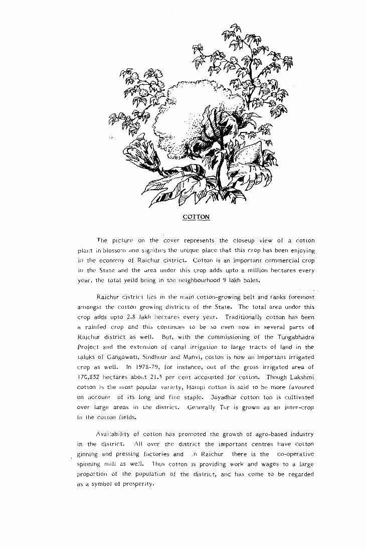
COTTON
The picture on the cover represents the closeup view of a cotton
plant in blossom and signifies the unique place that ttlis r.:rop has been enjoying
in the economy of Raichur district. Cotton is an important commercial crop
in the State and the area under this crop adds upto a million hectares every
year, the total yeild being in the neighbourhood 9 lakh bales.
Raichur district lies in the main cotton-growing belt and ranks foremost
amongst the cotton growing districts of the State. The total area under this
crop adds upto 2.8 lakh hectares every year. Traditionally cotton has been
a rainfed crop and this continues to be so even now in several parts of
Raichur district as well. But, with the commissioning of the Tungabhadra
Project and the extension of canal irrigation to large tracts of land in the
taluks of Gangawati, Sindhnur and Manvi, cotton is now an important irrigated
crop as well. In 1978-79, for instance, out of the gross irrigated area of
170,852 hectares about 21.5 per cent accounted for cotton. Though Lakshmi
cotton is the II lOst popular variety, Hampi cotton is said to be more favoured
on account of its long and fine staple. Jayadhar cotton too is cultivated
over large areas in the district. Generally Tur is grown as an inter-crop
in the cotton fields.
Availability of cotton has promoted the growth of agro-based industry
III the district. All over the district the important centres have cotton
ginning and pressing factories and in Raichur there is the co-operative
spinning mill as well. Thus cotton is providing work and wages to a large
proportion of the population of the district, and has come to be regarded
as a symbol of prosperity.

Ie"
,,' ARA81AN SEA
KARNATAKA ADMINISTRATIVE
1981
7iJ Ea.t of Gre.nwich n/
DIVISIONS
lJPon Survty of Indio mop with tnq permission of the Survttyor Gqnrrol of Indio.
Th\¢ rrilonol wotefs of Indio Clet..rId Into t~t SIlQ to a distance of tWIN' nautic.aI ml It Ilosurtd from tl'lr oppropriott bose lint.
T
77
7"
o
4.A
* @
KILOMETRES
40~ .. ~~O~====4~O~ .. ~60
o 17
o 15
, 14
© GQ\ftrnmtnt of Indio Copyright, 1986

FOREWARD PREFACE IMPORTANT STATISTICS ANALYTICAL NOTE TABLES
Section I - Village Directory
Explanatory Notes
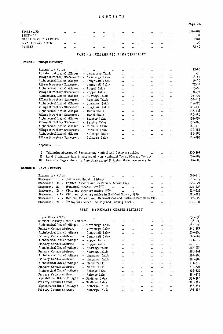
CONTENTS
PART - A : Vll.LAGE AND TOWN DIRECTORY
Alphabetical list of villages - D evadurga Taluk .. D evadui'g"l T aluk Gangawati ,[aluk Ganr,awati Taluk K oppal Taluk K oppal Taluk Kushtagi Taluk K ushtagi T aluk Ling sugur T aluk Lingsugur T aluk Manvi Taluk Manvi Taluk
Village Directory State m ent -Alphabetical list of villages Village Directory State m ent Alphabetical list of villages Village Directory State m ent Alphabetical list of villages Village Directory State m ent Alphabetical list of villages Village Directory State m ent Alphabetical list of villages Village D ire "tory State m ent Alph::bt::w.callist of villages Village Directory State m ent Alphabetical list of villages Village Directory State m ent Alphabetical list of villages Village Directory State m ent
- R aich ur T aluk - R aich ur T aluk - Sin dhn ur T aluk - Sin dhn ur T aluk - Yelbarga Taluk - Yelbarga Taluk
A ppendix I - ill
I Talukwise abstract of Educational, Medical and Other Amenities II Land Utilisation data in respect of Non-Municipal Towns (Census Towns) ill List of villages where no Amenities except Drinking Water are available
Section II - Town Directory
Explanatory Notes Statement I - Status and Growth History Statement II - Physical aspects and location of towns 1979 Statement ill - Municipal Finance 1978-79 State m ent IV - Civic and other amenities 1979 Statement IV A- Civic and other amenities in Notified Slums, 1979 .. statement V - Medical, Educational, Recreational and Cultural Facilities 1979 Statement VI - Trade, Com merce, Industry and Banking 1979 ..
PART - B: PRIMARY CENSUS ABSTRACT
Explanatory Notes District Primary Census Abstract Alphabetical list of village s Prim ary Census Abstract Alphabetical list of villages Prim ary Census Abstract Alphabetical list of villages Prim ary Census Abstract Alphabetical list of villages Prim ary C ansus Abstract Alphabetical list of villages Prim ary Census Abstract Alphabetical list of villages Prim ary Census Abstract Alphabetical list of villages Primary Cen~3 Ab.stract Alphabetical list of villages Primary Census Abstract Alphabetical list of villages Prim ary Census Abstract
- D evadurga Taluk D evadurga Taluk Gangawati Taluk Gangawati Taluk Koppal Taluk Koppal Taluk K ushtagi Taluk Kushtagi Taluk Lingsugur Taluk Lingsugur Taluk Manvi Taluk
- Manvi Taluk - Raichur Taluk - Raichur Taluk - Sindhnur Taluk - Sindhnur Taluk - Yelbarga Taluk - Yelbarga Taluk
Page No.
(vii-viii) (ix)
(xii) 1-29
32-40
43-48 51-52 54-65 69-70 72-81 85-86 88-97
101-102 104-115 119-120 122-133 137-138 140-149 153-154 156-165 169-170 172-181 185-186 188-197
200-203 202-203 204-205
209-216 218-219 220-221 222-223 224-225 226-227 228-229 230-231
235-236 238-239 243-244 246-253 257-258 260-267 271-272 274-279 283-284 286-293 297-298 300-307 311-312 314-321 325-326 328-335 339-340 342-349 353-354 356-361

SUPPLEMENT
INTROD UCtORY NOTE
Statement - Total, Scheduled Castes and Scheduled Tribes Population in the Taluks and Towns of the District
Statement II - District Primary Census Abstract for Scheduled Castes State m ent. ill - District Prim ary Census A bstract for Scheduled Tribes Statement IV - Scheduled Castes and Scheduled Tribes Population
(a) Village-wise and (b) Town-wise (within Town- Ward wise)
D evadurga Taluk Gangawati Taluk K oppal T aluk K uffita&i Taluk Lingsugur T aluk Mann Taluk R aichur Taluk Sindhnur Taluk Yelbarga T aluk
Statement V - Total Scheduled Castes and Scheduled Tribes Population 1981-Urban Blockwise
D evadurga (M) Gangawati (M) Hatti Gold Mines (N A C) Koppal (M) Kusbtagi (M) Lingsugur (M) Manvi (M) Mudgal, (M) M unirabad Project Area (S A) Raichur (M) Sindhnur (M) Yelbarga (M)
Statement VI - Description of boundaries and details of areas included in Census Enumeration Blocks in the urban areas of the district:
D evadUl'ga (M) Gangawati (M) Hatti Gold Mines (N A C) Koppal (M) Kuffita&i (M) Lingsugur (M) Manvi (M) Mudgal (M) Munirabad Project Area (SA) Raichur (M) Sindhnur (M) Yelbarga (M)
Statement vn - List of villages arranged according to the proportion of (a) Scheduled Castes, and (b) Scheduled Tribes population to the Total Population of the village concerned by ranges:
D evadurga Taluk Gangawati Taluk Koppal Taluk Kushtagi Taluk Lingsugur T aluk Manvi Taluk R aichur Taluk Sindhnur Taluk Yelbarga T aluk
List of Scheduled Castes and Scheduled Tribes
ILLUSTRATIONS
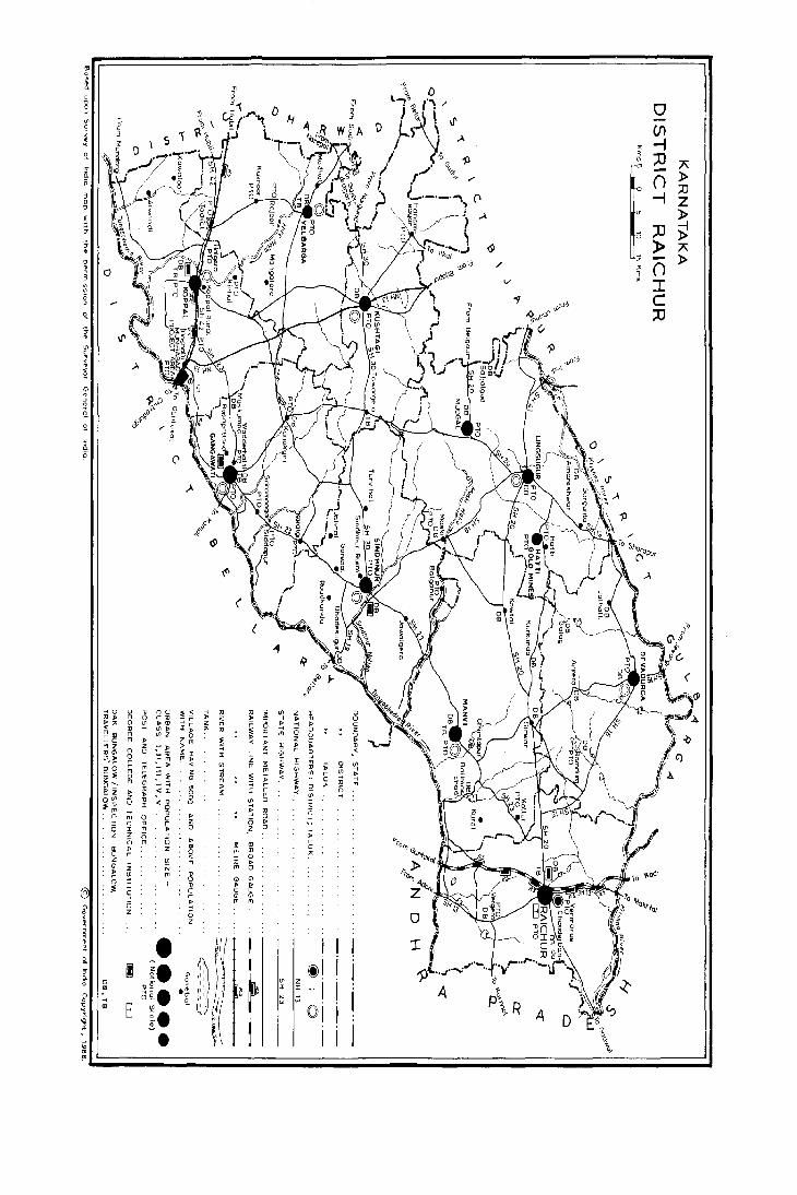
Map of Karnataka Showing the Administrative Divislons Map of R aichur District Map of D evadurga Taluk Map of Gangawati Taluk Map of Koppal Taluk Map of Kushtagi Taluk Map of Lingsugur Yaluk Map of Mann Taluk Map of Raichur Taluk Map of Sindhnur Taluk Map of Yelbarga Taluk
•••• * * (vi)
Page No.
368-369 370-371
372-373 373-375 375-376 376-378 378-380 380-381 382-383 383-385 385-386
387 387-388 388
388-389 389 389
389-390 390 390
390-392 392-393
393
394-395 395-401 401-402 402-405 406-407 407-408 409-411 4l1-l!1Z 412-413 413-426 426-428 428-429
430-431 431-432 433..li34 434-435 435-436 437-438 438-439 439-440 440-441
443
(iii) (xi)
50 & 242 68 & 256 84 & 270
100 & 282 118 & 296 136 & 310 152 & 324 168 &; 338 184 & 352

FOREWORD
The district census handbook (DCH), compiled by the Census Organisation on behalf of the State governments; is one of the most valuable products of the Census. The DCH is constantly referred to by planners, administrators, academicians and researchers. It is inter alia used for delimitation of constituencies; formulatation of local level and regional plans and as an aid to District Administration. The district census handbook is the only publication which provides Primary Census Abstract (PCA) data upto village level for the rural areas and wardwise for each city or town. It also provides data on infrastructure and amenities in villages and towns etc.
The district census handbook series was initiated during 1951 Census. It contained important census tables and PCA for each village and town of the district. During 1961 Census the scope of the DCB was enlarged and it contained a descriptive account of the district administative statistics, census tables and a village and town directory, including PCA. The 1971 DCH series was planned in three parts. Part-A related to village and town directory, Part-B to village and town PCA and Part-C comprised analytical report administrative statistics, district census tables and certain analytical tables based on PCA and amenity data in respect of villages. However, in some States it was confined to district census tables and in a few cases altogether given up due to delay in compilation and printing.
While designing the format of 1981 DCH series some new features along with the restructuring of the format~ of village and town directory have been attempted. At the same time, comparability with the 1971 data has also been ~ept in view. All the amenities except power supply in the village have been brought together in the village directory with the instruction that in case an amenity is not available in the referent village the distance in broad ranges from the nearest place·where the amenity is available may be given. The restructuring of the format of the village directory and incorporating more exhaustive data on infrastructure aspect, particularly in relation to amenities and land-use pattern, is expected to further meet the need of micro-level planning for rural areas. Jt is expected to help ~ot only in local area planning but regulating the provision of goods and services as well so as to.il'lipimise the regional imbalances in the process of development. A few new items of information have also been introduced to meet some of the requirements of the Revised Minimum Needs Programme. Such new items of information as adult literacy centres, primary health subcentres and community health workers in the village have been introduced in the village directory with this objective in mind. The new item on approach to the village is to have an idea about the villages in the district which are inaccessible. A new column, "total population and number of household, " has been introduced to examine the correlation of the amenties with the population and number of households they serve. Addition of two more appendices listing the villages where no amenities are available and according to the proportion of scheduled caste and scheduled tribe population to the total population has also been made with this viewJn mind.
The formats of the town directory have also been modified to meet the requirements of the Minimum Needs Programme by providing information on a few new items. A new statement on civic and other amenities in slums in Class-I and Class-II towns (Statement-IV-A) has been iI1troduced with this objective in mind. It is expected that this will help the planners to chalk out programme on provision of civic amenities for the improvem~nt of slums. The columns on Scheduled Castes and Scheduled Tribes population in Statement IV relating to civic and other amenities 'and adult literacy classesl centres under educational facilities in Statement V are also added inter alia with this view. A significant addition is class of town in all the seven statements of the town directory. The infrastructure of amenities in urban areas of the country can be best analysed by taking the class of towns into consideration. The addition of the columns on civic administration status and population in a few statements also serves this purpose.
The format of the primary census abstract for the villages and towns has been formulated in the light of changes in the economic and other questions canvassed through the individual slip of 1981 Census.
In order to avoid delay in publication of 1981 DCH series it has been so designed that Part-A of the volume contains village and town directory and Part-B the PCA of villages and towns including the Scheduled Castes and Scheduled Tribes PCA upto Tahsil/Town levels. At the beginning of the DCH a detailed analytical note supported bya number of inset tables based on PCA and non census data in relation to the infrastructure has been introduced to enhance its value. The district and Tahsil/Police Station/C D block etc., level maps depicting the boundaries and other important features have been inserted at appropriate places, to further enhance the value of the pUblication.

This publication is a joint venture of the State Government and the Census Organisation. The data have been collected and compiled in the State under the direction of Shri B. K. Das, the Director of Census Operations, Karnataka, on behalf of the State Government which has borne the cost of printing. The task of planning, designing and coordination of this publication was carried out by Shri N.G.Nag, Deputy Registrar General (Social Studies) of my office. Dr.B. K. Roy, Deputy Registrar General (Map) provided the technical guidanc.e in the preparation of the maps. Data received from Census Directorates have been scrutinised in the Social Studies Division at the headquarters under the guidance of Shri M. M. Dua, Senior Research Officer, I am thankful to all who have contributed in this project.
NEW DELHI 26th April, J 982
P. PADMANABHA REGISTRAR GENERAL,INDIA

PREFACE
The Registrar General and Census Commissioner of India has in his foreword to this series of publications, not only provided the reader with the historical background of the District Census Handbooks but has also explained at some length the scope and coverage envisaged for this country-wide project. As uniformity in approach and comprehensiveness need of data are distinctive features of this series every attempt has been made to adhere to the concepts and definitions adopted in designing the formats. These volumes contain the salient results based on the data gathered at the actual census count and. in addition contain a wealth of other than census information in respect of villages and towns of the district. It is hoped that these volumes would go a long way 10 meet the ever increasing demand for the micro-level data in this era of planned development.
The district census handbook is divided into two portions: while Part A contains the village and IOwn direclOry Part B confines itself to the primary census abstract. Since combining of these two parts and presenting the same in a single volume enhances the utility of the volume and also because the districts of the State are not so large as 10 render such single volumes Ul1widely in l\.arnataka, Part A and Part B of each district are being published together in a single volume. But, there is a major point of departure from the all-India pattern in so far as Karnataka is concerned. Owing to certaill technical reasons all the particulars on Scheduled Castes and Scheduled Tribes proposed for publication in the bCHB as part of Primary Census Abstract and also the other derived statements have been pooled up separately ar.d presented in the form of a Supplement. While such Supplements have been brought out as separate volumes in the case of Bidar and :-'landya, in the case of the other districts this material also forms part of the single volume of the District Census Handbook al\p appears separately after Part B.
In the preparation of the district census handbooks the role played by the census organisation is that of data gatherer and the cost of publication is borne by the State Government. In accomplishing this task we have had ~he ready and II hole-hearted cooperation of the staff at various lewis of different departments of the State Governl:1enl. For operational convenience the village directory was divided into two portions \'i:.:. that relating to area and I3nd use pattern. and that relating to the amenities. The relevant formats were mailed to the Tahsildars and Block Development Officers respectively requesting them [0 furnish information on land use pattern and amenities. Much of the data so supplied by tbese field-Ie\el officers have been cross-checked with the data obtained from various d :partments and a'n attempt has been made to reconcile r he dicrepancies as well.
I lake this opportunilY to offe. my gr:lteful thanks to all the officers and officials who ha\'e been actively involved in the compilation and preparation of this volume.
I am deeply grateful to Shri. P. Padmanabha. LA.S. the Registrar General, India for the benefit I have derived by way of guidance and ad\·ice. I also express my Ihanks to Dr. N. G. Nag, Deputy Regimar General (Social Stujies), Dr. B. K. Roy. Deputy Registrar General (Map) and Shri ;\'1. M. Dua, Scnior Research Officer.
Lastly, I am thankful to the GOIcrnment of Karnataka for having agreed readily to bear the cost of publication of the distriq cemLls handboo~ volumes. The Director, Printing, Stationery and Publications, Karnataka has evinced keen intere~t in bringing out these volumes.
Bangalore Date : 9.4.198,~
B. K. Das Director of Census Operations,
Kal'!1at"ka

OJ 0 · · 0.
[
~ " 0
U> a 0 0 3
~ 0 ~
3 '{ S ..... (/l -i ~
9-
K 1)
3 ::0 0
0 - A
3
() l>
a 0 ::0
u -i z
l> :; g.
0 ;lJ ~ · ~ » A u ~ ~
0 ,- iii l>
" () v
3 . I
9, " ~ C
0 ;:0 3 g. · I}l
~ · ~
~ , ~ 9-9,
'5 0. 0
.., ~
-<0 0 ~ nc ~ ~ _,
" " "" rn 0 rlJ l> " it VI Z I W
~" Gl "1 l>OJ :;~ Z ~ ~ _,
l> m 0
" "' l> " l> " rn
~ l> ... l> C
~~ rn IllZ II
" _,
(5 0 z rn I> z Gl -< rn 0 0
mz 2 l> rn :E < l> Z C l>
llC> n 0 ,- » 3: I
:; z ! I> l> " tI1l> ~
_lJ :I r -< Gl r
~ ,<
'r -< - '" !" l> Z :I
,"0 :" :." < "' m 3: :E I '" ~ 0 if>
P m :,. z ... m l> iii " iii
_, Gl m Gl II ~
_, I if> r ~ Gl'
m Gl -'i m ~ ,<
~ .. C ...
~z II :, :r '" I> ::; " " rn
" J> 0 :l: I r J> " ii 0"' z ~ 0 rn ;< III
~~ 0 I ~~ 0 III 0 ... _,
, m ... ... " n m 0 ~ l> !: " ii
... c 0 n .. r Z 6 J> ,-;
6 I .. l> 0 0 z z ii
_, ,2 -<
0 '" (5 J> l>
OJ l> Z '" ll: OJ r
C r 0 !: " c
z
'" < 0 "
Gl Z '" II J> l> N '" 0
:; Ul '" ~
~ I 0 Gl Gl
,:E S ~ J> g
n ~ c Gl C>
" 6 J> m '" 0 Z
_, < 6 ~ z 0 , 3 • • ""
, I ! 9,
'5 ~ ~. Q ltl! i 1 ~ 0 0 ID 'lg. .' Ul z i n e " I '·1 0 _, 09. tT N I A t
u ID B e. "
w ~ I. oj i P\R ~ A ;;; • I 1 I '" !"

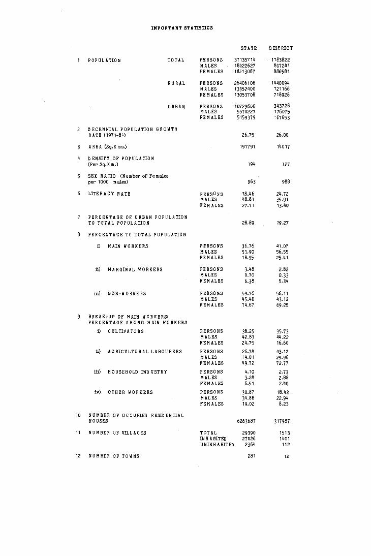
IMPORTAIT STATISTICS
STATE DISTRICT
POPULATION TOTAL PERSONS 37135714 1783822 MALES 18922627 897241 FEMALES 18213087 886581
RURAL PERSONS 26406108 1440094 MALES 13352400 721166 FE MALES 13053708 718928
URBAN PERSONS 10729606 343728 MALES 5570227 176075 FEMALES 5159379 167653
2 DECENNIAL POPULATION GROWTH R ATE (1971~81) 26.75 26.00
3 AREA (Sq.Kms.) 191791 14017
4 D ENSJTY OF POPULATION (Pel" Sq.Km.) 194 127
5 SEX RATIO (Number of Females pel" 1000 males) 963 988
6 LITERACY RATE: PERSONS ,8.46 24.72 MALES 48.81 35.91 FEMALES 27.71 13.40
7 PERCENTAGE OF URBAN POPULATION TO TOTAL POPULATION 28.89 19.27
8 PERCENTAGE Te TOTAL POPULATION
i) MAIN WORKERS PERSONS 36.76 41.07 MALES 53.90 56.55 FEMALES 18.95 25.41
ill MARGINAL WORKERS PERSONS 3.48 2.82 MALES 0.70 0.33 FEMALES 6.38 5.34
iii) NON-WORKERS PERSONS 59.76 56.11 MALES 45.40 43.12 FEMALES 74.67 69.25
9 BREAK-UP OF MAIN WORKERS: PERCENTAGE AMONG MAIN WORKERS
i) CULTIVATORS PERSONS 38.25 35·73 MALES 42.83 44.22 FEMALES 24.75 16.60
ill AGRICULTURAL LABOURERS PERSONS 26.78 43.12 MALES 19·01 29.96 FE MALES 49.72 72.77
ill) HOOSEHOLD IND USTRY PERSONS 4.10 2.73 MALES 3.28 2.88 FE MALES 6.51 2.40
iv) OTHER WORKERS PERSONS 30.87 18.42 MALES 34.88 22.94 FE MALES 19.02 8.23
10 NUMBER OF OCCUPIED R ESID EN TIAL HOUSES 6263687 317987
11 NU MBER UF VILLAGES TOTAL 29390 1513 IN H A BIT ED 27026 1401 U NIN H A BIT ED 2364 112
12 NUMBER OF TOWNS 281 12


ANAL YTICAL NOTE

ANAL YTlCAI,. NOTE
BRIEf HISTORY OF THE HANDBOOK:
DISTRICT CEI'i:'US
The District Census ,-:andbook was first introduced at the 1951 Census to meet the ever increasing den,and for micro-level data oy administrators planners and other Census data users. These series were primarily envisaged to replace the 'Part IV Taluk Tables' and 'Part V - Village Table,' of the earlier Censuses and to present the basic demographic and economic data at village level in the form of primary census abstract. In addition, these volumes were to contain a set of important census tables atttaluk, town and district levels.
At the 1961 Census the scooe of the volume vias gr(·atly enlarged by incorp~rating into it (i) a descriptive account of the <listrict, (ii) a set ot non-census tables dealing with administrative statistics of a decade, (iii) taluk and town level Census tables on econom ic and socia-cultural aspects and (iv) the village and urban block level primary census abstract. In a somewhat general .vay information on the availability of certain basic arnenities like drinking water wells and schools was also furnished.
The 1971 Census witnessea an overall improvement in the matter of data compilation as well as in presentation of the results. A countrywide uniformity in approach and a comprehensiVe coverage are the hall marks of this series of publications. The District Census ~andbook was split up into three parts: i) Part A consisting of land use data on villages and data on amenities and services available in villages and towns compiled in the form at village and town directory, ii) Part B consisting at district, taluk, town, Village and urban block level primary census abstract, and iii) Part C consisting of an analytical note based on census as well as the non-census data included in tne volume, a set of tables depicting the adrnini"trative statistics in greater details, census tables at district, taluk and town levels besides cl set of tables generated on the basis of villagewise Census data and particulars on amenities. rhe main objective was to present a comprehensive :md Intelligible portrai t of the district and an overall view of the results of a decade long developmental activities in the district. The publication programme too was phased out: 11 art A was planned to be released first to be followed by part B and then Part C which could be published only after the finalisation of various Cl'nsus tables that were to be included therein and dflalysed. In Karnataka, Part A and Part B were combined and published on time as a Single volume 'or each district except in the case 01 r.angalore. \.clving to reasons beyond control there has been an Inordinate delay in the publication of Part C volumes.
The current voiumes 01 District Census Handcuok 3re thus the fourth in the series and at ,'very succeeding census there r,as Deen an endeavour to enhance the utility of these volumes.
2. SCOPE OF 19&1 DISTRICT CENSUS HANDBOOKS:
;~cgarding uniformity and comprehensivenes~;, thC' ;)ppr03ch in 19S1 IS muchthesame asin 1'371. The contents have been sli!)htly enlarged ;)nd the
formats too are restructured to some extent to meet the requirements of the data users. The DIS
trict Census handaook has been divided into two p;)rts: i) Part A consisting of town directory <lnd village directory ana, ii) l'art 1\ consisting of uistrict, taluk, town village and v/ard level primary census abstracts besides the special PCA at taluk and town levels In respect of the Scheduled Caste anci Scheduled Tribes. Compilation 01 administrative statistics has been aQandoned altogether. Though di vided into two parts, in Karnataka as a matter of fact both the parts are being presented in a single combined volume for each district. There is however a point of departurf' from the all India pattern: all particulars relating to Scheduled castes and Scheduled Tribes are excluded from the mall1 volume of the district census handbook and are presented districtwise in the form of a supplement.
i) Town Directory: In the town directory section there are 7 statements in all to furnish townwise information on aspects such as: growth history; physical aspects and location; municipal finance; civic and other amenities in towns; civic and other amenities in notified slums; medical, educational, recreational and cultural facilities and trade, commerce, industry and banking. As compared to the 1971 series the statement about religionwise population has been dropped and an additional statement has been introduced in respect of urban areas wJth a population of 50,000 and more to furnish some basic data on slums. This apart, there are a few more variations mainly by way of inclusion of a few additional columns in each statement to indicate the size class of the town, population and also civic administration status with a view to facilitating an easier grasp of the data. In statement I, provision has been rnade to indicate the decadal growth rates, area and density of population as in 1981 and the sex ratio observed at the three successive censuses. The introduction of additional columns has resulted in the elimination of 2 columns which in 1971 f.lresented comparative information on functional classification of towns. Statements II and If I are very much the same while in statement IV additional information on water stora~e system with cap. acity has now been provided. In addition, in case of non-availability of fire-fightin~ station In the town itself reference to the nearest place with that facility has been gi.ven. In statement V too in case of non-availability of medical and educational facilities in the town information on the nearest place with such a facility has oeen provided. An additional column in this statement presents information on working, women's hostel. Statement Vf has rer~ldined almost unchanged except in the explan3tion regarding the imports and exports concerning the goods which simply pass through the town.
The towns 111 the district are arranlied serially on the basis of their names in an alphabetical oraer and assigned location code numbers starting from I. For presentation of data in the town DIrectory statements the same order of the towns has been followed. The concept of urban agglon,eration, introducea in 1971, has been

retained for use at the 1981 Census also. Where an agglomeration includes two or more independent towns, the names of the constituent towns are indicated in the correct sequence as per alphabetical arrangement of their names. But, the details to be furnished in the subsequent columns are skipped with a view to avoiding duplication. Instead, immediately after the name of the town, a cross 'reference is given by the legend "See .. Urban Agglomeration" printed within brackets. The name of the core town of the urban agglomeration too would appear at its correct sequence with the legend as above and immediately below that the same name with the additional title " ..... Urban Agglomeration" appears again without bearing any serial number. Against this line the cumulative totals for the urban agglomeration as a statistical unit are presented wherever such a procedure is relevant and meaningful. This line is followed by those relating to the constituent towns of the urban agglomeration starting with the name of the core city and followed by the others arranged in the alphabetical order of their names. This procedure is the same as that followed in 1971 and enables one to have a fairly good assessment of the data in relation to the smaller civic administrative units that form part of the large unit and also or the larger statistical unit itself simultaneously. In case there are outgrowths which are not 'urban' in their own right the particulars relating to such areas are mergea with those relating to the concerned town and presented in the statement. Such towns having outgrowths are marked out by an asterisk mark and lor all purposes the town includes not only its statutory limi ts out also all the outgrowths and together constitutes an ind"'pendent statistical unit. In an appendix, the names of these outgrowths and the population thereof are furnished townwise. These outgrowths appear in the Village Directory also. However, in all such cases merely a legend to the effect that it is an outg'owth of such and such a town is recorded along [he line instead of furnishing land use data and information on umenities. In the case of villages certain parts of whlch are regarded as outgrowth while the other parts are considered as rural the data relating to the outgrowth is included in the town directory statements and the data relating to the rest of the portion appears in the village directory. It may incidentally be mentioned that there are no such cases in Karnataka.
In statements II, III and VI where it is not relevant to combine the data for the urban agglomeration as a whole the legend 'see constituent units' is printed along the line instead of allowing the entire line blank.
ii) Village Directory:
In the village directory the columns regarding the land use pattern are very much the same while those relating to amenities have been slightly modiIled. Unlike in 1971, this time if a village is not having a particular amenity then the distance range within which that amenity is avaJlable and may be availed of has been lndic;ttl'ci. This enquiry is however confined only to (be basic level under each cateEory of amenity. In other words, if a villa§,e is not having any educational institution at all then the distance that one has
2
to cover to reach the nearest place havini! a primary school is indicated in ranges of less than 5 Km., 5-10 Km and 10+ Km. If a village is however having a primary school no aTtempt is made to provide similar information in relation to middle school, high school and college level ina progressive manner. Similar procedure has been followed regarding medical, postal and communication facilities. Regarding weekly markets too, if the village is not the venue of such a market the distance to the nearest weekly market is indicated in ranges.
In the village directory an additional column ha.s been introduced to indicate the popuJation of the village as well as the number of households therein. This juxta-positioning of population and amenities data would help one to assess at a glance the adequacy or otherwise of the amenities available within or in the immediate neighbourhood of the village. Another change with regard to the area and land use data this time is that these figures are furnished not in acres but in hectares upto two places of decimal. One more notable addition is the prOVision to indicate information about the proximity of the public transport facility su,h as bus stop and railway station in respect of each village. In 1971 though information on railway station (i.e., if available within one Kilometre from the village) was furnished in addition to the general condition of the road to the village under- the column for communication, there was no reference at all to bus transport facility. This time, in the coluilin about approach road the condition of the road that leads to or passes through the village is indicated. In the remarks colurr,n general information about the numoer of copies of newspapers circulating in the village as also about the number of different types of automobile vehicles available in the village is furnished.
I n the case of uninhabi ted villages i.e., villages which have returned nil population at the I ')81 Census, only the details in respect of land use are furnished and in the columns pertaining to amenities the word uninhabited has been printed. If there are any villages that are regarded as outgrowths of an urban agglomeration, then net ther the land use data nor the data on amenities is furnished in this statement. After the location code number and name of the village a legend indicates the name of the urban agglomeration of which that village is a par t. Practically this administrative unit has lost its independent existence having been merged in another unit for statistical purposes. But if only a portion of a village is so affected by inclusion in an urban agglomeration then information as I1lay be relevant to the portion that has still remained in the rural fold as a village has been furnished in the vtllage directory.
In order to facilitate easy reference, an alphabetical list of villages showing population fiGures according to the censuses of 1971 and 1981 is given in respect of each tal uk. At the eJ1d, the tollowint; appendixes have also been illcluded to provide an over all view of the district: talukwise abstract of amenities; list of inhabit{'d villages not having any amenities; and lana utilisation data for non-municipal towns if any.
iii) Primary Census Abstract:
As at the two previous censuses this time also the Primary Census A bstract is presel1ted villagewise in the case of rural areas. But,in so far as the urban areas are concerned the practice of furnishing data upto urban census enumerator's block level has been given up and the particulars are presented upto ward or division level only. Within the district the taluks are arranged in the alphabetical order of their names in English and covered one after the other in that order. For each taluk after furnishing the taluk level data with the rural-urban break up the villagewise details are furnished and this is followed by the data relating to towns in the taluk.
[n the Primary Census Al:lstract format itself there have been certain changes. Though fresh columns have been introduced to cover a new category of workers viz, marginal workers, the total number of columns is reduced in view of the elirnination of details regarding workers engaged in activities other than cultivation and household industries. There are now hardly 22 columns in the statement i.e., excluding those related to Scheduled Castes and Scheduled Tribes which however appear separately in the Supplement. The workers are classified into main workers and marginal workers and the main workers are further classified into one of the four categories viz, cultivator, agricultural labourer, worker in household industry and 'other' worker depending on the nature of work done al1d the sphere of economic activity.
In the case of urban agglomerations the same procedure as has been adopted for presentation of data in town and village directories has been foHowed. That is to say, the urban agglomeration is regarded as a single statistical unit and the aggregate figures obtained by the addition of details in respect of each constituent town and outgrowth are noted against the name of the urban agglomeration which in itself does not bear a location code number. In the section dealing with the Urban Primary Census Abstract the core town with its location code appears first carrying the legend: 'See ... urban agglomeration'. Immediately below that line the full name of the urban agglomeration appears and the aggregate figures for the urban agglomeration are furnished. This line is then followed by the constituent towns arranged in alphabetical order of their names along with their Location Code number and full details under various columns. If the core town or any other tl)wn for that matter were to have any outgrowths then the first line for the town would in fact be a sub-total as it includes data not only of the town but also of the outgrowths. Thereafter, the name of the town and its constituent outgrowths are given along with the relevant data.
In the rural portion of the Primary Census Abstract if an entire village were to form part of any urban agglomeration then only the name of the village is indicated along with the legend that this Village is included if' such and such urban agglomeration. In the case of villat,es partly included in an urban agglomeration details relating to only such portion as has remained under the rural category are given.
3. BRIEF NOTE ON CENSUS CONCEPTS :-
Census taking is a massive operation carried
out in a short span of time with the active participation of a veritable army of enumerators. The reference moment for the 1981 census is the sunrise of March 1,1981 i.e., the census provides a snap shot of the populatlOn of the rountry as it existed at the sunrise of March l,lnl. :\ctual enumeration was spread over a period of 20 days from 9.2.81 to 28.2.8 I followed by d revisionai round up to 5.3.81 for updating of the population fIgures with reference to the sunrise 01 rv:arch I, 1981. The questionnaire canvassed by the enumerators viz., the household schedule and individual slip arE' perlorce brief in their wordings dl1d this naturally implies the use of abstractIOns and concepts. With a view to ensuring uniforrnity in approiJch I fl understanding the various concep ts and in properly eliciting and recording of the information, the e numerators and supervisory officers were irnpart('d both practical and theoretical training intemiv€'ly.
As a preliminary to the actual censlJs the urban and rural areas were identifi(>u and listed out in respect of each administrative unl t and thereafter geographical areas that could be conveniently covered by each census enumerator were carefully carved out to cOrlstitute the enumerator's blocks.
The second major step was the house listing operation which was carried out in the State during May 1980. TherE'after, in Ordl'r to i1dhere to the prescribed work-load norn" th(> actual census enumerator's blocks were carefully demarcated on the basis of the layout sketches and notional maps prepared for the houselisting oper"tions. The detailed information on households and population collected at the houselisting operatIOns was also quite useful in this task of formatIOn of census enumerators blocks. Definitions anel explanations regarding the important census concepts Me gi ven in the following paragraphs.
i) Urban areas: The definition adopted in 1'161 and adhered to in 1971 has by and large been retal ned for the 1981 census also. There is however a minor modification regading the classiflcCltion oj fishing and forestry. These two actIVIties have now been regarded as allied to agriculture IJnlike in the earlier c&suses when these were treated as purely non-agricultural activities for workIng out the propor tion of agricultural and oth€'r than agricultural workers. According to definition the urban areas include: "i) All places with a Municipality, Corporation, Cantonment Board or Notified Town Area Committees etc., ii) All other places which satisfy the following criteria :-
a) minimum population of 5,000. [0) at least 75 per cent of male working popu
lation engaged in non-agricultural plJrS(litSj c) a density oj population of at least '+ 00 per
sq.km. (1,000 per sq.rrule) d) all places whim, thoush nat s<lti~fytnb the
above criteria had pronouncecJ urban char acteristics"
Demarcation of urban areas was done at the preliminary stage itself. In the case of nonstatutory towns the empirical test wa~ upplied on the basis of the population return, oj lile 1971
census and this was supplemented by consultation with the State Government authorities concerned· The changes such as declassification i.e., abolition of municipalities, constitution of new municipalities and such other civic bodies, coming up of large human settlements at construction sites and other centres, de-population of project areas and former labour camps etc., have aU been considered while preparing the lists of urban areas. U.rban areas with a population of 100,000 and more are called ci~ and the others are termed merely as towns.
ii) Urban agglomeration: This concep't which in 1971 replaced the concept of town group has been retained for the 1981 census also. It has been observed that very often railway colonies, university campuses, port areas, military camps and large residential colonies etc., come up quite adjacent to but situated outside the statutory limits of cities and towns. Such areas may not by themselves qualify to be treated as towns. But, if they form a continuous spread with the town they are outgrowths of the town and deserve to be treated as urban. Such towns together with their outgrowths have been treated as one urban unit called 'urban agglomeration. An urban agglomeration may consist of : a) A city with continuous outgrowth (the part of outgrowth being outside the statutory limits but falling within the boundaries of the adjoining village or vlllages ; b) One town with similar outgrowth or two or more adjoining towns with their outgrowth as in (a); or c) A city and one or more adjoining towns wit.h their outgrowths all of which form a continuous spread. It may further be noted that geographical contii(uity with the statutory limits of the core town has been the main factor in determiningwhether or not a nearby satellite town or an butgrowth is to be induded in the agglomeration. This is purely a statistical concept and for carrying out the actual census operations the administrative jurisdictions of the city or the towns concerned as well as the outgrowths situated in villages have been kept quite intact. The data have been pooled together only at the tabulation stage and presented in the combined form for the urban agglomeration as a whole and also severally for each one of the constituent units. iii) Rural areas i.e. Villages: Areas whi\il;l, are not classified as urban according to the ~dinition given above constitute the rural areas. The basic unit for rural areas is the revenue village which has definite surveyed boundaries. In the case of unsurveyed villages the boundaries as oeterrrrined by the local usage have been adopted. The revenue village may consist of a sip31e nucleated settlement or comprise of several hamlets i.e. human settlements or clusters of houses located at several places within the territorial limits of the village, or may be completely uninhabited. That is to say, the census village and the revenue village are identical in the. matter of jurisdiction. However, there are a few exceptions to this general rule. These are for example:
1) When the main setttiement of the Village with or without the surrounding lands is constituted into an urban area the remaining tracts of the revenue village are collectively treated as a separate unit for purposes of census enumeration, i.e. the truncated portion itself is considered as an independent village in itself.
4
2) When outlying portions of certain revenue villages are incorporated into the limits of urban areas by notification such areas, whether populated or not, are excluded from the revenue village concerned and for purposes of census operations the village boundaries are re-defined.
3) Revenue Villages which are completely incorporated in the limits of urban areas or else, are submerged under reservoir projects but are still maintained in the jurisdictional lists of the survey and settlement authorities pending resurvey and such other procedures are taken note of as revenue villages but are omitted for census purposes. i.e. these are not treated as censusvillages. The names of such villages if any in a taluk are given at the end without serial number but with due remarks.
4) If there are forest areas that do not torm a part of any of the revenue villages then such areas are identified clearly and the smallest administrative unit in vogue such as Forest Beat, has been reckoned as the census village. A forest range may consist of several such census villages.
5) For purposes of local administration such a~ collection of land revenue a single revenue village may sometimes be found to be sub-divided into two or more units. Instead of ignoring such divisions, occasionally eacn such unit gets reported as a separate independent revenue village. In spite of efforts to eliminate such cases it is quite likely that a few may persist till the very late stage when necessary corrections cannot be carr ied out.
iv) Census Enumerator's Block: In urban as well as in rural areas the smallest unit adopted for enumeration is the Census Enumerator's Block. The town is generally divided into wards and c;iivisions and wherever such units exist their distinctness has been retained. The geographical area comprised in each such ward or, the town in its entirety is constituted into several blocks in such a way that every bit of land stands included in one block or the other. If there were to be any islands then each island is treated as a separate unit and divided into one or more number of .plocks as may be necessary. Generally in the urban areas each census enumerators block consists of about 13 0 households covering a population of about 650 persons. However, in view of the fact that each block should have clear cut boundaries rcco!,;nbable on the fie 1o, smaller blocks have also been constiitued. In constituting these blocks all the lands included in the statutory limits of the town are taken into consideration. In the case of non-municipal towns such as a Town Panchayat or a Group Village Panchayat the revenue limits of only that Village which has been classified as a town on the basis of the empirical criteria have been considered as the boundaries of that census town. In other words, the panchayat jurisdiction and the census jurisdiction need not necessarily be identical in the case of non-municipal towns.
In the casc of villages, irrespecti vc. of the population size every hamlet and every island has been constituted into a separa te block. If the hamlet or the Island is large the number of enumerator's blocks constituted therein may be two or even more. The work-load norm per block is 150 households with a population of about 750 persons
dllU this generally applies to large nucleated settlenlC'nl, havlng more tnan this fixed lililit and therefore require division Into two or more blocks. In cach vdlabe Coire has been taken to ensure that no bi t of land belonf;ing 1,0 that village is left out 01 (llll,ideration while constituting bloch. That IS to SJ)' the entire revenue jurisdiction of the villa(?c is divided into blocks in such a WJy that even the dE,ricultural lands that may not contain any houses or households stand included in one block or the other. In other words, enough emphasis has been laid to ensure complete coverage Df the territDrial jurisdictiDn Df each village.
v) LDcation code number : Every State in the country, every district in the State, every t"luk or Town In the district, every village in the taluk and every ward or division in the city or town and every enumeratDr's block in the village or town is assigned a number for operational ease, in a particular order. When these numbers are written side by side in the same order starting from the state and separated by an oblique line the identity of any partl('ular census enumeration block can be known qUI te easily. The numbers assigneo are in international numerals except in the case Df tDwns in which case Roman numerals have been adopted. The states, the districts, the towns and the taluks are arranf;ed in an alphabetical order of their names for assigning these numbers. Taluk maps showlIlg the boundaries of various villages therein are quite essential since these provide the basis lor assi!;rung locallon code numbers to villJges. For purposes of revenue administration the villages of a taluk are usually or!;anised into a few circles or Hoblis and each such unit will have a heaaquartC'rs town or village. The identity of such units is Inaintained to the extent possible. Starting frorrl the circle of which the taluk headquarter town or villaf,c happens to be the circle hE'ildquarter dS well the villages in its lurisdlction are ,erledl) numbered by proceeoing in d clockwise: dire, (Ion i.e. in a concentric 11Iillliler arounD the hcadquClrter villase or town, or in a serpentine manner stJrtlng from the north-west corner. A fter exhausting all the villages oj the Circle the next clrel(' situated in the clockwise direction to the first one IS token up and commencing froli' the headquarter vdla[,c all the villa5es Within Its lurisdictloll dre numbered. Thereafter, the next circle is taken up and in this manner it 15 ensured til;)t all the vilJages of the taluk as well as any other analogous units such as islandS, reserve forest tracts not included in any revenue village elc., if any, are assigned location code nUfTlbers. The numbering of villages runs continuously [or the taluk through the different circles or HooUs. Taluk maps showing the boundaries of various villages along with their corresponding location eude numbers are also presented in these VOIUIIICS lor reference purposes.
VI) l;uildlilg : A buildin); is bcnerally a single structurc on the ground. Sometilllt's it is made up oj I\lore than onE' comDonent unit which afe used or likely to be used as' dwellings (residences) or establlshl"cnts such as shops, business houses, offICes, IJctorles, workshecis, schools, places of entcrtainll,ent, places of worship, godown" 5torc's etc. l( IS also possible that buildings Which have eor~lpOnell[ units may be used for a combination of
purposes such as shop-cum-resldence, workshop-culllreSidence, office-cum-residence etc.
\iIi) Census house: A Census House is a buildinE; or part of a building havin!; a separate main entrance frorn the road or common courtyard or staircase, etc., used or recognised as a separate unit. It Il,ay be occupied or vacant. It may be used for a residential or non-residential purpose or both.
viii) Household : A Household is a group of persons who cOlliTnonly live together and would take their meal Irof,l a commDn kitchen unless the exigencies of work prevented any of them from doing so. There may be a household of persons related by blood or a household of unrelated persDns or having a mix of both. Example of unrelated households are Doarciing houses, messes, hostels, residential hotels, rescue homes, jails, ashrams etc. These are called 'Institutional Households'. There may be one member households, 2 member households or multI-member households. For census purposes, each one of these types is regarded as a 'household'. If a group of persons who are unrelated to each other live in a census house but do not have their meals from the CDmmDn kitchen, they would not constitute an institutional household. Each such person would be treated as a separate household. The important link in finding aut whether there IS a household or not is a common kitchen. There may be a household which does not at all have a house to live in and may temporarily dwell on the roadside, pavements, in humepipes, temples, mantaps, platforms etc, or move about from place tD place resting uncierneath shade-bearing trees, pavements anci verandahs of public or private buildings. Such householas are for purposes of reference termed as Houseless Households.
ix) Criteria for enumeration of a person in a particular household:
..l) 1\11 those who norn~ally S("y uilU ..Ire present in that household during the entire period 01 enumeration i.e. from February 9 to February n, 1981 (both days inclusive)
b) Also those who are known to DC' normally residmg and had actually stayed durinE il part of the enumeration periOd (February 'j to 2o, I % I) but are not present at the time of enurnerator's visit;
c) Also those who are knowTl ro 0(' normally residmg and Jre not present at the time of the enumerJtor's visit our are expected to return oefore Februaryn.I981 dnd, d) Visitol' who are present In the hou~chold censused und are Jway from the place (s) of their usual reSidence during the entire enullieration perioc. For the purpose of enUI11eratJOn, such VIsitors will De treated as norillal residents of the household in which they are actually found ourinb the enumeration period provided they have not been enulllerated elsewhere.
x) Literate: A person who can both read and write With uncierstanding in any langua~e is to be taken ciS literate. A person who can merely reao but CJTlnot write is not literate. It is not necess..lry tn;)t it per,oll \'/ho is literate should have received

any formal education or should have passed any minimum educational standard.
xi) V/orkers and non-workers : Depending upon the nature of his or her activity during the reference period every individual enumerated at the Census is classified as either a worker or anon-worker. By definition, a worker is one who has worked, that is, 'participated in any economically productive activity'. Such participation may be physical or mental in nature. Further, work involves net only actual wor* 15ut also effective supervision and direction of work. The reference period for determining whether a person is worker or a nonworker is the full year preceding the date of enumeration. The criterion is somewhat liberal and, even a person who has participated in the production of economic goods and serviees for a very brief period will be categoriseci as 'worker'.
Among workers however there are two categories:
a) Main Workers:- Those who have worked for at least 183 days during the preceding year i.e. the entire reference period. (even though this may be in broken spells and in different occupations),
b) Marginal Workers:- Those who have worked for less than 183 days during the entire reference period.
For both the categories of workers further details on the sector of economy in which they have worked, their occupation (that is, the actual nature of work done) and employment status (that is whether employer, employee, urpaid family worker or own account worker) have also been ascertained. The industrial classification of workers as adopted at the Ce nsuses of 1961 and 1971 has been retained at the 1981 Census also. The industrial classification categories are: (I) Cultivators, (II) Agricultural labourers (III) Workers in livestock, forestry, fishing, hunting, plantations, orchards and allied activities, (IV) Workers in mining and quarrying, (V) Workers in manufacturing, processing, servicing and repairs which are (a) run as household industry, (b) not run as household industry, (V) Workers in construction, (VII) Workers in trade and commerce, (VIII) Workers in tramport, storage and communication, (IX) Workers in other services. For purposes of presentation in the Primary Census Abstract however the details in respect of main workers alone are considered and the industrial classification categories of III IV, V(b), VI, VII, VIII and IX are pooled together and shown under the heading 'Other Workers'. The oroad classifications therefore are : I-Cultivators, II-Agricultural labourers, V(a)-Workers at house hold industries, manufacturing, processing, servicing and repairs and, 1II, IV, V(b) and VI to IXOther Workers. Explanations regarding the broad categories are given below:-
a) Cultivators : for purpose~ of the census a person is working as- Cultivator if he or she is engaged either as employer, single worker or family worker in cultivation of land owned or held from Govenment or held from private persons or institutions for payment in money, kind or share. Cultivation includes supervision or direction of cultivation.
A person who has given out his or her land to another person or persons for cultivation for money, kind or share of crop and who "does not even
6
supervise or direct the cultivation of land will not be treated as cultivator. Similarly, a person working in another person's land for wages in cash or kind or a combination of both (agricultural labourer) wilJ not be treated as cultivator.
Cultivation involves ploughing, sowing and harvesting and production' of cereals and millet crops such as wheat, paddy, jowar, bajra, ragi etc. It lS important to note that for certain reasons the growing of certain crops is not considered as agriCUlture. If a person is engagea in the growing of such crops he or she will not be considered as cultivator or agricultural labourer.
The :;rowlng of the following crops is considered as cultivation:
I. CereJi Jnd millet crops: l'uClciy, wllcut. jowar, bajra, maize, ragi, barley, gram, etc.
2. Pulses: Arhar, moong, masur, urd, kesari etc.
3. Fibre crops: Raw cotton, jute, mesta, ,unhemp and kindred fibre crops.
It. Oil seeds : Sesamurr., ground-nut, rape, mustard, linseed, castor, etc.
5. Cash crops: Sugar-cane
The growing of the followin" crops will not be considered as culti va tion :
I. Plantation crops : Tea, coffee, rubber, tobacco, pepper, cardamom, etc.
2. Ediole nuts (Other than groundnut) : walnut, almond, cashewnut, etc.
3. Fruits: Bananas, apples, grapes, l1,angot., oranges, etc.
4. Coconut
5. Ganja, Chinchona, opium, and rrediCinal plants.
6. Arecanuts.
7. Flowers.
S. Roots and tubers, chillies and spices (other than pepper and cardamom).
9. Vegetables.
10. Other crops not specificaily included under cultivation.
b} Agricultural Labourer : A person who works in another person's land for wages in money, kind or share is regarded as an agricultural laoourer. He or she has no risk in the cultivation. The Agricultural labourer has no right of lease or contract on land on which he or she works.
c) nousehold Industry : Household Industry is defined as an industry conducted by the head of the household himself or herself and or by the members of the household at horne or within the' villagf' in rural areas and only within the precincts of the house where the household lives in urban areas. The larger proportion of workers in a household

industry would consist of Members of the house
hold including the head. The industry should not
De rU,fl on the scale of a registered factory which
would qualify or hos to be registered under the
Indiiln Factories Act.
d) ether \"Jorkers : The type of workers that comt
under this category include tactory workers; plan
tation workers; those engaged in trade, commerce,
busl ness, transport, mining, conslruction, poli ti
calor social work: all government servants; muni
cipal employees; teachers; priests; entertainment
artists, etc. In effect, all those who work in
any field of economic activity other than as culti
vators and agricultural labourers or in household
industry are categorised as 'ether Workers'.
xli) d;arginal Workers : Though similar classifi-
cation is possible in respect of t~.e marginal
workers also the Primary Census Abstract does not
ailll to present these details. The total number of
marginal workers alone is indicated sex wise. In
respect of such persons answers on how they have
engaged themselves mostly during the reference
period have also been elicited. That is to say,
the concept of main activity as adopteo in the
1971 census is kept in view and, as in the case of
non-workers, relevant details about their activity
have been ascertained.
xiii) Categories of non-workers : Depending upon
the manner in which the non-workers have enga&ed
themselves for most of the time during the reie
renee period they are classified into one or the
other of the six categories, mentioned below, at
the ti"ie of the enumeration itself. however the
Primary Census Abstract does not furnish details
accordin£ to the categories of non-workers but
indicates the total number of non-workers by sex.
a) Household duties : This covers all persons who
arc engaged in urpaid home duti-es and who do no
other work or have not done any work at all during
the Jast one year.
b) Students : This will cover all full-time students
7
including children attendirlg school.
c) Dependenb : This category inCludes all depen-
dents such as inf ants, children not attendlfl1:,
school, and persons permanently disabled form work
because of illness or old age. Dependents will
inclUde even able-bodied persons who cannot be
categorised in any other catc!,ory of non-workers
but are dependent on others.
d) Retired persons or Rentiers : A person who has
retired from service and is doi ng no other w"rk
I.e., not emploYl'd again in ,Ollie lull time work or
not engaged in SOnle other work such as cultivation
business, trade, etc., or a person who is
a rentier or living on agricultural or non-agri
cultural royalty, rent or dividend, or any other
persons of independent means for securing which he
or she does not have work, will come under this
category.
e) Beggars : This will cover begl5ars, vagrants or
cases such as persons without indication of source
of income and those with urDpecified source of
subsistence who are not ent;at!ed in any economi
cally productive work.
f) Inmates of Institutions : This will cover con
victs in jails or inmates of a penal, mental or
charitable institution even if such persons are
compell ed to do some work such as carpentry, carpet
weaving, vegetable growing, etc., in such insti
tutions. But an undertrial prisoner enumerated in
a jail would be recorded for the work he or she
was doing before he or she was apprehended. Simi
larly, a person temporarily in a hospitaJ or simi
lar institution woulci be recorded for the kind of
work he or she was dOing before he or she was
adm! !ted into the hospital or Institution. But,
for a long-term undertrial prisoner or convict
in a prison or for long-term inmates of penal or
charitable or mental institutions, the person's
previous work would not be taken into conside-
ration. A person will be considered as 'Long-term'
inmate if he or she is in such an institution for
6 months or more.

II. BRIEF HISTORY OF THE DISTRICT:
The district, named after its headquarters town Raichur, has a hoary past. The entire tract of land on the banks of the river Tungabhadra here is identified with Kishkindha, the kingdom of Vanaras. According to Jaina Ramayana, tbe city of Kishkindha was founded by Srikantha Kumara, the brotherin-law of D havala Kirti. It was whlle roaming about in this part of the country during his exile that Rama was accosted by Hanumantha. Kishkindha Kaanda, a section of the epic Ram ayana, narrates the events and episodes that took place in this tract of land during those legendary days. In M ahabharata, Sahadeva, whO led an expedition to the South on the occasion of the ~ ~ perfopmed by Yudhisthira, is said to have encamped for some ·time on the Kishkindha hill where the Vanara chiefs Sushena and Vrishasena made friends with him. These legendary references apart, archaeological evidences have amply demonstrated tbat this area has been the abode of to an since very early tim es. The district abounds in pre-historic sites and, of these, Maski is by far the most im portant. Each one of the seventeen spots excavated here has yielded neolithic artefacts like stone axes and ha m m ers, chalcedony, chert flakes and cores besides beads and plain pottery. There is a flat-topped chain of granite hills near t1aski and, at the foot of this hill, traces of iron-sm elting were discovered by the early explorers. A big field of menhirs has also been discovered here. In addition, at Benakal, Tolalagudda and K allur there are pre-historic paintings and dra wings besides megalithic tombs. The legendary accounts together with these relics testify to the great antiquity of the area co m prised in this district.
Historically this district is known to have formed part of ttie Mauryan empire. In the Deccan, Suvarnagiri was then a seat of viceroyalty. This place is identif1ed with Kanakagiri in Gangnati taluk by some historians and witll Maski in Lingsugur taluk by others. Edicts of Ashoka have been discovered at Maski and also at Gavimath and Palak1gllndll near Koppal. The im portance of Maksi edict lies in the faot that it contains a reference to Ashoka by his pe:osona.J, na m e also. After the death of Ashoka, however, the Mauryan empire disintegrated. By about 230 B.C., the Satavahanas established their supremacy in the 0 eccan and held their sway till 200 A.O. when the ruling family itself became extinct. Thereafter the Vakatakas rose to power in this region and certain parts of the district were ruled by the C hutus also. In about the middle of the sixth century A.O. the Chalukyas of Badami established a strong kingdom and during the reign of Pullkeshi II (610-642) tbey succeeded to a great extent in their atte m pt at unifying the Deccan. The RashtrakUtas of M'alkhed, who floW'lshed as feudatories of the C halukyas for· a couple of centuries, assu m ed sovereignty under 0 antidurga in 753 A.D. His successor Krishna I (756-775) extended the kingdom and the present Raichur too became a part of the vast Rashtrakuta empire. An inscription referring to the reign of Nripatunga A moghavarsha I (814-880) has been discovered at Koppal. Krishna m·(940-966) wu also a powerful king who inf1icted crushing defeat on the Cholas in the South. Two inscriptions of this king have been found at Arakeri and Uppinabetageri. The rulers of Malva invaded Malkhed during the reign of K hottiga (967-972). In 973 A.D. Tails II (973-997) of the western Chalukya family dethroned Karka n the successor of K hottiga and restored the ancient glory of the Chalukyas. He ruled from Malkhed and consolidated his sway in the western Deccan covering the entire area lying between the Narmada and the Tungabhadra. An inscription fQund in M adinur village of K oppal taluk refers to his reign and recounts his high sounding titles which are expressions of extraordinary valour. His son and successor Satyashraya (997-1008) continued his expansive policy. The Cholas were the main contenders for power and they were kept at bay. But the conflict between the Cbalukyas and the Cholas lasted for a long period. In 1019, Jayasimha II (1015-1042) scored a decisive victory at the batUe of Maski and compelled the intruding Rajendra Chola to withdraw to the south of the Tungabhadra. His successor Someshvara I (1042-1068) was however humbled by Rajadhiraja Chola who invaded the Chalukyan kingdom thrice. During the reign of Someshvara m (1126-1138) Vishnuvardhana, tbe Hoysala king led an unsuccessful attack on the R aichur doab. In 1157 K alachuri B:ijjala wrested the sovereignty of the Deccan fro m Tails m.
The Kalaclmri rule lasted for a brief period and during the reign of Sovideva, Madinur enjoyed the status of an alternative capital. In 1181, the Chalukyan supremacy was restored by Someshvara IV, who however soon yielded place to Bhillama of the D evagiri Yadava fa mily. During this period, the H oysalas too made inroads into the area north of Tungabhadra. The conquests of Ballala II made him the m aster of Pul1gere, Belvola, Kisukad and the neighbouring territories. He made Era m bargi (m odern Yelbarga) his northern capital and resided there for so m etim e during 1196. In 1211, the Yadava king Singhana recaptured these territories and once again the Tungabhadra ca m e Uo be recognised as the border between these two kingdoms.
During the reign of Ramachandra (1271-1310), Ala-ud-din Khlljl attacked D evagiri, pillaged the capital and thus dealt a severe blow to the power and prestige of the Yadavas. Seizing this opportunity, Kakatiya Prataparudra pushed the western border of his kingdom as far as Raichur. In 1307, Malik Kafur conquered the Y ada va kingdo m and reduced the king into a vaw of the Delhi Sultan. During his next expedition in 1313, Malik Kafur killed Shankaradeva, the son of Rarnachandra, and resumed the govern m ent of D evagiri. His tenure was te m porary, for as soon as he left for Delhi a litUe later, Harapale the son-in-law of Ramachandra rose in revolt and declared independence.But in 1317, Mubarak, the son and successor of Ala-ud-din KhiljI., recaptured D evagiri. In 1318, Harapala was flayed alive for his defisnce. In spite of these developments, the southern parts of Yadava kingdom including Raichur area continued to offer resistence to the Muham Madan rule. Last of such rebels was Kampilaraya who was finally vanquished by M uha m m ad-bin- Tughlak. After this victory, Muham mad-bin-Tuglak remained at D evagOri for a short period, and, in 1329, after appointing KuUugh Khan as the viceroy of Deccan, he left for Delhi. 1m mediately thereafter, the local leaders began to assert themselves. In 1331, Somadeva, of the C halukyan dynasty revolted agains~ the governor of K a m pli and seized the forts of Anegondi, Raichur and Mudgal. Hoysala Ballala m, threw off his allegience to the Delhi Sultan andinvaded the province of K a m pu. The next fe w years that follo w ed these events witnessed the emergence of the Vijayanagar empire with its capital close to the southern borders of Raichur and of the Bahmani kingdom with its capital at Gulbarga beyond the Krishna river in the north. Thereafter, R aichur doab beca mea bone of contention between these two powers and for a little more than two centuries this tract witnessed intensive and almost incessant warfare in which scant respect was shown, especially by the Bah m ani rulers, to the life and property of the civilians'. The region comprising Raichur district changed hands many ti m es during this period and its ,history is said to be sO confusing as to put one at a loss to know under whose control the area was during a particular period.
During the reign of Ala-ud-din I (1347-58), this area belonged to the Bah UJ aois. The kingdo OJ had been divided into four large divisions; Ashnabad-Gulbarga, along with Raichur and Mudgal being one of these. Later, Bukka Raya demanded the return of Raichur doab and, incensed by an insulting episode, he crossed the Tungabhadra and seized MudgaL Muham med I (1358-1375) got wild and proceeded plundering the country and killing the defenceless villagers. Bukka Raya had withdrawn to Adoni by now and was pursued by Muham mad early in 1367. At the batUe near Kauthal, Bukka Raya faced defeat and resorted to guerllla warfare for about 3 months whereafter he shut himself up in his capitaL Muham ~led on the other hand tooll to promiscuous slaughter of the inhabitants and thus co m pelled the Vijayanagara king to honour his de m ands. A t the tim e of the ascension of Mujahid (1375-1378) the successor of Mubalu,IJad, SOllIe of the forts of Raichur doab were held by Bukka Raya and SOjjle including R aichur and M udgal were held by the Saha m artis. Mujahid made an unsuccessful attempt on theVijayanagar kingdom. Similarly, during the reign of Muhalilmad II (1378-1397), Harihara II made a futile attelopt on Raichur. When Firoz Shah (1397-1422) and Harihara II (1377-1404) were at the hel,o of the affairs of the two kingdoms, the latter started military operations for the recovery of R aichur doab in 1398 and [JJ oved upto the Krishna, where he pitched the camp. Firoz Shah ,,[arched against him and enca m ped on the northern bank. He resorted to a strategem by which his confidants could kill Harihara's son and create confusion in the Vijayanagar ca m p. Firoz crossed the river easily and pursued the fleeing Harihara. After this

victory Firoz separated Raichur from Gulbarga province and appointed Fulad Khan as its f.!rst military govemor. Again, in 1406, the year in whiCh 0 evaraya I (1406-1422) ascended the
;V.lJtyanagara thron¥serlous war broke out when 0 evaraya tried tosecilre the hand of a beautiful girl of Mudgal. Baving failed in his attempt to capture the city of VjJayanagar, Firoz withdrew and sent out hl.s ]!LeII to ravage the country. Ultimately 0 evaraya had to ~ ~ make peace on the term s laid do 10' n by FirOz • In 1418, Firoz Shah laid !!!.ege to Pangal and hi9 protracted efforts lasting for nearly 2 years did not bear fruit. Vijayanagara scored a co m plete victory on this occasion and FirOz had to retreat leaving the 80uthem and eastern boundaries of hi9 kingdo ru in the occupation of Vijayanagara, troops. TlW!, defeat was however avenged by ~-~su¢cessOr ~ S1hab-ud-dinAhm~ed J (1422-143-6) who resorte<!!;Q :l!Jdisorilllinate _~ughter, enslaVIl_lII9nt of civilian population, destruction of te m ples and ldlling of cows to compel Vijayaraya (1422-1426) to pay a large sum as arrears of tribute. During the reigh of Ala-ud-din. II (1436-1458) h:is younger brother rose ' in reOelllori and captUred__~~ forts in the Raichur _doJ!P. But thi9 rebellion was put down in time and the errant brother was made the governor of Raichur. D evaraya II (1424-1446) invaded the Raichur doab in 1443, captured M udgal, besieged Raichur and Bankapur and laid waste the country upto Bijapur and Sagar in Gulbarga district. But, on the approach of Ala-ud-din, he withdrew' to ~al and Mljllicut-tujjar the Bahmani general could raise the sieges of Raichur and Bankapur. D evaraya finally agreed to make pllace and pay tributes regularly to the Bah ill ani Sultan. Thereafter, for a short period till the Bahmani dynasty 'ceased to be a power to reckon with" peace reigned in R aichur doab.
o uring the reign of Muham mad ill (1463-1482), the four administrative units of the Bahmani kingdom were divided into ei8ht by I1l.s Prime MW3ter ~Kbliaja Mahmud Gawan. The old province of Gulbarga was divided into two parts, Gulbarga and Bijapur and t~ latter included R aichur doab. The government of BlJapur w~ f.!rst given to Mahmud Gawan, and after I1l.s execution in 1480, Y usuf A dil Khan wa$" appointed as its Governor. 1n 1490 when Mahmud (1482-1518) w~ a king' only in name, Adil Khan being unable to toIBrate a weakling became an independent ruler and the founder of the Adil Shahi Dynasty of BlJapur. N arasa N ayaka, the regent of V:ljayanagara attacked Yusuf A<Ill Khan at the instigation of KasLm Barid, the Prime M¥Uster of Bidar. He captured Raichur and Mudgal. But not being able to ~withstand the counteI"ilttack and the treacherous strategem adopted by Adil (Chan, Narasa N"yaka had to aClcept defeat: However, it is said that Haichur deab remained part of V:ljayanagara empire till 1502, when, as a result of a jehad undertaken by the Bah m ani nobler, it passed into the hands of Yusut Adil lChan. Henceforth the ll1story of Raichur ceased to have any relation with that of the Bah m ani's of Bidar, which remained as a political power till· 1527. Though Yusuf A<Ill Khan beca mean independent ruler for all practical purposes fro m 1490, it is said that Yu~rAdli lb8D assumed the royal titles only in 1535.
Yusuf Adll Khan was succeeded by his son Ismail Adil Khan (1510-1534). TI1l.s period i30IiicIQes with the heyday of the V:ljayanag~.empi('e under the abJe adm1n1stNtion of the famous Kr.ishnadeva Raya (1509-1529) whose reign has been balled as the period of V:ljayanagara's greatest success, when its armies were victorious everywhere, and the city was most prosperous. Kr.ishnadevll. Raya invaded Raichur doab and took Raichur fort in 1510-11 and marched to Gulbarga, defeated Amir Barid the mW3ter IUId gaoler of the Bah m ani king M ah m ud and took the city. From there he proceeded to Bidar, captured it, and retnstated Mah m ud on the Bah m ani throne and assu m ed the title 'establisher of the Yavana kingdom'. But, a little lattei;Ismail A<Ill Khan recaptured Haichur. In 1520 however, Kr.ishnadeva R aya scored a resounding victory on the forces of Is In ail A <Ill Khan and ann-exed Raichur. However, Ismail Adil Khan who survived Kr.ishnadeva, Raya invaded Raichur doab and seized RaicJlur ai'll! Hudgal before Achuta Raya (1530-1542) could do a,nytldJ18 to prevent this advent)lf'e. Four years later, im mediately after the death of Isma.ll A<Ill Khan, Acliuta Raya invaded th". R aicbur doab ~d §lI!l!lue_d ~e country liS far n~rth as ttie Kr.Ishna.!rrom 1534 upto 1565 the Raichur doab for-med part of the V:ljayanapra-e'ipjN: Ali Adil Shah (1557:1580) made an alliance )lith the k1ng of Ahmadnagar which was later joined by the
9
Sultans of Golkonda and Berar. He demanded the restoration of Bagalkot and Haichur doab from Aliya Ramaraya (1543-1565). When this was sternly refUSed, the confederacy of the Sultans set out on its expedition against Ramaraya. In the battle that took place at Rakkasa-Tangadgi near Talikote, Ram.araya was killed and the Vljayanagera forces were completely routed. Raichur doab henceforth beea mean IIlldisputed part of the B:ljapur kingdo m and re m ained co m paratively peaceful for OYer a century till 1686. During the reign of Ali Adil Shah II (1656-1672) in 1662, an Aftican alliir named Siddi Jauhar, rebelled in Kumool.. The Sultan m arched through the doab to punlsh the rebel. The royal forces encountered the rebel near Mudgal who on being defeated fled to Raichur and from thence fled beyond Tungabhadra. Sikandar (1672-1686) was the last ruler of the Adil Shahi dynasty.
In 1685 A urangzeb started h:is ca m paign against the. Bijapur kingdo m and scored vicwry in October r686. Thenceforth Raichur doab also became a part of the Mughal empire. RuhUlla Khan was appointed as the Subedar of the new P1'Ovince of B:l;Japur and he was placed under the MUj!bal, emperor's Subedar at Hyderabad. With the proclamation of independence by the Nizam in 1724, the Bijapur lll'Ovince along with Raichur beca mea part of the Nizam's Dominions. Later, with tlJ,e ascendancy of the British, the Nizallls accepted their overlordsh:lp. During the p,eriod of Nizam Ali (1761-1803), the EngliBI' becam.e masters of large tracts of lanci in the Deccan. Under a treaty entered into in 1853, R aichur dlstr1ct 10' as assigned to the British. In 1858, Raichur doab was restored to the Nizu and this posLtion, remained Qnahanged till 1948. Achievedtent of independence was, followed im mediately by an integration of the States. But the Nizam declared independence on 27th August 1947 and refused to accede to the Indian Union. Th:is was followed by a reign of teITOr which was finally put down in a police action by the Government of India on 17th September 1948. Raichur became a part of the Hyderabad State of the Indian Union. As a consequence of the reorganisation of the States, Ra1.oIlur disfrlct was inoorporated into the new Mysore State (that is, Karnatelta) with effeot from 1st November 1956.
rhe ad ministrative h:istory of the district reveala that till 1905, the Haichur doab region consisted of two dlstr1cts: Raichur and Lingsugur. The former consisted of the taluks of Raichur, Yadglr, Yergera, D eodurg, Manvi, Alampur and Gadwal while Lingsugur district collllisted of the taluks of Lingsugur, Kushtagl Gangawati, Sindhnur, Shahapur and Shorapur. The taluks of K appal and Yelbarga constituted a separate Jaglr dlstrict. In 1905, Lingsugur district was abolished and all its taluks were trallsferred to Raichur district. At the same time, the taluk of Shahpur, Shorapur al)d Yadglr we~ transferred to Gulbarga dlstr1ct, and the villages of Yergera taluk were distributed among Raichur, Manvi and 0 eodurg. The abolition of Jagirs in 1949 resulted in the converslon of K oppal and Yelbarga into regular taluks of Raichur district. In 1956, Gadwal and Alampur were transferred to Andhra Pradesh. Thus at the tim e of its accemloil to Mysore state, the dlstrict consisted of nine taluks and tl1l.s position has re m ained intact since then. These taluks are grouped into 3 Revenue Sub-divisions for administrative convenience. While Raichur sub-division comprises the taluks of Raichur, Manvi and D evadurga, Lingsugur sub-division consists of Lingsugur, Sindhnur and Kushtagi, and Koppal sub-divi.'lion consists of the taluks of Koppal, YeIbarga and Gangawati.
5. LOCAITOB UO PHYSICAL ASPECTS:
R aichur district is situated in the north-eastern sector of the State in what may be broadly classified as a vast plain. Enco m passing an expansive area of 14017 square kilo metres, the dlstr1ct lies between the latitudinal parallels of 15'10' Nand 16'34' N and, the longitudinal parallels of 75'47' E and 77°36' E. In term s of geographical area it is the third largest district of the State. The district is of an irT'egular shape and 101 hen sketched resembles a patch which spreads from west to north east and is broader in the east. The eastern most portion is surrounded on all the three sides by lands belonging to Andbra Pradesh. Raichur is bounded on the north-west by Bijapur district; on the north by Gulbarga district; on the north-east, east and oouth-east by the districts of Mahaboobnap;ar and Kumool both of

Andhra Pradesh; on the south by south-east Be11ary district and on the west by D harwad district. On the horth and south by south-east, the rivers Krishna and the Tungabhadra form the natural boundaries of the district. In view of this geographical feature a major part of the district is known as the Raichur doab.
The district consists of two broad natural divisions : the western portion which is a plain country, bleak in aspect and scanty in vegetation and, the eastern "hich is undulating and is adorned with a rew hillocks here and there and has scrub jungles. The western portion is noted for its good black alluvial soil while the eastern portion contsins a predominentiy red soll. The hill clusters meet within the district and are made up mainly of granite rocks and being bereft of vegetation, do not have any asthetic appeal. A range of hills extends fro m the north west of R aichur to wards Yergern for a distance of about 25 K ms; another runs for a length of about 15 K m in the talukS of Raichur and Manvi and a third range extends south of Raichur towards Alampar in Andhra Pradesh. There is yet another chain of small hills called Yem me-gudda, in K ushtagi taluk, originating fro m the Bada mi group of hills in B:ijapur district and running into Gangawati taluk. These hills by and large represent erosional re m nants of an uplifted plateau and are made up of meta m orphic schists and granite gneisses of the pre-ca m brian age. Jagadgudda (630 'm etres MSL) near Kushtagi, Morigudda (593 metres MSL) near Sindhnur, Nishanigudda (598 metres MSL) near Kanakagil'i, Manvi gudda (551 metres MSL) near Manvi and Mallabad peak (528 metres MSL) 6 Km south of' Raichur are some of the important hill peaks of the district.
The Krishna and the Tungabhadra are the two important rivers of the district. These rivers have from times im memorial, been associated with religious and cultural life of the people. Legend and tradition have sanctified tMse two perennial sources of water. The Krishna, which has its origin in the western ghats, enters the R aichur district in the north of U ppinhal village of Lingsugur taluk and flows for a distance of about 170 K m along the northern borders. Several streams flow into this river before it leaves the district through the northeastern portion of Budadipad village of Raichur taluk. Locally this river is popularly known as the Hire hole and in the old Kannada inscriptions too it is referred to as 'perddore, connoting the same meaning namely, the big or great river. The Tungabhadra too has its origin in the western ghats and enters the Raichur district near Kesalapur village of Koppal taluk. Thereafter it flows along the borders of the taluks of Koppal, Gangawati, ::.indhnur, Manvi and Raichur covering a total distance of 208 K m before it leaves the district at the south-eastern tip of Talamari village. Since the general slope of the land of the district is fro m north-west to south-east a large nu m ber of rivulets and streams flow into the Tungabhadra especially during the rainy season. 'Hire halla is one such im portant rivulet which cuts across in the middle belt of the district from west to east. Maski Mala, Alawandi Mala, Sindhnur Mala, Siddapur Nala, Marli Mala, Inchanal Nala and Kanakagil'i Nala are the other important tributary streams of the Tungabhadra. Both tr.ese rivers have had im mense benef'i.cial effects on the economy of the district.
D harwars, Peninsular gneisSic complex, dykes and Kaladgi series are the main rock types occuring in the district. The D harwars consist of quartzites, quartzschists, quartz porphyrites, diabasic schists ferruginous quartzites, chloride, talc and talcchlorite schists. This series is found to occur in 3 prominent bands - the K ushtagi band, the M aski band and the R aichur band. Quartz reefs occur in plenty in the Maski band and these can be classified into 3 groups : white quartz reefs, slate-blue quartz reefs and pale blue and white quartz reefs. Of these three, the slate-blue quartz is of great im portance on account of
10
its auriferous nature. The Hatti Gold Mine is situated in the Maski band. The northern and southern portions of the district consista of the ~ink variety of the gneiasic rocks while the middle portion consists of the grey variety. The D harwar rocks are fairly rich in econo mic m inerala including gold, iron "nd copper. The predominent soils of the district are the black cotton solls locally called R egadas and Cha1Jtas.
Raichur district is characterised by a dry clim ate and an extremely hot sum mer. The low rainfall, which is laighly variable, accentua:tes the situation. The sum mer season which lasts from mid-February to early June is a period of rising te m perature. May is the hottest month of the year when the mean daily maximum reaches 39.SoC. The climate remains oppressively hot till the com mencement of the monsoons during mid-June. The onset of monsoon results in a gradual fall in te m perature and the weather becom es slightly cooler. The rainy season lasts fro m mid-June to thp. epd of Septe ill ber. The months of October and November mark the period of the retreating monsoon and the clim ate would be quite pleasant. The cold season sets in during Decem ber and thereafter the day as well as the night tem perature gradually decreases. The period from mid-D ecember to mid-January happens to be the coldest period of the year when the mean daily maximum and mean dally minimum temperatures would be about 29°C and noc. The highest maximum temperature ever recorded at Raichur Observatory is 45.6°c and the lowest minimum is 10.0oC. The district on the whole, has a dry climate and even during the south-west monsoon periI'd, the humidities are not very high.
The average rainfall in the district is 602 m m. Within the district itaelf there are collsiderable variations in this regard. The region ar01.uld lingsugur gets the least a m aunt of rainfall and as one moves towards the south as also the east, the quantum of rainfall as well as the num ber of rainy days increases gradually. A bout 70 per cent of the precipitation occurs during the south-west monsoon period and usually September happens to be the month with the heaviest rainfall. The a m aunt of annual rainfall is subject to large scale variation fro m year to year and this is a co m m on regional feature perceived in the case of the adjoining districts as well. As a result, in the past, ~. mines and sCilC'City conditions have quite often adversely affected the inhabitants of this drought prone district. Though the rivers Krishna and the Tungabhadra have on occasions been flooded and flowed wlld there have been very fe w cases of severe da m age to life and property by floods. Quite often it is the unusually heavy rain followed by hallstorm that has caused damage to the standing crops.
During the past two decades, the landscape of the district has undergone a gradual change. The Tungabhadra Left Bank Canal, its subsidiaries and the field channels thereof have all rendered the south-eastern belt of the district into a wetfarming zone with a co m paratively pleasant cl1m ate. G eographically, the outer boundary )ine of the district has remained unaltered during the decade 1971-81. There have not been any significant internal, that is, Taluk level or vIDage level, changes either during this period. The form ation of the Tungabhadra reservoir necessitated certain changes in boundaries of a few villages of Koppal taluk as well as shifting of population and setting up of new settlements. But these changes occurred during the previous decade of 1961-71. The following state m ent provides inform ation about the nu m ber of villages in various Taluks of the district according to the survey settlem ent records and as listed out for census purposes in 1971 and 1981. The reasons for variations if any are also furnished therein.

11
Total Number of villages Names of the
Revenue according to the Circles or No. of Reasons for variation iiI the number of villages as shown in
Sl, Taluk Hoblies and towns
No, Survey List fina-Number of as per
Settlem ent lised for villages in Census
and Land census each, shown in lists Records Dept.,
brackets Columns 3 and 4 Columns 4 and 5 1981 1971 (1981 Census)
1 D evadurga 188 188 188 D evadurga (48) Gabbur (40) Arkera (50) JalhalJi (SO)
2 Gangawati 158 158 157 Gangawati (24) The difference is due to the addition of Sri-Venka tagiri (22) ramanagar, a newly oonstituted village, to the Kanakagiri (24) 1981 census list of villages. Hull-Hyder (20) Nowli (20) Karalgi (16) Siddapur (15) Marli ( 17)
3 Koppal 151 151 156 Koppal (41) Two revenue villages Belvinhal and Mundargi of' Irkalgada (50) the 1971 census list, are now fully submerged Hitnal (23) under the Tungabhadra Project. Hence these Alwandi (37) are now omitted. Hosakanakapur and Hosa-
ningapur of 1971 are not independent revenue villages. Hence these two are also now omitted. Pura of the 1971 census list is partly sub merged under the Tungabhadra Project and the remaining portion is realigned with Nilogi village of 1971. With the realignment of Pura, both Nilogi and Pura constitute a single unit and this is added to the list as Nilogi-Pura.
4 Kushtag;. 177 177 176 Kushtagi (49) In 1971 Kushtagi (Rural) was left out on the Tawargera (37) presumption that it was fully incorporated in Hanmanhal (42) the municipal limits of Kushtagi town, Now Hanmasagar (49) the portion of K ushtagi village falling outside
the m unicipallimits of Kushtagi town has been identified and K ushtagi (R ural) is added to the census Jist of village.
5 Lingsugur 192 192 192 Lingsugur (50) GurgtJnta (47) Maski (45) Mudgal (50)
6 Manvi 171 171 171 Manvi (20) Hir.kotankal (19) Halapur (23) Pam anakallur(20) Kowtal (20) Malat (19) Sjrwar (15) Kallur (16) Kurdi (19)
7 Raichur 160 160 160 Raichur (26) Yergera (30) Gillesugur (26) Kalmala (24) D eosugur (26) Chanderbanda(28)
8 Sindbnur 172 172 172 Sindhnur (9) Salgunda (1D) Huda (8) Gorebal (8) Jalihal (6) GunjabalJi (12) Turvilial (20) Kunnatgi (15) Gudadur (23) Balganur (13) Jawalgera (14) Walka m dinni (10) Hedginal (9) Baderli (15)
9 Yelbarga 144 144 144 Yelbarga (36) Hirewankal- (39) kunta Mangalore (33) Kuknoor (36)
1513 1513 1516 12

6. MAJOR CHARACTERlSTICS OF THE DlST)!!Cl VITH REFERENCE TO ECONOMIC RESOURCES:
Raichur district :is richly endowed with major natural reSources such as minerals, vast expance of fertile agricutlural Ianels and two miShty rivers. In the sphere. of agriculture and eJ(ploitation of river waters the dlstrict has witnessed spectacular ~cWvelopm ent during the past two decades and a half, Wliat was once a district tllat bore the brunt of frequent droughts and famines and presented a picture of impoverishment and unrewarding labour has now been transform ed into an area which is Vibrating with a new zest for life and is on the threshold of a bright future. In large tracts the unecono mic and unpredictable dry farming econo m y has given place to the economy based on wet cultivation under assured canal irf'lgation condition, ,hanks to the Tungabhadra Left Bank Canal and the Rajolibanda Diversion Canal which have turned out to be a veritsble boon to the people of the district. The waters of the Tungabhadra have been harnessed to produce hydel power also. In the matter of minerala, Raichur enjoys the unique distinction of being the only district, other than Kolar, to produce gold in the State, Agrobased industries are also of considerable im portance in the econo m Y of the district,
The mineral wealth of the district includes gold, copper, iron, galena, quartz, mica, f~ldspar, ochres, ilmenite, soapstone and granites, However, mining activity is confined mainly to gold, quartz and soapstone. Gold occurs in reefs Of quartz in the belts of D harwar schists found at several places in the district. The Maski-H utti-Shorapur belt deserves special m entiOn, for this area see m s to have been them ost;prominent a m angst the gold mines of the district even in the re mote Pallt, The evidences discovered here bear testimony to the high levelB of skills and expertise achieved by the miners in those remote days w hen they could carry out mining operations at a depth of 640 feet below the surface of the earth. The Hatti area ranks a m angst the most ancient metal working sites of the world. Modem mining operations in this area com menced in about 1886 when the Hyderabad (D eccan) Company was formed. There after, the systematic investigations and prospecting for gold - an operatiOn that lasted for more than a decade and a half - resulted in the founding of three subsidiary co m panies. The Topaldoddi Gold Mines Company Limited, started the mining operatiOn.s in 19D5, produced about 2132 Ounces of gold and, on finding the are to be of a low grade, clcsed down the mines in 1908. The Wandalli (D eccan) Gold Mibing Company COmmenced the mining operations :In 1891 by :illlkinS 5 shafts and obtained :increa:illlg yields, and :in the year 1899 it produced a maximum of 7882 ounces of gold. The Hatti GolG Mining r,ompany Limited, started its operations in the auriferous lodes in the Hatti field and the crushing operations began in 1903 with a production of 3809 ounces of gold. The production level went up year by year and reached the peak of 21,200 ounces in the year 1914, The average output during 1914 to 1918 was estim ated at 16,539 ounces per annu rn. The workings reportedly reached a depth of 3500 feet. The outbreak of the f'lrst world war rendered it difficult for the co m pany to raise sufficient funds that were badly needed for investm ent. As a result, the company was finally closed dOlo(n in the year 1920, and gold mining industry came to an end in the district. After a lapse of nearly 2 decades and a rapid rise in the price of gold the industry began to show the signs of a n:Vival.
Under the control of the then Hyderabaq Government, Messrs John Taylor and Sons started a de'.ailed prospecting of the H atti Mines, These :investigation. revealed that the reefs have a length of more than 11,000 feet of Which only about 3000 feet had been prospected till then. It was therefore decided·to reopen the mines and to erect a plant to treat 150 tons of ore a day, with a provision for expansion of the capaCity to 300 tons per day. Major portion of the development program me was completed between 1939 and 1942, The Village Reef Mine as well as the Oaklay's Mine were dewatered and developed. Being satisfieG with the initial SUccess, in 1942, the government sanctioned necessary funds for re-establishing the industry. However, because of second world War all developm ental activities were suspended fat' a period of four years and active mining operations could be resumed only in 1946, During 1937-47, the mines were under the c~ntrol of the Hyderabad State Railway Board. On successful completion of the original development and prospecting program me, the government decided to set up a separate company with an authorised capital of rupees one crore, Thus in 1948, 'The
12
Hyderabad Gold Mines Company' was formed, The government purchased 80 per cent shares of the :issued capital of Hs.60 Iakhs and the rema:ining shares were made available for public subscription. As a result of the reorganisation of States, in 1956 November, the company came to be transferred to tile government of the new Mysore State and was rechristened as the Hatti Gold Mines Company Ltd. The capacity is now one thousand tonnes per day and the co til pany proVides e til ploy m ent to m are than 3000 persons at present.
The gold bearing reefs here are explored and developed horizontally along the strike by means of tunnels or drives and downwards by means of rises and winzes. The drives are developed at vertical intervals of 30 to 35 metres and, the are between the two succesSive layers is extracted by shrinkage or m agazioe stoping process. The main tools employed are the pneumatic drills operated by compressed air. The subterranean water that enters the mines is collected in large sumps, pumped to the surface and then made use in the processing of the are, The are is first broken into pieces by drilling and blasting and then hoisted to the surface w here it is fed into the mills and ground into a fine powder, which is then mixed with water and passed over a set of tables with blankets to trap the free gOld. The gold so collected is cast into bars and sent to the Bam bay Mint for purification. During 1979-80 the total quantity of gold produced here am ounted to 856 kilogram mes, In addition to gold, copper and silver were also prOduced in sm all quantities as by-products. G old mining at H atti obViously enjoys an unique place ill the econo m y of the district and alae of the State and the country,
A mong the other minerals which are being exploited in the district a mention may be made of white quartz suitalJle for glass and ceramic industries and of soapstone. The former is found in large quantities in a fe w villages belonging to the taluks of Haichur and Koppal while the latter is 'found mostly in Koppal taluk, Both are being exploited to a signillcant extent. During 1977-78, the total quantity of quartz produced Wall 2180 tonnes wme that of soapstone came to 2145 tonnes.
The basic econo m y of the district rests on agricultural land. Assured irrigation facility which has been extended in recent years to a large extent of such land has given boost to the agricultural econo m y. According to the land use statistics for 1978-79, the net area sown forms 70,5 per cent of the total geographical area of the district. Since another 14.6 per cent represents the fallow lands, nearly 85 per cent of the land has already been brought under the plough. The remaining 15 per cent of the lend coneists of foresta (2.3 per cent), barren and un cultivable land (3,6 per cent), lands put to non-agricultural uses (3·8 per cent), permanent pastures (3.2 per cent), lands under miscellaneous tree crops and groves (O.g per cent) and cultivable waste (1,1 per cent), The net area sown is subject to considerable annual variations, especially in the dry farOling zone as it depends entirely on the highly unpredictable seasonal conditions.
The lands of tile district yield a variety of crops among which the most important are jowar, rice, cotton, groundnut and sugarcane. If the area under the crop is taken as the index of popularity and im portance of the crop then it is noticed that jowar tops the list with the largest area and cotton comes next to it. The contribution of bajra, wheat and pulses to the economy of the district is quite aignillcant. Jowar:is the staple food of the people of the district and this is supple m ented by rice and wheat alSo, Jowar:is grown as a rainfed crop and also under irrigated conditions whereas rice and wheat are cultivated as wet crops only, The cropping pattern diooloses that at present, the net area sown is roughly distributed among different categories of crops as follows: cerealS and millets (45.7 per cent), pulses (11.1 per cent), other food crops (1,2 per cent), all seeds (14,9 per cent), fibres (27,1 per cent),
Raichur ranks foremost amongst the districts producing cotton and among the taluks of the district itself Sindhnur stanels first, The total area under this crop adds up to about 2.8 lakh hectares and the approximate quantity of output comes to about 2.5 lakh tonnes every year. Cotton:is cultivated Doth as a Khariff and a Rabi crop. Though Lakshmi cotton is the most popular variety, Hampi variety is favoured on account of its long and fine staple and Jayadhar cotton too is cultivated over a considerable extent. Hampi variety is grown· as a rainfed crop over large extents in the taluks of Gangawati, Sindhnur, Manvi and Raichur. Cotton:is also grown as

an irrigated crop, though the area under irrigated' cotton forms about 8 per cent of the total area so w n with cotton, The general practice is to so w tur gra m as an inter-crop in the cotton fields after every 10 or 15 rows of cotton. Cultivatiob of cotton enjoys a pivotal place in the agricultural econo m y 'of the district and this has been the case since centuries, From April 1963 a comprehensive scheme called the Cotton D 8velopment Scheme has been in operation here, Further, with a view to maximising the production of cotton a centrallysponsored scheme has also been in operation in certain selected areas of the district since 1968,
With the advent of canal irrlgation agriculture in the Tungabhadra Project Area underwent a drastic, change, There were no doubt various hurdles in the initial stageS and these included resistance of the farmers against dry-cum-wet creps aod also a lack of finance, From about the later half of the sixties finances' bacame available from the newly constituted Com mand Area Develop m ent A uthority and the attitudes of the farm ers also changed significantly and high yielding varieties beca m e popular grsdually.
In addition to cotton, paddy, sugarcane and groundnut have also asrumed greater significance in the overall economy of the district, While paddy and groundnut are cultivated in all the taluks, sugarcane cultivation is concentrated in the' taluks of Gangawati, Kappal and Sindhnur, These three creps along with the premier com mercisl crop of cotton have in recent years provided the much needed im petus for the industrial growth of the district, Since assured in'igation !las transform ed this once famine prone district into one of the most prosperous districts of the state it would be appropriate to mention some of the salient features of the ir'risation project, The river Tungabnadra has turned out to be' im m ensely beneficial to the people of R aichur and 85 per cent of the total irrigated area (1,7 lakh hectares) is covered by its waters supplied through the canals and field channels.
The Tungabhadra Project (rBP) was basically conceived as a protective syste m of irrigation so -that its benefits could be spread over as large' an area as possible, The pro~ct was started in 1945 and the water was impounded and f':irst made available for irrlgation in 1953, The dam constructed at Mallapura m near Hospet is 2450 metres long and 49 metres high above the lowest bed level and has a live storage capacity of 130,7 T,M,cft, the reservoir has a catchment area 27,972 square kilometres and a water spread area of 378 sq.km, This has resulted in the inundation of &0,51 sq ,k m, of land in this district affecting 22,752 persons in 40 villages of Koppal Taluk. The affected persons were suitably rehabilitated oy establishing as many as 31 new settlements, The total com mand area under the project is 1,272,404 acres (514,942 hectares) of which 871,879 acres (352,849 hectares) lie :in Karnataka and the rest in Andhra Pradesh, The com mand area is fed by the Left Bank Canal in Raichur district the High Level Canal and the Low Level Canal in Bellary district as well as in Andhra Pradesh, The LBC is 227 km. long and irrigates about 58 lakh acres in Raichur district, This is deaigned to carry a discharge of 7,000 cusces of water fer the f':irst 25 km. for power generation and thereafter 3,100 cusces of water for purposes of only irrigation, The L B C distributary syste m meant for both wet :and dry areas was de'ligned assuming the requirements of water at one cusec for 210 acres of localised area, In all there are 106 distrib1.1taries which supply water to the lands belonginf; to six out of the nine taluks of the district, Sindhnur and Manvi have the largest num ber of villages deriving benefits from this canal, Unlike in several other projects in order to speed up the develop m ent it was ensured that the water reached the last point of the ayacut by f':irst excavating field channels at the cost of the government, Further, with a view to prOviding maximum benefit to a larger number of farmers, localisation of cropping has been adopted, The principles prescribing the localisation of cropping are based on the classification of land depending upon the topographical feature s, drainage condition and the inherent properties of the soil as wall as the existing cropping pattern of each village. Moreover it was ensured that (i) each village had its share of izrigation; (ii) wet and dry blocks were arranged in the proportion roughly of 1:3; (ill) continuous bits of fertile lands were chosen for wet block and (iv) ~et blocks were not localised near a settlement so as to safeguard the health of the villagers,
13
As a result of various Ja,nd ~eform measures introduced during the post-independence per.illd starting with the A Qolition of Jagirs Regulation 1949 and culminating with the comprehensive Land Reforms Act 1961, (glven effect to from 2 Oct, 1965) - agricultural lands are now held under the Raiyatwari tenure directly by the occupants, The extent of lands that an occupant can hold is subject to certain statutorily defined limits, Measures have also been taken up during the past 15 years to prevent frag m entation of holdings on the one hand and to consolidate the already existing frag m ents into holdings of a visble size. The pattern of land holdings in B.aiGhur district broadly confor m s to the overall pattern prevailing ,m the State which is characterised by a predominance of small holdings, a small number of middle class peasants and 'a sprinkling of substantisl owners, According to the Report of the Mysore Tenancy and Agricultural Land Laws Com mittee
l 1958,
there were 195,912 land-holdings in Raichur district apd the average size of a holding worked out to 15,45 acres pr 6,25 hectares, Since then several changes including the extension of assured canal irrigation to large extents of land ha~e taken place, As a result there has been a rapid rise in thel num ber of land-holdings and a sim ultaneous decrease in the average extent to' land held by each land holder, According to the Agricultural Census 1977, there were 235,266 land-holdings covering an area of 1,096,930 hectares. The average size of a holding worked out to 4,66 hectares. Holdings of less than one hectare formed as much as 14.0 per cent while those in the range of 1.0-2,0 hectares accounted for another 19,4 per cent, Together, these small holdings, accounted for only 8 per cent of the total land held, M ediu m -sized holdings in the group 2,0-5,0 hectares form ed 36,~ per cent of the holdings and covered 25 per cent of the total land. Since the ceiling prescribed is 18 standard acres or 7,3 hectares, a considerable num ber of land-holdings fall in the category of 5,0-10,0 hectares, In fact these holding form 20 per cent of the total holdings and account for 29,9 per cent of the total land, There is a sprinkling of very large holdings and :in most of these cases the ll;nds beld are of a poor quality in as m uch a~ several units would have to be counted against one standard unit i.e. standard acre. In su m it may be stated that in Raichur district small and medium sized holdings are preponderant, In the areas enjoying assured irrigation, which are now quite large, productivity is fairly high and smaller extents can sustain larger populations,
An idea regarding the trem endous increase in the area under irrlgation may be had fro m the fact that in the matter of a decade between 1957-58 and 1966-67 the irrigated area rose fro m 14,5 thousand hectares to '198,068 hectares. The benefits of canal irrigation reached vast tracts of lands in the taluks of M anvi, Sindhnur and Ganga w ati, F 0!,!11 erly tanks were the m ajar sources of irrigation and these accounted for about a third of the total irrigated area, There were some canals also and these along with the nu m erous wells constituted the other sources of irrlgation, With the com missioning of the Tungabhadra Project the canal network now covers m ore than 85 per cent of the total :irrigated area, An im portant point to be noted is that there is a marked difference between the irrigation potential created by the canal network and the actual area fed by the waters through the canals and field channels. For instance during 1978-79, the net actual irrigated area amounted to 129,143 hectares only and of this the area under canal irrlgation added up to 110,340 hectares only, The area irrigated by wells was of the order of 13,594 hectares and the tanks accounted for 4339 hectares. Net area irrigated formed about 13 per cent of the net area sown and amQng the taluks Slndhnur topped the list followed' by Gangawati, Manvi and Raichur, The gross ir'r'iiated area however stood at 170,852 hectares and formed 16 per cent of the gross area sown. During 78-19 while rice and cotton accounted for 32.3 per cent and 21.5 per cent of the gross area sown the share .of groundnut and jowar came to 1~,2 per cent and 10,2 per cent respectively, In the areas not covered by the canal network the farm ers are being encouraged to sink irrigation wells. The area irrlgated by wells which was 11,628 hectares in 1976-77 moved up to 13,594 hectares by 1978-79, With the extension of irrigation facilities in the district there has been a spurt in the activities of the Horticultural 0 epartment which has :in recent years been running a training centre alae at Munirabad, Several schemes such as those intended for popularising the cultivation of coconut, vegetables, potato, fruits, cashew etc" have been taken up.

lr. Raichur district too animal husbandrr is an important economic activity. It is an adjunct to agriculture and d~spite
som e amount of mechanization, the cultivators even now depend to a large extent upon the draught power provided by the bullocks and the invaluable farm yard manure supplied by cattle and other animals. The hot dry climatic conditions, the problems of grazing and providing fodder have all along im posed certain limitatio!lll regarding cattle breeding and the cattle wealth of this drougllt prone district has always been all the lower side. However, with the advent of canal irrigatior there has been som e 1m prove m ent regarding the availability of water and fodder. The Krishna valley and the K hillar are the main breeds of ~attle reared in the district. Of these two breeds, Khillar breed has now become more popular in view of its greater utility in agricultural operations and its capacity to yield m ore milk. The majOrity of the cattle in the vast rural area continues to be of a nondescript mixed breed. In view of this, several developmental schemes have been taken up and Haryana cows have also been introduced. From 1968, a Cattle Development unit has been functinning from Jawa1gera in Sindhnur taluk. A centralised semen collection centre was also set up durlng 1968-69 at the Munirabad farm with the main object of increasing the milk yield of the local cattle through arti.fi.cialinsemination. Subsequently artificial insemination centres have been established at various places. Most of the farmers are accustomed to keep sheep and goats also. The sheep belong to what is popularly known as the D eceani breed which however is not particularly rich either in mutton or wool Efforts have been made to 1m prove the breed by selective cross-breeding with im ported Bikaner rams. There are two sheep and wool extension centres, one at Ginigera and the other at K oppal. A n idea regarding the progress in the cattle wealth of the district may be had from the following Stat1$tiCB based on cattle census.
L1VESTOC[ AND POULTRY POPULAnOI
Category of Livestock
Cattle
~ Buffaloes
Sheep
4 Goats
Total (In-eluding others)
6 Poultry
N U I!I ti.er of live stock heads in thousands as per the
cattle census of
1966 1972 1977
2
m.7 501.0 520.4
137.6 156.B 147.6
225:( 215.& 262.1
154.3 214.4 192.9
971.0 1101.2 1134.2
157.4 230.5 231.6
Percentage variatinn with
reference to 196& and 1977 f'lgures
17.55
1.21
16.13
25.02
16.81
41.14
During 1918-79 as many as 65 veterinary inBtitutions were functinning in the district. The number of artificial,insemination centres had risen to twenty. Keen attention is being paid towards poultry deVelopment and dairy development. There is one governm ent Rural Dairy C entre in Raichur with two chilling centres, one each at Raichur and Manvi. The total quantity of milk handled by this centre stood at 365,209 litres durlng 1978-79. It may be mentioned in passing that a Goshals was established at Raichur in 1943 and that it has an a~ unit at Maliyabad to keep the dry Il1ld non-productive cows. The Goshala aims at improving the breed of cows. Fodder development is a prerequisite for cattle development. The Animal Kusbandry dep~ m ent has been putting forth concerted efforts to popu).arise fodder cultivation, especially of hybrid varieties, among the cultivators in the in'lgated tracts and the response is also quite good.
14
With regard to I1sheri~s it may be noted that this district is endowed with two perennial rivers namely the Krishna and the Tungabhadra, which cover a total length of about 300 km, in addition to the reservoirs and about 900 tanks with a waterspread area of about 60 square Idlometres and the nUlLerous canals and field channels that criBs-cross the distrlct. Among the im portant varieties of I1sh found here are the carp, the catfish, the m urrels and the eels. Fishing is done by means of cast nets, gill nets, hooks and I1shing traps. Instead of regular boats the fisherm en use the leather coracles for fishing in deeper waters. F:iBh1ng activity is confined to fisherm en belonging to the traditional fishermen com munities only and their number is quite small. During 1977-78, the total number of fisher III en actively engaged in this profession did not add up to even 500. The total fish-catch in the distrlct durlng 1977-78 was estimated at 250 metric tonnes only. However efforts are being made to develop the fisheries and exploit the resources to a greater extent. There is a fish farm at Munirabad near the Tungabhadra Reservoir. Taluk level Nurseries have been developed at Raichur and Lingsugur with a view to rearing and distributing fish seed to private piscioulturists and the local bodies. Royalty syste m of fishing was introduced for the first time durlng 1976-77 in the taluks of Lingsugur and Kushtagi. In the district there are four fishermen co-operative societies with a total mem bership of 195.
Industrially, R aichur ranked amongst the most back w ard distr.lcts especially till the co m pletion of the Tungabhadra Project. For a long time power, that is electricity, was the main constraint. Hydro-electric power began to flow into the district from the Munirabad Power House from 1963 only. Till then diesel power was available at a few important centres such as Raichur (from 1935). Tn 1955, when a thermal plant was installed at Munirabad Project Site, arrangements were made to supply power to the towns of Koppal and Gangawati also. The advent of hydro-electic power provided the much needed break-through in the industrial develop III ent of the district. Formerly gold mining activity at Hatti was the major industry and details about thiB h~ve already been furniBhed. ThiB apart, there were very few large-scale industries such as the oil mill set up by Mis. Faruk Anvar Company at Raichur in 1944, the factory established in 1946 for the manufacture of R. C. C. _pipes by M/s.Indian Hum e Pipe Com pany, the Salar Jung Sugar Mills set up at Munirabad in 1944 etc. In addition there were numerous cotton ginning and pressing factories. Soon after 1960, three large-scale industries were set up in the district. These are the Tungabhadra Pulp and Board Mills, Munirabadj the Chamundi Che micals and Fertilisers Limited, Munirabad and the Co~
operative Spinning Mills, Raichur. Thereafter the Gangawati Sugar Mills and the petro-chemical works Raichur are the two important industries which have come up in the district .. In addition several sm all and m ediu m scale industries have co m e up at several places and the district is now well set on the path of industrialisation. As in 1979-80 there were as many as 363 registered factories providing em ploym ent to 9745 workers. At the household level handloom weaving is an important industry which provides livelihood to a considerable proportion of the population in certain im portant centres such as Ala wandi, Bhagyanagar, Kinhal, Hanamsagar, Tawargera, D othlhal, Maski, Mudgal, D evadurga, yergera, Gunjahalli, Talsmari, Idapnur, Balaganur etc., Considerable efforts have also been made to develop K hadi and Village industries covering prodUction of khadi, ghani oil, pottery, leather-work, carpentry, gur, khandasari etc. Kinhal, a village in Koppal taluk is famous for the production of wooden toys. At RaichUlJ and Lingsugur industrial estates have been set up. There is vast scope for expansion and modernisation of the existing industries and also for starting new industries. ThiB is particularly so in view of the fact that the State's first coal-based Thermal Power plant with a capacity of 420 M Wand eontributing 2310 million units, is rapidly co m ing up near R aichur.
In the matter of road and railway com munication, Raichur district does not hold any envious position. The few roads which existed formerly were of a poor standard and the rivers Krishna and the Bhim a as also several tributary strea m S thereto

im peded a proper development of the road network. The black cotton soil of these tracts also presented problems of proper maintenance. It is only after the reorganisation of the States in 19'>6 that this district witnessed re m arkable progress in this sphere. In 1954-55, for instance the distl"l.ct had a total road length of just 1000 k m. This figure moved up to 1870 k m. by 1968 and has now (1979-80) reached 3926 kt.,. The pace of develop m ent has been rapid in the ayacut areas of the Tungabhadra Left Bank Canal. In recent years several bridges and culverts have been built in different part.~ of the district and road co m m unication has been rendered m ore convenient. A m eolion may be made of the bridge near Hattikuni, the construction of which has considerably reduced the road distance between Raichur and Gulbarga. The total length of the railways in the district is 105 km. and now this entire length has been converted into broad gauge. The H ubli-G adag-H ospet-8ellary-G untakal rail way line passes through in the south-western corner of the district and the only town of Raichur district served by this rauway is Koppal, The other railway line from Guntakal to Wadi Junction passes through Radchur city in the north-eastern sector of the district and serves a very small area. Major portion of the district does not enjoy railway facilities.
Largescale trading and co m m ercial activities are mainly concentrated in Raichur, Gangawati, Koppal and Kushtagi -all of which have regulated markets, The im portant items exported from the district are cotton, oil-seeds especially groundnuts, groundnut-oil, cereals and pulses. By and large the trading and ~om rn ercial activities are the preserve of the private merchants. All the towns and quite a number of large-sized villages enjoying road side location have retail markets to serve the needs of the local residents as also those dwelling in Surrounding villages. Banking facilities are available in all the towns and a few im portant villages as welL As on 31 March 1980 the district had 91 com mercial bank offices including 28 offices of the Tungabhadra Gra m eena Bank.
In sum ming up it may be stated that Radchur district whdch, in the past, used to suffer quite frequently fro m droughts and famine has now been transformed into a flourishing tract hum ming with agricultural and industrial activity all through the year. This has been possible mainly on account of the Tungabhadra Reservoir Project which provided hydro-electric power as well as water for the irrigation of vast tracts. The potentialities of the economic growth attracted agricultural as well as non-agricultural workers from far and near and the district has witnessed a considerable addition of population. In the ayacut areas in-migrants form an im portant section of the population. The thermal power plant coming up at Shaktinagar near Raichur is bound to provide a further boost to the developing econo m y of the district.
7. MAJOH SOCIAL AND CULTUHAL EVENTS, NATURAL AND AD MINISTRATlVE DEVELOPMENTS AND MISCELLANEOUS ACTIVITIES OF NOTE D UHING THE D EeAD E :
The district has not witnessed any major social or cultural event during the decade. A s in other parts of the country and the State, in Raichur district alao various developm ental progra m rn es aim ed at achieving the welfare of different sections of the population were initiated and duly im pIe m ented by the departments of the government. The social and cultural life of the people was quite placid and as in the past during this decade too, fairs and festivals were held at numerous places, with the traditional po m p and gaiety.
8. BHIEF NOTES ON PLACES OF RELIGIOUS, HISTORICAL OR ARCHAEOLOGICAL IMPORTANCE IN VILLAGES AND PLACES OF TOUHIST INTEREST IN TOWNS:
1. D EUD URGA TALUK
L,C.No.49 : Gabbur:- In olden days this was known as Gopuragrama and was an agrahara. The ruins of a gateway, called Chandi gate, with a te m ple on either side of it and the re m nants of the temple of Male-Shankara, Venkatesha, IsAwara, Bangara Basappa and Hanuman bear testimony to the antiquity of the village. The M ale-Shankara te m pIe has two inscriptions. The village has the ruins of the enclosure walls also. These walls, which seem to have been built around it at different periods, are now in different stages of decay. An inscription found here dated in 1109 A.D., belonging to the reign of Vikra m aditya VI of Chalukyas of Kalyan is now preserved in the Hyderabad Archaeological Museum. According to the inscription, this place was an agrahara tow n and contained a Jaina te m pIe, called Brah m a Jinalaya or N agara Jinalaya.
15
2. GANGAWATI TALUK
L. C. N o. 12 : A negundi:- Being identified as a part of Kishkindha, the capital of Vanara kingdom mentioned in Ramayana, this ranks amongst the most ancient places in the district. Anegundi literally means the 'elephant pit' and the place got its na m e because i~ was being used by the Vijayanagar emperors to keep their war elephants. There are remains of Some magnificent buildings of the Vijayanagara times. Oncha Appa Matha here has beautifully carved pillars of jet black basalt and so m e good paintings on the ceilings. The Pampa Sarovara, Kamal Mahal and Nava Brindavana (which has samadhis of some saints) are situated nearby. An old fort and the old temples of Ranganatha and Jayalakhsmi are alao of considerable interest.
L.C.No. 31 Benkal :- This is a si.te of pre-historic culture consisting of dolm ens, Chro mlechs, re m ains of an iron-sm elting factory and so m e paintings. D aIm ens here are of special interst being cubic in form and made out of six stone slabs, each acting as support for the other.
L.C.No. 47 : Kanakagm;- Known as Swarnagiri in former days, this place was probably the headquarters of the southern viceroyalty of the Maurya'l empire. During the Vijayanagara period, this was the chief town of a prinCipality of Sedar Rajas founded by Parasappa Nayaka, These ftajas have built several temples of which the Kanakachalapati temple is a large one. This has spacious halls and massive pillars and is a fine specim en of South Indisn architecture of Vijayanagara tim es.
3. KUSHTAGI TALUIl
L,C,No, 70 : Pura:- This place :is noted for the fine and spacious te m pIe of So mesh wara which has K oti lingas. Annual Jatra :is held during Shravana. --
4. LINGSUGUR TALUK
L. G. N o. 84 : Jaladurga:- This is an island having the re m nants of a fort and is situated picturesquely in the Krishna river.
L. C. N o. 94 : D evarbhupur:- This place is noted for its A mareshwara tern pIe under the auspices of which an annual fair is held during February and March.
L.G.No. 98 : Maski:- Situated on the right bank of the Maski river, a tributary of the Tungabhadra, Maski is a highly interesting place of great antiquity which has yielded pre-historic artefacts. A number of inscriptions ranging from 10th to 16th century A.D, and traces of iron and gold working have been found here. The pre-historic finds found here are nu ill erous and include m egalithdc burials, funerary pottery, ancient ashmounds indicating metallurgical work and beads of several materials and shapes. It has alao yielded an Ashokan inscription. An exquisite miniature head of Buddha in crystal, adduced to 3rd and 2nd century B. C., has alao been discovered here. Other inscriptions found here belong to the period of the W est~m Chalukyas, the Yadavas and the Vijayanagara kings. The place appears to have then been known as Mosage, the chief town of M osage N adu,
L.G.No. 140 : Mudwal:- On the slopes of a rill about 2 Km west of the village pre-historic artefacts were found. Near this place gold crushers and iron slag were alao found in abundance.
L.G.No.142 : Venkatapur:- Near the two hills to the south of this village as many as 45 Cairns, all in a good condition of preservation, have been discovered. On the western side of these hills there is another group of cairns with double rings and so m e of these are about 16 metres in dia meter. Venkatapur is thus an important centre of the megalithic period of history.
5. MANIT TALUK
L.C.No. 64 : Kotekal:- There are two hillocks each having a fort on its top. Along the slopes of these hillocks artefacts, ironslag and gold-crushers belonging to the pre-historic period were discovered.
L.C.No. 83 : Kowtal:- Near this village is a hillock on the slopes of which m any pre-historic artefacts and re m ains of an old iron sm elting factory ha ve been aiscovered, There is a medieval temple of Tryambakeshwara built on what appears to be an ash-m ound. It contains two lingas, a beautiful image of M ahishasura m ardini and two K annada inscriptions.

L.C.No. 137 : Kallur:- The village and the hills around are full of antiquities. At Y € m migudda nearby there are pre-hiStoric paintings of buffaloes and bulls. The v:illi.ge has the re m ains of an old fort and gates, which seem to have been built around 13th or 14th century. The Markandesnwara temple here is of considerable interest as it contains so m e beautiful carvings. A nu m ber of inscriptions, most of the m belonging to the period of the Chalukyas of Kalyan have also been found here. There are m any old and spacious wells of which five are built of solid m asonary having flights of steps.
6. RAICHOR TALUK
L. C . N o. 71 : G andhal:- ThiS village is well kno w n in the region for the temple of Panchamukhi Pranadevaru, that is, Han.uman with five faces.
L.C.No.107 : D eosugur:- Situated on the right bank of the Krishna river, the village is known for its Sugureshwara or Veerabhadra temple. The annual fair held under its auspices in Margasbira month is an im portant event.
L.C.No.110: Rarnagaddi:- This is a beautiful island in Krishna river. It is looked upon as a sacred place since Sri Ra m a is said to have resided here for an year during his exile. The village has a Veerashaiva matha also.
L.C.No.129 : Kadlur:- To the north of this Village, the Bhima river joins the Krishna river and the place of confluence is considered as a very sacred spot. According to an inscription, Krishnadevaraya, the renowed Vijayanagara king visited this place and offered worship here.
L.C.No. 148 : Korva-Kalan:- An island on Krishna river, and popularly known as Naradagadde, this is the place where sage Narada is said to have performed penance. The village has a temple dedicated to Narada. There are two Veerashaiva mathas and a temple of Basavanna as well. Koormagadde, whi.cii""haSa D attatreya Peetha and the ~ of Sripada Vallabha Swami is nearby. The place is known for the annual cattle fair.
7. SUIDHNOR TALUK
L.C.NO.11 : SOOlalapur:- This village is well known for its te m pie of Am bade vi under the auspices of which an annual fair is held during pushya month.
L.a.No. 21 : Mukunda:- Situated on the bank of the Tungabhadra river, this village has the rem nants of an old and large fort on top of the hill nearby. A te m ple of M urari at the entrance of the villsge and the dargah of Gaddikhadar WWi in an island nearby are places of considerable im portance.
L.C.No. 26 : Roudkunda:- This is one of the important neolithic sites discovered in the district. The remnants of a small fort may be seen on a hill nearby.
8. YELBAIIGA TALUK
L.C.No. 109 : Kuknur:- The Sthala Purana identifies this villsge with .Kuntalapura connected witi;Ciia;;ctrahasa of the Mahabharata days. Being an im portant place fro m the ancient days, the village contains the re m ai.n.s of :the later Chalukyan buildings (8th to 13th century A.D.). The group of temples known as Navalinga group represents early Chalukyan art. Kalleshwara te m pie is a fine structure of the C halukyan period and is in a good condition. Many inscl'iptions have been found in the temples. vf this place. From the religious view point the temple of Mahamaya is the most important one. Kuknur was animportant 'ceritre of Shalr,ta sect during the 12th century A.D. This was a m ajar agrahara and also the headquarters of a sm all region called Kuknur-Thil'ty. The inSCriptional evidence indicate's that this village contained a few Jain and Veerashaiva temples also. L.C.No. 130 : ltagl:- This place is famous for the Mahadeva tern pie which ls one of the finest specim ens of the lat~r Chalukyan architecture. The pillared hall seems to have been supported originally by 68 pillars of which 26 were large. The four central ones are very rich in design. A beautiful insCription in m ediavel Kannada verse set up in a hall adjacent to the temple states that the temple was built in the 1112 A.D. by Mahadeva, a general of Tribhuvanamalla Vikramaditya VI of the Western C halukyan dynasty and praises the te m ple as Devalaya Chakravarti (emperor among the temples).
16
PLIICES OF INTEREST III AIID AROUND THE TOWNS:
There are twelve towns ,in the district and while a passing mention would rumce in the case of nine towns, Koppal, . Mudgal and Raichur deserve a detailed consideration on account of their historical backgrounds. D evadurga, form erly spelt as D eodurg, was once a stronghold of the Bedar chiefs and has the remnants of a fort now. Gangawati is said to have been known as N eelavati in anCient days. Anegundi" - a place of historical interest, is situated quite close to this towr1. Ever since the Tungabhadra Reservoir Project was com missioned, Gangawati gained in importance as it became the centre of developmental activities and has an agricutiural ~esearch station. The Virupaksha te m ple, the construction of which is ascribed to a Vijayanagara king and a religious institution named Muddusangaswami matha are places of some interest in this town. Hatti Gold Mines is a new tOllnship that has eme~ged in an ancient gold mining Site, consequ,ent on the intensification of the gold mining activity. K usbtagi is a noted co m m ercial centre and the place is kno w n for the largely attended fair held in hCnour of Adviswami. ~ingsugur too is a co m m ercial centre where several roads converge rendering the place into an im portant transport centre also. Sites close to this town have yielded neolithic implements like stone axes, ham mers, flakes, etc. Manvi town has a well known temple enshrining Jagannathaswamy and has also the ruins of an ancient fort. M un:ir~bad Project Area is a new township which emerged when th.e work relating to the Tungabhadra Reservoir Project was taken up during the latter half of the 19403. The Left Bank Canal starts from a place nearby. On the co m pletion of the Project work the major portion of the working foroe deserted the place and the township has now only maintenance staff aSSOciated with the Project. This neighbourhood is hum ming with industMal activity and there is a rugar factory as well. A Japanese style ornamental garden laid out here is an added attraction for the tourist who would have a fascinating view of the vast sheet of water stored in the Tungabhadra reservoir. Sindhnur is now a flOurishing town. But it does not have any places of interest. On the other hana Yelbarga is a place of sOOJe hiStOrical interest formerly known as Erambaragi or Yerambarage. In ancient da)'s it was, the capital of the Sinda chiefs. However the town does not have any interesting relics of its past glory.
Koppal was known as Kopananagara in the ancient and mediavel historical periods and was an important Jaina centre. This was the capital of a branch of the Silaharas and is. also known to have been patronised by the Gangas of Talkad who professed the Jain faith and later on by the C halukyas of Kalyana. N u m erous inscriptions and Muslim chrOnicles abound in references to thiS place. In the famous Kannada work, Kavirajamarga, tllis place is referred to as Vidita Maha Kopana Nagara and in certain other records it has been called A di-tirtha and Maba-tirtha testifying to the sanctity associated with it. This town is reported to have contained as many as 772 Jaina basadis and 24 Jaina Sanghas. Ashokan edicts have also been discovered here. The town is located at the foot of a rocky and fortified hill. The hill ranges close to the town have spurs locally known by such names as Palaklgundu,Gavimatha, Bahadur Bande etc, and there is a hillock called Mali-mallappana-betta. On the top of Mali-m allappana-betta there are several dolm ens. The fields between Palaklgundu and Mali-mallappana-betta are known as Pandavara vatham. Gavimatha contains four caves and a modern te m pie. 0 ne of the Ashokan edicts is on the P alakigundu and the other is on the Gavimatha spur. The fort is an important object of histOrical interest. Though it is not clear when it was built first, it is known tltat it was acquired in 1786 A.D. by Tipu Sultan and was got completely rebuilt with the help of French engineers. Thereafter the fort beca m e one of tl)e strongest forts of his tim es. In 1790, when it was besieged by the forces of the British and the Niza m, the fort withstood the European artillery attack for six months and re m ained im pregnable. Koppal finally capitulated not on account of the might of the attacking' forces but because .of the news about the occupation of 13angalore by the British, which was received at that juncture. During 1855, Bhima Rao Nadagauda took possession of Koppal and occupied it for a brief period. Along with hiS acco m plices he Ii as finally·killed during the battle that ensued. The fortifications here consist of two parts. The upper fort is situated on
a lofty and alm ost isolated sum mit in a gorge on the eastern sid.e of a cluster of rocky hills.
M udgal has yielded several inscriptions belonging to the Yadavas of D evagiri testifying to its im portance in those
historical times. During'the 14th century it was an important outpost of the K akatiya kingdo m. Malik N aib, after seizing D evagirl is known to have captured Mudgal along with Raichur. After the establishment of the Bahmani kingdom Mudgal became the sdene of frequent warfare between the Bahmanis and the Vijayanagara kings for quite a long period. The m cst im portant place of interest here is the remnants of the Mudgal fort. The outer fortifications cover an area of about a square kilo metre and a half and the fort is surrounded by a wide m oat. Behind the moat there is a scrap with a row of bastions. The moat and the row of bastions together offer a pleasing view. The fort has three massive gates and in front of Fateh D arwaza which faces EDIth there is a very massive bastion with a gun bearing a K annada inscription near its m uzzle. The Bala Hisar or citadel is built on the sum mit of the hill and com mands a good view of the interior of tire fort as well as the sUl'Tounding country. Bastions and walls built at different parts provided defence to the buildings which Once covered theSe areas. In the western part of the fort there is a large cistern, called the Hikrani Baoli, measuring about 120 metres in length and 40 metres in width. This fort contains several inscriptions of which at least seven are known to belong to the Adil Shahi dynasty of Bijapur, and another f'ifteen are in old Kannada and two are in D evanagari script. The town has an ancient Roman CatholiC church also. This is believed to have been built on the foundation of an earlier structure built by Jesuits before 1557 during the reign of Ibrahim Adil Shah who had granted lands for its support.
R aichur is a place of considerable historical im pcrtance and contains a few places of interest such as the fort, the tomb of a Muslim saint, Jami Masjid, Ek-minarki Masjid etc. 'The hill fort of Raichur is surrounded on three sides by a double row of massive but low circuit walls. The inner wall is built of huge 'blocks of well dressed and nicely fitted stones ,Tithout the aid of any cementing material. A slab on the western inner wall, which is about 13 metres long and is by far the largest slab found iD the fort contains a Kannada inscription dated in 1294 A.D. and stating that the fort was built by Raja Vitthala under the orders of Raja Gore Gangayya Raddivaru - a minister of the Kakatiya queen Rudramma Devi. Near this slab there are several slabs with dra wings and one of these depicts the process by which the inscribed slab was brought here fro m the quarry, laden on a buffalo-driven cart. The outer ',;all is built of co m paratively rough stolle masonry. The outer fortifications contain five gateways: the Mecca D arwaza on the west, Naurangi D arwaza on the north, Kati D arwaza on the east, the Khandak D arwaza on the south and the D oddi D arwaza on the southWe::t. The inner wail has two gateways: Sailani D arwaza in the west and Sikandari D arwaza on the east. The tom b of the Muslim saint Pir Sailani is a handso m e ana fascinating structure built in the Bijapur style and consists of a small rectangular hall surmounted by a beautiful dome set on a circular row of lotus petals and oma rn ented with four sm all tUti'et" 'it the corners. The Kill Masjid as also several others in the town are apparently built by using the material obtained I)y de m olishing Hindu temples that once existed in this town. This Masjld contains several beautifully polished C halukyan pillars of black basalt and also slabs bearing frag m ents of Kannada inscriptions. The Jami Masjld is a handsome structure having two entrances. The entrance on the southern side is supported on six m a:ssive stone pillars of the Chalukyan style with square bases, cruciform capitals and circular decorated middle portions. In Hie courtyard of the mosque there is a ce m etery which is said to contain the graves of some members of the Adil Shahi dynasty. Opposite this mosque there are the re m ains of an ancient palace. Ek-minarki Hasjld was constructed by Amber in 919 A.D. according to the Persian inscription found on its threshold. This mosque also contains several Chalukyan pillars. The minaret of this mosque is about 20 metres high and 4 metres in dia meter. This is built in the pers1an style and is identical in form with the Chand Minar at D aulatabad erected in 1445 A.D by Ala-ud-din Bah m ani. The minaret consists of two storeys and a winding stai"Case leads to the top fro m where one can have an excellent view of the town. Outside the fort walls there is another Jami Masjid which happens to be the biggest place of worship in the town. Khas Baoli is an ancient and extensive rectangular well built of solid stone m asonary and approached by means of big staircases in the corners. This well, it is beJieved used to supply water to the entire fort area in the past. Bala Hisar or the citadel stands on an irregular platform and is situated on the su m m it of the middle and the loftiest of the hills in the southwest corner of the fort. The northern side seems to ",ave been
17
occupied by the durbar hall - a double three-arched and tripledo m ed structure with a battle-m ented and loop-holed parapet on the top. On its west ther'e is a small mosque and on its eastern side there is a small pavilion, with a square pyramidal dome. In front of the hall there is a platform supporting a gun mounted on a turn-table. To the west of this gun there is the panch Bibi D argah - a place held in reverence by the Muslims. Raichut is noted for its te m pies dedicated to Ra m alingeshvara and Manik Prabhu.
9. BRIEF ANALYSIS OF DATA
i) Population and growth trends:
At the 1981 Census count, Raichur district has returned a total j)opulation of 1,iS3,B22. In terms of population size the district holds the eleventh rank a m angst the 19 districts and account." for 4.80 per cent of the total population of ihe State. In term s of geographical area this district ranks as the third largest and contributes 7.31 per cent to the total area of the State. In conformity with the pheno m enon of gro wth observed all over the State and the country, over the decades, Raichur district is also experiencing a steady increase in its population. During the latest decade of 1971-81, there has been an addition of 368,082 souls to the population of the district. The im plications of an addition of this magnitude may be visualised when it is known that this figure is slightly less than the total population of as m any as three of the sm ailer taluks of the district and nearly 1.35 tim es the population of the largest taluk. This addition represents as much as 20.63 per cent of tbe 1981 population. The decadal growth rate however works out to 26.00 per cent. This figure is quite close to the State average of 26.75 per cent and among the 19 districts, Raichur holds the sixth rank. Since like Raichur, Beilary district has also derived benefits fro m the Tungabhadra Project during the past two decades a comparison of the growth rates noticed in these two districts would be appropriate. Accordingly it is seen that while the growth rate in Raichur is 26.00 per cent that in Bellary is far higher, being 32.65 per cent. However, during the earlier decade of 1961-71, Raichur registered the higher growth rate of 28.75 per cent as compared to 22.66 per cent of Beilary.
A casual exa mination of the decadal variations in population from 1901 onwards reveals that except between 1911-21 during all the other decades the district has witnessed a positive growth. The rate of growth is however quite uneven and in each decade excepting 1931-41, it is at variance with reference to the overall average for the State. Between 1901 and 1911, when the population of the State increased by 3.60 per cent that of the district rose by 7.38 per cent. But, dUring the very next decade when the State witnessed a fall in its population by 1.09 per cent Raichur lost as much as 7.78 per cent of its 1911 population. This negative trend was stem med and during the next decade of 1921-31, Raichur experienced a positive growth of 6.58 per cent which however was very m ueh lower than 9.38 per cent, the overall rate registered by the State. Between 1931 and 1941 there was considerable im prove m ent in the sluggish trends of the earlier years. The growth rate measured upto the State average and in fact stood identical at 11.09 per cent. Prior to 1941, there used to be frequent outbreaks of epide m ics and consequential loss of life. This, in addition to the inadequate public health program mes, in a way impeded the rapid rise in population. The condition changed after 1941 and all over the State, the population began to rise rapidly. Thus between 1941~51 the State as a whole registered a growth of 19.36 per cent. In comparative terms the response from this drought-prone Raichur district was not quite upto the mark. The population increase was of the order of 11.21 per cent only. In fact, the rural areas suffered a marginal decline of 0.39 per cent, perhaps due to large scale of outmigration of the villagers in search of W DI'k to nearby to w ns and distant areas as well. It may be incidentally noticed that, during this decade, the urban population registered an unprecedented increase of 90.07 per cent - the secDnd highest rate among the 19 districts of the State. This preno IT] enon could be attrIbuted to the setting up of several labour ca m ps which were reckoned as urban for census purposes in vie w of their exclusively non-agricultural character. These ca m ps of a te m porary nature ca m e up in connectlOn with the civil works, including digging of canals, related to the TUC{;3bhadra Reservoir Pmject.

During 1951-61 the growth rates for the State and the district stood at 21.57 per cent and 15.44 per cent respectively. The rate of growth of population in Raichur district was indeed very low and the district held the 17th rank amongst the 1 9 districts. While the urban population suffered a drastic decline (decadal rate of minus 23.04 per cent) the rural population registered a positive growth of 26.23 per cent. This rate, it may be noted, was much higher than the overall average for the rural areas of the State, namely 22.56 per cent. It is quite likely tt>qt all those who had outmigrated between 1941-51 returned to their ancestral homes and in addition there was some amount of in-migration of outaiders as well, especially towards the end of the decade by which tim e the canal waters were released for irrigation purposes. With this newly extended facility the 'pull-factor' beca m e operative and enterprising people from even far off places began to move into the villages and certain towns of the district. Regarding the decline in urban population, the major factor seems to be a sudden crash in the number of urban areas - from 35 in 1951 to a me"e 10 in 1961 - indicating the fact that most of the towns which had sprung up in connection with the T BP in 1951 just ceased to exist once that particular work at that place was executed. A mongst the 10 towns of 1961, therefore, except Munirabad Project Area the rest were towns in their own right from the earlier period. While Munirabad Prcject Area witnessed a heavy decline in its population the other 9 towns gained substantially.
With the extension of assured canal inrigation to larger areas the influx of people which began as a trickle towards the close of the 1951-61 decade gained considerable momentum. During the decade 1961-71, Raichur district witnessed the all time high growth rate of 28.75 per cent. It may be noted that this figure was considerably higher than the average growth rate of 24.22 per cent for the State and in this matter of decadal growth rate Raichur stood next only to Bangalore district (3".68 per cent). The growth rate in the rural and urban areas wece 27.61 per cent and 35.39 per cent respectively. TalukwiBe details disclose that in 5 out of the 9 taluks of the district the growth rates were higher than the State average of 24.22 per cent. Gangawati taluk topped the list with a tally of 57.88 per cent and was followed behind by Sindhnur (~~.37 per cer.t), Manvi (26.82 per cent), Lingsugur (26.52 per cent) ar.d Koppal (25.22 per cent). It may be recalled that it is in tr,ese t'iluks that large tracts of land were provided with inrigation facililics.
During the latest decade of 1971-81 too the district has witnessed a substantially high growth rate - a rate which is quite close to the state average. Within the district different tracts have experienced the population growth at different rates. The areas which have been transformed on account of assured inrigation, have gained at considerably high rates while those wherein dry-farming is even now the backbone of the rural economy have registered low growth rates. The decadal g"owth rate is the highest in Sindhnur taluk (56.42 per cent) and Gangawati taluk with a tally of 43.83 per cent comes next. In the previOUS decade, it is interesting to know, Ganga w ati stood first with its 57.88 per cent and Sindhnur ranked secGnd with 44.37 per cent. During the latest decade also these two taluks hold the first two places though Sindhnur seems to have exerted a greater pull. The growth rate in the tal'Jks of R aichur and Manvi too may be regarded as above-average and this growth too may be largely attributed to the extension of inrigation faCilities. The decadal growth rate is the least in Kushtagi taluk (6.35 per cent) and the place im mediately above this is held by Yelbarga taluk (9.53 per cent). The taluks of D evadurga and Lingsugur, which too depend largely on dryfarming, have registered the low growth rates of only 11.76 per cent and 16.95 per cent respectivaly.
Tne rural-urban dichotomy reveals that the decadal growth rates in the :~ral and urban areas of R aichur district are 20.18 per cent and 58.06 per cent respectively. These two f4\ures are slighUy higher than the corresponding averagos for the State which are 19.07 per cent and 50.65 per cent respectively. If the rural areas of the taluks alone are to be considered, Sindhnur tops the list with a decadal growth rate ot' 53.65 per cent and Yelbarga occupies the last pIEce with a tally of only 4.17 per cent. One of the reasons for this low rate in Yelbarga in the fact that a large-sized village of 1911 has now been classified as an urban area. In Kushtagi taluk the decadal growth rate is 4.55 per cent - 3 rate wr.ich is higher in
18
comparison to that noticed only in Yelbarga taluk. The growth rate in Raichur taluk also is less than the district average. In so far as the urban areas of the nine taluks are concerned it may be noticed that barring Yelbarga taluk where urban population has emerged for the first tim e, Sindhnur taluk has experienced the highest growth (80.73 per cent). Gangawati and Lingsugur are the only taluks which have registered above-average rates. D evadurga taluk holds the last place with a growth rate of only 23.37 per cent.
In su Iil m ing up it may be stated that the tracts benefitted by the Tungabhadra Project have now become the main centres of attraction and are now able to provide sustenance to larger and larger nu m ber of persons who are mOving into these tracts in quest of work. The same trend however, cannot sustain for long. But till the saturation point is reached the influx is bound to continue. During the past 80 years the district has witnessed a growth of 1~4.17 per cent as compared to 184.46 per cent for the State. Between 1901 and 1941 the addition to the population was q'uite low - being only 17.26 per cent of its 1901 populauon. But, between 1941 and 1981, the population of the distri~ct has m ore than doubled itself. As already re marked, during this period the landscape of tlie diBtrict has undergone a vast change as a result of tte mignty Tungabhadra Project. il) Population size cla~s of ·,c.Jlages and towns:
Amongst tl1e ') taluks of t.he district, Raic~'lr- i"~ t,he most populOuS and its share in tbe total popl_llatic.n 'J£' tIlE; district SO:1j(~S to 15.36 per l:eIlt. Gangawati taluk \~-itl1 a share of
14.42 per cent ranks next to Raichur ",!hile SineEmur taluk hclds the th:ird place and contr'J.butes 12.27 per sent. Tte average population of a ta}'lK of H aichur district ,",or'kS' out to 198,202 and ill 3 out of the 9 taluks the population belcw this average. Kushtagi is the sm a1l8st talui< and its share in the total population co m es to 7.67 per cent only. The poejr,ioll of D evadurga taluk (7.92 per cent) is not very [i: U~h din erent fr'o m that of K ushtagi. In terms of total geographical area, it is seen, Gangawati taluk ranks as the smallest (1 328 Sq. K m J while Lingsugur taluk emerges as the largest (lY!;o Sq.K m). Kushtagi and Koppa] are slightly larger than GangaH3h. ':'hE: taluks of Yelbarga, Devadurga, Raichur d!1r. SiIjdLL~ are of a rcedium and mutually comparable siZE (around 1508 Sq,Kr.-I) wLlle Manvi happens to somewhat laY'ger (1791 Sq.!, :T,). lr, terms of inhabited villages, Lingsugur talu~ fJas the ~il:ly of 185 and is followed behind by D evadurga talui: the other end there are the taluks of K oppal (137) and Y e Lt:arga (138), The average nu m'ber of illhabited villages per t:U'Jk works out to 156. The taluks of Sindhnur and C;angav.i3ti havE-~ a relatively lower num bel' of inhabIted villagee,
The ave"a,," of an inhabited village of the district works out t'J TnErt: are considerable variations in this regard amongst the t,duks. The average population varies between 7;+7 in =: cV?r;urga taluk and 1369 in Sindhnur taluk. Ie the t"luio5 of Gan"awati, Koppal and Manvi which too are enjoying the benefits ::,1' a.ssc<ted inrigation t.he a~erage size is quitt; high. But in t-hc taluks where dry-far~ningis predominant, na m ely K l)shtaGi, ;',';.ngsiJglJr and Yelbarga, the 2veragc ~e is com parative[', in dew of the fact that the taluks of Gangawati, Si'1dr:D');' ~.'.rd r~anvi have witnessed exceptionally high growth r;ltcs sut";:-.('-=;uer:,t to the txtension of canal irrigation and since therl? ho..'·' 1:t.'0:''1 any instances form ation of ne w villages ClS a result. <:"~:(T'-'cf, it is obvicus that the extension of assured irrigation i13'] '"ideoed the range of variation of the average village pop'lLalinr 'i C," "got the taluks of the district. The im pact of ir''4;3tiJn is p,'idblt in the rise in the population of the villages ber,efittf'i~ U-,ereby.
~, di.olriDution elf villages by population size class reveals that in Biehur diolr:ct, the medium-sized villages are far more nu m erous ard that these account for 54.32 per cent of the total nu m ber of viJhges. There are a considerable nu m ber of small village:! also. A SpriI1JrJ,ing of very small as well as very large villages is also noticeable. Very small villages (below 200 persons) form 9.21 per cent and small villages (200-499) account for 26.34 per cent. Thus, 89.81 per cent of the villages have less than 2000 i.nhabitants each. Three villages (0.21 per cent) rank amongst the very large category and these are located in the taluks of Ganga" aU (K alatagi : 11,260), Lingsugur (Haski : 11,63~(1 and Sindhrlllr' (JabJlal : 12,60~). Large villages
having POpclla ijOC3 in the range of 2l'00-49 0 9 and 5000-9999 eac.~
constitute 7.99 per cent and 1.93 per cent respectively. Once a village reaches a particular level of population it begins to stake its claim to be recognised as a sown. If with a rise in population the place is al.ro fortunate enough to witness an industrial gro wth .or else to secure recognition as a III unicipality it soon ceases to be a village. The three villages with more than 10,000 inhabitants are on the threshold of such a change fro:n rural to urban category.
Unlike in 1971, no w all the taluks of the district have urban co m ponents. The share of each taluk in the total urban population of the district is quite uneven. The average urban population per taluk works out to 38,192. However in 5 out of the 9 taluks the actual urban population is much below this average. Haichur taluk contributes a major portion, since it accounts for as much as 36.30 per cent and this is followed way behind by Ganga w ati taluk which accounts for a mere 17- 09 per cent. The ::i1are of Koppal and Ling3.lgur work out to 12.&4 per cent and 11.14 per cent respectively and this is SJ in spite of the fact that these two taluks contain m ore than one town each. While Lingsugur taluk enjoys the distinction of having three towns within its limits, Koppal taluk has two towns and the remaining 7 taluks have only one town each. Town level details disclose that Raicnur has the largest population (124762) while Munirabad Project Area has the smallest number of inhabitants (7,471). The second largest town contains a population which is slightly less than one-half of the population of Raichur. At the lower end however the disparity in size is not SJ very pronounced. Yelbarga tow n is larger with reference to M unirabad Project Area only and the difference in population is a mere Bo perSJns. The next larger town however has 9,962 inhabitants. A classification of the towns according to size-groups shows that Haichur is the only Class I town with a population of more than 100,000. Likewise Gangawati is the only Class II town. A mongst the rest, three belong to Class III, four to Class IV and three to Class V. While the share of the single units in Class I and Class II category of towns comes to 36.30 per cent and 17.09 per cent respectively the contribution of the Class III, Class IV and Class V towns with multiple units each works out to 24.20 per cent, 15.14 per cent and 7.27 per cent respectively of the total urban population.
ill) Trend s of urbanisation :
R aichur ranks amongst the less urbanised districts of the State. A ccording to 1981 Census, the urban residents constitute 19.27 per cent of the total population of the district. This ligure is obviously low in compariSJn to the overall average of 28.89 per cent observed in the State. If the percentage of urban population is considered as an index of urbanisation and the districts are arranged in a descending order of their respective urban components, Haichur is seen to occupy the 13th place. A casual exa mination of the data relating to the three earlier censuses discloses SJ m e interesting inform ation. In' Qq. the proportion of urban population in this district was as ru"r, as 21.91 per cent and this figure was quite comparable to the overall State average of 22.95 per cent. At the very next census however the urban co m ponent suddenly crashed down to 14.61 per cent. In the State as a whole alSJ there was a slight decline but this was of very low order, for the average moved down from 22.95 to 22.35 per cent. In 1941 the urban co m ponent in the total population of R aichur district worked out to 12.S2 per cent and when viewed in this light the extraOrdinary rise and fall in the two 3.lbsequent decades acquire a special meaning. In 1941 there were only 12 towns and this number suddenly increased to 35 in 1951. The addition was due to the classification of 5 villages as towns and more SJ due to the recognition of 18 labour camps, which were existing at the tim e of the 1951 census, as urban areas. The situation changed by 1961 as all the labour camps with the exception of Munirabad Project Area had vanished and as m any as 8 other places ca m e to be declassified as a result of the adoption of a stricter definition of 2.n urban area. If tills peculiar episode is ignored, the district may be regarded as steadily and slowly beco ming m ore and more urbanised with the passage of every decade. The proportion of urban population which was 14.61 per cent in 1961 increased to 15.36 per cent in 1971 and then moved up to 19.27 per cent in 1981. The decadal growth rate of urban population has 3100 been quite steady at 35.39 per cent and 36.73 per cent dUring these two decades. In the 1971-81 decade however the district has not been able to keep pace with the overall urbanisation trends perceived in the State. The decadal growth has been
19
,of the order of 36.73 per cent - a rate which is very .much ' below the State average of 50.65 per cent. In the State as a whole the nurn ber of towns increased from 2~5 in 1971 to 281 in 1981. During this period the district too has gained and t~e num ber of towns has increased from 10 to 12. If the 1901 urban population is regarded as the base, during the past So years the urban population of the district has registered an increase of 357.02 per cent. This figure is well below the State average of 554.28 per cent. On the whole it rn ay be observed that the district is getting more and more urbaniSed. With the advent of canal irrigation however the rural areas are no w enjoying a m ore stable econo m y and have witnessed a larger influx of people even from far off places. Under the im pact of the Tungabhadra Project the towns are also developing though at a slower pace and, in course of time, new towns are boune to emerge.
If the urban co m ponent in the population of each taluk is regarded as index of its urbanisation it is seen that amongst the 9 taluks R aichur tops the list. The proportion of urban population in Raichur taluk is as high as 45.54 per cent. Gangawati taluk is the second most urbanised taluk and here the urban dwellers fOl"m 22.84 per cent. Yelbarga (4.89 per cent) is the least urbanised taluk and in fact in 1961 and alSJ in 1951 this taluk was co m pletely rural. R aichur taluk has the headquarters town of the district which is an important industrial, com mercial, transport and service centre. Yelbarga taluk on the other hand contains a sm all town in the interior under developed region. Gangawati, Koppal and Sindhnur are located in the areas benefitted by the Tungabhadra Project and all these three towns are now in a flourishing state.
Since there are 1401 inhabited villages and 12 towns in the district the average number of towns per hundred villages works out to 0.85. To put it in another way, for every town there are 117 inhabited villages. In the State as a whole for every town there are only 97 inhabited villages. Obviously the district contains a lesser number of towns. A mongst the taluks, Lingsugur has 3 towns and Koppal has two while the other 7 taluks have only one town each. In Lingsugur taluk there are hardly 62 inhabited villages per town. So alSJ in Koppal taluk the ratio is 68.5. Apparently these two taluks appear to be m ore urbanised than the rest. It may be mentioned in passing that Lingsugur taluk has witnessed the addition of a new town during the decade 1971-81 whereas Koppal taluk is having two towns from an earlier period. Yelbarga taluk which was entirely rural in 1971 has at present one town and 138 inhabited villages.
iv) Density of Population:
According to the 1981 Census, Raichur district has a density of 127 persons per &juare kilometre. This figure is very much less than 194 which is the average population density in the State. When the districts are arranged in a descending order of their density figures Raichur occupies the 17th place. In 1971, with a density of 101 perSJns per &juare kilometre, as com pared to the overall average of 153 for the State, Haichur district held the 17th rank. During the decade the population density has risen considerably and this rise may to a large extent be attributed to the Tungabhadra Project. The density of population varies considerably amongst the taluks and those that are fortunate enough to have large irrigated tracts and large urban centres are more densely populated. Gangawati'taluk has the highest density of 194 and is followed behind by Haichur (178), Koppal (145) and Sindhnur (137). At the other extreme there is D evadurga taluk with only 94 persons per &juare kilo metre. The taluks of K ushtagi, Lingsugur and Yelbarga which are in the dry farming belt have now densities.
Generally, the rural areas of any district or taluk are sparsely populated as com pared to the corresponding urban areas. In term s of geographical area as also ?opulation si.ze the urban areas tend to be sm aller and m ore co m pact. R aichur district too conform s to this pattern. The aggregate area of a':: the towns form s only 0.62 per cent of the total geographical area of the district and 19.27 per cent of the population 0 welL in this Sm all area. The density of population in urban areas i" seen to be as high as 3907. This tlgure is much higher t1~an the State average of 2914 and H aichur is the 8th m ost-densely populated district in so far as urban densities are concet'neo. Taluk level details reveal that the urban density is the rJ.gilest in Gangawati taluk (15,580) which incidentally has cn"), one town
within its limits and the least in Kushtagi taluk (1039) which too has a single town. The second highest density is noticeable in D evadurga taluk (14,380). In Raichur, the most populous and pro minent urban centre of the dbtrict, there are' 4388 persons per square kilom etre. Lingsugur taluk has 3 towns and Koppal has 2 towns. In these two cases the density figures are seen to be 1807 and 2872 respectively. A mongst the 12 towns Gangawati and D evadurga are the two most densely populated towns of the district. Besides these, there are only four towns with a iensity which is above the district average, namely Manvi, Sindhnur, Raichur and Yelbarga. Kushtagi town has the lowest density and the two places above this are held by the small towns of Mudgal (1520) and Munirabae Project Area (1598).
The density in rural areas of the dbtrict "orks out to 103 persons per square kilometre. This figure is very much lower than the State average of the 140 and amongst the 19 districts, Raichur holds the 16th raok. At the t.aluk level, the rural density varies between 84 in Lingsugur and 150 in Gangawati. Sindhnur (121) and Koppal (115) are the only other taluks where the rural densities are higher than the average. In Manvi taluk also the density is very close to the average. The incidence of relatively higtler densities in these four taluks may be attributed to the benefits of assured canal irngation facilities recently extended to vast areas of these taluks.
A distribution of the 1401 inhabited villages of the district according to density ranges reveals interesting details. There are 19 villages wrich have less than ten persons per square kilc·n;etre and at the other extre m e there are so m e 18 villages with more than 500 persons per square kilo metre. A vast m ajwLiy of the villages, forming 73.52 per cent, have denSities in the range of 51 to 20['. Since the district covers both the dry tracts w hieh ar'e sparsely populated and the tracts with assured canal irrigation facilities having higher densities ,;ide disparities are noticeable. In 10.49 per cent of the villages there are m ore than 200 per3)ns per square kilo metre. This is a sigr;i;lcar.t cevelop m ent in this once famine and drought pror;e district and this change may be attnbuted to the extenSlOr, of assured irl~gltion facilities. In the dry-farming zone thE: villages are 1Jsu311y large in term s of area and sm all jn population.
v) Sex Ratio:
In R aichur district chere are 9~3 F'2 m ales for eVery thousand rn ales as co m pared to tbe ovctall average of 963 in the State. When the districts are arranged in a de8C:enjir~g order of sex ratio figures R aichur holds the second mnk since C akmin K annod (1059) tops the list. But 'ItlE'r: the rural arcd urbar. areas of the districts are c0nsidered Bruchur get.s relegated to the thlrrl place under each one of the.se categor.ies. It is Lowever obvious that the rural as well as the ur·bar. areas of the district have a fairly large proportion of fe m ales. The data relating to previous censuses also show that, in compamtive terms, the fe m ale co m ponent in the population of the district has always been relatively large. P. casual exa ITlination of sex ratio figures for rural and urban areas at the e&rlier CE;nsu.ses reveals that in 1951 the rural areas had 1001 femaies pcr 1000 males while in the urban areas an excess of' f,'rr:ales was noticed in 1901 (1076), 1921 (IDOl) and 1931 (lOGI). Several factors have a direct effect on the sex ratio of place at a given point of tim e and a detailed analysis is beyond the scope of this note. As between 1941 and 1951, the sex ratio in rural areas jumped from 970 to 1001. It may be noted that this was the pertod when the construction work relating to the Tungabhadra Project was in full swing and the work force consisted of a significantly large number of in-migrants. There was al3) a temporary outmigration of villagers, especially male members, to labour camps which were reckoned as urban for census purposes. A s a result the sex ratio in urban areas moved down from 961 to 9~3. In the next two decadez the rural sex ratio gradually decreased. Once again, it has now moved up considerably. The urban sex ratio ho wever increased to 949 in 1961 but moved do wn to 940 in 1971 only to rise again in 1981 to 952.
Within the district, the sex ratio is seen to vary between 956 in Raichur taluk and 1016 in D evadurga taluk. In the taluks of Kushtagi and Yelbarga which are noted for dry-farming just as in the case of D evadurga taluk the sex ratio figures are quite high, namely 1010. 'In the taluks with canal irrigated lands, namely Gangawati, Sindhnur, Manvi and Koppal there are lesser
20
number of vJomenfolk. This phenomenon may perhaps L-t; attributed to the te m porary outm igration of male W orkmr IT. e IT, Lers from the dry-farrrd.!lg 3reas to the wet farming Zone ill qUtst 1)[
seasonal agricu~tural labour. An exarr:ination of the sex ratio figures in rural 3.reas of V3rlGU,') taluks shows th3.t theg; lie in the range uf 97'0 ("dichi~Y' 1"luk) and 1015 (D cvadurga tiiluk). The low sex ra'.ic Gt' ,al('l:ur taluk may be attributed to trJE higher degcee 0:"" ',lr~,:::t(,_~:atiorl 1:- has reached. The taluks of K ushtagi (10 11) and Yel[,af';_~3 ('';) ~ I)) have ;3 surplus of fE'm alf!S
and in the other predomlIlan~.ly dry-fJrming tCiluk of LillgSJr;L;!" the nu m ber of m ales is alm o~)t ~~qual tJ that of ;e rr. ales. But, strange a~ it. n, ay appeor Sindhnur taluk has a sex rano of 1006 wtlerl?as the taluks of Gal';gawati, Koppal M3nvL 'I':hich too lie lI] the wet-farming ::OtlE: have a sex ratio of than the dlstrict rural ave!'&ge 'If 997. Obviousiy the conditions in the rural arE::as of yaF..LOUS tal.JKs are r;:)t quite the ::x1m€.
If we urban areaS of different taluk2 are cOlJ&der'ed tht:
sex rath is ss-en to vary betweE:fl q31i in Raichur ar:d 1 in
o evadurga. Raichur is the prs-eminent ard most. PC;PUlOLiS town of the district and that it shou:d ha'v'e tr,e low~st .sex t'atio is quite compatible with thE' genera] impressLon tnat a higher aegree of urbaniS3tior. leads to a lO1r:crir.g of tr.e .::E'X
ratio. Though Gangawati is the ~cot1d largp<:t town of the dL'trict it has a relatively higher iTuportion 01 fe m ales in its population. The sex ratio for Gangfn.,rati tCilUk ud)(;Jn is 950 - a figure which is higher than 941i c ~3? nOTiCed in the taluks Sindhnur and K appal respectively. ',.i.kl:: L' E.:Vc..jl--i~~E:at Y e~t)arga alSJ has a surplus of fe (T] ales. It [i ay be of :il:,ep-<t. to :lVte t/la.t ~ven in 19J 1 when Yelbarga was consirjsred 0::: tJun fo~ the first time it had a s'Jrplus of females (sex 0:1 the other hand, till 1931 De vadurga had a of :'e ill ales (sex ratio being 1062 in 1931, 1066 in H21, cr, lOll and 1026 in 1901) and SLJlce t[,en it tas been fluCtC3tir:g from decade to decade. Gangawati town too had a sLrplu8 of females jn the earlier decades (1056 JJJ 1901, 1058 in 191 i, 1029 in 1921 and 1003 in 1931) and the position was more or' less the same in Sindhnur, Trends of urbamSCltiun and consequent move m ent of different sections of population and the recent trends in te m porery and longier IT: m igralions as a result of the extension of canai irT'igatlon facilities to thes:; areas see rn to have caused significant changes in the pattern of sex ratio in various units adopted for populaLon count.
vi) Literacy:
A ccording to the 1981 Census, in Raichur district, the literates for IT, 2~. 7 2 per cent of the total population. This figure is very low in co m parison to the general literacy level .observed in the State which is 38.46 per cent. In fact, amongst the 19 districts, Ralehur has the lowest literacy rate and occupies the last place. In 1971 however the district enjoyed a better ranking as it held the 17th place and so also at the two earlier censuSES 'of ~961 and 1951, Raichur district had an edge over the district" of GulDarga and Bidar. In 1951, the proportion of literates in ttle Dopulation of the district was as low as 9.29 per cent. D urin~ the decade that followed the literacy rate registered a 68.57 per cent increase and moved up to 15.66 per cent. Thereafter, the rate of growth qf literacy suffered a setback and by 1971 the proportion of literates increased to 20.20 per cent only. There has been a steady but slow progress during the latest decade as well. One of the factors which might have pulled down the literacy rate to some extent is the inmigration of a co m paratively large nu m ber of illiterate manual workers, ezpecially agricultural labourers, to the areas benefitted by the extension of cdnal irrigation facilities. There are several other faclors which cast a direct or an indirect innuence on literacy rate noticed at a particular point of tim e at any given place.
Within the district itself the literacy rate varies considerably among the taluks and in each unit, between the rural and urban categories of population, amongst the different towns and also between the male and female segments of population. Talukwise details shows that the literacy rate ranges between 16.27 per cent in D evadurga taluk and 29.69 per cent in Raichur taluk. D evadurga taluk is in the dry-farming zone and in what may be term ed a back ward area of the district. The high rate of literacy in R aichur taluk may be attributed to the high degree of urbanisation, that is, the high urban co m ponent in itz total population. Koppal and Yelbarga are the two other taluks
llhich have high literacy rates of 29.58 per cent and 28.25 per cent respectively. In Kushtagi taluk the literacy rate is above-average. But, Lirgsugur taluk which too lies ir the dry zone has a low literacy rate - a rate which is however m ore than that noticed ir the taluks of Sindhnur and Manvj.. In Gangawati taluk which has large tracts of canal irrigated lands the literacy rate is as much as 24.85 per cent and the taluk holds the fifth place among the 9 taluks.
The literacy rates in urban areas are generally higher tqa'n the rates ir the corresponding rural areas. R aichur is no exception to this general tendency. The rural and urban literacy rates are 20.97 per cent and 40.44 per cent respectively. The corresponding averages for the State are 31.05 per cent and 56.71 per cent respectively. If the literacy rates ir the rural areas of different taluks are exa mired it is noticed that Yelbarga taluk top~ the list (27.75 per cent) and is followed way behind by Koppal taluk (25.09 per cent) and then Kushtagi taluk (23.34 per. cent). At the other end, D evadurga taluk has the lowest literacy rate (14.55 per cent) and the places im mediately above this are held by Raicnur (16.67 per cent) and Lirgsugur (19.09 per cent). In Gangawati taluk the literacy rate is BlighUy above the district average for rural areas. In the case of the urban areas of various taluks, it is noticed that the literacy rate varies between 30.3.~ per cent in Manvi taluk and 45.74 per cent ir Koppal taluk. Of these, while Manvi taluk contains only the town of Manvi, Koppal has two towns, namely Koppal and the Munirabad Project Area. In Raichur taluk the literacy rate is 45.27 per cent - a figure which is lower only ir comparioon tq that noticed ir Koppal taluk. Though Ganga wati taluk contairs the second largest town of the district in the matter of literacy it lags very much behind and hold s the 8th place amongst the 9 taluks. T·ownwise particulars disclose that the literacy rate is highest (55.63 per cent) in Munirabad Project Area and the least in M udgal town (30.12 per cent). In H atti G old Mines area alsO· the literacy rate is quite high (52 .73 per cent). One of the mair rearons for the high literacy rates reported in the Munirabad Project Area and the Hatti Gold Mires is the population -compomtion which is quite distinct from that of the traditional towns. Both are of a special category and contain a fairly large proportion of highly OOl.led and professional workers bemdes a large proportion of educated clericill and such other workers. In both these towns males greatly outnumber their female counter~arts. In 1971 too, Munirabad Project Area had the highest literacy rate and was followed by Raichur. If these two special case's are left amde Raichur emerges as the town with the highest literacy (45.27 per cent) and this is followed behind by Koppal (43.69 per cent). In Gangawati which is the second largest town the literacy rate is quite low (34.32 per cent) and it is a matter of oolace that this is m are than w hat it is in the towns of Mudgal and Manvi. In 1971 aloo the pOsition was very much the same. The reaoons as to why the literacy level is ro 10 w in the second largest to w n of the district are not quite explicit. Large scale in-migration that occured between 1941 and 1951 and again between 1961 and 1971 perhaps contaired a very high proportion of the :illiterate and it is quite posmble that the town could not cope with the varied proble m s that arose ir the wake of a sudden irflux of people with varying backgrounds. A similar mtuation see m s to have developed to oome extent in Koppal, Manvi and Sindhnur.
In conformity with the general pattern, ir Raichur district too a conmderably larger proportion are literate among rn ales than among fe m ale s and this is true ir respect of rural as well as the urban segm ents of the population. The literacy rates for m ales and fe m ales of the district are 35.91 per cent and 13.40 per cent respectively. These rates are far below the overall averages for the State, na m ely 48.81 per cent and 27.71 per cent. The fe m ale literacy rate is indeed very 10 w . In the matter of male literacy, when the taluks are conmdered as units for comparioon, Yelbarga emerges as the taluk with the highest literacy (43.27 per cent) and this is closely followed behind by Koppal (41.75 per cent) and Raichur (~0.02 per cent). D evadurga taluk has the lowest male literacy rate (25 .24 per cent). If the rural situation is exa mired talukwise it is seen that Yelbarga (42.89 per cent) holds the topmost place while Koppal taluk (37.64 per cent)· moves down to the third place as KUSltagi takes the second rank with a m ale literacy rate of 37.81 per cent. Raichur taluk (26.13 per cent) slides down to the 8th rank and its pomtion is better only in co m pariron to that prevailing in the rural areas of D evadurga taluk (23.20 per cent). When the m ale literacy rates ir urban areas are examired talukwise it is noticed that it is the highest ir R aichur taluk (56.28 per cent) and the least ir Manvi (39.39 per cent). In Koppal taluk which contairs the M unirabad Project Area township the m ale literacy rate is very high (56.20 per cent), which however falla short of R aichur by a Blight margin. This apart, it is only in K ushtagi
21
taluk that the m ale literacy is higher than the district average. In the two towns of Munirabad Project Area and Hatti Gold Mires which are of a romewhat different kind, the male literacy rates are as high as 66.52 per cent and 64.15 per cent respecti vely. In the matter of fe m ale literacy it is seen that the rate varies between 7.43 per cent ir D evadurga taluk and 18.89 per cent ir Raichur taluk. The literacy rate is above average i~ two other taluks only: Koppal (17.12 per cent) and Gangawati (14.33 per cent) while in Yelbarga (13.39 per cent) it is quite close to the average. W hen the situation ir rural areas is examined. the position of Raichur (6.96 per cent) is seen to be better only in comparioon to that in Devadurga (6.04 per cent) which has the lowest female literacy rate. Yelbarga taluk which is in the dry-farming backward zone surprisingly enough has the highest female literacy rate of 12.76 per cent and the place next to it is held by K oppal taluk (12.38 per cent). In 1971 too the position was more or less similar. Koppal taluk had the highest female literacy rate of 9.82 per cent and this was followed by Yelbarga taluk (9.38 per cent)., Raichur taluk (4.71 per cent) held the last place and D evadurga (4.82 per cent) fared a little better. The factors irvolved appear to be quite com plex and only a deeper examiration can reveal the causes for this very low fe m ale literacy rate even ir a taluk which .contairs the district-head-quarter town and can normally be grouped under the 'progressive' category/ In the matter of fe m ale literacy ir the urban areas of different taluks, K oppal taluk (34.60 per cent) tops the list and Raichur taluk (33.48 per cent) takes the place next to it. In M anvi taluk the fe m ale literacy rate is only 21.14 per cent the lowest amongst the 9 taluks. The positions of Gangawati (22.23 per cent) and D evadurga (22.~4 per cent) are better only ir corn pariron to that in Manvi. Townwise inform ation SlOWS that in the towns of Munirabad Project Area and Hatti Gold Mires the proportions of literates among the respective fe m ale populations are 43.84 per cent and 39.84 per cent.
A ;:roupirg of the villages by population size class and an examination of the literacy rates for each group thereof reveals certain interesting details. Out of 1401 inhabited villages 129 are very sm all villages with less than 200 irhabitants each. The average literacy rate for this group is as low as 13.41 per cent. In the case of the next higher population group of 200-499 the literacy rate is seen to be 17.23 per cent. The size-class 500-1999 has the largest nu m bel' of villages na m ely 761 and in this case the literacy rate is 18.92 per cent. The literacy rate ircreases further to 22.69 per cent and 28.16 per cent ir the case of the next two higher population classes but dips slightly down to 27.41 per cent in respect of the three villages with m ore than 10,000 irhabitants. This distribution evidently points to the possibility of a direct relationship between population mze and literacy rate - larger the population higher the literacy rate. However population size is not the only criterion that deter mires the level of literacy of any particular village or town, even though one has to concede that it is one of the most important factors. The romewhat lower average noticed in the case of the three very large villages lends support to this view. Generally, the larger villages enjoy better educational facilities, offer greater opportunities and provide necessary motivations.
vii) Econa mic Activity :
A t the 1981 Census, every perron is categorised as a m air worker or a marginal worker or a non-worker depending upon the extent of one's participation in economically productive activity during the year preceding the date of enu m eration. The m air workers constitute the m airstay of the econo m y and consist of all those who have worked for 183 days or more during the reference period. The contribution of the marginal workers cannot altogether be ignored because they too are bamcally workers, who for one reaoon or the other have worked for less than 183 days during the particular reference period. In the development and economic progress of any region or district the extent of utilisation of the available manpower is a vital factor. At the same time the qualitative aspect of the workers cannot be ignored, for if the bulk of the workers are engaged ir unskilled manual labour it is irdicative of the fact that the level of development achieved is not quite appreciable. Raichur district is predomirantly agricultural and wet-farmirg is quite important. Sirce agriculture ~ ~ and wet-farming ir particular are labour-irtensive Raichur contains a high proportion of workers ir its population.
a) Main Workel's:
In Raichur district the mair workers form 41.07 per cent of the total population. This figure is much higher than the average

for the State which is 36.76 per cent. When the districts are arranged in a descending order of their respective proportions of workers, Raichur holds the third place, the other two districts with higher rate s being K odagu and Bellary. Like R aichur, Bellary district has al.oo been recently benefitted greatly fro m the Tungabhadra projec, and vast tracts of dry lands are no w enjoying assured canal irrigation. The higher work participation rate may be attributed to expansion of irrigation facilities on the one hand and the general backwardness of the region on the other. Within the district itself the proportion of workers happens to be 43.28_per cent in rural and and 31.81 per cent in urban areas and-56.55 per cent and 25.41 per cent respectively among the male and female segments of the population. In any area the work participation rate depends upon several factors such as the nature of the overall econo my, levels of develop m ent achieved by the rural and urban seg m ents, size of the urban co m ponent, sex-wise comparis;>o of population, social attitudes towards working women and the extent of participation of women in productive activities etc. All these are to be duly considered in any detailed analysis of this topic.
Talukwise details indicate that the proportion of workers varies between a minim um of 36.82 per cent in Raichur and a maxi.mum of 48.08 per cent in Sindhnur. The range of variation is indeed quite large. Further, it may be noticed, even the lowest average given out by Raichur taluk is slightly higher than, the overall average for the State. This high work participation rate in a way denotes the economic backwardness of the district as a whole. This also provides an idea regarding the changes that are likely to occur dut'ing the early stages when assured irrigation facilities are extended to vast areas. Sindhnur taluk which has the highest proportion of main workers has recently been benefitted greatly by the Tungabhadra Project. Though Gangawati taluk al.oo shares this characteristic feature it may be noted that this taluk has already passed the initial stages of change as the irrigation facilities reached the taluk so m ewhat earlier. Another valid factor is the difference in the urban co m panent of these two taluks. Similar explanation seems to hold good in the case of Manvi taluk also. The proportions of workers in Manvi (~4.~O per cent) and Gangawati (41.93 per cent) are seen to be much .owertnan that returned by Sindhnur. Manvi taluk holds the second place amongst the nine taluks while Gangawati moves down to the fourth place. In Yelbarga taluk which lies in the dry-farming zone and has a very small urban component the proportion of workers is as high as 42.31 per cent and the taluk ranks third. In the case of Raichur taluk the very low proportion of workers may be due to the large-size of the urban component and also the qualitative difference perceivable in the population of this pre-eminent town of the district as well as th~ importance of dry-farming in the rural areas. The place im mediately above that of Raichur is held by Lingsugur (37.19 per cent) and this taluk too lies in the dry-farming zone. If the proportion of main workers in the male population of each taluk is examined it is seen to vary between 52.85 per cent in Raichur taluk and 60.30 per cent in Sindhnur taluk. Manvi taluk (58.90 per cent) ranks next to Sindhnur and is followed by Gangawati taluk (57.56 per cent) and then co m es Yelbarga taluk with a tally of 57.41 per cent. This proportion in Lingsugur taluk (54.79 per cent) is higher only in com parison to that in Raichur taluk. In the wake of extension of irrigation facilities on a massive scale the proportion of main workers among m ales appears to increase can siderably. W hen the position among fe m ales is exa mined it is noticed that the proportion ranges between 19.50 per cent in Lingsugur taluk and 35.85 per cent in Sindhnur taluk. The taluks of Manvi (29.81 per cent) and Gangawati (25.90 per cent) hold the second and the fifth places respectively while Yelbarga taluk (27.36 per cent) holds the third place. The other taluks w here the proportion of fe m ale workers is less than the district average are D evadurga and Kushtagi.
When the details relating to the rural areas alone are examined, the proportions are seen to vary between 38.71 per cent in K ushtagi taluk and 50.05 per cent in Sindhnur taluk. The second place is held by Koppal taluk (44.95 per cent) while Manvi (44.84 per cent) and Gangawati (43.64 per cent) come next to it. The proportion of workers is fairly high in Raichur taluk (43.20 per cent). Taluk level sexwise particulars disclose that among the males the proportion of main workers is the highest in . Sindhnur (61.31 per cent) and fairly high in the taluks of Manvi (59.51 per cent) and Gangawati (58.93 per cent). These three taluks are clearly in the wet-farming zone. In Raichur taluk, which has the lowest proportion .of workers when considered as a single unit, the proportion of main workers
22
among the males (58.10 per cent) is quite close to the district average (58.36 per cent). This proportion is fairly low in the taluks of Yelbarga, D evadurga and Lingsugur and the least in Kushtagi taluk (56.11 per cent). All these taluks are in the dry-farming zone. In the case of fe m ales the proportion varies between 21.12 per cent in Lingsugur taluk and 38.86 per cent in Sindhnur taluk. Koppal (32.00 per cent) and Manvi (30.11 per cent) are the only other taluks where a higher proportion of women are returned as main workers. In Gangawati taluk for some inexplicable reasons the female work participation rate is very low (28.07 per cent). Wet-farming generates a greater de m and for fe m ale labourers, especially for agricultural operations such as transplanting, weeding and harvesting. However after the initial stages the rerultant relative prosperity may lead to a change in social attitudes among the cultivators and their womenfolk may prefer to opt out of the work and the labour requirement may be met by seasonal in-migrants to these areas.
In the case of the urban areas, the proportion of main workers is seen to vary between 29.15 per cent in Koppal taluk and ~0.67 per cent in Manvi taluk. In Raichur taluk which contains. the most populous and the prominent urban area of the district, the main workers form 29.19 per cent and this rate is higher only in co m paris:m to that noticed in K oppal. The lowest rate noticed in Kcppal taluk may be attributed to the fact that it has within its limits Munirabad Project Area· which has returned the lowest proportion· (25.26 per cent) of workers. But for this, R aichur the most highly urbanised taluk would have been the taluk with the lowest proportion. Yelbarga, with its low level of urbanisation, has a high proportion of main workers (36.~9 per aent) in its population. However, in Gangawati taluk which ranks next to Raichur in the matter of urbanisation the proportion of workers is very high (36.16 per cent). The situation in the taluks of R aichur district does not therefore lend full support to the generally held view that there is an inverse relationship between urbanisation and work-participation rate. Taluk level sexwise data 'shows that in each unit the male segment contains a relatively high proportion of main workers and in the urban areas of the district as a whole there are roughly four male workers for every female worker. Among males, the proportion of main workers varies between 46.71 per cent in Raichur taluk and 53.79 per oent in Mann taluk. In Gangawati taluk which oontains the second largest town, the main workers form 53.00 per cent. On the other nand in the other two taluks with a fairly high degree of urbanisation, namely Koppal and Lingsugur the proportion of workers are com paratively very low. Town level details reveal that the proportion of workers is the least in Hatti Gold Mines Area (41.96 per cent) of Lingsugur taluk and a little higher (45.0~ per cent) in Munirabad Project Area of Koppal taluk. Among fe m ales the proportion of workers is the least (9. 7 ~ per cent) in KOPPal taluk and the highest (27.32 per cent) in Manvi taluk. In Raichur the female main workers form 10.43 per cent whereas in Gangawati the proportion is as high as 18.43 per cent -a figure which is lower than that noticed in Yelbai"ga (20.82 per cent) besides Manvi. In the townships of Hatti Gold Mines and Munirabad Project Area the proportions of female main workers are seen to be as low as 2.46 per cent and 3.60 per oent respectively. The extent of female participation in economically productive work depends on several factors. In towns where agriculture is the predominent source of livelihood female participation tends to be quite considerable. This appears to be the case in most of the towns of the district, the most glaring exceptions being the townships of Hatti Gold Mines and the Munirabad PrOject Area.
A broad claSsification of the main workers by the sector of economy in which they are engaged shows that in Raichur district 35.73 per cent of the workers are cultivators, another 43.12 per cent are agricultural labourers, 2.73 per cent are workers in household industry and the remaining 18.42 per cent are 'Other Workers'. Agriculture as such accounts for 78.85 per cent and this contains a high proportion of wageearners. This fact, when' com pared to the overall average for the State namely 38.25 per cent cultivators and 26.78 per cent agricultural labourers, highlights the unique nature of the econo my of R aichur district. The extension of canal irriga tion to vast tracts has strengthened the agricultural econo m y and this transform ation has resulted in the emergence of agricultural labourer$ as the largest single group of workers. Even in towns agricultural workers are found in very large numbers and in some of the towns the agricultural labourers greatly
outnu m ber the cultivators. For instance in M anvi, the agricultural labourers and the cultivators constitute 48.95 per cent and 14.86 per cent respectively of the total workers. In Gangawati . and Sindhnur the corresponding proportions of cultivators and agricultural labourers are 9.18 per cent, 35.35 per cent and, 15.42 per cent and 30.41 per cent respectively. These towns are now in the wet-farming zone. In Lingsugur of the dryfarming zone 27.05 per cent of the workers are cultivators and another 25.23 per cent are agricultural labourers.
b) M~al Workers:
The marginal workers constitute 2.82 per cent of the total population of the district. This figure ill very III uch lower than the State average of 3.48 per cent and this feature III ay be attributed to the' fact that Raichur district has an exceptionally hi8h proportion of, main workers. The proportions of marginal workers in the male and female segments of the population of the district are 0.33 per cent and 5.34 per cent. The corre&ponding figures for the State are 0.70 per cent and 6.38 per cent respectively. The difference is hi8hly pronounced in the case of males. For every male marginal worker in the district there are as many as 16 female marginal workers.
As in the case of main workers, in the case of marginal workers too the rural rates are much hi8her than the urban rates and this is true in respect of both the segments of population. In the rural areas the marginal workers form 3.25 per cent - 0.34 per cent among males and 6.18 per cent among fe m ales. On the other hand in the urban areas the marginal workers form 0.99 per cent - 0.28 per cent among males and 1.73 per cent among females. If the absolute num bers are considered it would be seen that as against 46880 III arginal workers in rural areas (2451 males and 44423 females) there are only 3391 (492 males and 2905 females) in urban areas. In other words, 93.24 per cent of the marginal workers are from the rural areas. Since agriculture is the mainstay of the rural economy there are ample opportunities for women to engage them selves as seasonal workers for 3l0rt periods and contribute to the earnings of the fa m ily.
Talukwise details reveal that the proportion of marginal workers ill hi8hest (5.38 per cent) in Yelbarga taluk and the least in Raichur taluk (1.45 per cent). The other taluks where the proportions of marginal workers are fairly hi8h are Lingsugur (4.41 per cent), D evadurga (3.60 per cent) and KU31tagi (3.28 per cent). All these taluks are in the dry-farming zone. Though Manvi taluk is in the wet-farming zone and has a hi8h proportion of main workers in its population it contains a relatively high proportion of marginal workers as well (3.31 per cent). In Sindhnur and Gangawati the marginal workers form only 1.73 per cent and 1.69 per cent. When the data relating to rural areas alone are examined Yelbarga taluk tops the list (5.37 per cent) and ill closely followed behind by Lingsugur (5.11 per cent). The lowest proportion is noticeable in the case of Sindhnur taluk (1.64 per cent) while Raichur has a much hi8her proportion of 2.34 per cent. Sex wise details indicate that in Yelbarga 10.17 per cent of the rural fe m ales have returned the m selves as marginal workers. In contrast in Sindhnur taluk the fe m ale marginal workers form only 3.12 per cent. Likewise, if urban areas are consldered Yelbarga tops the list with 5.43 per cent and is followed way behind by Sindhnur. The proportion is quite low in the taluks of Manvi (0.51 per cent), KU31tagi (0.49 per cent) and Raichur (0.39 per cent) and the least in Gangawati (0.34 per cent). Yelbarga urban has the hi8hest rate for males (0.83 per cent) and also for females (9.98 per cent). The proportion of male marginal workers is the least (0.13 per cent) in Gangawati taluk and the posltion of Sindhnur taluk (0.16 per cent) is not much different. The incidence of marginal work among females is very low in the taluks of Raichur (0.54 per cent), Gangawati (0.56 per cent) and KU31tagi (0.58 per cent).
c) N on-workers:
All those who are neither main workers nor marginal workers belong to this category. Since R aichur district has a fairly high proportion of main workers and a moderate proportion of marginal workers it has a lower proportion of non-workers in its total population. As against the State average 59.76 per cent, in Raichur the 3lare of non-workers comes to 56.11 per cent only. In conformity with the general pattern in Raichur
23
district too the male segment contains a relatively lower pro· portion (43.12 per cent) than the fe male segm ent (69.25 per cent.). Further, as between the rural and urban sectors, the latter contains a larger proportion (67.20 per cent) and the difference is hi8hly pronounced in the case of fe m ales (rural areas 65.66 per cent and urban areas 84.66 per cent). There are considerable variations amongst the taluks and in each taluk between the male and female sections as also between the rural and urban segments. Raichur taluk especially the urban area has the hi8hest proportion of non-workers (70.42 per cent) and within this, the female segment has the highest rate (89.03 per cent). This feature could be attributed partly to trends of urbanisation. The town level details reveal that in the two special townships of Munirabad Project Area and Hatti Gold Mines the non-workers among the fe m ales constitute as much as 96.35 per cent and 98.06 per cent respectivley. The pattern of distribution of population as main workers, marginal workers and non-workers depends to a large extent on the nature ('P P00no m y of the subregion or the town, general economic condiuons of the people as well as seasonal conditions in a particular year and migration trends. These conditions keep on changing from time to time as well.
Availability of different types of amenities in villages and towns:
Infor m ation has been furnished on this aspect in detail in the village and town directory state m ents and in a condensed form in the appendix and the tables presented at the end of this analytical note. The district has witnessed considerable changes in the wake of the co m pletion of the Tungabhadra Reservoir Project and, as a result the regional imbalances have now become m ore pronounced. Extension of irrigational facilities has resulted in a steady growth of population in this particular zone and developm ent of infrastructural facilities might very well have lagged behind in several areas. In the dry-farming zone which is somewhat interior the level of development has all along been known to be low. In any analysis of data therefore these facts are to be kept in vie w .
(i) Drinking Water facility :
All the inhabited villages of the district have one or the other source of drinking water. A vast majority of the villages have in fact m ore than one type of water supply source, especially because of the bore well sinking drive launched during the last decade. Wells and borewells fitted with handpumps are the most com mon sources of drinking water. A few villages have taps while the residents of some 18 villages depend solely on river and those of another 22 depend on the waters flowing in the canals. It may be mentioned in passing that factors like the adequacy or otherwise of the water supply pOsition, availability of water all through the year, technical opinion regarding the potability of the available water etc., have not been enquired into. In the Village Directory the fact whether or not the village has any source of water supply (by type) either public or private, alone is indicated. All the towns of the district have piped water supply.
(il) Educational Facilities:
Educational institutions, at least at the prim ary school level are available in 1271 out of the 1401 inhabited villages of the district. In other words, 90.72 per cent of the inhabited villages are locally enjoying at least the minim um educational facilities. The aggregate population of these villages constitutes 98.55 per cent of the total rural population. On both these counts there are considerable differences amongst the taluks. The proportion of villages with educatioJial facilities happens to be the hi8hest in the case of Yelbarga taluk (95.65 per cent) and the least in Gangawati taluk (86.58 per cent). Raichur, KU31tagi and Lingsugur are the three taluks where more than 90 per cent coverage has been reported. Incluslve of Yelbarga these three taluks lie in the broad dry-farming zone. In Sindhnur taluk which has been im mensely benefited by the Tungabhadra Project and so also in Manvi taluk, the proportions of villages with schools are well below the district average. Though D evadurga taluk lies in the dry-farming zone it has ret\lrned a relatively low proportion of 89.02 per cent. In the matter of location of schools besldes the nature of agricultural econo m y of the village other factors such as slze, proximity to other setUements and towns etc., are also quite relevant.
..
When the proportion of population served is examined it is seen that it varies between 97.78 per cent in Lingsugur taluk and 99.36 per cent in Yelbarga taluk. Raichur (99.31 per cent) emerges as the second best served taluk and is followed closely behind by Kuootagi (99.07 per cent) and Sindhnur (99.05 per cent). This proportion is less than the district average in the three taluks of Manvi (97.89 per cent), D evadurga (97.81 per cent) and Lingrugur (97.78 per cent). Even this coverage may be regarded as fairly high and this see m s to have been posable because most of the villages of this district are either m ediu msi~ed or-mfairly large in population ~e. The villages not
. having even a single prim ary school are quite sm all in population ~e. In fact, the average population of the 130 villages without
, educational facilities works out to 160 only, and a distribution of these with reference to population size shows that 124 out of the 130 (i.e: 95.38 per cent) have less than 500 inhabitants each.
If the availebility of educational facilities is exa mined with reference to population ~e it beco m es clear that the larger villages are served better. A s against a coverage of 75.10 per cent in the care of 498 villages with less than 500 inhabitants each 99,21 per cent of the villages in the population range of 500-1999 and cent per cent of those with 2000 or m ore inhabitants each are enjoying educational facilities locally. A distribution of villages according to the distance fro m the nearest town and availebility of educational facilities 00001 s that there does not appear to be any direct or inverse relationship between these two variables. In the case of 86 villages located at distances of 5 km or less the coverage is 88.37 per cent. However, for the more nu m erous villages in the distance ranges of 6-15 km and J6-50 km ;t;he coverage is 91.54 per cent and 90.50 per cent respectively_ Proximity of a sm all village to 'a 'town appears to be a disadvantageous factor. If the villages without !K:hools are considered with reference to their respective distances to the nearest town it is noticed that 80 out of the 130 are beyond 15 km range and only 10 fall in the 5 km range. However, there villages need not necessarily depend on the educational institutions in the towns. In fact in the case of as many as 128. of these villages the distance to be covered to reach the nearest place with at least a pri mary !K:hool is hardly 5 km. Though the ideal situation is to provide at least a prim ary !K:hool to each and every village there see m to be lD m e practical proble m s such as the rudden increase in population of once very sm all or even uninhabited villages, extre m ely sm all population ~e, seasonal migratory trends and the like.
As some of the villages have more than one primary school, the average nu m ber of prim ary schools per inhabited 'village works out to, 1.00 and that in respect of villages with at least one ruch !K:hool com es to 1.11. A s the level of education increases the nu m ber of villages with ruch higher educational facilities tends to decrease rather abruptly. Thus, as against 1271 villages with primary schools there are only 338 villeges with middle !K:hools, 50 villages with high !K:hools and only 3 villages with higher secondary schools (junior colleges) 01 hile none has degree level colleges. When expressed in term s of percentages the position becomes much more clear. While 90.72 per cent of inhabited villages have prim ary s::hools thore with middle schools, high schools and junior colleges respectively form 24.13 per cent, 3,1[6 per cent and a negligibly small 0.21 per cent.
All tlie towns'}of the district are having educational facilities from primary sahool level upto high sahool level and all but 3 out of the 12 have facilities for pre-university education as well. Four towns have degree level colleges and one of these namely Raichur has an engineering college and polytechnic institute as well" Raichur and Gangawati are the prominent educational centres of the district. The educational institutions in these towns, especially those of the higher level cater to the needs of a large section of the rural residents also.
iii) Medical Facilities:
Medical facilities are locally availeble in 10.28 per cent of the inhabited villeges. This proportion varies between a minimum of 4.62 per cent in D evadurga taluk and a maximum of 17.73 per cent in Sindhnur taluk. The coverage is fairly high in the taluks of Manvi. (14.72 per cent), Koppal (14.60 per cent), Gangawati (14.09 per cent) and Raichur (13.16 per cent). The proportion of villeges with medical facilities are very 10 01 in the taluks located in the predominantly dry-farming zone namely Lingsugur (4.86 per cent), Kuootagi (5.52 per cent) and Yelbarga (5.80 per cent) besides D evadurga.
The aggregate population of the 144 villages with m edicaJ. facilities forms 31.16 per cent of the rural population. Taluklevel details reveal that the proportion of rural population served is the highest (43.78 per cent) in Sindhnur taluk and fairly high in the taluks of Koppal (39.86 per cent), Gangawati (37.35 per cent) and Manvi (35.95 per cent), These are the taluks with a high proportion of coverage in term s of villages also. Among the other 5 taluks it is only in the case of R aichur (30.45 per cent) that the proportion is close to the district average. The position of D evadurga taluk (20.49 per cent) which has the least proportion of villages with medical facilities is slightly better than that of Lingrugur taluk (19.65 per cent) . In term s of population served alao the taluks of the dry-farming zone are co m paratively backward.
Medical institutions located in towns and villages serve not only the residents of the towns and villages concerned but alao those residing in rurrounding villages. Thus, if the distance to be covered to reach the nearest place with medical facilities is exa mined in respect of the residents of the 1257 villages not having any medical facilities it is noticed that the distance is 5 km or less ir, the case of 45.90 per cent, 5-10 km in the case of 35.16 per' cent and more than 10 km in the case of remaining lB.94 per cent of the villeges.
A distribution of the villeges according to the distance fro m the nearest urban centre and a "ailebility of medical facilities shows that proximity to a town is in a way disadvantageous. A mongst the 86 villages which are ,in the 0-5 km distance range the coverage is only 6.98 per cent. In contrast, for the next range of 6-15 km the coverage is 11.42 per cent. However, as the distance increases the proportion of villages with m edieal facilities Shows a decline, for as may be seen only 9.98 per cent of those in the distance range of 16-50 km are enjoying medical facilities. Distance to the nearest town is however one of the im portant factors which has a bearing on the location of medical facilities. Villages that are neither too close nor too far away see m to be in an advantageous position. The needs of those residing in villages which are very near to urban areas are to a large extent met by the medical institutions functioning in the nearby urban areas and a fe w villege; on the urban fringe especially of large towns, may be fortunate enough to have one or two clinics run by registered medical practitioners as well.
Population size is an important factor and usually a village with a larger population enjoys a better chance of being provided with medical facilities. Out of the 144 villages with medical facilities of one type or the other, only one has less than 500 inhabitants while 64 have population ranging oetween 500 and 1999 and the remaining 79 have 2000 or more inhabitants. If the proportion with regard to the total nu m ber of villages in each group is exa mined it is noticed that the proportion moves up from a negligible 0.20 per cent to as much as 83.33 per cent in respect of the villages with less than 500 persons each on the one hand and those with 5000 or m ore inhabitants on the other. As between the two mid-groups of 500-1999 and 2000-4999, the proportions are seen to be B.41 per cent and 48.21 per cent respectively. Obviously the lsrger the village greater are the chances that it has 00 m e m edieal facility.
All the towns of the district have medical institutions with facilities to provide treatm ent to in-patients also. On an average the bed-strength for every thousand urban population of the district is 1.21 and chis varies between 5.02 in Hatti Gold Mines and 0.31 in Sindhnur. In Raichur the pre-eminent town of the district the average bed strength is 1.49 only and this is very much less than that noticed in the case of Munirabad Project Area (3.35). Amongst the villeges with medical facilities only one village has a hospital, 23 have a dispensary each, 16 have prim ary health centres, fa mily planning centres attached thereto 47 have primary health units and as many as 84 have other type~ of institutions, mainly clinics run by registered medical practitioners.
iv) Fostal Facilities:
Postal .facilities are locally availeble in 31.12 per cent of the inhabited villages. Among the taluks, Yelbarga ranks first with a coverage of 36.96 per cent and is closely follo 01 ed behind by Raichur (36.18 per cent). In contrast, in the taluks of D evadurga and Lingsugur only 24.28 per cent and 27.57 per cent of the villeges respectively have postal facilities. The taluks 'of Manvi, Gangawati and Sindhnur have above-average rates. The resident population of the 436 villeg~s with postal facilities

conlltitutes 61. 79 per cent of the rural population of the district. This is a fajrly good cov<lrage and may be attributed to the predominance of medium and large Szed villages in the district. Taluk level details indicate that Yelbarga tops the list with 69.56 per cent and is followed by Gangawati (65.87 per cent), Koppal (63.65 per cent) and Lingsugur (62.49 per cent). Raichur is the only other taluk with an above-average rate. From this point of view alro D evadurga taluk (51.43 per cent) holds the botto m -m ost place. The inhabitants of villages without postal facilities depend upon the facilities available in the nearby towns and villages. It is noticed that the distance to be covered is hardly 5 km in the case of 90.67 per cent of the 965 villages without postal facilities and m ore than 10 k m in the case .of only 0.73 per cent of the villages.
All the villages with m ore than 5000 inhabitants each, 92.86 per cent of ,those in the population range of 2000-4999, and 38.63 per cent of those having 500-1999 persons each have post;u facilities within their respective limits. In contrast, amongst the sm all villages with a population of less than 500 only 1.61 per cent are enjoying this facility. ObviouSly the village with a larger population stands a better chance of being provided with postal facilities within its limits.
Proximity to an urban centre is an important factor which affects the chances of a village in having or not having postal facilities locally. When exa mined with reference to distance to the nearest town it is noticed the proportion of villages with postal facilities works out to 30.23 per cent in respect of the 86 villages in the 0-5 distance range. This average moves up to 33.83 per cent for the 473 villages in the distance range of 6-15 km and Slides down to 29.69 per cent in the case of 842 villages which are beyond the 15 km limit.
. Postal, telegraph and telephone facilities are available in all the towns of the district. Amongst the villages, 361 have post offices, 54 have post offices and telephone facilities, and 20 have post offices, telephone facilities and alro telegraph offices.
v) Weekly Market Facilities:
All the to w ns of the district are functioning as trading and com mercial centres, though at different levels, and have permanent markets. In most of these towns weekly markets are alro held and such markets are of conmderable benefit to the residents of the nearby villages as well. Weekly markets are alro being held in 72 out of the 1401 inhabited villages. In other words 5.14 per cent of the villages are enjoying weekly market facilities locally. These villages are unevenly distributed among the 9 taluks. Koppal taluk has the highest tally of 16 such villages and Manvi (11 villages) comes next to it. The five taluks of Gangawati, Kushtagi, Raichur, Lingsugur and Sindhnur have 6 such villages each. When the proportion of villages with weekly markets to the total number of villages is considered talukwise it is seen to vary between 3.24 per cent in Lingsugur and 11.68 per cent in Koppal taluk. Manvi taluk holds the second place with a tally of 6.75 per cent and the pomtion of Yelbarga (5.07 per cent) is fairly good, The aggregate population of the villages with weekly market facilities forms as much as 19.50 per cent of the rural population of the district. From / this point of view alro Koppal is the best served taluk (32.12 per cent) and Manvi (23.95 per cent) comes next to it. Though in term s of proportion of villages served Lingrugur holds the last plece the proportion of population served here is fairly high (19.47 per cent) - a figure which is very much higher than that noticed in the case of Raichur taluk (7.23 per cent). The population size of the village with the weekly market is thus see m to be a vital factor. As in Lingsugur, in Raichur taluk alro there are six villages with weekly market facilities. In Sindhnur taluk also weekly markets are held in six villages and here the proportion of population served is 13.32 per cent. The im portance of population mze in this regard may be appreciated from the fact that only 2 out of the 72 have less than 500 persons each, 18 have a population in the range of 500-1999 and re m aining 52 have 2000 or m ore inhabitants each. If the villages in each size-group are conmdered it is seen that the percentage of coverage jumps frcm a negligible 0.40 per cent in the case of sm all villages of less than 500 persons each to 2.37 per cent in the case of m ediu m sized villages (500-1999) and shoots up first to 27.68 per cent in respect of villages with 2000-4999 persons each and then to 70.00 per cent in'
25
the case of large villages with 5000 or m are inhabitants.. The markets held in these larger. villages cater to the needs of those reading in the surrounding sm aller villages. Amongst. the 1329 villages not having this facility locally 446 villages (33.56 pel' cent) are located at a distance of 5 k m or less with reference to a village Or town with weekly market facility. The distance to be covered in 5-10 km in the case of 39.43 per cent of the villages and it is more than 10 km in respect of the remaining 27.01 per cent of the villages.
When examined with reference to the proximity of urban centres it is noticed that the proportion of villages with this facility happens to be 2.33 pel' cent in respec t of the 86 villages which are quite close to a town (0-5 km rangej and 5.71 per cent in the case of those in the optimum distance range of 6-15 km. This proportion moves down a little to 5.11 per centl in respect of the 842 villages that are located beyond the 15' km range, Of the 72 villages with weekly markets as many as 43 (66 per cent) are located beyond 15 km with referance to the nearest urban centre. Thus larger villages which are ~mewhat farther a way fro m any urban centre are likely to enjoy the weekly market facility locally. These villages would urually have a regular daily market alro, even though the nu m bel' of permanent shops may be quite few and the variety of goods dealt with may be very limited. Generally, such villages enjoy other infra-structural facilities ruch as educational, medical, transport and co m m unication facilities as well and may very well be regarded as growth centres.
vi) Com munication Facilities:
By com munication facility is meant the availability of a bus stop or a railway station or both within the limits of the village. Since R aichur district does not have any navigable rivers or canals the question of villages having waterways does not arise. Com munication facility is available in· 53.60 per cent of the inhabited villages. In this matter D evadurga appears to be the best-served taluk and position is fajrly good in the taluks of KUshtagi, Raichur and Gangawati. The proportion of villages with this facility happens to be the least in Koppal taluk w bile the taluks of Lingsugur and Yelbarga fare better only in com pariron to the atuation prevailing in Koppa!. The proportion of rural population served by this facility works out to 70.56 per cent and the taluliwise data show that this varies between 95.53 per cent in D evadurga and 60.64 per cent in Koppal taluk. The taluks of Gangawati, Kushtagi and Sindhnur have a fajrly high coverage.
Those residing in villages not having either bus stop 01' a railway station perforce depend on the nearby villages and towns enjoying the facility. In the case of 490 out of the 650 villages (75·38 per cent) not having com munication facility the distance to be covered to reach the nearest place with the facility is 5 k m or less. This distance is m are than 10 k m in the case of those remding in 29 villages only (4.46 per cent). The villages without this facility usually tend to be located so mew hat away fro m the urban areas. It may be seen that amongst the 842 villages which are located beyond the 15 km range with refe-
rence to the nearest town only 51.31 per cent have com munication facility. This proportion is 57.51 per' cent in respect of the 473 villages located in the distance range of 6-15 km and 54.65 per cent in the case of the 86 located still closer to a town. Though there are several other factors, too close a proximity to a town or for that matter, a large sized village, see m s to be a disadvantage in the matter of providing a separate bus stop facility. Among the 650 villages without communication facilities, only 6 per cent, that is 39 are located in 0-5 km distance range with reference to the nearest town, whereas those atuated beyond the 15 km range constitute 63 per cent.
All the village s with a population of 5000 or m ore and 84.82 per cent of the large villages having 2000 to 4999 inhabitants each are enjoying co m m unication facilities. On the other hand amongst the m ediu m sized (500-1999) and sm all villages (below 500) the corresponding proportion are 56.24 per cent and 39.76 per cent only. ObviouSly, the larger the village in population aze greater are the chances that it is provided with SOme co m m unication facility. It is quite natural that the needs of those living in the lar~S receive greater and more im mediate attention op ... ~ ~~e3 '<lon~erned. All the towns of the distric~eifjoyint good co m m unicq,tion facilities, 0ailf the 12 tow~s ~~wo, namely Raichur and Koppal, have r wa
vii) Approach Road:
The facility of Pucca approach road is available in ~5.5~ per cent of the inhabited villages of the district. In this rn atter also there are considerable variations at the taluk level. In Raichur taluk, it is reported, the coverage is as high as 9B.6B per cent and in Gangawati which comes next to it the coverage is only 59.73 per cent. In all the other taluks less than fifty per cent are enjoying this facility and Kushtagi holds the last place ~~wItlf--a coverage of 27.61 per cent. In terms of rural population served by this facility also R aichur taluk tops the list with a coverage of 99.00 per cent and Kushtagi holds the last rank with 31.93 per cent. The reaoons for such a wide disparity are not quite explicit and the posalbility of a conceptual error at the tim e of reporting-despite back referencescannot be ruled out.
As in the matter of several other facilities in this III atter also population Sze is a vital factor and the larger villages are m ore likely to be provided with pucca roads. It may be noticed that all the villages with a population of 5000 or more and 73.21 per cent of those having 2000 to 4999 inhabitants each have the pucca road f'acility. On the other hand the coverage in the case of those with less than 500 pers:ms each is only 34.34 pel' cent and that regarding the medium Szed villages of 500-1999 persons is 46.65 per cent. Proximity to an urban area is an advantageous factor. Amongst the villages located close to the urban areas 68.60 pel' cent are having pucca approach roads. As the distance range increases to 6-15 km and 16-50 km the proportion of villages covered by the facility decreases to 52.22 pel' cent and 39.43 pel' cent respect'···lv. Thus villages having somewhat larger populations an~ lU'€ !.oeated nearer to to wns have better chances of being served by pucca road facility.
viiiJ Power Supply:
All the tow"" and 65.60 per cent of the inhabited villages are e1ectr.i1led. ~;.. proportion of e1ectr.i1led villages ranges between 92.11 per ceo •• ;.~ Raichur taluk and 48.23 per cent in SindhnUl' taluk. In !'act .L!< La only In Sindhnur taluk that the coverage is less than fifty J)... cent. The sltuation in K appal taluk (91.97 per cent) is quite go,,~ and is comparable to that notioed in Raiehur taluk. It may be recalled that the Hunirabad Hydel Power House is located in Koppal taluk and this may be one of the 1m portant reasons for wch a high coverage. In ~he interior taluks of Yelbarga, Kushtagi (56.44 per cent) and Lingwgur (58.38 per cent) the proportions of electrllled villages are cOllparatively low. The aggregate population of the 919 electrlf1ed villages f'orlll S 82.06 per cent of the rural population of the diltrlct. Talukwise details indicate that the proportion of population served ranges between 97.86 pel' cent in Raiehur and 71.65 per cent in Sindhnur. Koppal (97.29 per cent) and Gangawati (96.31 per cent) are the two other best served taluks. On the other hand Yelbarga, Kushtagi and Lingsugur have poor averages. When the ,villages in diff'erent population Sze classes are exa mined it is noticed that the proportion of electrified villages increases as one moves from smaller to larger Villages. A mongst the villages with less than 500 inhabitants only 46.18 per cent are electrified. This proportion moves up to 72.5~
per cent, 95.54 per cent and cent pel' cent for the villages belonging to the next three Pbpulation slze-class of 500-1999, 2000-4999 and 5000 Pl-ua. Larger villages have an advantage over the smaller ones in that their demands are met on priority. Further, it is clear from the available data that proximity of the village to a town is also an advantageous factor. The propart.1.ODS of electrified villages to the total in the three distance ranges of 0-5 km, 6-15 km and 16-50 km are 80.23 per cent, 74.42 pel' cent and 59.14 per cent respectively. The proportion decreases as one II oves farther and farther away fro m a town. All the towns and almost all the large-Szed villages are e1ectr.lt1ed. In recent years the d1S::1ct has witnessed a co m m endable progress in the matter of electrlllcation. It may be mentioned in paSling that the last quarter of the decade .witnessed the COli mencellent of the work connected the Thermal Plant located at ShaktJoagar near Raichur.
Brief Note on Towns:
As already mentioned there are 12 towns in Raichur diIItri.ot imd, of theae, except HUnirabad -Project Area, eleven are ltatutory towns. Hunlrabad Projeat Area, as its very name
26
~nitles, is a special area classlfied as urban for census purpoSe~s in view of' its predominant urban characteristics. A mong the eleven towns ten are govemed by their respective III unicipal councils and the other, namely Hatti Gold Mines, is administered by a Notified Area Com lIlittee. This too is a special area in the sense that this is a sponoored mining town which has the appearance of a III odem township and stands out in contrast to the traditional towns of the district. In fact, this was added to the list of towns in 1981 only. Another town which has been added during the decade is Yelbarga. This was formerly (1951) also, classlfied as a town. The current reclasslfication is mainly on account of the change in its civic ad ministration status which came about oome time after the 1971 cenws. Incidentally Yelbarga happens to be the headquarters of a taluk of' the same name. These two cases apart all the others are old towns and seven of the m are enjOying urban status continuously from 1901 census. Kushtagi was classified as 11 town fOr the first time in 1931 and was declasalfed at the very next census. In 1951, KUshtagi regained its urban status and Lingsugur as well as M unirabad Project Area ca m e to be reckoned as towns. The cenruses of 1961 and 1971 did not witness any additions. In fact as discussed in an earlier section several areas suffered declaSS1lcation at the 1961 census.
In 1901 also Raichur was the most populous town of the district and Koppal was the second largest town. With a population of just over five thousand Sindhnur ranked as the sm allest town. Since then, these towns, have experienced diff'erent trends of growth-some faster than the others. Between 1901-1911 for instance, Raichur witnessed a decadal growth of 12.94 pel' cent - the highest rate in the district. D uring this period the towns of Gangawati (6.69 per cent), Manvi (6.81 per cent) and Sindhnur (6.41 per cent) also experienced a moderate growth tendency. The increase in the population of D evadurga was only nominal. But in Koppal the decline in its 190,1 population was of the order of 15.11 per cent. So ala:> in M udgal the population decreased by 10.12 per cent. The next decade witnessed a diff'erent trend: the highest growth rate of 21.55 pel' cent was recorded by Koppal which had lost heavily during. the previous decade. This apart Raichur was the only town to have gained population (5.35 per cent). While Mudgallost as much as 35.12 pel' cent, Sindhnur registered a fall by 17.12 per cent. The minimum amount of decrease was noticeable in the case of Deva· durga. The declining trend continued during the 1921-31 decade also but only in D evadurga (3.61 pel' cent). Sindhn'ur registered the highest growth rate of 20.12 pel' cent and was followed way behind by Ganga w ati (11.53 per cent). In R aichur the population increased at the steady rate of 5.82 per cent. The situation seems to have undergone a sudden change after 1931. The 1941 census' results show that the population increased considerably in each and every town. In Koppal town the growth rate was of theorderaf 39.99per cent and the second highest rate was noticeable in Mudgal (25.65 per cent) while Raichur (25.30 pel' cent) did not lag much behind. Between 1941 and 1951 Raichur town exper.i.enced a spectacular growth of 54.50 pel' cent and became the first class II town of the diltrlct. The pheno menan in G angawati town was however much more dralDatio. The population of this town doubled itself within a decade (113.62 per cent) and the sudden influx may be attributed to the speculation which at that time seems to have been rampant about the benet'lcial effects which would accrue to the people of this taluk from the Tungabhadra Project. In Koppal taluk a masalve town sprang up near the Tungabhadra Project site though Koppal town itself experienced a moderate growth of 23.9~ per cent. During this decade while all other towns registered considerable increases in their respective populations Manvi suffered a decline by 8.08 per cent. The following decade may be marked as a period of' low to medium growth in all towns except' Hunirabad Project which wffered a losa of 65.93 pel' cent of its 1951 population. In all the towns which gained in the earlier decade the process of' conoolidation seems to have become operative and the negative trend 'in Manvi town was reversed perhaps on account of the fact that canal i.rrigation facilities were extended to this neighbourhood also during the decade. Sindhnur town which too derived such benefits witnessed a growth of 25.80 per cent. In Gangawati the decadal growth rate was quite low (16.99 pel' cent). The overall development of the district gained a trem endous push as a result of the com missiOning of the Tungabhadra Project and the resultant trends of population growth affected the towns also quite favourably. Between 1961 and 1971, Gangawati town seems to have had a second ~ose of
'a sudden influx of people from far and near, for in this town the

decadal growth rate was of the order of 82.10 per cent. Manvi (59.60 per cent) and Sindhnur (51.42 per cent) are the other two towns which experienced a remarkably high growth tendency and this pheno m enon may be ascribed to the beneficial effects of the Tungabhadra Project. The other towns, with the exception of Munirabad Project area, experienced low te moderate increases in their respective population. Munirabad Project area continued to lose its population, though this was at a no minal rate of 6.01 per cent.
If the growth trends during the latest decade are exa mined it is seen that all the towns have registered substantial additons. The decadal growth rate happens to be the highest in Sindhnur (80.73 per cent) and the least in Mudgal (9.13 per cent). Gangawati has registered the second highest rate of 69.52 per cent and has no.W moved over to class IT category of towns. In a matter of 20 years the population of this to wn has trebled itrelf. Raichur too has experienced a fairly high growth rate 56.28 per cent and it has now emerged as the flrst. class I town, that is as the first city, of the district. In Manvi town aloo the growth rate is considerably high (53.46 per cent).
In 1901, Raichur was the most populous town and it has maintained its lead through out. Koppal which was the second largest town yielded place to Gangawati in 1971. Sindhnur which was the smallest town in 1901 has now emerged as the fourth largest town. If 1901 population is considered as the base, the highest increase is noticeable in the case of Gangawati (840 per cent) and this is followed by Raichur (463 per cent) Sindhnur (394 per cent) and Koppal (304 per cent). On the other hand, despite the passage of 80 years, the population has not doubled itself in the towns of Mudgal and]) evadurga. "O"tlviously the growth trends are influenced by a variety of COlD plex factors that beco m e operative at different points of time and are not amenable for easy comprehension.
In term s of geographical area, Raichur is the largest town and D evadurga. is the sm allest. The density of population in town" varies bet1il'~en 1039 in Kushtagi. and 15,580 in Gangawati. Raicliur the prominent urban centre of the district has a density of 4388 -' a figure which is lower than that noticeable in the much smaller towns of D evadurga (14,380), Manvi (8,712), Sindhnur (7,050) and Yelbarga (6,566). Population size does not see m to have any direct relationship with the density of tewns - the most populous tewn may have a low density and a small town may have a very high density. Particulars about sex ratio in towns at the three successive censuses furnished in State'm ent"1 dQ" 'riot lend support te any particular hypothesis. Sex ratio, if aht"'t:hing, seems te fluctuate from time to time rather than displaying any specifl.c trend over a period of tim e. In Kushtagi., Munirabad and Mudgal the sex ratio has increased from census to census whereas in all the other towns the sex ratio has shown signs of fluctuation.
Amongst the 12 towns, nine are the headquarters of the taluks known after their respective names and one of these is the headquarters of the district as well. These are functioning as administrative 'centres of considerable importance. Mudgal teo is such a centre but of a lesser order since it is the headquarters of a revenue circle only. The other two towns namely Hatti Gold Mines and Munirabad Project Area are not dischargin~ any ad ministrative functions and 'owe the:ir origin and growth te factors which are altegether different. W bile M unirabad Project Area is located at a distance of 30 k m with reference te Koppal the taluk headquarters the other two towns are at distance of 20 km with reference to their respective taluk headquarters. The district headquarter town of Raichur is locate.d in the north-eastern comer of the district which is of an :irregular but oblong shape. The road distance-between Raichur and the other towns of the district varies between 48 km in the case of Manvi and 190 km in the case of MUnirabad Project. If the case of Munirabad is excluded then Yelbarga happens to be the town which is located far away (183 km) with reference te the district headquarters. The intervening distance is below 50 km in the case of one town, between 50 and 100 j(m in the case of 4 towns, between 100 and 150 km in the case of the remaining 3 towns. Obviously the district headquarter town does not enjoy a central location and it would be a matter of considerable difficulty for the people from the far flung towns and villages to reach the district headquarter town within a reasonable period of journey time. The State headquarters too is located at a considerable road distance fro m the towns of
27
the district. W bile M unirabad Project Area is the one which is nearest to Bangalore (352 km) D evadurga is the farthest (458 km). A mongst the twelve towns, five are located at distance of less than 400 k m, and only one is beyond the 450 km mark. Raichur is itself a city sioee its population now exceeds one lekh. This happens to be the nearest city in the case of six towns and the intervening distance ranges between 45 km in the case of Manvi and 114 km in the case of MudgaL The towns of Munirabad Project Area (12 ~m), Gangawati (30 km), Koppal l32 km) and Kushtagi. [58 km) are located closer to the Hospet Urban Agglomeration which is reckoned as a city for census purposes. In the case of R aichur itself the nearest city happens te be Adoni of Andhra Pr'adesh ar.~ in 00 far as Yelbarga is concerned G adag is the oity "earest to it. The towns of the district may be regarded as being under the influence of Raichur, Adoni, Bellary, Hospet, Gadag and even llubli-ll harwad.
All the towns have bus route facilities and several routes eitner originate in the towns or at least pass through them acd link the m on to other im portant centres. Raichur and Koppal have the railway station facility aloo. The distance to the nearest railway station is only 5 km in the case of Munirabad Project Area and for all practical purposes this town too may be regarded as enjoying the railway station facility. A s regards the re~ajning 9 towns the distan '8 is seen to lie between 28 km in the case of Yelbarga and 93 km in the case of Lingsugur. In the matter of railway facilities the district is under-developed.
A broad idea regarding the municipal finances of the civic bodies may be had fro m the data on receipts and expenditure furnished in State m ent Ill. The particulars relate to only one particular year and are therefore not quite useful for any detailed analysis. As may be expected Raichur the most populous and the pro minent urban centre has the highest figure under the receipts as well as the expenditure. Barring Munirabad Project Area where a paltry sum of Rs.14,800 has been returned under receipts and the case of H atti Gold Mines fro m which relevant details were not forthco ming, the receipts and expenses reported are the lowest in the case of Yelbarga the smallest municipal town of the district. Generally larger towns have higher m unicipal incom es and incur heavier expenses as well. Raichur, the largest town, has the highest income (Rs.7,521,900). This is followed by Gangawati (Rs.2,036,200), Koppal (Rs.923,700) and Sindhnur (Rs.720,500)~the second, third and the fourth largest town. Similar sequence is noticeable in the matter of expenditure. An important point to be noted is that in the statement, the actual receipts and expenses during the year 1978-79 alone are reported and neither the opening balance nor the closing balance is taken into account. As a result in rome of the towns the actual expenditure exceeds the actual receipts (exa m ple M anvi, M udgal and]) evadurga).
In all the municipal towns, property tax happens to be the main and also recurring oource of inco m e. The contribution fro m this source to the total receipts during 1978-79 varies between 9.15 per cent in D evadurga and 74.30 per cent in Koppal. In Mudgal town also the contribution by this particular source is quite low (13.52 per cent). Besides Koppal, the other towns which derived a high proportion of income through this oource
are Gangawati (60.79 per cent) and Sindhnur (60.46 per cent). In Raichur, receipts through taxes accounted for 45.28 per cent only. Revenue derived from municipal properties and powers apart fro m taxation is also an im portant and recurring oource of inco mete the civic bodies. The contribution fro m this source is seen to range between a mere 3.01 per -cent in Mudgal and as m ucn as 56.07 per cent in Yelbarga which see m s to be an exceptional case. Barring Yelbarga it is Gangawati which has reported a high proportion of 23.55 per cent. In three towns this oource accounts for less than 10 per cent and in three others its share lies between 10 and 15 per cent of the total receipts. Every town of tDe district has reported substantial su m s as grants fro m the govern m ent. A major part of the receipts in D evadurga (44.27 per cent) is derived from this oource. The amount reallsed fro m this oource is subject to wide fluctuations fro m year to year and aloo amongst the towns.
An analysis of the expenditure by items reveala that in every municipal town general ad ministration accounts for a considerable proportion of the total expenditurp.. This proportion is the lowest (13.53 per cent) in Raichur and quite low in the
much smaller towns of Sindhnur (17.56 per cent) and D evadurga (18.56 per cent). On the other hand in Kushtagi the expenditure incurred on this head form s as much as 68.17 per cent. May be this is an exceptional case which has occurred in a particular year on account of local factors. Leaving this case aside, it may be seen that general ad ministration accounts for 46.77 per cent in Ling3lgur, 42.52 per cent in Gangawati, 38.59 per cent in Mudgal, 34.49 per cent in Yelbarga and about 27 per cent in the towns of K oppal and M an vi. There does not see m to be any direct or inverse relationship bet wee~ the population size of a town and the proportion of expenditure on this head. All the towns have spent considerable su m s of money on public safety (which includes providing of road lights also) and also on public health and conveniences (which includes providing of sewerage or drainage facilities, water supply etc.). The proportion of expenditure on public safety, varies between a minimum of 3.03 per cent in M udgal and a maxim u m of 15.64 per cent in Kushtagi. So also the expenditure on public health and conveniences varies between 3.21 per cent in Kushtagi. and 44.06 per cent in Manvi. Kushtagi. is the onlY town with such a low proportion of less than even 5 per cent. This proportion is above 40 per cent in 2 towns between 30-40 per cent in one town (D evadurga), between 20-30 per cent in 4 towns and between 10-20 per cent in two towns. It may once again be stated that the expenses incurred by the civic bodies vary fro m yeaI' to year depending upon nu m erous factors and meaningful conclusions can be drawn only when data relating to several years in succession are exa mined in depth.
Data on per capita receipts and expenditure for each town would provide a better basis for inter-town co m pari.sons. 'H owever one has to be quite cautious in 3lch a cO m parative study as it may leaa ',u fallacious conclusions, for population alone is not. the sole criterion that determines the volume of transactions of any particular civic body. Amongst the ten municipal towns of the district, Raichur has the highest per capita receipts (Rs.60.29) and is followed by Gangawati (Rs.34.67), Sindhnur (Rs.27.84), Manvi (Rs.27.25), Koppal (Rs.25.68) and D evadurga (Rs.25.36). The pe.· capita receipts happen to be quite low in K ushtagi (R s. 16.91) aM ... lbarga (R s. 15. 16) and it is the least in Mudgal (Rs.10.72). On ... ' exper.diture side too a similar distribution of the towns may". noticed. Raichur (Rs.60.23) has the highest per capita and Ganeawati (Rs.34.50) ranks next to it. At the other extre m e there arc the towns of Yelbarga (Rs.15.20) and Mudgal (Rs.13.23).
All the towns have pucea as well as katcha roads. The total road length varies considerably since it depends on various factors including the geographical and popualtion size of the town concerned. Broad co m parisons reveal that in Raichur the total road length is 149 km - a flgure which is more than thrice the road length reported fro m Koppal the town with the second highest road length. In Gangawati the second most populous town the road length is 28 km only. The only other town with a road length of more than 20 km is Hatti Gold Mines area. D evadurga (7 k m) and Yelbarga (3 k m) are the towns having very low figures. If the road . length per thousand population is examined it is noticed that Hatti Gold Mines area gives out the highest (2.11 k m) average while Yelbarga occupies the last place with a tally of 0.40 km. This average road length is more than one kilometre in the towns of Raichur, K oppal, K ushtagi and M unirabad Project Area and less than half a km in Gangawati.
Drainage facilities in the form of open surface drains are available in all the towns. In most of the towns these drains are pucca drains constructed out of granite slabs or ce m ent concrete and are of different shapes such as U or V or L depending upon local conditions. In Mudgal and Yelbarga how even katcha mud drains are reported t.o be of the main t) re. UndergrounG drainage facility is not available in any of the towns. However, it may be mentioned in passing that the underground drainage sche m e has been sanctioned to R aichur and as at the time of compilation of this data considerable progress has also been achieved in this regard. Even though the towns of this distnct are not having proper sewerage facilities almost all the towns have water-borne, that is hand flush latrines. The number of such latrines however varies from tOl.-Jn to town. In alJ these cases the latrines are connected to indlvidual septic tanks to en3lre the hygienic disposal of the night soil. Amongst the 12 towns, Hatti Gold Mines is the only town which has' reported service latrines requiring the services of the scavengers.
28
In this town the night soil is cleared by using buckets. In 'some of the smaller towns there' are what are called the slope type latrines and also co m pound or open latrines. The' slope-type latrines are built on the banks of the storm water drains and this permits the passage of the night soil directly into the open drains. The open latrines are m ere large areas enclosed by walls so as to provide so m e sort of privacy and are particularly meant for the womenfolk of the town.
Drinking water is supplied to con3lmers through taps in all the towns. The quantity of water 3lpplied and also the duration of 3lpply each day are 3lbject to considerable variations. Water is generally pu m ped to service reservoir or a overhead tank for storage and treatm ent prior to its supply to the con3lmers. Seven out of the twelve towns have service reservoirs and one of these, nam ely Raichur has overhead tanks as well. The other five towns have overhead tanks. In Batti Gold Mines area water is directly obtained through the, river inill.teration gallery and the water 3lpply here covers the mining operations as well and the total capacity in this small town of less than ten thousand inhabitants ·is about 6.9 million litres. In the other towns the storage capacity is seen to range between 58,500. litres in Yelbarga and 7,499,250 litres in R aichur. In four towns the storage capacity is 2.27 lakh litres and in one town (Lingsugur) it is only 1.36 lakh litres. Of the rest, Koppal has the largest capacity (11.5 lakh litres) followed by Munirabad Project Area (6.81 lakh litres), Gangawati (5.11 lakh litres) and Manvi (3.38 lakh litres). Storage capacity should however not be equated with the total quantity of water 3lpplied daily in the town concerned. Another point to be taken note of is that in each town there would be seasonal variations. A mongst the towns of the district Raichur is the only town with a fire fighting station. This happens to be the nearest place with such a facility in respect of 4 towns. Hospet, Bagalkot, Beilary and GadagBetgeri happen to be the nearest places with f1re-flghting services in respect of three, two, one and one town each of this district. A s already mentioned all the to wns of the district are having power supply and electricity is being used for domestic, com mercial, industrial and various other purposes, Raichur has the largest nu m ber of connections under each one of the categories and the places next to it are held by Gangawati and Koppal which are the second and third largest towns. Hatti Gold Mines and Yelbarga are the towns with a very small num.ber of domestic as well as industrial, com mercial and road lighting connections. These two are quite small in population size as well. Generally the larger towns contain a larger number of electrical connections and there would be so mea mount of variations depending upon the local conditions Slch as the relative im portance of industry and co m m erce.
Population growth has led to the emergence of nu m erous slums, especially in the larger towns. In 1979, Raichur and Gangawati had 16 and 8 notified slums respectively. In Raichur the slum-dwellers formed 19.54 per cent of the population whereas in Gangawati the proportion of slum-dwellers was of the order of 31.33 per cent. These slums occupied very sm all geographical areas leading to highly congested conditions. The density of population in the slums of Raichur and Gangawati worked out to 39513 and to 114,255 persons per square kilometre. From the details furnished in Statement IV-A it can be seen that only one slu m in R aichur has reported the presence of paved roads, all the slum s of Raichur have open 3lrface drains, only 2 out of the 16 have a couple of water-borne latrines with septic tanks attached thereto, all the slu m s have been provided with public taps and also street lights. In Gangawati however, none of the slu m s has any paved roads, drainage facility and waterborne latrines. All the slums have public taps and have been provided with electricity for domestic use (except one slu m) and road lighting. The proble m s posed by the emergence of slu m s in the towns have to be faced in the initial stages itself in order to avoid later complications. In Raichur and Gangawati ruch slum improvement activities and also mea3lres to prevent a proliferation of slum s are urgently called for.
Infor m ation on the extent of medical, educational and recreational facilities available in the towns is furnished in Statement V. All the towns have medical institutions of one type or the oth and there are facilities for the treat m ent of in patients ~~ RalChur has the district hospital which is comparatively better eqUlpped. The facilities available in the special townships of Hatti Gold Mmes area and the Munirabad Project Area are also Comparatively better. The average nu m bel' of beds per thousand urban population in towns varies between 0.31 in Yelbarga and 5.02 in Hatti Gold Mlnes. In Raichur the average bed strength is 1.49 whereas in Munirabad Project area the average is 3.35.

Regarding educational facilities it may be mentioned that all the towns have primay, higher primary and high schools and ,9 out of the twelve have junior colleges as well. The junior college at Lingsugur happens to be the nearest (20 km) in the case of Hatti Gold Mines and Mudgal. Residents of Munirabad Project Area depend upon the facilities available at Hospet (12 km). Degree colleges are available in the towns of Raichur, Gangawati, Koppal and Sindhnur. Raichur is the prominent educational centre and has a polytechnic institute as well as a recently started engineering college. In the case of 5 towns these institutions at Raichur are the nearest. The Bagalkot Engineering College and the Engineering Colleges at Hubli-D harwad happen to be the nearest technical institutions in the case of 4 and 2 towns respectively. The nearest places with a medical college happen to be Beilary and G ulbarga in the case of 9 and 2 towns respectively. Yelbarga town is nearer to Hubli-D harwad city which contains a medical college. In 'all the towns, with the exception of Mudgal and D evadurga, there are facilities for learning typewriting and in ~ towns short-hand institutions are also functioning.
Hostel facilities meant exclusively for working wo m en are not available in any of the towns of the district. Though there are play-grounds in most of the towns, with the exception of RaictlUr, none of the towns of the district has a modem stadium. Recreation facilities such as per m anent cine m a theatres are avail able in 7 out of the 12 towns. While Raichur the most populous
29
town has 5 theatres, Gangawati the second largest has 4 cinemas. In these two towns there are drama halls or com m'unity halls as well. Eight towns have public libraries and two others bave only reading roo m s. K ushtagi and Yelbarga are the only towns not having either a reading roo m or a public library.
All the towns have banking facilities and Raichur city bas as m any as 22 branch offices. Agricultural credit societies are functioning in all towns except Hatti Gold Mines area and the Munirabad Project area. All the towns are centres of com mercial as well as industrial activities. There are however differences in the scale of operations in both these spheres. Cereals, cloth, oilreeds (groundnut) and ce m ent are the most important com modities imported by the towns. The main item exported happens to be cotton (lint) in the case of 3 towns and rice in the care of 3 others. Ii hile gold is exported fro m H atti Gold Mines area, no com mOdity is either manufactured or exported from Munirabad Project Area which is a township of special category. Edible oil, Khadi cloth, safety matches and cut slzes of tim ber are the ite m s exported fro m the other four towns. Cotton ginning, factOries, rice and oil mills, saw mills and match factory besides the sugar factory at Gangawati are the main manufacturing units in the towns. In Yelbarga town production of Khadi cloth is a very im portant activity. The industrial activities in most of the to wns are mainly based on the agricultural co m m odities especially cotton, paddy, groundnut and sugarcane produced in the surrounding country side.
I Iff ••

TABLES

32
TABLES
TABLE 1 : POPULATION, NUMBER OF Vll.LAGES AND TOIINS, 1981
Sl. Population No. of Vill>.s
Name of Taluk ------No. Total Rural Urban fu- No.of
Total habited Towns
M F M F M
10 11 12 13 14
DEVADURGA 141214 70061 71153 129279 64159 65120 11935 5902 6033 188 173
GANGAWATI 257194 130256 126938 198459 100130 98329 56735 30126 28609 158 149
KOPPAL '99821 101110 98711 156375 78703 77672 43446 22407 21039 151 137 2
KUSHTAGI 136864 68097 68767 125083 62200 62883 11781 5897 5884 177 163
LINGSUGUR 200128 100319 99809 161830 80930 80900 38298 19389 18909 192 185
MANVI 201311 100957 100354 179966 90191 89775 21345 10766 10579 171 163
R AIC H U R 273989 140102 133887 149227 75573 73654 124762 64529 60233 160 152
SIND HNUR 218958 109566 109392 193083 96259 96824 25875 13307 12568 172 141
YELBARGA 154343 76773 77570 146792 73021 73771 7551 3752 3799 144 138
TOTAL 1783822 897241 886581 1440094 721166 718928 343728 176075 167653 1513 1401 12
TABLE 2 : D ECAD AL CHANGE IN DISTRIBUTION OF POPULATION
Population Percentage D ecadal
Sl. Name of Taluk Variation (1971-1981)
No 1971 1981
Total Rural Urban Total Rural Urban Total Rural Urban
10 11
DEVADURGA 126352 116678 9674 141214 129279 11935 11.76 16.80 23.37
GANGAWATI 178814 144167 34647 257194 198459 58735 43.83 37.66 69.52
KOPPAL 163506 130287 33219 199821 156375 43446 22.21 20.02 30.79
KUSHTAGl 128690 119642 9048 136864 125083 11781 6·35 4.55 30.21
LINGSUGUR 171123 148297 22826 200128 161830 38298 16.95 9.1367.78
M A NVl 156846 142937 13909 201311 179966 21345 28.35 25.91 53.46
R AlC H U R 209513 129682 79831 273989 149227 124762 30.77 15.Q7 56.28
SIND H N U R 139978 125661 14317 218958 193083 25875 56.42 53.65 80.73
HLBARGA 140918 140918 154343 146792 7551 9.53 4.17 .
TOTAL 1415740 1198269 217471 1783822 1440094 343728 26.00 20.18 58.06
TABLE 3: DISTRIBUTION OF Vll.LAGES BY POPULATION RANGES
Range of No. of Villages Percentage of Villages Population in each Range in each Range
Below - 200 129 9.21
200 - 499 369 26.34
500 - 1999 761 54.32
2000 - 4999 112 7.99
5000 - 9999 27 1.93
5000+ 0.21
TOTAL 1401 100.00

33
TABLE 4: DISTRffiUTION OF VILLAGES BY DENSITY
Range of Density per Sq. K m
Below - 10
11 - 20
21 - 50'
51 - 100
101 - 200
201 - 300
301 - 500
500 +
Not known
TOTAL
Total N o.of Villages in each Density Range
2
19
40
165
574
456
85
44
18
1401
Percentages of Villages in each Density Range
1.36
2.85
11.78
40.97
32.55
6.07
3.14
1.28
100.00
TABLE 5: LITERACY RATES BY POPULATION RANGES OF VILLAGES
Range of Population
Below - 200
200 - 499
500 - 1999
2000 - 4999
5000 - 9999
10000 +
TOTAL
N o.of "illages in each Range
2
129
369
761
112
27
3
1401
Literacy Rate
13·41
17.23
18.92
22.69
28.16
27.41
20.97
TABLE 6 : LITERACY RATES FOR TOWNS
Sl. Name of the Town Literacy Rate
No.
2
DEVADURGA (M) 34.81
2 GANGAWATI(M) 34.32
3 HATTl GOLD MINES(NAC) 52.73
4 KOPPAL (1'.) 43.69
5 KUSHTAGI (M) 42.98
6 LINGSUGUR (M) 35.27
7 MANVI(M) 30.34 . 8 MUDGAL(M) 30.12
MUNIRABAD PROJECTAREA(SA)55.63
10 R AlC H U R (M) 45.27
11 SIND HN U R (M) 35.79
12 YELBARGA (11 ) 38.07
ALL TOWNS 40.44
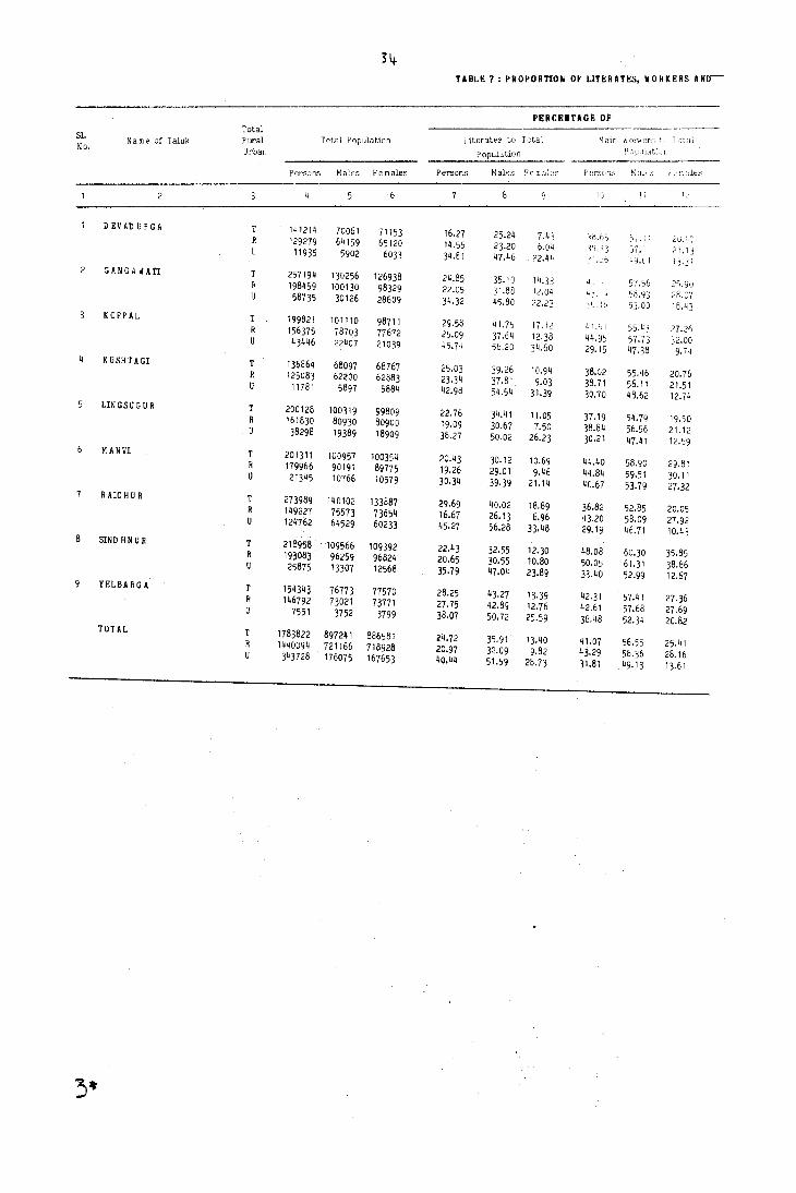
34-TABLE 7: PROPORnON OF LITERATES, WORKERS ANo--
PERCEIIUGE OF Total
Ulerat€'s to Total Main ~! or'i<er~...: 7, 1 ,~t 'i1 S1. Name of Taluk Rural Total Population h)~~! .. 1l~1L, No. Urban Population
Persons Males Females Persor.s ~: ales Fe rr.ales rH'SCJns ~: 1H_';:; !'.'-Jle,S
1') 1;
DEVADURGA 14121~ 70061 71153 16.27 25.2~ 7.43 58.65 ~,. . : . 2G.~·-· 129279 64159 65120 14.55 2].20 6.04 ~Il.; 3 57. 21. 13 11935 5902 6033 34.81 47.46 22.44 )6 q.tl 1)·31 GANGAWATl T 257194 130256 126938 24.85 35.10 14.33 57.56 2<;.90 198459 100130 98329 22.05 31.88 12.04 4}. -t '>8.93 28.07 58735 30126 28609 34.32 45.80 22.23 . ~ II 53·00 18.43 KOPPAL T 199821 101110 98711 29.58 41. 75 17.12 In,;, i 55.43 27.26 R 156375 78703 77672 25.09 37.64 12.38 44.9, 57.73 32.00 U 43446 22407 21039 45.74 56.20 34.60 29.15 47.38 9.74 KUSHTAGl T 136864 68097 68767 25.03 39.26 10.94 38.02 55.46 20.76 R 125083 62200 62883 23.34 37.81 9.03 38.71 56.11 21.51 U 11781 5897 5884 42.98 54.54 31·39 30.70 48.62 12.74 LlNGSUGUR T 200128 100319 99809 22.76 34.41 11.05 37.19 54.79 19.50 R 161830 80930 80900 19.09 30.67 7.50 38.84 56.56 21.12 U 3829B 19389 18909 38.27 50.02 26.23 30.21 47.41 12.:'9 MANVI T 201311 100957 100354 20.43 30.12 10.69 44.40 58.90 29.81 R 179966 90191 89775 19.26 29.01 9.46 44.84 59.51 30.11 U 21345 10166 10579 30.34 39·39 21.14 40.67 53.79 27.32 R AlC H U R T 273989 140102 133887 29.69 40.02 18.89 36.82 52.85 20.05 R 149227 75573 73654 16.67 26.13 6.96 43.20 58.09 27.92 0 124762 64529 60233 45.27 56.28 33.48 29.19 ~6.71 10.43
8 SIND H N U R T 218958 109566 109392 22.43 32.55 12.30 48.08 60.30 35.85 R 193083 96259 96824 20.65 3o.s5 10.80 50.05 61.31 38.86 25875 13307 12568 35.79 47.04 23.89 33.40 52.99 12.67 YELBARGA T 154343 76773 77570 28.25 43.27 13.39 42;31 57.41 27.36 R 146792 73021 73771 27.75 42.89 12.76 42.61 57.68 27.69 7551 3752 3799 38.07 50.72 25.59 36.48 52.34 20.82 TOTAL T 1783822 897241 886581 24.72 35.91 13.40 41.07 56.55 25.41 R 1440094 721166 718928 20.97 32.09 9.82 43.29 58.36 28.16 U 343728 176075 167653 40.44 51.59 28.73 31.81 49.13 13.61
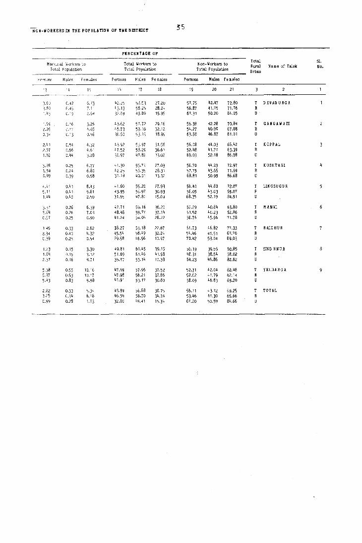
NoN-WORKERS IN THE POPULATION OF THE DISTRICT ~5
PER CENTAGE OF
Marginal Workers to Total Workers to Non-Workers to Total Sl. Rural Name of Taluk No.
Total Population Total Population Total Population Urban
Persons Males Females Persons Males Females Persons Males Females
13 14 15 16 17 18 19 20 21 2
3.60 0.42 6.73 42.25 57.53 27.20 57.75 42.47 72.80 T DEVADURGA 3.80 0.45 7.11 43. 13 58.25 28.24 56.87 41.75 71.76 R 1.43 0.19 2.6 11 32.69 49·80 15·95 67·31 50.20 84.05 U
1.69 0.16 3.26 43.62 57.72 29.16 56.38 42.28 70.84 T GANGAWATI 2.09 0.17 4.05 45.73 59.10 32.12 54.27 40.90 67.88 R 0.34 0.13 0.56 36.50 53.13 18.99 63.50 46.87 81.01 U
2.41 0.54 4.32 43.92 5':1.97 31.58 56.08 44.03 68.42 T KOPPAL 2.57 0.56 4.61 47.52 58.29 36.61 52.48 41.71 63.39 R 1.82 0.44 3.28 30.97 47.82 13.02 69.03 52.18 86.98 U
3.28 0.25 6.27 41.30 55.71 27.Q3 58.70 44.29 72.97 T KUSHTAGI 4 3.54 0.24 6.80 42.25 56.35 28.31 57.75 43.65 71.69 R 0.49 0.39 0.58 31.19 49.01 13.32 68.81 50.99 86.68 U
4.41 0.41 8.43 41.60 55.20 27.93 58.40 44.80 72.07 T LINGSUGUR 5 5.11 0.41 9.81 43·95 56·97 30.93 56.05 43.03 69.07 R 1.44 0.40 2.50 31.65 47.81 15.09 68.35 52.19 84.91 U
3.31 0.26 6.39 47.71 59.16 36.20 52.29 40.84 63.80 T MANVI 3.64 0.26 7.03 48.48 59.77 37.14 51.52 40.23 62.86 R 0.57 0.25 0.90 41.24 54.04 28.22 58.76 45.96 71.78
1.45 0.33 2.62 38.27 53. 18 22.67 61.73 46.82 77.33 T R Arc H U R 2.34 0.40 4.32 45.54 58.49 32.24 54.46 41.51 67.76 R 0.39 0.25 0.54 29.58 46.96 10.97 70.42 53.04 89.03 U
1.73 0.15 3.30 49.81 60.45 39.15 50.19 39.55 60.85 T SINDHNUR 8 1.64 0.15 3.12 51.69 61.46 41.98 48.31 38.54 58.02 R 2.37 0.16 4.71 35.17 53·14 17.38 64.23 46.86 82.62 U
5.38 0.55 10.16 47.69 57.96 37.52 52·31 42.04 62.48 T YELBARGA 5.37 0.53 10.17 47.98 58.21 37.86 52.02 41.79 62.14 R 5.43 0.83 9.98 41.91 53·17 30.80 58.09 46.83 69.20 U
2.82 0.33 5.34 43.89 56.88 30.75 56.11 43.12 69.25 T TOTAL }.25 0.34 6.18 46.54 58.70 34·34 53.46 41.30 65.66 0.99 0.28 1.73 32.80 49.41 15.34 67.20 50.59 84.66

36
TABLE 8 : DISTRIBUTION OF VILLAGES ACCORDING TO THE AVAILABILITY OF DIFFERENT AMENITIES
Number (with percentage) of villages having one or more
Sl. Number of of the following amenities Name of Taluk inhabited
No. villages Drinking Post and Marketl Commun- Approach by Power Education Medical Water Telegraph Shandy ication Pucca Road Supply
10 11
D EVAD URGA 173 154 18 173 42 8 152 55 89 89.02 4.62 100.00 24.28 4.62 87.86 31.79 51.45
GANGAWATI 149 129 21 149 47 6 86 89 123 86.58 14.09 100.00 31.54 4.03 51.72 59.73 82.55
3 KOPPAL 137 122 20 137 43 16 55 63 126 89.05 14.60 100.00 31.39 11.68 40.15 45.99 91.97
KUSHTAGI 163 153 163 50 6 102 45 92 93.87 5.52 100.00 30.67 3.68 62.58 27.61 56.44
LINGSUGUR 185 169 19 185 51 6 81 71 108 91.35 4.86 100.00 27.57 3.24 43.78 38.38 58.38
MANVI 163 144 24 163 53 11 65 69 91 88.34 14.72 100.00 32.52 6.75 39.88 42.33 59.51
HAICHUR 152 142 20 152 55 6 80 150 140 93.42 13.16 100.00 36.18 3·95 52.63 98.68 92.11
8 SIND HNU R 141 126 25 141 44 6 67 53 68 89.36 17.73 100.00 31.21 4.26 47.52 37.59 48.23
YELBARGA 138 132 8 138 51 7 63 43 76 95.65 5.80 100.00 36.96 5.07 45.65 31.16, 55.07
TOTAL 1401 1271 144 1401 436 72 751 638 919 90.72 10.28 100.00 31.12 5.14 53.60 45.54 65.60
TABLE 9: PROPORTION OF RURAL POPULATION SERVED BY DIFFERENT AMENITIES
Total Population Proportion of Rural Population served by the amenity of SL Name of Taluk of inhabited No. villages in Education Medical
Drinking Post and Marketl Com mun- 'A pproach by Power the Taluk Water Telegraph Shandy ication Pucca H Dad Supply
10 11
1 D EV AD U R G A 129279 97.81 20.49 100.00 51.43 21.25 95.53 41.74 69.42 2 GANGAWATI 198459 98.55 37.35 100.00 65.87 19.50 81.05 79.90 96.31 3 KOPPAL 156375 98.24 39.86 100.00 63.65 32.12 60.64 68.32 97.29 4 KUSHTAGI 125083 99.07 22.64 100.00 59.84 18.93 74.52 31.93 74.65 5 LINGSUGUR 161830 97.78 19.65 100.00 62.49 19.47 61.43 52.78 7lt.68 6 M ANVI 179966 97.89 35.95 100.00 61.71 23.95 59.06 61.09 79.62 7 R AlC H U R 149227 99.31 30.45 100.00 61.90 7.23 65.96 99.00 99.86 8 SIND HNUR 193083 99.05 43.78 100.00 57.82 13.32 72.54 62.06 71.65 9 YELBARGA 146792 99.36 21.12 100.00 69.56 20.15 67.80 47.69 72.79
TOTAL 1440094 98.55 31.16 100.00 61.79 \9.50 70.56 62.46 82.06
TABLE 10: DISTRIBUTION OF VILLAGES NOT HAVlIIG CERTAIII AMENITIES ARRANGED BY DISTANCE RANGES FROM THE PLACES IIHERE THESE ARE AVAILABLE
Number of villages where the amenity is not available and Village not having available at a distance of
the amenity of - 5 K ms 5-10 Kms 10+ K ms Total
1 ED U C A TID N 128 1 1 130 2 MEDICAL 577 442 238 1257 3 DRINKING W HER 4 POST AND TELEGRAPH 875 83 7 965 5 MARKET 446 524 359 1329 6 COM M U NIC A TIO N 490 131 29 650

37
TABLE 11 : DlSTRIBUTION OF VILLAGES ACCORDING TO THE DlSTANCE FROM THE NEAREST TOliN AND AVAILABIUTY OF DIFFERENT AMENITIES
Distance range Number of Nu m ber (with percentage) of villages having the amenity of
fro m the nearest villages
town (in K ms) in each
Education Medical Drinking Post and Marketl Commun- A pproach by
range Water Telegraph Shandy ication Pucca Road
0-5 86 76 6 86 26 2 47 59 (88.37) (6.98) (100.00) (30.23) (2.33) (54.65) (68.60)
6-15 473 433 54 473 160 27 272 247 (91.54) ( 11.42) (100.00) (3}.83) (5.71) (57.51) (52.22)
16-50 842 762 84 842 250 43 432 332 (90.50) (9.98) (100.00) (29.69) (5.11) (51.31) (39.43)
51+
Unspecified
TOTAL 1401 1271 144 1401 436 72 751 638 (90.72) (10.28) (100.00) (31.12) (5.14) (53.60) (45.54)
TABLE 12: DlSTRIBUTION OF VILLAGES ACCORDING TO POPULATION RANGE AND AMENITIES AVAILABLE
Population Range
500-1999
2000-4999
5000+
TOTAL
Number of Number (with percentage) of villages having the amenity of inhabited
villages Education Medical
Drinking Post and Market! in each range Water Telegraph Shandy
498 374 1 498 8 2 \ 75-10) (0.20) (' 00.00) ( 1.61) (0.40)
761 755 64 761 294 18 (99.21) (8.41) (100.00) (38.63) (2.37)
112 112 54 112 104 31 (100.00) (48.21) ( 100.00) (92.86) (27.68)
30 30 25 30 30 21 ( 100.00) (83.33) ( 100.00) ( 100.00) (70.00)
1401 1271 144 1401 436 72 (90.72) ( 10.28) ( 100.00) (31. 12) (5.14)
TABLE 13: MAIN STAPLE FOOD IN THE MAJORITY
Sl. No.
OF VILLAGES IN EACH TALUK
Na m e L,'l' TalUl<:
DEVADURGA GANGAWATI KOPPAL KUSHTAGI LI:~ G S U G U R fl A N VI RAICHUR SINDHNUR YE:.BARGA
~,: 3.ir~ Staple F oc·d
JO\ .. ;3r, Rict' Jo'war. Ri";l~
JD'I..J3f" Ri~c' ,jOW-3c. Bajr,l ,lOW aI', Bi\,t"
,ie,w' ell', P ~\_'t
Commun- Approach by kation Pucca Road
198 171 (39.76) (34.34)
428 355 (56.24) (46.65)
95 82 (84.82) m.21)
30 30 ( 100.00) (100.00)
751 638 (53.60) (45.54)
Power Supply
10
69 (80.23)
352 (74.42)
498 (59.14)
919 (65.60)
Power Supply
10
230 (46.18)
552 (72.54)
107 (95.54)
30 (100.00)
919 (65.60)

Sl. No.
6
7
8
SI. No.
Name of Taluk
DEVADURGA
GANGAWATI
KOPPAL
KUSHTAGI
LINGSUGUR
M ANVI
R AIC H U R
SIND HNUR
YELBA RGA
TOTAL
38
TABL! 1_: DISTRmUTIOIi OF VllLAGES ACCORDING TO LAND USE
Num ber of Inhabited Villages
173
149
137
163
185
163
152
141
138
1401
Total Area (H ectares 0.00)
146568.58
126153.96
130030.57
130983.20
191294.49
177097.10
144071.90
151427.04
143246.07
1340872.91
Percentage of Cultivable Area to
Total Area
75.90
71.36
74.91
88.28
83.08
86.22
86.26
84.81
95.56
83.19
Percentage of Irrigated area to
Total Cultivable Area
1.63
31.96
6.35
1.00
0.53
22.57
6.82
22.08
1.63
10.07
TABLE 15: GROWTH, DENSITY AND SEX-RATIO OF URBAN POPULATION IN THE DISTRICT IN RELATION TO THE StATE
DISTRICT STATE
Census Percen- D ecadal Sex D ecadal Sex
Year tage of percent- Density Ratio Percen- percent-Density Ratio
Total Urban Urban age (Popul- (No. of Total Urban tage of age (Popul- (No.of Popul- Popul- Popul- variation
ation per females Popul- Popul- Urban variation ation per females
ation ation ation in urban
Sq. K m) per ation aticn Popul- in urban Sq. K m)
per Popul- 1,000 ation popul- 1,000 ation males) ation males)
2 10 11 12 13 14
1951 952583 208713 21.91 90.07 NA 943 19401956 4453480 22.95 61.91 NA 941
1961 1099642 160622 14.61 -23.04 678 949 23586772 5266493 22·33 18.26 1777 913
1971 1415740 217471 15.36 35.39 2451 940 29299014 7122093 24.31 35.23 2272 913
1981 1783822 343728 19.27 36.73 3906 952 37135714 10729606 28.89 50.65 2914 926
TABLE 16: NEW TOWNS/TOWNS DECLASSlFlI!D IN 1981 CENSUS
Name of Town Population 1981 Census
(a) ·Added
1) H atti G old Mines 9962
ti) Yelbarga 7551
(b) Declassified - NIL -

39
TABLI 17 : PIR CAPITA RECEIP' AID IIPI.OITUII I. 'OlliS
PER C A PIT A
Receipt (Rs.) Expenditure {Rs.}
Sl. Class, Name & Civic Expend-
No. Status of the Town Receipt iture on Expend-Receipt
froQI all Total General Publio Public
iture on Other
Total through other
Expend- AdmWst- Health Works
Public Aspects
Taxes iture ration and Instit-sources Conven- utions iences
2 7 10 11
IV D EV AD U R G A (M) 25.36 2.32 23.04 26.09 4.84 8.24 0.01 13.00
2 II GANGAWATI (M) 34.67 21.08 13.59 34.50 14.67 6.06 11.35 2.42
V HATTI GOLD MINES (N A C) 864.60 5!,,!'J.7h 271.84
m KOPPAL (M) 25.68 19.08 6.60 25.36 6.99 6.93 6.17 5.27
5 IV KUSHTAGI (M) 16.91 6.67 10.24 16.93 11.54 0.54 '.28 0.19 3.38
6 IV LINGSUGUR (M) 21.73 10.85 10.88 19.42 9.08 4.65 2.59 3.10
7 m M A NVI (M) 27.25 14.61 12.64 29.24 7.86 12.88 8.50
8 IV MUD GAL (M) 10.72 1.45 9.27 13.23 5.10 5.52 0.18 2.43
9 V MUNIRABAP PROJECT AREA (SA) 1.98 1.98 136.66 76.96 8.17 51.53
10 I RAICHUR (M) 60.29 27.30 32.99 60.23 8.15 17.32 5.39 0.05 29.32
" m SIND H N U R (M) 27.84 16.B3 ".01 26.67 4.68 5.66 9.94 6.39
12 V YELBARGA (M) 15.16 6.~7 8.69 15.20 5.2~ 1.59 1.17 0.38 6.82
TOTAL 37.54 18.71 18.83 65.48 8.33 28.88 5.67 0.03 22.57
TABLE 18: SCHOOLS PER 'II THOUSAID popuunOi II 'OlliS
Sl. Class, II am e and Civic N umber per ten thousand population
Ho. Status of the Town Higher Secondary/
Secondary/ Junior Secondary/ Inter/PU C/
Matriculation Middle Primary
Junior Colle e
2 6
IV DEVAD URGA (M) 0.8~ 1.68 2.5 I 2.51
2 II GANGAWATI (M) 0.17 0.68 1.02 5.38
V H UTI GOLD MINES (N AC) 1.00 1.00 2.01 4.02
4 m KOPPAL (M) 0.28 1.11 2.50 4.17
5 IV KUSHTAGI (M) 0.85 0.85 2.55 5.09
6 IV LINGSUGUR (M) 0.59 1.18 2.37 3.55
7 m MAIIVl (M) 0.47 0.47 2.34 2.81
8 IV HUD G AL (M) 0.87 0.87 0.87 1.75
9 V HUNIRABAD (PROJECT AREA) (SA) 1.34 1.34 1.34
10 R AIC H U R (M) 0.24 0.96 1.84 2.40
II m SIND HNUR (M) 0.39 1.16 2.71 3.86
12 V YELBARGA (M) 1.32 1.32 2.65 2.65
TOTAL 0.38 0 .. 96 1.92 1.n'

Sl. No.
10
11
12
IV
IT
ill
IV
IV
ill
IV
ill
IV
40
TABLE 19: NUMBER OF BEDS IN MEDICAL INSTITUTIONSlN TOWNS
5l. No.
Class, N a m e and Civic Status of the Town
N umber of beds in medical institutions per 1000
population
IV DEVADURGA (M) 2.01 II GANGAWATI (M) 0.37 V HATTIGOLD MIN ES (N A C) 5.02
ill KOPPAL (M) 0.83 5 IV KUSHTAGI (M) 1.53 6 IV LINGSUGUR (M) 1. 78 7 ill MA NVI (M) 0.56 8 IV MUD GAL (M) 0.52 9 V MUNIRAEAD PROJECT
AREA (SA) 3.35 10 RAICHUR (M) 1.~g
11 ill SIND H N U R (M) 0·31 12 IV YELBARGA (M) 5· 30
TOTAL 1.21
TABLE 20: PROPORTION OF SLUM POPULATION IN TOWNS
Class, N? m e and Civic Status of the Town
IT GANGAWATI (M)
RAICHUR (M)
TOTAL
Proportion of the Slu m s Population to Total
Population of the Tow n
31.33
19.54
23.31
Density in Slums
per Sq. K m.
114286
39514
54987
TABLE 21: MOST IMPORTANT COMMODITY MANUFACTURED, IMPORTED AND EXPORTED IN TOWNS
Class, N a m e and Civic Status of the Town
DEVADURGA
GANGAWATI
HHTIGOLD KIN ES
KOPPAL
KUSHTAGI
LINGSUGU R
MAN VI
MUD GAL
(M)
1M)
(N A C)
(M)
1M)
1M)
1M)
1M)
MUNIRABAD PROJECT AREA (S A)
RAICHUR I ~I)
SINDHNUR 1M)
YELBARGA (1)
Manufactured
Cotton (Lint)
Sugar
Gold
Rice
Safety Matches
Cotton (Lint)
Groundnut Oil
Cotton (Lmt)
Groundnut Oil
Cotton (Lint)
Cotton - K hadi Cloth
Most im portant co m rr,odity
Exported 1m ported
Cotton (Lint) Rice
Rice Paddy
Gold Foodgrains
Rice Groundnut
Safety Matches Edible Oil
Cut sizes of Tim ber Rice
Paddy Cloth
Cotton (Lint) Cloth
Cement
Cotton Bales ILint) Groundnut
Edible Oil Wheat
Khadi Cloth Rice
PART A - VILLAGE AND TOWN DIRECTORY
(i) Section I - VILLAGE DIRECTORY (ii) Section II - TOWN DIRECTORY


VILLAGE DIRECTORY - AN,ENITIES AND LAND USE
EXPLAI\/A TORY NOTE
As the title signifies the Village Directory aims to provide information on amenities and land use paHern in respect of each and every village with the reference period as the year 1979-80. In all there are 20 columns in this tabular statement and, out of these as many as 9 are allotted to ameniti('s and services while another 5 are earmarked for data on land use. The remaining columns are concerned about location code number and name of the village area and population, its proximity to an urban cen~re and, remarks. Since most of 'these column headings are concise and represent certain concepts, a colulTln oy column explanation is furnished herewith. This would enable the reader at the very outset to recognise the scope and appreciate the limitations of the data presented under various columns.
Column I : Location Code Number :-
The concept of location code numbers has already been explained in the Analytical Note. The location code number thus assigned to the village is entered in this column. This number, runs serially starting from I for every taluk and the data are presented for villages arranged in an ascending order of their location code numbers. If there are any villages in the taluk that are fully incorporated into the' limits of any urban area or are completE'ly submerged under the back waters of any reservoir out are continued to be borne on the jl.risdictionallists of the Survey and Settlement authorities such villages are mentioned at the end without any location code number and in all such cases it may incidentally oe pointed out, no further data except the name and the area are furnished in the statement. Similarly in the case of villages which are classified as outgrowths of towns, their names and area particulars alone are given treating them at par wi th villBges fully incorporated in urban areas.
Column 2 : Name of Village :-
The name of the village corresponciing to the location code number is given in column I is spelt out in English in this column. By and large the spellings adopted at the previous i.e. 1971 Census, have been retained even now. However, errors aris· ing out of misreporting and misprinting if any in the 1971 District Census Handbooks have been taken note of and the correct spellings are now used. So also cnanges in village names duly effected by the Governrrrent with the sanction of the concerned authorities have been taken into consideration while finalising the spellings of villages names for 1981 census purposes. Further, if the name of the village has now been- spelt differently as compared to the spelling given in the 1·971 District Census hand book for whatever the reason the spelling as adopted in the 1971 District Census Handbook is also furnished within brackets below the present narne of the village in the alphabetical list of villages for the convenience of the data user.
A little more explanation appears to be necessary about the places which appear in the list of towns as well as in the list of villages. This phenomenon occurs particularly in the case of Taluk and District f-ieadquarter towns which, as revenue entities are geographically large villages. Tht: main villaEe site areas including the peripheral developed areas would have for long been incorporated into the urban limits without any change whatsoever
•
in Survey and Settlement records. In the Oris,i~al Survey recOrds and also at the Resurvey, the entire village inclusive of all the lands that are incorporated into the urban limits continues to be show!_l as a regular revenue village. In other words the\ portion constituted into a town is not taken out frolll the parent village and formed into a separate and independent unit in the jurisdictional lists. [very civic body, be it a municipal corporation or a town municipality or a notified area or a sanitary bnard defiiJ.es its own jurisdiction confining itself mostly to the b",ilt up area and the fringe areas for enforcing municipal rules and regulations. With the administrative and legal sanction of the Government which issues a notification in this behalf the civic body secures statutory rights for administering the local area so defined. The incorporated areas may at times cut across vlllage boundaries and may com
'Prise of portions belonging to the revenue jurisdiction of two or more villages. In some instances entire revenue lands of a village or of sever~1 villages are incoijlorated into the limits of a town in which case for purposes of census operations these villages lose their independent identity and are omitted in the list of villages of the taluk. Eut it is only in case of villages of which only certain portions are included in the town, especially those that contribute their names to the towns concerr.ed that this apparent duplication of names occurs. In such cases the jurisdiction of the town is very clear and it covers only a portion of village which is constituted into an independent entity as urban for census enumeration purposes. The remaining area too is constituted as an indepencient unit under the rural category i.e. as a villa~e. In order to distinguish this unique situation, the name of the village bears the suffix Rural within brackets in the census village Iists-. --Division of the village into urban and rural components and the suffixing of the names is a special procedure adopted for census purposes only. That is to say, if one were to ask-the Officers of the Survey, Settlement and Land Records whether in their lists there are villages such as say Sellary (Rural), Belgaum (Rural), Bijapur (Rural), Chamarajnagar (Rural), Magadi(Rurat Lv;anciya (Rural), Mysore (Rural), Raichur (Rural) etc., the answer would be a definite 'no' and then they would say that there are villages of the same name but without the suffix Rural. Similarly in the village maps and other records pertaining to the above named places, the lands that are incorporated into urban areas are also shown as part and parcel of the village concerned.
CoJumn J : TotaJ area of the viJIage (in hectares) The total geographical area of the villa!>e
as per revenue records is furnished in hectares up to two decimal places. In Karootaka the basic records are still maintained in acres and p,untas or acres and cents that is the units of measurements which were first adopted at the time of the cadastral survey. After the Introduction of the decimal system however the equivalents of these figures are also indicated, in addition to the already existing entries in resisters such as Akarband and Records of Rights. The area of each Survey number or part thereof Is converted into hectares and ares and square yards too in some cases. Thus if these converted figures fot each such small uni tare addeo together for the village the resultant total area would normally be either less or more than the corresponding figures that one would derive by the addition of figures in acres - guntasl

acres and cents and conversion of that into hee!Mes and ares. For purposes of presentation in this statement the village level area and land use figures which were furnished in acres-guntas or <tcres-cents by the Revenue Officers have been convertcd into hectares and ares and thE's£' figurE's I:;ay not therefore be identical with the are" as Illqy
be found entered in hectares and ares in the records oj some of the villages. The marginal differences would be due to the factors explained above. Further, in the case of villages of which certain portions are incorporated into an urban area the extent thus categorised as urban has been deducted from the total geographical area of the revenue village and for this reason the particulars presented here would not be' il1 full correspondence wi th the total area of that revenue administrative unit as (llentioned in the village records. If area figures are not available for any village the abbreviation 'N.A.' is entered in this column and a note at the bottom of the page explains the reason thereof also.
Column 4 : Total P~ulation and number of households :-
The total population of the village according to 1981 census and the number of households therein are indicated in this column. In the case of vllia.ges wi1h no inhabitants i.e. nil population, the word un-inhabited is wri tten across the line.
Columns 5 to 10 ; Amenities available (if not available within the village, a dash may be shown in the coll.:tln aid next to it in brackets, the distance in bro..' ra~es, viz.-5 Km, 5-10 Km aid 10+ Km of the 11e_, ~t place where the facility is available may be gi~.:~J:-
As the main heading for these columns suggest if the basic amenity covered under any of these columns were to be not available within the Village then, instead of simply stating that fact, an attempt is made here to indicate the minimurJ) distance (iil ranges) that one has to cover to avail oneself of that specific facility located in a nearby village ;)r a town. A t the data collee tiol) stage the name of such nearest place having that amenity as also the distance thereto from the referent Village have been ascertained to ensure a higher degree of reliability in reporting. The abbreviations made use of in these columns are explained below colufnn by column.
Column 5 : Education :-
All types of educational institutions functionIng in the Village irrespective of the levels of education offered, the medium of education and the status of the managing body are considered under this column. The aobreviations used to denote I nstitutions with differeM levels of education ·are :
d P : Primary or Elementary School:
Schools providing education form I standard and upwards upto and inclusive of IV standard are classified as Primary Schools. This would also include junior basic schools if any.
For purposes of reporting, schools which provide education not merely from I to IV but also for higher standards, called composi te schools for easy reference, are split up into different levels of education and counted as an independent unit under each such level.
44
ii) 11,1 : iv:iddle or Junior Secondary School :-
Schools providing education from V standard and upwards uplO and inclusive of VII standard and classified as middle schools. In Karnataka as a matter of fact the term middle school IS no longer in vogue. Primary educatIOn itself consists 01 seven years of schooling and the first four yeai' duration of this course is called Lower Primary and the next 3 year period is termed as Higher Primary. As mentioned above a Higher Primary School with I-Vll standard is treated as two units i.e. one Primary School and one Middle School for accounting purposes.
iii) H : (V',atriculation or Secondary School :-
Schools providing education from Vill standard and upwards upto and inclUSive of X standard are classified as High Schools. A composite school with I - X standard is treated as three separate units and counted separately under the category of Primary, Middle and r;igh School. iv) PUC : Higher Secondary/lntermediate/Pre-uni
versity/Junior College :-Schools and COlleges that provide education
for the XI and XII standards or as is more common in Karnataka for the I and II year of the Pre-University Course, fall under this category. There are Higher Secondary Schools with VIII standard and upwards covering the XII standard and on the other hand there are also degree colleges which provide education for PUC I and PUC II year. These composite units are as explained earlier, split up into different levels for reporting purposes.
v) C : CoJJege :
This would cover all educational institutions Ihat provide post PUC level education leading to UniverSIty degree in any subject or combination of subjects, and also post-graduate levels of education.
vi) 1 : Industrial School I
Industrial Schools if any in the villages are indicated by the abbreviation 'I'.
vii) TR : Training School:
All types oj Institutes that provide vocational and professional training are covered by this abbreviation.
viii) AC : Adult Literacy Class/Centre:
This abbreviation is recorded in thIS column only if adult literacy classe~ were being conducted regularly in the village during the reference year.
ix) 0 : Others:
AJJ other types of educational institutions such as Sanskrit Pathasala, lJ rdu Madarasa, N,al<htab etc., are included in this resiouary category.
It is important to note that in this column whenever the number of institutions of a particular l~vel or class exceeds one, only then the actual number is also reported immediately after the relevant abbreviation within brackets. That is to say the mere presence of an abbreviation without any numerical attribute signifies the existence of the facility,

III ill least one institution for which th;}t abbrl:viatlon stands. The numerals Indicate the number 01 ill,litutlon~ or units of that level or type.
-'\s explained already if il villilge doe, not h<tvl' -jny rdllcatlonal institution Whilbo('v('r then d d~"il (-l " entered ~tnd tilcH'<tlter, wltilin brackets, tlie minimulll distancc that one has to cover to dv,ul ol1e,ell of the primary level of educational lacili t) is indicated. The emphasis here is on the most oasic need i.e., the minimulO level. In otl1erwords, if the village has primary school, but not middle school or high school then no further information is furni-shed in respect of the proxinlity of a middle school and upwards. Similarly for a Village with primary and middle schools but no high school or a cpllege no further information is furnished in respect of the proximity 01 high school and college level facilities.
It may again be recalled that the concept of Village covers the entire revenue jurisdiction of that unit and includes all the hamlets i.e. human settlements located therein.
Column 6 : l'J.edical :-
The abbreviations used to denote the existence of medical institutions of different types in the village are:
H : hospital MCW : lV:aternity and Child Welfare Centre N;H : /V.aternity Home
cwe : Child Welfare Centre HC : Health Centre
PHC : Primary Health Centre PHU : Primary Health-Unit
o : Dispensary FPC: Family Planning Centre
TB : T.B.Clinic NH : Nursing Home RP : Registered Medical Practioner
Si0P : Subsidised N;edical Practitioner CHW : Community Health Worker
o : Others
If the number of institutions of a particular type happens to be more than one then that number is also indicated immediately after the relevant abbreViation.
Jf the village does not ha.ye any medical facilities whatsoever then the minimum distance that one has to cover to secure the minimum level of nwdical facility is indicated here in distance ranges.
The abbreviation H which stands for hospitals implies the availability of facilities for the treatll\ent of in-patients also. In several Primary Health Centres also' such facilities do exist. Likewise iY.sternJty Homes also entertain in-patiients but then these are confined only to maternity cases. This apart in all other cases except private nursing homes arrangements exist for the treatment of out-patients only. In local parlance in certain areas however even a dispensary is referred to as a hospital and the clinic run by a private medical practitioner as a dispensary and a private nursing home as a hospital. This indiscriminate usage at times leads to confusion and in view of this every attempt has been made to elimina te such ~eporti ng errors.
45
A II types of medical institutions, irrespective 01 the system of medicine practised .therein are covered under this colum without any attempt to provide a lurther break up by systerns of meciicine.
About the Corlllllunity Hedllh hforkcr it may incidentally be mentioned that it does not refer to workers in ex tension programmes like Malaria Sur-vcillance Workers, BaSIC Health Worker, Auxillilry l'iurse fVlidwile etc., but refers only to the paramedical personnel who have been specially trained for dispensing medicines for minor ailments at _the doorsteps of the patie_nts. This is an altogether new scheme and has not been introduced in Karnataka. Column 7 : Drinking Water :-
FollOWing are the abbreviations used to indicate the different sources of drinking water that are available in the village. These sources of drinking water supply may be public property or may even be owned by private persons and institutions. If there are two or more sources then all these sources are mentioned one after the other but separated by commas.
T:Tap VI: Well TK I Tank TW I Tube Well HP : Hand Pump R : River F : Fountain
C : Canal L : Lake S : Spring N : Nallah/S tredrn o : Others
NA : Information not available
If the village does not have any source of drinking water supply at all then, after a dash in this column, the distance range that one hilS to traverse to ~each the nearest place with drinking water lacility Is indicated.
Column 8 : Post and Telegraph :-
In this column information on the availability of postal, telegraph and telephone fdcilities in the vIllage is furnished using the following abbreviations.
: Post Office : Telegraph Office
PO TO PTO : Post and Telegraph Offices Phone : Telephone connection
Telephone connection need rot necessarily indicate the availability of a public call office in the village, for even private telephone connections to subscribers have been taken into considerations while filling up this column. If a village has postal as well as telephone facilities then both these amenities are mentioned. Likewise if there is a PTO and telephone connection then both the abbeviations are entered in thi~ column. On the otherhand if the vilJage is not having any of these facilities then a dash is noted and next to it the distance to the nearest place having the minimum facility of a post office is indicated in ranges.
Column 9: Day or Days of the Market/Hat :-
This column refers to the weekly, bi-weekly markets i.e., the weekly shandy, heJd in viJJages with a view to cater to the needs of that village

and more so to the needs of the inhabitants of several surrounding villages. In local terminology such a weekly market is called San the and is quite popular in Karnataka. In the case of villages which host such shandles the actual day on which the shandy takes place is mentioned and in all other cases a dash is entered and thereafter the distance to the nearest place with a weekly market is indicated in ranges as specified in the column heading. The place where such weekly market gathers may be located in the limits of an adjoining taluk or district. The important matter for consideration here is the geographical proximity. In some cases where the nearest town or a largesized village with a permanent market would serve the needs of the villagers, the distance ranges refer to such places with permanent markets only. In such cases obviously the nearest place where a weekly market is held would be very far away and will not be' a matter of much significance.
Column 10 : Communication:
For purposes of this column only the means of public transport' namely bus, railway and water transport system if any are considered. If the village is setved by any mode of such public transport the fact is indicated using the undermentioned abbreviations:
BS : Bus RS : Railway Station NW : Navigable Water way (including river, canal,
backwaters)
If a bus stop or a railway station is located within the territorial jurisdiction of a village then that villagae is considered as being served by that facility even if that bus stop or railway station 15 somewhat solitary and is located at some distance from the village-site. If more than one type of communication facility is available then all the relevant abbreviations are mentioned in this column. If no such facility is available at all then a dash is entered and thereafter the distance to the nearest place with a communication facility is indicated in ranges.
Column II : Approach to village :-
By approach to village is meant the type of road that leads to the village and this would indicate whether the village is accessible throughout the year or only during the fair season. The abbreviations used in this column are:
PR : Pu«~a Road KR : Kachcha Road NR : Navig>lble River NC : Navigable Canal NW : Navigable Waterway other than river and canal
if a~ FP : Foot path/Bridle path
If a village has a foot path or bridle path and also both pucca road and kachcha road then, only PR is recorded in this column as it would denote a higher level of facility of the same type. While kachcha road refers only to the unsurfaced mud road the term pucca road covers tar roads, cement roads water bound mecadum roads and metalled roads. But
46
if in addition to either PR or KR the village has a waterway then information on the availability of a water way is also indicated.
Column 12 : Nearest 'town and distance I
The name of the nearest town, that ,s any urban area as defined for purposes of the 1981 Census, and the distance thereto from the village are indicated in this column. The town mentioned here need not be located within that very taluk or the district or even the State for that matter. The main point for consideration here is the geographical proximity. The distance however 15 reckp.lE'd I1I:>t as a 'crow flles' but by some land route or water way. Further, when there Is a cross country foot-path or a cart-track and a little more circutious road from the vUlage or It5 pro>.lmity to the town then the distance by road is reported here in preference to the distance by foot-path or cart track. Similarly, when there are natural hurdles like unbridged rivers or streams the distance it furnished by the [I,ore circuitious route that the villagers would usually prefer. The information on distance is based on local enquiry by the reporting agency. If the town mentioned in this column belongs to another state then the name of that state is also indicated along with the name of the town and distance thereto.
Column 13 : Power ~Iy 1-
If the village is electrified, that is if power is actually available, whatever may be tht: form of its use, then the village is regarded as enjoying this amenity of power-supply. If the supply is expressly restricted for say agricul-tural or any other specific purpose then this point is clearly stated by using a specific abbreviati·:ln. On the other hand if electricity is being supplied for all purposes without any reservation~ then information on various purposes is not separately mt>ntioned. The abbreviations used in this column are:
ED : Electricity 'for domestic purpose only LAg : Electricity for agricultural purposes only EO : Electricity for other purposes like indus-
trial, commercial etc, EA : Electricity for all purposes stated above. Column 14 : Staple Food :-
Information on the staple food i.e. the cereals used by the majority population during the major portion of the year is furnished under this column. It may incidentally be mentioned here that no probing enquiries have been made to ascertain the exact situation in each and every village and that the details presented here are of a general nature. In several cases when it is not possible to determine the particular staple cerial, a combination. of major staple foodgrains is given.
Columns 15 to 19 : Land use (I.e. area under different types of land use In hectares l4> to two· places of decimal) I
The Ministry of Food and Agriculture, C:overnment of India has recommended to the Sta~e GJvernments the following classifications of land use pattern for the maintenance of records and for
purpo~t'S of presentation here the sanlC c1asslfic<.!tlon n,odcl has been adopted.
I. Forests, 2. Not available for cultivation,
a) Lands put to non-agricul tural uses, b) Ilarren aoo unculturable lands
3. Other uncultivated lands excluding fallow lands iI) Permanent pastures and other grazing lands,
0) Lands under miscellaneous tree-crops and groves not included in the net area sown,
c) Culturable wastes 4. Fallow lands:
ill Fallow lanos .Jther than current fallows, t..) Curreht fallows
5. Net area sown.
Column 15 of the Village Directory corresponds to category I i.e., forest, while columns 16 and 17 put together represent the cultivated lands and correspond to the combination of categories 4 and 5 above. Similarly columns 18 and 19 respectively correspond to categories 3 and 2 of the above classification. The data furnished here are based on the village records and pertain generally to the year 1979. The total of the area figures reported under these columns tallies with the total geographical area of the village as noted in column 3.
Column ., : Forest :.
This includes all lands classed as forests under any legal enactment dealing with forests or aoministered as forests whether State - owned or private and whether wooded or simply maintained as potential forest land. Lands tran~ferred to forest department for afforestation as also the class C and IJ lands transfered thus by the revenue department are also classified as forests. Within the forest area itself there may ocassionally be cultivated patches or dse there may be grazing lands. But such areas too are shown under colur.m 15 only as forests. If within an area classified as forest some specific extents of lands have been expressly assigned for regular cultivation and the records have not been set right pending formalisation of grants and related processes of survey and settlement then such cropped areas are shown under column 16 or 17 as the case may be and the remainder alone is shown as forest under column 15. The processes of regularisation of land grants and effecting relevant changes in the basic records of survey and settlement are somewhat protracted.and time consumin!!,. Therefore the information merely based on records is, in some cases at least, likely to be ciiI1erent when compared with that based on the actual field situation.
Columns 16 and 17 : Irrigated (by source) and Unirrigated :.
These two columns cover all the agricultural lands and when added together would correspond to the net area sown plus the current and othf'r faHows. The latter would imply all lands which were taken up for cultivation, but are temporarily out of cultivation for a period of not less than one year and not more than five years. All lands that arc lying uncultivated as fallow for more than 5 years in succes~ion are regarded as permanent fallows i.e., culturable waste and are covered under column Ill. Area sown more than once durin~ the same year, if any in the village,is counted
41
only oncc under these columns. In colurnn 16, a sOlJrcewise break up of the irri~~ated area is furnished using the following abbreviations I
GC : Government Canal PC : Private Canal
10, : Well(without Electricity)
WE : Well (with Electricity) TW : Tubcwell (without
electrici ty) T\JE : Tubewell(with electri
city)
TK I Tank :~ : River L: Lake
\'!I: Water fall 0: Others T: Total
The concept of irrigation implies the existence of a source of water supply within a reasonable distance and an arrangement to regulate the supply of water according to the day-ta-day needs of the crops raised in these fields. Naturally therefore all areas that are cultivated under purely rainfed conditions are treated as unirngated. Though paddy is generally regarded as a wet crop, if it is raised purely as a rainfed crop as it very often is the case in heavy to very heavy rainfall regions, such areas are regarcieo as unirrigated for purposes of this column and shown under column 17. Similarly about garden crops, the area is considered {or column 16 only if there is an element of irrigation. Sometimes it happens that the lands shown as Jry and rainfed in the settlement records are in actual fact having irrigation facili ties due to recent changes such as sinking of wells, introduction of lift irrigation or canal irrrigation on commissioning of a project etc. In such a case the actual situation is taken note of and despite its classification as rainfed in the records the area concerned is treated as irrigaled Though rare, the opposite situation (where a plot of land originally shown as irrigated has ceased to enjoy that facility and is now yielding purely rainfed crops) is also met with and such a situation arises due to reason~ such as breaching of tanks, drying up of irriEation wells and small tanks, defunct canal system and so on. The reporting aeency has generally assessed the actual si tuation prevailing during the reference year 1979 while furnishing the data on Irrigated lands. Regarding canal irrigation too it is the al tual irrigated area and not the command area that has been reported here.
In column 17 the total extent of unirrigated lands, that is, dry lands cultivated as rainfed fields and the fallow lands put together is reported. As explained above, lands yielding rainfed paddy crop are considered as unirrigated.
Column 1& : Culturable WaIte (including gauchar and 81"O\'e1h-
This category includes all lands available for cultivation whether not taken up for cultivation or taken up for cultivation once but not cultivated during the past five years or more in succession. Such lands may be either fallOW or covered with shrubs and jungles which are not put to any use. These may be assessed or unassessed and may be in isolated blocks or within cl.I,ltivated holdings. Lands under thatching grass, bamboo bushes and other groves which are not included under orchards or forests are also included under this category. Further, this includes all grazing lands irrespective
of whether they are permanent pastures and meadows or not. In several instances, lands that were at one time reserved for use as grazing fields and pastures and declared as ..:ssessed or unassessed wastes have over a puiod of time been brought under cultivation either fully ~r in parts as a re,ult of gradual encroachments ""d also becausE' ot the Government policies regardH'b lana granh. Thu~, though in the records, the particular plot of land continues to be shown as a pasture the actual field situation would reveal that most of that land is actually under cultivation. In all such cases; to the extent possible, the actual field
.. situation has been taken into consideration by the reporting agency.
.. Column 19 : Area not available for cultivation
In this column the total extent of land which is not availabte for cultivation in view of its being barren and uncul turable as also that which is put to non-agricultural uses is reported. Mountains, deserts, rocky hills, quarries, ravines and the like as well as the lands that cannot be
. brought under CUltivation except at a very high cost are included in the category of barren and uncultivable lands. The category of lands put to non-agricultural uses covers all lands occupied by Duildings, roads, railways, parks and playgrounds, area under water viz., rivers, streams, canals, reservoirs, tanks, ponds etc., and land put to any other use which is apparently non-agricultural.
Column 20 : Remarks including any place of religious, historical or archaeological interest :-
Though the heading does not reveal, in this
48
column, Information of general interest has been provided by reporting the number of news " paper copIes Circulated ill the village, num!1er of motor cycles and scooters, number of cars and Jeeps as well as the number of tractors available in the vJllage. The following dbbreviations are used :"
N : Newspaper copies circulating in the village. tvi : Motor cycles/Scooters avaJlable in the village C : Cars/Jeeps available in the village T : Trado" available in village
Immediately after the abbreviations the number of units is Indicated to provide a quantitative index to the data furnished. If in a village there is nothing to report On this topic i.e., On anyone or more of these items, then the concerned abbre" viations are not entered at aU. In other words, the abbreviation if found mentioned in thIS column is always followed by a numerical attribute.
It is necessary to note at this juncture that the information is based on what may be regarded a:; superficial oral enquiries by the repor ting agency and may therefore be considered as a rough estimate at a given point of time i.e. during the year 1979-80. In this column a numerical reference has also been given along with the abbreviation A -in respect of the notes, provided elsewhere in the volume, about Villages having matters of particular religiOUS, historical or archaeological interest to report. Such notes have generally been prepared on the basis of published material.

DEVAIlJRGA TALUK
4·

() '5-
J'
b-
() Ii I:
" 1:
d-+
I' :1
Ii b- Q
)
~ · 19 t.. ~ ~ ::l
I ) y .J I-
~ ~ d-~-( 0::
~ '" '? l-i If)
Ci ~
() 0-~C) a: za: ::::)
~S I ~ 0 0
~ <t: cr
~ W :< · Q • j_
~~~=
· ~ '6 0
• , • 0
~ ~ 5
if>
• £
o o E o ii .f
, o C J
~ · o CD

51
ALPHABEnCAl. LIST OF VILLAGES
TALUK : D EVAD URGA
1981 Population 1981 Population S1.. N a m e of Village Census 51, N a m e of Village Census No, L, C, No. L.C.
No. 1971 1981 No. 1971 1981
4 5
1 Aik~ud 132 241 401 66 Hemnhal 80 906 790
2 At;rahar (A grahal) 123 294 288 67 Hem nur 94 804 729
3 A kalku m pi 130 766 845 68 H erundi 146 656 706 4 Aldharti 62 23B 218 69 Herur 15 739 712
5 Alkod 128 676 837 70 Birebudur 69 1377 1462
6 A mrapur 65 565 466 71 Hirehonkunt 33 7 A mrapur IS 1 260 276 72 Hirekudalgi 84 178 155
8 A nch'Bugur 45 655 684 73 Hireralku m pi 76 1024 842
Andankhed 61 74 Honkatmalli 93 656 615
10 Anjal 44 1030 1016 75 H onnatagi 82 529 518
11 Anwar 131 447 441 76 H orahatti 177 23 12 Apprahal 78 120 133 77 H osur Siddapur 183 857 992
13 Arkera 89 2819 3612 78 H uligud 170 321 364 14 Arshangi 11 611 687 79 H ungunbad 106 203 212
80 Hunur (Hamnur) 10 132 224
15 Bagur 1~5 361 418 81 H uvinhadgi 48 407 360
16 Bandegud 125 ~01 893
17 Bassapur 184 82 115 82 Ingaladhal 67 q43 360
18 Baswantpur 79 295 226 83 Itagi 72 712 672
19 Bekalmardi (Rekalmardi) 121 165 172
20 Benderganeka! 136 1857 2117 84 Jagatkal 113 867 851
21 Benkal 5 417 438 85 Jagir"jadaldinni 120 995 1058
22 Bhogira m angund 180 514 762 86 Jalhalli 139 6166 7477
23 Shu m angund 133 916 1312 87 Ja m baldinni (Ja m aldinni) 147 176 165
24 Born manhal 81 797 705 88 Jaradbandi 109 255 255
25 80 m OJ anhalli 182 594 954 89 Ja vgud 58
26 Buddinni 110 653 645 90 j erbandi (J arbandi) 24 666 652
27 Buddinni 144 91 Jinnapur 104 591 545
28 Budinhal 68 597 558 92 Joladhadgi 3 638 702
29 Bunkaldoddi 185 1327 1602 93 Jutm ardi 126 133 262
30 C hadkalgudda 162 642 m 94 Kachapur 138 84 31 Chapalki 142 95 Kad~ud 59
32 C hickbudur 17 1397 1296 96 K akkaldoddi 172 479 592
33 C hlckhonkuni (C hickhunkoni) 22 458 447 97 Kakargal 63 646 687
34 C hickkudalgi 85 19 15 98 Ka maldinni 173 506 701
35 C hickraiku m pi 75 222 194 99 Kamdhal 29 217 2~5
36 C hlkkaldoddi 99 158 244 100 Kardigudda (Kardigud) 30 676 200
~7 C hlnchodi 187 1421 1640 101 Kardona 92 46 87
38 C hintalkunta 101 590 667 102 Karegud 42 1363 1625 103 Karkihalli B 420 458
39 D evadurga (Rural) 371 1249 104 Katmalli 159 119 106
D eodurg (R ural) 105 K elgin Irabgera 37 1287 1626
40 D evatgal 160 391 523 ( K aligina Irbgera)
41 D evergUd 31 ~ 1 () 286 106 Khanapur 83 1007 1177 42 D evergud 164 162 233 107 Khardigud 56 329 338
43 D and a m bli 4 1018 953 108 Khardigud 150 676 989 44 D urg 57 109 Kalur 86 486 324
110 K onchapli 6 755 756 45 Gabbur 49 4444 4822 111 Kopper 12 1477 1 r 16
46 Gagal 73 121 182 112 Kothdaddi 95 1365 1240
47 Gajaldinni 155 387 402 113 Kotigud 35 239 328 48 Galag 161 2879 2821 114 K urkifJalli 13 672 781
49 Ganajali 158 584 660 115 Kyadigera 127 2095 2324
50 Gandhal 178 1211 1431 51 G anekal 53 1497 1593 116 Lax minarayanapura 50 52 G ejjibhavi 105 460 550 117 Lingadhalh 141 556 692
53 G apalpur 46 849 880 54 Gopendeverhalli (G opendevarhalu) 18 193 237 118 f1adarkal 77 985 840
55 G ovindpalli 111 595 587 119 Madarkal 163 644 438 56 Guddad !rab!,;era 38 201 204 120 Mailapur 135 107
57 Gugal 74 494 427 121 Maladkal 54 2146 2300 58 G undgurthi 28 652 586 122 M alka m dinni 91 221 180
59 G untarhal 20 744 735 123 Mallapur 134 424 828 i?4 Malledevergud 122 346 504
60 Haddinhal 66 435 431 125 M allinaikandoddi 91 33E 1.4 ..
61 Hal-Jadaldinni 108 241 3':3 126 Mansagal ( ~i a nasgal) j6 lb4 J 17 62 Ham pergundi 149 127 Mandalgud 15" 31 C 34~
63 Hanchinhal 87 517 391j 128 Markamdlflni 119 71;9 '080 64 H eggaddinni 117 62'( 612 129 ~I asarkal ~' 1 :t'2"; 3( !.t
65 Hemanal 27 229 242 130 tj aseedpur (M aSldpura) S 1 094

52
ALPHABETICAL LIST OF VILLAGES
TALUK : D EVAD URGA
1981 Population 1981 Population 31. Name of Village Census 5l. Name of Village Census No. L.C. No. L.C.
No. 1971 1981 No. 1971 1981
1- 5
131 Masihal 70 604 611 162 Salkyapur 16 501 507 132 Matpalli 71 565 524 163 Sa m cdr", (Sa m a m dar) 40 328 589 133 Mednapur 148 220 240 164 Sasvlgera 32 342 826 134 Miyapur 34 402 576 165 Shakapur (Shak&par) 103 253 144 135 Mudalagund 165 624 700 166 Shavantgal 129 619 865 136 Mudgot 143 303 302 167 Sha vantgera 88 1095 894 137 Mudvaigaddi (MudwaigaddD 176 29 168 Shivangi 107 679 738 138 Mukanhal 156 363 365 169 Som an mardi 181 837 1218 139 Mundargi 157 1305 1458 170 Sugarhal 25 291 349 140 Mustoor 102 578 708 171 Suladgud 153 188 333 141 Mydargol 7 209 247 172 Sunkeshwarhal 64 771 795 142 M ykaldoddi (M akaldoddi) 171 395 441 1'13 Sunnadkal (Sunnadkal) 169 590 772
174 Sutardinni 114 ',43 Nagadinni 116 1295 1426 144 Nagargund 2 903 863 175 Teggihal 100 46? 370 145 Nagarhal 19 343 267 176 Timmapur 175 146 N aglapur 179 35 60 177 Tippaldinni 11'5 387 485 147 N agoli 124 786 828 178 Tippapur 60 148 Navalgud 152 297 302 149 N eelgal 52 1478 1475 179 Veergot 186 253 256 150 Nilvanji 43 631 653 180 Venglapur 41 309 472 151 Nim baldoddi 39 52
180 W agada m bli (V egda m bli) 47 341 378 152 Ooti 168 613 506 182 Wandli 167 1571 1679
153 P alkan mardi 166 806 696 183 Yeldoddi (Y alooddi) 98 215 194 154 Pandyan 137 450 437 184 Yatgal 14 785 732 155 Parapur 174 121 155 185 Yergudda 188 408 471 156 Paratpur 9 263 308 186 Y erm asal (Y era m sal) 23 625 713 157 Piligund 90 332 369 187 Y erka m andoddi 140 158 Pilikal 96 188 Yermarus 118 410 545
159 Ramanhal 26 774 821 160 Ramdurg 55 2216 2153 161 Rampur 112
DEVAIlJRGA TALUK
Taluk : DevadlJrga
L.e. NC). ~ame of Village
. Devadurga (Rural)
2 Nagargund 3 Joladhadgi 4 Dondambli 5 Benkal ~ Konchapli 7 Mydargol 8 Karkihalli 9 Paratpur
10 Hunur
II Arshangl
12 K(l~per
13 Kurkihillli
14 Yatgal
15 Herur
16 Salkyapur
17 Chickbudur 18 GopedeverhaUi 19 Nagarhal 20 Gutarhal 21 Masarkal
22 Chickhonkuni
23 Yermasal 24 lerbandi
25 Sugarhal
26 Ramanhal
27 Hemanhal
28 Gundgurthi
29 Kamdhal
30 Kardigudda
31 Devergud 32 Sasvigera 33 Hlrehonkuni
34 Miyapur
35 Kotigud
36 Mansagal
37 Kelgin Jrabgera
38 Guddad Irabgera 39 Nigbaidoddi 40 Samudra 41 Venglapur 42 Karegud 43 Nilvanji 44 Anjal 45 Anchesugur
Total Area of the village
(in hectares and ares)
Total Population and number of
households
3809.73
974.36 1196.68 1095.44 673.67 874.78 440.37 495.96 390.19
663.47
886.81
1249
863 702 953 438 756 247 458 308
224
687
2137.69 1716
10'5.16 711
1201.94 732
1315.55 712
596.50 507
1749.40 1296 232.85 237 381.42 267 654.90 735
3344.95 3046
515.33 447
405.35 713 684.79 652
556.82 349
303.91 821
415.62 242
454.27 586
301.96 245
493.41 200
531.11 1352.20
93.27
927.78
651.23
74.90
119.61 135.31 998.68 708.34
1250.77 1017.36 957.92 8113.59
286 826
576
328
317
1626
204 52
589 472
1625 653
1016 684
4b
232
168 106 lSI 82
153 42 84 51
46
121
314
153
143
105
270 36 43
121 513
86
134 142
68
155
34
104
44
38
51 132
77
59
56
278
37 II 94 80
283 113
·204 127
VILLAGE OlR.ECTORY
AMENITIES AND LAND USE
AmenitIes available (if not available within the village, a dash (-) may be shown in the column and next to it in brackets, the distance in broad ranges viz., -5kms, 5-IOkms and 10+ kms of the nearest place wher~ the facility is avallable may be given) Approach
Drinking water
Post and Telegraph
to Day or Days Communications villa e of the mar- [Bus stop, RaJiway g
Educa tional Medical
P
P PM P P P ·(-5) P P
.(-5)
P
6
-(.5)
-(-5) -(5-10) -(5-10) -(5-10) ·(10+) -(10+) ·(10+) ..(10+)
..(5-10)
..(-5)
W
W,Hp T,R W,Hp W,Hp W,Hp R,Hp R,Hp W,Hp
W,Hp
W,Hp
·(-5)
-(-5) PO PO -(-5) PO ..(-5) -(-5) -(-5)
-(-5)
-(-5)
ket/hat if Station, Waterway 1 any
-(-5)
-(-5) -(5-10) -(5-10) ..(5-10) -(10+) -(10+) -(10+) -(10+)
-(5-10)
-0-10)
10
·(-5)
-(-5) BS BS BS -(5-10) -(5-10) BS BS
BS
BS
PM PHU,D R PO,Phone Wednesday BS
p
P
P
P
PM P P P PM
p
P P
p
p
P
P
p
P
p P
p
P
P
P
-(-5) -(-5) P P PM P P P
-(.5) R,Hp -(.5)
..(-5) R,Hp -(-5)
-(-5) R,Hp -(·5)
-(-5) W,Hp -(-5)
-(-5) W,Hp PO -(-5) W,Hp -(-5) -(-5) W,Hp -(-5) -(-5) W,Hp -(-5) D T,W,Hp PO
-(-5) W,Hp -(-5)
-(5-W) W,Hp -(5-10) -(5-10) IV -(5-10)
-(5-10) W -(5-10)
-(5-10) W,Hp -(5-10)
-(5-10) W -(-5)
-(5-10) W,Hp PO
-(5-10) W,Hp -(-5)
-(-5) l/I -(-5)
-(-5) W -(5-10) 0 UN-INHABITED
-(5-10)
-(5-10)
-(5-10)
-(lOt)
-(lOt) -(5-10) -(lOt) -(5-10) -(5-10) -(5-10) -(5-10) -( 10+)
W,Hp
W,Hp
W,Hp
W,Hp
O,Hp o W,Hp W,Hp W W,Hp R,Hp R,Hp
-(-5) -(-5)
-(-5)
-(-5)
-(-5)
PO
-(-5) -(-5) :(-5) -(.5) PO -(-5) -(-5) -(-5)
..(-5)
.(-5)
-(.5)
-(-5)
-(-5) -(-5) -(-5) ..(-5) Wednesday
-(-5)
-(5-10) -(5-10)
-(5-10)
-(5-10)
-(5-10)
-(5-10)
-(5-10)
-(-5)
-(-5) -(5-10)
-(5-10)
-(5-10)
-(5-10)
-(lOt r
-(JOt) -(5-10) -(JO. ) -(5-10) -(5-10) -(5-10) -(5·10) -(JOt)
BS
BS
BS
BS
-(-5) -(5·10) BS BS BS
85
BS BS
BS
as
BS
as
B5
as
B5 BS
B5
B5
M
5S
5S -(-5) 55 -(5-10) BS B5 5S 5S
II
PR
PR PR PR PR PR PR PR PR
PR
PR
PR
PR
PR
PR
PR
PR PR PR PR PR
PR
KR PR
KR
PR
PR
KR
PR
PR
PR KR
KR
PR
PR
PR
KR KR PR KR PR PR PI< KR
~"
VILLAGE DIRECTORY
AMENITIES AND LAND USE Taluk : Devadurga
land use (.rea under different types of land use in hectares and ares) Remarks Including
Culturable any place oj LC. Nearest Town and distance Power Staple Irriii,.ted waste Area not religIOus, historj· :-<0. (in Km.) Supply food Forest (by source of irrigation) Un"rri~atcd (includin~ available for calor archeologi-
gii.uchar and cultivatIOn cal interest groves)
12 13 14 15 16 17 Il 19 20
Devadurga-l EA Jowar, Rice ~65.33 WE:4.25, W:20.03 1978.21 300.39 598.74 Tk:42.7&, T:67.06
Devadurga-3 EA Jowar,Rice 48.47 676.21 219.66 30.02 2 Devadur~a-8 EA Jowar,Rice 763.65 433.03 3 Devadurjii-IO EA ]owar,Rice 767.n 115.86 211.80 4 Devadurga -11 EA Jowar,Rice 581.85 0.05 91.77 T:I 5 Devadurga-16 Jowar,Rice 671.59 7.15 196.04 6 Devadurga-16 Jowar Rice 292.69 147.6i Devadurga-14 EAg Jowar WE:2.43, T:2.43 416.76 7.67 69.10 Devadurga-II Jowdr 335.79 11.45 42.95
Devadurga-IO Jowar W:1.62, T:I.62 644.91 16.94 10
Devadurga-IO EA Jowar W:8.50, T:8.50 873.98 4.33 11
Devadurgi-14 EA Jowar, Rice WE:I0.12, T:I0.12 1893.09 46.20 188.28 N:5, M:2, C:I, 12 T:2
Devadurga-1 Z EAg Jowar,Rice WE:2.~3, T:2.43 997.68 95.05 13
Devadurga-18 EAg Jowar,Rice WE:1.21, W:5.01, 1057.47 138.25 14 T:6.22
Devadurga-22 Jowar,Rice W:4.05, T:4.05 W97.49 214.01 T:l 15
Devadurga-" Jowar,,,"lce W:I.R2, T:I.82 588.42 6.26 T:I 16
Devadurga.19 Jowar,Rice 1711.18 38.22 17 Devadurga-19 Jowar 218.19 0.32 14.34 18 Devidurga-I6 Jowilr,Rice %1.37 20.05 T:l 19 Devadur~a.13 EA Jowar,Rice 537.48 14.69 102.73 T:l 20 Devadurga-8 EA Jowar ,Rice 118.69 Tk:7&.71, T:78.71 2574.29 64.88 508.38 N:4, M:I, C:I, 21
T:5 Devadur~a-5 EA lowar,Rice Tk:48.56, T:48.56 340.37 4.95 121.45 e:1 22
Devadurga-8 EA Jowar,Rice 369.96 3.52 3[;8] 23 Devadur~a-& EA Jowiir,Rice W:2.43, T:2.43 627.84 8.41 4~.ll T:I 24
Devadurga-8 EA Jowar,Rice W:8.09, Tk:20.24 47'-95 6.&1\ 44.66 25 T:28.33
Devadurga-& EA Jowar,Rice 280.64 23.27 26
Devadurg .. -8 EA J~war,Rice W:4.86, T:4.86 399.27 ll.49 27
Devi!4urga-6 EA Jowar,Rice W:4.45, T:4.45 431.61 18.21 28
Devadurga-6 EA Jowar ,Rice W:l.21, T:l.21 273.33 1.62 25.80 29
Oeva.ur~a-j EA Jowar ,i(ice ~4.~8 W: 1.'Z, f: 1.'2 352.84 53.97 30
Devidurga-5 EA Jowar,Rice 499.50 31.61 31 Devadurga-6 Jowar,Rice 957.34 362.38 32.46 32
Tk:24.28, T:24.28 50.91 18.0S 33
Devadurga-8 Jowar,Rice W:4.05, T:4.05 ~74.77 30.79 18.17 T:I 34
~evidurga-l 0 Jowar,Rice 591.93 27.16 32.14 35
Devaduria-1O Jowar,itice W:6.07, T:6.07 47.56 10.01 11.26 36
Devadurga-l J Jowar,Rice W:J2.1~, T:I2.1# 1045.31 390.35 2~.45 37
Devadurga-ll Jowar,Rice 66.35 51.54 1.72 38 Devadur~a-18 Jowar 60.03 16.20 59.08 39 Devadur~a-13 Jowar 477.98 ~S3.26 37.44 40 Devadurg.-6 EA Jowar 32.44 374.70 188.05 113.15 41 levadurga-6 Jowar 42.31 m.78 242.68 218.00 42 Devidur~a-I Q J.war 896.75 49.41 71.20 43 Devadurga-l0 Jowar 848.93 108.99 44 Devadurga-ll EA Jowar 722.60 120.99 N:I, M:I, T:l 45

Taluk : Devadurga
LC No.
Na:"1e of village
46 Gopalpur
47 Wagadambli
48 Huvinhadgi
49 Gabbur
50 Laxminarayanpur
51 Maseedpur
52 Neelgal
53 Ganekal
54 Maladkal
55 Ramdurg
56 Khardigud
57 Durg
58 Javgud
59 KadJigud
60 Tippapur
61 Andankhed
62 Aldharti
63 Kakargal
64 Sunkeshwarhal
65 Amrapur
66 Haddinhal
67 Ingaladhal
68 Budinhal
69 Hirebudur
70 Masihal
71 MaipaUi
72 Itagi
73 Gagal
74 Gugal
75 ChlCkraikumpi
76 Hlreraikumpi
56
VR.LAGE DIRECTORY
AMENITIES AND LAND USE
Amenities available (if not avallable within the vlllage, a dash (-) may be shown in the column and next to it in brackets, the distance in broad ranges viz., - 5 kms, 5-10 kms and 10 + kms of the nearest place where
the facility is available may be given) Approach Total Area
of the village
(in hectares and ares)
Total Population and number of households
------------------------------------------------ to
4a
763.20 sso
489.69 378
615.14 360
5347.32 4822
130.49
1207.34 1172
1315.88 1475
1516.46 1593
2770.45 2300
1645.11 2153
423.83 338
352.10
536.85
112.98
211.13
280.72
451.62
752.82
838.88
527.37
50S.63
595.92
829.65
2143.75
463.71
619.93
326.37
795.g8
345.89
2331.65
218
687
795
466
431
360
558
1462
611
524
672
1&2
427
194
&42
4b
165
65
66
&60
222
280
300
421
375
56
42
129
129
82
&5
61
99
274
113
101
115
26
91
43
164
nay or Days Educational Medical I)rinking Post and ')1 the mar-
','ater Telegraph ket/hat if
PM
p
P
-(5-10) W,Hp
-(5-10) R
-(-5) R,Hp
any
PO -(5-10)
-(-5) -(5-10)
-(-5) -(-5)
PHU T, W,Hp PO,Phone Thursday
UN-INHABITED
P
PM
PM
PM
P
-(-5) W,Hp -(-5)
-(-5) Tk,HP PO
-(5-10) IV,Hp PO
-(-5) W,Hp PO
D T,W,Hp PTO, Phone
-(-5) W -(-5)
UN-INHABITED
UN-INHABITED
UN-INHABITED
UN-INHABITED
UN-INHABITED
p
P
PM
P
PM
P
P
PM
P
P
P
-(-5)
P
P
p
-(-5) W,Hp -(-5)
-(5-10) IV,Hp -(-5)
-(5-10) W,Hp PO
-(-5) W,Hp -(-5)
-(5-10) W,Hp -(-5)
-(5-10) W,Hp -(-5)
-(5-10) W,Hp -(-5)
-(5-10) T,W,Hp PO
-(5-10) W,Hp -(-5)
-(-5) W,Hp -(-5)
-(10+) R,Hp PO
-(10+) R,Hp -(-5)
-(10+) R,Hp -(-5)
-(10+) R,Hp -(-5)
-( I 0+) T,R,Hp PO
-(-5)
-(-5)
-(5-10)
-(-5)
Friday
-(-5)
-(-5)
-(5-10)
-(5-10)
-(-5)
-(5-10)
-(5-10)
-(5-10)
-(5-10)
-(5-10)
-(-5)
-(10.)
-(10+)
-(10+)
-(10+)
-(10+)
Com munications [Bus stop, Railway Station, Waterway 1
10
BS
BS
BS
BS
-(5-10)
BS
BS
BS
BS
BS
BS
BS
BS
BS
BS
B5
BS
BS
B5
B5
B5
BS
B5
BS
village
11
KR
KR
PR
PR
PR
PR
PR
KR
KR
KR
KR
PR
PR
KR
PR
PR
KR
KR
KR
KR
KR
KR
KR
KR
KR
51
VILLAGE DIRECTORY
AMENITIES AND LAND USE
TaJuk , Oevadurga
"and use (area under different types of land use in hectares and ares)
Culturable Remarks including Nearest Town and distance ?ower ' taple Irrigated waste Area not any place of L.c.
(in Km.) Supply food ,'::ore5t Lv source 01 irrigation) Un-Irrigated (including available lor religious, histori- No. gauch-lr and cultIvation calor archeologi-
groves) C'1! lntere5t
-------12 13 14 15 16 17 IS 19 20
Devadurga-& EA Jowar \1:1.42. T,!.42 59 ).OS 166.70 46
Devadurga-8 EA Jowar 366.43 123.26 47
Devadurga-& EA Jowar 462.00 153.14 48
Raichur·29 EA Jowar 37.80 Tk:8.09, T:8.09 4662.43 252.1 I 386.89 N:J), M:S, C:I, 49
Rice T: II A-I 125.26 1.24 3.99 50
Raichur-35 EA Jowar 1149.80 57.54 51 Rice
Ralchur·27 EA Jawar Cc:148.43, T:148.43 941.93 5.70 217.82 C,2 52 Rice
Raichur-30 EA Jowar 72.33 1241.77 19.22 183.14 T:2 5J
Ralchur-35 EA Jowar 2662.29 148.16 T:I 54
Raichur-37 EA Jowar 38.46 1244.11 362.54 N:'. \1: I. T:4 55
Devadurga-30 Jowar 347.0f, 76.77 56
127.28 224.82 ,7
R:I.17, T:I.17 419.76 115.92 )8
112.90 0.08 5~
162.73 48.40 60
249.89 30.83 61
Devadurga-26 E.A Jowar 36.46 R:2.19. T:2.19 346.77 66.20 62
Devadurga-16 EA Jowar 560.70 192.12 63
Devadurga-20 fA Jawar Tk:14.S7, T:14.87 694.64 129.37 T:4 64
Raichur -22 EA Jawar 442.50 36.69 48.18 T:2 65
Devadurga·32 EA Jewar 502.02 6.61 T:I 66
Devadurga-35 Jowar 576.78 19.14 ('7
Devadurga-36 Jewar 822.75 6.90 N:I 68
Devadurga-38 EA Jawar 2119.06 24.69 T:4 69
Devadurga-32 EA Jowar 461.35 2.36 T:I 70
Devadurga-35 EA Jowar W,S.09. T:8.09 50S.93 102.91 T:I 71
Devadurga-42 Jewar 806.12 335.86 M:I, T,4 72
Raichur-42 Jewar 219.64 106.73 73
Raichur-42 fA Jowar 546.38 249.50 74
Raichur-42 Jowar 268.53 65.82 1l.54 75
Devaurga-42 EA Jowar 1843.94 65.S2 421.89 76

Taluk: Devadurga
L.C No.
Name 01 villa&e
77 Madarkal
78 Apprahal
79 Baswantpur
~o Hemnal
81 l'Iomrnanhal
82 Honnatagi
83 Khanapur
84 Hirekuialgi
&5 Ch:'_MudalgJ
i6 Kelur
87 HanChinhal
88 Shavantgera
!9 Arkera
90 Piligund
91 Millkamdinni
n Kardona
93 Honkatmalli
'14 Hemnur
95 Kothdoddi
'6 Pilikal
97 Mallinaikilndoddi
9& Yeldoddi
99 Chikkaldoddi
100 Teggihal
101 Chintalkunta
102 MustOQr
103 Shakapur
1 04 Jinna~ur
105 Gejjibhavi
I 06 Hun~undbad
107 Shivangi
58
VILLAGE DIRECTORY
AMENITIES AND LAND USE
Total Area 01 the village
(in hectares and ares)
Total Population and number 01 households
4a
1051.71 840
554.25 133
612.23 226
889.&9 790
760.71 705
602.78 51&
22~J.69 1177
590.52 155
344.72 15
1074.08 324
346.i2 394
834.17
426.32 369
429.46 180
433.05 87
62~.17 615
1005.28 729
326.50 1240
106.'1
27'-53
146.54
411.14
1179.75
249.9~
447.41
614.45
283.89
596.79
733.19
444
194
244
m 667
70~
144
54;
550
212
738
411
206
17
44
151
132
95
204
31
64
6S
173
74
31
15
115
146
275
105
29
40
78
128
132
31\
106
78
36
132
Amenities aViililile (if not available within the village, a dash (-) may be shown in the column and next to it in brackets, the distance in broad ran~es viz., - 5 kms, 5-10 kms and 10 + kms of the nearest place where Approich
to the facility is ilvaililble may Ie given)
Day or Days Educationil Medical Drinking Post and 01 the mar-
P
-(-5)
P
p
P
P
PM
p
P
P
p
PM
PMH
P
P
-(-5)
P
PM
PM
witer Telegraph ket/hat il any
9
.( 10+) W,Hp PO -(lOt)
-(10+) W ·(-5) -(10+)
-(10+) W -(-5) -(lOt)
-(-5) W,Hp PO -(-5)
-(5-10) W,Hp -(-5) -(5-10)
~-» W,Hp ~-» -(-5)
-(-5) W,Hp PO -(·5)
-(-5) W,H~ ~-5) -(-5)
-(-5) W,Hp -(-5) -(-5)
~5-10) W,Hp -(-5) -(5-10)
·(5-10) W,Hp ·(-5) -(5-10)
-0-10) W,Hp PO -(5-10)
PHU T, W ,Hp PO,Phone Thursday
-(5-10) W,Hp -(-5) -(5-10)
~-» W ~-» -(-5)
~5-10) W,Hp -(-5) -(5-10)
~-» W ~-» -(-5)
-(5-10) W,Hp -(-5) -(5-10)
-(-5) W,Hp PO -(-5)
UN-1NHAI'IITED
p
P
-(-5)
p
p
p
P
p
P
P
p
-(-5) W,Hp -(-5)
-(5-10) W,H" -(-5)
~5-10) W,Hp -(-5)
-(-5) W,Hp -(·5)
-(-5) W,Hp -(-5)
-(-5) W,Hp PO
-(5-10) W,Hp -(-5)
-(-5) W,Hp -(-5)
~-» W ~.»
-(5-10) W,Hp +5)
-(5-10) W,Hp PO
-(-5)
-(5-10)
-(5-10)
-(5-10)
-(-5)
-(-5)
-(5-It)
-(-5)
-(-5)
-(5-10)
-(5-10)
Communications village [Bus stop, RailwiY Station, Waterway 1
10
BS
BS
BS
BS
BS
BS
BS
BS
BS
BS
BS
BS
BS
BS
BS
BS
BS
BS
BS
BS
135
BS
115
BS
BS
B5
BS
11
KR
KR
KR
KR
KR
KR
KR
KR
KR
KR
KR
PR
KR
KR
KR
KR
KR
KR
KR
KR
KR
KR
KR
KR
KR
KR
KR
KR
KR
:-'earest Town and distance (in Km.)
12
Raichllr-42
Ralchur-40
Ralchur-38
Devadurga- 32
Devadurga-35
Devadurga-lj
Devadurga-34
Devadurgda-32
Ralchur-32
Devadurga-34
Devadurga-35
Devadurga-38
Devadurga-24
Devadurga-32
Oevadurga-26
()evadurga-48
Devadurga-24
Devadurga-16
()cvadurga-26
Devadurga-24
Devadurga-16
Oevadurga-16
Devadurga-16
Devadurga-24
()evadurga-26
Devadurga-12
Devadurga-26
Oevadurga-28
Devadurga-32
Devadurga-35
Power Supply
13
EA
EA
EA
EA
EA
EA
EA
EA
EA
EA
E,~
EA
EA
Staple food
14
Jowar
Jowar
Jowar
Jowdr
Jowar
Jowar
]owar
Jowar
Jowar
Jowar
Jowar
Jow.r
Jowar Rice Jowar Rice Jowar Rice Jowar
Jowar
Jowar Rice Jowar Rice
Jowar Rice Jowar Rice Jowar Rice Jowar Rice Jowar Rice Jowar Rice Jowar Rice Jowar Rice Jowar Rice Jowar Rice Jowar
VILLAGE DIRECTORY
AMENITlE~ AND LAND USE
Taluk : Dpvadurga
Land use (area under diffe,oent types of land use In hectares and ares)
Irrigated Forest (by sOllrce of irrigation)
15 16
W:5.IO, T:5.IO
W:3.39, T:3.39
Tk:32.78, T:12.78
198.27 Tk:73.15, T:73.15
Tk:13.72, T:I.1.72
Tk: 13.62, T:l3.62
Tk:9.55, T:9.55
W:~.04, T:&.04
Tk:58.25, T:58.25
40.49 W: 12.48, T: 12.48
Tk:9.81. T:9.81
W:6.66, T:6.66
W:l.2&, T:I.28
W:5.70, T:5.70
W:6.17, T:6.17
W:7.33, T:7.33
Tk:48.56, T:48.56
Tk:24.28, T:24.28
Tk:28.28, T:2!.28
Culturable waste
Un-irrigated (including gauchar and
groves)
17 18
839.04
389.53
560.05
823.86
705.60
585.72
2116.13 24.28
578.11 10.00
310.91
100&.59 19_32
330.20 14.14
819_62
1883.69
256.51
213.'9
361.92
4'&.87
597.65
72.39
80.24
166.00
165.17
103.34
183.82
736.23
129.91 10.12
163.77 3.80
368.78 4.87
209.30 14.25
570.02
564.30
Remarks Including Area not any place of
available for religiolls, his toricultIVation calor archeologi
cal interest
19 20
207.57
164.72
52.18
62.64
55.17
17.06
110.50 N:5, T:I
2.41 T:I
33.&1
4'_17
2_48
14.55
1240.67 N:25, M:2
156.09
202.15
61.58
151.2'
349.38
201.14
16.86
103.87
22.77
37.50
227.32
437.35
102.54 M:2, T:I
279.84
m.24
36.06 T:I
26.77 T:I
140.61
L.C No.
i7
78
79
80
81
82
83
84
85
86
87
88
89
90
91
92
93
94
95
96
97
98
99
100
101
102
103
104
105
106
107

Taluk: Devadurga
loC No.
Na me of village
108 Haljadaldinne
109 Jaradbandi
II 0 Buddinni
III Govindpalli
112 Rampur
113 Jagatkal
114 Sutradinni
I I 5 Tippaldinni
116 Naga"i~ni
117 Heggadinni
118 Yermarus
II 9 Markamdinni
120 Jagirjadaldinni
121 Bekalmardi
122 MaUedevergud
123 Agrahar
124 Nagoli
125 Bandegud
126 Jutmardi
127 Kyadigera
128 Alkod
129 Shavantgal
130 Akalkumpi
131 Anwar
13 2 Adkalgud
1 33 EIIIumangund
134 MaUapur
13 5 Mailapur
136 Benderganekal
137 Pandyan
138 Kachapur
60
VILLAGE DIRECTORY
AMENITiES AND LAND USE
Total Area of the villag_e
(in hectares and ares)
Total Population and number of households
Amenities available (if not available within the village, a dash (-) may be shown in the column and next to it in brackets, the distance in broad ranges viz., • 5 kms, 5-10 kms and 10 + kms of the nearest place where Approach
to
43
524.42 35J
350.78 255
470.35 645
463.67 587
252.21
1167.24 851
138.46
245.47 485
1168.98 1426
584.85 612
865.60 545
477.45 586
879.83 1058
49~,~1 172
?51.10 _'~4
377.73 288
1390.82 828
530.88 893
582.12 262
3343.79 2324
947.18 837
m.29 865
1002.89 845
848.51 441
386.51 401
H5.38 1312
610.00 828
123.09 107
1555.90 2117
347.89 437
611.50 84
the facility IS available may be given)
Day or Days Educational Medical Drinking Post and of the mar-
water Telegraph ket/ha! if
4b
57 P -(-5) W,Hp
52 P -(5-10) W,Hp
112 P -(5-10) W.Hp
90 P -(5-10) W
UN-INHABITED
142 PM ·(10.) Hp
UN-INHABITED
92 P -(10.) W,Hp
231 PM -(10.) W,Hp
103 PM .(IOt) W,Hp
95 P -(10.) W,Hp
123 P -(lOt) W,Hp
195 PM -(lOt) W,Hp
39 -(-5) -(lOt) W,Hp
99 P -(10.) W,Hp
53 P -(l0.) W.Hp
162 P -(10.) W,Hp
129 P -(5-10) W,Hp
39 .(-5) -(-5) W
384 P -(-5) W,Hp
163 PM D W.Hp
157 P -(-5) W,Hp
139 P -(-5) W,Hp
84 P -(-5) W,Hp
70 P -(-5) W,Hp
ZZ4 P -(-5) W,Hp
145 P .(-5) W,Hp
16 -(-5) .(-5) 0
.(.5) W,Hp
-(-5) W,Hp
.(-5) 0
any
-(5·10) -(-5)
-(5-10) -(5-10)
-(5-10) -(5-10)
-(-5) -(5-10)
PO
·(-5)
PO
-(-5)
-(-5)
-(-5)
PO
-(-5)
-(-5)
.(-5)
PO
-(-5)
.(-5)
PO
PO
-(-5)
-(-5)
-(-5)
-(-5)
-(-5)
-(.5)
-(-5)
PO
-{-,)
.(-5)
-(10+)
-(10+)
-(10+ )
-(10+)
-(10+)
-(10+)
-(lOt)
-(lOt)
-(10+)
-(10+)
·(10+)
·(10.)
·(10+)
-(10+)
-(lOt)
-(10+)
-(lOt)
-(10.)
-(5-10)
-(5-10)
-(5-10)
-(-5)
-(-5)
-(-5)
Communications village [Bus stop. Railway Station, Waterway 1
10
BS
BS
BS
BS
-(5-10)
BS
BS
BS
BS
BS
BS
BS
BS
BS
-(-5)
BS
BS
BS
BS
BS
BS
BS
BS
BS
BS
-(-5)
BS
BS
-(- 5)
11
KR
KR
KR
KR
PR
PR
PR
KR
KR
KR
KR
KR
KR
KR
KR
KR
KR
KR
KR
KR
KR
KR
KR
KR
KR
KR
KR
KR
KR

61
Vn.LAGE DIRECTORY
AMENITIES AND LAND USE
Taluk: Devadurga
Land use (area under dilleren\ types of land use in hectares and ares)
Culturable Remarks including Nearest Town and distarce Power Staple Irrigated waste Area not any place of L.c.
(in Km.) Supply food Forest (by source of irrigation) Un-irrigated (including available for religious, htstori- No. gauchar and cultivation calor archeologi-
groves) cal interest Culturable
12 13 14 15 16 17 IS 19 20
Oevadurga-29 EI\ Jowar W:5.77, 1:5.77 40G.56 ll8.09 lOB
Devadurga-32 Jowar 63.46 Tk:0.72, T:0.72 202.19 4.06 80.35 109 Rice
Devadurga-32 Jowar 435.&8 34.47 110 Rice
Devadurga-34 Jowar 311.64 27.97 124.06 T:I III
25.16 165.89 61.16 112
Devadurga-42 ]owar 1153.74 13.50 113 Rice
Tk:6.48, T:6.4.& 126.27 2.57 3.14 114
Manvi-26 fA ]owar 239.46 6.01 115
Manvi-32 ]owar W:5.67, T:5.67 1119.12 44.19 T:I 116
Manvi-37 Jowar 545.89 14.41 24.55 l1i Rice
Manvi-32 fA Jowar Tk:54.63. T:54.63 705.63 38.03 67.31 liS
Devadurga-4& Jowar 52.90 403.20 0.09 21.26 119 Rice
Devadurga-40 EA Jowar W:I9.5I, T:19.51 630.15 24.6Q 205.4& T:l 120
Devadurga-35 EA Jowar 445,43 7.99 40.49 121
Devadurga-34 Jowar 226.73 24.37 122 Rice
Devadurga-40 Jowar 337.82 39.91 123
Devadurga-40 EA Jowar 33.99 Tk:31.22, T:31.22 425.33 m.20 719.08 124
Devadurga-24 fA Jowar 297.84 233.04 125
Devadurga-29 EA Jowar Tk:55.52, T:55.52 414.66 111.94 126 Rice
Devadurga-32 EA Jowar 101.90 Tk:51.33, T:51.33 1477.76 331.68 1381.12 N:2, T:l 117
Manvi·32 EA Jowsr 134.25 Tk: 13.46, T: 13.46 580.60 218.87 N:5, M:2, T:1 128
Manvi-32 EA Jowar 69Q.41 29.01 79.86 129
Devadurga-32 Jowar Tk:16.19, T:16.19 692.48 77.73 216.49 130
Devadurga-40 Jowar 71.28 495.32 24.45 257.46 131
Devadurga-40 ]owar 59.78 183.37 143.36 132
Devadurga-34 Jowar 23.55 Tk:24.28, T:24.28 313.08 114.47 133
Devadurga-32 Jowar 119.79 W:5.16, 1:5.16 277.72 207.33 134
Devadurga-26 Jowar W:4.92, T:4.92 118.17 135
Devadurga-24 EA Jowar 116.09 Tk:26.31, T:26.31 966.46 447.04 13E
Devadurga-24 EA Jowar Tk:36.86, T:36.86 274,36 36.67 137
Devadurga.15 ]owar 83.49 W:2.78, T:2.78 312.99 212.24 138

Taluk: Devadur~a
L.C No.
Name of village
139 JalhaJli
14~ Yerkamandoddi
141 Lingadhalli
142 Chap~alki
143 Mudgot
144 Buddini
145 Bagur
146 Herundi
147 Jambaldinni
148 Mednapur
149 Hamper Gundi
150 Khardlgud
151 Amrapur
152 Navalgud
153 Suladgud
154 MandalgUQ
155 Gajaldinni
156 Mukanhal
157 Mundargi
158 Canajali
159 Katmalli
160 Devatg .. l
161 Galag
162 Chadkalgudda
163 Madarkal
164 Devergud
165 Mudalgund
166 Palkan Mardi
167 Wandli
16& Ooti
169 Sunnadkal
62
VILLAGE OIR.ECTOlty
AMENITIES AND LAND USE
Total Area of the villige
(in hectares and ires)
T~til Population and number of households
4a
1034.63 7477
3~5.01
1279.90 692
698.08
253.39 302
211.79
541.8& 418
672.50 706
310.43 165
366.98 240
437.35
719.58 939
232.51 276
398.80 302
1557.1' 333
302.34 349
303.47 402
203.09 365
2068.90 1458
708.82 660
216.31 106
819.20 523
3978.79 2821
525.29 775
203.27 43&
724.40 233
890.11 700
887.77 696
1597.18 1679
591.48 506
767.4' 772
4b
1322
117
74
142
33
42
174
53
56
38
60
67
64
264
129
17
491
102
94
36
91
132
300
89
133
Amenities .vailable (if not available withm the village, a dash (-) may be shown in the column .nd next to it in brackets, the distance in broad ranges viz., - 5 kms, 5-10 kms and 10 '" kms ef the nearest place where Approach
to CornmunicatilJns village
[Bus stop, Railway
the facility is available may be given)
Day or Days Educational Medical Drinking Post and of the mar-
water Tel~graph ket/hat if any
P2MH PHC,FPC T,W,Hp PO,Phone Monday RP7
UN-INHABITED
P -(-5) W -(-5) -(-5)
UN-INHABITED
P -(-5) W,Hp -(-5) ,(-5)
UN-INHABITED
P -(-5) W,Hp -(-5) -(-5)
P -(-5) W,Hp PO -(-5)
-(-5) -(-5) W -(.5) -(-5)
P -(-5) W,Hp -(-5) ..(-5)
UN-INHABITED
P
p
P
-(-5)
P
P
P
PM
P
-(-5)
P
PM
P
p
p
I'
PM
p
-(5,10) W,Hp -(5-10) -(5·10)
-(5-10) W -(5-10) -(5-10)
-(5-10) W,Hp -(5-10) -(5-10)
-(5-10) W,Hp -(5-10) -(5-10)
-(5.10) W -(5-10) -(5-10)
-(5.10) W -(-5) -(-5)
-(5-10) W,Hp -(-5) -(-5)
-(-5) W,Hp PO Sunday
-(-5) W,Hp -(-5) -(-5)
·(-5) W -(-5) -(-5)
-(-5) W,Hp -(-5) -(-5)
D T, W PO, Friday Phone
-(-5) W,Hp -(-5) -(-5)
-(-5) W -(-5) -(-5)
-(5-10) W,Hp -(-5) -(5-10)
-(5-10) W ,(-5) -(5-10)
-(-5) W,Hp -(-5) -(-5)
+5) \V,Hp PO .(.5)
-(-5) W -(.5) -(-5)
-(·5) W,Hp PO -(-5)
Station, Waterway J
10
BS
-(5-10)
-(5-10)
-(5-10)
-(-5)
BS
-(-5)
BS
BS
BS
-(-5)
BS
BS
BS
BS
BS
BS
BS
BS
BS
BS
BS
BS
BS
BS
85
B5
II
PR
KR.
KR
KR
KR.
PR
KR
PR
KR
PR
KR
KR
KR
KR
KR
KR
KR
KR
KR
KR
KR
KR
KR
KR
KR
KR
KR

63
VILL"GE DIRECTORY
AMENITIES AND LAND USE
Taluk : Devadur a
Land use (.rea uneer different types of land use in hect.res and ares)
Cultur;oi,le Remarks including Nearest Town .nd distance Power St .. ple Irrigated waste Area nGt any pl.ce of L.e.
(in Km.) Supply food Forest (by source of irri~.tion) Un-irrigated (includin~ av.il .. le for religious, histori~ No. llauchar and cultivation calor archeologi-
groves) cal interest
12 13 14 15 16 17 1& 19 20
Devadur~a-22 EA Jowar 157 .• 4 WE:161.M, T:161.&8 388.91 326.20 N:80, M:4, C:I,T:8139
3~.91 W:I.21, T:I.21 295.17 57.72 140
Lingsugur-30 Jowar 0:20.24, T:20.24 1212.36 24.28 23.02 T:I 141
619.12 78.96 142
Lingsugur-30 Jewar 214.'0 3.64 34.~5 143
16%.90 42.~9 144
Lin~sugur -2' Jowar W:2.62, T:2.02 454.32 85.54 145
Lingsugur-24 Jowar 611.86 2.79 57.85 146
Devadurga-IO EA Jawar 256.63 2.63 51.17 147
DevaQurg.-IO Jowar 73.63 230.25 4.16 58.94 148
168.22 262.41 6.72 149
Devadurga-13 EA ]owar WE:4.86, T:4.84 560.12 154.60 150
Devadurga-IO EA Jowar 175.47 3.45 53.59 151
Devadurga-10 EA Jowar 343.31 55.49 152
Devadurg_-W EA ]owar 501.86 WE:0.81, T:0.81 869.58 184.9~ 153
Devadurg.-14 Ell Jowar 241.35 60.99 154
Devadurga-16 Jowar 258.2~ 30.34 155
Devadurga-16 Jawar 172.75 45.18 156
Devadurga-19 EA Jawar 478.99 WE:0.40, Tk:4.05, T:4.45 830.40 755.06 157
Devadurga-24 EA Jowar 643.43 55.7~ 9.65 " N:2, T:I 158
Dev.durga-24 Jawar 196.08 18.32 J.~I 159
Devadurga-24 EA Jowar 724.42 94.78 160
Devadurga-32 EA Jawar 145'.23 W:6.07, Tk:75.07, T:81.14 1'36.02 81.17 421.23 N:6 161
Devadurga-35 Jowar W:8.09, T:8.09 508.41 0.21 8.58 162
Devadur~a-35 Jlwar 182.67 7.12 13.48 163
Devadurga-32 Jowar 22.85 W:4.05, 0:4.04, T:8.09 519.14 7.10 167.22 ]6~
Devadurga-32 Jowar 72.04 W:I.62, T:l.62 664.82 151.63 165
Devadurga-37 Jowar 32.74 765.98 16.86 72.19 T:] ]66
Devadurga-35 lOA Jawar 22.37 WE:20.64, W:2.43, 1442.97 69.41 39.36 T:] ]67 T:23.07
Devadurga-32 Jowar 15.78 IV: 1.62, T:1.62 513.34 8.09 52.65 ]68
Devadurga-32 Jowar 137.08 \11:3.24, T:3.24 443.90 24.27 ]59.00 169
64
VILLAGE DIRECTORY
Taluk : Devadurga AMENITIES AND LAND USE
Amenities available (if not available within -the village, a dash (-) may be
Total Area shown in the column and next to it in brackets, the distance in broad
L.C Name of village of the Total Population and ranges viz., - 5 kms, 5-10 kms and 10 t kms of the nearest place where Approach No. village number of
the facility is available may be given) to
(in hectares households Day or Days Communications village and ares) Educational Medical Drinking Post and of the mar- [Bus stop, Railway
water Telegraph ket/hat if Station, Waterway 1 any
4a 4b & 9 10 II
170 Huligud IlJ6.13 364 61 P -(-5) W,Hp -(-5) -(-5) B5 KR
III Mykaldoddi 315.43 441 68 P -(-5) W,Hp -(-5) -(-5) B5 KR
172 Kakkaldoddi 167.88 592 108 P -(-5) W -0-10) -(-5) B5 KR
173 Kamaldinni 282.08 701 JlO P -(-5) W,Hp -(-5) -(-5) B5 KR
174 Parapur 78M3 155 31 P -(-5) W -(-5) -(-5) B5 KR
175 Timmapur 213.14 UN-INHABITED
176 Mudvaigaddi 119.78 29 -(-5) -(-5) 0 -(-5) -(-5) -(-5) KR
177 H~rahatti 341.51 23 -(-5) -(-5) 0 -(-j) -(-5) -(-5) KR
178 GandhaI 1222.89 1'131 239 P -(5-10) W,Hp PO -(5-10) 85 KR
179 Naglapur 308.58 60 12 -(-5) -(5-10) O,Hp -(-5) -(5-10) 85 KR
180 Bhogirarnangund 334.61 762 156 P -(5-10) W,Hp -(-5) -(5-10) 85 KR
181 Somanwardi 1090.82 1218 202 P -(-5) W,Hp -(-5) -(-5) B5 KR
182 Bommanhalli 791.02 954 157 P -(-5) W,Hp -(-5) -(-5) 85 KR
183 Hosur SJddapur 1178_28 992 183 P -(-5) W,Hp -(5-10) -(-5) 85 KR
184 Bassapur 836.40 115 14 -(-5) -(-5) W -(5-10) -(-5) 85 KR
185 Bunkaldoddi 1731.87 1602 248 P -(.5-10) W,Hp -(:>-10) -(:>-10) 135 PR
186 Veergot 646.14 256 52 P -(:>-10) W,Hp -(-5) -(5-10) 135 KR
187 Chinchodi 935.36 1640 290 PM -(5-10) W,Hp PO -(5-10) 135 PR
188 Yergudda 3S0.74 471 72 P -(-5) W,Hp -(-5) -(-5) 135 PR
Total 150729.07 129279 23123

65
VILLAGE DIRECTORY
AMENITIES AND LAND USE
Taluk: Devadurga
Land use (area under dlfJerent types of land use in hectares and ares)
Culturable Remarks including Nearest Town and distance Power StaDle Irrigated waste Area not any place of L.c.
(in Km.) Supply fo~ Forest (by source of irrigation) Un-lrrieated (including available Jar relIgious, histori- No. gauchar and cultivatian calor archealogi-
groves) cal interest
12 13 14 15 16 17 18 19 20
Devadurga-32 EA Jowar 32.61 W:IO.52, T:IO.52 1035.65 20.23 37.12 170
Devadurga-29 EA Jawar WE:9.71, T:9.71 277.78 8.09 19.85 171
Devadurga-32 EA Jawar 28.91 WE:21.04, T:21.04 30.74 37.19 172
Devadurga-25 EA Jawar 21.50 WE:23.47, W:3.24, 177.75 4.06 52.06 J73 T:26.7 I
Devadurga-23 EAg Jawar 119.13 I'IE:2.43, T:2.43 403.85 55.28 203.74 174
II'E:4.86, T:4.86 193.18 1.11 13.99 175
Devadurga--24 EAg Jawar WE:2.43, 11':0.81, 112.45 4.09 176 T:3.24
Devadurga-25 Jowar 23.73 Tk:12.19, T:12.19 287.44 18.15 177
Devadurga-34 EA Jawar WE:39.66, 11':3.24, 936.91 16.18 226.90 178 T:42.90
Devadurga-34 Jawar 0.13 11':1.21, T:1.21 246.65 8.10 52.49 179
Devadurga-32 EA Jowar WE:7.28, 11':0.81, 305.47 21.0) 180 T:8.09
Devddurga-32 EA Jowar 46.34 WE:6.48, 11': 1.61, 824.76 12.14 199.49 181 T:8.09
Devadurga-28 EA Jowar WE:11.33, T:II.33 607.21 [0.93 161.55 182
Devadurga-25 EA Jawar WE:17.00, T:17.00 467.33 51.56 642.39 183
Lingsugur-38 Jawar 215.17 42.S1 578.42 184
Lingsugur-JO EA Jawar WE:4.05, T:4.'5 842.88 81.47 803.47 185
Lingsugur-32 Jawar 66.62 157.40 60.70 361.42 186
LingsuglJr-32 EA Jawar 0.32 0.161.88, T:161.88 615.93 48.65 108.58 187
Lingsugur-28 Jowar 22.36 W:8.09, T:8.09 250.79 99.50 188
1':2~4.78 WI::369.29 Tk:957.84 Gc:148.43
R:3.J6 0:186.16
6036.66 T:1909.l!6 112547.92 ~717.34 25517.29
5

5'

GANGAWATI TALUK
; • " • 3 iii' • 0' o
2. :r • IJl
~ ( • '< ~ Q
• ~ 2.
, <l
0'
Q o (
~ , 3 • , 2. :; <l
a' n o '0
~
'" ,.
1.
~11l 0 c
...... 2
.... 0 J>
J "ll < ~ o r J> JJ r r '" l> C IJl Q"
;< '" ~ ~ i IJl _,
'" J:, JJ r <: 0 '" 0 o l> I! j
=i ~ J:
Z l> 3:
'"
o o o
'" 2 C ' l: ' [ll
'" 'f! ; : .... : ~= i-II 10 1 ' I
: ~I :,)'
: 11:-11 JJ I I ;. I I I
::'1 1 I II ~ H" ~_J
(
(
-I
1l'
r c ~ !
(J)

ALPHABETICAL LIST OF VIl.LAGES
TALUK: GANGAWATI
1981 Population 1981 Population Sl. N a m e of Village Census Sl. Nan, e of Village Census No. L.C. Nc. L.C.
No. 1911 1981 No. 1971 1981
4 4
1 Acharnarsapur 143 1467 1728 61 Herur 153 3400 4459 2 A chlapur l 1j8 33 53 62 Hosa'.li 2 1244 160 1
3 Adapur 92 789 913 63 H osekera 01 askera) 158 3092 4720 4 A dvibhavi 85 589 746 64 Hosgudda 72 213 209 5 Agoli 36 17BS 1903 65 H ulihyder 71 2151 2249 6 A kalku m pi 101 294 329 66 Hulkihal 118 1372 2056
Anegundi (Anagundi) 12 3023 3258 67 H ulsanhatti 84 528 601 A njanhalli 16 30 344 Arhal 27 1584 2595 68 Ingaldal 83 302 363
10 Arlihalli 42 410 408 11 Ayodhya 146 1572 1897 69 JaJihuda 65 288 296
70 Jamapur 135 534 679 12 B'lglapur 28 71 Janga m arkalgudi 150 21 47 3745 13 Bailaka m pur 78 369 463 72 Jantkal (Kalan) 3 280 21 14 Banderhal 46 331 408 73 Jnatkal (K hurd) 147 2099 2804 15 Bankapur 59 262 465 74 Jeeral 98 1042 1193 16 3argur 138 797 1314 7'0 Jeeralkalgudi 97 1091 1547 17 Basapattana (Basapattna) 30 3465 5128 76 Juratgi 117 845 1128 18 Basrihal 79 768 805 19 Basvandurg 13 469 1081 77 Kakkargol 132 774 976 20 Battarnarsapur '13 453 500 78 ~alkera 55 896 1059 21 Batterhanchnal 151 397 1392 79 Kanakapur (Kankapur) 77 375 523 22 Benkal (K alan) 31 1142 1355 80 Kanai<giri 47 8291 9782 23 Benkhl (K hurd) 32 1121 1245 81 Kannerrnadu 81 480 657 24 Benkanhal 56 640 582 82 Karatgi 111 7148 11260 25 Rennur r31 1217 1261 83 Kardigudda 60 48 26 Bevinhal 125 1359 1988 84 Kardona 104 561 473 27 Bhairapur 93 27 30 85 Katapur (Khalsa) 54 294 363 28 Bomchihal 52 86 Katapur (U mll) 102 218 212 29 Bo msagar 66 211 279 87 K esakkihanchnal 154 561 919 30 Budugumpa 112 2461 3150 88 Kesarhatti 41 1188 1659 31 Bunhatti 106 321 107 89 Kottankal 128 473 607
90 Krishnapur 10 57 68 32 C hellur 121 1761 2810 91 Krishnapur 141 159 286 33 C hickra m pur 14 11 245 92 Kuntoji 136 838 1122 34 C hirchangudda 94 661 812 93 Kyad (Kalan) 50 767 844
[Khyad (Kalan)]
35 D ana pur 149 1740 2344 94 Kyad (Khurd) 49 255 289 36 D ankankal (K alan) 95 756 1391 [Khyad (Khurd)]
37 D ankankal (Khurd) 96 470 E89 95 Kyarihal 109 72 53 38 D asanhal 26 768 1289 39 D evlapur 86 369 436 96 Laxmipur 22
97 Layadhunsi 90 575 595 40 ~aGhanhal 107 544 444 98 Lingadhalli 33 149 286 41 Eliganoor 129 1117 1329
99 M alkan mardi 40 865 948 42 Gaddi 45 172 287 100 Mallapur 24 1566 2141 113 Ganga w ati ( Rural) 1 476 101 Mallapur 39 44 Godinal 73 480 355 102 M allapur 103 409 378 lIS Gonal 152 487 395 103 Malligwad 51 348 415 46 Gorvihanchinal (G o!'vihanchnal) 53 21 lC4 Markum bi 156 620 1036 47 Gouripur 88 819 882 105 11 arlanhalli 116 1989 3305 48 G uddadur 74 490 446 106 Marh 142 1268 3109 49 G udlaka m pur 68 107 Medinal (Kalan) 61 354 423 50 G udur 123 584 719 108 Medinal (Khurd) 62 1131 1445 51 G uldal 155 277 517 109 Mukkum pa 34 1054 1469 52 Gundur 140 2377 3637 110 Muslapur 67 867 1061
111 Mustur 137 2268 3376 53 Hagedal 119 528 815 112 Mylapur 124 1346 1885 54 Halsamudra 114 593 750 55 H a IT, pasdurg 37 390 560 113 Nagarhalli 4 299 343 56 Hanmanhal 76 468 567 114 Naglapur 70 182 187 57 Han m anhalli 17 125 250 115 N andihalli 133 909 932 58 Hanwal 157 2249 3735 116 Needoti 48 159 197 59 Hatti 100 25 5 117 Nowli 91 2848 3071 60 Hebbal 145 4747 1440

70
ALPHABETICAL LIST OF VILL.AGES
TALUK: GANGAWATI
1981 Population 1981 Population Sl. Name of Village Census Sl. Name of Village Census No. L..C. No. L.e.
No. 1971 1981 No. 1971 1981
2 4 4
118 Obalbanda 63 543 578 139 Temba 23 31 140 Tim mapur 113 682 837
119 Pannapur 126 1224 2671 141 Tippanhal 57 550 618 120 Parapur 82 209 237 142 Tirmalapur 19 67 109
143 Tondihal 120 825 1944 121 Rajapur 9 122 Ramdurg 11 341 200 144 Udamkal 44 1189 1195 123 Ramdurg 64 405 482 145 Uddihal 108 515 586 124 Rampur IS 1197 1606 146 Ulenoor 130 1588 1629 125 Rampur 69 283 244 126 Rangapur 21 247 281 147 Varankhed 89 90 109
148 Venkatagiri 25 1205 1584 127 Sanapur 20 759 1276 149 Vipra 5 33 46 128 Sangapur 7 1495 2115 150 Virpapur 6 99 16 129 Sankanhal 110 439 438 151 Virpapurgaddi 18 60 105 130 Shalignoor 134 91 127 152 Vithlapur 38 705 724 131 Siddapur 127 3096 4667 132 Singangund 8 72 262 153 Wadderhatti 29 3386 5778 133 Singanhal 139 790 1862 154 Wadderkal (khurd) 87 268 33 134 Sirwar 75 551 659 155 Wadki 99 666 669 135 Somanhal 122 1005 1656 136 Somsagar 80 632 766 156 Yem migudda 35 61 75 137 Srira m nagar I 144 6873 157 Yerdona 115 3173 4783 138 Sulekal 58 1148 1269 158 Y ettinha tti 105 295 201
Newly oreated village as per Government of Karnataka Notification No.RD-LRD 70 dated 28-6-1973.

GANGA VIA TI TALU K
Taluk : Gangawati
L.C No.
6
9
10
11
12
13
14
15
16
Ii
18
19
20
21
22
23
24
25
26
27
28
29
30
31
32
33
34
Name of village
Gangawati (Rurul)
HosaJli
Jantkal (Kalan)
NagarahaJli
Vipra
Virpapur
5angapur
Singangund
Rajapur
Krishnapur
Ramdurga
Anegundi
Basavandurg
C~ickrampur
Rampur
AnjanhaJli
Hanmanhal!i
Virpapurgaddi
Thirmalapur
Sanapur
Rangapur
Laxmipur
Temba
Mallapur
Venkatagiri
Dasanhal
Arhal
Baglapur
Wadder Hatti
Basapattana
Benkal (Kalan)
Benkal (Khurd)
LingadhaIJi
Mukkumpa
Yemmigudda
Total Area of the vIllage
(in hectares and ares)
2078.46
231.05
328.23
181.66
316.27
409.75
71&.20
166.00
157.03
81.67
158.40
721.70
549.13
377.08
330.34
187.70
331.74
283.5&
663.&4
380.10
1010.44
711.54
953.97
1122.66
585.23
873.33
338.97
543.59
1261.94
1269.77
2174.11
447.31
196.76
13&0.29
72
VILLAGE. DIRECTORY
AMENITIES AND LAND USE
Total Population and number of households
4b
1601 275
21
343 63
46
16
2115 440
262 45
68 20
200 46
3258 657
1081 205
245 57
1606 319
344 70
250 59
105 29
109 28
1276
281 50
2141 423
1584 259
1289 215
2595 441
5778 1098
5728 1061
1355 241
1245 222
286 49
1469 234
75 20
Amenities available (if not available within the village, a dash (-) may be shown in the column and next to it in brackets, the distance in broad ranges viz., - 'J kms, 5-10 k1l5 and 10 + kms of the neare5t place where Approach
to Communications v!llage
[Bus stop, Railway
the facility is available may be gIven)
bay or Days Educational Medical Drinking Post and cf the mar-
PM
-(-5)
P
-(-5)
-(-5)
-(-5)
-(-5)
PM
P2
-(-5)
?
P
-(-5)
-(-5)
-(-5)
P
-(-5)
PM
PM
P
P
P
P
P
-(-5)
water Telegraph ket/hat if ~ny
6
UN-INHABITED
-(-5) C
-(-5) C
-(-5) W,C
-(-5)
-(-5)
RP
-(-5)
C
C
Pip
C
PO -(-5)
-(-5) -(-5)
-(-5) -(-5)
-(-5) -(-5)
-(-5) -(-5)
PO -(-5)
-(-5) -(-5)
UN-INHABITED
-(-5) Hp,C -(-5) -(5-10)
-(-5) Hp,C -(-5) -(-5)
PHU,RP T,R,W PO, Phone Wednesday
-,-5) Hp,C -(-5) -(-5)
-(-5) C -(-5) -(-5)
RP Hp,C -(-5) -(5-10)
-(-5: Hp,C -(-5) -(5-10)
-(-5) Hp,C -(-5) -(10+)
-(-5) C,R -(-5) -(10+)
-(-5) Hp,C -(-5) -(10+)
RP Hp,W,C PO -(5-10)
-(-5) Hp,C -(-5) -(5-10)
UN-INHABITED
-(5-10) lip,C
D ~',Hp
-(-5) W,C
-(-5) ~.',C
-(-5) IY,C
RP W,C
RP IV
-(-5) W
-(5-10) W
-(10+) W,Hp
-(-5) o
liN-INHABITED
PO -(5-10)
PO -( lOt)
-(-5) -(10+)
?O -(5- 10)
UN-INHABITED
PTO, Phone
-(-5)
PO,Phone -(5-10)
PO -(lOt)
-(-5) -(10+)
-(-5) -(10+)
-(-5) -(10+)
-(-5) -(5-10)
Station, Waterway J
10
-(-5)
-(-5)
BS
-(-5)
-(-5)
B5
-(-5)
BS
-(-5)
BS
BS
BS
B5
-(- 5)
BS
55
B5
BS
-(-5)
BS
B5
BS
-(5-10)
BS
BS
-(-5)
B5
[IS
5S
-(- 5)
II
PR
PR
PR
KR
PR
PR
KR
PR
KR
PR
PR
PR
PR
KR
PR
PR
PR
pR
KR
PR
PR
PR
KR
PR
PF
PR
PR
PR
PR
PR

"Iearesl Town and distance (in Km.)
12
G1ngawati-2
Gangawali-I
Gangawau-l
Ganj(awati-I
Gangawati-I
Gangawati-6
Gangawati-7
Ganga.wati-8
Gangawati-9
Gangawati-IO
Gangawati-9
Gangawati-12
Gangawati-9
Gangawati-l0
Gangawati-IO
Gangawati-15
Gangawali-i 7
Gangawati-16
Gangawati-l6
Ganf-awati-i6
Gangawati-14
Ga'.gawati-13
Gangawati-9
Gangawati-3
Gangaviati-7
Gangawati-13
Gangowati-l1
Gangawati-14
Gangawati-17
Gangawati-15
73
VILLAGE DIRECTORY
AMENITIES AND LAND USE
Taluk : Gangawati
Land use (area under different types of land use in hectares ane' ares)
Power Supply
13
Sldple foel
14
EA Rice Jowar
fA Rice Jowar
EA Rice Jowar
EA Rice Jowar
EA Rice Jowar
EA Rice Jawar Rice Jawar
EA R.ice Jawar Rice Jowar
EA Rice Jowar Rice ]owaI
EA Rice Jower
EA i{ice Wheat Rice Jewar Rice ]owar
EA Rice Jowar
EA Rice Jowar
fA Rice Jowar
EA Rice Jowar
Forest
15
559 .. 72
182.12
391.75
40.87
486.45
235.94
11).32
51.80
201.14
456.91
339.96
855.13
700.)4
EA Rice 61.1 I Jowar
EA Jowar 187.38 Wheat
EA Jowar Rice
EA Rice Jowar
EA ;1.ice Jowar
EA Rice 333.07 Jowar
EA Rice 477.55 Jowar
EA Rice 1336.93 Jowar
EA Rice 285.31 Jawar
EA Rice 52.21 Jowar Rice 920.29 Jowar
Irrigated (by sou'ce of irrigation)
16
Gc : 1488.87 T : 1488.87 Gc: 197.27 T: 197.27
Gc : ,07.58 T : 307.58
Gc : 108.53 T : 108.53
Gc : 205.30 T : 205.30
Gc : 225.56 T: 225.56
Gc: 214.14 T : 214.14 Gc : 72.01
T : 72.01 Gc : 58.28
T : 58.28 Gc : 51.37
T : JI.37 Gc : d6.72
T: 116.72 Gc : ~08.19 T: 208.19
Gc: 168.10 T: 168.10 Gc : 84.99 T: 84.99
Gc: 131.81 T: 131.83 Gc : 72.85
T : 72.85 Gc : 86.07
T : 86.07 Gc : 54.79
T : 54.79 Gc: 32,l.l 3
T : 32.43 Gc : 75.73
T : 75.73 Gc : 35.91
T: 35.91 Gc : 151.81:
T: 151.86
Gc : 47.20 T : 47.20
Tk : 28.33 T : 2~.33
Gc : 172.81 T: 172.81
Gc :357.75 T: 357.75
Gc: 214.49 T: 214.49
Gc : 316.07 T : 316.07
Gc : 535.78 T: 535.7& Gc: 16.19
We: 12.14, T : 28.33 We: lU6
T: 14.16 We : 6.Q7
T: 6.oi ·'1'e : 6.07 T: 6.07
Culturable waste
Un-irrigated (including gauchar and
groves)
17 18
18.94
4.98 11.33
11.97 5.03
8.90 10.12
27.52 35.21
48.56 20.23
17.00 2.02
19.43 7.28
2.83 0.73
10.11
5.26 8.90
0.81 12.55
47.35 4.45
12.15
2.43 11.74
48.56 49.37
35.60
14.n 40.82
1.71
1.83
8.88
240.39 10.12
621.64 32.37
352.35
441.53
8~.03 27.12
184.95
302.61
687.18 69.61
438.29
141.52 2.17
121.41 11.00
419.27
Remarks including Area not any place of L.c.
No. available for religious, historJcultivation calor archeoloei
cal interest
19
10.93
17.47
3.65
54.11
48.24
2.07
43.52
74.97
31.17
2674
3 ~.57
!2.90
3.44
4.35
186.36
6.26
35.66
179.02
14.41
36.15
2.52
1.62
2.12
595.15
252.94
60.07
74.05
8.33
42.57
90.48
7.10
11.~8
12.24
6.07
40.73
20
N:6, '.1:3, T: I
N:6, M:2, T:I
"1:6, M:3, T:I
N:I, '1:1
N:15, M:4, T:l
N:2, :vi:1
N:30, M:l, T:3 A-I N:2
N:lO, M:4, T:4
N:5
N:3
N:3, M:2, i:1
N:l, T:l
N:l0, M:4
N:2
9
10
II
12
1 }
14
15
'6
17
\8
19
20
21
22
23
N:20, M:2, T:2 24
N:D, M:I, T:I 25
N:4, T:I 26
N:14, M:6, T:IO 27
28
N:40, M:6, T: I 0 29
N:50, ,'/;:16. T:12 30
N:4, T:l A-ll 31
N:I!, T:l 32
~!:4 33
iM 34
35
Taluk: Gangawati
L.C No.
36
37
3&
39
40
41
42
43
44
45
46
47
48
49
50
51
52
53
54
55
56
57
58
59
60
61
62
63
64
65
66
67
68
69
70
Name of village
Agoli
Hampasdurg
Vithalpur
Mallapur
Malkanmardi
Kesarhatti
Aralihalli
Ba ttarnarsapur
Udamkal
Gaddi
Bander Hal
Kanakgiri
Neerloti
Kyad (Khurd)
Kyad (Kalan)
Malligwad
Bomchihul
Gorvihanchinal
Katapurkhalsa
Kalkera
Benkanhal
Sulekal
Bankapur
Karadi Gudda
Medinhal (Kalan)
Medinhal (Khurd)
Obalbanda
Ramdurg
Jalihuda
Bomsagar
Muslapur
Gudlakampur
Rampur
Naglapur
Total Ar~a of the village
(in hectares and ares)
1991.23
1186.77
846.56
671.45
904.40
738.46
555.27
712.48
559.12
561.20
505.07
3995.31
574.31
136.68
557.85
449.07
247.83
271.32
537.00
1656.22
520.07
444.05
1395.76
922.02
278.57
76M3
967.25
351.65
1209.87
397.05
590.60
474.56
449.08
330.34
671.&1
74
VILLAGE DIRECTORY
AMENITIES AND LAND USE
Total Population and number of households
4a 4b
1903 325
560 84
724 135
948 177
1659 253
408 77
500 94
1195 220
287 49
408 67
9782 1666
197 26
289 55
844 145
415 69
363 51
1059 177
582 113
618 110
1269 218
465 61
48
423 74
1445 264
578 95
482 75
296 54
279 39
1061 188
244 40
187 36
Amenities available (if not available withm the village, a dash (.) may be shown in the column and next to it in brackets, the distance in broad ranges viz., - 5 kms, 5-10 kms and 10 t kms of the nearest place where
Approach to
the facility is available may be given)
Day or Days EducatIOnal Medical Drinking Post and of the mar-
water Telegraph ket/hat if
PM -(10t) W,Hp
P -(lOt) W
p -(lOt) W
p -(lOt) W
PM -(5-10) w,e
P -(5-10) W,Hp
p -(lOt) W,Hp
PM -(lOt) W,Hp
P -(10t) W
P -(5-10) W,Hp
P 5M2H,PUC PHC, T, W FPC
P -(-5) W,Hp
P
P
P
P
P
P
P
P
P
-(-5)
P
PM
PM
P
P
p
PM
P
P
-(5-10) W,Hp
-(5-10) W,Hp
-(5-10) W,Hp
-0-10) W,Hp
-(5-10) W,Hp
-(5-10) W,Hp
-(-5) W,Hp
-(5-10) W,Hp
-(-5) w
-(-5) o
-(5-10) Hp
-(5-10) Hp
-(10+) Hp
-(10+) W,Hp
-(lOt) W
-(10+) W
-(10+) W,Hp
-(5-10) Hp
-(5-10) Hp
any
PO -(10+)
-(-5) -(lOt)
-(-5) -(lOt)
UN-INHABITED
-(-5)
-(-5)
-(-5)
-(-5)
PO
-(-5)
-(-5)
PTO, Phone -(-5)
-(10+)
-(-5)
-(5-10)
-(10t)
-(lOt)
-(lOt)
-(10+)
Monday
-(-5)
-(5-10) -(5-10)
PO -(5-10)
-(-5) -(5-10)
UN-INHABITED
UN-INHABITED
-(-5) -(5-10)
PO -(5-10)
-(-5) -(5-10)
-(-5) -(-5)
PO -(5-10)
-(-5) -(-5)
-(-5) -(-5)
PO -(5-10)
-(-5) -(5-10)
-(5-10) -(lOt)
-(5-10) -(10t)
-(5·10) -(lOt)
-(-5) -(10+)
PO -(10t)
UN-INHABITED
-(-5) -(5-10'
-(-5) -0-10)
Communications village [Bus stop, Railway Station, Waterway 1
10
-(-5)
-(5-10)
BS
BS
BS
BS
-(5-10)
-(-5)
BS
BS
BS
-(-5)
-(5-10)
-(5-10)
-(5-10)
-(5-10)
-(5-10)
-(5-10)
BS
BS
-(-5)
-(-5)
BS
BS
-(-5)
-(-5)
-(-5)
-(-5)
BS
-(-5)
BS
II
KR
KR
PR
PR
PR
PR
KR
KR
PR
PR
PR
KR
KR
KR
KR
KR
KR
KR
PR
PR
KR
KR
PR
PR
KR
KR
KR
KR
PR
PR
PR
Nearest Town and dlstanc~ (in :<m.)
12
Gangawatl-18
c.angawatl~22
Cangawati-15
Gangawatl- 15
Gan~awati-R
Gan~awatl-! 2
Gangawati-14
Gangawati-18
Gangawati-18
Gangawati-16
Gangawatl-21
Gangawati-22
Gangawati-20
Ganga"ati-20
Gangawati-26
Gangawati-22
Gangawati-19
Gangawati-19
Gangawati-21
Gangawati-18
Gangawati-19
Gangawati-8
Gangawati-27
Ganr,awati-29
Gangawati-24
Gangawati-24
Gangawati-24
Gangawati-24
Gangawati-25
Gangawati-26
Gangawati-24
Power
Supply
13
EA
EA
Staple food
14
Rice Jowar Rice Jowar !lice Jowar
EA Jowar Wheat
EA Jowar ,:'heat
EA Jowar Wheat Jowar Wheat
EA Jowar Wheat
EA Jowar Wheat
EA Jowar Wheat
EA Jowar Wheat
EAg Jowar
EA wheat Jowar Wheat
EA Jowar I/heat
EA Jowar
EA
EA
EA
EA
EA
Wheat
Rice Jowar Rice Jowar Rice Jowar Rice Jowar Rice Jowar Rice Jowar Rice Jowar
EA Rice Jowar
EA Rice Jowar
EA Rice Jowar
EA Rice
EA Jowar Rice Jowar Rice Jowar
EA Rice Jowar
EA Rice Jowar
EA Rice Jowar
75
VILLAGE DIRECTORY
AMENITIES AND LA'ID USE
Taluk : Gangawat!
Land use (area under different types oj land use in hectares and ares)
Forest
15
1231.10
861.61
203.56
23.47
186.57
113.32
189.80
238.37
222.59
227.85
107.65
159.86
182.12
298.67
96.72
Irrigated (by source of Irrigation)
Culturable waste
Un-irrigated (Including gauchar and
groves)
16
I'/e : 8.09 T: 8.09
vIe: 4.05 T: 4.05
We : 6.09 T : 6.09
17
647.80
174.75
634.90
532.43
I'/e : 4.05 65? .38 T : 4.05
Gc : 271.55 333.88 T: 271.55 Vie: 2.83 486.04
T: 2.83 Gc : 35.14 664.26
T : 35.14 We : 6.07 390.28
T: 6.07 We : 4.05, 0 : 8.09, 315.26
T: 12.14 Vie : 4.86 213.68 T: 4.86
Tk: 54.63 3725.26 T : 54.63
We: 12.14 533040 T: 12.14 1!le : 0.81
T: 0.81 Vie : 6.07 T: 6.07
We: 6.48 T: 6.48
\Yf : 0.81 T: 0.81 0: 4.45 T: 4.45
Tk: 11.74 T : 11.74 Tk : 9.71 T : 9.7 I
'i/e : 2.83 T: 2.83
We : 18.62 T: 18.62
We: 15.78 T: 15.78
We: 6.07 T : 6.07
We: 6.48 T: 6.48
We: 4.05 T: 4.05
Tk : 24.28 T : 24.28 We : 7.28
T: 7.28
We: 7.18 T : 7.28
We : 6.88 T: 6.88
Tk : 30.35 T : 30.35 We: 1.62
T: 1.62
131.53
518.42
392.15
230.68
195.87
450.03
950.24
504.26
337.52
774.60
574.67
105.23
431.01
675.84
28M5
360.18
332.26
166.74
m.26
283.30
233.11
577.91
18
23.28
29.00
23.52
102.80
15.39
6.88
5.10
3.65
12.14
128.70
11.74
569.41
38.04
67.98
3.64
1.61
5.27
2.43
100.77
80.13
14.98
12.54
Remarks including Area not any place of
available for religIOus, historicllltivation calor archeologi
cal interest
19
80.96
121.41
".05
109.46
32.38
30.23
51.01
6.20
44.35
40.35
36.02
86.72
28.77
4.34
33.36
50.44
16.34
59.26
75.23
126.86
12.98
49.87
314.81
!l5.86
65.69
161.88
102.81
67.55
820.14
55.08
24.42
54.89
62.18
51.90
79.74
20
N:IO
N:2
.'1:2
N:14, M:4, T:I
N:I
N:50, M:5, T:2 A-III
N:4
N:2
N:2
N:4
N:2
N:J, M:l
N:4
L.c. No.
36
37
38
39
40
41
42
43
44
45
46
47
48
49
50
51
52
53
54
55
56
57
58
59
60
61
62
6)
64
65
66
67
68
69
70
Taluk: Gangawati
I..C No.
71
72
73
74
75
76
77
78
79
80
81
82
83
84
85
86
87
88
89
~O
91
92
93
94
95
96
97
98
99
100
I~I
102
103
104
105
Name of village
HuEhyder
Hosgudda
Godinal
Guddadur
Total Area of the village
(in hectares and ares)
\5 \6.77
162.85
1180.21
646.56
Slrwar 870.72
Hanmanhal 712.72
Kanakapur 322.94
Bailakampur 621.84
Basrihal 1202.77
Somsagar 860.59
Kaonermadu 1020.27
Parapur 317.84
Ingaldal 318.54
Hulsan Hatti 427.33
Advibhavi 873.42
Devlapur 657.50
'Vadderkal (Khurd) 670.81
Gouripur 468.77
Varankhed 582.68
LayaGh~nsi 939.16
Nowh 3513.80
Adapur 686.98
Bhairapur 262.93
Chirchan Gudda 557.76
Dankankal (Kalan) 1014.91
Dankankal (Khurd) ,\57.87
]eeralkalgudi
]eeral
Wadki
Hatti
Akalkumpi
Katapur (Umll)
MaHapur
Kardona
Yettin ha tti
1192.36
641.27
770.60
520.62
783.83
530.50
375.53
1148.08
894.29
76
VII LACE DIRECTORY
AMENITIES AND LAND USE
Total Population and number of households
4a
1249
209
355
446
659
567
523
463
805
766
657
237
363
601
746
436
33
882
109
595
3071
913
30
812
1391
889
1193
669
5
329
212
378
473
201
4b
389
35
65
67
112
105
79
75
140
128
105
37
57
95
89
70
6
154
14
116
571
154
136
254
149
284
178
125
51
35
69
101
52
Amenities available (if not available withi" the Village, a dash (-) may be shown in the COlumr. and neAt to it in bracket" the distance in broad ranges viz., - 5 kms, 5-10 kms dnd 10 t kms of the nearest place where
Approach to
the facility is available may be given)
Day or Days Ecucat,onal Medical Drinking Post and of the mar-
p
p
p
p
P
P
P
P
p
P
P
p
P
P
P
P
P
p
-(-5)
P
P
P
P
P
p
-(-5)
P
P
P
P
p
water Telegraph ket/hat if any
6
D W,Hp PO -(\0+)
-(-5) W -(-j) -(10t)
-(-5) W,Hp -(-5) -(lOt)
-(5-10) W -(-5) -(10+)
-(-5) W,Hp -(-5) -(10+)
-(·5) W -(1-10) -(5·10)
-(-5) W,Hp -(-5) -(5-10)
-(-5) w -(-5) -(5-10)
-(-5) W,Hp -(-5) -(-5)
-(-5) W,Hp -(-5) -(-5)
-(-5) W,Hp PO -(-5)
-(10+) W,Hp -(-5) -(10+)
-(lOt) W,Hp -(-5) -(lOt)
-(lOt) W,Hp -(-5) -(10+)
-(5-10) W,Hp -( -5) -(5-10)
-(-5) W,Hp -(-5) -(lOt)
-(-5) IV -(-5) -0-10)
D W,Hp PO -(10+)
-(-5) W,Hp -(-5) -(10+)
-(-5) W,Hp -( - 5) -(lOt)
PHU,RP W,Hp PO,Phone Friday
-(-5) W,Hp -(-5) -(-5)
-(-5) w -(5-10) -(-5)
-(-5) W,Hp -(5-10) -(5-10)
-(-5) W,Hp -(-5) -(5-10)
-(5-10) C -(-5) -(5-10)
-(5-10) W,C -(-5) -( lOt)
-(5-10) W,Hp PO
-(5-10) W,Hp -(-5) -(5-10)
-(-5) o -(-5) -(5-10)
-(5-10) W,Hp -(-5) -(5-10)
-(lOt) W,Hp -(-5) -(lOt)
-0-10) W,Hp -(-5) -(5-10)
-(5-10) W,Hp PO -(5-10)
-(lOt) W -(-5) -(10+)
Communications village [Bus stop, Railway Station, Waterway 1
10
BS
-(-5)
-(-5)
-(-5)
-(-5)
-(-5)
BS
-("5)
-(-5)
-(-5)
-(-5)
BS
BS
BS
-(-5)
-(5-10)
-(5-10)
-(-5)
-(-5)
-(-5)
BS
BS
-(-5)
BS
BS
BS
BS
BS
-(-5,
-(-5)
-(-5)
-(-5)
BS
-(-5)
BS
II
PR
KR
KR
KR
KR
PR
PR
KR
KR
KR
KR
PR
KR
PR
KR
KR
KR
KR
PR
PR
PR
PR
KR
KR
PR
PR
PR
PR
PR
KR
KR
KR
PR
KR
PR
Nearest Town and distance (in Km.)
12
Gangawati-30
Gangawati- 34
Gangawati-24
Gangawati-30
Gangawati-26
Gangawa t i-27
Gangawati-27
Gangawati-24
Gangawati-24
Gang2',vati-22
Gangawati-24
Gangawati-c6
Gangawati-24
Gangawati- 33
Gangawati-28
Gangawati-30
Gangawati-28
Gangawati.28
Gangawati-30
Gangawati-32
Gangawati- 32
Gangawati- 30
Gangawati-28
Gangawati-28
Gangawati-23
Gangawat:-23
Gangawati-20
Gangawati-24
Gangawati-26
Gangawati-29
Gangawati-30
Gangawati-23
Gangawati-36
Gangawati-38
Gangawati-39
Power Supply
13
EA
EA
EA
EAg
EA
EA
EA
EA
EA
EA
EA
EA
EA
EA
EA
EA
EA
EA
EA
EA
EA
EA
EA
EA
Staple food
14
Rice Jawar Rice Jowar Rice Jowar Rice Jowar Rice lowar Rice JO\l:ar Rice Jowar Rice Jowar Rice Jowar Rice Jowar Rice Jawar Rice Jowar Rice Jawar Rice Jowar Rice Jewar Rice Jawar Rice Jowzr Pice Jawar Rice Jawar Rice Jawar Jawar
Jowar
Jowar
Jowar
Rice Jawar Rice Jawar Rice Jawar Rice Jawar Rice Jowar Rice Jowar Jawar
Jewar
Jowar
Jewar
Jowar
VILLAGE DIRECTORY
AMENITIES AND LAND USE
Taluk : Gangawati
Land use (area under different types of land use in hectares dnd ares)
Forest
15
105.63
81.75
214.52
31.16
178.07
Irrigated (by source of irrigation)
16
"fie: 4.04 T: 4.04
We: 0.64 T: 0,64
We: 4.1'2 T: 4.42
We: 4.20 T: 4.20
0: 10.85 T: 10.85 We: 6.49
T: 6.49 We : 9.34
T: 9.34 We: 1.33
T : 1.33
W: 8.45 T: 8.45
Gc : 119.81 T: 119.&1
Gc : 141.&5 T: 141.85
Gc : 303.09 T : 303.09
Culturable waste
lJn-irrigated (inciuding ga<,lchar and
groves)
17
1432.99
225.05
766.56
576.81
616.23
618.40
166.19
546.53
1133.45
756.20
785.25
276.15
271.27
378.J9
706.03
348.92
550.59
309.19
519.69
569.14
2660.87
465.06
252.26
461.55
581.94
3J4.68
711.90
542.37
702.50
396.48
448.16
441.53
318.66
855.55
761.56
18
42.12
117.94
297.06
52.25
188.58
65.26
116.61
70.62
65.27
93.09
219.89
24.36
33.50
2M7
162.01
158.24
99.63
127.07
40.03
288.15
165.10
60.92
26U3
55.19
97.74
55.91
43.07
33.19
117.41
16.59
13.33
9U8
Area not available for cultivation
Remarks including any place of
religious, historicalor archeologi
cal interest
L.C. No.
19 20
21.66 N:l1
19.86
116.59
13.46
65.91
29.06 N:I 1
40.14
4.05
4.05
6.88 N:2
10.93 N:2
6.48
7.28
11.33 N:I
4.05
150.34
12.14
32.51 N:I
22.96
81.87
582.20 N:3
221.92 N:J, M:l
10.67
35.2~
48.93 N:2, M: 1
46.15 N:2, M; I
79.63 Ni2, M: I
42.99 N:l
25.03
9.20
3.74
41.22
43.54
114.46
38.45
71
72
73
74
75
76
77
78
79
80
81
82
83
84
85
86
87
88
89
90
91
92
93
94
95
96
97
98
99
100
101
102
i03
104
10.5
Taluk: Gangawati
L.C No.
Name of village
106 Bunhatti
107 Eachanhal
108 Uddihal
109 Kyarihal
110 Sankanhal
III Kartagl
112 Budugumpa
113 Timmapura
114 Halsamudra
115 Verdona
116 Marlanhalli
117 Jaratgi
118 Hulklhal
119 Hagedal
120 Tondihal
121 Chellur
122 Sornanhal
123 Gudur
124 Mylapur
125 Bevinhal
126 Pannapur
127 5iddapur
128 Kottankal
129 Eligangoor
130 Ulenoor
131 Bennur
132 Kakkargol
133 Nandihalli
134 Shalignoor
135 Jamapur
136 Kuntoji
137 Mustur
138 Bargur
139 5inganhal
140 Gundur
Total Area of the village
(in hectares and ares)
509.29
473.97
1047.02
494.78
386.54
VILLAGE DIRECTORY
AMENITiES AND LAND USE
Total Population and number of households
4b
107
444
586 93
53 11
438 72
Amenities available (if not available within the villabe, a dash (-) may be shown in the column and next to it in brackets, the distance in broad ranges viz., - 5 kms, 5-10 kms and 10 + kms of the nearest place where Approach
to Cornmunica\ions village
[Bus stop, Railway
the facility is available may be given)
Educa tional Medical Drinking water
6
p -(5-10) W,Hp
P -(5-10) IV,Hp
P ·(-5) W,Hp
-(-5) -(-5) W,Hp
P -(-5) W,Hp
Day or Days Post and of the mar
Telegraph ket/hat if any
-(-5) -(5-10)
-(-5) -(5-10)
-(-5) -(-5)
-(-5) -(-5)
-(-5) -(-5)
Station, Waterway 1
10
-(-5 )
-(5-10)
BS
-(-5)
BS
II
KR
KR
PR
KR
KR
2987.70 11260 2163 PHU,RP W,C PTO,PhoneWednesday BS PR
1095.48
1139.14
628.36
2565.36
610.29
~60.14
]310.83
546.69
1014.58
1238.55
JJ86.88
837.35
1867.69
1673.40
661.99
1494.79
753.24
1356.73
1693.49
1625.71
2135.13
878.46
433.44
859.46
1520.68
2199.02
743.15
960.54
1945.03
3150
837
750
4783
3305
1l2S
2056
815
1944
2810
1656
719
1885
1988
2671
4667
607
1329
1629
1261
976
932
127
679
1122
3376
1314
1862
3637
561
1% p
121 P
872
624
p
349 PM
133 P
335 p
528
286
127 P
320 PM
351 PM
895
99 -(-5)
250 P
311 PM
239 P
165 P
187 PM
22 -(-5)
118 P
209 P
633
263
339 P
707
PHU W PO -(5-10)
-(-5) W -(5-10) -(-5)
-(5-10) IV -(5-10) -(5-10)
-(5·10) IV PO -(5-10)
-(-5) IV PO -(-5)
-(-5) w,e -(-5) -(-5)
-(5-10) IV -(5-10) -(5-10)
-(5-10) W -(-5) -(5-IO)
-(5-10) IV -(-5) -(5-10)
-(-5) W PO, Phone -(5-10)
RP W,C -(-5) -(5-IO)
-(-5) W -(-5) -(5-1O)
-(5-10) IV,e PO -(5-10)
-(-5) IV PO -0-10)
-(-5) W PO -(-5)
PHU,RP T,IV,C PTO,Phone-(5-IO)
-(-5) T, IV,C -(-5) -(5-10)
-(-5) IV -(-5) -(10+)
-(5-10) W PO -(10+)
-(5-10) W,Hp -(-5) -(10+)
-(-5) W,R -(-5) -(10+)
D R PO -(1Q+)
-(-5) R -(-5) -(10+)
-(-5) R,Hp -(-5) -(10+ )
5MP W,C -(-5) -(5-10)
-(-5) W,R PO -(-5)
-(-5) Hp,C PO -(-5)
-(5-10) Hp,C -(-5) -(5-10)
-(5-10) W,Hp PO -(5-10)
BS
-(-5)
·(-5)
B5
BS
B5
B5
-(-5)
BS
.(10+)
BS
BS
B5
BS
-(-5)
BS
-(-5)
BS
BS
B5
BS
BS
-(-5)
-(-5)
-(-5)
BS
B5
BS
BS
PR
KR
KR
PR
PR
PR
PR
KR
PR
KR
PR
PR
PR
PR
KR
PR
KR
PR
PR
KR
KR
KR
KR
KR
KR
PR
PR
PR
PR

Nearest lawn and distance (in Km.)
12
Gangawati.40
Gangawati·42
Gangawati-43
Gangawati·44
Gangawati-46
Gangawati-26
Gangawati·25
Gangawati-26
Gangawati-26
Gangawati-22
Gangawati·23
Gangawati-23
Gangawati-22
Gangawati-23
Gangawati-24
Sindhnur-26
Gangawati-25
Sindhnur-27
Sindhnur-30
Sindhnur·1 &
Sindhnur-15
Gangawati-16
Gangawati-16
Gangawati-18
Gangawati-25
Gangawati-30
Ganp,awati·35
Gangawati-35
Gangawati-35
Gangawati-24
Gangawati-22
Gangawati-19
Gangawati-20
Gangawati-20
Gangawati-30
Power Supply
13
Staple food
14
Jowar
EA Jowar
EA Jowar
EA Jawar
EA Jawar
EA Rice Jawar
EA Rice Jawar
EA Rice Jawar
EA Rice Jawar
EA Rice Jawar
EA Rice Jowar
EA Rice Jawar
EA Rice Jawar
EA Rice Jawar
EA Rice Jawar
EA Rice Jowar
F.A Rice Jawar
EA Rice Jawar
EA Rice Jawar
EA Rice Jowar
EA Rice Jawar
EA Rice Jowar
EA Rice Jawar
EA Rice Jowar
EA Rice Jawar
EA Rice Jowar
EA Rice Jowar
fA Rice Jowar
EA Rice Jowar Rice Jawar
EA Rice Jawar
EA Rice Jowar
EA Rice Jowar
EA Rice Jawar
EA Rice Jowar
79
VILLAGE DIRECTORY
AMENITIES AND LAND USE
Taluk : Gangawati
Land use (area under different types of land use in hectares and ares)
Forest
15
186.16
97.13
Irrigated (by source of irrigation)
16
Gc: 1149.47 T: 1149.47 Gc : 726.44
I : 726.44 Gc : 34.98 I : 34.98
Gc : 53.73 T : 53.73
Gc : 1067.38 I : 1067.38 Gc : 390.25 I: 390.25
Gc : 267.02 I : 267.02
Gc : 806.57 T : 806.57
Gc : 338.34 I : 338.34
Gc: 510.10 T : 510.10
Gc : 763.37 I : 763.37
Gc: 1155.i5 I : 1155.15
Gc : 126.27 I: 126.27
Gc: 1146.11 I : 1146.11 Gc : 490.70
T : 490.70 Gc : 276.01
I : 276.01 Gc : 403.53
T : 403.53 Gc : 214.74 T: 214.74
Gc : 1002.61 I : 1002.61 Gc: 177.26 T: 177.26 Gc: 21.85
T : 21.85 Gc : 63.94
T: 63.94 Gc : 28.33
T : 28.33 Gc : 270.05
T : 270.05 Gc : 379.86
T : 379.86 Gc : 1159.99 I: 1159.99 Gc : 508.09
T : 508.09 Gc: 632.14 T: 632.14
Gc: 1377.64 T : 1377.64
Culturable waste
Un-irrigated (including gauchar and
groves)
17
465.28
332.05
807.52
286.25
359.80
1088.79
325.78
492034
362.74
704.05
54.33
37.25
106.97
103.61
120.16
61.82
111.39
827.54
1340.37
362.61
50.99
388.11
161.88
411.33
385.10
1286.80
1369.10
759.44
343.91
489.10
650.67
635.97
137.77
233.51
263.26
18
31.62
0.40
49.23
63.75
6.14
687.59
3.24
584.38
207.22
652_37
m.94
117.77
295.43
70.42
224.20
162_68
20.64
5.26
364.65
38.44
110.89
198.30
67.59
164.13
151.77
19.49
11.74
220.66
44.93
60.10
Remarks including Area not any place of LoC.
available for religious, his tori- No. cultivation calor archeologi-
19
12.39
146.52
190.27
144.78
20.60
cal interest
20
106
107
108
109
110
61.85 N:500, M:12, III C: 4, T : 5
40.02 N:20, M:2, 112 I: 1
27.44 N:5, M:l, T:l 113
4.67 N:20, M:3, 1:3 114
141.56 N:23, M:4, 115 T:4
50.77 N:50, M:3, T:2 116
38.10 N:2, M:l, Td 117
101.86 N:3, M:2, T:I lIS
34.32 N:2, M:l, T:I 119
160.12 N:2, M:l, T:I 120
250.68 N:lS, M:2, T:2 121
99.70 N:5, M:2, T:3 122
5.05 N:3, M: I, T: 1 123
36.40 N:5, M:2, T:2 124
126.24 N:5, M:l, T:l 125
9.41 N:15, M:3, T:3 126
632.37 N:65, M:S 127 C:2,I:2
46.41 N;5, M;I, 1:1 128
663.07 N:2 129
141.65 N:4 130
161.65 N:5, 1:1 131
592.41 N:3 132
55.08 N:3 133
61.20 134
80.82 N: 1 135
292.25 N:3 136
85.27 N:2, M:1 137
26.30 M:l 138
49.96 N:lu, T:l, M:l 139
244.03 N:I0, M:2, T:2 140

60
YI:.:'AGE DIRECTuRY
Taluk : Gangawati ',\\E\ITIE5 .'8D LAND USE
.~menities av"ilable (if not available within the village, a dasb (-) may be
Total Area sMa.'n in the column and next to it in brackets, tM~ dist1nce in broad
L.C Name of village of the Total Population and ra~ges viz., - 5 kms, 5-10 kms and 10 + kms of the nearest place where Approach No. village number of
the facility is available may be given) to
(in hectares households Day or Days ComiolUnications village and ares) EducatIonal \ledical Drinking rUJt and of the rnar- [Bus stop, Railway
water Telegraph ket/hat if Station, Waterway 1 any
4a 4b 10 II
1</1 Krishnapur 455.95 286 56 -(-5) -(-5) Hp,C -(-5) ·(5-10) B5 PR
142 '!larli 1133.11 310:, 653 P\I RP W,Hp PO,Phone -(-J) B5 PR
143 Acharnarsapur 400.82 1728 3Q4 P'! -(-5) W -(-5) -(-5) BS PR
144 Sriramanagar 911.86 6873 1452 P 2 \1 RP e PTO, Thursday BS PR Phone
145 Hebbal 989.30 1440 292 P ..(-5) w,e -(-5) -(-5) B5 PR
146 Ayodya 639.8~ 18~7 348 P\I ..(-5) e ..(-5) -(-5) B5 PR
147 Jantkal (Khurd) 595.16 2804 549 P\I -(-5) W,Hp PO ..(-5) BS PR
148 Achlapur 104.45 53 )0 -(-5) -(-5) 0 -(-5) -(-5) -(-5) KR
149 Danapur 707.71 2m 488 P\' -(5-10) w,e PO -(5-10) BS PR
150 Jangamarkal Gudi 814.68 3745 739 P\! -(-5) W,Hp PO -(-5) BS PR
151 Batterhanchnal 656.75 U92 252 P +5) W,Hp -(-5) -(·5) BS PR
152 Conal 354.17 395 6.5 P -(-j) e _(oj) -(-5) 5S PR
153 flerur 1003.23 4459 757 P2'!f-I -(-5) W,T PO,Phone Sunday BS PR
154 Kesakkihanchanhal 350.20 919 151 P -00.) w,e -(5-10) -(5-10) B5 PR
155 Guldal 631.39 517 89 P2 ·(5-10) W -(5-10) -(5-10) B5 PR
156 Markumbi 309.89 1036 177 P -(-5) w,e PO -(-5) BS KR
157 Hanwal 2410.90 3735 659 P\I i) W PO -(-5) BS PR
158 Hosekera 1014.25 4720 890 P \1 3 . PHU w,e PO -(5-10) BS PR
Total 132384.70 198Ul' 36319
81
VillAGE DIRECTORY
M\ENITlES AND L.~ND USE
Taluk : Gangawati
Land use (area under different types of land use in hectares and ares)
Culturable Remarks including Nearest TOlin and distance Power Staple Irrigated waste Area not any place of loc.
(in Km.) Supply food Forest (by source of irrigation) Un-Irrigated (including available for religious l histori- No. gauchar and cultivation calor archeologi-
groves) cal interest
12 13 14 15 16 17 IS 19 20
Gangawati-21 Rice Gc , 259.01 87.42 109.52 N,2, T,I 141 Jewar T: 259.01
GangawatJ-lD EA Rice 22.66 Gc : 572.01 249.55 271.15 17.74 N:12, T:I 142 Jawar T: 572.01
Gangawati-13 EA Rice Gc : 234.73 133.55 10.11 22.43 N:IO 143 Jowar T , 234.73
GangawatJ-14 EA Rice Gc : 766.10 145.76 N:25, M:5, 144 T : 766.10 C:I, T:2
GangawatJ-16 EA Rice Gc : 777.02 202.57 9.71 N:5 145 T : 777.02
GangawatJ-IO EA Rice Gc : 480.44 45.93 49.48 64.03 N:6 146 T : 480.44
Gangawatl-8 EA Rice Gc : 334.35 81.14 12.06 167.61 N:5 147 T : 334.35
Gangawati-6 Rice Gc : 83k,77 4.86 12.14 3.68 148 T : 83.77
Gangawatl-S EA Rice Gc : 378.38 19.41 216.71 93.21 N:4 149 Jowar T : 378.38
Gangawatl-4 EA Rice Gc : 632.77 62.74 44.27 74.90 N:8, T:l 150 Jowar T : 632.77
Gangawatl-4 EA Rice Gc : 372.92 163.19 42.53 7S.ll N:2 151 T : 372.92
Gangawatl-8 EA Rice Gc : 207.93 19.76 8.30 118.18 152 T : 207.93
Gangawatl-8 E!\ Rice Gc : 714.70 1.94 73.40 213.19 N:15, ~:1, T:I 153 Jowar T: 714.70
Gangawati- i 5 L/\ Rice Gc : 109.93 177.26 44.57 18.44 N:2 154 T : 109.93
Gangawall-IS E.I\ Rice Gc : 329.66 145.69 137.74 IS.30 N:I, M:I, T:I 155 T : 329.66
Gangawati-14 E.I\ Rice Gc : 165.32 71.73 44.82 28.02 156 Jawar T : 165.32
Gangawatl-16 E.I\ Rice 10,93 Gc : 1303.42 1081.88 14.67 N:6, M:2, T: I 157 Jowar T : 1303.42
Gangawati-IO EA Rice 79.32 Gc : 491.00 387.33 17.09 39.51 N:7, \1:1, T:l 158 Jawar T: 491.00
W: 9.26 We: 211.38
Gc : 30435.49 Tk: 159.04
0: 23.39 14484.32 r : 30838.56 62611.34 11264.88 13185.60


KOPPAL TALUK

~~================================~i r.:::: ~
. !
~ i: .
E
j I- '" U <C( .J 0:
S ~ I- '" I/)
is .J \)
z a: .~ 'v 0
~ ::J \\)-0= I
~ U "i ~ " D. <t
~ a:
"i ~ " ~
~ ~ v~ i 00 I>-
G A N ,.G
%
>
,.-, .nl ' , , ! I I I
'l I I I til? N
"
"'(9) .,<>, - '" INj I (til 1::r
II I ·1"<1 Z I.f\ I I .1 I ~_1 ol_J
)I n 1
1 P,T
J ()\o<'J.
o·~ ~ '-.0/ I
"1 & . ~
~ > f;. .(
"(
'" )
~
a>q
U'I
'"
0
« t. <i 'r ~
~ c!-O
ISl A
~
4
<.')
<i
:r:
_j
.J
uJ
CD
~ · >-tl o o a .ij
E
'0 ;: . E ~ • > o
"
0 ~ E
'0 "0
· c · " 0 , · ~ , '" · E a c
° .. • § · tl
· Z
-= j tl a E a '5 E
'0
'" · > :; '" c 0 tl , " · • 0 ..

85
ALPHABETICAL LlST OF 'lILLAGKS
TALUK : KOPPAL
1981 Population 1981 Population 31, Name of Village Census 31, Name of Village Census No, L.C, No, L,C,
No, 1971 1981 No, 1971 1981
5 ~
1 Abbigera 90 537 658 61 Han m anhalli 26 323 477 2 Achalapur 100 62 Han manhatti ~8 267 352 3 A charti m m apur 57 36 4~ 63 H unkuntiakkapur (H unukuntil 141 6~7 1028 4 Agalkera 98 2992 3818 6~ Hanwal 126 512 561 5 Allanagar 35 347 322 65 Hasgal 6~ ~7~ 620 6 Allipur 121 66 Hatti 21 373 ~56 7 Alwandi 115 4588 5606 67 Hatti 118 958 1098 8 A rnarapur 81 28 68 Hireboganhal 36 563 873 9 Arsinkera 65 175 308 69 Hirebom manhal 59 1262 1~76
10 Attivatti 106 50 41 70 Hirekhasankandi 94 503 851 11 Ayodhya (Ayodya) 105 71 Hiresindogi 131 2573 2931
72 Hiresulikeri (Hiresulikera) 55 547 455 12 Bahaddurbanda 3 1407 1727 73 Hitnal (Hittanhal) 92 2813 3403 13 Bandiharlapur 101 1411 2325 7~ HoJim udlapur 112 356 252 14 Bandikunta 75 15 H orlhatanhal 12 435 510 15 Basapur 28 668 825 16 Hoshalli 4 976 927 16 Basapur 102 523 704 17 Hoshalli 68 23 17 Belgatt1 119 741 918 78 Hoshalli 114 4198 6217 18 Belur 137 770 959 79 Hosur 63 194 401 19 Betgera 142 3440 4019 80 H ulgi. 109 218 620 20 Belinhalli 95 842 10~8 81 Hussainpur 101 21 Bhairapur 146 731 679 82 HuVi.~hal 2 347 400 22 Bhimanur (Bhimnur) 85 422 490 83 Hyati 6 699 B63 23 Bikanhalli 134 513 495 84 Hydernagar 150 482 595 24 BllebhaVi 79 275 350 25 BlMrhalli' (Biserhalli) 135 3199 3254 85 Indargl (Indergl) 71 2056 2754 26 Bochanhalli 144 1299 1705 86 Irkalgada (Trkalgad) 42 1815 2214 27 Budugu m pa (Budgu m pal SO 1355 2061 28 Budihal 8 431 485 87 Jabbalgudda 72 674 921 29 Budsettinhal 45 525 647 88 Jinnapur 67 432 551 30 9ullapur 111
89 KalhalJi 151 31 Challari 'i8 605 813 90 Kalkera 20 610 737 32 Chamalapur (Chamlapur) 50 363 455 91 Kamnur 88 887 1003 33 Chandragiri (Chandergiril 16 176 92 KampJi 116 345 408 34 Ctlikboganhal 37 377 465 93 Kampsagar 110 820 1168 35 Ctlikbom manhal 60 1262 1238 94 Kanakapur (Kankapur) 31 423 712 36 C tlikkhasankandi 93 95 Kardigudda 89 37 Clliksindogi 130 600 701 96 Karkihalli 38 758 836 38 C hiksulikeri (C hiksulikera) 56 359 422 97 K atarkigudlanur 138 1992 2576 39 ChUkmukki 53 790 829 98 KatrahalJi 129 593 664 40 Chllwadgi 22 788 922 99 Kawaloor (Kowlur) 123 5533 5904 41 Chukankal 10 5~0 602 100 Kenchandoni 91 194 328
101 Kerihalli 97 408 520 42 D a1egal 15 370 513 102 Keslapur 148 222 324 43 Devlapur 19 130 158 lQ3 Kidadhal 25 284 359 44 D hangaldoddi 82 393 533 10~ Kinhal 46 6330 6586 45 D 0 m barhalJi (D 0 m berhalli) 136 62~ 777 105 Kodadhal 52 462 490
106 Kolur 14 915 1150 46 G9bbur 30 413 506 107 Koppal(Rural) 4697 5216 47 Ganganhal 62 309 420 [Bhagyanagar (Koppal (R)] ~8 G hatreddihal 120 879 936 108 Kukanpalli 70 923 1170 q9 Ginigera 29 2134 2375 109 KUlilar Ramankunta 73 50 Gondbal 7 2263 2536 (K omara m ankunta) 51 Gosaldoddi 51 154 192 110 Kunikera 40 971 1179 52 Gudigera 124 515 662 111 K utganhalJi 27 393 511 53 Gulc1haJli 96 1194 1338 54 GunhalJi 11 458 498 112 Lachankera 39 607 9~7
113 Lebgera (Legbera) 87 905 1089 55 Halekunta 74 257 365 114 Lingadahalli 33 340 382 56 Halgera 128 2227 2475 57 Halhalli 83 576 767 115 Madinur 18 1749 1877 58 Halwagali 149 626 850 116 Mainahalli 133 1423 1472 59 Halwarti 41 916 1030 117 Manglapur 13 510 654 60 Handral 125 1013 1249 118 Mattur 1·40 741 1024

8&
ALPHABEnCAL LIST OF mLAGES
TALUK : KOPPAL
1~81 Population 1981 Population 5l. Name of Village Census 5l. N arne of Village Census No. L.C. No. L.e.
No. 1971 19B 1 No. 1971 1981
4
119 M ellikeri 5 162 218 137 Sangapur 86 141 149 120 Metgal 66 399 466 13B Shahapur 34 1095 1240 121 Moham mad Nagar 108 389 588 139 Shivapur 99 1819 2940 122 Moranhalli 145 793 944 140 Sidganhalli 54 164 155 123 Muddaballi 9 1260 1564 141 Sultanpur 78 124 M udlapur 47 421 458 125 M unirabad (R ural) 113 3610 4545 142 Tadkanakapur (Tadkankapur) 44 422 679 126 Murl'lpur 122 485 582 143 Tankankal 23 331 529
144 Ta ~ ergera 84 605 762 127 N ageshanhalli 77 594 572 145 Tigari 143 902 1110 128 Narayanpet 104 185 237 129 Naregal 17 758 731 146 U plapur 61 222 247 130 N arsipur 132 131 Neeralgi. 139 10 13 1126 147 Wadderhatti 49 242 302 132 Nilogipura (Nilogi) 147 517 904 14B Wadganhal 127 1200 1361
149 Wanbailary (Wanbailari) 69 784 1004 133 Ojanhalli 24 1222 1326
150 Yela m gera 43 836 999 134 R aghunathanhalli 117 303 334 151 Yettinhatti 16 770 809 135 Rajara m pet 103 136 Rudrapura 32

KOPPAL TALUK

Taluk :Koppal
L.C No.
Name of village
Koppal (Rural)
Huvinhal
Bahaddur Banda
Hosahalli
Mellikeri
Hyati
Gondbal
Budihal
9 Muddaballi
10 Chukankal
II Gunhalli
12 l10rthanhal
13 Mangalapur
14 Kolur
15 Dadegal
16 Yettinhatti
17 Naregal
18 Madmur
19 Devlapur
20 Kalkera
21 Hatti
22 Chilwadagi
23 Tankankal
24 Ojanhalli
25 Kidadhal
26 Hanmanhalli
27 Kutganhalli
2Z Basapur
29 Ginigera
30 Gabbur
31 Kanakapur
32 Rudrapur
33 LingadahaUi
34 Shahapur
35 Allanagar
Total Area of the village
(in hectares and ares)
3500.18
571.29
788.10
429.95
549.62
1952.86
1516.95
317.42
1048.88
486.43
333.00
271.79
189.05
179.67
486.20
1175.21
1105.86
1441.50
340.13
684.85
830.09
830.23
752.92
974.35
701.61
320.55
696.50
1070.56
952.52
396.04
651.19
295.99
202.48
376.71
285.34
88
Vn.LAGE DIRfCTORY
AMENITIES AND LAND USE
Total Population and number of households
Amenities available (if not available wlthtn the vtllage, a dash (-) may be shown in the column and next to it in brackets, the distance in broad ranges viz., - 5 kms, 5-10 kms and lOt kms of the nearest place where Approach
to the facility is available may be given)
Day or Days Educational Medical Drinking Post and of the mar-
water Telegraph ket/hat if any
4a 4b
5216
400
1727
927
218
863
2536
485
1564
602
498
510
654
1150
809
731
1877
158
737
456
529
1326
359
477
511
825
2375
506
712
382
1240
m
309 PM
155 P
35 -(-5)
148 P
480 PM
88 P
259 PM
96 P
90 P
82 P
110 P
196 PM
85 P
141 P
143 P
318 PM
27 -(-5)
132 P
84 P
17l P
83 P
220 PM
54 P
69 P
92 P
139 P
424 PM
67 P
66 P
241 P
55 P
-(-5) W,Hp PO,Phone -(-5)
-(-5) I'! -(-5)
-(-5) W,Hp PO
-(-5) W,Hp -(-5)
-(5-10) 'II -(-5)
.(l0.) 'II -(-5)
-(5-10) W,Hp PO
-(5-10) W,Hp -(-5)
-(-5)
.(-5)
-(-5)
-(5-10')
-(10.)
-(5-10)
-(5-10)
-(5-10) 'V,Hp PO -(5-10)
.(-5) W,Hp -(-5) .(-5)
-(-5) W,Hp -(-5) -(-5)
-(-5) W,Hp -(-5) -(-5)
-(-5) W,Hp -(-5) -(-5)
.(5-10) 'II PO -(5-10)
-(-5) 'II -(-5) -(-5)
-(-5) W,Hp -(-5) -(-5)
-(5-10) W,Hp -(-5) -(5-10)
PHU W,Hp PO -(5-10)
-(-5) 'II -(-5) -(5-10)
PHU W,Hp PO -(5-10)
-(-5) W,Hp -(-5) -(lOt)
-(-5) W,Hp -(-5) -(lOt)
-(5-10) ~',Hp -(5-10) -(10+)
-(-5) 'II -(-5) -(lOt)
-(-5) W,Hp -(-5) -(10.)
-(5-10) W,Hp -(-5) -(10+)
-(5-10) W.Hp PO -(lOt)
-(-5) W,Hp -(-5) -(-5)
D,RP(2) W,Hp PHU -(-5) W,Hp
PTO, Phone -(-5)
-(-5) W,Hp -(-5)
Saturday
-(-5)
-(-5)
UN· INHABITED
-(-5) '.II -(-5) -(-5)
PHU W,Hp -(-5) -(-5)
-(-5) W,Hp -(-5) -0-10)
Communications village (Bus stop, Railway Station, Waterway 1
BS
-(-5)
-(-5)
-(-5)
-(5-10)
-(10.)
-(5-10)
BS
-(5-10)
-(-5)
-(-5)
-(-5)
.(-5)
-(5-10)
IlS
-(-5)
·(5-10)
-(-5)
135
-(5-10)
.(-5)
BS
BS
-(-5)
BS
-(-5)
-(-5)
BS
BS,RS
-(-5)
-(-5)
-(-5)
-(-5)
-(-5)
PR
KR
KR
KR
KR
KR
PR
PR
PR
KR
KR
KR.
KR
KR
PR
KR
KR
KR
PR
KR
KR
PR
PR
KR
PR
KR
KR
PR
PR
KR
KR
KR
KR
KR

Nearest Town and distance (in Km.)
Kappal-I
Kappal-5
Koppal-3
Kappal-5
~oppal-8
Koppal-12
KODpal-IO
Koppal-19
Koppal-8
KODpal-3
Koppal-6
Koppal.4
Koppal-3
Kappal-6
Kappal·)O
Koppal-4
Koppal-S
Koppal-IO
Koppal·S
Koppal-IO
Koppal-IJ
Koppal-6
Koppal-6
Koppal-5
Koppal-5
Koppal-12
Koppal-14
Kappal-IO
Koppal-12
Koppal-14
Koppal-14
Koppal-16
Koppal-17
Koppal-15
89
VILLAGE DIRECTORY
AMENITIES AND LAND USE.
Taluk : Koppal
Land use (area under different types of land use in hectares and ares)
Power Supply
Staple food
EA Jawar Rice
EA Jowar Rice
Forest
EA Jowar 75.50 Rice
EA Jowar Rice
EA Jowar 5.22 Rice
EA Jowar 16.24 Pice
EA Jowar Rice
EA Jowar Rice
EA Jowar 2.8S Rice
EA Jowar Rice
EA Jowar Rice
EI\ Jowar Rice
EA Jowar Rice
EA Jowar Rice
EA Jowar Rice
EA Jowar Rice
EA Jowar Rice
EA Jowar Rice
EA Jowar Rice
EA Jowar Rice
EA Jowar Rice
F.A Jowar pjce
EA Jowar 122.31 Rice
EA Jowar Rice
EA Jowar Rice
EA Jowar Rice
EA Jowar Rice
EA Jowar Rice
EA Jowar 147.81 Rice
EA Jowar Rice
EA Jowar Rice
131.34
EA Jowar Rice
EA Jowar Rice
EA Jowar Rice
Culturable Irrigated
(by source of irrigation) waste
Un-irrigated (including gauchar and
groves)
W : 24.32, WE: 127.992811.41 T: 152.31 W : 11.59 512.05
T:11.59 WE : 22.91 649.07
T: 22.91 WE: 13.96, Tk : 12.14 336.7&
T : 26.10 ~IE : 17.10 412.93
T : 17.10 WI': : 46.19 645.72
T : 46.19 WE : 170.94 649.32
T: 170.94 WE : 22.&7 266.67
T : 22.87 'I'E: 41.5&
T: 41.58 WE: 13.56
T : 13.56 WE: 9.31
T: 9.31
931.0&
439.9&
265.39
WE: 23.41 175.12 T : 23.41
WE: 6.17 144.~8 T: 6.17
WE : 12.80 83.97 T: 12.80
WE: 4.15, 0.6.07 401.26 T: 10.22
WE : 9.23 1106.38 T: 9.23
WE : 8.09 1074.52 T: 8.09
1277.84
WE : 28.33 237.54 T : 28.33
'VE : 24.2&, Tk : 12.14 555.78 T : 36.42
WE: 19.83 785.20 T: 19.93
I'IE : 99.15 627.19 T: 99.15 II!E: 4.05 542.19 T: 4.05
WE: 32.38 841.57 T : 32.38
WE : 55.44 5&0.51 T : 55.44
WE: 24.93 277.71 T: 24.93
'fiE: 37.52 589.59 T: 37.52
V.'E : 42.30, Tk : 16.19 855.80 T : 58.49
WE: 14.34, Tk : 77.70 626.82 T : 92.04
WE : 20.03 304.83 T : 20.03
WE: 22.51 365.17 T: 22.51
WE: 27.44 J3J.96 T: 27.44
I'IE : 25.29 145.55 T : 25.29
WE : 2.3.95, Gc : 22.26 279.~9
T : 46.21 WE : 3.44 231.34
T : 3.44
460.1 I
18.90
27.73
15.1 I
12.76
14.84
8.18
14.17
0.10
24.30
56.00
7.25
52.20
8.25
18.76
52.85
42.29
32.69
11.72
24.62
Area not available for cultivation
Re marks including any place of
religious, historicalor archeologi
cal interest
76.35 N:20, M:8
28.75
40.62 N:20
39.34
114.37
1244.71
696.69 N:2, M:I, T:l
27.88
73.34 N:3
17.78
45.54
58.42
38.00
74.72 N:4
74.72 N:2
59.60
9.08
163.56 N:3
49.96
36.6.5
17.81
103.89
32.17
100.40 N:4, M:4
65.66
9.66
50.63 N:J, "1: I
103.42
43.56 N:15, M:7, T:I
71.18 N:I, M:I
230.82
5.25
19.92
25.99 M:2
50.5&
L.C. No.
10
II
12
13
14
15
16
17
18
19
20
21
22
23
24
25
26
27
28
29
30
31
32
33
34
35

Taluk : Koppal
loC No.
Name of village
36 Hireboganhal
37 Chikboganhal
38 Karkihalli
39 Lachankera
40 Kunikera
41 Halwarti
42 Irkalgada
43 Yelamgera
44 Tadkanakapur
45 Budsettinha1
46 Kinhal
47 Mudlapur
48 Hanmanhatti
49 Wadderhatti
50 Charnalapur
51 Gosaldoddi
52 Kodadhal
53 Chilkmukki
54 Sidganhalli
35 Hiresulikeri
56 Chiksuliker i
57 Achar Thimmapur
58 Challari
59 Hire Bommanhal
60 Chik Bommanhal
61 Uplapur
62 Gangdnhal
63 Hosur
64 Hasgal
65 Arsinkera
66 Metgal
67 Jinnapur
68 Hosahalli
69 VlaTiballary
70 Kukanpalli
go
VILLAGE DIRECTORY
AMENITIES AND LAND USE
Total Area of the village
(in hectares and ares)
Total Population and number of households
AmemtJes avaJlable hI not avaJlable wJthm the vdlage, a dash (-I may be shown in the column and next to it in brackets, the distance in broad ranges viz., - 5 kms, 5-10 kms and 10 + kms of the nearest place where
Approach to
Communications village [Bus stop, Railway
1427.84 873
1223.27 465
4636.13 836
2111.30 947
1478.52 1179
989.04 1030
1156.90 2214
1178.11 999
577.36 679
610.03 647
1463.63 6586
284.33 458
481.43 352
189.56 302
351.61 455
182.87 192
438.47 490
799.26 829
371.99 155
915.18 455
423.32 422
741.59 44
612.62 813
1189.03 1476
767.23 1238
222.79 247
377.98 420
637.88 401
662.68 620
1132.11 308
659.19 466
529.63 551
286.13 23
1005.14 1004
1219.54 1170
the facility is available may be given)
Educational Medical Drinking water
131 PM
66 P
146 P
163 p(Z)
224 P(2)
193 P
404 PMH
147 P
104 P
116 P
1 137 P(2)~/i,!-l
83 P
64 P
53 -(-5)
63 P
33 -(-5)
96 P
145 P
28 -(-5)
77 P
74 P
11 -(-5)
117 P
261 PM
223 PM
43 P
75 P
61 -(-5)
113 P
59 -(-5)
79 P
92 P
-(-5)
158 P
198 P
-(5-10) W,Hp
-(10.) W,Hp
-(10.) W
-(10.) W,Hp
-(10.) W,Hp
-(5-10) W,Hp
PHU W,Hp
-(-5) W,Hp
-(-5) W
-(-5) W,Hp
D,RP(4} T PHU -(-5) IV
-(-5) W,Hp
-(-5) W,Hp
-(-5) W,Hp
-(-5) W,Hp
-(-5) W
-(5-IO) W,Hp
-(5-10) W,Hp
-(10+) W,Hp
-(5-10) W
-(10+) W
-(10+) W,Hp
-(-5) W,Hp
PHU W,Hp
-(-5) W,Hp
-(-5) W
-(5-100 W,Hp
PHU W
-(-5) W
-(5-10) W,Hp
-(5-10) W,Hp
-(-5) o
-(10+) W,Hp
-(10.) W,Hp
bay or Days Post and of the mar
Telegraph ket/hat if any
PO -(5-10)
-(-5) -(-5)
PO Friday
-(-5) -(-5)
PO -(5-10)
-(-5) -(-5)
PO Monday
-(-5) -(-5)
-(-5) -(-5)
-(-5) -(-5)
PTO, Sunday Phone -(-5) -(-5)
-(-5) -(-5)
-(-5) -(-5)
-(-5) -(-5)
-(-5) -(-5)
-(-5) -(-5)
PO -(5-10)
-(-5) -(5-10)
-(-5) -(10.)
-(-5) -(5-10)
-(-5) -(10+)
PO -(-5)
PO Friday
-(-5) -(-5)
-(-5) -(-5)
-(5-10) -(5-10)
-(5-10) -(5-10)
-(J-IO) -(5-10)
-(10.) ·(10.)
-(IO.) -(10+)
-(-5) -(5-10)
-(-5) -(-5)
-(-5) Friday
Station, Waterway J
-(5-10)
-(5-10)
-(10.)
-(10.)
-(10+)
-(5-10)
BS
-(·5)
BS
-(-5)
BS
-(-5)
-(-5)
-(-5)
-(-5)
-(-5)
BS
BS
-(5-10)
BS
BS
-(5-10)
-(10+)
BS
BS
-(-5)
-(-5)
BS
BS
-(-5)
BS
-(-5)
-(-5)
-(-5)
-(-5)
KR
KR
KR
KR
KR
KR
PR
KR
PR
KR
PR
KR
KR
KR
KR
KR
PR
PR
PR
PR
PR
KR
KR
KR
KR
KR
KR
PR
PR
KR
PR
KR
KR
KR
PR
Nearest Town and distance (in Km.)
12
Koppal-12
l<.oppal-14
Koppal-19
Koppal-12
Koppal-9
Koppal-6
Koppal-15
Koppal-l"
Koppal-14
Koppal-I?
Koppal-I.I
:<oppal-15
KODpal-16
'<oppal-17
Koppal-IS
Koppal-20
Koppal-19
Koppal-21
«oppal-22
Koppal-25
Koppal-22
Koppal-26
Koppal-2S
Gan~awati-12
GanRawati-IO
Ganv3wati-15
'-,anQawati-ll
Gan~awati-12
Ganr.awati-12
Koppal-21
Koppal-l9
Koppal-18
Koppal-20
l(oppal-?0
91
VILLACE DIRECTORY
AMENITIES AND LI\IlD USE Taluk : «oppal
Land use (area under different types of land use in hectares and ares)
Power Supply
13
Staple food
14
F:A Jowar ~.ice
EA Jowar Rice
EA Jowar Pice
E,~ Jowar Rice
EA Jowar 'lice
Forest
15
EA Jowar 83.25 Rice
FA Jowar 57.72 Rice
fA Jowar 121.70 Rice
EA Jawar 6.89 Rice
fA Jawar Rice
EA Jowar Rice
l.:A Jpwar Rice
f.A Jowar 2M2 Rice
r:A Jowar 3.81 Rice
FA Jowar Rice
EA Jowar Rice
EA Jowar 30.29 Rice
EA Jowar 153.41 Rice
EA~ Jowar Rice
E,~ Jowar 231.30 Rice
EA Jowar Rice Jowar Q,ice
EA Jowar !}.icc
FA Jowar ~ice
~A Jowar ~icc
E.II' Jowar ~ice
c,\ Jowar Ric"
P.l\g ]owar !~ke
:11 ]owar Itice Jowar Rice
EA Jowar
E.\
Il.ice ]awar !?ice Jowar Rice ]owar Rice
lowar Ric£'
60.80
411.26
139.85
14.45
Irrigated (by source of irrigation)
Cultura~le waste
Un'lrrJ~ated (including ?auchar and
groves)
16 17
I',T: 37.95 ?52.51 T: 37.95
\IIf': 11.00 137.~3
T: 11.00 WE :62.93 329.91 T : 62.93
'I"E : 3.89 1508.37 T : 3.89
WE: 58.68, Tk: 12.14 1185.96 T : 70.82
'.I'E: 18.72 779.64 T: 18,72
WE: 36.10 Q02.38 T : 36.30
WE: S.15 739.87 T: 8.15
WE: 7.93 495.49 T: 7.93
Tk : 23.03 479.61 T : 23.03
I'IE: 40.57, Tk: 29.43 1155.69 T : 70.00 WE: 0.93 239.19
T : 0.93 348.31
164.2~
VIE : 2.02 312.38 T: 2.02
WE : 1.21 162.60 T: 1.21
'III;, : 5.67 328.70 T: 5.67
WE : 4.05 506.33 T: 4.05
WE : 3(24 360.67 T: }.24
WE : 1.21 T: 1.71
",[ : 4.32, Ti< : 30.~0 T: 35.12
WE: 2.02 T: 2.02
WE: O.SI T: 0.81
.'). r: : 14.27 T : 14.27
436.07
169.11
660.1 I
526. L~
1091.58
213.32
~15.1 S
531.09
598.14
425.25
466.41
243.47
924.60
929.17
54.34
129.82
sO.n
32.98
88.12
20.95
19.74
6L96
J2 .. \g
3.81
16.78
1~.42
78.13
99.76
32.07
2~.04
30.12
1.31
23.74
52.67
20.65
16.84
1O.6~
('7.70
Remarks including Area not any place of L.c,
available for religious, hislori- No. cultivation calor archeologi-
cal interest
19 20
537.38
1024.44
4743.29
544.70
')1.97
26.45
127.52
220.27
46.10
8~.15
170.98 :-oJ:25, M:2, T :1
44.01
76.12 .V':I
J 7.69
2D.43
4.64
30.07
57.34 N:2, )~:2, T:l
8.08
148.05
22.14
81.48
86.44 [\1:2
67.41 i'!:3
58.19 N:4
7.£6
34.06
2.91
87.83 N:2
102.06
97..07
25.99
25.82
69.86 i.::2, T: I
173.75 ~1:2, T:l
36
37
38
39
40
41
42
4'1
44
45
46
47
49
50
51
52
53
54
55
56
57
59
60
61
62
63
64
65
66
67
68
69
70

Talu, : Koppa I
L.C No.
:'-lame of \'ilJa~e
2.
71 Indargi
72 Jabbalgudda
74 Halekunta
7; Bandiku!\ta
76 Chandragiri
77 Nageshanhalli
78 SultanpUi
79 Bilebhavi
80 Budugumpa
81 Amarapur
82 Dhangal Doddi
83 HalhaJli
84 Tawergera
35 Bhimanur
% Sangapur
87 Lebgera
88 KanlOur
89 Kardigudda
90 Abbigera
91 Kenchandoni
92 Hitnal
93 Chikkhasankandi
94 Hirekhasankandi
95 Bevinhalli
96 Guldhalli
97 Kerihalli
98 Agalkera
99 Shivapur
100 Achalapur
101 Hussainpur
102 Basapur'
103 Rajarampet
104 Naryanpet
l05 Ayodhya
92
VILLAGE DIRECTORY
AMENITIES AND LAND USE
Total ,~rea of the village
(in hectares and ares)
Total Population and number of households
4a
3668.67 2754
948.53 921
480.72 365
425.64
348.36 176
,s68.76 572
323.)2
556.51 350
538.29 2061
216.42 28
711.58 533
650.00 767
1469.35 762
542.15 490
130.21 149
777.37 1089
980.41 1003
282.54
m.90
329.97
658
328
579.58 3403
700.50
952.65 851
533.11 1048
746.15 1338
962.25 520
629.38 3818
1339.00 2940
352.87
329.29
493.12 704
106.76
180.09 237
97.78
4b
451
153
58
35
104
62
334
14
83
145
127
18
22
202
184
112
43
641
145
183
246
96
655
569
146
65
Amemtles avaIlable ttl not avaIlable wlthm the vIllage, a dash to) may be shown in the column and next to it in brackets, the distance in broad ranges viz., - 5 kms, 5·10 kms and 10 + kms of the nearest place where Approach
to the facility is available may be given)
Day or Days Educational Hedical Drinking Post and of the mar-
P
P
-(-5)
P
p
PM
.(-5)
P
p
P
P
-(-5)
PM
PM
P
-(5-10)
PMH
p
P
PM
p
PM
PM
P
-(-51
water Telegraph ket/hat if
6
-(10+) IV,Hp
-(10+) \'I,Hp
-(10+) W
-(10+) IV,Hp
-(lOt) W,Hp
-{I 0+) W,Hp
-(.'i-l{)) ° -(10+) W,Hp
-(10+) W
-(5-10) \V
-(5-IOi W,Hp
-(5-jO) Hp
-(5-10) W,Hp
.(10+) Hp
-(-5) IV
-(5-10) Hp
PHU RP(3)
T
-(5-10) Hp
-(-5) W
-(5-10) Hp
-(5-10) Hp
T
Hp
-(-5) Hp
-(-5) Hp
any
PO Wednesday
-(-5) -(-5)
UN-INHABITED
-(5-10) -(5-10)
UN-INHABITED
-(5-10) -(5-10)
-(5-10) -(5-10)
UN-INHABITED
-(-5) -(10+)
PO -(10+)
-(-5) -(5-10)
-(-5) -(10+)
-(-5) -(10+)
-(-5) -(5-10)
-(-5) -(5-10)
-(-5) -(5-10)
PO -(5-10)
PO -(5-10)
UN-INHABITED
-(-5) -(-5)
-(-5) -(5-10)
PO,Phone f.1onday
UN-INHABITEO
-(-5) -(5-10)
-(-5) -(-5)
PO -(5-10)
-(-5) ·(5-10)
PO,Phone Sunday
PO,Phone -( -5)
UN-INHABITF.[)
UN-INHMJTEO
-(-5) -(-5)
U~I-I"'HABJTm
-(-5) -\-5)
UN-tNHABITED
Communications village (Bus stop, Railway Station, Waterway 1
10
BS
BS
-(5-10)
-(-5)
-(-5)
-(-5)
BS
-(-5)
-(-5)
-(5-10)
-(5-10)
-(-5)
-(-5)
BS
B5
-(5-10)
-(5-10)
BS,R5
-(-5)
-(-5)
BS
-(-5)
B5
B5
35
-(-5)
II
PR
PR
KR
KR
KR
KR
PR
KR
KR
KR
KR
KR
KR
PR
KR
KR
KR
PR
KR
KR
PR
PR
PR
PR
PR

93
.xJLLAG£ DIRECTORY
AMENlTlES AND LAND USE
Taluk : Kappal
Land use (area under different types of land use in hectares and ares)
Cu!turable Remarks including Nearest Town and distance Power Staple Irrigated waste Area not any place of L.C.
(in Km.) Supply food Forest (by source of irrigation) Un-irrigated (includin~ available for religious, histori- No. gauchar and cultivation calor archeologi-
groves) cal interest
14 16 17 18 .0
Koppal-27 EA Jowar 1703.82 WE : 56.76 1881.95 26.14 N:2, M:I, T:I 11 Rice T : 56.76
Koppal-29 EAg Jowar WE: 6.01 633.23 9.08 300.15 72 Rice T : 6.07
1609.05 76.86 4.05 73
Koppal-21 Jowar 283.11 153.8Q 42.23 1.54 74 Rice
385.72 WE: 0.40 37.76 1.76 75 T: 0.40
Koppal-19 EA Jowar 128.55 WE: 1.01 120.24 98.56 76 Rice T: 1.01
Koppal-23 EA Jowar 262.53 \liE : 10.52 213.30 42.39 140.02 77 Rice T: 1D.52
163.36 WE: 1.62 142.20 16.34 7& T: 1.62
Koppal-21 EA Jowar 121.46 WE: 17.00 333.07 67.61 17.37 79 Rice T: 17.00
Koppal-22 EA Jowar 36.71 WE : 79.73, 0 : 8.09 331.63 28.01 54.12 N:6, M:I 80 Rice T: %7.82
KoppaJ-20 EAg Jawar 50.52 WE: 4.86 90.97 10.15 59.92 81 Rice T: 4.86
Koppal-18 EA Jowar 37.17 WE: 2.02 489.73 70.21 1l2.45 82 Rice T : 2.()2
Koppal-19 EA Jowar WE : 10.93, 0 : 6.07 524.84 108.16 83 Rice T : 17.00
Koppal-19 EA Jowar WE : 1~.97, Tk : 6.07 1185.96 262.35 8~
Rice T 21.04 Koppal-13 EA Jowar WE: 4.86 471.411 36.01 29.84 85
Rice T: 4.86 Koppal-16 EA Jawar 152.55 20.99 6.67 86
Rice Koppal-8 EA Jowar 47.25 WE : 61.86 560.96 4.62 102.68 N:4 87
Rice T: 6U6 Koppal-13 EA Jowar 'l'E : 23.07 &36.82 39.17 81.35 N:2 S&
Rice T : 23.07 WE: 9.31 241.31 31.92 89
T: 9.31 Koppal-19 EA Jawar WE: 4.86 419.54 ).39 52.11 90
Rice T : 4.86 Koppal-19 Jawar 252.92 2.70 74.35 91
Rice Munirabad EA Jowar WE : 20.23, Gc : 222.60 131.44 57.79 107.05 N:30, M:14 92 Project Area-6 Rice o : 40.47, T : 283.30 C: I, T: 3
524.59 WE: 10.01 165.84 0.06 93 T: 10.01
Munirabad EA Jowar 230.73 WE : 8.50, 0 : 8.09 524.82 180.51 N:3, C:I, T:l 94 Project Area-l0 Rice T: 16.59 Munirabad EA Jowar 122.95 WE : 8.09, Gc : 40.47 305.31f 42.79 13.47 M:I 95 Project Area-7 Rice T : 48.56 Munirabad EA Jawar 40.06 WE: 14.31 637.79 41.00 12.99 N:2, M:2 96 Project Area-14 Rice T: 14.31 Munirabad EA Jawar 78.89 WE: 11.15,Tk : 26.30 667.12 100.34 78.45 97 Project Area-9 Rice T : 37.45 Munirabad EA Jowar 200.70 WE : 20.24, Gc : 164.93 138.65 64.40 N:20, M:5 98 Project Area-6 Rice o : 40.46, T : 225.63 C:3, T:3 Munirabad EA Jawar 525.73 Gc: 260.92,0: 101.18 108.9j 342.24 N:8, M:J2 T:4 99 Project Area-l Rice T : 362.10
345.38 7.17 0.32 100
322.56 4.43 2.30 101
Munirabad EA Jowar 386.22 Gc : 58.49, 0 : 32.38 12.83 3.20 N:4, M:2, T:2 102 Project Area-9 Rice T : 90.87
43.14 Gc : 43.93 7.85 11.84 103 T : 43.93
Munirabad EA Jowar Gc : 46.85, 0 : 20.24 1.20 Ill.gO N:4, M:l, T:2 104 Project Area-9 Rice T : 67.09
4.94 Gc : 52.88, 0 : 20.24 1.18 18.5~ 105 T : 73.12
Taluk : Koppal
L.C No.
Name of village
106 Attivatti
107 Bandiharlapur
108 Mohammadnagar
109 Hulgi
11 0 Kempsagar
III Bullapur
112 Holimudlapur
113 Munirabad (Rural)
114 Hoshalli
115 I\lwandi
116 Kampli
117 Raghunathanhalli
118 Haiti
119 Belgatti
120 Ghatreddihal
121 Allipur
122 Murlapur
123 Kawaloor
124 Gudigera
125 Handral
126 Hanwal
127 Wadganhal
128 Halgera
)29 Katrahalli
130 Chiksindogi
I3l Hiresindogi
132 Narsipur
133 Mainahalli
134 Bikanhalli
IJ5 Bisarhalli
IJ6 Dombarhalli
137 Belur
138 Katarkigudlanur
139 Neeralgi
140 Mattur
VD..LAGE DIRECTORY
AMENITIES AND LAND USE
Total Area of the village
(in hectares and ares)
Total Population and number of households
176.22 41
641.22 2325
423.88 588
389.11 620
312.99 1168
153.36
1456.35 252
413.59 4545
532.95 6277
4560.81 5606
380.80 408
637.34 334
830.10 1098
497.08 918
1032.15 936
467.62
633.38 582
10307.48 5904
151.81 662
769.77 1249
829.15 561
598.25 1361
2019.0; 2475
977.14 664
696.45 701
1812.92 2931
260.02
824.83 14n
796.95 495
1394.26 3254
238.62 777
785.57 959
3847.04 2576
1375.14 1126
1333.49 1024
462
130
113
221
52
849
1220
928
73
61
217
138
156
103
1113
102
204
95
213
432
117
124
465
283
97
600
136
173
405
176
17~
Amenities available (if not available withm the village, a dash (-) may be shown in the column and next to it in brackets, the distance in broad ranges viz., - 5 kms, 5-10 kms and 10 • kms of the nearest place, where
Approach to
CommunicatIons village [Bus stop, Railway
the facility is available may be given)
Day or Days Educational Medical Drinking Post and of the mar-
water Telegraph ket/hat if
-(-5)
PM
P
PM
P
P
PMH
P(2)M
P(2)1,I H',PUC P
P
P
P
PM
P
-(-5) o
PHU,RP HP
-(-5)
-(-5)
-(-5)
-(-5)
R?(8)
R?
RP(Z)
·(-5)
-(.5)
-(-5)
-(-5)
.(-5)
w
T
Hp
Hp
T
Hp
T
W,Hp
Hp
Hp
W,Hp
T
.(j-IO) Hp
P(2),M(2) PHC,RP(2) T FPC
P -(-5) Tk,Hp
PM
P
P
PM
P
P
PMH
PM
P
PM
P
P
PM
P
P
-(10+)
-(10.)
-(10.)
-(10.)
-(-5)
-(-5)
Tk,Hp
W
W,Hp
W,Hp
W,Hp
W,Hp
PHC T FPC RP(2)
-(-5) T
-(-5) W,Hp
-(-5) HP
-(5-10) W,Hp
-(·5) W
PHU W,Hp
-(-5) Tk
-(-5) W,Hp
any
-(-5) -(-5)
PO Saturday
-(-5) .(.5)
-(-5) Tuesday
-(.5) .(.5)
UN-INHABITED
-(-5)
PO,Phone Tuesday
PO,Phone .(-5)
PO,Phone Sunday
-(-5) -(-5)
.(-5)
PO
-H)
PO
.(.5)
.(-5)
-(-5)
-(-5)
UN-INHABITED
-(-5) -(5-10)
PO,Phone Saturday
.(-5) -(-5)
PO -(10+)
-(-5) -(10.)
-(-5) -(10.)
PTO, -(10.) Phone -(-5) -(10+)
·(-5) -(10.)
PO, Phone -(10.)
UN-INHABITED
PO -(-5)
·(-5) -(-5)
PO,Phone Wednesday
-(5-10) -(-5)
-(-5) -(-5)
PO Friday
PO -(-5)
-(-5) -(-5)
Station, Waterway J
-(-5)
BS
..(-5)
BS,RS
-(-5)
-(-5)
BS,RS
BS
BS
B5
BS
BS
-(-5)
-(-5)
-(-5)
BS
-(-5)
.(-5)
B5
BS
BS,RS
BS
.(-5)
BS
BS
BS
BS
BS
BS
BS
BS
.(-5)
KR
PR
KR
PR
KR
KR
PR
PR
PR
PR
PR
PR
PR
KR
PR
PR
KR
KR
PR
PR
PR
PR
KR
PR
PR
PR
PR
PR
PR
PR
PR
PR

Nearest Town and distance (in Km.)
Munirabad Project Area-! 0 Munirabad Project Area-12 Munirabad Project Area-IO Munirabad Project Area-2 Munirabad Project Area- 3
Mun,,~bad Project ,1\rea-5 \lunirabad Project Area-I
~\unlrabad Project Area-I :.Iundargi-12
.llundargi-13
Mundargi-12
Mundargi-IO
\Iundargi-l
Mundargi -10
Mundargi -12
Mundargi.16
Mundargi-18
Koppal-IS
Koppal-14
Koppal-16
Koppal-8
Koppal-IO
Koppal-9
Koppal-II
Koppal-16
Koppal-16
Koppal-13
Koppal-12
Koppal-16
l<oppal-17
Koppal-22
Koppal-24
Power Supply
EA
EA
EA
EA
EA
~.'"
EA
EA
EA
EA
EA
EA
EA
EA
EA
EA
EA
EA
EA
EA
EA
EA
EA
EA
EA
FA
EA
EA
EA
EA
EA
Staple food
]owar Rice Jowar Rice ]owar Rice Jowar Rice ]owar Rice
Jowar Rice Jowar Rice Jowar ~ice ]owar Rice Jowar Rice ]owar Rice Jowar Rice Jowar Rice Jowar Rice
Jowar Rice Jowar Ri~e Jowar Rice Jowar Rice Jowar Rice Jowar Rice, ]owar Rice Jowar Rice Jowar Rice Jowar Rice
Jowar Rice Jowar Rice Jowar Rice Jowar Rice Jowar Rice Jowar Rice Jowar Rice ]owar Ricl'
95
VILLAGE DIRECTORY
AMENITIES AND LAND USE
Taluk : Koppal
Land use (area under different types of land use in hectares and ares)
Irrigated Forest (by source of irrigation)
47.&4 Gc : &0.44 T : 80.44
361.57 WE : 20.24, Gc : 61.04 o : 56.66, T : 137.94
56.68 WE:40.47,Gc:96.26 T : 1J6.73
17.66 WE: 18.08, Gc: 141.64 T : 159.72
"IE: L2.28, Gc : 16L.34 o : 80.94, 1 : 254.56
44.55 Gc: 61.05, 0: 12.14 T: 73.19
Gc : 60.96, 0 : 72.85 T : 133.81
VIE: 10.12, Gc : 243.08 T : 253.20
WE : 20.24, Gc : 111.26 T : DJ.50
WE : 32.48 T : 32.48
WE: 22.41 1: 22.41
'VE : 29.27 T : 29.27
WE: 73.66 T : 73.66
WE: 11.81 T : 11.81 WE: 12.55
T : 12.55 WE: 21.17
T: 21.17 WE: 31.41
T: 31.41 WE : 24.92
T: 24.92 WE: 21.35
T: 21.35 WE : 215.69
T: 215.69 WI: : 37.99
T : 37.99 WE : 20.99
T : 20.99 WE : 33.35
T : 33.35 WE : 35.26
T : 35.26 WE : 27.74
T : 27.74 WE : 2.53
T: 2.53 0: 40.47, WE : 149.13
T: 189.60 WE: 14.16
T: 14.16 WE: 147.1l, 0: 121.41
T: 268.52
Culturable waste
Un-irrigated (including gauchar and
groves)
4.24
12.50 28.87
39.83 11.10
16.32
3.75
1234.60 54.54
43.90 16.08
129.60
3899.66 344.00
329.82 0.40
567.70
688.50
477.'5';
988.87
436.91
559.40
9793.60 10.12
136.15
695.71 8.10
745.57 3.37
525.17 23.48
1856.55 15.80
866.92 13.24
587.67
1249.00 210.44
210.07 1.76
772.09
726.04
1292.54 0.2R
191.49
748.90 18.20
1624.61
1227.81
770.45 129.50
Remarks including Ar ca not any place of
available for religious, historicultivation calor archeologi
cal interest
43.7n
100.34 N:2, M:2, T:2
179.54 N:2, M:2, 1:2
195.41 N:30, M:IO, C:2, T:5
58.4} N:L2,M:3
31.87
3MO N:2, M:I, T:l
100..41 N:80, M:16, C:19. T:8
271.85 N:26, 11.:6, C:3, T:7
284.67 N:l5, Mj4, 1:3
28.17 Nj2, M;I T:I
69.64
112.03
19.53
43.28 N:4
30.71
73.98
430.10 N:IO, M:6 T: 8
15.66
54.15
67.66
28.43
115.29 N:5, M:2 T: 1
72.06
87.43 M:I
137.79 N:5, M:I
10.20
31.75
37.56
66.18 N:15, M:5 T: 3
19.39 N:2, M:I
15.94 N:2
2032.83
133.17
165.02
L.C. No.
106
107
108
109
ILO
III
112
113
114
115
116
117
1I8
119
120
121
122
123
124
125
126
127
128
129
130
131
132
133
134
135
136
137
138
139
140

96
VIllAGE DIRECTORY
Taluk : Koppal AW,NITIES AND LAND USE
Amenities available (if nQt available within the village, a dash (-) may be
Total Area shown in the column and next to it 10 brackets, the distance in broad
j •• C Name of village of the Total Population and ranges viz., - 5 kms, 5-10 kms and 10 + kms of the nearest place where Approach
'<0. village number of the facility is available may be given)
to (in hectares hpuseholds Day or Days CommUnications village
and ares) Educational MedICal Drinking Post and of the mar- [Bus stop, Railway water Telegraph ket/hat if Station, Waterway]
any
4a 4b 10 II
141 Hunkunti Akkapur 1234.62 1028 177 P -(5-10) Hp -(-5) ·(5-10) -(-5) PR
\ 42 Betgera 3307.23 4019 650 PMH PHU TK Hp PO,Phone -(5-IO) BS PR RP(2)
143 Tigari I I 30.57 I I 10 181 P PHU HP PO -(5-10) BS PR
144 Bochanhalli 827.42 1705 256 PM -(-5) W,Hp PO -(10+) L51 PR
145 Moranhalli 780.63 944 148 P -(-5) W,Hp -(-5) -(10+) BS PR
146 flhalrapur 848.81 679 ]34 P -(-5) W,Hp -(-5) -(10+) -(-5) KR
147 Nilo~ipura 1064.10 904 135 P -(-5) W,Hp -(-5) -(10+) -(-5) KR
148 Keslapur 365.17 324 58 P -(5-10) ':'i,Hp -(-5) -(10+) ·(5-10) KR
149 Halwagali 670.54 850 136 P -(5-10) 'I' PO -(10+) -(5-10) KR
150 Hydernagar 421.34 595 91 P ·(5-10) W -(-5) -(10+) -(5-10) KR
151 Kalhalli 494.71 UN-INHABITED
Total I J601l.I3 1'631' 2n77

\Iearfst TO'\f\ and dlstam_'p (Ill !<1!1.)
I?
~oppal-?h
l(opDal·?O
\ 'undarr,l·n
'lundarp,I·16
, \undar~I') 6
"undargl-14
\'undarp,I-1 j
"undargi-Il
'1undarp,I·12
Hundargl·9
Dl)wrr ~uODiI
I,
FA
fA
"A,
r \
H
EA
F,A
cA
F.A
~A
lor<"t
t U 1 )
,lowar ~ic(>
Jawor ~ice
Jowar Rice Jowar Rice Jowdr [l,ce .1owar Rice iowar 'lice Jowar Rice Jowar Rice Jowar Rice
IOO4M9
VII.lAGE DIRECTORY
!rri\~Jt{'d
(b, source o! trrtgatlon)
I~
~: 10(,., I, '1 : I? I.u 1 T ; 227.?'
1~1 : 1t-0.lf7, lIfo : 139.79 T; I 'Q.if
\O,~ : (I(]/HI ':' : I! 1.41 T : :0?2 j \.:" : Y. J 1
T: 9.11 ".'F: ) t.?9
T: 17.2q \I!F : lS.33
T: :>'.J1 ,v'J: : 17 .u6
T: P.ul' WF:: 14."
T: 14.17 WI: : 6.42
T : '.42 W~: 12. '9
T :12.39 ',\,r= : 18.26
T: I ~.26
W: 64.79 IVE : n?7.~'J
Tk: 245.94 Gc: 1930.40
o : 910.58 T : 6479.30
('lIltllr,jhl('
\\. ,J')tc
1 n-IfT'I'''t('d (1Il[ 11Idll1~
17 19
"(':>ldl'I\.., IIII itldill"
'r(.'d f)l._)( dfl\ pL..HT l'tl
d\dliJhk l\lr n II\2HIII .... 111~,1t)rl-
----~.- .'F
--------.-~.---
12UG I-.~), 1'-1 ":1
29:?5.57 In 1.1 ~ !r,C/.:~
(,7U! I?'UI 121. i r ..
47h.51 141. ,~
74{.52 0.J) 21. 5)
741.21 17.7/, (.1 :,1
5G0. If, )Lh.S,~
:'16. II 114.'~ tl:1
219.51 1 .. .7.1.,(,.')
~Y7N JI.~u
'/'.6. 7 2 7.59 2?,lu
ql139.~6 3778.50 2256q.~8
1'1
I' )
I·,
I!·)
1',1,
1/,-
/J.:-;
~ '~~~
I)',
1'1

KUSHTAGI TALUK


-~------~~-.----.
1 ~B 1
,,' ". C ~fl~US
L. C. No.
leu ~,fl
P",v!: 177 ...... ir:-q_,:.,;r ~4
69 1c\L'
eaenir,i.::d tl~
dadi:r:nhd II~
b:iJ.u· J.f-:" 26 Ie ba~,d'ir'f;}~ 11,4
11 b2r:i,J','.! td 12 B:::..sa;:-.:lf ~1('
I', basa;"l,r \;,'1 33 14 8t>Ebgi 132 1 ~ beneflcl [I,:l~tl 31
L";~:-:;UJ'J'·I. 113 h', 168
II
'J!. 95 3.l.:~nhal 166
c' Born manhal 97 ") Byallhal b
C halger:J 1'/0
;74 C!:andra.'5;ri 13' ;:) C nlckgr:nnagar I;!:' 0(, C nick If. ukrtwrlal
C hicknan Jihal
LJ e'.'tllaf'ur l'Ju
29 D orL:lf:'['udri<J '6)
30 D ntirlai 20
~, I Gadcr,inti 124
32 G anganhal 45 33 Ganganh.:tl 72 34 Sarjanr~al 63 ):, Gonnal (K) 35 36 G orblhal 117 37 G Drvarbencha [1') 3tH 7 38 G otagi 21
3~ G udadhana m ~agar 82 4r~1 G adadur (Jaglri 127
G udadur 1M) 37 'I": G udadurkal (G udadlI'kal) 110
4 :' G uddadadevalapur 106 (Gudad D evelapur)
44 Gumgeri 46
45 HabaIkatti 125 46 Hadagli 75 47 Hagaldhal 61 48 Hanamageri 151 119 Hana msagar 129 ")\i Hancninhal 39
Hanmanhal 87 52 Hesrur (Kesarur) 15
53 Hirebannigol 16~
54 Hiregonnagar 121
55 Hire m anna pur 44 56 Hire m ukartihal 85 57 Hirenandihal 163 ~8 Hiretem minhal (Tern minal) 74 59 Hom minhal 78 60 Hongaddi 79
ALPHABETICAL LLST Of' VILLAGES
]A L U K : KU~IITAGI
Population $1. N arne of Village No.
1971 1981
Honmattl 528 4b8 P.osalii b8~ 62" oj MDsur IK)
64 ~ uchnoor- (H uctllnur)
65 H ulgera 404 ";S2 6e HuliYapur
67 t-<, uisegt': 1'1
3'10 4C? 4 3~' ,1, -~-r' b' " ld:;_apur
:001 rus r.7S (2~ 69 .jalinai ;C1 i9i 70 uJ :rl i1PUf'
3Uj ;8', 172 I/}J 71 K a bbar'gi
356 4.:7 72 i( adekoppa 100 73 Kadival
1152 74 Ko:door
75 K alalbandi 1407 i2:lS 76 K algonhal 1112 1211 77 K alkeri 265 33, 7~ Kalm alii 611 771 79 Kandakur 402 399 80 K anh81
81 K.nkoppa ;9j2 ,T17 8~ K atapur
j58 410 8, Kawalboodur 189 zu6 eil K esoor
1?~ e') Kidadur 476 86 Kliat'hatti
87 K odatgeri 160 19:' 88 Konapur 180. 240 89 Konapur
20,'j3 2433 90 K ordakera 91 K udloor
238 2')9 92 K u m blavati 443 347 93 K urbanha] 200 202 94 K ushtagi (R ural) 531 484 ~s K yadlguppa 213 168 500 562 96 Lingadhalii 196 235
1322 1097 97 M adalgatti 359 468 98 Madapur
1161 1105 J9 M adikera 818 667 100 H adnhal 492 687 101 M a]gitti 515 629 102 Halkapur
103 Marled~l
1212 1074 104 M anka;keri 105 Mannerhal
1076 1011 106 ~lasbinj{urbanhal
106 125 107 M astkatti 379 534 108 Matur 220 263 '09 ~1 a vinitagi (!<l a vinutagi)
6833 8387 110 M ayadhunsi 684 627 111 Megur
1506 1833 112 M ensageri 395 266 113 Mittalkod
1144 1238 114 M ettinhal 1458 1583 115 Miya~ur
2906 2809 116 t·1 udalgunai 345 392 117 Mudenoor 958 930 118 M udhotagi (:1 udhvatagi) 54') 503 119 MugnoClr' 366 421 120 M yadardokki 229 288
1981 Census
L.C. No,
14~
r 4
34 141 146 83
n6
52
24 53
133 155 91
139 169 137
16 59 48 69
164 134
13 19 58 64 93 65
107 159 29
116
I
153
77
5 36
172 111 90
175 86 12
148 94
128 22
130 43 27
154 102
73 152 07 30
149 115 60
Population
1071
515 296 ,82
2599 692 455
463
591 1174
1489 452 431 293
1245 528 307
1078 2291
196 442
1569 728
1'1'0 570 482 441
400 872 310
1071 408
1280
595
238 707 846 522
1693 211
1147
969 32
365 120 389
312 397
1253 212 509 490 984 230 831 395
1981
476 194 450
2879 645 417
524
lie1 72c
1666 453 480 274
1129 372 190 936
2506 258 '476 15-69 691
124&. 'f., ~t3
~~ ~
~ ~7' "91
1.25-3 581
11 132&
575
2411 546 905 )59
1630 255
1143
1193 78
479 122 535
218 '>10
1495 181 642 1(52 9;0 210 .f}75 250
>f'r ..
y ,<
ALPHABETICAL LIST OF VILl.AGES
T AC U K KUSHTACI
1981 Population 1981 Population S~, :\a~l~ ~'f Viilaf~e Census SI, ~ame of Vwage Census
L. C, N Q, L, C,
No. 1971 1981 NO, 1971 1901
12 j N ada valkop 17 128 100 1 ~ 9 Talugen 158 1649 1667 122 N ararhal 47 1'(8 225 150 Tatakunti 136 123 N andapur 51 755 613 151 Ta wargera 50 6709 706J 12~ N arinhal 66 580 J80 152 Teggihal 32 672 512
125 N a walhalli 40 103" 111 B 15, Tekkalki 10 579 572 126 N eerloLi 42 539 669 15~ Tengunti 49 993 '124 127 Nerebenchi 3 536 628 155 Tim m annattl '18 i 30 157 128 Nidsesi 8 1170 1 J i6 156 Tim m anhatti 156 129 Nilogal ;01 1973 2235 157 Tonsihal 18 644 568 130 Nirlakoppa 105 188 232 158 Topalkatti 157 512 448
159 Tuggaldona 103 1170 1303 131 Paramanhatti 108 309 280 160 Tumrikoppa 120 430 424 132 Parasapur 167 315 272 161 Turkanur 138 133 Parsapur 126 134 Pattalchinti 88 635 767 162 U mlira m pur 67 1113 164 , 35 Pura 70 465 621 163 U pparbasapur 14 136 Puratageri 1 ~3 425 DOg 164 Usa1koppa (Usalkop) 135
137 Ram pur ~8 360 541 165 Vanageri 109J 1063 138 Rampur (Jagirl 38 400 346 166 Varikal 123 236 281 139 Rampur (M) 41 156 200 167 Venkatapur 109 458 460 140 R angapur 92 403 440 168 Virupapur 76 377 358 141 Ryawanki 23 508 397 169 Vithalapur 68 410 419
170 Vakkandurga (Wakandurg) 99 51~ 606 142 Sanganhal 71 830 965 143 Sasvihal 55 539 491 171 Yelbunchi 114 856 998 144 Sebankatti 147 550 649 172 Yelburthi 161 877 800 145 Shadal<;era 104 949 826 173 Yerigeri 112 1683 1963 146 Shakapur 4 569 695 174 Yerigonhal 140 522 601 147 Siddapur 80 253 253 148 Sirguppa 25 853 653 1'15 Zhoolkunti 62 345 272
176 Zhoolkatti (Zoolkatti) 171 337 373 177 Zhunjalkoppa 173 192 185
KUSHTAGI TALUK

1 u4
VILLAGE I)IRf.CTORY
AMENITIES AND LAND USE
... --------- -----------"''\r-::'Cne:c:n''''rt'C:le-=-s aYJdable (If not avallable withm the \'dla~.~. a dash (-) ma~--
iota! ,rea L.r' ~laPi{' of "illa(~e at the Total Population and
[lumber of households
~o. villal!1;:'
I(url:>anhal
12 \ !;mkJikeri
14 l!ppar l\asaDur
15 "k"ur
I~ KalkN'
17 "advalkon
Ie Tonsj~al
I? "esoor
20 '~ot.hal
21 (~otapi
22 '.latur
21 Ryawdnk.
2~ Ranh.tti
29 '<udloor
3(1 \ \ude-ncor
11 ~enchi\matti
~1 f\a~J.Dur (\1)
14 Hoslir 1'<:)
11 (;onhol IV)
(in IWi'(Jrcs J./ld ,jr{'~)
1041.17
)11.11
II
I~I
111>.1 i 1111,
1924.1> I Of, i
127.1,
1;' ... '1.1 ?
!''11.97
100
470.51 197
1f,12.0~ f,)3
995.1,9 771
21 \)
m.:.39 197
291
317. 3~
)?1.5 I
114
in
50
27h
'07
21
21
78
109
162
i5
12
19
27
shown in the ,'alumn and (Iext to Jt rn brackets. the d.stance in broad ran~e, viz., - I kflls, 5-10 kms arrl 10 + k~1S 0' the nearest Dlace where ADproach
the facility is available may be given) to
')ay or "ays ~ducational 'l{"dical ')rmklnr Post and of tl1e mar-
.(-5)
r
p
p
p
D
pH
1'1\
l'
" !,
-(.5)
r,
-(-5)
I'
p
" n
p
pI,:
-(-5)
I'
'"·.::ItE'r
-1.5)
-(.;) " ,4p
.(.\)
Tp!e<!raDh kct/~lat if any
-1·5)
-1-5) -1-5)
-(-i) -(-5)
_I 5-1~) ,. ,'-in 01) -li-IO)
-I-I) ",H? -I-I) .(-')
-15-101 W -(l-IO) .(5-10)
-IHO) W -0-10) .(5-10)
-I·j)
-(5-IQ)
-(-5) -(-5)
.. (i·IO)
I N-I~iH.'\P,IT(f)
-( \-10) \''>"(0
-I i-I 0) " ,'to
-( \- I 0) '!,lip
-( I-I n) ",lip
-(-5)
.( - 5) '~, .'1p
·(·5) HP
-1-5) W,O
·1·5) "1,0
·(·5) \1I,"1p
.1.-5) '."
·1-5)
-(5-Jr)) \l',Ho
-(5-10) i"
PP!l
-(-5)
-( 5-1 0)
-(-5) \., I '- ~p
.1.\)
-(-5)
I \-I~H·\11ITrfl
-(5-10)
-(·5)
-(.5)
·(-5)
-(-5)
-(-j)
PI)
PO
-(-'I
.(-1)
-I-\d)
·1-5)
-I-i)
-1-5)
-1-5)
-(5.10)
..(~fO)
-(5-IOj
·1-5)
.(.1)
~aturdav
-15-10)
-(.5)
-(-5)
-(.5)
-(-5)
·1·5)
-1-5)
-15-10)
·(5- (0)
\\onday
-1-5)
·1-5)
-15·10)
-(-,I
-(-5)
CommunJrat.ons village r.~us stop, ~ailway Station, "'aterwayl
-(.5)
_(5_1 n)
-(.5)
-(-5)
ns
~.
-(.j}
+~)
-(-J)
RS
f\S
RS
!IS
I\S
-1-5)
_(_i)
-(5.10)
-(-5)
RS
-15-ln)
-1-5)
PR
PR
pq
PII
pq
1<.1{
PR
PR
PI>
KR
PR
KR
KR
KR
'<:R
KR.
1<1'
PI>
pq

Nearest Tewn and distance '(in Km.)
Kushtagi-l
Kushtagi-7
Kushtogi-3
Kushtagi-8
Kushtagi-5
Kushtagi-9
Kushtagi-7
Kushtagi-2
Kushtagi-8
Kushtagi-2
Kushtagi-6
KuShtagi-'t
KuBlrtagi-9
KLlshtagi-15
Kushlagi·17
'Kushtilgi-18
Kushtagi'16
Kushtag.-12
Kush tagi -20
Kushtagi-18
Kushtagi-18
Kushtagi-l;
Kushtag;-20
Kushtagi-ZO
Kushtagi-18
Kushtagi-20
Kushtagi-18
Kushtagi-22
Kushtagi-24
Kushtagi-18
Kushtagi-12
Kushtagi-9
Kushtagi-9
Power Supply
Staple leod
EA Jew.r lIalra Jewar Baira
EA Jewor Baira
EA Jewor Baira
EA Jewor Baira
EA Jewar Baira
EA Jewar Ba,ra
EA Jewar Bajra
EA Jewar Baira
EA Jewar Bajra
EA Jewar Ba,ra
',;. -!
EA 3o~t· Salta
EA Jo'IIa1-· s.JrJl.
EA .. ~ Bajra
Ea loIV!r &j.ra
EA }()WlI' 'lIiIjI'a
EA lowar Bajra
EA Jewar Balra
EA Jewar bajra
EA Jewar Balra
EA JOl¥Or Bajra
EA Jewar Bajra
EA Jewar Ba,ra
EAg Jewar Balra Jewar Bajra Jewar Bajra
EA Jewar Bajra Jewar Bajra Jewar Balra
EA Jewar. Bajra Jewar Ba,ra Jewar Ba,ra
VILLAGE DlRECTORV
AMENITIES ANn LANn USE
Land use (area under dif[orellt typOS of 'and usc In hertare, and cre,)
Ferest Irrigated
(by source of irrigation)
16
(u!turdble waste
(,n-Irrigated (Including gauchar dnd
groyos)
17 IS
'\rea not dVJiJabJe kt ( ultivution
l~cnIJrk" :')1 iurll!ln
am piJI (' of r('llgl~)IJS. hl"torl-( dl or Jrd,(_lollJgI
CJI Int{'r(" ... t
--__ --- _-_ ........ _. __ .. _._._---
WE: 12.14 27nOI T : 12.14 \I' : 2.02 4(,4.0 I T :2.02
WE: 10.12 472.45 T: 10.12
WE : 20.24. W : 8.09 427.00 T : 28.33
WE : 9.51 425.39 T: 9.51
WE : 4.96 651.33 T: 4.96
WE: 1.62,0: 11.11 264.49 T: 12.95
WE: 11.53 991.44 T: 11.53
WE : 2.43 1341>.% T : 2.41
0:2.83 T: 2.81
II E : 3.64 T : 3.b4
liE : 2.83 r: 2.81
\\ f : ().~ J I ; :.81
\I! • 1.24
T : 3.2"
H: l.ll! T : J.24
WE: 6.01, 0 t 1.62 T: 7.69
WE : 20.24. W : 8.09 T : 28.33
W: 1.62 T: 1.62
WE: 11.33 T : 11.33
WE : 4.86 T : 4.86
WE : 3.24 T : 3.24
440.11
JI1.68
307.49
426.32
658.58
lllU7
1575.91
629.01
452.60
1>92.33
1549.1\
946.59
496.76
26U2
405.36
, 418.70
473.1('
5~ \.51
35.61
4.1';
71.00
28.31
14.47
7. I 0
52.14
4).86
1.4\
36.72
3.55
; ~. 5,
16.JS
9.25
36.55
11.67
I l.66
1,.8\
61.93
8.80
10.45
8.87
24.32
17.97
7.94
2.07
10.96
12.50
29.37
6.39
7.30
12.%
9.64
11.67
13.95 N:I
1.88 N:I
11.41 I'ld
~.77 ."J:I
'1:2
57.84 ~:3
18.42 .":1 10
\:2, \1:2
12
S.01 13
6.42 14
26.71 \: I 1\
4.58 \:: : h
'>.71 18
14.~8 \:2. II: 1 19
il.7\ "J:30 20
27.13 'J:2 2 I
s.so n
19.86 24
36.99 ,'.1:1 25
19.80 :-I:I,'\I:I,T:I 26
A i" 16.74 N:I 27
11.60 28
46.08 N:2 30 i".!':· -E ... ,: 'J-" 1; I}):
5.55 N:I 31 ~ !.,~d·' . .<;'":'.0)1
19.1 I 32
9.70 13
5.36 "J:I 14
10.56 15

r-
II' ~'~ayadhllllsi
44 Ii Ire' MannaDlir
4(, Gumgeri
47 Nag.rhal
48 Kandaktrr
q9 Tengunti
50 Tawar~era
51 Nandanur
5? Idlapur
53 Jumlapur
54 Ainaour
55 ~asvlhal
.16 IIdvibhavi
57 'Iudalgundi
58 Kidadur
59 Kalrnalli
60 ,,:yadardokld
61 l1agaldhal
67. 7hoolk"nli
63 GarjanhaJ
64 Kilarhatti
6.1 Konapur
66 NarinhaJ
67 Umlirampur
6~ Vithalapur
69 KanhaJ
70 Pura
Tot.1I I\r('d 01 tl!e villJ.I'('
(in hect'an.·\ and aros)
foldl POf)Uldtioll • .Jfld Il\IITlher 01 hous('h()ld~
X4/.1ll
)1;. )6
1057.1,,, III ~
1410.91
20 I ? .46 lS09
5~4.53 JlI7
1150.59 1074
715.36 225
2505.59 2506
83P .. 44 724
5958.1~ 7863
1007.56
746.35
351.15
177.3.69
800.68
705.93
1809.09
1597.91
1042.53
692.66
834.64
1022.76
504.69
231.25
391.91
956.15
103S.79
1,13
524
722
"91
452
583
936
250
272
173
380
164
419
25~
621
107
124
{Ol
115
7117
?I
105
517
71
202
42
III
1318
117
90
1,7
97
87
99
172
47
92
46
79
23
83
47
121
10h
VILLI\GE I'IRECT'WY
I\MENITII~\ ANI) LANf) IJSE
)\rnC'nltlC's ilvddahk (If 110t avadable- within the vdIJ'~(', iJ di.1~lay be ~hown in tiw column and next to it in l)rarkC'ts, tl\(' nl~tdl\{,(' in brQad rar~('~ Vii .• , - 5 krn~, 5-10 km:-. and 10 1 klll~ 01 the fl('urC:-it place" whE're
Ih~ facility is available lIIay be ~ivl'n)
nay or :)ays Eclucatiollai Medical l"'lrinkin~ Post and of the rnar-
r~ornrnUnl( at ions villap,e tl'-Ll~ stor, '?ailway
I'
I'
-(-;)
I'
I'M
I'
!'
I'
"
I'
p
I'
I'
p
I' 1
I'
p
p
p
p
p
-(-5)
P
P
p
watC'r T(,!c-I~raDh kC't/h"lt if any
-(-I) m,Hp -(-5)
-(-5) -(-5)
-(j- IQ) -(-5) -( \-10)
-(j-IO) -(-5) -(5-10)
-( 5-10) -(-I) -()-IO)
-( 10.) -(-5) -( 10.)
-(';..10)
-(5-10) -( 5-10)
-(5-10) \V,Hp PO -(5-10)
-( 1-10) W,Hp -(-\) -(5-10)
-(5-10) W,Hp -('-10)
-(-5) 'V,Hp -(-5) -(-5)
PHC,FPC '<.t,Hn PO, Phone Saturday
-0-10) \II -(-5) -(5-10)
-(5-10) 'V,Hp -(-5) -(5-10)
-( 5-1 0) 1'0 -(1-10)
U'I-INHAliITEj)
-(5-10) ',",Hp -(-5) -(5-10)
-( 5-1 0) -(-5) -(5-10)
-(10 +) ~:,Hp PO -(lOt)
-( 10,) -(-5)
-(10,) \~I,HD PO -(lOt)
-(10,) W,Hp -(-5) -( JOt)
-(5-10) "',Hp -(5-10) -(5-10)
-(5-10) W,Hp -(-5) -(5-10)
-( 10,) W,Hp -(-5) -(10.)
-(5-10) Vl,Hp PO -(5-10)
llN-INHIIBITEn
-(5-10) W,Hp -(5-10) -(5-JO)
-(5-10) I'I,Hp -(5-10) -(5-10)
-(10+) "',Hp -(-5) -(10+)
-(lOt) -(-5) -(l0.)
-(lOt) \",Hp -(-5) -(l0.)
Station, \Vat('rway I
-(- \)
lIS
liS
liS
flS
-(-5)
flS
-(-5)
FlS
BS
!IS
BS
BS
[1S
BS
!IS
BS
!IS
BS
BS
BS
BS
as
liS
flS
BS
flS
KR
KR
1([1
P!l
PR
PR
KR
PR
PR
PR
KR
KR
PR
PR
KR
KR
KR
KR
KR
KR
KR
KR
KR
KR
KR
KR
PR
PR
KR
KR

Nearest Town and distance Power (in """', Supply
12
KlIshtil!(i-21
KlIsl"~!(i-12
KlIshta~i-16
Kushtagi-14
KlIshtagi-1 ~
Kushtagi-16
Kushtagi-Y
Kush t Ltg i -(,
KlIshtagi-4
Kushtdgi-21
KlIshtagi-17
Kushtagi-20
Kushtdgi-19
Kushtagi-22
KlIshtagi-23
Kushtagi- 32
KlIshtagi- 32
KlIshtagi- 30
KlIshtagi-12
KLlshtagi-10
KlIshtdgi-28
Kushtdgi-26
Kushtagi-24
Kushtagi-34
Kushtagi-35
EA
EA
EJ\
U\
E/\
1'1\
E/\
EJ\
E/\
E/\
E/\
1'/\
EJ\
EJ\
EJ\
Stapi<' food
14
JOWdr Bajra Jowar Ilajra Jawar Ilajra Jowar Ilajrd .loWo.lr Ilajrd .1owJ.r Ilajra ]nWtlr
Ilajrd
]owar Ibjrd Jowar
""jra Jowar llajr" JOWdr Ilajra ]owaf
ll"jra JOWdr lIajr"
Forest
15
Jowar 170.89 lldjr" JOWd'
II"i'" Jow"r ll"ir" Jow"r llaird
Jowa,
II"ir"
]owar
""j'" JOWd' ll"jr" ]owar Ilajra .1owoJ[ llajr" Jowaf llajrd Jowar Ilajra
low"r II"j'" Jowar Ilaird Jowdr lIalra
]owar IIdlra Jowdr
""Ira Juwar IIdjra Jowar lldlra Jowar lIajra
67.73
4 I .27
11.30
/
VlllA(;E nmECTORY
AMENITIE.~ ANn LANn "~E
Irrigated W,J.IIt<' ArC'J: not (by \l)urn' of irri~.Jt!llll) 1 JI1-lrri~at('(1 (I()dudlll~ aVilllabk lor
11\
W : O.~I T : 0.81
WE : 3.24 T : 1.24
WE: 1.62 T: 1.62
WE: 0.81 T: 0.81
WE: 7.28 T : 7.28
WE : 24.28 T : 24.28
WE: 0.81 T: 0.81
WE : 2.43 T: 2.'13
W , 4.86 T, 4.86
WE : 20.24 T: 20.24
WE: 3.24 T: 3.24
0: 3.M T: 3.64
0: 2.76 T : 2.76 0: 5.67
T: 5.67
W: 1'(,2 T: 1.62
W: 1.62 T : 1.62
WI: : '1.45 T : 4.4 \
17
X17.1 Y
lY7.26
1251.58
%1.78
)J5.82
110.75
1872.30
541.66
I 10~.87
621.~5
2143.67
80l.l1
4864.52
462.41
703.36
322.63
.1122.05
573.67
639.30
1404.11
1309.87
~35.47
608.93
760.41
7J4.87
406.63
854.96
210.71
3611.77
]g0.7~
77').98
g..Jlwhar and cultivation grLlV(,~)
18
S.14
11.30
'1.70
83.11
00.10
28.12
n.72
~0.41
121.78
20.0~
570.59
13.37
19.35
28.89
20.85
83.22
82.96
202.88
48.57
400.02
281.18
69.06
('5.20
45.95
211.S1
3.42
1.93
1.30
148.12
211.17
19
2.10
1.18
1.68
IO.'J3
7.(,)
0.78
38.9\
1.48
21.00
31.28
11.02
131.94
31.06
1.58
10.46
4.91
12.75
2.52
19.13
18.06
4.56
4.66
36.38
18.53
28.26
32.4~
26.91
38.22
5.29
21.39
27.24
27.24
Remark ... 1Il( ItldulJi urI)' pi",,, 01 L.c.
rt'ligiolJ!\, hbtori- No. ('JI or drl hl'ologl-
c.11 inh'rl'~l
20
N:I 1(,
N: I 37
18
19
N:2. T: I 40
'II
42
43
N: 10 44
N:I 45
N:IO, M:I 46
47
N:t 48
N:2 49
N:46, M:2, T:I 50
N:I 51
52
N:r 53
N:2, M:I
N:2
N:I
N:2, M:1
N:I
N:l
N:I A-l
54
55
56
58
59
60
61
62
63
64
65
66
67
68
69
70

I "'al -\rea L.l', ..... JII!t' 01 \llld~(, ot rh{' Tl)tJI P~mlJJ':Hlon dlKI
\,), vtlta~e r:utl,h"r 0\ (In hec tart's 111..111 :,,("'hvld,>
and Jres)
i ! \Jngan,.d %\
72 Cangdnhul 14~.')l 202
71 licttinhJI 54('.56 IE I
7, Hire Tcrnmlnhd' 501
!;09.h2
112"."1 57)
7~ f-longaddi 7.7(,. V, 288
~o Sid~aDur 616.71 251
X I Lhik-,\lukartlnhal J 52.40 125
85
86
87
litJl iyapur
'lach",hal
Hiremurkatih,,1
Manedhai
Hattmanhal
SS Pattalchintl
~9 lI,kkerr
468
II(J4.~j 645
1711.71 402
521,4 \ 142
nS.I(, lS33
767
162
43
12
91
22
97
57
45
on
75
171
65
241
367
140
VILLAGE mRE{~TORY
AMENITIES AND LAND USE
\rn~nltle, ,,,,,dable (if not ,,,,,ilable wlthin the village, a dash (-) may be "'!Il'\\ n ~n til€' column and !1{'xt to It In brackets, the dl5tance in broad 1,'IlI!C' l'iL .. -\ krns. 5-10 krm and 10, kms of the nearest place wher~
PM
P
p
P
-(-5)
p
p
I'
I'
-(-5)
p
P
p
I'
the facility is available may be given)
'ledlcal Ilrmking water
W
-( 10+) IV
-(10.) W,Hp
-(l0,) \l],Hp
-(10+) IV
-( 10+) W,Hp
-(lOt) IV
-(10,) 1\'
-(lO,) W,Hp
-(l0.) 'II.'
W,Hp
W,Hp
-( 10+) \l',Hp
-(10,)
-110,) W,Hr
PHI: \\',Hp
\\.Hp
nay or Days Co: Imuflications Post and of the rnar- Illus stop, Railway
TeleRraph ketfhat if ~tation. lVaterwal I dnL '
S 9 10
PO
·(·5)
-(-5)
-(-5)
-(-5)
-(l0.)
-110+)
.(l0+)
-( 10+)
-(JO+)
-(10+)
-(10.)
-(10.)
-(10.) -\l0.)
-(10.) -(10+)
-(-5) -(10+)
-(-5) -(10+)
-(-5) -(10,,)
-(10+)
-(-5)
-(-5) -OOt)
PO -( 10+)
PO Saturday
-(-5)
UN-INH II,BITE['l
-(10+)
[IS
-(-5)
-(-5)
-(-5)
BS
BS
BS
BS
BS
BS
+» +5)
-(5-10)
-(5-10)
flS
BS
'\wroach to
lillago
.. ,i
II
KR
KR
KR
KR
PR
KR
KR
KR
KR
KR
KR
KR
KR
KR
KR
PR
KR
KR
Qr) Malgltti 102 r,~
91 Kadival p ·(-5) "II
PO
-(-5)
qa.lID)
-,~;,~
'::(jf,
[IS
-(-5)
KR
"u "':'KR
92 ~angapur
93 Kodatge"
MawIliIIkurl1imhal
Ililekal
flasapur
floml1lanhal
Rampu,
A,hnoor
i;V Mittalkod
Tuggaldon~ ",
Shadalgera
1~~ \ .~c, Nirlakop'pa
4';1.1 I 440
64~
c ~ ,1. f..i ,,!
89
131
p
p
N.{\f 195.36 185 70 P
46i{j6
185iJ~98 ~~j:~6
i25:~O
606
~, Xi 551:24 2215
911:09 ltLd7
\_ 1<
6~3j)
2rsj5
1495
1303
826
232
.C
[J[,!
97 P
107 P
3~O
212 p
244
43 P
-(-5) W,Hp -(-5) -(-5)
W,Hp -(-5) 8'\
-(-5) \\ -(-5) -(-5)
-(-0) IV PO
'~\;~); Ii IV.lip -(-5) -(-5)
RP 1\ PO flS .:"
KR
·(IOt) W.Hp -(-5) I:'(ip,~) -(-5)
:~I~~~o\' w .( - 5) ',~(~,:iO) -(-j)
I ~:\NH.'\BITEi) -(5-10) W,Hp .rn~r~day KR
-(5-10) -(5) II :!:>~
+~), -(-5) KR
;-U)~ W,Hp PO ,;(~~{ -(-5)
-(-5) V!,Hp -(5·10) Ir,h·;!
cU); -(-5) KR
-(-5) IV -(5-10) ;\:¥i, -(-5) KR

109
VILLAGE DIRECTORY
AMENITIES AND LAND USE
_"~_~ "_._<~ ~i \~:_..i_J<'_t J"'~_~!._dl':. J
Land use (area under dIfferent types of land use In he("t.;lr('~)
Culturable Remarks indudlng Nearest Town and distance Power Staple Forest Irrigated Un-imgat"d wa~te Area not any pl"ce 01 L,C,
(in Kms.) Supply lood (by source of irrigatwn) (including available tor religlOu~, histOf]- \ll. gClurhar and cultivJlion cal or .:_\tThe0!{)gl~
groves) cal In[{'f(')t
2 _6 17 IS 19 2'J~-
~------- .---.~ --
Kushtagi-34 EA Jowar ~"4.52 ~O.69 23.4 j 71 Bajra
t<ushtagi-32 Jowa, 309.28 30.67 6,98 72 Bajra
!<ushtagi-30 ,Jowa, 449.41 43.73 ,53.42 71 Bajra
Kushtagi- 30 Jowar R: 4.10 721.90 4.92 74 Bajra T : 4.10
Kushtagi-2& Jowar R : 0.81 :83.06 3.1& 6.02 75 Bajr. T: 0.81
Kushtagi-28 Jowar W: 0.81 373.85 10.34 24.62 76 Bajra T : 0.81
Kushtagi-24 Jowar 'Ii : 1.21, R : 4.05 1087.44 211.73 14.18 N:I n Bajra T: 5.26
Kushtagi-Z6 Jowar R : 6.94 69M2 59.87 1.71 78 Bajra T: 6.94
t<ushtagi-28 Jowar 244.80 19.36 12.14 79 Bajra
Kushtagi-28 Jowar 53!.65 80.64 4.42 80 Bajra
Kushtagi-26 Jowar ]15.45 33.88 3.07 81 Bajra
Kushtdgi-19 Jowar 493.51 73.&4 50.59 82 Bajra
Kushtagi-16 Jowar W : 2.17, R: 2.12 1010.58 88.07 1.91 N:2 83 Bajra T: 4.29
Kushtagi-20 Jowar 244.51 97.03 32.63 84 Bajra
Kushtagi-20 Jowar 490.36 29.17 5.92 S' Bajra
!<ushtagi-28 fA Jowar 1552.87 189.85 46.88 N:2 86
Gajendragarh-22 EA Jowar WE: 60.71, W: 0.81 641.77 0.80 2&.07 N:26, M:I, T:i 87 Bajra T: 61.52
Badami-13 EA ]owar WE: 64.75 590.76 5.33 10.64 N:I 88 Baira T : 64.75
WE: 12.14 196.02 4.4& 89 T: 12.14
Gajenoragarh-16 EA Jewar WE: 13.76, 0 : 6.07 658.96 80.65 19.0S N:2 90 Bajra T: 19.83
Gajendragarh-IS EA Jowar WE: 3.24 309.75 8.34 91 Ba)ra T: 3.24
Gajend,agarh-20 EA Jowar WE : 8.09 345.70 39.44 7.88 92 T: 8.09
Gajenciragarh-25 Jowar 505.56 46.21 8.26 93 Badami-8 EAg ]owar WE : 4.86 43'1.15 16.97 7.66 94
T :4.86 Gajendragarh-25 EA Jowar WE: 16.19 324.&6 4.05 N:I 95
T: 16.19 Kushtagi-15 EA Jowar WE: 12.14 173.35 8.03 1.84 96
T: 12.14 Badami-lD EA Jowar WE: 3.64 414.41 38,89 3.22 N,I 97
Bajra T: 3.64 Kushtagi-20 Jowar 646.42 403.30 1.26 N:I 98
Badami-8 EAg Jowar 367.68 Tk : 27.56, WE :1.03 506.88 84.81 4.33 99 W : 1.27, T : 29."
27&.79 Tk , 1'.7& 502.29 1'.33 &.51 100 T: 19.71
Badami-8 EA Jowar 2.94 Tk: 12.'7, WE: 11.93 508.43 15.22 N:9 101 T : 24.65
Badami-16 EA Jowar 137.70 Tk : 12.2', WE : 12.35 677.n 7'-34 1.'1 N,I, T:I 102 liIajra T :24.64
lI.dami-" EA J.war 523.20 WE: 18.21 751.39 113.08 9.89 N:I 103 Bajra T: 18.21
Badami-15 EA Jowar 408.99 WE :4.02, 0 : 3.89 213.06 23.57 9.80 N:J 104 T: 7.91
Badami-16 EAg Jowar WE: 4.05 197.(,3 14.72 2.55 lOS Bajra T: 4.05

Taluk :Kushtagi
l1C
VILLAGE. DIRECTORY
AMENITIES AND LAND USE
----------------------------------
Total Area of the
t.c. Name of village village No. ( in hectares
and ares)
Total Populadon and number of households
Amenities ava!lable (if not available within the vdlage, a dash (-) may be shown in the column a"d next to it in brackets, the distance in broad
ranges viz., -5 km" 5-10 kms and lOt kms 01 the nearest pla~e where the facility is available may be given)
Day or Days Co:nmunications Educational \ledical Drinking Post and of the mar- [Bus slOP, Railway
Approach to
village
water Telegraph ket/hat if Station, Waterway) __________________________________________________________________ ~any' ______________________ __
4a
106 Guddadadevalapur 498.22 629
107 Konapur 292.62 565
108 Paramanhatti 217.57 280
109 Venkatapur 194.52 460
110 Gudadurkal 513.92 687
III Madnha! 390.09 j59
112 Yerigeri 546.% 1963
113 Benkanhal 1383.53 1215
114 Yel' 'chi 1016.25 998
115 Mugnoor 683.54 975
116 Kumblavati 848.51 1253
117 Gorabihal 413.79 562
118 Timmanhatti '10.70 157
I 19 Badimnhal 330.9t, 437
120 Tumrikoppa 348.04 42.
121 Hiregonnagar 754.65 1583
122 Chik-Gonnagar 308.34 206
123 Varikal 379.83 281
124 Gadchinti 619.06 259
125 Habalkatti 391.84 lOll
126 Parsapur
17.7 Cudadur (Jagir)
128 Mastkatti
129 Hanams agar
130 Mavinitagi
131 Chandragiri
132 Beelagi
I3J Kabbargi
134 Katapur
135 Usal Koppa
136 Tatakunti
137 Kalgonhal
138 Turkanur
139 Kadoor
140 Yerigonhal
206.92
674.90 1105
404.02 479
1585.09 8387
1068.19 535
874.13 410
96&,47 427
l!46.85 1666
1467.17 1569
300.12
105.92
274.17 372
181.22
447.85 274
271.63 601
4b
122
57
94
115
III
356
231
205
180
231
94
27
77
103
265
44
42
196
216
89
1465
89
73
73
317
307
78
51
101
PM
P
P
P
p
P
PM
PM
p
p
-(-5)
p
P
P
PM
PM
P
P
p
PM
PM
P
P
PM
9
-(-5) W,Hp -(5-10) -(-5)
-(-5) W,Hp -(5-10) -(-5)
-(5-10) W,Hp -(5-10) -(5-10)
-(10+) W,Hp -(5-10) -(10+)
-(JOt) W -(-5) -(10+)
-(-5) W,Hp -(-5) -(-5)
-(-5) W PO -(-5)
-(5-10) W,Hp PO -(5-10)
-(5·10) W,Hp PO -(.'i-l0)
-(5·10) W,Hp ·(-5) -(5-10)
-(5·10) W,Hp PO -(5-10)
-(5-10) W,Hp -(-5) -(5·10)
-(lOt) W -(-5) -(10+)
-(5-10) W,Hp -(-5) -(5-10)
-(10+) W,Hp -(-5) -(lOt)
-(5-10) W PO -(5-10)
-(5-10) W,Hp -(-5) -(5-10)
-(5-10) W -(·5) ,(5·10)
-(5-10) W,Hp -(-5) -(5-10)
-(5-10) W,Hp PO -(5-10)
-(-5) W
-(-5) W,Hp
PHU W,Hp
-(-5) W
-(5-10) W
-(5-10) W
-(5-10) W
-(10+) O,Hp
-(lOt)
·(l0+)
.(10+)
W,Hp
W,Hp
Hp
UN-INHABITED
PO
-(-5)
PTO Phone -(-5)
-(-5)
-(-5)
PO
PO
-(-5)
-(-5)
Saturday
-(-5)
-(5-10)
-(5-10)
-(5-10)
-(10+)
UN-INHABITED
UN-INHABITED
·(-5) -( 10+)
UN-INHABITED
-(-5)
PO
BS
-(-5)
BS
-(-5)
-(-5)
BS
BS
BS
-(-5)
10
-(5-10)
BS
-(-5)
BS
BS
BS
85
as -(5-10)
-(-5)
BS
BS
-(·5)
BS
-(.5)
-(5-10)
85
85
BS
BS
BS
BS
11
KR
KR
KR
KR
KR
KR
KR
KR
KR
KR
KR
KR
KR
KR
KR
KR
KR
KR
KR
KR
KR
KR
PR
KR
KR
KR
KR
KR
KR
KR
KR

111
VILLAGE DIRECTORY
AMENITIES AND LAND USE Taluk : Kushtagi
Land use (area under different types ot land use in hectares)
Culturable Remarks including Nearest Town and distance Power Staple Forest Irrigated Un-irrigated waste Area not any place 01 LoC.
(in Kms.) Supply food (by source of irrigation) (including available for religious, histori- No. gauchar and cultivation calor archeologi-
groves) cal interest
12 13 I~ 15 16 17 18 19 20
Badami-16 EA Jewar WE : 6.07 426.87 60.77 ~.51 N:2 106 Bajra T: 6.07
BadamHD Jewar 216.24 61.8~ 14.54 N:I 107 Biljra
Badami-21 Jowar 208.23 2.06 7.28 IDS Bajra
Badami-I 9 Jowar 193.22 1.30 109 Bajra
Gajendragarh-17 EA Jowar WE: 1.01 448.46 62.06 2.39 110 Bajra T: 1.01
Gajendragarh- I 6 EA Jewar WE: 18.21, W: 0.91 359.68 9.95 1.34 jjl Bajra r: 19.12
Gajendragarh- I 6 EA Jewar WE : 23.43 501.22 17.24 5.07 N:I 112 Balra T : 23.43
Gajendragarh- I 2 EA Jewar WE: 8.09 1284.67 82.44 8.33 N:2 113 Bajra r: 8.09
Gajendragarh-9 EA Jewar WE: 2.83 987.25 4.0~ 22.13 N:2 114 BaJra T: 2.83
Gajendragarh- I 6 EAg Jewar Wt : 2.62 671.84 3.55 5.53 115 Bajra T: 2.62
Gajendragarh-16 EA Jowar WE: 15.58, W : 21.21 786.92 18.76 6.04 116 Bajra r : 36.79
Gajendragarh-16 EA Jowar WE: 2.23 392.33 14.88 4.35 117 Bajra T: 2.23
Gajendragarh-17 Jewar 0: 3.24 266.05 59.35 2.06 lIS T: 3.24
Gajendragarh- I 4 EA Jewar WE : 2.42, W : 3.24 305.92 3.55 14.19 N:l 119 Bajra o : 1.62, T : 7.28
Gajendragarh- I 6 EA Jewar WE : 0.81, W : 6.07 338.44 1.62 1.10 N;1 120 Bajra r: 6.88
Gaj€ndragarh-9 EA Jewar WE : 2.43, W : 6.07 707.83 23.54 14.78 N:I, M:I 121 Bajr. r: 8.50
Gajendragarh-8 EA Jowar 300.76 3.14 4.44 N:l 122 Bajra
Gajendragarh-7 EA Jowar WE : 1.62, 0 : 48.56 305.59 22.27 1.79 123 Bajra T: 50.18
Gajendragarh-9 EAg Jowar WE: 4.04, W : 4.86 565.03 40.37 1.52 124 Bajra 0: 3.24, T: 12.14
Gajendragarh- I 0 EA Jowar WE : 5.26, W : 2.02 375.83 4.98 3.75 N:I 125 Bajra T: 7.28
WE: 2.02 199.42 3.34 2.14 126 T: 2.02
Gajendr agarh-13 EA )owar WE: 2.02 650.48 10.98 11.42 N:2 127 Bajra r: 2.02
Gajendragarh-16 EA Jowar WE: 5.46 392.20 1.6) 4.73 Njl 128 T: 5.46
Kushtagi-20 EA Jowar 3.06 WE: 10.12, rk : 12.14 1204.71 225.30 125.31 N:56, M:4, 129 Bajra R : 4.45, T: 26.71 C:I, T:2
Kushtagi-20 EA )owar 56.08 WE : 2.19, Tk : 2.83 678.18 327.13 1.78 130 Bajra r: 5.02
Gajendragarh-20 Jowar 22.78 W: 1.21 401.27 447.25 1.62 131 Bajra r: 1.21
Gajendragarh-19 Jowar 365.04 436.27 150.85 16.31 N:l 132 Bajra
Gajendragarh-22 EA Jowar 43.91 WE : 10.32 607.85 478.50 6.27 N:2, Mjl 133 Bajra r: 10.32
Ukal-15 EA Jowar WE: 10.12 1380.13 50.03 26.89 N:I,M:I 134 Bajra T: 10.12
292,0) 7.29 0.80 135
WE: 4.05 91.06 10.15 0.66 136 T 4.05
Ukal-l I EAg Jowar IVE 4.05 214.01 JO.88 25.23 137 Bajra T 4.05
172.55 1.93 6.74 138
liungund-14 EA Jowar rk : 21.80, W: 1.82 408.74 1.93 13.56 139 Bajra T : 23.62
Hungund-IO EA Jowar Tk : 38.18 224.63 6.21 2.61 N:l 140 Bajra T: 38.18
L.(. ~.:lllll· 01 \t1ldge \0.
1',1 Huehnoor
142 '\l1tatllJn~
141 Puratageri
144 Bandar"dl
145 HOrlllkl.tt!
I i+6 Hulger J
147 '>ebankaltl
I ~8 I.lannerhal
14'-) ~1udhoto.gl
I \1) Develapur
151 ~;:Hlamageri
152 .\Iiyapur
153 Kyadiguppa
))4 'vlensagerl
155 Kadekoppa
156 Timmanhatti
157 Topalkatti
I is Talugeri
159 Kokdakera
160 Chick-Nandihal
161 Yelburthi
162 Hire-Bannigo1
163 Hire-Nandihal
164 Kankoppa
165 Donnegudda
166 Bisnhal
167 Parasapur
168 I)hingikoppa
169 Kalalbandi
170 Chalgera
171 Zhoolkatti
172 Madikera
173 Zhunjalkoppa
174 Hosalli
175 Malkapur
ToLl1 ~rea
V1LlAGI:' DIRECTORY
IIMENITIE\ liNn LANIl 11\1:
'\jill'l~i-t'l;'l-"~J-ti~bl{-:-(ITn~'q dVJifJbk-"0:Tlin the ~-llragE', J 0j]~h (-) rllJV bt' ~h(")\\Jl Ifl ttl\.' ('OIWl!!1 Jlld i1,'\1 to It In brdckrts. the distance In broadrJng('" \il. .. -'l ~rn\. )-10 kill ..... anc1 !!),kl!l'l of the ne<lfE":,t plucE' whE'r('
"I Ihe fOldl Population d:>1i . till' 1d.ct!!t\ 1'"J J\JitJ.b!(' md.Y he ?,iv{'n) \ illag(~ nu [libn of
(in heclares ho",eholds
4 ':If_)
552
409
725
3647.91 2$79
~ 35.42 649
373.11 1193
10'14.24 210
296.88 263
~41.3) 642
1651.66 1328
1024.79 570
717.43 453
2J 7.39
6$7.36 448
15J2.05 1667
815.27 907
356.35 476
1025.44 800
960.82 1238
139U7 930
363/JI 476
491.:0 240
2n.'!3 315
669.86 272
170.72
8J5.59 1129
2678.90 2777
634.43 373
698.78 905
382.85 185
331.99 476
413.32 255
101
72
114
132
221
18
12
44
129
299
109
81
87
308
179
80
L\5
234
175
9G
56
60
67
223
550
170
33
112
56
p
P,\1
f'
p
P.\I
p
P,M
p
p
p
p
P,M
P
P
P
P,M
P,M
P
P
P,M
p
p
P
P
p
P,M
P,M,H
p
P
P
P
P
Day' or Days I',,"klng I'u,[ dnd of [lip IflJr-
\.1, ater Tel('~ra!)h KC't/hJt Jf
COnlrTltJnll...ltion'l
rBus stop, I<arlwav StatIOn, \l'atE'rway 1
~----~---~- 9 ~I""O---
-( 10·) \\ -(-5) -(JO·)
1\ .Hp -(-5) ·(10, )
II,Hp -(-5) -i I 0+)
II,Hp PO -( I 0+)
UN-It\H;\flITm
-(5·10) I1:,Ho PO -(5-10)
-(5-10) ,'i,Hp -(-5) -(5-10)
-(-5) 1'/ PO -(-5)
-(-5) ~;,Hp -(-5) -(-5)
-(-5) III,Hp -(5-10) -(-5)
-(5-10) W -(5-10) -(5-10)
-(5-10) W,Hp -(5-10) -(5-10)
-(lOft W,Hp PO -(10+)
-(lOft IV,Hp -(-5) -(lOt)
-(lOt) W,Hp PO -(lOt)
[ IN-INHABITED
-(5-10) W,Hp -(-5) -(5-10)
-(-5) W,Hp PO -(-5)
-\5-10) W PO -(5-10)
-(5-10) \~,Hp -(-5) -(5-10)
-(5-10) W,Hp -(-5) -(5-10)
-(10+) W PO -(10+)
-(lOt) \1i,'lp PO -{lOt)
-(10+) W,Hp -(-5) -(lOt )
-(lOt) IV,Hp -(5-10) -(lOt)
-(10+) IV,Hp -(-5) -(10+)
-(lOt) W -(-5) -(10+)
UN-INHIIBITED
-(10+) W,Hp PO -(10+)
PHC,fPC IV PO,Phone -(5-10)
-(-5) IV,Hp -(-5) -(5-10)
-(-5) W,Hp -(5-10) -(-5)
-0-10) W -(-5) -(5-10)
-(-5) W,Hp -(-5) -(-5)
-(-5) W,Hp -(-5) -(-5)
-(-5)
BS
-(-5)
5S
-(5- 10)
BS
BS
BS
-(5-10)
-(5-10)
-(-5)
B5
-(-5)
-(-5)
-(-5)
BS
B5
B5
B5
BS
5S
f)S
BS
BS
-(-5)
~5
B5
-(-5)
-(5-10)
-(-5)
BS
BS
;\pproach to
village
II
KR
KR
KR
KP
KR
KR
KR
PR
KR
KR
KR
PR
KR
PR
KR
PR
PR
PR
PR
PR
KR
KR
KR
KR
KR
KR
PR
PR
KR
PR
PR
PR

113
VILLAGE DIRECTORY
AMENITIES AND LAND USE Taluk : Kushtagi
Land use (area under different types of land use in hectares)
Culturable Remarks including Nearest Town and distance Power Staple Forest Irrigated Un-irrigated waste Area not any place of L.C.
(in Krns.) Supply food (by seurce ef irrigation) (including available for religious, his tori- No. gauchar and cultivation cal er archeelogi-groves) caJ interest
12 13 14 15 16 17 18 1q 20
Hungund-9 EA Jowar 320.90 5.53 5.52 141 Bajra
Hungund-15 EA Jewa, Tk : 42.73 WE : 1.62 427.37 10.23 3.12 142 Baj,a T : 44.35
Hun~und-15 Jowar 220.51 12.48 69.56 N:I 143 'Baj,a
Ilkal-IO EA Jewar Tk : 8.09 536.29 12.35 9.07 144 Baj,a T: 8.09
266.97 9.60 8.00 145
Ilkal-6 Jewa, 3242.52 361.28 44.11 N:3,M:3,C:I 146 Baj,a
Ilkal-12 Jewar W: 1.72 868.25 60.88 4.57 N:I 147 Baj,a T: 1.72
Ilkal-17 Jewar R: 7.63 796.99 65.42 8.07 148 Bajra T: 7.63
Ukal-g EAg Jewa, WE : 12.24 R : 6.12 1355.95 74.31 45.62 r-.I:l 149 Bajra T: 18.36
Ukal-15 Jowar 274.42 14.93 11.13 N:l 150 Baj,a
Gajendragarh-18 Jowa, 277.24 15.85 3.79 N:I 151 Baj,a
Gajendraga'h-22 EAg Jowa, WE: 1.82 919.71 11.71 8.11 I5l Bajra T: 1.82
Ilkal-IO EA Jewar WE : 14.57 1390.33 237.3& 11.38 N:2 153 Bajra T: 14.57
Ilkal-IO Jewar W: 1.62 818.97 200.45 3.75 154 Bajra T: 1.62
lIkal-IO EA Jowar WE: 8.90 689.53 16.18 2.82 155 Bajra T: 8.90
209.09 8.30 156
Kushtagi-12 EA Jowar 635.96 46.23 5.17 157 Bajra
Kushtagi-& EA Jewar WE: 12.34 1336.01 128.08 35.62 N:2 15& Bajra T : 12.34
Kushtagi-6 EA Jowar WE: 4.20 751.78 46.62 12.67 N:2 159 Bajra T: 4.20
Kusshtagi-IO Jowar W : 4.86 338.08 13.41 N:l 160 Bajra T: 4.86
Kushtagi-IO EA Jewar WE: 3.52 953.53 61.31 7.08 161 Bajra T: 3.52
Kushtagi-12 EA Jewa, WE : 2~.1.4 W : 2.63 873.85 30.71 24.49 162 Bajra T.: 31.77
Kushtagi-17 Jewar Tk : 6.07 Dl2.39 47.&6 2&.45 N:I 163 Bajra T: 6.07
Kushtagi-15 Jowar W: 2.43 356.35 1.33 2.90 N:l 164 Bajra T: 2.43
Kushtagi-18 Jewar W : 2.63 R : 16.59 458.86 5.24 11.18 N:I 165 Bajra r: 19.22
Kushtagi-20 Jewar W: 4.15 274.08 14.70 N:I 166 Bajra T: 4.15
Kushtagi-21 Jewar W: 3.44 645.73 1.82 18.87 N:I 167 Bajra T: 3.44
167.7~ 0.64 2.29 16&
Gajendragarh-16 EA Jowar 22.'9 W: 1.72 803.00 8.48 169 Bajra T: 1.72
Gajendragarh-21 EA Jewar WE : 9.00 R : 4.10 2537.69 86.40 41.71 N:3,M,I,C:I,T:1 170 Ba;ra r: 13.10
Gajendragarh-16 EAg Jewar 27.48 WE: 1.25 602.20 3.50 171 Bajra T: 1.25
Gajendragarh-IJ EA Jewar WE: 19.68 617.43 49.83 11.84 N:l 172 Bajra r: 19.68
Gajendragarh-16 lOA Jowar ~IE : 10.83 3&9.35 2.67 173 Bajra T: 10.83
Gajendragarh-18 EA Jowar WE: 4.05 280.34 9.62 37.98 N:2 174
Gajendragarh-20 Bajra T: 4.05
lOA Jowar WE: 1.62 376.69 24.29 10.72 N:I 175 Bajra T: 1.62
Taluk : Kushta!:i
L.c. No.
176
177
Name of village
Hulsegeri
,~dvibhavi
Total
114
VILLAGE DIRECTORY
AMENmES AND LAND USE
Total Area of the village
(in hectares and ares)
527.24
10,9.10
Total Population and number of households
4a 4b
417 74
625 !38
13)467.6) 12jQ83 2,.06
Amenities available (if not available within the village, a dash (-) may be shown in the column and next to it in brackets, the distance In broad ranges viz., -5 kms, 5-10 kms and 10+kms of the nearest place where
the facility is available may be given)
Day or Days Com'l1unications Educational Medical Drinking Post and of the mat- (Bus stop, Railway
water TeJegraph ket/hat if Station, Waterway 1 an
6 9 10
PM -(5-10) W -(-5) -(5-10) -(-5)
PM -(5-10) \I' -(-5) -U-IO) BS
Approach to
village
II
KR
KR
115
VILLAGE DIRECTORY
AMENITIES ANI) \.I\NI) USE. Taluk : Kushtagi
Land use (area under different types of land use in hectares)
Culturable Remarks including Nearest Town and distance Power Staple Forest Irrigated Un-irrigated waste Area not any place of L.C.
(in Kms.) Supply food (by source 01 irrigation) (including available for religious, histori- No. gauchar and cultivation calor archeologi-
groves) cal interest
12 13 14 15 16 17 18 19 20
Gajendragarh-21 EA Jowar 26.32 WE ; 4,98 493.18 2.76 N:l 176 Bajra T I 4,98
Gajendragarh-21 EAg )owar WE: 3.34 937.90 114.39 3,47 N:2 177 Bajra T I 3.34
W: 107.61 WE I 741.71 Tk I 204.14
R: 56.91 o I 94.47
31123.97 T: 12011.84 118361.63 9743.61 273M3

LINGSUGUR TALUK .
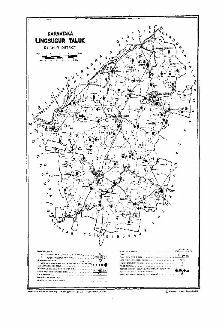
KARNATAKA LINGSUGUR TALUK
RAICHUR DISTRICT Milts 2 0
~ Klns 2 0
'?o
? 4.
.., z
4 6 Miles
1 •
.rl 6 8 ""'.
T A
BOUNDARY, fAlUK ".
IjILLAGE WITH LOCATION rODE ,,"wMa~R ...
" FOREST-RESERVED WITH NAME
HEAOaI!AATER5' TAW" ...•..
'''~~~!._~'~
: '51 I
. .. ~LINGSUGU'R 'R~"F I . © . VILLAGES WITH POPULATION ~tE • BELOW 100, 100-499;500-999'. • ••• 1OOO-4P99.i WOO AND A90VE __ . 0 LfIIINHABITED. VILLAGES WITH LOCATION COOE. ... f~ ~ ~ ~~>.:f· ,".- .. _.: URBAN AIlEA WITH LOCATION CODE. . . fiZ;YX:;'??,1 STATE HIGHI'/Av ... •. 5''': IMI'ORTANT METALLED ROAD ...
UNMETALLED AND OTHER ROADS.
Bo;ed upon SurYfY of Inc:hcI map with th~ p.rffllsSion Oi the SUr\ll!)'l)i Genera( d India
NOH N
RIVER WllH STREAM.,
TAN" , .. CANAL WI"'H D:SniIBUTARV
"OST DFFlCE'TELEGRAPH OFFIC[ ..
HIGHER SECCt<OARV SCHOOL.. POLICE STATION ..•. HOSPITAL ,PRIMARY HEALTH ("ENTREfpRIMAI=lY HEAlTI'I UNIT. r;,'-,,~ :NS;,li'l' ,FA:.IiL~ RANMNG CENTRE .•.
IMPORTANT VILLAGE MARI(ETJ HAT (SHAND,")
z
.= ... ~
POITO 5
PS
©Go ..... 'rnrTIIlnt ,;,) IndiO Copyright ,1966.
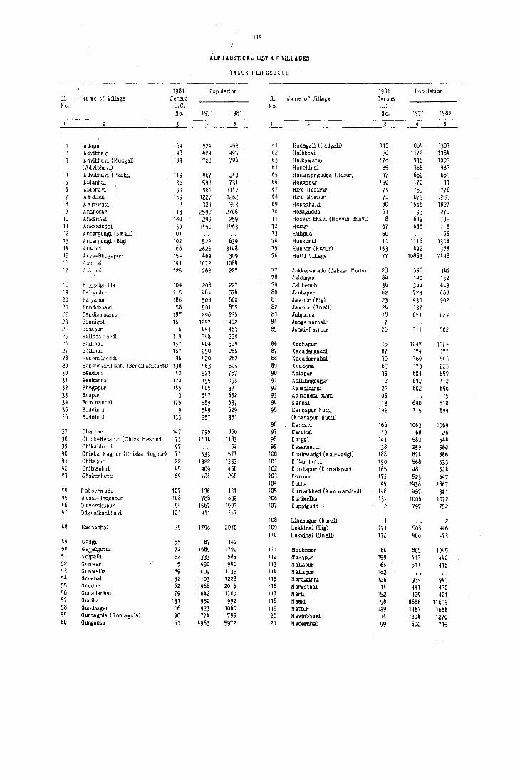
119
ALPHABETICAL UST OF VILLAGES
TALUK : LINGSUGUR
1981 PopulatilJn 1981 Population S1 Name of Village Census 31 Name of Village Census No. L.C. No. L.C.
No. 1971 1981 No. 1971 1981
4 5
Ad.pur 164 524 492 61 H adagali (H adgali) 110 1084 1307 Advibhavi 48 ~24 495 62 Halbhavi )0 1112 1,84 Advibhavi (Mudgal) 189 728 706 63 Halkawatgi 178 916 1003 (Advibhavi) 64 Hanohinal 85 386 483
4 Advibhavi (Maski) 119 467 240 65 Hanumangudda (Hosur) 17 662 663 5 Aidanhal 36 544 731 66 Heggapur 150 170 91 6 Aidbhavi 91 984 1142 67 Hire H esarur 74 759 776 7 Am dmal 169 1227 1262 68 Hire Nagnur 70 1079 1233 8 A mrawati 4 324 353 69 Honnahalli 80 1566 1827 9 Anahosur 43 2592 2766 70 Hosagudda 61 193 270
10 Ankanhal 180 299 259 71 HoaVin bhavi (HovVin Bhavi) 8 6~2 792 11 Ankasdoddi 139 1450 1463 72 Hosur 67 688 718 12 Antergungi (Small) 101 73 Huligud 50 66 13 A ntergungi (Big) 102 522 639 74 Hunkunti 11 1116 1308 14 Anwari 68 2825 3148 75 Hunoor (Hunur) 153 492 388 15 Arya-Bhogapur 154 469 309 76 Hutti Village 77 10863 7448 '6 .n..3~lil!al 191 1072 1084 17 Askih,,] 125 262 227 77 Jakker-madu (Jakker Mudu) 123 590 1142
78 Jaldurga 84 140 132 18 baggalgudda 104 208 227 79 Jallbenchi 34 344 443 19 Bailgudda 115 484 574 80 Jantapur 162 773 688 20 Balyapur 186 508 600 81 Jawoor (Big) 23 430 902 21 Bandebhavi 58 501 855 82 Ja w oor (S m all) 24 137 22 Bandisunkapur "87 296 236 83 Julgudda 18 651 824 23 Bannigo! 161 1297 1402 84 J unga m arhalli 7 24 Basapur 6 441 463 85 Jungi-li a m pur 26 311 5C2 'J Bellada mardi 119 348 228 26 Beiliha! 157 404 324 86 Kachapur 15 1047 13, ~ 27 Bellihal 167 250 266 87 K adadargaddi 87 174 i77 28 Benchaldoddi 96 420 262 88 K adadarnahal 130 369 5('3 29 Bendorkarlkunti (Bendikarlkunti) 138 483 505 89 Kaddona 63 173 223 30 Bendona 42 523 757 90 Kalapur 35 804 859 31 Benkanhal 120 195 195 91 K allilingsugur 12 692 712 32 Bhogapur 185 405 371 92 Kamaldinnl 21 802 896 33 Bhupur 13 647 652 93 Xamandal dinnl 106 15 34 Born mannal 175 589 637 94 Kannal 113 690 818 35 Buddinni 9 549 629 95 Kannapur hutti 192 775 844 30 Buddinni 133 357 351 (K hanapur H utti)
96 Kansavi 166 1063 1069 37 Chattar 147 795 850 97 Kardkal 49 68 26 38 Chick-Hesarur (Chick Hesrur) 73 1114 1183 98 Katgal 141 580 544 39 C hikaldaddi 97 52 99 Kesarhutti 38 259 580 40 C hikka N agnur (C hikka N ognur) 71 533 577 100 Khairwadgi (Kairwadgil 188 874 886 41 C hitapur 22 1322 1333 101 Killar hutti 190 568 533 42 C hitranhal 45 1109 458 102 Komlapur (Komalapur) 165 481 524 ~3 Chukenhutti 69 'Ia~ 258 103 Kornnur 173 523 547
104 Kotha 95 2438 2867 44 D abbermadu 127 136 131 105 Kumarkhed (Kurn markhed) 148 457 321 45 D esai-Bhogapur 108 788 832 106 Kunikellur 134 1006 1072 46 D everbhupur 94 1567 1903 107 Kuppigudd 2 797 752 47 D ignaikanbhavi 121 411 347
108 Lingsugur (R ural) 1 2 48 Each.nhal 39 1796 2070 109 L ukkihal (Big) 171 508 446
110 Lukkihal (Small) 172 468 473 49 Gadgi 55 87 142 50 G ajjalgutta 72 1685 1790 111 Machnoor 60 805 1045 51 Golpalli 52 333 585 112 Makapur 159 413 442 52 Gonwar 5 990 940 113 Mallapur 66 511 418 53 Gonwatia 89 1009 1135 114 Mallapur 182 5~ Gorebal 32 1103 1228 115 Maraldinnl 126 93~ 943 55 Goudur 62 1968 2016 116 Margatnal 44 441 ~30 56 Gudadanhal 79 1642 1700 117 Marli 152 429 421 57 Gudihal 131 952 992 118 Maski 98 8688 11639 58 Gundsagar 16 923 lQ60 119 Mattur 129 1467 1686 59 Guntagola (Gontagola) 90 774 795 120 MavinbhaVi 14 1204 1270 60 Gurgunta 51 4963 5972 121 Medernhal 99 600 715

120
ALPHABETICAL UST OF VILLAGES
TALUK : LINGSUGUR
1981 Population 1981 Populanon Sl. Name of Village Census S1. Name of Village Census No. L.C. No. L.C.
No. 1971 1981 No. 1971 1981
5 4
122 Medikinhal 100 1851 2197 160 Talekat (Talikat) 160 382 373 123 Mednapur 78 960 1257 161 Talekhan 107 1346 1099 124 Mincheri 33 390 400 162 Tanmankal 54 311 351 125 Mitt.ikellur 135 279 345 163 Taribhavi 132 163 210 126 Mudaldinni 122 497 449 164 Tawag 65 309 423 127 H udgal (R ural) 143 287 638 165 Tim mapur 114 820 909 128 ~udwal 140 209 266 166 Tirthbhavi 116 579 494 129 M uslikarlkunti 137 576 535 167 Todki (Tudkil 149 225 301
( M uslikarlikintil 168 Tondilial 179 585 636 169 Toral benchi 40 745 672
130 N agalopur (D ) 128 170 Tumbalgaddi (rumbal Guddi) 184 198 175 (N agalopur) 171 Turadgi 158 381 377
131 Nagarhal 176 1845 1862 132 Nager Benchi 103 953 1039 172 UJimeshwar 145 414 437 133 Nag)apur 146 917 1111 173 Uppanhal 181 354 324 134 Nandilial 41 380 462 174 Upperi (Small) 27 465 523 135 N arkaldinni 19 613 801 175 Upperi (Big) 29 370 417 136 Neeralkera 46 962 1073 176 Upper N andilial 170 861 750 137 Nilogal 75 1434 1648 138 Nirloti 117 115 53 177 Veerapur 76 505 743 139 NawJi 20 517 490 178 Veerapur (D) (Erapur) 105
179 Venkatapur 1~2 408 405 1~0 Pal doddi 56 730 710 180 Vyakarnhal 151 858 655 1~1 P algal dinni 177 380 422 181 Vyasa N andilial 112 386 427 1~2 Paramapur 93 435 597 143 Phoolbhavi (Phul Bhavi) 82 588 1221 182 Wandeli 155 424 420 144 Piklihal 144 481 523
183 Yalgundi (Y elgunti) 86 198 241 1~5 Raidurga 53 317 411 184 Yelgaldinni 37 441 467 146 Ramatnal 156 599 570 185 Yelgutti 59 1314 1497 1~7 R amloti (R a mlooli) 92 100 86 186 Yerdihal (Khurd) 163 427 372 148 Rampur 47 608 590 187 Yerdihal (Big) 168 568 60' 149 Rampur 183 282 281 188 Yerdoddi 109 341 387 150 Roudal banda 25 1217 1681 189 Yerdona 81 1027 1229 151 Roudal banda 64 1007 1695 190 Yergodi (Y erdoddi) 88 485 433
191 Yergunti 31 356 400 152 Sajjalgud 174 507 805 192 Yerjunti (Yergunti) 57 974 1~59 153 Sanbal 10 805 606 15~ Santikellur 136 1936 1989 155 Sarjapur 3 1610 1839 156 Shllhalli (TugalD 83 379 404 157 So m pur 111 158 Sultanpur 124 415 388 159 Sunkal ~8 519 566

LINGSUGUR TALUK
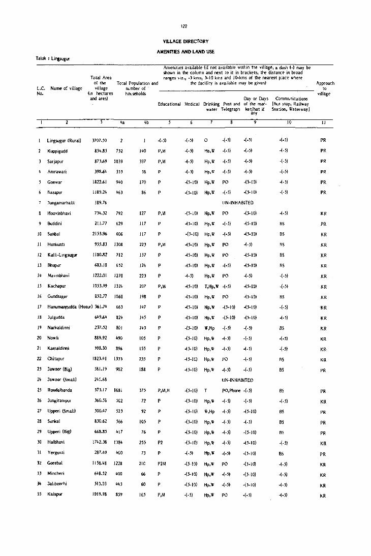
Talok : Lingsugur
L.C. Name 01 village No.
Lingsugur (Rural)
Kuppigudd
Sarjapur
Amrawati
Gonwar
Basapur
Jungamarhalli
Hoovinbhavi
9 Buddini
10 Sanbal
11 Hunkunti
12 Kalli-lingsugur
13 Bhupur
14 Mavinbhavi
15 Kachapur
16 Gundsagar
122
VILLAGE DIRECTORY
AMENITIES AND LAND USE
Total Area of the village
(in hectares and ares)
Total Population and number of households
4a
3707.50
834.83 752
873.69 1839
398.64 H3
1822.61 940
1189.24 463
189.76
734.32 792
211.77 629
2153.96 606
955.83 1308
1l80.~2 712
683.18 652
1222.01 1270
1053.99 1324
852.77 1060
4b
140
337
58
170
86
127
117
117
223
137
124
223
207
198
Amenities available (if not available within the village, a dash (-J may be shown in the column and next to it in brackets, the distance in broad ranges viz., -5 kms, 5-10 kms and 10.kms of the nearest place where
the facility is available may be given)
Day or Days Educational Medical Drinking Post and of the mar
water Telegraph ket/hat if any
6 8
-(-5) -(-5) o -(-5) -(-5)
P,M -(-5) 'io,W -(-5) -(-5)
P,M -(-5) Hp,W -(-5) -(-5)
P -(-5) Hp,W -(-5) -(-5)
P -(5-10) Hp,W PO -(5-10)
P -(5-10) Hp,W -(-5) -(5-10)
UN-INHABITED
P,M -(5-10) Hp,W PO -(5-10)
P -(5-10) Hp,W -(-5) -(5-10)
P -(5-10) Hp,W -(-5) -(5-10)
P,M -(5-10) Hp,W PO -(-5)
P -(5-10) Hp,W PO -(5-10)
P -(5-10) Hp,W -(-5) -(5-10)
P -(-5) Hp,W PO -(-5)
P,M -(5-10) T,Hp,W -(-5) -(5-10)
P -(5-10) Hp,W PO -(5-10)
Communications [Bus stop, Railway Station, Waterway 1
10
-(-5)
-(-5)
-(-5)
-(-5)
-(-5)
-(-5)
-(-5)
BS
BS
BS
BS
BS
-(-5)
-(-5)
BS
17 HanumanRudda (Hosur) 361.74 663 147 P -(5-10) Hp,W -(5-10) -(5-10) -(-5)
18 Julgudda
19 Narkaldinni
20 Nowli
21 Kamaldinni
22 Chitapur
23 Jawoor (Big)
24 Jawoor (Small)
25 Roudalbanda
27 Upperi (Small)
28 Sunkal
29 Upperi (Big)
30 Halbhavi
31 Yergunti
32 Gorebal
33 Mincheri
34 Jalibenrhi
35 Kalapur
649.64 824
237.52 801
889.92 490
598.30 896
1823.41 IlJ3
581.19 902
240.68
575.17 1681
360.58 502
500.47 523
830.62 566
668.85 417
1742.38 1384
287.49 400
1158.48 1228
648.52 400
510.03 443
1019.98 859
145
145
105
155
255
188
375
72
92
105
76
73
21e
66
60
165
P
P
P
P
p
P
P,M,H
P
P
P
P
P2
P
P2M
P
P
P,M
-(5-10) Hp,W -(5-10) -(5-10)
..(5-10) W.Hp -(·5) -(-5)
-(5-10) Hp,W -(-5) -(-5)
-(5-10) Hp, W -(-5) -(-5)
-(5-10) Hp,W PO -(-5)
-(5-10) Hp,W -(-5) -(-5)
UN-INHABITED
-(5-10) T PO,Phone -(-5)
-(5-10) Hp,W -(-5) -(-5)
-(5-10) W,Hp -(-5) -(5-IO)
-(5-10) Hp,W -(·5) -(-5)
-(5-10) Hp,W -(-5) -(5-IO)
-(5-10) Hp,W -(-5) -()-IO)
-(-5) Hp,W -(-5) -(5·10)
-(5·10) Hp,W PO -(5-10)
-(5-10) Hp,W -(-5) -(5·10)
-(5-10) Hp,W -(-5) -(5-10)
-(-5) Hp,W PO -(-5)
-(-5)
85
-(-5)
-(-5)
BS
BS
BS
..(-5)
BS
B5
BS
-(-5)
BS
-(-5)
-(-5)
-(-5)
-(-5)
Approach to
village
11
PR
PR
PR
PR
PR
PR
KR
PR
KR
KR
KR
KR
KR
KR
KR
KR
KR
KR
KR
KR
KR
PR
PR
KR
PR
PR
PR
KR
PR
KR
KR
KR
KR

Nearest Town and distance (in Kms.)
12
Lingsugur -I
Lingsugur -3
Lingsugur.3
Lingsugur -15
Lingsugur-15
Lingsugur- I 6
Lingsugur- I 6
Lingsugur-17
Lingsugur-17
Lingsugur-5
Lingsugur-7
Lingsugur-8
Lingsugur-12
Lingsugur-8
Lingsugur-9
Lingsugur-IO
Lingsugur-12
Lingsugur-21
Lingsugur-21
Lingsugur-20
Lingsugur-IS
Lingsugur-16
Lingsugur-16
Lingsugur-14
Lingsugur-15
Lingsugur-6
Lingsugur -10
Lingsugur-IO
Lingsugur-IO
Lingsugur-8
Lingsugur-9
Lingsugur-8
Lingsugur-4
Power Staple Forest Supply food
14 15
EAg Jowar Rice
EA Jowar Rice
EA Jowar Rice
EA Jowar Rice
EA Jowar Rice
EA Jowar Rice
EA Jowar Rice Jowar Rice
EA Jowar Rice
EA Jowar Rice
EA Jowar Rice Jowar Rice Jowar Ris:e
EA Jowar Rice
EA Jowar Rice
EA Jowar Rice Jowar Rice Jowar Rice Jowar Rice Jowar Rice
EA Jowar Rice
EA Jowar Rice
EA Jowar Rice
EAg Jowar
EA Jowar Rice
EA Jowar 198.66 Rice
EA Jowar 19.90 Rice
EA Jowar Rice
EA Jowar 21.44 Rice
EA Jowar Rice Jowar Rice Jowar Rice
EA Jowar Rice -
123
, VILLAGE DIRECTORY
AMENITIES AND LAND USE Taluk : L mgsugur
Land use (area under diffNent types of land use in hectares)
Irrigated Un-irrigated (by source of irrigation)
16 17
WE: 12.1~ 3653.26 T: 12.14
801.~1
809.10
363.83
1777.69
5S8.90
150.68
Tk : ~5.92 3~1.16 T : ~5.92
201.57
2053.66
911.05
Tk : 0.51 1108.10 T: 0.51 W: 1.21 ~28.% T: 1.21
WE : 16.39 1166.29 T: 16.39
WE: 16.39 992.06 T: 16.39
WE: 40.77 786.80 T : 40.77 WE: 6.37 338.47
T: 6.37 W : 3.2~ 612.96 T: 3.24 W : 3.34 227.20 T: 3.34
447.16
229.11
945.50
WE : 2.43 386.50 T : 2.43
62.58
WE: 10.12 50S.51 T: 10.12 WE: 2.68 JJ8.79
T: 2.68 WE: 2.87 428.50
T: 2.S7 502.40
Tk : 12.17, WE : 4.91 5J9.40 T : 17.08
121S.18
WE : 4.92 253.99 T: 4.92
1024.63
)]6.50
433.01
979.78
Culturable waste
(including gauchar and
groves)
18
6.22
15.93
6.15
581.32
13.32
338.02
1.84
54.31
12.81
I G.SS
1.11
S.3'1
2.2'J
39.72
04.44
16. \1-
317.lf)
,j.n
S0.07
',9.07
s. )7
I\rea not available for
cultivation
19
42.10
R~marks tnciudJllg any pldte 01
religious, histOrIcalor archeo!ogl
cal interest
20
27.20 N:5
~8.66 N:I\,M:I
34.81 N:2
38.77 N:5
19.02 N:4
25.76
9.22 N:3
8.36 N:8
45.99 N:2 10
~~.78 N:I II
72.21 N:2 ! 2
53.07 N:2 13
42.91 N:5 14
'+5.')4 N:4 I)
14.32 1IJ:3 I,
I ~.~Q 17
».44 N:2 13
b.n 1\;:4 19
44'.% \1:1 20
169.19 N:I 21
~77.91 '<:5, \1:2. T: I 22
139.15 '<:10. \1:1. T:I 21
17S.10 24
%.24 \:2". 11:1, 2·1 \':2. T:2
16.91 21>
29.1S 2'
6j.12 \:1 2S
5).91 29
206. j0 \:2 10
7.14 1!
h7.S7 \-:1. \\:1
11.')\ 1<
27.'11 \:.' ;,
V~.h 1 \:\ \1:1 "

Taluk : Lingsugur
L.C. Name of village No.
36 Aidanhal
37 YelgaldiAni
38 Kesarhutti
39 Echanhal
40 Toralbenchi
41 Nandihal
42 Bendona
44 Margatnal
45 Chitranhal
46 Neeralkera
47 Rampur
48 Advibhavi
49 Karadkal
50 Huligud
51 Gurgunta
52 Golpalli
53 Raidurga
54 Tanmankal
55 Gadgi
56 Paidoddi
57 Yerj~nti
58 Bandebhavi
59 Yelgutti
60 Machnoor
61 Hosagudda
62 Goudur
63 Kaddona
64 Roudalbanda
65 Tawag
66 MalJapur
67 Hosur
68 Anwari
69 Chukenhutti
70 Hire-Nagnur
124
VD.LAGE DIRECTORY
AMENITIES AND LAND USE
Total Area of the village
(in hectares and ares)
Total Population and number of households
4a
821.05 731
550.33 467
723.58 580
1817.53 2070
814.33 672
234.82 462
343.65 757
3314.74 2766
387.17 430
676.35 458
646.45 1073
"38.11 590
621.P 495
2938.30 2~
312.54 66
3864.80 5972
2047.97 585
307.95
825.51
427.56
41 I
35J
142
711.16 710
1776.26 1459
1163.18 855
1649.28 1497
1433.07 1045
496.79 270
1310.26 2016
419.23 225
436.62 1695
331.49 423
693.55 418
756.10 718
3664.98 3148
349.89 258
940.82 1233
m
83
102
359
136
91
130
517
91
86
193
104
79
12
1092
104
71
69
24
113
237
139
271
195
44
386
39
m 83
91
130
565
48
205
4b
Amenities available (if not available within the village, a dash (-) may be shown in the column and next to it in brackets, the distance in broad ranges viz., -5 kms, 5-10 kms and IO.kms of the nearest place where
the facility is available may be given)
Day or Days Communications Educational Medical Drinking Post and of the mar- [Bus stop, Railway
P
P
P
P
P,M
P
P
P,M
P
P2
-(-5)
-(-5)
P
P
-(lOt)
P
P
P
P,M
P
-(-5)
P,M
P
P
P
P,M
-(-5)
P,M
water Telegraph ket/hat if Station, Waterway 1
-(-5) Hp,W
-(-5) Hp,W
-(5-10) Hp,W
-(-5) T,Hp
-(-5) Hp,W
-(-5) Hp,W
-(-5) Hp,W
PHC, T,W FPC -(-5) Hp,W
-(-5) Hp,W
-(-5) Hp,W
-(-5) Hp,W
-(-5) Hp,W
-(-5) Hp,W
-(-5)
PHC, FPC -(-5)
-(-5)
-(-5)
o
T,Hp
Hp,W
Hp,W
Hp,W
any
8 9
-(-5) -(-5)
-(-5) -(-5)
-(-5) -(-5)
PO -(5-10)
-(5-10) -(5-10)
-(-5) -(-5)
-(-5) ..(-5)
PO, Tuesday Phone -(-5) -(-5)
-(-5) -(-5)
Po -(-5)
-(-5) ..(5-10)
-(-5) -(-5)
-(-5) -(-5)
-(-5)
Po, Phone -(-5)
-(-5)
-(-5)
-(-5)
Friday
-(-5)
-(-5)
-(-5)
-(-5) Hp,W -(-5) -(-5)
-(5-10) Hp,W -(5-10) -(5-10)
-(5-10) Hp,W -(5-10) -(5-10)
-(5-10) Hp,W -(-5) -(5-10)
-(10.) Hp,W PO -(JOt)
-(5-10) Hp,W -(-5) -(5-10)
-(5-10) Hp,W -(-5) -(5-10)
-(5-10) Hp,W PO -(-5)
-(5-10) Hp,W -(-5) -(5-10)
-(5-10) Hp, W PO Tuesday
-(5-10) Hp,W -(-5) .,(5-10)
-(10.) Hp,W -(-5) -(10.)
-(5-10) HP,W -(-5) -(-5)
PHU Hp, W PO -(5-10)
-(5-10) Hp,W -(-5) -(5-10)
-(-5) Hp,W PO -(5-10)
10
-(-5)
BS
BS
BS
-(-5)
5S
BS
BS
BS
BS
BS
BS
BS
BS
-(-5)
BS
BS
BS
-(-5)
-(-5)
BS
-(5-10)
-(-5)
BS
BS
-(-5)
BS
BS
BS
BS
-(-5)
BS
BS
-(-5)
-(-5)
Approach to
village
II
KR
PR
KR
PR
KR
KR
PR
PR
KR
KR
PR
Kit
KR
PR
PR
PR
KR
KR
KR
PR
KR
KR
KR
KR
KR
KR
KR
KR
PR
KR
KR
PR
KR
KR
KR
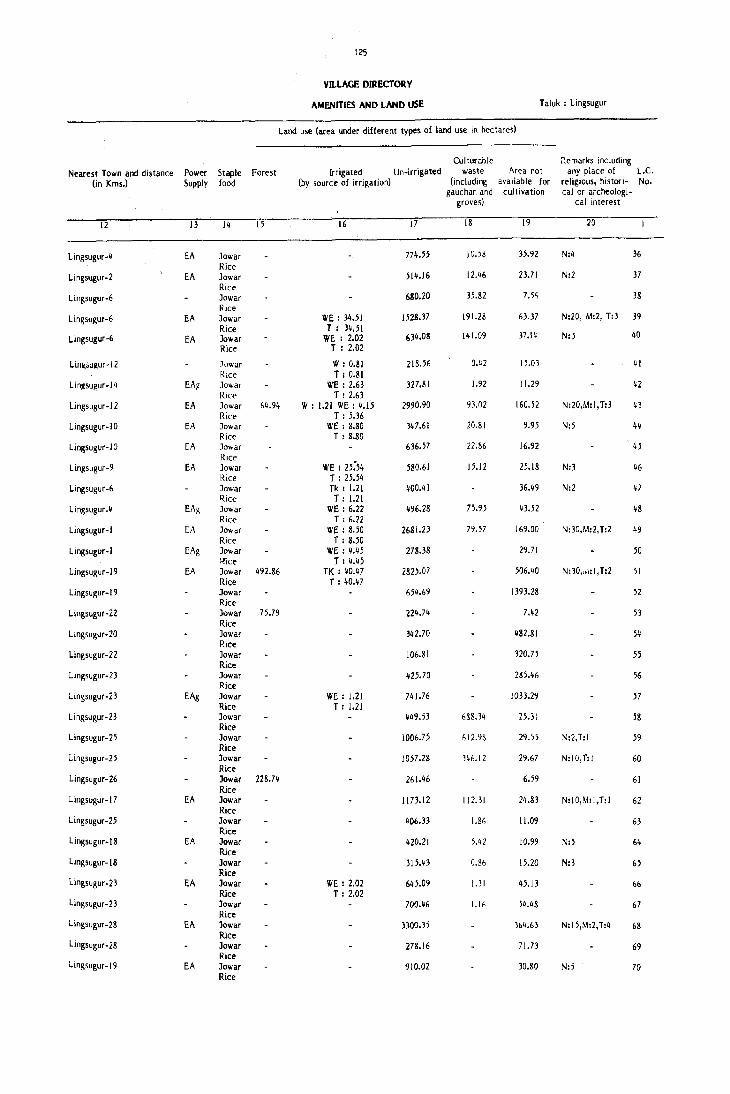
125
Vn.LACE DIRECTORY
AMENITIES AND LAND USE Taluk : Lingsugur
Land use (area under different types of land use in hectares)
Culturable ~e marks including Nearest Town and distance Power Staple Forest Irrigated Un-irrigated waste Area not any place of L.e.
(in Kms.) Supply food (by source of irrigation) (including available for religious, histori- No. gauchar. and cultivation calor archeologi-
groves) cal interest
12 13 14 15 16 17 18 19 20
Lingsugur-4 EA ]owar 774.55 10.58 35.92 N:4 36 Rice
Lingsugur-2 EA ]owar 514.16 12.46 23.71 N:2 37 Rice
Lingsugur-6 Jowar 680.20 35.82 7.54 38 Rice
Lingsugur-6 EA Jowar WE: 34.51 1528.37 191.28 63.37 N:20, M:2, T:3 39 Rice T ; 34.51
Lingsugur-6 EA Jowar WE : 2.02 634.08 141.09 37.14 N:5 40
Rice T : 2.02
Lin~,;ugur-12 .1owar W : 0.81 218.56 0.42 15.03 41 Rice T: 0.81
Lin~sugur-14 EA~ Jowar WE: 2.63 327.81 1.92 11.29 42 Rice T: 2.63
Lingsugur-12 EA ]owar 64.94 W : 1.21 WE: 4.15 2990.90 93.02 160.52 N:20,M:I,T:3 43 Rice T: 5.36
Lingsugur-IO EA ]owar wE: 8.80 347.61 20.81 9.95 N:5 44 Rice T: 8.80
Lingsugur-IO EA Jowar 636.57 22.86 16.92 45
Lin!(sugur-9 EA Rice ]owar WE : 25:54 580.61 15.12 25.18 N:3 46 Rice T : 25.54
Lingsugur-6 Jowar Tk: 1.21 400.41 36.49 N:2 47 R.ice T: 1.21
Lingsugur.4 EAg )owar WE: 6.22 496.28 75.95 43.52 48 Rice T: 6.22
Lingsugur-I EA Jowar WE: 8.50 2681.23 79.57 169.00 N: 30,M:2, T:2 49 Rice T: 8.50
Lingsugur-I EAg Jowar WE : 4.45 278.38 29.71 50 ~Jce T: 4.45
Lingsugur-19 EA Jowar 492.86 TK : 40.47 2825.07 506.40 N:30",,:I,T:2 51 Rice T : 40.47
Lingsugur-19 Jowar 65~.69 1393.28 52 Rice
Lingsugur-22 Jowar 75.79 22~.74 7.42 53 Rice
Lingsugur-20 Jowar 342.70 482.81 54 Rice
Lingsugur-n ]owar 106.81 320.75 55 Rice
Lingsugur-23 Jowar 425.70 2S5.46 56 Rice
Lingsugur-23 EAg )owar WE: 1.21 741.76 1033.29 57 Rice T: 1.21
L i ngsugur· 2 3 ]owar 449.53 688.34 25.31 58 Rice
Lingsugur-25 ]owar 1006.75 1i12.~8 29. )5 N:2.T:I 59 Rice
Lingsugur-25 Jowar 1057.28 346.12 29.67 N:IO,T:I 60 Rice
Lingsugur-26 Jowar 228.74 261.46 6.59 61 Rice
Lingsugur -17 EA Jowar 1173.12 112.31 24.&3 N:IO,M:I,T:I 62 Rice
Lingsugur-25 Jowar 406.33 1.86 11.09 63 Rice
Lingsugur-18 EA Jowar 420.21 5.42 10.99 N:5 64 Rice
Lingsugur-18 Jowar 315.43 0.86 15.20 N:3 65 Rice
Lingsugur·23 EA ]owar WE: 2.02 645.09 1.11 45.13 bb Rice T: 2.02
Lingsugur-23 Jowar 700.46 1.11, 54.48 67 Rice
Lingsugur-28 fA lowar 3300.35 364.63 N:15,M:2,T:4 68 Rice
Lingsugur-28 Jowar 278.16 71.73 69 Rice
Lingsugur -19 EA Jowar 910.02 30.80 N:5 70 Rice

Taluk : Lingsugur
L.C. Name of village No.
71 Chikka-Nagnur
72 Gajjalgutta
73 Chick-Hesarur
74 Hire-Hesarur
7~ Nilogal
76 Vt'erapur
77 Hutti Village
78 Mednapur
SO Honnahalli
81 Yerdona
82 Phoolbha v i
83 Silhalli (Tugli)
84 Jaldurga
85 Hanchinhal
86 Yalgundi
87 Kadadargaddi
88 Yergodi
89 Conwatla
90 Cuntagola
91 Aidbhavi
92 Ramloti
93 Parampur
94 Deverbhupur
95 Kotha
96 6enchaldoodi
97 Chikaldoddi
98 Maski
99 Medernhal
100 MedikinhaJ
126
VILLAGE DIRECTORY
AMENITIES AND LAND USE
Amenities available (if not available within the village, a dash (-I may be shown in the column and next to it in brackets, the distance in broad ranges viz., -5 kms, 5-10 kms and 10+kms of the nearest place where Total Area
of the village
(in hectares and ares)
Total Population and number ot households
the facility is available may be given)
4a
611,68 577
624.39 1790
1702.60 1183
1516.35 776
1734.13 1648
471.02 743
76.28 7448
1161.90 1257
272.67 1700
2888.41 1827
1920.27 1229
1322.18 1221
? .f. 40 404
1016.01 J3Z
876,~9 481
~00,07 241
451,)7 177
507,12 433
mO.38 1135
2784,09 795
1271.76 1142
823.92 86
846.71 597
!I 12,55 1903
6~j] ,38 7.867
!loo,IO 262
52
~419.17 11639
U~,~4 715
7~OS,08 2191
4b
93
331
235
150
307
132
1515
248
316
3)6
252
170
66
2'1
87
39
36
74
m 197
186
16
7l
346
511
2101
119
400
Day or Days Educational Medical Drinking Post and of the mar
water Telegraph ket/hat if any
P
P,M,H
P,M
P
P,M
P
P,M
P,M
P,M
P
P
P
P
P
P
-(-5)
P,M
p
-(-5)
6
-(-5) Hp," -(-5) -(5-10)
PHU T,Hp,W PO -(5-10)
-(-5) Hp,W PO -(10+)
-(.5) Hp,W -(-5) -(10+)
-(-5) Hp, W PO -(-5)
-(-5) Hp,W -(-5) -(-5)
-(-5) T,Hp PTO,Phone Sunday
-(-5) Hp,W
-(-5) Hp,W
-(-5) Hp,W
-(5-10) T,Hp
-(5-10) Hp,W
PO
PO
PO
PO
-(-5)
-(-5)
-(-5)
-(-5)
-(5-10)
-(5-10)
-(5-10) Hp,W -(-5) -(10+)
-(5-10) Hp,W -(5-10) -('-10)
-(10+) Hp,W -(-5)
-(10.) R -(-5)
-(lOt) R -(-5)
-(lOt) R -(-'I
-(5-10) Hp,W PO
-(5-10) Hp,W -(-5)
-(5-10) Hp,W -(-5)
-(5-10) Hp,W -(-5)
-(5-10) Hp,W -(-5)
-(5-10) HP,W PO
-(-5) Hp,W PO
-(-5) Hp,W -(-5)
-(-5) 0 -(-5)
D,PHU T,Hp,W PTO, Phone
-(-5) Hp,W -(-5)
D Hp,W PO
-(10+)
-(10+)
-(lOt)
-(lO+)
-(5-10)
-(5-10)
-(5-10)
-(5-10)
-(5-10)
-(5-10)
-(-5)
-(5-10)
-(5-10)
Sunday
-(-5)
-(5-10)
Communications [Bus stop, Railway Station, Waterway l
-(-5)
BS
liS
-(-5)
BS
BS
BS
BS
-(-5)
115
BS
-(-5)
-(.5)
10
-(5-10)
-(5-10)
-(5-10)
..(5-10)
-(5-10)
-(-5)
BS
-(-5)
-(-5)
-(-5)
-(-5)
BS
-(-5)
-(-5)
BS
BS
101 Antragungi (Smalll 296,99 UN-INHABITED
102 Antargugi (Bill)
103 Nagerbenchi
104 Baggalgudda
105 Veerapur (Dl
~~5,59 639
1400,43 10)9
71.,65 227
Il(;,~~
130
197
39
-<-5) Hp,"
-(-5) Hp,W
P -<-5) Hp,W
-(-5) -(5-10) liS
PO -(5-10) -(-5)
-(-5) -(5-10) -l-5)
UN-INHABITED
Approach to
village
II
KR
PR
PR
PR
PR
KR
PR
PR
KR
P~
PR
KR
KR
KR
KR.
KR
KR
KR
KR
KR
KR
KR
KR
PR
K.R
KR
KR
PR
PR
PR
PR
KR
KR

127
VILLAGE DIRECTORY
AMENITIES AND LAND USE Taluk : Lingsugur
Land use (area under different types of land use in hectares)
Culturable Remarks including Nearest Town and distance Power Staple Forest Irrigated Un-irrigated waste Area not any place 01 L.C.
(in Kms.) Supply food (by source of irrigation) {irduding ,lVailable for religioos, histori- No. gauchar and cultivation cdl or archeologi-
grovesl ell interest
12 13 I~ 15 16 17 18 I'J 20
Lingsugur-18 EA Jowar WE : 3.6~ 588.92 19.12 N:} 71 Rice T: 3.64
Lingsugur-2} EA Jowar WE : 12.24 m.67 69.64 8.84 N:l5,M:2,T:3, 72 Rice T: 12.24 C:l
Lingsugur-12 fA Jowar WE: 3.24 13!9.}6 m.44 28.36 N:IO,M:I 7J Rice T: 3.24
Lingsugur-12 fA Jowar WE: 2.02 1~32.19 60.65 21.49 7~
Rice T: 2.02 Lingsugur-25 fA Jowar WE: 10.12 1630.07 42.82 51.12 N;12,M:l,C:l n
Rice T: 10.12 T:2 Lingsugur-25 EA Jowar 460.7} 10.27 N:} 76
Rice Lingsugur-19 EA Jowar WE: 0.81 18.62 19.82 37.03 N:30,M:l,T:2 77
Rice T: 0.81 Lingsugur-17 EA Jowar WE: 2.83 783.79 4.37 37Q.91 N:IO 78
Rice T: 2.83 Lingsugur-17 fA Jowar 223.08 3.06 46.53 79
Rice Lingsup,ur-} fA Jowar Z}OO.07 'J.O} 37'J.2'1 N:15,T;1 80
Rice Lingsugur-8 fA Jowar 1370.31 lQ.96 539.00 N;IO,T:1 81
Rice Lingsugur-9 Jowar 813.81 450.43 57.94 82
Rice Lingsugur.IZ Jowar 406.71 100.29 270.40 83
Rice Lingsugur-13 fA Jowar 898.00 118.01 N:J H 84
Rice Lingsugur -15 Jowar 674.16 72.82 129.51 8)
Rice Lingsugur·16 Jowar 125.92 30.~~ 143.70 86
Rice Lingsugur-16 Jowar 283.32 39.74 128.51 87
Rice Lingsugur-18 Jowar 277.22 19.23 210.67 88
Rice Lingsugur-'j fA Jowar ~8l.95
Rice 135:06 411.37 N:I0 89
Lingsugur-IO EA Jowar 1007.55 234.31 1}~2.23 N:5 90 Rice
Lingsugur-14 Jowar 6;:6.49 105.99 539.28 91 Rice
Lingsugur-I ~ Jowar 3~3.47 208.91 316.54 92 Rice
Lingsugur-IO Jowar 362.87 315.52 168.32 93 Rice
Lingsugur-12 EA Jowar 775.40 13.60 323.55 N:15,M:l,T:1 'on 94 Rice
Lingsugur-22 fA lowar WE: 6.48 6596.51 54.39 N:l0,T:3 9} Rice T: 6.~8
Lingsugur-23 Jowar 934.15 517.43 48.52 96 Rice
Lingsugur-23 Jowar JII.}3 1.97 11.54 97 Rice
Sindhnur·18 EA Jowar WE: 15.78 3975.05 205.10 22J.2~ C:2,T:6,N:60, 98 Rice T I 15.78 M:S A-DI
Sindhnur-19 EA lowar 746.76 78.63 9.55 99 Rice
Lingsugur-2~ EA lowar WE: 102.41 1921.19 202.22 182.26 N:15,M;2,T;3 100 Rice T: 102.41
260.03 21.98 14.98 101
Lingsugur-23 EA lowar WE ; 1.~6 51'J.08 37.32 7.73 N:2,M:l 102 Rice T: 1.~6
Lingsugur-2 ! EA Jowar 1300.97 71.8'1 27.62 N;.~ 103 Rice
Li~sugur·23 fA Jowar 464.94 226.50 23.21 10~ Rice
102.59 6.04 7.81 105

Taluk : Llngsugur
128
VILLAGE DIRECTORY
AMENITIES AND LAND USE
Amenities available (if not available within the viJJage, a dash (-) may be shown in the column and next to it in brackets, the distance in broad ranges viz., -5 kms, 5-10 kms and JO.kms of the nearest place where
L.c. No.
Name at village
Total Area of the village
(in hectares and ares)
Total Population and number of households
the facility is available may be given)
4a 4b
10f, Kamandaldinni 218.73 15
107 Talekhan 2468.06 1099 216
108 Desai ·Bhogapur 1565.73 832 135
109 Yerdoddi 1124.76 387 78
110 liadagal i 1637.10 !J07 101
III Sompur
112 Vyasanandlhal 577 .05 427 66
I! 3 Kannal 664.82 818 164
114 Timmapur 16/5.01 909 136
115 Ballgudda 1584.51 574 88
116 Tirthbhavi 560.46 494 86
117 Nirloti 408.21 53 13
118 Advlbhavi (Maskl) 255.00 240 44
119 Belladamardi 1065.7 I 228 51
120 Benkanhal 234.46 195 34
121 Dignaikanbhavi 743.86 347 64
122 Mudaldinni 801.53 69
123 Jakkermadu 1013.75 1142 153
124 Sultanpur 567.54 388 65
125 Askihal 582.80 227 37
126 Maraldinni 974.97 943 144
127 Dabberrnadu 384.00 III 23
128 Nagalopur (D) 134.85
129 Mattur 2259.09 1686 306
130 Kadadarnahal 660.81 503 77
131 Gudihal 1011.57 992 167
132 Taflbhavi 476.82 210 36
133 Buddinni 637.86 351 68
134 Kuni-Kellur 603.77 1072 189
135 "'Itti-Kellur 727.37 345 64
136 Santi-KeHur 2386.97 1989 390
137 Muslikarlkunti 822.53 535 94
138 Bendarkarlkuntl 608.42 505 93
139 Ankasdoddi 794.31 1463 270
140 \ludwal 1110.46 266 47
Day or Days Educational Medical Drinking Post and of the mar
wafer Telegraph ket/hat if any
-(-5)
P,M
P
P,M
P
P
P
-(-5)
P
P
P
P
p
P
P2
-(-5)
P,M
P
P
P
P
p
P
P,M
P
p
P,M
p
6
-(-5) 0
-(-5) Hp,W
·(5·10) Hp,W
-(5-10) Hp,W
-(5·10) Iip,W
-(10+) Hp,W
-(10+) N
-(10+) S
-(10+) HP, W
-(5-10) Hp,W
-(5-10) Hp,W
-(5-10) Hp,W
-(5-10) 0
-(5-10) 0
-(5-10) 0
s
-(-5)
PO
·(·5)
-(-5)
-(-5)
·(5-10)
-(5-10)
·(5-10)
-(5·10)
-(5·10)
UN-INHABITED
-(-5)
PO
-(-5)
-(-5)
-(-5)
-(·5)
-(10+)
-(10+)
-(10+)
·(10.)
-(5·10)
-(5-10)
'(·5) -(5·10)
-(-5) ·(5-10)
·(5-10) -(5-10)
-(-5) -(5-10)
-(5-10) N,Hp,W -(-5) -(5·10)
-0-10) lip, W -(·5)
-(5-10) N,Hp,W -(-5)
-(5-10) Hp,W
.(5. iO) Hp, W
-(5-10) N
-(-5)
PO
-(-5)
-(5-10)
-(5-10)
-(5-10)
-(5-10)
-(5·10)
UN-INHABITED
-(5-10) T,Hp,W PO, Phone
-(-5) Hp, W -(-5)
·(5·10) Hp,W PO
-(5-!O) Hp, W -(-5)
-(5·10) Hp,W -(-5)
-(5-10) Hp, W -(-5)
-(-5) T,lip -(-5)
PIiU T,Hp PO
-(-5) Hp,W -(-5)
-(5-10) Hp,W -(-5)
-(5-10) Hp,W PO
-(-5) Hp,N -(-5)
-(5-10)
-(-5)
-(5-10)
-(5-10)
-0-10)
-(-5)
-(-5)
Wednesday
·(-5)
-(-5)
-(5-10)
-(-5)
Communications [Bus stop, Railway Station, Waterway J
10
-(-5)
-(-5)
·(·5)
-(-5)
-(-5)
·(-5)
-(·5)
-(-5)
-(5-10)
-(5-10)
-(5-10)
·(-5)
-(-5)
'(·5)
-(-5)
-(-5)
BS
-(-5)
-(-5)
-(-5)
-(-5)
BS
-(-5)
-(-5)
-(-5)
BS
BS
BS
BS
-(-5)
-(-5)
BS
BS
Approach to
village
II
KR
KR
PR
KR
KR
KR
KR
KR
PR
PR
KR
KR
KR
KR
KR
PR
KR
KR
KR
KR
PR
PR
KR
PR
PR
PR
PR
PR
PR
PR
PR
PR

129
VILLAGE DIRECTORY
AMENITIES AND LAND USE Taluk : Lingsugur
Land use (ar~a under different types of land use in hectares)
Culturable Remarks including Nearest Town and distance Power Staple Forest Irrigated Un-irrigated waste Area not any place of LoC.
(in Kms.) Supply food (by source of irrigation) (including available for religiou" histori- No. gauchar and cultivation calor archeologi-
groves) cal interest
12 13 14 15 16' 17 18 19 20
Lingsugur-26 Jowar 167.65 35.78 15.30 106 Rice
Lingsugur-25 EA Jowar 2239.37 150.28 78.41 N:5,T:2 107 Rice
Lingsugur-23 Jowar 1204.88 273.6G 87.25 108 Rice
Lingsugur-25 Jowar 995.24 78.59 50.93 109 Rice
Lingsugur-26 Jowar 1554.07 17.16 65.87 110 Rice
212.51 17.79 7.44 111
Mudgal-7 EA Jowar 477.13 72.32 27.60 112 Rice
Mudgal-8 EA Jowar 629.81 7.13 27.88 N:3,T:I 113 Rice
Mudgal-IO Jowar 1367.28 116.24 131.49 N:5,T:I 114 Rice
Mudgal-12 EA Jowar 1230.46 244.74 109.31 115 Rice
Mudgal-15 Jowar 433.82 114.01 12.63 116 Rice
Mudgal-12 Jowar 279.27 113.10 15.84 117 Rice
Mudgal-15 Jowar 226.85 24.51 3.64 118 Rice
Mudgal-18 EA Jowar 963.61 70.36 31.74 119 Rice
Mudgal-18 EAg Jowar WE: 0.21 205.32 8.81 20.12 120 Rice T 0.21
Mudgal-15 EAg Jowar WE 3.69 618.51 92.16 29.50 121 Rice T 3.69
Mudgal-7 Jowar 617.76 158.17 25.60 122 Rice
Mudgal-5 Jowar 927.40 15.86 70.49 N:5,T:I 123 Rice
Mudgal-5 Jowar 517.34 20.04 30.16 124 Rice
Mudgal-18 Jowar 504.14 18.14 60.52 125 Rice
Mudgal-12 Jowar 721.52 211.42 42.03 N:5 126 Rice
Mudgal-7 Jowar 331.97 12.07 39.96 127 Rice
114.44 20.41 128
Mudgal-5 EA Jowar WE: 46.74 2096.30 58.08 57.97 N:IO,M:I,T:3 129 Rice T : 46.74
Mudgal-3 Jowar 625.64 35.17 130 Rice
Mudgal-4 EAg Jowar WE: 25.09 954.92 31.56 N:5 131 Rice T : 25.09
Mudgal-5 Jowar 459.86 16.96 132 Rice
Mudgal-5 Jowar 607.61 4.22 26.03 N:5 133 Rice
MudgaJ-JO Jawar 591.18 12.59 N:5 134 Rice
MudgaHI Jowar 683.21 30.04 14.12 135 Rice
Lingsugur-14 EA Jowdr 2166.04 157.77 63.16 N:25,M:I,T:2 136 Rice
Lingsugur-14 EA Jawor 807.73 14.80 137
Lingsugur-15 Rice Jowar 569.15 23.46 15.81 138
Lingsugur-19 Rice
EA Jowar 713.47 25.26 55.58 N:IO,T:I 139
Lingsugur-17 Rice Jowar 1072.42 2.34 35.70 A-IV 140 Rice

Tuluk : Lin Sli ur
L.c. No.
~,ame 01 vdlage
141 Katgal
142 Venkatapur
143 Mudgal (Rural)
144 Piklihal
145 Ulmeswar
146 Naglapur
147 Chattar
148 Kumarkhed
149 Tadki
150 Heggapur
151 Vyakarnhal
152 Marli
153 Hunoor
154 Aryahhogapur
155 Wandali
156 Ramatnal
157 Bellihal
158 Turadgi
159 Iv\akapur
160 Talekat
161 Bannlgol
162 Jantapur
163 Yerdihal (Khurd)
164 Adapur
165 Komlapur
166 Kansavi
167 Bellihal
168 Yerdihal (Big)
169 Amdihal
170 Upper-Nandihal
171 Lukkihal (Big)
172 Lukkihal (Small)
173 Komnur
174 SaJjalgud
175 Bommanhal
Total Area of the village
(in hectares and ares)
589.73
990.25
4661.46
534.24
52J.97
369.42
1258.47
1186.92
896.96
302.08
1372.96
881.99
623.09
581.29
442.60
974.62
1256.07
744.43
714.46
1139.67
1760.76
JlI2J.li)
506.48
738.40
382.52
1516.34
574.52
767.67
848.17
1013.92
1019.00
44li.71
694.48
497.67
952.87
130
VILLAGE DIRECTORY
AMENITlES AND LAND USE
Amenities available (if nat avadable within the village, a dash (-) may be shown in the column and next to it in brackets, the distance in broad ranges viz., -5 kms, 5-10 kms and 10+kms of the nearest place where
Total Population and number of households
the facility is available may be given)
4a 4b
544 97
405 68
638 102
523 86
437 81
1111 191
850 144
321 63
301 52
91 24
655 129
421 88
388 90
309 66
420 81
570 102
63
377 78
80
373 84
1402 269
688 130
372 74
492 86
524 83
1069 206
266 56
601 99
1262 225
750 133
446 91
473 76
547 104
805 117
637 117
Day or Days Educational Medical Drinking Post and of the mar
water Telegraph ket/hat Jf any
9
P -(-5) Hp,W -(-5) -(-5)
P -(5-W) Hp,W -(-5) -(5-10)
-(-5) -(-5) W -(-5) -(-5)
P -(-5) Hp,W -(-5) -(-5)
P -(-5) Hp,W -(-5) -(-5)
P,M -(5-10) Hp,W PO -(5-10)
-(5-10) Hp,W -(-5) -0-10)
-(5-10) Hp,W -(-5) -(5-10)
P -(5-10) Hp,W -(-5) -00+)
-(-5) -(5-10) Hp,W -(-5) -(10.)
P,M -(5-10) Hp,W -(-5) -(5-10)
P -(10+) HP,W -(-5) -(10.)
P -(-5) Hp,W -(-5) -(lOt)
P -(-5) Hp,W -(-5) -(lOt)
P -(-5) Hp,W -(-5)
P -(-5) Hp,W -(-5) -(10+)
P -(-5) Hp,W -(-5) -(lOt)
P -(-5) Hp,W -(-5) -(10+)
P,M PHU Hp,W PO -(10+)
P -(-5) N,Hp, W -(-5) -(5-10)
P,M -(5-10) Hp,W PO -(5-10)
p -(5-1O) Hp, IV -(-5) -(5-IO)
P -(5-10) Hp, IV -(-5) -(5-10)
P -(5-10) Hp,W -(-5) -(5-10)
p -(10+) Hp, W -(-5) -( 10+)
P,M -(10.) Hp,W PO -(10+)
P -(1O.) Hp,W -(-5) -(10+)
P -(10+) Hp,W -(-5) -(10+)
P,M -(10+) Hp,W PO -(lOt)
P -(10+) Hp,W -(-5)
P -(5-10) Hp,W PO -(10+)
P -f5-10) Hp,W -(-5) -(i0+)
p -(5-10) Hp,W -(-5) -(10+)
P,M,H -(-5) T,Hp,VI PO -(10+)
p -(-5) Hp,W -(-5) -( 10+)
Communications [Bus stop, Railway Station, Waterway 1
BS
BS
BS
BS
-(-5)
-(-5)
-(-5)
-(-5)
as
BS
-(-5)
-(-5)
BS
BS
BS
as
BS
as
-(-5)
-(-5)
-(-5)
-(-5)
BS
-(-5)
BS
-(-5)
-(-5)
-(-5)
-(-5)
BS
as
10
Approach to
village
II
PR
Kll
PR
PR
PR
PR
PR
KR
PR
KR
KR
KR
KR
KR
KR
KR
KR
KR
KR
PR
PR
PR
KR
KR
KR
KR
PR
KR
PR
KR
KR
KR
KR
PR
KR

Nearest Town and distance (in Kms.)
12
Mudgal-12
Mudgal-l8
Mudgal-I
'Audgal-5
Mudgal-8
Mudgal-S
Mudgal-13
Mudgal-IS
Mudgal-16
Mudgal-15
Mudgal-15
Mudgal-12
Mudgal-15
Mudgal-20
Mudgal-20
Mudgal-19
Mudgal-18
Mudgal-18
Mudgal-13
Mudgal-12
Mudga'-3
Mudgal-3
Mudgal.g
Mudgal·l!
Mudgal·15
Mudgal-14
Mudgal-12
Mudgal-8
Mudgal-W
Mudgal-S
Mudgal-l2
Mudg~I-12
Mudgal-15
Mudgal-14
Mudgal-14
Power Supply
13
EA
EA
EA
EA
EA
EA
EA
Staple food
14
Jowar Rice Jowar Rice Jowar Rice Jewar Rice Jowar Rice Jawar Rice Jowar Rice
Forest
15
Jowar 17.44 Rice Jowar 23.98 Rice
EAg Jowar
EA
EA
EA
EA
EA
EA
EA
EA
EA
EA
EA
EA
EA
EA
EA
EA
EA
EA
EA
EA
EA
EA
EA
EA
EA
Rice Jowar Rice Jowar Rice Jewar Rice Jowar Rice Jewar Rice Jowar Rice Jowar Rice Jowar Rice Jowar Rice Jowar Rice Jowar Rice Jowar Rice Jowar Rice Jowar Rice Jowar Rice Jowar Rice Jewar Rice Jewar Rice Jewar Rice Jowar Rice Jowar Rice Jowar Rice Jowar Rice Jowar Rice Jowar Rice
131
VILLAGE DIRECTORY
AMENITIES AND LAND USE Toluk : Lingsugur
Land use (area under dlfierent types of land use in hectares)
Irrigated lin-irrigated (by source of irrigation)
16
W: 10.52 T : 10.52
WE: 16.19 T: 16.19
WE ; 44.50 T : 44.50
WE : 1.30 T : 1.30
WE : 1.22 T: 1.22
WE : 1.45 T: 1.45
WE : 2.02 W : 1.22 T : 3.24
WE : 1.62 T : 1.62
W: 2.43 T : 2.43
WE : 2.02 T : 2.02
WE : 1.62 W : 0.81 T : 2.43
17
520.26
842.92
4131.80
512.47
492.31
342.44
1080.77
574.78
605.00
275.99
1172.71
832.24
597.70
417.3~
418.89
943.53
1150.70
714.80
WE : 4.05 675.85 T : 4.05
WE : 2.43 1057.08 T : 2.43
WE : 5.72 1646.87 T: 5.72
WE: 5.27 1367.99 T: 5.27
WE: 3.39 494.16 T: 3.39
WE : 2.02 W : 4.05 704.42 T: 6.07 W : 1.62 359.16 T: 1.62
WE : 1.62 W : 5.66 1423.94 T : 7.28
538.19
WE : 12.42 738.32 T : 12.42 WE: 7.93 757.40
T : 7.93 GC: 0.40 WE : 10.12 8S1.75 Tk : 1.62 T : 12.14
WE : 0.81 971.05 T: 0.81
WE : 0.40 394.73 T: 0.40
WE : 6.07 552.82 T: 6.07
WE : 4.05 410.51 T: 4.05
GC : 1.62 WE : 2.43 808.80 Tk: 10.11 T: 14.16
Culturable waste ':Irea not
(tnc!udlng a,aliable for gauchar and cultivation
groves)
18 19
49.79 9.16
~2.71 38.41
450.11 35.05
1.37 18.60
31.66
25.76
73. 51 104.17
70.34 524.36
76.32 191.66
5.28 19.36
80.1 j 120.10
8.09 38.42
23.77
12.14 151.77
21.28
29.07
29.63
34.56
80.16
64.26 43.91
21.59 28.58
8.93
8.09 19.82
4.05 17.69
4.05 81.07
36.33
16.93
20.22 62.62
24.28 95.75
2.02 45.12
1.62 47.96
135.59
83.11
129.91
Re marks including lIny place 01
rdig10u~, hIstoricalor arCheologi
cal interest
20
A-V
'\:5
"1:2
N,o,T:1
N:5
N:3
N:2
N:5,T:1
N:5.T:1
N:5,M:I,C:l, T:2 N:IO.T:2
N:I5,T:2
L.C. No.
141
142
143
144
145
146
147
148
149
150
151
152
153
154
155
156
157
158
159
160
161
162
163
164
165
166
167
168
169
170
171
172
173
174
175

VILLf\CE DIRECTORY
MIENITIES AND LANO USE
Taluk : Lingsugur \111('nltl'" JIJIiJbl" (,r llut JIJilabk ,,'thin til(' \IIIJ~[>. a dash (.) may be
shO\\1l In the colurnn and n('\t to It III brJckrh, tile dl~tJnn' 111 broad Total \rea rJng('~ \"Ii •• -) knls. 'j_jrj kill'> Jlld ]I)·krtls ot tile rlC'...tr('~t place' where
01 the Total Population Jnd the ra( ilm I' JIJllabl" IIldl be gllen) '\pproach L.c. Name of village \Jllage rlUlllbrr 01 to No. (In hectares households village
and ares) Dal or Dd)S CumrnunlUl tlOns Edu(atlonal lledl, al I)rlnking Po~t .. md 01 the mar- Illu, stop, Railway
water T ciegr Jph ket/hat Ii any
Station, lIilterway]
4a 4b 10 II
176 Nagarhal 1258.08 18(i2 391 1',\\ RP Hp,\\ 1'0 .( I D·) f\5 PR
177 Palgaldinni 568.46 422 89 P ·(·5) Hp,l\ ·(·5) .( 1'1.) ·(.5) KR
178 Halkawatgi 1043.99 1003 191 I' ·(·5) Hi'.I\ PC' .( I 0.) ·(·5) KR
179 Tondlhal 635.68 636 123 I' -(5-10) Hp,11 -(-i) .( 10.) -(-5) KR
18,j Ankanhal 484.49 259 49 P -( \-1 0) R,Hp,I\' ·(5-10) ·(10. ) -(·5) KR
181 Uppanhal 438.55 324 67 P -(5-10) R,Hp ·(5·10) -( 10.) ·(·5) KR
182 Mallapur 174.94 LN-INHi\BITED
183 Rampur 468.09 281 50 P ·(5·10) Hp,1I ·(5·10) .( I 0+) ·(·5) KR
1&4 Tumbalgaddi 227.76 175 35 P -( 5-10) Hp,\\' ·(5·10) -(5-10) ·(·5) KR
1&5 Bhogapur 488.34 371 78 P ·(5·10) Hp,\\' -(·5) ·(10+) ·(·5) KR
186 Baiyapur 525.08 600 93 P -(5-10) Hp,W ·(·5) -( I 0,) BS PR
187 Bandi·Sunkapur 285.98 236 52 P ·(5·10) Hp,\\' ·(·5) ·(10+) BS PR
188 Khairwadgl 20~ 1.56 886 176 P,M -(5·10) Hp,W PO ·(10+) -(·5) KR
189 Advlbhavi (~udgal) 1254.52 706 118 P ·(5·10) Hp,\\' ·(·5) ·(5·10) -(-5) KR
190 Killarhutti 1048.95 533 93 P -(5·10) Hp,\\' ·(·5) ·(5·10) ·(·5) KR
191 Ashihal 566.38 1084 191 P2 ·(5·10) Hp,W PO ·(5·10) B5 PR
192 Kannapur-Hutti 927.70 844 147 P -(·5) Hp,W .(-5) ·(·5) BS PR
Total 192685.89161830 29503

133
VILLAGE DIRECTORY
AMENITIES AND LAND USE Taluk : lingsugur
land use (area under different types of land use in hectares)
Culturable Re marks including Nearest Town and distance Power Staple Forest Irrigated Un-irrigated waste Area not any place of L.C.
(in Kms.) Supply ioqd (by source of irrigation) (including available for religious, histori- No. gauchar and cultiv.tion cal or archeologi-
groves) caJ interpst
12 14 15 16 17 18 19 20
MudgaJ-18 EA Jowar WE: 12.14 1018.79 227.15 N:20,M:I,T:2 176 Rice T: 12.14
Mudgal-20 EA Jowar 538.64 2.43 27.39 177 Rice
Mudgal-18 Jowar 910.61 2.43 130.95 178 Rice
Mudgal-19 Jowar 571.80 1.62 62.26 179 Rice
Mudgal-30 Jowar 418.33 2.43 63.73 180 Rice
Mudgal-30 Jowar 405.40 3.24 29.91 181 Rice
145.46 2.43 27.05 182 Lingsugur-IS EA Jowar WE: 1.62 433.25 2.02 31.20 183
Rice T: 1.62
lingsgur-l& Jowar 188.37 1.61 37.78 184 Rice
Mudgal-12 EA Jowar GC : 2.02 WE : 8.09 402.76 59.27 185 Rice Tk : 16.20 T : 26.31
Murigal-lD EA Jowar GC : 1.62 WE : 10.12 433.87 67.33 186 Rice Tk : 12.14 T : 23.88
MudgaHO EAg Jowar GC : 0.81 WE : 4.05 201.69 71.34 187 Rice Tk : 8.09 T : 12.95
Mudgal-9 EA Jowar GC : 0.81 WE: 4.05 1729.85 298.76 N:5,T:l 188 Rice Tk : 8.09 T : 12.95
Mudgal-7 EA ]owar WE: 8.42 1220.71 25.39 189 Rice T: 8.42
Mudgal-9 EAg Jowar WE: 4.05 826.07 1.62 217.21 N:5 190 Rice T: 4.05
Mudgal-7 EA Jowar WE: 10.12 510.71 3.24 42.31 N:',T:l 191 Rice T: 10.12
Mudgal-2 EAg Jowar WE: 4.05 837.98 0.81 84.86 192 Rice T: 4.05
,,: 36.12 'fiE: 647.7'J 11< : 156.5) ~C : 7.2&
1143.75 T: 3"7.72 1.59007.&3 11111.&3 20574.76


MANVI TALUK
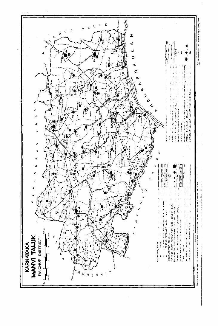
u K
I.) R T
(,
..J
I-
«
o
«
, • i
" ~ ~ -J,.
~3 t-!J a::
~i$ t-UJ
~ 0 .. Z- a:: x
~i :::> 1: U ~
E
~ il:i e
c::
.. N
J "\
E f S ~ N
.~ >! ,f
I <! W (! ,_ III
l: 0-
;0 It w " > Z
;: ~
Q
J: ':; <t : w J:
> W (!
U <1
iZ :I
~ " 0 <5 ~ ,. ........ LIJ
~ l: 0 W (!
~ ~ l: a: ,_ <1 i;I I- Z
:J cr Zw m " WU
~ w > u I-
0: W :t" <t '!! I- 0 i I- ~ 0_ z Q -' Z
W 0 I- <! Z , <,! u I! W<{ ,_ LI- W J: -'
~ III '" Ll- n 0
0: >
-' W " > <t I- W u <t-' Z III :t ;:; :> -<! 0 !2
_ Z 0 cr <{
u ~ J: n " LI-
•'-~I ' , , ,
.i .i_~ '<D' • !N: I IlICl Ul
I ' • I ' I,
o I I ,l. .. ' , .
~ z <! J:
~ !i , ,_ W ~ (! ~ :> w
" a > l-z I! 0: 0 11 ~
, o .. · l · £
~ i n o E o
~
" · >
~ , o
" , u · · o m

137
ALPHABETICAL UST OF vn.LAGES
TALUK: MANVI
1981 Population 1981 Population 31. Name of Village Census Sl. Name of Village Census No. L.C. No. L.C.
No. 1971 1981 No. 1971 1981
4 5 4 5
1 Advi Khanapur 155 499 594 61 Hire-Badar dinni 120 714 1007 2 Aldhal 116 698 784 62 Hiredinni 45 596 1138 3 Am arawati (A mrawati) 38 793 1068 63 Hire hangi 98 1004 993 4 Am eengaj 65 1617 1756 64 Hire Kadboor 58 454 578 5 Anandgal 81 972 952 65 Hire Kotankal 21 3297 4931 6 Arnalli 162 713 760 66 Hokrani 152 1046 1237 7 A roll 154 2303 2570 67 H OSUl' (U mll) 14 1128 1238 8 Atnur 124 2102 2321 68 H OSUl' (N ugdoni) 114 555 1171
69 Huda 88 315 328 9 Badlapur 34 190 215 70 Hunched 110 358 370
10 Bagalwad 119 2921 4022 71 Hussainpur 95 603 668 11 Bailm archad 170 1060 1317 12 Bal1atgi 115 2336 3410 72 Irkal 74 263 311 13 Bapur 166 112 238 14 Basapur 73 749 943 73 J ~kkal dinni 123 617 924 15 Belwat 32 172 290 74 Jalapur 136 411 1369 ~ 6 Bencha mardi 78 600 510 75 Jambaldinni 132 805 1028 17 !:3ett.adur 139 877 1353 76 Janekal 37 983 886 1c 3evinur 150 245 268 77 Janga m arhalli 53 374 570 19 Bhogawatj 39 772 997 78 Jeenur 28 1011 1311 20 Born manahal (Bornanha!) 149 795 915 79 Jinnapur 60 333 445 21 Bornsandoddi 92 80 Joladarasi. 42 166 22 Buddinni (U roll) 8 51 57 81 Jukur 159 521 653 23 Buddinni (U mli) 87 436 405 82 JutJahal (Jutalhal) 72 24 Bullapur 106 189 119 83 Jutlapur 15 93 25 Burhanpur 6 150 184 26 Ilyagwat 35 1970 2416 84 Kabberhal 57 100
85 Kachapur 68 308 392 27 Chagbhavi 134 1198 2628 86 Kaddinni 133 691 1181 28 C hikalparvi 9 1550 1809 87 Kalamgere 105 627 525 29 Chikkabadardinni 101 284 272 88 Kallur 137 5544 5372 30 C hikkadinni 44 501 761 89 Kambalanetti (Kamalat) 156 520 550 31 C hikkahangi 97 244 236 90 Kapgal 138 1795 2021 32 C hikkaudbal 52 91 Kardigud 143 1120 1546 33 C hikkotankal 13 1319 1200 92 Karegudda (Karegud) 36 654 984 34 Chilkaragi 75 496 501 93 Kasan doddi 93 757 557 35 Chimlapur 142 510 608 94 Katarki 4 931 961 36 C hincharki (C hinchirki) 86 826 875 95 K hara badinni 24 758 875
96 Korvi 165 1141 1038 37 D addal 3 421 476 97 Kotekal 64 694 667 38 D evipur 22 383 460 98 Kowtal 83 6455 7750 39 Dewatgal 102 367 512 99 Kumdhal 16 40 D hotarbanda 30 369 495 100 Kurdi 153 5606 6579 41 D onmardi 47 599 753 101 Kurkunda 107 1363 1464 42 D onmardi 91 316 267
102 Lakka rn dinni 135 597 855 43 Eklaspur 69 623 660 44 Eralgaddi 23 503 599 103 Machnur 151 939 1097
104 Madagiri (Madgiri) 147 2763 3352 45 Ganadinni 127 1036 1294 105 Madlapur 5 1557 1885 46 Gavigat 117 671 1165 106 Malat 103 1308 1564 47 Goge Hebbal 43 471 493 107 ~a1kapur 50 462 689 48 Goldinni 100 569 666 108 Malladgudda (M aladgud) 46 1124 1396 49 Gorkal 171 1914 2022 109 Malligm adu 145 469 604 50 Govindoddi 141 458 661 110 Manvi (Rural) 139 661 51 G ud-D inni (U mli) 96 104 155 111 Marat 112 887 857 52 Gud-D inni (Khalsa) 130 1383 1496 112 M arka m dinni 49 897 1057 53 Gudihal 76 716 738 113 M.Ramal dinni 61 46 49
114 M udda m gaddi 25 590 708 54 H alapur 40 904 1357 115 Murharpur 168 416 691 55 Halli 128 143 172 116 M urkiguda (M urkigud) 111 355 572 56 Hanchanhal 56 72 142 117 Mustoor 20 861 1010 57 Harvapur 79 575 596 58 Harvi 146 2189 3630 118 Nagaldinni 62 42 120 59 Heera (Heer) 89 1031 1370 119 Nakkunda 118 1042 1304 60 Hilalpur 77 240 212 120 N alga m dinni (N algundinni) 12 143 171

138
ALPHABETICAL LIST OF VILLAGES
TALUK: MAN VI
: )81 Population 1981 Populauon S1. N a ro e of Village Cen~us Sl. N a m e of Village Census No. L. C. No. L. C.
No. 1971 1981 N Q. 1971 1981
_l__
121 Nandihal (Kh'llsa) 17 396 493 149 S. Ra mal dinni 59 49 94 122 Nandihal 41 150 Sunkesh w ara 169 1897 2268 123 Narbanda 109 600 772 151 SUI,,.,.r:ool" 48 500 668 124 N aslapur 144 395 593 125 Na"alkal 113 852 1168 152 Tadkal 29 860 1253 126 N eerm anvi 140 2671 3813 153 Tam mapur 160 113 146 127 N e!kola 66 114 116 154 Tim mapur 84 379 279 128 Nugdoni 121 380 512 155 Togalgal 80
156 Tappal dOddi 85 461 515 129 Pamanl<aliur 63 1696 1776 !57 Toral dinni 51 927 1444 130 Pannur jagil' [Pannur (Khalaa)] 11 71 B 832 158 Tuggal dinni 5S 406 607 131 Pannur (Umli) 163 700 732 159 Tupdoor 82 449 410 132 Parasapur (Parsapur) 71 221 252 160 Tupdur (Khalsa) 148 204 233 133 Patakam doddi (Patkan D oddi) 104 34~ 604 134 Potanhal 27 1365 2143 161 Udbal 33 540 748 135 Potapur 99 441 436 162 Uralgaddi 26 3
163 Utaknur 31 916 93? 136 Rabbankal 2 633 868 137 Rajalbanda 161 932 1024 164 Wadwatti (Wadwaati) 108 416 289 138 Rajaldinni 18 398 436 165 W alka m <tinni 157 866 970 139 Rajoli 158 1573 1747 166 Watgal 70 1059 1018 140 Rangdhal 7 336 358
167 Yapala parU 90 141 Sadapur 164 892 935 168 Yarmal doddi 19 240 338 142 Saldapun 94 511 491 169 Yatgal 67 596 657 143 Sangapur 131 1163 1918 170 Yeddal dinni (yedal D inni) 5~ ~ 10 608 144 San hosun 129 1151 1521 171 Yedival 10 436 457 145 Seekal 167 371 963 146 Shakapur 125 866 715 147 Singaddinni 126 111 217 148 Sirwar 122 6084 9153

MANVI TALUK

Taluk : \\anvi
L.C. No.
Name 01 village
Manvi (Rural)
2 Rabbankal
Daddal
Katarki
Madlapur
6 Burhanpur
Rangdhal
Bud~;"i (Umli)
Chikalparvi
10 Yedival
II Pannur Jagir
12 Nalgamdinni
13 Chikkotankal
14 Hosur (Umli)
15 Jutlapur
16 Kumdhal
17
18
19
20
21
22
23
24
25
Nandihal (Khalsa)
Rajaldinni
Yarmaldoddi
Mutoor
Hirekotankal
DeviDur
Eralgaddi
Kharabadinni
Muddamgaddl
26 Uralgaddi
27 Potanhal
28 Jeenur
29 Tadkal
30 Rhotarbanda
31 Utaknur
32 Belwat
33 Udbal
34 Badlapur
35 Byagwat
Total Area 01 the village
(in hectares and ares)
Total PopUlation and number 01 households
4a
4200.20 661
599.91 868
517.30 476
712.)0 961
1280.61 1885
462.16 184
363.57 358
321.53 57
3180.77 1809
473.62 457
855.58 832
834.12 171
124~:~" 1200
667.!~ W%
308.53 93
206.29
583.58 493
630.12 436
492.25 338
1358.40 1010
2848.?5 4931
590.25 460
458.46 599
260.75 875
641.79 708
194.27
1463.64 2143
1520.77 1311
1486.43 1253
496.17 495
555.33 932
482.B 290
606.18 748
165.22 215
1882.64 2416
4b
141
168
89
169
369
28
54
368
85
152
31
211
222
27
92
64
56
165
924
91
98
166
138
385
243
232
84
161
48
129
45
464
VILLAGE DIRECTORY
AMENITIES AND LAND USE
Amenities available (if not available within the village, a dash (-) may be shown in the column and next to it in brackets, the distance in broad ranges viz., -5 kms, 5-10 kms and 10+kms of the nearest place ;"here
the facility is available may be given)
Day or Days Educational Medical Drinking Post and 01 the mar
water Telegraph ket/hat if
-(-5)
P
p
p
P,M
-(-5)
P
-(-5)
p
-(-5)
P
P
-(-5)
p
P
P
P
P
p
P
P,M
P
P
P
P
-(-5)
P
P
P,\I
an
-(-5) e,Hp -(-5) -(-5)
-(-5) W,Hp PO,Phone -(-5)
-(10.) W -(-5)
-(5-10) IV -(-5)
-(5-10) W,Hp PO
-(5-10) IV -(-5)
-(5-10) W,Hp -(5-10)
-(-5) W,Hp -(-5)
D T,e PO R,Hp
-(-5) IV +5)
-(5-10) W,Hp -(-5)
-(5-10) IV,Hp -(-5)
-(5-10) IV,Hp -(-5)
-(5-10) IV PO
-(5-10) C -(-5)
-(5-10)
-(5-10)
-(5-10)
-(5-10]
-(5-10)
-(10+)
-(10+)
-(10+)
-(5-10)
-(5-10)
-(5-10)
UN-1NHABITED
-(-5)
-(-5)
-(-5)
-(-5)
RP5
-(-5)
-(-5)
-(-5)
-(-5)
C,Hp
W,Hp
C,Hp
W
T,e IV,Hp C,Hp
w,e
W,C
w,e
-(-5)
-(-5)
-(-5)
-(-5)
PO, Phone -(-5)
-(-5)
PO
-(-5)
-(-5)
-(-5)
-(-5)
-(-5)
-(5- 10)
-(-5)
-(-5)
-(-5)
-(-5)
UN-INHABITED
PHC FPC -(-5)
RP
-(-5)
RP
-(-5)
-(-5)
-(-5)
PHU
C,Hp PO
C,Hp,W -(-5)
C,Hp PO
C,W -(-5)
W PO
C -(-5)
Hp PO C,W C,IV -(-5)
C PO
Thursday
·(-5)
-(5-10)
-(5.10)
-(5-10)
-(lOt)
-(JO.)
-(5-10)
Tuesday
Communications [Bus stop, Railway Station, Waterway 1
10
BS
B5
-(-5)
BS
BS
BS
-(-5)
BS
BS
-(-5)
-(-5)
-(5-10)
-(5-10)
-(-5)
-(-5)
BS
-(-5)
-(-5)
-(-5)
BS
-(-5)
-(-5)
-(-5)
-(-5)
B5
-(-5)
-(5-10)
-(5-10)
-(5-10)
-(lOt)
-(10.)
-(5-10)
BS
Approach to
vlildge
II
PR
PR
KR
PR
KR
PR
PR
P~
PR
KR
KR
KR
KR
KR
KR
PR
KR
PR
KR
PR
KR
KR
KR
KR
PR
KII
KR
KR
KP.
KR
KR
KR
PR

Nearest Town and distance (in Kms.)
12
ManvJ-l
Manvi-5
Manvi-13
Manvi-8
Manvi-8
,\lanvi-6
'\laovi-8
ManYi-lO
Manvi-D
Manvi-20
Manvi-26
Manvi-24
Manvi-24
Manvi-22
Manvi-23
Manvi-5
Manvi-4
ManvJ-3
\lanvi-5
\lanVi-IO
\1"nVI-24
\lon'l-21
~lanVl-22
Manvi-21
Manvl-24
~1anvi-26
Manyi-27
Manvi-30
Manvi-32
Manvi-30
Manvi- 30
\lanvi-19
Power Staple Supply food
13
fA
EA
EA
EA
EA
EA
EA
EA
EA
EA
EA
14
Rice Jowar Rice Jowar Rice Jowar Rice Jowar Rice Jowar Rice Jowar Rice Jowar Rice Jewar Rice Jowar Rice Jewar Rice Jewar Rice Jewar Rice Jawar Rice Jawar Rice Jawar
Rice Jowar Rice Jewar Rice Jawar Rice Jawar
Forest
15
EA Rice 10.32
EA
fA
[:\
EA
EA
EA
EAg
EA
Jowar Rice Jowar Rice Jewar Rice Jowar Rice Jowar
Rice Jowar Rice Jawar Rice Jawar Jawar
Jawar
Jowar
Jowar
Jewar Rice Jawar Rice
1~ 1
VILLAGE DIRECTORY
AMENITIES AND LAND USE Taluk : Manvi
Land use (area under dillerent types of land use in hectares)
Irrigated Un-irrigated (by source of irrigation)
16
CC: 1153.78 T : 1153.78
GC: 278.30 T : 278.30
GC : 242.14 T: 242.14
CC : 396.86 WE : 4.00 R : 40.96 T : 441.82
GC: 345.44 T : 345.44 GC: 5.26
T: 5.26
17
2004.89
238.15
128.39
84.66
472.89
325.38
337.52
262.09
GC: 2063.]3 R : 12.14 926.71 T : 2075.27
369.04
GC: 26.31 R : 3.23 769.21 T : 29.54
GC : 6.17 784.36 T: 6.17
CC: 111.55 1102.76 T: llt.55
CC : 124.45 WE : 4.04 495.09 T : 128.49
GC: 10.52 21i1.61 T: 10.52
188.72
GC: 34.42 501.28 T : 34.42
GC : 30.15 562.88 T : 30.15
GC : 23.17 439.35 T : 23.17
GC : 74.16 1105.64 T: 74.16
GC: 749.96 WE: 4.45 1919.40 T: 754.41
GC : 18.56 512.17 T: 18.56
GC : 18.00 397.80 T: 18.00
GC: 19.03 WE : 0.40 219.28 Tk : 0.04 T : 23.47
GC : 47.85 IV : 4.86 538.53 T: 52.71
GC : 3.03 181.52 T: 3.03
GC : 355.03 Tk : 6.48 968.14 T : 361.51
GC : 285.66 WE : 4.85 1034.51 Tk : 4.86 T : 295.37
GC : 253.20 1076.93 T : 253.20
GC : 95;IiJ 290.30 T: 95.4J
GC : 74.28 394.22 T : 74.28
GC: 120.75 300.96 T: 120.75
GC : 161.37 314.88 T : .161.37
GC : 23.08 WE : 1.20 75.94 T : 24.28
GC: 122.41 1449.86 T: 122.41
Culturable waste
(including gauchar and
groves)
18
511.48
8.14
117.39
166.22
96.39
44.09
5.97
1i9.69
18.24
16.19
8.09
13.67
50.94
2.84
16.15
2.39
5.01
87.60
25.83
ll.n
10.08
0.60
10.66
38.12
53.43
20.70
20.89
28.10
8.47
)0.47
9.84
249.68
Area not available for
cultivation
19
530.05
75.32
29.38
19.40
365.89
87..43
20.08
86.34
40.64
43.59
23.59
29.87
5.1i6
14.73
Remarks including any place of
religious, historicalor arCheologi
cal interest
20
N:25,M:J5, T: lJ
N:15.M:2,T :3
N:4
N:5,M:I,T:2
N:5,M:2, T:8
N:5,M:I
31.73 N:Ii,T:1
34.70
24.72
91.00 N:5,M:I,T:I
138.99 N:25,M:2,T:7
1i7.79 N:2
32.58 N:7
I7.1i0 N:5
39.89 N:6, T: I
9.72
95.87 N:20,M:2,T:)
137.46 N:5,M:2,T:1
135.60
89.57
58.73
52.05
100.06
55.16
60.69 N:IO,M:2,T:2
L.C. No.
10
II
12
13
14
15
16
17
18
19
20
21
22
23
25
26
27
28
29
30
31
32
33
31i
35

Taluk : Manvi
L.C. No.
Name of village
36 Karegudda
37 Janekal
38 Amarawati
39 Bhogawati
40 Halapur
41 Nandihal
42 ]oladarasi
44 ehikkadinni
45 Hiredinni
46 Malladgudda
47 Donamardi
48 Sunknoor
49 Markamdinni
50 Malkapur
5 I Toraldinni
52 Chikkaudbal
53 ]angamarhalli
54 Yeddaldinni
55 Tuggaldinni
56 Hanchanhal
57 Kabberhal
58 Hirekadboor
59 S. Ramaldinni
60 Jinnapur
61 M. Ramaldinni
62 Nagaldinni
63 PamankalJur
64 Kotekal
65 Ameengad
66 Nelkola
67 Yatgal
68 Kachapur
69 Eklasapur
70 Watgal
142
VILLAGE DIRECTORY
AMENITIES AND LAND USE
Amenities available (if not available within the village, a dash (-) may be shown in the column and next to it in brackets, the distance in broad ranges viz., -5 kms, 5-10 kms and 10.kms of the nearest place where Total Area
of the village
(in hectares and ares)
Total Population and number of households
the facility is available may be given)
3
1047.10 98#
1476.56 886
1236.76 1068
1187.45 997
303.62 1357
217.31
656.02 166
524.47 493
779.15 761
1397.15 1138
1634.33 l396
·~2.58 753
722.49 668
689.62 1051
531.95 689
1324.00 1444
372.99
342.08 570
474.60 608
376.26 607
326.12 142
263.41 100
777.19 57&
543.92 94
337.03 445
297.08 49
359.24 120
1053.44 1776
892.22 667
529.79 1756
581.11 116
1111.43 657
635.65 392
1145.00 660
2888.80 1078
4b
176
170
193
177
226
29
99
123
229
227
140
123
174
115
267
103
93
107
24
17
96
14
85
9
15
347
127
308
18
118
61
117
185
Day or Days Educational Medical Drinking Post and of the. mar
water Telegraph ket/hat if
P
P,M
P
P
P,M
-(-5)
P
P
P
P
P
P
P,M
P
P
P
P
P
-(-5)
-(-5)
P
-(-5)
P
-(-5)
-(-5)
P,M
p
P,M
-(-5)
P
P
-(-5)
P,M
an 6 9
-(-5) C -(-5) -(-5)
-(-5) W,Hp PO -(5-10)
-(-5) W,Hp -(-5) C
RP W,Hp -(-5) -(JO.)
RP W,Hp PO -(5-10) C
UN-INHABITED
-(-5) C -(-5) -(5-10)
-(-5) e,Hp -(-5) -(-5)
-(-5) e,Hp -(-5) -(5-10)
-(-5) W,Hp,C -(-5) -(5-10)
RP w,e PO -(5-10)
-(5-10) w,e -(-5) -(10.)
-(-5) W,Hp,C -(-5) -(5-10)
-(-5) e,Hp PO -(5-10)
-(-5) e,Hp -(-5) -(5-10)
RP e,Hp,W PO -(5-10)
UN-INHABITED
RP
-(-5)
-(-5)
W,Hp -(-5)
e,Hp,W -(-5)
C,Hp,W -(-5)
-(-5) e -(-5)
-(-5) C -(-5)
-(-5) w,e -(-5)
-(-5) e -(-5)
-(-5) w,e -(-5)
-(-5) e,Hp -(-5)
-(-5) W,Hp -(-5)
D RP3
W,Hp PO
-(-.5) W,Mp -(-5)
RP W,Hp PO
-(-5) W,Hp -(-5)
-(-5) W,Hp -(-5)
-(-5) W -(-5)
-(-5) W,Hp -(-5)
RP W,Hp PO
-(5-10)
-(5-10)
-(5-10)
-(-5)
-(-5)
-(-5)
-(-5)
-(-5)
-(-5)
-(-5)
Thursday
-(-5)
-(-5)
-(5-10)
-(5-10)
-(5-10)
-(-5)
-(-5)
Communications [Bus stop, Railway Station, Waterway 1
10
BS
-(-5)
BS
BS
BS
-(-5)
-(-5)
-(-5)
-(-5)
-(5-10)
-(5-10)
-(-5)
-(-5)
-(5-10)
BS
-(-5)
·(-5)
-(-5)
-(-5)
-(-5)
-(-5)
-(-5)
-(-5)
-(-5)
BS
BS
BS
BS
-(-5)
-(-5)
-(-5)
B5
BS
Approach to
village
11
PR
KR
PR
PR
PR
KR
PR
KR
KR
KR
KR
KR
KR
KR
PR
PR
PR
KR
KR
KR
KR
KR
KR
KR
PR
PR
PR
PR
PR
KR
KR
PR
PR

Nearest Town and distance (in Kms.)
12
Manvi-19
Manvi-16
Manvi-l0
Manvi-IO
Lingsugur-36
lingsugur-35
lingsugur -35
Lingsugur-35
Lingsugur-3 5
Manvi-36
Manvi-34
Manvi-38
lingsugur-4D
Lingsugur-40
Lingsugur-37
Lingsugur-40
Lingsugur-40
Lingsugur-38
5i ndhnur -32
Sindhnur-30
Sindhnur-26
Sindhnur-28
Ltngsugur-34
Lingsugur-3j
Lingsugur-35
Lingsugur-1 b
Lingsugur-17
Lingsugur-21
lingsugur-21
L ingsu~ur-22
Lmgsugur-22
Lingsugur-24
Llngsugur-25
Power Supply
13
EA
EA
EA
EA
EA
EA
EA
EA
EA
EA
EA
EA
EA
EA
EA
EA
EA
EA
Staple, food
14
Jowar Rice Jowar Rice Jowar Rice Jowar Rice Jowar
Jowar
Jowar
Forest
15
Jowar 27.32
Jowar
Jowar 21.37
Jowar
Jowar
Jowar
Jowar
Jowar
Jowar
Jowar
Jowar
Jowar
Jowar
Jowar
Jowar
Jowar
Jowar
Jowar 43.70
Jowar Baira Jowar Bajra Jowar Baira Jowar 162.69 Bajra Jowar 583.17 Bajra Jowar 305.95 Bajra Jowar 434.92 Baira Jowar 40.47 Baira
VILLAGE DIRECTORV
AMENITIES AND LAND USE
Land use (area under different types of land use in hectares)
Irrigated Un-irrigated (by, source of irrigatIOn)
16
GC : 124.14 T: 124.14
GC : 5&.23 WE : 0.80 T : 59.03
GC : 115.59 T : 115.59
GC : 180.53 T : 180.53
GC : 257.&9 T: 257.89
GC: 57.80 T : 57.80
GC: 64.65 T : 64.65
GC : 93.50 T : 93.50
GC: 172.91 T: 172.91
GC : 49.37 T : 49.37
GC : 193.86 T : 193.86
GC: 110.08 T : 110.08
GC : 140.99 T : 140.99
GC : 366.49 T : 366.49
GC : 17.37 T: 17.37
GC : 185.30 T : 185.30
GC : 260.62 T : 260.62
GC : 100.14 T: 100.14
GC: 127.33 T : 127.33
GC : 44.21 T: 44.21
GC : 22.36 T : 22.36
GC: 61.06 T: 61.06
W: 4.93 Tk : 17.38 T: 22.31
W: 3.57 T: 3.57
Tk : 9.36 . T: 9.36
W : 0.29 Tk : 57.28 T : 57.57 W: 5.01 T: 5.01
17
866.48
1208.80
1039.18
935.35
187.43
110.12
267.20
426.79
608.61
1149.52
864.59
505.9&
459.43
545.20
823.65
347.78
103.64
80.74
191.84
142.82
148.19
697.21
436.94
301.20
250.37
202.14
929.35
672.79
498.30
374.15
519.80
310.95
616.56
2576.63
Culturable waste Area not
(including available for gauchar and cultivation
groves'
18
28.52
1.06
20.50
5.88
48.68
67.85
73.26
22.86
53.12
91.68
574.69
26.84
55.03
28.45
96.34
30.76
29.25
38.95
30.18
24.14
54.23
33.39
Lo62
12.19
13.13
3.23
20.22
193.52
19
27.96
208.39
61.49
65.69
67.51
39.34
57.67
17.02
22.45
50.77
20.39
46.35
15.90
59.49
78.&3
7.84
24.69
36.90
53.52
26.72
32.06
27.44
45.92
35.83
22.57
59.17
68.39
217.81
15.73
31.1~
5.23
9.39
15.73
7J.I7
Taluk : Manvi
Remarks including any place of
religIOus, historicalor archeologi
cal interest
20
N:5.M:I,T:1
N:5,M:2,T:I
N:5,M:2,T:l
N:5,M:1
M:l
M:l,T:1
N:l,M:1
T:I
M:l,T:l
T:2
T:2
N:3,M:3,T:I
A-I
M:l,T:1
M:l
L.C. No.
36
37
38
39
40
41
42
43
44
45
46
47
49
50
51
52
53
54
55
56
57
58
59
60
61
62
63
64
65
66
67
68
69
70
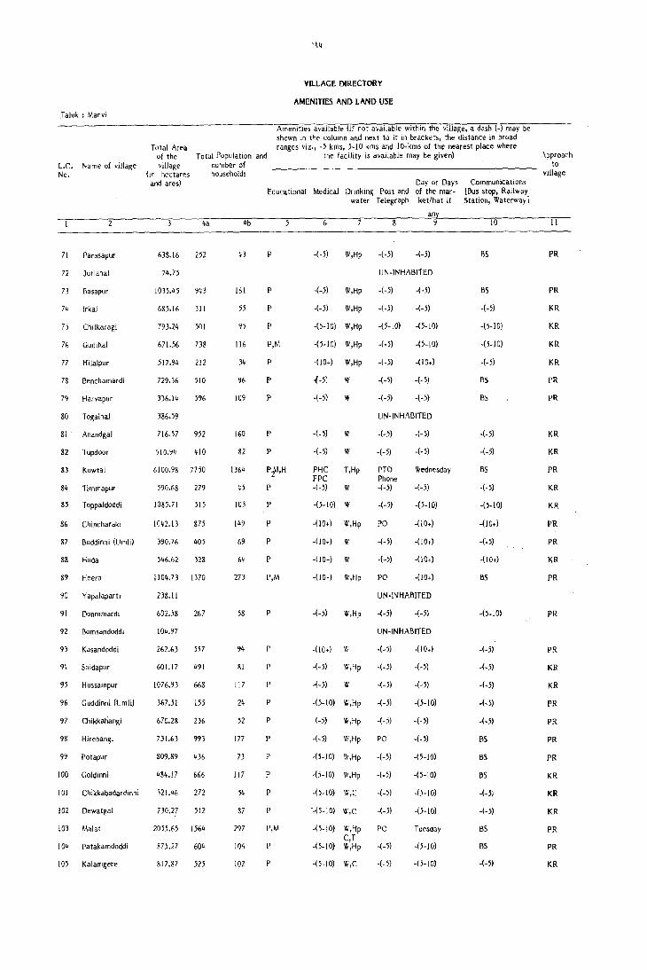
Taluk : Manvi
L.C. No.
Name of village
71 Parasapur
72 Jutlahal
73 Basapur
74 Irkal
7 j Chllkar agi
76 Gudihal
77 Hilalpur
7& Benchamardi
79 Harvapur
80 Togalhal
81 Anandgal
82 Tupdoor
83 Kowtal
84 Timmapur
85 Toppaldoddi
86 Chincharaki
87 Buddinni (Umli)
88 Huda
89 Heera
90 Yapalaparli
9 I Donmmardi
92 Bomsandoddi
93 Kasandoddi
94 Saidapur
95 Hussainpur
96 Guddinni (Umli)
97 Chikkahangi
98 Hirehangi
99 Polapur
100 Goldinni
101 Chikkabadardinni
102 Dewatgal
103 Mala!
104 Patakamdoddi
105 Kalamgere
144
VILLAGE DIRECTORY
AMENITIES AND LAND USE
Amenities available (if not available within the village, a dash (-) may be shown In the column and next to it in brackets, the distance in broad ranges viz., -5 kms, 5-10 kms and 10+kms of the nearest place where Total Area
oj the village
(In hectares and ares)
Total Population and number of households
the facility is available may be given)
638.16
74.75
1035,45
685.16
793.24
671.56
4a
252
943
311
501
738
517.94 212
729.36 510
336.14 5%
386.59
716.57 952
510.94 410
6100.98 7750
590.68 279
1085.71 515
1042.13 875
390.76 405
546.62 32&
1l04.73 1370
238.11
602.58
104.97
262.63
601.17
1076.93
367.51
267
557
491
668
155
670.28 236
731.63 993
809.89 436
484.17 666
321.46 272
730.27 512
2055.65 1564
875.27 604
817.87 525
4b
43
161
55
95
ll6
34
96
109
160
82
1364
45
103
149
69
64
273
58
94
81
117
24
52
177
73
117
54
87
297
10~
102
Day or Days Educational Medical Drinkin~ Post and of the mar
water Telegraph ket/hat if
P
P
P
p
P,M
P
P
P
P
P
P1",H
P
p
p
P
p
P,M
P
P
P
P
p
P
P
P
P
p
p
P,M
P
P
6
-(-5) W,Hp
-(-5) W,Hp
-(-5) W,Hp
-(5-10) W,Hp
-(5-10) W,Hp
-(10+) W,Hp
1-5; W
-(-5) W
-(-5)
-(-5)
Pl-fC FPC -(-5)
W
W
T,Hp
w
-(5-10) W
-(JOt) W,Hp
-(JOt) W
-(lOt) W
-(10+) W,Hp
-(-5) W,Hp
-(10+) w
-(-5) W,Hp
-(-5) W
-(5-10) W,Hp
(-5) W,Hp
-(-5) W,Hp
-(5-10) W,Hp
-(5-10) W,Hp
-(5-10) '1I,C
'-(5-10) W,C
-(5-10) W,Hp C,T
-(5-10) W,Hp
-(5-10) W,C
an
-(-5) -(-5)
UN-INHABITED
-(-5) -(-5)
-(-5) -(-5)
-(5-10) -(5-10)
-(-5) -(5-10)
-(-5)
-(-5) -(-5)
-(-5) -(-5)
UN-INHABITED
-(-5)
-(-5)
PTO Phone -(-5)
-(-5)
PO
-(-5)
-(-5)
PO
-(-5)
-(-5)
Wednesday
-(-5)
-(5-10)
-(10+)
-(lOt)
-(lOt)
-(lOt)
UN-INHABITED
-(-5) -(-5)
UN-INHABITED
-(-5) -00+)
-(-5) -(-5)
-(-5) -(-5)
-(-5) -(5-10)
-(-5) -(-5)
PO -(-5)
-(-5) -(5-10)
-(-5) -(5-10)
-(-5) -(5-10)
-(-5) -(5-10)
PO Tuesday
-(-5) -(5-10)
-(-5) -(5-10)
Communications [Bus stop, Railway Station, Waterway J
[0
BS
BS
-(-5)
-(5-10)
-(5-10)
-(-5)
BS
BS
-(-5)
-(-5)
BS
-(-5)
-(5-10)
-(10+)
-(·5)
-(lOt)
as
-(5-10)
-(-5)
-(-5)
-(.5)
·(-5)
-(-5)
BS
BS
BS
-(-5)
-(-5)
as
BS
-(-5)
.\pproach to
village
II
PR
PR
KR
KR
KR
KR
PR
PR.
KR
KR
PR
KR
KR
PR
PR
KR
PR
PR
PR
KR
KR
PR
PR
PR
PR
KR
KR
KR
PR
PR
KR

t~'.i
VILLAGE DIRECTORY
AMENITIES AND LAND USE Taluk : Manvi
Land use (area under diflerent types of land use in hectares)
Culturable Re marks including Nearest Town and distance Power Staple Forest Irrigated Un-irrigated waste Area not any place of L.c.
(in Kms.) Supply food (by source of irrigation) (including available for religious, histori- No. gauchar and cultivation calor archeologi-
groves) cal interest /
12 IJ 14 15 16 17 IS 19 20
Lingsugur-30 Jowar 598.51 27.18 12.47 71 Bajra
GC : 57.76 15.08 1.91 72 T : 57.76
Lingsugur -3 3 Jowar GC : 25.94 W : 3.87 918.75 54.15 32.74 N:l,T:l 73 Bajra T: 29.81
Lingsugur-30 Jowar 622.23 26.65 36.28 74 Bajra
i5 Lingsugur-26 EA Jowar W: 7.72 Tk : 13.23 689.31 61.63 21.35 Bajra T : 20.95
Lingsugur-27 Jowar 55.85 564.21 42.17 9.33 76 Bajra
Lingsugur-25 Jowar 90.65 385.2Q 33.75 8.34 77 Bajra
Lmgsugur-25 EAg Jowar WE: 1.54 67&.96 31.44 17.42 N:I 78 Bajra T: 1.54
Lingsugur-10 EA Jowar W: 2.16 294.26 10.01 29.71 79 Bajra T: 2.16
354.55 26.30 5.74 80
Lingsugur-20 EA Jowar 4.86 W : 2.05 Tk : 50.92 606.77 34.04 17.93 81 Bajra T : 52.97
Lingsugur-21 EA Jowar 419.50 41.68 49.76 N:1 82 Bajra
Lingsugur-28 EA Rice 16.48 GC : 52.61 5178.58 287.39 565.92 N:20,M:6,T:2 83 Jowar T: 52.61 A-ll
Lingsugur-33 Jowar 294.23 296.45 84 Bajra
Lingsugur-34 Jowar 1031.16 54.55 85 Bajra
Lingsugur-35 EA Jowar 822.64 118.05 101.44 86 Bajra
Lingsugur-37 EA Jowar 287.43 99.92 3.41 87 Bajra
Lingsugur-40 Jowar 438.49 73.66 31;.47 88 Bajra
Lingsugur-39 EA Jowar 951.37 85.97 67.39 89 Bajra
224.41 8.76 4.94 90
Lingsugur-43 EA Bajra GC: 119.37 505.98 26.84 20.39 91 Jowar T : 49.37
98.89 6.08 92
Lingsugur-43 8ajra 166.05 54.78 41.80 93 Jewar
Lingsugur-43 Bajra 425.92 8.09 167.16 94 Jewar
lingsugur-43 Bajra 640.97 435.96 95 Jowar
Ungsugur-35 EA Bajra 280.87 32.38 54.26 96 Jowar
Lingsugur-34 EA Bajra 623.66 46.62 97 Jewar
lingsugur-34 EA Bajra 636.77 20.63 74.23 N:l,M:1,T:l 9& Jowar
Manvi-35 Bajra 609.10 18.22 182.57 99 ]owar
Manvi-35 Bajra 333.45 99.15 51.57 100 Jowar
Manvi-35 Bajra 292.30 1.74 27.42 101 Jawar
Manvi-J6 Bajra GC: 20.23 535.79 50.24 124.01 t02 Jawar T : 20.23
Manvi-29 fA Jowar GC: 12.63 1795.47 114.87 • 132.68 N:1,M:I,T:1 103
Manvi-27 Bajra T: 12.63
fA Jowar W: 1.21 775.30 31.58 67.18 104
Manvi-30 Bajra T: 1.21 Jowar W: 2.83 530.11 11.05 273.88 105 Bajra T: 2.83

Taluk : Manvi
LoC. No.
Name of village
106 BuHapur
107 Kurkllnda
108 lVadwatti
109 I\arbanda
110 Hunched
.1 I I Murkigllda
112 Marat
II J Nawalkal
114 Hosur (Nugdoni)
I I 5 BaJJatgi
116 Aldhal
117 Gavigat
I 18 Nakkunda
JJ q Bagalwad
120 Hirebadardinni
121 Nugdoni
122 Sir war
123 Jakkaldinni
124 Atnur
125 Shakapur
126 Singaddinni
127 Ganadinni
128 HaJji
129 Sanhosur
Total Area of the village
(in hectares and ares)
Total Population and number of households
4a
822.15 119
1529.54 1464
9lJ.78 289
762.78 772
476.82 370
769.57 572
373.76 857
1408.85 Jl68
1238.25 ll71
3015.95 3410
1126.35 784
1664.66 1165
1565.54 1304
3033.&5 4022
816.29 1007
824.86 512
2902.83 9153
680.03 924
3584.43 2121
295.29 715
691.26 217
1445.24 1294
4b
22
240
66
153
59
114
161
228
236
640
137
216
227
695
201
96
1769
160
440
137
39
265
146
VILLAGE DIRECTORY
AMENITIES AND LAND USE
Amenities available (if not available within the viJJage, a dash (-) may be shown in the column and next to it in brackets, the distance in broad ranges viz., -5 kms, 5-10 kms and IO+kms of the nearest place where
the facility is available may be given)
Day or Days Communications Educational Medical Drinking Post and of the mar- [Bus stop, Railway
-(-5)
P,M
P
p
P
p
p
P
P
P,M
P
P
P,M
P,M
P
P
p,rvl
P
-(-5)
P
water Telegraph ket/hat if Station, Waterway]
6
-(10+) w,e
-(5-10) 'w,e Hp
-0-10) W,Hp
-(-5)
PO
-(-5)
-(5-10) W,Hp,C -(-5)
-(5-10) W,Hp -(-5)
-(5-10) W,Hp -(-5)
-(-5) W,C -(-5)
-{-51 W,Hp,C PO
-(-5) w,e -(-5)
PHU W,Hp,C PO
-(5-10) C,Hp PO
-(-5) W,Hp -{-5}
-(5-10) w PO
an
-(-5)
Thursday
-(-5)
-(5-10)
-(5-10)
-(5-10)
-(-5)
-{-5}
-(-5)
-(5-10)
-(l0.)
-(10.)
-(10.)
D W,Hp PO,Phone Friday
-(5-10) W,Hp,C -(-5) -(5-10)
-(-5) II',T,C -(-5) -(-5)
D,PHU, W,Hp RP T ..(-5) W.Hp
PO, Phone -(-5)
RP W,Hp PO
-(5-10) W,Hp -(-5)
-(5-10) W,Hp -(-5)
-(5-10) W,f-lp PO
Monday
-(-5)
-(-5)
-(5-IO)
-(5-10)
-(.5-JO)
10
-(-5)
BS
-(-5)
BS
-(-5)
-(-5)
-(-5)
BS
-(-5)
-(5-10)
-(-5)
-(-5)
BS
BS
-(-5)
-(-5)
BS
BS
BS
BS
-(-5)
-(-5)
338.04 172 34 -{-5} -(5-10) W,Hp -(-5) -(5-10) -(-5)
819.35 1521 274 -(5-10) W,Hp,e -(-5) -(5-10) BS
130 Guddinni (Khalsa) 3391.16 2496 488 -(5- I 0) II' ,Hp,C PO -(5-10) -(-5)
131 Sangapur
132 Jambaldinni
133 Kaddinni
134 Chagbhavi
135 Lakkamdinni
136 Jalapur
137 Kallllr
IJ8 Kapgal
139 Bettadur
140 Neermanvi
1079.89 1918
823.02 1028
816.99 1181
114~.23 2628
829.41 855
1220.63
8889.76
1765.43
1369
5372
2021
867.18 1353
2524.98 3813
349
180
225 P
500
143
277
994
267
722
-(-5) W,Hp -(-5)
-(-5) II' PO
-(5-10) II' PO
-(5-10) W,Hp -(-5)
-(5-10) W,Hp PO
-(-5) W,Hp,C
PHU W,T RP 3 -(5-10) Hp,C
-(5-10) Hp,C
-(-5)
PTO, Phone PO
-(5-10)
-(-5)
-(-5)
\ -(5-10)
-(5-10)
-(5-10)
-(-5)
Sunday
-(5-10)
-(5-10)
-(5-10) W,C,Hp PO,Phone -(5-10)
BS
-(-5)
-(5-10)
-(-5)
-(5-10)
-(-5)
BS
BS
-(-5)
BS
Approach to
village
II
KR
PR
PR
PR
KR
KR
KR
PR
KR
PR
KR
KR
PR
PR
KR
KR
PR
p~
PR
KR
KR
KR
KR
PR
PR
KR
KR
KR
KR
KR
KR
PR
PR
PR
PR

/ 147
VILLAGE DIRECTORY
AMENITIES AND LAND USE Taluk : Manvi
Land use (area under different types of land use in hectares)
Culturable Remarks including distance Power Staple Forest Irrigated Un-irrigated waste Area not any place of L.C.
Supply foOd (by source of irrigation) (including available for religious, histori- • No. gauchar and cultivation calor archeologi-
groves) cal interest
13 14 15 4§ 16 17 18 19 20
]owar W: 1.21 668.97 52.11 99.86 106 Bajra T : 1.21
EA Jowar WE : 4.86 VII : 0.81 1222.60 103.73 197.54 N:l,M:l,T:1 107 Bajra T: 5.67
EA Jowar WE : 6.88 W : 0.81 793.62 27.84 84.63 108 Bajra T: 7.69
EA Jowar 642.45 11.72 108.61 109 Bajra
EA Jowar lf32.57 38.96 5.29 110 Bajra Jowar 695.51 72.83 1.23 111 Bajra
EA Jowar 346.02 14.11 13.63 112 Bajra
EA ]owar GC: 161.74 908.08 229.38 109.65 N:2,T:1 113 Bajra T : 161.7lf
EA Jowar GC : 284.19 942.88 11.18 M:I,T:) 114 Bajra T: 28lf.19
EA Jowar GC : 246.99 0 : 16.39 2437.41 62.07 25.3.09 N:I,M:I,T:2 115 Bajra T : 263.38 Jowar GC : 122.34 935.llf 23.67 45.20 116 Bajra T : 122.34 Jowar GC: 62.90 896.33 610.07 95.36 N: I,M:2, T:2 117 Bajra T: 62.90
EA Jowar GC: 165.77 1212.23 75.44 112.10 N:I,T:I 118 Bajra T : 165.77
EA Jowar GC : 181.15 \liE : 8.50 2095.72 477.63 270.85 N:I 119 Bajra T : 189.65 Jowar GC: 81.55 654.49 23.09 57.16 120 Sajra T : 81.55
EA Jowar GC: 78.97 647.56 17.95 80.38 T:I 121 Bajra T: 78.97
EA Jowar GC: 1605.82 1035.79 5.80 255.42 N: 150,M:n, T: 15, 122 Rice T : 1605.82 C:2
EA Jowar GC : 3lf6.88 296.117 2.83 33.85 M:I,T:I 123 Rice T : 346.88
EA Jowar GC : 240.89 3178.08 77.84 87.62 N:IO,M:I,T:2 i211 Rice T : 240.89 Jowar GC: 70.11 199.89 10.01 15.28 125 Rice T: 70.11 Jowar GC: 132.70 521.57 2.21 34.78 126 Rice T : 132.70 ]owar GC: 91.75 1273.03 22.73 57.73 127 Rice, T: 91.75 Jowar GC: 23.67 292.53 9.56 12.28 128 Rice T : 23.67 Jowar GC : 212.79 5lf5.36 20.76 40.44 T: I 129 Rice T : 212.79
EA ]owar GC : lf08.00 2783.9lf 140.59 58.63 130 Rice T : 408.00
EA Jowar GC : 510.83 505.59 48.79 14.68 N:10,M:8,T:3 131 Rice T : 510.83
EA Jowar GC: 6D.43 727.31 14.99 20.29 N:5,M:3,T:2 132 Rice T: 60.1+)
EA Jowar GC: 182.32 571.lf8 17.04 46.15 N:5,M:2, T:3 133 Rice T : 182.32
EA Jowar GC : 906.53 1}4.06 17.97 70.67 N:5,M:2,T:3 134 Rice T : 906.53 Jowar GC: 202.86 584.19 13.26 29.10 M:2,T:I 135 Rice T : 202.86 Jowar GC : 1148.10 670.32 113.39 58.82 136 Rice T : 4lf8.10
EA Jowar GC : 309.82 WE : 2.lf3 7830.64 450.87 294.79 N:28,M:5, T: I 0 137 Rice Tk : 1.21 T : 313.46 C:I A-m
EA Jowar GC : 69.8! Tk : 111.55 1478.70 96.86 78.51 M:3,T:4 138 Rice T : 111.36
EA Jowar GC : 230.05 5.52.00 85.13 M:4,T:4 139 T : 230.05
EA ]owar GC: 7l7.5a WE: 6.48 1128.66 164.69 507.57 N:25,M:4, T:4 140 Rice T : 724.06

Taluk : Manvi
L.C. No.
Name of village
141 Govindoddi
142 Chimlapur
143 Kardigud
144 Naslapur
145 Malligmadu
146 Harvi
147 Madagiri
14& Tupdur (Khalsa)
149 Bommanhal
150 Bevinur
151 Machnur
152 Horkani
153 Kurdi
154 Aroli
155 Advikhanapur
156 Kambalanetti
157 Walkamdinni
158 Rajoli
159 Juk'Jr
160 Tan,mapur
161 Rajalbanda
162 ArnoW
163 Pannur (Umli)
164 Badapur
165 Korvi
166 Bapur
167 Seekal
168 Murharpur
169 Sunkeswara
170 Bailmarchad
171 Gorkal
Total
148
VILLAGE DIRECTORY
AMENITIES AND LAND USE
Amenities available (if not available within the village, a dash (-) may be shown in the column and next to it in brackets, the distance in broad ranges viz., -5 kms, 5-10 kms and 10+kms of the nearest place where Total Area
of the village
(,n hectares and ares)
Total Population and number of households
the facility is available may be given)
4a
326.06 661
5&9.39 . 608
498.25 1546
721.34 593
987.15 604
1461.80 36.)0
2791.17 3352
559.16 233
549.33 915
377.18 268
1348.78 1097
1741.86 1237
577 3.70 6579
2086.84 2570
798.67 594
441.04 550
591.92 970
995.00 1747
678.88 653
467.30 146
317.10 1024
824.06 760
706.07 732
61l.08 935
1657.89 1038
645.22 238
644.98 963
438.89 691
1077.64 2288
1371.59 1317
3062.68 2022
178892.38 179966
4b
126
114
295
99
liS
663
692
45
138
39
189
262
1402
413
100
93
161
278
118
23
162
159
132
168
196
48
194
138
416
241
384
33197
Day or Days EducatIOnal Medical Drinking Post and of the mar
water Telegraph ket/hat if
P
P
P
P
P
P,M
P,M
P
p
P
P
p
p
P
P
P,M
P
-(-5)
P,M
P
P
P
P
-(-5)
p
p
P,M
an
-(-5) Hp,C -(-5) -(5-10)
-(-5) C -(-5) -(5- 10)
-(-5) W PO -(-5)
-(5-10) Hp,C -(-5) -(5-10)
-(5-10) C -(-5) -(5-10)
RP2
-(-5)
w,e PO -(10+)
W,Hp,e PO,Phone -(10+)
-(5-10) W -(-5) -(10+)
-(5-10) W -(-5) -(10+)
-(-5) C -(-5) -(5-10)
RP C PO -(5-10)
-(-5) W,C PO -(5-10)
PHU T PO,Phone Saturday
-(-5) W,Hp PO -(-5)
-(5-10) W -(-5) -(5-10)
-(5-10) e -(-5) -(5-10)
-(-5) Hp,C -(-5) -(-5)
-(5-10) e PO -(5-10)
-(-5) C PO -(5-10)
-(-5) Hp,C -(-5) -(10+)
D W,Hp PO -(5-10)
-(-5) C -(-5) -(10+)
-(-5) C -(-5) -(10+)
-(5-10) W,Hp,C -(-5) -(10+)
-(5-10) W,Hp PO -(10+)
-(-5) w,e -(-5) -(-5)
-(-5) W,lip,C -(-5) -(5-10)
-(5-10) W -(-5) -(5-10)
-(5-10) W,Hp PO -(-5)
-(5-10) W -(-5) -(-5)
-(-5) W PO Friday
Communications [Bus stop, Railway StatIOn, Waterway 1
10
-(-5)
BS
BS
B5
-(-5)
BS
BS
B5
B5
BS
BS
BS
-(-5)
BS
BS
BS
BS
BS
-(-5)
BS
-(-5)
-(-5)
-(-5)
-(5-10)
-(5-10)
-(5-10)
-(-5)
-(-5)
BS
Approach to
village
II
KR
KR
PR
KR
KR
PR
PR
KR
KR
KR
KR
PR
PR
PR
KR
KR
KR
KR
PR
KR
PR
KR
KR
KR
KR
KR
KR
KR
KR
PR
PR

149
VILLAGE DIRECTORY
AMENITIES AND LAND USE Taluk : Manvi
Land use (area under different tyoes of land use in hectares)
Culturable Remarks including Nearest Town and distance Power Staple Forest Irrigated Un-irrigated waste Area not any place of L.C.
(in Kms.) Supply food (by source of irrigation) (including available jor religious, histori- No. gauchar and cultivation calor archeologi-
groves) cal interest
12 13 14 15 4§ 16 17 18 19 20
Manvi-8 Jowar GC : U19.87 153.34 5.02 17.83 141 Rice T : 149.87
Manvi-8 Jowar GC: 137.45 407.31 6.82 37.81 142 Rice T : 137.45
Manvi-5 EA Jowar GC : 158.73 287.74 4.22 47.56 M:I, T:2 143 Rice T : 158.73
Manvi-6 EA Jowar GC : 45.00 590.90 0.39 85.05 144 Rice T: 45.00
Manvi-IO Jowar GC: 100.03 854.93 32.19 145 Rice T: 100.03
Manvi-12 EA Jowar GC : 586.58 451.88 376.14 47.20 N:25,M:9, T:4 146 Rice T : 586.58
Manvi-18 EA Jowar· GC : 438.63 WE : 3.24 2168.70 27.56 141;30 M:2,T:2 147 Rice Tk : 11.74 T : 453.61
Manvi-15 Jowar GC: 72.84 478.68 7.64 148 Rice T: 72.84
Manvi-14 EA Jowar WE: 1.62 522.68 3.97 21.06 M:l 149 Rice T: 1.62
Manvi-16 EA Jowar GC : 29.14 338.31 9.73 150 Rice T: 29.14
Manvi-16 EA Jowar GC : 35.61 1285.80 27.37 N:IO,T:4 151 Rice T: 35.61
Manvi-17 EA Jowar GC : 36.42 1674.78 30.66 M:I,T;1 152 Rice T : 36.42
Manvi-21 EA Jowar GC : 5077.79 WE: 15.08 530.15 39.29 110.90 N:3 153 Rice Tk : 0.49 T : 5093.36
Raichur-24 EA Jowar GC : 612.75 WE: 2.03 749.81 29.48 681.37 154 Rice Tk : 11.40 T : 626.18
Raichur-27 EA Jowar GC ; 574.79 WE ; 5.83 175.53 25.46 3.19 155 Rice Tk : 13.87 T : 59M9
Manyi-26 EA Jowar GC : 390.81 WE : 1.79 26.09 5.10 17.25 156 Rice T : 392.60
Manvi-26 EA Jowar GC: 365.19 WE : 6.84 167.53 19.14 33.22 157 Rice T : 372.03
Manvi-27 EA Jowar GC : 335.79 Tk : 58.51 428.95 137.35 34.40 158 Rice T : 394.30
Manvi-26 EA Jowar GC : 172.50 Tk : 30.16 316.38 147.32 12.52 M:2,T:2 159 Rice T : 202.66
Manvi-24 Jowar GC : 167.72 Tk : 6.37 129.84 40.73 122.64 N:2,M:2, T:2 160 Rice T: 174.09
Manvi-22 EA Jowar GC : 98.76 WE : 9.'12 184.93 2.40 21.09 161 Rice T : 108.68
Manyi-20 Jowar GC : 498.76 202.18 76.40 46.72 162 Rice T : 498.76
Manvi-16 Jowar GC ; 61D.53 35.03 35.65 24.86 N:l,M:l,T:l 163 Rice T : 610.53
Manvi-12 EA Jowar GC: 363.04 149.44 48.21 50.39 164 Rice T : 363.04
Manyi-13 EA Jowar GC: 806.58 627.18 14.63 209.50 165 Rice T : 806.58
Manvi-5 Jowar GC : 455.53 164.88 4.82 19.99 166 Rice T : 455.53
Manvi-6 Jowar GC : 385.31 156.99 35.35 67.33 167 Rice T : 385.31
Manvi-8 Jowar GC: 173.63 194.47 0.77 70.02 T:I 168 Rice T : 173.63
Manvi-10 EA Jowar GC: 486.18 458.90 53.81 78.75 T:I 169 Rice T : 486.18
Manvi-14 EA Jowar GC : 453.27 705.24 131.12 81.96 170 Rice T : 453.27
Manvi-16 EA ]owar GC : 1678.25 WE: 39.16 902.80 54.32 381.39 171 Rice Tk: 6.76 T : 1724.17
'1': 41.33 WE: 135.94 TIc: 345.61 GC : 33950.41 R: S&.J3 0: 16.39
1797.7;) T : 345116.01 119739.29 9233.61 13525.72


RAICHUR TALUK
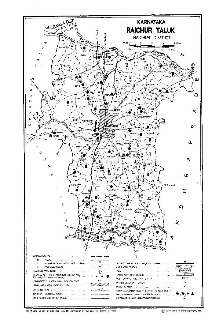
c:
« >
o
)
7
BOUNDARY, STATE ..
" TALUK ..
" VILLAGE WITH LOCATION CODE NUMSER
" FOREST -RESERVED
HEADQUARTERS, TALUK •.
VILLAGES WITH POPULATION SIZE, BELOW 200; 200-499; SOO-999; 1000-4999.
UNINHABITED VILLAGES WITH LOCATION CODE
URBAN AREA WITH LOCATION CODE
STATE HIGHWAY .•.
IMPORTANT METALLED ROAD.
UNMETALLED AND OTHER ROADS.
. .. ~_.~.!~.!.~ I 27 I ••• 1 __________ ..... ....... RF.······ ...
© ·0 ••• r----xi-----r
:::W#2X0"A SH 20
KARNATAKA RAICHUR TALUK
RAICHUR DISTRICT
Iy
Q
Q:
::r
c
'5. RAILWAV LINE WITH STATION,BF(OAD GAUGE
RIVER WITH STREAM . .. ~ .. ~ TANK
CANAL WITH DISTRIBUTARY
POST OFFICE / TELEGRAPH OFFICE ..
HIGHER SECONDARY SCHOOL
POLICE STATION
,..----PO/TO
PS
HOSPITAL, PRIMARY HEALTH CENTRE I PRIMARY HEALTH
UNIT,DISPENSARV,FAMILY PLANNING CENTRE... . •. ~,~, +,'" IMPORiANT VILLAGE MARKET/HAT (SHANDY) £
Bosed upon Survey of India map With tht" permisslOf'I of the- Sur-veyor General of India. © Government of India CopVrlght, 1986.

153
ALPH !DETICAL LlST OF Vll.LAGES
TALUK : RAICHUR
1981 Population 1981 Population S1- Name of Village Census 81. N arne of Village Census No. L.C. No. L.C.
No. 1971 1981 No. 1971 1981
4 2 4 5
Agapur 7 63 Ibrahim doddi 115 524 551 2 Agrahar 147 19 40 64 Idapnur 72 3121 3589 3 Alkur 43 873 873 65 Jahbenchi 104 471 649 4 Anwar 53 289 403 66 Ja m baldinni 37 734 833 5 Appandoddi 140 711 668 67 Jegarkal 91 2225 2082 6 Arlappanhuda 89 294 290 68 Julauigera 34 939 800 7 Arliben~hi 102 201 227 8 Arshangi 125 969 867 69 K adga m doddi 134 353 489 9 Arsigera 157 448 462 70 Kadlur 129 1524 1310
10 Asapur 103 666 699 71 Kadlur (Kudlur) 138 914 739 11 Aslcihal 25 2102 2669 72 Kalmala 83 3646 3&74 12 Athkur 151 1852 2517 73 Kamlapur 52 973 1173 13 AyaJPur 16 709 760 74 Kannedoddi 36 114 114
75 Karebudur 69 438 552 14 Baidoddi 10 849 1150 76 Karekal 130 285 316 15 Bapur 14 691 1024 77 Kataknur 60 414 454 16 Bapur 40 78 Katlatkur 135 855 1262 17 Bassapur 29 79 Khanapur 49 584 615 18' Bevl11 Benehi 120 562 475 80 Korthkunda 111 725 807 19 Bichal 58 1312 1899 81 Korvakalan 148 319 369 20 Bijangera 18 1030 1217 82 Korvakhurd 146 250 309 21 Balm andoddi 12 360 367 83 Korvihal 109 538 517 22 Buddinni 79 683 847 84 Kothdoddi 35 421 446 23 Budidipad (Budadipad) 149 554 588 85 Kothdoddi 155 69 88 24 Bu1Japur 81 673 974 86 Kotigud 59
87 Kuknoar 93 603 546 25 C handerbanda 133 1628 1905 88 Kurabdoddi 8 410 551 26 Chick m anchal 80 531 683 89 K urtipah (p urthipalli) 150 109 83 27 Chicksugur 92 1251 1424
90 Lingankhan doddi 32 926 1066 28 o eosugur 107 1416 3797 29 o evanpalli 19 861 1197 91 M ada m andoddi 141 157 198 30 Dinni 48 2188 2240 92 Maliabad 22 1917 2065 31 o angara m pur 144 897 1273 93 Mallapur 31 361 463 32 o ugnoor 68 706 766 94 Mallapur 90 863 846
95 M a m adadaddi 112 562 699 33 Eklaspur 26 110'1 1293 96 Mamdapur 100 787 903
97 Mandalgera 159 472 733 34 Fathepur 97 564 609 98 Mangigaddi 145 47 66
99 Manjerla 55. 845 97£ 35 Gadhar 56 974 1021 100 Manslapur !l6 1507 2064 36 Gajerhal 152 652 670 101 Masdoddi 33 775 869 37 Gandhal 71 2320 2920 102 Matrnari. 64 3176 4090 38 Gangwar 76 246 312 103 Meerapur 73 289 363 39 Ganjhalli 108 863 868 104 Meerapur 127 459 367 40 Ganmur 139 903 969 105 Merchathal 105 1274 1415 41 Garaldinni 47 1256 1575 106 Merched 95 1782 1878 42 Gatbichal 62 847 872 107 Midgalginni 41 595 313 43 G housenagar 11 106 156 108 Mirzapur 74 922 1123 44 GiJlesugur 57 1076 1544 109 Mittim alkapur 20 800 823 45 Godihal 44 556 484 110 Moldoddi 39 196 241 46 Gonhal 98 979 843 111 M oodaldinni 65 181 280 47 Gonwar 54 586 682 112 Murharpur 85 1091 592 48 Gunderveli 78 217 355 113 Murkidoddi 30 143 205 49 Gunjhalli 42 3655 3885 50 Gurjapur 126 335 548 114 N addigaddim alkapur 17 478 595
115 Nagandoddi 156 521 461 51 H alvenkatapur 84 603 319 116 Naglapur 51 312 265 52 Hanchinhal 70 312 377 117 Naglapur 119 124 60 53 Hanmapur 61 964 1079 118 Nelhal 101 1255 1461 54 Hanmapur 123 609 519 55 H anu rn andoddi 116 329 414 119 Palwaldoddi 154 228 259 56 H arkandoddi (Arkandoddi) 13 120 Pesaldinni 106 7 57 Heerapur 63 1392 1633 121 Polka m doddi 136 207 264 58 H egsanhalli 118 652 814 122 Potgal 5 1501 1915 59 Hem berhal 122 684 671 123 P uchaldinni 38 596 682 60 Hospet 94 1720 1353 124 Purtipli 46 1100 1204 61 Hosur 23 1481 1662 62 H unsihalhuda 99 923 890
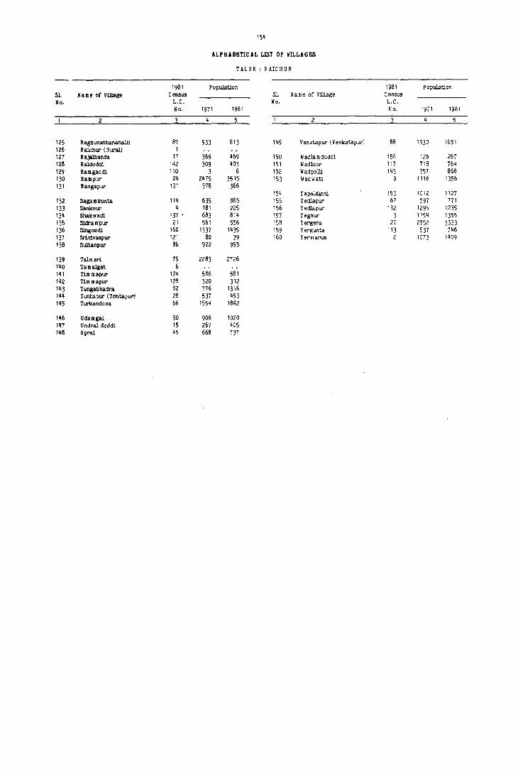
154
ALPHABEnCAL LIlIT OF mLAGES
TAL 0 K : R AlC H U R
1981 Population 1981 Population Sl. Name of Village Census Sl. Name of Village Census No. L.C. No. L.C.
No. 1971 1981 No. 1971 1981
2 4 5
125 Raghunathanahalli 87 933 813 149 Venktapur (Venkatapur) 88 1530 1651 126 Raichur (R ural) 1 127 Rajalbanda 17 369 469 150 W adla m doddi 158 126 267 128 Raldoddi 142 309 403 151 Wadloor 117 718 764 129 Ramgaddi 110 3 6 152 Wadpalli 143 157 868 130 Rampur 24 2475 3515 153 Wadwati 9 1116 1356 131 Rangapur 131 378 366
154 Yapaldinni 153 1012 1127 132 Saga m kunta 114 635 865 155 Yedlapur 67 597 771 133 Sanknur 4 181 225 156 Yedlapur 132 1295 1235 134 Shakwadi 131- 683 814 157 Yegnur 3 1154 1355 135 Sidram'pur 21 561 556 158 Yergera 27 2752 3333 136 SingnOdi 160 1337 1435 159 Yergunta 113 537 746 131 Srinivaspur 121 80 39 160 Yermarus 2 1073 1409 138 Sultanpur 86 922 995
139 Talmari 15 2283 2726 140 TamBlgat 6 141 Tim mapur 124 586 581 142 Tim mapur 128 320 312 143 Tungabhadra 82 776 1316 144 Tuntapur (Tontapur) 28 537 493 145 Turkandona 66 1554 1892
146 Udamgal 50 906 1020 m U ndral doddi 15 267 405 148 Upral 45 668 137

RAICHUR TALUK

Taluk : Raichur
L.C. No.
Na me of village
2
Raichur (Rur,,!)
Yermarus
Yegnur
Sanknur
Patgal
6 Tamalgat
Agapur
Kurabdoddi
Wadwatti
10 Baidoddi
II Ghosenagar
12 Bolmandoddi
13 Harkandoddi
14 Bapur
15 Undraldoddi
16 Ayajpur
17 Rajalbanda
18 Bi janger a
19 DevanpalJi
20 Mittimalkapur
21 Sidrampur
22 Maliabad
23 Hosur
24 Rampur
25 Askihal
26 Eklaspur
27 Yergera
28 Tutapur
29 Bassapur
30 Murkidoddi
31 MalJapur
32 Lingankhandoddi
33 Masdoddi
34 Julamgera
35 Kothdoddi
156
VILLAGE DIRECTORY
AMENITIES AND LAND USE
Amenities available (if not available within the village, a dash (-) may be shown in the column and next 10 it in brackets, the distance in broad ranges viz., ·5 kms, 5-10 kms and 10tkms of the nearest place where Total Area
of the village
(in hectares and ares)
Total Population and number of households
the facility is avaiJable may be given)
4a
2746.58
578.93 1409
1309.70 1355
289.12 225
1301.86 1915
84.93
61.78
352.76 551
1086.77 m6
591.82 1150
238.59 156
654.29 367
372.50
854.27 1024
944.91 405
816.81 760
237.79 469
1068.98 1217
1198.13 1197
539.51 823
532.84 556
1793.38 2065
751.42 1662
1861.06 3515
938.59 2669
1811.88 1293
2705.82 3333
677.79 493
191;60
385.50 205
539.27 463
616.98 1066
1197.18 869
743.86 800
780.87 446
4b
280
298
41
379
93
256
188
37
86
214
72
125
74
212
204
154
89
354
286
638
493
243
618
122
35
75
187
135
149
81
Day or Days Communications Educational Medical Drinking Post and of the mar- [Bus stop, Railway
P,M
P
-(-5)
P
P
P
-(.5)
P
P
P
P
P
P
P
P
P
P,M
P,M
P
P,M
P
P
P
P
P
P
P
water Telegraph ket/hat if Station, Waterway]
an
UN·INHABITED
RP W,Hp PTO,Phone -(-5)
-(-5) W -(-5) -(-5)
-(-5) IV -(-5) -(-5)
-(-5) W,Hp PO,Phone -(-5)
UN-INHABITED
UN-INHABITED
·(-5) W,Hp -(.5)
.(5-10) W -(.5)
-(5-10) W,Hp PO
-(5-10) W,Hp -(-5)
·(5·10) W,Hp -(.5)
·(5-10)
-(5-10)
-(5.10)
·(5-10)
-(5-10)
UN-INHABITED
-(5-10) W,Hp -(·5)
.(IOt) W,Hp .(-5)
·(10.) W,Hp .(-5)
.(5-10) W,Hp -(-5)
.(5-10) W,Hp ·(·5)
.(5-10) W,Hp -(-5)
-(5:10)
-(-5)
·(·5)
Sunday
·(·5)
-(-5)
.(5-10) W,Hp PO -(-5)
-(·5) W.Hp -(-5) ·(5-10)
-(-5) W,Hp PO,Phone -(5-10)
-(.5) W PO -(5·10)
RP W,Hp PO -(5-10)
-(-5) T,W,Hp PO
-(·5) W,Hp PO
·(-5)
-(-5)
n,RP W,Hp PTO,Phone Tuesday
-(-5) W,Hp -(-5) .(-5)
UN-INHABITED
.(·5) W,Hp -(-5)
.(·5) W,Hp .(-5)
RP W,Hp PO
.(-5) W,Hp .(-5)
·(·5) W PO
-(5-10) \II,Hp ·(-5)
.(-5)
.(-5)
-(-5)
·(-5)
-(5-10)
-(5-10)
10
BS,RS
BS
BS
BS
BS
BS
BS
-(·5)
-(-5)
.(-5)
-(-5)
BS
BS
BS
-(·5)
BS
BS
BS
-(·5)
BS
BS
BS
BS
BS
-(-5)
BS
BS
BS
·(-5)
BS
Approach to
village
II
PI{
PR
PR
PR
PR
PR
PR
PR
KR
PR
PR
PR
PR
PR
PR
PR
PR
PR
PR
PR
PR
PR
PR
PR
PR
PR
PR
PR
PR
PR
Nearest Town and distance (in Kms.)
12
Raichur-5
Raichur-IO
Raichur-12
Raichur-4
Raichur-9
Raichur-6
Raichur-9
Raichur-IO
Raichur-6
Raichur-13
Raichur-15
Raichur-13
Raichur-IO
Raichur-6
Raichur-9
Raichur-6
Raichur-4
Raichur-6
Raichur-3
Raichur-3
Raichur-2
Raichur-5
Raichur-15
Raichur-IO
Raichur-15
Raichur-18
Raichur-22
Raichur-12
Raichur-23
Raichur-24
Power Supply
13
Staple food
EA Rice ]owar
EA Rice Jowar
EA Rice Jowar
Forest
15
EA Rice 27.11 Jowar
EA Rice 32.38 Jowar
EA Rice 83,)7 Jowar
EA Rice Jowar
EA Rice Jowar
EA Rice Jowar
EA Rice 48.56 Jowar
EA Rice 527.89 Jowar
EA Rice 210.44 Jowar
EA Rice Jowar
EA Rice 25.09 Jowar
EA Rice 10.27 Jowar
EA Rice Jowar
EA Rice Jowar
EA Rice 192.64 Jowar
EA Rice Jowar
EA Rice Jowar
EA Rice Jowar
EA Rice Jowar
EA Rice 7 I. 36 Jowar
EA Rice 34.40 Jowar
EA Rice 55.30 Jowar
EA Rice Jowar
EA Rice Jowar
EA Rice 349.96 Jowar
EA Rice Jowar
EA Rice 37.67 Jowar
/ 157
VILLAGE DIRECTORY
AMENITIES AND LAND USE
Land use (area under different types of land use in hectares)
Irrigated Un-irrigated (by source of irrigation)
16
Tk : 25.59 W : 10.46 WE : 8.38 T : 44.43
17
2661.79
443.35
893.88
215.61
Tk : 58.34 W : 2.04 835.19 WE : 7.11 T: 67.49
WE : 1.21 63.85 T: 1.21
WE : 2.51 46.33 T: 2.51
Tk : 44.52 W : 15.97 170.35 WE : 32.37 T : 92.86 Tk : 50.87 W : 8.14 573.57 WE : 44.52 T : 103.53 Tk : 46.84 W : 4.36 337.47 WE : 8.70 T : 59.90 Tk : 3.18 W : 4.15 187.94 WE: 1.78 T: 9.11 Tk : 20.19 W : 3.37 379.37 WE : 8.02 T : 31.58
Tk : 25.15 W : 6.31 WE : 3.80 T : 35.26
277.37
455.89
260.87
GC : 61.26 414.20 T : 61.26
115.74
Tk : 44.66 W : 8.09 747.15 WE : 6.07 T : 58.82
985.91
Tk : 101.70 WE : 2.47 342.02 T: 104.17
444.58
Tk: 167.79 WE : 1.98 54Q.92 T : 169.77
WE : 1.22 GC : 8.09 542.70 T: 9.31
GC : 30.70 1672.00 T : 30.70
900.51
1545.63
GC : 144.20 Tk : 153.79 2238.46 WE : 20.24 T : 318.23
Tk : 95.44 489.88 T : 95.44
165.49
Tk : 9.63 307.61 T: 9.63
Tk : 6.88 WE : 3.24 508.92 T: 10.12
GC : 52.61 WE : 4.86 552.83 T : 57.47
Tk: 46.74 666.12 .: 46.74
Tk: 82.96 WE : 6.07 521.23 T : 89.03
Tk : 57.06 WE : 15.38 533.29 T : 72.44
Culturable waste Area not
(including available for gauchar and cultivation
groves)
18
52.31
44.48
85.93
54.87
56.47
10.96
8.31
16.17
104.14
120.38
34.02
2M9
53.69
223.57
107.24
43.12
100.22
139.59
37.18
74.81
97.29
29.07
202.35
4.91
54.63
9.82
9.82
9.30
4.05
129.50
81.75
106.72
19
32.48
91.10
285.46
18.64
315.60
&.91
4.63
41.00
222.16
74.07
7.52
214.85
41.44
90.99
48.91
87.79
122.05
137.70
62.36
56.14
13.45
792.76
170.34
158.36
38.08
63.90
72.86
3.44
16.29
3.14
10.93
2.63
4.86
51.85
30.75
Talul< : Raichur
Remarks including any place of L.C.
religious, histori- No. calor archeologi-
cal interest
20
N:20,M:6,C:I, T:2 N:20
N:15,M:2,T:1
N:18
Md
N:6
N:~
N:20
N:18,M:2
N:20,M:2
N:16,M:l
N:12,M:2,T:2
N:30,M:3,T:I
N:4,M:I
N:3
M:I,T:I
I_
6
9
10
11
12
13
14
15
16
17
18
19
20
21
22
23
24
25
26
27
28
29
30
31
32
33
34
35
Taluk : Raichur
L.C. No.
Name of village
2
36 Kannedoddi
37 Jambaldinni
38 Puchaldinni
39 Moldoodi
. 40 Bapur
41 Midgaldinni
42 Gunjhalli
43 Alkur
44 Gooihal
451 Upral
46 Purtipli
47 Garaldinni
48 Dinni
49 Khanapur
50 Udamgal
51 Naglapur
52 K.amlapur
53 Anwar
54 Gonwar
55 Manjerla
56 Gadmar
57 GiHesugur
58 Biehal
59 Kotigud
60 Kataknur
61 Hanmapu,
62 Gatbighal
63 Heerapur
64 Matmari
65 Moodaldil)ni
66 T urkandor>a
67 Yedlapur
68 Dugnoor
69 Karebuddur
70 Hanchinhal
158
VILLAGE DIRECTORY
AMENITIES AND LAND USE
Amenities available (if not available within the village, a dash (-) may be shown in the column and next to it in brackets, the distance in broad ranges viz., -5 kms, 5-10 kms and 10+kms of the nearest place where T()tal Area
of the village
(in hectares and ares)
Total Population and number of households
the facility is available may be given)
4a
358.65 114
903.48 833
678.22 682
339.66 241
853.45
539.40 313
3961.15 3885
805.42 873
505.39 484
460.42 737
1575.64 1204
1640.65 1575
1775.29 2240
707.93 615
894.04 1020
359.38 265
974.81 1173
463.85 403
720.16 682
521.15 978
1656.81 1021
388.22 1m
1828.61 1899
97.06
422.72 45.
501.33 1079
946.78 .872
390.17 1633
3153.10 4090
267.77 280
988.08 1&92
498.66 771
610.89 766
735.96 552
507.19 J77
4b
20
160
!l2
34
94
704
·164
92
145
243
309
420
106
203
59
77
108
174
187
2811
365
80
204
170
307
740
343
138
119
III
71
Day ()r Days Communications Educational Medical Drinking Post and ()f the mar- [Bus stop, Railway
-{-5)
p
P
-(-5)
.p
P,M,H
P
P
P
P,M
P,M
P,M
P
p
P
P
P,M
P
p
P
P
P
P,M
P
P
P
P
water Telegraph ket/hat if Stali()n, Waterway 1
6
-(5-10) W,Hp -{-5)
..(-5) W,Hp ..(-5)
..(-5) \I!,Hp PO
..(-5) W ..(-5)
8 an
9
-(5-10)
..(10+)
..(10+)
..(10+)
UN-INHABITED
-(-5) W,Hp -(-5)
PHU T,W,Hp PO
..(-5) W,Hp -(-5)
..(-j) Vi -(-5)
..(-j) W,Hp PO
..(-5) W,Hp PO
..(5-10) W -(-5)
..(5-10) IV,Hp PO
..(-5) W,Hp ..(-5)
..(10+) T,W,Hp PO
-(-5) W,Hp ..(-5)
-(-5) W,Mp PO
-(-5) W -{-5)
-(5-10) W,Hp ..(-5)
..(-5) W,Hp PO
..(.5) W -{-5)
RP W,Hp PO
RP W,Hp PO
·(10+)
-(!O+)
-(!O+)
-(5-10)
-{5-10)
-(5-10)
·(5-10)
-(5-10)
-{5-10)
-(5-10)
..(10+)
..(10.)
-(10+)
-(5-10)
-{5-10)
..(-5)
..(-5)
Tuesday
UN-INHABITED
..(-5)
RP
-{-5)
..(-5)
W,Hp -{.j)
W,Hp PO
W,Hp ..(-5)
W,Hp -(-5)
..(.5)
..(-5)
-(-5)
..(-5)
PHC,FPC T,W,Hp PO,Phone ..(-5)
..(-5)
..(-;)
-(-5)
-«5)
-(-5)
..(-5)
W,Hp .:(-5)
W PO
W,Hp -(-5)
W,Hp ..(-5)
W,Hp ..(-5)
W,Hp ..(-5)
Wednesday
..(-5)
..(5.10)
..(5-10)
..(5-10)
-(5-10)
10
-(-5)
BS
BS
..(-5)
BS
BS
-(-5)
..(-5)
-(-5)
BS
-(5-10)
BS
..(-5)
BS
BS
-(.5)
-(-5)
-(-5)
BS
-(-5)
BS
BS,RS
BS
BS
-(-5)
..(-5)
..(-5)
BS
BS
BS
..(-5)
-(-5)
BS
Approach to
village
11
PR
PR
PR
PR
PR
PR
PR
PR
PR
PR
PR
PR
PR
PR
PR
PR
PR
PR
PR
PR
PR
PR
PR
PR
PR
PR
PR
PR
PR
PR
PR
PR
PR

Nearest Town and distance (in Kms.)
12
Raichur-26
Raichur-18
Raichur-20
Raichur-26
Raichur-22
Raichur-l&
Raichur-22
Raichur-20
Raichur-20
Raichur-22
Raichur-29
Raichur-20
Raichur-13
Raichur-13
Raichur-16
Raichur-16
Raichur-14
Raichur-13
Raichur-16
Raichur-18
Raichur-18
Raichur-32
Raichur-36
Raichur-34
Raichur-35
Raichur-38
Raichur-40
Raichur-32
Raichur-31
Raichur-29
Raichur-26
Raichur-24
Raichur-22
Power Supply
J3
EA
EA
EA
EA
EA
EA
EA
EA
EA
I'.A
EA
EA
EA
EA
EA
EA
EA
EA
EA
EA
EA
EI\
lOA
EA
EA
EA
EA
EA
EA
EA
fA
fA
Staple food
14
Rice Jowar Rice Jowar Rice Jowar Rice Jowar
Rice Jowar Rice Jowar Rice Jowar Rice Jowar Rice Jowar Rice Jowar Rice Jowar Rice Jowar Rice Jowar Rice Jowar Rice Jowar Rice Jowar Rice Jowar Rice Jowar Rice Jowar Rice Jowar Rice ]owar Rice ]owar
Rice ]owar Rice Jowar Rice ]owar Rice Jowar !lice jowar Rice Jowar Rice ]owar Rice Jowar Rice Jowar Rice Jowar Il.ice Jowar
159
VILLAGE DIRECTORY
AMENITIES AND LAND USE Taluk : Raichur
Land use (area under different types of land use in hectares)
Forest Irrigated Un-irrigated (by source of irrigation)
16 17
Tk : 2.33 WE : 2.32 282.28 W: 1.52 T : 6.17
132.57 Tk: 130.72 WE : IMO 616.12 T: 148.12
Tk : 5.45 663.25 T: 5.45
117.36 Tk: 9.71 190.33 T : 9.71
Tk : 19.02 WE : 2.83 815.59 T: 21.85
Tk : 38.45 GC : 10.01 43.70 T: 48.46
113.25 Tk:247.68 WE:8.50 GC:311.612925.69 0:80.94 T:648.73
GC : 10.71 762.52 T: 10.71
GC : 34.75 437.27 T : 34.75
WE : 3.24 379.48 GC: 8.09 T: 11.33
GC : 71.75 1468.74 T: 71.75
GC I 118.67 1418.71 T I 118.67
GC : 84.g9 0: 4.04 1623.34 T : 88.93
WE: 1.21 GC : 6.48 681.22 T: 7.69
Tk: 31.58 GC : 27.82 807.47 o : 4.45 T : 63.85 WE : 0.81 GC : 15.18 329.50
T: 15.99 Tk : 76.89 WE I 4.45 807.99 GC : 48.97 T : 130.31
65.64 Tk: 3.68 W : 1.&2 261.47 GC: 43.10 T : 48.60
108.01 Tk: 18.29 WE : 3.24 457.98 GC : 77.20 T : 98.73 Tk : 42.36 WE : 6.88 336.60 GC I 74.97 T : 124.21 Tk : 44.43 GC 43.65 1439.33
T : 88.08 GC : 20.24 297.61
T : 20.24 GC I 240.34 1101.21
T : 240.34 GC: 23.26
T : 23.26 GC : 24.43 325.59
T : 24.43 GC : 83.06 291.39
T : 83.06
GC: 23.83 T : 23.83
GC: 390.92 T : 390.92
GC : 79.70 T : 79.70
GC : 336.97 T : 336.97
GC: 70.80 T : 70.80
GC 60.71 T 60.71
GC 40.47 T 40.47
790.55
336.49
2460.76
161.96
448.77
290.03
503.35
5;6.57
475.34
Culturable waste
(including gauchar and
groves)
1&
32.00
1.21
2.02
1.85
438.13
32.00
3.41
34.81
42.52
12.14
4.04
1.58
12.66
39.80
33.49
23.85
10.11
123.32
1.68
9.83
37.70
38.65
3.89
121.41
12.34
164.51
5'M2
6.06
34.52
[4.33
Area not available for cultivation
19
20.24
14.16
9.11
241.48
32.19
29.96
34.80
35.15
60.75
63.02
6.S&
l2.72
9.85
34.93
75.48
15.64
26.85
105.55
60.26
363.74
72.12
62.87
89.18
117.58
25.96
180.01
13.77
37.83
78.31
40.77
104.40
17.52
Remarks including any place of
religious, historicalor archeologi
cal interest
20
N:2
N:4,1·1:1
N:2
N:35,MI2, T:2
N:12,M:I
N:8,T:1
N:16,T:[
N:8,M:I
M:I
N:6,M:2,T:I
N:4
N:4,M:2,C:I, T:[
N:12,M:2
NI12,M:2,T:I
N:3
N:5,M:[
N:32,M:2,C:l, TIl
N:16
N:4
M:I
N:3,M:2,T:I
L.C. No.
36
37
38
39
40
41
42
43
44
45
46
47
49
50
51
52
53
54
55
56
57
58
59
60
61
62
63
64
65
66
67
68
69
70

Taluk , Raichur
L.c. No.
Name of village
71 Gandhal
72 ldapnur
73 Meerapur
74 Mirzapur
75 Ta1mari
76 Gangwar
77 Naddigaddimal-kapur
78 Gunderveli
79 Buddinni
80 Chickmand,<l!
81 Bullapur
82 Tungabhadra
83 Kalmala
84 Halvenkatapur
85 Murharpur
86 Sultanpur
87 Raghunathana-haJli
88 Venktapur
89 Arlappanhuda
90 Mallapur
91 Jegarkal
92 Chicksugur
93 Kuknoor
94 Haspel
95 Merched
96 Manslapur
97 Fathepur
98 Gonhal
99 Hunsihalhuda
100 Mamdapur
101 Ne1hal
102 Arlibenchi
103 Asapur
104 Jalibenchi
105 Merchathal
160
VD.LAGE DIRECTORY
AMENITIES AND LAND USE
Amenities available (if not available within the village, a dash (-) may be shown in the column and next to it in brackets, the distance in broad ranges viz., -5 kms, 5-10 kms and 100kms of the nearest place where Total Area
of the village
(in hectares and ares)
Total Population and number of households
the facility is available may be given)
4a
1615.19 2920
3744.22 3589
888.06 363
789.26 1123
1279.44 27Z6
482.42 312
813.56 595
384.27 355
300.19 847
507.42 683
424.53 974
821.69 1316
3266.13 3674
551.39 319
658.95 592
l377.38 995
894.83 813
3128.46 1651
226.91 290
958.89 846
2945.39 2082
1802.19 1424
817.81 ~46
1455.89 1353
1644.64 1878
1986.68 2064
772.90 609
1015.68 843
1345.37 890
1275.70 903
mZ.ll 1461
209.96 227
565.86 699
682.96 649
1513.12 1415
4b
495
665
69
200
451
50
97
75
163
137
171
242
645
59
III
196
158
287
53
159
395
284
110
236
362
385
III
157
163
177
293
43
117
120
250
Day or Days Educational Medical Drinking Post and of the mar
water' Telegraph ket/hat if
P,M
P,M,H
P
P
P,M
P
P
P
P
P
P
P
P,M
P
P
P,M,H
P,M
P
P,M
P,M
P,M
P
P
P
P
P
P
P
P
P,M
5 an
6 8 9
-(5-10) W,C PO -(5-10)
RP W,Hp PO,Phone -(5-10)
-(-5) W,Hp -(-5) -(10+)
-(-5) W -(-5) -(10+)
RP W,Hp PO -(10+)
-(-5) W,R -(-5) -(10+)
-(-5) W,Hp -(-5) -(10+)
-(-5) W -(-5) -(10+)
-(-5) W -(-5) -(5-10)
RP W,Hp -(-5) -(5-10)
-(-5) W,Hp -(-5) -(5-10)
RP W,Hp -(-5) -(-5)
PHU T,W,Hp PO,Phone Saturday
-(-5) W,Hp -(-5)
-(-5) W,Hp -(-5)
-(-5) W,Hp PO
-(-5) W,Hp -(-5)
-(-5) T,W,Hp PO
-(5-10) W,Hp -(-5)
PHC,FPC W,Hp -(-5)
-(-5) T,W,Hp PO
-(10+) W,Hp PO
-(10+) W,Hp -(-5)
-(-5) W,Hp PO
-(10+) T,W,Hp PO
-(5-10) W,Hp -(-5)
-(5-10) W,Hp -(-5)
-(5-10) W,Hp PO
-(-5) W,Hp -(-5)
-(5-10) W,Hp -(-5)
-(10+) W,Hp PO
-(-5) W,Hp -(-5)
-(-5) W,Hp PO
-(-5) W,Hp -(-5)
-( 10+) W,Hp PO
-(-5)
-(-5)
-(-5)
-(-5)
-(-5)
-(5-10)
-(5-10)
-(5-10)
-(10+)
-(10+)
-(10+)
-(10+)
-(5-10)
-(5-10)
-(5-10)
-(-5)
-(5-10)
-(5-10)
-(5-10)
-(5-10)
-(10+)
-(5-10)
Communications [Bus stop, Railway Station, Waterway 1
-(-5)
BS
-(-5)
BS
BS
-(-5)
-(-5)
-(-5)
-(-5)
-(-5)
-(-5)
-(-5)
BS
-(-5)
-(-5)
BS
-(-5)
-(-5)
-(-5)
BS
BS
10
BS,RS
-(-5)
BS
BS
-(-5)
-(-5)
BS
BS
BS
BS
BS
BS
BS
RS
Approach to
village
11
PR
PR
PR
PR
PR
PR
PR
PR
PR
PR
PR
PR
PR
PR
PR
PR
PR
PR
PR
PR
PR
PR
PR
PR
PR
PR
PR
PR
PR
PR
PR
PR
PR
KR

Nearest Town and distance (in Kms.)
12
Raiehur-30
Raichur-26
Raichur-30
Raichur-29
Raichur-35
Raichur-40
Raichur-40
Raichur-37
Raichur-35
Raichur-35
Raichllr-34
Raichur-31
Raichur-15
Raichur-21
Raichur-18
Raichur-20
Raichur-17
Raichur-13
Raichur-18
Raichur-20
Raichur-19
Raichur-13
Raichur-12
Raichur-14
Raichur-12
Raichur-8
Raichur-9
Raichur-IO
Raichur-12
Raichur-IO
Raichur-13
Raichur-8
Raichur-9
Raichur-ll
Raichur-15
Power Supply
13
Staple food
14
EA Rice Jawar
EA Rice Jawar
EA Rice Jawar
fA Rice Jawar
EA Rice Jawar
fA Rice Jawar
EA Rice Jawar
EA Rice Jawar
EA Rice Jawar
EA Rice Jawar
fA Rice Jewar
EA Rice Jawar
EA Rice Jawar
EA Rice
EA Jewar Rice Jawar
EA Rice Jowar
fA Rice Jewar
EA Rice Jowar
EA Rice Jewar
EA Rice Jowar
EA Rice Jowar
EA Rice Jewar
EA Rice Jowar
EA Rice Jowar
EA Rice Jowar
EA Rice Jowar
EA Rice Jewar
EA Rice Jowar
EA Rice Jewar
EA Rice Jewar
EA Rice Jewar
EA Rice Jewar
EAg Rice Jewar
EA Rice Jewar
EA Rice Jewar
Forest
15
lbl
Vn.LAGE DIRECTORY
AMENITIES AND LAND USE
Land use (area under different types of land use in hectares)
Irrigated Un-irrigated (by source of irrigation)
16
GC : 184.74 T : 184;74
GC : 105.75 T : 105.75
GC: 52.55 T: 52.55
GC: 334.32 T : 334.32
GC: 17.40 T: 17.40
GC: 62.37 T: 62.37
GC : 97.72 T: 97.72
GC: 37.39 T : 37.39
GC: 165.65 T: 165.65
GC : 163.59 T : 163.59
GC: 256.74 T : 256.74
GC: 302.41 T : 302.41
WE: 3.24 T: 3.24
WE: 2.43 T: 2.43 W: 5.26 T: 5.26
WE : 1.21 T: 1.21
Tk : 103.92 W : 4.85 T: 108.77
Tk : 61.11 WE : 4.05 T: 65.16
WE: 3.24 T: 3.24
WE: 7.22 T: 7.22
GC : 178.73 T : 178.73
GC : 168.90 T : 168.90
Tk : 24.28 WE : 1.22 T : 25.50
WE : 4.05 GC : 16.69 'T: 20.74
Tk : 55.16 WE : 1.62 GC : 18.21 T : 74.99
GC : 17D.44 T: 170.44
17
1085.96
3317.43
694.52
623.70
681.30
394.63
665.54
192.82
168.98
122.08
168.89
398.40
2936.58
543.72
649.85
1348.23
891.48
2985.65
220.84
901.08
2823.44
1696.44
801.41
1389.81
1445.14
1700.55
762.23
899.62
1290.38
1051.27
793.99
138.68
376.01
593.18
1291.29
Culturable waste
(including gauehar and
groves)
18
266.29
132.62
135.11
60.51
155.80
45.09
80.59
58.47
41.90
118.06
12.78
21.41
20.56
5.13
93.08
8.10
56.92
9.16
4.62
0.63
27.73
17.62
13.22
18.45
6.96
Area not available lor
cultivation
19
78.20
188.42
58.43
52.50
108.02
25.30
5.06
35.26
51.92
10],63
79.27
145.14
6.58
7.67
6.27
20.78
3.35
49.73
6.07
49.71
65.03
103.32
1.9&
64.87
86.11
220.97
10.04
1I2.82
47.77
17.97
161.60
32.56
150.66
14.79
44.43
Taluk : Raichur
Remarks including any place of L.C.
religious, histori- No. calor areheelegi-.
cal interest
20
N: 15,M:2 AoJ
N:30,M:1,T:I
N:2
N:4,M:3,T:2
M:I,T:l
N:2
M:I,T:I
M:l,T:l
M:I,T:I
N:25,M:5, T:5
r:1
T:I
71
72
7J
74
75
76
77
78
79
80
81
82
83
84
85
N:2,T:I 86
N:3,M:l,C:I, 87 T:~ M:l,T:! 88
89
N:8,M:1,T:2 90
N:14,M:I,C:J, 91 T:I N:IO 92
93
N:6 94
N:I0,M:I,T:I 95
N:I0,M:I 96
M:I,T:I 97
N:4 98
99
N:2,J:2 100
N:4 101
102
M:l,T:1 103
104
N:4,M:I,T:I 105
II
Taluk : Raichur
L.C. No.
Name of village
106 Pesaldinni
107 Deosugur
108 GanjhaIli
109 KorvihaI
11 0 Ramgaddi
I I I Korthkunda
112 Mamadadoddi
I I 3 Yergunta
114 5agamkunta
115 Ibrahimdoddi
116 Hanumandoddi
117 WadIoor
118 HegsanhaUi
119 Naglapur
120 Bevinbenchi
121 Srinivaspur
122 HemberhaI
123 Hanmapur
124 Timmapur
125 Arshagi
126 Gurjapur
127 Meerapur
128 Timmapur
129 Kadlur
130 Karekal
131 Rangapur
132 Yedlapur
133 Chanderbanda
134 Kadgamdoddi
135 KatIakur
136 Po1kamdoddi
137 5hakwadi
138 Kadlur
139 Ganmur
140 Appandoddi
II'
162
VILLAGE DIRECTORY
AMENITIES AND LAND USE
Amenities available (if not available within the village, a dash (-) may be shown in the column and next to it in brackets, the distance in broad ranges viz., -5 km" 5-10 kms and 10+kms of the nearest place where Total Area
of the village
(in hectares and ares)
Total Population and number of households
the facility is available may be given)
4a
273.75
2781.63 3797
1878.36 868
862.71 517
122.18 6
1617.65 807
321.17 699
813.57 746
747.75 865
603.41 551
174.18 414
1331.36 764
599.32 814
112.43 60
873.64 475
456.25 39
580.83 671
915.44 519
679.91 581
1891.40 867
1157.36 548
838.51 367
360.23 312
2173.71 1310
472.62 316
371.85 366
805.36 1235
1986.86 1905
199.28 489
1626.52 1262
353.03 264
782.48 814
1259.32 739
1004.42 969
392.98 668
4b
835
151
108
152
141
138
160
109
73
146
170
10
83
6
132
93
116
190
96
69
54
278
67
75
346
79
232
51
136
131
180
150
Day or Days Educational Medical Drinking Post and of the mar
water Telegraph ket/hat if
an 8
UN-INHABITED
H,RP T,W,Hp PO,Phone -(10.)
-(-5) W,Hp PO -(10.)
-(10+) W,Hp -(-5) -(IO.)
-(-5) -(-5) R -(-5)
P -(5-10) W PO
P -(5-10) W,Hp -(-5) -(5-10)
P -(10+) W,Hp-(-5) -0-10)
P -(LO+) W,Hp PO -(5-LO)
P -(10+) W -(-5) -(5-10)
P -(-5) W,Hp -(-5) -(LO+)
P -(10+) W,Hp -(-5) -(10+)
P -(10+) W,Hp PO -(LO+)
-(-5) -(10+) W,Hp -(-5) -(10+)
P -(10+) W,Hp -(-5) -(10+)
-(-5) -(5-10) W,Hp -(-5) -(10+)
P -(5-10) W,HP PO -(10+)
-(LO+) W,Hp -(-5) -(LO+)
-(-5) W,Hp -(-5) -(10+)
P,M -(5-LO) W,Hp -(-5) -(10+)
P -(5-10) W,Hp -(-5) -(10+)
P -(-5) W,Hp -(-5) -(10+)
P -(-5) W,Hp -(-5) -(10+)
P,M -(5-10) W,Hp PO -(10+)
P -(-5) IV,Hp -(-5) -(10+)
P -(5-LO) W,Hp -(-5) -(10+)
p -(-5) W,Hp PO -(10+)
P,M PHU T,W,Hp PO -(10+)
P -(-5) W,Hp -(-5) -(5- [0)
p -(-5) W PO -(5-LO)
p -(LO+) W -(-5) -(5-LO)
P -(10+) W,Hp -(-5) -(10+)
p -(LO+) W PO -(10+)
P -(-5) W,Hp PO -(10+)
P -(-5) W,Hp -(-5) -(-5)
Communications [Bus stop, Railway Station, Waterway J
10
B5
-(-5)
B5
-(-5)
BS
B5
B5
B5
-(-5)
-(-5)
-(-5)
5S
-(-5)
-(-5)
-(-5)
B5
-(-5)
-(-5)
-(-5)
-(-5)
-(-5)
-(-5)
-(-5)
-(-5)
-(-5)
-(-5)
BS
BS
BS
BS
BS
-(-5)
-(-5)
-(-5)
Approach to
village
II
PR
PR
PR
PR
PR
PR
PR
PR
PR
PR
PR
PR
PR
PR
PR
PR
PR
PR
PR
PR
PR
PR
PR
PR
PR
PR
PR
PR
PR
PR
PR
PR
PR
PR

Nearest Tawn and distance (,n Kms.)
12
Raichur-19
Raichur-24
Raichur-29
Raichur-30
Raichur-26
Ralchur-22
RalChur-18
Raichur-15
Raichur-IS
Raichur-29
Raichur-16
Raichur-lIl
Raichur-16
Raichur-20
Raichur-22
Raichur-24
Raichur-29
Raichur-29
Raichur-35
Raichur- 32
Raichur-20
Raichur-25
Ralchur-29
Rdichur-24
Raichur-24
Raichur-21
Ra,chur-II
Ralchur-IO
Raichur-IS
Raichur-13
Raichur-l I
Raichur-14
Raichur-14
Raichur- j7
Power Supply
13
EA
EA
EA
EA
EA
EA
EA
EA
EA
EA
EA
EA
EA
EA
EA
EA
EA
EA
EA
EA
EA
EA
FA
EA
EA
Staple food
14
Rice Jawar Rice Jawar Rice Jawar Rice Jowar Rice Jawar Rice Jawar Rice Jawar Rice Jowar Rice Jowar Rice Jawar Rice Jawar Rice Jawar Rice Jowar Rice Jawar Rice Jawar Rice Jawar Rice Jawar Rice Jawar Rice Jawar Rice Jawar Rice Jowar Rice Jowar ~ice
Jawar Rice Jawar Rice Jawar Rice Jowar
Forest
15
Rice 102.39 Jawar Rice Jowar Rice 28.75 Jawar Rice Jawar Rice Jawar Rice Jawar Rice Jawar Rice Jawar
163
VD..LAGE DIRECTORY
AMENITIES AND LAND USE
Land use (area under different types of land use in hectares)
Irrigated Un-irrigated (by source of imgation)
16
GC : 17.42 T : 17.42
W : 1.62 WE : 4.86 T: 6.48
Tk : 48.56 WE : 4.86 T : 53.42
Tk : 39.66 W : 1.62 WE : 15.38 T : 56.66
W : 4.86 WE : 18.61 GC : 67.03 T : 90.50
W : 4.05 I,VE : 8.09 T: 12.14
Tk : 12.14 W: 1.62 WE : 7.28 T : 2],04 Tk : 14.16 IV : 3.24 WE : 8.91 T: 26.31
IV: 5.06 T : 5.06 W : 0.81 T : 0.81
17
23U5
2467.32
1706.82
651.57
51.55
1285.15
286.19
727.21
681.71
554.84
152.38
1164.85
544.64
t09.24
856.62
361.09
576.97
892.32
677.74
176t.90
1022.19
826.41
344.48
In5.47
342.51
356.22
1'1 : 4.05 WE : 8.09 714.34 T: 12.14
Tk : 12],06 W : 8.35 1251.13 WE: 12.24 T : 141.65
Tk: 20.24 141.43 T : 20.24
Tk : 115.79 W : 2.83 1176.08 WE: 8.50 T : 127.12
Tk : 8.09 344.94 T: 8.09
Tk : 30.87 Wc.: 8.09 689.52 T : 38.96
Tk : 36.12 WE : 16.!9 1090.75 , T: 52.31
Tk : 42.90 W : 9.44 WE. : 20.23 T : 72.17
\\'~ : 6.74 T : 6.74,
311.67
287.04
Culturable waste Area not
(including available for gauchar and cultivation
groves)
IS
11.74
9.04
60.15
50.00
7.03
52.54
13.36
22.81
28.32
32.19
16.49
123.13
8.71
6.08
75.75
16.63
0.03
40.61
3.58
6.11
0.17
205.74
13.47
190.97
19.42
" 3.71
43.29
46.59
19
10.04
298.79
57.97
104.48
63.60
189.46
9.48
42.51
11.41
16.38
5.31
43.3&
45.97
3.19
10.94
IMl
3.86
23.12
2.17
112.87
135.17
12.07
15.75
342.57
125.72
9.52
78.71
285.95
24.14
103.60
34.58
72.55
76.89
52.61
Taluk : Raichur
Remarks including any place of
religiaus, historicalor archeologi
cal interest
20
L.C. Na.
106
N:40,M:l0,C:IO, 107 T:IO A-ll
A-m
M:l
M:I
N:2,T:1
N:2,T:l A-IV
N:8,M: I, T:2
N:18,M:2
N:2
;\~: 1
108
109
;]0
III
H2
113
114
lI5
116
117
118
119
120
121
122
123
124
125
126
127
128
129
130
131
132
133
134
135
136
137
138
139
140
Taluk : Raichur
L.C. No.
Name 01 village
141 Mad mandoddi
142 Raldoddi
143 \Vadpalli
144 Dongarampur
145 Mangigaddi
146 Korvakhurd
147 Agrahar
148 Korvakalah
149 Budidipad
150 KUrtipali
151 Athkur
152 Gajerhal
153 Yapaldinni
154 Palwaldoddi
15S Kothdoddi
156 Nagandoddi
157 Arsigera
158 Wadlamdoddi
159 Mandalgera
160 Singnodi
Total
Total Area 01 the village
(in hectares and ares)
Total Population and number of households
4a
346.67 198
362.74 4Jl3
945,42 868
1450.90 1273
383M 66
605.44 309
386.07 40
785.02 369
953.99 588
494.86 83
2702.79 2517
616.53 670
818.81 1127
410.76 259
216.67 88
484.93 461
623.40 462
163.56 267
400.47 733
1514.60 1435
151267.60149227
4b
35
74
171
226
II
50
15
79
133
15
525
120
216
54
23
92
98
45
133
256
27873
164
VILLAGE DIRECTORY
AMENITIES AND LAND USE
Amenities available (if not available within the village, a dash (-) may be shown in the column and next to it in brackets, the distance in broad ranges viz., -5 kms, 5-10 kms and 10+kms of the nearest place where
the lacility is available may be given)
Day or Days Educational Medical Drinking Post and of the mar
water Telegraph ket/hat if
p
P
p
P
-(-51
P
-l-5!
p
p
_f -5)
P.II
P
p
P
P
P
F
7
-(10.) W -(-5)
-(10.) W,Hp -(-5)
-(10.) IV,Hp -(-5)
-(10.) IV,Hp PO
-(HO) R ...(-5)
-(-5) -{S-IO) R
-(-5)
-(-5)
-(-5)
-(-5)
RP
-(-5)
R
R
-(-5)
-(-5)
IV,Hp -(-5)
IV,Hp -(-5)
IV,Hp PO
IV ,Hp -(-5)
PHU,RP W,Hp PO
-(-5) W,Hp -(-5)
-(-5) W,Hp -(-5)
-(-5) W,Hp -(-5)
-(-5) W,Hp -(-5)
-(-5) W,Hp -(-5)
-(-5) W -(-5)
RP IV PO
an
-(5-10)
-(5-10)
-(5-10)
-(10.)
-(10+)
-(10+)
-(10+)
-(10+)
-(10+)
-(5-10)
-(5-10)
-(-5)
Thursday
-(-5)
-(-5)
-(-5)
-(5-10)
-(10+)
.(10.)
-(10.)
Communications [Bus stop, Railway Station, Waterway 1
10
-(-5)
-(-5)
-(-5)
BS
-(-5)
-(-5)
-(-5)
-(-5)
BS
BS
BS
BS
85
BS
-(-5)
BS
-(-5)
. -(-5)
BS
BS
Approach to
village
II
PR
PR
PR
PR
PR
PR
PR
PR
PR
PR
PR
PR
PR.
PI!
PR
PR
PR
PR
PR

165
VILLAGE DIRECTORY
AMENITIES AND LAND USE Taluk : Raichur
Land use (area under different types of land use in hectares)
CuJturable Remarks including Nearest Town and distance Power Staple Forest Irrigated Un-irrigated waste Area not any place of L.C.
(in Kms.) Supply food (by source of irrigation) (including available for religious, histori- No. gauchar and cultivation calor archeologi-
groves) cal interest
12 13 14 15 16 17 18 19 20
Raichur-16 EA Rice Tk : 4.54 W : 6.07 310.52 17.02 8.52 ,41 Jowar T: 10,61
Raichur-19 EA Rice 340.93 21.81 142 Jowar
Raichur-24 EA Rice Tk : 29.64 794.69 9j.59 27.50 143 Jowar T : 29.64
Raichur-30 EA Rice 20.24 Tk : 36.52 W : 4.05 1134.44 182.95 61.11 N:6,M:l 144 Jowar WE : 11.59 T : 52.16
Raichur-35 Rice 138.96 244.53 145 Jowar
Raichur-32 EA Rice 309.15 12.51 283.78 146 Jowar
Raichur-38 EA Rice 100.45 3.76 281.86 147 Jowar
Raichur-35 EA Rice 4Q3.96 19.17 361.89 l-V 148 Jowar
Raichur-25 EA Rice 738.02 115.75 100.22 N:2,M:2 149 Jowar
Raichur-22 Rice 354.29 76.63 63.94 150 Jowar
Raichur-32 EA Rice Tk : 113.32 2458.35 95.10 36.02 N:6 151 Jowar T: 113.32
Raichur-20 EA Rice 482.52 120.61 13.40 N:4 U2 Jowar
Raichur-19 EA Rice 20.46 Tk : 20.24 W : 10.12 606.75 20.23 113.50 N:12,M:3 153 Jowar WE: 27.51 T: 57.87
Ralchur-15 EA Rice 46.54 Tk : 4.12 WE : 6.07 203.49 116.11 34.43 154 Jowar T: 10.19
Raichur-19 EA Rice Tk : 14.37 W: 8.90 157.82 12.70 18.83 155 Jowar WE: 4.05 T : 27.32
Raichur-14 EA Rice Tk : 32.28 WE : 8.10 312.66 46.80 85.09 156 Jowar T: 40.38
Raichur-15 EA Rice Tk : 32.62 447.09 84.28 59.41 N:2,M:2 157 Jowar T: 32.62
Raichur-16 EA Rice 129.30 28.33 5.93 158 Jowar
Raichur-15 EA Rice 352.59 42.89 4.99 N:2 159 Jowar
Raichur-II EA Rice 1223.92 277.49 13.19 N:IO,M:3,C:I, 160 Jowar T:I
" : 155.54 WE: lJ61.97 Tk: 2733.63
GC : 5097.119 0: 89.43
2461.65 T: &538.06 120800.0& 7415.76 12052.05

SINDHNUR TALUK

\
c z
1.-; Gl i
\j'l
; . <'i
C. ~ .. Gl
~ + u
'" Ill>
.Q
~
'i a. o
s
~ . . ~
~ N ::0
l> R I C ::0
<- 0 iii -f ::0 R
'" -I '" 3 .
~
~
V
en ! 0" 2~ $!4
» ~~ ... ~
.--., ~ / . j
\ ..... ./ .t A
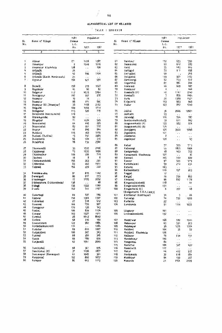
169
ALPH'ABETICAL LIST OF VILLAGES
TALUK : SIND H N U R
1981 Population 1981 Population SI. lIa me or Village Census SI. Name or Vil.Jage Census No. L.C. No. L.C.
No. 1971 1981 No. 1971 1981
4 4
Albnur 171 1278 1387 61 Haretnur 172 633 1399 2 A marapur 2 1049 1216 62 Hasamakal 90 612 983 3 Amarapur Khadehola 128 196 63 Hatti 35 443 645 4 Arlihalli 25 64 Hattigud 70 917 968 5 Arlihalli 52 796 1154 65 Hedagibal 99 245 6 Arlihalli (Simth Mav:inmadu) 23 66 Hedg1nhal 149 927 1172 7 Ayyanur 154 921 954 67 Hirebhergi 72 733 517
68 Hogernhal 67 884 844 8 Baderli 158 919 1027 69 Hokarani 46 609 467 9 Bagalapilr 45 60 82 70 Hosalapur 4 444
10 Balganur 112 4675 5894 71 HoBShalli (K) 40 1147 2240 11 Banniganur 147 557 838 72 HoBShalli 3 856 1465 12 Baa.apur 18 14 73 Huda 20 1389 1521 13 Baa.apur 88 471 890 74 Hulgunchi 153 663 908 14 Baa.apur (X) [Bassapur] 38 1168 2162 75 Hullur 123 852 1040 15 Be1gurki. 169 1066 1714 16 Belliganur 113 626 715 76 Jalihal 36 2646 12601 17 Bendlhatti (Sendalhatti) 119 77 Jalihatti 93 18 Shira mgondal 92 78 Jalwadgi 116 594 787 19 Shogapur 71 1024 529 79 Ja m ban m athanhalll 39 611 642 20 Bom manhal 64 445 295 80 Janga m erhatti (~) 133 582 574 21 Born manhal 82 551 778 81 Jangamerhatti (B) 134 22 Boppur 47 846 844 82 Jawalgera 125 3920 5898 23 Buddinni 115 463 1165 83 Jogaldinni 101 24 Budiwal (Budihal) 15 791 2989 84 Joladarasi. 8 25 Bukanhatti 56 504 310 85 Jugalapur 120 43 26 Butaldinni 78 732 2340
86 Kallur 77 525 1713 27 C hannahalli 33 1720 2496 87 Kalmangi 55 1806 1904 28 Chikbhergi 73 1020 1056 88 Kaniganhalu 48 490 703 29 Chikkkadbur 109 396 714 89 Kanakraddi Khadehola 127 30 30 Cincheri 16 8 6 90 Kannari 165 4VO 600 31 Chintemandoddi 155 263 291 91 Kanoor 97 629 1079 32 Chiterahal 83 402 1911 92 K ardchala mi 59 214 234 33 C hitrali 156 229 222 93 Katerld 163
94 K a thankh:>tti 110 157 263 34 D eensa m udra 91 815 1142 95 Keggal 12 35 D evergudi 80 817 773 96 Kengal 19 754 852 36 D hadeaugur 17 1775 2052 97 Kholabal 96 867 1178 37 o 1bbankhera (0 ibbankheda) 138 48 98 K onganaikandoddi 118 41 38 Oidagl 136 1322 1760 99 K onganaikandoddi 131 39 o umti 142 741 1157 100 K onganha tti (D ) 6 957 48
40 Gadertagi 69 727 746 101 (Konganhatti T.B.P.Camp) Konthanur (Konthapur) 34 9 86
41 Giniwar 150 1364 1307 102 Kunnatgi 74 720 1205 42 Gobberkal 27 518 912 103 Kurtkote 22 43 Gomersi 166 770 967 104 Kurukunda 51 1114 1833 44 Gonaganur 170 120 143 45 Gonhal 105 839 1124 105 Lingapur 161 46 Gonwar 143 1327 1911 106 Locknaikandoddi 132 47 Gorebal 28 4412 8642 48 Gorloti 58 316 160 107 Madsirwar 168 982 1040 49 G oudanbhavi 122 982 1885 108 Mahampur 63 321 200 50 Govindnaikandoddi 114 1285 109 Malakapur 30 1076 1764 51 Gudadur 89 810 1007 110 Maldinni 164 35 72 52 G udgaldinni 100 267 343 111 Maldinni Khadehola 126 53 Gudinal 68 350 345 112 Mallapur 79 634 731 54 Gunda 66 780 656 113 Mandahosur 140 55 Gunjanalli 42 1541 2640 11'1 Manganhal 84
115 Maranhal 104 327 420 56 Hanchinhal 98 361 935 116 Masldhatti 117 57 H anchinhal (K) 37 1198 1857 117 Matur 44 412 637 58 Hanumapur (Hanmapur) 41 1645 301 118 Mav:inmadu 32 618 684 59 Hanpanhal 102 850 1077 119 Muddapur 94 130 207 60 Harapur 86 443 1173 120 MUkunda 21 1704 2109
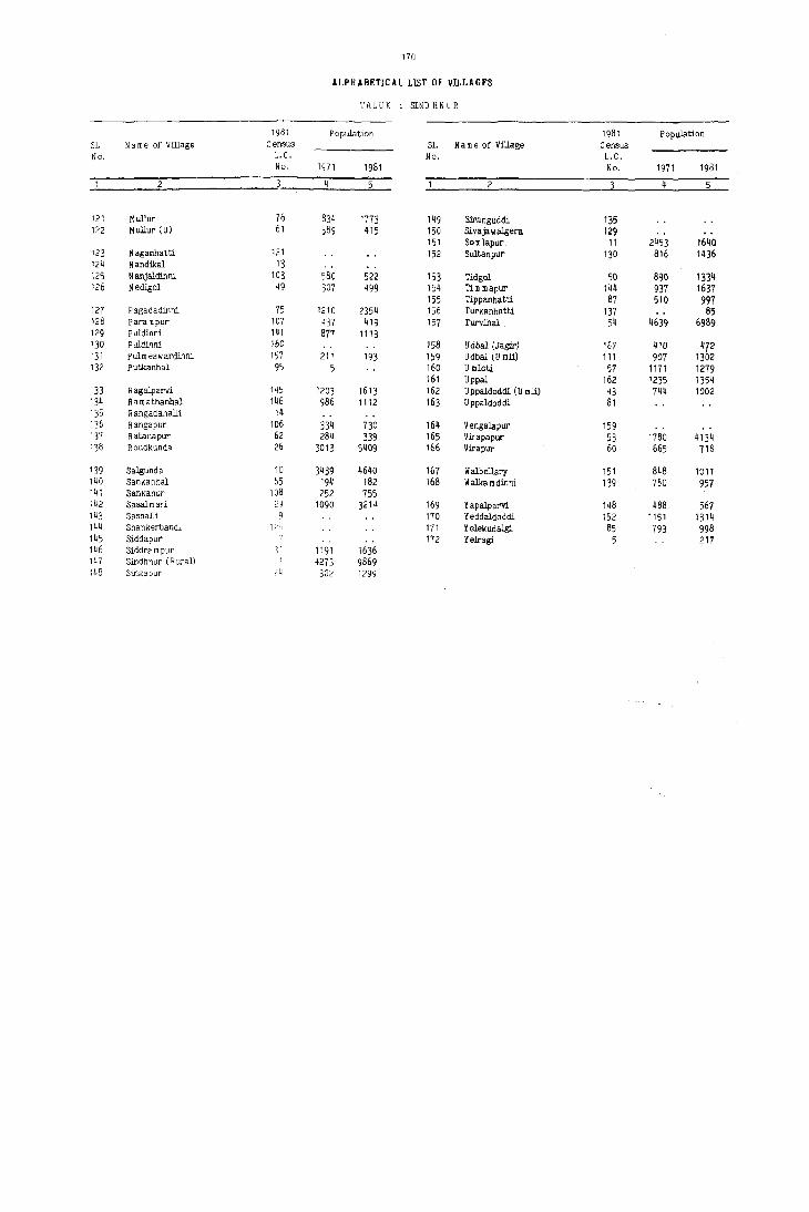
170
ALPHABETICAL LlST OF VILLAGES
HLUK : SIND HNUR
1981 Population 1981 Population S1. Name of Village Census S1. Name of Village Census No, L. C. No, L.e,
No. 1971 1981 No. 1971 1981
5 2 5
121 MuHur 76 834 1773 149 SJranguddi 135 1?2 Mullur ,U) 61 389 415 150 Sivajawalgera 129
151 SomJapur 11 2453 164Q 123 Naganhatt1 121 152 Sultanpur 130 816 1436 124 Nandikal 13 125 N anjaldinni 103 580 522 153 Tidgol 50 890 1334 126 Nedigol 49 307 499 '154 Tim mapur 144 931 1631
155 Tippanhatti 81 510 991 127 Pagadadinni 75 1210 2354 156 Turkanhatti 137 85 128 Parampur 107 437 419 157 Turvihal 54 4639 6989 129 Puldinni 141 877 1113 130 Puldinni 160 158 Udbal (Jagir) 167 410 472 131 Pulmeswardinni 157 211 193 159 Udbal (U roll) 111 907 13D2 132 Putkanhal 95 5 160 U mlotj, 57 1171 1279
161 Uppal 162 1235 1354 133 R agalparvi 145 1203 1613 162 Uppaldoddi (U roll) 43 744 1002 134 Ram a thanhal 146 986 1112 163 Uppaldoddi 81 135 RangadahalE 14 1 ~6 Rangapur 106 334 730 164 Vengalapur 159 137 R atanapur 62 284 339 165 Vicapapur 53 1780 4134 138 Roudkunda 26 3013 5409 166 Virapur 60 665 718
139 Salgunda 10 3439 4640 167 Walbe]Jary 151 848 1011 140 Sankanhal 65 194 182 168 II alka m dinni 139 760 957 141 Sankanur 108 252 755 142 Sasalmari. 2J 1090 3214 169 Yapalparvi 148 488 567 143 Sashalli 9 170 Yeddaldoddi 152 1151 1314 144 Shankerband" 12-1 171 Yelekudalgi 85 793 998 145 Siddapur 112 Yelragi 5 217 146 Siddra m pur 3i 1191 1636 147 Sindhnur (R ural) 1 4273 9869 148 Sina;apur 24 1302 1299

SINDHNUR TALUK

T"Juk : Sindhnur
L.C. No.
2
3
4
6
1\
9
10
11
[2
13
[4
[5
16
17
18
19
20
21
22
Name of village
Sindhnur (Rural)
Amarapur
Hosshalli
Hosalapur
Yelragi
Konganhatti
Siddapur
Joladarasi
Sashalli
Salgunda
Somlapur
Keggal
Nandikal
Rangadahalli
Budiwal
Cincheri
Dhadesugur
Bassapur
Kengal
Huda
Mukunda
Kurtkota
Total Area of the village
(in hectares and ares)
Total Population and number of households
4a
7051.1111 9S69
597.[6 [2[6
937.54 [465
528.60 444
266.32
347.[4
393.44
307.19
134.31
217
~8
4785.56 4640
1349.16 1640
319.45
241.86
252.89
522.34 2989
458.14
1725.70 2052
267.95
602.61 852
[385.76 1521
2659.31 2109
[39.00
4b
1811
215
293
lOa
47
12
852
310
552
404
144
257
407
23 Arlihalli 643.30 (Simth Mavinmadu)
24 Singapur 2[93.2[ 1299
25
26
27
28
29
30
31
32
JJ
3~
35
ArHhaIJj
Roudkunda
Gobberkal
Gorebal
Sasalmari
Malakapur
Siddrampur
Mavinmadu
ChannahaIJi
Konthanur
Hatti
290.21
3074.66 5409
8~8.52 912
2413.74 8642
1097.37 3214
874.:;2 1764
1432.47 [636
926.60 684
1849.82 2496
977.37 86
957.65 645
250
1002
157
1736
670
365
293
133
455
18
121
172
VILLAGE DIRECTORY
AMENITIES AND LAND USE
Amenities available (if not available within the villa~e, a dash (-) may be shown In the column and next to it in brackets, the distance in broad ranges viz., -5 kms, 5-10 kms and 10+kms of the nearest place where
, the facility is available may be given)
Day or Days Educational Medical Drinking Post and of the mar
water Telegraph ket/hat if
p
-(-5)
-(-5)
-(-5)
P
P,M
P
P
RP W,T
-(5-10) Hp,C
-(5-10) w,e
-(-5) 0
-(-5)
-(-5)
PHi: FPC ..(-5)
-(-5)
..(-5)
C
C
R,W, Hp,C W
Hp,C
o
an
PO,Phone -(-5)
PO
..(-5)
-(-5)
-(-5)
-(-5)
-(5-10)
-(5-10)
-(-5)
-(-5)
-(-5)
UN-INHABITED
UN-INHABITED
UN-INHABITED
PO, Phone -(-5)
Friday
-(-5)
UN-INHABITED
UN-INHABITED
UN-INHABITED
-(-5) -(5-10)
-(-5) -(5-[0)
D R,Hp,C PO -(5-10)
UN-INHABITED
·(-5) R,Hp,W -(·5) -(lOt)
-(5-10) W,Hp PO -(l0.)
-(10.) R,W,Hp PO -(JO.)
UN-INHABITED
UN-INHABITED
-(10.) R,Hp PO -(JO.)
UN-INHABITED
-(·5)
-(-5)
N,C,T, Hp C,W
PO, Phone -(-5)
T,C PO,Phone -( 10+)
RP2
I"/,Hp,C -(-5) -(5- !O)
RP W,Hp,C -(-5) -(5-10)
·(-5) Hp,C -(-5) -(lOt)
-(-5) C -(-5) -(lOt)
RP W,C PO -(l0.)
-(.5) ° -(-5) -(lOt)
-(5-10) W,C -(5-10) -(10.)
Communica tions [Bus stop, Railway Station, Waterway 1
BS
-(-5)
BS
-(-5)
BS
BS
BS
BS
BS
BS
BS
-(-5)
BS
-(-5)
-(-5)
BS
-(-5)
BS
BS
BS
BS
BS
BS
-(-5)
-(-5)
10
Approach to
village
11
PR
KR
PR
KR
PR
PR
KR
KR
PR
PR
PR
KR
KR
KR
KR
PR
KR
PR
PR
PR
KR
KR
KR
KR
KR
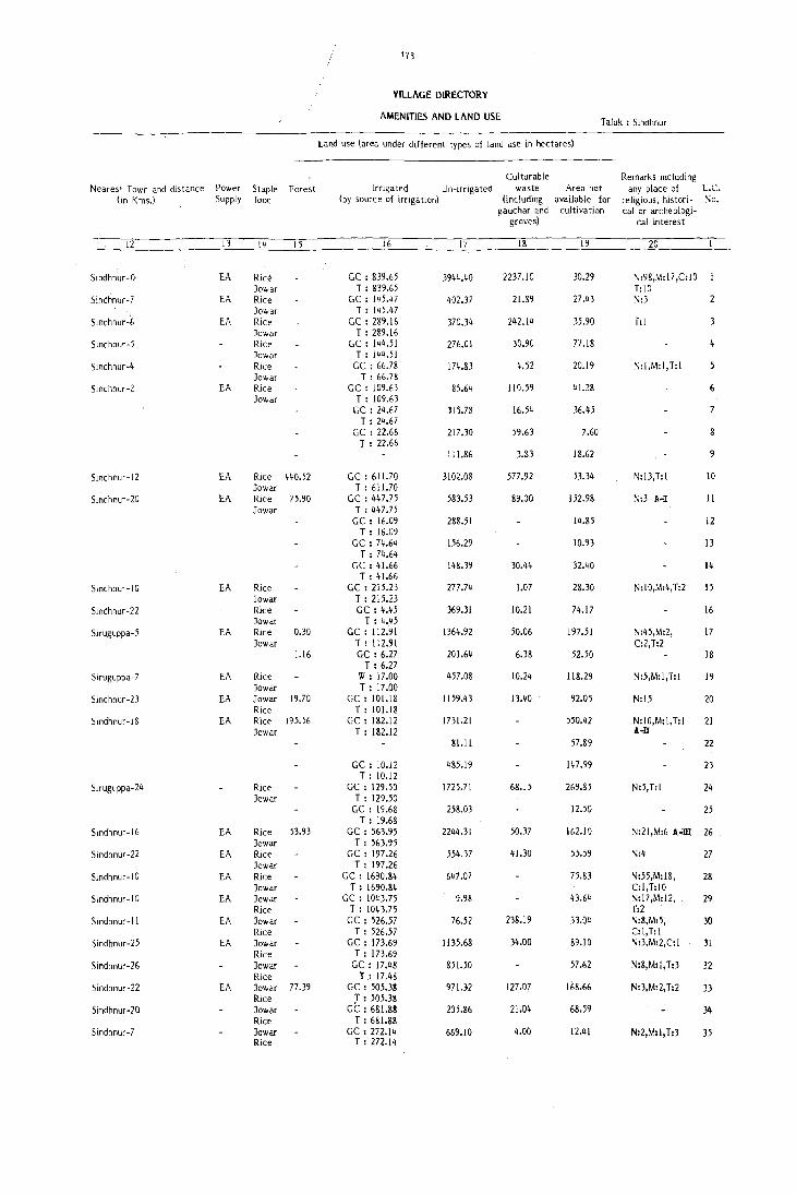
173
VILLAGE DIRECTORY
AMENITIES AND LAND USE Taluk : Sindhnur
Land use (area under different types of land use in hectares)
Culturable Remarks Including Nearest Town and distance Power Staple Forest Irrigated Un-irrigated waste Area not any place of L.C.
(In Kms.) Supply food (by source of irrigation) (including available for religious, histori- No. gauchar 2.nd cultivation calor archeologi-
groves) cal interest
12 13 14 15 16 17 18 19 20
Sindhnur-O EA Ric~ GC : 839.65 3944.40 2237.10 30.29 N:98,M: 17 ,C: I 0 Jowar T : 839.65 T:IO
Sindhnur-7 EA Rice GC: 145 •• 7 402.37 21.89 27M N:3
Sindhr,ur-6 Jowar T: 145.47
EA Rice GC: 289.16 370.34 2112.14 35.90 f:1 Jowar T: 289.16
Sindhnur-5 Rice GC : 144.51 276.01 30.90 77.18 Jowar T : 144.51
Sindhnur-4 Rice GC: 66.78 174.83 4.52 20.19 N:I,M:I,T:I Jowar T : 66.78
Sindhnur-2 EA Rice GC : 109.63 85.64 110.59 4J.28 6 Jowar T : 109.63
CC: 24.67 315.78 16.54 36.45 T : 24.67
CC : 22.66 217.30 59.63 7.60 T : 22.66
HI.86 3.83 18.62 9
Slndhnur- I 2 EA Rice 440.52 GC : 611.70 3102.08 577.92 53.34 N:l3,T:l 10 Jowar T : 611.70
Sindhnur-20 EA Rice 75.90 GC : 447.75 583.53 89.00 152.98 N:3 A-I II Jowar T : 447.75
GC : 16.09 288.51 14.85 12 T : 16.09
GC : 74.64 156.29 10.93 13 T : 74.64
GC : 41.66 148.39 30.44 32.40 14 T: 41.66
Sindhnur-IO EA Rice GC : 215.23 277.74 1;07 28.30 N:l0,M:4, T:2 15 Jowar T: 215.23
Sindhnur-22 Rice GC: 4.45 369.31 10.21 74.17 16 Jowar T: 4.45
Siruguppa-5 EA Rice 0.30 GC: 112.91 1364.92 50.06 197.51 N:45,M:2, 17 Jowar T: 112.91 C:2,T:2
1.16 GC: 6.27 201.64 6.38 52.50 18 T: 6.27
Siruguppa-7 EA Rice W: 17.00 457.08 10.24 118.29 N:5,M:I,T:I 19 Jowar T : 17.00
Sindhnur-23 EA Jowar 19.70 GC: 101.18 1159.43 13.40 92.05 N:15 20 Rice T : 101.18
Sindhnur-18 EA Rice 195.56 GC: 182.12 1731.21 550.42 N:l0,M:l,T:l 21 Jowar T : 182.12 !..,]I
SI.ll 57.89 22
GC: 10.12 485.19 147.99 23 T: 10.12
Siruguppa-24 Rice GC : 129.50 1725.71 68.15 269.85 N:5,T:! 24 Jowar T : 129.50
GC : 19.68 258.03 12.50 25 T: 19.68
Sindhnur- I 6 EA Rice 53.93 GC : 563.95 22~4.31 50.37 162.10 N:21,M:6 A-ill 26 Jowar T : 563.95
Sindhnur-22 EA Rice GC : 197.26 554.37 41.30 55.59 N:4 27 Jowar T : 197.26
Sindhnur- I 0 EA Rice GC : 1690.84 647.07 75.83 N:55,M:18, 28 Jowar T : 1690.84 C:l,T:lO
Sindhnur- I 0 EA Jowar GC : 10~3.75 9.98 43.64 N:l7,M:l2, 29 Rice T : 1043.75 T:2
Sindhnur-ll EA Jowar GC : 526.57 76.52 238.19 33.04 N:8,M:5, 30 Rice T : 526.57 C:l,T:1
Sindhnur-25 EA Jowar GC : 173.69 1135.68 34.00 89.10 N:3,M:2,C: 1 31 Rice T: 173.69
Sindhnur-26 Jowar GC: 17.48 851.50 57.62 N:8,M:l,T:3 32 Rice T: 17.48
Sindhnur-22 EA Jowar 77.39 GC : 505.38 971.32 127.07 168.66 N:3,M:2, T:2 33 Rice J : 505.38
Sindhnur-20 Jowar GC : 681.88 205.86 21.04 68.59 34 Rice T : 681.88
Sindhnur-7 Jowar GC: 272.14 669.10 4.00 12.41 N:2,M:l,T:3 35 Rice T: 272.14

Taluk : Sindhnur
L.e. Name of village No.
36
37
38
39
40
41
42
43
44
45
46
47
48
50
51
52
53
54
Jalihal
Hanchinhal (K)
Bassapur (K)
Jambanmathanhalli
Hosshalli (K)
Hanumapur
Cunjahalli
Uppaldoddi (Umli)
Matur
Bagalapur
Hokarni
Boppur
Kaniganhalu
Nedigol
Tidgol
Kurukund"
Arlihalli
Virapapur
Turvihal
55 Kalmangi
56 Bukanhatti
57 Umloti
58 Gorlotl
59 Kardchalami
60 Virapur
61 Mullur (U)
62 Ratnapur
63 Mahampur
64 Born manhal
65 Sankanhal
66 Cunda
67 Hogernhal
68 Cudihal
69 Gadertagi
70 Hattigud
VILLAGE ntRECTORY
AMENITIES AND LAND USE
Amenities available (if not available within the village, a dash (-) may be shown in the column and next to it in brackets, the distance in broad ranges viz., -5 kms, 5-10 kms and IQ>kfRS of the nearest place where Total Area
of the villa~e
(in hectares and ares)
Total population and number of households
the facility is available may be given;
4a
2270.45 12601
1646.73 1857
1170.23 2162
730.58 642
1959.33 2240
907.30 301
1087.4Q 2640
491.46 1002
1122.03 637
400.94 82
1218.47 467
930.85 844
562.65 703
596.08 499
917.40 1334
1519.26 1833
417.84 1154
2968.47 413~
4874.17 6989
3415.90 1904
721.38 310
1273.13 1279
1374.96 160
481.62 234
688.97 718
1058.04 415
797.22 339
350.~7 200
986.54 295
659.53 182
1086.~6 656
1~52.45 844
463.88 345
1587.86 746
585.77 968
4b
2593
357
426
120
451
55
471
173
123
15
99
157
127
94
220
300
205
783
1351
313
74
m
37
43
109
68
50
48
64
28
130
139
65
129
186
flay or Days Educational Iv'edical Drmking Post and of the mar-
p
-(-5)
-(-5)
P
P
P
P,M
P,M
P,~I
P
P,M
P
P
P
P
P
P
P
P
P,M
P,M
P
P
P
water Telegraph ket/hat if
an
PHU Hp,e PO RP IO
-(10+)
-(-5) C -(-5) -( 10+)
w,e -(-5) -(10+)
W,Hp,e -(5-10) -( 10+)
Hp,C -(-5) -(lOt)
-(-5) w -(-5) -(10+)
-(10+) Hp,C PO,Phone -(10+)
-(10+) w,e PO
~IO+) w,e ~-~
-(10+) W -(-5)
-(5-10) w,e -(5-10)
RP w,e -(5-10)
-(-5) w,e -(-5)
-(5-10) e -(-5)
-(5-10) C,W -(-5)
-(10+) Hp,e PO
-(5-10) Hp,e PO
-(5-10) Hp,W,e PO
-(10+ )
-( 10+)
-(10+)
-(10+)
-(10+)
..(10+)
-(10+)
-(5-10)
-(5-10)
PHU Hp, W ,e PO,Phone Saturday
-(5-10) W PO -(5-10)
-(5-10) \II -(-5) -(5-10)
-(10+) IV PO -(10+)
-(10+) W -(-5) -(10+)
-(10+) W -(-5)
-(10+) W PO -(10+)
-(10+) W -( -5) -(10+)
-(10+) W -(-5) -(10+)
-(10+) W -(-5) -(10+)
~1O+) W ..(-5) -(10+)
-(5-10) VI -(-5) -(10+)
-(10+) w,e -(-5) -(10+)
-(5-10) Hp,C PO -(10+)
-(5-10) W,Hp -(-5) -(5-10)
-(-5) w,e -(-5) -(5-10)
-(5-10) Hp,Tk PO -(5-10)
Communications [Bus stop, Railway Station, Waterway]
10
B5
BS
BS
8S
-(-5)
BS
-(5-10)
-(5-10)
-(5-10)
-(10+)
-(10+)
-(10+)
BS
BS .
BS
BS
-(-5)
BS
-(5-10)
-(5-10)
-(5-10)
-(5-10)
-(5-10)
-(5-10)
-(10+)
-(10+)
-(5-10)
-(5-10)
-(5-10)
Approach to
village
II
PR
PR
KR
KR
KR
KR
PR
KR
KR
KR
KR
KR
KR
KR
KR
PR
PR
PR
PR
KR
PR
KR
KR
KR
KR
KR
KR
KR
KR
KR
KR
KR
KR
KR

"Iearest Town and distance (in Kms.)
12
Sindhnur-14
5Indhnur-J}
Sindhnur-14
Sindhnur-16
Sindhnur-16
~indhnllr-19
Sindhnur-14
Sindhnur-16
Sindhnur-22
Sindhnur -20
Sindhnur-22
Sindhnur-20
5indhnur -16
Sindhnur-16
Sindhnur -I 0
Sindhnur-9
Sindhnur-7
Sindhnur-18
Sindhnur-26
Sindhnur- 32
Sindhnur -34
Sindhnur- 38
Sindhnur- JS
Sindhnur-40
Kushtagl-27
Sindhnur-32
Sindhnur-J5
Sindhnur-34
Sind~nur-30
Slndhl1ur-30
Sindhnur-29
Sindhnur-29
Sindhnur-26
Slndhnur-27
Power Supply
13
Staple food
14
Forest
15
fA Jawar RiCe
EA Jowar Rice Jowar Rice
EA Jowar Rice Jowar Rice
EA Jowar
EA
EA
EA
EA
EA
EA
EA
EA
EA
EA
Rice Jowar Rice Jowar Rice Jowar Rice Jawar 19.26 Millets Jowar 111.10 Millets Jowar "lillets Jowar Millets Jowar 1.89 RlCe Jawar Rice Jowar Rice Jawar Rice Jawar 10.73 Rice Jawar 2.77 Rice Jawar 374.16 RIce Jawar Millets Jawar 43.01 Millets Jowar Millets Jewar ,",!,illets Jawar Millets Jowar 36.32 Millets Jawar 201.73 MIlleTS Jowar 74.93 Millets Jowar 349.25 Millets Jowar Millets Jowar Millets Jawar Millets Jowar Millets Jowar Millets Jowar Millets
175
VILLAGE DIRECTORY
AMENlTlES AND LAND USE
Land use (area under different types of land use in hectares)
Irrigated Un-jrrigat~d
(hy source of irrigation)
16
GC: 1776.19 T : 1776.19
GC : 1256.59 T : 1256.59
GC : 695./7 T : 695.27
GC : 793.41 T: 293.41
GC : 1584.62 T : 1584.62
GC: 836.92 T: 836.92
GC : 707.92 T : 707.92
GC : 213.49 T: 213.49
GC : 180.44 T : 180.44
GC' : 170.65 T: 170.65
GC : 205.97 T : 205.97
GC : 280.11 T: 280.11
GC: 242.56 T : 242.56
CC : 70.62 T : 70.62
GC : 797.01 T : 797.01
GC : 1326.31 T: 1326.31
17
409.14
334.29
364.88
375.46
327.72
287.40
130.91
781.50
301.26
951.89
853.71
217.08
135.70
332.21
949.78
198.40
1510.04
3358.63
2974.71
672.96
1124.63
1227.87
417.29
610.74
986.67
572.16
264.36
607.53
544.65
977.90
1270.72
445.31
1510.37
539.96
Culturahle waste
(including eauchar and
groves)
18
44.67
25.60
31.IQ
14.69
5.01
44.62
83.97
66.10
23.58
94.85
24.78
l15.06
122.33
262.50
123.58
70.90
511.36
58.05
23.34
~0.75
97.13
142.58
6UI
55.65
24.61
17.11
10.53
28.45
100.59
86.93
139.20
3.51
24.42
24.29
Area not available for
cultivation
19
40.45
55.85
84.48
30.61
32.30
45.53
47.55
63.09
93.99
56.84
60.63
52.36
59.86
130.19
42.58
203.34
77.92
139.33
128.41
43.69
7.67
8.36
4.51
2.68
22.58
10.44
6.22
0.65
1.31
14.29
21.63
42.53
15.06
53.07
21.52
Taluk : Sindhnur
Remarks including any place of
religious, historicalor archeologi
cal interest
20
N:38,M:36, T:25 N:II,M:2,T:2
N:6
N:8,M:I
N:24,T:I
N:4.M:3, T:3
M:I
T:2
T:l
N:2
N:l5,M:4,T:3
N:25,M:5,T:6
N:2,M:2, T: I
loc. No.
36
37
38
39
40
41
42
43
44
45
46
47
48
49
50
51
52
53
54
55
56
57
58
59
60
61
62
63
64
65
66
67
68
69
70

Taluk : Sindhnur
L.c. No.
Name 01 village
71 Bhogapur
72 Hirebhergi
73 Chikbhergi
74 Kunnatgi
75 Pagadadinni
76 Mullur
77 Kallur
78 Butaldinni
79 MaHapur
80 Devergudi
81 Uppaldoddi
82 Bommanhal
83 Chi terahal
84 Manganhal
85 Yelekudalgi
86 Harapur
87 Tippanhatti
88 Bassapur
89 Gudadur
90 Hasamakal
9 I Deensamlldra
92 Bhiramgondal
93 lalihatti
94 Muddapur
95 Putkanhal
96 Khalabal
97 Kanoar
98 Hanchinhal
99 Hedagibal
100 Gudgaldinni
101 Jogaldinni
102 Hanpanhal
103 Nanjaldinni
104 Maranhal
105 Gonhal
176
VILL"GE DIRECTORY
AMENITIES AND LAND USE
-\lllt'1l1tI<'S ."ilable (if not available within the village, a dash (-) may be $Ih')\\ 11 In thl" oJlumn and next to it in brackets, the distance in broad rall~e; ,iz •. -\ kms, 5-10 kms and 10+kms of the nearest place where Total .~reJ
of the village
(in hectares and ares)
T ,'tal Population, and number of
the factlity is available may b~ given)
4a
1114.79 529
1702.87 517
1599.96 1056
883.56 1205
1057.58 2354
749.92 1773
776.89 1713
805.87 2340
759.30 731
889.36 773
292.84
360.37 778
712.52 1911
342.82
827.39 998
307.53 1173
358.43 997
482.76 890
406.28 1007
703.77 983
485.30 1142
163.40
261.59
311.95 207
337.41
724.27 1178
774.55 1079
530.55 935
671.38 245
560.19 343
169.19
1514.31 1072
758.87 522
723.16 420
1112.88 1124
\ll"useholds
4b
107
107
195
252
474
361
313
464
130
147
128
387
179
228
187
189
180
177
206
38
194
192
159
67
194
96
188
Day or Days EducatJOnaJ \ledicaJ Drinking Post and of the mar
water Telegraph ket/hat if
P
P
P
P
P
P
P,M
P
P
P
P
P
P
p
P,M
P
P,M
p
P,M
P
P
P,M
P
P
P
P
P
-(10+) W -(-5)
-(10+) IV ,Hp PO
-(lOt) IV -(-5)
-(-5) W,Hp,C -(-5)
RP2
RP
W,Hp,C PO
Hp,C -(-5)
-(-5) Hp,C -(-5)
-(-5) Hp,C -(-5)
-(-5) IV,C PO
-(-5) W,C -(-5)
UN-INHABITED
-(5-10) 'V,C -(-5)
-(5-10) Hp,C -(-5)
UN-INHABITED
-(-5) W,C -(-5)
-0-10) Hp,C -(-5)
-(10+) W,C -(-5)
-(-5) W,C -(-5)
-(10+) W,Hp PO
-(lOt) W,Hp -(-5)
-(10+) W,Hp -(-5)
UN-INHABITED
UN-INHAflITED
-(-5) c -(-5)
UN-INHABITED
RP C PO
-(-5) W,Hp -(-5)
-(5-10) Hp;C -(-5)
-(lOt) R -(-5)
-(10+) W,Hp -(-5)
UN-INHABITED
-(lOt) W,Hp PO
-(l0+) W PO
-( 5-10) Hp,C -(-5)
-(5-10) C -(-5)
anv
-(10+)
-(10+)
-(10+)
-(10+)
-(5-10)
-(-5)
-(-5)
-(-5)
-(-5)
-(-5)
-(5-10)
-(5-10)
-(10+)
-(10+)
-(10+)
-(5-10)
-(10+)
-(lOt)
-(10+)
-(lOt)
-(5-10)
-(-5)
Monday
-(-5)
-(-5)
-(-5)
-(5-10)
-(-5)
-{-5)
CommunicatlOns [Bus stop, Railway Station, Waterway 1
10
-(5-10)
-(10+)
-(10+)
BS
BS
BS
BS
BS
-(-5)
-(-5)
BS
BS
-{-5)
BS
BS
BS
BS
BS
-(-5)
-(-5)
-(-5)
-(5-1 0)
-(5-10)
-(5-10)
-0-10)
-(5-10)
-(-5)
-(5-10)
-(5-10)
Approach to
village
II
KR
KR
KR
PR
PR
PR
PR
PR
KR
PR
PR
PR
KR
PR
PR
PR
PR
PR
KR
KR
KR
KR
KR
KR
KR
KR
KR
KR
KR
N~arest Town and distance (in Krns.)
Power Supply
Staple food
Forest
177
VILLAGE DIRECTORY
AMENITIES AND LAND USE
Land use (area under different types of land use in hectares)
Irrigated Un-irrigated (by source of irrigation)
Culturable waste
(including gauchar and
groves)
Area not available for
cultivation
Taluk : Sindhnur
Re marks including any place of
religious, historicalor archeologi
cal interest
L.C. No.
_____ .�_2 _____________ ~13~ __ ~14~ __ ~1~5 __________ ~1~6 ________ ~1~7 ______ ~18~ ______ ~1~9 ________ ~2~0 ______ ~ __
Sindhnur-32
Sindhnur-30
Sindhnur-30
Sindhnur-12
Sindhnur-9
Sindhnur-8
Sindhnur-6
Slndhnur-3
Slndhnur-3
Slndhnur-7
Sindhnur-8
Slndhnur-9
Sindhnur-15
Slndhnur-13
Sindhnur-20
Sindhnur-IO
Sindhnur-18
Sindhnur-18
Sindhnur-18
Sindhnur-13
Sindhnur-15
Sindhnur-17
Sindhnur-16
Sindhnur-30
Sindhnur-22
Sindhnur-24
Sindhnur-26
Sindhnur-20
Sindhnur-22
EA
EA
EA
EA
EA
EA
EA
EA
EA
EA
EA
]owar 463.99 Millets ]owar 189.51 Millets ]owar 176.08 Millets ]owar Rice ]owar Rice ]owar Rice ]owar Rice ]owar Rice ]owar Rice ]owar Rice
]owar RlCe ]owar Rice
Rice ]owar Rice ]owar Rice ]owar Rice ]owar ]owar Rice ]owar Rice ]owar Rice
]owar Rice
]owar Rice ]owar Rice ]owar Rice ]owar Rice ]owar Rice
]owar Rice
]owar Rice
Jowar Rice
]owar Rice
9.56
GC: 115.54 T : 115.54
GC: 256.18 T: 256.18
GC : 274.39 T : 274.39
GC: 275.53 T : 275.53
GC : 211.38 T: 211.38
GC : 79.25 T : 79.25
GC : 315.34 T : 315.34
GC : 22.26 T : 22.26
GC : 55.44 T: 55.44
GC : 42.48 T : 42.48
GC : 7.89 T: 7.89
GC : 123.32 T : 123.32
GC : 80.94 T: 80.94
GC : 101.78 T: 101.78
GC: 35.42 T : 35.42
GC: 87.11 T: 87.11
GC : 32.88 T : 32.88
GC: 115.46 T: 115.46
GC : 187.51 T: 187.51
GC : 66.96 T : 66.96
GC: 151.06 T : 151.06
GC: 5!r.51 T: 59.51
GC : 59.51 r: 59.51
GC : 184.05 T: 184.05
632.75
1441.93
1368.78
637.20
609.29
242.82
358.39
470.25
394.23
401.00
251.89
274.39
483.62
244.24
538.09
182.88
328.52
290.71
373.08
627.09
471.52
161.58
258.99
186.19
250.38
518.44
449.00
413.34
438.43
426.55
163.53
1346.95
725.92
605.62
840.39
9.06 8.99
61.12 10.31
37.77 17.33
95.82 35.00
141.64 50.47
196.14 36.57
93.37 49.60
79.66 44.58
220.69 65.13
97.47 75.55
7.51 11.18
18.69 11.85
100.36 86.06
69.29 21.40
76.32 80.10
16.56 27.15
20.23 9.68
64.45 25.82
10.93 22.27
10.93 30.33
13.78
1.82
2.60
10.03 28.62
54.15
90.37
54.84 83.20
32.78 17.47
40.88 41.01
61.85 71.79
5.66
9.72 157.64
13.13 19.82
14.59 43.44
17.19 71.25
N:2,M:I
N: IO,M:5, T:l
N:3,llhl,T:2
N: 13,M:5, T:5
N:17,M:3,T:2
N:3,T:1
N:I,T:I
N:2,T:1
N:2,M:7,T:2
N:2
N:13,T:l
N:3
N:4,M:l
N:14,M:2
N:5
N:14,M:I,T:2
N:l
N:IO
N:16
N:9,M:3, T:3
N:8
N:14
N:3
N:2
N:7,T:1
71
72
73
74
75
76
77
78
79
80
81
82
83
84
85
86
87
88
89
90
91
92
93
94
95
96
97
98
99
100
101
102
103
104
105
Taluk : Sindhnur
LC. Name of village No.
106 Rangapur
107 Parampur
108 Bankanur
109 Chik-kadbur
110 Kathanhatti
III Udbal (Umli)
112 Balganur
113 Belliganur
114 Govindnaikan-doddi
115 Buddinni
116 Jalwadgi
117 Maskihatti
118 Kongnaikandoddi
119 Bendlhatti
120 Jujalapur
121 Naganhatti
122 Goudanbhavi
123 Hulfur
124 Shankerbandi
125 Jawalgera
126 Maldinni Khadehola
127 KanakraddiKhadehola
128 Amarapur-Khadehola
129 Siva-Jawalgera
130 Sultanpur
131 Konganaikandoddi
In Locknaikandocldi
133 Jangamarhatti (N)
134 Jangamar-hatti (B)
135 Siranguddi
136 Didagi
1)7 Turkanhatti
138 Dibbankhera
139 Walkamdinni
140 Mandahosur
178
VII LACE. DIRECTORY
AMENITIES AND LAND USE.
Amenities available (if not available within the village, a dash (-) may be ,hown in the column and next to it in brackets, the distance in broad ranges viz., -5 kms, 5-10 kms and 10+kms of the nearest place where Total Area
of the village
(in hectares and ares)
Total Population and number of households
the facility is available may be given)
3 4a
275.76 730
487.82 419
555.03 755
508.89 714
498.49 263
804.08 130Z
11036.96 5894
840.73 715
325.72 1285
577.10 1165
802.23 787
129.23
70.87
164.99
171.26
221.59
41
43
497.09 1885
636.12 1040
238.99
980.21
453.79
115.1I
450.14
345.37
5898
30
)96
2365.63 1436
61.47
162.41
225.10
155.99
342.62
574
1757.88 1760
469.77 85
393.24 48
4b
130
80
150
liS
49
230
1093
120
259
234
157
8
10
383
I7l
1172
35
282
110
349
12
187
Day or Days Communications Educational Medical Drinking Post and of the mar- [Bus stop, Railway
P
P
P
-(-5)
-(-5)
P
P
-(-5)
-{-5)
P
P
P,M
-(-5)
-(-5)
P,M
water Telegraph ket/hat it Station, Waterway 1 an
6
-(5-10) W,Hp -(-5) -(5-10)
-(10.) W,C -(-5) -(5-10)
-(10.) Hp,e -(-5) -(10.)
-(10.) w,e -(-5) -(10.)
-{5-10) w,e -(-5) -(5-10)
-(5-10) w,e -(-5) -(5-10)
PTO,Phone Monday PHU,RP4
w,e
-(-5) W,C -(-5) -(-5)
-(-5) o -(-5)
-(-5) W,Hp,C -{-5)
-(5-10) W,Hp,C -(-5)
UN-INHABITED
-(-5) o -(-5)
UN-INHABITED
-(-5) o -(-5)
UN-INHABITED
-(5-10) W,Hp,C PO
-(-5) w,e -(-5)
UN-INHABITED
PHe,FPe T,W,e PO,Phone RP2
-{-5)
-(-5)
-(-5)
-(-5)
RP
-(-5)
-(-5)
RP
UN-INHABITED
o -(-5)
o -(-5)
UN-INHABITED
w,e -(-5)
UN-INHABITED
UN-INHABITED
e -(-5)
UN-INHABITED
UN-INHABITED
c PO
o -(-5)
o -(-5)
e -(-5)
UN-INHABITED
-(-5)
-(-5)
-(5-10)
-(-5)
-(-5)
-(5-10)
-(-5)
Saturday
-(-5)
-(-5)
-(-5)
-(-5)
-(5-10)
-(-5)
-(-5)
-(5-10)
10
-(-5)
-(-5)
BS
BS
BS
BS
BS
-(-5)
-(-5)
BS
BS
-(-5)
-(-5)
BS
BS
BS
-{-5)
-(-5)
-{-5)
-(-5)
BS
BS
-(-5)
BS
Approach to
village
II
KR
I<.R
PR
PR
KR
KR
PR
KR
KR
KR
KR
KR
KR
PR
PR
PR
KR
KR
KR
KR
PR
PR
KR
PR

179
VILLAGE DIRECTORY
AMENITIES ANI) LANO USE Taluk : Sindhnur
Land use (area under different types of land use in hectares)
Cu1turable Remarks including Nearest Town and distance Power Staple Forest Irrigated Un-irrigated waste Area not any place of LoC.
(in Kms.) Supply food (by source of irrigation) (including available for religious, his tori- No. gauchar and cultivation calor archeologi-
groves) cal interest
12 !3 14 15 16 17 18 19 20
Sindhnur-20 Jowar GC : 63.26 IS2.43 11.96 IS.11 106 Rice T : 63.26
SindhDur-22 Jowar 459.91 27.91 107 Rice
Sindhnur-2~ Jowar GC : 94.94 420.62 12.30 27.17 N:2 lOS Rice T: 94.94
Sindhnur-24 EA Jowar GC : 186.32 293.53 0.40 2S.64 N:4 109 Rice T: IS6.32
Sindhnur-25 EA Jowar GC: 56.86 426.15 15.48 T:I 110 Rice- T: 56.S6
Sindhnur-26 EA Jowar GC : 140.63 625.88 8.88 28.69 N:8,T:4 III Rice T : 14Q.63
Sindhnur-25 EA Jowar GC: 978.67 2635.49 150.29 272.51 N:64,M:5, T:4 112 Rice T : 978.67
Sindhnur-27 Jowar GC : 347.33 373.74 79.10 40.56 113 Rice T: 347.33
Sindhnur-18 Jowar GC: 95.31 IS6.26 17.85 26.30 114 Rice T: 95.31
Sindhnur-20 Jowar GC: 295.24 75.52 178.02 2S.32 M:3,T:5,C:1 115 Rke T : 295.24
Sindhnur-21 EA Jowar GC: 124.09 590.84 16.02 71.28 T:2 116 Rice T : 124.09
GC: 3.39 119.09 5.13 1.62 117 T: 3.39
Sindhnur-13 Jowar GC: 6.78 59.55 3.17 1.37 11S Rke T: 6.78
GC: 18.41 103.23 41.41 1.94 119 T: 18.41
Sindhnur-12 Jowar GC: 18.01 137.06 15.21 0.98 120 Rice T: 18.01
GC: 6.53 179.18 26.61 9.27 121 T: 6.53
Sindhnur-20 Jowar ('C : 77.48 346.63 51.42 21.56 N:2,M:2, T: I 122 Rice T: 77.48
Sindhnur-22 EA Jowar GC: 139.94 424.87 49.13 22.18 T:2 123 Rice T : 139.94
GC: 68.13 156.71 14.15 124 T: 68.13
Sindhnur-12 EA Jowar GC : 167.35 744.89 20.37 47.60 N:106,M1I6, 125 Rice T: 167.35 T:19,C:4
GC : 139.22 309.07 5.50 126 T : 139.22
Sindhnur-15 Jowar GC : 2.23 100.09 12.07 0.72 127 Rice T: 2.23
Sindhnur-16 Jowar GC: 24.79 333.04 81.36 10.95 128 Rice T : 24.79
GC: 46.95 261.44 32.51 4.47 129 T: 46.95
Sindhnur-14 EA Jowar GC: 519.67 1536.44 248.50 61.02 N:6,T:2 130 Rice T : 519.67
52.61 8.65 0.21 131
GC: 23.57 131.59 6.08 1.17 132 T : 23.57
Sindhnur-14 EA Jowar GC: 20.64 166.03 31.55 6.88 N:2 133 Rice T: 20.64
GC: 11.33 112.18 29.56 2.92 m T: 11.33
GC: 49.17 238.59 28.96 25.90 135 T: 49.17
Sindhnur-22 EA Jowar GC: 144.38 1481.68 24.39 107.43 N:3,M:l,T:1 136 Rice T: 144.38
Sindhnur-15 Jowar GC: 16.49 419.S4 22.00 11.44 137 Rice T: 16.49
Sindhnur-13 Jowar GC : 43.81 335.11 10.12 4.20 138 Rice T: 43.81
Sindhnur-25 EA Jowar GC : 61.88 656.46 3.97 50.34 N:5,T:1 139 Rice T: 61.88
GC: 25.09 248.00 7.72 17.09 140 T : 25.09

Taluk : Sindhnur
L.C. Name of village No.
141 Puldinni
142 [lummi
143 Gonwar
144 Tim mapur
145 Ragalparvi
146 Ramathanhal
147 Banniganur
148 Yapalparvi
149 Hedginhal
150 Giniwar
151 Walbellary
152 Yeddaldoddi
153 Hulgunchi
154 Ayyanur
155 Chintamandoddi
156 Chitrali
157 Pulmeswardinni
158 Baderli
159 Yengalapur
160 Puldinni
161 Ungapur
162 Uppal
163 Katerki
164 Maldinni
165 Kannari
166 Gomersi
167 Udbal (Jagir)
168 Mudsirwar
169 Belgurki
170 Gonaganur
171 Albnur
17.~ Haretnur
Total
Total Area of the village
(in hectares and ares)
Total Population and number of households
4a
415.68 1113
917.75 1157
1385.03 1911
1879.73 1637
792.51 1613
827.85 1112
1166.34 838
890.89 567
2519.29 1172
641.40 1307
1727.53 lOll
1661.63 1314
658.76 908
813.52 954
538.77 291
463.60 222
537.06 193
784.63 1027
255.44
164.62
76.42
1714.61 1354
407.51
545.12 72
757.38 600
855.40 967
362.63 472
1036.01 1040
952.98 1714
3.0.13 143
131 .39 1387
97, .56 1399
159~2.23 193033
4b
178
207
322
374
326
195
150
101
212
238
183
235
147
185
51
46
42
176
252
14
105
151
79
188
341
24
279
237
180
VILLAGE DIRECTORY
AMENITJES AND LAND USE
Amenities available (if not available within the village, a dash (-) may be shown in the column and next to it in brackets, the distance in broad ranges viz., -5 kms, 5-10 kms and 10+kms of the nearest place where
the facility is available may be given)
Day or Days Communications Educational Medical Drinking Post and of the mar- [Bus stop, Railway
P
P
P,M
P
P,M
P,M
P
P
P,M
P
P,M
P
P
P
P
P
P
P,M
P,M
-(-5)
P
P
P
P
" • 2
-(-5)
P,M
P
water Telegraph ket/hat if Station, Waterway]
6
-(10+) C
-(to+) C
RP C
-(-5) C
PHU C
-(5-10) C
-(5-10) C
-(-5) C
-(-5) R
-(-5) C
-(-5) R
RP C
-(-5) c
RP R,C
-(-5) It
-(-5) R
-(-5) R
RP C,Hp
8
-(-5)
-(-5)
PO
-(-5)
PO
PO
-(-5)
PO
PO
-(-5)
PO
PO
-(-5)
-(-5)
-(-5)
-(-5)
-(-5)
PO
UN-INHABITED
UN-INHABITED
-(-5)
-(-5)
-{(5)
-(-5)
-(-5)
RP 2
-{(5)
-(-5)
RP
-(-5)
UN-INHABITED
R,W,Hp PO
UN-INHABITED
o
C,Hp
Hp,C
Hp,C
Hp,C
Hp,C
Hp,C
Hp,C
Hp,C
-(-5)
-(-5)
-(-5)
-(-5)
PO
-(-5)
-(-5)
PO
-(-5)
an
-(10+)
-(10+)
-(10+)
-(10+)
-(5-10)
-(5-10)
-(5-10)
-(5-10)
-(10+)
-(-5)
-{(5)
-(5-10)
-(to+)
-(to+)
-(10+)
-(10+)
-(10+)
-(-5)
Saturday
-(-5)
.(·5)
-(·5)
-(·5)
-(5·10)
-(5-10)
·(5-10)
·(5-10)
-(-5)
10
BS
BS
-(·5)
BS
BS
BS
BS
BS
-(5-10)
BS
BS
-(-5)
-(-5)
-(5-10)
-(5·10)
-(5-10)
·(5-10)
BS
-(5·10)
-(5·10)
BS
-(5·10)
·(5·10)
-(5·10)
BS
·(·5)
BS
BS
Approach to
village
II
PR
PR
PR
PR
PR
PR
PR
PR
KR
PR
KR
KR
KR
KR
KR
KR
KR
PR
KR
KR
KR
KR
KR
KR
KR
KR
PR
PR
181
VILLAGE DIRECTORY
AMENITIES AND LAND USE Taluk : Sindhnur -----
Land use (area under different types of land use in hectares)
Culturable Remarks including Nearest TOllln and distance POlller Staple Forest Irrigated Un-irrigated waste Area not any olace of L.C.
(in I(ms.) Supply food (by source of irrigation) (including available for religious, histori- No. gauchar and cultivation calor archeolo?,f'
groves) cal intpn~,
12 13 14 (; 16 17 IS 19 20
Sindhnur-28 EA JOlllar GC: 70.52 309.86 1.90 33.40 141 Rice T : 70.'2
Sindhnur-30 JOlllar GC : 203.7} 567.15 85.91 60.94 N:6,M:2,T:1, 142 Rice T I 20J.75 C:I
Sindhnur-35 JOlllar GC I 81.34 1215.73 29.56 58.40 N:2,M:2, f:2 143 Rice T I 81.34
Sindhnur-20 JOlllar GC : 371.65 1045.57 427.84 34.67 MII,T:I 144 Rice T : 371.65
Sindhnur-28 EA JOlllar GC : 81.67 636.17 27.42 47.25 N:6,M:3, T:2, 11" Rice T: 81.67 C:I
Sindhnur-26 EA JOlllar GC I 49.32 690.76 52.16 35.61 N:1,T:1 146 Rice T I 49.32
Sindhnur-24 EA JOlllar GC I 63.89 826.26 249.29 26.90 T:l 147 Rice T I 63.89
Sindhnur-24 fA JOlllar 791." 51.46 47.88 148 Rice
Sindhnur-25 JOlllar GC I 9'-00 2263.74 160.55 N:? I',,} Rice T I 95.00
Sindhnur-20 lOlllar GC I 15.78 565.74 14.17 45.71 M,I I II)
Rice T I 15.78 Sindhnur-20 EA JOlllar GC I 8.09 1439.J5 60.30 219.79 N:~.M:I T:!
Rice T 18.09 Sindhnur-23 JOlllar GC I 212.06 1322.49 61.01 "(,.n! r:t
Rice T : 212.06 Sindhnur-35 lOlllar GC I 66.37 503.11 49.74 19.1/, .J)
Rice T: 66.37 Sindhnur-36 JOllldr GC I 33.85 625.96 7.~7 140.84 ,·)/,
Rice T I 38.85 Sindhnur· 36 JOlllar GC I 38.85 394.20 14.57 91.1) 155
Rice T I 38.85 Sindhnur-36 Jowar GC : 31.57 310.18 14.97 106.88 ])6
Rice T I 31.'7 Slndhnur-28 Jowar GC I 21.04 459.28 8.73 48.01 j57
Rice T 121.04 5indhnur-16 fA JOlllar GC 1195.31 "0.83 4.93 33.56 NI3,C:I,T:2 US
Rice T I 195.31 GC I 6.07 225.79 16.23 7.35 159
T I 6.07 146.27 3.46 14.89 160
43.08 13.67 19.67 161
Siruguppa-17 Jowar GC : 51.21 1221.26 208.06 234.08 NI2,MII,T:I 162 Rice T: 51.21
GC I 18.86 I50.7~ ;17.67 20.2~ 16) T : 18.86
Sindhnur-16 Jowar C;C: 123.33 151.38 240.60 29.81 164 Rice T I 123.33
Sindhnur-IO EA Jowar GC : 90.13 596.32 17.50 '3.43 T:2 165 Rice T: 90.13
Sindhnur-7 fA JOlllar GC I 54.63 614.84 124.21 61.72 NIl 166 Rice T : 5~.63
Sindhnur-7 fA Jowar C;C I 6.88 336.60 0.99 18.16 TII,MII 167 Rice T I 6.88
5indhnur-9 fA JOlllar GC : 38.04 869.32 72.34 '6.3J NI~,MII 168 Rice T I 38.04
Sindhnur-12 EA Jowar C;C I 62.73 814.77 20.29 55.19 NI3,MI3,T:I 169 Rice T I 62.73
Siruguppa-17 Jowar GC : 27.71 231.28 88.27 22.87 170 Rice T: 27.71
Sindhnur-13 fA Jowar GC I 77.35 998.96 174.50 60.58 NI5,MII,T:I 171 Rice T I 77.35
Sindhnur-15 fA JOlllar GC I 4.65 644.99 277.83 49.09 172 Rice T : ~.65
I' : 17.00 GC : 29011.07
2923.75 T I 290"'.07 106137.)/1 12251.6' 903M2

YELBARGA TALUK
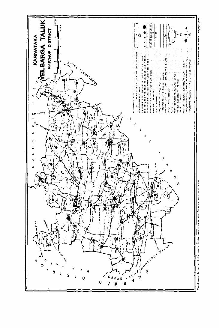
; :i
I-U (I l-I/)
0
F-' ' , i: ! : , . ' ,
I''''© '~I , , i: :
: I ., , 1: __ 1
..
IX ::::> :r u 0 o
~ 0::
> <
I-
.1. N o I
J. s o
·'1 ' , ' , .:;:;: ~ ;;: 1 .... 1 ::t ~ .:X: Z '" ' , , , ., , , , ' , o L_J
>
<III ,
+~ Ul .. ~
o
o >
~ , III
· ;
c o
'm .~
• D
· ; £ i

185
lLPHlBBTICAL LIST OF Vll.LAGBS
TALUK : YELBARGA
1981 Populat.i.on 1981 Population
S1 Name of Village Census 51. Name of Village Census No. L.C. No. L.C.
No. 1971 1981 No. 1971 1981
,1 2 4 5 2 4
Adoor 142 1197 1323 61 Itagi 130 3250 3407 AdvihaJJi 124 213 205
, Anugondan Koppa 131 62 Jarkunt.i. 17 259 315 Arkeri 90 1127 1169 63 Jarkunt.i. 70 245 269
64 Jhulkatt.i. 7 330 350 5 BaJapur 105 6 Balgera 97 1547 1705 65 Kadar haJJi 86 616 623 7 Ballutgi 6 2169 2305 66 Kadbalkatt.i. 9 212 274 8 Bandi 8 1244 1416 67 KakkihaJJi 112 559 697 9 Bandih~ 29 1110 1268 68 Kalak bandi 65 284 377
10 Bannikopp 129 1287 2377 69 Kalbhavi (Kadbhavi) 49 530 416 11 BassapUl' 5 435 456 70 Kallur 27 2180 2338 12 Bedwatti 93 524 507 71 Karmudi 30 2063 2418 13 Benakal 118 2150 2139 72 KatgihaJJi 53 467 588 14 Bevoor 78 2216 2691 73 Katral 33 456 386 15 Bhairnaikanhalli 82 572 708 74 Kavalkere 108 19 4 230
( BhairnaikanahaWl 75 KerihaJJi 133 16 Bhanapur 120 1059 1031 76 Kollhal 58 611 661 17 BhatpanhaJJi 140 585 1020 77 Komlapur 123 816 568 18 Sinhal 138 1401 1488 78 Konapur 113 237 293 19 Blraldinni 72 344 364 79 Konasagar 12 914 1015 20 Boon koppa 13 186 201 80 Kudgunti 24 911 1059 21 Budgumpa 95 581 588 81 Kudri Kotgi 23 591 645 22 Budkunti 71 607 732 82 Kudri moti 81 1797 1991 23 Budur 43 540 545 83 K uknoor (K ukanoor) 109 7911 9111 24 Bukkanhatti 56 199 105
84 Lagalur 19 73 78 25 C hanpanhaJJi 111 286 280 85 Lakmangule 107 405 442 26 Chendinhal 83 168 172 86 Lakmapur 121 1033 1271 27 Chendoor 91 847 771 28 C hikbannlgol 11 511 706 87 Madlur 21 348 411 29 C hikbeedinhalu 85 537 652 88 MakkahaJJi 15 153 190 30 C hiken koppa 139 1283 1524 89 M alaksa m udra 25 866 827 31 C hikka arlihalli 73 90 Malekoppa 135 994 923 32 C hikka m annapur 45 507 552 91 Mandalgeri 132 1814 1837 33 C hik m yageri 98 1908 2146 92 Mandalmari 62 303 440 34 Chikoppa 3 276 402 93 M angalore (H anglur) 76 4735 5270 35 C hik w ankal kunta 50 452 569 94 Mannapur 128 809 652 36 Chitapur 122 283 199 95 • Maranhal 20 447 423 37 Choudapur 38 414 432 96 Markat 46 580 674
97 M asabhanchinhal 116 1402 1421 38 D am mill' 18 647 870 98 Mataldinni 74 1348 1391 39 D yam pur 143 1271 1337 99 Hatrangi 66 257 323
100 Hudhol 36 5119 5378 40 Gandhal 47 1354 1775 101 Murdi 104 1402 1625 41 Gavarhal 114 303 327 102 Muthalu 88 475 503 42 Geddigera 99 1014 1193 103 Myadneri 59 403 601 43 G oreekoppa (G orlekoppa) 115 249 275 44 Gule 41 238 199 104 Narsapur 102 191 246 45 Gunhalu 57 1722 1812 105 N eJgeri (N eJJer1) 80 602 819 46 Guntamadu 42 230 230 106 Nilogal 61 356 359 47 Guttur 106 552 635 107 N iIlgalbandi 64 858 lQ03
108 Nillgapur 126 616 584 48 Hagedhal 10 375 416 109 Nittali 117 783 693 49 Hanmapur 100 120 175 50 Harlst.ankerbandi 110 140 146 110 Putakmari 69 334 436 51 Hire arlihalli 67 1325 1513 52 Hlrebeedinhalu 87 729 697 111 Rajoor 141 1827 1851
( Hirebeediahalu) 112 Ryavanld. 96 1235 1338 53 Hire m yageri 35 3021 3253 54 Hire waddarkal 54 986 1069 113 Salbhavi 16 231 314 55 Hire wankal kunta 37 1706 19 13 114 Sanganhal 26 2337 2246 56 Honhunashi 84 366 398 115 Sankanur 32 1363 1523 57 H osahaJJi 2 754 804 116 Sidlabhavi 44 396 421 58 Hosur 68 415 492 117 Sidnekoppa 136 874 769 59 Hulegudda (Halegudda) 103 633 862 118 Sirgumpi 34 580 604 60 Hursihal 60 1533 1684 119 Sirur 89 1073 1213
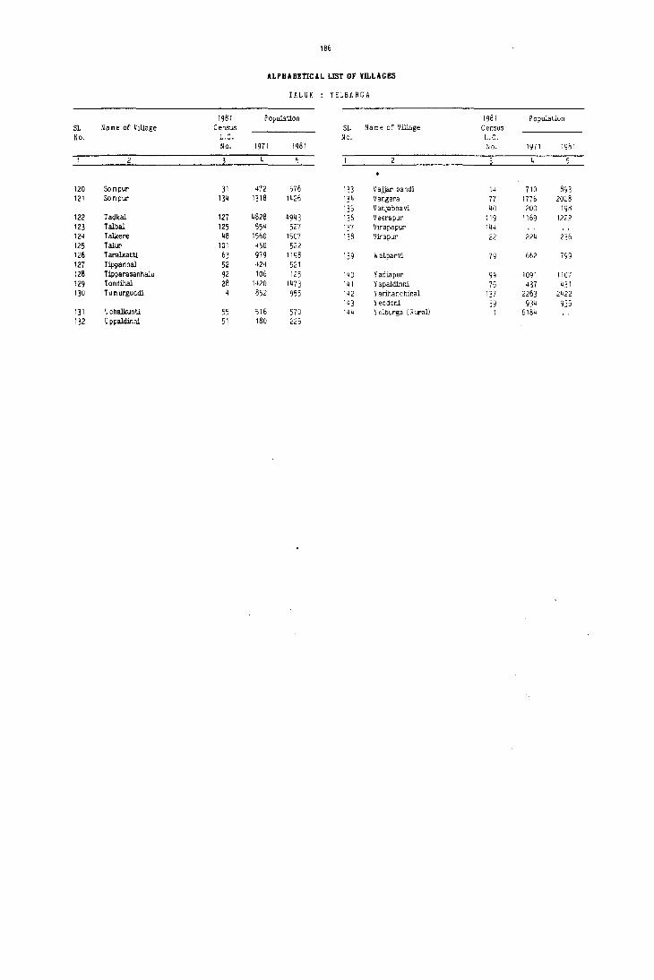
186
ALPHABEnCAL UST OF VILLAGES
rUUK : YELBARGA
1981 Population 1981 Population S1. Name of Village Census Sl. Name of Village Census No. L.C. No. L.C.
No. 1971 1981 No. 1971 1981
120 Sompur 31 472 576 133 Vaiiar bandi 14 710 893 121 Scm pur 134 1318 1426 134 Vangera 77 1776 2028
135 Vanjabhavi 40 200 198 122 radkal 127 4828 4943 136 Veerapur 119 1169 1222 123 Talbal 125 554 527 137 Vl!'apapur 144 124 Talkere 48 1560 1507 138 IJirapur 22 224 236 125 Talur 101 450 522 126 TaralkatU. 63 979 1198 139 Watparvi 79 66? 799 127 Tippanhal 52 424 521 128 Tipparasanhalu 92 106 125 140 Yadiapur 94 1091 1107 129 Tondihal 28 1420 1473 141 Yapaldinni 75 437 431 130 TumurguCidi 852 955 142 Yarihanchinal 137 2263 2422
143 Yeddoni 39 934 935 131 Uchalkunti 55 516 570 144 Y dburga (R ural) I 618lJ 132 U ppaldir.ni 51 180 225
YELBARGA TALUK

raluk : Yelbar a
L.C. No.
Name of village
Velbarga (Rural
Hosahalli
Chikoppa
Tumurguddi
Bullutgi
Jhulkatti
Bandi
Kadbalkatti
10 Hagedhal
II Chikbannigol
12 Konasagar
13 Boonkoppa
14 Vajjarbandi
15 Makkahalli
16 Salbhavi
17 Jarkunti
18 Dammur
19 Lagalur
20 Maranhal
21 Madlur
22 Yirapur
23 Kudrikotgi
24 Kudgunti
25 Malaksamudra
26 Sanganhal
27 Kallur
28 Tondihal
29 Balldinal
30 Karmudi
31 Sompur
32 Sankanur
33 Katral
34 Sirgumpi
35 Hiremayageri
188
VILLAGE DIRECTORY
AMENITIES AND LAND USE
Amenities available (if not available within the village, a dash (-) may be shown in the column and next to it in hrackets, the distance in broad ranges viz., -5 kms, 5-10 kms and 10+kms of the nearest place where Total Area
of the village
(in hectares and ares)
Total Population and number of households
the facility is available may be ~iven)
4a
529.17 804
509.57 402
1550.75 955
839.35 456
1491.95 2305
412.38 350
1030.70 1416
282.21 274
430.37 416
823.54 706
1406.7) 1015
445.21 201
1397.23 893
629.03 190
368.42 314
550.54 311
822.09 870
209.02 78
414.48 423
228.49 411
182.78 2)6
879.98 645
116J.91 1059
1063.68 827
4619.37 2246
2043.29 2338
2177.07 1473
1473.48 1268
3959.74 2418
524.03 576
1087.77 1523
422.49 386
1121.29 604
1787.42 3253
4b
142
68
190
100
400
76
286
37
81
135
179
36
D9
28
54
62
153
12
73
66
Ii)
107
179
151
439
443
277
2J2
427
101
309
77
1J5
579
Day or Days Educational Medical I)rinking Post and 01 the mar
water Telegraph ket/hat if any
P
P
P
P
P,M
p
P,M
P
P
P
P,M
p
P,M
-(-5)
P
P
P
-(-5)
P
P
P
P
P
P
P,M
P,M
P,M
P,M
P,M
P
P,M
P
P
P,M
UN-INHABfTEn
-(-5) W,Hp -(-5) -(-5)
-(-5) W,Hp -(-5) -(-5)
-(-5) W,Hp -(-5) -(-5)
-(5-10) Hp -(-5) -(HO)
-(-5) W,Hp PO -(-5)
-(-5) W -(-5) -(10+)
D W,Hp PO -(l0.)
-(-5) W,Hp -(-5) -(l0.)
-(5-10) W,Hp -(5-10) -(5-10)
-(-5) W -(-5) -(l0.)
-(-5) W PO -( 10+)
-(5-10) W -(5-10) -(j-W)
-(IO+) W,Hp PO -(10+)
-(HO) W -(-5) -(lOt)
-(lOt) W,'"lp -(-5) -(10.)
·(5-10) Vl -(5-10) -(5-10)
-{5-IO) W,Hp -(5-10) -(5-IO)
-(5-10) IV -0-10) -(5-10)
-(-5) IV,Hp -(-5) -(-5)
-(5-10) W -(5-10) -(5-10)
-( ·5) \II -(-5) -(-5)
-( ·5) IV -(-5) -(-5)
-( -10) W,Hp -(-5) -(-5)
-(.5) W,Hp PO -(-5)
P~ CJ IV ,Hp PO Saturday
-(- 0) IV ,Hp PO -(-5)
-(10.) Hp,Tk PO -(10.)
-(10+) Hp,Tk -(-5) -(10.)
-(5-10) W,Hp PO -(5-10)
-(lOt) W,Hp -(-5) -(10.)
-(10+) W,Hp PO -(lOt)
-(lOt) W,Hp -(-5) -(10.)
-(10.) W -(-5) -(10.)
-(5-10) W,Hp PO,Phone -(5-10)
Communications [Bus stop, Railway Station, Waterway 1
BS
BS
BS
-(-5)
BS
-(-5)
BS
-(-5)
BS
-(-5)
-(-5)
-(-5)
BS
-(-5)
-(-5)
-(-5)
10
..(-5)
-(5-10)
..(5-10)
-(5-10)
-1-5)
-(-5)
85
85
BS
-(-5)
B5
BS
BS
BS
BS
BS
-(-5)
BS
Approach to
village
II
KR
KR
PR
KR
KR
KR
PR
PR
PR
KR
PR
KR
PR
KR
KR
KR
KR
KR
KR
KR
KR
KR
PR
PR
PR
KR
KR
KR
KR
PR
PR
PR
PR
PR
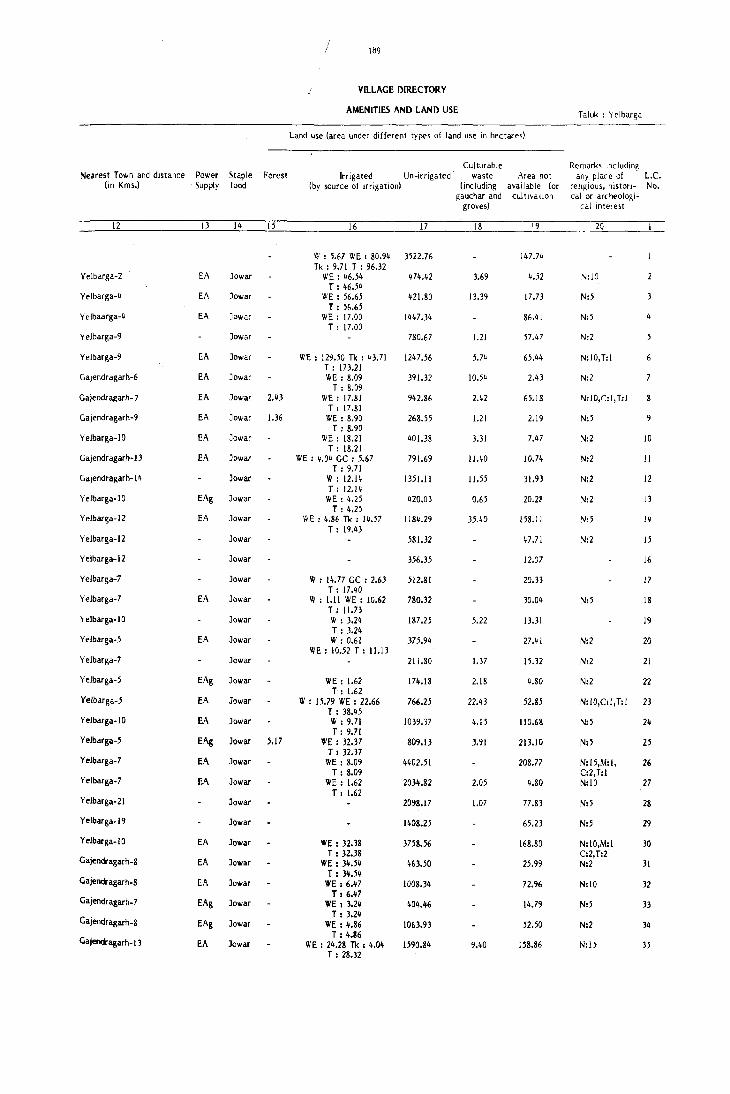
Nearest Town and distance (in Kms.)
Power Supply
Staple food
Forest
VILLAGE DIRECTORY
AMENITIES AND LAND USE
land use (area under different types of land USe in hectares)
Irrigated Un-irrigated (by source of irrigation)
Culturable waste Area not
(including available for gauchar and cultl,a,ion
greves)
____ ~1~2 ____________ ~13~ __ ~1~~ ____ .~15~ __________ ~1~6 __________ ~17~ ______ ~18~ _______ '9
Yelbarga-2
Yelbarga-~
Yelbaarga-~
Yelbarga-9
Yelbarga-9
Gajendragarh-6
Gajendra~arh-7
Gajendragarh-9
Yelbarga-IO
Gajendragarh-1J
Gajendragarh-l ~
Yelbarga-IO
Yelbarga-12
Yelbarga-12
Yelbarga-12
Yelbarga-7
Yelbarga-7
\ elbarga-I 0
Yelbarga-5
Yelbarga-7
Yelbarga-5
Yelbarga-5
Y elbarga-I 0
Yelbarga-5
Yelbarga-7
Yelbarga-7
Yelbarga-21
Yelbarga-1 9
Y elbarga-I 0
Gajendragarh-8
Gajendragarh-8
Gajendragarh_7
Gajendragarh_8
Gajendragarh-13
W : 5.67 WE : 80.9~ 3522.76 Tk: 9.71 T : 96.32
EA Jawar WE : ~6.5~ 474.42 T : ~6.54
EA Jawar \1IE : 56.65 421.80 T : 56.65
EA Jawar WE: 17.00 1~47.34
T: 17.00 Jawar
EA Jawar WE: 129.50 Tk : 43.71 T: 173.21
EA Jawar WE : 8.09 T: 8.09
EA Jawar 2.43 WE: 17.81 T: 17.81
EA Jowar 1.36 WE : 8.90 T: 8.90
EA Jowar WE : 18.21 T: 18.21
EA Jowar WE : 4.04 GC : 5.67 T: 9.71
Jowar W: 12.14 T: 12.14
EAg Jewar WE : 4.25 T: 4.25
EA Jawar Ii' E : 4.86 Tk : 14.57
Jewar
Jewar
Jewar
EA Jewar
Jewar
EA Jawar
Jowar
EAg Jewar
EA Jowar
EA Jewar
EAg Jewar 5.17
EA Jewar
EA Jewar
Jowar
Jewar
EA Jawar
EA Jawar
EA Jawar
EAg Jawar
EAg Jawar
EA Jawar
T: 19.43
W : 14.77 GC : 2.63 T: 17.40
W : 1.11 WE : 10.62 T : 1I.n W: 3.24 T: 3.24 W: 0.61
WE: 10.52 T : 1l.1J
WE: 1.62 T: 1.62
IV : 15.79 WE : 22.66 T : 38.45 W : 9.71 T: 9.71
WE: 32.37 T : 32.37
WE: 8.09 T: 8.09
WE: 1.62 T: 1.62
WE: 32.38 T: 32.38
WE: 34.54 T : 34.54
WE: 6.47 T: 6.47
WE: 3.24 T: 3.24
WE: 4.86 T: 4.86
WE : 24.28 Tk : 4.04 T : 28.32
780.67
1247.56
391.32
942.86
268.55
401.38
791.69
1351.11
420.03
1184.29
581.32
356.35
512.81
780.32
187.25
375.94
211.80
174.18
766.25
1039.37
809.13
4402.51
2034.82
2098.17
1408.25
3758.56
463.50
1008.34
404.46
1063.93
1590.84
3.69
13.39
1.21
5.7~
10.54
1.21
3.31
11.40
11.55
0.65
5.22
1.37
2.18
22.43
4.15
3.91
2.05
1.07
9.40
147.74
4.52
17.73
86.41
57.47
65.44
2.43
65.18
2.19
7.47
10.74
31.93
20.U
158.11
47.71
12.07
20.33
30.04
13.31
15.32
4.80
52.85
110.68
213.10
208.77
4.80
77.83
65.23
168.80
25.99
72.96
14.79
52.50
158.86
Taluk : Yelbarga
R~rnarks Including any place of '
religious, historicalor archeologi
cal Interest
20
N:IO
N:5
N:5
N:2
N:IO,T:I
N:2
N:10,C:I,T:l
N:5
N:2
N:2
N:2
N:2
N:5
N:2
N:5
N:2
N:2
loC. No.
5
8
10
11
12
13
15
16
17
18
19
20
21
N:2 22
N:JO,C:l, T:l 23
N:5 24
N:5 25
N:15,M:I, 26 C:2,T:I N:IO 27
N:5
N:5
N:IO,M:I C:2,T:2 N:2
N:IO
N:5
N:2
N:l5
28
29
30
31
32
33
34
35

Taluk : Yelbar a
VILLAGE DIRECTORY
AMENInES AND LAND USE
Amenities available if not available within the villa~e, a dash (-) may be shown in the column and next to it in brackets, the distance in broad ran~es viz., -5 kms, 5-10 kms and 10.kms of the nearest place where
L.C. No.
Name of village
Total Area of the village
(in hectares and ares)
Total Population and number of hooseholds
- the facility is available may be given)
4a
36 Mudhol 416Q.93 5378
37 Hirewankalkunta 570.25 1913
38 Choudapur 350.35 432
39 Yeddoni 840.54 935
40 Vanjabhavi 292.12 198
41 Gule 36&.95 199
42 Guntamadu 441.88 230
43 Budur 1027.67 545
44 Sidlabhavi 55&.59 421
45 ChikkamannapUf 718.04 552
46 Markat 423.60 674
47 Gandhal 1664.16 1775
48 Talkere 885.86 1507
49 Kalbhavi 794.25 416
50 Chikwankalkunta ~33.67 569
51 Uppaldinni 472.73 225
52 Tippanhal 438.73 521
53 Katgihalli 676.59 588
54 Hirewaddarkal 1659.92 1069
55 Uchalkunti 504.07 570
56 Bukkanhatti 697.79 105
57 Gunhalu 1450.37 1812
58 Kolihal 750.58 661
59 Myadneri 448.02 601
60 Hunsihal 1897.63 1684
61 Nilogal 374.25 359
62 Mandalmari 454.71 440
63 Taralkatti IIOS.25 1198
64 Ningalbandi 76).65 1003
65 Kalakbandi 633.17 377
66 Matrangi 312.81 323
67 Hire Arlihalli 1114.21 1513
68 Hosur 544.21 492
69 Putakmari 386.38 436
70 Jarkunti 166.49 269
4b
991
343
82
172
29
35
50
95
74
104
114
276
275
77
106
41
79
104
205
116
25
324
109
95
312
69
87
215
18J
68
52
241
87
72
47
Day or Days Educational Medical Drinking Post and of the mar
water Telegraph ket/hat if any
P.M,H
P,M,H
P
P
P
P
P
P
P
P
P
P,M
P,M
P
P
P
P
P
P
P,M
P
P
P
P
P
P
P
P
P
P,M
P
P
P
6 9
..(5-10) W,Hp PO,Phone ..(5-10)
PHU W,Hp PO Thursday
-(10.) W -(-J) ..(10.)
-(5-10) W PO -(5-10)
..(10.) W -(-5) ..(10.)
..(10.) W -(-5) ..(10.)
..(10.) W -(5-10) ..(10.)
..(10.) W,H~ ..(;-10) ..(10.)
..(10.) W ..(5-10) ..(10.)
..(10.) VI ..(5-10) .(10.)
-(10.) W ..(5-10) ..(10.)
-(10.) IV,Hp PO .(10.)
..(10.) W,Hp PO .(10.)
..(-5) w -(-5) .(-5)
-(-5) IV,Hp -(-5) .(-5)
.(-5) W,Hp -(oj) .(-5)
..(5-10) w -(-5) ..('-10)
.(10+) W ..(-5) ..(10.)
.(10+) W PO ..(10.)
.(5-10) IV .(-5) ..(5-10)
.(5-10) W,Hp ..(-5) ..(5-10)
-(5-10) W,Hp PO ..(5-10)
.(5-10) IV ..(-5) -<5-10)
.(5-10) W -(-5) ..(5-10)
..(-5) IV,Hp PO ..(-5)
..(-5) W,Hp ..(-5) ..(-5)
..(10.) W,Hp -(-5) ..(10.)
..(5-10) W,Hp PO ..(5-10)
-(10.) W,Hp ..(-5) ..(10.)
-(JO.) W ..(-5) ..(10.)
-(10.) W ..(-5) ..(10.)
..(10+) W PO ..(10.)
..(10.) W,Hp ..(-5) ..(10.)
-(;-10) W,Hp ..(-5) ..(5-10)
-(;-10) W,Hp ..(-5) ..(5-10)
Communications [Bus stop, Railway Station, Waterway)
10
BS
liS
..(-5)
BS
..(5-10)
..(5-10)
..(;-10)
..(;-10)
..(5-10)
..(5-10)
..(-;)
..(5-10)
BS
BS
liS
liS
BS
..(-5)
..(-5)
BS
-{-')
liS
-{-5)
BS
..(-5)
BS
BS
liS
..(-;)
..(-5)
..(-5)
liS
BS
BS
-(-5)
Approach to
village
II
PR
KR
KR
KR
KR
KR
KR
KR
KR
KR
KR
KR
KR
I<R
KR
KR
KR
KR
KR
KR
KR
KR
KR
KR
PR
PR
PR
KR
PR
KR
KR
PR
KR
KR
KR
Nearest Town and distance Power Staple Forest (in Kms.) Supply food
12
Yelbarga-1
Kuahtagi-14
Kuahtllfli-I
Kulhtagi-I
Kuahtagi-18
KushtaKi-I'
KulhtaKi- I'1
Kushtllfli-17
Kulhtagi-18
Kushtagi-14
Kulhtagi-18
Kuahtllfli-22
KulhtaKi-16
Kuahtagi-14
Kulhtagi-i}
Kuahtagi-16
Kuahtagi-16
KuahtaKi-23
Kuahtagi-20
Kuahtagi-19
Kuahtagi-22
Kulhtagi-19
Ku5llta&i-21
Kuahta&i-2J
Kushta&i-22
Kushta&i-18
Kushta&I-16
Kulhllli-18
Kulhtagl-19
Kushta&I-20
Kushfili-21
KulhAli-16
lCushtagi-19
J(ush!agi-'
KulhhJi-~
13 14
EA Jowar
EA Jawar
Jawar
Jowar
Jowar
Jowar
Jowar
Jowar
Jowar
Jowar
Jowar
Jowar
Jowar
EAg Jowar
EA Jowar
Jowar
Jowar
Jowar
15
Jowar -
Jowar -
Jowar
EA Jowar
EAg Jowar
Jowar
EA Jowar
Jowar -
Jowar
Jowar -
EA Jowar
EAg Jowar
EA Jowar
Jowar
Jowar
Jowar -
Jowar
191
VD.LAGE DIRECTORY
AMENITIES AND LAND USE
Land use (area under different types of land use in hectares)
Irrigated Un-irrigated (by source of irrigation)
16 17
VI : 13_10 VIE : 59.25 3929.81 T: 72.35
VI : 1.62 VIE : 14.21 538.52 T: U.83 " : 2.02 332.43 T : 2.02 VI I 6.07 80-7.34 T: 6.07
279.35
324.02
437.98
" : 4.04 912.54 T 14.04 " : 1.62 551.15 T: 1.62 " : 2.02 681.51 T I 2.02 " I 4.86 413.97 T I 4.86 " : 4.04 1640.89 T: 4.04 " I 6.68 870.45 T I 6.68
"E : 3.64 Tk : 32.38 "0.88 T I 36.02 " I 2.02 230.64 T I 2.02 " I 6.32 452.34 T I 6.32 " : 1.21 431.50 T: 1.21 " : 4.17 658.47 T I 4.17 " : 3.24 1625.51 T I 3.24 " : 2.18 494.02 T : 2.18 " : 4.~ 611.49 T: 4.96
W I 2.02 WE I 12.95 mO.71 T 114.97
WE I 12.95 736.82 T I 12.95 W ; 4.86 442.36 T: 4.86
WE : 25.60 IS66.57 T I 25.60 W I 3.24 363.41 T :3.24
VI I 8.09 T: 8.09
WE 110.12 T I 10.12
WE I 12.14 T: 12.14
WE: 17.81 T I 17.81 WI 13.36 T I 13.36 W, 10.12 T I 10.12 W: 1.62 T: 1.62 W: 2.02 T: 2.02
446.42
IOS6.35
~16.45
281.08
IOSs.94
'2'.60
380.78
15S.27
Culturable waste Area not
(including available for gauchar and cultivation
groves)
18
12.15
2.08
29.01
3.80
2.'5
4.86
3.09
2.25
2.63
3.79
19.02
38.70
4.17
6.26
10.42
19
158.77
3.75
15.90
27.13
12.77
44.93
1.82
82.02
2.02
34.51
2.22
14.37
5.10
1.01
14.07
3.39
10.16
24.69
7.87
2.32
45.99
0.81
0.80
5.46
3.43
2.03
3.39
0.94
4.'8
1l.92
14.91
2.15
1.43
6.20
Taluk : Yelbarga
Remarks including any place of L.e.
religious. histori- No. calor archeologi-
cal interest
20
N:2',M:2,T:1
N:20,C:l
N:5
N,' N:2
N:2
N:'
NI2
N:2
N:5
N:5
N:5
N:IO
N:5
Nt5
NI2
N:2
N:'
NIIO
N:15
NI2
N!15
N:2
N:2
N:'
N:2
N:2
NIIO
N;',C:I
N:'
N:2
36
37
38
39
40
41
42
43
44
45
46
47
48
50
51
52
'3
55
56
57
58
'9
60
61
62
63
64
65
66
67
68
69
70

Taluk : Yelbarga
L.C. Na me of village No.
71 Budkunti
72 Biraldinni
73 Chikka ArHhalli
74 ~!ataldinni
75 Yapaldinni
76 Mangalore
77 Vangera.
78 Bevoor
79 Watparvi
80 Nelgeri
81 Kudrimoti
82 Bhairnaikanhalli
83 Chendinhal
84 Honhunashi
85 Chikbeedinhalu
86 Kadarhalli
87 Hirebeedinhalu
88 Muthalu
89 Sirur
90 Arkeri
91 Chendoor
92 Tipparasanhalu
93 Bedwatti
94 YadiaP\lr
95 Budgumpa
96 Ryavanki
97 ,Balgera
98 Chikmyageri
99 Geddigera
100 Hanmapur
101 Talur
1,02 Narsapur
, 103 Hulegudda
104 Murdi
105 Balapur
192
VD.LACE DIRECTORY
AMENmES AND LAND USE
Amenities available (if not available within the village, a dash I-) may &e shown in the column and next to it in brackets, the distance in broad ranges viz., -5 kms, 5-10 kms an<! lD+kms of the nearest place where Total Area
of the village
(in hectares and ares)
Total Population and number of households
the facility is available may be given)
4a
32
550.42 364
470.18
977.65 1391
386.16 431
2781.00 5270
1272.39 2028
2013.54 2691
609,23 799
714.09 819
1834.17 1991
383.16 708
443.56 172
428.95 398
637.69 652
559.85 623
693.77 697
483.92 503
861.83 1213
1434.13 1169
1222.13 771
621.67 125
789.28 507
580.59 1107
587.58 588
1393.23 ms
1943.07 1705
IS95.!! 2146
1297.69 1193
132.38 175
465.49 522
466.65 246
900.76 S62
2017.23 1625
363.53
4b
118
62
235
70
1000
370
'190
141
132
379
114
34
SO
124
113
133
76
200
208
m 23
89
197
114
264
319
400
231
31
106
37
149
297
Day or Oays Communications Educational Medical Drinking Post an<! of the mar- [Bus stop, Railway
P
P
P,M
P
P,M,H
P,M
P,M
P
P,M
P,M
P
-(-5)
P
P
P
P
P
P,M
P,M
P
-(-5)
P
P
P
P,M
P,M
P,M
P
P
P
P,M
water Telegraph ket/hat if Station, Watelwayl any
6 8
-(5-10) V',Hp -(-5) -(5-10)
-(5-10) W -(5-10) -(5-10)
UN-INHABITED
-(-5) W,Hp PO -(-5)
-(-5) W -(-5) -(-5)
PHC, W,Hp PO,Phone Tuesday FPC -(-5) W,Hp PO -(-5)
PHU W,Hp PO Monday
-(5-10) W -(-5)
-(-5) W,Hp -(-5)
-(-5) W,Hp PO
-(-5) W,Hp -(-5)
-(-5) w -(-5)
-(-5) W -(-5)
-(-j) W PO
-(-5) W -(-5)
-(-5) W PO
-(5-10) W
-(5-10) W
-(5-10) \II
-(ID+) W
-(5-10) W
-(5-10) W
-(5-10) W
-(5-10) W
-(-5)
PO
PO
-(-5)
-(-5)
-(-5)
-(-5)
-(-5)
-(-5) W,Hp PO
-(5-10) W,Hp PO
-(5-10) W,Hp
-(10+) W
-(10+) W
-(10+) W
-(10+) W
-(10+) W
-(-5) W
PO
PO
-(-5)
-(-5)
-(-5)
-(-5)
PO
UN-INHABITED
-(5-10)
-(-5)
-(-5)
-(-5)
-(-5)
-(-5)
-(-5)
-(-5)
-(-5)
-(5-10)
-(5-10)
-(5-10)
-(10+)
-(5-10)
-(5-10)
-(5-10)
-(5-10)
-(-5)
-(5-10)
-(5-10)
-(10+)
-(10+)
-(10+)
-(IO+)
-(10+)
-(-5)
-(-5)
-(-5)
BS
-(-5)
BS
BS
BS
-(-5)
BS
BS
-(-5)
-(-5)
~-5)
-(-5)
10
-(5-10)
-(-5)
-(-5)
-(5-10)
-(5-10)
-(5-10)
-(5-10)
-(-5)
-(-5)
-(5-10)
-(-5)
-(5-10)
BS
-(10+)
-(10+)
-(10+)
-(10+)
-(10+)
BS
Approacl to
villag.e
11
PR
PR
KR
PR
PR
KR
PR
KR
PR
PR
KR
KR
KR
KR
KR
KR
KR
KR
KR
KR
PR
PR
PR
KR
KR
KR
KR
KR
KR
KR
PR
KR
PR

Nearest' Town and distance (in Kms.)
12
Kushtagi-IO
i(ushtagi -14
Kushtagi-17
Kushtagi-16
KoppaJ-24
Yelbarga-14
Yelbarga-18
Yelbarga-25
Yelbarga-23
KoppaJ-17
Koppal-20
Koppal-16
Koppal-16
Koppal-17
Koppal-20
Koppal-20
KoppaJ-28
Koppal-28
Koppal-24
Yelbarga-23
Yelbarga-22
Yelbarga-25
Yelbarga-25
Yelbarga-16
Yelbarga-18
Yelbarga-19
Yelbarga-IO
Yelbarga-12
Yelbarga-15
Yelbarga-16
Yelbarga-16
Yelbarga-16
Yelbarga-23
193
VILLAGE DIRECTORY
AMENInES AND LAND USE
Land use (area under different types of land use in hectares)
Power Staple Supply food
14
Forest
15
Irrigated Un-irrigated (by source of irrigation)
16 17
EAg Jowar - WE : 8.09 306.46 T: 8.09
Jowar - W : 6.07 525.26 T: 6.07
W : 2.02 WE : 4.04 458.26 T: 6.06
EA Jowar - W : 6.07 WE : 10.12 855.45 T: 16.19
EAg Jowar - WE : 1.62 380.78 T: 1.62
EA Jowar - WE : 162.26 2437.20 T: 162.26
EA Jowar - WE : 89.03 1092.95 T: 89.03
EA Jowar - WE: 91.26 1719.05 T: 91.26
EA Jowar - WE : 48.77 509.40 T: 48.77
EA Jowar - WE : 8.90 685.41 T: 8.90
EA Jowar - WE : 21.47 Tk : 25.07 1589.94 T: 46.54
EA Jowar WE : 30.55 315.72 T: 30.55
EAg Jowar - WE : 1.62 439.74 T: 1.62
EAg Jowar - W : 2.43 WE : 74.23 254.67 T: 76.66
EA Jowar - WE : 52.61 494.2S T: 52.61
EA Jowar - W : 48.56 490.33 T: 48.56
EA Jowar - WE : 4.04 662.05 T: 4.04
EA Jowar - WE : 7.28 470.87 T: 7.28
EA Jowar 9.31 WE : 22.46 758.63 T: 22.46
EA Jowar 34.80 WE : 12.70 IJ 88.00 T: 12.70
EA Jowarl23.03 WE : 17.60 1062.60
EA
EA
EA
EA
EA
EA
EA
Jowar -
Jowar -
JOlliar -
Jowar -
Jowar -
Jowar 31.57
Jowar -
Jowar -
Jowar -
EAg Jowar-
EAg Jowar-
Jowar
EA Jowar -
T: 17.60
WE: 8.90 T: 8.90 W: 1.62 T: 1.62
WE: 6.27 T: 6.27
WE : 33.19 T : 33.19
WE: 16.18 T: 16.18
WE: 2.02 T: 2.02
W : 37.64 WE : 83.77 T: 121.41
562.76
759.61
509.83
m.12
1297.21
1756.24
1840.77
1290.82
129.29
447.75
454.14
883.77
1832.43
353.00
Culturable waste
(including gauchar and
groves)
18
35.37
2.55
9.30
30.76
166.06
19.12
22.95
1.31
48.16
35.38
5.47
9.49
25.71
2.71
4.23
22.86
7.60
40.55
5.51
3.64
2.83
1.36
10.15
16.99
Area not available for cultivation
19
6.49
19.09
5.86
70.64
1.21
172.24
59.65
37.17
31.94
79.78
174.74
35.58
2.20
49.46
55.41
15.49
27.68
5.77
61.94
172.92
16.19
53.99
16.54
46.28
33.46
82.15
114.71
15.64
3.23
0.26
1.56
9.13
6.84
46.40
10.53
Taluk : Yelbarga
Remarks including any place of
religious, historicalor archeologi
cal interest
20
L.C. No.
N:2 71
N:2 72
7J
N:15 74
N:2 75
N:30,M:3,T:2 76
N:5 77
N:l5,T:I 78
79
N:5 80
N:15 81
T: I 82
83
T:I 84
85
86
87
88
N: 15,M:2, T: I 89
N:I0,M:l 90
N:I 91
N:5
N:5
N:5
N:6
N:IO
N:IO
N:5
N:5
N:15
93
94
95
96
97
98
99
100
101
102
103
104
105

Taluk : Yelbar a
L.C. No.
Name of village
106 Guttur
107 Lakmangule
108 Kavalkere
109 Kuknoor
110 Har ishankerbandi
III Chanpanhalli
112 Kakkihalli
113 !(onapur
114 Gavarhal
115 Goreekoppa
116 Masabhanchinhal
117 Nittali
118 Benakal
119 Veerapur
120 Bhanapur
121 Lakmapur
122 Chitapur
123 Komlapur
124 Advihalli
125 Talbal
126 Ningapur
127 Tadkal
128 Mannapur
129 Bannikoppa
130 Itagi
131 Anugondankoppa
132 Mandalgeri
133 Kerihalli
134 Sompur
135 Malekoppa
136 Sidnekoppa
137 Yarihanchinhal
138 Binhal
139 Chikenkoppa
140 Bhatpanhalli
19~
VILLAGE DIRECTORY
AMENITIES AND LAN!) USE
Amenities available if not available within the village, a dash (-) may be shown in the column and next to it in brackets, the distance in broad ranges viz., -5 kms, 5-10 kms and 10+kms 01 the nearest place where Total Area
of the village
(in hectares and ares)
Total population and number of households
the facility is available may be given)
4a
700.86 635
794.35 442
366.99 230
>647.33 9111
156.13 146
412.51 280
502.84 697
264.03 293
796.82 327
185.41 275
1312.71 1421
1012.83 693
1701.69 2139
1494.60 1222
894.66 1031
944.90 1271
456.72 199
764.59 568
324.43 205
1081.76 527
434.h8 584
5662.04 4943
805.46 652
2790.27 2377
3203.00 3407
464.63
2218.62 1837
36.92
1669.61 1426
905.30 923
1156.09 769
3447.00 2422
1489.62 1488
692.42 1524
618.41 1020
108
81
38
1675
30
54
liS
60
44
2%
115
411
215
218
231
40
121
36
100
96
865
134
436
591
343
268
178
142
449
244
271
132
Educational Medical I)rir'~in~ Post and water Tel~raph
Day or Days of the market/hat if
P
P
-(-5)
P
P
P
P
P
P,M
P
P,M
P,M
P,M
P,M
P
P
P
P
P
P,M,H
P,M
P,M
P,M,H
P,M
P,M
P
P
P,M
P,M
P,M
P
any
9
-(-5) II' +5) -(-5)
-(5-10) W -(-5) -(-5)
-(-5) W -(-5) -(-5)
PHC T,W PTO, Friday FPC,RP Phone -(-5) w -(-5) -(-5)
-(-5) W -(-5) +5)
-(-5) W -(-5) -(-5)
-(5-10) II' -(-5) -(-5)
-(-5) II' -(-5) -(-5)
-(-5) II' -(-5) -(-5)
-(-5) III,Hp PO -(-5)
-(5-10) \II -(-5) -(5-10)
-(5-10) II',Hp PO -(5-10)
-(lOt) IV,Hp -(-5) -(lOt)
-(-5) W,Hp PO,Phone -(-5)
-(-5) II' PO -(-5)
-(5-10) W -(-5) -(.I-IO)
-(5-10) W -(-5) -(5-10)
-(lOt) VI -(-5) -(-5)
-(-5) W,Tk, -(-5) -(-5) Hp
+5) W -(-5; -(-5)
D,RP W,Hp PTO,Phone Monday
-(-5) w -(-5) -(-5)
-(5-10) Tk,Hp PO,Phone -(5-10)
PHU U.',Hp PO,Phone Wednesday
UN-INHABITED
-(-5) W,Hp PO -(-5)
UN-INHABITF.D
-(5-10) Tk PO -(5-10)
-(5-10) Tk PO -(5-10)
-(10+) Tk -(-5) -(10+)
-(10+) Tk,!-Ip PO -(10+)
-(lOt) Tk PO -(10+)
-(5-10) Tk PO -(5-10)
-(-5) W,Hp -(-5) -(-5)
Communications [Bus stop, Railway Station, Waterway 1
10
-(-5)
BS
-(5-10)
BS
-(-5)
-(-5)
BS
-(-5)
-(-5)
-(-5)
BS
BS
{-5)
-(5-10)
BS,RS
-(-5)
-(5-10)
-(-5)
-(-5)
BS
-(-5)
BS
BS
B5,RS
BS
BS
BS
BS
-(-5)
BS
BS
BS
BS
Approach to
village
II
KR
KR
I(R
PR
PR
KR
KR
KR
KR
KR
PR
PR
KR
KR
PR
PR
KR
KR
K~
PR
KR
PR
KR
PR
KR
KR
KR
KR
KR
KR
KR
KR
KR
Nearest Town and distance (in Kms.)
12
Yelbarga-23
Yelbarga-14
Yelbarga-19
Yelbarga-15
Yelbarga-14
Yelbarga-14
Yelbarga-19
Yelbarga-19
Yelbarga-20
Yelbarga-19
Yelbarga-20
Yelbar~a-2~
Yelbarga-25
Yelbarga-25
Koppal-17
Kappaal-16
Koppal-20
Kapoal-18
Kappal-28
Koppal-19
Yelbarga-22
KOfJpal-14
Yelbarga-24
Yelbarga-29
Yelbarga-19
Yelbarga-18
Yelbarga-27
Yelbarga-25
Yelbarga-27
Yelbarga-28
Yelbarga-27
Yelbarga-27
Yelbarga-23
Power Staple Supply food
13
EA
EA
fA
fA
EA
EA
EA
EA
EA
EA
EA
fA
EA
EA
EA
EA
EA
EA
EA
EA
EA
EA
EA
14
Jawar
Jowar
Jowar
Jowar
Jowar
Jowar
Jowar
Jowar
Jowar
Jowar
Jowar
Jowar
Jowar
Jowar
Jowar
Jowar
Jowar
Jowar
Jowar
Jowar
Jowar
Jowar
Jowar
Jowar
Jowar
Jowar
Jowar
Jowar
Jowar
Jowar
Jowar
Jowar
Jowar
Forest
15
195
VILLAGE DIRECTORY
AMENmES AND LAND USE
Land U5~ (area under different types of laiK! use in hectares)
Irrigated Un-irrigated (by source of irrigation)
16
\liE: 10.12 T: 10.12
WE I 6.4R T: 6.48
WE: 32.37 T: 32.37
WE: 72.84 T: 72.84
IV: 41.28 WE: 12.14 T : 53.42
W : 22.66 T : 22.66
VI: 8.90 T: 8.90
WE: 60.71 T : 60.71
WE: 20.23 T: 20.23
WE: 36.42 T : 36.42
\II : 2.43 WE : 9.00 T: 11.43
W : 4.04 T: 4.04
17
695.78
764.95
338.J5
3537.07
149.76
411.54
264.03
672.18
180.32
1200.79
901.37
1559.35
1478.78
865.07
924.16
445.73
736.60
316.43
1052.86
405.94
5521.11
774.97
2680.81
3063.03
457.58
2109.79
36.79
1634.00
866.71
1129.53
3371.38
1463.18
(,74.06
601.12
Culturable waste Area not
(including available for gauchar and cultivation
groves)
18
2.14
15.16
19.43
36.42
124.64
5.27
20.64
89.84
2.43
2.02
2.84
32.38
0.81
0.40
2.02
4.45
2.83
19
2.94
4.12
22.36
58.46
6.37
0.97
5.09
33.81
37.40
52.50
13.39
6.93
20.74
10.99
27.99
8.00
20.00
26.72
80.22
25.63
89.23
100.71
7.05
65.02
0.13
34.80
38.59
26.16
75.62
24.42
13.91
10.42
Taluk : Yelbarga
Remarks including any place of L.c.
religious, histori- No. calor archeologi-
cal interest
20
N:5
N:200,M:3, C:2, T:I 0 A-l
N:lO
N:5
N:50,M:I,T:1
N:lO,T:l
N:IO,T:I
N:l5,T:1
N:30
N:15,T:2
N:5
N:6
N:5
N:6
N:5
N:10,T:2
N:50,M:2,T:3
N:15
N:15
N:15,T:I
N:IO,T:l
N:20,T:2
N:IO,M:I,T:1
106
107
108
109
110
111
112
113
115
116
117
118
119
120
121
122
123
124
125
126
127
128
129
130
131
132
133
134
135
136
137
138
139
140

Tal uk : Yelbarga
L.C. Name of village No.
141 Rajoor
147 Moor
143 Dyampur
1114 V irpapur
'Total
Total Area of the village
(in hectares and ares)
Total Population and number of hooseholds
4a 4b
Im.so 1851 330
1096.94 1323
196
Vn.LAGE DIRECTORY
AMENITIES AND LAND USE
Amenities available (il not available within the village, a dash (-) may be shown in the column and next to it in brackets, the distance in broad ranges viz., -5 kms, 5-10 kms and IO.kms of the nearest place where
the facility is available may be given)
Day or Days Educational Medical Drinking Post and of the mar
water Telegraph ket/hat it any
P,M
P,M
6
-(-5)
-(-5)
8 9
W,Hp PTO,Phone -(-5)
W,Hp -(-5) -(-5)
Communications [Bus stop, Railway Station, Waterway J
10
BS
941.08 IJJ7
234
241 P,M -(-5) W,Hp PO -(-5)
BS
B5
430.03 UN-INHABITED
14$892.97 146792 26644
Approach to
village
II
PR
PR
PR
Nearest Town and distance (in Kms.)
12
Yelbarga-! 8
Yelbarga-11
Yelbarga-14
Power Staple Forest Supply food
13 14 J5
EA Jowar
EA Jowar
EA Jowar
207.67
197
VILLAGE DIRECTORY
AMENmES AND LAND USE
Land use (area under different types of land use in hectares)
Irrigated Un-irrigated (by source of irrigation)
16
WE: 5.22 T: 5.22
" : 350.92 WE : Ilst • .5I
Tk: 129." GC; LlO
T: 23U.21
17
1560.84
1073.02
924.99
409.60
139190.63
Culturable waste
(including gauchar and groves)
18
2.43
14.00
123M9
Area not available for
cultivation
19
28.53
23.92
16.09
1.21
5211.90
Taluk : Yelbarga
Remarks including any place of
religious, historicalor archeologi
cal interest
20
N:30,M:l,T:l
N:20,M:I,T:2
N:IO
l.Co No.
141
142
JII3
1~4

APPENDIX

200
APPIIO IX (I)
'ULUlIIllII ABSrRACr or
EDUCATIOUL SL.
Name of TaMe Hatr.lculationl Higher Secondary! No. Prim ary SchoOl Middle SchoOl Secondary PU ClIntermediate!
SchOOl Junior C allege
Villages Institutions Villages Institutions Villages Institutions Villages Inst.itutions
7 10
DEVADURGA 154 158 30 30
2 GANGAWATI 129 161 38 40
KOPPAL 122 130 36 37 7
KUSHTAGI 153 160 41 43 5
5 LINGSUGUR 169 191 41 43 6
6 H ANVI 144 158 33 33
7 RAICHUR 142 156 32 33 5
8 SIND H N U R 126 159 39 42
9 YELBARGA 132 135 48 49 7
TOTAL 1271 1408 338 350 43 44
--_ ..
APPIIOIX (I)
'l'lLDlIIlSI ABSTRAcr or ED DCATIOUL,
MEDICAL
SL. Name of Taluk M atemity and Child
Prim ary Health No. DlspensatY HOSpital Welfare C entrel
Centre! Health M atemity Hom e! Child
Welfare Centre Centre
Villages In.stI.tutions vmages Institutions Villages InstitutiOns Villages In8t1tutioIIII
18 19 20 21 Zl 23 24 25
D EVAD UROA
GANGAWATI
KOPPAL 2 2
KUSHTAGI 2
LIN GSU 0 U R 2 2
MANVI 2
7 RAICHU R
SIND HNUR
9 YELBARGA
TOTAL 23 23 16 16
201
VD.LIGE DIRECTOR!
BIl UCAITOUL. MBIlICAL AID OnBR IMKIITIES
College (Graduate anll above)
Villages Institutions
11 12
VD.LAGE DIRECTORY
BIl UClnOIAL
Adult Literacy C lass/ Centres Others
Villages Institutions Villages Instltutions
13 14 15 16
MBIlICAL liD OTHER AMUITI!S (COITIl.)
MBIlle IL
Fa mily Planning Prim ary Health
Com munity Sub-Centrel
Centre PHU
Health Worker
Villages Institutions Villages Institutions Villages Institutions
o~ 21 28 2q 30 31
6 6
2 13 13
2 2
2 2 5
2 5 5
2
2
2
16 16 47 41
Villages with No Educational
F acilitl.es
17
19
20
15
10
16
19
10
15
6
130
Others
Villages Institutions
32 3~
13 13
12 30
16 29
15 15
21 41
2 2
84 133
Villages with no Medical. Faoility
34
165
128
111
154
176
139
132
1,6
130
1257
Name of Taluk SL No.
2
D EV AD U RG A
GANGAWATI 2
KOPPAL
KUSHTAGl
LINGSUGUR C,
MANVl
RArCMU R
SIND HN U R 8
YELBARGA 9
TOTAL
NaIDe of Taluk SL No.
2
DEVAD URGA
GUGAWAn 2
KOPPAL 3
KUSHTAGI 4
LINGSUGUR 5
MANVl 6
R AIC H U R 1
SIND HNU R 8
YELBARGA
TOTAL
Sl. No.
Sl. No.
202
APPENDIX (l)
TALUKVlSE ABSTRACT OF EDOCAnONAL,
D R'NKIN G VA TE R Villages 1<ith
Name of Taluk nod1"inking
Tap Well Tank Tubewell River Fountain Canal Others More than water facility One Source of any type
2 35 36 37 38 39 40 41 42 43 44
DEVADURGA 27 137
GANGAWATI 28 22 B8
KOPPAL 10 28 19 76
KUSHTAGI 56 2 105
LIN GSU G U R 170
M A NVI 28 17 117
R AlC H U R 22 125
SINDHNUR 17 22 11 85
YELBARGA 67 65
TOTAL 12 274 26 18 64 33 968
APPUOIX CD)
LAND UnLlSAnON D A.TA IN RESPECT OF
Land use (i.e., area under different types of land
Name of Town and Taluk within brackets Total Area Forest Irrigated by Source
2 5
- NIL -

Yn.LAGE DIRI!CTORI
MEDICAL UD OTHER AMEHlTIES (CO.CLD.)
posr ABD TELEGRAPH
P.O. & T.O. & P.T.O. & P.O. T.O. P.T.O Phone Phone Phone
Phone
q5 q6 47 48 qg 50 51
36
36 6 5
29 11
47
45 2
44 7 2
47 2
36
42
362 20
Yn.LAGE DIRI!CTORI
lOR-MUNICIPAL rOliNs (CnSUS TOWNS)
.- in hectares upto two decimal places).
Unimgated Culturable Waate (1ncludlng . gaucher and groves
6
203
COMH UNIC AnONS
Bus Railway Navigable Stop Station Water Way
52 53 5q
152
86
55 5
102
81
65
79
67
63 2
750 11
Area not available for cultivation
8
- MIL-
POWER SUPPLY Name of Taluk
!lot Available
Available
55 56 2
89 84 D EV AD U R G A
123 26 GANGAWATI
126 11 KOPPAL
92 71 KUSHTAGI
10C 77 LIN GSUG U R
97 66 M ANVI
140 12 RAICHUR
68 73 SIND HNUR
76 62 YELBARGA
919 482 TOTAL
NaIlle of Town and Taluk within brackets
2
Sl. No.
31. No.

204
APPUOIl -nI
l.JST or VD.L1GIS VHIRB 10 AMB'IIlmS IlelPT DJIIJIllIIG VATU ARB AVAILABLE
Name of Taluk 51. L.C. Ham e of V1J.la&e No. No.
2 3 4
o EVA!) UROA 39 NIGBAlI> ODDI
2 135 MAILAPU II
3 138 KACHAPUR
4 176 MUD AVArGADOl
5 177 HORAHATTl
2 OANGAWATI 8 SIN a A N a U NO
2 11 IIA MD U IIG
3 60 KARDIGUDD A
4 93 BHAIRAPuli
5 100 H ATTl
6 148 ACHLAPUH
3 KOPPAL 5 MELLIKERI
2 57 ACHARTHIMHAPUR
3 65 AHSINKERA
4 68 HOSAHALLI
5 81 AMARAPtJ R
6 91 KSNCHAND ONI
4 KUSH TA al 31 BENCHAMATTI
5 LINGSUGUR 61 HOSAD UllOA
2 69 CIlUKENHUTT!
3 86 YALGUNDl
II 87 KADAD ARCiADDI
5 92 RAMLOT!
6 97 C HIK K A LD 0001
7 106 KA M A ND A LOIN NI
8 117 NIRLOTI
9 127 DABBEHMAD U
10 150 HEGGAPUR
6 MA NVI 12 N ALa A MDIN HI
2 15 JUTLAPUR
3 32 BEL II' AT
4 43 OOOEHEBBAL
5 56 IlANCHANHAL
6 51 KABBARHAL
7 59 S. RAM A LD IN NI
8 61 M. RAM A LD IN NI
9 106 BULLAPUR
10 126 SIN G ADDIN NI
11 128 HALLI
12 160 TAMMAPUR
13 166 BAFUR
7 RAIC H U R NIL
205
APPIIDII -m
WT OF Yn.LAGIS wBln 10 AMElITIBS IICKPT D RIII:lIO lIun ARK UAlLABLE
Halle of Taluk 51. L.C.
Hame of Village No. No.
2 3 4
8 SIND HNU R 4 HOSALAPUR
2 34 KONTHANUR
3 45 BAGALAPUR
4 118 K 0 N G A N AI K A ND OD D I
5 120 JUJALAPUR
6 127 KANAKRADDI KHADEHOLA
7 128 AMARAPUR KHAD EHOLA
8 138 DIBBANKHERA
9 164 M ALDIN NI
10 170 GONAGANUR
9 YELBARGA 15 MAKKAHALLI
2 19 LAGALUR
3 83 C H ANDIN H AI...

206 ANN3XlJRR TO VILLAGfi: DlllECTORY
rATfTIcrTLAI'l<:; OF' VILLAGES WHICH ARE FULLY OR PARTLY INCLUD~D IN 1'HE URBAN AMAS OF THB DISTRICT
(Area in hectares 0.00) -.. ~.--~
Total Geo-51. Name of Taluk Name of To...n Name of vi llage graphical Rural Urban No, with L.e .No. area as Com- Com-
per reve- ponent ponent nue re-cords
1 2 3 " 5 6 7
1 Devadurga Devadurga (}l) 1. Devadurga 3893.27 3809.73 83.54 2 Gangawati Gangawati (M) 1. Gangawati 2373 .08 2078,46 294.62
3. Hirejantkal 366.96 328.23 i8.73 6. Virpapur 453.51 409.75 43.76
3 Koppal Koppal (M) 1. K.oppal 4572.71 3500.18 1072.5' Munirabad 113. Munirabad 417.59 413.59 4.00 prorct Area (s '\
112. Holimudlapur 1892.113 1456.35 436.08
4 Ku~htan:i Kushtagi (H) 1. Kushtagi 4175.54 3041.'}7 1134.17
5 Lingsngur Hatti Gold 77. Batti 430.18 76.28 353.90 mnes (NAC) 95. Kotha 6932.02 6657.38 274.64 Lingsugur (~1) 1. Lingsugur 3853.63 3707 .. 49 146.14
1{9. Karadkal 3157.05 2938.30 218.75 50. Hllligud 684.82 312.51t 372.28
~l!ldll:al (~! ) t 'I). ~Iud a;a 1 5415.54 4661.45 751t.09
6 Manvi ~ranvi ((\1) 1. Manvi 441t4.93 4200.20 244.7)
1 Raich!lr Raichur (N) 1. Raichur 5260.63 2746.58 2514.05 S. Potgal 1337.83 1301.86 35.97
21). Eldaspur 2105.10 1811.88 293.22
8 Sindhn'lT Sindhn'l r (r1 ) 1. Sindhnur 7418.31 7051.44 366.87
9 Yelbarga Yelbarga (M) 1. Yelbarga 3881.61 3766.82 114.79
=*+=*+=*+*

SECTION II - TOWN DIRECTORY

TOWN fllRECTORY
EXPLANA TOR Y NOTE
Town Directory comprises of six tabular ,tatements as applicable to all the towns and ,in additional statement regarding the slums, only in respect of towns with a population of 50,000 and above. These are numbered serially from I to VI and the additional statement bears the number IV A in view <)f \he fact that it deal's with the same typ€ of information which is covered in statement IV. These statements contain several columns each with brief headings and for presentation of the data, abbreviations have also been made use of for the sake of brevity. These statements are taken up for consideration one by one and an explanatory note is given in respect of each column, with the exception of column l which refers to Serial Number and is seif-explanatory.
Statement I : Status and ~rowth history
Column 2 : Class, Name and Civic Administration Status of town :-
The class to which a town belongs is determined on the basis of its population at the 19!!1 census count and it is indicated in this column in roman numerals. The classification criterion adopted now is the same as that adopted for analysis and explanations at the earlier censuses. The towns are divided into six classes :-
Class Population Size Class Population Size
I II
III
100,000 and above IV 50,OGO to 99,999 V 20.000 to 49,999 VI
10,000 to 19,999 5,000 to 9,999 Below 5,000
The concept of urban agglomeration has been adopted for presenting the demographic data at the 1981 census also. But, in Karnataka, unlike in 1971, at this census quite a large number of villages have been recognised as out-growths of the core town or of one of its contiguous constituent towns. In determining the class however, the population of the core town alone is taken into consideration in these cases also. That is to say, the population returned by the geographical entity recognised as a census town, on the basis of the definitions adopted, alone is considered for this classification.
The middle component of this column heading refers to name of the town which does not need elucidation. Name of the town, as adopted in the official records, is reported here.
The civic administration status of the town as on 1.1.1980 is indicated immediately after the name of the town, within brackets. The abbreviations used for this purpose are as follows :-
C : MuniciJ,lal Corporation Iv: : City Municipal Council M : Town Municipal Council
CB : Cantonment Board NAC : Notified Area Committee SB : Sanitary Board TP : Town Panchayat/Nagar Panchayat P : Village Panchayat/Gram Panchayat
SA : Special Area
The SpeCial Area in filet reprf''>l'nh il (<.1,('
where there is no civl< adrnillistrative body. These areas generally consist of townships or colonie, purely under the administrative control of certdin public sector factories or undertakings or under specific depClrtmf'nts of the GOVf~rnrllent such LIS lor example the St.Jte Public Works Department dfl(j the Power Corporation.
With a view to ensuring the llxity of bounddries of various administrative units, that is to ensure th"at the frame for census taking once finalised with reference to a cut-off date remains unchanged till the completion of the census count the State Government had been requested not to order any jurisdictional changes and not to give effect to any changes in the civic admlni~tration status either. However due to more cOlllpelling reasons it is quite possible that in some exceptional cases such a change in civic administration status has taken place during the period 1.1.80 to 1.3.81. Such cases if any are indicated by rrovidilli= ;>
note at the bottom of the concerned pilt;C.
Column 3 : location Code Number :-
The significance as well as the importance of location code numbers has already been cxpldined. Every town bears a distinct location code number consisting of 3 elements. The first element in this code structure indicates the State whde the second and the third represent the numbers assi!l,ned to the district within the State ana the town within the district. The numbers assigned to the towns in the district are aJl In rOfllan nUlTlerilh while those relating to the State and the district are in arabic numerals.
column 4 : Name of taluk :-
In Karnataka the term taluk 15 very much in vogue though the designation of the Revenue Administrative Officer has for long been chilnged from Amildar Qr Mamlatdar to Tahsildar. The name of the taluk within the jurisdiction of which the town is located is indicated in this column. There are a few instances wherein a particular town stradles portions belonging to two adjilcl:nt' taluks. In such a case the town is con'>ldered to belong to the Taluk that contains a major portion of the town.
In the statement such cases are marked OUl by an index and a note at the bottom of the pdge ('X
plains the correct situation.
Column 5 : Area (Sq. Kms) :-
The geographical arE'a of the town IS furnished here in square kilometres upto two plilces of decimal. The area figures reported at j irst by the concerned civic bociies etc., werE' examined With reference to the respective town boundary notifications and the relevant village fIIapS as well as the charge maps prepared for the 198 I census operations With a view to ensuring greater aCCllracy. The final area figures as adopted for tne 198 I census are reported here.
Column 6 : Number of Households (1981) :-
The total number of households, including those consisting of institutional ana house less population, enumerated in the town at the 1981 census count is given here eVE'n though the same information appears again in the Primary Census Abstract. The purpose is to facilitate a better comprehension of the demographic situation, especially with reference to the population data presented in this statement.
Columns 7 to 15 : P~ulation and growth rate of the town at different censuses from 1901 to 1981 :-
The population figures for the town as returned at the decennial census from 190 I through 1981 are furnished under these columns in oraer to provide an insight into the hi, tory of growth of the town. If in any partICular census year the referent town did not enjoy the urban status that i~ if that place was reckoned as a village for that census its population is not reported under the column concerned and a dash mark is indicated in stead. In other words, the population- figures are given here for the town only if it happened to be an urban area at that particular census year.
Thus, a f,lance at these columns reveals whether the reierent town having been first Classified as 'urban' has maintained that st<.ltus continuously through the suceeding censuses or whether there have been subsequent dedassifications. From column 8 onwards, the decadal growth rates of the town are indicated within brackets below the population figures in order to permit an easier grasp of the decadal growth trends and to facilitate a comparative analysis. Population variation~ are quite often associated with changes in the jurisdiction of the urban area and sudden spurts are sometimes due to incorporation of fast developing fringe areas to the town or amalgamation of adjacent towns with the core town during the inter censal period. Such cases are marked out in the statement and explained by way of a note at the bottom of the concerned page.
Column 16 : Density (1981) :-
For every town the density of population per square kilometre is presented in this column. The density figures are determined with reference to the area of HIe town in Sq Km upto two dt'cirnal places and the population returned at the 1981 census.
Columns 17 to 19 : Sex Ratio 1961 to 1981:-
Sex ratio is expressed as the rumber of females for every thousand males and is based On the sexwise distribution of the population returned at the census. For each town thrse figures are furnished for the 3 successive censuses. This information would provide an insight into the changing pattern of sex ratio in urban areas.
Statement 11 : Physical a~ects and location of Towns 1979
Column 2 : Class and Name of Town :-
n.is column is the same as colunin 2 of State-·
~IO
ment I and docs not need any explanation. Unlike in statement I here the civic administration status of the towr, i~ "mitted.
Columns 3 to.5 : Phys.ical a~ects :-
These columns deal with the rainfall and temperature data. It is common knowled~e that meteorological observatories have not Deen established
in each and every town, even though most of tl'le towns do have rain-guages and due arrangements have been made to record the rainfall data all through the year. The Director General of Observatories has furnished data on rainfall, maximum and minin,ullitcrnperature in respect of towns having Observatories. These figures are standard normals based on the data for 30 years from 191 I to 1960, and are distinguished in the staterr.cnt by placing an asteri~k mark at the top right hand side of the figure. Inforrndtion of thi, type is available only for a few towns.
In so far as the oata on rainfall is concerned, for most of the remaining towns the particulars have been supplied by the local officers and cross-checked for accep tabiJi ty with the da ta furnished by the State Bureau of Econolflics and Statistics. The rainfall figures are i'1 millirnetres and represent the annual average based on the actual figures relating to the preceding ten years. In cases of non-availability of evpn this type of information, the particulars relating to the nearest town are reported urlder this column with the distinguishing notation I\i being placed at the top right hand side of the figure.
In columns 4 and 5 information on temperature is presented in degree centigrade. As stated above the asterisk mark here indicates that the, intor-n,ation has been furnished oy the Dirfictor General of Observatories. Such information is not available for most of the towns. Instead of putting a dash in these columns for such towns the data furnished by the Director General of Cbservatories as pertaining to a town situated at almost the same altitude and In th<' proxlrrllty of the reh'fl'nt town arc reported with the sub5titute notatlOll N to d<,note that the data does not actually relate the town and should therefore bE' re;;arded a~ very approximate.
Columns 6 to 12 Name of and road distance from State H.Q; District H.Q; subdivision/Taluk H.Q; nearest city with a pq>ulation of 100,000 and more; Railway Station; Bus route Navigable river or Canal (if within 10 Kms) :-
The column headings are self explanatory and are intended to indicate the location of various important centres With reference to the town concerned. If the referent town itself happens to be mentioned in these columns the distance is recorcied as '0' (zero) and in all other case~ the road distances are given in kilometres. In column 8 the name of the sub-division to which the ta!uk (in whict] the town is located) belong., as well as the name of the taJuk to which the town belongs are mentioned along with road di~tances in the same order one b(' low the other. In column 9 the name

of the nearest city with a population of 100,000 and more according to 1981 census and road distance thereto IS mentioned in respect of l'i:1ch ,inri every town even if the referent town itself has d
Dopulation of 100,ODO and more.
The proximity by road alone is tJken into consideration for fillill; up thiS column and as such cities belonging to adjacent states also find an occasional mention in this column.
Column 10 reiNS to the nearest railway station and distance thereto by road. In a lew ca>cs though' the name of the railway ~t..ltion is the ~;J me as that of the referent town the riistdnce indicated IS other than zel,) because 01 the lact that the stullon is actudlly located beyond the juri~diction of' the referent town.
In case the referent town is enjoying bus route facili ty (i.e.road tramport) the l1ame of the town is mentioned in column I I and the distance 15
recorded as zero. Names of bus routes passing through or origina ting from the town are not indicated here. If there is a navigable river or a navi!)able canal at a distance of 10 kilometres or less from the ref('rent town tht'n the name of the river or the canal is indicated in '~olulTIn 12. To differentiate between a river and a canal the aobreviations (R) and (C) are mad£' use ot ~lnd the distance from the town to the navigable waterway is mentioned thereafter. It may incidentally be stated that in Karnataka there are very few navigabl(' river~ and practically no navigable canals.
Statement III : Municipal Finance- 1978-79
As the title 0(,l1ote5, this statement deah with the actual income and expenditure of the civic body administering the town. 1\ n attempt has been made to present comparable data in the case of non-municipal towns like Panchayats and areas under the administration of public sector undertakings and the like. The data relate to the financial year l':llli-79 and have been furnished by the local authorities concerned bilsed on relevant records. It may also be stated here that no probing enqUiries have been made and the particular5 as reported by the civic bodies have been accepted after ensuring arithmetical accuracy.
Colum 2 : Class and Name of Town :-
This is same as column 2 of Statement II and as such docs not require any explanation.
Column) : Civic Administration Status (In 1980)
As explained under column 2 of Staten~('nt I, the civic administration stdtUS 01 the tnwli uS on 1.1.80 is indicated in this column usin).; the salTl(, set of abbreviations.
Columns 4 to 10 : Receipt (In Rs. '00) :-
The actual receipt realised by the civic body under various heads of income as well a, tile total for the year 1978-79 are indicated in hundreds in these colum ns. The opening baJanct' [or the year is not taken into account under any of these columns.
Columns II to 17 : Expenditure (In Rs. 'DO) :The actual expenditure incurred during the
year is furnished here in hundreds. The various
~rJ
heads 01 accounts arc grouped into 6 broad catq;oriC'S for each of which a separate COIUlrln i~ pro'lded. Puolic safety covers th~ expen"es incurred for road lighting, destruction of rabid and stray dogs, besides th;]t on fire fighting services, Similarly 'public-institutions' cov('rs not merely the contributiOn> made by the civic body to fduc cational, nredical und cultural instituti.on'i in the town but also the expenditure incurred. for the rTiaintendnn, of educational and such other insti Irltions if any, tunctloning under Its direct LI)I1trd.
I\S in rhe case of rCCt'lpt in the ca\l' of expenditure also tl'" dOSing balan(:e ilt the ('nd of th,' year is not consiClupd and the'reforc III alrnost all the case" til(' total recC'lpt ·:",C till' total expenditure are not bala'lced in this ,taternent.
Statement IV : Civic and otlv-r Amenities 1979
Column 2 : Class and Name of Town :-
This IS sam(' as column 2 of statemenh II ..llld III and does not need further explanation.
Column 3 : Civic Administration Status :-
Expl..lnation furnished carliN for (olwlIli :i. 01 Statement f and column 3 Statement III holds good tor this statement also.
Column 4 : Pq>ulation :-
The total population of the town according t.O
1981 Census is mentioned here with a view to faCIlitate: a comparative analysis of tile aa!;].
column 5 : Road length (In Kilometres) :-
Cenerally in a towrt it is the CIVIC authority that is responsible for construction and maintenance of roads. The term road as used here includes streets also and while th(' un'iurfacea mild dnd brave I roads ar(' cate~or·is('d a~ Kilcilcha rOilch, the surfaced road, arc cla,~i!ied as PUCCil rOdcis. In most of the cities and towns the district r0.J(J\
and highways under the control of the I'ubli<; \'. ork • Department also pass through. Th(' rOdos situated within the Jurisdktion of the town and under the control of the civic authori ty ar(' shown in 011('
line against the code ivi and those under the con!rol of the Public Works Department and the like are shown against the code '!'W[)' in anothn line. In both the cases the road length is shown undel two categories viz., KR (Kachcha KOdd) ilnd PR (hJcca Road) as defined above. In order to h;'ve an idea about the total length of all types of roads in the town, therefore alJ these f ilsures are to be added together. In cases where it has not lieen possibk to asc('rtain the lull detail, by type of road and agency responsible lor maintenance the combined road length alone is furnished. The road length IS given in kilometres ilnd fractions are rounded off to nex t integer. Column 7 : System of 5ewf"rage :-
Generaily sewerage 5Y5telll implies thl' network of mains and branches 01 underground conduits lor the conVC),dllCC of sewerage to thl' linal point 01 dispvsal. Sewer, that carry only household alJd industrial wastes are called separate sewers while those that carry storm water from roofs, streets and other sur!aces are known as storm water drains and those carrying both sewage and stom, water are called combined sewers. In towns provided with such systems of underground 'ewer age also there
cover the areas not served by sewerage systl'm and also to drain out excess rain water all over the town.
However in towns that are not provIded wIth sewerage SystEi(\ and such towns are far more numerous in the State, there would generally be open drainage system. Where even this system is not prevalent the householders would have made their own arrangements such as soak pits and cesspools. In this colurP'1 therefore information is presented not only on sewerage system, but also on the dr:linage system. Like sewerage system, the drainage system is also of different types o'-"pending upon the ronstruction material and also the shape of the drains. The two most important types of sewerage/drainage system are reported under this column in the order of their importance in the towns using the following abbreviations.
S: Sewers OSD : Open Surface drains BSD : Box Surface Drains SD : Sylk pattern Drains PT : Pit System
The box surface drains are also open drains but are built of size stone masonry and are also called Pucca gutters. The sylk pattern drains too are open surface drains only. The open surface drains category thus covers the Kachcha drains involving mere earth-work and also the drains constructed from out of oblong granite slabs or, out of pre-fabricated cement concrete blocks which need only joining anti cement pointing after being placed in position. These drains are of L.J shape; L shape or V shape and to the ex tent possible these details have also been provided under this column.
Columns S, ') and 10 : Number of Latrines :-
Information on total number of latrines of different types as furnished by the concerned civic authorities is reported under these 3 columns. Both private and public latrines are covered here and the particulars in these columns and in column II are closely interlinked. The water-borne latrines include all types of flushout latrines while service latrines refer to only those that are being serviced by manual scavengers either everyday or twice or thrice a week.
Column 11 : Method of Disposal of Night-Soil :-
The phrase disposal of night-soil is generally presumed to refer to the manner in which the garbage is finally disposed of by the civic body i.e. sale by public auction, used as manure etc. However, the main purpose of this column is to provide information on the method by which the nightsoil is removed from the latrines, that is, the primary disposal of the human waste. A little elaboration on this aspect therefore appears to be necessary.
There are three systems of disposal of human waste, namely, (i) underground sewerage, (ij) sanitary water flush latrines with individual disposal systems like septic tank, leaching cess pool and collecting well, and (iii) dry type of latrines with manual scavenging.
The system of underground sewerage provides for the street sewerage with which are connected
the \Cillitary latrin!:s con\tructed in the hOl"(,~
haVing water do\cts Cind Iitted with 111I~~lIng CIS
terns (or hand fll!~iJing).
Thlough this seWN tht: faceal nlattN is tl·311',ported without the need for ~caveni-;ing. Thi, systern generally exists in citie~ alld lar!;e tow II'>
besides indu~trial townships built and controlled by public sector undertakings and large companies and the like. Where the stre(c, sewer dues 1I0t exist these sanitary water flush latrines are connected to a local septic tank with a sub-soil dispersion system or a lea(hing pit. Where th(o' liquid wastes from the water clo\et could be diSposed of locally in a leaching Pit, a septic t,wl<; with a soil dispersion system IS constnwted. Thi" dispersion requires an optimum travel through the pores of the soil which render the harmful liqUid bacterially innocuous by the slow process of filteration through the soil traversed.
Wherp the soil is impermeable, collecting wells are constructed and the sanitary water flush latrines are connected with them. The;e wells ar" cleared at periodic intervals by a ,>uitable device. The dry type latrines are of SCI vice type frOlll where the human excreta has to be reillOVCU by sCeJvangers who rnove from house to hOWle, in rno,l cases carrying the night-soil as head loads on· their head, or shoulders or in baskets with handles or in wheel barrows. This Wil,t(' is then collected in bullock carts or trucks and trdnsported to dumping grounds at the outskirts of the town.
It may be mentioned in passing that in Karnataka the practice of carrying night-,oil by head loads has been discontinued with effpct [rom 1.5.8.73. consequent on the issuance of a Governrn('nt order in this behalf. However in a jpw cases the town dwellers have sought the intervention of tile courts and have been able to secure the status quoante in respect of the scavenbing services that were being provided by the civic body concerned till that date.
The abbreviations used in thi, culurnn are. the following, and if more than one system IS prevailing the two most irnportant types are indicated one after the other:
S : Sewerage ST : Septic tanks WB : Wheel Barrows B : Baskets (with handles)
HL : Head Loads
In case the town has latrines of other types that are neither of the sanitary type nor the service type this column does not apply at all and therefore a dash is entered.
Columns 12 and 13 : Protected water ~ply source and capacity of storage system
The sources of water supply in the town are indicated by using the following, tour abbreviations:
T:Tap W: Well
TK : Tank Water I TW : Tube Well/Hand Punlp
Supply thrsugh the taps irnplies a primary
source such as a river, stream, bore wells, curb wells, tank and reservoirs etc., which are of course not mentioned in this column. It may be incidentally stated that the term protected is used in a very liberal sense, and no attempt has been made to gather data on the methods of filteration and water purificatory treatment if any resorted to by the agency supplying water through pipes in the towns. The generally prevalent pratice in most ot the towns is to pump raw water into the storage tanh or reservoir, treat it with bleaching powder and then distribute that water for consumption through pipes.
If there are more than 2 sources of 'water supply in the town the first two which are regar·· ded as" most important are mentioned in that order separated by a comma. In column 13, the systems of storage of water are considered and the twe that are most important in the referent town are indicated in that order and after each entry the storage capacity is also mentioned in litres within brackets. The abbreViations used in this colu m n are :
OHT : Overhead Tank SR : Service Reservoir
IG : River Infilteration Gallery BWP : Borewell Pumping System PT : Pressure Tani<
The term capacity has its usual meaning, namely, the capacity to store or contain. It may further be clarified that the storage capaci ty does not necessarily indicate the quantity of water supplied daily to the inhabitants of the town. In some of the towns due to the inadequacy of water supply at the primary source for most part of the year the normal utilisation of the storage capacity would be of the order of 50 to 60 per cent only. On the contrary there are towns where water is pumped into the storage system and also distributed for consumption twice every day almost througt.out the year and there are a few towns where the inlets and outlets of the storage systems would both be functioning simultaneously for most part of the day making it somewhat difficult to calcUlate the quantity of water supplied everyday under such a system.
column 1_ : Fire Fighting Service:-
If fire fighting service is available in the town this fact is indicated by the word 'Yes' recorded in this column. In all other cases the name of the nearest place if in the same district or the name of the nearest district if in the same State or other State where such services are available is indicated along with the road distance in kilometres between the referent town and the place with fire-fighting service.
Columns 1.5 to l' : Electrification (Number of connections)-Domestic, Industrial, Commercial,Road Lighting (Points) and others :-
In colul,1ns 15 to 19 information about the number of electrical connections (installation) for different categories of consumers in the town is furnished. The definitions of the terms used in the column headings are as follows :-
(i) Domestic ~ Connections to residential houses, bangalows, clubs, hostels and hospitals run on non-commercial lines, charitable, educational and religious institutions are all induded in the domestic category, A.E.H. i.e., All Electric Home connections are also categorised as domestic.
(ii) Comrnerci;;l : This category includes elll connections for the supply of eleccricity to commercial establishments ~uch as wholesale and retail shop~, offices and business houses, hotels, resturants, tea stalls, photographic studios, X-ray installations, advertisements and exterior illumination, railway ~tation, bus station, and the like.
(iii) Industrial : Power supply COlil,crtlOns to industrial establishments are covered unGer thiS column. This would include small establishments such as Dower looms, flour mills, roasting, grinding, wet grinding, repair workshops using power operated tools anci the like.
(iv) Road Lighting : The toti31 num~r o[ street lights being maintained in the town is nlE'ntioned here. (V) Others : Connections to all categories other than those cited above are covered under this heclo ing. This would include temporary connections, connections to· pumpsets, water works and such other installations.
Statement IV A Civic and other Amenities in Notified Slums, 1979
This statement which may be regarded a~ an appendix to statement IV is confined to town~ with a population of 50,OO(J and more i.e., class I and Class II towns. Information on slums that are officially recognised as slu m 5 (even if those are not notified in so m e cases) is presented under 14 colu m ns apart from column I which relates to serial number .and column 2 which relates to n':'n,e and class of town.
Column 3 : Name of slum :-The names of slums, if any, in the' town elf('
given in separate lines in the alphabetical order of their names. Column 4 ; A.rea of slum ;-
The geo!;raphical area of each slum is given in square kilometres up to two p laes of derimal. Column 5 : Population of slum :-
The populatIOn figures for thiS colullln dr<'
furnished by the civic authorities concerne(~
Slums as such have not been made independent units for census enumeration and as such 1981 Census data as applicable to the slums covered here are not available.
Columns 7 to 12 System of Se.werage, Number of Latrines and Method of disposal of Night soil :-
These column headings are same as those appearing in the statement IV and have already been explained. The information is furnished here for each slum separately. The main heading latrines is subdivided into those that are privately owned and those that are for common use of the cOfl'rTluJ1ity i.e., public latrines.
Column 13 Number of tap points/pUblic hydrants installed for SlWly of protected water :-
The total number of public taps or l1ydrelJ1ts If ilny in the slun1 IS mentioned here.
columns 14 to 16 : Electrification (Number of connections):-

Total number of electrical connectIons in each slur... provided for purposes of domestic use, road lighting and other than these two i ~ reported sepe-rately under these three columns. The meaning of the terms used in the column heading has already been explained.
Statement - V : Medical, Educational, Recreational and Cultural facilities 1979
Column 2 : Class and Name of Town :-
This column is same as column 2 of statement IV and therefore calls for n0 further explanation.
Column 3 : Population :-
The total population of the town according to 1981 Census is noted in this column.
Columns .. and 5 : Medical Facilities : H05pita!/Dispe nsar ies/T .B.Clinic/Health centresiNursi~ Homes etc., and oomber of beds in Medical institutions noted in column If:-
The scope of these columns is confined tv only such of the facilities that are offered by institutions run by or aided by 6overnment/semigovernment or local bodies and :hari table institutions or social service agencies like tile nlissionaries. In other words data on the facili lies provided in the town by private doctors i.e. registered medical practitioners either individually or in establishments where they work in groups,are excluded from the purview of these columns.
The abbreviations used in column If are :-
H : Hospital D : Dispensary
PHC : Primary Health Centre PHU : Primary Health Unit FC : Family Planning Centre TB : T.B.Clinic NH : Nursing Home
o : Others
If there are two or more nurnber of institutions of the same type then the number of institutions is also indicated within brackets immediately after the relevant abbreviation in the column.
Maternity homes, maternity and child welfare centres, leprosy clinics, chest clinics and veneraj diseases clinic etc., if any are all included under the category of 'Others'. But even when a Family Planning Centre is attached to a Hospital or a Primary Health Centre it is treated as an independent unit and counted separately.
If the town has hospitals and dispensaries providing facilities under different systerns of medicine such as allopathic, ayurvedic, unani and homoeopathic then this detail too has been included using abbreviations such as : A for Ayurvedic. U for Unani and Hom for the Horpoeopathic sy~tenl. The allopathic institutions do not have any additional abbreviation. Thus, a mere H or D would mean that the reference is to <illopathic system;
an entry "H (A-I,2)" would mean that I Ayurvedic hospital and 2 allopathic hospitals are functioning in the town and an entry like liD (f1om-2,1, U-I)" would imply the existence 01 2 hornoeopathic dispensaries, I allopathic dispensary and I Unani dispensary.
If medical facility is not available in tbe town then the name of the nearest place where it is available if in the same Jistrict, and name of the district if in the same State or other State is mentioned Ilere along Wilh the distance in Kilometres shown within brackets.
The number of beds with which the medICal institutions noted in column 4 are equipped is indicated in colu!lIn 5.
Columns (; to 15 :-
These columns provide information regarding the educational facilities available in the town and are considered stage by stage.
Columns (; to 9 : ArtsiScierce/Commerce Colleges (of Desree lew:J and above); Medical Colleges; E~ineeri~
Colleges; Polytechnics :-
Particulars of colleges in the town providinh general education facilities at degree level .. Jr<
indicated in column 6 USing the following abbreviations.
A : Arts only S : Science only
AS : Arts and Science only C : Commerce only
AC : Arts and Commerce onJy ASC : Combined for all three categories: Arts,
Science and Commerce L : Law
If the number of colleges of any particular category is more than one then that number is also given within brackets against the abbreviation concerned. It may incidentally be mentioned here that the educational institutions with a vocational and professional content such as pharmacy College, B.Ed., Agricultural Colle!;e etc., are not covered under this but are shown included in the category :;Jf "Others" in column 10.
In columns 7, II and 9 the number of medical colleges, the number of engineering colleges and the number of polytechnic insti tutions are indicated.
In case the town does not have any of the colleges rcfern:d to in these 4 colulTln~ i.e., if the entry were to be a dash in any of these colum ns then the mm£' of the nearest place with the facility along with the distance thereto is mentioned. It such a place is outSide the district then the name and the distance to that place and if such i.I pldce is outside the State itself then the name of that State is mentioned In these columns. The Sdrne procedure is adopted regarding thE' other columns dc,ding with educational facilities.

-':olumn 10 Recognised Shorthand, Typewriti~ and other Vocational Training. Institutions :
The term recognised would mean recogni tion by some statutory authority like th(' Educational Department, Commerce Department, Laoour-Department etc., of the Government or ser.li-government or autonomous oodies or public sector projects. The Teachers' Training Colleges, the Nursing College, the Pharmacy CollE'ge. the COllege imparting education in Physical Education and the I ik arc also shown under this column against the category of 'Others'.
SH : Shorthand TYPE : Typewritifl~
Sh.Type : Shorthand and Typewriting o : Other,
If the number 01 l1lsti tUtiUIl5 of <.Illy
particular type is more than one that number I, also indicdted within brackets along with the abbreviatIOn C0!1cerned.
Columns II to 14 : Higher Secondary/lntermediatel PUC (Pre-University College)1 Junior College/Secondary, Matriculation, Junior Secondary and Middle Schools and Primary Schools :-
lnforrnation about the number of schools of different types functioning in tht' town i5 lurnlshed under these columns. All school~ irrrespf'ctive of the medium of education and the typ(' of administering agency i.e., all thosc' run by or aided by Government or local bodies, as well a~ the unaided institutions run by private -management are consIdered here for reporti ng. If there Jrt' co m posite institutions such as a college pr<lVJdlnb cduciltioJl at degree level and also at I're-Lnivcrsity level then slich JOstitutions are split up Into degree college and PUC (i.e.Junior CollE'ge) and separately counted as it they are independent uni!s. Likewise, a composite Junior College which has facilities for providing eduration say from I to XII standard (I.e., from Primary I standard lIptO PUC) would be regarded as representing one Junior Colle1;e, one high School, one Middle School and one Primary School and each of these units would be cOtlllted and reported under the relevant column as if each unit was an independf'nt institution in its own right. Similarly a school with I to X standard would get counted under Prllllary, I\,iiddle and High School categories and a composi!,> School with I to VII standard would 0(' considered und,'r the Primary school a~ also the ,hiddl(' Sellool category.
In Karnataka the term middle schooi is no longer in vogue as the primary cclucation consists of 7 years 01 schooling leadmg to \Cf'llllo.Jry level. However the first four cIJ~sCS (I - IV standard) ,\((,: called lower primary da,ses and the next three are regarde<Jas !!i.sb.e..!:_ primary d<1sses. There <ore schools with only I to IV st<1ndards. called LPS and also thost' with V to VII only (formerly middle schools) known as HI'S anCi there is no difficulty in counting sllCh instlturiorh a~ separate primary ana middle schools. ~ut there are composite schools called the higher Primary Schools having I-VII standards and such schools have now been split up mto Onf' Primary onG one :v!iddle School for purpose~ of reporting under these colul1Jns of the Town Directory. This method of accounting is therefore different from d sin'ple counting of schools in the town.
Column 15 : Adult literacy classes/centres anctothers (Specify) :-
If adult literacy classes are being run at regular centres in the town the number of such centres is indicated in this column by the ~ide of the abbreviations /\e. Curukula, rv~adarasa (Ardbic school) and 5uch other qlAdsi religiou5 cum educi1-tional institutions if any in the town are al~o reported in this colum'n under the category oj
'others'.
Column 16 Number of 'f{orki~ Women's Hostels with number of seats :-
Though there are hostcls rneilnt lor students in almost all the towns, very few hJve hostel> meant [or working women. In this ['oluum the number of only such ho,tels that arc l'xc1usivt'ly meant for working women only are repotea along with the iniormation on the numON of seats i.e., its strength.
Columns 17 to 19 t<.ecreational and Cultural Faci-lities stadia, cinema, audi toria/drama/ community halls ;-
Column 17 relates to the number of st",dio.] It any In til<' town. Or<ilrldry play brounds which one usually (OlTles acro;, in towns and citics arc excluded frorn the purview of this collimn. The term stadium is u'cd 111 its stri( t <,cnsc to refC'r to those constructed at considerable cost; and dre under proper upkeep.
I n column 18 the total number of perrnanent cinema theatres in the town IS indicated. Touring talkies i.e., cinema tents of a purely temporary n<.lture arc not t<lken into account [or this column. If there are <1ny auditor la, drama halls and community hal h in the town the total number of such units is reported in column 19.
The number of public librarie~ and reading rooms are s{'parately furnishf'd by the side 01 abbreviation PL for Public Library and RR for Readin!; KOOIll. Such f<Jcilities offered by educational and private institutions including those that are cmnmcrcialiscd (called Circulating libraries in local parlance) are not covered lor reporting under this column.
Statement - VI : Trade, Commerce, Industry and Barl<ing 1979
Column 2 : Class and Name of Town :-
This column i, the ,arne as colurl'i1 2 of the preceding statement and therefore calls for no further explanation.
Columns ] to 8 : Names of three most important commodities imported and names of three most important commodities exported :-
For purposes of these column" cOlnn.odities for which the town serves only as <1 transit centre by importing for the specific purpo~s of exporing the commodities without any processipg are not considered either as imports or <15 exports. Agricultural and such other allied produce may be regularly brought into the town frorTi the neighbouring villages and sold to cormTllssJOn agents and wholesalprs at the regulated market for further export to areas outside the.: town. In such cases
the produce that is brought into the town is not considered as import. On the other hand if these items are mainly consumed within the town either as consumption goods or as raw materials by any manufacturing industry then the commodities would be regarded as imports. Thus the commodilies imported are either locally consumed in tQe sar,1e form, or else processed further and thereafter either consumed locally or exported to other centres. This restriction apart there is no limitation concerning the nature and quantity of the commodities that may be considered for reportinG under these columns. Importance in a town is restricted basically to the few or several commodities that qualify for consideration either as imports or as exports. By and large the commodidities reported under exports would coincide with the commodities reported as manufactured in the town because of the specific exclusion of transit goods. As a result, the image that some of the towns have bl,lil t up over decades as tr adi tional ellporters of certain goods does not get reBected under these columns.
In these columns the importance of a commodity is reported in very general terms and decided upon in terms of the estimated volume of commodities transacted and is based on local enquiries by the civic authorities concerned.
Columns 9 to 11 : Name of three most important Commodities manufactured.
The order of importance is determined broadly by taking into consideration the volume of the total output of the commodities or the seale of operation and for these columns too it is the civic authority that has furnished the in10rmation after local enquiries. All types of manufacturing and processing irrespective of the sector to which they belong are considered and of these the three that are most important are reported.
Rib
Column 12 : Number of Banks :-
Information 011 this itern has been supplied by the office of the i<.egistrar General, India after ascertaining the details from the lh',erve l)ank of India. The datZl relates to the year I 'J7'J and In conformity with the instructtons issued tn thiS regard, no attclllp t hets been madt' to updatt:' the data. If ,[ bank has two or more oranC'h('s then each such branch is regarded as a separate ~ank [or compu ting, the number of banks.
Column 13 : Number of Agricultural Credit Societies :-
The total number of agricultural co-operalJvc credit societies functioning in the town, irrespective of the type to which they belong (1.(,.,
primary, service, multipurpose, a;;ricultural produce' marketing etc) is reported under this colurlln. In quite a large numner 01 towns agriculture I~
an important means of livelihood for a numbrr of persons and agriculturists of urban are<.lS to(j haw 10r long been influenced by the co-operativE' nlOVCnll'r,t.
Column 14 : Number of Non-agricultural Credit Societies :-
Consumer co-operative societlc" V/hl< h extend credit facilities to the rnembers, and all other credit co-operative societies that CJnnot be' classified as agricultural are con5idered lor tim
column. Several groups of people bc:1onging to specific categorie, might have fOflllcd co-operative societies to cultivate the habit of thril t and to make use of the benefit arlsint, out of thE' ('lIcouragement given to the co-operatIve 'y\overnent. /\ II such co-operative societies are cOVN('d ullder till'" column.
TOWN DIRECTORY STATEMENTS

218
TOW.
STATI!Ml!MT - I SUTUS
Class, Name and Civic Location No. of Households Population and growth rate
SJ.. Name of Taluk Area in including house-No.
Administration Status Code Headquarters (Sq. K ms) less households of Town Number (1981 Census) 1901 1911 1921
2
IV o EVAO URGA (M) 1611 o evadurga 0.83 ,112 6773 6837 6652 0·94 -2.71
2 n GANGAWATI (M) 16m Gangawati 3.17 10624 6245 6663 6027 6.69 -9.55
HAT'tI GOLD MINES(N AC) 16/IU Lingsugur 6.29 1773
m KOPPAL (M) 161lV Koppal 10·73 5864 8903 7558 9187 -15.11 21.55
IV KUSHTAGl (M) 16/V Kushtagi 11.34 2079
6 IV LINGSUGUR (M) 16/VI Lingsugur 7.37 3105
7 m MANVI (M) 16/vn Manvi 2.45 3904 6253 6679 6250 6.61 6.42
8 IV M UO GAL (M) 16/Vm Lingsugur 7.54 1890 7729 6947 4507 -10.12 -35.12
9 V MUNIRABAO 1611X Koppal 4.40 1354 PROJECT AREA (SA)
10 RAICHU R (M) 16/X Raichur 28.43 21795 22165 25034 26374 12.94 5.35
11 m SIND lINUlt (M) 16/XI Sindhnur 3.67 4690 5242 5578 4623 6.4 I -17.12
12 YELBARGA (M) 16/Xn Yelbarga 1.15 1433
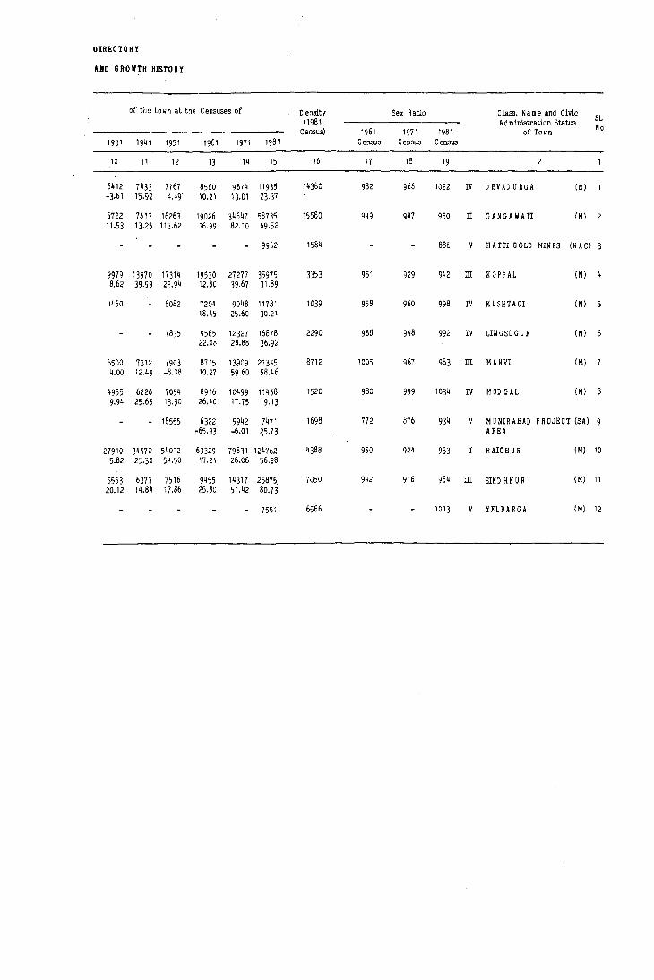
DIRECTORY
AND GROWTH HISTORY
of the to w n at the Censuses of o ensi.ty Sex Ratio Class, N a m e and Civic (1981 A d ministration Status
SL No Census) 1961 1971 1981 of TOlin
1931 1941 1951 1961 1971 1981 Census Census Census
10 11 12 13 14 15 16 11 18 19 2
6~12 7433 7167 8560 9674 11935 14380 982 966 1022 IV o EV AD U RG A (M)
-3·61 15.92 4.49 10.21 13.01 23.37
6722 7613 16263 19026 34647 58735 15580 949 947 950 IT GANGAWA'fl (M) 2 11.53 13.25 113.62 16.99 82.10 69.52
9962 1584 886 V HATTI GOLD HINES (N AC)
9979 13970 17314 19530 27277 35975 3353 951 929 942 m KOPPAL (H) 8.62 39.99 23.94 12.80 39.67 31.89
4460 6082 7204 9048 11781 1039 958 960 998 IV KUSHTAGI (M)
18.45 25.60 30,21
7835 9565 12327 16878 2290 968 998 992 IV LIN GSU G U R (M) 22.08 28.88 36,92
6500 7312 7903 8715 13909 21345 8712 1005 967 983 m MANVI (M) 7 4,00 12,49 -8,08 10,27 59.60 58,46
4955 6226 7054 8916 10499 11458 1520 980 999 1034 IV MUD GAL (M) 9.94 25,65 13,30 26,40 17.75 9,13
- 18555 6322 5942 7471 1698 772 876 934 V H U NIR ABAD PROJECT (SA) 9 -65,93 -6.01 ~5,73 AREA
27910 34972 54032 63329 79831 124'/62 4388 950 924 933 RAICHUR (M) 10 5.82 25·30 54,50 17 ,21 26.06 56,28
5553 6377 7516 9455 14317 25875 7050 942 916 964 m SIND HNUR (M) 11 20.12 14.84 17.86 25.80 51.42 80,73
7551 6566 1013 V YELBARGA (M) 12

220
STATEMERT - n PHYSICAL ASPECTS
Physical Aspects Name of Road and DlI3tance (in Kms) from
Temperature Sub-D ivlBionl Sl. (in D egree- State D istriot
No. ClaSs and Name of Town Rainfall
C entlgrade) Headquarters Headquarters Taluk/
(in m.m.) Headquarters Maximum Minimum
2
IV D EVAD URGA (M) 873.1 42.7N 13.8N Bangalore-458 Raichur-60 Raichur-60 D evadurga..Q
II GANGAIIATI (M) 607.9 41.1 N 14.0N Bangalore-370 Raiohur-128 Koppal-48 Gangawati-o
V H UTI GOLD MINES (N AC) 634.3 42· 12· Bangalore-4 47 Raiohur-80 Lingsugur-20 L1ngsugur-20
ill KOPPAL (1-1) 624.3 41.5N lO.3N Bangalore-372 Raiohur-175 Koppal..Q Koppal..Q
IV KVSHTAGI (M) 567.0 40.2N 13.0N Bangalore-398 Raichur-145 Lingsugur-69 Kushtagi-O
IV LINGSUGUR (M) 688.1 43·2N lO.ON Bangalore-427 Raichur-94 Lingsugur-O Lingsugur-O
ill MANVI (M) 648.9 42.7N 13.8N Bangalore-447 Raichur-48 Raichur-48 Manvi-O
IV MUll GAL (M) 688.1N 4l.SN lO·3N Bangalore-425 R aichur-114 Lingsugur-19 [;ingsugur-19
9 MUNIRABAD PROJECT 624.3N 43·2N 10.0N Bangalore-352 R aichur-190 Koppal-30
A REA (SA) Koppal-30
10 RAICHUR (M) 707.7 42.7" 13.81 Bangalore-40 1 Raichur-O Raichur-O Raiohur-O
11 ill SINll H N U R (M) 325.7 42.7N 13.BN Bangalore-390 Raichur-87 Lingsugur-48 Sindhnur-O
12 YELBARGA (M) 578.0 40.2N 13.0N Bangalore~400 Raichur-183 Koppal-40 Yelbarga-O
= Represents the data on rainfall and temperature of the nearest town situated approximately at the same altitude.
• = Indicates that the data has been furnished "by the Director General of ObservatorieS •
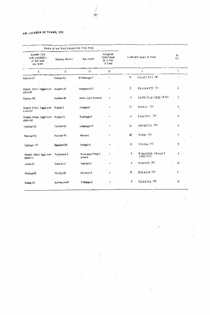
/ 221
AND LOCATION OF TOWNS; 1979
N a m e of and Road Distance (in K m s) frO m
Nearest City Navigable Sl. with population River/Canal Class and Name of TO\Jn
of .one lakh Railway Station Bus Route
(if within No.
and more 10 K ms)
10 11 12
R aichur-60 Raichur-60 D evadurga-O IV DEVADURGA (M)
Hospet Urban Agg1omer- Gingere-35 Ganga wati-O II GANGAWATI (M")
ation- 30
Raichur-80 Raichur-80 Hatti Gold Mines-O V HATTI GOLD MINES (N AC)
Hospet Urban Agglomer- Koppal-O Koppal-O ill KOPPAL (M)
ation-32
H ospet Urban A gglo m ar- K oppal-50 Kushtagi-O IV KUSHTAGI (M)
alian-58
Raichur-93 Raichur-93 Lingsugur-O IV LINGSUG U R (M)
Raichur-45 Raichur-45 Manvi-O ill MANVI (M)
R aichur-114 Bagalkat-80 Mudgal-O IV MUDGAL (M)
Hospet Urban Agglomer- Munirabad-5 M unirabad Project V MUNIRABAD PROJECT
alion-12 Area-O AREA (SA)
Adoni-72 Ralchur-O Raichur-O R AIC H U R (M) 10
Raichur-87 Bellary-87 Sindhnur-O ill SIND HNUR (M) 11
Gadag-65 Bhana pur-28 Yelbarga-O YELBARGA (M) 12

222
STATEMENT -m MUNICIPAL
Civic Receipt ( in Rs. 'DO )
Sl.. AdmirJ- Revenue der.ived- -
No. Class and Name of Town stration Receipt frO!if t-liiiiiCipal Govem- Other
status __ through Tin 1980) Taxes
Properties and ment Loan Advance Sources
etc. Power apart Grant (Specify)
from Taxation
5 6
IV DEVADURGA M 277 371 13~0 1031
IT GANGAWATI M 12379 4754 1001 2228
V HATTI GOLD I-HNES NAC NA NA NA NA NA NA
ill KOPPAL M 6863 1522 603 249
5 IV KUSHT_AGI M 786 171 100 935
IV LIN GSU G U R M 1831 377 1180 279
ill MANVI M 3119 286 305 2106
8 IV MUD GAL M 166 37 152 873
V MUNIRABAD PROJECT AREA SA 148
10 RAlC HU R M 34061 9017 8081 2~060
11 m SINDHNUR M 4356 336 373 20 2120
12 V YELBARGA M 489 642 1~
NA DATA NOT AVAILABLE

223
FINANCE, 1976-1979
Expenditure (in Rs. '00)
Public
Total General
Public Health
Public Public
Others Total
Class and Name of Town S1.
Receipt Ad mini-
Safety and
Works Instit-
(Specify) Expend- No.
stration Conveni- utions iture ences
10 11 12 13 14 15 16 17
3027 578 151 984 1400 3114 IV DEVAD URGA (M)
20362 8616 1423 3558 6668 20265 II GANGAWATI (M)
NA 21140 09051 5940 86':; 1 V HATTI GO'"D MINES (M)
9237 2514 1177 2492 2220 719 9122 m KOPPAL (M)
1992 1360 312 64 151 22 86 1995 IV KUSHTAGI (M)
3667 1533 365 784 438 158 3278 IV LINGSUGUR (M)
5816 1677 459 2750 1355 6241 m MANVI (M)
1228 585 46 632 21 232 1516 IV MUD GAL(M)
148 3250 5750 610 600 10210 V MUNIRABAD PROJECT AREA (SA) 9
75219 10164 6791 21605 6727 68 29788 75143 RAICHUR (M) 10
7205 1212 619 1465 2572 1035 6903 m SIND HNUR (M) 11
1145 396 72 120 88 29 443 1148 V YELBARGA (M) 12
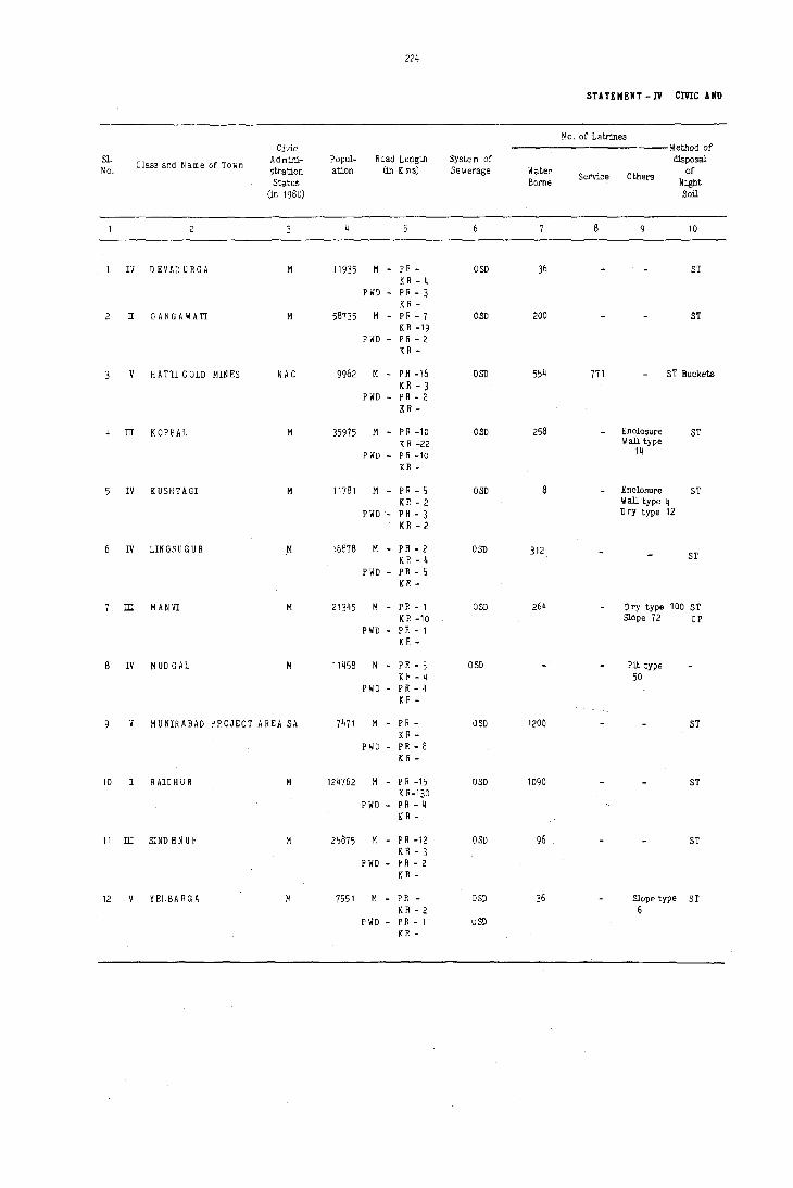
224
STATEMENT -IV eme ANO
~'o. of Latrines Civic <O'--i~ethod of
Sl. Class and Name of Town
Ad mini- Popul- Road Length System of disposal No. stration ation (in K ms) Sewerage Water
Service Others of
Status Borne Night (jn 1980) Soil
8 10
IV D EVAD URGA M 11935 M - PR- OSD 36 ST K R - 4
P WD - P R - 3 K R -
II GANGAWATI M 58735 M - P R - 7 OSD 200 ST K R -19
P WD - P R - 2 K R -
V HATTI GOLD MINES NAC 9962 M - P R -16 OSD 554 771 ST Buckets K R - 3
P WD - P R - 2 K R -
III K OPP AL M 35975 M - PR -10 OSD 258 Enclosure 5T K R -22 Wall type
PWD - P R -10 14
K R -
IV KUSHTAGI M 11781 M - PR - 5 OSD 8 Enclosure ST K R - 2 Wall type 4
P WD - P R - 3 Dry type 12
K R - 2
IV LINGSUGUR M 16878 M - P R - 2 OSD 312 K R - 4 ST
P WD - P R - 5 KR -
III MANVI M 21345 M - P R - 1 aSD 264 Dry type 100 ST K R -10 Slope 72 CP
P liD - P R - 1 K R -
8 IV MUD GAL M 11458 M - P R - 3 OSD Pit type K R - 4 50
P WD - P R - 4 K R -
V MUNIRABAD PROJECT AREA SA 7471 M - P R - OSD 1200 51 K R -
P WD - P R - 8 K R -
10 RAICHUR M 124762 M - PR -15 OSD 1090 ST K R-130
P WD - P R - 4 K R -
11 III SIND H N U R M 25875 M - P R -12 OSD 96 ST K R - 3
P \lD - P R - 2 K R -
12 YELBARGA M 7551 M - P R - OSD 36 Slope type ST K R - 2 6
PWD - P R - 1 usn K R -
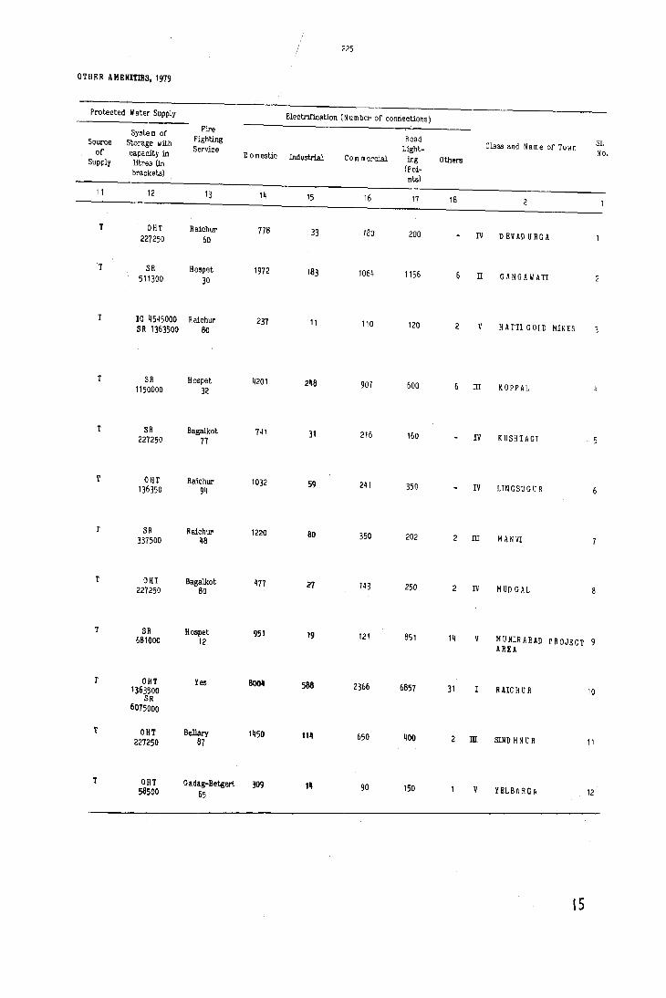
225
OTHER A HEHInES, 1979
Protected W ater S~pply Electrification (N umber of connections)
System of Fire Road 8l. F~hting
Class and Name of Town Source Storage with Service L~ht- No. of capacity in Domestic Industrial Com mercial ing Others Supply litres (in
(Poi-brackets) nts)
11 12 13 14 15 16 17 18
T OHT Raichur 778 33 180 200 IV D EVAD U R G A 227250 &0
T SR Hospet 1972 183 1064 1156 !I GANGAIIATI 2 511300, 30
T 10 4545000 Raichur 237 11 110 120 2 V HATTl GOLD MINES SR 1363500 80
T SR Hospet 4201 248 907 600 ill KOPPAL 1150000 32
T SR Bagalkot 741 31 216 160 IV KUSHTAGI 227250 17
T our Raichur 1032 59 241 350 IV LINGSUGUR 6 136350 94
T SR Raichur 1220 80 350 202 2 ill M ANVI 337500 48
T OHT Bagalkot 477 21 143 250 IV MUD GAL 227250 80
T SR Hospet 951 19 121 851 14 V H U NIH ABAD PROJECT 9 681000 12 AREA
T OIlT Yes 800_ 588 2366 6857 31 I RAre H U R 10 1363500 SR
6075000
T OUT Bellary '_50 11_
650 400 ill SIND H N U R 11 227250 87
or OHT Gadag-Be1:geri 309 111 90 150 V YELBAROA 12 58500 65
15

Sl. No.
2 II
Class and Name of Town
R AlC H U R
GANGAWATl
IS'
Name of Slum
Around Gal Market
Near Ramalingeshwara Temple
Around Panoh bibi Pahad
Fortwall (Near Kotalab)
Navrang D arwaza
Shala msabdoddi
Behind New Mutton Market
Thim m apurpet
Zahirabad
Around BRB College
Near Grain Market
&a Talab Area
Gunj Area (Near Neer bban kunta)
Near Veerbhadreshwar temple Qilla
Iqbal Nagar
H arijan w ada
Behind Bhartihalli
Gundam rna Camp
Ram purpeth
Old Trenching Yard
Basaveshwara Cam p
N e e]akan tesh w ar te m ple
Virpapur Wadder Camp
Near H Dusing Board Colony, 3y. N 0.195/1
• For Class I and IT To wns onlY·
226
A~ea of Slum
(in Sq. K ms)
0.004
0.004
0.008
0.004
0.004
0.004
0.012
0.162
0.121
0.012
0.020
0.182
0.040
0.012
0.048
0.040
0.004
0.089
0.001
0.033
0.008
0.009
0.005
0.012
STATEMENT -IV A erne AND OTHER
Population
(in Sq. K ms.)
220
320
1000
400
160
240
480
2800
5800
360
1400
3600
1600
1200
2400
2400
200
5000
800
5000
2000
3000
400
2000
Paved Roads
(in Kms)
System of
storage
OSD
OSD
OSD
OSD
OSD
OSD
OSD
OSD
OSD
OSD
OSD
OSD
OSD
OSD
OSD
OSD
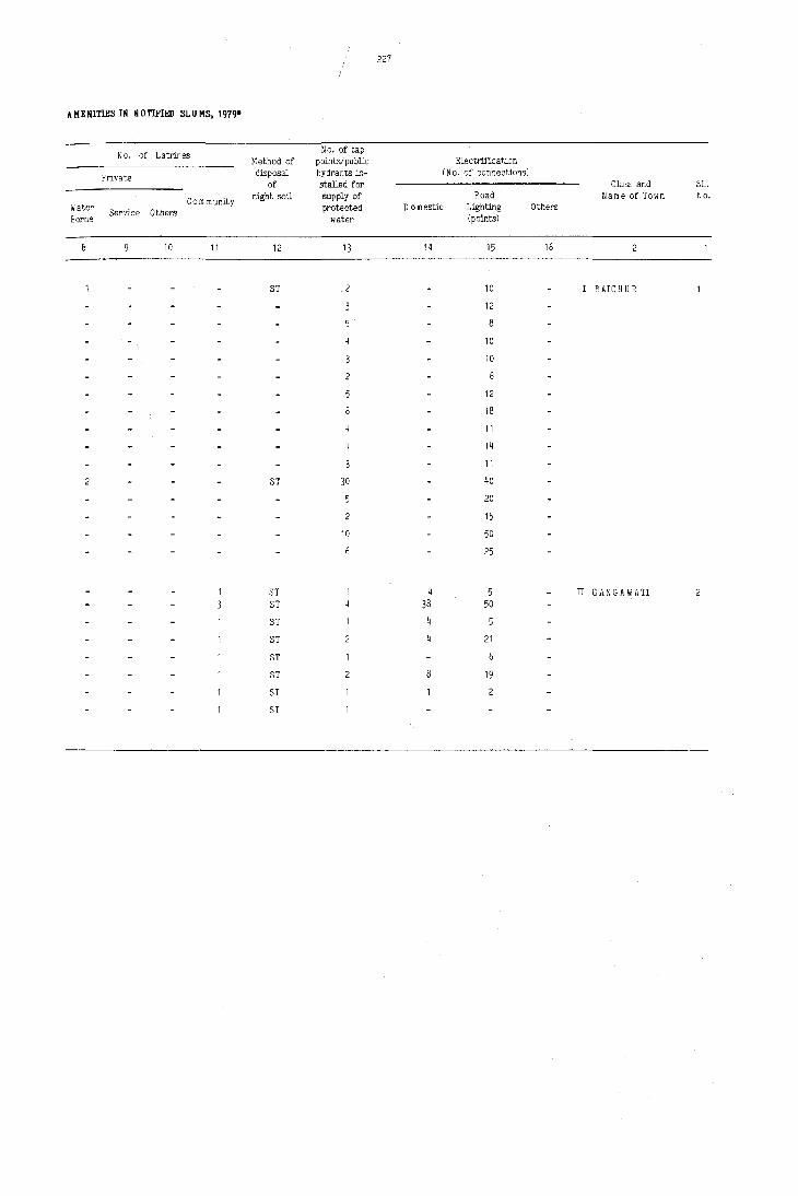
ZZ7
AMENITIES IN NOTIFIED SLUMS, 1979.
No. of Latrines No. of tap
Method of points/public Electrification
Private disposal hydrants in- (N o. of connections)
of stalled for Class and SL.
Com munity night soil supply of Road Name of Town No.
Water Service Others protected Domestic Lighting Others
Borne water (points)
10 11 12 13 14 15 16
3T 10 I RAICHUR
12
8
10
10
12
18
11
14
11
3T 30 40
5 20
15
10 50
25
3T 4 5 II GANGAWATI ST 38 50
3T
3T 21
3T
ST 19
3T
ST

81. No.
10
II
12
SL. NO.
6
7
8
9
10
11
12
Class and Name of Town Population
IV DEVADURGA (M) 11935
II GANGAWATI (M) 58735
V HATTI GOLD MIN ES (N A C) 9962
ill KOPPAL (M) 35975
IV KUSHTAGI (M) 11781
IV LIN GSU G U R (M) 16878
ill MANVI (M) 21345
IV MUD GAL (M) 11458
V MUNIRABAD PROJECT AREA (SA) 7471
R AIC H U R (M) 124762
ill SIND HNUR (M) 25875
V YELBARGA (M) 7551
f : Includes T.B. Sanitoriuln with 50 beds.
+ : Leprosy Centre
Class and Name of Town Population
IV D EVAO URGA 11935
II GANGAWATI 58735
V HATTI GOLD MINES 9962
ill KOPPAL 35975
IV KUSHTAGI 11781
IV LlNGSUGUR 16878
ill M ANVI 21345
IV MUD GAL 11458
V MUNIRABAD PROJECT AREA 7471
RAle H U R 124762
m SIND H N U R 25875
YELBARGA 7551
228
M eaical Facilities
Hospital! o ispensaries/ T .B. Clinics
etc
PHU FC
PHU FC
PHD
PHU
H
PHU
PHC FC
H 0(2)
H (2)f 0(3) FC(I)
PHU
PHU FC 0;. (1)
Beds in Medical Institutions noted
in Col.4
24
22
50
30
18
30
12
6
25
186
STATEMENT - V MEDICAL, El>UCATIOliAL
Educational Facilities
Arts/Science Com merce
Colleges (of degree level and above)
Raichur-60
C,AS, ASC
Raichur-80
ASC
IikaJ -24
Sindhnur-48
Ralchur-48
Iikal-28
Hospet-12
AS, C, AC
AC
Koppal-4C
Medical Colleges
G ulbarga-l1 0
Beilary-65
Beilary-156
Beilary-93
Beilary-Il0
Bellary-138
Beilary-IIS
Beilary-130
Bellary-80
Gulbarga-150
Beilary-87
Hubli-O harwad-130
STATEMENT - V MEDICAL, ED UCATIOIUL
Educational Facilities (Concld.)
Junior Secondaryl Secondary Matriculation and Middle
Schools
12
12
13
2
23
7
Primary Schools
14
19
4
15
6
6
30
10
Adult Literacy Classes! Centres Others (Specify)
15

I ! 229
RECREATIONAL AND CULTURAL FACILITIES 1979
Educational Facilities
HiBher
R ecognised Short~ Secondary!
Interm ediatel Engineering
hand, Typewriting PU C (Pre-
Colleges Polytechnics and Vocational
University) Training
Institutions Colleges Junior Colleges
10 11
Raichue-60 Raichur-60 R aichur-50 PUC
R aichue- 128 Beilary-65 Type (2) PUC Sh. Type
R aicbue-SO Raichur-80 Sh. Type Lingsugur-20
Bagalkot-122 Befury-93 Sh, Type (2) PUC
Bagalkot-77 Bagalkot-77 Type PUC
Bagalkot-92 Bagalkot-92 Sh. Type PUC
Raichur-48 Raichur-48 Typ8 (2) PUC
Bagalkot-72 BagaIkot-72 Lingsugur- 19 Lingsugur- 19
H ubli-D harwad-123 Beilary-80 Sh. Type Hospet-12
Sh. Type (3) PUC (6) Type (2) o (4)
Raichur-90 Raichur-90 Type PUC
H ubli-D harwad-130 Hubli-D harwad-13D Type (2) PUC
RECREATIONAL AND CULTURAL FACILITIES 1979
N o,of Recreational and Cultural Facilities
Working Women's Hostels with A uditoriu m I
N umber of Seats Stadium Cine rna
Dramal Com munity
Halls
Public Libraries including Reading Rooms
16 17 18 19 20
PL
PL, P R
PL (2)
2 PL, PR
R R (2)
PL
RR
PL
PL(2) R R (3)
PL, R R
IV
II
V
ill
IV
IV
ill
IV
ill
V
IV
II
V
ill
IV
IV
ill
IV
V
ill
V
Class and Name of Town
DEVADURGA
GANGAW ATI
HATTI GOL) MIN ES
KOPPAL
KUSHTAGI
LINGSUGUR
MAN VI
MUD GAL
MUNIRABAD PROJECT AREA
RAICHUR
SIND H N U R
YELBARGA
Class and Na!lle of Town
DEVADURGA
GANGAWATI
HATTI GOLD MINES
K OPP AL
KUSHTAGI
LINGSUGUR
M A NVI
MUD GAL
MUNIRABAD PROJECT AREA
R AIC H U R
SIND H N U R
YELBARGA
Sl. No
10
11
12
Sl. No,
10
11
12

~~'. Class and Name of Tuwn
1st
1 IV o EVAD URGA Rice
2 IT GANG.~WATI Paddy
HATTI GOLD Foodgrains MIN ES
4 lIT K0PPAL Groundnut
5 IV KUSHTAGI Edible Oils
6 IV LIN GSU G U R Rice
7 ill M A NVI Cloth
8 IV M UO GAL Cloth
MUNIRABAD Cement PROJECT AREA
10 R AIC H U R Groundnut
11 ill SIND HNUR Wheat
12 V YELBARGA Rice
, 230
N a m e of three most 1m portant Corn modities Imported
2nd
Cloth WoOd
3rd
Groundnut Sugarcane
Building C he micals including Material Explosives
Jowar Cotton
Cloth C em ent
Cloth Sugar
Jaggery Tobacco leaf and Products
Foodgrains
Steel Sugar
Cotton Paddy
Cotton Paddy
Sugar Cloth
STATEMENT - VI THAD E, COMMERCE
Name of three most important Com m odities Exported
1st 2nd 3rd
Cotton (Lint) Groundnut OJ] Pottery
Rice Groundnut Oil Sugar
Gold
Rice Cotton (Lint) Groundnut Oil
Safety Matches Cut sizes of tim bel"
Cut sizes of Cotton Lint Groundnut Oil tim ber
Rice Groundnut Oil Cotton Lint
CottDn (Lint) Jowar
Cotton bales Groundnut Oil Rice (Lint)
Edible Oil Cotton (Li~t) Cotton Yarn
Khadi Cloth Cotton (Lint) Cotton Yarn

/ 231
lID IJSTRY AND BANKING, 1979
N a m e of three most im portant Number of Number of Com modities Manufactured Nu m ber Agricul- N on-Agei-
S1. of tural cultural Class and Name of Town
No. 1st 2nd 3rd
Banks Credit Credit Societies Societies
10 11 12 13 14
Cotton Lint Groundnut Oil Pottery IV D EV AD U R G A (M)
Sugar Groundnut Oi!. Jaggery 12 II GANGAWATI (M)
Gold V H A TTl GOLD MIN ES (N A C)
Groundnut O:il Beaten Rice Cotton (Lint) ill KOPPAL (M)
Safety Matches Cut sizes of IV KUSHTAGI (M)
Tim bel'
Cotton (Lint) Groundnut Oil Cut sizes of tim ber IV LlNGSUGUR (M)
Groundnut Oil Cotton (Lint) ill MANVI (M)
Cotton (Lint) 2 IV MUDGAL (M)
V MUNIRABAD PROJECT AR8A(SA) 9
Groundnut Oil Washing Soap 22 25 RAICHUR (M) 10
Cotton (Lint) Enible Oil Bricks ill SIND H N U R (M) 11
Cotton Khadir Spinning of Yam C ut si~es of Tim ber 2 V YELBARGA (M) 12 Cloth

PART B - PRIMARY CENSUS ABSTRACT
(I) DISTRICT PRIMARY CENSUS ABSTRACT (II) TALUKWISE PRIMARY CENSUS ABSTRACT

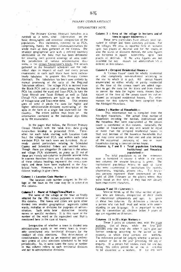
PRIN,ARY CE.NSUS ABSTRACT
EXPLANATORY NOTE
The Primary Census Abstract (urnishes HI a nutshell as it were, vital information on the basic demot;raphic and E'conomic composition of the population. This statement, referred to as PCA, comprising hardly 16 main columns,summarises the whole mass of data gathered at the Census. The smallest geographical unit with a defined boundary identifiable on the field that has been delineated for ensuring cert percent coverage of area under the jUrlsdiction of various administrative divlsions, is the census Enumerator's block. The details gathered in the household schedules and the individual slips in respect of each and E'vcty person enumerated in each such block have been meticulously tabulat€c to prepare this Pr imary Census Abstract. The tabulation has been done entirely by manual processing of the data at the Regional Tabulation offices. The village PCA is derived from the Block PCA and in case of urban areas, the Block PCA has yielded the ward and Town PCA. [n turn the Taluk (Rural) and Taluk (Urban) as well as Taluk (Total) PCA statements are built up on the basis of Village-wise and Town-wise data. This process goes on until it yields the data for higher and higher administrative divisions culminating at the apex in the form of a single line statement for the country. The entire edifice thus rests on the information contained in the individual slips filled up by the enumerator.
[n the pages that follow, the District Primary Census Abstract with the taluk level data giving rural-urban breakup is presented first. Thereafter for each taluk starting with Location Code No.1 the village level PCA and within each taluk wardwise PCA for each town are furnished. As already stated particulars relating to Scheduled Castes and Scheduled Tribes are omitted here. Though there are altogether 24 columns in the urban and village PCA statement, as many as 12 out of these are merely sub-columns to provide sex wIse data. [n essence therefore there are 12 columns only. Most of these column headings represent the !;ensus concepts and these have been explained in the· Analytical Note. However, a brief description of the column headings is given here.
Column I : Location Code Number :-The location code number assigned to the vil
lage or the town as the case may be is enterl'd in this .:oJumn.
Column 2: Name of ViIlage/TowrJWard :-The name of the village or the town as finally
adopted for the 1981 census purposes IS entered in this column. The towns and cities are quite often divided into smaller geographical segments called wards, rnohalias or divisions for purposes of administration. Such units bear distinctive locality names or specific numbers. It is this name or the rumber of the ward or its equivalent unit that is mentioned here in the case of towns.
Irrespective of whether a town is divided into administrative wards or not every town is invariably constituted into territorial divisions for the conduct of civic elections. This delimitation of constituencies is done as an essential and preliminary proess of civic elections scheduled to be held periodically. So, in some cases the name or number in this column refers to such territorial divisions and not to administrative divisions.
Column 3 Area of the village in hectares and of town in square kilometres :-
These araa particulars have already been turnished in village and town directory portions. For the vilJages the area is reported here 111 hectares upto two places of decimal and for the towns, as also the wards or diVISIOns thereof, the area figures are furnished in square kilometres up to two places of decimal. If the area figure, are not available for any reason the abbreviation I"A i'> entered In this column.
Column If : OcC\4)ied Residential Houses :-A 'Census House' could be wholly residential
or else completely non-residential accordmg to the u,e to which it is put. All census houses enumerated as either wholly or partly residential at the time of the census count are added together to get the data for the block and from thence to deflve the data for higher units. Houses found vacant at the time of the census count are not reckoned as occupied residential houses. The information for this column has been compiled from the Abridged Houselists.
Column 5 : Number of Households :-This information too is comp iled from the
Abridged Houselists. The actual total number of households including the normal, institutional and the houseless that were enumerated at the census count is mentioned in this column. Generally, the number of households in any unit would be equal or more than the occupied residential houses ill that unit because of the houseless households that one may corne across in that unit and also because of the occasional instances, of two or more householos sharing a common census house. Columns 6, 7 and 8 : Total pq>ulation (includi~
Institutional and Houseless pq>ulation) :-
The total population as on the reference cate is furnished in column 6 while in the flext two columns the sexwise break-up is given. The institutional population teters to such of tlio~e
who were enumerated in institutions like host<;>]s. churlHTleries, hospitals, prisons etc., Tile' houseless persons represent those enumerated on the night of 28th February at the fJlaces where they were found at that time. if they had not already been enumerated chewhcre.
Columns 9 and 10 : Literates :-Sexwise break up of the total number of per
sons who are literate, irrespective of their levels of educational attainments and age, IS given in these two columns. Cy definition a Ilterate is a ptrson who can both read and write with unoerstanding in any language. [t is important to note that by convention all children below 5 years of age are regarded as illiterate.
Columns II to 20 : N:ain Workers :-These 5 pairs of columns deal wi th the main
workers. Out of these, whde the firs! pair provides only the total the other 4 pairs give out further break-up according to the sector of the economy in which these persons arf' workIng. The reference period for jUdging whether a person is a worker or not is the year preceding the oay of enquiry. If a person had workeo even for one day during this entlre period he or ,he is entitled to be classified as a worker. If lor any Sllcn
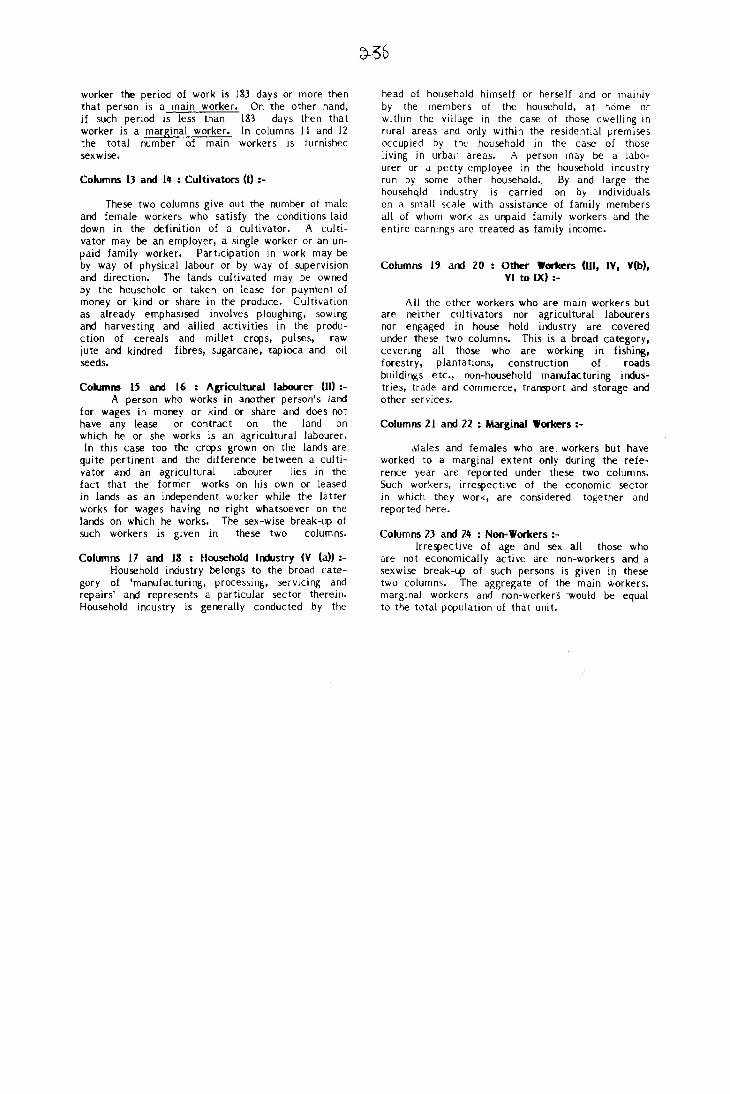
worker the period of work is 1&3 days or more then that person is a main worker. On the other hand, if such period is less than 183 days then that worker is a marginal worker. In columns I I and 12 the total number of main workers is furnished sexwise.
Columns 13 and 14 : Cultivators (I) :-
These two columns give out the number of male and female workers who satisfy the conditions laid down in the definition of a cultivator. A cultivator may be an employer, a single worker or an unpaid family worker. Participation in work may be by way of physical labour or by way of supervision and direction. The lands cultivated may be owned by the household or taken on lease for payment of money or kind or share in the produce. Cultivation as already emphasised involves ploughing. sowing and harvesting and allied activities in the production of cereals and millet crops, pulses, raw jute and kindred fibres, sugarcane, tapioca and oil seeds.
Columns 15 and 16 : Agricultural labourer (11):-A person who works in another person's land
for wages in money or kind or share and does not have any lease or contract on the land on which he or she works is an agricultural labourer. In this case too the crops grown on the lands are
quite pertinent and the difference between a cultivator and an agricultural labourer lies in the fact that the former works on his own or leased in lands as an independent worker while the latter works for wages having no right whatsoever on the lands on which he works. The sex-wise break-up of such workers is given in these two columns.
ColU1Tlns 17 and III : Household Industry (V (a»:-Household industry belongs to the broad cate
gory of 'manufacturing, processing, servicing and repairs' and represents a particular sector therein. Household industry is generally conducted by the
head of household himself or herself and or mainly by the members of the household. at heime or within the village in the case of those dwelling in rural areas and only within the residential premises occupied by the household in the case of those living in urban areas. A person may be a labourer or a petty employee in the household industry run by some other household. By and large the househQld industry is carried on by individuals on a small scale with assistance of family members all of whom work as unpaid family workers and the entire earnings are treated as family income.
Columns 19 and 20 Other Workers (Ill, IV, V(b), VI to IX) :-
All the other workers who are main workers but are neither cultivators nor agricultural labourers nor engaged in house hold industry are covered under these two columns. This is a broad category, covering all those who are working in fishing, forestry, plantations, construction of roads buildings etc., non-household manufacturing industries, trade and commerce, transport and storage and other services.
Columns 21 and 22 : Marginal Workers :-
Males and females who are, workers but have worked to a marginal extent only during the reference year are reported under these two columns. Such workers, irrespective of the economic sector in which they work, are considered together and reported here.
Columns 23 and 24 : Non-Workers :-Irrespecti ve of age and sex all those who
are not economically acti ve are non-workers and a sex wise break-up of such persons is given if) these two columns. The aggregate of the main workers, marginal workers and non-workers -would be equal to the total population of that unit.

DISTRICT PRIMARY CENSUS ABSTRACT
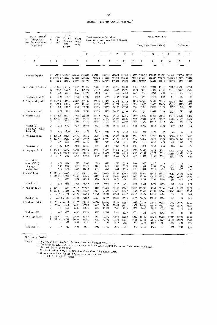
State/l)istr ict/ SI. Taluk/Urban/ No. Agglofllera!JDn
City/Town
T R 1
Area
~~l
No. of Occupied No.af Reslden- House-tial holds
houses
2)8
DISTRICT PRIMARY CENSUS ABSTRACT
Total Population (inciudmg InstitutIonal and Houseless Literates
PopulatJOn)
P F P
10 II
F
12
MAIN WORKERS
Total Main Workers (1-1\) Cultivators
M F P F
13 14 15 16 17 18
Raichur District T 14017.0317987 324455 1783822 897241 886581 441021 322231 118790 732692 507407 225285 261788 224396 37392 R 13929.0 258164 263822 1440094 721166 718928 302017 231402 70615 623363 420893 202470 249109 213535 35574 U 88.0 59823 60633 343728 176075 167653 139004 90829 48175 109329 86514 22815 12679 10861 1818
1. Devadurga Taluk «l T 1508.1 24396 R 1507.3 22289 U 0.8 2107
Devadurga (M) «l
Gangawati Taluk
Gangawati (M)
Koppal T aluk
Koppal (M) Munirabad Project Area (SA)
Kushtagi Taluk
Kushtagi (M)
Lingsugur Taluk
Halti Gold Mi"es (NAC) Lingsugur (M) Mudgal (/vi)
Manvi Taluk
Manvi (M)
Raichur Taluk
Raichur (M)
Sindhnur Taluk
Sindhnur (M)
Y cJbarga T aluk
Yelbarga (M)
«l Formerly Deodurg
Note:
U 0.83 2107
T 1327.6 R 1323.8 U 3.8
U 3.77
46293 35849 10449
10449
T 1375.2 33924 R 1360.1 26872 U 15.1 7052
U 10.73 5702
U 4.40 1350
T 1366.0 25326 R 1354.7 23267 U 11.3 2059
U 11.34 2059
T 1948.1 35956 R 1926.9 29250 U 21.2 b706
U 6.29 1766 U 7.37 3060 U 7.54 1880
T 1791.4 36447 R 1788.9 32568 U 2.5 3879
U 2.45 3879
T 1541.1 48045 R 1512.7 26496 U 28.4 21549
U 28."3 21549
T 1598.3 40124 R 1594.6 35524 U 3.7 4600
U 3.67 4600
T 1490.1 27471 R 1488.9 26049 U 1.2 1422
U 1.15 1422
25245 141214 23123 129279 2122 11935
2122 11935
46943 257194 36319 198459 10624 58735
10624 58735
34495 199821 27277 156375
7218 43446
5864 35975
1354 7m
25';85 136864 23406 125083
2079 11781
2079 11781
36271 200128 29503 161830 6768 38298
1773 3105 1890
mOl 33197 3904
9962 16878 11458
201311 179966 21345
3904 21345
49668 273989 27873 149227 21795 124762
21795 124762
41170 218958 36,sn 193G83 4690 25875
4690 25875
28077 154343 26644 146792
1433 7551
1433 7551
70061 64159 5902
71 153 65120 6033
5902 6033
130256 126938 100 I 30 98329 30126 28609
30126 28609
101110 98711 78703 77672 22407 21039
18524 17451
3883 3588
68097 68767 62200 62883
5897 5884
5897
100319 80930 19389
588"
99809 80900 18909
5283 4679 8474 8404 5632 5826
100957 100354 90191 89775 10766 10579
10766 10579
140102 133887 75573 73654 64529 60233
64529
109566 96259 13307
13307
76773 73021
3752
3752
60233
109392 96824 12568
12568
77570 73771 3799
3799
22969 17683 18814 14882 4155 2801
4155 2801
63918 45723 43758 31924 20160 m99
20160 [3799
59109 42214 39237 29621 19872 12593
15716 10010
4156 2583
34259 26735 29196 23519
5063 3216
5063 3216
45548 34520 30891 24822 14657 9698
5253 3389 5953 3973 3451 2336
41136 30407 34659 26166 6477 4241
6477 4241
81356 56066 24872 19747 56484 36319
56484 36319
49123 35663 39862 29404 9261 6259
9261 6259
43603 33220 40728 31317
2875 1903
2875 1903
5286 54572 3932 50841 1354 3731
1354 37JI
18195 107848 11834 86607 6361 21241
6361 21241
16895 82953 9616 70288 7279 12665
5706 10787
1573 1878
7524 52039 5677 48422 1847 J617
1847 3617
11028 744)3 6069 62861 4959 11572
1864 2332 1980 5648 1115 3592
10729 89377 8493 80696 2236 8681
2236 8681
25290 100893 5125 64469
20165 36424
20165 3642"
13460 105277 10458 96634 3002 8(;43
300< 8643
103&3 65300 9411 62545
972 2755
972 2755
40011 14561 37083 13758 2928 803
2928 803
74971 32877 59003 27604 D%& 5273
15968 5273
56047 26906 45431 24857 10616 2049
8867 1920
1749 12~
37764 14275 34897 135:?;0 2867 nO 2867 750
5lI<J66 19467 45775 17086
9191 2381
2217 115 4256 1392 2718 874
59461 29916 53670 27026
579 I 2890
5791 2&90
74043 26850 43905 20564 30138 6286
30138 6286
66064 39213 59013 37621 7051 1592
7051 1592
44080 21220 42116 20429
1964 791
1964 791
1. IP\ 'M', a~d 'F', sta~d5. for Persons, Males and Females respectively. 2. The follOWing abbrevJatJoos have been used within brackets against the names of the towns to indicat
the CJVJc Status of the town. e, M : Municipality NAC: Notified Area Committee SA: Special Area.
3. Under column No.3, the followJng abbreviations are used: T : Total R: Rural U: Urban.
23482 20781 22771 20134
7J I 647
711 647
32452 28661 30375 26873 2077 1788
2077 1783
27915 23051 26388 21694
1527 1357
1499 1335
28 22
25026 21943 24106 21099
920 844
920 844
31568 26768 28896 24532
2672 2236
4 4 1528 1229 1140 1003
30615 26895 29325 25884
1290 lOll
1290 1011
24415 21507 23143 20383
1272 1124
1272 1124
36762 29996 35429 28845
1333 1151
1333 1151
29553 28676
877
877
24794 24091
703
703
2701 2637
64
64
3791 3502
289
289
4864 4694
170
164
3083 3007
76
7f
4800 4364 436
299 137 '
3720 3441
279
279
2908 2760 148
148
6766 6584
182
182
4759 4585
174
174
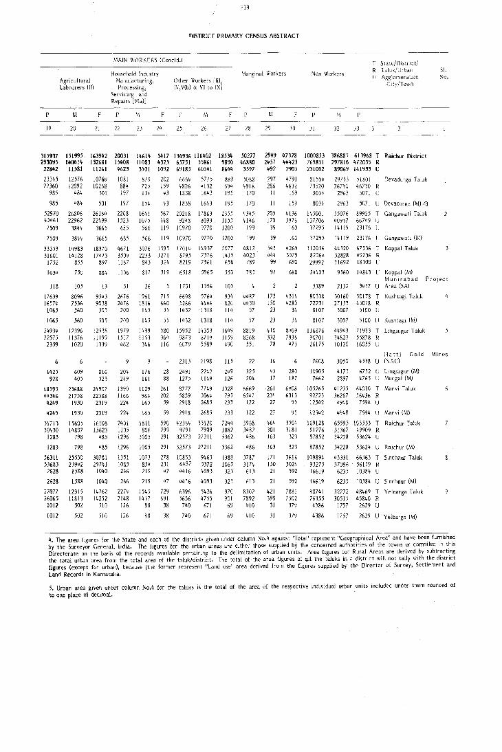
p
19
315917 29JO')} 22842
23345 22360
985
985
52970 45461 7509
7509
33353 31601 1752
1634
liS
17639 16574
1065
1065
24934 22575 2359
6
1425 928
48595 44346 4249
4249
31713 30430 1283
1283
56311 53683 2628
2628
27G77 26065
1012
1012
Agricultural Labourers (II)
M.
20
151995 1401!14 11581
12576 12092
484
484
26806 22962
3S44
3844
14983 14128
855
F
21
163942 (j2681 11261
10769 10268
501
501
26164 22499
3665
3665
18370 17473
897
239
DL~TRICT PRIMARY CENSUS ABSTRACT
MAIN WORKERS (Concld.)
Household Industry Manufacturing. Processing,
Servicing and Repairs [V(a)]
Marginal Workers
p
22
20031 15408 4623
1081 884 197
197
2208 1523 685
685
4671 3504 1167
Other Workers [III, IV,V(b) & VI to IX]
~I F p M
23 24 25 26
14614 5417 134936 116402 11083 4325 65751 55861 3531 1092 69185 60541
879 202 6664 5775 725 159 4826 4132 154 43 1838 1643
154 43 1838 1643
1641 1075
566
566
3076 2233 843
567 20218 448 9248 119 10970
119 10970
1595 17014 1271 8795 324 8219
17863 8093 9770
9770
14937 7376 7561
F
27 28
18534 50277 9890 46880 ~644 3397
889 5088 694 4918 195 170
195 170
2355 1155 1200
1200
2077 1419 658
4345 4146
199
199
4812 4023 789
M F
29 30
2949 47328 2457 44423 492 2905
297 4791 286 4632
11 159
11 159
209 170
39
39
543 444
99
4136 3976
160
160
4269 3579 690
750 884 1136 817 319 6518 5965 553 785 97 688
105
8096 7536 560
560
12396 11376 1020
609 405
23688 21758
1930
1930
15605 14807
798
798
25530 239'12
1588
1588
12315 11813
502
502
13 31
9543 9038
505
505
12538 11199 1339
816 523
24907 22588 2319
2319
16108 15623
485
485
307&1 29741
1040
1040
14762 14252
510
510
2676 2476
200
200
1979 1517 462
204 249
i390 1166
224
224
2401 1105 1296
1296
1351 1085 266
266
2274 2148
126
126
26 1701 1596 105
934 820 114
1961 1816 145
145
1499 1153 346
176 161
1129 964 165
165
1811 806
1005
1005
1073 854 219
219
1545 1457
88
88
715 660
.55
55
480 364 116
28 88
261 202
59
6698 5266 1432
1432
15952 9873 6079
5764 4446 1318
1318
14303 8714 5589
2313 2198
2491 1275
8777 5859 2918
2242 1149
7749 5064 2685
114
1649 1159 490
lIS
249 126
1028 795 233
59 2918 2685 233
590 42364 35120 7244 299 9791 7909 1882 291 32573 27211 5362
291 32573 27211 5362
278 10853 9465 ngg 231 6437 5372 1065
47 4416 4093 323
47 4416 4093 323
729 6396 5426 970 691 5656 4755 901
38 740 671 69
38 740 671 69
4487 4430
57
57
8819 8268
551
22
325 204
6669 6547
122
122
3968 3482
486
486
3787 3174 613
613
8302 7892
410
410
173 150 23
23
410 332
78
16
45 17
261 234
27
27
464 301 163
163
171 150
21
21
421 390
31
31
4314 4280
34
34
8,,09 7936 473
280 187
6408 6313
95
95
3504 3181 323
323
3616 3024 592
592
7881 7502
379
379
Non-Workers
p
31 32
F
33
T State/[)i.strlct/ R Taluk/Urban U .Agglomeration
City/Town
1000853 386885 613968 T Raichur District 769851 297816 472035 R 231002 89069 141933 U
81554 73520
8034
8034
145001 107706
37295
37295
112056 82064 29992
24403
29753 26790
2963
2963
55076 40957 14119
14119
44520 32828 11692
51801 T Devadurga Taluk 46730 R
5071 U
5071 U Devadurga (M) ra 89925 T Gangawati Taluk 66749 IJ 23176 U
23176 U Gangawati (M)
67536 T Koppal Talui< 49236 R 18300 U
9560 14843 U Koppal (M)
51. No.
Munirabad Project 5589
80338 72231 8107
8107
116876 90701 26175
7608
10905 7662
105265 92723 12542
l2542
169m 51276 87852
87852
109894 93275 16619
16619
80741 76355 4386
4386
2132 3457 U Area (SA)
30160 27153 3007
3007
44943 34823 10120
50178 T Kushtagi Taluk 45078 R
5100 U
5100 U Kushtagi (M)
71933 T Lingsugur Taluk 55878 !< 16055 U
Hatti Ge>ld Mines 3050 4558 U (NAC)
4173 2897
41235 36287 4948
6732 U Lingsugur (M) 4765 U Mudgal (M)
64030 T Manvi Taluk 56436 R
7594 U
4948 7594 U Manvi (M)
65595 103533 T Raichur Taluk 31367 49909 R 34228 53624 U
34228 53624 U Raichur (M)
43331 66563 T Sindhnur Taluk 37096 56179 R 6235 10384 U
6235 10384 U 5indhnur (M)
32272 48469 T Yelbarga Taluk 30515 45840 R
1757 2629 U
1757 2629 U Yelbarga (M)
4. The area figures for the State and each of the districts given under column No.4 against 'Total' represent "Geographical Area" and have been furnished by the Surveyor General, India. The figures for the urban areas are either those supplied by the concerned authodties of the towns or complIed In thiS Directorate on the basis of the records available pertaining to the delimitation of urban Untts. Area figures for Rural Areas are derived by subtr~ct~ng the total urban area from the total area of the taluk/district. The total of· the area figures of all the taluks in a district will not ta!ly With the district figures (except for urban), because jthe former represent "Land use" area derived from the figures supplied by the Director of Survey, Settlement and Lann Records in Karnataka.
5. Urban area given under column No.4 for the taluks is the total of the area of the respective individual urban units included under them rounded of to one place oj dedma\.


DEVAOORGA TALUK

:t m. ~ I
».
" j r' -I
0 :r o· c "
( .... ( z ~ :}
0 '. \ I ',,-iii
~'"Z ~: i N! I
z '" . ~
\
».
r ... ··\ " . • < .
" ~ ! ~+ I ~
-4 C
I'{ ~
U R
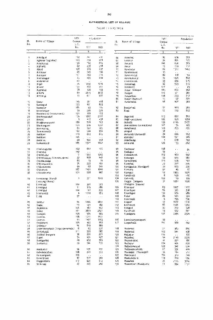
243
AtPHABETlCAL LIST OF VILLAGE:
TALUK : D EVAD URGA
1981 Population 1981 Population 31. N a m e of Village Census Sl. N am e of Village Census No. L.C. No. L.C.
No. 1971 1981 No. 1971 1981
4
Adkalgud 132 241 401 66 Hemnhal 80 906 790 Agrahar (Agrahal) 123 294 288 67 He mnup 94 804 729 Akalkum pi 130 766 845 68 Herundi 146 656 706 Aldharti 62 238 218 69 Herur 15 739 712
5 Alkod 128 678 831 70 Hirebudur 69 1377 1462 6 A mrapur 65 565 466 71 Hirehonkuni 33 7 A mr~pur 151 ?60 276 72 Hll'e kudalgi 84 178 155 8 Anchesugur 45 655 684 73 H ireralku m pi 76 1024 842 9 Andankhed 61 74 Honkatmalli 93 656 615
10 Anjal 44 1030 1016 75 Honnatagi 82 529 518 11 Anwar 131 447 441 76 H orahatti 177 23 12 Apprahal 78 120 133 77 H osur Siddapur 183 857 992 13 Arkera 89 2819 3612 78 H u!lgud 170 321 364 14 Arshangi 11 611 687 19 H ungunbad 106 203 212
80 Hunur (Hamnur) 10 132 224 15 Bagur 145 361 418 81 H uvinhadgi 48 407 360 16 Bandegud 125 401 893 17 Bassapur 184 82 115 82 Ingaladhal 61 443 360 18 Baswantpur 79 295 226 83 Itagi 72 712 672 19 Bekalm ardi (R ekalm ardi) 121 165 172 20 Benderganekal 136 1857 2117 84 Jagatkal 113 867 851 21 Benkal 5 417 438 85 Jagir-jadaldinni 120 995 1058 22 Bhogira m angund 180 514 762 86 Jalhalli 139 6166 7477 23 Bhurnangund 133 .916 1312 87 Jarnbaldinni (Jamaldinni) 147 176 165 24 Born manhal 81 797 705 88 Jaradbandi 109 255 255 25 Bo m m anhalli 182 594 954 89 J.vgud 58 26 Buddinni 110 653 645 90 Jerbandi (Jarbandi) 24 666 652 27 Buddinni 144 91 Jinnapur 104 591 545 2B Budinhal 68 597 558 92 Joladhadgi 3 638 702 29 Bunkaldoddi 185 1327 1602 93 Jutmardi 126 133 262
30 Chadkalgudda 162 642 775 94 Kachapur 138 84 31 C hapalki 142 95 Kadligud 59 32 C hickbudur 11 1397 1296 96 K akkaldoddi 172 479 592 33 C hickhonkum (Chlckhunkom) 22 458 447 97 Kakargal 63 646 687 34 C hickkudalgi 85 19 15 98 Kamaldinhi 173 506 701 35 C hickralku m pi 75 222 194 99 Kamdhal 29 217 245 36 Chikkaldoddi 99 158 244 100 Kardigudda (Kardlgud) 30 676 200 37 Chinchodi 187 1421 1640 101 Kardona 92 46 81 3B C hintalkunta 101 590 667 102 Karegud 42 1363 1625
103 Karklt:illi. 8 420 458 39 o evadurga (Rural) 371 1249 104 Katmalli 159 119 106
Dead urg (R ural) 105 Kelgin Irabgera 37 1287 1626 40 o evatgal 160 391 523 ( K aligina Irbgera) 41 D evergud 31 316 286 106 Khanapur 83 1007 1177 42 D everguo 164 162 233 107 Khardlgud 56 329 338 43 D onda m bli 4 1018 953 108 Khardigud 150 616 989 44 D urg 57 109 Kolur 86 486 324
110 Konchapli 6 755 756 45 Gabbur 49 4444 4822 111 Kopper 12 1477 1716 46 Gagal 73 121 182 112 Kothdoddi 95 1365 1240 47 Gajaldinni 155 387 402 113 Kotigud 35 239 328 48 Galag 161 2879 2821 114 K urkihalli 13 672 7Bl 49 Ganajali 158 584 660 115 Kyadigera 121 2095 2324 50 Gandhal 17B 1211 1431 51 Ganekal 53 1497 1593 116 Lax m inara yana pura 50 52 GeJjibhavi 105 460 550 117 Lingadhalli 141 556 692 53 Gopalpur 46 849 8BO 54 Gopendeverhalli (G opendevarhalu) 18 193 237 118 Madarkal 77 985 B40 55 G ovindpalli 111 595 587 119 Madarkal 163 644 438 56 G uddad Ira bgera 38 201 204 120 MalLapur 135 101 51 Gugal 74 494 427 121 Maladkal 54 214ti 2300 58 Gundgurthi 28 652 5B6 122 M alka m dinni 91 221 180 59 Guntarhal 20 744 735 123 Mallapur 13~ q2~ B28
1?4 Malledevergud 122 34~ 504 60 Haddinhal 66 435 431 125 M allinalkandoddi 97 336 444 &1 H al-Jadaldinni 108 241 353 126 M ansagal (M anasgal) 36 164 311 62 Ham pergundi 149 127 Mandalgud 154 310 349 63 Hanchinhal 87 517 394 128 M arka m dinni 119 709 586 64 Heggadoinm 117 627 612 129 Masarkal 21 2725 3046 65 Hemanal 27 229 242 130 Maseedpur (Masidpura) 51 894 1172
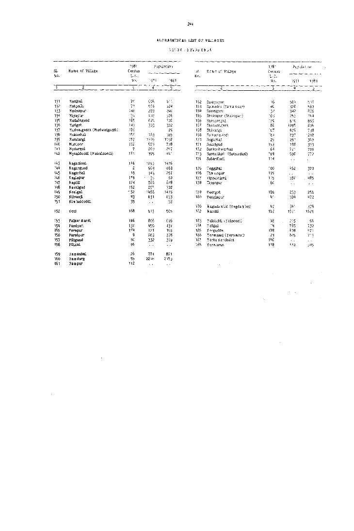
244
ALPflADt:TICAL LIST OF VII.LAGRS
TALUK : DEVAD URGA
1981 Population 19B1 Population Sl. Name of Village Census 31. N a m e of VlllEge C ensU3 NO. L.e. No. L.C.
No. 1971 1981 No. 1971 1981
131 Ma3Ulal 70 604 511 16" Salkyapur 16 501 '007 132 Matpalli 71 565 )24 163 s" m udra (Sa m a m dar) 40 328 589 133 Mednapur 148 220 240 164 Sasvigera 32 342 826 134 Miyapur 34 402 )76 165 Stockapur (Shakapar) 103 253 144 135 Mudalagund 165 624 700 166 Shavantgal 129 619 865 136 Mudgot 143 J03 302 167 Shavantgera 88 1095 894 137 Mudvaigaddi (M udwalgaddi) 176 29 168 Shivangi 107 679 738 138 Mukanhal 1% 363 365 169 Somanmardi 101 837 1218 139 Mundargi 157 1305 11;,>8 170 SugarhaJ 25 291 349 140 Mustoor 102 578 708 171 SuJadgud 153 188 333 141 Mydargol 7 209 247 172 Sunkesh w arhal 64 771 795 142 Mykaldoddi (Makaldoodil 171 391 441 173 Sunnadkal (Sunnadkal) 169 590 772
174 Sutardinni 114 143 N.gadinni 116 1295 1426 144 Nagargund 2 903 863 175 Teggihal 100 462 370 145 Nagarhal 19 343 267 176 Tim mapur 175 146 Naglapur 179 35 60 177 Tlppaldinni ll? 38'{ 485 147 NagoJi 124 786 828 178 Tippapur 60 148 Navalgud 152 29? 302 149 Neelgal , 52 1478 1475 179 Veergot 186 253 256 150 NUvanj[ 43 631 653 180 VengJapur 41 309 472 151 Nim baidoddi 39 52
180 Wagad. m bli (V egda m blil 47 341 378 152 Ooti 168 613 506 182 Wandli 167 1571 1679
153 Palkanmardi 166 806 696 183 Yeldoddi \ Y alooddi) 98 215 194 154 Pandyan 137 450 437 184 Yatgal 14 785 732 155 Parapur 174 121 155 185 Yergudda 188 408 471 156 Paratpur 9 263 308 186 Yerm asal (Yera msal) 23 625 713 157 Plllgund 90 332 369 187 Y erka m andoddi 140 158 Pilil<al 96 188 Yermarus 118 410 545
159 Ramanhal 26 774 321 160 Ramdurg 55 221b 2153 161 Rampur 112
DEVAIlJRGA TALUK

2~6
'l'ALUK: l)EVADURGA URBAN/VILLAGE PRIMARY
Total Population (including No, of InsJitutionai & !luu"l", Literates. Total Main
LC. Name of ViIlage/T,mTl/ Area of Village in O<:cupied Nil. of Pupu1ation) Workers (I-IX) Name or No, ,'f Ward! hecla«s ,md of Town! residential HOllse-
No. Piv;sion! M"halla etc" Ward in.Km1 houses holds
p M F M F M F
4 10 II 12
DEV ADURGA 'l'ALUK T 1508.1 24396 25245 141214 70061 71153 17683 5286 40011 14561 R 1507.3 22289 23123 129279 64159 65120 14882 3932 37083 13758 U 0.8 2107 2122 11935 5902 6033 .801 1354 2928 803
RtlR.\L
1 Devlllhlrqa (Rural) 3809.73 231 232 1249 644 605 19 01 397 132 2 Naqar;und 974.36 168 168 863 421 442 71 15 262 49 3 Joladhad¢. 1196.68 103 106 702 349 353 109 39 187 119
" Dondlmb1i 1095.44 163 181 953 464 489 105 18 311 195 5 Benlca!. 673.67 70 92 438 210 228 48 16 102 23
6 Xonchapli 874.78 138 153 756 354 402 138 36 234 114 7 MydarQOl 440.37 41 42 247 115 132 15 65 08 8 Karltihalli 495.96 81 B4 458 21B 240 27 02 129 31 9 Parapur 390.19 48 51 308 151 157 39 16 74 29
10 ~nur 663.47 36 46 224 116 108 34 12 58 39
11 Ar8hangi 886.81 121 121 687 339 348 79 25 205 130 12 Kopper 2137.69 312 314 1716 857 859 241 86 479 325 13 Kurkihalli 1095.16 138 143 781 407 374 92 15 258 130 14 Yatgal 1201.94 153 153 732 345 387 9S 34 213 232 15 Herur 1315.55 141 143 712 349 363 117 27 232 226
16 Salkyapur 596.90 105 105 507 247 260 62 18 146 113 17 Chickbudw:: 1749.40 225 270 1296 647 649 216 67 392 209 18 Gopendeverhalli 232.85 31 36 237 114 123 55 2S 59 07 19 N.garhal 381.42 42 43 267 144 123 37 07 57 20 (hJ.ntarhal 654.90 121 121 735 384 351 114 26 200 04
21 Mas anal 3344.95 499 513 3046 1511') 1536 441 151 192 251 22 Chiclchonk1Uli 515.33 86 86 447 220 227 68 13 113 24 23 Yetmasal 405.35 118 134 713 346 361 8S 26 185 09 24 Jerbandi 684.79 128 142 652 306 346 98 33 183 33 25 Sugurhal 556.B2 62 68 349 157 192 32 07 96 20
26 Ramanbal 303.91 150 155 821 386 435 67 13 237 186 27 Hemanhal 415.62 33 34 242 119 123 30 65 04 28 GundOurthi 454.27 104 104 586 218 308 63 11 158 37 29 KllIIdhal 301.96 44 44 245 123 122 37 07 72 10 30 lCardigudda 493.41 38 38 200 101 99 12 55 04
31 Deverqud 531.11 47 51 286 145 141 32 02 73 07 32 Sasvigera 1352.20 132 132 826 434 392 07 244 27 33 HirehonkWli 93.27 UN-INHABITED 3. MiYlPur 927.78 72 77 576 290 286 48 11 148 51 35 Kot1911d 651.23 59 59 328 169 159 29 03 91'- 11
36 Mansagal 74.90 56 56 311 168 149 13 109 19 37 Kelgin Ir<lbgera 1472.25 267 278 1626 849 777 58 01 473 58 38 OUddad I r~bgera 119.61 37 37 204 116 88 58 25 39 NilOOaidod<U 135.31 11 11 52 26 26 20 10 40 SlIIIIU.dra 998.68 94 94 589 294 295 33 02 190 04
.1 VenglllPur 708.34 80 80 472 269 203 07 159 23 42 Karegud 1250.77 283 283 1625 799 826 3t 04 428 211 43 lfilYlJlji 1017.36 113 l13 653 323 330 39 191 27 44 APjll 957.92 198 204 1016 474 542 33 04 296 322 4S lnehelU9I11' 843.59 127 127 684 343 341 92 19 198 03
46 Gopalpur 763.20 152 165 880 426 454 127 20 253 151 .7 lfagadambl1 489.69 65 65 378 197 181 40 17 lC8 17 48 Huvinhadgl 615.14 66 66 360 178 182 68 19 99 32 49 Gabbur 5347.32 834 860 4822 2412 2410 895 316 1279 483 50 Laxminareyanapara 130.49 UN-INHABITm

I 2~7
/
CENSUS ABSTRACT TALUKI DEVADURGA
MAIN WORKERS Household Inuu,try
Other \Vorkers Mari_!inal Workers Non-workers Culti"ators Agricultural Mallufacturiug Pmce~,-(II Labourers (II) iug S~h'i~ill~' and (Ill. IV, Y b)& Name of ViliagelTownl L. C.
Repa,r; [VII-II YI to IX Name Or No. of Wardl No. Divis;on I Mohalla etc.,
M F M F M F M f M F M F
1.1 14 15 10 17 IK 19 2[1 21 22 23 24
207S1 2701 12576 10769 S79 202 5775 SS9 297 4791 29753 51801 T DEVADURGA TALUK 20134 2637 12092 10268 725 159 4132 694 286 4632 26790 46730 R
647 64 484 501 154 43 1643 195 11 159 2963 5071 u
273 24 87 101 31 07 01 1'8 246 465 DevadUrqa (Rural) 1 94 10 132 35 01 01 35 03 02 33 157 360 Nagargund 2
119 04 60 109 05 04 13 02 152 234 Joladhadgi 3 104 05 169 176 24 14 147 294 Dondambl1 4
16 69 22 03 14 01 01 05 107 200 Benltal 5
56 03 138 110 05 35 01 09 120 279 Konehapli 6 37 03 19 05 09 01 50 123 Mydargol 7 45 03 68 26 16 02 02 10 87 199 l(arldhalU 8 49 21 29 04 77 128 Parapur 9 27 28 39 03 58 69 Hunur 10
117 54 70 71 01 17 as 134 218 Arshangi 11 175 15 194 291 17 02 93 17 01 378 533 Kopper 12 113 127 123 06 03 12 04 149 244 Kurltihall1 13 99 75 72 145 01 41 12 01 132 154 Yatgal 14
123 74 59 107 23 26 27 19 117 137 Herur 15
95 10 32 98 la, 01 09 04 02 101 145 Salltyapur 16 207 24 130 162 11 44 23 255 440 Chlc1tbudUr 17
39 01 20 06 55 116 Gopendeverhalli 18 32 20 01 04 06 87 117 Nagarnal 19 93 01 101 03 03 03 184 347 Guntarhal 20
401 26 263 200 18 10 90 15 718 1285 Masarkal 21 50 03 61 20 22 01 87 203 Chickhonltuni 22 70 01 90 02 10 04 15 02 26 182 133 176 Yermasal 23 52 114 33 17 123 313 Jerbandi 24 67 10 27 09 02 01 61 172 Sugurhal 25
111 15 103 166 04 19 05 01 149 248 Ramanhal 26 37 25 04 03 54 119 Hemanhal 27 63 06 67 29 04 24 02 120 271 Gundgurthi 28 50 03 14 07 08 51 112 lCamdhal 29 36 14 04 05 46 95 lCacdigudda 30
56 03 05 04 12 72 134 Devergud 31 198 04 06 03 38 20 190 365 SasviQera 32
UN-INHABITED Hirehonkuni 33 120 04 28 47 142 235 MiYlIPur 34 69 02 14 07 08 02 78 148 Kotigud 35
52 48 19 09 59 130 Mansagal 36 344 05 104 53 11 14 02 36 374 683 lCelgin Irahgera . 37
41 17 25 58 63 Guddad I rabgera 38 07 13 10 06 16 Nlmbaidoddi 39
146 43 04 01 104 281 Sanudra 40
126 01 32 22 01 110 180 Venglapur 41 325 118 84 91 05 14 02 05 371 610 ICaregud 42 139 09 17 01 35 17 132 303 Nllvanjl 43 156 08 125 313 12 01 03 01 02 177 218 Anjlll. 44 99 79 09 02 11 01 02 145 336 Anchesugur 45
201 120 33 26 03 16 05 173 303 Gopalpur 46 75 02 30 15 03 89 164 Wagadambli 47 60 06 27 26 12 79 150 Huvinhadgi 4B
426 20 387 387 50 14 416 62 20 1133 1907 Gabbur 49 UN-INHABITED Laxminarayanapura 50
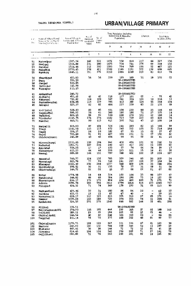
248
TALUKI DEVADURGA (CON'TD.) URBAN/VILLAGE PRIMARY
Total Population (includin~ 'Nt),t1f Institutional & Hou,<]ess- Litercltes Total Main
1.(, :"~,lI1h! of Villa~cfT(j\\I11 Area ni' Villo.i;!C in Occupied NI). of PupulatiDn) W.)I kef:; !I-IX) ;";:m.\: Ilj' l\J1l of War·11 lh:('\arl~ :.Inti (If 1"1\.'11/ residential House-
:\"). ! livi~i\\llf.''1:\)h;llla ~tC', Ward in Km~ houses hl)ld.;;
P M F M M F
10 II 12
51 Maseeq,ur 1207.34 162 222 1172 558 614 217 64 327 136 52 Neelgal 1315.88 231 280 1475 734 741 274 99 384 150 53 Ganekal 1516.46 212 300 1593 794 799 196 52 467 125 54 Maladkal 2770.45 378 421 2300 1149 1151 332 139 688 665 55 Ramdurg 1645.11 351 375 2153 1084 1069 313 83 613 76
56 Khardigud 423.83 56 56 338 169 169 51 19 100 D2 57 Durg 352.10 UN-INHABITED 58 Javgud 536.85 UN-INHABITED 59 Kadl.igud 112.98 UN-INHABITED 60 Tippapur 211.13 UN-INHABITED
61 Andankhed 280.72 UN-INHABIT,..) 62 Aldharti 451.62 42 42 218 117 101 02 75 42 63 Kakargal 752.82 124 129 687 361 326 120 16 216 13 64 Sunkeshwarhal 838.88 113 129 795 413 382 124 55 244 134 65 Amrapur 527.37 82 82 466 227 239 83 22 135 09
66 Haddinhal 508.63 83 85 431 198 233 88 25 116 43 67 Ingaladhal 595.92 58 61 360 180 180 71 27 105 14 68 Budinhal 829.65 99 99 558 288 270 121 22 160 14 69 Hirebudur 2143.75 274 274 1462 723 739 229 60 428 76 70 Masihal 463.71 90 113 611 300 311 43 13 200 14
71 Matpalli 619.93 87 101 524 241 283 82 15 148 59 72 Itagi 1141.98 113 115 672 340 332 105 32 214 196 73 Gagal 326.37 26 26 182 87 95 15 02 57 47 74 Gugal 795.88 91 91 427 196 231 31 07 132 62 75 Chlckraikl1I1l1)i 345.89 43 43 194 98 96 09 02 61 20
76 HireraikUIrpi 2331.65 159 164 842 406 436 101 32 262 53 77 Madarkal 1051.71 187 206 840 423 417 102 23 230 92 78 Apprahal 554.25 17 17 133 57 76 06 04 29 17 79 Baswantpur 612.23 44 44 226 115 111 25 18 61 30 80 Hernnal 889.89 144 151 790 388 402 100 19 224 . 137
81 Bommnhal 760.77 124 132 705 359 346 83 20 .209 24 82 Honnatagi 602.78 77 95 518 261 257 103 37 156 56 83 Khanapur 2283.69 200 204 1177 568 609 136 35 348 256 84 Hirekudalgi 590.52 30 31 155 78 77 31 08 51 06 85 Chlck1<udalgi 344.72 02 02 15 07 08 02 01 07 02
86 Kolur 1074.08 54 64 324 160 164 33 08 107 67 87 Hanchinhal 346.82 68 68 394 196 198 73 19 122 09 88 Shavantgera 834.17 173 173 894 434 460 163 71 271 73 89 AIi<:era 3395.78 553 556 3612 1798 1814 416 120 1066 757 90 Pil1gund 426. ~2 71 74 369 179 190 31 OS 112 99
91 Malkamdlnni 429.46 30 31 180 86 94 20 62 57 92 Kardona 433.05 15 15 87 47 40 29 25 93 Honkatmall1 628.17 112 115 615 305 310 07 OS 172 14 94 Hemnur 1005.28 143 146 729 374 355 76 11 206 61 95 Kothdoddi 326.50 275 275 1240 648 592 144 33 401 298
96 Pilikal lC6.'l1 tN-INHABITED 97 Mallinalkandoddi 276.S3 105 105 444 239 205 27 02 168 102 98 Yelduddi 189.22 29 29 194 102 92 12 03 46 99 Chikkal doddi 146.54 40 40 244 126 118 03 64 06
100 Teggihal 411.14 78 78 370 168 202 48 01 99 77
101 Chintalkunta 1179.75 128 128 667 331 336 47 01 183 30 102 Mustoor 249.9C 132 132 708 359 349 53 13 197 27 103 Shakapur 447.41 38 38 144 72 72 12 01 41 19 104 Jinnapur 614.45 104 106 545 258 287 71 27 161 79 105 Gejjibhavi 283.89 72 18 550 269 281 99 18 185 90

249
CENSUS ABSTRACt TAJ,UK: DEVADUROA (COOTD.)
MAIN WORKERS
Household Industry Other Wurk.c-rr- Marginal Workers Non.workers Culti"ators Agricultural Manufacturing ProcesSl-
(I, Labourers (II) ing ServiciJl _ and (Ill. IV. Vb) & Name of Villa:,c/Tmvn/ L.C. Repairs (VI [all VI to IX Name Of No of WarJ/ No. i)iVl>ionjMohalia etc ..
M F M F M F M F M F M F
1.1 14 15 16 17 18 19 2(1 21 22 23 24
145 02 125 132 07 50 02 01 231 477 Maseedpur 51 142 13 190 131 02 50 06 48 195 302 396 Neelgal 52 27 417 125 0.4 19 327 674 Ganekal 53
349 228 286 424 04 49 13 0.5 461 481 Mal adk al 54 175 . 10. 288 54 11 139 12 liB 131 468 862 Ramdurg 55
62 33 0.1 03 0.2 01 03 45 68 122 Khardigud 56 lH-INHAlllTID Dut1;l 57 UN-INHASITID Javgud 58 UN-INHABITW KaQligud 59 UN-INHABITm Tlpoapur 60
\II-Ul8IIfi.Tm Andankhed 61 46 29 42 42 59 Aldharti 62
10.8 0.1 85 12 05 18 0.1 141 144 172 Kakargal 63 78 21 134 112 04 0.1 28 169 248 Sunkeshwarhal 64 52 60. 0.6 0.2 21 03 113 92 117 Amrapur 65
49 0.1 56 40 0.1 10. 0.2 71 82 119 Haddinhal 66 69 20 13 ,.. 16 01 57 75 109 Ingaladhal 67 ~3 0.4 50 0.6 02 15 04 128 256 Budinhal 68
241 0.2 151 70 19 0.1 17 03 0.1 78 294 585 Hirebudur 69 46 148 14 02 0.4 laO 297 Masihal 70.
72 0.6 61 47 0.3 "04 12 02 0.1 0.3 92 221 Matpalll 71 82 74 120 121 0.3 0.9 0.1 0.1 0.9 125 127 Itagi 72 37 23 18 24 0.1 01 30 48 Gagal 73 73 16 49 45 0.2 DS 0.1 64 169 Gugal 74 44 0.5 16 15 0.1 0.1 37 75 Chickraikunl> i 75
214 0.6 25 41 01 22 06 144 383 Hireraikumpi 76 34 0.2 152 77 0.7 07 37 06 03 92 190. 233 Madarkal 77 12 11 11 28 59 Apparahal 78 27 01 30 28 0.4 01 0.2 05 52 76 Baswantpur 79 93 10.7 135 05 0.1 19 01 0.2 0.5 162 260 Hemnal 80.
84 97 24 07 21 03 150. 319 BOl1ll1anhal 81 137 49 08 0.1 0.1 10 105 20.1 Honnatagi 82 113 0.6 164 230. 13 58 20 0.2 10 218 343 Khanapur 83
31 0.1 a o. 0.6 0.3 27 71 Hirekudalgi 84 03 04 0.2 06 Chlclckudalgi 85
45 0.4 40. 56 03 19 07 53 97 l{olur 86 64 40. 04 01 17 0.5 04 74 185 Hanchinhal 87
139 0.7 107 58 04 04 21 04 01 38 162 349 Shavantgera BB 494 117 282 572 49 30 241 38 14 27 718 10.30 AIltera 89
87 91 04 04 04 17 0.4 67 91 PiligUnd 90.
38 4S 07 11 03 14 01 24 37 Malkamdinni 91 09 20. 25 19 15 Karli:ma 92
127 04 32 07 07 06 0.3 04 151 129 145 Honkatmalli 93 140 25 29 31 0.7 30 as 03 35 165 259 Hemnur 94 233 193 100 99 14 0.2 54 14 24' 294 Kothdoddi 95
Qi-lNIWU'fID Pililtal 96 122 09 14 88 32 05 71 103 Mall1nailc andodo i 97
32 14 05 45 51 47 'leldcddi 98 54 0.8 06 02 08 58 54 54 Chikkaldoddi 99 73 14 76 0.1 11 0.1 02 69 123 Teggihal 100
160. 05 11 23 0.2 10. 0.2 148 30.6 Chintalkunta 10.1 121 01 57 20 08 03 11 03 02 109 160. 213 Mustoor 10.2 28 01 09 17 02 0.2 0.1 31 53 Shakapur 10.3 96 10 41 64 0.4 01 20 04 97 20.8 Jinnapur 10.4 70. 0.3 55 79 0.2 5B OB 78 84 113 Gejjibhavi 105

2~C
TALUKI DEVADURGA (C()tjiV.) URBAN/VILLAGE PRIMARY
T Olal POpulation (including ~-~------
No. of Inslitutional & Housel,ss Literates Total Main LCo Nam. of VilIage!iown! Area of Villa~e in Occupied No. of Population) Workers II-IX) Name or No. of Ward! h.:ctar"s (lnd of T(wmj r .... 'Side!ttial House-No. Divisioll/M"halla etc .• Ward in Kille house, holds
p M F M f M f
10 11 12
106 Hungunbad 596,79 36 36 212 104 108 37 18 63 26 107 Shivangi 733.19 132 132 738 362 376 93 24 212 152 lOB Haljadalditlni 524.42 56 57 353 166 187 26 02 87 04 109 Jaradbandi 350.78 52 S2 255 124 131 21 75 05 110 Buddinni 470.35 107 112 645 319 326 94 10 117 34
111 Govj.ndpalll H3.67 90 90 587 300 287 49 14 184 54 112 Rampur 252.21 \JloI-DHIABlTED 113 Jaqatke1 1167.24 138 142 851 428 423 131 39 238 217 114 Sutard1nnl 138.46 tJ)I-DiIiABlTED 115 Tippaldinnl 245.47 83 92 485 227 258 58 06 130 40
116 Nagadinni 1168.98 204 231 1426 688 738 227 81 393 287 117 Heggaddinni 584.85 98 103 612 305 307 138 29 162 20 118 Yel\aarus 965.60 83 95 545 267 278 95 13 159 78 119 MarkllDdinn1 477.45 122 123 596 287 299 82 19 196 n 120 JaqirjedaldJ,nnJ, 879.83 181 195 1058 535 523 136 34 322 33
121 Bekelmatdi 493.91 39 39 172 80 92 09 54 3. 122 KelledeverlJUd 251.10 99 99 50. 257 2·" 40 02 171 20 123 Aqrahar 3i7.73 53 53 288 140 148 54 10 83 40 124 HIlOCl1 1390.82 162 162 828 384 444 88 22 243 175 125 Biltldegudi 530.88 128 129 893 452 441 176 35 235 128
126 Jutme:di 582.12 39 39 262 141 121 09 02 87 58 127 J(yac:ligera 3343.79 384 384 2324 1170 1154 121 26 711 476 128 Alkod 947.18 158 163 837 405 432 94 38 237 20 129 Shavantgal 799.29 156 157 865 423 442 88 13 274 220 130 A)o;alk1.1m,,1 1002.89 137 139 845 424 421 12 01 285 100
131 Anwar 848.51 84 84 441 221 220 28 141 23 132 Adkalgud 386.51 70 70 401 209 192 20 06 14S 28 133 Bhwnangund 535.38 222 224 1312 646 666 60 03 416 122 134 Kallapur 610.00 142 145 828 442 386 25 OS 273 144 135 Mulapur 123.09 16 16 107 46 61 32 01
136 Benderganeltal 1555.90 357 375 2117 1042 1075 235 83 595 113 137 PlIIIdyan 347.89 77 80 437 225 212 29 06 1.54 70 138 Kachal'ut 611.50 14 14 84 42 42 03 23 13 139 Jalhalli 1034.63 1321 1322 7477 3704 3773 1219 426 1823 336 140 Y~rk8lQandoddi 385.01 utI-lHtlABlTED
141 LingadhallJ. 1279.90 117 117 692 349 343 47 34 188 02 142 Chappell<i 69B.08 UN-INtlABI'l'iD 143 Mudgot 253.39 52 52 302 165 137 16 95 144 Bttdd.1nni 211.79 UlI-INtlABI'l'iD 145 Bagur 541.88 74 '4 418 207 211 36 06 107 02
146 HEirundi 672.50 142 142 706 334 372 115 13 181 12 147 Jllmbaldinn1 310.:43 33 33 165 89 76 10 48 17 148 MEidnapur 366.98 42 42 240 123 117 20 n 77 52 149 H~per:gundi 437.35 UN -lHIiABI'l'iD 150 lOlard1gud 719.58 170 174 989 48a 501 108 11 333 20
151 Amarapur 232.51 53 53 216 133 143 55 26 69 02 152 Nava19ucl 388.80 Sf; 56 302 152 150 56 22 82 03 153 51l1adgud 1557.19 37 38 333 181 152 100 02 154 M'IIIdalgud 302.34 58 60 349 164 185 29 04 106 04 155 Gajaldinni 303.47 67 61 402 202 200 17 95 52 156 MUkanhel 203.09 64 64 365 173 192 20 05 77 56 157 MlWlargi 2068.90 261 264 1458 726 732 222 64 423 181 158 Gan.j~l 708.82 129 129 660 329 331 74 15 211 31 159 K4tmalll 216.31 11 17 106 54 52 16 05 22 01 160 Devatgal 819.20 9a 98 523 261 262 63 08 146 06
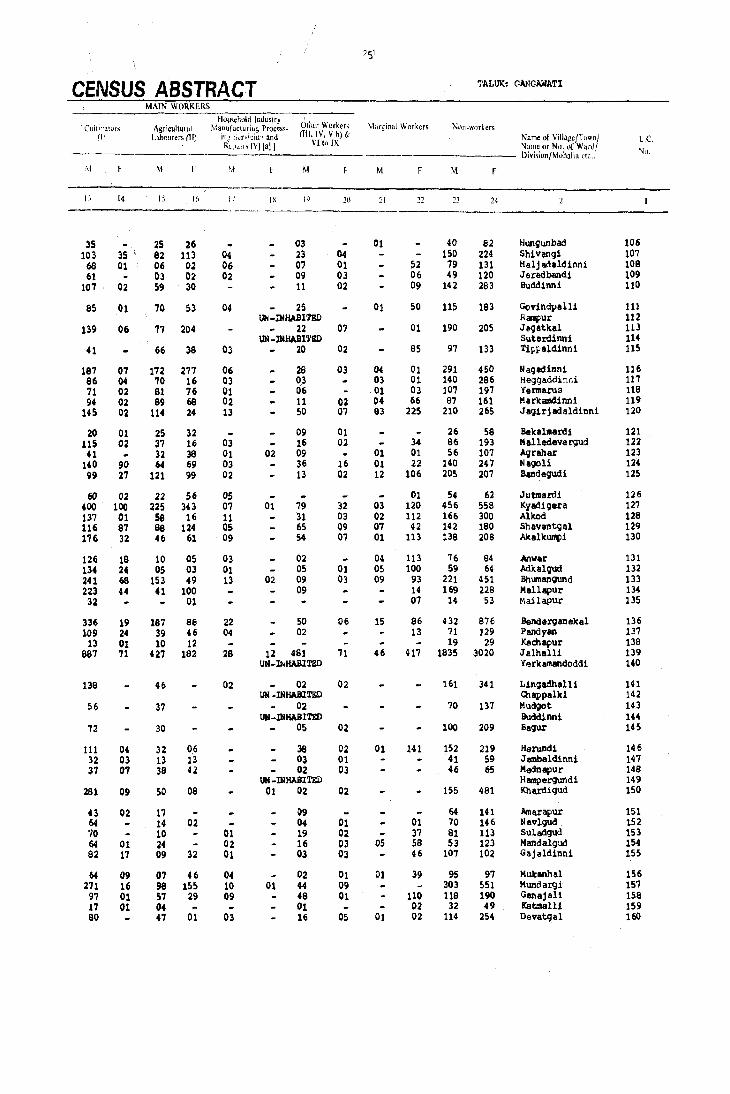
2S1
CENSUS ABSTRACT TALUK: G~GAWATI
MAIN WORKERS
Household Indrutry Other Work", Mar~inal Workers CUlli"atvr:o; Agricultural Mallll.factu£log PfQceS:;~ Nt)n~workers
{I ,1 Labourer< (llJ in..;' 'ld.iciu' and (Ill. IV. V b) {;: Name of Village/Town! 1..c. Re:".,,, IV! [a! I VIto IX Name or No. of Ward/
[)ivi5ion/M,)halla de., Nil.
:vi F '" 'II M M F M F
13 14 15 II. I; IX 19 2(1 21 22 2.1 24 ---_.
35 25 26 03 01 40 82 Hunqunbad 106 103 35 82 113 04 23 04 ISO 224 Shivengi 107
6S 01 06 02 06 07 01 S2 79 131 Halj adaldinni 108 61 03 02 02 09 03 06 49 120 Jaradbandi 109
107 02 59 30 11 02 09 142 283 8udd1nni 110
85 01 70 S3 04 25 01 50 115 183 GQvindpalli 111 tnI-INHABI'l'ED RiI1IPur 112
139 06 77 204 22 07 01 190 205 Jegatkal 113 UN -INHABITED SutaJ:dinni 114
41 66 38 03 20 02 85 97 133 Tipuldinn1 115
187 07 172 277 06 28 03 04 01 291 450 Nagadinni 116 86 04 70 16 03 03 03 01 140 286 Heg9addinni 117 71 02 81 76 01 06 - 01 03 107 197 YeI1llarllS 118 94 02 89 68 02 11 02 04 66 87 161 Markamd!nnl 119
14S 02 114 24 13 SO 07 03 225 210 265 Jagirjadaldinni 120
20 01 25 32 09 01 26 58 BekallDal'di 121 115 02 37 16 03 16 02 34 86 193 Malledevergud 122 U 32 38 01 02 09 01 01 56 107 Agrlhar 123
140 90 64 69 03 36 16 01 22 140 247 Nagoli 124 99 27 121 99 02 13 02 12 106 205 207 Bandequc:li 125
60 02 22 56 05 01 54 62 Jutma.ro.i 126 400 100 225 343 07 01 79 32 03 120 4S6 558 Kyadigera 127 137 01 58 16 11 31 03 02 112 166 300 Alkod 128 116 87 88 124 05 65 09 07 42 142 180 Shavantgal 129 176 32 46 61 09 54 07 01 113 138 208 Akalkumpl 130
126 18 10 05 03 02 04 113 76 84 Anwar 131 134 24 05 03 01 05 01 05 100 59 64 Mkalquc:l 132 241 68 153 49 13 02 09 03 09 93 221 451 Bhumangund 133 223 44 41 100 09 14 169 228 Mallapur 134 32 01 07 14 53 Mailapur 135
336 19 187 88 22 50 06 15 86 432 876 Benderganekal 136 109 24 39 H 04 02 13 71 129 Pandyan 137
13 01 10 12 19 29 Kachapur 138 887 71 427 182 28 12 481 71 46 417 1835 3020 J elhall! 139
Utl-DlHABITED Yerkamandoddi 140
138 46 02 02 02 161 341 Llngadhalli 141 UN -INHABITED 'happallci 142
56 37 02 70 137 MUdgot 143 \J)I-INHABITED Buddinni 144
72 30 05 02 100 209 Bagur 145
111 04 32 06 38 02 01 141 152 219 Herundi 146 32 03 13 1'3 03 01 41 59 Jembaldinni 147 37 07 38 42 02 03 46 65 Mednapur 148
UN -INHABITED Hampergundi 149 281 09 SO 08 01 02 02 155 481 Khudigud 150
43 02 17 09 64 141 Amarapur 151 64 14 02 04 01 01 70 146 Na\l'lgud \52 '/0 10 01 19 02 37 81 113 Suledqud 153 64 01 24 02 16 03 05 58 53 123 Mandalgud 154 82 17 09 32 01 03 03 46 107 102 Gajaldlnni 155
64 09 07 46 04 02 01 01 39 95 97 Mulcanhal 156 2'11 16 98 155 10 01 44 09 303 55l Mundargi 157 97 01 57 29 09 48 01 110 118 190 Ganajali 158 17 01 04 01 02 32 49 Katlllalli 159 80 47 01 03 16 OS 01 02 114 254 Devatglll 160
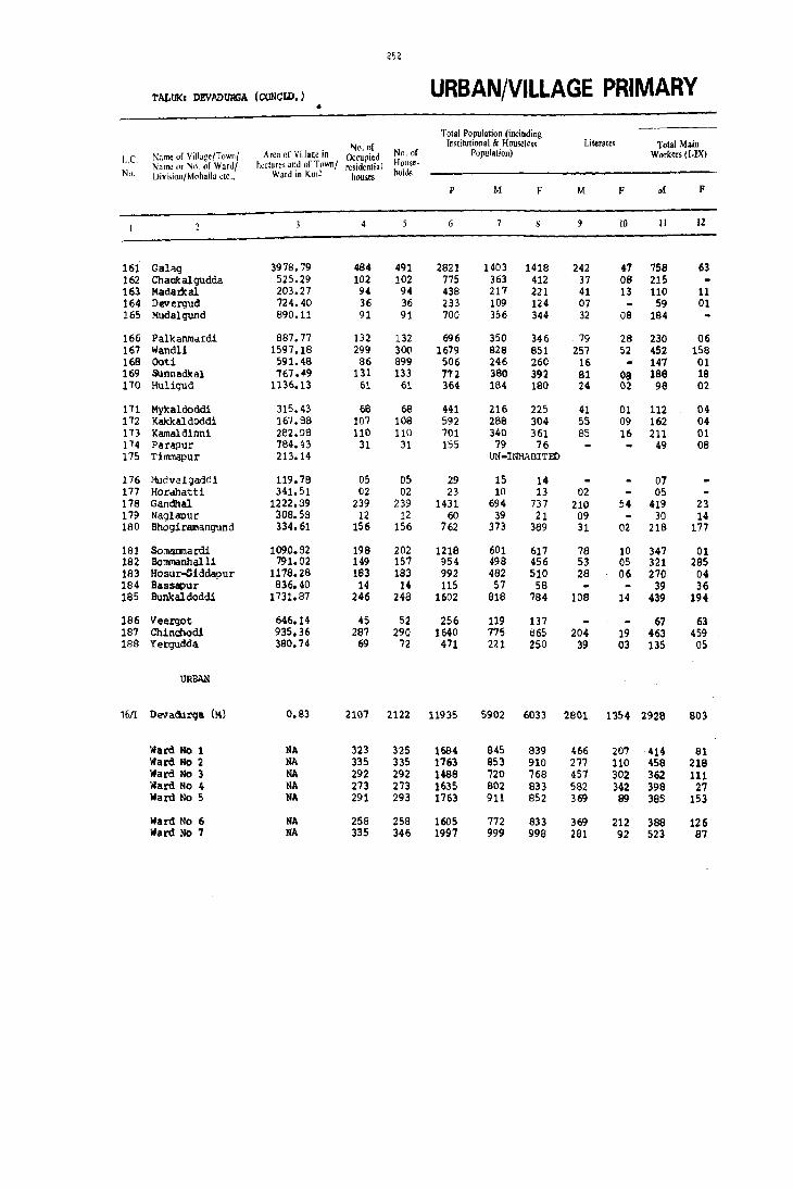
252
TALtlKl DEVADUR;A (CONCtD.) URBAN/VILLAGE PRIMARY •
Total Population (including
No. of Institutional & Housele" Literates Total Main
1..e. Nume of Village/Townl Area of Village in Occupied No. of Population) Workers (I.IX) Name or No, of Ward/ hectares and "f Town! residential House.
No. [)ivision/Mohalia etc., Ward in KmZ houses hold,
p M F M F M F
4 9 10 II 12
161 Gahq 3978.79 484 491 2821 1403 1418 242 47 758 63 162 Chaakalgudda 525.29 102 102 775 363 412 37 08 215 163 Madat1cal 203.27 94 94 438 217 221 41 13 110 11 164 Devergud 724.40 36 36 233 109 124 07 59 01 165 Mudalgund 890.11 91 91 700 356 344 32 DB 184
166 Palkanmardi 887.77 132 132 696 350 346 79 28 230 06 167 Wandli 1597.18 299 300 1679 828 851 257 52 452 158 168 Ooti 591.48 86 899 506 246 260 16 147 01 169 $J.nnadlcal '167 •• 9 131 133 772 380 392 81 08 188 18 170 Huligud 1136.13 61 61 364 184 180 24 02 98 02
171 Mykaldoddi 315.43 68 68 441 216 225 41 01 112 04 172 Kakkal doddi 167.98 107 108 592 28B 304 55 09 162 04 173 J(amaldlnni 282.GB 110 110 701 340 361 85 16 211 01 174 Parapur 784.43 31 31 155 79 76 49 08 175 Timmapur 213.14 UN-INliABITED
176 MudvaJ.gaddi 119.78 05 05 29 15 14 07 177 Hor.matti 341.51 02 02 23 10 13 02 05 178 Gandhal 1222.39 239 239 1431 694 737 210 54 419 23 179 Naglapur 30B.58 12 12 60 39 21 09 30 14 180 Bhogiramangund 334.61 156 156 762 373 389 31 02 218 177
181 Somamlardi 1090.92 198 202 1218 601 617 78 10 347 01 182 Bommanhalli 791.02 149 157 954 498 456 53 05 321 285 183 Hosur-Sidda!>ur 1178.28 183 183 992 482 510 28 06 270 04 184 Bassapur 836.40 14 14 115 57 58 39 36 185 Bunk aldoddi 1731.37 246 248 1602 818 784 lOa 14 439 194
186 Veergot 646.14 45 52 256 119 137 67 63 187 Chinchodi 935.36 287 290 1640 775 865 204 19 463 459 188 Yergudda 380.74 69 72 471 221 250 39 03 135 05
URBAN
1611 DE!IIadurqa (M) 0.83 2107 2122 11935 5902 6033 2601 1354 2928 803
Ward No 1 NA 323 325 1684 845 839 466 207 414 81 Ward No 2 NA 335 335 1163 853 910 277 110 458 218 Ward No 3 NA 292 292 1488 720 768 457 302 362 111 Ward No 4 NA 2'13 213 1635 802 B33 582 342 398 27 Ward No 5 NA 291 293 1763 911 852 369 89 385 153
Ward No 6 NA 258 258 1605 772 833 369 212 388 126 Ward No 7 NA 335 346 1997 999 99B 281 92 523 87

I
I /253
CENSUS ABSTRACT TALUX: DEVADURJA (CONCID.)
MAIN WORKERS Household Industry Other Workers Marginal Workers Non-workers Culti\'ators Agricultural Manufacturinl! Proce~s.
(I) Labourers (III ing Scrvici;l_~ ~nd (HI. IV, V b) & Name or Vill,,~e/Townl L.C. Rep.;" [VII al ) Vlt(lIX Name 0' No. "f Wardl No. llivi.lionlMohalJa etc.,
M F M F M F M F M F M F
IJ 14 15 16 17 I ~ 19 20 21 22 23 24
307 325 48 36 11 90 04 01 01 .644 1354 Galaq 161 79 133 02 02 14B 412 Chadkalgudda 162 64 40 11 01 OS Ie? 210 Mada~a1 163 37 22 01 50 123 Deverqud 164
182 01 D1 172 344- Mudalgund 165
223 04 '03 02 04 29 120 311 Pa1ltanmardi 166 237 91 110 61 11 05 94 11 02 101 374 592 Wandli 167 129 01 17 01 99 259 Ooti 169 161 02 09 12 02 01 17 03 24 192 350 Sunnadkal 169
32 01 60 02 04 01 01 86 177 Huligud 170
40 03 65 02 05 01 104 221 Myltaldoddi 171 146 07 04 03 06 02 126 298 Kakkaldoddi 172 166 31 04 06 01 129 360 Kamaldinni 173
47 06 02 02 01 29 68 Parapur 174 UN-INHABITED Timmapur 175
07 oe 14 Mudvai gadili 176 05 05 13 Horahatti 177
351 01 45 19 04 01 19 02 31 275 683 Gandhal 178 14 13 01 01 15 09 07 Naglapur 179
141 110 37 64 07 33 03 06 16 149 196 Bhogiramangund 180
284 01 42 09 12 01 253 616 SOl1lanmardi 181 42 17 264 266 01 14 02 09 177 163 Bommanhalli 182
167 92 04 02 09 212 212 294 Hosur...siddapur 163 08 31 36 IS 22 Bassapur IB4
195 01 223 192 Oi 12 01 02 29 377 561 8unkaldoddi 185
13 50 63 04 52 74 Veergot 166 394 05 48 452 03 18 02 01 312 405 Chinchodi 187 96 33 65 06 03 12 83 233 Yergudda 188
647 64 494 501 154 43 1643 195 11 159 2963 5071 Devadurga (11) 16/1
78 10 19 14 28 20 289 37 02 13 429 745 Ward No 1 107 4 134 189 10 02 207 23 02 393 692 Ward No 2
61 09 40 65 07 02 254 35 01 358 656 Ward No 3 69 02 21 09 13 295 16 01 403 806 Ward No 4 35 11 135 107 44 02 171 33 01 525 699 liard No 5
88 01 42 72 44 16 214 37 01 14 383 693 Ward No 6 209 27 93 45 08 01 213 14 04 131 472 780 Ward No 7


GANGAWATI TALUK

~ . ~
:l i .
~ ~ ~. E
" '"
.(
'" ~ r-~_tI) ~~O
..
~~ a: ~ ::J
N
~~ I .,)
U 0 0
« 'v
Z a: N \I" • -c E " .<..
C)
..)
< ~
©
\)
,,;
4.
G. C!. G.
:::>
I!l Y
? ~ Ul
",
•r-'I ' I , I , I
e:~: M 'I N
.1"'1 I , I ill
• I I I I
a t_J
~
o
c • E E • > o I!l
G
.;
" .£ ~
o
ii .. • c • "
~
o c o °ii • .~
• 4
• ~
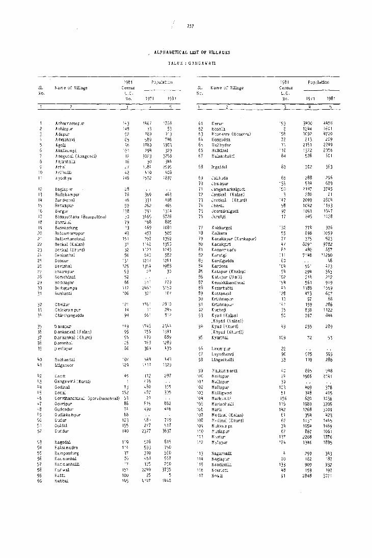
257
ALPHABETICAL LIST OF VILLAGES
TALUK : GANGAWATI
1981 Population 1981 Population SI. N a m e of Village Census S1. N a m e of Village Census No. L.C. No. L.C.
No. 1971 1981 No. 1971 1981
4 5
1 A charnarsa pur 143 1467 1728 61 Herur 153 3400 4459 2 Achiapur 148 33 53 62 Hosalli 2 1244 1601 3 Adapur 92 789 913 63 H osekera (H oskera) 158 3092 4120 4 AdVibhavi 85 589 746 64 Hosgudda 72 213 209 5 Agoli 36 1789 1903 65 Hulihyder 71 2151 2249 6 Akalkum pi 101 294 329 66 Hulkihal 118 1372 2056 7 A negundi (Anagundi) 12 3023 3258 67 H ulsanhatti 84 528 601 8 A njanhalli 16 30 344
Arhal 27 1,,84 2595 68 Ingaldal 83 302 363 10 Arlihalli 42 410 408 11 Ayodhya 146 1572 1897 69 Jalihuda 65 288 296
70 Ja mapur 135 534 679 12 Baglap'Jr 28 71 J anga m arkalgudi 150 2147 3745 13 Bailaka m pur 78 369 463 72 Jantkal (Kalan) 3 280 21 14 Bandedlal 46 331 408 73 Jnatkal (K hurd) 147 2099 2804 15 Bankapur 59 262 465 74 ,Jeeral 98 1042 1193 16 8,rgur 138 797 1314 75 Jeeralkalgudi 97 1091 1547 17 Basapattana (Basapattna) 30 3465 5728 76 Juratgi 117 845 1128 18 Basrhlal 79 768 805 19 Basvandurg 13 469 1081 77 Kakkargol 132 774 976 20 Battarnarsapur 43 453 500 78 Kalkera 55 896 1059 21 Batterhanchnal 151 397 1392 79 Kanakapur (Kankapur) 77 375 523 22 Benkal (K alan) 31 1142 1355 80 Kanakgiri 47 8291 9782 23 Benkal (K hurd) 32 1121 1245 81 Kannermadu 81 480 657 24 Benkanhal 56 640 582 82 Karatgi 111 7148 11260 25 Bennur 131 1217 1261 83 Kardigudda 60 48 26 Bevinhal 125 1359 1988 84 Kardona 104 561 473 27 Bhairapur 93 27 30 85 Katapur (Khalsa) 54 294 363 28 Born chihal 52 86 Katapur (U mli) 102 218 212 29 Bomsagar 66 211 279 87 Kesakkihanchnal 154 561 919 30 Budugull1 pa 112 2461 3150 88 Kesarhatti 41 1188 1659 31 Bunhatti 106 321 107 89 Kottankal 128 473 607
90 KrLshnapur 18 57 68 32 Chellur 121 1761 2810 91 KrLshnapur 141 159 286 33 C mokra m pur 14 11 245 92 K untoji 136 838 1122 34 C hirchangudda 94 661 812 93 K yad (K alan) 50 767 844
[Khyad (Kalan)]
35 D anapur 149 1746 2344 94 K yad (K hurd) 49 255 289 36 D ankankal (K alan) 95 756 1391 [K hyad (K hurd)]
37 Dankankal (Khurd) 96 470 889 95 Kyarihal 109 72 53 38 D asanhal 26 768 1289 39 D evlapur 86 369 436 96 Lax mipur 22
97 Layadhunsi 90 575 595 40 Eachanhal 107 544 444 98 Lingadhalli 33 1 '19 286 41 Etiganoor 129 1117 1329
99 M alka n mardi 40 865 948 42 Gaddi 45 172 287 100 Mallapur 24 1566 2141 4.3 G anga\olati (R ural) 1 476 101 Mallapur 39 44 Godinal 13 480 355 102 Mallapur 103 409 378 45 Gonal 152 487 395 103 M alligwad 51 348 415 46 G orVihanchinal (G orvihanchnal) ~3 21 104 Markum b! 156 620 1036 47 Gouripur 88 819 882 105 M arlanhalli 116 1989 3305 48 G uddadur 74 490 446 106 Marli 142 1268 3109 49 G udlaka m pur 68 107 M edinal (Kalan) 61 354 423 50 Gudur 123 584 719 108 M edinal (K hurd) 62 1131 1445 51 Guldal 155 277 517 109 Mukkumpa 34 1054 1469 52 Gundur 140 2377 3637 110 Muslapur 67 867 1061
111 M ustur 137 2268 3376 53 Hagedal 119 528 815 112 Mylapur 124 1346 1885 54 Halsam udra 114 593 750 55 Hampasdurg 37 390 560 113 Nagarhalli 4 299 343 56 Han manhal 76 468 567 114 Naglapur 70 182 187 57 Han m anhalli 17 125 250 i 15 N andil1alli 133 909 932 58 Han wal 1?7 2249 3735 116 N eerloti 48 159 197 59 H atti 100 25 5 117 Nowli 91 2848 3071 foG Hennal 145 Wi47 1440

258
ALPHABETICAL LIST OF Vll.LAGES
rALUK : GANGAWATI
1981 Population 1981 Population $1. N a m e uf Village Census S1. N a m e of Village Census No. L.C. No. L.C.
No. 1971 1981 No. 1971 1981
2 ~ 5 4
118 Obalbanda 63 543 578 139 Temba 23 31 140 Tim mapur 113 682 837
119 Pannapur 126 1224 2671 141 Tippanhal 57 550 618 120 Parapur 82 209 237 142 Tirmalapur 19 67 109
143 Tondihal 120 825 1944 121 Rajapur 122 Ramdurg 11 341 200 141j U dam kal 44 1189 1195 123 Ramdurg 64 405 482 145 Uddihal 108 515 586 124 Rampur 15 1197 1606 146 Ulenoor 130 1588 1629 125 Rampur 69 283 244 126 Rangapur 21 247 281 147 Varankhed 89 90 109
148 Venkatagiri 25 1205 1584 127 Sanapur 20 759 1276 149 Vipra 5 33 46 126 Sangapur 1 1495 2115 150 Virpapur 6 99 16 129 Sankanhal 110 439 438 151 Virpapurgaddi 18 60 105 130 ShalJ8noor 134 91 127 152 Vithlapur 38 705 724 131 Siddapur 127 3096 4667 132 Singangund 8 72 262 153 Wadderhatti 29 3386 5778 133 Singanhal 139 790 1862 154 Wadderkal (khurd) 87 268 33 134 Sirwar 75 551 659 155 Wadki 99 666 669 135 Somanhal 122 1005 1656 136 Somsagar 80 632 766 156 Yem migudda 35 61 75 137 Srlra m nagar 144 6873 157 Yerdona 115 3173 4783 138 Sulekal 58 1148 1269 158 Yettinhatti 105 295 201
Newly created village as per Government of Karnataka Notification No.RD-LRD 70 dated 28-6-1973.

GANGA WATI TALUK

2&0
TALUKI GANGAWATI URBAN/VILLAGE PRIMARY
Total Population (including N\),(lf hhlitutiuna! & HUlI .. ('}es,> Litt:r Jt..'s Total Main
I. r. Name of Villa~'ITownf Area or Villa'!\: hI Occul';,d N.l. of jllll}U1alion) IV '''Kers il-IX) :--JaIUL' or N{) or Ward/ hL'Ctare'i and O(T\lVlll! rc~iJelltial
Hou)~~ Nl). i)ivision/M,)halla etc .. Ward in Kine housl!s }wld~
P M F M F 1vI F
10 II 12
GANGAWATI TALUK T 1327.6 46298 46943 257194 130256 126938 45723 18195 74971 32977 R 1323.8 35849 36319 198459 100130 98329 31924 11834 59003 27604 u 3.8 10449 10624 58'135 30126 28609 13799 6361 15968 5273
RURAL
1 Gangawati (Rural) 2078.46 UN-INHABITED 2 Hosall1 231.05 275 275 1601 795 806 267 100 458 377 3 Jantkal 328.23 09 09 21 15 06 04 12 04 4 Nagarnalli 181.66 63 63 343 17'1 166 39 01 118 92 5 V!pra 316.27 09 09 46 24 22 06 14 15
6 V!rpapur 409.75 02 02 16 08 08 01 05 05 7 Sanga1)ur 718.20 433 440 2115 1060 1055 249 122 656 ;H5 8 S!ngangund 166.00 45 45 262 137 125 73 47 86 9 Rajapur 157.03 UN-INHABITIID
10 Kri shnapur 81.67 20 20 68 33 35 10 03 23 01
11 RamQurg 158.40 46 46 200 101 99 19 01 70 12 Anegundi 721.70 656 657 3258 1644 1614 555 300 1002 471 13 Basavandurq 549.13 205 205 1081 569 512 184 48 314 11 14 Chicltrampur 377.08 57 57 245 128 117 23 03 94 15 Rampur 330.34 319 319 1606 829 777 220 104 489 50
16 Anj anhall i 192.43 70 70 344 173 171 50 10 114 86 17 Hanmanhalli 18'1.70 59 59 250 133 117 40 07 90 70 18 Virpapurqaddi 331.74 28 29 105 57 48 14 07 42 34 19 Timalapur 283.58 28 28 109 59 50 06 02 44 31 20 Sanapur 663.84 239 242 1276 666 610 207 87 421 128
21 Rangapur 380.1t' 50 50 281 141 140 33 12 93 53 22 J.,axndpur 1010.44 UN-INHABITED 23 Temba 711.54 UN-INHABITED 24 Mall apu r 953.97 423 423 2141 1064 1077 350 97 604 107 25 Venkatag1d 1122.66 252 259 1584 799 785 180 42 450 209
26 tlallanhal 585.23 202 215 1289 649 640 212 42 326 158 27 Arhal 873.33 438 441 2595 1258 1337 324 62 756 464 28 Baglapur 339.97 UN-INHABITED 29 Wadderhatti 543.59 1096 1098 5778 2917 2861 1326 631 1636 80b 30 Saeapattana 1261.94 1045 1061 5728 2928 2800 904 397 1754 920
31 Benkal (Kalan) 1269.77 239 241 1355 713 642 185 27 398 96 32 Benltal (KhuJ;d) 2374.11 222 222 1245 626 619 219 78 374 290 33 Lingadh al11 447.31 49 49 286 145 141 24 24 99 84 34 Muk.k~a 196.76 234 234 1469 '738 131- 145 12 442 164 35 Yemmigudda 1380.29 12 20 75 38 37 04 01 26 11
36 1\go11 1991.23 322 325 1903 930 973 300 99 516 428 37 Itampasclurq 1186.77 94 94 560 300 260 34 05 176 '70 38 Vit)llapur 846.56 135 135 724 377 347 93 21 224 43 39 Mallapur 671.45 UN-INHABITED 40 Malkanmardi 904.40 174 177 949 474 474 74 04 288 155
41 Kesarhatti 738.46 253 253 1659 858 801 258 56 494 283 42 Arlihall! 555.27 77 77 409 199 209 60 06 104 87 43 Battarnarsapur '112.49 94 94 500 229 271 12 03 137 114 44 udarW<al 559.12 219 220 1195 617 578 120 29 342 46 45 Gaddi 561.20 49 49 287 138 149 38 18 79 53
46 Banderoal 505.0'1 66 67 408 202 206 69 11 128 78 47 Kanakgiri 3995.31 1652 1666 9782 5067 4715 2112 842 21540 552 48 Neerlot1 574.31 26 26 197 107 90 20 05 57 04 49 Kyad (!{hurd) 136.68 55 55 289 147 142 39 02 S6 10 50 Kyad (Kalan) 557.35 145 145 844 410 434 107 15 252 01

261
CENSUS ABSTRACT TALUKt GANGAWATI
MAIN WORKERS Hous<hold Industry
Other WDrkers Margin"l Workers Non-workers ('tlJlhltt)r~ Agricultural ManufacruriJ.ag PlocesS~ (l! Labourerl (rr) in,' ·i~r.icjn and (Ill, IV, V b) &. Name of Village/Town/ L.C.
Rc;',,,,, IVJ raj J VI to IX Name or No. of Wardl Division/Mohalla etc., No.
M F M M F M F M F M F
IJ 14 15 16 1'; IB 19 20 21 12 23 24
28661 3791 26806 26164 1641 567 17863 2355 209 4136 55076 89925 T GANGAWATI TALUK 26873 3502 22962 22499 1075 448 8093 1155 170 3976 40957 66749 R 1789 299 3844 3665 566 119 9770 1200 39 160 14119 23176 U
UN-INHABITED Gangawati (Rural) 1 111 56 312 311 03 01 32 09 04 333 429 Hosall1 2
10 04 02 03 02 Jantl(al 3 09 93 89 01 16 03 59 74 Nagarhall1 4 01 09 14 04 01 10 07 Vipra 5
02 03 05 03 03 V1rpapur 6 233 06 271 177 21 02 131 60 30 404 780 Sangapur 7
62 23 01 51 125 Singangund 8 UN-INHABITm Rajapur 9
17 01 06 10 34 Krishnapur 10
48 21 01 31 99 Ra!IIdurg 11 280 11 587 444 08 02 127 14 02 01 640 1142 Anegundl 12 173 10 90 01 OZ 49 255 501 Basavandurg 13 {l4 i3 17 34 117 Chic'krllllPUr 14
124 02 324 45 05 35 03 13 341 714 RaJllPUr 15
40 05 70 78 01 03 02 59 65 Anjanhall1 16 15 03 69 67 01 05 43 47 HanmanhaUi 17 08 01 32 33 01 01 15 14 V1tPapurgadd1 18 02 01 42 30 15 19 T1tmalapur 19
106 04 242 118 07 66 06 159 245 323 Sanapur 20
21 71 53 01 15 48 72 Rangapur 21 UN-ItlHABITED Wxm1pur 22 UN-INHABITED 'l'elllba 23
186 11 351 84 OJ 64 12 22 460 948 Mallapur 24 301 04 68 196 10 03 71 06 116 349 460 Venkatagiri 25
180 17 113 140 03 30 01 18 323 464 Dasanhal 26 251 23 447 431 08 03 50 07 243 502 630 Arhal 27
UN-INHABITED Baglapur 28 339 24 801 '741 39 0'1 457 28 05 114 1276 194'1 Wadderltatti 29 500 31 855 769 14 05 385 115 01 14 1173 1666 Buapattana )0
158 217 96 06 15 19 315 527 9enltal (lW.anl 31 129 08 181 256 10 11 54 15 01 252 328 Benkal (Khurdl 32
13 60 80 26 04 46 57 L1ngadhalll 33 201 47 106 79 15 06 120 30 11 296 556 Mukkwrpa 34
08 08 01 10 10 12 26 "ie.nmigudda 35
229 15 250 401 13 06 24 06 414 545 AgoU 36 9'1 15 46 53 06 27 02 02 124 188 HUlPaadi1rg 37
132 71 40 01 20 03 153 304 V1thlapur 38 UN-INHABITED Ma!1 apur 39
235 64 43 91 07 03 04 186 315 Kalkanmardi 40
261 130 202 144 31 09 364 518 Kesarhatti 41 38 20 53 66 13 01 95 122 Arl1hall1 42 74 01 60 111 03 02 92 157 Battarnarsapur 43
210 02 97 44 03 32 275 532 Udamkal 44 39 03 34 46 01 01 05 03 59 96 Gaddi 45
82 30 3'1 47 09 01 38 74 90 Banderhal 46 1224 40 504 330 118 103 794 79 23 546 2404 3617 Kanakg1r1 47
50 02 07 02 50 86 Neerloti 48 68 01 18 09 61 132 Kyad (Khurd) 49
246 01 01 05 05 158 428 Kyad (Kalan) 50

262
TALUKI GANGAWATI (COtml. ) URBAN/VILLAGE PRIMARY
Total Population (including ---~--.- .. ------.
No. ,'f rnstitutional & Huc,des; Literilks Total Main L.C. I'\;tme of Viila;:e/T ",ml Are" of VilJa~e ;n Ocoupied No. of P"pu1ati<)J1) Workers (I·IX)
Name or N.) ill' WarJ/ h~ctar\;s 3nd of T\hvn/ n:!>idential HOII'c-No. l)ivi.i.m{Mtlhulla etc .• Ward in Km2 houses holds --_._--------_._---
p M F' M F M F
10 II 12
51 H&l.l1gwild 449.07 69 69 415 194 221 91 39 113 76 52 Bomchihal. 247.83 UN-INHABIT!» 53 Goxvihanchinal 271.32 uti-INHABIT!» 54 T<atapurlthal 9a 537.00 51 51 363 187 176 49 DB 117 66 55 Kalkera 1656.22 175 177 1059 521 538 131 13 297 B9
56 BeIlkilnhlll 520.07 113 113 582 301 281 60 03 174 49 57 T iPPiIDhd 444.05 110 110 6~:J 327 291 166 39 174 63 58 Sulekal 1395.76 213 218 1269 656 611 124 13 389 183 59 BlIDkapur 922.02 61 61 465 252 213 56 02 144 33 60 Kardiqudda 278.57 04 04 48 25 23 20 03
61 Medinal (KalllD) 760.43 73 74 423 225 198 52 07 129 06 62 Medinal ()(hurd) 967.25 264 264 1445 747 698 219 25 431 27 63 Obalbanlia 351.65 95 95 578 305 273 91 19 1.46 03 64 Remdurg 1209.81 75 75 482 239 243 66 03 144 07 6S Jal1hu~ 397.05 54 54 296 147 149 48 01 96 07
66 lIonIsagar 590.60 39 39 279 147 132 13 01 86 67 Muslapur 474.56 188 lea 1061 542 519 148 2B 318 42 68 GudlaJtanpur 449.08 uti-INHABIT!» 69 R_ur 330.34 40 40 244 119 125 57 34 59 01 70 Nag!apur 671.81 34 36 187 95 92 36 07 52 03
71 Hulihyder 1516.71 364 389 2249 1093 1156 357 118 585 361 72 Hosqu~ 362.65 35 35 209 107 102 26 02 68 41 73 Godina! 1180.21 61 65 355 184 171 31 101 52 74 Guddadur 646.56 64 67 446 215 231 60 20 134 58 75 Sirwar 870.72 112 112 659 312 347 68 31 180 162
76 Hanmallhal 712.72 93 105 567 299 268 72 04 177 92 77 Kanalt8PUr 322.94 76 79 523 268 255 6B 06 153 17 78 BailaJtllqlur 621.84 7S 75 463 244 219 72 24 140 22 79 Basrihal. 1202.77 13" 1-'0 805 416 389 154 15 274 51 . 80 Somngar 860.59 124 128 766 390 376 147 47 240 206
81 Kannermedu 1020.27 105 105 657 329 328 159 100 190 11 82 Parapur 317.84 35 37 237 106 131 41 18 72 22 83 Ingaldal 318.54 57 57 363 191 172 84 37 94 02 84 Hul 8anhatti 427.33 95 95 601 308 293 116 31 188 25 85 Adv1bhavi 873.42 89 89 746 385 361 99 40 171 04
86 Devlapur 657.50 68 70 436 232 204 56 10 153 03 87 Wadderkal (lChurd) 670.81 06 06 33 18 15 01 07 07 88 Goudpur 468.77 135 154 882 465 417 109 06 235 35 B9 VaranJched 582.68 14 14 109 51 58 12 03 36 19 90 Layadhunsl 939.16 116 116 595 296 299 68 23 192 79
91 Nowli 3513.80 568 511 3071 1539 1532 423 120 aoo 323 92 Adapur 686.98 154 154 913 437 476 154 21 266 165 93 Bhairapur 262.93 03 03 30 12 18 OB 08 94 Chlrchanqudda 657.76 136 136 812 399 413 100 16 193 172 95 Dankankal (Kalan) 1014.91 25~ 254 1391 706 685 216 86 403 151
96 Danlcankal (!(hurd) 557.B7 149 149 889 462 427 126 10 242 20S 97 Jeeralkalqudi 1192.36 281 284 1547 802 745 172 53 493 239 96 Jeeral 641.27 178 178 1193 580 613 147 22 316 258 99 Wadlti 770.60 120 125 669 320 349 105 30 182 186
100 Matti 520.62 01 01 05 03 02 01 01 01
101 Ale allc\lll\)l 783.83 51 51 329 168 161 39 01 98 38 102 Katapur (001) 530.50 35 35 212 113 99 03 63 01 103 H&l.1apur 375.53 69 69 378 192 186 45 05 115 07 104 Kardona 1148.08 101 101 473 234 239 77 16 132 02 105 fettinhatti 894.29 52 52 201 '92 109 31 02 49 28

263
CENSUS ABSTRACT
Culti"ators
M
13
80
96 196
138 137 243
65 04
117 341 131 129 84
84 191
51 49
(I)
F
14
15
58 03
03 29 08 07 02
06 07
01 03
17
375 126 55 08 84 15 91 24
123 108
117 30 123 106 03 1'75 16 153 120
148 61 6'7
131 133
9'7 06
208 15 80
440 1'72
OS 101 206
01
08
06 33 04 19
36 03 01 15 34
140 126 229 19 155 10 91 02
90 01 58 01 6'7 02
106 01 39 17
MAIN WORKERS -.--ii~~·;;;hold Industr-y ----- -.--
Agricultural Manufacturing Process. Other Workers Marginal Workers Labourers (If) ing S,rvicinc and (1lJ, IV, V b) &
M
15
23
67
F
16
58
01 71
32 44 21 34
104 152 17 21 04 01
11 66 07 09 08
76
03 02
14 03 06 04
23
01 02
105 18e 11 33 13 37 17 25 22 31
40 62 08
08 13 40 28 37 45
27 03 14 23 29
04 01 07 20
102
10 22 01 11 04
255 267 68 157 01 07 69 156
133 104
75 77 247 219 150 245
85 184 01
04 37 01 23 02 09 01 03 09
Repai,s [VI fa] J VI 10 IX
M
17
01
05
02 19
01 02 02
01
06
01
23
06 01
03 03 03 05 08
03
07
06
01
01
09 07
03 06
09 03
04
05
F M
18 19
09 UN-INHABITED UN-INHABITED 02 21 07 29
20 02
04 14 23 62 12
22 06 06 03
02 45
UN-INHABITID 04 01
07
01 09
03
03
03 08
03 01
01
82 02 04 20 34
17 27 23 54 42
12 08 13 27 09
46
19 01 09
96 19 02 20 58
18 14 11 02 01
04 04 25 12 07
F
20
03
OS 08
02
03 03
06
02
01
06
09 16
09 06 06 32
01 03
17 04
01 12
02 01 03
03
02
M
21
07
01
06
04
08
02
02
18 01
F
22
01
31 04
03 173
37 04
04
92
18 20
01 06
06
07 124
82 95
05 40 65
114
22
148 01
53 97
16
37 04
SO 42 29
110 06
TALUKI GANGAWATI (COOTD.)
Non·workers
M
23
91
70 224
127 146 269 107
05
96 316 153 95 51
61 220
60 43
508 39 83 81
132
122 115 104 142 150
131 34 97
120 214
79 11
228 15
104
F
24
144
79 445
232 225 255 143
16
192 671 266 236 142
132 385
106 69
794 55
119 16"7 185
169 114 115 243 170
312 69
105 268 243
201 08
360 39
220
737 1061 171 310
4 10 198 188 302 437
220 309 264 138
02
70 50 77
102 43
206 506 318 159
01
73 56
150 127
75
Name of Village/TllIvn/ Name or NIl. or Ward, OivisionlMohalla etc.,
MaUigwad Bomchihal Gorv1hanchinal KatapuxXhCllsa Kalkera
Benkanhal TillPanhal Sulekal Bankapur Kardigudda
Medina! (Kalan) Medina! (Khurd) Ob&1l1anda Ramdurg Jal1huda
BoIIIsagar Muslapur Gudiakampur RaJIIlur Nagiapur
Hul1hyder Hosgudda Godina! Guddadur SllWar
Hanmanhal Kanalcapur Baihkampur Basr!.hal SOmsagar
Kannemadu Parapur Inga!dal Hulsanhattl Advibhavl
L.c. No.
51 52 S3 54 55
56 57 58 59 60
61 62 63 64 65
66 67 68 69 70
71 72 73 74 75
76 77 78 79 80
81 82 83 84 85
Devlapur 86 Wadderltal (Khurd) 87 Gouripur 88 Varankhed 89 Layadhunsi 90
Nowli 91 Adapu[ 92 Bhairapur 93 Chi rc:hangudda 94 DankaQkal (ICalanl 95
Dankankal (Khurd) 96 Jeeralkalgu41 97 Jeeral 98 Wadle! 99 Hatti 100
Akalkuqll 101 Katapur (uml1) 102 Mall.pur 103 Rardona 104 Yettinhatti 105

264
TAlitll<' GANGAWATI (caNTO.) URBAN/VILLAGE PRIMARY
Total Population (including No. of Institutional & Houseless Literates Total Main
L.e. Na!11e of Village/Townl Mea of Village in Occupied No. of Pupu1ation) Workers (l.IX) Na!11e or No. of Ward! hectares 'lIld of T"IVn! residential HOllse-
No. Im'lsion)Mohalla etc., Ward in Kmc houses holds
p M F M F M F
10 II 12
106 BWlhatti 509.29 35 35 107 43 64 10 03 22 14 107 Eclffital 478.97 78 78 444 219 225 72 09 135 35 108 ud al 1047.02 93 9.3 586 279 307 63 03 158 107 109 Kyar! al 494.78 11 11 53 24 29 05 15 13 110 Sankanhal 386.54 72 72 438 221 217 116 15 122 15
111 Karatg! 2987.70 2132 2163 11260 5661 5579 2153 814 3443 2084 112 Budugunpa 1095.48 558 561 3150 1544 1606 482 164 902 619 113 Til1l1lapur 1139.14 146 146 837 409 428 168 41 214 143 114 Halsamudra 628.36 118 121 750 319 359 133 20 238 109 115 Yerdona 2565.36 861 872 4783 2348 2435 710 293 1431 804
116 Marlanhalli 610.29 614 624 3305 1652 1653 516 272 1080 770 117 Juratg1 460.14 210 218 1128 587 541 195 89 338 231 118 Hulldhal 1310.83 347 349 2056 1056 1000 398 117 613 294 119 Hagedal 546.69 132 133 815 424 391 115 60 264 71 120 Tond1hal 1014.58 335 335 1944 990 954 317 134 569 320
121 CheJ.lur 1238.55 524 526 2810 1425 1385 534 270 920 614 122 SOIIIanhal 1386.88 285 286 1656 805 651 209 64 471 325 123 Gudur 837.85 126 127 719 344 375 84 17 205 166 124 Mylapur 1867. f£J 311 320 1885 940 945 346 61 573 255 125 Bev!nhal 1673.40 342 351 1988 968 1020 264 59 612 634
126 Pannapur 661.99 493 49B 2671 1325 1346 538 257 779 340 127 Siddapur 1494.79 874 895 4667 2343 2324 877 304 1395 907 128 Kottankal 153.24 99 99 607 304 303 109 31 178 141 129 El!ganoor 1356.73 250 250 1329 682 647 183 24 387 14.3 130 Ulenoor 1693.49 311 311 1629 806 623 222 53 502 275
131 Bennur 1625.71 236 239 1261 652 609 186 73 392 249 132 Kaltkarqol 2135.13 161 165 976 483 493 159 46 287 164 133 Nandihalll 878.46 183 187 932 464 468 112 30 288 167 134 Shal!gnoot' 433.44 22 22 127 68 59 08 37 32 135 Jamapur 859.46 117 118 679 344 335 92 08 214 125
136 Kuntojl 1520.68 203 209 1122 564 558 116 27 347 230 137 Mustur 2199.02 618 633 3376 1690 1686 568 319 1009 554 138 Bargur 743.15 249 263 1314 664 560 207 85 392 256 139 Singanhal 960.54 337 339 1862 928 934 264 57 535 275 140 Gundur 1945.03 707 707 3637 1840 1797 454 215 1124 506
141 Krishnapur 455.95 56 56 286 148 138 44 34 90 50 142 Marl! 1133.11 628 653 3109 1630 1479 692 248 1001 206 143 Aeharnarsapur 400.62 304 304 1728 858 870 309 74 483 89 144 Sriramnagar 911.86 1403 1452 6673 3474 3399 1342 833 2234 962 145 Hebbal 989.30 279 292 1440 732 708 332 125 431 196
146 Ayodhya 639.98 339 348 1897 991 906 293 157 603 269 147 Jantkal I<hurd 595.16 549 549 2804 1389 1415 495 212 803 273 148 Achlapur 104.45 10 10 53 29 24 17 12 19 09 149 Danapur 707.71 482 488 2344 1165 1179 349 164 663 515 150 J angamarkalgudi 814.68 738 739 3745 1869 1876 497 279 1183 461
151 Battemanehnal 656.75 252 252 1392 715 677 158 130 447 110 152 Gonal 354.17 64 65 395 207 188 60 59 136 42 153 Herur 1003.23 756 757 4459 2222 2237 679 306 1276 361 154 Kesakk1hanchnal 350.20 151 151 919 477 442 129 35 287 59 155 Guldal 631.39 89 89 517 257 260 61 24 145 23
156 Kattwnbl 309.89 177 177 1036 513 523 225 36 277 138 157 Hanwal 2410.90 647 659 3735 1878 1857 507 1SS 1080 603 158 HOSekera 1014.25 872 890 4720 2391 2329 654 340 1482 638

265
CENSUS ABSTRACT TALUI(, GANGAWATI (CON'l'D.)
MAIN WORKERS ----- Household Industry Culti"ators Agricultural Manufacturing Process~ Other Worker' Marginal Workers Non·workers
'(I) Labourers (If) ing Servicing and (III, IV, Vb) & Name of Village/Town/ L,C, Repairs [VI [all VI to IX Name or No. of Ward
-----------~-~-.-Division/Mohalla etc"
No,
M F M F M F M F M F M F
lJ 14 15 16 17 18 19 20 21 22 23 24 t ..
19 08 06 03 21 50 Bunhatt! 106
88 04 13 20 08 08 26 03 16 84 in lachaDhal 107
77 52 98 13 07 16 02 121 200 Uddihal 108
11 03 13 01 09 16 Kyarihal 109
90 01 32 14 44 99 158 SanJcanhal 110
917 169 1420 1761 110 44 996 110 33 149 2205 3346 Karatgi 111 432 103 358 507 19 01 93 08 642 997 Bucl.u~a 112
1'13 59 33 83 08 01 195 295 Timmapur 113
161 50 56 59 02 19 01 153 249 Halsamudra 114
429 28 8)1 766 12 159 10 76 917 1555 Yerdona 115
263 93 683 665 15 03 119 09 01 572 882 MarlaDhall i 116
138 03 166 219 04 30 09 28 249 282 Juratgl 117
220 01 343 285 11 05 39 03 20 443 686 HUlkihal 118
135 04 107 66 01 21 01 01 160 319 Hagedal 119
239 59 295 259 02 33 02 10 421 624 'l'ondihal 120
534 206 322 397 17 01 41 10 06 505 765 Chellur 121
160 99 249 206 08 08 54 12 08 334 518 Somanhal 122
91 46 96 115 07 01 11 04 139 209 Gucl.ur 123
324 10 190 241 08 51 04 367 690 Mylapur 124
262 22 285 591 20 10 45 11 1 356 385 Bevlnhal 125
496 03 243 333 16 24 04 546 1006 Pannapur 126
558 91 600 777 24 13 213 26 01 35 947 1382 Slddapur 127
118 85 35 53 25 03 126 162 Kottankal 128
223 04 116 133 04 44 06 295 504 !liginoor 129
98 42 325 212 13 04 66 17 01 3¢4 547 Ulenoor 130
251 03 114 244 27 02 22 260 338 Bennur 131
211 10 37 143 39 11 09 1% 320 I<akkargol 132
196 83 65 81 01 02 26 01 04 41 172 260 Nandihalli 133
26 01 07 30 04 01 31 27 Shallgnoor 134
102 08 74 112 38 05 130 210 Jamapur 135
182 28 129 190 06 03 30 09 217 328 Kuntoji 136
441 64 490 463 14 05 64 22 06 37 675 1095 Mustur 137
190 09 112 224 14 04 76 il 272 392 Barqur 138
22B 38 255 226 04 48 11 12 46 381 613 Slnganhal 139
523 40 496 455 14 91 11 716 1291 Gundur 140
41 03 44 47 05 58 88 Krlshnapur 141
296 13 31B 164 29 11 358 18 03 116 626 1157 Marli 142
343 32 110 52 03 27 OS 19 17 356 764 Acharnarsapur 143
468 51 1113 855 64 15 589 41 94 1240 2343 Sriramnagar 144
214 03 174 183 08 05 35 05 301 512 Hebbal 145
223 01 343 265 10 27 03 388 637 Ayodhya 146
273 19 382 224 17 11 131 19 20 586 1122 Jantkal iChl.lrd 147
11 06 09 02 10 15 Achlapur 148
357 14 225 490 30 05 51 06 12 502 652 Danapur 149
409 43 576 362 19 179 56 01 685 1415 Jangamarkalgud1 150
143 06 271 97 07 02 26 os 04 65 264 502 B_teI'hanchnal 151
76 01 59 41 01 '11 146 Gonal 152
660 38 513 302 21 10 82 11 01 16 945 1860 Herur 153
155 10 113 45 05 14 04 118 190 265 Kesakklhanchnal 154
83 06 59 17 03 112 237 Gulda! 155
165 57 72 79 09 31 02 18 236 367 Harkumbl 156
714 154 277 437 06 02 83 10 798 125' Hanwal 157
747 39 627 583 14 04 94 12 02 30 907 1661 Hosekera 158

L.C. No.
161II
TALtlltl GANG1MATI (CONCUl.)
Name of Village/Town! Name or No. of Ward/ Divi.kmiMohaJla etc.,
URBAN
Gangawati (M)
Division No I Division No II Division No III Division No IV Division No V Division No VI
No. of Area of Village in Occupied
heclares and of Town/ residential Ward ill Km2 houses
4
3.77 10449
NA 1287 NA 2281 NA 191:32 NA 1450 NA 2778 NA 1271
266
No. of Households
10624
1299 2304 2038 1479 2197 1307
URBAN/VILLAGE PRIMARY
Total Population (including Institutional & Houseless
Population)
P M F
58735 30126 28609
7502 3794 3708 12604 6516 6088 10997 5735 5262 8290 4268 4022
12291 6214 6077 7051 3599 3452
Literate,
M F
10
Total Main Workers (I-IX)
M F
II 12
13799 6361 1!i968 5273
1668 945 1968 897 260'1 9Sa l628 1401 2591 1130 3094 1004 2050 lOBO 2214 463 3144 1574 3136 577 1539 674 1928 931
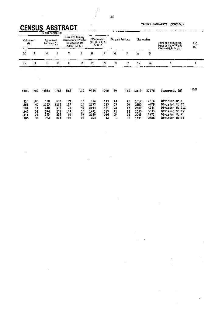
267
CENSUS ABSTRACT TALUK. GANGAWATI (CONClD.)
MAIN WORKERS Household Industry
Other Workers Marginal Workers Non.workers OIltivators Agricultural Manufacturing Process-(I) Labourers (II) ing Servicing and (Ill, IV, Vb) & Name of Villagt/Townl L.e.
Repairs IV]la] J VI to IX Name or No. of Ward/ Division/Mohalla etc., No.
M F M F M F M F M F M F
13 14 15 16 17 18 19 20 21 22 23 24
1788 289 3844 3665 566 119 9'170 1200 39 160 14119 23176 Ganqawati (M) 16m
415 108 510 631 89 15 954 143 14 45 1812 2766 Division No I 251 40 1063 1103 137 15 2177 243 03 09 2885 4678 Division No II 181 11 348 477 71 45 2494 471 02 17 2639 4241 Division No III 245 58 394 277 104 15 1471 113 11 26 2043 3533 Division No IV 316 34 575 353 65 04 2180 186 09 28 3069 5472 Division No V 380 38 954 824 100 25 494 44 35 1671 2486 Division No VI


KOPPAL TALUK

. .!J
~ i .
j l-E
'" -« .J u
~ ~ 0: .. I-
~ lI)
15 .. z .J 0:: Q: ~
::> .~
~ I ~
t 1>-
e. 0 0 ~ t « "
~ 0::
~ ~ ~
~ ~ 1>-
v., t i "6 J>.
G A 1'1 /.G ~ I
0-
A-
\I)
\) 'f.
\..
J I
6t >
I>- .(
-(
.-
\I-I' " I.c'~
)
IV
'7'
IS'
) ""
)
0
« z « )-
~
1- ct 0
I>l A
4-
J:
.-. :.:: :J ..J <I: t-
...J
W
CD
.c !!'
" n c u
.~
" E
(;

sL No.
2 3 4 5 6 7 8 9
10 11
12 13 14 15 16 17 18 19 20 21 22 23 24 25 26 27 28 29 30
31 32 33 34 35 36 37 38 39 40 41
1<2 43 44 45
l:5 47 48 49 50 51 52 53 54
55 56 57 58 59 60
N a m e o[ ·Village
Abbigera Achalapur Achartim mapur Agalkera Allanagar AUipur Alwan'(ti A marapur Arsinkera Attivatti Ayodhya (Ayodya)
Bahaddurbanda Bandibiirlapur Bandlkunta Basapur Basapur Belgatti Belur Betgera Bevinhalli Bhairapur Bhimanur (Bhimnur) Bikanhalli BUebhavi Bisarhalli (Biserhalli) Bochanr1311i Budugu m pa (Budgu m pal Budihal Budsettinhal Bullapur
Challari Chamalapur (Chamlapur) Chandragiri (Chandergiri) Chikbogannal Chikbo m manhal Chli(khasankandi C hiksindogi C hiksulikeri (C hikslilikera) Chill< m ukki ChUwadl',i Chukankal
o a jegal D evlapc.r D hangaldoddi D 0 m barr.alli (0 0 m berhalli)
Gabbur Ganganhal G hatreddihal Ginigera Gondbal Gosaldoddi GUdigera Guldhalli Gunhalli
Halekunta Halgera Halhalli Halwagali Halwarti :iandral
1981 Census
L.C. No.
90 100 57 98 35
121 115 81 65
106 105
3 107 15 28
102 119 137 142 95
146 85
134 19
135 144 80 8
45 111
58 50 76 37 60 93
130 56 53 22 10
15 19 82
136
30 62
120 29 7
51 124 96 11
74 128 83
149 41
125
27l
ALPflABETICAL LIST Of VILLAGES
[aUK: KOPPAL
Population S1. Name of Village No.
1971 1981
537 658 61 lion manhalli 62 Han m anhatti
36 44 163 H unkuntiakkapur (H unukunti) 2992 3818 64 Hanwal
347 322 65 Hasgal 66 Hatti
4588 5606 67 Hatti 28 68 Hireboganhal
175 308 69 Hirebo m m anhal 50 41 70 Hirekhasankandi
71 Hiresindogi 72 Hiresulikeri (Hiresulikera)
1407 1727 73 Hitnal (Hittanhal) 1411 2325 74 Holimudlapur
15 K orthatanhal 668 825 76 H oshalli 523 704 77 H oshalli 741 918 78 Hoshalli 770 959 79 Hosur
3440 4019 80 Hulgi. 842 1048 81 Hussainpur 731 679 82 Huvinhal 422 490 83 Hyati 513 495 84 Hydernagar 275 350
3199 3254 85 Indargi (Indergi) 1299 1705 86 Irkalgada (Irka]ead) 1355 2061 431 485 87 Jabbalgudda 525 647 88 Jinnapur
89 Kalhalli 605 813 90 Kalkera 363 455 91 Kam nur
176 92 Kamp\i
377 465 93 Kam psagar 1262 1238 94 Kanakapur (K ankapur)
os Kardigudda 600 701 ~6 K arkihalli
359 422 97 K atarkigudlanur
790 829 9~ Katrahalli 788 922 99 Kallaloor (Kowlur)
540 602 100 Kenchandoni 101 K erihalli
370 J 13 :02 K eslapur
130 158 103 Kidadhal
393 533 1011 Kinhal 624 777 105 Kodadhal.
106 Kolur 413 506 107 K oppal ( Rural)
309 420 [Bhagyanagar (K oppal (R) J 879 936 108 Kukanpalli
2134 2375 10~ Ku m nr Ra mankunta 2263 2536 (Korn ara m ankunta)
154 192 110 K unikera 575 662 111 K utganhalli
1194 1338 458 498 112 Lachankera
113 Lebgera (Legbera) 257 365 114 Lingadahalli
2227 2475 576 767 115 Madinur 626 850 116 M ainahalli 916 1030 117 Manglapur
1013 1249 118 Mattur
1981 Census L.C. No.
26 48
141 126 64 21
118 36 59 94
131 55 92
112 12 4
68 114 63
109 101
2 6
150
71 42
72 61
151 20 88
116 110
31 89 38
138 129 123
91 97
148 25 46 52 14
70 73
40 27
39 87 33
18 133
13 140
Population
1971 19B 1
323 477 267 352 647 1028 512 561 474 620 373 456 958 1098 563 873
1262 1476 503 851
2573 2931 547 455
2813 3403 356 252 435 510 976 927
23 4198 6277
194 401 218 620
347 400 699 863 482 595
2056 2754 1815 2214
674 921 432 551
610 737 887 1003 345 408 820 1168 423 712
758 836 1992 2576 593 664
5533 5904 194 328 408 520 222 324 284 359
6330 6586 462 490 915 1150
4697 5216
923 1170
971 1179 393 511
607 947 905 1089 340 382
1749 1877 1423 1472 510 654 741 1024
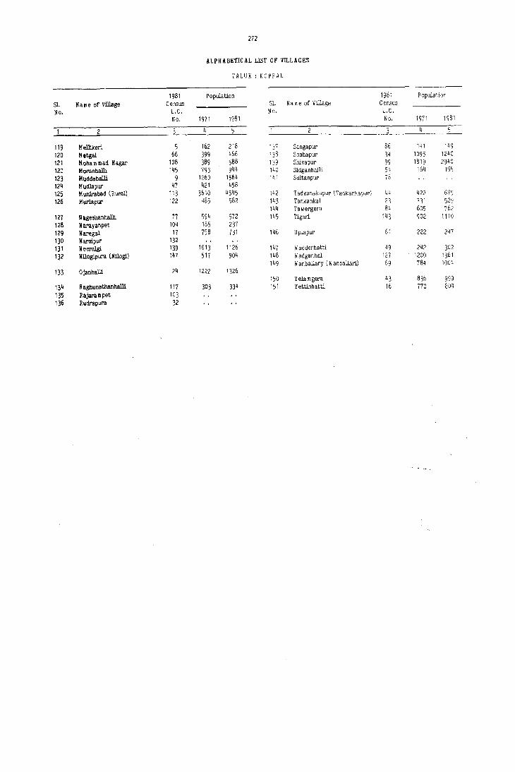
272
ALPHABETICAL LlST OF VILLAGES
TALUK : KOPPAL
1981 Population 1981 Population
$1. NaBle of Village Census Sl. N a m e of Village Census
No. L.C. No. L.C.
No. 1971 1981 No. 1971 1981
2 4 J
119 Mellikeri. 5 162 218 137 Sangapur 86 141 149
120 Metgal 66 399 466 138 Shahapur 34 1095 1240
121 Honam mad Nagar 108 389 568 139 Shivapur 99 1819 2940 122 Moranllalli 145 193 944 140 Sidganhalli 54 164 155
123 Huddaballi 9 1260 1564 1~ 1 Sultanpur 78 124 Mudlapur 47 421 458 125 H unirabad (Rural) 113 3610 4545 142 Tadkanakapur (Tadkankapur) 44 422 679 126 Murlllpur 122 485 582 143 Tankankal 23 331 529
144 Tawergera 84 605 762 127 N ll.geshanhalli '77 594 572 145 T~ari 143 902 1110 128 Narayanpet 104 185 237 129 Naregal 17 758 731 146 U plapur 61 222 247 130 Narsipur 132 131 Neeralgi 139 1013 1126 147 Wadderhatti 49 242 302
132 NUogipura (Nilogi) 147 517 904 148 Wadganhal 127 1200 1361 149 Wanballary (W anballari) 69 784 1004
133 Ojanhalli 24 1222 1326 150 Yelamgera 43 836 999
134 R aghunathanhalli 117 303 334 151 Yett.inhatti 16 770 809
135 Rajarampet 103 136 Rudrapura 32

K()PPAL TALU K
18~

274
TALUK: KOPPAL URBAN/VILLAGE PRIMARY
Total population (including -~---~---
No. of Institutional & Houseless Literates 'Total Main NaTne of Village/Town} Area of Villa~e in Occupied N". of Population) Workers (I.IX)
L.C'. Name m No "I' Ward/ hectarb and of Ttlwn! f<sidelitial Hom,e~
No. Divisiun/Mohalla etc .• Ward in Kill' houses holds
p M F M F M F
10 II 12
KDPPAL 'l'ALUK '1' 1375.2 33924 34495 199821 101110 98711 42214 16895 56047 2ti906 R 1360.1 26872 2727'1 156375 78103 77612 29621 9616 45431 24857 U 15.1 7052 7218 43446 22407 21039 12593 7279 10616 2049
RURAL
1 Koppal (Rural) 3500.18 821 822 5216 2M9 2567 1321 491 1408 721 2 Huvinhal 571.29 70 70 400 ln 203 116 36 105 3 Bahaddurbanda 788.10 294 309 1727 859 868 327 54 454 06 4 Hoshalli 429.95 154 155 927 473 454 174 39 292 61 5 Melliker1 549.62 35 35 218 110 lOB 23 65 55
6 Hyat1 1952. B6 14B 148 863 431 432 148 23 239 24 7 Gondbal 1516.95 476 480 2536 1214 1322 509 128 699 415 8 Bud1hal 317.42 87 88 485 243 242 108 36 153 142 9 Muddaballi 1048.BB 257 259 1564 781 7B3 315 65 f56 410
10 Chukankal 486.43 96 96 602 307 295 99 36 189 156
11 Gunhalli 333.30 90 90 498 256 242 105 110 149 55 12 Horthatanhal 271.79 '74 82 510 262 248 131 18 167 lQ5 13 Mangalapur 189.05 110 110 654 325 329 120 26 220 184 14 Kolur 179.67 187 196 1150 579 571 277 83 341 110 15 Dadegal 486.20 85 B5 513 261 252 96 17 153 86
16 Yettinhatti 1175.21 141 141 809 385 424 174 5' :!25 49 17 I'laregal 1105.86 143 143 731 3B6 345 112 10 206 49 18 Mad1nur 1441.50 315 318 1877 923 954 313 IJ3 524 377 19. Devlapur 340.13 27 27 158 82 76 22 o.l 4.8 35 20 Kalkera 684.<35 132 132 737 349 388 74 06 232 153
21 Hatti 830.09 84 84 456 226 230 44 01 146 47 22 Chllwadagl 930.23 171 171 922 461 461 113 03 285 146 23 'l'ankankal 752.~2 76 83 529 272 257 46 04 150 96 ~4 Qjanhalll 974.35 218 220 1326 693 633 269 28a 38~ 357 25 Kldadhal 701.61 54 54 359 1B2 177 36 08 114 22
26 Hanmanhalli 320.55 68 69 477 251 226 2S 02 169 107 27 Kutganhalli 696.50 92 92 511 256 255 107 42 155 113 28 Basapur 1070.56 139 139 825 40B 417 73 10 242 140 29 Ginigera 952.52 422 424 2375 1205 1170 398 184 734 228 30 Gabbur 396.04 62 67 506 262 244 72 08 103 26
31 Kanakapur 651.19 123 123 712 350 362 116 11 202 89 32 Rudrapur 295.99 UN .. INHABITED 33 Lingada}lalli 202.48 62 66 382 20a 174 29 02 147 96 34 Shahapur 376.71 239 241 1240 636 604 130 37 376 198 35 A1lanll.gar 285.34 55 55 322 162 160 31 06 101 66
36 Hireboganhal 1427.B4 126 131 873 446 427 180 77 263 13 37 ChiJcboganhal 1223.23 59 66 465 247 218 80 08 128 17 38 Karldhalli 4636.13 H' 146 836 436 400 122 19 251 07 39 Lachankera 2111.30 162 163 947 4B2 465 123 10 291 06 40 Kun ike ra 1478.52 223 224 1179 603 576 159 24 31' 68
41 lialwarti 989.04 193 193 1030 53a 492 101 0' 305 150 42 Irkalgoo.a 1156.90 394 404 221' 1116 1098 433 205 636 315 43 YelllDgera 1178.11 147 147 999 483 516 117 27 288 194 44 Tadkallakll.pur 577.36 104 104 619 345 334 128 40 203 134 4S Budsettinhal 610.03 116 116 647 324 323 108 28 215 110
46 K1nhal 1463.63 1134 1137 6586 3270 3316 1633 709 1B66 1158 47 Kudlapur 284.33 B3 83 458 2Z6 232 78 27 139 124 48 lianmanhatti 481.43 64 64 352 17B 174 31 01 101 49 49 Wadderhatt1 189.56 53 53 302 157 145 30 98 54 50 Chi!l1l1apur 351.61 63 63 455 228 227 56 17 154 38
18'

I 275
TALUK: I<DPPAL
CENSUS ABSTRACT MAIN WORKERS
Cultivators Household Industry Other Workers Marginal Workers NOD-workers
Agricultural Manufacturing ProCess-(I) Labourers (ID ing Servicing and (Ill, IV, V b) & Name of Village/Town! L.C.
Repairs [V] [a]] VIto IX Name or No. (If Ward! ~-~------~.
Division/Moh~lIa etc., No.
M F M F M F M f M F M F
13 14 15 16 17 18 19 20 21 22 23 24 l'
23051 4864 14983 18370 3076 1595 14937 2077 543 4269 44520 67536 T I([)PPAL TALUK.
21694 4644 14128 17473 2233 1271 7376 1419 444 3579 32828 49236 R
135'7 170 855 897 843 324 7561 658 99 690 11692 18300 U
49 09 243 8e 389 269 727 355 04 88 1237 1758 Koppal (Rurall 1
105 92 203 Huvinhal 2
261 - 106 03 21 01 66 02 01 265 404 597 Bahaddurbanda 3
193 03 42 35 03 44 23 94 191 299 Hoshalli 4
61 47 04 06 02 45 53 Mellikad 5
123 02 97 20 05 01 14 01 192 408 Hyati 6
354 107 205 266 53 33 87 09 02 106 513 801 Gondbal 7
65 68 142 02 18 90 100 Bud!hal 8
407 79 37 331 12 325 373 Muddaballi '9
95 89 155 05 01 01 118 138 Chukankal 10
75 13 35 38 06 01 33 03 03 107 184 Gunballi 11
91 18 70 87 03 03 95 143 Hortbatanhal 12
127 105. 43 55 03 11 47 13 25 105 120 Kangalapur 13
187 32 79 15 20 01 55 02 13 121 225 340 Kolur 14
37 62 77 01 53 09 56 108 110 Dadegal 15
126 01 43 43 56 05 90 160 285 y.t;tinhatti 16
123 05 51 3S OS 03 24 03 180 296 Nue;.l 17
237 60 241 309 10 05 36 03 05 60 394 517 Madinur 18
36 02 07 33 05 3' 41 Devlapue 19
163 OS 52 140 02 02 15 06 29 117 206 KelJcer. 20
82 02 52 42 03 09 03 72 80 111 Hatti 21
209 02 71 144 05 176 315 Ch!lwadalJi 22
64 01 52 76 34 19 12:1 161 Tankankal 23
190 172 357 01 19 311 276 Ojenhalli 24
61 OS 52 17 01 - 01 68 154 Xidadhal 2S
119 11 U 33 09 03 03 26 79 93 H4JlIIIIIllhall1 26
96 49 42 60 01 16 04 07 4S 94 97 .xutganhalli 27
228 79 09 61 05 166 277 Ba.lpur 28
341 66 187 140 31 10 175 12 471 942 Ginigera 29
63 09 32 11 03 05 44 74 115 144 Gabbur 30
100 15 78 69 10 03 14 02 10 38 138 235 Kanakapur 31 UN_INHABITED Rudr.pur 32
18 01 59 91 10 04 61 78 l,.ingadehalli 33
236 100 100 86 12 08 28 04 260 406 Shahapur 34
48 16 22 46 01 30 04 04 11 57 83 Alllnagar 35
213 10 14 03 06 30 03 139 180 275 HitelooqllJlhal 36
89 03 22 11 .06 03 11 30 117 89 84 Chi:lcbo9 enhal 37
164 60 04 15 01 18 02 216 179 177 Karlcihall! 38
182 100 05 01 De 01 06 261 185 198 Ladhankera 39
249 25 30 38 13 03 22 02 22 140 267 368 Kunlun 40
224 24 71 124 10 02 26 67 207 275 Hilwart! 41
334 97 171 '192 20 OS 111 21 11 57 469 726 Irkalglda U
152 03 106 189 03 27 02 48 195 274 Yel-oer:. U
HO 90 43 40 20 04 142 200 Tadklllakapur 4. 170 04 19 99 03 08 23 4i 109 164 BudHttiJlhal 45
369 .49 307 518 62:l 414 568 177 12 90 1392 2068 ICUhal 46
99 15 21 79 04 15 30 87 108 Mu41apur 41
64 /02 27 47 10 77 125 Hanunhatti fa
73 36 19 18 06 01 S9 90 "add.matt1 49
142 22 06 14 06 02 06 74 183 Ch .. lapur 50'

276
TALUIt: I()PPIIL {COtI'JD.) URBAN/VILLAGE PRIMARY
Total Population (including
No. of Institutional & Huusele" Literat~s Total Main
L.C. Name of Villa.<!e/TolVn/ Area of Village in ()ccupi.:d No. of Populati"n) Workers (I-IX) Name or No. of War.!j h.:ctar(;s and of Townl r~sidential
HOll~e.
No. [)i~i>k>ttfM\,halla etc .• Ward in Km~ houses holds
p M F M F M F
4 10 II 12
51 Goseldoctdi 182.87 33 33 192 95 97 08 59 39 52 Kodadhal 438.47 95 96 490 251 239 111 20 150 129 53 Chi lJcmulclC.1 799.26 145 145 829 419 410 192 33 236 61 54 Sidganhalli 371.99 28 28 155 83 72 17 57 14 55 Hir:e8uu'ker1 915.18 77 77 455 245 210 38 01 1·61 89
56 Chik.ul1k8ri f23.32 74 74 422 221 201 6t 0-4 116 60 5'7 Acnar Timmapur '741.59 11 h 44 26 18 11 07 58 Challari 612.62 117 l17 813 418 395 130 14 231 10 59 Hi~anhal 1189 .• 03 254 2'61 1476 737 739 184 39 419 208 60 Chi kbaIInanh al 767.23 216 223 1238 610 628 204 61 373 161
61 Uplapur 222.79 43 43 247 138 109 26 06 73 09 62 Gan9111hal 377.98 71 75 420 228 192 72 01 132 17 63 Hosur 637 .• 88 49 61 401 208 193 15 .01 133 24 64 Ha8gal 662.68 113 113 620 313 307 106 22 180 29 65 Arsinkal."a 1132.11 59 59 308 160 148 34 102 23
66 MeteJal 659.19 79 79 .66 247 219 118 33 141 55 67 Jinnapur 529.63 92 92 551 288 263 67 -08 168 85 68 Hosahalli 286.13 04 04 23 11 12 01 08 06 69 Wenballuy 1005.14 158 158 1004 506 496 63 03 126 138 70 Kukanpalll 1219.54 198 198 1170 E05 565 198 44 31i3 73
71 IDdargl 3668.67 451 451 2754 1399 1355 326 81 810 606 72 Ja):Ibalguc!da 948.53 152 153 921 "9 442 124 19 248 06 73 iCqIar a .. ankunte 1689.96 UN -DlIiAIIITBO ,. HalelaJnta 480.72 58 58 365 191 1,. 20 OJ ·88 60 75 Banliikullta 425.64 UN_INHABI'l'BD
76 Chandraqiri 34B.36 34 35 176 88 88 06 51 36 ·77 Nageahanhalll 668.76 104 104 572 289 293 57 07 173 93 .78 SlIltllllpur 323.52 UM -DiHABI'l'BD 79 8UebbaY! 556.51 62 62 350 170 180 38 11 85 73 -eo ~a 538.29 329 334 2.061 1053 1008 249 49 569 348
81 Aari~Ul' 216.42 14 14 28 19 09 06 01 15 07 82 Db lIIl9"aldodC! 1 711.58 93 83 533 285 248 65 11 171 41 83 Nalhalli 650.11 145 loiS 767 378 .389 97 28 228 49 84 '1'avergera 1469.35 125 127 762 397 365 123 37 219 65 85 Bh!lIIanur 542.15 73 78 490 248 242 48 06 135 56
86 Sarl9apur 180.21 21 22 149 83 66 05 48 23 87 Lebger. 177.37 194 202 1089 516 573 185 89 319 161 88 ~ur 980.41 182 184 1003 496 505. 153 3S 382 187 89 ICardigudda 282.54 UN -INHA8ITED 90 Abbigera 477.90 112 112 658 321 337 117 17 173 12
91 Kendlandonl 329.97 43 43 328 153 175 06 95 53· 92 Hitnel 579.58 621 641 3403 1697 1706 658 446 1043 625 93 Qlilt I<huankandi 700.50 UN -INHA8ITBD 94 Hire Kha.ankandi 952.65 140 145 1351 425 426 120 26 271 244 95 Bevinhalli 533.11 1132 163 11;146 509 539 159 51 324 289
96 GuldhalH 746.15 246 246 1338 693 645 189 52 421 327 97 Ker1halli 962.25 96 96 520 269 251 127 15 234 160 98 Al;alltera 629.38 619 655 3818 1970 1848 736 241 1214 614 99 Shivapur 1339.00 544 569 2940 1487 1453 551 202 920 460
100 Achal~,ur 352.87 UN-DlHA8ITED
101 Hussa1np\lr 329.29 UN-DiHAIlITID 102 Basapur 493.12 146 146 704 369 335 119 32 229 140 103 Rajerampet 106.76 UN :.aNlWII'l'ED 104 Narayanpet 180.09 39 65 237 122 115 28 08 86 59 105 Ayodhya 97.78 UN -DiHAlII'l'ED

277
CENSUS ABSTRACT TALUKa KOPPAL (CQlm.)
MAIN WORKERS
Huusehold Industry Other Workers Marginal Workers Non-workers Cuiti"ators Agricultural Manufacturin~ Proc~ss-
(I) labourers (H) ins; Ser\'iciliZ and (Ill, IV, Vb) & Narpe of Village/Town/ Le· Repairs [V] [a]] VIto IX Name or No. ()f Ward/
.- Division/Mohall. etc., No.
M F M M F M F M F M F
IJ 14 15 16 17 18 19 20 21 22 23 24
59 35 04 36 58 Golaldoddi 5J 77 38 30 72 25 18 18 01 101 110 Kodadhal 52
169 20 40 31 02 07 25 03 06 183 343 ChilkmukJd 53 36 01 10 11 11 02 26 58 Sidganhalli 54
133 87 04 02 01 OJ 104 121 liiresuli ked 55
87 17 15 41 02 14 06 105 135 Chiklul1keri 56 04 05 03 03 02 01 03 15 08 Achar T1nm!IPUr 57
200 05 11 02 04 02 16 01 01 187 384 Challar1 58 276 156 38 29 13 12 92 11 318 531 li1reballllanhal 59 257 73 49 70 23 12 44 06 07 144 230 323 Chikbcamanhal 60
61 05 11 02 01 02 03 17 62 83 Uplapur 61 115 15 04 02 02 11 10 96 165 Ganganhal 62 95 16 30 08 08 75 169 Hosur 63
123 04 36 23 04 01 17 01 01 133 277 Haagal 61 88 21 12 02 02 58 125 Arsinkera 65
132 55 03 01 05 106 164 Metgal 66 128 30 37 55 02 01 120 178 Jinnapur 67 05 01 03 05 03 06 Hosahall1 68
262 106 31 28 15 03 18 01 180 360 Wanballary 69 216 08 128 65 03 16 242 492 Kultanpall1 70
543 342 193 250 14 05 60 09 09 589 740 Indargi 71 120 02 35 03 40 53 01 56 231 380 JabballJUdda 72
UII M INHABITED Kumar a .. anltwl ta 73 51 19 33 41 03 01 103 114 Haleltunta " UMMINHABITEO Sandikunta 75
31 02 18 34 02 37 52 Chandragiri 76 105 06 50 84 05 02 13 01 116 190 Nageshanhalli 77
UN-INHABITED Sultanpur 78 67 64 01 05 06 02 11 02 85 107 Bilellhavi 79
134 10 371 335 16 48 03 484 660 Budugumpa 80
01 10 06 04 01 04 02 Aalarapur 81 116 19 40 21 15 01 114 207 DheD9aldodd1 8Z 170 01 14 11 31 37 13 01 01 149 339 Halhalli 83 124 01 62 56 11 22 08 01 178 299 . TaweIgera 8. 80 01 37 52 18 03 03 42 110 144 Bhilllanur 85
25 08 23 15 13 35 30 SMlllpUr 86 224 24 62 134 14 19 03 06 197 406 Leb!jera 87 170 02 100 184 32 01 01 196 317 Kamnur 88
UN-DlIlABITED Kardigudda 89 115 03 42 09 01 15 148 325 Abbigera 90
81 01 04 52 10 58 122. Kenchandoni 91 339 123 415 406 70 57 219 39 04 650 1081 Hitoal 92
UN -INHABITED Chick I<bansankandi 93 166 93 244 01 11 154 182 Hire·Khasankandi 94 132 OS 169 276 04 01 19 04 185 250 Bevinhall1 95
182 18 160 262 47 42 32 05 05 272 313 Guldhalli 96 126 69 100 90 02 06 01 14 35 77 Kerihalli 97 325 09 677 572 29 03 183 30 04 08 752 1226 . Aqalkera 98 259 11 449 437 12 2GO 12 09 61 558 932 Shivapur 99
UN -INHABITED Adlalpur 100
UN-INHABITED Husllinpur 101 . 39 07 140 133 02 48 140 195 Basapur 102
UN -INHABITED Rajarampet 103 04 78 59 04 36 56 Narayanpet 104
UN -ItIHABITED Ayodhya 105
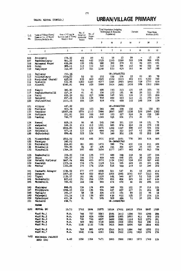
278
~ALUKI IQ>PAL (COOCLD.) URBAN/VILLAGE PRIMARY
ToW Population (including No. of Institutional & Houseless Literates Total Main
L.C. Name of Village/Townl Area of Village in Occupied No. of Population) Workers (I.IXl Name or No. of Wardl hectares and of Townl residential HOllse.
No. Division/Mohalla etc., Ward in Km2 houses holds
p M F M F M F
10 11 12
106 Attivetti 176.22 09 09 41 18 23 09 13 16 107 Sandiharlapur 641.22 462 462 2325 1145 1180 322 108 6GS 495 108 Mohatmlad Nagar 428.88 130 130 586 309 279 61 08 233 161 109 Hulgi 389.11 113 113 620 316 304 163 92 158 81 110 l<empsagar 312.99 217 221 1168 533 635 183 64 327 265
111 Bullapur UN _INHABITED 112 Hol1mudlapur 52 52 252 128 124 23 03 63 76 113 Munirabad (Rural) 635 649 4545 2332 2213 992 431 1351 740 114 Hoshell! 1203 1220 6277 3264 2993 1462 729 1777 639 115 Alwandi 91)6 928 5606 2914 2692 1426 506 1552 1086
116 Kmnpli 380.aO 73 73 406 193 215 121 46 105 76 117 Raghunathanhalli 637.34 61 61 334 173 161 90 26 111 93 118 Hatti 630.10 211 217 1096 567 531 124 13 333 296 119 Belgattl 497.06 138 138 918 469 449 193 21 278 139 120 Ghatreddlhal 1032.15 155 156 936 478 458 315 148 254 126
121 All1~ur 467.62 UN -lNHABlTED 122 Murlepur 633.38 102 103 582 284 296 150 62 150 83 123 Kawaloor 10307.~8 1075 1113 5904 2897 3007 1238 536 1'(,49 1362 124 Gudigera 151.81 102 102 662 335 327 156 34 210 169 125 Handrel 769.77 204 204 1249 615 634 173 20 373
126 Hanwal· 829.15 95 95 561 260 301 110 19 131 71 127 Wadganhal 598.25 213 213 1361 685 676 256 24 375 138 128 Ralgera 2019.05 .32 432 2475 1248 1227 608 157 654 162 129 Katrahell1 977.14 117 117 664 342 322 167 42 189 104 130 at!ksindogi 696.45 123 124 701 349 352 135 23 212 149
131 H'-Asindogi 1812.92 453 465 2931 1450 1481 776 285 614 686 132 Narsipur 260.02 UN -Ill HABITI!J) 133 Mainahalli 824.83 261 283 1472 698 774 410 151 411 109 134 Sikanhalli 796.95 95 97 495 241 254 107 25 145 66 135 Slsertlall! 1394.26 597 600 3254 1577 1677 662 243 913 758
136 DOmbarhelli 238.62 136 136 777 409 368 218 64 227 166 137 Belur 765.57 166 173 959 469 490 161 28 255 214 138 Katarki Gudlanur 3847.04 404 405 2576 1234 1342 556 232 697 463 139 Neeralg1 1375.14 176 176 1126 531 595 249 45 301 294 140 Mettur 1333.49 175 176 1024 524 500 219 59 294 202
141 HWlk1ulti Akkapur 1234.62 177 177 1028 511 517 81 16 265 212 142 Betqera 3307.23 649 650 '019 195' 2065 1061 467 1113 491 143 Tigar1 1130.5'1 161 181 1110 561 549 257 52 325 226 144 Bochanhalli 827.42 251 256 1705 851 854 245 26 427 424 145 Morenhall1 780.63 148 148 944 474 470 64 02 295 143
146 Bhairapur 848.81 134 134 679 348 331 121 37 2U 121 147 NUoqipura 1064.10 132 135 904 447 457 21'1 31 243 28 1'8 ICti1apur 365.17 58 58 324 173 151 89 22 96 18 149 HalwlIgal1 370.54 135 136 650 426 422 125 37 226 121 150 Hydamagat 421.34 91 91 595 309 286 72 10 195 154 151 Xalha'll1 494.71 UN-INHABITED
UJUWI
1~- IC)pp~ 1M) 10.73 5702 5864 35975 16524 17451 10010 5'106 8867 1920
Waro NO.1 N.A. 744 757 5003 2591 2412 1394 705 1248 288 Ward No.2 N.A. 619 626 4004 2009 1995 1093 6H 999 202 lfud No.3 M.A. 764 766 4867 2486 2381 1116 522 1273 291 Ward No.4 N.A. 648 682 3720 1896 1824 1056 665 900 313 Ward No.5 M.A. 1100 1122 7100 3615 3485 1606 924 1814 495
Ward No.6 N.A. 786 a05 4976 2S46 2432 1264 660 125$ 153 Ward 110.7 M.A. 1041 1106 6303 3381 2922 2261 1618 1376 178
16/l1 MUNlBABAD PROJECT AREA (SA) 4.40 1350 1354 7471 3883 35B8 2583 1573 1749 129

CENSUS ABSTRACT MAIN WORKERS
. --·-----~-------------Iiu\lsehold InJ\"I~\ o~;:;:~ \\ 0iKI!r5
IIlL 1\. \ 0) '" \! tJ /\
Cu!uI,'atQIS Agricultural M~\I111ractttrin~ Pr\\(',;,,-(I) L"bourm (Ill ing SCf'licl;\~ "",I
Repairs III [a] J
M
I]
\)2 116
10 38 so
F
.14
02 44 02 05 11
22 14 205 58 223 13 614 HB
10 (;6
53 106
80
01 01 35 03 02
77 U7 840 611 118 06 366
109 27'1 402 1-18 158
40 40 43 65
376 204
157 09 84 12
473 175
112 05 153 09 382 21 113 06 195 114
95 01 598 65 110 65 214 01 250 127
76 147
Btl 106
63
01
09
1335 164
122 180 291
94 420
152 76
22
26 34 24 02 47
25 06
06
M F
15 16
11 14 438 440 184 157
59 69 242 250
59 62 615 589 555 542 527 7134
10 26 44 92
265 259 153 134 138 122
67 74 604 719 86 181 01
71 59 98
143 105 34 60 32 82
199 428
206 96 56 52
220 492
76 118 76 201
198 357 114 263
66 83
160 208 312 407 147 159 199 419
41 16
69 121 37 27 07 16 72 110
110 154
750 884
71 105 87 106 90 125
164 227 247 244
56 35
105
47 30
13
M
17
05 02 02 01
25 39
109
53
06 04 02
03 25 02
02 13 07
09
15
07 02 86
04 02 31 07 10
04 30 13 02 02
06 01
10 01
811
63 102 156
33 242
115 106
26
-_---
F
I R
02 01
02
129 37 59 :;4
UN .. INP • .t\3:i~Z.J
:0
09 01 07 02
02 02 07 506 36 38 960 H B6 302 68
24 22 01 OS 15
UN -lNi-':rt3l:~
25
02 02 02
01 03 01 02 lao 50
04 02
02 01
00
20 25
102 (J7 13
01 22~
41 01 03 54 134
53 02 02
01
35 la 66 31 23
06 173
25 12 02
63 52 01
15
02
53
04 01 31
43 04 32 03 03
03 18 02 04
38 02 01
UN -ll'iiABl 1'0";:;
319 5965
10 15 75 12
135
992 630 136 &09 905
03 932 69 1161
as 1596
553
147 47 67 72 69
78 73
105
"largillGI Workers
M
21
01
12 02
34 74 02
02
19 09
33
06 02 05
09
91
02 05 26 17 24
20 03
02
F
22
06 05
12 103
02
02 04
49 36
147 03
01
19
20 18 41
247
02
01
688
61 123 156
45 104
197 02
02
TALUK: KOPPAL (CONCLD.)
NOll-workers
M
)3
05 456
76 146 204
F
24
07 685 118 211 365
45 46 947 1461
14332251 1360 1604
88 62
234 191 222
139 68
233 306 332
115 166 1239 1589
125 138 242 634
129 230 277 391 594 1062 153 218 137 202,
636
281 94
659
182 214 537 230 230
776
64S 110 876
202 276 879 301 298
246 305 832 1327 236 323 424 430 179 327
134 204 77
202 114
208 429 133 301 131
9560 14843
1341 2063 1005 1670 1187 1934
979 14 66 1771 2886
1271 2082 2000 2742
2132 3457
N'\Ine of Village/Townl Name or No, ()\" Ward/ Division/Mohalla etc.,
IIttivatti Bandi h ad apur Mohammad Nagar Hulgi Kampsagar
I.e
106 101 108 109 110
Bullapur 111 Holimudlapur 112 Munirabad (Rural) 113 Hoshalli 114 AINandi 115
Kampli Raghunathanhalli Ilatti Belgatti Ghatreddihal
Allipur Murlapur Kawaloor Gudigera Handral
Ham~al liadganhal Halgera Katrahalli Chiksindogi
Hiresindogi Narsipur Mainahalli Blltanhalli Bisarhalli
Dombarhalli Belur Katarki Gudlanur Neeralgi Mattur
Hunkunti Akkapur Betgera Tigari Bodlanahall! Moranhalli
llhalralJur Nllogipura Keslapur Halwagali Hydernagar Kalhalli
URBNt
KOP~AL (M)
Watd No.1 Ward No.2 !'lard No.3 Ward No.4 Ward No.5
Ward No.6 Ward No.1
116 117 118 119 120
121 122 123 124 125
126 127 12B 129 130
131 132 133 134 135
136 137 138 139 140
141 142 143 144 145
146 147 146 149 150 151
16/IV
MUNlRABAD PROJECT 16/1X AREA (SA)


KUSHTAGI TALUK

~==============~~~==='l
~ ~ ~
z
3 . E
'" I-
~~ u 1i l-(/)
103 0
I~ a: ;:) I 0
u ::I: ~ (/) a: ~
2 . 2 i
-.J
" l-
« (.')
J.... -0 Q:
-to '%,/ «
-Ie (J
.;, a:l - " ...;
"< (JJ
Cl:' l- >-
I-
0 V) I..
z
, :-1 ~.~! I: 1:0::
\ ~~: I-... .1
Ilol :~: © • lit'll :~: U ~ I' : ;~: " ·1 :: ~~ .;,
Q- II I:X: ' __ 1 .
::>
0 (.')
't-
?
1- " " '< c., a: 0:. w " CD f... >: () :l z w w >: 0 "
? 0 z u
r Z I-0 ~ ~ u 0
UJ 0 > ~ a: :t UJ I- "' '" ii w
:l a: ..J
"' 1
;! I-
" "' '" ~ OJ ~ '3 a:
1! ~ 0 w ;; IL
f-
/ a: > " a: :l
Cl ~ " z 0 :0 " a w <D r
v
0
~ I-
'" 0-Il.
UJ U u: '" J 0
0 X 0 (l_ :t
" u a: \J1
>: " ~ w " ~ a: w
"' " z a: I- ~ 0 I-
"' "' 0 ~ u u r u: w I-I- \J1 Ul ~ " 0 a: "' a: Iii "' u
'" ~ J g! " 0 0 iX ~ 0. J' 0.
•
i11 ' , , , .' 1
~ 1 1
""I ,-I r z • ,~I , 1
1 : • , 1 , 1
0 '--'
o·~ w OeD 0 N" 0
~~ u z
w" 0
"' CD
~ .. 0 0 W O u a ~£ g u '" . 5~ r z
0 I-
~~ ~ ~ U
~o \J1 :1 ~Q w
" ~ o •
" r 0. ~ ~ t
~ ~ E% " :t
" 8 " i ~:il w f- a:
~ "' .• iii " " will " z ,,~ I Z
0 " 1 " z III ~ -'0 -'0 Z a: " 5N :l :l Z
<III "~
~
i ,
'~ :0 1-\
~ ~\ : z Xi " :t > \; l'l ~ \ ~ ?: \ X g: " ; ~w\ ~ a:a: a: !z z! ~ UlW\ (,) (.) \~
~ ~ \5 r f ~ ~ ~ >0.
~ ~ ~\ - ~ 0.1 ~ Lt ~\
0
" I \J1
\J1 0
" 0 0 a: " 0 a: a: w
;: " j a 0
~ 1! z " UJ
" >: 0 r ~ " I-
i z ~
i3c " I-~ a: "' 0 , ~ "- Z ;;: :l '"
\ I .. \
g u o
" £
0
~ '0 ii
\ ~ f
l ~\ ~i
'0\ c i ~ I,
£ a. . :; :; ~ a. ~ 0
] '0
! </)
8-, '0
* ell

283
" ALP" A BETIC AL LIST OF VILLAGES
TALUK : KUSBTAGI
1981 Population 1981 Population S1. N a m e of Village Census SI. N'l m e of Village Census No. L. C. No. L.C.
No. 1971 1981 No. J97 J J9$J
4 5
J Achnoor 100 61 Honmatti 145 2 Advibhavi 56 528 !168 62 H osalli J7ll 515 m 3 Advibhavi 177 684 625 63 Hosur (K) 34 296 194 4 Ainapur 54 64 Huchnoor (Buehinur) 141 382 450 5 Akkeri 89 65 Hulgera 146 2519 2879 6 Antarthana 142 404 552 66 H uliyapur 83 692 64'5
61 H ulaegeri 176 455 417 7 Bachinhal 84 370 402 8 Badimnhal 119 432 437 68 Idlapur 52 463 524 9 Balutagi 26 1009 775
10 Bandargal 144 675 725 69 Jalihal 24 591 481 11 Banhatti 28 201 197 70 Jumlapur 53 1174 722 12 Basapur 96 303 385 13 Basapur (M) 33 172 124 71 Kabbargi 133 1489 1666 14 Beelagi 132 356 427 72 Kadekoppa 155 452 453 15 Bencha m atti 31 100 77 73 Kadival 91 431 480 16 Benkanhal 113 1152 1215 74 Kadoor 139 293 274 17 Bhingikoppa 168 75 Kalalbandi 169 1245 1129 18 Bichkal 11 1407 1235 76 Kalgonhal 137 528 372 19 Bilekal 95 1112 1211 77 Kalkeri 16 307 190 20 Bisnhal 166 265 335 78 Kalm alli 59 1078 936 21 Born manhal 97 611 771 79' Kandakur 48 2291 2506 22 Bya1ilrU 6 402 399 80 Kanhal 69 196 258
81 Kankoppa 164 442 476 23 Chalgera 170 2932 2777 82 Katapur 134 1569 1569 24 C handragiri 131 358 410 83 K a w albood ur 13 728 691 25 C hickgonnagar 122 189 206 84 Kesoor 19 1110 1246 26 Chick m ukrtinhal 81 80 125 85 Kidadur 58 570 583 27 Chicknan1ihal 160 381 476 86 Kilarhatti. 64 482 173
87 Kodatgeri 93 441 648 28 D evelapur 150 160 195 88 Konapur 65 29 D onnegudda 165 180 240 89 Konapur 107 400 565 30 D otihal 20 20<33 2433 90 Kordakera 159 872 907
91 Kudloor 29 310 291 31 Gadchinti 124 238 259 92 Kum blavati 116 1071 1253 32 Ganganhal 45 443 347 93 Kurbanhal 2 408 581 33 Ganganhal 72 200 202 94 K ushtagi (R ural) 1 11 34 GiITjanhal 63 531 484 95 Kyadiguppa 153 1280 1328 35 Gonhal (K) 35 213 168 36 Gorbihal 117 500 562 96 Lingadhalli 77 595 575 37 G orvarbencha m atti 7 196 235 38 Gotagi 21 1322 1097 97 Madalgatti 5 238 248 3~ Gudadhanamsagar 82 359 468 98 Madapur 36 707 546 40 Gadadur (Jagir) 127 1161 1105 99 Madikera 172 846 905 41 Gudadur (M) 37 818 667 100 Madnhal 111 522 559 42 G udadurkal (G udadirkal) 110 492 687 101 Malgitti 90 1693 1630 43 Guddadadevalapur 106 515 629 102 Malkapur 175 211 255
(Gudad D evelapur) 103 Manedhal 86 1147 1143 44 Gumgeri 46 1212 1074 104 Hankalkeri. 12
105 Mannerhal 148 969 1193 45 Habalka~ti 125 1076 1011 106 M asbinkurbanhal 94 32 78 46 Hada&Ji, 75 106 125 107 M astkatti 128 365 479 47 Jl.agaldhal 61 379 534 108 Matur 22 120 122 48 Hanamageri 151 220 263 109 Mavinitagi (Mavinutagi] 130 389 535 49 Hanamsagar 129 6833 8387 110 MayadhunSi 43 50 Hanchinhal 39 684 627 111 Megur 27 312 218 51 Hanmanhal 87 1506 1833 112 Mensageri 154 397 570 52 H esrur (K esarur) 15 395 266 113 Mittalkod 102 1253 1495 53 Hirebannigol 162 1144 1238 114 Mettinhal 73 212 181 54 Hiregotmagar ;21 1458 1583 115 Miyapur 152 509 642 55 Hire m anna pur 44 2906 2809 116 Mudalgundi 57 490 452 56 Hire m ukartihal a5 345 392 117 Mudenoor 30 984 930 57 Hirenandihal 163 958 930 118 M udhotagi (M udhvatagi) 149 230 210 58 Hiretem minhal (Tern minal) 74 545 503 119 Mugnoor 115 837 975 59 Hom minhal 78 366 421 120 M yadardokki 60 395 250 60 Hongaddi 79 229 288

m
ALPHABETICAl. WST OF VILl.AGES
TALUK : KUSHTAGI
1981 Population 1981 Population 51. HalD e of Village Census S1. N a m e of Village Cen~us
No. L.C. No. L.C. No. 1971 1981 No. 1971 1981
2 4 2 4
121 Nadavalkop 17 128 100 149 Talugeri 158 1649 1667 122 Hagamal 47 118 225 150 Tatakunti 136 123 'Nandapur 51 755 613 151 Tawargera 50 6709 7863 124 Narlnhal 66 580 380 152 Teggiha1 32 672 512 125 Nawalball1 40 1034 1118 153 Tekkalki 10 579 572 1~ NeerlotJ. 42 539 669 154 'I'engunti 49 993 724 127 Nerebencbi 3 536 628 155 Tim ma:nhatti. 118 130 157 128 Nidsesi 8 \110 1310 156 Tim m anhatti 156 129 Nlloga1 101 1973 2235 157 Tonsihal 18 644 568 130 Nirlakoppa 105 188 232 158 Topalkatti 157 512 448
159 Tuggaldona 103 1170 1303 131 Paramanhattl. 108 309 260 160 Tumcikoppa 120 430 424 132 ParaMPur 167 315 272 161 Tur.kanur 138 133 Paraapur 126
767 134 Pattalchintj. 88 635 162 U mlirampur 67 143 164 135 Pura 10 465 6il 163 U pparbasapur 14 i36 puratagerl 143 425 409 164 Usalkoppa (Usalkop) 135
137 Rampur 98 360 541 165 Vanageri 9 1095 1063 138 Rampur (Jap-) 38 400 346 166 Varikal 123 236 281 139 Rampur (M) 41 156 200 167 Venkatapur 109 458 460 140 Rangapur 92 403 440 168 Virupapur 76 377 358 141 Ryawanld 23 50S 397 169 Vithalapur 68 4'0 419
110 Yakkandurga (W akan!l'Urg) 99 514 606 142 SanganlltlJ. 11 830 965 143 SasVihal· 55 539 491 111 Yelbunchi 114 856 998 144 SebankatTJ. 147 5,)0 649 172 Yelburthi 161 877 800 145 Shadalgera 104 949 826 173 Yerigeri 112 1683 1963 146 Shakapur 4 569 695 174 Yerigonbal 140 522 601 147 S1ddapur 80 253 253 148 Sirguppa 25 853 653 175 Zhoolkunti. 62 345 m
176 Zhoolkatti. (Zoolkatti) 171 337 373 177 Zhunjalkoppa 173 192 185

KUSHTAGI TALUK

286
T/oLUK; J<lJSHTAGI URBAN/VILLAGE PRIMARY
Total Population (including Literates No. of Institutional & Houseless 'Total Main
L.C. Name of Village/Town! Area of Village in Occupied No. of l'opulation) Workers (I.IX) Name or No. of Ward! hectares and of Town! residential House
No. Division/Mohallo etc .• Ward in Km2 houses holds
P M F M F M F
2 10 II 12
J<lJSH'l'AG I TAI.U K T 1366.0 25326 25485 136864 68097 68767 26735 7524 37764 1.27~ R 1354.7 23267 23406 125083 62200 62883 23519 5677 34897 13525 U 11.3 2059 2079 11781 5897 S884 3216 1847 2867. 750
RURAL
1 Kushtll91 (Rural) 3041.37 06 06 11 OS 03 02 06 01 2 Kurbanhal 513.31 89 98 581 283 298 117 12 174 10 3 Nerebenchi 500.68 la 114 628 341 287 88 09 209 95 4 6hakapur 528.21 126 127 695 328 367 84 11 180 106 5 Madalgatt1 474.62 50 50 248 110 138 26 10 69 10
6 Byalihal 700.58 74 74 399 195 204 57 05 07 07 7 Gorvarbenchlllllatti 289.78 50 50 235 112 1'23 :u 05 64 09 8 Nlds8s1 1113.15 237 239 1316 633 683 292 73 333 305 9 Vanagerl 1924.23 214 2U 1063 515 548 172 13 278 38 10 TekJI:alJtl 464.83 114 115 512 282 290 83 2Ii 166 112
11 Blchkal 2173.39, 273 276 1235 572 663 189 53 323 253 12 Mankallted 327.36 UN.INHABlTiD 13 Kawalboodur 329.07 156 167 691 341 350 86 10 204 110 14 I1pparbasapUr '449.12 UN-INHABI'l'ID 15 Hesrur 695.55 67 67 266 129 137 5S 03 87 01
16 Kalked 601.97 49 49 190 106 84 ,35 06 67 18 17 N ada'lalkop 370.86 21 21 100 SO 50 08 03 ·28 13 18 Tonsihal 359,33 105 105 568 274 294 83 21 109 25 19 I<esoor 368.23 215 216 1246 620 626 300 78 368 138 20 Dotlnal 303.54 441 442 2433 1227 1206 605 174 654 246
21 Goti'll 1693.30 245 245 1097 525 572 172 66 312 78 22 Matur 645.87 21 21 122 59 63 03 01 43 03 23 Ryawanld 470.51 78 78 397 199 19,8 87 11 U5 02, 24 Jallhal 721.06 109 109 481 248 233 128 OS 149 52 2!; "lrguppa 1612.08 153 153 653 313 340 133 22 190 32
26 Baluta'li 995.69 162 162 775 390 385 161 17 232 31 27 Hagur 526.30 55 55 218 118 100 56 08 63 28 'Banhatti 278.39 32 32 197 96 101 37 ,60 04 29 Kuclloor 422.10 56 56 291 155 136 73 98 04 30 Mudenoor 786.02 185 188 930 457 473 211 75 217 242 31 Bench_atU 317.38 19 19 77 42 35 13 02 23' 18 32 Teqqlhal 523.51 102 102 512 259 253 117 09 159 06 33 Basapur (M) 475.70 27 27 124 66 58 32 08 29 34 Hosur (I<) 491.48 45 45 194 90 104 30 05 50 35 Gonhal (I<) 605.77 30 30 168 84 84 41 03 50
36 Madapur 847.43 107 107 546 262 284 100 .14 125 01 37 'Gudadur (H) 535.56 124 124 667 320 347 110 07 207 172 38 R_pur (Jagir) 404.45 63 65 346 178 168 96 14 101 39 Hanchlnal 1458.58 115 115 627 323 304 56 06 160 96 40 Nawalhalli 1057.44 200 207 1118 556 562 220 37 322 116 41 Rampur (H) 309.89 2S 25 200 107 93 10 47 42 Neerlotl 605.71 103 105 669 328 341 89 07 178 14 43 Mayadhunsl 346.93 IDil-INHABI'l'ED 44 Hi re-MannapUr 2012.46 537 537 2809 1392 1417 498 104 826 322 45 Ganganhal 564.53 71 71 347 152 195 45 08 80 42 46 Gumgerl 1150.59 202 202 1074 533 541 189 43 303 158 47 Nagarhal 735.36 42 42 225 112 113 28 01 65 07 48 Kandakur 2505.59 430 433 2506 1270 1236 418 110 697 U9 49 Tengunti 838.44 151 151 724 352 372 106 09 178 03 50 Tawergera 5958.18 1308 !l18 7863 3993 3870 1894 782 2015 647

2b7
\ TALUK: I<lJSHTAGI
CENSUS ABSTRACT MAIN WORKERS
Household Industry Other Workers Marginal Workers Non.workers Cultivatprs Agricultural Manufacturing Process.
(I) . Labourers (II) ing Servicin1 and (III, IV, Vb)& Name of Village/Town/ L,e, Repairs [VI [all VI to IX Name or NIL of Ward!
Division/Mohalla etc., No,
M F M F M F M F M F M F
IJ 14 15 16 17 IS 19 20 21 22 23 24
219.3 3083 8096 9543 1961 715 57M 934 173 4314 30160 50178 T KUSHTAGI TALUK 21099 3007 7536 9038 1916 660 4446 920 150 4290 22753 45078 R
844 76 56~ S05 145 55 131B 114 23 34 3007 5100 U
01 OS 01 02 02 I<Ushtagi (Rural) 1 121 01 22 09 09 22 09 109 279 Kurbanhal 2 148 56 07 27 01 ~ 47 12 01 49 131 143 Nerebenchi 3 99 03 55 81 15 17 11 05 148 261 Shakapur 4 51 14 04 03 06 01 03 73 38 55 Hadalgatti 5
67 21 01 16 06 03 66 88 131 Byalihal 6 43 18 08 03 01 22 48 92 Gorvarbenchamatt1 7
149 01 125 275 14 21 45 08 18 29 282 349 Nidsesi 8 234 16 31 14 01 14 06 01 128 236 382 Vanageri 9 98 as 32 97 05 02 31 08 116 178 Tekkalki 10
209 111 57 112 14 11 43 19 249 410 Bichkal 11 UN~INHABITBD Hankalked 12
154 07 07 88 04 39 15 29 137 211 Kawa::J:loodur 13 UN~INHABITBD Upparbasapur 14
56 28 01 01 02 83 42 53 Hesrur 15
47 02 09 20 07 30 39 36 Kalker1 16 16 02 01 02 09 11 22 22 15 N adavalltop 17
108 24 01 01 02 163 269 Tonllihal 18 124 22 84 61 47 42 113 13 02 100 250 388 ICesoar 19 133 21 61 51 308 140 152 34 03 186 570 774 Dot1hal 20
172 24 110 46 15 OS 15 03 01 01 212 493 GoUgi 21 32 11 03 37 16 23 Matur 22 60 30 01 01 O. 01 64 196 Ryawanki 23
123 40 12 12 03 11 05 99 176 Jalihal 24 124 01 42 22 05 02 19 07 123 306 Sirguppa 2S
202 25 14 05 03 13 01 08 158 346 Balutagi 26 56 05 02 55 100 Megur 27 46 01 12 03 02 06 36 91 Banhatti 28 92 01 06 03 57 132 Kudloor 29
110 29 85 212 13 39 01 210 231 Hudenoor 30
09 03 13 15 01 19 17 Benchamatti 31 117 01 26 as 04 12 100 247 Tegg1hal 32
26 03 37 58 Basapur (HI 33 48 01 01 03 40 101 Hosur (I<) 34 49 01 34 84 Gonhal (I<) 35
120 01 02 02 01 137 283 Hadapur 36 185 153 15 16 03 04 01 01 25 112 150 Gudadur (H) 37 94 01 06 77 168 Rampur (Jag1r) 38 75 02 46 81 13 13 26 163 208 Hanchinal 39
197 39 6B 64 06 01 61 12 01 34 233 412 Nawalha1l1 40
47 60 93 Rampur (H) 41 128 06 09 44 05 177 150 1SO Neerloti 42
UN-INHABITED Hayadhuns1 43 458 53 106 183 25 237 86 11 306 555 789 H1re-Mannapur 44
57 02 20 35 02 03 01 02 72 153 Ganganhal 45
IB4 07 dO 150 U 01 25 02 230 381 Gunged 46 63 06 01 01 01 47 106 Nagarhal 47
479 205 174 211 08 01 36 02 02 52 571 765 Kandakur 48 154 02 08 16 01 174 369 TengunU 49 779 193 256 269 229 97 751 88 18 156 1960 3067 Tawargera SO

288
TALUKI jQ)~HTAGI URBAN/VILLAGE PRIMARY
Total Population (including No. of Instil1ltional & Houseless Literates Total Main
L.C. Name of Village/Town! Area of Village in Occupied No. of Pupulation) Workers (I.IX) Name or No. of Ward hectares and of Town/ residential House.
No. Division/Mohalla etc., Ward in Km2 houses holds
P M F M F M F
10 11 12.
51 Nandapur 1007.56 117 117 613 316 291 121 22 167 131 52 Idlapur 483.34 87 90 524 251 213 135 51 149 133 53 JlI1Ilapur 746.35 157 157 722 374 348 138 30 216 135 54 AinapUf 351.15 UN-DiHABITED 55 Sasvihal 1223.69 96 96 491 262 229 134 33 150 62
56 Advibhav1 418.88 97 97 468 218 250 72 04 138 98 57 Mudalgundi 800.68 87 87 452 221 231 79 33 US 59 58 Kidadur 705.93 99 99 583 299 284 99 16 199 59 Kalmalli 1809.09 172 172 936 410 466 152 22 277 01 60 Myadardoklti 1597.91 47 47 250 128 122 50 01 71
61 Hagaldhal 1042.53 84 94 534 260 274 105 17 ~46 86 62 Zhoolltunti 692.66 65 65 272 135 137 22 01 77 43 63 Garjanhal 834.64 92 92 484 246 238 52 04 158 88 64 Kilamatti 1022.76 46 46 173 88 85 49 16 46 04 65 I(cnapur 504.69 UN-INHABITBD
66 liIarinhal 934.82 79 79 380 193 187 48 07 120 ~
67 UmlirMPur 231.25 22 23 164 81 83 03 41 01 68 V1thalapur 391.91 83 83 419 208 211 70 31 120 95 69 Kanhal 956.15 47 47 258 130 128 02 .. 78 10 70 Pura 1038.79 112 121 621 299 322 61 09 /161 102
71 Sanganhal 508.66 162 162 965 490 475 19i 37 255 114 72 GlIlganhal 346.93 43 43 202 101 101 32 19 65 24 73 M.tt1nhal 546.56 32 32 181 89 92 23 03 58 43 74 Hire-Tenr.linhlll 130.92 91 91 S03 249 254 60 03 154 18 75 HIldilll11 293.07 22 22 125 56 69 07 31
76 V1rupapur 409.62 67 67 358 176 182 46 04 91 14 77 L1ngadhalli 1324.61 94 97 57S 281 294 66 10 128 06 78 Hoaminhal 758.94 M 64 421 209 212 35 121 79 Hoftgaddi 276.30 57 57 288 148 140 69 11 86 .11 80 S1ddapur 616.71 45 45 253 135 118 38 07 83 28
81 Chick~ukartinhal 352.40 20 30 125 62 63 33 32 82 Gudadhanalllsll9&r 617.94 75 75 468 241 227 37 12 133 99 83 Hul1yapur 1104.85 121 121 645 324 321 68 08 176 96 84 Blchinhal 374.23 65 65 402 201 201 58 05 122 11 85 H1re~uIlartihal 525.45 68 68 392 193 199 58 03 108 41
86 MlIledhal 1189.60 241 241 1143 550 593 207 82 291 132 87 Hanmanhal 738.16 365 367 1833 919 914 456 164 473 7:Z 88 Pattalch1nti 671.48 138 140 761 371 388 177 29 232 51 89 Akkeri 212.M UN-DiIlABITED 90 Malgitti 778.52 297 302 1630 826 804 369 94 427 202
91 Kadival 321.33 86 86 480 228 252 116 31 137 42 92 Rangapur 401.11 89 89 440 211 229 83 31 139 103 93 J(odltgeri 560.03 131 131 648 328 320 167 42 194 10 94 MasbinltUrbanhal 463.64 19 19 78 41 37 24 01 22 01 95 Bil.ltal 345.10 212 213 1211 616 595 224 30 346 06
96 Sasapur 195.36 70 70 385 199 186 81 15 108 03 97 Bonmanhal 460.16 134 135 771 376 395 162 16 235 213 98 RlIIIPur 10SO.98 97 97 541 269 272 114 39 146 02 99 WakJcllldurga 993.56 107 107 606 303 303 81 06 162 84
100 Achnoor 825.70 UN-Dil:IABITED
101 N110gal 551.24 390 390 2235 1156 1079 379 117 656 15 102 M1ttallwd 921.09 231 232 149S 720 775 227 38 401 264 103 'l'u9gBldona 1415.77 241 244 1303 642 661 230 32 357 278 104 Shadalgera 663.33 188 189 826 406 420 149 50 241 188 105 N1rlakoppa 218.95 43 43 232 112 120 20 03 71 21
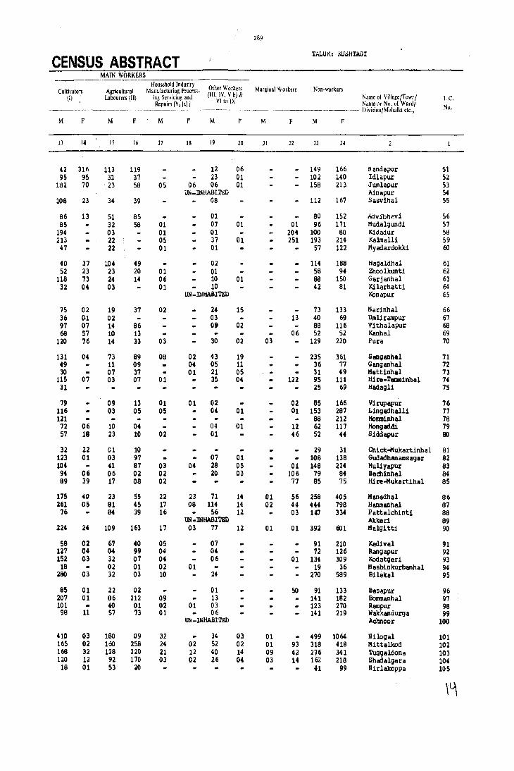
289
CENSUS ABSTRACT ThLUI<: KU':>H'rAGI
MAIN WORKERS Household Industry
Other Workers Marginal Workers Non-workers Cultivators Agricultural Manufacturing Process-(I) Labourers (II) ing Scrvicin,!! and (Ill, IV, Y b) & Name 01 Village/Town/ L.c.
Repairs IVlla] 1 VI to IX Name or No, of Waru/ No.
---------~-~ -------- '-"._- ----------- Division/Mohallactc"
M F M F M F M F M F M F
13 14 15 16 17 18 19 20 21 22 23 24
42 316 113 119 12 06 149 166 Nanda?Ur 51 95 95 31 37 23 01 102 140 Idlapur 52
182 70 23 58 05 06 06 01 158 213 Jumlapur 53 UN_INHABITJ!;D Ainapur 54
108 23 34 39 08 112 167 Sasvlhal 55
B6 13 51 85 01 BO 152 Ai:lvibhavi 56 85 32 58 01 07 01 01 96 171 Mudalgundl 57
194 03 01 01 204 100 BO Kidadur 58 213 22 05 37 01 251 193 214 Kalmall! 59 47 22 01 01 57 122 Myadardokki 60
40 37 104 49 02 114 188 Hagaldhal 61 52 23 23 20 01 01 58 94 Zhoolkllntl 62
11B 73 24 14 06 10 01 88 150 Garjanhal 63 32 04 03 01 10 42 Bl Kilarhatti 64
UN -INHABITED Konapur 6S
15 02 19 37 02 24 15 73 133 Narinhal 66 36 ().1 02 03 13 40 69 Umliralllpur 67 97 07 14 86 0' 02 e8 116 Vithalapur 68 6B 57 10 13 06 52 52 Kanhal 69
120 76 14 33 03 30 02 03 129 220 Pun 70
131 04 73 89 08 02 43 19 235 361 Sanganhal 71 49 11 09 04 05 11 36 77 Ganganhal 72 30 07 37 01 21 OS 31 49 Mettinhal 73
11S 07 03 07 01 35 04 122 95 lU Hire-Tenn1nhal 74 31 25 69 Hadagl1 75
79 09 13 01 01 02 02 85 166 Virupapur 76 116 03 05 05 04 01 01 153 2B7 Lingadhall1 77 121 88 212 Hommlnhal 78 72 06 10 04 04 01 12 62 117 Hongadt2i 79 57 18 23 10 02 01 46 52 44 Slddapur 80
32 22 01 10 29 31 Chick~ukartlnhal 81 123 01 03 97 07 01 108 138 Gudadhanalllslgir 82 104 41 87 03 04 28 05 01 148 224 Hul1yapur 83 94 06 06 02 02 20 03 106 79 B4 Baalinhal B4 89 39 17 oe 02 77 85 75 Hire-Mukartlhal 85
175 40 23 55 22 23 71 14 01 56 258 405 Manedhal 86 261 05 81 45 17 08 114 14 02 44 444 798 Hanmanhal 87 76 84 39 16 56 12 03 147 334 Pattalchinti BB
UN -INHABI 'l'BD AItlterl 89 224 24 109 163 17 03 77 12 01 01 392 601 Malgitti 90
58 02 67 40 05 07 91 210 Kadival 91 127 04 04 99 04 04 72 126 Rangapur 92 152 03 32 07 04 06 01 134 309 Kodatgeri 93
18 02 01 02 01 19 36 Masb1nlrurbanhal 94 280 03 32 03 10 24 270 589 BHekal 9S
85 01 22 02 01 SO 91 133 Basapur 96 207 01 06 212 09 13 141 IB2 Bommenhal 97 101 40 01 0'2 01 03 123 270 Rampur 98 98 11 57 73 01 06 141 219 Wakkandurga 99
IJtj_INHABITED Achnoor 100
410 03 180 09 32 34 03 01 499 1064 Nllogal 101 165 02 100 258 24 02 52 02 01 93 31B 418 Mittalkod 102 168 32 12B 220 21 12 40 14 09 42 276 341 Tuggaldona 103 120 12 92 170 03 02 26 04 03 14 162 21B Shadalgera 104 18 01 53 20 41 99 Nirlakoppa 105
\~

290
TALUI<; i(JJSH'l.'AGI (CON'l'D.) URBAN/VILLAGE PRIMARY
Total Population (including No, of imtitulional & Houseless Literates Tobi) Main
Name of Village/Town/ Area of Village in Occu~ied No. of Popul alion) Workers (I.IX) L.c. Name tlI' Nil. of Ward/ h,'clare, and of Town/ residential House·
N.), /Jivi.lioJljM"luJla ele., Waro in Km' houses hol,l;
p M F M F M F
10 II 12
106 Guddada-Devalapur 496.2~ 122 122 629 311 318 85 18 170 13 107 Konapur 292.6~ 74 74 565 278 267 99 14 150 83 lOB l;' aramanhatti 217.57 57 57 280 142 136 33 06 76 18 109 Venkatapur 194.52 93 94 460 230 230 90 05 107 54 110 Gudaclurkal 513.n 113 115 667 343 344 48 02 197 07
111 Madnhal 390.09 113 ll~ 559 266 :m 127 18 I80 159 115 Yeriger! 546.96 355 356 1963 966 997 377 88 560 321 113 Benkanhal 1363,53 231 231 1215 615 600 243 69 315 174 114 Yelbunchi 1016,25 205 205 996 497 501 170 18 280 86 115 Mugnoor 663.54 178 180 915 495 4BO 221 40 3U 262
116 Kumblavatti 848.51 23l 231 1253 630 623 158 28 401 290 117 Gorabihal 413.79 94 94 562 287 275 137 10 176 99 118 'l'i!ll1lanhatti 330.70 27 27 157 19 7B 12 40 15 119 Badimnhal 330.94 77 77 437 226 211 87 03 117 41 120 TlIIIIrikovpa 348.04 103 103 424 225 199 109 30 136 03
121 Hire-Gonnagar 754.65 265 265 1583 793 790 285 66 477 367 122 Chick-Gonnagar 308.34 44 44 206 102 104 35 14 47 123 I/arikal 379.83 42 42 281 138 143 48 04 79 68 124 Gadchinti 619.06 43 43 259 132 127 40 08 86 65 125 Habalkatti 391.84 195 196 1011 410 541 219 53 242 02
126 ParsaIJur 206.92 UN -lNIfABI'rED 127 Gudadur (Jagir) 674.90 216 216 1105 553 552 261 46 319 114 128 Mastkatti 404.02 89 89 419 232 247 112 12 145 94 129 Hanmasagar 1585.09 1459 1465 83B1 4017 4310 1705 924 2124 812 130 Havinitagi 1068.19 99 99 535 272 263 92 11 159 19
131 Chandragiri B74.13 73 73 410 197 213 64 05 116 01 132 Seelag! 968.47 73 73 427 215 212 122 25 128 13~ Kabbar9i 1146.85 317 317 1666 830 636 210 20 455 06 134 Kata~ur 1467.17 307 307 1569 748 621 237 29 457 148 135 Usalko.,pa 300.12 UN -INHABITED
136 Tatalcunti 105.92 UN-INHABI'rED 137 Kalgonhal 274.17 78 78 372 179 193 91 04 98 50 138 Turkanur 181.22 UN-INHABITED 139 Kadoor 447.85 51 51 214 139 135 81 25 69 36 140 Yerigonhal 271.63 101 101 601 294 307 157 53 148 76
141 Huchnoor 331.95 92 92 450 219 231 94 13 136 02 142 Antarthanll 485.07 101 101 552 280 272 122 15 114 142 143 Puratageri 302.55 72 n 409 187 222 108 22 93 144 Bandargal 565.80 114 114 725 317 348 165 10 230 43 145 Honmatti 284.51 UN -INIlABI'rED
146 Hulgen 3647.91 511:1 518 2879 1430 1449 510 140 789 43 147 Sebankatti 935.42 132 132 649 316 333 154 29 182 48 148 Mannerhal 818.11 2:21 221 1193 510 623 190 19 307 235 149 Mudhotagi 1494.24 38 38 210 112 98 40 04 79 74 150 Develapur 300.48 31 32 195 96 99 15 08 65 54
151 Hanamagerl 296.88 44 44 263 132 131 48 05 66 152 Miyal'ur 941.35 1~8 129 642 299 343 133 OB 161 05 153 KyadigulJpa 1653.66 288 299 132S 656 672 224 27 380 38 154 Mensageri 1024.79 109 109 570 296 274 47 03 177 63 155 KadekOwa 117.43 81 81 453 241 206 96 16 155 113 156 Tlr1111tnhatti 217.39 UN-INHABITED 151 TOIJalkattl 687.36 67 87 448 223 225 74 04 134 79 158 'l'alugeri 1512.05 307 308 1667 823 844 396 117 435 117 159 Kordakera 815.27 1'71 179 907 456 451 193 19 292 14 160 Chic)( Nandihal 356.35 73 80 476 254 222 65 01 145 04
,<11
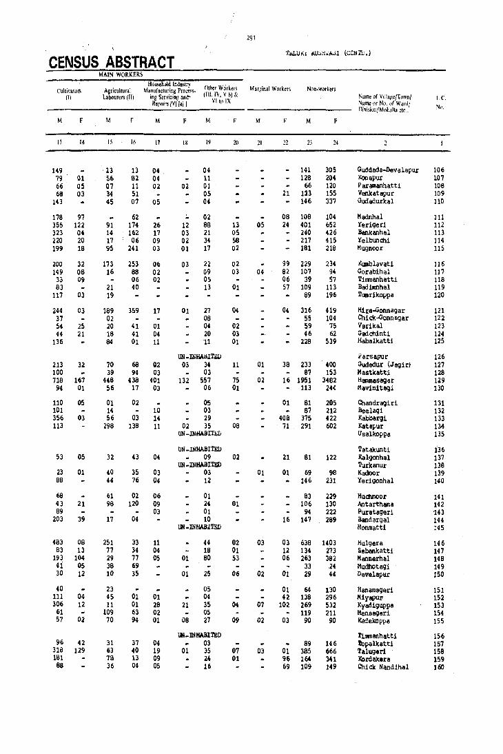
291
CENSUS ABSTRACT 'fALU'«; lI.U;"H'.l:A';l (CON'l'L.)
MAIN WORKERS
Househ3ld Industry Other W';rkers Marginal Workers Non.workers Cultivato~ Agricultural Manufacturing Process.
(I) Labourers (II) ing Servicing and- (III, TV, V b) &. Name of Villag~/T"wn/ t.e. Repairs IV] [a] I Vlt!) IX Nume or No. "I' Ward!
Division/Moltalla etc., Ntl.
M F M F M F M F M F M F
I) 14 15 16 17 18 19 20 21 12 21 24
149 13 13 04 04 14l 305 Guddada-Devalapur 106 79 01 56. 82 04 11 128 204 Konapur 107 66 05 07 11 02 02 01 66 120 Par<!l11anhatti 108 68 03 34 51 05 21 12) 155 Venkatapur 109
143 45 07 05 04 146 337 Gudadurkal 110
178 97 62 02 08 108 104 Madnhal 111 355 122 91 174 26 12 88 13 05 24 401 652 Yerigeri 112 323 04 14 162 17 03 21 05 240 426 Benk anha 1 113 220 20 17 06 09 02 34 58 217 415 YeIbunchi 114 199 18 95 241 03 01 17 02 181 216 Mugnoor 115
200 32 173 253 06 03 22 02 99 229 234 Kunl:Ilavati 116 149 06 16 8B 02 09 03 04 62 107 94 Gorabihal 117
33 09 06 02 OS 06 39 57 Tinmanhatti 116 83 21 40 13 01 57 109 113 Badimnhal 119
117 03 19 69 196 Tuorikoppa 120
244 03 189 359 17 01 27 04 04 316 419 Hire..Gonnagar 121 37 02 06 55 104 Chick-Gonnagar 122 54 25 20 41 01 04 02 59 75 Ver1lcal 123 44 21 18 41 04 20 03 46 62 Gadchinti 124
136 84 01 11 11 01 228 539 Habalkatti 125
UN-lNHAIlITiW .l'arsapur 126 213 32 70 6B Q2 03 34 11 01 38 233 400 Gudadur (Jagiri 127 100 39 94 03 03 87 153 Mastkatt1 126 716 167 448 438 401 132 557 75 02 16 1951 3482 Hanmasagar 129
94 01 56 17 03 06 01 113 24( Mavinitagi 130
110 05 01 Q2 05 01 61 205 Chandr~iri 131 101 14 10 03 67 212 Beelag1 132 356 03 56 03 14 29 408 375 422 ~aJ)bar91 133 113 296 136 11 02 35 08 71 291 602 Katapur 134
UN-lNI1ABI7'SIJ Usalkoppa 135
UN_lNHABI'Ml Tatakunti 136 53 05 32 43 04 09 02 21 81 122 Kalgonhal 131
UN -INHABI'Ml TurJcanur 138 23 01 40 3S 03 03 01 01 69 98 Kadoor 139 66 44 76 04 12 146 231 Yerigonhal 140
66 61 02 06 01 83 229 HudlnOor 141 43 21 98 120 09 24 01 106 130 Antarthana 142 89 03 01 94 222 Puratageri 143
203 39 17 04 10 16 147 289 Bandargal 144 UN -INHABITED Honmatti 14S
483 08 251 33 11 44 02 03 03 638 1403 Hulgera 146 63 13 77 34 04 18 01 12 134 273 SebanJcatti 147
193 104 29 77 05 01 80 53 06 263 382 Mannerhal 148 41 05 38 69 33 24 Mudhotagi 149 30 12 10 3S 01 25 06 02 01 29 44 Develapttf 150
40 23 05 01 64 130 Hanamager1 151 111 04 45 01 01 04 42 138 296 Miyapul' 152 306 12 11 01 26 21 35 04 07 102 269 532 Kyadiguppa 153
61 109 63 02 05 119 211 Mensageri 154 57 02 70 94 01 06 27 09 02 03 90 90 Kadekoppa 155
UN~INHABlTED T1111!1anhatti 156 96 42 31 37 04 03 89 146 'l'opalkatti 157
318 129 53 40 19 01 35 07 03 01 385 666 'l'alugeri 158 lSI 78 13 09 24 01 96 164 341 !'.ordaJcen 159 88 36 04 OS 16 69 109 149 Chicle Nandihal 160
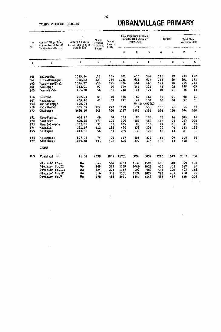
292
TALj)J(: KLTSHTAGI (CONCLIl) URBAN/VILLAGE PRIMARY -~----
'fotal Population (including
Nn. of Institutional & Houseless Literates Total '-bin
L.C. Name of ViHa~e/Town! Area of Village il' Occupied NI). nf Population) Workers (I-IX) Name or No. of Wa[(11 hectares alld "f T"wn I TI!~id~n\h,1
HOllse-No. n;visioll1Mohalla ctc., Ward in Km~ houses hulds -_--_.---
p M F M F M F
4 10 II 12
161 Yelburthi 1025.44 155 155 800 406 394 116 19 238 162 162 Hire-Bannigol 960.a2 229 234 1238 611 627 236 58 301 191 163 Hire-N andihal 1394.'1'1 175 l15 930 464 '166 1'14 IS 265 212 164 KanltOPpa 363.01 90 90 476 244 232 65 05 139 09 165 Donnegudde 495.10 56 56 240 III 129 40 01 65 42
166 Bisnhal 292.93 60 60 335 169 166 56 01 98 91 167 l'arasapur 669.86 67 67 272 142 130 60 08 92 51 168 Bhingikoppa 170.72 uti-INHABITED 169 Kalalbandi 835.59 222 223 1129 5'74 555 156 26 316 37 170 Cbalgera 2618.90 548 550 2777 1365 1392 576 238 744 160
171 Zhoolkstti 634.43 69 69 373 187 186 78 14 106 44 172 Madikera. 696. '78 1'70 170 905 453 452 143 06 297 305 173 Zhunjalkoppa 382.85 33 33 185 80 105 22 01 41 52 174 Hos!tll1 331.99 112 112 476 238 238 70 04 113 132 175 Malkapur 413.32 56 56 255 133 122 65 13 81
176 Hulsegeri 521,24 74 74 417 205 212 66 09 116 36 171 Adv1:bhav1 1059.10 138 136 625 322 303 133 13 178
URBAII
16/V Kushtag1 (M) 11.34 2059 2079 11781 5897 5884 3216 1847 2867 750
Division No,l NA 543 541 3053 1533 1520 655 140 609 198 Pivia10n No.II NA 348 349 2069 1046 1023 620 303 51!? 86 P1viaion No.III NA 324 324 1867 900 967 491 300 423 165 P1v1s1on NO. IV NA 366 371 ~151 1124 1027 797 487 460 75 P1.,111011 lIo.V NA 478 488 2641 1294 1347 653 411 ME:! 226

293
CENSUS ABSTRACT TALUK: KUSHTAGI (CONCLD.)
MAIN WORKERS .----~~,--~ --
Household Industry Other Worke<s Mar~inal Workers N,'n-workers Cultivators Agricultural Manufacturing PfIlCes.'.
(I) Labourers (II) ing Servicin~ and (III. IV, V h) & NillIle of Vill'l~c/T"wnl L.C. VIto rx Repairs [V] [a]] N,,"\~ nr Nl> "I' Wardl No. ----~--- -----.---~~-- Divi,ioll/Mohalla etc ..
M F M f M f M F M F M f'
IJ 14 15 16 17 1& 19 20 21 22 2.1 24
151 11 60 146 20 02 07 01 168 232 Yelburthi 161 101 05 ~63 183 12 01 19 02 01 310 435 Hire-BannJ.~ol 162 133 05 113 204 10 02 09 01 Jl 01 198 253 Hire ... ~ andihal 163
79 48 06 O. 01 08 105 4123 KankoPlia 164 24 01 32 36 01 08 05 04 46 83 Donnegudda 165
83 6S 07 23 01 01 0'7 02 71 75 BJ.snhal 166 65 34 21 14 02 02 04 01 50 '79 Parasapur 167
UN_INHABITr;D Bhing1koppa 166 280 11 02 25 01 33 01 09 !O7 ,49 411 l<alalband1 169 448 52 128 94 22 15 146 19 05 111 636 1101 Chalgera 170
92 05 11 39 03 19 54 62 98 Zhoolltatti 171 154 25 128 277 02 03 13 156 147 Madlkera 172
41 50 02 39 53 Zhun j alkoppa 173 16 02 89 127 01 08 02 01 124 106 Hosall! 174 65 13 01 02 52 122 MalkaplU' 175
68 D4 23 29 03 22 03 09 89 167 Hulseqeri 176 126 24 09 19 144 303 Advibh,vi 177
844 76 SEC 505 145 5S U19 \U 23 34 3007 5100 Kushta9i (M) 16/V
189 23 189 133 14 11 417 31 02 03 722 1319 D11r1sion )io.l 219 11 80 60 27 03 201 12 01 02 518 935 Division No.II 111 OS 123 131 12 01 177 )) 02 4'75 602 Division No.lII 179 J.6 30 47 24 01 227 11 06 04 658 948 D1vision toO.IV 146 21 199 134 69 39 296 32 12 25 63' 1096 Division No. V


LINGSUGUR TALUK
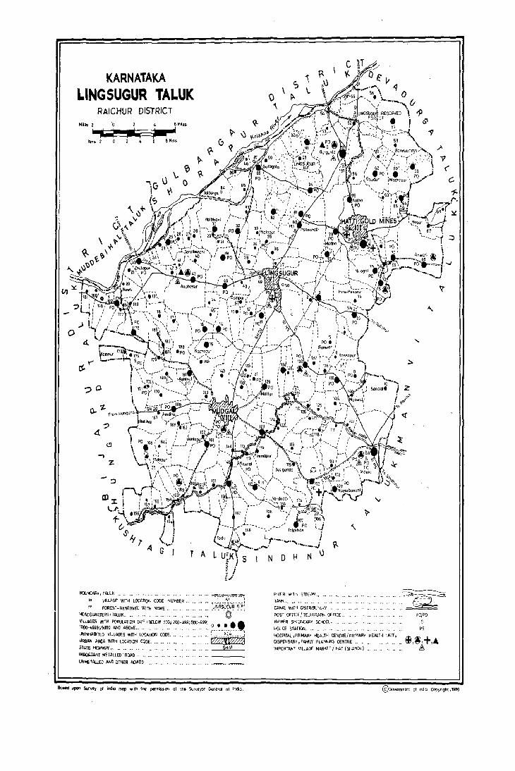
(/J
0
KARNATAKA LINGSUGUR TALUK
RAICHUR DISTRICT 4 SM ...
~ I Km!i l 4
~Y"
?O
? 4-
(!)
""'I
Z
:::>
BOUNDAR¥, TAlUK .
" VILLAGE WITH LOCATION CODE NUMBER ..
FOREST-REseRVED WITH NAME" HEADQUARTERS, TAlUK ..
T A
" '" G;'~;~;;;i "',"'. © '
VILLAGES WITH POPULATION SIZE, BELOW 200; 200./,99; 500-999; •• 1000-4999;5000 AND ABOVE." " ." •. ". " .. " .,,' ". '" ." ~ •. ~_.'. __ ..• , UNINHABITED VILLAGES WITH LOCATION CODE. ", " .... ' .. ". ,', L _____ )(_~~ _____ ! URBAN AR£A WItH LOCATION CODE. •• '" WffiIlt'%'i02 SlATE HIGHWA'... .' SH 41 1III!()jUAI;T METALLED ROAD ..
UNMHALlED AND OTHER ROADS.
90sid ~ $or"", of india mop with thcz permisSion Of the Surv~yor General of Indio.
c; , \.
RIVER Wlnl STREAM., lANK
CANAL WITH Of5TRIBUTA~Y .
1jl.
POST OFFICE I TELEGRAPH OFFICE ..
HIGHER SECONDARY SCHOOL ..
POLICE STATION" '"
i >o~
Qir:~t
" 'il'
HOSPITAL, PRIMARY HEALTH CENTRI;:/ PRIMARy HEAlTH UNIT, DISPENSARI, 'AMILI PLANNING CENTRE '"
IMPORTANT VILLAGE MARKET I HAT (SHANDY)
'Y
"-
"-
~
Z
<i
~ ...... ~~
~ PO/TO
S PS
@50\lmYTlent ot India Copyright ,1986.
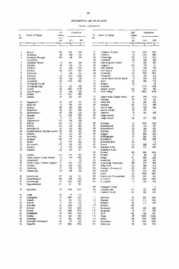
297
ALPHABETICAL LIST OF VILLAGES
TAL UK: LIN G S U G U R
1981 Population 1981 Population S1. Name of Village Census S1. Name of Village Census No. L.C. No. L.C.
No. 1971 1981 No. 1971 1981
4 2 4
Adapur 164 524 492 61 H adagaJi (H adgali) 110 lu84 1307 ldvibhavi 48 424 ~95 62 Halbhavi 30 1172 1384 Advibhavi (M udgal) 189 728 706 63 Hali<awatgi T78 S16 1003 (Advibhavi) 64 Hanchinal 85 386 4113
4 Advibllavi (Maski) 119 467 240 65 Ham.mangudda (Hosur) 17 662 663 5 Aidanhal 36 544 731 66 Heggapur 150 170 91 6 Aidbhavi 91 984 1142 67 Hire Hesarur 74 759 776 7 A mdihal 169 1227 1262 68 Hire Nagnur 70 1079 1233 8 Amrawati 4 324 353 69 H onnahalli 80 1566 1827 9 Anahosur 43 2592 2766 70 Hosagudda Gl 193 270
10 AnKanhal 180 299 259 71 i'oovin bhavi (Hovvin Bhavi) 8 642 792 11 Ankasdoddi 139 1450 1463 72 Hosur 67 688 718 12 A ntergungi (S m altl 101 73 H uligud 50 66 13 A ntergungi (Big) 102 522 639 74 Hunkunti 11 1116 1308 14 Anwari 68 2825 3148 75 Hunoor (Hunur) 153 492 388 15 Arya-Bhogapur 154 469 309 76 H utti Village 77 10863 7448 16 Ashihal 191 1072 1084 17 Askihal 125 262 227 77 Jakker-madu (Jakker Mudu) 123 590 1142
78 Jaldurga 8~ 140 132 18 Baggalgudda 104 208 227 79 JaJibenchi 311 344 443 19 Bailgudda 115 484 574 80 Jantapur 162 773 688 20 Baiyapur 186 50B 600 81 Jawoor (Big) 23 430 902 21 Bandebhavi 58 501 855 82 Jawoor (Small) 24 137 22 Bandisunkapur 187 296 236 83 Julgudda 18 551 824 23 Baonlgol 161 12~i' 1402 84 Junga m arhalli 7 24 Basapur 6 441 463 85 Jungi-Rampur 26 311 502 25 Bellada m ardi 119 348 228 26 Bellihal 157 404 324 86 Kachapur 15 1047 1324 27 Bellihal 167 250 266 87 K adadargaddi 87 174 177 28 Benchaldoddi 96 420 262 88 K adadarnahal 130 369 503 29 Bendarkarlkunti (Bendikarlkunti) 138 483 505 89 Kaddona 63 173 225 30 Bendona 42 523 757 ~O Kalapur 35 804 859 31 Benkanhal 120 195 195 91 K allilingsugur 12 692 712 32 Bhogapur 185 405 371 92 Kamaldinni 21 802 896 33 Bhupur 13 647 652 93 Kamandal dinni 106 15 34 Born manhal 175 589 637 94 Kannal 113 690 818 35 Buddinni 9 549 629 95 K annapur hutt! 192 775 844 36 Buddinni 133 357 351 (Khanapur Hutti)
96 K ansa vi 166 1063 1069 37 Chattar 147 795 850 97 Kardkal 49 68 26 38 Cmck-Hesarur (Chick Hesrur) 73 1114 1183 98 Katgal 141 580 544 39 Chikaldoddi 97 52 99 Kesarhutti 3R 259 580 40 Chikka Nagnur (Chikka Nognur) 71 533 577 100 Khairwadgi (Kair~adgi) 188 874 886 41 Chitapur 22 1322 1333 101 Killar hutti 190 568 533 42 Chitranhal 45 409 45B 102 Komlapur (Komalapur) 165 481 524 43 C hukenhutti 69 188 258 103 Korn nur 173 523 547
104 Kotha 95 2438 ~867 44 Dabbermadu 127 136 131 105 Kumarkhed (Kum markhed) 148 457 321 45 o esai-Bhogapur 108 788 832 106 K unikellur 134 1006 1072 40 o everbhupur 94 1567 1903 107 K uppigudd 2 7~7 752 47 o ignaikanbhavi 121 411 3117
108 Lingsugur (R ural) 2 48 Eachanhal 39 1796 2070 109 L ukkihal (Big) 171 508 446
110 Lukkihal (S m all) 172 468 473 49 Gadgi 55 37 142 50 G ajjalgutta 72 1685 1790 111 Machnoor 60 805 1045 51 GOlpalli 52 333 585 112 Makapur 159 413 442 52 Gonwar 5 990 940 113 Mallapur 66 511 418 53 Gonwatla 89 1.009 1135 114 Mallapur 182 54 Gorebal 32 1103 1228 115 Maraldinni 126 934 943 55 Goudur 62 1968 2016 116 Margatnal 44 441 430 56 Gudadanhal 79 1642 1700 117 Marli 152 4~9 421 57 Gudihal 131 952 992 118 Maski 98 8688 11639 5B Gundsagar 16 923 1060 119 Mattur 129 14&7 1&86 59 G untagoJa (G ontagoJa) 90 77~ 795 120 Mavinbhavi 14 1204 1270 60 Gurgunta 51 4963 5972 121 Medernhal 99 600 715

298
ALPIl ABEnC AI. LIST OF VILLAGES
TALuK : LINGSUGUH
1981 Population 1981 Population SI. Name of Village Census 31. N am e of Village Census No. L.C. No. L.C.
NC. 1971 1981 No. 1971 1981
2 4 4 5
122 MediJdnbal 100 1851 2197 160 Talekat (Talikat) 160 382 373 123 Mednapur 78 960 1257 161 Talekhan 107 1346 1099 12~ Minchen 33 390 400 162 Tan Manka! 54 311 351 125 M1ttlkellur 135 279 345 163 Taribhavi '32 163 210 126 Mudaldinni 122 497 449 164 Tawag 65 309 423 127 MUdga! (R ural) 143 287 638 165 Tim mapur 114 820 909 128 )Iudwal 140 209 266 166 Tirthbhavi 116 579 494 129 M usllkar1kunti 137 576 535 167 Todki (Tudki) 149 225 301
(M uslikarJikintl) 168 Tondihal 179 585 636 169 Tara! benchi 40 745 672
130 N 8j!alopur (D ) 128 170 TurnbaJtaddi (Tumba! Cuddi) 18~ 198 175 (H agalopur) 171 Turadgi 158 381 377
131 N8j!arbal 176 1845 1862 132 N 8j!er Benchi 103 953 1039 172 Ulimeshwar 145 414 437 133 Naglapur 146 917 1111 173 Uppanhal 181 354 324 13~ Nandihal. 41 380 462 174 Upperi (Small) 27 465 523 135 Narkaldinni 19 613 801 175 U pperi (Big) 29 370 417 136 Neeralkera 46 962 1073 176 Upper N andihal 170 861 750 131 Nllogal 75 1434 1648 138 Nlrloti 117 115 53 117 Veerapur 16 505 743 139 NowJi 20 511 490 17B Veerapur (0) (Era put) 105
179 Venkatapur 142 408 405 140 Pal doddi 56 730 710 180 . Vyakarnhal 151 858 655 141 P algal dinni 117 380 422 181 Vyasa Nandihal 112 385 427 142 Para rnapur 93 435 5.97 143 Phoo1bhavi (Phul Bhavi) 82 588 1221 182 Wandali 155 424 420 m Piklihal. 144 481 523
183 YaJtundi (Y el.gunti) 86 19B 241 145 Raidurga 53 3,., 411 184 Y elgaldinni 37 441 467 146 Ramatnal 156 599 570 185 Yelgutti 59 1314 1497 147 Ramloti(Ra mlootl.) 92 '00 86 186 Yerdihal (Khurd) 163 427 372 148 lIa-mpur 41 60B 590 187 Y erdihal (Big) 168 56B 601 149 Ram pur 183 282 281 188 YercQddi 109 341 387 150 Roudal. banda 25 1217 1681 189 Yerdona 81 1027 1229 151 IOIlda]. banda 64_ 1007 1695 190 Yergodi (Y erdoddi) 88 485 433
191 Yergunti 31 356 400 152 s.Jjalgud 174 507 805 192 Yerjunti (Y ergunti) 57 974 1459 153 Sanbal 10 805 606 154 Santlkellur 136 1936 1989 155 Sarjapur 3 1610 1m 156 Shllhall1 (Tugali) 83 379 l/IJII 157 So II pur 111 158 Sultanpur 12~ ~15 388 159 SU!\kal 28 519 566

LINGSUGUR TALUK
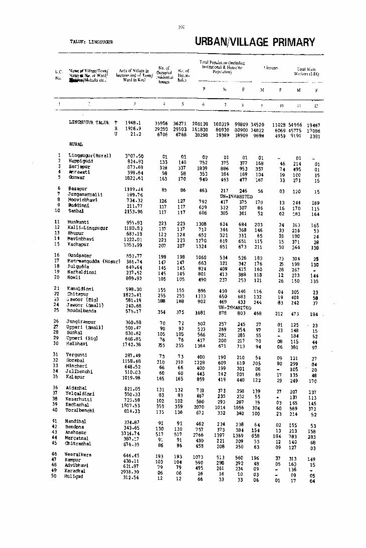
300
T ALUK: Ll NGSUGlJR URBAN/VILLAGE PRIMARY ----_.
Total Pop"lation (including No. of Institutional & Hou"les, Literate~ Total Main L.e. Namt III Vtlhge_rfownl Area of Village in Occupied No. of Population) Workers (I.IX) Nallll'. Nil. HI Ward! he.tare' ant of townl :esi,lential House.
No. JIIiaIoaIMur.aila etc .. Ward in Km~ houses hoI,!, ----- . ------------~---.-
P ~. F M F M F
iO II 12
LINGSt'GUR TALUK T 1948.1 35956 36271 200128 100319 99909 34520 11029 54966 19467 R 1926.9 292S() 29503 161830 80930 90900 24822 6069 45775 17096 1.1 21.2 6706 6768 39298 19399 18909 9699 4959 9191 2381
RURAL
1 LingBUgul'( Rural) 3707.50 01 01 02 01 01 01 01 2 Kupp1gudd 934.g3 133 140 752 375 377 169 46 214 01 3 Sarjapur 873.69 328 337 1839 896 953 357 74 495 01 4 Iftrawati 398.64 58 59 353 184 169 104 19 100 15 5 Gonwar 1822 .61 163 170 940 4~3 477 167 33 271 15 6 Basapur 1189.L4 85 96 463 217 246 56 03 120 15 7 Jungamarhall i 189.76 UN~ISHABIT[;D 9 Hoovinbt)avi 734.32 126 127 792 417 375 170 13 244 169 9 Budd1nni 211.77 117 117 629 322 307 86 16 170 115 10 '>anbal 2153.96 117 117 606 305 301 52 02 183 164
11 Hunlrunti 955.93 223 223 1309 624 684 20) 24 363 165 12 Kalli-Lingsugur 1180.S 2 137 137 712 344 368 146 33 216 53 13 Bhupur 6a3.1B 122 124 652 321 331 65 03 180 24 11 Mavinbhavi 1222.01 223 223 1270 619 651 115 15 371 28 15 Kachapur 1053.99 207 207 1324 651 673 211 50 364 130 16 rundsaqar 852.77 198 198 1060 534 526 IB3 23 304 2S 17 Hanl''I1anqudda (Hosur) 361.74 147 147 663 321 342 176 25 198 130 18 Julqudda 649.64 145 145 B24 409 415 160 28 267 19 Narkaldinni 237.52 145 145 801 413 388 119 12 223 144 20 Nowli 889.92 105 105 490 237 253 121 26 150 135 21 Kamaldlnni 598.30 155 155 896 450 446 116 04 305 23 2'2 Chitapur 1823.41 255 255 1333 650 683 132 19 401 58 l3 ~awoor (Big) 581.19 188 199 902 469 433 244 83 242 37 24 ,1awoor (Small) 240.68 UN-INHABITED 25 ROudalbanda 575.17 354 375 1681 978 B03 468 212 473 184 26 Jungirampur 360.58 70 72 502 257 245 27 01 125 23 27 Upped (small) 500.47 90 92 523 269 254 97 23 149 15 28 Sunkal 830.62 105 105 566 281 295 55 184 52 29 Upped (Big) 668.85 76 76 417 200 217 70 08 115 44 30 Halbhavi 1742.38 255 255 1384 671 713 94 06 381 97 31 Yergunti 287.4-9 73 73 400 190 210 54 09 121 27 32 Gorebal 1158.48 210 210 !228 609 619 205 90 299 04 33 Mincher! 648.52 66 66 400 199 201 06 105 20 34 Jalibenchi 510.03 60 60 H3 242 201 69 17 135 48 35 Kalapur 1019.99 165 165 859 419 440 122 29 249 170 36 Aidanhal 821.05 131 132 731 373 358 139 27 207 137 37 Yelgaldinni 5S0.33 83 83 467 235 232 55 137 113 38 KesarhutU 723.58 102 102 580 293 287 35 0) 165 145 39 Eachanhal 1817.53 350 359 2070 1014 1056 304 60 569 372 40 Toralbenchi 814.33 135 136 672 332 340 100 23 214 52 41 Nandihal 234.82 91 91 462 224 238 64 02 155 53 '2 Bendona 343.65 130 130 757 373 394 15~ 13 213 158 43 Anahosur 3314.74 517 "i17 2766 1397 1369 658 184 783 283 44 Margatnal 387.17 91 91 430 221 209 53 12 140 68 45 Chitranhal 676.35 96 96 458 209 250 63 09 127 03 46 Neeralkera 646.45 193 193 1073 513 560 196 37 313 149 47 Rampur 439.11 103 104 590 298 292 48 05 163 15 49 Advibhavl 621.97 79 79 495 261 234 09 136 49 Karadkal 2938.30 06 06 26 16 10 03 09 05 50 Huligud 312.54 12 12 66 33 33 06 01 17 04

301
CENSUS ABSTRACT TALUK: LlrlGSUGUR
MAIN WORKERS --------·----------ll;;;;;!to\d hld\l5'-,,----·--
('ulli,::ltols Agricultural Manufacturing Proc~,,- Other \\ Or~l:fS Marginal Workers NOll-workers
(I) Labourers (II) illg: Senicill~! nnu 1111. II". V b)" Naille of Vil1a~cIT(l\\'nl L.C. Repairs [VI lull \1 1,,1\ Nallle or N". "r Wordl
.---~ Division/Mohall. ric" No.
M F M F M f \1 " M F M F
13 14 15 16 17 l~ I') 20 21 2? 23 24
---~--- ----_. ------- ,
26768 4800 12396 12538 1499 460 14303 1649 410 8409 44943 71933 T LINGSUQ.JR TI\L1) i( 24532 4364 11376 11199 1153 364 8714 1159 332 7936 34823 55878 R 2236 436 \ 1020 1339 346 116 5539 49(1 78 473 10120 16055 U
01 01 - Lingsugur (Rural) 1 89 111 01 01 13 02 164 159 t1.2 Kupp1gudd 2
295 157 01 1:.! 31 03 442 38B 510 Sarjapur 3 74 03 20 10 06 02 33 84 121 Amrawati 4
230 OB 30 06 02 01 09 01 62 191 400 Gonwar 5
93 09 \)6 04 01 02 18 07 113 90 118 Basapur 6 UN-I~P'.6JlITED Jungamarhalli 7
7a 04 85 159 03 02 78 04 01 173 205 Hoovinbhavi 8 143 92 03 07 17 15 07 01 10 152 182 Buddinni 9 109 05 59 155 05 03 10 01 122 137 Sanbal 10
275 03 38 129 09 16 41 17 01 234 260 285 Hunkunti 11 123 04 76 49 07 10 128 315 Kall i-1 ingsug'Jr 12 129 11 20 09 10 01 21 03 141 307 Bhupur 13 197 02 166 26 09 01 353 247 270 Mavinbhavi 14
93 257 130 08 06 161 287 382 Kachapur 15
162 117 25 1, 10 26'3 230 233 Oundsagar 16 100 22 81 108 04 13 123 212 Han\ll!1angudda (Hosur) 17 214 50 01 02 107 142 308 Julgudda 18
91 93 143 03 Gl 36 01 26 187 218 Narkaldinni 19 121 113 09 17 09 03 11 02 01 87 117 Nowli 20
227 67 22 05 06 01 145 423 Kamaldinni 21 225 90 58 08 i3 249 625 Chitapur 22
48 01 55 33 06 133 03 227 396 Jawoor (Big) 23 UN-H'HABI1'ED .Jawoor (Small) 24
97 42 78 128 13 04 255 10 02 403 619 Roudalbanda 25
58 01 40 22 27 132 222 Jungirampur 26 72 01 58 12 08 10 02 04 90 117 149 Upped (Small) 27 83 02 44 34 09 10 48 06 163 97 70 Sunkal 28 86 07 07 36 11 0" 11 01 85 172 Upped (Big) 29
255 14 112 80 07 07 03 290 616 Halbhavi 30
1 J 8 26 02 01 Cl 69 183 YergUnti 31 235 01 60 02 04 01 310 615 Gorebal 32 89 03 15 17 0: 03 94 179 Mincher! 33
108 30 27 18 107 153 Jal1benchi 34 129 12 89 154 04 29 04 14 28 156 242 Kalapllr 35
131 16 70 121 01 05 166 2(.1 Aidanhal 36 100 77 35 36 02 98 119 Yelgaldinni 37
04 01 160 144 01 01 128 141 Kesarhutti 38 29 421 362 113 106 10 02 445 682 Eachanhal 39
105 62 47 06 41 05 01 06 117 282 Toralbenchi 40
75 02 :'2 49 03 25 02 03 66 66 119 Nandihal 41 9:' 11 86 146 06 26 01 160 226 Bendona 42
407 33 194 16B 32 05 150 27 10 271 504 865 Anahosur 43 77 03 33 43 04 03 26 19 07 81 134 Margatnal 44 74 43 03 05 05 03 66 78 181 Chitranhal 45
244 05 58 142 02 02 09 01 199 411 Neeralkel'a 46 120 05 40 09 03 01 135 277 Rampur 47 135 01 125 234 Mvibhavi 48
09 02 03 02 Q7 03 !(aradltal 49 08 06 04 03 16 29 Hul1gUd 50
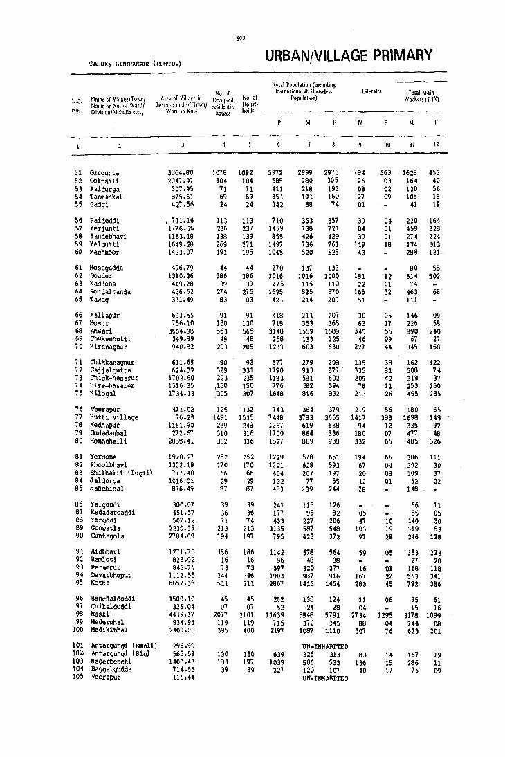
302
'tALUK: LINGSUGUR (CONTO.) URBAN/VILLAGE PRIMARY
Total Population (intillding No. of Instill.tiona[ k Houseless Literates Total Main
Le. Name of Village/Town! Area of Village in Occul,ied No. of r~pulation) Workers (I.IX) Nallle or No. of Ward/ hectares and of Tmvnl n:liidclltt;tl HOllse.
No. Division/Mohall. etc., Ward in Kill' houses holds
p M F M F M F
[0 II 12
51 rurgunta 3864.80 1078 1092 5972 2999 2973 794 363 1628 453 S2 Golpalli 2047.97 104 104 585 280 305 26 03 164 40 53 Raidurga 307.95 71 71 411 218 193 08 02 130 56 54 Tanmankal 825.51 69 69 351 191 160 27 09 105 16 55 Gadgi 427 .56 24 24 142 68 74 01 41 19
56 P.aidoddl .711.16 113 113 710 353 357 39 04 220 164 57 Yerjuntl 1776.26 236 237 1459 738 721 04 01 459 328 58 Bandebhav1 1163.18 138 139 855 426 429 39 01 274 224 59 Yelgutt{ 1649.28 269 271 1497 736 761 119 18 474 313 60 MachnooJ! 1433.07 191 195 1045 520 525 43 288 121
61 Hosagudda 496.79 44 44 270 137 133 90 58 62 Goudur 1310.26 386 386 2016 1016 1000 191 12 614 502 63 Kaddona 419.28 39 39 ;!Z, 11S 110 22 01 74 64 Roudalbanda 436.62 274 275 1695 825 870 165 32 463 68 65 Tawag 331.49 83 83 423 214 209 51 111
66 Mallapur 693.55 91 91 418 211 207 30 05 146 09 67 Hosur 756.10 130 130 71B 353 365 63 17 226 58 68 Anwari 3664.98 563 565 3148 1559 1589 345 55 890 240 69 Chu'kenhutti 349.139 48 48 258 133 125 46 09 67 27 70 H1renagnur 940.82 203 205 1233 603 630 227 44 345 168
71 Chikkanagnur 611.69 90 93 577 279 298 135 38 162 122 72 Gajjalgutta 624.39 329 331 1790 913 877 335 81 508 74 73 Chick-hesarur 1702.60 223 23S 1183 581 602 209 42 313 37 74 Hire-hesarur 1516.35 \150 150 776 332 394 78 11 253 250 75 Nilogal 1734.13 305 307 1648 816 832 213 26 455 285
76 Veerapur 411.02 125 132 143 364 379 219 56 180 65 77 Hutti village 76.28 1491 1515 7448 3783 3665 1417 393 1698 14') 78 Mednapur 1161.90 239 248 1257 619 638 94 12 3.35 92 79 Gudadanhal 272 .67 :,10 316 1700 864 836 180 07 477 48 80 Honnahalli 2888.41 332 336 1827 889 938 332 65 485 326
81 Yerdona 1920.27 ?52 252 1229 578 651 194 66 306 111 82 Phoolbhavi 1322.18 170 170 1221 628 593 67 04 392 30 83 Shilhalli (Tugli) 777.40 66 66 404 207 197 20 08 109 37 84 Jaldurga 1016.01 29 29 132 77 55 12 01 52 02 85 Hanchinal 876.49 87 87 493 239 244 29 148
86 Yalgundi 300.(17 39 39 241 115 126 66 11 87 Kadadargaddi 451.57 36 36 177 95 82 05 ,5 05 88 Yergod1 507 .12 11 74 433 227 206 47 10 140 30 89 Gonwatla 1230. ~8 213 213 1135 581 548 103 19 319 83 90 Guntagola 2784.09 194 197 795 423 372 97 28 246 128
91 .\idbhavi 1271.76 186 186 1142 578 564 59 05 353 223 92 Ramlotl 829.92 16 16 86 48 38 27 20 93 Parampur 846.71 73 73 597 320 277 16 01 168 118 94 Devarbhupur 1112.'>5 344 3116 1903 981 916 Hi7 22 563 341 95 Kotha 6657 • ~8 511 511 2867 1413 1454 283 45 792 386
96 'Senchaldoddi 1500.10 45 45 262 138 124 11 06 95 61 97 Chikaldoddi 325.04 07 07 52 24 29 04 15 16 98 HasJd 4419.17 2077 2101 11639 5848 5791 2734 1295 3178 1099 99 Me de rnh al 834.94 119 119 715 370 345 88 04 244 08
100 Medikinhal 21109.()3 395 400 2197 1087 1110 307 76 638 201
101 Antargungi (Small) 296.99 UN-INHABITED 10,' Antargungi (Biq) 565.59 130 130 639 326 3.13 83 H 167 19 103 Nagerbenchi 1400.43 183 197 1039 506 533 136 15 286 11 104 Baggalgudda 714.&5 39 39 227 120 107 40 17 75 09 105 Veerapur 116.44 UN-INHABITED
303
y
CENSUS ABSTRACT TALUK, LINGSUOOR (CCNTD.)
MAIN WORKERS Household Industry
Olfi~r W"rkers Marginal Workers Non-workers Cullil'ators Agricultural Manufacluriu~ Process. (I) Labourers (II) ing Servicin~ :lnU '(111, IV, Vb) & Name of Village/T<lwn! L,C,
Repairs (V] raj 1 VI to IX Name or No. of Wardl Division/Mahalia etc., No.
M F M F M F M F M F M F
IJ 14 I) 1(0 17 18 19 20 21 22 23 24
831 61 289 288 63 08 445 90 27 525 1344 1995 Gurgunta 51 85 01 ,43 19 36 20 40 116 225 Golpall1 52 95 42 20 11 15 03 11 51 77 80 Raidurga 53 87 04 06 12 12 01 69 85 75 'fannaankal 54 32 10 02 09 07 02 16 25 39 Gadgl 55
148 88 31 68 41 08 18 133 175 Paidodd.1 56 390 79 6~ 244 04 07 01 09 38 270 355 Yerjunti 57 226 210 09 11 39 03 152 205 Bandebilav1 58 363 255 55 54 56 04 01 261 448 Yelgutti 59 181 43 64. 77 01 42 01 232 404 Machnoor 60
50 54 05 04 25 57 75 Hosagudda 61 333 237 96 253 16 07 169 05 01 401 498 Goudur 62 13 43 18 01 41 109 Kaddona 63
277 15 69 37 117 16 01 96 361 706 Roudalbanda 64 103 08 108 103 101 Tawag 65
21 09 120 01 04 65 198 Mallapur 66 128 05 44 42 05 49 11 01 127 306 Hoeur 67 583 91 122 124 48 09 137 16 15 410 654 939 Anwar 1 68
18 02 29 22 01 19 03 06 39 60 59 Chukenhutti 69 141 U 81 123 04 119 04 10 93 248 369 Hirenagnur 70
46 11 27 67 09 08 80 36 01 56 116 120 ChiJclcanagTlllr 71 182 13 175 43 20 04 131 14 04 267 401 536 Gajjalgutta 72 151 05 111 22 14 07 42 03 07 222 256 343 Ch~ck-heearuI 73 133 133 62 78 11 06 47 33 01 129 143 Hire-hesMUr 74 263 126 154 155 09 29 04 181 361 366 Nlloqal 75
68 09 35 46 10 04 67 06 23 113 161 201 Veerapur 16 187 03 123 26 63 31 1325 88 60 12 2025 3505 Hutt! village 77 182 33 69 55 02 82 04 02 85 282 4bl Mednapur 78 215 02 224 45 04 34 01 05 08 382 780 Gudadanhal 79 234 30 137 248 15 18 99 30 04 404 608 Ronnahall1 80
180 04 88 98 03 01 35 08 01 01 271 539 Yerdona 81 137 02 238 28 07 10 07 236 556 Phoolbhavi 82 19 06 86 31 03 01 9B 160 Shilhalli (Tugli) 83 26 02 19 07 20 25 33 Jaldurga 84 87 16 03 42 68 91 176 Hanchinal 85
53 08 05 02 01 07 01 49 115 Yalgundi 86 43 05 04 02 06 41 40 36 Kadadargaddi 87 87 23 05 03 01 47 04 10 87 166 Yerqodi 88
146 25 127 34 06 40 24 268 465 Gonwatla 89 133 02 95 124 02 16 02 177 244 Guntagola 90
207 02 124 218 03 19 03 225 341 Aidbhavi 91 21 18 06 02 21 18 Ramloti 92 92 05 52 47 02 24 64 03 152 156 Parampur 93
33" 19 134 311 05 01 90 10 01 423 575 DevaIbhupur 94 351 191 234 182 04 203 13 07 110 614 898 Kotha 95
69 21 06 20 20 2.0 04 43 59 Benchaldoddl 96 11 02 08 04 06 02 09 10 Ch1kaldodd.1 97
827 58 607 776 132 56 1612 209 18 231 2652 4455 MaeU 9B 195 442 08 07 126 337 Medemhal 99 372 33 146 150 .37 14 83 04 449 909 Medikinhal 100
UN-INHABITED Antargungl (small) 101 136 23 19 08 01 159 293 Antargungi (Big) 102 145 03 120 08 06 15 227 220 295 Nagerbenchl 103
47 01 17 08 11 45 98 13aqqalgudda 104 UN-INHABITED Veerapur lOS

304
TALUJ<: LINGSUGUR (CONTD.) URBAN/VILLAGE PRIMARY
Total Population (including ----~---
No. of Institutional &. HouseJess Literates Total Main L.e. Name of Village/Town! Area of Village in Occupied No. of Pupulation) Workers (OX) Name or No. of Ward! hectares and nr Town! residential House-No. Division/Mohalla etc., Ward in Km2 houses holds
--------~ ... ----
P M F M F M F
10 II 12
106 Xamandal dinn 1 218.73 04 04 15 07 08 01 03 01 107 Talekhan 2462.06 215 216 1099 533 566 209 40 334 194 108 Desai.Bhogapur 1565.73 135 135 832 409 423 44 10 241 119 109 Yerdoddi 1124.'16 78 78 3B7 199 188 50 07 11B 67 110 Hadagal1 1637 .10 201 202 1307 628 679 126 26 350 29
111 Jompur 237.74 UN-INHABITED 112 vyasanandihal 577 .O~ 6C 66 427 208 219 71 16 124 74 113 Kannal 664.82 164 164 818 395 423 136 31 226 198 114 Tirnmapur 1615.01 136 136 909 435 474 82 21 283 218 115 Bailgudda 1584.51 86 88 574 287 297 75 08 171 107
116 Titthbha'li 560.46 B6 86 494 243 251 46 03 151 127 117 Nirloti .08.21 13 13 53 26 27 05 03 14 18 118 Advibhavi (Mask1) 255.00 44 44 240 130 110 04 61 51 119 Bell adamiilrd1 1065.71 51 51 228 110 118 37 03 67 1B 120 BenJcanhal 234.46 34 34 195 104 91 25 03 63 18
121 Dignaikanbhiilvi 743.86 64 64 347 164 183 24 05 59 122 Mudald1nni 801.53 69 69 449 249 200 53 09 154 41 123 Jakkermadu 1013.75 153 153 1142 567 575 52 03 324 91 124 9J.ltanpUt 567.54 65 65 388 197 191 41 10 124 11 125 Askihal 582.80 37 37 227 116 111 18 83
126 Marald1rmi ~74.97 143 144 943 502 441 152 11 300 145 127 Dabbermadu 384.00 23 23 131 63 68 03 38 02 128 N agalopur (D) 134.135 UN~INHABITED 129 Mattur 2259.09 305 306 1686 824 852 283 63 438 174 130 Kadadflrnllhal 660.81 77 77 503 247 256 27 05 13B
131 Gudihal 1011.57 167 167 992 495 497 167 10 269 47 132 Tar1bhav1 476.92 36 36 210 105 lOS 11 01 58 08 133 Budd1nni 637.86 68 68 351 186 165 75 02 111 134 Kuni-Kellur 503.77 189 189 1072 525 547 136 39 309 234 135 Mittl-Xellur 727.37 64 64 345 176 169 51 05 105 63 136 Santlkellur 2386.97 387 390 1989 947 1042 335 100 529 418 137 Muslikarlkunti 822.53 94 94 535 281 254 142 33 179 125 138 BenearkarlltUnti 608.42 93 93 505 252 253 88 16 137 53 139 AnJtasdoddi 794.31 270 270 1463 727 735 251 59 388 135 140 I'lIdwal 1110.46 47 47 266 138 128 65 20 75 71 141 Xatgal . 589.73 97 97 544 278 266 92 11 165 62 142 Venkatapur 990.25 68 68 405 194 211 77 37 110 83 143 Mudqal (Rural) 4661.46 102 102 638 336 302 38 01 184 37 lU P1kl1hal 534.24 86 86 523 252 211 120 24 153 80 145 Ulimeshwar 523.97 61 91 437 213 224 43 13 135 83 146 Naqlapur 369.42 191 191 1111 557 554 78 35 323 236 147 Chattar 1258.47 144 144 850 439 411 99 OS 2~ 52 148 Xumarkhed 1186.92 63 63 321 162 159 25 04 99 04 149 TCldki 896.96 52 52 301 161 140 27 51" 51 ISO Heqgapur 30Ma 24 24 91 42 49 03 22 17 151 Vy alt arnh al 3,372.96 129 129 655 354 301 94 17 186 19 152 Marl 1 881.99 85 88 421 203 218 61 17 130 25 153 Hunoor 623.09 90 90 388 191 197 98 26 110 01 154 My a-Shoqapur 581.29 66 66 309 156 153 60 11 93 09 155 Wandali 442.60 81 81 420 210 210 9'1 23 135 101 156 Ramatnal 974.62 98 102 570 284 286 US 28 165 146 157 Bellihal 1256.07 61 63 324 157 167 61 07 81 39 158 Turadql 744.43 78 78 377 186 191 94 25 112 74 159 Makapur 714.46 80 80 442 221 221 105 42 123 ?l 160 Talekat 1139.67 94 84 373 183 190 69 24 102 53


306
'r'~LuK: L!NGSUGUfl (CONCLD.) URBAN/VILLAGE PRIMARY
Total Population (including No. of InstiMional & Houseles> Literate> Total M.',11
LC \i,lIl1e of Village/T"lYn/ Arca of Villa~e in Occupied No. of Population) \Vor~", (1.1\) Name M 1\0 II;' \\ ,;I"d} hl'l"Iar(;:; and llf Town! residrl1ti,11 HOIl>"·
No. l)i\'I~idlil ~illh,tlLl L'1l' .• Ward in Km: houses holds
p M. F M. F M F
4 10 II 12
161 Bannlgo1 1760.76 267 269 aoz 697 705 222 54 388 11 162 Jantapur 1423.43 120 130 688 359 329 109 26 211 24 163 Yerdlhal (Khurd) 506.48 74 74 372 184 18B 74 16 106 43 164 Adapur 738.40 86 86 492 252 240 150 37 156 46 165 Komlapur 382.52 83 83 524 247 277 130 48 149 47
166 Kansavi 1516.34 206 206 1069 514 555 270 82 319 63 167 Belllhal 514.52 56 56 266 132 134 5B 14 76 37 168 Yerdihal (Big) 767.67 99 99 601 302 299 96 46 196 57 169 Amdihal 848.17 224 225 1262 606 656 223 44 324 231 170 Upper-Nandihal 1013.92 133 133 75D 365 385 160 36 205 40
171 Lukk1hal (Big) 1019.00 91 91 446 231 215 98 10 125 24 172 Lukklhal (small) 444.71 74 76 473 235 238 75 15 132 58 173 Komnur 694.48 104 104 547 278 259 162 19 141 52 114 Saj j al9l1d 497.57 114 117 805 536 269 406 41 156 115 175 Bolllnanhal 9'52.87 117 117 637 32; 310 113 12 154 86
176 Nagarhal 1258.08 388 391 1862 898 964 263 88 498 288 177 Palgaldinni 568.46 89 89 422 205 217 95 62 131 99 178 Halkawatgi 1043.99 190 191 1003 491 512 138 26 258 106 179 'l'ondihal 635.68 123 123 636 307 329 102 06 176 03 IBO Ankanhal 484.49 '9 49 259 127 132 62 03 77 83
IBl Uppanhal 438.55 66 67 324 169 155 BO 22 104 53 162 Mallapur 174.94 UN-INHAIlITED 193 Rampur 468.09 50 50 291 144 137 68 22 96 70 184 Tumbalgaddi 227.76 34 35 175 78 97 50 17 48 39 195 Bhogapur 498.34 78 78 371 189 182 79 28 128
196 Baiyapur 525.0B 93 93 600 31B 292 138 16 16B 197 Bandl-&lnkapur 285.9B 52 52 236 120 116 53 02 83 22 198 1<h ai rwadg! 2041.56 176 176 886 457 429 151 14 291 176 189 Advibhavi (MUdgal' 1254.52 118 118 706 353 353 88 11 213 02 190 Kill arhutti 1048.95 93 93 533 268 265 74 02 159 16
191 Ashihal 566.38 191 191 1084 511 573 163 57 290 169 192 Kannapur-Hutti 927.70 147 147 844 432 412 121 16 273 26
URBAN
161lIt Hatti Gold Mines (NAC) 6.29 1766 1773 9962 5283 4679 3389 1864 2217 . 115 ,
16/VI Ltngsugur (1<1) 7.37 3060 3105 1687B 8474 8404 3973 1980 4256 1392
Division No. I NA 488 492 2812 1355 1457 532 196 736 480 Division No. II Nil 808 811 4306 2197 H09 1268 757 U1a 158 Division No.III NA 975 1007 5231 2707 2524 1421 769 1259 283 Division No. IV NA 411 411 2281 1125 1156 379 118 547 155 Division No. V NA 378 384 2248 1090 H58 373 140 597 316
16/VIlI MUdga! (M) 7.54 1880 1690 11459 5632 5!l26 2336 1115 2719 874
Ward No.1 NA 293 294 1926 959 967 493 209 369 65 ~ard No.2 NA 361 361 2025 972 1053 357 198 487 181 Ward No.3 NA 487 488 2958 1442 1516 667 338 715 252 Ward No.4 lilA 739 747 4549 2259 2290 825 370 1147 376
· '307
,CENSUS ABSTRACT TALUK: LINGSUGlJR (CONCLD.)
MAIN WORKERS
Household Indumy Other Workers Marginal Workers Culti','ator, Agricultural Manufacturing Proces~~ Non-workers
(II Labourm (ll) ing ServiciJ1~ and (111, IV, Vb) &, ":aIlIC or Villa~c/T()lVnl L.C. Repairs IVI [all VIto IX N:IlllC or No nf Wardl
iliv;"illn/Mnhalla etc,: No.
M F M F M M F M F M F
I, 14 15 In 17 Ik 19 20 21 22 23 24
211 01 83 06 08 86 04 216 309 478 Bannigol 161 115 02 49 19 10 37 03 160 148 145 J,mtapur 162 80 24 16 14 01 09 05 02 75 76 70 Yerdihal (Khurd) 163 BO 02 57 43 04 15 01 96 194 i\dapur 164
127 05 04 40 06 12 02 98 230 Komlapur 165
184 01 97 60 12 26 02 25 195 467 lCansavi 166 49 05 21 32 01 05 01 56 96 Bell ihal 167 B6 05 59 47 09 02 32 03 116 242 Yerdihal 168
164 17 97 180 28 27 35 07 01 282 424 Amdihal 169 108 04 73 35 06 18 01 100 160 245 ;)'pper-Nandihal 170
75 10 25 01 13 05 12 02 07 74 99 117 Lu'kk1r,al (Big) 171 81 02 27 54 24 02 103 180 Lukk1hal (Small) 17~
94 15 33 37 04 10 137 217 Komnur 173 77 57 27 53 oa 01 44 04 02 003 378 151 Saj jalgud 174 72 27 58 5& 03 02 21 01 02 113 171 211 Bommanhal 175
282 159 85 94 38 26 93 09 08 99 392 577 Nagarhal 176 91 42 28 51 07 05 05 01 01 74 117 Palgaldlnni 177
139 .7 93 52 05 21 07 233 406 Halkawatgi 178 102 03 56 01 17 131 326 Tondihal 179
58 49 10 33 09 01 50 49 Ankanhal 180
60 19 16 34 04 24 02 42 63 60 Uppanhal 181 UN-INHABITED Mallapur 182
68 43 15 25 03 10 02 01 04 47 63 Rampur 183 30 24 09 14 01 08 01 03 30 55 Tumbalgaddi 184 65 30 09 04 86 61 96 8hogapur 185
104 50 03 11 02 150 280 Baiyapur 186 62 15 21 07 37 94 Bandi-SUnkapur 187
141 35 48 119 10 09 92 13 01 08 165 245 Khairwadg1 18S 188 01 20 01 05 140 351 Advibhavi (Mudgal) 189 109 47 15 02 01 ;'1 47 109 202 Killarhutt1 190
148 09 126 156 01 15 04 77 221 327 Ashihal 191 184 01 49 24 40 03 01 155 153 229 Kannapur-Hutti 192
URBAN
04 06 09 2198 115 16 06 3050 4556 Hatti Gold Mines(NAC)16nn
1229 299 609 816 176 28 2242 249 45 280 4173 6732 Lingsugur (M) 16/VI
316 151 160 272 16 10 184 47 18 57 601 920 Division '<0. I 79 1a 66 45 46 07 927 88 08 19 1071 1932 Division No. II 99 13 166 189 61 03 933 78 09 55 1440 2186 Division No .III
381 66 89 16 17 60 13 05 83 573 918 Division NO. IV 295 51 128 234 36 08 138 23 05 66 488 776 Division NO. V
1003 131 405 523 161 88 1149 126 17 181 2897 4765 Mudgal (M) 16/VTII
112 05 45 56 11 201 04 590 902 Ward No.1 224 40 80 106 20 {)9 163 26 73 485 799 Ward No.2 169 38 124 159 62 21 360 34 11 60 716 1204 ward No.3 498 54 156 202 68 58 425 62 06 54 1106 1860 Ward No.,


MANVI TALUK

!F====== u o o
r , o <.
5 o o 3 o u
:; . u . 3
@
'" o < . , ~ ~
n o "0
j
I' ;"j 0
, I
, " , I
(Il l)ltl.
" " ~ :~: : !. : :. I ,
:r
."
"0 3
N G 5
')
«
D
c::
r
c
" ~ 1
.. .. 0 )I n
"c::::==~"===~ ,

311
ALPHABETICAL LIST OF VILLAGES
TALUK : MANVI
1981 Population 1981 Population 51. N a m e of Village Census SI. N a m e of Village Census No. L. C. No. L.C.
No. 1971 1981 No. 1971 1981
4 4
1 Advi Khanapur 155 499 5g4 61 Hire-Badar dinni 120 714 1007 2 Aldhal 116 698 784 62 HiredinrJ 45 596 1138 3 A marawati (Amrawati) 38 793 1068 63 Hire hangi 98 1004 993 4 Am eengad 65 1617 1756 64 Hire K ad boor 58 454 578 5 Anandgal 81 972 952 65 Hire K otankal 21 3297 4931 6 Arnalli 162 713 760 66 Hokrani 152 1046 1237 7 AroJi 154 2303 2570 67 Hosur (U mJi) 14 1128 1238 8 Atnur 124 2102 2321 68 Hosur (Nugdoni) 114 555 1171
69 Huda 88 315 328 Badlapur 34 190 215 70 Hunched 110 358 370
10 Bagalwad 119 2921 4022 71 H ussainpur 95 603 668 11 Bailmarchad 170 1060 1317 12 Ballatgi 115 2336 3410 72 lrkal 74 263 311 13 Bapur 166 112 238 14 Basapur 73 749 943 73 J"kkal dinni 123 617 924 15 Belwat 32 172 290 74 Jalapur 136 411 1369 ~ 6 Bencha mardi 78 600 510 75 Jam baldinni 132 805 1028 17 Bettadur 139 877 1353 76 Janekal 37 983 886 12 .a.svinLlr 150 245 268 77 Janga m arhalli 53 374 570 1~ Bhoga Vi aU 39 772 997 78 Jeenur 28 1011 1311 20 Bo m m anahal (Bo m anhal) 149 795 915 79 Jirnapur 60 333 445 21 Bo m sandoddi 92 80 Joladarasd 42 166 22 Buddirni (U mJi) 8 51 57 81 Jukur 159 521 653 23 Buddirni (U mJi) 87 4,6 405 82 Jutlahal (Jutalhal) 72 24 Bullapur 106 189 119 83 Jutlapur 15 93 25 Burhanpur 6 150 184 26 Byagwat 35 1970 2416 84 Kabberhal 57 100
85 Kachapur 68 308 392 27 Chagbhavi 134 1198 2628 86 Kaddinni 133 691 1181 28 C hikalparvi 9 1550 1809 87 Kalamgere 105 627 525 29 C hikkabadardinni 101 284 272 88 Kallur 137 5544 5372 30 C hikkadirni 44 501 761 89 Karr,balanetti (Kamalat) 156 520 550 31 C hikkahangi 97 244 236 90 Kapgal 138 1795 2021 32 Chikkaudbal 52 91 Kardigud 143 1120 1546 33 C hikkctankal 13 1319 1200 92 Karegudda (Karegud) 36 654 984 34 Chilka"agi 75 496 501 93 Kasan doddi 93 757 557 35 Chimlapur 142 :;10 608 94 Katarki 4 931 961 36 C hincharki (C hinchirki) 86 826 875 95 K harabadinni 24 758 875
96 Korvi 165 1141 1038 37 D addal 3 421 476 97 K otekal 64 694 667 38 D evipur 22 383 460 98 KowLll 83 6455 7750 39 D ewatgal 102 367 512 99 Kumdhal 16 40 D hotarbanda 30 369 495 100 Kurdi 153 5606 6579 41 Donmaf'di 47 599 753 101 Kurkunda 107 1363 1464 42 Donmardi 91 316 267
102 Lakkam dinni 135 597 855 43 Eklaspur 69 623 660 44 Eralgaddi 23 503 599 103 Machnur 151 939 1097
104 M adagiri (M adgiri) 147 2763 3352 45 Ganadinni 127 1036 1294 105 Madlapur 5 1557 1885 46 Gavigat 117 671 1165 106 Malat 103 1308 1564 47 Gage H ebbal 43 471 493 107 Malkapur 50 462 689 48 G aldirni 100 569 666 108 M?lladgudda (I~ aladgud) 46 1124 1396 49 G orkal 171 1914 2022 109 Mallig m adu 145 469 604 50 Govindoddi 141 458 661 110 Manvi (Rural) 1 139 661 51 G ud-D inni (U mJi) 96 lOll 155 111 Marat 112 887 857 52 Gud-D inni (Khalsa) 130 1383 1496 112 M arka m dirni 49 897 1057 53 Gudihal 76 716 738 113 M.Ramal dinni 61 46 49
114 Muddamgaddi 25 590 708 54 Halapur 40 904 1357 115 Murharpur 168 416 691 55 Halli 128 143 172 116 Murkiguda (Murkigud) 111 355 572 56 Hanchanhal 56 72 142 117 Mustoor 20 861 1010 57 Harvapur 79 575 596 58 Harvi 146 2189 3630 118 N agaldinni 62 42 120 59 Heera (Heer) 89 1031 1370 119 Nakkunda 118 1042 1304 60 Hilalpur 77 240 212 120 N alga m dinni (N algundinni) 12 143 171
312
ALI'II A ::ETlC AI, J.JST or' VIl.LAGES
:ilL "
: H:iVl
,-------- ----.--~-------. --.~--_-
1981 r'l_,p'lLlUfJ:l : 981 i (JPU!dtjl)[l
SL N 8. m e of Village C(:,!l:.w; ,----_,_ .,1. tl:ilr: l' of V illa[e C ensw; -------lio, : ,. ~. III L, C.
~'J I ). 1'1:" ilo" I'rr "! l'JCll -~-----~-.-
._ .... _._------ .-- .. ------~- ---
" ! . -~- -- ----.. - -- ----- -.- .. ---.-.~-- -._---_ ..
121 N a n;:;t,ic; : Khalsa) 1/ jIlt 11 1,3 14y :j, Ra mal ,11!,:,L ';9 jig 94 122 N andiJli1i 1.1 150 .sunkt~,r, wan: 1 (19 1l\!j(' 2288 123 Narbanda 109 600 772 IS 1 ~:urjknG:_;r 'lI':; 500 u6E 124 Naslapur 144 395 593 125 Nawalkal 113 852 1168 -:')? TJdk:u 29 86C 1203 126 Neermanvi 140 ,67 1 3513 1Jj Tanl m(wur 1 bO 113 146 127 N elkola 66 114 116 l'Jll Ti r.l r7! E'lpur m 279 128 N ugj\._~m I? 1 lee S; 2 lLh i Jt,~llt.31 i" '0
1'-):) T I. r~:J.l dljjd; H' ,J 1161 515 129 Pam 3nKaliur 63 1(,96 1'/','(, 15'( '[',,(',ll ,.linn! ';1 '}27 1"44 130 Pannur jagir[ParJW (Khalsa)J 11 718 2j:' 1'J8 TugS") clinni 55 1106 607 131 P annur (U mll) 163 700 "/ J2 1~9 TuprJoor c2 4~: 9 410 132 Parasapur (Parsapur) 71 221 252 160 Tupdur (K hiliBil) 148 2011 233 133 Pataka m doddi (Patkan D oddi) 104 3114 60 1,
134 P otanhal 27 1j65 " 14 3 llJ1 U db"l 33 511 0 748 135 P otapur 99 1141 436 lrl") liealgaddl :'6
ULlknur 31 9 16 (j3:' 136 Rabbankal 2 633 868 137 Rajalbanda 161 932 lD24 l[,il I': ad Intti ('" a; ;;c",ti) 10EI Ifil' 2d9 138 R ajaldinni 18 398 1136 165 Ii aJkClITI dinr,i iS7 866 970 139 R ajoll 158 1573 1147 1 fIb Watrlal 70 lU59 10?U 140 Rangdhal 7 336 31)8
107 YapaIe ~arli 90 141 Sadapur ~ 64 892 935 168 Y Be m al jodci 19 240 338 142 Saidapur 94 J 11 491 169 Y alga~ 67 S9t; 657 143 Sangapur 131 116) 1 ~ 18 170 Yeddal dlrtni (Y edal D mni) 54 Lt 10 608 144 San hosur 129 1151 1:'21 111 Yediv21 10 Ii )6 1157 145 Seekal 167 371 963 146 Shal<apur 125 866 '(15 147 Singaddinni 126 111 m 148 Sirwar 122 6084 9153

MANVI TALUK

314
TALlJK: ~ANVI URBAN/VILLAGE PRIMARY
Total Population (inciudin" Nn,nf Tn'ititutlonal & HOU~C]{'S5- Literati.''' Total Main
I..\'. N,lllh~ of Villa~(:/Townl Area or Village ill OL'l'Ullicd Nn. of Population) 1V"rkers I1-IXl 1\,jl\lC' or No tll' \\'ard/ hl'c!al"Cs ;md \)1' Tllwnj rc.sideJlliai Hou:\(>-
N~). I )ivi:-.iun/l\lt)lli.1l1~H·tc '" WiHd in I\.lll~ houses hold~
p M F M F M F
!O II 11
.----MANYI TALUK T 1791.4 36447 37101 201311 100957 100354 30407 10729 59461 29916
R 1788.9 32568 33197 179966 90191 89775 26166 8493 53670 27026 U 2.5 3679 3904 21345 10766 10579 4241 2236 5791 2890
RURAL
1 Man'l! (RUral) 4200.20 141 141 661 360 301 127 76 234 68 2 Rabbankal 599.91 166 168 868 441 427 125 '33 292 25 3 Daddal 517.30 89 89 476 236 240 33 09 150 65 4 Katarki 712.10 169 169 961 483 478 79 16 316 174 5 Madlapur 1280.61 366 369 1885 940 945 210 57 588 501
6 Burhanpur 462.16 28 2B 1B4 84 100 15 44 7 Rangdhal 363.57 54 54 358 172 186 08 76 8 Buddinni ( OOi) 321.53 08 OB 57 26 31 10 02 13 9 Chilta1patvi :31BO.77 368 368 1B09 924 885 201 102 526 87
10 Yedival 473.62 85 85 457 217 240 33 01 141 98
11 Pannurj aglr 855.58 147 152 832 435 397 140 19 275 233 12 N al qarndi nni 834.12 31 31 171 88 83 10 49 31 13 Chikkotanltal 1245.99 211 211 1200 601 599 111 29 392 306 14 Hosur (urnl1) 667.12 221 222 1238 600 638 176 50 374 250 15 Jutlapur 308.53 27 27 93 44 49 21 10 35 12
16 Kumdhal UN -INHABITED 105 17 Nandihal (Khalsa) 583.58 92 92 493 242 251 24 127 62
18 Rajaldinni 630,12 64 64 436 228 208 93 21 146 99 19 Yarrnaldoddi 492.25 56 S6 338 158 180 63 33 96 7S 20 Mustoor 1358.40 165 165 1010 492 518 89 18 280 44
21 Hirekotankal 2848.95 922 924 4931 2483 2448 766 321 1472 627 22 Devipur 590,25 87 91 460 220 240 86 07 139 143 23 Eralgaddi 458.46 96 98 599 303 296 80 16 174 106 24 Kharabadinni 260.75 166 166 875 436 439 146 38 263 122 25 Muddarngaddi 641.79 132 138 708 347 361 146 40 202 112
I 26 Uralgaddi 194.27 tN~INHABITlID
27 Potanhal 1463.64 377 385 2143 1057 1086 279 92 615 324 28 Jeenur 1520.77 243 243 1311 681 630 214 76 395 212 29 Tadkal 1486. 1!3 232 232 1253 642 611 150 31 402 200 30 Dhotarbanda 496.17 79 84 495 243 252 63 15 148 127
31 utaknur 555.33 161 161 932 473 459 168 41 282 155 32 Belwat 482.23 48 48 290 144 146 12 75 64 33 Udbal 606.78 127 129 748 376 372 106 11 227 146 34 Badlapur 165.22 45 45 215 107 108 33 14 56 54 35 Byagwat 1882.64 459 464 2416 1198 1218 470 192 750 430
36 Karegudda 1047.10 176 176 984 495 489 100 22 348 277 37 Janekal 1476.56 170 170 886 451 435 157 28 267 53 38 Amarawati 1236.76 190 193 10.68 531 537 156 64 302 74 39 Bhogawati 1187.45 177 177 997 485 512 171 36 306 220 40 Halapur 303.62 220 226 1357 640 717 ,21 62 363 333
41 Nandihal 217.31 tn-INHABITED 42 Joladarasi 656.02 29 29 166 76 90 58 46 51 03 43 Gogehebbal 524.47 99 99 493 251 242 48 09 146 04 44 Chikkadinni 779.15 liB 123 761 356 405 138 43 222 176 45 Hiredinni 1397.15 226 229 1138 561 577 142 32 317 245
46 Malladgudda 1634.33 227 227 1396 716 680 163 10 486 310 47 Donamaradi 602.58 140 140 753 319 374 133 15 227 245 48 Sunknoor 722.49 123 123 668 341 327 155 20 191 59 49 Markamdinni 659.62 173 174 1057 534 523 95 14 305 131 SO Malkapur 531.95 115 115 689 337 352 89 05 198 175
315
CENSUS ABSTRACT TALUK: MANY I
AIN WORKERS
Household Indu,lr, ()thL'[,\\"Ml,('p" ('ulti1'ators Agricultural Manufacturing Proc~s~· f\1:Jr:!iJl~11 WOrKl'rS NOI,.wnrkers
(I) Labourers (II) ing Servicin_;: and i111. 1\'. \ h) '" Naill" of Yil1a~'I'T\I\Vnl L.C. Repairs [VI [al J \ 11\1 1\ 1\;.tHll'i.I\·N\\ i,lrW'J.HI/
Dlvi:,i~111/M\)h;111J de .. Nc.
"1 f M F M M M F M F
D 14 15 16 17 IS 19 2(1 " 22 2:1 24
26895 3720 23688 24907 1129 261 7749 1028 261 640B 41235 64030 T MANY I TALUK 25884 3441 21758 22568 964 202 5064 795 234 6313 36287 56436 R
1011 279 1930 2319 165 59 2685 233 27 95 4948 7594 U
140 16 72 48 08 02 14 02 11 51 115 182 Manvi (Rural) 1 144 133 19 15 06 149 402 Rabbankal 2
58 01 91 62 01 02 02 86 173 Daddal 3 202 103 98 71 15 168 304 Katark1 4 208 22 343 473 02 01 35 05 06 21 346 423 Madlapur 5
40 04 40 100 Burhanpur 6 76 ;" 96 186 Rangdhal 7 13 13 31 Buc1dinni (Umli) 8
383 02 126 85 17 398 798 (.;hi~al~arvi 9 66 68 98 07 76 142 Yedival 10
38 223 223 04 01 10 09 160 164 Pannurjagir 11 43 13 06 18 39 S2 Nalgamdinni 12
182 66 152 222 02 01 56 17 '! 209 293 Ch1kkotankal 13 164 21 181 228 14 15 01 226 388 Hosur (UmU) 14 27 08 12 09 37 JutlaPur 15
UN-INHABITED Kumdhal 16 60 03 64 57 03 02 115 189 Nand1hal (Khalsa) 17 64 09 80 90 02 440 82 69 Rajaldinni 18 54 10 36 59 06 06 62 105 Yarmaldoddi 19
224 19 48 23 08 02 94 212 380 Mustoor 20
581 53 680 538 26 03 164 33 06 39 1005 1782 Hirekotankal 21 65 48 138 04 22 05 81 97 DE!I1ipur 22 79 79 104 03 13 02 26 129 164 Eralgaddi 23
114 01 96 117 12 41 04 04 27 169 290 Kharabadinni 24 98 03 78 107 03 23 02 08 145 241 Muddamgaddi 25
UN" -INHABITED Uralgaddi 26 237 64 216 227 08 03 154 30 09 126 433 636 Potanhal 27 lEe, 12 184 193 02 01 29 06 22 71 264 341 Jeenur 28 167 18 209 180 03 23 02 81 240 330 Tadkal 29 76 38 48 80 01 21 09 04 95 121 Dhotarbanda 30
1b8 98 7S 50 06 05 13 02 191 304 Utaknur 31 48 37 27 27 69 82 Belwat 32
119 67 43 70 06 59 09 06 49 143 177 Udbal 33 43 11 05 28 02 10 06 05 51 54 Badlapur 34
370 52 277 361 15 01 88 16 10 448 778 Byagwat 35
34 307 277 07 147 212 Karegudda 36 113 08 142 41 02 01 10 03 01 04 183 378 Janekal 37 182 97 73 06 01 17 02 84 227 379 Amarawati 38 211 20 65 192 r'4 04 26 04 01 01 178 291 Bhogawat1 39 148 15 169 317 02 44 01 277 384 Halapur 40
UN-INHABITED Nandihal 41 44 06 03 01 25 87 Joladarasi 42
110 25 05 04 06 105 238 Gogehebbal 43 125 46 80 122 07 03 10 05 03 134 226 Chikkadinnl 44 213 52 44 142 03 04 57 47 244 332 Hiredinni 45
115 25 355 283 06 02 10 230 370 Malladgudda 46 136 05 81 239 01 10 152 129 Donamaradi 47 123 61 57 02 02 05 01 149 268 Sunknoor 48 248 12 52 119 05 '- 229 392 Markamdinn1 49 93 02 89 172 16 01 139 1'11 Malkapur 50
316
TAl-UKI MAN'JI (CONTO.) URBAN/VILLAGE PRIMARY
Total Population (including No.af Institutional & Houseless Literate. Total Main
1 .. C. ""me of ViliagelTownl Area of Villa~e in Occupied No. of Pupu)ation) Workers (l.rX) N;lllle or No of Ward/ hectares and l)[' Tl1wn! residential House·
No. Division/Mllhaila etc., Ward in Km= houses holds
p M F M F M F
IQ II 12
51 Torald1nni 1324.00 267 267 1444 709 735 174 52 419 332 52 Chikkaudbal 372.99 lJN~INHABITED
S3 Jangamarhalli 342.08 103 103 570 287 283 102 17 162 104 54 Yeddaldinni 474.60 93 93 608 312 296 109 39 179 132 55 Tuggaldinn1 376.26 107 107 607 325 282 122 32 212 125
56 Hanchanhal 326.12 24 24 142 67 75 18 05 48 3$ 57 Kabberbal 263.41 17 17 100 47 53 21 12 28 0$ 58 Hi rekadboo r 777.19 95 96 578 280 298 135 47 162 140 59 S. Remaldinni 543.92 14 14 94 51 43 10 04 26 21 60 Jinnapur 337.03 85 85 445 213 232 " 08 141 106
61 M. Ilamaldinni 297.08 09 09 49 25 24 16 13 62 Nagaldinni 359.24 15 15 120 57 63 14 02 39 27 63 Pamankallur 1053.44 346 347 1776 873 903 255 77 500 l69 64 Kotekal 892.22 126 127 66'1 344 323 119 25 190 OE. 65 Ameengad 529.79 307 308 1756 857 899 420 95 509 18&
66 Nalkola 561.11 16 18 116 62 54 02 33 12 67 Y'atga1 1111.43 118 118 657 325 332 49 01 184 101 68 Kachapur 635.65 61 61 392 217 175 26 146 72 69 Ekala~apur 1145.00 117 117 660 323 337 133 30 171 63 70 \fat gal 2888.BO 185 185 1078 548 530 ISB 37 308 109
71 Parasapur 638.16 36 43 252 132 120 U 05 68 14 72 Jutllhal 74.75 W~INHABITEO
73 Basapur 1035.45 161 161 943 475 468 'l02 59 276 75 74 Irkal 685.16 55 55 311 152 159 58 21 75 47 75 Chilkaragi 793.24 95 95 501 254 2., 94 25 139 44
76 Gudihal 671.56 116 116 738 368 370 170 33 229 182 77 Hilalp"Jr 517.94 34 34 212 109 103 39 04 54 10 78 Benchamaradi 729.36 96 96 510 252 258 64 04 160 48 79 HaIVapur 336.14 109 109 596 311 285 113 24 169 86 60> Togalgal 386.59 m -INHABITED
81 Anandgal 716.57 160 160 952 480 472 239 58 258 187 82 Tupdoor 510.94 82 82 410 203 207 45 04 112 58 83 Kowtal 6100.98 1363 1364 7750 3972 3778 1427 600 2363 755 84 'rimma,?ur 590.68 45 4S 279 146 133 26 06 91 40 85 ToppalCbddi 1065.71 103 103 515 266 247 98 20 146 88
86 Chincharaki 1042.13 149 149 975 434 441 124 25 248 241 67 Buddinni (Umlil 39.76 69 69 405 199 206 56 01 122 85 88 Huda 546.62 64 64 329 156 172 13 03 102 15 89 Heera 1104.73 272 273 1370 667 703 178 33 378 141 90 Y' apal aparti 238.11 UN-INHABITED
91 DOIllTl1lardi 602.58 58 58 267 137 130 41 01 78 45 92 Bomsandoddi 104. 'J7 UN-INHABITED 93 I<asandoddi 262.63 94 94 557 269 288 48 07 191 125 94 Saidapur 601.17 81 81 491 253 238 49 162 112 95 Hussainpur 1076.93 117 117 668 345 323 89 01 216 104
96 Guddinni (Umli) 367.51 24 24 155 83 72 20 03 52 97 Chikka Hangi 670.28 52 52 236 111 125 38 07 63 03 98 Hire Hang! 731.63 177 177 993 479 514 107 23 263 80 99 Potapur 807.89 73 73 436 215 221 40 09 139 48
100 Goldinni 484.17 117 117 666 304 362 90 09 179 18
101 Chi1<:ka Badardinni 321.46 54 54 272 130 142 33 06 77 13 102 Dewatgal 730.27 87 87 512 266 246 66 15 153 114 103 Malat 2055.65 297 297 1564 801 763 246 69 462 247 104 Patakamdoddi 675.27 106 106 604 294 310 56 26 180 29 105 Kalamgere 817.87 102 102 525 265 260 77 20 156 92

318
TALUK: MANVI (CONTO.) URBAN/VILLAGE PRIN1ARY
Tllta' Population (including No. of Institutional & Houseles, Literate:.. .Total Main
I.e. Naille of V lllagc/To,,"/ Area of Village III Occupied No. of Pupulation) Workers (I-IX) Name (lr No (11' V",ard/ hl'clllrl,;,\ illld of Town! rl!sidential HOllse-
No. iJivisiOll/MnhallJ de .. Ward in KI1l~ houses holds
p M F M F M F
10 II 12
------106 Bullapur 822.15 22 22 119 63 56 19 46 21 107 Kutltunda 1529.54 240 240 1464 718 476 147 33 438 136 109 Wadwalti 913.78 66 66 289 140 149 40 10 78 14 109 Narbanda 762.78 153 153 772 412 360 79 06 224 lCO 110 Hunched 476.82 59 59 370 180 190 25 02 94 16
111 Murkiguda 769. ~7 114 114 572 286 286 30 02 166 64 112 Marat 373.76 161 161 857 415 442 98 09 249 01 113 Nawalkal 1408.85 228 228 1168 595 573 123 39 355 142 114 Hosur (Nug::!oni) 1238.25 236 236 1171 618 553 209 76 425 97 115 Ballatgi 3015.95 640 640 3410 1703 1707 476 184 1080 599
116 Aldhal 1126.35 137 137 784 388 396 99 26 251 117 Gavigat 1664.66 216 216 1165 560 605 166 76 334 186 118 Nakkunda 1565.54 227 227 1304 632 672 207 44 411 352 119 Bagalwad 3033.85 668 695 4022 2077 1945 435 164 1162 674 120 Hi rebadardinni 816.29 201 201 1007 504 503 76 22 337 341
121 Nugdoni 824.86 89 96 512 242 270 76 21 158 78 122 Sirwar 2902.83 1747 1769 9153 4616 4537 1786 800 2637 829 123 Jakkaldinni 680.03 160 160 924 468 456 193 52 238 56 124 Atnur 3584.43 429 440 2321 1150 1171 377 106 605 291 125 Shakapur 295.29 137 137 715 334 381 131 25 213 161
126 Singaddinni 691.26 39 39 217 115 102 49 30 69 30 127 Ganadinni 1445.24 240 265 1294 674 620 190 53 386 227 128 Halli 338.04 34 34 172 82 90 06 04 47 39 129 San Hosur 819.35 271 274 1521 753 768 185 54 472 328 130 Guddinni (Khalasa) 3391.16 475 488 2496 1293 1203 285 134 775 150
131 Sangapur 1079.89 346 349 1918 945 973 252 101 583 437 132 Jambaldinni 823.02 176 180 1028 526 502 136 55 339 133 133 Kaddinni 816.99 217 225 1181 575 606 118 42 365 120 134 Chagbhavi 1149.23 489 500 2628 1345 128j 427 139 809 233 135 LakJramdinni 829.41 143 143 855 429 426 93 33 279 149
136 Jalapur 1120.63 277 277 1369 715 654 205 130 456 145 137 Kallur 8889.76 993 994 5372 2696 26~6 833 328 1611 923 138 Kapgal 1765.43 359 364 2021 995 1026 340 120 596 .487 139 Bettadur 867.18 266 267 1353 646 707 192 69 369 301 140 NeeIlllanvi 2524.98 718 722 3813 1940 1873 352 147 1163 804
141 Govindoddi 326.06 126 126 661 327 334 54 26 227 198 142 Chimlapur 589.39 114 114 608 302 306 115 37 163 95 143 Kardigud 498.25 294 295 1646 733 813 18~ 55 427 369 144 Naslaour 721.34 99 99 593 282 311 50 05 157 30 145 MalUgmadu 987.15 115 115 604 302 302 85 33 224 164
146 HaIVi 1461.80 658 663 3630 1810 1820 586 272 1036 754 147 Madagiri 2791.17 692 692 3352 1668 1684 583 202 1052 628 148 Tupdur Khalsa 559.16 45 45 233 109 124 18 02 75 24 149 BOnmanahal 549.33 126 138 915 440 475 128 24 259 06 150 Bevinur 377.18 39 39 268 1U 127 47 28 94 05
151 Machnur 1348.78 161 189 1097 571 526 302 80 332 99 152 Hokrani 1741.86 212 262 1237 606 631 184 61 365 267 153 Kurdi 5773.70 1086 1402 6579 3249 3330 1039 429 1843 598 154 Aroli 2086.84 413 413 2570 1310 1260 362 86 702 512 155 Advi Khanapur 79B.67 97 100 594 312 282 91 20 180 160
156 Kambalanetti 441.04 93 93 550 279 271 70 12 149 114 157 Walkamdinni 591.92 161 161 970 486 484 119 23 272 25 158 RajoU 995.00 278 278 1747 891 856 349 46 545 05 159 Jukur 678.88 118 118 653 323 330 68 28 178 121 160 Tanrnapur 467.30 23 23 146 75 71 03 34 27
161 Rajalbanda 317.10 162 162 1024 525 499 136 33 272 209 162 ArnalU B~4.06 156 159 760 382 378 93 23 208 158 163 Pannur (I1mU) 706.07 132 132 732 360 372 128 57 192 45 164 Sadapur 611.08 168 168 935 471 464 44 11 272 126 165 Korvi 1657.89 196 196 1038 510 528 26 05 312 176

319
CENSUS ABSTRACT TAL UK: MAIN! (CONTO.)
MAIN WoRKERS H()u,ehold III0u,,, y
Other Wllr~('r, i\Llrjin:1I Worl.:t'r~ Ntlll~workers Cultil.'ators Agricultural ~\lanuf.lcturin1! Pnl('t~~~-
(I) Labourers (II) ill~ S.:rvici)l/ Ilnd 1111. IV, V h)" ~:,III" of Villa~e/TI\1V1l1 l. C, Repairs [vf lal I VI to IX ~:lllll' M Nn or W:lrd/
llivhioJl/,lohalla ':te., N\).
M F M F ~1 M F M M F
1.1 14 15 16 17 I ~ I~ 20 21 " ~,l 2~
41 15 03 06 01 01 17 35 Bullapur 106 292 89 51 42 04 91 05 177 280 433 Kurkunda 107
53 07 13 - 18 01 17 62 118 Wadwatti 108 149 14 6C 85 02 13 01 108 188 152 Narbanda 109 73 09 18 08 04 87 86 85 Hunched 110
146 2S 19 38 01 01 02 01 118 221 MurJdguda 111 lS8 SO 02 09 01 242 166 199 Marat 112 216 33 108 107 06 01 25 01 10 176 230 255 Nawalkal 113 227 01 153 93 29 16 03 05 276 188 180 Hosu!' (Nl1gdoni) 114 484 68 463 514 28 05 105 12 10 125 613 983 Ballatgi 115
166 77 02 06 14 137 382 Aldhal 116 132 08 1.7 171 14 06 41 01 02 133 224 286 Gavigat 117 107 01 231 336 27 05 46 10 38 221 282 Nakkunda 118 499 89 574 551 06 02 83 32 01 914 1271 Bagalwad 119 258 178 38 162 02 01 39 167 162 Hirebadardinni 120
68 04 66 74 11 13 83 84 109 Nugdoni 121 664 70 1042 668 132 17 799 74 18 648 1961 3060 Sirwar 122 27 01 191 53 06 14 02 230 400 Jakkaldinni 123
289 19 252 268 11 53 04 16 39 529 841 Atnur 124 102 46 94 110 02 17 03 04 08 117 212 Shalc:apur 125
42 13 27 17 03 07 43 65 Singaddinni 126 152 22 220 203 02 12 02 02 286 393 Ganadinni 127
23 23 37 01 02 35 51 Halli 128 220 01 212 316 06 09 34 02 01 06 280 434 San Hosur 129 525 14 197 123 15 03 38 10 01 83 517 970 Guddinni (Khalasa) 130
200 38 331 389 26 01 26 09 07 362 529 Sangapur 131 134 07 182 126 04 19 130 187 239 Jambaldinni 132 257 12 90 106 01 17 02 74 210 412 Kaddinni 133 382 13 378 218 05 44 02 25 495 511 555 Chagbhavi 134
23 2S0 149 06 150 277 Lakkamdinni 135
260 36 178 105 0'; 14 04 01 133 258 376 Jalapur 136 490 22 880 843 21 11 220 47 1085 1753 Kallur 137 266 84 270 393 01 60 09 399 539 Kapgal 138 119 OS 218 293 07 25 03 277 406 Bettadur 139 351 03 737 790 10 01 65 10 777 1069 Neermanvi 140
68 27 152 170 03 04 01 100 136 Govindodcii 141 81 70 90 01 11 05 139 211 Chiml~ur 142
149 49 248 316 05 01 26 03 01 306 443 Kardigud 143 129 13 18 15 10 02 125 281 Naslapur 144 134 1tl 80 147 01 09 01 76 138 Malllgmadu 145
437 119 542 625 10 03 47 07 72 114 994 Harvi 146 446 119 500 476 49 19 57 14 39 616 Hi17 Madagiri 147 31 02 44 22 34 100 Tupdur Khalsa 148 29 02 227 03 03 01 04 160 177 309 BornInanahal 149 04 01 89 04 01 84 47 38 Bevinur 150
77 10 215 79 01 40 09 03 237 236 190 Machnur 151 134 03 208 256 23 08 02 241 362 Hokrani 152 833 69 776 511 30 08 204 10 02 176 1404 2556 Kurd! 153 538 245 127 264 12 25 03 13 608 735 Aroli 154 86 86 157 04 02 04 01 132 122 Advi Khanapur 155
59 01 75 113 09 06 130 157 Kambalanetti 156 242 02 16 23 04 10 244 214 215 walkamdinni 157 475 03 02 05 63 02 173 346 678 Rajoli 158 92 74 119 03 09 02 145 209 Ju};ur 159 29 05 27 41 44 Tamapur 160
101 139 206 04 01 28 02 253 290 Raj albanda 161 9S 01 93 154 05 01 15 02 174 220 AmalH 162
109 75 43 08 02 168 327 Pannur (Umli) 163 142 08 120 118 10 01 199 337 Sadapur 164 253 11 43 164 01 15 01 02 196 350 Korv1 165
320
TALUI<: MANVI (CONem. ) URBAN/VILLAGE PRIMARY .'-----_._-_.
T"tal Pl)puiation (iliciuJing ------~u. ()f In,litlitional & Hou,cle" Literal" T utal M.ain
IC \,(1)" ,>i' \ ill:I~'( I ,)1\ I)! Area (II' Vi!l,{~e in OI'l'UI'il'd ;\;0 of l\lpul~Hi~)Jl) Workmll·IX)
\,uno.! III '\\1 \1\' W:lId! h\'ct.lrL'i ,IllLlll( 1\11,1,'11/ rl..'sid~·)l(i,d lion". ;"\1, I )iVj',i\l)l/ \lllh.l\Ll ~'h' . II <lrc! in Km; !t()U,'_;-';
11<11d,
I' Iv! r M F M F
W II I'
166 Bapur 645.22 46 48 239 135 103 29 08 89 46 167 Seekal 644.98 194 194 963 474 489 97 27 282 138 168 Murha!pur 438.89 138 138 691 357 334 57 36 215 133 169 Sunkeswara 1077.64 415 416 2288 1155 1133 285 141 '132 321 170 Bailmarchad 1371.59 231 241 1317 662 655 92 22 390 269
171 Gorkal 3062.68 384 384 2022 1028 994 160 61 656 269
URBAN
16/VII Manvi (M) 2.45 3879 3904 21345 1:)766 10579 4241 2236 5791 2890
Di'1is1on No. I N. A. 619 626 3427 1700 1727 669 205 947 613 Division No. II N.A. 752 756 4458 2198 2260 789 413 1247 799 Division No.III N. A. 56B 511 3408 1717 1691 1107 742 821 218 Division No. IV N.A. 707 711 3960 2004 1956 526 229 1092 538 Division No.V N.A. 1233 1240 6092 3147 2945 1150 647 1694 722
i 321 !
CENSUS ABSTRACT TALUKs MANVI (CONCID.)
MAIN WORKeRS
H0u,~hold Ind'''i'' Other Workers Culti"ator:-. Agricultural Manufacturinl! Pr(}c~~~~ Marginal Workers Non-workers
(II Lahourm([11 If,g Servici;l.:, and (III, IV, V b) & Name of Village/Town! L.C. Repairs IV) raj I VI to IX Name {\I' NIL or Ward/
DivisionJM<lhalla etc., No.
M F M M F M F M F M F
IJ 14 15 16 17 I X 19 20 21 22 2.1 24
29 08 37 35 01 22 03 46 57 Bapur 166 141 21 117 115 24 02 01 192 350 seekal 167 106 12 109 120 01 22 142 179 Mur'larpur 168 442 50 239 260 14 02 37 09 09 423 803 Sun'keswara 169 108 26 239 226 12 05 31 12 02 272 384 Bailmarchad 170
300 60 273 183 13 09 70 17 04 368 725 Gor'kal 171
1011 279 1930 2319 165 59 2685 233 27 95 4948 7594 Manvi (M) 16/VTI
189 89 230 453 26 10 502 61 03 753 1111 Division No.1 281 116 479 632 35 11 452 40 07 11 944 1450 Division No, II 124 20 137 136 32 13 528 49 07 08 889 1465 Division No. III 327 50 391 441 17 08 347 39 10 61 912 1357 Division NO,IV 90 04 693 657 55 17 856 44 03 12 1450 2211 DiVision No. V


RAICHUR TALUK

~
v -.j
I ,.J
'( 127
/-.
"''' '0" (90 '.
0:.
:)
c:
« > w
0
'{,O~~0\ 'J'" v,o
+ i)
)
.6.-
'<'
7
BOUNOARV, STATE ..
" TALUK ..
" VILLAGE WITH LOCATION cODE NUMBER.
" FOREST -RE:SERVEO
HEADQUARTERS! TALUK ..
VILLAGES WITH POPULATION SIZE! BELOW 200, 200-499; SOOC999; 1000-4999 .
UNINHABITED VILLAGES WITH LOCATION CODE
URBAN AREA WITH LOCATION CODE .'
STATE HIGHWAV. __
IMPORTANT METALLED ROAD.
UNMETALLED AND OTHER ROADS.
i5 o S
.-._._._
.. ~~~-;~-~~~~ =.J RF
© o ••
[~~-:_-j§_~-_~_J W;/"d(W' Al
SH 20
KARNATAKA
RAICHUR TALUK RAICHUR DISTRICT
Mdes 2 0 6 Miles -,sr- :
RAILWAY LINE WITH STATlON,IlROAD GAUGE
RIVER WITH STREAM
TANK
CANAL WITH ~STRIBUTARV .
POST OFFICE r TELEGRAPH OFFICE ..
HIGHER SECONDARV SCHOOL ..
POLICE STATION
:r
a
PO/TO
PS
a.
HOSPITAL, PRIMARY HEALTH CENTRE / PRIMARV HEALTH
UNIT,OISPENSARY,FAMILY PLANNING CENTRE... ". ~, ~,+, A IMPORTANT VILLAGE MARKET!HATISHANDV) &
a
Ba5~ upon Sur'lle'l of IndIO lTIap WIth the permiSSIon of the Surljeyar General of ("dlo. © Government of India Copynght.,.1986.
51, No.
1 2 3 4 5 6 7 8 9
10 11 12 13
14 15 16 17 18 19 20 21 22 23 ?4
25 26 27
28 29 30 31 32
33
34
35 36 31 38 39 40 41 42 43 44 .45 46 47 48 49 50
51 52 53 54 55 56 57 58 59 60 61 62
~a m e of Village
Agapur Agrahar Alkur Anwar Appandoddi Arlappanhuda Arlibenchi Al'Shangi Arsigera Asapur Askihal Athkur Ayajpur
Bai.doddi Bapur Bapur Bassapur Bevin Benchi Bichal Bijangera Bolmandoddi Buddinni Budidipad (Budadipad) Bullapur
C handerbanda Chick m anc".l Chicksugur
D eosugur D evanpalli Dinni D angara m pur D ugnoor
Eldaspur
Fathepur
Gadhar Gajerhal Gandhal Gangwar Ganjhalli Ganmur Garaldinni Gatbichal Ghousenagar Gillesugur Godihal Gonhal Gonwar Gunderveli Gunjhalli GurJapur
Halvenkatapur Hanchinhal Hanmapur Hanmapur H anu m andoddi H arkandoddi (A rkandoddi) Heerapur H egsanhalli Hem berhal \\()"pet Hosur H unsihalhuda
1981 Census
L. C. No.
./
147 43 53
140 89
102 125 157 103 25
151 16
10 14 40 29
120 58 18 12 79
149 81
133 80 92
107 19 48
144 68
97
56 152 71 76
108 139 47 62 11 57 44 98 54 78 42
126
84 70 61
123 116
13 63
118 1?2 94 23 99
325
kLPHABETICAL LIST OF VILLAGES
r (; L lJ K : Ii file H U R
1981 Population SL N a fT. e ()f Village Census /j o. c, c,
1981 1971 1981 ________ =--T -----4 -.--.---
19 873 289 711 294 201
96~ 448 666
2102 1852 709
849 691
562 1312 1030 360 683 554 673
1628 531
1251
1416 861
2188
B97 /06
1104
564
974 652
2320 246 863 903
125n 847 106
1076 556 979 586 217
3655 335
60l 312 964 609 329
1392 652 684
1720 1481 923
40 873 11113 be8 29(1 22'/
867 462 699
2669 2517 /60
11 SO 1024
475 1899 1217
367 847 588 974
ly05 683
1424
3797 1197 22'10 1273 766
1293
609
1021 670
2920 312 868 969
1575 872 156
154)1 484 843 ue2 35'J
3885 548
319 377
1079 519 414
1633 814 671
1353 1662 890
69 '/0 71 "/2 7j
74 75 76 77 78 19 80 81 82 83 84 8') 86 87 88 ~9
90
91 92 93 94 9'J 96 97 98 99
100 101 102 103 104 105 106 107 108 109 110 111 11? 113
114 115 1\6 117 11 B
119 120 121 122 123 124
Ihr'aniilJd(lddi
Idapnur ,j;-] lHJ('nchi
,LJ. rn bn:.linm
'/cr~(H'kal
,Jula i),p;er'(t
V.CH1f-:.lmdourli K adlur Kadlur (Kudlur) Kalrnala Kamlapur Kannedoddi Karebudur K arekal K alaknur Katlatkur K hanapur Korthkunda K orvakalan Korvakhurd Korvjhal
Kothdoddi Kothdoddi K oligud K uknoor
K urabdoddi Y urtipaJi (P urthipaJli)
Lingar,khan doddi
Madamandoddi Maliabad Mallapur M allapur M a m adadoddi Mamdapur Mandalgera Mangigaddi /1 anjerla Manslapur Masdoddi Matm.1ri Mf>erapur M f::E:rapur
M 0rchathal t-l erched Midgalginni Mirzapur Mittimalkapur M oloodei M oOdaldlnni M urharpur
N urkldoddi
N addigaddim alkapur N agandoddi Naglapur N aglapur N elhal
Palwaldoddi Pesaldinni Polka m doddi Potgal P uchaldinni PUrtipli
'7 )1
134 129 138 8'
36 69
130 60
135 49
111 148 146 109 35
155 59 93 8
150
141 22
31 90
112 100 159 145' 55 96 33 64 73
127 105 95 41 74 20
39 65 85 30
77 156 51
119 101
154 106 136
5 38 46
524 3121 4'/1 734
2225
93~
3')3 1524 914
3646 973 114 438 285 414 855 584 725 319 250 538 421
69
603 410 109
926
15', 1917
361 863 562 787 472
47 845
1'>07 775
3176 289 459
1274 1782 595 922 800 196 181
1091 143
478 521 312 124
1255
228 7
207 1501 596
1100
5:'; 1
3589 6119 833
2082 800
489 1310 739
36/4 1173
114 552 316 454
1262 615 807 369 309 517 446
88
546 551
83
1066
198 206')
463 846 699 903 733
66 978
2064 869
4090 363 367
1415 1878 313
1123 823 241 280 592 205
595 461 265
60 1461
259
264 1915 682
1204
326
ALPHABETICAL LlST OF VILLAGES
TAL, UK : KAICHUR
19B 1 Population 1981 Populati0n SL Name of Village C cnsll;~ SI, N a nJ e of Village Census No, LC, No, L,C.
No, 1971 1981 No. 1971 1981
4
125 Raghunathanahalli 8'( 9Jl 81 J 149 Venktapur (Venkatapur) 88 1530 1651 126 Raichur (Rural) 1 127 Rajalbanda 17 369 469 150 Wadlamdoddi 158 126 267 128 Raidoddi 142 309 1103 151 Wadloor 117 718 764 129 Ramgaddi 110 1 6 152 Wadpalli 143 757 868 130 Ram pur ?4 2415 3515 153 Wadwali 9 1116 1356 131 Rangapur 1]1 318 ,66
15 tl Yapaldinni 153 1012 1127 132 Saga mkunta 1111 635 865 155 Yedlapur 61 591 771 133 Sankn<lr 4 181 225 156 Yedlapur 132 1295 1235 lJ'1 Shakwadi 131 68J 81 ~ 157 Yegr.ur 3 1154 1355 135 Sidra!Tl pur 21 561 556 158 Yergera 27 2752 3333 136 Singnodi 160 133'{ 143'0 159 Yergunta 113 531 746 107 Sril)ivaspur 121 80 39 '60 Y erm arus 2 1073 1409 138 Sultanpur 86 92:' 995
139 Talman 75 2283 2726 140 Tamalgat 6 141 Timmapur 12~ 586 581 142 Tim mapur 128 320 312 143 Tungabhadra 82 776 1316 144 Tuntapur (Tontapur) 28 537 493 145 Turkandana 66 1554 1892
146 Udamgal '0 906 1020 147 U ndral doddi I'> 267 405 148 Upral 4S 668 731
RAICHUR TALUK
328
TALUX: AAICliUR URBAN/VILLAGE PRIMARY
Total Population (including -------No. of Institutional & Houseless Literates TMal Main Name of Vilbge/T,nvJ1! Area nj Vill:lge in OCl'ul)ied No. of Pupuiation) Workers (I-IX) Ie.
Name til' Ntl. ()f \Vard/ h':L·!ar~-" ilUt.] tlf Tllwn/ residential House-Nu. /)lvi~hlJl/Mtlhalla dc .. Ward in Km2
house.~ hoi ,Is
p M p M P M F
10 11 12
AAICHUR TALUK T 1541.1 48045 49668 273989 140102 133887 56066 25290 "043 26850 R 1512,7 26496 27873 149227 75573 73654 19747 5125 43905 20564 U 28.4 21549 21795 124762 64529 60233 36319 20165 30138 6a86 RURAL
1 Raichur (Rural) 2746.58 UN -IliHABlTEO 2 Ye no arus 578.93 218 280 1409 '731 678 325 109 392 230 3 Yegnur 1309. "10 298 298 1355 701 654 337 97 364 216 4 S&nknur 289.12 41 41 225 110 115 16 02 68 5 Potgal 1301.a6 346 319 '-915 996 919 476 245 514 22<1 6 Tamalgat 84,;l3 tIN-INHABITEP 7 A{Japur 61.78 tIN -INHABITED 8 Kurabdoddi 352, '76 93 93 551 27'7 274 49 05 154 5& 9 l'Iadwati 1086.71 255 256 1356 698 658 87 16 449 139 10 llaidoddi 591.a2 1Ba 1B8 1150 S77 573 106 19 33. 87
11 Ghousenagar 238,59 37 37 156 86 70 05 '3 12 Bolmandodd1 654,.9 86 86 367 191 176 36 0' 136 01 13 Harkandoddi 312.50 llM-DntAJ3I'l'EO 14 Bapur 854.27 176 214 1024 521 S03 82 26 330 87 15 Undraldoddi 944~91 66 n 405 ~9 196 50 04 115 03 16 Ayajpur 816.al 125 125 760 393 367 66 226 42 17 Rajalbanda 237.79 61 74 469 234 235 12 01 147 S. 18 Bijangera 1068.98 21< 212 1217 617 600 40 02 344 110 19 Deva.'lpalH 1198.13 202 204 1197 584 613 152 65 361 273 20 Hi ttimalkapur 539.51 154 154 823 411 412 83 02 233 100 21 Sidrampur 532.C!4 89 89 556 284 272 49 08 159 llO 22 HaUabad 1793.38 354 354 2065 1076 989 35 665 394 23 Hoaur 751.12 282 286 1662 864 798 225 34 421 81 24 Rampur lS61.06 557 618 l515 1153 1762 906 500 824 353 25 AslUhal 938.59 465 493 2669 1383 1286 552 130 712 15$ 26 Eklaspur 1811.88 239 2~3 1293 660 633 217 35 380 214 21 Yergera 2705.<12 602 618 3333 1686 1647 60S 209 911 36') 28 Tuntapur 677.79 122 122 493 285 208 118 28 201 44 29 llassapur 191.60 UbI_INHABl'l'ED 30 MurlcidOddi 385.50 35 35 205 112 93 20 01 65 19 31 Mil1lapur 539. ;11 75 75 463 235 228 15 160 107 32 Lingankhandoddi 616.:18 187 187 1066 559 507 37 08 334 22 33 MaSdoddi 1197. \8 135 135 869 432 43'1 56 02 258 04 34 Jula1l\gera 743.il6 149 149 600 422 318 67 02 352 22 35 Kothdoddi 780.67 81 81 446 244 202 07 02 173 1n 36 Kannedoddi 35a.6~ 20 20 114 58 56 41 10 37 Jambaldinn1 903.4-8 155 160 B33 433 ~OO 61 05 268 244 36 Puahaldinni 678.22 112 112 682 343 339 62 1.0 194 150 39 Moldoddi 339.66 34 34 241 113 128 08 66 47 40 llapur 853.45 llM-DIHABITED
41 Midgaldinni 539.40 94 94 313 180 133 06 121 52 42 Gunjhalli 3961.15 681 704 38B5 1951 1934 451 157 105'1 657 43 Alkur 805.42 1&4 164 813 460 411 122 14 245 234 44 God1hal 505.39 92 92 484 255 229 48 02 164 88 45 Upral 460.42 145 145 1'31 377 360 72 09 270 166 46 Purtip!i 1575.64 243 243 1204 60B 596 211 70 346 155 47 Garald1nni 1640.65 236 309 1575 778 797 250 76 465 373 48 Dinn! 1715.29 3n 420 2240 1120 1120 318 84 654 358 49 l<hanapur 707.93 102 106 615 306 309 123 16 177 113 50 Udamgal 894.04 194 203 1020 505 515 124 49 292 243
!
,2Q
CENSUS ABSTRACT TALI) K: RAICHIJ II
MAIN WORKERS Hl)us~hold InJll~try
Other \\ \)f~er~ \Ltr~illal \\' nrht'r .. \(lll'~~llrken. Culti\'ators Agricultural l\1anufactUrIlH! Procc:-. .. -(I) Labourer\; ([J \ mg Serl,'iclT1d and (III. 1\. \ hi [.: \,!illl' of \ ilb:,':t.:/!O\\H! I (
Repairs [Vllall \ I h) IX \,lllll' (11 ~II pi WardJ I ))vi,j\lllJi\loha\\a de .. '"I,
M F M M M , \\ M
1) 14 15 16 17 I~ I') ~o " " 2.1 ,. 21507 2908 15605 16108 1811 590 35120 1244 464 3504 65595 103533 T RAICHlJR TALUK 20383 2760 1480', 15623 806 299 7909 1882 301 31S1 31367 49909 II
1124 148 798 485 1005 291 27211 5362 163 323 3422a 53624 U
UN-INHABITED lIaichur (Rural) 1 48 01 156 215 06 02 182 12 01 339 441 'iermarus 2 68 120 207 11 01 165 08 01 114 336 324 'iegnur 3 58 09 01 51 42 64 Sanknur 4 46 30 196 170 06 01 266 21 22 49 460 648 Potqal 5
UN-INHABITED Tarnalgat 6 UN -INHABITED Agapu):" 7
102 01 19 37 03 30 20 11 123 205 <ZurabdodG 1 a 251 19 110 17 07 05 81 36 05 249 514 Wadwati 9 226 03 82 80 08 02 18 02 129 243 351 Baidoddi 10
43 43 10 Ghous'!!nagar 11 136 01 08 55 161 Bolmandoddi 12
UN_INHABITED Harkandoddi 13 215 a 79 62 27 07 09 04 04 11 181 405 Bapur 14 106 02 01 09 94 193 Undraldoddi 15
170 05 42 35 04 10 02 [7 06 160 319 Ayajpur 16 119 24 36 18 04 B'J 1S1 Rajalbanda 17 303 19 12 86 18 03 11 02 273 490 Bijangera 18 269 186 53 69 13 06 26 12 223 340 Devanpalli 19 73 67 92 07 01 86 07 178 312 Mittimalkapur 20
98 02 39 97 05 22 06 125 162 Sidrampur 21 398 10 209 318 58 66 01 411 594 Maliabad 22 82 06 03 03 03 333 72 04 443 113 Hosur 23
133 14 332 288 04 05 355 46 01 11 928 1392 Rarnpur 24 75 17 284 101 08 345 34 671 1128 Askihal 25
96 2S 211 188 04 69 01 03 280 416 Eklaspur 26 297 44 289 194 23 98 302 41 02 05 773 1275 Yergera 27 as 03 11' 41 02 84 164 Tuntapur 28
UN-INHABITED Bassapur 29 49 12 19 04 47 74 Murkidoddi 30
56 22 61 71 12 02 31 12 75 121 Mallapur 31 285 08 38 14 11 225 485 Lingankhandcddi 32 239 13 06 04 174 433 Masdoddi 33 310 04 41 18 01 70 356 Julamgera 34 44 02 112 129 08 09 01 71 70 Kothdoddi 35
03 04 26 06 11 01 17 46 Kannedoddi 36 116 106 239 10 04 36 01 01 165 155 Jarnbaldinni 37 110 03 67 138 03 01 14 08 149 189 Puchaldinni 38 37 01 23 46 06 47 81 Moldoddi 39
UN-INHABITED Bapur 40
83 33 38 19 59 81 Midgaldinnl 41 477 69 462 554 16 05 102 29 04 18 890 1259 Gunjhalll 42 221 180 16 54 06 02 03 215 176 Alkur 43 120 39 86 01 0 .. 02 09 91 132 Godihal 44 83 02 102 157 04 01 61 06 03 107 191 Upral 45
65 09 205 123 14 01 62 22 02 59 260 382 Purtipli 46 144 17 265 338 10 07 46 11 02 313 422 Garaldinni 47 280 01 314 347 16 01 44 09 52 466 710 Dinni 48 80 04 61 107 01 02 35 129 196 I<hanapur 49
117 S4 133 177 02 02 40 10 02 06 211 266 Udamgal 50

330
TALUK: RAICHUR (CONID.) URBAN/VILLAGE PRIMARY
Total Population (including No. of Institutional & Houseless Literates Total Main
L.C'. Name of Village/Town/ Area of Village in Occupied No. of Population) W ookers (l- IX) Name or No, or Ward! hectrl.H;s and of Townj residential House-
Nt}. Divh,jon/Mohalla etc" Ward in Km2 houses holds
p M F M f M F
6 10 It 12
51 Naglapur 359.38 57 59 265 132 133 41 10 94 95 52 Kamlapur 974.61 202 213 1173 564 589 105 29 396 325 53 Anwar 463.65 66 77 403 205 198 29 01 129 102 54 Gonwar 720.16 108 108 682 349 333 67 21 197 121 55 Manjerla 521.15 159 174 978 497 481 82 33 314 278
56 Gadhar 1656.61 170 187 1021 518 S03 154 U 317 215 57 Gillesugur 388.22 282 284 1544 767 711 181 38 456 274 58 Bichal 1828.61 360 365 1899 956 941 224 56 55.8 263 59 Kotigud 97.06 UN-INHABITED 60 Kataknur 422.72 60 80 454 232 222 68 13 150 27
61 Hanmapur S01.33 204 204 1079 521 558 134 28 267 77 62 Gatbichal 946.78 170 170 8'12 440 432 106 15 255 164 63 Heerapur 390.17 251 307 1633 858 775 168 27 494 39 64 Matmari 3153.10 694 740 4090 2031 2059 699 227 1141 581 65 Moodaldinni 267.77 40 55 280 139 141 38 05 89 75
66 Turkandona 988.08 321 343 1892 918 9'14 145 35 519 525 67 Yedlapur 498.66 136 138 771 382 389 78 14 227 157 68 Dugnoor 610.89 119 119 766 399 367 30 09 227 159 69 Karebudur 735.96 111 111 552 272 280 53 14 170 19 70 Hanchinhal 507.19 56 71 377 194 183 28 05 113 43
71 Gandhal 1615.19 483 495 2920 1431 1489 268 13 855 696 12 Idapnur 3744.22 592 665 3589 1805 1784 360 65 921 521 73 Meerapur 888.06 64 69 363 176 187 23 01 104 51 74 Mitzapur 789.26 177 200 1123 564 559 119 21 339 61 75 Talmari 1279.44 448 451 2726 1352 1374 393 68 7B3 397
76 Gangwar 482.42 SO 50 312 156 156 67 20 112 104 77 Naddiqaddimalkapur 813.56 97 97 595 305 290 39 06 192 174 78 Gunderveli 384.27 75 75 355 174 181 41 03 96 79 79 Buddinni 300.19 131 163 846 423 424 57 17 231 162 80> Chickmanchal 507.42 135 137 683 333 350 59 15 191 60
81 Bullapur 424.53 171 171 974 488 486 65 10 272 -22.8 82 Tungabhadra 821.69 236 242 1316 672 644 97 36 407 152 83 Kalmala 3266.13 564 645 3674 1852 1822 684 202 1082 546 84 Halvenkatapur 551.39 59 59 319 165 154 55 08 108 57 85 Murha,tpur 658.95 111 111 592 298 294 84 14 190 77
66 Sultanpur 1377.38 172 196 995 SOl 494 110 15 311 238 87 Raghunathanahalli 894.83 121 158 813 380 433 95 14 209 39 BB Venktapur 3128.46 281 287 1651 803 84B 34B 56 403 EO B9 Arlappanhuda 226.91 35 53 290 130 160 31 10 75 80 90 Mallapur 956.89 159 159 846 425 421 18S 52 237. 89
91 Jegarkal 2945.39 360 395 2082 1004 10'18 326 107 595 390 92 Chicksugur 1602.19 282 284 1424 740 684 291 42 372 159 93 Kulaloor 817.81 110 110 546 275 271 118 19 156 124 94 Hospet 1455.89 234 236 1353 658 695 244 75 398 125 95 Merched 1644.64 360 362 IB78 888 990 253 56 503 270
96 Manslapur 1986.68 363 385 2064 1039 1025 209 58 616 537 97 Fathepur 772.90 111 111 609 300 309 110 22 177 22 98 Gonhal 1015.68 154 157 843 411 432 177 49 186 14 99 Hunsihalhuda 1345.37 144 163 890 450 440 160 10 260 80
100 Mantdapur 1275.70 167 177 903 478 425 154 33 273 91
101 Nelhal 1142.11 252 293 1461 743 718 135 10 402 187 102 Arlibellchi 209.96 43 43 227 111 111'> 26 03 55 09 103 Asapur 5<'5.86 109 117 699 350 349 135 38 176 39 104 Jalibenchi 682.96 105 120 649 l-32 317 70 13 175 108 105 Merchathal 1513.12 210 250 1415 732 683 317 68 427 217

/ /
331
CENSUS ABSTRACT TALUK, RAICHUR (CONID.)
MAIN WORKERS
Household Indumy Other Workers Marginal Workers Non.workers Cultivators Agrictlitural Manufacturing Proce~s.
(I) Labourers (II) ing SeT \licin~ and (Ill. IV, V b) & ~a1\\~ uf Vil\a~~~/T()wnl Repairs [VI [a] ] VIto IX Namc 1)1 Nt) til' W;1.I"<I/
j)ivi.\illl1/~hhalla de"
M F M F M F M F M F M F
13 14 15 16 17 18 19 20 21 22 21 24
73 71 20 24 01 38 38 Naglapur 51 138 03 205 286 15 06 38 30 01 39 187 225 Kamlapur 52 110 11 16 88 01 03 76 96 Anwar 53 105 03 77 115 01 14 03 152 212 Gonwar 54 182 12 98 261 05 29 05 03 183 200 Manjerla 55
112 04 163 208 02 01 40 02 03 201 285 Gadhar 56 171 18 155 236 07 117 20 01 311 S02 Gillesugur 57 230 13 227 222 08 05 93 23 30 400 648 Bichal 58
UN-INHABITED Kotigud 59 142 02 05 25 03 07 82 188 Kataknur 60
204 12 50 62 13 03 254 481 Hanmapur 61 77 1'4: 157 04 30 07 01 01 184 267 Gatbichal 62
411 19 48 15 06 01 29 04 11 138 353 598 Heerapur 63 453 52 482 SOO 30 05 176 24 04 890 1414 Matmari 64
27 29 32 U 01 29 05 01 SO 65 Moodaldinni 65
212 126 202 373 20 13 85 13 02 399 447 Turkandona 66 126 38 77 118 04 20 01 155 232 Yedlapur 67 117 01 77 139 01 32 19 172 208 Dugnoor 68 79 01 69 15 03 19 03 102 261 Karebudur 69 34 61 39 02 16 04 81 140 Hand1inhal 70
SOO 19 263 653 18 01 74 23 03 03 573 790 Gandhal 71 331 83 425 368 36 04 129 66 99 312 785 951 Idapnur 72
44 06 47 42 13 03 10 32 62 104 M~erapur 73 225 08 95 53 05 14 16 225 482 Minapur If 554 231 176 127 11 42 39 03 569 974 Talmari 75
72 67 32 33 08 04 44 52 Gangwar 76 168 147 14 22 10 05 113 116 N addigaddimalkapur 77 46 OS 38 71 06 01 06 02 01 78 101 Gunderveli 78 88 04 128 157 09 06 01 192 262 Buddinni 79
106 01 70 59 02 13 46 142 244 Chi ckmanchal 80
152 103 225 05 12 03 216 258 Bullapur 81 235 06 137 143 03 32 03 58 265 434 Tung abhadra 82 475 71 451 455 13 02 143 18 19 770 1257 Kalmala 83
37 65 57 01 05 01 57 96 Halvenkatapur 84
" 105 76 03 08 01 108 217 Murharpur 85
155 30 82 188 03 71 20 02 10 188 246 Sultanpur 86 61 128 37 03 17 02 09 126 162 268 Raghunathanhalli 87
261 08 105 47 07 01 30 04 400 788 Venktapur 88 26 23 49 55 02 55 80 Arlappanhuda 89 88 08 106 74 04 39 07 01 188 331 Mallapur 90
235 53 247 291 36 17 77 29 10 409 678 Jegarkal 91 112 01 86 142 06 168 16 368 525 Chicksugur 92
61 40 119 55 05 02 02 117 145 Kuknoor 93 91 12 248 110 19 40 03 14 260 556 Hospet 94
202 28 165 170 05 03 131 69 06 47 379 673 Merdled 95
229 34 118 l16 09 11 260 176 OS 423 483 Manslapur 96 69 06 98 12 10 04 21 123 266 Fathepur 97 91 01 72 11 01 22 02 21 05 204 413 Gonhal 98 73 07 165 73 01 21 08 132 182 228 Hunsihalhuda 99
124 01 131 89 18 01 205 334 Mamdapur 100
2"5 22 117 161 02 18 04 01 341 530 Nelhal 101 09 04 01 42 08 56 107 Adibenchi 102 57 03 57 04 02 01 112 31 174 310 Asapur 103
128 38 24 66 04 19 04 03 02 154 207 Jalibendli 104 297 52 115 163 04 01 11 01 07 305 459 Merchathal 105
132
TALUKI RAICHUR (CON'ID.) URBAN/VILLAGE PRIMARY
Total Population (including --_.---No. of Institutional & Housel .. , Literates Total Main Name of Village/Town/ Area of Village in Occupied No. of Population) Workers (I-IX) L.C.
Name or No {If Ward! h('ctares and lif Town/ residential House. Nu, Division/Ml1halla etc.\ Ward in Km~ houses holds
p M F M F M F
10 II 12
106 Pesaldinn1 273.15 UN -lMHABI no 101 Deosugur 2781.63 B02 835 3797 2102 1695 756 201 1346 403 108 Ganjhalli IB78.36 151 151 968 460 40B 67 11 264 163 109 Korvihal 862.71 108 108 517 263 254 64 15 166 80 110 Ramg add i 122.18 01 01 06 04 02 03 02 111 Korthkunda 1617.65 152 152 B07 366 421 97 35 263 193 III Karnadadoddi 321.17 141 141 699 336 363 49 03 228 95 113 Yergunta 813.57 138 138 746 358 368 36 04 212 33 114 Sagarnkunta 747.75 160 160 665 427 438 70 13 240 39 115 Ibrahillldoddi 603.41 109 109 551 291 260 46 07 156 101 116 Hanur.1andoddi 174.t8 71 73 414 208 206 45 01 119 88 117 W'adloor 1331.36 146 146 764 362 402 93 04 2.02 10 116 Hegsanhalli 599.32 170 170 814 431 383 173 46 251 81 119 Naglapur 112.43 10 10 60 32 28 07 03 16 120 Bevinbenchi 873.64 83 63 475 239 236 71 21 139 25 121 Srinivaspur 456.25 06 06 39 15 U 01 04 10 01 122 Hemberhal 580.83 115 13< 671 321 350 105 32 222 40 123 Hanmapur 915.44 82 93 519 257 262 71 07 157 29 124 Timmapur 679.91 98 116 561 285 296 77 13 178 109 125 Arshangi 1891 •• 0 189 190 867 444 423 153 33 274 124 126 Gurjapur 1157.36 89 96 548 291 257 143 55 182 120 127 Meerapur 838.51 58 69 367 187 180 50 08 119 83 128 Tirnmapur 360.23 54 54 312 168 144 54 17 101 02 129 Kadlur 2173.71 276 278 1310 641 669 227 48 355 82 130 Karekal 472.62 67 67 316 169 147 75 16 91 34 131 Rangapur 371.85 15 75 366 119 187 87 47 96 41 132 Yedlapui: 805.36 212 229 1235 642 593 307 79 305 65 133 Chanderbanda 1986.86 343 346 1905 928 977 159 63 526 306 13~ Kadgam:Joddi 199.28 79 79 489 254 235 65 06 141 68 135 Katlatkur 1626.52 232 232 1262 637 625 44 10 394 338 136 Polkamdoddi 353.03 51 51 264 132 132 23 02 81 52 137 Shakwadi 762.48 136 136 814 415 399 94 13 232 130 138 Kadlur 1259.32 131 131 739 383 356 77 16 221 45 139 Ganmllr 1004.42 180 180 969 511 458 107 11 339 13 140 Appandoddi 392.98 ISO 150 668 333 335 31 01 210 125 141 Madmandoddi 346.67 33 35 198 106 92 04 67 14 142 Raldoddi 362.74 74 74 403 221 182 45 02 130 02 143 Wadpalli 945.42 136 171 668 438 430 69 08 249 138 144 Dongarampur 1450.90 222 226 1273 629 644 108 28 414 87 145 Mangigaddi 383.49 11 11 66 36 30 15 03 16 146 Ko rv akhurd 605.44 SO 50 309 154 155 39 12 88 06 147 Agrahar 386.07 15 15 40 26 14 14 05 13 01 148 Korvakalan 785.02 75 79 369 186 183 33 15 110 36 149 Budidipad 953.99 133 133 588 293 295 74 27 200 89 150 Kurtipali 494.86 15 15 83 45 38 06 04 27 09 151 Athkur 2702.79 437 525 2517 1372 1145 228 28 860 397 152 Gajerhal 616.53 120 120 670 344 326 66 18 190 11 153 Yapaldinni 818.81 215 216 1127 588 539 238 81 345 21 154 Palwaldoddi 410.76 54 54 259 130 129 21 06 89 24 155 ICothdoddi 216.67 23 23 88 45 43 05 28 07 156 Nagandoddi 464.93 92 92 461 243 216 50 08 151 82 157 Arsigera 623.40 98 96 462 229 233 27 05 135 34 158 Wadlamdoddi 163.56 45 45 267 149 118 29 08 72 19 159 Mandalgera 400.47 124 133 733 379 354 67 20 215 29 160 Singllodi 1514.60 252 256 1435 711 724 55 U 439 111
•
333
CENSUS ABSTRACT TALUK; RAICHUR (COO'ID.)
MAIN WORKLRS
Hl)U~t:hold Indu~tr) Other \\l)r1.."h ~\'Iar~lllal Wor~ers N()n~workers ('ultil'atuf<'; Agricultural \1 anut acturillg Pr()l"'~"-
(II I.abou'm (Ill Inc: '\~rviciJ1_! o.nd (IlL IV, V 0) t 1\',II1lC PI' Villaj2c/Tmvn! L.C I(era", 1\'11"11 \'1 to IX Name or ~\). or W~udf
~(). Iliv;,;oll/Mohalla etc.,
M F \1 M M r M F M
13 14 15 16 17 1 ~ I') 20 21 22 23 24
UN_INHABITED Pesaldinni 106 180 26 307 279 17 01 842 97 03 34 753 1258 Deosugur 107 152 37 97 122 11 01 24 03 01 176 244 Ganjhalli 106 113 36 40 41 01 01 12 02 97 174 Korvihal 109 02 02 02 RilIIIqaddi 110
226 02 2:' BO 06 06 01 123 228 Korthkunda 111 100 08 53 68 08 05 67 14 106 268 MilIIIadadoddi 112 117 03 36 25 11 48 05 19 148 127 207 Yerqunta 113 131 01 75 02 02 32 36 03 88 184 311 Sagamkunta 114 94 02 57 98 05 01 135 159 Ibrahimdoddi 115
61 31 ' 32 51 06 20 06 27 89 91 Hanumandoddi 116 164 02 04 08 03 7.6 05 13 177 147 214 Wadloor 117
50 01 107 77 06 88 09 12 180 284 Hegsanhalli 116 14 02 16 28 Naqlapur 119 69 65 24 05 01 100 211 Bevinbenchi 120
0:' 04 01 01 14 05 09 Srinivaspur 121 93 03 78 18 02 49 19 01 117 98 193 Hemberhal 122 93 03 49 20 15 06 09 100 224 Hanmapur 123 87 09 72 9:' 19 05 06 107 161 TiJlmapur 124
125 49 113 64 08 28 11 01 170 298 Arshangi 125
14 166 120 01 01 02 109 135 Gurjapur 126 44 68 81 07 02 04 68 93 Meerapur 127 92 02 08 01 01 66 H2 Tinvnapur 128
152 13 170 69 07 26 07 286 580 Kadlur 129 18 02 54 31 19 01 01 01 77 112 Karekal 130
24 03 61 35 11 03 83 146 Rangapur 131 124 06 95 48 07 79 11 01 01 336 527 Yedlapur 132 234 62 206 225 17 06 69 15 01 401 669 Chanderbanda 133 79 01 35 65 08 19 02 20 113 147 Kadgilllldoddi 134
259 39 126 262 05 07 04 10 01 242 287 Katlatlrur 135
13 03 34 31 34 18 51 80 Polkamdoddi 136 86 50 93 96 37 163 269 Shakwadi 137
172 03 37 10 02 12 30 162 311 Kadlur 138 124 02 187 01 09 05 19 05 172 445 Ganmur 139 156 42 11 05 07 04 36 74 19 123 191 Appandoddi 140
51 10 ')5 01 11 03 01 12 38 66 Madmandoddi 141 84 06 3S 02 91 180 Raldoddi 142
165 39 23 87 05 04 56 08 08 60 181 232 Wadpalli 143 240 14 99 50 13 08 62 15 07 215 550 Dongarampur 144
18 18 30 Mangigaddi 145
56 28 05 01 01 03 66 149 Korvakhurd 146 02 06 01 05 03 13 10 Agrahar 147 48 04 54 31 08 01 76 147 Korvaka1an 148 94 07 99 89 93 206 Budidipad 149 16 11 09 18 29 Kurtipal1 150
299 68 300 271 06 07 275 51 09 168 483 580 Athkur 151 139 01 38 03 05 08 07 154 315 Gajerhal 152 146 84 13 14 ]01 08 220 243 298 Yapaldinni 153
55 15 20 07 01 ._
13 02 25 41 80 Palwaldoddi 154 19 07 05 02 02 24 17 12 Kothdoddi 155
78 38 79 35 03 92 136 Nagandoddi 156 64 03 63 29 03 05 02 04 94 195 Arsigera 157 56 07 04 11 12 01 01 77 96 Wad 1 amdoddi 158 98 98 21 04 15 08 09 71 155 254 Mandalgera 159
201 04 181 100 07 01 50 06 09 227 263 386 Singnod~. 160

334
TALUK, RAICHUR (CONCLD.) URBAN/VILLAGE PRIMARY
Total Population (including No. of Instimtional & Houseless Literates Total Main
1..('. Name of Village/Town/ Area of Village in Occupied No. of Population) Workers (I-IX) Name or No nf Ward/ hectare" and of T nwnl residential House-
No. Di\.rision/Ml)hall3. etc., Ward in Km2 houses holds
P M F M F M F
10 II 12
URBAN 16/X Raichur (M) 28.43 21549 21795 124762 64529 60233 36319 20165 30138 6286
Ward No.1 NA 2945 3043 16309 8535 7714 5750 3695 3644 616 Waro No.2 NA 1412 1423 9034 4783 4251 3307 2152 2122 141 Waro No.3 NA 1904 1938 11223 5776 5447 4071 2718 2486 314 Waro No.4 NA 1993 2019 11920 6040 5880 3061 1643 3095 560 Ward No.5 NA 1006 1024 6591 3470 3121 2494 1500 1466 128
Waro No.6 NA 1180 1186 6608 3506 3102 1455 395 1600 419 Ward No.7 NA 798 808 4288 2304 1984 1870 1269 915 102 Waro No.8 NA 1789 1794 10061 4976 5085 1322 432 2495 1139 Waro No.9 NA 2701 2706 15716 8069 7647 3823 1560 4039 883 Ward No.10 NA 988 990 5925 3076 2849 1973 950 1400 216
Waro No.11 NA 1075 1089 6941 3685 3256 2714 1693 1626 138 Ward No.12 NA 3758 3775 20146 10309 9831 4479 2158 5250 1630
~ 3~,
CENSUS ABSTRACT 'l'ALUK; RAICHUR (CONCLD.l
MAIN WORK.ERS
Hou"hold Indumy Other \\ urk.er" Mar:~illal Worl..cr~ N,m~~\\Hkers Culti"atofs Agricultural Mallufacturiug Pn)ce",~
(I) Labourers (II) in!! Scr'licin-! and (lil. [Y, V bJ" \,lllh' (lr \ illa:~c/ r()\\111 I~L Repairs [VI [a: I VI I" IX :-";,1111t' (ll N,I III \Varllj
:,\;,1. I )ivi~i(\111 ~illh:dl.l I·k,.
M F M M M F M F M
[) 14 IS 16 Ii 18 19 20 21 22 2.1 24
1124 148 798 485 1005 291 27211 5362 163 323 34228 53624 Raichur lM) 16/X
67 34 08 34 16 3509 592 18 25 4873 7133 Ward NO.1 36 - 17 03 09 02 2060 136 05 2656 4110 Ward No.2 78 02 02 66 11 2340 301 15 39 3275 5094 Ward No.3 29 01 39 12 125 36 2902 511 09 05 2936 5315 Ward No.4 84 05 23 01 86 21 1273 101 07 05 1997 2988 Ward No.5
155 11 68 43 59 35 1318 330 18 39 18e8 264. Ward No.6 16 01 02 01 02 896 99 1389 1882 Ward No.7 34 07 09 03 138 13 2314 1116 10 44 2471 3902 Ward No.8
377 52 199 163 93 13 3370 655 34 101 3996 6663 Ward No.9 !CO 52 123 44 25 08 1112 112 21 08 1655 2625 Ward No.lO
45 06 05 104 17 1472 115 21 17 2038 3101 Ward No.l1 63 11 277 208 265 117 4645 1294 05 40 5054 8167 Ward No.12


SINDHNUR TALUK
22

, Q
o· o o o ~
i . ill ~
_". ....... r--
s
< I
('
\
-Z' , Q
I \J1
C-
(
139
ALPHABETICAL L1ST Of VILL~GES
T~Lllr : :;llin II N IJ R
-----~.-~ ~-----~-----------
I ~81 PopubLlOn 1981 F'opulation ~l. N a rr: ~ u~ :ll!" CeJ1::;\l~' C,). N a ffi e of Village C ensu~;
L.r. No. L. C. ;·10. 1971 19D 1 No. 1971 1981
--------- ---- -- -- -~ -------, <, -------- ---- -- --_--- ---------
P It.rlUl 1'(1 1 ?7K I)WI 61 H aretnur 172 633 1399 A IT: ~lraI1ur' 2 I04y !;'I 6 62 Hasa makal 90 612 983 Am orapLir K hddt:hcla 126 196 63 flatti 35 443 645 Arlihalii 2J 64 Hattlgud 70 917 968 Arlihelli '02 796 1154 65 H edagibal 99 ?45 i; rlihalli nnl MJvinmadu) n 66 Hedginhal 149 927 1172 A yyanur 1"4 921 954 67 Hirebhergi 72 733 ') 17
68 Hogernhal 67 884 844 Baderli 158 919 1027 69 Hokarani 46 609 467 Bagalapur 4S 60 82 70 Hosalapur 4 444
10 Ealganur 112 4675 5894 71 H osshalli (K) 40 1147 2240 11 Banniganur 147 557 838 72 Hosshalli 3 856 1465
L Ba3Sapur 18 14 73 Huda 20 1389 1521 1 j Bassa~ur 88 471 890 74 Hulgunchi 153 663 908 14 Bassapur (K) [Bassapur J 38 1168 2162 75 H ullur 123 852 1040 15 Belgurki 169 1066 1714 16 Belllganur 113 626 715 76 Jalihal 36 2646 12601
Bendlhalti (Bendalhatti) 119 77 Jalihatti 93 Bhira m gondal 92 78 Jalwadgi 116 594 787 Bhogapur 71 1024 529 79 Ja rn ban m athanhalli 39 611 6,42
20 Born manhal 64 445 295 80 Jangamerhatti (N) 133 582 574 Born manhal 82 551 778 81 Janga m erhatti (B) 134
2;:_ Boppur 47 846 844 82 Jawalgera 125 3920 589B 5 Buddinni 115 463 1165 83 Jogaldinni 101
Budi w al (Bujlhal) 15 791 2989 84 Joladarasi 8 Bukar.hatti 56 504 310 85 Jugalapur 120 43 Butaldinni 78 732 2340
86 Kallur 77 525 1713 ;"( C"annahalli 33 1720 2496 87 Kalmangi 55 1806 1904 ,3 Chikbhergi 73 1020 1056 88 Kaniganhalu 48 490 70] 29 C hikkkadbur 109 396 114 89 Kanakraddi Khadehola 127 30 30 Cincheli 16 8 6 90 Kannari 165 470 600 ~J I C ninta m andoddi 155 263 291 91 Kanoor 97 629 1079
C hiterahal 83 402 1911 92 Kardcbalami 59 214 234 :3 C hitrali 156 229 222 93 Katerki 163
94 K athankhatti 110 157 263 .JL; D ef lsa 'I} udra 91 815 1142 95 Keggal 12
,- D evetgudi 80 817 773 96 K engal 19 754 852 ,6 D hadesugur 17 177~ 2052 97 Kholabal 96 867 1178 ,; D lbb3.nkhera (D ibbankhed;)) 138 48 98 K onganaikandoddi 118 41 18 Didagi 136 1322 1760 99 K onganaikandoddi 131 ~ ':1 lJ u m ti i l !{_) 741 1157 100 Konganhatti (D) 6 957 48
(Konganhattl T.B.P.CamPi .'1'1 G adel'tat) b() nr 746 101 K onthanur (K onthapur) 34 9 86 ,I Gjniwar 1)0 1364 1 j07 102 K unnatgi 74 720 1205
}j ~) Gobberkal 27 filE<. 912 103 K urtkota 22 '-') Go m ersl 166 770 967 lOll K urukunda 51 1114 1833
'" G onaganur 1(0 12U 14 J I,') G anhal 1 :15 839 1124 10S Lingapur' 161 ',u Goo \-l ar 111 J 1327 1 Y 11 106 Loc~(oaikandoddi 132
Gor-::bal ?d 4412 8642 q/:j G urloti 58 316 160 107 ~1 ;)dsirw ar 168 982 1040 4~ C'JudJnbbavi 122 982 1 e85 108 tvl Jha m pur 63 32, 200 '0'1 G ovindnaJ.k3iJdoadi 114 1285 lOS MCllakapur 30 10I6 1764 51 G udadur 89 810 :007 110 Mrl1dinni 164 35 72 '02 I_; udgaldinn, 11)0 267 343 111 ~1alrlinni K hadeholo 126 )~ G udilla! 68 350 345 112 M ailaput IS 63 4 '131 ".14 I, und8 66 780 h~6 113 M andaho~:ur 140 ')5 G unjahalli 42 1541 2640 114 Manganhol 84
1 15 Maranhal 104 327 420 56 Hanchinhal 98 361 935 l11i Maskihatti 117 57 H anchinhal (K) 37 119B 1~(/1 11'1 11atur 44 412 637 58 Hanumapur (Hanmapur) 41 1640 301 118 Mavinmadu 32 618 684 59 Hanpanhal 102 850 10n 119 M uddapur 94 130 207 60 H arapur 86 443 1173 120 M ukunda 21 1704 2109

340
ALPHABETICAL LLST OF VILLAGES
TALUK : SINDHNUR
1981 Population 19~1 Population 31. Name of Village Census S1. Name of Village Census No. L.C. No. L.C.
No. 1971 1981 NJ. 1971 1981
121 Mullur 76 834 1773 149 Slranguddi 135 122 Mullur (U) 61 389 415 150 Sivajawalgera 129
151 Somlapur II 2453 1640 1"3 Naganhatti 121 152 SUltanpur 130 816 1436 124 Nandikal 13 125 N anjaldinni 103 580 522 153 Tidgol 50 890 1334 126 NedigoJ 49 307 499 154 Tim mapur 144 931 1637
155 Tippanhatti 87 510 997 127 P agadadinni 75 1210 2354 156 Turkanhatti 137 85 128 Parampur 107 437 419 157 Turvihal 54 4639 6989 129 PUldinni 141 877 1113 130 PUldinni 160 158 U dbal (Jagir) 167 410 472 131 PUlmeswardinni 157 211 193 159 U dbal (U mJi) 111 901 1302 132 Putkanhal 95 5 160 U mloti 57 1171 1279
161 Uppal 162 1235 1354 133 Ragalparvi 145 1203 1613 162 U ppaldoddi (U mJi) 43 744 1002 134 Ramathanhal 146 986 1112 163 Uppaldoddi 81 135 R angadahalli 14 136 Rangapur 106 334 730 164 Vengalapur 159 137 Ratanapur 62 284 339 165 Virapapur 53 1780 4134 138 Roudkunda 26 3013 5409 166 Virapur 60 665 718
139 Salgunda 10 3439 4640 167 Walbellary 151 848 1011 140 Sankanhal 65 194 182 168 W alka m dinni 139 760 957 141 Sankanur 108 252 755 142 Sasalmari 29 1090 3214 169 Yapalparvi 148 488 567 143 Sashalli 9 170 Yeddaldoddi 152 1151 1314 144 Shankerbandi 124 171 Yelekudalgi 85 793 998 145 Siddapur 7 172 Yelragi 5 217 146 Siddrampur 31 1191 1636 147 Sindhnur (R ural) 1 4273 9~69 148 Singapur 24 1302 1299

SINDHNUR TALUK
3~2
TALUJI': SINOHNUR URBAN/VILLAGE PRIMARY
Total Population (illcluding No, of In~titutional & Houselcs5. Litera.t..:s To\al Main
L.c. Name of Village/TolVIll Area of Village in OCC11picd Nl), of Pupulation) Workers (I-IX) Name or No of Wardj hcctart"~ :lnd of Tlnvlli rl."sidentiai HOll.'ie~
No. DivisiLmjMohalia etc" Ward in-Km2 houses hl)ld~ ------- ---~~--~-------- -- ---~----- -~--
P M F M F M F
10 II 12
SINOHNUR TALUK T 1598.3 40124 41170 218958 109566 109392 35663 13460 66064 39213 R 1594.6 35524 36480 193083 96259 96824 29404 10458 59013 37621 U 3.1 4600 4690 25l:!75 13307 12568 6259 3002 7051 1592
RURAL
1 Sindhnur (Rural) 7051.44 1798 1811 9869 5081 4188 1651 719 3013 1173 2 Amarapur 597.16 207 215 1216 597 619 161 25 359 331 3 Hosshalli 937.54 268 293 1465 739 72C 141 75 451 319 4 Hosalapur 528.60 100 100 444 231 213 08 02 150 50 5 Yelragi 266.32 47 47 217 105 112 28 09 73 58
6 Konganhatti (0) 347.14 12 12 48 23 25 01 17 14 7 Siddapur 393.44 UN_INHABITED 8 Joladarasi 307.19 UN_INHABITED 9 Sashalli 134.31 UN_INHABITED
10 Salgunda 4785.56 806 852 4640 2284 235.6 525 228 1385 928
11 Somlapur 1349.16 310 310 1640 842 798 272 60 466 147 12 Keggal 319,45 UN_INHABITED 13 lIIandikal 241.86 UN_INHABITED 14 Rangadahalli 252.89 UN-INHABITED 15 Budiwal 522.34 532 552 2989 1514 1475 551 3Sl 1010 553
16 Cinched 458.14 01 01 06 02 04 02 04 02 03 17 Dhadesugur 1725.70 393 404 2052 1053 999 413 153 632 384 18 Bassapur 267.95 UN -ll' HABlTED 19 Kengal 602.61 141 144 852 415 437 142 59 249 81 20 Huda 1385.76 249 257 1521 769 752 265 43 447 281
21 Mukunda 2659.31 400 407 2109 1071 1038 378 85 619 154 22 Kurtkota 139.00 UN-INHABITED 23 Arlihalli (Simth- 643.30 UN-INHABITW
mavimnadu) 24 Singapur 2193.21 250 250 1299 622 677 182 64 373 42 25 Arlihalli 290.21 UN_INHABITED
26 Roudkunda 3014.66 990 1002 5409 2697 2112 733 540 1193 1326 27 Gobberkal 848.52 155 157 912 454 458 200 32 252 232 28 Gorebal 2413.74 1720 1736 8642 4284 4358 1469 906 2787 1471 29 Sasalmari 1097.37 667 670 3214 1603 1611 493 247 1073 880 30 Malakapur 874.32 362 365 1764 912 852 266 112 601 431
31 Siddrampur 1432.47 288 293 1636 801 835 197 40 529 504 32 Mavinmadu 926.60 126 133 684 320 364 74 18 205 241 33 Channahalli 1849.82 455 455 2496 1268 1228 508 179 812 545 34 Konthanur 977.37 14 18 86 SO 36 03 09 36 13 35 Hatti 957.65 121 121 645 337 308 90 37 214 21
36 JaUhal 2270.45 2528 2593 12601 6280 6321 1710 102. 4077 2785 37 Hanchinhal (1<) 1646.73 350 357 1857 921 936 279 92 608 413 38 Bassapur (K) 1170.23 410 426 2162 1069 1093 317 131 676 349 39 Jambanmathanhalli 730.58 120 120 642 lOB 334 77 12 181 182 40 Hosshalli (K) 1959.33 448 451 4220 1130 1110 287 9. 752 511
41 Hanunapur 907.30 55 55 301 145 156 52 06 100 112 42 Gunjahalli 1087.49 455 473 2640 1285 1355 348 117 833 701 43 Uppaldoddi (Umli) 491.46 173 173 1002 527 415 152 19 297 168 44 Matur 1122.03 123 123 637 312 325 76 06 182 lIB 45 lle.galapur 400.94 15 15 82 42 40 07 24 08
46 Hokarani 1218.47 99 99 461 225 242 53 09 120 69 47 iloppur 930.85 157 157 844 406 438 98 08 219 172 48 Kaniganhalu 562.65 127 127 703 351 352 106 26 206 93 49 Nedigol 596.08 94 94 499 237 262 72 OB 144 63 50 'ridgel 917.40 220 220 1334 664 670 208 29 396 150

,43
CENSUS ABSTRACT TALUK: SINPHNUR
MAIN WORKERS - ---"_----- ------- --- . --------.---.--~
H(lm~hojd Indu'ttry Culti"ators Agrlcultural Manufacturin:; Prl)l'l~.I,~H Other \\('rl..efs Marginal Workers Nl,)n~workers
(II I abourers (Tn in~ S:.::rvicin"_ and (III. IV, Vb) 8: Name of Village/Town/ L.C. Repairs IVllal1 VI ttl IX Name M No llf Ward!
Division/Ml1h:llla etc., No.
M F M F M F M F M F M F
I) 14 15 16 17 18 19 20 21 22 23 24
29996 6766 25530 30581 1073 278 9465 1388 171 3616 43331 66563 T SINDHNUR TALUK 28845 6584 23942 29741 854 231 .5372 1065 150 3024 37096 56179 R 1151 182 1588 1040 219 47 4093 323 21 592 6235 10384 U
1619 143 740 874 05 07 649 149 15 133 2053 3482 Sindhnur (Rural) 1 237 179 100 144 01 21 08 17 238 271 Arnarapur 2 290 23 127 287 34 09 02 286 407 Hosshalli 3 48 33 100 17 02 81 163 Hosalapur 4 26 46 58 01 32 54 Yelragi 5
02 14 14 01 06 11 Konganhatti (D) 6 UN-INHABITED Siddapur 7 UN-INHABITED Joladarasi 8 UN _INHASITiID Sashalli " 567 181 705 731 17 07 96 09 12 7B 887 1350 Salgunda 10
302 33 115 lOB 03 01 46 OS 04 376 647 Somlapur 11 UN-INHABITED Keggal 12 UN-INHABITW Nandikal 13 UN-INHABITW Rangadaha111 14
436 67 483 456 14 07 77 23 110 504 812 Budiwal 15
02 03 01 Cincheri 16 113 12 344 350 25 03 150 19 01 421 614 Dhadesugur 17
UN-INHABITED Bassapur 19 155 08 77 71 04 13 02 07 96 159 260 Kengal 19 272 01 126 270 02 47 10 322 471 Huda 20
441 70 135 75 11 OB 32 01 01 452 BB3 Mukunda 21 UIl-INHABITED KurtKota 22 UN-INHABITED Arlihalli (Simth-23
mav1nmadu) 241 06 120 36 U 249 635 Singapur 24
UN-INHABITED Arlihalli 25
910 130 729 1141 07 01 1'7 54 01 904 1395 Roudkunda 26 181 22 222 10 01 39 09 01 02 201 224 Gobberkal 27
1102 102 1360 1335 34 05 291 29 31 16517 285ii Gorebal 2B 376 158 562 684 20 03 115 35 05 20 525 711 Sasalmari 29 301 15 256 ~5 11 02 33 09 01 01 310 420 Malakapur 30
321 222 163 271 02 01 43 10 03 272 32B Siddrampur 31 65 47 134 192 06 02 115 123 MlIVinmadu 32
593 183 124 333 03 92 29 01 24 455 659 Ch ann ahal 11 33 22 08 U 05 - 16 23 Konthanur 34
107 14 99 07 OB 76 123 211 Hatti 35
1408 264 2226 2211 57 18 406 92 10 2203 3526 Jalihal 36 241 17 335 391 05 01 27 04 01 27 312 496 Hanell1nhal (I<) 37 455 BO 186 263 09 26 06 01 393 743 Bassapur (1<) 38 119 115 57 67 05 121 152 Jambanmathanhall139 402 86 309 423 14 27 02 01 378 598 Hosshalli (1<) 40
35 36 59 76 06 45 44 Hanum apur 41 457 221 33+ 470 Oli 36 10 38 452 616 Gunjahalli 42 172 50 14,4 30 11 45 13 11 230 296 Uppaldoddi (Umli)43
90 04 18 113 02 12 01 01 15 129 192 Matur 44 18 05 08 01 18 32 Bagalapur 45
83 01 31 61 06 01 02 105 171 Hokarani 46 101 05 B6 161 04 02 2B 04 187 266 Boppur 47 100 17 80 13 01 25 03 US 259 Kaniganhalu 48
90 U 60 06 06 03 93 199 Nedigol 49 165 10 206 132 08 01 17 07 268 520 Tidgol 50
344
TALUI{, SINDHNUR (CONTD.) URBAN/VILLAGE PRIMARY
Total Population (including ~---~~---
No. of rnstitutional & Houseles~ Literates Total Main
L.e. Name of Village/Towl1/ Area of Village in Occupied N{l.of Population) Workers (J-TX) Name or No. of Ward! hectar(;~ and l)f Townl n.'sidclilial How;c-
No. Division/Moholl" etc .. Ward in Km' houses holds --~--
P M F M F M F
lO II 12
51 Kurukunda 1519.26 291 300 1833 873 960 246 53 520 31& 52 Arlihalli 417.84 190 205 1154 559 595 185 05 354 305 53 Virapapur 2968.47 762 783 4134 2046 2088 650 225 1306 792 54 l\:rvihal 4874.17 1330 1351 6989 3498 3491 1199 437 2077 1453 55 Kalmanqi 3415.90 305 313 1904 944 960 509 146 503 134
56 Ilukanhatti 721.38 73 74 310 144 166 57 12 81 41 57 Umlot1 1273.13 233 233 1279 642 637 251 42 347 12 58 Gorloti 1374.96 37 37 160 85 75 21 01 42 33 59 l<ardchalmlli 481.62 43 43 234 134 100 14 87 43 60 Virapur ~8.97 109 109 718 370 348 20 06 210 198
61 Mullur (Umli) 1058.0' 68 68 415 217 198 4S 06 129 101 62 Ratanapur 797.22 50 50 339 180 159 15 06 113 58 63 Mahampur 350.47 48 48 200 105 95 48 13 65 31 64 lloIImanhal 986.54 64 64 295 142 153 40 03 96 57 65 Sankanhal 659.53 28 28 182 96 86 33 07 53 02
66 Gunda 1086.46 130 130 656 329 327 145 32 177 06 67 Hog.mbal 1452.45 139 139 844 408 436 203 84 237 134 68 Gudihal 463.88 65 65 345 178 167 76 11 113 117 69 Gadertagi 1587.86 129 129 746 369 377 79 08 234 237 70 Hattigud 585.77 171 186 968 454 514 117 04 316 380
71 Bhogapur 1114.79 107 107 529 287 242 60 06 167 89 72 Hlrebhergi 1702.87 107 107 517 248 269 51 02 162 154 73 Chikbhergi 1599.96 195 195 1056 506 550 184 20 311 153 74 Kunnatgi 883.56 252 252 1205 610 595 150 42 382 271 75 Pagadadinni 1057.58 463 474 2354 1149 1205 378 251 746 375
76 Mullur 749.92 360 361 1773 875 898 336 141 578 386 77 I<allur 776.69 312 313 1713 ~8 865 217 89 581 506 78 Buteldinni 805.87 464 464 2340 1139 1201 284 105 694 538 79 Mallapur 759.30 127 130 731 369 362 183 30 219 1.66 80 Deverquc)i 889.36 146 147 773 381 392 89 11 220 206
81 Uppaldoddi 292.84 UN ... DUlABI1'ED 82 BoaIIIanhal 360.37 128 128 778 391 387 135 25 232 94 83 Chiterahal 712.52 387 387 1911 973 938 305 143 609 136 84 K8Jlganhal 342.83 tIN-INHABITED 85 Yelekudalgi 827.39 176 179 998 479 519 116 10 304 141
86 Harapur 307.53 227 228 1173 594 579 215 110 355 219 87 T1ppanhatti 358.'3 126 187 997 508 489 70 OS 309 238 88 B&8sapur 482.76 182 189 890 455 435 168 74 303 174 89 Gudadur 406.28 176 180 1007 477 530 228 49 257 209 90 Has .. akal 703.77 172 177 983 487 496 234 50 281 130
91 Deensumudra 485.30 149 206 1142 sao 562 189 58 330 252 92 Bhiramgondal 163.40 UN -INHABITED 93 Jallhatti 261.59 UN-INHABITED 94 Muddapur 311.95 38 38 207 105 102 24 02 57 44 95 Putkanhal 337.41 UN-INHABITED
96 I<holabal 724.27 194 194 1178 571 607 149 10 369 284 91 Kanoor 774.55 192 192 1079 524 555 248 sa 320 273 98 Hanchinal 530.55 159 159 935 470 465 202 82 282 99 Hedagibal 671.38 44 44 245 130 115 72 18 74 05
100 Gudgaldinni 560.19 67 67 343 173 170 54 03 101 89
101 Jogaldinnl 169.19 UN_INHABITED 102 Hanpanhal 1514.31 194 194 1072 532 540 113 06 292 61 103 Nanjaldinni 758.87 96 96 522 269 253 112 13 163 113 104 Maranhal 723.16 62 64 420 225 195 47 03 117 01 105 Gonhal 1112.88 184 188 1124 574 550 168 31 321 179

3~5
ABSTRACT TALUK: SINDHNUR (CONro.)
CENSUS , MAIN WORKERS
---------------Household Industry
Other Workers Marginal Workers N()n~workers Culti'.'ators Agricultural Manufacturing proces~-(I) Labourers (lI) ing Servicinf! and (m.IV, V b) & Name of Village/Town/ L.C
Repairs IV]la]] , VIto IX i'.tanlc or Nt) or Ward! NLI.
-------~--------.--------------------- ----- Divi ... ion/MohalJa L:tc.,
M F M F M F M F M F M F
IJ 14 15 16 17 18 19 20 21 22 23 24
268 79 158 227 24 70 12 02 04 351 638 Kurukunda 51 203 133 119 166 07 25 06 08 39 197 251 Arlihalli 52 659 280 ~79 450 12 04 156 58 250 '40 1046 Virapapur 53
1007 400 687 985 51 09 332 59 03 31 1418 2007 Turvihill 54 371 54 50 56 15 01 67 23 01 12 440 814 Kalmanqi 55
57 17 11 23 13 01 63 125 Bukanhatti 56 107 02 222 06 09 02 09 02 38 304 257 321 Umlotl 57
33 '01 07 32 02 43 42 Gcrlcti 58 31 02 46 U 04 04 47 53 Kardchalami 59 85 01 122 197 02 01 160 150 Vlrapur 60
22 105 107 01 01 88 91 Mullur (U!Dli) 61 66 4'1 57 06 01 67 101 katanapur 62 19 03 35 28 11 40 64 Mahampur 63 46 06 48 50 02 01 46 96 Boaunanhal 64 41 01 09 01 01 02 43 84 Sankanhal 65
111 03 45 03 03 18 03 139 149 182 Gunda 66 85 124 128 18 as 10 01 01 170 302 Hogernhal 67 71 01 41 115 01 01 65 50 Gudihal 68
225 223 03 10 01 OS 04 135 140 Gadertagi 69 130 326 183 54 03 138 134 Hatti9Ud 70
~ 01 9'1 87 01 09 01 120 153 Bhogapur 71 11 01 130 144 21 09 96 115 H1rebhergi 72
244 31 144 09 04 27 05 195 397 Chlkbherg1 73 185 38 178 233 02 17 02 226 324 Kunnatq1 '14 346 30 337 336 11 03 52 06 01 403 829 Pagadadinni '15
219 39 329 347 13 17 15 297 497 Mullur 76 87 47 481 455 03 02 10 02 01 267 358 Kallur 77
209 03 430 530 04 01 51 04 US 663 l!utald1nni 78 124 03 87 163 02 06 ISO 196 Mallapur 79 125 04 87 199 01 01 07 02 01 161 185 Devergudi 80
tIN-:::NHABITED Uppaldoddi 81 138 OS 72 85 11 03 11 01 01 159 292 I3ol1lllanhal 82 265 0'1 301 111 12 14 31 04 73 364 729 Chiterahal 83
UN-INHABITED Manganhal 84 192 93 140 19 01 18 175 3~ YelekudalQ1 85
165 02 165 216 01 01 24 239 3~ Harapur 86 113 41 149 187 04 03 43 01 20 199 231 Tippanhatti 87 177 21 97 151 06 23 02 02 152 259 I!assapur 88 140 23 94 180 06 l' 06 03 220 318 Gudadur 89 108 04 139 119 05 29 07 OS 206 361 Hasamakal 90
149 14 168 237 01 12 01 250 310 Deensumudra 91 tIN-INHABl1'ED Bhiramqondal 92 UN-INHABITED Jal1hatt! 93
53 44 04 48 58 Muddapur 94 UN-INHABITED Putlcanhal 95
253 4S 89 234 06 01 21 04 202 323 l<holabal 96 205 15 91 255 04 20 03 01 204 281 Kanoor 97 136 140 02 04 13 188 452 Hanchinal 98
68 02 03 02 02 02 56 110 Hedagib"l 99 57 44 88 01 72 81 Gudgaldlnni 100
UN-INHABITED Jogaldinni 101 219 03 34 52 14 05 25 01 01 167 239 312 Hanpanhal 102 94 63 111 02 02 04 01 106 139 Nanjaldinni 103
111 01 06 04 55 104 139 Maranhal 104 221 31 88 as 01 11 19 253 352 GOI'lhal lOS

106 107 108 109 110
111 112 113 114 115
116 117 118 119 120
121 122 123 124 125
126 127 128 129 130
131 132 133 134 135
136 137 138 139 140
141 142 143 144 145
146 147 148 149 150
151 152 153 154 155
TALUK: SINDHNUR (CONTD.)
\,\lIIt: of \,il1.l,~:l'1 1'o\\'n/ ~,I[lW (l!" Nn III Wald! j)ivl~i(lll/M(\h~dla d~.,
Rangapur I'arampur Sankanur Chik-l<adbur Kathanhatti
Udbal (Uml1) Balganur Belliganur Govlndnaikandoddi BudCllnnl
Jalwadgl Maskihatti Kongnaikandoddi Bendlhatti Jujalapur
Naganhatti Goudanbhavi Hullur Shankerbandi Jawalgera
Maldinnikhadehola
'\Il'cl (Ii' Yillal!c in ;1,'I'I;\[, ~ :illd liT(IWll/
\\ drd in :ZI1I"
215.76 487.82 555.03 508.89 498.49
804.08 4036.96 840.73 325.12 57'1.10
802.23 129.23 70.87
164.99 171.26
221.59 491.09 636.12 238.99 980.21
453.79 Kanakraddikhadehola 115.11 Amarapurkhadehola 450.14 Siva-Jawdlgera 345.37 Sultanpur 2365.63
KOnganaikandoddi 61.47 LocJmaikandoddi 162.41 Jangamarhatti (N) 225.10 Jangamarhatti (B) 155.99 Siranguddi 342.62
D1dagl 1751.88 'l'urkanhatti 469.77 Dibbankhera 393.24 Walkamdinni 772.65 Mandahosur 291.90
Puldinni 415.68 Dummi 917.75 Gonwar 1385.03 Tirrmapur 1819.73 Ragalparv1 792.51
Ramathanhal 827.85 Bann1ganur 1166.34 Yapalparvi 890.89 Hedginhal 2519.29 Giniwar 641.40
Walbellary 1727.53 YeCldaldodCli 1661.63 Hulgunchi 658.76 Ayyanur 813.52 Chintamandoddi 538.77
346
NIl, of Ol'L'upir:d fl'<;idrnti:l!
housi:s
129 74
150 118 49
204 1064 117 259 234
15«>
08
10
308 158
1075
05 34
279
108
333 12 01
184
115 207 312 345 300
195 149 99
207 238
179 235 142 182
51
Nt), of fJolL'.,c. hutd~
130 80
150 118 49
230 1093
120 259 234
151
08
10
383 171
1172
05 35
282
110
349 12 08
187
178 207 322 374 326
195 150 101 212 238
183 235 147 185
51
URBAN/VILLAGE PRIMARY
Total Population (includint TmtitutlOJ1(IJ & Housciess
Pupu1ation)
p M F
730 350 380 419 211 208 755 391 364 714 359 355 263 135 128
1302 638 664 5894 2862 3032 115 342 373
1285 645 640 1165 575 590
787 394 393 UN-INHABITED
41 23 18 UN-INHABITED
43 21 22
UlO-INHABITED 1885 955 930 1040 494 546
UN-INHABITED 5898 3029 2869
UN-INHABITED 30 16 14
196 96 100 UlO-INHABITED
1436 714 722
uti-INHABITED UlO-INHABITED
574 299 275 UN-INHABITED Ubi-INHABITED
1760 842 91B BS 46 39 48 25 23
957 461 496 UN_INHABITED
1113 543 570 1157 562 595 1911 950 961 1637 814 823 1613 760 853
1112 551 561 838 410 426 567 305 262
1172 601 571 1307 663 644
1011 489 522 1314 656 658
908 444 464 954 471 483 291 137 1!>4
Literati!'>
M _ F
10
126 33 88 11
161 96 84 22 39 12
157 51 1024 320
93 35 302 144 1Eil '14
19 06
164 12 186 26
1000 366
02 10 07
185 68
63 15
171 51 OS 01
190 47
112 07 197 25 295 105 275 49
70 18
190 44 '16 20
108 20 201 71 10 20
263 106 137 18 11!> 22 138 22 48 15
Total Main Workers (I-IX)
M F
II 12
205 194 121 122 264 184 216 213
75 '51
416 360 1665 1577
211 142 ,403 301 411 25'1
230 110
13 08
15 13
S76 513 271 302
1'715 1156
07 06 58 62
456 306
160 134
507 404 32 18 16 12
241 72
291 143 320 116 604 467 534 360 432 372
354 279 264 237 163 36 323 148 351 35
305 241 383 281 267 122 302 176 101 12

CENSUS ABSTRACT, CLlth'atQrs
(I>
M F
13 14
13~ 105 4&
lOa 86 6Q 57 33
93 30 718 482 111 36 274 129 168 09
116 16
274 221 93 52
51!> 159
06 01 18
207 97
67 24
226 14 01
149 06
215 224 02 393 13 162 03 213 06
168 12 154 83 125 01 127 95 348 34
198 83 151 33 131 122 14
67 02
MAIN WORKERS
Agricultural Labourers (H)
M F
15 16
55 82 64 122
129 165 98 139 18 18
263 322 547 970
63 82 118 168 213 244
85 84
13 08
15 13
276 279 156 246
914 966
01 05 37 59
215 207
93 109
250 401 18 17 16 12 74 62
64 143 80 111
149 451 230 353 189 362
175 265 74 147 15 28
171 139
78 152 195 240 116 120 160 156
28 10
Household Industry Manufacturing ProcessM
ing Servicing and Repairs [VJ raj J
Other Workas (Ill, IV, V b) &
VI to IX
M F M F
17 18 19 20
02 02 09 05 02 07 01 26 19
32 14
07 04 53 04 B1 56 319 69 03 40 24 01 10 04 02 28 04
08 06 21 04 UN-INHABITED
UN-INHABITED
UN -INHABITED 03 02 23 11 03 19 04
UN-INHABITED H 01 262 30
UN_INHABITED
01 02 03 UN_INHABITED
34 02
UN-INHABITED UN_INHABITED
01 UII-INHABlTED UN-IldiABITED
15 02 16 01
04 02 14 02 UN_INHABITED
03 - 09 03 13 03 15 01 47 02 09 01 133 03 05 25 04
01 10 02 05 31 07 15 07 08 03 22 04
03 01
04 25 06 04 01 33 0'1 04 16 02 04 16 06 03 03
347
Marginal Workers Non~workers
M
21
01
01
11
01
01
01
05
05
Name of Village/Townl Name or No. of Ward}
----- ------ Division/MohalIaetc.,
F M F
22 23 24
145 186 Rangapur 90 86 Par_pur
127 180 Sankanur 1'2 142 Chik-kadbur
60 77 Kathanhatt!
04 222 300 Udbal (UwtU) 02 1l!16 1454 Balganur 42 125 189 Belliganur
242 339 Govindnaikandoddi 44 164 289 Buddinn1
164 283 Jalwadgi Maskihatti
10 10 Kongnalkandoddi Bendlhatti
06 09 Jujalapur
Naganhatti 379 41'1 Goudanbhllvi
02 223 242 Hullur Shan kerbandi
106 1303 1607 Jawalgera
Maldinnikhadehola 09 08 Kanakraddikhadehola 38 38 Amarapurkhadehola
Slva-Jawalgera 01 258 415 Sultanpur
Konganaikandoddi Locknailtandoddi
139 141 Jangamatbatti (N) Jangamatbatti (B) Siranguddi
119 335 395 Dldagi 14 21 Turkanhatti
03 09 OS DibbanJcheca 01 220 423 Walkamdinni
Mandahosur
115 252 312 Puldlnni 242 419 DUllllli 345 494 Gonwar 280 463 TilMlapur
02 327 479 Ragalparvi
48 196 234 Ramathanhal 03 146 188 Banniganur 48 137 178 Yapalparvi 74 278 349 Hedginhal
312 609 Giniwar
19 184 262 Wlllbe11 ary 02 273 315 Yeddaldoddl
133 177 209 Hulgunchl 104 164 203 Ayyanur 106 36 36 Chintalllandoddi
L.c, No.
106 107 108 109 110
111 112 113 114 115
116 11'1 118 119 120
121 122 123 124 125
126 127 128 129 130
131 132 133 134 135
136 137 138 139 140
141 142 143 144 145
146 147 148 149 150
151 152 153 154 155

3~8
TALUK: SINDHNUR (CONCLD.) URBAN/VILLAGE PRIMARY
Totrl Papulation (including No. of Institutional & Houseless Literates Total Main
L.e. Name of Village/Town! Area of Village in Occupied No. of Population) Workm (I·IX) Name or No. of Ward/ hectares and of Town/ residential House.
No. DivHon/MohaUa etc., Ward in Km! houses holds ---------- .
P M F M F M F
4 10 11 12
156 Chitral1 463.60 46 46 222 127 9S 82 19 76 01 157 PulJneswardinn i 537.06 42 42 193 99 94 72 31 67 32 be Baderl1 784.63 176 176 1027 503 524 193 58 282 171 159 Ifengalapur 2S5.44 UN-INHABITED 160 Puldinnl 164.62 UN_INHABITED
161 Lingapur 76.42 u!:-INHABITED 162 Uppal 1714.61 248 252 1354 697 657 186 35 420 331 163 Katerki 40'7.51 UN_INHAB!.TED 164 Maldinni 545.12 U 14 72 33 39 13 08 19 04 165 Kannar! 757.38 104 105 600 296 304 go 26 159 26
166 Gomers1 B55.40 146 151 967 493 474 74 10 249 118 167 Udbal (Jagir) 362.63 77 79 472 226 246 54 22 120 76 168 Mads1r:war 1.036.01 180 188 1040 512 528 131 36 271 173 169 Selgurlu 952.98 330 341 1714 B50 864 222 72 563 471 170 GOIlB9l11lur 370.13 24 U 143 72 71 02 52 42
171 Albnur 1311.39 276 279 1387 702 685 183 15 4:5 260 172 Haretnur 976.56 233 237 1399 692 707 187 33 457 354
URBAN
16/XI S1ndhnur (M) 3.67 4600 4690 25875 13307 12568 6259 3002 7051 1592
Ward No.1 liA 555 555 3338 !720 1616 976 550 875 192 Wlrd No.2 liA sao 581 3546 1814 1732 1075 658 905 353 WitI'! No.3 NA 247 247 1300 639 661 317 154 339 142 Ward No.t MA 533 549 3124 1640 1484 817 350 831 86 Ward No.5 MA 929 995 5105 2630 2475 1128 469 1455 284
Ward NO.6 Mol 1756 1763 9462 4864 4598 1946 821 2646 533
349
CENSUS ABSTRACT 1'1.:.U KI SDlDHNUR (CONCLD.)
MAIN WORKERS .-------------~--
Household Industry Cultivators Agricultural Manufacturing Process. Other Workers Marginal Workers Non-workers
(I) Labourers (II) ing Serxic1I1t and (1If, IV, V b) & Nam~ of Village/Towni L.C. Repairs [VI [al I VI to IX Name or No. of Wardl
-----_- --- -------- DivisiollJ-Mohalla etc., No.
M F M F M F M F M F M F
13 14 15 16 17 18 19 20 21 22 23 24
45 30 01 01 36 51 58 -:bitrali 156 48 18 32 01 41 32 21 Pulaeswardinni 157
203 76 5 .. 91 02 01 23 03 09 29 212 324 Baderl1 158 utl_INHABI?ED Vengalapur 159 tJIi-INHABITED Puld1nni 160
UN_INHABITED Lingapur 161 221 81 157 243 25 03 17 04 277 326 Uppal 162
UN_INHABITED Kate!'ki 163 19 01 03 14 35 Maldinni 1M
159 06 09 19 11 01 117 279 Kannar! 165
135 15 100 99 14 04 244 356 Gol'llers1 166 43 01 n 75 05 106 170 Udbal (Jagir) 167
148 90 167 OS 01 28 OS 02 01 239 354 Madsixwar 168 227 36 295 432 05 36 03 287 393 Belqurki 169
24 08 28 34 20 29 GOIlaganur 170
238 92 149 162 02 26 06 04 58 283 367 AllxIur 171 320 106 122 246 02 01 13 01 235 353 Haretnur 172
1151 162 1588 1040 219 41 4093 323 21 592 6235 10384 S1ndhnur (M) l6/II
124 18 84 102 40 03 627 69 01 44 844 1382 Ward No.1 63 04 346 303 13 02 483 .. 04 61 905 1318 Ward No.2 66 25 95 as 04 01 174 31 21 300 498 ward No.3 47 01 166 34 33 25 585 28 23 809 13'73 Ward Mo.4
220 17 271 201 28 03 936 63 03 115 1172 2076 Ward No.5
631 117 626 315 101 13 1288 88 13 328 2205 3737 Ward No.6


YELBARGA TALUK

1f · · 0.
C '0 o , Ul
~ < · '"
3 o "
:7 ·
:; ·
, 0.
" o
'0 I "0 -I
~ ~ ~ ~ n '" '" D 0
!,/) ({J ~ ~ rn -~ g ~ ~ o z :-. ZOrn
" r ~ ~ 11
(fl » n "0 6 ~ o 0 r '0
-n n rn
" ». c·
" rn
(
~
()
o " o ro N
~ Sl g 1'"
(
Z C ~ ro rn
"
R W A 0 0
R 0
I ('_ i G' ._.'"
4 A • • 'vG' -
41#-4l
I
S T N
I .. \
Qo "'~
o
R A L
o
I
:0 l> n I C :0
g ~ :0 n -t
C (j l'
"'-t %
c
(/I
I
-f

/ 353 /
ALPIIABETICAL LIST OF VILLAGES
TALUK : YELBARGA
1981 Population 1981 Pop$tion 3L Name of Village Census Sl. Name of Village Census ------No. Lo C. No. L.C.
No. 1971 1981 No. 1971 1981
2 2 ~ 5
Adoor 142 1197 1323 61 Itagi 130 3250 3407 AdVihalli 124 213 205 Anugondan Koppa 131 62 Jarkunti 17 259 315 Arkeri 90 1127 1169 63 Jarkunti 70 245 269
64 Jhulkatti 7 330 350 5 Balapur 105 6 B~era 97 1547 1705 65 Kadar halli 86 616 623 7 Ballutgi 6 2169 2305 66 Kadbalkatti 9 212 274 8 Bandi 8 1244 1416 67 Kakkihalli 112 559 697 9 Bandiilal 29 1110 1268 68 Kalak banm 65 284 377
10 Bannikoppa 129 1287 2377 69 Kalbhavi (Kadbhavi) 49 530 416 11 Bassapur 5 435 456 70 Kallur 27 2180 2338 12 Bedlolatti 93 524 507 71 Karm udi 30 2063 2418 13 Benakal 118 2150 2139 72 Katgihalli 53 467 588 14 Bevoor 78 2216 2691 73 Katral 33 456 386 15 Bhairnaikanhalli 82 572 708 74 Kavalkere 108 194 230
( Bhairnaikanahalli) 75 K erihalli 133 16 Bhanapur 120 1059 1031 76 K olihal 58 611 661 17 Bhatpanhalli 140 585 1020 77 Komlapur 123 816 568 18 Binhal 138 1401 1488 78 Kortapur 113 237 293 19 Biraldinni 72 344 364 79 Kortasagar 12 914 1015 20 Boon koppa 13 186 201 80 K udgunti 24 911 1059 21 Budgumpa 95 581 588 81 K udri Kotgi. 23 591 645 22 Budkunti 71 607 732 82 K udri m ati 81 1197 1991 23 Budur 43 540 545 83 Kuknoor (Kukanoor) 109 7911 9111 24 Bukkanhatti 56 199 105
84 Lagalur 19 73 78 25 Chanpanhalli 111 286 280 85 Lak til angule 107 405 442 26 Chendinhal 83 168 172 86 Lakmapur 121 1033 1271 27 Chendoor 91 847 771 28 Chikbannigol 11 511 706 87 Madlur 21 348 411 29 C hikbeedinhalu 85 537 652 88 Makkahalli 15 153 190 30 C hiken kappa 139 1283 1524 89 Malaksamudra 25 866 827 31 Chikka arlihalli 73 90 Malekoppa 135 994 923 32 Chikka mannapur 45 507 552 91 Mandal<leri 132 1814 1837 33 C hik m yageri 98 1908 2146 92 Mandalmari 62 303 440 34 Chikoppa 3 276 402 93 Mangalore (Manglur) 76 4735 5270 35 Chiklolankal kunta 50 452 569 94 Mannapur 128 809 652 36 Chitapur 122 283 199 95 Maranhal 20 447 423 37 Choudapur 38 414 432 96 Markat 46 580 674
97 Masabhanchinhal 116 1402 1421 38 Dammur 18 647 870 98 Mataldinni 74 1348 1391 39 D yampur 143 1271 1337 99 Matrangi. 66 257 323
100 Mudhol 36 5119 5378 40 Gandhal 47 1354 1775 101 Murdi 104 1402 1625 41 Gavarhal 114 303 327 102 Muthalu 88 475 503 42 Geddigera 99 1014 1193 103 Myadneri 59 403 601 43 Goreekoppa (G orlekoppa) 115 249 275 44 Gule 41 238 199 104 Narsapur 102 191 246 45 Gunhalu 57 1722 1812 105 N elgeri (N eljeri) 80 602 819 46 Guntamadu 42 230 230 106 Nilogal 61 356 359 47 Guttur 106 552 635 107 Ningalbandi 64 858 1003
108 Ningapur 126 616 584 48 Hagedhal 10 375 416 109 Nittali 117 783 693 49 Hanmapur 100 120 175 50 H arishankerbantli 110 140 146 110 Putakmari 69 334 436 Sl Hire arlihalli 67 1325 1513 52 Hirebeedinhalu 87 729 697 111 Rajoor 141 1827 1851
(Hirebeediahalu) 112 Ryavanki 96 1235 1338 53 Hire m yageri 35 3021 3253 54 Hire waddarkal 54 986 1069 113 SalbhaVi 16 231 314 55 Hire loIankal kunta 37 1706 1913 114 Sanganhal 26 2337 2246 56 Honhunashi 84 366 398 115 Sankanur 32 1363 1523 57 Hosahalli 2 754 804 116 Sidlabhavi 44 396 421 58 Hosur 68 415 492 117 Sidnekoppa 135 874 769 59 Hulegudda (Halegudda) 103 633 862 118 Sirgu m pi 34 580 604 60 Hunsihal 60 1533 1684 119 Sirur 89 1073 1213
23

35#
ALPHABRTICAl. LL~T Of VILUGES
TAL UK : YELBA ~GA
198', Population 1981 Population 51. Name of Village Census 31. Name of Village Census No. L.C. No. L.C.
No. 1971 1981 No. 1971 1981
4 5
120 So mpur 31 472 '576 133 Vajjar bandi lli 710 893 121 Sompur 134 1318 1'126 134 Vangera 77 111& 2028
135 Vanjabhavi 40 200 198 122 Tadkal 127 4828 4943 136 Veerapur 119 1169 1222 123 Talbal 125 554 527 137 Virapapur 144 124 Talkere 48 1560 1507 138 Virapur 22 224 236 125 Talur 101 450 522 126 lara.lJ(a ttJ. 63 979 1198 139 Watparvi 79 662 799 127 TipparlllU 52 424 521 128 Tippara)lanh~u 92 106 125 1110 Yadiapur 94 1091 1107 129 Tondi.h,$1 28 1420 1473 141 Yapaldinni 75 437 431 130 Tumurg\lQtli 4 852 955 142 Yarihanchinal 137 226} 2422
143 Yeddoni 39 934 935 131 UchalkuntJ. 55 516 570 144 Yelburga (R ural) 1 6184 132 Uppaldinni. 51 180 225
23'
YELBARGA TALUK
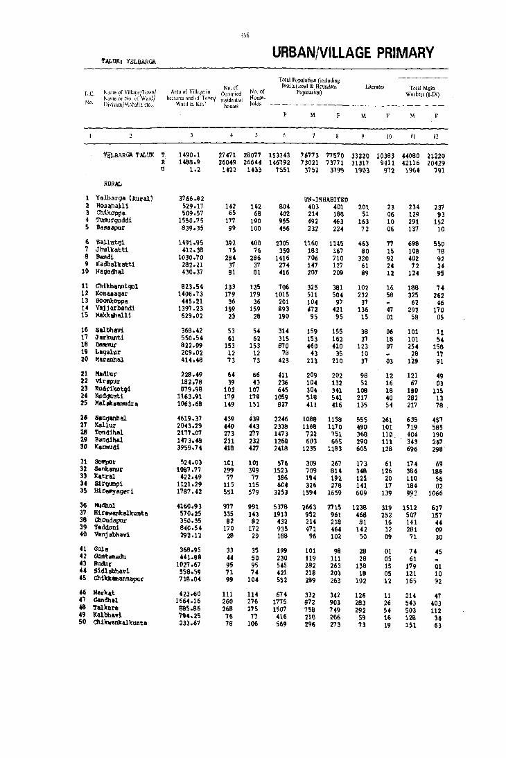
356
T~UK: YELBARGA URBAN/VILLAGE PRIMARY
Total Population (including No. of Institutional & Houseless Literates Total Main
L.C. Name of Village/Town/ Are~ of Village in Occupied No. of Population) Workers (I.IX) Name or No of Ward/ hectares and \)1' Ttlwn/ residential House ..
No. Di,i,ionjMllhalla etc., Ward in Km~ houses holds
p M F M F M F
10 11 12
'flLBARGA TALUK T 1490.1 27471 28077 153343 76773 77570 3322Q 10383 H080 21220 R 1488.9 26049 26644 146192 73021 73771 31317 9411 42116 20429 U 1.2 H2( 1413 I!)Sl 3752 37~ 191>3 972 1964 791
RURAL
1 Yelbarqa (aural) 3766.92 UN-INHABITED 2 Hoe all al li :'29.17 H2 H2 804 403 401 21>1 23 234 237 3 Chikappa 509.57 65 6a 402 214 18S 51 06 129 93 4 Turnut'guddi 1550.75 177 190 955 492 463 163 10 291 152 S lIa,e,pur 839.35 99 100 456 232 224 72 06 137 10
6 lIallut r;!i H91.9S 392 400 2305 1160 1145 463 77 698 550 7 Jhul'katt1 412.38 75 76 350 183 167 80 15 108 78 8 Bandt 1030.70 26' 296 1416 106 710 320 92 402 92 9 J(adb!llJcatt1 262.21 37 37 27( 141 127 61 24 12 2'
10 Haqedhal 430.37 81 61 416 207 209 99 12 124 95
11 Ch1kbannlCJ)1 823.54 133 135 706 32S 381 102 16 lSa 74 12 ICona,agar 1406.13 179 179 1015 511 504 232 58 325 262 13 BoonltOppa 445.21 36 36 201 104 97 37 62 46 14 Vlljjarband1 1397.23 159 159 893 472 421 136 47 292 170 15 Makkahalli 629.02 23 28 190 95 9S 15 01 58 05
16 SlIlbhavi 368.42 S3 54 314 159 155 38 06 101 11 17 Jllr)tunti 550.54 61 62 315 IS) 162 3'1 18 101 54 18 DaIIb'm1t 822.09 153 153 870 .60 410 123 01 254 158 19 LlIgalur 209.02 12 12 78 43 35 10 29 17 20 I1.lIranllal 414.49 73 73 423 213 210 37 03 129 91
21 Madlut' 228.49 64 66 411 209 202 98 12 121 49 22 virtIPUr 192.76 39 43 236 104 132 51 16 67 0.3 23 'Kudt'i'i«ltg1 879.9S l02 107 645 304 . 341 109 19 180 115 24 Kud9llntl 1163.91 179 179 1059 518 541 217 40 282 U 25 MIIl3knmudra 1063.68 149 151 927 411 416 135 54 217 78
26 sanqanhal 4619.37 439 439 2246 10138 1158 555 261 635 457 27 Kallur 2043.29 .. 0 443 2338 1168 1170 490 101 719 '585 28 ToM-1hal. 217'1.07 273 27'1 1473 722 751 368 110 404 190 29 Band1hal 147 3.48 231 232 1268 603 665 290 111 343 267 3D Kennudi 3959.71 419 427 2418 1235 1193 605 128 696 298
31 SoIftpur 524.03 1t1 101 576 309 267 173 61 174 69 32 Senkenur 1087.77 299 309 1523 709 8U 348 126 384 186 33 Katr!ll 422.49 77 77 386 194 19Z 12S 20 110 56 34 Slrgurnp1 1121.29 115 115 604 326 278 141 17 184 02 35 Hlr$1lYligeri 1787.'2 551 579 3253 1594 1659 609 139 9~3 1066
36 ~dhol 4160.93 9'77 991 5378 2663 2715 1238 319 1512 627 37 H1re,tlll1kelltuntll 570.25 335 343 1913 952 961 468 252 507 157 38 OlOUdapur 350.35 82 82 432 214 218 61 16 141 44 39 'Ieddoni 640.54 170 172 935 471 464 142 12 281 09 40 Vanjabhavi 292.12 26 29 168 96 102 50 09 71 30
41 Gule 369.95 33 35 199 101 98 28 01 14 45 42 Guntemadu 441.98 44 50 230 119 111 28 05 61 43 lIu&tr 1027.67 95 95 545 292 253 138 15 179 01 U Siclla.b})avi 559.59 71 .,. 421 218 203 19 05 121 10 45 ChikltllllanR<IpIlt' 718.04 99 104 552 289 263 102 12 165 92
46 Marht 423.60 111 114 674 332 342 126 11 214 47 47 Gandhal. 1664.16 260 276 1775 972 903 283 26 543 403 48 Talker. e85.86 268 275 1507 7Sa 749 292 5. 503 112 49 'Kalbhavi 794.25 76 77 416 210 20G 59 16 128 34 50 dl1kwl!llltalkunta 233.67 78 106 !i69 296 273 73 19 151 63

351
CENSUS ABSTRACT TALUK: Yl!;LBAR~
MAIN WORKERS Household Industry
Other Workers Marginal Workers Non-workers Cultivators Agricultural Manufacturing Proce,,-(J) Labourers (II) ing Servicing and (Ill, IY, Vb)& Name of Village/Town! L.C.
R.pairs [VI [all YI to IX Name or No. of Ward/ Division/Mohalla etc., Ntl.
M F M F M F M F M F M F
13 ' 14 IS 16 17 18 19 20 21 22 23 24
24794 4759 12315 14762 1545 729 5426 970 421 7881 32272 48469 T YSLBARGll.TALUK 24091 4585 11813 14252 1457 691 4755 901 390 7502 30515 45840 R
703 114 502 510 88 38 671 69 31 379 1757 2629 U
llN-INHABITED Yelbarqa (Rural) 1 146 19 70 217 03 15 01 169 164 169 164 Hosahalli 2 28 04 84 99 17 8S 95 ChUtoppa 3
202 35 62 106 05 22 11 06 116 195 195 Tumurgudi 4 99 02 19 04 07 02 12 02 86 95 128 Busapur 5
288 306 303 228 15 01 92 15 462 595 Ballutqi 6 60 11 31 63 03 14 04 11 7S 79 Jh\11ltatti 7
262 06 55 75 17 07 68 04 03 14 301· 604 sandi II 44 02 22 22 06 75 103 Kadballtatti 9 61 07 50 B4 OS 02 05 02 83 1101 Hagedha.l 10
137 44 74 06 137 307 Chikbennigol 11 281 02 24 25B 09 11 02 186 242 KOoes.gar 12 59 42 02 04 01 03 42 48 Boonltoppa 13
168 78 27 48 01 01 96 43 180 251 Vajjarbandi 14 37 11 01 02 08 04 31 37 59 Makkahall1 15
59 27 07 04 11 04 59 58 85 Salbhavl 16 44 54 54 01 02 52 108 Jarkunti 17
162 37 58 106 18 06 16 09 03 S9 203 193 DaltlllUr 18 04 24 17 15 18 Lagalur 19 72 48 51 41 01 05 02 14 84 105 Maranhal 20
79 06 38 43 01 03 04 68 149 Madlur 21 SO 14 03 01 02 45 37 84 Vlrapur 22
132 51 37 84 06 05 12 124 214 Kudrikotgi 23 143 04 101 08 11 27 01 11 232 225 296 l(udgunti 24 175 01 06 75 36 02 184 338 MalalCSamudra 25
394 96 157 318 24 30 60 13 453 701 Sanganhal 26 393 199 271 367 32 03 23 16 01 449 584 Kalll1[ 27 322 04 113 1" 19 02 50 13 01 31B 557 Tondihal 28 212 128 110 136 02 19 03 260 398 Bendihel 29 418 49 206 233 21 03 51 13 01 538 BS5 Kermudi !O
53 02 111 66 10 01 52 135 146 SOnlpur 31 236 54 109 114 10 01 29 17 04 325 624 Sankanur 32 96 09 14 46 01 02 82 136 Ketral 33 98 01 79 01 02 05 179 142 97 Sirgumpi 34
381 307 442 707 37 03 133 49 04 601 589 Hiremyaqeri 35
642 23 698 583 S3 11 119 10 07 188 1144 1900 IlIdhol 36 291 42 81 80 26 25 109 10 07 99 438 505 Hirewankalltunta 37 106 24 28 18 03 04 02 86 73 88 I.:houdepUr 38 199 01 52 06 03 27 02 01 202 189 2S3 Yeddoni 39
52 20 18 08 01 01 01 35 25 37 Venj abhllYi 40
54 09 16 32 04 04 05 27 48 Qlle 41 55 03 03 67 58 44 Qlntmedu 42
155 22 02 01 02 152 101 110 Budur 43 111 07 OS 02 02 01 91 97 102 Sidlabhavi 44 127 05 24 82 04 02 10 03 25 124 146 Chlkkmannapur 45
158 30 47 17 02 07 123 118 172 Market 46 315 30 121 358 12 10 95 05 08 161 321 339 Gandhal 47 249 18 205 88 10 03 39 03 04 341 251 296 Talkere 48 116 26 05 01 12 02 31 82 141 Kalbhavi 49 105 27 29 25 01 07 16 04 04 69 lU 141 Chlkwankalkunta SO

358
URBAN/VILLAGE PRIMARY T.f.I,UK: Y)';LBAAG.\ (CONTD.)
Total Population (including -~----
No. of Instilunonal & Hou>e1ess Literat" Total Main
LC. Name of Village/Town! Area of Village in Occupied No. of Population) Workers (I.IX) Name or No. of Ward! hectares and of T(,wn/ residential House.
No. Division/MohalIa ctc., Ward in J(m2 houses holds
p M F M F M F
10 II 12
51 Uppald1nni 472.73 41 41 225 107 118 43 13 58 12
52 Tippanhal 438.73 79 79 521 'tT3 248 82 10 155 88
53 Katgihalli 676.59 101 104 588 284 304 80 38 166 81 S4 Hirewaddarkal 1659.92 205 205 1069 550 519 182 52 343 157 55 Uchallrunti 504.07 116 116 570 289 281 57 12 169 09
56 Buk'kanhatti 697.79 24 25 105 54 51 09 42 03 57 Gunllalu 1450.37 322 324 1812 882 930 350 98 508 28 58 ltOUhal ')'50.58 109 109 661 319 3~2 1)5 14 196 14 59 ft{adnerl 448.02 95 95 601 307 294 103 22 186 39 60 IfUnsihal 1897.63 307 312 1684 830 854 224 45 465 126
61 Nilogal 374.25 68 69 359 191 168 68 27 110 74 62 Mandalmad 454.71 81 87 440 218 222 48 O!i 141 22 63 Taralltattl. ' 1109.25 20S 215 1198 606 592 234 24 323 104 64 N,l.ngal-Bandi 763.65 166 183 1003 492 511 131 11 277 189 65 lCal akbandi 633.17 66 68 377 180 197 56 23 101 04
66 Matrang1 312.81 52 52 323 174 149 78 16 101 49 67 Hirearl1halli 1114.21 219 241 1513 772 741 250 43 448 136 68 Masur 544.21 77 67 492 255 237 89 04 150 31 69 Putakmari 366.38 70 72 436 220 216 75 16 129 70 Jar'kunti 166.49 47 ~7 269 133 136 26 69
71 Budkl11\ti 321.04 118 118 732 366 366 104 10 185 04 72 B1rllldinn1 550.42 61 62 364 186 178 70 18 112 76 73 ChiltltaarUhalli 470.18 UN-INHABITED H Mataldinni 977.65 233 235 1391 709 682 267 55 411 42 75 Yappaldinni 386.16 70 70 431 218 213 17 02 128 04
76 Mangalore 2781.00 996 1000 5270 2577 2693 1133 417 1509 1139 77 Vangera 1272.39 368 370 2028 1010 1018 306 144 616 165 78 Bevoor 2013.54 486 490 2691 1342 1349 503 142 802 199 79 lIatparvi 609.23 137 141 799 420 379 106 09 231 60 90 Nelgeri 774.09 132 132 819 413 406 152 53 226 132
81 lCUdrimot1 1834.17 369 379 1991 981 1010 331 61 508 279 92 Bh~1rn81kanhelli 383.16 114 114 708 329 379 104 09 c t02 140 93 OIendi Ilh al 443.56 34 34 172 93 79 05 62 47 84 Honhunashl 428.95 80 80 398 207 191 58 U 123 81 85 01 ikbeed1nhal u 637.69 124 124 &52 321 331 107 11 205 117
96 J(edarhalli 559.85 113 113 623 310 313 128 24 200 78 87 Hirebeedinhalu 693.77 129 133 697 345 352 168 68 175 03 9S Illthalu 483.92 76 76 503 255 248 110 16 143 35 99 Slr:ur 961.83 200 200 1213 602 611 295 116 328 94 90 Arkeri 1434.13 208 208 1169 595 584 279 76 382 332
91 C2lendOor 1222.13 135 148 771 392 379 246 66 234 179 92 Tlpparasanhalu 621.67 22 23 125 70 55 11 01 26 03 93 Bedwatti 789.28 83 89 :'07 2:'4 253 133 53 109 11 94 Yadiapur 580.59 197 197 1107 563 544 182 21 342 63 95 Budgwnpa 587.58 112 114 588 290 29B 129 36 174 173
96 lyavaMl 1393.23 256 264 1338 669 669 264 69 448 299 97 hlgera 1943.07 311 319 1705 832 873 390 117 478 38 99 Ch1'kR11ageri 1695.11 400 400 2146 10S4 1092 471 156 524 211 99 Geddigera 1297.69 226 231 1193 591 602 272 65 332 235
100 HlllIIIIapur 132.38 31 31 175 9S 80 33 15 53 49
101 Talur 465.49 106 106 522 238 284 95 20 137 50 102 Marsapur 466.65 37 37 246 123 123 22 01 68 14 103 Hulegudda 900.76 149 149 862 437 425 185 21 T16 86 104 Hurd! 2011.23 295 297 1625 920 80S 260 92 498 307 105 Balepur 363.53 UN-INHABITED

359
CENSUS ABSTRACT TALUK: YJ:;LBAR~ (CONTD.)
MAIN WORKERS
Household Industry , Other Workers Marginal Workers Non·workers Cultivators Agricultural Manufacturing Proce". (I) Labourers (II) ing S,ervicin~ an': (!If, IV. V b) & Name of Village/fown/ L.C.
Repairs [Vllall VI to IX Name or No. of 'r!arJ/ ..._..---------~--~~--~- ~~.~~~~----~--. Division/Mohalla etc., No.
M F M F M F M F M F M F
J3 14 15 16 17 18 19 20 21 22 23 24
41 15 12 02 5~ ~9 S2 Uppaldinni Sl 82 05 68 82 03 02 01 05 118 155 Tippanhal 52 41 03 118 73 02 02 05 03 40 118 183 Katgihalli 53
274 11 53 140 06 01 10 05 02 65 205 297 Hirewaddarkal S4 162 03 01 03 01 01 OS 02 173 120 99 Uchal'kunti 55
42 03 31 12 11 ~kkanhatti 56 338 02 128 03 19 10 23 13 60 374 8~2 Cbnhalu 57 154 07 32 07 06 04 07 92 116 236 Xolihal 59 147 05 29 34 04 06 121 255 Myadneri 59 326 20 93 96 23 04 23 06 01 220 364 508 Huns ih al 60
57 06 48 66 01 04 02 02 39 79 55 Nllogal 61 104 05 28 15 09 02 02 100 75 100 Mandalmari 62 221 10 77 84 05 04 20 06 293 488 Taralkatti 63 153 02 30 145 31 21 63 21 06 215 316 Ningal-llandi 64 100 04 01 13 79 190 Kalakbandi 65
79 18 10 29 12 02 03 73 91 Matrangi 66 240 132 129 32 04 44 04 08 95 316 510 Hirearlihall1 67 136 03 12 27 02 01 01 03 104 203 Hosur 68 123 06 01 114 90 102 Putakmari 69 69 01 02 62 136 Jarltunti 10
165 01 01 03 16 03 01 181 361 ~dkunti 71 82 19 19 51 02 04 09 02 01 19 73 83 Biraldinni 12
UN-INHABITED Chilt)taarlihalli 73 308 08 62 28 09 32 06 02 177 296 463 Mataldinni 14 92 33 03 02 01 62 90 147 Yapald1nni 75
789 334 312 661 43 102 365 42 02 1069 1552 Mangalore 76 421 91 72 32 36 25 81 17 296 394 557 vangera 77 419 46 189 119 24 11 170 24 07 343 533 807 Bevoor 79 206 10 11 46 04 01 10 03 189 319 'IIatparvi 79 152 46 42 83 06 26 03 12 187 262 Neigeri 90
384 129 42 107 34 30 48 13 413 131 Kudrimoti 81 177 10 34 111 30 14 21 05 01 127 238 lIhairnaikanhalll 82
56 06 47 31 32 Chendlnhal 83 102 01 14 77 07 03 84 110 Honhunaahi 84 143 29 56 85 06 03 116 214 Ch1ltbeed1nhalu 85
89 02 99 72 12 04 11 56 99 179 Kadarhalll 86 120 28 01 09 18 02 17 214 153 135 H1rebeedlnhalu 87 89 41 34 03 10 01 112 213 ItJthalu 88
149 11 125 90 01 53 03 174 511 Sirur 89 162 24 293 305 05 01 12 02 203 252 Arlteri 90
136 10 83 167 14 01 02 158 200 Chendoor 91 21 01 01 01 03 01 01 20 34 24 18 Tipparasanhalu 92 71 01 06 02 19 o. 13 04 36 110 109 132 Bedwatti 9)
180 06 144 51 03 02 15 04 221 481 Yadiapur 94 15 31 99 140 10 02 06 09 110 116 ~dgWRpa 95
281 105 118 182 15 04 34 08 221 370 RyavanJCi 96 330 13 96 15 25 37 10 11 ol12 343 423 Balgen 91 284 23 172 156 20 02 48 30 59 219 411 602 ChiJullyageri 99 228 110 77 120 07 02 20 03 04 259 363 Geddigera 99
31 02 17 47 05 42 31 Jianmapur 100
72 01 55 47 03 07 02 101 234 Talur 101 43 03 23 11 02 14 51 41 59 Narsapur 102 173 31 94 42 03 06 01 06 201 155 138 Hulegudda 103
318 40 140 260 04 01 36 06 06 44 316 454 ~rdi 104 UN-INHABITED Balapur 105

360
TALtJi(: Yl!:L8ARGA (CONcr.V.) URBAN/VILLAGE PRIMARY
T,ltai Population (including No. pf ImlitutlOnai & HOll~!!less Literates Total Main
L.c Name of Village/Town/ Area (If Villa~c in Occupied N(l. of Populatiun) Workers (I-IX) Naille or No "I' Wardl h\.·l'tar('~ and of Town) rcsidcn!ial Hous.c-
No. Divisioll/Mtlhalla ~tc" Ward in Km~ houses hold~
p M F M F M F
10 II 12
106 Qlttur 700.~6 109 108 635 297 338 102 41 214 194 107 Lalanangule 794.35 81 81 44~ 221 221 90 27 146 79 108 Kavalkere 366.99 38 38 230 118 112 24 73 49 109 Kuknoor 3647.33 1606 1675 9111 4527 4594 2235 1140 2512 1579 110 Harlshankerbandl 156.13 30 30 146 72 74 31 03 47 17
111 Chanpanhalli 412.,)1 54 54 290 133 147 55 09 86 27 112 Kakkihalli 502.134 118 119 697 369 328 163 25 216 205 113 Konapur 264.03 42 45 293 150 143 47 04 89 77 114 Gavarhal 796.82 60 60 321 167 160 68 29 105 17 115 GOreekoppa 195.41 44 44 275 139 136 85 27 77 37
116 Masabhanchinhal 1312.71 296 296 1421 662 759 345 139 423 471 117 Nlttal1 1012.83 115 115 693 329 364 81 20 219 215 118 Benakal 1701.69 401 411 2139 1033 1106 436 131 572 186 119 Veerapur 1494.60 207 215 1222 586 636 293 108 338 142 120 Bhanapur 894.66 2m 218 1031 495 536 270 94 243 100
121 Lakmapur 944.90 220 231 1271 652 619 306 93 359 57 122 Chitapur 456.72 32 40 199 97 102 52 03 58 61 123 Komlapur 764.59 114 121 568 285 283 117 14 187 85 124 Advihalli 324.43 32 36 205 100 105 29 08 65 30 125 Talbal 1081.76 100 100 527 270 257 146 40 143 18
126 Ningapur 434.68 94 96 584 314 270 168 31 162 02 127 'hilkal 5662.04 858 865 4943 2433 2510 HO) 597 1328 844 128 Mannapur 805.46 134 134 652 310 342 157 71 170 06 139 Banniltoppa 2790.27 425 436 2377 1155 1222 677 335 673 240 130 lhgi 3203.00 590 591 34m 1734 1673 807 296 902 456
131 lInugondankoppa 464.63 UN-IMI-'~BITED 132 Mandalgeri 2218.62 343 343 1837 937 900 452 146 559 25 133 Kerihalll 36.92 UN-INHABITED 134 SOmpur 1669.61 239 268 1426 743 683 386 84 401 314 135 Malekoppa 905.30 17~ 178 923 U4 479 202 39 230 62
136 Sidnekoppa 1156.09 142 142 769 393 376 215 55 223 48 13'7 Yarihanchinal 3447.00 442 449 2422 1180 1242 598 164 6j~ 245 138 B1nhal 1489.62 239 244 1488 765 723 393 67 422 196 139 Chi'kenltoppa 692.42 258 271 1524 742 782 475 195 440 169 140 Bhatpanhalli 618.41 132 132 1020 496 524 262 137 289 143
141 Rajoor 1591.80 312 330 1851 892 959 460 153 443 40 142 Moo!: 1096.94 223 234 1323 651 672 329 138 388 388 143 Dyampur 941.08 239 241 1337 651 686 343 100 361 305 144 Virpapur 430.03 UN-INHABITED
URBAN
161m Yelbarqa (M) 1.15 1422 1433 7551 3752 3799 1903 972 1964 791
Division No. I NA 432 433 2103 1020 1083 455 256 527 200 Division NO. II NA 367 374 2030 1038 982 496 252 525 253 Division No.Ill NA 523 526 2869 1441 1428 866 414 718 232 Div1s1on No. IV lIA 100 100 549 253 296 86 50 134 106

361
CENSUS ABSTRACT TALUK: Yh:LBARG./; (CONCLD.)
MAIN WORKERS
Household Industry Other Workers Marginal Workers Cultil'ators Agricultural Manufacturing ProceiiS- Non-workers
, (0 Labourers (If) ing Ser'Jicinf and (Ill, IV, V b) & Name of Village/Townl L.C. Repairs [V] [a] ] VI (0 IX Name or No, of Ward/
Division/Mohalla etc" No,
M F M F M F M F M F M F
1.1 14 15 16 17 18 19 20 21 22 23 24
100 09 102 181 04 08 04 83 144 Guttur 106 82 07 54 69 02 O. 08 01 41 7S 101 LaJ<mangule 107 54 16 15 33 04 45 63 Kavalkere 108
739 261 613 896 302 276 858 145 21 198 1994 2808 Kuknoor 109 16 31 17 32 25 25 Harishankerbandi 110
40 01 44 26 02 58 47 62 Chanpanha1l1 111 105 36 97 165 06 08 04 153 123 Kakkihalli 112
69 15 74 03 05 61 66 Konapur 113 70 11 30 64 01 01 04 01 62 83 Gavarhal 114 60 16 16 20 01 07 62 92 Goreekoppa 115
293 197 65 241 07 03 58 30 01 238 298 Masabhanchinhal 116 130 31 78 183 03 09 01 08 110 141 Nittal1 117 283 17 173 153 80 12 36 04 98 461 822 Benaku 119 163 11 109 125 11 55 06 21 248 473 Veeupur 119
47 08 92 75 13 01 91 16 05 19 247 417 Bhanapur 120
210 05 109 51 14 26 01 01 SO 292 512 Lakmapur 121 29 23 61 06 39 41 Chitapl.\r 122 97 67 83 07 16 02 98 198 Komlapur 123 43 18 30 04 35 75 Advihalli 124 85 40 14 04 04 14 127 239 Talbal 125
90 67 0:' 02 14 51 138 217 Ningapur 126 691 278 386 538 30 02 221 26 09 29 1096 1637 Tadkal 127
99 63 04 01 07 02 05 140 331 Mannapur 128 358 121 241 100 08 02 66 17 17 279 465 703 Bannikoppa 129 580 162 229 280 11 01 82 13 01 831 1217 Itag! 130
UN-INHABITED Anugondankoppa 131 340 09 159 10 20 40 06 67 378 788 Mandalgeri 132
UN-INHABITED Kerihalli 133 195 41 137 270 13 56 03 04 342 365 sompur 134 142 68 60 03 17 02 214 417 Malekoppa 135
149 15 53 32 05 16 01 170 329 Sidnekoppa 136 197 16 435 222 11 03 33 04 58 504 939 Yarih@I)chlnal 137 174 172 190 24 06 52 48 343 479 Sinhal 138 233 149 167 11 01 47 01 302 613 Chikenkoppa 139 190 74 141 0' 21 02 02 05 205 376 Bhatpanhall! 140
270 09 81 16 10 02 82 13 38 362 411 557 Rajoor 1U 237 192 108 186 02 41 10 263 284 Adool: 142 218 97 56 188 08 79 20 290 381 Dyampur 143
UN-INHABITED Virpapur 144
URBAN
703 174 502 510 88 38 671 69 31 379 1757 2629 Yelbarga (M) t6/xn
150 18 133 140 48 29 196 13 06 128 487 755 Division No. I 176 69 116 137 09 06 224 41 07 76 506 663 Division No. II 354 81 181 135 26 03 217 13 17 159 646 1037 Division No.III
23 06 72 98 05 34 02 01 16 118 174 Division No. IV

SUPPLEMENT

/ 36S
INTRODUCTORY NOTE
This supple m ent to the District Census Handbook is devoted exclusively to the particulars relating to the Scheduled Castes and Scheduled Tribes. The District Census Handbook was first introduced at the 1951 Census to meet the ever increasing demand for micro-level data and since then this has re mained the only census publication which gives out data at the village level in the case of rural areas and at the enu m eration block level in the case of urban areas. The scope of this publication was enlarged in 1961 and also in 1971 so as to render it m ore useful by presenting in it a wealth of information on infrastructural facilities in villages and towns. The current volumes of the District Census Handbook are thus the fourth in the series and are marked by a greater degree of co m prehensiveness and uniformity in approach. As co m pared to the 1971 series the village and town directory formats have been slightly modified. So also the Prim ary C ens'us A bstract too has undergone certain changes. The previous practice of presenting thead min:iBtrative statistics and the various district and taluk level tables has been given up. A part fro m these general changes at the all India level, in so far as Karnataka is concerned, because. of certain technical reasons aU the particulars relating t.o the Scheduled Castes and the Scheduled Tribes envisaged for presentation in the District Census Handbook, have been pooled together and brought out in the form of a separate supple m ent.
These details are presented in the following sequence:-
State ment I : Total, Scheduled Castes and Scheduled Tribes population in the taluks and towns of the district. (These details form part of the General District Prim ary Census Abstract).
State m ent II District Primary Census Abstract - Scheduled Castes
Statement III: District Primary Census Abstract - Scheduled Tribes
St"atement IV: Scheduled Castes and Scheduled Tribes population - (A) Villagewise ar.d (B) Townwise (within town ward-wise) (These details form part of the urban/village Primary Census Abstract).
State m ent V: Total, Scheduled Castes and Scheduled Tribes population -Urban Block-wi<3e (This corresponds to the A ppendix to urban/village Prim ary Census Abstract).
State m ent VI Description of boundaries and details of areas included in census enu m eration blocks- in the case of urban areas of the district (corresponding to the annexure to the A ppendix to the urban/village Prim ary Census Abstract).
State m ent VII List of villages arranged according to the proportion of (a) Scheduled Castes and (b) Scheduled Tribes population to the total population of the village concerned by ranges. This would correspond to A ppendix IV A and B to the Village Directory.
State m ent VIII: List of Scheduled Castes and Scheduled Tribes.
The concept of Scheduled Castes and Scheauled Tribes as evolved by the Government of India and embodied in the G ovtrn m ent of India Act 1935 section 309 for the first tim e and standardised later on for the purposes of the Constitution of the Indian Republic has all along been adopted for purposes of census operations as well. 'Scheduled Castes', means such castes, races or tribes or parts or groups within such castes, races or tribes as are deemed under Article 341 (of the Constitution of India) to be the Scheduled Castes

366
for purposes of the Constitution of India. No person who professes a religion different fro m the Hindu or the Sikh shall be dee m ed to be arne m ber of a Scheduled Caste. Likewise, 'Scheduled Tribes means .such tribes or tribal com munities 01" fjarts or groups within such tribes or tribal co m m unities as are dee m ed under Article 342 (of the Constitution of India) to be the Scheduled Tribes for the purposes of the Constitution of India. Persons belonging to the Scheduled Tribes may profess any religion. State wise statutory liSts of Screduled Castes and Screduled Tribes were notifiedfor therirst time after Independence under the 'Constitution (Scheduled Castes) order 1950 and the 'Constitution (Schl}duled Tribes) order 1950'. These orders have close links particularly with Article 46 of tr,e Constitution which lays down that liThe State shall pro mote with Special care the educational and economic interests of the weaker sections of the people, and in particular, of the Scheduled Castes and ScLeduled Tribes and shall protect the m fro m social injustice and all forms of exploitation".
These lists have subsequently been modified, supplemented or amended from time tc tim e. As a result of the re-organisation of the states in 1956 involving transfer of territor:ies fro m one State to another,a major change beca me necessary in most of the States. Consequently the"Scheduled Castes and Scheduled Tnbes (Modification) order 1956" was promulgated and the interests of these two sections of the society were adequately safeguarded. Twenty years later, in 1976, with the main objective of removing the area restrictions im posed within the states, the parlia m ent enacted the"Scheduled Castes and Scheduled Tribes order (A mendment) Act, 1976" (Act No.l08 of 1976 dated thf;; 18th Septe m ber 1976). The lists of Scheduled Castes and Scheduled Tribes notified thereunder as applicable to Karnataka State have been adopted for purposes of the 1981 census operations. Copies of these lists, in English as well as in Kannada, .lere supplied to each and every census enumerator and supervisor. Necessary instructions for filline up answers to the questions relating to the me rr: bel'S belonging to the Scheduled Castes and Scheduled Tribes were also issued. The following points were emphasized by way of clarifications:
IIIf the person belonging to a Scheduled Caste or a Scheduled Tribe returns his/her caste or tribe by a synony m or generic na m e of a caste or tribe, it should be reckoned as a Scheduled Caste or a SCheduled Tribe only if the na m e finds a place in the list furnished to you. Similarly, if the answer to this question is in general ter:ns like Harijan/ Gir:ijan or A chut/ Adivasi, you should not reckon the person enu m erated as belonging tc a Scheduled Caste or Scheduled Tribe as the case may be. In such a case you should· ·ascgrtain the na m e of the caste/tribe fully and if that na m e finds a place in your list, you should reckon the person as belonging to Scheduled Caste or Scheduled Tribe as the case may be. If a person is negligent and insists on calling hi m self/herself merely 'H arijan' or 'A(~hut' or 'Adivasi' or 'Girijan', as the case m~y be, or repeats the synonym or generic na m e of a caste or tribe, please tell hi m Iher that his description is not adequate (or census purposes and persuade him Iher to give the actual na m e of the Scheduled Caste or Scheduled Tribe. If the person merely claims· to be a Scheduled Caste or Scheduled Tribe, but says that he/she does not belong to any of the notified co m m unities applicable tn the area, as reflected in the list supplied to you,he/she will not be reckoned as belonging to a Scheduled Caste or a Scheduled Tribe".
Analysis of Census Results: As compared to the earlier lists of SchedU:ed Castes and Scheduled Tribes which formed the basis for census enumeration at the censuses of 1961 and 1971, there has been a substantial change in the lists adopted for the 1981 census. The area restrictions that were prevalent regarding nu m erous castes and tribes included in the lists have now been removed. Therefore the 1981 Census results cannot be straight away used for any comparative analysis of growth trends and such other factors unless one delves deeper into the historical, SOCial, eCOrlo mic and de mographic aspects of life of these two categories of the population. Such an analysis is beyond the scope of this volu m e and has therefore not been atte m pted here. Salient data about the distribution of the Scheduled Castes and Scheduled Tribes in rural as well as urban areas of the district as also the pattern of distribution in ad m ini'ltrative units of different levels within the district are included in t)1is slender volu m e in the for m of tabular state rn ents.
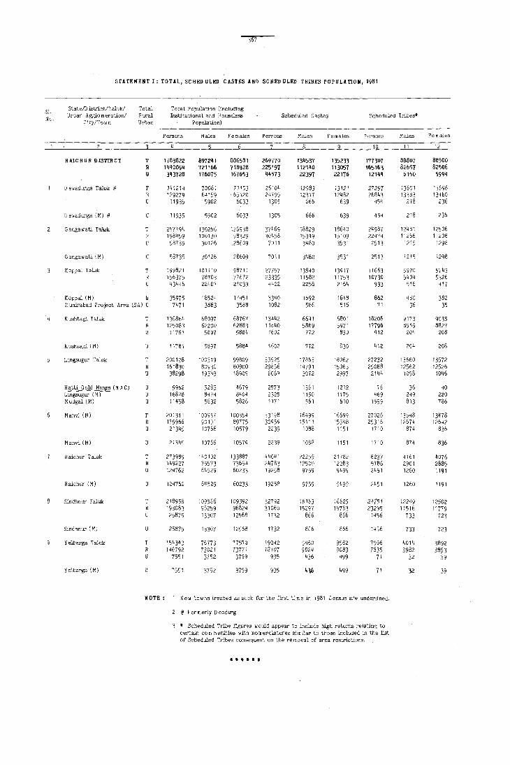
STATEMENT I: TOTAL, SCHED ULED. CASTES ANn SCHED ULED TRIBES POPULATION, 1981
51-State/D istr'ict/Talukl Total Total Population (including
Nv. Urban A gglo m era tionl Rural Institutional and H ouseless Scheduled Castes Scheduled Tribes'
City/Town Urban Population)
Persons Males. Females Pen;'lons Males females Persons Males Females
10 11 12
R AleH U R DISTIR CT T 1783822 897241 886581 269770 134537 135233 177307 88807 88500 R 14400S~ 721166 118928 225191 112140 113057 165163 82657 82506 U 343728 176075 167653 44573 22397 22176 12144 61~O 5994
D evadutga Taluk @ T 1~ 121~ 70061 71 Ed 26104 12983 13121 27297 13601 ' 3696 R 129279 64159 65120 24799 12317 124B2 26B4, 13383 13460 u 11935 5902 6033 1305 566 639 454 218 236
D evadurga (M) @ 11935 5902 6033 1305 666 639 454 218 236
Gangawati Taluk T 257194 130256 126938 37469 18829 18640 24987 12481 12506 1984'>9 100130 98329 30458 153 '19 15109 22474 11266 11208 58735 30126 28609 7011 3480 3531 2513 ·,215 1298
Gangawati (10 U 08735 30126 28609 7011 3'180 3531 2513 1215 1298
K appal Taluk T 199821 101110 98711 27757 13840 13917 ·,1663 5920 5',43 R 156375 78703 77672 23335 11582 11753 10730 5404 5326 u 43446 22407 21039 4422 2258 2164 933 516 417
Kappal (M) U 35975 18524 H451 3340 1692 1648 862 480 382 Ilururabad Project Area (SA) U 7471 3883 3588 1082 56f, 516 71 36 35
K ushtagi T aluk T 136864 68097 68767 13442 6641 1)801 1820B 9173 9035 R 125083 62200 62883 llB40 5869 5971 17796 8969 8827 u 11781 5897 5884 1602 772 830 412 204 208
Kush"agl (M) 11781 5897 5884 1602 772 830 412 204 208
Lingsugur Taluk 200128 100319 99809 35925 17863 18062 27232 13660 13572 H 161830 80930 80900 29856 14791 15065 25088 12562 12526 U 38298 193R9 18909 6069 3072 2997 2141, 1098 1046
Hatti Gold Min~s (N A C) 9962 5283 4679 2573 1361 1212 76 36 40 Lingsugur (M) u 16878 8474 8404 2325 1150 1175 469 249 220 Mudgal (M) U 11458 5632 5826 1171 561 610 1599 813 786
Manvi (M) T 201311 100957 100354 33198 16499 16699 27026 ~ 3548 13478 R 179966 90191 89775 30959 15411 15548 25316 12674 126~2 U 21345 10766 10579 2239 1 DB8 1151 1710 874 836
Manvi (M) U 21345 10766 10579 2239 10BB 1151 1110 874 836
Raichur Tal"k T 273989 140102 133887 44041 22259 217B2 8237 4161 4076 R 149227 75573 73654 24783 12500 12283 57B6 2901 2885
124762 64529 60233 19258 9759 9499 2451 1260 1191
Haichur (M) U 124762 64529 60233 19258 9759 9499 2451 1260 1191
Sindhnur T21uk 218958 109566 109392 32792 16163 16629 24151 122~9 12502 193083 96259 96824 31060 15297 15763 23295 11516 11779 25875 13307 12568 1732 866 866 1456 733 723
Sindhnur (M) 25875 13307 12568 1732 866 866 1456 733 723
Yelbarga T aiuk T 154343 76773 77570 19042 S460 9582 7906 4014 3892 R 146792 73021 73771 18107 9024 9083 7835 3982 3853 U 7551 3752 3799 935 436 499 71 32 39
Y elbarga (M) 7551 3752 3799 935 416 499 71 32 39
NOTE: New towns treated as such for the first time in 1981 Census are underlined.
2 @ Formerly Deodurg
• Scheduled Tribe figures would appear to include high returns relating to certain com munities with nomepclatures Similar to those L~cluded in the list of Scheduled 'fr:bes consequent on the re m oval of area restrictions .
.. • .. .. .. I

368
STATEMENT·n: DISTRICT PRIMARY CENSUS ABSTRACT FOR SCRED ULED CASTES
Sl. D istrictl T alukl Urban
No. Agglo m~:::n/CitYI
RAICHUR DISTRICT
1 D evadurga Taluk@
D evadurga (M)@
Gangawati Taluk
Gangawati (M)
Kappal Taluk
Koppal (M) Hunirabad Project Area (SA)
Kushtagi Taluk
Kushtagi. (M)
Lingsugur Taluk
No. of T House-R holds II with S.C.
m em bers
T R U
T R U
T R U
U
T R
T R U
T R U
51861 43383 8478
4828 4586 242
242
7357 5968 1389
1389
5132 4354 778
584
194
2805 2501
304
304
6788 5709 1079
Total Soheduled Castes Population
M F p
269770 134537 135233 28164 225197 112140 113057 18164 44573 22397 22176 10000
26104 12983 24799 12317
1305 666
1305 666
37469 18829 30458 15349 7011 3480
7011 3480
27757 13840 23335 11582 1t~22 2258
3340 1692
1082 566
13442 6641 11840 5869 1602 772
1602 772
35925 17863 29856 14791
6069 3072
13121 1880 12482 1625
639 255
639 255
18640 3018 15109 2157 3531 861
3531 861
1391'1 3174 11753 2053 2164 1121
1648 749
5 It, 372
6801 1571 5971 1120
830 451
830 451
18062 4226 15065 2458 2997 1768
Ratti Gold Hines (NAC) U 411 446 222
2573 1361 1212 1122 Lingsugur (H) U Hudgal (M) U
Hahvi Taluk
Hanvi (M)
Raichur Taluk
Raichur (H)
8 Sindhnur Taluk
Sindhnur (H)
Yelbarga Taluk
Yelbarga (H)
@ Fora erly D eodurg
T R U
U
T R U
T R U
T R U U
6391 5905 486
486
8386 4754 3632
3632
6574 6192 382
382
2325 1150 1171 561
33198 16499 30959 15411 2239 1088
2239 1088
44041 22259 24783 12500 19258 9759
19258 9759
32792 16163 31060 15297
1732 866
1732 866
3600 19042 g460 3414 18107 9024
186 935 436 186 9'35 436
1175 404 610 242
16699 2657 15548 2252
1151 405
1151 405
21782 7182 12283 2448 9499 4734
9499 4734
16629 2287 15763 2045
866 242
866 242
9582 2169 9083 2006 499 163 499 163
Literates
M
22752 15440 7312
1629 1423 206
206
2480 1808 672
672
2575 1779 796
519
277
1269 967 302
302
3377 2092 1285
781 325 179
2197 1894
303
303
5478 2039 3439
F 10
5412 2724 2688
251 202
49
49
538 349 189
189
599 274 325
230
95
302 153 149
149
849 366 483
341 79 63
460 358 102
102
'704 409
1295
3439 1295
1939 1751
188
188
1808 1687
121 121
348 294
54
54
361 319
42 42
MAIN WORKERS
Total Main Workers (I-IX) Cultivators (I)
11
125515 108278
17237
11038 10574
464
464
18798 15410 3388
3388
13502 12003 1499
1200
299
5234 4657
577
577
13939 11989 1950
614 921 415
16950 15725
1225
1225
18619 11541 7078
7078
18435 17775
660
660
9GOO 8604
396 396
M 12
77707 66409 11298
7518 7229 289
289
11265 9249 2016
2016
7989 6921 1068
798
270
3573 3202
371
371
9732 8293 1439
588 596 255
9808 9173 635
635
12152 7362 4790
4790
10190 9725
465
465
5480 5255 225 225
13 14
47808 25939 41869 24862 5939 1017
3520 3345
175
175
3331 3298
33
33
7533 3340 6161 2916 1372 424
1372 424
5513 2593 5082 2472
431 121
402 119
29 2
1661 1628 1455 1559 206 69
206
4207 3696
511
26 325 160
69
4275 3991) 279
163 116
7142 3073 6552 3036 590 37
590 37
M 15
22023 21169
854
2940 2908
32
32
2899 2569 330
330
2129 2036
93
92
1413 1349
64
64
3669 3456 213
128 85
2619 2597
22
22
6467 4179 2288
2335 2069 2260 - - 2005
75 64
2288
8245 8050
195
195
75
3251 3228
23
23
3520 2113 3349 2097
171 16 171 16
64
2459 2437
22
22
1826 1812
14 14
F 16
3916 3693 223
391 390
1
441 347
94
94
464 436 28
27
215 210
5
606 540
66
35 31
454 439
15
15
266 255
11
11
792 791
1
287 285

369
STATEMENT n: DISTRICT PRIMfHY CEIISUS ABSTRACT FOR SCHEO ULEO CASTES
MAIH lI0BKERS (Concld.)
Agricultural Labourers (ill
House.hold IndustryManufacturing,
Processing, Servicing and Repairs [V(a)]
Oth€r Workers [ill, IV, V(b) & VI to IX] Marginal Workers N on- Workers
R U
D istrict/Taluk/Urban Agglom eration/Cityl
Town
P M F P M F p M F P M F P M 17 18 19 20 21 22 23 24 25 26 27 28 29 30 31
76626 38420 38206 3588 2504 71331 35890 351141 2804 1912
5295 2530 2765 784 592
6452 3519 619B 3394
254 125
254
13466 11311
2155
125
6864 5782 1082
2933 359 298 2804 318 26~
129 41 29
129 41 29
66Qlz 291 5529 198 1073 93
186 112 74
2155 1082 1073 93 74
8412 3963 8005 3751
407 206
366 169
41 37
2388 1241 2142 1123
246 118
246 118
6351 3322 5821 3134 524 188
3 386 135
3 139 46
12671 6163 11755 5781
916 382
916 382
7529 3968 7306 3844 223 124
223 124
13889 6714 13600 6551
289 163
289 163
5468 2666 5187 2524
281 142
281 142
4449 . 544 327 4248 435 257
201 109 70
197 108 69
1147 375 260 1019 307 224 128 68 36
128 68 36
3029 515 366 2693 378 259
336 137 107
3 3 247 92 77
89 42 27
6508 276 218 5974 251 203 534 25 15
534 25 15
3561 415 351 3462 195 162
99 220 189
99 220 189
7175 251 187 7049 206 143
126 45 44
126 45 44
2802 562 311 2663 516 283
139 46 28
139 46 28
1084 19362 14760 4602 7216 892 9281 7438 1843 6771 192 10081 7322 2759 445
61 49 12
896 761 760 {i58 136 103
12 136 103
105 86 19
1701 985 716
1316 786 530
135 ,953 102 938 33 15
33
385 199 186
15
764 734
30
19 716 530 186 30
217 1953 15.70 178 1091 871
39 862 699
383 220 163
39 607 468 139
115 83 32
255 231
843 649 194
659 506 153
32 194 153
149 2798 2375 119 1788 1444
30 1010 931
15 15
58 48 10
608 582 280 252 122 97
930 683 247
808 592 216
10 247 216
24
184 143
41
423 344 79
26 28 25
122 91 31
31
64 8340 5764 2576 33 1780 1351 429 ?,1 6560 4413 2147
31 6560 4413 2147
64 1044 63 741
303
830 594 236
303 236
214 147 67
67
665 582
83
83
377 371
6
1409 1339
70
2 50 18
783 781
2
2
722 625 97
97
469 353 116
116
251 233
18
857 804
53
677 636
41
180 1074 168 1048
12 26
18 53 41 12 26
431 6179 137039 56393 80646 T 392 6379 110148 45339 64809 R
RAICHUR DISTRICT
45 400 26891 11054 15837 U
50 903 48 890
'3
52 43 9
13
712 691
21
21
89 576 84 498 5 78
78
9 368 8 363
5
53 1356 46 1293 7 63
49 14
21 762 21 760
71 651 50 575 21 76
14113 5415 8698 T 13287 5040 8247 R
826 375 451 U
D evadurga Taluk@
826 375 451 U D evadurga (M)@
17907 14314 3593
751? 10395 T 6057 8257 R 1455 2138 U
Gangawati Taluk
3593 1455 2138 U Gangawati (M)
13590 5762 7828 T 10750 4577 6173 R 2840 1185 1655 U
K 0 ppal T aluk
2057 889 1168 U Koppal (M) M unira bad Project
783 296 487 U Area (SA)
7831 3059 4772 T 6812 2659 4153 R 1019 400 619 U
Kush tagi T aluk
1019 400 619 U Kushtagi (M)
20577 8078 12499 T 16528 6452 10076 R 4049 1626 2423 U
1957 1354 738
771 1186 U 553 801 U 302 436 U
15465 6670 8795 T 14453 (i217 8236 R
1012 453 559 U
Lingsugur Taluk
Hatti Gold Mines (N A C) Lingsugur (M) Mudgal(M)
Manvi Taluk
1012 453 559 U Manvi (M)
24700 10036 14664 T 12617 5088 7529 R 12083 4948 7135 U
Raichur Taluk
21 76 12083 4948 7135 U Raichur (M)
21 448 21 332
116
116
71 1003 71 977
26
26
13888 5952 7936 T Sindhnur Taluk 12932 5551 7381 R
956 401 555 U
956 401 555 U Sindhnur (M)
8968 3909 5059 T 8455 3698 4757 R
513 211 302 U
Yelbarga T aluk
513 211 302 U Yelbarga (M)
24
Sl. No.

370
STArEMENT m: DISTRICT PRIMARY CENSUS ABSTRACT FOR SCHI!D ULEn TRIBES
Sl. No.
D :istrictfTaluk/Urban Agglo m eration/Cityl
Town
2
RUCHUR DISTRICT
o evadurga Taluk @
o evadurga (M) @
Gangawati Taluk
Gangawati (M)
Koppal Taluk
»oppal (M) M unirabad Prcject Area (SA)
Kushtagi Taluk
Kushtagi (M)
Lingsugur T aluk
T R U
T R U
T R U
T R U
u
T R U
T
Hatti Gold Mines (NAC)U Lingsllgl.ll' (M) U Mudgal (M) U
Manvi Taluk
Manvi (M)
R aichur Taluk
Raichur (M)
Sindhnur Taluk
Sindhnur (M)
Yelbarga Taluk
Yelbarga (M)
@ Formerly D eodurg
T R U
T R U
T R U
T
u
U
24'
No. of Househelds
with S.T.
Total Scheduled Tribes' Fopulation
Literates
MAIII VORItERS
Total Main W orkel'S (I-IX) C ulti va tors
membe~ __ ~ __ ~~ __ ~ __ ~ __ ~~ __ -= __ ~~ ____ ~ ____ ~ __ ~ ____ ~ ____ . P M F P M F M~· P M F 5 6 7 8 ~ 10 11 q2 13 111 15 16
32631 30334 2297
5010 4926
84
84
4734 4213 521
521
177307 88807 165163 82657 12144 6150
27297 13601 26843 13383
454 218
454 218
24987 12481 22474 11266 2513 1215
2513 1215
2020 11663 5920 1870 10730 5404
150 933 516
135 862 480
15 71 36
3398 18208 9173 3318 17796 8969
80 412 204
80
4795 4432
363
14 85
264
4967 4590
377
377
1508 1066 442
442
4779 4518
261
261
1420 1401
11
19
412 204
27232 13660 25088 12562 2144 1098
76 469
1599
36 249 813
27026 13548 25316 12674
1710 874
1710 874
8237 4161 5786 2901 2'j51 1260
2451 1260
24751 12249 23295 11516
1456 733
1456 733
7906 4014 7835 3982
71 32
71 32
88500 21218 18397 82506 19024 16739 5994 2194 1658
13696 2129 1868 13460 2040 1808
236 89 60
236 89 60
12506 3214 2727 11208 2842 2445 1298 372 282
1298 372 282
5743 2130 1828 5326 1878 1634
417 252 194
382 215 172
35 37 22
9035 3170 2759 8827 3040 2677
208 130 82
208 130 82
13572 2892 2543 12526 2661 2358 1046 231 185
40 25 19 220 74 60 786 132 106
13478 2685 2340 12642 2582 2264
836 103 76
836 103 76
4076 1181 953 2885 472 412 1191 709 541
1191 709 541
12502 2390 2140 11779 2125 1925
72J 265 215
723 265 215
3892 1427 1239 3853 1384 1216
39 43 23
39 43 23
2821 2285 536
80638 75685 4953
261 11300 232 11134
29 166
29 166
487 11849 397 10634 90 1215
90
302 244
58
43
15
411 363
48
48
349 303
46
6 14 26
345 318
27
27
228 60
168
168
250 200 50
50
1215
5328 4992
336
319
17
7264 7111
153
153
11409 10551
858
16 183 659
13211 12364
847
847
3450 2688 762
762
13361 12767
594
594
188 3466 168 3444 20 22
20 22
53588 27050 50212 25473
3376 1577
8209 8084
125
125
3091 3050
41
41
7576 4273 6842 3792
734 481
734 481
3465 1863 3213 1779 252 84
236 83
16
5394 1870 5284 1827
110 43
110
8205 7582
623
15 124 484
8287 7775
512
512
43
3204 2969
235
1 59
175
4924 4589
335
335
2308 1142 1706 982 602 160
602
7731 7331 400
400
160
5630 5436
194
194
2413 1053 2395 1049
18 4
18
33786 32606
1180
5812 5753
59
59
4351 4204
147
147
2178 2067
111
110
4041 4001
40
40
6170 5732 438
7~ 362
4012 3954
58
58
915 867
48
48
4590 4317 273
273
1717 1711
6
29063 28063
1000
5083 5024
59
59
3617 3504
113
113
1769 1676
93
92
3665 3630
35
~5
5279 4875
404
65 339
3557 3512
45
45
844 798
46
46
3738 3537
201
201
1511 1507
4
4723 "543
180
729 729
734 700
34
34
409 391
18
18
376 371
5
5
891 857
34
11 23
455 442
13
13
71 69 2
2
852 780 72
72
206 204
2

371
/
STATEMENT m: DISTRICT PRIMAHY CENSUS A'\STRICT FOR SCBED OLED TRffiES
MAIN VORKERS (Concld.)
Agricultural Labourers (II)
Household IndustryManufacturing,
Processing, Servicing aqd Repairs [V(a)]
P 17
M F 18 19 20
40925 19556 21369 47_ 38831 18555 20276 340 2094 1001 1093 134
4782 2511 2271 52 4725 2488 2237 49
57 23 34 3
57
6521 5903 618
618
2672 2574
98
94
2780 2701
79
79
4147 3830
317
80 237
23 34
3173 3348 54 2908 2995 52 265 353 2
265 353
1286 1386 47 1245 1329 40
41 57 7
37
1348 1305
43
43
57
1432 53 1396 50
36 3
36
1980 2167 45 1857 1973 44
123 194
32 91
48 146
8728 4318 4410 34 8036 3933 4103 20
692 385 307 14
692
1582 1565
17
385 307 14
704 690
14
14
878 99 875 8
3 91
91
8238 3549 4689 49 8023 3442 4581 36 215 107 108 13
215
1475 1474
1
107 108 13
687 687
788 41 787 41
I
M 21
351 270 81
50 47 3
39 37
2
31 25 6
42 39 3
44 43
1
26 18 8
56 8
48
48
4 I 31 10
10
22 22
F 22
123 70 53
15 15
16 15
1
11 11
43
43
43
19 19
Other Workers [llI IV, V(b) & VI to IX]
Marginal Workers N on- Workers T D istrictlTaluk/Urban
Agglom eration/City/ Town
M F P M F M F 23 24 25 26 27 28 29 30 31 2
5453 4618 835 7064 370 6694 89605 348_9 54756 T 6865 350 6515 82613 32095 50518 R
RAlCHU R DISTRICT 3908 3324 584 1545 1294 251 199 20 179 6992 2751j 1j238 U
654 607
47
47
923 475 448
431 311 120
108
12
390 359
31
31
1047 945 102
16 27 59
437 354 83
83
854 248 606
606
484 391
93
93
233 218
15
15
565 525
40
89 1129 75 1054 14868 5317 9551 T D evadurga Taluk @ 82 1121 75 1046 14588 5224 9364 R 7 8 8 280 93 187 u
40
747 393 354
354
379 267 112
101
11
339 310
29
29
176 82 94
94
52 44 8
51 49 2
902 145 807 138
95 7
15 27 53
280 93 187 U D evadurga (M) @
560 546
14
14 546 12578 4891 13533112944411 1 13 1284 480
7687 T 6883 R
804 U
Gangawati Taluk
14 13 1284 480 804 U Gangawati (M) @
282 20 262 259 19 240
23 1 22
23 22
817 47 770 814 46 768
3 2
6053 2435 3618 T 5479 2172 3307 R 574 263 311 U
520 243 277 U U
54 20 34 U
10127 9871
256
256
3732 6395 T 3639 6232 R
93 163 U
93 163
1506 58 1448 14317 5397 8920 T 1459 58 1401 13078 4922 8156 R
47 47 1239 475 764 U
2 45
2 45
60 21 284 125 895 329
39 U 159 U 566 U
K oppal Taluk
Koppal (M) Munirabad Project Area (SA)
K uahtagi Taluk
K uahtagi (M)
Lingsugur T aluk
Hatti Gold Mines (N A C) Lingsugur (M) Mudgal (M)
386 312 74
51 1189 47 1142 12626 5214 7412 T Manvi Taluk 42 1186 46 1140 11766 4853 6913 R 9 3 1 2 860 361 499 U
74
704 150 210 38 494 112
494 112
403 321 82
82
193 179
14
14
81 70 11
11
40 39
1
2 860 361 499 Manvi (M)
318 69 249 4469 1784 2685 T R aiohur Taluk 268 54 214 2830 1141 1689 R
50 15 35 1639 643 996 u
50 15 35 1639 643 996 U Raichur (M)
569 14 555 10821 4504 6317 T Sindhnur Taluk 520 13 507 10008 4172 5836
49 48 813 332 481
813 332 481 U Sindhnur (M)
694 26 668 3746 1575 2171 T Yelbarga T aluk 692 26 666 3699 1561 2138 R
2 2 47 14 33 U
47 14 33 U Yelbarga (M)
•••••• Scheduled Tribe t'ij;ures ,",auld appear to include high returns relating to certain com munities with nomenclatures similar to those included in the list of Scheduled Tribes consequent on the re m oval of area restrictions.
Sl. No.
9

372
STATEMENT IV: SeHE» ULE» CASTES AND SCHE» ULED TRIBES POPULATION, 1981
L.C. N a m e of the villagel Scheduled Scheduled L.C. N am e of the villagel Scheduled Scheduled No. town urban ward Castes Tribes· No. town urban ward Castes Tribes*
M F M F M F M
DEVADURGA rALUK T 12983 13121 13601 13696 56 Khardigud 54 40 R 12317 12482 13383 13460 57 D urg U NIN H A BITED U 666 639 218 236 58 Javgud U NIN H A BIT ED
59 Kadligud U NIN H A BIT ED RURAL 60 Tippapur U NIN H ABITED
1 D evadurga (Rural) 81 6~ 196 171 61 Andankhed U NIN H A BIT ED 2 Nagargund 52 63 73 67 62 Aldharti 103 86 3 Joladhadgi 39 43 63 Kakargal 60 45 4 D onda m bll 164 179 16 17 64 Sunkesh w arshal 71 66 5 Benkal 60 55 65 A mrapur 43 44
6 Konchapli 40 42 172 197 66 Haddinhal 32 33 7 Mydargol 4 4 93 109 67 Ingaladhal 27 26 8 Karkihalli 24 23 132 144 68 Budinhal 81 83 9 Paratpur 22 25 18 19 69 Hirebudur 132 129
10 Hunur 17 16 70 Masillal 89 91 15 21
11 Arshangi 83 90 71 Matpalli 127 157 12 Kopper 166 151 72 ltagi 99 108 15 14 13 Kurkihalli 33 35 54 44 73 Gagal 2 3 14 Yatgal 76 96 74 Gugal 31 42 16 20 15 Herur 124 143 75 C hickraiku m pi 23 23 54 50
16 Salkyapur 31 24 40 39 76 Hireraiku m pi 46 45 106 '20 17 Chick Budur 139 153 112 106 77 Madarkal 78 89 18 G opendeverhalli 3 4 46 49 78 Apprahal 13 17 19 Nagarhal 19 21 52 44 79 Baswantpur 31 30 20 Guntarhal 58 66 7 80 Hemnal 114 118
21 Masarkal 179 201 81 Born manhal 105 83 22 Chickhonkuni 58 61 82 Honnatagi 28 31 23 Yermasal 78 93 83 Khanapur 130 154 24 Jerbandi 111 130 9 11 84 Hirekudalgi 17 22 25 Sugarhal 48 62 57 73 85 C hickkudalgi
26 Ram 3nilal 72 62 86 Kolur 69 75 21 Hemanhal 35 35 18 26 87 Hanch:inhal 23 22 28 Gundgurthi 135 147 58 74 88 Shavantgera 120 113 29 Kamdhal 30 33 39 32 89 Arkera 284 256 648 629 30 Kardigudda 18 21 81 76 90 Piligund 10 9 123 135
31 D evargud 54 52 40 38 91 M alka m dinni 15 14 43 '56 32 Sasvigera 378 344 92 Kardona 45 39 2 1 33 Hirehonkuni U NIN H A BIT ED 93 Honkatmalli 19 23 115 125 34 M1yapur 99 94 137 133 94 Hemnur 54 44 119 109 35 Kotigud 42 39 95 Kothdoddi 59 54 274 236
36 Mansagal 39 35 6 3 96 Pilikal U NIN H A BIT ED 37 K eJgin Irabgera 289 270 286 269 97 M allinaikandoddi 10 12 209 175 38 G uddad Irabgera 98 Yeldoddi 63 55 7 7 39 Nim baidoddi 99 C hikkaldoddi 8 14 75 68 40 Samudra 97 101 134 137 1 DO Teggihal 14 25 '38 45
41 Vengiapur 89 67 101 C hlntalkunta 14 12 287 295 42 Karegud 76 77 102 Mustoor 105 107 80 68 43 Nilvanji. 22 21 103 Shakapur 30 25 8 10 44 Anjal 34 41 302 363 104 Jjnnapur 76 72 45 Anche Sugur 77 84 105 Gejjibhavi 89 91 74 72
46 Gopalpur 111 121 106 Hungunbad 26 24 36 41 47 Wagadambli 7 6 64 51 107 Shivangi 96 97 48 H uvinhadgi 25 30 4 2 108 H aljadaldinni 24 30 54 50 49 Gabbur 373 394 5 109 Jaradbandi 21 27 64 75 50 Lax minarayanapur U NIN H A BITED 110 Buddinni 36 32 178 191
51 Maseedpur 81 81 37 39 111 Govindpalli 42 44 52 N eelgal 217 218 95 94 112 Rampur UNINHABITED 53 G anekal 183 212 129 114 113 Jagatkal 67 74 54 Maladkal 273 243 114 Sutardinni U NIN H A BIT ED 55 Ram durg 126 130 115 Tippaldinni 40 50 65 73

373 /
!
STATEMENT IV: scaED ULEO CASTES AND scaED ULED TRIBES POPULATION, 1981
L.C. N arne of the village I Scheduled Scheduled L. C. Na m e of the village/ Scheduled Scheduled No. town urban ,!ard Castes Tribes· No. town urban ward Castes Tribes·
M F M F M F M F
4 5 4 6
TALUK: DEVAD URGA (Cancid.)
116 Nagadinni 62 57 185 192 161 Galag 155 135 523 532 117 H eggaddinni 60 61 68 68 162 Chadkalgudda 29 28 118 Yermarus 28 36 163 Madarkal 20 21 42 47 119 M arka m dinni 71 64 156 180 164 D evergud 30 45 120 Jagirjadaldinni 138 166 230 217 165 Mudalgund 65 61 259 21n
121 Bekalmardi 26 32 26 25 166 Palkanmardi 80 79 40 42 122 Malledevergud 13 20 44 39 167 Wandli 167 167 78 90 123 Agrahar 21 32 168 Doti 4 7 236 245 124 N agoli 48 57 80 83 169 Sunnadkal 43 41 251 263 125 Bandegud 428 417 13 14 170 Huligud 24 23 121 123
126 Jutmardi 5 118 108 171 Mykaldoddi 91 82 19 21 127 Kyadigera 558 522 483 489 172 Kakkaldoddi 48 51 48 55 128 Alkod 138 138 41 48 173 Kamaldinni 114 139 41 38 129 Shavantgal 7 5 174 Parapur 29 25 42 40 130 Akalkumpi 43 39 209 190 115 Tim mapur U NIH H-A BIT ED
131 Anwar 13 15 86 82 176 Mud vaigaddi 15 14 132 Adkalgud 12 9 145 124 171 Horahatti 6 10 133 Bhumangund 5 10 523 551 178 Gandhalk 106 120 65 94 134 Mallapur 14 10 412 357 179 Naglapur 2 29 19 135 Mailapur 9 20 33 39 180 Bbogi Ram andund 31 38 298 308
136 Benderganekal 285 245 310 399 181 Somanmardi 67 84 324 322 137 Pandyan 14 11 105 92 182 Bo m m anhalli 132 111 305 286 138 Kachapur 42 42 183 H osur-Siddapur 1 2 53 53 139 Jalhalli 452 503 111 706 184 Bassapur 48 50 140 Yerkamandoddi U NIN HABITED 185 Bunkaldoddi 49 52 ~70 254
141 Lingadhalli 49 61 10 186 Veergot 18 29 4 3 142 Chappalli U NIN H A BIT ED 181 Chinohodi 192 211 88 103 143 Mudgot 40 32 188 Yergudda 61 75 144 Buddini U NIN H ABITED 145 Bagur 38 32
URBAK 146 Herundi 75 80 147 Ja m baldinni 10 8 29 27 16/I P evadurga (H) 666 639 218 236 148 Hednapur 14 10 2 4 149 Ham pergundi U MIN H A SITED ~ard No.1 29 21 12 14 150 Khardigud 59 68 Ward No.2 28 19 60 52
Ward No.3 9 12 12 18 151 A mrapur 29 29 Ward No.4 8 2 62 75 152 Navalgud 16 17 113 105 Ward No.5 450 435 2 2 153 Suladgud 129 109 40 27 154 Mandalgud 22 17 44 57 Ward No.6 72 74 8 5 155 Gajaldinni 13 19 Ward No.7 70 76 62 70
156 M ukanhal 7 10 157 Mundargi 107 103 265 291 158 Ganajali 72 67 112 113 159 Katmalli 8 7 7 5 160 o evatgal 26 23 152 158
TALUK: GANGAWATI
GANGA WATI TALUK T 18829 18MO 12481 12506 11 Ramdurg 26 32 R 15349 15109 11266 11208 12 Anegundi 202 198 208 211 U 3480 3531 1215 1298 13 Basavandurg 89 61 124 116
14 C hikram pur 3" 47 13 5 Ganga w ati ( Rural) U NIN H A EIT ED 15 Rampur 243 203 203 20g Hosalli 210 224 14 15 Jantkal (K alan) 50 42
16 N agarhalli 50 42 Anjanhalli 35 32
Vipra 7 6 17 Hanmanhalli 6 7 18 Virpapurgaddi 34 28
6 Virpapur 8 8 19 Tirmalapur 11 11
7 Sangapur 337 314 29 26 20 Sanapur 245 217 72 66
8 Sirgangund 10 5 9 9 Rajapur U NIN H A ElTED 21 Rangapur 77 87 22 13
10 Krishnapur 30 33 22 Laxmipur U NIH A EITED 23 Temba U NIN H A BIT ED 24 Mallapur 285 290 236 233 25 Venkatagiri 142 137 49 48

374
Sl'ATEHENT IV: seHED (fLED CASTES AND sellEn ULEn TRIBES POPULATION, 1981
L.C. N a m e of the Village/ Scheduled Scheduled L.C. N a m e of the village/ Scheduled Scheduled No, to w n urban ward Castes Tribes' No. town urban ward Castes Tribes'
M F M F M F M
4
TALUK: GANGAIlATl (Coold.)
26 D asanhal 76 91 81 73 86 D evlapur 10 9 19 21 27 Arhal 210 217 144 155 87 Wadderkal (K hurd) 3 2 28 Baglapur U NIN H A BITED 88 G Duripur 22 23 48 31 29 Wadderhatti 205 202 110 115 89 Varankhed 43 50 30 Basapattana m 431 300 289 90 Layadhunsi 10 10 161 148
31 Benkal (Kalan) 37 38 67 61 91 Nol<li 479 453 141 130 32 Benkal (K hurd) 192 164 :23 138 92 Adapur 7 13 48 40 33 Lingadhalli 23 20 66 75 93 Shairapur 12 18 34 Mukkumpa 78 70 192 193 94 C hirchangudda 218 216 111 126 35 Yem m41udda 4 3 16 19 95 D ankankal (K alan) 107 108 168 141
36 Agoll 79 77 7 11 96 D ankankal (Khurd) 16 19 198 188 37 Hampasdurg 32 35 71 54 91 Jeeralkaisudi 221 189 34 30 38 Vithlapur 49 42 98 Jeeral 176 192 150 145 39 Mallapur U NIN H A BIT ED 99 Wadki 19 21 246 244 40 M alkan m ardi 69 66 100 Batti 3 2
41 Kesarhatti 126 110 65 64 101 Akalku m pi I 49 40 42 Arlihalli 31 38 4 1 102 Katapur (U mll) 15 43 Battarnarsapur 14 18 29 35 103 Mallapur I 5 8 44 Udamkal 115 103 104 Kardona 13 10 48 511 45 Gaddi 24 22 105 Yettinhatti 5 8 22 24
46 llanderhal 2 3 33 21 106 Bunhatti 3 2 16 28 41 Kanakgjri 483 501 59 53 107 Eachanhal 12 14 58 56 48 Neerloti 8 6 13 9 108 U ddihal 7 8 9 9 49 Kyad (Khurd) 2 2 39 44 109 Kyarihal 24 29 50 KyarJ (Kalan) 41 38 253 249 110 Sankanhal 102 89
51 M allJ_g wad 4 3 122 148 111 Karatgi 569 543 329 300 52 Bom01Jihal U NIN H A BIT ED 112 Budugumpa 237 252 53 G orvihanchiJlal U NIN H A BIT ED 113 Tim mapur 54 K atapurkhalsa 19 18 67 68 114 Halsamudra 126 122 55 Kalkera 71 86 29 36 115 Yerdona 202 193 504 521
56 Benkanhal 6 7 13 10 116 M arlanhalli 300 333 28 32 57 Thippanhal 64 61 20 16 117 Juratgi 99 102 147 136 58 Suleka! 47 66 23 17 118 H ulJ<ihal 163 138 140 138 59 Bankapur 119 Hagedal 87 81 66 ' 57 60 K ariJ4ludda 120 Tondihal 88 71 56 55
61 Medina! (Kalan) 26 20 119 102 121 Chellur 277 293 206 211 62 Medina! (Khurd) 64 44 224 209 122 Somanhal 141 147 86 69 63 Obalbanda 17 13 17 17 123 Gudur 17 19 49 54 64 Ramdllrg 17 16 35 42 124 Mylapur 68 7~ 208 220 65 Jalihuda 6 5 7 7 125 Bevinhal 189 208 210 232
66 Bcmsagar 142 129 126 Pannapur 172 184 153 180 67 Mualapur 99 85 36 39 127 Siddapur 439 464 ' 22 27 68 Gudlakampur U NIN H ABITED 128 Kottankal 1 69 Rampur 26 29 38 34 129 EliganQor 196 201 70 NagJapur 7 15 9 130 Ulenoor 70 73 287 321
11 Hulihyder 47 46 201 223 131 Benour 172 161 55 49 72 Hosgudda 6 5 4d 52 132 Kakkargol 52 51 169 173 73 Godinal 22 17 64 65 133 N andihalli 65 70 225 207 74 Guddadur 1 6 47 56 134 Shallgnoor 3 3 75 Sjrwar 48 50 8 13 135 Jam apur 24 23
76 Hanmanhal 28 23 11 61 136 Kuntoji. 199 212 16 15 77 Kanakapur 28 23 137 Mustur 238 219 35 47 78 Bailaka m pur 18 17 138 Bargur 139 133 3 ') 79 Ba:rihal 25 21 333 326 139 Singanhal 143 158 171 163 80 Somsagar 13 10 188 164 140 Gundur 337 343 38 33
81 Kannermadu 56 68 43 48 141 K!is)1napur 36 34 82 Parapur 20 28 67 81 142 Marti 116 172 81 59 83 !ngaldal 134 123 2 5 143 A charnarsapur 65 68 241 235 84 H ulsanha tti 18 16 14 10 144 Srira m nagar 894 871 153 149 85 AdVibhaVi 303 291 53 51 145 Hebbal 57 56 4 3
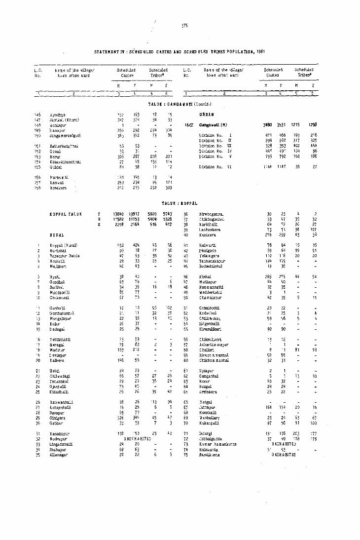
STATEMENT IV: S{HED ULED CASTES AND SCHED ULED TRIBES POPULATION, 1981
L.C. N a m e of the villagel Scheduled Scheduled L.C. N a m e of the village/ Scheduled Scheduled
No. town urban ward Castes Tribes' No. town urban ward Castes Tribes'
M M M M ~
3 5
TALUK : GANGAWATI (Concld.)
146 Ayodhya 157 163 18 19 URBAN 147 Jantkal (Khurd) 347 374 3~ 33 148 Ach13.pur 1 16m Gangavati (M) 3480 3531 1215 1298 149 D anapur 296 292 294 304 150 J anga m arkalgudi 363 342 73 89 Division No. I 471 466 193 218
Division No. II 295 282 317 325 151 B~ttethan.chnal 58 53 Division N c. ill 328 353 402 444 152 Gonal 32 31 !) ivision No. IV 447 49" 104 96 153 Herur 308 287 208 201 Division No. V 795 792 160 188 154 K esakkihanchnal 27 45 135 114 155 Guldal 81 58 12 12 Division No. VI 1144 1147 39 27
156 Markum bi 141 145 13 14 157 Hanwal 259 234 95 121 158 Hasekera 212 215 292 309
TALUK : KOPPAL
[OPPAL TALUK T 13840 13917 5920 5743 36 Hire boganhal 3D 23 4 2 R 11582 11753 5404 5326 37 C hikboganhal 53 47 35 32 u 2258 216' 516 411 38 Karkihalli 64 72 26 27
39 Lachankera 73 71 98 107 RURAL 40 Kunikera 276 259 43 38
1 Koppal (Rural) 452 424 45 56 41 Halwarti 78 64 15 15 2 HU"inhal 20 18 27 30 42 Irkalgada 59 64 99 91 3 Bahaddur Banda 47 53 35 52 43 YeIamgera 110 118 20 20 4 HoshalJi 29 33 26 25 44 Tadkanakapur 194 179 5 M ellikeri 40 43 45 Budsetttnhal 19 36
6 Hyati 38 40 46 Kinhal 285 275 44 54 7 Gondbal 63 78 6 47 Mutllapur 44 40 8 Budihal 34 36 16 18 48 Han m anhatti 32 35 9 M uddaballi 85 77 49 Wadderhatti 3 1
10 Chukankal 67 70 50 Chamalapur 42 39 11
11 GunhalJi 12 10 95 102 51 Gosaldoddi 20 22 12 Horthatanhal 21 11 32 37 52 Kodadhal 21 25 4 13 Mangalapur 22 38 13 lU 53 Chllk \II ukki 59 56 4 14 Kolur 26 37 54 Sidganhalli
15 D adegal 25 25 55 Hiresulikeri 90 90
16 Yettinhatti 73 79 56 C hiksulikeri 13 12 17 Naregal 79 82 57 Achartim mapur 1 1 18 Madinur 183 212 58 Challari 8 11 81 78 19 D evlapur 59 Hire bo \II m annal 50 55 20 Kalkera 146 156 60 Chikbom manhal 32 31
21 Hatti 24 29 61 Uplapur 2 1 22 Chllwadagi 65 57 27 26 62 Ganganhal 5 1 13 10 23 Tankankal 29 29 35 24 63 Hasur 40 32 24 Ojanhalli 75 65 64 Hosgal 24 24 25 Kidadhalli 25 26 39 42 65 Arsinkera 25 22
26 Han m anhalli 28 26 113 94 66 Metgal 27 K utganhalli 19 26 6 5 67 Jinnapur 164 154 20 16 28 Basapur 69 79 68 Hosahalli 29 G~era 326 344 45 47 69 Wanballary 23 24 63 67 30 Gabbur 33 39 7 3 70 Kukanpalli 67 50 91 100
31 Kanalcapur 138 150 25 42 71 Indargi 191 178 203 177 32 Rudrapur UNINHABITED 72 Jabbalgudda 37 49 178 175 33 Lingadahalli 24 20 73 Kumar Ramankunta U NIH A BlTED
34 Shahapur 62 63 74 Halekunta 51 53 35 Allamigar 20 22 75 Bandikunta U NIH IvBI1 ED
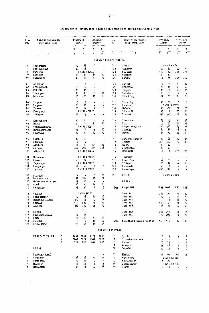
376
STATEMENT IV: SCHE:D ULED CASTES AND SCH£D ULEn TRIBES POPULATION, 1981
L,C, N arne of the village! Scheduled Scheduled L,C. Name of the village! Scheduled Scheduled No. town urban ward Castes Tribes· No, town urban ward Castes Tribes'
M M F M M F
2
TALUK: (OPPAL (eoneld,)
76 C handragiri 12 68 121 Aliipur U NIII H A BIT ED 77 N ageshanhalli 62 78 122 Murlapur 59 62 69 74 78 Sultanpur U NIN H ASITED 123 Kawaloor 450 440 281 278 79 Bllebhavi 21 24 87 79 124 GucUgera 81 80 80 Bud\lgumpa 89 85 19 22 125 Handral 46 48 227 232
81 A marapur 3 1 126 Hanwal 6 7 91 116 82 D hangaldoddi 9 10 127 Wadganhal 42 47 14 13 83 Halhalli 178 182 128 Halgera 106 127 52 50 84 Tawergera 38 38 37 36 129 K atrahalJi 15 15 85 Shimanur 27 31 17 13 130 C hiksind ° gi 19 26 33 28
86 Sangapur 3 3 131 Hiresindogi 195 224 5 87 Lebgera 28 31 132 N arsipur U NIN H A BITED 8a Kumnur 57 54 4 133 Mainahalli 97 10~ 107 11& 89 Kardigudda U NIN ~ A BITED 13~ Bikanhalli ~7 62 123 118 90 Abbigera 15 9 135 Bisarhalli 336 345 127 125
91 Kenchandoni 149 171 136 D 0 m barhalli 66 63 48 38 92 Hitnal 197 211 191 176 137 Belur 73 92 184 176 93 C hikkhasankandi U NIN H A BITED 138 Kotarki GudJanur 242 226 69 73 94 Hirekhasankandi 115 11 ~ 45 50 139 N eeralgi 63 6~ 143 151 95 Bevirhalli 37 41 20 25 1~0 Mattur 6, 49 136 154
96 Guldhalli 82 79 141 H unkunti Akkapur 92 68 92 85 97 Kerihalli 5 7 142 Betgera 211 249 120 113 98 Agalkera ~76 479 207 196 1~3 Tisari. 49 52 99 Shivapur 227 246 244 238 1~4 Bochanhalli 94 99
100 Achalapur U NIN H A SITED 1~5 Moranhalli 7 8 226 201
101 Hussainpur U NIH H A SITED 146 Bhairapur 102 Basarur 66 77 5 147 Nilogi Pura 37 26 103 Rajarampet U NIN H A BITED 148 Keslapur 20 14 64 68 104 Narayanpet 62 64 3 149 Halwagali 48 57 105 Ayodhya U NIN H ABlrED 150 Hydernagar 260 242
106 Attivatti 6 10 151 Kalhalli U NrN H A BITED 107 Bandiharlapur 292 314 39 29 108 MohalIIam iliad Nagar 109 80 URBAN 109 Hulgi 60 68 14 16 110 Kampsagar 149 190 3 161IV Kappal (H) 1692 1648 480 382
111 I>l1llapur U NIH A EITED Ward No.1 287 291 13 12 112 Holimurllapur 17 18 62 46 Ward No,2 10 10 13 14 113 Munlrabad (Rural) 370 368 170 163 Ward No.3 4 5 66 60 11~ Hoshalli 611 582 117 111 Ward No.4 684 721 48 39 115 Alwandi 336 322 125 106 Ward No,5 48 49 110 90
116 Kampli Ward No.6 287 213 151 128 117 R aghunathanhalli 18 17 Ward No.7 372 299 79 39 118 Hatti 15 12 39 36 119 Belgatti 5 6 47 52 16m Hunirabad Project Area (SA) 566 516 36 35 120 G hatreddihal 72 66 46 38
THUK : KUSHTAGI
IIISHTAGI tALU( '1' 6641 6801 9113 9035 Byalihal 12 R 5869 5911 8969 8821 7 G orvarbencha m atU 2 1 U 172 830 204 208 8 Nidsesi. 70 79 17 19
9 Vanageri. 33 48 15 15 JlURAL 10 Tekkalki 29 30 4 6
K ushtagl (R ural) 11 Bichkal 96 105 51 53 2 Kurbanhal 38 36 11 14 12 Mankalkeri U UIN H A BITED 3 Nerebenchi 10 14 9 7 13 Kawalboodur 118 128 4 Shakapur 15 24 4 4 14 Upparbasapur U NIN H A SITED 5 Hadalgatti 37 41 50 68 15 Hesrur 3 9
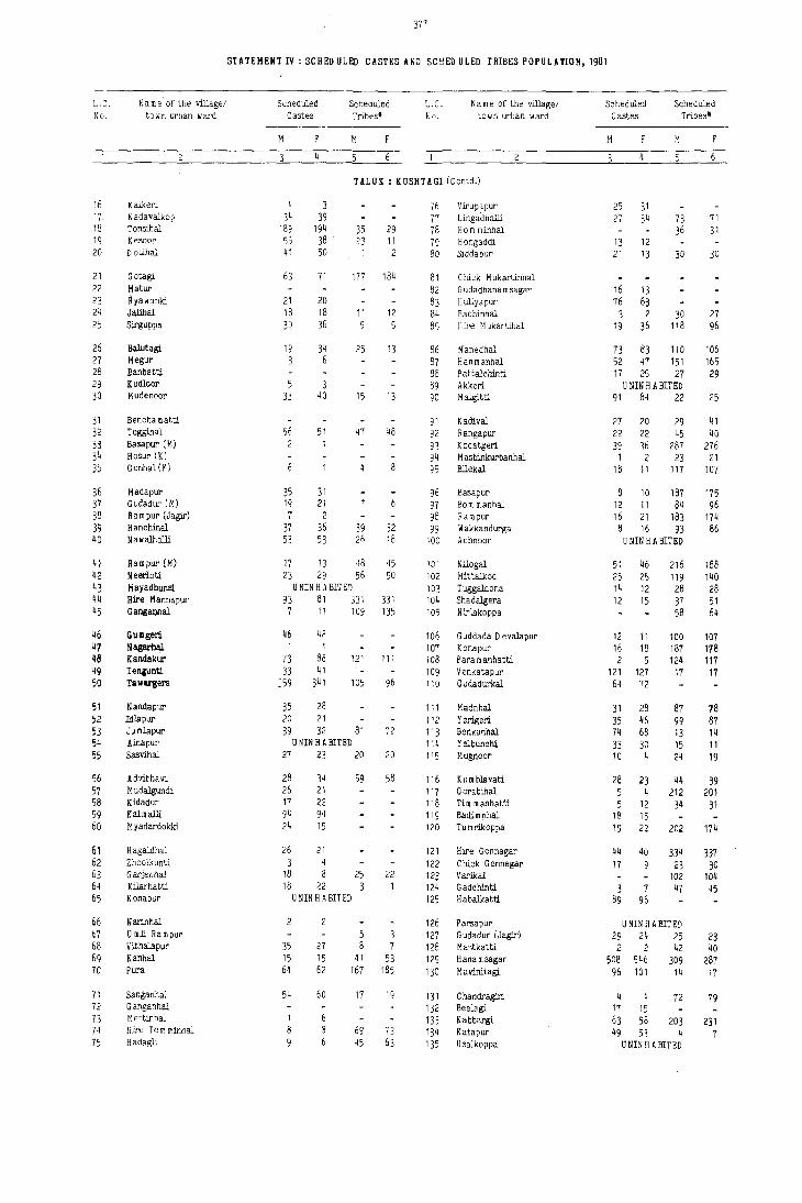
m
STATEMENT IV: SCHEll ULED CASTES ANn SCP.ED ULEO TRIBES POPULATION, 1981
L. C. Name' of the v'.J.J.age! Scheduled Scheduled L.C. Name of the village! Scheduled Scheduled ]lJc', town urban war'd Castes Tribes* No. towrl urban ward Castes Tribes'
M M M M
TALUK : KUSHTAGI (Contd.)
1.6 Kalkeri 4 3 16 Virupapur 25 31 17 Nadavalkop 34 39 11 Lingadhalli 21 34 73 11 18 Tonsihal 189 194 35 29 78 Hom minhal 36 31 19 K esoor 55 38 23 11 19 Hongaddi 13 12 20 D otihal 41 50 1 2 80 Siddapur 21 13 30 30
21 Gotagi 63 11 177 184 81 Chick M ukartinhal 22 Matur 82 G udadhana msagar 16 13 23 Hyawanki 21 20 83 Huliyapur 16 63 24 Jalihal 18 18 11 12 84 Bachinhal 3 2 30 27 25 Sirguppa 30 36 9 5 85 Hire M ukartihal 19 36 118 96
26 Balutagi 19 34 25 13 86 Manedhal 73 83 110 106 27 Megur 1 6 87 Hanmanhal 52 47 151 165 28 Banbatti 88 P attalchinti 17 25 27 29 29 Kudloor 5 3 89 Akkeri U NIN H A SITED 30 Mudenoor 33 40 15 13 90 Malgitti 91 84 22 25
31 Bencha m atti 91 K adival 27 20 29 4 I 32 Teggihal 56 51 47 48 92 Rangapur 22 22 45 40 33 Basapur (M) 93 Kodatgeri 39 36 287 276 3~ Hosur (K) 94 M asbinkurbanhal 1 2 23 21 35 Gonhal (y) 95 Bilekal 18 11 117 107
36 Madapur 35 31 96 Basapur 10 187 175 37 Gcdadur (M) 19 21 97 Born manhal 12 11 84 96 38 Rampur (Jagir) 7 2 98 Rampur 16 21 183 174 39 Hanchinal 37 36 39 32 99 Wakkandurga 8 16 93 86 40 Na walhalli 53 53 26 18 100 Achnoor U NIN H A SITED
41 Rampur (M) 17 13 48 45 101 Nilogal 51 46 216 188 42 Neerloti 23 29 56 50 102 Mittalkod 25 25 119 140 43 Mayadhunsl U NIN H A BIT ED 103 Tuggaldona 14 12 28 28 44 Hire M anna pur 93 81 331 331 104 Shadalgera 12 15 37 51 45 Ganga~al 7 11 109 135 105 Nirlakoppa 58 64
46 GUlIIgeri 46 4P 106 G uddada D eValapur 12 11 100 107 47 Nagarhal 1 4 107 Konapur 16 18 187 178 ~B Kamlakur 73 86 121 111 108 Para m anhatti 2 5 124 117 ~9 TeOiunti. 33 41 109 Venkatapur 121 127 17 17 50 !aw.rgera :59 341 105 96 110 Gudadurkal 64 72
51 Nandapur 35 28 111 Madnhal 31 28 87 78 52 IdlaPur 20 21 112 Yerigeri 35 46 99 87 53 Jumlapur 39 32 81 72 113 Benkanhal 74 68 13 14 54 Ainapur UNINHABITED 114 Yelbunchi 33 30 15 11 55 Sasvihal 27 23 20 20 115 Mugnoor 10 4 24 19
56 Advibhavi 28 34 59 58 116 Kumblavati 28 23 44 39 57 Mudalgundi 26 21 117 Gorabihal 5 4 212 201 58 Kidadur 17 22 118 Tim manhatti 5 12 34 31 59 Kalmalli 94 94 119 Badimnhal 18 15 60 M yadardokki 24 15 120 Tumrikoppa 19 22 202 174
6, Hagaldhal 26 21 121 Hire G onnagar 44 40 334 337 62 Zhoolkunti 3 4 122 Chick G onnagar 17 9 23 30 63 Garjanhal 18 8 25 22 123 Varikal 102 104 64 Kilarhatti 18 22 3 124 Gadchinti 3 7 47 45 65 Konapur U NIN H A BIT ED 125 Habalkatti 89 96
66 Narinhal 126 Parsapur U NIN H A BIT ED 67 U roll Rampur 5 3 127 Gudadur (Jagir) 29 24 25 23 68 Vithalapur 35 27 8 7 128 Mao,tkatti 2 2 42 40 69 Kanhal 15 15 41 53 129 Hanamsagar 508 546 309 287 70 Pura 64 62 167 185 130 Mavinitagi 96 101 14 17
71 Sanganhal 54 60 17 19 131 Chandragiri. 4 4 72 79 72 Ganganhal 132 Beelagi. 17 15 73 Mettinhal 133 Kabbargi. 63 58 203 231 74 Hire Tern rninhal 69 73 134 Katapur 49 53 4 7 75 Hadagli 45 63 135 Usalkoppa U NIN H A BIT ED

378
STATEMENT IV: SCHED ULED CASTES AHP SCHED ULED TRIBES POPULATION, 1981
L.C. Name of the village/ Scheduled Scheduled L. C. N arne of the village/ Scheduled Scheduled No. town urban ward Castes Tribes· No. to w n urban ward Castes Tribes·
M M M M
TALUK : KUSHTAGI (Concid.)
136 Tatakunti U NIN H A BIT ED 161 Yeiburthi 39 26 119 127 137 Ki4!onhal 21 28 140 150 162 Hire-Sanrugol 57 44 20 21 138 Turkanur U NIN H ABITED 163 Hire-N andihal 50 56 132 137 139 Kadoor 18 28 39 38 164 Kankoppa 7 5 153 140 140 Yerlgonhal 15 13 86 104 165 D onnegudda : 5 16 6 12
141 Huchnoor 26 25 166 Bisnhal 19 20 128 128 142 Antarthana 23 23 167 Parasapur 1 28 24 143 Puratageri 168 Bhingikoppa U NIN H A SITED 144 Bandargal 26 34 112 91 169 Kalalbandi 24 37 7 '1 145 Honmatti U NIN H A BIT ED 170 Chalgera 204 199 135 130
146 Hul.<Jera 182 178 366 347 171 Zhoolkatti 16 12 144 145 147 Sebankatti 47 45 172 Madikera 33 35 148 Mannerhal 26 32 173 Zhunjalkoppa 6 6 149 Mudhotagi 31 31 174 Hosalli 13 12 150 D evelapur 8 3 175 Malkapur 23 16
151 Hanamageri 4 2 92 92 176 HuJ.segeri 21 25 144 140 152 Miyapur 23 30 6 5 177 Advibhavi 53 53 m 157 153 Kyadiguppa 92 103 136 133 154 Mensageri 138 125 URBAN 155 Kadekoppa 31 21
16/V K ushtagi (M) 772 830 204 208 156 Tim unhatti U NIN H A BIT ED 157 Topalkatti 11 14 47 52 Division No. I 229 239 8 6 158 Talugeri 44 43 48 44 Division No. II 37 29 59 60 159 KOrdakera 29 32 145 132 Div1si.on No. m 323 382 27 24 160 Chick-Nandihal 6 11 224 195 Div1si.on No. IV 46 10 11 7
Division No. V 137 170 99 111
TUUl : LIIiGSOGUR
LINGSOGUR TALOI' 't 17863 18062 13660 13572 26 Jungira m pur 251 241 R 111791 15065 12562 12526 27 Upperi (Small) 37 30 134 125 U 3072 2997 1098 1046 28 Sunkal 27 26 202 199
29 Upperi (Big) 12 13 104 121 RURAL 30 Halbhavi 264 270 366 386
1 LingBugur (RUral) 31 Yergunti 12 26 8<' 70 2 Kuppigudd 48 34 32 Gorebal 340 369 5 3 Sarjapur 81 79 33 Mineheri 146 135 4 A mrawati 34 Jalibenehi 25 21 5 Gonll~r 23 21 35 Kalapur 119 124
6 Basapur 8 2 36 Aidanhal 96 89 7 J unge ~ arhalli U NIN H A BIT ED 37 YeJ<Ialdinni 8 Hoov'.,bhavi 15 13 36 Kesarhutti 129 151 9 Budui.n:u 7 12 39 Eachanhal 287 336 200 206
10 Sanbal 118 125 40 Toralbenchi 31 26 247 2511
1l Hunkunti 75 66 41 Nandihal 31 46 112 108 12 Kalli-Lingsugur 34 45 37 55 42 Bendona 24 30 154 137 13 Bllupur 60 62 43 Anahosur 168 169 322 323 14 MaVinbhavi 113 112 51 59 44 Margatnal 37 28 15 Kachap.:r 156 159 133 134 45 Chitranhal 64 76 44 43
16 Gundsagar 81 91 33 26 46 Neeralkera 70 85 12 15 17 Hanumangudda (Hosur) 57 71 16 15 47 Rampur 34 32 248 246 18 JuI<!udda 93 108 175 170 48 Advibhavi 19 Narkaldinni 47 45 248 228 49 Karadkal 11 20 NowlJ 40 35 50 Huligud 14 15
21 Kamaldinni 32 31 58 40 51 Gurgunta 160 149 1129 1142 22 Chitapur 169 186 203 224 52 Golpalli 14 21 226 257 23 JaWOD" (Big) 36 44 33 32 53 Raidurga 79 74 24 JaWOD" (Small) U NIN H A BIT ED 54 Tanmankal 1 84 65 25 R oudalbanda 57 66 42 43 55 Gadgi 36 25 32 49

379
STATEMENT IV: SCHED ULED CASTES AND SCHED ULED TRIBES POPULATION. 1981
L.C· N am e of the village! Scheduled Scheduled L.C. Name of the village! Scheduled Scheduled No. town urban ward Gastes Tribes· No. te w n urban ward Gastes Tribes·
M F M F M F M F
TALUK : LINGSUGUR (Gontd.)
56 Paidoddi 49 56 197 199 116 Thirthbhavi 12 173 166 57 YerjuntJ. 10 8 708 704 111 Nirloti 2 58 Bandebhavi 6 7 378 318 118 Advibr.avi (Maski) 130 110 59 Yelgutti 144 177 195 188 119 Bellada m ardi 10 1 40 39 60 Machnoor 90 105 77 69 120 Benkanhal 14 66 16 13
61 Hosae;udda 82 80 48 43 121 D l.<!;naikanbhavi 8 (2 GoudUr 398 395 92 74 122 Mudaldinni 18 55 63 KaddCllla 22 22 2 4 123 Jakke!'l1ladu 107 113 64 R oudalbanda 140 166 124 Sultanpur 20 23 65 Tawag 21 28 125 Askihal 14 19 99 88
66 Mallapur 19 17 126 Maraldinni 346 304 61 Hosur 20 19 221 230 127 D abbermadu 15 20 44 41 68 Anwari 118 130 28 19 128 Nagalopur U NIN H A BIT ED 69 C hukenhutti 30 20 129 Mattur 183 181 38 39 70 Hire N ~.gnur 149 151 46 61 130 Kadadarnahal 68 97
71 C hikka N agnur 10 13 19 26 131 Gudihal 69 63 119 123 72 G ajjalgutta 145 166 25 27 132 Taribhavi 42 40 50 51 73 Chick Hesarur 113 118 13 B 133 Buddinni 71 58 74 Hire H esarur 60 56 3 134 K uni-K ellur 89 94 28 21 75 Nilogal 215 231 135 Mitti-Kellur 3
76 Veerapur 42 39 73 78 136 Santikellur 106 132 77 H utti village 680 712 77 72 137 M uslikarIkunti 85 77 78 Mednapur 107 116 138 BendarkarIkunti 41 47 121 119 79 Gudadanhal 69 61 14 19 139 Ankasdoddi 42 56 80 Honnahalli 121 121 97 93 140 Mudwal 3 2
81 Yerdona 115 143 19 19 141 Katgal 16 14 165 152 82 Phoolbhavi 111 91 142 Venkatapur 64 75 83 Shilhalli (Tugli) 26 24 11 12 143 Mudgal (Rural) 12 9 84 Jaldurga 11 8 30 15 144 Piklihal 2 85 104 85 Hanchinal 4 80 88 145 Ulimeshwar 56 63
86 Yalgundi 115 126 146 Naglapur 110 95 146 149 87 Kadadargaddi 5 8 87 10 147 Chattar 260 265 91 75 88 Yergodi 5 9 216 190 148 Kumarkhed 8 8 122 118 89 GonwatJa 381 343 121 125 149 Todki 37 26 90 Guntagola 32 48 171 125 150 Heggapur 25 23 10 16
91 Aidbhavi 16 70 56 151 Vyakarnhal 46 38 92 Ramloti 36 30 152 Marli 49 51 54 48 93 Parampur 198 168 73 75 153 Hunoor 21 22 94 D everbhupur 117 122 154 Arya-Bhogapur 8 6 95 Kotha 203 230 174 191 155 Wandali 37 29
96 Benchaldoddi 59 58 62 44 156 Ramatnal 32 29 16 11 97 C hikaldoddi II 5 157 Bellihal 10 13 1 98 Masld 880 849 454 507 158 Turadgi. 26 33 99 Medernhal 19 26 230 223 159 Makapur 18 13
100 Mediklnhal 341 345 160 Talekat 2'r 25
101 Antargungi (Small) U NIM H A BIT ED 161 Bannl.<!;ol 104 90 41 49 102 Antargungi (Sl.<!;) 159 136 36 36 162 Jantapur 39 41 74 66 103 N agerbenchi 108 121 16 9 163 Yerdihal (Khurd) 18 11 104 Baggalgudda 10 5 164 Adapur 22 29 23 17 105 Veerapur (D) U NIN H A BIT ED 165 Komlapur 13 12
106 K a m andaldinni 7 8 166 Kansavi 77 72 26 47 107 Talekhan 75 76 34 32 167 Bellihal 4 6 108 D esai Bhogapur 176 206 1 168 Yerdlhal (Bl.<!;) 75 69 3 109 Yerdoddi 23 21 41 43 169 Alndihal 198 194 125 159 110 Hedagali 454 4b5 32 35 170 Upper-Nandihal 30 28 108 105
111 Sompur U NIN H A BIT ED 171 Lukkihal (Blg) 41 32 4 112 Vyasanandihal 30 46 172 Lukkihal (Small) 43 41 59 51 113 Kanna]. 61 6~ 47 55 173 Kom nur 14 24 114 Till'mapur 103 93 158 182 174 Sajjalgud 49 29 4 6 115 Bailgl.\dda 55 55 175 Bom manhal 74 79 209 185

380
STATEMENT IV: 5CHEO ULEO CASTES AND SCHEO ULED TRIBES POPULATION, 1961
L.C. Name of the village/ Scheduled Scheduled L.C. N a m e of the village! Scheduled Scheduled No. town urban ward C estes Tl'ibes' No. town urban ward Castes Tribes*
Ii F M F M F M F
4 6
TAt.n : LllIGSUGOR (ConeM.)
176 Nagarhal 125 140 21 22 ORBAN 177 P algaldinni 44 37 178 Halkawatgi 108 112 130 139 161II[ Hatti Gold Hines (N A C) 1361 1212 36 40 179 Tondihal 15 25 180 Ankanhal 10 12 11 13 16/VI Lingsugur (M) 1150 1115 249 220
161 Uppanhal 15 9 D ivlsion No. I 309 375 13 11 182 MalIapur U NIN H A BIT ED D ivlsion No. II 102 95 13 4 163 Rampur 16 21 D ivlsion No. m 461 419 47 34 164 Tu m balgaddi 5 8 D ivlsion No. IV 111 114 132 128 165 Bhogapur 42 31 '6 41 D ivlsion No. V 167 172 44 43
186 Baiyapur 74 63 17 20 16/VIII Mudgal (H) ~61 610 813 786 187 Bandi-Sunkapur 1 168 Khldrwadgi 111 95 7 Ward No.1 60 1 189 Advi. Bhavi. (Mudgal) 22 25 122 107 Ward No.2 268 341 64 53 190 Killarhutti 62 63 195 188 Ward No·3 110 132 5 3
Ward No.4 123 136 744 730 191 AshihaI 400 456 69 74 192 Kannapur-Hutti 141 128 264 255
TALUI: HANVl
HANYl rALUI T 16499 16699 13548 13478 36 Karegujd" 83 77 R 15411 155~8 12674 12642 37 JaneKal 60 71 136 137 0 1088 1151 874 836 38 A marawati 120 114 57 73
39 Bhogawati 20 22 93 93 RORAL 40 HaIapur 111 136 26
1 Manvi. (Rural) 14 10 59 55 41 Nandihal U NIN H A BIT ED 2 RabbankaI 31 28 42 Joladarasi 5 3 Dadda.l 20 17 199 20g 43 GogehebbaI 62 48 77 81 4 Katarld 31 27 57 45 44 C hikkadinni 25 27 3 7 5 Madlapur 328 330 232 248 45 Hiredinni 111 120
6 Burhanpur 15 11 46 HaIIadgudda 49 34 15 9 7 RangdhaI 23 16 92 102 47 Donamaradi 76 76 267 276 8 Buddinni (U mli) 48 Sunknoor 71 69 9 Chikalparvi. 129 113 49 M arka m dinni 113 108
10 Yedival 32 34 50 Malkapur 50 57
11 P annur Jagir 102 94 129 122 51 Toraldinni 121 135 12 II alga m dinni 87 81 5~ Chikka Udbal U NIN HAIliTED 13 C hikkotankal 118 111 333 313 53 Jangamarhalli 47 33 14 Hosur (Umli) 87 100 212 226 54 Yeddaldinni 109 98 23 21 15 Jutlapur 4 5 55 TuggaIdinni 47 31 154 145
16 Kumdhal U NIN H A BIT ED 56 Hanchanhal 37 41 17 N andihal (K hal.:3a) 67 56 76 85 57 KabberhaI 18 Rajaldinni 5 10 143 125 58 Hirekadboor 81 102 45 41 19 Y arm aldoddi 20 35 63 61 59 S. Ram aldinm "36 31 20 Mustoor 54 75 368 378 60 Jinnapur 50 47 161 183
21 Hirekotankal 656 618 229 231 61 M.Ramaldinni 23 19 22 D evipur 22 19 172 191 62 NagaIdinni 57 63 23 Eralgaddi 90 73 58 65 63 PamankaIIur 74 95 133 123 24 Kharabadinni 62 63 65 75 64 KotekaI 10 7 323 310 25 M udda m gaddi 60 69 110 106 65 A meengad 190 263 44 44
26 Uralgaddi U NIN H A BIT ED 66 N elkola 27 PotanbaI 170 162 152 165 67 YatgaI 54 57 26 Jeenur 77 74 245 232 68 Kachapur 4 1 187 145 29 TadkaI 129 107 40 32 69 Eklasapur 109 105 48 60 30 D hotarbanda 29 35 70 Watgal 97 112 73 64
31 Utaknur 54 65 71 Parasapur 32 Belwat 69 60 72 Jutlahal U NIN H ABITED 33 \ldbaI 85 88 54 52 73 Basapur 117 105 89 73 34 Badlapur 28 20 74 IrliaI 33 32 30 31 35 Byagwat 147 157 49 49 75 Chilkaragi 82 79 28 26
381
STATEMENT IV.: SeHED ULED CASTES AND SCHED ULED TRIBES POPULATION, 1981
L.C. N a m e of the village! Scheduled Scheduled L.C. Name of the village! Scheduled Scheduled No. town urban ward Castes Tribes' No. tolln urban ward Castes Tribes'
M F M M M
TALUK: H.ANVI (Coneld.)
76 Gudihal 21 22 135 132 131 Sangapur 138 147 317 333 77 Hilalpur 31 25 132 Ja rn baldinni 126 120 168 147 78 Bencha m aradi 45 48 32 36 133 Kaddinni 60 63 11 9 79 Harvapur 28 27 38 36 134 Chagbhavi 154 152 80 Togalgal U NIN H A BIT ED 135 Lakkam dinni 93 87
81 Anandgal 114 117 34 29 136 Jalapur 60 55 48 33 82 Tupdoor 28 36 137 Kallur 365 406 117 96 83 ROlltal 618 665 19 17 138 Kapgal 176 217 318 287 84 Tim mapur 3 3 139 Bettadur 171 141 336 410 85 Toppaldoddi 15 16 15 12 140 Neermanvi 519 489 292 290
86 C hinch"rald 106 107 27 28 141 Govindoddi 104 99 159 175 87 Buddinni (U mll) 41 42 63 68 142 Chimlapur 58 44 103 '10 88 Buda 3 9 134 146 143 Kardl;;ud 101 1?5 387 425 89 lIeera 72 80 196 201 144 Naslapur 20 22 90 Yapalaparti U NIN H A BIT ED 145 Malligmadu 8 6
91 D on mardi 11 7 32 30 146 Harvi 388 406 12 92 Bo msandoddi U NIN H A BIT ED 147 Madagiri 339 377 93 K asandoddi 27 37 148 Tupdur (Khalsa) 35 43 94 Saidapur 33 ~1 149 Bom manahal 104 108 252 252 95 HuS5al1lpur 51 4~ 150 Bevinur 68 69
96 Guddinni (Umll) 1~ 11 151 Machnur 128 114 204 203 97 C hikka H angi 10 8 152 Hokrani 166 180 44 44 98 Hire Hangi 74 93 153 Kurdi 434 437 136 135 99 Potapur 17 17 154 Aroli 254 226 16 15
100 Gol.dJ.nni 28 43 155 A d vi K hanapur 74 65 120 95
101 C hikka Badardinni 18 16 156 K a m balanetti 27 22 15 12 102 D ellatgal 15 7 157 W alka m Glnni 24 16 234 229 103 Malat 127 148 231 214 158 Rajoli 75 70 569 569 104 Patakamdoddi 74 74 15~ Jukur 59 58 58 46 105 Kalamgere 98 101 17 18 160 Tam mapur 46 45
106 Bullapur 22 21 161 Rajalbar.da 116 117 107 Kurkunda 51 53 162 Arnalli 10 10 32 25 108 Wadwatti 48 43 163 Pannur (U mll) 46 43 147 152 109 Narbanda 101 99 164 Sadapu" 50 56 297 294 110 Hunched 19 22 165 Kom 22 27
111 Murkiguda 223 229 166 Bapur 22 10 112 Marat 80 76 167 Seekal 202 188 113 Nawalkal 79 87 143 141 168 Murharpur 258 255 12 114 Hosur (Nugdoni) 50 35 161 149 169 Sunkeswara 446 453 115 Ballatgi. 98 96 548 587 170 Ball m archad 142 137
116 Aldhal 22 29 11 171 Gorkal 82 88 117 Gavigat 86 88 142 132 118 Nakkunda 109 107 32 34 URBAN 119 Bagalllad 304 306 97 Bo 120 Hirebadardinni 114 121 16/VII Hanvi (M) 1088 1151 87q 836
121 Nugdoni 75 95 58 54 DiVision No. 102 87 22 20 122 Sirwar 621 613 40 51 DiVision No. IT ~90 547 16 20 123 Jakkaldinni 63 55 DiVision No. ill 1 6 7 1 124 Atnur 291 277 59 55 Division No. IV 13 14 447 461 125 Shakapur 72 81 DiVision No. V 482 497 382 334
126 Singaddinni 9 8 127 Ganadinni 200 163 173 159 128 Halli 21 22 18 20 129 San Hosur 229 260 46 49 130 G uddinni (K halaa) 207 201 151 149
382
STATEMENT IV: SCHEn ULEn CASTES AND SCHEn ULEn TRIBES POPULATION, 1981
L.C. N arne of the village! Scheduled Scheduled L.C. Name of the village! Scheduled Scheduled No. town urban ward C astea Tribes' No. town urban ward Castes Tribes·
M F M M M F
TALUK: HAICHUR
RAICHUR TALUK T 22259 21782 4161 4076 56 Gadhar 11 13 R 12500 12283 2901 2885 57 Gillesugur 96 85 U 9759 9499 1260 1191 58 Bichal 83 73
59 Kotigud U NIN H A BIT ED RURAL 60 Kataknur 31 25
Raichur (Rural) UNINHABITED 61 Hanmapur 59 59 2 Yermarus 139 135 62 Gatbichal 15 21 58 61 3 Yegnur 132 119 63 Heerapur 61 49 4 Sanknur 47 49 64 Matmari 40 36 5 Potgal 230 232 65 M oodaldinni 6 5
6 Tamalgat U NIN H A SITED 66 Turkandona 83 105 7 Agapur U NIN H A BITED 67 Yedlapur 8 11 50 48 8 Kurabdoddi 120 113 68 o ugnoor 46 38 221 210 9 Wadwati 138 125 69 Karebudur 63 74 39 40
10 Baidoddi 114 108 70 Hanchinhal 43 39 118 110
II G housenagar 11 7 71 GandhaI 47 54 297 298 12 Balm andoddi 61 48 72 Idapnur 30 33 639 632 13 H arkandoddi U NIN H A BITED 73 Meerapur 14 Bapur 92 91 74 Mirzapur 22 22 15 U ndraidoddi 49 48 75 Talmari 58 68
16 Ayajpur 52 ~3 76 Gangwar 20 16 17 Rajalbanda 35 39 77 N addigaddim alkapur 27 22 18 Bijangera 1 1 78 Gunderveli 14 15 19 D evanpalli 71 83 79 Buddinni 8 7 20 Mittimalkapur 92 91 80 Chick m anchaI 13 12
21 Sidrampur 43 47 81 Bullapur 53 47 41 45 Maliabad 102 99 82 Tungabhadra 67 73
23 Hcsur 415 396 83 Kalmala 355 327 211 245 24 Rampur 654 618 84 Halvenkatapur 17 31 25 Askihal 574 597 392 351 85 Murharpur 59 60
26 Eklaapur 248 220 86 Sultanpur 83 67 27 Yergera 84 82 313 287 87 R aghanathanahalli 85 97 64 96 28 Tuntapur 74 60 88 Venktapur 90 87 29 Bassapur U NIN H A EITED 89 Arlappanhuda 1 1 30 Murkidoddi 25 15 90 Mallapur 14 15
31 Mallapur 9 11 91 Jegarkal 258 281 32 Lingankhandcddi 16 10 92 Chicksugur 109 94 33 Masdoddi 33 35 93 Kuknoor 17 9 34 Julamgera 6 7 36 37 94 Hospet 190 201 35 Kothdoddi 14 13 95 Merched 351 367 18 19
36 Kannedoddi 96 Manslapur 387 397 37 Ja m baIdinni 84 79 97 Fathepur 107 122 38 PuchaIdinni 6 3 98 GonhaI 75 78 39 Moldoddi 99 H unsihalhuda 31 24 3 3 ~o Sapur U NIN H ABITED 100 Mamdapur 148 135 18 13
41 MidgaIdinni 101 Nelhal 70 79 42 Gunjhalli 355 380 102 Arlibenchi 6 8 43 Alkur 51 41 103 Asapur 17 20 46 50 44 GcdihaI 34 27 37 26 104 Jalibenchi 10 9 45 Upral 43 42 13 13 105 Merchathal 97 94
46 Purt.i.pli 49 65 106 Pesaldinni U NIN H A BITED 47 Garaldinni 119 147 107 D eosugur 271 264 48 Dinni 255 275 108 Ganjhalli 114 98 49 Khanapur 69 72 109 Korvihal 45 41 50 Udamgal 99 94 110 Ramgaddi
51 Naglapur 83 86 111 Korthkunda 111 112 52 Kamlapur 37 38 230 255 112 M a m adadoddi 22 21 53 Anwar 10 7 113 Yer.gunta 74 82 54 Gon\lar 113 103 114 Sanga ru kunta 95 98 20 19 55 Manjerla 158 131 115 Ibrahim doddi 17 10

383
STATEMENT IV: SCHED ULEO CASTES AND SCHEO ULEO TRIBES POPULATION, 1981
L.C. Name of the village/ Schedllled Schedllled L.C. Name of the village/ Schedllled .scheduled No. town urban ward Castes Tribes' No. town urban ward Castes Tribes'
M M M M F
4'
TALUK : RAICHUR (Concld.)
116 H anu m anooddi 146 Korvakhurd 67 56 117 Wadloor 115 127 147 Agrahar 1 2 118 H egsanhalli 116 110 148 Korvakalan 38 31 1 ~ 9 Naglapur 149 Budidipad 90 99 120 Bevinbenchi 40 43 150 Kurtipali
121 Srinivaspur 151 Athkur 151 126 122 Hem bertial 82 79 152 Gajerhal 136 127 123 Hanmapur 62 70 153 Yapaldinni 106 92 124 Tim mapur 86 89 154 Palwaldoddi 3 4 125 Arshangi. 45 43 155 Kothdoddi 6 8
126 Gurjapur 50 35 156 Nagandoddi 2 2 m Meerapur 52 52 157 Arsigera 77 70 128 Tim mapur 34 27 158 W adla [II doddi 129 Kadlur 83 87 159 Mandalgera 165 144 130 Karekal 10 12 160 Sing nodi 284 284
131 Rangapur 28 36 URBAN 132 Yedlapur 63 62 12 10 133 Chanderbanda 242 267 16/x Ra1chur (M) 9759 9499 1260 1191 134 K adga m doddi 135 Katlatkur 289 287 Ward No.1 1862 1722 52 53
Ward No.2 96 88 11 9 136 Polka m doddi 21 25 Ward No.3 27 21 81: 81 137 Shakwadi 48 41 Ward No.4 1441 1493 90 101 138 Kadlur 42 ~2 Ward No.5 255 168 11 15 139 Ganmur 53 48 140 Appandoddi 15 11 Ward No.6 151 157 193 206
liard No.7 62 57 36 28 141 Mad mandoddi 35 29 Ward No.8 3630 3712 18 13 142 Raldoddi 18 7 Ward No.9 594 553 522 454 143 Wadpalli 48 45 Ward No.l0 13 3 3 4 144 D angara m pur 116 95 m Mangigaddi Ward No.l1 80 64 1
Ward No.12 1548 1461 239 227
TALUK : SlHD BHUR
SlHD HNUR 'rAl.UK T 16163 16629 12249 12502 21 Mukunda 163 152 101 90 R 15297 15763 11516 11779 22 Kurtkota U NIN H A BIT EO U 866 866 733 723 ?3 Arlihalli (Simth Mavinmadu) U NIN H A BIT ED
24 Singapur 79 79 213 237 RURAL 25 Arlihalli U NIN H A BITED
Sindhnur (R ural) 360 378 102 108 26 Roudkunda 454 469 169 165 A marapur 111 122 27 Cobbl rkal 49 58 127 130 Hosshalli 138 151 28 Gorebal 1034 988 637 680 Hosalapur 14 12 29 Sasalmari 386 396 15 10 Yelragi 7 8 64 66 30 Malakapur 137 131 237 244
Kongan Hatti (D) 13 13 31 Siddrampur 178 190 28 28 7 Siddapur U NIN H A SITED 32 Mavinmadu 55 75 139 145 8 Joladaran U NIN H A SITED 33 C hannahalli 146 168 48 46 9 Sashalli U NIN H ABITED 34 Konthanur
10 S~unda 256 232 83 97 35 Hatti 18 19 25 21
11 Somlapur 352 371 65 54 36 Jalihal 960 1044 685 682 12 Keggal U NIN H A SITED 37 Hanchinhal (K) 222 204 42 55 13 Nandi.kal U NIN H A BIT ED 38 Bassapur (K) 58 40 148 164 14 R angadahalli U NIN H A BIT ED 39 Ja m ban mathanhalli 5 4 28 30 15 Budiwal 388 374 224 225 40 Hosshalli (K) 236 225 48 46
16 Cincheri 41 Hanumapur 1 2 57 59 17 D hadesugur 72 88 42 Gunjahalli 159 155 133 168 18 Bassapur U NIN H A SITED 43 Uppal D oddi (U mli) 74 64 101 94 19 Kengal 119 121 44 Matur 60 58 106 121 20 Huda 78 78 45 Bagalapur 40 35
384
STATEMENT IV' SCHED ULED CASTES AND SCHED ULED TRIBES POPULATION, 1981
L. C, N a m e of the villagel Scheduled Scheduled L. C. N a ill e of the villagel Scheduled Scheduled ~o. town urban ward Castes Tribes· No. town urban ward Castes Tribes'
M M F M M
TALU K ; SIND H N U R (Contd.)
46 Hokrand 7 14 95 78 106 Rangapur 19 19 47 Boppur 26 36 156 161 107 Para mpur 24 27 48 K aniganhalu 38 ;10 203 196 108 Samkanur 63 55 29 32 49 N edigol 11 19 1 109 Chikk-Kadbur 40 54 203 175 50 Tidgol 165 169 110 Kathanhatti 7 9
51 Kurukunda 193 203 78 95 111 U dbal (U mJi) 151 164 52 ArJihalli 63 77 206 210 112 Balganur 357 373 79 89 53 Virapapur 507 575 199 211 113 BelJ.i;1;anur 61 69 54 Turvihal 33B 381 122 134 114 G ovindnaikandoddi 94 101 9 19 55 Kalmangi. loB 93 150 138 115 Buddinnd 119 121 8 9
56 Bukanhatti 19 35 9 19 116 Jalwadgi. 86 86 57 U mloti 124 133 39 48 117 Maskihatti U NIN H A BIT ED 58 G orloti 42 33 118 Kongnaikandoddi 5 2 8 59 K ardchala mi 9 9 84 65 119 Bendlhatti U NIN H A BIT ED 60 Virapur 41 39 1 120 Jujalapur
61 Mullur (U) 44 34 17 14 121 Naganhatti U NIN H A BIT ED 62 Ratanapur 8 4 122 Goudanbhavi 204 201 87 89 63 Mahampur 6 1 71 67 123 Hullur 12 19 17 19 64 Born rnanhal 7 7 18 16 124 Shankerbandi U NIH H A BIT ED 65 Sankanhal 23 17 12 5 125 Jawalgera 399 355 338 345
66 GUnda 58 53 51 46 126 M aldinnd K hadehola U NIN H A BIT ED 67 Hogernhal 45 57 88 85 127 Kanakraddi KhadehOla 68 Gudihal 128 A m arapur K hadehola 9 9 26 31 69 Gad~rtagi. 31 34 176 166 129 Siva Jawalgera U NIN H A BIT ED 70 Hattigud 54 69 67 89 130 Sultanpur 138 1~6 97 96
71 Bhogapur 6 10 223 18B 131 Konganaikandoddi U NIN H A BIT ED 72 Hire Bhergi 44 39 99 127 132 Locknaikandoddi U NIN H A EITED 73 Chik Bhergi. 27 28 133 Janga marhatti (N) 99 79 170 163 74 Kunnatgi. 151 161 134 Jangamarhatti (8) U NIII H A BIT ED 75 P agadadinnd 249 250 103 110 135 Siranguddi U NIN H A BIT ED
76 Mullur 157 156 21 24 136 D idagi. 24 34 11 14 77 Kallur 162 167 123 136 137 Turkanhatti 25 19 78 Butalrlinnd 251 286 51 47 138 D ibbankhera 7.9 Mallapur 107 102 139 W alka m dinnd 59 78 80 D evergudi 10 10 85 88 140 Mandahosur U NIN H A BIT ED
81 Uppal D oddi U NIN H A BIT ED 141 Puldinnd 17 17 259 286 82 Born manhal 48 43 17 22 142 D umti 14B 137 229 231 83 Chlterahal 301 307 32 26 143 Gonwar 126 142 441 433 84 Mangadhal UNINHABITED 144 Tim mapur 95 109 233 259 85 Yelekudalgi. 38 43 73 77 145 Ragalparvi 138 123 329 409
86 Harapur 95 lQ2 1 3 146 Ram athanhal 97 98 180 188 87 Tippanhatti 92 87 82 95 147 Banniganur 140 114 61 66 88 Bassapur 77 100 15 8 148 Yapalparvi 15 12 9 4 89 Gudadur 57 61 149 Hedginhal 114 1.15 104 111 90 Ha8a. m akal 193 215 66 59 150 Giniwar 58 76 81 67
91 D eensu m udra 260 246 148 153 151 Walbellary 57 63 68 77 92 Bhira mgondal U NIN H ABITED 152 Yeddaldoddi 144 164 297 278 93 Jalihatti UNINHABITED 153 Hulgunchi 71 68 214 232 94 Huddapur 20 22 154 Ayyanur 88 109 139 142 95 Putkanhal UNINHABITED 155 Chintamandoddi 6 10 85 81
96 Kholabal 66 81 42 46 156 Chitrali 32 22 63 53 97 Kanoor 91 101 157 Pulmeswardinnd 10 9 4 3 98 Hanchinhal 56 52 91 90 158 BaderJi 43 50 99 Hedagibal 1 1 159 Vengalapur U NIN H A BIT ED
100 G udgaldinnd 113 113 12 14 160 Puldinnd U NIN H A BIT ED
101 .Jogaldinnd U NIN H A BIT ED 161 Lingapur U NIN H A EITED 102 Hanpanhal 97 127 55 54 162 Uppal 48 44 330 309 lJ3 N anjaldinnd 8 8 8 11 163 Katerki U NIN H A BITED 104 Maranhal 49 57 164 Maldinnd 105 Gonhal 173 154 20 21 165 Kannari 34 32 49 50

385
STATEMENT IV: SCHED ULED CASTES AND SCHED ULED TRIBES POPULATION, 1981
L.C. N a m e of the village/ Scheduled Scheduled L. C. N a m e of the village/ Scheduled Scheduled No. town urban ward Castes TriMs' No. town urban ward Castes Tribes·
M F M F M M F
TALUK: 3[JIDHHUR (Concld.)
166 Gomersi 63 46 Ward No.1 29 33 167 U dbal (Jagir) 56 61 Ward No.2 23 13 22 29 163 Madsirwar 112 121 11 13 Ward No.3 169 8elgurki 152 169 13 10 Ward No.4 50 37 18 16 17C Gonaganur 2 2 51 52 Ward No.5 181 176 274 270
171 Albnur 84 73 58 48 Ward ~o.6 583 607 419 408 172 Haretnur 46 61 198 198
U RBAli
16/XI Sindhnlll' (M) 866 866 733 723
TALUI : YELBARG!
YELBARGA TALUK T 9460 9582 4014 3892 41 Gule 15 11 R 9024 9083 3982 3853 42 Guntamadu 119 111 U 436 499 32 39 43 Budur 24 33 48 38
44 Si<ilabhavi 24 22 50 49 RURAL 45 Chlkkamannapur 27 36 40 39
Y elbarga (R ural) U NIN H A BITEll 46 Markat 49 58 H osahalli 53 44 6 117 Gandhal 134 144 330 334 Chikoppa 117 117 48 Talkere 94 78 37 36 Tumurguddi 41 39 49 Kalbhavi 31 30 33 24 Bassapur 26 21 50 Chikwankalkunta 19 10 215 207
6 BaJlutgi. 229 218 51 Uppaldinni 4 8 7 Jhulkatti 37 27 52 Tippanhal 11 6 180 158 8 Sandi 81 74 53 KatgJhalli 41 48 9 Kadhalkatti 54 Hire w addarkal 143 146
10 Hegedhal 11 19 55 Uchalkun+j 26 27
11 C hikbannigol 96 112 21 22 56 Sukkanhatti 5 6 12 Konasagar 11 7 118 12' 57 Gunhalu 61 61 62 70 13 Boonkoppa 2 1 58 Kolihal 73 77 14 Vajjarbandi 75 55 51 55 59 Myadneri 28 20 44 47 15 Makkahalli 5 5 60 Hunffihal 153 164 31 37
16 Salbhavi 18 16 61 Nilog31. 21 16 18 8" '. 17 Jarkunti 10 9 61 70 62 Mandalmari 6 4 18 D am mill' 93 79 95 95 63 Taralkatti 138 129 67 71 19 Lagalur 6 6 64 Ningal-Bandi 25 26 38 ~5 20 Maranhal 74 78 65 Kalakbandi 5 1 3
21 Madlur 25 19 66 Matrangi. 5 7 22 Virapur 67 HirP.arlihalli 8 9 213 184 23 Kudrikotgi. 52 51 68 Hosur 2 6 25 20 24 Kudgunti 120 104 31 34 69 Putakmari. 3 4 104 108 25 M alaksa m udra 29 31 70 Jarkunti 17 19 71 7Jj
26 Sanganhal 110 111 37 27 71 Budkunti 27 32 12 12 27 Kallur 74 79 17 25 72 Biraldinni 25 26 123 115 28 Tcndihal 118 106 73 Ctrikka Arlihalli U NIN H ABITED 29 Bandihal 64 87 35 47 74 Mataldinni 110 100 41 44 30 Karmudi 91 85 92 91 75 Yapaldinni 18 19
31 Sompur 76 Mangalore 514 554 32 Sankanur 54 63 77 Vangera 106 97 16 20 33 Katrals 11 18 42 36 78 Bevoor 93 103 34 Sirgumpi 31 28 79 Watparvi 79 69 2 35 Hiremyageri 180 169 34 36 80 Np.lgeri 46 44
36 Mudhol 260 275 15 14 81 Kudrimoti 98 106 86 83 37 Hire l<1ankalkunta 133 143 36 44 82 BhaJrnaikanhalli 59 73 38 Choudapur 28 31 83 Chendinhal 3 39 Yeddoni 13 20 138 128 84 Honhunashi 51 50 5 40 Vanjabhavi 85 C hlk beedinhalu 36 45
25

386
STATEMENT IV: SCHEDULED CASTES ARD SCHEDULED TRIBES POPULATION, 1981
L.C. Name of the village! Sclleduled Scheduled L·C. Nam~ of the village! Scheduled Scheduled No. town urban ward Castes Tnbes' NO. town urban ward Castes Tnbes'
M M M H F
2 2 6
TALUK : YELBABGA (Concld.)
86 Kadarhalli 59 56 22 19 121 Lakmapur 51 48 87 Hirebeedinhalu 44 49 2 122 Chitapur 88 Muthalu 20 21 38 42 123 Komlapur 33 34 43 38 89 Sirur 92 86 124 AdYihalli 90 Arkeri. 62 56 125 Talbal 11
91 Chendoor 70 72 126 Ningapur 77 64 92 Tipparasanhalu 127 Tadkal 252 297 93 Bedwatti 45 48 128 Mannapur 63 71 94 Yadiapur 143 128 129 Bannlkoppa 81 78 9 13 95 BUdgumpa 53 53 130 Itagi. 250 209 59 59
96 Ryavanki. 98 94 131 Anugonctankoppa U NIN H A BIT ED
97 Balgera 127 123 25 31 132 Mandalgeri 80 76 58 52 98 C hik m yageri 127 127 27 17 133 Kerihalli U NIN H A BIT ED
99 Geddigera 106 105 134 Sompur 52 63 107 78 100 Hanmapur 11 10 135 Malekoppa 44 70
101 TaltlJ" 60 81 136 Sidnekoppa 29 2~
102 Narsapur 20 17 137 Yarihanchinal 115 I 13 27 33 103 Hulegudda 33 32 168 160 138 Binhal 91 97 162 136 104 Murdi 90 81 117 III 139 C hlkenkoppa 87 85 47 43 105 Balapur U NIN H A BITeD 140 Bhatpanhalli 37 29
106 Guttur 25 24 18 28 141 Rajoor 99 106 107 Lakmangule 36 37 37 31 142 Adoor 98 93 108 Kavalkere 43 43 143 D yampur 84 99 II 10 109 Kuknoor 558 570 43 46 144 Virpapur UNINHABITEO 110 Harishanker Bandi
URBAN 111 Chanpanhalli II 10 112 K aJ<ki.halli 219 192 16/Xn Yell>arga (M) 436 499 32 39 113 Konapur 114 Gavarhal 41 36 Division No. I 1~4 157 11 14 115 Goreekoppa 13 8 Division No. IT 133 142 15 18
Division No. m 1 3 6 116 Masabhanchinhal 58 74 66 57 Division No. IV 158 200 3 117 Nittali 38 44 118 Benakal 80 98 16 18 119 VeeraptlJ" 115 127 12 20 120 Bhanaput 48 45 24 17
..... , Note : New tow~ treated as such for the t'iret time in 1981 Census are underlined.
The following abbreViations have been used within brackets against the names of the to,",nB to indicate the civic status of the town.
M : Municipality N A C : N ot.itied Area Com mittee SA : Special Area
Under Column I, the following abbreViations are used.
T : Total R : Rural U : Urban
* Scheduled Tribe figure would appear to include high returns relating to certain communities with nomenclatures similar to those included in the list of Scheduled Tribes consequent on the removal of area restrictions.
2.5'
387
STATEMENT V : TOTAL, SCHED ULED CASTES AND SCHED ULED TRIBES
POPULATION 1981 URBAN BLOCKWISE
L. C. Name of Town/Ward Tot31 Scheduled Schedule·j L C. ~Iame of Town/Ward Total Scheduled Scheduled No. Urban Block Population Castes Tribes· No. Urban Block Population Castes Tribes·
1611 D EVAD URGA (M) 11935 1305 454 DIVISION NO - II (Concld.)
WARDNO-l 1684 50 26 E.B.No.21 415 5 21 E.S.No.22 438 13 13
E.B.No. 1 715 28 E.B.No.23 322 8 E.B.No. 2 495 22 E.B.No.24 608 E.B. No.3 474 24 E.B.No.25 488 5
E.B.No.26 350 67 WARD NO - 2 1763 47 112 E.B.No.27 624 13 11
E.B.No.28 463 7 26 E.B. No.4 615 42 E.B.No.29 475 14 E.B.No.5 543 5 92 E.B.No.3D 367 43 41 E.B.No. 6 60S 20 E.B.N -.:, i 4
'IS 7
E.B.No.32 357 11 WARD NO - 3 1488 21 30 E.B.No.33 300
E.B.No.34 359 11 12 E.B.No.7 454 E.B.No.35 451 21 47 E.B.No. 8 493 2 E.B.No·36 552 2 34 E.B.No. 9 541 19 20 E.B.No.37 487 10
E.B.No.38 1335 208 81 WARD NO - 4 1635 10 137 E.B.No.39 363 125 10
E.B.No.40 469 65 E.B.No.l0 414 E.B.N o. 11 538 D IVISIO N NO - ill 10997 681 846 E.B.No.12 683 130
E.B.No.41 1111 54 42 WARD NO - 5 1763 885 E.B.No.42 728 27
E.B.No.43 306 E.B.No.13 645 235 E.B.No.44 501 E.B.No.14 602 539 E.B.No.45 297 E.B.No.15 516 111 E.B. N 0.46 389
E.S.No.47 266 WARD NO - 6 1605 146 13 E.B.No.48 471 33 268
E.B. No.4g 448 15 E.B.No.16 473 95 E.B.No.50 859 6 E.B.No.17 540 44 E. B. N 0.51 273 1 E.B.No.18 592 7 13 E.B. No.52 610 324
E.B. No.53 495 28 5 WARD NO - 7 1997 146 132 E.B.No.54 544 10 18
E.S.No.55 448 35 E.B.No.19 416 50 41 E.B.No.56 481 45 40 E.B.No.20 439 24 78 E.B.No.57 316 31 97 E.B.No.21 71 'j 67 E.S.No.58 565 26 163 E.B.No.22 197 13 E.B.No.59 558 41 91 E.B.No.23 231 E.B.No.tiO 558 6
E.B.No.61 773 28 83 16m GANGAWATI(H) 58735 7011 2513
D IVISro N N 0 - IV 8290 938 200 D IVISIO N NO - I 7502 937 411
E. B. N o. 62 702 46 90 E.B.No. 1 617 8 15 E.B.No.63 363 5 18 E.B.No. 2 575 192 E.B.No.64 483 15 3 E.B.No. 3 556 294 40 E.B.No.65 424 E.B.No.4 498 358 E.B.No.66 367 319 E.B.No. 5 742 51 59 E. B. N o. 67 490 405 E.B.No. 6 381 E.B.No 68 423 E.B.No. 7 493 E.B. No.69 671 E.B.No. 8 519 E.B.No.70 633 E.B.No. 9 497 20 20 E. B. N 0·71 621 E.B.No.l0 688 5 124 E.B.No.72 438 E.B. No.ll 478 2 7 E.B.No.73 357 26 E.B.No.12 329 6 130 E.B.No.74 397 41 25 E.B.No.l) :'32 E.B.No.75 469 18 4 E.e. ~ 0.14 497 E.B .. No.76 409 17 7
E.B.No.77 280 14 3 DIVISION NO - II 12604 577 642 E.B.No.78 434 26
E.B.No.79 329 4 30 S.B.No.15 '>24 10 E.B.No.16 551 5 219 D [VIS! 0 N N 0 - V 12291 1587 348 o.B. N o. 17 580 c.B.No.1S 471 10 E.B.No.SO 709 t:.B.N 0.19 401 E.B.No.21 618 E.B.No.2C 406 24 20 E.E.No.S: Ij96

38b
STATEMENT V : TOTAL, SCHED ULED CASTES AND SCHED ULED TRIBES
POPULATION 1981 URBAN BLOCKWISE
L.C. Name of Towr/Ward Total Scheduled Scheduled L.C. Name of Town/Ward Tot.al Scheduled Scheduled No. Urban Block Populatlon Castes Tri.bes* No. Urban Block Population Castes Tribes·
GANGAWATI(M) (Concld.) 161IV K OPPAL (H) 35915 3340 862
DIVISION NO - V (Concld.) WARD N a - I 500J 578 25
E.B.No. 83 698 23 E.B. N o. I 679 E.B.No. 84 621 50 E.B.No. 2 771 E.b.No. 85 351 E.B.No. 3 714 24 E.B.No. 86 405 16 E.B.No.4 345 E.B.No. 87 234 LB.No. 5 380 II E.B.No. Be 323 E.B.No. 6 435 121 E.B.No.89 495 II I E.B.No.7 450 295 E.B.No. 90 521 50 II E.B.No.8 67 I 148 E.B.No. 91 586 38 19 E.B.No. 9 558 E.B.No. 92 449 106 45 E.B.No. 93 563 175 WARD NO - 2 4004 20 27 E.B.No. 94 434 31 E.B.No. 95 I'll 147 E.B.No.IO 732 E.3.No. 96 325 191 E.B.No.11 798 E.B.No. J7 548 399 5 E.B.No.12 644 E.B.No. 98 436 45 13 E.B.No.13 456 E. B. N o. 99 531 99 60 E.B.No.14 594 27 E.B.No.IOO 380 72 E.B.No.15 405 II E.B.No.IOi 069 16 41 E.B.No.16 375 E.B.No.l02 410 33 22 E.B.No.103 345 68 60 WARD NO - 3 4867 126 E.B.No.l04 623 15 2" E.B.No.IOo 410 16 13 E.B.No.17 284
E.B.No.18 528 D IVI"to N N 0 - V, 7051 2291 66 E.B.No.19 388
E.B.No.20 323 E.B.No.106 500 28 IS E.B.No.21 499 E.B.No.107 349 148 E.B.No.22 603 17 E.B.No.IOB 426 28 E.B.No.23 276 E.B.No.109 418 203 5 E.B.No.24 605 8 E.B.No.IIO 528 484 13 E.B.No.25 599 88 E.B.No.1 I I 429 301 E.B.No.26 186 13 E.B.No.112 503 440 E. B. N 0.27 576 E.B.No.113 399 388 E.B.No.114 748 246 WARD NO - 4 3720 1405 87 E.B.No.115 4J8 16 E.B.No.116 516 3 E.B.No.28 552 E.B.No.117 538 18 17 E.B.No.29 223 E.B.No.118 399 4 E.B.No.30 473 18 E.B.No.llg 392 E.B.No.31 576 376 16 E.S.No.120 468 E.B.No.32 777 437 3
E.B.No.33 716 403 66 E.B.No.34 403 171
16flII HATTI GOLD HINES (NAC) 996~ 2513 76 WARD NO - 5 7100 97 200
E.B.No. I 437 10 I E.E.No. 2 1132 221 E.B.No.35 789 E.B.No. 3 657 67 E.B.No·36 701 E.B.No. 4 528 122 E.8.No.37 271 E.B.No. 5 305 121 E.B.No.38 552 E.B.No. 6 538 19 E.B.No.39 605 E.B.No. 7 602 95 18 E.B.No.40 712 12 E.B.No.8 345 49 E.B.No.41 386 7 E.B.No.9 466 59 18 E.B.No.42 692 78 E.B.No.IO 203 54 E.B.No.43 531 E.B.No.11 265 9 E.B.No.44 786 7 E.B.No.12 41 3 10 E.B.No.4S 596 156 E.B. No.13 705 138 E.B.No.46 479 18 E.B. N 0.14 457 154 E.B.No.IS 760 570 WARD NO - 6 4978 560 279 E.B.No.16 538 141 E B.No.17 750 364 E.B.No.li7 580 I'> E.B.No.IS 496 138 E.B.No.48 ')36 151 2' 0 E.B.No.19 365 141 E.B.No.49 ~84 285 5
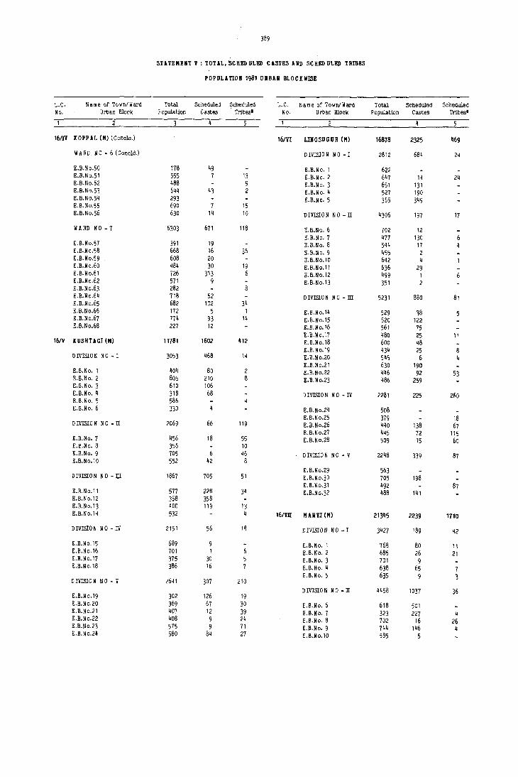
389
STUEMEHT V : TOTAL, SCHI!D ULED C1STI!S UD SCHI!D ULED TRlBI!S
POPULAnOB 1981 URBAN BLOCK WISE
L.C. Name of To~n/Ward Total Scheduled 9cheduled L.C. Name of Town/Ward Total Scheduled Scheduled No. Urban Block Population Castes Tribes' No. Urban Block Population Castes Tribes'
2 5
16m KOPPAL (M) (Conclo.) 16/VI LIBGSUGUR (H) 16878 2325 469
WARD NO-6(Concld.) DIVISION NO-I 2812 684 24
E.B.N 0.50 178 49 E.B.No. 1 622 E.B.No.51 555 7 13 B.B.No. 2 647 14 24 E.B.No.52 488 9 E.B.No. 3 651 131 E.B.N0.53 644 43 2 E.B.No. 4 527 190 E.B.No.54 293 E.B.No. 5 365 349 E.B.~o.55 690 7 15 E.B.No.56 630 14 1') DIVISION No-n 4306 197 17
II ARD NO - 7 6303 671 118 g.B.No. 6 102 12 E.B.No. 7 477 130 6
E.B.No.57 391 19 S.B.No. 8 544 17 4 E.B.No.58 668 16 36 E.B.No. 9 455 2 S.B.No.59 608 20 S.B.No.l0 642 4 E.B.No.60 484 30 19 S.B.No.11 636 29 S.B.No.61 726 313 6 E.B.No.12 499 1 E.B.No.62 571 9 E.B.No.13 351 2 E.B.No.63 282 E.B.No.64 718 52 DIVISION NO - ill 5231 880 81 E.B.No.65 682 102 34 E.B.No.66 172 5 1 E.B.No.14 529 38 E.B.No.67 774 93 14 E.B.No.15 520 122 S.B.No.68 227 12 E.B.No.16 561 75
B.B.No.l? 480 25 11 16/11 (USHUGI (M) 11781 1602 412 E.B.No.18 600 48
E.B.No.19 434 25 8 DIVISION NO - I 3053 468 14 E.B.No.20 545 6 4
E.B.No.21 630 190 E.B.No. I 404 80 2 E.B.No.22 446 92 53 E.B.No. 2 805 210 B E.B.No.23 486 259 E.B.No. 3 610 106 E.B.No. 4 318 68 DIVISION NO - IV 2281 225 260 E.B.No. 5 586 E.B.No. 6 330 E.B. No.24 508
E.B.No.25 379 18 DIVISION NO - II 2069 66 119 E.B. No.26 440 138 67
E.B.No.27 445 72 1 I 5 E.B.No. 7 456 18 55 E.B.No.28 509 15 60 E.B.No. 8 356 10 E.B.No. 9 705 6 46 DIVISION NO - V 2248 339 87 E.B.No.l0 552 42 8
E.B.No.29 563 DIVISIO N NO - JlI 1667 705 51 E.B.No.30 705 198
E.B.No.31 492 87 E.B.No.l1 577 228 34 E.B.No.32 488 141 E.B.No.12 358 358 E.B.No.13 400 119 13 E.B.No.14 532 4 16/Yll HANYI (H) 21345 2239 1710
DIVISION NO - IV 2151 56 18 DIVISION NO-1 3427 189 ~2
E.B.No.1S 689 9 E.B.No. 1 76g 80 11 E.B.No.16 701 1 E.B.No. 2 685 26 21 E.B.No.17 375 30 E.B.No. 3 701 9 E.B.No.18 386 16 E.B.No. 4 638 65 7
E.B.No. 5 635 9 3 DIVISION NO-V <,641 307 210 DIVISION NO - n 4458 1037 36
E.B.No.19 302 126 19 E.B.No.20 369 67 30 E.B.No. 6 618 501 E.B.No.21 407 12 39 E.B.No. 7 323 227 4 S.B.No.22 408 9 24 E.B.No. 8 702 16 26 E.B.No.23 575 9 71 E.B.No. 9 744 146 4 E.B.No.24 560 84 27 E.B.No.l0 585 5

390
STATEHENT V : TOTAL, SCRED ULED CASTES AND SCUED ULED TRIBES
POPULATION 1981 URBAN BLOCKliISE
L.C. Name of Town/Ward Total Scheduled Scheduled L.C. Name of Town/Ward Total Scheduled Scheduled No. Urban Block Population castes Tribes' No. Urban Block Population Castes Tribes'
2
161VIf MAliVI (H) (Concld.) WARD NO - 4 4549 259 1474
D IVISIO N N 0 - IT (C oncld.) E.B.No.16 332 24 1 E.B.No.17 539 120 49
E.B.No.l1 675 129 E.B.No.18 658 3 21 E.B.No.12 442 6 E.B.No.19 745 5 41 E.B.No.13 369 7 E.B.No.20 596 76 20
E.B.No.21 381 28 268 DIVISION NO-ill 3408 E.B.No.22 665 589
E.B.No.23 633 485 E.B.No.14 769 E.B.No.15 405 16m HONIRABAD PROJECT E.B.No.16 488 AREA (SA) 1411 1082 11 E.B.No.17 748 7 E.B.No.1B 359 E.B.No. 1 367 38 12 E.B.No.19 639 E.B.No. 2 556 163 1
E.B.No. 3 544 84 5 DIVISION NO -IV 3960 27 908 E.B.No.4 554 77
E.B.No. 5 485 269 E.B.No.20 444 34 E.B.No. 6 495 22 B.B.No.21 1175 310 E.B.No.7 458 27 E.B.No.22 696 13 5 E.B.No. 8 535 35 E.B.No.23 . 781 7 E.B.No. 9 623 33 E.B.No.24 693 259 E.B.No.l0 627 40 E.B. No.25 376 E.B.No.l1 555 30 E.B. No.26 495 300 E.B.No.12 661 29 37
E.B.No.13 690 47 2 DIVISION NO - V 6092 979 716 E.B.No.14 321 188 9
E.B.No.2? 582 25 59 16/X RAICHOR (H) 124762 19258 2451 E.B. No.28 648 63 E.B. N 0.29 516 137 28 WARD NO - 1 16309 3584 105 E.B.No·30 738 146 226 E.B.No.31 776 98 37 E.B.No. 1 485 27 E.B.No.32 223 19 12 E.B.No. 2 595 21 20 E.B.No.33 526 96 7 E.B.No. 3 555 7 E.B.No.34 741 176 55 E.B.No. 4 434 166 12 E.B.No·35 580 82 132 E.B.No. 5 420 272 E.B.No.36 762 137 160 E.B.No. 6 567 430
E.B.No. 7 690 381 E.B.No. 8 511 181
16/Vill HUD GAL (H) 11458 1171 1599 E.B.No. 9 611 15 E.B.No.l0 555 5
WARD NO - 1 1926 61 E.B.No.l1 728 409 E.B.No.12 828 220
E.B.No. 1 467 E.B.No.13 577 130 E.B.No. 2 386 E.B.No.14 352 170 E.B.No. 3 542 E.B.No.15 469 59 E.B.No. 4 531 61 E.B.No.16 381 131
E.B.No.,17 475 n WARD NO - 2 2025 609 117 E.B.No.18 428 8
E.B.No.19 480 E.B.No. 5 449 9 58 E.B.No.20 483 8 25 E.B.No. 6 511 217 22 E.B.Ho.21 401 20 E.B.No. 7 574 37 E.B.No.22 679 17 27 E.B.No. 8 491 383 E.B.No.23 544 33
E.B.No.24 519 WARD NO-3 2958 242 E.B.No.25 817 59
E.B.No.26 596 139 E.B.No. 9 340 32 E.B.No.27 542 131 E.B.No.l0 492 4 E.B.No.28 608 172 E.B.Ho.l1 432 1 E.B.No.29 979 281 E.B.No.12 493 9 E.B.No.13 263 8 \I A RD NO - 2 9034 184 20 E.B.No.14 515 168 E.B.No.15 423 20 E.B.No. 1 728 24 17

391
STATEMENT V : TOTAL, SCHEn ULEn CASTES AND SeREn ULEn TRIBES
~OPULATIO" 1981 URBAN BLOCKII1SE
L.C. N a m e of Town/ Ward Total Scheduled Scheduled L.C. Name of Town/Ward Total Scheduled Soheduled No. Urban BloCK copclation Castes Tribes' No. Urban Block Popclation Castes Tribes'
2
16/1 RAICHUR (II) (Contd.) WARD NO - 5 (Concld.)
WARD NO - 2 (Coocld.) E.B.No. 3 629 58 E.B.No. 4 460
E.B.No. 2 660 E.B.No.5 410 E.B.No. 3 824 E.ll,No, 6 441 20g E,B.No. 4 719 25 E.B.No. 7 373 E.B.No. 5 748 E.B.No. 8 361 10 E.B.No, 6 742 14 E.B.No. 9 424 39 10 E.B.No. 1 597 E.B.No.10 470 57 E.B.No. 8 616 E,B.No.l1 613 8.B.No. 9 581 E.B.No.12 604 K.B.No.10 730 1 E.B.No.13 617 40 15 8.B.No.11 494 8 E.B.No.12 544 70 WARD No-6 6608 308 399 E.B.No.13 523 12 E.B.No.14 528 8 E.B.No. 1 403 2
E.B.No. 2 361 10 WARD NO - 3 11223 48 165 E.B.No. 3 713 98
E.B.No. 4 660 40 E,B.No. 1 530 E.B.No. 5 654 E.B.No. 2 618 E,B.No. 6 514 18 E.B.No. 3 612 E.B.No. 7 547 3 E.B.No. 4 574 20 9 E.B.No. 8 406 E,B.No. 5 613 7 75 E.B.No.9 534 90 4 8.B.No. 6 743 13 E,B.No.10 575 47 317 E.B.No. 7 628 E.B.No.l1 650 78 E.B.No. 8 738 '5 E.B.No.12 591 E.B.No. 9 511 15 E.B.No.l0 440 WARD NO-7 4288 119 64 E.B.No.11 777 E.B.No.12 568 E.B.No. 1 623 11 E.B.No.l3 458 44 E.B.No. 2 562 E.B.No.14 620 E,B.No. 3 423 E.B.No.15 428 E.B.No. 4 387 37 3 E.B.No.16 575 E.B.No. 5 373 67 9 E.B,No,17 638 E.B.No. 6 607 46 E.B.No.18 524 E.B.No. 7 565 E.B.No.19 628 E,B.No. 8 506
E.B.No. 9 242 WARD NO - 4 11920 2934 191
WARD NO - 8 10061 7342 31 E.B.No. 1 426 9 E.B.No. 2 510 11 E.B.No. 1 475 448 E.B.No. 3 699 224 E.B.No. 2 533 533 8.B.No. 4 701 4 E.B.No. 3 396 396 E.B.No. 5 530 411 E.B.No. 4 376 368 E.B.No. 6 455 167 E.B.No. 5 375 375 E.B.No. 7 492 122 E.B.No. 6 459 459 E.B,No. 8 388 306 E.B.No. 7 601 597 E.B.No. 9 621 242 E.B,No. 8 418 77 E.B.No.10 61 i 159 15 E.B.No. 9 471 9 31 E,B.No.11 430 216 E.B.No.l0 417 E.B.No.12 539 192 E.B.No.11 529 10 E.B.No.13 612 381 E,B.No.12 429 184 E.B.No.14 532 40 E.B.No.13 517 504 E.B.No.15 465 23 13 E.B.No.14 624 624 E.B.No.16 398 E.B.No.15 619 619 E.B.No.17 406 110 E.B,No.16 545 545 E.B.No.18 411 E.B.No.17 482 482 E.B.No.19 620 E.B.No.18 429 414 E.B.No.20 552 68 48 E.B.No.19 461 451 E.B.No.21 522 28 66 E, B. N 0,20 905 247 E.B.Nb.22 514 158 49 E.B.No.23 486 63 WARD NO - 9 15716 1147 976
WARD NO - 5 6591 423 26 E,B,No. 1 435 E.B.No.2 422 10
E.B.No. 1 642 E.B.No. 3 398 E,B.No, 2 541 E.B.No. 4 593
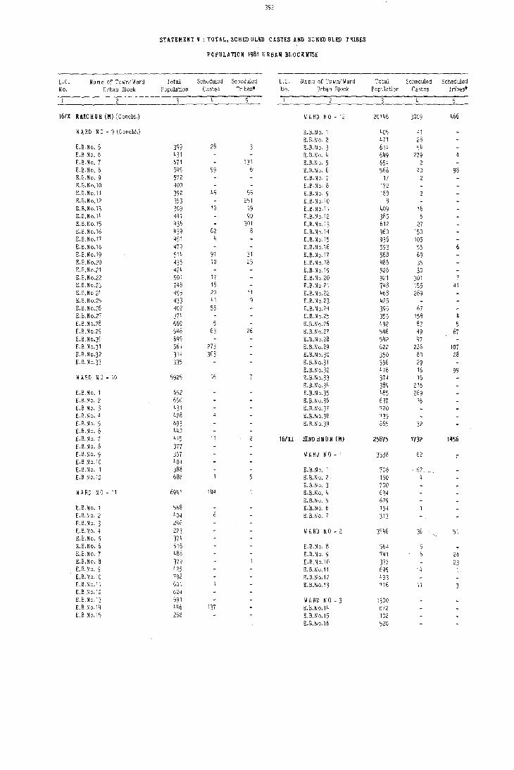
392
STATEMENT V : TOHL, SCRED UL£!) CASTES AND SCHED ULEll T'lIBES
POrULATION 1981 URBAN BLOCKliISE
L.C. Name of To~nfWard Total Scheduled Scheduled L. C. Name of Town/Ward Total Scheduled Scheduled No. Urban Block Population Castes Tribes' No. Urban Block Population Castes Tribes'
16/x RUCHUR (11) (Concid.) WARD NO - 12 20 1~6 3009 466
~ A RD NO - 9 (Concld.) E.S.No. 1 40'5 41 E.B.No. 2 471 28
E.a. No.5 399 28 8.S.No. 3 614 54 E.B.No. 6 431 E.S.No. 4 649 279 E.E.No. 7 671 131 E.S.No. 5 654 2 E.B. No.8 549 99 6 E.B.No. 6 568 40 98 E.E.No. 9 572 E.B.No·7 17 E.B.No.l0 400 E.B.No. 8 172 E.B.No.l1 392 45 55 E.B.No. 9 188 E.B.No.12 353 251 E.B.No.IO 8 E.B.No.13 309 10 19 E.B.No.l1 409 16 E.B.No.14 441 90 E.B.~10.12 385 6 E.B.t:o.15 436 301 E.B.No.13 612 27 E.B.No.16 439 62 8 E.B.No.14 960 150 E.B.No.17 451 4 E.B.No.15 936 105 E.B.No.18 ~79 E.B.No.16 593 55 6 E.B.No.19 514 91 31 E.B.No.17 588 89 E.B.No.20 435 10 25 E.B.N 0.18 486 35 E.B.No.21 424 E.B.No.19 526 30 E.B.No.22 501 17 E.B.No.20 921 301 7 E.B.No.23 748 18 E.B.NQ.21 748 155 41 E.B.No 24 495 20 11 E.B.No.22 468 289 E.B.No.2S 433 41 9 E.B.N 0.23 425 E.B.No.26 402 55 E.B.No.24 395 67 E.B.No.27 374 E.B.N 0.25 355 158 4 E.B.No.28 660 5 E.B.No.26 492 82 5 E.B.No.29 648 63 26 E.B.No.27 546 49 67 E.B.No·3D 699 E.B.No.28 542 47 E.B.No·3 1 564 273 E.B.No.29 622 226 107 E.B.No.32 J14 303 E.B.No.30 350 80 28 B.B.No·33 335 E.B.No.31 356 29
E.B.No.32 476 16 99 WARD NO - 10 5925 16 E.B.No.33 374 16
E.B.No.34 389 216 E.B.No. I 652 E.B.No·35 485 269 g.B.No.2 650 E.B.No.36 637 16 E.B.No. 3 431 E.B.No.37 720 £.E.No.4 428 E.B.No.38 739 E.B.No. 5 693 E.B.No.39 865 32 E.B.No. 6 442 E.B.No.7 415 II 16/XI slim HNUR (H) 25875 1732 1456 E.B.No.8 377 E.B.No·9 357 WARD NO - I 3338 62 7 g.B.No.IO 404 E.S.No.ll 388 E.B.No. 1 708 ~7 E.B.No.12 688 E.B.No. 2 150 4
E.B.No. 3 700 WARONO-l1 6941 144 8.B.No. 4 634
8.B.No. 5 679 E.B.No. 1 568 E.ll.No. 6 154 E.B.No.2 404 E.B.No. 7 313 E.B.No. 3 24f E.B. No.4 223 WARD NO - 2 3546 36 51 E.B.No. 5 374 E.B.No. 6 516 E.B.N o. 8 564 E.B.No. 7 488 E.B.No. 9 74 I 24 E.B.No. 8 379 E.B.N 0.10 337 23 £.B. No.9 425 E.B.No.11 695 14 1 E.B. N 0.10 798 E.B.No.12 493 E.B.No.11 60 I E.B.No.13 716 II E.B.No.12 624 E.E.No.13 591 WARD NO - 3 1300 E.B.No.14 446 137 E.B.No.14 672 E.B. N 0.15 258 E.B.No.15 108
E.B.No.1S 520

L.\.. . Name ~f Town/Ward ~; :;. Ucban Block
16/XI SIND KNUR (M) (CDndd.)
W A RO NO - 4
E.S.No.l1 E.8.No.18 E.8,No,19 E,B.No.20 E,B.No,21
WARD NO-5
E.B,No,22 E.B,No.23 E.B.No.24 E,B,No,25 E,B,No,26 E,B.No.2? E,B.No,28 E,B.No,29
WARD NO - 6
E.B.N 0.30 E.B,No,31 E.ll.No,32 E.B.No.33 E.B.N 0,34 g,B,No.35 E.B.No,36 E.B,No·37 E.B.No.38 E.B.No,39 E.B,No,~O
393 ! /
STATEMENT V : TOTAL, SCHEU UL~D CASTES AND SCHEO ULED TRIBES
Total PoplJlation
3124
649 806 352 110 607
5105
696 768 868 665 426 415 609 658
9462
778 824 729 683 696 361 816 'i54 700 610 712
POPULATION 19b1 URBAN BLOCK WISE
Scheduled Screduled L,C. Name of Town/Ward Total Castes Tribes' No. Urban Block Population
W A RO NO - 6 (Concld.)
61 34 E.B.No.41 575 £.B.No.42 430
44 C.B.No.43 523 13 21 E.B,No,44 471 13 5 17 8 16/Xll 'lELBARGA (M) 7551
D IVISIO N N 0 - I 2103 357 544
E,B.ND, 1 619 26 173 E,B.No, 2 462 41 206 E,8.No, 3 591 89 3 E,B.No, 4 371
32 12 DIVISION NO-II 2030
59 80 E.ll,No, 5 430 130 50 E.B.No. 6 445
E.B,No.7 '514 1190 827 E.B,No, 8 641
D IVISIO N N 0 - II! 2869 237
2 E,B,No. 9 588 50 E,B,Ne.l0 591
186 E,B,No.l1 616 E,B,No.12 541
64 11 E,B,No.13 533 25 6
342 DIVISION NO -IV 549 m 204
65 E,B.No.14 549
••••••
Scheduled Tribe figure would appear to include high returns relating to certain co m m unities with no m enclatures slm liar to those included in the list of Scheduled Tribes consequent on the re m oval nf area restrictions.
~--__ 3chedu..._ed ccheduled
Castes Tribes'
_5_
84 8
437
935 71
301 25
20 22
276
275 33
9 15
251 25
358
358

STAHHENT VI: DESCRIPTION OF BOUND ARIES AND DETAILS Or' AREAS INCLUDED IN
CENSUS ENUIIERATION BLOCKS IN THE URBAN AREAS OF THE DISTRICT
E, B, No. EAST
Town: Devadurga (II)
P atil M ohalla
Siddra mesh w ar Mohalia
Basavana Te m pIe and Nala
Rastrapathi Mohalla
Fields
Rasteapathi Mocalla
Boundnries of Census Enu m eration Blocks WEST NORTH . SOUTH
Hillock
Abu Mohalla
Sha m bulingaiahna G uddada Street
Patil Mohalla
Siddra mesh w ar Mohalia
Siddra mesh w ar M ohalla to Sha m bulingaiah Te m pIe road
liARD NO - 1
Road to C,H,P, Field and Hillock School
Nehru road Fields
Nehru road Tahsil Office road
Ii IRD NO - 2
Tillak M ohalia Fields and Hillock
Tillak M ohalla Rastrapathi Mohalla
Tillak M ohalla Rastrapathi Mo' ']a
liARD NO - 3
Road to Gopalswami Siddrameshwar road D arbar road Rastrapathi M ohalla Te m pIe
Hillock Road fro m G overnm ent School to D arbar road
Hillock D arbar road
~sarOni Basaveshwar Temple Old High School area
D arbar road
10 Sarojini M ohalia
11 Hillock
12 Hillock
13 Hillock
14 Main road
15 Main road
16 Main road
17 Main road
18 A shok M ohalia
19 Netaji Mohalla
20 Hillock
Main road
MaJll road
Main road
Bapuji. M ohalla
Bapuji. M ohalla
Benkin tank
II addar katta to Kumbarwadi road
Ashok M ohalla
N etaji. M ohalla
Fields
C handenkere
liARD NO-ij
Old High School area
Main road
Bapuji. M ohalla
D arbar road
Old High School area
Old High School area
WARD NO-5
Old High school area
Bapuji. M ohalla
H arijana gudda
Hillock
Bapuji. M ohalla
Goutam Mohalla
IIlRDNO-6
Drain to Howshetty Goutam Mohalia Veeranna house to II addarkatta
Goutam Mahalia Nehru road
Ashok Mohalia Nehru road
Ii A RD NO - 7
Benkin Tank Nehru road
Fields Hillock
Hote: Wherever used these aobreviations stard for:
Buildings f~overed under the Enumerati(;(J Bloc~s Name or No, of Street/Road! 5uilding No. Lane/Cross Road!Etc" From To
Abu Mohalla
Patti Mohalla
Siddrameshwar Mohalla
Rastrapathi M ohalia
Tillak M ohalia
Gop~wamy Mohalla
Sarojini M ohalia
Basaveshwar Mahalia
High Sc hool area and Agasar oni
High School area
Bhagatji. Mahalia
Bapuji. Mohalla
Gowtham Mohalia
Ashok M ohalla
N etaji M ohalla
Netaji Mohalla
N etaji M ohalia
Cinema House road and Tahsil Office road
Tahsil Office read
Gouram peth
TaIuk : D evadurga
134
100
94
113
113
111
96
103
91
106
101
106
113
106
116
102
100
103
91
92 196
Ii S : II estern Side ES: Eastern Side N S : H orthem Side SS Southern Siae OS Both Sides

395
STATEMENT VI: DESCRIPTION OF BOUND ARIES AND 0 ETAn.S OF ABBAS INCLUD ED IN
CBNSUS ENUMERATION BLOCY.S IN THE URBAN AREAS OF TBI! DmTRICT
E,B. ~o. EAST
Boundaries of Census Enumeration Blocks WEST NORTH SOUTH
TOlin: D evadurga (M) (Concld.)
liARD NO-7(Concld,)
21 Gouram peth Hillock Portion of Gouram Hillock peth
22 Hillock Hillock R aichur road Gouram peth
23 Fields Fields Fields Hillock
TOlin: Gangallati (M)
10
11
12
13
DIVlSION NO-I
Jantkal.-Anagondi road
Jantkal-Anagondi road
G.A,M,Road
G.A.M,Road
G.A,M.Road
Ganga wati-Anagondi road
Ganga w ati- A nagondi road
Hillock
Hillocks and Huts
Hillock
Road to Jantakal
o pen space and Grave Yard
K uteha road by the left side of Ashurkhana
Road to Hillocks by the side of M.Ayyappa's house
N.M.Park and TDB Quarters
Open space and Grave Yard
G.A.M, Road and cross road to Jantkal
A gricultural field
K utcha road by the side of Ashurkhana
Road to Hillock by the side of M. A yyappa 's house
M.G.Road Pampanagar and road Rampurpet Main road Hillock
Pam panagar internal Hillock and fields Siddikera road main road and H Dusing Board Q uacters
M.G. Road Internal lanes Bendarwada road connecting BendaI' -wadaand Pampanagar road
Internal road fro m Siddikera road Bendarwada road Malkajappa house via M allappa house, Singarappa and Balam rna's house
Bendarwada Main road Idgah and fields
D evangamath road
Lane by the side of school
M.G.Road
Lane by the side of school
Bendarwada Main road
Masque and P athan galli
Ayyappa's house lane
Talwar Bhavi road
Lane to Talwar bha vi. fro m Bendar-wada main road
R Dad by the left side of Mosque to M.G,Road via Sidda-pur Parvatham ma's house
Hillock
Pam panagar road
Pam panagar road
Siddikera road
Siddikera road
Siddikera road
Siddikera road by the right side of Nagareshwar Temple
Buildings covered under the Enu!n eration Blocks Name or No. of Street/Road/ Building No. Lane/Cross Road/Etc., From To
Taluk : D evadurga
Goura m peth
Gouram peth
B~ 0 & P WD Quarters and Suppathgera
108
~o
~o
Taluk : Gangallati.
Southern side of GangawaU-Jantkal road
Southern side of Grave Yard
Kumbar oni, Lambani Tanda and Temple road
Temple road, Kumbar ani road and Hillock road
Western side of G.A.M.Road
Pampapati temple area, M.G.Road and northern side of Hillocks
Pam panagar Main road
M. G. Road, Bendarwada road, Pam panagar road and its lan es
Pam panagar road, Bendarwada road and its lanes
Siddikera road and Bendarwada Main road
1 112 141 143
113 140 144 225
1 66 89 130
67 88 131 209
146
1 '17 120 140
48 119
79 187
1 78 188 205
97
School road, Masjid road 43 D evangamath road and Siddikera road 91 106
125 133
Siddikera road, Hanumantha 44 90 Te mple road and Talwar 107 124 Bhavi road
Mosque road, Siddikera road, 95 193 M.G,Road, Siddapur galli and by lanes

E.B. No. aST
396
STATEMEIIT VI: DESCRIPTIOII OF BOUND ARIES AIID DETAU,S OF AREAS INCLUDED III
CENSU3 ENU:!ERATION BLOCKS IN THE URBAN AREAS OF THE DISTRICT
Boundaries of Census Enu m eration Blocks Bu:il<tings covered under the Enumeration Blocks WEST NORTH SOUTH Name or No. of Street/Road! Building No.
Lane/Cross Road/Etc., From To
6
TOlin: Gangallati (M) (C ontd.) Taluk : Gangawati
14
15
16
17
18
19
20
21
22
23
24
25
26
27
28
M.G.Road
M.G.Road
H ajja m oni lane
H ajja m oni lane
Bendarwada Main road
Bendarwada Main road
Bendarwada Main road
Rilla road to Thalcur camp
Road and Open space
Bendarwada Main road
Lane from Killa road to K utoha Mam road
Lane upto hOuse of N arsing Rao
Hajjam oni
Bendarwada M am road
Bendarwada Ham road
Fields
Fields
Fields
Fields
FieldS
Lane fro m ~~ill.a
road i.e. be!L..~d
Veerbhadreswara te m pie
Tha,;ur ea m p road from Killa
M.G.Road via Gandhi Market road Chowk and .Mahaveer· Circle
M.G.Road
Islam road
Lane and huts frOm the hut of A.Pampapathi to Virupaxayya hut via Shamid Sab hut
Beudarwada Main road
Gadwpl Camp and fields
o istributry
DIVISION NO - 1 (ConoId.)
Talwar Bhavi Street
Lane from M.G. Road to Mosque, via Gujrathi ani
n1'lISIOli NO - n
Venkatara mana Temple road
Mailarappa House ani lane
Road to Venkateshwara Temple
Road from falwar Bha vi to Basanna Circle
Huchappa's house oni lane
FrQ m the house of 11 ailarappa joins to H ajja m ani and the house of N abi Sab
K utcha road fro m Lane by the side of the Bcndarwada Main Sri B.Lingappa's road to Azeem Sab house house
K uteha road fro m Kutcha road fro m Bendarwada mam road Bendarwada main road to P entayya house to Raja Sab house
Killa Main road Road from Lendarwada Main road to Thim m appa'f house
Lane fro m the house Old Trenching Yard cf Sri Ra manna to and field Mo. Ali Sab house
K uteha road to Siddikera
Lingayath }rave Yard and road
F oad fro m Thaku~ camp to Veg. Ma;'ket
M ahaveer Circle
Road from M.G. road to Bendarwada mam road via Hanuman Temple
Road fro m Banni tree
Lane from A.Pampapathi hut to D astegir Sab hut Via Raja Sab hut, D aUl Sab hut and Kalappa hut
Read frOm the house of Pampapathi to Mariyam rna
Road to Killa
Killa road
R Dad in front of Hanuman Temple
Venkataramana Temple road
Li'lgayath Grave Yard
Road from Banni tree to D istributry
Bcnasankari Temple area, KaJikamma Temple road, M.G.Road an.d G ujrathi oni
Venkateswara Temple road, M.G.Road, Tall/ar Bhavi road
Western side of Hajja m 's oni
Eastern side of Bendarwada Mam road
Bendarwada Mam road (WS)
Benderwada Main road (WS)
Killa IJj aiD road, Basheer Ahmed Compound INS)
Northern side of Treno,lUng Yard and fields
Eastern side of Raiehur Shaiah's A gricultucal lands
Bendar\! ada road and Killa rbad - ,
Eastern side of Thakur Cam p road
Hanuman temple road, Market road, M.G.Road
Venlcatara mana Te m pIe road Hanuman Temple road, M.G.Road and Bendarwada road
N orth-Western side of Weelely Market area and Islampur road
Northern side of Banni tree lane
1 185
99
93 169 18~
168 170 189
73
1 113 150
25 132
170
168 285
~8
93
94
125
98 194
184
92
188
183 245
72
144
24 131 212
112 149
169
262
269 367
70 167

/ 397
STATEHEHT VI:DE1\CRIPTIOM OF BOl1l1DARmS ABD DEUD..S OF AREASIlfCLUDED 1M .'
CENSUS ENUMERATION BLOCKS IN THE URSU AREAS OF THE DISTRICT
E.B. Boundaries of Census Enu m eration Blocks Buildin)(s covered under the Enu m eration Blooke No. EAST WEST NORTH SOUTH Name or No. of Street./Road/ Buildin5 No.
Lane/Cross Road/Etc., From 1'0
Town: !langawati (H) (Contd.) Taluk : Gangawatl.
DIVISIOll NO -ll (Concld.)
29 L.G. Road Huts & D :i.'!tl'ibutry D urgam ma Nala Road fro m D istributry Southem side of D urgam rna Nala 1 47 to L.G.Road 71 92
270 284
30 L.G.Road D urgam ma Nala K utcha approaching Durgamma Nala Huts in between D urgam ma 1 70 road N ala and approach road 140 156
31 L.G. Road Huts and D urgam ma Lane leading to K ute!la approach road Western side of L. G. R ol'.d 71 139 Nala huts 157 175
32 L.G.Road Nala Lane leading huts K utcha road & Nala Northern side of Nala 176 235
33 L.G. Road Nala K anakadurga Kutcha road Southern side of Kanakadurga 236 2&0 talkies talkies
34 L.G.Road D urgam ma Naja R.G.Road H ut.s and K anakadurga Kanakadurga talkies area, 201 388 talkies L.G.Road and Koppal road
35 Durgamma Nala K utcha road leading K utcha road behind Durgamma Nala D urgarn rna Nala (NS) 1 102 junction & Bridge to D urgam rna Nala Mubarak Saw Mill 128 132
36 Open space NaJa. R.G.Road Nala Eastern side of D urgam rna Temple 191 303
37 Mubarak Saw Mill Commerce College R.G.Road Nala College area and W S of 103 127 and Nala M ubarak Sa w Mill 133 190
304 329
38 L.G.Road Prashant Nagar A gricultural lands R.G.Road L.G.Road, R.G.Road and 1 5 northern side of N al2 38 59
205 268
39 Roa1 by the side of Agricultural fields Octroi N aka and K utcha road and Northern side of Prashant Nagar 129 204 Balaji Rice Mill fields Nala
40 K utcha road in Fielde Kutcha roaa R.G.Road Prashant Nagar and R .G. Road 6 37 S .No.27 60 128
DIYI5[OIi NO - m
41 R.G.Road L.G.Road Agricultural farm Raict,ur road AP M C Yard towards North and 224 Farm Quarters
42 TAP C MS Godown L.G.Road R.G.Road Road leading to TAPCMS Godown (<IS) 1'(0 TAPCMS Godown
43 Masjid road L.G.Road Road leading to Lane by the side of Primary School area, L.G.Road 87 Godowns Masji.d at L.G.Roa1 and Godown Kutcha road
44 Open space D aval Sab House New CiM ma talkies Jum rna Masjid road Suban Zenda Katte road, Jum ma 88 185 road road M asjid road and Cine", a talkies road
45 D a val Sab house L.G.Road Lane by the side of Road by the side of Jumma Masjid road, L.G.Road, 71 road Venkateswara Traders Mosque D aval Sab house road and Canara
Bank left side
46 Road approaching to L.G.Road Road :in front of K utcha road fro m Eastern side of L.G. Road 1 79 Canara Bank Niza m uddin house L.G.Road 149 162
47 Road by the side of L.G.Road K utcha road by the Durgamma Nala Canara Bank road and L.G.Road 80 148 Canara Bank side of Laundry
48 D urgam rna Naja L.G.Road Gale m mana gUdi and Indira N agar road Eastern side of Galam rna Temple 105 Nala Lane
49 Galem rna Temple lane L.G.Road Durgamma Nala Indira N agar road Western side of Gale m rna 106 232 Tern pie lane
50 Durgamma Nala L.G.Road Road by the side Road from Mahaveer Northern side of old State 219 of Vi.jayaku mar Circle to Tikotikar Bank and Raichul' road Trading Co., and Petrol Bunk L.G. Road

398
STATEMENT VI: DllSCRIPTION OF BOUNDARIES AND DEUn.S OF AUASINCLUDED IN
CENSUS ENU'1ERATION BLOCKS IN THE URBAli AREAS OF TilE DISTRICT
E.B. Boundaries of Census Enumeration Blocks Buildings covered under the Enu rn eration Blocks No. EAST WEST NORTH SOUTH Name Or No. of Street/Road/ Buil@!!! No.
Lane/Cross Road/Etc., From To
4 8
Town: Gangawati. (M) (Contd.) Taluk : Gangawati.
D MllIO N NO - m (C onold.)
51 S. N. G . Buildings L.G.Road Old Weekly Market Gandhi Chowk L.G.Road, Old Weekly Market road, 121 road Sub Old Market road & Mochiwada
52 Old Weekly Market Mohiuddin TalJu.es Sub Old Weekly R.G.Road from Gandhi Jain Temple road, Raichur road, 200 Yard road Market rOad Chowk M ohiuddin Talkies road and
MOchil'lada road
53 Internal road of Internal road of D urgappa's Godown Road in front of Southern side of P urgappa 1 64 Itla m pur via. Itla m pur lane Kanakagiri Basappa's godown lane 170 lB9 Buranuddin house house
5~ TAPCMS Godown and Internal main road Lane to R. Hussain TAPCMS Godown TAPC MS Godown wire fencing (WS) 65 169 huts via Khan Sab house Sab house and huts
55 KutcM road Road by the side Road in front of Road in front of North-Eastern side of 1 90 of Canara Bank Kanakagi.ri Canara Bank and Canara BanK 191 201
Basappa's house D urgarn ma Nala
56 M ahadevappa Rice Kutcha road K utcha road and Ambamma Temple and Northern side of Ambamma 91 190 Mill road Ladies Latrine Nala Temple and D urgam rna Nala
57 Kutcha road from D urgarn rna NalE. and Koppal-Rainhur Raicbur road Raichur road, G. M. Mill road and 102 R.G.Road G.M.Rice Mill road Wood Contractors Sa w Mill road
58 l'ield Gajanana Sa w Mill Toddy Shop and Raichur road and Eastern Side of G ajanana 103 246 Rangaswamy Contra- Burial Grounds Sa w Mill and Banm tree ctor's shed
59 Muslim Grave Yard K utcha road fro rn Kutcha road from R.C.Road Gajanana Sa w Mill, Banni 247 388 R.G.Road huts Cam p surroundings
60 R aichur road and Muslim Burlal Ganga wati-Raichur Ganga wati-Ka mpli Eastern Side of Kampli road 69 109 Banni tree ground road and fields road 115 166
61 Fields and $araswathi J ulynagar Internal Venkateswara Rice Kampli road G.R.Main road, Bellary road and 1 68 Rice Mill road (half portion) Mill Koppal road 110 114
OIVlSION NO-tv
62 JulYnagar road G.A.M.Roaa Kampli road D eviprasad Garage road Northern side of D eviprasad Garage 1 151
63 Road by the side Pinjarwada road Lane fro m the house Old A minkacheri road Pinjarwada road, road bY the 59 of Prasad Lodge of Sri D urgappa side of Prasad Lodge
joins to Pinjarwada
6~ GAM Road Pinjarwada Part R .G. Road and petrol Old A minkacheri road GA M Road, R.G.Road, Pinjarwada 60 176 road Bunk (part) road and Gandhi Chowk Hotel
A mar Road
65 Pinjarwada galJi H.G.Road to Gandhi R.G.Road Old A minkacheri road Zandakatte area, H MS Talkies road 123 Chowk part Pinjargalli, prasad LOdge'l'Oad
and M.G.Road
66 GAM ROad Tokabangal shop Old A minkacher'i Agsar ani road A minkacheri road, Bus Stand 1 14 road via Nee m road Road, Agsar oni 34 56 tree katte 83 94
122 136 161 171
67 Internal Main road Agasar ani Main Old A minkacheri Agsar 0 ni road Agsar oni main road, Old 15 33 road road A minkacheri road and N eela- 57 82
kantesh ~8l' Te m ple area 95 121 137 160
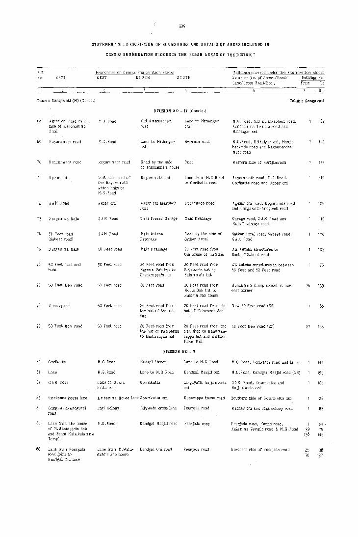
E.B. r.o. EAST
399
STATEMENT VI: D ESC RIPTlO N OF BOUND ARIES AND DETAILS OF AREAS INCLUD ED IN
CENSUS ENU~ERATION BLOCKSIN THE URBAN AREAS OF THE DISTRICT
Boundaries of Census Enu m eration Blocks Buildings covered under the Enumeration Blocks WEST NORT.H SOUTH Name or No. of Street/Roadl Building No.
LanelCross Road/Etc., From To
Town: Gangawati (M) (Contd.) Taluk : Ganga wad.
68
69
70
71
72
73
74
75
76
77
78
79
80
81
82
83
84
85
86
Agsar oni road by the. side of Kencham rna Gudi
Rayaramath road
Har:ijanwada road
U ppar oni
G H~ Road
D urgam rna Nala
50 Feel road (Sa beet road)
Durgarnrna Nalil
50 Feet road and huts
50 Feet New road
o pen space
50 Feet New road
Gorikatta
Lane
GAM Road
Vitobanna house lane
Gangawati- Anegundi road
Lane fro m the house of M. Wahiduddin Sab and Banni M ahakalil m rna Te m pIe
Lane fro m Peer-jada road joins to Kandgal Oni lane
M. G. Road
M.C.Road
R ayara math road
Left side road of the Rayaramath w hic h links to M.G. Road
Agsar oni
GAM Road
GAM Road
50 Feet road
50 Feet road
50 Feet road
50 Feet road
50 Feet road
M.G,Road
M.G.Road
Lane to Gowri katta road
DIVISION NO -IV (Concld.)
Old A minkacheri Lane to Mithaigar road oni
Lane to Mithaigar Brahmin wadi oni
Road by the side Road of Thippanna's house
Rayaramath oni Lane from M.G.Road to G orikatta road
Agsar oni approach U pparw ada road road
D evi Prasad Garage Main Drainage
Main kutcha Road by the side of
D r"inage Satkar Hotel
Main Drainage 20 Feet road from the house of Ra m das
20 Feet road fro m 20 Feet road from Karee m Sab hut to S. K aisar's hut to Shankrappa's hut Balilm rna's hut
20 Feet road 20 Feet road fro m Moula Sab hut to Hussain Sab house
20 Feet road fro m 20 Feet road from the the hut of Sha mid hut of Maheboob Sab Sab
20 Feet road from 20 Feet road fro In the the hut of Pa m panna Pan shop to Hanuman-to Bashumiyan hut tappa hut and Am bika
Flour Mill
DIVISION NO - V
M udgal Street Lane to M.G.Road
Lane to M.G.Road Kandgal Masjid oni
G owrikatta Lingayath, hajjam wada oni
A mbam rna House lane Gowrikatta oni Kuberappa house road
Jogi Colony Julywada cross lane Peerjada road
M.G.Road K andgal M asjid road Peerjada road
Lane from M.Wahi- K andgal 0 ni road P eerjada road duddin Sab house
M.e.Road, Old Aminkacheri road, Kencham rna Temple road and Mithaigar oni
M.e.Road, Mithaigar ani, Masjid backside road and Raghavendra Mutt road
Western side of Harijanwada
Rayaramath road, M.G.Road, Gorikatte road and Uppar oni
Agasar oni road, Upparwada road and Gangawati-Anegundi road
Garage road, GAM Road and Main D t'ainage road
Satkar HOLel road, Sabeet road, GAM Road
All Kutcha structures to East of Sabeet road
All kutcha structures in between 50 Feet and 50 Feet road
Gundam rna Camp school at north east corner
New 50 Feet road (ES)
50 Feet New road ',ES)
M.G.Road, G orikatta road and lanes
M.~.Road, Kandgal Masjid road (NS)
GAM Road, Gowrikatta and Hajjam wada oni
Southern side of Go wrikatta oni
Wadder oni and Jogi colony road
Peerjada road, Masjid road, Kalam rna Temple road ~ M.G.Road
Northern side of Peerjada road
82
142
115
110
105
110
110
103
75
76 139
86
87 155
145
150
108
126
88
1 24
39 75 138 148
25 38 76 137

400
STATEMENT VI.DF.SCRIPTION OF BOUNDARIES AND DETAILS OF AREASINCLUDED IN
CENSUS ENUMERATION BLOCKSIN THE URBAN AREAS OF THE DISTRICT
E.B. Boundaries Df Census Enumeration Blocks Buildings covered under the Enumeration BlocKs No. EAST W ES7 NORTH SOUTH Na me or No. of Street/Roadl Building No.
Lane/Cross Road/Etc., From To
Town: Gang<.wati r,M) (Contd.) T?luk : Gangawati
DIVISION NO - V (Concld,)
87 GAM Road M ,G, Road P eerjada road MUnicipal 0 ffiee Peerjada road, GAM Road, Tahail 65 Office road and M, G. Road
88 K utaha road fro m GAM Road H osalli road Road to Kottreswara GAM Road, Hosalli road, Gali 18 the hu>_g of K orw as Cam p by the side of D argam rna Temple road and road 121 196
Brindavan Hotel by the side of Hotel Brindavan
89 N eeJ.kantesw ara Camp K uteha road fro m H osaill road Road to Kottreswara Southern side of H osalli road 19 120 by lane the huts of K orw as C&mp by the side of
Brinda van Hotel
90 Venkatachal'i ~dvocate N eelakant,es w ara Cam p H osalli road Road to Huts Western side of Advocate's 1 73 house and fields internal road house road 194 213
91 Open land Road leading to K,H,B.Colony road Basaweswara Camp road K,H.B,Colony at north 74 193 Krishnadevaraya Circle
92 Small nala, fields 50 Feet New road Fields Road to hut, Road to Laxmi temple, Oni No.1, 1 41 and Laxmi temple leading to Bus Oni No.2 and northern side of 64 104
Stand B.D .C.F,Office 133 193 208
93 Fields Small nala Lax mi ca m p road Fields and H osalli Southern side of Laxmi Camp 42 63 road road In" 132
134 192
94 Road fro m M urahari GAM Road Murahari. Nagar Road fro m the house of Western side of Sri. M. N agappa 87 Nagar to M,L.A's road Sri Jambanna on GAM, M.L.A. house road house road to D yavappa house
in Chalwadi wade
95 Road from Murahari. GAM Road Road by the right H osalli road Western side of M.L,A's house 88 187 Nagar to M.L.A.'s side of Sri H ,So road and Harijanwada road house Jayaprakash house
and D ya vappa bouse
96 Fields New road to Murahari Camp Main drain and palt Poultry Farm and northern side 63 Murahari Camp and boundary wall of H osalli road Main Drain _19J 215 part of C halw adi W$da road
97 New road to Chalwadi Wada road Main drain H osalli road Southern side of Main drain 6~ 190 M urahari Nagar
98 M urahari. Nagar 20 Feet 2nd road M urahari. Nagar Sunnagar ani College road, Murahari. Nagar road 92 and H.R.S,College
99 50 Feet road D urgam rna Temple 20 Feet road Chalwadi wada boundary North-eastern side of D urgam rna 95 road wall Temple
100 50 Feet New road 20 Feet road 20 Feet road 20 Feet road M urahari. Nagar 61
101 50 Feet New long road 20 Feet road 20 Feet road 20 Fee, road M urahari Nagar 62 125
102 50 Feet New road 20 Feet road 20 Feet road 20 Feet road fro m the School road M urahari Nagar 62 hut of Krishnaji
103 50 Feet New road 20 Feet road 20 Feet road 20 Feet road from the School road at north of 63 115 hut of Nagamma M urahari nagar
104 20 Feet road M urahari. Nagar 20 Fe~t road and ~5 ~ eet road M urahari. Northern side of M\lrahari. 111 School opposite Toddy shop School road School road Ian e to A m bika Flour Mill road
105 50 Feet road Main road 20 Feet road 20 Feet road 50 feet New road (W S) 80
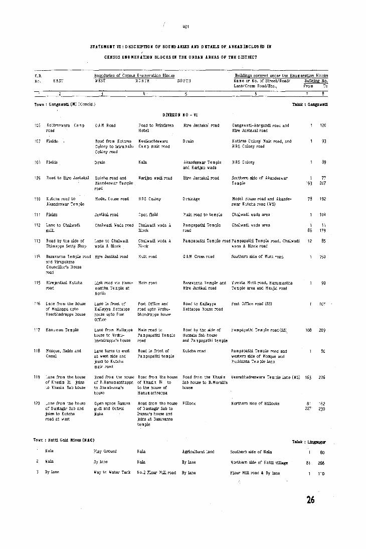
401
STATEMENT VI:DESCRIPTION OF BOUNDARIES AND DEUn.S OF AREASlNCLUDED IN
CEHSUS ENUMERATION BLOCKS III THE URBAN AREAS OF THE DlSTRICT
Boundaries of Census Enumeration Blocks E.B. No. EAST WEST NORTH SOUTH
Town: Gangawati (M) (Concld.)
DIYElON NO - VI
106 Kottreswara Camp road
107 Fields
GAM Road Road to Biindavan 'Hotel
Road from Kottres NeelkMteswara Golony to Sriramalu Camp main road Golony road
108 Fields Drain Nala
109 Road to Hire Jantakal K~tcha road and Harijan wadi road AKandeswar Temple
110 K utcha I'oad to Akandeswar Temple
111 Fields
112 Lane to Chalwadi galli
ro~d
Model House road HRS Colony
Jantkal road Open f1eld
Chalwadi Wada road Chalwadi wada A Block
Hire Jantakal road
Drain
Akandeswar Te m pIe and H arijan wada
Hire Jantakal road
Drainage
Main road to temple
Pampapathi Temple road
Builitings covered under the Enu m eration Blocks Name or No. of Street/Road/ Builiting No. Lane/Cross Road/Etc., From To
Gangawati-Anegundi road and Hire Jantakal road
Kottres Colony Main road, and H RS Colony road
H RS Colony
Southern side of Akandeswar Te Dl pIe
Model House road and Akande-swar K utcha road (W S)
Chalwadi wada area
Chalwadi wada area
7
TaluIc: Gangawati
120
93
89
1 77 193 207
78 192
104
1 11 86 179
113 R Dad by the side of Lane to Chalwam wada A Block
Chalwam wada A Block
Pampapathi Temple road Pampapathi Temple road, Chalwadi 12 85 Thim appa Setty Shop
114 Basavanna Temple read Hire Jantkal read and Virupaksha Councillor's House road
115 Hirejantkal Kutcha LiOk road via Hanu-road mantha Temple at
North
116 Lane tro rn the house Lane in tront of of Mallappa upto K a]layya K ettappa Veerbhadrappa house house upto Post
Office
117 Hanuman Temple Lane tram Mallappa house to Vr31U-bhendrappa's house
118 Mosque, f1elds and Lane turns to east Canal at west side and
joins to K utcha main read
119 Lane tram the house Road tram the house of Khasim Bi joins of B.Hanumanthappa to K hasim Sab house to Sha m banna's
house
120 Lane tram the house o pen space Basa va of D astagir Sab and gum and 0 ctroi joins to Kutcha Naka read at west
Town: Hatti Gold Mines (NAC)
Nala Play Ground
Nala By lane
By lane Way to Water Tank
wada A Block road
Mutt road GAM Cress road Southern side of Mutt road 150
Main road Basavanna Te m pIe and Virakta Mutt road, Hanumantha 90 Hire Jantkal road Temple area and Masjid road
Post Office and Road to Kallayya Post Office road (SS) 107 road upto Vrshu- K ettappa House road bhendrappa house
Main road to Road by the side of Pa m papathi Te ui ple road (SS) 108 209 Pampapathi Temple Hussain Sab house road and Pampapathi temple
Road in tront of Kutch. road Pampapathi Temple road and 80 Pampapathi temple western ,side of Mosque and
M uddanna Te m ple lane
Road tra m the house Road tram the Khasim Veerabhadreswara Temple lane (NS) 163 226 of Khasim Bi to Sab house to B. M urali's to the house of house H anu m anthappa
Road tra m the house Hillock Northern side of Hillocks 81 162 of D astagir Sab to 227 230 Iranna's house and joins at Basa vanna temple
Talulc : Ung9ugur
Nala Agricultural land Southern side of N ala 80
Nala By lane Northern side of Hatti village 81 266
No.2 Flour Mill read By lane Flour Mill road & By lane I 110
26
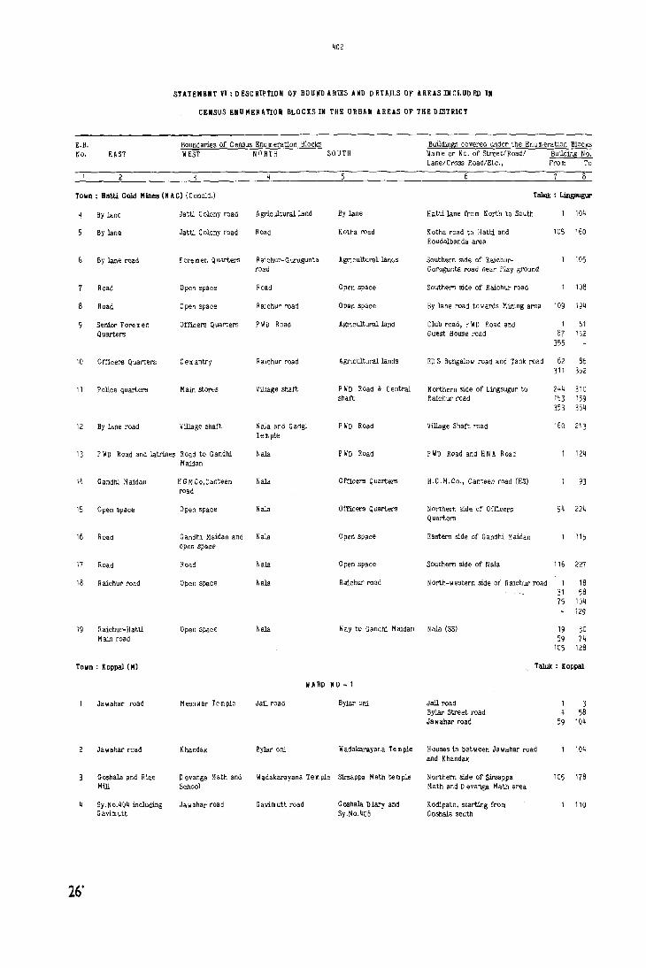
402
STATEMEIIT VI: DESCRIPTION OF BOUNDARIES AND DETAILS OF AREASINCLUDED IN
CENSUS ENUMERATION BLOCKS IN THE URBAlI AREAS OF THE DIStRICT
E.B. Boundaries of Census Enu m eration Blocks Buildin~ covered under the Enu m eration Blocks
No. EAST WEST NORTH SOUTH Name or No. of Street/Road! BuildinS No. Lane/Cross Road/Etc., From To
2
Town: Hatti Gold Minea (NAC) (Concld.) TalQk : Lingwgur
By lane Jatti Colony road A gricultural land By lane Hatti lane from North to South 104
8y lane Jatti Colony road Road Kotha road K otha road to H attl and lOS 160 R oudalbanda area
G lly lane Nad Foremen Quarters Raichur-Gurugunta Agriculturallanos Southern side of Raichur- 105 road Gurugunta road near Play ground
Road Open space Road Open space Southern side of R aichur road 108
Road Open space R aichur road OpQn space By lane road towards Mining area 109 194
Senior Foremen Offuers Quarters P WD Road Agricultural land Club road, P WD Road and 1 61 Quarters Guest House road 87 152
355
10 a meers Quarters Cemantry R aichur road Agricultural lands ED S Bungalow road and Tank road 62 86 311 352
11 Police quarters Main stores Village shaft PWD Road & Central Northern side of Lingsugur to 244 310 shaft Haichur road 153 159
353 354
12 By lane road Village shaft Naja and Gadgi P WD Road Village Shaft road 160 243 Temple
13 P W D Road and latrines Road to Gandhi Naja PWD Road p WD Road and H N A Road 124 Maidan
14 Gandhi Maidan H G M Co,Canteen Nala Officers Quarters H.G.M.Co., Canteen road (ES) 93 road
15 Open space Open space Nala a meers Quarters Northern side of Officers 94 224 Quarters
16 Road Gandhi Maidah and Nala o pen space Eastern side of Gandhi Maidan 115 Open SPace
17 Road Road Naja Open space Southern side of Naja 116 221
18 R aichur road Open space Naja R aichur road North-western side of Haichur road 1 18 31 58 75 104
129
19 Raichur-Hatti Open space Naja Way to Gandhi Maidan Nala (SS) 19 30 Main road 59 14
105 128
Town: Koppal (MJ Taluk : K oppal
liARD NO ~ 1
Jawahar road Meshwar Temple Jail road Bylar oni Jail road 1 3 ByJar Street road 4 58 Jawahar road 59 104
Jawahar road Khandak Bylar oni Wadakarayana Te m pie Houses in between Jawahar road 104 and Khandak
Goshala and Rke D evanga Math and Wadakarayan. Te m pie Sirsappa Math tern ple Northern side of Slrsappa 105 178 Mill School Math and D evanga Math area
Sy.No.404 including Jawahar road Gavimutt road Goshala Diary and Kod1path, starting from 110 Gavimutt Sy.No.406 G oshala south
26'

"03
STATEMENT VI:DESCRIPnON OF BOUNDARIES AND rETAILS OF AHEASINCLUDED IN
CENSUS ENUMERATION BLOCKSIN THE URBAN AREAS OF THE DISTRICT
E,B, Boundaries of Census Enu m eration Blocks Buildings coyered under the Enu m eration Blocks 'No, EAST WEST NORTH SOUTH Name or No, of Street/Road/ Bwlding No,
Lane/Cross Road/Etc., t~ro m To
Town: KopJ;al (H) (Contd.) Taluk : K appal
WARD NO - 1 (Concid.)
Sy.No.390 and 391 Sharada Talkies Gayi Mutt roa~ Sy.No.401, 390, 395, Gavi Mutt road 43 and 396 road 409 (Sharada talkies
road)
Sharada talkies Sy.No.401,390, Sy.No·390,391 D alapathi road North side of the Gavi Mutt road 44 129 395, 409 (Sharada ( Govirath road) talkies road)
Waddarwada road H arijan wada Palton road Gavi mutt road Waddarwada 47
Waddara oni Siddanna Te m ple Palton Masjid Gavi mutt road Palton road 48 53 Waddara oni 54 79 Veernagam rna Temple 82 90 Masjid road 91 126
P alton road to Warkar ani Tahsildar Office GaYi mutt road East side of G. G M.S. School 145 Waddarwada
WARD NO - 2
10 Gadadar House road Warkar oni Way to Warkar ani Jail road Gadadar road 1 18 Warkar ani. road 19 86
11 Warkar ani Gowri Angal road Warkar om cross Gown Angal cross Warkar oni 49 road road
II(A) Warkar Oni Gowri Angal road Gowri Angal cross Jail road Warkar ani 50 87 road
12 Khandak Mittekera road K olkar road Road to SiddigaUi Mittikere road 95
13 Mittikere road D iddiker road Jail road Khandak D iddiker road & cross roads 65
14 Mittekere road D iddiker road Sailanpura road D iddiker cross road Sailanpur road and D iddiker road 66 96 Mittekere road 97 155
15 Mittekere road D iddiker road Jail road Sailanpur Entrance Sailanpur oni 60
16 Mittekere road o iddiker road Sailanpur road Khandak Sailanpur road 61 125
II A RD NO - 3
17 D iddiker road K uteha road to 8rahmanwada road Khandak East side of 0 iddiker road 27 M asjid
1 B K utcha road to M asjid Sy. N 0.621 ,629,619 H ulikere road K handak H ulikere road 28 104
19 Kutcha road (0 iddiker Fort wall Brahmanwadi road H ulikere road Eastern side of Fort wall 52 road)
20 K utcha road (D iddi- Fort D alapathi road and H ulikere road Eastern side of Fort wall 53 81 ker road) Gowri Angal road
21 Bazar road Killa Jail road Fort Wall Fort wall and Killa road 76
22 Brahmanwadi road H ulikere tank and D alapathi galli Fort wall Brah man wadi road 85 Sy.No.621
23 Gown Angal road Fort & Sy.No.638 Fort wall D alapathi gaUi Eastern side of Fort wall 28
24 Gown Angal road Fort wall Fort wall D alapathi gaUi Eastern side of Fort wall 29 95 Sy.No.662 (638)
25 Jog; Bandi Gown Angal road Gowri Angal road Old Jail road i\ orthern side of Old Jail road

404
STATEMENT VI: DESCRIPTION OF BOUND ARIES AND D ETAll,S OF AREAS INCLUD ED IN
CENSUS ENUMERATION BLOCKS IN THE URBAN AREAS OF THE DISTRICT
E.B. Boundaries of Census Enu m eration Blocks Builcti!lgs covered under the Enumeration Blocks No. EAST WEST NORTH SOUTH Name or No. of Street/Road! Builcti!lS No.
LanelCro.s.s Road/Etc., From To
8
Town: Koppa]. (M) (Contd.) Taluk : Kappal
WARD NO - 3 (Concld.)
26 J ogi Banda road Gowri Angal road Basa wanagudi Old Jail road Gowri Angal road 75 97
27 Gowri Angal road Gowri Angal road Jogi Banda road Jail road Gowri Angal road 67
WARD NO - 4
28 Warkar ani Jogi Banda road Kanakageri road Warkar ani Houses In between Warkar oni 53 and Jogi Banda
29 Warkar oni Jogi Banda road Kanakageri road Warkar oni Kanakagiri road 54 72 Jogi Banda 73 99
30 Jawahar road Warkar ani road K anakagiri ani road Warkar oni road Warkar oni road 1 59 Jawahar road 60 106
31 Jayaprakash Market Ja wahar road In- C allege road Tahsil Office Jawahar road 1 67 cludlng K otagara College road 68 101 oni Salarjung road 102 154
32 Sy.No.223 and J.P.Market and C allege road P alton M asjid Eastern side of J.P.Market 118 !'ields Jawahar road
33 Sajje !'ields Salarjung road Kumbaroni Hanuman Temple road College road and Sa w Mill road 131
34 Sajje fields Salarjung road Kumbaroni College road C allege road and Salarjung road 132 177 Shalk bavi road 178 190 J a II ahar road 191 203
WARD NO - 5
35 Sajje fields Ja w ahar road and G hesi Bazar road Kumbar oni Western side of Sajje !'ields 104 Kawalar ani
36 Salarjung road Jawahar road Ghesi Bazar Shalk Ba vi road Salarjung road 1 18 Shalk bavi road 19 30 J a II ahar road 31 60 G hesi Bazar road 61 121
37 APMC Gunj Kawalar oni G hesi. Bazar road K u m bar oni road Houses In between Kumbar oni 40 Kutcha road and G hesi Bazar road
38 Kutcha road Kawalar Salarjung road Ghesi Bazar KumbarDni Houses In between Kum bar oni 41 117 oni and G hesi Bazar
39 Korvar oni Salarjung road Korwar oni Kurnbaroni Salarjung road 94
40 Salarjung road Kotagar oni K urubara ani road Ghesi Bazar Western side of Salarjung road 112
41 Salarjung road Kotagar ani Basavana Te m pla Ghesi Bazar E astern side of Salarjung road 113 175
42 Sardar ani Jawahar road K urubara ani G hesi. Bazar road Starting fro m Sardar Galli on 124 east side to Jawahar road
43 Sardar oni Jawahar road Zanda Katta and Kotagaroni Southern side of K urubara oni 76 Durgamma Temple road
44 Salarjung road Jawahar road D urgam rna tern pie Zanda Katta area 2anda Katta area 77 222 (K otagar oni) (K urubara ani)
45 Salarjung road Jaiwahar road Zanda Katta road K urubara ani road South side of Kurubara oni 85
46 Salarjung road Jawahar road Mydar Oni road Jawahar cro.s.s road Mydar ond and Jawahar 86 175 at public latrins cross road

/ /
40)
S'tATEMElit VI:DESCRIPTION.OF BOUNDARIES AND DETAILS OF AREASIIiCLUDED 111
CENSUS ENUMERATION BLOCKS IN THE URBAN AREAS OF THE DISTRICT
E.8. No. EAST
Town; Koppa! (11) (Concld.)
Jawahar road
Ja wahae road
Boundaries of Census Enu rn eration Blocks WEST NORTH SOUTH
Sy.No.639 and part of Hassan road
Hassan road
WHD NO - 6
M ardan A Ii M asjid K anakanagiri road
Balwadi and Gandhi Ghesi Bazar road School
Buildings covered under the Enu m eration Blocks Name or No. of Street/Roadl Building No. Lane/Cross Road/Etc.,
\I arkar oni cross and Ja w ahar road
Ja w ahar road
Fro m To
Taluk : Koppal
114
56
Ja wahar road Hassan road Mochiwada Link road fro m Hassan Ja wahar road 57 137
50
51
52
53
Jawahar roao
Jawahar road
Madivalappa Masjid road
Jawahar road
54 Mochiwada Kutcha road
55 Hassan road
56 D hormasala
57 APMC Road
58 Salarjung road
59 KS R TC Depot road
60 K utcha road
M adivalappa M asjid
Madivalappa Masjid
Hassan road
Hassan road
Grave Yard
Mochil/ada Kutcha road
Hatagarpet (H assan road)
Salarjung road
Grave Yard
Ashok Rice Mill
Ashok Rice Mill
road to Ja w ahar road near G andbi School
Basavanagudi Mochiwada
Police Station Basa vanagudi
Baharpet road Madivalappa Masjid
MadivaJappa Masjid Hillock road
Fields
Road leading to Police Station
Bus Depot
Hassan road
Grave Yard
Hatagarpet
WARD NO - 7
Gilligera road
Gadag road
Railway Station road
Railway line
G hesi Bazar road
Hassan road
Water Tank Hillock
Water Tank Hillock
61 Gandhi Nagar road KHB Colony «f'ields Railway line Yelbarga road
62
63
64
65
66
67
68
Raghavendra Saw Mill Kunchikorawar oni Railway line road
Raghavendra Mutt road Kunchikorwar Oni road
Hassan road
Bhagya N agar and Kinhal road
Club road
Kinhal road
K ushtagi road
Raghavendra Saw Mill
Siddesh w ara Club road Oil Mill and Sy.No.681 Bhagya N agar road
Club road
Kinhal road
Railway line
Railway line Sy.No·735
Sy.No.690, 679/1 and 67912, 6S0
Railway line and Mehta Oil Mill
Railway road
Raill/ay line including Muslim Grave Yard
Gadag road
Gadag road
Yelbarga
Railway line
Station area
Station road
Gilligera road
Ja\iahar road
Baharpet school road and Jawahar road
8aharpet road and Madivalappa Masjid road
OPPOsite to Madivalappa Masjid and H illoc k area
Hatagarpet
Hatagarpet
Dharmasala Road and Hospital road
Hubli-Gadag road, Gavi. mutt road and Salarjung road
Ja w ahar road and Hospital road
Hassan road
Yelbarga road
Southern side of Railway line
Northern side of Yelbarga road
Western side of Raghavendra Saw Mill
Station area and P W D Quarters
Railway Station road
Bhagya Nagar roao and Station road
Eastern side of Club road
Eastern side of Kinhal road
51
35
25
85
43
85
85
150
50
131
34
126
11~
24
94
84
148
97
42
73
148
84
150
84
119

STATEMENT VI:DESCRIPTtON OF BOUNDARIES AND DETAIlS OF AREASINCLUDED IN
CENSUS ENUMERATION BLOCKS IN THE URBAN AREAS OF THE DISTRICT
E.B. Boundaries of Census Enu IT! eration l:hucKS DlJUJin~.s c"~'vered unJt'r' the EnLl [II er'dLlOrl Glcc;i-:s
No. EAST WEST NORTH SOu Name ur' No. of .:)tret't!RoEJd/ BuildinG No. Lane/Cross ROJd/J:.:tc., FroDl To
Town: Kushtagi. (M) T aluk : K ushtagi
DIVlSTON NO-1
Agricultural Field New Extension road Raichur-G ajendra- Agricultural field Kushtagl.-Raichur road, Kushtagi- 104
and K oppal road garh road Koppal road, Kushtagi-Gajendra-gath road
K oppal road and Govt. Hospital ano R aichur road G ajendragarh road Adaviraya Temple road, G ajendragarh 141
New Extension road Extension road road and K oppal road
Bazar road Desai Halla Hosa bhavi road Gadada road Bazar road, H osa bha vi road 102 and Gadada road
Old Bazar road Mutt road Jum OJa Masjid road Hosa bhavi road D hanagarwadi behind the Kattu 103 157 D urga m maT em ple
Hanuman Temple Waddar galli MulliJ.r wadi Sri. Syed Sab, P WD Western side of Hanurnan 98 Street and Main D river, house road Te rn pie Street Bazar road
Main Bazar road Waddar galli road Sri Syed Sab, P WD Masjid road Northern side of J u m rna 99 153 Driver House road Masjid road
DIVlSTON NO - IT
Main Bazar road Wadder ani Koudhiyavara oni C hala mara pha vi Northern side of C hala mara 92 road road bhavi road
Main Bazar road Tahsil Office road Hosa bhavi road Koudhiyavara oni road M aJ1l bazar road and northern side 93 185 of Koudhiyavara oni road
Old Bazar road Masjld and Sy. N o. Sunkala m maTe m pie Hosa bhavi road H osa bha vi road and Old Bazar raid 152 223/4 to 225/2
10 Tahsil Offioe road Agricultural field H arijana keri Kuranal oni Mullar wadi, Hosa bhavi road 105 and Main Bazar road and K urana] oni
DIVlSTON NO-ill
11 Harijana wada Agricultuml field Tahsil road M ullarwada Tahsil Office road, Hanu masagar 103 road and school road
12 Open land Tahsil road Hanu m asagar road Mullarwada Nala E astern sid e 0 f Tahsil road 54
13 Hanumasagar road o pen space of Hostel and Junior Hire M asjid road College road and Bazar r02.d 55 124 H arijan w ada and College Tahsil Office road
14 Main Bazar road Naikwadi Girl's Primary Post Office road Northern side of Old Bazar road 93 School road
DIVlSTON NO - IV
15 A gric ultural fields llkal road mal road Brahmin wada Masjid road, Hi:-uJumasagar road, 140 mal road and T engunta road
16 Main road upto Court road Brah min wada D 0 m bargalli Court road, Hospital road 118 Hospital and Maddaniswamy Mutt area
17 Joshi wada road Main Bazar road Brah min wada Ramalinga Temple Court road, Hospital road 64 southern side of Brahmin wada
18 Brah min wada road Main Bazar road Venkatesh Te m pie Dombar wada Northern side of Bazar, 65 143 road D ombar wada road
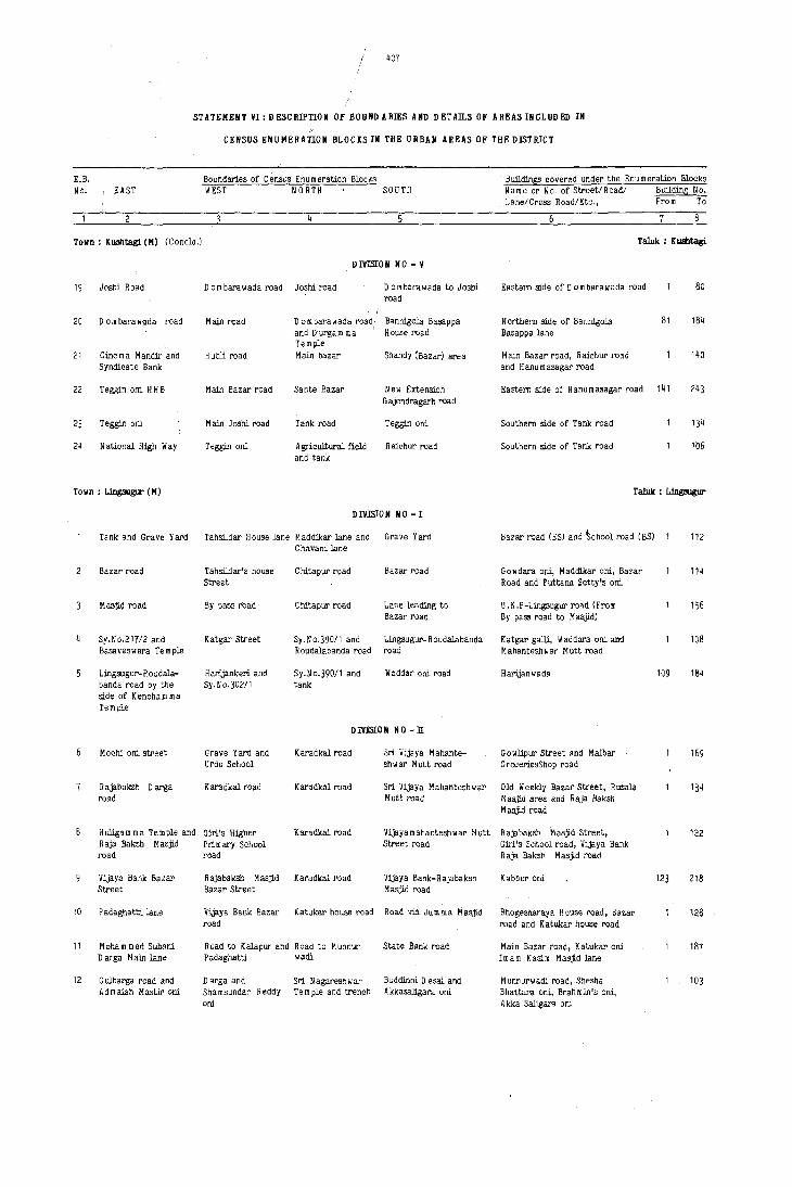
/
STATEHENT VI: DESCRIPTION ot BOUNDARIES AND DETAILS OF AREASINCLUDED IN
CENSUS ENUMERATION BLOCKS IN THE URBAN AREAS OF THE DISTRICT
E.B. No. EAST
Town: KUBhtagi. (H) (Concld.)
19 Joshi Road
20 D 0 m bara w<lda· road
21 Cinema Mandir and Syndicate Bank
22 Teggin ani H H P
23 Teggin ani
24 National H:igb Way
Town: Lingaugur (H)
Boundaries of Census Enu m eration Blocks WEST NORTH SOUTH
DIVISION NO - V
Dam barawada road Joshi road D ombarawada to Joshi road
Main road
Hubli road
Main Bazar road
Main Joshi road
Teggin ani
D 0 m bara wada road and Durgamma Te mple Main bazar
Sante Bazar
Tank road
A gricultural field and tank
Bann:igola Basappa House road
Shandy (Bazar) area
New Extension G ajendragarh road
Teggin ani
R aichur road
DIVISION NO -I
Tank and Grave Yard Tahsildar House lane Maddikar lane and Grave Yard
2
10
11
12
Bazar road
Masjl(l road
Sy.No.21112 and Basaveswara Temple
Lingsugur- R oudalabanda !'<lad by the side of Kencham ma Temple
M ochi oni street
Rajabaksh Darga road
Hul:igam ma Temple and Raja Baksh Masjld road
Vijaya Bank Bazar Street
P adaghatti lane
Moham med Subani Darga Main lane
G ulbarga road and Admaiah Mastit oni
Tahsildar's house Street
By pass rbad
Katgar street
H al'ijankeri and Sy. No. 3021 1
Grave Yard and Urdu School
K aradkal road
Glrl's H:igher Primary School road
Rajabaksh Masjid Bazar Street
Vijaya Bank Bazar road
Road to Kalapur and Padaghatti
Darga and Shamsundar Reddy ani
Chavani lane
Cbitapur road
C hitapur road
Sy.No.390!1 and Roudalabanda road
Sy.No.390/1 and tank
Bazar road
Lan~ leading to Bazar road
Lingsugur- R oudalabanda road
Waddar oni road
DIVISJ:ON NO - II
Karadkal road Sri Vijaya Mahante-shwar Mutt road
Karadkal road Sri Vijaya M ahantesh w ar Mutt road
Karadkal road Vijayamahantesbwar Mutt Street road
Karadkal road Vijaya Bank-Rajabaksh Masjid road
Katukar house road Road via Jum ma Masjid
Road to Munnur State Bank road wadi
Sri N agaresh war Buddinni Desai and Te m pIe and trench A kkasaligara oni
Bu.ildings covered under the Enumeration Blocks Name or No. of Street/Roadl Bu.ilding No. Lane/Cross Road/Etc., From To
Taluk : KUBhtagi
Eastern side of D 0 m bara w ada road
Northern side of Bann:igola Basappa lane
Main Bazar road, Raichur road and H anu m asagar road
81
Eastern side of Hanumasagar road 141
Southern side of Tank road
Southern side of Tank road
80
184
140
134
106
Taluk : Lingaugur
Bazar road (ES) and ~chool road (BS)
Gowdara oni, Maddikar ani, Bazar Road and Puttana Setty's oni
U.K.P-Lingsugur road (From Bypass road to M asjid)
Katgar galli, Waddara ani and Mahanteshwar Mutt road
Hal'ijanwada
G owlipur Street and Malbar GroceriesShop road
Old Weekly Bazar Street, Rusala Masjid area and Raja Baksh Masjld road
RajabakSh Masjid Street, Girl's School road, Vijaya Bank Raja Baksh Masjid roact
Katber oni
Bhogesharaya House road, Bazar road and Katukar house road
Main Bazar road, Katukar oni Imam Kasim Masjid lane
Munnurwadi road, Shesha Bhattara oni, Brahmin's oni, A kka Saligara ani
112
114
156
108
109 184
169
134
122
123 218
128
187
103

E.B. No. EAST
lIOB
STATEMENT VI: DESCRIPTION OF BOUNDARIES AND DETAILS OF AREAS INCLUD ED IN
CENSUS EHUMERATION BLOCKS III THE URBAN AREAS OF THE DISTRICT
Boundaries of Census Enu m eration Blocks 81ill.mngs covered under the Enumeration Blocks WEST NORTH SOUTH Name or No. of Street/Road/ Bull<ting No.
Lane/Cross Road/Etc., FrOJl1 To
TOlin: Lingsugur (M) (Coneld.) Taluk : Lingsugur
13
14
15
16
17
18
19
20
21
22
23
24
25
26
27
28
29
30
31
32
DIVISION 110 - II (Coneld.)
G ulbarga road Adimalah Master Sri. Nagareshwar Main Bazar road lane Temple road
DIV]SlON NO-ill
G urgunta road G ulbarga rOad Nala and Gin N e michand Road
Gulbarga road and Kalapur road Nala Lane to S31m ani Galli Hanuman Temple
Bye Pass road Bangalore-G ulbarga Nala Police Colony road
Bye P ass road T31uk 0 ffiee road Police Colony lane Lingsugur--R aichur road
Bye P ass road Tank Bund road Lingsugur-R aichur A pproach road to road r ahsil 0 ffice
POlice Station road Gowlipur road Sri Vijaya m ahante- R aichur road sh war Mutt road
MuniciPal D ffice Go w lipur road Sri Vijayam aha- R aichur road "Gad ntesh II ar Mutt road
Kalapur road N ala & Shandy Nala o inasigalli Maidan area
Bye Pass road Waddar ani ~ griculture land Nala
Lingsugur-G urgunta Municipal boundary Burial ground road Municipal boundary road and M ahante- and Lingsugur- and H anu m an, Basa vanna shwar road H aichur road Tern ples
DIVISION NO -lV'
Chavani road Talewadkar Oni and Police Gowda's land MUdgal road Halla and halla
Mudgal-Chavni road Nala and Bheernana Agasi road Mudgal-Chavni road Gowda's land
Kumbar lane Mudgal road Bazar oni By Pass road and open space
Bye Pass Mudgal road Chavni-Mudg31 road By Pass road M udgaJ.-Ling:lugur road
Kurbar ani Road to Ukal Sri Tontadarya Mutt Begar ani road
D!VJli[ON NO - V
Lane from Bazar road Mudgal-Chavni road Chavni-Koski road to Chav·ni-Maski road
Kutcha road to Maski Sri Tontadarya Mutt MaskicChavni road Chavni road
K utcha lane leading K u m bar lane Bazar road to Bazar-KUI'1.<bar oni
Maski-Chavni road Kumbar lane & Agriculture lands AgricultUral lands
Banagigar oni
Bazar Jane
Road to K u m bar galli
Bye Pal'S road
Brahmins Galli, Main Eazar road and G ulbarga road
104 177
Nagareshwar Temple area, Minchanipur 1 123 oni and N e micband road
Munnur Road (ES) 124 236
Mincbanipur Road and N e michand 132 Quarter's road
Police 0 uarters, KE B Cclony and 133 255 Raghavendraswamy Temple Street
KHB, NGD's KSRTC Quarters, Taluk 158 Office road, Bangalore road and Tank Bund road
Raichur-Ling:lugur road, Bangalore- 159 305 G ulbarga road, Bus Stand road and Police station road
Dinisi Galli, VijayamahanteShwar 134 Mutt road
Waddar galli, Moham med Galli 135 27511 and Karadkal Bazar road
Sanagar ani, H arijan oni and 276 384/1 G ulbarga road
Lingsugur-C'haluni road, Taluk 134 Office road, Court road, Karadk31 road
North-Western side of Mudg31 road 141
D yamavva Temple road and 88 Mudgal-Chavni road
8etegar Oni, Kumbar oni, ?injar 91 Kabbera oni and Bedar oni
8edara oni, Kumbar oni
K u m bar oni, U ppar ani, Banagigar oni and Bazar road
Sri Tontadar-Jaswamy Mutt area
'rIaddar ani
Kumbar oni
Harijan wada and MaskiChavni road
92 178
117
121
142
91
92 199
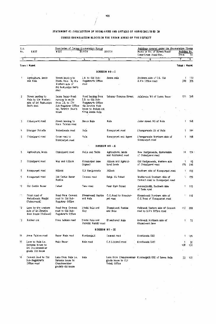
409
/
STATEMENT VI: DI!SCRlPnON Of BOUNDARIES AIID DETAILS OF .lREASIlICLUDED III
CENSUS ENUMERAUON BLOCKS IN THE URBAN AREAS OF THE DISTRICT
E.B. Boundaries of C eMus Enu m eration Blocks Buildin!l!! covered under the Enu m eration Blocks No. EAST WEST N'ORTH SOUTH Name or No. Of Street/Road/ Buildinl! II o.
Lane/CroBS R Dad/Etc., From To
Town: Manri Taluk : lIann
DIVmON NO-1
Agriclllturallands Street leadir,3 to LB. to Old Sub- Sanna nala Southern side of 1. B. Old 1 170 and Nala Dhobi. Nala by the Registrar's .Office S.R's Office road 3~9 355
Western side of road Sri Ba.humiya 8ab's shed
Street leaQing to Sanna Ba2.ar-ll DaO ~ oao leaQing from Sahukar E aranna Street Julaiwacla \IS of Sanna Bazar 171 3~8 Nala by the Western running to south I. B. to Old Sub-side of Sri. Bashumiya from I.B. to Old Registrar's 0 ffice Sab's shed Sub-Registrar Office via Ibrabim Naik
via, Ibrahim N aiI<'s house to Budaki ani house along Sanna N ala
C bikalparvi road Street leading to Sanna Nala Mala Jadar street NS of Nala 148 Prem Talkies road
D hangar M ohalla M ehadiw ada road Nala K ona purpet road D hangarwada S8 of N ala 14b
C bikalparvi road Cross road to Nala Konapurpet and Agase D hangarwada Northern side of 158 Konapurpet road K onapurpet road
DIVISION NO -11
Agricultural lands C bikalparvi road Halla and fields Agricultural lands New Harljanllada, Eastemside 1~ 174 c
and Rabbankal road of Cbikalparvi road
Cbikalparvi road Way and Hillock Konapurpet base Hillock and Agricul- Old Harljanwada, Western side 1 13 (Agase) turallands of C bikalparvi road 175 246
K onapurpet read Hillock Old Harljanllada Hillock Southern side of Konapurpet road 143
K onapurpet road Old Cattle Bazar Cement road Sabja Ali Pahad Waddarwadi Southern side of 170 Rastha Gement road to Konapurpet road
10 Old Cattle Bazar Pahad Tank road Peer Giab Pahad Ju m m uldoddi, Southern side 115 of Tank road
11 Fro·nt road of Road from Cement Khasablladi Rastha e.C .. Road to Konapur- Khasabwadi Northern side of 116 Mehadiwada Masjid road to Old Sub- and Mala pet road C.C.Road of Konapurpet road (Fakeerwadi) Registrar Office
12 Lane by the western Road from Cement D hobi N ala and Khasabwadi Rastha Naikwadi Eastern side of Cement 117 209 side of Sri Ibrahi.m road to Old Sub- Way and Mala road to So R 's Office road Nail< House (Kolillad) Regi3trar's Office
13 Kabber oni Prem talkies road D hobi N ala and Khasabwadi Nala Naikwadi Northern side of 72 Maruthi Mandir road Khasabwadi lane
DIVISION NO - m
1~ Pre m Talkies road Bazar Main road K u m bargalli Ce ment road Komtiwada (SS) 195
15 Lane to Mala i.e. Main Bazar Mala road C.P .S.School road Komtiwada (NS) 1 32 Earanna House to 108 178 Sri C handrasekhar gouda Old house
16 Ce ment read to Old Lane from Mala i.e. Nala Lane fro m C handrasekhar K u m bargalli (8S) of Sanna N ala 33 107 Sub-Registrar's Earanna house to g9uda house to Old Office road C handrasekhru"' Tahsil Office
gouda(s old house

410
STATEMENT VI: DESCRIPTION OF BOUNDARIES AND DETAn.S OF AREASINCLODED IN
E.B. No. EAST
Town: Manvi (M) (Contd.)
17
18
19
20
21
22
23
24
25
26
27
28
29
30
Main Bazar road
Main Bazar road
Lane from ·P.S.P. Jum mu D oddi to Sri Jagannath Rao's house (Sreenivas Nursing Home)
Way from Civil Dispensary to Sri Jagannathadas Te m ple via Beldar Mohansingh house
D uragam rna Street (From Adapurpet H P S to tank road)
Govt. Civil Hospital road
Way to Beginpet
M uniclpal 0 ffice road
M uniclpal 0 ffice to Chowdam ma Temple road
Karadigudda road
Main road fro m Civil Dispensary to Bus Stand
Open land by the Eastern side of M unsiff Court and Grave Yard fields upto Nala
Road from Old Sub-Registrar 0 ffice to Govt. Jr. College
Road from Jr.College to K.E.B.Offl.ce
CEIISUS ENUMERATION BLOCKS IN THE URBAN AREAS OF THE DISTRICT
Boundal'ies of Census Enumeration BlockS WEST NORTH SOUTH
Pinjar 0 ni and SunargalJi
Lane from Civil
DIVISION NO - m (Concld.)
BUl'ial Grounds Jum mudoddi way
Road in front of Lane from SI'i Dispensary to Civil Dispensary J aganna thdas te m ple Jagannathdas te m ple via Kapgal Sesha-girl Rao's house
to Main Bazar via D r.Jagannath Rao Sreenivas Nursing Home
Way leading to tank Lane to Sri Jagannath Tank road upto Das temple, from P.S.P.Katta (Jummu Main road via doddi) Sreenivas Nursing Home
DIV1S[ON NO - IV
D uraga m rn a Street Way connecting the (From Adapurpet HPSlane of C.D. Jagato Tank road) nnathadas Te m ple
Way to tank (kere) fro m Sri Jagannathdas Temple
Hillock
Adapurpet road
Hillock and 0 pen space
Agricultural land
Way from Gadangal Well to Perakal oni
Field
Eastern side road of Chowdam rna Temple
Main road from Civil Dispensary to Bus Stand
Dilapidatad House of Sri K asiraya and nelds
Jr. College com-pound and cart-track running oy the side of toddy shop & Arrack shop
and Adapurpet H PS Road
Way fro m A dapurpet H PS to Hillock
Chowdam rna Temple Street
lIay to Kalmath
Agricultural land
II ay in front of Municipal Office connecting Haldal village rastha
R aichur-Gingera road
Way to Tank (Kere)
\I ay to Belginpet
Mallikarjun's Hill
Public way (fro m side of M uniclpal 0 ffie e to connecting H aldal village rastha)
Way fro m southern side of Chowdam rna Temple to Masjid via Kalmath
P.Khajamiya Sab's fields
DIV1S[OIi 110 - V
Open space of Way and Nala in front T.A.P.C.M.S. Civil Dispensary Ltd., Office
Housing Board Nala Colony
Fields and Open Nala place
Way to Bus stand Govt. Jr.College via K.E.B. and compound Housing Board G olony
Buildings covered under the Enumeration Blocks Name or No. of Street!Road! Building No. Lane!Cross Road!Etc., From To
Taluk : Manvi
Brahamanwada liS of Main Bazar road 1 217
Brahamanwada Civil Dispensary (SS)
Pinjar ani N S of tank road
Bendarwadi N S of Sri Venkateswar Temple
Southern side of Mosque
Southernside of Chowdeswary Te m ple Street
Kamath area North-Eastern side of Mallikarjun Hillock
Belginpet II S of Karadigudda road
Belginpet NS of Chowdam ma temple and Kalmath
Rajeswari Nagar South eastern side of APMC Office
Old Bus Stand and Post Office area
Eastern side of Bus Stand Civil Dispensary road
Western side of Pre m Talkies road
Housing Board Colony behind Pre m talkies
122
123 261 262 263
1 154
62
174
198
158 272
61 175
153
138
154
173
244
138
197
371
157
181 451

~11
/
STATEMENT VI:DESCRIPTION OF BOUNDARIES AND DETAILS OF AREASINCLUDED IN
E.B. No. EAST
Town: Hanvi (H) (Concld.)
31 K.E.B.Office - LB. road
32 Raichur road
33 Bus Stand road
34 Lane from Raichur-Gingera- road to Veterinary 0 ispen-sary co rn pound
35 By lane from Raichur-G ingera road to K aradigudJa road
36 Land Development Society
TOlin: Hudgal (H)
Mulla Agasi
Open space
House of Chanda Baig and Hasana baig's open land
Fort
Bannigol-Janatapur road
M aski Bazar road
Way to Harijanwada
Sy.No.479, 472
Way to Ibrahill pura
10 Ku mbarpet
11 M odiIJsa b open space and Veerabhadra Tern pie
CENSUS ENUHERATlON BioCKS IN THE URBAN AREAS OF THE DISTRICT
Boundaries of Census Enu r, erat"cn Blocks Bulldings covered under the Enumeration Blocks WEST NOn;H SOUTH Name or No. of Street/Road! Bullding No.
Lane/Cross Road/Etc., From To
TaIuk : Hanvi
DIVISION NO - V (Concld.)
Bus Stand road fro m R aichU!' ... Gingera Open place and fields r.W.D .Camp, S5 of Raichur- 182 271 R.D.C .C.Bank to road at Southern side of Gingera road 452 570 T.D .B.Omce K.E.B.Colony
Cart tract by the Canal Raichur-Gingera P.W.D.Camp R aichur-Gingera 571 618 side of L.D .S.Manvi road road (NS)
Lane from Raichur- Raic:-::..:r-o'Jingera TAPCMS Ltd" Office Slum area western side of 200 Gingera road to r08·j_ Bullding & Godown K S R T C Bus Stand road Veterinary D ispen-sary Co m pound b~ the side of TAP C M S
Karadigudda road ? a:,:~.·..:!'-Gingera Veterinary Dispensary M allikarjun Talkies road (SS) 201 394 r~a:: Compound
Karadigudda road Ra.:.::t:'.:r-Gingera G adangal well and Jaii Quarters area eastern side 395 583 rca:: Adapurpet mosque of K aradigudda road
Karadigudda road Ca:-:a.. R aichur-Gingera road Narayan Teerth Ashram area 58~ 693 N S of Raichur-Gingera road
Taluk : Ling:rugur
liARD NO - 1
Madar Sab's house : ;:-ga road fort waii Southern side of Darga road 88 lane
Fort wall Ka::! J arwaza. Hill and fort Basavanna Temple area and 90 Hussain Pasha Darga area
Burial ground and ~::": Road and Fort Eastern side of Burial ground 100 Hussain Pasha Darga road
Chada Hussain :- ::-: Lane leading to eastern Western side of A gasi door 91 house's lane Agasi door
WARD NO - 2 Fort and Trench ~~~ roa.d Hillock and Gosala- Bannigol-Janatapur road 93
raya te m pie
Venkatarayapet G :salpet and M asjid and Take ani Jain ani, Take ani, Begar oni and 128 K .;:.S.Office road Kornatiga ani
Road leading to ~~ asid. road Hillocks Eastern side of Bannigola road 97 Bannigola
Khaseem Peer ;.~ aski. road Hillocks Bannigola road Balwadi and 124 Darga Harijankeri
WARD NO - 3
Kabarstan and house ::j pet road M aski ,'oad and Old pet road and M asld road 94 of Rajappa Sugnadi Takkiay area
Ibrahi m pur M asjid ::: pet road Maski road Ibrahim pur Masjid, Basavanna 117 and Hande Jallara Te m pte area and M ysore M aha nth ani Swamy Mutt lane
Way to Neerdoddi Mattur road Old pet tank and Southern side of Hattur road 73 Kalmatha

~12
STATEMENT VI: DESCRIPTION OF BOUIlDARIES AND DETAn.S OF AREAS INCLUDED IN
CENSUS ENUMERATIOB BLOCKS IN THE URBAN AREAS OF THE I)IStRICT
E.8. Boundaries of Census Enumeration Blocks BuildinSS covered under the Enumeration Blocks No. EAST WEST NO nTH SOUTH Name or No. of Street/Road! BuildinS No.
Lane/Cross Road!Etc., 'rom To
8
Town: Hudgal (H) (Concid.) Taluk : H udgal
II ARD 110 - 3 (Concld.)
" 12 Mun.i.cipal Latrines Open space of Modil".' l'Iatblr ro.4 M .sld road and Sy. Mattur road, LillgsugUl'-C~I,gavati 121
and field Sab and Veerabhadra 110.393 Road and liaski road Temple
13 Sy.NO.362, 357 Siddanna Temple & Sy.No.270,273 & 274 Mattur road Southern side of K ontihalla and 59 and 358 3y.No.256 Lingsugur road
14 Sy.No.255 and Sihineerina bhavi P.H.C.Quarters and Mattur road Weaver's oni, KUmbar oni 101 Siddanna Te m pIe lane Govt. 6igb school H arijaOkeri and Balegar keri.
15 Basanna well and M uchagar oni road Lane from Cinema H alepet road Basanna Te m pIe road H alepet 95 Kumbaroni H andir to Bazar Nagareswara Temple read, Moull
road via lumbar D argo road and M adivala road Basavanna Temple
liARD NO - 4
16 Lane to Khasab Lane leading to Baga.lkot-Haichur Hain Bazar road M aski road, Bus Stand road 160 Street Bagalkot- R aiohur road and Bazar road
road
17 Sajanabai road Lillgsugur road and Govt. School and Road to Rilla and Bazar road and N orth-eastern 143 Killa road Linpugur road Gosalpet Side of Lingsugur road
18 Prim ary School and Totagar oni and L.lngsugur road Lane to Kar1gar ani Church road, Basavanna Tn ple lane 116 P~mp HoUSe Burial ground Pu mpH ouse road and Ka~ar oni lane
19 Burial ground and Pilljar Bha vi lare tank Church road Pinjar bhavi lane, Bagalkot,- 132 G undada bha vi Litlgsugur road and Church ['oad
20 Chavadi road & Trench Pumpset anct Jleld Kandaka Som warpet Raju Ice ,actory 161 Lillgsugur road road and Bagalkot road
21 Masjid and Kandaka D urgam ma Temple Saga.lkot road D urgappa House road Edgah Masjid and Bagalkot road (SS) 162 239
22 Sy,No,13 & 599 Rouse of Badakuri Bagalkot road Lane to Temple and U pparpet. D urga \II \II a Te \II pIe 110 Rajappa Bannigol road lane. Kalloni and HaI1adavar pni
23 K asjid C yanap?aiah I\jJlock, lIal\\lll\an l!agalkot road ¥ ardhihal roM Cyanapayya 1<> III 1>le, Baga1llot rQaQ , 3~ rem ple and Nayakar Temple and Water and N aikar galli kaCte tank
town: Munirabad Project Area (SA) Taluk : Koppa!
r.L,B.C. & Forest Reservoir and REep BoundarY D a In Entrance Hill side COlony, C CSB from Forest 128 N ursery ends at HjJlock Old P WD Chowk Quarters FOrest Nursery end~ Grave Yard at Grave hrd
Hi$h level canal Iloundary of KE f\ H ortiIlulture Dept. High level canal Hum behind & by the side of 1 11~
Fence Fence KEI! Colony OPp. Petrol pump (Part.I)
KEB I'ence N.H.13 H ortillultural F enoe Kalam ma Temple lane K BE Colony opp. Petrol Pu m p(Part I) 1 121
KEB ~ence N.H.13 r;alalllllla Temple la.oeKEB ,enee MSEB Colony opp. Petrol Pump 122 213 Partn
5 Hanuman Temple road H1gh leVel canal Main· canal I Bazar rQad Houses in between Bazar road and Horticultural Office boundary
93
6 High level canal & Temple road Bazar road Roa<i behiml Peon's High school circle, Bazar roa<! 90 N,H.Road 13 Quarters and Halluman Temple road
Temple road H3sji.d road Bazar road I Radial road !.st flaclial road upto High 91 179 School, MOSQue road, Bazar road and Te m pIe road
8 N.H.13 Masji.d road I Radial road Internal R Mia! road Quarters in E.F.G • H Zones 88
N.H NAtIONAL HIG H II Al'

413
/
STATEMENT VI: o ESC RlP'l'ION OF 1I0UNDARIES AND DETAD.S OF AREAS INCLUDED III
CENSUS EIiUMERA'l'ION BLOCKSIN THE URBAN AREAS OF TRE DISTRICT
E.B. Boundaries of Census Enumeration Blocks Buildings covered under the Enumeration B~ocks No. EAST WEST NORTH SOUTH Name or No. of Streetl Roadl Buildina No.
LanelCross Road/Etc., From To
Town: Hunirabad Project Area (SA) (Concld.) Taluk : Koppal
. I Radial road N.H.13 Internal Radial I Radial road Quarters in A ,B,C & D Zones & 106 road entire play ground including
school and club
10 Bazar roM I Radial road Masjid road Internal road T.M.F.Quarters single 'D' and 132 UU Quarters
11 Bazar road I Radial road Internal road N.H.13 T.M.F.Quarters, KEB Quarters and 133 268 huts, behind K Ell Colony
12 Main canal Main Bazar Main canal N.H.13 Main Canal, N.H.13 Bazar road 122 upto Temple
13 Main CaQal Hill side road N .H.13 Main canal & da m KEB Colony Opp.Police 169 leading to da m Station, Ole & New Workshop
a(lministrative building of KEB & PWD
14 Tungabhadra River Main canal Fields R.O.F.Channel H olio w ce m ent blockS and huts 78 beyond. Main canal and F:iBheries Department
City: Raicbur 'raJuk : Raicbur
liARD NO - 1
C.C.Road Railway Track Lingsugur road Mahaboob Gulahan Volkot Press to G. G. High School road 1 60
C.e.Road Railway track Mahaboob Gulshan Udaya Nagar Cross road fro m G.G.High School 61 111 Udaya Nagar 112 142
C.C.Roa€! Railway Colony Udaya Nagar Railway Station Station to U daya N agar cross road 1 28 H anu m an gudi lane 29 55 U daya N agar road 56 110 Huts to Railway Station cross road 111 123 SL V Ice Factory road 124 165
Metal road and N ala Lane with Granite G oodshed road Metal road V.V.GJri. road 1 18 slab Hanuman Temple road 19 44
H arijan w ada 45 85
Lane with Stone Railway Tracks Good Shed road Harijanwada H arijan w ada 86 94 slabs H P S School lane 95 144
Shabad stone lane Railway boundary G oodshed road Agricultural fields R ajman Gadda 90
Agricultural flelds Railway boundary H arijan w ada Agriculturai fields Rajmangadda lane 91 140 and Station Bazar Asapur road 141 160 School baokside road Church road 161 180
Matrnari road Metal road Goodshed road Ashapur road 1.B. Road lane 1 44 I.B. Road 45 85
LB. Road Matmari road G oodshed road Fields and Hillocks Ram Mandie r'oad 86 110 Ramlingeswar Temple 111 127 I.B.Colony 128 213
10 Aaro Talab and I.B.Road Hillock l.B. & B.T.Road Lane by the side of LB. Road 1 29 Hillock Lane by the side of Temple lane 30 63
Station chowk lane 64 94
11 Hillock I.B.Road B.C.Hostel Aam Talab tank Huts opPOsite I. B. Colony lanes 170
12 Fields Road to I.B. Rail w ay Circle road G oodshed road Hostel lane 171 275 Hanuman Temple lane 276 322

414
STATEMENT V1:DESCRIPTION OF BOUNDARIES AND DETAn.S OF AREASINCLUDED IN
CENSUS ENUMERATION BLOCKSIN THE URBAN AREAS OF THE DISTRICT
E.B BOundaries of Census Enumeration Blocks Buildin6s covered under the Enu m eration BlockS No. EAST WEST NORTH SOUTH Name or No. of Street/Roadl Building No,
Lane/Cross Road/Etc., From To
City: Raichur (Contd,) Taluk : Raichur
WARD NO - 1 (Concld.)
13 ft 111 ba Bhavani Te m pIe C.C.Road Convent School road Railway Circle road StatiOn Cross road, Gold Market lane 1 59 lane ~ mba Bhavani Temple 121 138
~ 4 C.C.Road Cross road fro m Convent School road Station Circle Darga lane (BS) 65 Railway Circle
15 Indimnagar C ross road fro m Convent School road Hillock 'A'Lane 66 120 Railway Circle Aa m Talab road 121 145
16 Aam Talab (Tank) C ross road fro m Tank Bund road Convent School road Goal Market road Laxmam rna 100 Tank Bund road Te mple lane to Convent SchOol road
17 C ross road fro m Lane from Tank Tank Bund road Convent SchOol road Laxmamma Temple ES 101 146 Tank Bund road to Bund road to Aam Talab Cross road 147 184 Convent School road Convent School road
18 Metal road C.C.Road Tank Bund road Convent School road D urga M andir 1 34 Convent school road 35 70
19 Lane fro rn Tank Bund Metal road Tank Bund road Convent School road Convent School road 71 104 .I"'ad to Convent Brah m an wadi 105 171 ~~hool road
20 Ilillock 50' Road Khandak Tank bund road Khandak 29 Mavina Tank 30 47 had Nagar Cross road 48 70
21 50' Road Road in front of Khandak Tank bund road Azad Nagar Northern side 71 126 Goal Market Azad N agar Southern side 127 151
22 Road in front of C.C.Road Power House Tank Bund road Ashur Khana Street 1 22 Goal Market Raman Gowda Colony 23 55
Main station road 56 107
23 Metal road Fields Lingsugur road Fields Nijalingappa Colony (Ist cross road) 1 17 Nijalingappa Colony (IT cross road) 18 41 Ladies Club road 42 ' 60 Hindi Training school road 61 105 Main road 106 115
24 Railway track Metal road Level cross road Fields Park (ES) 116 142 Park (WS) 143 163 Colony road 164 189 K.E.B.Quarters 190 213
25 Railway track Agricultural fields Rai:lway track to Sri Ramnagar Colony Railway line & K H B Colony 1 94 LingSUgur road Ram Mandir road .~ 95 147
Lingsugur road 148 192
26 V .V.Giri road Rail .. ay Track Tagore Nursery Railway Quarters Railway Station road 1 71 School Railway play ground 72 129
Muthyalam ma Temple lane 1]0 140
27 Rajman Gadda & Road Railway track Railway Quarters A gric lIltural fields Railway Quarters 141 178 Water Tank road 179 239
28 Railway track Church Rampur road Sri Ramnagar Colony Railway Quarters HOSBur road 1 20 Railway school road 21 45
29 Railway track ChUrch & Rampur Sri Ramnagar Colony Railway Quarters Church road 46 55 road Hanuman Temple lane 56 57
Rampur road 58 83 H uw opposite to Railway Quarters 84 126197 and church
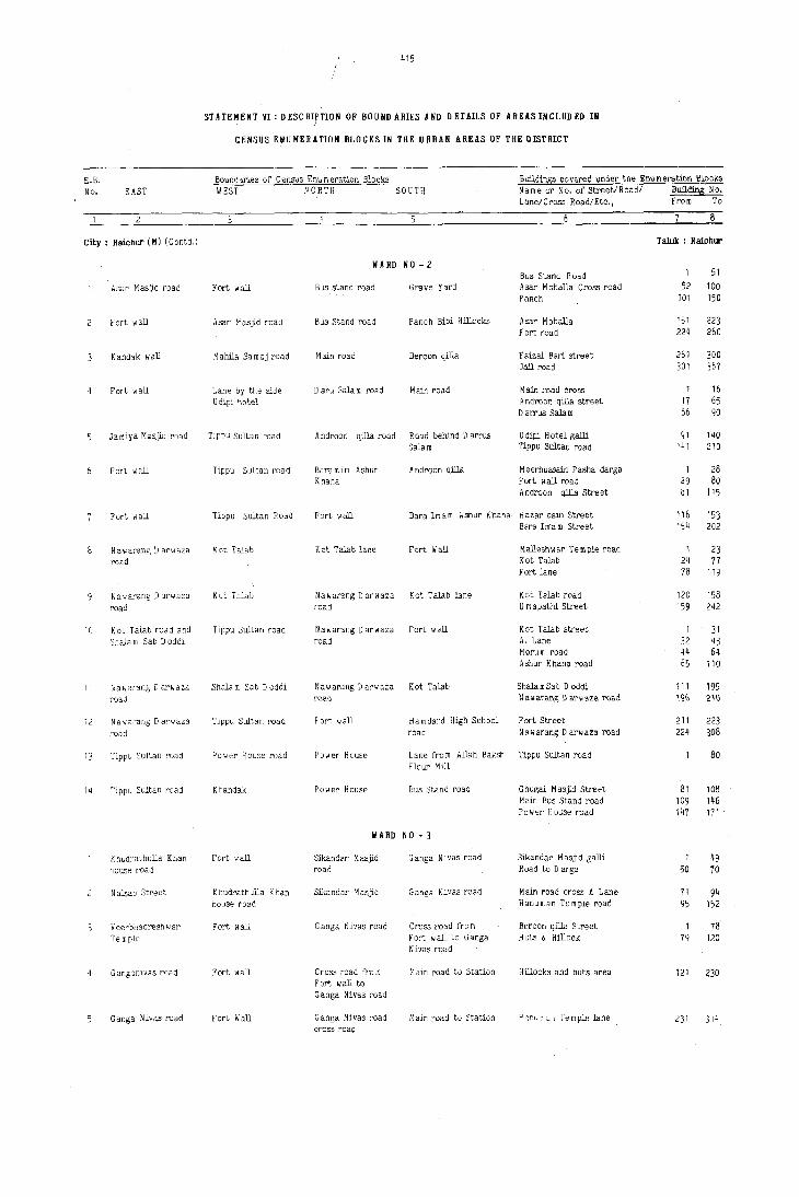
E.B. No. EAST
City: Raichur (M) (Contd.)
8
10
11
12
13
14
Asar M asjld road
Fort wall
Kandak wall
Fort wall
Jamiya Masjld road
Fort wall
Fort wall
Nawarang D arwaza road
Nawarang D arwaza
road
Kat Talab road and Shala m Sab D oddi
r~awarang D arwaza. road
Nawarang D arwaza
road
Tippu Sultan road
Tippu Sultan road
Khudrathulla Kban house road
Nabab Street
V eerbhadresh war
Temple
G anganivas road
Ganga Nivas road
415
STATEMENT VI: DESCRIPTION OF BOUND ARIES AND DETAILS OF AREAS INCLUD ED IN i
CENSUS EIIUMERATION BLOCKS IN TKE URBAN AREAS OF TKE DISTRICT
Boundaries of Census Enumeration Blocks Bllldings covered under the Enum eration Blocks WEST NORTH SOUTH Name or No. of Street/Road/ Building No.
Fort wall
Asar M asjid road
M ahila Sa m aj road
Lane by the side U dipi hotel
Tippu Sultan road
Tippu Sultan road
Tippu Sultan Road
Kot Talab
Kat Talab
Tippu Sultan road
Shala m Sa b D oddi
Tippu Sultan road
Power House road
Khandak
Fort wall
Khudrathulla Khan house road
Fort wall
Fort wall
Fort fI all
Lane/Cross Road/Etc., From To
WA RD NO - 2
Bus stand road Grave Yard
Bus Stand road Panch Bibi Hillocks
Main road Beroon qilla
D aru Sala m road Main road
A ndroon qilla road Road behind D arrus 3ala m
Baramim Ashur Androon qilla Khana
Bus Stand Road Asar Mohalla Cross road Panch
Asar Mohalla Fort road
Faizal Bari street Jail road
Main road crass A ndroan qilla street D a,,",us Salam
U dipi Hotel galli Tippu Sultan road
M eerhussain Pasha darga Fort wall road A ndroon qilla Street
Fort wall. Bara Imam Ashur Khana Hazar bain Street Bara Im"am Street
Kat Talab lane Fort Wall
Nawarang D arwaza Kat Talab lane road
Nawarang 0 arwaza Fort wall road
Nawarang D arwaza Kat Talab l'oati
Fort wall Hamdard High School road
M allesh w ar T e m ple road Kat Talab Fort lane
Kat Talab road U mapathi Street
K ot Talab street A. Lane Morum road Ashur Khana road
Shala m Sab 0 oddi Nalfiarang D at''rIa'Za road
Fort Street Nawarang D arwaza road
Power House Lane fro m Allah Baksn Tippu Sultan road Flour Mill
Power House Bus Stand road
WARD NO-3
Sikandar Masjid road
Sikandar M asjid
Ganga Nivas road
C ross road fro m Fort wall to Ganga Nivas road
Ganga Nivas road cross road
Ganga Nivas road
Ganga Nivas road
Cross road fro m Fort wall to Ganga Nivas road
M aln road to Station
110in road to Station
Ghugal Masjid Street Main Bus Stand road Power House road
Sikandar M asjid galli R Dad to Darga
Main road cross A Lane Hanuman Temple road
BerDan qilia Street Huts & Hillock
Hillocks and huts area
j1 '1r.U~' :.tl: Te m pie lane
Taluk : Raichur
1 51
52 100 101 150
151 223 224 260
261 300 301 367
16 17 65 66 90
91 140 141 210
1 28 29 80 81 115
116 154
1 24 78
120 159
1 32 44 65
111 196
211 224
81 109 147
50
71 95
1 79
121
231
153 202
23 77
119
158 242
31 43 64
110
195 2\()
223 308
80
108 146 171
49 70
94 152
78 120
230
314
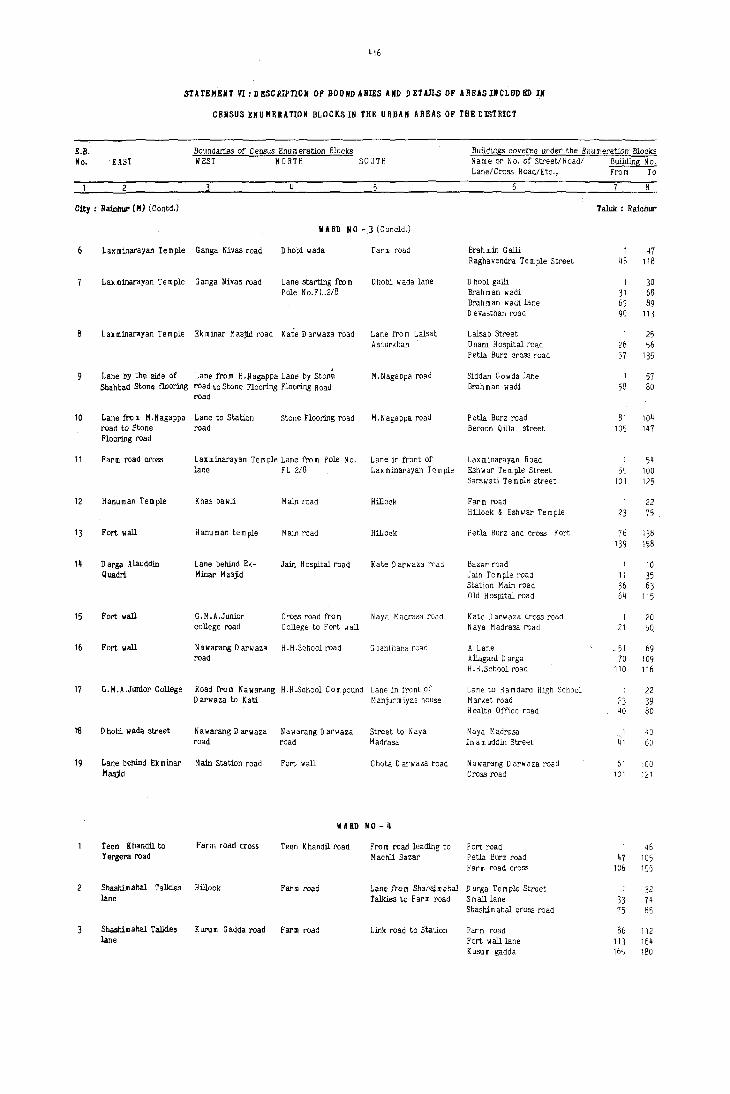
416
STATBMBNT VI: DBSCRiPTIOIi OF BOUND ARIES AND IlBTAILS OF AflEASINCLUDBD IN
CENSUS ENUMERATION BLOCKS III tHE URBAN AREAS OF THE DISTRICT
B.B. Bo"ndaries of Census Enu m eration Blocks Buildillgs covered under the Enumeration Blocks No. EAST WEST NORTH SOUTH Name or No. of Street!Road! B!£!ding No.
Lane!Cross Road!Etc., From To
Cfty : Raicbu!' (M) (Contd.) Taluk : R aichur
WARD NO - 3 (Coneld.)
Laxminarayan Temple Ganga Nivas road Dhobi wada Farm road Brah min Galli 1 47 Raghavendra Temple Street 48 118
Laxminarayan Temple Ganga Nivas road Lane starting roo m D hobi wada lane D hobi galli 1 30 Pole No.FL.2/8 Brahman wadi 31 68
Brahman wadi lane 69 89 D evasthan road 90 113
Laxminarayan Temple Ek minar M asjid road Kate D arw aza road Lane fro m Lalsab Lalaab Street 1 25 Ashurkhan U nani Hospital road 26 56
Petla Burz croSS road 57 135
Lane by the Side of Lane from H.Nagappa Lane by Stone M.Nagappa road Siddan Gowda lane 1 57 Sbahbad Stone flooring road to St.one Flooring Flooring Road Brahman wadi 58 80
road
10 Lane from M.Nagappa Lane to station Stone Flooring road M.Nagappa road Petla Burz road 81 104 road to Stone road Beroon Qilla street 105 147 Flooring road
11 Farm road cross Laxminarayan Te m pIe Lane fro m Pole No. Lane in front of Laxmillarayan Road 1 54 lane FL 2!8 Lax millarayan Te m pIe Eshwar Temple Street 55 100
Sarswati Temple street 101 125
12 Hanuman Temple Khas bawli Main road Hillock Farm road 1 22 Hillock & Esh"ar Temple 23 75
13 Fort wall Hanuman temple Main road Hillock Petia Burz and CrOss Fort 76 138 139 158
14 Parga Alauddin Lane behind Ek- Jain Hospital road Kate D arwaza road Baz;ar road 10 Quadri Minar Masjid Jain Temple road 11 35
Station Main road 36 63 Old HOSpital road 64 115
15 Fort wall G.M.A.Junior Cross road f)"o m N aya M adrasa road Kate 0 arwaza cross road 1 20 college road College to Fort wall N aya M ad rasa road 21 5Q
16 Fort wall Nawarang P arwaza H.H.School road S oanthana road A Lane _ 51 69 road Allagani Darga 70 109
H. H .School road 110 116
17 n.M.A.Junior College Road from Nawarang H . H .School Com pound Lane in front of Lane to Hamdard High Sehool 1 22 o arwaza to Kati ManjurmiYRs house Market road 23 39
Health 0 fi,e e road 40 80
fB o hobi wada street N a w arang 0 arwaza Nawarang Oarwaza Street to N aya N aya M adrasa 40 road road Madrasa 1m a m uddin Street 41 60
19 Lane behind Ek minar Main Station road Fort wall Chota D arwaza road Nawarang D arwaza road 61 100 l1asjiO Cross road 101 121
II ARO NO - 4
Teen Khandil to Farm road cross Teen Khandil road Fro m road leading to Fort road 1 46 Yergera road Machli Bazar Petla Burz road 47 105
Far In road croSS 106 155
Shashilll ahal Talkies Hillock Fal"m road Lane from Shahsim ahal D urga T em pIe Street 1 32 lane Talkies to Farm road S mall lane 33 74
Shashim ahal cross road 75 85
Shashim ahal TalId.es Kuru m G adda road Farm road Link road to Station F·arm road 86 112 lane Fort wall lane 113 164
Kusum gadda 16~ 180
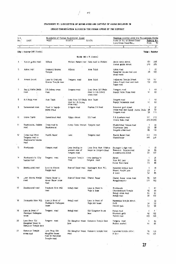
E.B. No. i EAST
/ /
417
STATEHEIIT VI: DESCRIPTION.OF BOUNDARIES AND DE'l'An.S OF ARUSINCLUDED IN
CENSUS ENUHER'ATION BLOCKSIN THE URBAN ARBAS OF THE DISTRICT
Boundaries of CensllS Enumeration Blocks BWldings covered under the Enumeration Blocks WEST NORTH SOUTH Name or No. of Street!Road! Building ¥o.
Lane!Cross Road!Etc., From To
7
City: Raichur (M) (Contd.) Taluk : Raicblll'
10
11
12
13
14
15
16
17
18
19
20
21
Kuru m gadda road
Ashok road
Arrack Depot
Bapuji Patha $lIala road
B.P .Shala road
Zaheerabad roaO
Grave Yards
Hillock
Urukundi Eranna Te mple
Lane to Urukundi Eranna Temple road
I.B.Colony cross road
Aam Talab
Road to Bapuji.patha shala
Zaheerabad road
Shashimahal Talkies Cross road to road Shashim ahal
C ross road fro m Yergera road to Shashimahal talkies road
Mochiwada
Mochiwad~ to City talkies road
Shashim ahal road
Lane K hooni M asjid road
Shashim ahal road
U m akanth Rice Mill
Lane in front of Maddipet Kallappas house
M achli Bazar
Yergera road
Yergera road
Lane to Khooni Masjid road
Charat Bazar to Ja war Bazar cross road
U makant Rice Mill road
Lane in front of Maddipeth Kallappas house
Yergera road
Lane fro m Old Yergera road Slaughter house to Hanuman Temple lane
Hanuman Temple Lane from Old cross road slaughter house
road to H anu m an Temple road
VA RD NO - Jj (C ontd.)
Mutton ·~attket road Link road to Station
Hillock
Yergera road
Yergera read
Aam Talab
Aam Talab
Lane from B.P.Shala road to LB.Colony cross road
Lane from B.P.Shala Aam Talab read to I.B.Colony cross road
Yergera road Station I.B.Hoad
Vijaya chowk I.B.Road
Darga Zinda Sha vali Yergera road
Lane Yergera road
Lane leading to Lane from Ram Krishna western side of house to Yergera Road Yergera road
~anuman Temple Lane leading to road Yergeca road
Sharoof Bazar road Sapthagiri Ri~e Mill road
Sharaof Bazar road Charat Bazar
N etaji road Lane in front to Raja & Sons
N etaji road Lane in front of Raja Sab house
Netaji road Old Slaughter house lane
Old Slaughter house Hanuman Temple lane lane
Old Slaughter house Hanu m an te m pIe lane road
Janda katta street Kuru m gadda street
Ashok road Slaughter House road and cross roads
Yellam rna Temple Street Ashok Depot road and Aam Talab road
Y eragera road Sapuji. P atha Shala road
Y ergera road Sapuji. P athashala read
11)1 248 249 289
1 27 28 105
106 151 152 200
1 40 41 60
1 41
40 60
Hanuman gudi street 1 Cross road and Bapuji. P atha Shala 38 Y ergera road 58
37 57
110
P.K.Quarters road Octroi Naka road
Shashimahal Talkies road C harabazar lane Yergera cress road
Machli Bazar road C harat bazar
Soudagar Lodge read H anu m an Talkies road Am babhavani street
Street Rice Mill lane D evar Math lane
Hanuman tem ple lane Khooni Maajid lane A Lane
Charat Bazar cross road M angal 1/ arpeth
Mocml/ada ChowdeShwari Temple Netaji cross read Netaji. road
Narasappa temple street Galli D hondi galli
Netaji read Kharasab galli Ashoka road
Yergera road Mutton market
Hanuman temple street A lane
27
111 215 216 2~1!65
1 22 23 88 89 110
111 143 144 204
1 39 87
1 36 70
20 52
86 121
1 48 81 98
1 34 53
1 42
103
1 41
86 151
38 86
127
35 69 88
19 51 85
120 163
47 80 97
107
33 52 98
u 102 120
40 85
1JO 175

U. No. EAST
Cit, : lIaiCbUJ' (M) (Contd.)
22 Lane fro m house of Mond 0 m ersab
23 Md.Osman Counciler's house road
3
Ranuman Talldes Jane
Hanuman Talldes Jane
Hanuman talIdes road in front of H anu m an temole
H anu m an talIdes road
Jani Maulla road
418
STATEMENT VI:DESCIIIPTIOIi OF BOUIIJ).lRIES AIID J)ETAn.S OF AIIE!SINCLIIDED II
CENSUS ENUMERATION BLOCKS IN THE URBAII HUS OF THE DISTRICT
Boundaries of Census Enu m eration Blocks Buildings covered under the Enumeration Blocks WEST NORTH SOUTH Name or No. of Street/Road/ Buil<ting No.
Yergera road
Yergera road
Kodanda Rama Temple Jalle
Lane in front of Somawarpeth Police Station
Lane from Som warpeth Police station to H.S.Nivas buil<ting
Jani Maulla road
Katkavala Naja
Lane/Cross Road/Etc., From 10
liARD 110 - 4 (Conolli.)
Old Slaughter house Hanuman Temple lane SharocfBazar road road Mochiwada
Old Slaughter house Hanuman Tem pIe lane 0 mer Sab street road Kirona Bazar
Yergera road
liARD NO-5
Neta.)!. road
Lane lea<ting to Rachayya Math to Hanuman talIdes
Lane leading to Ranuman talkies
N agaresh war te m ple to Rachayya Math lane
Lane lea<ting from Pole No·3/6/1 to H anu m an talIdes
M.S. Nivas Building
N .S. Nivs" hllHding Thim m apurpet road road
N.S.Nivas bullding Thim mapurpet lane road
Vivekananda road Ram M andir Street Rachayya Math Jane Venkateshwara Street
Ranuman talkies read Som warpeth Police Station road So m warpeth Street Nagareshwa!' Temple lane
H anu m an talkies road Eshwar D evalaya road So III Ii arpeth lane
Ranuman tem;>].e road Jani Maulla road
Shashimahal talkies Jane Katkavala
8
Taluk : Ba:Itlbur
1 51 52 90
91 118 119 149 150 165
1 19 50 74
1 21 51 68
I 32 54
\8 49 73 99
2()
50 67 98
31 53 95
I 40 41 80
81 124 125 151
Kedanda Rama temple MUnicipal latrine Lane by Granite stones mop )ring
M.N.~ivas bull<ting to Pole No.4/4/3
Raghavendra Rice Mill J anatha Lodge lane
1 45
44 70
8
10
12
13
lane
Ram Mandir Jane
N alband CirrJ.e to Venkatesh waraRice Mill
Jani Mahalia Mosque road
Jani Mohalia Mosque road
Nala
Katka vala N ala
Katkavala Nal~
Road to Karnataka Sangha
21'
Lane to Shashimhal Hanuman talkies road
Mochiwada road Netajl road
Lane by Granite Stones mop
K.L.Kantha Rao's omce
Thim mapurpet road Link road from Jani B.C. Hostel road M ohalla road to
Katkavala Masji.d road
Shashim ahal road
B.C.Hostel road Thim m apurpet road
thim mapurpet road Lane upta Hanuman Nala temple
Thim mapurpet road Shashim ahal road
Shashimahal talkies Katkavala to road Shashim ahal road
Thim mapurpet road
Rice Mill to Shashimahal road
liARD 110-6
Lane to Hanuman talkies
Sri R agha vendra Swamyroad
Kutcha road to Grave Yard
Kanta E'rinting Press lane A Lane Veeranhadra te m pIe lane Chawk Mas,lW. lane Mrlthyn:ieshwara lane
Shashim abal road Shetty Bawli road Shashim ahal Talldes cro!l!rroadoc
Shashimballane
Jani Mollalla road Thim mapurpeth road
Katkavala Masji.d Street Thim mapur pet Nala lane
Vayale galli street Shashi m ahal road
Shashi m ahal talkies Sbashimahal croos raod Nala & Temple road
Hanuman talIdes road L. V.D ,C ollege road Hanuman talIdes cross road
71 94 95 106
107 125 126 155 156 170
,I 55 56 109
110 140
90
91 121 122 145
I 61 62 90 91 110
111 122 123 158 159 22'2
I 23 24 40 41 112
I 16 17 69 70 100

~ 19
STATEMENT VI: D ESCRIPTI(j1i OF BOUND ARIES AND D EUILS OF AREAS INCLUD ED IN
CENSUS ENUMERATION BLOCKS!N THE URBAN AREAS OF THE DISTRICT
E.B. Boundaries of Census Enumeration Blocks Buildins;! covered under the Enu rn eration Blocks No. EAST WEST NORTH SOUTH Name or No. of Street/Road/ Building .!2.!.
Lane/Cross Road/Etc., From To
6
City: Raichur (M) (Contd.) Taluk : Rai.chur
liARD NO - 6 (Concld.)
Road to Grave Yard B. R . B. College road Grave Yard Khadi Gramodyoga road Khac1i GramodyogaSangh road 101 168
D attathreya Te m pIe B. R. B. C allege road Road to Vasavipur Manik Prabh~ Temple Kariyappa Tatha road 1 48 road road Manik Prabhu Temple road 49 87
Laxmi Temple road 88 125
Mahalaxmi Mandir Road to Hanuman M anik Prabhu Yeragera road B.R.B.College road 126 146 road talkies Temple road Huta in between B.R.B.College 147 231
road and L.V.D.College
Hanuman talkies road Lane fro m N elusab K atka vala to Yeragera road JOlWara galli 1 63 Floor mill to H anu rn an talkies Huts opposite B. R.B.Circle 64 95 Janublam rna gudi road Bapuji road 9f 1~8
Floor Mill road Shashim ahal road N ala by the side Road to B.R.B.College Tank road 1 32 of Thakurji Oil Mill S~mahal backside lane 33 44
Lane fro ID Bapuji roar' 45 95
Police Station lane Venkateswara Rice Netaji. road N ala by the Side of Thakur Mill road lan~ fro m 96 201 to M.S.Nivas build- Mill road Thankurji Oil Mill Main road ings
Hanuman talkies road Shashi m ahal road Netaji. road Nala Bapuji cross road and Shashim ahal 85 road
H anu m an talkies road Shashi m ahal road Nala Kachha road H anu m an talkies road huts area 86 169
10 Han~ man talkies road Katkavala road Lane from Marem ma Katkavala to Hanuman B.R.B.College road 1 25 Te~ple to Hanuman talkies lane H anu m an talJdes road 26 70 temple Marem rna temple road 71 lOS
11 Hanuman talkies road P ujari H anu m anthappa lC~tkavala road to Katkavala to Malli- Pallam Roa Street 1 8 lane by the side of Ilanu m an talkies road karjun hut Karnataka Sanghacross road 9 23 Hanuman talkies Pujari Hanumanthappa lane 24 59
Katkavala lane 60 81 Huts and lane 82 117
12 Hanu man t.olkies road Katkavala Hanuman talkies Katkavala to Hanuman Opposite to Hanuman talkies i.e. 105 road to Katkavala talkies road via. western side of Yergera road via. temple M allikarjun Hut
II !liD HO - 7
Faruk Anwar Co., Lane to Chinal Pahad Lane to Chinal Netaji. road Gadwal road and cross road 1 49 P ahad and M asjid C hinal P ahad street 50 83
Vidyarthi Nilaya road 84 136
G ajgarpet road Hanuman talkies road Netaji road Somwarpet Mutt road Basweshwar Temple lane 1 22 Chowdam ma katta 23 60
G ajgarpet road Pakeerappa's chatra Som warpet Mutt Eshwar Temple road Eshwar temple road 61 131 road road
Jawahar N agar road Pakeerappa's chatra Som warpet Mutt Jawahar Nagar road Gajgarpet road 1 50 road road Temple road 51 80
Pakeerappas Chatra Karnataka Sangh Road to Som warpet Jawahar Nagar road Temple road 81 121 road road Rice Mill Karnataka Sangha ROBd 122 176
Ja wahar Nagar Chow darn rna Katta Harijanwada Road in front of H anu m an te m pIe street 1 90 Rice Mill Chakarmath Street 91 123
N.G.O.Colony road Ja wahar N agar road Harijanwada and Ja w ahar High school Harijanwada road 1 30 N.G.O's Colony road Jawahar Nagar road 31 55
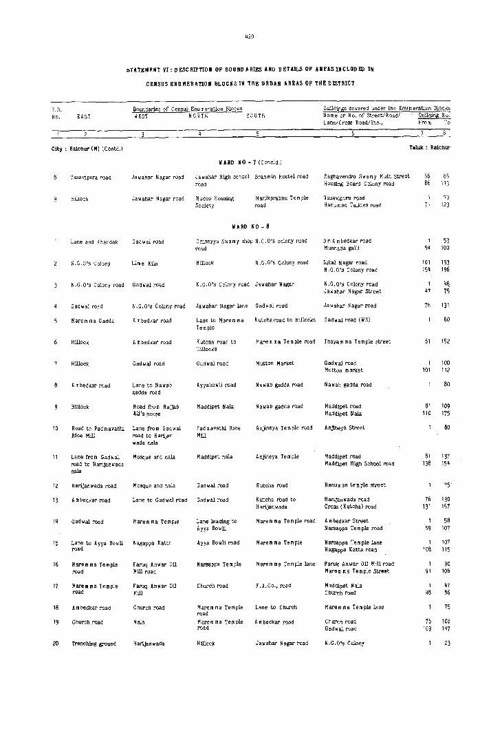
420
Ii-rATEHRNT VI: DESCRIPTIO" OF BOUNDARIES AND DETAILS OF AREAS INCLUD lID IN
CEIISUS ENUMERATION BLOCKS IN THE URBAN AREAS OF 'TilE DISTRICT
E,B. Boundaries of Census Enu m eration Blocks BulldirllE covered under the Enu In eration Blocks
No. EAST WEST NOR T H SOUTH Name or No. of Street/Road! Bull.din5 Nu. Lane/Cross Road/Etc., From To
City: RaictlU!' (M) (Contd,) Taluk : Raichur
., ARD NO - 7 (Coneld,)
Vasa vipura road Jawahar Nagar road Ja wahar High school Brahmin Hostel road Raghavendra Swamy Mutt Street 56 85 road Housing Board Colony road 86 113
Hillock Jawahar Nagar road Hudec Housing M anikprabnu Te m ple 'VaJavipura road 1 70 Society road Hanuman Talkies road 11 123
WARD No-8
Lane and K handak Gadwal road Chinnyya Swamy shop N,G.O's colony road Dr, Am bedkar road 1 53 road M unnada galli 5~ 100
W.G.O's Colony Lim e Kiln Hillock N ,G. 0 's Colony road lq bal N agar road 101 153 N.G.O's Colony road 154 196
N.G,O's Colony road Gadwal road N.G,O's Colony road Jawahar Nagar N.O.O's Colony road 1 116 Jawahar Nagar Street 47 75
Gadwal road N.G.D's Colony road Jawahar Nagar lane Gadwal road Ja wahar N agar road 16 131
Marem rna Gadda A m bedkar road Lane to Harem ma K uteha road to Hillocks Oadwal road (WS) 60 Temple
Hillock A rn bedkar road K utcha road to Marem ma Temple road Thayam rna Temple street 61 152 Hillocks
Hillock Gadwal road Gadwal road Mutton Market Gadwal road 1 100 Mutton market 101 112
Am bedkar road Lane to Nawab Ayyabowli road Nawab gadda road Nawab gadda road 80 gadda road
HillOck Road trom Rajjab Maddipet Nala Nawab gadda road M addipet road 81 109 Ali's house Maddipet Nala 110 175
10 Road to Pad m avathi Lane from Gad wal Pad m avathi Rice Anjineya Temple road Anjineya Street 80 Rice Mm road to H arij,m Mill
wada nala
11 Lane troll! Gadwal Mosque and nala M addipet nala Anjineya Temple M addipet road 81 137 road to Harijanwada M addipet High School road 138 154 nala
12 Harljanwada road Mosque and r,ala Gadwal road Kutcha road Hanuman temple street 15
13 A rn bedkar road Lane to Gadwal road Gadwal road Kutch. road to Har:ijan wada road 76 130 Harijanwada Cross (K utcha) road 131 157
14 Gadwal road Marem rna Temple Lane leading to Mare rn rna Te m ple road A rn bed~ar Street 1 58 Ayya Bowli Narsappa Temple road 59 107
15 Lane to Ayya Bowli Nagappa Kattr. Ayya Bowli road Marem rna Temple Narsappa Temple lane 1 107 road N agappa K atta road 108 115
16 Marem rna Temple Faruq Anwar Oil Narsappa Temple Marem rna Temple lane Faruk Anwar Oil Mill road 1 90 road Mill road Marem ma Temple Street 91 106
11 Maremma Temple Faruq Anwar Oil Church road F.A.Co., road Maddipet Nala 1 41 road Mill Church road 48 86
18 A m bedkar road Church road Maremma Temple Lane to Church Harem lila Te rn ple lane 75 road
19 Church road Nala Marem rna Temple A m bedkar road Church road 76 108 road Gadwal road 109 147
20 Trenching ground Harljanwada Hillock Jawahar Nagar read N,G.O's Colony 23
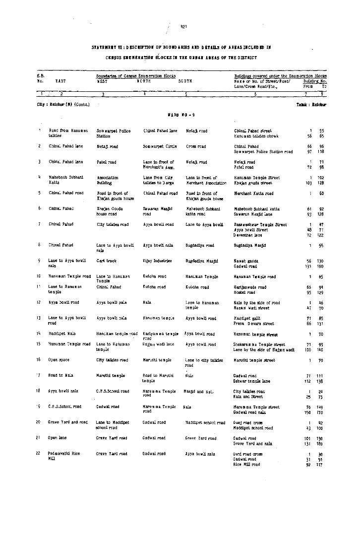
421
SUTBMBlT VI: 0 ESCmnOI or'BOUILD ARIES UD DETllLS or nus I1CLUD I!Il III
I
CEiSUS ElOMERATiOI BLOClS III THE URBn ARUS or THI! DlSTRICT
E.B. Boundaries of Cellflus Enumeration Blocks Bu1ld1ngs covered under the Enum eration Blocks No. EAST WEST NORTH SOUTH Name or No. of Street/Road/ BuUdir$ No.
Lane/Cross Road/Ete., From To
City: Raiclur (M) (Contd.) TaJuk : laich ...
liARD 110-9
Road Il'om Hanuman Som warpet Police C hJnal P ahad lane Netajl road C hJnal P ahad street 1 55 talki.es Station Hanuman talki.es chowk 56 65
C hJnal P abad lane NetaJI. road Som warpet Cll'cle Cross road C hJnal P ahad 66 96 Som warpet Police Station road 97 118
ChJnal Pabad lane Patel road Lane in !ront of Netajl road Netajl road 1 71 Merchant's AS3l. Patel road 72 98
Maheboob Subhani Association Lane !rom City Lane in front of Hanuman Temple Stl'eet 1 102 Katta BuUding talkies to D arsa Merchant Association K haJan g~uda street 103 128
C hJnal P ab8d road Road :In !ront of C hJnal P ahad road Road :In !ront of Merchant Katta road 00 K haJan gouda house KhaJan gouda house
Chlnal Pabad KhaJan Gouda Sa w aran Masjl.d Mabeboob Subhani Mabeboob Subhani katta 61 92 house road road katta road Sa w aran H asjld lane 93 128
C hinal P ahad City talki.es road Ayya bowli road Lane to Ayya bowli Buueshwar Temple Street 1 47 Ayya bowll Street 48 11 D evasthan lane 72 122
ChJnal Pahad Lane to Ayya bowli Ayya bowli nala Bugdadiya road Bugdadiya M asJid 55 nala
Lane to Ayya bowli Cart traok Vijay Industries Sugdadiya H aajId Nawab gadda 56 130 nala Gadwal road 131 160
10 Hanllman Temple road Lane to Hanuman Kutcha road Hanuman Temple Hanuman Temple road 65 Temple
11 Lane to H anu II an Chlnal Pahad Kutcha road KuLcha road Harljanwada road 66 94 temple Hostel road 95 129
12 Ayya bowll road Ayya bowl1 nw Nala Lane to Hanuman Nala by the side of road 1 46 tem ple Hazam wadi street 47 70
13 Lane to Ayya bowll Ayya bowli nala Aanuman temple Ayya bowli road Maddipet galli 71 85 road Prana 0 evara street 86 131
14 Maddipet N ala Hanuman temple road Kariyam ma temple road
Ayya bowli road Hanuman temple street 70
15 Hanuman Temple road Lane to Hanuman Hajjar,l wadi lane Ayya bo w li road ShekarUl lila Tuple street 71 99 temple Lane by the side of Hajjam wadi 100 140
16 Open space City talkies road M aruthi te m ple Lane to city talkies H aruthi te m ple street 70 road
17 Road to Nala H aruthi te III ple Road to Haruthi Nal2 Ga4wal road 71 111 temple Eshwar temple lane 112 138
18 Ayya bowli nala C.P .S.School road Harem lIa Temple M asj!.d and N all. City talkies road 1 24 road N ala and Street 25 75
19 C.P .S.School road Gadwal road Harem ma Temple Nala Marem ma Temple street 76 149 road Gad wal road nala 150 170
20 Grave Yard and road Lane to Hadd1pet Gadwal road M addipet school road G unj road cross 1 42 school road M addipet school road 43 100
21 Open lane Grave Yard road Gadwalroad Grave Yard road Gadwal road 101 130 Grave Yard and nala 131 189
22 Pad mavathi Rioe Grave Yard road Gadwal road Ayya bowli nala Guni road cross 1 30 Mill Gadwal road 31 91
Rice Hill road 92 111

422
SUTJl:MENT VI:DISCRlPnO. OF BOO.DUlIS UD DET.lll.S OF ARI!lS III CLOD Kll III
CENSUS lI:BoMERlnOI BLOCJ[S lH THE URBAN AREAS OF TilE DISTRICT
E.B. Boundaries of Census Enumeration Blocks BulJ.dl.ngs covered under the Enumerat.i.on Blocks
No. EAST WEST NORTH ~UTH Name or No. of Street/Roadl BUildinS No. Lane/Cross Road/Etc., From To
2 4 5 8
C:it,. : Rajchur (M) (Contd.) Taluk : Raidll"
WARD 10 - 9 (ConcId.)
23 Hillock Padmavathi Rice Gadwal road Ayya bOI/Ii road Mallikarjun Rice Mill road 1 58 Mill Peersab Stl'eet 59 81
Vasa vi Ind U5trlal Road 82 119 Laxman Swamy Street 120 150
24 Fields Fields Fields and Vithal- Gadwal road Vithaldas Te m ple Stl'eet and 105 das Temple road Cross roael
25 Link road Hanuman Temple road Gadwal road Hanuman Temple Gadwal roaa 106 136 Hanuman Temple Street 137 204
26 Church I'oad Ayya bowIi nala H arljan wada Church cross road Ayya bowIi nala 1 17 Church road 18 65
27 Church road Harljan wada Church cross road Gadwal road Bhajan Mandali street 66 90 Gadwal road 91 131
28 Lane joining Gad wal City talkies road Laxmidevi temple Harljan wada road Narsappa Temple Street 1 36 road road Mahalaxmi Street 37 108
29 Lane to Lax midevi Eshwar Temple road Lane from Harljan Laxmidevi Temple Munnarwadi (liS) 1 35 temple wada to Eshwar Road Munnarwadi (SS) 36 107
temple
30 Ishwar Temple road City talkies road Link road to City Laxmidevi Temple Shivalinga Temple 1 ijO
talkies road road Bridge road 41 56 Mahalaxmi Temple road 57 97
31 Link road N ala and lane Gadwal road City talkies road City talkies cross road 1 19 Link road 20 57 Thayam ma Temple lane 58 104 C anal and lane 105 119
32 Field and Anjineya R cad to fields N eerbhavi kunta Gadwal road Gadwal road 1 33 tern pIe Hanuman temple lane 34 58
33 Road and fields Gunj road N eerbhavi tank City talkies road City talkies lane 1 49 N argadda Math 50 80
WARD 110 - 10
City talkies road Lane by the side Eastern road City talkies road City talkies Circle 1 30 of R.D.D .C,Bank Kumbar wadi road - 31 86
Central Library read 87 111 R.D.D .C.Bank road 112 129
2 Lane behind City Y er m arus road ~amakatta gudi road City talkies road Cross te m ple road 1 28 talkies Yer:narus road 29 78
Kamakatta road 79 129
City talkies road H yderabad road Hanuman Temple Street to Chowdam ma H yders bad road '_1 31 road Temple Mahadev Swamy lane 32 80
4 City talkies road K a m a1<atta road Kamakatta road City Talkies chowk Chowdam ma tem ple street &1 106 road City Talkies road 107 132
Lane to G Unj road Gunj road G unj road cross Kamakatta temple Gunj road 1 64 Bassan bowIi road 65 105 Munnar wadi 106 119
5 Hanuman templ. road Hyderabad road Baba bowli road Indian bank road Indian bank road & cross roads 70
Way to Bassan bo II li Hafluman temple road Baba bowIi road Road to Bella m Hanumanthanna street 71 96 Gundappa house Bassan bowIi way 97 139
8 Way to Bassan bowll. Road Manuman Temple Saba bowli road Road to Bella m a Bellam Gundappa Stl'eet and 66 to Bassan bowIi G undappa house Bassan bowIi way

423
/ I
STATEMENT V!:DESCRIPTION OF BOUNDARII!S AND OETAn..S OF .tREASINCLUDED IN
CENSUS ENUMERATION BLOCKSIN THB URBAN AREAS OF THE DISTRICT
E.E. Boundaries of Census Enu m eration Blocks Buildil>ss covered under the Enumeration Illocks No. EAST WEST NORTH SO UTH Name or No. of Street/Road/ Buildil>B ii o.
Lane/era$! Road/Etc., ~rom To
2
Clty : Raichur (M) (Contd.) Taluk : Raichur
liARD 110 - 10 (Concld.)
Gansanagar !lag.nna's Way to Bassan bowli Bassan bawli Way to Ganga Naganna's Bassan bowli road 67 132 house road house
10 City talkie! road Way to Bassan bowli Shiva Nagappa Rice Way to City talkies City talkies lane 1 19 Mill road Adoni Veerupakshappa Street 20 65
11 City talki~ road Way to Bassan bowli City talkies cross Way to Laxmam ma City talkies lane 66 72 road temple o bobi galli 73 129
12 City talkies road Kamakatti gudi Link road to City City talkies Kamakatta gudi lane 1 55 tal)<i.es road City talkies lane 56 68
Khasi bowli 69 95 A shurkhana lane 96 116
WARD NO -11
State -Bank road Lingsugur road Lingsugur road G aonthana and fort Satbkacheri road 1 10 N eelakant road 11 36 Gandhi chowk 37 45 S.B.H.Road 46 91 Mahaveer Chowk 92 100
2 Road in front of State lIank road Lingsugur road G aonthana and fort Lahar wadi 1 50 MpL Library C.C.Road 51 111
Municipal Library roao 112 148
Cloth Bazar road Hamdard High Link road from Teen K handil to Jain Math road 5 School road H arillar road to Kate darwaza Mahila Jain math lane 21
Gaonthana Mahatm a Gandhi road 22 70 Osmaniya Market road 71 125
Cloth Bazar road M.G.R~ad Gaonthana road Kirana Bazar road Bhangi. kunta 1 5 Netaji. road 6 33 Cloth Bazar 34 88 Bbangi. Kunta 89 113
Bhangi. K unta road M.G.Road Yermarus Cbowrasta Kirana Bazar road G nalthana lane 1 8 Barillar road 9 60 Malleshwar chowk 61 87 B.S. R ao Street 88 147
C. P .S.School road Bhangi. K unta road Municipal Latrine Bhangi K unta road Bhangi kunta road 1 30 C.P .S.School cross road 31 55
Pinjarwadi Jane Bhangi. K unta road City talkies road Municipal Latrine City talkies road 56 80 Chowrastha road 81 141
Adinarayana Temple Bhangi. kunta H ala City talkies road A dinarayana T e m ple City talkies III ain road 1 29 road Adinarayana temrle lane 30 70
D ineshayya Bandary AdiI>arayana Temple City talkies road Actinarayana Te III pIe Yaseen K han street 71 116 road road Veershiva Boarding lane 117 136
10 Road to Pat-l road Gandinni Channappa City talkies road Lane by the side of Bhangi kunta 1 39 house Bo m bay Oil Depot Pinjar wadi 40 102
City talkies chow k 103 138
11 D ala! w adi road AdiI>arayana Temple Road by the side M aharastra Bank Corporation Bank road 1 30 road of Bombay Oil Depot Sharoof Bazar road 31 76
Laxmi Venkateshwar Temple lane 77 88 M aharastra Bani< road 89 112
12 D ala!wadi road Actinarayana Te m pIe Road A dil>arayana Kirana bazar road Pinjar wadi lane 1 19 road te III pIe to M aha- N eelkanth te m pIe lane 20 28
rastra Bank Ravindranath Type Institute lane 29 41 Shankar Bowli 42 75 M aharastra Bank road 76 110

424
STATEMENT VI: DESCRIPTION OF BOUNDARIES AND DETAILS OF AREAS INCLUD ED IN
CENSUS ENUMERATION BLOCKS IN THE URBAN AREAS OF THE DISTRICT
E,B. Boundaries of Census Enu m eration Blocks Buildinss covered under the Enu m eration Blocks No. EAST WEST NORTH SOUTH Name or No, of Street/Roadl Building No,
Lane/Cross Road/Etc., From To
City: Raichur (M) (Cantd.) Taluk : Raichur
WARD NO - 1l (Conold,)
13 Patel road & lane D alalwadi Roaa Road Kalalwadi to Lane to ,;ity Talkies City Talkies road 18
Patel road road N etajl road and street 19 42
Kho mi Madrasa lane 43 87
14 Patel ro;:\d lane City talkies lone Sarkhil Masjld road Hanuman Temple lane Sarkhil M asjld road 1 65 H anu m an Te m pIe lane 66 111 Shankar Lingeshwar lane 112 138
15 Madina Hotel circle Patel road Sanga mesh w ar Press Shroff Bazar road Patel roadd 1 38 City talkies cross road 39 44 M ysore cafe lane 45 62 Shroff Bazar 63 80 N etajl road and shroff Bazar 81 143
WARD NO - 12
C.C,Road to Gunj Hyderabad road Kalyan Mantap road City talkies road Hanu m an gJdi road 27 Hyderabad road 28 68 R aJendra gunj 69 140
Neerbhavi Kunta C.C.Road to Gunj Gunj Compound City talkies road Bassan bowli 141 152 tank A,P,M,C.Road 153 214
G unj road 215 231
Cart track road Gunj read Gadwal road N eerbha vikunta road H Wiga m m a gudi street 1 82 G unj road 83 99 Cross road 100 130
Cart track road Gunj road Gadwal road N eerbhavikunta tank Talab lane 131 167 C art track road 168 265
Jalalpahad Cart track Gunj compound N eerbhavi kunta tank Gaawal road 266 309 Lst cross C art road 310 390
Jalalpahad G unj co m pound Cart track Neerbhavi kunta tank Und cross C art road 391 474 Jalalpahad road 475 510 Gadwal road 511 534
A.P.M.C, Compound Hyderabad road Yerm arus road clYcle K alyan M antap H yderabad road 1 28 Kalyan Mantap road 29 57 Bassan bowli G unj road 58 31
A.P.M.C, Compound Hyderabad read A,P,M,C.Office 50 Feet road beh1J1d Godown road 1 38 G ado. n K utcha road G unj 39 93
A.P. M, C.Com pound 94 118
A.P.M.C,Compound A.P,M.C.Compound 50 Feet Godown road A.P.M.C.Omce Rajendra Gunj 1 31 Market Yard and Gunj 32 78
10 A.P. M.C.Com pound A.P, M.C .Co mpound Watch man's Quarters 50 I G odo w n road A.?, M. C. Com pound 1 35 of HM C Thayanna Gudt lane .,36 56
11 H yderabad road Hillock Road behind Muni- G unj road Police Quarters road and 130 cipal Quarters Chander Banda road
12 Chandra Banda road Police Quarters road L.B.S.Nagar road Cress road Municipal C lIacdra Banda road 131 204 Quarters
13 Chandra Banda road P alice Quarters road L.B.S.Nagar road Chandra Banda road P olic e Quarters 125
14 Fields L,B.S.Nagar road Chandra Banda road Police Quarters Huts area opposite to 126 310 District Civil Hospital
15 Fields Civil Hospital Fields Chandra Banda road Huta behind Civil Hospital 311 403 chandra Banda road 404 492
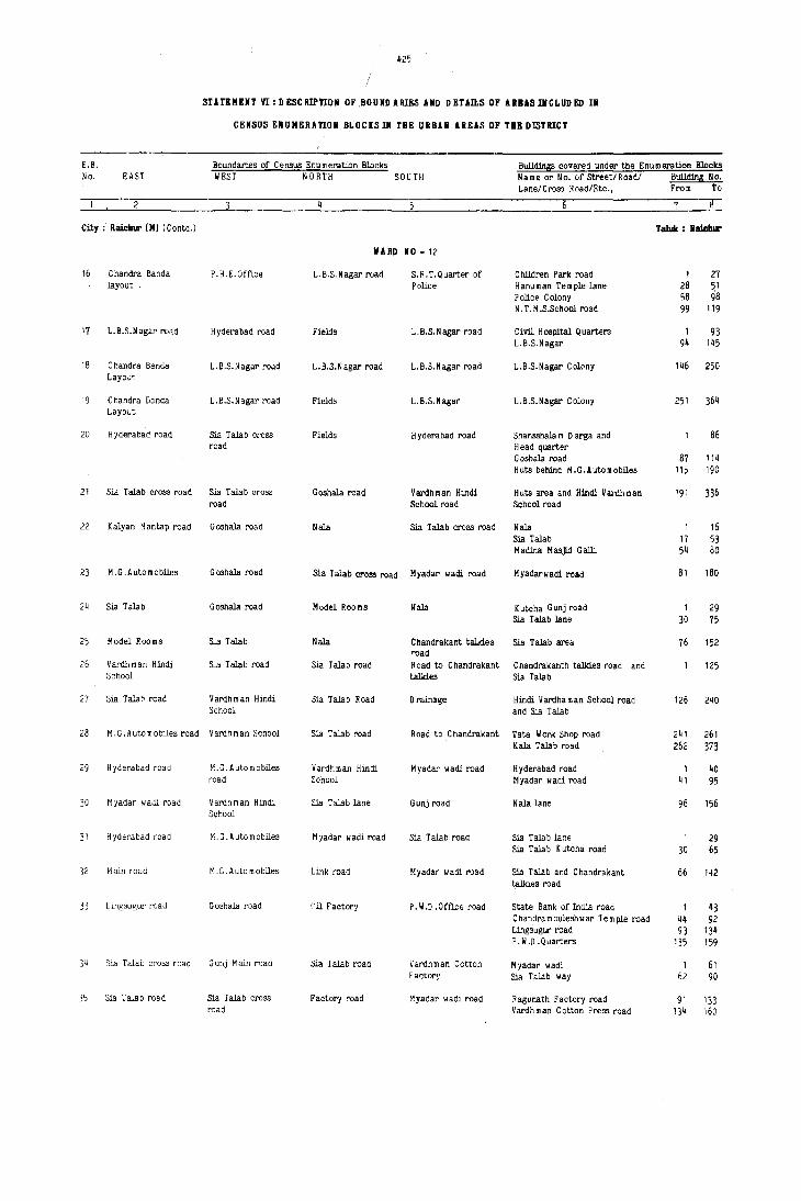
~25
STlTEMENT VI:IlESCRIP'l'ION OF,BOUNDAllIES AND DETAn.S OF ARUSI.CLUDED II
CENSUS E.UMERATIOII BLOCISIII THE URBAN AREAS OF THE DISTRICT
E,B. Boundaries of Census Enumeration Blocks BuildinS!!! covered under the Enum eration Blocks No. EAST WEST NORTH SOUTH Name or No. of Street/Road/ BuiJ.din1! No.
Lane/Cro"" Road/Etc., From To
2 -r City; Ralcbur (M) (Conld.) Taluk : Balcblll'
liARD 110 - 12
16 Chandra Banda P.H.E.Offlce L. B.S. N agar road S.R.T.Quarter of Children Park road 1 27 layout Police Hanuman Temple lane 28 51
Police Colony 58 98 N . T. M .S.School road 99 119
17 L.B.S.Nagar road Hyde"abad road Fields L.B.S.Nagar road Civil Hospital Quarters 1 93 L.B.S.Nagar 9~ 1~5
18 Chandra Banda L.E.S.Nagar road L.B.S.N agar road L.E.S.Nagar road L.E.S.Nagar Colony 146 250 Layo",t.
19 Chandra Banda L.E.S. N agar road Fields L.E.S.Nagar L.E.S.Nagar Colony 251 364 Layout
20 Hyderabad road 5ia Talab cross Fields H yderabad road Shansshala m 0 arga and 86 road Head quarter
G oshala road 87 11~
Huts behind H.G.Automobiles 115 190
21 Sia Talab cross road Sia Talab cross G oshala road Vardhman Hindi Huts area and Hindi V ardh m an '91 336 road School road School road
22 Kalyan Mantap road Goshala road Nala Sia Talab cross road Nala 1 16 Sia Talab 17 53 Madina Masji.d Galli 54 80
23 M.G. Automobiles G oshala road Sia Talab cross road M yadar wadi road H yadarw adi road 81 180
24 Sia Talab Goshala road Model Rooms Nala K utcha G unj road 1 29 Sia Talab lane 30 75
25 Model Rooms Sia Talab Nala Chandrakant talkies Sia Talab are~ 76 152 road
26 Vardhman Hindi Sia Talab road 5ia Talab road Road to Chandrakant Chandrakanth talkies road and 125 School talkies Sia Talab
27 Sia Talah road Vardhman Hindi Sia Talab Road o rainage Hindi V ardha m an School road 126 240 School and Sia Talab
28 M. G. A uta mobiles road Vardhman School Sia Talab road Road to Chandrakant Tata Work Shop road 2~ 1 261 Kala Talab road 262 373
29 H yderabad road M.G.Automobiles Vardhman Hindi M yadar wadi road H yderabad road 1 40 road School Myadar wadi road 41 95
30 Myadar wadi road V ardh m an Hindi Sia Talab lane Gunj road Nala lane 96 156 School
31 H yderabad road M.G.Automobiles M yadar wadi road Sia Talab road Sia Talab lane 1 29 Sia Talab K utcha road 30 65
32 Main road M.G.Automobiles Link road M yadar wadi road Sia Talab and Chandrakanl 66 142 talkies road
33 Lingsugur road G oshala road 'Iil Factory P. W.D .Off'i.ce road State Bank of India road 1 43 Chanjramouleshwar Temple road 44 92 Lingsugur road 93 134 P . W .0 . Quarters 135 159
34 Sia Talab cross road G unj Main Mad Sia Talab road Vardhman Cotton Myadar wadi 1 61 Factory Sia Talab way 62 90
35 Sia Talab road Sia Tala b cross Factory road M yadar wadi road Ragunath Factory road 91 133 road Vardhman Cotton PI"t'SS road 134 160

426
STATEMENT VI: D BSCmnOI Of BOOID ARIRS AND D ETAn.S OF AREAS INCLUD ED IN
cnsos ENUMEUnOI BLOCKS III THE URBAN AREAS Of THE DISTRICT
E.B. No. EAST
Boundaries of Census Enu m eration Blocks WEST NORTH SOUTH
City: RalcllUr(M) (concld.)
36
37
38
39
Goshala road and P. W.O .Office
Gunj road
Gunj road Railway track
Arab Mahalia Iddgah Railway track
Arat Mohalia Road Iddgah road
TOlin: Sindlmur (M)
2
5
6
Raichu!'-G anga\tlati road
Road thlm Nala to Patelwadi lane
Kasabwadi
K asab wadi
Road leading to Gowdara oni Halla
Road thlm 0 arga to Iswar Temple road Chavadi Hanuman Temple
Kasabwadi
Kalmata road and part of road leading to Halla
Road to Badibase
Rama Temple road
liARD NO - 12 (Concld.)
Fields LiIlgsugur road
Arabwadi road Gunj road
M anchalapur road Lingsugur road
Manchalapur road LiIlgsugur road
II ARD NO - 1
Nala
Nala
Darga and well
MUnicipal road at o arga
Main Bazar
Lane to Patel w adi
Chavadi H anu m an Temple
Main bazar
Kandinath & Katibase Main road
Badibase m wada Main road
Ramalah's Bailu (Vacant space)
Road to Ram Mandie Police Gowdar oni Main road
8
9
10
11
12
13
14
15
16
Road to Ram Mandir
Lane connecting Ram Mandir and Jain Mandir
Lane connecting Ra ~ Mandir road and Jain Mandir
o urgam ma Temple and office oni (road)
Office oni road
BrahmiIl road
Bawle Nawaz Darga
Bawle Nawaz 0 arga
Badi base
o evam rna Temple Kuchha road
Devam Cia Temple
road
Sitaram Saw Mill road
Road to Nala
Road to Nala
Upparwadi
Venkatara mana Temple
Venkataramana Temple Road leading to road Bazar
II ARD NO - 2
U ppar ani
Devamma Temple road
Ram Mandir and Aswathanarayan Temple
Way to Badibase
Way to Badibase
Nala
Main bazar
Main Bazar
Road thlm D eva III rna Te m ple and M etigowda oni
MaiIl road
Badi base
Kacherigalli
II ARD NO - 3
A pproach road to Upparwadi
A pproach road to Upparwadi
Lane to Ram Mandir
Bazar road
Metegowda's Garden BrahmiIl Street
Buildings covered under the Enumeration Blocks Name or No. of Street/Road! Building No. LanelCross Road/Etc., From To
Taluk : RaichiD"
Lingsugur road Sathkacheri road Sathkacheri A m baji Rice Mill road
Tank and 0 arga Street
Arabwadi Masjid road Arabwadi Manchalapur road
Padela Oil Mill and Railway lire
1 31 32 102
103 143 144 165
166 263
1 39 40 130
131 254
Taluk : Sindhnur
R.G.Road & Main Bazar road
Northern side of Patelwadi lane
Eastern side of G owdara oni
Main bazar road and eastern side of Ish war Temple
Attarwadi and Gowdar oni road
BrahmiIl's oni, Tahsil Office road and K al m ata road
Attarwadi and POlice Gowdar ani
1 185
186 208
1 124
1 147
145
146 187
71
BrahmiIl's ani and Ram Mandir road 95
Brah miIl Street and D eva m m a 134 Temple road
OevammaTempleroad,Ram 134199 Mandir road
Badibase and Office oni i30
Kache~alli 131 210
Kacherigalli (NS) 66
Ram Mandir road, Upparwadi Darga road
Khandi Mutt oni
Venkataramana Temple road, Gurusiddappa Mutt road
1 127
128142/3
1 109

,'121
/ !
STUEHEIT Yl:DESCRIPnOIl OF BOD liD ARIES AIID DETAILS OF ABBASINeLUDED I.
CElISUS EHUHERAnON Bl,(lCISIN THE ORBAN AREAS OF T8E DISTRICT
E.B. Boundaries of Census Enu m eration Blocks BuJldings covered under the Enu m eration ·Blocka
No. EAST WE"T NORTH SOUTH Name or No. of Street/Road/ Buil.dlnS No. Lane/CroS! Road/Etc., From To
2 8
Town: Sindhllur (H) (Contd.) TaIuJc : Slndlmur
WAIID 10 -_
17 R.G.Road M urlicipal road Main Bazar Way to R.G.Road Badi base road, R.G. Road and 125 i~ Cr0S3 roads
18 R.G.Road Metal road Kati base Road leading to Main Bazar road 149 R.G.Road
19 R.G.Road Metal road Kati base Road by the side of College road (ES) 150 238 Govt. College
20 Road by the side of Kati base Main Bazar road Road to Kati base Southern side of Bazar road 143
Masjld
21 Kati base Metal road Main Bazar Kati base Southern side (f Sri Veera- 156 bhadreshwar Temple and Bazar road
IIUD 10 - 5
22 Metal road D hanagarwadi road Main Bazar M unicipallar>e near D hanagarwadi southern side of 112 Godowns Main Bazar
23 D hanagarwadi D hanagarwadi D hanagarwadi Street near o hanagarwad! south side road 113 226 Latrines to Bus stand
24 R aicl,ur-Sindhnur Bus Stand road Road to Bus Stand K ushtag! road Bus Stand road, Raichur road 227 338 road near godowns and K ushtag! road
25 K utcha road fi'o m Road by the side of Old Bazar road R cad to Bus Stand Southern side of Old Bazar road 136 Old Bazar road to Veerabhadra Temple Bus Stand road
2& Cart read D hanagarw ad! Rice Mill road Road to Bus Stand Main Bazar road cart road 102 and D arg~ road
27 Heggapur oni Cart road Rice Mill road Main Bazar road o arga road and H eggapur road 103 186
28 Road to Bus Stand Revaiah Swamy house K ushtagi road Way to Bus Stand Southern side of Iofegharaj 169 road Shet Mill road
29 Field S.B. Talkies road S.B. Talkies road Bus Stand road Eastern side of S. B. Talkies road 170 318 and Southern side of Bus Stand road
liARD NO - 6
30 Way to Halla Raichur-Bangalore Nala and way to P & T 0 t'fice road Eranna Te m ple area and opposite 109 ro.d Fort to Cotton Ginning Factory
31 Open area R.G.Road Nala Old Market area P & T Office road, Municipal 110 334 Office road and eastern side of Cotton Ginning Factory road
32 Way to Halla R.G.Road Road in front of Sukalpet road Mar~et area, R.G.Road, Masjld 191 Vegetable Market road and Sukalpeth road
33 Veterinary Hospital R.C.Road Sukalpeth road Road by the side of Raichur-Gangavati road, Sukalpeth 198 48& and A m arapur road T ahsll 0 ffiee road and R.G.H.E.S. area
34 A marapur road R.G.Road P. W.O .Quarters Patta lands Western side of A m arapur road 114
35 A marapur road R.G.Rnad Municipal Plota Patta lands Western side of A m arapur road 115 200 Colony
36 Municipal Plots Road by the side K ushtag! road Petta lands Kushtag! road, Gangavati road 153 road of Am arapur and Hatti road
31 Hunicipal plots Canal K ushtag! road Patta lands Housing Board Quarters and 154 251 H.tti road
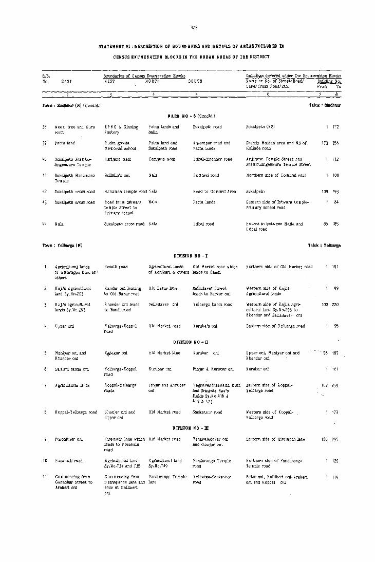
428
S'UTEHElIT Vl:DEscHII'nON OF BOUNDARIES Utl DETAJLS OF lRl!tISIIiCLUDED IN
CENSUS ENUMERAnON BLOCI(SIN THE URBAN AREAS OF THE DlSTRICT
E.B. No. EAST
TOlin: Sin4hnur (M) (C oncld.)
38 Neem tree and Guru i~;utt
39 Patta land
40 Sukalpeth Sha m bu-lingeswara Te m ple
'11 Sukalpeth H anu mana Tem pie
42 Sukalpeth cross road
43 Sukalpeth cross road
44 Nala
Talln : YeI.bar8a (M)
Boundaries of Census Bou m eration Blocks WEST NORTH SOuTH
II ARD NO - 6 (Concid.)
AP M C & Ginning Patta landS and Sukalpeth road Factory halla
Rudra gowda htta land and A m araplJr road and Memorial school Sukalpeth road Patta lands
Harijana wadi Harijana wadi Udbel-Sindhnur road
Bollalla's ani Nala G 0:11 arsi road
Hanuman temple road Nala Road to Gomarsi Area
Road from Ishwara Nala Patta lands te m pie Stl'eet to Prim ary sohool
Sukalpeth cross road Nala Udbal road
DI\'lS[OIi NO - I
Agricultural lands H osalli I'oad Agricultural lands Old I~arket road which of A marappa Kuri ano of Adhikari & others leadS to Bandi others
Raji.'s AgricuUural Kander oni leading Old Bazar lane Selladave!' Street land Sy.No.293 to Old Bazar road leads to Barker ani
K aji's agricultural K hander oni leads Selledaver ani Yelbarga bandi road lands Sy.No.293 to Bandi road
Uppal' ani Yelbarga-Koppal Old Market toad Kuruba's oni rQad
DIVrSWN NO-II
Maniyar ani and Khander ani
K,tagal' ani Old Market lane Kurubar ani
Lam ani tanda ani Yelbarga-Koppal Kurubar ani Pinjar & Kurubar ani road
Agricultural lands K oppal-Y elbarga Pinjar and Kurubli" Raghavendraswami Mutt !'(lads ani and Srinivas Rao's
fields Sy.No.416 & 419 & 423
K oppal-Y elbarga road G hanjer ani and Old Market !'(lad Sankanoor road U ppar ani
DIVISION NO-ill
Purohither ani Hlremath lane which Old Market road BenaKaledavar ani leads to H osahalli and GoudaI' oni road
10 H osahalli road Agricultural land Agricultural land fanduranga Te III pie Sy.No.734 and 735 Sy.No.749 road
11 Com mencing from Com mencing from Panduranga Temple Yelbarga-Sankanoor Ganachar Street to o eshapande lane and lane rO,d Arakeri oni ends at H allikeri
ani
BuiliJing!! covel'~d under the Enumeration Blocks Name or No. of Street/Roadl Building No. Lire/Gross Road/Etc., From To
8
TaJUk , Sindhnlll'
Sukalpeth (N 5) 1 172
Shandy M aidan area and N S of 173 356 H allada road
Anjaneya Temple Street and 1 132 Shambulingeswara Temple street
Northern side of Gomarsi road 1 108
sukalpeth 109 1Q3
Eastern side of Ish wan te m ple- 84 Primary scheol road
Houses in between Halla and 85 185 Udbal road
Taluk : Yelbarga
Northern sid< of Old Market road 1 181
Western side of Kaji.'s 99 Agricultural lands
Western side of Kaji.'s agri- 100 220 cultural land Sy.No.293 to Khander and SelJadaver oni
Eastern side of Yelbarga road 95
U ppar ani, M aniyar ani and "_ 96 187 Khandar ani
Kurubar ani 1 101
Eastern side of K oppal- 102 259 Yelbarga road
Western side of K oppal- 179 Yelbarga road
Eastern side of Hire math lane 180 295
Northern side of Panduranga 1 129 Te rn pie road
BeJar ani, H allikeri. ani: Arakeri. 1 119 ani and Koppal ani
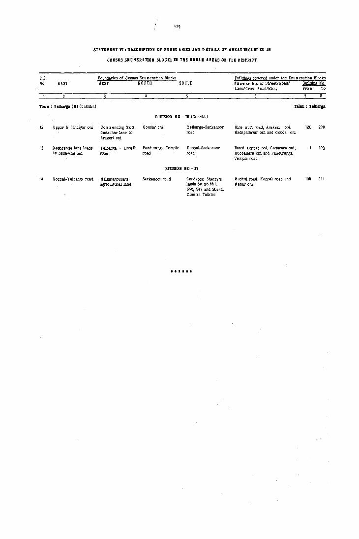
£.B. No. EAST
2
429
STATEMENT VI: DESCRIPTION OF BOUND ARIES AND DnAlLS OF AREAS I1CLUD ED III
CENSUS UUMERATION BLOCtS III THE URBU AREAS OF THE DISTRICT
Boundaries of Census Enumeration Blocks Buildings covered under the Enu m eration Blocks WEST NORTH SO[;.'H Name or No. of Street/Road/ Bullding No.
Lane/Cross Road/Etc., From To
6 8
Town: Yelbarga (M) (Conclct.) Taluk : I eIbarga
D lVlStO II NO - m (C oncld.)
12 U ppar & G indiyar ani Com mencing froID Gouda!'· oni Yelbarga-Sankanoor Hire mutt road, Arakeri opi, 120 239 Ganachar lane to road H adapada var oni and G oudal' oni Arakeri oni
13 D esiJpande lane leads Yelbarga - Hosalli Panduranl;a Te m ple Koppal-Sankanoor Banni Koppact oni, Gadarara ani, 103 to Sada"kan ani road road road Hubballera oni and Panduranga
TeID ple road
DIVISION NO-Ii
14 K oppal-Y elbarga road M alJanagouda's Sankanoor I'Odd Gundappa Shetty's Mudhol road, Koppal road and 104 211 agrlculturalland landa Sy.No.6f>1, Madar oni
659, 547 and Shakti Cine m a Talkies
••••••

430
STATEMEn m:!.lST OF VILLAGES ACCORDING TO THE PRQPORTIOR OF SCHEDULED CASTES AID
SCHBD ULBD TRmES TO THB TOTAL POPULATION BY URGES
(Excludes villages with no Scheduled CasteS/Scheduled tribes Population)
Range of Scheduled Castes/ Scheduled L.C. Name of the village L.C. Name of the village L,C. N a III e of the village L.C. Name of thp village Tribes No. No. No. No. Population (Percentages)
6
TALUI( : DEY AD URGA
A ~ SCHEll ULED CASTES
0~5 7 Mydargol 18 Gopendeverhalli 47 Wagadambli 73 Gagal 90 Piligund 97 M allinaikandoddi 101 C hintalkunta 126 Jutmardi
129 Shavantgal 132 Adkalgod 133 Bhumangund 134 Mallapur 156 Mukanhal 168 Dati 179 Naglapur 183 Hos~Siddapur
6-10 8 Karkihalli 13 Kurkihalli 42 Karegud 43 tlilvanji 44 Anjal 93 Honkatm alli 95 Kothdoddi 99 C hikkaldoddi
116 Nagadinni 122 M'alledevergud 130 A kalkum pi 131 Anwar 137 Pandyani 148 Mednapur 155 Gajaldinni 160 D evatgal 161 Galag 162 Chadkalgudda 163 Madarkal 180 Bhogira m angund 185 Bunkal~oddi
11-15 D evad urga (R ural) Nagargund 3 Joladhadgi 6 Konchapli Paratpur 10 Hunur 16 Salkyapur 19 Nagarhal
21 Masarkal 48 Huvinhadgi 51 Maseedpur 55 Ramdurg 63 Kakargal 66 Haddinhal 67 Ingaladhal 76 Hireraiku m pi 82 Honnatagi 87 Hanchinhal 89 Arkera 94 Hemnur
100 Teggihal 108 H aljadaldinni 110 Buddinni 111 G ovindpalli 118 Yermarus 124 Nagoli 139 Jalhalli 1lI7 Ja m baldinni 150 Khardigud 152 Navalgud 154 Mandalgud 157 Mundargi 159 Katmalli 169 Sunnadkal 110 Huligud 181 Som an mardi
16-20 12 Kopper 20 Guntarhal 26 Ramanhal 30 Kardigudda 49 Gabbur 64 Sunkeshllarhal 65 Amrapur 69 Hirebudur 74 Gugal 77 Madarkal 91 M alka III dinni 109 Jaradbandi
113 Jagatkal 115 Tippaldinni 111 H eggaddinni 123 Agrahar 141 Lingadhalli 145 Bagur 165 Mudalgund 167 Wandli 172 K akkaldoddi 178 Gandhal 186 Veergot
21-30 5 Benkal 11 Arshangi 14 Yatgal 17 Chickbudur 22 Ch1ckhonkuni 23 Yermasal 27 Hemanhal 29 Kamdhal 35 Kotigud 36 Mansagal 45 Anchesugur 46 Gopalpur 52 Neelgal 53 Ganekal 54 Maladkal 56 Khardigud 68 Budinhal 70 Masihal 75 C hickraiku m pi 78 Apprahal 79 Baawantpur' 80 He'mnal 81 Bom manhal 83 Khanapur 84 Hirekudalgi 88 Shavantgera 102 Mustoor 104 Jinnapur
106 Hungunbad 101 Shivangi 119 H arka III dinni 120 Jagirjadaldinni 135 Mailapur 136 Benderganekal 143 Mudgot 146 Herundi 151 A mrapur 158 Ganajali 166 Palkanmardi 182 Bom manhalli 187 Chinchodi
31+ 4 D ondambli 15 Herur 24 Jerbandi 25 Sugarhal 28 Gundgurthi 31 D evergud 32 Sasvlgera 34 Miy~pur 37 K elginirabgera 40 Samudra 41 Venglapur 62 Aldharti 71 Matpalli 72 ltagi 86 KolIL" 92 Kardcna 98 Yeldoddi 103 Shakapur 105 Ge,iiibhavi 121 Rekalmardi
125 Bandegud 127 Kyadigera 128 Alkod 153 Suladgud 171 Mykaldoddi 173 Kamaldinni 174 Parapur
B - SCHBD ULEll TRmES
0-5 4 D ondambli 20 Gunjarhal 24 Jerbandi 36 Hansagal 48 Huvinhadgi 49 Gabbur 72 ltagi 92 KlIl'dona
125 Bandegud 141 Lingadhalli 148 Hednapur 186 Veergot
6-15 9 Paratpur 13 K urkihalli 51 Haseedpur 52 Neelgal 53 Ganekal 70 Masihal 74 Gugal 98 Yeldoddi
103 Shakapur 128 Alkod 159 Katmalli 166 P alkan m ardi 167 Wandli 171 Mykaldoddi 173 Kamaldinni 178 Gandhal 183 H os~Siddapur 187 Chinchodi
* Scheduled Tribe figure would appear to include high returns relatin!t:0 certain communities with nomer,clatures similar to those included in the list of Scheduled Tri s consequent on the removal of area restrictions.

431
STlTBIIENT m: LIST OF Vll.LAGES ACCORDING TO THE PROPORTION OF S{;HEO ULEO CASTES AND
SCHED ULED TRIBES TO THE TOTAL POPULATlOIi BY RANGES
(Excludes villages with no Scheduled Castes/Scheduled Tribes Population)
Range of SeiIeOuled Castes! Scheduled L.C. Nam e of the village L.C. N a m e of the village L.C. N a m e of the village L.C. H a me of the village
Tribes No. No. No. No.
Population (Percentages)
2
TALUK :,D EVAD URGA (Coneld.)
B - SCHEll ULEO TRIBES (Coneld.)
16-25 2 Nagargund 16 Salkyapur 17 Chickbudur 27 Hernanhal
28 Gundgurthi 100 Teggihal 102 Mustoor 117 H eggaddinni
122 M alledevergud 124 Nagoli 139 Jalhalli 153 Suladgud
163 Ma~arkal 172 K akkaldoddi
26-35 1 D evadurga (R ural) 29 Kamdhal 31 D evergud 37 K elginira bgera _7 Wagadam bli 76 Hireraiku m pi 89 Arkera 94 Hemnur
105 G ejjibhavi 108 H aljadaldinni 115 Tippaldinni lIb Nagadinni 121 R ekalmardi 147 Ja m baldinni 154 Mandalgud 158 Ganajali 164 D evergud 185 Bunkaldoddi 188 Yergudda
36-50 6 Konchapll 18 GopendeverhaJli 19 Nagarhal 25 Sugarha}
34 Miyapur 40 Samudra 93 H urJkatm alli 95 Kothdoddi 106 Hungunbad 120 Jagir Jadaldinni 127 Kyadigera 130 Akalkurnpi
131 Anwar 136 Benderganekal 137 Pandyan 157 Mundargi
161 Galag
51+ 7 Mydargol 8 Karkihalli 30 Kardigudda 44 Anjal 75 C hickraiku m pi 90 Piligund 91 Malkamdinni 91 Mallinaikandoddi
99 C hikkaldoddi 101 Chintalkunta 109 Jaradbandi 110 Buddinni
119 M arka m dinni 126 Jutmardi 132 Adkalgud 133 Bhumangund
134 Mallapur 135 Mailapur 138 Kachapur 152 Navalgud 160 D evatgal 165 Mudalgund 168 Ooti 169 Sunnadkal
170 H uligud 174 Parapur 176 Mudvaigaddi 177 Horahatti
179 Naglapur 180 Bhogira rn angund 181 Somanmardi 182 Born rnanhalli 184 Bassapur
TALUK : GANGAllAn
A - SC HED ULEO C1STE5
0-5 17 Han rn anhalli 46 Banderhal 49 Kyad (Khurd) 51 Malligwad ,6 Benkanhal 59 Bankapur 63 Obalbanda 65 Jalihuda 70 Naglapur 71 Hulihyder 72 Hosgudda 14 Guddadur 80 So m sagar 86 D evlapur 88 G ouripur 90 Layadhunsi 92 Adapur 96 D ankankal (K hurd) 101 Akal Kumpi 103 Mallap~r
104 K ardona 106 Bunhatti 108 U ddihal 110 Sankanhal 123 Gudur 128 Kottankal 134 Shalignoor 148 Achlapur
6-10 8 Singangund 29 Wadderhatti 31 Benkal (K alan) 34 Mukkum pa
35 Yem rnigudda 36 Agoll 43 Battarnarsapur 47 Kanakgiri 48 N eerloti 50 Kyad (Kalan) 54 Katapurkhalaa 58 Sulekal 62 Medinal (Khurd) 64 Ramdurg 76 Han manhal 77 Kanakapur 78 Bailaka m pur 79 Basrihal 84 H ulsanhatti 99 Wadki
105 Yattinhatti 107 Eachanhal 111 Karatgi 115 Yerdona 120 Tondihal 124 Mylapur 130 Jlenoor 135 Jamapur 143 Acharnarsapur 145 Hebbal 151 Betteerhanchnal 154 K esakkihanchnal 158 H osekera
11-15 12 A negundi 13 Basavndurg 26 D asanhal 30 Basapattana
33 Lingadhalli 37 Ha m pasdurg 38 Vithlapur 40 M alkan mardi 41 Kesarhatti 55 Kalkera 61 M edinal (K alan) 73 Godinal 75 Sirwar 87 Wadderkal (Khurd) 95 D ankankal (Kalan) 102 Katapur (U mll)
118 H ulkihal 126 P annapur 132 K akkargol 133 N andihalli 137 Mustur 142 Marll 153 Herur 157 Han wal
16-20 16 Anjanhalli 19 Tirmalapur 25 Venkatagiri 27 Arhal 42 Arlehalli 44 Udamkal 45 Gaddi 57 Thippanhal 67 M usla pur 81 Kannermadu 82 Parapur 112 Budugumpa

STATEMENT VII: LIST OF VILLAGES ACCORDING TO THE PROPORTION OF SCHEDULED CASTES AND
SCtfED ULED TRIBES TO THE TOTAL POPULATION BY RANGES
(Excludes villages with nO Scheduled Castes/Scheduled Tribes Population)
Ran68 of Scheduled Castes/ Scheduled L.C. N 1 me of the village L. C. "a rn e of the village L.C. N a m e of the village L.C. Name of the village Tribes No. Ne. No. No. Population (Percentages)
TALUK : GANGAVATI (Conoid.)
A -SCHEDULED C ASreS (C ondd.)
16-20 116 M arlanahal'i 117 Juratgi 121 Chellur 122 So manhal
(C oncld.) 125 Bevinhal 12'/ Siddapur 139 Singanhal 140 Gundur 146 Ayodhya 15G J anga m arkalgudi 152 Gonal
21-}0 2 Hosalli Nagarhalli 5 Vipra 11 Ramdurg 15 Ra rn pur 24 Mallapur 32 Benkal (K h'lrd) 69 Rampur 91 Nowh 97 Jeeralkalgudi 119 Hagedal 129 Eliganoor
131 Bennur 13B Bargur 141 Krishnapur 144 Srira m nagar 147 Jantkal (K hurd) 149 D ana pur 155 Guldal 156 Markumbi
31. 7 Sangapur 10 Krishnapur 14 C hickra m pur 18 Virpapur gaddi 20 Sanapur 21 RangaDur 66 Bomsagar 83 Ingaldal 85 Advibhavi 94 C hirchangudda 98 Jeeral 136 Kuntoji
B - SCHED ULED THIBES
0-5 Hosalli 7 Sangapur 8 Singangund 16 Anjanhalli 17 Ii an m anhalli 29 Wadderhatti 36 Agoll 42 Arhhalli 47 Kanakgiri 56 Benkanhal 58 Sulekal 65 Jalihuda 75 Sirwar 83 Ingaldal 84 Hulsanhatti 97 J eeralkalgudi
103 Mallapur lOB U ddihal 116 M arlan halli 127 Siddapur 135 Jamapur 136 K untoji 137 Mustur 138 Bargur 140 Gundur 142 Marh 144 Stira m nagar 145 fI ebbal 146 Ayodhya 147 Jantkal (K hurd) 150 Janga m arkalgudi 155 Guldal 156 Marku rn bi
6-15 Jantkal (K alan) 12 Anegundi 14 C hickra m pur 20 Sana pur 21 Rangapur 25 Venkatagiri 26 D asanhal 27 Arhal 30 Basapattana 31 Benkal (K alan) 41 Kesarhatti 43 Battarnarsapur 46 Banderhal 48 N eerloti 55 Kalkera 57 Thippanhal 63 Obalbanda 67 M uslapur 70 Naglapur 81 Kannermadu 85 Advibhavi 86 D evlapur 88 Gouripur 91 Nowh 92 Adapur 111 Karatgi 118 Hulkihal 119 Hagedal
120 Tondihal 121 Chellur 122 Somanhal 123 "Glldur 126 Pannapur 131 Bennl,lr 153 Herur 157 H.nwal 158 Hosekera
16-25 13 Basavandurg 24 Mallapur 32 Benkal (Khurd) 37 Hampasdurg 64 Ramdurg 71 Huhhyder 74 Guddadur 76 Hanmanhal 95 D ankankal (Kalan) 98 Jeeral 104 Kardona 105 Yettinhatti
115 Yerdona 117 Juratgi 124 M ylapur 125 Bevinhal 139 Singanhal
26-35 15 Ram pur 34 Mukkumpa 49 Kyad (Khurd) 62 Medinal (Khurd) 69 Rampur 94 C hirchangudda 101 Akal kumpi 107 Eachanhal
114 Halaa m udra 132 Kakkargol 143 A charnarsapur 149 D anapur 154 K E sakkihanchnal
36-50 33 Lingadhalli 35 Yem migudda 54 Katapur Khalaa 72 Hosgudda 73 G odinal 80 Somsagar 96 D ankankal (Khurd) 106 1unhatti
110 Sankanhal 130 Ulenoor 133 N andihalli
51+ 6 Virpapur 50 Kyad (Kalan) 51 Malligwad 61 Hedinal (Kalan) 79 Basrihal 82 Parapur 89 Varankhed 90 Layadhunsi 93 Bhairapur 99 Wadki 100 Hatt 109 Kyarihal

4,3
STATEMENT vn: LIST OF Vll.LAGES ACCORDING TOTHEPROPORT;ION OF SCIlED ULED CASTES AND
SCHEDULED TRIBES TO THE TOTAL POPULATION BY RANGES
(Excludes villages with no Scheduled Castes/Scheduled Tri.bes Population)
Range of Scheduled C astesl Scheduled L.C. Name of the village L.C. N arne of the village L.C. Nam e of the village L.C. N arne of the village Tribes No. No. No. No. Population (Percentages)
TALUK : (OPPAL
A - SCUED ULED CASTES
0-5 11 G unhalli 14 Kolur 49 Wadderhatti 57 A chartim m apur
58 C hallari 60 C hikbo m m anhal 61 Uplapur 62 Ganganhal
69 Wanballary 82 D hangaldoddi 86 Sangapur 87 Lebgera
90 Abbigera 97 Keri.halli 118 Hatti 119 Belgatti 126 Hanwal 129 Katrahalli 145 Moranhalli
6-10 2 Huvinhal 3 Bahaddur banda Hoshalli Hyati
7 Gondbal 9 Muddaballi 12 H orthatanhal 13 Mangalapur 15 D adegal 27 K utganhalli 34 Shahapur 36 Hireboganhal 42 Irkalgada 45 Budsettinhal 46 Kinhal 52 Kodadhal 56 C hiksulikeri 59 Hirebom manhal 64 Hasgal 70 K ukanpalli
72 Jabbalgudda 80 Budugumpa 84 Tawergera 95 Bevinhalli 117 R aghunathanhalli 125 Handral 127 Wadganhal 128 Halgera 130 C hiksindogi 143 Tigari. 147 Nilogipura 148 Keslapur
11-15 8 Budihal 21 Hatti 22 Chilwadagi 23 Tankankal 24 Ojanljalli 25 Kidadhal 26 Hanmanhalli 30 Gabbur
33 Lingadahalli 35 Allanagar 39 Lachankera 41 Halwarti
53 Chilkm ukki 65 Arsinkera 71 Indargi 79 Bilebhavi 81 Amarapur 85 Bhimanur 88 Kumnur 92 Hitnal 96 Guldhalli 112 H olim udlapur 115 Alwandi 120 Ghatreddihal
123 Kawaloor 131 Hiresindogi 133 M ainahalli 139 Neeralgi 140 Mattur 142 Betgera 144 Bochanhalli 149 HalwagaJi
16-20 1 Koppal (Rural) 16 Yettinhatti 28 Basapur 38 Karkihalli 47 Mudlapur 48 Han m anhatti 50 Chamalapur 63 Hosur 99 Shivapur 102 Basapur 113 Munirabad (Rural) 114 Hoshalli
136 D 0 ill barhalli 137 Belur 138 Katarkigudlanur 141 Hunkunti Akkapur
21-30 10 Chukankal 17 Naregal 18 Madinur 29 Ginigera 37 Chikbog.nhal 43 Yelamgera 51 Gosaldoddi 74 Halekunta
77 N ageshanhalli 94 Hirekhasankandi 98 Agalkera 107 Bandiharlapur 109 Hulgi 110 Kampsagar 122 Murlapur 124 Gudigera 134. Bikanhalli 135 BiBarhalli
31. 5 M ellikeri 20 Kalkera 31 Kanakapur 40 Kunikera 44 Tadkanakapur 55 Hiresulikeri 67 Jinnapur 76 C handragiri 83 Halhalli 91 K enchandoni 104 Narayanpet 108 Mohamam madnagar
150 Hydernagar
B - SC HED ULED TRIBES
0-5 1 Koppal (Rural) 3 Bahaddurbanda 7 Gondbal 13 Mangalapur 17 Naregal 27 K utganhalli 29 Ginigera 30 Gabbur 35 Allanagar 36 Hireboganhal 41 Halwarti 43 Yelamgera 46 Kinhol 50 C ha malapur 52 Kodadhal 53 Chilk m ukki 62 Ganganhal 76 C handragiri 80 Budugumpa 88 Kumnur 95 Bevinhalli 102 Basapur 104 N arayanpet 107 Bandiharlapur
109 Hulgi 110 Kampsagar 114 Hoshalli 115 Alwandi 127 Wadganhal 128 Halgera 131 Hiresindogi
6-15 Huvinhal 4 H oshalli Budihal 12 Horthatanhal 22 Chilwadagi 23 Tankankal 31 Kanakapur 37 Chikboganhal 38 KarJdhalli 40 XU/likera 42 Irkalgada 67 Jinnapur 69 Wanballary 71 Indargi 84 Ta wergera 85 Bhimanur 92 Hitnal 94 Hirekhasankandi 98 Agalkera 113 M unira bad (R ural)
118 Hatti 119 Belgatti 120 G hatreddihal 123 Kawaloor 130 Chiksindogi 133 M ainahalli 135 Bisarhalli 136 D em barhalli 138 Katarki Gudlanur 1~2 Betgera
28

STATEMENT VII: LIST OF YlI.LAGES ACCORDING rOTHEPROPORnON OF SCHEll ULEIl CASTES AID
SCHEll ULEO TRIBES TO THE TOTAL POPOLAnON BY RARGES
(Excludes villageS with no Scheduled Castes/Scheduled Tribes Population)
Range of Scheduled Castes/ Scheduled L.C. N am e of the village L.C. Na me of the village L. C. N arne of the village L.C. Na me of the village Tribes No. No. No. No. Population (Percentages)
TALUI( : KOPPAL (Concld:)
B - SCHED OLED TRIBES (Concld.)
16-25 25 Kidadhal 39 Lachankera 58 C hallari 70 Kukar.palli 99 Shivapur 122 Murlapur 141 H unkuntiakkapur
26-35 139 N eeralgi. 140 Mattur
36-50 11 Gunhalli 26 Hanmanhalli 72 Jabbalgudda 79 Bilebhavi 106 A ttivatti 112 Holimudlapur 125 Handral 126 Hanwal 134 Bikanhalli 137 Belur 145 Moranhalli 148 Keslapur
TALOK : KOSHTAGI
A -SCHEDOLED CASTES
0-5 3 Nerebenchi Byalihal 7 Gorvarbencha matti 15 Hesrur 16 Kaikeri 20 D otihal 27 Megur 29 Kudloor 33 Basapur (M) 35 Gonhal (K) 38 Rampur (Jagir) 45 Ganganhal 47 N agarhal 62 Zhoolkunti 63 Garjanhal 66 Narinhal 73 MetUnhal 74 Hire-Tern minhal 84 Bachinhal 87 Hanmanhal 88 P attalchinti 94 M asbinkurbanhal 95 Bilekal 96 Basapur 97 Born manhal 99 Wakkandurga 101 Nilogal 102 Mittalkod
103 Tuggaldona 104 Shadalgera 106 G u<ldadadevalapur 108 Para manhatti 112 YeM<>;eri 115 Mugnoar 116 K u m blavati 117 Gorabihal 121 Hlre-G onnagar 124 Gadchinti 127 G udadur (Jagir) 128 Mastkatti 131 Chandraglri 140 YeM<>;onhal 148 Mannerhal 151 Hanamageri 158 Talugeri 160 Chick-Nandihal 164 Kankoppa 167 Parasapur 169 Kalalbandi 174 Hosalli
6-10 4 Shakapur 9 Vanageri 10 Tekkalki 19 Kescor 23 Ryawanki 24 Jalihal 25 Slrguppa 26 Balutagi 30 Mudenaor 37 Gudadur (M) 40 N a walhalli 42 N eerloti 44 Hire M annapur 46 Gumgeri 48 Kandakur 49 Tengunti 50 Tawargera 51 Nandpur 52 I<llapur 53 Jumlapur 55 Sasvihal 57 Mudalgundi 58 Kidadur 61 Hagaldhal 79 H ongaddi 82 G udadhana msagar 91 Kadival 92 Rangapur 98 Ram pur 107 Konapur 114 Yelbunchi 119 !!adlmnhal
120 Tumrikoppa 132 Beelagi 133 Kabbargi 134 Katapur 142 A ntarthana 144 Bandargal 150 o evelapur 152 Miyapur 157 ~opalkatti 159 K ordakera 161 Yelburthi 162 Hlre-Ban",<,;ol 171 Zhooikatti 172 Madikera 173 Zhunjalkoppa
11-15 2 K urbanhal Nidsegi 21 Gotagi 36 Madapur 39 H anchinal 41 Rampur (M) 56 Advibhavi 68 Vith~pur
69 Kanhal 71 Sanganhal 75 Hadagli 77 Lingadhalli 80 Siddapur 85 H Ire- M ukartihal 86 M ane<lhal 90 Malgitti 93 Kodatgera III Madnhal 113 Benkanhal 118 Tim m anhatti
122 C hick-G on nagar 129 Hanamsagar 137 Kalgonhal 14 I Huchnaor 146 H ulgera 147 Sebankatti 153 Kyadiguppa 155 Kadekoppa 163 Hire-N andihal 165 o onnegudda 166 Bisnhal 170 Chalgera 175 M alkapur 176 H ulsegeri
16-20 II Bichkal 59 Kalmalli 60 M yadardokki 70 Pura 76 Vlrupapur I Ie G udadurkal 125 Habaikatti 139 Kadaor
177 A dvibhavi
21-30 32 Teggihal 64 Kilarhatti 83 Huliyapur 149 Mudhotagi
31+ 5 Madalgatti 13 - K a walboodur 17 Nadavalkop IS Tonsihal 109 Venkatapur 130 Mavinitagi 154 Mensageri
28'

~35
STUI!MEIIT m: LIST OF ID.LAGES ACCORDIIIG TOTHEPdlJPORnOIl OF SCHEO ULEO CASTES AND
SCHEO ULEO TRIRES TO THE TOTAL POPULAnON BY RANGES
(Excludes villages with no Scheduled Castes/Scheduled Tribes Population)
Range of Scheduled C ... tesl Scheduled L.C. N a m e of the village L.C. N a m e of the village L.C. Name of the village L.C. Name of the village
Tribes No. No. No. No.
Population (Percentages)
TALUK : KUSHTAGI
B - SCHEO ULEO TRIRES
0-5 2 Kurbanhal 3 Nerebenchi Shakapur Byalil1al 8 Nidsesl 9 Vanageri 10 Takkalki 19 Kesoor
20 D otihal 24 JaliI1al 25 Sirguppa 26 Balutagi
30 Mudenoor 37 Gudadur (foI) 40 Na walhalii 51 Nandapur 64 Kilarhatti 67 U ",Ii Rampur 68 Vithalapur 71 Sanganhal
96 Malgitti 103 Tuggaldona 113 Benkanhal 11~ Yelbunchi
115 Mugnoor 127 Gudadur (Jagir) 134 Katapur 1 ~ 1 Huchnoor 152 Miyapur 162 Hire-Bannigol 169 Kalakbandi
6-15 11 Bichkal 18 Tonsihal 35 Gonhal(K) 39 Hanchinal 48 Kandakur 50 Tawargera 55 Sasvihal 63 Garjanhal 84 BachIDhal 88 Pattalchinti 91 Kadival 104 Shadalgera
109 Venkatapur 112 Yer:igeri 116 Kumblavati 129 Hana msagar 130 MaVlnitagi 158 Talugeri 165 o onnegudda 170 Chalgera
16-25 32 Teggihal ~2 N eerloti 4~ Hire Mannapur 53 Jumlapur 56 Advibhavi 77 Lingadhalii 78 Hom rninhal 80 Siddapur 86 Manedhal 87 Hanmanhal 92 Rangapur 95 Bilekal 97 Born manhal 101 Nilogal 102 Mittalkod 128 Mastkatti
146 Hulgera 153 Kyadiguppa 157 Topalkatti 167 Parasapur
26-15 21 Gotagi 7~ Hi"e rem roinhal 99 Wakkandurga 106 G uddada D evalapur 111 Madnhal 122 Chick Gonnagar 133 Kabbargi 139 Kadoor 140 Yerigonhal 1~~ Bandargal 159 Kordakera 161 Yelbunchi 163 Hire N andihal
36-50 5 Madalgatti ~ 1 Rampur (M) 69 Kanhal 118 Tim m anhatti 121 Hire-G onnagar 12~ Gadchinti 131 C handragiri
51+ 45 Ganganhal 70 Pura 75 Hadagli 85 Hire Mukartihal
93 Kodatgeri 9~ M asbinkurbanhal 96 lJasapur 98 Rampur 105 Nirlakoppa 107 Konapur 108 Para m anhatti 117 Gorabihal 120 Tumrikoppa 123 Varikal 137 Kalgonhal 151 Hanamageri 160 Chick-Nandihal 16~ Kan koppa 166 BiBnhal 171 Zhoolkatti 176 Hulllegeri 177 Advibhavi
TlLU[ : LlIIGSUGUR
A - SC HEO ULEO CASTES
0-5 5 Gonwar 6 Basapur 8 Hoovinbhavi 9 Buddinni 51 Gurgunta 54 Tanmankal 57 Yerjunti 58 Bandebhavi 67 Hasur 71 Chikka Nagnur 85 Hanchinal 88 Yergodi 91 Aidbhavi 116 Tirthbhavi 121 o ignaikanbha vi 135 Mitti Kellur 1~0 Mudwal 1~3 Mudgal (Rural) 144 Piklihal l~B Kumarkhed 154 Arya Bhogapur 165 Komlapur 167 Bellihal 187 Bandi Sunka pur
6-10 3 Sarjapur 21 Kamaldinni 23 Jawoor (Big) 25 R ovdalbanda 28 Sunkal 29 U pperi (Big) 31 Yergunti 34 Jalibenchi 40 Toralbenchi 42 Bendona 52 Golpalli 66 Mallapur . 68 Anwari 79 Gudadanhal 87 Kadadargaddi 90 G untagola 99 Medernhal 104 Baggalgudda 117 Nirloti 119 Bellada m arm
139 Ankasdoddi 1~1 Katgal 157 Bellihal 159 Makapur 163 Yerdihal (K hurd) 16~ Adapur 170 Upper N andihal 173 Komnur 174 Sajjalgud 179 Tondihal 180 Ankanhal 181 Uppanhal 184 Tu m balgaddi 189 A d vi Bha vi (M udgal)
11-15 2 Kuppigudd 11 Hunkunti 12 K alii Lingsugur 19 N arkaldinni 20 Nowli 27 Upperi (Smali) 43 Anahosur ~4 Margatnal 46 N eeralkera ~7 Rampur 56 Paidoddi 65 Tawag 7~ Hire Hesarur 76 Veerapur 80 Honnahalii 83 Shilhalii (Tugli) 8~ Jaldurga 9~ D everbhupur 95 Kotha 98 Maski
107 Talekhan 109 Yerdoddi 124 Sultan pur 125 Askihal 131 Gudihal 136 Santikellur 151 Vyakarnhal 153 Hunoor 156 Ramatnal 160 Talekat 161 Bannigol 162 Jantapur 166 Kansavi 176 Nagarhal 183 Rampur

436
STATEMENT VlI: UST OF vn.UGES ACCORDING TOTHEPROpORTIOH OF SCHiro ULED CASTES AND
SeHED ULED TRIBES TO THE TOTA[, POPULATION BY RANGES
(Excludes villages with no Scheduled Castes/Scheduled Tribes Population)
Range of Scheduled Castes/ Scheduled L.C. N a m e of the village L.C. Name of the village L.C. Name of the village L.C. Name of the village Tribes No. No. No. No. Population (Percentages)
6
TALUfC: LIIIGSUGilR
A - SC HED ULED CASTES (Ccncld.)
16-20 13 Bhupur 14 Mavinbhavi 16 Gundsagar 17 Hanuman Gudda (Hosur) 41 Nandihal 60 Machnoor 63 Kaddona 64 Roudal Banda 69 Chukenhatti 72 Ga.ijalgutta 73 Chick H esarur 77 Rutti village 78 Mednapur 82 Phoolbhavi 112 Vyasanandihal 113 Kannal
115 Bailgudda 123 Jakkermadu 134 Kuni Kellur 138 Bendar Karlkunti 146 Naglapur 155 Wandali 158 Turadgi 171 Lukkihal (Big) 172 Cukkihal (Small) 177 Palgaldinni 185 Shogapur
21-30 15 Kachapur 18 JuJ_gudda 22 Chitapur 35 Kalapur 36 ~idanhal 39 Eachanhal 59 Yelgutti 70 Hire-Nagnur 75 Nilogal 81 Yerdona 103 N agerbenchi 114 Jim mapur
'22 Mudaldinni 127 D abbermadu 129 Hattur 131 M uslikarlkunti 149 Todki 152 Marli 168 Y erdihal (Big) 175 Born manhal 178 Halkawatgi 186 Baiyapur 188 Khairlladgi 190 Killarhutti
31+ 10 Sanbal 26 Jungira m pur 30 Halbhavi 32 Gorebal 33 Mincheri 38 Kesarhutti 45 Chitranhai 49 Karadkal 50 Huligud 55 Gadgi 61 Hosagudda 62 Goudur 89 Gonwatla 93 Param pur 96 Benchaldoddi 100 Medikinhal
102 A ntargungi (Big) 106 Kamandaldinni 108 D esai-Bhogapur 110 Hadagali 118 ~dvibhavi (Haski) 120 Benkanhal 126 Maraldinni 130 Kadadarnahal 132 Taribhavi 142 Venkatapur 147 Chattar 150 He~apur 169 A mdihal 191 Ashihal 192 Kannapur huttl.
B - SC REO ULEO TRIBES
0-5 6 Basapur Hoovinbhavi 9 Buddinni 10 Sanbal 17 Hanumangudda (Hosur) 25 Roudal Banda 32 Gorebal 34 Jalibenchi 46 Neeralkera 50 Huligud 63 Kaddona 68 Anwari 12 G ajjalgutta 73 Chick-Hesarur 74 llire-H esarur 77 H utti village 19 Gudadanhal 81 Yerdona 103 N agerbenchi 108 D esai-Bhogapur
110 Hadagali 129 Mattur 134 Kuni Kellur 156 Ramatnal 157 BeJlihal 168 Yerdihal (Big) 171 Lukkihal (Big) 174 Sa.ijalgud 176 Nagarhal 181 Uppanhal 188 Khairwadgi
6-15 12 K alli Lingsugur 14 Mavinbhavi 16 Gundsagar 21 Kamaldinni 23 Ja woor (Big) 60 Machnoor 62 Goudur 70 Hire Nagnur 71 Chikka Nagnur 80 H onnahalli 83 Shilhalli (Tugli) 91 ~idbhavi
95 Kotha 98 Maski 102 Antargungi (Big) 107 Talekhan 113 Kannal 120 Benkanhal 161 Bannigol 164 Adapur 166 K ansa vi 180 Ankanhal 186 8aiyapur 191 Ashihal
16-25 15 Kachapur 39 Eachanhal 43 Anahosur 45 C hitranhaJ:.. 76 Veerapur 89 Gonwatla 93 Param pur 97 C hikal doddi
109 Yerdoddi 131 Gudihal 147 Chattar 152 Marli 162 Jantapur 169 A mdihal 172 Lukkihal (Small) 185 Bhogapur
26-35 22 Chitapur 49 Karadkal 59 'YelgutU 61 Hosagudda 84 Jaldurga 85 Hanchinal 119 Bellada III ardi 11.15 Ulimeshwar 1~6 Naglapur 150 Heggapur no Upper N andihal Halkawatgi 189 Advibhavi (M udgal)
36-50 18 JuJ_gudda 21 Upperi (Small) 31 Yergunti : cndihal 42 Bendona 51 Gurgunta 53 Raidurga :;:, Tanmankal 90 Guntagola 96 Benchaldoddi 114 Tim mapur 132 Taribhavi
133 Buddinni 138 Bendarkarl K unli 144 Piklihal
51+ 19 N arkaldinni 28 Sunkal 29 U pperi (Big) 30 Halbhavi ~o Toralbenchi 47 Rampur 52 Golpalli 5S Gadgi 56 Paidoddi 57 YerjunU 58 Bandebhavi 67 Hosur 86 Yalgundi 81 Kadadargaddi 88 Yergodi 92 Ramloti 99 Medernhal 116 Tirthbhavi 125 Askihal 127 D abbermadu
141 Katgal 148 Kumarkhed 175 Bo m manhal 190 Killar hutti 192 Kannapur hutti
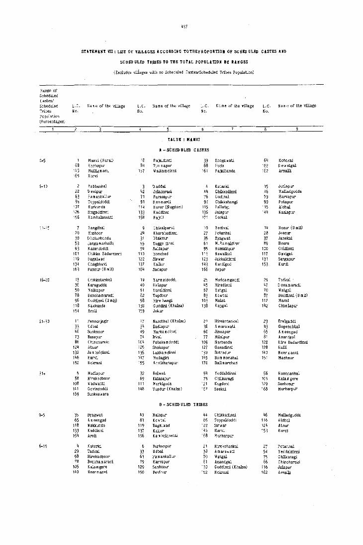
437
STATEMEIIT 'ill: LIST or VILLAGES ACCORDING TOTHEPROPORTIOH OF SCHED ULEIl CASTES AND
seH&!) ULED TR~ES TO THE TOTAL POPULATION BY RANGES
(Excludes villages with no Scheduled CasteS/Scheduled Tribes Population)
Range of Sqheduled Castes! Scheduled L.C. N a m e of the Village L.C. N a m e of the village L.C. N a m e of the village L.C. N a m e of the village Tribes No. No. No. No. Population (Percentages)
. 7
TALUK : MANVI
A - SCHEll ULEIl CASTES
0-5 1 Manvi (Rural) 18 Rajaldillni 39 Bhogawati 6q Kotekal 68 Kachapur 8q Tim mapur 88 Huda 102 D ewatgal
145 Malligmadu 157 W alka m dinni 161 Rajalbanda 162 Arnalli 165 Korvi
6-10 2 Rabbankal 3 II addal 4 Katarid 15 Jutlapur 22 II evipur 42 Joladarasi 44 Chikkadmni 46 M alladgudda
~3 Pam ankallur 71 Parasapur 76 Gudihal 79 Harvapur 85 Toppaldoddi 91 D onmardi 9? C hikkahangi 99 Potapur
107 Kurkunda 114 Hosur (Nugdoni) 115 Ballatgi 116 Aldhal 126 Singaddmni 133 Kaddmni 136 Jalapur 144 Naslapur 156 K a m balanotti 158 R ajoli 171 Gorkal
11-15 7 Rangdhal 9 C hikalparvi 10 Yedival 14 Hosur (Umli) 20 Mustoor 24 Kharabadinni 27 Potanhal 28 Jeenur 30 D hotarbanda 31 Utaknur 35 Byagwat 37 Janekal 53 Janga marhalli 55 Tuggaldillni 61 M.Ramaldmni 89 Heera 93 Kasandoddi 94 Saidapur 95 Hussainpur 100 Goldinni
101 C hikka Badardmni 110 Honched 113 Nawalkal 117 G'l-vigat 119 Bagalwad 122 Sirwar 123 Jakkaldillni 131 Sangapur 134 Chagbhavi 137 Kallur 143 Kardigud 153 Kurdi 163 Pannur (U mli) 164 Sadapur 166 Bapur
16-20 13 C hikkotankal 19 Y arm aldoddi 25 M udda m gaddi 29 Tadkal 36 Karegudda 40 Halapur 45 Hiredinni 47 D onamaradi 50 Malkapur 51 Toraldinni 67 Yatgal 70 Watgal 78 Bencha m aradi 82 Tupdoor 83 Kowtal 87 Buddmni (U roll) 96 Guddmni (U mll) 98 Hire hangi 103 Malat 112 Marat
118 Nakkunda 130 Guddini (Khalsa) 138 Kapgal 142 Chimlapur 154 Aroli 159 Jukur
21-30 11 Pannurjagir 17 N andihal. (K halsa) 21 Hirekotankal. 23 Eralgaddi
33 Udbal 34 Badlapur 38 A marawati 43 Gogehebbal 48 Sunknoor 49 M arka m dinni 60 Jinnapur 65 A meengad 73 Basapur 74 Irkal 77 Hilalpur 81 Anandgal 86 C hincharaid 104 Pataka m doddi 109 Narbanda 120 Hire Badardmni
124 Atnur 125 Shakapur 127 Ganadmni 128 Halli 132 Jam baldinni 135 Lakka m dillni 139 Bettadur 140 Neer!nanvi 1~6 Harvi 147 Madagiri 149 Bam manahal 151 Machnur 152 Hokrani i55 Advikhanapur 170 Ballmarchad
31+ 5 Madlapur 32 Belwat 54 Yeddaldmni 56 Hanchanhal. 58 Hirekadboor 69 Eklasapur 75 C hill<aragi 105 Kala m gere
108 Wadwatti 111 Murkiguda 121 Nugdoni 129 Sanhosur 141 Govindoddi 148 Tupdur (K halsa) 167 Seekai 168 Murharpur 169 Sunkeswara
B - SCHEll ULEIl TRIBES
0-5 35 Byagwat 40 Halapur 44 Chikkadinni 46 Malladgudda 65 Ameengad 83 Kowtal 85 Toppaldoddi 116 Aldhal
118 Nakkunda 119 Bagalwad 122 Sirwar 12~ Atnur 133 Kaddinni 137 Kallur 146 Harvi 153 Kurdi 154 Aroli 156 Ka m balanetti 168 Murharpur
6-15 4 Katarid 6 Burhanpur 21 Hirekotankal 27 Potanhal 29 Tadkal 33 Udbal 38 A marawati 54 Yeddaldmni 58 Hirekadboor 63 Pam ankallur 70 Watgal 75 C hill<aragi 78 Bencha m aradi 79 Harvapur 81 Anandgal 86 C hincharaki
105 Kala mgere 129 Sanhosur 130 G uddinni (K halsa) 136 Jalapur 140 Neermanvi 150 Bevinur 152 Hokrani 162 Arnalli

438
STATEMENT VII; LIST OF Vll.LAGES ACCORDING TOTHE PROPORTION OF SCHED ULED CASTES AND
SCHED ULED TRIBES TO THE TOTAL POPULATION bY RANGES
(Excludes villages with no Scheduled Castes/Scheduled Tribes Population)
Range of Scheduled Castesl Scheduled L.C, N a m e of the village L,C, N a m e of the village L. C, N a m e of the village L. C. N a m e of the village Tribes No. No, No, No, Population (Percentages)
TALUK; MANYI (Concld.)
B - SCHED ULED TRIBES (ConoId,)
16-25 1 Manvi (Rural) 5 M adIapur 23 Eralgaddi 24 K harabadinni
39 Bhogawati 69 Eldasapur 73 Basapur 74 Irkal 91 D onmardi 113 Na wali<al 117 Gavigat 121 Nugdoni
128 Halli 159 Jukur 161 Rajalbanda
26-35 11 P annurjagir 14 Hosur (U mJi) 17 N andihal (K halsa) 25 M udda m gaddi 37 Janekal 43 Gogehebbal 87 Buddinni (U roll) 89 Heera
114 Hosur (NugdOni) 115 Ballatgi 127 Ganadinni 131 Sangapur 132 Ja m baldinni 138 Kapgal 142 Chimlapur
36-50 19 Yar m aldoddi 28 Jeenur 55 Tuggaldinni 76 Gudinal 103 Malat 106 BulJapur 151 Machnur 155 Advikhanapur 157 W alka m dinni 163 Pannur (U roll)
51+ 3 D addal Rangdhal 12 N alga ro dinni 13 C hikkotankal 18 Rajaldinni 20 Mustoor 22 Devipur 47 D onamaradi
59 S. Ram aldinni 60 Jinnapur 61 M,Ramaldinni 62 Nagaldinni 64 Kotekal 68 Kachapur 88 Huda 139 Bettadur
141 Govindoddi 143 Kardigud 1~9 Boro manahal 158 Rajoll 160 Ta m mapur 164 Sadapur
TALUK ; RlICHUR
A -SCHEDULED CASTES
0-5 18 Bijangera 27 Yergera 31 M allapur 32 Lingankhandoddi 34 Julamgera 38 Puchaldinni 53 Anwar 56 Gadhar 62 Gatbichal 64 Matmari 65 Mood aldinni 67 YedJapur 71 Gandhal 72 Idapnur 7~ Mirzapur 75 Talmari 79 Buddinni 80 Chick m anchal 89 ArIappanhuda 90 Mallapur
93 Kuknoor 103 Asapur 10~ Jalibenchi 115 Ibrahim doddi 116 Hanumandoddi 140 Appandoddi 154 Palwaldoddi 156 Nagandoddi
6-10 22 Maliabad 33 Masdoddi 35 Kothdoddi 46 Purtipll 52 Kamlapur 58 Bichal 63 Heerapur 66 Turkandona 77 N addigaddim alkapur 78 Gunderveli 81 Bullapur 99 H unsihaJhud~
101 Nalhal 102 Arlibenchi 112 Mamadadoddi 125 Arsbangi 130 Karekal 132 Yedlapur 139 Ganmur 142 Raldoddi 147 Agrahar
11-'5 11 Ghousengar 16 Ayajpur 19 D evanpalli 43 Alkur 44 Godihal 45 Upral 57 Gillesugur 60 Kataknur 61 Hanmapur 68 D ugnoor 76 Gangwar 82 Tunga bhadra 84 H alvenkatapur 86 Sultan pur 88 Venktapur 92 Chicksugur
105 Merchathal 107 D eosugur 129 Kadlur 137 Shakwadi 138 Kadlur 143 lIadpalli 151 Athkur
16-20 2 Yermarus 3 Yegnur Wadwati 10 Baidoddi 14 Bapur 17 Rajalbanda 21 Sidrampur 30 Murlddoddi 37 Ja m baldinni 42 Gunjhalli 47 Garaldinni 50 Uda mgal 83 Kalmala 85 Murharpur 98 Gonhal 109 Korvihal
120 Bevinbenchi 126 Gurjapur 128 Jim mapur 131 Rangapur 136 Polkamdoddi 144 t ongara m pur 148 Korvakalan 153 Yapaldinni 155 Kothdoddi
21-3u 5 Potgal 12 Bolmandoddi 15 U ndraldoddi 20 Mittim alkapur 28 Juntadur 48 Dinni 49 Khanapur 55 M anjerla 69 Karebudur 70 Hanchinhal 87 Raghanathanahalli 91 Jegarkal 94 H ospet 108 Ganjhalli 111 Korthkunda 113 Yergunta
114 Sagamkunta 118 Hegsanhalli 122 Hemberhal 123 Hanmapur 124 Tim mapur 127 Meerapur 133 Chanderbanda

439
STATEMENT vn: LIST OF VILLAGES ACCORDING TOTHEPROPORfiON OF SCHED ULED CASTES AND
SCUED U~ED TRIBES TO THE TOTAL POPULAfiON BY RANGES
(Excludes villages with no Scheduled CasteS/Scheduled Tribes Population)
R~nge of Scheduled Cll.stes/ SCheduled L.C. Name of the village L.C. Name of the village L.C. Name of the villPge L.C. N a II! e of the village
Tribes No. Ne. No. No. Population (Percentages)
TALUK : RUCHUR
A - SCHSI) ULED C ASTBS (Concld.)
31+ 4 Sanknur 8 Kurabdoddi 23 Hosur 24 Rampur
25 Askihal 26 Eklaspur 51 Naglapur 54 Gonwar
95 Merched 96 Manslapur 97 Fathepur 100 Mamdapur 117 Wadloor 135 Katlatkur 141 Mad m andoddi 146 Korvakhurd 149 Budidipad 152 Gajerhal 157 Arsi8era 159 Mandalgera 160 Singnodi
B - SC RED OLED TRIBES
0-5 5 Potgal 37 Ja m baldinni 45 Upral 50 Udamgal 84 H alvenkatapur 90 Mallapur 95 Merched 99 Hunsil'Jalhuda
100 Mamdapur 101 Nelhal 114 Saga mkunta 132 Yedlapur
6-15 34 Julamgera 44 Godibal 62 Gatbichal 67 Yedlapur 69 Karebudur 81 Bullapur 83 Kalmala 103 Asapur
16-25 27 Yergera 71 Gandhal 87 R aghana thanahalli
26-35 25 Askihal 72 Idapnur
36-50 52 Kamlapur
51+ 68 o ugnoor 70 Hanchichal
TALO I : SJ:ND HNO R
A - SCREn ULED CASTES
0-5 38 Bassapur (K) 39 Ja m ban m athanhalli 41 Hanumapur 46 Hokarani 62 Ratanapur 63 Mahampur 64 Born manha! 71 Bhogapur 73 Chikbhergi 80 D evergudi 103 N anjaldinni 106 Rangapur
123 Hullur 136 D idagi 141 Puldinni 148 Yapalparvi 155 Chintam andoddi 170 Gonaganur
6-10 1 Sindhnur (R uraD 4 Hosalapur 5 Yelragi 17 D hadesugur 20 Huda 35 Hatti 47 Boppur 49 Nedigal 54 Tur'lihal 59 Kardchala mi 69 Gadertagi 85 Yelekudalgi
110 Kathanhatti 128 A m arapur K hadehola 150 Giniwar 157 P ulm eswardinni 158 Baderli 162 Uppal 172 Haretnur
11-15 10 Salgunda 21 Mukunda 24 Singapur 27 Gobberkal 30 Malakapur 33 C hannahalli 42 Gunjahalli 43 Uppal D oddi (U mll) 48 K anigan halu 52 Arlihalli 55 Kalmangi 60 V:irapur 6·/ Hogernhal 70 Hattigud 82 Born manhal 89 Gudadur 96 Kholabal 98 Hanchichal 107 Parampur 109 Chikk Kadbur
112 Balganur 114 GovindnaiJ(andoddi 125 Jawalgera 139 \I alka m dinni 143 Gonwar 144 Tim mapur 151 \I albellary 153 Hulgunchi 165 Kannari 166 Gomersi 171 AIbrlur
16-20 2 A marapur 3 H osshalli 26 Roudkunda 32 Mavinmadu 36 Jalihal 44 Matur 56 Bul<anhatti 57 U mloti 61 Mullur (U) 66 Gunda 72 Hirebhergi 76 Mullur 77 Killur 86 Harapur 87 Tippanhatti 88 Bassapur 94 Muddapur 97 Kanoor 108 Sankanur 113 Belliganur
118 K ongnaikandoddi 130 Sultanpur 145 Ragalparvi 146 Ram athanllal 149 Hedginhal 169 Belgurki
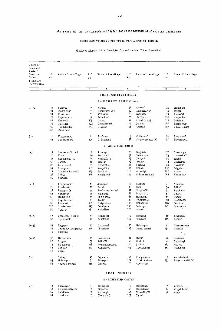
440
STATEMENT VII: LIST OF VII.LAGES ACCORDING TOTHEPROPOnTION OF SCBEn ULEn CASTES AND
SCHED ULEn TRIBlls TO THE TOTAL POPULATION BY RANGES
(Excludes villages with no Scheduled Castes/Scheduled Tribes Population)
Range of Scheduled Castes/ Scheduled L ,C, Name of the village L. C. N a m e of the village L.C. N a m e of the village L.C. Name of the village Tribes No, No. No. No, Population (Percentages)
'---"
TALUK: SINDHANUR (Conoid.)
A - SeHEn ULED CASTES (Conoid,)
21-30 15 Budiwal 19 Kengal 28 Gorebal 29 Sasalm ari 31 Siddra m pur 37 Hanchinhal (K) 50 H osshalli (K) 50 Tidgol 51 Kurukunda 53 Vjrapapur 65 Sankanhal 74 Kunnatgi 75 P agadadinni 78 Butaldinni 79 Mallapur 102 Hanpanhal
104 Maranhal 105 Gonhal 111 U dbal (U mJi) 115 Buddinni 116 Jalwadgi 122 G oudanbhavi 142 D um)1!i 147 Banniganur 152 Yeddaldoddi 154 Ayyanur 156 Chitrali 167 U dbal (,Jagir) 168 MadsFwar
31+ 6 Konganhatti 11 Somlapur 8] C hiterahal 90 Hasamakal 91 D eensu m udra 100 G u dgaldinni 133 Janga marhatti (N) 137 Turkanhatti
B - SCHEn ULEn TRIBES
0-5 Sindhanur (R ural) 2 A marapur 10 Salgunda 17 D hadesugur 20 Huda 29 Sasalm an 31 Siddrampur 33 C hannahalli 37 Hanchinhal (K) 40 Hosshalli (K) 49 N edigol 50 Tidgol 54 Turvihal 60 Vjrapur 76 Mullur 78 Butaldinni 82 Born manhal 83 Chiterahal 86 Harapur 88 Bassopur
99 H edagibal 103 N anjaldinni 105 Gonhal 112 B~anur
114 G ovindnaikandoddi 115 Buddinni 116 Jalwadgi_ 123 Hullur 1]6 D idagi 148 Yapalparvi 157 P ul m es w ardinni 168 Madsirllar 169 Belgurki
6-15 Konganhatti 11 Somlapur 15 Budiwal 21 Mukunda 26 Roudkunda 28 Garebal 35 Hatti 36 Jalihal 38 Bassapur (K) 39 Ja m ban m athanhalli 42 G unjahalli 51 Kurukunda
53 Virapapur 55 Kalmangi 56 Bukanhatti 57 U mloti 61 Mullur (U) 64 Bam manhal 65 Sankanhal 66 ~unda
75 P agadadinni 77 Killur 85 Yelekudalgi 90 Hasamakal 96 Khalabal 100 G udgaldinni 102 Hanpanhal 108 Sankanur
122 Gaudanbhavi 125 Jawalgera 130 Sultanpur 147 Bllnniflanur 150 Giniwar 151 Walbellary 171 Albnur
16-25 43 Uppaldoddi (U mJi) 67 Hogernhal 70 H attigud 80 D evergudi 87 Tippanhatti 98 Hanohinhal 149 Hedginhal 165 Kannari
26-35 24 Singapur 27 Gobberkal 30 Malakapur 91 D eensu m udra 128 A m araper K hadehala 144 Tim mapur 146 Ram athanhal 154 Ayyanur 172 Haretnur
36-50 32 Mavinmadu 41 Hanumapur 44 Matur % Hokarani 47 Boppur 52 Arlihalli 58 G orloti 69 Gadertagi 72 Hjrebhergi 118 Kongnaikandoddi 141 Puldinni 142 Dum mi
143 Ganwar 145 Ragalparvi 152 Yeddaldoddi 153 Hulgunchi 162 Uppal
51. 5 Yelragi 45 Bagalapur 48 K arugan)laJ.u 59 Kardchala mi 63 Mahampur 71 Bhagapur 109 Chikk Kactnur 133 Jangamarhatti (N)
155 Chintamandaddi 156 Chitrali 170 Gonaganur
TALUIC : YELBARGA
A - SCHED ULEn CASTES
0-5 12 Kanasagar 13 Boonkoppa 15 M akkahalli 39 Yeddom 50 Chikwankalkunta 52 Tippanhal 62 Mandalmari 64 Ningal Bandi 65 Kalakbandi 66 Matrangi 67 Hjrearlihalli 68 Hosur 69 Putak roari 83 Chendinhal 125 Talbal

STATEHERT m: LlST OF mLAGES ACCORDIHG TO'l'HE PROPORTIOIi OF SCHED ULED CASTES AMD
SCHED ULED UiliES TO THE TOTAL POPULATION BY RANGES
(Excludes villages with nD Scheduled Castes/Scheduled Tribes Population)
fange of $cheduled Castes! Scheduled L.C. Name of the village L.C. N am e of the village L.C. Name of the village L.C. Name of the village Tribes No. No. No. No. Population (Percelltages)
1 8
fUUK : YELBARGA (Conald.)
A - sell ED OLED CASTES (Conald.)
6-10 4 Tumurguddi 5 Bassapur 10 Hagedhal 17 Jarkunti 25 M alaksa m udra 26 Sanganhal 27 Kallur 30 Karmudi 32 Sankanur 33 Katral 34 Sirgumpi 36 Mudhol 43 Budur 55 Uchalkunti 56 Bukkanhatti 57 Gunhalu 59 lIyadneri 61 Nilcgal 71 Budkunti 75 Yapaldinni 77 Vangera 78 Bevoor 81 Kudrimoti 88 Muthalu 90 Arkeri 103 Hulegudda 106 Guttur 111 C hanpanhalli
115 Gorekoppa 116 Masabhanchinhal 118 Benakal 120 Bhanapur 121 Lakmapur 129 Bannikoppa 132 Manbalgeri 134 Sompur 136 Sidnekoppa 137 Yarihanchinhal 140 Bhaipanhalli
11-15 2 Hosahalli Bandi 14 Vajjarbandi 16 Salbhavi 19 Lagalur 21 Madlur 28 Tondihal 29 Bandihal 35 Hire m yageri 37 Hire Wankalkunta 38 Choudapur 41 Gule 44 Sidlabhavi 45 Chikkamannapur 48 Talkere 49 Kalbhavi 53 Katgihalli 70 Jarkunti 72 Biraldinni 74 Mataldinni 80 N elgeri 85 C hikbeedinhalu 87 Hire beedinalu 89 Sirur 96 Ryavanki 97 Balgera 98 C hik m yageri 100 Hanmapur
102 Narsapur 104 Murdi 109 Kuknoor 117 Nittali 123 Komlapur 127 Tadkal lrO ltagi 135 Malekoppa 138 Bmhal 139 C hikenkoppa 141 Rajoor 142 A doer 143 D yampur
16-20 6 Ballutgi 7 Jhulkatti 18 Dam mur 23 Kudrikotgi 46 Markat 47 Gandhal 60 Hunsihal 76 Hangalore 79 Watparvi 82 llhairnaikanhalli 86 Kadarhalli 91 Chendoor 93 Bedwatti 95 Budgumpa 99 Geddigera 107 Lakmangu1e
119 Veerapur
21-30 11 ClJiIcbannigol 24 Kudgunti 54 Hire waddarkal 58 Kolihal 63 Taralkatti 84 Honhunashi 94 Yadiapur 101 Talur
114 Gavarhal 126 Ningapur 128 Mannapur
31. Chikoppa 20 Maranhal 108 Kavalkere 112 Kakkihalli
B - SCHED OLED TRIBES
0-5 2 Hosahalli 26 Sanganhalu 27 Kallur 35 Hire." yageri 36 Mudhol 37 Hire wankalkunta 48 Talkere 51 U ppaldinni 60 Hunsihal 65 Kalakbandi 71 Budkunti rr Vangera 79 Watparvi 84 Henhunashi 93 Bedwatti 97 Balgera 98 Chikmyageri 109 Kukneor 118 Benakal 119 Veerapur
120 Bhanapur 129 Bannikoppa 130 ltagi 137 Yarihanchinal 143 D yam pur
6-15 11 C hikbannigol 14 Vajjarbandi 24 Kudgunti 29 Bandihal 30 Karmudi 45 Chikkamannapur 49 Kalbhavi 57 Gunhalu 61 Nilogal 63 T~atti 64 Ningal Bandi 68 Hosur 74 Mataldinni 81 Kudrimeti 86 Kadarhalli 88 Muthalu
104 Murdi 106 Guttur 107 Lakmangu1e 116 M asabhanchinhal 123 Komlapur 132 Mandalgeri 134 Sompur 139 C hikenkoppa
16-25 12 Kenasagar 18 Dam mur 33 Kajral 43 Budur 44 Sidlabhavi 88 MU',halu 138 Binhal
26-35 39 Yeddeni 67 Hirearlihalli
36-50 17 Jarkunti 47 Gandhal 69 Putakmari 103 Huleguddll
51. 42 Guntamadu 50 C hikwankalkunta 52 Tippanhal 59 Myadnery 70 Jarkunti 72 Biraldinni


~43 LIST OF SCHEDULED CASTES AND SCHEDULED TEIBES IN KARNATAKA ACCORDING TO TEE
SCHEDULED CASTES AND SCHEDULED TRIBSS ORDERS (AMENDMENT) ACT, 1976
(NO. 103 OF 1976, DATED THE 18TH SEPTEMBER, 1976)
Scheduled Castes Scheduled Casl':s Scheduled Castes
1. Adi Andhra 28. Chandala 64. Mai!a 2. Adi Dravida 29. Chenna Dasar, Holaya Dasar 65. Mala 3. Adi Karnataka 30. Dakkal, Dokkalwar 66. Mala Dasari 4. Adiya (in Co::>rg District) 31. Dakkuliga 67. Mala Hannai 5. Ager 32. Dhor, Kakkayya, Kankayya 68. Mala Jangam 6. Ajila 33. Dam, Dombara, Paidi, Pano 69. Mala Masti 7. Anamuk 34. Ellamalwar, 70. Mala Sale, Netkani 8. Aray Mala YellammalawandI u 71. Mala Sanyasi 9. Arunthathiyar 35. Ganti Chores 72. Mang, Matang, Minimadig
10. Arwa Mala 36. Garoda, Garo 73. Mang Garudi, Mang Garodi 11. Baira 37. Godda 74. Manne 12. Bakad 38. Gosangi 75. Masthi 13. Bant (in Belgaum, Bijapur, 39. Halleer 76. Mayilan
Dharwar and North Kanara 40. Halsar, Haslar, HulasYar, 77. MeghYal, Menghvar Districts) Halasyar 7S. Moger
14. Bakuda 41. Handi Jogis 19. Mukri 15. Balagai 42. Hasla SO. Mundala 16. Bandi 43. Holar, Valhar S1. Nadia, Hadi 17. Banjara, Lambani 44. Holaya, Holer, Holeya S2. Nalkadaya IS. Bathada 45. Holeya Dasari 83. Najakeyava 19. Beda Jangam, Budga Jangam 46. JaggaJi 84. Nayadi 20. BeHara 47. lamhuyuiu 85. Pale 21. Bhangi, Mehtar, Olgana, 48. Kadaiyan 86. PaHan
Rukhi, Malkana, Halalkhor, 49. KaHadi 87. Pambada Lalbegi, Balmiki, Korar, 50. Kepmaris 88. Panchama Zadmalli 51. Kolupulvandlu 89. Panniandi
22. Bhambi, Bhambhi, Asadaru, 52. Koosa 90. Paraiyan, Paraya Asodi, Chamadia, Chamar, 53. Koracha 91. Paravan Chambhar, Chamgar, 54. Korama 92. Raneyar Haralayya, Harali, Khalpa, 55. Kotegar, Metri 93. Samagara Machigar, Mochigar, Madar, 56. Kudumban 94. Sam ban Madig, Mochi, Muchi, Telegu 57. Kuravan 95. Sapari Mochi, Kamati Mochi, Ranigar, 58. Lingader 96. Sillekyathas Rohidas, Rohit, Samgar 59. Machala 97. Sindhollu, Chindollu
23. Bhovi 60. Madari 98. Sudugadu Siddha 24. Bindla 61. Madiga 99. Thoti 25. Byagara 62. Mahar, Taral, Dhegumegu 100. Tirgar, Tirbanda 26. Chakkiliyan 63. Mahyavanshi, Dhed, Vankar, 101. Valluvan 27. Chalavadi, Chalvadi, Channayya Maru Vankar
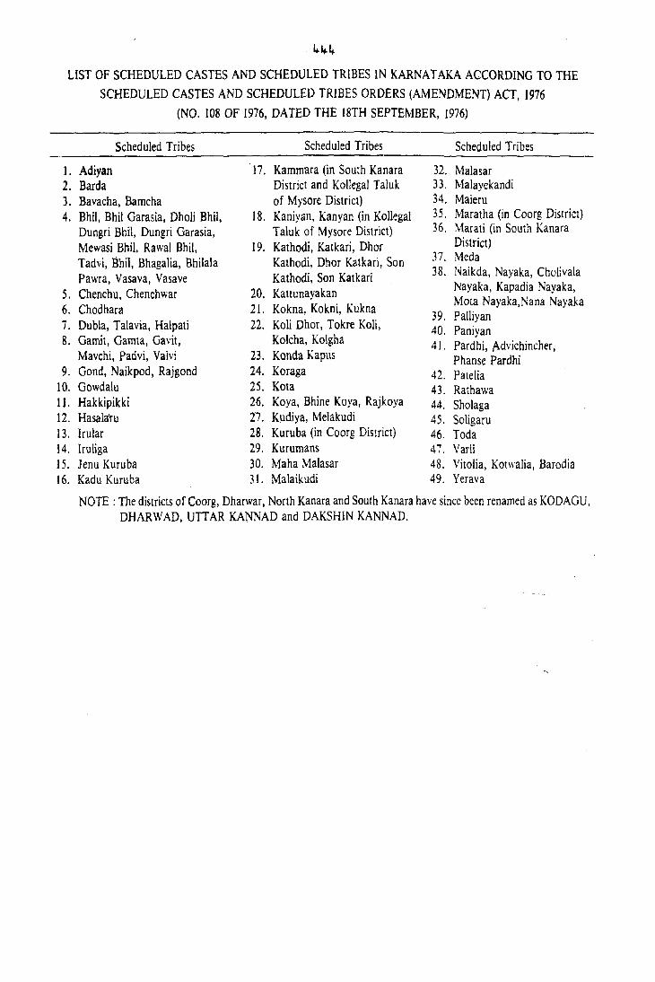
~~~
LIST OF SCHEDULED CASTES AND SCHEDULED TRIBES IN KARNA T AKA ACCORDING TO THE
SCHEDULED CASTES AND SCHEDULED TRIBES ORDERS (AMENDMENT) ACT, 1976
(NO. 108 OF 1976, DATED THE 18TH SEPTEMBER, 1976)
Scheduled Tribes Scheduled Tribes Scheduled Tribes
1. Adiyan 17. Kammara (in South Kanara 32. Malasar 2. Barda District and KollegaJ TaJuk 33. Malayekandi 3. Bavacha, Bamcha of Mysore District) 34. Maleru 4. Bhil, Bhi! Garasia, Dholi Bhil, 18. Kaniyan, Kanyan (in Kollegai 35. Maratha (in Coorg District)
Dungri Bhil, Dungri Garasia, Taluk of Mysore District) 36. Marati (in South Kanara
Mewasi Bhil, RawaJ Bhil, 19. Kathodi, Katkari, Dhor District)
Tadvi, Iihn, Bhagalia, Bhilala Kathodi, Dhor Katkari, Son 37. Meda
Pawra, Vasava, Vasave Kathodi, Son Katkarl 38. Naikda, Nayaka, Cholivala
5. Chenchu, Chenchwar 20. Kattunayakan Nayaka, Kapadia Nayaka,
6. Chodhara 21. Kokna, Kokni, Kukna Mota Nayaka,Nana Nayaka
39. Palliyan 7. Dubla, Talavia, Halpati 22. Koli Dhor, Tokre Koli, 40. Paniyan 8. Gamit, Gamta, Gavit, Kolcha, Kolgha 41. Pardhi, Advichincher,
Mavchi, Pad vi, Valvi 23. Konda Kaptls Phanse Pard hi 9. Gond, Naikpod, Rajgond 24. Koraga 42. Patelia
10. Gowdalu 25. Kota 43. Rathawa 11. Hakkipikki 26. Koya, Shine Koya, Rajkoya 44. ShoJaga 12. Hasalaru 27. Kudiya, Melakudi 45. Soligaru 13. lrular 28. Kuruba (in Coorg District) 46. Toda 14. lruliga 29. Kurumans 47. Varli 15. Jenu Kuruba 30. Maha Malasar 48. VitoJia, Kotwalia, Barodia 16. Kadu Kuruba 31. Malaikudi 49. Yerava
NOTE: The districts of Coorg, Dharwar, North Kanara and South Kanara have since been renamed as KODAGU, DHARWAD, UTTAR KANNAD and DAKSHlN KANNAD.

Part I - A
Part I - B
Part II - A
Part II - B
Part III - A
Part III - B
Part IV - A
Part iV - B
Part V - A
Part V - B
Part VI - A
Part VI - B
Part VII
Part VIII - A
Part VIII - B
Part VIII - C
Part IX
Part X - A
Part X - B
Part X - C
Part XI
Part XII
Part XIII
1981 Census Papers
CENSUS OF INDIA 1981 - KARNATAKA STATE PUBLICA nON PROGRAMME
..
Administration Report-Enumeration
Administration Report-Tabulation
General Population Tables
For official use only
Primary Census Abstract (in two volumes)
General Economic Tables
General Economic Tables
Social and Cultural Tables
Social and C,ultural Tables
Migration Tables
Migration Tables
Fertility Tables
Fertility Tables
Tables on Houses and Disabled population
Household Tables
Household Tables
Report on Households
Special Tables on Scheduled Castes and Scheudled Tribes
Town Directory (State Volume)
Survey Reports on Selected Towns
Survey Reports on Selected Villages
Ethnographic notes and Special Studies on Scheduled Castes and Scheduled Tribes
Ceflsus Atlas
District Census Handbooks
Part A : Village and Town Directory Part B : Village and Townwise Primary Census Abstract
Special Papers are also planned and will be published as and when these are ready
ALL INDIA VOLU MES
Volumes similar to those indicated above, except Part XIII, are being published at the All India Level also.
The District Census Handbooks will be available for sale at the Government Central Press, Bangalore and the other publications at the office of the Dire~tor of C~~sus. Operat~on$', ~l<ir.r19t~ka, Bangalore and the Controller of Publications, Cml Lmes, N~\Y'~~»H-1l0 051j. •
.v • Jltf< ~