Parts xiii-A& B, Village & Townwise Primary Census Abstract ...
387
CENSUS· OF INDIA 1981 SERIES-6 HANDBOOK PARTS XIII 4 VILLAGE & TOWN DIRECTORY VILLAGE & T()WNWISE fRlMARY CENSUS ABSTJ{l\t;!T DISTRICT O. P. BHARADWAJ OF THE INDIAN ADMINISTRATIVE SERVICE Director of Census Operations Haryana Published by the Government of Ha ryana 19&3
-
Upload
khangminh22 -
Category
Documents
-
view
0 -
download
0
Transcript of Parts xiii-A& B, Village & Townwise Primary Census Abstract ...
CENSUS· OF INDIA 1981
SERIES-6
HARYA~A
DISTRI~T C~NSUS HANDBOOK
PARTS XIII 4 ~!I VILLAGE & TOWN DIRECTORY
VILLAGE & T()WNWISE fRlMARY CENSUS ABSTJ{l\t;!T
~MBA~A DISTRICT
O. P. BHARADWAJ OF THE INDIAN ADMINISTRATIVE SERVICE
Director of Census Operations Haryana
Published by the Government of Ha ryana 19&3

MOTIF
The river Ghaggar or the Rigvedic Sarasvati now rises in the Siwaliks and enters .the plains first in Distri~ A~bala on its journey towards the District of Ganganagar in Rajasthan. In the time of the Rigveda it was probably born in the high Himalayas and was a big perennial river since it has been described as the river par excellence, rushing down from the mountains to the ocean with a tempestuous roar, breaking and carrying down tops of hills like lotus stems and filling the rea1.ms of 'earth and the wide tr'act of the firmament. For the people living in its valley it was the giver of food and bestower of weaLth ,and therefore best of rivers and even the be~t of mothers.
The hermitages of Rishi.s alon9 its banks resounded with the chanting of the mantras and sacrificial smoke arose atI around them. These hermitages were also the seats of learning 1J'hich gradually elevated the river first to the siatus of a River-Goddess and then to the Goddess oJ Learning who has been chosen as a motif jor the district of Ambala.
~\Ci "\
BOUNOARY, STATE ••
BOUNOARY, OISTRICT
BOUNOARY, TAHSIL
HEAOQUARTERS: DISTRICT; TAHSIL .,.
NATIONAL HIGHWAY, .•
STATE HIGHWAY
IMPORTANT METALLED ROAD
RAILWAY LINE WITH STATION, BROAD GAUGE.
RAILWAY LINE WITH STATION ,NARROW GAUGE.
RIVER AND STREAM /,CANAL. ..
VILLAGE HAVING 5000AND ABOVE POPULATION WITH NAME... • ..
URBAN AREA WITH POPULATIO,N SIZE- CLASS 1, n,m,IV SoY ..
POST AND TELEGRAPH OFFICE
DEGREE COLLEGE AND TECHNICAL INSTITUTION
REST HOUSE. TRAVELLERS' BUNGALOW. FOREST BUNGALOW AND CANAL BUNGALOW.
_ ... _ ... _ .. _ .. _
SHU
os - I III1
~/= S4rar.
•
.<~~"~'''', ..
e-.·· PTO
Fe, CB
Based lJPon SurvliiY of India mop with ttl'll permission of the Surveyor 6.n .... o1 of India
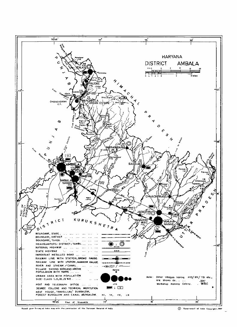
HARYANA
DISTRICT AMBALA " ! i 20
! i.
S 4 :1 2 I (I 10M_In
Note: Other villagu having are shown cis. .
PTO/ RH/ TB etc., .~'t~i WRC Workshop Railway Colony ..
•
@- Gcvernment ot Indio Copydght ,1981
I, · , 7645
HARYAN A
TAHSIL KALKA DISTRICT AMBALA
Km.Z I a 2 4
t===lti fttd 1:aJr 6 I
i 4
THE TAHSIL BOUNDARY 15 AS SUPPLIED BY SURVEY OF INDIA, AND THE VILLAGE BOUNDARIES ARE AS PER REVENUE RECORDS.
BOuNOARY, STATE
...... c :z « ~
u
BOUfIIDARY, TAI'!S l
eOL.NCARY, V "~AGE. WITI-<
TAHSI~ h~ADo..JARTERS
~OCATION CODE NUMBIOR. [-..!.:::4~~::: _ _] VILLAGES W II'! POPL.LATIGN SIZE' 6ElOW ZOO; 200-499, SeO-999; lCOO-4999; 5000 8< ABOVE
uN,NHABITED VIL~AGE:S I!''liTH ,DCATION CODE
LlRBAN AREA W'TH LOCATION COOl,
NAT 10NAl hiGHWAY
STATE H GHWAY
IMPORTANT METAL~ED ROAD
RAII.WAY LINE WITH STATION, BROAD GAUGE
RAILWAY LINE WITH STATION, NARROW GAUGE.
POST OFFICE I POS~ AND TElEGRAPI-i QF-FICE.
HIGH OR I-<IG4ER SECONOARV SCHOeL
FO L,CE STATION
HOSP'TAl, PRIMARY HEALTH CENTRE. DISPENSARY.
DE.GREE COLLEGE
RrVER AND STREAM
© .O.GoO
C=--££s=--=.-_] E'Z'0I~
NH22
SH I
RS
- ~=-RS II II 1E!jB I II
PO / PTO
S
PS
@ I c:::al
+ .~~ .-::
E cst of 6recz:nwich
o
B 10
ttY SMiles
..., <
30· , 30
'I BaS" upon Survey of IndiO mop WI1h ~he pe-rm_ss,Qn of ,he surveyor Gene-rot of India
© GCJiII'e-rnmeni of lndia Copyright. 1982
CENSUS OF INDIA-1981
A-CENTRAL GOVERNMENT PUBLICATIONS
The publications relating to Haryana bear series No. 6 and will be published as follows :-
Part I-A
Part I-B
Part II-A
part II-B
Part In Part IV
Party
Part VI
Part Vll
Part VIII
Part IX
Part X-A
Part X-B
Part X-C
Part XI
Part XII
Administration Report-Enumeration (for official use only)
Administr.a.tion Repo~t-Tabulation (for official use -only)
General Population Tables
Primary Census Abstract:
General Economic Tables
Social and Cultural Tables
Migration Tables
Fertility Tables
} combined
Tables on Houses and Disabled population
Household Tables'
Special Tables on Scheduled Castes
Town Directory, . . Survey Reports on selected towns
Survey RepQrts on selected villages
Ethnographic notes and special studies on Scheduled Castes
Census Atlas
B-HARYANA GOVERNMENT PUBLICATIONS
Pa]:ts xlU':'_A & ll~District Census Handbooks-one for each district (Village and Town Directory a Primary Census Abstract)
(il)
CONTENTS Page
Foreword v
Preface
ACknowI~gements
Important Statistics
vii
ix
xi
Analytical Note 1 29 Part A-VILLAGE AND TOWN DIRECTORY ..
Section I~Village Directory 31 Codes used in the ViUage Directory 33
Alphabetical list of. villages in Kalka Tahsil 37
Kalka Tahsil 43
Alphabetical list of villages in Naraingarh Tahsil 57
Naraingarh Tahsil 67
Alphabetical list of villages in Ambala Tahsil 97 - .' Ambala Tahsil 107
Alphabetical list of villages in Jagadhri Tahsil 139
Jagadhri Tahsil 153 Appendices 1 to 4 197
'Section II-Town Directory 215 Codes used in the Town'Directory 217
Town Directory Statements 221
Appendix 239 Part B-PRIMARY CENSUS ABSTRACT 243
Maps:
Ambala District 245
Kalka Tab sil 251
Naraingarh Tahsil 265
Ambala Tahsil' 289
Jagadhri Tahsil 317
Appendix-Enumeartion blockwise total population and Scheduled Castes population 353
District Primary Census Abstract of Scheduled Castes 365
Ambala District: Tahsil boundary, district and tahsil headquarters, towns, roads! railways, rivers/canals, important villages, rest houses etc.
Kalka Tahsil: Tahsil headquarters, village bouadary and population, urban areas, roads/railways, rivers/canals and service facilities etc
Naraingarh Tahsil: -do-Ambala Tahsil: -do-Jagadhri Tahsil: -do-
(iii)
Facing page
xi
37
57 97
139


FOREWORI)
The district census handbook (DCR), compiled by the Census Organisation on behaif of the State governments, is one of the most valuable products of the Census. The DCR is, constantly referred to by planners, administrators, academicians and researchers. It is inter alia used for delimitation of constituencies, formulation of local level and regional plans and as an aid to District administration. The district census handbook is the only publication which provides Primary Census Abstract (PCA) data upto village level for the llural areas and wardwise for each city or town. It also provides data on infrastructure and amenities in villages and towns, etc.
The district census handbook series was initiated during the 1951 Census. It contained important census tables and peA for each village and town of the district. During 1961 Census the scope of the DCR was enlarged and it contained a descriptive account of the district, administrative statistics, census tables and, a village and town directory, including peA. The 1971 DCR series was planned in thNe parts. Part-A related to village and town directory, Part-B to village and town peA and Parte comprised analytical report, administrative statistics, district census tables and certain analytical tables based on peA and amenity data in respect of villages. However, in some States it was confined to' district census tables and in a few cases altogether given up due to d~lay in compilation ani printin g.
While designing the format of 1981 DCR series some new features along with the restructuring of the formats of village and town directory have been attempted. At the same time, comparability with the 1971 data ha'l also been kept in view. All the amenities exc~pt pow~r supply in the village have been brought together in the village directory with the instruction that in cas! an amenity is not available in the referrent villag~ the distance in broad ranges from th~ nearest place where the am~nity is' available may b;, given. The restructuring of the form 1t of the villag~ directory and incorporating more exhaustive data on infra,tructure aspect particularly in relation to amenities and land-use pattern is expected to further' meet the need of micro level planning for rural areas. 1t is expected to help not only in local
,area planning but regulating the provision of goo:is and services as well so as to minimise the regional imbalances in the process of development. A few new items of inform ltion have also be(!n introduced to meet some of the requirements of the Revised Minimum Needs Programme. Such new item. of informati<;>n as adult literacy centres, primuy h~alth sub.centres, and commllnity health workers in the village have been introduced in the village directory with this obje~tive in mind. The new item on approach to the village is to have a~ idea ab::>ut the villag~s in the district which are inacce~sible. A neW column, "totat population and number of households" has be..!n introduced to examiM th~ c:)rrelation of the amenities with the population and number of household~ they s~rve. A1ditioa or two more
, appendices listing the villages where no amenities are available and ac~ording to the prop)rtion of sch~duled caste and scheduled tribe popUlation to· the total population has also been made with this view in mind.
The formats of the to'wn directory have also beell modified to meet the requirements of the Minimum Needs Programme by providing information on a few new items. A new .statement on civic and other amenities in slums in Class-I and Class-II towns (Statement IV -A) has been introduced with. this objective in mind. It is expected that this will help the plannets to chalk out programmes on provision of civic amenities fot the improvement of slums. The columns on Scheduled Castes and Scheduled Tribes population in statement IV relating to civic arid other ajnenities and adult literacy classes/centres under educational facilities in stat~ment-V are also added inter alia with this view. A significant addition is class of town in all the seven statements of the town directory. The infrasttucture of amenities in urban areas of the country can be best an·alysed by taking the class of towns into consideration. the addition of the columns on civic administration status and population in a few statements also serves this purpose.
The format of the primary census abstract for the villages and towns has been formdlated in the light of changes in the economic and other questions canvassed through the individual slip of 1981 Census.
III order to avoid delay in publication of 1981 DCH series it has been so designed that Part-A" of the volume, contains village and town directory and Part~B, the PCA of villages and towns including the Scheduled Castes and Scheduled Tribes PCA upto Tahsil/Town levels. At the beginning of the DGH a detailed analytical note supported by a number of inset tables based on PCA and non census data in relation to the infrastructure has been introduced to enhance its value. The district and tahsil/Police Station/C. D. Block ,etc., level maps depicting the boundaries and other important features have been inserted at appropriate ,places, to further enhance the value of the publication.
(v)
'This publication is a joint venture ot the State Government and the Census Organisation. The data have been collected and compiled in the State under the direction of Shri o.P. Bharadwaj, LA .S. the Director of Census Operations, Haryana on behalf of the State Government which has borne the cost of printing. The task of planning, designing and coordination of this publication was carried out by Shri N. G. Nag, Deputy Registrar General (Social Studies) of my office. Dr. B. K. Roy, Deputy. Registrar General (Map) provided the technical guidance in the preparation of the maps. Data received from Census Directorates' have been scrutinised in the Social Studies Division at the headquarter s under the guidance of Shri M. M. Dua, Senior Research Officer. I am thankful to all who have contributed in this project.
New Delhi
the 26th April, 1982
(vi)
P" PADMANABHA
Registrar General, India.
PREFACE
At the outset, it must' be stated that the Census Operations of 1981 were carried out under the stewardship of ,Shri o. P. Bharadwaj, Director of Census Operations, Haryana and the credit for the suCCessful conduct of the Operation goes to him. Before, however, the report could be finalised he had to reSume his duties under the State Government in public interest.
In March, 1981, the provisional population totals of Haryana State were released after the enumeration was over. The actual enumeration was conducted from 9th February to 28th February, 1981, with a revisional round from 1st March to 5th March, 1981 in order to bring the Census count c6rrect upto the reference date i. e. the sunrise of 1st March, 1981:
In Paper-I of 1981 provisional figures down to the district level and cit~es with population of 100,000 and above had been given and basic ~~ta relating to total population including SeX ratio, density, decennial growth rate, literacy and sexWISe breakup of population were presented. Thereafter a supplement to Paper-I of 1981 was brought out presenting a few other characteristics of population also based on provisional results of 198-1 Census. It covered information on urban popUlation and work participation rates of the male and female population. Data down to the tahsil and town levels in the form of Primary Census Ab~tract and on disabled persons were also included. .
Th~ 1981 series of District Census Handbooks to which this volume belongs has been divided into two parts. Part-A presents data obtained from the field on land Use pattern and amenities such as drinking water, post and telegraph, educatiop.al, medical etc. available in each village and civic <..nd other amenities 'in each town. Part-B presents demographic data down to the village level .in rural areas and ward level in the case of urban areas. Enumeration bl0ckwise figures of total population and scheduled 'castes population in case of urban areas are shown in an appendix at the end of Primary Census Abstract. Our attempt has been to present the information concerning each district in its maximum possible details in the hope that these volumes will prove useful to scholars, planners and those who are working to improve thy economic condition of the people particularly in our State and generally jn the country as a whole.
Dated : Chandigarh
the 28th April, 1983
(vii)
R. K. AGGARWAL
Deputy Director of Census Operations,
Haryana

ACKNOWLEDGEMENTS
In a country like India, with the dimensions of a sub-continent and one sixth of the world's population, Census is a gigantic task. That we have been able to accomplish it successfully is largely due to the inspiration and guidance. of Shri P. Padmanabha, Registrar General and Census Commissioner, India. His deep understanding of both the conceptual as well as the practical aspects of Census and complete identification with· the job have been a living example to us all and his ever-smiling and unruffled expression, always considerate and sympathetic view of our problems and polite but firm handling of difficult situations filade him an ideal captain of the team engaged in a stupendous undertaking. First and foremost, therefore, 'we .must express our grateful thanks to him for showing us the right direction in steering the Census ship througb difficult waters.
For the massive operatiQn of actual Census taking, the whole country is divided into convenient Enumeration Blocks covering about 750 persons in the rural areas and about 650 persons in the urban areas. In Haryana State, as many as 20,534 Enumeration Blocks were demarcated and 23,603 Enumerators and Supervisors were appointed and trained for the work of actual count. An overwhelming majority of the Enumerators and Supervisors Was drawn from the Education Department of tbe State and tbe remaining from Central/State Governm,ent Departments and from tbe offices of Local Bodies. They canvassed tbe basic Census schedule i.e. tbe Individual Slip for eacb person by moving from house to house during the Enumeration period. We, therefore, take this opportunity to express our deep appreciation for these thousands of field workers who at considerable inconvenience to themselves worked hard to make the colossal task of the 1981-Census a success.
The Principal Census Officers, District Census Officers, Additional District Census Officers, SubDivisional Census Officers, Charge Officers and Deputy Charge Officers were responsible for organising and coordinating the work in their respective areas of jurisdiction. A large share of the credit goes to these State Census Officers in the districts who discharged their duties with full vigour and enthusiasm. We are really grat~ful to them for their ungrudging cooperation. We must also acknowledge with gratitude the active belp and cooperation extended by the Government of Haryana at all levels and the goodwill shown by the people of the State to .the staff working for the Census Organisation. . ,
The great mass of information collected in the field was edited and processed in our two Regional Tabulation Offices located at Ambala and Kurukshetra with the help of 500 odd Tabulators, Checkers and Supervisors. The compilation of Primary Census Abstract is an outcome .of the hard labour put in by the dedicated team of officials consisting of Tabulators, Checkers, Supervisors, Statistical Assistants and Investigators in these Regi6nal Tabulation Offices. All of them deserve praise for hard work put in by them to complete the work in the stipulated period. The Regional Tabulation Office at Ambala Sadar was looked after by Shri S.L. BahI, Deputy Director who was assisted by Shri AL. Kakkar, Investigator and' four Statistical Assistants while the Regional Tabulation Office at Kurukshetra was controlled by Shri R. K. Puri, Deputy Director who was ,assisted hy Shri Vinod Kumar Babbar, Investigator and four Statistical Assistants. Shri J. R. Vashistha, Assistant Director, also worked as Deputy Director in the Regional Tabulation, Offices for some time firstly when Shd S. L. Bahl, Deputy Director proceeded on leave and again on the transfer of Shri R. K. Puri, Deputy Director to the office of the Registrar General, India, New Delhi. We would like to record our appreciation of the assistance provided by these officers/officials-.
Village and Townwise Primary Census Abstracts prepared in the two Regional Tabulation Offices were checked and finalised in the Head Office by a team of Statistical Assistants and Shri Jaswant Lal, Investigator under the supervision of Sarvshri J.' R. Vashistha and J. N. Suri, Assistant Directors. These abstracts form Part-B of this District Census Handbook.
The data contained in Village and Town Directories which form Part-A of this Handbook was collected by us from the District Revenue Agency and the Local Bodies. We also approached variolls State Government Departments to provide the relevant data for cross checking the accuracy of the information collected from the field 'by the above mentioned two agencies. We are indebted to them for the cooperation and promptness with which they met our requirements. In our office, the data thus collected was processed and finalised into various statements by a team of Computors, Statistical Assistants and Sarvshri Amarjit Singh and Koshy P. Zachariah, Investigators under the supervision of Sarvshri J. R. Vashistha and J. N. Suri, Assistant Directors.
(ix)
The maps included in the Handbook and cover design 'were prepared in the map section headed by Shri J. P. Purohit, Cartographer under the supervision of Shri S. R. Puri, Research Officer (Map). We have also to mention the assistance rendered in the preparation of the draft of this Handbook by Shri J. N. Suri, Assistant Director, Shri S. R. Puri, Research Officer and Shri P. N. Modgil, Research Officer.
We have to record with gratitude the valuable guidance provided by Shri N. G. Nag, Deputy Registrar General (Social Studies) and Dr. B. K. Roy, Deputy Registrar General (Map). Our thanks are also due to Shrt M. M. Dua, Senior Research Officer, Shrt S. C. Srivastava, Assistant Central Tabulation Officer and their staff in scrutinising portions of this Handbook relating to their respective branches in the office of the Registrar General, India. ' ,
, This brief-section on acknowledgements is by no means exhaustive and there are many· more unnanied people to whom our thanks are due but before we close we must thank Shri K. M. S. Pillai, Controller and Shri P. Oommen, Deputy Controller of Pr~nting. and 'Stationery, Chandjgarh
'Administration, for m.aking a good job of the printing of this Handbook.' .
(x)

ilVil>ORTANT STATISTICS
STATE DISTRICT
Population Total Persons 12,922,618 1,409,463
Males 6,909,938 753,308
Females 6,012,680 656,155
Rural ,Persons 10,095,231 94~,686
Males 5,380,966 507,049
Females 4,714;265 438,637
Urban PerSons 2,827,387 463,777
Males 1,528,972 246,259
'Females 1,298,415 217,518
Decennial Population 28·75 28·32 Growth Rate 1971-81
Area (Sq. Kms.) 44,212,00 3,832 ·00
Density of Population (Per Sq. Km.)
292 36~
Sex Ratio (Number of. females 870 871 per 1000 males)
Literacy Rate Persons 36·14 44·62
Males 48 ·20 53·03
Females 22'27 34·97
Percentage or Urban Population 21'88 32·90 to. Totitl Population
Percentage to Total population-
(i) Main Workers PersonS 28'35 29·03
Males 48'94 51·90
Females 4'69 2·76
(ii) Marginal Workers Persons 3'28 0·58
. Males 0·99 0'39 Females 5·91 0·80
(Hi) Non·Workers Persons 68·37 70·39 Males 50'07 47 '71
Females 89'40 96'44
(xi)
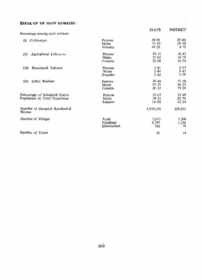
DREAJ(-UP OF MAIN WORKERS :
STATE DISTRICT Percentage among main workers
(i) Cultivators Persons 44·68 28·40 Males 14'29 29·50 Female~ 49'26 4'71
(ii) Agricultural Labou:crs Persons 16'11 16.47 Males 15'62 16'76 Females 22'00 10 ·33
(iii) Household Industry Persons 2'81 3,57 Males 2·84 3·47
.Females 2'42 5'70
(iv) Other Workers Persons 36·40 51'56 Males 37'25 50·27 Females 26'32 79·26
Percentage of Scbeduletl Cast.:!s Persons 19'07 23·49 Population to Total Population Males 19 ·13 23·70
Females 18 ·99 23-24
Numljer of Occupied Residential Houses
1,959,351 226,815
Number of Villages Total 7,073 1,306 Inbabited 6,745 1,230 Uninhabited 328 76
Number of Towns 81 14
(xli)
I 45
HARYANA
TAHSIL KALKA DISTRICT AMBALA
Km.2 I 0 2 4 6
yhtt# ::::ahtd i i Z 4
~~. oS-/ "V) 23\ ... . ...-J..r ---·
24) ~
6 10
ttH 5 Milo.
~ ~
Note
(/
THE TAHSIL BOUNDARV IS AS SUPPLIED BV SURVEY OF INDIA I AND THE VILLAGE BOUNDARIES ARE AS PER REVENUE RECORDS.
o z « :t tJ
BOUNDARY, STATE
BOUNDARY, TAHSIL.
BOUNDARY, VILLAGE WITH LOCATION CODE NUMB~~~ [=~=4~~==J TAHSIL HEADQUARTERS. © VILLAGES WITH POPULATION SIZE: BELOW 200; ... 0 • 200-499; 500-999; 1000-4999; 5000 & ABOVE lit • e UNINHABITED VILLAGES WITH LOCATION CODE ..
\
URBAN AREA WITH LOCATION CODE.
NATIONAL HIGHWAY
STATE HiGHWAY.
IMPORTANT METALLED ROAD
RAII.WAY LINE WITH STATION, BROAD GAUGE ..
RAILWAY LINE WITH STATION, NARROW GAUGE.
POST OFFICE / POST AND TELEGRAPH OFFICE.
HIGH OR HIGHER SECONDARY SCHOOL
FOLICE STATION
HOSPITAL. PRIMARY HEALTH CENTRE. DISPENSARY ...
DEGREE COLLEGE
RIVER AND STREAM
[=-=~46=--='J Wm1W/d
NH22
SH I
RS -oo@iD
RS II II IIt2I
'" EB
PO / PTO
5 PS
@j ~
+ ... ~
E ost' of G reenwkh 'I © GCNernm .. nt of Indio Copyright, 1982
~\C1 '\
BOUNDARY, STATE ..
BOUNOARY, OISTRICT ... BOUNDARY, TAHSIL
HEAOQUARTER S: DISTRICT; TAHSIL •..
NATIONAL HIGHWAY ...
STATE HIGHWAY ...•...
IMPORTANT METALLED ROAD
RAILWAY LINE WITH STATION, BROAD GAUGE.
RAILWAY LINE WITH STATION, NARROW GAUGE.
RIVER AND STREAM /CANAL ...
VILLAGE HAVING 5000A"ID ABOVE
_ .. _ .. _ .. _ ... _ -.~-. '1)"-
~N~U~ SH 31
.S -RS -~/= BGrlllr.
.'0;_.,;:: .... '"
POPULATION WITH NAME... ... . ..
URBAN AREA WITH POPULATION SIZE- CLASS I, II, III ,IY&lL. • •••• POST AND TELEGRAPH OFFICE PTO
DEGREE COLLEGE AND TECH"IICAL INSTITUTION
_; GJ
REST HOUSE. TRAVELLERS' BUNGALOW, FOREST BUNGALOW AND CANAL BUNGALOW.. RH, TB, Fe, CB
Basad lJPon Survey of Indio mop with the- pllrrnission of the Surveyor General of India
HARYANA
DISTRICT AMBALA 10 15 20 ! ! !
i. 5 4 3 2.f 0 10 Miles
Note: Other villages having are shown as. .
PTO/ RH/ TB etc.,
·~'lfi WRC Workshop Railway Colony.
© Government of Indio Copyright ,1982

ANALYTICAL NOTE

3
CONCEPTS AND DEIl'INtrIONS
It has been the tradition of the Indian Census to, present·Census· ,datil' for' rutal and urban areas separately. In fact, in all the censuses throuJhout the world,:" this cla~sifiCation OfL eensu,; data" into rural and urban units is generally recognised and data presented accordingly. But the distinction between rural and urban is not yet amenable to' a single -definition which could· be aP't5licabIe t~ ~all·countri~s.
The village defined
The definition of the 'Village adopted in our State for! the' ,census,;, corrosponds'to..,the one contained in the Punjab Vmd Reven~e Act, 1887. It is. associat~dr: 'wit~-:thc~Jevy and coltectiou-,Of! the. Land revenue by the Government and IS, as such, exclusivelyadmlOlstratIve Ifl character. From this' 'POInt ,of view, a village is better ClUed a Revenue Estate, meaning thereby an 'Estate' (a specific and demarcated area of land) marked as such for the purposes of levy/ realisation - of the:::land r.evellue. ,As the land revenue, is to be realised from the" .:landholders, it was necessary, for :the, Government, to-prepare and maintain a separate record of rights of the holders .. of ,land for' .. 'each,'''':'villagc. !The 'Revenue13state- ',or 'Mauza' the name given to tho village in the Punjab Land Revenue Act, l887, has accordingly beeI)<defirled "as an area of Which a separate record of rights is maintained or which has been separately assessed to land revenue or would have .. been So assessed if the ,land 'reve'nue' :liad -riot ,been·' realised or compounded or ,redeemed or which the Stat'e Government has, otherwise: declared ,as -an' ,Estate". 'This ~aefiilition of village has been adopted for the purposes of the Census ever-since';the year '1901. ~ The village';thetefore, is 'not merely the inhabited area (abadi dell) of a village but refers to the entire land coming within a fixed boundary. In certain cases, in' fact, a village may be uninhabited.
Urban area L defined
After considerable thought, the following 'definition 'of an urban uni't' -adopted 'at ,the 1961 and-1971 Censuses has been retained with' a minor variation for the 1981 Census:
(a) AU places with a municipality, corporation, cantonment board or a notified r area :coIIimittee etc. -
(b) All other places wliich satisfied the following' criteria:
(i) A minimum 'population of 5,000 ; (ii) At least 75, per cent'of the male working population engaged, in 'iiort~agricultural pursuits ;.
and
(iii) A density of popUlation of at least 400 per .square kilometre (1000 per'square'll1ile).
In, 1961 and 1971 Censuses the males· working in activltieuuch ias -livestoc.k, forestry"fishing, hunting ,and -plantations, orchards and allied activities -were treated":as engaged in~ non-agrioultural, pursuits :and therefore, contributed to the 75 per cent criterion whereas in the 1981 Censlls these, activities :arci treated at pJ.:." with cultivation and agricultural labour for the purpose of this criterion .
. In addition to all municipal areas/Contonment board, four villages namely (1) Babiyal in Ambala district, (2) 'Samalkha in Karnal district, (3) Gurgaon (rural) and (4) Jharsa~in Q'urgaon ,district 'satisfying the above, criteria have been treated as 'census ·'towns • (non:amunicipal) 'in 1981 Census. Pailchkula Urban Estate in Ambala district has also -been treated as a "town. 'The Faridabad - Complex Administration consisting of Faridabad, Faridabad Township and BaUabgarh towns of 197i- 'and some surrounding villages in Faridabad district has been treated as an independant ,town. ,~he ,total number
• of towns in the State in 1981 Census has thus risen to 81 a'k compared to 65 in 1971 Census.
-What is a C~nsus .House
A Census House is a building or part, of a building having a separate main entrance from the road or common courtyard or stair case etc., used or recognised as a separate unit. It may be occupied or vacant. It may be used for residential or non-residential purposed or-for~ both.
What constitutes a Household
A l:lousehold is a group of persons who commonly live together and w would take' their' meals' ftom a common· kitchen unless the, exigenci~s of work prevented any 'of them from doing' so .. TheteAilay be a household· of persons 'related by blood or a 'household of unrelated persons or having a 'mix of both. Examples of unrelated households are boarding houses, messes, hostels, residential hotels, 'fescue homes, jails, ashrams, etc. These are ealled 'Institutional Households'. By 'fIouseless Households'is m6ant a household, the- members of which do not have a house to live in and s}),end' the -night on foot paths etc. There may be one member households, 2 member households or multimember households. For
census l',url'o s~s, each on~ gf -these' types is re~arded as a 'household' ~ , ,
4
Definition of Scheduled Castes/Scheduled Tribes
- The terms 'Sched'-uled Castes' and 'Scheduled Trices' have been defined in clauses 24 and 25 of article 366 of the. Constitution, respectively as. follows : _" ..
"Scheduled Castes" mean such castes, races or tribes or parts or groups within such castes, races or tribes as are deemed under article 341 to be scheduled castes for the purposes, of the -Constitution.
"Scheduled Tribes" mean such tribes or tribal communities or parts or groups within such tribes or tribal communities as are deemed unuer article 342 to be scheduled tribes for the purposes of the Constitution.
Under article~ 341 and 342 of the Constitution, the president is empowered to specify the list of Scheduled Cas~s and Scheduled Tribes for each State and Union Territory. Accordingly, the Scheduled Castes and Scheduled Tribes are listed under the Presidential Order for each State and Union Territory.
In the Scheduled Castes and Scheduled Tribes Lists (Modification) Order, 1956, as amended uptodatc, as many as 37 castes are listed as Scheduled Castes in the State of Haryana. There is, however, no Scheduled Tribe, listed as such, in Haryana State.
Who is literate
A person who can both read and write with understanding in any language is to be taken as literate. A person who can merely read but cannot write is not literate. It is not necessary that a person who is literate should have repcived' apy formal education or shOUld have passed any minimum educational standard.
Worker defined
Like 1971 Census, a worker in 1981 Census is a person whose main activity is participation in any economically productive work by physical or mental activity. Work involves not only actual work but also effective supervision and direction "of work. The main worker is one who has worked for 183 days or more in a year in one or more than one economic activity. A person who has worked for less than 183
days in a year is considered a marginal worker.
And a Non-Worker
A non-worker is either mainly engaged in household duties or is a student or a dependent or a retired person or rentier or beggar or an inmate of an institution or engaged in other non-productive economic activity.
Connotation of Cultivator
For purposes of the Census a person is working as Cultivator if he or she is engaged eithe r as employer, single worker or family worker in cultivation of land owned or held from Government or held from private persons or institution for payment in money, kind or share. Cultivation includes supervision or direction of cultivation.
Who is AgricuJtura:t Labourer
A person who works'in another person's land for wages in money, kind or share is regarded as an agricultural labourer. He or she has no risk in the cultivation but he/she merely works in-another pelson's land for wages. An agricultural labourer has no right of lease or contract on land on which he/she works. -
Meaning of Household Industry
Household industry is defined as an industry conducted by the head of the household himself/herself and or by the members of the household at home or within the village in rural areas and only within the preCIncts of the house where the household live~ in urban areas. The larger proportion of workers in a household industry should consist of members of the household including the head. The industry should not be run on the scale of a registered faqtory whicq would 'q~alify or has to be registered under the Indian Factories Act.
Standard Urban Area expJained
The c&ncept of tbe Standard Ulban Area whicb was adopted for the first time in 1971- enyillaeed'l
5
constant st~tistical spatial reporting unit which was t.t) ser,:e as the ba sis of urban development planning for the c'):1?erned city or town. The St.and~rd Urban :\rea I:;> defI,:ed as "the. projected growth area of a city or town h~vIng 50,~OO o~ more populatl.on l~ 1971, as It w<?uld be ~n 1991, takIng into account not only the towns and vIUages whIch wIll get merged mto It but also the Intervenmg areas which are potentially urban. Thus it is a long term planning area and is to remain as a statistical reporting unit during the three successive Censuses-1971,1981 and 1991".
In the case of Haryana, the following eleven St:mdard Urban Areas were delineated 1 Ambala. 2 Bahadurgarh. 3- Bhiwani. 4 Faridabad Complex Administration (previously 'known as Faridabad-BaUabgarh Complex). 5 Gurgaon. 6 Hisar: 7 Karnal. 8 Panipat. 9 Rohtak.
10 Sonipat. 11 Yamunanagar-Jagadhri.
The concept of Urban Agglomeration
The concept of Urban Agglomeration adopted for the first -time during the 1971 Census was an improvement on the concept of town group adopted in the 1961 Census. An urban agglomeration must form a continuous urban spread constituting a town and its adjoining urban out-growths or two or more physically contiguous towns together with continuous welt recognised urban out-growths, if any, of such towns. -
In several areas around 'a core city or statutory town have come up fairly large well recognised railway colonies, university campuses, port areas, military camps, etc .. , and even though they are outside the statutory limits of the corporation, municipality or cantonment, they fall within the revenue limits of the VIllage or villages which is or are contiguous to the town. It may not be altogether realistic to treat such areas lying outside the statutory limits of a town as rural units ; at the same time each such individual area by itself may not satisfy the minimum population limit to qualify it to be treated as an independent urban unit. Such areas deserve to be reckoned alongwith the town and the continuous spread including such urban outgrowths would deserve to be .t~eated as an integrated urban area. Each such agglomeration may be made up of more than one statutory town adjoining another such as a municipality and the adjoining cantonment and also' other adjoining urban growths such as a railway colony, university campus, etc. Such outgrowths which <;10 no~ qualify to be treated as individual towns in their own right are to be, treated as urban appendages of the units to which they are contiguous.
In 1971 Census no place was recognised as a continuous urban spread deserving to be treated as an urban agglomeration in Haryana. However, the following four urban agglomerations have be en delineated at the time of 1981 Census:-
-----------------------~-------------------------------------------------
Urban Agglomeration Constituent towns or urban outgrowths
1. Yam~nanagar (U.A.) 1. Jagadhri Workshop Rail way Colony (M. C.)
2. yamunanagar (M. C.)
3. Jagadhri (M. C.)
2. Hisar (U.A.) 1. Hisar (M.C.)
2. Haryana Agricultural University and Mini Secretariat
3. Ambala (U.A.) 1. Ambala Cantt. (C.B.)
2. .t\mbala Sadar (M.e,)
4. Gurgaon (U.A.~ 1. Gurgaon (M.C.)
2. Gurgaon Census Town.
THE DISTRICT
rhe present Ambala district comprises the tahsils of Kalka, Naraingarh, Ambala and Jagadhri. There ~ere no jurisdictional changes in thi&district during the decade 1971-81. Tahsil Kalka has 154 villages and 'three towns, Kalka, Pinjore and Panchkula Urban Estate, tahsil Naraingarh has 334 villages and two towns, Naraingarh and Sadaura, tahsil Ambala consists of 325 villages and four towns Ambala, Ambala Cantt., Ambala Sadar and BabiyaI whereas Jagadhri tahsil comprises 493 villages and five towns, Jagadhri Workshop Railway Colony, Yamunanagar, Jagadhri, Buria and Chhachhrauli. With a population of 1,409,463 as per 1981 Census, Ambala ranks second among districts with 10·91 per cent of the total population of the State. Being 3,832 sq. km". in area it occupies 8 ·67 per cent of the total area (*44,212. sq. kms.) of the State and areawise ranks fifth in the State. Haryana has on an average 292 personS per sq. kilometre, with Faridabad district as the most thickly populated (466) and Sirsa as the sparsest (165). Ambala district with 368 persons per sq. kilometre ·ranks third among the twelve districts of the State.
The district lies between 30° 02' 30" and 30° 55' 5" North Latitude and 76° 32' 45" and 77° 36' 20" East Longitude. On its north and north-east are the districts of Solan and Sirmaur of Himachal Pradesh. To its east and south-east is the Yamuna river and aCross the river is Saharanpur district of Uttar Pradesh. On its south is the district of Kurukshetra. To its west are the districts of Patiala and Rupnagar of Punjab and Union Territory of Chandigarh.
Since the last Censu? of 1971, there hav0 been many changes in the boundaries of some of the existing districts and some new districts have also been formed. The new districts are.Kurukshetra, Sonipat. Faridabad, Bhiwani and Sirsa. Thus increased the number of d'istricts to 12 in 1981 as against 7 in 1971. The figures presented in this volume adhere to the boundaries of administrative units as on 31st December, 1979. They cover 39 tahsils and 81 cities/towns jncluding the four Census towns in the State.
District Census Handbook
Among the traditional documentations of the Census is the. fairly comprehensive and uniform District Census Handbook (DCH) consisting of Village and Town Directories and Village and Townwise Primary Census Abstract (PCA).
Prior to 1951, District level Census data formed part of general reports and tables. Puplication of Dbtrict Census Handbooks as independent publications began from 1951 Census only.
In 1961, attempts were made to make the District Census Handbooks more informative and these contained valuable Census 'data for each village and town. of the district, indicating some basic amenities available in the villages. In 1971, the scope and coverage of both census and non-census statistics was further enlarged and the District Census Handbooks were published in two volumes, first containing the two Parts A & B and the second comprising Part C alone :-
Part A - Village and TOWl}"Directory. v
Part B - Village and Townwise Primary Census Abs.tract.
Part C -Analytical Report, Administrative Statistics and District Census TabI7s.
The pUblication of Part-C was considerably delayed because of delay in getting the administrative statistics from the various departments. So, Part-C has been dropped this time. Moreover, the administrative statistics would be available to the data users from the publications of the respective departments.
Part-A of the 1981 District Census Handbook contains Village and Town Directory and Part-B contains Village and Townwise Primary Census Abstracts. Both the parts have been. combined together in this volume. A tahsil map showing the village boundaries, the location code numbers of the villages, the distribution of various amenities in villages and the size class of their population, has been given in the beginning of Section I-Village Directory. An alphabetical list of villages in each tahsil has also been given, along with a note explaining the codes used in the Village Directory. The -codes used in the Town Directory have been explained at the beginning of Section II-Tow~ Directory.
Village Directory,
Amenities and land use
SCOPE
. The Village Directory provides certain basic data separately for each· village, the villages in the district having -been arranged tahsilwise and within the tahsil, location i:odewise. At the time of Census en umeration each village was assigned a code number for purposes of identification. ----. --~--~
7
The format of the village directory follows the pattern canvassed in 1971 Census' except for a few additional columns. The column for total population and number of households has been added to facilitate analysis of the village directory data. The column for approach to village is aimed at having an idea of the number of inaccessible villages in a district. All the amenities except power supply in the village have been brought together with -the instructions that if an amenity is not available in the village a dash (-) may be shown against the same in the relevant column but next to it the distance from the village of the nearest place where the facility is available may be given in broad ranges in brackets, the ranges being; "(-5 kms)", "(5-10 kms)" and "(10 tkms)". .
.The Village Directory, therefore, contains information about the total area of the village (Column 3); total population and number of households (Column 4) ; and availability or otherwise of the amenities like educational, medical, drinking water, post and telegraph, duy(s) of .tbe market/hat and communications ,(Columns 5 to 10)., In Columns 11 to 13, approach to village, nearest town and distance and availability or otherwise of power supply have been indicated. Column 14 shows the staple food of the people of the village. The area under different types of land use such as area under forest, area under cultivation. (irrigated and unirrigated separately), culturable waste and the area not available for cultivation has been given in Columns 15-19. In Column 20 have been indicated the places of religious, historical or archaeological interest along with the infQrinatfon regarding newspapers, motorcycles/scooters, cars/jeepsand tractors. The data presented in the village directory has been collected from the Districl/Tahsil revenue agency.
Appendix 1
This Appendix gives for each tahsil the number of villages baving various levels and types of' educational institutions, such as primary schools, middle schools, adult literacy centres etc. along with their number" various types of medical institutions such as dispensaries, primary health centres etc. along with their number, various types of drinking water sources such as taps, tubewells etc., post .and telegraph offices,. power supply, railway station, bus stop etc. and also the number of villages not having these amenities.
~I ~
Appendix 2
This Appendix gives for each non-municipal town (Le. place treated as town only for Census' purposes) the area under forest, irrigation, unirrigated land, culturable waste land and area not available. for cultivation.
Appendix 3
This AppendiX gives the list of villages where .no educational, medical and public health faciliti~s· are available. •
Appendix 4
Tlifs Appendix gives the list of villageP With Scheduled Castes population in various ranges of pr()portion. Information is presented by the ranges 0-5 per cent, 6-10 per cent, 11-15 per cent, 16-20 per cent, 21-30 per cent and 31 per cent' and above. '
Town Directory
The Town Directory consists of seven statements almost similar to those adopted for 1971 Census., These statements have been compiled from the information supplied by the local bodies. A few new columns have been introduced with a: view to facilitating anaiysis of tbe da;ta. A significant addition is of' class of town in every statement because the infrastructure of amenities and facilities foun.d in urban areas' can be analysed by taking the class of town into consideration. The addition of the column on civic; administration status in statements III and IV and population ih statemehts IV and V also serves the' ~anie purpose.
The columns on Soheduled Castes population in statement IV and adult literacy c1a~ses/centres iw statement V have been provided keeJling in view the Minimum Needs Programme of, the Planning:
, Commission.
Again if the fire fighting service as in statement IV and medical or educational fac,ilities as int statement V are not available in the town, the name of the nearest town if hi tbe same district or the name' of the nearest district if in the same State or other State where available along with its 'distance from the' referrent town is given. This is a new feature of 1'981 Census as it is necessary to identify the areas witll
lid specific facility in every district. Details contained in each statement are given bdiow'.
Statement I gives the class and civic administration status of each town and provides some basle data based on the Primary Census Abstract (PCA) such as its area', number of households; density, sex ratio and population/growth rate. In case a town did not enjoy urban status at any Census; the relevant. columns under the headings 'Population and growth rate of the town at the Censuses of' and 'Sex Ratio' have been left blank. Where any town lost its urban status at any Census, the entry 'Declassified' has been made in the relevant columns .
. Class of each town has been presented according to 1981 Census population of the core town as follows :-
Population 100,000 and above 50,000-99,999 20,000-49,999 10,000--19,999 5,000-9,999 Below 5000
Class: I II
III IV V
VI
Statement II gives the physical aspects of the vaFious towns . in the district. .minimum and maximum temperature is not available for all the towns in the district Rainfall data is available in respect of Ambala, Ambala Cantt., Kalka, Naraingarh and only.
I>ata regarding except Ambala. Jagadhri towns
Statement III indicates the position of Municipal Finances for the year 1978-79. Income and expenditure figures have been given in Rs. '00' in respect' of each town in the district.
Statement IV shows civic and other amenities viz., roads, system of sewerage, number of latrines, method of disposal of night soil, water supply, fire-fighting service and the nUl\lber of electric connections as available during the year 1979. Sewerage facilities are available in Panchkula Urban Estate, Pinjore, Jagadhri, Jagadhri Workshop Railway Colony and Yamunanagar towns. In Jagadhri and Yamunanagar, open surface drainage system also e~ists. Other towns (except Naraingarh) are also served by open surface drains. In most of the towns, the method of carriage of night soil is by wheelbarrows and baskets. The practice of carriage of night soil as headload still continues in Ambala Cantt., Babiyal and Jagadhri towns. Fire fighting service is available in Ambala, Ambala Sadar, Yamunanagar, Pinjore and Jagadhri Workshop Railway Colony. .
Statement IV-A is in respect of civie and other amenities in notified slums of Class I and II towns. In this district Ambala and Yamunanagar are Class I towns and Ambala Sadar is a Class II town. Some slums exist in Ambala and Ambala Sadar only. All these slums are· served by open surface drains and the method of disposal of night soil is by wheel-barrows. Some electric connections (domestic as well as road lighting points) are available in these slums. .
Statement V reflects the'position of medical, educational, working women's hostel, recreational an~ .c~ltural facilities for each .town .in the. district d~ri!1g th~year 1979. Under the heading ~edical facIlIties, the number of hospltals/dlspensaf1es/T~ B. clImcs etc., has been shown separately alongwlth the total number of beds available. Under the heading educational facilities, number has been given separately of Arts/Science/Commerce Colleges, Medical Colleges, Engineering Colleges, Polytechnics, recognised Shorthand, Typewriting and Vocational Training Institutions; Higher Secondary/Secondary/Junior Secondary/ Middle/Primary Schools and Adult Literacy Centres. The extent of availability of· recreational and CUltural facilities is reflected in the number of stadia, cinemas, auditoria and public libraries.
The towns of Babiyal, Buria, Chhachbrauii, Naraingarh, Panchkula Urban Estate, Pinjore and' Jagadhri Workshop Railway Colony do not have any college. There are three colleges-one Arts college, one Arts and Scieuce college and one Arts, Science and Commerce college in Ambala, two Arts., Science and Commerce colleges in _ Ambala Sadar, one Arts college each in the towns of Ambala Cantt. ,Kalka and Sadaura, one Arts college and two Arts and Commerce cQlleges in Jagadhri, and two Arts colleges and two Arts, Science and Commerce colleges in Yamunahagar. Ambala town has two polytechnics also. There are twelve Vocational Training Institutions in the district-six in Ambala, two in Ambala Cantt. and one each in Chhachhrauli, Kalka; Naraingarh and Yamunanagar. There are two working women's hostels in this district-one each in Ambala and Ambala Cantt.
In Statement VI information regarding three most important commodities imported/exported and manufactured has been gtven along w"i1h the number of banks, agricultural credit societies and non-agricultural credit societies. Tractors, machine tools, vanaspati ghee, sugar, paper, utensils, carpets, scientific instruments etc. are among the important items manufactured in the district.
Primary Census Abstract of General Population (i) District Primary Census Abstract : ·-In the District Primary CensUs Abstract figures have beert
presented. for the district as a whole as well as for each tahsil separately. 'T' stands for total population and 'R' and 'U' for the rural and urban areas, respectively. .
(ii) Tahsil-wise Primary Census Abstract :-Here figures for each village and town (and within the town wardwise) in a tahsil have been prcsented.
At the time of Census enumeration, enumeration blocks were formed in the villages, each block consisting of about 750 'persons and in the towns, each block consisting of about 650 persons. But the data have not been given for each block separately in th~ Case of rural. areas. In the case of urban areas total population and Scheduled Castes population have been shown blockwise in the appendix. Data in Columns 6-28 of the Primary Census Ab:rtract have been given sex-wise. During 1971 Census break-up of workers into nine indufotrial categories was given whereas categories III, IV, V (b) and VI to IX have been combined together while presenting 1981 Census figures. A new concept of 'Marginal Worker' has been introduced this time. Appendix ,
This appendix gives at urban block level the total population and Scheduled Castes population. Primary Census Abstract of Scheduled Castes Population .
In the District Primary Census Abstract of Scheduled Castes population figures have been presented for the district as a whole as well as for each tahsil/town separately.
PHYSICkL ASPECTS The district has a sub-t~opical continental monsoon climate where we find seasonal rhythm, hot
summer, cool winter, unreliable rainfall and great annual range of temperature. In winter frost sometimes occurs during December and January. The region also receives occasional winter rains from the western disturbances. The rainfall during 1979-80 was 61.3 centimetres against 112.5 centimetres during 1977-78 and 156.6 centimetres during 1978-79. There are sharply-rising Siwalik hills and foothill rolling plain in the north and north-east;u doom in Pinjore area and the flood-plains along the Ghaggar, Sarasvati and Yamuna rivers. Morni hiJIs lying in Naraingarh tahsil constitute the highest point of the district as well as of Haryana. The important river~ of the district are Ghaggar (Rigvedic Sa:rasvati), Sarasvati, Markanda and Chantang. The slope of the district is towards south and south-~est in which directioI]. the rivers flow. The district is dissected towards its north and north-east by the rainfed torrents. The soils in the distri<:;t are light loam (Seo!i), silty loam (Khadar), silty clay (Naili and Chhachhra-Dakar), loam (Bhangar and Nardak), clayey silt (Bet), piedmont (Ghar and Kandi) and Siwaliks (Pahar). The underground water level is relatively high in the southern parts and low in the north and north-east which is a hilly tract. Yamun~ is the orily perennial river providing irrigation.al facilities in the east and south-east portions of the district.
ECONOMY The district has a mixed type of economy which is partly agricultural and partly industrial. At the
time of 1981 Census 44.87 per cent of total main Workers were registered under agrarian sector consisting of cultivators and agricultural labourers. Household industries claimed 3.57 per ceIit while 'Other workers' were 51.56 per cent in the district. The district is an important link between hills and plains. Ambala, Jagadhri and Yamunanagar are important trade centres. Yamunanagar, having probably the biggest timber market in the entire northern India caters to the need of ammunition boxes to the Defence Department and packing cases to tea and tobacco industries. ". There were 726 registered working factories in the district during the year 1979 and ,estimated numberitif workers employed in them was 28,236, 292 of these factories manufacture metal products and parts and 115 cotton textiles. The large and medium scale units are engaged in producing tractors, machine tools, paper, vanaspati ghee. sugar, cement, stainless steel utensils, Scientific instruments, leaf springs, etc. Hindustan Machine Tools at Pinjore, Ballarpur Industries Limited, Saraswati Sugar Mills and Yamuna Auto Industries at Yamunanagar, Indian Sugar and General Engineering Corporation and Swastika Metal Works. at Jagadhri, Bhupendra Cement Works at Surajpur and' Oriental Science Apparatus Workshop at Ambala Cantt. are ·some such units. Besides, there are many small scale units in the district and these manufacture scientific and surgical instruments, agricultural, implements, sanitary fittings, plastic and bakelite goods, safety matches etc. Jagadhri is famous for ferrous and non-ferrous metal utensils. It .is perhaps the only place after Moradabad in India where copper and bronze utensils are'manufactured on mass scale. The economy of Jagadhri industry is based on scrap and so the utensils manufactured here are available at cheaper rates in the market.
Irrigation in the district mostly depends upon' tubewells. Area under cultivation of foodgrains and sugarcane was 260· 3 thousand hectares and 27·5 thousand hectares respectively during tbe year 1979-80. In this district area under sugarcane cultivation is maximum in the State. Among the foodgrains wheat, rice and maize ate grown. Area under reserve4 forests· is 137 square kilometres. In 1977 the number of live· stock in H!1ryana was 6,904,800 which includes cattle~ buffaloes, horses, ponies, donkeys, sheep, goats, camels and pigs etc. Out of these, Ambala district contributed' only 622,000 animals and these mostly include cattle, buffaloes, sheep and goats. During 1979-80, the number of different types of motor vehicles on road Vial 93,583 in the State, out of which 20,983 came from Ambala district . ..

10
HISTORY AND ARCHAEO:(.OGY*
llrief history
The name of the district is derived after its headquarters town, Ambala. According to a local tradition it was founded by one At1J.ba Rajput during the 14th century. Another version associates the name of the town with goddess Bhawani Amba whose temple exists in the town. Yet another version is that the name of the town is a corruption from Ambwala or a place abounding in mangoes, from the large number of mango groves that existed at one time in its immediate neighbourhood. There seems to be no reason to doubt the antiquity of the region which is well established on the basis of discovery of numerous pre-historic, protohistoric and historica.l sites, many of which have been mentioned in ancient India~ literature. The name may be connected with the tribe of the Ambas mentioned in Sanskrit literature.
The earliest inhabitants of the district were primitive people using stone tools of the lower paleolithic age which have been discovered from various sites in the Kalka tahsil. Already in the time of Rigveda the Aryans had their settlements in the valleys of the sacred Sarasvati, the Drishadvati and the Yamuna. Their prominent tribes, the Bharatas, Purus and Kurus fought battles here, performed yajnas and recited and composed Vedic hymns. The Ambala area was included in the kingdom of the Pandavas and their successors, the Parikshitas. It is interesting to note that Turgbana (identified with Shrughana or Sugh near Jagadbri) finds mention in Vedic literature and has also been mentioned by Panini. The district formed part of the Mauryan empire and an edict of Asoka was found at village Topra near Jagadbri and stupas at Sugh and Chaneti. Tbe Topra pillar was removed by Feroz Shah Tugh1aq in A.D. 1356 and fixed at Kotla Feroz Shah in Delhi. The. area later came under the Sungas and an interesting find of the age is a Sunga terracotta plaque depicting a child learning alphabets on a wooden plate. It became successively part of the empires of the Kushanas, the Guptas and the Pushpabhutis of Thanesar and later fell prey to the imperial ambitions of Yasovarman of Karlauj and Lalitaditya of Kashmir. In. 10th century, Mahmud. Ghazni and hiG successors raided the district several times but a brief speU of peace was restored in 12th century under Chauhans. During the period from 9th to 12th centu,ry, the district witnessed an upsurge in religious and artistic activity as evidenced by the recovery of sculptural remains from different places.
The district passed under Muslim rule as a result of the deci~ive victory of Shihab-ud-din Ghuri over Prithviraja III in the second battle of Taraori in A.D. 1192. The important remains of the medieval period include brick forts at Khizrabad and Sadaura, Rang Mahal at Buria and the well known Mughal Gardens at Pinjore. It was during this period that small principalities of Kalsia, Buria, Ramgarh, Raipur, Kotaha, K.hizrabad, Naraingarh, Kesri, Mustafabad, Arnauli, Jagadhri, Dam1a and Bilaspur grew up.
The British annexed this area towards the beginning of the 19th century and also toolQ the existing small principalities under their protection. In 1847, Ambala district was formed with acquired strip of territory around Ambala. Subsequently small principalities were merged in it. It played a significant part in the great uprising of 1857. The ~ntire Indian troops stationed at Ambala, a military 'depot of great importance then, were disaffected towards the British and rose. in open revolt Although there was no active civil uprising in the district the population as a whole was also not warm towards t~ British. About tp,e close of 19th century and the first quarter of 20th century, the people became politically awakened. They took active part in the national freedom movement, the Non-Cooperation Movement, Civil Disobedience Movement and the Quit India Movement and made good deal of sacrifices like their fellow countrymen for achieving freedom from British rule.
This rapid survey of its history from the. earliest time indicates that the district always remained in the mainstream of Indian history.
Prior to the format jon of Haryana in November, 1966, Ambala district had six tahsils but during the Reorganisation, it lost Nalagarh tahsil to Himachal Pradesh, Rupnagar tahsil and a major portion of Kharar tahsil to Punjab and a few villages including the Chandigarh Capital Project Area to the newly formed Union Territory of Chandigarh. It was t left with only 3 tahsils, Ambala, Jagadhri and Naraingarh including' 153 villages and the Kalka town transferred from Kharar tahsil. Later in 1967, 153 villages and the Kalka town were taken out oJ the Naraingarh tahsil and formed into a separate Kalka "tahsil.
There are three historical gurdwaras, namely Badshahi Bag Gurdwara, Sis Ganj Gurdwara and Manji Sahib Gurdwara and two Muslim shrines of Lakhi Shah and Tawaqal Shah and a Bhawani Amba Temple. In 1968, a stagnating water tank near bus stand was transformed into a lake with boating facilities. A park was developed on the outskirts of the lake and a lighthouse and coloured fountains were installed. •
*Sudarshan Kumar Gupta 'Ambala District: the land Of sacred saraswati', Haryana Review January, 1983.

11
Places of interest
There are many places of interest in the distl'ict, some of which are places of antiquity, others acquired importance on account of their economic and industrial development and still others have been developed as tourist resorts.
Ambala Cantonment
The Ambala Cantonment was established in 1843. after the abandonment of Karnal Cantonment in 1841 on account of the prevalence of malaria there. The place has assumed importance as the centre for the manufacture of scientific and surgical instruments and as an important rail road junction.
Buria
. It is an ancient place whic.h. was first mentioned in the 7th century A. D. by the Chinese traveller, HiUen Tsang. The place was l'ehablhtated and patronised by Mughal Emperors Humayun and Shah Jahan. The l~tter ~re~cted a Rang Mahal, a well-built palace with stone arches, now in ruins. Raja Birbal, one of the lllne Mtnisters of Akbar, was born here.
Chhachhrauli
It was the capital of erstwhile princely State of Kalsia. The prominent buildings of the town are Ravi Palace, clock tower, fort and Janak Niwas.
Jagadhri
This town is thought to be a relic of the old name Yugandhari. The discovery of old coins of different periods prove the antiquity of the place. It was possibly the capital city of a janapada. The town is famous for brass utensils, an industry which is said to be continuing from the early centuries of the Christian era.
Kalka
This town is a terminus of DelbJ-Kalka. railwa.y line gnd st;·~rting point of narrow !gaugc Kalka -Shimla railway line (opened in 1903) and is a gateway of Him;:l.chal Pradesh territory. A temple of Kalika Devi is located on Kalka-Shimla road.
Pinjore
It is an ancient historical <).nd religious place. It is said to be th.;: earliest habitation (If man and it i.s said that the e<,.r1y man lived in Pinjore legion ronnd abont Chandigarh, one and half Crores years ago. Tools of lower Palaeolithic period, fabricated on qU'l.rtzite, Jlave been foundirom the region stretching from Pinjore to Nalagarh. The place is associated with five pandaW'.s who ell ronte to HiJ1ldlayas during their exile' stayed here for sometime. The place was then kn0wn as Panchpura Jater corrupted to Pinjorc. The name panchpnra was deciphered from the Pinjore Baoli inscriptiC'n found from here. Important sculptures and other antiquarian remains rec:>vered from th,;: place can be aS1>igncd to the peried ranging between 9th century A.D. to 12th century A.D. Pipjorc is famo.lls for the beautiful Muglw.l G?rden, perhaps the loveliest and the oldest in northern India. It is said to have been made by Fidai Khan in the 17th cen.tury. The Haryana Govermeilt, of late, have recreated the whole complex by adding coloured illuminations to the play of fountain water, providing rest places, picnikin!; faciliti~s and a mini zoo. It has also beep renamed as Yadavindra. Garden as a mark of respect to the late Yadavindra Singh, Maha raja of the erstwhile princely State of Patiala. The main gate of the garden opens on the highest terrace and seven terraces descend gradually into the distant boundary of the garden. In the middle of the first terrace is the Shish Mahal in the Rajasthani-Mughal style with small windows and apertures. Thel'e is a lyrical Hawa Mahal, approached by steps on the side of the wall. The second terraCe is uplifted by large arched doorways, above which thel'e is the Rang Maha!. Cleverly devised by the architect, the view of the lower terraces is from the open hall way below. The palace has an enormou\ open courtyard. We descend, by concealed steps on both sides of the big house, to the third terrace where the cypresses and flower bed lead down to dense groves of fruit. trees on each layer. The density of the dark green foliage evokes brooding depths. The upward flow of water from the fountains cools the eyes. There is a CUbe-like Jal Mahal, with a square fountain bed and a plinth to sit down on for pleasure. The next terrace is flanked by denser groves of trees, lightened by the water devices in the middle. The end structure of the door way has recently been made into a disc-like open air theatre. The stiff outer wall of the garden is reminiscent of the fort walls, which has now all around miniature pavilions hou.,ing the zoo. A Bhima Devi temple and an old baoli in the town have legendary ~onnection wit4 Pandavas, The place becaIl!e more important with the establishment of HMT factory in 1963.
12
Sadaura
Sadaura is a place of antiquity as indicated by the discovery of ancient coins. There is a tomb of Hazrat Shah Kumaish, said to' have been built in A.D. 1450. Banda Bairagi is said to have built a fort at Lohgarh about 7 kilometres from the town which. has been the centre of his activity. A place Katalgarhi in t4e town is associated with the massacre of those who betrayed him.
Yamunanagar
Yamunanagar, previously known as Abdullapur is located on the Western Yamuna Canal. Initially, a few factories and a timber market were established there. After 1947, the refugees from Pakistan were ~ettled pere. Later a model town and a fe,,: o.the~ colonies ~ere also establiiPed. It is one of the maj~r mdustnal centres of Haryana and has the dlstmctIon of havmg many large scale and small scale industrIal units. It is a big timber market and has many saw mills. A city centre is being established on the banks of 'Y'estern Yamuna Canal whi~h will have a lake, a restaurant, club, view towel', stadium, swimming pool, lIbrary, museum and gymnasIUm hall. .
Chandi Mandir (Kalka Tahsil)
Chandi Mandir, located on Ambala-Kalka road is a small village named. after an old shrine dedicated to Chandi Devi. The shrine of Chandi Devi is located across the railway line. Saket, a home for orthopaedically handicapped is also located at Chandi Mandir.
Nada (Kalka' Tabsil)
Nada which lies across the Ghaggar near Pauchkula is famous lor a Gurdwara named after one Nadu Shah, a disciple of Guru Gobind Singh. He rendered great service to the Guru when the latter along with his army was camping at this place.
Mansa Devi temple lies in village BiJaspur (Kalka tahsil) about 3 kilometres east of Mani Majra (Chandigarh). There are two temples dedicated to the goddess. The older one is said to have been built by the ruler of Mani Majra somewhere in A. D. 1815: This temple contains thirty-eight panels of wall paintings besides floral designs painted all over the ceiling and the arches leading into the temple. The second temple is said to have been constructed by Maharaja Karam Singh of erstwhile Patiala State somewhere in A. D. 1861.
Talokpur (Naraingarh Tahsil)
. Talokpur is famous for temple of goddess Sharda Devi where a big fail.' is held in March-April. In the vicinity of the temple, there is a complex of temph_s dedicated to Shiva.
Morni hills are offshoots of Siwalik ranges and the Morni village (Bhoj Jabial) lies on the mountain side of the range, The name Morni is said to be after the name of the queen who is· believed to have ruled this area. This is the only hill station in the State .and has a Salubrious climate. Thy Government undertook to develop this hill resort and constructed a motorable road connecting it with Panchkula. A beautiful, comfortable forest tourist hut 'Lal Munia' and a P.W.D. rest house have been constructed there.
Haryoli (AmbaJa Tahsil)
Haryoli 'Situated 8 kilometres from Ambala, is famous for its temple of Rishi Markandya. It is said that the Rishi was only 12 years of age when the messenger of Yama came to take away his life. He was deep in meditation worshipping Shiva. He invoked Shiva's protection. Shiva appeared and gave him blessings that he would never perish till the deluge.
Lakhanaur Sahib (Ambala Tahsil)
Lakhanaur Sahib, a village situated about 6 kilometres south of Ambala, is known for jts gurdwara built to commemorate the memory of Guru Gobind Singh.
Panjokhara (Ambala Tahsil)
Panjokhara lies in north-east of Ambala on Ambala-Naraingarh ro~d. It is famous for ~ ~urdwara built ro commemon;te the visit of Gurp. Har ~ishl!n.
13
Bilaspur (Jagadhri Tahsil) BiJasp.ur is said to be associated with sage Ved Vyas, the writer of the Mahabharata. There
are a number of tirthas in and around . Bilaspur, among these, the most famous is Kapa! Mochan situated ~bout 2 kilometres north of Bilaspur. The mythological legend of the Karat Machan tank is mentioned in the Mahabharata and· other Puranas. The Kapat Mochan tank is held in high esteem and a big fair is held in October-November. Rio Mochan tank, Suraj Kund, Vyas Kund, Sidheshwar temple are other well-known tirthas located near Kapal Mochan. Bisationwala (Jagadhri Tahsil)
Panchmukhi Hanuman temple is located in Village Bisationwala, 4 kilOlnetres away from Bilaspur on Bilaspur-Chhachhrauli road. The temple has a gigantic idol of Hanuman with a' face having five different images. The temple is said to be one of the three of its kind in India. Chaneti (Jagadhri Tahsil)
At Chaneti, a small village situated about 3 kilometres eaSt 6f Jagadhri anti nearly the same distance from Sugh, there is a huge brick mound. The shape and structure of this mound and the testimony of Hiuen Tsang, the Chinese traveller, suggests that the mound probably represents the remains of an Asokan stupa_ Tajewala (Jagadhri Tahsil)
Tajewala located 92 kilometres from Ambala is very popular tourist resort. The Western yamuna Canal and the Eastern Yamuna Canal take off from the Yamuna from this place. The place is ideal for angling and the rest house at Tajewa.a preserves an angler's record book that dates back almost 50 years. Hathini Kund is an angler's par~qise and there is a lovely view of the Yamuna's water making .shifting patterns of light and shack Kalesar, IS nestling in enchanting surroundings. . It is a game sanctuary whiC;h sprawls with thick sal trees in an area extending over 5 thousand hectares. Tajewala, Hathini ,Kund and Kalesar are located within 5 ki!ometres of each other on Jagadhri-Paonta road. Suitable accommodation for the tourists visiting the complex is available at Kulesar, Hathini Kund and Tajewala. Sugb (Jagadhri Tahsil) .
Sugh located about 5 kilometres east of Jagadhri has been identified with the ancient city of Shrughana. It was an important city of nbrthern India and has been mentioned in the vedic and later literature. A detailed account of the city is recorded by Hiuen Tsang, a Chiness traveller who visited the city in the first half of the 7th century. His account shows that Shrugh~na was the capital city of a kingdom which extend~d on either side of the Yamuna under thll Siwaliks.· The archaeological excavations at Sugh have revealed that the town existed from Circa 600 B. C. to circa A. D. 300. The archaeological finds included pottery, terracotta figurines, coins, seatings, etc. Among these terra cotta finds, a broken figure depicting a headless child with a takhti in l;tp, now on display in the National Museum, New Delhi, is of special interest. The importance of the plaque lies in the fact that the writing board has alphabets belonging to Sunga period. No such figure has yet been found from any other site in India.
Adh B~dri lying on the foot-hills of the Siwaliks, is also associated with an ancient past. The sacred river Sarasvati is believed to have originated from this place. A number of sculptures of ShivaParvati and Ganesha belonging to 9th-10th century A. D. and a few Buddhist images belonging to lith· 12th century A. D. have been discovered from this vlace. . ' .
Hamauli near Jagadhri is known for Panch Tirtha, a sacred tank. It is believed that the five Pandavas took bath in the tank here.
TOURIST RESORTS The State Government has provided oases of comfort, relaxafion and recreation by creating tourist
complexes for the road weary all over Haryana. 'These complexes include motels, restaurants and resorts. In Ambala district, the Department of Tourism has developed following tourist resorts :-Red Bishop at Panchkula
(i) It is situated 270 kms., away from Ddhi on Chandigarh-Shimla road in Panchkula town. It provid·~s [!ciliiies of restaurant, bar and arrangements f(;r garden parties.
Youth Hostel at Panchkula (ii) It is also situated in Panchkula town at e:distance cf 270 kms. fwm Ddlti en a state road leading
aw,ty from the National Highway N.). 22. A g.~t-away-from-it-all retreut, the hostel lies atop nt.'ised ground on the bank of Gh3.ggar river and c,ffcrs dOrI)litory acce mmcdation, catering facilities an,d restful ease.
Yadavindra Gardens at Pinjore (iii) Th~se are situated 270 Kms. away from Delhi on the National Highway No. 22. Steeped in myth ane!
legend, originally conceived by Fidai Khan, the trusted lieutenant of Aura.ngzeb, this Mughal garden is now alive with coloured lights, running water channels and fountains. Facilities available inch,de motel, restaurant, shopping arcade, mini zeo, children's park. epen-air-theatre, Ja.panese garden, bar, wine shop, glass h0u,se aOQ ~on,ferencc roow, (t<;;. J,.u;<urjous accCUlplodaticT\ is ilyailablc for tb,e tourjsts, .

14
ANALYSES OF DATA
The fol1owing inset tables in this volume are based on the data compiled in the Village and Town Directory and the Primary Census Abstract.
Table 1 below indicates the population sexwise separately for rural and urban areas at district and tahsil level along with the number of villages and towns as per 1981 Census.
Serial Name of Tahsil No.
1 2
Kalka
2 Naraingarh
3 Ambala
4 Jagadhri
Total.Distict
TABLE 1
population, Number of Villages and Towns, 1981
POPULATION
Total Rural
P M F P M F P
3 4 5 6 7 8 9
126,490 69,439 57,051 88,146 48,052 40,094 38,344
245,696 130,369 115,327 226,195 120,248 105,947 19,501
522;829 274,961 247,868 289,719 154,379 135,340 233,110
514,448 278,539 235,909 341,626 184,370 157,256 172,822
Urban
M p
10 11
21,387 16,957
10,121 9,380
120,582 112,528
94,169 78,653
No. of Villages No. of Towns
Total Inhabited
12 13
154 136
334 320
325 309
493 465
14
3
2
4
5
1,409,463 753,308 656,155 945,686 507,049 438,637 463,777 246,259 217,518 1,306 1,230 .14
Table 2 below gives percentage decadal (1971-1981) variation in population. This variation is more pronounced in urban areas than in rural areas.
TABLE 2 ,
Decadal change in distribution of population
_-------POPULATION Percentage decadaJ
(1971-81)' variation Tahsil
1971 1981
-------- Total Rural Urban
Total Rural Urban Total Rural Urban
.2 3 4 5 6 7 8 9 10
Kalka 83,975 66,264 1.7,711 126,490 88,146 38,344 50'63 33 ·02 116 ·50
Naraingarh 196,500 180,649 15,851 245,696 226,195 19,501 25'04 25'21 23'03
Ambala 431,680 245,554 186,126 522,829 289,719 233,110 21 ·11 17'~9 25'24
Jagadhri 386,250 261,203 125,047 514,448 341,626 172,822 33·19 30'79 38·21
District 1,098,405 753,670 344,735 1,409,4.63 945,686 463,777 28·32 25 '48 34·53

15
Table :1 below presents distributIon of villages according to the slze of poputation. it stlows that 49 ·76 per cent of the villages in the district are medium sized having population in the range ofSOO-1999 and 31 ,14 per cent of the villages fall in the population range of "200-499.
TABLE 3
Distribution of villages by population ranges
Number of Percentage villages in of villages
Range of population
each range in each range •
1 2 3
-200 . 165 13'41
200-499 383 31 '14
500-1,999 .612 49'76
2,000-4,999 64 S·20
5,000-9,999 6 0,49
10,000+
Total 1,230 100 ·00
Table 4 below shows the distribution of villages by density. In 32.52 per cent of villages in the district, the density of population per square kilometre fall in the range 301-500 whereas in 30 '65 per cent it falls in the range 201-300. It is above 500 in 8·94 per cent of villages only.
t>
Range of density (per sq. km.)
-10
11-20
21-50
51-100
101-200
201-300
301-500
501+
Not known
Total
1
TABLE 4
Distribution of villages by density
Total number Percentage of of villages' villages in in each each density density range range
2 3.
11 0'90
6 0'49
28 i·iS
57 4·63
241 19'59
377 30·65
400 32'52
110 8·94
1,230 100·00

Tabi~ 5 beiow gives ~he proportion of Scheduled Castes population to total population in the viHage. In 69.19 per cent of vi1lage~ perce~1tage uf Scheduled Castes population to total population is 16 and above. In 12.44 per cent of villages there is no Scheduled Castes population at all.
TABLE 5
Proportion of Scheduled Castes population to total population in the villages
----------- ----- ----Percentage range of Scheduled Castes
population to total population
Nil
5 or less
6-10
11-15
16-20
21-30
31 "and above
--------------~--------_....----------- .. ----Total
Number of Percentage of villages in villages in each range each range
2 .3
153 12·44
57 .4 '63
77 6·26
92 7'48
115 9·35
228 18 '54
508 41'30
1,230 100·00
Table 6 below relating to proportion of Scheduled Tribes pc,pulation to total popUlation in the villages i~ not applicable as there are no Scheduled Tribes in 4;he 'Haryana State.
TABLE 6
Proportion of Scheduled Tribes population to total popUlation in the villages
Percentage range of Scheduled Tribes population to total population
Numoer of villages in each range
Percentage of villages in each range
_--- ---~---------- ---1
---------------~--.--.-----~-.----
Nil
5 or less
6_15
16-25
26_35
36-50
51 and.above
Total
2
"1
I J
\. Not applicable
J I \ )
3
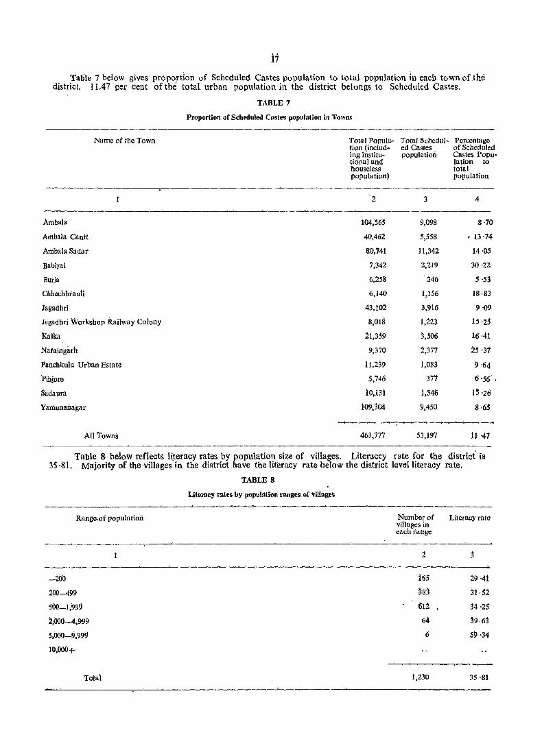
11 Table 7 below gives proportion of Scheduled Castes population to total population in each town of the
district. 11.47 per cent of the total urban population in the district belongs to Scheduled Castes.
Name of the Town
1
Ambala
Ambala cantt
Ambala Sadar
lJabiyal
Buria
chhachhtauti
Jagadhri
Jagadhri Wotkshop Railway Colony
Kalka
Nataingarh
Panchkula Urban Estate
'Pihjore
Sadaura
YaIIiunaiiagar
All ToWns
TABLE 7
Proportion of Scheduled Castes population in Towns
Total Population (including institutionaland houseless popula tion)
2
104,565
40,462
80,741
7,342
6,258
6,140
43,102
8,018
~1,3S9
9,370
11,239
5,746
10,131
lO9,304
Total Schedul~ Percentage ed castes of Scheduled population Castes Popu
lation to total population
3 4
9,098 8·70
5,558 • 13 ·14
11,342 14'05
2,219 30 ·22
'346 5 ·53
1,156 18·83
3,916 9'09
1,223 15'25
3,506 16·41
1,377 ~5 ·31
1,083 9'64
377 6 '56' ,
1,546 1:;'26
9,450 8·65 ......._,__,____,_...._.... ............ -----;,.._,~
463,777 53,197 11'41
Table 8 below reflects. li~eracy rates by population size of villages. Literacey rate for the district' is 35 ·81. Majority of the villages in the district have the literacy rate below the district level literacy rate.
Range,of population
-200
200-499
SOO-1,99!}
2;()()0-4,999
5.000-9.999
10,000+
Tota~
TABLE 8
Literacy rates by population ranges,of 'Villages
Numbetof villages in eachtange
2
165
~83
612
64
6
1.230
Literacy rate
3
29 ·41
31·S2
34 ·25
j9·63
59 '34
3S ·81

20
TABLE
Literates, Workers, Non-workers, Scheduled Castes/Tribes
Name of Tahsil Total Total Population Percentage
Rural -------------Urban
Persons Males Females Scheduled Scheduled Literates to total population Caste Tribe po pula- popula- --_--------tion to tion to P M F total total popula- popula-tion tion
1 2 3 4 5 6 7 8 9 10 o!i
Kalka T 126,490 69,439 57,051 19·42 46·01 53 ·16 37'32
R 88,146 48,052 40,01)4 22·24 31),08 47 ·41 29'09
U 38,344 21,387 16,957 12.95 61 ·95 66·06 56'78
Naraingarh T 245,696 130,369 115,3~7 24 ·39 36'41 46·90 24·56
R 226,195 120,248 105,ll47 24·75 34'38 45·15 22 '16
U 19,501 10,121 9,380 20 ·12 59'99 67'66 51 -72
Ambala T 522,829 274,961 247,868 23·15 50 ·10 58 ·07 41 ·27 <)
R 289,719 154,379 135,340 32'04 39'20 49'16 27'83
U 233,110 120,582 112,528 12 -10 63 '66 69 '47 57-43
Jagadhri T 514,448 278,539 235,909 24'40 42'64 50'89 32'88
R 341,626 184,370 157,256 32·03 33 ·05 42 '92 . 21-49
U 172,822 94,169 78,653 9'31 61 '58 66'51 55-67
Total District T 1,409,463 753,308 656,155 23 '49 44-·62 53·03 34·97
R 945,686 507,049 L 438,637 29·38 35·81 45 ·77 24·30
V 463)777 246,259 ~17!?18 P'47 62·59 67,97 56'4~
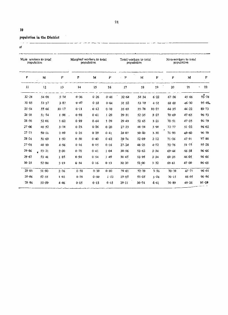
21
10
population in tbe District
of
_,_-------. Main workers to total Marginal workers to total Total workers to total Non-workers to total
population population population population
-------------_" ---------- -------------P M F P M F p M F P M F
11 1~ 13 14 15 16 17 18 19 20 21 22
tI 32'28 54·08 5·74 0'36 0·26 0'48 32·64 54·34 6·22 67·36 45·66 93'78
30'85 53 '37 3·87 0'47 0'33 0'64 31 '32 53·70 4'51 68 ·68 46·30 95 '49.
35'54 55'66 10 ·17 0'11 _ 0 ·12 0·10 35'65 55·78 10'27 64'35 44·22 89'73
28'38 51 ·74 1 ·98 0·93 0·61 1 ·29 29'31 52'35 3·27 70'69 47'65 96 '73
28 ·,so 52·01 1 ~82 0·99 0·64 1 ·39 29·49 52·65 3·21 70'51 47·35 96'79
27'00 48·52 3·78 0·2l 0·26 0·20 27·23 48'78 3·98 72·77 51'22 96·02
27·72 50 ·11 2'89 0·35 0·29 0·41 28 '07 50·40 3.30 71·93 49·60 96·70
28'24 51·69 1 ·50 0·50 0·40 0·62 28 ·74 52 '09 2·12 71·26 47'91 97·88
27·08 48 ·10 4·56 0·16 0·15 0·16 27·24 48'25 4'72 72'76 51 '75 95·28
29'86 <I 53·21 2'30 0·70 0'41 1·04 30·56 53'62 3·34 69'44 46'38 96·66
29'67 53'41 1 '85 0·98 0·54 1 ·49 30·65 53'95 3·34 69'35 46 ·Os. 96·66
30'25 52'84 3 ·19 0·14 0·16 0-13 30-39 53-00 3-32 69'61 47·00 96'68 ,
29·03 51·90 2·76 0·58 0·39 0·80 29·61 52·29 3 ·56 70·39 47·71 96·44
29·06 52·55 1·92 0·79 0·50 1 ·12 29·85 53·05 3 ·04 70·15 46·95 96·96
28'96 50·59 4'46 0·15 0·15 0·15 29 ·11 50·74 4·61 70·89 49'26 95 '3<)
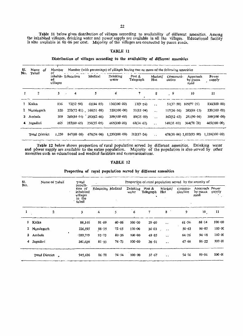
22
Table 11 below gives distribution of villages according to availability of different amenities. Among the inhabited villages, drinking water and power supply arc available in all the villages. Educational facility is also ava.ilable in 68 '86 per cent. Majority of the villages are connected by pucca roads.
TABLE 11
Distribution of villages iaccording to tbe availability of different amenities
SI. Name of Number Number (with percentage) of villages having one Or more of the following amenities No. Tahsil of
inhabit- Education Medical Drinking Post & Marketl Communi- Approach ed water Telegraph Hat cation by pucca
Power supply
villages road
1 2 3 4 5 6 7 8 • 9 10 11
Kalka 136 72(52 ,94) 61(44 ·85) 136(100 ,00) 13(9 '56) 51(37 '50) 105(77 ,21) 136(100 ,00)
2 Naraingarh 320 233(72 ,81) • 166(51 ,88) 320(100 ·00) 51(15 ,94) 117(36·56) 282(88·13) 320(100 ·00)
3 Ambala. 309 260(84·14) • 193(62·46) 309(100·00) 80(25 ·89) 162(52·43) 281(90·94) 309(100 ·00)
• Jagadhri 465 282(60 ·65) 256(55 ·05) 465(100 ·00) 68(14·62) 148(31 ·83) 364(78,28) 465(100 ·00) ~~~ _ ___'__' ___ --r
Total District 1,230 847(68 '86) 676(54 '96) 1,230(100 ·00) 212(17 '24) 478(38 ·86) 1,032(83 '90) 1,230(100 '00)
Table 12 below shows proportion of rural population served by different amenities. Drinking water and pbwer supply are available to the entire population. Majority of the population is also served by other amenities such as educational and medical facilities and communications.
TABLE 12
Proportion of ru!al population served by different amenities
Sl. Name of Tahsil Total Proporti!,>n of rural population served by the amenity of No. popula-
tion of EducatiOn Medical Drinking Post & Marketl commu- Approach Power inhabited water Telegraph Hat nicatiol1 by pucca supply villages road in the
, tahsil
1 2 3 4 5 6 7 8 9 10 11
1 Kalka 88,146 81 ·09 60'86 100'00 29'60 61 '54- 88 ·14 100'00
2 Naraingarh 226,195 88'35 72·15 100·00 36·03 50"63 90·85 100'0<;
3 Ambala ·289,719 93'73 80'36 100·00 49·85 64,26 94·18 100·0(
4 Jagadhri 341,626 81 '33 74 ·73 100'00 30 ·51 47 ·68 86'22 100 ·OC
Total District ,. 945,686 86·78 74 ·54 100 ·00 37·67 54·76 89·94 100 .0(

Table 13 below gives distribution of villages, not having certain amenities arranged according to distance ranges from the places where' thege are available. In 1,018 villages Post and Telegraph facility is not available whereas there is no communication. facility in 752 villages.
TABLE 13 Distribution of ~iHages not having certain amenities arranged by distance
from the 1Iiaces where tbese are available
Villages not having the amenity of Number of villages where the amenity is not available and
Education
Medica1
Drinking wa ter
Post and Telegraph
Market/Hat
Communication
1
-5kms.
2
362
360
790
614
available at a distance of
5-lOkms. 10+kms. Total (Cols.2_4)
3 4 5
16 5 383
142 43 554
i73 5S 1,018
HJ2 36 752
Table 14 below shows distribution. of villages according to the distance from the nearest town and availability of different amenities. 581 villages fall within a distance of 6-15 kms., 347 villages within l1. distance of 16-50 kms. and another 302 villages within a distance of 0--.-:5 kms. from the nearest town.
TABLE 14 Distribution of viJJages according to the distance from the near~st tOlw'n
and availability of different amenities
Distance range Number froID. the nearest of intown (in Kms.) habited Education
Number (with percentage) of villages. having 'the amenity of
Medili:al Drinking Post & Market! Communi-teleg~aph Hat cation
Approach by pucca road
Power sUpply
1
0-5
rI·
6-15
16-50
51+
Unspecified .__,___,
Total
villages in-each range
2 3
302 198(65 '56)
581 397(68'33)
4
162(53 '64)
316(54 :39)
water
5
302(100 ·00)
581(100 '00)
6
43(14·24)
99(17,04)
7 8 9
98(32'45) 274(90,73)
234(40 ,28) 483(83,13)
10
302(100 '00)
581(100 '00)
347 252(72 '62) 198(57 ,(6) 347(100 '00) 70(20 ,17) 146(42 ,07) 275(79 '25) 347(100 '00)
1,230 847(68 '86) . 676(54 '96) 1;230(100 ·00) 212(17 '24) ~78(38 '86) 1,032(83 '90) 1,230(100 '00) --~--~------~~--~~~--~--~~---
Table 15 below gives distribution of villages according to population range and amenities available. 612 villages have population in the range 500-1,999. whereas 548 villages have population of less than 500. Only 6 villages have population of more than 5,OOu. Majority of the villages have most of the noted amenities.
TABLE 15 Distribution of Villages according to population ran~e and amenities available
Population Number Number (with percentage) of villages having the amenity of tange of in-
habited Education Medical Drinking Post & Market/ Communi- Approach Power vllJages water Telegraph Hat cation by pucca supply in each road range
1 2 3 4 5 6 7 8 9 10 ,.. ..
"-499 548 230(41 '97) i69(30 ,84) S48(HiO '00) 23(4,20) 156(28 '47) 422(77,01) 548(100 ·6d)
500-1,999 612 548(89 ,54) 440(71 ,.90) 612(100 '00) ,134(21 '90) • . 263(42-97) 543(88 -73) 612(100 '00)'
2,000-4,999 64 63(98·44) 61(95 '31) 64(100 '00) 49(76,56) 53(82 '8i) 61(95 ;31) 64(100,00)
5;000+ 6 6(100 '00) 6(100 '(0) 6(106 '00) 6(100 '00) 6(100 '00) 6(100 .()() 6(i00 '00)
Total i,230 847(68·86) 676(54-96) 1,230(100 '00) 212(17 '24) 478(38 '86) 1.032(83 '90) i,230(focJ ·00)
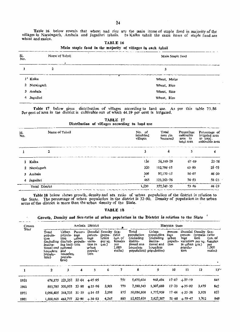
Table 16 below reveals that wheat and rice are the main items of staple food in majority of the villages in Naraingarh, Ambala and Jagadhri tahsils. In Kalka tahsil the main items of staple food are wheat and maize.
TABLE 16 Main staple food in the majority of villages in each tahsil
Sl. Name of Tahsil Main Staple food No.
1 2 3
1· Kalka Wheat, Maize
2 Naraingarh Wheat, Rice
3 Ambala Wheat, Rice
4 Jagadhri Wheat, Rice
Table 11 below gives distribution of villages according to land Use. As per this table 73.86 Per ~nt of area in the district is cultivable out of which 44.19 per cent is irrigated.
TABLE 11 Disttibution of villages according to land use
SI. No.
i
i Kalka
2 Naraingarh
3 Ambaia
4 Jagadbri
Name of Tahsii
2
_ ... _.,..._....,-1 _ _"._....--... _ ____..~~~~~_
Total District
No. of Total inhabited area (in villages l1ectares)
3 4.
136 24,310 ·29
320 112,796'15
309 97,170 ·IS
465 123,263 ·76
1,230 357,540 ·35
Percentage :percentage of cultivable irrigated area area to to total. total area CUltivable area
5 6
67·89 22·18
63·90 28 '73
86·07 46·30
74·53 58'23
13·86 44·19
Table 18 below shows growth" density and sex ratio of 'urban population of the d.istrict in reiation to the State. The percentage of urban population in the district is 32 ·90. Density of population in the urban areas of the distric!t is more than the urban density of the State.
Census Year
1
1951
1961
1971
1981
TABLE 18
Growth, Density and Sex-ratio of urban population 'iii the District in relation to the State j
Ambala District
Total Urban Percen- :Decadal Density Se;ll" popu]a- pclpula- tage percen- (popu- ratio tion tion urban tage 1ation (no. of (incluciing (includ- popuia- varia- per sq. ft;males institu- ing insti- tion tion in -km.) per tional and tutional urban 1.,000 houseless and , {lopula- fuaJes) popula- hous«less tion tion) popula~
tion)
2 ~ 4 5 I; '7
618,175 221,352 32·64 +45 ·95 751
885,785 300,953 33'98 4-35 ·96 3,961 779
1,098,405 344,735 31·39 +14·55 3,108 875
1,409,463 463,777 32·90 +34'53 4,265 883
Haryana State
total Urban P9Pulation population (including (including institu- institu-tional ana tional and houst;less hou&eless pclpulation) populatiOn)
g 9
5,673,614 968,494
7,590,543 1,307,680
10,036,808 1,772,959
12,922,6i8 2,827,387
percen" Decadal Density Sextage percen- (po pula- ratio urban tage tion (no. of popula. variation per sq. females tion in urban km.) per
popula· 1,000 tioil tnales)
10 11 12 13 .....
17·07 +37·19 845
17·23 +35 ·02 3,479 842
17·66 +35'58 3.928 853
21 '88 +59'47 3,702 849
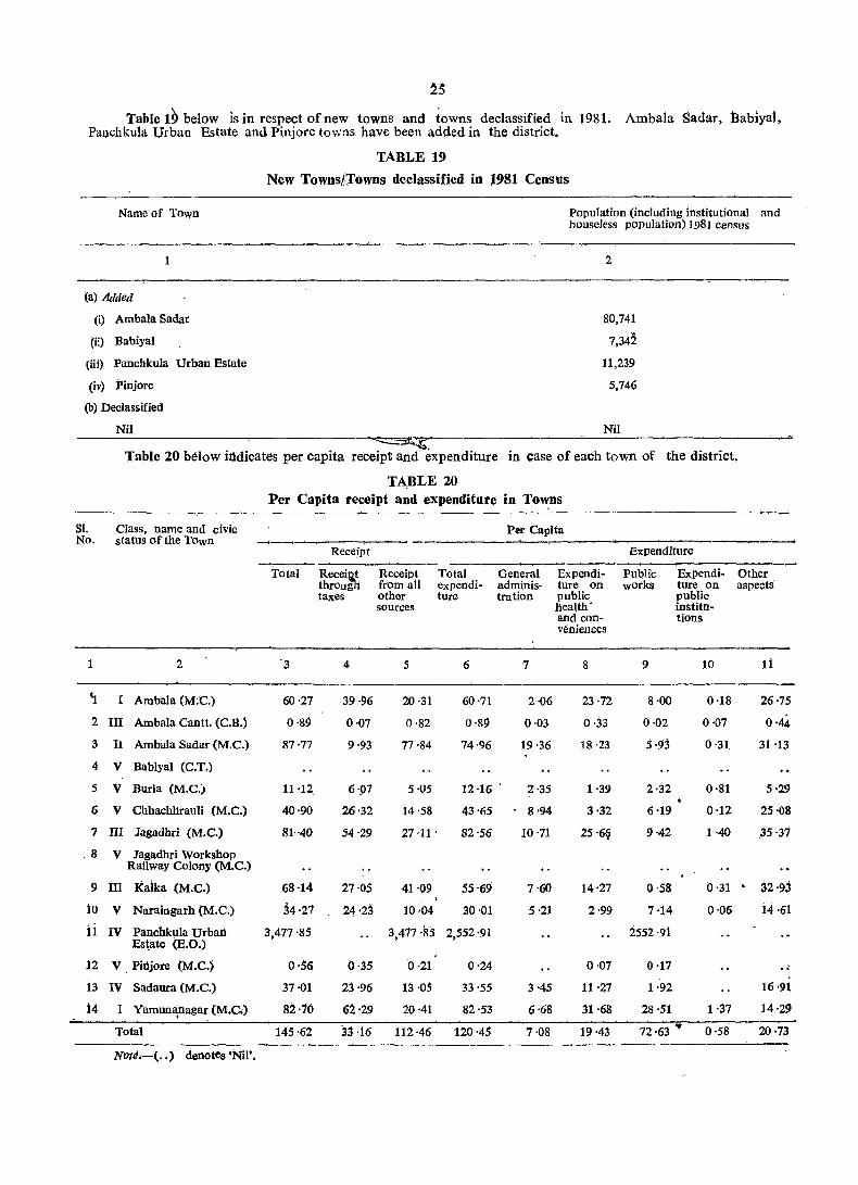
25
"fable 19 below is in respect of new towns and towns declassified in 1981. Ambala Sadar, Babiyal, Pallchkula Urban Estate and Pinjore towns have been added in the district.
Name of Town
1
(a) Added
(i) Ambala Sadar
(ii) Babiyal
(iii) Panchkula Urban Estate
(iv) Pinjore
(b) Declassified
Nil
TABLE 19
New Towns/rowns declassified in J981 Census
~.
Population (including institutional and houseless population) 1981 Census
2
80,741
7,342
11,239
5,746
Nil
Table 20 below illdicates per capita receipt and expenditure in case of each town of the district.
TA.BLE 20 ];ler Capita receipt and expenditure in To,,:ns
SI. Class, name and civic Per Capita No. status of the Town ..-.,-___,--_., ---
Receipt Expenditure
Total Recei~ Receipt Total General Expendi- Public Expendi- Other throng' from all expendi- adminis- ture on works ture on aspects taxes other ture tration public public
'sources health' institu-and con- tions Vi:niences
1 2 '3 4 5 6 7 8 9 10 Ii
'J. I Ambala (M;C.) 60·27 39·96 20·31 60'71 2·06 23·72 8·00 0·18 26·75
2 III Ambala Cantt. (C.B.) 0·89 0·07 0'82 0·89 0·03 0·33 0·02 0·07 0'44
3 II Atnbala Sadar (M.e.) 87'77 9·93 77·84 74·96 19·36 18·23 5·9j 0'31 31'13
4 V Babiyal (C.T.)
5 V Burla (M.C.) 11·12 6·p7 5·05 12 ·16 . 2·35 1 ·39 2·32 0·81 5'29
6 V Chhachhrauli (M.C.) 40'90 26'32 14·58 43'65 8·94 3'32 6'19 0'12 25·08
7 III Jagadhri (M.C.) 111 .. 40 54·29 27 ·11 . 82'56 10 ·71 25'69 9·42 1 ·40 35·31
.8 V Jagadhri VVorkshop Railway Colony (M.C.)
9 m Kaika (M.C.) 68'14- 27'05 41·09 55'69 7·60 14·27 0·58 0'31 . 32'93
10 V Naraingarh (M.C.) ~4'21 24'23 10··04 30·01 5·21 2·99 7·14 0·06 i4'61
ii IV Panchkula Urbarl 3,477'85 3,417 ·85 2,552 '91 2552'91 Es~ate (B.O.)
12 V PiI1jore (M.C.) 0·50 0'35 0·21 0'24 0·07 0·17 .. i3 IV Sadaura (M.C.) 37·01 23'96 13 ·05 33'55 3·45 11'27 1 ·92 16'91
14- I Yamunapagar (M.C,) 82·10 62·29 20·41 82'53 6·68 31 ·68 28·51 1·37 14·29 ......_ Total 145·62 33·16 112·46 120'45 7·08 19·43 72·63 • 0·58 20·73
Note.-( .. ) denotes 'Nil'.
.
26 'fable 21 below gives the number of schools per ten thousand population in towns. There is no
Higher Secondary School in Babiyal, Buria, Chhachhrauli, Jagadhri Workshop Railway Colony, Panchkula Urban Estate and Pinjore. Only one Higher Secondary and two Secondary/Matriculation Schools per tell thousand population are available in the urban areas. .
TABLE 21
Schools per ten thousand population in Towns
Class, name and civic status of the Town
1
I Ambala (M.C.)
UI Ambala Cantt. (C.B.)
n Ambala Sadar (M.C.)
V BabiYat (C. T.)
V Buria (MoC.)
V Chi:J.achliiauli (M.C.)
trr jagadhri (Moe.)
." Jagadhri Workshop Railway Coiony (M.C.)
iit Kalka (M.C.)
V Narairigarli (M. C.)
tv Parichkuia Urban Estate (E.O.)
V Pinjdre (M;e;)
IV Sadauta (M.e.)
I Yamunanagar (M.C.)
Total
Notes.-(l) ' .. ' denotes 'Nit·.
(2) 'N' denotes 'Negligible'.
Higher Secondary/ Inter/P.U.C.;Junior College
2
N
i
N
.. 1
1
1
1
1
No. per ten thousand population
Secondary/ Junior Matriculation Secondary!
Middle
3 4
'2 2
) 2
2- 2.
1 3
5 5
j 3
2 1
4 5
2. j
2 2
1 2
2 5
2 i
1 1
2 :2
Primary
5
3
3
3
4
3
5
:3
6
6
3
j
5
3
2
3

27 Table 22 below indicates the number of beds tn medical institutions per 1,000 population. The
number of beds per 1,000 population in urban areas comesto two.
TABLE 22
No. of beds in medical institutions in Towns -----------------,~
Class, name and civic status of the Town
1
I Ambala (M.C.)
III Ambala Cantt. (GB.)
II Ambala Sadar (M.C.)
V Babiyal (C.T.)
V Buria (M.C.)
V Chhachhrauli (M.e.)
III Jagadhri (M,C.)
V Jagadhri Workshop Railway Colony (M.C.)
III Kalka (M.C.)
V Naraingarh (M.C.)
IV Panchkula Urban Estate (E.O.)
V Pinjore (M.e.)
IV 1;1 Sad aura (M.C.)
I amunanagar (M.e.)
Total
Notes.-(l) ',.' denotes 'Nil'.
(2) 'N' denotes 'Negligible'.
No. of beds in medical institutions per 1,000 population
2
3
1
2
3
3
2
5
N
1
2
1
2
Table 23 below shows proportion' of slum popUlation in Class I and II towns. In Ambala and Ambala Sadar towns of the district the proportion of slum population to total popUlation of the towns comes to 3l ·65 and 5 '08 per, cent respecNvely.
TABLE 23
Proportion of slums population in Towns
Class, name and civic status of the Town'"
Ambala (M.C.)
Percentage of the slums population to total population of the town
2
31 ·65
5·08
Density in slums (per sq. km.)
3
7,995
48,786 II Ambala Sadar (M~C.)
Yamunanagar (M.e.) . There is no notified/officially recognised slum area in this town ~-~I~~---~--~-~~ 20·07 8,806
"'For Class I and ClaSS II towns only.
28
Table 24 below shows the names of the most important m~nuf<\ctured, exported a.nd imported commodities in case of each town.
TABLE 24
Most iPlPortant commodity manufac(UHd, imJoltEd ad e:ll[tHtcd in Towns
Class, name and civic of the Town
status Most imvortan't commodity·
Manufactured Exported
1 2 3
I Ambala (M.C.) DUrries Cloth
III Ambala Cantt. (C.B.)
1I Ambala Sadar (M.C.) Scientific goods • Scientific goods
V Babiyal (C.T.)
V Buria (M.C.) Des; Cloth\} Desi Jutties
V Chhachhrauli (M.e.) Rice Ban Babber
III Jagarihri (M.C.) Stainless Steel Utensils' . Utensils
V Jagadhri Workshop Railway Colony (M .. C.)
III Kalka (M.C.) Pathroti Baskets Pathroti Baskets
Foodgraios
Tractor Parts
Milling Machines
Kbandsari
V Naraingarh (M.C.) Carpets
IV Panch kula Urban Estate (E.O.) Tractor Parts
y Pinjore (M.e.) Tractors
IV Sadaura (M.C.) Khandsari
I Yamunanagar (M.C.) Sugar Sugar
Note.- ' .. ' dellotes 'N,il'.
Imported
4
Cotton
Raw material for Sci!!ntific goods
Gur
Cotton
Stainless Steel
Television Sets
Cloth
Cement
Tractor Tyres and Tubes
Vanaspati Ghee
Sugarcane
PART A
VILLAGE AND TOWN DIRECTORY
29

SECTION t
VILLAGE DIRECTORY


33
CODES USED
IN THE VILLAGE DffiECTORy


35
CODES USED IN THE VInLAGE DIRECTORY TOGETHER WITH WHAT THESE STAND FOR ARE INDICATED BELOW
COIJUMN NO. 5
Educational Primary School Middle School Matriculation Higher SecondarY/Pre-university College College-any college (graduate level and 'above)
like Arts, Science, Commerce etc. Industrial school Training school Adult literacy class/centre
COLUMN NO.6 . Medical Maternity Home Primary Health Centre Health Sub-centre Dispensary Family planning centre Nursing Home Registered private practitioner Community health worlaer
COLUMN NO. 7
Drinking Water Tap water Well water Tank water Tubewell water Hand pump River water Canal Spring Nallah Others
COL.UMN NO.8
Post and Telegraph Post Offige Post and Telegraph Office Telephone Connection
COLUMN NO. 10
Communications Bus Railway station
COLUMN No. 11
Approach To Village Pucca Road Kaccha Road
P M H PUC C
I Tr Ac·
MH PHC HS D FPC NH RP CHW
T W Tk TW Hp R C S N o
PO PTO Phone
BS RS
PR KR

COLUM~ NO. 13
Power Supply Electricity for domestic purpose Electricity for agriculture Electricity for other purpose like industrial,
commercial, etc. Electricity for all purposes listed above
'COLUMN NO. 16
Irrigated by Source Government Canal Well (wHhout electricity) Well (with electricity) Tube~well (without electricity) Tube-well (with electricity) Tank River Waterfall Others Total
COLUMN NO. 20
Remarks
36
N-copies of the newspapers coming in the village. M-Motorcycles/scooters available in the village. C-Cars/jeeps available· in the village. T-Tractors available in the village.
ED BAg EO
EA
GO W WE 'I'W 'I'WB Tk R we o T
37
ALPHABETICAL LIST OF VILLAGES IN KALKA TAHSIL

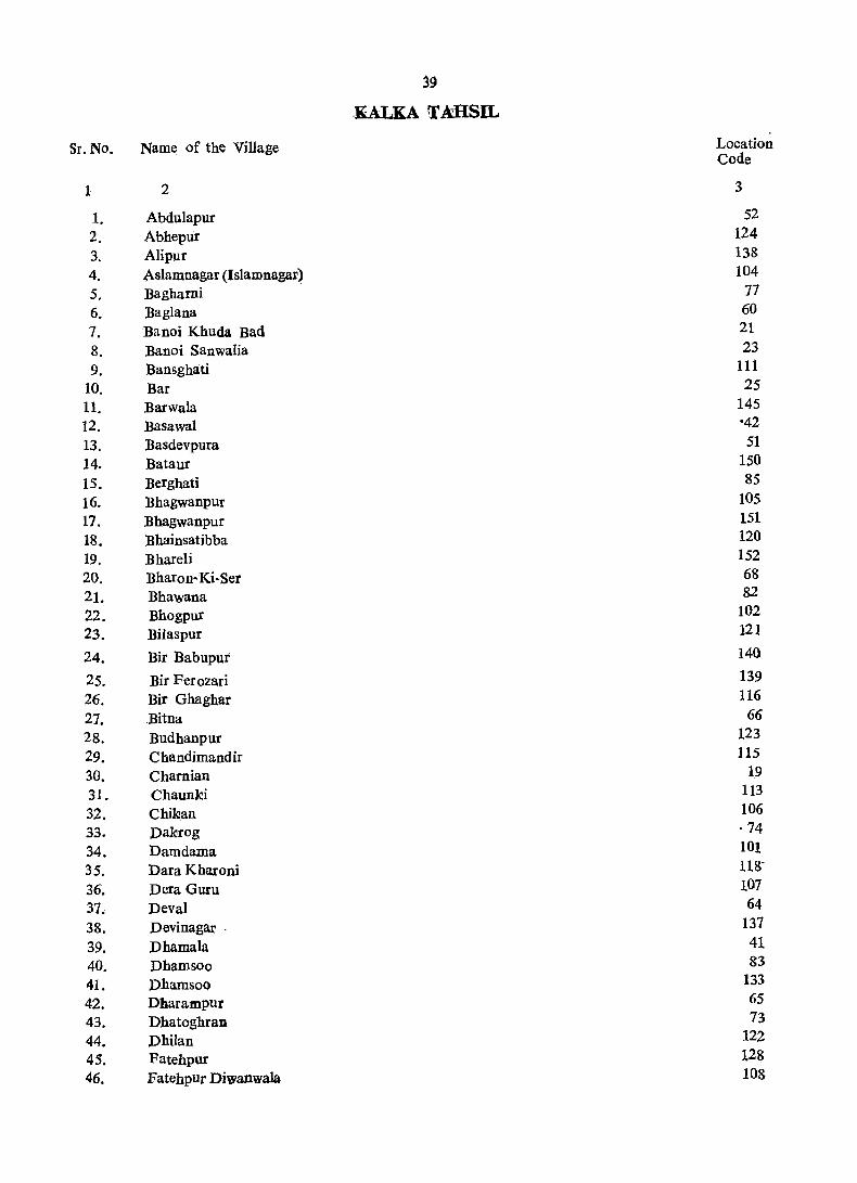
39
KALKA T MISIL
Sr. No. Name of the Village Location Code
1 2 3
1. Abdulapur 52
2. Abhepur 124 3. Alipur 138
4. ,Aslamnagar (Islamnagar) 104
5. Bagbami 17 6. Baglana 60
7. Banoi Khuda Bad 21
8. Banoi Sanwalia 23
9. Bansghati 111
10. Bar 25
11. Barwala 145 12. Basawal ·42
13. Basdevpura 51 14. Bataur 150
15. Berghati 85
16. Bbagwanpur 105
17. Bhagwanpur 151 18. Bhainsatibba 120
19. Bhareli 152
20. Bharon-Ki-Ser 68
21. Bhawana 82
22. Bhogpur 102
23. Bilaspur 121
24. Bir Babupur 140
25. Bir Ferozari 139
26. Bir Ghaghar 116
21. Bitna 66
28. Budhanpur 123
29. Chandimandir 115
30. Chamian 19
31. Chaunki 113
32. Chikan 106
33. Dakrog ·74
34. Damdama 101
35. Dara Kbaroni 11S'
36. Dera Guru 107
37. Deval 64
38. Devinagar . 137
39. Dhamala 41
40. Dhamsoo 83
41. Phamsoo 133
42. Dharampur 65
43. Dhatoghran 73 44. Dhilan 122
45. Fatehpur 128
46. Fatehpur Diwsnwala 108
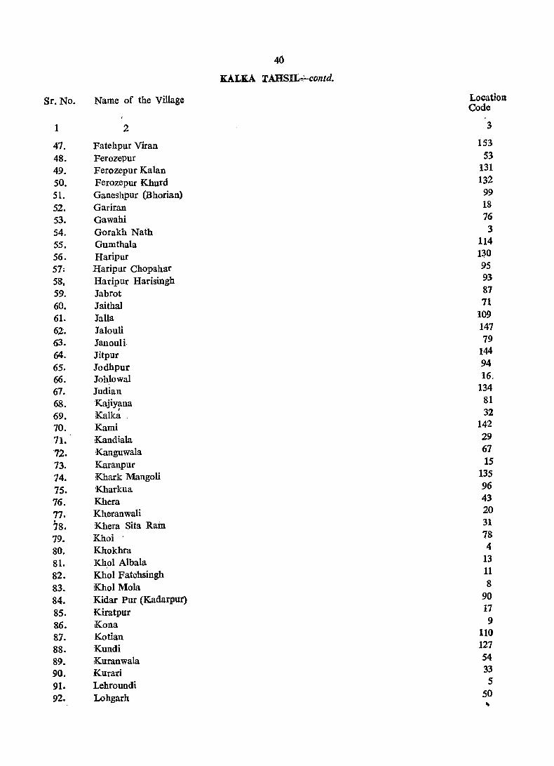
40
KALKA 'l'AHSI£":-contd.
Sr. No. Name of the Village Location Code
1 2 3
47. Fatehpur Vuan 153
48. Ferozepur 53
49. Ferozepur Kalan 131
SO. Ferozepur Khurd 132
51. Ganeshpur (Bhorian) 99
52. Gariran 18
53. Gawahi 76
54. Gorakh Nath 3
55. Gumthala 114
56. Haripur 130
57; Haripur Chopahar 95
58, Haripur Harisingh 93
59. Jabrot 87
60. Jaithal 71
61. Jalla 109
62. Jalouli 147
63. Jan 0 uli 79
64. Jitpur 144
65. Jodhpur 94
66. Johlowal 16.
67. Judian 134
68. Kajiyana 81 ,
69. Kalka 32
70. Kami 142
71. Kandiala 29
-72. Kanguwala 67
73. Karanpur 15
74. Khark Mangoli 135
75. Kharkua 96
76. Khera 43
77 • Kheranwali 20 . Khera Sita Ram 78. 31
79. Khoi 78
80. Khokhra 4
81. Khol Albala 13
82. Khol Fatehsingh 11
83~ Khol Mola 8
84. Kidar Pur (K.adarpur) 90
85. Kiratpur 17
86. Kona 9
87. Kotian 110
88. Kundi 127
89. iKuranwala 54
90. Kurari 33
91. Lehroundi 5
92. Lohgarh 50 ,..
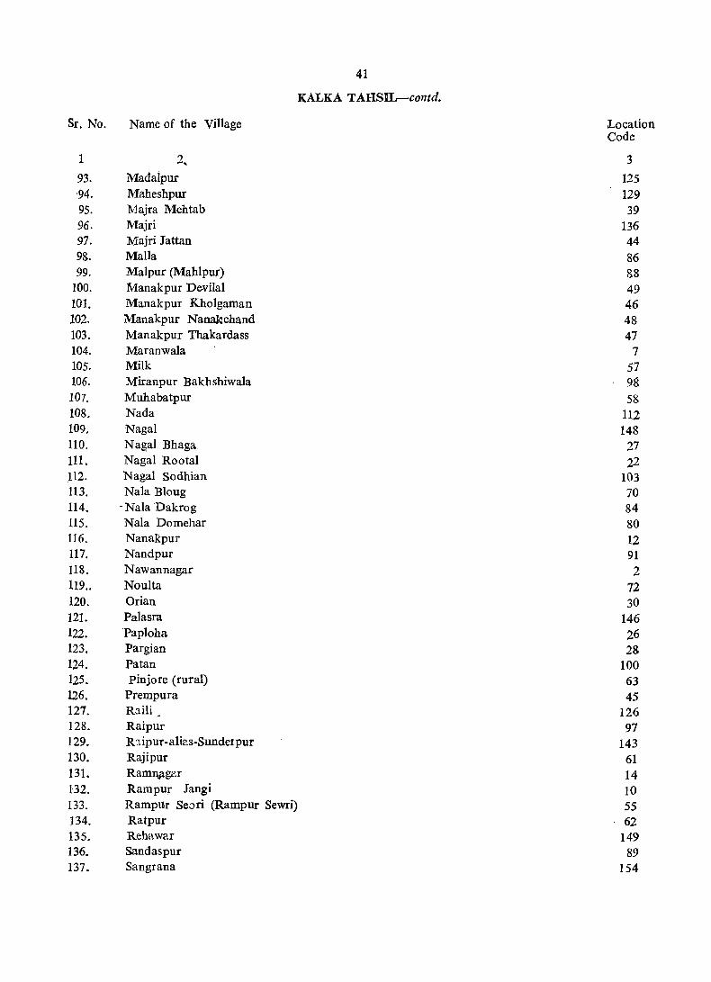
Sr. No. Name of the Village
1 2,
93. Madaipur '94. Maheshpur 95. Majra Mehtab 96. Majri 97. Majri Jattan 98. MaIl a 99. Malpur (Mahlpur)
100. Manakpur Devilal 101. Manakpur Kholgaman 102. ~nakpur ~anakchand
103. Manakpur Thakardass 104. Maranwala 105. Milk 106. Miranpur Bakhshiwala 107. Muhabatpur 108. Nada 109. NagaI 110. NagaI Bhaga 111. NagaI Rootal 112. NagaI Sodhian 113. Nala Bioug 114. -Nala Dakrog 115. Naia Domehar 116. Nanakpur 117. Nandpur 118. Nawannagar 119.. Noulta 120. Orian 121. Palasra 122. Papioha 123. Pargian 124. Patan 125. pinjore (rural) 126. Prempura 127. Raili • 128. Raipur 129. R:::ipur-ali~s-Sundelpur
130. Raj i pur 131. Ramnitger 132. Rampur Jangi 133. Rampur Searl (Rampur Sewri) 134. Ratpur 135. Rehawar 136. Sandaspur 137. Sangrana
41
KALKA TAHSIL-contd.
Location Code
3
125 129 39
136 44
86 88 49 46 48 47
7 57 98 58
112 148
27 22
103 70 84 80 12 91
2 72 30
146 26 28
100 63 45
126 97
143 61 14 10 55 62
149 89
154
Sr. No.
1
138.
139.
140.
141.
142.
143.
144.
145.
146.
147.
148.
149.
150.
151.
152.
'153.
154.'
Name of the Village
2
. Shahpur
Sitoo Majra
Soorajpur
Suketri
SuItanpur
Surajpur
Tagra Hakimpur -Tagrahari Singh
'Pagra Hasua
Tagrakali Ram
Tagr~ Kanga n
Tagra Sahoo
'Jekwana
Thane-ki-Ser
Tibi
Tipra
Toran
42
KALKA TAHSIL-condd.
Location Code
3
1
6
117
119
141
59
34
37
35
38
40
36
56
24
92
69
75
43
vitLAGE DIRECI'ORY
KALKA TAHSIL

44
KALKA TAHSIL VILLAGE
Amenities and
Loca- Name of Village Total Total Amenities available (If not available within the village, a dashC-)is shown tion (with Hadbast area of Population in the column anq next to it in brackets, the distance in broad ranges,. Code Number) the and Number viz.-5 kms., 5-10 'kms. and 10+ kms. of the nearest place where tbe No. Village of house- facility is available is gi~en) I>
(in bolds --~-hectares) Educational Medical Drinking Post and Day Communi-
Water Telegraph or cations (potable) days ~us Stop,
of the ailway mar- Station, ket! Water bat, way) if any
1 2 3 4 5 6 7 8 9 10
Shabpur (99) 117'76 306 ~4) P CH\:V T,W,TW -.(10+) BS
2 Nawannagar (98) 231·07 494 (82) -.(-5) -(10+) T,W,Tk, -(10+) BS '.
Gorakh Natb 'Hp
3 (97) 159·00 186 (27) P -(10+) T,W,TW -(10+) BS
4 Khokbra (100) 314·84 443 (70) -(-5) _(5_10) T,W,TW; -(5-10) .. BS Hp
5 Lehroundi (94) 109 ·00 - 147 (25) -.(-5) -(10;1-) T,W -(-5) -(10+)
6 Sitoo Majra (96) 88·22 171 (24) -(-5) -(10+) , T,W,TW -(-5) BS
7 Maranwala (95) 220 ·96 716 (137) P HS,CHW T,W,TW, PO BS
(101) 167·94 Hp
8 KhoI Mola 195 (31) _(5_10) CHW T,W -(5-10) .. -(5-10) 9 Kona (93) 266'2& 516 (72) P CHW T, W, TW', -(-5) BS
Hp 10 Rampur Jangi (92) 207·20 684 (106) P -(10+) T,W. ~ _(-5) -(-5)
11 Khol Fatehsingh (102) 106'00 215 (35) P -(10+) T,W, Tic -(5-10) " -(5._10) 1'2 Nanakpur (91) 344'79 1,285 (196) P,M,H CHW(2) T,W PO BS
13 KholAlbaia (89) 142'00 39 (6) -(-5) _(-5) W -(10+) BS
14 RaIDDagar (90) 127'07 345 (42) P -(-5) • W -(5-10) '" BS 15 Karilnpur (88) 333 '00 1,487 (207) P,M,H HS,CHW T,W.TW -(5~10) ... BS
16 Johlowal (129) 284'89 714 (87) P CHW T,W,TW ~(-5) BS
17 Kiratpur (127) 237'95 817 (l08) P RP,CHW T,W,TW -(-5) BS
18 Gariran (126) 278'82 391 (50) _(-5) _(5_10) T,W,1W -(-5)' BS
19 Charnian (128) 271'54 602 (71) P CHW T,W, TW _(5~10) ., BS
21) Kheranwali (130) 242'00 1,063 (169) P CHW T -.(5-10) BS
21 Banoi Khuda Bax (131) 150'00 213 (39) P CHW W -(-5) ~(-5)
22 NagaI Rootal (133) 204'00 370 (50) -(-5) _(_5) T ~(_5) -.(-5) 23 Banoi Sanwalia (132) 115 '00 80 (11) -(-5) _(_5) W -(-5) _(_5) 24 Thane-Kl-Ser (134) 68'39 347 (52) -(-5) -(-5) S _(-.5) -.(_5)
25 Bar (135) 475'00 396 (59) P,M HS,RP S pO BS
26 Paploba (139) 315'00 891 (135) P CHW T,W _(-5) -.(-5) 27 NagaI Bbaga (138) 82'96 227 (31) P -.(-5) T -(-5) -.(_5) 28 Pargian ' (136) 73'00 123 (16) ~(-5) -(-5) T -(-.5) -(-.5) 29 Kandiala (137) 141'00 340 (47) -(-5) CHW T' -(-5) -(-5) 3() Orlan (147) 56'66 203 (33) -(-5) -(-5) T ~(-5) -(-5)

4) DIRECTORY AMBALA. DISTRiCT
Land Use
Approach Nearest town and Power Staple Land use (i.e" area under different types of Remarks (in-to Village distance (in 'kms,) Supply food land use in hectares rounded upto 2 decimal eluding, any
Places) place of reli-gious, histori-
~~ __ ~~~~~~~ __ -'-,_~ ~~~ ,~,-- calor Forest Irrigated Un- Cul- Are:! archaeological
by Sources irrigated tural not interest) waste available (includ- for ing cultiva-gauchar tion and groves)
11 12 13 14 15 16 17 18 19 20
PR Kalka (27) ED,EAg Wheat, Maize T(23.47), 49·37 2'83 42'0~ Cl:T1 0(23,47)
PR Kalka (20) ED, EAg .. Wheat, Rice IT(42.49). 72·84 7'28 )08 '46 0(42.49)
KR Kalka (18) ED,EAg Wheat, Maize T(31.oo). 67·00 61'00 Temple Gorkh-TW(3.00)' nath: MIS 0(28.00)
PR Kalka (20) EA Wheat, Maize T(45'32), 103'60 10 '12 155·80 MI2
Kalka 0(45.32)
PR (24) ED, EAg Wheat, Maize T(31.00), 12·00 66·00 Mil TWE(lO.OO) 0(21-.00)
PR Kalka (18) ED, EAg Wheat, Maize T(3.64), 58·27 .. 26'31
PR ,Kalka (15) ED, EAg Wheat, Maize 0(3.64) T(24.28), 132 '73 6'07 57·88 Temple: MIS 0(24,28)
Kalka KR (20) ED Wheat, Maize T(36.42).
26'71 141 '23 PR Kalka (15) ED, EAg Wheat, Maize 123·43 8'09 98 '34 MIS
0(36.42) PR Kalka (14) ED, EAg Wheat, Maize T(45'32), 96'31 6'88 58'69 Temple
0(45.32)
KR Kalka (20) ED,EAg Wheat, Maize T(54.23),
21,00 85'00 78·io PR Kalka (10) ED, EO Wheat, Maize 212·46 Ml
TW(10.12),
KR Pinjore ~11) ED Wheat, Maize R(44., 1) T(29.00), 48·00 65·00 .. TW(14.00),
Pinjore ED Wheat, Maize '0(15.00)
PR (11) T(1.62) 80 ·13 45 ·32 PR Pinjore (10) ED,EAg Wheat, Maize TW(l,62) 218·00 1 '00 86'00 M3: T1
T(28.00), TW(22.00), TWE(6'00)
PR Pinjoi'e (9) ED,BAg Wheat, Maize T(31.97) 185·75 55 '44 11 '73 Ml TWE(31.97)
PR Pinjore (8) EA Wheat, Maize T(8.90), 154·99 0'40 73·66 M2
Pinjore:, TWE(8.90)
PR (5) ED Wheat, Maize T(2,83), 201 '94 22'(i6 51 ·39
/' Wheat, Maize TW(2.83)
PR Pinjore (6) ED, EAg T(44.51), 170'37 0'81 55'85 Temple Devi : TW(22.26), T2
Kalka ED Wheat, Gram TWE(22.2S)
PR (5) T(12.00), 190'00 40'00 .. 0(12.00)
PR Kalka (8) ED Wheat, Gram 98 '00 52'00 PR Kalka (5) ED Wheat, Gram 131 '00 73 '00 KR Kalka ,'(S) ED Rice, Maize
T(30.35), 16·00
21'45 99 ·00
PR Kalka (7,) ED • Rice, 'Maize 13'35 3 '24' .. 0(30.35) .
PR Kalka (2) ED Maize, Gram T(40.00), 194·00 41 ·00 Ml R(40.00)
PR Kalka (5) ED Maize, Gram m·oo 8·90
88·00 N2 PR Kalka (5) ED Maize, Gram 41'28 32'78 PR Kalka (3) ED Maize, Gram 32'00 41·00 .. PR Kalka (5) ED Maize, Gram 94·00
37·23 47'00
KR Kalka (4) ED Maize, Gram 17'00 2·43
45 KALKA TAIISIL VILLAGE
Amenities and
Loca- Name of Village Total Total Amenities available (If not available within the village. a dash(-) is shown tion (with Hadbast area of population in the column and next to it in brackets, the distance in broad ranges, viz., Code Number) the and Number _5 kms .• 5_10 kms. and 10+kms. of the nearest place where the facility No. Village of house- is available is given)
(in holds --..---.---...--__,~------.--.__..--.___"--._...___,, .. -__,~---. ---hectares) Educational Medical Drinking Post and Day Communi-
Water Telegraph or cations .(Potable) days (Bus StoP.
of the Railway mar- Station, ket/ Waterway) hat, if any
2 3 4 5 6 7 8 9 10
31 Khera Sita Ram (148) 34·00 208 .(59) -(~5) -(-5) S -(_S) -<_5) 32 Kalka (393) 163 ·09 Wholly merged 33 Kurari (394) 122·21 Wholly merged 34 Tagra Hakimpur (150) S8·68 514 (75) P HSCHW .. T,W _(_S) -(-5) ~5 Tagra Hasua (143) 45·73 293 (41) ,(-5) CHW T _(_5) _(_5
36 Tagra Sahoo (142) 63·13 • 193 (33) _(_5) CHW T -(-5) _(-5) 37 Tagrahari Singh (144) 28·00 172 (31) P CHW" T -(_5) -(_5) 38 Tagrakali Ram (145) 61·92 240 (48) _(_5) _(_5) T -(-5) -(_5) 39 Majra Mehta b (140) 165·00 791 (112) -(.,....5) CHW T -(_5) -~-5) 40 Tagra Kangan (141) 77·29 126 ' (24) .,....(_5) -;-{-5) .T -(-5) -_5)
41 Dhamala (122) 421'00 1,129 (158) P CHW T' _(-5) _(_5) 42 Basawal (125) 174'00 763 (119) P.M,H HS T -(5-10) BS 43 Khera (124) 129·00 420 (64) P CHW T -(5~10) BS 44 MajrLJattan (123) 146 '00 450 (S6) P CHW ill T -(~5) BS 45 Prempura (103) 64'34 200 (29) -(-5) -(5-10) T,W _(5~10) _(_5)
46 M'\nakpu[ Kholgaman(104) 140'00 Un-47 Manakpur Thakar- .(120) 110 '00 203 (22) -(-5) -(-5) T -(-5) -(-5)
dass 48 Manakpur Nanak- (119) 112·00 537 (71) P , -(-5) T -(-5) -(-5)
chand 49' Manakpur DeviIal (118) 62'00 261 (31) P -(_5) T .A(_~) -(_5)
50 Lohgarh (121) lS0'00 402 (53) ._(_5) -(-5) T -(-5) -(_5)
51 Basdevpura (151) 255-35 482 (70) -(-5) -(-5) T -(-5) -(-5) 52 Abdullipur (115) 59·00 406 (81) -(-5) CHW T.W.Tw Phone BS
53 Ferozepur (117) . 27'00 ' 79 (10) -(-5) -(-5) T.W.Tk. TW.Hp
-(-5) BS
54 Kuranwa!a (105) 186·00 Un. 55 Rampur Seori (106) 168-00 1,577 (333) P -(-5) T,W,Tk. -(-5) BS
(Rampur Sewri) TW, Hp
56 Tekwana (107) 74·00 1 Wholly merged 57 Milk (m) 89·84 r Wholly merged 58 Muhabatpur (110) 46·00 J Wholly merged 59 Surajpur (l09) 127'00 3,932 (812) P CHW T,W,Tk, -(-5) BS,RS
TW,Hp
60 Baglana (112) 34·00 13 (3) -(-5) -(-5) T,WHp -(-5) -(-5)
61 Rajipur (108) 122·21 1,708 (372) P,M.H HS,CHW T,W,tk P.O. BS TW, Hp Phone;
62 .Ratpur (116) 130·00 1,556 (347) P -(-5) T.W.Tk, -(-5) BS TW,Hp
63 Pinjore (Rural) (113) 138'40 5.584 (1367) P,M,H PHe, FPC. T.WTk PTO, BS CHW(4) • TW. Hp Phone
64 Deva! (114) 29·14 Un· (
65 Dharampur (152) 50'00 132 (24) P -(-5) T. W,Tk, TW,Hp
-(-5) BS

47
DIRECTORY AMBALA DISTRICT
Land Usc
Approach Nearest town and Power Staple Land use (i.e., area under different types of Remarks (in-to yillage distance (in kms.) Supply food land usc in hectares rounded up to 2 decimal eluding any
places) place of religious,
__..._._,---.___,.._....,~- historical or - Forest Irrigated Un- Cultqr- Area archaeological
by Sources irrigated al not interest) waste availa,ble (includ- for ing , cultiva-gauchar tion and groves)
11 12 13 14 15 16 17 IS 19 20
KR Kalka (4) ED Maize, Gram 12'00 22'00 in Kalka M.C. in Kalka M.C. PR Kalka (3) ED Wheat, Gram 33 ·99 23'S8 0'81 pR Kalka (3) ED Maize, Gram 29'54 14'57 1'62
PR Kalka (2) ED Maize, Gram 40-47 20'23 2'43 PR Kalka (3) ED Maize, Gram 20'00 8'00 pR Kalka (3) ED Maize, Gram 38'S5 20'23 2'84 PR Kalka (1) ED Maize, Gram 114 -00 51 '00 PR Kalka (2) ED Maize, Gram 42-90 25'49 8'90
PR Pipjore (4) ED Wheat. Gram 270·00 16'00 135 '00 M2:T2 PR Pinjore (5) ED Wheat. Maize 98 ·00 1 '00 75'00 M2:Tl PR Pinjoie (5) 'ED Wheat, Maize 97 ·00 5'00 27'00 PR Pinjore (4) ED Wheat, Maize 95 ·00 3'00 48'00 Ml: T1 KR. Chandigarh (10) ED Wheat, Maize 29'95 34'39
inhabited chd. (U.T.)
140'00 PR Pinjore (2) ED Whea t, Maize . T(46.00). 16'00 48'00
•. ,7 0(46.00) PR Pinjore (2) ED Wheat, Maize T(44.00), 7·00 2·00 59 '00
0(44.00) PR Kalka (6) ED Wheat, Maize T(47.00). 8 '00 7·00
0(47.00) PR Pinjore (3) ED Whea t, Maize T(48.00), 55·00 4:00 43 ·00
0(4S_00) PR Pinjore (3) ED Wheat, Maize 95 '10 75·27 84·98 PR Pinjore (1) ED Wheat, Maize T(S_OO) 22.00 5-00 24·00 M2: C4
0(8_00) . PR Pinjore (1) ED,BAg Wheat, Maize T07_00), 6·00 4·00 Tl
0(17_00) inhabited. 11·00. 14·00
186·00 PR pinjore (3) ED,BAg Wheat, Rice T(24.00), 119·00 M2
0(24.00)
in H.M.T. Pinjore iaH.M,T. Pinjore inH.M.T. Pinfore Wheat, Maize KR Kaka (6) ED,EAg T(38.00) 4·00 1-00 84·00 M4
W(2.00),
Wheat, Maize 0(36.00)
PR pinjore (1) ED,EAg . 1 00 T(5.00), 28'00 GC(S.OO)
PR KR Kalka' (S) ED,EAg Wheat, Maize T(24.28), 2 ·43 95·50 Gurdwara: TWE(S.26), N24: M22
(5) Wheat, Maize 0(19.02)
11·00 28·00 GUldwara: PR Kalka ED,EAg T(31.00), 60·00 TW(6.00), Q N9: M7: Cl
Wheat, Maize 0(2S.00)
71·22 Temple: N200: PR pinjore (0) EA 18·62 T(44.92), 3·64 TW(t.62), • M2S0: C4 0(43.30)
0·81 2·84 inhabted 0·40 T(19.83), 5'26 W(6.S8), 0(12.95)
~8 -og I'QO 11 -()() PR Pinjore (2) ED,EA~ Wheat, Maize 'r

48
KALKA TAHSIL VILLAGE
Amenities and toca- Name of Village tion (with Hadbast
Total area of the
Village (in hectares)
Total Amenities available (If not available within the village, a dash(-) is shown population in the column and next to it in brackets, the distance in broad ranges, viz.,
Code Number) No.
and Number -5 kms., 5_10 kms. and IO+kms. of the nearest pI2ce where the facility of is available is)iven) households
~~tio~;;t'-M~dical----Dri;king-r~;-;~-D--;;Y-Co;-~;"
1 2
66 Bitna
67 Kanguwala
68 Bharon-Ki-Ser
69 Tipra
70 Nala Bioug
71 lalthal
72 Noulta
73 Dhatoghran
74 Dakrog
75 Toran
3
(153) 384 ·00
(146) 76 ·00
(149) 134·76
(157) 90 ·00
(165) 35·00
(156) 59 ·08
(158) 55 ·00
(160) 37 '64
(169) 166·00
(159) 117 ·00
4 5
1,240 (223) P
131 (28) - (-5)
142 (20) -(-5)
561 (96) P
295 (43) -(-5)
130 (15) -(-5)
141 (23) -(-5)
82 (19) P, M
288 (39) P
569 (92) .,......(-5)
6
CHW
-(-5)
-(-5)
CHW
-(5-10)
-(--5)
-(-5)
-(5-10).
-(10+)
-(5-10)
76 Gawahi (170) 132·00 146
103
172
160
(24) -(5-10)' -(5-10)
77 Bagharni
78 Khoi
(168) 47·00 (16) -(-5) CHW
79 Janouli
80 Nala Domehar
81 Kajiyana
82 Bhawana
83 Dhamsoo
84 Nala Dakmg
85 Berghati
(167) 77·00
(162) 87 ·00
f164) 29·54
(161) 96 ·00
(155) 106 ·00
(171) 37 ·64
(163) 40 ·47
(173) 69 ·00
36
235
389
114
39
51
(28) -(-5)
(22) P
(4) -(_5)
(37) -(-5)
(72) P
(17) -(-5)
(6) -(-5)
(9) -(-5)
86 Malla
87 labrot
(174) 112·00 1,464 (301) P,M,H
(166) 122'00 .272 (43) P
88 Malpur (Mahlpur) (177) 76 '00
89 Sandaspur (178) 41 ·00
90 Kidar Pur (Kadarpur)(176) 142 '04 26~ (44) -(-5)
91 Nandpur (175)
92 Tibi (172)
93 }faripur Harisingh (182)
94 Jodhpur (186)
95 Haripur Chopahar (187)
57·87 284 III
65·00 119
26·71 86
82 ·15 86
95'10 190
(51) -(-5)
(18) -(-5)
(14) -(-5)
(15) -(-5)
(36) -(-5)
-(-5)
CHW
'--(-5)
D
CHW
CHW
-(5-10)
-(-5)
HS,CHW
CHW
CHW
-(-5)
-(-5)
CHW
• -(5-10)
-~5-10~
Water Telegraph or cations (Potable) days (Bus Stop,
of the Railway mar- Station, ketl Waterhat, way)
7
T, W, Tk; TW,Hp T,W, Tk, TW,Hp· T, WTk, TW.Hp T,W,Tk, TW,Hp T
S
S
T
S
S
S
S
S
T
T
T
T,S
S
T
T
T.S
T
T
T
T,S
T
T,TW
T~TW
8
-(-5)
-(-5)
-(-5)
-(-5)
-(5-10)
-(-5)
-(-5)
-(5-10)
--(5-.10)
'-(5-10)
-(5-10)
-'(5-10)
-(5-10)
-(10+)
-(10:1-)
-(5-10)
-(-5)
-(-5)
-(5-10)
-(-5)
PO
-(5-10)
-(-5)
-(-5) •
-(-5)
-(-5)
-(-5)
-(5-10)
if any
9 10
BS
-(-5)
-(-5)
-(-5)
-(5-10)
-(-5)
-(-5)
-(5-10)
-(5-10)
-(5-'10)
-(5-'--10)
-(5-10)
-(5-10)
-(10+)
-(5-10)
-(5-10)
-(-5)
-(-5)
-(5-10)
-(-5)
BS
-(5-10)
Uc-
Un-
-(-5)
BS
-(-5)
-(-5)
BS
49
DIRECTORY AMBALA DISTRICT
Land Use
Approach Nearest town and Power Stllple Land use (i.e. area under different types of Remarks (in-tq Villa~e distance (in kms.) Supgly food land use in hectares rounded upto 2 decimal eluding any
places) place of reli-gious, histori-calor
Forest 1 rriga ted by Un- Cultur- Area . archaeological Sources irrigated al not interest)
waste available (inc1ud- for ing cultiva-gauchar tion and groves)
11 12 13 14 15 16 17 18 19 20
PR,KR Kalka. (2) ED,EAg Wheat, Maize T(7.00), 218'00 22·00 137·00 M5
Pinjore Wheat, Maize 0(7.00)
KR (1) ED,EAg 54·00 22·00 ..
KR Kalka (2) ED,EAg Wheat, Maize T('~4.69), 42·90 11·74 55'43 N2:Ml
Wheat, Maize 0(24.69)
KR Kalka (3) ED,EAg 67·00 5'·00 18·00
PR pi~jore (10) ED Wheat, Maize 32·00 3·00 .. KR Pinjore (2) ED Wheat, Ma.ize T(2.43), 16'59 27·52 12·54
pinjore 0(2.43)
KR (3) ED Wheat, Maize T(ll.oo), 28·00 15·00 1 ·00 .. PR Kalka (7) Wheat, Maize
Wf(lLOO) 20·23 ED T(3.64), 1 ·62 12 ·15 ..
Kalka Wheat, Maize 0(3.64)
KR (13) ED T(l8.00), 63·00 72 ·00 13·00
KR Pinjore ED Wheat, Maize Wf(l8.oo)
66·00 (5) T(17.00), 27·00 7·00 . Wf(17.00)
KR Kalka (19) ED . Wheat, Maize T(6.00), 43·00 61.00 n·oo .. KR Pinjore ED Wheat, Maize'
Wf(6.oo) 12·00 (10) T(5.00) 11 '00 19·00
KR Kalka (13) ED Wheat, Maize Wf(5.00)
23·00 T(3.00). 19'00 32·00 .. PR Kalka Wheat, Maize
Wf(3.00) 45·00 (9) ED T(8.00), 15 00 19·00 ..
pR pinjore ED Wheat, Maize Wf(8.oo)
17·81 '(10) T~2.83), 4·45 4·45 .. PR pinjore
o 2.S3) 58·00 (5) ED WlW,at, Maize T(4.00), 30·00 4·00 ..
KR Kalka Wheat, Maize Wf(4.00)
38·00 (6) ED T(J5.00), 12·00 41·00
KR Kalka Whea.t, Maize Wf(15.00)
J6'59 (I 8) ED .. T(O.S!) 16·59 3·65
KR pinjore Wheat, Maize Wf(0.8!)
16·59 (8) ED T(4.05), 13 ·76 6·07 .,
KR pinjore Wheat, M~jze 0(4·05)
30·00 (16) ED T(2.00), 34·00 3·00 Wf(2.oo)
PR pinjore (I 5) ED,EO Wheat, Maize T(9.00), 62·00 38·00 3·00 N5: M2
pinjore ED / Wheat, Maize Wf(9'00)
52.·00 PR (10) T(19.QO), 31·00 20·00 .,
inhabited Wf(19.00)
20·00 T(5.00), 29'00 22·00 .. inhabited
Wf(5.00) 10·00 19'00 12·00 ..
pR pinjore (15) ED Wheat, Maize T(31.97), 57·46 ' .. 52·61 0(31.97)
PR pinjore (15) ED Wheat, Maize T(3.64), 40·8,7 13'36
pinjore 0(3.64)
32·00 Kl¥ (6). ED Wheat, Maize T(3.00), 20·00 10·00 ..
KR pinjore r (8) Wheat, Maize WI (3.00)
24·69 2·02 ED .. PR Kalka (8) ED Wheat, Maize 56·66 • 25·49 .. p~ pinjore (8) ED,EA,~ Whel\t, M,!izQ 1()'~9 ., $7·4(j 1 (1-59 4'4(1 .,

SO
KALKA TAHSIL VILLAGE
Amenities and
Loca- Name of Village Total Total Amenities available (If not available within the village, a dash(-) is shown lion (with Hadbast area of Population in the column and next to it in brackets, the dIstance in broad fanges viz., Code Number) the and -S kms, 5_10 kms. and 10+kms. of the nearest place where the facility No. Village Number of is available is given).
(in households ~_,__,___,~....---.-__,__.,---.__,__,___,__,__,~_~~-,~----~-~-
hectares) Educa tional Medical Drinking Post and Day Communi-Water Telegraph or cations (Potable) days (Bus Stop,
of the Railway mar- Station, kelt Water. hat, way) if any
2 3 4 5 6 7 8 9 10
96 Kharkua (183) 62·00 300 (48) ~(-5) CHW T,TW -(5-10) -(-5)
97 Raipur (i95) 193·44 417 (74) -(-5) _("':"5) T,TW -(5-10) BS
98 Miranpur Bakhshi-wala
(194) 334·27 701 (107) P -(-5) T,TW -(-5) -(-5)
99 Ganeshpnr (Bhorian) (188) 108·00 416 '(70) P CHW T,TW -(-5) -(-5)
100 Palan (189) 40'06 81 (11) -(-5) -(-5) T -(5-10) -(-5)
101 Damdama (154) 151·35 248 (42) -(..,-5) CHW TW -(-5) -(-5)
102 Bhogpur (190) 103 ·19 231 (41) P CHW T,TW -(-5) -(-5)
103 Nagai Sodhian (191) 89·00 85 (11) -(-5) -(-5) T -(-5) -(-5)
104 Aslamnagar (192) 268·00 783 (107) -(5-10) -(5-10) T -(5-10) -(5-:-10) ([slamnagar)
105 Bhagwanpur (193) 156·,00 299 (42) P HS T -(5-10) BS
106 Chikan (185) 178 ·00 585 (90) P C~W T,TW -(5-10) r;;
BS
107 DeraGuru (184) 81 ·00 177 (25) '--,(-<5) -.(5-.10) T,TW ~(S-.10) -.(-.5)
J08 Fatehpur Di~anwala (181) 509·00 848 (127) P CHW T,TW -.(5-.10) BS
109 Jalla (179) 200·00 174 (27) rp I- -.(5-10) R -(-5) - (5:-10)
JlO Kotian (196) 257·78 713 (123) P -(5~ 10) , T,TW,R - (5-10) -(-5).
111 Bansghati (180) 37'00 Un. 112 Nada (199) 234'00 ': 1,233 (251) P HS T,Hp -(-5) BS
113 Chaunki (198) 165 ·51 449 (73) P - (.:. 5) T -(-05) -(-5)
114 Gumthala· (197) 139 ·00 114 (19) -(-5) CHW T,R -(-5) -(-5)
115 Chandimanc1ir (391) 295·00 3,178 (779) P(3), M(2), -(- 5) T,W PTO, BS,RS H,Tr Phone
116 Bir Ghaghar (392) 166 ·00 2,607 (712) P -(-5) R -(-5) BS
.. 117 Soorajpur (389) 184·94 Un. lISt Darn Kharoni (390) 874·00 880' (247) - (5-10) -(5-10) R - (5-10) -(5-10)
·tt 119 Suketri (376) ~ 1,447 ·94 1,382 (218) P,M HS,CHWJ T P,9;:: -(-5)
''-
~~9 Bhainsatibba (377) 50S'00 1,6(53 (502) P -(-5) T -(-5) .... (-5) ,

51
nmECTORY AMBALA nIsrluct Land Use
Approach Nearest town and Power Staple Land use (i.e. area under different types of Remarks (in-to Village distance (in kms.) Supply food land use in hectares rounded upto 2 decimal c1udingany
places) place of reli-gious, histori-
........,~--.___..___,...-., - calor Forest Irrigated Un- Cultur- Area archaeological
by Sources irrigated al not interest) waste available (includ- for ing cUltiva-gauchar tion and groves)
11 12 13 14 15 16 17 18 19 20
KR Pinjore (4) ED Wheat, Maize T(8.00), 34'00 19·00 1·00
(8) Wheat, Maize R(S.OO)
1·21 PR Kalka ED,~Ag T(J 3.35), 102'38 76'50 R(13.35)
KR Pinjore (4) ED,EAg Wheat, Maize T(0.4O), 138·81 192 ·63 2·43 l'WE(OAO)
PR Kalka (10) ED,EAg Wheat, Maize T(4.00), 67·()() 37·00 . TWE(4.00)
PR Kalka (9) ED. BAg Wheat, Maize T(2.43}, 24·28 12·95 0-40 TWE(2.02), 0(0.41)
PR Kalka (3) ED, EAg Wheat, Maize T(13.76), 47·35 55·44 34·80
pinjore R(13.76)
PR (5) ED,EAg Wheat, Maize T(0.81), 62·32 40·06
Pinjore Wheat, Maize o ·(O.Sl)
57·00 29·00 PR (3) ED, T(3.00), TWE(2.00),
Pinjore ED,EAg Wheat, Maize 0(1.00)
165 .()() 75·00 2·00 PR (5) T(26.00),
Pinjore Wheat, Maize R(26.00)
58·00 PR (5) ED, EAg. T(31.00), 67·00 TWE(12.00), R(14.00), 0(5.00)
PR Pinjore (7) ED,EAg Wheat, Maize 140·00 37·00 1 ·00
PR Pinjore (S) ED,EAg Wheat, Maize T(2. (0) , 49·00 30·00
PR Pinjore Wllea!, Maize TWE(2.oo)
204·CO 285.'00 2·00 (8) ED,EAg T(18,OO), Ml
Pinjore Wheat, Maize R(18.00)
58·00 PR (10). ED T(1.()(,), 141 ·00 TWE(1.00)
PR Panchkula Urban (5) ED,EAg Wheat, Maize T(87.01), 59'89 3·64 107·24 Estate R(77.29),
inhabited 0{9.72)
6·00 31·00 PR Panchkula (1) ED.EAg Wheat, Maize' T(39.00), 75·00 120·00 Gurdwara:
Urban Estate TWE(1.00), M3: Cl: Tl R(26.00), 0(12.00) "
PR Chandigarh (1) ED,EAg WIleat, Maize T(29.54),· 46·13 89·43 0·41 (Chandigarh U.T.), R(27.11),
O(2.~ 2·00 KR Panchkula (2) ED,EAg Wheat, Maize T(32. ), . 105·00
Urban Estate R(30.00),
Kalka Wh~at, Rice 0(2.00)
45'00 PR (10) ED T(42.00) 191·00 17·00 N4: M2: Cl R(42.00)
PR Panchkula Urban Estate
(4) ED Wheat, Rice 166·00
inhabited 184·94 KR Chandigarh (9) ED Wheat, Maize 874 ·00
(Chandigarh U.T.)
PR Chandigarh (3) ED Wheat,Rice 93 ·S9 T(159.04), 100·77 1,091'02 3 ·22 Temple: N1: (Chandigarh U.T.) R(159.04) M2
\
Chandigarh (6) Wheat, Rice 1(153.00), 34·00 PR ED 321 ·00 N12: M2:T1 (Chandigarh U.T.) 0(153.00)
i(At&A TAHSIL
Loca- Name of Village tion (with Hadbast Number) Code No.
1-
121 Bilaspur
122 Dhilan
2
123 Budhanpur
124 Abhepllr
125 Madalpur
126 Raili
127 Kundi
128 Fatehpur
129 Maheshpur
130 Haripur
- 131 Ferozepur Kalan
132 Ferozepur Khlird 133 Dhamsoo 134 Judian
135 Kllark Mangoli
136 Majri
137 Devinagar
138 AJipur
139 Bir Ferozari
140t BiT Babupur
141 Suitanpur
142 KaIhi
143 Raipur-AliasSunuerpur
144 Jitpur
145 Barwala
146 Palasra
147 Jalolili
(378)
(380) (372)
(370)
(382)
(369)
(366)
(367)
(368)
(383)
(386)
(387) (381) (379)
(388)
(385)
(384)
(237)
(364)
(365)
(241)
(243)
(244)
(245)
(246)
(242)
(240)
Total area of the
Village (in hectares)
3
72·00
62·00 212-00
187·00
108 -00
181 -70
142·00
91 ·00
127·00
127·00
121 ·00
70·01 87·82
258·0{)
291·00
89-00
VILLAGE Amenities and
Total Population
. and Number of households
Amenities available OJ not available within the village, a dash(-) is shown in the column and next to it in brackets, the distance in broad. ranges viz --5kms; 5 ~10 kms. and 10+ kms. of the nearest place where the faCility is available is given) • ___,___,_..___,~~ ___ ~~. ~_ -~ ___ -'-___ ----'-"___'---r
Educational Medical
4 5
485 (179) -(-5)
602 (90) P
430 (73) P
71 (12) -,(- 5)
978 (J86) P
691 (106) P
634 (117) - (- 5)
670 (143) - (- 5)
72f) (139) P
457 (87) P
544 (158) -. (- 5)
3,097 (737) P, M, H
1,084 (244) P, Tr
6
-(5-10)
HS,CHW
CHW
CHW
CHW
- (- 5)
RP(2),CHW
CRW
- (- 5)
RP (3)
Drinking Water (Potable)
7
W
-T
T
T,W
W
\\T,Rp
W
T
t
W
T
T,W
Post and Day Communi-Telegraph or cations
8
-(--5)
--(-5)
~(-.S)
-(- 5)
-(-.5)
-,(-.5)
-.(-,5)
- (- 5)
PTO, Phone
- (- 5)
days (Bus Stop, of the Railway mar- Station, ket/ Waterway) hat, if any
9 10
~(-5)
Wholly merged -,(-,5)
-,(-5)
-.(-.5)
:as
BS
Wholly merged Wholly merged
- (- 5)
BS
212 -00 2,242 (477) P
CHW
CHW W
W,Hp
- (- 5)
liS
BS
269 ·00 580 (90) P
291 ·00
212·00
101 ·00
225'00
91·00
195·00
469 ·00
63·00
223 ·00
10 (5) - (5-10)
433 (50) P
520 (66) P
70~ (154) -(-5)
4,280 (631) P(2), M(2), H,A(;
765 (105) P'
- (5- 10)
-(5--10)
- (..:..5)
CHW
-(-5)
HS,D, CHW (3)
W
W,Hp
T,W,Hp
T,W,'Hp
W,Hp
W,Hp
-(-5)
- (5- iO)
- (- 5)
- (--,5)
-(-5)
PTO, Plibne
PO
-(- 5)
Un-
- (~-10)
-(-5)
-(-~)
-(-5)
Un.
BS
Un.
BS

53
DIRECTORY AMBALA DISTRICT
Land Use
Approach Nearest town and Power Staple Land use (i.e .• area under different types of Remarks (in-to Village distance (in kms.j Supply food land usc in hectares rounded up to 2 decimal eluding any
places) place of reli-gious. histori-
__,~__,. __,..---.-__...,--,___,... ~~~__,....,.-----. ~- - - - - ~ ~- , calor Forest Irrigated Un-irri- Cultur- Area archaeological
bySources gated al not interest) waste available (includ- for ing cultiva-gauchar tion and groves)
11 12 13 14 15 16 17 18 19 20
PR,KR Chandigarh (10) (Cbandigarh D .T.)
ED Wheat, Maize 72·00 Temple
in Panchkula Drban Estate PR Chandillarh (5) ED Wheat,Rice 212 00 M2
(Chandlgarh D.T.)
PR Chandigarh (10) ED Rice, Maize T(50.0m, 1 ·00 13600 NIO: M3:T5 (Chandigarh D.T.) TWE(2.00)
PR Chandigarh (10) ED Wheat, Maize 0(48.00)
108 00 Gurdwara (Crandigarh D.T.) .-
PR Cliandigarh (13) ED Rice, Maize T(16.19), 165 ·51 NI0: M2: Cl (Chandigarh U.T.). TWE(5.67),
PR Chandigarh (13) 0(10.52)
ED Rice, Maize T(l 27. 00), 15 ·00 NI0: M2:C2: (Chandigarh U.T.) TW(37.00), T4
0(90.00) PR Chandigarh (11) ED,EAg Wheat, Rice T(78.00). 11·00 2·00 Nl:Ml:T1
(Chandigarh (D.T.) TWE(7.00),
Chandigarh R(71.00)
PR (11) ED Wheat, Rice T(88.00), 2·00 35·00 2·00 M1:Cl:T2 (Chandigarh D.T,). TW(1.00)
PR Chandigarh (11) ED Wheat, Rice R(87.00)
127·00 Ml (Chandigarh D.T.)
PR Chandigarh (10) ED Wheat, Riel" 121 ·00 . (Chandigarh D.T.) In Panchkula Urban Estate in Panchkula Urban Estate PR,KR Chandigarh (6) ED Whtat, Maize T(2.00), 256·00
PR (Chandigarh D.T.) R(2.00) Chandigarh (11) ED Wheat, Riee T(11.00), 7·00 269 ·00 400 N50: M1O;
.(Ch,andigarh D.T.) R(ll.OO) C2:T1
PR Chandi~arh (10) ED Wheat, Rice 89·00 N4: Ml
PR (ChandlgarlJ D.T.)
Wheat, Rice Chandigarh (11) ED T(89.00). 119 ·00 400 M2: C2:T2
PR (Chandigarh U.T.) R(89.00)
8·00 Chandigarh (18) EA Wheat, Maize T(73.00), 107 ·00 81 ·00
inhabited (Chandigarll U.T.) TWE(73.00)
288·00 3·00
KR DeraBassi (10) ED Wheat, Bajra 207·00 5·00 (punjab)
PR DeraBassi (11) EA Wheat, Bajra T(38.00), 49 00 2·00 12·00
PR,KR (Punjab) TWE(38.00) Dera Bassi (11) EA Wh,at, Maize T(B5.00), 125·00 4·00 11 ·00 Tl
PR,KR (Punjab)
Wheat, Bajra TW(85.00)
46·00 1·00 DeraBassi (11) EA T(34.00), 10·00 Ml
inhabited (Punjab) TWE(34.00)
64·00 T(69.00), 62·00
PR,KR Dera Bassi (10) 'EA Wheat, Maize TWE(69.00)
15·00 Temple Kalj: T(296.00), 117 ·00 41 00 (punjab) W(IHO), N210: M18:
TWE(283.00) Tl
lnhabited T(18.00), 41·00 4·00
DeraBassi ED,EAg Wheat, Maize TWE(18.00)
1 ·00 PR (10) T(76.00), 78·00 • 68 00' T1 (Punjab) TWE(76.00)

54
KALKA TAHSIL VILLAC-E
Amenities and
Loca- Name of Village Total area of the Village (in hectares)
Total Amenities available (If not available within the village, a dash(~) is shown Population in the column and next to it in brackets, the distance in broad ranges viz, tion (with Hadbast Number) and Number ~5 kms, 5~10 kms. and 10+kms. of the nearest place whcre the facility of households is available is given)
Code No.
r 148
149
150
151
152
153
154
2
NagaI (238)
Rehawar (239)
Bataur (247)
Bhagwanpur (248)
Bhareli (249)
Fatehpur Viran (250)
Sangrana (251)
All Villages
Educational Medical Drinking Water (Potable)
3 4 5 6 7
297'00 837 (123) P -(5-10) T,W,Hp
363·00 681 (94) P CHW W,Hp
763 '63 2,104 (285) P -(-5) W,Hp
256·00 806 (118) P -(-5) T,W,TW
469 ·00 1,832 (254) P,M CHW T,W,TW
106'03 9 (2) ,_(-5) -(-5) T
163 ·00 131 (13) -(-5) _(_5) T,W,TW
26,268 '34 88,l46 (16,346) P7S, MIS. H9 PHCl, HSI2, Tr2. Act D2. FPCl,
RP7,CHW 61
Post and Day Communi-Telegraph ·or cations
. days (Bus Stop, of the Railway mar- Station, ket/ Waterway) hat, if any
8 9 10
-(-5) BS
-(~5) -(-5)
, -(-5) -(-5)
-(-5) BS
PO -(-5)
-(-5) -(-5)
_(_5) BS
t Although entered as • Be-Chirag • (un. inhabited) in the Revenue record. the .population shown agains t\ this village was en umerated at·the time of 1981_Census.
Notes-.I. Where a town and village bear an identical name, the word (Rural) has been allded after the name of the village.
2. The area of a village (revenue estate) is based on the information supplied by the Revenue patwari.
DIRECTORY
Land Usc
Approach Nearest town and Power to Village distance (in kms.) Supply
It 12 13
PR DeraBassi (11) ED (Punjab)
PR DeraBassi (16) ED,EAg (Punjab)
PR Dera Bassi (10) EA (Punjab)
PR DeraBassi (10) ED,EAg (Punjab)
PR,KR DeraBassi (10) ED,BAg (Punjab)
KR Dera Bassi (10) EAg (Punjab)
PR,KR DeraBa5si (8) ED,EAg (Punjab)
Staple food
14
Wheat, Maize
Wheat, Maize
Wheat, Maize
Wheat, Maize
Wheat, Maize
Wheat, Maize
Wheat, Maize
55
AMBALA'D:nSTRICT
Land use (i.e., area under different types of land use in hectares rounded'upto 2 decimal places)
Remarks (including any place of religious, histori-
~----------~~--'~~~-----'-C--- calor Forest Irrigated Un- Cultur- Area archaeological
by Sources irrigated al not interest) waste available (includ- for ing cultiva-gauchar tion and groves)
15 16 17 18 19 20
T(94.00). 98·00 105 ·00 T1 TWE(94.00) . T(47.oo), 170·00 18·00 128·00 .. TWE(47.00) T(195.86), 29987 47'35 220·55 Cl:T3 TWE(195.S6)
T(J 69.00), 53·00 8'00 26·00 N2: M4: T1 TWE(169.00)
4'00, 39·00 N2: Ml:. T7 T(267.oo). 159 00 TWE(267.00) T(73.65), 24·69 7·69 .. TWE(73.65)
lOS ·00 1200 T(39.00), 4·00 TWE(39.00)
130 '50 T(3.870.48), 9.483 '00 3,713 '58 8.295 '81 N558: M436: GC(5.00), C21: T41 W(21.88), WE(ll.OO). TW(206.45), TWE(t,599.98), R(758.66) Wf (154.81), O{1,1l2.70)


eOUNOARY. STArE
!30UNDARV. TAHSIL
IJOUll/IlARY. VILLAGE Wl7H LOCATION CODE NUMBER
TAHSIL HEADQUARTERS
VILLAGES WlrH POPULAWJN SltEl:JtLOW ZOO.
200-499; 500-999; 1000-4999;5000 .. ABOVE
UNINHABITED VJlL.M;E5 \I'I!TH LOCATION CODE
URBAN AREA Wllt1 LOCAl ION CODE
STATE HIGHWAY
IMPORTANT METALLED ROAD
POST OFFICE / POST A'40 TELEGRAPH OFFICE
HIGI-1 OR HIGHER SECONDARY SCHOOL
POLICE STATION
HOSPiTAL. PRIMAR\' HEALTH CENTRE. Q1SPENSAhV
DEGREE COLLEGE
RtVER AND Sl"REAM
© o ••••
[ = -=X-264 - - - J I'l0/pMWh'1
,HI
PO/PTO
MOfE TffE UNSURVEYED AREA i.f.. 1,-,70 HECTARES HAS BEEN INCUJDED IN RESPECHVE 8HOJS AND UIE BHOJ5' BQUHOA.RIES ARE AS PER REVENUE RECORDS.
". EQ!Iiot of Grc .. n""~h-
'5
HARYANA
TAHSIL NARAINGARH DISTRICT AMBALA . ,
Vd w Km.l I
FA?
,. @ GOYlrnmcnl of Indio Copyright .. 1SI2
51
ALPHABETICAL LIST OF VILLAGES IN NARAINGARH TAHSIL


-59
NARAINGARH TAHSIL·
Sr. No. Name of the Village Location Code.
1 2 3
1. Ahmadpur 218 2. Akbarpur 175 3. Alipur 60 4. Ambli 234 5. Amrala 37 6. Andheri 315 i. Asgarpur 254 8. Asrewali 7 9. Azampur 224
10. Babak Majra 131 11. Badbauli 156 12. Badhaur 63 13. Badi Kohri 180 14. Bagwala 86 15. Bagwali 85 16. Bahbalpur 88 17. Bakala 259 18. Bakarpur 318 19. Baktuha (Bakbtuwa) 160 20. Ballopur 214 21. Bana Babadurpur 270 22. Bana Madanput 2 23. Banaundi 168 24. Bapauli 139 25 .. Ba,r~ Gaon 220 26. Baragarh 171 27. Bara Korwa 129 28. Barauna Bara 56 29. Barauna Chbota (Cbhota Haroona) 58 30. Barberi Badi (Beri Bareri) 158 31. Barberi Cbhoti (Chhoti Bared) 159 32. Bari Bassi 176 33. Bari' Rasaur 1.37 34. BaroH 215 35. Barsu Majra 230 36. Batora 212 37. Batwal 53 38. Bazidpur 91 39. Bebloli 123 40. Ber Kberi 31.4 41. Berpura (Blrpura) 122 42. Bhagpur 72 43. Bbanoo 11 44. Bbanvli (Bbavli) 181 45. Bharanpur 170
Sr. No.
• 1
46. 47. 48. 49. 50. 51. 52. 53-. 54. 55. 56. 57. 58. 59. 60. 61. 62. 63. 64. 65.
_ 66 ..
67. 68. 69. 70. 71. 72. 73. 74. 15. 76. 77. 78. 79. 80. 81. 82. 83. 84. 85. 86. 87. 88 ..
89. 90. 91.
60.
NARAING;AlUl T.AMSJL,:-cof2td.
Name of the Village
Bharauli Dharog Bheron
2
Bhoj Balig
Bhoj Darara Bhoj Dharti Bhoj Jabial Bhoj Kotbi Bhoj Koti Bhoj Kudana Bhoj Mataur' Bhoj Nagal Bhoj Naita Bhoj palasra Bhoj ponta
Bhoj Rajpura Bhoj Tipra Bholiwala Bhud Bhud (Bhood) Bihipur Bichpari Bihla Bilaspur Boonga Boron Brahinan Majra
-:Blldha Kbera Bukhari Buraj Jamna Waia (BurjjamnanwaIa) Burj Shahid
C~ak Majudat .chan. Chak Chand Sauli Chautan Chechi Majra Chhajal Majra Chhajju Majra Chhotagarh Chhoti Bassi Chhoti Kohri Chhoti Rasa ur Dabkauri Dabkora .Dandlawar (Danola.w~\') Danora
Location' Code
3
33 114
81 27 20 17 23 22 21 26 15 24
18 16 28 25 19
276. 30
191 140
80 12
172 14
116 227 330 324 300 165 293 279 329 83 203 221 115 173 174 184 240
47 120 193 210

61
NAR,AINGARH T AHSIL-....;contd.
Sr. No. Name of the Village Location Code
1 2 3
92. Debar 68 93. Dehar 235 94. Dehri 113 95. Dera 245 96. Dhamau1i Bichli 149 97. Phamauli Majri 150 98. DhamauJi Uparli 147 99. Dhanana 112
100. Dhandaurru 54 101. Doman Walll (Doomonwala) 251 102. Dudhli 209 103. Dullopur (Dalopur) 43 104. Fatehgarh 104 105. Fatehpur 196 106. ' FatehpuT 325 107. Fazilpur )96 108. Ferozepur 71 109. Ferozepur 201 IlO. Ferozepur KatnKa 322 111. Ferozepur Ranyan 260 112. Gadauli 265 113. Galawari (Galori) 247 114. Ganauli 67 115. Ganauli 233, 116. Ganeshpur 42 117. Ganeshpur 128 118. Garhi 70 119. GaIhi Viran 289. 120 .. Gazipur 99 121. Gharauli 133 122. Gobindpur 64 123. Gobindpur 110 i24. Golpura 89 125. Gulapur 282 126. H~midpur 246 127. Handi K,hera 148 128. Hango~a 77 129. Hangoli 76 130. Harbon 319 131. Haripur 92 132. HaruIi 75 133. Hassanpur 312 134. Haveli 158 135. Husaini 211 136. Islamnagar. 285 137. Ismailpur 288 138, Jafarpur Jafri 271
62 NARAINGARH TAHSIL-contd.
Sr. No. Name of the Village Location Code
1 2 3
139. Jagatpur 206 140. Jangoo Majra 179 141. Jangu Majra 199 142. Jaspur 106 143. Jaswantgarh 13 144. Jatwar 118 145. Jeoli" 332 146. Jhanda 255 147. Jhar Sahala ~10 l48. Jhiwri Wala (Jhioriwala) 3 L49. Kaimbwala 32 150. Kakar Majra 84 151. Kakrali 87 l52. Kalal Majra 127 153. Kalal Majri 82 L54. Kalyana 331 l55. Kalyanpur Atari 269 l56. Kanauli 49 [57. Kalldaiwala 281 158. Kanipla 307 l59. K.anjala 162 160. Karasan lsi .61. Kathe Majra 200 l62. Kazampur 34 [63. Khangesra 50 64. Khanpur Brahman 107
J65. Khanpur Labana 232 166. Khanpur Rajputan 197 167. Khatauli 51 168. Khera Gani 98 169. Khera Juttan 117 170. Kheri 55 111. Kherki Manakpur 178 172. Kherwali Parwala (Kheriwali
palwala) 41 173. Khet ParaH 44 174. Kbirki Jatan 226
115. Khurd 134 176. Kohra Bhura 195 177. Koiwala (Koiwali) 5 178. Korwa Khurd 130 179, Kot 48 180. Kotla 278 18t. Kullarpur 207 182. KuraH 163 IS3. LaM 186 184. La.barpur 252
63
NARAINGARH TAHSIL-contd. Sr. No. Name of the Village Location
Code 1 2 3
185. Lakhnaura .320 186. Lalpur 321 187. Lana 10 188. Lautan 238 189. Magharpura 152 190. Mah~~dpur 266 191. Majra 13& 192. Majri 306 193. Mannkpur 239 194. Manak Tabra 36 195. Manqlai 190 196. .Manglor 177 197. Manka 9 198. Masumpur 66 199. Mauli 94 200. Mawa Kheri 334 201. Mianpur 205 202. Milak Jhabalian 256 203. Milk 216 204. Mirpur 213 205. Mirzapm 284 206. Mirzapur Kath 316 207. Mugal Majra 204 208. Muhndpur 109 209. MUna Majra 225 210. 'Nabipur 243 211. Nadlan 6 212. NagaI 135 213. Nagai Moginand 4 214. Nagauli 185 215. Nagla 125 216. Nagla (Negla) 313 217. Nakhrauli 333 218. Nanduwali 327 219. Nanehra 236 220. ~angawan '(Naugawan) 146 221. Nanheri . 273 222. Naraingarh (Rural) 217 223. Narainpur .61 224. Nasrau1i 124 225. Natwal 95 226. Nan Gawan (Noganwan) 167 227. Naushahra (Nushara) 295 228. Nawa Gaon Urf Khader (Noganwan) 96 229. Nawagaon (Nayagaon) 275 230. Nazampur 253
Sr. No.
1 231. 232. 233.-234. 235. 236. 237. 238. 239. 240. 241. 242. 243. 244. 245. 246. 247. 248. 249. 250. 25I. 252. 253. 254. 255. 256. 257. 258. 259. 260. 261. 262. 263. 264. 265. 266. 267. 268. 269. 270. 271. 272. 273. 274. 275. 276. 277.
64
NARAINGARH TAHSIL~contd.
Name of the Village
2 Nek Nawan Okhal Paharipur p<Hl1muwala Pandon Panjauri l>anjeton Panjlas('. Parai! Parbholi P~wehri
Putwi p ~~rwali Pulcwala pyarcwala Qasampur Rachheri Rahna Raipllf Rani Raipur Viran Rai\\ali Raja\\uli Rajpur Rajpur Rajpura Raju Majra Ramgarh Ramgarh Rampur Rampur Rampur Ranyan Ranyanwala Rao Majra (Raw Majra) Rasidpur Rasulpur Ratauli Rataur Rathali RattewaIi Rattu WaIa Rerh Viran Sabbapur Sabbri Sa:bilpur
Sadanpu(~ Sadaqpur-
Sadaur.a (sadhora Patti Sainyan) (Rural)
Location Code
3 161 317 262 272 305 223 145 228 155 298 144 121 280 189 192 194 126 65 59
229 101 157 248 304 153 231
1 222
62 208 261 309 242 108 257 286 182 249 ·40
297 187 302 303 45
103 166 ~91
Sr. No.
1
278. 279. 280. 28!. 282. 283. 284. 285. 286. 287. 288. 2~ 290. 291. 292. 293. 294. 295. 296. 297. 298. 299. 300. 301. 302. 303. 304. 905. 306. 307. 308. 309. 310. 311. 312. 313. 314. 315. 316. 317. 318. 319. 320. 321-322 ..
323.
65
NARAINGARH TAHSIL ........ cOl1td ..
Name of the Village
Sadiqpur Saidupur Salahpur Salempuf SaJola Samanwa Sam Bhalva Samlehri Samru Sangauli Sangrani Santokhi Sarakpur Saranwa Shahjahanpur Shahpur Shahpur Shahpur Shahzadpur Shakarpura Shampur Shamtoo . Sherpur Shimlipur Sian Majra singhpura Sontli
2
Sukh Darshanpur Sultanpur Sultatipur Surgal Tabar Taha,r Pur Talokpur Tandwal Tanka Majra Taparian Tapparian Rulduki Tapri Shahid . Tasraula Tal,'rauli Tepla Tewa,r (Tior) Tharwa Thaska Tibbj
Location Code
3
294 263 267 287 142 78
188 74
119 274 244 132 90
308 73 35
241 326 137 328 301 39
154 8
219 100 136 52 69
290 311 93
164 29
169 143 ·31
323 141 105 111. 102 283
79 268 46
Sr. No.
1
324. 325. 326. 321. 328. 3Z9. 330. 331. 332. 333. 334.
66
NAR:AINGARH TAHSIL~concld; Name of the VilIag.·
2
Tibi Majra Tibri Toda Todarpur Toka Toka Tunda Bag Udamgarh Udamgarh Ujjhal Majri Wasalpur
Location Code
3
57 292 97
271 3&
202 264 250 299 198 l~
67
VILLAGE DIRECTORY
NARAJNGARH TAHSIL

NARAINGARH TAHSIL
Location Code No.
Name of Village (with Hadbast Number)
2
Ramgarh (232)
2 Bana Madanpur (231)
3 Jhiwri Wala Ohiori Wala)
4 Nagai Moginand
(230)
(229)
5 Koiwala (Koiwali) (228)
6 Nadlan
7 Asrewali
8 Shimlipur
9 Manka
10 Lana
11 Bhanoo
12 Bihla
13 Jaswantgarh
14 Boonga
IS Bhoj Mataur
16 Bhoj Palasra
17 Bhoj Dharti
18 Bhoj Naita
19 Bhoj Tipra
20 Bhoj Darara
21 Bhoj Koti
22 Bhoj Kothi
23 Bhoj Jabial
24 Bhoj Nagai
25 Bhoj Rajpura
26 Bhoj Kudana
27 Bhoj Balig
28 Bhoj Ponta
29 Talokpur 30 Bhud
(227)
(226)
(236)
(233)
(235)
(234)
(237)
(239)
(225)
(317)
(316)
(318)
(319)
(320)
(321)
(322)
(323)
(324)
(326)
(.313)
(314)
(325)
(315)
(216) (215)
VILLAGE
Total area of the Village (in hectares)
Total population and Number of households
Amenities and
Amenities avail~bte (If not. ayailable within thc. village •. n dash(. -) is shown 10 the column and next to It In brackets, the distance m broad ranges viz -5 kms .• 5-10 kms; and 10+kms. of the nearest place where the facility is available is given)
Ed~-;;tk;"~--~M7cti;I-' - D--;i;D;J;;g-~~~t --;nd - -n---;; C~~~_
3 4 5
612 ·00 2,664 (445) P(2). M(2). H,Tr
335 ·00 602 (95) P
145·00
333·00
656·00
637·00
951·00
197·00
358 (55) - (- 5)
26li (33) - (- 5)
°1l4 (32) P
647·00 1,034 (160) P
34·00
349·00 120 (17) -(-5)
776·00 1,502 (232) P
250 ·00 338 (56) - (- 5)
399 ·00 1,026 (149) P
390 '00 2,332 (359) P,M,H
269·00 1 ,294 (183) P(2)
204·00 804 (132) P
130 ·00 484 (71) -(~5)
121 ·00 620 (97) P
70 ·00 210 (33) P
242 ·00 91 ~ (163) P(Z)
99·00 286 (49) P
138·00 1,337 (267) P,M,H
675 ·41 2,028 (279) P(3)
470 '24 1,684 (259) P(2)
251 ·71 900 (137) p, M
110 ·00 364 (56) P
294'20 929 (119) - (--5)
148·00 198'00
358 (62) P 197 (23) _(_5)
6
Water Telegraph or c'\tillns (Potable) <lays (Dus StoP.
orthe Railwi;lY mar- Station ketl Waterway) hat. if ally
7 9
MH, D,RP(7) T,W,Tk. CHW TW,Hp
8
PO, Phone
10
BS
CHW T,W,Tk - (- 5) BS
HS
- (5-10)
- (5-10)·
CHW
- (- 5)
CHW
CHW
- (5- 10)
HS
-(10+)
_(-5)
~(~5)
CHW •
- (5-10)
HS,CHW
- (5-10)
MH.D,RP, CHW D
- (5-10)
HS,CHW
~(-5)
CHW
- (5-10) - (5-10)
W.Tk, R - (- 5) .. BS
Un-
R -(-5) .. BS
R,N -(5-10) .. -(5-10)
T,W,Tk, - (- 5) TW,Hp,R
W,TW,R -(-5)
T,W,TW, PO Hp TW - (- 5)
T.R -(-5)
°T,W,TW,R, PO S,N
T,Tk, R,N T.S
S
S
o
o
o T
R,N,O
R
R
R,N
N
- (5-10)
-(-5)
-(- 5)
- (5- 10)
-(5- 10)
-(5- 10)
-(5-10)
PO
- (5:'" 10)
- (5-10)
T, Tk,R,N -.(_5) T,R,N -(-5)
Un-
BS
Un-
DS
BS
- (- 5)
._ (5_10)
BS
- .(5- 10)
BS
- (- 5)
- (5 - 10)
- (5_10)
- (5- 10)
-(5- 10)
BS
- (5-0 10)
-(5_10)
-(5_10)
(-5)
- (10+)
BS -(- 5)

69
DIRECTORY AM"BALA OISTRICf
Land Use
Approach Nearest town and Power Staple Land use(Le.,area under different types of Remarks (in-to village dist!ll1ce (in kms.) Supply food land use in hectares rouuded upto 2 decimal eluding any
places) place of reli-gious, histori-
-- - -~-----.----- - - - - - - - - - - -- cal. or Forest Iuigated Un-irrl- Cultur- Area arch:leologica'
by Sources gated al not interest) waste available (includ- for ing cu:ltiva. gauchar tion and groves)
11 12 13 14 15 16 17 18 19 20
PR,KR Chandigarh' (11) EA Wheat, Rice T (77.00). 131 ·00 404·00 N 150 :M12 (Chandigarh U.T.) WE (2.00), C4: T2
W (1.00),
EA Wheat, Rice 0(74.00)
PR Chandigarh (11) T (52.00), 95 ·00 188'00 (Chandigarh U.T.) W (3.00),
inhabited 0(49.00)
24·00 . 121 ·00
PR Chandigarh (11) ED Wheat, Maize . 48 ·00 189·00 96·00
inhabited (Chandigarh U·T.)
656·00
PR Chandigarh (13) ED Wheat, Maize .6 ·00 110 ·00 521 ·00
PR (Chanctigarh U.T.)
ED Wheat, Maize 56·00 77'00 Chandigarh (20) 814·00 4·00 Tl
inhabited (Chandigarh U.T.)
197'00 .. PR Chandigarh (22) ED,EAg Wheat, Rice T (34.00), 82'00 527'00 4'00 Ml
inhabited (Chandigarh U.T.) TWE (34.00)
34'00
PR Chandigarh .(24) ED, EAg Wheat, Rice T (8.00), 178·00 160'00 3'00 Tl'
PR,KR (Chandigarh U.T.) TWE (8.00) Dera )lassi (16) EA Wheat, Maize' T (7.00), 533'00 48 '00 188'00 T1
KR (Punjab)
EA Wheat, Maize TWE (7.00) .
207'00 Chandigarh (18) T (3.00), 40'00 T1
PR,KR (Chandigarh U.T.)
EA Wheat, Maize TWE (3.00)
153'00 12 '00 Chandigarh (25) 234'00
PR,KR (Chandigarh U.T.)
ED Maize, Rice 291'00 26·00 Temple Mani Majra (20) T (62.00), 11 '00 (Chandigarh U.T.) R (62.00) Devi; N4
KR Narainglirh (25) ED Wheat, Maize T (2.00), 236'00 25·00 6·00
PR Chandigarh EA Wheat, Maize R (2.00)
'125 ·00 68·00 (30) T (4.00), 7·00
KR (Chandigarh U.T.)
EA Wheat, Maize Wf (4.00)
89·00 17·00 Kalka (33) T (21.00), 3·00
KR Kalka (20) EA Wheat, Maize Wf (21.00)
89·00 16·00 T (15.00), 1 ·00
KR Chandigarh (35) ED Wheat, Maize Wf (15.00)
36'00 16'00 T (18.00), (Chandigarh U.T.) 0(18.00)
KR Chandigarh (37) EAg Wheat, Maize T (42.00), 178'00 21 ·00 1 ·00 (Chandigarh U.T.). TWE (4.00), "I"
KR Chandigarh (33) ED W.heat, Maize 0(38.00) .
66·00 9'00 1·00 T (23.00),
PR,KR (Chandigarb U.T.)
ED 0(23.00)
i15'00 Chandigarh . (35) Wheat, Maize T (7.00), 12'00 4'00
KR (Chandigarh U.T.) 0(7.00)
353'69 Naraingarh (30) ED . Wheat, Maize T (55.44), 259'40 6'88
KR Chandigarh (40) ED, EAg Wheat, Maize 0(55.44)
385'66 62'32 12 ·14 T (10.12), . (Chandigarh U. T.) 0(10.12)
KR Naraingarh (34) ED Wheat, Maize T (10.12), 203·55 21,S5 16 ·19
KR Chandigarh (34) ED Wheat, Maize 0(10.12)
83·00 22·00 1 ·00 T (4;00), (Chandigarh U·T.) 0(4.00)
KR Chandigarh (34) ED Wheat, Maize T (12.95) 219'74 ·14 ·97 46'54
PR,KR (Chandigarh U.T.)
EA Wheat, Rice 0(12.95)
126 ·00 8·00 Naraingarh (32) 14 -00 Temple Devi PR,KR Naraingarh (~6) EA Wheat, Rice T (23.00), 110·00 1 ·00 64'00
0(23.00)
NARAlNGAlUl TAHSIL
Loca· tion Code No.
Name ofVillagt: (with Hadbast Number)
31 Taparian
32 Kaimbwala
33 Bharauli
34 Kazampur
35 Shahpur
2
36 Manak Tabra
37 Amrala
38 Toka
(214)
(213)
(212)
(211)
(210)
(244)
(242)
(1)
70 vILLAGE
Amenities aDd
Total area of the Village (in hectares)
Total Amenities available (If not available within the village. a dashC-) is shown Population in the column and next to it in brackets. the distance in broad ranges viz and Number -5 kms, 5-10 kms. and 10+kms. of the nearest place where the facility of households is available is given)
----~~-------~~~~------------~----Educational Medical Drinking Post and Day Communi.
3 4 5
260 ·00 995 (153) P(2), Ac
182·O<J 81 (11) -(- 5)
150·O<J 417 (61) P
444 ·00 654 (97) P
288·00 487 (71) P
584·00 1,266 (207) P, M
261 ·00 107 (13) - (- 5)
125 ·00 289 (38) - (- 5)
Water Telegraph or cations *'I (Potable) days (Bus Slap
of the Railway , mar· Station, ket) Waterway) hat,
6
CHW
.... (5- iO)
HS
CHW
CHW
CHW
-.(5-10)
CHW
7 8
W"R - (- 5)
W.R - (- 5)
T,W,TW.Hp .,.. (5- 10)
T.W,Tk, TW,Hp
T,W.TW, Hp
- (- 5)
PO
T,W.TW, -(-.5) Hp T.W.nv, - (- 5) Hp
if any
9 10
BS
- (- 5)
- (5-10)
- (5:"'10)
- (..., 5)
BS
- (- 5, BS
39 Sllamtoo (241) 375 '54 1,123 (168) P CHW T,W.TW, - (- 5) Hp
BS
40 Rattewali (222) ~ 688'00 1,832 (265) P,M,H
41 Kherwali Parwala (243) ~Kheriwa[i Palwala)
42 Ganeshpur (221)
43 Dullopur(Da!opur) (217)
44 Khet Parali
45 Sabilpur
46 Tiblii 47 Dabkauri
4-8 Kot
49 Kanauli
50 Khangesra
51 Khatauli
52 Sukb Darshanpur
53 .6atwal
. 54 Dha:ndaurru
ss ~heri
~(218)
(219)
(220) (224)
(238)
(223)
(i40)
(3)
(1)
(5)
(4)
(10)
252 ·00 868 (126) P
47 ·00 302· (39) P
58 ·00 63 (10) P
396·00 507 (89) P
122 '(10 229 (31) P
303·00 660 (102) P 325 ·00 514 (76) P
554 ·41 931 (163) P.M.H
184 ·13 156 (15) -(- 5)
293·00 561 (79) P
742 ·00 2.242 (288) P,M,H
274 ·00 629 (98) P
140 '83 390 (63) -(-5)
233'00 723 (106) .p
287'00 870 (128) P
HS.CHW(2) T,W,TW PO
CHW
NH,CHW
CHW
HS
- (5-10)
CHW -(-5)
D, RP(2), CHW -(-5)
- (- 5)
HS, RP(3)
CHW
-(-5)
CHW
CHW
T,W
T
T,R
T.R
T,R
T,W T,W.Hp
-(- 5)
-(- 5)
-(- 5)
PO
- (5)
-(- 5) -(-5)
T,w;rw, PO Hp T,W,TW.Hp - (- 5)
T,W,TW,Hp - (- 5)
T.W.Tk. ·TW. Hp
PO
T,W.Tk, -(-5) TW.Hp
T.W,Tk· -(-5) , TW.Hp
T.W.Tk. TW.Hp
-(-5)
T,W.Tk, -(5-10) TW,Hp,R
BS
BS
' .• - (- 5)
- (-5)
-(-5)
-(- 5)
-' (- 5) -(-5)
BS
-(-5)
- (- 5)
BS
BS
BS
BS

71
DIRECTORY AMBALA DISTRICT
Land Use
Approach Nearest town and Power Staple Land use (i.e., area under different types' of Remarks (in-
to Village distance (in kms.) Supply food land use in hectares rounded upto 2 decimal eluding, any places) place of reli·
gious, histori· - ------.-,,-,,-~--.--.-- ""'":"-- -- - - -- calor Forest Irrigated Un.irri- Cultur· Area archaeQlogical
by Sources gated al . not intclest) waste available {inelud. for mg cult iva· gauehar tion and gr<?ves)
11 12 13 14 IS 16 17 18 19 20
PR,KR Naraingarh (24) EA Rice, Maize T (101.00), W (3.00), '-' 62·00 52·00 45·00
R (98.00) PR,KR Naraingarh (24) EA 'Wheat, Rice T (28.00), 99'00 14·00 41'00
R (28.00) PR,KR Naraingarh (26) EA Wheat, Rice T (40.00). 81 '00 2·00 27 ·0'0
R (40.00) PR,KR Naraingarh (22) EA Wheat, Rice T (61.00), 314 ·00 12·00 57'00 T2
TWE (42.00),
Wheat, Rice R (19.00)
177 '00 PR,KR Naraingarh (19) EA T (27.00). 36·00 48·00 T3 TWE (27.00)
PR Naraingarh (21) EA Wheat, Rice T (53.00), 421 '00 110 ·00 M2 W (4.00),
Wheat, Rice .TWE (49.00)
PR Dera Bassi (22) EA T (30_00), 184'00 47·00 (Punjab)
Wheat, Maize TWE (30.00)
PR Dera Bassi (18) EA T (28.00), 85'00 12·00 (Punjab) W (11.00),
PR Wheat, Rice TWE (17.00)
Dera Bassi (22) EA T (76.89), 136·78 4'86 157'01 (PanJab) W (4.05),
PR,KR Naraingarh Wheat, Maize TWE (72.84)
464·00 182·00 (25) EA T (31.00). 11'00 N4: Ml TWE (31.00)
PR,KR Naraingarh (22) EA Wheat, Maize 180"00 72·00
PR,KR Chandigarh (27) ED,EAg Wheat, Maize 40·00 7·00 (Chandigarh U.T.)
PR,KR Chandigarh (28) ED Wlleat, Maize 35·00 2·00 21 '00 (Chandigarh U.T.)
PR,KR Chandigarh (31) .EA Wheat, Maize 262·00 134·00 NJ :M2
PR,KR (Chandigarh U.T.)
Whe!?,t, Maize Naraingarh (26) ED T (3.00), 87·00 32·00 R (3.00)
PR,KR Naraingarh (27) ED,EO Wheat: Maize T (60.00),
217'00 10·00 76'00 PR Chandigarh (23) EA Wheat. Maize 192·00 18·00 55·00
PR (Chandigarh U.T.)
Wheat. Rice TWE (60.00)
Dera Bassi (19) EA 9·71 T (14.16), 382·42 12 '55 135·57 N6:M2
PR (punjab)
Wheat. Maize TWE (14.16)
Dera Bassi (71) EA' T (27.11). 118 ·57 6·88 31·57 M : T2
PR (Punjab)
Wheat, Maize TWE 27.11)
Dera Bassi (19) EA 3·00 T (81.00), 142·00 13 ·00 54·00 T3 (Punjab) • W (2.00),
PR,KR Wheat, Maize TWE (79.00)
Dera Bassi (16) EA T (128.00), 517·00 13'00 84'00 N8 :T4 (Punjab) W (22.00),
TW (44.00),
KR Dera Bassi Wheat, Maize TWE (62.00)
(21) EA T (31.00), 144'00 10·00 S9'00 (Punjab) W(4.00),
TW (14.00),
PR,KR Wheat. Maize TWE (13.00)
Dera Bassi (19) EA T (40.06), 83'36 2·43 14'98 (Punjab) W (5.26),
TW(6.88).
PR,KR Wheat, Maize TWE (27.92)
72·06 Dera Bassi (18) EA T (47.00), 114·00 (Punjab) W (6.00),
TW(13 '00).
PR Wheat. Maize TWE (28.00)
Dera Bassi (13) SA T (75.00), 136·00 '13'00. 63'00 (Punjab) W (2.00),
TWE (73.00)
72
NARAINGARH TAHSIL VILLAGE
Amenities ,a_nd
Loea. N arne of Village Total Total Amenities available (If not available within the village, a dash(-) is shown tion (with Hadbast area of population in the column and next to it in brackets, the distance in broad ranges viz Code Number) the and - 5kms; 5_10 kms. and lO+kms. of the nearest place where the facility ~o. Village Number of is available is given)
(in households - .. --.. ____ .-___ ._· ... __ ._~~-4-<l- .. _ _.j_. __ ,, ___ ____ __ hectares) Educational , Medical Drinking Post and Day Communi.
Water' Telegraph or cations (potable) days (Bus Stop,
of the Railway mar- Station, ket( Waterway) hat, if any
1 2 3 4 S 6 7 8 9 10
56 Barauna Bara (9) 161'00 691 (95) P -(-5) T,W,Tk,TW -(-5) Hp,R
BS
57 Tibi Majra (8) 89'00 314 (44) -(-5) CHW T,W,Tk, TW,Hp,R
-(-5) BS
58 Barauna Chhota (Chhota Baroona)
(7) 94·00 514 (96) -(-5) -(-5) W,TW,Hp -(-5) BS
59 Raipur Rani (6) 663'67 4,449 (723) P(2), M(2) MH,PHC, T,W,Tk,TW, PTO, BS H(2), Ir FPC, RP, Hp,R Phone
CHW(S)
60 AJipur (206) 122·00 Un-
61' Narainput (207) 137 ·19 249 (23) -(-5) -(-5) W,TW,Hp -(-5) -(-5)
62 Rampur (209) 326'00 735 (99) P -(5-10) W,TW,Hp -(5-10) -(5-10)
63 Badhaur (208) 309'98 695 (l00) P -(5-10) T,W,TW -(5-10) -(-5)
64 Gobindpur (205) 310 ·79 414 (54) P CHW T,W -(5-10) -(-5) 65 Rahna (204) 225'81 636 (98) P D T,W -(-5) BS
66 -Masumpur (201) 195·00 -248 (35) -(-5) -(5-10) W -(5-10) BS 67 Ganauli (200) 364'00 463 (66) -(5-10) CHW T,W -(5-10) -(-5) 68 Debar (202) 132 ,33 300 (46) P -(5-10) T, W -(5~10) -(-5) 69 Suitanpur (203) 19J ·41 423 (64) -(-5) -(-5) W, Tk, lW -(-5) BS
70 Garhi (245) 486·02 2,260 (353) P,M RP(2), T,W,Tk. PO BS CHW(2) TW,Hp
71 Ferozepur (247) 278,00 650 (02) P,M r::HW W,TW -(-5) -(-5)
72 Fhagpur (248) 118-00 157 (19) -(-5) -(-5) W,Tk,TW -(_5) -C-5} 73 Shahjahanpur (246) 450·00 408 (59) P CHW W,Tk,TW -(-5) -(-5)
74 Samlehri (11) 152·00 700 (126) P -(-5) T,W,Tk,nv -(-5) HD.R
-(-5)
75 HaruE (12) 205·00 712 (103) P CHW T,W,Tk, -(-5) -(-5) TW, Hp,R
76 Hangoli (266) 831 ·00 1,244 (195) P HS,RP, T.W,T~, -(-5) -(-5)
967 CHW TW, Hp. R
77 Hang0la (265) 564·00 (160) P.M,H CHW T.W,Tk, PO -(5-10) TW,Hp. R
78 Samanwa (268) 208'00 190 (24) P -(-5) T,W,Hp -(--5) -(-5)
79 Tharwa (18) 214,00 615 (78) P,Ac CHW T,W,TW, Hp
-(-5) -(-5)
80 Bichpari (263) 484,00 958 (122) P CHW T,W,TW, -(-5) -(-5) lip

73
nffiECTORY AMBALA DISTRICT
Land Use
Approach Nearest town and Power Staple Land use (Le., area under' different types of Remarks (in. tl3 Village distance (in kms.) Supply food land use in hectares rounded upto 2 decimal eluding any
places) place of reli-giou~, histori·
'-1- _ .. ~4_"' __ ._"'_"~-.I __ - - - - - - - - - - -_ .. calor Forest Irrigated Un-irri- Cultur- Area archaeological
by Sources gated al not interest) waste available .(inc1ud. for IDg cult iva-gauchar tion and groves)
11 12 13 14 15 16 .17 18 19 20
PR Dera Bassi (14) .EA Wheat, Maize' T (58.00). 45'00 21·00 37·00 (Punjab) W (9.00).
"TWE (49.00) PR Dera Bassi' (16) EA Wheat, Gram T (17.00), 42'00 7·00 23'00
(Punjab) W(4.00). TW (13.00)
PR Dera Bassi (16) EA Wheat:, Maize T (24.00), 43'00 9'00 18'00 (Punjab) W (2.00),
TW(2.oo), TWE (20.00)
Temple: PR Naraingarh (19) EA Wheat, Maize . .. T (98.34), 374'33 19·42 171'58 W (5.26), Gurdwara: TWE (93.08) Masjid: N70 :
. M30 :Cl : T2 inhabited T (4.00), 112'00 6'00
TWE (4.00)
PR Naraingarh (22) EA' Wheat, Gram T (4.86), 99 ·15 6·47 26'71 TWE (4.S6)
PR Naraingarh (27) EA Wheat, Maize T (9.00). 192'00 125'00 TWE (9.00)
KR Naraingarh (24) 'EA Wheat, Maize T (28.33), 223'38 3'64 54'63 TWE (28.33)
KR Naraingarh (22) EA Wheat, Maize 240'38 10·52 59·89 PR Naraingarh (19) EA Wheat. Maizc 179'68 46'13
PR. Naraingarh (22) EA Whe~t. Maize, 105'00 90'00 PR Naraingarh (16) EA Whe 'to Maize 177·00 187'00 KR Naraingarh (23) EA Wheat, Maize 87·01 2·43 42'S9 PR.KR Naraingarh (16) EA Wheat, Maize T (2.43). 178'87 2·02 8·09
TWE (2.43) PR.KR Naraingarh (16) EA Wheat, Rice T (84.58) •. 348'02 4·45 48'97 M4
TWE (S4.58)
PR,KR Naraingarh (12) ED,EAg Wheat, Rice T (8.00), 207·00 2·00 61·00
ED TWE (S.OO)
PR,KR Naraingarh (13) Wheat. Rice 92·00 6·00 20·00 PR,KR Naraingarh (13) EAg Wheat, Maize T (4.00), 419'00 27·00
TWE(4.00) PR.KR Naraingarh (16) EA Wheat, Maize T (20.00), 117'00 2·00 13'00
TWE (20.00) PR,KR Naraingarh (21) EA Wheat, Maize T (66.00). 105·00 6·00 2S'00
W(32.00), TW (2.00). TWE (32.00)
PR,KR Naraingarh (24) EA Wheat, Rice T (1.00), 582'00 30·00 218·00 Temple Shiv W (1.00)
KR Naraingarb (13) EA Wheat, Rice T (1.00). 394·00 19·00 150·00 Temple Shiv : TW (1.00) N2: Ml
KR Naraingarh (13) , EA Wheat; Maize T (9.00), 178'00 4'00 17'00 TWE (9.00)
PR Naraingarh (19) EA Wheat, Rice T (30.00), W(4.00)
144·00 1 ·00. 39·00 T1
TW (12.00) TWE (14.00)
PR Naraingarh (13) EA Wheat. Maize T (50.99). 397'80 7'28 27'93 T1 TWB(50.99)
74
VILLAGE
Amenities and
NARAINGARH TAHSm
Loca- Name of Village tion (with Hadbast Code Number No.
1 2
81 Bheron
82 Kalal Majri
83 Chautan
84 Kakar Majra
85 Bagwali
86 Bagwala
87 Kakrali
88 Bahbalpur
89 Golpura
90 Sarakpur
91 Bazidpur
92 Haripur
93 Tabar
94 Mauli
95 Natwal
Tota area Of the
Village (in hectares)
Total population and Numbet
of households
Amenities available (If not available within the village a dash(- ) is shown in the column and next to it in brackets, the distance' in broad ranges viz, ._ 5 kms, 5-10 kms. and IOr+-kms. of the nearest place where the facility is available is given)
(262)
(261)
(260)
(269)
(19)
(20)
(22)
(21)
(17)
(14)
(267)
(13)
(15)
(16)
(23)
Educational Medical Drinking Water (Potable)
Post and Day Communi-
3
341 ·00
293 ·39
'143 ·00
4 5
811 (l05)'.P
562 (75) P
467 (57) P
537 '00 1,798 (248) P,M,B:
310'00 773 (130) P
416'00 603 (82) P
239'00 874 (127) P
123'00 146 (17) P
283 ,00 277 (34) -(-5)
151 ·75 2J2' (25) -:-:(-5)
61 '00 59 (3) -(-5)
383 ·23 892 (120) l'
176 ·44 473 (49) l'
867 ·23 1,689 (216) l',M .,. 662 ·46 1,162 (171) P
Telegraph or cations
6
CHW
-(-5)
-(-5)
7
T,W,Hp
T.W.Hp
8
-(-5)
-(-5)
T.W, Hp -(-5)
HS,D,RP(3) W,TW,Hp. PO CHW(2) RP(2), CHW W,TW, Hp ':"'(-5)
RP,CHW
CHW
-(5-10)
-(5i'-lO)
CHW
-(-5)
RP,CHW
-(5-10)
HS. RP(2). CHW D,RP
W,TW, Hp -(-5)
W, TW. Hp -(-5)
W,TW,Hp -(-5)
W,TW,Hp -(-5)
W,Hp
~.Hp
W,Hp
W.HD
W.Hp
W,Hp
-(5-10)
_(_5)
PO
--(-5)
PO
--(-5)
days (Bus StoP. of the Railway mar- 'Station, ket! Waterway hat, if any
9 • 10
-(-5)
_(_5)
-(-5)
B5 BS
-(-5)
BS
-;(-5)
BS
BS
-(-5)
BS
BS
BS
-(-5)
96 Nawa Gaon Urr (24) 283·68 619 (89) P CHW W,Hp -(-5) -(-5) . Khader (Noganwan)
97 Toda
98 Khera GaDi
99 Gazipur
100 Singhpura
101 Raiwali
102 Tepla
103 Sadanpur
104 Fatehgarb
105 Tasraula
(25)
(26)
(27)
(28)
(29)
(30)
(40)
(31)
(34)
393 ·00 1,372 (195) P,M,H
363 ·00 199 (26) -(~~j
221 ·00 930 (122) P
234·00 1,479 (252) -(-5)
314'44
55'00
176·00
201 (33) P,M,H
163 (16) -(-5)
321'72 2,073 (318) P.M
102'00 101 (13) '-:(-5)
RP,CHW
-(-5)
_(_5)
RP
HS,CHW
_(_5)
W,Hp PO
W,Hp -(-5)
W, Tk -(-5)
W.Tk, Hp -(-5)
W,Tk,Hp PO
W.Tk,Hp
HS, CHW(2) W. Tk
_(_5)
PO
-(-5) -(-5) T.W.Hp
-(-5)
-(-5)
-(-5)
-(-5)
BS
BS
'BS
Un-
. -(-5)
7S'
DIREctORY
Land Use AMBALA DISTRICT
APproach Nearest town and Power Staple Land use (i.e., area under different tyPes of Remarks (in-
to Village dIstance (in kms.) Supply food land USe in hectareS rounded upto 2 decimal eluding any places) place of reli-
- - -- - - :- - - - - - - -:- -:- - - - - ------ -gious, histori-Forest Irngated Un.IITI- Cultur- Area calor
by Sources gated al not archaeological waste available interest) ~includ- for lUg eultiva-' gauchar tion and groves)
11 12 13 14 IS .16 17 18 19 20
PR Naraingarh (12) EA Wheat. Maize T (10.00). 2io·00 8'00 53·00 Ml .TWE (10.00)
PR Naraingarh (12) EA Wheat. Maizc: T (44.51). 208'81 6'88 33 '19 Nt :M2 W (4.05).
Wheat, Maize TWE (40.46)
PR Naraingarh (11) EA T (6.00), 111 ·00 4'00 22'00 W (2.00), TW(2.00). TWE (2.00)
PR Naraingarh (13) EA Wheat, Rice T(45.00). 453'00 39'00 N3 ; M3 :T:2 TWE (45.00)
PR Naraingarh (14) EA Wheat, Rice T (23.00), 201 '00 86·00 Temple TW (1.00).
Wheat, Rice TWE (22.00)
PR Naraiugarh (14) EA T(37.00). 270 ·00 109·00 Temple Shiv T~6.00). Ml: Tl T (31.00).
PR Dera Basi (16) EA Wheat, Rice T (60.00), 129·00 50"00 Temple
(punjllb) W (1.00), TW(7.00).
(14) EA Wheat, Rice TWE(52.00)
70·00 PR Dera Basi T (20.00). 33·00
(punjab) TW (3.00)
EA Wheat, Rice TWE(l7.00)
159·00 42·00 PR Dera Basi (13) T (26.00). 56·00 Tl
(Punjab) ... TW (2.00),
(13) EA Wheat, Rice TWE (24.00)
123·83 2'83 PR, KR Dera Basi T (10.93), 14 '16
(Punjab) Wheat,.Rice
TW(10.93)
KR Dera Basi (13) EA 53·00 8·00
(Punjab) (13) EA· Wheat, Rice T(38.44), 251 '71 22·26
PR Dera Basi 70·82 Temple
(Punjab) EA Wheat, Rice
TWE(38.44) 79'72 29'54
NI :T3
PR Dera Basi (12) T (40.87), 26'31 Tl
(punjab) EA Wheat, Maize
TWE(40,87) 588'40 38'44
PR Dera Basi (12) T (46.94). 193'45 N2: M1
(Punjab) EA Wheat, Rice
TWE(46.94) 21 ·04
PR Narai.~garh (26) T(88.62), 260'61 292·19 Temple W (2.83). TW(22.26).
EA Wheat, Rice TWE (6353)
125 ·05 17·81 29'13 PR Ambala City (2,2) T (111.69), Ml
W (6.07). TW(24.69).
(21) EA Wheat, Rice TWE(80,93)
149'33 3·24 148 ·16 N3 : Ml :T2 PR Ambala City .T (92.27),
W(5.(i7). TW(20.23).
KR Ambala City (26) ED,EAg Wheat, Rice TWE (66.37)
57'00 26'00 175'00 T2 T (105.00).
KR Ambala City (21) EA Wheat, Rice TWE (105.00)
19·00 1 ·00 88·00 Ml : T2 T (113.00),
PR,KR Ambala City (21) EA Wheat, Rice TWE (113.00')
72·00 38·00 M8 :T2 T(l24.04), TWE (124.00)
PR,KR Ambala City (21) EA Wheat, Rice T (142.85), 73'65 0'40 97'$4 N3 :Ml
inhabited T.WE (142.85)
34'00 6·00 12·00 T.(3.00), TW(3.00) ~
2·00 PR,KR Ambala Cantt. (16) ED,EAg Wheat, Rice T(79.00), 50·00 45·00 MZ: TS
Ambala City (16) EA Wheat, Rice TW(79.00)
141 ·23 24·28 45·33 M2: C4 :T:4 PRKR T(110.88).
PR,KR Amb'ala City (23) EP.EAi Wllca •• Rico TW(110.SS)
48.QO 31'00 M2 T(2l.Do), TW(23.00)
NARAINGARH T~IL VILLAGE
Loca·. Name of Village tion (with Hadbast Code Number) No.
1 2
106 Jaspur
107 Khahlmr Brahman
~ 108 Rasidpur
109 Mukandpur
110 Gobindpur
111 Tasrauli
112 Dhanana
113 Dehri
114 Bharog
115 Chhajju Majr~
116 Boron
117 Khera Jattan
118 Jatwar
119 Samru
120 Dabkora
121 Patwi
122 Berpura (Birpura)
123 Behloli
124 Nasrauli
125 Nagla
126 Rachheri
127 Kaial.Majra
128 Ganeshpur
129 'Bara Korwa
130 Korwa Khurd
(32)
(33)
(270)
(271)
(272)
(35)
(36)
(47)
(46)
(45)
(44)
(43)
Total area of the Village (in hectares)
3
287·73
382·42
260·21
273·00
156·21
375·00
658·00
109·26
460 ·12
150·95
88·22
120 ·19
Amenities and
To,al Amenities available (If not available within the village, a dash(- lis sho",* in Population the column and next to it in brackets. the dbtance in broad ranges viz, and Nuumber - 5 kms, 5-10 kms. and JO+kms. of the nearest place where the fa.;ility of house- is available i~ given) holds ----_____ -- - ----- - - - ----------___ _
4
452 (48)
1,176 (172).
724 (91)
722 (100)
538 (67)
767 (95)
2,257 (312)
333 ('t4)
1,730 (261)
325 (37)
P
P
P
P
-(-5)
P
P,M,H
P
P,M
P
339 (52) -(-5)
347 (50) P
Medical
6
-(-5)
CHWJ
-(-5)
CHW
CHW'
HS,CHW
RP(2), CHW
-(-5)
-(-5)
CHW
-(-5)
-(-5)
Ddnking Water (potabit.)
7
W,Tk,Hp
W,Tk.Hp
T,W,Tk, TW,Hp T,W,Tk, TW, Hp T,W,Tk, TW,Hp
T,W,Tk, TW,Hp T,W,Tk, TW,Hp W,Tk, Hp
W,Tk, Hp
W,Tk, Hp
W,Hp
W,Hp
Post and Telegraph
8
-(-5)
PO
-(-5)
-(-5)
-(-5)
-(-5)
PO
-(-5)
PO
-(-5)
-(-5)
-(-5)
Day or days of the market' hat, if any
9
Communication:' (Bus Stop, Railway, Station, WaterwaY)
10
BS
.. -(-5)
-(-5)
.. -(-5)
.. -(-5)
.. -(-5)
BS
.. -(-5)
.. -(-5)
BS
(41) 1,148 ·00 3,435 (477) p,M,H RP(2).CHW(3) W PO, Phone
BS
BS
BS
(42) 162 ·00 199 (39) p
(39) 93·89
(38) 280 ·04 ~ 648 (85) P
(37)
(48)
(49)
(50)
134·76
372·00
334·00
364·00
580 (76)
82(J (133)'
669 (115)
1,106 (162)
P
P
P
P
(281) 359 ·36 1,352 (185) P
(282) 129·00 579 (77) P
(280) 205·00 847 (129) P,M
(279). 230'67 696 (98) P
(52) 831 .. 00 1,980 (317) P,M,H
-(-5)
-(-5)
-(5-10)
-(5-,0)
RP(2). CHW
CHW
W,Hp -(-5)
W,Tk,Hp PO
W,Tk.TW,Hp PO
W,Tk
T,W,Tk, Hp W,Hp
-(10+) •
PO
-(-5)
RP(2), CHW W. Hp -(-5)
CHW W.Hp -(-5)
-(-5) W.Hp PO
_(_5) W.Hp -(-5)
D, RP(3) W,Hp PO
BS
BS
BS
BS
BS
Un-
.. -(-5)
.. -(-5)
-(-5)
BS
BS
BS
DIRECTORY
Land Use
Approach to village
11
Nealest town and distance (in kms.)
12
power Supply
13
Staple food
14
PR, KR AmbaJa city (19) ED, EAg Wheat, Rice
PR, KR Ambala City (27) ED, EAg Wheat, Rice
PR Naraingarh (14) BA Wheat, Maize
PR
PR
PR
PR
Naraingarh
Naraingarh
(14) EA
(14) EA
Wheat, Maize
Wheat, Maize
Wheat, Maize
Wheat, Maize
77
AMBAI:.A DISTRICT
Land use: (Le., area under different type.~ of land use In hectares rounded uP to 2 decimal places)
Remarks (includiJ;lg anyplace of religious, historicalor .archaeological mterest)
P;r;t -r;;i;t;d' - - Un:rri·-C~M-=--A~---'
15
by Sources gated al not waste available
16
T (60.70), TWE (§0.70) T (123.02),
. TWE (123_02) T (2.02), TWE (2.02)
T (1.00). TWE (1.00) T (33.99), TWE (33_99)
(includ. for ing cult iva. gauchar lion and' graves)
17 18
149·73 21 ·45
172'39 2·83
237 -14 2-02
243 ·00 1·00
99 ·15
252-00 . 12-00
358·00 2·00
19
55'85
84 '18 TI
19 -03
28·00
23 ·07
42-00 Ml
20
72 ·00 Shiv Temple TI
PR,KR
PR,KR
PR,KR
Naraingarh
Naraingarh
Naraingarh
(14) EA
(14) EA
(15) EA Wheat, Rice " ..
T (69.00), TWE (69.00) T (226.00), TWE (226.00) T (53.01), TWE (53.01) T (167.13). TWE (167.13) T (13.35), TWE (13.35)
28 ·73 12 -95 14-57
PR,KR
PR"KR
PR
PR
inhabited
PR
PR
PR,KR
PR
PR
PR
PR
PR
PR
PR
i\mbaJa City (13) EA
Naraingarh (16) EA
Ambala City (20) EA
Ambala City (14) EA
Ambala Cantt. (14) EA
Ambala Cantt. (16) ED, EAg
Wheat, Rice
Wheat, Rice
Wheat, Rice
Wheat, Rice
Wheat, Rice
Wheat, Rice
Ambata Cantt. (16) ED, EAg Wheat. Rice
Ambala Cantt. (18) EA
Ambala Cantt. (13) ED
Ambala Cantt. (12) EA
Ambala Cantt. (10) EA
Wheat, Rice
Wheat, Riee
Wheat, Rice
Wheat, Maize
Ambala Cantt. (13) EA Wheat, Rice
Ambala Cantt. (13) EA Wheat, M,aize
Ambala Cantt. (16) EA Wheat, Rice
Ambala Cantt. (14) ED Wheat, Rice
Ambala Cantt. (13) ED, EAg Wheat, Rice
T (3.64), TWE (3.64) T (51.39), TWE (51.39) T (308.00), TW (146.00), TWE (162.00) T (26.00), TW (12.00), TWE (14.0U)
T(26.71), GC (26.71)
T (113.00). TWE (113.00) T (101.00). TWE (101.00) T (158.00). TW (9.00). TWE (149.00)
156 ·21 1 '62
90-65
28 -33 24 -28
26'30 2·83
492·00 67-00
65-00 23-00
45-73
173·20
61-92
211·00
193-00
159 '00 10 ·00
T (277.61), 41 ·28 TW (80.94), . TWE (196.67) T (101.00), 16 ·00 2 ·00 TW (20.00), TWE{81.00) T (130.00). 55·00 2 ·00 TW (20.00), TWE (110.00) T (178.46), 34 ·40 TW (40.46). TWE (138.00) T(240.00), 365 ·00 45 ·00 TWE(240.00)
135 '16 Temple: N2: M2 :T1
46·95 T2
31 ·97
39-67 Tl
281 ·00 N20: M4 : TIO
48-00
48 '16
80 ·13 T3
72·84 T3
48 '00
40 ·00 N2: M2 : T3
37'00 M2: T5
40 '47 M3: T4
10 -00 M3: T3
18'00 M4: T4
17 '81 M4: T6
170 '00 N5: MI: T1
78
VILLAGE NARAINGARH TAHSIL Amenities and
Loca- Name of Village Total Total .Amenities available (If no~ ~vailable within th~ villag~ a dash(-) is shown tion (with HadbastNumber) area of Population III the column and next to It In brackets, the dIstance III broad ranges viz, Code the and Number - 5 kms, 5-10 kms. and 10+kms. of the nearest place where the facility No. Villagc of households is ayailable is given)
(in I ---.-----.-----... --.----- --- -- - - - - - - ----hectares) Educational Modical Drinking post and Day Communi-
Water Telegraph or cations (Potable) days (Bus Stop,
of the Railway mar- Station, ket! hat, if any
Waterway)
1 t· 3 4 5 6 7 8 9 10
131 Babak Majra (51) 315·00 Un-
132 Santokhi (53) 151 ·00 312 (40) -(-5) -(-5) W -(-5) -(-5)
133 Gharauli (54) 328·00 1,003 (1'40) P -(-5) W,Hp -(-5) -(-5)
134 Khurd (56) 260'00 342 (55) P -(5-10) W,Hp -(5-10) -(5-10)
135 Nagai (55) 134· 00 297 (43) _(_5) CHW W,Hp _(5_10) -(5_10)
136 Sondi (57) 397 ·00 735 (127) P -(_5) W,Hp -(-5) _(_5)
137 Shahzadpur (58) 1,052 ·00 4,965 (769) P(2), M(3), D, RP(7) T,W,TW, PTO, BS H(3), PUC,C, Hp Phone I
138 Majra (60) 363 ·00 2,.843 (471) P RP(4) T,W,TW, PO, BS Hp Phone
139 Bapauli (259) 308·00 222 (52) _(_5) CHW W,Hp _(_5) _(_5)
1,40 Bibipur (59) Hio ·00 466 (52) P _(_5) W,TW,Hp _(-5) _(_5)
141 Tapri Shahid (102) 79·00 19 (3) _(_5) _(_5) W,Hp _(_5) BS
142 Sa.'oJa (104) 324·00 877 (134) P,Ac CHW W,TW,Hp _(_5) -(-5)
143 Tanka Majra (105) 69 ·00 82 (9) -(-5) _(_5) W,TW,Hp _(_5) _(_5).
144 Patrehri (103) 739·35 3,768 (535) P,M,H, HS, RP(2) W,Hp PO, BS. Ac(3} Phone
145 Panjeton (274) 184·00 629 (66) P _(_5) W,Tk _(_5) _(_5)
146 Nangawan (Naugawan)
(273) 207 ·00 11.1 (25) _(_5) _(_5) W,Tk _(_5) _(-5)
147 Dhamauli Uparli (276) 195·00 240 (37) ~(_5) ~(_5) W,Tk;Hp _(-:-",5) ~(~5)
148 Handi Khera (275) 220·00 340 (43) P ~(_5) W,Tk,Hp ~(-5) ~(_5)
149 Dhaniiluli Bichli (277) 120·59 504 (82) P _(_5) W.Tk _(_5), ~(-5)
150 Dhamauli Majri (278) 117 ·00 345 (56) Ac ~(_5) W.Tk _(_5) _(_j)
DIRECTORY
Land Use
Approach Nearest town and to Village distance (in kms.)
power Supply
11
inhabited
PR
PR
PR
PR
PR
PR
PR
PR
PR
PR
PR
PR
PR
PR
PR
PR
PR
PR
PR
12
Ambala Cantt. (16) EA
Ambala Cantt. (16) EA
Naraingarh (14) EA
Naraingarh (18) EA
Naraingarh (.13) EA
Naraingarh (8) EA
Naraingarh . (10) EA
Naraingarh (10) EA
Naraingarh (11) EA
Naraingarh (12) EA
Naraingarh (13) EA
Nara_ingarh (14) EA
Naraingarh (13) EA
Naraingarh ,(D) EA
13
Naraingarh (11) ED, EAg
Naraingarh (12) EA
Naraingarh (16) EA
Naraingarh (12) EA
Naraingarh (12) EA
Staple food
14
Wheat, Rice
Wheat, Rice
Wheat, Rice
Wheat, Rice
Wheat, Rice
Wheat, Rice
Wheat, Rice
Wheat, Rice
Wheat, Rice
Wheat, Rice
Wheat, Ri~e
Wheat, Maize
Wheat, Rice
Wheat, Rice
Wheat, Rice
Wheat,Rice
Wheat, Rice
Wheat, Rice
Wheat, Rice
79
~MBALA DISTRICT
Laud use (i.e., area under different types of lwd use in hectares rounded up to 2 decimal places)
Remarks (including any place of religious, historical or archaeological interest)
F;;t~ri~~~~lli-ir;--C~~--A;~ by Sources gated al not
15 16
T (96.00), TWE (96.ool T (83.00), TWE (83.00) T (21.00), TW (5.00), TWE (16.00) T (108.00), TW (108.00)
T (22.00), W (4.00), TW (8.00), TWE(lO.OO)
T (62.00), TWE(62.00) T (568.00), TW (27.00), TWE (541.00) T (113.00), TW (12.00), TWE (101.00) T (131.00), TW (4.00), TWE (127.00) T (89.00), TW (8.00), TWE (81.00)
T (43.00), TW (12.00), TWE (31.00) T (173.00), TW (20.00), TWE (153.00) T (23.00), TW (9.00), TWE (14.00) T (259.40), 0(259.40) T (124.00), TWWi.OO), TWE (58.00)
T (102.00), TW (26.00), TWE (76.00) T (148.00), TW(46.00), TWE (102.00) 'f (73. 00) TW (29.00)" TWE (44.00) T (55.44), TW(35.21), TWE (20.23) T (59,00) TW(40.oo), TWE (19.00) .
waste available (includ- for ing cultiva-gauchar tion and
17
179·00
49 ·00
234·00
120'00
groves)
18
12·00
6·00
38·00
20·00
75 ·00 28·00
268·00 32·00
346'00
157 -00
140-00
3-00
34-00
88 ·00 14-00
26 -DO 14 -DO
394-56 2 ·43
24 -00 9-00
83·00 5-00
24-00 5 -00
130·00 1-00
45'32 4-45
47'00
19
28·00
13 ·00 T4.
35 ·00 T2
12·00
9 -DO T2
35 -DO T2
20
138 00 Temple: . - N50: MIO:
C4 :T8 93 -DO N13: M7
37 ·00 ._
8 -00 ..
2-00
49 -DO N2: M2 :Tl
6 -00
82 -96 Temple Shiv: N4: M4CIT5
27 -00 M2: T5
17-00
18 -00 T2
15-38
11-00

NARAINGARH TAHSIL
Loca- Name of Village tion (with Hadbast Number) Code No.
1 2
151. Karasan
152 Magharpura
153 Rajpura
154 Sherpur
155 Parail
(286)
(283)
(284)
(285)
(287)
80
VILLAQE Amenities and
Total area of
the Village (in hectares)
Total Amenities available (If not available within the village, a dash(-) is Population shown inthe column and next to it in brackets, the distance in broad
and Number of . ranges, viz, -5 km., 5_10 kms. and 10+ kms. of the nearest households place where. the facility is available is given)
~-""__""__'~~--1---r-""""""""'_'---,~ __
Educational Medical Drinking Post and Day or Communi ..
3 4 5
355 ·00 1,187 (166) P, Ac
192' ·00 569 (105) P
161 ·00 596 (81) P
290 ·00 560 (76) P
130 ·00 338 (45) _(_5)
6
HS, RP(3)
RP,CHW
_(..,.....5)
CHW
_(-5)
Water Telegraph days cations (Bus (Potable) of the stop,Rail
market/ way Sta-
7 8
W,TW,Hp PO
W,TW,Hp -(-5)
W,TW,Hp -(-5)
W,TW,Hp -(-5)
W,TW,Hp -(-5)
hat, tion. if any Waterway)
9 10
BSo
BS
BS
_(_5)
_(_5)
156 Badhauli (110) 1,051 '00 2,610 (327) P,M,H HS, RP(2) W,Tk,Hp ,PO BS
157 Rajawali
158
159
160
Barh'ri Badi (Beri Bareri) Barheri Chhoti (Chhoti Bareri) Baktuha (Bakhtuwa)
161 Nek Nawan
162 Kanjala
163 Kurali
164 Tahar PLlr
165 Bl'rj ShalUd
166 Sadaqpur
167 Nau Gawan (Noganwan)
168 Banaundi
169 Tandwal
170 Bharanpur
171 Baragarh
172 Bilaspur
173 Chhotagarh
174 Chhoti Bassi~:
175 Akbarpllr
176 Bari Bassi
177 Mangior
178 Kherki Manakpur
179 Jangoo Majra
180 Badi KOhri
(288) 259 ·00 917 (120) P
(109)
(107)
(106)
(108)
(119)
546'00
295 ·00
323 ·00
59 ·00
260 ·00
988 (153)
467 (58)
881 (112)
P,M,H
-(-5)
P
191 (22) -(-5)
553 (82) P, Ac
CHW
RP
-(-5)
RP,CHW
':""(-5)
CHW
(120) 892 ·00 2,226 (328) P,M,Ac(2) HS, RP
(121)
(63)
(64)
(122)
(65)
(62)
(61)
(66)
(258)
(69)
(68)
{305)
(70)
(257)
(256)
(255)
~254)
53·00
93'48
96·00
383·00
405 ·00
202·00
81·00
331·00
247 ·00
106·00
81·00
120·00
215,00
277·00
437,00
132·00
287·00
261 (29) -(-5)
382 (57) P
715 (103) P
749 (93) P, M, H
874 (118) P
253 (27) -( - 5)
1,100 (155)
601 (95)
20 (2)
365 (46)
317 (48)
970 (134)
402 (63)
702 (114)
P
P
-(-5)
-(-5)
P,M
P
p
P
368 (54) -(-5)
504 (75) _(-5)
-(-5)
-(;-5)
-·(-5)
HS
CHW
-(-5)
HS,CHW
-(-5)
-(-5)
CHW
-(-5)
-(-5)
-(-5)
CHW
-(5-10)
CHW
W,Tk;Hp -(-5)
W,Hp,
W,Hp
W,Hp
PO
-(-5)
-(-5)
W,Hp -(-5)
W,Tk,TW, -(-5) Hp
W, Tk,TW, PO Hp,N'
W,Tk,TW, -(-5) B"p,R
T,W,TW, Hp T,W,Tk, Hp,R T, W,Tk, TW,Hp T,W,Tk, TW,Hp. T, W,Tk TW,Hp
T,W,TW, Hp,N T,W,TW, Hp T,W,TW, Hp W,TW, HP W,TW, Hp
T,W,TW, Hp T,W,TW Hp T, W,Tk, TW,Hp, R
-(-5)
-(-5)
PO
-(-5)
-(_5)
-(-5)
-(_5)
-(-5)
-(-5)
PO
-(-5)
-(-5)
-(-5)
T, W, Tk, -(-5) Hp T,W, Tk, ~(-5) TW, Hp,R
-(-5)
BS
BS
BS
BS
-(-5)
BS
Un-
-(-5).
-(-5)
BS
-(-5)
-(10+)
BS
BS
BS
BS
BS
BS
BS
BS
-(-5)
-(-5)
-(-5)
DIRECTORY Land Use Approach Nearest town and Power to Village distant:e (in luns). Supply
11
PR-
PR
PR
PR
PR
12
Naraingarh
13
(18) EA
Ambala Cantt (14) EA
Ambala Cantt (14) EA
Ambala Cantt (16) BA
Ambala Cantt (18) 'EA
Staple food
14
Wheat, Maize
Wheat, Rice
Wheat, Rice
Wheat, Rice
Whea t, Maize
PR, KR Naraingath (14) EA Wheat, ~ice
PR Naraingarh (16) EA Wheat, Rice
PR Naraingarh (14) ED, EAg Wheat, Rice
PR Naraingarh (14) EA Wheat, Rice
PR Naraingarh (12) EA Wheat, Rice
PR Naraingarh (14) ED, EAg • Wheat, Rice
PR, KR Naraingarh (10) EA Wheat, Rice
PR KR Naraingarh (10) EA wheat, Rice.
inhabited
PR, KR Naraipgarh (10) EA Wbeat, Maize
PR, KR Naraingarh
PR Naraingarh
PR Naraingarh
PR, KR Naraingarh
PR Naraingarh
PR Naraingarh
PR Naraiogarh
PR Naraingarh
PR Naraingarh
PR Naraingarh
PR Naraiogarh
PR Naraiogarh
PR, KR Naraingarh
PR, KR Naraingarh
l<R Naraingarh
(10) EAg
(5) EA
(ll) EA'
(8) EA
(8) ED, EAg
(6) EA
(10) ED, BAg
(5) ED, EAg
(5) EA
(~) EA
(6) EA
(6) EA
(12) EA
(8) ED
(8) BA:
Wheat, Rice
Wheat, Rice
Wheat, Rice
Wheat, Rice
Wheat, Rice
Wheat, Maize
Wheat, Rice
Wheat, Maize
Wheat, Maize
Wheat, Maize
Wheat, Maize
Wheat, Maile
Wheat, Rice
Wheat, Rice
Wlwat, Rice
81
AMBALA DISTRICT
Land use (i.e. area under different types of land use in hectares rounded upto 2 decimal places)
Remarks (including any place of
Forest
IS
religious, ~_~~ __ historical or
Irriga ted by Sources
Un-irri- Cultur- Area not archaeologicl gated al available Interest)
waste for (including cultivation gauchar and groves)
16 17 18
T (219.00), .87 ·00 10 -00 TWE (219.00) T (124.00), 47 -00 TWE·(124.00) T (82.00), 59 -00 5 ·00 TWE (82.00) T (154.00), 109 ·00 3·00 TWE (154.00) T (55.00), 64 ·00 2 ·00 TWE (55.00)
T (158.00), 691 ·00 . W (20.00), TWE (138_00) T (107.00), 70 -00 TW (4.00), TWE (103.00) T (77.00), 345 ·00 20-00 TWE (77.00) T (105.00), 100 -00 16 -00 TWE (105.00) ·T (67.00), 191 -00 9 -00 TWE (67.00)
T (30.00), 17·00 1 -00 TW (30,00) T (102.00), 140·00 TW (1.00). TWE (101.00) T(190-00) 444'00 14'00 W(5'00) . TW(18S.oo) T(2,00), 14 '00 1 '00 TW(2.00) T(49.78) 27'S2 5'67 W(49.78)
T(66.00) TWE(66'OO) T(n·OO), TWE(72.00) T(179.00), TWE (179 -00) T(l64.00), TWE(l64.oo) T(15.00), TWE(lS.oo)
T(144.00), TWE(144.oo) T(17.00), TWE(17.00) T(36.00) TWE(36.00) T(SS.OO), TWE(58.00) T(60.00) TWE(60.00)
T(54.00): . TWE(54.00) T(19.00),
-TWE(19.00) T(4.00), TW(1.00), TWE(3.00)
T(6,OO) TWE(6.00)
22'00
203·00 6·00
69'00 18·00
16'00
38·00
94·00 _ 19·00
154 '00 68 ·00
48'00 7·00
IJ·oo 3·00
45·00
81·00 19·00
112·00 60 ·00
292·00 13·00
78'00 1·00
146'00. 75'00
19 20
39·00 N2: M2:Cl :T8
21 ·00 Ml
15 -00 T2
24 ·00 T3
9·00 Tl
202 ·00 M2: T6
82 -00
104 -00 N4: Ml : Tl
'74 -00
56 -00 N2: M1 :
11 -00
18'00
"
T2
244 '00 MI: T13
36'00
10'51 T 4
8'00
102 ·00 M2: T3
139 -00 M1; T5
• 22'00 T4
28·00 TZ"
74-00 Ml: Tl
8·00
15·00
9·00
• 15 ·00
61·00
86·00
128'00
53'OQ
60'00
"

NARAINGARH TAHSIL
Loca- Nam of Village . tion (with Hadbast Number) Code No.
1 2
181 Bhanvli (Bhavli)
'182 Rataur
183 Wasalpur
184 Chhoti Kohri
185 Nagauli
186 Laha
187 Rerh Viran 188 Sam Bhalva
189 Pulewala 190 Man~Uai
191 Bhud (Bhood)
192 Pyarewala
193 Dandlawar (Danolawar)
Ij
194 Qasampur
195 Kohra Bhura
196 Fatehpur
197, Khanpur Rajputan
198 Ujjhal Majri
199 Jan~u Majra
200 Kathe Majra
201 Ferozepur
202 Toka
203 Chechi Majra
204 Mugal Majra
205 Mianpur
206 Jagatp1,!r
207 Kullarpur
208 Rampuf
(264)
(252)
(253)
(71)
(72)
(77)
(195) (196)
(197) (198)
(199)
(250)
(249)
(251)
(78)
(80)
(79)
(194)
(82)
(81)
(193)
(191)
(192)
(83)
(84)
(310)
(309)
(75)
Total area of the Village (in hllctares)
3
120·00
1,068 ·00
190·00
384·85
224·00
82
VILLAGE Amenities an,;
Total Population and Number of households
Amenities available (If not available within the village, a dasb(~) is shown in the column and next to it in brackets, the distance in broad ranges', viz., -5 lans., 5_10 kms., and 10 +kms. of the nearest place where the facility is available is given).
Educational
4
534 (74) P
383
278
501
462
(65) P
(38) -(-5)
(72) P
(66) -(-5)
Medical
6
-(5-10)
-(5-10)
-(-5)
-(-5)
CHW
Drinking Water (potable)
Post and Telegraph
7 8
T. W. Tk. -(_5) TW,HP,R
T,W.Tk, TW,Hp,R W,TW, Hp W,TW, Hp
W,TW, HP
-(-5)
-(-5)
-(-5)
-(-5)
Day Or Communidays cations (Bus of the stoP. Railmarketl way Station hat, Waterway) if any
9 10
......(10+)
-(10+)
-(-.:i)
-(-5)
-(-5)
4GG ·00 1,134 (207) P, M, Ac RP(2), CHW W, TW, Hp PO BS
49·00 108 ·00
161·00 513 ·00
397·00
335·00
284·00
76·00
855 ·00
290 '9,6
363 ·00
240'38
99'00
253·00
238·0()
234·00
156-00
80-00
225 -00
62:00
303 '00
112-00
335 (45) P
620 (87) P 549 (85) P
724 (104) P
820 (120) P
502 (88) P
1,643 (278) P, M,H
1,234 (172) P, Ac, (3)
669 (92) P, Ac
517 (80) P
324 (50) Ac
604 (95) P, M, H, Ac
343
371
100
218
405
28
(45) P, Ac
(57) P, Ac
(12) _(-5)
(35) Ac
(66) P, Ac
718 (137) P, Ac
434 (63) P, Ac
-(-5)
-(-5) CHW
-(-5)
HS,CH\V
CHW
HS, RP(2)
RP,CHW
CHW
~(5~10)
-(5_10)
HS
D,CHW
_(5_10)
_(5_10)
CHW
CHW
~(_5)
-(-5)
CHW
T,W
T,W,TW T,W,Tk, TW,R T,W,Tk, TW,R T,W,Tk, R T,W,Tk, TW,R
W,Tk, TW,Hp
\X, Tk, TW.Hp T, W,Tk, TW,Hp T,W,Tk
T, W,Tk, .... TW,Hp,R
T,W,Tk,. TW,Hp,R
t,W,Tk
T,W, Tk,R T,Tk,R
T.W, Tk,TW
T.W,Tk. TW,Hp,R
TW
T.W.Tk. TW.Hp T,W.Tk, TW.Hp
-(-5)
-(-5) -(5-10)
_(_5)
~(-5)
_(~5)
PO
~(~5)
_(-5)
-.(-5)
-(-5)
PO
-(~5)
~(~5)
---(~5)
-C-5)
~C-5)
_(_5)
-.(~5)
-(-5)
Un-(-5)
-(-5) -(-5)
_(_5)
_(_5)'
BS
Un-
BS
-(_5)
_(_5)
_(5_10)
_(5_ 1 0)
_(5_10)
-(5-10)
_(5_10)
_(5_10
_(5_10)
_(_5)
_(_5)
-(-5)
_(--5)

83
DIRECTORY AMBALA DISTRICT Land Use
·Approach Neare~t town and Power Staple Land use (Le. area under different types of land use Remarks, to Village distance (in kms.) Supply Food in hectares rounded upto 2 decimal places) (including
any place of religious, historical of
Forest Irriga ted by Un-irri- Cultural Area not archaeological Sources gated waste available Interest)
(including for gauchar cultiva-and groves) tion
11 12 13 14 15 16 17 18 19 20
KR Naraingarh (13) EA Wheat, Rice T(2.oo). 81·00 4·00 33'00 WE(1.00), TW(1.00)
KR Naraingarh (10), EA Wheat, Rice T(18.00), 618·00 43·00 389·00 TWE{\8.(0)
·J.~R Naraingarh (8) ED,EA~ Wheat, Rice T(9.oo), 134'00 11·00 36'00 TWE(9.00)
PR Naraingarh (6) ED, EA, Wheat, Rice T(72.84). 234'71 28·33 4S'97 T2 TW(12.14),
Naraingarh (6) Wheat, Maize TWE(60.70)
PR ED, EA!:' T(5S.00), 114'00 10·00 42·00 T5 TW(4.00). TWE(54.00)
PR Naraingarh (4) ED, EAg1 Wheat, Maize T(94.OQ)" 149'00 129·00 94'00 M1:Cl:T3 TWE(94.oo) T(17'00), IS·00 11'00 3'00
;nhabited Naraingarh
TWE(17.00) .R (S) EDBA!: j Wheat, Maize T(1.00). 95'00 12.00
PR Naraingarh (8) Wheat, Maize TWE(1.00)
38·00 ED 121·00 2·00 PH. Naraingarh (13) ED Wheat, Rice 166·00 347·00 M1
J'R Naraingarh (16) ED Wheat,Rice 316·00 81·00
PRo Naraingarh (14) ED Wheat,Rice T(1.00), 244·00 40·00 50·00
PH. Naraingarh (16) .WE (1.00)
n·ol) ED,BAg Wheat, Rice T(45.00), 164·0() 3·00 W(4.00).
inhabited TWE(41.00) T(l.OO), 53 ·00 22·00
PR.,KR Naraingarh (8) SA Wheat, Rice W(I.00) T(90.oo), 554·00 8'00 203·00 W(2.00), TW(4.00), TWE (84.00)
1)R., KR ': Naraingarh (8) BA Wheat, Rice T(10.12), 189'79 27,92 63'13
PH.,KR Naraingarh (8) TWE(1O.12)
91 ·00 EA Wheat, Rice T(135.00), 137 '00
PR Naraingarh (S) . TWE(135.00)
52'61 Tl ED,BAg Whe;lt,Rice 153'78 33·99
PR,KR' Naraingarh . (5) ED,BAg Wheat, Rice Te55.00), 24·00 9·00 11·00 M1 :Tl TWE(10.00),
PR Naraingarh (5) ED,EAg Wheat, Rice 0(45.00) T(S3.00), 93·00 5·00 72·00 M1 TWE(1.00). 0(S2.00)
PR. Naraingarn (7) ED,EAg Wheat, Rice T(6S.00). 142·00 4'00 24·00 Tl
](R. Naraingarh (S) Wheat, Rice 0(68.00)
170'00 35·00 29·00 ED,EAg
'!>R. Naraingarh (6) ED,BAg Wheat, Rice T(51.00), 11·00 9-4 ·00 0(51.00)
PH. Naraingarh (5) ED,EAg Wheat, Rice T(30.00), 3S'00 1'00 10·00 TWE(1.00),
PR Nurain!arh (3) ED,EAg Wheat, Ric~ 0(29.00) T(73.00), 107·00 1 ·00 44·00 TWE(l'.OO), 0(57.00)
PR., KQ. • Naraingarh (2) BAg Wheat,Rice T(47.00), 12·00 3'00
P~KR . Naraingarh (2) TWE(47.00)
2'00 28·00 Ml;Cl:T3 EA Wheat, Maize T(95.00), 178·00 TWE(95.00)
PR., KR. Naraingarh (2) EA Wheat, Rice . T(64.oo). 36-00 .2'00 10'00 Tl TWE(51.00), 0(13.00)

84
'N ARAINGARH TAHSIL VILLAGE
A menities and
Loca- Name of Village Total Total Amenities available (If not available within the village. a dash(-) is tion (with Hadbast Number) area of Population shown in the column and next to it in brackets, the distance in broad Code the and ranges, viz., -5 kms., 5_10 kIns., and 10 +kms. of the neales t No. Village Number of place where the facility.is a vaiJable is given)
(in • households ~~~ ___,_..,~-.-..___,--~---
hectares) Educational Medical Drinking Post and Day Commu-Water Telegraph 01' nications (Potable) days . (Bus stop,
of the Railway marketl Station. hat, if Water any ,r;.way)
2 3 4 5 6 7 8 9 10
209 Dudhli - (76) 83 ·00 184 (23) -<_5) _(-5) T,W, Tk.TW
-(_5) -(-5)
210 Danora (74) 179'00 592 (76) P CHW T,W,Tk, -(-5) -(-5) TW,Hp
211 Husaini (308) 250·00 1,000 (136) P.Ac CHW T,'W. Tk. -(-5) _(_5) TW,HP.
212 Batora (73) 202·00 450 (65) P,Ac' CHW T,W,Tk, _(-5) -(-5) TW,Hp
213 Mirpur (90) 121 ·00 354 (47) P CHW T, W, Tk, _(_5) -(_5) TW.Hp ..
214 Ballopur (306) 131 ·00 351 (43) P _(5_10) T, W, Tk, _(5_10) _(5_10) TW,Hp
215 BaroH (89) 285'30 1,289 (170) P HS,RP, T,W,Tk, CHW TW,Hp
-(-5) -(-5)
216 Milk (307) 152'00 - 450 (63) P,Ac ... (-5) T,W,Tk, TW,Hp
. -(-5) -(-5)
217 Naraingarh (Rural) (88) 454'46 40 (8) P,M.H, _(-5) . T,W.Tk, TW,HP
_(_5) BS
218 Ahmadpur (303) 160·00 278 (43) _(_5) _(_5) T.W.Tk, TW,Hp
_(_5) -(-5)
219 Sian Majra (304) 212'00 698 (101) -(-5) -(-5) W,Hp -(-5) BS
220 BaraGaon (97) 337·00 1,509 (229) P HS,CHW W,Hp -(-5) BS
221 Chhajal Majra (67) 77·00 307 (41) P -(5-10) W.Hp -(5-10) BS
222 Ramgarh (98) 69·00 143 (21) -(-5) -(-5) W,Hp -(-5) -(-5)
223 Panjauri (101) 150·00 . 395 (71) -(-5) -(-5) W.Hp -(-5) BS
224 Azampur (100) 116'00 . 290 (30) P -(-5) W.Hp -(-5) BS
225 MunaMajra (99) 60·00 243 (28) P CHW W,Hp -(-5) BS
226 Khirki Jatan (298) 263·45 846 (123) Ac -(5-10) T,W.Tk, -(-5) -(5-10)
Brahman Majra TW, Hp, N
-(-5) 227 (301) 178'00 476 (80) -(-5) CHW T.W.Tk. -(-5) TW,Hp. N
'-(-5) -(-5) 228 Panjlasa (96) 471·45 2,333 (389) P.M CHW T. W. Tk. TW.Hp ,
229 Raipur Vir an (302) 131 ·93 777 (116) -(-5) CHW T.W. Tk, -(-5) -(-5) TW,Hp
230 Barsu 'Majra (390) 232·00 . 414 (48) P CHW T. W. Tk. -(5-10) BS TW,Hp
85
DIRECTORY AMBALA DISTRICT
Land Use
Land use (i.e. area under different types of land use in Remarks Approach Nearest town and Power Staple hectares rounded upto 2 decimal Places) (including to Village distance (in 'krn3.) SuPgly food any place of
religious.
F;;~st~It;ig--;ledbY~U;;:i;;j: Qili;;;;ij ~-A-;;~t- ~r~h!~~lo~fcal Sources gated waste available Iuterest)
(Including 'for cul-gauchar tivation and groves)
11 12 13 14 15 16 17 ~ 18 19 20
KR Naraingarh (2) EA Wheat, Rice T(33.00), 36·00 7·00 7·00 TWE(33.0D)
PR,KR Nai"aingarh (2) BA Wheat, Rice T(8S.00), 69·00 9·00 16·00 M2 TWE(8S:00)
PR,KR Naraingarh (2) EA Wheat. Rice T(134.00), 8S'00 2·00 29·00 Temple TW(8.00), Jamkeshwar TWE(l26.00)
KR Naraingarh (3) EA Wheat, Rice T(89.00) 65 ·00 3'00 45'00 T1 TW(8.00), TWE(81.00)
PR,KR Naraingarh (3) EA Wheat, Rice T(l04.oo) 6'00 8,00 3·00 T2 TW(23.00),
(3) TWE(81.00)
PR,KR Naraingarh EA • Wheat, Rice T(87.00), 23 ·00 16·00 5'00 Nl:Ml : TI TW(35.00),
J TWE(52.00) PR,KR Naraingarh (3) EA Wheat, Rice' T(231.48), 32 ·78 17·00 4·04 N5:M3:T5
TW(66.77), TWE(164.71)
PR Naraingarh (2) EA Wheat, Rice T(90.00) 45'00 10·00 7·00 N2: Ml TW(40.00),
Wheat, Rice TWE(50.00)
PR,KR Naraingarh (0) EA T(l78.46), 212'05 18·621- 4S'33 N23 TW(l6.59), TWE(l61.87)
PR,KR Naraingarh (2) EA Wheat, Rice 11 T(l28.00). 17·00 12·00 3,00 Nl: Ml TW(47.00), TWE(81.00) •
PR Naraingarh (3) EA Wheat, Rice T(l39.00), 54'00 1·00 18'00 T2 TWE(l39.00)
PR Naniingarh (3) EA Wheat, Rice. T(243.00), 64'00 30·00 TWE(243 ·00)
PR Naraingarh (6) ED,EAg Wheat, Rice .• T(49.00), lS'OO 2·00 11·00 .. TWE(49.oo)
PR Naraingarh (3) ED,EAg Wheat, Ricc T(44.00), 17·00 2·00 6·00 TWE(44J)0)
PR Naraingarh (S) EA Wheat, Rice T(116.00), 20·00 4·00 10·00 W(l.OO), TW(4.00), TWE(l 1 1.00)
3000 PR Naraingarh (5) ED,BAg Wheat, Rice T(69.00), 6·00 11·00 T2 W(l.DO), TWE(68.00)
PR Naraingarh . (3) ED,EAg Wheat, Rice T(32.00), 17·00 3·00 8'00 TWE(32.00),
~
PR,KR Naraingarh (5) EA Wheat, Rice T(177.6S), 66·77 0·81 18·22 Temple: T3
(3) 'kA TWEC177.65)
PR,KR Naraingarh Wheat, Maize T(78.00), 85·00 13.'00 2·00 1"1 TWE(78.00)
PR,KR Naraingarh (2) EA Wheat, Rice T(182.92), 233·50 6·47 48·56 N5:M2:Tl W(l.21),
Wheat, Maize TWE(181.71)
57·46 PR,KR Naraingarh (I) EA T(55.04) 19·43 Cl .. W(0.81); TW(7.69),
PR, KR .- Naraingarh (3) EA Wheat, Rice TWE(46.S4) T(194:00)~ 17·00 4·00 17'00~ T1 W(2.00), TW(4.00), TWE(lSS.oo)
VILLAGE ~
NARAINGARH TAHSu;.. Amenities and
Loca- Name of Village tion (with Hadbast Code Number) No.
1 2
231 Raju Majra (299)
··Total area of the Village. (in hectares)
3
Total Amenities available (If not available within the village, a dash (-) is shown Population in the column and ned to it in brackets, the distance in broad ranges viz., and Number -5 kms; 5-10 kms. anq, lO+kms. of the nearest place where the facility of house-_ is available is «,ven) holds ____ ~.---------
Educational Medical
4 5
Drinking Water (potable)
7
Post and Day Cominuni· Telegraph or cations
days (Bus Stop, of the Railway mar- Station, ket/hat, Water if any way)
8 9
63'00 372 (51) -(-5)
6
-(5-10) T, W, Tk, -(5-10)
10
BS TW,Hp
, 232 Khanpur Labana (296) 265 ·00 720 (113) P CHW W, Tk, -(-5) BS
233 GanauIi (294) 211 ·00 760 (100)
234. Ambli
235 Dehar
236 Nanehra
237 Bari Rasaur
238 I.:auta!\
239 Manakpur
240 Chhoti Rasaur
241 Shahpur
242 Ran Majra (Raw Majra)
243 Nabipur
244 Sangrani
P<
(136) 569·00 1,421 (216) P
qm 523 ·UO 1,339 (196) P
(95)
(92)
(91)
(93)
(94)
(87)
(312)
(311)
(85)
216·00
386·47
243'00
127·00
167·{)O
243·62
218·00
113 ·00
227·00
974 (142) P, Ac (2)
750 (129) P, Ac
990 (157) P
50 (8) -(, ..... 5)
108 (13) -(-5)
~ 251 (41) -(~5)
127 (16) Ac
686 (111) P,.Ac
633- (89) P, Ac
-(-5)
HS,CHW
CHW
CHW
CHW
CHW
-(-5)
-(-5)
HS
-(-5)
CHW
CHW
TW,Hp, N
W, Tk, -(-5) TW,Hp, N
W, Tk. PO TW,Hp,R,N
W, Tk, -(-5) TW,Hp,R
W, Tk,TW, -(-5) Hp
W, Tk, -(-5) TW,Hp W, Tk, -(-5) TW,Hp W. Tk, .:....(-5) TW,Hp,R W, TIl, -(-5) TW,Hp,R
TW, Hp -(-5)
W,Hp -(-5)
W, Hp -(-5)
W Hp -(5-10)
245 Dera (190) 1,167'00 2,598 (423) p(2) RP(4), CHW T, W, TW -(-5)
246 Hamidpur (86) 405 ·00 959 (193) P, M, Ac (2) RP
247 Gaiawari (Galori) (334) 184 ·53 582 (82) P, Ac ~(5_10)
248 Rajpur
249 Rathali
250 Udamgarh
251 Doman Wala (Doomonwala)
252 Laharpur
253 Nazampur
254 Asgarpur
(333) 59 ·00 237 (29) -(-5)
(332) 173 ·00 510 (76) P
(329) 170 '77 124 (18) -(5~lO)
(327) 154 ·18 135 (24) P
(328) 645 ·46 1,520 (245) P, M, Ac
(331)
(330)
209·00
228 ·00
264 (39)
186 (24)
P 9 _(_5)
~~)
D
HS
_,(~5)
W,Hp' PO
W,Hp _(-5)
W,Hp _(_5)
W,-Hp ·-(-5)
'T, W, Hp _(~)
Hp
W,Hp
W.Hp
T,W
-{_5)
PO
-(_5)
-(_5)
-(-5)
BS
BS
-(-5)
-(-5)
-(-5)
-(-5)
-(-5)
BS
-(-5)
-(-5)
.. -(5-10)
BS
BS '-
-.(-5)
-.( ..... 5)
-.(-5)
BS

"87
DJRECTOliy
Land Use AMBALA DISTRICT
Approach Nearest town and Power Staple Land use (i.e .• area under different types of Remarks (in-10 Village distance (ill ~ms.) Supply food land use in hectares rounded urto 2 decimal eluding any
places) place of reli-
Forest Irrigated gious, histori-
Un-irri- Cultur- Area calor by Sources gated al not archaeological
waste available interest) (incIud- for ing cultiva-gauchar tion and groves)
11 12 13 14, 15 16 17 18, 19 20
PR,KR Naraingarh (5) EA Wheat, Rice T(18.00). 36·00 1·00 8·00 Tl W(1.00). TW(2.00), TWE(t5.00)
PR,KR Naraingarh (10) EA Wheat, Maize TO 16.00), 124·00 1·00 24·00 N2:Ml:T3 TW(43.00), TWE(73.00)
Gurdwara: . KR Naraingarh (S) EA Wheat,. Rice T(158.oo), 27·00 1·00 25'00 TW(36.00), T4
Naraingarh TWE(122.00) .
203·00 ]PR, KR (8) EA Wheat, Rice T(194.00), 157'00 15·00 Nl:M2:T5 TW(32.00), TWE(162.00)
IPR,KR Naraingarh (6) EA Wheat, Rice T(140.00), 200'00 13'00 170'00 M3:T10 TW(JS.OO)
, TWE(122.00)
PR Naraingarh (5) EAg Wheat, Rice T(l37.00), 48·00 , 31'00 T1 TW(4.00), TWE(133.00)
PR Naraingarh (5) ED, EAg Wheat, Rice T(169.97), 72·03 4·45 140·02 T3 0(169.97)
PR,KR Naraingarh (1) ED, EAg Wheat. Rice T(l2S.00), S9'00 26·00 M3 :T2 TWE(12S.00)
PR,KR Naraingarh (3) ED,EAg Wheat, Rice' T(34.oo), 34'00 46·00 13·00 T1 TWE(34.00)
PR Nalaingarh (5) ED. EAg Wheat, Rice T(1S.00), 75·00 2·00 72'00 T1 TWE(t8.00)
PR Naraingarh (8) ED, EAg Wheat, Rice T(63.94), 46·13 133 '55 .T2 Q TWE(63.94)
],R Naraingarh (3) ED,EAg Wheat, Rice' 121.00 T(36.00), 25'00 36'00 TWE(36.oo)
PR Naraingarh (2) EA Wheat, Rice T(85.00), 17'00 1·00 10·00 Tl TWE (85.00)
KR Naraingarh (5) ED, EAg Wheat, Rice T(36.00), 50·00 141·00 Tl TWE(16.00).
PR,KR Naraingarh' (10) EA Wheat, Rice R(20.00) T(184.00), 518'00 189·00 276·00 Ml TW(4.00), , TWE(90.00), R(90.00)
PR Naraingarh (8) EA Wheat, Rice 56'00 T(30.oo), 136'00 77'00. 106'00 M2 TWE(6.oo), • R(24.00)
PR Naraingarh (8) ED, EAg Wheat, Mal:z:e T(l02.38), 50 '99 2·S3 28 '33 TWE(S.50),
ED, BAg R(93.'SS)
6·00 PR Naraingarh (8) Wheat, Maize T(47.00), 4'00 2.,00
PR ED,EAg TWE(47,OO)
17·00 Naraingarh (8) Wheat, Maize T(83.00), 69 ·00 4·00
(9) EO, SAg TWE(S3,00)
37'6$ KR Sadaura Wheat, Maiz~ T(0.40) 'p9 ·50 ~ ·24 TW(0.40)
PR,KR Sadaura (8) ED, EAg Whea t, Maize- 91 ·46 40 ·87 21 ·85
PR Sadaura (8) ED,BAg Wheat, Maize T(255.76), 217 '31 38 ·85 133 ·54 C1:T4 TW(53.42),
PR Naraingarh (S) ED,BAg TWE(202.34)
20 00 Wheat, Rice 33·00 T(44.00), 97 ·00 15' 00
PR Naraingarh (10) ED,BAg, Wheat, Maize 27 ·00 TWE(44.00)
28 ,00 140 00' 33 00
PR Sadaura (10) sA WIleat, Maiz:e TO ~.OO) 1~2 '00 1~ ·00 273 '00 Tl TW(ll.OO)

NARAINGARH TAHSIL
Loca- Name of Village tion (with Hadbas( Code Number) No,
2
256 Milak Ihabalian {139)
257 Rasulpur (138)
258 Haveli (141)
259 Bakula (142)
260 Ferozepur Ranyan (143)
261 Rampur Ranyan (144)
262 Paharipur (145)
263 Saidupur (148)
Total area of the Village (in hectares)
3
74 ,00
311 ,00.
385,00
256·00
174,00
VILLAGE
Amenities and
Total , Population and Number of households
Amenities available [If not available within the village, a dash(-l is shown in the column and next to it in brackets, the distance in broad fanges viz,-5 km~, 5-10 kms. and lO+kms. of the nearest place where the facility is available is given]
Educational
4 5
271 (36) P
987 (171) P
772 (129) P
524 (82) P
550 (79) _( -5)
Medical
6
-_(5--'010)
HS, RP(3)
PR(2),CHW
CHW(2)
CHW
Drinking Water (potable)
Post and Day Communi-Telegraph or cations
7 8
T, W. Tk, TW,Hp
-(-5)
W, Tk, TW, PO Hp,R W, Tk, TW, PO Hp,N W,Hp -(-5)
W,Hp -(-5)
days (Bus Stop, of the Railway mar- Station, ket! Waterway) hat. if any
9 10
-(-5)
BS
BS
_(-5)
- (--5)
165 '00 430 (63) P -(-5) W,Hp
W,Rp
W,Hp
-(-5) _(_5)
-(-5) 189 ·00 454 (68) -(-5] -(-5) -(-5)
259 ·00 421 (59) P, Ac HS,CHW -(-5) - .(-5)
264 Tunda Bag
265 Gadauli
(147) 31 ,00 Un-
(135) 1,479 -51 3,305 (453) P, M, H HS. RP(3), CHW
266 Ma hmadpur (140)
267 Salahpur (188)
268 Tha:;ka (187)
269 Kalyanpt;lr Atari (170)
270 Bana Bahadurpur (186)
271 Ja \1\rpur Jafri (185)
272 Pamrn uwala (184)
273 Nanheri (183)
274 Sangauli (178)
275 Nawagaon .(177) (Nayagaon)
276 Bholiwala
277 Todarpur
278 KOlla
279 Chan Chak
280 Peerwali
(176)
(175)
(174)
(179)
(180)
244 -00 1,727 (258) P CHW
534 ,00 646 (71) P, M, H, Ac CHW
839 -31 914 (135) P CHW
276 -40 615 (97) p CHW
287 -73 118 (21) -(-5) ·-(5-10)
145 -00 264 (36) -(5_10) -(5-10)
340 ·CO 397 (72) P _(5_,10)
?1·00 165 (28) -(-5] -(10+)
.137 ·00 239 (38) P -(10+)
137 ,00 379 (68) -(-5) -(5-10)
96 '00 169 (28) --(-5)
206 ·00 435 (60) P
CHW
CHW
NH,CHW
-(5-10)
.-(5-10)
179 -00 237 (45) P, M
73 ·00 268 (45) -(~5)
50 -00 142 (22) -(-5)
T, W, Tk, -(5_10) TW, Hp R,N
T, W,Tk, TW,Hp, R,N T. W, Tk, TW.Hp, R,N T. W. Tk, TW,Hp, R,N T, W. Tk, TW.Hp, R,N T. W, Tk, TW,Hp, R,N
(. T. W, Tk, TW,HIJ, R.N T:W. Tk, TW,Hp, R,N T,W
T,W
PO
-(-5)
-(-5)
-(5-10)
-(5-10)
-(5_1Q)
-(10+)
-(10+)
T, W,TW Hp - (5-10)
T, W, Hp -(5-10)
T, W, lip -(5-10)
T .. W, Hp -(5-10)
T, W; Hp -(5-10)
T W, Hp -(5-10)
BS
-(-5)
-(~5)
-(-5)
--(5-10)
_(_5)
-(-5)
BS
-(-5)
-Hi)
BS
-(-5)
-(-s)

"89
DIRECTORY AMBALA DISTRICT
Land Use
Approach Nearest town and Power Staple Land use (i.e., area under different types of Remarks (in. to Village distance (in kms.) Supply food, land use in hectares rounded upto 2 decimal eluding any
places) place of reli· gious, histori· calor
Forest Irrigated Un.ieri- Cultur- Area archaeological by Sources gated al not interest)
waste available (includ- for in!! . cuItiva· gaur-har tion and groves)
11 12 13 14 15 16 17 18 19 20
PR Sadaura (8) EA Wheat, Rice T(11.oo), 51 ·00 3 ·00 9 ·00 TWE(1'l .00)
PR Sadaura (7) EA Wheat, Rice T(98.00), 158 ·00 7 ·00 48 ·00 Mosque: TWE(98.00) N4 : M3
PR Sadaura (6) EA Wl1eat, Rice T(136.00), 210 ·00 5 ·00 34·00 N2: Ml :T2. TWE(136.00)
PR,KR Sadaura (6) EA. Wheat, Rice T(91.00), 105.·00 ·24 ·00 36·00 T3
PR,KR Sadaura (5) EA Wheat, Rice TWE (91.00)
M2:T3 T(41.oo), 97 ·00 3 ·00 33 '00 TW(41.00)
PR,~R Sadaura (5) EA Wheat, Rice T(21.00), 91 ·00 6 ·00 47 '00 .. Sadaura
TW(21.00) M2 PR,KR (3) EA Wheat, Rice T(90.00), 81 ·00 1 ·00 17 ·00
Sadaura TWE(90.00)
M2.:T7 PR,KR (3) EA Wheat, Rice T(42.00), 149.00 6 ·00 62 ·00
inhabited TWE(42.00) T(S.OO), 25 ·00 1·00
Sadaura W(5.00)
Temple: PR,KR (6) EA Wheat, Rice T(l25.86), 866'42 475 ·09 12 ·14 W(2.83) Masjid : N6 TW(48.56), M3 : CI: T9 TWE(73.25), 0(1.22)
PR,KR Sadaura (6) EA Wheat, Rice T(lO.OO), 195 ·00 39·00 .. " TWE(1O.00) .
PR,KR Sadaura (10) EA Wheat, Rice 137·00 3·00 394·00 ..
PR,KR Sadaura (6) 'EA Wheat, Rice T(2.83), 327 ·79 61 ·11 447 ·58 TW(2.83)
.)
PR,KR Sadaura (5) EA Wheat, Rice T(4.86), 171 '99 14·16 85·39 .. TWE(4.86)
PR,KR Sadaura (6) EA Wheat,. Rice T(6.47), 230'67 5 ·67 44 '92 .. TWE(6.47)
PR,KR Sadaura (6) EA Wheat, Rice 113·00 32 ·00 ..
PR,KR Sadaura (8) EA Whea(Rice 171 ,00 1 ·00 168 ·00 ..
KR Sadaura (11) EA ... Wheat, Rice 57 ·00 3 ·00 11 ·00
KR Sadaura (2) EA Wheat, Rice 103 ·00 2·00 32·00
PR,KR Sadllura (12) EA Wheat, Rice T(1.00), 105·00 7·00 24-00 TWE(1.oo)
PR,KR Sadaura (11) EA Wheat, Rice' 76.00 4·00 16·00
PR,KR Sadaura (12) EA Wheat, Rice T(19.00), 151 '00 8·00 .28·00
PR,KR Saclaura (10) EA Wheat, Rice TWE(l9.oo) T(2.oo), 147·00 3·00 27·00
KR Sadaura (12) EA Wheat, Rice TWE(2.oo)
57·00 2'00 14'00
KR Sadaura (12) EA Wheat, RiCe 26'00 2'00 20'QO
NARAINGARH TAHSIL
Location Code No,
1
Name of Village (with Hadbast Number)
2
281 'Kandaiwala (182)
282 Gulapur .. (181)
283 Tewar (Tior) (173)
284 Mirzapur (172)
285 Islamnagar .,171)
286 Rata(lli (168)
287 Salempur (160)
288 Ismailpur (159)
289 Garhi Viran
290 Sultanpur
(169)
(158)
90 VILLAGE
Total area of the Village (in hectares)
Total Population and . Number of households
Amenities and
Amenities avail.able [If not available within the village, a dash(-} is shown in the column and next to it in brackets. the distance in broad ranges viz -Skrns, 5-10 km~, and 10+kms. of the nearest place where the facility is anilable is given )
Educational
3 4
88'00 !. 286 (52) -(-·5)
123 '00 151 (25) Ac
80 ·00 171 (29) -(-5)
292'18 554 (93) P
102·00 293 (50) -(-5)
153 -00 619 (t06) P
157 -00 359 (58) ,(-5)
315 -00 627 (l00) P
134'00
151 (27) -(~5)
Medical
HS
-(5-10)
-(5-10)
HS
CHW
CHW
-(-5)
CHW
-(-5)
Drinking ,Post and • Day Water Telegraph or (Potable) . days
7 8
T, W, Hp -(5-10)
T, W, Hp -(5-10)
T. W -(5-10)
W, Hp -(5-10)
W, Hp ~(5-10)
W, Hp -(5-10)
W. Hp -(-5)
W,Hp -(-5)
W.Hp -(-5)
of the macket/ hat, if any
9
Communi" cations (Bus Stop, RailwayStation, Waterway)
10
_(-5)
-(:-5)
BS
BS
BS
BS
BS
BS
Un-
-(-5)
291 Sadaura(Rural) (155) 1,172'76 661 (94) -(-5) -(-5) W, Hp -(-5) -(-5) (Sadhora Patti
• Sainyan)' 292 Tibri (146) 181 ·00 77 (12) -(-5)
293 Chak Majudat (156) 12·00
294 Sadiqpur (l5'Q 530·00 1,227 (213) P
295 Naushahra (Nushara)
296 Fazilpur
297 Rattu Wala
298 Parbholi
299 Udamgarh
(162)
(161)
(167)
(166)
(165)
300 Buraj JamnaWala(l64) (Burj Jamnan-wala)
301 Sham pur , (163)
302 Sabhapur (154)
303 Sabhri
304 Rajpur
305 Pandon
306 Majri
307 Kanipla
.)08 Saranwa
(153)
(152)
(151)
(149)
(150)
(133)
226·00
248·00
349·64
147·00
144·00
96'00
193·00
102·00
45·00
287 -00
2s1·00
89:00
278-00
947.:00
931 (135) P, Ac
397 (62) P
596 (83) P
267 (43) P
190 (29) P
383 (54) P
851 (131) P
530 (77) P
120 (9)
770 (115)
492 (81)
-(-5)
P
P
295 (46) P
683 (97) -(-5)
2,7.56 (450) P.M,H, Ac(3)
-(-5)
CHW!2)
CHW
r -(-5)
CHW
-(5-10)
-(-5:)
_CHW
CHW·
CHW.
-(-5)
-(-5) , CHW
-(-5)
CHW
'W,Hp -(-5)
W, Hp " -(-5)
W,Hp
W,Hp
W.Hp
W.Hp
W.Hp
-(-5)
-(-5)
-(5-10)
--(5-10)
-(-5)
W, Tk, R -(-5)
T, W, Tk, -(-5) HI' T, W, Tk, -(-5) Hp,R
T, W,Tk,' TW,Hp,R T,W,Tk, TW,Hp, R T,W,Tk, TW,Hp,R
W,Hp
W:Hp
-(-5)
.-(-5)
-(-5)
-(-5)
-(-5)
'.'
HS, CHW(2) W, HI' PO, Phone' :.
-(-5)
Un-
-(-5)
-(-5)
-(-5)
-(5-10)
-(5-10)
-( .. 5)
-(-'5)
_(-5)
-(-5)
-(-5)
-(-5)
-(-5)
-(-5)
BS
BS

DlREC;fORY
Land Use
Approach Nearest town and to Village distance (in kms.)
11 12
PR, KR Sadaura (11)
PR, KR Sadaura (11)
PR, KR Sadaura (12)
PR, KR Sad aura (6)
PR, KR Sad aura (5)
PR, KR Sad aura
PR, KR Sadaura
PR, 'KR Sadaura
inhabited
PR, KR Sad aura
(3)
(2)
(2)
(2)
Power Supply
13
EA
EA
EA
EA
EA
EA
EA·
EA
.EA
PR, KR Sadauta (0)' EA
PR, KR Sadaura
inhabited
PR, KR Sad aura
PR, KR Sad aura
PR, ~R Sadaura
PR, KR Sad aura
PR, KR Sad aura
PR, KR Sad aura
PR Sadaura
PR Sadaura
PR Sadaura
PR,KR
PR,KR
PR
PR,KR
·PR,KR
PR,KR
Sadaur,
Sadaur" ,
Sadaura
Sadaura
Sadaura
Sad aura
(2) EA
(2) ,EA
(2) EA
(3) EA
(5) ·EA
(4)
(5)
(5)
(2)
(4)
(4)
(2)
(2)
(5)
(3)
(5)
EA
EA
ED
... EAg
ED
EA
EA
EA
EA
EA
EA
Staple food
14
Wheat, Rice
Wheat, Rice
Wheat, Rice
Wheat, Rice
Wheat, Rice
Wheat, Rice
Maize, Rice
Wheat, Rice
Wheat, Maize
Wheat, Rice
Wheat, Rice
Wheat, Rice
Wheat, Rice
Wheat, Rice
Wheat; Rice
Wbeat, Rice
Wheat, Rice
Wheat, Rice
Wheat; Maize
Wheat, Rice
wpeat;Rice
Wheat, Rice
Wheat, Rice
Wheat, Rice
Wheat Rice
Wheat, Rice
91
AMBALA DiSTRICT
Land use (i.e., area under dffferent types of land use in hectares rounded upto 2 decimal places)
Forest Irrigated by Sources
15 16
3.24 T(20.23), TWE(20.23)
1 ,00 T(12.00),
21'00
.'.
7·00
TWE(12.00)
T(27.00), TWE(27.00) T(S7.00), TWE(57.00) T(19.00) TWE(I9.00)
T(9.71), TWE(9.71)
T(407.92), TWE(407.92)
T(42.00), TWE(42.00) T(9.00), TWE(9.00) T(81.00), TWE(81.00) T(12.00), TWE(12.~)
T(15.00), TWE(15.00) T(13.76), TWE(13.76)
. ~ .
T(41.00), TWE(41.00) T(2.00), lWE(2.00)
T(22.00), TWE(22.00) T(ll8.00) T"'(lt8.00) T:l)' T 71.00)
T(65. 1, TWE(65.00) T(llS.OO), TW(46.00), TWE(69.00) T(572.00), TW(2~9.9<!),.
Un-irri- Cultur-gated al
17
70'00
64·00
69'00
224'19
56'00
102·00
76·00
174·00
50'00
50'99
461'33
.85'00
2·00
294·00
190'00
183'00
244'02
123'00
113'00
72·00
134·00
79'00
12'00
132'00
110'00
14'00
91·00
223'00
waste (including gauchar and groves)
2·00
29·00
2·00
24·28
25'00
5·00
103 ·00
6·00
2'43
101'17
42·00
25'00
8'00
10·00
1i'95
6·00
9·00'
23·00
14·06
6'00
1'00
33 ·00
55'00
2'00
11'00
40'00
Remarks (including any place of reli
giqus; historicaL-·or
Area archaeological not interest) . available for cultivation
19
16·00
30·00
9·00
20·24
8'00
19·00
24'00
19,,00
57·00
9'71 Tl
20
202,34 Temple: NS:MS:C1: TlO
12·00
1·00
i30'00 Ml
16·00 M2: Tl
40'00 Tl
78'91 T2
18·00
22·00
1·00
4·00 Ml: Tl
fs·OO Tl
10'00 Tl
4'00 Tl
21'00 Temple.; TS
8·00'
61'00 M2:T4
.' 105 ·00 Nil: M6 : C2: Ti2
92
NARAINGARH TAHSIL VILLA
Amenities
Loca- Name of Village Total Total ;Amenities available (If not available within the village, a dash (.-J is s tion (with Hadbast area of Population m the column and next to it in brackets, the distance in broad range Code Number) the and --5 kms, 5-10 kms. and 10+ kms. of the nearest place where the fl No. Village Number of is available h given)
(in households ----hectares) EdUQational Medical Drinking Post and Day Con
Water Telegraph or cati( (potable) days (Bm
of the Rail mar· Stat ket/ Wa1 hat. if any
1 2 3 4 5 6 7 8 9
309 Ranyanwala (134) U7-00 183 (25) -(-5) -(5~10) Hp -(-5) .:-(
310 Jhar Sahala (132) 211·00 49 (8) -(-5) -(5-;'"10) Hp -(-5) -c
311 Surgal (131) 91'00 155 (17) -(-5) -(5-10) W,Hp _;(5-10), " -(-
312 Hassanpur (289) 143'00 735 (101) P -(5-10) W,Hp -(-5) -(-
313 Nagla (Negla) (290) 388'00 764 (112) P,M -(5-10) W,Hp -(-5) -(-
314 Ber Kheri (293) 255'00 743 (95) P -(5-10) W,Hp -(-5) -(-
315 Andheri (291) 149'00 758 (115) p CHW T,W,Tk, -(5-10) BS TW,Hp
316 Mirzapur Kath (292) 135 '00. 408 (59) P -(-5) T.W,Tk. -(-5) BS TW,Hp
317 Okhal (295) 133'00 297 (44) -(-5) -(-5) T,W,Tk, TW.Hp
-(-5) BS
318 Bakarpur (297) 111 '00 326 (49) P -(~5) T, W, Tk, TW.Hp
-(-5) -(!
319 Harbon (123) 155·00 558 (76) P -(-5) T, W,Tk, -(-5) -c TW,Hp
a20 Lakhnaura (124) S07 ·00 ·1709 (243) P D T.W,Tk, PO BS TW,Hp
3~1 Lalpur (125) 370,00 891 (124) P,Ac HS W.Tk, PO BS Hp,N
322 Ferozepur Kathka (118) 212-00 490 (68) -(-5) -(-5) W,Hp, -(-5) BS I R, N,
323 Tapparian Ru\duki (117) 106·00 266 (33) P, Ac (2) -(-5) W,N -(-5) -,(-
324 Bukhari (130) 142·00 290 (35) P CHW(2) W,TW, Hp -(-5) -(-
32S Fatehpur (126) 19~2 455 (62) P -(-5) W, Tk)Hp -(-5) -(-
326 Shahpur (129) too '713 (104) -(-5) RP,CHW W, Tk. Hp -(-5) -(-.
327 Nanduwali (128) 93·00 423 (63) -(~5) -(5-10) W,Tk,Hp -(-5) -(-
328 Shakarpura (127) 195 .()() 398 (55) P -(-5) W,Tk. -(-5) BS Hp,N
329 chand Sallii (116) 266·68 624 (72) P Tr, Ac -(-5) T, W, Tk, TW,Hp. R
-(-5) -(-
~Rud_~~ (112) 222·00 416 (65) P CHW T; W, Tk, TW,Hp,R
-(-5) -(-
93
DIRECTORY
Land'Use AMBALA DlISTRHCT
Approach Nearest town and Power Staple Land use (i.e .• area under different types of Remarks (in-
to Village distance (in kmS.) Supply food land use in hectares rounded upto 2 decimal eluding any places) place of reli-
gious, his tori-calor
Forest Irrigated Un-irri- Cultur- Area archaeological by Sources gated al not interest)
waste available (includ- for ing cuitiva-gauchar tion and
groves)
u 12 13 14 15 16 17 18 19 20
PR,KR Sadaura (5) EA Wheat, Rice T(4.00), 81·00 52·00 TW(4.00)
PR,KR Sadaura (12) EA. Wheat, Rice T(70.00), 60·00 79·00 2·00 Tl TW(6.00), TWE(64.00)
PR,KR Sadaura (10) EA Wheat, Rice T(42.00), 38 ·00 S'OO 3·00 T2 W(2.00),
Maize, Rice TW(40.00)
PR,KR Sadaura (10) EA T(96.00), 29 ·00 15 ·00 3·00 Tl TW(6.00),
EA Maize, Rice TWE(90.00)
PR,~R Sadaura (8) T(157.00), 64·00 26·00 141 ·00 T2 TW(10.00), TWE(147.00) ,.
PR,KR Sadaura (6) BA Maize, Rice T(190.00), 39 ·ob 22·00 4·00 M1 :T3 TW(59.00),
ED,EAg Wheat, Rice TWE(131.00)
PR,KR Sadaura (8) T(93.00), 41·00 15,00 1'2 TW(28.00), TWE(65.00)
PR,KR Naraingarh (10) EA Wheat, Rice T(97.00), 27·00 11·00 .. \ TW{10.00),
(8) EA Wheat; Rice TWE(87.00)
PR,KR Naraingarh T(69.00), 52·00 12·00 TW(12.00),
PR,Kit (6)" EA Wheat, Rice TWE(57.00)
Naraingarh T(98,OO), 6·00 7·00 T4 TW(8.00),
(8) EA Wheat, Rice TWE(90.00)
PR,KR Naraingarh T(71.00). 62·00 6'00 16·00 Ml : T3 TW(20.00).
(8) EA Wheat, Rice TWE(51.00)
7·00 PR, KR Naraingarh T(230.00), 231 ·00 39·00 Temple :T2 W(1.00), TW(6l00). TWE(166.00}
PR, KR Naraingarh (10) EA Wheat, Rice T(89.00), 239·00 8·00 34·00 T3
(10) EA Wheat, Rice TWE(89.00)
KR Naraingarh T(15.00). '. 168 ·00 6'00 23 ·00 TWE(13.00),
(11) EA Wheat, Rice R(2.00)
KR Sadaura T(32.00), 55·00 4·00 15 ·00 TWE(30.00),
Sadaura EA Wheat, Rice R(2.00)
PR,KR (10) T(71.00), 58'00 1 ·00 12'00 T1
Sad aura (10) BA Wheat, Rice TWE(71.00)
PR T(39.2S), 120 ·19 9·71 14'57 Ml TWE(39.25)
PR Sadaura (10) EA Wheat, Rice T(97.00), U4·00 2'00 19·00 NI:Ml:T2
(10) EA Wheat, Rice TWE(97.00)
PR Sadaura T(28.00), 55·00 2·00 8·00
(12) EA Wheat, Rice TWE(28.00)
PR Sadaura T(34!00), 125·00 7·00 29'00 T1 TWE(24.00),
(13) EA Wheat, Rice 00
R(IO.OO. PR,KR Sad aura T(47.35 ; 170'77 30·35 18 ·21
Wheat, Rice TWE(47.35)
PR,KR Naraingarh (15) EA T(33.00), ~}. 175 ·00 2·00 12·00 Tl TWE(28.00, 0(5.00)

94 NARAiNGARH TAHSil,' VlLLAGl:
"-oca-lion Code No.
1
331
332
333
334
Name of Village (with Hadbast Number)
2
Kalyana
• JeoH
Nakhrauli
Mawa Kheri
All village.
Amenities an d
Total Total Amenities available (If not available within the village, a c.Jash(-) is shown area 9f Population in the column and next to it in brackets, the distance in broad ranges, viz, the and -5 kms, 5-10 kms and lO+kms. of the nearest place whel e the facility Village Number of is available is given) (in households hectares) Educational Medical Drinking Post and Day Communi-
Water Telegraph or cations. (Potable) days (Bus S{oP,
of the Railway mar- Station, kelt Waterway) hat, if any
3 4 5 6 7 8 9 10
(111) 225'00 481 (71) P CHW T,W,Tk, -(-5) -(-5) TW,Hp,R
(i15) 418·00 1,280 (190) P. Tr MH,D, T, W, Tk, PO BS CHW TW,Hp,R
(114) .264 ·00 778 (116) P -(-5) T,W,Tk, -(-5) -(-5) TW,Hp
(113) 141 ·00 380 (50) P,Ac CHW T,W. Tk, -(-5) -(-5) <, TW,Hp,R
114,769.04 226,195 (33,619) P 236, M45. MH4.PHCl. HS3S.D13, FPCl.NH2. IIPS2. CHW151
H28 pucr, Ct,l1. Tr4. Ac50 ..
Notes:_ (1) Where a tOwn and village bear an identical name. the word (Rural) has been added after the name of the village.
(2) The area of a village (revenue estate) is based on the information supplied by the Revenue Patwari.
(3) "21470 Hectares of un-measured hilly area has not been counted for in any of the vilJage~,"
D1RECTORY
Land Use
Approach to Village
11
Nearest town and distance (in kills.)
12
Power Supply
13
KR Naraingarh. (15) EA
PR, KR Sadaura (17) EA
PR, KR Sadaura (16) EA
PR, KR Sadaura (16) EA
Staple food
14
Wheat, Rice
Wheat, Rice
Wheat, Rice
Wheat, Maize
AMBALA DJlSTRJlCT
Land use (i.e. area 1.:r,der differeLt Iypes cf lar.d use in hectares rounded urlo 2 deciru~l
places)
Rnr~d"s (inell.Girg ,n~ place of religious, his ton-
----------------------- calor Forest Irrigated Un-irri
gated by SOurces
15 16 17
T(69.00), 138·00 TW(14.00), TWE(4,OO), 0(51.00)' T(192.00), 183 ·00 TW(42.00), TWE(l23.00), 0(27.00) T(33.00), 207'00 TW(8.00), TWE(25.00) T(32.00), 9'/·00 TW(14,00), TWE(18.00)
1,106 '95 T(20,846.23), 45,676-'71 GC(26.71), W(249.82), WE(4.00). TW(2,635.8S). TWE(16,212.72) R(493.SS). )Vf(40.00), 0(1,183.22)
Cultural
waste (includ· ing gauchar and groves)
18
1 ·00
3 ·00
g·OO
1 ·00
Area archaeolo!i,ical not interest) available for cultiva-tion
19 20
17·00
40,00 N7:M3:T6
16·00
11·00
6,287 '24 19,381 '91 N 441 ; M 207: CZ3: T358,
r .tI!>q(l~4S 0,
<{ 9 ~
..J <{ oCt
..J
m oCt oCt ~
m ~
z '" oCt <{ oCt >-0:: oCt
l-
I ..J u N
0:: (/) .... a
til :J: 0 <{ ] 1- e
r N
I -~
! I !f: ·:~I' . . I:: .:: I I .:":""" :r.: _ • . It ,~.'J(I ':t i i .:: .:: r ~ IL--' 0 :__J
<t 0: ,_ W :r Ul ~
::> 0: ::> ~
,_ U
0: I-
Ul
0
n d
a
~ 1;
,. . , '" c o c. ,
: a
'"

97
ALPHABETICAL LIST OF
VILLAGES IN AMBALA TAHSIL


99 AMBALA TAHSIL
Sr. No. Name of the Village Location Code
1 2 3 1- Abdulgarh 170 2. Addu Majra 279 3. Adhoi 166
4. Adhoya I:tindwan (Adhoya) 161 5. .t\dhoya Musalmava 162 6. Ahman (Ayema) 266 7. Akalgarh 159 8. Akbarpur 82 9. Alapur 96
10. Alauddin Majra 288 11. Alawalpur 155 12· Aliaspur 115 13, Alipur 118 14. Ambala Cantt. 44 15. Ambala City 26 16. Aminpur 265 17. Anandpur Jalbera 251 1&. Babaheri 241 19. Babiyal 43 20. Baknaur 292 21. Balana (Bullana) 256 22. Ramba 289 23. Banhpur (Bahpur) 297 24. Bara 220 25. Barara 148 26. Barauli 281 27. Baringan (Baranga) 267 28. BamaTa 32
29. Barola 229 30. Batrohan 299 31. Bazeedpur 199 32. Degampur 219 33. Bego Majra 244 34. Bchbalpur 250 35. Behta (Bihta) 86 36. Bckonpur (Bikonpur) 122 37, Bersan (Bersa) 280 38. Bhano Kheri 249 39. Bhari (Bhiri) 258 40. Bheelpura. 68 41. Bhudian 142 42. Bhurangpur (BharanIPur) 295 43. Bichpari 233 44. Binjal Pur 114 '45. Bishangarh 285

100
AMBALA TAHSIL-cQntd. Sr. No. Name of the Village Location
Code 1 2 3 46. Boh 40 47. Bohawa (Burawa) 213 48. Brahman Majra 212 49. Chahal Majra (Chahail Majra) 175 50. Chandpura 42 51. Chaera 186 52. Chhanni 202 53. Chhapra 323 54. Chudiala 205 55. Chudiali 206 56. Chugna 309 57. Dadiana 6 58. ' Dangdehri 8 59. Danipur 319 60. Daudpur' 296 61. Denarpur (Dinarpur) 196 62. Dera Salaimpur 152 63. Devinagar 5 64. Dhakola 185 65. Dh,anallra 104 66. Dhankaur 33 67. Dhanor,a 223 68. Dhanori (Dhaneri) 224 69. Dhelo Majra 300 70. Dhin 128 71. Dhiya Majra 164 72· Dhnau"ri 117 73. Dhorali 242 74 . Phulkot. 23
. 75. Dhurala 204 76. Dhuraia 253 77. Dhurkra 252 78. Dingerian (Dang Deheria) 269 79. D)odpur (Dadupur) 177 80. Dorana 227 81. Dubli 197 82. Dudhala 50 83. Dukheri 211 84. Duliana 131 &5. Duliani 132 86. Fatehpur '74, 87." Faza!pur~ (FazaiJpur) 235 88. Gangan Reri (Gaganheri) 105 89. Ganganp,ur (Gaganpur) 147 90. Garnala 35 91. Getpura 324 92. Ghagru 294
i61 AMBALA TAHSIL--contd.
Sr. No. Name of the Village Location Code
I 2 3
93, Ghalri (Geherd) 18,2 94. Ghasectpur &5 95. Gh?sitpur 53
96. GhcJ 4
97. Gobindgarh ').75 98. Gobilgarh_ 98
99. Goia 92
100. Goli 90
101. Gorsi .n (Goursia) 281_
102. Haldari 201
103. Hamayupu r 260
104. Hamidpur 139
105. Hflrra 18.3 lO6. llaryoli 190
L07. Hasanpur (Haisa'lpur) 278
L08. Hema Majra 140
109. Holi 146
110. llusanpur (Hass:1npurj 195 111. Ismailp:lf (Asmailpur) 270
112. Jagoli 314
11~ .. Jahangirpur (Jahagirpu r) 119
114. Jalalpur 282 115. Jalubi 171 116. Jamal Majra 129 117. Jandheri 320
11'8. Jandli 22 119. Janeteur 36
120. Jansu i 286
i2L Jansuya 315 122. Jawahargarh 87
123. Jharu Majra (Jhando Majra) 100
124. Kakar Kunda 106 125. Kakru 29
126. Kalal Majra 247
127. Kalarheri (Kalaheri) 39 128. Kalawar 321
129. Kaleran (Kalera) 283
130. Kalpi 95
131. Kambas 160
132. Kambasi 167
133. Kangwal 322 134. Kansapur 121
135. Kanwla 48 136. Kanwli 45 137. Kapuri 67 US: Kardhan 51

H>2
'AMBAtA TAHSIL-contJ.
Sr. l·~o. ~ame of the Village Location Code
. 1 .2 3 1.39. Kflsairla Kalan (Kasre\a ka'lan) 169 140. Kasairla Khurd (Kasrela Khurd) 168 141. Kesr; 198 142. Khan Ahmadpur 125 143. Khana Majra 307 144. Khanpur 208 145. Khanpura 192 146. Kharu'Khera 79 147. Khaspur 276 148. Khatoli 30 149. Khcra 97 J 50. Khera . 272 151. Khojkipur 55 152. Khuda Kalan 61 153. Khuda Khurd 59 154. Khuddi 60 155. Khurampur Majri 27 156. Khurchanpur 303 157. Kolu Majra {Kolo Majra} 2 158. Konkpur 230 ]59. Kot Kachhwa Kalan 221 t60. Kot Kachhwa Khurd 222 161. Ladana 255 162. Laha 89 163. Lakhnaur Sahib 245 164. Laliana 232 165. Landha 207 166. Landiali (Ladiali) 273 167. Langar 203 168. Laotan (Lota) 302 169. Liharsa 1 170. Lohgarh 10 171. Machhonda 218 172. Machhondi 215 173. Mahlan 318 174. Mahtabgarh 76 ]75. M~jr! 237 176. Mtl.1akpur 154 177. Malikpur 72 178. Malor 271 179. Malwa 228 180. Manakpur 7 181. Mandhaur 31 182. Mandli 24 183. Manglai 80 184. Manka 259
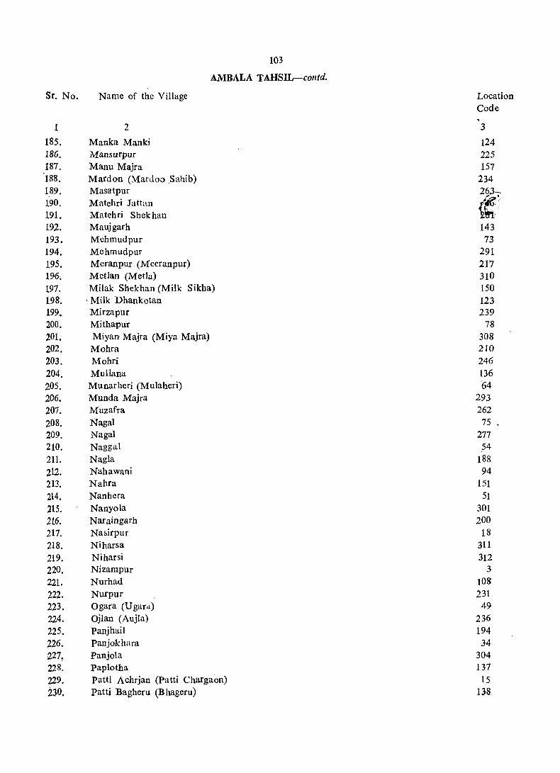
Sr. No.
1
185. 186. 187. 188. 189. 190. 191. 192. 193. 194. 195. 196. 197. 198. 199. 200. 201. 202. 203. 204. 205. 206. 207. 208. 209. 210. 211. 212. 213. 214. 215. 216. 217. 218. 219. 220. 221-222. 223. 224. 225. 226. !).27! 228. 229. 230,
Name of the Village
2
Manka Manki Mansurpur Manu Majra Mardon (Mardoo .Sahib) Masatpur Matehri Jattan Mutehri Shekhan Maujgarh Mehmudpur Mehmudpur Meranpur (Mceranpur) Metlan (Metla)
103
AMBALA TAHSIL-contd.
Milak Shekhan (Milk Sikha) ' Milk Dhankotan Mirzapur Mithapur Miyan Majra (Miya Majra) Mohra Mohri Mullana Munarheri (Mulaheri) Munda Majra Muzafra NagaI NagaI Naggal Nagla Nahawani Nahra Nanbera Nanyoia Naraingarh Nasirpur Niharsa Niharsi Nizampur Nurhad Nurpur Ogara (Ugard) Ojlan (Aujla) Panjhail Panjokhara Panjola paplotha Patti Achrjan (Patti Chargaon) Patti Bagheru (Bhageru)
Location Code
3
124 225 157
234 263~ ~~"
\~. 143 73
291 217 310 150 123 239
78 308 210 246 136 '64
293 262 75
277 54
188 94
151 51
301 200
18 311 312
·3 108 231
49 236 194 34
304 137
15 138

104
AMBALA TAHS!L-contd'
Sr. No. Name of the Village Locati< Code
1 2 3 231. Patti Chanarthal 135 232. Patti Jatan 11 233. Patti Kalalan, 14 234. Patti M,ehar 21 235. Patti Rangran 12 23~ Patti Shekhan 13
237.~ Patti Suba Akbarpur (Suba Akbarp~r) 25 238. Pelakhni (Pilkhani) 69 239. Phalail Majra (Koloo Majra) 83 240. PharoIi 209 241. Phoksa (Faksa) 156 242. Phusiala (Pasiala 189 243. ponti (Pawati) 126 244. Qurbanpur 268 245. Raiya Majra 193 246. Rajauli 179 247. Rajukheri 176 248. Ramgarh Urf Sharifpur 41 249. Ramgarh 99 250. Rampur 57 251. Rampllf 184 252. Rao'Majra 173 253. Rasulpur 306 254. Rattangarh Urf Nakatpur 298 255. Rattanheri , 66 256. Rawalan (Rallla) 254 257. Rawlan (Rawala) 62 258. Regian (Rangian) 238 259, Rola Reri (Roolaheri) 130 260. Roshanpura 325 261. Rukhri 127 262. Rupu Majra (Roopo Majra) 17 263. Saba pur 91 264. Sadopur (Sidhoopur) 9 265. Saha 88 266. Sahia 1l1'
267. Sajjan Majri 178 268. Sakhraon (5ukhrao) 274' 269. Salakhani 110 270. Salarheri (Salaherl) 58 271. Salhapur (Salanpur) 120 272. S(lmalheri (Samleri) 77'
I
273. Sambhalkha (Sanbalkha) 81' 274. Sapehra 63' 275. Sarai l\1ehadud (Sarai Mahdud) 47 276. Sarangpur 16
. '477. Sarda H.eri . 113
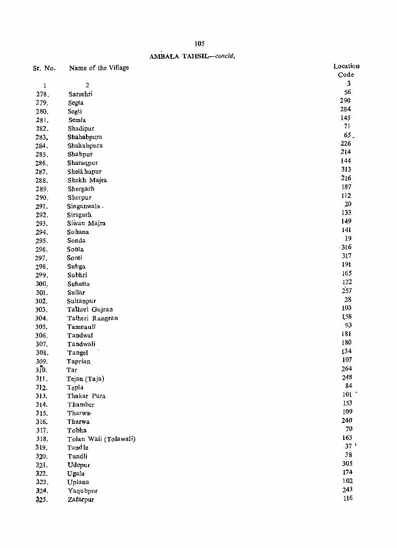
105
AMBALA TAHSIL-concld,
Sr. No. Name of the Village Location Code
1 2 3 278. Sarsehri 56
279. Segta 290
280. Segti 284
281. Semla 145
282. Shadipur 71
283, Shahabpu.ra 65,
284. Shahabpura 226
285. Shahpur 214
286. Sharaqpur 144
287. Sheikhupur 313
288. Shekh Majra 216
289. Shergarh 187
290. Sherpur 112
291. Singanwala . 20
292. Sirsgarh 133
293. Siwan Majra 149
294. Sohana 141
295. Sonda 19
296. Sonta ·316
297. Sonti 317
298. Subga 191
299. Subhri 165
300. Suhatta 172
30l. Sullar 257
302. Sultanpur 28
303. Talheri Gujran 103
304. Talheri Rangran L58
305. Tamnauli 93
306. Tandwal 181
307. Tandwali 180
308. Tangel 134
309. Taprian 107 b
310. Tar 264
311. Tejan (Taja) 248
312. Tepla 84
313. Thakar PUra. 101 .
314. Tbamber 153
315. Tbarwa .. 109
316. Tbarwa 240
317. Tobha 70
318. Tolan Wali (Tolawali) 163
319. Tundla 37 \
320. Tundli 38
321. Udcpur 305
322. UgaJa 174
323. Uplana 102
324. Yaqubpllf 243
~25. Zafarpur 116

to,
VILLAGE DIRgCTOkY
AMBALA TAHSIL
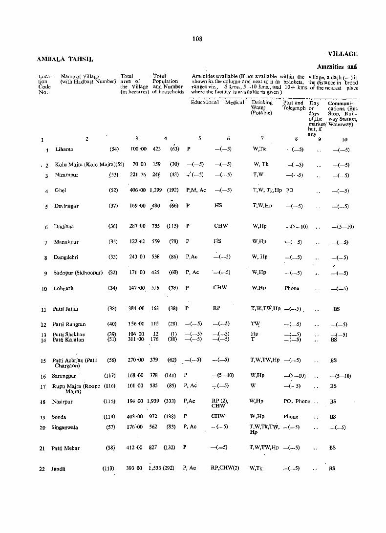
lOS
AMBALA TAHSIL VILLAGE
Amenities and Location Code No.
Name of Village Total . Total (with Hadbast Number)" area of Population
Amenit!es available (If not availa~l~ within the village, a dash (_) is shown III the column ,tnd next to It m brackets the distance in broad ranges viz., -5 ~ms., 5 .10 kms., and 10+ k~s of the nearest place where the facility is available -is given)
2
Liharsa (54)
the Village and Number (in hectares) of households
Edt;~~ Medic~1 '~D~j~kin-;--l?~ n;;~Communi~-Water Telegraph or cations. (Bus
3 4 #
100 ·00 423 (63) P
(Potable) days Stop, Railof ,the way Station, marketl Waterway) hat, if any
5 6 7 8 9 10
-(-5) W,Tk -(-5) -(-5)
2 Kolu Majra (Kola Majra)(55) 70 ·00 159 (30) -(-5) ~(-5)
-(-5)
W,Tk -( -5) -(-5)
3 Nizampur .(53)
4 Ghel (52)
5 Devinagar (37)
6 Dadiana (36)
7 Manakpur (35)
8 Dangdehri (33)
9 Sa do pur (Sidhoopur) (32)
10 Lohgarh
11 Patti Jatan
12 Patti Rangran
13 Patti Shekhan 14 Patti Kalalan
(34)
(38)
(40)
(39) (51)
15 Patti Achrjan (patti (56) Chargaon)
16 Sarangpur (117)
17 Rupu Majra (Roopo (116). Majra)
18 Nasirpur
19 Sanda
20 Singanwala
21 Patti Mehar
22 Jandli
(115)
(114)
(57)
(58)
(113)
221 '76 24~ (43) .,L(-5)
406'00 1,299 (192) P,M, Ac ~(-5)
... 169 ·00 ,.480 (66) P
287 ·00 755 (115) P
122 '62 559 (78) P
243 ·00 53-8 (86) P,Ac
171 ·00 425 (60) P, Ac
147·00 516 (78) P
384'00 163 (38) P
156 ·00 115 (28) ~(-5)
104 ·00 12 (1) -(-5) 311 ·00 176 (38) -(-5)
270 '00 379 (62) _(-5)
168·00 778 (141) P
101 ·00 585 (85) P, Ac
194 '00 1,939 (333) P,Ac
403 ·00 972 (138) P
176·00 562 (83) P,Ac
412 ·00 827 (132) P
HS
CHW
Its
-(-5)
'-(-5)
CHW
RP
_(-5)
-(_5) _(-5)
-(5-10)
7(-5)
RP (2), CHW
CHW
-(-5)
-(-5)
T,W -(--5)
T,W, Tk,Hp PO
T,W,Hp
W,Hp -.(5-10)
W,Hp ~(-5)
W,Hp -(--5)
W,Hp -(_5)
W,Hp Phone
T,W,TW,Hp -(-5).
TY{ Hp T
-(-5)
_("':'5) --(-5)
T,W,TW,Hp -(-5)
W,Hp
W
W,Hp
-(5_10)
-(- 5)
PO, Phbne ..
W,Hp Phone
T,W,Tk,TW, _(-5) Hp
T,W,TW,Hp _(-5)
393 '00 1,533 (292) P, Ac RP,CHW(2) W,Tk _(-5)
-(-5)
_(-5)
_(-5)
-(5-10)
-(_5)
_(-5)
BS
BS
BS
BS
-.(-5)
BS
BS
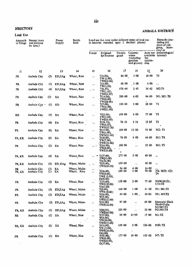
109
DIRECTORY AMBALA DISTInci
Land Use
Approach Nearest town Power Staple Land use (i.e. area under different types of land use Remarks (inc-to Village and distance Supply food in hectares rounded upto 2 decimal places) ludingany
(in kms.) place of reli-gious, histo-rica I or
Forest Irrigated Un-irri- Cultural Area not archaeological by Sources gated waste available interest)
(including for gauchar cultiva-and groves) tion
11 12 13 14 15 16 17 18 19 20 ')
PR Ambala City (3) ED,EAg Wheat, Rice T(4.00), TW(1.00),
84··00 2·00 10·00 Tl
Ambala City Wheat, RiC'e TWE(3.oo)
60·00 6·00 PR (3) ED,EAg T(3.oo), 1·00
(4)' TW(3.00)
PR Ambala City ED,EAg Wheat, Rice , .. T(6.47), 176·44 2·43 36'42 M2:'Tl TW(1.62),
Ambala City TWE(4.S5)
290·00 6·00 PR (3) EA Wheat, Rice T(16.00), 94·00 N1: M3: T8 TW(8.00)
Ambala C~ty - (3) Wheat .. Rice TWE(S,90)
130·00 11 PR ED T(7.00), 3'00 29·00 TW(6.00), TWE(1.00)
KR Ambala City (8) EA . Wheat, Rice T(13.00), TW(5.00),
194·00 3·00 77·00 Tl
PR Ambala City (6) EA Wheat, Rice 'TWE(S.OO) T(2S.33), TW(6.07),
78 '10 3 :24 1~·.9S T1
PR Ambala City (6) TWE(22.26)
164·00 M2:Tl EA Wheat, Rice T(lS.oo), 13·00 51·00 TW(4.00),
Ambala City '(8) Wheat, Rice TWE(ll.OO)
78·00 9·00 Ml:T4 PR,KR EA . T(3S.oo), 46·00 TW(7.00) •
PR Ambala City (3) EA Wheat, Rice ... . TWE(31.00) T(16.oo), 108'00 23·00 M2:T3 TW(S.oo),. TWE(S.oo)
PR,KR Ambala City (4) EA Wheat, Rice .. .. T(37.oo), 273·00 S'oo 69'()O TW(13.00)
Ambala City Wheat, Maize Tk(24.00)
130·00 PR,KR (3). ED,EAg T(10.00), 16·00
Ambala City m Wheat, Maize TWE(lO.OO)
S4·00 4,00 16'00 PR EA .. PR,KR Ambala City (1) EA Wheat. Rice' .. T(58.00). lS0'00 3 -00 70·00 N4.: M2S: C2:
TW(8.00), T4 TWE (5.00),
Ambala City (2) Wheat, Rice 0(4S:00)
158'00 2·00 77'00 NI00;MlS1~ PR EA T(33.oo), TWE(30.00) C131T~
Ambala City (S) ED;EAg Whea t, Maize Tk(3.oo)
14S'00 1'00 11·00 PR T(S.oo), N1: Ml:T2 . TWE (S.OO) PR Ambala City (3) ED,l:iAg Wheat, Maize T(26.00), 64'00 1·00 • 10·()o Nl: M3:T2
W(5.00),
Ambala City (2) Wheat, Maize TWE(21.00)
97'00 6S'00 Memarial Shah PR ED,EAg T(32.00) TWE(32.00) Naslr-U-din
N3:M5:T2 PR,KR Ambala City (2) ED,BAg Wheat, Maize T(45.OO), 3~6'00 32·00 N2:M3.T4
PR Ambala City (2) EA Wheat, Rice TWE(45.()0)
89'00 13"00 17·00 MI:T2 T(57.oo), W(4.oo) TW(20.00),
PR,KR Ambala City (2) EA Wheat, Rice TWE(33.oo)
139·00 2'00 2j6'OO NIt>: 1'2 T(35.00), TW(3.oo), 'I'WE(2S.00),
(3) Wheat, Rice 0(4.~
177·00 10'00 N7:'f2 .PR Ambala City EA T(53. ).' 153·00 TW(8.oo), TWE(s.oo), 0(37.00),

AMBALA TAHSIL
Location Code No.
23
24
25
26
27
28
29
30
31
32
33
34
3S
36
37
38
39
40
41
42
43
44
4S
Name of Village (with Hadbast Number)
2
Dhulkot - (6~)
Mandli (59)
Patti Suba Akbarpur (49) (Suba Akbarpur)
Ambala City (50).
*Khurampur Majri (41)
Sultanpui (42)
KakrU . (31)
Khatoli (30)
Mandhaur (43)
Bamala (48)
Dhankaur (61)
Panjokhara (29)
Gamala: (44)
Janetpur (45)
Tundla (46)
'Tundli (47)
'K.alarher·i (Kalaheri) (28)
Boh (27)
Ramgarh Urf SharIfpur(26)
Chandpura (25)
Babiyal (63)
Ambala Cantt. (62)
Kanwli (111)
Total area of the . Village (in hectares)
3
270'00
26·00
363·00
97'00
215·00
120·00
170'00
271'00
264'00
Ito VILLAGE
Amenities and
Total Amenities available (If not available within the village, a dash (-) is Population shown in the column and next to it in brackets, the distance in broad and Number ranges viz.-5 kms., 5-10 kms. and 10+kms. of the nearest place of households where the facility is available is given)
4
959 (166)
21 (6)
472 (l01)
1,359 (249)
897 (134)
869 (142)
Educational Medical Drinking Post and Day Communica-
5 ... 6
P,Ac -(-5)
-(-5) -(-5)
P,M,Ac -(-5)
Ac(2) lIS
P -(5-10)
P,Ac -(-5)
Watef Telegraph or tions (Potable) days (Bus Stop,
of the Railway mar- Station, ket/hat, Waterway) if any
7 8 9 10
W,TW,Hp Phone BS,RS
W,Hp -(-5) BS
Wh?Hy merged
Wholly merged
W,TW,Hp Phon~ BS,RS
W,Hp PO BS
. Tk,Hp -(-5) -(-5)
W,Hp -(5-10) " -(-5)
212 ·00 .1,126 (191) P,Ac CHW W,Hp ~(_5) -(-5)
175·00 825 (132) ,P,Ac -(-5) W,Hp PO -(-5)
1,213 ·63 3,042 (465) P(2), M(2),H HS,CHW(2) W,Hp PO,Phone .. BS
324'00 1,518 (226) P,M CHW T,W,Hp -(-5) BS
21S·00 476 (84) P -(5-10) T,W,Hp -(-5) BS
142·00 2.200 (324) P,M CHW W.Hp -(-5) -(-5)
49'00 670 (124) P CHW W,Hp ~(-$) -(-5)
517'18 1,403 (221) P CHW W,Hp PO ~(-S)
568'00 3,769 (617) P,M,H,Ac(3) HS,CHW(3) HP PO,Phone " BS 202-00 480 (81) P.Ac(2) -(-:5) TW.Hp -(-5) -(-5)
~
92'00 216 (31) -(-51 -(-"5) Hp -(-$) ~(-5)
322 ·00, Treated
3,767 -00 <> Wholly merged
124'00 478 (79) -(-5) -(-5) W,Tk,tip -(~5) BS
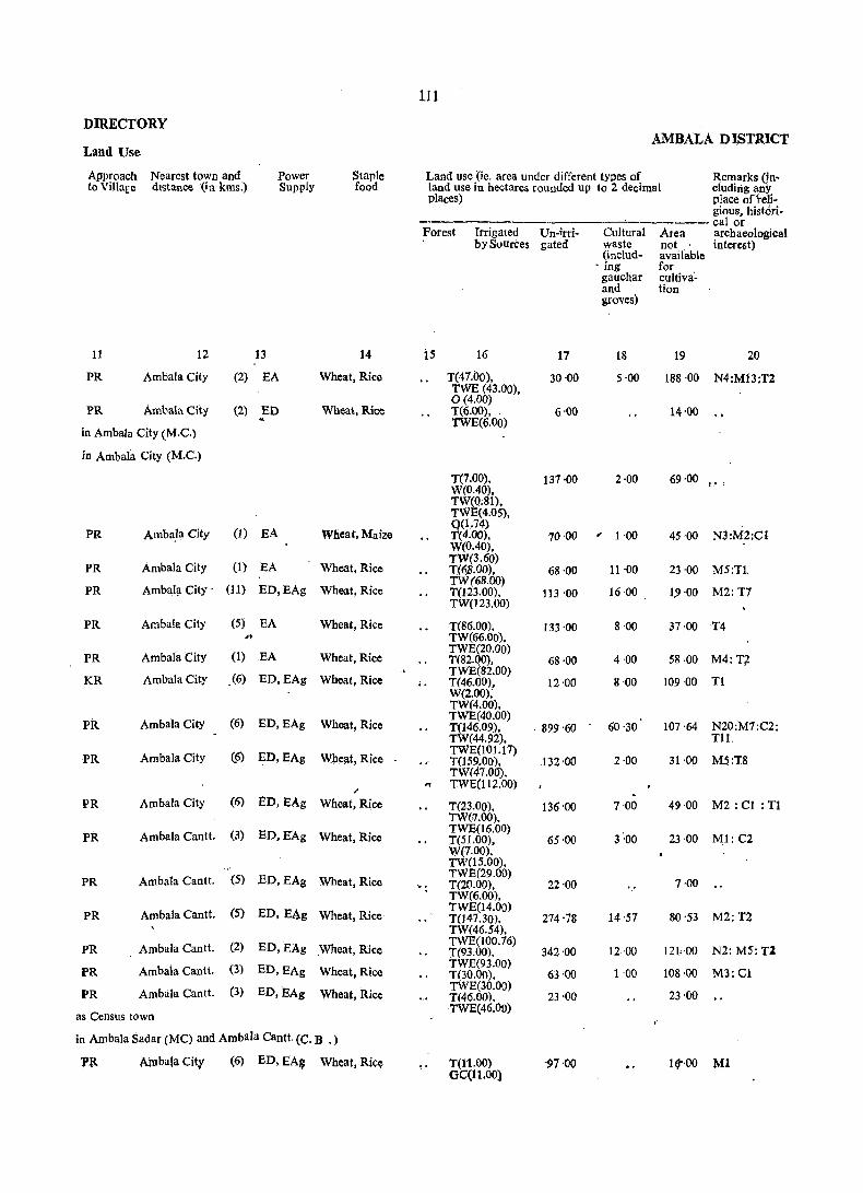
1.11
DIRECTORY AMBALA D ISTR1CT
Land Use
Approach Nearest town and Power Staple Land use (ie. area under different types of Remarks (in-to Villare distance (in kms.) Supply food land use in hectares rounded up to 2 decimal eluding any
places) place ofreli-gious, histori-calor
Forest Irrigmed Un-lrri- Qiltural Area archaeological bySuurces gated waste not interest)
(includ- available . ing for gauchar cultiva'-and tion groves)
11 12 13 14 is 16 17 18 19 20
PR Ambala City (2) EA Wheat, Rice T(47.00), 30·00 5·00 188·00 N4;M13;T2 TWE (43.00), 0(4.00)
PR AmbalaCiiy (2) ED Wheat, Rice T(6.oo), 6'00 14'00 . TWE(6.00) in Ambala City (M.C.)
in Ambala City (M.C.)
T(7.00), 137 ·00 2·00 69·00 P.' I
W(0.40), TW(Q.81). TWE(4.05),
EA 0(1.74)
PR Amba.l\l City (1) Wheat, Maize T(4.00), 70·00 , 1 ·00 45·00 N3:M2:Cl W(0.40),
Ambala City (1) EA Wheat, Rice TW(3.60)
M5:T1. PR 1".(6$.00), 68'00 11·00 23 '00
Ambal;t City' (ll) ED,EAg Wheat, Rice TW(68.00)
16 ·00 M2:T7 PR T(123.00), 113 '00 19'00 . TW(I23.00)
PR Ambala City (5) EA Wheat, Rice T(86.00). 133 ·00 8'00 37·00 T4
'" TW(66.00),
Ambafa City (1) EA Wheat, Rice TWE(20.00)
58·00 M4:T7 PR T(82.QO), 68·00 4·00
AmbalaCity .(6) ED,EAg Wheat, Rice TWE(82.00)
Tl KR T(46.00), 12 '00 8·00 109 ·00 W(2.00); TW(4.00),
Ambala City (6) ED,EAg Wheat, Rice TWE(40.00)
60 '30 107 '64 N20:M7:C2; PR T(146.09), . 899 '60 TW(44.92). TIl.
PR Ambala City (6) ED,EAg Whe!!.t, Rice TWE(101.17) T(159.00). 132 ·00 2·00 31 ·00 M5:!8 TW(47.00). .. TWE(1l2.00)
PR AmbaJa City (6) ED,EAg Wheat, Rice T(23.00), TW('7.00).
136'00 7·00 49·00 M2: Cl : T1
PR AmbaJa Cantl. (3) ED, E"Ag Wheat, Rice TWE(16.00) T(51.00), 65·00 W(7.00},
3:00 23'00 M.1:C2
TW(lS.OO),
PR Ambala Cantt. (5) ED,EAg Wheat, Rice TWE(29.00)
7·00 ' .. T(20.00), 22·00 TW(6.00),
PR AmbaJa Cantt. (5) ED,EAg Wheat, Rice TWE(l4.00)
14'57 80,53 M2:T2 T(147.30). 274,78 TW(46.54),
PR Ambala CanU. (2) ED,EAg Wheat, Rice TWE(J00.76) T(93.00). 342'00 12 ·00 12kOO N2: M5: TZ
PR Ambaia Cantt. (3) ED,EAg Wheat, Rice TWE(93.00) T(30.00), 63 ·00 1 ·00 108·00 M3:Cl
Ambala CanU. (3) ED,EAg Wheat, Rice TWE(30.00)
23·00 PR T(46.00). 23·00
as Census town TWE(46.00)
in AnibaJa Sadar (MC) and Ambala Cantt. (C. B .)
J'R Ainbala City (6) ED,EAg Wheat, Ri~ T(1'1.00) OC(11.00)
"97'00 1(1",00 Ml
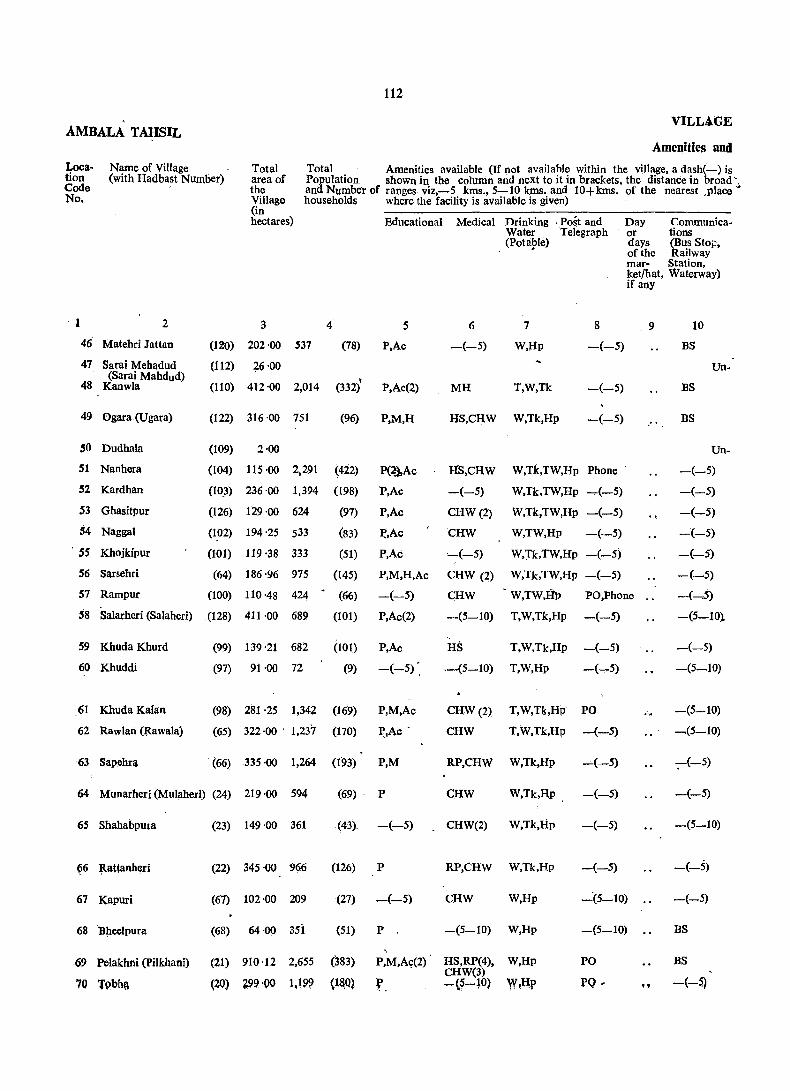
112
AMBALA TAHSIL VILL4.GE
Amenities and
Location Code No.
Name of Village (with Hadbast Number)
Total area of the Village (in hectares)
Total Amenities available (If not available within the village, a dash(-) is Population shown in the column and next to it in brackets, the distance in broad "
. 1 2
46 Matehri Jattan
47 Sarai Mehadud (Sarai Mahdud)
48 Kanwla
49 Ogara (Ugara)
,0 Dudhala
51 Nanhera
52 Kardhan
S3 Ghasitpur
54 Naggal
. SS Khojkipur
56 Sarsehri
57 Rampur
'8 Salarheri (Salaherl)
59 Khuda Khurd
60 Khuddi
.61 Khuda Kalan
62 Rawlan (Rawala)
63 Sapehra
and Number of ranges viz,-5 kms., 5-10 kms. and 10+kms. of the nearest ,place households where the facility is available is given)
3 4
Educational Medical Drinking . Post and Water. Telegraph (Pota1'Ie)
5
(120) 202 ·00 537 (78) P,Ac
6
-(-5)
7
W,lIp
8
-(-5)
(il2) ~6 '00
(110) 412 '00 2,014 (332) P,Ac(2) MH T,W,Tk -(-5)
(122) 316 -00 751 (96) P,M,H HS,CHW W,Tk,Hp -(-5)
(109) 2-00
Day Communica-or tions days (Bus Sto~, of the Railway mar- Station, ket/hat, Waterway) if any
.9 10
BS
BS
BS
Un-
Un-
(104) 115 -00 2,291
(10,]) 236 -00 1,394
(126) 129 -00 624
(422)
(198)
(97)
P(~Ac
P,Ac
P,Ac
~,Ac
P,Ac
P,M,H,Ac
HS,CHW
-(-5)
CHW (2)
CHW
,-(-5)
CHW (2)
CHW
-(5-10)
W,Tk,TW,Hp Phone . -(-5)
(1.02) 194 -25 533 (83)
(101) 119 -38 333 (51)
(64) 186 -96 975 (145)
(100) 110 -48 424 ~ (66)
(128) 411 -00 689 (101)
-(-5)
P,Ac(2)
(99) 139 -21 682 (101) P,Ac
(97) 91 -00 72 (9) -(-5)
(98) 281 -25 1,342 (169) P,M,Ac
(65) 322 -00 . 1,237 (170) ~,Ac .
. (66) 335 -00 1,264 (1'93) P,M
W,Tk,TW,Hp -,.(-5)
W,Tk,TW,Hp -(-5)
W,TW,Hp -(-5)
W,J'k,TW,Hp -(-5)
W,Tk,TW,Hp -(-5)
W,TW,IJt, PO,Phone
T,W,Tk,Hp -(-5)
HS T,W,Tk,Hp -(-5)
,-(5-10) T,W,Hp -(-5)
CHW(2) T,W,Tk,Hp PO
CHW T,W,Tk,Hp -(-5)
RP,CHW W,Tk,Hp -(-5)
-(-5)
-(-5)
-(-5)
-(-5)
-(-5)
-(--..5)
-(5-10).
-(-5)
-(5-10)
-(5-10)
-(5-10)
-;-(-5)
64 Munarheri (Mulaheri) (24) .219 -00 594 (69)· P CHW W,Tk,Hp -(-5) -(-5)
65 Shahabpura
~6 ~attanher~
67 Kapuri
68 Bheelpura
69 Pelakhni (pilkhani)
70 Tpbhft
(23) 149 -00 361
(22) 345 ·00 966
(67) 102 -00 209
(68) 64 ·00 3si
(21) 910 -12 2,655
(20) ~99 -DO 1.199
(43). _(-5)
(126) P
(27) -(.....;5)
(51) P.
(383)
<l~Q)
P,M,A9(2)
f.
CHW(2) W,Tk,Hp
RP,CHW W,Tk,Hp
CHW W,Hp
-(5-10) W,Hp
HS,RP(4), W,Hp CHW(3) -(5-10) W,lIP
-(-5)
-(-5)
"-:(5-10)
_(5_10)
PO
:PQ -
-(S:__10)
-(-5)
-(-5)
BS
BS
.. -(--~

113
DIRECT01W AMBALA -DISTRICT
Land Use
Approach Nearest town and Power Staple Land use(i.e. area under different types of Remarks (in-to Village distance (in kms.) Supply' food land use in hectares rounded uPto 2 decimal eluding any
places) place of 'reli-gious, histori-calor
Forest Inigated Un-irri- Cultural Area archaeological by SoUrces gated watse not interest)
(ipcluct- available Ing for gauchar cultiva-and tion groves).
11 12 13 14 15 16 17 18 19 20
PR Ambala City (3) ED,EAg Wheat, Rice T(20.00). 154:00 28-00 Gurudwara: TWE(20.oo) Nl:M2:T3
inhabited 25-00 1 '00
PR AmbalaCity (3) EA Wheat, Rice T(l41.00). 236·00 35·00 Gurudwara: TW(132.00), N4:M6:T15
PR Ambala Cantt. TWE(9.00)
43'00 M6;C1:T16 (3) EA Whc.at, Rice . ., T(IW.OO). 163 '00 GC(76.00),
inhabited WE(34.00)
1 ·00 T(1.00).
PR Ambala Cantt. (2) Whea;_t, Maizc GC(1.00)
Gurudwara: EA T(28.00), 36-00 51 ·00 GC(Z8.00) N3:M5:C3
PR Ambala Cantt. (3) ED,EAg Wheat, Maize T(100.00); 53'00 1 ·00 82·00 TS
J;'R Ambala Cantt. (4) ED,EAg Wheat, Maize GC(100.00)
55:00 5~00 48·00 T(21.00).
PR Ambala. Cantt ED,EAg. GC(21.00)
84-58 71-22 Temple: N4: (1) Wheat, Maize T(36.02). 2·43 GC(36.0Z) Ml:T2
PR Ambala Cantt. (3) EA Wheat, Maize T(21.04). 26 '30 5'26 66 ·78 Temple: N2: GC(21.04) ,- M2:Cl
PR Ambala Cantt. (5) . ED, EAg Wheat, Maize T(50.18), 56 '66 80 ·12 N2
PR Ambala Cantt. ·(3) EA Wlleat, Maize GC(SO.18)
2'43 55'84 N3: M3:Cl; T(23.07), 19 ·14 GC(23.07) Tl
PR Ambala Cantt. (3) ED,EAg Wheat, Rice T(22.00), 308·00 9·00 72·00 Ml : Tl TW(lt.OO),
PR. Ambala Cantt. (2) ED,EAg Wheat, Rjce TWE(I1.00)
68·39 3·24 19'02 T2 T(48.56),
J>R Ambala Cantt. (5) ED,EAg Wheat, Rice GC(48.56)
76 ·00 2-00 9 '.00 T(4.00), TW(2.00). TWE(2.00)
PR Ambala CanU. (5) ED, EAg Wheat, Rice T(0.40). 209·22 2·43 69·20 M2: T8
PR Ambala Canlt. (5) ED,EAg Wheat, Rice TWE(OAO) T(60.00), . TW(20.00).
203 '00 5·00 54'00 Ml:T4
PR Ambala Cantt. (10) EA Wlleat, Maize TWE(40.00) T(l23.00). 182·00 4·00 26·00 M5:T8 TW(40.00).
PR Ambala Cantt. (6) EA. Wheat, Maize TWE(83.00)
86'00 7·00 30-00 T5 T(96.00), TW(44.00),
PR Ambala Cantt. (11) EA Wheat, Maize TWE(52.00) T(30.00), TW(lO.OO),
87 ·00 1 ·00 31 ·00 Tl
TWE(20.90)
PR Ambala Cantt. (10) EA Wheat, Maize TC143.00), 158'00 6'00 38 '00 M3: T4 TW(23.00)_
FR Ambala Cantt. (11) EA Wheat, Rice TWE(120.00)
17·00 13 ·00 6-00 T(66.00), TW(21.00),
PR • Ambala Cantt. (11) EA Wheat, Rice TWE(45.00) T(15.00), 36'00 1 ·00 12'00 TW(IO.00),
PR!KR Ambala Cantt. (11) Wheat, Maize TWE(S.OO)
579·91 8·50 109·25 M4:T5 EA T(212.46). GC(212.46)
fR AITIQalll Cantt. (8) I;A Wh~t.Ri~e T(S5.oo). .2~Z·OO .. 22'00 N1: M4;TJ TWE(SS~OO)

AMBALA TAHSIL
Name of Village Loc:!. tion Code No,
(with Hadbast Number)
71 Shadipur
72 Malikpur
2
73 Mehmudpur
74 Fatehpur
(19)
(18)
(71)
(73)
75 NagaI (70)
76 Mahtabgarh (69)
77 SaJ.ll'lIheri (Samleri) (94)
78 Mithapur (96)
79 Kharu Khera (95)
80 Manglai (129)
81 Sambhalkha (130) (Sanbalkha)
82 Akbarpur (131)
83 Phalail Majra (132) (Koioomajra)
84 Tepla (133)
85 Ghaseetpur (195)
86 Behta (Bihta) (158)
87 Jawahargarh (134)
88 ,Saha (93)
89 Laha (72)
1>14
VILLAGE
Amenities and
Total area of the Village (in hectares)
Total Population and Number of households
Amenities available (If not availabI..e within the village, a dash(-) is shown in the column and next to it in brackets, the distance in broad ranges viz. -5 kms., 5-10 kms. and 10+kms. of the nearest place where the facility is available is given)
Educational Medical
3 4 s 6
137·00
121 ·00 398 (52) -(-5)
354 '50 1,110 (157) P,Ac (2)
118 '00
-(-5)
CHW(2)
46 ·00 88 (17) -(-5) -(-5)
97 ·00 404 (72) P '-(5-10)
925 '91 2,815 (411) P,M,H,Ac HS,CHW
111 ·00 166 (32) -(-5) -(5-10)
82 '15 275 (45) P -(5-10)
363 ·00 1,237 (171) P caw ,
833 '24 3,141 (472) P,M,Ac HS
238 '00 263 (43) P -(5-10)
116 ·00 326 (49) P -(5-10)
655 ·00 11895 (299) P,Ac HS,CHW
116 ·00 424 (55) P -(-5)
1,110.04 5,268 (763) p,M,H,PUC, D,RP(4), Ac(3) CHW
92 ·00 413 (64) P -(~5)
870 ·40 3,545 (551) P(2),M(2), D,RP(lO), H(2),Ac(3) . CHW(2)
159 '00 139 (16) -(-5) -(-5)
Drinking Water (Potable)
7
W,Hp
W,Hp
Post and Day Communi-Telegraph or cations
8
-(-5)
PO
days Bus Stop, of the Railway
mar- Station, ket/hat, Water-if an}' way)
9 10
BS
BS
Un-
Un-
W,Hp PO -(-5)
W,Hp -(-5) -(-5)
W,Hp PO BS
W,Hp -(-5) BS
W,Hp -(-5)' -(-5)
W,Hp -(-5) -(-5)
W,Hp PO -(-5)
W,TW,Hp -(-5) -(-5)
W,TW,Hp -(-5) -(-5)
W,TW,Hp PO BS
W,Hp -(-5) -(-5)
W,Hp PO,Phone. . BS
W,Hp -(-5) -(-5)
W,Hp PTO, BS Phone
W,Hp -(-5) BS
90 Goli (74) d69'00 117 (19) Ac RP(2) T.W,TW,Hp -(-5) BS
91 Sabapur
92 Gala
93 Tamnauli
94 Nahawani
95 Kalpi
(17) 196 ·00 576 (86) P
(16)
(75)
(92)
(136)
766'00 1,482 (236) P,Ac(2),
554 '00 748 (127) P
738 '95 1,856 (268) P,Ac(2)
503 '00 1,550 (230) .P,M,Ac(2)
CHW
RP(2) CHW
RP
::..-(-5)
HS
T,W,TW,Hp -(-5)
T,W,Hp
, T,W,Hp
W,Hp
W,Tk,Hp
-(-5)'
-(-5)
PO
PO
-(-5)
BS
BS
BS
BS

its"
bmEC110RY AMBALA DISTRICt
Land Use
Approach Nearest town and Power Staple Land use (ie. area under different iypes of land use Remarks (in-to Village disttmce(in kms.) Supply food in hectares rounded uPto 2 decimal places) eluding any
place of reli-gious, histori-
-i--------------------- calor Forest Irrigatect Un-irri- Cultwal Area archaeo-
by Sources gated waste not logical (includ- available interest) ing for gauchar cult iva-and tion groves)
11 12 13 14 15 16 17 18 19 20
inhabited T(30.00), '103·00 4·00 TWE(30.00)
PR Ambala Cantt. (10) EA Wheat, Rice T(8 ·00), 95 ·00 5·00 13·00 TWE(8,00)
PR Ambala Calitt. (10) EA Wheat, Rice T(33.99) 286'51 27 :92 6'08 M2:T1 GC(33.99)
inhabited T(1.00). 112 ·00 1 ·00 4·00 TWE(1.00)
PR Ambala Cantt. (10) EA Wheat, Rice T(11.00), 27 ·00 2·00 6·00 TWE(ll.OO)
PR.KR Ambala Cantt. (13) EA Wheat, Rice T(34.00), 47'00 16'00 M3 TWO 2.00), TWE(22.00)
PR Ambala Cantt (11) EA Wheat, Rice T(278.82), 532·15 114 ·94 Mosque: N3: GC(278.82) M8:Cl:T2
PR Ambala Cantt. (11) EA Wheat, Rice T(12.00), 84·00 15 ·00 TW(4.00), TWE(8.00)
PR Ambala Cantt. (11)' EA Wheat, Rice T(5 '67),. TW(2.43),
61·11 2'02 13 ·35 Ml: T3
Anibaia Clln tt. TWE(3.24)
58 ·00 Temple: Ml: PR (6) EA Wheat, Rice T(66.00), 236·00 3·00 TWE(66,00) Tl
PR Ambala Cantt. (8) EA Wheat, Maize T(297.44), 422·08 10'93 102 ·79 Temple; N2: TW(297.44) M3:T9
KR Ambala Cantt. (6) EA Wheat, Rice T(13.00), 207 ·00 4'00 14 ·00
(6) EA TWE(l3,OO),
60'00 6·00 13·00 PR Alllbala Cantt. Wheat, Rice T(37.00), Ml TWE(37.00),
PR Ambaia Cantl. (8) EA Wheat, Rice T(319.00), 266'00 13·00 57 '00 N5:M6:T4 TW(95.00), TWE(l78.00),
PR Ambala Cantt. (14) EA Wheat, Rice 0(46.00)
65'00 1'00 15'00 T(35.00), N2: Mf: C2: TWE(35.00) T4
PR Ambala Cautt. (14) EA Wheat, Rice T(288.13), 731 '26 1 ·21 89·44 Temple; Gur-W(45.32). dwara:N60:
Ambala Cantt. TWf42.81)
23'00 M15:TlO
PR (14) EA Wheat, Rice T(5 .00), 3'00 8·00 Ml-: T2 TW(17.00),
PR Ambala Cantt. EA _ Wheat, Rice TWE(41.00)
658 -82 8 ·50 36·35 (10) T(166.73), Temple:N60: TW(17.00), -MI5:Cl:T2
KR Alllbaia Cantt. (11) 'EA Wheat, Rice
TWE(137.59), 0(l2,14} T(24.00), 125 ·00 ~'OO ']·00 TW(I1.00),
PR All1bala CanU. (16) ED,EAg Wheat, Rico 0(13.00)
149·00 9·00 8·00 Nl: T2 T(3.00), -TWE(3.00)
KR. Ambala Cantt. (18) ED. BAg , Wheat, Rice T(7.00), 154'00 10·00 25 '00 T2
Ambala Cantt. (16) ED,EAg Wheat, Rice 1WE(1.00)
610 ·00 9'00 120·00 Nl: M2: 1'1 PR T(27.00), T\V(8.00),
FR Amba1a Cantt. (18) EA Wheat, Rice TWE(19.00)
383'00 26·00 121 '00 T(24.00). T3
Ambala City (7) EA Wheat, Rice TWE(24.00)
585'57 11'33 86'61 N2:MS:T6 PR T(55.44). TW(14.16),
Ambala City (7) EA Wheat, Rice TWE(41.28)
348'00 10'00 121 ·00 N7:M4;T3 PR t· T(24.00), TW(8.00). TWE(16.00)

AMBAtA 1A,ItsI1 VILLAGE
Amenities and
Loca· tion Code No.
Name of Village Totai (with Hadbast Number) area of
the Village (in hectare.s)
Total Population and Number of households/
Amenities available (If not available,within the village, a dash (-) is shown in the column and next to it in brackets, the distance in broad ranges viz., -5 kIns. S-10 kms. and 10+krns. of the nearest place where the facility is available is given)
1
- 96 Alapur
97 Khera
98 Gokalgarh
99 Ramgarh
2 3
(154) 167·00 234
(89) 350 ·00 747
(76) '454 '86 962
(78) 256 ·00 822
100 Jharu Majra (Jhando (77) 263 ·00 582 Majra)
4
Educational Medical
5 6
(35) -(-S) -(-5)
(92). P(2),M(2),H CHW
(125) P,M,H,Ac(2) CHW
Drinking Water (Potable)
7
W,Rp-
W,Rp
:W,Hp
(119) P HS,CRW W,Hp
(89) P CHW W,Hp
Post and Day Communi. Telegraph or cations
8
-(-5)
-(-5)
PO
-(-5)
-(-5)
days (Bus Stop, of the Railway mar· Station, ket/ Waterway) hat, if any
9 10
-(-5)
. -(-5)
BS
-(-5)
-(:-5)
101 Thakar pura (IS) 542 ·00 1,291 (209) P,M,Ac(4) HS,RP(2) T,W,TW, PO Hp
BS
102 Uplana (14) 510·00 1,369 (1~5) P,Ac(2)
103 Talheri Gujran (13) 341 ,00 664
104 Dhanaura (80)
105 Gangan Heri (Gagan. (12) Heri) -
791 ·00
418 -00
",802
717
106 Kakar Kunda
107 Taprian
108 Nurhad'
109 Tharwa
110 Salakhani
111 Sahla
112 Sherpur
113 Sarda Heri
114 Binjal Pur
115 Aliaspur
116 Zafarpur
117 Dhnauri
(10) 379 -00 529
(11) ·138·00 355
(3) 450 -00 424
(2) 412 -00 478
(4) 201 -DO 694
(1) 424 '00 768"
(5) 151·00 473
(6)' 660·00 1,996
(9) 609 ·45 1;657
(7) 181 ·00 ,450
(8) 746 ·63 1,575
(81) 173 '61 . 660
118 Alipur (82) 284.49 645
119 Jahangirput.\ (83) 278 '42 662 (Jahagirpur)
120 Salhapur (Salanpur) (85) 172:39 499
(95) P,Ac
(283) P,M,H
(94) P,Ac'
(71) P
(45) P
.(61) P,Ac
(55) P,Ac
(102) P
(111) P,Ac
(86) P
(290) P,Ac
(244) P,Ac
(73) -(-5)
(218) P,M,H,Ac
(92) P
(85) P
(111) -(-5)
(67) P
RP,CHW .T,W,Tk,Hp -(10+)
RP,CHW(2) T,W,Hp
HS,CHW(3) W,n,Hp
CHW W,Tk,Hp
-(10+)
PO
-(10+)
-(10+) W,Tk, Rp -(-5)
CHW
CHW
HS,CHW
-(-5)
CHW
CHW
CHW
RP,CmV(2)
-(5-10)
HS
-(5-10)
W,Tk,Hp -(-5)
W,Tk PO
W,Tk,TW, -(-5) Hp _ W,Tk,TW. PO Hp
W,Tk,TW, Hp W,Tk,TW, Hp W,Tk,TW, Hp T,W,Tk, TW,llp W,Hp
T.W.Tk. TW,Hp W,Hp
-(-5)
-(-5)
-(-5)
PO
-(-S)
PO
-(5-1~)
D,CHW W,Rp PO
PO -(5-10) W,Hp
-(5-10) W.Hp -(-5)
BS
BS
as
-(-5)
-(-5)
-(5-10)
-(-5)
BS
-(-5)
as -(-5)
as BS BS BS
-(-5)
-(-5)
-(-5)

117
DIRECTO'Q.Y AMBALA DISTRICT Land Use
Approach Nearest town and Power Staple Land use (i.e. area under different types of land use Remarks (in-
to ViUa&e distance (in kIDs.) SU\l.P!Y food in he~tares rounded uptD 2 decimal places) - eluding any place of reJi-gious, histori-_______________________ calor
Forest Irrigated Un- Cultural Area archaeological by Sources irrigated w;')ste not interest)
(inc1ud- available ing for gauchar cultiva-and tion groves)
11 12 13 14 15 16 17 18 19 20
PR,KR Ambala Ci~y (8) EA Wheat, Rice; T(2LOO). 122-00 4-00 20·00 Ml:T2 TW(4.00), TWE(17.00)
PR Ambala Ca~tt. (16) EA WhC!!t, Rice T(9.00), 277·00 6·00 58 ·00 TI TW(4.00), TWE(5.00)
PR Ambala Can,tt. (18) EA Whe~t, Rice T(liS.56), 312·41 761>9 Temple.: p GC(6D6)
PR Ambala Cantt. (22) EA Wh;;:a ~'< Rice T(47.00). 124·00 5·00 80·00 Temp.le Sp.iv TW(36:00), TWE(lJ.OO)
FR Sadaura (15) EA Wheat, Rice T(1.00), 163 -00. 1'00, 92·00 Tl WE(4.00},
PR Ambala Cantt. (30) EA Wheat, R.ice W(3.00) T(40.OQ). 446·00 11·00 45 ·00 Temple' N4: TW(B.O(J). Tl "
Ambala Cantt. EA Wheat, Rice TWE(~2.00)
3·00 PR (16) T(31.00). 440·00 36 ·00 Temple Tha-
TW(1I.00). kurdwara:Tl
Ambala Cantt. • Wheal, Rice TWE(20.00)
281 ·00 PR, (16) EA T(28.00). 9'00 23'00 TW{6.00),
Wheat. Rice TWE(22.00)
PR, KR Sadaura, (J~) EA T(18.00). 622·00 104'00 41·00 N4:Ml:T4
Sadaura (15) EA Wheat, Rice TWE((l8.00)
5-00 PR T(6.00), 202'O(} 205·00 T2 TWE(6,OO)
KR Sadaura (14) EA Wheal, Rice T(34.00), TWE(34.00)
191·00 18·(}O 136·00 Ml:T5
KR ~~daura (14) pA Whel\t, Rice T(4.00), 113:0(> 2-00 19·00 TI'
Wheat, Rice TWE(4.00)
PR Sad aura (18) EA T(18_00). 279 00 34·00 119'00 Ml:T2
Sadaura (8) ED,EAg Wheat, Rice TWE(l8.00)
73 ·00 KR " • T(18.00). 113 '00 208'00
Sadaura ED,~A~ Wheat, Rice TWE(1S.00)
, 9·00 17·00 PR (6) T(103.00), 72·00 N2: Ml:'Tl TWIl(103.00)
KR Saduara (6) ED,BAg W~e~t, Rice T(26.00). 296 ·rio 39·00 63·0{) Tl
ED •. E.<\g W~eat, Rice TWE(26.DO)
PR Sadaura (6) T(99.00), 32·00 4·00 16'00 N4; Ml: TWE(99.00) Cl: T4
PR,KR Sadaura (8) EDrgA~ Wheat, Rice T(S24.00). 67·00 22·00 47 ·(}O N3:M4:C1: TWE(S24.00) no .
PR,KR Sadaura (12) EAt- Wheat, Rice T(175.63), 280'04 ]53 .7(1, Temple Shiv:
EA Wheat, Rice TWE(17S.63) Nl:M3S
KR. Sadaura (10) T(S7.00), 73-00 21 ·00 M12
Saduara (10) EA Wheat, Rice TWE(87.00)
:m·22 PR T(227.43), " 0,1 205 ·98 TempleSliiv: .
EA. Wheat. R,jce TWE(221.43) N2: M3
PR,KR }agadhri <m T(lIU!9), 39·26 2·02 21 ·04 Ml:T4' W(1.21), TW(10:S2).
PR JIIgad1Jri (19) EA Wheat TWE(39.26)'
3·24 , T(248.SS). 32 '37 N2:M2;GI :TQ,
.PR lllgadhri (21) EA. Wheat, Rice GC(248.88)
92'27 8'90 'rl T(159.04). 18 ·21 TW(95.10),
KR Jagadhri (21) EA Wheat TWE(63.94)
39'25 2·83 10,12 T(l20.19), T2 TW(50.58}, TWE(69.6l)

AMBALA TAHSIL
Loca- Name of Village tion (with Hadb6st Number) Code No.
2
121 Kansapur (145)
122 Bekoripur (Bikonpur) (146)
123 Milk Dhankotah'
124 Manka Manki
125 Kban Ahmadpur
126 Ponti (Pawati)
127 Rukhri
128 Dhin
129 Jamal Majra
(147)
(148)
(144)
(84)
(142)
(143)
(86)
130 Roia Heri (Roolaheri) (79)
131 Duljana
132 DuJiani ,
133 Sirsgarh
134 Tangel
135 Patti Chanarthal
136 Mullana
137 Paplotha
138 Patti Bagheru (Bhageru)
139 Hamidpur
140 Hema Majra
141 Sohana
142 Bhudian
143 Maujgarh
144 Sharaqpur
145 Semla
(87)
(141)
(140)
(88)
(138)
(139)
(91)
(90)
(137)
(153)
(152)
(151)
(2I2)
(201)
(202)
its
-VILLAGE
Total area of the Village (in hectares)
Amenities and
Total Amenities available (If not available within the village, a dash(-)is shown Population in the column and next to iUn brackets, the distance in broad ranf:es viz.
and Number -5 kms; 5-10 kms. and 10+kms. of the nearest place where the fadlity of households is available is given)
74 ·00 313
84·00 356
129·00 386
402 ·66 1,433
231 '48 784
160 ·00 510
233·00 490
4
Educational
5
(48) P
(48) -(-5)
(62) P
(222) P,M
(145) P
(60) P
(82) P
973 ·66 3,316 (522) P,M,H
165·00 242 (34) P
80 ·00 190 (30) P
398 -00 1,090 (183) P
333 ·00 1,167 (179) P
376'00 818
360 ·97 554
160 ·25 739
650·32 3,756
429 '37 666
480 '00 1,678
196·00 379
424·00 789
(131) P,Ac
(90) P
(129) -(-5)
(625) P(3),M(3). H(3),Ac(4)
(85) P,Ac
(255) -(-5)
(62) P
(114) P, Ac(2)
688 ·76 1,785 (278) P,Ac
291·00 827 (97) P,Ac
151 ·35 653
269 ·92 728
180 -00 752
(122) P
(109) P
(110) P,Ac
Medical
6
CHW
-(5-.10)
-(5-10)
CHW(2)
HS
CHW
CHW
Drinking Water (Potable)
7
W,Hp
W,Hp
W,Hp
W,Hp
W,Hp
W,Hp
W,Hp
Post and Day Telegraph or
days of the market! hat, if any
8 9
-(5-10)
-(-5)
-(-5)
.PO
-(-5)
-(-5)
-(-5)
Communications (Bus Stop, Railway Station, Waterway)
10
-(-5)
-(-5)
BS
BS
BS
-(-5)
-(-5)
D,CHW(2) W,Hp PO,Phone . . BS
-(5-10)
-(-5)
CHW
-(-5)
-(-5)
CHW
-(-5)
PHC,FPC, CHW(5)
-(-5)
-:-(-5)
-(5-10)
caw
CHW
CHW
-(-5)
CHW
CHW
T,W,Tk, TW,Hp
-(5-10)
W,Tk,TW, -(-5) Hp
W.TW.Hp .-(5-10)
W,Tk,TW. -(-5) Hp
W.Tk,TW, -(-5) Hp
Hp
T,W,TW, Hp
T.W,TW, Hp
T.W,Tk, TW,Hp
T.W,Tk, TW,Hp
T,W.Tk. TW,Hp
W,Hp
-(-5)
.-(-5)
PTO,Phone ..
-(-5)
-(-5)
-(5-10)
-(-5)
W,Hp PO
W.Tk, Hp Phone
W,TW,Hp
W,TW,Hp
-(-5)
-(_5)
W,TW,Hp PO
BS
-(-5)
BS
BS
BS
-(-5)
ns BS
-(-5)
-(-5)
-(--;-5)
-(~5)
-(-5)
-(-5)
-(-5)
-(-5)
BS

119
DJILECTORY AMBALA DISTRICT
Land Use
Approach Nearest town and Power Staple Land USe (i. e., area under different tyPes of Remarks (in-to Villare distance (in kms.) Supply food land uSe in hectares rounded Upto 2 decimal plaCes) eluding any
vlace of reli-gious, bistori-
--.--~---~ ('alor Forest Irrigated Un-irri- Cultural Area archaeological
by Sources gated waste' not interest) (includ- available ing for gauchar cultiva-and tion groves)
11 12 13 14 15 16 17 18 19 20
PR Jagadhri (19) EA Wheat, Rice T(25.00), 37'00 1 '00 11'00 .. TW(13.00). TWE(12.00)
PR,KR Jagadhri (25) EA Wheat T(70.00) •. 1 ·00 4'00 9'00 T1 TWE(70.00)
PR,Ki Jagadhri (16) EA Wheat T(1l2.00). 1·00 3·00 13 '00 M2: Cl:T4 TWE(l12.00)
PR,KR Jagadhri (16) EA Wheat, Rice T(320.51). - 26'71 3'64 51'80 NZ: MZ:T6 TWE(320.51)
PR,KR Jagadhri (21) .EA Wheat, Rice T(l3Z.33). 69'60 3'Z4 26'31 M4;C2:TZ TWE(13Z.33)
PR Ambala Cantt. (26) ED Wheat, Rice T(104.00); 42'00 2'00 12·00 T1
Ambala Cantt. \yheat, Rice TWE(104.00)
15'00 N2 PR (26) ED T(132.00). 84'00 2·00
Ambala Cantt. ED Wheat, Ri~e TWE(132.00)
87'41 Mosque:NS: PR (24) T(276.80). 609'45 GC(276.80) M4:Cl:TS
PR Ambala Cantt. (26) EA Wheat. Rice T(60.00), 95'00 2'00 8'00 Ml TW(28.00).
PR,KR Ambala Cantt. (28) EA Wheat, Rice TWE(32.00)
21·00 17'00 T(4.00), 38'00 TW(4.00)
PR.KR Ambala Cantt. (22) ED,EAg Wheat, Rice T(30.00). 306·00 21·00 41'00 Ml TW(12.oo),
PR Ambala Cantt. (22) ED,EAg Wheat, Rice TWE(lS.oo)
231'00 1·00 37'00 T(64.00), .. TW(32.00) •
. TWE(3Z.00)
PR Arnbala Cantt. (21) ED,EAg Wheat. Rice T(106.00). TW(33.00).
224·00 16·00 30·00 ..
"'1>R,KR Arnbala Cantt. (21) EA Wheat. Rice TWE(73.00)
261·02 49'37 5'66 T2 T(44.92) TWE(44.92)
PR,KR Arnhala Cantt. (20) EA Maize T(29.95), 86·60 13'76 29'94 N20: T2
PR,KR Arnbala-Can tt. (20) EA Wheat, Maize TWE(29.95)
47·75 100 '77 N80:Mll:Cl: T(177.99), 329·81
Wheat, Rice TWE(177.99) T4
PR Arnbala Cantt. (19) EA T(17.00), 273 ·16 139 ·21 T1.
PR.KR Arnbala Cantt. (16) EA Wheat, Rice TWE(17.00)
140·00 140'00 NIO:M3.:TS T(200.00).
PR Ambala Cantt. (17) EA Wheat, Rice TWE(200.00)
127'00 23 ·00 T(46.00),
PR Arnb~la Cantt. (16) Et\, 'Wheat, Rice TWE(46.00)
194'00 169'·00 N2: M2; T8 T(61.00), TWE(61.00)
PR,KR Ambala Cantt. (25) EA Wheat, Rice T(173.60), 439·08 76·08 M3:T4
PR,KR Arnbala Cantt. (30) EA Wheat, Rice TWE(173.60)
76·00 65·00 N2:Ml:Cl:Tl T(150.00),
PR Ambala Cantt. (35) EA Wheat, Rice TWE(150.00)
19·42 19·43 Nt: Ml: Tl T(1l2.50),
PR Ambal!l Cantt. (215 EA Wheat, Rice TWE(112.50)
73-25 22'66 21·04 Nl:Ml:T3 T(152.97),
fR; Arnba!~ C.~ntt. (30) EA Wheat, Rice TWE(152.97)
35·00 2·00 4·00 Nl:M1: ~ T(139.00), T'WE(139.00)
..

AMBA~A. TAHSIL
Location Code . No.
,Name of Village (with Hldbast Number)
146 Holi
147 Ganganpur (Oaganpur)
148 Barara
149 Siwan Majra
2
(150)
(149) .. (203)
(204)
150 Milak Shekhan (Milk (205) Sjkha)
151 Nahra
l_52 Dera Sal;limpur
153 Thamber
154 Malakpur
155 Alawalpur
156 PhOksa (Faksa)
157 Mall\! Maira
158 Tal~eri Rangran
159 Akalgarh
160 Kambas
161 Adhoya Hindwan Adhoya)
(206)
(207)
(208)
(238)
(239)
(240)
(237)
(236)
(241)
(242)
q35)
162 Adhoya Musalmana (209)
163 Toian Wali (Tolawali)(234)
164 Dhiya Majra (210)
165 Subhri (232)
166 Adhoi
167 Kambasi
168 Kasairla Khurd (Kasrela Khurd)
169 KasairJa Kalan (Ka~rela Kalan)
110 Abdul¥arh
(233)
(243)
(245)
(246)
(247)
120
V~LLAGE
A@eniti~s and
Total area of the Village (in hectares)
Total Amenities available (If not available within the village, a dash(-) i~ shown Population inthe column and next to it in brackets, the distance in broad ranges viz and Number -5 kms; 5-10 kms. and 10+kms. of the nearest place where the of households facility is available is given) .
3
411 ·15
199·51
Educational
4 5
1,357 (177) P,M,Ac
808 (83) P
Medical
HS
CHW
6
Drinking Water (Potable)
7·
W,TW,Hp
W,TW,Hp
Post and Telegraph
8
Day Communi-or cations days (Bus Stop, of the Railway' mar- Station. ket/hat, Water-if any way)
9 10
PO,Phone .. BS
-(-5) .. -~-5)
1,237 ·11
209·62
125'00
9,811 (1602) P(2),M(2),H D,H,S.NH(2), W,Tk,HP Ac(3) RP(15)ICItW(10)
PTO,Phone .. BS,RS
915 (151) P CHW W,TW,Hp .. BS
.. BS 406 (60) P --.(-5) W,TW~Hp
192 ·22 675 (100) P RP,CHW
614 '30 ,1,978 (296) P,M iIS,CHW(2)
1,061.07 4,874 (665) P,M,H,Ac(3) HS,RP(5),CHW (5)
227 '00 611 (106) P -(-5)
369·00 914 (117) P -(5-1p)
212 -00 358 (52) -(-5) _.(5_10)
108 ·00 849 (111) P,M,Ac CHW
306 ·00 776 (102) P -(5-10)
88 ·00 302 (47) -(-5) CHW
320 '51 651 (90) P CHW
576 ·00 2,132 (328) P,M,H,Ac(2) HS,RP(2), CHW (4)
438·00
241 ·00
81 ·34
497'00
2~03? (333) -(-5)
99 (15) -(-5)
665 (76) P, Ac
2,029 ,(270) P, Ac(2)
248 ·00 1,081 (173) P, Ac(3)
471 ·00 1,756 (271) P
211 ·00 748 (103) P, Ac
189 ·00 618 (68) -(-5)
157 ·00 3~~ (47) A9
NH, RP(4), CHW
-(-5)
CHW
RP(2),CHW(2)
CHW
HS, RP(2), CHW
-(10+)
HS
-(5-10) .
W,TW,Hp
W,TW.Hp
-(-5)
PO
.. BS
.. -(-5)
WT,W,Tk,TW,PO,Phone .. BS I1P T;W,Tk,TW, -(--5) .. -(-5) I1P W,Tk, TW,Hp -(-5) -(-5)
W,Tk,TW,Hp -(-5)
W,Tk,TW,Hp PO,
W,Tk,TW,Hp _(-5)
W,Tk,TW,Hp -(-5)
W~Tk,TW,Hp -(-5)
'W,Tk,TW,Hp PO, Phone
T,W,Tk,TW, Hp
W, Tk, TW, Hp. W,Tk,TW, Hp W, Tk, TW, Hp'N .
Phone
-(-5)
-(-5)
-(-5)
W,Tk, TW, PO Hp
W,Tk, TW, PO Hp .
W.Hp L(_5)
W,Hp PO
-(-5)
.. -(-5)
-(-5)
.. -(-5)
.. BS
.. BS
BS
•. BS
.. -(-5)
.. -(-5)
.. -(-5)
.. BS
.. -(-5)
.. _(_5)
-(-5)
f' -(-$)
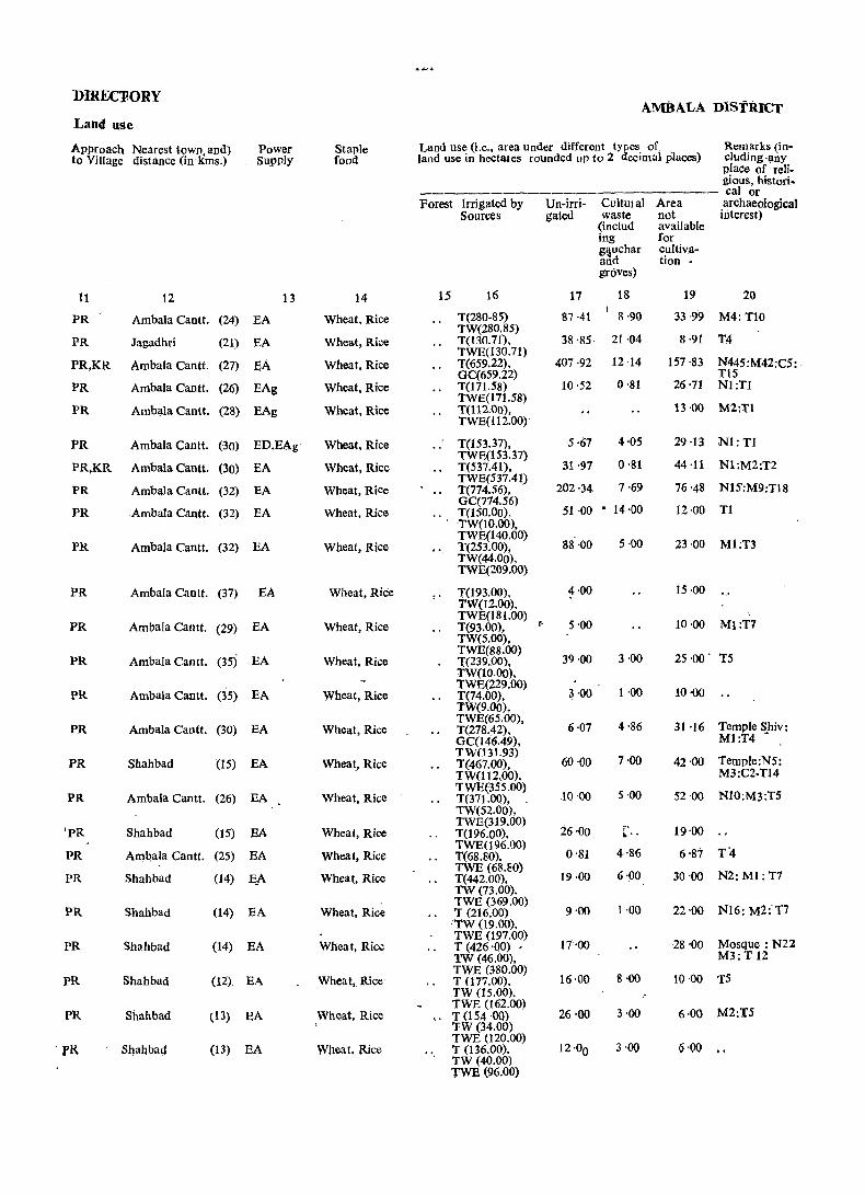
DIREC'FORY AMBALA D~SfRICT
Land use
Approach Nearest lown and) Power Staple Land use (Le., area under different tYa:es of Remarks (in-to Village distance (in kms.) SUI'ply food land use in hectales rounded up to 2 ccimal places) eluding ·any
place of reli-gious, hlstori. _______________ - _____ calor
Forest Irrigated by Un-irri- Cvltuial Area archaeological Sources gated waste not interest)
(includ available ing for glillchar cultiva-and tion • groves)
11 12 13 14 15 16 17 18 19 20
PR Ambala Cantt. (24) BA Wheat, Rice T(280-85) 87·41 8·90 33·99 M4: TlO TW(280.85)
PR Jagadhri (21) BA Wheat, Rice T(130.71), 38 '85· 21·04 8·91 T.4 TWE(130.71)
PR,KR Ambala Cantt. (27) EA Wheat, Rice T(659.22), 407 ·92 12 ·14 157·83 N445:M42:C5: GC(659.22) TI5
PR Ambala Cantt. (26) EAg Wheat, Rice T(l71.58) 10·52 0,81 26,71 Nl:T1
PR Amb!.\la Cantt. TWE(171.58)
(28) EAg Wheat, Rice T(112.00), 13·00 M2:Tl TWE(112.00)
PR Ambala Cantt. (30) ED,EAg Wheat, Rice T(153.37), ·5 ·67 4·05 29·13 Nl:Tl
PR,KR Ambala Cantt. (30) EA TWE(153.37)
31 ·97 0,81 44·11 Wheat, Rice T(537.41), Nl:M2:T2
PR Ambilla Cantt. EA TWE(537.41)
202,34 7,69 76'48 NlS:M9:Tl8 (32) Wheat, Rice T(774.56),
PR Ambala Cantt. EA GC(774.56)
51 ·00 • 14·00 12·00 T1 (32) Wheat, Rice T(l50.00), TW(lO.oo),
PR Ambala Cantt. (32) EA Wheat, Rice TWE(140.00)
88·00 5·00 23 ,00 Ml:T3 T(253.00). TW(44.00), TWE(209.oo)
PR Ambala Cantt. (37) EA Wheat, Rice T(l93.oo), TW(12.00),
1.00 15·00
PR Ambala Cantt. EA Wheat, Rice TWE(181.00)
(- 5'00 10,00 Ml:T7 (29) T(93.00), TW(5.00),
PR Ambala Cantt. (35) EA Wheat, Rice TWE(88.00)
39·00 3·00 2S ,00' T5 1'(239.00), TW(lO.Oo),
PR Ambala Cantt. (35) EA Wheat, Rice TWE(229.oo)
3 ,00 1,00 10,00 T(74.00), TW(9.00),
PR Ambala Canft. (30) EA Wheat, Rice TWE(65.00),
6·07 4 ,86 31 ,16 Temple Shiv: T(278.42), GC(146.49). MI:T4 - .
PR Shah bad (15) EA Wheat, Rice TW(131.93)
60·00 7,00 Temple:N5: T(467.oo), 42'00 TW(112.00), M3:C2-T14
PR Ambala Cantt. (26) EA Wheat, Rice TWE(355.oo)
10 ·00 5 ·00 52·00 NI0:M3:TS T(371.00), TW(52.00),
'PR Shahbad (15) EA Wheat, Rice TWE(319.00)
26'00 " 19'00 T(196.00), ~ .. PR Ambala Cantt. (25) EA Wheat, Rice
TWE(l96.00) 0,81 4·86 6,87 T4 T(68.80),
PR Shah bad (14) ~A Wheat, Rice TWE (68.80)
19·00 6·00 30'00 N2: M1: T7 T(442.00), TW (73.00).
PR Shah bad (14) EA Wheat, Rice TWE (369.00)
9,00 1·00 22·00 N16: M2:T7 T (216.00) TW (19.00).
PR Shllhbad (14) EA Wheat, Ri~ TWE (197.00)
17"00 28 ,00 Mosque: N21 T (426 'QO) • TW (46.00), M3: T 12
PR Shah bad (l2) EA Wheat, Rice TWE (380.00)
16·00 8 ·00 10·00 T5 T (177.00), TW (15.00).
PR Shahbad (13) EA TWE (162.00)
3 ,00 M2:T5 Wheat, Rice '.' T (154 ,00) 26 ,00 6·00 TW (34.00)
fR, Sljahbad (13) EA W)1eat, Rice TWE (120.00)
12·00 3'00 Q.QQ .. T (136.00) • TW (40.00) TWE (96.00)
122
VILLAGE AMBALA TAHSIL
Amenities and
toca- Name of Village Total Total Amenities available (If not available within the village, a dash(-) is shown tion (with ~adbl\st Number) area of PORulation in the column and next to it in brackets, the distance in broad ranges viz. Code the and Number of - 5 kms.,5- 10 kms. and 10+kms. of the nearest place where tho No. Village households
(in facility is available is given)
hectares) Educational Medical Drinking Post and Day Communi-Water Telegraph or cations (Potable) days (Bus Stop,
of the Railway mar- Station, ket/hat, Waterway) if any
2 3 4 5 6 7 8 9 10
171 Jalubi (248) 184·13 876 (li5) P, Ac(2) . CHW W,Hp -;(-5) BS
~
172 Suhatta (229) 289·35 824 (121) P,Ac RP,CHW W, Tk/ Hp -(~5) BS
173 Rao Majra (230) 143'00 666 (99) P CHW W,Hp -(-5) BS
174: Ugala (244) 1,421 ·00 4,773 (708) P,M,H,Ac(2} HS,NH, T, W,Tk, PO, phone BS RP(10), TW, Hp CHW(2)
175 Chahal Majra (215) 121 ·00 194 (27) -(-5) -(_5) W,Hp -(-5) BS (Chahail Majra)
176 Rajukheri (211) 337·50 852 (125) P, M, Ac(2) CHW W,Hp PO -(-5)
177 Diod pur (Dadupur) (214) 96·00 823 (116) P,Ac CHW W;Hp -(_5) BS
178 Sajjan Majri (213) 200·00 307 (46) P,Ac -(-5) W,Hp _(-5) BS
179 Rajauli (200) 390'00 1,558 (244) P,Ac CHW W,Hp PO -(-5)
180 Tandwali (231) 197·00 1,117 (175) P " -(-5) W,Hp -(-5) -(-.-5)
181 Tandwal (216) 594·00 2039 (295) f,M,H,Ac(2) HS, RP(3) W,Hp PO BS,RS
182 Ghalri (Geherri) (199) 314·00 518 (75) P CHW W,Hp -(-5) -(-5)
183 Harra (198) 389'00 1,130 (149) P tHW W,Hp -(-5) BS
184 Rampur (ISS) 259'00 1,447 (187) P,Ac RP,CHW W,Tk,Hp -(5-10) -(-5)
185 Dhakola (135) 247·00 674 (102) P, Ac(2) RP,CHW W, Tk,Hp -(5-10) BS
186 Chapra . (156) 145·00 609 (84) -(-5) CHW ,W,Hp -(-5) -(5-10)
187 Shergarh (15.7) 102·00 307 (46) -(5-10) -(5-10) W,Hp -(5-10) BS
188 Nagla (196) 300·68 1,036 (150) P HS,RP W,Hp Phont' .as
189 Phusiala (pasiala) (218) 369·00 873 (115) P,M,Ac CHW W,Hp -(5-10) -,(-5)
1~0 Har)'oli (197~ ~99'09 64~ (85) f CHW W,Rp -(-5) -(-5)
123
DlRECTORY AMBAtA DISTRICT
Land Use
Approach Nearest town and Power Staple Land use (ie. area under different types of Remarks (in~ to Village distance(in kms.) Supply food land use in hectares rounaed up to 2 dtcimal cluding any
places) place of reli-gious, histori~ calor
Forest Irrigated .' Un-irri- Cultural Area archaeological by Sources gated waste not interest)
(includ- available iug for gauchar cultiva-and tion
> groves)
11 12 13 14 15 16 17 18 19 20
PR Shahbad (12) EA Wheat, Rice " T (165.92) 5'67 12'54 M1;T 2 TW (40.47). TWE (125:45)
PR Ambala Cantt. (24) EA , Wheat, Rice .. T (194.25), 66'77 1 '62 26'71 Ml:Tl TW (60.71), TWE (133.54)
PR Ambala Cantt. (15) EA Wheat, Rice .. T (114 '00). 16'00 6'00 7·00 TS TW (32.00).
PR Shahbad (II) EA Wheat, Rice TWE (82.00) T(1,248.00), 50·00 123 ,00 N25: M9: C11 TW (1,248.00) T 16
PR,KR Ambala Cantt. (17) EA Wheat, Rice " T(38.00}, 71 ·00 2·00 10,00 .. TW (10.00). TWB (28.00)
PR,KR Ambala Cantt. (24) EA Wheat, Rice " T (226.62), 65'56 14'57 30'75 M3:T 5 TW (91.46) TWE (l35.16)
PR,KR Ambala Cantt. (22) EA Wheat, Rice .. T (47.00), 34'00 1·00 . 14·00 T1 TW (16.00) TWE (31.00)
PR,KR Ambala Cantt. (20) EA Wheat, Rice t (108.00). 70·00 2·00 20~00 T2 TW (34.00) TWB (74.00) I
PR,KR Ambala Cantt (20) EA Wheat, Rice T (113.00), 242 ·00 6·00 29·00 M4: C1: T 6 TW(38.00),
PR Ambala Cimtt. (19) EA Wheat, Rice TWB (75.00) T (79.00), 99',00 1 ·00 18 ·00 Ml: C5: T2
. TW (33.00), TWE (46.00)
430·00 PR,KR Atnbala Cantt. (l6) EA Wheat, :Rice T (100.00), 11'00 53'00 T2 TW (32.00),
PR,KR Ambala Cantt. (19) ED Whe~t, Rice TWE (68.00)
164'00 14'00 136 ·00
PR,KR Ambala Cantt. (l6) EA Wheat, Rice T (32.00), 301·00 5 ·00 51 ·00 M2:T6
(14) EA TWE (32.00)
PR Ambala Clintt. Wheat, Rice .. T (171.00), 64.00 2·00 22·00 M2:T5 TW (10.00), TwE (155.00),
Whea t, Rice o (6.00)
PR Ambala Cantt. (14) ED, BAg .. T (42.00), 182·00 5·00 18·00 Ml;T2 TW (10.00),
Atnbala Cantt. TWE (32.00)
PR (16) ED Wheat, Rice .. T (32.00), 95'00 2·00 16·00 M2:T2 ;: TW (l2.00),
pR Ambala Cantt. (16) ED, EO Wheat, Rice TWE (20.00) T (18.00): 73 '00 1'00 10'00 Tl TW (18.00)
PR Ambala Cantt. (16) ED,BAg Wheat~ Rice T (175.23), 90·24 0·81 34·40 N3: M5:T6 TW (53.82),
PR Shahbad J (10) EA Wheat, Rice TWE (121.41) T (146.00), TW (65.00),'
198 ·00 1·00 24·00 M2: Cl: T4
TWE (81.00) KR Shah bad (15) ED, BAg Wheat, Maize T (38.85),
0(38.85) 119·79 72·44 67·98 Temple Mart,
kanda: T2

1~4
VIttAG~ AMBALA TAHSIL
Amenities a.nil Loca- Name of Village Totel Total Amenities avaiiable(If not available within the village. a dash (-) is shown tion (with Hadbast Numb;:r) area of Population in the column and next to it in brackets. the distance in broad ranges viz. Code the and Number of -5 kms. ~-10 lans. and 10+kms. of the nearest place where the No. Village households facility is available is given)
(in -__ -__ hectares) Medical Educational Drinking Post-and Day Communi-
Water Telegraph or cations (Potable) days (Bus StoP.
of the Railway mar- Station. !cet/hat. Waterway) If any
2 3 6 7 8 9 10
191 Subga (217) 719·00 1.254 (170) P.,Ao HS,CHW W.,Hp -(-'-5) "- -(5-10) ..
192 Khanpura (228) 111 ·29 377 (52) P CHW W,Hp -(-5) ", -(-5)
193 Raiya Majra (227) 64'00 Un-
194 Panjhail (226) 325·77 436 (69) P CHW W.Hp _(-5) -(-5)
. 195 Husanpur (Hassanpur)(225) 139'00 78 (13) -(-5) _(_5) W.Hp -(-5) .. ....,.(~5)
196 Denarpur (Dinarpur) (224) 449 -00 1,172 (170) PiAc RP(2) W,Hp PO BS
197 DubH (222) 175'00 819 (116) P,Ac RP.CHW W,Hp -(-5) BS
198 Kesri (221) 981 ·00 3,021 (432) p, M. H.PUC, HS. D. RP(6), W, TW. Hp PTO,Phone BS,RS Ac(2) CHW(3)
199 Bazeedpur (220) 129 '90 286 (39) -(-5) RP W. Tk, TW, -(-5) BS , Hp , "
200 Naraingarh (219) 113·31 207 (24) P -(-5) W, Tk, TW, -(_5) Hp
.. BS
201 Haldari (194) 348 '83,. 1,547 (221) ~,Ac RP(3). CHW W. Tk, TW. -(-5) Hp -
.. BS
202 Chhanoi (192) 155'40 461 (62) -(-5) RP,CHW W, Tk, TW, -(-5) .. BS Hp
203 Lan gar (193) 164'70 448 (65) P RP W, Tk, TW, -(-5) BS
511 '11 Hp ,
204 Dhurala (159) 1,711 (260) P,Ac RP(2) W, Tk, TW, -(-5) .. BS Hp
205 chudiala (191) 369 -00 1,187 (177) P,Ac CHW W, Tk, TW,. PO, Phone .. BS Hp
206 Chudiall (160) 26,6 ·00 460 (62) P -(-~) W, Tk, TW, -(-5) Hp
BS
207 Landha (223) 550·77 1,584' (233) P HS W, Tk, TW, PO BS Hp
208 Kbanpur (190) 265·87 790 (111) P -(-5) W, Tk, TW, -(-5) .. B$ Hp
209 Pharoli (189) 181 ·00 645 (92) P CHW W,Tk, Hp -(-5) .. ~(-5) 1-
210 Mohra (18B) 935·00 2,481 (381) P HS,CHW W,Tk,TW, PO Hp
BS
211 Dukheri (161) 1,015 '34 2,544 (321) P, M, Ac(2) HS,RP, W,TW, Hp PO .. BS, RS
525 P, Ac(2) _ CHW(2)
212 Brahman Majra (127) 225-00 (80) CHW W, TW, Hpl -(5-10) .. -(5-10)
213 Bohawa (Borawa) (162) 104·00 44 (3) -(5~10) -(-5) T,W,TW, Phone .. BS Hp
214 Shahpur (125) 941 ·00 3,952 (581) P(2)M(2),H(2), HS, RP(3), PUC CHW(2)
W~Hp PO, Phone •• - J)S
115 Machhondi (124) 115 '00 Un-
125
DIRECTORY AMBALA DISTRIct
Land Use
Approach Nearest town and Power Staple Land use(i.e. area under different types of Remarks (in-to Village distance (in kms.) Supply. food land use in hectares rounded uP to 2 decimal eluding any
places) place of reli-gious, histori-calor
Porest Irrigated Un-irri- Cultur- Area archaeological by Sources gated al not interest)
waste aVailable (includ- for ing cultiva-gauchar lion and' groves)
11 12 13 .. 14 15 16 17 18 19 20
PR Shahbad (14) '}jA Wheat, Maize .. T (368.00), 178·00 8·00 165·00 M1: Tl £ TW (75.00),
TWE (200.00), 0(93.00)
12 '55 0·81 KR Shahbad (10) ED,EAg Wheat, Maize T (91.46), 6'47 T5 TW (10.52), TWE (80.94)
inhabited T (3.00), 49'00 12·00
Shahbad TW (3.00)
140'02 Temple: M2: PR (10) ED, EAg Wheat, Maize T(48 ·97). 0·81 135 ·97 TW (8.09), Tl
($) TWE( 40.88)
20·00 PR Shahbad EA Wheat T (18.00), 1Z'00 89:00 N2:Ml
(6) TWE (18.00)
118 '00 PR Shahbad 'EA Wheat, Rice T (238.00)' 6'00 87'00 N4: M4: T5 TW(17.00),
Shahbad EA Wheat, Maize TWE (221.00)
24'00 PR (10) T (134.00), 2'00 15'00 NI0: T3 TW (21.00),
Shahbad (8) Wheat, Rice TWE (113.00)
436·00 Temple:N10: PR EA T (467.00), 6·00 72·00 TW (89.00), M6: T35 TWE (378.00)
21'45 PR Ambala,Cantt. (18) ED.EAg Wheat. Rice T(93.48), 14'97 T2 GC (93.48)
PR Ambala Cantt. (16) ED,EAg Wheat, Rice T (44.51), 48·16 5·26 15·38 1'2 Arnbaia Cantt. (14) Wheat, Rice
GC (44.51) 242'81 N 15: M2: T2 PR ED,EAg ... T (76.48), 3·24 26·30
Ambala Cantt. ED,EAg Wheat, Rice GC (76.48)
87·41 J1.R (16) T (59.08), 8·91 N2:T2 GC (59.08)
0
pR Ambala Cantt. (16) ED,EAg Wheat, Rice T (88.22), '62·32- 14·16 NS: Cl: '1'4 Wheat, Rice
GC (88 ·22) ~17'67 PR Ambala Cantt. (11) ED,BAg T (136.78), 3·24 53'42 NIO: Mi: T8
GC (136.78) PR,KR Ambala Cantt. (13) ED,BAg Wheat, Maize T (261.00), 84.00 1 ·00 :23·00 N1;M5;T13
TW (99:00),
Ambala Cantt. (6) Wheat, Maize TWE(162.00)
114 '00 PR,KR ED, BAg T (129 ·00), 5·00 18'00 N2: M2:T3 TWE (128.00), 0(1.00) ...
PR,KR Ambala Cantt. (16) ED,EAg Wheat, Maize T (320.91), 183 '72 7·69 38 -45 Ni: M8: CI: TWE (320.91) T13
PR,KR Ambala Cantt. (13) ED,EAg Wheat, Maize t (141.23) TWE (140.83),
101'98 3'24 19'42- T9
Ambala Cantt. (8) ED,EAg Wheat, Maize TK (OAO)
160'00 7·00 12·00 PR,KR T (2.00), . T3
Ambaia Caritt. (S) EA Wheat, Rice TWE (2.00)
601 ·ob M3: 'r la PR,KR '1' (201.00), 38·00 95·00 TW (59.00),
Ambala Cantt. (6) EA Whiiat, Maize TW'E (142.00)
535·39 11'33 N2: M6: Tl() PR T (381.21), 87·41
(3) ED Wheat, Maize GC (381.21)
PR Ambala Cantt. T( 2.00), 191'00 ·6·00 26·00 T2
Ambala Cimtt. (5) Wheat, Maize TWE (2.00)
2·00 Nt: Ml: Cl PR,KR EA T (54.00) 39·00 9·00 TW (4.00), TWE (50.00)
PR,KR Ambala Cantt. (5) EA Wheat, Maize' T {459.00), 266'00 3·00 213·00 Gurdwara: TW (40.00). N33: M24:C3 TWE (419.00) T36
inhabited T(29.00), TWE (25.00), 0(4.00)
80·00 6·00 ..
126
VILLA AMBALA 'f AIISIL
Amenities
wca- Name of Village Total Total Amenities availabie[If not available within the village, a dashC-)is sh tion (with Hadbast area of pOJulation in the column and next to it in brackets, the distance in bro~d range! Code Number) the an ~5 kms. 5_10 kms. and lO+kms. of the nearest place where No. Village Number of facility is available is given]
(in households ----he~tares) Education al Medical Drinking Post and Day CommUl
Water Telegraph or cations (Potable) days (Blls Sto
of the Railway mar- Station, ket/ Waterwa hat, if any
1 2 3 4 5 6 • 1 8 9 10
216 Shekh Majra (108) 54'00 200 (47) -(-5) -(-5) W -(-5). BS
217 Meranpur (Mceran- (106) 33 ·00 ;:.
Un-pur)
218 Machhonda (lOS) 376·00 1735 (246) P(2), Ac CHW W,Tk,TW, Hp
-(-5) -(-5)
219 Begampur (107) 139 ·00 365 (53) ~C-5) RP W,Tk,TW, -C-5) -(5_1() Hp
220 Bata (123) 395 00 1.092 (160) P,Ac D W,Tk,TW, _(-5) BS Hp
221 Kot Kachhwa Kalan (164) 282·00 493 (7~) P CHW W,TW, Up -C_5) -C_5)
222 Kot Kachhwa Khurd (163) 270'(]O 567 (87) P _(-5) W,Tk,TW, Hp
-C-5) _(_5)
223 Dhanora (187) 402·(]O 938 (131) P,Ac CHW W.Tk, TW, -C5-10) BS
224 Dilanori (Dhaneri) (186) 342·00 888 (128) p,Ac CHW Hp W,Tk, TW, -(5-10) BS
Hp
225 Mansurpur (249) 103 '19 274 (43) _(-5) CHW Hp _(_5) BS
226 Shahabputa (250) 208 ·01 782 (10"3) P - (10+) W,Hp -(10+) BS
227 Dorana (271) 641 ·00 1,654 (230) P, M,il CHW Hp PO BS
228 Malwa (274) 261 ·02 528 (73) P -(-5) Hp -(-5) .. ~(-5}
229 Baroia (276) 371 ·00 933 (123) P ciIw Hp PO BS
230 Konkpur (273) 338·00 826 (110) ......,(-5) cm" W,Hp _(_5) BS .-
231 Nurpur (272) 183 ·00 551 (80) P,M,H D W,Hp ~(10+) BS
232 Laliana (269) 167 ·94 623 (93) P CHW W,Hp -(lO+) BS
233" Bichpari (270) 101 '00 264 (33) P -(~5) W,Hp _(_5) BS
234. Matdon (Mardoo Sahib)
(252) 132·00 415 (64) P -(-5) W,TW,Hp PO BS
235 Fazalpur (Fazailpur) (251) 229·00 444 (66) P,Ac RP,CHW W,Tk,TW, Hp
_(_5) -(10+)

127.
nmECTORY AM:aALA DISTRICT
Land Use
Approach Nearest town and Power Staple Land use (Le. area under different types of Remarks (in-to Village distance (in kms.) Supply food landuse in hectares rounded up to 2 decimal eluding any
places) place of reli-gious, his tori-_________________ --cal or
Forest Irrigated Un-jrri· Cultural Area archaeological by gated waste not interest) Sources (incIud- available
ing for gauchar cultiva· and tion groves)
11 12 13 14 15 16 17 18 19 20
pR Ambala Cantt. (2) ED,EAg Whea t, Maize T(2.00), 13 ·00 39'00 .. 0(2.00),
inhabited .. T (9.00), 19·00 1 ·00 4'00 GC (9.0)
PR Ambala Cantt. (3) ED,EAg Wheat, Rice T (29.00), 394'00 1 '00 42'00 Temple Shiv; TW (15.00), N 1: M10:T6 TWE (14.00)
M2:T2 PR Ambala Cantt. (3) ED, EAg Wheat T(26.oo), 106'00 7·00 TW (9.00),
Ambala Cantt. ED, EAg TWE (17.00)
Temple: N2: PR (5) Wheat, Rice T (154.00), 206·00 2·00 '33 ·00 W (73.00) M4: T 3
PR,KR Ambala Cantt. (5) ED, EAg Wheat, Maize TW(81.00) T (99.00), 143·00 6·00 34·00 M3: T4
PR,KR Ambala Cantt. li) ED,EAg Wheat, Maize TWE (99.00) T (180.00), 53·00 5·00 32·00 Ml: T1 TWE (180.00)
PR,KR Ambala Cantt. (12) ED,EAg Wheat, Maize T (192.00), 162·00 5'00 43'06 T9
PR,KR Ambala Calltt. (13) ED,EAg Wheat, Maize TWE (192.00)
M3: T 10 T (215.00), 104.00 1·00 22·00 TW(93.00) .
Ambala Cantt. (11) EA Wheat, Rice . TWE (122.00)
Nl: M2: TS PR T (73.25), 20·23 1·21 8·50 TW(20.23),
PR Ambala Cantt. (11) EA Wheat, Rice TWE (53.02)
N1: M1: T8 T (147.71), 45·73 1 ·21 13 '36 TW (26.30),
PR Ambala Caott. (13) EA Wheat, Rice TWE (121.41) T (420.00), 164·00 13·00 44·00 N7:M1:T1 TW (81,00) TWE (339.00)
KR Ambala. Cantt. (21) ED, EAg Wheat, Rice T (139.61), 83·36 S'09 29·96 T1 TW(17.00)
Ambala City (20) Wheat, MaiZe TWE (122.61)
Ml: TID PR ED,EAg T (189.00), 150·00 8·00 24'00 TW (27.00),
PR Ambala Ciiy (19) ED,EAg Wheat, Maize TWE (162.00) T (147.00), 166·00 2·00 23·00 TW(26.00),
PR Ambala City (18) ED,EAg Wheat, MaiZe TWE (121.00) T (62.00), 89·00 2·00 30·00 T2 TW{22.00),
Ambala City (6) ED,EAg - Wheat, Maize TWE (40.00)
M2: T 5 PR T( 39.66), 97·12 2'S3 28 ·33 (. TW (11.33),
TWE (28.33)
PR AIilbala City (16) ED, EAg Wheat, MaiZe T (30.00), 38·00 1·00 • 32·00 TW(6.00),
PR,KR Ambala City (14) ED, EAg Wheat, Rice TWE (24.00) T (20.00). 92'00 2'00 18·00 TW(6.00),
KR Am1;>ala Cantt. <8) TWE-(14.00)
ED~EA~ Wheat, Rice T (130.00), 54·00 27·00 18·00 M5:T 8 " W (26.00), TW (104.00)
128
AMBALA TAHSIL V]LLAGE
Amenities and Loca- Name of Village Total Total Amenities available (If not available within the village, a dash (_) is tion (with Hadblst Number) area of Population shown in the column and next to it in brackets, the distance in blOad Code the and Number ranges viz.- ,5 km~., 5-.10 kms. and 10+ krus. of the nearest place No. Village of house- where the facility is available is given 1
t' (in holds -hectares) Educational Medical Drinking Post and Day Communi-Water Telegraph or cation s (Potable) days (Bus Stop,
of the Railway mar- Stati0n, kett Waterway) hat, if any
2 3 4 5 6 7 8 9 10 236 OJ Ian (Aujla) (185) 163 ·00 524 (66) P . • -(-5) W, Tk,TW,
Hp -(-5) ~(10+)
237 Majri (184) 368 ,66 987 (141) P,Ac RP(2),CHW W, Tk,TW, Hp
-(-5) BS
238 Regian (Rangian) (182) 50 ·58 Un-239 Mirzapur (167) 98 ·00 275 (41) P -(10+) W,Tk,TW --(-5) BS
240 Tharwa (166) 567 ·00 1,668 (238) P,M HS,CHW W,Tk,TW, PO BS Hp
241 Babaheri (165) 157 ·02 371 (48) P CHW W,Tk,TW; -(10+) BS Hp
_(5_10) 242 Dhorali (169) 192 ·00 549 (74) P -(5-10) W,Tk,TW, -.(5-10) Hp
243 Yaqubpur (168) 45 ·00 Un-244 Bego Marja (181) 1l~ ·00 255 (27) P -.(5_10) W, Tk, TW,
Hp - (5_10) BS
245 Lakhnauf Sahib (183) 270 '33 497 (64) P,Ac -(5~.10) W,Hp -(-5) 'BS
246 Mohri (253) 713 '86 1,395 (197) P,M,H CHW W,Hp _(_5) as
247 Kalal Majra (267) 167 '94 ~Un-
248 Tejan (Taja) (254) 200-00 375 (58) P CHW W, TW,Hp -(-5) -(-5) 249 Bhano Khcri (180) 842,'54 1,981 (272) P, Ae HS,CHW W,Hp PO BS
250 Behbalpur (170) 85'39 440 (67) P CHW W,Hp,N -(5_10) BS
251 Anandpur Jalbera (121) 642'63 1969 (280) P,M,H,Ac(2) HS, RP(2), W,TW, Hp PO BS CHW
252 Dhurkra (118) 466 19 557 (76) P(2),Ae CH.W W PO BS
253 Dhurala (119) 233 '10 799 (109) P(2), Ac -(5-10) W,TW - (. -5) -(-5)
254 Rawalan (Raula) (171) 165·92 330 (53) P RP W,Hp -(.-5) BS 255 Ladana (72) 172 ·00 499 (80) P,Ac CHW T.W,TW, _(-.5) -(-,5)
Hp 256 Balana (Bullana) (173) 1,079 ·69 2.965 (447) P,M,H,Ac(3) HS, RP(3) T PO BS
'1,402 CHW(2)
257 Sullar (174) 400 '63 (234) P, Tr RP(2),CHW W,Hp -(-5) BS
258 abari (Bhiri) , (176) 171 ,99 495 (64) • r Caw w,ap ~(-S) -(-5)
129
DIRECTORY
Land Use
Approach Nearest town and Power Staple Land use (Le. area under different types of Remarks (in-to Village distance (in kms.) Supply food land use in hectares rounded UP to 2 decimal eluding any
places) place of reli-gious, histori-calor
Forest Irrigated by Un-irri- Cultural Area archaeologi-Sources gated waste not cal interest)
(includ- available ing for gauchar cultiva-and tion groves)
11 12 13 14 15 16 17 18 19 20
KR Ambala Carttt. (8) ED, EAg Wheat, Maize T (75.00), 58·00 18·00 12·00 T5 TW (S.OO),
PR Ambala Cantt. (8) ED, EAg Wheat, Rice TW (67.00 T (206.79), 116'95 44·92 M3:T9 W (4.05), TW (42.09), TWE (155.40), Tk (5.25)
inhabited r (5.26), 42·09 3'23
PR Ambala Canft. (S) ED,EAg Wheat, Rice TW(5.26), T (21.00), 63·00 3'00 11 ·00 M2:T2 TW (12,00),
PR,KR Ambala Cantt. (5) ED,EAg Wheat, Maize TWE (9.00) T (64.00), 417'00 86'00 ,M3: T 12 TW (32.00). TWE (32.00)
Ambala Cantt. PR,KR (5) ED, EAg Wheat, Maize T (31.57), 99'96 5·67 19·82
Ambala Cantt. TWE (31.57)
PR,KR (5) ED,EAg Wheat, Rice T (35.00), 129·00 2'00' 26'00 Ml: T9 TWE (6.00), 0(29.00)
inhabited 43'00 2'00
PR,KR Ambala City (6) 'ED, EAg Wheat, 'Maize T( 55.00), .43 ·00 4'00 13 ·00 T6 TWE (43.00),
PR,KR Ambala Cantt. 0'(12.00)
Gurdwara: (8) ED,EAg Wheat, MaiZe T (37.64), 200·32 32·37 GC (37.64) Nl: M2: Cl:
T7 PR,KR AmbaJa Cantt. (10) EA Wheat, MaiZe T (233.10), 424'10 0'81 55'85 Thakurdwara:
GC (233.10) M5: C1:T18
inhabited T (34.80), 129·90 3·24
AmbaJa City TWE (34.80)
PR,KR (14) Ep,EAg Wheat, MaiZe T(9.oo), 175 ·00 4·00 12·00 Ml:T5
AmbaJa City TWE (9,00)
Gutdwara: PR (13) ED,EAg Wheat, Maize T (139.61), 656 '39 0'40 46'14 TW (52.61), M3 :T 15 TWE (55.Q4),
PR Ambala City (10) ED,EAg Wheat, MaiZe 0(31.96) T (24.28), 49'78 1 ·21 10 12 Ml: T 1 TW (14.57),
AmbaJa Ci~y 0(9.71)
N2: M3: T17 PR (6) EA Wheat, Rice T (278.01). 306·75 4·45 53'42
PR AmbaJa City GC (278.01)
Nl: M2: TS (5) EA Wheat, RiCfl T (44.92). 365'02 1·62 54'63 WE (2.43). TW_ (22.26), TWE (20.23)
PR,KR Ambala City (8) EA . Wheat, Rice T( 17.00), 188·18 3·24 Z4'68 TempJeNl: GC (17.00) M 3:C2 :T7
PR AmbaJa City (6) EA Wheat, Rice T (4.05), 139'61 5'67 16'59 T1 W (4.05)
PR,KR Ambala City (8) . EA Wheat, Rice T (12.00) 150'00 1 ·00 9·00 T1
Ambala City T\~ (12.00)
1·62 PR,KR (6) EA Wheat, Rice T 44.51), 951'00 112'56 N1: M4: C2: GC (44.51) T 34
PR Ambala City (10) ED,EAg Wheat, Rice T (371.90), 28·73 M2: Cl: T16 TWE (154.18), 0(217.72)
PR Ambala City (to) ED, EAg Wheat, Rice T (150.54), TWE (83.77),
21'45 M1:Cl:T7
0(66.77)
AMBALA TAHSIL
Looation Code No.
Name of Village (with Hadbast Number)
2
259 Manka
260 Hamayupur
261 Matehri Shekhan
262 Muzafra·
263 Masatpur
264 Tar
265 Aminpur
(178)
(179)
(256)
(177)
(257)
(263)
(~58)
Total area of the Village (in hectares)
3
·77 ·00
260 '61
272 '75
178'00
491 ·69
338·00
236 ·00
266 Ahman (Ayema) (175) 212 ·05
267 Baringan (Baranga) (260) 70 ·00
268 Qurbanpur
269 . Dingerian (Dang Deheria)
(259)
(261)
270 Tsmailpur (Asmailpur)(262)
271 Malor (283)
272 Khera (281)
216·69
161 '00
323 ·74
269 ·52
437·00
130
VILLAGE
Amenities and.
Total Population and Number of households
Amenities available (If not available within the village, a dash(-_) is shown in the column and next to it in brackets, the distance in broa<1 ranges viz-5 kms. 5-10 kms. and 10+kms. of the nearest place where- the facility is available is given)
Edu~tion;J'Me~al-'D~~g"fu-;t'a~d-'Da-;---C~-;~; Water Telegraph or cations
4 5
891 (146) P
739 (118) P, Ac
454 (55) P
896 (144) P
865 (123) -(-5)
513 (73) P
436 (51) P
253 (30) -(_5)
364 (47) P
433 (49) -(--5)
702 (103) P, M
617 (97) P, Tr
820 (98) P, M
(Potable) days (Bus Stop, of the Railway
6 7
CHW W,Hp
RP(4),CHW W, Hp
8
_(-5)
PO
mar- Station, ket! Waterway) hat, if any
9 10
Un-
CHW W, Tk, Hp -(5-10) _(_5)
PHC,FPC Hp,C PO BS
-(-5) W,Hp -(-5) BS
CHW W,Hp -(-5) _(-5)
_(-5) W,Hp _(-5) _(-5)
-(-5) W,Hp _(-5) BS
HS,CHW W,Hp -(-5) BS
-.(-5) W,Hp -(-5) BS
RP,CHW W,Hp -(-5) as
RP W,Hp -(-.5) BS
CHW W,Hp -.(10+) -(10+)
273 Landiali (Ladiali) (264) 432 ·60 1,244 (159) P _(_5) W.C -.(10+)
274 Sakhraon (Sukhrao) (265) 407 ·00 731 (97)~ P CHW Hp -(_5) _(_5)
275 Gobindgarh' (255) 125·00 182 (18) p. Hp -(10+) -(lOt)
tH DIRECTORY
AMBALA DISTRICT Land Use
Approach Nearest town and Power Staple Land use(Le. area under different types of Remarks (in-to Village distance (in kms.) Supply food land use in hectares rounded up to 2 decimal eluding any
places) place of reli-gious, histori-
-__,.........,___.,_..,,-....,----.--.--.---.--.---.___,___,___,___,---.___..,___,__,-----.-----.-----,__... calor Forest Irrigated by Un-irri- Cultural Area archaeo1ogi-
Sources gated waste not cal interest) (includ- available ing for gauchar cultiva-and tion groves)
11 ~I 12 13 14 15 16 17 18 19 20
inhabited T (72.00), TWE (5.00)
5·00
. (11) 0(67.00)
PR Ambala City ED,EAg Wheat, Rice T (75.68), 156'61 28'32 M2:T1 GC (75.68)
PR Ambala City (13) EA Wheat, Rice T (253.33), 19·42 N4: Ml: T7 TWE (21.45), 0(231.88)
'PR Ambala City (13) ED,EAg Wheat, Rice T (166.00), 12·00 Ml:T4 TWE (101.00). 0(65.00)
l{R Ambala· City (14) ED,EAg Wheat, Rice 'r (433.01) ., 58·68 M3: T1 TWE (125.86), 0(307.15)
KR All)baJa City (13) ED,EAg Wheat, Rice T (286.00) 52.00 Ml: Tl TW(46.oo), TWE (40.00), 0(200.00)
PR,KR Ambala City (14) ED,EAg Wheat, Rice T (190.00), 46'00 T3 TW(41'00)' TWE (19'00),
AmbalaCity 0(130.00)
PR (10) ED, EAg Wheat, Rice T (l95A~), 16'59 T5 4
TWE (42.49), 0(152.97)
PR Ambala G:ity (13) ED, EAg Wheat, Rice T (60.00), 10·00 Tl TWE (10.00), 0(50.00)
PH. AmbalaCity (11) ED,EAg Wheat, Rice T (203.15)' 13·76 M2:T6 TWE (85.79) 0(117.36)
PR ~mbalaCity (16) ED,EAg Wheat, Rice T( 144.00) 17·00 Nl:T4 TWE (62,00),.
PR Ambal~City 0(82.00)
104'40 (18) ED,EAg Wheat,Rice T (219.34), N~T7 GC (45.73) TWE (58.68),
PR AmbalaCity (19)' EA Wheat, Rice 0(114.93) T (217.31), GC (120.19),
52·21 M2:T8
TWE (40.87)
KR Ambala City (i6) 0(56.25)
242'00 EA Wheat, Rice T (117.00), 78·00 M2: Cl: T14 GC(6.00), TW (40.00), TWE (71.00)
KR AmbalaCity (14) EA Wheat, Rice T (129.50), 248'41 20·23 34:40 M3:T7 GC (8.09), W (20.23),
AmbalaCity (14) TWE (101.18)
PR EA Wheat, 'Rice T (132.00), 238'00 8·00 29·00 M2: T 10 , TW (5l.00),
PR Ambala City (14) EA Wheat, Rice TWE (81.00) T (43.00), 66·00 7·00 9'00 Ml:T4 TW (20.00), TWE (23.00)

13~
VILLAGE AMBALA TAHSIL
Amenities and
Loca- Name of Village Total Total Amenities available{Tfnot available within the village,a dash(-) is tiori (with Hadbust area of Population shown in the column and next to it in brackets, the distance in broad Code Number) the and Number ranges viz,-5 kms. 5-10 kIns. and JO+.kins. of the nearest place No. Village of household where the facility is available is given)
(ill' ---.----.--.------.~~--hectares) Educational Medical Drinking Post and bay Communi-
Water Telegraph or cations (Potable) days (Bus Stop,
of the Railway mar- Station, ket! Waterway) hat, if any
;,
1 2 3 4 S (j 7 8 5) 10
276 Khaspur (266) 95'00 336 (44) P -(10+) Hp -(10+) -(10+')
'),77 Nagai (280) 544·29 1,112 (187) P M,B CHW Hp PO BS
278 Hasanpur (Baisa npUr) (279) 280'00 439 (61) P,M,H,Ac -(10+) HI) PO BS
279 Addu Majra (278) 401 ·00 699 (~6) P C}lW W,Hp -(-5) -(-5)
280 Bersan (Bersa) (268) 205 -00 245 (29) P -(10+) W,Hl' -(-5) -(-5)
2&1 Barault (277) 326'00 826 (98) p -(10+) W,Hp -(-5) -\-5)
282 Jalalptir (275) 238'00 538 (72) P CFiw W,Hp -(-5) -(-5)
283 Kaleran (Kalera) (307) 455·26 1,224 (180) P CHW W,Hp -(-5) -(-5)
284 segti (306) 273·56 347 . (68) P,M,H,Ac -(5-10) W,Hp,C PO BS
285 _Bishangarh (305) 193·03 412 (63) -(10+) -(5-iO) W,Itp, C -(10+) BS
286 ]ansui (308) 101 ·71 2,102 (297) P,M,H,Ac HS,CHW W,TW,Hp, C
PO BS
287 Gorsian (Goursla) (309) 336'69 276 (47) -(10+) -(5_10) W,Hp,C -(10+) BS
288 Alauddin Malra (301) 160'25 134 (iO) Ac CHW W,T\V,Hp,C -(-5) -(-5)
289 Bamba (302) 122·00 399 (69) -(-5) CHW W,Hp -(-5) BS
290 segta (304) 301'00 418 (62) P CHW W.Hp -(-5) -(-5)
291 Mehmudpur (303) 179·00 247 (28) P -(-5) W;Hp,C -(-5) -(-5)
292 Baknaur (282) 392'00 1,450 (200) P,M,H,Ac HS,CHW W,Tk, Hp PO BS
293 Munda Majra (285) 109'67 178 (24) -(-5) -(-5) W, Tk, Hp -(-5) -(-5)
294 Ghagru (284) 177'65 122 (19) P -(-5) W, tIp -(s-io) -t5-iO)
295 Bhurangpur (286) 426'53 1,027 (127) P CHW W,Tk,Hp, -(5-fO) BS (Bharangpur) C
296 Daudpur (287) 210·00 221 (25) P -(5-10) Hp -(5-10) BS

133
DIRECTORY AMBALA DISTRICT
Land Use
Approach Nearest town and Power Staple Land use (ie. area under different types of R~arks (in-to Village distance(in kms.) Supply food land use in hectares rounded upto 2 decimal places) eluding any
place of reli-gious, histori-
---~~----~---~-----~---cal or Forest Irrigated by Un-irri- Cultural Area archaeological
Sources gated waste not interest) (incJud- available' ing for gauchar cultiva-
. and tion groves)
ot;;,
11 12 13 14 15 16 17 18 19 . 20
PR Ambala City (16) EA Wheat. Rice T (62.00), 18·<l0 TW (26.00),
5·00 10·00 M2:T5
(16) TWE (36.00)
PR Ambala City EA Wheat. Rice T (131.93), 351 ·67 60·69 M2: T5 TW (50.99). TWE (80.94)
PR Ambala City (16) EA Wheat, Rice T( 99.00), 156 ·00 25·00 M1:T6 TW (32.00),
, Ambala City ED TWE (67.00)
M2:T9 PR (18) Wheat, Rice T (77.00), 289·00 2·00 33'00 TW (12.00),
(19) ED Wheat, Rice TWE (65.00)
PR Ambala City T (44.00), 129·00 1 ·00 31 ·00 T2 TW (16.00),
Ambala City (19) ED Wheat. Rice TWE (28.00)
194'00 T6 KR T (93 ·00) 4·00 35·00 TW (40.00).
KR Ambala City (24) ED Wheat. Rice TWE (53.00).
74·00 3·00 T1 T (134.00), 27·00 TW (40.00), TWE (94.00)
PR Ambala City (20) ED Wheat, Rice T (191.0,1). 190·60 3·24 70·41 T2
PR,KR All}bala City (19) ED,EAg Wheat, Rice GC (191 '01)
161 '87 N3: M4:T2 T (12.55), 4·86 94·28
KR Ambala City (21) ED,EAg Wheat. Maize GC (12.55)
41'28 M1:T6 T (63.13). 2·43 86·19
PR.KR Ambala City (21) EA Wheat, Rice GC (63.13).
208'41 N3: M4: 'ff6 T (426.94). 66·36
PR,KR Ambala City (21) EA . Wheat, Rice GC (426.94)
M2:T 3 T (220.96). 115·73 GC (54.23), TWE,(85.79)
PR Ambala City (21) ED,EAg Wheat,Rice 0(80.94)
13 ,35 Ml .. ·T (136.38), 10·52
PR Ambala City (19) ED,EAg Wheat, Rice GC (136.38),
T2 T (106.00) 16·00 GC (57.00), TW (37.00),
PR Ambala city (20) ED,EAg Wheat, Rice 0(12.00),
Ml:T3 T (53.00), 139 ·00 109·00
KR Ambalacity (21) EA Wheat, Rice WE (53.(,0)
T5 T (155.00), 7·00 17·00 GC (53.00), TW (40.00)
KR AmbalaCity (20) EA Wheat, Rice l'WE (62.00)
72·00 Temple: T (273.00). 47·00 GC (125.00), Nt: Ml: T13: TW (53.00), TWE (95.00)
KR Ambala city (23) ED,EAg Wheat, Rice T (65.15), 12'55 31 ·97 Tl GC (26,71), TW (18·21),
KR Ambala City (18) ED,EAg Wheat, Rice TWE(20.23)
Ml:T3 T (9}.86), 23 ·07 62·72 GC (57.06), TW (22.66),
PR.KR Ambala City , (19) ED,EAg Wheat, Rice TWE(12.14)
112·50 M4:T9 T(254.14), 4'45 55·44 PR,KR Ambala City (21) ED,EAg Wheat, Rice
GC (254.14) T (131 '00), 48'00 11·00 20·00 .Ml: T9 GC (107.00) TW (24.00)

AMBALA TAHSIL
Name of Village Location Code No.
(wish Hadbast Number)
1 2
297 Banhpur (Bahpur) (288)
298 Rattangarh Urf (296) Nakatpur
299 Batrohan
300 Dhelo Majra
301 NanyoJa
(294)
(293)
(292)
134
VILLAG,
Amenities an
Total area of the Village (in h"ctares)
Total Population and Number of households
Amenities available (If not available within the village, a dash(~) shown in the column and next to it in brackets, the distance in bro ranges vlz._5 kms 5,-10 kms, and 10 +kms. of the nearest pia where the facility is available is given)
Ed~~IMedi;I-Dri-;:;king P-;tandDay~- Comm-;
3 4 5
127 ·OO~ 168 (15) P
146 -00 138 (16) P, Ac
342 '36 1,179 (140)
158 ·00 221 (38)
558 -00 2,962 .(486)
P,Ac
-(-5)
P,M,H, PUC, C
Water Telegraph or nications (potable) days (Bus Stol
of the Railway
6
-(5-10)
CHW
7
W,Hp
8
-(5-10)
T,W, Tk, -(5-10) TW,Hp,C
HS CHW W, Hp -(5-10)
-(-5) W, Tk, Hp -(-5)
market/ Station, hat; Waterwa: if any
9 10
BS
BS
-(-5)
-(-5)
HS, D, RP(6) W, Tk, Hp P.O,Phone .• CHW
BS
302 Laotan (Lota) (291) 174 '00, 508 (59) P, Ac -(-5) W, Tk, Hp -(-5) BS
303 Khurchanpur
304 Pamola
305 Udepur
306 Rasulpur
307 Khaoa Majra
308 .;.
Miyan Majra (Miya Majra)
309 Chugna
310 Metlan (Metla)
311 Nih ars a
312 Niharsi
313 Sheikhupur-
314 Jagoli
315 JansLiya
316 Sonta.
(290) 161 ·00 701 (96) P
(289) 240·00 494 (61) P, Ac
(295)
(312)
165 ·51 603 (81) P,M,H
92·00 153 (22) -(-5)
RP,GHW
CHW
RP,CHW
-(5-10)
W, Tk, Hp -(-5)
W, Tk, Hp, -(-5) C
W, Tk, Hp -(5-10)
Tk, TW, Hp -(-5)
(297) 171·00 665 (104) P RP(2),CHW W,Hp,C -(5-10)
(300)
(299)
(298)
(310)
(11)
(313)
(314)
(315)
(316)
89'84 225 (34) P,Ac -(5-10)
69 ·20 153 (28) --(-5) -(5-10)
89 -00 297 (45) P -(-5)
73 ·25 188 (33) P -(5-10)
542·27 1.101 (146) P,Ac(2) RP, CHW
168·00 605 (88) P
172·00 493 (68) P
422 ·49 1,020 (144) P
573·00 1,706 (270) P, M
CHW
. -(5-10)
CHW
HS,CHW
Hp,C
Hp,C
Hp,C
-(5-10)
-(5-10)
-(-5)
TW' -(5-10)
W, Tk, Hp, -(-5) C
W,Tk, Hp -(5-10)
W,Tk,Hp -(-5)
W,Tk, HI> -(-·5)
W.Tk,Hp PO
BS
BS
BS
BS
BS
-(5-10)
-(-5j
BS
-(-5)
BS
BS
BS
BS
BS
135
DIRECTORY AMBALA DISTRICT
Land Use
Approach Nearest town and Power Staple Land use (ie. area under different types of Remarks (in-to Village distance(in kms.) Supply foud - land use in hectares rounded upto 2 decimal places) eluding any
place of rell-gious, histori-
-"'__"---,~'__"""""__'-'__'-~ calor Forest Irrigated by Un-irri- Cultural Area archaeological
Sources gated waste not interest) (incud- available . ing for gauchar cultiva-and tion grove)
11 12 13 14- 15 16 17 18 19 20
PR,KR AmbalaCity (21) ED, EAg Wheat, Rice T (92.00), 23.00 12·00 Ml:T6 GC(81.00), TW (11.00)
PR,KR AmbalaCity (24) ED,EAg Wheat, Maize T (82.00), 55.DO 9-00 M6:T·l GC(42.DO), TW(40.00)
PR,KR Ambala City (24) ED,EAg Wheat T (211.24), 91·86 0·40 38'86 Ml:T4 GC (211.24)
PR,KR AmbalaCity (30) ED,EAg Wheat, Rice T (109 'DO), 35·00 3·00 11·00 TI GC (8.00), TW (20.00),
PR,KR Wheat, Rice TWE (81.00)
AmbalaCity (29) E/\ T (362.00), 122·00 7·00 67'00 Temple Devi I GC (10.00), N40: Mia W (162.00), T20
Wheat, Rice TWE (190.00)
46·00 PR,KR Ambala City (26) ED,BAg T (101.00), 6-00 21·00 M2:T7, GC (51.00), TW (10.00), TWB (4000)
PR,KR Ambala City (26) ED,EAg Wheat, Rice T(S5.00), 53·00 5'00 18 ·00 T5 GC (1.00)
Wheat, Rice TW (84.00),
'PR, KR . Ambala City (24) ED,EAg T (147.00), 63 '00 3 ·00 27·00 TS GC(40.00) TW (103.00),
Wheat, Rice TWE-(4.00)
82·55 PR,KR AmbalaCity . ~26) BA T(64.75), 2·07 16'19 M3:T7
Wheat, Rice W 64.75)
PR Ambala City (26) ED,EAg T(60.00), 20·00 3·00 9·00 N1: Ni2' GC (36.00),
Wheat, Rice TW (24.00),
45'qo PR,KR Ambala City (26) ED, EAg T (105.00), 21 ·00 T3 GC (83.00),
Wheat, Rice TW (22.00)
PR Ambala City (24) lOlA T (67.99), 9 ·31 1 ·62 10·92 QC (8,09). TW (59.90)
PR Ambala City (26) EA Wheat, Rice T (19.83), 40'87 0·81 7 ·69 GC (19.83)
PR Ambala City (26) ED,EAg Wheat, Rice T (59.OD), 23'00 7-(')0 GC(44.oo) , W(lS .00)
61'92 9 '71 PR, KR~ Ambala City (26) ED,EAg Wheat, Rice T (1.62), GC (1.62)
PR,KR AmbalaCity (24) ED, EAg Wheat, Rice T (191'82), 300·68 0·81 48'96 Ml:T3 GC (91.05) TW (100.77
PR,KR T (79.00)
70·00 19'00 AmbalaCity (29) ED, EAg ~ Wheat, Rice GC (63.00). TW(8.00), TWE(S.DO),
PR, KR Ambala City (29) ED. EAg Wheat, Rice . T(114.00), GC (80.oo),
21·00 23·00 14-00 Ml:Tt:
TW (16'00) TWE (18.00)
PR,KR AmbalaCity (29) ED, EAg Wheat. Rice T (372.31), . 9 ·71 0·81 39·66 T2 GC (372.31)
PR,KR. Ambala City (29) ED, EAg Wheat, Rice T (439.00). 73.00 61-00 M2: T IG GC(36.oo), TW (136.00), TWE (267.00)

136
VILLAGE AMBALA TAHSIL
Amenities and
Loea- Total Total Amenities available (If not available within the village, a dash(-) is Name of Village tion (with Hadbast Number) area of Population shown in the column and next.to itin brackets, the distance in broad
and Number ranges viz,~5 kms., 5~10, kms. and 10+kms. of the nearest pla,ce Code No. -
1
317 Son!i
318 Mahlan
319 Danipur
320 Jandheri
321 Kalawar
322 Kangwal
323 Chhapra
324 Getpura
325 Roshanpura
2
(317)
~18)
(322)
(323)
(320)
'(319)
(321)
(324)
the Village (in hectares)
3
346·00
271'00
313·22
,546'32
430·58
411·96
558·86
374·73
(325) 214·48
of house- where the facility is available is given) holds
Educational Medical
4 5
971 (129) P
697 (101) P,
381 (43) P,M
1,154 (94) 'P(2)
899 (79) P
7~7 (103) P
1485 (198) P, M
721 (91) P
6
CHW
CHW
CHW
CHW
HS
CHW
-(--5)"
CHW
Drinking Water (Potable) ,
7
W,Tk,Hp
W,Tk,Hp
W,Hp
W,Hp,C
W,Hp,C
W,Hp,C
W,Hp,C
W,Hp,C
Post and Telegraph
8
-(-5)
-(-5)
-(5-10)
-(5-10)
-(5-10)
-(5-10)
-(-5)
-(-5)
604 (65) P CHW W, Hp, C -(-5)
Day or days of the mar-ket/hat, if any
9
','
Commu-nications (Bus StoP. Railway Station, Water way)
10
BS
BS
as -(-5)
BS
-(-5)
BS
-(-5)
-(-5)
-------~\~·t -~~~ ---'_--All villages 102,769.67 289.719(42,770) P268,M62,H36
PUC4.Cl,Tr 2, Ac155
MH1,PHO, HS46,D9,FPC2 NH5,RP131, CHW208
Note1.-1; Where a town. and village bear an identical name, the word (RUral) has been added after the name of the village.
2. The are a of a village (revenue estate) is based on the information suppled by the Revenue PatwarL
*Total Population and }:art of the area of the village has come within the municipal limits of; mbala City.
DIRECTORY
Land Use
Approach to Village
11
PR, KR
PR.KR
PR,KR
PR,KR
PR, KR
PR,KR
PRo KR
PR,KR
PR,KR
Nearest town and distance (in kms.)
12
AmbalaCity (29)
Ambala City (29)
Ambala City (41)
AmbalaCity (39)
Ambaia ~ity (40)
Ambala City (37)
AmbaJa Cit¥ (36)
Ambala City (37)
Ambal;!.City (37) .
Power Supply
J3.
ED,EAg
ED,EAg
ED, EAg
EA
ED, EAg
ED,EAg
EA
ED,EAg
ED,BAA
Staple food
14
Wheat, Rice
Wheat, Rice
Wheat, Rice
Wheat Rice
Wheat, Rice
Wheat, Rice
Wheat, Rice
Wheat, Rice
• Wheat, Rice
137
AMBALA DISTRICT
Land use (Le. area under different typeS of land use in hectares rounded upto 2 decimal places)
Forest
15
Irrigated by Sources
16
T (253.00); GC (51.00). TW (81.00). TWE (121.00) T (204.00), GC (11.00), TW (66.00), TWE (127.00) T(179.27), GC (179.27) T (216.91), GC (5.26). TW (84.98) TWE (126.67) T (356.52), GC (356.52) T (338.72), GC (121.00), TW (144.88), TWE (72.84)
T (467.81). GC (467.81) T (310.79), GC (310.79) T (191'01), GC (26 '30) TW (133.54), TWE (31.17)
Un- Cultural irrigated waste
(including gauchar and groves)
17 18
61·00 2·00
34'00 5'00
87.41
283·23 10'93
20·23
37·23 11·33
48 '56
25'90
9·71 0-40
Area not available for cultivation
19
30'00
28·00
46·54
35·20
53·83
24'68
42'49
38·04
13·36
Remarks (including any place of religious, historicll I or archaeological interest) ,
20
Tl
M2:T5
M1: T9
M2: CI: T8
Temple Dcvi: Ml: T4 Ml: T 9
T 18
M1: T9
T (38914.48). GC (9239.60), W (437.41)
4;J,877 ·90 1,777 '17 13,651'12 N: 1186 : M: 796:
WE (40.43). TW (7584.33). TWE (19237.69), TK (32.65), 9 (2342.37)
C: 12 : T: 1317 ;

139
ALPHABETICAL LIST OF
VILLAG~S IN JAGADHRI TAHSIL


Serial Name of the Village No.
1 2
1. Aharwala 2. Ahmad Majra 3. Ahmadpur
4. Ajijpur (Azizpur Khurd) 5. Akalgarh 6. 'Akbarpur 7. Alipur 8. Ali Sherpur Majra 9. Amadalpur
10. Ambli 11.- ~Ambwala
12. :Ambwala 13. Arnauli 14. Ashabpura 15. )I r-Aurangabad 16. Azizpur 17. Bachon 18. Badanpur 19. Badhi Majra 20. Bahadurpur 21. 'Bahadurpur 22. Bahrampur 23~ Bakarpur 24. Bakkarwala 25. Bala Chaur 26. Balauli 27. Bal Chhappar 28. Balla Majra 29: _ Baniawala 30. ;. Bankat 31. Banse Wala (Banswala) 32.':' Bara Khera (Khera Bara) 33. Baroli Majra 34. ; Begampur 35r Belgarh 36. Belibhud 37., _Bhagwangarh 38. Bbagwangarh Clrf Bansantaur 39. Bhagwanpur 40: Bhagwanpur 41. Bhagwanpur 42~. Bhambholi 43. Bhambol (BhanbauI) 4'4t Bhamnauli 45. Bhangera Bhangeri Bagpat 46. Bhatauli
l2Jl
JAGADHIU TAHSIL
Location Code
3
75 148 450
431 322 482 254
61 274 436 21-
410 .372 110 356 402 158 483 314 192 -335 271 273 205 290 138 391 234 180 98 27
434 140 224 236 ; 195. 299 156 53
291 44_8 464 465 lQO 178 3f)7

Serial Name of the Village No.
1 2
47, Bhattuwala 48. Bhawanipur (Bhawanpur) 49. BherthaI 50. Bhit Chhappar 51. Bhilpura 52. Bhilpura 53. Bhogpur 54. Bhogpur 55. Bhojpur 56. Bhud Kalan 57. Bhud Majra 58. Bhukhri 59. Bhul Kheri 60. Bhut Majra 61. Bibipur 62. Bichpari 63. Bihta 64. Bijwali 65. Bilaspur 66. Bir Tahanpur 67. Bit Tapu 68. Bisationwala 69. Bodhi 70. Budheri 71. Buria Jagir 72. Buria Sarkar '']3. B utgarh 74. Chabutron 75. Chagnauli 76. Chaharwala 77. Chahron 78. Chak Baba Sahibsingh 79. Chanda Kheri 80. Chandpur 81. Chaneta (Ghaneta) 82. Chaneti
83. Chaowala ,'84. Chaurahi 85. Chhachhrauli (Rural) 86. Chhajju Nagala 87. Chhalaur 88: Chhapper Mansurpur 89. Chholi 90. Chhota Khera (!<.hera Chhota) 91. Chikan 92. Chintpur 9l. Choli (Ghauli)
142
.JAGADHRI TAHSIL-contd.
Location Code
3
50 68
123 16
221 238
4 281 300 199
232 288 225 358 261 229 64 36 21
169 257
83 37
371 279 278
8 93
116 409 375 188
19 348 128 298 121
77 111 381 66
442 82
435 182 103
62

Serial Name of the . Village No.
1 2
94. Chuharpur 95. Chuharpur Kalan 96. Chuharpur Khurd 97. Chuharpur Mangalsingh 98. Dadupur Chhawni 99. Dadupur J attan
100. Dadupur Malion 101. Daira 102.. Damla (Demla) 103. ~ammunpur Bara 104. Dammunpur Chhota 105. Damoli 106. Darajpur 107. Darpur 108. Darwa 109. Darwa 110. Daryapur 111. Dasani 112.. Dasaura 113. Daulatpur 114,' Daulatpur 115. Daulatpur 116. Daulatpur Malian 117. Dayalgarh 118. Dekriwala 119. Deodhar (Dodhar) 120. Dhakwala 121. Dhalaur 122'. Dhanaura 123. Dharam !Kot 124. Dhorang 125. DiyaIgarh 126. Doiwala (Duiwala Urf Ramgarh) 127. Dudhla 128. Faqira Majra 129. Faquir Majra 130. FarakhpUl: Q:arrukhpUl') , .
131. Faridpur 132. Fatebgarh 133. Fatehgarh Tumbi 134. Fatehpur 135. Fat.ehpur 136. Fatehpur 137. Gadhaula 138. Gadhauli. 139. Gadhauli
143
J AGADHRt TAHSIL-contd.
LoCation Code
3
40 201 135 160 289 146 106 423 489 253 250 212 471 172 230 309
81 316 211 151
325 484 453
58 198 231 152
1 52 80
492 276 233 488 157
10 36J 452 283 399
87 311 447 438 307 441
Serial No.
Name of the Village
1
140. Gadwali 141. Galo Ii 142. ' Ganaula 143. Oanauli
2
144. Garhi Banjara 145. Garhi Gosain 146. Garhi Gujran 147. :Garhi Mundo 148. Ghoron 149. ·Gianawala. 150. Gobindpura. 151. Gobindpuri 152. 'rGogion 153. Oohlni 154. Gohra Bani 155. Gollanpur 156. Gulabgarh 157. Gulabnagar 158. Gundapura 159. Gurdhanpur 160. .Habibpur 161. Hafizpur 162. Hafizpur 163 .. Hafzi (Hafizi) 164. Haibatpur 165. _.Haidarpur 166. Hal Dari Gujar 167. Hal Dari Maru 168: iIaluwala 169. Hangoli (HingoH) 170., Hara uli 171. -,Harewa 172. Hargarh 173. Hariawas
, 174: .Haripur Jatan 175. j Haripur Kamboan 176. '" Rarnattl 171'; Hartaul 178. Hasanpur 179. Hasanpur 180. Hunde Wala lSI! Ibrahimpur 182, tIsharpur 183.,' .Ishopur 184. 'Ismailpur 185. Jagadhri (Rural)
144
. jAGADHRI 'rmSI~contd.
4' 1 1 2,~
4~
3~
3(
,2~
4C 30 ,30 A;7 46
9 47, 2'01
36: 45~
13~
,34; iOl ASS 2pS 408 166 ~42 243
-·376 -A58
107 .21S 478 330 379
r339
477 79
245 472~ ,302 168
- ?-68 354 226 JOI

Serial No.
Name of the Village
1. 2
186. Jagdhauli 187. Jaidhar 188. Jaidhari 189. Jaipur 190. Jairampur Jagir 191. Jairampur Khalsa 192. Jaitpur (Jitpur) , 193. Jamiatgarh rJamit-Garh) 194. Jampur 195. Jandhera 196. Jangle Mehrniwala
145~
JAGAI}.HRJ. t~iISIL___'eoT1tJ.
197. Jangle Salempur Kohi (Jungle. Salampur Khoi) 198. Jarauda 199. Jatanwala 200. Jathe~i
201. Jaurian 202. Jhar Chandna 203. Jbinjron 204. Jhinwar Heri 205. Jodhpur 206. Jogiwara 207. lucia Jatan 208. Juda Sheikhan 209. Jungle Kalesar 210. Kail 211. ":I~a:impura' 212. Kajiwas 213. K~krauni
'214. Kalanaur 215. Kalanpur 216. Kalawar 217. Kalesar 218. Kami Majra 219. Kanabri Kalan (Kanherf Bari) 220. Kanalsi 221. Kanarhi Khurd (Kanheri Chhoti) 222. Kaniawala 223. Kansepur (Ka~bapur) 224. Kansli 225. Kapoori Kalan 226. Kapoori Khurd 227. Karera Khurd (Chhota Karera) 228. Karkauli 229. Kat 230. Katarwali
Location Code
3
411 217 220 493
262 249
89 9
359 466 170
55 369 173, 120 353 457 479 378: 259 95
393 394 184 365
15 456
11 318 470 426 185 321 467 280 462 237 350 1&1 404 . 403. 329 210 267 96

Serial No_.
I
231. 232. 233. 234. 235. 236. 237. 23&. 239. 240. 241. 242.
243.
244.
245,
246.
247.
248.
249.
250.
251. • 252.
253.
254.
255.
256.
257.
Name of the Village
2
Katarwali Kathgarh Kathwala Khadri Khajuri Khandwa Khanpur Khanpura Khanpuri Khanpur Rajputan Khanuwala Kharwan
Khera
Khera Brahmana~ (Khera Majra)
Kheri I1arshansingh
Kheri Ranghran
Kherki
Khijri
Khilanwaia
Khizrabad
Khol Darpur
Khol Fatehgarh
Khundewala
Khurdi
Kishanpura
Koliwala
Kotar Khana
25& .. kot Basawasingh
259. Kot Mushtarka
260. Kotra Kahansingh
261. Kotra Khas
262. Kot Sarkari
263. Kulchandu_
264. Kulpur
265. Kunjal Jatan
, 266. Kunjal Kamboyan 267. Kurali 26&. Kurewala 269. Labasabad 270. tahoriwala
146 jAGADHRI TAHSIL-contd.
Location Code
3
97 44
380 24& 334 338 461 108 137 427 85
292 366
18
425
352
215
190
179
191
171
163
387
336
202 197
390
154
153
142
74
149
416
451
486
487 5
78 206 240

Serial No.
Name of the Village
1 2
271. Lakar Mai Partappur 272. Lalhari Kalan (Lalhari BaTi) 273. Lalhari Khurd (Lalhari Chhoti) 274. Landaura 275. Lapra 276. Lawana (Liawana) 277. Lawani 278. Leda Khadar 279. Leda Khas 280. Ledi 281. Lopon 282. Machhraut i 283. Magharpura 284. Mahe;wri (Maheshri) ,285. Mahiyudinpur 286. Mahlanwali
287. Mahmudpur 288. Mahmudpur 289. Majri 290. Majri Tapu 291. Makhaur 292· Malakpur 293. Malakpur Bangar 294. Malak Raipur 295. Malikpur Khadir 296. Mali Majra 297. Mali Majra 298. Mamli 299. Manakpur 300. Manakpur 301. Manakpur 302. Manbharwala 303. Mandauli 304 Mandauli Gagar 305 Mandebar 306. Mandebari 307.
- ) Mandewala
308. Mandhar (Mandhalir) 309. Mandi 310. Mand Kheri 311. Manglaur 312. Manipur 313. Marw'a Kalan
314. Marwa Khurd 315. Maullri
147
JAGADHRI TAHSIL- contd.
Location Code
3
240 101 102 389 266 432 430 143 114 145 104
23 445 419 90
377
124 265 49
256 397 415 76 12
223 275 444
373 2
86 1i:293 228 .317. 255 360 475
. 194 392 264 130 29
147 13
398
69
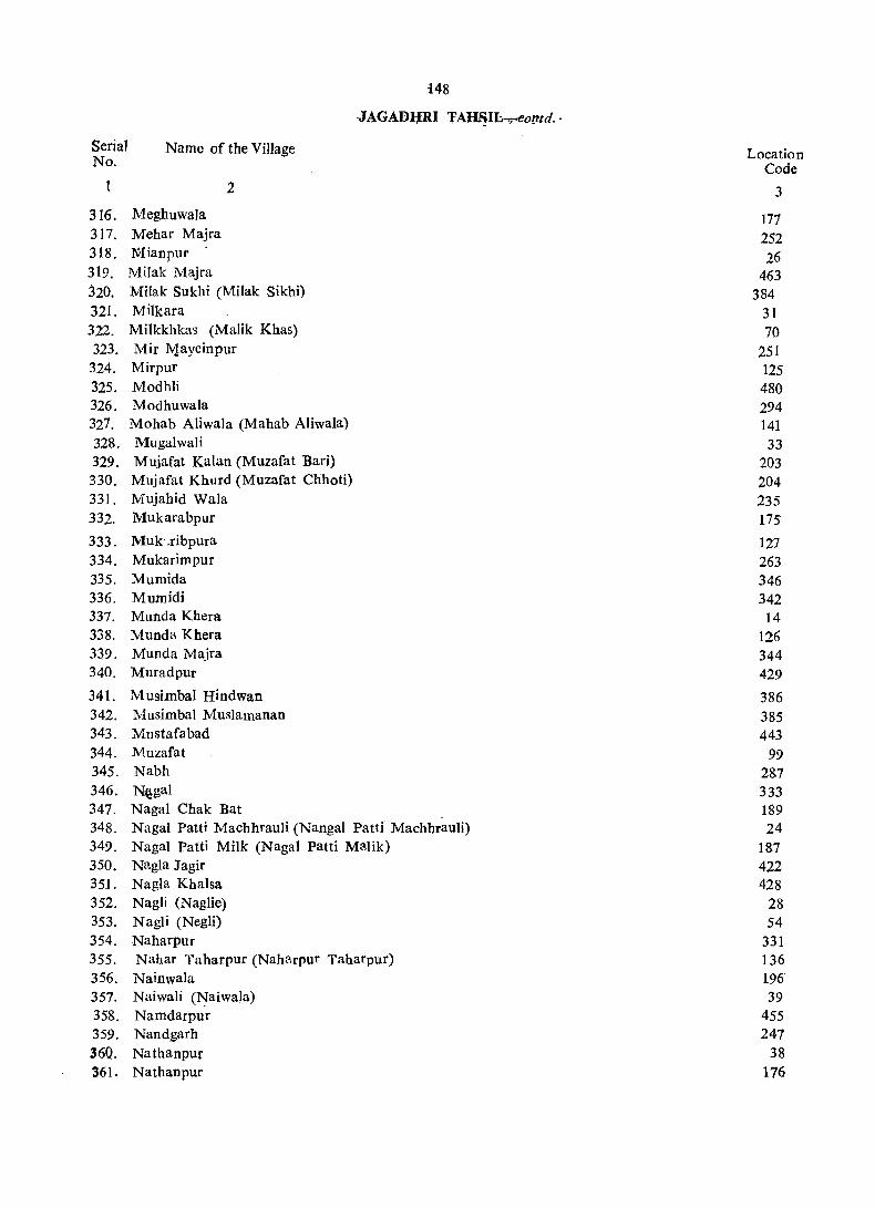
148
·JAGADIJRI 'fA~I~o!l'td.·
Serial No.
Name of the Village
1
316. Meghuwala 317. Mehar Majra 318. NIianpur .
319, Milak Majra
2
320. Mi1ak Sukhi (Milak Sikhi) 321. Milkara 322. Milkkhkas (Malik Khas) 323. Mir Jv.layeinpur
324. Mirpur 325. Modhli 326. M odhuwala 327. Mohab Aliwala (Mahab Aliwala) 328. Mugalwali 329. Mujafat Kalan (Muzafat Bari) 330. Mujafat Khurd (Muzafat Chhoti) 331. Mujahid Wala 332. Mukarabpur
333. Muk .ribpura 334. Mukarimpur 335. Mumida 336. Mumidi 337. Munda Khera 338. Munda Khera 339. Munda Majra 340. Muradpur
341. Musimbal Hindwan 342. Musimbal Muslamanan 343. Mustafabad 344. M.uzafat 345. Nabh 346. Nigal 347. NagaI Chak Bat _ 348. NagaI Patti Machhrauli (Nangal Patti Machhrauli) 349. NagaI Patti Milk (NagaI Patti Malik) 350. N[l.gla Jagir 35J. Nagla Khalsa 352. Nagli (Naglie) 353. Nagli (Negli) 354. Naharpur 355. Nahar Taharpur (Naharpur Taharpur) 356. Nainwala 357. Naiwali (Naiwa1a) 358. Namdarpur 359. Nandgarh 36Q. Nathanpur 361. Nathanpur
Location Code
3
177 252 26
463 384
31 70
251 125 480 294 141 33
203 204 235 175
127 263 346 342 14
126 344 429
386 385 443
99 287 333 189 24
187 422 428
28 54
331 136 196 39
455 247
38 176
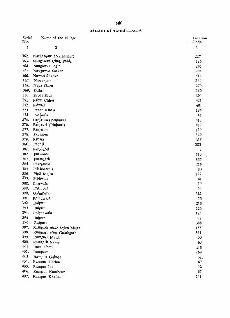
149-
JA.GADHRi'TAHS·IL-contd.
Serial Name of the Village Location No. Code
1 2 3
362. Nathanpur (Natharpur) 227 363. Naugawan Chak pahla 28.6 364. . Naugawan Jagir 285 365. Naugawan Sarkar 2&4 366. Nawan Shahar 414 367. Nawazpur 239 368. Naya Gaon 270 369. Odhri 260 370. Pabni Badi 420 .371. pabni Chhoti 421 372. Painsal 401 37:l Panch Khola 183 374. panjwaJa 43 375. panjaura (Pinjaura) 418 376. Panjauri (Pinjauri) 417 377. Panjeton 129 378. Panjupur 340 379. Pansra 315 380. Paonti 383 381. ParbhaoIi 7 382. parwalon 310 383. patasgarh 355 384. Pheruwala 119 385. pilkhan wala 30 386. Pipli Majra 222 387. pjpliwala 41 388. Piruwala 117 389. Prithipur 94 390. Qaimpura 312 391. Raianwala 73 392. Rnipur 213 393. Raipur 326 394. Raiyanwala 186 395. Rajpur 88 396. Rajpura 388 397. Ramgarh alias Arjun Majra 155 398. Ramgarh alias Gulabgarh 341 399. Ramgarh Majra 400 400, Ramgarh Sawai 63 401. Ram Kbcri 118 402. Rampura 269 403. Rampur Gainda 51-404, Rampur Hadan 67 405. Rampur Jat 92 406, Rampur Kamboan 65 407. Ranipur Khadar 241

Serial No.
t
408. 409. 410. 411. 412. 413. 414. 415. 416. 417. 418. 419. 420. 421. 422. 423. 424.' 425. 426. 427. 428. 429. 430. 431. 432. 433. 434. 435. 436. 437. 438. 439. 440. 441. 442. 443. 444. 445. 446. 447. 448. 449. 450. 451.
150·
JAGADH~U- TAHSIL~con!d ..
Name of the Village
2
Ranipur Ranjitpur Rasulpur Ratanpura Rattangarh RattoIi Rohlaheri ROr Chhappar RU:1Ia' Kheri Rukali Sabalpur (Mutsil Gadhauli) SahapuF Sabhapur Sabilpur Jatan Safilpur Salempur Bangar (SaIimpur Bangar) S']lcmpur Khadar (Salehpur Khadir) Salcmpur Kohi (Salimpuf Khoi) Sanaur Sandhaya (Sindhai) Sankhera Saran Sarawin Sasauli Satari (Sitari) Shadipur Shahabudinpur Kalan Shababudinpur Khurd Sbahjahanpur Shahpur Shabpur Shahpur Shab' Quamaispur Shahzadpur Sbabzadwala Shekhupura (Sheakhpura) Shergarh Sherpur Sialba Singbpura Singhpura Sipianwala Suabari Sud hail
Location Code
3
47 45
405 313 491 351 32
357 364
84 439 272 490 437
35 374 109. 56 11 71
115 449
3 349 412 328 162 159 216 20
370 433 382 282 174
'407 59
132 468
6 131 161 48
363

Serial No.
1
452. 453. 454. 455. 456. 457. 458. 459. 460. 461. 462. 463. .464. 465. 466·
467. 468. 469. 470. 471. 472. 473. 474. 475. 476. 477. 478. 479. 480. 481, 482. 483. 484. 485. 486. 487. 488. 489. 490. 491. 492. 493.
Name of the Village
2
Sudhal Sugh Sukhdaspur sukhpura sultanpur Sultanpur Sunder Bahadurpur Taharpur Kalan Taharpur Khurd Tahimun (Tahimu) Tahri Tajakpur Tajewala Talakaur Tapu Akalgarh (Akalgarhtapu)
Tapu Jaidhar Tapu Kamalpur Tapu Mandauli Taranwala Taruwala Teha Brahmanan Tehi Jatan TejIi Telipura Telipura Tibbi Raiyan Tigra Tigri Tihanon Todarpur Topra. Khurd Tugalpur Tundeki Taparian Uddhamgarh Udhamgarh Udhamgarh Vncha Chandana Urjani Vttamwala Yakubpur Yamunanagar Yarah
1Si. JAGADHRI TAHSIL~concld.
Location Code
3
362 277 460 337 46
446 57 167 25
209 165 308 193 424 321
219 320 319 122 139 395 396 306 244 295 150 323 324 105 332 481 144 34
413 72
2~6 454 134
42 214 345 164


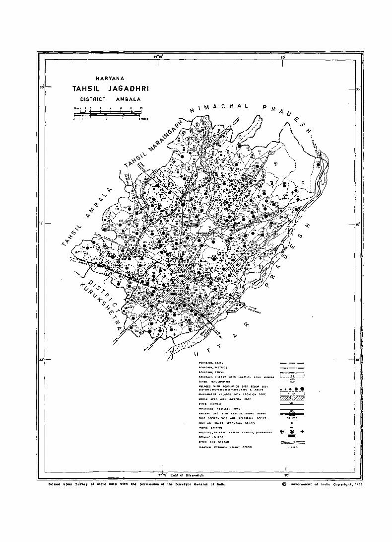
30°
""S'
HARYANA
TAHSIL JAGADHRI DISTRICT AMBALA
BOUNDARY, STATE
.OUNO .... '. DISTRiCt
BOUNDARY, TAHSil
BOUNDARY, VILLAGI! W!TtI LOC"T~OH COOl! MUNSER
tAHSil HEAOQUAAfER.S
VillAGES WitH POPULATION SIZE eno_ too: 200-419: 500-,"; 1000-411"; 5000 • ".0"£ UMnUoU ... ,tEO '1ILU,(;.f.S 'tin ... LOC",IOM
UIIIIII",. AREA WITH LOCATION
S'ATE l'II6HWA,
.MPDRUMT liI[UlllEO ROAD
RAILWA, lINf: WITH STATION,
POSt OFFICI! I POST AND TELEGRAPH OFFICI!"
HIGH UR HIGHER SECONDARY SCHOOL
POLICE STATION
HOSPITAL, PAI ..... Ry HEALTH CENTRE, DISPENSARY
DEGREE' COLLEG!!
111'1'1 A .NO STREAM
JAGADHAI WOlllI(SHOp R ... Il .... Ay COLONY
8os.d upon 5~,.e, of Indio mop with tM perini •• lon of the- Surveyor General of india
15
30°
r--'-~"':''==i ---©--~
~ J.W.AC.
30'
© Gov~rnme'nt o. Il'tdiQ Copyright, 1982

153
VILLAGE DIRECTORY
JAGADHRI TA~SIL
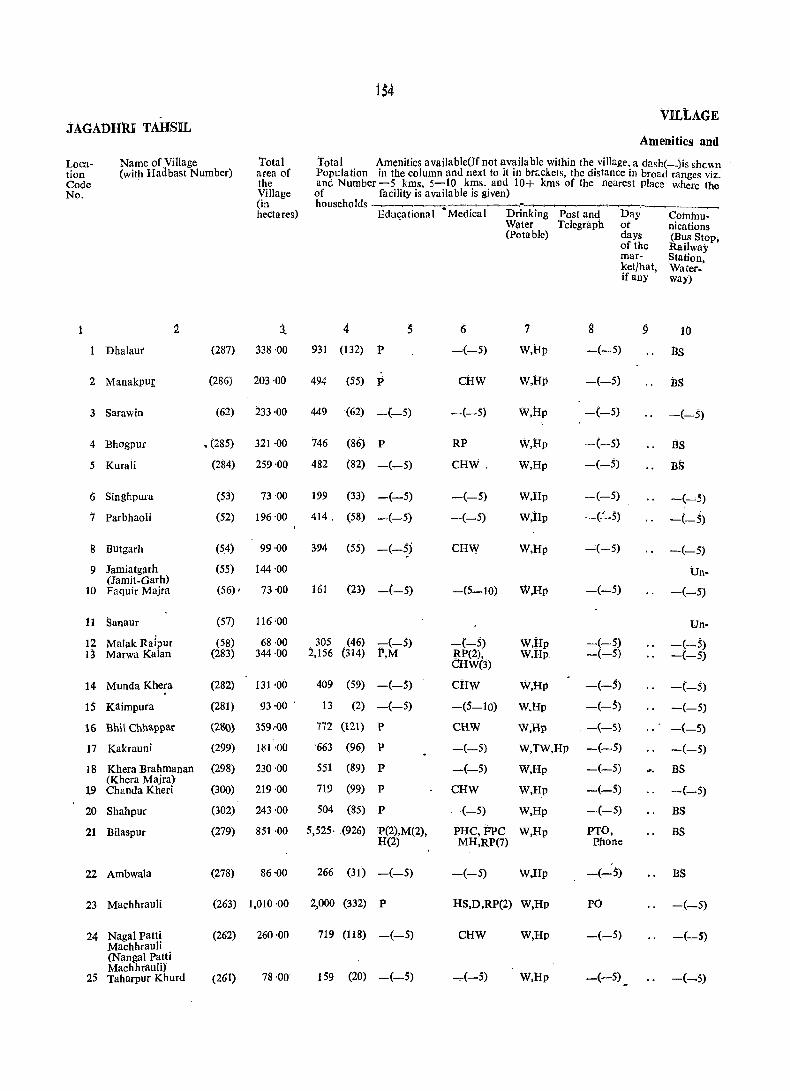
B4 VILtAGE
.tAGADH1U TAHSIL Amenities and
Loca- Name of Village Total Total Amenities available(Jf not availa ble within the village, a dash(_)is shewn tion (with Hadbast Number) area of Population in the column and next to it in brr.ckets, the distance in broad ranges viz. Code the and Number-5 kms, 5-10 kms. and 10+ kms of the nearest place where the No. Village of facility is available is given)
(in households _______ . ____ ~_-__ ~ __ ~.~'_,-.~_ hectares) Edu"ational -Medical Drinking Post and Day Cotnh"-t~
W(lter Telegraph or nications (potable) days (B,,!s Stop;
of the RaJlway mar- Station, ket/hat, Water-if any way)
2 3.. 4 S I) '1 g 9 10
Dhalaut (287) 338'00 931 (132) P -(-5) W,Rp -(-5) BS
2 Manakpur (286) 203·00 494 (55) P CRW W,Rp -(-5) BS
3 Sarawin (62) 233·00 449 (62) -(-5) -(-5) W,Rp -(_5) -(-5)
4 Bhogpur • (285) 321 ·00 746 (86) P RP W,Rp -(-5) BS
5 Kurali (284) 259·00 482 (82) -(-5) CRW. W,Rp -(-,5) Bi;
6 Singhpura (53) 73'00 199 (33) -(-5) -(-5) W,Rp -(-5) -(---'5)
7 Parbhaoli (52) 196 '00 414. (58) -(-5) -(-5) W,Rp -(':""5) -(-5)
8 Butgarh (54) 99·00 394 (55) -(-5) CRW W,Rp _;(-5) -(-5)
9 Jamiatgarh (55) 144·00 Un-(Jamit-Garh)
161 (23) -(-5) W,Rl' -(-5) 10 Faquir Majra (56) , 73 ·00 -(5-10) -(-5)
11 Sanaur (57) 116 '00 Un-
12 Malak Raipur (58) 68·00 305 (46) -(-5) -(-5) W,Rp -(-5) -(-5) 13 Marwa Kalan (283) 344·00 2,156 (314) P,M RP(2), W.Rp -(-5) -(-5)
CRW(3)
14 Munda Khera (282) 131 -00 409 (59) -(-5) CRW W,Hp -(-5) -(-5)
15 Kaimpura (281) 93'00 . 13 (2) -(-$) -(5-10) W.Hp -(-$) -(-5)
16 Bhil Chnappar (280) 359.·()O 772 (121) P CHW W,Hp -(-5) -(-5)
17 Kakrauni (299) 181 -00 '663 (96) P -(-5) W,TW,Rp -(-5) -(-5)
18 Khera Brahmanan (298) 230'00 551 (89) P -(-5) W,Rp -(-5) BS (Khera Majra)
719 (99) 19 Chanda Kheri (300) 219·00 P CHW W,Rp -(-5) -(-5)
20 Shahpur (302) 243·00 504 (85) P -(-5) W,Rp -(-5) BS
21 Bilaspur (279) 851 ·00 5,525· (926) P(2),M(2), PRC, FPC W,Rp PTO, BS R(2) MR,RP(7) P.hone
22 Ambwala (278) 86'00 266 (31) -(-5) -(-5) W,Rp -(-5) BS
23 Machhrauli (263) 1,010 ·00 2,000 (332) P RS,D,RP(2) W,Hp PO -(-5)
24 NagaI patti (262) 260'00 719 (118) -(-5) CHW W,Hp -(-5) -(-5) Machhrauli (Nanga! Patti Machhtauli)
159 (20) -(-5) ..,.(-5) 25 Taharpur Khurd (261) 78'00 W,Hp -(-5) -(-5)
DIRECtORY
Land Use
Approach to Village
Nearest town and distance(in kms:)
1i 12
FR Sadaura (1)
PR Sadaura (6)
kit. Sadauta (5)
. .,fR Sadaura (5)
PR Sadauta (4)
PR Sadaura (6)
KIt Sadaura (5)
PR Sadaura. (5)
Inhabited
PR Sadaura (5)
inhabited
KR Sadaura (8) PR Jagadhri (8)
PIt Sadaura (5)
KR Jagaclhri (18)
PR,KR Saclaura (10)
PR Sadaura. (10)
PR Jagadhri (14)
PR Jagadhri (13)
PR chhachhrauli (7)
PR Chhachhrauli (8)
KR Chhachhrauli (8)
KR Sadaura (7)
KR .Sadaura (7)
IKR Sadaura (5)
EA
Power Supply
ij
ED, EAg
ED,EAg
:fA
EA
ED
EA
ED,EAg
ED,EAg
ED EA
ED,EM
ED
ED,BAg
EA
ED,E:Ag
ED, EAg
EA
EA
ED,EAg'
EA
ED,BAg
ED,BAS
Staple fOOd
14
Wheat, Rice
Wheat,..Rice
Wheat, Rice
Wheat, Rice
Wheat, Rice
Wheat, Maize
Wheat, Maize
Wheat; 'Malie
Wheat, Rice .
Wheat, Rice Wheat, Rice
Wheat,Rice
Wheat, Maize
, Wheal, Rice
Wheat; Maize
Wheat, Rice ,
Wheat, Maize
Wheat, Rice
Wheat, Rice
Wheat, Rice
Wheat, Rice
Wheat, Rice
Wheat, Rice
AMBALA ntsTRtcT
Land use (ie. area under different types of land use in hectares rounded bpto 2 decilnal places)
F-;;~;~Jr;ig~fed~~ Un~ri:'~~Cultu~l~ Ar~--by Sources gated waste not
(includ- available ing for gauchar oultiva· and tion groves)
. 15 16 17 IS 19
T(147.00). i63'00 ~·OO 25 ·00 TW(17.00). ... TWE{l30.00) T(62.00); . 120'00 1,00 14·00 TW(17.OQ), TWE(4S.00)
145 ·00 .:\5'00 t(53.00), . TW(I1.00). TWE(42.00)
282'00 "I'(4.00), 35'00 tWE(4.00) .T(13.0i), 198 ·00 1'00 47'00 W(2.00), . TWE(ll.Oo)
56·00 11·00
T(40.00), 135 ·do S'OO i6'00 W(2.00), TW(3S.00)
82'00 5'00 12·00
117 '00 21·()()
T(27.00) 39·00 7'00 TW(21.00)
95·00 :21·00·
T(lo3.00), 59'00 9·00
194'()O 47 ·00 TW(10·PO), TWE(93.00)
96·00 i8 '00 '1'(11.00), TWE(l7.00)
81·00 4·00 T(8.00), TWE(8 '00)
3i1;0<5 30·00 T(12.001, tWE{1 .00) 126 ·00' 15'00 1'(40.00),
TWE(40.00) 210'00 T(9.00), 11 '00
TWE(9.00) 182·66 T(13.00l 24·00
TWE(1 .00) ' .. T(75.00), 149·00 2'00 11'00
TWE(7S:00) 53'00 T(8S.00), 611 ·00 ,102·00
TWE(83.<50). 0(2.00)
50-00 T(23.00j' 13·00 TWP(2 .00)
T(18.00), 843·00 1'1'00 132,00 TW(3.00), TWE(15.00)
199·00 T(36.00), 25'00 TW(36.00)
T(28.00J' 38'00 7'00 5·00 TWE(2.00)
Remarks (including any place of (eligious, historical Cir archaeolo_ gical . interest)
20
T5
Mi:T9
T3
Ml :T4
..
.,
..
N~:M4:T 3
T2
Nt
T1
Nl:C2:T1
Temg,Ie: Gur wara: N225:M12: C4:TS'
Nt:M2:TS
Tl

JAGADHRI tAlISIL
Location Code No.
Name of Village (with Hadbast Number)
2
26 Mianpur
27 Banse wa1a (BanswaJa)
28 Nagli (NagIie)
(51)
(50)
(264)
29 Manglaur (49)
30 pilkhanwala (260)
31 Milkara (258)
32 Rohlaheri (257)
33 Mugalwali (259)
34 Tunde Ki Taparian (47)
35 Safilpur (46)
36 Bljwali (45)
37 Bodhi (44)
38 Nathanpur (43)
3~ Naiwali (Naiwala) (42)
40 ChuharpUr (40)
41 Pipiiwala
42 Uttamwala
43 Paniwala
44 Kat!J,garh
45 Ranjitpur
46 Sultanpur
47 Ranipur
48 Suabari
49 Majri
SO Bhattuwala
(41)
(38)
(39)
(~7)
(254)
(255)
(256)
(253)
(249)
(251)
Total area of the Village (in hectares)
3
248 ·00
154·00
252·00
317·00
307·bo
132'00
248·00
418'00
108·86
580·00
181 '30
179'00
81 ·00
85·00
127'00
200·00
52·00
136·00
637'00
117 ·00
203'00
353 ·00
185'00
55·00
219 ·00
156
VlLLAC:€
Amenities and
Total Amenities available(lf not available 'Within tte villare, a dashC-)is sl:c\\n Population in the column and next to it in brackets, the distance in broad ranges viz, and Number -5 kms. 5-10 kms. and lO+kms. of the nearest place where the of facility is a vaila ble is given) households ~-~-~--~~~
.Educational Medical Drinking Water (Potable)
Post and Day Communi-
276
570
404
4 5
(50) P
(92) -(-5)
(59) Ac
1,036 (179) P
284 (43) -(-5)
141 (22) -(-5)
287 (39) -(-5)
943 (131) P,M,H
103 (19) -(-5)
924 (137) P
563 (95) -(-5)
278 (49) -(-5)
266 (39) -(-;)
220 (35) -(-5)
55 (10) -(-5)
458 (74) P
122 (14) -(-5)
133 (21) -(-5)
742 (126) P
194 (39) -(-5)
298 (4S) -(-5)
690 (114) P
282 (45) -(-5)
195 (29) -(-5)
399 (57) -(-5)
Telegraph or cations
(;
-(-5)
RP,CHW
CHW
7
W,Hp
w,Hp
W,Hp
RP.CHW W,Hp
8 .
-(-5)
-(5-10)
-(-5)
-(-5)
days (Bus Stop, of the Railway mar Station ket/hat, Waterifany way)
9 10
-(5~10)
-(5-10)
-(5-10)
-(-5) W.Hp -(5-10) ..
~(5-10)
-(5-10)
-(-5) T,W.Hp
-(-5) W
tIS,RP(2) T,W.Hp
-(-5) W,Hp
RP,CHW W,Hp
-(-5) W,Iip
-(-5) W,Hp
-(-5) T,W.lIp
-(-5) W,lIp
CHW(2), T,W
RP(2),CHW T,W,Hp
-(-5) T,W,Hp
CHW T,W,Hp
-(-5)
-(-5)
pO
-(-5)
PO
-(-5)
-(-5)
-(-5)
_(_5)
-(-5)
PO
-(-5)
-(-5)
D,CHW T,W;rk, _(5_10) TW,N
CHW T,W,TW, -(-) Hp
-(10+)
ltS,CFiW - T,W,tk,TW, -(-5) Hp
-(-5) w,Tw,Iip -(-5)
itp W,Hp -(-5)
cFiw W,TW,Hp -(-5) ..
BS -(-5)
BS
~(-5)
-(-5)
-(-5)
-(5-10)
-(-5)
~(-5)
-(-5)
-(-5)
-(-5)
--(-5)
-(-5)
BS
BS
-(-5)
-(-5)
-(-5)
DIRECTORY
. Land Usc
Approach Nearest town and to Village distance. (in kms.)·
Power Supply
KR
KR
KR
KR
KR
PR
KR
PR
KR
KR
PR
BR
PR
KR
PR
PR
PR
KR
PR
PR
PR
PR
PR
PR
pR
11
Sadaura
Sadaura
Sadaura
Sadaura
Sadaura
Sadaura
Sadaura
Sad aura
Sadauta
Sadaura
Sadaura
Sadaura
Sadaura
Sadaura
Sadaura
Sadaura
Sadaura
Sadaura
Sadaura
Sadaura
Sadaura
Sadaura
Sadaura
Sadaura
Sadaura
12 13
(6) ED,EAg
(5) EA
. (8) EA
(9) EA
(8) EA
(18) EA
(18) EA
(18) EA
(6) ED,EAg
(8) EA
~1O) ED,EAg
(8) ED
(10) ED,EAg
(10) ED
(13) ED
(11) EA
(12) ED
(14) ED
(11) ED, BAg
(12) . ED,EAg
(12) ED,EAg
(10) ED,EAg
(10) ED,EAg
(15) EA
(11) EA
Staple foOd
14
Wheat, Rice
Wheat, Rice
Wheat, Rice
Wheat, Rice
Wheat, Rice
Wheat, Rice
Wheat, Rice
Wheat, Rice
Wheat, Rice
Wheat, Rice
Wheat, Rice
Wheat, Bajra
Wheat, Rice
Wheat, Rice
Wheat
Wheat
Wheat, Rice
Wheat, Rice
Wheat, Rice
Wheat, Rice
Wheat, RiCe
Wheat, Rice
Wheat, Riee
Wheat, Rice
Wheat, Rice
AMBALA DISTRICT
Land use(i.e. area under different types of land use in hectares rounded upto 2 decimal
Remarks (including any places) .. pl~c~ of
-~~~~.~~~~~~~~~~~~~~.~~-.~-~ relIgIous Forest Irrigated Un-irri- Cultur- Area historicai
by gated aJ not or Sources waste available archaeolo-
15 16
T(la.OO), TWE(l8.00) T(29.00), TWE(29.00) T(S.OO), TWE(5.00)
T(2.00), TWE(2.00)
30 ·00 T(l6.00), TWE(16.00) T(14.00), TWE(14.00)
53 '00 T(33.00).
43'00
TWE(33.00) T(0.40), TWE(0.40)
T(0.40), TWE(0.40) T(2.00), W(2.00) T(7.00), TW(3.00). TWE(4.00)
o T(14.00), TW(14.00)
T(4.00), TWE(4.00)
T(4.00), TWE(4.00)
T(64.00), TWE(64.00)
T(26.00), TW(26.00) T(13.00), T\V(13.00) T(16.00), TWE(16.00)
17
205 ·00
95·00
224·00
264·00
246.00
70 ·00
199'00
267'00
61.51
365·00
129·09
127·00
46·00
59·00
105 '00
130 '00
39·00
46·00
209·00
69'00
115 ·00
167'00
56'00
24'00
111 '00
(inc1ud- for gical ing cultiva- interest) gauchar tion and groves)
18
4·00
7·00
2·00
20.00
1·00
1 ·00
1 ·00
6'07
84·00
9'71
19 ·00
4·00
1·00
7·00
19 20
25 ·00 Tl
26·00
16·00 T1
51·00
39.00
15 ·00 Tt
34·00 Tt
64·00 Tl
40·88
131·00 Tl
42·10
31 ·00
28·00
22·00
21·00
27·00
6·00
90·00
414·00
44 ·00 Tl
84·00 1\11
122·Q.o Tl
. 103 '9.9 18·00
92'00
:,1'1
JAGADHRI TAHSIL
Location Code No.
1
Name of Village (with Hadbast Number)
2
51 Rampu[ Oainda
52 Dhanaura
53 Bhagwanpur
54 Nagli (NegH)
55 Jangle Salempuf Kohi (Jungle Salaropur Khoi)
56 SaJempur Kohi (Saliropur Khoi)
(36)
(252)
(3S)
(32)
(489)
(33)
57 Sunder Bahadurpur (34)
58 DayaJgarh (250)
59 Shergarh (248) 60. Gadwali (247)
61 Ali Sherpur Majra (246)
Total area of the Village (in hectares)
3
273"00
384'00
365'00
1,301 ·00
144·00
161 '00
683 '50
61 '00
154·00 312·01
264'00
VILL A.menitie!
Total Amenities available(If not available within the village, a dash(-)issho Population the colUmn and next to it in braCkets, the distanCe in .broad ranges and Number -5 kms., 5-10 kms. and 10+kms. of the nearest place where of facility is available is given) households . __ ~~~ __ ~~ _____ .~_
Educational Medical Drinking Post and Day Coromu!
93
382
621
1,132
14
4 5 6
(13) ..... (-5) -(-5)
(69) P,M RS
(109) -(-5) 'RP,CHW
.(182) P CHW
(3) -(_5) ~~5-1O)
454 (55) l' _(10+)
825 (i54) -(-5) _(_5) ,
173 (~8) P -(5-10)
Water Telegraph or ~ tions (Potable) days (Bus Sto.
of the Railway mar- Station, ket/hat, Waterwa' if any •
7
W
w,tw W,Hp
W,Rp
W
W
W
W,Rp
8
-(5~10)
-(-5)
-(-5)
_(5_10)
-(5_10) •
-(-5)
-C-5)
PO
9 10
-(-5)
-(-5)
-(-5)
-(5-10)
_(5-10)
_(-5)
_(_5)
-(5-10)
302 (53) -(-5) -(- 5) W,Rp -(-5) -(-5) 454 (64) -(-5) -(-5) W,Rp -(-5) -(-5)
823 (130) P HS,RP,CHW" W,Rp -(-5) -(-5)
62 Choli (9hauli) (237) 207 '00' 340 (45) P,M RS,RP W,Rp PO -(-5)
63 Ramgarh ~awafi (245)
64 ·Bihta (242)
65 Rampur Kamhoan (243)
66 Chha]aur (244)
67 Rampur Haria."
·68 "Bhawanipur (Bhawanpur)
69 Mauhri
70 Milk kha s (Malik Khas)
(48)
(276)
(277)
(275)
182·00
260'00
157'00
260·00
189·00
119 ·00
99'00
212'00
7J Sandhaya (Sindhai) (265) 488 ·00
72 Udhamgarh
73 Raianwala
74 Ko!~.l$ha~
75 Aharwala
(266)
(267)
(274)
(273)
·72 .. 00
·284 ·00
181 ·00
114 '00
140 (20) -(~5) -(-5)
433 (60) P..J CRW'
505 (85) _(_5) FtP(2)
429 (56) P
(i)2 (103)' P
350 (42) P
-(-5)
Cf!W
-(-5)
429 (59) -(-5) -(-5)
902 (137) P CHW
879 . (129) P HS,CHW
132 (18) -(-5) -(-5)
534 (79) P
953 (121). P
670 (90) P
CHW
CHW
-(-5)
W,Rp -(-5)
W,Rp pO
W,Tk,TW, PO Hp
W.Rp PO
W,Hp
W,Rp.
W,Rp
T,W,TW
W,fip
W
W,Hp
W,Hp
T,W,TW, Hp
-(-5)
-.(-5)
-(_5)
-(-5)
-(;-5)
-(5-10)
-(-5)
-(-5)
-(-5)
_(-5)
BS
BS
-(-5)
_(-5)
-(-5)
-(-5)
-(-5)
BS
-(-5)
-(-5)
BS
BS
159
DIRECTORY AMBALA DISTRICT
Land Use
Approach Nearest town and Power Staple Land use (ie: area under different types of Remarks (in"' to Village distance(in kms.) Supply food land use in hectares rounded upto 2 decimal eluding any·
places) . place of reli-I gious, histori-. ~~ ____ , ____ .eal or
Forest Irrigated Un-irri- Cultur- Area archaeological by Sources ga,ted al not interest)
waste available (indud- for ing cultiva-gauchar' tion and groves)
11 12 13 14 15 16 17 18 19 20.
KR Sadaura (10.) ED Wheat, Rice 32·00 241·00
PR Sadaura (13) ED,EAg Wheat,Rice T(23.00), 70.·0.0. 291·0.0.
Sadaura Wheat,Rice W(23.OO)
20.7·00 PR (10.) ED,EAg T(21.00), 137 ·00 T1 TWE(21.00) :;.
KR Sadaura (15) ED,EO Wheat, Maize 139·0.0.' 2·00 1,160.'00
KR Sadaura (12) ED Wheat, Maize 6·0.0. 138·0.0. -PR Sadaura (18) ED,EAg Wheat, Rice T(lQ.QD),
TW(S'.o.D), 1DS·o.Q 43 .0.0.
KR Sadaura (17) .ED Wheat, Maize 341.95 TWE(2.00)
246·0.5 20.·64 74·86 . i KR Sadaura (1?) EAg Wheat, Maize T(4.00),
TW(2.QQ). 34·0(} 23·0.0
PR Sadaura (14) EA Wheat, Rice TWE(2.o.o.)
74'0.0. 1'00 79·00 T1 KR Chhachhrauli (16) EA Wheat, Rice T(79.72). 59·0.8 173 ·21
KR Chhachhrauli (16) EA Wheat, Rice GC(79.72) T(33.00). 170.·0.0. 61·0.0. T1 TW(26.o.o.),
KR ChhachhrauIi (18) EA' Wheat, Rice TWE(7.QQ)
109 .0.0. 41·00 T2 T(56.o.Q), 1·0.0. TW(3S.o.Q),
KR Chhachhrauli (19) EA Wheat, Rice TWE(18.00)
4·0.0 2·0.0. 123·00 Ml : T3 T(53.00), TW(SO.DQ).
PR,KR Chhachhrauli (1.4) EA Wheat, Rice II TWE(3.oo)
136·00 1'6·0.0. 52·0.0. T1 T(56.o.Q). TW(16.00).
PR,KR Jagadhri (24) EA Wheat, Rice TWE(4o..o.O)
55'0.0. 8'0.0. 7S·o.o. N2 T(16.o.Q); TW(6.oo).
o·
KR Sadaura (16) EA Wheat', Rice TWE(lO.oo) T(35.00), TW(8.00),
128·0.0. 2·00 95·00 Tl
KR Jagadhri (21) ~A Wheat, Maize TWE(27.o.O) T(47.DD), 91 .0.0. . .;) 51'00
KR Sadaura (14) EA Wheat, Maize TWE(47.DD)
67·00 2·0.0. 17·0.0. T2 T(33.o.O),
PR,KR Chhachhrauli (12) EA Wheat, Maize TWE(33.o.O)
66'0.0. 2,0.0. 11·0.0. T2 T(2o..o.o.),
PR,KR Chhachhrauli (12) Wheat, Maize TWE(2o..OO)
157·00 23'00 Temple Shiv : EA T(32.00), TWE(32.00) N1: T1
PR,KR Chhachhrauli (15) EA Wheat, Rice 126·0.0 T(99.00), TW(33.oo),
214·00 5'0.0. 44'00. Ml: T5
PR Jagadhri (16) ED Wheat, Rice TWE(66.00) T(62.00), 3'0.0. 7·0.0 Tr TW(9.o.o.),
Wheat, Rice TWE(S.3.00)
13·00 24·00. N3 :T4 KR Jagadhri (16) ED,EAg 29·00 T(218.0~, /
Jagadhri Wheat, RiCQ TWE(21 .0.0)
20.'0.0 IS'Qt} 37·00 N4: M2': Tl PR (16) EA T(lOfj.OOJ'
Whea,t, Ri~e TWE(lO .00.)
~7'OQ N2 ;Ml; n PR Jagadhri (14) EA T(87.0o.l' " TWJ;\8 ,o.G} ,.
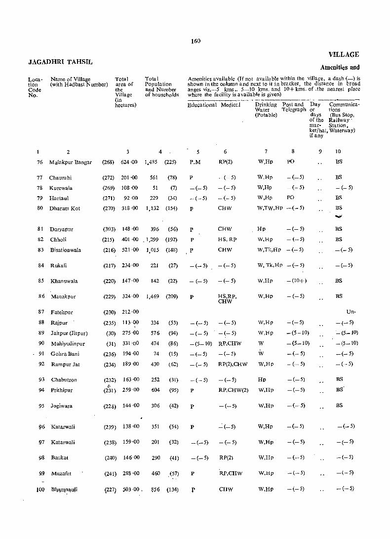
JAGADHR[ TAHSIL
Location Code No.
Namc of Village Total Total Population and Number of houscholds
(with Hadbast Number) area of the Village (in hectares)
2 3 4
76 Malakpur Bangar (268) 624 '00 JAR5 (225)
77 Chaurahi (272) 201 ·00 561 (78)
78 Kurcwala (269) 108 ·00 51 (7)
79 Hartaul
80 Dharam Kot
81 Daryapur
82 Chholi
83 Bisationwala
84 Rukali
85 Khan1,lwala
86 Manakpur
87 Fatcilpur
88 Rajpur .
89 J aitpur (Jitpur)
90 Mahiyudinpur
91 Gohra Bani
92 Rarnpur Jat
93 Chabulroll
94 Prithipur
95 Jogiwara
!)6 Katarwali
97 Katarwali
98 Bankat
99 Muzafat
100 Bqa,IIlna,uJj
(271) 92 ·00 229 (34)
(270) 318·00 1,132 (154)
(303) 148 ·00 396 (50
(215) 401 ·00 _ 1,299 (192)
(216) 521 ·00 1,015 (148)
(217) 234 ·00 221 (27)
(220) 147 ·00 142 (22)
(229) 324 ·00 1,469 (209)
(230) 212 ·00
(235) 113 ·00
(30) 275 ·00
(31) 331 '00
(236) 194 ·00
(234) 189 ·00
(232) 163 ·00 (0
(231) 259 ·00
(228) 144 ·00
(239) 138 ·00
(238) 159 ·00
(240) 146'00
(241) 288 '00
334
576
474
74
430
(53)
(94)
(86)
(15)
(62)
252 (31)
604 (95)
306 (42)
351 (54)
201 (32)
290 (41)
460 (57)
(227) S03 ·00 . 856 (134)
160
VILLAGE
Amenities and
Amenities availablc (If not available within thc village, a dash (-) is shown in the column and next to it in bracket, thc distance in broad anges viz,-5 kms ,. 5_10 kms. and 10+ kms. of . the nearest place wherc thc facility is available is given)
Educational Medical
5 6
P.M RP(2)
P -(-5)
-(-5) -(-5)
_(_5)
P
P
P
P
-(- 5)
CHW
CHW
HS,RP
CHW
-(-5) -(-5)
- (-5) -(- 5)
P
-(-5)
-(-5)
-(5-10)
-(-5)
-(-5)
HS,RP, CHW
-(-5)
-(- 5)
RP,CHW
-(-5)
RP(2),CHW
-(-5)
Drinking Watcr (Potable)
Post and Day <;:ommunica-Tclegraph or tlons
7
W,Hp
W,Hp
W,Hp
8
PO
-(-5)
- (- 5)
W,Hp PO
W,TW,Hp -(- 5)
Hp -(- 5)
W,Hp - (-5)
W,Tk,HP -(-5)
W, Tk,Hp - (- 5)
W,Rp - (10+)
W,Rp -(-5)
-(-5)
-(5-10)
days (Bus Stop, of thc Railway' mar- Station, ket/hat, Watcrway) if any
9 10
BS
BS
- (- 5)
BS
BS
BS
BS
-(-5)
-(-5)
BS
BS
Un-
W,Hp
W,Rp
W -(5-10)
-(-5)
_ (5-10)
_(5_10)
_(_5)
_(_5)
W -(-5)
W,Hp -(-5)
Hp -(-5) -(-5)
P RP,CHW(2) W,Hp -(-5)
BS
BS'
P -(-5) W,Rp -(-5) BS
P "":'(-5) W,Hp -(-5) -(-5)
-(-5) -(-5) W,Hp -(-5) _(_5)
-(-5) RP(2) W,Rp -(-5) _(_5)
P W,Rp -(-5) -(-5)
r CHW W,Rp -(-5) -(-5)
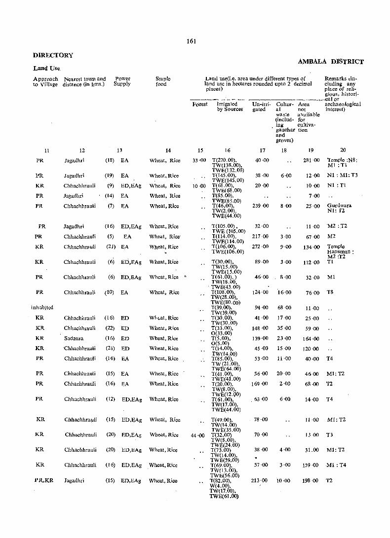
161
DIRECTORY AMBALA DISTRICT
Land Use
Approach Nearest town and Power Staple Land use(Le. area under different types of Remarks lin. to Village distance (in kms.) Supply food land use in hectares rounded upto 2 decimal eluding any
places) place of reli-gious, his tori-
~-~-~_:"-~--,--~-___ ~ ____ , __ cal or Forest Irrigated Un-irri- Cultur- Area archaeological
by Sources gated al not interest) waste available (inc1ud- for ing cultiva-
. gauchar tion and groves)
11 12 13 14 15 16 17 18 19 20
PR Jagadhri (18) EA Wheat, Rice 33'00 T(270.00), 40·00 281 ·00 Temple :N8: TW(138.00), Ml :T1 TWE(132.00)
Nl : Ml: T3 PR Jagadhri (19) EA Wheat, Rice T(14S.00), 38·00 6·00 12·00 TWE(14S.00)
KR Chhachhrauli (9) ED,BAg Wheat, Rice 10·00 T(68.00). 20·00 ]0'00 N1 : T1 TWE~8.00)
PR Jagadhri (14) EA Wheat, Rice T(SS. ), 7·00 TWE(85.00)
Gurdwara PR Chhachhrauli (7) EA Wheat, Rice T(46.00), 239 ·00 8·00 25'00 TW(2.00). Nl: f2 TWE(44.00)
PR Jagadhri (16) ED,EAg Wheat,Rice T(IOS.OO) , 32·00 11 ,00 M2 ::I2 TWE (105.00)
PR Chhachhrauli (5) EA Wheat, Rice' T(114.00), 217·00 3·00 67·00 M2 TWE(114.00)
KR Chhachhrauli (21) EA Wheat, Rice T(106.00), 272 ·00 9·00 134'00 Temple TWE(106.00) Hanuman:
M2 :T2 KR Chhachhrauli (6) ED,EAg Wheat,Rice T(30.00), 89·00 3·00 112·00 Tl
TW(IS.00) TWE(15.00)
PR Chhachhrauli (6) ED,EAg Wheat, Rice " T(61.00). ) 46,00 g·OO 32,00 Ml TW(18.00,
. TWE(43,OO) PR Chhachhrauli (10) EA Wheat, Rice T(l08.00), 124·00 16'00 76·00 T8
TW(28.00),
inhabited TWE(80.00) T(39.00), 94·00 68·00 11·00
KR Chhachhrauli (16) ED What, Rice TW(39.00) T(30.00), 41 ·00 17·00 25·00
(22) Wheat,Rice TW(30.00)
KR Chhachhrauli ED T(33.00), 148·00 35·00 59·00 0(33.00)
KR Sadaura (16) ED Wheat,Rice T(5.00), 139·00 23'00 164·00
KR :Chhachhrauli (21) ED Wheat,Rice 0(5.00) T(14.00). 45·00 15·00 120·00
PR Chhachhrauli (16) EA Wheat, Rice .. TW(14.00) T(S5.00), 53·00 11'00 40·00 T4 TW(21.00),
PR Chhachhtauli (15) Wheat, Rice TWE(64.00)
56'00 20·00 Ml:T2 EA T(41.00), 46·00
PR Chhachhrauli (16) EA Wheat,Rice TWE(41.00)
169 ·00 T(20.00), 2·00 68 ·00 T2 TW(S.OO),
PR Chhachhrauli (12) Wheat,Rice TWE(12.00)
63'00 6'00 T4 ED,EAg T(61.00), 14·00 TW(l 7. 00), TWE(44·.00)
KR Chhachhra1,lli (15) ED,EAg WIleat, Rice T(49.00), 78·00 11·00 M1:T2 TW(14.00)
KR Chhachhrauli (20) Wheat, Rice TWE(35.00)
70·00 ED,EAg 44·00 T(32.00) 13 ·00 T3 TW(8.00),
KR Chhachhrauli (20) Wheat,Rice TWE(24.00)
38·00 4·00 M1:T2 ED,EAg T(73.00) 31.00 TW(14.00),
KR Chhachhrauli (16) ED,EAg Wheat, Rice TWE(S9.00)
57·00 T(69.00), 3·00 159·00 Ml :T4 TW(13.00).
PR,KR Jagadhri (15) ED,EAg Wheat, Rice TWE(56.00) T(82.00), 213·00 10·00 198·00 T2 W(4.00), TW(17.00), TWE(61.00)
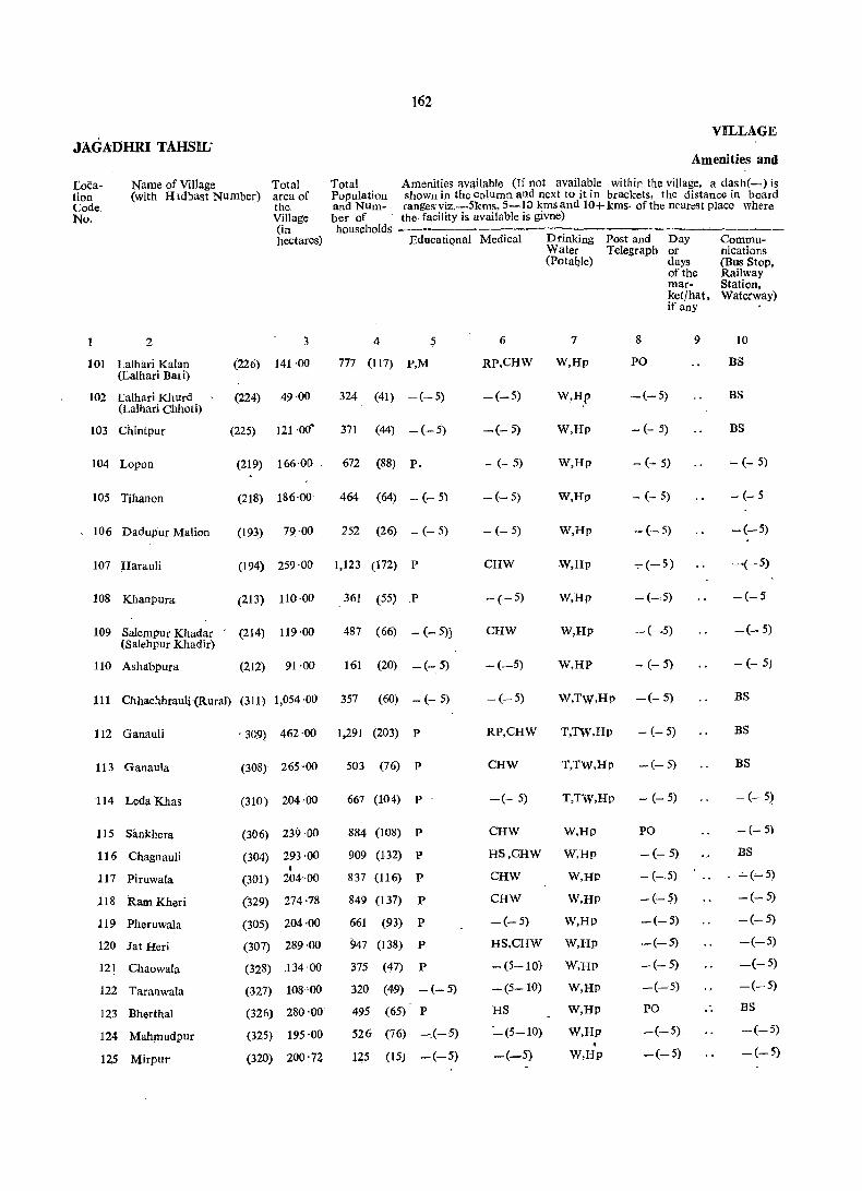
162
VILLAGE JAGADHRI TAHSIL'
Amenities and
Name of Village Loeation Code. No.
(with Hldbast Number) Total area of the Village (in hectares)
Total Amenities av~ilable Of not available within the village, a dash(-) is Population shown in the column and next to it in brackets, the distance in board and Num- ranges viz.-5kms, 5-10 kmsand 10+kms. of the nearest Place where
2
101 Lalhari Kalan (Lalhari Bar i)
102 Lalhari Khurd (Lathari Chhoti)
103 ChintPur
104 Lapan
105 Tihanon
106 Dadupur Malian
107 Harauli
108 Khanpura
109 Salempur Khadar (Salehpur Khadir)
110 Ashabpura
(226) 141·00
(224) 49 ·00
(225) 121 .()(,.
(219) 166·00
(218) 186·00
(193) 79 ·00
ber of the facility is available is givne) households ---.
Educational Medical
4 5 6
Drinking Post and Day Water Telegraph or (Potal)le) days
7
of the market/hat, if any
9
777 (117) P,M RP,CHW W,Hp
8
PO
324 (41) -(-5) -(-5) W,H.p -(-5)
371 (44) -(-5) -(- 5) W,Hp - (- 5)
672 (88) P. - (- 5) W,Hp - (- 5)
464 (64) - (- 5) -(- 5) W,Hp - (- 5)
252 (26) - (- 5) - (- 5) W,Hp - (-5)
(194) 259 ·00 1,123 (172) P CHW W,Hp ~(-5)
(213) 110 ·00 361 (55) P - (-5) W,Hp
(214) 119·00 487 (66) - (- 5)J CHW W,Hp
. (212) 91 ·00 161 (20) -(-5) -(_5) W,HP - (- 5)
111 ChhachhrauH(RuraJ) (311) 1,054'00 357 (60) -(-5) - (-5) W,TW,Hp --(- 5)
112 Ganauli
113 Ganaula
114 Leda Khas
115 Sankhera
116 Chagnauli
117 Piruwala
118 Ram Kheri
119 Pheruwala
120 Jat Heri
12! Chaowala
122 Taranwala
123 Bherthal
124 MahplUdpur
125 Mirpui
. 309) 462·00 1,291 (203) P
(308) 265 ·00
(310) 204·00
(306) 239 ·00
(304) 293 ·00 I
(301) 204·00
(329) 274 ·78
(305) 204 ·00
(307) 289 ·00
(328) J 34 ·00
(327) 108 '00
(326) 280 ·00
(325) 195 ·00
(320) 200 . 72
503 (76) P
667 (104) P
884 (108) P
909 (132) P
837 (116) P
849 (137) P
661 (93) P
947 (138) P
375 ('17) P
320 (49) - (- 5)
495 (65) P
526 (76) -.(- 5)
145 (15) -(-5)
RP,CHW T,TW,Hp
CHW T,Tw,Hp
-(- 5) T,TW,Hp
CHW W,Hp
HS,CHW W,Hp
Caw W,HP
CHW W,HP
-(-5) W,Hp
HS,CHW W,Hp
-(5-10) W,HP
-(5-10) W,HP
HS
-:'_(5-10)
-(-5)
W,Hp
W,Hp •
W,Hp
- (- 5)
-c- 5)
- (- 5)
PO
- (- 5)
- (- 5)
-(-~)
-(-5)
-(-5)
-(-5)
-(-5)
PO
-(-5)
-(-5)
Communications (Bus Stop, Railway Station, Waterway)
10
BS
BS
BS
- (- 5)
- (- 5
-(-5)
~(-5)
-(-5
_(_ 5)
- (_ 5)
BS
BS
BS
- (- 5)
-(- 5)
BS
_ ..:. (~5)
-(-5)
-(-5)
-(-5)
_(-5)
-(-5)
BS
-(-5)
-(-5)
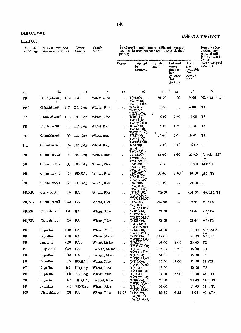
163 DtRECTORY
AMBALA.D][STR~Ct Land Use
Approach Nearest town and Fower Staple Land use(i.e. area under different types of Remarks (in-to Village distance (in kms.) Supply fo~d land use in hectares rounded up to 2 decimal eluding any
places) place of reli· gious, histori-
----=-- .. _--------------- ealOT Forest hrigated Un-irri- Cultural Area archaeological
by gated waste not interest) Sources (incluct- available
ing for gaucher cultiva-and tion groves)
11 12 13 14 15 16 17 18 19 20
PR Chllachluauli (13) EA Wheut,Rice T(40.00), 91·00 1·00 9·00 N2: Ml : T1 TW(9.00).
Chhuchhralili TWE(31.00)
PR (15) ED,BAg Wheat, Rice T(36.00), 9·00 4·00 T2 W(22.00)
Chhachhrauli WE(14.00).
PR (13) ED,EAg Wheat. Rice T(L03.19), 6·07 0'40 11·34 T7 TW(14.16),
ChhachhruuJi TWE(89.03)
PR (8) ED;EAg Wheat, Rice T(144.oo), 5·00 4·00 13·00 T3 TW(6t.OO),
Chhachhlauli TWE(83.00)
PR (6) ED,EAg Wheat,Rice T(127.00) 19·00 6·00 34·00 T3 TW(46.00),
Chhachhrallli TWE(SI.OO)
PR (6) ED,BAg Wheat, Rice T(64.00), 7,00 2,00 6,00 W(24.00),
ED;EAg TW(40.00)
PR Chhachhrauli (6) Wheat, Rice T(153.00), 83·00 1 ,00 22,00 Temple :M2 TW(61.00), T2 TWE(92.00)
PR Chhachhrauli (4} ED,EAg Wheat, Rice T(94,00), 5'00 11"00 M3:Tl TW(S3.00),
Chhachhrauli TWE(41.00)
3 ,00 ~ PR (5) ED,EAg Wheat, Rice T(47.00), 59'00 10'00 M2: T6 TW(18.00), '" TWE(29.00),
PR Chhachhrauli (2) ED,EAg Wheat, Rice T(53.00), 18·00 20'00 TW(20.00),
Chbachhrauli (0) TWE(33.00)
PR,KR EA Wheat, Rice T(161:oo), 489.00 404'00 N4: M5: T1 TW(27.oo),
Chhachhrauli . (2) TWE(134.oo)
PR,KR E~ -Wheat, Rice T(62.oo), '202 '00 198'00 M3:T5 W(8.00),
Chhachhrauli (3) TWE(54.00)
PR,KR EA Wheat, Rice T(184.00), 63:00 18·00 M2:'T6 TW(60.oo),
Chhachhrauli (3) TWE024.00)
PR,KR EA Wheat, Rice T(121.00), 60';00 23-00 M3:T:l TW(24.oo),
(10) TWE(97.00)
PR Jagadhri EA Whe!lt, Maize . T(147.00). 74'00 11S"00 N"4:-M2: TWE(147.00) T4
PR Jagadhri (10) EA Wheat, Maize T(107.00), 168·00 18',00 N4 :T3
Jagadhri (10) TWE(107.00)
PR EA.. Wheat, Maize T(SO.OO) •• 96;00 8'00 20'00 T2
PR Jagadhri' (10) EA Wheat, Maize TWE(80.oo)
135 ·97 0'40. 16:20 T(I22.21), T3
Jagadhri .- (8) Wheat, M!\ize TWE(l22.21)
PR EA . T(115.00), 74-00 15 '00 T1
Jagadhri (2) ED,EAg TWE(1l5.00)
PR . Wheat, Rice T(179.00), 77·00 11 '00 22'00 Ml:T2
Jagadhri (8) TWE(l79.oo}
PR ED,EAg Wheat, Rice T(86.00), 38 ·00 10·00 T2
PR Jagadhri (8) Wheat, Rice TWE(86:00)
ED,BAg T(73.00), 23·00, 5·00 7-00 M1 :T1
PR . Jagadbri (6) TWE(73.00)
ED,EAg Wheat,Rice T(199.00), 61 ·00 20·00. M4 :-T9
PR Jagadhri (6) 'IWE(199.oo)
ED,EAg Wheat, Rice T(115.00), 66,,00 14 .. 00 Ml :Tl
Chhachhrauli (3) TWE(1 t 5.00)
KR SA Wheat, Rice 14 ·97 T(154.59), ·15 ·38 :4'45 11·33 Ml :.T2 TW(50.18), 'lWE(104:41)

Location Code No.
Name of Village (with Hadbast Number)
2
Total area of the Village (in hectares)
3
126 Munda Khera
127 . Mukaribpura
(318) 189 ·00
(311) 206·00
128 tChaneta (Ghaneta) (316)
129 Panjeton (315)
130 Mand Kheri (319)
131 Singhpura (205)
132 Sherpur (206)
133 tGurdhanpur (204)
134 U rjani (203)
135 Chuharpur 'Khurd (207)
136 Nahar Taharpur (211) (Naharpur TaharPur)
137 Khanpuri (210)
77·00
276·80
301 ·00
127·00
126·00
51·00
234·00
68·00
116·00
63·00
VILLAGE
Totai 'Population and Number of households
Amenities and
Am~nities available(If not available within the village, a dash(-)is shown in the column and next to 'it in brackets, the distance in broad ranges viz, -5 kms., 5-10 kms., and 10+kms of the nearest vlaCe where the
. facility is available is given) ._------
Educational Medical Drinking Post and
4
824 (105) P
608 (88) P
5
38. (5) -(5-10)
1.157 (145) P
1,541 (215) P
372 (57) -(- 5)
732 (105) P
3 (1) -(-5)
318 (46) -(- 5)
318 (45) - (- 5)
350 (53) -(-5)
148 (21) -(-5)
6
HS
CHW
-(5-10)
CHW
Water Telegraph (Potable)
7 . 8 •
W,HD -(5-10)
W,Hp -(5-10)
W,HP - (5- 10)
W,Rp -(-5)
RP,CHW W,Rp - (- 5)
-- (-- 5) W,Hp -(-5)
-(-5) W,RP -(-5)
-(-5) W -(-5)
HS,CJ:lW IIp -(-5)
-(-5) W,Hp -(-5)
-(5-10) W,Hp -(5-10)
-(5-10) W,Hp - (5- 10)
Day or days of the market/hat, if any
9
..
Communications (Bus Stop, Railway Station, Waterway)
10
BS
BS
BS
BS
-(-5)
-(-5)
~(-5)
-(-5)
-(-5)
-(-5)
-(5-10)
-(-:-5)
138 Balauli (208) 424 ·00 1,134 (186) P RP,CHW W,Rp PO -(5-10)
139 Taruwala
140 BaroH Majra
141 Mohab Aliwala (Mahab Aliwala)
142 Kotra Kahansingh
143 Leda Khadar
144 'rugalpur
145 Ledi
·146 Dadupur Jattan
147 l\1anipur
148 tAhmad Majra
149 Kot Sarkari
ISO Tibbi Raiyan
(209)
(191)
(178)
(189)
(190)
(192)
(221)
(222)
(223)
(187)
(188)
(179)
131·00
209'00
119·00
133·00
228·00
212·00,
567 (86) P
474 (76) P
173 (28) -(- 5)
446 (71) -(- 5)
821 (134) P
664 (103) P
CHW W,Hp ....... (- 5)
-(5- 10) W,Hp _(- 5)
-(5- 10)
-(5-10)
HS
CHW
W,Hp
W,Hp
W.Hp
. W,Hp
-(- 5)
-(-5)
-(-5)
-(-5)
278·00 1,125 (162) P,M,H RP,CHW W.Hp PO
105--00
54-00
295·00
307·00
588 (77) -(_:_5) -(5-10) W,Hp -(:. 5)
435 (73) -(- 5) CHW W,HP -(-5) . 20 (2) -(5-10) -(5-10) W,Hp -(5-10)
418 (60) -(- 5) D,CHW W,Hp -(10+)
877 (167) P CHW W,Hp -(10+)
-(5-10)
-(- 5)
-(-- 5)
-(-5)
-(- 5)
_(_5)
BS
BS.
-(-5)
-(5-10)
-(-5)
-(- 5)

165
niRECTOR¥ AMBALA DISTRIct
Land Use
Ap):!roach Nearest town and Power Staple Land use (i.e. area under different types of Remarks (in-to Village distance(in kms.) Supply food land use in hectares roundee! upto 2 decimat eluding any
plilces) _ place of reli-gious, histori~
_'---- - calor Forest Irrigated Un-irri~ Cultur- Area archaeologiclli
by Source gated al waste not interest) (incJud- available ing for
. gauchar cultiva:. and lion groves)
11 12 lj 14 15 16 17 18 19 20
PR Jagadhri (5) EA Wheat, Rice T(l65.00), 5'00 19'00 T5 W(16S.00)
PR Jagadhri (4) EA Wheat, Rice T(l74.00), 9'00 6·00 17'00 M4:T7 TW(47.00), TWE(127.00)
PR Jagadhri (5) EA Wheat, Maize T(66:00), 8·00 3·00 TWE(66.00)
PR Chhachhrauli (3) EA Wheat, Rice T(234.31), 27'52 0'40 14'57 T 10 TW(44.51), TWE(189.80)
PR.. Chhachhrauli (3) EA Wheat, Rice T(263.00), 11'00 4'00 23 ·00 Ml:TS TW(263.00)
PR Chhachhrauli (2) EA wheat, Rice T(42.00), 58·00 27·00 WE(3.00), TWB(39.00)
PR Chhachhrauli (2) BA Wheat, Rice T(lO@O), 3'00 4'00 13'00 Ml:T6 TW(20.00), TWE(86.00)
KR. Chhachhrauli (3) EA Wheat, Rice T(31.00), 12-00 8'00
'(3) Wheat, Rice TWE(31.00)
PR Chhachhrauli BD,EAg - 12·00 T(12S.00), 28·00 69'00 Ml:T3 TWE(125.oo)
PRo Chhachhrauli (1) EA Wheat, Rice T(57.oo), 1 '00 2'00 8-00 Ml:T3 TWE(57.00)
PR Chhachhrauli (2) EA Wlleat, Rice T(68.00), 26'00 6·00 16·00 T1 TW(18.00),
Chhachhraufi TWE(SO.oo)
KR (5) EA Whea t, Rica T(29.00), 29'00 1'00 4'00 TW(17.QO). TWE(12.00)
PR Chhachhrauli (4) EA Wheat, Rice T(279.00), 108'00 9·00 28·00 Temple: TW(36.00), MI: T6 TWE(243.oo)
22·00 PR Chhachhrauli (4) EA Wheat, Rice T(95.oo), 2,00 12·00 MI:Tl TW(19.00), TWE(76.oo)
93·00 PRo Chhachhrauli (8) EA -Wheat, R.ice T(n.oo), 39'00 5·00 MI: Tl TWE(72.00)
KR. Chhachhrauli (10) EA Wheat, Rice .. T(14.oo),' 75'00 2'00' 28'00 .. TWE(14.00) KR. Chhaohhrauli (8) EA Wheat, -Rice ~ T(22.00), 75 ·00 1·00 35'00
( TWE(22.00) PRo Chhachhrauli (8) EA. Wheat, Rice T(108.00), 55'00 6'00 59'00 Tl
TW(18.oo),
'(6) TWE(90.00),
KR Chhachhrauli EA Wheat, Rice T(87.00), 110 '00 15'00 T2 • TW(19.00),
PR Chhachhrauli Wheat. Rice TWE(68.00)
.i8 ·00 24,00 Temple ITl (6) EA T(2IS.DO), 1·00 TW(49.00),
PR Chhachhrauli (8) EA Whea-t, Rice TWE(166.oo) T(92.oo). TW(43.00),
8·00 37·00 11
PR Chhachhrauli TWE(49.00)
9·00 (8) EA Wheat, Rice T(43.00), 51·00 2'00
KR Chhachhrauli TWE(43.00)
44'00 (10) EA Wheat, Rice T(6.00), 4'00
KR. Chhachhrauli Whe!\,t, Rice TWE(6.oo)
65 '00 (10) EA .. T(76.00), 154'00 T1 TWE(76.00)
PR Chhachhrauli, (10) aD,BAg Wheat, Rice M ·T(9.oo), 252-00 46·00 TS TWE(9.00)

JAGADHRI TAHSIL VILLAGE
Location Code No.
Name of Village (with Hadbilst Number)
Total area of the Village (in hectares)
Totar Population and Number of households
Amenities and
Amenities available(I£ not availab.le within the village, a dash(-) is shown ih the column and next to it in brackets, the distance in 'broad ranges viz, -5 kms. 5_10 kms., and 10+ kms. of the nearest place where the facility is available is given)
Educational Medical Drinki;-P;,; and-Da;-Co;;uni-
151 Daulatpur
152 Dhakwala
2
153 KotMushtarka
(I 80)
(IB3)
(184)
154 Kot Basawasingh (185)
155 Ramgarh Alias (186) Adun Majm
156 Bhagwangarli (26) Urf Bansantaur
157 Faqira Majra (24)
158 Bachon (182)
159 Shahabudinpur Khurd (23)
160 Chuharpur (19) Mangalsingll
161 Sipianwala (20)
162 Shahabudihpur (22) ,Kalan
163 Khol Fatehgarh (25) 164 Yarah (21) 165 Tahri (27)
166 Haidarpur
167 Taharpur Kalan
168' lbrahimpur •
(233)
(28)
(29)
169 Dir Tahanpur (490) 170 J!lflgle Mehrniwala (491)
171 Khol Darpur 172 Darpur 173 Jafanwalil
11.4 ShahzadWala
175 MukarabpUt
176 Nathanpur
(492) (17) (18)
(16)
(181)
(15)
171' Meghuwala (14)
178 D}1angera Dhangeri (9) Dagpat
3
86·00
79'32
272'75
4 5
530 (82) -(- 5)
447 (53) _(_ 5)
815 (120) P,M,H
216·00 1,200 (202) P
195 ·00.. 619' (9'3) - (- 5)
81 ·00 11 (I) P
51 '00 205 (39) _(_ 5)
35,00 133 ~1'7)' -(-5)
26·00 30 (4) -(-5)
53 ·00 271 (50) _(5_10)
52 ·00 248 (27) -(S~lO)
32 ·00 55 (8) _ (__,5)
85·00 61 ·00
103 ·00 93 (16) - (-5)
92·00 237 (42) -(-5)
413 '00 1,551 (242) P
273 ·00 852 (152) -(-5)
91'00 670'55
820·00 350'00 235'00
284'00
262·00
66·00
1,023 (178) P 657 .(120)' -(-5)
575 (91) P
688 (110) P
21 (4) -(-5)
llS '00 229' (40) -(-5)
626 ·00 1,294 (2'11) P
179 Khilanwala 180 Daniawala
(10) 306'00 (13) 122·00
820 (149) P
181 Kansli 182 Chikan 183 panch Khola 184 Jungle K'alesar 18S' Kalesar
l'i<.
(ll) 131·00 (12) 224·00 493) 2,496 '00
(2) 4,682 ·00 (1) 1,219 '00
440 (65) _(_5)
4S9 (7~) -(~5) 311 (48) ~(,-... .s)
105 (1'4) -(~S) 1,'382 (348) P, M
Water Telegraph or cations (Potable) days (Dus Stop,
of the Railway mar- Station, ket/hat, Waterway) jf any
6
_(_5)
caw HS,RP(3).
RP(2),CHW
RP
RP(2)
-(_5)
-(~s)
-"'(-5)
_(-5)
- (-5)
- (~5)
-(5-10)
-(-5)
85,1&, CHW -(-S)
789
W,Hp -(10+)
W,Hp -(10+)
'W,Hp PO
W,Hp -(- 5)
W,Hp - (10+)
W -(5-10)
W,Hp - (5- 10)
Hp . -(5-10)
W,Hp - (5- 10)
W - (5- 10)
W,Hp -.(5- 10)
W -(5-10)
W _(5-10)
W, Hp -(5-10)
W -(5-10)
Hp,O -(5-10)
RP(2), CHW W PO -..{10+)· W -(-5)
CHW W _(-5)
-(10+) W, Hp -(-5)
_(5_10) w --{IO+)i W, Hp _(_5)
RP, CHW(2) W, Hp :"""(5_10)
CHW -(10+)
clIW -(10+)
-,(_5)' as,CHW
W -(5---:>10) W,Hp _(_5)
W _(~5) Hp ~(-5J
W; ttp ~.(~5)' W,Hp PO
10
- (- 5)
- (- 5)
DS
BS
- (- 5)
-(- 5)
- (- 5)
-(-s)
-(-5)'
- (5- :0)
- (5- 10)
-(-5~
UnUn
-(5-10)
_(5-10)
-(5~rO)
-(5-1.0)
UnUn-
Un-BS -(-S)
-(-5)
-(-5)'
-(-5)
-(-5)
BS

167
DlRECrORY AMBALA DISTRICT
Land Use
Approach Nearest town and Power Staple Land use(Le. arM under djfferent types of Remarks (in-to Village distance (in. kms.) Supply food land use in hecfhres rounded up to 2 eluding any
decimal pll\ces) place of reli-gious, histori-cal Of
Forest Irrigated Un-irri- Cuhur- Area archaeological by Sources gated a1 not interest)
waste available (indud- for ing cultiva-gauchar tion and groves)
11 12 13 14 15 16 17 18 19. 20
KR Chhachhrauli (13) ED,EAg Wheat, Rice T(19.00), 37·00 30·00 TWE(19.00)
KR <:;hhachhrauli (13) ED;EAg .. Wheat, Rice T(40.06), 31·97 0·40 6'89 TWE(40.06)
PR Chhachhrauli (10) ED,EAg Wheat, :Rice T(0.81), ~ 190'60 3 '64 . 77·70 T2
Chhachhrauli TWE(0.81)
Mosque: T3 PR (11) ED,EAg Wheat, Rice T(22.00), 158'00 36·00
PR Chhachhrauli ED,EAg TWE(22.00)
(11) Wheat, Rice T(21.00), 95 '00 79'00 T4 TWE(21:00)
PR Chhachhrauli (16) EA Wheat, Maize T(3.00), 51 ·00 5·00 22·00 T1 TWE(3.00)
Chhachhrauli KR (11) ED Wheat, Maize 1'(1.00), 38 '00 400 8'00 .. PR Chhachhrauli (11) ED,EAg Wheat, Maize
TW(1.00) T(13.00), 17·00 5·00 ..
PR Chhachhrauli Wheat, Maize TW(13.00)
(11) ED T(11.00), 12'00 3·00 .. TWE(11.00)
PR,KR Chhachhrnuli (13) EA Wheat, Maize T(3.00), 43·00 7·00
Chhachhrauli TWE(3.00)
PR (12) EA W~eat. Maize T(14.0Q) 25·00 13·00 1"3 TW(l4.00)
PR,KR Chhachhrauli (13) EA Wheat, Maize T(7.00), 20'00 5·00 .. inhabited
TWE(7.00) 42·00 4·00 39·00
inhabited 1'(4:00),
35·00 .5 ·00 21 ·00 KR Chhachhrauli (16) EA Wheat, Maize 75·00 12·00 12·00
TW(4.00)
KR Chhachhrauli (13) EA Wheat, Maize T(13.CO), 69·00 3·00 7·00
PR,KR Chhachhrauli (16) 'Wheat, Maize TW(l3'00)
EA 'T(2.00), 350·00 25·00 36·00
Chhachhrauli Wheat, Maize TWE(2.00)
PR,KR (18) EA T(1O.00), 217-00 13·00 33,00
inhabited 0(10.00)
665·i9 91 ·00
inhabited 5 ·26
inhabited 820·00 .. PR Chhachhrauli (19) EA Wheat, Bajra 221 ·00 110·00 19·00 Mosque PR Chhachhrauli (17) EA Wheat, Bajra T(7.00), . 166·00 36·00 26·-00
Chhachhrauli . Wheat , Bajra TWE(7.00)
KR (16) EA T(22.00), 157 -O~ 2S -~o 80 -00 T2
KR Chhachhrauli (16) Wheat, Bajra TWE(22.00)
Ml ;T5 EA' T(71.00), 108·00 77·00 6·00 TW(16'OO), TWE(55 ·00)
PR Chhachhrauli (14) EK.l Wheat; Maize 39'(j0 23·00 4·00
PR Chhachhraulj (14) EA W.heat,Maize T(13-00), 77·00 17·00 8·00
Chhachhrauli Wheat, Maize TWE(13 ·00)
Ml : Tl .PR (16) EA T(33.00), 384·00 130·00 79·00 TW(9.00). '
. TWE(24.00) KR Chhachhrauli (17) EA Wheat, Maize 20S-00 12·00 86·00 PR Chhachhraulj (16) EA Wheat, Maize T(4.00), 75-00 29·00 14·00
'IWE(4.00)
PR Chhachhrauli (18) EA Wheat, Bajra 123·00
98·00 6·00 27·00 PR Chhachhrauli (19) ED Wheat, Maize 79·00 11·00 11·00
inhabited 2,496'00 PR,KR Chhachhrau\i (\9) ED Wheat, Maize 4,682'00
~5'QO Nt: Ml:T5 .• KR Chhac hhrallii (27) EA w.Aeat, -Ric~ \ _ ~~6".OO T(43.00), 397'00 42~'00 TW(8.00), lWE(3~.OQ)
c 168
VILLAGE JAGADHRI TAHSIL
Amenities and
Loca- Name of Village Total Total Amenities available(lf not available within the villabe, a dash(-) Is shown tion (with Hadbast Nuinber) area of Population in the column and next to it in brackets, the distance in broad ranges Code the and Number viz>_-5 kIns., 5-10 krris. and 10+kms of the nearest place where the No. Village of facility is available is gIVen)
(in households hectares) Educational Medical Drinking Post and Day Communi-
Water Telegral'h or cations (Potable) days (Bus Stop,
of the Railway mar- Station, ket/hat, Waterway) jfany
1 2 3 4 5 6 7 8 9 10
186 Raiyanwala (4) 1,059 ·00 1,462 (246) P -(-5) W, C -(-5) BS
187 Nangal Patti Milk (5) 791 '00 1,030 (166) -(-5) D W -(_5) _(_5) (NagaI Patti Malik)
59·00 188 Chak Ba ba Sahibsingh (7) Un-
189 Na~al Chak Bat (6) 11'00 Un-190 Khljri (8) 795·00 1,050 (190) P RP,CHW W _(_5) _(-5)
191 Khizrabad (165) 953·00 3,263 (574) P(2), M(2), PHC,FPC, W,C PO BS H RP(10),
192 Bahadurpur 282·00 P,M CHW(2)
(164) 641 (95) RP,CHW W,C - (- 5) BS
193 :rajewala (3) 670·00 1,784 (302) P(2) D C PTO BS
194 Mandewala (64) 121 '00 ..254 (44) P CHW T, Hp - (5- 10) -(-5
195t Belibhud (63) 494·92 9 (4) -(- 5) CHW W - (- 5} -(-5)
196 Nainwala (65) 131 ·00 233 (47) -(-5) -(5-10) -T,Hp - (5-10) ...... ( ...... 5)
197 Koliwala (68) 155'00 222 (34) -(-5) -«-5) T, HI' - (-5) - (-5)
198 Dekriwala (66) . 57·00 80 (8) -(-5) -(-5) T,Hp -(-5) -(-5)
199 Bhud Kalan (67) 303·00 1,148 (142) • P RS T,Hp -(-5) BS
200 Gulabgarb (169) 243·00 310 (49) P - (5-10) T, HI' -(5-10) BS
201 Chuharpur Kalan (168) 490·00 1,835 (287) P, M -(5-10) "f,Rp :- (5-10) BS
~02 Kishanpura (167) 679'00 2,033 (313) P RP(4),CHW W,Hp. -(-5) BS
203 Mujafat Kalan (166) 339·00 1,413 (196) P HS, RP, f,HP -(5-10) BS (Muzafat Bari) CHW
204 Mujafat Khurd' (176) 1.53'00 475 (85) -«~5) _(- 5) Tk,Hp _(5_10) BS (Muzafat Chhoti)
~OS BakkarWala (177) 347·00 1,355 (208) P RP(3), CHW W,Hp -(5-10) .. -BS
206 Lahasabad" (175) 103'00 293 (39) -(- 5) RP,CHW W,Hp - (-5) -(- 5)
207 Hafizpur (173) 134·00 570 (80) P CHW W,Hp - (- 5) - (- 55
20$ Haf~i (Ha.fizi) (l72) 7~'OO 14Q (21) ... (- S) - (5-10) W.Rp - (-~) ,. -(-S)
169
DIRECTORY "
AMBALA DISTRICT Land Use
Approach Nearest town and Power Staple Land 'use (i.e area under different types of Remarks (in-to Village distance(in kms.) Supply food land use in hectares rounded up to 2 cluding any
decimal places) place of reli-gious, histori-calor
Forest IrriglJ,ted Un-irri- Cultur- Area archaeological by Sources gated al not interest)
waste available (includ- for ing cultiva-gauchar tion and groves)
<It
. 11 12 13 14 15 16 17 18 19 20
PR Chhachhrauli (24) ED Wheat, Rice 518·00 T(3.oo), 42&'00 82'00 28·00 Gurdwara
KR Chhachhrauli (14) ED Wheat, Rice 565 ·00 GC(3.00)
189'00 10·00 27·00
inhabited 12·00 30·00 17·00
inhabited 356·00
10·00 16·00
1 '00 PR Chhachhrauli (19) ED Wheat, Rice 291·00 132 ·00 N2: Ml:
Cl: T2
PR Chhachhrauli (16) ED, Wheat, Maize T(163.00), 638·00 72·00 80·00 Temple :N50: EAg GC(l56.00), MI5 : CI :
TWE(7.00) T16 PR Chhachhrauli (18) ED, Wheat, Maize T(145.00), 59·00 18 ·00 60·00 Temple :N5:
EAg GC(I42.00). M3 :T5
PR CIlhachhrauli (22) ED Wheat, Maize TWE(3.00)
98·00 256·00 N12: M6 : T(82.00). 234·00 GC(82.00) T2
PR.KR Chhachhrauli (16) ,EA Wheat, Rice T(26.00). 70·00 25 ·00 Ml:T4 :::- GC(26.00)
KR Chhachhrauli (16) EA Wheat, Maize T(0.40), 30·35 464,17 GC(O'40)
KR Jagadhri (14) EA Wheat, Maize .. T(63.00), 38 ·00 30·00
PR,KR' Chhachhrauli (16) EA Wheat, Maize GC(63 ·CO)
. 40·00 100·00 T(15.00), T1 GC(12.00),
PR,KR Chhachhrauli (16) EA Wheat, Maize TW(3.00)
22·00 T(15.00), 20-00
PR,KR Chhacl!brauli (16) EA Wheat, Maize GC(15.00)
54·00 98·00 T(151.00), T4 GC(138·00)
PR CWlachhrauli (10) EA Wheat, Rice TW(13.00)
61·00 136·00 MI : Cl : T3 T(46.00), GC(42.00), TW(4.00)
PR.KR Chhachhrauli (11) EA Wheat, Maize T(255.00). 58·00 6·00 171'00 Temple: N2: GC(253.00), Ml: T3
PR Chhacbhrauli (14) ED. Wheat. Rice TW(2.00)
33·00 45·00 92·00 Temple: N7 : T(509.00), EAg GC(439.00). M3: Cl : T9
PR Chhachhrauli (13) EA Wheat. Rice
TW(28.00), i WE(42.00) (76.00). 228·06 3·00 32·00 T3
TW(33.00),
PR Chhachhrauli (13) EA Wheat, Rice TWE(43.00) T(8.00). TW(4.00),
96·00 32·00 17·00 N2: M2: TI0
PR Chbachhrauli (11) ED. Wbeat, Rice BAg
TWE(4.00) 159·00 1 ·00 31 ·00 T(l56.00).
TW(1l3 ·00). TWE(43.00)
PRo KR Chhachhrauli (16) ED. Wheat, Rice T(87.00), 4·00 12·00 EAg TW(53.00).
PR,KR I.'!:hhachhrauli (13) Whea,t, Rice TWE(34.00)
33·00 11 '0.0 M2 :T3 ED. T(90.00). EAg TW(29.00). ... TWE(61.00)
KR Chhacbhrauli (11) ED. Wheat, Rice T(ll.OO). 58'00 4'00 flAg TW(6.00).
TWfl(5.00)

170
'" :VILLAG-E
JAG'.ADHRI :rAHSIL Amenities and
Loca- Name of Village cTDtal Total Amenities available (If not available within the village. a dash (___.) is tion (with Hadbast Number) area of Population shown in the column and next to it in brackets. the distance in· broad Code the and Num- r~Q8es viz,-5 kms. 5-10 kms. and 10+kms of the nearest place where No. Village ber of the facility is available is given)
,(io .households hectares) Educational Medical Drinking Post and Day Communica-
Water Telegraph or tions (Potable) days (Bus Stop,
of the Railway mar- Station, ket/hat, Waterway) if any
0
2 3 4 5 6 7 8 9 10
209 Tahimun (Tahimu) (174) 217·00 711 (112) P RP W,HD -(-5) -(- 5)
,.. 210 KarkauIi (171) 288-00 1,158 (158) P CHW W,Hp - (- 5) - (- 5)
211 Da~aura (198) 358·00 1,169 (152) P CHW W,Hp - (- 5) - (- 5)
212 Damoli (195) 99-00 675 (100) P - (5- 10) W,Hp -(-5) ~(-5)
213 Raipur (196) 100/00 236 (30) P - (S:__ 10) W,Hp - C:- 5) -(-5)
214 Yakubpur (197) 272,00 822 (122) P RP(2), CHW W,Hp -(-5) -(-5)
215 Kherl<i (20i) 73-00 Un-
216 Shahjahanpur (201) 116-00 279 (40) - (- 5) - (- 5) Hp - (- 5) BS
217 Jaidhar (82) 326·00 1,805 (309) P,M,H HS. RP(2). Hp - (-5) BS CHW
218 Harewa (83) 101 '00 378 (61) -(-5) Caw Hp -(-5) BS
219 Tapu Jaidhar (84) 120·00 un-
220 Jaidqari (&1)- 370'00 1,105 (163) P RP(2)CHW Hp PO BS
221 .Bhilpura (~OO) 271·00 607 (101) P CHW Hp - (- 5) BS
222 Pipli Majra (199) 134'00 636 (88)" - (- 5) RP T,w,Hp -(5-10) .. BS
223 ~alikpur Khadir (170) 391 ·00 1,361 (224) P HS,RP W,Hp PO BS
224 Begampur (801 522'00 1,201 (199) P CHW T,WsHp -(-5) -(-5)
. 225 BhulKheri (85) IH'()() 633 (81) -(-5) -'(-5) W,Hp -(-5) -(-5)
.. 226 ISllla,ilpur (86) 22t ·00 1,114 (180) P RP,CHW T.W -(-5) BS
17t
DIRECTORY AN.m'AtA. DlS'r.1U€T
Land' Use
Approach Nearest town and Power Staple Land use (i.e~ area unCler. different types of'; Remarlcs'(in-to "'Hlage, distant: (inkms,) Supply' food land use in hectares rouuded'upto 2'4el;imal eluding any,
places), " place of reli-gious, histbri-
---' cal or Forest Irrigated Un,irri- Cultural Area archaeologi.
by Sources gated waste not cal interest) (includ- available ing for gauchar cultiva-and tioll groves)
1'1 12 13 14. 15' 16 17 18 19 20
PR, KR ChhachhrauU (14) ED,. Wheat" Rice T(lOO.OO&~ 97·00 20·00· Temple: M4 : EAg GC(65.0 ), T4
TW(16.00),
Wheat, Rice TWE(19.00)
KR Chhacbhrauli (11) ED, T(20S.00). 56·00 1·00 23·00 Gurdwara: EAg GC(166.00),
, M5: T22
TW(16.00). TWE(26.00)
PR, KR Chhachhrauli ( 8) ED, Wheat, Rice .. . T(277.00). 49·00 2·00 30·00 T5 EAg: GC(91.00),
TW(73.00).
KR ED, Wheat) Rice TWE(113.00)
Chhachhrauli (6) .. . T(41.00), 37·00 ,21·00 TIl BAg TW(23.00).
KR Wheat, Rice TWE(1S.00)
Chhachhrauli (6) ED, T(34.00). 24·00 3·00 39·00 EAg TW(14.00);
PR, KR TWE(fO.OO)
Chhachhrauli (8) ED, Wheat, Rice T(201.00). 37·00 2·00 37.·()() Temple: Ml: E~g' GC(89.00), T4
TW(39.00),
inhabitted TWE(73.00),
21 ·00 T(23.00) 29·00 TW(23.00)
PR,KR ChhacIihrauli (6) EA Wheat. Rice T(64.00), 45 ·00 '1,00 T4 GC(56.00). TWE(S.OO)
33·00 4,·00 PR,KR Chhachhrauli (6) EA Wheat~. Rice T(194:00), 95·00 NS:. M2 :1'6 TW(162.00),
PR,KR TWE(32.00)
40,00 Chhachhrauli (6) EA Wheat, Rice T(36.00), 25,00 T3 TW(32.00), TWE(4.00)
inhabitted T(24 ·00) 91 ·00 5·00
.PR,KR Chhachhrauli: Wheat ,..Rice TW (24.00)
(8) EA, T(205. (0) •. 91·00 4"OQ 70'00 NI0:M3: TS TW(l94.00).
PR,KR: Cl:ihachhrauli Wheati.Rice TWE(11.00)
72 ·00. 4·00 $5 ·00 (6), EA~. T(140.00), MhT:3 GC(S6.00), TW(27.00).
t>,R Chhachnrau Ii Wheat, Maize TWE(27.~O)'
74·00 4·00 29·00 N2:Tl (6) EA T(27.00). TW(12.00).
PR ChhachhrauIi . TWE(lS.OO)
107·00 10·00 29·00 M2:T6 (6) EA Wheat, Maize T(245.00) •. G C(231.. 00);
PR ChhachhrauIi Wheat, Maize TWE(14.00)
182·00 4·00 184·00 (8) EA T(l52.00). M2;TlO GC(29.00), TW(9t.OO).
KR TWE(32.00)
61·00 22·00 T4 ChhachhrauIi (8) EA Wheat. Maize T(34.00), TW(14.00). TWE(20.00)
"R, Chhachhrauli (10) EA Wheat, Maize T{!1,7 .00). 79·00 9·(J0 46·00 Nl~Ml:T' TW(45.00). TWE(42.00)

Location Code NOI
1
Name of ViiIage (with Hadbast Numbet)
2
Total area of the Village (in . hectares)
3
227 Nathanpur (Natharpur}(91) 206-00
228 Manbharwala (79) 145-00
229 Bichpari (77) 117 -00
230 Darwa (78) 181-00
vitiA.GE Amenities and
Totai Amenities available (If not available Within the village. :1 dash (-) is Population shown in the coiumn and next to it in brackets, the distance ill brtiad and Num- ranges viz,,-5 kms. 5_10 kms. and 10+ kms. of the nearest place where ber of the facility is available is given) households _
Educational Medical brinking Post and Day
4 5
505 (67) - (_.5)
268 (43) . (- 5)
226 (38) -(-5)
461 (65) P
6
CHW
-(-5)
Water Telegraph or (Potable) days
W,Hp -(-5)
W,Hp - (5-10)
of the market/hat; irany
Communications (Bus StoP. Railway Station. Waterway)
10
BS
BS
231 Deodhar (Dodliar) (72) 887 -00 1,784 (265) P,M,H HS,D.RP(2) T,Hp PO BS
232 Bhud Majra (70)
233 Doi wala (Duiwala (69) Urf Ramgarh)
234 Balla Majra (71)
235 Mu_iahid wala
236 Belgarh
237 Kaniawala
238 Bhilpura
239 N awazpur
(75)
(73)
(74)
(76)
(93)
240_ Lalcar Mai Partappur (92)
241 Rampur Khadar
242 Haldari Gujar
243 Haldri Maru
a 244 Telipura
245 Hasan!'ur
~.. f 246 Lailoriwala
. 247 Nandgarh
(94)
(95)
(88)
(96)
(90)
(89)
(87)
214-00
178-00
143-00
370-00
669-00
268 ·00
365 ·00
318·00
593-00
503-00
262-00
101-00
52·00
11& -00
208 ·00
237 (36) -,(-S)
40 (9) -.(-.5)
344 (48) -,(-.5)
91 (9) - (- 5)
25 (9) -(-.S)
141 (23) - (_ 5)
602 (95) - (- 5)
374 (42) P
856 (132) P
860 (124) P
12 (3) ~(_,5)
355 (46) - (- 5)
853 (128) -(-5)
242 (39) - (-.5)
221 (29) -(-5)
526 (84) P
-.(10+)
CHW
-(-5)
-.(-,5)
-(-5)
-(-5)
-(-5),
-(-,5)
-(-5)
CBW(2)
-(-5)
-(-5)
W,Hp -(-5)
T,Hp ~(5~10)
HP - (- 5)
Hp -(-5)
Hp -(5-.10)
W,Hp - (5- 10)
Hp -(5-10)
T,Hp - (5-10)
T,HP -(5-10)
T,Hp -(-5)
T"Hp
T,Hp
T,Rp
T,Hp
T.Rp
T,Rp'
~(- 5)
-(-5)
-(-5)
-(-5)
-(-5)
-(-5)
BS
~(_5)
- (- 5)
-(5- 10)
-.(_5)
- (5-10)
-(5-10)
-(-5)
-(-5)
BS
-(-5)
-(-5)
- (-5)
BS
-(-5)

i13
ntRECTORY AMBA-LA DISTRiCT
Land Use
Approach Nearest town and Power slaple Land use (ie. area under differ-ent types of Remarks (in-to Village distance (in kIllS;) Suppl)' food land use in hectareS"rounded up to 2 decimal eluding any
places) plaee of reli-gious. histori-
------ calor Forest Irrigated Un-irri· Cultural Area archaeological
by Sources gated waste 110t interest) (includ- available ing fot gauchar cultiva" and tion grove,)
11 l~ 13 14- 15 16 17 1il 19 M
PR ChhachliiauJi (10) EA Wheat, Maize T(55.00). 77 ·()o 74·00 T4 GC(24.00).
PR ChlJachJjrauli 1'W(31.00)
1'4 (lO) ED,EAg '\tbeat, Maize T(41.00), 87·00· 17·00 GC(9.00}, TW(t5.00),
Chhachluauli T\\tE(I 7.00)
62 ·00 J;'R (10) FA Wheat, Maize T(22.0D), 33,00 .. W(12.00),
.PR ChhachhrauH Wheat; ~aize TWE(lO.{)O)
28 OD 1'2 (11) EA T(l()8.{lO), 45 ·00 TW(41.00). TWEJ67.00) .
PR.KR. Jagadhri (16) EA Wheat. Rice T(41 .00), 94·iJO 8·00 369 ·00 N2:M3:T16 GC(352.00), TW(56.00). )
ChhachhrauIi ED,EAg Wheat, Rice l'WE(S.OO)
6·00 34-00 PR (14) T(l13.00), 61 ·00 .,
GC(103,()0),
.KR Chhachhrauli t>
TW(lO.OO) 38·00 139·00 (19) ED Wheat,Rice Tel.OO).
Chhachhrau1t TWE(1.00)
9B·OO PR (14) EA Wheat, Rice T(25.006, 20·00 GC(5.0 ).
Chhachhrauli Wheat. Rice TWE(20.00)
KR (16) ED,EAg TO 6.00), 4·00 123·00 227·09 GC(3.00), TW(13.00)
KR _ yamunanagar (17) EA Wheat, Rice T(7.00). ;4·00 608·00 .. Jagadhri ED,EAg -
TW(7.00) 129-00 9·00 119 -()O
KR (IS) Wheat, Rice T{11.00), TW(1l.90) ·TZ
KR Yamunanagar (l6) ED.EAg Wheat, Rice T(12.00), 21S·OO 138 ·00 TW(6.00), TW£(6.00)
T3 KR Jagadhri (22) EA Wheat, Rice T(26.00), 207 ·00 85 -90
Jagadhri TW(16.00)
187·00 T3 KR (20) EA Wheat, Rice' T(31.00), 375 ·00 TW(31.00)
'-
PR.KR Jagadhrl (26) EA Wheat, Rice T(66.00&o 1St ·00 256·00 . TS TW(41. )
Jagadhri Wheat, Rice 1'WE(25.00)
92·llo 160-00 T2 KR (24) EA T(lO.()~,
Wheat, Rice TWE(1 .00)
24·00 M2:T4 KR Jagadhri (15) EA T(7Q.OO), 7·00 GC(33_00).
PR.KR Jagildhri -EA Wheat, Rice T\V(37.00)
57·06 14 ·16 N2:M4:T7 (8) T(123.43). GC(5.2~ TW(77.7 ).
Wheat. Rice TWE(40.47)
37·00 S-OO PR,KR Jagadhri (13) EA T(IO.DO),
TW(10.00)
PR,KR Jagadhri (22) EA' Wheat, Rice T(93.00). 15 ·00 10·00 Tl GC(72.00), ' TW(21.00) I
KR Jagadhri (21) .EA- Wheat, Rice T(133.00), 40·00 • 35·00 T3 TW(93.00). TWE(40.00)..,
jAGADHRI TAHSIL
Loca- Name of Village
VILLAGE Amenities and
. ~
tion (with Hadbast Number) Total area of the Village
Total J.>opulation and Number of households
~menities available(lf not av~ilable within the v!lIage, a dash(_) is shown In 1he column and next to It In brackets, the distance in broad ranges viz,-5 kms, 5-10 kms. and 10+ kms. cf the neal est place where the Code
No. facility is available is given) .
2
. (in hectares)
3 4
Educational Medical
5 6
Drinking Post and Water Telegraph (Potable)
7 8
Day or days of the market/
·hal, if an
9
248 Khadri (97) 911·00 2,196 (377) P,M,H . D,RP,CHW W,Hp PO
249 Jairampu~ Khalsa (98)
250 Dammunpur ChllOta (99)
25.1 Mir Mayeinpur . (100)
91 ·00
66·00
120·00
926 (129) - (- 5)
258 (49) - (- 5)
RP,CHW
-(-5)
252 Mehar Majra (His) 268 '30 1,048 (143) P RP
253 Dammunpur Bara (101) 142 ·00
254 Alipuf
255 Mandauli Gagar
(l02) llS ·00
(103) 420 ·00
245 (34) -(-5) lIS,CHW
314 (56) -.(-5) CHW
323 (4:9) P CHW
-(-5)
-(-5)
HI' PO
IIp _(_'5)
HI' - (- 5)
Hp -(- 5)
Communi· catlons (Bus StoP. Railway Station, Waterway)
10
BS
BS
-(-5)
Un·
-(-5)
_(_5)
- (- 5)
Un·
2% Madri Tapu
257 Bir Tapu ,
258 Gharon
(113)
(114)
(115)
(116)
(117)
377·00
311 ·00
254·95
17600
414·00
255·00
120·00
904 (141) p. D,ClIW Hp
HI'
Hp
W~Hp
-«5- 10) .. . ~(- 5)
259 tJodhpur
260 Odhri
2M Bibipur
262 JairampurJagir
263 Mukarimpur
264 Mundi
265 Mahmudpur
266 Lapra
267 Kat
268 Isharpur
269 Rampura
270 NayaGaon
·2.71 Bahrampur
2'72 Sahapur
273 Bakarpuf
274 Amad~lpur
2 (1) - (5- 10) - (5- 10)
46 (9) - (- 5) - (5- 10)
(118)
(112)
966 (161) -(-.5) -.(5-..10)
(119) IM'OO 471 {8t) - (- 5) - (5- 10)
(133) 137,,00 629 (104) -(-5) -(5-'1O)
(135) 87·00 183 (29) -(-5) CHW
(134) 265 ·00 632 (90) -;(-,S) -«-,5)
(132) . 155 ·00
(131) '107 ·24
623 (101) P
483 (57) P
(l3() 74 ·06 '302 :(46) P
(t2i) 135 '97 669 (93) P
(131) 117 ·36 398 (51) P
(121)
(120)
262 ·00 1. ,347 (184) P,l\Ut
208 ·01 794 (113) P
(395) 412 ·00 .,.J ;590 (218) P
HS,CHW
-(- 5)
- (- S)
-(- 5)
- (5-10)
D,RP CHW (2) CHW
HS.RP(3)~
W,HJl
W,Hp
Hp
HI'
Hp
IIp
Hp
Hp
HI'
Hp
W,Hp
- (5- 10)
-(-5)
__ (_oS)
-(-5)
-(- 5)
--(-;5)
- (- 5)
- (- 5)
- (- S)
_ (- 5)
- (- 5)
- (- 5)
PO
-(-5)
PO
~ (5- 10)
_(_5)
- (5-10)
Un
-(5- 10)
~(-5)
-«-;5)
- (- 5)
-(-5)
-(-5)
-c- 5)
BS
nS
BS
BS
-(5-10)

175
D][RECTORY LandUlle AMBALA DISllRICT
Approach Nearest town and Power Staple " "ltnd use(i.e. area under different types of Remarks (in-to ViUa~<e dista.nc~ (in kItl5.). Supply food ad use in hectares rounded up to 2 decimal eluding auy
places) " plo:l.ce of reli-[,ious, histOl i-----------------_._-.-.----- calor
Forest .Irrigated by Un-jrri- Cultural Area arch" collrgi-Sources gated wast\! not cal int~rcst)
(includ- available lUg for gauchar cul.tiva-and tion groves)
11 12 13 14 15 16 17 18 19 20
pR,KR Jagadhri (9) EA Wheat, Rice T(S96.00), GC(86.oo),
130 ·00 9'00 176·00 Temple:N3: M4:C5:T29
TW(429.00),
iagadhri (10) EA Wheat, Rice TWE(81.00)
PR,KR T(76.oo), 5·00 10·00 T5
JagadlJri (10) EA Wheat, Rice TW(76.00)
PR,KR T(58.00). 2·00 6·00 T2
inhabited TWE(58.oo) T(60.oo), 35·00 25·00
PR,KR Jagadbri (13) EA Wheat, Rice TW(60.00)
49·78 103'59 Ml:T6 T(114.93). TW(80.94),
Jagadhri (11) EA Wheat, Rice TWE(33.99)
PR,KR T(60.00), 23 ·00 59·00 T2 TW(57.00),
inhabited TWE(3.00) T(7.00), 51 ·00 60·00
Jagadhrl '" TW(7.00) KR (21) EA Wheat, Rice T(34.00), 139·00 247·00 T2
TW(34.00)
KR Jagadhri (13) ED Wheat,Rice T(1.00), 179·00 197·00 T4 T'Y(1.00) ,."
inhabited 6·00 1 '00 304'00
KR Buria (3) ED Wheat, Rice T(0.40), 193 ·84 60 ·71 TI0
PR Yamunanagar (16) EA Wheat, Maize TWE(0.40)
61.00 115.00
PR Yamunanagar (8) ED Wheat, Rice T(3 '00) 118 ·00 .~ . 293· 00
PR Jagadhri (6) ED WIleat, Rice TW(3.00)
186·00 61·00 M2:T2 T(8.00),
inhabited TWE(8.00)
56·00 1·00 63·00
PR Jagadhri (6) ED,BAg Wheat, Rice T(38.00), 55·00 4·00 7·00 TW(20.00),
PR Yamunanagar (6) EA Wheat, Maize TWE(18.00)
Ml:T3: T(56.00), 67 ·00 1 ·00 13.·00 TW(24.00),
PR Yamunanagar (6) ED,EAg Wh"at, Rice TWJ:(32.00) T(52.00), 29·00 2·00 4·00 Ml:T3
PR Yamunanagar (6) ED,EAg Wheat, Rice TWE(52.00) T(I8.00), 117 ·00 1·00. 129'00 T7
.PR Yamunanagar (6) EA Wheat, Rice TWE(l8.00)
20·00 M4:T3 T(107.00), 19·00 9·00
KR Yamunanagar (5) ED,EAg Wheat,Rice TWE(107.00)
2'43 9·71 T4 T(94.70); 0'40
PR yamunanagar (5) ED,EAg Wheat, Rice
TW(48 '97) TWE(4S.73) T(43.71), 23·88 1·62 4·85 Tl TW(12.14),
PR Jagadhri (10) ED,EAg Wheat,Rice TWE(31.57)
26·30 T5 T(85.79), 12·95 10·93 TW(4.86),
PR Jagadhri (8) ED, EAg Wheat, Rice TWE(80.93)
13 ·36 M2:T4 T(100.36), 3'64 TW(50.18),
PR Jagadhri (10) EA Whezt, Rice TWE(50.18)
23·00 N2:M7:Cl: T(145.00), 92·00 2·00 TWE(145.00), T 18
l'R ~ Jagadhri (11) ED,EAg Whea.t, Rice T(142.45), 36·02 12·95 16'59 Ml:T9 TW(71.22)
Buria (2) ED,EAg Wheat, Rice TWE(71.23)
61·00 7'OQ 69·00 M9:Gl:Tll PR T(275.00), TW(28.00), TWE(247.00)
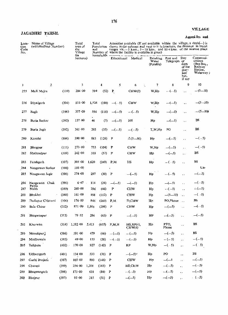
176
VILLAGE JAGADHRI TAHSIL
Ameni.i\!s and
Loca- Name of Village tion (withHadbast Number) Code No.
Total area of the Village (in hectare&)
Total Amenities available (If not available within the village, a dash(-) is Population shown in the column and next to it in brackets, the distance in broad and ranges viz.- 5 kms., 5-10 kms. and 10 + kms. of the nearest place Number of where the facility is available is given)
275 Mali Majra
276 Diyalgarh
277 SUgh
278 Buria Sarkar
279 Buria Jagir
280 Kanalsi
281 Bhogpur
282 Shahzadpur
283 Fatehgarh
2
households Educational Medical
3 4 5
(110) 204 '00 394 (52) P
6
CHW(2)
(394) 133 ·00 1,126 (190) -(-5) CHW
(396) 357'00 594 (110) -(-5)
(393) 157·00 40 (7) -(-5) HS
(392) 361 ·00 203 (33) -(~,5) -(-5)
(104) 390 '00 883 (126) P ~(5_1O)
(111) 273 '00 753 (104) P CHW
(109) 242 '00 333 (57) P' CHW
(101) 305 ·00 1,620 (249) P,M HS
284 Naugawan Sarkar (l08) 166 '00
285 Naugawan Jagir (390) 274 ·00 297 (30) P
286 Naugawan Chak Pahla
287 Nabh
288 Bhukhri
(391) 6 '47 114 (24) -(-5)
(389) 280 ·00 296 (46) P
(388) 161 '00 891 (112) P
289 Dadupur Chhawni (l06) 176 ·00 846 (160) P,M
290 Bala Chaur (312) 871 ·00 1,801 (298) P
291 Bhagwanpur (313) 79 ·32 286 (43) P
292 Kharwan (314) 1,182 ·00 5,413 (855) P,M,H
293· Manakpur]
294 Modhuwala
295 Telipura
296 Udhamgarh
297 Garhi Banjara
298 Chaneti
299 Bhagwangarh
300 Bhojpu,
(386) 191 ·00 479 (66) -(_5)
(385)
(402)
(401)
(387)
(399)
(398)
(397)
49'00
170·00
155 (20) --(-5)
927 (142) P
134'00 533 (70) P
165 ·00 893
254 ·00 1,208
173 ·00 631
93 ·00 315
(146) P
(183) P
(84) P
(51) P
-(-5)
-(_5)
tHW
CHW
D,CHW
CHW
-(-5)
HS,RP(4), CHW(4)
-(-5)
-(_5)
RP
_(_5)1
CHW
HS,CHW
-(_5)
_(_5)
Drinking Water
(potable)
7
W,Hp
W,Hp
W,Hp
Hp
Post and Day Telegraph or
days of the market/ hat, if any
8 9
-(-·5)
-(-5)
_(_5)
T,W,Hp PO
Hp -(-.5)
W,Hp -(_5)
Hp -(---,5)
Hp
Hp
Hp
Hp
Hp
Hp
Hp
HP
Hp
Hp
Hp
W,Hp
Hp
Hp
Hp
Hp
IIp
- (.~-5)
--(~5)
_(_5)
-.(- 5)
-(5-10)
PO,Phone ..
PTO, Phone
-(_.5)
- (- 5)
-(-5)
PO
-(-5 _( __ .5)
-(-5)
"""(·-5)
Communications (Bus StOlt Railway Station, Waterway)
10
-(5-10)
~(5-10)
BS
BS
-(-5)
BS
Un-
-(_5)
-(-5)
-(-5)
-(-5)
BS
_(_5)
-(-5)
BS
BS
-(-5)
-(-5)
BS
-(_5)
-(-5)
-(_5)
-(~~S)
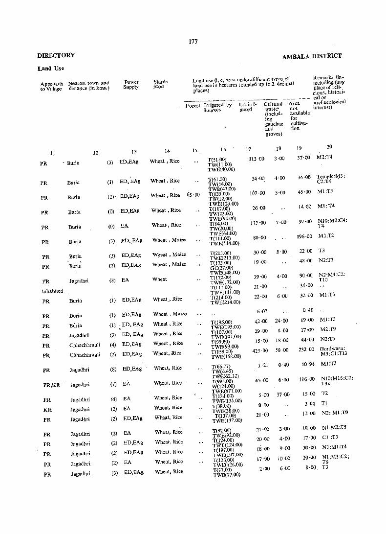
177
DIRECTORY AMBALA DISTRICT
LaRd Use
Approach Nearest town and Power Staple Land use (i, e, area under·different types of Remarks {in-
to Village distance (in kms.) Supply fOod land lIse in hectares rounded up to 2 deCimal including (au)'
places) place of reli-gious, his tori-
---_ . .........,--- -.-~ ... --.-----~---.---.- - calor
Forest Itrigated by Un-irri- Cultural Area archa.eological
Sources gated waste> not interesr) (includ- ava.ilabltl ing for gauchar cultiva-and tion groves)
11 12 13 14 15 16 17 18 19 20
PR • Buria (3) ED,EAg Wheat ,Rice T(51.oo) 113 '00 3·00 37·00 M2:T4
TW(11.00) TWE(40.oo)
PR Bllria (1) ED,EAg Wheat, Rice T(61.00) 34'00 4'00 34'00 Temple:M3;
TW(l4.00) C2:T4
PR Buria
TWE(47'(lO) 107·00
(2)- ED,EAg Wheat ,Rice ~5·0Q T(13S.QO) 5·00 45·00 Ml;TS
TW(12.00)
PR Buria ED,EAg TWE(l23.00) Ml:T4
(0) Wheat ,Rice T(117.00) 26·00 14·00 TW(23.00).
PR Buria
TWE(94.00)
(0) EA Wheat· , Rice T(84.00) 173 ·00 7'00 97·00 N10:M2:C4:
TW(20.00) T4
PR Burja ED,EAg TWE(64.00) M2:T2
(3) Wheat , Mai:ze T(114.oo) 80·00 196·00 TWE(114.00)
PR Buria (3) ED,EAg Wheat. Maize T(213.00) 30·00 8'00 22·00 T3
. TWE(213.00)
PR Buria (2) ED,EAg Wheat, Maize T(17S.00) 19·00 48 ·00 N2:T3
GC(27.00)
PR Jagadhri
TWE(148.00) N2:M4:C2: (8) EA Wheat T(l72.00) 39·00 4·00 90·00
TWE(172cOO) TID
inhabited T(111.00) 21·00 34·00
PR Buria
TWE(ll1.00)
(0 ED,EAg Wheat., Rice T(214.00) 22'00 6'00 32'00 Ml:T3
TWE(214.00)
PR Buria (I) ED,EAg Wheat, Maize 6·07 0·40
PR Buria (1) ~ED,EAg Wheat, Rice T(195.00) 42·00 24'00 19·00 Ml:T3
TWE(195.00)
PR Jagadhri (3) ED,EAg Wheat, Rice T(107.(lO) 29·00 8 00 17·00 M2:T9
PR
TWR007.00)
Chhachhrauli (4) ED,EAg Wheat, Rice T(99.00) 15·00 18 -00 44·00 N2:T5
PR ChhachhrauJi
TWE(99.00) Gurdwara: (2) ED,EAg 'Wheat, Rice T(I5S.00) 423·00 58·00 232·00
TWE(158.00) M3:Cl:T13
PR Jabadhri (8) ED,EAg Wheat, Rice T(66.77) 1 ·21 0-40 10·94 Ml:T3
TW(4.45)
PR,KR ~agadhri
TWE(62.32) NI0:M16:C2: (7) EA Wheat, Rke T(995.00) 65·00 6'00 116·00
W(124.oo) T32
PR
TWE(871.00) 1'2 Jagadhri (4) EA Wheat, Rice T(134.00) 5·00 37·00 15·00
KR Jagadhri
TWE(134.00)
(2) EA Wheat, Rice T(38.oo) 8·00 3·00 Tl
PR
TWE(38.00) N2: Ml:T9 Jagadhri (2) ED,EAg Wheat, Rice T(137.00) 21·00 12·00
TWE(137.00)
PR Jagadhri (2) EA Wheat, Rice T(92.00) 21·00 3·00 18·00 N1:M2:T5
PR Jagadhri
TWE(92.QO) Cl :T3 (2) ED,EAg Wheat, Rice T(124.00) 20·00 4'.00 17·00
PR
TWE(124.00) 9·00 Nl:Ml:T4
Jagadhri (2) ED,EAg Wheat, Rice T(197.(lO) 18·00 30·00 TWE(197.00) 20·00 Nl:M3:C2;
PR Jaga<lhri (2) EA Wheat, Rice T(126.00) 17·00 10·00 TWE(l26.00) T6
PR Jagadhri (3) ED,EAg Wheat, Rice T(77.oo) 2·00 6·00 8'00 T3
TWE(77.00)
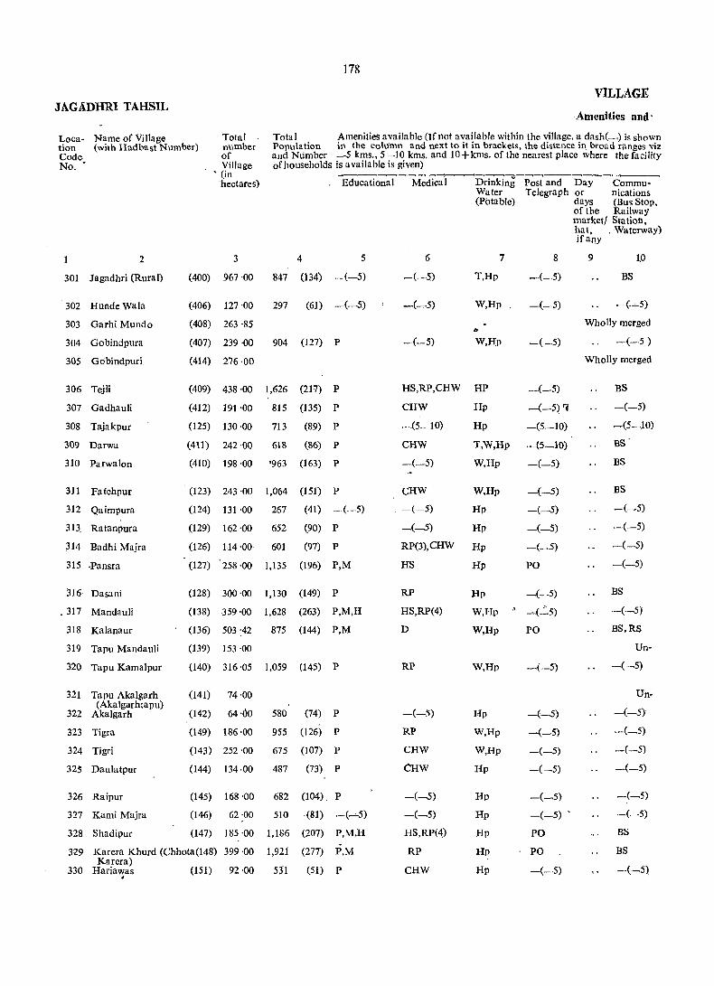
178
VILLAGE JAGADHRI TAHSIL
Amenities and'
Total Amenities available (If not available within the village, a dash(-.) is shown Loca- Name of Village tion (with Hadbast Number)
Total . number of Village
Population in the column and next to it in brackets, the distance il1 broad ranges viz and Number -5 kms., 5 -10 kms. and 10+kms. of the nearest place where the facility of households is available is given)
Code No. -
, (in ----~----_,-~-~~~--~-~-~-
_ Educational Medical Drinking Post and Day Commu-
2
301 Jagadhri (Rural)
302 Hunde Wala
303 Garhi Mundo
304 Gobindpura
305 Gobindpuri
306 Tejli
307 GadhauJi
308 Tajakpur
309 Darwa
310 Parwalon
311 Fatehpur
312 Qaimpura
313. Ratanpura
314 Badhi Majra
315 .Pansra
316 Dasani
. 317 Mandauli
318 Kalanaur
319 Tapu Mandauli
320 Tapu Kamalpur
321 Tapu Akalgarh (Akalgarhtapu)
322 Akalgarh
323 Tigra
324 Tigri
325 Daulatpur
326 Raipur
327 Kami Majra
328 Shadipur
hectares)
4 5 3
(400) 967 ·00 847 (134) .-(-5)
(406) 127 '00
(408) 263 ·85
297 (61) -(_5)
(407) 239 -00 904 (127) P
(414) 276 -00
(409) 438 -00 1,626 (217) P
(412) 191 '00 815 (135) P
(125) 130 ·00 713 (89) P
(411) 242 -00 618 (86) P
(410) 198 ·00 '963 (163) P
(123) 243 -00
(124) 131 ·00
(129) 162 ·00
(126) 114 -00
1,064 (151) P
267 (41) -(-5)
652 (90) P
601 (97) P
(127) 258 '00 1,135 (196) P,M
(128) 300-00 1,130 (149) P
(138) 359 -00 1,628 (263) P,M,H
(136) 503 '42 875 (144) P,M
(139) 153 ·00
(140) 316 ·05 1,059 (145) P
(141) 74 ·00
(142) 64 -00
(149) 186 -00
(143) 252 -00
580 (74) P
955 (126) P
675 (107) P
(144) 134·00 487 (73) P
(145) 168 -00 682 (04) P
(146) 62 -00 510 -(81) -(--,-5)
(147) 185 '00 1,186 (207) P,M,H
329 Karera Khurd (Chhota(148) 399 -00 1,92i Kurera)
330 Hariawas (151) 92 -00 53"1
(277) P,M
(51) P .
6
-·(-5)
-(-5)
Water Telegraph or nications (Potable) days (Bus Stop,
of the Railway market/ Station,
7
T,Hp
W,Hp
W,HP
8
_(-5)
-(-5)
-(-5)
hat, _ Waterway) ifany
9 10
BS
-(.~5)
Wholly merged
-(-.5 )
Wholly merged
HS,RP,CHW HP _(_5) BS
~(-5)
-(5-.10)
BS'
CHW
-(5-10)
CHW
-(-5)
CHW
-(.-5)
-(~5)
Hp -(-5) 'C
Hp -(5_10)
T,W,Hp -(5.-10)
W,Hp -(-5)
W,Hp
Hp
Hp
-(-5)
-(~5)
-(-5).
RP(3),CHW Hp -(_5)
HS
RP
HS,RP(4)
D
RP
-(-:'I)
RP
CHW
CHW
-C-5)
-(_5)
HS,RP(4)
RP
CHW
Hp PO
Hp _( __ 5)
W,Hp • ~(~5)
W,Hp PO
W,Hp
Hp
W,Hp
W,Hp
Hp
Hp
Hp
Hp
Hp
Bp
-(.-5)
-(-.5)
-(-5)
-(-5)
-(-5)
-(_5)
_(_5) ,
PO
PO
-(-5)
BS
BS
-(_5)
-(-5)
-(-5)
-(-5)
BS
-(_5)
BS,RS
Un-
-(-5)
Un-
-(_5)
-(-5)
-(-5)
-(-5)
-(-5)
-(-5)
BS
BS

179
1> lRECTORY AMBALA n:nSTRJrCT
Land Use ""
Approach Nearest town and Power Staple Land use (i.e. area under different types of Remarks to Village distance (in kms) SUI'Ply food land use in hectares rounded (including any
uP to 2 decimal placcs) place of reli-gious,
-- historical Forest Trrigated by Un- Cultural Area or archaeolo-
Sources . irrigated waste- not gical (ins;.luding 11 vaila ble intcrest) gauchar for and cultivation groves)
11 12 13 14 IS 16 17 18 19 20
PR Jagadhri (0) EA Wheat, .Rice T(672.00). is·oo 15·00 255·00 T5 TWE(670.00) Tk(2.00)
KR Jagadhri (2) ED,EAg Wheat, Rice T(103.00) j7·00 1·00 6'00 T3 TWE(103.00)
in Jagadhri (M.C.)
PR Yamunangaar (2) EA Wheat; Rice T(191.00) 17·00 10'00 21·00 M3:C1:T5 TWE(191.00)
In Yamunangar (M.C.)
PR Jagadbri (2) EA Wheat, Rice T(321.()() 4·00 6·00 107 ·00 M3:T16
PR (1) Wheat, Rice TWE(321.00)
'48 'QO Yamunanagar EDjEAg T(100.00) 4'00 39 ·00 . M1 :T2 TWE(lOO.OO)
PR Yamunanagar (3) ED,EAg Wheat, ltice T(1l3.00) 1'00 16·00 M3:T5 TWE(l13.oo)
12'00 25"00 PR Yamunanagar (4) EA Wheat, Rice T(98~00) 47·00 T2
ED,EAg'· Wheat. Rice TWE(98.00)
1'00 PR Jagadhri ,3) T(50.00) 68'00 73 ·00 .. TWE(50.QO)
~
pR Yamun~nagar (5) • ED,EAg Wheat, Rice 16·00 T(12S.00) 53 ·00 3'00 46 ·00 N2:M1:T3
(4) TWB(J25.00)
1·00 PR Yamunanagar ED.EAg Wheat, Rice T(96.00) 23'00 11·00 Ml:Tl
(4) TWE(96.00)
J.()O PR Yamunanagat ED,EAg Wheat,. Rice T(148.00) 13 ·00 Ml:T5
(2) TWE(148.00)
G'OO 12·00 N2:M3:T5 PR Yamurianagar EA Wheat, Rice T(93.00) 3·00
(1) TWE(93.00)
43·00 PR Yamunanagar EA Wheat, Rice T(213.00) 2·00 NI0:M4:T6 TWE(213.00)
PR Yamunanagar (6) EA Wheat, Rice T(2S8.00) 6·00 36·00 N2:M3:T9
(3) TWE(258.00),
PR Yamunanagar EA Wheat, Rice T(311.00), 15·00 33·00 M4:T11
Yamunanagar (5) EA 40·87 TWE(31 1.00)
65'56 41'68 145'69 PR Wheat, Rice T(209.62). N6.:M4:C2: TWE(209.62) Tl2
inhabited T(17.00), 30·00 31·00 75·00 " TWE(i7.00) ..
PR Yamunanagar (6). EA Wheat, Rice T(267.49), 13·76 0·40 34'40 M4:T8 TWE(267.49)
inhabited T(27.00), 34·00 9·00 4·00
(6) TWEQ,7.00)
10,00 PR Yamunanagar EA Wheat, Ric!'! T(53.00), 1'00 M2;T4 TWE(S3.00)
PR Yamunanagar (6) .EA Wheat, Rice T(89.oo), 80·00 3·00 14·00 T4
PIt (6) TWE(89.00)
Yamunanagar ED,EAg Wheat, Rice T(235.00), 1·00 16·00 N3;M6:C2: TW(235 :00) no
PR Yamunanagar (5) ED;EAg Wheat, Rice T(1l6.00). 10·00 1·00 7·00 T6 TW(116.00)
PR Yamunanilgar (3) EA Wheat, Rice T(144.00). 5·00 1·00 18·00 MI:Tl
PR Yamunanagar (1) . TWE(144:00)
9·00 1·00 8·00 EA Wheat, Rice T(44.00), T3
Yamunanagar (1) TWE(44.00)
PR EA Wheat, Rice T(135.00), 19'00 4'00 27·00 N4: M3: T6
Yamunanagar (3) TWE(13S.00)
27·00 PR EA Wheat, Rice T(357.00), 15·00 N8:Ma.:C1: TWE(357;00), Tll
PR Yamunanagar (5) EA Wheat, Rice T(78.00). 4'00 2'00 8·00 .N4:T3 TWE(78.00)
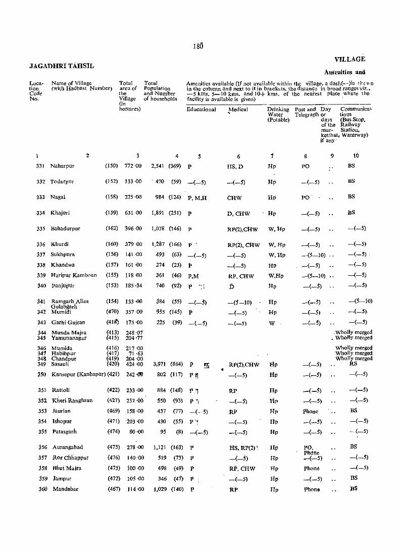
VILLAGE JAGADHRI TAHSIL
Amenities and
Name of Village Localion Code No.
(with Hadbast Number) Total area of the Villagc (in hectares)
Total Population and Number of households
Amenities available (If not available within the village, a dash('---)is d-c \I n in the column and next to it in bracktts, the distance in broad ranges viz., -5 kms. 5-10 kms. and 10+ kms. of the nearest place where the facility is available is given)
331 Naharpur
332 Todarpur
333 Nagai
-334 Khajuri
335 Bahadurpur
336 Khurdi
337 Sukhpura
338 Khandwa
2
.339 Haripur Kamboan
340 panjupur
341 Ramgarh Alias Gulabgarh
342 Mumidi
343 Garhi Gujran
344 Munda Majra 345 Yamunanagar
346 Mumida 341 Habibpur 348. Chandpur 349 Sasauli
Educational
4
(150) 772 -00 2,541 (369) P
(152) 133 -00 - 470 (59) -(-5)
(158) 225-00
(159) 631 -00
(162) J96 -00
(160) 379 -00
(156) 141 -00
(157) 161 -00
(155) 118 ·00
(153) 185 ·34
(154) 133 -00
(470) 357·00
(411r) 175 -00
(413) (415)
(416) (417) (419) (420)
248,01 204-77
217·00 '71 -63
204·00 424-00
984 (124) P, M,H
1,891 (251) P
1,078 (146) P
1,~87 (166) P
493 (63) -(-5)
274
361
740
p,M
(23) P
(46)
(92) P .,-.1
384 (55) -(-5)
955 (14;) P
225 (39) _(_;)
3,911 (864) P ~
350 Kansepur (Kanbapilr) (421) 242 -00 802 (117) P ~
351 Rattoli
352 Kheri Rangnran
353 Jaurian
354 Ishopur
355 Patasgarh
356 Aurangabad
351 Itor Chhappar
358 Bhut Majra
359 iampur
%6 Mandebar
(422) 233 ·00
(427) 237 -(}O
(469) 158 -00
(471) 203 -00
(474) 80 ·00
(475) 278 ·00
(476) i40·00
(473) ioo '00
(472) 105 '00
(467) 114 ·00
884 (148) Ii 1 55G (93) P 1
437 (77) -(-5)
430 (55) P-4 95 (8) _(_;)
1,121 (163) P
519 (73) P
498 (49) P
346. (4'1) P
1,029 (140) P
•
,!vfedical Drinking Post and Day Communi ca. Water Telegraph or tions (Potable) days (Bus StoP.
of the Railway mar- Station, ket/hat. Waterway)
6
HS,D
-(-5)
CHW
1
Hp
IIp
Hp
D,CHW Hp
RP(2),caW' w, IIp
RP(2), CHw W, Hp
__ (_;) W, Hp
-(-5) ltD
RP,CHW W,Hp
D Up
-(5-10) tIp
-(-5) Hp
-(--5) W
RP(2).CHW HP
-(-5) Hp
RP -(-5)
RP
-(-5)
-(-5)
its, RP(1) 1
-(-5)
·RP. cliW
-(-5)
RP
Hp
Hp
Hp
lip
tIp
Hp
Hp
Hp
lip
Hp
if anY' .
8
PO
-(-5)
PO
-(-5)
-(-5)
9
~(-5)
-(5-10) ..
-(-;)
-(5-10) ..
-(-S)
-(-5)
-(-5)
-(-5)
10
BS
BS
BS
BS
-(-5)
-(-5)
-(~5) -
-(-5)
-(-5)
-(-5)
-(5-10)
-(-5).
-(-5)
.wholly merged _ Wholly merged
-(-5)
-(-;)
_(_5)
-(-5)
phone
-(-5)
-(-5)
PO. Phdne -(-5)
phone
-(-5)
Phone
Wholly merged Wholly merged Wholly merged
RS
-(_5)
-(-5)
-(-S}
BS
-(-5)
-(-5)
IlS
--<-5)
-(-5)
BS
BS

Lsi
niREcTo}tY AMBALA DISTRict Laud Use
Approach. Nearest town and power Staph; Land use(i.e. area under different types of Remarks (in-to Village distance (in kms.) Supply food land use in hectares rounded . eluding any
up to 2 decimal places) place of reli-gious, histori-calor
Forest Irrigated Un-irri- Cultur- Area archaeological by-Sources gated al not interest)
waste available (includ- for ing cultiva-gauchar tion and groves)
11 12 13 14 IS 16 17 18 19 20
PR Yamunanagar (6) EA Wheat, Rice T(621.00), 110·00 1·00 40·00 N8: M6: C2: T W(9 1.00) T27
PR TWE(530.00)
Yamunanagar (7) ED,EAg Wheat, Rice T(114.00), .. 1'00 18'00 'r4 TW(12.00) TWE(102.00)
PR Yamunanagar (4) EA Wheat, Rice T(172.00) 4'00 15·00 34·00 N4: Ml: Til TW(44.00)
PR Yamunanagar TWE(128.00)
(6) EA Wheat, Rice T(533.00), 27'00 8·00 63·00 N6: M2: C3: TW(41.oo), T17 TWE(492.00)
PR Yamunanagar (8) EA Wheat, Rice T(333.00), 5·00 15·00 43·00 N5: M4: T25 TWE(333.00)
PR Yamunanagar - (8) EA Wheat, Rice . T(334.00), 1·00 7·00 37·00 N4: M6:T7
Yamunanagar TWE(334.oo)
PR (6) ED,EAg Wheat, Rice T(83.00) • 28·00 8'00 22·00 Nl;T4 TWE(83.00)
PR Yamunanagar (5) ED, EAg Wheat, Rice T(133.oo), 10·00 7'00 11·00 ' M2: Cl: Ttl TWE(133.00)
PR 'Yamunanagar (5) EA Wheat, Rice " T(72.oo), 7·00 16'00 23·00 M4:TS TWE(n.oo)
PR Yamunanagar . (5) EA Wheat, Rice T(161.47), 0·40 23·47 M4! Cl:T1 TWE(157.02),
Yamunanagar Wheat, Rice 0(4 '45)
28·00 PR (3) EA T(74.oo), 10·00 21·00 TWE(74.00)
PR Yamunanagar (5) EA Whtat, Rice T(142.00), 138 ·00 9'00 68·00 M2: TIS TWE(142.00)
PR Yamunanagar (3) EA Wheat, Rice T(28.00), 73·00 22'00 52·00 T3 TWE(28.00)
in ¥amunanagar (M.C) in yamunanagar (M.e.)
jn yamunanagar (M.C.) in Yamunanagar (M.e.) iIi Yamunanagar (M.C.)
(5) EA Wheat, Rice T(1S4.00), 19·00 251 ·00 N90: M70:CI0 PR Yamunanagar TWE(154.oo) TI5
PR Yamunanagar (3) EA Wheat, 'Rice T(150.00). 71'00 21·00 T3 TWE (150.00)
PR Jagadhri (2) EIY,EAg Wheat, Maize , .. T(133.00). 76·00 24·00 M6: Cl: '1'6
Wheat, Rice TW(133.00)
45·00 PR Yamunanagar (6) EA T(l60.oo). 32·00 M9: TI5 TWE(l60.00)
PR Yamunanagar (1) EA Wheat, Rice T(128.00). 8·00 2·00 20·00 NS: M3: C2: TWE(128.00) TS
fR Yamunanagar (4) EA Wheat, Rice T(124.oo). 40·00 16·00 23·00 N2: M3: Cl:
Wheat, )lice TWE(124.00) T6 .
I'R Yamunanagar (4) EA T(60.00), 10·00 3'00 7·00 M2:el: n TWE(60.00)
PR Yamunanagar (5) ,SA Wheat, Rice T(203.00), 26·00 18·00 31·00 N4: M3: C3: TWE(203.00) T7
PR Yamunanagar (6) EA Wheat, Rice T(131.00). 9·00 M3: Cl: TIS TWE(131.00)
KR Yamunanagllr (3) , EA Wheat, Rice T(94.00) 6·00 Nl: MI0: TlS TWE(94,00)
PR Yamunanagar (2) EA Wheat, Rice T(98.00), 7'()() Nl:M4: T6 TWE(98.00)
PR Yamunanagar (2) EA Wheat, Rice T(104.00) 10·00 N6: M7; Tll TWE(l04.00)
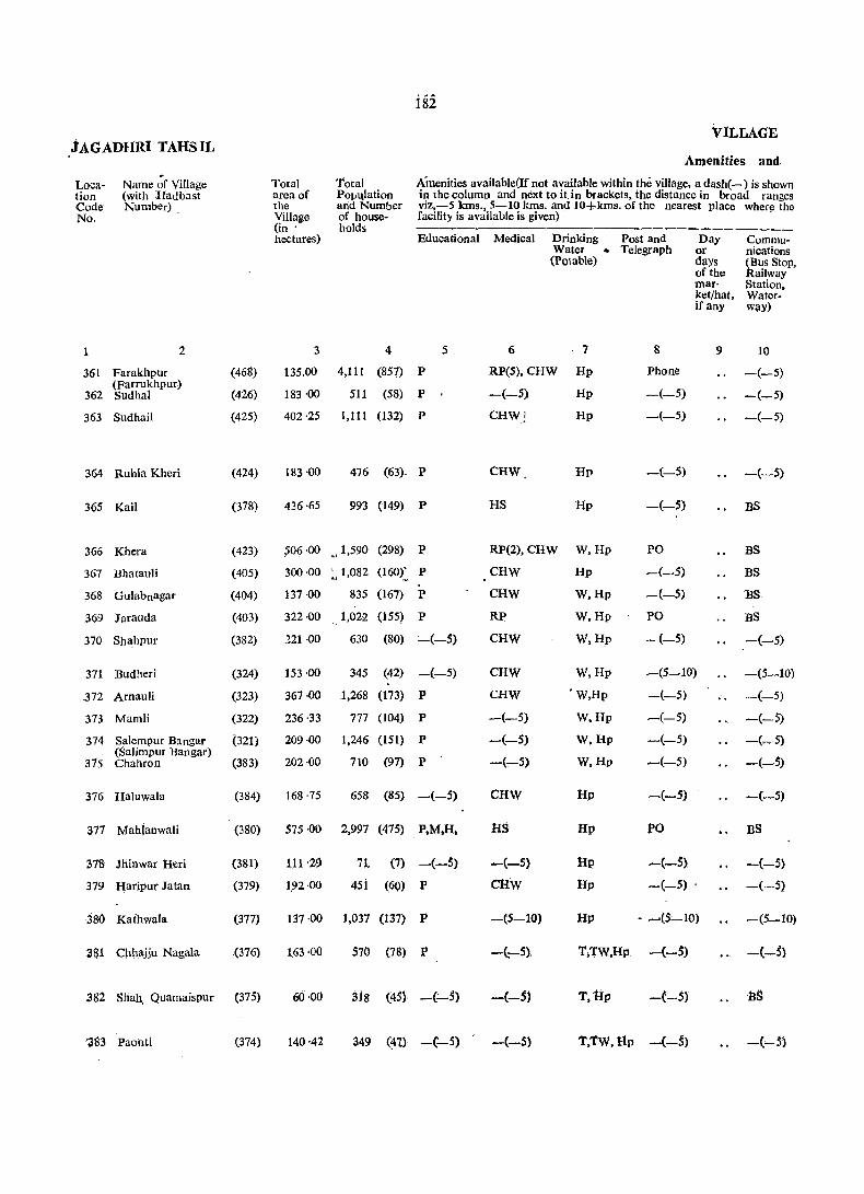
f82
VILLAGE .tAGADflRi TAHSIL
Amenities and
Loca- Name of Village Total Total Amenities available{If not available within the village, a dash(-) is shown tion (with Hadbast area of PO)1'qlation in (he column and next to iUn brackets, the distance in broad ranges Code Number) the arid Number viz,-5 kms., 5-10 kms. and lO+kms. of the nearest place where the No. Village of house- facility is available is given) .
(in' holds --------hectares) Educational Medical Drinking Post and Day Commu-
Water . Telegraph or nications (Potable) days ~us Stop, or the ailway
mar- Station, ket/hat, Water-if any way)
2 3 4 5 6 . 7 8 9 10
361 Farakhpur (468) 135.00 4,111 (857) P RP(5), CHW Hp Phone -(-5)
362 (Farrukhpur) Sudhal (426) 183'00 511 (58) P -(-5) Hp -(-5) -(-5)
363 Sud hail (425) 402·25 1,111 (132) P CHWj Hp -(-5) -(-5)
364 RuhIa Kheri (424) 183 ·00 476 (63)- P CHW Hp -(-5) -(-5)
365 Kail (378) 436·65 993 (149) P HS Hp -(-5) BS
366 Khera (423) ,s06'00 u 1,590 (298) P RP(2), CHW W,Hp PO BS
367 BhatauJi (405) 300·00 ~ 1,082 (160): P CHW Hil -(-5) BS
368 Gulabnagar (404) 137 ·00 835 (167) P CHW W,Hp -(-5) BS
369 Jarauda (403) 322·00 1,022 (155) P RP W,Hp PO BS
370 Shahpur (382) 121 ·00 630 (80) :_(-S) CHW W,Hp -(-5) -(-5)
371 Budheri (324) 153·00 345 (42) -(-5) CHW W,Hp _(5_10) -(5-10)
372 Arnauli (323) 367·00 1,268 (173) P CHW 'W,Hp -(-5) -(-5)
373 Mamli (322) 236 ·33 777 (104) P -(-5) W,Hp -(-5) -(-oS)
374 Salempur Bangar (321) 209·00 1,246 (151) P -(-5) W,lIp -(-5) -(_S) (Salimpur Bangar)
202·00 710 (97) -(~5) W,Hp -(-5) -(-5) 375 Chahron (383) p
376 Haluwala (384) 168·75 658 (85) -(-5) CHW IIp -(-5) ~(-5)
377 Mahianwali (380) 575·00 2,997 (475) P,M,H. HS Hp PO BS
378 Jhinwar Heri (381) 111 '29 n. (7) -(-5) -(-5) Hp -(-S} -(-5)
379 Haripur Jatan (379) 1.92 ·00 4si (60) P ClIW IIp _(_5) . -(-5)
380 Kathwala (377) 137 ·00 1,037 (137) P -(5-10) Hp • --,(5,-10) -(5-10)
361 Chhajju Nagala .(376) 1.63 ·00 570 (78) P -(,-5), 'I';l'W,Hp -(-$) -(-5)
382 Sliah. Quamaispur (375) 60·00 318 (:15) -(:-5) -(-5) T,Hp -(-5) ·tIS
'383 Paohti (374) 140'42 349 (~t) -(:_S) -(-5) T.TW,Hp -(-5) -(~S)
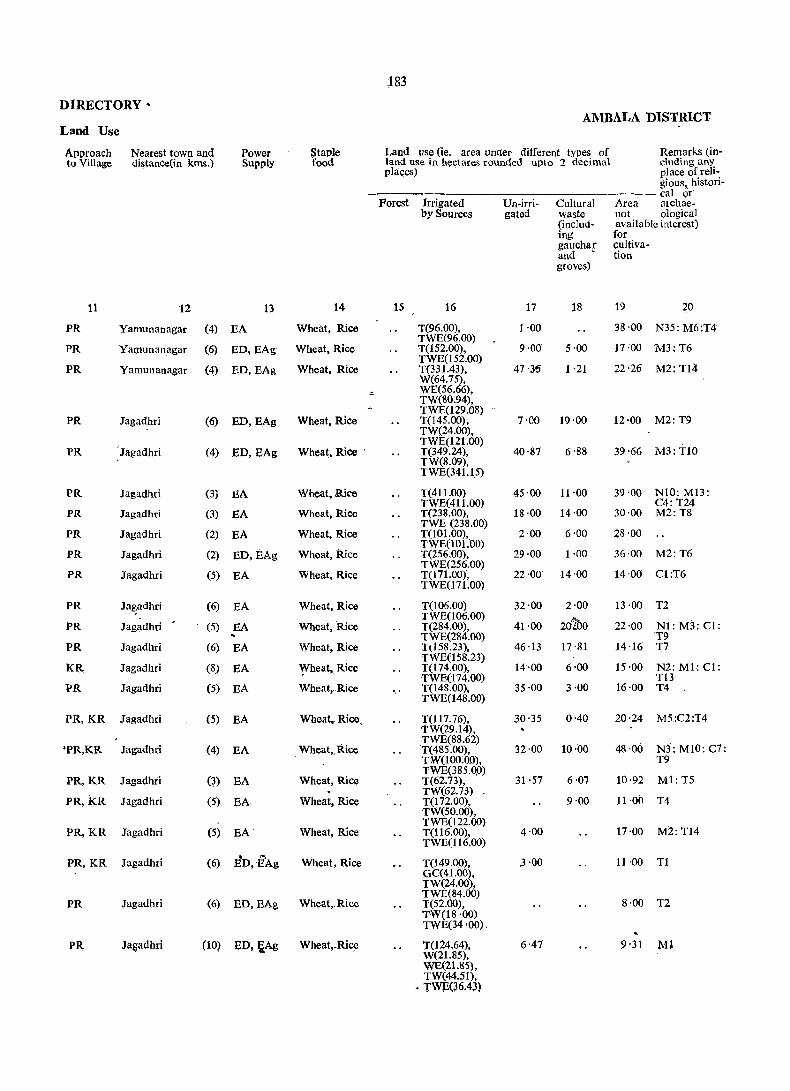
183
DIRECTORY' AMBALA DISTRICT
Land Use
Approach Nearest town and Power Staple Land use (ie. area under different types of Remarks (in-to Village distance(in kms.) Supply food land use in hectares rounded upto 2 decimal eluding any
places) place of reli-gious, histori-
--- calor' Forest Irrigated Un-irri- Cultural Area archae-
by Sources gated waste 110t ological (inc1ud- available interest) ing for gauchar cuItiva-and ' tion groves)
11 12 13 14 15 16 17 18 19 20
PR Yamunanagar (4) EA Wheat, Rice T(96.00), 1·00 38'00 N35: M6:T4 TWE(96.00)
PR Yamunanagar (6) ED,EAg Wheat, Rice T(152.00), 9·00 5·00 17·00 M3:T6 TWE(152.00)
PR Yamunanagar (4) ED,EAg Wheat, Rice T(331.43), 47'35 1 '21 22'26 M2: TI4 W(64.75), WE(56.66), TW(80.94), TWE(129.08)
PR Jagadhri (6) ED,EAg Wheat, Rice T(145.00), 7·00 19·00 12·00 M2:T9 TW(24.oo),
, TWE(121.oo) PR Jagadhri (4) ED,EAg Wheat, Rice . T(349.24), 40'87 6·88 39'66 M3: TIO
TW(8.09), TWE(34q5)
FR Jagadhri (3j BA Wheat, Rice T(411.00) 45'00 11'00 39·00 NIO: M13: TWE(411.00) C4: T24
PR Jagadhri (3) EA Wheat, Rice T(23S.00), 18·00 14·00 30·00 M2:TS TWE (23S.00)
PR Jagadhri (2) EA Wheat, Rice T(101.00), 2·00 6'00 28 ·00 TWE(IOl.OO)
PR Jagadhri (2) ED, EAg Wheat, Rice T(256.00), 29·00 1·00 36·00 M2:T6 TWE(256.00)
PR Jagadhri (5) EA Wheat, Rice T(l 7 1.00)', 22·00 14·00 14·00 CI:T6 TWE(l71.00)
PR Ja~adhri (G) EA Wheat, Rice T(10G.00) 32·00 2·00 13 ·00 T2
Wheat, Rice TWE(106.00)
202>0 N1: M3: Cl: PR Jagadhri (5) EA T(284.00), 41·00 22'00 .. TWE(284.00) T9 PR Jagadhri (G) EA Wheat, Rice Tt158.23), 46·13 17·81 14 ·16 T7
TWE(158.23) KR Jagadhri (8) EA ~heat, Rice T(tROO), 14·00 6'00 15·00 N2: MI: Cl:
TWE(174.00) T13 PR Jagadhri (5) EA Wheat,.Rice ',' T(148.00), 35·00 3·00 16·00 T4
TWE(148.00)
PR,KR Jagadhri (5) EA Wheat, Rice. T(117.76), 30'35 0'40 20'24 M5:C2:T4 TW(29.14),
Jagadhri , Wheat,.ltice TWE(S8.62)
'PR,KR (4) EA T(485.00), TW(lOO.OO),
32·00 10·00 48·00 N3: MIO: C7: T9
TWE(385.QO) PR,KR Jagadhri (3) EA Wheat, Rice T(62.73), 31 ·57 6·07 10·92 Ml: T5
TW(62.73) PR,KR Jagadhri (5) EA Wheat, Rice T(172.00), 9'00 11'00 T4
TW(50.00),
PR,KR Jagadhri (5) EA' Wheat, Rice TWE(122.00) T(116.00), TWE(116.00)
4·00 17·00 M2: T14
PR,KR Jagadhri (G) . ....
ED,EAg Wheat, Rice T(149.00), .3·00 11 ·00 Tl GC(41.00), TW(24.00),
Jagadhri TWE(84.00)
PR (6) ED,EAg Wheat,. Rice T(52.00), 8·00 T2 TW(lS ·00) TWE(34 '00).
PR Ja~adhri (10) ED,~Ag Wheat,.Rice T(124.64), 6·47 9'31 Ml W(2t.85), WE(21.8S), TW(44.51),
• TWE(36.43)

184
VILLAGE JAGADHRI TAHSIL
Amenities and
Loca- Name of Villl\ge Total Total Amenities available (If not available within the vlllage, a dash(-) is shown tion (with Hadbast area of 'Population in the column and next to it in brackets, the distance in broad ranges Code Num.ber) the and Number viz,-5 kms" 5-10 kms. and 10+ kms. of the nearest place where the No, VillagQ of house- facility il1 available is. given)
(in holds hcctar<;s) E<lucational Medical Drinking Post and Day Communi-
Water Telegraph or cations (Potable) daY3 (Bus Stop,
of the Railway mar- Station, ket/hat, Water. if any way)
1 2 3 4 5 6 7 8 9 10
384 Milak Sukhi (Milak (373) 98·74 544 (9~) P -(-5) T,TW,Hp -(-5) -(-5) Sikhi)
385 Musimbal Musla. (372) 354,09 1,089 (180) -(-5) RP(2) 4
T,TW,Hp PO BS mWan
386 Musimbal Hindwan (371) 335'88 1,380 (185) P,M,H HS T;Hp PO BS
387 Khundewala (370) 262·00 597 (95) P -(-5) Hp -(-5) -(-5)
388 ~a:jl1Ura (369) 195·00 555 (97) P 'CHW Hp -(-5) -(-5)
389 Landaura (367) 117'00 403 (60) -(-5) CHW Hp -(-5) -(-5)
390 Kotar Khana (366) 497 ·76 1,474 (216) P!M HS. RP,(2), CHW
Hp -(-5) -(-5)
391 Bal Chhappar (365) 627·00 2,187 (327) P RP(3),CHW W,Hp -(-5) BS
392 Mandhar «333) . 419·00 1,453 (241) P RP,CHW W,Hp PO BS-(Mandhaur)
393 Juda Jatan (335) 201-00 695 (102) P RP,CHW T,W,TW, -(5-10) -(-5)
394 Juda Sheikhan (332) 170-00 515 (79) Hp
-(-5) RP W,TW, Hp -(-5) -(-5)
395 Teha Brahmanan (331) 82-00 .254 -(32) P RP T,W,Hp -(-5) -(-5)
396 Tehl Jatan (330) .73 ·00 366 (53) -(-5) RP,CHW T,W,TW, -(-5) -(-5) Hp
397 Makhaur (297) 198-00 607 (77) P CHW W, TW, Hp -(-5) -(-5)
398 MarwaKhurd (295) 453-00 1.,721 (256) P RP(4), CHW W.TW, Hp PO BS
399 Patehgarh Tumbi (59) 273'00 1.134 (153) P,M HS, RP(2) W,Hp PO BS
400 Ramgarh Majra (60) 294-00 625 (85) -(-5) ..... (-5) W,Hp -(-5) -(-5)
401 Painsal (61) 280-44 490 (73) -(-5) -(-5) W,Hp -(-5) -(-5)
402 Azizpur (292) 433,00 1,691 (233) P RP(3), CHW W,Hp PO -(-5)
403 Kapoori Khurd (293) 132 -73 252 (40) -(-5) -(5-10) W,Hp -(-5) -(-5)
404 KapooIi Kalan (294) 222·17 496 (S2) P,M HS W,Hp -(-5) -(-5);
4Q~ l\asulpuf (~6) W7-9~ 94$ \?1~ f fl~, ClI~ W,lIp -~-?) -~-~}

185
DIRECTORY AMBALA DISTRICT
Land Use
Approach Nearest town and Power Staple 1!and use (ie: area under different types of Remarks (io· to Village distance (in kms.) SUl-'ply food land use in hectares founded upto 2 decimal eluding any
places) place of reIi-i-gious. histor-cal or
Porest Irrigated Un·im- Cultur- Area archae-by Sources gated al not ological
waste available interest) (includ- for ing cultiva-gauchar tJon and groves)
11 0" 12 13 14 15 16 17 18 19 20
PR Jagadhri (8) ED,EAg Wheat, Rice T(83.36), 6'07 9·31 M2:T2 TW(8.09),
PR Jagadhri (8) . ED, EAg Wheat, Rice TWE(75.27) T(313.22), 14 '16 26'71 N2: M5: T1 TW(42.90),
PR Ja!:adhri (8) ED,EAg Wheat. Rice TWE(270 '32) T(278.82), 15'38 41'68 - Nl: Ml: T5 TW(101.17),
PR Jagadhri (11) ED,EAg Wheat, Rice TWE(I71.65) T(248.00), TW(86.00),
2'00 12·00 N2:T5
PR Jagadhri (10) ED,EAg Wheat, Rice TWE(l62.00) T(l69.oo), 0 7·00 19·00 N2: Ml: T2 TW(48.00),
PR Jagadhri TWE(l21.00)
(Il) ED. EAg Wheat. Rice TO 01.00), 3 '00 1 ·00 12'00 TZ W(2LOQ), TW«23.00),
PR Jagadhri TWE(57.00)
NI0: M6: T20 (14) ED.EAg. Wheat, Rice T(43S.44), 26'71 3·64 31'97 W(96.31), TW(96.3l), TWE(242.82)
PR.KR Jagadhri (10) EA Wheat, Rice T(443.00), 122'00 8·00 54:00 M5:T4 TW(79.00),
PR,KR Jagadhri (10) EA Wheat, Rice TWE(364.00) T(320.00), 46'00 12'00 • 41'00 M5: C3: T7 TW(45.00),
PR,KR Jagadhri TWE(275.00)
M3: Cl: T3 (11) EA Wheat, Rice T(B2.00). 108·00 11 ·00
PR,KR Jagadhri (l5)~EA TWE(82.00)
Wheat, Rice T(17.00), 83'00 2·00 8'00 Tl TWE(77.00)
PR,KR Jagadhri (11) EA Wheat; Rice T(20.00), 58'00 1 ·00 3 ·00 Tl TWE(20.00)
PR,KR Jagadhri (11) EA Wheat, Rice T(10.00). 56·00 2·00 5·00 Ml
PR,KR Jagadhri (15) EA Wheat, Rice TWE(10.oo)
M2:T3 T(S8.00), 126·00 4'00 10·00
PR Jagadhri (15) TWE(58.oo)
Gurdwara EA Wheat. Rice T(304.00), 115 '00 3·00 31 ·00 TWE(304.oo) M6:T4
PR Sadaura (6) EA Wheat, Maize T(7.oo), 234'00 32'00 Ml: C2: T2
PR Sadaura (6) :EA Wheat, Maize TWE(7.00) T(7.00), 263 -00 1'00 23·00 TWE(7.00)
I KR Sad aura I (6) EA' Wheat, Maize T(21.04), 222 '17 37·23 Tl .. TWE(21.04) PR Sadaura (6) E1\ Wheat, Maize T(2.00), 377'00 1 ·00 53 ·00 Temple Shiv:
TWE(2.00) M2:T5 PH, Jagadhri (24) ED, EAg Wheat, Rice T(18.62), 105·22 8·89 T3
TW(8.90),
PR Jagadhri (ZS) Wheat. Rice TWE(9.72)
15 ·78 Ml: T2 ED, BAg T(60.30) 146'09 TW(20.64). TWE(25.49),
PR, la~adh!,i (18) 13D, EAg Wheat. Rice 0(14.17)
18'62 T(109.26), 69·20 T1 TW(44.51). TWE(40.47), 0(24.28)
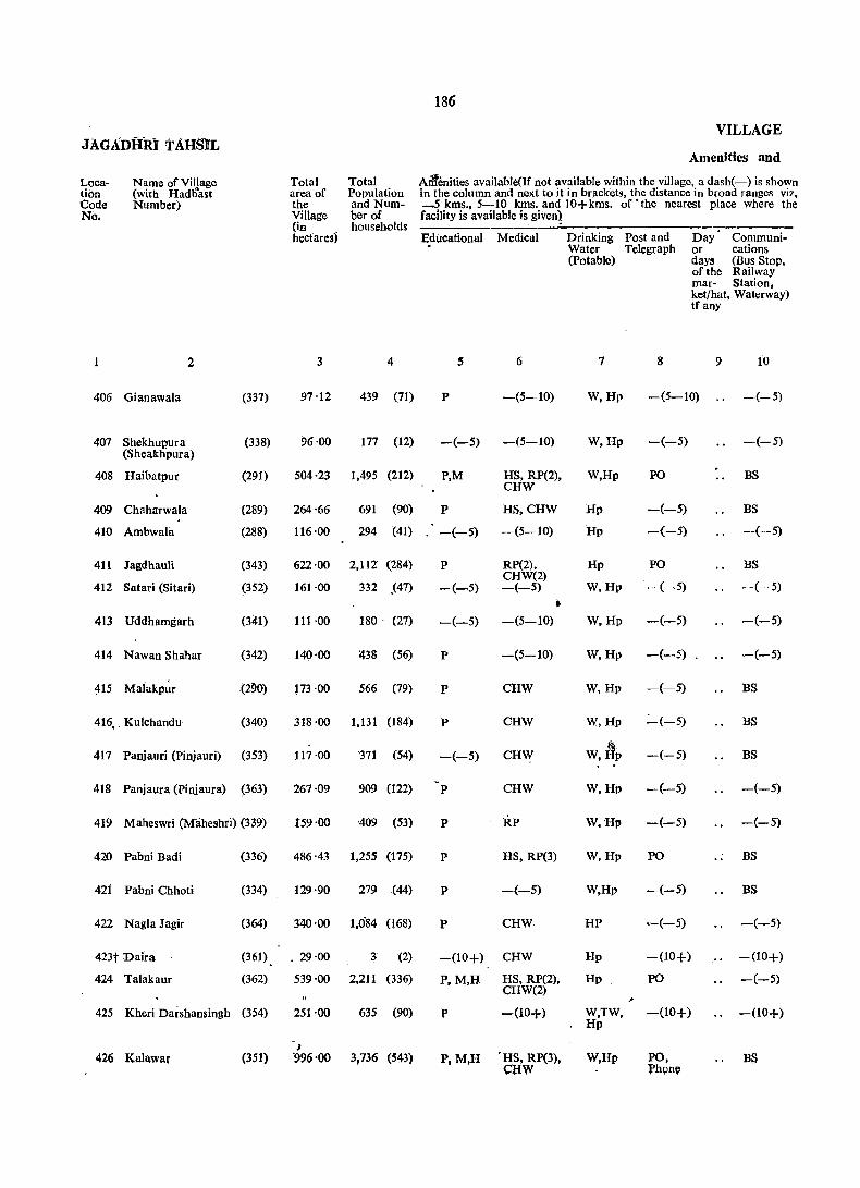
186
VILLAGE JAGAbilRI TAHSIL
Amenities and
Loca- Name of Village Total Total AMenities available(If not available within the village, a dash(-) is shown lion (with Hadt)'ast area of Population in the column and next to it in brackets, the distance in broad ranges viz, Code Number) the and Num- ~~ kms., 5-10 kms. and 10+kms. of • the nearest place where the No. Village ber of facility is available is given1
(in households hectares) Educational Medical Drinking Post and Day Communi-
Water Telegraph or cations (Potable) days (Bus StoP.
of the Railway mar- Station, ket/hat, Waterway) tf any
2 3 4 5 6 7 8 9 10
406 Gianawala (337) 97'12 439 (71) P -(5-10) W,Hp -(5-10) -(-5)
407 Shekhupura (338) 96·00 177 (12) -(-5) -(5-10) W,Hp -(-5) -(-5) (Sheakhpura)
408 Haibatpur (291) 504·23 1,495 (212) P,M HS, RP(2), CHW
W,Hp PO BS
409 Chaharwala (289) 264 '66 691 (90) P HS,CHW Hp -(-5) BS
410 Ambwala (288) 116·00 294 (41) -(-5) -(5-10) 'Hp -(-5) -(-5)
411 Jagdhauli (343) 622·00 2,112 (284) P RP(2). Hp PO BS
412 CHW(2)
-(-5) Satari (Sitari) (352) 161·00 332 .(47) -(-5) -(-5) W,Hp -(-5)
• 413 Uddhamgarh (341) 111·00 180 ' (21) -(-5) -(5-10) W,Hp -(-5) -(-5)
414 Nawan Shahar (342) 140·00 438 (56) P -(5-10) W,Hp -(-5) -(-5)
~15 Malakpl;r (290) ~73·00 566 (79) P CHW W,Hp -(-5) BS
416, . Kulchandu (340) 318·00 1.131 (184) p CHW W,Hp :""'(-5) BS
417 Panjauri (Pinjauri) (353) 117 ·00 '311 (54) -(-5) CHW w,I1p -(-5) BS
418 Panjaura (Pinjaura) (363) 267·09 909 (122) P CHW W,Hp -(-5) -(-5)
419 Maheswri (Maheshri) (339) 159·00 409 (53) P RP W,Hp -(-5) -(-5)
420 Pabni Badi (336) 486·43 1,255 (175) P HS, RP(3) W,Hp PO .. BS
42i Pabni Chhoti (334) 129·90 279 (44) P -(-5) W,Hp -(-5) BS
422 Nagia Jagir (364) 340'00 1,084 (168) P CHW HP --(-5) -(-5)
423t Daira (361) .. 29·00 3 (2) -(10+) CHW Hp -(10+) -(10+)
424 Talakaur (362) 539'00 2,211 (336) P,M,H HS, RP(2), Hp PO -(-5) CHW(2) ,
425 Khed Darshansingh (354) 251·00 635 (90) P -(10+) W,TW, -(10+) -(10+) Hp
J 426 Kalawar (351) ·996'00 3,736 (543) P,M,H 'HS, RP(3),
caw W,Hp PO, BS
l'hone

is' DIRECTORY
AMBADA'nlSTRict Land Use
Appro~ch Nearest town anc! Power Staple iand use (Le. area under different types of Remarks (in~ to Village distance (in krns.) Supply food land use In hectares rounded upto 2 decimal eluding any
places) place of rell., gious; histori-calor
Forest- Irrigated Un-irri- Cultur- Area archae" by Sources gated al not ological
waste available interest) (includ- for ing cultiva-gauchar tion and groves)
11 12 13 14' 15 }6 'l7 IS- 19 20
PR Jagadhri (16) -ED,BAg Wheat, Rice T(72.03}, 13·76 4'05 7·28 Tl TW(29.9.5), TWE(29:9.5),
(16) ED,EAg Wheat, Rice 0(12.13)
PR Jagadhri T(24.00), 59'00 13'00 Ml:T~ TW(5.00), TWE(19.00) I>,; ,
PR Jagadhri (16) ED,EAg Wheat, Rice T(193.44), 227 '43 38'85 44·51 Nl;Tt TW(11250),
(8) TWE(80.94)
26'71 PR Sadaura EA Wheat, Rice T(44.1l), 193'44 0'40 Ml:TZ
(10) EA Wheat, Rice TWE(44.11)
PR Sadaura T(2.oo), 104·00 }O·OO .. TWE(2.00)
PR Sada.ura (11) EA . Wheat, Rice T(413.oo), 154'00 55'0(} T14 TWE(413.00) 1
KR Jagadhri (1) ED, E~g Wheat, Rice T(99.00), - 51 ·00 11·00 Ml:T4 TW(1S.00),
(10) ED,EAg Wheat, Rice TWE(81.00)
PR Slldaura T(96.00), 3·00 12·00 Nl:M2 TW(15.00j,
(10) ED,BAg Wheat, Rice TWE(81.00)
PR S~jaura T(94.oo), 37·00 9·00 Ml:T2 TW(13.00),
(12) ED,EAg Whea(Rice 'TWE(81.00)
70'00 PR Sadllura T(84.oo), . 19 ·00 M3:T8 TW(24.00),
(8) ED, EAg Wheat, R.ice TWE(60.00)
PR ]agadhri T(206.00), 68·00 44·00 N2: MI: T1 TW(44.00),
(7) ED,BAg Wheat, Rice TWE(162.00)
69·00 PR ]agadhri T(42.oo), 6'00 ." TW(5.00),
(15) ED,BAg Wheat, 'Rice 1:WE(37 .0() ~
39·25 K.R Jagadhri T(207.20), . 4,45 16 '19 Ml;T4 . TW(69.20),
]agadhri (14) ED,EAg Wheat, Rice TWE(138.00)~
71·00 KR T(64.00), 4·00 20·00 T2 TW(12.00),
(13) ED,BAg Wheat, Rice TW)3(52.00)
240·78 PR. lagadhri T(42.49), 167~94 35·22 M3-: Tl3 TWE(42.49)
PR,KR Jagadhri (10) ED,EA~ Wheat, Rice. T(6S.15), 50·58 3·24· 10·93 Ml:'r::! TW(20.23),
KR Wheat,. Ric,! TWE(44.92)
147'QO Jagadhri (11) EA T(I(J4.00), 4·00 25 ·00 M4: '1'6 TW(39.00),
Wheat, Rice TWE(125.00)
20·00 KR ]agadhri (13) ED T(7.oo), 2·00 .. Wheat, Rice
TWE(7.00) 71'00 M5: C1: TS PR Jagadhri (14) EA T(423.oo); 45·00
TW(57.00), TWE(366.oo)
PR Jagadhri (24) ED, BAg Wheat, Rice T(190.00). 48,,00 8-·00 5·00 T4 TW(32.oo), TWE(158.00)
PR Sadaura (16) EA Wheat. Rice T(48S.oo)j . 4S!MO 46·00 13 ·00 Temp)e: N1:: TW(166.00) M21ClaT14 TWE(319.ooL

iss JAGADitRi TAHSIL
VILL,At:£
Amenities and , ..
Loca- Naqle of Village Total Total Amenities available(If not available within the village a dash (-) is tion (with Hadbast Number) area of Population shown in the column end next to it in brackets, the distance in broad Code the and Num- ranges viz.-5km., 5-10 kms. and 10+kms. of the nearest place No. Village ber of where the facility is available is given)
(in households hectares) Educational Medical Drinking Post and Day Communi-
Water Telegraph or cations (potable) days (Bus Stop,
of the Railway mar- Station, ket/hat, Waterway) if any
2 3 4 5; .. 6 '7 g 9 10
427 Khanpur Rajputan (345) 95·00 234 (31) P -(10+) W,Hp -(10+) -(10+)
428 Nagla Khalsa (344) 226'00 495 (76) P(2) -(10+) W,Hp,N -(-5) .-(-5)
429 Muradpur (346) f25 ·00 164 (24) -(:"':"'5) CHW W,Hp -(-5) -(~5)
430 Lawani (347) 132·00 534 (79) P CHW W,Tk,Hp -(-5) -(-5)
431 Ajijpur (Azizpur (348) 109'00 147 (18) P(2) CHW W,Hp -(10+) -(-5) Khurd)
432 Lawana (Liawana) (349) 264·00 1,180 (150) P HS,CHW W,Tk,Hp -(10+) -(10+)
433 Shahpur (350) • 40'00 15 (2) -(10+) -(10+) W,TW,Hp -(-:-5) -(10+)
434 BaraKhera (Khera Bara)
(355) 210·00 '620 (100) P -(10+) W,TW,Hp -(10+) -(10+)
435 Chhota Khera (356) 98'00 248 (44) P -(10+) W,TW,Hp -(10+) -(10+) (Khera Chhota) ~
436 Ambli (357) 253·00 727 (99) P -(10+) W,TW,Hp -(10+) -(10+)
437 Sabilpur Jatan (360) 193'00 '630 (78) p -(10+) W.TW.Hp. N
-(10+) -(10;1-)
438 Gadhaula (359) 331·00 817 (151) P HS, CHW(2) W,Hp PO BS
439 Sabalpur (Mutsil (358) 292·00 674 (104) -(-;5) C;HW W,Hp -(-5) BS Gadhauli)
440 Garhi Gosain (438) 134'00 458 (64) P -(,..-5) W,Hp -(-5) -(-5)
441 Gadhauli (437) 166'00 115 ' (91) p -(10+) W, Hp -(-5) BS
442 Chhapper Mansurpur (443) 499'00 1,815 (263) P -(10+) W,Hp PO BS . 443 Mustafabad (444) 716'00 6,281 (1040) P(4); M(4), M:H,J.>HC, T,W,TW, PTO, BS.RS . H(4) FPC, RF(15). Hp Phone
caw 444 Mali Majra. (4S4) 90'00 311 (55) P -(-5) W,Hp -(-$) -(-5)
445 Magi)arpurtl (446) 143'00 ,253 (39) P -(-5) W,Hp -(-5) -(-5)
446; • Su!tanpur (445) 211'00 767 (111) P CHW W,Hp -.(-5) .. ,-{-~

lR~ DiRECTORY
AMBALA DiSTRIct Land Use
Approach Neatest town and Power Staple Land use (Le. area under different types of Remarks (in-to Village distance (in kms.) Supply food "land use in hectares rounded up to 2. decimal eluding any
places) place of reli-gious, histori-
Forest calor
Irrigated Un-irri- Cultur- Area archaeological by Sources gated al not interest)
waste available (lnclua- for jug cultiva-gauchar tion and groves)
11 12 13 14 IS 16 17 18 19 20
PR Sadaura (IS) EA Wheat, Rice T(49.oo), 39'00 2·00 S'OO TW(16.oo), TWE(3J.00)
PR Jagadhri (22) ED,EAg j Wheat, Rice' T(198.00), 6'00 5 ·00 17'00 T1 W(81.oo)
Wheat, Rice TWE(117.oo)
PR Jagadhri (23) ED T(I03.00), 12'00 2·00 8'00 T2 TW(41.00), -.
Wheat, Rice TWE(62.00)
KR Jagadhri (21) EA T(91.00), 30·00 1·00 10·00 Ml:Tl W(40.00), TWE(51.00) .
PR,KR Jagadhri (21) ED,EAg Wheat, ~aize .T(91.oo), 6,oq S'OO 7'00 T3 TW(40.00),
ED, EAg, Wheat, Rice TWE(51.00)
PJt Jagadhri (19) T(23S.oo), 6·00 ... 23·00 Ml:T2 TW(l2I.QO),
(21) . Wheat, Maize 1:WE(114.0(ij
KR Jagadht'i ED,EAg T(32.oo), 7·00 1·00
Wheat, Maize TW(32.00)
PR Jagadhri OS) ED, E{\,g. T(162.00), 34·00 14·00. N2:T2 TW(76.00), .
Wheat, Maize TWE(S6.oo)
" PR Jagadhri (18) ED,EAg T(86;00), 1·00 11'00 Nl: Ml: Tl TWE(S6.00}
PR.KR Jagadhri (18) ED,EAS Wheat, Ma(ze T(239.oo). 2·00 1·00 11'00 N2:T8 TW(llS.oo)
Wheat, Maize S TWE(124.00)
PR,KR Jagadhri (14) ED,EAg 1:(156.00) 21·00 16'00 N3;M:l T6 TW(75.00).
Wheat, Rice TWE(81.00)
PR Jagadhri (16) EA T(272.00), 33·00 26·00 N4: MI1T6 W(221.oo)
Jagadhri (15) Wheat, Rice WE(51.oo),
PR EA T(23I.00), 18'00 9'00 34'00 NS; M2: T4
PIt Wheit, Rice TWE(231.00)
Jagadhri (17) EA T(90.00), 29·00 15·00 Nl TW(l5.oo), TWE(75.oo)
FR Jagadhri Wheat, RiceJ ...
M21 Cll.T4 (12) EA T(l28.oo), 18·00 20'00 'tW(19.00),
PR. Jagadhri t Wheat, Rice TWE(109.00)
41·00 N8: M2i T14 (14) EA T(432.oo). 26'00 .d.! ._I TW(S4.00),
TWE(37a.D0)
PR Jagadhri (i6Y EA . Wheat, Rice T(S88.00), 44·00 ' .. 84·00 Mosque and TW(60.OQ). Teml1le Sarso TWE(S28.0_0) .. watit N20S:
M4S';C6:T18 PR,KR Yamunanagar (12) EAg Whellt, Rice ., T(73.00), 7'00 3 ·00. 7'00 Tl
TW(l1.oo); ,
?R,KR ~l) TWE(62.00)
Jagadhri EA Wheat, Rice , T(llS.oo),. 7·00 7·00 11'00 N4:M3: TW(13.oo), Cl ;T3 TWE~105.oo)
pa, KR Jagadhri (22) EA Wheat, Rice T(181.00), 7·00 4·00 19·00 Ml TW(lO.OO), TWE(171.oo)

i90 VlttAC~
JAGAJ)HRIjjTAHSIL Amenities and
Loca- Name ot: Village . Total Total Ainenities available(If not available wi.thill the village, a dash(-) is shown. tion (with Hadbast No.) area of Population in the column and next to it in brackets.~the distance in broad ranges viz, Code the and Number -5 kills., 5-10 kms. and 10+kms. of the nearest place where the No." Village of facility is availabJe is given}
(in -households hectares) Educational Medical Drinking Post and Day Communica-
Water Telegraph or tions (Potable) days (Bus Stop,
of the Railway mar- Station, ket/hat, if any
Waterway)
2 :3 4 5 ·6 7 8 9 10
447 Fatehpur (448) 285·00 1,001 (168) P CHW W,Hp -(-5) ~(-5)
448 Bhagwanpur (447) 100·00 604 (95) P RP tW, TW, Hp -(10+) BS
449 Saran ~44~) 764'00 2,861 (416) P,M,H HS, RP(5), CHW(2)
W,TW,Hp PO BS
450 Ahmadpur (451) 115·00 pn-
451 Kulpur (450) 334'00 765 (92) P CHW W,Hp -(-5) ns "
452 Faridpilr (4P) 225'00 348 (52) p -(10+) Hp -(10+) -(10+) ,
453 DaulatpOr Malian (453) 197'00 ~ 951 (110) P --(10+) W,Hp' -(10+) -(10+)
454 ,Oneha Chandan a (456) . 464'00 1,904 (298) P crIW W,Hp PO BS,RS
455 Namdarpur (455) 116·00 383 (63) '-(~S) --'(-5) W,Hp -(10+) .,....(10+ )
456 Ka'jiwas (457) 149·00 469 (55) P -(5-10) W,Hp -(10+) . -(10+)
, . 457 Jhar Chandna (458) 261'00 459 (61) P CHW W,Hp -(10+) -(10+)
458 Hangol\ (Hin~oli) (459) 227 ·00 468 '. (57) P M,H,n W,Hl1 PO, Phone -(10+>
. 459 Gundapura (441) 219'00 '696 (87) ."
P CHW W,Hp Phone -(10+)
460 Sukhdaspur (442) 120'00 373 (44) . -(-5) CHW W,Hp -(10+) -(lOof-)
461 Khanpur (439) 447-58 . '1,529 (223) P RP.CHW W,TW. Hp,N
-(~5) -(-5)
462 Kaharhi Khurd (436) 226·00 973 (02) • (Kanheri Chhoti)
-(-5) RP(2) W,TW,Hp -(-5) -(~.S) •
463 Milak Majra (368) 13l'7S 197 (32) -(-'-S) -lS-1'{}} W,TW. -(5-10) -(-'S)
j~ Hp,N
'" 464 Bhambholi (435) 'S00 ·18 1.991. (308) -(-5) RP(3)~ CRW W.TW,Hp -.!(-S) .. :as
465 Bhambol (Bhanbaul) (434) 403'(}() 1,475 (237). P,M' MitiHS. 'I',W.TW. PO .. -(-S) " RP(3) Hp.N
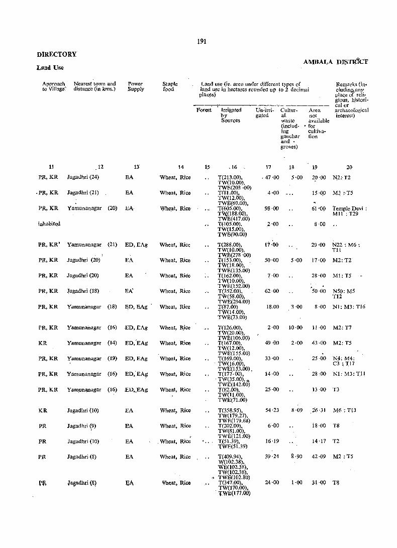
191
DIRECTORY AMBALA n:n:sndcT
Land Use
Approach Nearest town and Power Staple Land use (ie. area under different types of Remarks (in-to Village~ distance (in kms.) Supply food land use in hectares roundea up to 2 decimai cluding,;unY'
places) place of reli, ,gious, histori-
, calor - Forest Irrigated Un-lrri- Cultur- Area archaeofogical
by g~ted al not interest) Sources waste available
(inc1ud- • for ing eultiva-galJchar tion and • groves)
11 12 13 14 15 ,16 17 18 19 20
PR,KR Jagadhri (24) BA 'Wheat, Rice T(213.00), - 47-00 5-00 20-00 N:Z:' T2 TW(10.00},
.PR,KR Jagadhri (21) BA Wheat, Rice TWB(203 ·00)
4·00 lS'QO T(81.00), M3 :·T5 TW(12.00),
PR,KR (20) BA Wheilt, Rice TWB(69.00),
Yamunanagar 'T(605.00), 98'00 61 '00 Temple Devi : Tl;'{(188.00), Mll : T29
inhabited TWB(417.00) T(105.00), 2·00 8·00 TW(lS.00), TWB(90.00)
PR,KR' Yam,unanagar (21) BD, BAg Wheat, Rice T(288.00), 17·00 29·00 N22: M6: TW(10.00), Tli
Jagadhri (20) TWE(278 '00)
PR,KR EA Wheat, Rice T(153.00). 50'00 5·00 17'00 M2:T2
PR,KR Jagadhri (20) BA Wheat, RiCe
TW(18.00), TWE(l3S.00) T(162.00). 7·00 28·00 Ml: T5 TW(lO.OO),
Jagadhri (18) EA" Wheat, Rice TWE(l5:2.00)
PR,KR T(3S2.00), 62·00 50·00 NSO: MS TW(58.00), Tl2
(IS) ED,BAg' Wheat, Rice TWE(294.00)
PR,KR YamullllJlagar T(87.00) lS.00 3 '00 8·00 N1: M3: Tl6 TW(14.00), TWB(73.00)
PR,KR Yamunanagar (16) BD,BAg Wheat,. ~ice T(126.00), 2·00 10·00 11·00 M2:T7 TW(20.00),
(14) ED,'BAg Wheat, Ricll TWB(106.00)
49·00 KR Yamunanagar T(167.00), 2·00 43·00 MZ: T5 TW(12.oo), TWB(155.00)
PR,KR Yamunanagar (19) BD,BAg Wheat, Rice T(169.00), 33·00 25 ·00 N:J.:M4: TW(l6.oo), C3 ~ 1)7
PR,KR Yamurtanagar (16) BD,'EAg Wheat, Rice TWE(153.00) . T(1nOO), 14·00 28 ·.00 Nl: M3: 1)1
. TW(35.00), ""
Wh~at, Rice TWB(142.00)
PR,KR Yamunanagar (16) ED~,EAg T(82.00), 25·00 13 ·00 T3 TW(I1.00), TWB(71.00)
KR Jagadhri (to) BA Wheat" Rice T(35S.95), 54·23 8·09 26·31 M6 : T13 TW(l79.27),
PR Jagadhri (9) BA Wheat, Rice TWE(179.68)
6·00 TC202:00), 18·00 TS TW(81.00),
, TWE(121.00) PR Jagadhri (10) BA ,Wheat, Rice 1:(51.39), 16 ·19 14 ·17 T2
TWE(51.39)
PR Jagadhri (8) BA Wheat, Rice T(409.94), 39·24 g'90 42·09 M2 :T5 W(102.3S), WE(102.3S), TW(lOZ.38),
'" TWB(102.80) r~ Ja~adhri <~~ {;t\ lVheat, Rice T(347.oo), 24·00 1·00 31'00 T&
, TW(170.00), TWE(t77.00)

JAGADURJ TAflSIL.
Loca- Name of Village . tion (with Hadb~t Number)
Code ~o,
1 1.;
490 Sabhapur (161)
491 Rattangarn (487)
492 Dhorang (488)
493 Jaipur (163)
Total arcaof the.
, Village (in hectares)
.",
254·14
400·63
, 467·41
277,,61
-----.,j----__....-~
AU Villages 130,06:1 ·63
194
VILLAGE
Amenities and
Total . Amenities available (If not available within the village, a dash(-) is shown Population in. the oolumn and next to it in brackets, the distance tn broad ranges viz. f
arid Number ,5 kms, 5-10 kms. and lO+kms. of the nearest place where the facility of is available is given) households ~-~-~-----"--- -~-~~--
Edueational Med.ical Drinking Post and
4
34&
,1-71
1,257
721
Day Communi· , Water Telegraph
(potable) or cations days (Bus Stop,
5
(45) -(-5)
(160) 'P
0(8) P
.(103) P
6 ':/
-(5-10) W,Hp
CHW W,Hp
CHW W,Hp
CHW W,Hp
of the Railway market I Station, hat, Water'ifany way)
8 9 10
-(-5) - (-5)
-(-5) BS
-(-5) BS
-(-5) -(-5)
----------341,626 (51,560) P290. M47, MH4,PHC3,
HZ6, TrI. HS56,D16. Act Il'PC3.
RP22S, CHW206
tAlthough entered as 'Be-Chirag' (Un-inhabited) in the Revenue record, the population shown against this village was enumerated at the time of 19&1' Census.
Notes :-(1). Where lli town and village bear an idential name. the wo~d (Rural) has been added after tllc name of the village.
(2) The area of a village (revenue estate) is based on the information supplied by the Revenue Patwari~

OIRECTORV
Land Use
Approach to Village
11
Nearest town and distance (in kms.)
12
pR,KR yamuoanagar (6)
PR Radaut (6)
PR Radaut (5)
PR Radaur (5)
Power Supply
13
ED.EAg
EA
EA
EA
Staple food
14
Wheat. Rice
Wheat, Maize
Wheat, Maize
Wheat. Maize
AMBALA DISTRict
Land use (i.e., area under different types of land use in hectares rounded upto 2 decimal places)
Remarks (including any place of reli-gious, histori-- ___ ~~ ________ ...:... --- calor
Forest Irrigated Un- Cultu- Area ~rchaeological by irrigated ral not IOterest)
15
Sources waste available (including for . gauchar cultivs-and tion groves)
16 17 18 19
T(47.75), 121 ·81 49·37 35·21 rWE(47.75)
T(269.11), 49'37 20·23 61'92 WE(243.21). TWE(25.90), T(331.03). 56·25 21 ·04 59·09 WE(289.35), TWE(41.68) . T(102.38~ 99·96 15 ·78 59·49 WE(60.7~. TWE(41. 8)
20
M1 :.Tl
M5 :T12
' 3 N5 :Ml:Tl
Ml ~T3
11485·08 T(53.914 '26), 36,017 ·58 3,249 ·84 23912 ·55 GC(3,024 '38), '
NI0I0:M742 CI03:Tl943
W~OS5'71). W 842 '15). TW(9S80 '45).· TWE(39,304 ,54). Tk(2,OO), 0(105.03)

APPENDICES 1-4
197

l~S
APPEN-
Tahsilwise Abstract of Educational, DISTRICT : AMBALA
EDUCATIO-
Serial Name of Tahsil Primary School Middle School Matriculation/ Higher Secondary/ College (graduate Adult Literacy No. Secondary PUC! and above) Class/Centres
schools Intermedi atel Junior College
----- -------Villages Institu- Villages Institu- Villages Institu- Villages Institu- Villages Institu- Villages Institu-
tions tions tions tions tions tions
2 3 4 5 6 7 ',8 9 10 11 '-'\ 12 13 14
1. Kalka 72 75 13 15 9 9 1
2. Naraingarh 227 236 41 45 25 28 40 50
3. Ambala 256 268 55 62 32 36 4 4 111 155
4. Jagadhri 281 290 42 47 22 26
Total District 836 869 151 169 88 99 5 5 2 2 153 207
MEDICAL DRINKING
Serial Name of Tahsil ~,-- Villages No. Community Others with no Tap Well Tank Tube- River Foun- Canal
Health medical well tajn Workers facility
Villages Num- Villages Insti-bers tutions
1 2 30 31 32 33 34 35 36 37 38 39 40 41
------1. Kalka. 55 61 4 7 75 103 60 13 38 5
2. Naraingarh 137 151 41 84 ' 154 '''0
152 _:' 292 .139 153 66
3. Ambala 164 208 53 136 116 39 283 109 104 22
4. Jagadhri 190 206 115 225 209 52 319 8 52 4
~------- ----Total District 546 626 213 452 554 346 954 269 347 71 26
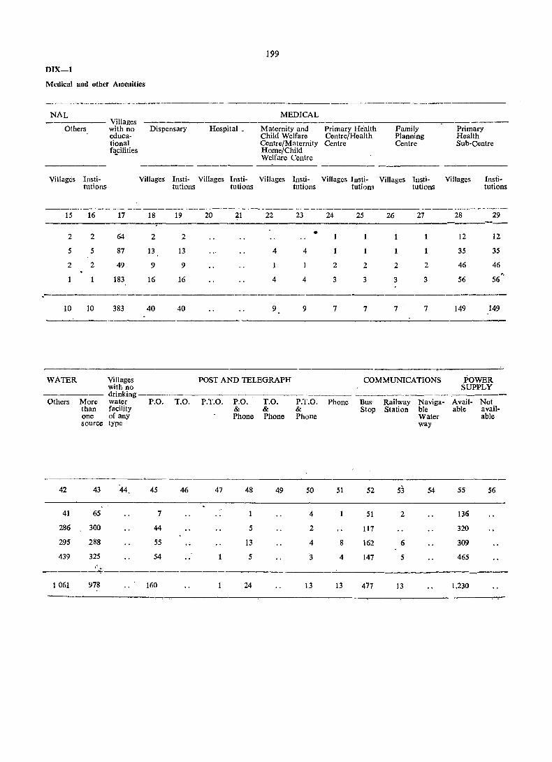
199
DIX-l
Medical and other Amenities
-------------------------------------------- ------------NAL
Others Villages with no educational f~cilities
Dispensary Hospital _
MEDICAL
Maternity and Child Welfare Centre/Maternity Home/Child Welfare Centre
Primary Health Centre/Health Centre
Family Planning Centre
-------- ------- -_------- -------- ----Villages Insti- Villages Insti- Villages Insti- Villages Insti- Villages Insti- Villages Insti-
tutions tutions tutions tutions tutions tutions
Primary Health Sub-Centre
Villages Insti-tutions
._-------------_._-------------15 16 17 18 19 20 21 22 23 24 25 26 27 28 29
2 2 64 2 2 • 1 12 12
5 5 87 13 13 4 4 1 35 35
2 2 49 9 9 1 2 2 2 2 46 46 '.
183 16 16 4 4 3 3 3 3 56 56
10 10 383 40 40 9 9 7 7 7 7 149 149
WATER Villages POST AND TELEGRAPH COMMUNICATIONS POWER with no SUPPLY drinking ------
Others More water P.O. T.O. P.T.O. P.O. T.O. P.T.O~ Phone Bus Railway Naviga- Avail- Not than facility & & & Stop Station ble able avail-one of any Phone Phone Phone Water able source type way
42 43 44 45 46 47. 48 49 50 51 52 53 54 55 56
41 65 7 4 51 2 136
286 300 44 5 2 117 320
295 288 55 ., 13 4 8 162 6 309
439 325 54 5 3 4 147 5 465 , .....
------~-----------
1061 978 160 24 13 13 477 13 1,230
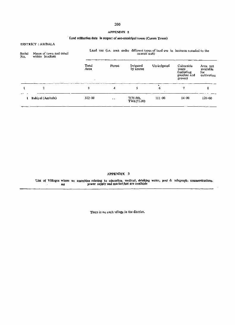
DISTRICT: AMBALA
Serial Name of town and tahsil No. within brackets
1 2
Babiyal (Ambala)
200
APPENDIX 2
land utilisation data in respect of non-municipal towns (Census Towns)
Land use (i.e. area under different types of land use in hectares rounded to the nearest unit)
Total Area
3
322·00
Forest Irrigated by source
4 5
T(71.00), TWE(71.00)
APPENDIX 3
Un-irrigated
6
111·00
Culturable Area not waste available (including for gaucharand cultivation groves)
7 8
14·00 126'00
List of Villages where no amenities relating to education. medical, drinking water, post & telegraph, communications, Q power supply and market/hat are available
There is no such village in the district.
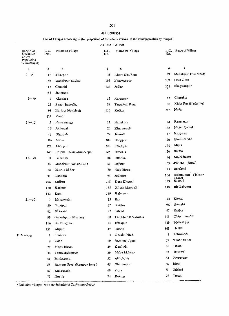
201
APPENDIX 4
List of Villages according to the proportion of Scheduled Castes to the total population by ranges
KALKA TAHSIL
Ranges of L.C. Name of Village L.C. Name of Village L.C. Name of Village Scheduled No. No, No. Castes PopUlation (L'crwntagcs)
2 3 4 5 6 7
0-5* 17 Kiratpur 31 Khera Sita Ram 47 Manakpur'ThakardMs
49 Manakpur Devilal 105 Bhagwanpur 107 DcraGuru
113 Cl1aunki 134 Judian 151 Bhagwanpur , 1.54 Sangrana
5-10 4 Khokhra 15 Karanpur 19 Charnian
23 Hanoi Sanwalia 38 Tagra((ali Ram 90 Kidar Pur (Kadarpur)
93 Haripur Harisingh 110 Kotian 112 Nada
127 Kundi
11-15 2 Nawannagar 12 Nanakpur' 14 Ramnagar
16 Johlowal 20 Kheranwali 22 NagaI Rootal
41 Dhamala 79 lanouli 81 Kajiyana
86 Malia 102 Hhogpur 120 Ehainsatibba
124 Abhepur 12S Fatehpur 136 Majri
143 Raipur-Alias-Sunderpur 145 Barwala 150 Bata.ur
16-20 IS Gariran 26 Paploha 44 Majri Ja-Han
48 Manakpur Nanakchand 61 Rajipur 6~ .Pinjore (Rural)
68 Bharon-ki-Ser 70 Na.Ia Bloug 85 Berghati
91 Nandpur 94 Jodhpur 104 Aslamnagar (Islam. I,agar)
106 Ghikan US Dara Kharoni 119 Suketri
130 Haripur 135- Khark Mangoli 140 Bir Babupur
142 Kami 149 Rebawar
21-30 7 Maranwala 25 Bar 43 Khera
59 Surajpur 62 Ra.tpur 75 oawahi
82 Ehawana 87 Jabrot 97 RaiPur
99 Gane~hpur (Bhorian) lOS Fatehpur Diwanwala 11s Chandimandir
116 :Bir Ghaghar 121 :Bilaspur 129 Malle&hpur
138 Alipur .47 Jalouli 148 Nagai
31 & above 1 Shahpur 3 Gorakh Nath 5 Lehroundi
9 Kana 10 Rampur Jangi 1..4 Tbane-ki-Ser
27 Nagai Bhaga 29 Kandi~la 30 Orian
34 Tagra Hakimpur 39 Majra Mehtab 42 Basawal
51 Basdevpula 52 Abdulapur 53 Ferozepu r
55 Rampur Seori (Rampur Sewri) 65 Dharampur 66 Bitna
67 Kanguwala 69 Tipra 71 Jaithai
72 Noulfa 74 Dakrog 75 Toran
*E."cludes villages with no Scheduled Castes population
Ranges qf Scheduled Castes Population (Percentages)
202
APPENDIX 4
List of Villages al!('ording to the proportion of Scheduled Castes to the total population by ranges
KALKA TAHSIL-cone/d.
L.C. Name of Village L.C. No.
Name of Village L.C. No.
Name ofVi1Iage No.
2 3 4 5 6 7
31 & above-cone/d. 78 Khoi 92 Tibi 98 Miranpur Bakhshiwala
101 Damdama 103 NagaI Sodhian 114 Gumthala
123 Budhanpur 125 Madalpur 126 Raili
131 Ferozepur KalaR 137 Devinagar 141 Suitanpur
152 Bhareli
M~
APPENDIX"4
Li~ of Vilhlges Jlceorilil)g to the proportion orSc1Ieduled Castes to the total populatioo by ralJges
NA~O\INGARH TAHSIL .
N ... me of Vil!aze L.C. Ranges of Le. Nam~ of Village L.C Name of Village Scheduled No. :No. No. Castes Population (Percentages)
1 2 3 4 5 6 7
0-5' 2 Dana Mada.npu( 4 Nanga! M()ginand 6 Nadlan
18 Bhoj Naita 20 Bhoj Datara 28 Bhoj l'onts
31 Taparian 34 Kazampur 44 Khe t l'arali
,52 Sukh Darshanpur 53 Datwal 65 Rahus
151 Karasall 157 Rajawali 174 Chhoti Bassi
175 Akbarpur 190 Mandlai 192 pyarewala
197 Kh~npur R.ajputan 223 Panjlluri 225 Muna Ma,ira
242 Rao Majra (Raw Maira) 299 Udamgarh 300 Burj Jamna Wllia
i Ramgarb (Burjjarrumwala)
6-10 H Boonga 15 . Bhoj Mataur
17 Blloj Dnarti 26 Bhoj Kuda.na. 2$ Ta,lokpur
36 Manak Tabra 38 Toka 46 Tibbi
61 Na,rainpur 66 Masurnpur 68 Debar
71 Ferozcpur 76 Hangoli . so Bichpa.ri
&1 :SherOD 9& Khera.Gani 14() Bibipur
145 Panjeton 159 ~lir!leri Chho-ti (Chboti Bared) 163 BanaUlldi
170 . Bhara.npur 181 Bhauvli (Bhavli) 193 Dandlawar (Dauola.w::.r)
198 Ujjhal Majri 202 Taka 219 Sian Majra
233 GanauH 244 S3ngrani 267 Salahpur
268 Thash 2i7 To!larpur 27& I{otla
296 Fazilpur 319 Chand Sauli
11-1$ 7 AsrewaJi 21 Booj Koti 2:5 Bhoj Rajpura.
39 "Sham too 40 Rattewali 58 Barauna Chhota
S2 Ka.!alMajri 86 B7 (Chhoja Baroona)
llagwt'la Ka.kraJi
88 Bahbalpur 93 Tabar 97 Toda.
113 Dl.lhri 124 Nasrauli 130 Korwa Khurd
154 Sherpur 156 Badbauli 167 Nau Gawan (Nogan-wan)
196 Fatel1.1lur 201 Ferozepllf 227 Brahman Majra
245 Dera 246 l:i aI:lid pur 248 Rajpur
2:S8 Ha.vell 2n RaHuwata 316 Jvar Sahilia
16-20 16 Bnoj Palasra 23 BhogJqbial 33 BharauJi
41 KherWali Parawala (Kheriwlili- SO Khangesra 54 Dha.ndaurru .Palwrua)
92 Hi\ripur 107 Khanpur .Brabman 108 Rasidpllt
109 Muk:mdpur lIS Jatwar 134 Khurd
147 DhaJl1O.uli U[Jarli 162 Kanjala 1"16 "Sari Bassl
.Eduues villages with· no Scheduled Castes population,

204
APPENDIX 4
List of Villages Il~cording to the proportion of Scheduled Castes to the total population by ranges
NARAINGARH TAHSIL-colltd.
Ranges of L.C. Name of Village L.C. Name of Village L.C. Name of Village . Scheduled No . No No.
Castes Population (l'ercentages)
1 2 3 4 5 6 7
16-20-Concld. 195 Kohra Bhura 200 Kathe Majra 20S Mianput
236 Nanehrn 240 Chhoti Rasaur 252 Labarpur
276 Dholiwala 314 Der Klteri 334 MawaKheri
21-30 13 Jaswantgarh 24 BhojNagal 47 Dabkauri
48 Kot 51 Khatauli 56 Barauna Bara (Bara Baroona)
59 Raipur Rani 67 GanauIi 68 Debar
70 Garhi 75 Haruli 79 Tharwa
85 Bagwali 94 Mauli. 99 Gazipur
106 Jaspur 121 l'atwi 122 Berpura (Dirpura) . 127 Kalal Majra 133 Gharauli 137 Shahzadpuf
138 Majra 142 Salola. 144 Patrehri
15B :Bar11eri :Badi (:Beri :Bareri) 184- Chhoti Kohri 1St') Laha
210 Dan ora 211 Husaini 217 N araingari} (Rural)
234 Ambli 2'!S Denat 2.37 Bad RaS3.U!
247 Galawari (Galori) 255 Jhanda 265 Gadauli
269 Kalyanpur Atari 275 Nilwagaon (Nayagaon) 284 Mirzapur
287 Salempur 295 Naushahra (Nushara) 302 Sabhapur
308 Saranwa 313 Nagla (Negla) 315 Andheri
319 Harbon 320 Lakhnaura 321 Lalpur
330 Budlta Xhera :331 Kalyana 332 JeoIi
333 Nakhrauli
31 & above 9 Manka 12 Bihla 22 Bboj Kothi
35 Shahpur 37 Amrala 55 Kheri
74 Sam!ehri 77 Hangola 84 Kakar Majra
89 Golpura 95 Natwal % Nawa Gac)ll UrfKhader • (Noganwan)
100 Singhpura 104 Fatehgarh .• 111 Tasrauli
112 Dhanana 114 Bharog 115 Chhajju Majra
116 Boron 117 Khera JaUan 123 Behloli
125 NagJa 126 Rachheri 128 Ganeshpur
129 Bara Korwa 132 Santokhi 135 Nagai
136 SontIi 139 Bapauli 148 HandiKhera
149 DhamauIi Bichli 150 Dhamauli Majri 152 Magharpura
153 Rajp~. 155 Parail 160 Baktuha (Bakhluwa).
161 NekNawan 163 Kurali 165 Bud Shahid
105
APPENDIX 4
List of Villages according to the proportion of ScflcduIed Castes' to the total population by rangeS
NARAINGARH TAHSIL-,concld.
Ranges of Scheduled L.C. Name of Village L.C. Name of Village L.C. Name of Village Castes No. No. .No.
" Population (Percentages)
1 2 g 4 S 6 1
31 & above- 166 Sadaqpur 169 'randwai 171 Baragarh cone/d. co
172 Bilaspur 177 Manglor 17& Kherki Manakpur
179 Jangoo Majra 180 Badi Kohri 182 Rataur
ISS Nagauli 191 Bhud (Bhood) 199 Jangu Majra
207 Kullarpur 208 Rampur 212 Batora
213 Mirput 214 Ballopur 215 BaroU
216 Milk' 218 Ahmadpur 220 Bara Gaon
221 Chhajal Majra 222 Ramgarh 226 Khirki Jatan '
228 Paqjlasa 229 Raipur Viran 231 Raj u 'Majra
232 Khanpur Labana 238 Lautan 241 Shahpur
243 Nabipur 249 Rathali 251 Doman Wala (Ooomanwala)
257 Rasulpur 259 Bakala 260 Ferozepur Ranyan
261 Rampur Ranyan 262 Paharipur 263 Saidupur
266 Mahmadpur 282 Gulapur 285 Islamnagar
288 Ismailpur 290 Sultanpur 291 Sadaura (Rural) (Sadhorn Patti Sainyan)
294 Sadiqpur 301 Shampur 304 RaJpur
305 Pan don 306 Majri 307 Kanipia
'309 Ranyanwala 311 SUrgal 312 Hassallpur
316 Mirazpur Kath 318 Bakarpur 322 Ferozepur Kathka
324 Bukhari 325 Fatehpur 326 Shahpur
327 Nanduwali 328 Shakarpurll

2Q()
APPENDIX~
tist of Villages according to the proportion ()f Scheduled Castes to the total population by rangeS
AMBALA TAHSIL
Ranges of L.C. Name of Village L.C. Name of ViJiage L.C. Name of Village Scheduled 1'\0. N!). No. Castes Population (Percentages)
. r 2 3 '4 5 6 7
0-5· . 28 Sultanpur 78 Mithapur 278 Hasanpur (Haisanpur)
314 Jagoli ~
6-10 57 Rampur 135 Patti ChanarJhal 227 Dorana
269 Dingeriarr (Dang D!!heria) 282 Jalalpur 303 Khurchanpul'
320 Jandheri 325 ~oshanpura
t'l --1; 5 Devinagar 32 Barnala 45 Kanwli
56 Sarsehri 103 Talheri Gujran 121 Kansapuf
liG' Ponti (Pa~ati) l3S l'atti Bagher,u (Bhageru) 173 Rao Majra
228 Malwa 235 Fazalpur (Fazailpur) 301 Nanyola
302 L~otan (Lota) 305 Udepur 312 Niharsi
317 Sonti 321 Kalawar 323 Chhapra
r6~20 14 Patti Kalalan 19 Sonda 20 Singanwala
64 Munarhed (Mulaheri) 72 Malikpur 76 Mahtabgarh
102 Vplana 105 Gangan Heri (Gaganheri). 112 Sherpur
117 Dhanauri 129 Jamal Majra 137 Paplotha
148 Barara 167 Kambasi 119 Rajauli
189 l'husiala (I?asiaia) 19-1 S,ubga. 201 Haldari
219 Begampur. 255 ~I\dana 261 Matehci Shekhan
262 Muzafra 270 {~mailpur (Asmailpur) 271 Malor
275 Gobi!lclgarh 2iH Bl\ratili 283 Kaleran (Kaleza)
285 Bishangarh 286 Jansui 287 Gorsian (Goursia)
290 Segta 291 Mehmudpur 300 Dhelo Majra
313 Sheikhupur
21-30 4 Ghel 18 Nasirpur 22 JandJi
29 Kakru 34 Pa~okhara 31 Tundla
39 Kalarheri (Kalaheri) 40 Boh 46 Miltehri Jattan
52 Kardhan 54 Naggal 61 KhudaKalan
62 Rawlan (RawaJa) 68 B11ee!pura 69 Pelakhni (I?ilkhani)
73 Mehmudpur 77 Samalheri (Samleri) 84 Tepla
85 Ghaseetl1ur 87 Jawahargarll 90 Goti
98 Gokalgarh 99 Ramgarh lOS Nurhad
109, Tharwa 116 Zafarput 131 Duliana
136 Mullana 149 Siwan Majra 150 Milak Shekhan (Milk Sikha)
152 Dera Salaimpur 155 Alawalpur 159 Akalgarh
.Excludes villages with no SCheduled Castes pOpulation
207
APPl':NDIX4
List of Villages act\)rding to th~ ptripnrtion at Stlieduled Castes tu the total populatibil by ran!!;~
AMnALA TAHSIL-collid.
Ranges of L.C. Name of Village L.C. Name of Village L.C. Name ofVillagc Scheduled No. No. Nd. Castes Population (Percentages)
2 3 4 5 6 7
21-30-cQncld. 160 Kambas 162 Adhoya Musalmana 164 Dhiya Majta
171 Jalubi 172 Suhafta 174 Ugala
176 Rajukheri 184 Rampur 186 Chapra
192 Khanpura 198 Kesri . 199 Bazeedpur
202 Chhanni 207 Landha 20S Khan pur
214 Shall pur 221 Kot Kachhn wa Kalan 223 DhanoTa
224 D)ianori (Dhaneril 229 Barola 231 Nurpur
232 LaJiana .236 Ojlan (Aujla) 244 Bego Majra
245 Lakhnaur Sahib 246 Mohri 249 Bhano Kheri
252 Dhurkr.3 263 Masatpur 266 Abman (Ayema)
268 Qurbanpur 272 Kheta 274 Sakhraoll (Sukhrao)
284 Segti 295 Bhurangpur (Bhatangpur) 299 Batrohan
307 Khana Majra . 315 Jansuya 316 Sonta
318 Mahlan 319 Danipur 324 Getpura
31 & above 1 Liharsa 2 Kolu Majra (Kolo Majra) 3 Nizampur
.6 Dadiana 7 Manakpur 8 Dangdehri
9 Sadopur (Sidhoopur) 10 Lohgarh 11 Patti Jatan
15 Patti Achrjan (Patti 16 Sarangpur 21 Patti Mehar Chargaon)
31 Mandhaur 23 Dbulkot ' 30 Khatoli
36 Janetpur 33 Dhankaur 35 Garnala
48 Kanwla 38 Tundli 42 ChalldPura
53 Ghasitpur 49 Ogara (U gara) 51 Nanhera.
59 KhudaKhurd 55 Khojkipur 58 Salarheri (Salaheti) , 70 Tobha 63 Sapehra 66 Rattanheri
80 Manglai 75 NagaI 79 KbaruKhera
83 Pbalail Majra (Koloa Majra)
81 Sambbalklul (Sallbalkba) 82 Akbarpur 89 Laha ,-
86 Behta (Bihta) 88 Saha 93 Tamnauli
91 Sabapur 92 Gola 96 Alapur
94 Nabawani .95 Kalpi 101 Thakar PUt·a
97 Khera 100 Jbaru Majra (Jhando Majra) 104 Dha:naura
106 Kakar Kunda 107 Taprian 110 Salakhani
111 Sahla .
113 Sarda Red 114 Binjal Pllr
115 Aliaspur 118 Alipur . 119 Jahangirp'uf (Jahagirpur)
120 Salhapur (Salanpur) 1Z2 Bek;onpu,r (BikonPllr) 123 Milk Dhankot.an
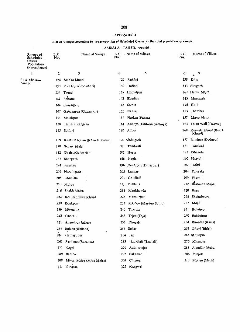
208
. APPENDIX 4
Lis) of Villages according to the proportion of Scheduled Castes .to the total population by rang~s
AMBALA T AHSIL-eone/d.
Ranges of L.C. Name of Village L.C. . Name of Village L.C. Name of Village SchedUled No. No. No. Castes Population (Percentages)
2 3 4 5 6 7 ... 31 & above- 124 Manka Manki 127 Rukhri 128 Dhin coneld.
130 Rola Heri (Roolaheri) 132 Duliani 133 Sirsgarh
134 Tangel 139 Hamidpur 140 Hema Majra
141 Sohana 142 Bhudian 143 Maujgarh
144 Sharaqpur 145 Semla 146 Hali
147 Ganganpur (Gaganpur) 151 Nahra 153 Thamber
154 Malakpur 156 Phoksa (Faksa) 157 Manu Majra
158 Talher! Rangran 161 Adhoya Hindwan (Adhoya) 163 Tolan WaH (Tolawali)
165 Subhri 166 Adhoi 168 Kasairla Khurd (Kasrela Khurd)
169 Kasairla Kalan (Kasrela Kalan) 170 Abdulgarh 177 Diodpur (Dadupur)
178 Sajjan Majri 180 Tandwali 181 Tandwal
182 Ghalri (Geherri) • 183 Harra 185 Dhakola
187 Shergurh 188 Nagla 190 Haryoli
194 Panjhail 196 Penarpur (Dinarpur) ·197 Dubli
200 Naraingarh 203 Langar 204 Dhurala I
205 Chudiala 206 ChudiaIi 209 Pharoli
210 MoIna 211 Dukheri 212 B"i!ahman Majra
216 Shekh Majra 218 Machhonda 220 Bara
222 Kot Kachhwa Khurd 225 Mansurpur 226 Shahabpura
230 Konkpur 234 Mardon (Mardoo Sahib) 237 Majri
239 Mirzapur 240 Tharwa 241 Babaheri
242 Dhorali 248 Tejan (Taja) 250 Behbalpur
251 Anandpur Jalbera 253 Dhurala 254 Rawalan (Raula)
256 Balana (Bullana) 257 Sullar 258 Bhari (Bhiri) . 260 Hamayupur 264 Tar 265 ~minpur
267 Baritlgan (Baranga) 273 Landiali «(Ladiali) 276 Khaspur
277 Nagai 279 Addu Majra 288 Alauddin Majra
289 Barnba 292 Baknaur 304 Panjola
308 Miyan Majra (Miya Majra) 309 Chugna JI0 Metlan (Mctla)
~11 Nih~rs~ ~22 Kan~w~l
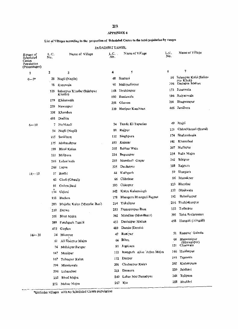
209
APPENDIX 4
List of Villages according to the proportion of Scheduled Castes to the total population b~ ranges
JAGADHRI TAHSIL
Ranges of L.C. Name of Village L.C. Name ofVilIagc L.C. Name of Village
Scheduled No. No. No. Castes Population (Percentages)
2 3 4 5 6 7
0-5* 28 N agli (N aglie) 48 Suabari 56 Salem PUr Kohi (Salim-
78 Kurewala
Pur Khok) 90 Mahiyudiupur 106 DadupUl Malion
109 Sa1empur Khadar (Saleh pur 168 Ibrahimpur 173 Jatanwala
Khadir) Raiyanwala 180 Baniawala 186 179 Khilanwa.la
258 Ghoron 291 Bhagwa.npur
239 Nawazpur 339 Hatipur Kambaan 466 Jandhera
338 Khandwa
488 Dudhla
6-10 7 paroha(lli '34 Tunde Ki Taparian 49 Majri
54 Nagli (NegJi) 88 RajPUf 111 Chhachhrauli (Rural)
liS Satlkhera. Bl Singbpura 174 Shahzadwala
175 Mukarabpur 185 Kalesar 191 Khizrabad
199 Bhud Kalan 205 BakkarWala 207 Hafizpur
221 Bhilpura. 224 Begampur 234 "Balla Majra
246 La1lOriwala 255 Mandauli Gagar 261 Dibipur
266 Lapra 325 Dati!atpur 383 Rajpura
11,--15 37 Bodhi 44 Kathgarh 59 Shergarh
62 Choli (Ghanli) 66 Chbalaur 86 Manakpur
91 Gohra,Bani 103 Chintpur 123 Bherthal
• 134 Urjani 142 Kotra Kahansingh 152 Dhakwala
158 Bachon 178 Bhangera "Bhangeri Bagpat 192 Bahadurpur
2{l3 Mujafat Kalan (Muzafat Barl) 214 Ya.kubpur ~16 Shahjahanllur
230 Darwa 253 Dalllll1unpur Bara 332 Todarpur
358 Bhut Majra 392 Mandhar (Mandhaur) 395 Teha Brahrnanan
399 Fatehgarh Tumbi 453 DaulatDur Malian 458 HangoIi (Hingc)li)
473 Goglon 489 Damla (Demla)
16':"" 20 26 Mianpu! 47 Rnnipur 51 Rampur· Gainda ~
,61 Ali Sherpur Majra 64- Bihta 68 Bhawanipur (Bhawanpur)
76 Ma[akpur Bangar 95 Jogiwara 121 Chaowala
147 Manipur 155 Ramg:arh Alias ·Ariun Maha, 166 Haidarpur
167 TaharPur Kalan 172 Darpur 193 Tajewala
194 Mandewala 201 Chubarpuf Kalan 202 Kishanpura
206 Laha.sabad 211 Dasa.ura 220 Jaidhari
232 Bhud Majra. 240 Laka.t Ma.i Partappur 244 Telipura
252 Mehar Majra 267 Kat 2S8 Bhukhd
*excludes yiJlages with no Scheduled Castes population
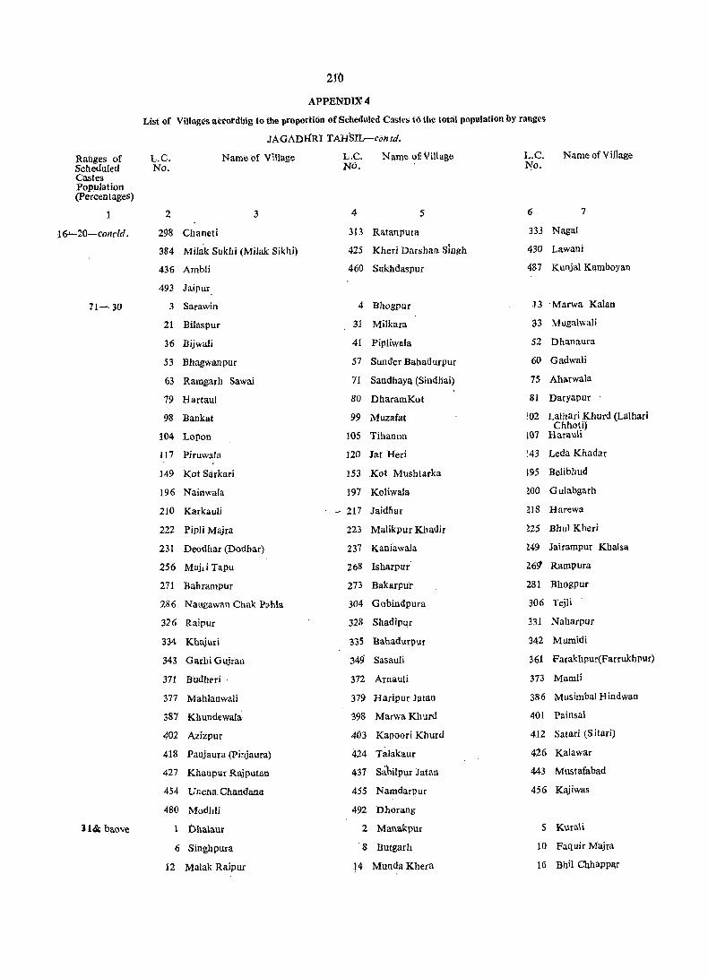
210
APPENDIX' 4
List of Villages atcordiJ\g (0 tlie proportioil of Scheduled Cast('s to the total population by ranges
JAGADHRI TAHSIlr-contd.
Ranges of L.C. Name of Vmage L,C. Name of: Village L.C. Name of Village Scheduled No. NO. 1-jo. Castes Population (Percentages)
2 3 4 5 6 7
16 ...... 20-conc/d. 298 Cbaneti 313 Ratanpura 333 NagaI
384 Milak Suklli (Milak Sikh i) 425 Kheri Darshan Singh 430 Lawani
436 Ambli 460 Sukhdaspur 487 Kunjal Kamboyan
493 Jaipur
11-30 3" Sarawin 4 Bhogpur 13 "Marwa Kalan
21 Bilaspur 31 MiIkara 33 Mugalwali
36 Bijwali 41 Pipliwala 52 Dhanaura
53 Bhagwanpur 57 Sunder Bahadurpur 60 Gadwali
63 Ramgarh Sawai 71 Sandhaya (Sil1dnai) 75 Aharwala
79 Hartaul 80 DharamKot 81 Daryapur
98 Bankat 99 Muzafat [02 Lalhari Khurd (Lalhari Cbhoti)
104 Lopon 105 Tihanol1 [07 Harauli
117 Piruwaia 120 Ja! Heri [43 Leda Khadar
149 Kot Sarkari 153 Kot Mushtarka 195 Belibhud
196 Nainwala 197 Kaliwala Wo GuJabgarh
210 Karkauli - 217 Jaidhar ZIS Harewa
222 Pipli Majra 223 Malikpur Khadir Z25 Bhul Kheri
231 Deadhar (Dodbar) 237 Kanfawala Z49 Jairampur Khalsa
256 Majd Tapu 268 !sharpur 26~ Rarnpura
271 Bahrampur 273 Bakarpuf 281 Bhogpur
286 Naugawan Chak P<lhla 304 Gobindpura 306 Tejli
326 Raipur 328 Shadipur 331 Naharpur
334 Khajuri 335 Banadurpur 342 Mumidi
343 Garbi Gujran 349 SasauJi 361 Parakhpur(Farrukbpur)
:m Budht'ri " 372 Arnauli 373 Mamli
377 Mablanwali 379 Haripur Jalan 386 Musimbal Hindwan
387 Khundewala" 398 MarwaKhurd 401 Painsal
402 Azizpur 403 Kapoori Khurd 412 Salari (SHari)
418 Panjaura (pinjaura) 424 Talakaur 426 Kalawar
427 Khanpur Rajputan 437 Sabilpur Jatan 443 Mustafabad
454 VnCha.Chandana 455 Namdarpur 456 Kajiwas
480 Modhli 492 Dhorang
1141 bao'le Dhalaur 2 Manakpur 5 KuraH
6 Singhpura '8 Butgarh 10 Faquir Majra
12 Malak Raipur l4 Munda Khera 16 Bhi! Chhappar

211. APPENDIX 4
List of Villages according to the proportion of Scheduled Castes to the total population I}y rilnges
JAGADHRI TAHSIL-contd.
Ranges of L.C. Name of 'village L.C. Name of Village L.C. ~ame of ViIla$e. ~chedliled No. No. No. Castes ~
Population (Percentages)
1 .2 3. 4 5 6 7
31& above- 17 Kakrauni 18 Khera Brahmanan 19 Chanda Kheri contd. (Khera Majra)
20 Shahpur. 23 Machhrauli 24 Nagai Patti Machhrauli , (Nangal Patti Machhrauli
27 Banse Waia (BanswaJa) 29 Manglaur 35 Safilpur
38 Nathanpur 40 Chuharpur 45 Ranjitpur
50 Bhattuwala 65 Rampur Ka.mboan 67 Rampu_r Harian
69 Mauhri 70 Milkkhas (Malik Khas) 72 Udhamgarh
.73 Raianwala 74 Kotla Khas 77 Chaurahi
S2 Chholi 83 Bisationwala 92 Rampur Jllt
93 Chabutron 94 Prithipur 96 Katarwali
97 Katarwali 100 Bhamnauli 101 Lalhari Kalan (Lalhari Bari)
108 Khanpura 110 Ashabpura .Hi. Ganauli
113 Ganaula 114 Leda Khas 116 ChCj.g'l1auli
118 Ram Kheri 119 pheruwala .122 Taranwala
124 Mahmudpur 126 Munda Khera 147 Mukaribpura
129 Panjeton 130 Mand Kheri 132 Sherpur
135 Chuharpur Khurd 136 Nahar Taharpur (Naharpqr 137 Khanpuri Taharpur)
138 Balauli 139 Taruwala 140 BaroIi Majra
14.1 Mohab Aliwala (Mahab Aiiwala) 144 Tugalpur 145 Ledi
14,6 Dadupur Jattan 150 Tibbi Raiyan J54 Kot Basawasingh
162 Shahabudinput Kaian 190 KhiJri 208 Hafzi (Hafizi)
209 Thaimun (Tahimu) 212 DamoIi 226 Ismailpur
227 Nathanpur tNatharpur) 228 Manbharwala 2:73 Doi Wala (Duiwata Urf Ramgarh)
238 Bhilpura 241 Rampur Khadar 245 Hasanpur
.24;'7 Nandgarh .248 Rhadri 250 Dammunpur Chh9ta
260 Odhri 264 Mandi 270 NayaGaon
272 Sabapur 274 Amadalpur 2,15 Mali MaJra
276 Diyalgarh 277 Sugh ~19 Buria Jagir
280 Kanalsi 282 Shahzadpur 2il3_ Filtt;hgarh
287 Nabh 289 Dadupur Chhawni 290 Bata Chaut
i92 Kharwan 2.93 Manakput 294 Modh~wata
29-5 Telipura -2,96 Udhamgarh 297 Garh i Banjata
299 Bhagwangarh 300 Bhojpur 301 J~g~dhri (Rural)
302 Hunde Wala 307 Gadhauii 308 TajaKPut

212
APPENDIX 4
List of Villa'ges according to the proportion of Scheduled Castes .to the total population hy tanges
JAGADHRI TAHSIL-contd ,
Ranges o'f IRi
Name of Village Name of Village L,C, L,C, L.C. Name of Village Scheduled No. No. No. Castes Population (Percentages)
1 2 3 4 S 6 1
31 & above- 309 Darwa 310 Parwalo~ 311 Fatehpur
contd. 312 Qaimpura 314 Badhi Majra 315 Pansra '
316 Dasani 317 Mandauli 318 Kalanaur
320 Tapu Kamalpur 323 Tigra 324 Tigri
327 'Kami Majra 329 Karera Khurd (Chhota Karera) 336 Khurdi
337 Sukhpura 340 Panjupur 341 Ramgarh Alia" Oulabgarh
350 Kansepur (Kanbapur) 351 RattoH 352 Kheri Ranghran,
353 Jaurian 354 Ishoput 356 Aurangabad
357 Ror Chhappar 359 Jampur 360 Mandebar
362 Sudhal 363 Sudhail 364 Rubia Kheri
365 Kail 366 Khera 367 Bhatauli
368 Oujabnagat 369 Jarauda 370 Shahpur
374 Salempur Bangar (SaIimpur Bangar) 375 Chahron 316 Haluwaja
3S0 Kathwala :\81 Chhajju Nagata 382 Shah Quamaisput
383 Paonti 385 Musimbal Muslamanan 389 Landaura
390 Kotar Khana 391 BaI Chhappar 393 JudaJatan
394 Juda Sheikha~ 396 Tehi Jatan 397 Makhaur
400 Ramgarh. MaJra 404·. Kapoori Kalan 40; ,RasuJpur
406 Oianawala 408 Haibatpur 409 Chaharwala
410 Ambwala 411 Jagdhauli 413 Uddhamgarh
414 Nawan Shahar 415 Malakpur 416 Kulchandu
417 Panjauri (Pinjauri) 419 Maheswari (Maheshri) 420 Pabni Badi
421 Pabni Chhoti 422 Nagta Jagir 428 Nagla Khalsa
429 Muradpur 432 Lawana (Liawana) 434 Bara Khera (Khera Bara)
435 Chhota Khera (Khera chhota) 438 Oadhaula 439 Sabalpur (Mutsii Oadhauli)
440 Garhi Oosain 441 Gadhauli 442 Ciiliapper Mansurpur
444 Mali Majra 445 Magharpura 446 Sujtanput
447 Fatehpur 448 Bhagwanpur 449 Saran
451 Kulpur 452 Faridpur 457 Jhar Chandn::!
459 Oundapura 461 Khanpur 462 Kanarhi Khurd (Kanheri Chhoti)
464 Bhambholi 465 Bhambo1 (Bhanbaul) 461 Kanahrl Kalan (Kanheri Bari)
468 Sialba 469 Gohlni 410 K!1lanpui'
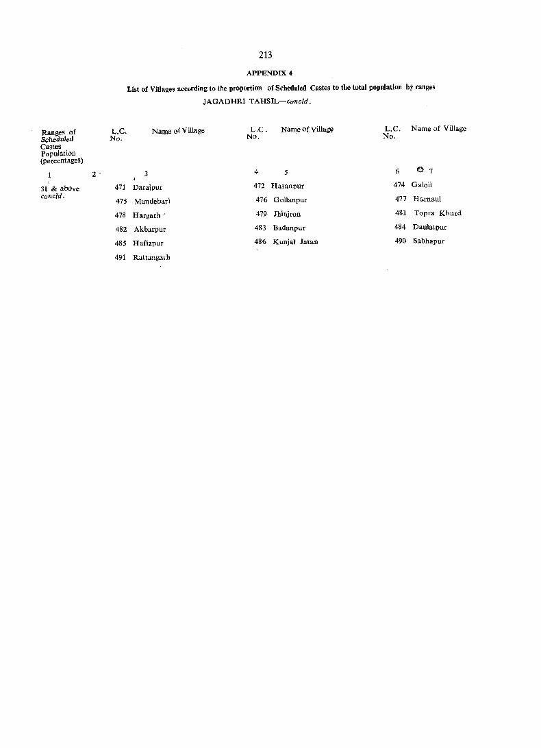
Ranges of Scheduled Castes population (percentages)
1
31 & above concld.
2 -
L.C. No.
471
475
478
482
485
491
213
APPENDIX 4
List of Villages according to the proportion of Srheduled Castes to the total population by ranges
JAGADHRI TAHSIL-concld.
Name of Village L.C. No.
Name of Village L.C. Name of Village No.
3 4 5 6 e 7
Darajpur 472 Hasanpur 474 Galoli
Mandebari 476 Gollanpur 477 Hamaul
Hargarh' 479 Jhinjron 481 Topra Khurd
Akbarpur 483 Badanpur 484 Daulatpur
HafizpuI 486 Kunjal iatan 490 Sabhapur
Rattangarh


215
SECTION II
TOWN DIRECTORY

CODES USED IN THE
TOWN DIRECTORY

219'
CODES USED iN mE TOWN DIRECTORY TOGETHER WITH WHAT THESE STAND FOR ARE INDICATED BELOW:
Status
M.C.
C.B.
C.T.
E.O.
Type of road-
PR
KR
System of Sewerage-
S
OSD
Pt
Method of disposal of nightsoil-
HL
B
WB
ST
S
Source of Water SuppJy-
TW
T
W
TK
System of storage of water-
ORT
SR ., BWP
PT
Medical facilities-
H
-D
HC
Municipal Committee
Cantonment Board
Census Town
Estate Office
STATEMENT-IV
Pucca Road
Kuccha Road
Sewer
Open Surface Drains
Pit System
Head Loads
Baskets
Wheel Barrows
Septic Tank .Latrines
Sewerage
Tubewell Water/Handpuxnp
Tap Water
Well Water
'Tank Water
Overhead Tank
Service Reservoir
Borewell Pump in,g System
Pressure Tank
STATEMENT-V
Hospital
Dispensary
Health Centre
Medical faciIities-concld.
FC
TB
o A
Educational facilities-
A
AS
AC
ASC
Recognised sltortlland, typewriting and other vocational training institutions
o Public Libraries including reading rooms-
PL
RR
220
STATEMENT -V
Fl'.mily Planning Centre
T. B. Clinic
Others
Ayurvedic
Arts only
Arts and Science only
Arts and Commerce only
Arts, Science and Commerce
Others
Public Library
Reading Room
221
TOWN DIRECTORY
STATEMENTS
S1. No.
1
2
3
4
S
6
7
8
9
10
11
12
13
14
Class, name and civic administration status of the town
2
Ambala (M.C.)
III Ambala Cantt. (C.B.)
II Amba/a Sfldar (M.e.) 'Ill·
Ambala (U.A.)
(i) III *.Ambala Cantt. (C.B.)
(ii) 1I Amba/a sadar (M-C.)
V Babiya/ (C.T.)
V Buria (M.C.)
V Chhachhrauli (M.C.)
III Jagadhri (M.C.)
V *Jagadhri Workshop Railway Colony (M.C.)
III Kalka (M.C.)
V. *Naraingarh (M.C.)
Locatioll Code No.
3
VI
VII
222
Name of Area Tahsil (in Sq.
kms.)
4 5
Ambala 16'94
37'51
Ambala
VIII Ambala
31·18
6'33
2·21
1·94
IX Ambala
XIII Jagadhri
XIV Jagadhri 1 ·29
I Kalka 3·39
IV Naraingarh
IV Panchku/a Urban Estate (E.O.) III Kalka
Kalka
10·37
3'44
2·70
V p_injore (M.C.)
IV Sadaura (M. C.)
I Yamunanagar (M.C.)
Yamunanagar (U.A.)
(i) III Jagadhri (M.C.)
(ii) V *Jagadhri Workshop Railway Colony (M.C.)
(iii) I Yamunanagar (M.C.)
II
V
XII
x
XI
Naraingarh
27·60
Jagadhri 10·83
Jagadhri 0·89
Jagadhri 15 ·88
Number of house· holds including hOuseless househoicts (in 1981_ Census)
6
18,828
24,520
9,942
14,578
1,180
1,094
1,170
4,474
1,662
2,766
1,232
1,813
30,013
7,404
1,655
.20,954
STATEMENT
Status aod
Population and growth :ate of the
1901
7
78,638
5,865
5,520
7,045
9,812
13,462
13,462
---1911
8
80,131 (+1 '90)
1921
9
76,326 (-4 '75)
See Ambala
See Ambala
Notified as a
Notified as a Census
4,272 3,574 (-27 ·16) (-16 '34)
4,246 (-23 ·08)
4,202 (-1·04)
See Yamunanagar
See Yamunanagar
4,532 . 7,635 (-35'67) <+68 '47)
Notified as a town
Notified as a town
Notified as a 7,774
(-20 '77)
town 7,630
(-1·85)
See Yamunanagar
12,045 (-10 '53)
12,045 (_10 ·53)
11,544 (-4'16)
11,544 (-4'16)
Notified as a town
Notes.-l. ·*Ambala Cantonment in 1901, population 050,438 (30,367 M, 20,071 F) in 1911, population 54,223 (34,446 M, 19,777 F) in 1921, population 47,745 (29,691 M, 18,054 F) and in 1931, population 49,368 (29,991 M, 19,377 F) was a part of Arnbala (M.e.). The cornbined population of Ambala (M.C.) and Ambala Cantonment for 1901 to 1931 has been shown against Ambala (M.C.).
2. Ambala Sadar was carved ,out of Ambala Cantt. after 1971-Census. Hence the pOpulation of Ambala Sadar M.C. has not been shown prior to 1981.Census.
3. ' .. ' denotes 'Nil'.
4. Towns treated as such for the first time in 1981-Ccnsus are printed in italics,
5. Towns treated as such for the first time in 1971-Ccnsus which continue to be treated as towns for 1981-Census are shown with an asterisk (.) on their left • .
•• U.A. denotes. Urban Agglomeration.
223
1.
Growth History
town at the Cens,uses of
1931 1941 ---. --~--.e---1951 1961 1971
10 11 12 13 14
86,592 44,964 57,979 76,204 83,633 (+13 '45) (-48 '07) (+28 '95) (+31 '43) (+9 ·75)
Urban Agglomeration
Urban Agglomeration
62,419 94,043 105,5~3 102,493 (+50 '66) (+12 '23) (-2 ,89)
62,419 94,043 105,543 102,493 (+50 '66) (+12'23) (+2 ·89)
town,for the first time in 1981.Census
t own for the first time in 1981-Census
3,494 3,857 3,635 3,988 4,645 (-2'24) (+10 '39) (-5'76) (+9'71) (+16 '47)
5,124 5,419 4,444 5,038 5,382 (+21 '94) (+5 '76) (-17 '99) (+13 '37) (+6,83)
Urban Agglomeration
Urban Agglomeration
7,937 9,766 14,058 18,068 17,711 (+3 '96) (+23 '04) (+43 '95) (+28 '52) (-1'98)
for the first time' in 1971.Census 6,880
for the first time in 1981-Census . . for the first time in 1981.Census
7,769 8,815 7;566 7,7,75 8,971 .(+1'82) (+13'46) .(-14'17) (+2 '76) (+15 '38)
Urban Agglomeration
13,268 16,422 39,627 84,337 115,020 (+14 '93) (+23)7) (+141'30) (+112 ·83) (+36 '38)
13,268 16,422 23,943 32,637 35,094 (+14 '93) (+23,77) (+45 '80) (+46 '31) (+7,53)
for the first time in 1971.Census 7,332
'15,684 51,700 72,594 (+229 '64) (+40 ,41)
1981
15
194,565 (+25 '03)-
121,203 (+18 '25) .
40,462 (-60'52)
80,741
1,342
6,258 (+34 '73)
6,140 (+1'4 ·08)
21,359 (+20 '60)
9,370 (+36 '19)
11,239
5,746
10,131 (+12.93)
160,424 (+39 '47)
43,102 (+22 '82)
8,018 (+9 '36)
109,304 (+50 '57) -
Density
(1981 Census)
16
6.173
3,231
1,298
12,755
3,322
3,226
4,760
6,301
6.941 •
1,084
1,670
3,752
5,812
3,980
. 9,009
6,883
Sex-ratio ----------1961 Census
17
838
727
727
841
856
752
940
780
821
754
1971 1981 Census Census
18 19
, 881 895
926 970
926 1,103
909
902
881 868
944 910
858 834
927 924
675
897
933 929
820 831
853 823
824 790
803 8313

81. No.
2
3
4
5
6
7
8
9
10
11
12
Class and name of Town
2
Ambala
III Amhala Cantt.
II AmbaJa Sadar
AmbaJa (U.A.)
(i) III AmbaJa Cantt.
(ii) IJ· Ambala Sadar
V Babiyal
V BUria
V Chhachhrauli
III Jagadhri
V Jagadhri Worksh(>p Rail~ay Colony
III Kalka
V Naraingarh
IV Pancllku)a Urban Estate
V Pinjore
13 IV Sadaura
14 I Yamunanagar
yamunanagar (U.A.)
(i) III ]agadhri
(ii) V Jagadhri WOrkshop RailwaY Colony
224
Physical aspects
Rainfall Temperature (in mm) (in centigrade)
Maximum Minimum
3 4 5
'=. 797 '0 44'4 1. 8
797 ·6 N.A. NA
N.A. N.A. N.A.
N.A. N.A. N.A.
N.A. N'.A. N.A.
N.A. N.A. N.A.
843'3 N.A. N.A.
1.022,9 N.A. N.A.
N.A. N.A. N.A.
N.A. N.A. N.A.
N.A. N.A. N.A.
598 '0 N.A. N.A.
N.A. N.A. N.A.
State HQs.
6
Chandigath (47)
Chandigarb (55)
Chandigarh (55)
Chandigarh (60)
Chandigarh (106)
Chandigarh (J 10)
Chandigarh (29)
Chandigarh (59)
Chandigarh (8)
Chandigarh (24)
Chandigarh (88)
Chandigarh (100)
Chandigarh (108)
STATEMENT
P hYSical Aspects and
Name of and
District HQs.
7
Ambala. (0)
See Ambala
See Ambala
See Constituent
Ambala (9)
AmbaJa (9)
Ambala (14)
AmbaJa (60)
AmbaJa (66)
See ¥amunanagar
See Yamllnanagar
Ambala (56)
Amba/a (39)
Ambala (40)
Ambala (51)
Ambala (68)
See Yamunanagar
See·Collstittlent
Ambala (54)
Ambala (62)
(iii) I Yamunanagar ~.A. N.A. N.A .. Chandigarh Ambala (107) (61)
._------_---._ Notes.-1. 'N.A.' means inrormation not available.
2. ' .. ' denotes 'Nil'.
~, U.A. denote~ Urban Agglomeration,
225
II
Location of Towns, 1979
road distance (in krus.) from ___...,._--,-~__"'_"""--------
Sub-DivisionlTahsil H.Qs. Nearest city with Railway _~tation Bus route Navigable river/ population of on~ can.a! (if within lakh and more . 10 kms.)
8 9 10 11 12
-AmbaIal AmbaIa Chandigarh AmbaIa Ambala
(0) (0) (47) (0) (0)
Urban Agglomeration
Urban Agglomeration
Units
Ambala! Ambala AmbaIa Amba!a Cautt. Ambala Cautt. (9) (9) (9) (0) (0)
Ambala/ Ambala Arubala Amba!a Cantt. Ambala Sadar (9) (9) (9) (2) (0) -
AmbaIa/ Amba!a Ambala AmbaIa Cantt. -BabiyaI (14) (14) (14) (5) (0)
Jagadhri !Jagadhri Yamunanagar Jagadhri Buria (6) (6) (13) (13) (0)
Jagadhri/Jagadhri Yamunanagar Jagadhri Chhachhrauli (12) (12) (19) (19) (0)
Urban Agglomeration
Urban Agglomeration
Ambala/Kalka ChandigarJ; Kalka Kalka (56) (0) (29) (0) (0)
Narai ngarh/Narain garh Ambala Ambala Naraingarh (0) (0) (39) (39) (0)
Ambala/Kalka Chandigarh Ch~ndigarh P auchkula Urban Estate (40) (16) (8) (8) (0)
AmbalajKalka Chandigarh Kalka Pinjore· (51) (5) (24) (5) (0)
Naraingarh/Naraingarh Yamunanagar B-arara sadaura (29) (29) (35) (26) (0)
U rhan Agglomeration
Unl:
J agadhri/Jagadhri Yamunanaj;ar Jagadhri Yamunanagar Jagadhri (0) (0) <;1(7) (7) (0)
Jagadhri/Jagadhri Yamunanagar Jagadhri Workshop Jagadhri Workshop (8) (8) (3) (0) Railway Colony (0)
Jagadhri/Jagadhri Saharanpur Jagadhri YJ1munanagar Yamunanagar (7) (7) (32) (0) (0)
~------_ .. _.,---

81. No.
2
3
4
5
6
7
8
9
10
11
12
13
14
Class and name of Town
2
., I Ambala
III Ambala Cantt.
II Ambala Sadar
Ambala (U.A.)
(ij III Ambala Cantt.
(ii) II Ambala Sadar
V Babiyal
V Buria
V Chhachhrauli
III Jagadhri
V Jagadhri Workshop Railway Colony
III Kalka
V Naraingarh
IV Panchkula Urban Estate
Y. Pinjore
IV Sadaura
I Yamunanagar
Yamunanagar (U.A.)
(i) III Jagadhri
(ii) V Jagadhri Workshop Railway Colony
(iii) I Yamunanagar
Notes.-L ' .. ' denotes 'Nil'.
2. U.A .. denotes Urban Agglomeration.
Civic administration status (in 1980)
3
M.C.
C.B.
M.C.
C.B.
M.C.
C.T.
M.C.
M.C.
M.C.
M.C.
M.C.
M.C.
E.O.
M.C.
M.C.
M.C.
M.C.
M.C.
M.C.
Since
Receipt through taxes, etc.
4
41,786
29
8,019
380
1,616
5,778
2,270
20
i:2,427
23,403
Revenue derived from municipal properties and 'power apart frQm taxation
5
3,556
116
3,010
14
196
633
322
193
742
all the prol'erties within the
68,079 5,946
STATEMENT
Municipal
Receipt (in
Government Loan grant
-_----6 7
6,000 4,000
See Ambala
See Ambala
See Constituent
117
2,040
Notified as a Census
26
See Yamunanagar
See Yamunanagar
1,745 3,150
22
See Yamun;inagar
See Constituent
16 1,000 .,
Jagadhri Wor kshop Railway
1,470 2,930
IiI
Finance. 1978-79
Rs .. '00')
Advance
8
214 "
Other sources
9
7,461
Urban Agglomeration
Urban Agglomeration
Units
100
57,796
Total receipt
10
63,017
362
70,865
I town for the first time in 1981-Census
14 J 288 696
110 563 2,511
Urban Agglomeration
Urban Agglomeration
219 3,028 14,553
619 3,211
390,875 390,875
12 32
261 846 3,749
Urban Agglomeration
Units
4,866 5,060 35,087
Colony are owned by the Central Govt.
796 11,171 90,392
General adminIstration
11
2,1$4
13
15,628
147
549
1,622
488
349
~,618
Public n.f~ty
12
221
5,273
9
5,434
;U
4
417
173
283
948
Expenditure (in Rs. '00')
Public Others Total institutions (specify) expenditure
Public Public health works and convcrucn-ces
13 14 15 16 17
24,806 B,367 188 22,694 63,482
132 10 29 169 362
14,119 4,190 253 19,700 :"'60,524
87 145 51 300 761
204 380 7 1,536 2,680
~,047 124 67 6,617 11,894
280 669 6 1,196 2,812
.. 286,921 286,921
4 10 14
1,142 195 1,430 3,399
11,060 4,061 605 14,295 35,587
Railway Board,:no income and expenditure has been shown for the year 1978-79
7.297 7,432 34,621 ' 31,166 1,501 8,188 90,205

Sr· No.
1
1
2
3
4
5
6
7
8
9
10
11
12
13
14
Class and name of town
2 - - ___.. ..
I Ambala
III Ambala Cantt.
II Ambala Sadar
Ambala (U.A.)
(i) III Ambala Cantt.
(ii) II Ambala Sadar '"
V Babiyal
V Buria
V Chhachhrauli
III Jagadhri
V Jagadhri Workshop Railway Colony
III Kalka
V Naraingarh
IV PanchkuJa Url:tan Estate
V Pinjore
IV Sadaura
I Yamunanagar
Yamunanagar (U.A.)
(i) III Jagadhri
(ii) V Jagadhri Workshop Railway Colony
(iii) I Yamunanagar
228
Civic Population administra- . . tion status (in 1980)
3 4
M.C. 104,565
C.B.
M,C.
121,203
C.B. 40,462
M.C. 80,741
C.T. 7,342
M.C. 6,258
M.e. 6,140
M.C.
M.C. 21,359
M.C. 9,370
E.O. 11,239
M.C. 5,746
M.C. 10,131
M.G.
160,424
MC 43,102
M.C. 8,018
M.C. 109,304
Scheduled Road len gth Castes (in kms.) populatiolJ.
5 6 .
9,098 PR(36.0)
16,900 PR(75.0) KR(5.0)
5,558 PR(40.0)
11,342 PR (35.0) KR (5.0)
2,219 PR (4.0)
346 PR (1.0)
1,156 PR (1.0) KR (3.0)
3,506 PR (5.6) KR (1.3)
2,377 PR (1.2) KR (3.0)
1,083 PR (60.0)
377 PR (7.0)
1,546 PR (1.5) KR (3.0)
14,589 PR (95.2) KR (46.0)
3,916 PR (11.2)
1,223 PR (2.0)
9,450 PR (82.0) KR (46'0)
STATEMENT
Civic and otber
System of Number of of sewerage ---. - ___ _
7
OSD
OSD
OSD
OSD
OSD
OSD
OSD
Pt.
S
S'
OSD
S,OSD
S
S,OSD
Water Service bOrne
8 9
543 19,012
See Ambala
See AmbaJa
24 6,542
24 80
6,462
812
2,025
See Yamunanagar
See Yarnunanagar
549 278
250
11,223
1,100
50
See Yamunanagat
5,119 16,281
492 2,332
1,000
3,627 13,994
Notes.-l. * lIn case this service is not available in the town, the name of the nearest town if in the same district or the name of the nearest district if in the same State or other State where available along with distance from the town, is mentioned.
2. 'N.A.' means capacity not available.
3. ' .. ' denotes 'Nil'.
4. U.A. denotes Urban Agglomeration:

229
rv Amenities, 1979
latrines Method of Protected Water Supply Fire fighting Electrification (Number of connectionS)
---'_ disposal of ------------.-~-......-~--- service * --------~------------
Others night soil Source of SYstem of Domestic Industrial Commer- Road Others supply Storage with cial lighting
capacity in litres (points) (i n brackets)
10 11 12 13 14 15 16 ,)7 18 19
.. WB T,TW OHT (2,002,000) Yes 18,664 303 5,000 2,055 BWP eN.A.)
U rbah Agglomeration
V rban Agglomeration
72 OHT (4,125.967) 21,687; 806 6,239 1,353 638
72 HL T, TW Ambala Sadar 5,166 121 526 300 638 (I)
B T, TW OHT (4,125,967) Yes . 16,521 685 5,713 1,053
1,004 HL W, T Ambala Sadar 1,411 (5)
.. WB T,1;'W Yamunanagar 530 15 74 (13)
B T, TW OHT (91,000) Xamuilanagar (19)
1,119 35 439 165
Urban Agglomeration
Urban Agglomeration
102 WB T, W <mT (910,000) Pinjore 2,522 47 786 221 (5)
WB T,TW PT (150,000) Ambala 1,340 50 516 '150 BWP (N.A.) (39)
.. ST, S T, TW Chandigarh (8)
2,685 130 482 391
.. S TW,TK, SR: (3480,000) yes . 1,039 1 19 300 6 BWP (N.A.)
750 WB,ST T, TW SR (113,750) Yamunanagar (35)
3,499 1,452 {;70 2
Urban Agglomeration
OHT (910,000) 17,409 1,625 5,066 3,010 202 BWP (N.A.)
", HL, B 'l',TW OHT (455,000) Yamunanagar 4,340 814 1,617 591 173 (7)
" S T,TW OHT (N.A.) Y\1S 1,636 8 652
.. WB, S T, TW OHT (455,000) Yes BWP (N.A.)
11,433 811 3,441 1,767 29
------~----- .. -
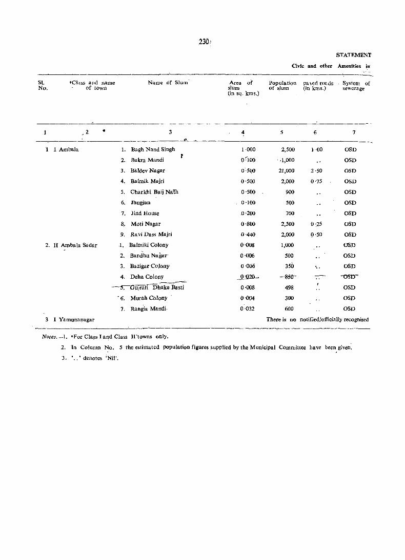
51. No.
1
'1
2.
*ciass and name of town
2 •
I Ambala
II Ambala Sadar
1.
2.
3.
4.
5.
6.
7.
8.
9.
1.
2,
3.
4.
Name of Slum
3 .,
Bagh Nand Singh
Bakrl! Mandi t
Baldev Nagar
Balmik Majri
Charkhi Baij Nalh
Jhugian
Jind House
Moti Nagar
Ravi Dass Majri
Balmiki Colony
Bandhu Nagar'
Bazigar Colony
Deha Colony ---------S:-Ou]ratiDhaka' Basti
'6. Murah Colony
7. Rangia Mandi·
3 I Yamunanagar
Note$._l. "'For Class I af)d Class I1'towns only.
230,
Area of slum (in sq. kms.)
4
1·000
0-:'100
0"500
0·500
0'500
0'100
0'200
0'800
0'440
0'008
0'006
0'006
_JU}2O-
0'008
0'004
0·032
STATEMENT
Civic and other Amenities in
Population paved Tor,ds System of of slum (in kms.) . sewerage
5 6 7
2,500 1·00 OSD
. ·1,000 OSD
21,000 2·50 OSD
2,000 0'75 OSD
900 OSD
500 OSD
700 OSD
2,500 0'25 OSD
2,000 0'50 OSD
1,000 OSD
500 OSD
350 ',. OSD
--s51)- "'OSlJ'
498 OSD
300 OSD
600 OSD
There is no notified/officially recognised
2 . In Column No. 5 the estimated population figures supplied by the Municipal Committee have been given.
3. . . . • denotes 'Nil'.
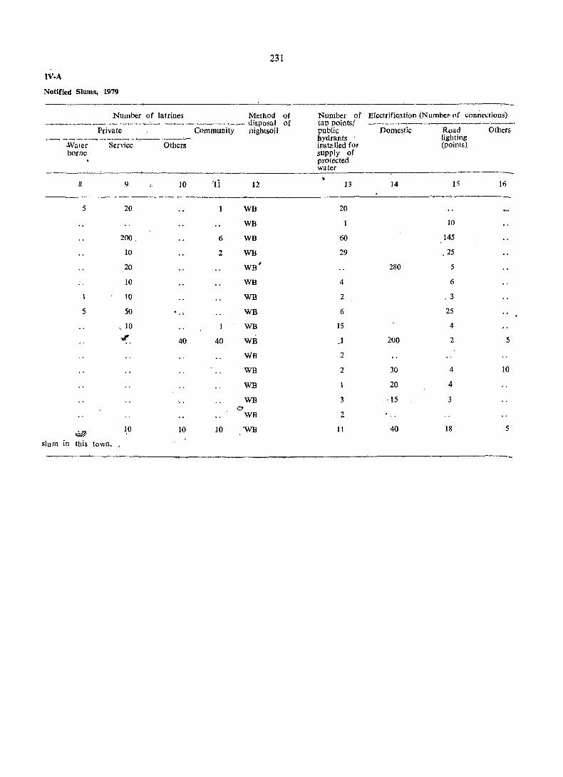
231
IV·A
Notified Slums, 1979
Number of latrines Method Qf Number of Electrification (Number of connections) -~~.-~-~._~- --,~--,__:,.-. ~~-.~-,~---,-,- disposal of tap pointsl _ __.,-........--._~_.. __ ~__.._-.. _ ___,_1 _ _.,~· ~ __
Private Community nightsoil public Domestic Road Others -~- --,.--.- -+---,.- .. - .. __,~ __'.---.--.__, --.-__...,:"'- hydrants lighting
-Wuter Service Others installed for (points) borne supply of
protected water
'Ii ~
8 9 10 12 13 14 15 16
~
5 20 WB 20
WB 10
200 6 WB 60 145
10 2 WB 29 .25
20 WB' 280 5
.. 10 WB 4 6
10 WB 2 . 3
5 50 WB 6 25
". 10 WB 15 4
oJ' 40 40 WB .1 200 2 5
WB 2
WB 2 30 4 10
WB 20 4
WB 3 ·15 3 0
WB 2
~ ~O 10 10 'WB 11 40 18 5
slum in this town.
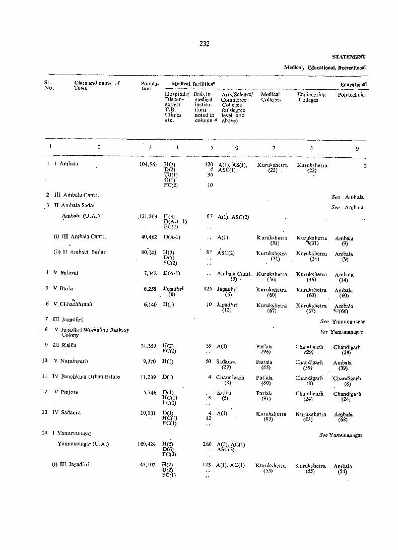
232
STATEMEm'
Medical, Educational, Recreational
SI. Glass and natU>e of Popula- Medical facillties* Educational No. Town tion -----....;.._~--.--- ------~-------------.~---~----
Hospitals/ Beds in Arts/Science! Medical Engineering Polytechnics Dispen- medical Commerce Colleges Colleges saries/ institu- Colleges T.B. dons (of degree Clinics noted in level and etc. column 4 above)
~--
2 3 4 5 6 7 8 9 .--~---~
1 I Ambala 104,565 H(3) 320 A(1), AS(I), Kurukshetra Kurukshetra 2 D(2) 4 ASC(I) (22) (22) TB(l) 36 0(1)
10 FC(2)
2 III Arilbala Cantt. See Ambala
3 II Ambala Sa dar See Alllbaia
~mbala (U.A.) .121,203 H(3) 87 A(1), ASC(2) D(A-I, I) FC(2)
(i) III Ambala Cantt. 40,462 D(A-l) .. AO) Kurllkshetra' Kurukshetra Ambala (31) "I.(3J) (9)
Oi) IT Ambala Sadar 80,141 H(3) 87 ASC(2) Kurukshetra Kurukshetra Ambala D(1) (31) (31) (9) FC(2)
4 V Babiyal 7,342 D(A-J)' Ambala Cantt. Kurukshetra Kuruksbetra Ambala (5) , (36) (36) (14)
5 V Buria 6,258 Jagadbri 125 Jag®hri Kurukshetra Kurukshetra Ambala (6) (6) (60) (60) (60)
~
H(1) 10 Jagadhri Kurukshetra Kurukshetra Ambala 6 V.CbhachhrauIi 6,140 (12) (67) (67) '\l;:{66)
7 III Jagadnri See Yamunanagar
8 V Jagadhri Workshop Railway See Yamunanagar Colony
9 III Kalka 21,359 H(2) 39 A(I) Patiala Chandigarh , Chandigarh FC(I) (96) (29) (29)
10 V Naraingarh 9,370 HeJ) 50 Sadaura Patiala Chandigarh Ambala (29) (85) (59) (39)
11 IV PanchkuJa Urban Estate 11,239 D(1) 4 Chandigarh PatiaJa Chan,digarh 'Chandigarh (8) (80) (8)' (8)
12 V Pinjore 5,746 D(I) Kalka Pudala Chandigarh Chandigarh HC(l) 8 (5) (91) (24) (24) FCCI)
13 IV Sadauru 10;131 DCl) 4 A(I) Kurukshetra Kurukshetra Ambala HC(1) 12 (83) (83) (68) FCCl)
14 I Yamunanagar See Yamut+anagar
Yamunanagar (U.A . .) 160,424 HC~ 260 A(3), AC(I) DC ) ASC(2) . FC(2)
(i) III Jagadhri 43,102 H(2) 125 A(I), AC(l) Kurukshetra Kurukshetra Ambala 1;>(2) (55) (55) (54) :rql)

233 .
v
anll C~ltural Facilities, 1979
facilities* Number ofrecrcational and cultural Working facilites
Recognised Higher Secon- Junior Primary Adult women's ----------~--____,-----shorthand, Secondary, daryl Secon- Schools literacy hostels Stadia Cinema Auditorial Public typewriting Intermediate/ Matdcu- daryand classes/ with Drama/ libraries and voca- P.u.c. (Pre- lation Middle centres, number Commu- including tional University, Schools others of seats nity halls reading training College/Junior (Specify) rooms institutions Co liege level)
---~-------
10 11 12 13 14 15 16 17 18 19 20 .
0(6) 4 19 20 30 16** 1(40) 2 PL(1), RR(5)
H
Urban Agglomeration ~
Urban Agglomeration
0(2) 5 18 20 35 t2 -:) 1(45) 5 PL(2), RR(5)
0(2) 3 5 7 13 2 1(45) 2
Ambala 2 . 13 Cantt. (4)
13 22 3 PL(2), RR(S)
Ambala Ambala Cantt. 2 3 4 Sadar (5) (5)
Yamunanagar . Jagadhri 3 3 2 Sadaura PL(2). RR(2) (13) (6) (34)
0(1) Jagadhri 2 2 3 Sadaura PL(I). RR(1) (12) (22)
Urban Agglomeration
Urban Agglomeration
0(1) 3 4' 6 ]2 Chandigarh 1 1 PL(2), RR(3) (21)
0(1) '2 2 3 2 PL(2). RR(2) 4
Chandigarh Chandigarh 2 3 Chandigarh (8) (8) (1)
Kalka KaJka. 1 3 3 Chandigarh PL(2), RR(2) (5) (5) (16)
Naraingarh 2 2 3 5 1 PL(I), RR(I) (29)
Urban Agglomeration
0(1) 12 22 26 43 5 3 PL(4), RR(12)
Yamunanagar 4 9 9 15 Sadaura 2 PL(2), RR(2 (7) (28)
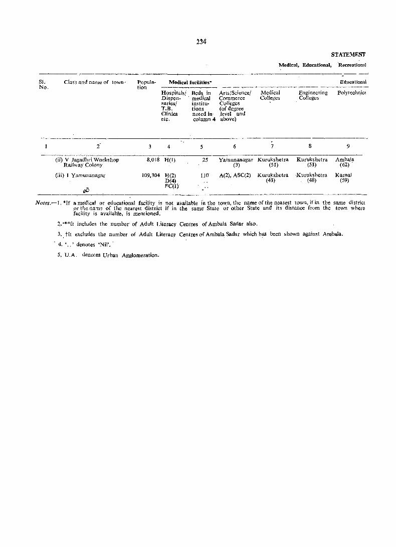
51. No.
ciass and name of town·
2
(ii) V Jag&dbri Workshop Raifway Colony
(iii) I Yamunanagar
~7;
Population .
3
8,018
109,304
Medical facilities"
Hospitalsj Bed~ in Dispen- 'medical saries! institu-T.B, tions Clinics noted in' etc. column 4
4 5
H(l) 25
H(2) 110 D(4) FC(I)
Arts/Science! Commerce Colleges (of degree level and above)
6
Yamunana-gar (3)
A(2), ASC(2)
STATEMENT
Medical, Educational, Recreational
Medical Colleges
7
Kurukshetra (51)
Kuru)(shetra (48)
-------
Engineering Colleges
8
Kurukshctra (51)
Kurukshetra (48)
Educational
Polytechnics
9
Arnbala (62)
Karnal (59)
Notes.-1.*If ame'dical or educational facility is not available fnthc town,the name of the nearest town,ifin tile same district ,or the nam~ of the nearest district if in the same State or other State and its distance from the town where facility is available, is mentioned.
2. ·**It includes the number' of Adult Literacy Centres of Ambala Sadsr also.
3. tIt excludes the number of Adult Literacy Centres of Ambala Sadar which h~s been shown against Ambala.
4. '.,' denotes ·Nil'.
5. U.A. denotes Urban Agglomeration.
235'
V-cohcld.
and Cultural Facilities, 1979
facili ties * -----------------------------'_-------Recognised, Higher Secon- Junior Primary Adult shorthand, Secondary, daryl Secon- Schools literacy typewriting Intermediate! Matricu- daryand classes! and vocational P.U.C. (P.re- lation Middle centres/ training University" Schools others· institutions College/ (sp_ecify)
Junior. College level)
10 11 12 13 14 15
Yamunanagar Yamunanagar 3 4 5 Sadaura (3) (3) (36)
0(1) 8 10 13 23 Sadaura (35)
Working women's hostels with number of seats
16
Number of recreational and cuitilral ,facilities
----------------_ Stadia Cinema Auditorial Public
Dramal libraries Commu- including nity halls reading
rooms
17 18 19 20
PL{I), RR(I)
3 2 PL(I), RR(9)
S1. No.
2 . 3
4
5
6
7
8
9
Class and name of town
2
I Ambala
III Ambala Cantt·
II' Arnbala Sadar
Ambala (U.A.)
(i) III Ambala Cantt.**
(ii) II Ambala Sa dar
V Babiyal
V Buria
V Chhachhrauli
III Jagadhri
V Jagadhri Workshop Railway Colony
III Kalka
10 V Naraingarh
~~pancl1!(tifa ~Estate
12 V Pinjore
13 IV Sadaura
14 I Yamunanagar
Yamunanagar (U.A.)
(i) III Jagadhri
(ii) tV Ja~adhri Workshop Railway. Colony
(iii) I Yamunanagar
Name of three most important commodities imported
3
Cotton
Raw material for Scientific goods
Gur
Cotton
Television Sets
Cloth
Cement
Tractor Tyres and Tubes
yanaspati Ghee
i1I
Stainless Steel
Sugarcane
2nd
4
Paddy
Raw material for Refrigera tors
Leather
Oil Seeds
Radio Sets
Sugar
Sanitar-wares
. Hydraulic Equipments
Sugar
Aluminium
3rd
5
Iron and Steel
Petrolium and Crude oil
Desi thread
Paddy
Groundnuts
Groundnuts
Iron
Bearings
C1otl}
Zinc, Copper and Brass
Raw material for Spring Steel paper and Plates Vanaspati Ghee
STATEMENT
Trade, Commerce,
Name of three
1st
6
Cloth
See Ambala
See Ambala.
See Constituent
Scientific goods
Desi jutties
Bon Bobber
See Yamunanagar
See Yamunanagar
Pothrooti Baskets
Foodgrains
Tractor parts
Milling Machines
Khandsari
See Yamunanagar
See Constituent
Utensils
Sugar
Notes.-l. "''''Due to exclusion of Civil area: from the Cantonment, the information for columns 3 to 11 is 'nil'. The residents of Cantonment area bring the household goods from Ambala Sadar which is adjacent to Ambala Cantonment. Now Cantonment consists of army area and a small bazar names 'RHA Bazar'.' ' ,
2. tJagadhri Workshop Ra,i1way Colony M. C', being residential colony for employees, nothing is imported, exported or manufactured within the limits of M.C.
3. ' .. ' denotes 'Nil'.
4, .6. "'It includes the number of . banks in Ambaia Cantt. (C;B.) and Ambala Sadar (M.C.).
5. U.A.: denotes Urban Agglomeration.

237
VI
Industry and Banking, 1979
most important commodities Name of three most important commodities Number Number Number exported manufactured of banks ofagri- of nOD-
cultural agricul-2nd 3rd 1st 2nd 3rd credit tural
societies credit societies
7 8 9 10 11 12 13 14
Rice Iton and Steel Durries Iron and Steel Soap 637 2 9 goods goods
Urban Agglomeration
Urban Agglomeration
Units
3
Refrigera tors Kabari goods Scientific Refrigera tors Electric goods 9 goods
Desi Cloth Sugarcane Desi Cloth Desi Jutties Earthen Pots
Rice Oil Rice Oil Utensils 3 2 1
Urban Agglomeration
Urban Agglomeration
Stoneware Lime stone Pathroti Stone Stone 4 1 Baskets Kundies Chaf,kies
Mango fruit Vegetables Carpets Wheat Thrasher Suit Cases 3 2 2
Tractor pa.rts 2
Machine Tractors Tractors Broching Vertical Milling 1 Accessories Machines Centre
Potatoes Carpets Khandsari Carpets Rice 2 1
Urban Agglomeration
Units
Show pieces Hospital Wares Stainless Steel Aluminium and Show pieces 10 2 Utensils Brass Utensils
1
Paper and Automoblie Sugar Paper and' Automobile 16 V Vanaspati Ghee Springs Vanaspati Ghee Springs


APPENDIX
239

241
!_PPENDIX
---------------------------~-----------------------~--_-
Towns showing their outgrowtbs wltb popUlation
------------;;-------------- - ~ '---------~-------------~--.--
SI. No.
1
Name of the town . with location cpde
No.
2
Population of COre town
3
Not applicable
Outgrowth
4
------------------------~----~---
PE>pulation of outarowth
s

243
· PART B
PRIMARY CENSUS ABSTRACT


PRIMARY CENSUS ABSTRACT
AMBALA DISTRICT

246
PRIMARY CENSm
Location District/Tahsil Total/ Area in No. of No. of Total Population (including Code Rural/ Km" occupied. House- Institutional and HouseJess No. Urban Residential hOld& population)
Houses ----------------~
p M F
1 2 3 4 5 6 7 8 9
1 . AmbaJa District T t3,832 '0 226,815 233,047 1,409,463 753,308 656,15
R 3,723 ·3 141,995 144,295 945,686 507,049 438,63
U 108·7 84,820 88,752 463,777 246,259 217,51
2 Kalka Tahsil T 262·7 24,462 24,818 ' 126,490 69,439 57,05
R 245·5 16,090 16,346 88,146 48,052 40,09
U 17 ·2· 8,372 8,472 38,344 21,387 16,9$
3 Naraingarh Tahsil T 1,147 ·7 36,745 37,094 245,696 130,369 115,32'
R 1,143 ·6 33,377 33,619 226,195 120,248 105,94'
U 4 '1 3,368 3,475 19,501 10,121 9,38(
4 Ambala Tahsil T 1,027 '7 85,146 87,298 522,829 274,961 2,47,861
R 971·0 42,334 42,770 289,719 154,379 135~34(
U 56·7 42,812 44,528 233,110 120,582 112,528
5 Jagadhri Tahsil T 1,300 ·6 80,462 83,837 514,448 278,539 235,905
R 1,269 ·8 50,194 51,560 341,626 184,370 157,256
U 30·8 30,268 32,277 172,822 94,169 78,653
tTohl area figures for the district represent "<;1eographical area" figUres supplied by the Surveyor General. Figures for urban areaS are those supplied by the Local Bodies. Area for the rural areas are derived by subtracting the urban area from the total area of the district. The tot~I of ll;rea fIgures of tahsils in·the district will not tally with the district figures because the former are derii. cd from the vlllage·Wlse area figures supplied by the Tahsildars.
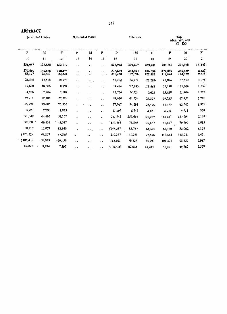
247
.ABSTRACT Scheduled Castes Scheduled Tribes Literates Total
Main Workers (I-IX)
__ o ___________ --------:0-- ------------
P M F P M F P oM F P M F
10 11 12 13 14 15 16 17 18 19 20 21
331,057 178,538 152,519 628,948 399,467 229,481 409,160 391,018 18,142
277,860 149,685 128,175 338,690 232,091 106,599 274,866 266,439 ' 8,427 53,197 28,853 24,344 290,258 167,376 122,882 134,294 124,579 9.715
24,566 13,588 10,978 '58,2~ 36,911 21,291, 40,826 37,550 3,276 . 19,600 10,806 8,194 34,446 '22,783 .11,663 27,198 • 25,646 1,552
4,966 2,782 2,184 23,756 14,128 9,628 13,628 11,904 1,724
59,914 32,186 27,728 89,466 61,139 28,327 69,735 67,453 2,282
55,991 30,086 25;905 77,767 '54,291 23,476 64,470 62,542 1,928
3,923 2,100 1,823 11,699 6,848 4,851 5,265 4,911 354
121,048 64,891 56,157 261,943 159,656 102,287 144,957 137,794 7,163
92,831 • 49,814 ' 43,017 ·113 .. 556 75,889 37,667 81,827 79,792 2,035
28,217 15,077 13,140 ~148,387 83,767 64,620 63,130 58,002 5,128
[125,529 67,873 57,656 219,337 141,761 77,576 153,642 148,221 5,421
.P09,438 58,979 .50,459 112,921 79,128 33,793 101,371 98,459 2,912
16,091 8,894 7,197 fil06,416 ~2,633 43,783 52,271 49,762 2,509

248
PRIMARY
Main Location District/Tahsil Total/ . Code Rural Cultivators Agricultural
No. Urban labourers (I) (II)
----.---------~------
P M F P M F
1 2 3 22 23 24 25 26 27
1 AUlbala District T 116,195 115,341 854 67,415 65,541 1,874
R 113,496 112,666 830 65,675 63,902 1,773
U 2,699 2,675 24 ],740 1,639 101
2 Kalka Tahsil T 8,055. 8,023 32 2,303 2,231 72 .. R 7,996 7;965 31 2,266 ,2,198 .68
U 59 58 37 33 4
3 Naraingarh Tahsil T 34;262 33,784 '478 13,649 13,417 232
R 33,531 33,054 477 13,407 13,178 229
U 731 730 242 239 3
4 Ambala Tahsil T 32,718 32,581 137 22,929 22,203 726
R 31,698 31,574 124 22,380 21,715 665
U 1,020 1,007 13 549 488 61
5 Jagadhri Tahsil T 41,160 40,953 207 28,534 27,690 844
R 40;271 40,073 198 27,622 26,811 8tl
U 889 880 9 912 879 33
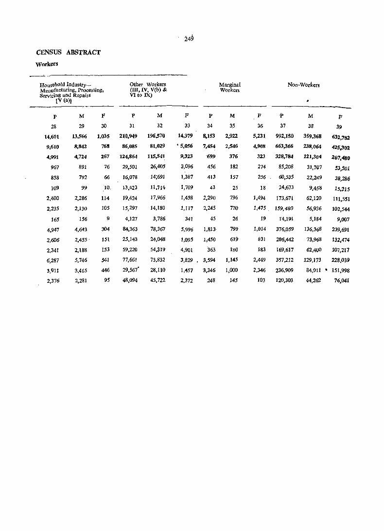
249
CENSUS ABSTRACT Workers
Household lndustry- Other Workers Marginal Non-Workers Manufacturing, Processing, (III, IV, V(b) & Workers ServiCing and Repairs VI to IX)
[V (a)1 • ---P M F P M F P M F .p M F
28 29 30 31 32 33 34 35 36 37 38 39
14,601 13,566 1,035 210,949 196,570 14,379 8,153 2,922 5,231 992,150 359,368 632,782
9,610 8,842 768 86,085 81,029 • 5,056 7,454 2,546 4,908 663,366 238,064 425,302
4,991 4,724 267 124,864 115,541 9,323 699 376 323 328,784 121,304 207,480
967 891 76 29,501 26,405 3,096 456 182 274 85,208 31,707 53,501
858 792 66 16,078 14;691 1,387 413 157 256 60,535 22,249 38,286
109 99 '10, 13,423 11,714 1,709 43 25 18 24,673 9,458 15,215
2,400 2,286 114 19,424 17,966 1,458 2,290 796 1,494 173,671 62,120 111,551
2,235 2,130 105 15,297 14,180 1,117 2,245 770 1,475. 159,480 56,936 102,544
165 156 9 4,127 3,786 341 45 26 19 14,191 5,184 9,007
4,947 4,643 304 84,363 78,367 5,996 1,81J, 799 1,014 376,059 136,368 239,691
2,606 2,455 . 151 25,143 24,048 1,095 1,450 619 831 206,442 73,968 132,474
2,341 2,188 153 59,220 54,319 4,901 363 180 183 169,617 62,400 107,217
6,287 5,746 541 77,661 73,832 3,829 3,594 1,145 2,449 357,212 129,173 228,039
3,911 3,465 446 29,567' 28,110 1,457 3,346 1,000 2,346 236,909 84,911 .. 151,998
2,376 2,281 95 48,094 45,722 2,372 248 145 103 120,303 44,262 76,041

2S1
PRIMARY CENSUS ABSTR ACT KALKA TAHSIL

KALKA TAHSIL
Location Code No.
Name ofVilJage (Hadbast No.)
1 2
Sbahpur'
2 Nawannagar
3 Gorakh Nath
4 Khokhra
5 Lehro,undi
6 Sitoo Majra
7 Maranwaia
8 Khol Mola '
9, KODa
10 Rarnpur Jangi
(99)
(98)
(97)
(100)
(94)
(96)
(95)
(101)
(93)
(92)
11 Khol Fatehsingh (102)
12 Nanakpur (91)
13 Khol Albala (89)
14 Rarnllagar .(90)
15 Karanpur (88)
16 Johlowal (129)
17 Kiratpur (127)
18 Gariran (126)
19 Charnian (128)
20 Khcranwali (130)
21 Banoi Khuda (131) Bax
22 Nagai Rootal (133)
23 Banoi Sanwalia (132)
24 Thane-ki-ser (134)
25 Bar (135)
26 l'aploha (139)
i7 Nagai Bhaga (138)
2& !,~rgian (136)
29 Kandiala (137)
30 Orian (147)
31 Khera Sita Ram (148)
32 Kalka (393)
[n Kurari (394)
34 Tagra Hakim- (150) pur .
as Tagra Hasua (143)
Area of No. of Village oeeuin Heet- pied ares residen-
, tlal ' 'Houses
3
117 ,76
231 ,07.
159·00
314·84
109·00
88·22
220 ·96
167 ·94
266·28
207·20
106·00
344·79
142·00
127·07
333·00
284·89
237·95
278'82
271 ·54
242·00
IS0,00
204 ·00
115 ·00
68 '39
475·00
4
44
82
26
70
25
24 111
31-
72
106
35 '
196
6
42
207
87
108
50
71
169
39
50
11
S2 59
315·00 135
82 ·96 ~ 31
73 ·00, 16
141,·00 47·
56 ·66 32
34·00 59
163 ·09 ')
122 ·21 J 58 ·68 75
45 ·73 41
252
No. of Tot!)l Population (lneluHouse- ding Institutional and holds Houseless Population)
5
44
82
27
70
25
24
137
31
72
106
P
6
306
494
186
443
147
171 716
195
516
684
M
7
178
264
100
239
78
81
407
98
282
369
35 215 127
196 1,285 684
6 39 24
42 345' 206
207 1,487 842
87' 714 421
lOS 817 481
50 391 232
71 602 354
169 1,063 587
39
50
11
52
59
135
31
16
47
33
59
213
370
80
347
396
891
227
123
340
203
208
120
204
47
194
215
478
121
66
159
98
122
F
8
128
230
''86
204
69
90
309
97
234
315
88
601 15
139
645
293
336
159
248
476
93
166
33 •
153
181
413
106
57
11H
105
86
VILLAGE PRIMARY
Scheduled Castes
Scheduled ,. Tribes
M
9
61
30
47 14
45
F M F
10 11 12
91
102
163
88
26
·45
48
5
42
31
79
24
3
127
64
35
28
34
14
45
74
84
151
73
18
38
40
4
37
27
55
19
3
87
50 <:)
84 76
79 70
64 7fJ 68 13
1
..
.;
Literates
M
13
71
89
41
82
32
52
207
32
122
194
24
329
2
94
327
184
186
101
153
281
20
78
18
47
94
228
72
29
75
67
84
F
14
26
20
18
26
21
33
69
27
86
13S
28 94
41
29 19
53
92
2
25
10
'8
43
60
35
3
21
$1
48
Total population and whole area of these village
75
41
514
293
2in
167
.22~
12G
109 .. i36
66
19 {j
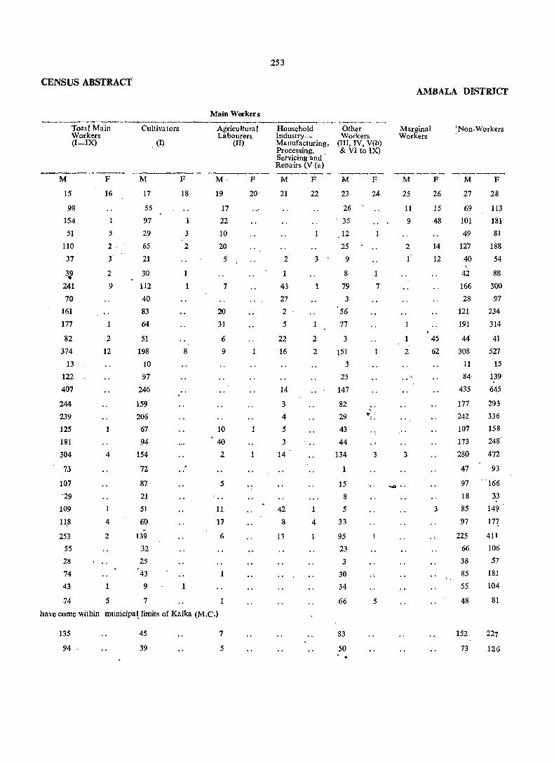
CENSUS ABSTRACT
Total Main Workers (I-IX)
M
15
98
154
51
110
37
32 241
70
161
177
82
374
13
122
407
244
239
125
181
304
73
107
-29
109
11,8
253
55
28
74
43
74
F
16
5
2 -
3
2
9
2
12
1
4
1
4
2
1
5
Cultiva tors
M
17
55
97
29
65
21
30
112
40
83
64
51
198
10
97
246
159
206
67
94
154
72
87
21
51
60 "
139
32
25
43
9
7
(I)
F
18
1
3
2
1
1
8
1
Main Workers
Agricultural Labourers
M
19
17
22
10
20
5
7
20
31
6
9
10
40
2
5
11
17
6
1
(II)
F
20
1
1
1
have come within municipa! limits of Kalka (M.C.)
135
94
45
39
7
5
253
Household Industry_ Manufacturing, Processing, Servicing and ' Repairs (V (a)
M
21
F
22
Other Workers
(III, IV, V(b) & VI to IX)
M
23
26
35
12
25
F
24
2
1
43
27
2
5
3' 9
22
16
14
3
4
5
3
14 '
42 8
13
1
2
2
1 ,
4
8
79
3
56
77
3
151
3
25
147
82
29
43
44
134
1
15
8
5
33
95
23
3
30
34
66
83
~O . .
1
7
1
., '=",
., 3
5
AMBALA DISTRICT
Marginal Workers
M
25
11
9
2
l'
2
3
_ ..
F
26
15
48
14
12
45
62
3
'Non-Workers
M
27
69
101
49
127
40
42
166
28
121
191
44
308
11
84'
435
177
242
107
173
280
47
97
18
85
97
225
66
38
85
55
48
152
73
F
28
113
181
81
188
54
88
300
97
234
314
41
527
15
139
645
293
336
158
248
472
93
166
33
149 '
In 411
106
57
181
104
81
227
126

KALKA TAHSIL
Location Code No.
l'
Name of Village (Had bast No,)
2
36 Tagra Sahoo (142)
37 Tagrahari Singh (144)
38 Tagrakali Ram (145)
39 Majra Mehtab (140)
40 Tagra Kangan (141)
41 Dhamala . (122)
42 Basawal (125)
43 }Chera (124)
Area of Village 'in Hectares
3
63·13
28·00
61 '92
165 ·00
77·29
421·00
174·00
129·00
44 Majri Jattan (123) 146 -DO
45 Prempura (103) 64 ·34
46 Manakpur (104) 140·00 Kholgaman
47 Manakpur (120) 110 ·00 Thakardass
48 Manakpur (119) 112 -DO Nanakchand
49 Manakpur (118) 62 ·00 Devilal
50 Lohgarh (121) 150 ·00
51 Basdevpura
52 . Abdulapur
53 Ferozepur
54 Kuranwala
(151)
(115)
(117)
(105)
255-35
59-DO
27'00
186--00-
55 RampurSeori (106) 168 -00 (Rampur Sewri)
254
No. of No. of occu- House-pied holds residen-
Total Population (Including Institutional and Houseless Population)
tial Houses
4
33
31
48
112
24
154
95
64
56 -29
22
71
31
53
70
81
10
333
p
5 6
33 193
31 172
48 240
112 791
24 lUi
i58 1,129
119 763
64 420
56
29
22
71
31
53
70
81
10
450
200
203
537
261
402
482
406
79
333 1,'77
M
7
112
98
127
423
71
625
439
237
265
107
131
321
150
222
271
226
44
914
F
8
.81
74
113
368
55
504
324
183
185
93
72
216
111
180
211
180
35
663
V1LLAGE PRIMARY
Scheduled Castes
Scheduled Tribes
M
9
6
163
76
184
60
37
4
49
7
92
78
27
610
F M
10 11
14
127
68
140
47
34
3
50
7
64
54
23
471
F
12
Literates
M
13
49
46
56
197
33
239
200
109
14
7
22
6
52
5
66
77
39
i19 38
15 Un.
46 14
192 76
73 34
53 30
78
151
26
297
52
71
12
Un·
73
56 'Tekwana 57 Milk 58 MuhabatPur
(107) (111) (110)
74 '00 1 89'84 >-46'00 J
Total population and whole area of these villages
59 Surajpur
60 Baglana
61 Rajipur
62 Ratpur
63 Pinjore (Rural)
64 Deval
65 Dharampur
66 Bitna
67 Kanguwala
68 Bharon-ki-ser
69 Tipra
7Q ]'{ala BIQu~
(109) 127 '00
(112) 34 '00
(108)
(116)
(113)
(114)
(152)
(153)
(146)
(149)
(157)
(l?5)
122'21
130·00
138'40
29 '14
50·00
384·00
76·00
134'76
90'00
35 '99
812
3
372
347
1,365
24
223
28
20
96
4?
812 3,932 2,178 1,754
3 13 8 5 -
372
347
1,367
24
223
28
20
96
4~
1,708
1,556
5,584
132
1,240
131
142
561
~9~
944
875
3,093
70
658
70
76
294
l~9
764
681
2,491
62
582
61
66
267
P§
459
181
217
631
43
441
61
10
166
t7
375
133
168
5C6
44
38,5
55
13
162
;~
...
1,476
2
604
628
2,224
34
348
35
55
155
?~
918
2
296
291
1,:276
Un'
26
169
10
30
76
255
CENSUS ABSTRACT AMBALA ])ISTRICT
Main Workers
Total Main Cultivators Agriculluhl Household OthlO'r Marginal Non-Workers Workers Labourers Ihdustry- Workers Workers (I-IX) (I) (II) Manufacturing, (III, IV, V(b)
Processing, & VIto IX) Servicing and Repairs IV (a)]
----M I! M F M F oM F M F M F M F
15 16 17 18 19 20 21 22 23 24 25 26 27 28
61 45 16 51 81
58 38 20 40 73
78 27 1 SO 49 113
210 92 3 115 213 368
47 24 23 24 55
297 10 118 1 178 10 328 494 265 24 57 3 18 187 24 174 299 144 2 48 11 9 1 76 93 181 150 80 22 2 46 115 185 57 24 23 10 50 93
inhabited
81 64 6 11 ?,O 72
18L 51 35 95 140 216
75 47 2 26 '75 111 127' 119 8 95 180
151 3 84 1 61 2 6 120 208 12() 2 4 2 12- i02 2 106 178 22 8 3 11 .,. 22 35 ,
innabited
527 146 6 185 4 6 1 330 141 387 516
have COme within municipal limits of Pinjore (M.C.)
1,138 62 29' 15 28 1 1,066 61 10 1,030 1,692 3 2 5 5
442 12 8 18 32 384 I 12 4~ 3 461 749 483 8 86 11 16 370 8 1 391 673
1,649 68 35 1 7 93 1 1,514 66 3 1,441 2,423 inuaoited
37 8 29 33 62
332 1 82 6 3 241 1 326 581 43 8 35 27 61 38 1 10 1 27 1 38 65
148 14 28 1 10 109 ,14 146 253 9;2 .,' 73 ,. 7 . , , . 12 " 77 1ll;!

K~KA TAHSIL
Location Code No.
Name of Village (Had bast No')
Area of No. of Village occupied in Hectares resi-
71 Jaithal
72 Noulta
2
73 Dhatoghran
74 Dakrog
75 Toran
76 Gawahi
77 Bagharni
78 Khoi
79 Janouli
(156)
(158)
(160)
59·08
55·00
37'64
(169) 166 ·00
(159)
(170)
(168)
(167)
(162)
80 Nala Domehar (164)
117'00
132·00
47·00
77·00
87·00
29·54
81 Kajiyana
82 Bhawana
83 Dhamsoo
84 Nala Dakrog
85 Berghati
86 MaJla
87 Jabrat
88 Malpur (Mahlpur)
89 Sandaspur
90 Kidar Pur (Kadarpur)
91 Nandpur
92 Tibi
93 Haripur Harisingh
94 Jodhpur
(161) 9.6 '00
(155) 106 ·00
(171)
(163)
37'64
40·47
(173) 69 '00
(174) 112'00
(166) 122'00
(177) 76 '00
(178) 41 '00
(.176) 1~'04
(175) 57 '87
(172) 65 '00
(182) 26'71
(186) 82,,15
95 Haripur Chopahar(187) 95 ·10
96 Kharkua
97 Raipur
(183) 62'00
(195) 193 '44
98 Miranpur (194) 334 ·27 Bakhshiwala
99 Ganeshpur (188) 108 '00 (Bhorian)
100 Palan (189) 40 '06
101 Damdama
102 Bhogpur
103 NagaI Sodhian
104 Aslamnagar (Islamnagar)
105 Bhagwanpur
(154) 151 '35
(190)
(191)
(192)
(193)
103'19
89·00
268'00
156·00
dential . Houses
4
15
23
19
39
73
24'
i6
28
22
4
37
72
17
6
9
301
41
44
51
18
14.
15
36
48
60
107
70
11
42
41
11
107
42
256
No. of Total Population (InHouse- eluding Institutional & holds Houseless Population)
5
P
6
130
141
M
7
71
78
42
F 8
59
63
40
150
VILliAGE PRIMARY
Scheduled Castes
Scheduled Tribes
M 9
F M F
42.
31
69
10 11
41
28
12
Literates
M
13
.F
14
5
7
15
23
19
39
92
24
16
28
22
82
288
569
146
103
138
.308
64
58
261 121
82
100
19
25
27
12
41
61
27
31
13
41
17
14
8
6
3
4
37
72
17
6
172 84
160 * 86
36
235
389
114
39
22
127
219
60
17
82
45
88
74
14
108
170
54
22
9 51 24 27
301 1,464 795 669
43 272 148 124
44' 269 145 124
51· 284 ~ 162 . 122
18 119 70 49
14 86 47 39
15 86 47 39
36
48
74
107
70
11
42
.41
11
107
42
190
300
417
701
416
81
248
231
85
783
299
99
158
235
366
226
40
139
120
42
432
170
91
142
182
335
190
41
109
111
43
351
1~
18
84
13
16
SO
5
113
.35
13.
31
30
3
9
46
180
57
43
17
32 •
74
1
88
9
19
40
5
89
30
14
24
23
3
5
46
·160
33
44
13
30
67
9
65
77
26
9
21
5
20
23
5
. 9
5 5
555 358
58 17
Un
Un-
60 14
48 8
30 9 12
29 16
12
38
53
129
70
17
41
58
25
125 .
60
4
9
15
61
19
4

CENSUS' ABSTRACT
Total Main Workers (I--.IX)
M
15
36
42
33
1!.7
192
29
23
47
42
9
67
138
27
10
13
38S
77
inhabited
inhabited
72
82
3S
35
2l! 67
100
146
205 129
22
82
69
,18
249'
Us
F
16
28
.. ,
00
1
18
10
1
4
$
Cultivators
M 17
22
26
29
82
52
12
11
42
19
9
SO
53
23
9
12
29
19
SO
53
33
35,
23
53
10 ~ 97
'85
7S
21
61
36
5
86
').1
(1) •
F
18
.'.
., ,"
1
. . [ "
,.
257
Main Workers
Agricultural 'Labourers
(II)
M F 19 20
9
8
IS
3
1
12
1
7
..
38
1
18
2
.7
93
19
. .
1
• Househ91d Other Workers Industry_ (III, IV, V(b) Manufacturing, & VI to IX) Processing, Servicing and Repairs {V(a)]
M ·F
21 22
3
1
1
;.
4 .. 1
2
19
13
4
.5
1
..
.. .
M F
23 24
5
5
4
4
139
2
9
4
7
15
76
4
1
1
337
20
9
25
2
5
13
12
47
113
54
1
21
-32
13
65
68
28
.. 1
11
10
. ..
13
.. 1
'i
4
4
AMBALA DISTRICT.
Marginal Workers
M F
25 26
... . . .. 2
S
.... \
..
8
••
NOll-Workers
M F
27- 28
35
36
9
51
116
35
35
37
44-
13
58
76
33
'7
n 410
71
73
80
.35
12
19
32
58
89
161
97
18
57
51
24
183
5S
59
63
40
'150
233
82
45
88
74
14
107
144
54
22
27
629
124 '
124
122
49
39
39
91
142
169
335
190
41
109
111
42
341
124
258
It.ALJ{A TAHSIL
Location Code No.
Name of Village (Had bast No.)
Area of Village in Hectares
No. of No. of occu- House-pied holds
Total Population (Including Institu-tional anti Houseless Popula tion)
2
106 Chikan
107 De~a Guru
108 Fatehpur Oiwanwala
109 Jalla
110 Kotian
111 Bansghati
112 Nada
113 Chaunki
114 Gumthala
U5 Chandimandir
116 Bir Qhaghar
117' Soorajpur
h8t Dara Kharoni
119 Suketti
170 Bhainsatibba
121 Bilasput
122 Ohi1an
1:i3 Budhanpur
i24 Abhepur
i25 Madaipur
126 Raili
127 Kundi
128 Fatehpur
129 Mahesbpur
130- Haripur
131 Ferozepur Kalan
132 Ferozepur Khurd
f33 Dhatnsoo
134 Judfan
135 K1iark MangOli
136 Majri
i37 Devinagar
1.38 Aliptir
1~9 B~ Ferozari
140t Bir Babupur
3
(185) 178 ·00
(184) 81 ·00
(181) 509-00
(179) 200 ·00
(196) 257 ·78
(180) 37 ·00
(199) 234-00
(198) 165 ·51
(197) 139 ·00
(391) 0:0 295 ·00
(392) 166 ·00
(389) 184 '94
(390) 874-00
(376) 1,447 ·94
(377) 508·00
(378) 72 ·00
(380) _ 62 ·00
residen-tial Houses
4
90
25
127
27
123
226
72
19
779
711
247
183
502
179
(372)
(370)
(382)
(369)
(3116)
(367)
(a68.)
(383)
(386)
(387)
(381)
(379)
(388)
(385)
212·00 90
187'00 1:1 -l08 ·00 12
181 ''70 185
142'00 106
91 -(10 U7
127,00 111-2
121'00 139
121 -00 87
70'01 }-.
87 '82 -
258·00 158
291·00 716
89 -00 198
(384) 212'00
(237) 2691~
(364) 291·00
(365) 212'00
455
.88
5
_..-:. . _ .. -- - -P M
5
90
6
585
25 177
127 848
27 174
123 713
251 1,233
7
320
94
456
92
384
685
73 449 246
19 114 62
779 3,178 1,005
712 2,607 1,232
247 880 401
218 1,382 773
502 1,663' 704
179 485 164
90
73
12
186
106
117
143
139
~7
158
737
244
502
430
71 ~18
691
6j4
670
729
457
544 3,097
1,084
332
254
44 GQt
414 374
425
39.2
267
2~1
.. 477 2,242 1,470
90 580 317
5 '.io 7
F
. 8
265
83
392
82
329
548
203
52
1,573
1,37,5
419
60!>
,95!)
j21
270
176
27 3.77
Z7! 2.60
i45
.337
.190
~2j
1,482
j't9
772
263
3
VILLAGE PRIMARy
ScheduledCastes
o
M F
Scheduled Tribes
M F
Literates
M F
9
47
2
97
10 11 12 13
50 132
29
62
4
85
26
45
11 7
23 19
434 • 331
3~3 216
84 70
118 103
128 118
31 6S
27 8
128 46
12
165 100
Un-
239 76
87 19
18
"96 762
510 480
tJn-
194 219
355 196
281 389
49 111
'totai populatioil and whoie area of the
113
36
18.
188
~
- 39
100 85
132
88
17
'1
ll~
1~
35 68
61
99
.-,.
161
i33
17
194
200
96
130
217
122
84 51
3
43
60
28
28
131
44
Ttitai population and whole area of thi
H
339
90
i
281
46
473 . 324
85 66
2
...
38 i69
820 539
~42 gj
444 101
133 59
Un-
2 2

CENSUS. AJ1S11RACr
Main Workers .. -----------~----~-,.-.------------------------'.---Total Main Workers
(I-IX)
M
15
202
51
254
50
180
inhabited
401
149'
30
769
482
inhabited
152
453
236
32
F
16
43
17
134
84
33
33
5
Cultivators
(I)
M
17
124
47
232
46
72
93
63
13
79
139
20
F
18
2
3
Agricultural Labourers
(II)
M
19
.17
• 3
13
7
2
197
12
village has come within Panchkula Urban E~tate
146
157
30
413
294'
240
288
184
137 '
3
6
67
3
29
65
3
15
25
69
38
14
35
1
3
17
8
.13
64
14
6
17
7
village has come within Panch kula Urban Estate.
40
739
485.
1,065
180
inhabited
6
96
102
199 -
2
1
32
109
4
2
4
15
33
1
F
20
28
1
.,
Household IndustryManufacturing, J?rocessing, Servicing and Repairs LV (ail
M
21
13
2
8
33
9
7
2
2
3
7
6
9
25
12
28
1
F
22
12
5
1
3
Other workers (III, IV, V(b) & VI to IX)
M
23
48
4
18
4
108
293
78
16
650
480
151
108
]97
30
]38
125
21
375
158
188
26]
132
124
31
709
473
990
37
1
F
24
43
3
1
]26
84
33
5 -
"5
2
6
66
2
29
64
93
102
197
2
AMBALA m:STlUCT
Marginal Workers
M
25
2
4
2
2
5
F
26
27
1
"
Non-Workers
M
27
118
43
202
42
204
284
97
32
F
28
264
83
392
82
329
505
186
51
836 1,412
750 1,290
249
320
468
132
186
95
14
188
116
134
135
208
130
181
446
576
954
321
269
173
21
308
274
231
180
337
190
323
874 .1,385
215
405
136
1
. 276
573
260

260
·VILl.AG:E PRIMARY KALKA TAHSIL
Loea- Name of Village Area of No. of No. of Total Population (Inclu- Scheduled Scheduled Literates tion (Had bast No.) Village in OCCII- House- duing Institutional and Castes Tribes Code Hectares pied holds Houscless POPulation No. residen-
tial Houses
---__,----::--- ----- -------, P M F M F M F M F
2 3 4 5 6 7 8 9 10 11 12 13 14
141 Sultan pur (241) 101 ·00 50 50 433 235 198 74 72 126 57
142· Kami (243) 225·00 66 66 520 286 234 58 40 186 95
143 RaipurAlias (244) 91 ·00 154 154 7.Q9 357 35~ 48 39 215 167 Sunderpur
144 Jitpur (245) 195'00 Un-
145 Barwala (246) 469 ·00 623 631 4,280 2,296 1,984 333 266 .< .~ 1,378 126
146 Palasra (242) 63'00 Un-
147 Jalouli (240) 223'00 105, 195 765 428 337 118 107 247 822
148 Nagai (238) 297'00 123 123 837 417 420 125 108 195 110
149 Rehawar (239) 363·00 94 94 681 362 319 64 51 158 42
150 Hataur (247) 763'63 28~ 285 2,104 1,129 975 143 122 465- 252
151 Bhagwanpur (248) .256.po 1l~, 118 806 433 373 13 4 255 138
152 Bhareli (249) . 469'00 254 254 1,832 990 842 320 262 466 219
153 Fatehpur Viran (250) 106'03 2 2 9 4 5 3 4
154 Sangrana (251) 163·00 13 13 131 70 61 1 .. ~ 42 28 ___ ~ _____ --""'1_"_""""'" -------------. Grand Total 102,76~ '67 16,090 16,346 88,146 48,052 40,094 10,806 8,794 22,783 11,663
tAlthough entered as "Be-chirag" (Un.inhabited) in the revenue record, the populat~on shown again~t thi,s village was eIlu~erale9 at the time of 1981-Census.
Notes. -(1) where a town and village bear an identical name, the word (Rural) has been added after the name of the village. (2) The,area of the village (revenue estate) is based on the informatipn supplied by the revenue Patwari and in~tudes
urban area, if any.
261
CENSUS ABSTRACT
AMBALA DISTRICT ,Main 'Worker's
-----,;"._,,------.,.,._-~-------... ._--------.:.-.-------....._-"!-'----Total Main Cultivators AgricUltural Household Other Marginal Non-Workers Workers Labourers Industry- Workers Workers (I-IX) (I) (II) Manufacturing, (III, IV, V(b)
Processing, & VI to IX) Servicing a.nd Repairs [V (a)1 ---------- ---.------- ------- ------- -----0:--- -------- - .. ----
M F M F M F M F M F M F M F
15 16 17 18 19 , 20 21 22 23 24 25 26 27 28
122 85 2& '9 113 198
149 4 102 10 :3 34 3 5 132 230
132 7 42 10 4 76 7 225 345
_ inhabited ...
1,147 45 328 1 255 67 497 44 1 1,149 1,938
inhabited
211 & 59 97 2 2 53 5 217 329
209 22 59 50 99 21 44 164 397
203 4 125 37 2 10 31 2 8 _ 159 307
603 23 315 ~46 9 22 133 526 952
242 174 21 46 191 372 .. 559, 26 250 182 24 12 115 2 431 816
2 1 2 5
34 ' 32 -1 .36. 61
-~---------.. ----.. ,~---...,.--.. :.:_-~-. -_-.._---_._--------------' ----~S,646 1,552 7,965 31 2,198 68 792 66 14,691 1,387 157 lS6 22;249 38,286

KALKA TAHSIL
Location Code No.
I
II
III
Name of Town/Ward
2
KALKA (M.C.)
Ward
"
2 •
3
4
5
6
7
8
9
10
11
12
13
PINJORE (M.C.)
Ward
" 2
Area of town in km'
3
3 '39
3·44
PANCHKULA URBAN ESTATE (E.O.) 10'37
Ward
2
3
4
5
6
7
6
9
10
11
12
13
14
15
16
17
18
19
262
No. of occupied residential Houses
No. of Total Population (IndudHouse- ing Institutional & holds Houseless Population)
5
P
6
M
7
F
8
URBAN PRIMARY
Scheauled Castes
M
9
F
10
Scheduled Tribes
M F
11 12 4
4,387
363
431
404
291
229
356
356
425
304
278
373
332
245
4,474 21,359 11,649 9,710 1,907 1,599
367 2,104 1,118
431 1,939 1,077
404 1,901 1,008
291 1,68'3 909
310 1.622 924
356 1,554 829
356 1,609 913
425 1,593 934
304 1,247 701
278 1,427 741
373 1,704
332 1,610
247 1,366
919
837
739
986
862
893
774
698
725
696
659
546
686
785
773
627
1,232 1,232 5,746 3,029 2,717
615
617
2,753
103
103
5
81
13
196
778
176
2·
222
126
35
26
35
285
31
76
300
160
615· 2,714 1,449 1,265
617 3,032 1,580 1,452
2,766 11,239
103 448
. 109
8
397
10
6,709
298
224
8
4,530
150
173
2
81 427 291 136
13 47 27 20
196 744 464 .280
778 3,274 1,861 1,.413
180 669 422 247
2
222
126
35
.26
35
9
947
490
129
108
125
285 1,010
31
76
107
259
300 1,450 ,
160 589
6
517
279
103
85
94
619
59
160
765
427
3
430
211
26
23
31
391
48
99
685
162
406
142
39
397
99
124
143
136
139
40
86
63
93
210
150
60
665
69
7
81
13
77
93
18
22
62
6
49
1
109
6
7
44
374
123
27
362
80
115
]03
96
106
28
50
52
83
167
117
50
418
27
1
73
11
50
63
3
15
49
11
70
6
2
37

CENSUS ABSrRACT
Literates Total Main Workers (I-IX)
M
13
F
14
M
15
8,436 5,658 6,249.
679 440 583
804
791
519
595
590
641
750
546
574
726
676
545
476
620
293
382
388
393
405
336
479
509
527
410
585
554
435
496
433 .
538
532
386
389
492
427
399
2,433 1.935 1,416
1,067 864
1,366 1,071
3,259
45
112
5
182
4
2,035
6
84
49
120
748
668
4,239
191
141
8
133
15
312 199
909
251
736 1,127
150 282
2
396 • 266
68 47
15
25
6
306
10
25
599
100
4
111
10
44.9
2
459
207
89
69
78
415
34
III
388
378
F
16
500
87
46
36
20
29
20
24
28
26
46
S5
54
29
182
152
30
1,042
65
41
38
10
85
345
23
12
84
17
11
24
71
24
50
47
95
263
Main Workers
Cultivators
M
17
40
12
5
~
7
6
8
15
15
3
2
(1)
(
F
18
1
Agricultural Labourers
(II)
M
19
14
2
7
3
2
18
18
1
F
20
4
4
Household Industry~ Manufacturing, Processing, Servicing and Repairs [V(a)l
Other Workers [III, IV, V(b) & VI to IX)]
AMBALA DISTRECT
Marginal Workers
Non Workers
----- ---- ------M
21
40
3
11
1
1
2
3
18
" .
59
12
24
12
2
8
1
F
22
M
23
F M F M
27
F
28 24 25 26
5 6,155 494
3
580 86
574
554
420
488
425
535
530
'384
379
486
'427
373
43
36
20
29
20
24
28
26
45
S4
54
29
3 1,383 175
3
2
715 145
668 30
4,176 1,040
189 65
141
8
133
15
310
41
38
10
85
2 1,115 343
282 23
2
235
195
89
67
78
407
34
111
388
377
12
84
17
11
24
71
~4
50
47
95
6 13 5,394 9,197
2
2
1
18
15
1
#
2
2 2
2
3
4
535 898
492
454
473
426
396
373
401
315
352
427
410
340
816
857
754
667
704
672
631
519
639
727
715
598
1,612 2.535
700 1,113
912 1,422
5 2.,452
92
83
3,483
85
132
2
96
10
195
157
12
152
734 1,068
140 224
4
258
• 72
14
16
16
202
25
49
377
49
3
418
127
9
11
7
318
24
49
638
67


.,ltlMARY CENSUS ABSTRACT
NARAINGARH TAHSIL
NARAINGARH TAHSIL
Location Code No.
Name ofViI[age CRadbast No.)
1 2
Ramgarh
2 Bana Macranpur
3 Jhiwri Waia (JhiotiwaIa)
4 NagaI Moginand
5 Koiwala (Koiwali)
6 NadIan
7 AsrewaIi
8 Shimlipur
9 Manka
10 Lana
11 Bhanoo
12 Dihla
13 Jaswantgarh
14 Boonga
15 Bhoj Mataur
16 Bhoj J,>aIasra .
17 Bhoj l;>harti
18 Bhoj Naita
19 Bhoj Tipra
20 Bhoj Darara
21 Bhoj Koti
22 Bhoj Kothi
23 Bhoj Jabial
24 Bhoj NagaI
25 Bhoj Rajpura
26 Bhoj Kudana
27 Bhoj Balig
28 Bhoj Ponta
29 Talokpur
30 Bh'Jd
31 Taparial1
32 Kaimbwala
33 Bharauli
34 Kazamput
35 Shahpur
(232)
(231)
(230)
(229)
(228)
(227)
(226)
(236)
(233)
(235)
(234)
Area of -Village in Hectares
No. of occupied residential llOuses
3 4
612 ·00 444
335·00 95
145 ·00
333 ·00 54
656·00
637 -00 33
951'~ 32
197-00
647 -00 158
34-00
349 -00 17
(237) 776·00 232
(239) 250 ·00 56
(225)
(317)
(316)
399 ·00 149
390·00 356
269 -00 178'
(318) 204 -00 132
(319) 130·00 71
(320)
(321)
(322)
(323)
(324)
121-00 97
70-00 33
242·00 163
99·00 49
138 ·00 267
(326) 675 ·41 278
(313) 470 -24 255
(314) 251 ·71 137
(325) 110 -00 56
(315) 294-20 119
(216) 148 -00 56
(215) 198 -00 23
(214) 260 -00 153
(213) 182 -00 11
(212) 150-00 61
(211) 444 -DO 97
(210) 288 ·00 71
No_ of Total ],>opulation (IncJudHonse- ing Institutional & holds Houseless I?opulation) . .
VILLAGE PRtMARY
Scheduled. Castt;s
Scheduled Tribes
-----. ------ ----- _._---n ],>
5 I 6
445 \ 2,664
95
55
33
32
602
358
266
114
160 1,034
17 120
232 1,502
56 338
M
7
1,460
333
197
134
62
562
67
819
180
149 1,026 591
359 2,332 1,182
183 1,294 734
132
71
97
33
163
.49
804
484
620
210
437
278
323
110
916 50~
286 . 155
267 1,337 746
279 2,028 1,083
259 1,684 951
137 900 476
56 364 194
119 929 510
62 358 214
23 197 104
153 995 530
11 81 41
61 417 237
97 654 365
71 487 247
F
8
1,204
269
161
132
52
472
53
683
158
435
1,150
560
367
206
297
100
414
131
591
945
733
424
170
419
144
93
465
40
180
289 •
240
M
9
125
10
5
235
332
52
39
92
137
33
13
2
78
79
152
265
116
37
19
19
27
40
21
75
F
10
102
5
2
10
201
272
51
31
90
97
29
7
57
63
122
236
78
29
22
17
21
29
7
82
M
11
F
12
Un-
Un-
Un·
Un-
,.
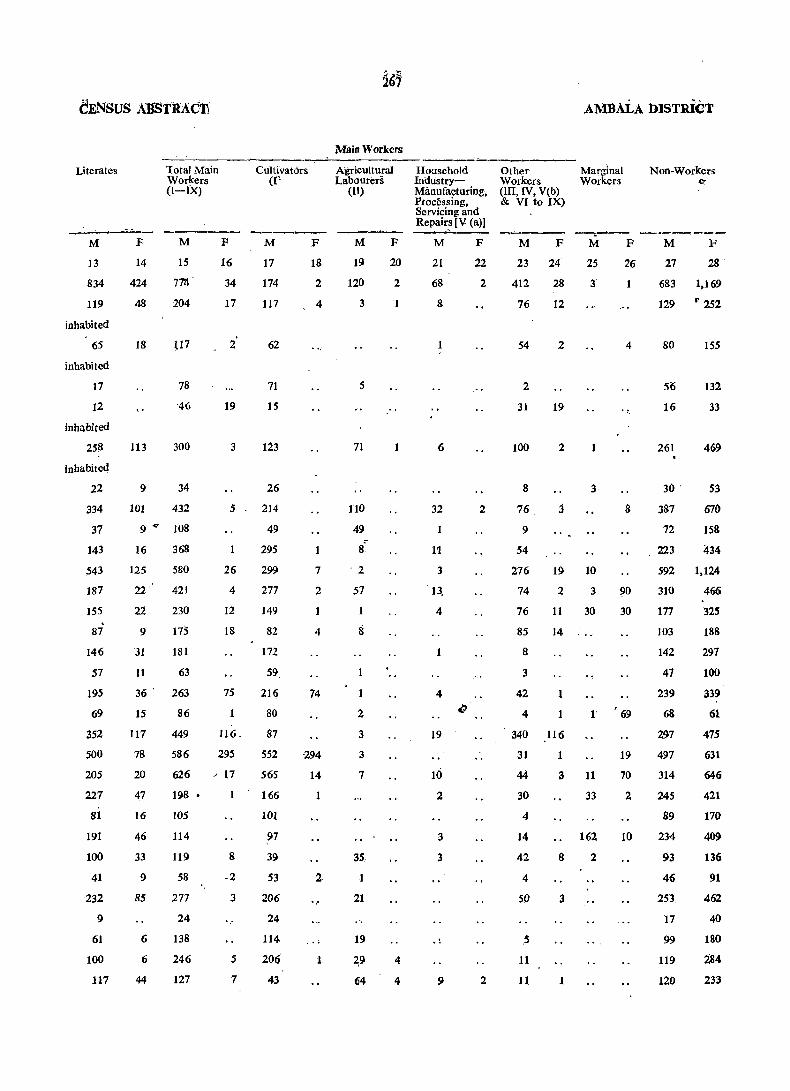
Literates
M
13
834
119
inhabited
65
inhabited
17
12
inhabited
258
inhabited
22
334
37
143
543
187
155
87
146
57
195
69
352
500
205
227
81
191
100
41
232
9
61
100
117
Total Main Workers
F
14
424
48
18
113
9
101
(I-IX)
M
15
7721
204
U7
78
-46
300
34
432
9" 108
16 368
125 580
22' 421
22
9
31
11
230
175
181
63
36' 263
15
117
78
20
47
16
46
33
9
85
6
6
44
86
449
586
626
198 •
105
114
119
58
277
24
138
246
127
F
16
34
17
2'
19
3
5
26
4
12
18
75
116.
295
~ 17
8
.2
3
5
7
Cultivators (l'
M
17
174
117
62
71
15
123
26
214
49
295
299
277
149
82
172
59
216
80
87
552
565
166
101
97
39
53
206
24
114
206
43
F
18
2
4
7
2
4
74
294
14
1
2
.. ~
1
Main Workers
Agricultural Labourers
(II)
M
19
120
3
5
71
110
49
8'
'2
57
2
3
3
7
35,
1
21
19
2:9
64
F
20
2
4
4
Household IndustryManufacturing, Processing, Servicing and Repairs IV (a)]
M
21
68
8
6
32
1
11
3
13,
4
4
19
Hi 2
3
3
9
F
22
2
2
2
AMBALA DISTRICT
Other Workers (III, IV, V(b) & VI to IX)
Marginal Workers
Non-Workers Co
----..--- -'--.---M F
23 24
412 28
76 12
54
2
31
100
8
76
9
54
2
19
2
j
M
25
3
1
3
276
74
76
85
19 10
8
3
42
4
2 3
11
14
1
30
I'
340 116
31
44
30
4
14
42
4
50
5
11
11
1
3 11
8
3
1
33
162
2
F
26
1
4
8
~o
30
69
19
70
2
10
M F
27 28
683 1,169
129 ,. 252
80
5('j
16
261
30 '
387
72
, 223
155
132
33
469
53
670
158
434
592 1,124
310 466
177
103
142
47
239
68
297
497
314
245
89
234
93
46
253
17
99
119
120
325
188
297
100
339
61
475
631
646
421
170
409
136
91
462
40
180
284
233
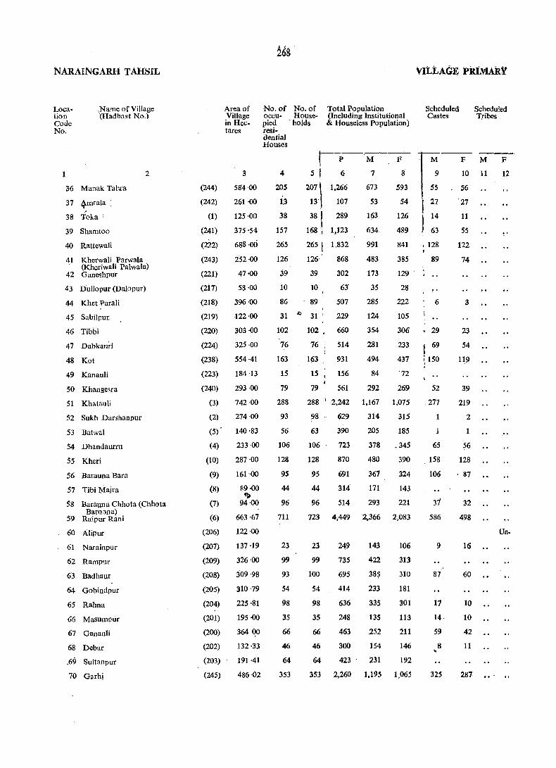
NARAINGARH TAHSIL
Location Code No.
,Name of Village (Hadbast No.)
1
36 Manak Tahra
37 41ntala ,
38 Toka:
39 Shamtoo
40 Rattewali
41 Kherwali Parwala
2
(Kheriwali Palwala) 42 GaneshpUf
43 Dullopur (Dalopur)
44 Khet ?arali
45 Sabilpur.
46 Tibbi
47 Dabkallri
48 Kot
49 Kanauli
50 Khange"ra
51 Khatauli
52 Sukh Dar;hanpur
53 Batwa!
54 Dhandaurru
55 Kheri
56 Barauna Bara
57 Tibi Majra
58 Barauna Chhota (Chhota Baro;ma)
59 Raipur Rani
60 Alipur
61 Narainpur
62 Rampuf
63 Badhaur
64 Gobindpur
65 Rahna
66 Masumpuf
67 Ganau!i
68 Debar
.69 Suitanpur
70 Garhi
(244)
, (242)
(1)
(241)
(222)
(243)
(221)
(2i7)
(218)
(219)
(220)
(224)
(238)
(223)
(240)
(3)
(2)
(5)
(4)
(10)
(9)
(8)
(7)
(6)
(206)
(207)
(209)
(208)
(205)
(204)
(201)
(200)
(202)
(203)
(245)
Area of Village in Hectares
3
584 ·00
261 ·00
125·00
375 '54
688·00
252 ·00
47·00
58·00
396 ·00
·122·00
303 ·00
325 ·00
554·41
184 ·13
293 ·00
742·00
274·00
140·83
233·00
287·00
161 ·00
89·00 ~
94·00
663·67
122·00
137 ·19
326·00
309'98
310'79
225·81
195·00
364 ()O
132·33
191 ·41
486·02
No.of No. of occu- House-
Total Population (Including Institutional & Houseless Population)
Scheduled Castes
Scheduled Tribes
pled . holds fCii-dential Houses
4
205
1.3
38
157
265
126
39
10
86
r--P-'M-~"-
5 I 6 7 8
207 \ 13'
381
168,1
265 1 126· ,
39
10
89
1,266
107
289
1,123
1,832
868
673
53
163
634
991
483
173
593
54
126
489
841
385
129
I
M
9
55
27
14
63
~ 128 ~
89
6
31 ~ 31
302
63'
507
229
35
285
124
354
281
494
28
222
105
306
233
437
'72
102
76
163
15
.79
288
93
56
106
128
95
44
96
711
23
99
93
54
98
35
66
46
64
353
102. 660
76 514
1p3 931
15 156
79 561
288 '-2,242
98
63
629
390
84
292
1,167
314
205
269
1,075
315
185
29
1 69
~ 150
52
277
106 723 378 ,345 65
128 870 480 390 158
95 691 367 324 106
44 314 171 143
96 514 293 221 37
723 4,449 2,366 2,083 586
23
99
100
54
98
35
66
46
64
353
249
735
695
414
636
248
463
300
423
2,260
143
422
38$
233
335
135
.252
154
231
1.195
106
313
310
181
301
113
211
146
192
1.065
9
87
17
14·
S9
8
325
F M F
10 11 12
56
'27
11
5S
122
74
3
23
54
119
39
219
2
1
~6
128
87
32
498
16
60
10
10
42
11
287
Un-
...
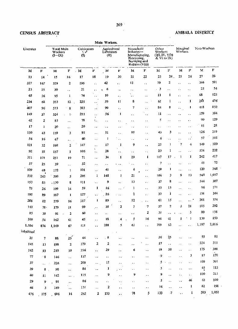
CENSUS ABSTRACT
Literates
M
13
327
23
65
234
407
149
42
17
130
56
121
92
311
57
109
532
153
75
195
208
165
85
100
1.586
inhabited
21
145
162
77
37
39
40
29
44
476
Tota.l Main Workers
F
14
167
15
16
68
96
37
2
43
16
32
18
171
25
68
(I-IX)
M
15
329
30
95
353
573
324
83
20
159
67
198
157
251
39
172
263 . 590
83 .170
26
89
82
78'
30
54
109
187
279
179
91
162
874 1,169
7
13
93
'8
8
11
88
198
210
146
226
90
142
9 • 91
3 149
F
16
2
12
8
1
3
2
19
5
8
14
16
11
2
61
67
25
2
10
,
17S 14
269 .
AMBALA DISTRICT
Main Workers,
Cultivators '_ :,)
(I)
.M
17
196
21
74
225
383
253
78
20
95
60
147
106
71
32
101
295
111
59
127
J17
99
60
45
111
44
179
156
137
209
84
115
86
131
242
F
18
. Agricu1t~-;;;J---;I~useb.~d----~~- - Marginal Labourers Industry- Workers Workers
(II) Manufacturing, (III; IV, V(b) Processing, & VI to IX)
M F
19
42
'. 6
10
59
99
S6
11
17
28
34
45
1 168
9
1
1
2
16
.26
89
38
18
288
8
2
29
12
1
9
2
2 153
20
11
1
1
2
4
5
...
Servicing and Repairs (V(a»
M
21
12
8
7
10
9
.29
6
21
B
2
12
5
5
61
6
9
7&
F
22
1
·7
2
16
M F M F
23
79
24 _ 25 26
3
11
61
84
11
5
43
6
25
23
2
1
8
3
117 17
7
20
106
37
3
8
33 13
32
61
37
31
1
15
2
94 41
709 62
36 25
17
19 10
·9
5
5
9
5
16
133 ·7
7
1
1
1
4
9 13
3 21
1
3
3
46
1
~
NOd-Workers
M F
27
344-
23
98
2d'1
418
159
90
15
28
591
54
125
476
832
384
129
28
126 219
57 J05
149 . 300
124
242
45
120
232
417
72
268
568 1,057
144
96
191
201
185
80
130
307
171
344
374
292
138
15.9
1,197 2,016
55
224
81
311
175 . 300
87
109
45 ~
110
63
82
-1.78
301
113
211
100
191
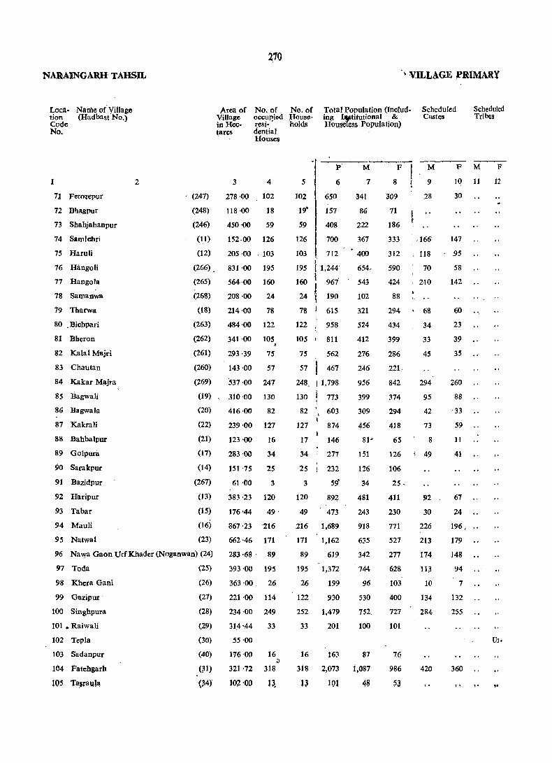
NARAINGARH TAHSIL
Loca- Name of Village tion (Hadbast No.) Code No.
1
71 Ferolepur
72 Dhagpur
73 Shahjahanpur
74 Samlebri
75 Haruli
76 Hangoli
77 Hangola
78 Samanw8
79 Tharwa
80 . Dichpari
81 Dberon
82 Kalal Majri
83 Chautan
84 Kakar Majra
85 Bagwali
86 Dagwala
87 Kakrali
88 Dahbalpur
89 Golpura
90 Sarakpur
91 Bazidpur
92 Haripur
93 Tabar
94 Mauli
95 Natwal
2
(247)
(248)
(246)
(11)
(12)
Area of Village in Hectares.
3
2'10
No. of occul'ied resi- • dential Houses
4
278:00 102
118 ·00
450·00
18
59
152·00 126
205·00 .103
(266) ~ 831 '00 195
(265) 564·00 160
(268) 208 ·00 24
(18) 214 '00 78
(263)
(262)
(261)
(260)
(269)
484·00 122
341·00 105 •
293·39 75
143·00 57
537·00 247
(19) , 310'00 130
(20)
(22)
(21)
(17)
(14)
(267)
(13)
(15)
(16)
(23)
416·00 82
239·00 127
123'00 16
283'00 34
151 '75 25
61 .()O 3
383·23 120
176'44 49·
867'23 216
662·46 171
96 Nawa Gaon UrfKhader(Noganwan) (24) 283 ·68· 89
393'00 195
363·00. 26
221'00 114
234·00 249
314'44 33
97 Toda
98 K,hera Gani
99 Gazipur
100 Singbpura
101 • Raiwali
102 Tepla
103 Sadanpur
104 Fatehgarh
t05 Ts,Faula
(25)
(26)
(27)
(28)
(29)
(30)
(40)
(m
~~4)
55'00
116'00 16 iJ
321 ·72 318
102 '00 13.
• VILL.AGE ;PRIMARY
No .. of Households
Total Population (Including Wtitutional & HO\isetess Population)
Scheduled Castes
Scheduled Tfi~s
- --P--M~Fj M
9
28
5 6 7 8!
102
19'
59
126
103
650
157
408
700
712
195 I 1,244'
160 I 967
24 ~ 190
78 ~ 615
122 958
105 1 811
75 562
57 467
248. I 1,798
130 773
82 , 603 I
127 874
17 146
34 ' 277
25 I 232
3 59'
120 892
49 473
.216 1,689
171 1,162
89 619
195 1,372
26 199
122 930
252 1,479
33 201
341
86
222
367
400
654.
543
102
321
524
412
276
246
956
399
309
456
lSI
126
34
481
243
918
635
342
744
96
530
752.
100
16 163 87
318 2,073 i,OS?
l~ lQl 48
309
71
186
333
312
590
424
88
294
434
399
286
221.
842
374
294
418
65
~ , ., 166
ll8
70
210
68
34
33
45
294
95
42
73
8
126 49
106
25·
411 92
230 30
771 226
527 2:13
277
628
103
400
727
101
76
986
~J
174
113
10
134
284
420
F M F
10 11 12
30
147
,95
58
142
60
23
39
35
260
88
33
59
11
41
67
24
196 ...
179
148
94
7
132
255
360
Un.
t! ,. ...

271
CENSUS ABSTRACT ,AMB:A:LA .DISUtICf
Main Workers
Literates Tht;IMain~- Cultivat~- Agri~ltur~H--;:;~sehold--Oth;:Wo.rk:ers Marginal:' Non-Workers Work~rs ~~'(I) Labourers Industry,_ [JII, IV, V(b) Workers
M F
14
43
16
38
48
(1 ~IX) (II) Manufacturing, & VI to IX) Processing. Servicing and Repairs [V(a)]
M F 'M F M F M F M F M F'
15
171
16
2
18 20 21
6
22 23 24 25 26
45
136,
198
194
2
13
133
28
73
-160
166
270
278
88 ' 386
1
8
11
17
131
42
126
71
79
232 2
19
10
1
1
46
65
83
94
46
9
24
24
2
9
35
41
47
52
10
22
51
21
29
21
6
5
51
163
229
143
173
132
480
2i5
144
216
39
66
75
12
236
86
379
264
155
383
52
231
422
69
inhabit:J
57
4~1
26
122
42
94
66
55
127
61
227
117
93
125
28
30
38
116
44
179
73
46
179
23
93
279
58
37
244
9
281
50
168
292
225
118
138
476
222
152
236
40
77
7$
17
233
113
511
339
196
395
57
287
341
46
50
565
30
2
22
11
1
2
74
§4
7
4
3
29
103
40
105
221
185
70
105
166
83
100 .
135
31
43
'64
17
106
65
253,
125
81
232
48
130
74
23
43
172
2S
2 38
11
19
9
107 •
93
20
Jj
1
31
4
30
16
119
56
85
45
7
35
154
7
1
186
2 32
18
3
9
10 ,
11
2
8
7
.22
to 2
8
~4
5
32
13
15
4 44
,. t.
4
9
3
.. 7
201
38
25
44
8
-2
7
87
, 30
131
144
25
86
2
109
98
15
6
163
S
22
1
2
1
1
4
5
2 10 ,7
53
64
7
4
3
1
15
8
2
4
59
8 21
22
4 28
M F
27
170
41
86
169
206
268
262
52
153
232
187,
158
108
479
177
157
220
41
74
51
17
238
122
406
296
144
341
39
242
41,1
54
37
518
18
28
307
71
186
333
311
582
413
88
292
434
399
282
221
815
3.13
283
417
65
126
106
.25
402
226 p
638
463
270
603
103
378
724
100
76
929
53
NARAINGARIl TAHSIL
Loca- Name of Village tion (Hadbast No.) Code No.
106 Jaspur
107 Khanpur Brahman
108 Rasidpur
109 Mukandpur
110 Gobindpur
111 Tasrauli
112 Dhanana
113 Dehri
114 Bharog
115 Chhajju Majra
116 Boron
117 Khera Jattan
118 Jatwar
119 Samru
120 Dabkora
121 Patwl
.' 122 Berpuea (Birpura)
123 Bchloli
124 Nasrauli
125 Nagla
126 Ra:l1heri
127 Kalal Majra
128 ·Ganeshpur
129 Bara-Korwa
130 Korwa Khurd
131 Babak Majrs
132 Sant':lkhi
133 Gharauli
134 Khurd
135 NagaI
136 SoutH
137. Shahzacipur
138 Majea
139 Bapa';lli
140 BibipUf
2
Area of 'Village in Hectares
3
. (32) 287 '73
(33) 382 '42
(270)
(271)
(272)
(35)
(36)
(47)
(46)
(45)
(44)
260'21
273 -00
156·21
375'00
658 ·00
109·26
460-12
150·95
88·22
(43) 120 -19
(41) 1,148'00
(42) 162'00
(39)
(38)
(37)
(48)
(49)
(50)
(281)
(282)
(280)
(279)
(52)
(51)
93'89
280-04
134·76
372'00
334·00
364 -01)
359·36
129 :00
205 -00
230-67
831 -00
315'00
(53) 151 ·00
(54) 328-00
(56) 260-00
(55) 134·00
(57) 397·00
(58) 1,052'00
(60) 363-00
(259) • '308 ·00
(59) 100-00
272
VILLAGE PRIMARY
No. of No, of Total Population (Includ- Scheduled occupied House- ing In~titutjonal & Castes
Scheduled Tribes
resi- holds HouseJes!;~ Population) dentinl . Houses
4
48
172
91
100
67
95
302
44
261
36
52
45
476
39
8S
76
133
115
156
185
77
.l29
98
332
40
132
55
43
125
769
471
52
52
5
P
6
48 452
172 i 1.176
91
100
67
724
722
538
95 767 I
312 , 2,257
44 333
261 ,i 1,730
37 325
52 339
50 347 I' ~
477 : 3,435 \
39 199
85 648
76 580
133 I 820
115 669
162 1,106
185 - 1,352
77
129
98
579
841
696
337 1.980
40 312
140 1,003
55 342
43 297
127 735
769 4,965
471 2,843
52 222
52 466
M F M F M
7
229
610
400
388
283
F
8
223
566
324
334
255
9 10 U 12
397 370
1,266 991
187 146
928 . 802
176 149
176 163
186 161
1.878 1,557
110 89
357
316
409
33'6
566
720
301
450
363
996
291
264
411
333
540
632
278
397
333
984
48 56
114 102
55
70
65
57
129 111
385 307
26 20
291 265
84 75
176 163
51 58
351 307
106 88
91 78
242 226
49 35
174 164
329 327
84 68
193 143
132 118
169 136
162 ISO 68 62
522 481· 11-0 103
177 165 38 31
1~ 1~ ~ @
376 359 127 113
2,608 2,357 590 524
1,501 1,342 -336 287
119 103 39 40
2SS 211 23 11' ..
Un-
Un-

C:ENSuS ABSrltACT
Literates
-----
Total Main Workers (I_IX)
M F M F
13
136
331
109
104
102
173
557
90
444
94
90
66
963
70
iinhabited
173
155
204
229.
240
327
139
276
170
579
inhabited
75
249
100
70
174
1,565
837
37
115
14
76
138
17
24
35
56
148
50
192
35
28
17
15
103
326
235
222
155
227
602
92
483
93
73
100
449 1,061
26 70
84
58
85
148
83
92
47
159
82
415
46
96
70
28
109
179
127
155
144
303
391
161
184
147
443
87
283
93
82
202
980 1,249
478
11
55
756
74
131
16
1
3
12
3
2
3
12
2
1
3
·4
1
4
1
2 . 94
29
5
2
Main Workers
Cultivators (I)
M F
17
63
173
23·
174
129
98
291
59
199
39
7
45
437
69
103
86
52
82
147
154
8Z
82
58
258
42
150
40
16
105
327
100
19
87
18
1
1
Agricultural Labourers
(II)
M F
19 20
10
71
185
1
34 12
9
86
169
17
i41
28
37
39
312
48
16
73
14
119
180
55
44
57
48
33 86
42
54
51
249
136
.,24
.. ,
2
1
4
1
5
Houshold Other Workers Industry- [III, IV, V(b) Manufactur- & VI to IX) jng,Processing, Servicing and Repairll [V(a)}
M
21
25
14
12
7
2
11
47
4
2
22 ~3
30
57
13
14
17
31
135
14
i32
26
29
16
265
1
28
21
28
24
3
12
3
1
3
10
47 ,2
2
8
2
4
12
10
72
98
1
35'
49
22
54
31
125
11
46
11
12
36
601
3
4
1
1
1
88
422 29
54
20
5
1
AMBALA I>ISTRiCT
Marginal Workers
25 26
2 1
5 f ••
1
4
24
1
1
38 78
4
1
2
19
1
Non-Workers
27
124
284
165
166
128
170
659
95
445
83
28
221
563
324
322
255
370
979
146
79
149
103 . 169
86 158
817 ~1,544
40 89
177
185
230
191
263
329
140
228
216
549
75
239
84
65
174
291
264
411
331
540
631
278
316
333
980
146
480
161
149
357
1;359 2,263
745 1,311
45
123
79
208

~ARAINGARH rwSlt.
Loca- Name (if Village tion (Hadbast No.) Code
.No.
1
141 ".Tapri'Shahid
142 / Sahla J
143 Tank.a Majra
144 Patreh)'i
145 Panjetbn
2
146 Nangawan (NaOllawan)
147 Dhamauli Upacli
148 Han1i ~hera
149 Dhamauli Bichli
150 Dhamauli Majd
151 Karailan
152 MagharPlira
153 Rajpura
154 Sherpur
155 ParaH
156 Badllauli
157 Rajawali
158 Barheri Barli (Deri Bllferi)
159 Barheri:Chhoti (Chh::ltiBarefi)
160 Baktuha (Bakhtuwa)
161 Nek Nawan
162 Kanjala
163 KuraU
164 Tahar I;'Ur
1 ~S Burj Shahid
166 Sadaqpur
167 Nau Qawan (Noganwan)
168 Banaontli
169 Tandwal
170 Bharanput.
171 Baragath
i72 Jlila!(tfUt,f
~ 173 ChM:ta-garh
174 Chhoti Bassi c;
175 . Akbamur
~74.
Area of Village
No_ of 'N6~ of' occupied H6uSe-
Total Popula'tibh Scheduled Scheduled (Including Institutional & Castes Tribes
in ·Hectares resi- holds Houseless Population)
3
79-00
324·00
6!} '00 .;
739·35
. 184·00
207'00
195 ·00
220-00
120·59
117 ·00
355 ·00
192'00
161 ·00
290·00
130·00
1,051 -00
259'90
546·00
295 ·00
323 ·00
~9-00
dential Houses
4
3
134
9
519
66
'- 25
36
43
82
56
166
104
81
76
45
307
119
153
58
112
22
(102)
(10'1)
(105)
(103)
(274)
(273)
(276)
(275)
(277)
(278)
'(286)
(283)
(284J
(285)
(287)
(llO)
(288)
(109)
(107)
(106)
(l08)
(119)
(120)
(121)
260 -00 82
892·00. • 328
53·00
(63)
(64)
(122)
( 65)
'93 ·48 29
96.·00 57
383'00 . 103
405 ·00 93
. (62) 202 ·00
(61) 81·00
(66) 331'00
(258$ 247 ·00
(69). 106 -00
(68) 81·00
(305) . 120 ·00
118
27
155
95
2
46·
48
~~--~~--~---P
6
M
7 5
'3 19 10
134
9
877. 449~
82 41
535
66
25
37
43
82
56
166-
105
81
76
45
327
120
153
58
112
22
3,768
l ~.:~ t 240
( 340
I 504 I I 345
t 1,187
f 569
! 596
1 560
I 338
J 2,610
i 917
~ 988
... 467
• 881
191
82 553
328 '12226 \ .
29 261
57 ' 382
103 - 715
93 749
118 874
27 253
155 1,100
95 601
2 20
46 365
48" 317
I
1,999'
329
53
130
187
259
187
613'
294'
320 •
296
173
1,384
485
513
253
459
107
288
1,161
147
205
379
379·
458
134
589
322
11
174
161·
F
8-
9
428
41
1,769
300
58
110
153
245'
158
.574'
275
276'
264
165
1,226
432
475
214
422
84
265
1,065
114
177
336
370
416
ll~
511
279
9
191
156
M'
9
F M F
10 11
97 . 83
I 566
I 19
492
21 I , .. I 27
J 184 i I 198
, 113-
I 26
I 125
. 116
40
69
213
14
127
20
143
41
17
153
191
101
26
105
94
25
6)
165
14
118
14
132
36 .•
42 54
533 472
50 37
204 117
53 43
39 33
187 183
16 8
202 149
269 229
8 6
10 7
12
..
Un.
CENSUS ABSTRACT
Literates
13
6
230
16
882
173
28
64
88
128
95
332
149
145
151
43
551
171
266
135
222
53
120
470
-inhabited
83
87
194
231
238
5S
315
145
8
84
101
14
112
2
433
91
22
.35
41
57
40
216
99]
-44
59
23
235
·62
130
39
62
15
49
169
36
54
85
127 . • 85
27
·146
62
5
• 68
, 80
Total Main Workers (I~IX)
15
6
207
28
1,024
165
28
62
102
133
16
85
313
162
162
170
90
666
264
"~75
134
221
53
171
589
9
3
23
5
4
Cultivators
(I)
M F
17
5
122
28
418
127
20
47
83
'69
41
193
48
87
95
47
412
171
163
98
120
32
113
227
29
14
18
1
& ••
1
4
74
106
198
198
.228
78
11', 113
291
·15·5
7
99
69
2
19
2
126
104
58
135
2S
6
65
·27
Mmn Workers
. Agricultural Labourers
(II)
M F
19 20
33
322 I' ..
12
9
4
28
,46
38
50
42
34
143
48
39
16
• 53
14
31
211
26
59
26
42
113
C8
69
90
4
18
.. ~ ...
1
1
1
2
2
Household Industry, Manufacturing,
Processing. Servicing and. Repairs [V(a)]
M F
21
3
47
3
32
4
6
7
49
21
16
9
4 .
22
6
2
'4
4
9
2
2
3
22
3
13
AMBALA DIStRICT
Other Workers Marginal (III, IV, V(b) Workers & VI to IX)
M F M F
23 24 25 26
49
237
23
8
6
15
36
12
74
9
72 23
19
26
9
62
24
57
19
39
7
23
121>
1
4
13 ,.
1
11
2
1
8
" /
4 5
31
55
26
11
12
78
38
4 13 6
28
21
2 19
2
NonWorkers
"---.--.---.-----_,
M .F
27
4
242
13
975
164
25
68
85
126
102
300
1:32
158
125
83
718
221
238
119
238
54
117
28
9
427
41
1,760
300
58
110
153
244
155
573
252
275
264
165
1,225
431
470
206
422
84
265
572 1,061
73
99
181
181
'2'30
52
285
165
4
73
92
113
176
325
368
416
113
486
258
191
156

NARAlNGARH TAHSIL
Loea- Name of Village tion (Hadbast No.) Code No.
i 176 Bari Bassi
177 MangIor
178 Kherki Manakpur
17? Jangoo Majra
180 Badi Kohri
181 Bhanvli (Bhavii)
182 Ratauf
183 WasaIpur
184 Chhoti Kohri
185 NagauIi
186 Laha
187 Rerh Viran
188 Sam Bhalv~
189 Pulewala
190· Mandlai
191 Bhud (Bhood)
192 pyarewala
193 Dandlawar (Danolawar)
194 Qasampur
195 Kohra Bhura
196 Fatehpur
197 Khanpur Rajputnn
198 Ujjhal Majri
199 Jangu Majra
200 Ka the Majra
201 Ferozepur
202 Toka
203 Chechi Majra
204 Mugal Majra
205 Mianpur
206 Jagatpur
207 Kullarpur
208 Rampur
209 Dudhli
210 D~nora
VILLAGE PRiMARY
Area of Village
No. of No. of Total Population (Including occupied House- ~'Institutional & Houseless
Scheduled Scheduled
in Hectares resi- holds 'population)
(70)
(257)
(256)
(255)
(254)
(264)
dentinl Houses
3 4 5
215·00 134 134
277 '00 62 63
437 '00 110 114
132 ·00 54 54 _/
287 ·00 ~ 75 75
120·00 74 74
6
970
402
702
368
504 •
(252) 1,068 '00 65
38
65
38
534
383
278 (253) 190 ·00
(71) 384 ·85 72
(72)' 224 ·00 66
(77) 466 '00 207
, (195)
, (196)
(197)
(198)
(199)
(250)
(249)
(251)
(78)
(80) ~
(79)
(194)
(82)
.(81)
(193)
(191)
(192)
(83)
(84)
(310)
(309)
(75)
(76)
(74)
49·00
108·00
161 00
45
87
513 '00 85
397·00 104
335 ·00 113
284·00 88
76·00
855, '00 275
290·96 172
363·00
240·38
99·00
253·00
238·00
234·00
156·00
80·00
225·00
62·00
92
78
50
95
45
57
12
35
66
5
303 ·00 127
112 '00 63
83·00
179·00
23
67
72 501
66 462
207 1,134
45
87
85
104
120
88
335
620
549
724
820
502
27.8 1,6'43 ,
'172 1,234
92 669
80 517
50 324
95 604
45 ·343
57 371
12
35
66'
5
137
63
23
76
100
218
405
28
718
434
183
592
7
521
210
358
196
265
310
206
148
277
244
540
187
320
295
379
423
266
798
669
~35.
8
449
192
344
172
239
224
177
13C
22~
2H
594
148
300
254
345
397
236
845
565
334
2.76 241
168 156
348 256
162, 181
183 188
51
115
226
13
365
222
97
304
49
103
179
15
353
212
87
288
9
110
192
319
196
201
29
106
79
155
174
16
112
1
27
148
84
2
23
63
63
18
14
42
89
Castes Tribes
10 11 12
87
175
306
172
183
18
76
63
)40
157
7
116
22
118
86
.21
48
58
20
12
31
98
126
86
Un-
Un-

277
CENSUS A.BSTRACl' AMBALA DISTRICT
Litera tes,
M
13
234
105
176
84
99
130
90
33
148
113
303
inhabited
68
130
121
.117
170
87
inhabited
445
271
211
98
86
194
54
66
24
38
101
2
164
78
48
171
Main Workers
--ThmlifuTt;~~·<:ui~~~~~ AgriCU~~ur~I--H;;~oid--o~workers Marginal Workers Labourers Industry_ [III, N, y(b) Workers
F
14
101
28
79
47
40
32
53
72
28
24!5
16
60
20
12
49
18
283
92
148
25
44
68
24
26
7
(I,---,JX) (I) (II) Manufac- & VI to IX] turing,
M
15
279
100
190
85
120
188
107
102
153
130,
222
115
168 '
171
211
254
127
352
347
155
184
83
190
93
102
23
F
16
4
3
1
1
21
2
2
5
3
9
5
1
M
17
159
31
I04
36
66
157
51
94
89
52
63
102
103
128
167
161
84
200
244
100
165
F .
18
5
2
3.
4
M
19
37
49
40
8
16
11
37
6
37
63
35
6
9
19
16
11
69
53
19
6
18
5
29
4
F
20
1
2
6
1
...
Processing, Servicing aM Repairs [V(a)]
M
21
2i .. ) 1
1
1
7
5
19
12
4
7
4
10 5
2
5
4
·F
22
3
1
1
M F M F
23 24 25 26
62. 1
19 2
45 3
40
38
20
18
2
20
15
1
1
119 11
13 i;'
40 1
8
6
2
23 73
42" 136
22 95
11 63
22
21
.70
28
4 10 52
3
7.3
'45
1 3
2
1
2
8 , 69
42
105
61
84
22
62
26
7
2
60
34
8
22
80
3
10
1
5
15
2
5 45
2
119
45
20
99
106
8
174
118
46
149
2 68
57
33
74
43
35
4
38
5
11
11
1
52
26
9
26
i 15
1
2 ' •.
2
'1
17
NonWorkers
M
27
242
104
168
111
145
122
97
46
124
114
295
72
110
102
157
159
139
446
322
180
92
85
155
69
81
28
46
105
4
191 e-... io3 49
155
F
28
440
188
341
172
239
224
176
128
223
218
500
148
162
159
280
340
233
836
565
327
241
154
253
181
188
49
101
173
15
344
195
87
28R

NARAINGARH TAHSIL
Lodation Code No~o
Name of Village (Had bast No.)
1
211 Husaini
212 Batora
213 Mirpur
214 BaJlopur
215 Baroli
216 Milk'
2
217 Naraingarh (Rural)
218 Ahmadpur
219 Sian Majra
220 Bara Gaon
221 Chhajal Majra
222 Ramgarh
223 Panjauri
(308)
(73)
.(90)
(306)
(89)
(307)
(88)
(303)
(304)
(97)
(67)
(98)
(101)
278
Area of Village in Hectares
No. of No. of occupied Hbuse-resi- holds
3
250'00
202'00
121 '00
dential Houses
4
136
t 47
131 ·00 .43
285 ·30 J64
152'00
454'46
160·00
63
8
43
212 ·00 101
337 ·00 229
77 ·00 41
69'00 21
150'00
5
136
65
47
43
170
63
8
43
101
224 AZampur (lOOh 116 ·00
71
30
28
'229
41
21
71
30
28 225 Muna Majra
226 Khirki Jatan
227 Brahman Majra
228 PanjJasa I
(99) 60 ·00
229 Raipur Viran
230 Barsu Majra
(298)
(301)
(96)
(302)
(300)
231 Raju Majra (299)
232 Khanpur Labana (296)
233 Ganauli (294)
·234 Ambli (136)
235 Dehar (137)
236 Nanehra (95)
'237 Bari Rasaur (92)
238 Lautan (91)
239 Manakpur (93)
240 Chhoti R,asaur (94)
2M ShahpUf (87)
242 Rao Majra (Raw Majra) (312)
243 ~bipur (311) " ..
263 ·45 123 123
178 '00 80 80
471 ·45 389 389
131 ,93 115 '116
232·00 48
63 ·00 51
265 ·00 .113
211 ·00 100
569 ·00 216
523 '00 188
216·00 142
386'47 129
243 '00 157
127'00 8
167·00 13
243 '62 4l
218 '00 16
113 ·00 111
48
51
113
100
216
196
142
129
157
8
13
~1
16
244 Sangrani
?-45 Dr-!'Il
(85) • 227·00 89
111
89
4f3
VIDLAGE PRIMARY
Total Population (Includ. ing Institutional & Houseless Population)
Scheduled Castes
~~~~--p--t-M--F1
6 7 8 li 9 10
1,000
450
354
351
1.289
450
40
278
698
1,509
307
. 143
395
290
243
532
241
186
126
691
2~5
18
137
356
776
163
72
173
147
131
846 446
476 223
2,333 1,243
777 405
414 221
372 182
720 363
760 389
i,421 755
1,339 717
974· 522
750 389
990 501
50 25
108 53
251 138
IP 67
686 367
633 333
468
209
Hi8
155
598
195
22
141
342
733
144
71
222
143
112
400
253
1,090
372
193
190
357
371
666
622
452
361
489
25
55
113
60
319
300
1,14l
138
80
83
100
252
116
5
68
37
274
89
33
5
2
214
35
630
228
84
161
30
219
210
86
102
179
10
64
161
?4 22l
129
72
86
90
206
80
5
66
32
235
74
35
3
186
33
524
217
93
167
25
188
180
72
85
1,52
12
,56
128
23
17~
Scheduled Tribes -
M F
11 12
".
!'
CENSUS ABSTRAOT'
Literates·
M F
13
249 '" 132
72
105
405
129
12
70
202
420
59
25
95
87
72
182
124
497
192
118
14
95
55
26
31
165
77
8
38
145
196
33
3
100
51
51
78 o
109
286
121
62
35
119
66
166
146
Total Main Workers (I-Dd'
--~---'----'--~ M F
15
193
120
109
83
317
100
7
51
180
399
84
44
71
81
61
224
83
626
201
113
88
164
208
384
359
16
2
7
2
3
3
7
10
2
2
1
158
2
1
4
73
196
166
391
379
301
204
265
136 . 255
14
32
47
10·
139
115
~S~
116
166
1
25
16
39
44
Sa7
181
224
17
23
78
39
183
185
S~
1
2
3
10
279'
AMBALA DISTRICT
Main Wor~ers __'--~-----.--------.-II-;---.___,--------
Cultivators
M
17
73
46
52
49
105
5S
4
18
91
130
36
19
42
61
45
78
37
108
46
79
50
78
144
150
165
155
82
102
16
19
29
(I)
31
69 ,
107
~OO
F
18
1
2
1
1
l
Agricultural Labourers'
. (II)
M .F
19
60
30
43
27
109
21
1
21
4
t'45
34
21
{}
5
99
28
182
57
8
24
25
46
105
106
33
53
65
24
5
42
63.
11<1
20
2
2
1 .
74
lIousehold ItidustryManufacturing, Processing, Servicing and Repairs [V(a)j
M F
21
<Q2
10
1 "" 7
8
31
8
2
4
8
4
3
16
25
3
10
3
.. 2
34
22
1
7
4
1
1
1
Other Workers [III, IV, V(b) & VI to IX]
M F
Marginal Non-Workers Workers
- _ ___,___,___,- -----'--M F M F
23
58
24 25 26 27
339
117
28
466
188
156
141
551
188
22
34
14
6
96
24
2
12
77
93
13
4
23
20
11
39
16
6
3
1
6
2
2
1
332 82
90
26 14
. 57
15
113
63
64
36
54
1
3
25
3
70
15
214
2
1
2
2
J.
4 14
10
14
6 44
6 7
13
2
15
10 32
6 1
35
3 57
77
112
368
149
11
85
176
377
79
28
102
66
7Q
222
140
617
204
108
94
199
181
371
348
261
20&
276
8
30
59
~h ~84 !1'
14&
125
333
723
144
71
220
141
110
400
25j
932
370
193
190
356
371
647
589
451
360
487
25
55
113
60
281
300
,
590 1,074

NARAINGARH 'J;AHSllL
Location Code No.
Name of Village (Hadbast No.)
246 Hamidpur
/47 Galawari (Galori)
1248 Rajpur r 249 Rathali
{250 . Udamgarh
2
Area of ViIlagein Hectares
3
(86). 405·00
- (334) 184 '53
(333) 59 '00
(332) 173 ·00
(329)
251 Doman Wal;:t (Doomanwala) (327)
252 Laharpur (328)
170 ·77
154'18
645,46
209·00
228·00
431'00
253 Nazampur
254 Asgarpur
255 Jhanda
256 Milak Jhabalian
bs7 Rasulpur
258 Haveli
/259 . Bakala
260 Ferozepur Ranyan
r 261 Rampur Ranyan
~ 262 Paharipur'
~ 263 Saidupur
I 264 Tunda Bag
265 Gadauli
266 Mahmadpur
267 Salahpur
268 Thaska
269 Kalyanpur Atari
(270 Bana Bahadurpur
271 Jafarpur Jafri \
272 Pammuwala
273 Nanheri
274 Sangauli
275 Nawagaon (Nayagaon)
. 276 Bholiwala
277 T~'rpur
278 Kolla
. 279 Chan Chak
280 Peerwali
(331)
(330)
(189)
(139)
(138)
(141)
(142)
(143)
74-00
311 '00
385·00
256'00-
174·00
(144) . 165·00
(145)
(148)
(147)
189'00
259 ·00
31'00
(135) 1,479'51
(140) 244 ·00
(188) 534·00
(187) 839 ·31
(170) 276'40
(186) 287 ·73
(185) 145 -00
(184) 340 ·00
(l8~) 71 ·00
(178)' P7'00
(177)
(176)
(175)
(174)
(179)
(180)
137-00
96·00
206-00
179·00
73·00
50·00
No. of occupied residential Houses
4
193
82
·29
76
18
24
245
39
24
65
36
171
129
82
79
63
68
59
453
258
71
135
97
21
36
72
28
38
68
28
60
45
44
22
280
No. of Total Population House- (Including Institutional holds &- Houseless population)
5
193
82
29
76
18
24
245
39
24
72
36
171
129
S2 79
63
68
59
453
258
71
1'35
97
21
36
72
28
38
68
28
60
45·
45
22
P
6
959'
582
237
510
124
135
1,520
264
186
537
271
987
772
524
550
430
454
421
M
7
459
3'13
125
267
69
82
817
147
95
295
147
532
374
276
303
231
244
217
F
8
500
269
112
243
55
- 53
703
117
91,
242
124
455
398
248
247
199
210
204
3,305 1,698 1,607
1,727 948 779
646 341 305
914 500 414
615 327 288
118 ·55 .63
264
397
165
239
379
169
-435
237
. 268
142
144
219
81
124
20t
97
243
12i
155
69
120
178
84
115
173
72
192
116
113
73
VILLAGE PRIMARY
Scheduled Castes
n
M
9
74
75
IS 108
55
148
65
207
58
133
123
145
117
139
403
50~
27
52
70 .
60
18
17
11
Scheduled Tribes
F M F
12 10 11
6q 60
8
95
39
135
59
172
48
144
110
124
104
123
334
427
32
30
61
55
9
8
5
un-
CENSuS ABSTRACT Main workers
_~___,. __ .. _,_ .. _~_.._._..__,_ .. ___ .....;;.,_._"--"I_'~"_~_"_"_"_1_' ___ _"'_"_"_-. Total Main Cultivators Agricultural Household Other Workers Marginal Non-Workers
'Workers ' (1) Labourers Industry- , [lII, IV, V(b) Workers Literates (I-.IX) , (II) Manuf~turtng, &
ProcesSIng, VI to IX1
_____ " _.._ .. __ ~_., ~_"-1 __ -"-
M
13
- '265
145
73
98
33
21
339
75
36
105
58
F
14 '
192
57
22
20
16
g
141
23
4
25
23
M
15,
170
149
66
144
33
50
425
71
54
162
78
~10 ,- 149 - 292
248
128
138
97
136
91
164
46
56
26
52
33
inhabited
664 318
406· 78
125
140
69
21J
28
2
198
-141
167
101
117
105
869
527
174
309
203
9
43
36
15
32
45
21
1 35
106
58
46
9
4 95
'5 _ 137
8
9
51
31
2
SO
86
i24
62
132
80
93
46
F
16
3
4
5
- 1
1
15
..
M
17
46
87
4l'
89
29'
19
324
49
50
114
63
60
109
65
86
63
61
40
, 260
148
237
169
iC)34
93
133
1 48
SO
72
46
113
26
75
37
F
18
1 .
1
..
1
1
M
19
79
38
17
47
27
57
15
26
10
92
56
54
60
26
32
47
173
198
11
23
19
31
13
6
17
11
7
F
20
1
7
Servicing and -Repairs [V(a)]
M
21
3
J
2
22
3
1
1
38
6
24
12
16
F
22
2
o-M F
23 24
42
23
8
8
4
4
43
5
4
21 , 5
118
33
22
18
12
23
1'7
159
63
15
·25
15
2
4
2
6
9
3
13
21
7
2
3
2
5
5
1
M F
25 26
19
7
M
27
289
164
59
123
36
32
392
76
41
133
69
240
176
135
133
111
126
lOS
F
28
497
269
112
243
55
52
702
117
91
242
124
451
393
248
246
,199
209
203
829 1,592
421 778
167
191
5 124
20
49
82
31
38
305
414
283
63
120
118
83
115
82" . 173
35
111
41
62
23
72
192
115
.1 13
73
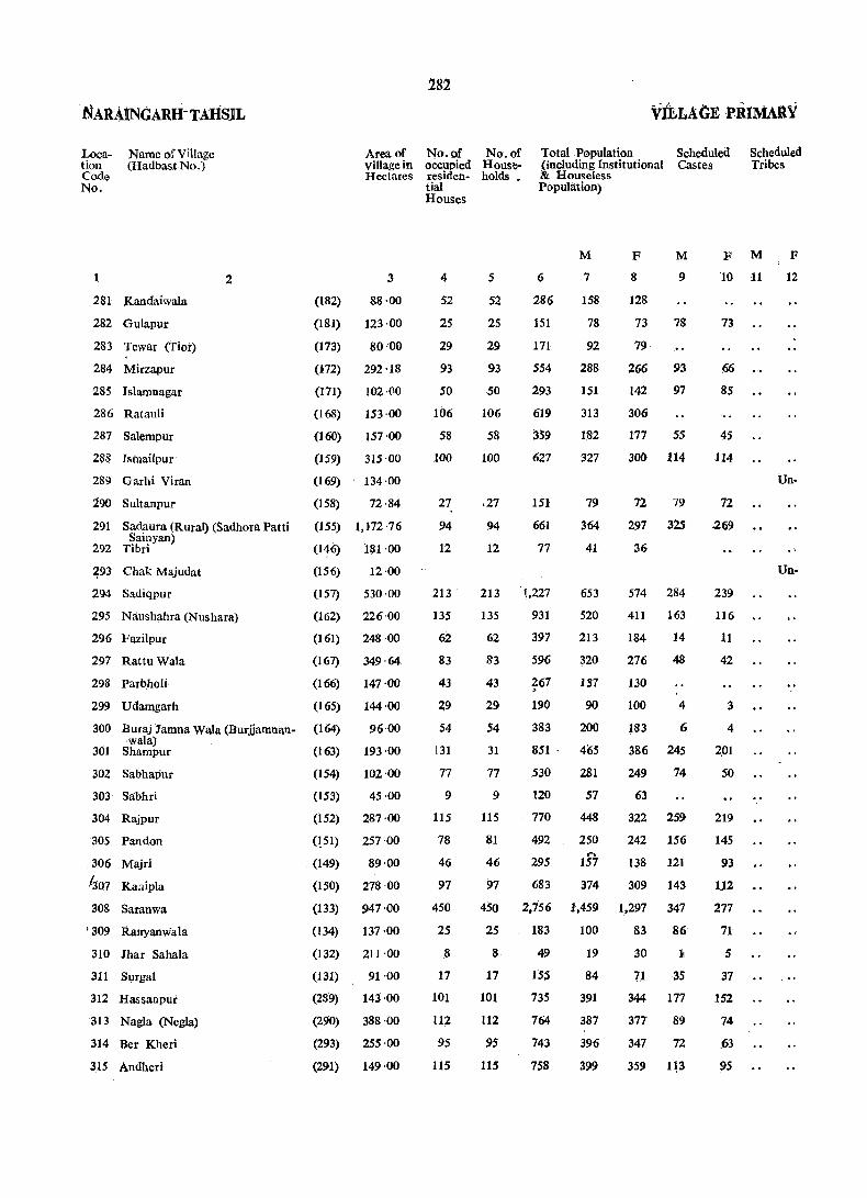
· NARAINGARH- TAHSJL
Location Code No.
1
Namc of Village (Hadbast No.)
281 Kandaiwala
282 Guiapur
283 Tewar (Tior)
284 Mirzapur
285 Isiamnagar
286 Ratauli
287 Salempur
288 Isinailpur
289 Garhi Viran
290 Suitanpur
2
291 Sadaura (Rural) (Sadhora Patti Sainyan)
292 Tibri
~93 Chak Majudat
294 Sadiqpur
295 Naushahra (Nushara)
296 Fazilpur
297 Rattu Wala
298 ParbllOli
299 U damgarh
300 Buraj Jamna Wala (Burjjamnan-wala)
301 Shampur
302 Sabhapur
303 Sabhri
304 Rajpur
305 Pan don
306 Majri
1307 Kanipla
308 Saranwa
r 309 Ranyanwala
310 lhar Sahala
311 Surgal
312 Hassanpur
313 Nagla (Negla)
314 Ber Kheri
315 Andheri
(182)
Area of Village in Hectares
3
88·00
(181) 123 ·00
(173) 8.0'.0.0
(172) 292 ·18
(171) 102 ·(10
(168) 153 ·00
(160) 157 ·00
(159) 315 ·00
(169) 134 ·00
(158) 72·84
(155) 1,172 ·76
(146) 181 ·00
(156) .12·00
(151) 530·00
(162) 226·00
(161) 248 ·00
(161) 349 ·64
(166) 147 ·00
(165)
(164)
(163)
(154)
(153)
144·00
96·00
193 ·00
102'00
45·.00
(152) 287 ·.00
(lSI) 257·.0.0
(149) 89 ·.00
(150) 278 ·.00
(133) 947 ·00
(134) 137 ·0.0
(132) 211 ·0.0
(131) 91·.0.0
(289) 143 ·0.0
(290) 388 ·.00
(293) 255 ·00
(291) 149 ·00
282
No. of oCcupied residential Houses
4
52
25
29
93
50
106
58
1.00
27
94
12
213
135
62
83
43
29
54
131
77
9
115
78
46
97
450
25
8
17
1.01
112
95
115
Na. of Home-holds _
Total .Population (including Institutional &: Houseless Population)
Scheduled Castes
Scheduled Tribes
5
52
25
29
93
50
106
58
100
,27
94
12
6
286
151
171
554
293
619
359
627
151
661
77
213 '1,227
135 931
62 397
83
43
29
54
31
77
9
115
81
46
97
596
~67
190
383
851 .
530
120
770
492
295
683
M
7
158
78
92
288
,151
313
182
327
79
364
41
653
520
213
32.0
IS7
90
2.00
4(;5
281
57
448
250 ....
157
374
F
8
128
73
79
M
9
78
266 93
142 97
3.06
177 5S
300 114
72 79
297 32$
36
574 284
411 163
184 14
276
130
10.0
183
386
249
63
48
4
6
245
74
322 259
242 156
138 121
309 143
450 2,156 1,459 1,297 347
25
8
17
101
112
95
115
183
49
ISS
735
764
743
758
100
19
84
391
387
396
399
83 86
30 11
71 35
344 177
377 89
347 72
359 1.3
F M
10 11
73
66
85
4S
114
72
.269
239
116
11
42
3
4
2.01
SO
219
145
93
112
277
71
5
37
152
74
.63
95
F
12
Un-
Un-

2g3 CENSUS- ABSTRCT AMBALA DISTRICT
Literates
M
13
31
21
14
126
45
80
92.
124
inhabited
24
104
12
inhabited
261
259
49
113
59
27
36
205
98
30
179
95
93
172
833
30
11
38
178
162
228
P$
F
14
5
11
72
21
13
62
26
5
21
83
59
18
45
21-
10
68
.. 39
18
37
34
34
62
456
7
11
11
77
70
121
93
Main Workers _ __, _ ___,-__., ........ -..-.., __ -.., ~---.._.._.--~,..;....._,__,------.-_.,-_...,__.,----~----___, Total Main Cultivators Agricultural Household' Other Workers' Marginal Non-Workers' Workers (1) Labourers Industry- [ill, IV, V(b) Workers (I-IX) (II) Manufacturing, &
M
15
99'
50
49
151
76
195
90
188
42
176
31
299
239
131
185
69
52
112
260
155
29
290
144
74
172
687
27
11
19
167
160
215
165
F
16
3
6
4
1
37
5
3
3
2
5
4
14
M
17
79
30
39
74
36
127
42
100
19
56
25
16Z
89
86
111
61
42
66
88
96
21
64
43
28
79
280
19
7
18
57
86
129
82
F
18
2
2
i
3
1
2
M
19
15
18
15
13
H
19
13
92
4
51
74
-36
, 53
6
24
36
36
100
86
23
58
192
5
3
82
41
52
51
!l
F
20
17
1
Processing, , VI to IX] Servicing and Repairs [Vea)]
M
21
2
26
13
1
25
3
3
3
4
3
15
15
F
22
4
M F M F
23 24 25 26
5
2
10
60
14
55
24·
69
10
27
2
12
61 • 1
76
6
21
7
4
22
136
20
7
. 1~3
15
23
31
212
3
1
<> 13
18
33
32
5
3
11
1
1
6
1
29
1
4
2
23
23
15
39
3
10
1
53
2
.,'
M
27
59
27
43
137
75
112
92
139
36
188
10
325
281
82
135
68
38
88
205
126
27
157
106
79
202
770
50 '
8
42
209
188
181
234
F
28
122
63
79
259.
137
304
176
263
72
297
36
516
411
184
273
129
97
183
384
249
63
315
242
134
309
1,283
83
30
71
344
377
346
359

NARMNGARII TAHSIL
Location Coile No.
Name of Village (Hadbast No.)
316 Mirzapur Kath
317 Okhal
318 Bakarpur
319 Harbon
.320 Lakhnauxa
321 Lalpur
322 Ferozepur Kathka
323 Tapparil!-n Rulduki
324 Bukhari
325 Fatehpur
326 Shahpur
327 Nanduwali
328 Shakarpura
329 Chand Sauli
330 Budha Khcra
331 Kalyana
332 Jeoli
333 Nakhrauli
334 Mawa Kheri
2
(292)
(295)
(297)
(123)
(124)
(125)
(118)
(117)
(130)
(126)
(129)
(128)
(127)
(116)
(112)
(111)
(115)
(114)
(113)
Area of Village in Hectares
284
No.of occupied residential Houses
No. of Total Population . House- (including Institutional holds • & House1ess Population
VILLAGE PRIMARY
Scheduled Castes
Scheduled Tribes
--~--~----~ -~~~~ ~-----
3
135 ·00
133 ·00
111 ·00
155·00
507·00
370·00
212·00
106'00
142·00
183·72
232·00
93·00
195·00
266 '68
222·00
225·00
418·00
264 ·00
141 ·00
5
P
6
59 59 408
44 44 297
49 49 326
76 76 558
242 243 1,709
124 124 891
68 68 490
33 33
35 35
62 62
104 104
'63 63
55 55
72 72
65 65
71 71
266
290
.455
773
423
398
624
416
481
175 190 1,280
116 116 778
50 50 380
M
7
206
153
171
311
921
471
259
\52
155
262
417
236
205
332
216
235
684
429
210
F
8
202
144
155
247
788
420
231
114
135
193
356
187
193
292
200
246
596
349
170
M
9
80
62
95
265
117
115
62
124
193
128
94
26
53
58
166
95
36
F
10
85
70
69
234
98
97
52
102
154
102
94
31
68
53
128
72
36
M F
11 12
Grand Total i14,769-:04~33:3n33,619-_'12z6;195120~lOS~713o',0s62~~5-~-~-:-:
Notes: _(I) Where a town and village bear an identical name, the word (Rural), has been added after the name of the village.
(2) The area of a village (revenue estate) is based on the information supplied by the Revenue Patwari and inclUdes urban area, if any.

285
CENSUS ABSTllACT AMBALA DISTRICT
M2in Workers
Litera,tes -n;taiM-;in -~Cultiv~-;--A-;;riccl-;ral--'"lIo:s~cld---oth~;Wo~k-;s< Marginal Non-Workers Workers (I) Labourers Jndustry- [III, IV, V(b) Workers (I_IX) (II) Man ufacturing, &
Processing, V,I to IX] Servicing and Repairs [Veal]
-_--..--4'---+~_ ... __, ............ ----,_--. ___ ---4- _,....---.---- ---'"-",,,--...__' ----1- ___'-~--__"'----' ------:-..,....._ ~-----'l- -.......,-__,~-:"-
M F M F M F M F M F M F M F M F
13 14 15 16 17 18 19 20 21 22 23 24 25 26 27 28
98 51 106 68 34 4 100 202
56 48 i2 I
88 144 24 65 5
85 36 93 3 52 30 2 9 78 152
163 73 133 10 58 37 7 13 2 25 178 237
380 171 466 .2 • 204 149 62 51 455 786
211 59 248 127 81 8 32 223 420
53 8 140 68 59 2 11 119 231
73 II 89 84 5 <63 114
70 25 79 51 15 2 11 76 135
109 35 129 73 40 5 11 133 193
191 69 209 74 96 7 32 1 208 355
86 17 133 75 41 11 6 103 _187
85 29 96 39 49 8 109 193
106 29 180 106 67 7 151 292
123 47 99 69 20 10 117 200
132 85 127 89 25 13 108 245
355 181 363 16 81 158 31 93 16 321 580
J61 46 236 141 44 3 48 193 349
102 36 112 8L 22 9 98 170
___ --" __ ---I_-., __ -_.,._oj_"'-"""\I--I ~__t_.. ___ ___, ____ -'l ___ -_,.--I-<I_<I__,__I _.....~__.-__,__,---I_ ~-~ --4--1-.-.---I----t __ ~--..oI-"""I--I._.oI ___
34,291 23,476 62,542 1,928 33,054 .477 13,178 229 2,130 105 14,180 1,117 770 1,475 56,936 102,544

286
NARAINGARH TAHSIL URBAN PRiMARY
Loca- Name of Town/Ward Area of No. of No. of Total Population (includ- Scheduled Scheduled tion Town ocru- House- ing Institutional and . Castes Tribes Code .in Km2 pied holds Houseless Population) No. resi-
dential Houses
---_--.___,----- ---~~ --~--P M F M F M F
1 2 '3 4 5 6 7 8 9 10 11 12
IV NARAINGARH (M.C.) 1'35 1,596 1,662 9~69 4,5!l! 1,277 1,100
Ward ,593 616 3,782 1,944 1,838 785 691
2 571 583 3,152 1,671 1,481 349 291
3 432 463 2,436 1,254 1,182 ~4.1 118
v SADAVRA (M.e.) 2'70 1,772 1,813 . 10,131 5,252 4,879 ~
823 723 .--Ward 186 186 996 483 513 13 8
2 156 158 881 447 434 8 3
3 143 143 835 429 406 7 5
" 4 1~6 156 847 442 405 .85 73
5 161 165 918 477 441 74 59
6 200 200 r 1,136 603. 533 209 203
7 .153 153 906 484 522 16 17
8 . 133' 133 787 412 375 5
9 162 162 838 449 389
10 164 164 910 468 442 22 16
.. 11 158 193 t'1,077 558 519 38) 337
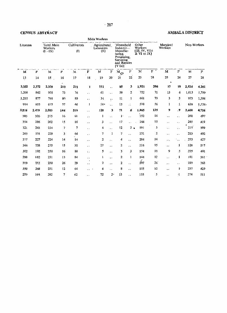
·287
CENSUS ABSTRACT AMBALA DISTRlCf
Main Workers _______ .......... ~----__.,__t-__, ____ ~_.~__, ___ __..,__.__, _ _...~-___,
Literates Total Main Cult iva tors Agricultural.. 'Household Other Marginal Non-Workers Workers Labourers Industry-. Workers Workers (I-iX) (I) (II) ManufaG- [III, IV, V(b)
turing, & VI to IX] Processing, Servicing and Repairs [V (a)1
------ ------,____,_ ............. - - --_....,. _ ___, ............... ______" ~--.----------.-- -~- ---____,__., __,__,____,---.,_--- ----0--.------- --.___,,--~-~
M F M F M F M F MO F M F • M F M F
13 14 15 16 17 18 19 20' 21 22 23 14 25 26 27 28
3,332 2,372 2,328 210 211 1 111 8S 3 1,921 206 17 10 2,524 4,281
1,208 842 918 73 76 61 59 2 722 71 13 6 1,013 1,759
1,210 877 795 80 89 34 11 661 79 3 3 873 1,398
914 653 615 57 46 16' 15 ,. 538 56 1 638 LJ24.
3,516 2,479 2,583 144 519 128 3 71 6 1,865 135 9 .9 2,660 4,726
385 326 215 16 61 1 . 152 16 268 497
354 286 202 15 16 3 17 166 15 245 419
321 243 214 7 7 4 12 2 • 191 5 215 399
263 151 229 3 64 7 7 151 2 213 402
317 227 224 14 14 2 4 204 14 253 427
366 228 275 15 30 27 2 216 15 1 328 517
302 192 250 16 88 .. 5 3 3 154 13 9 5 225 401
280 182 231 13 84 2 144 12 181 361 '
319 212 230 26 29 2 2 1~7 26 219 363
350 268 231 12 64 4 8 155 12 1 237 429
259 164 282 7 62 72 2- 13 135 5 ·1 276 511

289
PRIlVIARY CENSUS ABSTRACT
Ai\1BALA TAHSIL

AMBALA TAHSIL
Location Code No.
Name of Village (Had bast No.)
1 2
1 Liharsa
2 Kolu Majra (Kola Majra)
3 Nizampur
4 Gbel
S Devin agar
6 Dadiana
7 Manakpur
8 Dangdehri
9 Sadopur (Sidhoopur)
10 Lohgarh
"11 Patti Jatan
12 Patti Rangran
13 Patti Shekhan
14 Patti Kalalan
Area of Village in Hectares
3
(54) 100-00
(55) 70·00
(53) 221-76
(52) 406 .()()
(37) 169 -00
(36) 287-00
(35) 122·62
(33) 243·00
(32) 171-00
(34) 147 .()()
(38) 384-00
(40) 156'00
(39) 104'00
(51) 311'00
15 Patti Achrjan (Patti Chargaon) '(56) 270-00
1'6 Sarangpur (117) 168 '00
17 Rupu Majra (Roopo Majra) (116) 101 -00
18 Nasirpur "(115) 194 ·00
19 S()uda (114) 403·00
20 Singanwala (57) 176-00
-21 Patti Mehar (58) 412'00
22 Jandli (113)· 393 ·00
23 Dhulkot (60) 270·00
24 Mandli (59) 26-00
(49) 363'00 1
290
VILLAGE PRIMARY
No. of No. of Total Population (iuclud. Scheduled oceu' House-pied holds
ing institutional & Castes
resi· dential Houses
4
63
30
43
192
66
115
78
86
60
78
38
4
1
38
62
141
85
333
138
83
132
292
166
6
Houseless Population
p
5 6
63 423
30 159
43 246
192 1,299
66 .480
115 755
78 559
86 538
60 425
78 516
38 163
·28 " 115
38
62 .
12
176
379
M
7
213
88
138
716
260
391
327
288
244
285
97
66
7
95
197
141 778 388
85 585 330
333 1,939 i,037
138 972 527
83 562 301
132 827 455
292 1,533 843
166 959 532
6" 21 11
F
8
210
71
108
583
220
364
232
250
181
231
66
49
5
81
182
39.0
255
902
445
261
372
690
427
10
M
9
183
81
64
199
29
176
115
128
117
162
77
13
196
364
230
104
51
307
219
277
F
10
180
68
48
155
27
161
75
112
91
123
45
16
182
378
-.. 199
95
44
266
188
210
Scheduled Tribes
M
11
F
12
2S Patti Suba Akbacpur
(Suba Akbarpur)
26 Ambala City
r Tot!!l population and whole area of these villages have come within municipal
(50) 97'00 J . 27 Khurampur Majn (41) 215-00
28 Sultanpur (42) 120'00
29 Kakru (31) 170·00
30 Kllatoli (30) 271·00
Total population and part area of the village has come within munici{l8.1
101
249
134
101 472 -296
249 1,359
134 897
765
469
176
594
428
4
202
289 o
2
169
280
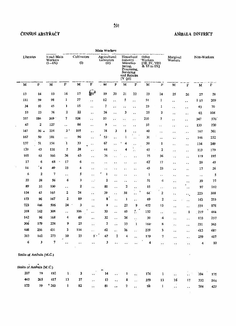
C~NSUS ABStRACT
Literates
_c ___ .-ot_-"' __
Total Main Workers (I-IX)
Cultivators
(1)
M F M F M F
13
111
34
53
357
42
147
167
137
120
105
17
14
6
22
89
154
173
723
318
142
306
446
313
6
14
59
10
23
184
2
15
98
45
76
369 '
127
56. 224
50
51
43
63
6
'6
2
28
32
42
96
446
162
96
179
256
142
3
181
154
131
166
68
49
7
56
100
165
167
506
308
168
224
431
273
7
limits of Ambala (M.e.)
. .. limits of Ambala (M,e.)
207 79 192
443
172
265 417
59 • 263
16
1
1
2
17
27
15
22
7 124
86
3) 105
'1
2
36
17
23
6
2
2
24
4
9
3
10
1
13
1
96
33
38
65
6
4
5
3
2
24
89
3
106
60
25
114
23
3
37
82
Main Workers
Agricultural Labourers
(II)
M F
Household lndustry_ Manufacturing, Processing, Servicing
and Repairs [V ~a)1
M F
19 20 21 22
12
7
26
35
9
78
53'
67
44
26
1
2
81
39
8
9
30
32
2
62
67
3
14
13
81
3
2
..
5
3
1
• 4
4
2
38
22
40
26
33
26
4
1
8
2
9
Other . Workers [III, IV, V(b) & VI to IX)
M F
23
54
23
25
210
32
40
31
50
45
75
62
45
1
51
15
64
69
472
132
50
164'
229
179
4
174
359
98
24
1
1
2
7
1
2
36
17
23
6
2
2
15
·4
8
3
7
1
13
1
AMBALA DISTRICT
Marginal Workers
M F
25 26
...
Non-Workers
M F
27
1 15
43
62
347
133
167
146
134
113
119
29
17
39
97
223
163
531
28
209
70
106
576'
220
361
232
249
179
195
49
26
5
1 .219
75
182
388
253
878
444
257
363
687
417
16 17
133
231
. 4"12
259
4
'104
332
206
10
175
564
427
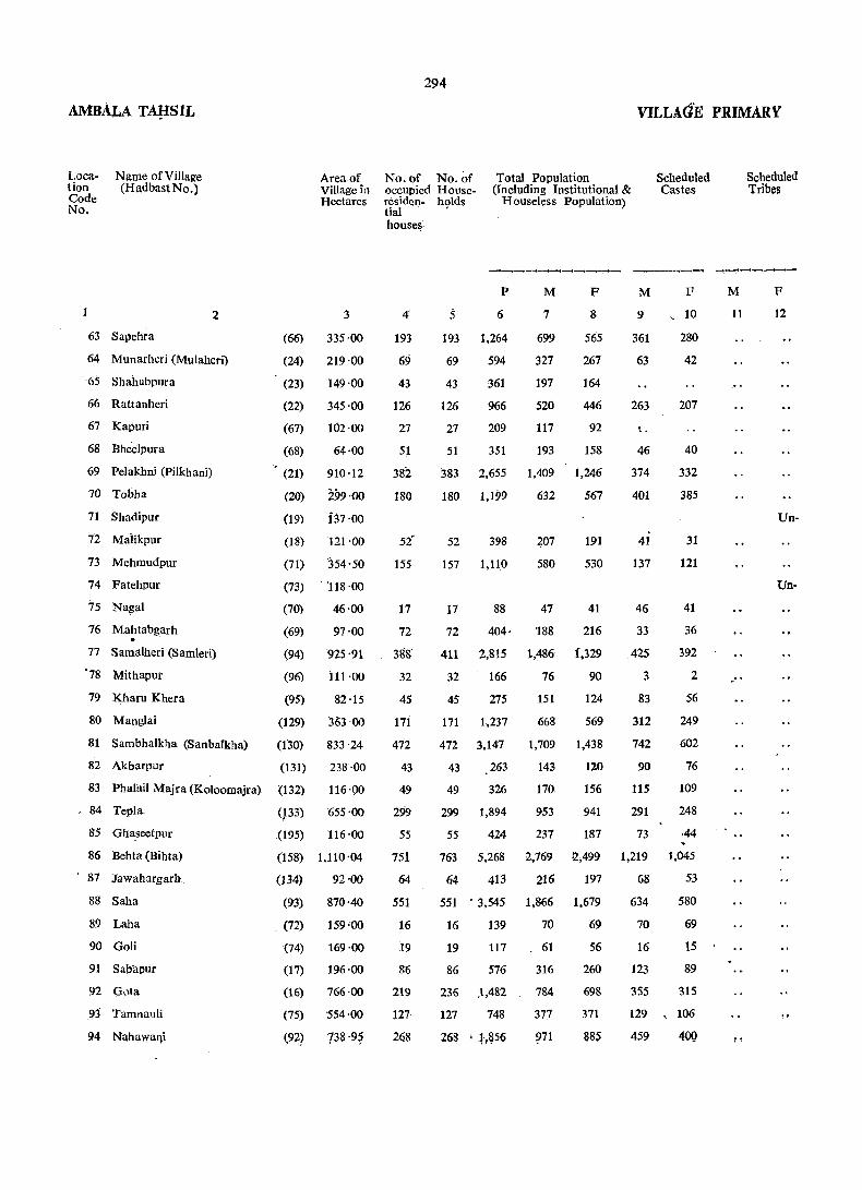
AMBALA TAf{SlL
Location Code No.
Name of Village (Hadbast No.)
Area of Vi!lage in Hectares
1 2 3
63 Sapehra (66) 335'00
64 Munarheri (Mulaheri) (24) 219 ·00
, 65 Shahabpura
66 Rattanheri
67 Kapuri
(23) 149·00
(22) 345·00
(67) 102·00
68 Bheelpura
69 Pelakhni (Pilkhani)
70 Tobha
71 Shadipur
72 Maiikpur
73 Mehmudpur
74 Fatehpur
(68) 64·00
(21) 910 ·12
(20) 299·00
(19) i37'00
(18) 121 '00
(71) 354'50
(73) , '118 ·00
75 Na~al (70) 46 ·00
76 Mahtabgarh (69) 97 ·00 . 77 Samalheri (Samleri) (94) 925 '91
'78 Mithapur (96) 111 ·00
79 Kharu Khera (95) 82·15
80 MangIai (129) 363 ,00
81 Sambhalkha (SanbaIkhll) (130) 833 ·24
82 Akbarpur (131) 238 ·00
83 PhaIllil Majra (Koloomajra) (132) 116 '00
. 84 Tepla, (}33) '655 '00
85 Gha,seetpur .(195) 116·00
86 Behta (Bihta) (158) 1,110 '04
87 Jawahargarb (134) 92'00
88 Saha
89 Laha
90 Goli
91 Sahapur
94 Naha,waqi
(93)
(72)
870·40
159·00
(74) 169·00
(17) 196·00
(16) 766·00
(75) 554·00
(92) 738 '9?
294
VILLAG'E PRIMARY
No. of No. of occupied Houseresiden- holds
Total Population (Including Institutional &
Houseless Population)
Scheduled Castes
tial • house~
4'
193
69
43
126
27
51
382
180
5t 155
17
72
38!f
32
45
171
472
43
49
299
55
751
64
551
16
19
86
219
127
268
P
6
193 1,264
69 594
43
126
27
361
966
209
M
7
699
327
197
520
117
F
8
565
267
164
446
92
51 351 193 158
383 2,655 1,409 1,246
180 1,199 632 567
52 398
157 1,110
207
580
191
530
M
9
361
63
263
46
374
401
41
137
F
10
280
42
207
40
332
385
31
121
17 88 47 41 46 41
72 404· '188 216 33 36
411 2,815 1,486 .f,329 425 392
32 166 76 90 3 2
45 275 151 124 83 56
171 1.237 668 569 312 249
472 3,147 1,709 1,438 742 602
43 263 143 120 90 76
49 326 170 156 115 109
299 1,894 953 941 291 248
55 424 237 187 73 ,44
763 5,268 2,769 12,499 1,219 1,045
64. 413 216 197 68 53
551 • 3.545
16 139
19 117
86 576
236 .1,482
127 748
1,866
70
61
316
784
377
~71
1.679
69
56
260
698
371
ass
634
70
16
123
355
580
69
15
89
315
129 ,106
459
M
11
"
Scheduled Tribes
F
12
Un-
Un-
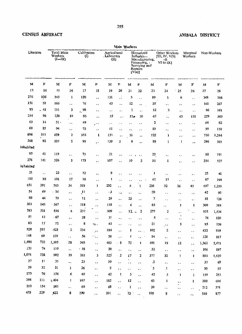
295
CENSUS ABSTRACT AMBA,LA DISTRICT
Main Workers
Literates -Th~liwii;-'--Culti;at;,;-'-Agri;fut-;;l-~~~;h~id~--Othe;-~rl<~ Marginal NO,ll-Workers Workers (I) ,Labourers Jndustry~ [III, IV, V(b) Workers
(I_IX) (U) Manufacturing.'&
M
13
276
151
F
14
196
58
95 • 41
M
15
345
166
111
2~8
51·
214
63
88
696
268
inhabited
95
276
inhabited
21
110
651
54
80
303
783
51
83
528
148
1,486
131
1,071
27
39
173
298
210
479
98
14
25
315
92
41
141
88
291
49
94
659
335
119
326
22
101
163
34
44 70
143 ' 3,67
331
12
17
337 , 69
856
,67
72
·521
109
722 1,395
74
728
11
32
76
110
982
35
31
156
111 );404
134
449
165
,422
F
16
1
3
10
2
2
3
17
34
4
.. 2
28
39
1
6
1
8
M
17
120
76
98 J,
93
49
73
355
99
75
173
12
58
319
11 .. 11
118
257
28
8
234
56
349
J 58
263
23
26
69
167
60
190
F
18
1
1
.~ ..
3
Processing, • VI to IX] Servicing and Repairs [V(a)]
M F M F
19 20 21 22
131
43
55
11
151
139 1
21
107
9
202
·3
29
158
309
31
43
184
38
5
12
1
15011 10
31
8
10
4
23
6
2
1
n _ 2
483 ,8 72'
20
-325
10
2
42
182
68
lOt
2 17
3'
12
1
2$ ,
2
M
23
89
35'
12
65
2
10
122
89
23
36
42
238
20
7
85
277
8
21
102
14
491
32
377
.2
3
42
43
~6
10,8
F
24
3
1
1
17
32
2
2
19
32
1
5
1
M
25
6
63
1
26
3
12
F
26
131
45
1
M
27
348
161
86
229
66
99
F
28
564
267
161
305
92
158
750 1,244
296
88
254
25
'iS7
565
191
527
41
199
697 1,250
42
81
300
90
124
568
853 1,434
76
95
432
128
120
156
939
187
1,362 2,471
106 197
883 1,639
35 69
30
159
380
212
549
55
253
696
371
877

AMBAL A TAHSIL
Location Code No.
Name of Village (Had bast No.) Area of Village in Hectares
2 3
95 JFalpi (136) 503 '00
96 Alapur (154) 167 '00
97 Khera (89) 350·00
98' Gokalgar:.h (76) 454 '86
99 Ramgarh (78) 256 ·00
100 Jharu Majra (Jhando Majra) (77) 263 '00
101 Thakar Pura (15) 542 '00
102 Uplana (14) 510 ·00
103 Talheri Gujran . (13) 341 ·00
104 Dhanaura (80) 791 '00
105 Gangan Heri (Gaganheri) (12) 418·00
106 Kakar Kunda . (10) 379 ·00
107 Taprian
. 108 Nurhad
109 Tharwa
110 Salakhani
111 Sa:h1a
112 Sherpur
113 Sarda Heri
114 Binjal Pur
115 Alia spur
116 Zafarpur
117 Dhnauri
li8 Alipur
119 Jahangirpur (Jabagirpur)
120 Salhapur (Salanpur)
121 Kansapur
122 Bekonpur (Bikonpur)
123 Milk Dhankotan
124 Manka Manki
125 Kban Abmadpur
(11) 138 '00
(3) 450-00
(2) 412 ·00
(4) 201'00
(1) 424 ·00
(5) 151 '00
(6) 660 '00
(9)
(7)
(8)
609'45
181 '00
746 '63
(81) i73 '61
(82) 284'49
(83) 278 '42
(85) 172 '39
(145) 74'00
(146) 84 ·00
(147) 1:'9 '00
(148) 402 '66
(144) . 231 '48
296
VILLAGE PRIMARY
No. of No. of Total Population . occupied House- (Including Institutional residen- holds & Houseless population) tial
Scheduled Castes
houses
4· 5
P
6
M
'7
229 230 1,550 829
35 35 234 124
~ 92 747 ,399
125 125 962 509
119 119 822 414
89 89 582 302
206 209 1,291 679
185 185 1,369 743
95 95 664 368
283 283 1:802 928
94 94 717 390
64' 71 529 271
45
61
55
45
61
~5
102
355
424
478
694
187
217
254
367
111 768 397
86 473 258
290 1,996 1,059
244 1,657 856
F
8
721
110
348
453
408 <
280
612
626
196
874
327
258
168
207
·224
'327·
371
215
937
801
102
111
86·
290
244
73 73 450 255 ! 195
218 218 1,575
92 92 660
83 85' 645
11l 111 662
67 67 499
48 48 313
48 48 356
62· 62 386
221 222 1,433
145- 145 784
851 724
324
341
351
264
167
182
204
765
366
336
304
311
235
146
174
182
668
418
M
9
F
10
403 '348
79 70
192 154
117 108
90 99
144 '115
274 241
142 105
58 44
327 3b7
80 58
148 J47
87
60
66
165
142
50
·376
376
151
258
62
117
125
87
24
69
100
290
71
55
58
152
129
43
341
~43
120
. 215
'62
108
100
76
20
75
86
273
Scheduled Tribes
M ,F
• 11 12
..

C;ENSlJS ABSl'R~CT
Literates
i M
13
327
42
137
125
203
131
365
319
169
434
189
96
85
114
71
186
206
167
450
489
131
F
14
143
9
8
27
"
Total Main Workers (I-IX)
M
15
1438
65
195
292
63 235
40" 164
" 177 364
97
29
223
55
34
47
51
10
70
135
109
198 (,
254
32
394
201
431
170
134
97
107
123
173
197
125
558
341 "
285' 187
114
438
139
181
ISS'
163 .
142
151
114
101
89
131
102
65
78
40' 122
66
39
71
386' 143
90 100
121
431
189 268 227
F
16
4
2
36
3
60
2
3
4
2
2
2
17
41
34~
10
1
15
31
Culti,vators (I)
M
17
214
26
99.
179
120
89
132
243
115
44
121
65
54
57
84.
65
115
SO
278
135
41
188
81
88
69
47
22
40
60
, 1
149
114
Main Workers
Agricultural Labourers
(II)
Household Other Workers Industrv- [III, IV, V(b) Manufacturing, & Processing, VI to IX] Servicing and Repairs [V(a)]
A MBALA InSTRJrCr
Marginal Workers
Non-Workers
--- --.---F
18
1
4
\ 2
1
2
1
16
9·
M F M • F
19 20 21
78
33
59
97
66 1
44 27
150
24
.1
4
22
9~ 2 ., ,
61
317 52
19
58
37
35
36
82
63
36
234
2
1
100 12
54 32
164
3
3
3
5
26
17 3
10 11
38
41
56
51
17
28
41
136
. . ",,,. 13
37·
2
3
5
.,.
M
23
122
6
36
16
49
31
78
58
22
67
3,0
11
, 6
12
3
26
19
39
45
101
19
60
17
41
30
22
50
31
20
143
33
F
24
2
8
3
1
4
2
2
2
2,
3
2
22
"
M
25
3
18
2
3
F
26
4
·108
M
27
388
59
204
217
179
138
315
349
167
497
F
28
717
110
347
453
406
244
608
625
296
814
202' 326
137
90
110
131
194
200
133
499
512
141
412
185
160
196
141
77
82
83
334
171
256
168
207
221
323
369
213
935
780
154
724
302
294
202
220
146
174
182
637
417

Location Code No_
Name of Village (Hadbast No_) Area of Village ill Hectares
No_ of No_ of Total Population (Including Institutional & Houseless Population)
1
126 Ponti (Pawati)
127 Rukhri
128 Dhin
129 Jamal Majra
2
130 Rola Heri (Roo!aheri)
131 Duliana
132 Duliani
133 Sirsgarh
134 Tange!
135 Patti Chanartha!
136 Mullana
137 Pap!otha
138 Patti Bagheru (Bhageru)
139 Hamidpur
140 Herna Majea "
141 Sohana
142 Bhudian
143 Maujgarh
144 Sharaqpur
145 Semla
146 Holi
147 Ganganpur (Gaganpur)
148 Barara
149 Siwan Majra
150 MiIak Shekhan (Milk Sikha)
151 Nahra
152 Dera Salaimpur
153 Thamber
154 Malakpur
155 Alawa!pur ...
occupied Houseresid"en- holds tial Houses
3 4
(84) 160-00 60
82
522
34
(142) 233 -00
(143) 973 -66
(86) 165-00
(79)
(87)
(141)
(140)
(88)
(138)
(139)
(91)
(90)
(137)
(153)
(152)
(151)
(212)
(201)
(202)
(150)
(149)
(203)
(204)
(205)
(206)
(207)
80-00 30
398-00 183
333-00 179 , 376 ·00 124
360-97 96
160-25 129
.650'32 615
429-37 78
480-00 248
196-00 62
424 -00 114
688-76 278
·291 -00 97
151 -35 122
269 ·92 109
180-00 109
411 -IS 177
199-51 83
1,237 -11 1,588
209 -62 147 ~.
125-00 60
192-22 100
614'~0 279
(208) 1,061 -07
(-238) 227 -00
635
106
117 " (239) 369 '00
5
60
82
P
6
510
490
M
7
279
255
F
8
231
235
522 3,316 1,682 -t 1,634
34 242 127 115
30
1~3
179
131
96
129
625
85
255
62
114
278
97
122
109
110
177
83
1,602
151
60
100
296
190
1,090
1,167
818
554
739
3,756.
666
1,678
379,
789
1,785
827
653
728
75~
1,357
808
9,811
915
406
675
106
561
597
460
295
375
1,987
391
901
199
419
965
451
354
381
403
749
444
S,101
427
212
357
995
84
529
570
358
259
364
1,769
275
777
180
370
820
376
299 '
347
349
608
364
4,710
488
194
318
983
665 4,874 2,606 2,268
106 611 325 " 286
117 914 489 425 .
V1LLAGE PRIMARY
Scheduled Castes
M
9
40
i08
729
29
47
145
305
287
129
22
428
69
109
167
141
516
173
134
205
121
316
302
1,030
111
56
156
299
903
188
150
F
10
37 , 112
664
20
47
127
265
244
110
21
363
5S
85
147
112
441
145
102
179
110
247
239
921
112
66
133
287
774
164
128
Sclteduled Tribes
M F
11 12
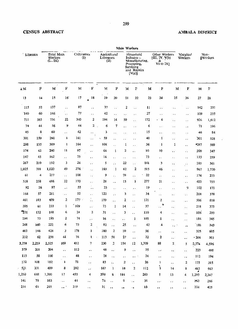
CENSUS ABStRACT
, Literates Total Main WorKers (I-IX)
13
115
'140
711
74
45
301
298
174
147
267
1,025
61
5}8
92
168
461
205
14
52
60
385
44
8
159
135
42
45
210
M
15
137
146
756
56
60
260
309
260
162
192
701 1,020
4 217
258 488
F
16
22
9
11
3
49
22
2
Cultivators
M
17
87
77
340
44
42
161
164
97
75
24
274
108
170
(I~
55
52
177 '
, 109
•
F
18
2
2
~21
194
268
403
232
26
57
183
61
132
73
160
146
62
97
211
459
233
168
195
222
424
238
Ii 24 2
3,258 2.219 2.525
379
115
172
521
1,2;0
141
2)4
201
58
108
331
204
100
182
499
618 1,300
79 163
61 265
2
6
3
61
109
1
8
17
74
73
178
76
432
112
48
71
202
455
44
219
2
7
4
299
Mail} Workers
Agricultural Labourers
(II)
M F
19 20
37
42
Household IndustryManufacturing, Processing, Servicing and Repairs
[V(a)]
M F
21 22
2
M
23
194 14 50
11
27
172
6
3
" 59
108
66
14
5
169
9
28
23
122
159
73
31
16
82
180 2
113 58
7
2
22
62
78
13
3
2
14
3
25
10
27
6
15
40
36
95
73
141
2 515
, 22
1 277
1
19
34
121
37
110
105
42
56
22
230 2 154 12 1,709
48
28
83
167
9
2
18
398 8 184
74 9
31
2
35
24
26
112
263
36
1S
Other Workers [III, IV, V(b) & .
VI to IX]
F
AMBALA DISTIUCT
Marginal Workers
M F
NonIWorkers
M F
24 25 26 27 28
- 6
10
3
46
21
2
4
4
2
88
, 5
5
2
14
13
9
142
109
231
235
926 1,612
71
46
:l01
'287
200
133
i83
106
84
528
569
347
259
361
967 1,720
174 275
413 755
102
208
506
218
186'
186
181
325
·206
171
370
818
375
293
345
,343
605
303
5 2,574 4,~96
2
8
223
112
175
482 ,
488
194
315
967
4 1,293 2,247
1'62 286
224 425
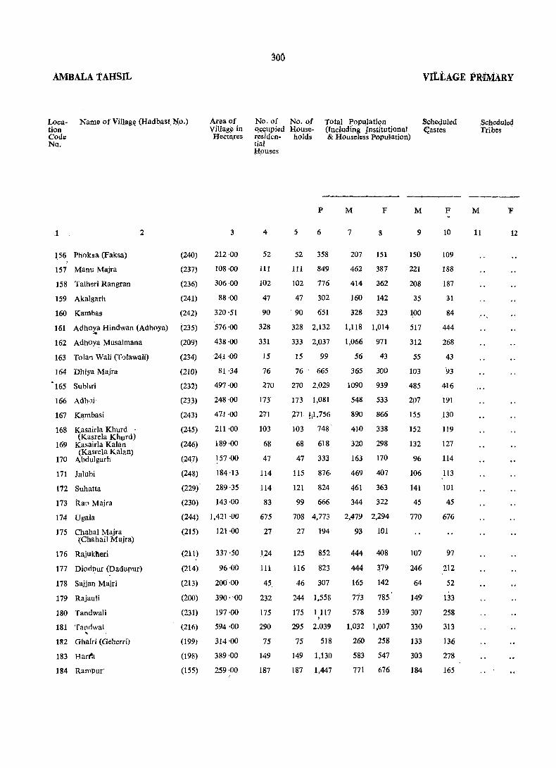
AMBALA TAHSIL
Location Code No.
Name of Villllg~ (Had bast. ~o.) Area of Village in Hectares
156 Plioksa (Faksa)
157 Manu Majra
158 Talheri Rangran
159 Akalgarh
160 Kamhas
2
(240)
(237)
(236)
(241)
(242)
3
212·00
108 '00
306·00
161 Adhoya Hindwan (Aclhoya) (235)
88·00
320·51
576'00
438'00
241·00
... 162 Adhoya Musalmana
163 Tolar) Wali (Tolawali)
164 Dhiya Majra
'165 Subhri
166 Adh.)i
167 K~mbasi
168
169
170
Kasairla Khurd (Kasrela Khurd)
Kasairla Kalan (Kasrela Kalan)
L\bdulgarh
171 Jalubi
172 Suhatta
173 Ra:l Majra
174 Ugala
175 Chabal Majra (Chahail Majra)
176 Rajukheri
177 Diod!?ur (Dadupur)
178 Sajjan Majri
179 Rajauli
180 Tandwali
181 Tanrlwal .. '
182 Ghalri (Geherri)
183 Harl'!l
184 Rampur'
(209)
(234)
(210)
(232)
(233)
(243)
(245)
(246)
(247)
(248)
(229)
81 '34
497·00
248 ·00
471 '00
211'00
189;00
157·00
184·13
289·35
(230) 143·00
(244) 1,421 ·00
(215) 121·00
(211)
(n4)
(213)
(200)
(231)
(216)
(199)
(198)
(155)
337·50
96·00
200·00
390 ·-00
197 ·00
594 ·00
314'00
389·00
259·00
300
No. of Qccupied reSldcntia! ~l.ouses
4
52
111
102
47
90
328
331
15
76
270
173
271
103
68
47
114
114
83
675
27
1,24
111
45,
232
175
290
75
149
187
No. 0.£ H;olli!eholds
Total Population (Including Institutional & Houselcss population)
P
5 6
52 358
111 849
102 776
47 302
. 90 651
328 2,132
333 2,037
15 99
76' 665
270 2,029
173 1,081
,271 ti1,756
103 748'
68 618
47 333
115 876.
121 824
M F
7 8
207 151
462 387
414 362
160 142
328 323
1,118 1,014
1,066 971
56 43
365 300
1090 939
548 533
890 866
410 338
320 298
163 170
469 407
461 363
99 666 344 322
708 4,773 2,479 2,294
27 194 93 101
125 852
116 823
46 307
244 1,558
175 1117 ,
444 408
444 379
165 142
773 785
578 539
295 2,039 1,032 1,007
75 518 260 258
149 1,130 583 547
187 1,447 771 676
M
9
1S0
221
208
35
100
517
312
55
103
485
207
155
152
132
96
106
141
45
770
107
246
64
149
307
330
133
303
184
vILtAGE PRiMARY
Scheduled ~astes
F
10
109
188
187
31
84
444
268
43
93
416
191
130 119
127
114
113
101
45
676
97
212
52
133
258
313
136
278
165
M
,Scheduled Tribes
F
11 12

CENSUS ABSTRACT
Literates Total Main Workers (I-DO
M
13
65
179
211
61'
135
269
604
24
203
501
330
50.7
172
130
67,
151
177
174
1,197
70
270
231
107
463
277
545
103
212
366
F M
" 14 15
16
37
80
19
66
300
405
9
65
156
213
302
48
41
33
36
62
74
103
217
224
80
161
549
505
20
177
545
247
451
208
185
93
247
235
161
752 1,327
65
154
95
64
316
153
266
49
81
l41
57
204
224
65
374
242
552
130
292
413
F
16
5
35
5
4
7
65
10
17
4
3
5
9
10
Cultivators (I)
301
,Main workers
Agricultural Labourers
(II)
Household IhduslryManufacturing, Processing, Servicing and Repairs [yea)}
Other Workers [iII" IV, V(b)
& VI to IX}
AMBALA DISTRICT
Marginal Workers
Non-Workers
----- ----- ------ ------- _--....;---M
17
46
125
114
52
80
166
153
4
69
244
133
233
98
85
24
143 c
131
88
581
36
, 91
66
21
148
99
173
53
89
Pi
F
18
4
2
.,
5
1
M F M
19 20
52
62
67
23
64
21
• 12
5
209 Z 24
115 11 31
11
32
217
43
105
8g-
81
55
73
31
32
6
15
2
3
8
3
F
22
265
3
4 96 40
43 4 8
40 14 22
12
76
102
l(,5
39
2
5
3
37
l' 136 14
1~ l8i
F
23 24
5
18
38
5
17
150 3
.206 22
5
20, "(1
84 1
70
98
20
18 • 11 1
31
65
38
7
385 16 c
18
62
96
32
145
38
177
, 38
53
88
5
2
3
2
3
8
10
M
25
11
13
3
F
26
'4
51
M
27
104
245
190
80
167
F
28
150
387
362
141
323
569 1,009
561 936
36
188
545
301
439
202
]35
70
222
226
183
43
299
934
529
866
338
298
169
407
352
321
1,152 2,228
36
229
220
100
386
335
480
127
291
358
101
398
362
138
782
534
998
197
546
676

AMBALA TAHSIL
Location Code No
Name of Village (Hadbast No.) Area of Village in Hectares
185 Dhakola
186 Chapra
187 Shcrgarh
188 Nagla
2
189 Phusiala (Pasiala)
190 Haryoli
191 Subga
192 Khanpura
193 Raiya Majra
194 panjhail
195 Husanpur (Hassanpur)
196 Denarpur (Dinarpur)
197 Dubli
198 Kesri
199 Bazeedpur
200 Naraingarh
201 HaIdari
202 Chhanni
203 Langar
204 Dhurala
205 Chudiala
206 Chudiali
207 Landha
208 Khanpur
209 Pharoli
210 Mohra
211 Dukheri
212 Brahman Majra
213 Bohawa (Borawa)
214 Shahpur
US Machhondi
3
(135) 247 ·00
(156) 145·00
(157) 102 ·00
(196) 300 ·68
(218) 369 '00
(197) 299 '06
(217) 719·00
(228) 111 '29
(227) 64'00
~(226) 325'77
(225) 139 '00
(224) 449 ·00
(222) 175 ·00
(221) 981 ·00
G~20) 129 ·90
(219) 113 ·31
(194) 348 '8'3
(192) 155 ·40
(193) 164 ·70
(159) 511 ·11
(191) 369 ·00
(160) 226 ·00
(223) 550 ·77
(190) 265 ·87
(189) 181 ·00
(188) 935 ·00
(161) 1,015' 34
(127) 225 ·00 .. (162) 104 ·00
(125) 941 ·00
(124) 11S ·00
302
No. of No. of Total Population occupied House- (Including Institutional residen- holds & Housele>ss Population) tial • Houses
4
102
&,4
46
150
115
85
154
51
61
13
170
115
432
39
24
221
62
65
260
177
62
233
111
92
350
319
80
3
578
5
102
84
P
·6
674
609
46 307
150 1,036
115 873
85 643
170 1,254
52 377
M
378
345
171
537
£1.37
338
650
203
F
8
296
264
.136
499
436
305
604
174
69 436 229 207
. 13 78 36 42
170 1,172 623 549
116 819 441 378
4;32 3,02] 2,651 1,370
39 286 151 135
24 207 111 96
221 1,547 844 703
62 461 238 .223
65 448 236 212
260 1,711 939 772
177 1,187 643 544
62 460 226 234
233 1,584 861 723
111 790 418 372
92 645 348' 297
381 2,481 1,362 1,119
321 2,544 1,372 1,172
80 525 268 257
3 44 32 12
581 . 3,952 2,i60 1,792
VILLAGE PRIMA~Y
Scheduled Castes
M
9
208
80
94
251
76
158
111
59
F
10
151
67
67
232
62
143
116
52
106 88
192 170
218. 172
475 . 410
45 37
56 50
162 129
79 5.6
91 82
438 362
360 312
81 82
244 7 , 113 97
122 87
435 348
645
125
482
533
177
413
..
Scheduled Tribe~
M
11
F
12
Un.
lJn.

CENSUS ABSTRACT
Literates
M
13
198
154
83
285
205
166
255
86
inhabited
87
26
344
199
761
70
56
428
139
U5
386
371
118
32Q
233
200
608
704
130
25
F
14
64
45
28
143
82
62
1-35
29
44
22'
14
72
342
27
21
185
70
67
143
155
68
124
106
94
270
293
73
6
Total Maio Workers
(I-IX)
M F
15
186
189
83
283
253
171
340
100
122
16
336
219
864
94
56
417
144
135
484
318
123
440
231
178
684
70'1
121
25
16
2
10
2
1
5
5
12
3
2
1
4
15
5
1,107
inhabitf;d
672 1,246 82
Cultivators (I)
M
17
82
113
30~
103
162
39
171
51
21
9
127
90
359
47
32
174
72
78
12S
102
66
164
117
64
270
2i2
21
519
F
18
Main Workers
Agricultural Labourers
Household Industry-Manufacturing, Processing, Servicing
(IT)
M
19
48
47
37
82
70
72
82
32
88
7
116
58
254
36
15
103
58
43
184
163
41
243
65
and RepaiJ'1:
F M
20 21
3
7
2
4
3
17
3
[V(a)]
F
22
1 .
28 2
4
1
4
1
1 26
5
1
7
1
2
M
23
49
27
12
95
21
60
70
14
12
65
67
250
7
9
140
13
14
149
53
11
32
42
72
224
Other Workers [III, IV. V(b)
& VI to IX)
F
1
6
2
1
3
5
if
2
1
1
2
M
25
18
6
1
1
3
41
186
269
1
4
5 161 .• 15
24
2·
329 60 11 1
76
22
387
4
21 2
AMBALA DISTRICT
Marginal \\'orkers
F
26
S3
1
14
M
27
192
156
88
254
184
167
310
103.
107
20
287
204
781
57
55
427
94
101
455
325
103
420
187
169
675
665
147
7
·912
NonWorkers
F
28
294
264
136
489
436
305
602
174
Z07
41
544
320
1.358
135
96
700
223
211
770
543
234
721
372
295
1,101
1,157
252
12
1.710
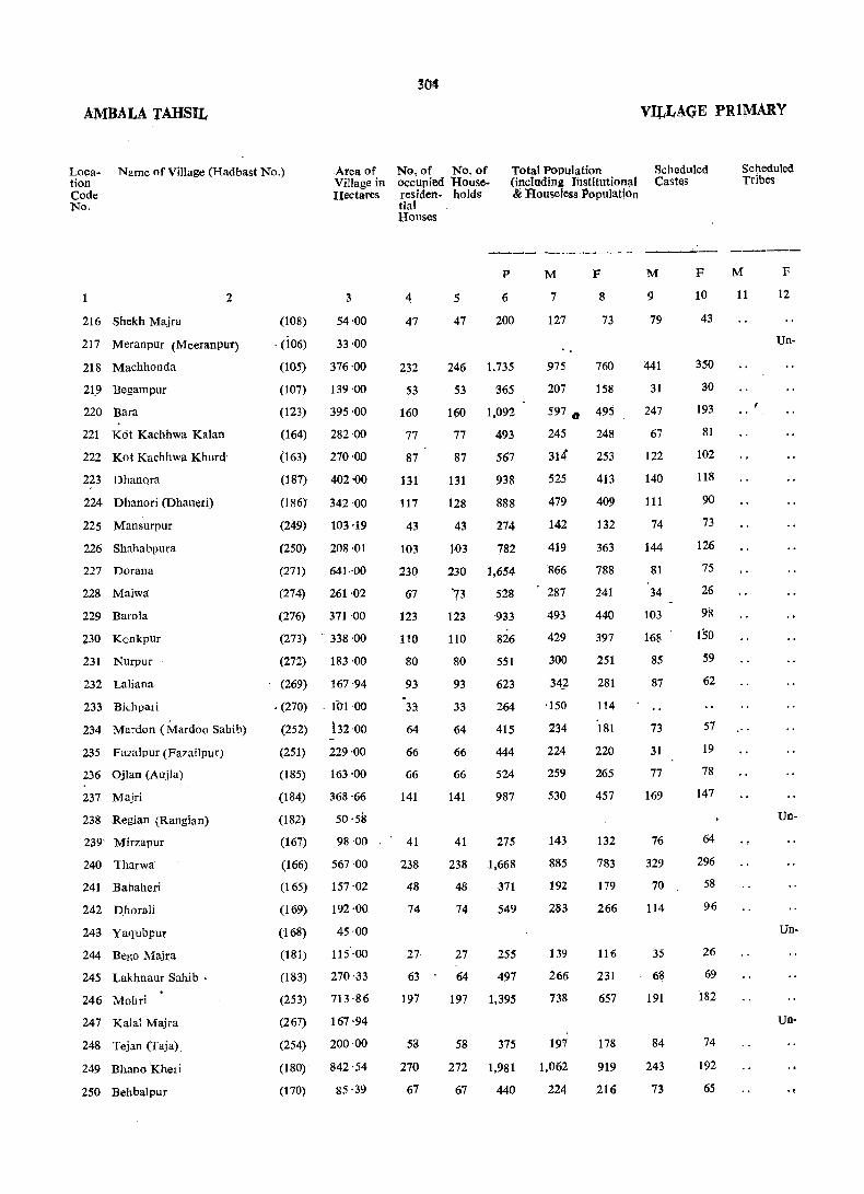
AMBALA TAHSIL
Loca· tion Code No.
Name of Village (Hadbast No.) Area of Village in Hectares
2
216 Shekh Majra
217 Meranpur (Meeranpur)
218 Machhonda
21.9 Begampur
220 Bara
221 K6t Kachhwa Kalan
222 Kot Kachhwa Khurd
223 Dhanora
224 Dhanori (Dhaneri)
225 Mansurpur
226 Shahabpura
227 Dorana
228 Malwtl
229 Barola
230 KGnkpur
231 Nurpur
232 Laliana
233 Bichpari
234 Mardon (Mardoo Sahib)
235 Fazalpur (Fazailpuf)
236 OJ Ian (Aujla)
237 Majri
238 Regian (Rangian)
239· Mirzapur
240 Tharwa
241 Babaheri
242 phorali
243 Yaqubpur
244 Bego Majra
245 Lakhnaur Sahib·
246 Mobri
247 Kalal Majra
248 Tejan (Taja).
249 Bhano Kheri
250 Behbalpur
(108)
. (106)
3.
54·00
33'00
(I()'5) 376 '00
(107) 139 ·00
(123) 395 ·00
(164) 282 ·00
(163) 270 ·00
(187) 402 '00
(186) 342 ·00
(249)
(250)
(271)
(274)
(276)
(273)
(272)
(269)
• (270)
(252)
(251)
(185)
(184)
(182)
(167)
(166)
(165)
(169)
(168)
(181)
(183)
(253)
(267)
(254)
(180)
(170)
103·19
208·01
641··00
261,02
371·00
338·00
183·00
167·94
. 101·00
i32 ·00
229·00
163'00
368'66
50·58
98 ·00
567·00
157·02
192·00
45·00
115 ·00
270 '·33
713 ·86
167 ·94
200·00
842'54
85·39
No, of No. of occupied Rouse· residen. holds tial Houses
Total POPulation (including Institution;ll &. Rouseless PopUlation
VILLAGE PRIMARY
Scheduled Castes
Scheduled Tribes
--------_--- ----- ----
4
47
232
53
160
77
87
131
117
43
103
230
67
123
110
80
93
33
64
66
66
141
41
238
48
74
27
63
197
58
270
67
5
47
P
6
200
246 1,735
53 365
160 1,092
77 493
87 567
131 938
128 888
43
103
274
782
230 1,654
'73
123
110
80
93
33
64
66
66
141
528
933
826
551
623
264
415
444
524
987
41 275
238 1,668
48 371
74 549
27 255
64 497
197 1,395
58 375
272 1,981
67 440
M
7
127
F
8
73
975 760
207 158
597., 495
245 248
314 253
525 413
479 409
142
419
866
287
493
429
300
34~
·150
234
224
259
530
143
885
192
283
139
266
738
197
1,062
224
132
363
788
241
440
397
251
281
114
181
220
265
457
132
783
179
266
116
231
657
178
919
216
M
9
79
441
31
247
67
122
140
111
74
144
81
34
103
168
85
87
73
31
77
169
76
329
70
114
35
68
191
84
243
73
F
10
43
350
30
193
81
102
118
90
73
126
75
26
98
150
59
62
57
19
78
147
64
296
58
96
26
69
182
74
192
65
M
11
F
12
Un·
Un·
Un·
Un-
"

CENSUS ABS11RACT
Literates
M
13
24
inhabited
454
124
283
128
142
220
197
90
222
519
117
257
173
157
160
91
116
120
137
278
inhabited
95
434
91
157
inhabited
69
122
320
inhabited
93
380
U9
F
14
4
197
57
93
76
52
71
75
50
78
287
46
163
42
57
38
37
46
81
77
101
35
295
52
59
37
55
142
54
273
53
To_tal Main Workers (I-IX)
M
15
98
561
120
324
130
177
307
245
79
217
482
164
255
235
168
174
72
122
131
142
292
62
475
108
155
75
132
378
99
561
118
F
16
35
30
14
4
11
5
12
27
17
6
1
2
1
1
4
'I
8
3.05:
Main Workers
Agdcultural Lal::lQur.ers
aousehold Other Workers Indust~y-, [ID, IV, V(b)
(W Manufacturing, & Pl;o~essing, YI to IX] Servicing and Repairs [yea)]
~-, -.-- .--:-:---M
17
174
73
163
61
90
155
100
23
55
223
" 87
156
89
97
43
25
32
66
65
155
29
166
53
113
54
65
187
29
289
45
F
18
1
' ..
1
, M F
19 20
60
15
2
120 11
53
71
90
88
32
104
112
39
76
112
42
94
34
71
35
64
60
18
222
42
27
16
33
102
45
153
22
4
3
4
5
1
5
1
M F
21 22
14,
1.
8
5
4
1&,
8.
5
6
2
12
1
10
1
10
2
4
4-
M
23
98
313
32
36
16
15
54
52
24
54
129
38
15
29
28
31
13
17
18
12
67
14
77
13
15
3
30
85
12
112
50
F
24
35
28
3
8
6
26
17
2
1
4
2
~MBALA DISTRICT
Marginal Workers
M
25
6
20
6
6
F
26
17
51
11
6
2
28
Non·Workers
M
27
29
414
87
.273
115
137
218
234
63
202
,384
123
238
193
132
168
78
112
93
117
238
81
410
,84
128
64
128
340
92
495
106
F
28
38
729
158
481
247
253
409
398
127
351
761
207
440
397
251
281
114
181
163'
264
455
132
782
178
266
116
216
650
176 •
883
216

AMBALA tAHSIL
Location Code No.
Name of Village (Hadbast.No.) Area of Village in Hectares
No. of No. of occupied HOuseresiden- holds
tial
Total Population (including Institutional & Houseless P.:>pulation
Houses
1 2 3 4
251 Anandpur Jalbera
252 Dhurkra
(121) 642 '63 280
(118) 466'19 76
253 Dhurala (119) 233 ·10 109
254 Rawalan (Raula)
255 Ladana
(171) 165 ·92 53
(172) 172 ·00 80
256 Balana (Bullana)
257 Sullar
(173) 1,079 ·69 429
(174) 400 ·63 234
258 Bhari (Bhiri)
259 Manka
(176) 171 ·99 64
260 Hamayupur
261 Matchri Shekhan
262 Muzafra
(178)
(179) .. (256)
(177)
263 Masatpur (257)
264 Tar (263)
265 Aminpur (258)
266 Ahman (Aycma) (175)
267 Ba,ringan (Baranga) (260)
268 Qurbanpur (259)
269 Dingerian (Dang Deheria) (261)
270 IsmaiIpur (AsmaiIpur) (262)
271 Malor (283)
272 Khera (281)
273 Landiali (Ladiali) (264)
274 Sakluaon (Sukhrao) (265)
275 Gobindgarh (255)
276 Khaspur (266)
277 NagaI (280)
(279)
77-00
260 ·61 146
272 ·75 118
178·00 55
491·69 144
338·00 123
236·00 73
212 ·05 51
70 -00 30
216-91 47
161 ·00 49
323 -74 103
269 ·52 97
437 ·00 98
432·60 159
407 -00 97
125 -00 18
95 -00 44
544·29 186
280·00 61 278 Hasanpur (H aisanpur)
279 Addu Majra (27S) 401 ·00 96
280 Bersan (Bersa)
281 Barauli
282 Jalalpur
283 Kaleran (Kalera)
284 Segti
-285 Bishangarh
(268) 205 -00 29
(277) 326-00 98
(275) 238 -00 65
(307) . 455 -26 180
(306) 273 ·56 56
(305) 193 ·03 63
5
P
6
M
7
F
8
280 1,969 1,()7S 891
. 76 557 300 257
109 799 402 397
53 330 182 148
_ .80 499 268 231
447 2,965 1,643 1,322
234 1,402 738 664
64 495 255 240
146
118
55
891
739
454
144 896
123 865
73 513
51 436
30 253
47 364
49 433
-103 702
97 617
98 820
159 1,244
97 731
18 182
44 336
187 1,172
61 439
96 699
29 245
9S ·826
72 53B
180 -1,224
68 347
63 412
479
397
234
470
456
282
242
139
191
232
368
334
448
631·
382
93
180
625
234
358
133
437
281
663
206
213
412
342
220
426 ... 409
231
194
114
173
201
334
283
372
563
349
89
156
547
205
341
112
389
257
561
141
1'99
VILLAGE PRIMARY
Schedl'led Castes
M
9
386
87
148
60
46
553
273
105
249
82
44
118
163
128
58
39
47
IS
72
62
126
219
82
19
77
193
183
92
28
120
41
36
F
10
349
73
158
48 .. 42
431
252
100
225
66
36
95
1'37
111
50
12
34
15
68
SO
115
195
87
13
71
159
1
162
61
21
lOS
33
34
Scheduled Tribes
M
11
F
12
Un-

CENSUS APSTRACT
'Literates Total Main Workers
(I-IX)
Cultivators (I)
307
Main Workers
Agricultural" Labourers
(10
AMBALA DISTRICT
Household Other Workers Marginal Non-Workers Industry- . [III, IV, V(b) Workers Manufacturing, &
Processing, VI to IX! Servicing and Repairs [V(a)]
- ..... -- ---- ----M F
13 .14
525
153
215
86
169
805
337
103
inhabited
210
253
122
193
216
70
90
67
101
74
134
154
236
237
.161
57
69
373.
163
144
62
172
122
301
III
65
190
'81
95
35
80
376
176
43
84
169
54
119
76
13
32
15
56
26
70
69
76
66
66
39
23
248
169
74
35
82
58
102
5S
26
M
15
573
189
217
110
152
858
403
139
246
211
141
287
266
162
122
77
106
127
215
161
221
360
188
47
85
332
116
181
76
231
150
339
131
108
F
16
4
6
2
8
42
15
2
35
4
M
17
188
83
96
52
74
350
139
50
81
58
71
116
115
72
.. .,. 6~
38
70
74
58
3
42
1
14
11
3
1
70
117
179
92
28
41
145
·59
84
62
96
85
191
22
60
F
18
1
2
5
2
2
1
M F
19 20
256
30
57
25
33
215
126
39
76
49
33
68
102
78
38
7
19
30
76
55
69
34
36
10
33 11
79 ....
3
75
6
14
36
62
28
23
1
3
6
1
M
2i
4
5
2
4
4
40
20
7
3
1·
7
1
5
7
2
3
3
5
5
9
7
8
13
1
F
22
32
M
23
125
71
64
31
41
·289
J8 30
82
1 101
36
96
1
;,
48
7
12
30
17
22
78
33
34
147
59
9
11
103
49
13
8
114
21
T3
8IT 25
F
24
3
5
1
6
2
8
1
33
3
42
1
3
1~
3
1
M
25
1
142
11
1
16
7
7
15
F
26
18
3
5
1
15 \
.3
M
27
505
111
185
72
115
F-
28
887
257
373
148
229
643 1,311
335
116
222
185
93
183
190
120
120
62
85
·105
153
173
226
320
178
39
88
278
118
177
57
206
131
324
75
105
622
240
407
327
218
391
405
230
194
114
173
201
334
280
371
521
349
87
127
533
202
341
112
389
257
561
140
199

AMBALA TAHSIL
Location Code No ..
Name of Village (Hadbaat No.)
286 Jansui
287 Gorsian (Goursia)
288 Alauddin Majra
289 Bainba
290 Segta
291 Mehmudpur
292 Balmaur
293 Munda Majra
294 Ghagru
2
295 Bhurangpur (Bharangpur)
296 Daudpur
297 Banhpur (Bahpur)
298 Rattangarh Urf Nakatpur
299 Batrohan
300 Dhelo Majra
301 Nanyola
302 Laotan (Lota)
303 Khurchanpur
304 Panjola
305 Udepur
306 Rasulpur
(308)
(309)
(301)
(302)
(304)
(303)
(282)
(285)
(284)
(286)
(287)
(288)
(296)
(294)
293}
(292)
(291)
(290)
(289)
(295)
(312)
307 Khana Majra (297)
308 Miyan Majra (Miya M ajra) (300}
309 Chugna (299)
310 MeHan (Metla)
311 Niharsa
312 Niharsi
313 Sheikhupur
314 Jagoli
315. Jansuya
316 Sonta
317 Sonti
318 Mahlan
(298)
(310)
(311)
(313)
(314)
(315)
(316)
(317)
(318)
Area of Village in Hectares_
3
701 ·71
336-69
160 -25
122-00
301-00
179'00
392·00
109'67
177·65
426'53
210'00
127·00
146'00
342'36
·158 ·00
558 -00_
174·00
161·00
240'00
165 '51
92·00
171'00
89·84
69·20
89·00
73 ·25 4
542·27
- 168 ·00
172·00
422·49
573 -00
346·00
271 ·00
No. of No. of occupied Houseresiden- holds tial
Total Population (including Institutional & Houseless Population)
Houses
4
297
47
20
69
62
28
200
24
17
127
25
15.
16
140
38
486
59
88 ~ ..
61
81
22
104
34
28
45
33
146
88
68
144
270
129
101
5 •
P
6
M
7
F
8
297 2,102 1,147 9S5
47 276 157 119
20 134 71 63
69 399 • 199 200
62 418 227 191
28 247 136 111
200 1,450 797 653
24 178 101 77
19 122
127 1,027
25 221
15
16
168
138
140 [1,179
38 221
72 50
560 467
109 112
97
77
71
61
616 563
125 96
486 l2,962 1,640 1.3~
59
96
61
81
22
104
34
28
45
33
146
88
68
144
270
129
101
508
701
494
603
153
665
225
153
297
188
1,101
605
493
1,020
1,706
971
691
270 238
389 312
274 220
299 304
89 64
336 329
127 98
79 74
153
97
571
324
- 249
521
940
560
373
144
91
530
281
244
499
766
411
324
Scheduled Castes
.M
9
F
10
214 183
24 19
71 63
157 157
43 33
28 18
241 207
116 97
188 166
21 18
186 163
26
44
129
40
84
104
79
136
97
73
65
2
125
205
73
75
28.
27
96
35
94
84
74
123
91
68
41
138
165
42
73
Scheduled Tribes
M
11
F
12

CENSUS ABSTRACT
Literates
-------M
1,3
555
78
29
95
102
51
411
56
32
232
36
47
33
271
4
796
110
172
106
177
53
180
49
20
49
26
302
151
F
14
329
41
4
,39
32
30
165
37
18
111
~5
1,7
2
138
398
45
63
45
133
21
110
1
28
ot 154
92
118' 96
209 113
367
1-59
160
112
30
51
Total Main . Workers (I-IX)
M
15
627
81
40
115
111
71
375
39
32
258
64
57
35
299
91
907
154
212
143
156
43
185
58
41
71
43
298
126
115
259
564'
331
200
F
16
2
10
14
11
4
2
3
28
1
5
1
r
27
18
2
5
Cultivators (I)
M
17
239
56
20
60
55
52
136
15
19 149
58
47
32
132
23
296
93
2
78
90
29
49
35
25
31
23 180
.. 75
100
167
224,
215
9Z
F
18
309
MaIn Workers
Agricultural Labo.urers
(In
Household ' Other Workers
M
19
217
16
16
47
25
16
158
7
8
48
4
6
78
65
172
43
164
48
33
3
107
12
14
34
17
59
15
51
232 ,
99
65
Indus'try- [III, IV, V(b) Manufacturing, & Processing, VI to IX] Servicing and Repairs [V(a)]
F M
20 21
9
13 3
10 14
4
1 12
i 22
F
22
1 82 • 7'
4
1
27
18
4
7
3
3
8
2
10
"
M
23
171
9
4
5
17
3
64
17
5
49
2
4
3
67
3
357
18
42
17.
26
11
26
8
2
6
3
58
28
15
39
98
17
~1
F
24
2
2
20
2
AMBALA DISTRICT
Marginal Workers
M
2S
1
42
,,'
31
3
13
Non-Workers
F M
26 27
520
76
31
84
3 116
F
28
953
119
53
186
177
65' 107
422
61
39
23 260
45
40
42
87 286
653
77
, 49
442
112
71
61
473
34 96
730 1,29~
116 237
177
131
143
46
151
69
38
82
54
273
198
134
32 249
376
229
F3
311
215
303
64
328
97
74
117
73
530
279
244
465
76~
411
~l~
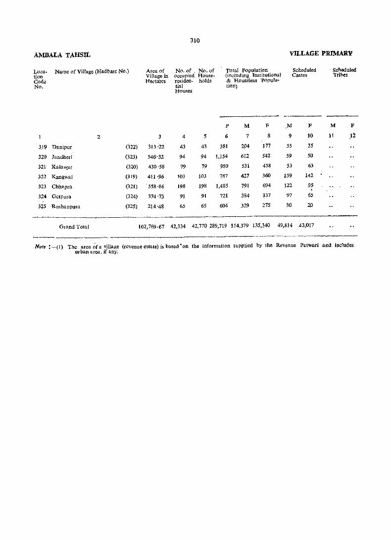
AMBALA TAHSIL
Location Code No.
Name of Village (Had bast No.)
2
319 Danipur (322)
320 Jandheri (323)
321 Kula"Cur (320)
322 KangwaJ (319)
323 Chhapra (321)
324 GetPu,ra (324)
325 Rosbanpura (325)
Grand Total
Area of Village in Hectares
3
313·22
546'32
430'58
411'96
'558'86
374'73
214 '48
310
No. of , No. of occupied Houseresiden- holds tial Houses
4 5
43 43
94 94
79 79
103 103
198 198
91 91
65 65
Total Population (including lnstitutional & Houseless 'populatiOn)
p M F
6 7 8
381 204 177
1,154 612 542
989 531 458
787 427 360
1,485 791 694
721 384 337
604 329 275
VILLAGE PRIMARY
Scheduled Castes
-------M F
9 10
55 35
59 50
53 63
159 142
122 95
97 65
30 20
Scheduled Tribes
M F
11 12
102,769.67 42,334 42,770 289,719 154,379 135,~40 49,814 43,017
N(}te :--(1) 'the area ~fa village (revenue estate) is based "on the information supplied by the Revenue Patwarj and, includes urban area. if any.
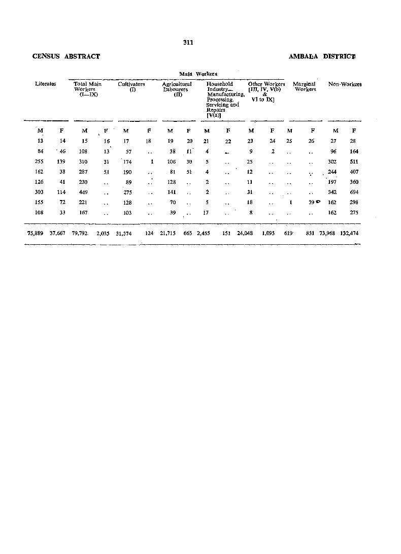
311
CENSUS ABSTRACT AMBALA D1STRICl1
Main Workers
Literates Total Main Cultivators Agricultural Household Other Workers Marginal Non-Workers Workers (D L'abourers Industry_ [III, IV, V(b) Workers
(I-IX) (II) Manufacturing, & Processing, _ VI to IX] Servicing and Repairs [V(a)] -_"---- -----
M F M F M F M F M F M F M F M F
13 14 15 16 17 18 19 20 21 22 23 24 25 26 27 28
84 . 46 108 13 57 38 11 4 9 2 96 164
255 139 3W 31 174 1 106 30 5 25 302 511
162 38 287 5.1 190 81 51 4 12 244 407 . 126 41 230 89 128 2 11 197 360
303 114 449 275 141 :2 31 342 694
155 72 221 128 70 5 18 39 c:> 162 298
108 33 167 103 39 17 8 162 275
-----.---. .......... __,--. ......... ---._____,__,,_.,__,--~__....,___,~-__,~--.__..-__,__,.__., ~~----..._,-----.__,__,__.,-.__,---.----
75,889 37,667 79,792 2,035 31,574 124 21,715 665 2,455 151 24,048 1,095 619- 831 73,968 132,474

AMBAtA TAHSIL
Location Code No ..
Name of Town/Wa.rd
1 2
VIl AMBALA (M.C.)
Ward
"
..
..
...
"
" "
"
2
3
4
5
6
7
8
9
10
11
12
13
14
15
16
17
18
19
20
21
22
23
24
25
26
27
VII AMBALA CANTT. (C.B.)
Ward
..
.. ".
"
1
2
3
4
.~
7
312
URBAN PRIMARY
Area of No. of Town occupied in residen-Km·. tial
. Houses
3 4
No. of Total Population (includHouse- ing Institutiona.l and holds Houseless' Population)
5
P
6
M
7
F
8
Scheduled Ca,stes
M
9
F
10
16 ·94 18,061 ~18,828 104,565 55,193 -49,372 4,926 4,172
890
. _616
658
665
728
986 4,869 2.66~ 2,203
616 3,238 ""1,736 1,502
658 3,323 "1,726 1,597
688 3,212 '1,757 1,455
843 5,068 '2,654 2,414
1,093 11,183 5,950 r3,081 2,869
686.
654
944
845
943
618
523
493
707
562
540
540
511
619
511
537
706
608
657
473
734
31·18 9,758
981
1,309
464
·894
802
832 4,468
654 3,155
1.014 5,125
898 4,901
985 5,196
642. 3,701
2,586 1,882
1,631 1,524
2,591 2,534
2,647 ~,254
2,834 2,362
2,012 1,689
595 3,177 1,623 ~54
536
775
623
541
3,070
4,317
3,468
3,113
1,608
2,306
1,819
1,639
1,462
2,011
1,649
1,474
578 3,161 1,638 1,523
512 2,759 1,401 1,358
622 3,586 1,871 1,715
531 3,088 1,589 1,499
561 2,938 1,513 1,425
2,077
1,898
1,922
751 4,218 2,141
694 4,236 . 2,338
685 3,947 r 2,025
491 3,003
334 4,278
9,942 40,462
983 4,484 ... 1,317 5,887
464 1,978
895 3,423
802 3,170
1,547 1,456
2,214 2,064
19,2.38 21,224
2,125 2,359
2,807 3,080'
936 1,042
1,590 1,83r
1,441 1,729
1,466 1,507 5,661 2,774 2,887
283
18
34
45
417
180
373
125
75
65
536
644
26
59
158
61
2
7
43
28
3
58
145
392
196
13
29
20
354
165
273
119
67
53
416
490
15
52
117
49
2.
37
35
4
48
139
361
98 113
1,051 . 1,005
2,959 2,599
99 82
583 521
185 167
214 195
245 .253
343 247
3,842 3,974 15,859 7,565 8,294 1,190 1,134
Scheduled Tribes
M
11
F
12
.,
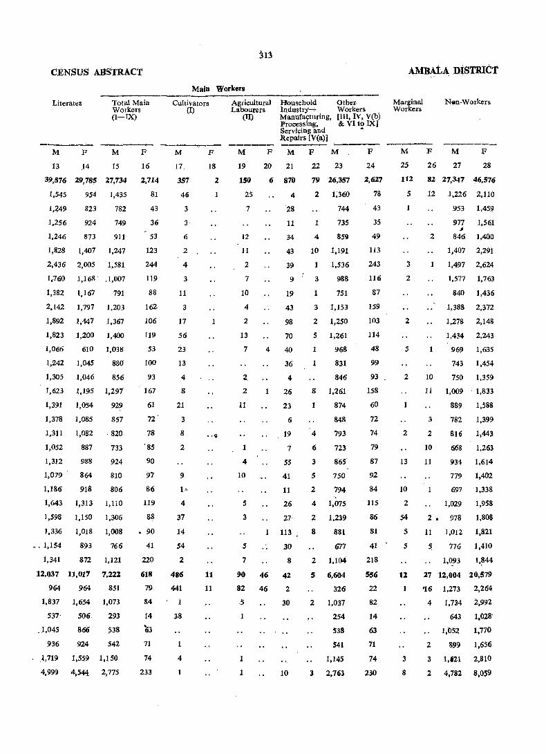
:313
CENSUS ABSTRACT
Main Workers
------------~------------------------Literates Total Main Workers (I-IX)
M F M F
13 ,14 15 16
39,576 29,785 27,734 2,714
1,545 954 1,435 81
1,449
1,256
1,246
823
924
873
782
749
911
1,828 1,407 1,247
2,436 2,005 1,581
1,:760 1,168' ,1,007
1,382 1,167 791
2,142 1,797 1,203
1,892 1,447 1,367
1,823 1,200 1,400
1,066 610 1,038
1,242 1,045
1,305 1,046
880
856
1,623 1,195 1,297
1,391 1,054
1,378 1,085
929
857
1,311 1,082 . 820
1,052 887 733
1,312 988
1,079' 864
1,186 918
924
810
806
1,643 1,313 1,110
1,598 1,150 1,306
1,336 1,018
•. 1,154 893
1,341 872
12,037 11,017
964 964
1,008
766
1,121
7,222
851
1,837 1,654 1,073
537'
,1,045
506
866
293
538
936 924 542
,1,719 1,559 1,150
4,99!) 4,544 2,775
43
36
53
123
244
119
88
162
106
119
53
100
93
167
61
72
78
'85
90
97
86
119
88
• 90
41
220
618
79
84
14
~3
71
74
233
Cultivators (I)
M F
17
357
46
3
3
6
2
4
3
11
3
17
56
23
13
4
8
21
3
8
2
9
10
4
37
14
54
2
486
441
1
38
1
4
1
18
2
1
1
11
11
Agricultural Labourers
Household Industry...;. Manufacturing, Processing, Servicing and Repairs [V(a)]
Other Workers (III, IV, V(b) & VIto IX]
(II)
---~ M F M F M
19
150
2S
7
12
11
2
7
10
4
2
13
7
2
2
11
1
4
10
5
3
5
7
90
82
5
1
1
1
20 21
6 870
4
28
11
34
43
39
9
19
43
98
70
4 40
36
4
1 26
1
46
46
23
6
19
7
5S
41
11
26
27
113
30
8
42
2
30
10
22 23
79 26,357
2 1;360
1
4
744
7.35
859
10 1,191
1 1,536
3
1
988
751
3 1,153
2 1,250
5 1,261
1
1
968
831
846
8 1,261
1
4
6
3
5
2
874
848
793
723
865
750
794 '.
4 1,075
2 1,239
8
2
5
881
677
1,104
6,604
326
2 1,037
254
538
541
1,145
3 2,763
.. F
24
2,627
78
43
35
49
113
243
116
87
159
103
114
48
99
93
158
60
72
74
79
87
92
84
ll5
86
81
41
218
SS6
22
82
14
63
71
74
230
AMBAtA DiSTRlCT
Marginal Workers
" '
N""n-Workers
M F M F
2S 26 27 28
112 82 21,347 4.6,576
5 12 1,226 2,110
1
3
2
2
5
2
1
2
13
10
2
54
5
5
12
1
3
8
953 1,459
977 1,561 ~
2 846 1,400
1,407 2,291
1 1,497 2,624
10
1,577 1,763
840 1,436
1,388 2,372
1,278 2,148
1,434 2,243
969 1,635
743 1,454
750 1,359
11 1,009' 1,833
3
2
10
11
1
889 1,588
782 1,399
816 1,443
668 1,263
934 1,614
779 1,402
697 1.338
1,029 1,958
2. 978 1,808
11 1,012 1,821
5 776 1,410
I,0_93 1,~44
27 12,004 20,579
'16 1,273 2,264
4 1,734 2,992
643 1,028-
1,052 1.770
2 899 1,656
3 1,121 2,810
2 4,782 8,OS9
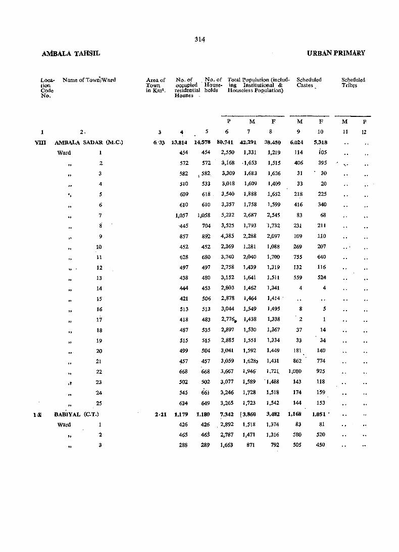
AMBALA TAHSIL
Loca- Name of Town/Ward tion Code No.
1
VDI
2.
AMBALA SADAR (M.e.)
Ward 1
" "
" • ,
"
" '
" " "
" "
" -
,f
2
3
4
5
6
7
8
9
10
11
12
13
14
15
16
17
18
19
20
21
22
23
24
25
BABIYAL (C.T.)
Ward
" .. 1
2
3
314
URBAN PRIMARY
Area of Town in Km2.
No. of No. of Total Population (includ- Scheduled occupied . House- ing Institutional & Castes residential holds Houseless l'op,ulation) Houses ,
4 5
P
6
M
7
F
6 '33 13,814 14,578 80,741 42,291
1,331
8
38,450
1,219 454 454 2,550
572 572 3,i68 ·1,653 1,515
582 1582 3,309 1,683 1,626
1,409
1,652
510 533 3,018 1,609
609 618 3,540 1,888
610 610 3,357 1,758 1,599
1,057 1,058 5,232 2,687 2,545
'445 704 3,525 1,793 1,732
857 892 4,385 2,288 2,097
452 2,369 1,281 1,088
680 3,740 2,040 1;700
497 2,758 1,439 1,319
480 3,152 1,641 1,511
453 2,803 1,462 1,341
506 2,878 1,464 1,414 .
513 3,044 1,549 1,495
483 2,776. 1,438 1,338
535 2,897 1,530 1,367
515 2,885 1,551 1,334
504 3,041 1,592 1,449
M
9
6,024
114
406
31
33
218
416
83
231
109
269
755
132
559
4
8
2
37
33
181
452
628
497
438
444
421
513
418
487
SIS
499
~57
668
502
545
634
457 3,059 1,628) 1,431 862
668 3,667 1,946 1,721 1,080
502 3,077 1,589 . 1,488
661 3,246 1,728 1,518
649 3,265 1,723 1,542
143
174
144
F
10
5,318
i05
395
30
20
225
340
68
211
110
207
640
116
524
4
5
1
14
34
140
774
925
118
159
153
2·11 1,179 1,180 7,342 [3,860 3,482 1,168 1,051 .
426
465
288
426 . 2,892 1,518 1.374
465 2,787 1,471 1,316
289 1,663 871 792
83
580
505
81
520
450
Scheduled Tribes
M
11
'.'
F
12

Literates
ji5
Main Workers --____..-~--.------------------~------
Total Main Workers (I-IX)
Cultivators 'j (I)
r:, Agricultural Household Labourers Industry-
(U) Manufacturing. Processing. Servicing and Repairs [Yea»)
Other Workers [III. IV. V(b) & VIto IX)
AMBALA D!STRUCT
Marginal Workers
Non-Workers
------- -------- ------ ----- ------ _;_,_--_:_ ------ ----M
13
F
14
M
15
F
16
29,663 22,271 21,289 1,714
1,033 81~ 628 52
1,107 782
1,406 1,266
1,234
1,164
989
892
816
778
824
901
859
891
929
2,203 1,834 1,264
1,292 1,027 882
i,856 1,456 1,019
792 535 618
1,050 521 1,067
·1,041
1,000
727
664
1,201 1,037
1,161 956
1.273 1,103
. 1,106 835
1,149
1,042
1,127
964
891
736
792
552
741
810
772
773
841
695
797
838
824
802
924 555 1,008
1,158 1,019 732
1,160 812 905
1,231 873 869
2.491 1.547 1.757
1,069
913
$09
714
523
310
679
671
407
81
117
68
81
54
116
79
74
27
63
51
71
49
87
65
48
42
33
42
26
187
42
97
62
81
22
34
26
M
17
71
:3
5
3
8
35
3
2
2
4
93
60
26
7
F
18
M F M
19 20 21
156
3
2
9
64
4
64
2
92
63
29
.. 1,188
20
42
22
1
59
16
24
21
12
17
87
23
45
10
111
. 277
'72
129
10
24
36
22
14
48
46
9 88
1
8
24
46
18
F
22
M
23
F
24
60 19,874 1.654
608 52
2
2
781
879
855
831
910
1,233
858
3 1,007
9 584
5 881
11
1
2
1
12
3
3
3
6
3
718
758
760
660
560
617
667
827
800
766
921
716
854
823
, . 570
382
79
115
68
81
54
116
79.
73
24
54
46
60
48
86
64
46
42
33-
41
26
175
39
94
59
23
26
,r
M
25
54
.16
11
5
21
1
1
1
F
26
M
27
F
28
74 20.948 36,662
703 1,167
829 1,434
782 1,509
750 1.341
48 981 1,523
829 1,545
1,423 2,429
911 1,653
1,269 2.023
1 652 1,060
4 968 1,633
3
1
6
10
698 1.1.68
810 1.437
690 .1,292'
691 1,326
707 1,430
743 1,290
733 1,324
713 1,295
768 1,397
826 1,405
938 1,534
857 1,446
823· 1,421
854 1,480
2,101 3,400
839
799
463
1,352
1,282
766

317
PRIMARY CENSUS ABSTRACT
JAGADHRf TAHSIL
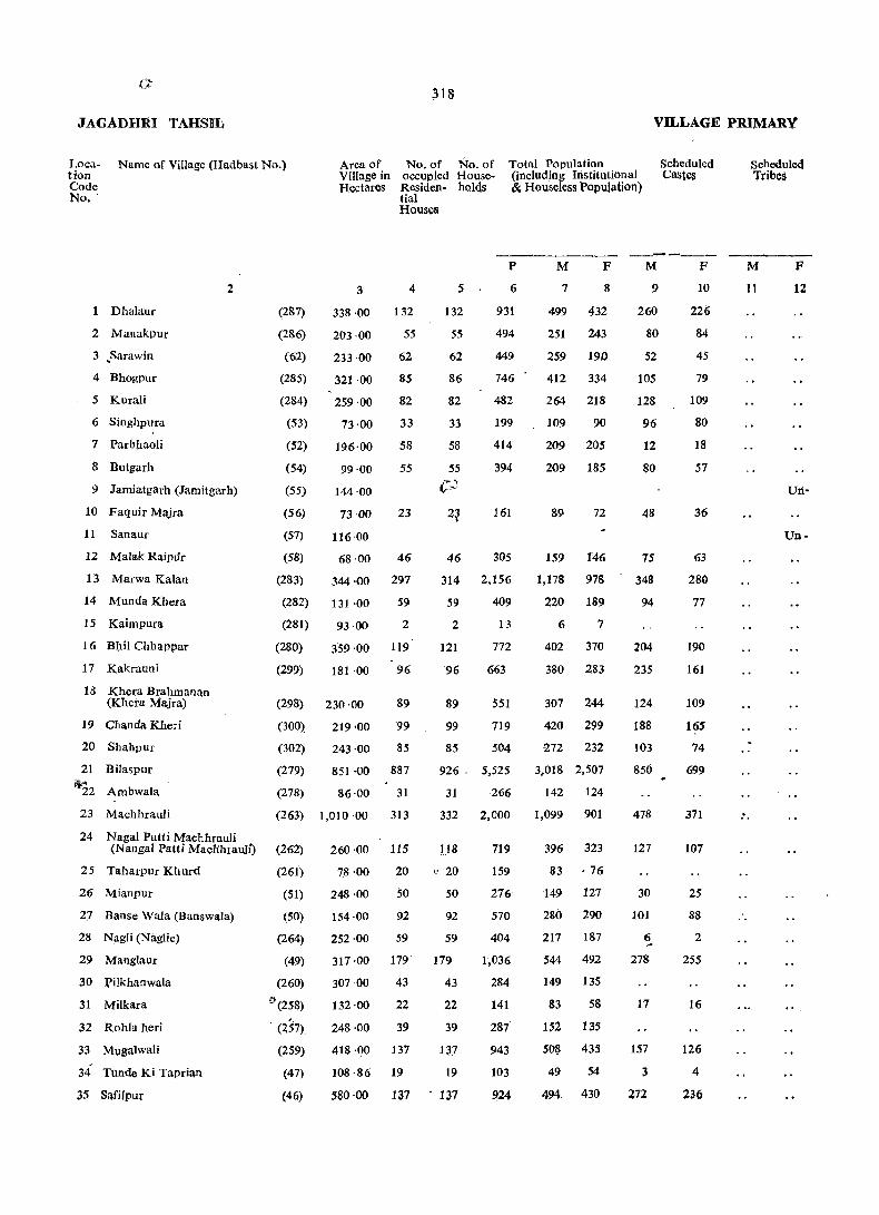
318
JAGADHR] TAHSTh VILLAGE PRIMARY
Location Code No, .
Name of Village (Hadbast No.) Area of VlIIage in HectarQs
No. of No. of occUpied HouseResiden. holds tial Houses
Total Population (including Institutional 8r. Housdess Papulation)
Schedule<l Caste§
Scheduled Tribes
------- ----
Dhalaur
2 Manakpur
3 .Sarawin
4 Bhogpur
5 Kurali
6 Singhpura
7 ParbjIaoli
8 Butgarh
2
9 Jamiatgarh (Jamitgarh)
10 Faquir Majra
11 Sanaur
12 Malak Raipur
13 Marwa Kalan
14 Munda Kbera
15 Kaimpura
16 Bllii Chhappar
17 Kakrauni
18 Khera Brahmanan (Khera Majra)
19 CIlauda Kheri
20 Shahpur
21 Bilaspur
1;.22 Ambwala
23 Machhrauli
24 NagaI Patti Machhrauli
(287)
(286)
(62)
(285)
(284)
(53)
(52)
(54)
(55)
(56)
(57)
3 4
338·00 132
203 ·00 55
233 ·00 62
321 ·00 85
259 ·00 82
73 ·00 33
19.6,00 58
99 ·00 55
144·00
73·(}{)
116 ·00
23
(58) 68 ·00 46
(283) 344 ·00 297
(282) 131 ·00 59
(281) 93·00 2
(280) 359 ·00 119
(299) 181 ·00 96
(298) 230 ·00 89
(300) 219 ·00 '99
(302)
(279)
(278)
243 ·00 85
851 ·00 887
86·00 31
(263) 1,010 '00 313
(Nanga I Patti Macb:hrauli) (262) 260 ·00 115
25 Taharpur Khurd (261)
26 Mianpur (51)
2J Banse Wala (Banswala)
28 NagIi (Naglie)
29 Manglaur
30 Pilkhanwala
31 Milkara
32 Rohla heri
33 Mugalwali
34 Tunde Ki Taprian
35 Safilpur
(50)
(264)
(49)
(260)
~(258)
(257)
(259)
(47)
(46)
78·00 20
248 ·00 50
154·00 92
252 ·00 59
317 -00 179
307·00 43
132-(}{) 22
248 ·00 39
418 ·00 137
108·86 19
580 -00 137
5
132
55
62
86
82
33
58
55
C-.J
P
6
931
494
449
746
482
199
414
394
161
46 305
314 2,156
59 409
2
121
96
89
99
13
772
663
551
719
85 504
926 - 5,525
31 266
332 2,000
118
(' 20
50
92
59
179
43
22
39
137
19
137
719
159
276
570
404
1,036
284
141
287
943
103
924
M
7
F
8
499 432
251 243
259 190
412 334
264 218
109 90
209 205
209 185
89 72
159 146
1,178 978
220 189
6 7
402 370
380 283
307 244
420 299
-272 232
3,018 2,507
142 124
1,099 901
396 323
83 ·76
149 127
280 290
217 187
544 492
149 135
83 58
1$2 135
508 435
49 54
494 430
M
9
260
80
52
105
128
96
12
80
48
75
348
94
204
235
124
188
103
850
478
127
30
101
6 ~
278
17
157
3
272
F
10
226
84
45
79
109
80
18
57
36
63
280
77
190
161
109
165
74
699
371
107
25
88
2
255
16
126
4
236
M
11
F
12
Urt-
Un-
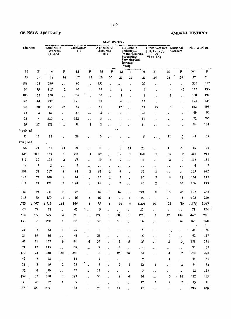
CE NSUS A~STRACT
Literates
M
13
18&
94
100
146
'76
35
25
79
inhabited
31
inhabited
58
524
115
4
162
193
137
ISS
145
F
14
58
19
25
44
20
2
4
37
12
24
458
39
5
68
67
53
39
80
Total Main Workers (I-IX)
M
15
269
115
150
239
159
60
137
125
37
61
489
102
2
217
200
171
231
J50
F
16
2
25
1
23
4
2
8
8
2
Cultivators (I)
M
17
90
66
108
121
33
37
122
71
29
24
'248
53
2
94
74
. 78
1,763 1,067 1,519
8
21
114
52
46
146
43
198
136
63 22 71
514
133
36
24
61
71
172
42
28
52
159
33
137 .
279
36
7
19
21
17
24
7
8
4
n 26
45
599
230
45
86
157
145
318
98
49
90
280
22
279
4
37
45
9 104
132,
20 r 203
4
87
28
75
183
7
163
F
18
2
4
4
319
AMBALA DISTRICT
Mj\Jn Workers
Agricultural Labourers
(II)
Household Other Workers Marginal Non-Workers
------M F
19 20
150
37
33
80
51
2
3
2
3
11
64
19
62
35
45
16
46
75
6
124
30·
3
2.S
32
7
5
2
7
12
55
3
93
2
3
1
4
1
Industry~ [III, IV, V(b) Workers Manufacturing, &
Processing, VI to IX] Servicing and Repairs [V(a)]
M F
21 22
5
6
12
1
-3
17
19
6
1
2
16
23
3. 5
96
151
50
5
2
13
1
5
86 20
2 1
8 4
11
M
23
29
7
8
32
63
21
11
51
5
23
160
11
55
90
46
147
" 5S
1,202
22
126
14
S
16
16
4
24
9
12
3
34
12
12
F
24
25
2
3
7
2
8
8
99
2
i
M
25
4
l'
3
11
11
136
2
6
16
F
26
46
13
23
10
3
38
63
23
M
27
230
132
lOS
173
102
49
72
84
41
87
553
116
4
185
174
136
173
122
F
28
432
195
190
334
193
90
205
184
59
100
964
184
7
362
231
119
268
210
23 '30 1,476. 2,%3
37
2
194
54
3
2
2
6 # 16
4 2
71 124
463
166
703
268
38 I 75
62 121
121
72
222
48
34
62
222.
23
215
278
181
470
135
54
l35
415
51
429
~20
JAGADHRn:' TAHSiL VILLAGE PIDMARY
Location Code No
Name of Villag .. (Had bast No.) Area of Village in
I, ;Hectares
No. of No. of Total population occupied House- (Including Ill~titutional
Scheduled Castes
Scheduled Trib.ys
t
36 nijwali
37 Bodhi
38 Nlithanpur
2
39 Naiwali (Naiwala)
40 Clruharpur
41. J?ipliwala
42 UttamwaJa
43 Paniwala
44 Kathgarh
45 Ralijitpur
46 Sultanpur
47 Ranipur
48 Suabari
49 Majri
50 nhattuwala
51 Rampur Gainda
~2 Dhanaura
53 Bh"agwanpur
54 Na~1i (Negli~
55 Jailg1e Salempur Kohi (Jungle Salampur Khoi)
56. Salet'Qpur KQhi (Saliffipur KllOi)
57 Sunder Bahadurpur
58, Dayalgarh
59 Shergarh.
60 Gadwali
61 Ali Sberpur Majra
62 ChoU (Ghauli)
03 Ramgarh Sawai
,·64 Billta
65 Rampur Ramboau
66 ChIlalaur
67 Rampur Harian.:
68 Bltawanipur (Bhawanpur)
(19 Mauhri
residen- holds; lie Houseless pOj:l\lIatioD) tial
(45)
(44)
(43)
(42)
(40)
(41)
(38)
(39)
(37)
(Z54)
(255)
(256)
(253)
(249)
3
181 ·30
179·00
81 ·00
85·00
HOUSC3
4
95
49
39
35'
127 ·00 10
200 ·00 74
52 ·00 10
136 00 • 21,
637 ·00 126
11/00
203 ·00 48
353·00 " 114-
,185 ·00 • 45"
55·00 29'
(251) 219 ·00 57
(36) .273 ·00 13<1
(252) '"384 ·00 69'
(35) ·.365 ·00 109.'
(32) 1,301 ·00 182 "'
(489) ,144 ·00 ; 3'
(33)
(34)
(250)
(248)
(247)
(246)
(237)
(245)
(242)
(243)
, (244)
(48)
(276)
(277)
i61 ·00 55
683 ·50 150 "
61 ·00 28
154·00 53
312·01 64
'264 ·00 130
'207 ·00: 45
182·00 20-
260 -00 60
157 ·00 73
. r260 ·00 ' 55~
189 ·00 103
119 ·00
99·00
42
59
,5
95
49
3
35
lq
74
14
21
126
39
48
114
45
29
57
1'3
69
109
182
3
55
154 .. 2? 53
6iI-
130
45
20
60
85
56
103
42
59
P
6
563
278
266
220
55
458
122
133
742
194
298
.690
282
195
399
r '93
r 382
'621
1,132
14
454
825
173
302
454
-823
340
140
433
505
429
632
'350
429
M
7
315
156
140
121
30
248
69
66
427
105
165
380
155
F
8
248
122
126
99
25
210
53
67
315
89
133
. 310
,~127
M
9
92-
19
84
,22
60
68
42
104 '91
56
8
7
215
46
211
346
623
8
224
469
91
161
246
451
169
67
243
291
246
346
200
238
184 75
47 7
171 57
275 .102
509 48
6
230 9
356 128
82
141
208
372
'171
73
190
214
183
23
" 59
.84
( 24
·21
37
94
34
286 104
150
191
43
75
F
10
69
'14"
77
19
62
45
36
53
.6
'r 4
63
~ 8
,4$
~ ':15
29
11
90
12
48
77
25
17
127
75
26
'92
22
56
M
11
.. ' .
"
,
F
12
i ••
., .
.CENSUS ~ABSTR.ACT AMBALA _ n:nSTld_Cl'
Main Workers
Literates ----T-o-t-alMain -~t-iv-a-to-.r~s.---A-. g-r-ic'-u-lt-u-ra-l~-'-~hbhl-Othe-;-workers- Marginal Workers
Non.Yi Worke'rs
M
13
6
3
56
24
2
109
14
18
114
30 _
35
119
8
11
91
10
95
132
67
107
23
35
65
S6
129
71
18
117
83
-103
143
_ 79
113
Workers (I) Labourers Induslry- [III, IV, V(b) (I-IX) (II) Manufacturing, &
p:
14
M
15
4 _ 228
96
11
1
25
1
12
4
12
29
22
36
37
2
36
3
17
15
19
16
35
16
57
39
24
24
25
35
81
82
14
1~9
47
36
260
64-111
235
101
70
123
23
127
198
374
S
131
309
57
91
148
295
106
47
120
167
132
195
100
137
P
16
5
2
4
8
3
1
2
1
1
11
3
M
17
100
84
32
80
14
101
46
36
193
40
64
116
88
64
58
15
47
78
310
5
103
171"
45
32
84
187
57
29
69
59
92
93
68
6S
P
18
M
19
117
10
35
26
33
18
32
92
9
5
22
3
7
39
34
17
118
8
38
32
50
27
13
22
6
13
17
19
2S
P
20
1
2
1
Processing, VI to IX] Servicing and Repairs _
(V(a)]
M F
21 22
_"
5
5
12
2
1
2)
16
1
2
3 o
11.
1
6
4
11
24
9
58
10
42
1
1
3
1
2
8
1
3
1
2
1
3
M
23
4
-2
9
2
17
1
22
4
14
6
4
1
27
4
71
8
19
10
14
4
17
21
34
21
5
20
44
17
43
12
46
F
24
2
1
8
3
M
25
8
5
3
6
1
8
P
26
36
16
1
'7
3
2
S
23
36
",
11
2
1
M
27
87
60
59
39
16
- 99
22
30
167
41
54
145
54
34
84
18
84
148
249
3
157
28
6?
97
156
63
20
U5
124
114
151
100
101
F
28
248
122
89
99.
25
205
53
67
299
86
133
306
127
91
169
43
169
275
504
6
230
332
46
138
207
370
170
73
i78
203.
183
283
147
190

JA~ADHRI TAHSIL
Location Code No.
Name of Village (Had bast No.) Area of Village in Hectares
1 2
70. Milkkhas (Malik Khas)
71 Sandhaya (Sindhai)
72 U<Ihamgarh
73 Raianwala
74 Kotra Khas
75 Aharwala
76 Malakpur Bangar
77 Chaurahi
78 Kurewala
79 Hartaul
80. Dhatam Kot
81 Daryapur
82 Chholi
83 Bisationwala
84 Rukali
85 Khanuwala
86 Manakpur
87 Fatehpur
'88 Rajpur
89 Jaitpur (Jitpur)
90. Mahiyudinpur
91 Gohra Bani
92 Rampur Jat
93 Chabutron
94 Prithipur
95 Jogiwara
96 Katarwali
97 Katarwali
98 Bankat
99 Muzafat
(275)
(265)
(266)
(267)
(274)
(273)
(268)
(272)
(269)
(271)
(270.)
(30.3)
(215)
(216)
(217)
(220.)
(229)
(230.)
(235)
(3D)
(31)
(236)
3
212·0.0.
488·0.0.
72·0.0.
284·0.0.
181·0.0.
114·0.0.
624·0.0.
20.1 ·00
Hi8·DD
92·0.0.
318·0.0.
148·0.0.
40.1·0.0.
521 .0.0.
234·0.0.
147·0.0.
324'0.0.
212·0.0.
113·0.0.
275·0.0.
331 ·00
194·00
(234) 189 .0.0.
(232) 163 .0.0.
(231) 259 -DO.
(228) 144 -00
(239) • 138 -DO.
(238) 159 -DO.
(240.) 146 -00.
(241) 288 :0.0.
10.0. Bhamnaull (227)
10.1 Lalhari Kalan (Lalhari Bari) (226)
10.2 Lalhari Khurd (Lalhari Chhoti)(224)
50.3-0.0.
141 -0.0.
49'0.0.
121 -DO.
166-00
186·00
10.3 chintpur
10.4 Lopon
105 Tihanon
(225)
(219)
(218)
VILLAGE ~RfMARY
No. of No. of occupied HouseResiden- holds
Totai Popuiatidn Scheduled (including J nstitutionat Castes
tial . Houses
4
136
129
18
78
121
89
225
78
7
34
148
56 189
148
27'
22
20.9
53
94
86
15
62
31
95
42
54
32
41
57
134
10.8
41
42
88
64
& Houseless Population)
5
P
6
137 90.2
129 879
18 132
79 534
121 953
90. 670.
225 1,485
78 561
7
34
154
56
192
148
27
22
209
53
94
86
15
62
31
95
42
54
32
41
57
134
111
41
44
88
64
51
229
1,132
396
1,299
1,0.15
221
i42
1;469
334
576
474
74
430.
252
604
30.6
351
20.1
290.
460
856
'111
324
371
612
464
.
M
7
498
478
" 57
291
.50.9
384
774
30.7
36
131
617
216
699
544
113
68
773
172
30.5
250.
36
234
141
311
172
180.
lID
160.
248
466
430.
114
191
354
248
F
8
M
9
404 192
401 .137
75 38
243 132
444 162
286 115
711 152
254 120.
15
98
515
180.
60.0.
471
10.8.
74
1
37
169
S9
221
186
696 114
162
271
224
38
196
III
293
134
171
91
130.
212
10.
11
7
10.2
52
142
37
69
89
31
S4
390. 134
341 227
150. 49
114
318
216
3D
94
69
F
10.
142
122
51
10.3
141
80.
143
lID
29
160.
47
20.6
17S
97
13
5
2
81
40.
133
14
66
74
33
47
138
164
43
14
98
S6
scheduled Tribes
M F
11 12
Un-
ctNsuS ABSTRACt -
-----------~ Literates. Total Main
Workers (I-IX)
Cultivators (I) .
M F
1j 14
M F M F
21!)
186
2S
133
263
180
364
134
20
60
274
102
376
244
37
47
269
hlhabited
12
34
28
3
84
49
83
67
52
36
5S
127
181
196
85
94
·-.188 .
116
15 16 11 18
78 257
83 266
13, 35
54
140
49
273
49
11
15
140
39
147
110
13
38
75
8
3
27
17
IS
27
15
9
16
59
58
76
23
38
96
54
135
258
202
410
175
24
82
345
125
378
342
65
,31
423
97
178
142
16
113
72
178
92
101
67
89
129
281
23~
101
102
160
130
110
4 111 5 13
11 63
l' 105
12
1
23
2
6
2
1
18
1
2
29
2
4
115
149
64
9
40
163
70
177
.161
44
22
133
62
104
65
8
49
25
76
38
41
21
53
80
152
63
48
53
61
64
5
1
1
2
Main Workers '---
Agricultural Laboureri
(II)
Household Other Workers Industry- (III, IV, V(b)' Manufacturing, , & Processing, . VI to IX) Servicing and Repairs . [V(a)]
-__,;;-~-~. ~___'--'-'---M F M F M
23
F
19 20 21
12
54
22
52
45
2()
39
17
32'
98
75
1
26
30
29
67
1()1
17
3
143
21
~ 65
50
1. 1
3
77
3
27
5
3 9
1
4
31
3
3
9
1
3
87, 2
2
1
H
3
5 ;.
83
56
1
30
59
52
136
31
14
16
.143
25
130
49
4
6
60
14
8
16
44
27 "
8
17
IS
33
27'
37
42
16
39
58
74
30
30
58
57
47 17 (!.. 22
3 •
14 1
53 29
45
8
10
27
9
4
11
10
18
51
is
19
31
9
24 1
1
2
4
1
1
18
1
6
1
1
1
1
1
M
25
6
1
10
1
1
Marginal Non-Workeri Workers
-----F M F 26 '17 28
52
23
20
38
7
1
1
3
1
57
9
235
211
22
35i
374
50
146 194
~51, 436
182
364
131
12
49
272
91
321
202
48
37
350
75
127
108
20
121
68
133
80
78
43
71
119
185
197
'73
95
194
118
285
696
253
14
98
492
180
600
470
108
74
694
156
271
223
36
194
108
274
133
112.
82
130
2it
361
346
150
174
316
212

JAGADHRI TAHS][L
Loca- Name of Village (Had bast No.) lion
Area of Village in Hectares
Code No.
1
106 Dadupur Malion
107 HarauIi
108 Khappura
109 Salempur Khadar (Sah~hpur Khadir)
11 0 Asha bpura
111 Chhachhrauli (Rural)
112 Ganauli
113 Ganaula
114 Leda Khas
115 Sankhera
116 Chagnauli
117 Piruwala
118 Ram Kheri
1.19 Pheruwala
120 Jut Heri
121 Chaowula
122 TaranwaJa
123 BheJ:thal
124 Mahmudpllf.
125 Mirpur
126 Munda Kher'l
127 Mukaribpuril.
128 tChaneta (Ghaneta)
1.29 Panjetop
IJO Mand Khed
1.31 Siughpura
132 Sherpul
1.33 tGurdhanpur
1~4 Urjani
135 CIllmarpur Khurd'
(193)
3
79·00
(194) 259 '00
(213) 110 ·00
(214) 119 '00
(212) 91 '00
(311) 1,054 ·00
(309) 462 ·00
(308) 265 ·00
(310) 204 ·00
(306)
(304)
(301)
(329)
(305)
(307)
(328)
(327)
(32~)
(325)
(320)
(318)
(317)
(316)
(315)
(319)
(205)
(206)
(204)
(203)
(207)
239·00
293·00
204·00
274'78
204'00
289·00
134 ·00
108 ·00
280·00
195.'00
200 ·72
189·.QO
206·00
77·00
276 .. 80
301·00
127·00
126,,00
51,,00
234,00
68·00
No. of occupied resi· dential House~
4
26
172
55
66
20
43
203
.76
104
108
132
116
137
93
138
47
49
65
73
15
105
88
5
145
215
50
105
45
45
No .. of Households
5
26
172
55
66
20
60
203
76
104
108
132
116
137
93
138
47
49
65. . 76
15 '
105
88
5
145
215
57
lOS
46
45
Total Population (including Institutional and Houseless Population)
P
6
252
1123
361
487
161
357
1,291
503
667
884
909
837
849
661
947
375
320
495
526
125
824
608
38
1,157
1,541
372
732
3
318
318
M
7
128
580
210
253
80
175
677
274
364
483
479
496
456
344
501
200
174
262
268
62
446
324
18
629
1335
201
401
3
179
170
F
8
124
543
151
234
81
1,82
614
229
303
401
430
341
393
317
446
175
146
233
258
63
378
284
20
528
706
171
331
139
148
V1LtAGE PRtMAiU';
M
9
1
138
89
13
28
18
344
122
145
41
165
140
240
158
J06
38
61
35
151
147
186
228
360
12
219
24
123
Scheduled Castes
F
10
137
60
10
28
19
.305
100
110
43
157
89
230
139
95
32
50
37
129
123
165
191
309
9
181
11
106
Scheduled Tribes
M
11
F
12
.. '
625
CENSUS ABSTRACT
, Main Workers
Literates ----Th~illi~--~It~futs'-~Agiicu~lk~eii.oid-· Othe;--Workers . (I) Labourers Industry- Workers
M
13
59
268
105
106
16
118
267
103
190
213
271
232
150
135
221
88
68
150
135
36
217
152
7
317
'348
44
179
58
54
(I-IX) (II) Manu- [III, IV, V(b)
F
14
32
129
43
55
11
90
90
25
90
93
112
86
51
M
15
61
315
113
.145
51
81
337
143
205
298
270
302
246
78 178
64 • 296
50
32
lOS
86
23
92
43
5
153
105
2
64
14
6
122
78
125
149
32
244
174
10'
336
393
109
220
3
104
92
F
16
5
3
12
10
12
4
17
2
2
4
11
9
M
17
43
109
45
77
31
40
94
50
85
204
122
130
93
42
148
71
40
74
57
30
103
45
10
148
127
58
70
56
41
F
18
4
3
M
19
8
118
36
36
19
8
117
57
73
48
72
16
131
31
71
28
1'7
12
76
88
95
88
148
20
76
3
16
40
.F
20
5
8
facturing, & VI to IX] Processing, Servicing and Repairs [V (a)]
M
21
4
30
17
14
4
21
3
5
3
.11
13
F
22
12
3
M
23
6
88
32
32
33
9.6
19
47
32
76
152
22
84
74
22
20
39
11
2
53
34
97
107
31
74
19
11
F
24
12
3
17
2 J} 2
1
3
1
6
1
·A.MBA'LA D!S'l'RIcr
Marginal Workers
M
25
32
2
16
2
52
5
F
26
3
8
7
2
13
10
NonWorkers -
M F
27 28
67 124
265 538
97 148
108 234
29 81
94 170
308 601
1.31 217
157 291
185 401
209 429
178 317
210 393
166 315
203 442
78 175
96 141
1_37 232
119 258
30 62
202 377
150 284
8 20
293 517
390 692 I
92 162
181 331
70 129
78 147

JAGADHRI TAHS1L
Loca- Name of Village (Hadbast No:) tion
Area of" Village in Hectares
Code No.
1 2
136 Nahar Taharpur (N aharpur Taharpur)
137 Khanpuri
138 Balauli
139 Taruwala
140 BaroH Majra
141 Mohab Aliwata (Mahab Aliwala)
142 Kotla Kahansingh
143 Leda Khadar
144 Tugatpur
145 Ledi
146 Daaupur Jattan
147 Manipur
148t Ahmad Majra
149 Kot Sarkari
150 Tibbi Raiyan
151 Daulatpur
152 "Dhakwala
153 Kot Mushtarka
154 Kot Basawasingh
3
(211) 116'()(
(210) 63·00
(208) 424 ·00
(209) 131 ·00
(1 91) 209 ·00
(178) 119 '00
(189) 133·00
(190) 228 ·00
(192) 212 ·00
(221) 278 ·00
(222) 137 '00
(223) lOS '00
(187) 54'00
(188) 295 ·00
(179) 307 '00
(180) 86·00
(183) 79 '32
(184) 272 ·75
(185) 216 ·00
155 Ramgarh Alias Arjun Majra (186)
156 Bhagwangarh urf Bansantaur (26)
195'00
81 ·00
l57 Faqira Majra (24) 5t1,Jo 3510 158 Bachon (182)
159 Shahabudinpur Khurd
160 Chuharpur Mangalsingh
161 Sipianwala
162 Shahabudinpur Kalan
163 Khol Fatehgarh.
164. Yarah
t(/$ Taltri
(23) 26 ·00
(19) 53 ·00
(20) 52'00
(22) 32·00
(25) 85'00
(21) 61 '00
~27? 10~'~
326
No. of No. of Total Population (including institutional and Houseless Population)
occu- House-pied holds resi-dential Houses
4
53
21
186
86
76
28
71
134
102
154
74
73
2
60
167
82
53
120
202
93
1
39·
17
4
50
27
8
5
P
6
53 350
21 148
186 1134
86
76
28
71
134
103
567'
474
173
446
821
664
M
7
176
81
608
284
248
95
238
419
345
162 1,125 613
77 ~88 312
73 435 "229
2
60
167
82
53
120
20
418
877'
530
447
815
202 1,200
93
1
39
17
4
50
27
8
619
11
205
133
30
271
248
55
10
220
486
302
246
425
635
319
6
111
78
13
153
134
27
49
F
8
174
67
526
283
226
78
2.08
402
319
512
276
206
10
198
391
228
201
390
,565
300
5
94
55
17
118
114
,28
VILLAGE PRIMARY
Scheduled Castes
M
9
80
81
331
126
145
72
31
93
'115
202
105
38
56
149
29
122
F
10
89
67
284
116
131
60
27
93
104
159
94
34
51
125
30
114
211 ' .175
64 52
.._
8 10
27 28
Scheduled Tribes
M
11
F
12
Un.
Un·
CENSUS ABSTllACl'
Literates
M
13
55
10
207
145
58
32
43
186
128
268
140
104
6·
80
154 '
42
98
195
220
F
14
17
107
82
18
12
15
91
39
107
36'
54
2
24
55
8
14
88
72
95 "32
3
19
19
2
19
73
4
inhabited
inhabi.!ed
13
. 38
'1
Total Main Workers (I-IX)
M
15
100
44
313
126
136
51
137
222
176
313
167
128
3
131
260
156
143
214
304
182
5
55
46
8
104
73
11
F
16
6
3
2
7
27
2
32
6
5
1
Cultivators
(1)
M
17 •
53
17
105
52 \ 59
25
92
73 o
76
110
77
46
3 '
73
61
136
112
61
83
82
. 5
51
3~ " ,
7
103
62
4
F
18
5
2
2
2
"
327
Main Workers
Agricultural Labourers
(11)
Household IndustryManufacturing, Processing, S.ervicing and Repairs IV (8»)
M
19
38
25
55
54
64
23
21
74
67'
65
52
41
,F M
20 21
F
22
41
109
9
15
69'
99 •
67
4
1
.7
1
2
,.
17
11
10
13
7
4
5
19
45 28
3
2
32
66 2
4
" ~
" t·
Other Workers [Ill, IV, V(b) & VI to lXJ
M
23
9
2
136
20
13
3
24
64
23
125
31
37
12
45
·8
14
52
56
29'
4
4
10
F
24
2
5
6
2
5
3
,.
AMBALA DISTRICT
Marginal WorIs;ers
M
25
io
11
5
9
t'
F
26
2
}8
n 2
1
1
, .,
,.
NonWorkers
M
27
F
28
76 173
37 ,67
295 520
158 283
112 226
44 73
101 206
187 377
158 307
295 483
145 276
101 203
7 10
89 198
217 '346
146 228
103 201
211 384
331' 559
137 299
1 5
56 . 94
32 55
5 17
49 118.
61 114
16 28
77 44
,JAG"A:DHRI TAHSIL
Location Code No.
Name of Village (Hadbast No.)
'3"28
Area of No. of No. 6f Village in occupied HouseHectares residential holds
Houses
Total Population (including Institutional and Houseless population)
VILLAGE PRIMARY
Scheduled Castes
Scheduled Tribes
--~--------
2
166 Haidarpur
167 Taharpur Kalan
168 Ibrahimpur
169 Bir Tahanpur
170 Jangle Mehrniwala
171 Khol Darpur
172 Darpur .. 173 Jatanwala
174 Shahzadwala
175 Mukarabpur
176 Nathanpur
171 Meghuwala
178 BhangerR Bhang-eri BagPat
179 Khilanwaia
180 illaniawala
181 Kansli
182 Chikan
183 Panch Khola
184 Jungle Kalesar
185 Kalesar
(233)
(28)
(29)
(490)
(491)
(492)
(17).
(18)
(16)
(181)
(1S)
(14)
(9)
(10)
(13)
(11)
(12)
3
92·00
413 '00
273 '00
91 ·00
670'55
820.00
350 ·00
235 ·00
284 -00
262·00
66'00
115 ·00
626'00
306'00
122·00
131 ·00
224 ·00
(493) 2,496'00
(2) 4,682.00
(I) 1,219.00
.. 186 Raiyanwa]a (4r 1,059.00
187 NagaI Patti Milk (Nagai Patti (5) 791' '00 Malik)
188 Chak Baba Sahibsi!1 gh (7) 59 '00
189 Nagai Chak Bat
190 Khijri
191 Khizrabad
192 Bahadurpur
193 Tajewala
194 Mandewala
195t llelibhud
196 Nainwala
197 Koliwala
198 Dekriwala
199 Bhud Kalan
200 Gulabgarb
(6)
(8)
(165)
(164)
(3)
. 11·00
795·00
953·00
282.(J()
670·00
(64)] 121 ·00
(63). 494·92
(65)· 131 ·00
(68) 155 ·00
(66}
(67)
(169)
57,00
303·00
243 '00
4 5
P
6
M
7
42' 42 237 123
F
B
114
682
393
242 242, 1,551 869
152 152 852 459
178
120
91
110
4
40
211
149
65
73
48
14
242
245
166
190
574
95
232
44
4
31
34
8
142
49
178 1,023 550
120 657 372
9{ 575 326
110 688 361
21 ]4
40 229 125
211 1,294 723
149
65
73
48
820 464
440 249
459 249
311 168
14 105 54
348 1,382 753
473
285
249
327
7
104
566
356
191
210
141
51
629
246 1,462 770 692
166 1,030 554 . 476
190 1,056 581 469
574 3,263 1,148 1,515
95 641 346 295
302 1,784 ~.030. 754
44
4
47
34
·8
254 136
9 7
233 125'
222 117
80 39
142 1;148 685
49 310 176
118
2
108
105
41
463
134
M
9
25
132
2
93
3
23
30
77
2
5
77
41
192
88
44
156
22
2
36
34
44
41
F
10
22.
115
'67
3
16
24
65
4
76
26
159
94
43
139
24
28
30
48
41
M
11
F
12
Un-
Un
Un-
Un·
Un
Un •

CENSUS ABSTRACT
Literates
~ F
13
33
199
7
inhabited
inhabited
inhabited
120
·7
79
100
1
8
96
44
35
4
3
inhabited
192
177
32
inhabited
jnhabited
14
10
39
40
5
58
9
20
2
10
61
27
1
146 29
671 448
147 57
366 115
52 16
4
25
27
20
2,36
75
1
6
48
13
Total Main Workers (I-IX)
M F
15
72
485
315
334
271
20·5
218
9
71
459
274
149
158
94
26
436
451
354
306
943
18S
660
77
4
82
62
19
490
93
16
23
2
2
3
39
.6
3
3S
Cultivators
(1)
M. F
17
44
350
269
18
209
244
• 154
133
3
21
312
160
83
155
90
196
250
192
47
252
80
115
55
26
27
19
127
26
1
1
2
Main Worke~s
Agricultural Labourers
(II)
M F
19
24
73
4()
85
13
30
56
6
48
·124
53
51
12
166
147
134
237"
326
71
340
16
18
29
119
36
20
1
1
1
3
Household Industf):' Manufacturing, Processin 8, Servicing and Repairs [V (a)J
M ·F
21 22
... 23 20
5
4
9
5
9
s
20 24
10
25
1
3
2
9
Other Workers [III, IV, V(b) & VIto IX1
M F
23
4
39
6
25
14
16
25
2
14
56
6
3
3
14
73
54
23
22
345
21
180
6
4
37
3
242
22
24
3
2
14
6
3S
AMBALA DlsTRICi
Marginal Workers
M
25
F
26
10
NonWorkers
M
27
51
384
144
215
101
121
143
5
54
269
190
100
91
74
28
317
~9
200
F
28
114
659
393
472
284 t
249
327
7
104
564
354
191
210
143
51
626
692
476
275 469
805 1,476
155
370
58
3
43
55
20
195
83
295
754
108
2
102
102
41
428
134

JAGADHRITAHSIL VILtAGE PRIMA:R.Y
Loca- Name of Village (Hadbast N().) iion
Area of No. of No. of Total Population (including Institutional and Houseless Population)
Scheduled Castes
Code No.
1 2
201 Chuharpur Kalan
202 Kishanpura
(168)
(167)
Village occu- House-in pied holds HectaIes resi-
dential Houses
P
6
M
'7
281 I j S35 983
313 2.033 1,191
M
9
151
187
F
10
134
155
203 Mujafat Kalan (Mulafat Bari) (166)
3
490-00
679'00
339'00
4
263
313
196 196 1,413 782
261
699
159
302
.81
380
640
613
367
129
434
F
8
852
842
631
214
656
134
268
95 74
204 Mujafat Khurd (Muzafat Chhoti)
20S Bakkar Wala
206 Laha~abad
207 . Hafizpur
2Q8 Hafzi (Hofitzi)
209 Tahimun (Tahimu)
210 Karkauli
211 Dasaura
212 Damoli
213 Raipur
214 Yakubpur
215 Kherki
216 Shabjahanpur
217 Jaidhar
218 Harewa
219 Tapu Jaidhar
220 Jaidhari
221 Bhilpura
222 Pipli Majra
223 Malikpur. Khadir
~24 Begampur
225 Bhul Kheri
226 Ismailpur
227 Nathanpur (Natharpur)
2.28 Manbharwala
229 Bichpari
230 Darwa
231 Deodbar (Oodhar)
232 Bhud M~ra
233
234 .. 235
Doi Wala (Duiwala urt .. Ramgarh)· Balla Majra
Mujahid Wala
(176f 153 '00
(177) 347-00
(175)
(173)
(172)
(174)
(171)
(198)
(195)
(196)
(197)
(202)
(201)
(82)
(83)
(84)
(81)
(200)
(199)
(170)
(80)
(85)
(86)
103"00
134"00
73 ·00
217 -00
288 '00
358 -00
99·00
iOO'OO
272-00
73'00
116·00
326'00
101,00
120-00
370-00
271 ·00
134·00
391 ·00
522'00
117 ·00
221 ·00
(91) 206·00
(79) 145 ·00
(71) 111,00
(78) 181 ·00
(12) 887-00
(10) 214·00
(69) 178'00
(71) 143 ·00
(15) 310 ,DO
85
208
39
80
21
111
158
152
100
30
122
40
249
57
163
101
88
208
154
31
178
58
42
38
65
263
36
9
43
9
85 475 . 208 1,355
39 293
80 570
21 140
112 711
158 1;158
152 1,169
100 675
30 236
122 822
40 279
309 1,805
61 378
163 1,105
101 607
88 636
224 1361
199 1,201
81 633
180 1.114
67 50S
43 268
38 226
65 461
265 1,'784
36 237
9 40
48 344
9 91
154
970
231
59
331
518
556
308
.107
~88
125
835
147
611' 494
320 ~87
407
754
664
368
595
229
607
537
265
519
53 45
34 24
28 26
40 .24
119 108
157 126
100 97
III 100
57 53
24
243
4<1
122
20
81
208
46
74
19
176
38
104
16
70
127
40
81
257 '7212
310 195 121 65
72 147 121 77
128 98
255 206 31
973 811 227
131 106 27
25 15 25
211 133 17
"44 47
26
197
20
IS 17
Scheduled Tribes
M
P
F
12
.,
..
UnO.
Un-

CENSUS ABSTRACT
Literates
M ·F
13
384
364
243
37
207
·53
81
15
135
293
205
136
54
187
inhabited
70
348
78
inhabited
257
113
256
249
204
49
221
67
41
~8
86
363
45
57
14
126
190
67
123
15
18
47
135
48
41
20
64
14
118
28
78
11 86
111
60
9
68
2
7
1
31
116
9
.. ,
Total Main Workers (I-IX)
M F
16
Cultivators
(1)
M F
17 15
544
763
452
149
385
l' 146
87
179
39
225
390
306
212
78
224
94
40
2
5
3
1
. 1
570 103
146
343
173
.147
478
399
250
342
199
83
75
127
529
63
19
141
27
1
1
6
62
86
16
1
194
211
117,
204
54
105
15
79
135
151
71
70
83
68
129
189
107 '
54
149
163
24
110
55
35
45
68
241
36
5
76
14
1
1
2
1
3
1
331
Main W or~ers
Agricultural Labourers
(II)
M F
Household IndustryManufacturing, Processing, Servicing and Repairs [V (a)]
M F
Other Workers [III. IV. V(b) & VltoIXj
19 20 21 22 23
160
323
33
17
2 • 65
24
1
39
226
236
199
14
104
27
56
22
111
207
107
35
2
97
17
214
27
100
42
40
243
109
44
157
63
41
27
34
182
22
14
• 18
9
13
1
2
8
15
1
12
10
9
.12
11
25
1
2
17
7
5
8
13
19
5
2
14
6
24
2
5
8
.;
~
6
18
2
34
37
47
81
6
43
7
210
83
49
16
40
67
122
180
61
75
7
3
25
82
10
45 •
4
2
1
80
. 1
1
1
1
54
86
1
AMBAL:\' DISTInCT
Marginal Workers
25
2
5
2
6
3
6
3
26
"
19
27
2
38
22
Non-Workers
27
4~9
428
330
112
312
72
123
42
155
245
307
155
51
208
60
394
85
265
147
254
276
265
28
851
802
631
214
654
134
268
59
331
~13
553
307
106
387
124
713
145
466
286
210
601 .
475
118 .179
253
111
64
53
128
441
63
6
63
17
501
1~4
82
98
205
789
lOG
15.
133
41
JAGADHRI TAHStL
Location Code No.
Name of Village (Hadbast No.) Area of No. of No. of Total Population (including Village in occupied House- Institutional and HouseHectares residential holds Jless Population)
1
236 Belgarh
237 Kaniawala
238 Bhilpura
239 Nawazpur
2
240 Lakar Mai Partappur
241 Rampur Khadar
242 Haldari Gujar
243 Haldri Maru
244 Telipura.
245 Hasanpur
246 Lahoriwala
247 Nandgarh
248 Khadri
249 Jairampur Khalsa
250 Dammunpur Chhota
251 Mir Mayeinpur
252 Mehar Majra
253 Dammunpur Bara
254 Alipur
255 Mandauli Gagar
256 Majri Tapu
257 BirTapu
258 Ghoron ~
259t Jodhpur
260 Odhri
26l Bibipur
262 Jairampur Jagir
263 Mukarimpur
264 Mandi
265 Mahmudpur
266 Lapr.!
267 Kat
268 lsr.arpllr
269 Rarnpllra
270 Naya Gaon
(73)
(74)
(76)
(93)
(92)
(94)
(95)
(88)
(96)
(90)
(89)
(87)
(97)
(98)
(99)
(100)
(105)
(101)
(102)
(1~3)
(113)
(114)
(115)
(116)
(117)
(118)
(112)
(119)
(133)
(135)
(134)
(132)
(137)
~130)
(i22)
3
669·00
268·00
365·00
318 '00
593'00
503 ·00
26Z'00
101·00
194·65
52·00
118 ·00
208·00
911·00
91 ·00
66·00
120·00
268 ·30
142·00
118 ·00
420·00
377·00
311·00
254·95
176·00
414·00
255·00
120·00
1P4'00
137·00
87·00
265 ·00
155·00
107·24
74·06
135'97
Houses
4
9
23
95
42
132
88
3
46
127
29
29
84
377
129
49
142
34
56
49
141
1
9
161
66
104
29
90
101
57,
46
93
5
9
23
95
42
132
124
3
46
P
6
25
141
602
374
856
860
12
355
M
7
21
70
336
214
446
589
6
191
128 853 477
39 242 139
29 221 129
84 526 2~
377 2,196 1,202
129 926 523
49 258 149
143 1,048
34 245
56
49
141
1
9
161
81
104
29
90
101
57
46
93
314
323
904
2
46
966
471
629
183
632
623
4R3
302
669
627
138
176
174
504
2
28
529
267
353
98
339
339
276
167
377
F
8
4
71
266
160
410
271
6
164
376
103
92
262
994
403
109
421
107
138
149
400
18
437
204
276
85
293
284
207
135
292
VILLAGE PRIMARY
Scheduled Castes
M
9
18
10~
2
84
202
F
10
20
85
6
87
67
94 80
71 52
10 7
86 77
419 354
101 98
77 48
101
17
10
41
17
28
42
84
15
8
43
16
18
50
129 114
30
52
66
19
46
42
44 30
168 140
Scheduled Tribes
M
il
F
i2
un.
Un.
Un.
Un-

333-
CENSUS ABSTRACT
Milin Workers Literates _ __,..---t__........-t_...-.j_~~__,---I_..~ ____ --"'t_-~-'""'« __ .....-.-_ _....--.--I ____ _
~_"_--...t __ _
M F
13
3
12
81
51
123
161 <0
75
171
35
33
65
476
235
49
inhabited
285
29
inhabited
32
79
inhabited
196
'i}2
8
64
inhabited
40
105
28
9
144
140
92
14
19
8
24
34
29
70
4'
6
18
176
68
13
65
7
5
6
75
9
13
11
6
59
61
41
71)
Total Main Cultivatols Agricultural Household Other Workers Workers Labouers Industry- [III, IV, V(b) (I"':'IX) (1) (U Manufa.cturing.
Processing, & VI to IX]
_ _,.._--...-M F
IS
21
43
225
16
133 ' ,,>J
270
445
4
111
260
87
80
157
675
329
87
362
72
89
118
299
2
15
300
175
IS7
56
173
172
134.
98
194
5
4
3
14
34
10
4
10
. -4
M F
17
18
30
126
113
193
85
5S
104
17
57
34
ISs"
180
30
207
49
59
81
221
3
156
'CJ7
83
28'
39
83
47
42
76
18
Servicing and Repairs (V(a)] ._.j----- ~_..,-----
M F ,vM F
19 20
3
10
48
14
66 ·S
21
2
34
90 3
3
31
129
44
16 1
88 • 19
393 4
83
44
81
14
. 14
26
57
3
88
" 33
79
18
111
41
60
18
4
1
4
"
6
2
2
3
28
12
2
12
5
5
10
22
2
M F
i3
17
6
11
267
19
25
26
5
32
96
54
10
74
7
4
11
21
2
9
51
40
25
10
23
38
27
38
~Q
24
4
14
15
5
1
1
10
AMBAJ:.A DISTRICT
Marginal Workers
Non-Workers
M F M F
25
1
7
4
2
3
"
26
14
24
2
Hl
1
27
27
28
4
71
111 251
81 160
1.76 405
144 267
2 6
80 161
217 376
52
49
89
91
107 228
527 960
194 402
61 107
265 407
59 106
. 2 83 "136
"I 56 148
205 399
13 18
229 436
92 194
166 272
" 40 85
166 293
164 283
141 207
69 135
\' 1~3 ~9~
JAGADHIU TAHSIL
toea- Name of Village (Had bast No.) tion Code No.
1 2
(131)
Area of Village in Hectares
3
117 '36 271 Bahralllpllr
272 Sai;apllr (121) 262 ·00
273 Bakarpur
274 Amadalpur'
275 Mali Majra
276 Diyalgarh
(120). 208 '01
(395) 412 ·00
277 S11gh
278 BIJria 'Sarkar
279 Buria Ja'gir
280 Kanalsi
281 Ilhogpur
282 Shahzadpur
283 Fatehgarh
284 Naugawan Sarkar
(110)
(394)
(396)
(393)
(392)
(104)
(111)
009)
(107)
(l08)
285' Naugawan Jagir (390)
286 Naugawan Chak Pahla (391)
287 N:-tbh (389)
288 Bhukhri (388)
289,... Dadupllr Chhawni (10.6) {_-
290 Bala ~ur (31 '!)
291 Rhagwar,pur (313)
204·00
133 ·00
357·00
157·00
361 ·00
390'00
273 ·00
242·00
305 ·00
1()(j'QO
274 '00,
6'47
280·00
161 ·00
176·00
871'00
79 ·32
292 Kharwan (314) 1,182 ·00
293 l'vlanakpur
294 Modl1uwala
295 Telipura
296 lJdbamgarh
297 Garbi Eanjal a
298 CbalOeti
299 Bhagwuflgarh
300 Bhojpur
301 Jagadhri (Rural)
302 Htwde Wala
303 Garhi Mundo
304 G')bil1dpura
305 Gobindpuri
(386)
(385)
(402)
(401)
(387)
(399)
(398)
(397)
(400)
(406)
(408)
(407)
(414)
191 ,00
49·00
170·00
134 ·00
165'00
254·00
173'00
93·00
967·00
127·00
263'85
239,00
276'00
334
No. of No, of Total Population .(including Institutional & Houseless Population)
occu- House-pied holds residon tiai Hou~es
4
50
179
113
218
, 52
190
110
7
33
126
104
53
243
26
24
46
112
160
291
5
51
p
6
398
184 1,347
113 794
218 1.590
52
190
110
7
33
12b
104
394
594
203
883
753
57 333
249 1,620
30 297
24 114
4'> 296
112. 891
160 846
298 1,801
43 286
M
7
224
737
430
868
210
61',
328
21
100
468
387
187
844
143
57
169
449
462
965
147
F
8
174
610
364
722
184
510
266
19
103
415
306
146
776
154
57
127
442
384
836
139 43
855
66
20
142
70
146
183
84
855
66
5,413 2,888 2,525
51
134
61
127
20
479
1~5
142' 927
70 533
146 893
183 1,208
84
51
134
61
127
631
315
847
297
904
245
36
506
181
466
673
342
182
458
181
498
234
69
.421
252
427
535
289
133
389
116
400
V][LLAGE PRIMARY
.8.::hcriuJeo Castes
M
9
59
232
123
297
75
48;
138
70
212
115
137
296
14
59
72
161,
520
8
1,040
111
77
19b
128
330
114
120
112
296
134
F
10
52
190
102
285
73
397
105
68
188
96
119
295
16
45
76
131
426
6
868
99
61
169
113
305
91
105
73
266
102
Scheduled Trib"s
M
11
' ..
F
12
Un-
'.'
Total populatioo and whl1le area
113 100
Total populati!'n and whrle area
335
CENSUS ABSTRACT
Literates
M
13
105
372
220
365
108
147
114
17
38
176
85
81
378
inhabited
65
4
70
275
292
457
76
1,530
114
39
184
181
162
241
163
107
189
65
F
14
34
169
98
137
38
26
37
11
10
76
54
J6
176
64
30
149
133
237
50
" Main Workers
Total Mai;---:Cultivat;~-~~Agricultu~}'"II~~Sebold~-"Ot~~---Workers (I) Labourers Industry- Workers (l~IX) (II) Manufactur- [III, IV. V(b)
---'-~-___'-- --_._--M
15
125
356
227
451
129
331
202
12
51
264
218
i03
450
72
37
96
256
260
518
80
F
16
15
10
13
27
12
2
2
8
8
4
M
17
30
154
94
83~
64
11
39
11
25
94·
158
6
183
63
41
n3
61
168
54
F
18
M F
19 20
63
114
62
236
30
14
8
184 23
89
21
123
52
69
140
7
36
30
35
60
8
8
220 11
ing, & VI to IX) Processing" ' Servicing and Rellaris [V(a)!
M F
21 22
8
12
2
7
9
3
2
2
8
6
1
M
23
24
76
69
125
35.
127
73
4
47
8
128
124
2
1
23
86
13i
F
24
10
1
5'
4
12
2
2
:3
~
1
785 1,450
13
4
51 340'
33
22
42
44
43
98
72
40
23
3
2
13
393
18
13
13 59
5
124
13
658
56
14
113
36
2 62
10
71
95
'112
49
261
154
52 ." 251
107
88
42
47
13
365
187
94
244
107
2
1
36
.78
9
104
22
68
38
19
14
88
33
1
2
2
7
6
1
2
88
133
223
95
39
133
65
33
76
of the.village has come within municipal limits of Jagadhri (M.e.)
290' 131 265 122 52 91
(If the village has come within municipaljimits of Yamunanagar (M.O)
AMBALA DJISTRICT
Marginal Workers
M
25
29
4
1
23
7
14
".
F
26
36
31
9
8
21
2
Non.Workers
M
27
70
381
199
417
80
284
126
9
49
204
169.
84
F
28
123
600
362
709
153
474
254
19
102
415
366
144
371. 766
64
20
73
179
202
447
67
154
57
119
413
380
823
133
38 98 1,400 2,376
12 103
133
37
245
127
203
308
155
88
214
74
233
232
69
420
251
288
457
289
133
389
116
406
JAGADHRI TAHSIL
Loca- Name of ViII age (Hadbast No.) tion Code No.
Area of Village in Hectares
336
No. of No. of Total Popula.tion (inciuding occupied House- Institutional & Houseless residen- hold$ l'opulation) tial Houses
VILLAGE PRIMARY
Scheduled Castes
Scheduled Tribes
--_-----_--- ------ -------1
366 TejJi
307 Gadhauli
308 Taj:lkpur
309 Darwa
310 Parwalo.l1
311 Fat~hrmr
312 Qajmptlra
313 Ratanpura
314 Badhi Mlijra
315 pansra
316 Da,sani
317 Matldauli
318 Kalanaur
319 Tapu Mandauli
320 Tapu Kamrupur
2
321 Tapu Akalgarh (Ak1ilgarhtapu)
322 AkaJgarh
323 Tigra
324 Tigri
325 Daulatpur
326 Raipur
327 Kami Majra
328 Shadipur
329 Katera' Khurd (Cbhota Karera)
330 Hariawas
331 Naharpur
332 Todarpur
333 Nagai
334 Khajuri
335 Bahadurpur
336. Khurdi
337 Sukhpura
338. Khandwa
339 Haripur Kamboan
340 Panjupuf
3
438 '00
191 ·00
130·00
242·00
198·00
243·00
131·00
162·00
114·00
258·00
300·00
359·00
503'42
153 ·00
316·05
74·00
64·00
4
217
135
89
86
163
151
41
90
97
196
141
239
136
145
74
(409)
(412)
(125)
(411)
(410)
(123)
(124)
(129)
(126)
(127)
(128)
(138)
(136)
(139)
(140)
(141)
(142)
(149)
(143)
(144)
(145)
(146)
(147)
(148)
186·00 126
252 ·00 107
134'00 "73
168 -00 104
62'00 81
185·00 207
399-00 269
(151) 92-00
(150) 772 -00
(152) 133 -00
(158) 225 ·00
(159) 63.1 ·00
(162) 396·00
(160) 379 ·00
(156) 141 -00
(157) 161 ·00
(155) 118 -00
(153) 185 '34
51
369
59
119
251
144
164
61
23
46
91
5
P
()
217 1.626
135 815
89 713
86 618
163 963
151 t,064
41 267
90 652
97 601
196 1,135
149 1,130
263 1,628
144 875
145 1,059
74 580
M
7
8S8
443
392
326
537
565
141
339
311
623
614
852
487
575
299
126 955 521
107 675 341
73 437 .273
104 682 370
81 510 289
207 1,186 644
277 1,921 1,022
51 531 275
F
8
768
372
321
292
426
499
126
313
290
512
516
776
388
484
281
434
334
214
312
221
542
899
256
369 2,541 1,387 1,154
59 470 263 207
124 984 523 461
251 1,891 1,034 857
146 1,078 580 498
166 1,287 687 600
63 493 254 239
23 274 141 133
46 361 208 153
92 740 393 347
M
9
F
10
255 236
292 256
155 119
173 160
377 3.17
244 205
45 44
65 58
152 130
194 163
301 261
261 253
173 131
260 239
183 140
183 183
14 . 13
103 85
141 115
190 144
681 608
414 356
31 24
94 83
262 227
163 126
254 232
174 172
2
6 3
133 135
M
11
F
12
Un-
Un-

CENSUS ABSTRAct
Literates
------,-M
13
357
191
187
153
215
338
72
163,
167
325
300
410
213
F
14
121
49
77
38
39
154
47
59
100
140
125
187
80
inhabited
242 104
inhabited
170
,302
165
57
78
70
241
473
165
547
80
207
510
296
393
74
68
107
2.01
78
45
72
7
16
28
132
185
102
235
23
103
227
163
136
21
39
29
64
Total Main Workers (I-IX)
M F
15 • 16
423
196
207
163
305
278
77
193
157
362
304
418
241
287
176
298
156
146
173
99
357
509
130
674
133
241
486
290
324
93
73
115
185
3
8
1
4
5
2
11
1
7
5
2.
11
2
6
23
7
2'
2
13
1
2
3
1
Cultivators (I)
M
17
125
43
106
43
66
102
26
49
31
86
, 85
75
68
133
118
121
10
104
6S
7
94
96
65
195
85
122
171
151
123
40
51
87
56
F
18
1
1
2
1
1
MalQ Workers
Agricultural Labourers
(II)
'Household Industry- , Manufacturing, Processin~, Servicing and Repairs (V(a)]
M
19
201
F M F
20 21 22
19
'58
10
38
61
24
112
54
29
83
141
13
135
46
2
1
-'._,
4
1
5
2
112 _ 2
43
14
3
35
65
200
25
240
35
64-
188
95
.103
32
10
8
94
...
8
8
2
4
26
5
30
4
21
5
35
7·'
18
8
3
73
2
11
5
11,
S
9
5
4
3
2
:;
Other Workers [III, IV. V(b) & VI to IX]
M
23
93
108
38
80
197
94
27
27
72
212
129
202
160
19
12
47
103
28
97
-54
125
213
38
228
13
46
127
39
87
18
3
20
30
F
24
1
2
1
1
1
2
8
1 .
'2
4
9
2
4
15
7
2
4
1
AMBALA DISTRICT
Marginal' Workers
M
25
1
42
1
2
31
75
5
6
1
F
26
2
18
42
1
86
22
69
1
2
Non-Workers
M
27
F
28
434 763
205 346
185 321
163 291
232 384
286 495
62 121
146 313
154 288
261 SOO
310 .515
434 769
246 383
288 482
123 281
192 337
185 334
127 214
197 310
115 199
287 536
508 807
139 256 to
713 1.146
130 20$
282 459
548 844
289 495
363 598
161 236
68 133
93 153
208 346
338 jAGADHRn TAHS][L
Location Code No.
Name of Village (Hadbast No.) Area of Village in Hectares
No. of No. of Total Population occupied House- (includiilg Institu-
2
341 Ramgarh Alias Gulabgarh
342 Mumidi
343 Garhi Gujran
344 Munda Majra
345 Yamunanagar
346 Mumida
347 Habibpur
348 Cltandpur
349 Sasauli
350 Kansepur (Kanbapur)
351 RattoIi
352 Klteri Rangltran
353 Jauriao
354 Ishopur
355 J;>atasgarh
356 Aurangabad
357 Ror Chhappar
358 Bhut Majra
359 Jampur
360 Mandebar
361 Farakhpur (Farrtlkhpur)
362 Sudhal
363 Sudhail
364 Ruhla Kheri
365 Kail
366.Khera
367 Bhatauli
368 Gulabnagar
369 Jarauda
370 Shahpur
371 Budheri
372 Arnauli
373 Mamli
374 Salempur Bangar (salimpur Bangar)
375 Chahron
residen- holds tional and Houseless tial Population)
(154)
(470)
(418)
(413)
(4.15) -
(416)
(417)
(419)
(420)
(421)
(422)
(427)
(469)
(471)
(474)
(475)
(476)
(473)
(472)
(467)
(468)
(426)
(425)
(424)
(378)
Houses
3 4
133 ·00 55
357 ·00 113
175·00
248·07
204'77
217·00
71 '63
204·00
39
l J
424·00 769
242·00 117
233·00 148
237 ·00 91
158·00 77
203·00 55
80 ·00 8
278 ·00 163
140·00 73
100·00' 49
105·00· 47
114·00 140
135'00 643
183'00, 58
402·25 130
183·00 63
436·65 149
(423) 506 ·00 297
(405) 300·00 160
(404) 137'00 167
(403) 322·00 155
(382) 221 ·00 70
(324) 153 ·00 42
(323) 367 ·00 168
(322) 236 '33 104
(321) 209 ·00 151
(~83) 202 ·00 97
-5
55
145
39
P
6
384
955
.?25
M
7
205
509
119
F
8
179
446
106
864 3,971 2,227 1,744
117 802 427 37.5
148 884 468 416
93 550 290 260
77 437 248 189
55 430 242 188
8 .95 46 49
163 1,121 569 552
73 519 287 232
49 498 246 252
47 346 199 147
140 1,029 571 458
857 4,111 2,287 1,824
58 511 297 244
132 1,111 590 521
63
149
476
993
298 1,590
160 1,082
167 835
155 1,022
80 630
42 345
173 1,268
104 777
!51 1,246
97 710
256
532
883
542
492
575
337
190
670
421
677
391
220
461
707
540
343
447
293
155
598:
356
569
319
VlILLAGE PRiMARY
Scheduled Castes
M
9
190
132
F
10
164
108
39 27
Scheduled Tribes
M
11
F
12
Total population and whole area
565
292
153
130
84
109
175
189
33
146
273
571
100
199
126
255
513
199
364
360
195
39
184
113
208
127
450
250·
136
123
72
80
169
149
37
98
232
444
94
173
100
223
446
198
299
285
184
35
173
90
192
98
.. ,

Literates Total Main Workers (I-IX)
Cultivators (I)
Main Worker:s
Agricultural Lab;mrcrs
(II)
Household IndustryManufacturing, Processing, Servicing and Repairs [V (a)]
Other Workers [III, lV, V(b) & VI to IX]
AM'HAtA DIstRIcT
Marginal Workers
Non-Workers
_-----....- -----..1_-- _______ ____ _ ___ ~__,__ ________ ______ _ ____ _ M
13
73
239
27
F
14
6
12f
6
M
15
101
273
67
F
16
67
M
17
44
74
30
F
18
35
M F M F
19 20 21 22
27 32
102
34
1 '
of these villages have come within municipal limits of Yamuna nagar (M.e.)
1,516
107
181
143'
135
136
25
300
790 1,162
. 143
140
104
299
1,634
170"
345
90
218
19
94
44
81
75
16
134
57
86
16
124
911
55
336
38
74
408 ' 178
263
187
292
124
91
371
164
337
211
135
2S
140
40
33
186
63
102
36
196
240
1-59 146
110
25
290
155
130
85
298
1,086
133
294
125
282
472 . 263
303
301
172
93
402
218
,57
206
33 61
60
96
46
6 15
4 38
24
2 66
4 41
48
23
4 92
17 14
54
5 139
29
14 78
7 31
2 131
15 1
13 113
3 37
61
2 162
1 88
2 ISS
1 106
1
1
1
11
1
27
70
4
66
38
28
82
74
39
36
95
no 41
53
78
54
147
14
34
9
34
8
, 69
56
125
2
4
20
5
3
2
2
13
11
4
21
2
1
28 13
3
5
4
3 28
1
30
1
2 25
M
23
29
91
3
1,054
66
139
42
90
42
142
40
41
<26
98
951
34
81
18
122
294
113
264
179.
73
23
139
73
52
100
F
24
32
4
2
4
2
15
3
3
2
15
2
2
M
25
2
13
1
F
26
M
27
104
236
52
F
28
112
446
106
1 1,063 1.'71()
4
231
228
131
102
132
21
279
132
116
114
273
375
416
259
179
184
49
550
22S
252
147
454
2 1,188 1.805
30
11
1
13~
295
131
2501
411
279
'189
274-
165
97
270
203
320
185
244
486
220
447
689
538
328
434
289
155
596
355
567
318
jAGAllHR1· TAIlSiL ViLLAGE PIdMAR¥
Loea. Name of Village (Hadbast No.) tion Code
Area of No. of No. of Village in occupied House Hectares residen-· holds
TotalP.opulation (including Institutional &Houseless Population)
Scheduled Castes
No.
i 376 Haiuwata
377 MalilanwaH
378 Jhinwar Heri
379 Haripur latan
(384)
(380)
(381)
(379),
-3
380 Kathwala (377)
168'75
575 ·00
111 '29
192·00
137·00
163·00 381 Chhajju Nagata (376)
382 Shah Quamaispur (375) 60·00
140'42
98·74
354 ·09
335·88
383 Paonti (374)
384 Milak Sukhi (Miiak Sikhi) (373)
385 Musimbal Muslamanan (372)
~
386 Musimbal Hindwan
387' Khundewala
388 Rajpura
389 Landauta
390 Kotar Khans
391 Bal Chhappar
392 Mandhar(Mandhaur)
393 Juda.Jatan
394 Juda Sheikhan
395 Teha Brahtnanan
396 Tehi Jatan
397 Makhaur
398 Marwa Khurd
399 Fatehgarh Tumbi
"400 Ramgarh Majra
491 Painsal
402 Azizpur
403 Kapoori Khurd
404 Kapoori Kalan
405 Rasutpur
406 Gianaw.ala
407 Shekhupura (Sheakhpura)
408 Haibatpur
409 Chaharwala
410 Ambwala
(371)
(370) 2()2 ·00
(369) 195 '00
(367) 117 '00
(366) 497 '76
(365) 627 ·00
(333) 419 '00
(335) 201 '00
(332) 170 '00
(331) 82 '00
(330) 73 ·00
(297) 198 '00
(295) 453 ·00
(59) 273'00
(60) 294·00
(61) 280 '44
(292) 433 '00
(293) 132 ·73
(294) 222 '17
(296) 197 '08
(337) 97 ·12
(338)
(291)
96'00
504'23
(289) 264 '66
(288) :116'00
tiat Houses.
4 5 6
85 85 658
475 475 2,997
7
60
7 71,
60 ,451
137 137 1.037
78 78 570
45 45 318
47 47 349
94 94 544
172 180 1,089
175. 185 1,380
7
352
1,517
34
247
586
307
165
196
278
569
746
8 9
306 • 288
1,480 447
37
204 66
451 187
263 253
153. 121
153 75
266 59
520 185
634 220
10
258
439
50
149
225
105
54
41
155
.159
93 95 597 301 296 79 73
89 97 555 256 . 299 29 18
60 60 403 219 184 103 91
216 216 1,474 781 ,.693 326 302
326 327 2,187 1,137 1,050 583 513
241 241 1,453 747 706 122 98
102 102 695 377 .318 216 177
79 79 515 274 241 '" 89 73.
32 32 254 133 121 17 12
" " 3" 1~ 1~ 1Q 1M
77 77 607 3ll 296 106 94
256 256 },721 941 780 253 .209
153 153 1.134 ,(}10 524 94 76
85 85 . ~625 .346 '279 261 ,221
72 73 490 .274 ,216 58' 52
233 233 1:69J .. 885 806 180 181
40 40 252 130 ,122 41 29
82 82 496 256 240 73 81
91 91 645 ,334 111 253 239
71 71 439 228 1211 96 85
12 12 J77
198 212 1,495
90, 90
. 4t: 41
691
;294
91
790
.384
.1A8
86
;]05 255 221
1307 I 153 ~:126
ir46 91 90 ~ i
Scheduled Tribes
M F
11 12
".<t>
' ..
' ..

341
CENSUS ABSTRACT
Literates
M
13
209
864
21
128
33$
135
70
91
184
359-
390
158
143
77
414
530
,392
.175 II:>
.135
91
99
,135
,493
309
,108
.137
420
73
127
158
108
56
379
151
38
F
14
72
565
24
57
120
38
21
34
135
234
167
100
131
13
186
246
239
47
54
50
28
73
187
138
28
47
163
35
68
58
46
38
173
38
10
Total Main Workers (I-IX)
M
15
183
646
20
·130
319
'154
F
16
6
3
3
10
27
1
17
2
, ',,:n Workers
Cultivato.rs 'Agricultural Labourers
(I) (II)
Household Industr,y· Manufacturing, Processing, Servicing and RCl>airs [V(a) ]
M
17
35
178
14
52
F
,18
M
19
52
F M F
155
69
22
34
102
102
191
55
50
58
196
234
1.
4
20 -21 22
68
3
38
77 2
41 2
17
21
II
84
123 26
47
24
44
6
6
2,
6'
2
4
1-
1
72
77
"142
303
.373
136
134
114
414
556'
400
189
141
3 "1202 2
1"49
30
116
15
42
2
4
, 62
103
.171 -512
304
188
141
448
129
,161
119
43
429
203
83
22
38
1
84
67
42
21
82
:213
171
34 :100
4
19
3
1
14
9
74
219
36.
55
73
68
'.31
192
, 116
28 .
12
16
58
120
23
51
21
;105
12
19
56
21
.143
.64
51
23 21
"3 ."
:4 27 32
31
18 1
2
6 46 13
,4
'I
2
11
lQ
8
1
Other Workers [III, TV, V(b) & VI to IX]
M
23
90
394
3
40
87
44
31
16
,29
104
51
32
56
12
'69
292
80
86
'32
19
'43
28
'152
79
';34
'37
78
20
54
30
30
12
~3
13
4
P
24
5
5
17
2
.1
2
,3
'2
3
2
,9
AMBALA DISTRICT
Marginal Workers
M
25
4
5
:4
1.2
2
1
F
26
1
5
1'4
2
123
4
9
18
3
Non-Workers·
M
27
169
p •
867 1,474
14
117
2,66
153
88
1:15
136
266
373
165
.122'
,105
367
3.1
204
447
'260
148
138
266
510
607
295
282
184
693
581 1,948
3.47
188
133
71
96
,140
417
30.5
156
132
43.7
62
127
173
109
"8 361
6S
703
'316
241
121
145
296
619
519
226·
204
784
'l~t
237
310
189
84
696
307
146

JAGADHRll TAHSIL
l.oca- Name of Village (Had\:!ast No.) tion
Area of Village in He:-t~res
Code No.
2
411 Jagdhauli
412 Satari (Shari)
413 Uddhamgarh
414 Nawan Shahar
415 Malakpur
416 Kulchandu
417 Panjauri (Pinjauri)
418 Panjaura (Pilljaura)
419 Maheswri (Maheshri)
420 Pabni Badi
421 Pabni Chhoti
422 Nagla Jagir
423 tDaira
424 Talakaur
425 Kheri Darshansingh
426 Kalawar
427 KhanpuI Rajputan
428 Nagla Khalsa
429 Muradpur
430 Lawani
431 Agijnur (Azizpur Khurd)
432 Lawana (Liawana)
433 Shahpur
434 Bara Khera (Khera Bara)
3
(343) 622 ·00
(352) 161 '00
(341) 111 ·00
(342) 140 ·00
(290) 173 ·00
(340) 318 ·00
(353) 117 ·00
(363) 267 ·09
(339) 159'00
(336) 486 '43
(334) 129 '90
(364) 340 ·00
(361) 29 '00
(362) 539 ·00
(354) 251 '00
(351) 996·00
(345) 95·00
(344) 226·00
(346)
(347)
(348)
(349)
(350)
(355)
125.00
132·00
109·00
264·00
435 Chhota Khera (Khera ChhOta)(356)
40'00
210 ·00
98'00
436 Arnbli (357) 253'00
437 Sabilpur Jatan (360) 193 ·00
438 Gadhaula (359) 331 '00
439 Sabillpur (Mutsil Gadhauli) (358) 292·00
440 Garhi Gosain (438) 134 ·00
441 Gadhauli (437) 166 ·00
442 Chhapper Mansurpur (443) 499 ·00
443 Mustafabad (444) 716 ·00
444 Mali Majra (454) ,90 ·00
44S Ma~a.rpura (446) 143 '00
No. of No. of occu- House-
Total Population (including Institutbnal & Houseiess Po!'ulatlon) pied holds
reslde.,-ti:lI H(,U~fS
4
284
47
27
56
79
182
54
109
53
175
41
168
2
336
82
502
31
76
24
79
18
150
2
100
38
5
P
6
M
7
F
8
284 2,112 1,124 988
47 332 193 139
27 180 98 82
56 438 238 200
79 566· 314 .252
184 1,131 609 522
54 371 202 169
122 909 492 417
53 409 218 191
175 1,255 673 582
44 279 157 122
168 1,084 568 516
2 3 3
336 2,2.11 1,176 1,035
90 635 334 301
543 3,136 2,024 1,112
31 234 131 103
76 495 261 '234
24
79
164
534
18 147
150 1,180
2
100
44
15
620
248
87
274
72
584
7
319
129
77
260
75
596
8
301
119
99 99 727 387 340
78 78 630 332 298
151 151 817 406 411
104 104 674 368 306
57 64 458 254 204
91 91 715 361 354
258 263 1815 976 839
982 1040 6,281 3,337 2,944
55 55 371 205 166
39 39 253 14;l lU
VILLAGE PRIMARY
Scheduled Castes
M
9
F
10
385 342
S5 41
65 57
209 171
131' 115
233 207
166 137
127 110
129 101
270 244
71 54
266 224
354 280
67 63
481 395
29 27
101 89
36
45
36
41
258 258
187 171
93 94
66 66
101 90
192 179
220 176
156 132
183 171
359 286
722 599
168 143
4) J(j
Scheduled Tril;es
M
11
F
12

343
CE.NSUS ABSTRACT Main Workers
AMBALA DISTRICT
~~~,-~-,~--,-,-~~~~.~~~'-~~-~--~---
Literates
M F
13
524
108
33
113
121
289
103
245
113
329
62
266
14
201
39
15
26
59
95
36
96
58
137
19
146
260
100
Total Main Workers (I-IX)
M
15
592
107
55
119
180
285
94
238
115
343
76
299
1
571
165
3
594
170
896 381 1,062
53
146
40.
109
16
300
3
162
51
201
158
199
198
119
162
529
20
79
16
42
4.
93
71
23
76
42
121
79
23
101
226
70
123
43
167
44
300
5
171
76
184
175
214
',84
127
184
499
2,199 1,491 1,728
87
79
28
55
102
74
F
16
66
25
29
60
5
1
lQ
1
12
3
108
6
1
6
3
3.
2
30
81
7
10
Cultivators Agricultural Household Other (1) Labourers Industry- Workers
(II) Manufactur- [III, IV, V(b) ing, & \'I to IX) Processing, Servicing and Repairs [V(a»)
Marginal Workers
Non-Workers
-M---P ~-~--F~M~F~ M F M F M F
17
323
72,
19
40
99
1fl 63
116
51
103
48
143
272
98
549
45
71
20
135
36
126
5
85
21 134
83
63
66
51
80
169
212
32
43
18
5
2
.1
3
1
10
1
1
3
19 20 21 22 23
74
6
2
21
184 54 all
29 20
31 26
54 56
75
123
12
65
44
157
11
108
140
33
5
2
210 62
17
42
22
26
7
120
32
26
22
61
102
68
48
89
3
2
2
134 24
172
45
14
7
1
3
4
13
4
2
11
1
39
7
3
14
11
165
11
1
1
3
2
6
38
19
57
20
79 ~
17
46
1
148
33
264
8
10
6
47
54
23
2§
31
49
36
28
15
185
4 1,179
14
.8 17
24 25
11
10
7
34
3
6
l
2
3
76
13
4
4
·2
1
10
26
7
47
6
18
1.
8
27
532
28
921
86 .. 107
43
119
134
324
108
241
103
329
77
269
, 2
52
140
252
517
168
369
185
572
120
516
- 605 1,022
169 298
958 1,604
61
138
44
107
28
284
2
148
53
201
157
192
184
127
177
476
103
233
77
260
75
590
8
300
113
322
297
408
303
201
354
801
68 1,599 2,795
103
68
159
101
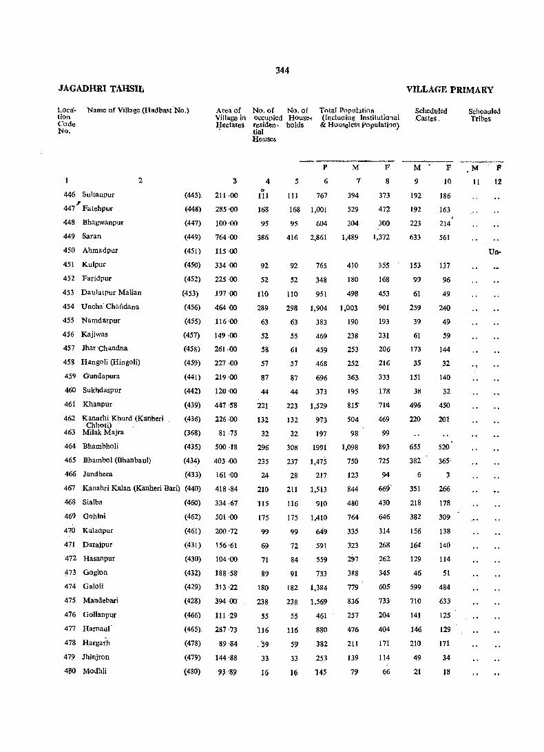
JAGADHRI TAHSIL
Localion Code NQ.
Name of Village .(Hadbast'No.) Area of Village in Hectares
'1
446 Suitanpur , 447 Falehpur
448 Bhagwanpur
449 Saran
450 Ahmadpur
451 Kulpur
452 Faridpur
2
453 DaulatPur Malian
454 Uncha Chandan a
455 Namdarpur
456 Kajiwas
457 Jhar Chandna
458 Hangoli (Hingoli)
459 Gundapura
460 Sukhdaspur
46f Khanpur
462 Kanarhi Khurd (Kanheri Chhoti)
463 Milak Majra
464 Bhambholi
465 Bhambol (Bhanbaul)
466 Jandhera
'3
(445). 211 ·00
(448) 285 ·00
(447) 100 ·00
(449) 764 ·00
(451) 115 ·00
(450) 334 ·00
(452) 225'00
(453) 197 ·00
(456) 464·00
(455) 116·00
(457) 149 ·00
(458) 261 ·00
(459) 227 ·00
(441) 219 ·00
(442) 120 ·00
(439) 447 ·58
(436) 226 ·00
(368) 81 ·75
(435) 500 ·18
(434) 403 ·00
(433) 161 ·00
467 Kanahri Kalan (Kanheri Bari) (440) 418.84
468 Sialba
469 Gohlni
470 Kalanpur
471 Darajpur
472 Hasanpur
473 Goglon
474 Galoli
475 Mandebari
476 Gollanpur
477 Harnaul
478 Hargaih
479 Jhinjron
460 MollhJj
(460) 334 ·67
(462) 501 '00
(461) 200 '72
(431) 156 '61
(430) 104 '00
(432) 188 ·58
(429) 313 ·22
(428) 394 ·00
(466) 111 ·29
(465) 287 ·73
(478) 89 ·84
(479) 144 '88
(480) 93 '89
344
No. of No. of occupied House. residen - 'ho Ius tinl
Total Population (lnc1uditig Institutional & Houseless POpulatbn)
HO).lses
4 ".
111
168
95
386
92
52
no 289
63
52
58
57
87
44
221
132
32
296
235
24
210
115
175
99
69
71
89
180
238
55
'116
. '59
33
16
5
P
6
111 767
168 1,001
95 604
416 2,861
92 765
M
7
394
529
304
1,489
410
52 348 180
110 951 498
298 1,904 1,003
63 383 190
55 469 238
61 459 253
57 468 252
87 696 363
44 373 195
223 1,529 815'
132 973 504
32 197 98
308 1991 1,098
237 1,475 750
28 217 123
211 1,513
116 910
175 1,410
99 649
72 591
84 559
91 733
182 1,384
238 1.569
55 461
116 880
59 382
33 253
1Q 14~
844
480
764
335
323
297
388
779
836
257
476
211
139
79
F
8
373
472
300
1,372
355
168
453
901
193
231
206
216"
333
178
71~
469
99
893
725
94
66':.f
430
646
314
268
262
345
60S
733
204
404
171
114
fj6
VILLAGE PRIMARY
Sc11eduled .Castes"
M
9
192
192
223
633
153
99
61
259
39
61
173
35
151
38
496
220
655
382
6
351
218
382
156
164
129
46
599
710
141
146
210
49
21
F
10
186
163
214
561
137
96
49
240
49
59
144
32
140
32
450
201
520
365·
3
266
178
309
138
140
114
51
484
633
125 "
129
171
34
18
Scheollied Tribes
M F
11 12
Un-
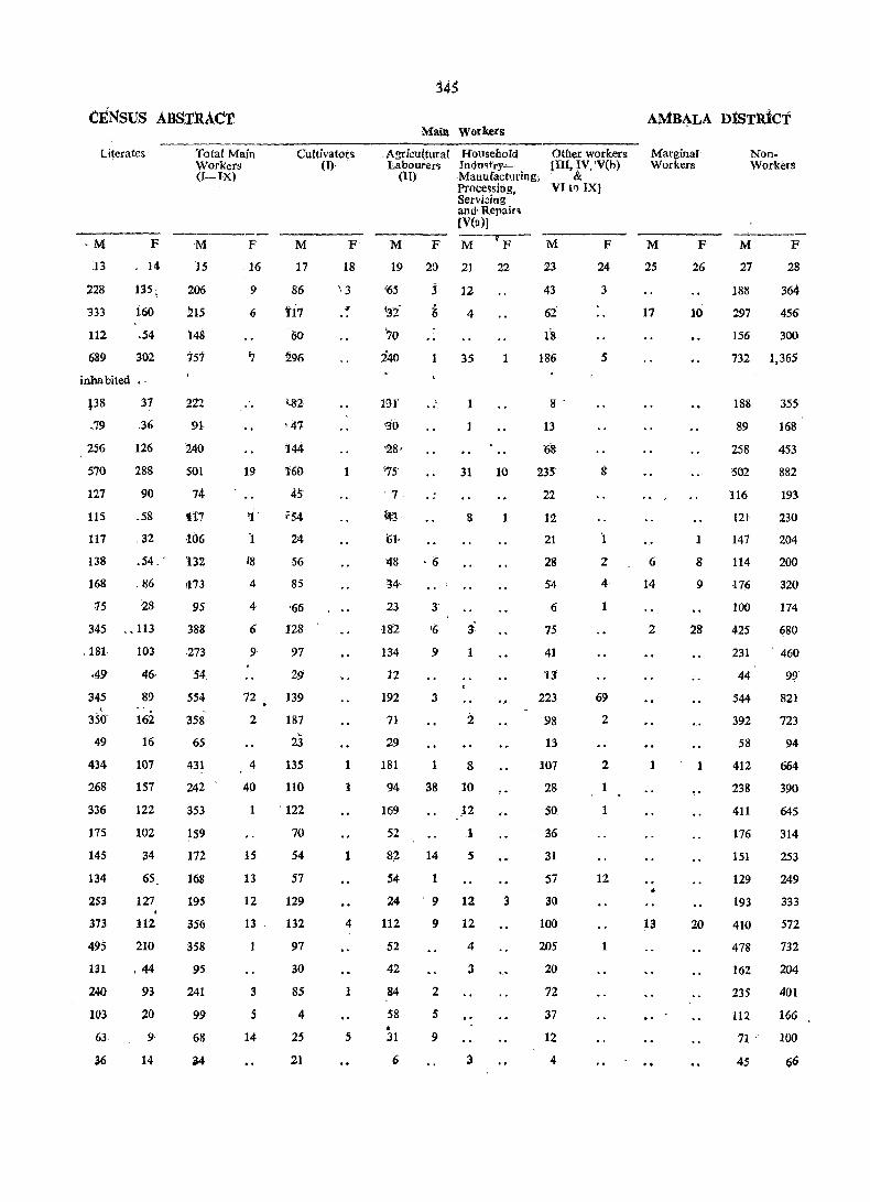
CtNsus ABSTRACT
Literates
·M ]3
228
333
112
689
F
14
135 :
160
.54
302
inhabited •.
138
.79
31
,36
126
288
90
.58
32
Total Main Workers (I-IX)
M P
15
206
215
'lAS
757
222
91
14{)
501
74
ti7
-106
16
9
6
19
'1 '
256
570
127
115
117
138
168
.54. . 132
,86
15 28
345 .. 113
181
·49
345 . 3Sa
49
434
268
336
175
145
134
253
373
495
131
240
103
63
36
103
46·
89
162
16
107
157
122
102
34
65
127
112
210
.44
93
20
9
14
1173
95
388
273
54
554
358
65
431
242
353
159
172
168
195
356
358
95
241
99
68
~4
72
2
4
40
1
15
13
12
13
3
5
14
Cultivators (I)
M
17
86
ti7 60
296
144
1'60
45
f54
24
56
85
'66
128
97
29
139
187
23 135
110
, 122
70
54
57
129
132
97
30
85
4
25
21
F
18
'.3
1
1
1
4
1
5
345
Main Workers
, Agricultural Labourer~
Household Indmt'ry-'Manufacturing, Processing, Secvidng
Other workers [m, IV, 'V(h)
& (II) VI tf) IX]
and' Repair~ (V(lI)j
M P M-rP- M P
24
3
19 20 21
En
'30
'28'
1S
'7
~3
(';1·
j 12
4
35
1
1
31
8
48 ·6
'M·
23
182
134
12
192
71
29
181
94
169
52
82
S4
24
112
52
42
84
58 • 31
6
3'
'6
9
3
1 8
38 10
14
1
.12
1
s
9 12
9 12
2
5
9
4
3
3
22
1
10
1
..
3
23
43
62
IB 186
8 .
13
'68
235
22
12
21
28
54
6
75
41
11
223
98
13
107
28
50
36
31
57
30
100
205
20
72
37
12
4
5
8
69
2
2
1
1
12
1
AMB~LA DISTRICT
Marginal Workers
M
25
17
6
i4
2
1
13
F
26
10
1
8
9
28
1
20
NonWorkers
M F
27
188
297
156
28
364
456
300
732 1,365
188
89
258
502
116
121
147
114
-176
100
425
231
44
544
392
58
412
238
411
176
151
129
193
410
478
162
235
112
71
45
355
1{!8
453
882
193
230
204
200
320
114
680
460
99
.821
723
94
664
390
645
314
253
249
333
572
732
204
401
166
100
66
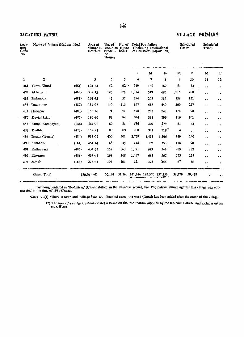
14~
JAdAlniRI TAHSIt VitLAGE I'RiMARY
Loca- Name of Village (Had hast No.) Area of No. of No. of Total Population Scheduled Scheduled tion Village in occupied House- (Including Institutional Castes Tribes Code Hectares residen- holds & Houseless population) No tial
H(\uses
----P M F~ M F M F
1 2 3 4 S 6 7 8 9 10 11 12
481 Topra Khurd (464) 124·64 52 52 ~ 349 180 169 61 53
482 Akbarpur (463) 305'13 126 126 1,014 519 495 215 208
483 Badanpur (481) 166·32 46 57 394 205 189 138 121
484 Daulatpur (482) 131'93 110 110 967 518 449 300 257
485 Hafizpur (483) 155-40 71 71 528 285 243 114 98
486 Kunjal JataD (485) 186-96 83 84 634 338 296 116 WI
487 Kunja! Kamboyan • (486) 164'70 80 81 586 307 279 51 45
488 Dudhla (477) 158'23 89 89 700 381 319 .~ 4 .' .. 489 Damla (Demla) (484) 913'77 400 401 2,759 1,453 1,306 169 140
490 Sabbapur (161) 254·14 45 45 348 195 153 118 90
491 Rattangarh (487) 400'63 159 160 1,171 629 542 209 183
492 Dh(\rang (488) 467'41 168 168 1,257 695 562 173 137
493 Jaipu'r (163) 277'61 103 103 721 375 '346 67 56
~-..----
Grand Total 130,064 ·63 50,194 51,560 341,626 184,370 157,256 58,979 50,459 -== ;" ,- - :-~-= "_-'II'_f"""""I __
tAlthough entered as 'Be-Chirag' (Un.inhabited) in the Revenue record, the Population shown against ~his village was enu-merated at the time of 1981-Census.
Notes : -(1) Where a town and village bear an identical name, the word (Rural) has been added after the name of the village.
(2) The area of a village (revenue estate) is based on the information supplied by the Revenue Patwari and inCludes urban area. if any.
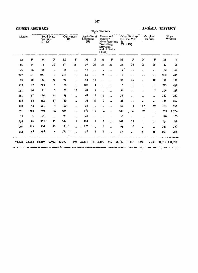
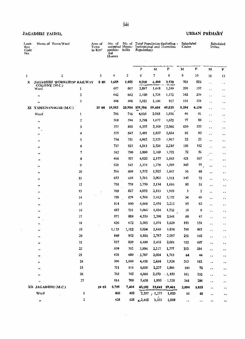
JA~Al>lIR~ T AHS:l:L
Location Code No.
Name of Town/Ward Area of Town inKm2
No. of No. of Total Population (including' Scheduled occupied House- Institutional and Houseless Castes residen- holds Population) tial Houses
Scheduled Tribes
--------- --~-. -~ ._---
1 2 3 4 5
P
6'
M
7
F
8
X JAGADHRI WORKSHOP RAIL WAY 0 '89 1,655 1,655 8,018 4,480 3,538 COLONY. (M.C.) ~~ .~ --~
Ward 607 607 2,897 1,648 1,249
" XI Y AMUNANAGAR (M.C.) .
2
3
Ward' 1
"
"
"
"
"
"
" "
"
XII JAGADHRI (M.C.)
Ward
"
2
3
4
5
6
7
8
9
10
11
12
13
14
15
16
17
18
19
20
21
22
23
24
25
26
27
2
642
406
642 3,100 1,728 1,372
406 2,021 1,104 917
15 '88 19,583 20,954 109,304 59,484 49,820
10'83
756 156 4,024 2,068 1,956
569
757
555
734
737
542
648
528
556
652
758
769
759
814
687
877
626
1,135
849
'837
659
678
594 3,298 1,677 1,621
803 4,355 2,309 l2,046
647 3,491 1,857 1,634
751 4,042 2,125 1,917
823 4,813 2,526 2,287
790 3,890 2,169 1,721
707 4,020 2,177 1,843
547 3,374 1,779 1,595
609 3,572 1,925 1,647
658 3,513 2,002 1,511
758 3,770 2!154 1,616
827
879
840
731
889
672
1,182
952
4,052
4,588
4,666
3,666-
4,539
3,503
5,034
4,884
2,113
2,413
2,454
1,934
2,398
1,874
3,160
2,787
1,939
2,175
2,212
1,732
2,141
1,629
1,874
2,097
839 4,499 2,418 2,081
702 3,894 2,117 1,177
680 '3,787 2,024 1,763
994 1,040 4,458 2,634 1,824
731
762
614
6,799
400
428
816 4,028 2,'f27 1,801
762 4,086 2;233 . 1,853
700 3,458 1,930, 1,528
7,404
400
43,102 23,641 19,461
'2,297 (1,277 1,020 . 428 ~2,44l 1,353 t,089
M
9
701
208
342
151
F
10
522
157
234
131
5,294 4,156
46 41
77
630
92
22
193
12
421
105
56
145
80
3
34
95
10
60
193
748
251
712
313
64
263
104
161
344
2,094
60
88
525
92
23
152
51
367
75
40
73
31
2
49
82
9
47
151
483
168
607
284
44
182
72
132
286
1,822
48
M
11
F
12
..

CENSUS ABSTRACT
Litera.tes Total Main Workers
M
13.
F
14
(I-IX)
M
15
3,708 2,344 2,229
1,362
1,435
911
777
944
613
818
895
516
F
16
90
54
30
6
39,488 28,120 30,802 '1,635
1,557 1,162 938
772 1,292 1,042
1,371 885 1,068
1,370 1,034 958
1,583
1,679
1,207
1,258
1,025
1,235
1,285 894 1,282
1,440 1,023 1,180
1,276 938
1,376 1,646
946
977
1,411 946 1,137
1,561 1,035 1,199
1,652 1,438 1,067
1,807 1,522 1,268
1,736 1,393 1,226
1,590 1,189 943
1,789 1,309 1,154
1,221 802 897
1,467 518 1,986
1,915 1,132 1,439
1,554 1,090 1,123
1,189
1,426
1,558
1,224
1,307
846
674 1,051
957 964
944 1,542
784 1,167
833 1,189
465 1,069.
15,565 10.781 13,470
755
853
536
583
723
859
79
57
67
44
71
39
64
74
32
42
28
42
112
151
128
77
119
46
46
69
61
38
42
35
15
23
34
615
12
16
Cultivators (I)
M
17
1
391
'4
8
24
11
6
37
2
3
18
8
6
22
64
19
6
41
3
16
6
46
37
193
5
3
349
Main Workers
F
18
Agricultural Labourers
Household IndustryManufacturing, Processing, Servicing and Repairs [V (a)l
Other Workers [III,IV,V(b) & VI to IX]
(II)
M P M F
19 20 21 22
1 3'
2
M
23
2,224
816
893
515
F
24
90
54
30
6
1 274 14 1,101 59 29,036 ,1,561
13
30
18
2
5
10
6
110
10
2
35
10
8
9
1 194
5
7
50
53
.10
23
115
69
5
26
21 ~
117
29
4
80
34
4 58
76
16
18
72
21
35
8 37
16
40
15
38
2
1
8
3
884
698
994
906
902
1,128
1,274
1,151
907
6 854
4 1,106
1,187
3 971
1,206
3 994
838
1,130
837
8 1,913
1,418
1 1,053
4 1,010
6 922
1,496
1,143
3 1,104
1,010
81,080 16 12,003
27 686
1 127 722
77
56
66
43
63
35
63
74
31
36
24
41
109
1.51
121
75
1.19
46
38
69
59
26
36
34
15
20
34
590
12
1~
AMBALA D]STRICT
Marginal Workers
M
25
2
2
51
2
2
4
7
4
4
2
9
2
2
2
2
6
55
5
F
26
Non-Workers
M
27
F
28
2,249 ' .3,488_
830 1,195
831 1,342
588 911
44 28,631 48,141
1,128 1,871
905 1,563
4 1,239 1,975
895 1,590
4 1,093 1,842
1,29.0 2,248
5 883 1,652
993 1,768
831 1,562
947 1,605
4 856 1,479
3 953 1,571
1,046 1,827
1,145 2,023
1,228 2,084
991 1,655
5 1,242 2,017
2 975 1,581
1,174 1,828
1,348 2,027
3 1,295 ·2,017.
1,066 1,738
2 1,058 1,719
1,092 1,789
4 1,059 1,782
2 1,038 1,828
861 1,494
9 10,116 18,837
549 1,008
494 1,073
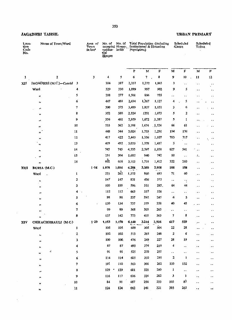
Location Code No.
Name of Town/Ward
2 1
XII JAGADHRI (M.C.)-Conc1d 3
Ward
.. to
.. " "
" "
" .. " ..
XIII BURIA (M.C.)
Ward
" " " " ..
" XIV CHHACHHRAULI (M.C.)
Ward
.. " .. ., ..
"
"
4
5
6
7
8
9
1.0
11
12
13
14
15
16
.1
2
3
4
5
6
7
8
1
2
3
4
5
6
7
8
9
1.0
11
Area or Town in ~ms
3
350
No. or No. or Total Population (including occupied HOllSl'-•. -Institutional & Housele&s residej1- holds popl.d"tiou) tial .8!lU.ses
4
314
329
218
447
500
352
356
533
448
417
459
745
251
602
5
387
33.0
277
P
6
2,337
1,899
1,561
M
7
1,272
997
8.06
F
8
1,065
9.02
755
481 2,694 1,567 1,127
575 3,489 1,837 1,652
38.0 2,324 1251 1,.073
461 2,959 1,672 .1,287
562' 3,198 1,674 .. 1,524
544 3,.024 1,733 1,291
422 2,443 1,336 1,1.07
492 . 3,.035 .
745 4,555
1,578
2,597
1,457
1,958
304 1,682 94.0 742
616 3,163 1,751 1,412
1 '94 1,078 1,094 6,258 3,350 2,908
1'29
255
141
1.00
112
98
13.0
99
137
1,153
1.05
1.02-
1.0.0
87
91
114
1.01
262
147
100
112
98
134
99
142
1.170
1.05
1.02
100.
87
91
114
11.0
129 - 129
116
84
124
117
91
lZ4
.. -: -1,553
831
596
663
537
737
568
773
860
456
311
337
292
379
3.05
410
693
375
285.
326
245
358
263
363
6,140 3,214 2,926 _C" __ ~" 609
513
476
493
525
6.05
563
6.01
6.06
487
Q(iZ
3.05
265
249
274
27.0
31.0
3.01
321
324
254
341
. 304
248
227
219
255
295
262
28.0
282
233
URBAN PRIMARY
Scheduled' ,~aste$
M
9
3
9
4
3
5
5
66
194
783
3
627
10
322
188
71
64
6
4.0
7
617
22
2
28
4
2
15.0
1
3
1.02
3Q3
F
1.0
5
5
6
2
61
176
717
541
26.0
158
6.0
44
3
43
8
539
28
6
19
132
87
2G5
Scheduleq Tribe&
M
11
. ,
"
F
12
"
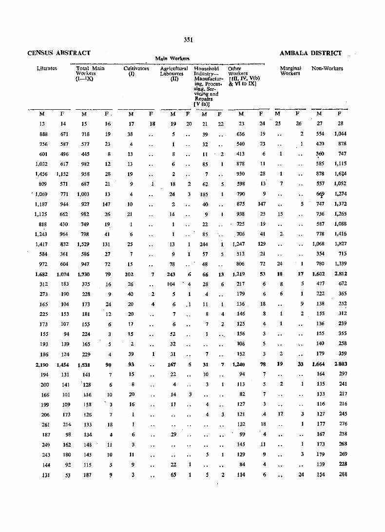
CENSUS ABSTRACT
Lit~ratlls Total Main Workers
M
13
888
756
601
F
14
671
587
496
1,032 617
1,456 1,152
571
(I~IX)
M
15
718
577
445
982
958
687
771 1,003
944
662
430
964
927
982
749
798
809
. 1,069
1,187
1,125
818
1,243
1,417
584
1132 1,529
972
361
604
586
947
1,682 1,094 1,730
312 183 375
273
165
225
173
155
193
186
190
104
153
107
94
139
124
228
173
181
155
224
165
229
2,190 1,454 1,531
194 131 141
200
166
199
206
261
187
249
243
144
131
141
101
109
173
214
98
162
180
92
53
'128
],16
158
126
133
134
148
145
115
la7
F.
16
19
23
8
12
28
21
13
147
26
19:
41
131
27
72
79
16
9
24
12
6
3
5
4
90
7
6
10
3
7
18
11
II
10
5
9
351
AMBALA DISTRICT ~in Wor~el'll
.--....:._~
Cultivators (I)
M
17
38
4
13
13
19
9
4
10
21
6
25
7
15
202
26
40
20
20
17
15
2
39
93
15
8
20
16
1
6
3
11
9
3
F
18
1
7
2
4
1
Agricultural Labourers
Other Workers
Marginal Workers
Non-Workers
(Iij
Household Industry_ Manufacturing, Processing. Serviclng and Repairs
[III, IV, V(b) & VIto IX)
[V (a»)
M F M F M
23
636
540
413
19 20 21 22
S
1
8
6
2
18
24
2
14
2
39
32
11
85
7
62
3 185
40
9
22
85
244
57 1
48
2
1
5
1
878
930
598
790
875
938
725
706
1 1,247
5 513
806
13
9
78
243
104
6
4
66 13 1,219
28 6 217
S 1
6 ,1
7
6
52
32
31
167
22
4
14
11
29
22
6S
5
3
1
1
4
11
8
7
1
7
31
10
3
4
4
5
s
4
2
179
136 .
146
125
156
lOS
152
7 1,240
3
2
94
113
82
127
121
132
99
145
129
84
114
F M
24 25
19
23
6
11
28
13
9
147
25
19
41
129
21
72
53
6
6
18
8
4
3
5
3
78
7
5
7
3
.4
18
4
11
9
4
6
1
7
15
2
24
18
8
6
1
2
19
2
17
F
26
2
1
5
M
27
F
28
554 1,044.
420 878
360 747
585 1,11S
1:l78 1,6~
557 1,052
6~ 1,274
747 1,372
736 1,265
587 1,088
778 1,416
1,068 1,827
354 715
780 1,339
11 1,602 2.812
5 477 672
9
2
' ..
222
138
155
136
155
140
179
365
252
312
239
355
258
359
33 1,664 2.803
1
3
1
3
164 297
135
133
116
127
177
167
173
179
139
154
241
217
216
245
276
258
268
269
228
288

APPENDl~
ENUMF!RATlON BLOCKWISE TOTAL POPULATION AND SCHEDULED CASTES POPULATION
353

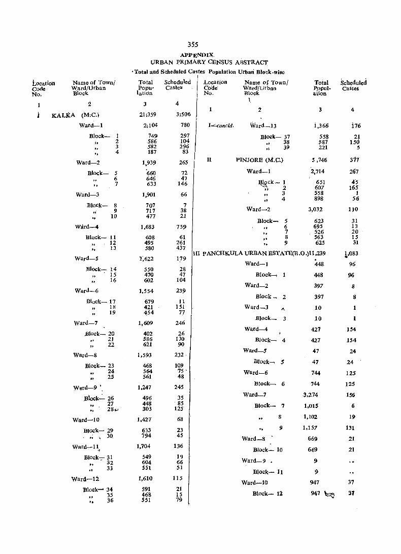
35.5 APPENDIX,
URBAN ERIMARY CENSUS ABSTRACf
. Total u!)d Sl:heduled Castes Population Urban Block-wise
Location Name of Town! Total Scheduled Location Name of Town! Total Scheduled Code Ward/urban Popu- castes Cooe Ward/urban Popul- Castes No. Block latidn No. Block aUon
2 4 I
3 i 3 4
i KALK.A (M:C.) 21 ~359 3i506
Ward-l 2;104 780 I"'::"concld. Ward~13 i.366 i76
Block- 1 749 297 Block- 37 558 21 ;0 2 586 104
" 38 587 Isd .. 3 582 296 ,; 39 221 5
" 4 187 83
Ward-2 1,939 265 11 PINJQRE (M.e.) S ,746 377
Block- S '660 72 Ward-l 2,714 207 6 646 47
~~ck- 1 651 45 7 633 146 " .. 2 607 165 Ward-3 1,901 66 .. 3 558 1
•• 4 898 56 Block- 8 707 7
Ward~2 ,; 9 717 38 3,032 110 ,- 10 477 21
Block~ 5 623 31 Ward-4 1,683 759 6 695 13
to 7 526 20 Block- 11 608 61 ., S 563 15
12 495 261 " 9 625 31
" 13 580 437
Ward-5 1',622 III pANCHKULA URBAN ESTATE(E.O.)11.239 1.083
179 . Ward-l 448 96
Block- 14 550 28 15 470 47 Block_, 1 448 96 16 602 104
Ward-2 397 8 Ward-6 1,554 239
Block~ 2 397 8 Btock- 17 679 11
18 421 151 Ward-3 I\. 10 1 .. 19 454 77
Ward-7 Block- 3 10 1
1.609 246 Ward-4 427 154
Block~ 20 402 26
" 21 586 130 Block- 4 427 154 .. 22 621 90
Ward-8 1.593 232 Ward-S 41 24
Block- 23 468 109 Block __ $ 47 24
24 564 75 ' Ward-6 744 125 .. 25 561 48
Wllrd-9 • 1.247 245 Block- 6 744 125
Block":'_ 26 496 35 Ward-7 3.274 156
.. - 27 448 85 Block__, 7 1.015 6 .. 28" 303 125
Ward-l 0 1.427 68 8 1,102 19
Block- 29 633 23 " S! 1,157 131
OJ , 30. 794 45 Ward-8 669 21
Ward-ll 1,704 136 Block- 10 669 21 '. Block- 31 549 19
Ward-9 9 . 32 604 66 . .. .. 33 S51 51 Block- 11 9
Ward-12 1,610 115 Ward-l0 947 37
Block- 34 591 21 947 ~ 31 35 468 15 Block- 11 ..
36 S51 79 -.
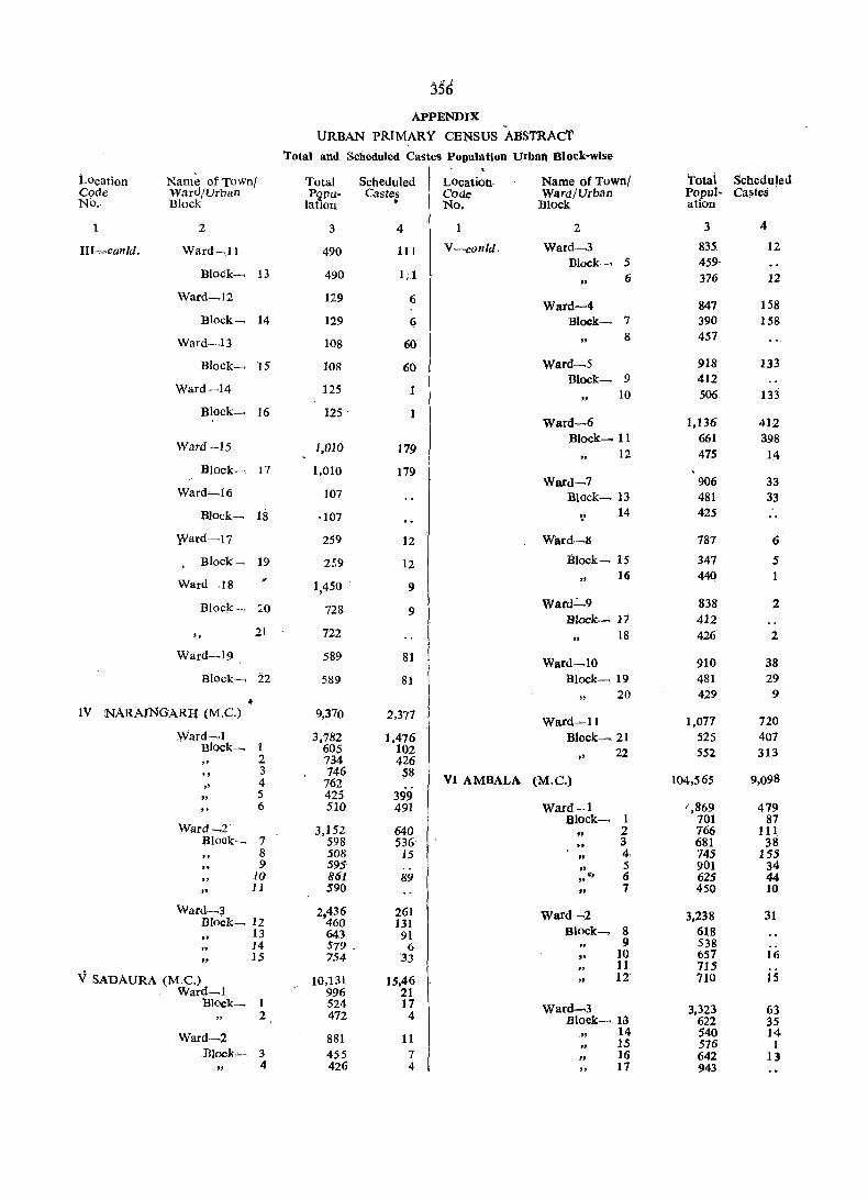
356 APPENDIX
URBAN PRIMARY CENSUS ABSTRAct
'rotal and Scheduled Castes Population Urban Block-wise
Location Name of Town! Total Scheduled LOcation, Name of Town! 'rotai Scheduled Code Ward/Urban Pi,lpu- Castes Code Ward/Urban Popul- Castes No. Block latlou • No. Block ation
2 3 4 2 3 4
III-=canid. Ward~ll 490 111 V-conld. Ward-3 835 12 Block- S 459
Block- 13 490 1; 1 6 376 12
Ward-I 2 129 6 Ward-4 847 158
Block- 14 129 6 Block- 7 390 158
Ward-13 108 60 8 457
Block_ 15 108 60 Ward-5 918 133 Block- 9 412
Ward-14 125 10 506 133 " Block- 16 125 ' 1
Ward-6 1,136 412
Ward --15 Block- 11 661 398
J,010 179 12 475 14 .. Block- 11 1,010 179
Ward-7 906 33 Ward-I 6 107 Block- 13 481 33
Block_ 18 ·107 ::.' 14 425
Ward-17 259 12 Ward,-8 781 6
Block~ 19 259 12 Block- 15 347 5
Ward ,18 " 16 440 1
1,450 . 9
Block_ LO 728 9 Ward~9 838 2
Block- 17 412
" 21 722 18 426 2
Ward-19 589 81 Ward-l0 910 38 Block_ 22 5S9 81 Block- 19 481 29
.. " 20 429 9
IV NARAJNGARH (M.C.) 9,370 2,377 Ward-ll 1,077 120
Ward-l 3,782 1,476 Block~21 525 407 Block_ 1 60S 102 22 552 313 2 734 426 " " "
3 746 58 9,098
" 4 762 VI AMBALA (M.C.) 104,565 .. 5 425 399 6 510 491 Ward-ol (,869 479
Block- 1 701 87 Ward_2 3,152 640 " 2 766 III
Block_ 7 598 536 .. 3 681 38 8 508 15 " 4 745 155 .. 9 595 .. " 5 901 34
10 861 89 " 0:. 6 625 44
" 11 590 " 7 450 10
Ward-3 2,436 261 Ward-2 3,238 31 Block- 12 460 131 13 64.3 91 Block_, 8 618
" 9 538 14 579 _ 6 15 754 '33 10 651 16
11 715 V SADAURA (M.e.) 10,131 15,46 .. 12' 710 15
Ward-l 996 21 Block_ 1 524 17 Ward-3 3,323 63 2 472 4 Bloek- 13 622 35
Ward-2 881 11 ., 14 540 14 ., 15 576 1
Block"-> 3 455 7 " 16 642 13
" 4 426 4 " 17 943

357 ApPENDIX! .
URBAN PRIMARY CENSUS ABSTRACT
Total and Scheduled Castes population Urban Block-wise
Location Name of Townl Total Scheduled Location Name Qf Towll/ Total Scheduled Code Ward/Urban Popu- Castes Code Ward/Urban Popu- Castes No. Block lation No. Block latioR
.. (
1 2 3 4 .... 2 3 4-
Vl-contd. Ward-4 3,212 65 VI-conetd. Ward-l0 4,901 118 Block- 18 742' 27 Block- 57 887 39
" 19 587 58 816
" 20 764 23 59 602 21 508 15 60 715 22 611
" .... 61 976 69
Ward-5 5,068 62 905 10
771 BJOck-- 23 997 4 Ward-II 5,196 952
" 24 672 83 Block2-63 1,658 539
.. 25 908 149 64 669 134
• ,26 874 405 65 824 199
27 794 122 66 655 '35 .. 2'8 823 8 ,,' 67 624 30 68 766 15
Ward-6 5,950 345 Block- 29 1,015 44
Ward-12 3,701 . 1,134
30 689 53 Bloek-69 748 577
31 699 18 .. 70 662 380
32 ,652 78 71 661 93
" 33 525 64 72 539
34 643 73 654 47
" 18 35 724
74 437 37 20
36 419 25 Ward-13 3,177 41 37 584 27 B1ock-75 694
76 538 Ward-7 4,468 646 77 628 f5
Block- 38 545 ,. 55 78 588 32 39 752~ 68 79 729 4 40 888 56
" 41 1,055 310 Ward-14 3,070 111
Block-80 595 42 377 80 81 660 75 .. 43 851 77 " +
82 555 36 ". 83 665
Ward-8 3,155 244 84 595 Block- 44 763
45 680 46 970 36 Ward-IS 4.317 275 47 742 208 Blqck-85 606 1
86 624 19 Ward-9 5.12S· 142 87 631 30
Block- 48 534 8 " 88 599 3 89 636
49 450 90 658 36 50 636 4 91" 563 186
" 51 766 8 Ward-i6 3',468 lIO 52 803 58 53 ·563 31
Block--92. , 598 63 93 696 31
54. 396. 11 • 94 534 5 .. 55 467 7 95 693 2
~~ ~lQ l~ 96 624 9
,~
" 97 n:?
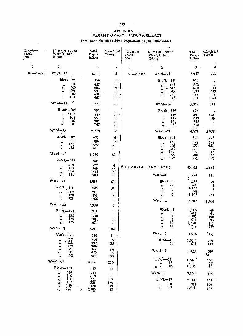
358
APPENDIX URBAN P~lMARY CENSUS ABSTRACT
Total and Scheduled Olstes Population Urban Block-wies
Location Name of Town! Total Scheduled I Location Name of Town/ Total Scheduled Code Ward/Urban Popu- Castes Code Ward/Urban Popu- castes NO. Block lation No. Block lation
1 2 3 4 2 3 4
VI-contd. Ward-I7 3,113 4 VI-cone/d. Ward-25 3,947 753
Block_;98 354 Block-140 650 99 637 .. 141 622 37
" 100' 502 4 .. , 142 680 33 t01 533
" 143 ;693 535
-, toz 621 .. 144 668 8 .. to3 466 145 634 140
Ward-I 8 ~
3.161 Ward-"-26 3,003 211
Block-104 536 Block-146 537 '105 617 147 493 162
" 106 558 148 613 49 f07 70S 149 812 108 745 .. 150 548
Ward-.19 2,759 7 Ward_Z1 4,273 2,056 . Block-l 09 687 4 Block..,_ 151 570 247
110 709 3 .. 152 598 598 .. tll 690 .. 153 633 633 .. 112 673 "
154 560 72 .. 155 675 11 Ward-20 3,586 80 .. 156 590 55
" 157 652 440 Block-I 13 58n .. 114 717 6 VIJ AMBALA CANTT. (C. B.) 40,462 5,558 ,. 115 709 72.
." 116 734 2 , 117 780 Ward-l ~4.484 181 ..
ward-21 3,088 63 Block-l 1,233 23 .2 609 I Block-U8 805 58 " 3 1.121 3 .. 4 498 119 714 5 1,023 154
" 120 803 5 .. 121 766 Ward-2 5,887 t,104
Ward-22 2.938 7
Block:-122 Block_6 1.116 69 745 7 -- 7 618 68
123 738 o- S 1,183 260 .. 124 781 "
9 621 195 .. 125 674 " 10 1,550 213 .. 11 739 299 Ward-23 4,218 106 f
Block-126 634 14 Ward-3 1,978 '352
127 764 9 Block-l 2 1,334 219 .. . 128 59i 35 " 13 644 133 " 129 706
130 564 14 Ward-4 3,423 409 .. 131 450 4 e 132 508 30 'Bloc'k-14 1,562 . 250 Ward-24 4,236 279 " 15 661 76
Block-133 ~> ". 16 1,200 83 433 11
134 711 Ward-5 3,170 498 135 662 to 136 621 27 Block-17 1,164 167 .
137 .838 175 18 575 106 138 486 39 " 19 1~431 ~2~ qg , .
t~~~ 3~ .. "

359
APPENDIX!
URBAN PRIMAR.Y CENSUS ABSTRACT -Total and Scheduled Castes Population Urban Block.wise
L6cafion Name of Town! Total Scheduled Location Name of Town! f:1Jotal . Scheduled Code Ward/Urban Poim. Castes Code 'Ward/Urban Popu >;' Castes No. Block lation No. Block lation
1 2 3 4 2 3 4
VII-·concld. VIII-contd. ward-6 5,661 590 Ward-.,,-5 3,540 443-
Block-20 1,554 Block- 19 533 27
1.62 20 816 92 ,,.' 21 771 30
21 782 53 \~ 22 842 173 22 1,245 122 ~, , 23 578 121 23 608 92
" 24 892 122 Ward-6 3,357 756 25 580 39
Block- 24 582 6 Ward_7 't§;859 2,424 .. 25 518 5
.- " 26 457
"' 27 465 15 Block'-26 1,720 .. 1.95
., 28 704 680
27 ~Sif' .. 29 631 50 .' 96
" 28 ~J4,2. 214 Ward_7 5,23t 151 29 1,119 156 30 794 203 Block- 30 904 31 2,096 343 31 1,079 125 32 1,112 161 " 32 880 33 1,532 444 't~' . 33 816 26 34 1,298 77 34 697 35 795 121 ". 35 856 36 1,482 174 1, 37 712 29 Ward-8 3.525 442 38 1,227 211
Block- 36 581 65 VIII AMBALA SADAR'(M.C.) 80,741 11,342 37 525 161
38 446 170 Wttrd-l 2,550 219
39 .,685 36 40 593 10 41 695
Block-l 630 24 2 661 165 Ward-9 4,385 219 3 620 30 4 639 Block- 42 1,091 63
" 43 807 37 Ward-2 3,168 801 44 795 53 .. 45 821 61
BJock-5 640 46 871 5
12 6 1,327 687 Ward--l0 2,369 476
u 7 541 70 8
... 660 32 Block- 47 636 47
Ward-3 " 48 801 221 3,309 61 . " 49 93i 2()8
Block-9 702 Ward "';'11 3,740 1,395
" 10 707 7 ~Iock-.
." 11 732 21 50 • 550
12' 689 5 51 ·558 539
J.3 4Z9 28, .. 52 704 222
53 6ri2 400 Ward_4
54 601 146 3,O1'll 53 .. 55 725 88
Block-14 682 Ward"":'12 2,758 248
" 15 616 Block- , .. 16 642 56 681 .. , 17· 427 57 516 55 l~ 18 651 53 j" 58 683 22
if' 59 666 138 ~ ~ W z.q ~J,
,to

360
APPENDIX'
URBAN PRIMARY CENSUS .ABSTRACT
Total anif'.Scbeduled Castes Population Urban Block-wi"
Location Name of Town! Total Sche.duled Location Name of Town/. Total Scheduled Code Ward/ Urban Population -Castes ... Code Ward/Urban Population Castes No. Block No. Block
2 • 3 4 1 2 3 4
YIU-contd .• VIlI-'-concld. Ward-22 3,667 2,OG5 Ward-13 3,152 ),083
Block- 61 506 Block- 101 669 482 9 102 641 461 .. 62 627 91 103 5&9 254 .. 63 833 442 104 549 92 64 636 150 " 364 ,.
]05 551 .. 65 550 391 '106 668 352 " Ward-14 2,803 8 Ward-23 3,077 261
Block- 66 499' B Block- 107 861 186 " 67 688 ,. 108 668 75 " 68 846 .. 109 660 " 69 77f,J
" nO 888 Ward-1S 2,878 ;f"rd-24 3,246 333
.Block- 70 713 " .;J3lock- 111 615 222 0' 7l 795
" 112 710 .. 72 705 .. 113 697 73 665 ,. 114 520 71 11S 704 40 Ward"'" ,16 3,049 13 ..
Ward-25 3.265 297 B1ock- 74 682 .. 75 955 5 Bloak- 116 489 20 76 589 117 410 1 77 818 8 .. 118 773 29
" 119 833 103 Ward-I7 2,776 3
" 120 760 144 Block~ 78 816 IX BAIHYAL (C.T.) 7,342 2,219 79 1,037 3
t64 " 80 520 Ward-I 2,892 " 81 403
Block- I 651 78 Ward-I 8 2,897 51 2 666
3 486 II ,BIQck--: 82 424 12 .. 4 SOl 65
5 588 .. 83 639 Ward-i' 2,787 1,100 84 714 24
85 481 Block- 6 528 86 639 is 7 955 303 ..
8 285 285 " Ward-19 2,885 67 " 9 373 66 .. 10 646 446
Block- 87 62B 1663 955 .. 88 846 9 Ward-3
89 858 13 Blook- 11 316 148 .. 90 553 45
12 520 -340 Ward-20 3,041 321 13 377 173
14 450 294 Block- 91 688 166
JAGADHRI WORKSHOP 92 559 25 X 93 272 8
8,018 1.223 91 776 12 RAILWAy COLONY (M.e.) 95 746 10
1;fj36 Ward-l 2,897 365
Ward-21 3,059 Block- 1 414 29
Block- 96 692 61.4 .. '2 469 105 97 481 384 ,. 3 633 35 9&. 852 598 .. 4 467 62 " 99 686 11 :; 371 56 " ,.
~ ~43 18. .. . tOQ 3413 19 I'

3gi APPENDIX'
URBAN PRIMARY CENSUS ABSTRACT
Total and Schedldcd Castes Population Urban Block·wise
Location Nam:ofTown/ Total Scheduled Location Name of' Town/ Total Scheduled', Code Ward/Urban Popu- Castes
No, Block lation Code Ward/Urban Popu- Castes No, Bloa lation
1 2 3 4 2 3 4
X-':oncld, Xl-contd' Ward-6 Ward-2 3,100 576 • 4,813 345
Block-7 555 34 Block-36 530 .,. 8 469 34 37 567 9 667 158 .. 116 .. .. 10 736 80' .. 38 591 2S .. , 11 673 270 39 6S1 24 Ward-3 2,021 282 .. .. 40, 523 2 Block-12 624 87 • 41 598 22 13 352 S4 ' .. ..
732 14 488 91 .. 42 134 .. 15 557 SO .. 43 621 22
XI YAMUNANAGAR-(M.C.) 109,304 9,450 , Ward- 7 3,890 123
Ward-I 4,024 87 Block"':"44 538
BJock-l .. 45' 644 60 669 8
46 569 15 .. 2 754 18 .' " 3 468 13 ... 47 498 .. 4 586 48 48 677 40 " 5 714
49 497 "
6 395 8 7 438 50 467,
Wardo-2 3,298 165 Ward-8 4,020 788
Block-8 753 Block-51, 771 355 " 9 592 52 681 ,240' "
10 569 6
" 11 583 1 53 767 182 12 429 56 54 549 13 372 102 55 636 "
WBrd-3 4,355 1.155 " , 56 452 11
Block-14 1,094 10 .. 57 164
" 15 456 223 Ward-9 3,374 180 16 676 209 ., 17 492 222. Block- 58 478 43 "
18 356 270 59 . 19 454 6 .. 4:78 61 , .. 20 827 216 " 60 56': 26
Ward-4 3,491 184 61 .731 11
" 62 728 35 Block-21 79L 4 " 63 394 4 .. 22 666
Ward_l0 34 512 23 547 9 96 .. "
24 590 4 Block-M 642 12
" 25 490 167 .. 65 480 .. 26 407 .. 66- 517 19
Ward-5 4,042. 45 " 67 773 13
" 68 331 28 Block-27 420 " 69 7.69 24 ,,, 28 483 7
" 29 529 6 Ward-II 3i513, 218 .. 30 295 .. 31 509 Block_70 682 98 32 505 33 509 5 " 71'. 689 41 ..
" 72 810 48 " 34 453 23
" 73' '825 2S ." 35 339 4 ....... 14' 507 C;
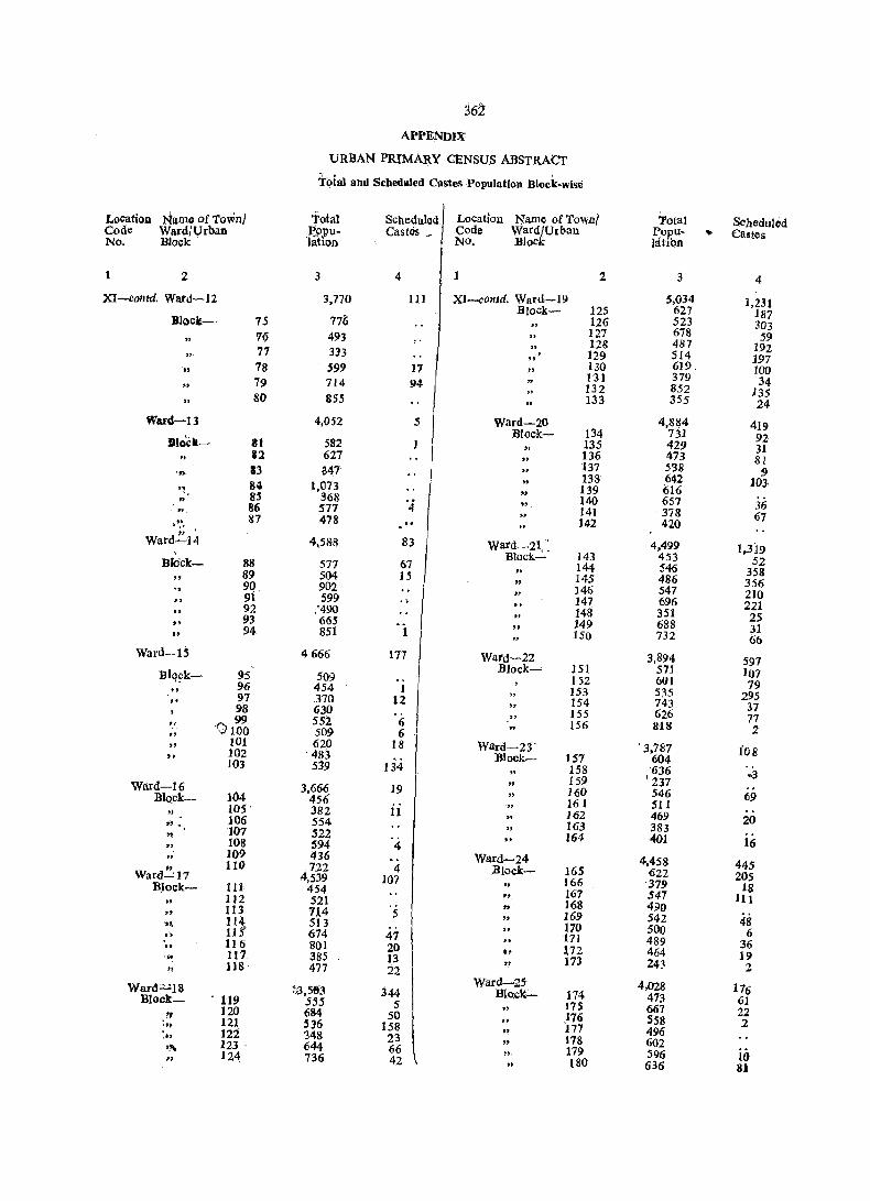
362 APPENDIX:
URBAN PRIMARY CENSU.S ABSTRAcr
Tofal and Scbeduled Ca.stes .Population Block-wise
Location Namo of Town/ fotal SChedul ed Location Name ofTownl Total Scheduled Code WardfUrban p'ppu- Castes , Code Ward/Urban Popu- ~ Castes No. Block Jahon NO, BloCk latibn
1 2 3 4 1 2 3 4
XI-contd. Ward-12 3,770 III XI-comd. Ward-19 5,034 1,231 BIock- 125 627 187 Block- 75 776 " 126 523 303
76 493 127 678 59 " 128 487 192 77 333 "
, 129 514 197 78 599 17 130 619 lOa ..
131 379 34 79 714 94 132 852 135 " 80 855 133 355 24
Ward-13 4,052 5 ward-20 4,884 419 Block- 134 731 92 JiJlo'ck- II 582 1 " 135 429 31 III 627 .. 136 473 81
13 047 137 538 9 ',. 138 642 103
" 84 1,073 " 139 616 8S 368 '4 140 657 36 86 577 141 378 67
" 87 478 142 420 . " "
W8td-21,': Ward--14 4,588 83 4,499 1,319 , Block- 143 453 52 Blo'ck- 88 577 67 144 546 358 89- 504 15 " 145 486 356 90 902 146 547 210 91 599 .. 147 696 221 92 :490 148 351 25 .. 93 665 149 688 31
" 94 851 1 150 732 66 Ward-lS 4666 117 Ward-22 3,894 597 BJock-' 151 571 107 Blq~k- 95 509 152 601 79 96 454 I 153 535 295 .. 97 370 12
" 154 743 37 98 630 155 626 77 " 99 552 6 156 818 2 .. 0100 509 6 .. 101 620 18 Ward-Z3' . 3,787 fOB 102 ' 483 Block- 157 604 103 539 134 158 -636 ~3
" 159 • 237 Ward-l 6 3,666_ 19 " 160 546 69 Block- 104 456 " 161 511
" lOS' 382 ii 162 469 20 ", 106 554 " 163 383
" 107 522 164 401 - 16 .. 108 594 4 109 436 Ward-24 4,458 445 " 110 122 4 Block- 165 622 205 Ward-"17 4,539 107 166 '379 18 Block- III 454
" 167 547 111 IJ2 521 " 168 490 .. 113 7.~4 5 " 169 542 48 ~~ 114 513 170 500 6 .. llS' 674 47 171 489 36 " 116 801 20 0, ~72 464 19 ' .. 117 385 13 " 173 243 2 '! 118 477 22
Want=18 ~,3,5&3 Ward-Z5- 4,028 176 344 Block:"" 114 473 61 Block- 119 555 5 175 667 22 I, 120 684 50 176 558 2 ~'h 121 536 158 177 496 ,., ]22 348 23
" 178 602 ,"- 123 . 644 66 ". 179 596 II} " 124 736 42 .. 180 636 81
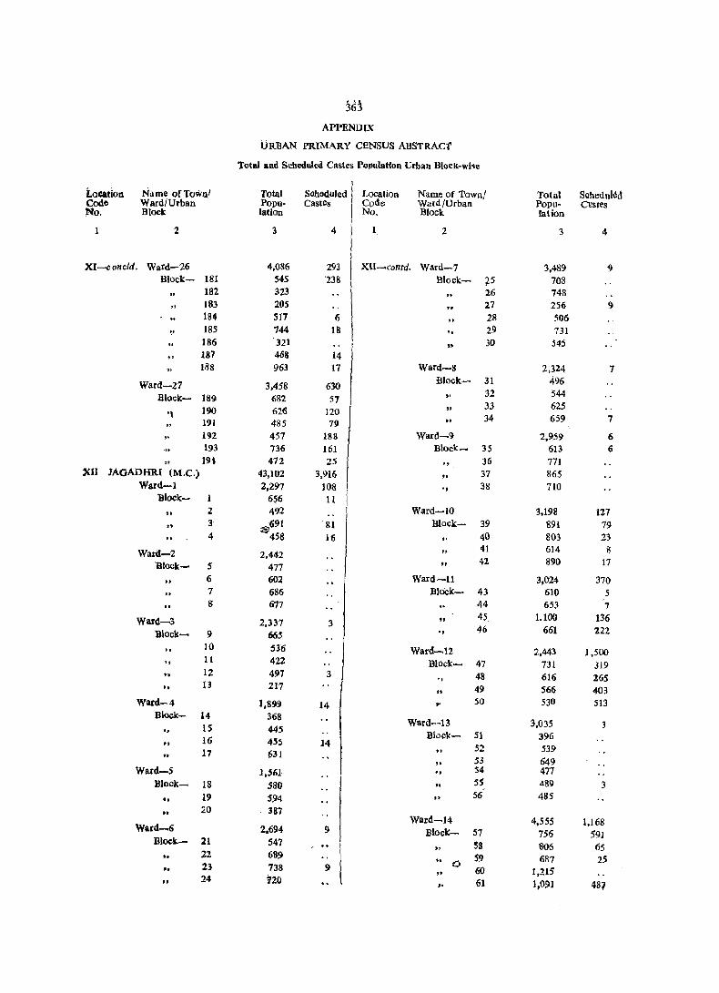
~63
APPENDIX
URBAN PRIMARY CENSUS ABSTRAct
Total and Scheduled Castes Population Urban Blnck-wise
Location Name ofTownl Total Soheduled Location Name of Town! Total Scheduled Codc Ward/Urban Popu- Castcs Code Ward/Urban Popu- Ctlstes No. Block lation No. Block lation
2 3 4 2 3 4
XI--collcld. Ward-'26 4,086 293 XU-contd. Ward-7 3.489 9 Block- 181 54S '238 Block- ~5 708
182 323 2.6 748 183 20S 27 256 9 184 517 6 28 506 IBS 744 18 " 29 731 186 321
" 30 545
" 187 468 14 188 963 17 Ward-8 2,324 7
Ward-27 3.458 630 Block- 31 496
Block- 189 682 57 .. 32 544
]90 626 J20 .. 33 625 '~ 34 659 7 191 485 79 .. " 192 457 188 Ward~9 2,959 6
193 736 161 Block- 35 613 6 19~ 472 25 " 36 771
XII lAQADHR[ (M.e.) 43,102 3,916 " 37 865 Ward-l 2,297 108 ., 38 710
lllock- 656 11
" 2 492 Ward-iO 3,198 127 .. 3 ;a>691 81 Blocl<:- 39 891 79 .. 4 458 16 , . 40 803 23
Ward-2 2,442 .. 41 614 8
Block- S 477 " 42 890 17
" 6 602 Ward-ll 3,024 370 .. 7 686 Bloek- 43 610 5 .. g 677 44 653 7
Ward-3 2,337 3 " 45 ].100 136
Block- 9 665 ., 46 661 222
" 10 536 Ward-.12 2,443 1,500
" 11 422 Black- 47 731 319 f. t2 497 3 48 616 265 .. " 13 217 49 566 403 ..
Ward-4 1,899 14 ,- 50 530 513 Block- 14 368
Ward-13 3,035 " IS 445
Block- 51 396 .. 16 455 14 52 539 17 631 53 049 ..
Ward-5 1,561- ., 54 477 Block_ 18 580 ss 489 3 .. 19 594 II 56 485
0' 20 387 Ward-14 4,555 1,168
Ward~6 2,694 9 Block- S7 756 591 Bl~k.- 21 547 S8 806 65
'f 22 68~ " 59 6&7 25
23 738 9 0 60 t,215 'f ..
" 24 120 ,. 61 1,091 487
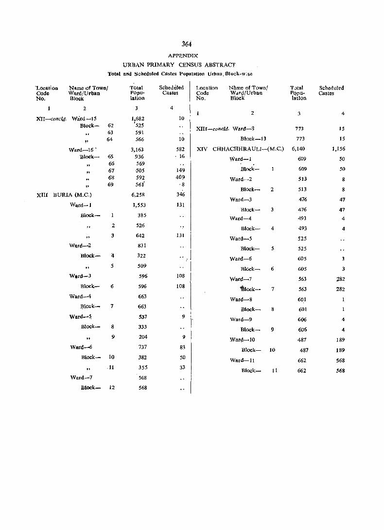
364 APPENDIX
URBAN PRIMARY CENSUS ABSTRACT
Total Ilnd Scheduled Castes Population Urbao. Block-w;sc
'Location Name of Townl Total Scheduled Location N!lme of Town! TJta\ Schedukd Code Ward/Urban Popu- Castes Code Wdrd/Urban p()pu- Castes No. Bl(X;k lation No. Block latlon
2 3 4 2 3 4
XU -cone/d. Ward-IS 1,682 10 Block- 62 '525
XIII-concld. Ward-B 773 15 63 591
" 64 566 10 Block-I3 773 15
Ward-I6 . 3,163 582 XIV CHHACHHRAULT-(M.C.) 6,140 1,156
Block- 6S 936 . 16 Ward-l 609 50
" 66 569 . 67 505 149 Block- 609 50
" ., 68 592 409 Ward-2 513 8
" 69 56!' ·8
Block- 2 513 8 XIII BURIA (M.C.) 6,258 346
Ward-3 476 47 Ward-l 1,553 131
B1ock- 3 476 47 Block- 385
Ward-4 493 4
" 2 526 B1ock- 4 493 4 .. 3 642 131 Ward-5 525
Ward-2 831 Block- S 525
Block- :4 322 Ward-6 605 3 .. 5 509 Block- 6 605 3 W~rd-3 596 108
Ward-7 563 282 Block- 6 596 108 ~Iock- 7 563 282
Ward-4 663 Ward-8 601 Block- 7 663 Block- 8 601
Ward-~ 537 9 Ward-9 606 4 Block- S 333 Block- 9 606 4
" 9 204 9 Ward-lO 487 189
Ward-6 737 83 Block- 10 487 189 Block- 10 382 50 Ward-ll 662 568 .. .11 355 33
BIock- 11 662 568 Ward-7 568
Block- 12 568

DISTRICT PRIMARY CENSUS ABSTRACT
OF SCHEDULED CASTES
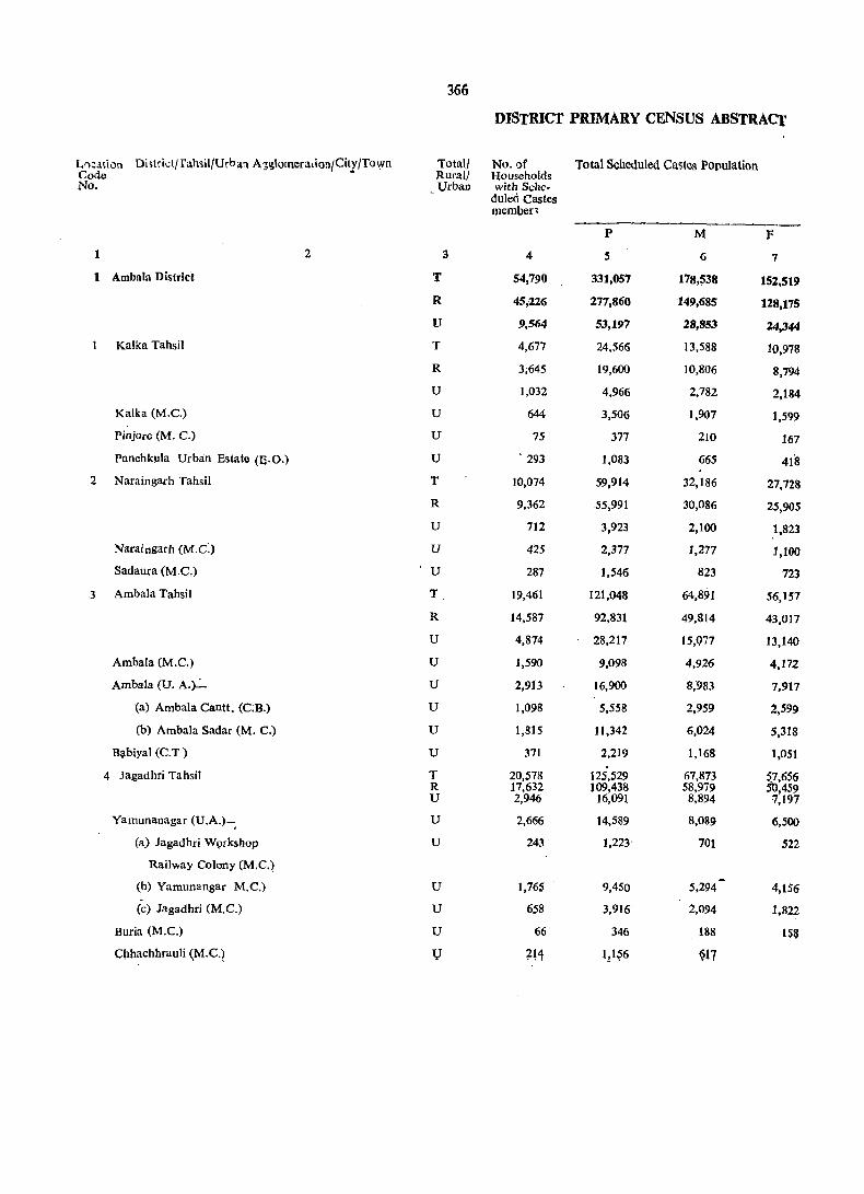
366
DISTRICT PRIMARY CENSUS ABSTRACT
L')~atiun Di;trict/fahsH/Urh a1 A,'~g\orneratioll/Citl/Town Total! No. of Total Scheduled Castos Po(,ulation Code Rurall Households No. Urba.o with Sche-
duled Castes member,
-----~---------p M F
1 2 3 4 5 6 7
1 Ambala District T 54,790 331,057 178,~38 152,519
R 45,226 277,860 149,685 128,175
U 9,564 53,197 28,853 24,344
Kalka Tahsil T 4,677 24,566 13,588 10,978
R 3;645 19,600 10,806 8,794
U 1,032 4,966 2,782 2,184
Kalka (M.C.) U 644 3,506 1,907 1,599
Pinjore (M. C.) U 75 377 210 167
Panchkula Urban Estate (B.O.) U . 293 1,083 665 418
2 Naraingarh Tahsil T 10,074 59,914 32,186 27,728
R 9,362 55,991 30,086 25,905
U 712 3,923 2,100 1,823
Naraingarh (M.C:) u 425 2,377 1,277 1,100
Sadaura (M.C.) U 287 1,546 823 723
3 Ambala Tahsil T 19,461 121,048 64,891 56,157
R 14,587 92,831 49,814 43,017
U 4,874 28,217 15,077 13,140
Ambala (M.C.) U 1,590 9,098 4,926 4,172
Ambala (U. A.~ U 2,913 16,900 8,983 7,917
(a) Ambala Cantt. (C.B.) U 1,098 5,558 2,959 2,599
(b) Ambala Sadar (M. C.) U 1,815 11,342 6,024 5,318
Ba,biyal (C.T ) U 371 2,219 1,168 1,051
4 Jagadhri Tahsil T 20,578 125,529 67,873 S.7,656 R 17,632 109,438 58,979 50,459 U 2,946 16,091 8,894 7,197
Yamunanagar (U.A.)-. U 2,666 14,589 8,089 6,500
(a) Jagadhri WQrkshop U 243 1,223" 701 522
Railway Colony (M.C.)
(b) Yamunangar M.C.) U 1,765 9,450 -5,294 4,156
(c) Jagadhri (M.C.) U 658 3,916 2,094 1,822
Buria (M.C.) U 66 346 188 158
Cbhachhrauli (M.C.) l} 2H 1!1~6 917

367
OJ SCHEDULED CASTES Main Workers
~~ .-...-__,,---~-
Literates Total Ma.in Workers CultivatoJ,'s (I-IX) (l)
---------------P M F P M F' l' M F
8 9 10 It 12 13 14 15 16
86,256 66,862 19.394 94,382 89,605 4,777 10,208 10,030 178
66,657 53,399 13,258 78,719 75,463 3,256 10,093 9,915 178
19,599 13,463 6,136 15,663 14,142 1,521 115 115
7,759 5,660 2,099 7,998 7,169 829 737 733 4
5,885 4,350 1,535 6,205 5,669 536 725 721 4
1,874 1,310 564 1,793 1,500 293 12 12
1,480 1,011 469 1,025 928 97 10 10
190 132 58 121 106 15 2 .2
204 161 37 647 466 181
15,007 11,817 3,190 16,669 16,182 487 2,795 2,714 81
13,604 10,856 2,748 15,618 15,198 420 2,744 2,663 81
1,403 ,961 442 1,051 984 67 51 51
975 672 303 636 587 49 32 32
428 289 139 ,415 • 397 18 19 ,19
34,521 25,888 8,633 33,318 31,769. 1,549 3,012 2,991 21
23,172 18,315 4,857 25,481 24,640 841 2,995 2,974 21
11,349 7,573 3,776 7,837 7.129 708 17 17
3,526 2,440 1,086 2,740 2,406 334 12 12
6,812 4,462 2;350 4,568 4,225 343 5 5
2,320 1,559 761 1,434 1,340 94 3 3
4,492 2,903 1,589 3,134 2,885 249 2 2
1,0ll 671 340 529 498 31
28,969 23,497 5,472 36,397 34,485 1,912 3,664 3,592 72 .23,996 .19,878 4,118 31,415 '29,956 1,459 3,629 3,557 72
4,973 3,619 1,354 4,982 4,529 453 35 35,
4,631 3,339 1,292 4,532 4,104 428 26 26
730 479 251 343 326 17
2,638 1,931 707 2,904 2,643 261 12 12
1,263 929 334 1,285 1,135 150 14 14 •
49 44 5 123 108 15 5 5
~~;J 23~ ~7 n7 J17 ~Q 4 4 .,
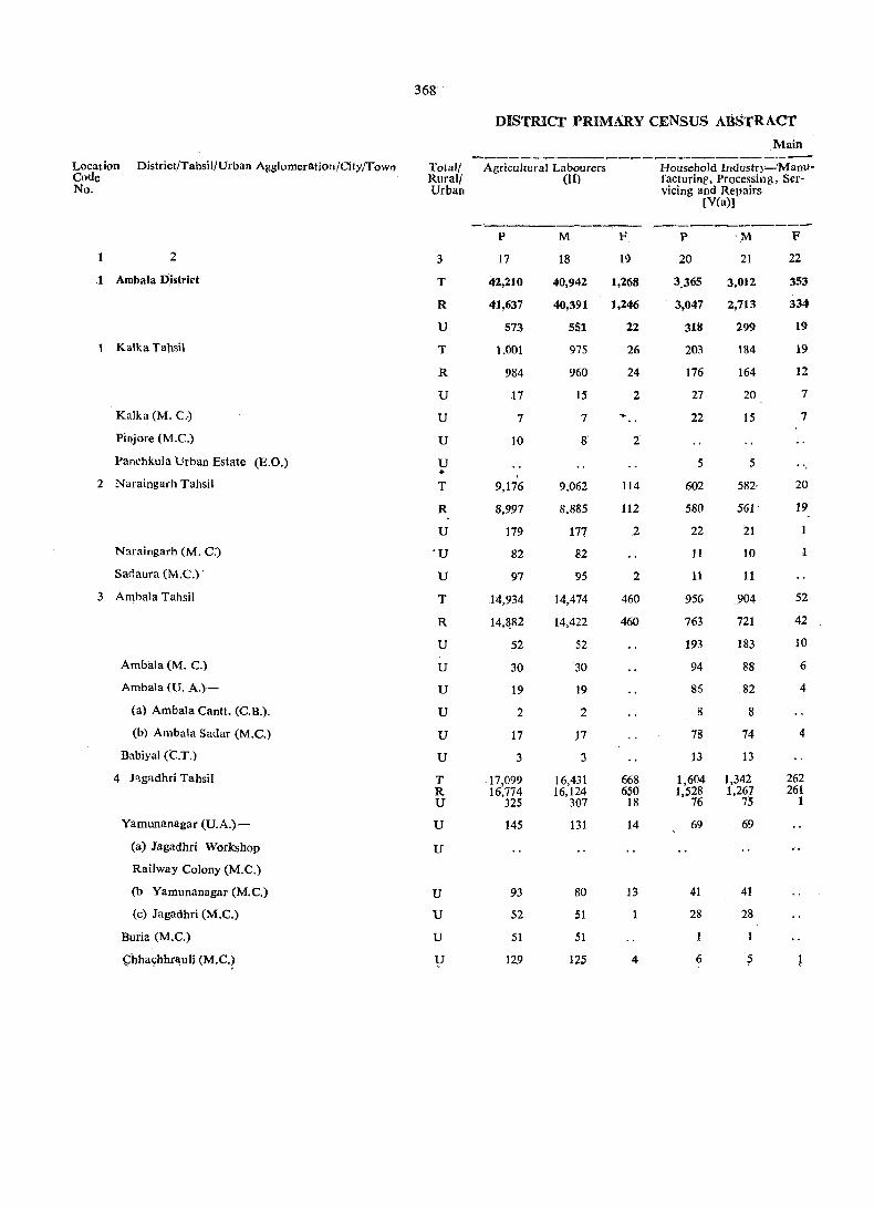
368·
DISTRiCT PR][MARY CENSUS ABSTRACT
Main . ----------
Location District/Tahsil/Urban Agglomeration/City/Towll TotalJ AgricultUral Labourers Household Industry-'Manu-Code Rurall (11) facturinl'. Processing, Ser-No. Urban vicing and Repairs
[yea)]
p M F p ·M F
2 3 17 18 19 20 21 22
1 Ambala D,istrirt T 42,210 40,942 1,268 3.365 3.012 353
R 41,637 40,391 1,246 3,047 2,713 334
U 573 551 22 318 199 19
1 Kalka Tahsil T 1.001 975 26 203 184 19
R 984 960 24 176 164 12
U 17 15 2 27 20 7
Kalka (M. C.) U 7 7 22 15 7
Pinjore (M.C.) U 10 8 2
Panchkula Urban Estate (E.O.) U 5 5 .. 2 Naraingarh Tahsil T 9,176 9,062 114 602 582· 20
R 8,997 8,885 112 580 561 19
U 179 177 2 22 21
N~raingarh (M. C:) 'U 82 82 11 10
Sad aura (M.C.) . U 97 95 2 11 11
3 Ambala Tahsil T 14,934 14,474 460 956 .. 904 52
R 14,&!l2 14,422 460 763 721 42
U 52 52 193 183 10
Ambliia (M. C.) U 30 30 94 88 6
Ambala (0. A.)- U 19 19 86 82 4
(a) Ambala Cantt. (C.B.). U 2 2 8 8
(b) Ambala Sadar (M.C.) U 17 17 78 74 4
Babiyal (C.T.) U 3 3 13 13
4 Jagadhri Tahsil T 17,099 16,431 668 1,604 1,342 262 R 16,774 16,124 650 1.528 1,267 261 U 325 307 18 76 75 1
Yamunanagar (U.A.)- U 145 131 14 69 69
(a) Jagadhri Workshop U
Railway Colony (M.e.)
(b Yamunanagar (M.C.) U 93 80 13 41 41
(c) Jagadhri (M.e.) U 52 51 1 28 28
Buria (M.e.) U 51 51
C:hha~hhr~uli (M.C.? V 129 125 4 6 5

OF SCHEDULED CAstES~concld
Workers ._---
Other Workers [III, IV, V(b) & VI to IX]
P
23
38,599
23,942
14,657
6,057
4,320.
1,737
986
109
642
4,096
3,297
799
511
288
14,416
6.841
7.575
2,604
4,458
1.421
3,037
513
14,030 9,484 4,546
4,292
343
2,758
1,191
66
188
M
24
35,621
22,444
1,317
5,277
3,824
1,453
896
96
461
3,824
3,089
735
463
272
13,400
6,523
6,877
2,276
4,119
1,327
2,792
482
13,120 9,008 4,112
3,878
326
2,510
1,042
51
183
~-----
F
25
2,978
1,498
1,480
780
496
284.
90
13
181
272
208
64
48
16
1,016
318
698
328
339
94
245
31
910 476 434
414
}7
248
149
15
5
P
26
3,549
3,432
117
89
87
2
...
590
570
20
19
783
719
64
12
52
5
47
2,087 2,056
31
12
8
4
19
Marginal Workers
M
2i
939
889
50
38
38
167
153
14
14
268
242
26
3
23-
2
21
466 456
10
10
6
4
F
28
2,610
2,543
67
51
49
2
423
417
6
5
515
477
38
9
29
3
26
1.621 1,600
21
2
2
19
13100 DCO (H)-Govt. Press, D.T., Chd.
P
29
233,126
195,7(l9
37,417
16,479
13,308
3,171
2,480
256
435
42,655
39,803
2.852
1,722
1,130
86,947
66,631
20,316
6,346
12,280
4,119
8,161
1,690
87,045 75,967 11,078
10,045
880
6,538
2,627
223
810
Non-Workers
M
30
87,994
73,333
14,661
6,381
5,099
1,282
979
104
199
15,837
14,735
1,102
676
426
32,854
24,932
7,922
2,517
4,735
1,617
3-,118
670
32,922 28,567
4,355
3,975
375
2,645
9~5
803
300
F
31
145,132
122,376
22,756
10,098
8,209
1,889
1,501
152
236
26,818
25,068
1,750
1,046
704
54.093
41,699
12,394
3,829
7,545
2,502
5,043
1,020
54,123 47,400
6,723
6,070
50,5
3,893
1,672
143
510

Loca Code No.
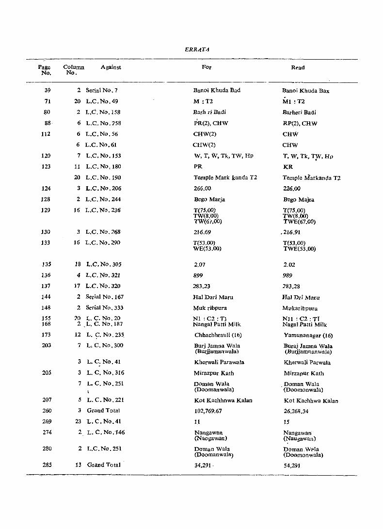
ERR A, T.4
Page Column Against FOr Rt'ad No. No.
39 2 Serial No." Banoi Khuda Bad Banoi Khuda Bax ~
71 20 L.C.No.49 M :T2 MI. :T2
SO 2 L.C.No.158 Barh ri Badi Barheri Badi
88 6 L.C.No.:?58 ,
RP(2),CHW PR(2),CHW
112 6 L.C.No.56 CHW(2) CHW
6 L.C.No.61 CHW(2) CHW
120 7 L.C.No.153 W, T. W. Tk., TW, Hp T, W. Tk, TjV, HI}
123 11 L.C. No. ISO PR KR
20 L.C.No.190 Temple Mark kanda T2 Temple Markancla T2
124 3 L.C.No.206 266.00 226.00
128 2 L.C.No.244 Bego Marja Bego Majra
129 16 L.C. No. 236 T(75.oo) T(75.00) TW(8:00) TW(8.00) TW(6/.00) TWE(67.00)
130 3 L.C.No.268 216.69 .216.91
133 16 L.C.No.290 T(53.00) T(53.00) WE(53.00) TWE(53.00)
135 18 L.C.No.305 2.07 2.02
136 4 L.C.Nv.J21 899 989
137 17 L.C.No.J20 283.23 283.28
144 2 Serial No. 167 Hal Dad Maw Hal Dri Maw
148 2 Sf'rial No. 333 Muk ribpura Ml1karibpura
]55 20 L. C. No. 20 Nt : C2: Tl Nl1 : (;2: TI 168 2 L. C. NO.IR7 Nangal Patti Milk NagaI Patti Milk
173 12 L. C. No. 235 Chhachhrauli (16) Yamunanagar (16)
203 7 L. C. No. 300 Burj Jamna Wala Buraj Jamna Wala (Burjjamanwala) (Burjjamnanwala)
3 L. C. No. 41 Kherwali Parawala Kherwali Parwala
205 3 L. C. No.316 Mirazpur Kath Mirzapur Kath
7 L. C. No. 251 Doman Wala Doman Wala (Doomanwala) (Doomonwala)
207 5 L. C. NO.221 Kot Kachhnwa Kalan Kot Kachhwa Kalan
260 3 Grand Total 102,769.67 26.268.34
269 23 L.C.No.41 11 15
274 2 L. C. No.146 Nangawan Nangawan (Naogawan) (Nau~awan)
280 2 L.C.No.251 Doman Wala Doman.W?la (Doomanwala) (Doomonwala)
285 13 Grand Total 34,291, 54,291

Page Column Against Por Read No. No.
286 8 SadalU'a (M.C.). 522 422 Ward No. 'I
302 7 L. C. No. 198 2,651 1,651
312 2 AmfJala Cantt. (C.B.) Blank 6 Below Ward No, S
318 2 L.C.No.34 Tunde Ki Taprian Tunde Ki Tapariaa
320 5 L.C. No.3S 3 39
4 L.C.No.42 10 14
321 23 L.C.No.S3 8 78
329 25 L.C. No. 194 1
333 17 L.C.No.2S0 30 33
341 26 L.C.No.400 9 19
26 L.C.No.401 IS 8
342 2 L.C. No. 431 Agijpur Ajijpur
349 20 Jagadhri (M.C.) Blank 8
21 Jagadhri (M.C.) 81,080 1,080
28 Jagadhri Works~lop Rly. Colon)" (M.C.)
3,488 3,448
351 17 Buria (M.C.) 2 25 Ward N('. 7 ..
356 3 Ambala (M.C.) .869 4.869 Ward No. t
360 4 Ward No. 20 166 266 Block NO.9!
366 4 Kalka (M.C.) 644 664
7 Chhachhr~i (M.C.) Blank 539
369 30 Buria (M.C.) 803 80