Village & Townwise Primary Census Abstract, Darjiling, Part ...
Upload
khangminh22Category
view
0download
0
E S FI 2001
SERIES-22
DISTRICT CENSUS HANDBOOK
Part - A & B
1ST
VILLAGE & TOWN DIRECTORY
--}
VILLAGE AND TOWNWISE PRIMARY CENSUS ABSTRACT
cYfTCfIT~~ PEOPLE ORIENTED
Manoranjan Saran of the Indian Administrative Service
Director of Census Operations, Orissa
ORISSA
The maps included in this publication are based upon Survey of India map with the permission of the Surveyor General of India.
The territorial waters of India extend into the sea to a distance of twelve nautical miles measured from the appropriate base line.
The interstate boundaries between Arunachal Pradesh, Assam and Megl1alaya shown in this publication are as interpreted from the North-Eastern Areas (Reorganisation) Act, 1971 but have yet to be verified.
The state boundaries between Uttaranchal & Uttar PrF~desh, Bihar & Jharkhand and Chhattishgarh & Madhya Pradesh have not been verified by government concerned.
© Government of India, Copyright 2007.
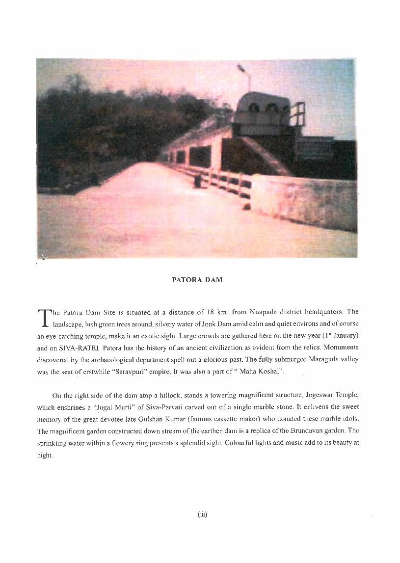
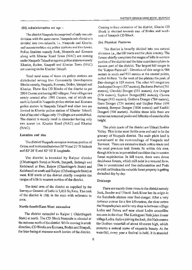
PATORA DAM
The Patora Dam Site is situated at a distance of 18 km. from Nuapada district headquaters . The
landscape, lush green trees around, silvery water of Jonk Dam amid calm and quiet environs and of course
an eye-catching temple, make it an exotic sight. Large crowds are gathered here on the new year (1 st January)
and on SIVA-RATRl. Patora has the history of an ancient civilization as evident from the relics. Monuments
discovered by the archaeological department spell out a glorious past. The fully submerged Maraguda vaHey
was the seat ~f erstwhile "Saravpuri" empire. It was also a part of" Maha Koshal".
On the right side of the dam atop a hillock, stands a towering magnificent structure, Jogeswar Temple,
which enshrines a "J\}gal Murti" of Siva-Parvati carved out of a single marble stone. It enlivens the sweet ./
memory of the great devotee late Gulshan Kumar (famous cassette maker) who donated these marble idols.
The magnificent garden constructed down stream of the earthen dam is a replica of the Brundavan garden. The
sprinkling water within a flowery ring presents a splendid sight. Colourful lights and music add to its beauty at
night.
(iii)

Foreword
Preface
CONTENTS
Acknow ledgemen t
District Highlights - 2001 Census
Important statistics in the District
Ranking of Police Stations in the District
Statement I
Statement 2
Statement 3
Statement 4
Statement 5
Statement 6
Statement 7
Statement 8
Statement 9
District Map
Analytical Note
Name of the headquartcrs of District/Tahasils, their rural/urban status and distance from district headquarters, 2001
Name of thc headquarters of district/CD Block, their rural-urban status and distance from district headquarters, 2001
Population of the district at each Census fi'om 190] to 2001
Area, number of villages/towns and population in district
and Police Station, 2001
CD Block-wise number of villages and rural population, 200 I
Population of Urban Agglomerations/towns, 2001
Villages with population of 5,000 and above at CD Block level as per 2001 Census and amenities available
Statutory towns with population less than 5,000 as per 2001 Census and amenities available
HouseJess and Institutional population of
Police Stations, rural and urban, 2001
1. History and scope of the District Census Handbook
2. Brief history of the district
3. Administrative set-up
4. Physical features: Location, size, physiography, relief, drainage, climate, agriculture, industry, gram panchayat and cropping pattern
5. Mil:;or characteristics of the district ill the form of any historical figure associated with the district
(v)
Pages
ix
XI
xiii
xv
xvi
xviii
xix
xix
xx
xxi
xxii
xxii
XXII
xxii
xxiii
xxv
3
4
6
6
11
6. Blicf description of places of religiolls importance,
historical and tourist interest ill the district
7. Censlis concepts
8 Non-censlIs concepts
9. 200 I census findings - Population, its distribution
10. Brief' analysis of peA data based on inset tables I to 36
11. Drief analysis of the Village Directory and Town Directory
data based on inset tables 37 to 47
12. Brief analysis of the data 011 houses and household amenities,
12
14
22
25
26
45
HOllselisting Operations, Census or lndia 2001 based on inset tables 48 to 52 50
13. Scope of Village Directory 58
14. Scope of Town DirectOlY 59
PART A- VILLAGE AND TOWN DIRECTORY
SECTION - I - VILLAGE DIRECTORY
Note explaining the abbreviations used in the Village Directory
List of Villages merged in Towns and outgrowths at 2001 Censlls
CD modi-wise Ilrescntation of ViIltlge Directory data
1. Nuapada CD Block Map
Alphabetical list of Villages Amenities & Land lise
2. Komana CD Block
Map Alphabetical list of Villages Amenities & Land use
3. Boden CD Block Map
Alphabetical list of Villages Amenities & Land use
4. Sinapali CD Block Map
Alphabetical list of Villages Amenities & Land use
5. Khariar CD Block
Map Alphabetical list of Villages Amenities & Land use
Appendices to Village Directory : I to VIII
(vi)
63
66
67 70 74
109 113 116
149 152 154
173 177 180
205 209 212
237
SECTION -- II - TOWN DIRECTORY
Note explaining the abbreviations used in Town Directory
Town Directory Statements (I to VII) :
STATEMENT I - Status and Growth History
STATEMENT II - Physical aspects and location of towns, 1999
STATEMENT Iff - Municipal finance, 1998-99
STATEMENT IV - Civic and other amenities, 1999
STATEMENT V - Medical, Educational, Recreational and Cultural Facilities
STATEMENT VI - Tracie, Commerce, Industry and Banking,1999
STATEMENT VI[ - Civic and other amenities in slums,1999
PART B - PRIMARY CENSUS ABSTRACT
Brief note 01) Primmy Censlls Abstract
Distnct Primary Census Abstract (General)
Appendix to District PrimalY Census Abstract i.e.Urban block wise figures of
Total, SC and ST Population
Primary Census Abstract for Scheduled Castes
Primary Census Abstract for Scheduled Tribes
cn. Block-wise Village Primary Census Abstract
Primmy Census Abstract - CD Block Nuapada
Primary Census Abstract - CD Block Komana
Primary Census Abstract - CD Block Boden
Primary Census Abstract - CD Block Sinapali
Primary Census Abstract - CD Block Khariar
Urban Primary Census Abstract
267
271
271
272
272
273
274
274
277
282
291
294
302
310
330
350
364
384
398
Annexure I Number of villages under each Gram Panchayat (CD Blockwise) 407
Annexure II - Feltility and Mortality, 1991 Census 410
Annexure III - Various measures of fertility and mean age at marriage, 1991 Census 410
Annexure IV - Percentage Distribution of Migrants by place of birth/place of last residence, 2001 Census 412
Annexure V - Brief account of main religions in the district/tahasi I as per 2001 Census 413
Annexure VI - Marital status of popUlation as per 2001 Census 414
Annexure VII - Age, Sex and Education in the district, 2001 Census
Annexure VIII - Distribution of different mother tongues returned in 2001 Census
(vii)
415
418

Foreword
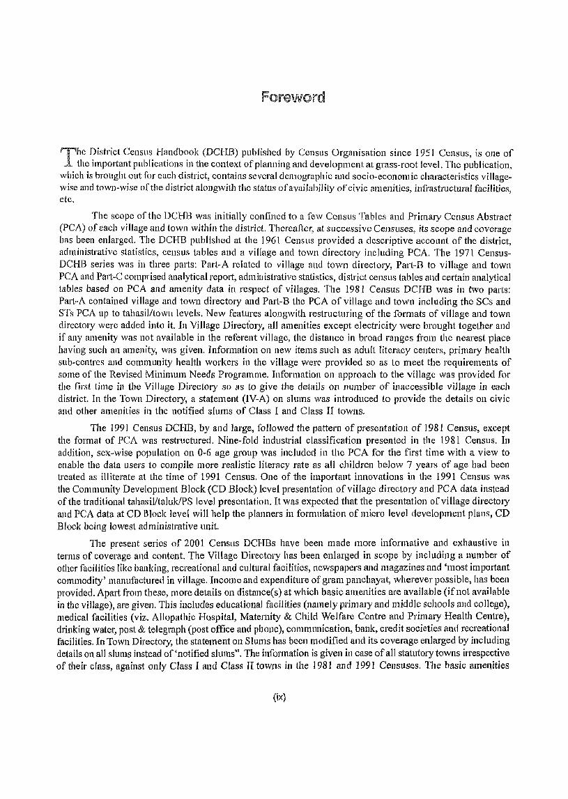
The District Census Handbook (DCHB) published by Census Organisation since 195 I Census, is one of the important publications in the context of planning and development at grass-root level. The publication,
which is brought out [or each district, contains several demographic and socio-economic characteristics village~ wise and town~wise of the district alongwith tIle status ofavailability of civic amenities, ilJfrastructural facilities, etc.
The scope of the DCBB was initially confined to a few Censlls Tables and Primary Census Abstract (PCA) of each village and town within the district. Thereafter, at successive Censtlses, its scope and coverage has been enlarged. The DCBB published at the 1961 Census provided a descriptive account of the district, administrative statistics, census tables and a village and town directory including PCA. The 1971 Census~ DCBB series was in three parts: Part~A related to village and town directory, Pati-B to village and town PCA and Pati-C comprised analytical report, administrative statistics, district census tables and certain analytical tables based on PCA and amenity data in respect of villages. The 1981 Census DCRB was in two parts: Part-A contained village and town directory and Part~B the PCA of village and town including the SCs and S'Cc; PCA up to tahasilltown levels. New features alongwith restructuring of the formats of village and town directory were added into it. In ViIlage Directory, all amenities except electricity were brought together and if any amenity was not available in the referent village, the distance in broad ranges from the nearest place having such an amenity, was given. Information all new items such as adult literacy centers, primmy health sub-centres and community health workers in the village were provided so as to meet the requirements of some of the Revised Minimum Needs Programme. Information on approach to the village was provided for the first time in the Village Directory so as to give the details on number of inaccessible village in each district. In the Town Directory, a statement (IV-A) on slums was introduced to provide the details on civic and other amenities in the notified slums of Class I and Class II towns.
The 1991 Census DCHB, by and large, followed the pattern of presentation of 1981 Census, except the format of PCA was restructured. Nine-fold industrial classification presented in the 1981 Census. In addition, sex-wise population on 0-6 age group was included in the PCA for the first time with a view to enable the data users to compile more realistic IHeracy rate as all children below 7 years of age had been treated as illiterate at the time of 1991 Census. One of the important innovations in the 1991 Census was the Community Development Block (CD Block) level presentation ofviIlage directory and PCA data instead of the traditional tahasilltaluk/PS level presentation. It was expected that the presentation of village directOlY and PCA data at CD Block level will help the planners in formulation of micro level development plans, CD Block being lowest administrative ullit.
The present series of 2001 Census DCHBs have been made more informative and exhaustive in terms of coverage and content. The Village Directory has been enlarged in scope by including a number of other facilities like banking, recreational and cultural facilities, newspapers and magazines and 'most important commodity' manufactured in village. Income and expenditure of gram panchayat, wherevel' possible, has been provided. Apart from these, more details on distance(s) at which basic amenities are available (if not available in the village), are given. This includes educational facilities (namely primary and middle schools and college), medical facilities (viz. Allopathic Hospital, Maternity & Child Welfare Centre and Primary Health Centre), drinking water, post & telegraph (post office and phone), communication, bank, credit societies and recreational facilities. In Town Directory, the statement on Slums has been modified and its coverage enlarged by including details on all slums instead of 'notified slums". The information is given in case of all statutory towns irrespective of their class, against only Class I and Class II towns in the 1981 and 1991 Censuses. The basic amenities
(ix)
available in the villages and towns are analysed in depth with the help of a number of cl'Oss-dassified inset tables and statements. Two other significant additions in the publicatioll are iuclusion of 'motif' highlighting significant eharacteristic of the district and analytical notes as annexures. The allalytical notes on (i) fertility and mortality and (ii) variolls measures of fertility and mean age at marriage are prepared based on 1991 CenslIs. Wlwreas, in the noies relating to (0 percentage distribution of migrants by place of birth/place of iast residl;Jl1ctl, (ii) mal1l religions, (iii) 111a1 ital slains of population, (iv) age, sex and education, and (v) distribution of spectrum of mother tongue, nature and extent of changes occurred in the district in its basic socio demographic features during the decade 1991-2001 are analysed. The eight digits permanent location coele (PLCN) to all the villages and towns have been assignee! keeping in view the future needs.
The village and town level amenity data have been collected, compiled and computerized in prescribed record structure uncleI' the supervision of Shri Manoranjan Saran, Director of Census Operations, Orissa. Thereafter, effolt have been made to ensure comparability of the information with that of 1991 Census dala and the information brought oui by the respective state governments in their annllal reports and statistical handbooks for various years after 1991. The task of planning, designing and coordination of this publication was carried out by Shri RG.MitI a, Deputy Registntf General (C & T) and Dr. I.e. Agrawal, Senior Research Officer of Social Studies Division. Dr. RP. Singh, Deputy Registrar General (Map) provided the technical guidance in the preparation of maps. Whereas, Shri Anil Kumar Arora, Deputy Director of Data Processing Division who worked under the overall supervision of Shri Himakar, Addl. Director (EDP) helped in preparation of record structure for computerisation of village and town directory data and the programme for the generation of Village Directory and Towll Directory staiements including analytical inset tables. The draft DCHB manuscripts received fi'om the Census Directorates have been scrutinized in the Social Studies Division under the guidance of Shri S.LJaill, Deputy Director and Shri R.K.Mehta, Assistant Director. I am thankful to all of them and others who have contributed to make this publication possible.
New Delhi Dated: 17.10.2006
(x)
D.KSikri Registrar General &
Censlls Commissioner, India
Preface
The District Census Handbook (DCHB) brought out by the Census Organisation after each Census is one
of the most valuable and important publications providing grass-root level data in order to cater to the
needs and aspiration of the people at large. The publication is compiled and prepared for each district of the
state by the Census Organization all behalf of the State Government. It not only contains the numeric figures
relating to the people in villages and towns but also gives a clear picture on the quality of their life. These
publications are widely used by the State Government functionaries at the district level as well as other levels
for planning, development ancl administrative purposes in addition to a large cross-section of data users,
academicians, scholars, researchers and other non-governmental agencies who derive maximum utility of
these publicati011s. The Registrar GeJleraJ & Census Commissioner, India in his foreword has highlighted the
improvements in the publication brollght out from time to time since its inception.
As per 2001 Census publication programme, it has been proposed to publish the District Census Handbook
ill two parts i.e. Part A - Village and Town Directory and Part B - Village and Town Primary Census
Abstract. Part A of the publication contains information on basic amenities available to the villagers and land use data supported by a number of tables and its analysis on non-census data for villages and towns. Part
B of the publication on the other hand contains details census data for villages alld towns in the form of
Primary Census Abstract. The contents and coverage of the publication have been designed in a uniform
manner by the Registrar General & Census Commissioner, India. By and large, the manner of presentation
of DCHBs of the 200 I Census is similar to the 1991 Census. However, the publications have been made
more informative and exhaustive keeping at par with the changes in socio-economic scenario of the nation
and the requirement of the data users. It is hoped that the publication would be helpful to the planners,
administrators in formulating micro level developmental planning.
The collection and compilation of such a huge data was indeed a formidable task requiring crusader's
zeal on the part of different functionaries. Information on amenities and land use data for Village Directory
has been collected from the Tahasilclars while the Chief Executive Officers of the Municipal Corporations
and Executive Officers of the MunicIpalities and Notified Area Councils have provided the information for
towns. Data collected as such have been cross-checked with the help of the official data collected from
various Departments/Organisations like Reserve Bank of India, Department of Post, Government of India, Directorate of Health Services and Directorate of Indian System of Medicine & Homeopathy, Directorate
of Higher Education etc; Government of Orissa. Though all types of efforts have been taken for removal
of discrepancies in the figures, yet the possibility of some error still creeping into them cannot be altogether
ruled out.
Till 1991 Census, The Director of Census Operations had the responsibility fol' providing data whereas
its publication was the responsibility of the State Governmel1t. However, this time the publication is being
brought out by the Govt. oflndia. The publication will also be made available for the first time in electronic
format to the numerous data users.
I express my deep gratitude to Shri J.K. Bal1thia, lAS, Registrar General & Census Commissioner, India,
Shri Ro. Mitra, Deputy Registrar General (C & T) and Dr. I.e.AgrawaJ, Sr. Research Officer of Social Studies
Division and other officers of the Registrar General's office for their valuable guidance ill preparing this volume.
(xi)
I am glatetul to the ciep,utments of the Govt o( OII'>Sd, Heads of iJepclltmentq, Colleciol,) and othel dlst! leI officer~, Tdhdstldalb, Block Develoment Ofike) '>. Cillel LAet-utlve Ofilt-els and ExecutIVe Officelb
of the town~ who h,lVe e..<.tended theu co-operatIOn and he! p fot collectmg su<-h voluminous lind useful ddta
1 ~m also grateful to the auti10lliles 01 Reserve B,mk ofJndla dnd Po ... tal Depmtment fnt PIOVldll1g u;qlllsite ddta
I would be fadtng 111 my duty, unles~ I tlcknowledge the ImpOItant IOle played by my colleagues, who have
been clSSOclated with the plOJect one way 01 the othel, ior theu SllIcelC ettol ts to bJlng Ollt tIlls publICatIOn
Bhubal1esw,lI
JanlldlY, 2004
(XII)
Manoranjan Saran DIl ecto! of Census Opel atlOl1S,
Orissa
Acknowledgement
Editing ~md SupenTisiolU
I Shri D.Bchem 2 Shri A.K.Samal 3 Shri PrHtap Singh 4 Shri P. Tripalhy 5 Shri Pravakar Barad 6 Shri H.K.Singh
Village and Town Directory Ullits
Shri A. C. Samantary 2 Shn D. C. SainI 3 Shri B. M. Patnaik 4 Shri Niren Shame 5 Shri A.N.Nayak 6 Shri A. C. Dehcra 7 Shri Tapanesh Ray 8 Shri C. R. Mishra 9 Shri P. K. Das
IO Shri R. C. Das 11 Shri A. K. Patnaik 12 Shri D. K. Bose 13 Shri Sunaram Mahali 14 Shri Niral\jan Panda 15 Shri K. R. Tripathy 16 Shri A. K. Dey 17 Shri P. K. Mishra
18 Shri S. N. Mohapatra 19 Shri M. A. Maj id 20 Shri B. C. Mohapatra 21 Shri S. S. Roy 22 Shri Sallatan Naik 23 Shri N. C. Das 24 Shri P.KBhuyan 25 Shri R.N. Mishra 26 Shri S. N. Seth 27 Shri Babu Padhy 28 Shri B. K. Rath 29 Shri P. K. Padhi
Programming and data pl'ocessing 1 Shri Padarbinda Rath
(xiii)
Deputy Director Deputy Director Deputy Director Deputy Director Deputy Director Assistant Dj rector
S. 1. Gr.I S. I. Gr.I S. I. Gr.I S. 1. Gr.l Investigator (SS) Gr.} S. r. Gr.II S. I. Gr.II S. I. GdI S. I. Gr.II S. 1. Gr.11 S. 1. Gr.n S. 1. GrJl S. r. Gr.11 S. 1. Gr.III S. r. Gr.III S. I. Gr.IIl S. 1. Gr.m S. 1. Gr.III S. r. Gr.Iff S. 1. Gr.III S. I. Gr.III S. 1. Gr.III S. 1. Gr.JII S.l. Gr.III S. I. Gr.III S. 1. Gr.III Assistant Compiler L. D. C.
DPA Or.'A'
C, R C. IJn~panl1iou
SlJri Akshya Ku. Molwpatrn 2 Shl'i Santosh Kll. J\clwrya
3 Shri Gora Chand Saho()
4 Shri Debcndra Kuma;' Mohapatra
5 Shri Madan Mohan Behera
6 Shri Nabin Chandra SalHI I), C. A. Unit
I Shri D. Selhy 2 SIt!'i.l. Pali 3 SlIl'i R. K. Pallcy 4 Sl1l'i S. K. Dutta
5 Shri A. K. lena 6 Shri S. K. Kabisatpalhy 7 Shl'i K. C. Padhi 8 SIt!'i Niranjan Saboo
9 Shri P.K. S<llwo
10 Shri SIc. S. Hussain
11 Shri Sridhar Naynk 12 Shl'i Maheswar Nayak 13 Shri R. C. Singh
14 8hri Sankarsall Barik
15 Shri Pramoda Patnaik
Map Unit Supervision
1 Shri J. P. Rout
Pl'eparatioll of Maps
1 Shri T. S. Khadatkar 2 Shri M. N. Das 3 Shl'i R. N. Tiyu 4 Sh!'i S. Mulia 5 Shd S. C. Mallik 6 Shl'i S. K. Nayak 7 Shri D. K. Pradhan 8 Shd G. N. Mohapatra 9 Shri P. K. Ray
10 8hri J.N. Acharya
11 Shri P. K. Dehera 12 Shri G. C. Nayak 13 Shri P. K. Das
Printing 1 Shri B.K.Sahu 2 Shri D.N.Mishra 3 Shri Sudarsan Mishra 4 Smt.M.Panda
(xiv)
DED Gr. 'l3' DEO Gr. '13' DEO Gr.'B' DE() (it. 'I)'
DEO Gr.'B' Stenographer Gr.Ill
S. I. CI r.I S.l. Gr.fI
S. 1. Cir.II S. 1. Gr.1I
S. 1. Gr.n
S. r. Gr.1l S. I. Or.III
S. I. Or.llI S. l. Gdfl S. 1. Gr.! II S. L Gr.lrI
S. I. Gr.Ill S. I. Or.III S. I. Gr.IIl Compiler
Research Officer(Map)
Sr. Geographer Sr. Drawing Assistant Geographer
Sr. Draftsman
Sr. Draftsman
Sr. Draftsman
Sr. Draftsman Sr. Draftsman Draftsman Draftsman
Draftsman !IPMO HPMO
STA(Ptg.) Printing Inspector
S.1. Gr.III Proof Readet"
pistrict Highlights ... 2001 CenslUs
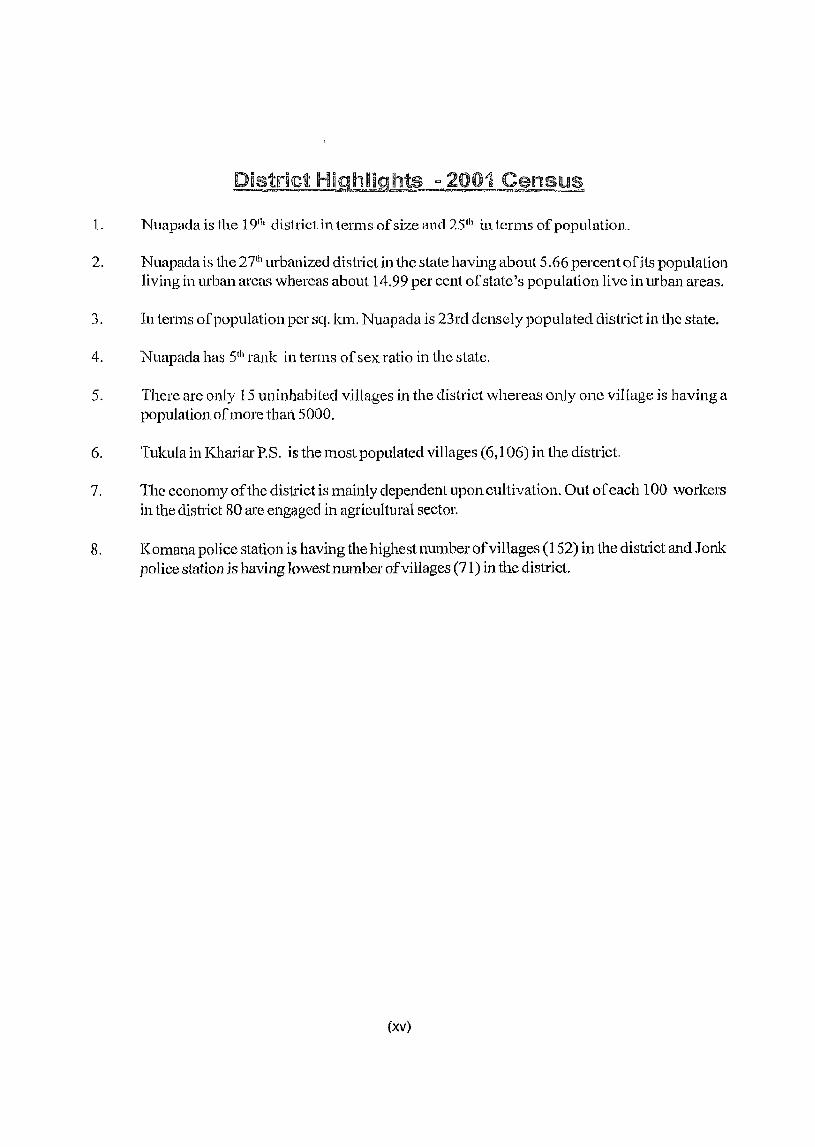
1. Nuapac1a is the 191h district in terms of size and 25th in terms of population.
2. Nuapada is the 27th urbanized district in the state having about 5.66 percent of its population living in urban areas whereas about 14.99 per cent of state's popUlation live in urban areas.
3. In terms of population per sq. km. Nuapada is 23rd densely popUlated district in the state.
4. Nuapada has 5th rank ill terms of sex ratio in the state.
5. There are only 15 uninhabited villages in the district whereas only one village is having a population o[more thar15000.
6. Tukula in Khariar P.S. is the most populated villages (6,106) in the district.
7. The economy of the district is mainly dependent upon cultivation. Out of each 100 workers in the district 80 are engaged in agricultural sector.
8. Komana police station is having the highest number of villages (152) in the district and J onk police station is having lowest munber of villages (71) in the district.
(xv)
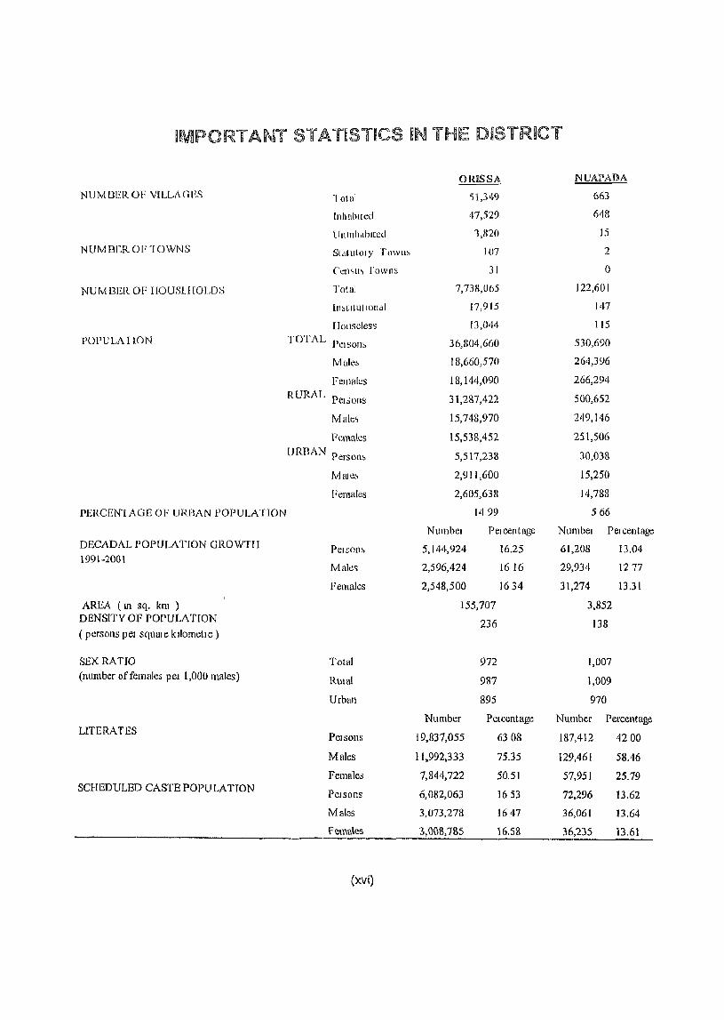
IMPORTANT STATISTICS iN THE OISTRJCT
omSSA NUAPAIJ>A
NUMBEROF VILLAGES "! (llnl '51,349 663
InhahIted 47,529 648
lhtlnildbltcd 1,820 15
NUMBeR 01'"1 OWNS S(,\(ul(llY Towll> 107 2
Ccn~ll" [owns 31 0
NUMBER OF IIOUSLIIOLDS TOUll 7,738,065 122,601
In~tltlillon<ll 17,915 147
lIollscles~ 13,044 115
l'OPULAI ION TOT AL PC1SOJl~ 36,804,660 530,690
Malc~ 18,660,570 264,396
FClllnk:s 18,144,090 266,294
RURAL Pel sons 31,287,422 500,652
Malc, 15,748,970 249,146
Ft:males 15,538,452 251,506
URDAN Person~ 5,517,238 30,038
Mnlc5 2,911,600 15,250
Females 2,605,638 14,788
PERCEN'IAGE OF URBAN POPULATION 1499 566
NUl11bel Pel cent age Numbel Pelcentage DECADAL POPULATION GROWTH
Pelson~ 5,144,924 16.25 61,208 l3.04 1991-2001
Mule~ 2,596,424 1616 29,934 1277
Females 2,548,500 1634 31,274 13.31
AREA (Ill sq. km ) 155,707 3,852 DENSfTY OF POPULATION 236 138 (persons pel squme kllometle)
SEX RATIO Total 972 1,007 (number of females pel 1,000 males) Rmul 987 1,009
Urban 895 970
Number Pel cent age Number Percentage LITERATES Pelsons 19,837,055 6308 187,412 4200
Males 11,992,333 75.35 129,461 58.46
Females 7,844,722 50.51 51,951 25.79 SCHEDULED CASTE POPULATION Pelsons 6,082,063 1653 72,296 13.62
Males 3,073,278 1647 36,061 13.64
Females 3,{)(lS,7SS '6.58 36,'235 13.61
(xvi)
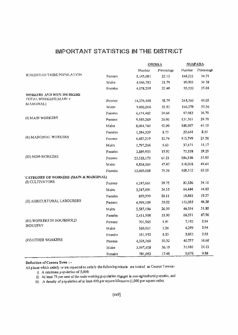
IMPORTANT STATISTICS IN THE DISTRICT
omSSA NUAPADA
Number Percentage Number Percentage SCIIEDULED TRIBE POPULATION Persons 8,145,081 22,13 184,221 34,71
Males 4,066,783 21.79 90,901 3438
Females 4,078,298 22.48 93,320 35,04
WORl<EHS ANI) NON-WORKERS rOTAL WORKERS (MAIN + Persons 14,276,488 38,79 244,360 46.05 MARGINAL)
Males 9,IlO2,OO6 52.53 146,378 55,36
Females 4,474,482 24.66 97,982 36.79 (I) MAIN WORKERS Pel sons 9,589,269 26,05 131,561 24,79
Males 8,004,740 42,90 108,907 41.19
Females 1,584,529 8,73 22,654 8,51
(11) MARGIN AI, WORK ERS Persons 4,687,219 12.74 112,799 21,26
Males 1,797,266 9,63 37,471 14,17
Females 2,889,953 15,93 75,328 28,29
(HI) NON-WORKERS Persons 22,528,172 61.21 286,330 53.95
Males 8,858,564 47.47 118,018 44.64
Females 13,669,608 75.34 168,312 63,21
'CAn:CORY OF WORKERS (MAIN & MARGINAL) (I) CULTIVATORS Persons 4,247,661 29.75 83,326 34,10
Males 3,347,691 34,15 64,444 44.03
Females 899,970 20,11 18,882 19.27
(II) AGRICULTURAL LABOURERS Persons 4,999,104 35,02 113,085 46.28
Males 2,587,196 26,39 46,554 31.80
Females 2,411,908 53,90 66,531 67.90
(III) WORKERS IN HOUSEHOLD Persons 701,563 4.91 7,192 2.94 INDUSTRY
Males 320,011 3,26 4,299 2.94
females 381,552 8.53 2,893 2,95
(IV) OTHER WORKERS Persons 4,328,160 30.32 40,757 16.68
Males 3,547,108 36.19 31,08] 21.23
Females 781,052 17.46 9,676 9.88
Definition of Census Town: -All p laces which satisfy or are expected to satisfy the following criteria are treated as Census Towns:-
i) A minimultl population of 5,000; ii) At least 75 per cent of the male working pop ulatioll engaged in non-agricultural pursuits, and
iii) A density of p opuiatiol1 of at least 400 per square kilometre (1,000 pet' square mile),
(xvii)
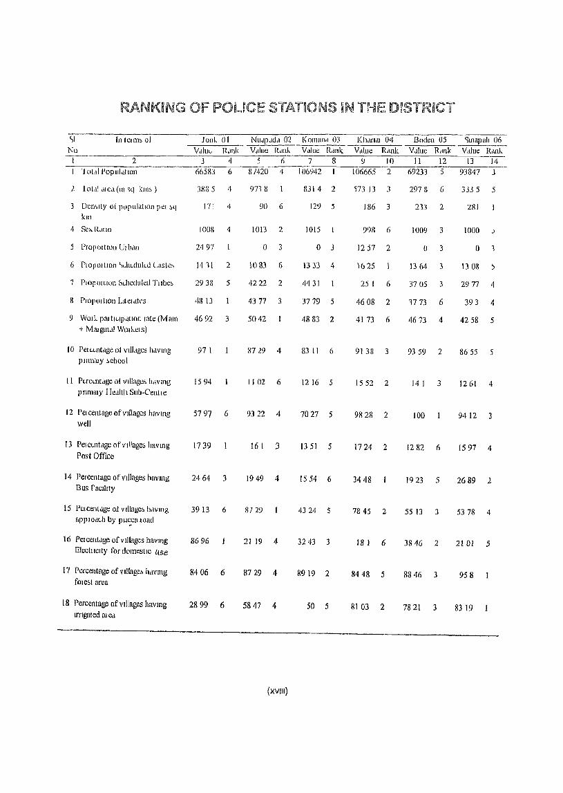
RANKING OF POLICE STATIONS IN THE DISTRICT
<,1 In tellW> of Jonk 01 NU,IP,ld<l 02 Komana 03 Kharlal 04 Boden 05 "Illapah 06 Nll VdlllL, R,lllk Value RcUlk Vclluc Rdnk Vdlue Rcmk Value Rcll1k Vcllue Rank
I 2 3 4 5 6 7 B 9 10 II 12 13 14 1 olLlI POpUI.ltlOll 66583 6 81420 4 106942 106665 2 69233 5 93847 j
1 lot<lldIC,I(lll~q kl1l~) 3885 4 9718 8314 2 '573 13 3 2978 6 3335 5
3 Demlty of P0]1UI,ltIOIlIH!1 ~q 171 4 90 6 129 5 186 3 233 2 281 kill
<I SC), R<llIO lOOn 4 1013 2 lOIS 998 6 1009 3 1000 .)
5 ProPOltlO1I Ulbdll 2'197 () 3 0 3 1257 2 0 3 0 '1
6 PlOP 01 ttoll SdlL,clnkd Caslc~ 14 11 2 1083 6 13:lJ i~ 1625 1364 3 1301l ;,
7 PIOpoltlOll Schecluled Tllbe~ 2938 5 4222 2 4431 25 I 6 3705 3 2977 4
1I PIOPOlllOll Lltel<ltt·s 4813 4377 3 3779 5 4608 2 1773 6 393 4
9 WOlle pat tlCl]l<ltlon rate (Mam 4692 3 5042 4883 2 41 73 6 4673 4 4258 5 -t Mruglllcil WOlh.CIS)
10 Pcu .. ll1tclge of vtllclges haVing 97 I 8729 4 83 II 6 9138 3 9359 2 8655 5 plll1lilly 1>chool
II PucUltdge of VIllage, h,IV ll1g 1594 II 02 6 1216 5 1552 2 14 I 3 1261 4 pnmuly IIeciIth SlIb·Cenlle
12 PClcentagc of vIllages havlllg 5797 6 9322 4 7027 5 9828 2 100 9412 3 well
13 PCI CLnt ,Ige of vlllage& havmg 1739 16 I 3 13 51 5 1724 2 1282 6 J597 4 Post Office
14 Percentage ofvtllages havlllg 2464 3 1949 4 1554 6 3448 1923 5 2689 2 Bus facllity
15 Pelcent<lge of VIllage, hclvmg 3913 6 8729 4324 5 7845 2 55 13 3 5378 4 apPlOdl..h by pll,:_ca load
16 PClcentcige ofvdJages havlJJg 8696 21 19 4- 3243 3 Electllclty for domestIc LIse
18 I 6 3846 2 2101 5
17 Percentage ofvlllage~ hclvmg 8406 6 8729 4 8919 2 8448 5 8846 3 958 [olest area
18 Percentage of villages havmg 2899 6 5847 4- 50 5 8103 2 7821 3 8319 lrrlgat ed !II eel
(XVIII)
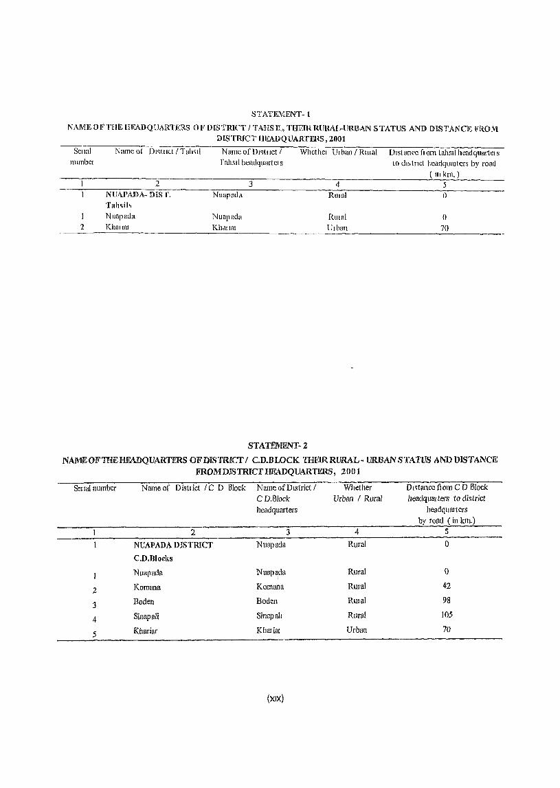
S T ATI~MENT" n N AMIW IF' THE [I FAD Q UARTERS 0 If DiS TRIeT I TABS IL, THEm. RURAL-URBAN STATUS AND [) IS TAN eE FRO M
DJISTRICT HEADQUARTER...~, 2001
SCllnl Nnmcol DI~tllct I Tnh~11 Name of DI~tllct / Whethcl UI ban I RUlal Dlstan(.'c f1()m tahsil hcadquartcls llumbcl r nhsil hcaclquartel S to dl~ (Tlet hcadquru lers by road
( 111 kIn. ) 2 3 4 5
NUAPADA- DIS r. Nuapad'l Rlllnl 0 Tah .. il~
Nuapada Nuapada RUIn! 0 2 Khntlnt Khc11HlI Udlun 70
STATEMFNT-2
NAMEOFTHEHFADQUARTERS OFDJS1RICTI C.D.BWCK THErRRURAL- URBAN STATUS AND DISTANCE FROMDISTRICr HEADQUARTERS, 2001
Sellal number
2
3
4
5
Nameo[ Disttict Ie 0 Block Name of DIstrict!
2
NUAPADA DISTRICT
C.D.Blocks
Nuapada
Komana
Boden
Sinapali
Khariar
C D.8lack headquarters
3
Nuapada
Nuapada I
Komana
Boden
Sinapah
Kbariat
(XIX)
Whether Urban I Rural
4
Rural
Rural
Rural
RUlal
Rural
Urban
o I ~tance fI om C 0 Block headquru ters to district
headquruiers by road (ill km.)
5
o
o 42
98
105
70

STATiLMEN1'-3 »)(WULATllON OIFTlHEDHSTRiCTAnCACH CENSnS FROM 1901 TO 200]
---·TI1~tflct--· -TO~-Cen!>lIs Per ,()n~ Male:, Female:, Decadal populallon variation
RlIlall Year Ulban Ab:,olute Percentage
2 3 4 5 6 7 8
NVAPADA Total 190] 122,559 61,165 61,194
1911 147,489 72,875 74,614 24,910 2034
1921 150, tHO 73,962 76,218 2,691 182
1911 17H,787 87,838 90,949 28,607 1905
19,11 203,379 99,94] 103,438 24,592 1375
1951 219,850 109,339 110,511 16,471 810
1961 267,272 132,399 114,873 47,422 2157
1971 338,894 16R,514 170,380 71,622 2680
1981 392,681 195,105 197,578 53,789 1587
1991 (169,482 234,462 235,020 76,799 19.56
200l 530,690 264,396 266,294 61,20& 13.04
Ihual 1901 122,559 61,165 61,394
1911 147,489 72,875 74,614 24,930 2034
/921 150,180 73,962 76,218 2,691 182
1931 178,787 87,838 90,949 28,607 19.05
1941 203,379 99,941 103,438 24,592 13.75
1951 219,850 109,339 110,511 16,471 8.10
1961 252,999 125,177 127,822 33,149 1508
1971 322,017 159,975 162,042 69,018 27.28
1981 371,289 184,247 187,042 49,272 15.30
1991 443,717 221,271 222,446 72,428 19.51
2001 500,652 249,146 251,506 56,935 12.83
Urban 1901
1911
1921
1931
1941
1951
1961 14,273 7.222 7,051
1971 16,877 8,539 8,338 2,604 18.24
1981 21,394 10,858 10,536 4,517 26.76
1991 25,765 13,191 12,574 4,371 20.43 2001 30,038 15,250 14,788 4,273 16.58
(xx)
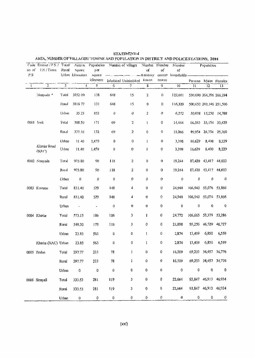
STATEf\.11liNT-4 ARIi;A, NUMlIlFR OFViLLAGIDSI TOWNS AND rOPlJLATION IN DISTJ.UCr AND POUCESTATIONS, 2001
(;-ode Dl~tllct / P S / Total! Alca If1 Population
no of UA I Town RUlal/ squme per P.S Urball kilometers square
2
Nuapada -I<
0001 Tonk
Kl:ariar Road
fNM')
0002 Nuapada
0003 Kommla
0004 Kharial
3
Total 3852 00
RllIal 381677
Ulban 3523
Total 38850
Rtlldl 377.10
Ulban
Ulban
1140
11.40
Total 973.80
RlIlal 973.80
Urhan o
Total 831.40
Rural 831.40
Urban
TOlal 573.13
Rural 549.30
Urban 23.83
Khm'im (NAC) Urban 23,83
0005 Boden Total 297,77
Rural 297,77
Urban o
0006 Sinap ali Total 333.53
Rural 333.53
Urban o
4
kilometer
5
138
131
[{53
171
132
1,459
1,459
90
90
o
129
129
186
170
563
563
~33
f33
o
281
281
o
Number of villages Numbcl Number Number Population of of of
statutOl), census hotIseholds--------
Inhabited Uninhabited lown~ tOWllS Persons Males Females 6
648
648
()
69
69
()
o
1 Ul
118
o
148
148
o
116
116
o
o
78
78
o
119
119
o
(xxi)
7
15
15
()
2
2
o
o
2
2
o
4
4
o
3
3
o
o
o
3
3
o
8
2
o
2
o
o
o
o
o
o
o
°
o
o
o
o
o
o
9
o
o
o
o
o
o
o
o
o
o
o
o
o
o
o
o
o
o
o
o
° o
o
)0 11 12 13
122,601 530,690 264,396 266,294
116,329 500,652249,146251,506
6,272 30,038 15,250 14,788
14,464 66,583 33,154 33,429
11,066 49,954 24,754 25,200
3,398
3,398
16,629 8,400 8,229
16,629 8,400 8,229
19,244 87,420 43,417 44,003
19,244 87,420 43,417 44,003
o o D o
24,948 106,942 53,076 53,866
24,948 106,942 53,076 53,866
o o o o
24,772 106,665 53,379 53,286
21,898 93,256 46,529 46,727
2,874 13,409 6,850 6,559
2,874 13,409 6,850 6,559
16,509 69,233 34,457 34,776
16,509 69,233 34,457 34,776
o o () o
22,664 93,847 46,913 46,934
22,664 93,847 46,913 46,934
o o o o
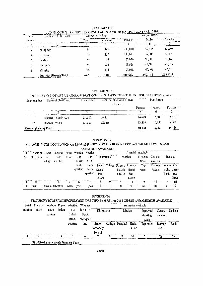
S fA'[ EMENT .. S
('.1). HLOCK .. WI'>F, NUMllEROFVILLAGIKS AND RURAL POPULATION. 20tH
SCll<li Ndme,)f C 1) Block Numb!!l ot vllI<lge, RUlal populatIOn
lltllnoe: rotdi Inhdbll!!d Pel,oll~ Male~ rem"i!!, -----------~ -
2 3 4 5 6 7
Nlidpada 171 167 119,830 59,635 60,195
2 K01l1ana 162 159 117,082 57,906 59,176
3 Boden 119 86 72,0'56 3'i,888 36,16H
4 Sinapah 125 122 98,666 49,309 49,357
5 Khdli,1l 116 114 93,()18 46,408 46,610
DIS trict (Rural) ~r()t'll: 663 648 500,652 249,146 251,506
STATEMENT .. 6
I'OPUlXl'lON Ol? URBAN AGGlLOMF.RATIONS (INCUJDlNG CONSTH'UIENT lJNn S) I TOWNS, ZOOt
St::llul numbel N,une of UA(fOWll ----Ulbun ,tdtllS Name 0(' tdh~ll whew town PopulatIOn
IS located PerSOll& Male~ remtlle~
~ 2 3 4 5 6 7
Khat lllr Ruad (NAC) NAt: lonk 16,629 8,400 8,229
2 KhmiUl (NAC) NAC Kh.ulm 13,409 6,850 6,519
District (Urban) Total: 30,033 15,250 14,788
STATElVUiNT .. 7 ViLlAGES WITH POl)UIATION OF51000 AND ABovrt ATc.n. nLoCK LlNEL AS PER2001 CI!NS18 AND
AMIl.N1TJIIS A VAIUBLE SI Nruneof Name Location Popu- Whethel WhethcI Amellitic~ avmlable
No CD Block of code lallon It IS It is EducatlOllal Mediccli DlIuiang Commn- Bankmg
village lJUmbCl Tahsil CD, Watel lllcatlOn head- Block Semol College Pluumy Plimal'Y Tnp Rmlway Corom- Co-
quarters head- Secon- Health Health watel Station ercial opera-quarters (huy eeolle Sub- Bmlk live
School centJe Bank 2 3 4 5 6 7 8 9 10 Jl 12 13 14 15
Khurlcu Tukula 04221700 6106 yeg yes 1 0 'I Yes No 0
STA1lllVIIlNf .. 8
S11\.1UIORYlOWNS WIDlPOPll.t\.110NLESS TIIAN 5000 AS PER 2001 CJ!NSlS AND AMl!NmES AVAIlABLE
Selia1 Nan~of location Popu- Whether Whether Anl'lnities available nlumel Town code lation it is it is CD. Educational Medical Inproved Colmu .. Banking
lllurber Tahsil Block drinking nication head- headqulIr water
quarters tel'S Selliol College Hospital Health Tap \'vater RaIlway Bank Secot1dmy Centre station
Seho I 2 3 4 5 6 7 8 9 10 11 12 13
This Distl"ict has 110 such Statuto) y Toml
(xxii)
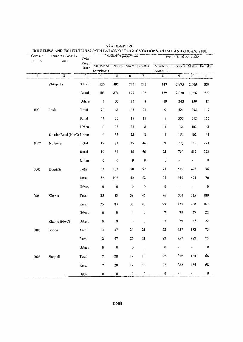
STATEMENT ·9 HOlJSELESS AND INSTITUnONAIL POPUILATfiON OF IJOUCE STATIONS, RURAl, AND URBAN, 2001
Code No. District / Taha<;i1 / Total/
Ilollseless population Institutional population of P.S. Town
RlIla]/ Urban Number of I'Cls01l5 Males Females Number of PClsons Males Females
households households 2 3 4 5 6 7 II 9 10 II
NlIIljJlIdll Total U5 407 204 203 147 2,873 2,015 858
RUI'lII 109 374 179 195 129 2,628 1,856 772
l1rbllll 6 33 25 8 18 245 159 86
0001 .lonk Tota! 20 66 43 23 22 521 344 177
RUIn! 14 33 III 15 II 355 242 113
Urball 6 33 25 8 11 166 102 64
Khariar Road (NAC) Urban 6 33 25 8 II 166 102 64
0002 Nuapada Tolal 19 81 35 46 21 790 517 273
Rural 19 81 35 46 21 790 517 273
Urban 0 0 0 0 0 0
0003 Komonn Totnl 32 102 50 52 24 549 473 76
Rural 32 102 50 52 24 549 473 76
Urbatl 0 0 0 0 0 0
0004 Khariar Total 25 83 38 45 36 504 315 189
Rural 25 83 38 45 29 425 258 167
Urbal} 0 0 0 0 7 79 57 22
Khariar (NAC) UrbaJl 0 0 0 0 7 79 57 22
0005 Boden Total 12 47 26 21 22 257 182 75
Rural 12 47 26 21 22 251 182 75
Urbal) 0 0 0 0 0 0
0006 Sinapali Total 7 28 12 16 22 252 184 68
Rural 7 28 12 16 22 252 184 6&
Urbatl 0 0 0 0 0 a
(xxiii)

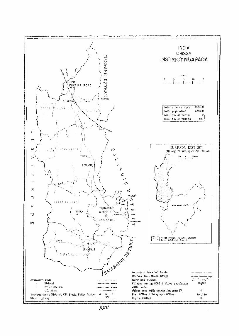
n
Boundary, State Diatrlct Police Station C.D. Block
Headquarters : Di~trict. C.D. Block, Police Station @ @ 0
State Highway .. ___ . .111L._ ......
xxv
INDIA ORISSA
DISTRICT NUAPADA
o 5 10 J5
L=.=d=~-:c-+------J
Total firua ill Sq.km. 3852.00
Totfll popula.tion 530GDO
T()ta} 110. oj' T(JwIJ!' 2 Total no. of viJlag€8 563
---------------------, NIJAPJ\DA DlSTRICT
CIJANGF. IN JIJRlSDICTION 1991-01.
~ 0 20Kms. 1-===+=1
..... ;1 i ~-'_' '. ,
" ,. . ..:
!--:'-'; Ne"ly oreuted Nuapntln [)islrict t.,_«_'.:...:.. from Ka]ululUdi Dislricl. _._--_.-
Important Metalled Hoads Railway line, Broad Gal1g€ River and Stream Villages having 5000 & above populatioll with name Urball area with populatj(lU size: IV Posl Office I Telegraph Office Degree College
1'&
PO / TO i;;J

AN TICAL NOTE


Analytical Note
(1) History amI Scope of the District Census Handbook
The Census of India has all along endeavoured to maintain its tl'adition of feeding the people with reliable 5tatistical information through its various publications, The District Census Handbook is one of such publications which in real sense, is the mirror of Census reflecting the demographic features and infrastructural development of the villages and towns of tile districts and thereby facilitating the formulation of realistic plan in order to cater to the needs and aspirations of the people at large. The genesis of this publication being after the conduct of the 8th decennial Census in 1951 and the first in the post independence era, its contonts and coverage have undergone tremendous changes over the period keeping at par with the changes in socio-economic scenario of the nation and the requirement of the planners, scholars, data users, administrators and others, The publication is a veritable mines of information providing a clear picture of popUlation in both qUllntitative and qualitative terms up to the grass-root levels i.e. about the villagers and town dwellers,
This document was brought out for the first time as an auxiliary to 1951 Census as a joint venture between the Government of India and the State Government The initial arrangement of supply of data by the Census Organisation of the Government of India and converting them into published documents by the State Government was continuing till 1991 Census. In 2001 Census the publication of this document is carried out by the Census Organisation. Apart from giving the rural statistical information, it readily gives a complete list of villtlges contained within a police station and district in an exhaustive manner and becomes very resourceful for the users. In order to make the data component more illustrative, maps of the djstrict, tahasils, C.D. Blocks and police stations are also inserted in the publication.
As per the 1951 publication programme, the DCB was published in one volume and did not contain information given in the Village and Town Directory.
Apart from this the brief introduction of the district, general features, density map, prescribed tables for general population, economic tables, social and cultural tables and village statistics were provided in the DCH. The Primary Census Abstract was given under the heading "Village Statistics", However, the information on village-wise list of displaced persons and information on Small Scale Industries were presented in the 1951 DCB volume.
The District Census Handbook - 1961 was also in one single volume just like 1951 publication. However, it contained some modifications Le. this volume was divided into three parts - i) the first part contained the introduction of the district, ii) second part contained the census tables and iii) the official statistics were given in the 3rd part The village wise Primary Census Abstract (PCA) under the heading of "Village Directory" was included in the second patio Additional information on village wise list of industries and tables 011 fairs and festivals were presented in 1961 DCH.
The District Census Handbooks of 1971 Census were published in three volumes: i) Part-A containing the data on amenities; ii) Pal't-B incorporating the Primary Census Abstract (PCA) and iii) Part-C giving administrative statistics and Census tables. The first two volumes of the DCH i.e. Part A and Part B for the 1971 Census could be published within the time schedule and catered to the needs of the data users, However, difficulties were experienced in collecting administrative statistics from various offices for the preparation of the 3rd volume of the DCH i.e, Palt C and its printing. This volume could be published ultimately after much delay. The idea of bringing out the publication of the 3rd volume of the District Census Handbook containing information 011 administrative statistics etc was dispensed with effect from the subsequent censuses.
The District Censlls Handbook for 1981 Census was published in two parts Le. FaIt A - included
Village and TaWIl DirtJctory and Part B - presented the Pdmary Census Ahstract (PC A) including Scheduled Castes and Scheduled Tribes Primary Census Abstract up to police station/tnwll levcls. By and iarge, the contents of the Village alld Town Directory of J 98 t CenslIs were almost similar to
those adopted during 1971 Censlls, baring a few changes necessitated by the requirements of the
planners and data users.
The District CenSllS IIandbook of 199 I Censlls was of the same pattern of 1981 CenslIs. Part-A of the DCH contained statistics of Village and Town Directory and Part-B included data on Village and Town wise Primary Census Abstract including Schedufed Ca.sies/Scl1eduie Tribes Primary Census Abstract. However, the DeB publication of 1991 Censlls exhibited the following novel ideas so far as the presentation of data of these publications were concerned.
i) Village Directory data and Primary CenslIs Abstract were presented CD Block wise having separate identity or constituent police
stations within a block. The villages coming under different police stations but within the same C.D.Block were shown separately so as to facilitate comparisOl) with that of previous publications.
ii) Both manual and computerized location codes of various villag~s were shown separately for 1981 and 1991 Censuses in alphabetical order for the convenience of the data users.
iii) 111 case of both the village and town directories, the objectives of the various columns and the connotation of various observations lIsed therein were explained in the relevant sections.
iv) Nine fold industrial classifIcation of main workers were presented instead of four fold industrial classification presented in the 198 I Census publications.
v) The sex-wise population under the age group O~6 was included in Primary Censlis Abstract for the first time in order to enable the data users to compute more realistic literacy rate
4
DISTRICT CENSUS HAND BOOK' NUAPADA
as all ehildren below 7 years were treated as ill j (crate.
vi) Tahasil and Police Station maps in 1he publication showing the village and town
boundaries also depicted the C.D. Block boundary for the conveniellce of the readers and data lIsers etc.
The Censlls or lndia 2001 follows the same pattern of 1991 Census in publishing the D.C.H. volumes for each district. The District Censlls Handbook publication contain 2 parts, i.e.; Part 'A' containing statistics on village and town directory and Part 'D' containing data 011 village and towIl-wise Primary CenslIs Abstract including Scheduled Castes/ Sclleduied Tribes Primary CenslIsAbstract. Ui(e f99( Census, the village level information for both parts of District Census Handbook volumes have been presented C.D. Block-wise.
The Census of India 2001 has introduced the eight digited permanent location code (PLC) for each and every village, which has run continuously for the entire state starting from the 1Sl village of the 1 sl police station ofthe l't district of the state to the last village of last police station of the last district. The last two digits of the PLC are kept as 00 and reserved for future treatment, if any. In order to facilitate the comparability of data by the data users, the Pel111anent Location codes of villages during Census of India-2001 and their corresponding location codes during 1991 Census have been shown along with village names under the C.D. Block-wise alphabetical list of villages.
(ii) Brief History of the District
The district Nuapacla came into existence on 1 ,I April 1993 comprising the entire Nuapada sub-division of the former Kalahandi district for administrative convenience vide notification No.DRC-44/93R-142l8 dated 27.3.93 of Government of Orissa. Nuapada subdivision, which was a part ofSambalpur district since 181 April 1936 reconstituted on pi January 1948 and was declared as a sub-division of Kalahandi district with headquarters at Bhawanipatna.
The justification of naming the district as Nuapada emerged in 1936 by virtue of the recommendation of Orissa Administration Committee (1933) by shifting
ANALYTICAL NOTE
the administrative headquarters of ex-state ofKhadial to a new place of head quarter, named village Jayantu Nuapada Wllich was subsequently renamed as Nuapada and till that time, being the administl'ative headquarters ofN uapada sub-division, it continues to be the district headquarters. It is nothing but the estate of ex- Zamindar of Khariar.
Nuapada district has a glorious past, along with its attractive natural endowment to the tourists. During tIle hoary past, when Vedic Arya Dynasty was famolls for self-sculpture and golden age of Aryan Civilization, Maraguda valley ofNuapada was the chief center of administration. The prolific Archeologist J.M.P. Singh Deo proved that this valley was the kingdom of Kush a , the son of Ram Chandra, and the most subject-loving king of Ajodhya of Surya Dynasty. The place being named as Kusha Sthali became the capital of kingdom Koshala. As per Dr. Nabin Kumar Sahoo, from 4th
century AD, Guptas and Nandas ruled over the land and after that from last part of 5th century AD the land was ruled over by Sarvapuris, Pandu Vans is or Shome Vansis, Kalachuri and Chauhans. From relics it is p1esullled by the Historians that all these mlers were Saktas, Shaivas, Jains and Buddhas for which the shrines of all types of deities were built, the relics of which are excavated.
In course of time the estate of Khariar came into being during the last quarter of 15th Century AD when the pratap Rudra Dev, the Cbauhan Raja of Patlla, (1455-1480) created three Garhs, i.e. Kholagarh, Gouragarh and Komnagarh in favour of one of his two sons. All these are constituted with some annexations on owing to the dowry or royal matrimonial alliances. Kholagarh comprised the present plain land ofNuapada (Tan want) area upto Khariar road. Gouragarh comprised Sunabeda plateau where the picturesque Jumalgarh and Munikgarh stands. Komnagarh is tlle present Komna and its surroundings, whel'e we find the ruins of old fort of Komnagarh.
As per arcl1ives preserved in Khariar House and according to the tradition prevalent in the Kharial' Raj family, Gopal Roy was the eldest son ofPratap Rudra Dev, the CJ18uhan Raja of Palna, born to his second queen. The second son Vikramaditya, born to Chief Queen obtained the throne of Patna for which there was a conflict between the two brothers for succession
5
for some time and finally Gopal Roy won and got hold of the Ramai Sword, the symbol of royalty but left the kingdom of Patna in favour of Vikl'amaditya, his younger brother. By virtue of his efficiency, capability and wit, subsequently he ruled over Khariar Estate till 1610 from 1590 AD with headquarters at K0I1111a. He was an able alld clever ruler who successfully curbed down the rebellion of Rajgonds and strengthened his estate by expanding it. After him, his successful heirs continued to rule over the land. The 9th ruler in the lineages of Gopal Ray was Pratap Rudra Singh Deo who I'llied from 1793 to 1818 AD and the Marathas occupied Khariar and exercised their suzerainty over Pratap Rudra. After the second Anglo Maratha war, the Britishers occupied Khariar and ruled frol11 December 1803. It was restored to Bhonsalas in 1806 towards the end of Pratap Rudra. The 3rd Anglo Maratha war continued with the crushing defeat of Murathas. Britishel's occupied Kbariar in 1818. Prataprudra died in 1808 and from him further rulers ruled the land under the subjugation of British rule.
Raj a Ratan Singh, the next successor was a valiant king and was very vigorous and ambitious. He defeated the king of Kalahandi and decided the prolonged boundary dispute with Kalahandi. He shifted his royal abode from K0l1111agarh to Khariar, considering its unhealthy climate, inaccessibility and the troubles oftribals. The relics of the fort are a part of palace of Khariar chief. Thus bis heirs I'Uled till the rule of Brajaraj Sing Deo in 1889 who was the most efficient ruler. His son Raja Bir Bikram Deo was also an efficient ruler. His son Raja Arthatml1 amalgamated Khariar with Orissa in 1936 and he ruled till 1946. After his death, l1is son Lal AllUP Si11g Deo succeeded the tl1rolle who also became the Deputy Minister of Orissa twice after independence. It is pertinent to mention here that the Khariar house used to honour the Ramai Sword originally brought by Gopal Roy. Besides the Ramai Sword, the Chief ofKllariar also honoured to a Muslim Sword called Kunwar Khal1da from the time of Padman Sing. But after independence there was no significance of Royal feudal because of democrative set up.
As per history there is no significant contribution offhe area for the Freedom movement. However, the gallant freedom fighter Vir Surendra Sai (1857-1862) carried on his freedom fight fi'om Manikagarh, which provided him a strong hold of safety.
(iii) AdminasiraHve sct UI): -
The district Nuapada is comprised afonly one subdivision with the same name. Nuapada sub-division is divided into two tahasils, i.e. Nuapada and Kbariar, and accommodates six police stations and two towns. Police Stations namely .lank, Nuapada and Komana along with Khariar Road Town (NAC) are coming under Nuapada TahasH as against police stations namely Khariar, Boden, Sinapali and Khariur Town (NAC) are coming under Khariar Tahasil.
Total rural areas of these six. police stations are distributed among five Community Development Blocks namely, Nuapada, {(omana, Boden, Sinapali and Khariar. These five CD Blocks of the district as per 2001 Censlls are having 663 villages. FOllr villages are newly created after 1991 Census, out of which one each is found in Nuapada police station and Komana police station in Nuapada Tahasil and other two are located in Khariar police station of Khariar Tahasil. Out of the total villages only 15 villages are uninhabited. The district is mostly rural in character having only two towns i.e. Khariar Road (NAC) and Khariar (NAC).
Location and size
The district Nuapada occupies western portion of Orissa and is situated between 20° Nand 21 0 N latitude and 82° 20' E and 82° 50' E longitude.
The district is bounded by Raipur district (Chhattisgarh State) at North, Bargarh, Balangir and Kalahandi at East, Raipur (Chhattisgarh State) and Kalahandi at south and Raipur (Chhattisgarh State) at west. Hill tracts of the district chiefly comprise the ranges of hills in western portion of the d,istrict.
The total area of the district as supplied by the Surveyor General ofIndia is 3,852 Sq.Kms. The rank of the district is 19th in the state with reference to area.
North-Soutll/East-West extension
The district extended to Raipur ( Chhattisgarh State) at north. The CD Block Nuapada is situated at the extreme n011h of the district. While moving in south direction, CD Blocks are Komana, Boden and Sinapali, the later being at extreme south border of the district.
6
DISTRICT CENSUS HAND BOOK: NUAPJ\DA
Coming to EaM extension of the district, Khm jar CD Block is situated towards east of Boden and northeast of Sinapali CD Block.
(iv) Physical Features
The district is broadly divided into two natural divisions i.e., the hill tracts and the plain country. The former chiefly comprises the ranges of hills in western portion ofthe district and the later constitutes plains in eastern part of the district. The largest hill ranges is the 'Katpur-IJuravadi'. Elevation of this range is 986 meters in south and 931 meters at the central poin1s, ealled Birbusi. To the west of tile plateau the peak of Deo-deongri is 929 meters. The other hill ranges are JamharpatDonrri (537 meters), Burharas Parbat(74l meters), Ghochki Donger (555 meters), Ara Donger (376 meters), Supkoll Donger(882 meters), Chmrra Donger (933 meters), Godama Danger (784 meters), Guru Donger (734 meters) and Gaijhar Pahar (494 meters), Barepat Donger (1006 meters) and Kachki Donged (506 meters). Besides these llills there are
numerous unnamed peaks and hillocks of considerable height.
The plain tracts of the district are Udanti Slllider Valley. This is the most fertile area and said to be the granary of Nunpada district. The main plain land is constituted at the surroundings of Nuapada and Tanwant. There are extensive black cotton tracts and the most precious teak forests lie within this area, though it is in an impoverished condition due 10 wanton forest exploitation. In hill tracts, there were dense deciduous forests, which still exist in a reduced form. Due to unrestricted and free deforestation and Podu or shift cultivation the val uable forest property is getting dwindled day by day.
Drainage
There are mainly three rivers in the district namely Jonk, Sunder and Udanti. Jonk River has its origin in the Sunabeda plateau near Bad-dongar. After a very tortuous course for a few kilometres, the river enters the Nuapada plain and is very deep in between village Lodra and Patora and near about Lodra crocodiles are seen in the river. The Katingpani Nalajoins it near village Lodru. Before joining the Jonk, this Nala creates the Godhan waterfall of about 60 metre high, which presents a natural scene of exquisite beauty. At the waterfall, every year a festival is held. It is attended

ANALYTICAL NOTE
by local people, even by the people of the adjoining villages of Chhattisgarh. An image of Lord Siva is worshipped here and the deity is said to have been consecrated by Raj a Vikram of legendary; f~me, of whom the people oftl1is area still sing songs. A tributary known as the Masankuda river joins the Jonk near the village Dhararnbardha. Jonk falls in the Mahanadi at Seorinarayan in Chhattisgarh. During the summer, the flow almost dries up except in its upper reaches where it continues to receive perennial but slender flow from its tributaries. There is a deep darha in the river locally named Trislll darha within the village limit ofMaraguda.
S under River owes its origin on the eastern side of the Swwbeda pJateal1 neal'Tal'bad; obJique}r 11'lH'ersing
the undivided Kalahandi district for about 96 km, it enters into Balangir district near the village Tuklila. During the rainy season teak woods were said to be floated through this ri ver from the interior. It dries up comple(ely during slimmer and, thus is not navigable.
Udantl or Udet takes its origin from the hills of Chhuttisgarh and enters the district at village Chitl'ama and tlowing easterly and ultimately joins the river Tel, about tell kilometers away from village Borda. Its bed is rocky up to the village Kaihibadi whereafter it gradually turns sandy. On either sides of this river are excellent teak wood forests, which are in the process of disintegration. The river served as a medium for exporting forest products prior to present road lines. Periodical changes in its course are seen in recent years.
Tanks are found almost in every village. Apart from the private tanks, a large number of tanks are in Government possession. These tanks vary from less than a hectare to about ten hectares in different areas, generally classified as Kata, Sagar, Bal1dha and Sara. The tanks are chiefly used for bathing, drinking, pisciculture and irrigation purposes depending on the popular needs of the locality. The most imp0l1ant tank i.e. Raital Sagar in the Maraguda Valley covers an area of 150 acres of land and it is full of aquatic birds. Flight of steps were constructed in early time round about the Sagar for the use of the inhabitants, the remains of which are still to be seen. Its embankment is 40 to 50 ft. wide and it is quite interesting today even to have around by jeep.
7
Climate:
The mean daily maximum and 111lIllmUm temPHrlltture of the district are 41 0 alld 28° centigrade respectively during Mayas against 28° C and 10° C during December. The year may be divided into four seasons. The hot season is from March to May fo !lowed by the south-west monsoon season from June to September. October and November constitute the posHllonsoon season. The cold season is from December to Fl!bruary. December is the coldest month with mean maximum temperature of 28°C as against minimum temperature of 100 C. Short spell of cold weather often occurs in winter. The relative humidity is high ill west monSOO1l aad past moasoolllIlont/rs.
The average annual rainfall ofthe district is 1009.7 mm. The district gets rain due to Southwest monsoon.
Soils
The distrir-t has mainly three types of soil, Red laterite, Black Eoil and Sandy loam. The Red laterite soil is found all over the district. It is deficient in Phosphorous and Nitrogen. The black soil found mostly in Nuapada Tahasil. It is rich ill Potassium and Magnesium and is best suited for cultivation of paddy, cotton, chilly, tobacco and Rabi crops like pulses and wheat. Sandy loam soil found in Nuapada Tahasil is suitable for cultivation of oil seeds and root crops. The riverside areas are alluvial sandy and sandy loam soil.
Geology
The different litho-stratigraphic units met within the district are basement gneisses, charnockite and Khondalite suits of rocks, leptynite, anthrosite, granitoid gneiss; vein quartz, pegmatite, metadoJerite nepheline and horn blende syenite, sub~arkosic quartzite shale, quat1zite laterite soil and alluvium.
Flora
NlJapada district is rich with abundant natural beauty with dewy green hills, dense forest with water falls and streams around which luxuriant wild vegetations are seen. In the Nuapada district the flora of ravines and valleys is evergreen where the few small patches of reserve forests occur. The crop inside is that of pure Sa] or plateau Sal where the adjacent hillsides are covered with grass and missed forest with
no trace of Sal. Besides, the general category of trees of Orissan tropical climate such as P~asal> Mahua, Bandhan:, Kuruma, Dhaura, Jamun, Kangada, Sisam (sisu), Kendu, Asana etc. are also seen. Once upon a time Nuapada was called to be the home of Teak, which Blas been demoHshed to a greater extent. Different
types of wild grasses, bamboo are also seen in the forest.
The village site of Nuapada district has its characteristic flora in the groves, gardens, tank side and house-enclosures where during rains small crops of vegetation and grain are reared. The vegetation differs on the riverbeds and a long the stretches of sandy banks. Most among the common treeS are banyans, mangoes, jackfruits, palms, date palms, jamul1s, bamboos, neems, bel and tamarinds, etc. Fruit plants like banana, guava, oranges, lemon, papaya, litchi etc. are also seen in cluster in farms and village sites.
The bhatia waste at present is mostly void of all tree and shrub growth and it looks as though it never bore any forest. Diospyros melanoxylon (kendu) with short stunted growth standing on some of the recently cleared wastes bear the testimony to the fact that more dense vegetation once existed here.
l1'a1lna
The forests of the district were famous for the abundance of wild fauna both herbivore and carnivore. Shikar have all contributed towards disappearance of herbivore population. which resulted in gradual reduction of number of carnivore. Further the killing of wild lives for skin, bore, horn and teeth etc. causes quick disappearance of wild lives and Government should be vigilant properly for prevention of deforestation and hunting. The following fauna are seen in the forest tracts in reduced nUJnber.
Among the wild animals, elephants, Indian bison (Goyal), the Sambhars, the spotted deer (Chital), Indian deer. horned deer, the black buck antelope, the Indian mouse deer, the Indian hares, the rabbits, the tigers, the panthers or leopard (Chita), the hyena, the wolves, the wild dogs, the jackals, the foxes and the sloth bears are commollly seen.
The jungle fowls and Game birds such as peafowl, bush quail, the bottom quill, the common green pigeon,
8
DISTRICT CENSUS HAND BOOK' NUAPADA
ducks, gfldwalls, blue winged teals, the spurred goose, the goose teal, whistling teal and common snipes are seel1 in different places of the district abundantly.
Only the sweet fish vilriety is available in the district water sources from small to large size. Among those
are Magma, Singi, Gadisha, Kerandi, Baligarada, Mahurali, Seula and Balia etc., which are commonly seen everywhere. But Rohi, Bhakura, Chittal and Mirkali, etc. are seen in big tanks and Sagars. Chingl1l'i and crabs are rarely seen.
Crocodiles, gadhi, frogs and snakes such as cobra, Gokhm~ Tampa, Chiti, Rana and Dhamana are common snakes, seen in the district.
Forest
The district had a very vasi dense forest area in the past. But the quick deforestation for different purposes made it very sparse and if such type of
practice continues, time will come not only the precious forest property will be destroyed but also it will severely affect to environment and human survival. However, the district has total forest area of 1,849.69 kilometers, out of which other forest 345.25 kms., demarcated forest 15.4 kms, unclassified forest 0.44 kms.and unreserved general forest 1,488.6 kms.
Source: District Statistical Hand Book, Nuapada -1999.
Natural wealth
Different types of minerals such as coal, iron,
bauxite etc. are found in the district. But due to insuffiCiency of scope and absence of proper transport facilities, there is no industry or pmcessiIlg center to exploit all these minerals for the sake of economic bearing of the district.
On the contrary, the district was very rich in forest produces, which is now available at a reducing rate. However, the important forest produce like firewood, timber, bamboo, Kendu leaf, teak, sal, piasal, Sisu, Sahaj, Bija, Jamun, Mahua are the main timber species found in the district. Other forest products ofthe district are myrobalans, broom grass, lac, Mohua flowers and seeds, Antia bark, Sabai grass, tamarind, arrow root, honey, hide and horn etc. The rocky and hilly tracts provide road and building materials such as bOUlders,
ANALYTICAL NOTE
metal, chips, morrom and granite stone. The riverbeds provide sand and pebbles. 1/
Land use patterHi
As per District Statistical Hand Book, Nuapada-1999, the land utilization pattern of the dish iet is as follows-
Forest area covers 42,299 hectares, Miscellaneous tree crops and groves not included in net area sown covers 775 hectares, Permanent pasture and other grazing lands covers 15,592 hectares, culturable waste covers, 7,438 hectares, land put to non-agricultural uses covers 14,933 hectares, barren and un-cultivable lands constitutes 8,545 hectares, current fallows covers 21,892 hectares, other fallows covers 6,266 hectares and net area sown 126,887 hectares.
Cropping pattern
The district has good potential for horticulture and plantation crops. The climate of the district is quite suitable for the same. The main fruits are mango, banana, orange, papaya, pineapple, guava, sapeta, litchi, bel', coconut, potol, kundru, nursery and mushroom. In alluvial tracts supported by regular irrigation, crops like paddy, maize, wheats~ greengl'am~ b lackgram, horse gram and sugarcane are cultivated. Vegetables are also grown in different areas. In the shift cultivation side, millet and such other food crops are cultivated. Oilseeds such as til (Rashi), groundnut, mustard and ragi are also cultivated in suitable patches in plain areas and hill tracts.
Irrigation
During ancient time, the rulers, zamindal's and rich cultivators excavated sagars, katas, tanks; bandhas, ponds and big wells which were used for irrigation purpose. But at present the in'igation facilities are highly deficient in the district. Allthough its economy is largely dependent on agriculture, no regular or systematic irrigation system is developed. In order to cover more area under irrigation the sources available in the district are dug wells, bore wells, pump sets, drip Irrigation and sprinkler. At present there are 43 lift irrigation points, 180 dug wells, 20 bore wells, 280 pump sets.
drip irrigation methods covers 25 hectares and
9
sprinklers covers 50 hectares. Recently 3 minor irrigatiol,l projects and one medium irrigation project are in progress but {here is no scope for major irrigation project in the district.
Source: Directorate of Economic Statistics, Orissa
Animal HlAsb:mdry.
Differcnt varieties of domestic animals like cow, cattle, buffaloes, sheep, goats, pigs, fowl are seen in the district. For production of meat, the animals like sheep, pig, goat, poultty etc. are reared.
Egg production in the district refers to Deshi bird,
improved bird and duck. There are 127,659 cows, 289,683 cattle, 70,232 buffaloes, 44,316 sheep, 99,766 goats, 1,254 pigs and 157,137 fowls. During the year 1998-99 the total milk production of the district was 6.59 MT and total egg productioll was 5.20 millions. For medical services to animals there are 8 hospitals and dispensars, i.e. 9 V,A.Ss.! Addl.V.A.Ss, 62 L.A.Cs and 19 Artificial1nsemination centers in tJle district.
Source : District Statistical Hand Book, Nuapada -1999.
Fisbery
In the past there was no regular fishery development work though fishes were caught from the available natural and artificial water sources. But now-a-days in order to strengthen tbe rural economy, pisciculture has been taken up in some Gram Panchayat tanks, which is not adequate to meet the local needs. Some private persons have taken up pisciculture in their own tanks. In order to meet the internal consumption of the people, marine fish (both fresh and dried) is imported from Gaqjam district. The Fisheries department of the State Government has started fry supply centers in Khariar and Nuapada. Realizing its importance and finding good potentiality government in collaboration with commercial banks is taking steps for widening pisciculture development activities. In the year 1998-99~ fish production was 1393 MT and fry
production was 6,82,000 Nos.
Sources: District Statistical Hand Book, Nuapada -
1999.
Indust,'Y
Due to the absence of conducive atmosphere and inadequacy of raw materials associated with bad roadways, industrial activities neither could flourish in past noT!' could develop in the present time for which
Nuapaaa is industrially one of the most backward districts of the state. During the year 1997-98 as many as 18 industrial units of the district accollunociates 456 workers as against 17 units on 1996-97 employing 499 workers. There are 21 small-scale industries with 57 workers, 676 cottage industries with 1,352 employees and 1,156 handloom industrial units with 2,312 em ployees.
Sources: District Statistka] Hand Book, Nuapada -1999.
Mines - The district is also not rich in mineral sources. However, there are two lime stone mines and one graphite mine are under operatioll wherein 35 workers and 75 workers are deployed respectively.
Source: District Statistical Hand Book, Nuapada -1999.
Trade and Commerce
The public distribution system of the district aBotted essential commodities to 438 authorised retail shops during 1998-99. There are private sector procurement and distribution system for general commodities which are served by the supplier in different business centers both ill rural and urban centers. There ltre 5 main Hats (markets) and some small Hats, wh~re selling and purchasing of consumable goods both agricultural and non-agricultural are done intermittently.
Transport
The number of motor vehicles during 1998-99 numbered 19,240 of which 13,709 are motorcycle etc., 2,348 are tractors and trailers, 1,053 trucks and lorries, 66 are contact carriages, 969 are jeeps and station wagons, 46 are three wheelers and auto rickshaws, 413 are private cars, 243 are state carriages, 138 are taxies and 255 are miscellaneous and other vehicles. The district has 368 kms ofvillage roads, 504 kms. of P.S. roads, 48 kms. of classified viUage roads. 4,133 kms. of Gram Panchayat roads, 270 fems.of forest roads, 66 kms .of other district roads, 13 kms. of major
10
DISTRICT CENSUS HAND BOOK: NUAPADA
district roads ;}ud 110 kms. of state highways. All the important places of the distric'_ including tourist spots are provided with bus facilities.
Only 32 kms. of broad gauge single railway line passages through the district, providing 3 railway stations.
Source: District Statistical Hand Book, Nuapada -1999.
Elect'.·gcity alid power
Consumption of electricity (in million unit) in Nuapada district during the year 1998-99 in L.T. category of consumers is 27.34(99.14%) as against H.T 0.24(0.86%). During tLIe year 1998-99 as many as 435 villages were electrified. Electrical pump sets energized up to 1998-99 are 2.36 milliollunits forOLIC against 0.95 million units for private owned.
Source: District Statistical Hand Book, Nuapada -1999.
Pancbayati Raj system
The three tier PanchayaLi Raj system was introduced in the state with the enforcement of the Orissa Panchayat Samiti and Zilla Pnl'ishad Act, 1959, w.e.f. 26 th January 1961 which was further strengthened with the implementation of Orissa Zilla Parishad Act, 1991 w.eJ. }'I November 1993. The major objective of the Panchayati Raj System is to entrust the people with the management of local affairs and develop their capacity for self-governance. In the three tiel' system of Panchayati Raj, the Pancbayat Samiti functions as the inter-mediary between Zilla Parishad at district level and the Gram Panchayat aJ village level and each offhem functions within its own jurisdiction for the development of rural areas of the districts for a normal tenure offive years.
Zilla Parishad, the apex body in the district is constituted ofthe following members. Each Panchayat Samiti in the district elects two members to the Zilla Parishad. Elected members of legislative assembly and members of parliament from the district become the members of the Zilla Parishad. Chairmen of all Panchayat Samities of the district, Chairmen of the Municipalities/ NACs and co-operative banks of the district, the district officers of health, education, public
ANALYTICAL NOTE
health, agl'iculture, forest, works and co-operative development become the ex-officio members ofZiIla Parishad. There is reservation of seats for Scheduled Castes and Scheduled Tribes members on the basis of pl'opoliion of their population while Il3rd of the seat is reserved for women members including Scheduled Castes and Scheduled Tribes women. The members of the Zilla Parishad elect one amongst them as President and another as Vice President. The Collector ofthe district acts as the Chief Executive Officer. The Zilla Parishad, besides formulating policies for the key areas of rural development in the district, monitol's and evaluates the various developmental programmes of the government, which are implemented by the Panchayat Samities in their respective areas of the district.
The Pailchayat Samities, which act as the intermed ialY between Zilla Parish ad and Gram Panchayats were eSlablished throughout the state in accordance with the provisions of the Orissa Panchayat SamitiAct, 1959 und its jurisdiction is coterminous with the area of the Community Development Block. The Block Development Officer is the executive head of the samiti. Other block level officers are the official members. The Sarpanchs of all Gram Panchayats withiu the CD Block become non-official members of the Panchayat Samiti. The elected members of the Panchayat Samiti elect one amongst them as the Chairman and another as Vice Chairman, of whom one must be a woman. Panchayat Silmities are not only responsible for the planning, execution and supervision of all types of governmental development programmes in their areas but also look after the spread of primary education, management of trust and endowments etc. and all other developmental matters in their respective localities.
The Gram Panchayat at the primary level is constituted of a group of villages, whicl1 are divided into wards. The voters of each ward directly elect Ward members. The voters of all the wards under the Gram Panchayat elect the Sarpanch oCthe Panchayat and one Naib 8arpanch is elected from amongst the ward members to look after the work of the Panchayat.
This primary unit of democratic decentralisation is the main agency to mobilize the rural manpower.
11
Functions of the Gram Panchayat include sanitation, supply of drinking water, maintenance of ferry ghats and wells, construction and maintenance ofPanchayat roads, cattle pounds, providing streetlight and implementing different agricultural schemes in the villages under its jurisdiction.
The names of the Panchayat Samities, number of Gram Panchayats and number of villages under each Panchayat Samiti ill1he district are given below:
81. No. Name No. of Gram No. Of villages of the PanchaYrts . uncleI' the
Panchayat under Panchayat Samiti Panchayat Samiti 8amiti
NUllpada 24 171
2 Komana 24 162
3 Boden 13 89
4 Slllapali 16 125
5 Khariat 16 116
TOTAL 93 663
(v) Major Characteristics of the district t
contribution of tile district in the form of any historical figures associated with tbe district.
Raja Bmjamj Sing Deo
Raja Brajaraj Sing Deo of Khariar was a remarkable benevolent and philanthropic ruler with an admirable public-spirited personality. Simultaneously, he was a poet of great excellence. He undertook extensive endeavours for upliftment of education, ayurvedic medical institutions and allopathic dispensaries for his subjects, His help was unprecedented during the famine of 1899-1900, for providing food centers to famine stricken teeming poor without Government assistance. This made him unforgetable. To do away with the transportation problems he made extensive development of roads. He excavated numerous wells and tanks for irrigation purpose. The most important road during his time was that which linked Raipur with Kalahandi through Khariar and excavation of wells and plantation of trees at a distance of about 6 kms beside this road. The
magnificent garden cum farm built in 1894, in cornmemoration of his father Padman Sing, named Brajaraj Bag, the large covered well with parapets of decorated carvings and flight steps in the garden named Muktakumari Sabli excavated at the sweet memory of his second queen Mukta Kumari, Mukta Sagar a
gigantic tank and the temple ofBrajeswar Shiva where the installation of a beautiful image of Nandi (Bull),
recovered from Maraguda valley are specimens of his
public works. He was very generous to provide
financial assistances to talented poor for higher education, notable among whom was Dr. Had Singh Gaur, Bar-at-Law, who shined in thejudicial sphere of
the country. For his above achievements in 1903 he
was awarded with Kiser- 1- Hind gold medal of first class and the title of Raja was conferred all him as a sign of personal distinction. He died on 1"1 November
1907 at Mahasamund on his pilgrimage to Holy Prayag.
His portrait finds an honoured place in the portrait
gallery ofSambalpur Univeristy.
Bir BUmun Dco
Bir Bikram Deo, the wOlthy son of Raja Brajal'aj
Sing Deo, succeeded to the throne in 1907 after the
death of his father. As per the saying, 'Like father like
son' he followed the footprints of his father and
undertook all types of public works in the field of
education, medical treatment, irrigation and roads. He
was equally talented like his father in the field of literature especially in drama. In the memory of his
father he established a primary school at Mahasamund,
the death place of his father. For his parts and capability
he was appointed as honorary magistrate, a Durbari
and Khas Mulkati. He died in 19'13.
Artatmna Dco
Artatrana Deo came to the seat ill 1913, being a minor for which tIle estate was manag~d by the Court
of Wards till 1921, when he attained majority. He was
a wel1-behaved man with liberal views. Alike his
predecessors, he was a good and popular ruler. Above
all, he was a good athlete and renowned Tennis player
and was awarded the Silver Jubilee Medal in 1935.
He was also a honormy magistrate, a Durbari and Khas
12
DISTRICT CENSUS HAND BOOK: NUAPADA
Mulkati. It is due to his sincere effort that Kharial' was amalgamated with Orissa in 1036. He was twice elected to Orissa Legislative Assembly. The title of Raja was conferred on him in 1944. He died on 30lh
September 1946.
Lal Amap Sing Deo
Lal Anup Sing Deo came to the Gadi in 1946.
He was a very popular ruler for which he became the Deputy Minister of Orissa twice. Apart from his
administrative maneuvers, he was a prolific scholar
and poet for which he was awarded with the title of
'Kabi Saurabha' by the Braja Mohan Sail itya Samittee
of Kalahandi in 197 I. Some of his notable literary
achievements are, Arati, Urmai, Litika and Murchhana.
(vi) Brief description of places of religions
importance, historical and tourist interest in the
distR"ict
District Nuapada is 110t only attractive for its
el1l'iched natural beauty but also bears the importance
of archeological, historical and religious interest of the
hoary past, creating the thirst of wonder amongst
tourists and research scholars. Some of them are
presented below:
Maraguda Valley
It is the chief centre of tourists for its natural
beauty and glorious past. This valley starts from
Sunabeda plateau up to the last of the district in the
southwest direction being situated at a distance of about
15 Kms. from district headquarters, connected with
good motorable road. It is situated at the bank of rive I'
Jonk at the foot of a hill and around the village there
are many images and ancient relics. In Sunabeda
plateau the beautiful natural sights such as, dewy green
hills, dense forests, water falls namely, Beniadhas,
Godhas and Kalardhas, the backside water storage of
Petora Dam (the Govt. tourist center), Sahipal and
Jadamunda Dams and many other attractive natural
elements catch the eyes of all who visit the district.
Being attracted by the tranquility and serenity of the
place Mr. Hewitt described that 'Sunbeda Plateau offers an ideal site for a sanatorium'. Besides, the
ANALYTICAL NOTE
natural attractions, this region is more famous for its presentation of vast ancient glory of neolithic
civilization. It is being the capital of different rulers
starting fi'om Kusha till the beginning of the reign of
Raja Ratan Sing who shifted his head quarters from
Komnagarh to Khariar. Dr. I.M Prasad Sing Deo
discovered images of Lord Budha from here. Dr.
C.B.Patel also discovered a Bauddha Stupa (dilapidated). As pel' the epic of 'Abadha N ashataka' Lord Buddha Dev stayed here [or three 1110nths. An
image of Lord Jain also was discovered from here, which is at present preserved in the Jain temple of Khadar Road. Again C.B.Patel discovered a big Siba
Linga from the hillock of'Chingrakachhar'.A 'Silalipi'
of 4th century AD was discovered from here, which
belonged to Gupta Dynasty. In the village Jhalap there
is a broken Shiva temple from which a big Shiva Linga
was excavated, which was brought to the Lokhaneswar
temple of Bhubaneswar by Ex-Secretary, Sri
A.N .Tiwari. The temple' Koshal's Khakhara
Khakharu' is also a Shiva pitha. On Triswa Dhipha
there is the image of 'Chaturvuja Mahisa Mardhini'
and image of 'Lord Kartikeya' was excavated from
the village Vuliasikuana. A beautiful image of Nag raj
is seen on the bank of J onk, which is locally called, as
Yogisundar. It is presumed by Dr. N.K.Sahoo that all
these were built in 5th century AD.
Besides, the most important factor is that there
are the relics of many hill fortresses and ruined
buildings on inaccessible hilltops, which bears the
specimen of ancient sculpture, art alld architecture.
Amongest them important are Manikgarh, (named after
great Chauhan warrior Manik Ray), Jumalgarh,
Gaudagarh. One can see on the main gate of Jumalgarh
hillfort, Chheliagarh the seat of its presiding deity. In
nutshell, along with marvelous relics the area abounds
with wild beauty offorest clad mountains and valleys
with springs and cascades.
Patala Ganga
It is a hot spring of village Kotagaon in Khariar
police station, situated at a distance of 41 kms from
Khariar and 6 kms from Boden. It is regarded as a
holy place for Hindus. There is a belief that if a man
takes bath in this warm spring water after Solari Lunar
eclipses, he will acquire spiritual attainment equal to
13
that of bath in the holy river Ganga. As per mythological background, during Ramchandra's "vanvas" while walking through tllat area, Sita Devi
felt thirsty. There was no water source nearby and
hence Lord Ram pierced earth by an arrow and brought the Ganga to Earth and accordingly the place llas been
named as Patala Ganga. There are temples of Lord Shiva and Lord Jagallnath quite close to the spring.
Yogi matb
Yogi math is famous for the prehistoric paintings on walls and ceilings of caves, which bears the artistic genius and style of neolithic age. It is situated at a
distance of 9 kms, to the east ofKhariar. The paintings
and the drawings are very distinctly drawn in Indian red paint over the rock surface. The figure of bull is
very interesting. There is also a cow and a calffollowing
as well as a figure of a man. The whole scene bears
the significance of the domestication of animals and
agriculture. In the ceil iug too there are some paintings.
There is another cave at a short distance and because
the roof has fallen, the paintings are not visible. The
entire area is yet unexplored and invites scholars to
unearth her past glory.
Bmlhi Komana
Budhi Komana is situated at a distance of 40 kilometres to the north ofKharial'. The place is famous
for the temple dedicated to Lord Pataleswal', the other
name of Lord Siva. It is a brick temple of Tri-Ratha
style, which is now in dilapidated condition. Amongst
the existing temples in the district it is one ofthe oldest
temple. The Jagamohana of this temple is found in
ruins and Biman is in a precarious condition. It is
presumed that this temple belonged to the early
medieval period. Though the temple was renovated
during the rule of Chauhalls, it is originally a pre
Chauhan erection.
Tanwant
Ii is a village situated at a distance of 7 kms to the
south ofNuapada on the foot of a hilL The river Shilda,
which takes its origin in the hills, creates a waterfall at
Bogthala, which is about one kilometer to the west of
Tanwant. The temple dedicated to Goddess
'Konabhoinra' is situated in the village and nearby the
relics of a ruined fort can be seen which is presumed to be the Kbadagal'h Fort. There is a large water reservoir dose to nt.
NUlap:uJa
Nllapada is thlj shifted headquarters ofthe district fi'om 1936 while it was a sub-division. I-Ience all the district level offices are located here. It is situated only at a distance of 6 miles from the Jonk Railway Sation. In addition to all government organizations. there are temples dedicated to Sri Jagannath, Shiva and Ram, which are not of remote antiquity.
The town Khariar being the oldest town of the district, headed the capital center of the ex-Khariar estate for about ISO years. It is 78 !cms. ii'om Khariul' Road and 73 kms. from Bhawanipatna. During the last part of 181h Century, Raja Ratan Singh shifted his head quartel:sfrom one-sided Komna to the centrally located Khariar considering its unhealthy climate and inaccessibility and tribal agitations. Hence relics orold fort, declined palace and many temples are seen here. The temples ofDhadhi Baman, Jagannath, Hanuman, Laxmi and Raktambri are located in the town. It is believed that the temple of Jagamohan is more than 5 hundred years old. The well-known Oriya poet Chaityna Das, who was a resident ofthis town during 161h century AD has mentioned the name of the town as 'Nagra Khadiyala' in his work 'Nirguna Mahatmya\Dussera and Chandan Iatra are the important festivals, which were gorgeously celebrated by the Ex~Zamindars and rulers.
Kluuiar Road
DISTRICT CENSUS HAND BOOK' NUAPADA
Komaml
It is a large village at the bank of Rive!' Sunder at about a distance of 40 killS. south of Nuapada on the road towards Khariar. The relics of the ruined Komnagarh fort are the dumb witness of the headquarters of Chauhan rulers. Even today the remains of palace, several buildings and temples speak of the former glory ofihe place. There are high schools, primary health centers, Post and Telegraph Offices, Inspection Bungalow, Community Development Block, Police station and other Government offices.
(vii) Census Concepts
Building:
A 'Building' is generally a single structure on the ground. Sometimes it is made lip of more than component unit which are used or likely to be used as dwellings(residel1ces) or establishments such as shops, business houses, offices, factories, workshops, worksheds, Schools, places of entertainment, places of worship, godowns, stores etc. It is also possible that building which have component units may be used for a combination of purposes such as shopcum-residence, workshop-cum-residence, office-cmnresidence,etc.
Usually a structure will have four walls and a roof. But in some areas the very nature of COl1stl'Uction of houses is such that there may not be any wall. Such is the case of conical structures where entrance is also provided but they may not
have any walls. Therefore, sllch of the conical structures are also treated as separate buildings.
Permanent houses :
Houses, the walls and roof of which are made of permanent materials. The material of walls can be anyone from the following, namely, galvanized iron anyone from the following, namely, galvanized iron sheets or other metal sheets, asbestos sheets, burnt bricks, stones or concrete. Roof may be made of from anyone of the following materials, namely, tiles, slate, galvanized iron sheets, metal sheets, asbestos sheets, bricks, stones or concrete.
Semi-permanent houses :
Khariar Road is situated on the river Jonk, which at this point forms the boundary between Orissa and Madhya Pradesh. It was a small town but after the opening of the Raipur - Vizianagaram Railway line, the place steadily rose as a center of trade and commerce, being supported by the railway station. Rice mills, soap factory, tannery and other small industrial units are located here. Rice and flattened rice are the important items of exports; timber was also expolied in a considerable quantity, which is gradually getting reduced. The local trading community consists mostly of the Marwaris, the Gujuratis and the Muslims.AJain temple is located here.
Houses in which either the wall or the roof is made of permanent material and the other is made
14
ANALYTICAL NOTE
of temporary material.
Temporary bOUHses :
Houses in which both walls and roof arc made of materials, which have to be replaced frequently. Walls may be made from anyone of the following temporary materials, namely, grass, thatch, bamboo, plastic, polythenc, mud, unburnt bricks or wood. Roof may be madc from anyone of the following temporary materials, namely, grass, thatch, bamboo, wood, mud, plastic or polythene.
Dwelling Room :
A room is treated as a dwelling room if it has walls with a doorway and a roof and should be wide and long enough fat a person to sleep in, i.e. it should have a length of not less than 2 meters and a breadth of at least 1.5 meters and a height of 2 meters. A dwelling rooUl would include living room, bedroom, dining room, drawing room, study room, servant's room and other habitable rooms. Kitchen, bathroom, latrine, store room, passageway and verandah which are not normally usable for living are not considered as dwelling rooms. A room, used for multipurpose such as sleeping, sitting, dining, storing, cooking, etc., is regarded as a dwelling room. In a situation where a census houses is used as a shop or office., etc., and the household also stays in it then the room is not considered as a dwelling room. But if a garage or servant quarter is used by a servant and if shell1e
also lives in it as a separate household then this has been considered as a dwelling room available to the servant's household. Tent or conical shaped hut if used for living by any household is also considered as dwelling room.
A dwelling room, which is shared by more than one household, has not been counted for any of them. If two households have a dwelling room each but in addition also share a common dwelling room, then the common room has not been counted for either of the housellOIds.
Census House
A 'census house' is a building or part of a building used or recognised as a separate unit because of having a separate main entrance from the road or common courtyard or staircase, etc. It may be
15
occupied or vacant. It may be used for residential or 110n- residential purpose or both.
In certain peculiar situations, the manner in which buildings and cenSUs houses were identified for Ilumbering in the field by the enumerators is described hereunder:
Sometimes a series of different buildings are found along a street which are joined with one another by common walls on either side looking like a continuous structure. These different units are practically independent of one another and are likely to have been built at different times and owned by different persons. In such cases, though the whole structure with all the adjoining units apparently appears to be one building, each pOIiion was treated as a separate building and its constituent units as separate census houses.
On the other hand, one may come across cases, patiicularly in large cities of multi-storeyed ownership flats. In these cases while the structure looks like one building, different persons own the flats. In case of such mu1ti-storeyed structures, IJ8villg a llumber of flats owned by different persons, the entire structure was treated as one building and each flat as a separate census house.
Ifwithin a large enclosed area, there are separate buildings owned by different persons then each such building is treated as a separate building. There can be a situation where within all enclosed compound there are separate buildings owned by an undertaking or company or even government that arc actually in occupation of different persons. For example, Indian Oil Corporation colony where the buildings are owned by the Corporation but these are ill occupation of their employees. Each such building was treated as a separate building. But if in anyone of these buildings there were flats in occupation of different households, each such flat was reckoned as a separate census house.
Sometimes if becomes difficult to apply the
definition of census house strictly in certain cases. For example, in an urban area, if a flat has five rooms,
each room having direct entrance from the common
staircase or eotlftyard. By definition, this has to be treated as five census houses. If all these five rooms

nre occupied by a single household it was not realistic to treat them. as five censlls houses. In sLlch H
case.'singleness' of use of tlwse roOlTlS along with tile, main house: should be considered Ilnd the entire flat was treated as one censLls house. On the other hand, if two independent households occupy these five rooms, the first household living in 3 rooms and the second household occupying 2 rOOI11S, then considering the use, the first three rooms together were treated as one cenSllS house and the remaining rooms as another census house. But if each 1'00111
WaS occupied by all independent hOllsehold, then each slIch room was treated as a separate: census house.
In case of hostels, hotels, etc., even if the door of each room in which an inmate lives opens to a common verandah, staircase, courtyard or a common room, as it happens almost invariably, the entire hostel/ Hotel building was treated as one cenSllS house. but if such hostels/ hotels have out- houses or other stmctures used for different purposes or the same purpose, then eac11 such structure attached to the main hostel/hotel was treated as a separate censlls house.
In some parts of the country, in rural areas, the pattern of habitation is such that a group of huts, located in a compound, whether enclosed or unenclosed, is occupied by one household. While the main residence may be located in one hut, other huts may be llsed for sleeping, as a kitchen, bath room, baithak, etc. Though each of the huts was a separates structure, they form a single housing unit and therefore, have to be treated collectively as one building and one cenSllS house. If some of the huts are used by one household and the others by a second 11ousehold as residence, then the two groups of huts were treated as separate census houses. However, if there were also other huts in the compound used for other purposes and not as part of the household's residence such as, cattle shed, worksl1ed, etc., these were treated as separate census houses.
On the other hand, in urban areas, where more than one structure within an enclosed or open compound (premises) belonging to the same person, e.g., the main house, the servant's quarter, the garage, etc., only one building number was given for this grou p and each of the constituent a separate census house number.
16
DISTRICT CENSUS HAND BOOK. NUAPADA
Only cases where a structure with roof and pillars has come up was treated as a building.
Rural-Urban :nca :
The data in tables on Houses, Household Amenities and Assets are presented separately for rural and urban areas. The unit of classification in this regard is 'town' for urban areas and 'village' for rural areas. In the Censlls ofInclia 200 I, the defin ition of urban area adopted is as follows:
a) All places with a municipality, corporation, cantonment board or notified town area committee, etc.
b) A place satistying the following three criteria simultaneously:
i) A minimum population of 5,000;
ii) At least 75 per cent of male working population engaged in non-agricultural pursuits; and
iii) A density of population of at least 400 per sq. km.(l,OOO per sq.mile)
For identification of places which would qualify 10 be classified as 'urban' all villages, which, as per the 1991 Census had a population of 4,000 and above, a population density of 400 persons pel' sq. km. and having at least 75 per cent of male working population engaged in non-agricultural activity were considered. To work out the proportion of male working population referred to above against b) (ii), the data relating to main workers were taken into account.
Apart from these, the outgrowths(OGs) of cities and towns have also been treated as urban under
'Urban Agglomerations'. Examples of out-growths are railway colonies, university campuses, port areas, military camps, etc., that may have come up neal' a statutory town or city but within the revenue limits of
a village or villages contiguous to the town or city.
Each sllch individual area by itself may not satisfY the demographic criteria laid down at (b) above to
qualify it to be treated as an independent urban unit
but may deserve to be clubbed with the towns as a continuous urban spread. Thus, the town level data, wherever presented, also includes the data for outgrowths of such towns.
ANALYTICAL NOTE
City:
Towns with population of 1,00,000 and above are called cities.
Urban Agglomeration
An Urban Agglomeration is a continuous urban spread constituting a town and its adjoining urban outgrowths (OGs) or two or more physically contiguous towns together and any fldjoining urban outgrowths of such towns. In some cases railway colonies, university campuses, port areas, etc., may come up near a city or statutory town outside its statutory limits but within the revenue limits of a village or villages contiguous to the town or city. Each such individual area by itself may not satisfy the minimum population limit to qualify it to be treated as an independent urban unit but may deserve to be clubbed with the town as a continuous urban spread. For the purpose of delineation of Urban Agglol11rrations during Census of India 2001 , following criteria are taken as pre~requisites: (a) The core town or at least one of the constituent towns or an urban agglomeration should necessarily be a statutory town; and (b) The total popUlation of all
the constituents (i.e., towns and outgrowths) of an Urban Agglomeration should not be l~ss than 20,000 (as per the 1991 Census). With these two basic criteria having been met, the following are the possible different situations in which Urban Agglomerations would be constituted: i) a city or town with one or more contiguous outgrowths; ii) two Of'more adjoining towns with their outgrowths; and iii) a city and one or more adjoining towns with their outgrowths alJ of which form a continuous spread.
Housebold :
A 'household' is usually a group of persons who normally live together and take their meals from a common kitchen unless the exigencies of work prevent any of them from doing so. Persons in a household may be related or unrelated or a mix of both, However, if a group of unrelated persons live in a census house but do not take their meals fro111 the common kitchen, then they are not constituent of a common household. Each such person was to be treated as a separate household. The impOliant link in finding out whether it was a household or not was
17
n common kitchen. There may be one member households, two member households or multi-member I~ouseholds.
J institutional housebold
A group of unrelated persons who live in an institution and take their meals from a common kitchen is called an Insiit1ltional Household. Examples of Institutional Households arc boarding houses, messes, hostels, hotels, rescue homcs, jails, ashrams, orphanages, etc. To make the definition more clearly pcrceptible to the enumerators at the Census 2001, it was specifically mentioned tlJat this category or households would cover only those households where a group ofunrelated persons live in an institution and share a common kitchen.
Houseless household :
Households who do not live ill buildings 01' census houses but live in the open ()11 roadside, pavements, in hume pipes, under fly-overs and staircases, or in the open in places of worship, mandaps, railway platforms, etc., are treated as Houseless Households.
Scheduled Castes and Scheduled Tribes
Article 341 of the Constitution provides that the President may, with respect to any State 01' Union territory, specify the castes, races or tribes or parts of or groups within castes, races or tribes which shall for the purposes of the Constitution be deemed to be Scheduled Castes in relation to that State 01' Union territory. Article 342 similarly provides for specification of tribes or tribal communities or parts of or groups within tribes or tribal communities which are to be deemed for the purposes or the Constitution to be Scheduled Tribes in relation to the various States and Union territories. In pursuance of these provisions, the list of Scheduled Castes and I or Scheduled Tribes are notified for each State and Union territory and are valid only within the jurisdiction of that State 01'
Union territory and 110t outside.
It is important to mention here that under the
Constitution (Scheduled Castes) Order, 1950, no
person who professed a religion different from
Hinduism was deemed to be a member of a
Scheduled Caste in addition to every member of the
Ramdasi, Kabirpanthi, Majhabi or Sikligar caste
resident in Punjab or Patiala and East PlIl\jab States Union were in relation to that State whether they pro/essed the Hindu 01" the Sikh religion. Subsequently, in September J 956, by an amendment, the Presidential Order of 1950 and in all subsequent Presidential Orders relating to Scheduled Castes, the Hindu and the Sikh religions were placed on the same footing with regard 10 the specification of Scheduled Castes. Later on, as per the amendment made in tho
Constitution (Scheduled Castes) Order 1990, the Hindu, the Sikh and the Buddhist were placed on the same footing with regard to the recognition of the Scheduled Castes.
The lists containing the names of the Scheduled Castes and the Scheduled Tribes applicable for the
Census of India 200 I in the State are given below:
Scheduled Castes List for Orissa.
1. Adi Andhra
2. Amant, Amat
3. Audhelia
4. Badaik
5. Bagheti, Baghuti
6. Bajikar
7. Bad
8. Bariki
9. Basor,Burud
10. Bauri
11. Bauti
12. Bavuri
13. Bedia, Bejia
14. BeIdaI'
15. Ehata
16. Bhei
17. Chachati
18. Chnkali
19. Chamar, Meehi, Muchi, Satnami
20. Chandala
21. Challdhai Maru
22. Chertla, Chhelia
18
DISTRICT CENSUS HAND BOOK' NUAPADA
23. Dandasi
24. [)o\vnr
25. Dlul'; rvar
26. Dllolla, Dhabi
27. 00111, Dombo, Durin Dom
28. Dosadha
29. Ganda
30. Ghantarghada, Ghal1tra
3l. Ghnsi,Ghasia
32. Ohogin
33. Ghus!Jria
31. Godug,di
35. Godari
36. Godra
37. Gok11 a
38. Gomit, Komit
39. Haddi, Hadi, Harf
40. Irika
41. Jaggali
42. Kandra, Kandara
43. Kama
44. Kalia
45. Kela
46. Khaclala
47. KodaJo, KhodaJo
48. Kori
49. Kummari
50. Kurunga
51. Laban
52. Laheri
53. Madari
54. Madiga
55. Mahuria
56. Mala,lhala,Malo,Zala
57. Mang
58. Mangan

ANALYTICAL NOTE
59. Mehra,Mahar
60. Mehtar, Bhangi
61. Mewar
62. Mllndapotta
63. Mllsahar
64. Nagarchi
65. Namasudra
66. Paidi
67. Paillda
68. Pamidi
69. Pan,Pano
70. Panchama
71. Panika
72. Panka
73. Pantanti
74. Pap
75. Pasi
76. Patial, Patikar, Patraianti, Patua
77. Rajlla
78. Relli
79. Sabakhia
80. Samasi
81. Sanei
82. Sapari
83. Sauntia,Santia
84. Sidbria
85. Sinduria
86. Siyal
87. Tamadia
88. Tamudia
89. Tania
90. Tiar,Tior
91. Turi
92. Ujia
93. Valamiki, Valmiki
I . I
19
Sched uled Tribes list for Orissa :
1. Bagata
2. Baiga
3. Bal~jara, Balljari
4. Bathudi
5. Bhottada, Dhotada
6. Blllliya, Blmyan
7. Bhumia
8. Bhlllnij
9. Bhl\l1jia
10. Bil1jhal
11. Binjhia, Binjhoa
12. Birhor
13. Bondo Poraja
14. Chenchu
15. Da!
16. DeslIa BJllllnij
17. Dharua
18. Didayi
19. Gadaba
20. Gandia
21. Ghara
22. Gand, Gonda
23. Ho
24. Holva
25. Jatapu
26. Juang
27. Kandha Gauda
28. KawaI'
29. Kharia,Kbarian
30. Kharwar
31. Khond, Kond, Kandha, Nanguli Kandha, Sitha Ka11dha
32. Kisan
33. Kol
34.Kolah I,oharas, Kol Lohlll"as
35. Kolha
36. Koli. Malhar
37. Kondadora
38. Kara
39. KarLIa
40. Kotia
41. Koya
42. Kulis
43. Lodha
44. Madia
45. MahaH
46. Mankidi
47. Mallkirdia
48. Matya
49. Mirdhas
50. Munda, Munda Lohara, Munda MahaJis
51. Mundari
52. Omanatya
53. Oraon
54. Parenga
55. Paroja
56. Pentia
57. Rajuar
58. Santal
59. Saara, Savar, Saura Sahara
60. Shabar, Lodha
61. Sounti
62. Tharua
Language and Mother tongue
As per the Census concept, each language is a group of mother tongues. The Census questionnaire collects information on the mother tongue of each person, and mother tongue is defined as the language spoken in childhood by the person's mother to the person. If the mother died in infancy, the language mainly spoken in the person's home in childhood will
20
DISTRICT CENSUS HAND BOOK. NUAPJ\DA
be the mother tongue. In the case of infants and deaf mutes, the language lIsually spoken by the mother is considered as mothel' tongue. it is not necessary that the language spoken as mother tongue should have a script. The mother tongues returned by the lespondents in census are classified and grouped under appropriate languages according to their linguistic characteristics.
Literate :
A person age 7 years and above who can both read and write with understanding in any language is taken as liter~\te. A person who can only read but call1lot write is not literate. It is not necessary that to be considered as literate, a person should have received any formal education or passed any minimum educational standard. Literacy could also have been achieved through adult literacy classes or through any non-formal educational system. People who are blind and can read in Braille are treated as literates.
Literacy rate :
Literacy rate of the population is defined as the percentage of literates in the age group seven years and above. For different age groups the percentage of literates in that age group gives the literacy rate.
Educatioual level :
The highest level of education a person has completed
Work:
Work is defined as participation in any economically productive activity with or without compensation, wages or profit. Such participation may be physical and/or mental in nature. Work involves not only aetnal work but also includes effective supervision and direction of work. It even includes part time helJ.! or unpaid work on farm, family enterprise or in any other economic activity. All persons engaged in 'work' as defined above are workers. Persons who are engaged in cultivation or milk production even solely fot' domestic consumption are also treated as workers. Reference period for determining a person as worker and non~worker is one year preceding the date of enumeration.
Main worker :
A perSOIl '."ho has worked for major part of the reference period ( i.e. six months 01' more during the

t\r~ALYTICAL NOTE
last one year preceding tlle date of enumeration) in any economically productive activity is termed as 'Main worker'.
Marginal worker :
A person who worked for less than six months of the reference period ( i.e. in the last one year preceding the date of enumcration ) in any economic activity is termed as 'Marginal worker'.
NOll-worker :
A person who has not worked at all in any ecollomically productive activity during the reference period (i.e. last one year precedtng the date of enllmerBtion ) is termed as 'Non-worker'.
Cultivator :
POI' purposes of the CenSliS a perSall is classified as cultivator if hl) or she is engaged in cultivation 0 1) land ()wnerl or held from government or held from private persons or institutions for payment in money, kind Of share. Cultivation includes effective supervision or direction in cultivation. A person who ha!' given out her/his land to another person or persons or institution(s) for cultivation for money, kind or share of crop and who does not even supervise or direct cultivation in exchange of land, is not treated as cultivator. Similarly, a person working 011 another persoll '8 land for wages in cash or kind or a combination of both (agricultural I&bourer) is not treated as cultivator. Cultivation involves ploughing, sowing, harvesting and production of cereals and millet crops such as wheat, paddy, .iowar, bajra, ragi, etc., and other crops such as sugarcane, tobacco, groundnuts, tapioca, etc., and purses, raw jute and kindred fiber crop, cotton, cinchona and other medicinal plants, fruit growing, vegetable growing Or keeping orchards or groves, etc. Cultivation does not include the following plantation crops - tea, coffee, rubber. coconut and betel-nuts (areca).
Agricultural labourer :
A persall who works on another person's land for wages in money or kind 01' share is regarded as an agricultllTal labourer. ShelHe has no risk in the cultivation, but merely works on another person's land for wages. An agricultural labourer has no right of lease or contract on land on which she/he works.
21
HOilsellOld Industry worker' :
Household industry is defined as an industry conducted by the head of the household herself/himself and or by the members of the household at home or within the village ill rural areas and only within the precincts of the house where the household lives in urban areas. The larger proportion of workers in household industry should consist ofl11embers of the household including the head. TIle industry should not be fLin on the scale of a registered factory which would qualify or has to be registered under the Indian Factories !\ct and should be engaged in manufacturing, processing, servicing and repairs of goods. It does not include professions such as a pleader, Doctor, Musician, Dancer, Watemml1, Astrologer, Dhobi, Barber, etc. or merely trade or business, even if stich professions, trade or services are run at home by members of the household.
Other worker:
A person who has been engaged in some economic activity during the reference period but not as a cultivator or agricultural labourer or in Household Industry is termed as a 'Other Worker (OW)'. The type of workers that come under this category of 'OW' include all government servants, municipal employees, teachers, factory workers, plantation workers, those engaged in trade, commerce, business, transport, banking, mining, construction, political or social work, priests, entertainment artists, etc. In effect, all those workers other than cultivators or agriculturallahourers or household industry workers, are 'Other Workers'.
Worh: participation a'ate :
Percentagc of workers (main + marginal) to total population.
Population density:
Population density is the number of persons inhabited per square kilometre of the area.
Age:
Age is measured in terms of the completed number of years
Sex~ratio :
Number of females per 1,000 males in a population.

(viii) NOII)-Census Concepts
hnxu'oved drinilillg water:
fr the household had access to drinking waleI' supplied from a tap, hand pump, tube well or well (protected or covered) situated within or outside the premIses, it is considered as having access to improved drinking water.
It may be mentioned that slIch llniform definitioll Illay not be villid across all States.
System of sewerage :
Generally, a sewerage system would mean a network of mains and branches of underground conduits for the conveyance of sewerage to the point of disposal. Sewers that carry only household and industrial wastage are called separate sewers; those that carry storm water from roofs, streets and other surfaces arc known as storm water drains, while those carrying both sewage and storm water are called combined sewers. However, in some towns, which are not provided with such underground sewerage system, it is served by open surface drain, box drain, silk pattern drain, etc., in these towns.
Type of latrine and Method of disposal of night soil.
There are three prevalent systems of disposal of human wastes, viz. ;
(i) underground sewerage,
(ii) sanitary water flush latrines with individual disposal systems, like septic tank, leaching cess pool and collecting well, and
(iii) dry type of latrines with manual scavenging.
The system of unci erg round sewerage provides for the street sewerage with which are connected the sanitary latrines constructed in the houses having water closets and fitted with flushing cistern (or hand flushing). Through this sewer the fecal matter is transported without the need for scavenging. This system generally exists in cities and big towns.
Where the street sewer does not exist, these sanitary water flush latrines are connected to a local septic tank with a sub-soil dispersion system 01' a leaching pit. Here the liquid wastes from the water closet is disposed of locally in leaching pit, a septic
22
DISTRICT CENSUS HAND BOOK: NUI\PADA
tallkwith a soil dispersion system is constructed. This dispersion requires an optimum travel through lhe pores ofthe soiL which renders the hannfhlliqllid baclerially innocuolls by the slow precess of filtraiion through the soil traversed.
Where the soil is impermeable, collevting wells are constructed and the sanitary water flush latrines are connected with them. These wells are cleaned at pel iodie intervals by a suitable device. The dry lype of latrines are of service type latrines from where hllman excreta is removed by scavengers fr01l1 hOllse to hOllse, in most cases earrying it On their heads or shoulders or in baskets with handle Or wheel barrows. These llfe
then collected in bullock carts or trucks or tractors and trolleys for being carried to the dumping grounds.
Fertility:
In demography, the word fertility is llsed in relation to the actual production of children or occurrence of births specially live births. Fertility is a measure of rate at which population acids to itselfby lJirths and normally assessed by relating the I1lll11ber of births to a full or part of the poplllation, such as number of married women or number of women ofchild-bearing age. The definitions of the terminology used in computing different fertility rates are mentioned below:
Crude birth mte (CDR) :
Ratio of the number of live births in a year to the mid year popUlation, normally expressed per 1,000 popUlation.
Number of live bit1hs during the year CBR:::: x 1,000
Mid-year Population
Crude death rate (CDR) :
Ratio ofthe number of deaths ill a year to the mid year population, normally expressed per 1 ;000 popUlation.
Number of deaths during the year CDR = x 1,000
Mid-year Population
Natural gl'owth rate:
Growth rate is obtained as the difference between crude birth rate and crude death rate in the absence of migration.
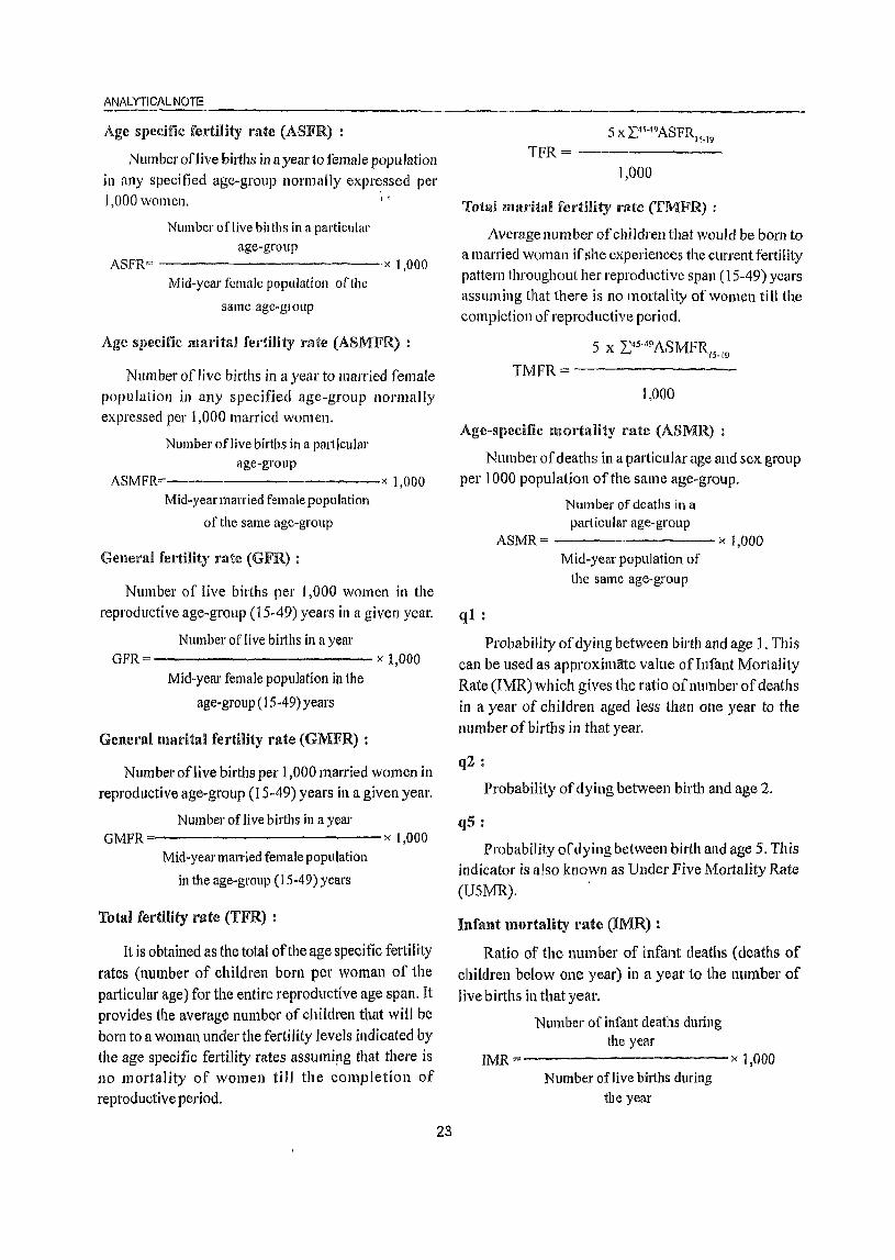
ANALYTICAL NOTE
Age specific fCI·mity rate (ASFR) :
Number oflive births in a year to female population in any specified age-group normally expr~ssed per 1,000 women. I ,
Number of live bilths in a particular age-group
ASFR== x 1,000 Mid-year female population of the
same age-group
Age specific marital fertility rate (ASMFR) :
Number of live births in a year to married female population in any specified age-group normally expressed per 1,000 married women.
Number of live births in a partlcular age-group
ASMFR ---------__ x 1,000 Mid-year married female population
of the same age-group
TPR = -------1,000
Tota! niaritlll fertility rate (TMFR) :
Average number of children that would be born to a married woman if she experiences the current fertility pattern throughout her reproductive span (15-49) years assuming that there is no mortal ity of women till the completion of reproductive period.
5 X 2:45•49 ASMFR
15·19
TMFR = -----~--1,000
Age-specific mortality mte (ASMR) :
Number of deaths in a particular age and sex group per 1000 population of the same age-group.
Number of deaths in a particular age-group
ASMR = )( 1,000 General fertility rate (GFR) : Mid-year population of
Number of live births per 1,000 women in the the same age-group
reproductive age-group (15-49) years in a given year. ql :
Number of live biIths in a year GFR= x 1,000
Mid-year female population in the
age-gl'Ollp (15-49) years
General marital fertility rate (GMFR) :
Number of live births per 1,000 married women in
reproductive age-group (15-49) years in a given year.
Number of live births in a year GMFR x 1,000
Mid-year married female population
in the age-group (15-49) years
Total fertility rate (TFR) :
It is obtained as the total of the age specific fertility rates (number of children born per woman of the particular age) for the entire reproductive age span. It provides the average number of children that will be born to a woman under the fertility levels indicated by the age specific fertility rates assumipg that there is no mortality of women till the completion of reproductive period.
23
Probability of dying between birth and age 1. This can be used as approximate value of Infant Mortality Rate (IMR) which gives the ratio of number of deaths in a year of children aged less than one year to the number of births in that year.
q2 :
Probability of dying between birth and age 2.
q5 :
Probability of dying between birth and age 5. This indicator is also known as Ullder Five Mortality Rate (U5MR). .
Infant mortality I'ate (IMR) :
Ratio of the number of infant deaths (deaths of children below one year) in a year to the number of live births in that year.
Number of infant deaths during the year
IMR =-----------x 1,000 Number of live births during
the year
lnfant mortality rale comprises of two parts, viz.,
Neo-natal mortality rate ancl Post neo~natal mortality rate. The neo-natal mortality rate also comprises of two parts viz., Early neo-natal mortality rate and late neo-nata I mortality rate. These are defined as:
NeO-'lUlltaX mortaHty nate (NMR) :
Numberof infants dying within the first month of life (28 days or under) in a year per 1,000 live births of
the same year.
Number of infant deaths aged 28
days or uncler during the year
NMR=--------------------' Number oflive births during
the year
i) Early nco- nat~li mortality D'.i\tc :
Number of infant deaths of less
than 7 days during the year
x 1,000
------------- x 1,000
Number of live births during
the year
ii) Late neo-natal mortnlity mtc :
Number of infant deaths of? dllYs to less than 29 days during the year
----------- x 1,000
Number of live births during
the year
Post neo-natal mortality rate (PNMR) :
!'Jumber of deaths of 29 days to less than One year during the year
----------- x 1,000
Number of live births during
the year
Peri-natal mortality rate (PMR) :
Number of still births plus deaths within 1 st week of delivery per 1000 births in a year.
Number of still births and infant deaths of less than 7 days during the year
PMR= x 1,000
Number of live births and still
births during the year
24
DISTRICT CENSUS HAND BOOI< . NUAPADA
Still hirth r'ate (SBR) :
Number of still births during
the year
Number of live births and still
births during the year
Maternal mortality rate (MMR) :
" 1,000
Number of deaths of women in the age-group 15-49 while pregnant or wi1hin 42 days oftennination of pregnancy from any cause related to pregnancy and child birth per 100,000 live births in a given year.
Number of maternal deaths to
women in the age group 15-49
MMR=---- ----------x 100,000
Nllmberoflive birth
Eligible couple (Couples per 1,000 pOpll!iition) :
Number of currently married females in the agegroup 15-44 years per 1000 persons of all age~.
Child woman ratio (0-4) :
1. Number of children in the age-group 0-4 years per 1,000 women in the age-grollp 15-49 years.
Child woman ratio (5-9) :
2. Number of children in the age-group 5-9 years per 1,000 women in the age-group 15-49 years.
Civic status of urban units :
Civic Status of a town/city is determined on the basis of Civic Administrative authority of the town e.g., Municipal Corporation/Corporation, Municipal Committee/Municipal council, Municipality etc.
Size class of VA/town:
Size-class ofUA/Town is based on the population size of the VA/City/Town VAs/Towns with 100,000 and above population are classified as Class I VAs/
Towns. These Class I UAs.lTowns are now further sub classified into seven sub classes namely MI to M7 depending on the population size of VAl City IT own. These are:
M7 (5,000,000 and above);
M6 (2,000,000 to 4,999,999);
M5 (1,000,000-1,999,999);
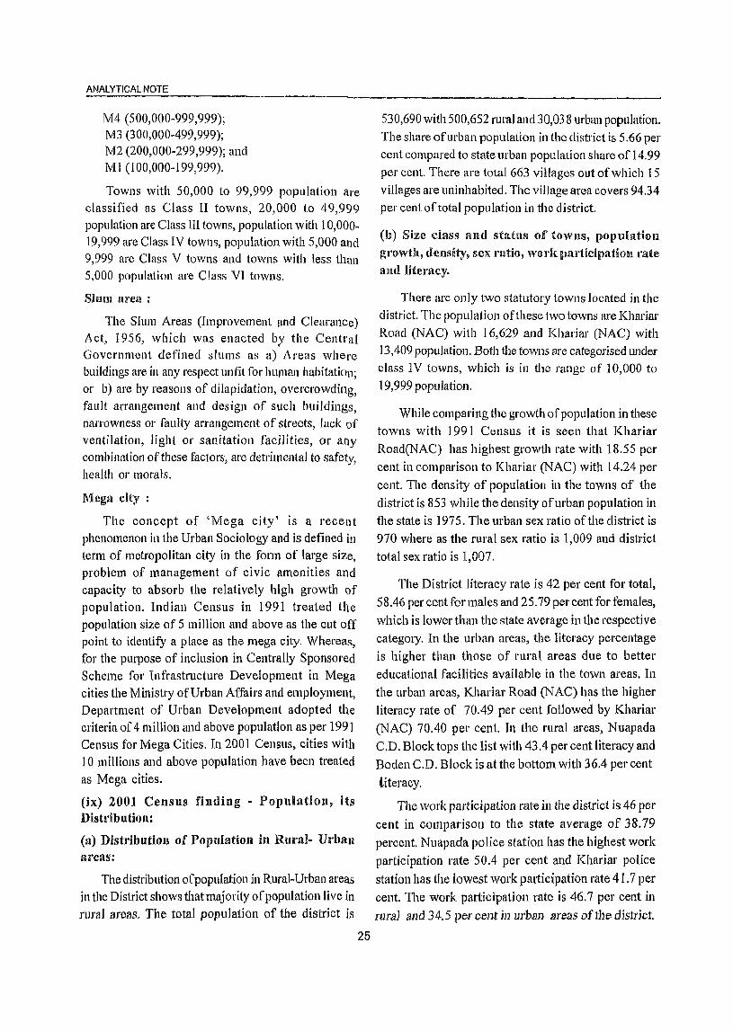
ANALYTICAL NOTE
M4 (500,000-999,999); M3 (300,000-499,999); M2 (200,000-299,999); and Ml (100,000-199,999).
Towns with 50,000 to 99,999 population are classified as Class II towns, 20,000 to 49,999 population are Class III towns, population with 10,000-19,999 are Class IV towllS, population with 5,000 and 9,999 are Class V towns and towns with less than 5,000 population are Class VI towns.
Shun area:
The Slum Areas (Improvement Ilnd Clearance) Act, 1956, which was enacted bv the Central - - . Government defined slums as a) Areas where buildings are in any respect unfit for human habitation; or b) are by reasons of dilapidation, overcrowding, fault arrangement and design of such buildings, narrowness or faulty arrangement of streets, lack of ventilation, light or sanitation facilities, or ally combination of these factors, are detrimental to safety, health or morals.
Mega city:
The concept of 'Mega city' is a recellt phenomenon in the Urban Sociology and is defined in term of metropolitan city in the form of large size, problem of management of civic amenities and capacity to absorb the relatively high growth of population. Indian Census in 1991 treated the population size of 5 million and above as the cut off point to identify a place as the mega city. Whereas, for the purpose of inclusion in Centrally Sponsored Scheme for Infrastructure Development in Mega cities the Ministry of Urban Affairs and employment, Department of Urban Development adopted the criteria of 4 million and above population as per 1991 Census for Mega Cities. In 2001 Census. cities with 10 millions and above population have been treated as Mega cities.
(ix) 2001 Census finding - Population, its Distribution:
(a) Distribution of Population ill Rural- Urban areas:
The distribution ofpopulatiol1 in Rural-Urban areas in the District shows that majority of population live in rural areas, The total population of the district is
25
530,690 with 500,652 rural and 30,038 urban popUlation. The share of urban popUlation in the district is 5.66 per cent compared to state urban population share of 14.99 per cent. There are total 663 villages out of which 15 villages are uninhabited. The village area covers 94.34 per cent of total popUlation in the district.
(b) Size class and status of towns, popUlation
growth, density, sex ratio, work participation rate and literacy.
There are only two statutory towns located in the district. The popUlation ofthese two towns are Khariar Road (NAC) with 16,629 and Khariar (NAC) with 13,409 population. Both the towns are categorised under class IV towns, which is in the range of 10,000 to 19,999 population.
While comparing the growth of popUlation in these towns with 1991 Census it is seen that Khariar Road(NAC) has highest growth rate with 18.55 per cent in comparison to Khariar (NAC) with 14.24 per cent. The density of population in the towns of the district is 853 while the density of urban population in the state is 1975. The urban sex ratio of the district is 970 where as the rural sex ratio is 1,009 and district total sex ratio is 1,007.
The District literacy rate is 42 per cent for total, S 8.46 per cent for males and 25.79 per cent for females,
which is lower than the state average in the respective category. In the urban areas. the literacy percentage is higher than those of rural areas due to better educational facilities available in the town areas. In the urban areas, Khariar Road (NAC) h~s the higher literacy rate of 70.49 per cent followed by Khariar (NAC) 70AO per cent. In the rural areas, Nuapada C.D. Block tops the list with 43.4 per cent literacy and
Boden C.D. Block is at the bottom with 36.4 percent
titeracy.
The work participation rate ill the district is 46 per
cent in comparison to the state average of 38.79 percent. Nuapada police station has the highest work participation rate 50.4 per cent and Khariar police
station has the lowest work participation rate 41.7 per
cent. The work participation rate is 46.7 per cent in
rura1 and 34.5 per cent in urban areas ofthe district.

DISTRICT CENSUS HAND BOOK: NUAPADA
(x) Brief Analysis of Primary Census Ahsta'act Data
The inset tables in the District Census Handbooks based on Primary Census Abstract data have been quite useful for the data users, planners and administrators etc. This is a novel feature of censlIs which aims at providing a brief analysis of Primary Census Abstract data and helps the data user to get an insight into the gamut of Census in a nutshell. Each
inset table reflects a separate feature on various demographic features of the district and its parls.
Table- I presents the decadal change in population
of police stations by residence during the year 1991-2001. The population of the district as recorded in 2001 Census stands at 530,690 as against 469,482
TABLE-l : DECADALCHANGEJN POPULATION OF POUCESTA110N DYRES IDENCE, 1991-2001 Selial Police Population Percentage decadal Percentage urban
number Station 1991 2001 population
Total Rlllal Urban Total RUlal Urban Total Rural Urban 1991 2001 2 3 4 5 6 7 8 9 10 11 12 13
2
3
4
5
6
Jonk
Nuapalla
Komana
Khariar
Bodcll
Sinapali
62,238 48,211
76,243 76,243
95,651 95,651
92,898 81,160
60,399 60,399
82,053 82,053
District Total: 469,482 443,717
14,027
o o
11,738
o o
25,765
66,583
87,420
106,942
106,665
69,233
93,847
SjO,690
in 1991 indicating a net addition of 61,208 persons during the decade. The decadal growth rate of the
district works out to 13.04 per cent as compared to the state average of 16.25 per cent. Within the district, the highest growth rate (14.82%) is seen in Khariar police station and lowest growth rate (6.98%) in Jonk police station. The majority of population in the district live in rural areas and only 5.7 per cent in
49,954 16,629
87,420 0
106,942 0
93,256 13,409
69,233 0
93,847 0
500,652 30,038
7.0 3.6
14.7 14.7
11.811.8
14.8 14.91
14.6 14.6
14.4
13.0
14.4
12.81
18.5
0.0
0.0
4.2
0.0
0.0
6.6
22.5
0.0
0.0
12.6
D.D
0.0
5.5
25.0
0.0
0.0
12.6
0.0
0.0
5.7
urban areas as per 2001 Census which is sJightly higher than 5.49 per cent of urban population in 1991 Census. Between the two tOWIlS, the growth rate of IIl'ban population is higher (18.55%) in Jonk police station and lower(14.24%) in Khariar police station. It is also evident from the table that out of the total 6 police stations in the district, the highest population 106,942 is found in Komana police station.
TABLE- 2: NUMBER AND PERCENTAGE OF INHABITED VILLAGES IN SPECIFIED POPULATION SIZE
RANGES WITH THE RELATED POPULATION, 200 1
Serial District / C.D. Block Totnl Total rural population Number and Population less than number number of percentage 200
inhabited ofviJJages villages Persons Males Females Males Females
2 3 4 5 6 7 8 9
Nuapada 167 1] 9,830 59,635 60,195 25 (15.0) 1,432 1,482
2 Komana 159 117,082 57,906 59,176 35 (22.0) 1,486 1,516
3 Boden 86 72,056 35,888 36,168 7 (8.1) 237 242
4 Sinapali 122 98,666 49,309 49,357 15 (12.3) 814 8'19
5 Khariar 114 93,018 46,408 46,610 10 (8.8) 604 566 Districts (Rul'al) Total: 648 500,652 249,146 251,506 92 ( 14.2) 4,573 4,625
" 26
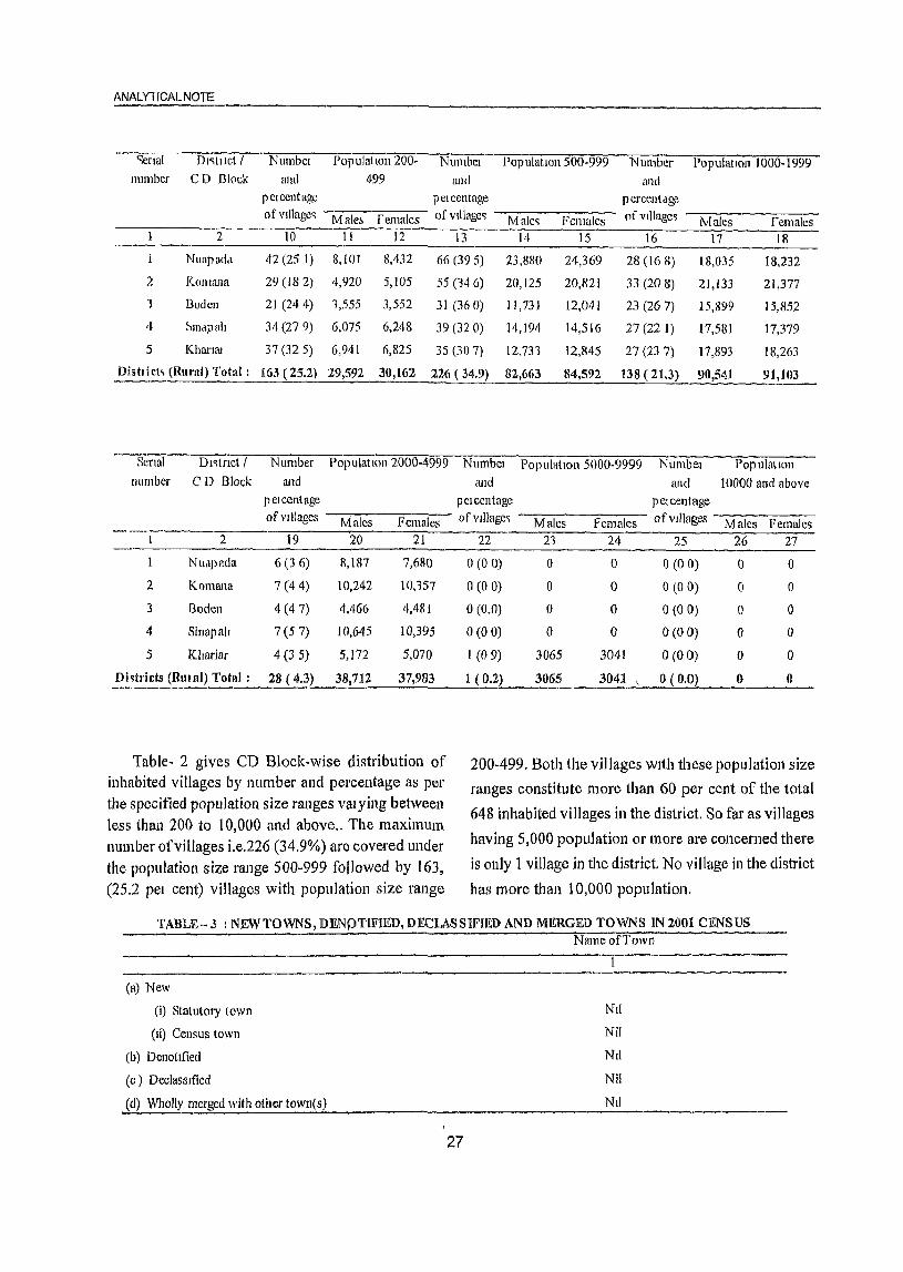
ANAlY1 rCAl NOTE
')crlUl DI'itllct I Numbcl PopulatIOn 200~ Nlllnbcl Population 500-999 Number Pop ulatlon 1000-1999 number CD Block and 499 ami and
pClccntagc pClcentnge percentage ofvlllageq Mab femalcs o[vllIagcq Maleq Females ofvlllage~ Males females
2 10 11 12 13 14 15 16 17 18
Nuapad'l 42 (25 1) 8,101 8,432 66 (39 5) 23,8S0 24,369 28 (16 8) 18,035 18,232
2 Komana 29 (18 2) 4,920 5,105 55 (14 6) 20,125 20,821 33 (20 8) 21,133 21,377
'I Bodcn 21 (244) 1,555 3,552 31 (36O) 11,731 12,041 23 (26 7) 15,899 15,852
4 ~lIlapalt 34 (27 9) 6,075 6,248 39 (32 0) 14,194 14,516 27(221) 17,581 17,379
5 Khamu 37(325) 6,941 6,825 3S (307) 12,731 12,845 27 (237) 17,893 18,263
Dist! i C(, (Rural) Total: 163 (25.2) 29,592 30,162 226 (34.9) 82,663 84,592 138 (21.3) 90,541 91,103
--SCnal Dlqtnct / Number Population 2000-4999 NumbcI PopulatIOn 5000-9999 Numbel Population Ilumber CD Block and and and 10000 and above
pel cent age pClcentage pel cent age of Villages Males Females ofvJllage~ Males Females of villages Males Females
2 19 20 21 22 21 24 25 26 27
Nuapacla 6 (36) 8,187 7,680 0(00) 0 0 0(00) 0 0
2 Komana 7 (4 4) 10,242 10,157 0(00) 0 0 0(00) 0 0
3 Boden 4 (47) 4,466 4,481 0(0.0) 0 0 0(00) 0 0
4 Sinapall 7 (57) 10,645 10,395 0(00) 0 0 0(00) 0 0
5 Khariar 4 (35) 5,172 5,070 1 (09) 3065 3041 0(00) 0 0
Di~trjcts (Rula!) Total: 28 (4.3) 38,712 37,983 1 (0.2) 3065 3041 \ 0(0.0) 0 0
Table- 2 gives CD Block-wise distribution of inhabited villages by number and percentage as per the specified popUlation size ranges valying between less than 200 to 10,000 and above .. The maximum number ofvillages Le.226 (34.9%) are covered under the popUlation size range 500-999 followed by 163, (25.2 pel cent) villages with popUlation size range
200-499. Both the villages WIth these population size
ranges constitute more than 60 per cent of the total
648 inhabited villages in the district. So far as villages
having 5,000 population or more are concerned there
is only 1 village in the district No village in the district
has more than 10,000 population.
TABLE-J : NEW TOWNS, DENj)TIFJED, DECLASSIFIED AND MERGED TOWNS IN 2001 CENSUS
(a) New
(i) Statutory town
(li) Census town
(b) Denotlfied
(c) Declassified
(d) Wholly merged with other town(s)
27
NalllcofToWll
Nil
Nil
Nil
Nil
Nil
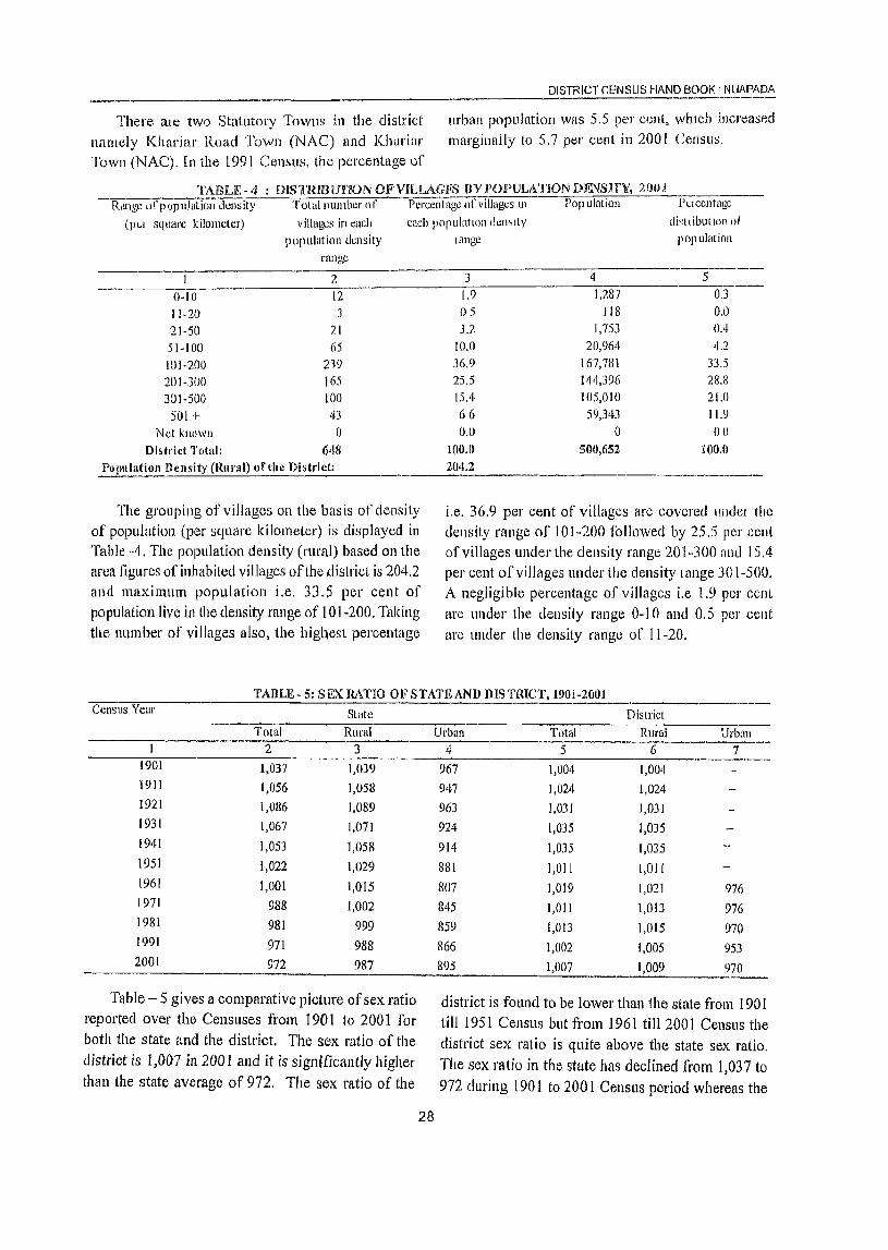
There ale two Statutory Towns in the district namely Khariar Road Town (NAC) and Khariar Town (NAC). In the 1991 Census, the percentage of
DISTRICT CF.NSUS HAND BOOK . N~AP~~
Ilfban population was 5.5 per cent, whIch increased marginally to 5.7 pel' cent in 200 l Cel1su~.
TABLJ~- 4 : DlsTRmurJON OFVJLLAGIiS flY PO)PULATJON DF.NSHV, 2001 --"'R-,U-lg-G-u"""f 1-) o-p-uO-lu-:-tiol1 dGl1sity Tolal llumber of Percentage of villages III Population Puccntage
di~tl ibullOn ot poplllarion
(pLI square kilometer) villages in each each populatlOl1 ch:mlty
0-10 11-20
21-50 51-100 101-200 201-300
301-500 501 +
Not known Di&tl'ict Total:
population dwsity range
2
12 3
21 65
219 165 100 43 o
648 PO(lulatioll llcnsity (Rural) of the District:
The grouping of villages on the bas is of density of population (per square kilometer) is displayed in Table -4. The population density (rural) based on the area figures of inhabited villages of the district is 204.2 and maximum population i.e. 33.5 per cent of population live in the density range of 101-200. Taking the number of villages also, the highest percentage
lange
3 1.9 OS 3.2
10.0 36.9 25.5 15.4 66 0.0
100.0 204.2
'I 1,287
118 1,753
20,964 167,781 1 ~4,396 105,010
59,343 0
500,652
5 OJ 0,0 0.4 4.2
33.5 28.8 21.0 11.9 00
XOO.O
i.e. 36.9 per cent of villages are covered IIndel the
density range of 101-200 followed by 25.5 per cent of villages under the density range 201-300 and 15.4 per cent of villages under tlte density lange 301-500. A negligible percentage of villages i.e 1.9 pel' cent are under the density range 0-10 and 0.5 per cent are under the density range of 11-20.
Urban 7
------~~--------------------~------------------------------------------------
Table - 5 gives a comparative picture of sex ratio reported over the Censuses from 1901 to 2001 fol' both the state and the district. The sex ratio of the district is I j 007 in 200 1 and it is significantly higher than the state average of 972. The sex ratio of the
28
976 976
970
953
970
district is found to be lower than 1he state from 1901 till 1951 Census but from 1961 till 2001 Census the district sex ratio is quite above the state sex ratio. The sex ratio in the state has declined from 1,037 to 972 during 1901 to 2001 Censlls period whereas the
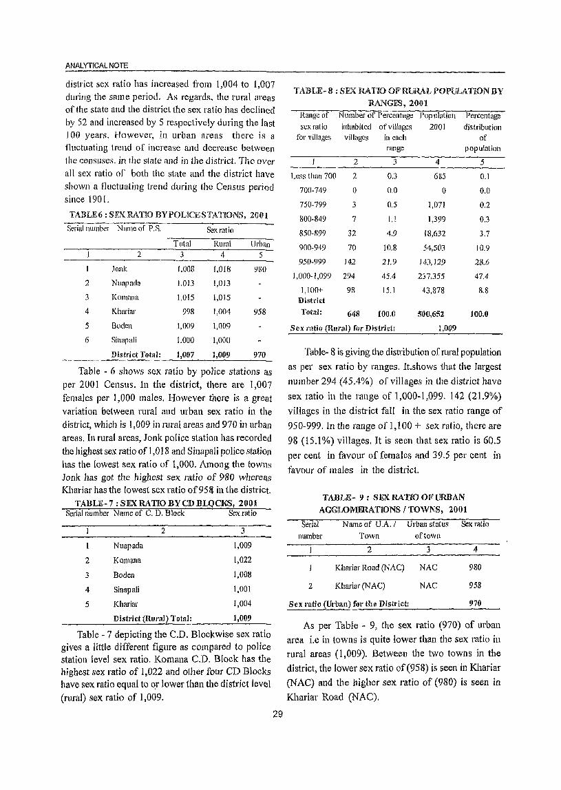
ANALYTICAL NOTE
district sex ratio has increased from 1,004 to 1,007 dlll'illg the same period. As regards, the rural areas of the state and the district the sex ratio has declined by 52 and increased by 5 respectively during the last 100 years. However, in urban areas there is a fluctuating trend of increase and decrease between the censuses. in the state and in the district. The over
all sex ratio of both the state and the district have shown a fluctuating trend during the CenslIs period since 1901.
TABLE6 : SEX RAllO BV POLICE STATIONS, 2001
Serial number Nrune of P.S. Sex ratio
Total Rural Urban 2 3 4 5
I Ionk I,OOS 1,018 980
2 Nuapada 1,013 1,013
3 Komana 1,015 1,015
4 Khru'iar 998 1,004 958
5 Boden 1,009 1,009
6 Sinapali 1,000 1,000
District Total: 1,007 1,009 970
Table - 6 shows sex ratio by police stations as per 2001 Census. In the district, there are 1,007 females per 1,000 males. However there is a great variation between rural and urban sex ratio in the district, which is 1,009 in rural areas and 970 in urbItI1 areas. In rural areas, Jonk police station has recorded the highest sex ratio of 1,018 and Sinapali police station has the lowest sex ratio of 1,000. Among the tOWl)s Jonk has got the highest sex ratio of 980 whereas Khariar has the lowest sex ratio of95f1 in the district.
TABLE-7 : SEX RATIO BY CD BLQCKS, 2001 Serial number Name of C. D. Block Sex ratio
2 3
Nuapada 1,009
2 Komana 1,022
3 Boden 1,008
4 Sinapali 1,001
5 Khariar 1,004
District ,(Rural) Total: 1,009
Table - 7 depicting the C.D. Blockwise sex ratio gives a little different figure as compared to police station level sex ratio. Komana C.D. Block has the highest sex ratio of 1,022 and other tbur CD Blocks have sex ratio equal to o,r lower than the district level (rural) sex ratio of 1,009.
29
TABLE- 8: SEX llATIO OF RUHAL POPULATION BY
RANGES,2001
Range of Number of Percentage Population Percentage sex ratio inhabited of villages 2001 distribution
for villages villages in each of range popUlation
2 3 4 5
Less than 700 2 0.3 685 0.1
70()-749 0 0.0 0 0.0
750-799 3 0.5 1,071 0.2
800-849 7 1.1 1,399 OJ
850-899 32 4.9 18,632 3.7
900-949 70 10.8 54,503 10.9
950-999 142 21.9 143,129 28.6
1,000-1,099 294 45.4 237,355 47.4
1,100+ 98 15.1 43,878 8.8 DistJ'ict
Total: 648 100.0 500,652 100.0
Sex ratio (Rural) for District: 1,009
Table- 8 is giving the distribution of rllfal population
as per sex ratio by ranges. It. shows that the largest
number 294 (45.4%) of villages in the district have
sex ratio in the range of 1,000-1,099. 142 (21.9%)
villages in the district fall in the sex ratio range of
950-999. In the range of 1,100 + sex ratio, there are
98 (15.1%) villages. It is seen that sex ratio is 60.5
per cent in favour of females and 39.5 per cent in
favour of males in the district.
TABLE- 9 ; SEX RATIO OF URBAN
AGGLOMERATIONS f TOWNS t 2001
Serial number
Nrune of U.A. I Urban status Sex ratio Town oftowl1
234
Khnriar Road (NAC) NAC 980
2 Khariar (NAC) NAC 958
Sex ratio (Urban) for the District: 970
As per Table - 9, the sex ratio (970) of urban area i.e in towns is quite lower than the sex ratio in rural areas (1,009). Between the two towns in the
district, the lower sex ratio of(958} is seen in Khariar (NAC) and the higher sex ratio of (980) is seen in
Khariar Road (NAC).
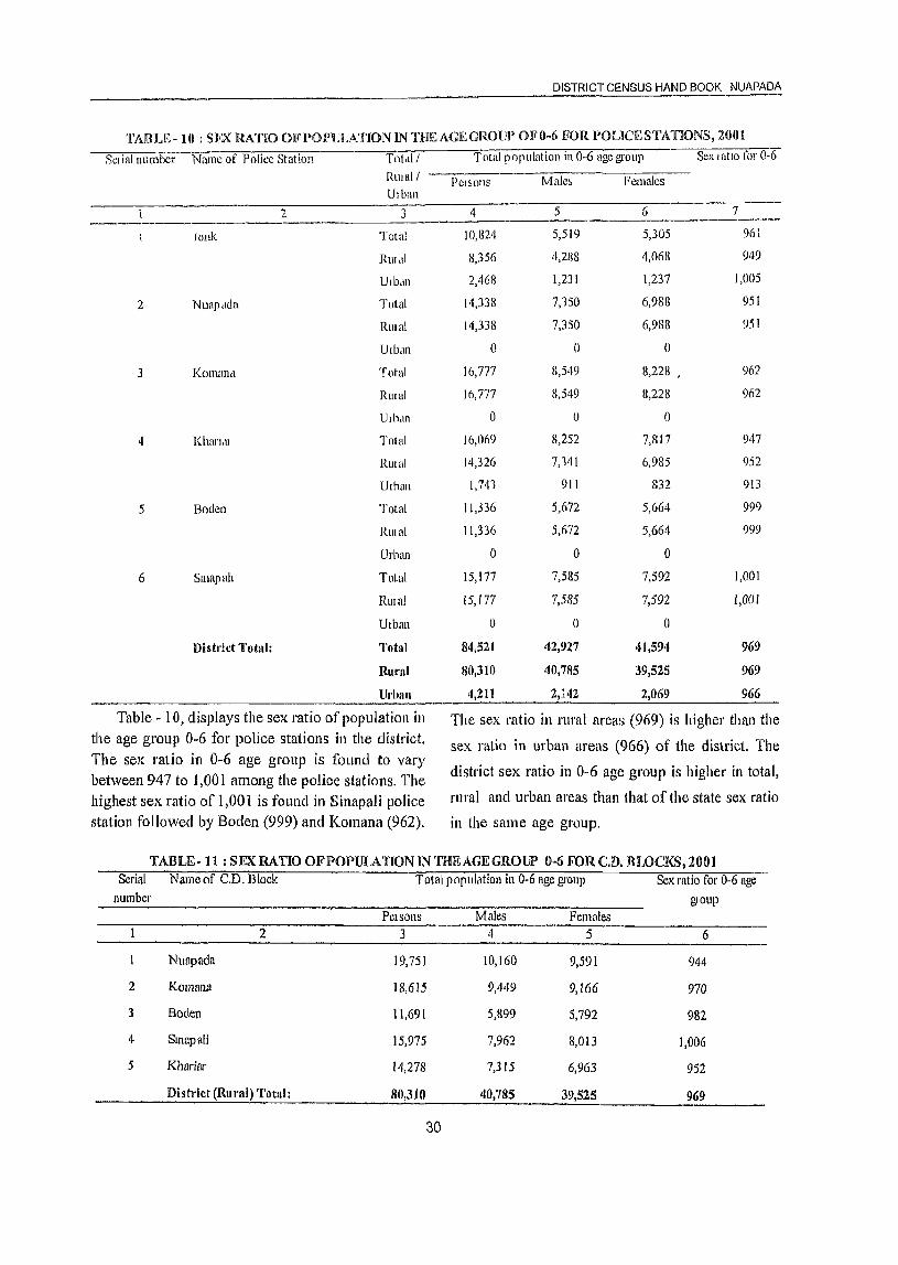
DISTRICT CENSUS HAND BOOK NUAPADA
TABLE-IO : SllX RATIO OFl'Ol'ULATION IN THEAGEGROlJP OFO-6 FOR I'OLICESTATIONS, 2()01
Sel ial number Name of Police Station Totdll Total population in 0-6 age group Sex I atlo for 0-6
RUlal1 Pel50l1S Male, Females Ulban
2 3 4 5 6 7 ----------~
lonk Total 10,824 5,519 5,305 961
RUldl 8,356 4,2U8 4,068 949
Ulb,lII 2,468 1,231 1,237 1,005
2 Nuapaela Total 14,338 7,150 6,988 951
RUlal 14,338 7,350 6,988 951
Ulban 0 0 0
J Koman<1 Total 16,777 8,549 8,228 " 962
Rlllal 16,777 8,549 8,228 962
lhh,ll1 () 0 ()
4 Kharldl Total 16,069 8,252 7,817 947
RUlal 14,326 7,141 6,985 952
Ulban 1,741 911 832 913
5 Boelen Total 11,336 5,672 5,664 999
RlIIul 11,336 5,672 5,664 999
Urban 0 0 ()
6 Slllapah Total 15,177 7,585 7,592 1,001
RlIlai 15,177 7,585 7,592 J,OOJ
Utban 0 () 0
District Total: Total 84,521 42,927 41,594 969
Rural 80,310 40,785 39,525 969
Urban 4,211 2,142 2,069 966
Table - 10, displays the sex ratio of population in The sex ratio in rural areas (969) is higher than the the age group 0-6 for police stations in the district. sex ratio in urban areas (966) of the district The The sex ratio in 0-6 age group is found to vary
district sex ratio in 0~6 age group is higher in total, between 947 to 1,001 among the police stations. The highest sex ratio of 1,001 is found in Sinapali police rural and urban areas than that of the state sex ratio
station followed by Boden (999) and Komana (962). in the same age group.
TABLE- 11 : SEX RATIO OF POPULATION IN THE AGE GROUP 0-6 FOR CD. BLOCKS, 2001 Serial Name of C.D. Block Total population in 0-6 age group Sex ratio fol' 0-6 age
number glOup Pet sons Males Females
2 3 4 5 6
Nuapada 19,751 10,160 9,591 944
2 KOllllU18 18,615 9,449 9,166 970
3 Boden 11,691 5,899 5,792 982
If Smapali 15,975 7,962 8,013 1,006
5 Khariol' 14,278 7,315 6,963 952
Distl'ict (Rural) Totul: 80,310 40,785 39,525 969
30
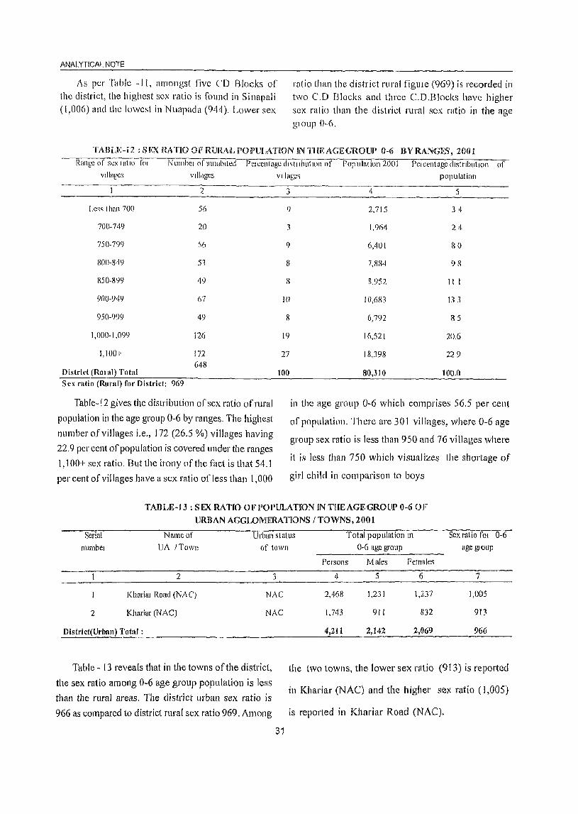
ANALYTICAL NOTE
As per Table -II, amongst five CD Blocks of the district, the highest sex ratio is fonnel in Sinapali (1,006) and the lowest in Nuapada (944). Lower sex
ratio than the district rural figlllc (969) is recorded in two C.D Blocks and three CD.Blocks have higher sex ratio than the d btriet rural sex ratio in the age glOup 0-6.
TABW-X2 ;Sl!X RATIO OF RlJRAL lPOI)ULATlON IN THE AGE GROUP 0-6 HYRANGFS,200t
Range of sex I atlo 101
villages NUlllbcI nf111habltecf PClccntage dl~tllbl1tH)n of Population 200l PClccntngc ciIstnbutlOll of
villages villages population
2
Le~q than 70() 56
70()· 749 20
7S()·799 :':>(1
800·1149 51
R50-8lJlJ 49
90()-949 67
950-999 49
1,000-1,099 126
1,1001- 172 648
District (RUB al) Total Sex ratio (Rural) for District: 969
Table-12 gives the distribution of sex ratio of rural
population ill the age group 0-6 by ranges. The highest
number of villages i.e., 172 (26.5 %) villages having
22.9 per cent of popUlation is covered under the ranges
1,100+ sex ratio. But the irony ofthc fact is that 54.1
per cent of villages have a scx ratio of Jess than 1,000
3 4 5
() 2,715 3 4
3 1,%4 24
80
98
9 6,401
8
8 11 l
I()
7,884
H,952
10,683
6,792
133
8
19
27
100
lli,52l
18,398
80,310
85
20.6
229
100.0
in the age group 0-6 which comprises 56.5 per cent
of popUlation. There are 301 villages, where 0-6 age
group sex ratio is less than 950 and 76 villages where
it is Jess than 750 which visualizes the shortage of
girl child in comparison to boys
TABLE-13 : SEX RATIO OF POPULATrON IN THE AGE GROlII) 0-6 OF
URBAN AGGLOMERATIONS / TOWNS, 2001
Serial numbel
Name of
UA /Town Urban status Total population In Sex ratio fOl 0-6
of (own
2 3
Kharim Road (NAC) NAC
2 Khariar (NAC) NAC
Distl'ict(Urban) Total;
Table - 13 reveals that in the towns of the district,
the sex ratio among 0-6 age group population is less
than the rural areas. The district urban sex ratio is
966 as compared to district rural sex ratio 969. Among
31
0-6 age grOllp age glOlIp
Persons Males females
4 5 6 7
2,468 1,231 1,237 1,005
1,743 911 832 913
4,211 2,142 2,069 966
the two towns, the lower sex ratio (913) is reported
in Khariar (NAC) and the higher sex ratio (1,005)
is reported in Khariar Road (NAC).
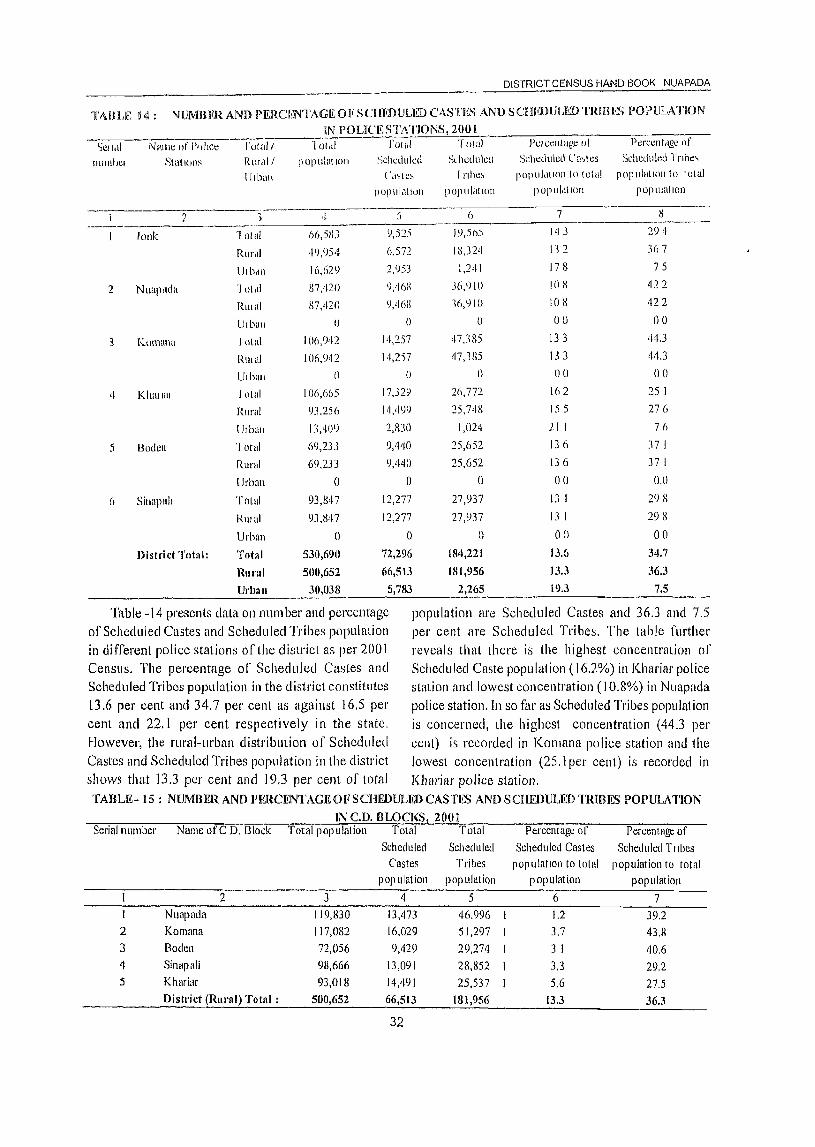
DISTRICT CENSUS HAND BOOK NUAPADA
TABLE 14: NUMBKR AND PERCENTAGE OF ScmnllJLED CASTES AND SCHEDULED TRmES POPULATION
IN POUCESTATIONS, 201l I
SCI,,!I 1\1 amt: of 1'1)11ce rotal/ "IOlct! ['olnl T oUlI l'clccnlilge oj Pcrct:llt<lgl: of
IllllnlJCI StatlL)ll~ RUfcll/ populatloll Scheduled Sl hcdulcd Scheduled Ca.,tes Scheduled rnbc:~
{ ilban ( 'c\',te, r nbc, POlllllclllon to total pOjllllatlolito lUlul
pOjllllatloil popliialloll POPUlclt)(lIl populatIon
2 3 ·1 :) 6 7 H ----"'"""--~ 19,)(JS 143 294 Jonk "loJa! 6b,SIlJ 9,525
Rurcli ·1<),()54 6,572 18,3211 112 367
lJl bon 16,629 2,053 1,241 178 75
2 NUllpclda "Iotcll 87,420 C),tl6S J6,() 10 108 422
Rlllal R7,420 C),46X 16,910 108 422
U,ball 0 () 0 00 00
3 l".\)!l1tlna I DIal 106,042 14,257 47,385 133 44.3
RIllal 106,1)42 111,2)7 47,lHS 133 44.3
Ulban 0 0 0 00 00
4 KhmlaJ lotal 106,665 17,329 26,772 Ifl 2 25 I
Rural <)],256 14,499 25,748 155 276
lJlbali 13,409 2,R30 1,024 21 I 76
5 Bodell "lotal 69,2JJ 9,440 25,652 lJo 37 I
Rural 6<),233 9,440 25,652 136 37 I
Urban () 0 0 00 0.0
6 Sinapah Total 93,g47 12,277 27,937 13 I 2') 8
RUlal 93,g47 12,277 27,937 13 1 298
Urban 0 0 () 00 00
Distri ct Total: Total 530,690 72,296 184,221 13.6 34.7
Ruml 500,652 66,513 181,956 133 36.3
Urban 30,U3B 5,783 2,265 19.3 7.5
Table -14 presents data on number and percentage popUlation are Scheduled Castes and 36.3 and 7.5 of Scheduled Castes and Scheduled Tribes population per cent are Scheduled Tribes. The table further in different police stations of the clistrict as per 2001 reveals that there is the highest concentration oj' Censlls. The percentage of Scheduled Castes and Scheduled Caste population (16.2%) in Khariar police Scheduled Tribes population in the district constitutes station and lowest concentration (10.8%) in Nuapada l3.6 per cent and 34.7 per cent as agaillst 16.5 per police station. In so far as Scheduled Tribes popula1 ion cent and 22, I per cent respectively in the state. is concerned, the highest concentration (44.3 per However, the rural-urban distribution of Scheduled cellt) is recorded in Komana police station and 1he Castes and Scheduled Tribes population in the district lowest concentration (25.1 per cent) is recorded in shows that 13.3 per cent and 19.3 per cent of total Kharial' police station. TABLE-I5: NlJMBER AND 11ERCENTAGEOF SCHEDlJLED CASTES AND SCHF..DULED TRIRF.s POPULATION
INC.D.BLOCKS 2001 Sedall1L1lllbel' Name ofC D. Block Total popUlation Total Total Percentaglj of Percenlagt of
Scheduled Scheduled Scheduled Castes Scheduled Tltbes Castes Tribes populatIon to total population to total
pop ulation popUlation popUlation popUlation
2 3 4 5 6 7 I Nuopada 119,830 13,473 46,996 1.2 39.2 2 Komana 117,082 16,029 51,297 3.7 43.8 3 Boden 72,056 9,429 29,274 3 I 40.6 4 Sinapali 98,666 13,091 28,852 3.3 29.2 5 Khariar 93,018 14,49] 25,537 5.6 27.5
District (Rural) Total: 500,652 66,513 181,956 13.3 36.3
32
ANALYTICAL NOTE
Table-I 5 gives picture regarding distribution of Scheduled Castes and Scheduled Tribes population in different C.D.Blocks of the district as per 2001 Census. The highest concentration of Scheduled Castes population is recorded in Khariar (15.6%) CD. Block tt)llowed by Komana (13.7%) CD. Block. In
contrast, Nuapada CD. Block lies at the bottom with ollly 11.2 pel' cent of Scheduled Caste population. As regards, the percentage of Scheduled Tribes population to total population, Komana CD.Block tops the list with 43.8 pel' cent of tribal population and the lowest percentage (27.5%) is recorded in KhariarCD. Block.
TABLH~ 16: PROPORTION OF SCHEDULED CASTES POJ)ULATION TO TOTAL POPULATION IN VILLAGES, 200]
PClcentagc range of Scheduled Castes Numbelof population to total popllintion villages
2
Nil 120
I.e~s than 5 101
5-10 136
11-20 IRG
21-30 60
31-40 27
41-50 12
51-75 3
76 and above 3
Distl'ict Total 648
Table- 16 shows proportion of Scheduled Castes population to total population of the villages. The percentage of Scheduled Caste popUlation to total popUlation of villages is divided into nine ranges starting from 'Nil to 76 and above'. The table reveals that out of 648 inhabited villages of the district, 120 (J 8.5%) villages have no Scheduled Caste population
Percentage Scheduled Castcs PClccntagc Population
3 4 5
185 0 0.0
15.6 2,305 3 5
21D 9,695 14.6
287 31,073 467
93 11,573 17.4
4.2 7,196 10.8
19 3,360 5.1
05 837 1.3
0.5 474 0.7
100.0 66,513 100.0
and 3(0.5%) villages have more than 75 per cent of Scheduled Caste population. However, the majority of villages in the district numbering 483(74.6%) have Scheduled Caste population ranging between less than 5 to 30 per cent and they constitute 82.2 per cent of Scheduled Caste population of the district.
TABLE - 17 : PROPORTION OF SCHEDULED TRmES POPULATION TO TOTAL POl'ULATION
IN VlLLAGES, 2001 Percentage range of Scheduled Tribes Number ofvilJages PClccntagc Scheduled Tribes Percentage
population to total popUlation PopUlation
2 3 4 5
Nil 57 8.8 0 0.0
Less than 5 32 4.9 783 0.4
5-10 44 6.8 4,353 2.4
11-20 60 9.3 10,426 5.7
21-30 69 10.6 16,889 9.3
31-40 63 9.7 19,964 11.0
41-50 55 8.5 21,699 11.9
51-75 139 21.5 63,568 34.9
76 and above 129 19.9 44,274 24.3
District Total : 648 100.0 181,956 100.0
33
DISTRICT CENSUS HAND BOOK. NUAPADA
Like the previous Table-I 7, distributes the villages found that the maximum percentage (59.2%) oflotal
of the district into different percentage ranges of Scheduled Tribes population of the district live in 268
Scheduled Tribes population to total population. Out villages ano the concentration of Scheduled Tribes
of 648 inhabited villages of the district, 57 (8.8%) population in these villages is in the range of 5 J per
viUages ha.ve no Scheduled Tribes population. It is cent and above of the total population of the village. 'fABLE ~18: NUMBER AND PERCENTAGE OF SCHUHJLFJ) CASTlE'S AND SCHEDULED TRIBES POl)ULATION
IN URBAN AGGLOMERATlONS I TOWNS, 2001
Serial Name of VA / Town Total Total Scheduled
number popUlation Castes population
2 3 4
Khariar Road (NAC) 16,629 2,953
2 Khariar (NAC) 13,409 2,830
Distl'ict(Urllllu) Totnl 30,038 5,783
Table-IS presents data on number and percentage of Schecluled Castes and Scheduled Tribes population in different towns of the district as per 2001 Census. The percentage of Scheduled Castes and Scheduled Tribes popUlation to the total population in the urban areas of the district constitutes 19.3 per cent and 7.5 per cent respectively. Between the two towns of the district, Khariar (NAC) has the higher
Total Scheduled Percentage of Scheduled Percentage of Scheduled Tribes Castes population to Tribes population to
population total population total population 5 6 7
1,241 17.8 7.5
1,024 21.1 7.6
2,265 19.3 7.5
concentration of Scheduled Castes popUlation (21.1 %)
in the district and Khariar Road (NAC) has the lower
concentration ofScheduleci Castes population (17.8%).
Like-wise, Khariar (NAC) has the higher
concentration ofSchecluled Ttribes popUlation (7.6%)
ancl Khadar Road (NAC) has the lower concentration
of Scheduled Tribes population(7.5%) in the district.
TABLE- 19: SEX RATIO AMONGSCHEDULFD CASTES AND SCHEDULED TRmES IN c. D. BLOCKS, 2001
Serial number Name oC CD Block
2
Nuapada
2 Komallu
3 Boden
4 Sinapali
5 Khal'ial'
District (Rural) Total :
Table-19 shows sex ratio among Scheduled Castes and Scheduled Tribes population in different C.D Blocks of the district as per 2001 Censlls. For the I'ural areas of the district as a whole, the sex ratio of Scheduled Castes ancl Scheduled Tribes popUlation are 1,005 and 1,027 respectively. In case of Scheduled Castes population, Boden C.D. Block exhibits the highest sex ratio of 1,014 followed by Khariar(I,006), Komanft (1,005) and Sinapali(I,004).
Scheduled Castes sex ratio
3 998
1,005
1,014
1,004
1,006
Scheduled Tribes sex ratio
4 1,030
1,034
1,014
1,015
1,035
1,005 1,027
Nuapada has the lowest sex ratio of 998. As regards
the sex ratio of the Scheduled Tribes population, three C.D. Blocks have recorded higher sex ratio and other
two C.D Blocks have recorded lower sex ratio than
the Scheduled Tribes sex ratio of the district. Among
the CD Blocks Khariar (NAC) has recorded the
highest sex ratio of 1,035 and Boden has the lowest sex ratio of 1,014.
TABLEw 20: SEX RATIO AMONG SCHEDULED CASTES AND SCHEDULED TRIBES IN URBAN AGGLOMERATIONS I TOWNS, 2001
Serial number Name ofU.A.I Town Scheduled Castes sex ratio Scheduled Tribes sex ratio
2 3 4 I Kharial' Road (NAC) 953 1,038 2 Khariar (NAC) 1,066 962
S ex ratio (Urban) for the District: 1,007 1,003
34
ANALYTICAL NOTE
Like the pleVlOUC; table, Table-20 lI1chcates sex
latta fUl10ng Scheduled Ca'ltes and Scheduled TlIbes populatIon 111 the towns of the dIstrict The urban aleClS of the dlstl1ct have I eCOl'ded sex I at 10 of 1,007 and 1,003 dl110ng Scheduled Castes and Scheduled Tltbes population lespeclively Between the two towns, the
iligilci Scheduled Castes 5ex latlO 0[(1,066) is found
III Khar lal (NAC) and lowel sex ratio of (953) is
fOllnd m Khallnr Road (NAC) The hlg1Je1 ScJleduJed
Tllbe sex I atlo of 1,038 is 111 Khartal Road (NAC)
and lowel sex ratio of 962 IS III Khm ial (NAC).
IADUL- 21: NlIMBERANDl'RRCENTAGEOFLlTI~RATES ANDILLITI!.RATES BVPOLlCESTATIONS, 2001 SCI tal Name of 1 Olul I Numbcl of !ttCI ate,> and lllItclatcs Pelccntagc oj lIterates Gap 111
numbel PolIce qtatloll Rwull Numhel of htcrateq Numhcl of IIlrtcl!lteq Illule-fcmalc
UI ban PClson<; M ,lies remalc'i Pel '>om M alc'i female'> Person'> M die., f emules htel aey rate
2 3 4 5
Jonk lotal 26,819 17,277 9, 'i67
RUlal 16,857 11,446 5,411
III ban 9,982 5,831 4,151
2 Nuapadd fo(al 11 987 21,608 10,379
RUlal 31,98721,60810,379
Urban o o ()
3 KOlll<lna fota1 34,076 24,107 9,969
RUI <II 34,076 24,107 9,969
lhbun o o o
4 Khmlat lotal 41,744 28,106 13,638
RUlul 33,531 23,242 10,289
Urban 8,213 4,864 3,349
5 Boden Total 21,845 16,049 5,796
Rmal 21,845 16,049 5,796
Ulban o o o
6 SlI1apall 1 otal 30,921 22,314 8,607
RUlal 30,921 22,314 8,607
Urban o o o
7 8 9 10 II 12
39.744 15,877 23,867 48 I 625 340
11,0Y7 11,308 19,789 40 5 559 256
6,047 2,569 4,078 70 5 81 3 594
55411 21,809 13,624 418 599 280
55,433 21,809 33,624 43 8 599 28 ° () o o 00 o 0 ()
72,866 28,969 43,897 378 541 218
72,866 28,969 43,897 37 8 54 1 21 8
o o o 00 o 00
64,921 25,273 39,648 46 1 623 300
59,725 23,287 36,438 425 593 259
5,196 1,986 3,210 704 819 585
47,388 18,408 28,980 377 558 199
47,388 J 8,408 28,980 177 55 8 199
o o o 00 o 00
62,926 24,599 38,327 193 567 21 9
62,926 24,599 38.327 393 567 219
o o o 00 o 00
13
285
303
220
319
319
00
323
323
00
323
334
234
359
359
00
349
349
00
Di~trict Total: Total 187,412 129,461 57,951 343,278 134,935 208,343 42.0 58.5 25.8 32.7
Rural 169,217 118,766 50,451 331,435 )30,380 201,055 40.3 57.0 23.8 33,2
V,ban 18,195 10,695 7,500
Table-21 presents Police Station level data giving tIle number of literates and illiterates along with pel centage of literates as pel 2001 Census. The Iitelacy rate of the district is 42.0 per cent of the total population and It is 58 5 per cent and 25.8 per cent in case of males and females Jespectively For the totallUral population of the district, the literacy comes to 40.3 per cent and for the total urban
11,843 4,555 7,288 70.5 81.6 59.0 22.6
35
population of the district it is at a higher level of70.5 per cent. In all the police stations along with the district, the literacy rates in case of males is higher than the cOJrespollding rates for the females. Jonk Police Station records the highest literacy of 48.1 per cent followed by Khal iat· (46.1 %) and Nuapada (43 8%). Boden police station is at the bottom with 377 per cent literacy.
DISTRICT CENSUS HAND BOOK NUAPADA
TABLE- 22 : NUlVlBERAND pr~R(,ENTAGEOFLrmRATI<S AND ILUTERATi<E nYSK~X IN c. D. BWCI(S, 2(JOi
Srllal Name of N'lll1bcl of Iitelate~ ,mel dlitCldtr:, [lelcentage of Iltetate~ Gllp trJ
number (' D Riock '-'-'N-UI---Clllc-'le-l {-'lfC7-1it~wtcs NUlllhel of Illitclate, Jllllle·jemdle PCJSOI\~ Mdle, rem"le, ht~IIICY 1&" ........"P,...e-I~-Ol-l:, M.tlcs [t!l11uie, PC1,OIl> Mulc~ Fcmale~
3 ·1 5 (> 7 8 9 ]0 II ------------- -----------,---- --------
29,264 14,129 76,417 10,171 46,066 434 59 1 279 31
32 2 l(ol11!1na 37,691 26,451 11,240 79,191 11,455 47,936
30,451
40,269
36,333
383 546 22 5
3 Boden 21,9t)O 16,273 5,717 50,066 11),615 543 1 R 8 35
35
31
32,658
33,485
23,570 9,088 66,O()8 25,739 395 )70 220
Khan.!1 I)IW'ict (Rulal)
Total:
23,2()8 10,277 59,531 21,200 425 594 259
169,217 HS,766 50,451 331,435 130,380 201,055 40.3 57.0 23.8 33
Tablc-22 showf. number and percentage of literates and illitelates by sex in the rural aIcas of' the distt iet So fill as the percentage of litclHtes 1'01 the lata I nllal population is concerned, Nuapada CD. Block tops the lIst with 43.4 pel cent followed by Khanar (42.5%), Sinapali (39.5%), Komana (38.3%)
and Boden (36 4(%), The male literacy is highest IJ1
Kllariar C.D. Block (59.4%) and lowest in Boden (',D. Block (54.3%). Like~wise, the femaIL: literacy I, highest in Nuapada C.D. Bloclc (27 9% ) alld lowest in Boden C.D. Block (J 8.8%).
TABLE 23 : DISTRIBUTiON OF VILLAGES I3Y LlTERACY RATE RANGE, 2001 {{,lnge of litelacy rate fOl Numbel of mhablted Pel Gent,lge dlstllDutlOll Pop l! lat ion Percentage dlSlllblltlOCI
villages villages of vlll,\ges of p op ulatlon
2 3
(] 7 I 1
1·10 12 1 9
11-20 56 86
21-30 141 21 8
31·40 1119 292
'f)·50 158 244
51-60 58 90
61-70 20 'J 1
71-80 5 08
81-90 2 03
91-99 0 DO
100 () 00 District Totul: 648 100.0
Literacy rate for District: 42
Table-23 distributes the total number of villages in the district as per different ranges of literacy rates of the villages. The table reveals that the maximum number of villages in the district i.e. 189 constituting 3 I J per cent of the total population in the rural areas of the district, have literacy ~ates in between 31 ~40 per
36
4 5
254 0.1
1,615 03
25,401 5 1
80,319 16 (J
156,529 31 3
142,482 28.5
59,215 11 8
24,697 49
9,015 18
1,103 0.2
0 O.D
0 O.U
500,652 100.0
cent, J 58 llumber of villages have literacy I'(\tes in between 41-50 per cent and 141 villages have literacy rates in between 21-30 per cent.There is no village in the district which has achieved more than 90 per cent literacy and seven villages have ac1Jieved more than 70 per cent of literacy.There are 7 villages with no literacy,
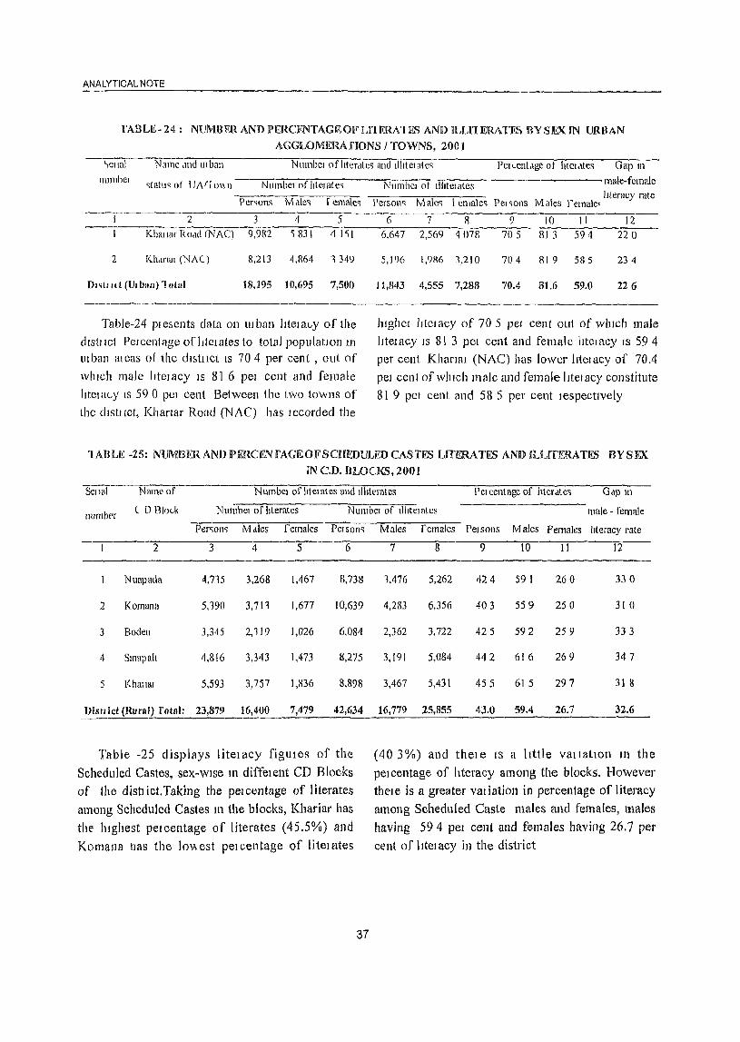
ANALYTICAL NOTE
fABLE-24: NUMBERANDI)ERCENTAGEOFLI1ERAHS ANIHLLl1ERATES BVSIEXIN URBAN
AGGLOMEHAnONS / TOWNS, 2001
'-,CI Ial
Ilumber Name ,md III ban Numbcl of literates and IlhtcI ateq PClccnLlgc of hteldtes Gap 111
~tat\lq at tJi\rr 0\\ n NumbcI of litel ate';
234 5 Khallar ROdd (NAC) 9,982 'i 831 4 I 'i I
2 Kh,lrIm (NAC) 8,213 4,864 1 349
DI ~tI f( t (UI ball) 1 otal 18,195 lO,()95 7,500
Tabfe-24 pi e&cnts data on til ban flteJaGY of the dlStllci Pel cent age of htel ates to total populatIOn III
III ban al cas of the cll&tllct IS 70 4 per cent, out of whIch male htelacy IS 81 6 pel ccnt and female Ittclat"y IS 590 PCI cent Betwcen the two towns of the cllstllct, Khanar Road (NAC) has recorded the
Numbcr 01 t1htcratcs male-female
Pcrsonq Ma\eq I emalc<; PC1'lOnS Males female< IHenley rate
6 7 8 9 10 II 12 6,647 2,569 4078 705 81 3 594 220
5,196 1,986 3,210 704 819 585 234
11,843 4,555 7,288 70.4 81.6 59.0 226
hlghel llte!acy of 70 5 pel cent out of whIch male IIteIacy IS 81 3 pCI cent and female lItcI acy IS 59 4
per cent Khanat (NAC) has lower Ittelacy of 70.4
pel cent of willch male and female btewey constitute 81 9 PCI cent and 58 5 per cent lespectlvely
lABLE -25: NlJMBERAND PERCFNfAGEOFSCHIJDULED CASTES LITERATES AND ILLrrERATES BYSEX
IN CD. BLOCKS, 2001
SelHlI Nmm'of Numbel of htel ntes and Illiterates PCI centagc of liter ate> Gap 1I1
nllmber (. D Block Numbel of hterates NumbcI of llhtclates mule - female
Per~on~ Metles females Pel son~ Males females Pelsons Males Females Itleracy rate
2 3 4 5 6 7 8 9 10 11 12
Nuapada 4,715 3,268 1,467 8,738 1,476 5,262 424 591 260 330
2 Komana 5,190 3,711 1,677 10,639 4,283 6,356 403 559 250 31 ()
3 Boden 3,345 2,119 1,026 6,084 2,362 3,722 425 592 259 333
4 Smapah 4,816 3,343 1,473 8,275 3,191 5,084 442 616 269 347
5 KhmlaI 5,593 3,757 1,836 8,898 3,467 5,431 455 61 5 297 31 8
District (Runil) rotal: 23,879 16,400 7,479 42,634 16,779 25,855 43.0 59.4 26.7 32.6
Table -25 displays liteJacy figUles of the (403%) and thele IS a !tttle vatlatlon 111 the
Scheduled Castes, sex-WIse 10 diffelent CD Blocks pelcentage of lIteracy among the blocks. However
of the distIict.Taking the pelcentage of literates thele is a greater vatiation in percentage of literacy
among Scheduled Castes 111 the blocks, Khadar has among Scheduled Caste males and females, males
the highest pelcentage of literates (45.5%) and having 594 pel cent and females having 26.7 per
Kornana tlas the lov. est pel centage of I He! ates cent of htelacy in the district
37
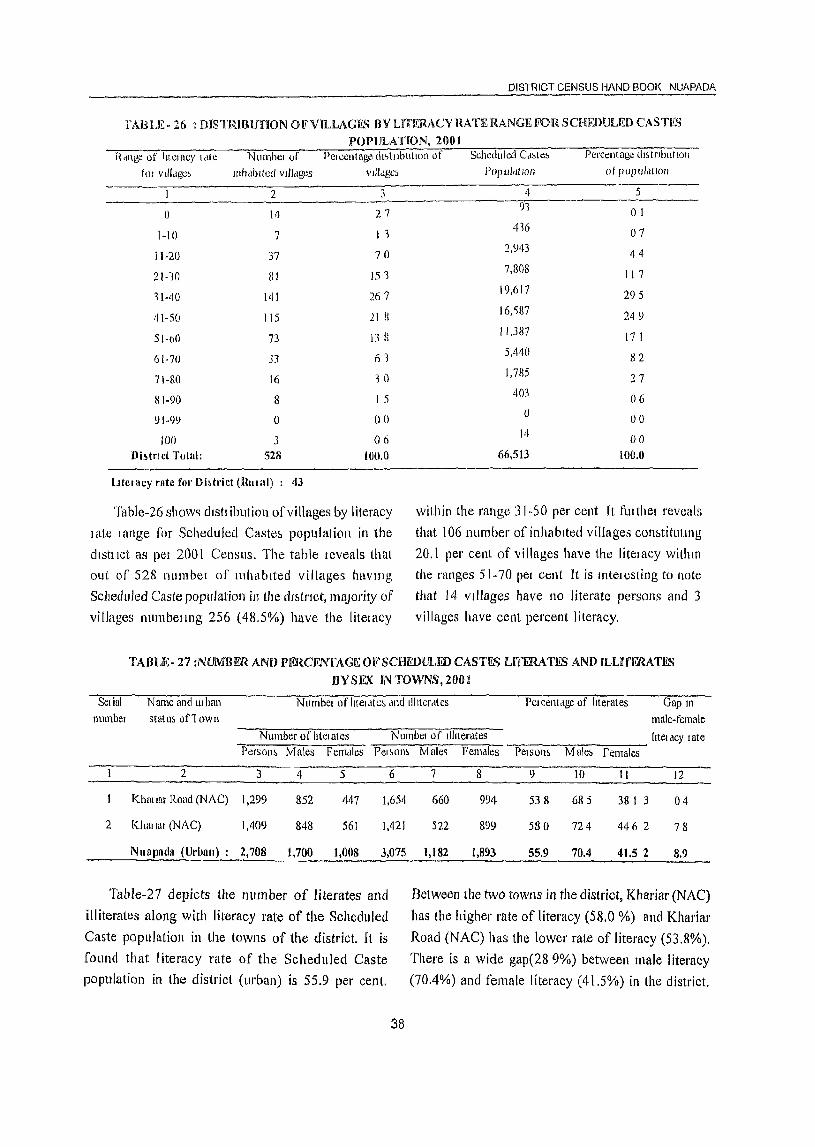
DISTRICT CENSUS HAND BOOK NUAPADA
fABLE- 26 : DJSTRlBUnON OF'VILLAGE_" BY LlTERACY RATE RANGE FOR SCHEDULED CASTIIS POPULATION, 20lH
Hdllge of Iitelac), 1,lle Nllrnbcl of PClccntage dl~tllblltlon of Scheduled Caote~ Percentage (h,tnblltIOI1
tor vll!dge~ Illhdblted vilidges vIJ!dge,
2 3
0 14 27
I-I () 7 I 1
11-20 37 70
21-10 81 15 '3
11-'10 141 267
111-50 115 21 fl
51-bO 73 IH
6!-70 33 /)1
7\-80 16 10
S 1-90 8 I 5
91-99 0 00
100 3 06 Di~tnct Total: 528 lon.o
lJtcrllCY rate for Di~trict (Rlllal) : 43
Table-26 show') dlstl iblltiol1 ofvillages by literacy
I ate I ange for Scheduled Caste~ population in the
dish Ict as pel 200 I Censlls. The table ICveals that aLIt of 52B l1umbel of II1hablted villages havmg
Sclleduled Caste population ill the dlMrlCt, JnlU0l'ity of
villages nurnbellng 256 (48.5%) have the litelacy
PO(lUldlion of popul,ltlOIl
4 5 91 01
416 07 2,943 44 7,808 117
19,617 295 16,'i87 249 11,387 17 I 5,440 82 1,785 27
403 06 (J
00 14 00
66,513 100.0
within the range 31-50 per cent It fUlthel reveals
that 106 number of inhabited villages con~titllttng
20.1 pel' cent of villages have the litelacy withlll
the ranges 51-70 pel cent It is Intel I,!sting to note
that 14 villages have 110 literate persons and 3
villages have cent percent literacy.
TABLE- 27 :NUMBERAND PERCENTAGE OFSCHEDULFD CASTFS LITERATES AND ILLlTFRATES nYSEX INTOWNS,200J
Seliul Name and urban Numbcl of htel ate~ tlnd t1l1ter<ilcs Per cent,lge of literates Gap 10
numbcl statu~ on own male-female Number of !ltelates Numbel of llhteratt!s !ltelclCY late
Pcrson~ Males FCIl1c1les Pelwm,
2 3 4 5 6
{(hill tar Road (NAC) 1,299 852 447 1,654
2 Khat tal (NAC) 1,409 848 561 1,421
NUflpada (Urban) : 2,708 1,700 1,008 3,075
Table-27 depicts the number of literates and
illiterates along with literacy rate of the Scheduled
Caste population in the towns of the district. It is
fOLind that 1 iteracy rate of the Scheduled Caste
popUlation in the district (urban) is 55.9 per cent.
38
Male~ Females PelSOl1~ Male~ females
7 8 9 10 11 12
660 994 538 685 38 I 3 04
522 899 580 724 446 2 78
1,182 1,893 55.9 70.4 41.5 2 8.9
Between the two towns in the district, Khariftr (NAC)
has the higher rate of literacy (58.0 %) and Khariar
Road (NAC) has the lower rate of literacy (53.8%).
There is a wide gap(28 9%) between male literacy
(70.4%) and female literacy (41.5%) in the district.
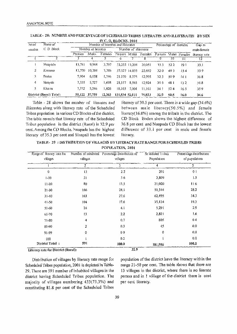
ANALYTICAL NOTE ---------------------------------------------------------------TABLE- 28: NUMlIF.R ANDPERCENI'AGEOFSCHEDULEDTRIBFS Lfl'ERATES AND ILLITERATES BYSEX
IN C. D. BLOCKS 200 I ~ell(ll Namc (If Number ofhterates and iIlltclates Pelcentage of literates Gap III
1111l11bcl C D Block N umbel 01 liter atcs PCI sons Male<, Females
2 3 4 5
Nuapada 13,741 9,944 3,797
2 KOIllIlIl.1 13,770 10,3114 1,3116
3 Roden 7,904 6,158 1,746
4 Sinapah 7,335 5,727 1,608
5 Khmlal 7,372 5,546 1,826
Distl'ict (Rural) Total: 50,122 37,759 12,363
Table - 28 shows the number of literates ancl illiterates along with literacy rate of the Scheduled Tribes population in various CD Blocks of tile district. The table reveals that literacy rate of the Scheduled Tribes population in the district (Rural) is 32.9 per cent. Among the CD Blocks, Nuapada has the highest literacy of 35.3 per cent and Sinapali has the lowest
Numbel of IlIltclates male-female Pels()n~ Males Females Pel sons Males Females literacy late
6 7 8 9 10 II 12
33,255 13,204 20,051 1S 3 522 191 33.1
37,527 14,835 22,692 320 493 154 339
21,370 8,375 12,995 32.1 509 14 I 368
21,517 8,593 12,924 305 48 I 132 348
IB,165 7,004 11,161 34 I 524 165 359
131,834 52,011 79,823 32.9 50.5 16.0 34.6
literacy of30.5 per ccnt. There is a widc gap (34.6%) between male literacy(50.S%) and female literacy(16.0%) alllong the tribals in the district. The CD Block Boden shows the highest difference of 36.8 per cent and Nuapada CD Block has the lowest d i fferencc of 33. I per cent in male and female literacy.
TABLE- 29 : DISTRIIJUnONOI<'VILLAGES BY LITERACY RATE RANGE FOR SCHEDULED TIUBES
IlOPULATION, 2001
Range of Iitelucy late fOl Numbel of mhablted Peleentage dl~tllblltlon of Scheduled 111bes Percentage cllstributlon
villages Villages
2
0 13
1·10 21
11·20 80
21·30 166
31·40 163
41·50 104
51·60 24
61·70 13
71·80 4
8'·90 2
91·99 0
100 1 District Total : 591
UtCl'lICY rate fol' District (Rural):
Distribution of villages by literacy rate range for
Scheduled Tribes population, 2001 is depicted in Table~
29. There are 591 number of inhabited villages in the district having Scheduled Tribes population. The
majority of villages numbering 433(73.3%) and
constituting 81.8 per cent of the Scheduled Tribes
Villages
3
22
36
13.5
28.1
27.6
17.6
4.1
2.2
0.7
0.3
00
0.2
100.0
32.9
PopulatIOn
4
201
2,809
21,020
51,344
62,495
35,124
5,291
2,821
805
45
0
181,956
of populatIOn
5
01
1.5
116
28.2
34.3
19.3
2.9
1.6
04
0.0
0.0
0.0
100.0
population of the district have the literacy within the
range 21-50 per cent. The table shows that there are
13 villages in the district, where there is no literate
person and in 1 village of the district there is cent
per cent literacy.
39
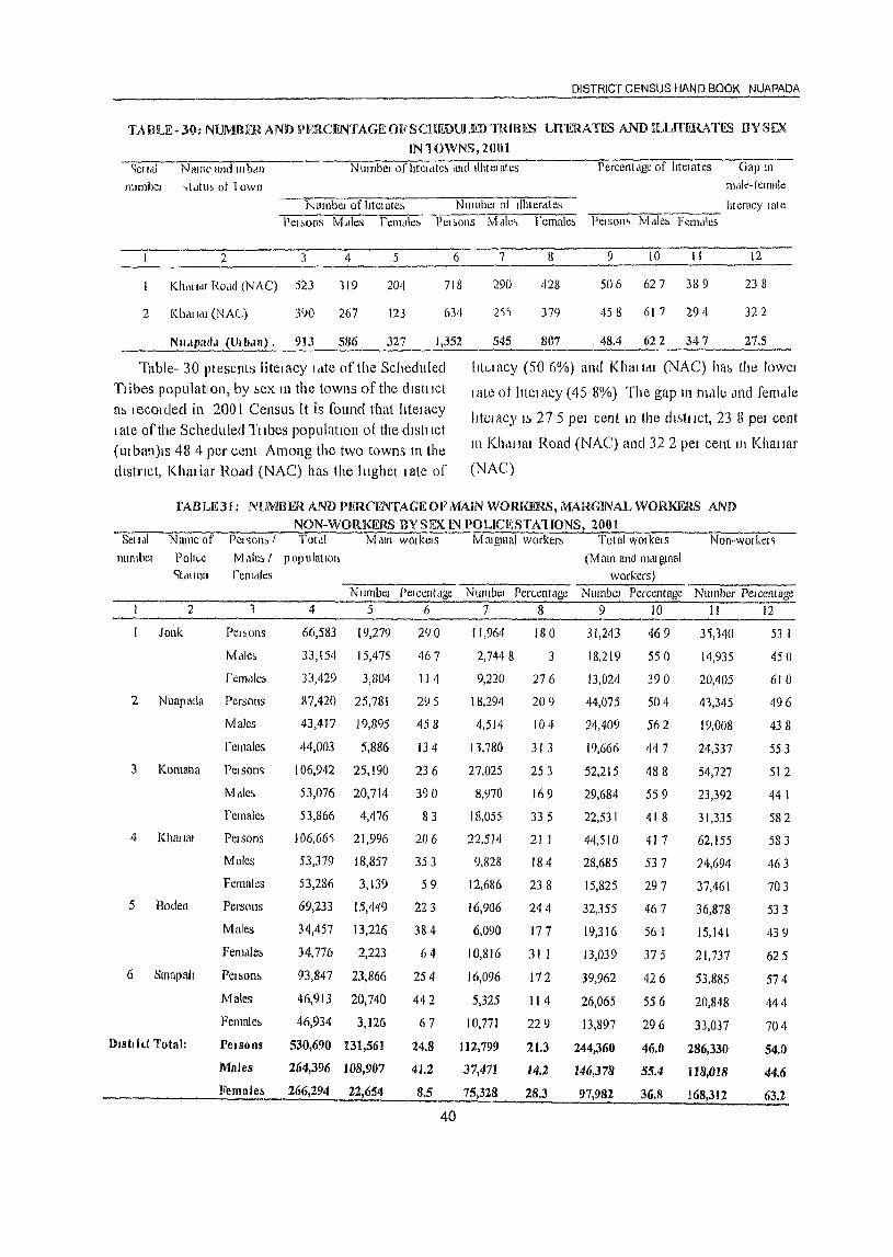
DISTRICT CENSUS HAN D BOOK NUAPADA
TAIlLE-JO: NUMBffiAND JPE!tCENTAGEOFSCBmULEDTRlBES LITERATES ANDILUTFHATliS BYSEX IN'IOWNS,2001
':er ldl N allW and III btlIl N IImbel of htel LIte, tInct Illltel ates Pcrccnldge of IItcl ates Oap III
IllHllhcl ..,tdlub of lown ITItlie- femak:
,,"umbel of htelate5 NUl1lbclol Illiterates lIteracy late PClbOIlS M,\les l'elHdle, PCI,OIlS Mdlc~ female, Pelson., Mdle~ Fem,!lc,
2 3 4 5 6 7 8 9 10 II 12
K11<111<11 ROdd (NAC) 523 119 204 718 290 428 506 627 389 238
2 Kballtll (NAC) 390 267 123 2'i~ 379 458 61 7 294 322
Nll.l(lad.1 (lJlb.tn). 913 586 327 1,352 545 807 48.4 622 347 27.5
Table- 30 ptesents litel acy r ,lte of the Scheduled Ttibes population, hy 5ex 111 the towns of the dlstllct at> lecolded in 2001 Censw; It is found that IItelacy I ate of the Scheduled Ttlbes populatIon of the cltsllict CUI ban)ls 48 4 per cent Among the two towns 111 the dlstnct, Khariar ROdel (NAC) hU5 the hlghet I ate of
Itte-lacy (506%) and Khalldl (NAC) ha~ the lowel
I ate of literacy (45 8(X)) The gap Il1 l1\elle <md fen1c1le
lltelacy t~ 27 5 pel cent III the (h5tllct, 23 8 pel cent
III Kh,ttlflt Road (NAC) and 32 2 pet cent tn Khmrar
(NAC)
rABLE31: NUMBER AND PI~R(,ENTAGl<~ OF MAIN WORKF .. RS, MARGINAL WORKERS ANn NON-WORKERS BY SEX IN POLICESTA1[ONS, 2001
Sellal Name of rel~on, I Tottll M,lln wOlkclS Matglllal worker~ ToWI WOlkels NOIl-wOlkel~
lllimbel Po!t(.c tvJ.lles I populallon (Mam and m,ugmal <itatlon renldles workers)
2
lank
2 Nuapllda
3 Komana
4 Khflllil!
5 Boden
6 Smapal!
D,sttid Total:
Number PelcCn(,lge 1 4 5 6
Male~
Persons
Males
females
PCISOl1G
Mdle~
remale~
PelSOI1S
Males
Females
Persons
Males
Femdle,',
Pel,',on,<,
Males
Female&
66,583
33,154
33,429
87,420
43,417
44,003
106,942
53,076
53,866
106,66')
53,379
53,286
69,233
34,457
34,776
93,847
46,913
46,934
19,279
15,475
3,804
25,781
19,895
5,886
25,190
20,714
4,476
21,996
18,857
3,139
15,449
13,226
2,223
23,866
20,740
3,126
PelSOIlS 530,690 131,561
Mnles 264,396 108,907
I(elllale~ 266,294 22,654
290
467
114
295
458
134
236
390
83
206
353
59
223
384
64
254
442
67
24.8
41.2
8.5
40
NUll1bel Per<..elltage NUlllbcl Percentage Number Pelcentage 7 8 9 IO II 12
[1,9611 180
2,7448 3
9,220 276
18,294 209
4,514 [04
11,780 31 3
27,025 253
8,970 169
18,055 33 5
22,514 21 I
9,828 184
12,686 238
16,906 244
6,090 177
10,816 31 1
16,096 172
5,325 114
10,771 229
31,243
18,219
13,024
44,075
24,409
19,666
52,215
29,684
22,531
44,510
28,685
15,825
32,355
19,316
13,039
39,962
26,065
13,897
112,799
37,471
75,328
21.3 244,360
14.2 146,378
28.3 97,982
469
550
390
504
562
447
488
559
418
41 7
537
297
467
561
375
426
556
296
3'),140
14,935
20,405
41,345
19,008
24,337
54,727
23,392
31,335
62,155
24,694
37,461
36,878
15,141
21,737
53,885
20,848
33,037
46.0 286,330
55.4 118,018
36.8 168,312
53 I
450
610
496
438
553
512
441
582
583
463
703
533
439
625
574
444
704
54.0
44.6
63.2
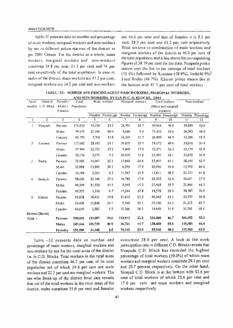
ANALYTICAL NOTE
rable-31 presents data 011 numbcl and pelecnt<lge ale 44.6 pel cent and that of females It is 8.5 pel
of llMlI1 WOI kel s, 111m gmal WOI kers and nOI1-WOl kel S cent, 28 3 pel cent and 63 2 pel cent respectIvely.
by "ex 111 dt{felent poilce statIons of the dlstllct a'> Total WO! kCI SIC combination of main WOI kel sand
pel 200 I Census rOI the dlc;tl ict as a whole, mam marglllal WOJ]WIS of the dlsuict IS 460 pel cent of
wOlkels, malgll1aI WOlkers and non-wor kOI c; the total population and it lies above the cOllcspondll1g
(..omt Itute 24 8 peJ cent, 21 3 pel cent and '54 pel figure" of 38 79 PCl cellt fOl the state. NualJada police ::.1atlol1 top'> the list 111 pel centage of total wOlkers
cent IC'lpectlYcly of Lhc total population In case of (')04%) followed by KOl1lana (488%), J011I«469%) male<, of the dl'ltiICt, 111<1111 wOlkels ate 412 pel cent, ) and Roden (467%) Khalla! police <;tatlOn lies at Illatglllul wOlkels ate 142 pel cent and non-wolkel~ the bottom WIth 41 7 per cellt of total wor ker s
I ABU~- 32: NUMBER AND PERCEN'lAGEOF MAIN WORKERS, MARGINAL WORKF'..RS,
AND NON-WOillillHS BV StX IN C. D. BLOCKSl 2001 )Cl I,d Name of Pel ')on'> I Total Mdlll wOlkel,
number L D Blo("k Malt'q I PopulallOn r emaIe,
Number Percentagc -----2 3 4 5 (j
Nua(1ad'l Pel ')011') 119,810 15,150 293
Males 19615 27,446 460
fel1ldll's 60,195 7,704 128
7 [(omana Per')ofl,) 117,082 28,193 241
Males 57906 22,722 392
females 59,176 5,471 92
J Bodell Petsonq 72,056 16,067 223
Male') 35,888 13,803 385
remale'l 16,168 2,264 63
4 SlI1ap"h PeISOIl'i 98,666 25246 256
Males 49,309 21,920 445
Females 49,357 3,326 67
5 Kharldl PCISOIlS 93,018 18,431 198
Male~ 46,408 15,848 34 I
fcmale~ 46,610 2,583 55
Di~trict (Rural)
rotal : PelSon~ 500,652 123,087 24.6
Mules 249,146 101,739 408
Females 251,506 21,348 8.5
"Iable -32 plesents data on l1umbel and percentage of main workels, mmginaJ wDlkers and nOll-workels by sex for the lural meas of the district i.e. in C.D. Blocks. Total workers in the rural alcas of the dish ict constitute 46.7 pel cent of its total population out of which 246 per cent are main WOl kers and 22 2 pel' cent are marginal workers The sex-wise break-up of the district level data reveals that out of the total workers in the I'tIl al areas of the dIstrict, males constitute 55.6 per cent and females
41
Mmglllal workel'> Tolal worker,> NOll·wmkers (M am and l11at gmal
workelc;) Number PClcelltagc Numbcl PClccntage N umbel Percentage
7 8 9 10 II 12
24,791 207 59,941 SO 0 59,889 50 ()
5,686 95 11,132 556 26,503 444
19,105 317 26.809 445 33,386 555
29,879 25 'i 58,072 496 59,010 504
9,849 170 32,571 562 25,335 438
20,()30 138 25,501 431 33,675 569
17,840 248 33,907 47 I 38,149 529
6,293 175 20,096 560 15,792 44 ° 11,547 319 13,811 382 22.357 61 8
16,789 170 42,035 426 56,631 574
5,545 112 27,465 557 21,844 443
11,244 228 14,570 295 34,787 705
21,614 232 40,045 43 I 52,973 569
9,348 201 25,196 543 21,212 457
12,266 263 14,849 119 31,161 68 I
110,913 22.2 234,000 46.7 266,652 53.3
36,721 14.7 138,460 55.6 110,686 44.4
74,192 29.5 95,540 38.0 155,966 62.0
con stltute 38 0 per cent. A look at the work paltlclpation late 111 different C D. Blocks J eveals that Nuapada C.D Block has recorded the Illghest pelCentage of total workers (50.0%) of which mam workers and marginal workelS constitute 29.3 pel cent
and 20.7 percent respectively. On the other hand, Sinapali CD Block is at the bottom with 42.6 per cent of total workers of which 25.6 per cent and 17 0 pel cent are mam workers and marginal workers respectively.
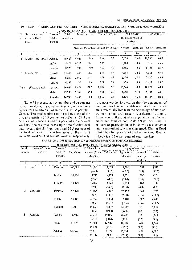
01& TRier CENSUS HAND BOOK NUAPAOA
rAIH 1£·33: NUMBER AND PNl.CFNTAGE Ole MAIN WORKERS, MARClNAL WORKI!RS AND NON-WORKERS
BYSEXIN URBAN AGGLOMERATIONS /TOWNS! 2001 Sl N dln~ dud III b,U\ Pel ~Oll~ I fotdl lVLun WOI kCI ~ Mmglnal wOlkels Tot,ll wl)lkel!> Nt)ll-wOlk(.,r~
No ~tatll, of UA I Males I Populdtlon (Mmn (llIrillldlgUlrIl
iow!' relllalc~ wOlkel ~) -------
Numbel PtH.Ll1(r1ge Nlilllbcl Pt'ltentdg<, Numbel l'elccl1tdgc N Ul11lll'l Pel Lcnt c1gc
---- 2 3 4 5 6 7 8 9 10 I I 12
1 Khallell RO,lll (NAC) Pel ~on~ 16,629 4,966 299 1,028 62 1,994 300 10,635 6<10
Mdles 8,400 4,212 50 1 27h 11 4,48H 534 3,912 466
I em'lle~ 8,229 7S4 92 7">2 9 I I,S06 183 6723 817
2 1(11<111.1. (NAC) PICI~on<; 13,'109 3,508 26/ 8'i8 64 4,366 326 9,04] 674
Male~ 6,S50 2,956 412 474 69 3,110 501 3,420 499
rellhllL~ 6,559 552 84 1811 ') 9 936 143 5,623 857
Dlstlllt (lJlb.tll) Total. Persons 30,038 8,474 282 1,8116 63 10,360 3<15 19,678 {J55
Male .. 15,2SIl 7,168 47 {I 750 4.9 7,918 51.9 7,332 48.1
Female!> 14,788 1,306 8.8 1,136 7.7 2,442 16.5 12,346 83.5
Table-33 plesents data on numbel and pelcentage It IS note-wOlthy to mention that the percentage of 01 mmn woilcelb, ll1a1gtnc11 workelS and non-wolkelE. malg1l1ul workels 111 the lllban meas of the dl'ittlct by "ex fOJ the Iltban aleas 111 the c1isttict as per 2001 are substantially less than the petcentage ofmmglnal Cenblls The total wOlkels In the lIIban aJeas of the wOlkelS In the lUral clleas of the dlE.lllct It I~ only dJ~tnct COllbtltute 34 5 pCI cent out of which 28 2 pel 63 pel cent of the total 111 ban population out ofwhlch cent me mam WOI kels and 6.3 pel cent me matgnMI males and female~ contllbute 49 pel cent dnd 77 wod~el~. The sex-wise brenk-lIr} ot the dls{lict level pel cent lespectlvely Tn so far as WOlk PdltfclpatlOl1 data leveals that 5 I 9 pel cent and 16 5 pel cent of I ale 111 mdlvldual towns IS conceIl1ecl, Khat tal Road the totdl WOI ket s III the 1lI bdn areas of the (hstl tet (NAC) has 36 0 penent o11otal WOI leers and Khallat ,lie male Walkers and Cemale wOlkers tespecttvely. (NAC) IMS 326 pel cent of total worket ..
TABLE - 34 : mSTRmurroN OF WORKERS BY S EX IN FOIJR CATEGORIFS
OF ECONOMIC ACTIVITY IN POLICE STATIONS, 2001 ""'S:-el-w7"", --:N'-'-cln-1c-o-"r-;P:"-o'itl.-c--:p"""e-. ~-o-ns-'/"-'--'-I::-o-t a-;" :"-"c...,T';"'O-'t-;-d' r·illmbcl 0 f Cltegory 0 f W oIl(el ~
.;--;-..,---::::-:-;----nUlllbcl <Jtalwns M (Ile~ I Pop ulntlOIi WOI kCI ~ (M all! Cllltlv,ltllr~ AgliCUltlll <II Household Other
Fem.tles I M rlrgll1ut) Labolller~ Industry workels worker~
2 3 4 5 6 7 8 9 Jonk Per~ono, 66,583 31,241 12,022 12,501 392 6,328
(469) (385) (400) (I 1) (203) Male~ 31,154 18,219 8.174 4,551 290 5,204
(550) (449) (250) (I 6) (286) I eOMles 33,429 13,024 3.848 7,950 102 1,124
(190) (295) (610) (08) (86) 2 Nutlpada Per~oll~ 87,420 44.075 15.327 22.459 563 5,726
(504) (348) (51 0) (I 3) (130) Male~ 43.417 24,409 11,430 7,910 382 4,687
(562) (468) (324) (16) (192) females 44,003 19,666 3,897 14,549 181 1,039
(447) (198) (740) (09) (53) 3 KOl11ana Pelsolls 106,942 52,215 19,864 26,431 1,171 4,747
(488) (380) (506) (22) (9 1) Male~ 53,076 29,684 14,942 10,402 680 3,660
(559) (503) (350) (23) (123) Female& 53,866 22,531 4,922 16,031 491 I,08?
(41 8) (21 8) (712) (22) (48)
42

ANALYllCAL NOTE
OFlIl'CONOMIC ACTIVITY IN POLICE STAl'IONS , 200t SCI tnl N,ul1c of Pollcc FCI50IlS I '( otaf ['otaf l1umbcr of CalegOlyofworkcls IlUmbel <;'latlol1S Males / Population workcl'> (M alll CultlvatOlS Agilcultlllal Homehold Othel
renlclles I-M,ltglllfll) Labourcl<; IllduSIIY wOlkers wOlkers
2 3 4 5 6 7 8 9
II Khallm Pel&ons 106,665 44,510 10,979 18,519 1,780 13,232
(41 7) (247) (41 6) (40) (297)
Males 53,379 28,685 8,499 8,978 ( ,215 9,991
(537) (296) (31 '3) (42) (348)
r<ellJale~ 51,286 15,1l25 2,480 9,541 56'i 3,239
(297) (157) (603) (36) (205)
5 Bodell Pel>Oll~ 69,233 12,355 11,640 15,777 1,379 3,559
(467) (360) (488) (43) (11 0)
Male~ 14,457 19,116 9,576 6,468 739 2,533
(56 I) (496) (335) (3 8) (13 I)
rClllales 14,776 13,039 2,064 9,109 640 1,026
(375) (158) (714) (49) (7.9)
6 SlI1upnit Pel sons 93,847 39,962 13,494 17,396 1,907 7,165
(426) (33 8) (435) (48) (179)
Males 46,913 26,065 11,823 8,245 993 5,004
(556) (45.4) (31 6) (3 8) (19.2)
Females 46,934 13,897 1,671 9,151 914 2,161
(296) (12.0) (658) (6.6) (15.6)
Dish'iet Total: Persons 530,690 244,360 83,326 113,085 7,192 40,757
(46.0) (34.l) (46.3) (2.9) (16.7)
Male~ 264,396 146,378 64,444 46,554 4,299 31,081
(55.4) (44.0) (31.8) (2.9) (21.2)
Females 266,294 97,982 18,882 66,531 2,893 9,676
(36.8) (19.3) (67.9) (3.0) (9.9)
Note. Pel cent age of workers to total workers are given in blackets
Table-34 distributes the total workers of different police stations and the district by sex into foul' categories of economic activities. The table reveals that out of the total workers in the district, 34.1 per cent are cultivators, 46.3 per cent are agricultural labourers, 2.9 per cent are household industry workers and 16.7 per cent are other wOlkers. The sex-wise break-up of the district level data shows that male paIiicipation rate is comparatively higher than the female participation rate in case of cultivators and other workers and vice-versa in case of agricultural labourers and household industry workers. The police station wise distribution of total workers indicates that
43
in almost all police stations maximum number of workers are engaged as agricultural labourers and cultivators except Khariar where maximum workers are agricultural labourers and other workers.
Like previolls table, Table-35 distributes workers of the district, C.D. Block-wise, by sex into fOllr categories of economic activities. The table shows that 46.7 per cent of the total population in the rural areas ofthe district are workers (main+marginal) and as perthe category-wise break-up, 35.3 per cent, 47.8 pCI' cent, 2.9 per cent and 14.0 per cellt of the total workers are cultivators, agricultural labourers, household industry workers and other workers
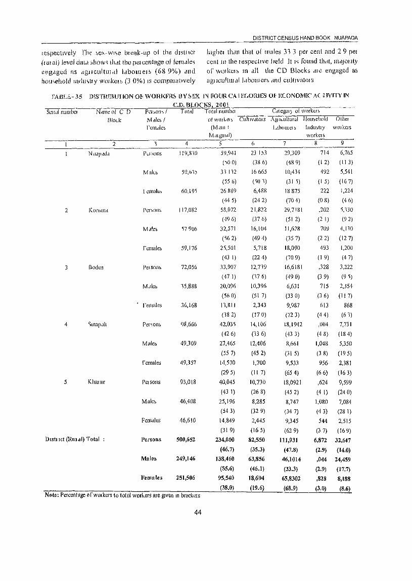
DISTRICT CENSUS HAND BOOK NUAPADA
iespecttvely [he !lel>.-wl'>e bl ealc-up 01 the d !slllct Illghel tl1<ln that of males 31 3 per cent and 2 9 pel
(Illl ill) level date! [,how,> 11Mt the pelccntage ot terndle~ cent III the! espectlvc 1 wid It I'> found thdt, majOllty
eng,lged as dgJlcultul<l1 IdboU1ClS (689%) and of wOIkeJ~ 111 elll the CD Blocks ,He engaged as
hou<'ehold mdu')uy wo!lcels (3 0%) IS compaJatJvely agilcullllldl Idbotllers ,md cultlVatols
rAllLE,- 35 OISTRIBUHON 01< WORKFRS BY ~EX IN FOUR CA i E(.ORH!S m I;:('ONOMIC A( HVlTV IN
CD. BLOCKS 200t St:!ldlllllmbcl NdlllC oj C D PCJ~()n~ / Total Total Jlllmbcl c'ltCgOI} of worktl ~
Blo(..k M,llc, / of Will kCl, Clllt,VdtOIS AgJlwitlllal IIoll,ehold Othel
rcmdle~ (Iv! ,1I11 I LlholilCI, Indll,(Jy wOlkels M,UgUl,\I) workels
2 1 4 5 II 7 8 9
NU,iP,idd PtA ,OilS 11~,lnO 59,941 23 1.)3 29,309 714 6,765
(~O 0) (386) (489) (I 2) (II 3)
Mal(.., 59,61) 31 112 16665 10,434 492 5,541
(556) (')01) (31 'i) (I 5) (167)
I ernale~ 60,191 26 g09 6,488 18875 222 1,224
(44 5) (242) (704) (0 8) (46)
2 KOl1hll1,1 Per,0115 117,082 58,072 21,822 29,7181 ,202 'i,130
(496) (376) (51 2) (2 1) (92)
M.lle5 ')7906 32,571 16,104 11,6)8 709 4,110
('\62) (494) (357) (22) (127)
females 59,176 2\501 5,718 18,090 493 1,200
(43 I) (224) (709) (I 9) (47)
3 Boden Pelson~ 72,056 33,907 12,719 16,6181 ,328 3,222
(47 I) (176) (490) (39) (9 'i)
M,lIe~ 15,888 20,096 10,396 6,631 715 2,354
(560) (51 7) (33 0) (3 6) (II 7)
rCl1Iales 36,168 11,811 2,343 9,987 613 868
(182) (170) (72 3) (44) (61)
4 ')lOapdh Pel~on!> 98,666 42,03'; 14,106 18,1942 ,OOLI 7,731
(426) (13 6) (433) (48) (184)
Mab 49,309 27,465 12,406 8,661 1,048 5,350
(55 7) (452) (31 5) (3 8) (195)
females 49,357 14,570 1,700 9,533 956 2,381
(295) (II 7) (654) (66) (163)
5 KhuIIHf Pel sons 93,018 40,045 10,730 18,Q921 ,624 9,599
(43 1) (268) (452) (4 1) (240)
Males 46,408 25,196 8,285 8,747 1,080 7,084
(543) (329) (347) (43) (28 I)
Females 46,610 14,849 2,445 9,345 544 2,515
(31 9) (165) (629) (37) (169)
Dish let (Rill ,II) Total Persolls 500,652 234,000 82,550 111,931 6,872 32,647
(46.7) (35.3) (47.8) (2.9) (14.0)
Male:> 249,146 138,460 63,856 46,1014 ,044 24,459
(55.6) (46.1) (33.3) (2.9) (17.7)
Females 251,506 95,540 18,694 65,8302 ,828 8,188
(38.0) (19.6) (68.9) (3.0) (8.6) N Gte: Percentage of WOI kers to total workers are gIven III brackets
44
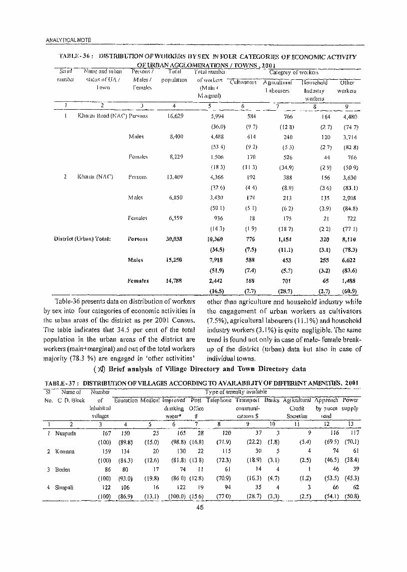
ANALYTICAL NOTE
TABLE- 36: mSTRIHUnON OF WOm<ERS BY S EX IN mull. CATEGORIE.,,) OF f£ONOMIC ACTIVITY 01<' URBAN AGGLOMERA TrONS / TOWNS lOOI
Scrral Namc and lllban Pel~oll<; / Total Total number CategOIY of work crt. nlllllb~r c,(aluq nfllA I Males I population of \vOl kef ~ Cultlvator'i AgtKultuHlI Ilomehold Other
lawn female, (M ain + l abollrert. InduslIY workcrs Mdlgll1al) workers
2 ] 4 5 6 7 8 9
Kharlnt Roat! (NAC) Persons 16,629 5,994 584 766 164 4,480
(36.0) (9 7) (128) (2 7) (747)
Male<; 8,400 4,488 414 240 120 3,714
(534) (92) (5 3) (2 7) (828)
Femalc,> 8,229 1.506 170 526 44 766
(Ill 3) (II 3) (34.9) (29) (509)
2 Khat tal (NAC) PClsom, 13,409 Ij,366 192 388 156 3,630
(126) (44) (8.9) (36) (83.1)
Malc, 6,850 3,430 174 213 135 2,908
(50 I) (5 1) (62) (3.9) (84.8)
Female> 6,559 936 18 175 21 722
(143) (1 9) (18 7) (22) (77 I)
District (Urhan) Total: Per~olls 30,038 10,360 776 1,154 .320 8,110
(34.5) (7.5) (11.1) (3.1) (78.3)
Males 15,250 7,918 588 453 255 6,622
(51.9) (7.4) (5.7) (3.2) (83.6)
Females 14,788 2,442 188 70t 65 1,488
(16.5) (7.7) (28.7) (2.7) (60.9)
Table-36 present!> data on distribution of workers other than agriculture and household industry while by sex into four categories of economic activities in the engagement of urban workers as cultivators the UI ban areas of the district as per 2001 Census. (7.5%), agricultural labourers (11.l %) and household The table indicates that 34.5 per cent of the total industry workers (3.1 %) is quite negligible. The same population in the urban areas of the district are trend is found not only in case of malc- female break-workers (main-t marginal) and out ofille total workers up of the district (urban) data but also ill case of majority (78.3 %) are engaged in 'other activities' individual towns.
(I<f) Brief analysis of Village Directol'Y and Town Directory data
TABLE-37 : DISTRlBunONOFVILLAGES ACCORDING TO AVAILABILITVOFDIFFERENT AMENITIES, 2001 SI Nameo! Number Ty pe of amenity aVailable
No. C n. Block of Education Medical Imploved Post Telep hone Transport Banks Agr icultural Approach Power inhabited dlll1king Office communi- Credit by pucca supply Villages watel'* # cations $ Societies load
2 3 4 5 6 7 8 9 10 11 12 13
Nuapada 167 150 25 165 28 120 37 3 9 116 117
(100) (89.8) (15.0) (98.8) (16.8) (71.9) (22.2) (1.8) (5.4) (695) (70.1)
2 Komana 159 134 20 130 22 115 30 5 4 74 61
(100) (84.3) (12.6) (81.8) (138) (72.3) (18.9) (3.1) (2.5) (46.5) (38.4)
3 Boden 86 80 17 74 II 61 14 4 I 46 39
(100) (93.0) (19.8) (860)(128) (70.9) (16.3) (4.7) (1.2) (53.5) (45.3)
4 Sinapali 122 106 16 122 19 94 35 4 3 66 62 (100) (86.9) (13.1 ) (100.0) (156) (770) (28.7) (3.3) (2.5) (54.1 ) (50.8)
45
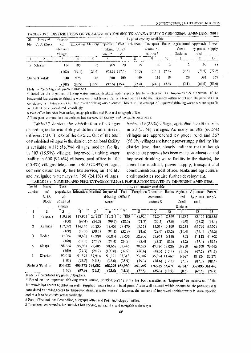
DISTRICT CENSUS HAND BOOK' NUAPADA
TAULE-.37 : mSTRIBUnON OF VILLACJ!S ACCORDING TO A VAILAiHLlTY OF DlFFElUl'.NT AMENIT.IES. 200 I -·SI. Name of Number Ty pc of HllIenity available
No C. D.illock of Educatioll Mt:llical Improved Post Tclephone Transport Banb Agricultural Approach Pow-;'-
inhabited drinking Office communi- Credit by pucca supply 1/illag~s watCI"~ /I catiolls $ Societies road
'" 3 1\ 5 6 7 8 I) 10 11 12 13 <.
Khanal' 114 lOS 25 109 20 79 40 3 3 9U 88
(100) (92.1 ) (21.9) (£)5.6) ( 17.5) (6£).3) (35. J) (2.6) (2.6) (78.9) (77.2)
District Total: 648 575 Hl3 600 HID 469 156 19 20 392 267
(100) (88.7) (15.9) (92.6) (15.4) (72.4) (24.1) (2.9) (3.1) (60.5) (56.6)
Note: - Percentages arc given in bl'Hckets. * Based on the improved drinking watcr source, drinking water supply has been classified as 'Improved' 01' otherwise. If the household has access 10 drinking water ~llpplicd lI'om a lnp or a IU1Ild pUlllJl! lube well situated within 01' outside the preillises it is considered as having access to 'Improved drinking water source'. Ilowever, lhe cOllcept of improved drinking water is state specific and this is 10 be considered accllI'dingly. II Post office includes Post office, telcgrap h unkc and Post and telegrnp h of'iice. $ Tlal1sp Olt C0I11111llllicat ion includes bus service, rail facility and navigable waterway s.
Tahle-37 depicts 1 he distribution of vi llages banks in 19 (2,9%) villages, agriculttlral credit societies according to the availability of different amenities in in 20 (3.1 %) villages. As many as 392 (60.5%)
ditTerent CD. Blocks orthe district Out of the lOtal villages are approached by pllcca road and 367 648 inhabited villages in the district, educational facility (56,6%) villages are haying power supply Jncility. The is available in 575 (88.7%) villages, medical facility district level data clearly indicate that although in 103 (15.9%) villages, improved drinking water spectacular progress has been made on education and facility in 600 (92.6%) villages, post office in 100 improved drinking water facility in the district, the (15.4%) villages, telephone in 469 (72.4%) villages, areas like medical, power supply, transport and communication facility like bus service, rail facility communications, post office, banks and agricultural and navigable waterways in 156 (24.1 %) villages, credit societies require fi.lrlher development.
TABLE38: NlJMBERAND PERCENTAGE OF RURAL POPULATION SERVED BY DIFFERENT AMENrnHlS, Serial Name Total Ty pe of amenity available
number of pop Illation Education Medical Improved Post Telephone Transport Banks AgriclIlt- Approach Power C.D, of drinking Oft1ce 1/ communi· ural by pucca supply Block inhabited wflter* cations $ Credit road
villages Societies 2 ] 4 5 6 7 8 9 10 II 12 13
NlIapada 119,830 117,931 28,958 119.241 34,280 85,920 42,240 8,369 11,837 82,421 100,836 (100) (98.4) (24.2) (99,5) (28.6) (71.7) (35.2) (7.0) (9.9) (68,8) (84, I)
2 Komana 117,082 114,166 35,235 98,409 38,470 95,558 35,018 15,399 12,232 65,729 65,793 (100) (97.5) (30. J) (84.1) (32.9) (81.6) (29.9) (13,2) (10.4) (56, I) (56.2)
3 Boden 72,056 70,693 19,988 00,808 17,436 52,906 15,963 6,210 892 41,122 41,898 (100) (98.1 ) (27.7) (84.4) (24.2) (73.4) (22.2) (8,6) (1,2) (57.1) (58.1)
4 Sinapali 98,666 95,984 24,405 98,666 32,446 79,565 47,820 12,026 10,819 66,599 70,640 (100) (97.3) (24.7) (100.0) (32,9) (80.6) (48.5) (12.2) (11,0) (67.5) (71.6)
5 Khariar 93,018 91,5~8 37,916 91,171 33,348 73,806 35,894 11,467 6,767 81,224 82,273 (100) (98.5) (40.8) (98.0) (35.9) (79.3) (38,6) (12.3) (7,) (87,3) (88.4)
District Total : 500,652 490,372 146,502 468,295 155,980 387,755 176,935 53,471 42,547 337,095 361,440 (100) (97.9) (29.3) (93.5) (31.2) (77.5) (35.3) (10.7) (8.5) (67.3) (72.7)
Note: • Percentages are given in brackets . .. Based on the improved drinking water source, drinking water supply has been classified as 'Improved' or otherwise, If the
household has access to drinking water supplied from a lap or a hand pump / tube well situated within or outside the premises it is considered as having access to . Improved drinking water source'. However, the concept of improved drinking water is state specific and this is to be considered accordingly. II Post oftice includes Post oftice, telegraph office and Post and telegraph office. $ Transport communication includes bus service, rail illcility and navigable waterway s,
46
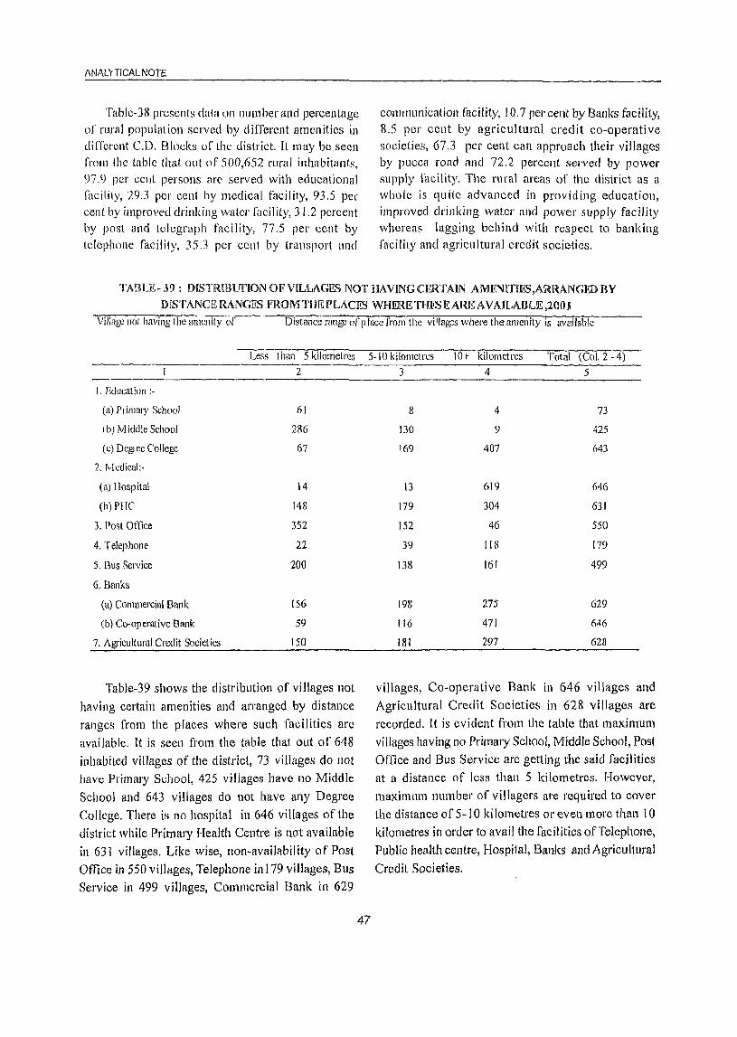
ANALYTICAL NOTE
Table-38 presents data all number and percentage of rural population served hy different amenities in different C.D. Blocks of the district. It may be seen fl'olll the table tha.t out of 500,652 rural inhabitants, 97.9 pCI' celli persons arC' served with educational facility, 29.3 per cent by mcdical facility, 93.5 per cent by improved drinking water [aeil ity, 31.2 percent by post and telegraph facility, 77.5 per cent by telephone facility, 35.3 per cellt by transport and
cOlllmunication facility, 10.7 pel' cent by Banks facility, 8.5 per cent by agricultural credit co-operative societies, 67.3 pCI' cent can approach their villages by pueca road and 72.2 percent served by power supply facility. The rural areas of the district as a whole is qu ite advanced in provid ing education, improved drinking water and power supply facility whereas lagging behind with respect to banking facility and agricultural credit societies.
TABLE-.\9: DISTRIBunON OF VILLAGES NOT HAVINGCFJUAIN AMFNITIES,ARRANGEDBY
DISTANCE RANGES FROM THE PLACES WHERE 'fHI'S E ARE AVAILABLE ,20t) J Village not having the amenity of Distance rallge of place lI'om the villages where the amenity is available
Less than 5 kilometres 2
I. Education ;-
(a) P, illlfll)' School 61
I b) Middle School 286
(c) DegJee College 67
2. Medical:-
(n) [Iospital 14
(h) PIle 148
3. Post Office 352
4. Telephone 22
5. Bus Service 200
6. Banks
(a) Commercial Bank 156
(b) Co-operative Bank 59
7. Agricultural Credit Societies 150
Table-39 shows the distribution of villages not having certain amenities and arranged by distance ranges from the places where such facilities are
available. It is seen from the table that out of 648 inhabited villages of the district, 73 villages do not have Primary School, 425 villages have no Middle School and 643 villages do not have any Degree College. There is no hospital in 646 villages of the district while Primary Health Centre is not available in 631 villages. Like wise, l1on~availability of Post Office in 550 villages, Telephone in 179 villages, Bus Service in 499 villages, Commercial Bank in 629
5-10 kilometres lOt- kilometres Total (Col. 2 - 4)
47
3 4 5
8 4 73
130 9 425
169 407 643
13 619 646
179 304 631
152 46 550
39 118 179
138 161 499
198 275 629
116 471 646
lBI 297 628
vi lIages, Co-operati ve Bank in 646 villages and Agricultural Credit Societies in 628 villages are recorded. It is evident from the table that maximum villages having no Primary School, Middle School, Post Office and Bus Service are getting the said facilities at a distance of Jess than 5 kilometres, However, maximum number of villagers are required to cover the distance of 5-1 0 kilometres or even more than 10 kilometres in order to avail the facilities of Telephone, Public health centre, Hospital, Banks and Agricultural
Credit Societies.
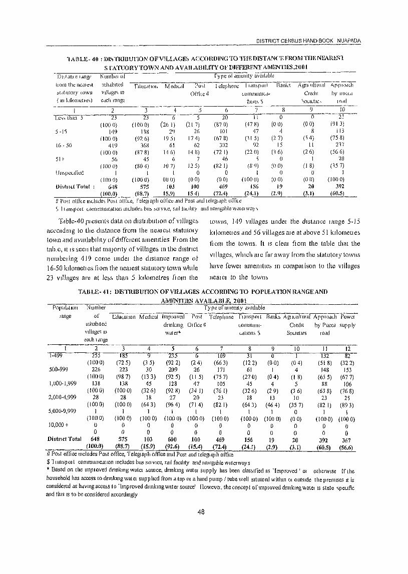
DISTRICT CE.NSUS HAND BOOK NIJAPI\DA ------------------------------------------------------'IABLE-40 : DI/-,TRII3UnON OFVILLAGK" ACCORDING TO TllEmSTANCEFROM'nmNEARN~'l
S fATUORYTOWN AND AVAILABIUTY OFDlFFERFNf AMENTIES,2001 _ _.--D,,' dl1( e I,mg" N umbel of fype 01 ,llncnlty avmi.tble
Ii Olll the nedl C,( Illh,lblted Cduc,ltlOh Medl\-,ll Po,>t I ciepllOllc [ldlbpOII [1ank ~ AgrH'tillllar--A.[JpiOJiTl bldtutOlY wwn villdge, m Office II LllIlllIllliliLd. Credt( by 011"(,,1
( III kllometle,) edch range tlOl1'> ~ ')OUUte, IOdd
2 3 4 5 6 7 8 9 10
Le"lhan 5 23 23 6 5 20 II 0 0 fl--(1000) (100 0) (26 I) (21 7) (870) (47 Il) (00) (00) (91 3)
5 -Ii 149 118 2') 26 101 47 'I 8 113 (1000) (92 6) 1(5) 174) (678) (11 5) (27) (14) (758)
16·50 419 36H 61 62 3D2 n 15 II 217
(1000) (878) 146) 14 Il) (72 I) (220) (16) (26) (566) 5H 56 45 6 7 46 ) 0 1 20
(1000) (lW 4) 107) 125) (82 1) III 9) (00) (l 8) (157) UmpCLllied I I I 0 () 1 () () I
(1000) (I ()O 0) 0(0) (00) (00) (1000) (00) (00) (1000) I)iltl u.t Totnl 648 575 IOJ 100 469 156 19 20 31)2
( 100,O~ (SS.7l 15.9) 154) (72.4) (24.1) (2.9) ____l3.1) (60.5l IIl'o"t (Jifke llu..ludc, Po,t ollke, felcgJaph oiJice dnd Post tint! lelcgldph office ~ 11 dll,pott LOlIUlllllllc,ltlOll lllLlude::. bu!> ::'Cl VILe, rdll faCIlity and navIgable walel way ~
'I:lble-40 plesen[~ data on cllstllbutlon ofvJ]Jage~ accOicill1g to the chMance from the nc.nc:,t statutolY town and avallablllty of cllffeJenl amenIties FlOrn the tablc, It IS seen that I11aJorHy of village!> m the cilstnct numbedng 419 come undel the cllslance range of 16-50 kllometl es ft am the neatest statutory town whde 23 VIllages are at les,<, than 5 kilometres flOm the
lOWllS, 149 vJllages undel the dlSldllce lange 5-15
ktlometles ,mel 56 villdges ate at above 51 ktlometJes
flam the towns. [t IS cleal flom the table that the
villages, which al e far away tram the statutOlY towns
have fewel amenities 111 compal ison to the Villages
neat el to the town!>
TAm~E- 41: mSTRIBUnON OF VILLAGES ACCORDlNGTO I)OPULATION RANGE AND
AMliN lUES AVAILABL§ 20(11 Populdtlon Number Typ e of amcllIty dvmlable
range of ellUl-allOn Medical Imp lOved Po,t Telephone 1'1 anspOl t B<lnb A@I(..ultllla1 APPIOd(..h POWt.:1 Inhabited drmklllg o I lice II wmmU11l· Cledl( by Puce') supply village~ III wdtef~ (..c)llOn, 'f> Sot-leIit'S IOnd eaLh Idnge
I 2 3 4 5 6 7 8 9 10 11 12 T-ii9""9 255 185 9 235 6 169 31 0 1 132 82
(1000) (72 5) (3 5) (922) (24) (663) (12 Z) (00) (04) (51 8) (322) 500-999 226 223 30 209 26 171 61 1 4 148 153
(1000) (987) (133) (925) (II 5) (757) (270) (04) (I 8) (655) (677) 1,000-1,999 138 138 45 128 47 105 45 4 5 88 106
(1000) (1000) (326) (92 8) (34 I) (76 I) (326) (29) (3 6) (63 8) (768) 2,000-4,999 28 28 18 27 20 23 18 13 10 23 2)
(1000) (1000) (643) (964) (714) (82 I) (643) (464) (357) (82 I) (893) 5,000-9,999 1 1 I I I I I I 0 I 1
(1000) (1000) (1000) (1000) (1000) (1000) (1000) (1000) (00) (1000) (1000) 10,000 + 0 0 0 0 0 0 0 0 0 0 0
0 0 0 0 0 0 0 0 0 0 0 District Totlll 648 575 103 600 100 469 156 19 20 392 367
(100.0) (88.7) (15.9) (92.6) (15.4) (72.4) (24.1) (2.9) (3.1) (60.5) (56.6) II Po~t otlice Il1cludes Post office, Telegtaph office and Post dlld telcgt,lph oftice $llanspOit commUnIcation Il1cludes bus SCI Vice, r<lll faclItty and navlgnbJe watelways '" Bused on the IlnplOved drmkmg watel !>Olllce, drmklllg watel supply has been ciashlfted as 'Improved ' 01 otherWise If the household has access (0 drmkmg watel supphed from <I tap 01 a hand pump / tube well situated withm 01 outside the premises It is considered ,15 hcwlflg acce~s to 'Improved dlll1kmg water source' [[owevel, the concept of tmploved drtnkmg watel IS state "pet.lfic and thiS IS to be considered accordmgly
48
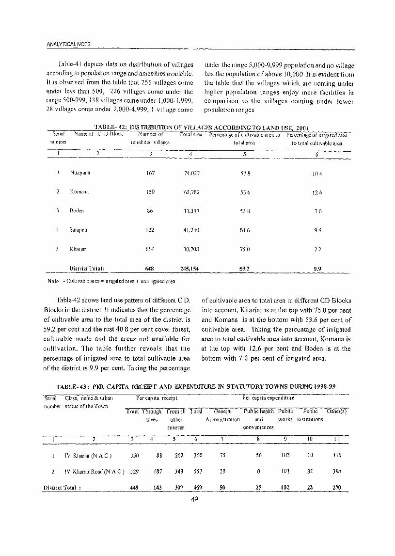
ANALYTICAL NOTE
rable-41 depIcts data on distributIOn of vdlages accoHling to population lange and amenitIes available. It IS obqclved from the table that 255 vdlages come unde! lc'>s than 500, 226 vIllage,> come undel (he tange 500-999, 138 villages come under 1,000-1,999, 28 vdlage~ come undel 2,000-4,999, 1 vIllage come
LInder the wnge 5,000-9,999 population and 110 vIllage ha.', the population of above 10,000 It IS evident from
the table that the vIllages which ale coming undel hIgher populatIon tanges enjoy 11100e facllities in com pal isoll to the villages cOllling unde! lowel populatIOn I angcs
TABLE-42: DIS fRmUnON OIfVILLAGE_~ ACCORDING TO LAND USE, 2001 <Jer 131 Name of C D Rlock Number of rotal mea Perccntage of wltrvable mea to Percentage at rrrlgated mea
llumbel Illhahlted VIllage'>
2 3 4
NUdpada 167 711,027
2 KOITI,lIla 159 65,782
1 Boden 86 11,397
4 SlIlapali 122 41,240
5 Khmlar 114 10,708
District Total: 648 245,154
Note - CultIvable mea'" lIngated mea + ulllrtlgated area
Table-42 shows land use pattern of different C D.
Blocks in the dlstllct It mdicates that the percentage of cultIvable area to the total at ea of the district is
59.2 per cent ancl the rest 40 8 per cent covel fmest, culturable waste ancl the areas not available for
cultivation. The table fmther reveals that the
percentage of it rigated area to total cultivable area
of the district IS 9.9 pel' cent. Taking the pelcentage
total area to total cultlvclble mea
5 (,
'i78 104
536 126
')58 70
616 94
75 () 77
59.2 9.9
of cultivable mea to total area 111 different CD Blocks into account, Khal'ial IS at the top with 75 0 per cent
and Komana is at the bottom with 53.6 pel' cent of
cultivable mea. Taking the pelcentage of irrigated area to total cultivable area into account, Komana is at the top with 12.6 per cent and Boden is at the bottom with 7 0 pel cent of ilTigated area,
TABLE-43: PER CAPITA RECEIPT AND EXPENDITURE IN STATUfORYTOWNS DURING 1998-99
Sellal Class, name & \II ban Per capIta receIpt Pel eap Ita expendltule
number status of the Town Total Thlough from all lotal General rllblrc health Public PublIc Other(s)
t!lxe~ other Adllll1llstratlon and works Illst It ut IOns sources conveniences
2 3 4 5 6 7 8 9 10 11
rv Kharim (N A C ) 350 88 262 360 75 56 103 IO 116
2 IV Kharrar Road (N A C ) 529 187 343 557 29 0 101 33 394
Di~tlict Total : 449 143 307 469 50 25 102 23 270
49
'Llblc-43 glVCb the dctaIl account 01 pel CdPltn tCCClpt and expenditlllc III statutolY towns In all of the lowns the pel capita expcndltme is 11Ighel than the per capita IC('CIPt. rhe shale of teVcllue flOlll all
DISTRICT CENSUS HAND BOOK NUAPAOA
othCl C,OllICCb III the per capita lecelpt IS lllghel than the lecelpt Ctom taxes The higher pelcentagc of expendltUl e goes to publ ic WOI ks and othel s.
1ABLE-44 : SCHOOl...., / COLLEGJi:5 JIER H),OOO POI)(JLAHON IN S'JAHJWRV roWNS,2001 Sellal numbel ~t\[l1C <llld lIIb,lIl ~tdtlh'()f r ype 01 I.:lillLdtlOlhtllll'>lltU\lOn
[own PII111c11Y IUl1l1lJ '1cLOlicimy / SC(..l)Jllldl), / Senior College
2 1
Khdllc11 (N A C) II i)
2 Klhlll[U Ro,ltI (N i\ ( ) 90
DI\tlld 'I ot.11 : 10.3
'Iable-44 pi escnts data all Schools and Collcgeb PCI 10,000 poplilation 111 the towns of the dlStllct The table I cveab thell 101 evelY 10,000 UI ban population In the dISh ict, there are about len primalY schools,
TABLE- 45 : NUMBER OF BEDS IN MfIDICAL
INSTUUI'IONS IN TOWNS, 200 I
Selw!
1l1l111bcl
Name anclillban
Sl,llus of
the IOlVn
2
I Khat 1.11 (N A C )
2 Khallal Road (N A C)
DI\II ct Total:
NUl11bel of becb IIlI11Clill,ll
Institutions PCI 10,000 population
3
12
13
12
Number of beds III Medical InstitutIons perl 0,000 population peltainll1g to two towns in the districl IS plesented in Table 45. It shows that 12 beds are
avU! lable in medical institutions per 10,000 til ban population of the district.
TAllLE-46: PROPORTION OF SLUM POPULATION
IN TOWNS, 2001 SI Name of the Town Total Slum Pelcentclge
No population population of slul1l population
to told! population
2 3 4 5
Khatiat (N.A C ) 13,409 4,551 339
2 Khatim Road eN A C ) 16,629 6,847 412
District Total : 30,038 11,398 37.9
Table-46 presents data on proportion of slum population in the towns of the distIict. The slum population ofihe town constitutes 37.9 per cent of its total population, KhaJ iar (NAC) having 33.9 per cent and Khariar Road (NAC) having 41.2 per cent slum population.
50
Mlcidle M dtllclildtlOn ~elolld'HY
4 5 6 7
lO 22 07 07
211 24 00 00
2.7 2.3 0.3 0.3
about 1111 ee nllCldle !:>choob, about two secondary schoob, one !:>CflIOI secondary and one college in Khm in! (NAC) and no "eniol secondary and college ill KhallaJ Road (NAC)
TABLE- 47: MOST IMPORTANT COMMODITY EXPORTEDOlrrOF AND MANUFACflJREO IN
TOWNS, 2001 Selldl Name and lliban
nllmbcl ~tatll~ ot Town
2 Kh,Ulat (N A C)
Most IInpOlt,U1t commodity
Manufactlllcd
Bredd Dal
3 [xpOited
4 Rile OIlseed
Rice Glal11 2 K!wllaJ ROdd (N A C ) AllIlJ1l11ll1llllltcnsil RICC
G lIdclkhu [{.ICC Bdll1 hon rt)\tllle~ GlIdah.hu
Table-47 depicts the most important commodities manufactured 111 different towns and exported from the towns. The main items of manufacture in the district are Rice, Dal, Bread, Aluminium utensils, Gudakhu and II on fixtures. The items exported mainly include Rice, Glam, Oilseed, Gudakhu.
(xii) Analysis based on HOllsclist Data, Census2001
In India, much emphasis has been laid on the mechanism of decentralized planning emerging frol11 the grass root level which has given rise to the necessity of building adequate data base for formulation of future plans at the micro level.
With the commencement of five year plans lack of data on quality and quantity of housing stock has compelled the Census Organization to conduct lin if 01 111
houseltsting allover the country not only on housing but also on the qualIty of living of household.
ANAL YTICAL NOTE
Like the previolls Cellsus, the Census of India, 200 J was conducted in two phases namely, (i) Housel isting operation and (ii) Population enumeration. The hOllselisting operations in Orissa was conducted in April-May, 2000, much ahead o[ the pOPlllation enumeration.
The basic objective of this elementary exercise wns to prepare a frame indispensable for smooth and systematic conduct of the population enumeration durillg February, 200 I. The housing consus, thus in some way was a prelude to the actual population
cOUllt oft11e Census. In addition, information collected through houselisting provide comprehensive data base for assessing the conditions o1'tl1e human settlements, housing deficit and for future housing requirements for formulation of hOllsing policies.
This operation also provides a massive data on amenities available to the household essentially required by various departments ofthe union and state governments and many other non-government organizations for development and planning of di [ferant projects of housing sccto!".
TABU> 48: HOUSEHOLDS BYTENURESTATUS AND NUMBER OF ROOMS OCClJPIED
INTHEDISTRICT 2001 """['cillirc status NUlllbcl of dwelling rooms Number of hOllseholds
------~T~ot-al~--------~S~ch-c~dl~ll-ed7C~n-s~te-s------~S7cl~lC~'d~u7Ic~c1mT~ri~he-s---
Total Rural Urban Total Rural Urban Total Rural Urban -----------------~----------------~----~----------~----~----~----~----~--2 3 4 5 6 7 8 9 IO 11
Own~c1
Rented
Others
District
Total
Total
No exclusive room
One room
Two rooms
Three rooms
3+ rooms
M cd ian number of rooms
Total
No exclusive room
One room
Two rooms
Three rooms
3+ rooms
M cd ian number of rooms
Total
No exclusive room
One r00111
Two roOI11S
Three rooms
3+ roOI11S
Median number Ofl"00111S
Total
No exclusive room
Dne room
Two rooms
Three rooms
3+ I"OOm5
MediaD number of rooms
122,846 118,263
1,439 1,395
4,583
44
44,411 43,320 1,091
51,249 49,680
16,067 15,239
9,680 8,629
2 2
3,496 2,053
48 30
1,084 672
1,342 788
594 33 I
428 232
2 2
3,352 3,036
165 152
1,411 1,278
1,065
445
266
2
973
390
243
2
129,694 123,352
1,652
46,906
53,656
17,106
10,374
2
1,577
45,270
51,441
15,960
9,104
2
1.569
828
1,051
2
1,443
18
412
554
263
196
2
316
13
133
92
55
23
2
6,342
75
1,636
2,215
1,146
1,270
2
19,036 17,879 1.157 43,950 43,581
286 274
7,352 7,004
8,055 7,589
2,292 2,100
1,051 912
2 2
422 282
7 5
156
159
66
34
2
541
52
258
150
54
27
119
96
41
21
2
482
49
228
134
48
23
I
19,999 18,643
345 328
7,766 7,351
8,364 7,819
2,412 2,189
1,112 956
2 2
12 573 570
348 15,291 15,150
466
192
139
2
140
2
37
63
25
13
2
59
3
30
16
6
4
1,356
17
415
545
223
156
2
19,490 19,369
5,826 5,760
2,770 2,732
2 2
524 411
9 9
203
215
55
42
2
946
36
419
313
107
71
2
160
170
39
33
2
892
34
384
303
101
70
2
45,420 44,884
618 613
15,913 15,694
20,018 19,842
5,988 5,900
2,883 2,835
2 2
Datil Source: Census of India 2001, H- Series: "Tables 011 Houses, Household Amenities and Assets."
51
369
3
141
121
66
38
2
113
o 43
45
16
9
2
54
2
35
10
6
536
5
219
176
88
48 2
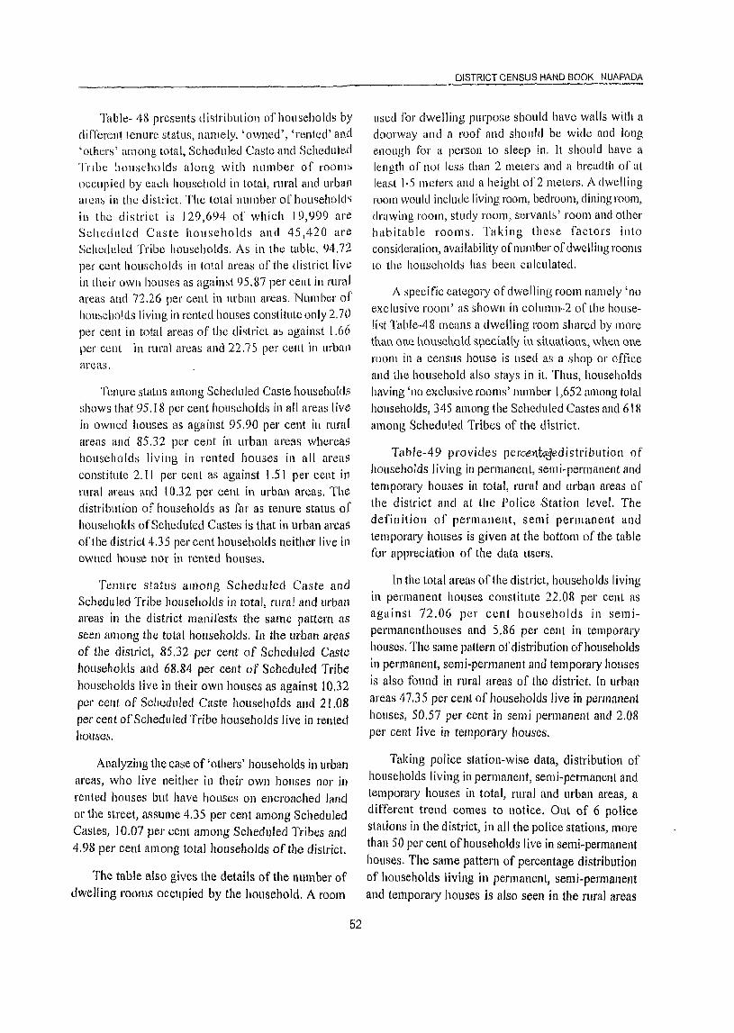
_____________________________________________________ ~D~IS_T~R~IC~T~CENSUSHANDBOaK NUAPAOA
TablCl- 48 presents distribution of households by different tenure status, namely, 'owned', 'rented' (lnd 'others' among total, Scheduled Caste and Scheduled Tnbc households along with number of rooms occupied by ca~h household in total, rural and urban alca~ in the district. The total number of households in the district is 129,694 of which 19,999 are Scheduled Caste households and 45,420 are Scheduled Tribe households. As in the table, 94.12 per cent households in total areas of the district live in thdr own hOLlses as against 95.87 per cent in rural areas and 72.26 per ceni in urban areas. Number of hOlls(.:holds living in rented houses constitute only 2.70 per cent ill total areas of the district ab against l.66 per cent ill llIral an:as and 22.75 per cent 'Ill urban areas.
Tenure status among Scheduled Caste households shows that 95. I 8 per cent households in all areas live in owned houses as against 95.90 per cent in rural areas and 85.32 per cent in urban areas whereas households living in rented hOllses in all areas constitute 2.11 per cent as against 1.51 per cent in rural areas and 10.32 per cent in urban areas. The distribution of hOllseholds as far as tenure status of households of Scheduled Castes is that in urban areas ofthe district 4.35 per cent households neither live in owned hOllse nor in rented houses.
Tenure status among Scheduled Caste and Schedu led Tribe households in total, rural and urban areas in the district manifests the same pattern as seen among the total households. In the urban areas of the district, 85.32 per cent of Scheduled Caste households and 68.84 per cent of Scheduled Tribe households live in their own houses as against 10.32 per cent of Scheduled Caste households and 21.08 per cent of Scheduled Tribe households live in rented houses.
Analyzing the case of 'others' households in urban areas, who live neither in their own houses 1101' in rented hOllses but have hOllses 011 encroached Jand or the street, assume 4.35 per cent among Scheduled Castes, 10.07 per cent among Scheduled Tribes and 4.98 per cent among total households of the district.
The table also gives the details of the number of dwelling rooms occupied by the household. A room
52
lIsed for dwelling purpose should have walls with a doorway and a roof and should be wide and long enough for a person to sleep in. It should have a length of not less than 2 meters and it breadth of at least I· 5 meters and a height of 2 meters. A dwelling room would include living room, bedroum, dining room, drawing room, study room, servants' 1'00111 and other habitable rooms. Taking these factors into consideration, availabi lity of number of dwelling rooms to the households has been calculated.
A specific category of dwelling room namely 'no exclusive room' as shown in column .. 2 ofihe houselist Table-48 means a dwelling room shared by more tJUU1. one hous.ehotd specially in s.iU.H~tions., when one room in a census house is used as a shop or office and the household also stays in it. Thus, households having 'no exclusive rooms' number 1,652 among total households, 345 among the Scheduled Castes and 61 R among Scheduled Tribes of the district.
Table-49 provides percel'\.tqqedistribution of households living in permanent, semi-permanent and temporary houses in total, rural and urban areas of the district and at the Police Station level. The definition of permanent, semi permanent and temporary houses is given at the bottom of the table for appreciation of the data tlsers.
In the total areas of the district, households living in permanent hOllses constitute 22.08 per cent as against 72.06 per cent households in semipennanenthouses and 5.86 per cent in temporary houses. The same pattern of distribution ofhOllseholds in pel'manent, semi-permanent anJ temporary houses is also found in rural areas of the district. In urban areas 47.35 pel' cent of households live in permanent houses, 50.57 per cent in semi permanent and 2.08 per cent live in temporary hOllses.
Taking police station-wise data, distribution of hOllseholds living in permanent, semi-permanent and temporary hOllses in total, rural ancl urban areas, a different trend comes to notice. Out of 6 police stations in the district, in all the police stations, more than 50 per cent of households live in semi-permanent houses. The same pattern of percentage distribution of households living in permanent, semi-permanent and temporary houses is also seen in the rural areas
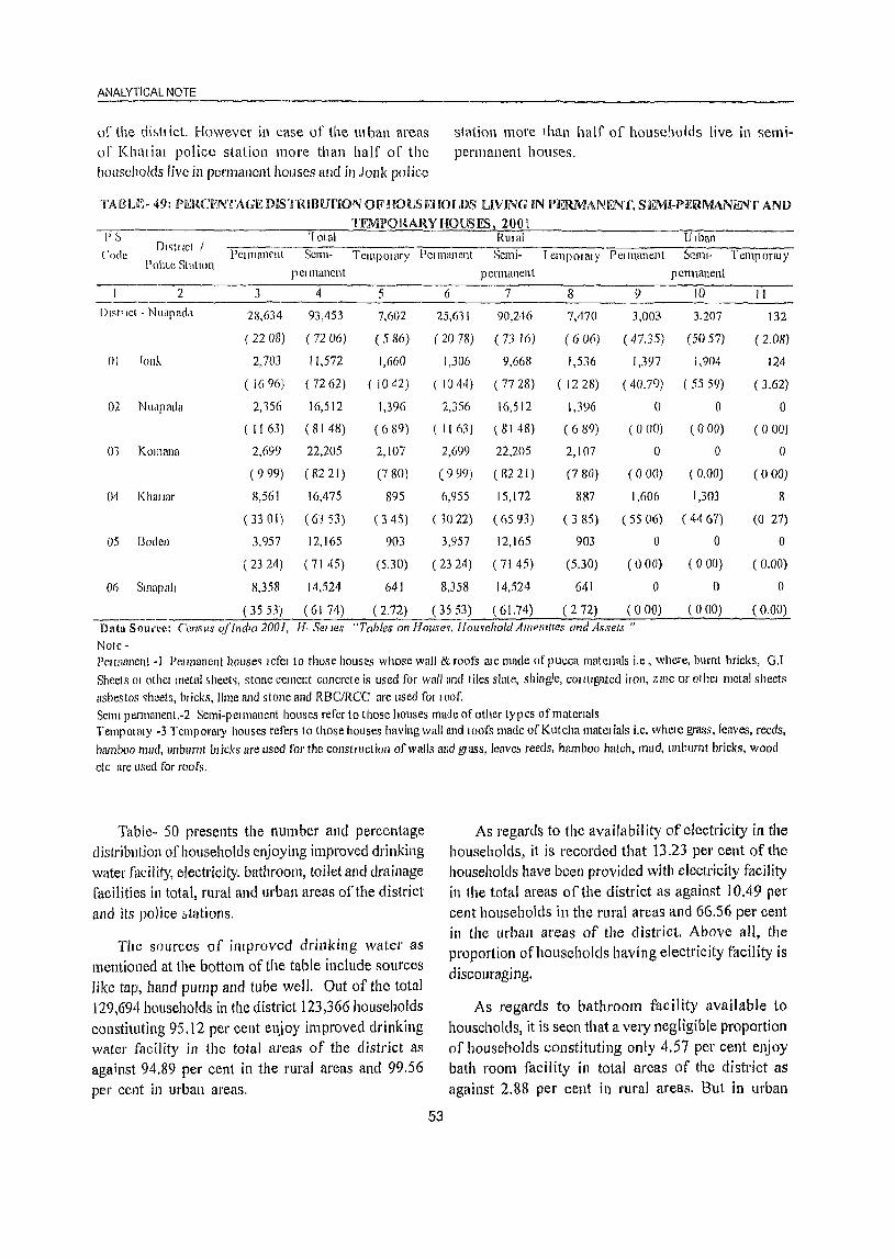
ANALYTICAL NOTE
of the distt iet. However in case of the UI ban areas of Khnl iar police station more than half of the households livc in permallcn( houses and in Jonk police
station more than half of houscllOlds live in semipermanent houses.
TATH'-E- 49: PElRCIiNTAGE DIS TRIBUfION OF HOUSEHOLnS LIVING IN PERMANENT, SI~MI-PEIRMANENT AND
TEMPORARYHOUSlES 2001 l\\IIal Ulban
t 'ode DI~tllct /
PoliLe StatulIl I'CIITlan('llt Scml- Tcmpolary i'cllnllllcnt Semi- I CIllPOI at y Pel mancnt Tel11pormy
pClIllanent pcrmanent
2 3 4 5 6 7
DIst1lct - Nuapadd 28,634 93,453 7,602 25,611 90,246
( 22 08) ( 72 (6) (586) (2078) (7.116)
p erllli1nent
8 ') 10
7,470 3,003 3,207
(606) (47.35) (5057)
II
132
( 2.08)
01 fOIlr.. 2,703 11.572 1,660 1,306 9,668 1,536 1,3')7 1,904 124
( 16 (6) (72 (2) ( 1(42) ( 1044) (77 28) ( 1228) (40.79) ( 5559) (3.62)
02 NUdpada 2,156 16,512 1,396 2,356 16,512 1,3lJ6 () 0 0
(1163) (8148) «(l8Y) (1163) (8148) (689) (000) (000) (000)
01 KOllHUln 2,699 22,205 2, 107 2,699 22,205 2, 107 a 0 0
(999) (8221) (780) (999) (8221) (780) (000) (0.00) (000)
04 Khlllmr 8,561 16,475 895 6,955 15,172 887 1,606 1,303 8
( 33 0 I) (63 53) ( 3 45) ( 10 22) (6593) ( 3 85) ( 55 06) ( 44 (7) (0 27)
05 Bodell 3,957 12,165 903 3,957 12,165 903 0 0 0
(2324) (7145) (5.30) (2324) (7145) (5.30) (000) (000) (a.OO)
Do SlIlapaiJ 8,358 14,524 (4) 8,358 14,524 641 0 0 0
~ ___ ~~(3_5=53).~(~6~1~74~)~~(~2~.7~2)~~(~35~5~3~)-7(~671.7~4~) __ ~(~2~72~) __ ~(~O~O~O) __ ~(~O~U~O) __ ~(O~.O~O) Data SOI;':~~~~ Census ofll1d/{/ 2001, J-I- Selles "Tables 011 House~, J1()lI~ehold Amel1lll£!s and Assets"
Note -Pel mallent -I Pel man en! h()use~ I efel to those houses whose wal! & foofs [II c made of p ucca matellals i.e , whcre, burnt bricks, G.I
Sheets 01 othcl metal sheet" stone cement concrete is used for wall and tiles slate, shingle, cOIlUgatC<! iIon, ZII1C or othel metal sheets asbestos ~heets, bl icks, lime and slone and RBC/RCC are used tOI loof. Scml pennanent.-2 Semi-pelmanent houses refer to those hOllses made of other types of rna term Is Temp 01 my -3 Temporary houses refers (0 those houses having wall und lOofs made of Kutcha matel ials i.e. where grass, leaves, reeds, bwnboo Illud, unhumt hllcks are used for the constructioll of walls and gI ass, leavc& reeds, bamboo hatch, mud, unburnt bricks, wood etc are lIsed for roofs.
Table- 50 presents the number and percentage distribution ofhouseholtls enjoying improved drinking water facility, electricity, bathroom, toilet and drainage facilities in total, rural and urban areas ofthe district and its police &tations.
The sources of improved drinking water as mentioned at the bottom of the table include sources like tap, hand pump and tube well. Out of the total 129,694 households in the district 123,366 households constituting 95.12 per cent enjoy improved drinking water facility in the total areas of the district as against 94.89 per cent in the rural areas and 99.56 per cent in urban areas.
53
As regards to the availability of electricity in the households, it is recorded that 13.23 pel' cent of the households have been provided with electricity facility in the total areas of the district as against 10.49 per cent households in the rural areas and 66.56 per cent in the urban areas of the district. Above all, the proportion of households having electricity facility is discouraging,
As regards to bathroom facility available to households, it is seen that a very negligible proportion of households constituting only 4.57 per cent enjoy bath room facility in total areas of the district as against 2.88 per cent in rural areas. But in urban

DISTRICT CENSUS HAND BOOK NUAPADA
IABI E- 50: PER(,ENTAGnLOFnOlJ':H~HOLDS HAVING IMPROVED DRINKING WAfFJ?SOlJRCE.,
ELl<.( IRIClTY,BA1BROOM, IOILKI ANDDRA..lNAGEF4CILlfV, 2001 PS DI~tllct / P ') lotdl! NUlllbt! Number and 0< tU.:ntage of home holds !ldvmg
"l>de Rlllr11! 01 Bdlllloom To~DI,un<lgl-
I JIbdn hOll~ehold~ IIlIp 10vec! dllflklllg f1edlltlty
WdtU' -------
L ., 4 "i b 7 8 9
DI~tr let - NU:lp.tda 11)l,,1 129694 123,31)6 17,155 5,912 7930 12,(31)
(9) 12) (1321) (457) (6 II) (974)
RIIl.!1 123 352 117,O'i2 J2934 3, 'i57 ),135 9,803
(9489) (1049) (288) (4 16) (795)
Lilb,1I1 6,347 6,114 4,221 2,375 2,795 2,833 (9956) (6656) (3745) (4407) (4467)
()J lonk IOldl 15,936 15,Sll5 3,592 1,486 1,62'i 3,619 (9968) (22 54) (932) (I () 20) (22 71)
Rllidl 12,51 I 12,478 1,292 181 215 1,772 (9974) (1033) (I 16) (I 88) (14 16)
Lilbdll 1,'~2) 3,'HJ7 2,300 1,303 1,390 1,1l47 (9947) (67 15) (3804) (40 58) (5193)
02 NU<ljlddd f otdl 20,265 19,852 1,249 1,249 1,456 2,679 (9796) (1603) (616) (7 18) (1322)
RUI,iI 20,265 19,852 3,249 1,249 1,456 2,679 (97 (6) (16 03) (616) (7 18) (13 72)
Ulban 0 0 0 0 0 0 (000) (000) (000) (000) (000)
03 /(O!1l<1fl,j TOlal 27,011 25,399 2,912 557 1063 1,357 (9403) (10 78) (206) (394) (502)
RlIlcll 27,011 25,199 2,912 557 1,063 1,157 (94 03) (l078) (206) (19~) (502)
Ulbcll1 0 () () 0 () 0 (000) (000) (000) (000) (000)
(H Khwlcll fat,d 25,931 24,342 4,565 1,568 2,191 2,448 (93 87) (17 60) (605) (845) (944)
RlIIaf 23,OI~ 21,415 2,644 496 786 1,462 (93 14) (I 149) (2 16) (342) (635)
Lirban 2,917 2,907 1,921 I,on 1,405 986 (9966) (6586) (3675) (4l! 17) (3J II)
05 Boden Iot,il 17,025 16,019 955 304 505 712 (9409) (561) (I 79) (297) (430)
RLUal 17,025 16,019 955 304 505 712 (9409) (561 ) (1 79) (297) (430)
Urball 0 0 0 0 0 ° (000) (000) (000) (000) (000) 06 Smapait Total 23,526 21,869 1,882 768 1,090 1,801
(9296) (800) (326) (463) (766) RUtal 21,526 21,869 1,882 768 1,090 1,801
(92 (6) (800) (326) (461) (766) Ulb,m ° 0 0 0 0 I)
(000) (000) (000) (000) (000)
Data SOluce Census of Indlll 2001, 11- Sellcs "rabies on Ilollse'>, Household Amenttle~ dnd As~et~ " .J< Ddsed on the ImplOved drlllkmg watel 90111ce, dllnkmg water ~upply has been classIfied .IS Improved' or othelWI~e If the household hll!> access to drmkll1g water supplIed trom fI tap 01 a hand pump / tube well 01 well Mtuated wlt}un or ollt~lde the plelm~es It IS conSIdered as havmgdcce~~ to Improved chmkmgwatel 50urce' However, the ~oncept of llnplOved dnnkmg water IS stdte &pecll1c ,md thl~ IS to be con~ldel ed aLwrclingly Note Pel cent age ha~ been gIven In bJacket~ <lltel the number ol hOll!>ei1olcls Dathroom mean~ bathroom wlthm the house 1 Oller meallS tOIlet wlthlll the hOllse Dramage mednl> closed and open clramage
54
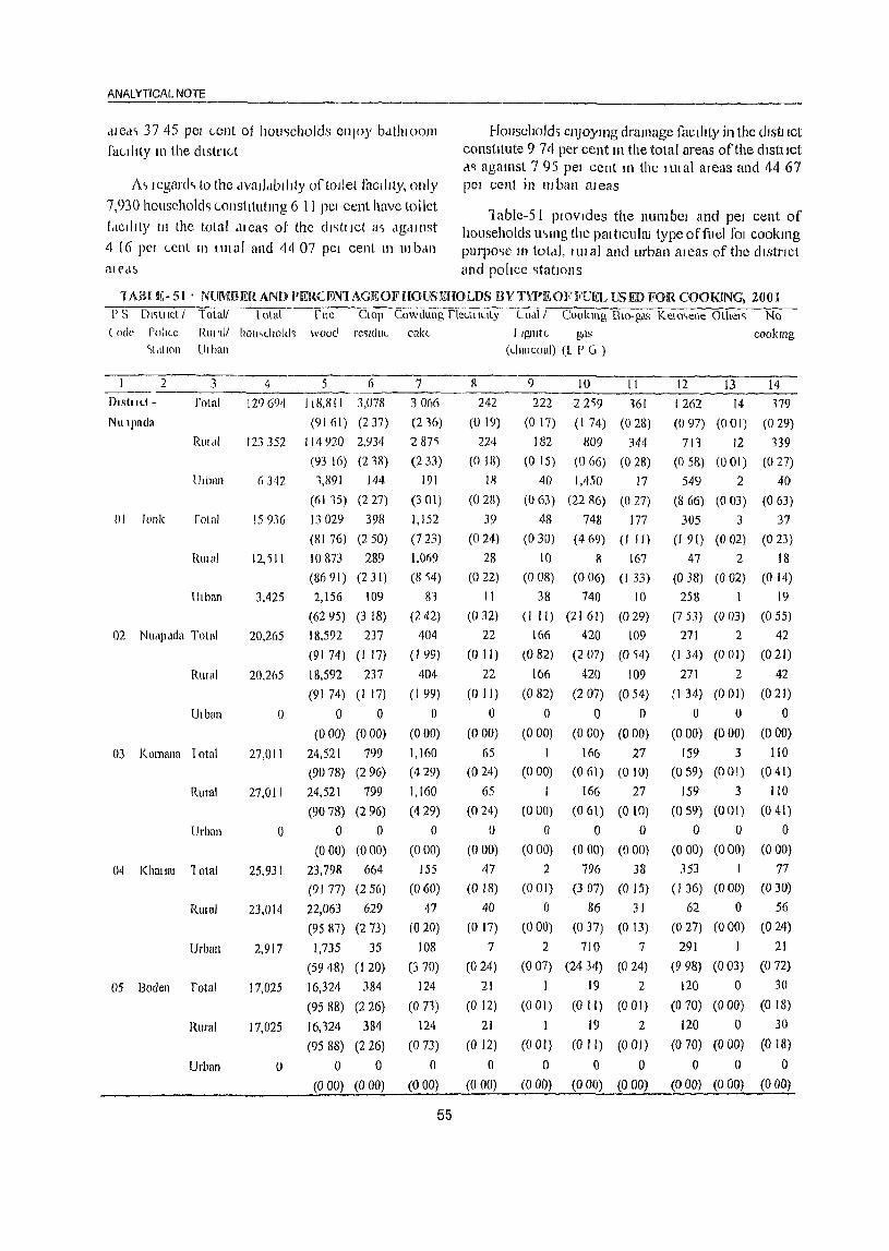
ANALYTICAL NOTE
<lled~ 3745 PCI Gent 01 hou<;cholds enJoy bdthloOIl1
facilIty 111 the dIstrIct
J\ ~ legard~ to the dvatldblllty of toIlet facility, only 7,930 households ("onstltutll1g 6 11 pCI cent have toilet
fdClllty III the total <ilca') ot the Cll'ltllct a,> clgdlllst
4 16 pel Lent 111 lUI al and 44 07 pel cent 111 HI ban aleelS
HOllsehold~ cl1Joymg dramage facIlIty in the dlstllct constitute 9 74 per cent III the total areas of the citstllCt cl'l aga1l1st 7 95 pel cent t11 the nil al al eas and 44 67 PCI cent in 1lI ban al eas
1ablc~5 I plOvlcles the I1UmbCl and pel cent of households U'>ll1g the pat tlculm type offuel fOI cookll1g purpo<;e lI) total, IUlal and urban aleas of the dIstrict and pollce '>tatlons
lAIH E- 51' NLJMBERAND PERCE!V"IAGEOFHOUSEHOLDS BY TYPE OF FUEL USED FOR COOl(INC, 2001 P S Dl<;tllct I Total! lota\
(ode Pollee Rill 111 hOll"ehold'l wood re'lldllL cake <'[,I(IOn Ulban
Dlstl Ilt
NUlplldll
2
01 lonk
3
fotal
UdlaJl
folnl
RlIlal
Ulbun
02 NUdP,ldll TOlal
Rlllni
Utban
03 Komana 10tal
Rural
Urban
04 Khat WI 1 alai
RUlal
Urban
05 Boden rotal
Rural
Urban
4
129694
5 6
IIS,811 3,078
(9161) (237)
123 352 114 920 2,934
(l)3 16) (218)
Ii 342 1,891 144
(6115) (227)
15936 13029 398
(81 76) (2 50)
12,'511
3,425
20,265
20,265
o
27,011
27,011
()
25,931
23,014
2,917
17,025
17,025
o
10873 289
(86 91) (2 31)
2,156 109
(6295) (3 18)
18,592 237
(9174) (I 17)
18,592 237
(9174) (1 17)
o 0
(000) (000)
24,521 799
(90 78) (2 96)
24,521 799
(90 78) (2 96)
o 0
(000) (0 00)
23,798 664
(91 77) (2 56)
22,063 629
(95 87) (273)
1,735 35
(59 48) (I 20)
16,324 384
(95 88) (2 26)
16,124 384
(95 88) (2 26)
o 0
(000) (000)
7 30()6
(216)
287')
(233)
191
(301)
1,152
(723)
1,069
(814)
81 (242)
404
(1 99)
404
(I 99)
o (000)
1,160
(429)
1,160
(429)
o (0 00)
155
(0 (0)
47
(020)
108
(370)
124
(071)
124
(073)
° (000)
55
8
242
(019)
224
(0 18)
III
(028)
39
(024)
28
(022)
11
(0 32)
22
(0 II)
22
(0 II)
o (000)
65
(024)
65
(024)
o (000)
47
(018)
40
(017)
7
(024)
21
(0 12)
21
(0 12)
o (0 00)
! Igllitt l?F1S
(dull coal) (l P G )
9
222
(017)
10 II
22'i9 l61
(I 74) (028)
182 809 344
(0 15) (066) (028)
40 1,450 17
(0 63) (22 86) (0 27)
48 748 177
(030) (4 (9) (I II)
10 8 167
(0 08) (0 (6) (I 33)
38 740 10
(1 II) (2161) (029)
166
(082)
166
(082)
o (000)
I (000)
1
(000)
o (000)
2
(001)
o (000)
420 109
(2 07) (0)4)
420 109
(207) (054)
o 0
(0 ~O) (000)
166 27
(061) (010)
166 27
(06l) (010)
o 0 (000) (000)
796 38
(307) (0 15)
86 31
(037) (013)
2 710 7
(007) (24 34) (0 24)
)
(001)
1
(0 01)
a (0 00)
19 2
(0 II) (001)
19 2
(0 II) (0 OJ)
o 0 (000) (000)
c{)okmg
12 13 14
1262 14 179
(097) (001) (029)
711 12 139
(0 58) (001) (027)
549 2 40
(8 66) (003) (063)
305 3 37
(I 91) (002) (023)
47 2 18
(038) (002) (0 14)
258 1 19
(753) (003) (055)
271 2 42
(134) (001) (021)
271 2 42
(134) (001) (021)
o 0 0
(0 00) (0 00) (0 (0)
159 3 [10
(059) (00 I) (0 41)
159
(059)
o (000)
3 110
(001) (041)
o 0 (000) (000)
353 1 77
(J 36) (000) (030)
62 0 56
(0 27) (0 00) (024)
291 21
(9 98) (003) (0 72)
120 0 30
(0 70) (0 00) (0 18)
120 0 30
(0 70) (0 00) (0 18)
o 0 0
(000) (0 00) (O 00)

DISTRICT CENSUS llANO BOOK NUAPADA
JABLE- 51 : NUMBER AND i)ERCENrAGEOFHO[JSEIIOLDS ilYTYPlf~OFFUI!.L lJSFD FORCOOKIN(", 20lH
PS OI~tllcJ / Told!) To(,tl rue ClOp ('owdung flcctJluty COdl1 Cookll1g BIO-g,l.) K("lo~ellc Othcl& No
Code Pollt(_, Rural/ households wood le,ldue Ldl,e LlgJlItt.. ~l\ c()okll1g
SLIt IOn UIlhll1 (CildIUldl) !L P (J )
2 3 4 5 6 7 8 9 JO 11 12 13 14
()b Sll1ap.lil lotal 23,526 22,547 596 71 48 4 110 8 '14 5 83
(95 84) (251) (03() (020) (002) (047) (003) (023) (002) (015)
RUt "I 21,526 22,')47 596 71 48 4 110 8 54 5 83
(9) 84) (253) (030) (020) (002) (047) (0 OJ) (023) (002) (035)
Ulb,m () 0 0 0 0 0 0 0 0 0 0
(000) (000) (0 (0) (000) (0 ()O) (0 (0) (000) (OO() (0 (0) (000)
Pel LLI1t.lgC III bl 'Icket~
D,ILI SOUl cc: Censu,> ol Intil.! 200 I II- SClle~ "T,lblc~ on 11011)(.", I IOll~eh()ld AmenlllL'> find A~,ct:; "
As ~hown 111 the table, thele me I1Ine types of
fuel S L1sed LOt COOklllg pLIl pose by 129,694 household~
III the dlstllct 01 these (lIeb, filewood l~ llsed by
91 61 pel cent of households III total clreas of tIllS
dlstllct <IS agalllbt 9116 pel cent mllual and 61 3~
pel cent in 1Il ban aleell> SlI11llar Iy cow-dung IS used
by 236 pel cent of hOlJ')eholcls 111 totdl .lled~ and 233 pel cent household~ 111 nil ell ale(l~ o( the (h~tnLt {OJ ('ookll1g PUI po.c,e
In the Iltball dJetl~ or the dl~tllct, 61 ~'\ pet (Lnt
l)1 !Joll.,c!loltl., lhe Ilrcwoud lollowod b) 22 86 pel
cell! Lllokmg g(h dnd 866 PCI l-"Ilt kell)"CIIC
fABLE-52: NUMBEROFnOU~EHOLDS AVAILING BANKINGSERVIOE AND NUMBER OF HOlJSEHOLDS
HAVING EACH OJ? fBESPOCJFJED ASSET'S, 200J
PS DJstJ let IPS TOt.lJ/ Tot,ll TOlal A YdJldbJllly ot hOlJsehold U\sUS
Code Rliluil number 01 IlUmbel 01 RdClio/ Televl~lon 1 e1ephone Blcyde Swoler, Car, Nonco[ Ulb,m hou~dlOlds hOll~eholcb I l<UlSISlOl MolOl Jeep, the
aVfllllI1g Cyde, Van spwficd bankmg Moped assetb
2 3 4 5 6 7 8 9 10 II 12
DI~trlct - NlIllllada TOld! 129,694 18,773 21,805 8,381 1,959 65,537 4,547 789 58,498
(1447) (1681) (646) () 5) (5053) (3 51) (061) (45 1)
Rural 123,352 15,992 19,951 5,760 1,203 61,784 3,385 595 56,574
(1296) (1617) (467) (098) (5009) (274) (048) (4586)
Urban 6,142 2,781 1,854 2,621 756 3,753 1,162 194 1,924
(43 85) (2923) (41 33) (1192) (59 18) (1832) (306) (3034)
01 10nk Tota! )5,936 3,241 3,271 1,912 461 10,067 915 174 4,964
(2014) (2053) (1200) (289) (6117) ('i 74) (I 09) (31 15)
RIllal 12,511 1,802 2,424 520 83 8,088 114 53 3,941
(1440) (1937) (416) (066) (6465) (251) (042) (3 I 5)
Ulban 3,425 1,439 847 1,392 378 1,979 601 121 1,023
(4201) (2473) (4064) (II 04) (5778) (17 55) (353) (2987)
56

ANALY neAL NOTE ---~-
IAHLI~-52: NlIMBEROFHOUSEHOLDS AVAiLING BANKINGSF1WICES AND NUMBEHOFHOlJSF1iOLDS
HAVING EACH OF THE S Pli.C'IFKED ASSEfS, 2001
PI) DI~tllcl / P ') [otall Total lotal A v<lllabiltly of hOllsehold assets Lodc RUf,ll! 1l1lmbcI oj llllmbcl oj Radlo/ J clevhloll I elep!Jonc BIcycle SCOO(CI. Car, None of
lhball hOll~chold<; hou"eh()ld~ I lanSI~(OI MolDI Jeep, the availll1g Cycle Vall specIfied b,l1lklllg Moped a~sets
2 3 4 5 6 7 8 9 10 11 12
OJ Nllapada lolal 20,265 3,411 4,094 1,911 287 12,116 961 116 7,015
(1683) (2020) (951) (I 42) (6077) (474) (067) (3462)
R'lJ,ll 70,265 3,411 4,094 1,911 287 12,316 961 136 7,015
(1681) (2020) (953) (1 42) (6077) (474) (067) (1462)
Ulbun 0 a 0 0 0 0 0 0 0
(0 no) (0 ~O) (0 00) (0 00) (0 00) (000) (0 aD) (000)
01 Komanu rotal 27,011 1,131 4,271 998 317 13,049 605 127 12,812
(12 14) (1'i B I) (3 (9) (I 17) (tiS 31) (224) (047) (4743)
RlIlal 27,0 II 3,313 4,271 998 117 11,049 605 127 12,812
(1734) (1')81) (369) (1 17) (4811 ) (224) (047) (4743)
Ulban 0 () 0 () () 0 0 0 0
(000) (000) (000) (000) (000) (0 (0) (000) (OOO)
()4 Khmtat I utal 25,931 3,262 4,134 2,228 511 12,858 1,072 147 11,985
(1258) (1671 ) (859) (198) (4959) (4 13) (057) (4622)
Rural 23,014 1,920 3,327 999 135 11,084 511 74 11,084
(II 34) (1446) (434) (059) (4816) (222) (032) (48 16)
l)lban 2,917 1,342 1,007 1,229 378 1,774 561 73 901
(4601) (3452) (42 13) (1296) (60 82) (1923) (250) (3089)
0') Bodcll 'I alai 17,025 2,117 2,301 416 118 6,970 287 85 9,414
(1243) (13 52) (244) (069) (4094) (I (9) (050) (5530)
Rural 17,025 2,117 2,301 416 118 6,970 287 85 9,414
(1243) (1352) (244) (069) (4094) (I 69) (0 50) (5530)
Urban 0 0 a 0 0 0 0 0 a (000) (000) (000) (0 00) (0 00) (000) (000) (000)
06 ')Illapah Tolal 23,526 3,409 3,534 896 263 10,277 707 120 12,308
(1449) (1502) (381) (l 12) (4368) (301) (051) (5232)
RUlal 21,526 3,409 3,534 896 263 10,277 707 120 12,308
(1449) (1502) (381 ) (1 12) (4368) (301) (051) (5232)
Ulban 0 0 0 0 0 0 0 a 0
(000) (000) (000) (000) (0 00) (0 00) (0 00) CO 00)
Data Source Census oflndta 2001, II- SeJ1es "Tables on Houses, HO\l~ehold Amelllties and A~sets"
Table~52 presents the number and percentage of As regards to banking services, it may be households availing banking service facility in total, mentioned here that banks refer to all types of rural and urban areas of the district along with the commelcial banks such as nationalized banks, private police stations. It also provides information all the banks, foreign banks and co-operative banks and the availability of household assets like radio, transistOl, service availed means the hend of the household 01'
teleVision, telephone, bicycle, scooter, motorcycle, any other member in the household is availing banking moped, car, jeep etc. in total, rural and urban areas seIvice provided by the bank or post office bank, as of the district a holder of any type of bank account Accordingly,
57
only 18,773 (14.47%) of the total 129,694 households in the district avail banking services as agai11st 43.85 per cent in the U1batl areas and 12.96 per cent ill the ('mal areas.
As regards to Jifferent household assets, bicyclt;: claims the highest percentage (50.53 pCI' cent) of households in total, 50.09 per cent in rural and 59.18 per cent in urban areas of the district. Radiol Transistor claims the second position (16.81%1) followed by television (6.46%) as household asset. Expensive household assets like telephone, scooter, car ancljecp claim very negligible proportion in both rural and total arcas oJ'the district. However in the urban areas" II .92 per cent of the households have telephone connection and 18.32 per cent households possess scooter, motorcycle, moped and 3.06 per cent own car, jeep, van etc.
As regards to banking services availed by households at police station level, the Jonk police station is at the top with 20.34 per cent and the Komana police station is at the bottom with 12.34 per cent.
Coming to the household assets at the police station level, it is seen that, maximum proportion of households in total and lll'ban areas possess bicycle as their household Ilsset distantly followed by radio/ transistor and television sets. Valuable assets like scooter, motorcycle, moped, car,jeep, van, telephone etc. are possessed by a negligible proportion of households both in total, rural and urban areas.
This apart households not having household assets as mentioned in Column.6-11 of the table form majol' pmportion in total, rural and urban areas of the district and police stations,
(xiii) Scope of Village Directory
The publication of District Census Handbook (OCH) is an excellent venture of the Censlls netwot'k. Information pertaining to quality of life and facilities available in vi lIage and urban areas after bei ng collected through perfect articulated schedules, are pl'eSellted in the form of Village Directory and Town Directory respectively fof' each district from which a planner envisages to transform the backward society to a modern one Village Directory contains data on
68
DISTRICT CENSUS HAND BOOK. NUAPADA
each and every village, may be a revenue villagl:' 01
unsurveyed village or notil1ed forest village or forest cluster in the rural areas C.D. Block wise/P.S. wise. The nllmes of village have been arranged ill ascendillg order of the permanent location code of the villages uncleI' different Police station within the jurisdiction of the concerned C.D. Block. It is noteworthy to mention that Census of India 200 I has introduced the assignment of permallent eight digited location code number to all villages in the state for facilitaring easy comparability of data over the period. In order to facilitate the readers & data users, an alphabetical list of villages under each C.D. Block showing the Police station with its location code number has been provided at the beginning of lllC vill<tge directory. In case of village (s) treated as an alit growth(s) in an urban agglomeration or treated as a Census town, the code number(s) and the name(s) ofvillage(s) hat, been provided minus data thereof separatdy. In Case ofPali village forming a portion of an olltgrowth, the corresponding data of the rural portion of the village only have been presented in the village directory. However the land utilization data for such cen~us towns have been made available in Appenrlix-lIl.
Maps being the instruments of depicting the location of the places, natural features, roads etc. within the respective administrative boundaries, these have been incorporated accordingly in the volume. All the maps so presented in this volume have been authenticated by the concerned revenue authorities in so far as the boundary, spellings and locations nre concerned. In case of the units adjacent to the coast land of the state, such maps have been cleared by the Survey oflndia through the Office of the Registrar General of India.
The district map showing the Police station boundary have been given at the beginning of the village directory. In addition to this maps, C.D. Block maps depicting the boundaries of various police stations under the C.D. Blocks, location of all the villages, symbolical representation of important amenities etc. have been incorporated in this volume prior to the presentation of data for the concerned C.D.Block.
The information on village directory has been provided in the statement containing 24 columns and

ANALYTICAL NOTE
these are relating to area of the village in hectares, population and number of households, availability of amenities like educational, medical, drinking water, post/telegraph/telephone facility, commercial & cooperative banks, agricultural! non-agricultural/other credit societies, recreational and cultural facilities, communications and power supply etc. This also provides information on the mode of approach to village, the name of the nearest town and its distance from the village, whether news paper/magazine is received by the villagers, income & expenditure of local bodies and also the information on the most important commodities that are manufactured in the village. In case of non-availability of any of the amcnities in the village, distance in broad ranges of thc nearest place where the facility is available has heen provided it) the directory.
Apart from these, the land use data for different villages in conformity with the pattern of classification of land use as recommended by the Ministry of Agriculture, Government of India have been presented in the said statement.
The Ministry of Agriculture has recommended the llJaintenance of records of land use pattern under five categories. These are as follows:
I. Forests
2. Not available for cultivation:
(a) Lands put to nOll-agricultural uses
(b) Barren and unculturable lands
3. Other uncultivated lands excluding fallow
lands:
(a) Permanent pastures and other grazing lands
(b) Lands under miscellaneous tree crops and
groves not included in the Ilet area sown
(c) Culturable wastes
4. Fallow lands:
(a) Fallow lands other than current fallows
(b) Current fallows
5. Net area sown
The Jand-use data in Vi lIage Directory are in
59
accordance with the above mentioned classification. Forest is the same as category I above. Irrigated (by source) and un-irrigated give break-up of agricultural land which arc a combination of categories 4 (a & b) and 5 above. CultuJ'abie waste corresponds to category 3 (a+b+c) above. Area not available for cultivation corresponds to category 2(a+b).
The information on village wise amenities and land-use pattern [or the village directory have been collected fi'olll the Tahasildars who in tUl'll had utilized the services of village level workers like Revenue Inspectol' & Amins workillg under them. In order to ensure the accuracy and quality of data, these data have further been compared with the data collected from various concerned governmental departments. Information on educational institutions has been collected from Inspector of SchoolsfD.I of schoolsl concerned Block Development Officers. Directorate of Health services of Orissa/respective Chief District Medical Officers/concerned Block Development Officers etc. have supplied information relating to Medical facilities. Information on Posts & telegraphs and telephone facilities has been obtained from the respective authorities of Government of India. Likewise, Reserve Bank of India has supplied information on commercial and co-operative banks. Data on agriculturallnon-agricultural/othel' credit societies have been verified, wherever possible, with the information furnished by the concerned Registrars of Co-operative Societies.
(xh/) Scope of Town Dh-ectol'Y
The tOWI1 directory abounds in a compendium of information relating to all towns statutorily notified as well as census towns in a district. The towns have been arranged in ascending order of their location code within a district and do not cover strictly the m Hitary areas in the district.
The information on amenities and other aspects presented in codes have been explained separately. As regards urban agglomeration, a conventional creation of Census, the names of such agglomerations have been indicated which are similar to the names of the main town of the agglomerations. The particulars of the constituents of the agglomeration have been furnished separately.

The concept of out growths has already been discussed !loder urban agglomeration. To reiterate, the lown directory particulars of outgrowths of the nrban units are lIot available separately. and slleh particulars of the outgrowths are merged in the COre
town
Information on town directory has been collected from concerned Executive Officer of stalutori Iy noti ficel Towns ancl from Block Development OffIcer for CenSLlS Towns. The details of information on town directory presented in seven statements are briefly explained below.
Stalel11ent- I: This statement presents the status and growth bistory of towns. In Col.I of the statement serial number of tbe town and in Co1.2 name of the town in alphabetical order along with the class and administrative status have been furnished. In Col.3 location code of the town and in ColA, the name ()f the tahasil and police station in which the town is situated are given. eol.5 gives the names of C.D.Blocks of census towns. Area of the town(in square kilometer), number of households including house less households, population and growth rate af popUlation, density and sex ratio etc. are presented in subsequent columns.
Statement - II: This statement provides information on physical aspects unci location of the town. These information include average rain fall, maximum and minimum temperature for the last ten year beginning from 1990-1999, distance of the town from the state, district, sub-division/tahasillpolice station headquarters etc., the nearest city with one lakh and above population, nearest city with population of five lakh and more, railway station, bus facility, navigable river/canal (if within 10 kms of the town) are indicated in different columns.
Statement- rII: It depicts the picture of the municipal finance of the town for the year 1998-99. The receipts from different sources are indicated under ColA to Col.l 0 where as the expenditure under various items have been shown under Col. I I to Col.! 7.
Statement- IV: The statement depicts the picture of civic and other amenities available in the town. These include total popUlation, Scheduled Caste and Scheduled Tribe populat ion orthe tawn as per 2001 Census. Apart ii·om this, the total road length in kms,
60
DISTRICT CENSUS HAND Baal< : NUAPADA
system of sewerage, number of latrines, method of disposal night soil, source of protected water supply, system of storage of drinking water. fire fighting services. electrification with !lumber of connection for different uses are shown in diiferent columns.
Statement -V: This statement presents information on medical, educational and recreational and cultural Jacilities available in the town in 1999. The medical institutions cover hospitals/dispensaries/T.B.clinic, etc with number of beds. These institutions may have been owned by Govt.lLocal bodies, private agenci0s, etc. Similarly, the educational institutions cover both general and techn ical ones and include arts/science/ commerce colleges (of degree level and above), medical colleges, engineering colleges, polytechnics, reconiged shorthand/type writing/vocational training institutions, higher secondarylintet'lnediatc/senior secondary PUC (pre-university college)/junior college level, secondary/matriculation, Junior secondary and middle schools, primary schools, adult literacy centers, working women's hostels with number of seats, stad i um,ci nema,aud itori lim/ e1rama/comm unity halls, public libraries including reading rooms etc. available in the town are furnished under different columns.
Statement- VI: Information on three most important commodities exported, three most important commodities manufacture, number of banks, number of agricultural credit societies and number of nOIlagricultural credit societies peliaining 10 the respective towns in the district are ret1ected in this statement.
Statement - VII: Like the village directory, the town directory format has also been modified to some extent. In the 1991 Censlls, civic amenities available in notified/recognized slums only in urban areas were collected. Contrary to this pl"Ovision, information/data relating to availability of civic amenities in each slum irrespective of it being recognized/notified was recorded in the 2001 Census with the objective to asceliain the existing civic amenities in slums and to provide necessary information/data required for slum improvement/development. Besides the number of households and population, amenities like paved roads (in kms), system of sewerage, number of latrines (category wise), method of disposal of night soil, number of tap points etc. and electric connection
available in the slums are presented in this statement.


VILLAGE AND TOWN DIRECTORY
Section I - Village Directory
(a) Note explaining the abbreviations used in thc village dil'cctou·y
The "Village Directory" is one of the traditional compilations of the Census. It gives the list of villages, their location numbers, their area, population, number of households, amenitics such as educational, medical, drinking waler, post and telegraph, commcrcial and co-operative banks, agricultural non-agricultural and other crecl it societies, recreationa I ancl cultural facilities, communicatioll, approach to village, nearest town with a distance, power supply availability of newspaper and magazines, most important commodity manufactured and land llse of each village.
Village is a statutory recognized unit having a defiuite boundary and separate land records. In case, a complelevillage is treated as an outgrowth of urban agglomeration, data on amenities for that village, have not been given in the Village Directory but shown along with the urban component. The villages which are consider as a Census Town , the amenities data arc shown in the Town Directory. For those villages which have partly merged in an outgrowth of U .A., the amenities data are shown in the Village Directory for that particular village.
The 'un-inhabited' villages ( villages with no popUlation) have been indicated as such after furnishing details in columns 1 to 3 i.e., Serial ntfmbel~ Name of village & location code number and area of the village against column 110. 4 to 18. The land
use data for such villages are shown in Col. 19 to 23
The Village Directory format has 25 columns and the details given under each column for the village are as follows :
Columns 1 & 25 : Serial Number
Self explanatory. All the villages within the C D Block are presented serially ill the ascending order of their location code number.
Columns 2 8t 24 : Name and Location Code
Number of "mage.
The name and location code number of the village
63
are shown against these columns. This also includes the forest and uninhabited villages.
Coillmn :3 : An~a of the village
The area of the villages i 11 hectares are given. Wherever the area figures was not fUl'l1ished by the concerned depal'tlllCnt the column i::; left blank.
Column 4 : Total population
The total popUlation of the village as per 200 I Census is given against this column.
Column 5 : Number of households
The number of households as per 2001 Census is given in this column.
Amenities:
In column 6 to 23, availability in respect of different amenities such as education, medical, drinking water, post, telegraph, banks, credit societies, cOl11munication, power, approach road etc, in each village has been depicted with appropriate codes against the column concerned. Wherever the amenities are not available in the village, a dash (-) is shown in the column and next to it in brackets the distance in broaci ranges viz. <5 kms., 5-10 kms. and 10+ killS of the nearest place where the facility is available is given, Column wise details al'e given below:
Column 6 : Educational
Classes upto class V included in Primary SchooL This will include nursery school, kindergarten school. Pre-basic school, pre-primary school, junior basic school upto class V.
Classes from VI to VIII are included in the middle school.
Classes from IX and X included in High secondary school. Classes XI and xn are included in senior secondary school.
In case of composite schools like middle school with primary school or secondary school with middle
schooL these are also included in thc number of primary and middle schools, respectively.
Accordingly any of the following types of instituj ions if exists within the village IS shown as p<;!'
codes given below:
( i) Primary School P
(ii) Middle School M
(iii) Secondary School 11
(iv) Senior Secondary School PUC
(v) College C
(vi) Industrial School
(vii) Training School 1'1'
(viii) Adult I iteracy class/centre AC
(ix) Others (specify) e.g. Sanskrit Path- 0
shala, Senior basic school, Navodaya Vidyalaya, Makhtab, etc.
More than one institution of a type in the village is indicated by the number within brackets against the abbreviation, e.g. P(3), M(4), etc.
Column 7 : Medical
Availability ofmedical facility within the village is indicated by following codes;
(i) Allopathic Hospital Ayurvedic Hospital Unani Hospital Homeopathic Hospital
(ii) Allopathic Dispensary Ayurvedic Dispensary Unani Dispensary Homeopathic Dispensary
(iii) Maternity & Child Welfare
(iv) Maternity Home
(v) Child Welfare Centre
(vi) Health Centre
(vii) Primmy Health Centre
(viii) Primary Health SubMCentre
(ix) Family Welfare Centre
(x) T.B. Clinic
(xi) Nursing Home
(xii) Registered Private Medical Practitioner
H HA HU
H Hom
D
DA DU
D Hom
MCW
MH CWC
HC
PHC
PHS
FWC
1'B
NH RMP
64
DISTRICT CENSUS HAND BOOI< : NUAPADA
(xiii) Subsidised Mt:clical Practitioner SMP
(xiv) Community llealth Worker CHW
~v) Oilie~ 0
More than one iustitution of a type in the village is indicated by the number within brackets against
the abbreviations, e.g. 11(3), 0(4), de.
Column 8 : Dl'ilUldn(~ WateD'
The type of the drinking water supply sources available within the village are indicated by codes as follows:
(I) Tap Water T
(ii) Well Water W
(iii) Tank Water TK
(iv) Tubewell Water TW
(v) Hanclpump HP
(vi) River Water R
(vii) Canal C
(viii) Lake L
(ix) Spring S
(x) Others 0
(xi) Summer Source SS
Column 9 : Post, Telegraph and Telcphone
It is indicated by codes as shown below whether within the village exists the following amenities:
(i) Post Office PO
(ii) Telegraph Office TO
(iii) Post & Telegraph Office PTO
(iv) Telephone Connection PH
Column 10 : Commercial and Co-opcl'ative Bani{s
If the village is served by any banking serv ice, commercial bank, co-operative bank etc. the same is indicated in codes mentioned below along with the number of banks in brackets. If not available the distance of nearest place where the facility exist is given:
(i) Commercial Bank
(ii) Co-operative Bank
CM
CP
VILLAGE AND TOWN DIRECTORY
Column 11: Credit Societies
If the village enjoys the services of Credit Societies i.e. Agricultural Credit Societies, Non Agricultural Credit Society or Other Credit Societies, the same is indicated in cocles mentioned below along with the number of slich societies in brackets. In case the facility is not available within the village the distance of the nearest place where such facility exist is given:
(i) Agricultural Credit Society ACS
(ii) Non-Agricultural Credit NCS Society
(iii) Other Credit Society oes
Column 12 : Recreational and cultural facilities
If facilities such as Cinema/Video hall, Sports Club, Stadium!Auditorium is available in the village. The same is recorded in these columns. If not available the particulars of the nearest place with the facility is recorded. The information is indicated in codes mentioned below along with the number of such facilities in brackets:
(i) CinemaiVideo Hall
(ii) Sports Club
(iii) Stadium! Aud itorium
Column 13 : Communications
cv SP
ST
If the village is served by any mode of public!
private transpo~t like Bus, Railway Station or Navigable water ways they are to be mentioned as
follows:
(i) Bus
(ii) Railway Station
(iii) Navigable Waterway
Column 14 : Approach to village
BS
RS
NW
Approach to village refers to the state of road leading 10 village. The approach to the village is
indicated in following codes:
(i) Paved Road PR
(ii) Mud road MR
(iii) Foot path FP
(iv) Navigable River NR
65
(v) Navigable Calla! NC
(vi) Navigable waterways other than NW River, Canal
Column 15 : Nearest Town and distance
The distance is given in kilometers in brackets against the name of the town nearest to the village.
Column 16 : Power SIIBllJly
Availability of Power Supply in the village, whatevcr may be the form of its LIse is given by lIsing following codes:
(i) Electricity for domestic usc ED
(ii) Electricity for agricultural use EAG
(iii) Electricity for other purposes EO
(iv) Electricity for all purposes EA
Column 17 : News Paper/Magazine
If village rece!ves any News Paper/Magazines the same is noted in this column using following
codes:
(i) News Paper
(ii) Magazine
N
M
Column 18 : Most important commodities
maJlufactured
The name of three most important commodities manufactured in the village is recorded against this column.
Column 19 to 23 : Land use i.e. area under different types of land usc
Land use data maintained by the State/U.T, Govts. are furnished against these columns. The data concerning area under Forest, Irrigated land (by source), Un-irrigated land, Culturable waste and Area not available for cultivation in the village are shown against these columns. The area figures are given in hectare(s) up to one decimal. Dash '_' is recorded wherever the information is 110t made available by the concerned department. The codes used for different types of irrigation facilities available in the village are indicated below:
(i) Government Canal GC

(ii) Private Canal PC
(iii) Well (withoul electricity) W
(iv) Well (with electricity) WE
(v) TubeweU (without ekehicity) TW
(VI) Tubcwdl (with dectricity) crwl2 (vii) 'lank rK
(viii) River R
(ix) Lake L
(x) WateI'f~111 wr (xi) Others 0
(xii) Total T
The villrlgl.: directory also carries tile following appendices.
Appcndix-I It gives the abstract of educational, medical and other amenities available in villages C 0 Block"wise of the
district.
Appendix-I-A Indicates number of villages C 0 Block-wise having one or 1110rc
primary schools.
Appcndix-I-B Indicates Ilumber of villages C D Block wise having primary, middle and secondary schools.
Appendix-I-C Shows number of villages CD Block wise with different sources of drinking water facilities.
Appendix-II Indicates the list of villages with 5,000 and above populatioll 'which do. not have one or more important amenities.
Appendix-II-A Indicates list ofCenslls Towns which do 110t have one or more amenities.
Appendix-Ill It gives the land utilization dala in respect of Censlls Towl1s/nonmunicipal Towns.
66
DISTRICT CENSUS HAND BOOK _NUAPADA
Appendix-IV C D Block wise list of inhabited villages where no amenity other than drinking water facility is available.
Appendix-V Summary showing number of villages not having Scheduled Castes
popUlation
Appe.ndix-VI Summary showing number of villages not having Scheduled Tribes population.
Appendix-VII A, VII B
The appendix shows the list of villages according to proportion of the Scheduled Castes and Scheduled Tribes to the total population by ranges.
Appendix-VIrI Indicates C 0 Block-wise number of villages under each Gram Panc!tayat.
(b) List of villages merged ill towns and
outgrowths at 2001 Census :
The dis1rict Nuapada was having two statlltory towns, namely, Khariar Road (NAC) ancl Khariar (NAC) in 1991 Census and no new town has been created during the Census 200 I. However, during these two census periods there is no viHage merged in any town situated earlier. Similarly, no outgrowth at 200 I Census has been croppt:d up.
SI. No.
LIST OF VILLAGES FULLY MERGED IN ~OWNS AND OUTGROWTHS
AT 2001 CENSUS
Name Location Merged in towns of village code No. and olltgrowths
2 3 4
NIL
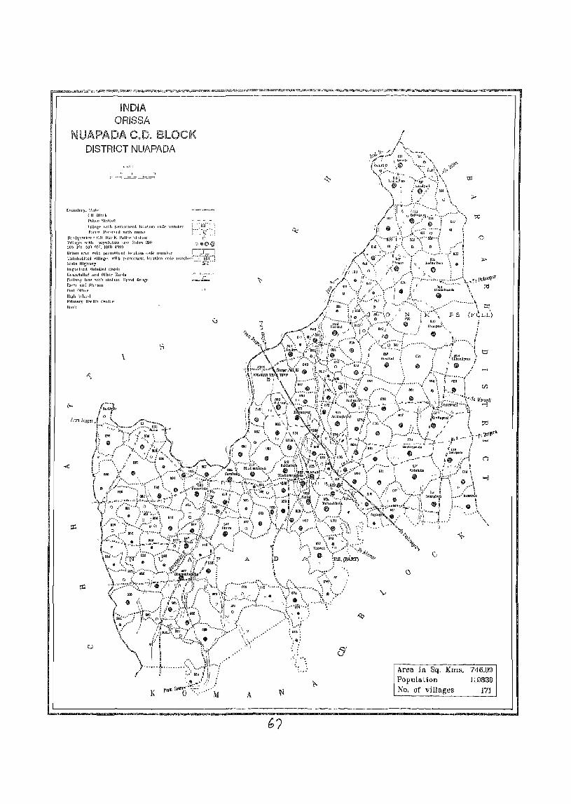
iND!A ORISSA
NUAPADA CJJo BLOCK DISTRICT NUAPADA
I II I " .... 1- r--j ~.=._t..=" _____..L--::;_=-I
()uUI111nf},')\ntl'
CD lllnrh PO}Ht' "itU\H1[l
\lllaw' Wltt~ Ilrrlllnn('[JlllllulllllJ Iud!' IIllJulll'r : "'oiiw
",:
fori'll I'f'r"f\{ II with I1nrnl' ~"" •• ~( '.:.: Ih ){lqlJtlrlcr..i! l'.D mOl k. Poilu.' "'hUUl1 0
igi"1;'~ l;~t~l t}!}~~)PI~1'1tJ~~D;l7(' TI\JloTf 200 0 06)11
llrblHI (Inn rllth IlLrmnnpul 1()(J.ltl,)JI un] ... IIl1l1lhor r"::'-Ll IJllint1llblte<i vlHngf'~ wHIi p"rnHlntmt llllatJon fod£' nllmbf>I:"-~"iiJ:i": htlltc Ilighully .... BJiJ .•• hn{ll)} (~nt actllUf'IJ f~Ofltln
tJllll1ehllcd ilnd Othl'r ROMl!!
Hulhmy ho~ tilth !.lllltlOn Hro'l.tI GIlIIGf' fln'ci nnd SII('lIl11 1'001 OffILl!
IhUh ')(hool PrimM'S HI'i'lih l'entlt> Ollllk
\
u
": .. ~'.
A N
~.
V
'-,
o
Area in Sq. KIDs. Pop11lation No. of villages
746.09 110830
171

VILLA E DIRECTORY F
NUAPADA C.D. BlOCK- 0001
ALPHABETICAL LIST OF VILLAGES OF NUAPADA C.D. BLOCK - 0001 Senal number Name of vIllage 2001 Census locatlon code 1991 Census loealton code number
number I 2 3 4
NAME OF C.D. BLOCK - NUAPADA
POLICE STATION - JONK - 0001
Amalldadar 04184600 100010014001400037
2 Amasena 04186&00 \0001001400\400059
3 Amodl 04181100 100010014001400002
4 Babankera 04183200 100010014001400023
5 Bakharmal 04181700 100010014001400008
6 Baloda 04185100 100010014001400042
7 Barakothl 04182200 100010014001400013
8 Beheradlhl 04184700 100010014001400038
9 Beltukurl 04181800 100010014001400009
10 Bhalnsmundl ORF Bhusudl 04183500 100010014001400026
II Bhalsatal 04185200 100010014001400043
12 Bhaleswar 04181600 100010014001400007
13 BhandarpurJ 04185300 100010014001400044
14 Bhanpur 04184000 100010014001400031
15 Bhotha 04184200 100010014001400033
16 Blromal 04185600 100010014001400047
17 Bisora 04182700 100010014001400018
18 BOirbhadl 04186200 100010014001400053
19 Budhlpa!J 04185000 100010014001400041
20 Chanabeda 04187200 100010014001400063
2\ Cuul!\dpam 04185&00 \000100\4001400049
22 Chlchmpanl 04185700 100010014001400048
23 Chmgarasara 04183400 100010014001400025
24 Darllmunda 04187800 100010014001400069
25 Darl mawapara 04185400 100010014001400045
26 Darlipali ORF Chuhun 04186300 100010014001400054
27 Deogaon 04182000 100010014001400011
28 Dhanora 04182600 100010014001400017
29 Dhumabhala 04184100 100010014001400032 30 Doto 04183300 100010014001400024
31 Gaharendlill 04183800 100010014001400029
32 GOlama 04186900 100010014001400060
33 Gudapatara 04182800 100010014001400019 34 Jampanl 04185900 100010014001400050 35 Jamuh 04185500 100010014001400046 36 Jangula 04184900 100010014001400040 37 JenJera 04184800 100010014001400039 38 lhalbahal 04187500 100010014001400066 39 Jhlllki 04183000 100010014001400021 40 Kadamben 04182500 1000\0014001400016 41 Kalyanpur 04187100 100010014001400062 42 Kandadhap 04182300 100010014001400014 43 Kermell 04187600 100010014001400067 44 Khahapanl 04187900 100010014001400070 45 Kodoguda 04181400 100010014001400005 46 Kodomen 04186400 100010014001400055
70
ALPHABETICAL LIST OF VILLAGES OF NUAPADA C.D. BLOCK - 0001 SPrlal number Name of village 2001 Census location code 1991 CenslIs location code number
• number ----_.-___ L 2 3 4
47 Kolda 04187000 100010014001400061
4l! Kukunmundl 04184300 100010014001400034
49 Kulmbandha 04183900 100010014001400030
)0 Kunlmunda 04181000 100010014001400001
51 Lukupall 04183100 IOOOl001400140ooJ2
52 Magurpanl 04187700 100010014001400068
'il Mahatamtura 04186600 100010014001400057
~4 Masankunda 04182400 100010014001400015
S'i Mudhela 04186500 100010014001400056
~6 NeglpalJ 04182900 100010014001400020
57 l'andnpano 04181900 100010014001400010
58 Par?s Ihhadar 04184500 100010014001400036
S9 Parkod 04184400 100010014001400035
60 Rohenpal11 04188000 100010014001400071
61 Sa.lha (Kala) 04187100 100010014001400064
62 Sallha (Khurd) \ 04187400 100010014001400065
63 5af alpah 04181500 100010014001400006
64 Saralpah 04186\00 .
100010014001400052
6: Sell lena 04183600 100010014001400027
66 Senhhata 04183700 100010014001400028
t:J7 S'ngpUl 04182100 100010014001400012
68 TamaJ'd dddar(KaJ a) 04181200 100010014001400003
69 Tamkldari1r(Khurd) 04181300 100010014001~00004
70 Tangopal1l 04186000 100010014001400051
71 'thelKobeda 04136700 100010014001400058
POLICE STATION - NUAPADA - 0002
Amanara 04189300 100020014001400012
2 Anhyuba 04191200 100020014001400031
3 BagJore 04195000 100020014001400118
" Bhalll~adaraha 04188600 100020014001400006
S Bhmnslmundl 04189900 100020014001400018
6 Bha·sadadar 04195400 100020014001400072
7 Bhdjlpala 04190100 100020014001400020
II Bharualllunda 04196600 100020014001400082
9 Bhera 04190600 100020014001400025
10 Bhera 04194100 100020014001400060
II Bhothll 04196200 100020014001400078
12 Brahman! 04188700 100020014001400007
13 Chhehlendl 04191600 100020014001400035
14 Chhotkendubahara 04188300 100020014001400003
15 Chhntiodra 0'l196300 100020014001400079
16 ChlpaJhal 04193700 100020014001400056
17 Chulahhat 04195600 100020014001400073
18 DaldaL 04189200 1000200140014000 I 1
19 Daltpathna 04189100 100020014001400010
20 Dhamanpun 04197900 1000200140014000Q5
71
ALPHABETICAL LIST OF VILLAGES OF NUAPAOA C.D. BLOCK - 0001. Senal number Name of village 200 I Cen~us location code 1991 Census location code number
number 2 3 4 .
21 Dharambandha 04196700 100020014001400083
22 DhwaJabhata 04194700 100020014001400066
23 Dlanmunda 04192700 100020014001400046
24 Dumerpanl 04190300 100020014001400022
2S ForfouJ 04188100 100020014001400001
26 Gadtor 04193200 100020014001400051
27 Gangadlgarh 04195900 100020014001400075
28 Gldhmlpanl 04188800 100020014001400008
29 Gobara 04197600 100020014001400092
30 Godtula 04190800 100020014001400027
31 Golabandh 04197400 100020014001400090
32 Haldl 04190000 100020014001400019
33 Hanspun 04190700 100020014001400026
34 I-Iernamunda 041Q3300 100020014001400052
35 Jamudara 04191500 100020014001400034
36 Jamusal1bhata 0418.8500 tOO02001400]400005
37 Jhalap 04196900 (000200J4001400085
38 Jhllmlill 04192800 100020DI4001400047
39 Junanl 04190900 100020014001400028
40 Kalamldadar 04195300 100020014001400071
41 Kankerm'ilnJI 04197500 100020014001400091
42 Karchul 04193600 100020014001400055
43 Katmgpanl 04196400 100020014001400080
44 Kendubahara 04188400 100020014001400004
45 Kermell 04197300 100020014001400089
46 Khalranl 04199700 100020014001400113
47 Khalana 04189700 100020014001400016
48 Khoksa 04197800 100020014001400094
49 KodoPdh 04196100 100020014001400077
50 Kotenchullil 04191700 100020014001400036
51 Kukuratal 04194600 100020014001400065
52 Kukunmundl 04194900 100020014001400068
53 LanJlmar 04193900 100020014001400058
54 Lodra 04196500 100020014001400081
55 Mahuabhala 04192200 100020014001400041
56 Momguda 04197100 100020014001400087
57 Maullbhata 04193500 ]00020014001400054
58 Mohara 04189400 100020014001400013
59 Motanuapada 04194400 100020014001400063
60 Musarangl 04195100 100020014001400069
61 Nandapur 04190200 100020014001400021
62 Padampurl 04192400 100020014001400043
63 Pagarpanl 04191000 100020014001400029
64 Pakhanpadar 04195500 100020014001400116
65 Panchampur 04194000 100020014001400059 66 Pandnpam 04193800 100020014001400057 67 Pandnpanl 04195800 100020014001400074
72
ALPHABETICAL LIST OF VILLAGES OF NUAPADA C.D. BLOCK - 0001 Senal number Name of village 200 I Census locatIOn code 1991 Census location code number
number 2 3 4
68 Paraskhol (Kala) 04192000 100020014001400039
69 Palaskhol (Khurd) 04191900 100020014001400038
70 Parsabuda 04192100 100020014001400040
71 Pasamara 04189000 100020014001400009
72 Patalghutkun 04189500 100020014001400014
73 PatharapunJ I 04194200 100020014001400061
74 Palora 04196800 100020014001400084
7S Palparpah 04190500 100020014001400024
76 Pawartola 04189600 100020014001400015
77 PethlBpalt 04197200 100020014001400088
78 Plpalchhendl 04191400 100020014001400033
79 RaJlbnagar 04188900 100020014001400119
80 RaJPurnuapada 04192500 100020014001400044
81 Ratapah 04193400 100020014001400053
82 Rattpall "{)4192900 100020014001400048
83 Sahlpaln 04191300 100020014001400032
84 Sakhatora 04193100 100020014001400050
85 Salebhala 04192300 100020014001400042
86 Sarabang 04189800 100020014001400017
87 SethJumpaOl 04195200 100020014001400070
88 Sl8latl 04191800 100020014001400037
119 Sllda 04190400 100020014001400023
<10 Siharibahara 04196000 100020014001400076
91 SlfIgldl 04188200 100020014001400002
92 Sirtol 04192600 100020014001400045
93 Sunantal 04198000 100020014001400096 . 94 Supaft 04194800 100020014001400067
95 Tanwat 04197700 100020014001400093
96 Tanamahuabhata 04194500 100020014001400064
97 Thakurnuapada 04193000 100020014001400049
98 T1krapada 04197000 100020014001400086
99 Tlleljhar 04191100 100020014001400030
100 Tona 04194300 100020014001400062
POLICE STATION - KOMANA - 0003
Barabeda 04200500 100030015001500151
73
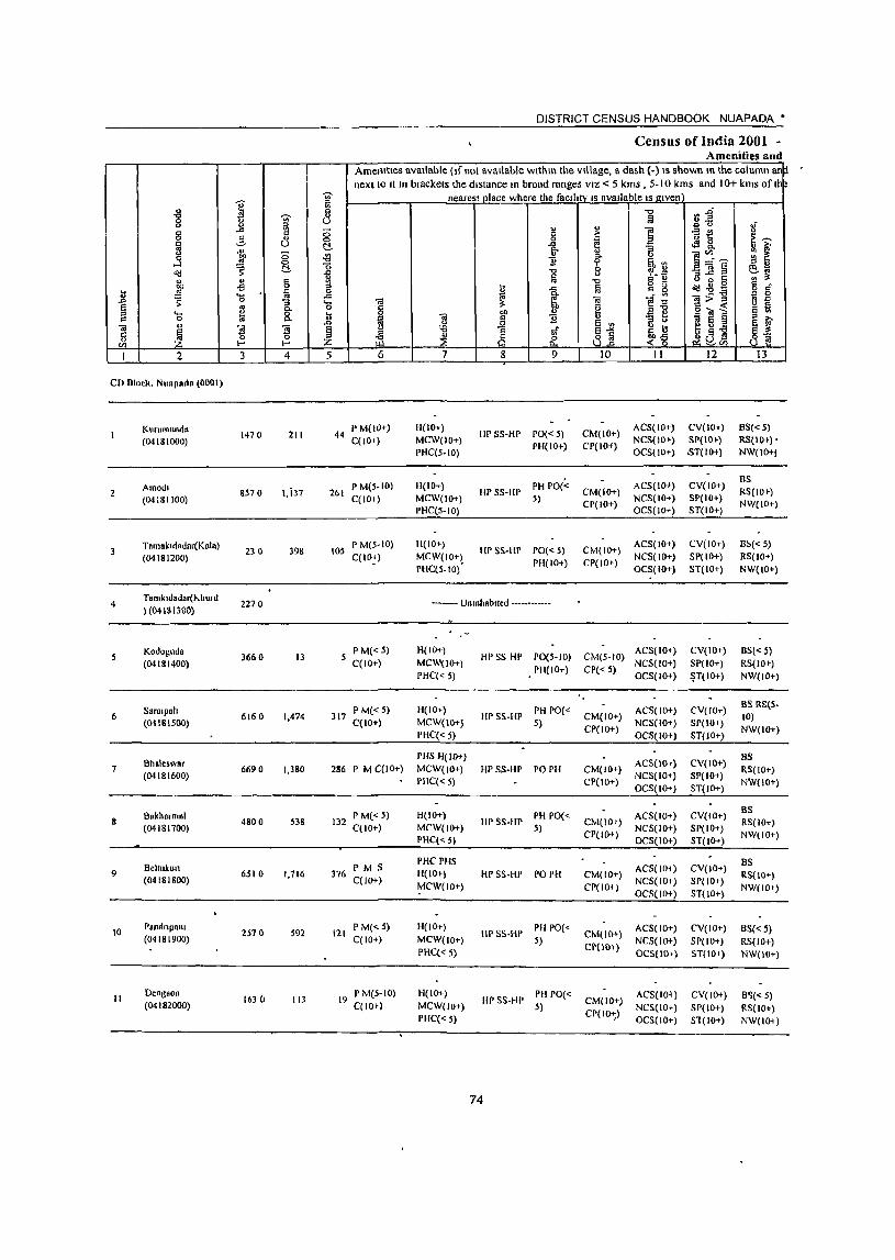
.... o
2
CD Dlock. N ""pad. (0001)
2
3
4
.5
6
7
8
9
10
II
KlIllImundn (04181000)
Amodl (04181100)
Tnmakldadar(Knla) (04181200)
Tamkuiadar(hhurd ) (04181300)
Kodoguda (04181400)
Sarnlpah (04IBI500)
Bhale.war (04181600)
Bakhalmal (04181700)
Beltukun (04 18 I 800}
P.lldnpalll (04181900)
Deogtlon (04182000)
3 4
1470 211
8570 l,i37
230 398
2270
3660 13
6160 1.474
6690 1.380
4800 538
6510 1.716
2570 592
1630 113
DISTRICT CENSUS HANDBOOK NUAPADA'
Census of India 2001 -Amenities and
AmeOitieS available (If not available wlthm the village, a dash (-) IS shown m the column an next to II In brackets the distance 10 broad ranges VIZ < 5 kms , 5-10 kms and 10+ kms of Ih
nearest place where the faCility IS available IS !lIven
5 6
44 P M(IO+) C(10+)
261 PM(S-IO) C(IO-J)
105 P M(5-1O) C(10:)
P M« 5) C(IO+)
317 P M« 5} C(IO+)
286 P M C(lO+)
132 P M« 5) C( 10+)
376 P M S C(IO+)
121 P M« 5) C(IO+)
19 P M(S-IO) C(IO')
7
H(IO+) MCW(IO+) PHC(5·10)
H(IO+) MCW(IO+} PHC(5-10)
11(10+) MCW(IO+) PHC(S-IO)'
8 9
HP SS-HP PO« 5) PH(IO+)
HP SS-HP PH PO« 5}
HP SS-HP PO« 5) PH(IO+)
10 II 12
CM(IO+) ACS(IO+) CV(lO+) CP(IO-f) NCS(lO') SP(IO')
OCS( 10+) ,sT(IO+)
CM(IO+) CP(IO+)
ACS(IO+} NCS(lO+) OCS(IO+}
CM(IO+) ACS(IO+) CP(IO+) NCS( 10+)
OCS(IO+)
CV(IO+) SP(IO+) ST(IO+)
CV(IO+) SP(IO+) ST(IO+)
-------- Unmhablled -----.---•• -
H(IO+} MCW(lO+)
PHC« 5)
H(IO+)
MCW(10+l PHC« 5}
PHS H(IO+} MCW(IO+) PHC« 5}
H(IO+) MCW(IO+) PHC(<; 5)
PHCPHS H(10+)
~CW(IO+)
H(IO+) MCW(lO+)
PHC« 5)
H(IO+)
MCW(lO+) PHC« 5)
HP SS HP PO(5-1O) CM(5-10) ACS( 10+) PII(IO+} CP« 5) NCS(IO+)
HP SS.HP PH PO« S)
HP SS·HP PO PH
HP 5S.HP PH PO« 5)
HP SS-HP PO PH
IlpSS.HP PH PO(<; 5)
HPSS-HI' PH PO« 5)
74
OCS(IO+}
CM(IO+} ACS( 10+) CPC 10+) NCS(lO+)
OC5(10+)
CM(IO+) ACS(IOr) CP(IO+) NCS(IO+)
OC5(1O+)
CM(IO+) ACS(IO+) CP(IO+) NCS(IO+)
OCS(IO+)
CM(IO+) AC5(1O-J) CPC 10+) NCS(lO+)
OCS(IO+}
CM(IO+) ACS(IO+) Cp(l!)-\-) NCS( 10+)
OeS(IO,)
CM(IO+) CP(IO-t;}
ACS(I01) NCS(IO+) OC5(10+)
CV(IO+} SP(IO+) ~T(lO+)
CV(IO+) SP(lO+) ST(IO+)
CV(IO+) SP(lO+) ST(IO+)
CV(IO+) SP(IO+) ST(IO+)
CV(IO+) SP(IO+) ST(IO+)
CV(IO+) SPlIO+) ST(IO+)
CV(IO+) SP(IO+) Sl(IO+)
13
B5«5) RS(IO+)' NW(IO+l
BS RS(IO» NW(IO+)
B~«5)
RS(IO+} NW{lO+)
B5« 5}
RS(IO') NW(IO+)
BS RS(S. 10) NW(lO+)
BS RS(IO+) NW(lO+)
BS RS( 10+) NW(lO+)
BS RS(IO+) NW(IO+)
BS«S} RS(JO+) NW(IO+)
B~«.5)
RS(IO+) NW(IO+)

VILLAGE DIRECTORY ----------------------------------------------.----------------ViIl:lge Directory "'1'-' on ""') Land usc (I e area under dlfTetent types of land use Ir .
hectare)
i c 0
_g ~
bIl ~ . .a ::: <> ;;
~ <> 0
" u c 8 U ...
, ~ e 'OJ' E~ .2 -a 8 ~ ~" " 1!J' " :> :g '" ,',oj
~ ~"t:l ~ Jq ~ 00
~ >. 1a ~ il ]: " 1: ~ e "t:l ~"t:l
10 ;; B " go 8.CJ .!! ..!! ~ e
'" "" '" .0 l\! 0 '- ::I
~ ... "- !3,.a " bIl or 0 c !! ~
tl ::I tl 'iii E ~il c " <'3
~ ~ II:! ]" .. ~ Z_ -~ J: ;3 8 ~ ~ E
CIl
15 16 17 18 19 20 21 22 23 2 I
Mil Khan .. ROAd (30) ED 68 122 I 67 108 Kurumunda
----------Mit "halla, Road (30) ED 664 7157 343 405 Amod, 2
--------
MR Khan., Rond (35) FD 95 124 08 Ta,nak,dad.,.(Kalal 1
._--_.-•••••••• UnInhabIted ••••••••••• ramk,dadar(Khurd) 4
MR Kl,."a, Rond (27) m 1957 1331 251 119 Kodoguda
PR Khans, Road (25) m 406 5451 260 39 Sara,p'\' 6
MR Khans, Rond (28) ED 437 6047 65 140 Bh.leswa,
PI'< Khana, Road (25) en 116 4070 175 439 Bakham,al
PR Khana, Road \25) FD 494 5575 265 178 Beltukuro 9
____ ... _.Iw.
MR KhJlla, Ro,d (27) CD 206 2101 123 11 5 Panrlnpalll 10
MR "hannr Road (27) fD 118 1344 163 10 Deogaon II
75

! I
12
2
~lIlgpur
(04182100)
'3 4
273 0 421
5
DISTRICT CENSUS rlANDOOOK NUAPADA •
Cen~us ot India 2001 -AllIellillel> lind
Amenltles available (It nol dVdllahle wltnu' the village d daGh ( ) I; ~how!1 III the ~OllJmll dl1~ next 10 It In olaLl<elS the dl',taoLt! In brudd I dnges VIL <. 5 km!> ) 10 i-m!> dnd I (J" k'ns o! tn
near~Sl plaLe where the !aLllttv IS available IS J!,!Ven
6 7 8 9 10 11
105 PM«» C(lOt)
III 10,) MCW(IOt)
PIlC( So)
HP~S HI' 1'111'0(, 5)
C'M(IO+) ep(IOI)
AC~(ILt)
N(~(IOt)
Oe\(lo-<)
LV(IOI)
~r(lo+)
~I(I()+)
8S(, ') R~(IO\)
NW(IOI)
------------------------------__ ---------------------------------------------------------IJ
14
I)
16
17
18
19
20
21
B~lrikOllll
(041&2200)
h .. nddditap (04182300)
MaSdnkunda (04182400)
f...dddlTlbtll
(01182500)
D~umO\'"
(01182600)
Bt~Ola
(01182700)
Guddpatara (04182800)
Neg'pah (04182900)
JllIuk, (04183000)
7400
3840
13230
9380
4880
8950
2610
2650
Jl30
468
247
1368
1005
823
1603
475
J94
705
95 I' M« 5) C(1O+)
50 I' M« 5) C(lOt)
310 I'MC(IO+)
203 P M« 5) C(lOt)
201 P M« 5) C(lOt)
383 I' M C(lO')
107 I' M« 5) C(IO»
102 I' M« 5) C'(IO,)
159 P M«)l C(lO+)
H(IDt)
MCW(lOt)
Pllq~ 10)
1I(IOt)
MCW(IOt)
PHC'(5 10)
11(10, )
MCW(IO+)
1'11(5-10)
11(10)) MCW(IO+)
PIlC(:5-IO)
11(lOt)
MCW(IOt-)
PHC(5-10)
PHS H(IO+)
MCW(IOf)
PHC(~ 5)
H(IO+) MCW(IO+)
PHC« 3)
11(101 ) MCW(IO+) PIlL(,5)
H(IO,)
MCW(IO+)
PHl(5 )(})
HI' ~S Ill' PH 1'0(5- CM( III t)
to) C'I'(IO+)
HI' 5S III' I'll 1'0(5- CM(IO+)
10) CP(IO+)
IIPS5 III' 1'0« 5) 1'11(10+),
111' S~ III' 1'0(5-10) 1'11(10, )
IIPS~Hr PHPO« 5)
HI' ~S HI' PO PH
HPSS-HP 1'0« 5) rll(lOt)
HI' '>5 III' 1'111'0(, 5)
liP 55 HI'
76
PH 1'0«
5)
CM(W,)
(P(IO')
CM(IO»
C1'(IO+)
CM(IO+)
CP( 10 I)
CM( lOt)
CP(IO+)
CM(IO»
CP(IOt)
CM( 10+) CI'(]{)I)
CM(IOt)
CP(IO+ )
AC~(IOt)
NC ~(LO+) O(~(IOt)
AC~(lOt)
N(~llOt)
OC5(1O+)
A(~(IOt)
N( S(IOI)
OCS(IO-l)
An(IO'l NCS(lO') OL~(IOt)
A(S(lOI)
NC5( 10+)
OCS( lOT)
AC5(10+)
NeS(IO+)
OeS( lOt}
ACS(IOt)
NeS( lOt) OL~( 10+)
AC!>( 10\) NCS( 10+) 00(10+)
ACSIIO+ )
NCS( 10+)
OeS(lo+)
lV(IO+) ',1'(10,)
ST(IOI)
CV( 10+)
SP(lOt)
H(lO+)
(,V( 10+)
~P(IO')
~T(IO»
( V(IO+)
SP(IOI)
SI(IO+)
CY(IO+)
~P(lO+)
H(J()f)
CV( 101}
'>1'(10 t)
"T(lOf)
CV(IDt)
~P(lO+)
H(IOI)
CV(iU+)
SP(IO') \T( 10+)
ey( 101}
SP(10+)
ST(iO+)
BS(:5 I()
R~(lO' )
NW(IO')
8~(,-1O)
RS(IO I )
NW(IO+)
85« 5) R5()(H)
NW(IOq
8~(5 10)
RS(IO') NW(I(}i)
65« 5) RS(IO+)
NW(IOt)
D\(,5)
RS(IO')
NW(IO+)
8~« 5) RS(IO,)
NW(IO\)
B'i« 5) RS(IO+) N\\ (10+)
B'>(<- 5) RS(lO, )
NW(Il)l)
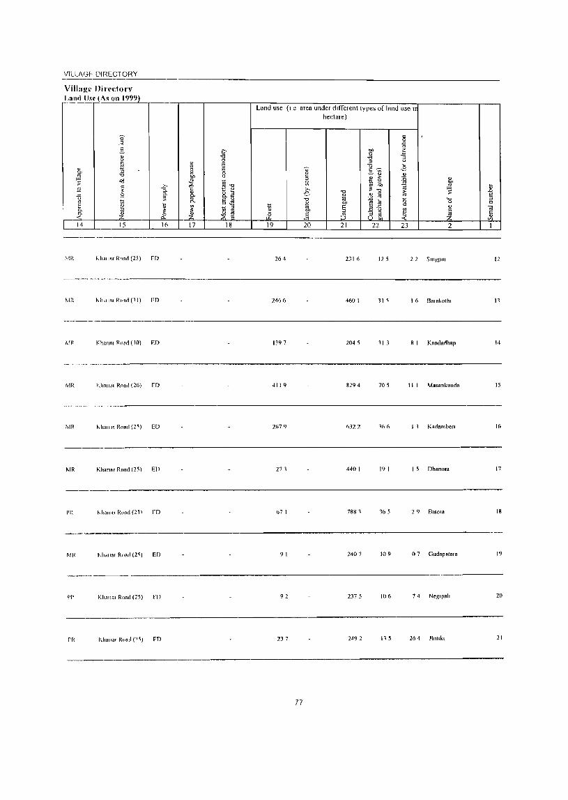
VILLAGF-- DIREC10._R_Y __
Village Directorv Land Use (As 011 1999)
MR "hOi Jar Ro." (25) FD
MR "h""" R,.," (11) FD
Khanal Road (10) ED
MR Khall.lI Roa" (26) I'D
MR "hnll81 ROAd (2';) ED
I\.IR Khanar Road (25) ED
PI: "hull"' Road (21) fD
MR tJ,mar Roar! (2~) ED
Land usc (I e area under dIfferent types of land use n hectare)
264 231 6 12 5 22 SlI1gpUI
2466 4601 11 ~ 1 (, Ba"'ol1n
1397 2045 11 3 8 1 Kandadh8p
4119 8294 705 II 1 Mas8llklllld.
2679 6322 166 1 1 Kadamben
271 4401 191 1 5 Dhanora
67 1 7881 165 29 8'"018
91 2407 109 07 Gudapata,a
-------__ ._-------------------------
PI' Kha"01 Road (25) [I) 92 2375 106 74 Neg'p."
Il.h.lla, Roa,1 (1~) FD 237 2492 115 264 Jhll,k,
77
12
II
14
15
16
17
18
19
20
21

DISTRICT CENSUS HANDBOOK NUAPADA •
Cem.u~ of Indld 2001 -Amenltle~ dlld
II.l Amenlt es aVdllable (lfnOl aVdlldble within the village a dash ( ) IS shown III the column an next to It III brackets the dl,tan~e III broad ranges VIL < 5 KillS 5 10 kill> and 10+ kill> ot Ihb
~ nedfe"t place where the tacllltV " dvallable "given I
~ ~
~ Ii § ~:E u L)
" '" t) " c: -" '" - " " ~ -'" '" " c:: 0 c ,. ~ 5 ~~ 0 3 ... 0 0 ~ ;: iii u c:. -" ., ~
" "'" :; ... "'" '" '" u
"" 8 -<'l " 15. 0 ~~~ ~ ~ 0 ...l ~ t!- o 11 ~ Ii ~ ~] ~ ~;;; od ;; ..<: "0 0 '" ti " " c 1A ~ "0 C (.) 0 r: ~ ~
0 u " 00 -s 0 " -" ~ c o<!.sg 0 " 1l ~ .... iii 0 " "'" 0 c: 0
~ 0 -" ;;; ~, Cil I'!~ ~>J '" ~ :; '- Cil :;: u E l'l C- o c v f! E] o '" ~ a
" .... 0 u 0 "" " 0 @ Q. fa Cil c 11 .,
~ E § " .. "
_o 0 .Q E '" " 0 E ~ Cil
~. "5 Cil E u -a " ~
E -'" ~~ .... g -a c 0 0 " '" ~ 8 8] ~(j~ ~~ .,
~ Vl I-< I-< Z I 2 3 4 5 6 7 & 9 10 II 12 13
2Z 1 ukupah
2870 49} 100 1'1\1(5 10) 11(101)
Ill' ~~ Ill' I'll 1'0«
(M(IO) A(~(lOc) (V(IO+) B~( 5)
(04183 IDOl C(lOt) MCW(IO) 5) U'(IO+)
N(~( 1(1) .'.P(IOc) R~(IO+)
PH((5 10) OC~(IOI) .',T( lOt) NW(IOc)
AC~( IO+} (V(IO+) B.',
23 Bllnn~ell
3530 379 8) PM(510) H(lO') III' ~~ III' 1'0« 5) C M( to+) R~(IOc)
(04 I 83200) C(IO+) MCW(IO+) PH(ID+) (1'(IOc)
NCS(IO') ~P(IOc) NW(lOc)
PHC(5 10) OC~(IOc) H(ID+)
24 Data (OlIS}300) 1290 396 90 I'M(510) H(IO+)
III' ~S III' 1'0(5 10) CM(lO+\ MS(IO') CV(I(jt) BS(5 10)
C(lO+) M(W(IO') PIl(lO') CP(\()+)
NCS( lOt) ~P(IOc) R~(IO+)
I'IIC (5 10) OCS(lO t ) ~T(IO+) NW(I01)
')5 ClullbaJ l!ldfd 3880 452 108
I'M(510) H(lOt) HI' S~ Ill'
I'll 1'0« lM(IO+)
A(~(I()') CV(I01) ElS(~ 5)
(04183400) C(lO+) MCW(IO') 5) CP(lOc)
N(!.(IOc) ~P(IOt) R~(IOt)
1'1I«IOc) OC!.(IO+) .',T(IOI) NW(IOt)
Bl18il1SIlIUndi 011 P M(5 10) H(IO') Al~(IOt) (V(IOt) B~(IOt)
06 BI\usudl 350 I 443 106 W.',!.W 1'0(5 IDj (M(IO') (04183500)
C(IOc) MCW(lOt) Pll(~ Sj CP(IO+)
NCS(IOc) 51'(10+) R~(ID' ) PH((IOc) OC~(IOt) ST(IOc) NW(IO+)
Semel18 I'M(510) H(IOt) 1'111'0« Al~( 10') (,V(IO+) BS
27 2530 419 95 HI' 'is HI' (M(IO') RS(IO+) (04183600) C(IO+) MCW(IOc) 5)
( P(IOt) NC~(IO') ~P(IO+)
NW(IOt) 1'11('« 5) OeS( 10+) H(IOt)
78 SellbhOlI
329 (l 446 III P M(5 10) H(IO')
Ill' ~S Ill' I'll 1'0« AC~(IOC) CV(l{I.) B!>«5)
CM(IO+) (04183700) C(lO+) MCW(IO,) 5)
(1'(10+) NCS( 10') ~P(IO') RS(IO+)
PH((5 10) O(S(IO+) ST(IO+) NW(IO,}
79 j}dhal clllhhi 2030 312 81
I' M(, 5) II( 10+) flP ~5 III' 1'0«5) CM(IO+)
A( ~(IOt) CV(IO+) B~(5 10) (041&3800) C(IO') M(W(IO')
PII(IOt) (1'(IOt) NCS(IOt) ~P(IOT) R'>(IOc)
PIK(S 10) Ot S(IO+) ST(lO+) NW(IO+)
DHPHS AeS NeS(5 Kuhdbdndha PM S III lOt) HI'Wn, CV(IO+) B5(10+) 30 7730 988 246 1'0 Pil CM(IO,) 10) OC ~(5 (01183900) C(IO+) MCW(IO+) ~~ III' SP(IOt) R~(IOt)
1'11('(10; ) CP(IO+) 10)
~1(10+) NW(lO')
31 Bhdnpur
2 1840 2285 533 I' M C(lOt) H(IO+) HI'W IK I'H 1'0("
( M(lOt) A(~(' 5) CV(IO') BS(IO+)
(04184000) ~ICW(IOt-) 55 Ifl' 5) CP(IOc)
NC5(1O' ) .',I'( 10') R~(IO')
PHC(IO+) OC~(5 10) ST(IO+) NW(IOl)
78
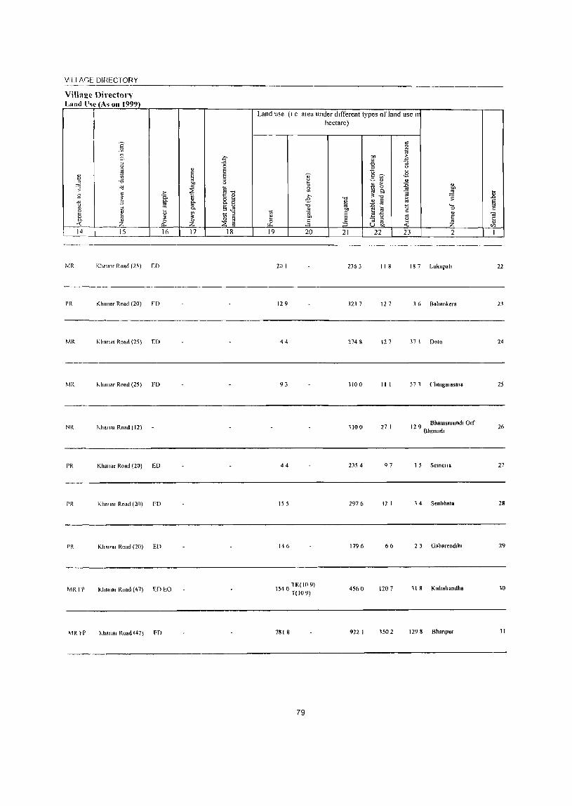
VILI AGE DIRECTORY ----------------------------------------------------ViIla!!:e Directorv Land ll~e (Ai 011 1999)
MR KhO! Ilr Road (25) ED
PR I(haIlnr Road (20) rD
Land use (I e area under different types of land use If
hectare)
20 I 2363 II 8 187 lukupah
129 323 7 127 3 6 Baoallke,.
22
23
----------------------------------------------------------------------MR 44 274 g 127 37 I 00\0 24
-----------------------------------------------------------------------MR "h" Jar Road (25) FD
NR r,halla. Rood (12)
PR Khall.r Road (20) ED
PR Kh., 101 Road (20) ED
PR Khall" Road (20) ED
MR rr 1<.11."ar Road (47) ED to
"h.\\.r Road (42) FD
93
44
15 5
146
TK(I09) 154{) T(W9)
7818
79
1100
1100
2354
2976
1796
4560
922 I
III 57 1 Chlllgal asara 25
27 I 12 9 Bh81llsmundl Orf
Bhusudl 26
97 1 5 Semell. 27
12 I 14 Senbhata 28
6& 2 ) Gaharendlill 29
1207 11 8 Kuhahandha 10
1502 129 8 Bhanpur 11

32
33
34
35
36
37
38
39
40
41
2
DhlllndIJhdld (04184100)
Bholha (041&4200)
KukUlllTIlllldl
(04184300)
Patkod
(04184400)
Parasabhadal (04184500)
Amahdadal (04184600)
Beheradlhl (04184700)
JenJerd (04 I 848()0)
Janllul. (04184900)
Budillpall (04185000)
3 4
1590 188
4360 603
1810 168
5&50 1,342
2100 435
1590 525
2760 432
3120 1,020
3440 639
1510 263
DiSTRICl CENSUS HANDBOOK NUAPADA
Census of India 20(11 -Amenitie~ and
Amenities available (If not available within the village a dash (-) IS shown In t!:le column dn~
next 10 It In brad.els the dl5tanLe In broad ranges VIi: " 5 km; 5-10 kms and 10+ km; o! tt nearest pldce where the taclltty IS a valldble IS given
5 6
34 I' M('" 5) C(IO,)
143 I' M« 5) C(IO+)
44 I' M« 5) C(IO+)
300 P M & C( 10+)
99 I' M« 5) C(IO+)
7
H(IO+) MCW(IO+) I'HC(IO+)
11(101-)
MCW(IO+)
PHC(IO+)
H(IO+)
MCW(IOr)
PHC(5-10)
PH& H(J()+)
MCW(IOt)
PIIC(5-10)
H(IO+)
MCW(IO+)
PHC(5-IO)
113 I' M« 5) C(5- H(lO+) 10) MCW(IO+)
PHC(5-10)
102 I' M« 5) C(5- H(IO+) 10) MCW(IO+)
PHC'(510)
PHS 11(10') 205 P MC(IO+) MCW(IOi)
121 P M« 5) C(IO+)
PHC« 5)
H(IO+)
MCW(IO+)
PHC(5-10)
56 PM«5)C(5- H(IO+) 10) MCW(IO+)
PHC« 5)
8 9
III' W TK SS HI'
I'll 1'0(<-5)
HPWTK SS HI'
I'H PO« 5)
HI' W S~- PH 1'0«
HI' 5)
HI' W ~S- PO PII
III' 1'0(5-10)
HPSS-Hp PH 1'0« 5)
HI' W ~S- PH 1'0« HP 5)
HI' W rK PH 1'0« 5S-IIP 5)
III' W fK PO I'H« 55-HI' 5)
HI' W SS- PH 1'0«
HI' 5)
HP W TK PII 1'0«
SS-HP 5)
80
10
CM(IO+) Cr(IOi)
CM(IO+)
CI'{I0+)
CM(IO+) e 1'(101))
11
ACS« 5) NCS(IOI-) OC5(5-10)
AC~« 5) NCS(IOI-)
OC~« 5)
ACS« 5)
NCS(IO+)
OC5« 5)
ACS
CM(5-10) NC~(IO')
CP(5-10) OCS« 5)
CM(5-10) ~~~(~;+~ CI'(5-10)
ACS« 5) CM(5-10) NCS(IO+)
CP(5-1O) OCS« 5)
12
CY(IO+) SI'(lO i )
ST(lOI-)
CY(IO+)
SI'(lO 1-)
ST(IOI-)
13
B~(1 0 1-)
RS(IO+) NW(IOI)
1l&(IO') RS(IO') NW(IOt)
CY(5 10) BS« 5)
&P()-IO) RS(5-JO) S 1(10,) NW(IO+)
CY(5-10) B& R~(5 10)
51'(5-10) NW(IO+) S f(IO,)
C Y(5-1O) BS(5-1O)
SP(5-IO) RS(5-1O)
ST(IO+) NW(IO,)
CY(5-10) BS RS(5-
SP(IO+) 10) ST(IO+) NW(IO+)
CM(S-IO) AC5(5-10) CY(5-10) BS« 5) CP(5-1O) NC~(IO+) SP(5-10) RS(5-IO)
OC~« 5) ~1 (10+) NW(IO+)
CM(S-IO) ACS(5-10) eY«5) CI'« 5) NC5(IO+) SP(5 10)
OCS(<-5) ~T(IO+)
CM(5-IO) AC~(5-1O) CV« 5) CI'« 5) NCS(IO+) SP(IO+)
OC5(,5) ST(IO+)
CM(5-IO) AC5« 5) CV« 5)
CP(5-IO) NCS« 5) SP« 5) OCS(5-10) ST(IO+)
BS RS« 5)
NW(lO' )
BS RS« 5)
NW(IO+)
BS RS(5-
10) NW(5-
10)
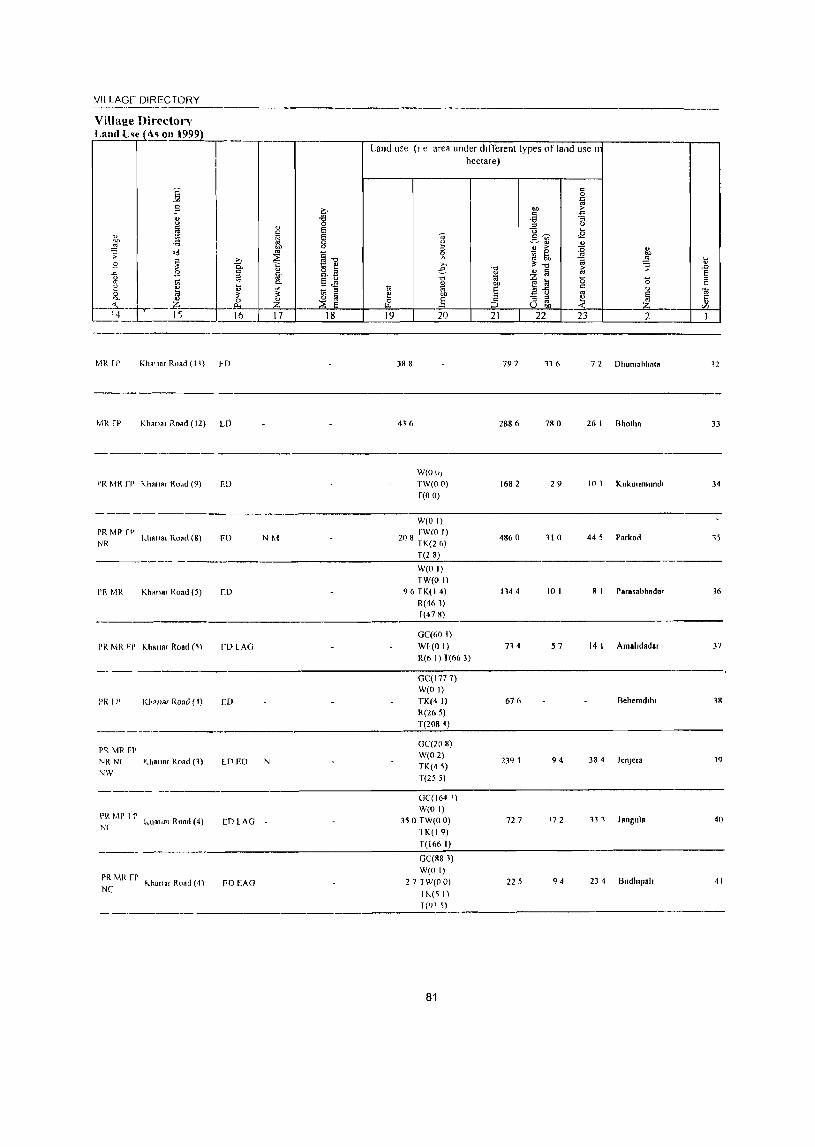
VlllAGr DIRECTORY
Village Director'\' Land U~i ( <\.~ 011 \999)
--.--r----.---------,~~--~------~~~--------------~------------ ~ Land use (I e are~ under dlfTerent types of land use II
MR [I' Khn'''I Road (Ill ~D
MR fP Khanal il.oa!! (12) UJ
PR MI{ ff' I\.l1a"ar I{o"u (9) ED
-----------_._------1'1{ MP fP NR kila".r Road (8) I'D NM
I'R MR Khanar Road (5) CIJ
fL'lAG
I'R I l' KIWI"' Ron,) (I) CD
PR \1R Fl'
NR N( Kha"ar Road (1) LDEO N
NW
I'R MP l~ NC kilnl'" ROAd (4) CD LAG
PR Mit rr NC I\."Hnar ROAd (4) I'D EAG
hectare)
~-----,--------~----~----~.-------
388
436
W(Ol,)
TW(OO) f(O 0)
W(O I)
208 fW(O I) TK(26)
T(28)
W(O I) TW(O I)
96 TK(I 4)
R(461) f(478)
GC(60 I)
WIo(OI) R(6 I) T(66 3)
GC(I77 7) W(O I) TK(4 I)
R(26 S) T(2084)
GC(20 8) W(02) TK(4,)
T(255)
GC(I64 I) W(O I)
350 TW(OO) 1K(19)
T(166 I)
GC(88 1)
791
2886
1682
4860
1144
714
676
2)9 1
727
22 S
11 (> 72 Dhumahhal.
780 26 I Bholhn
29 10 1 Kukunmllndl
110 44 S Parkod
10 I R 1 Par.sabhad.r
57 14 I Amahdadar
Beheradlhl
94 38 4 JenJe,a
172 13 1 Jangul.
94 2) 4 Budhlpah W(O I)
27 TW(OO) 11\.(, I) 1(91 I)
--------------------------------------~~
81
12
33
)4
1S
16
37
38
19
40
4 I
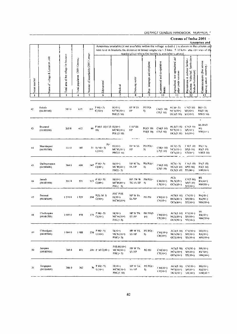
DISTRICT CENSUS HANDBOOK NUAPADA •
Census of Indld 2001 -Amemttes dod
IT I AmenlHe, avalldble (It not aVdllable within the village a ddSh ( ) I~ ~h()wl1 In the eol\lmn 'lnll
~
lIext to It It\ ordcl.eb the dl,lallee In brodd Idllge. VIZ -- 5 kills 5 \() llTl' dnu l(J~ ~II\' o! lit ll"oUe'l pl,\c" wher" Ihe !aclllI~ I. dvatldble I' gl\en I
" ~ 0:: I "'- ~ ~ I
'3 " iii ..}
~ 0 " "
c <> 1l .c - " "f! -= ~ " 5 <:> c > 0 -3 0 0 '" E u 1:: E-ia u C:!- -a ~ <lS 8. " ~ u " - " g_ :;
]~- '" '" 0 "" <:> .;g u :g 5 ....l ~ <:> 0 11 % 51",
"<l -; C:!- -'" -0 <> '" !! :;] § 6~
" " '" ~ § '"0 " t; t) 0 t: '" :!. "-"" -s 0 i:i '" § g ~ ~~g 0 " i:i ~ ia 0 .... .c 1;j ~ ttl;>-g ~ 0
.c 0 :; .... ttl ttl "f! '" ~ E ,.
i'l 0- 0 t:: :$
~ al1 § itt ~ a " '0 8. i:i 0 OIl " c:: til iii ttl " 11 "3 b ~ Ii ~ " ~ "
.c u :;; e '" e .. ttl el ~ e " -a e-'" " ~
~] 11 ~ :> 8 ~ 51 u (3 5 ~ 0 " ~ ~ 8] ~~ ~uVi Vl ...... ...... z
I 2 3 4 5 6 7 8 9 10 11 12 13
BalodA 3M70 613 163
PM« S) H(IO.) HPW S~ PH POI LM(S 10)
At ~(" 5) l V(S 10) !3~« 5) 42
(04185I()O) C( 10+) MrW(lO+) HI' 5) N(~(I01 ) ~P(IO.) R~(5 10) PHC(5 10)
(,P(5 10) 0(~(5 10) ~1(10') NW(S 10)
Bhals81al P M(5 10)('(5 H(IO+) 1 liP SS A(S(5 10) CV(5 10) Il~ R'>(S
43 2050 412 9<) 1'0(51() CM(510) 10) (01185200) 10) MCW(IOt) liP
PH(5 10) CP(5 10) N(,5(10+) !>I'(I01 )
NW(HH) PIIL(5 10) 0(,~(5 10) 1>1(10+)
Bhlindarpurl 1'«
1I(IOt) liP W ~~ PH 1'0(" AL~(<- 5) (V('\ 10) Il~« 5) 44 1330 145 J I 5) M«5) CM(, 10)
(041853UU) ((10+)
MCW(IO.) III' 5) (P(S 10)
N('~(IOI) SP(5 10) R~(5 10) PHC(5 10) OC~\IO') ~T( lOt) NW(510)
45 Dalltnawapala
364 0 600 147 I'M«5) II(I()') III' W 1 "- I'll 1'0«
CM(5 10) ACS(~ 5) (V15 10) 1l'>(5 10)
(04185400) C(IO+) MCW(Wt) 5'> III' 5) CP(5 10)
NC!:>(510) SI'(5 10) RS(S 10) PHC(,5) 0(S(5 (0) Sl (10+) NW(IO+)
JalllulJ PM«5) 11(10+) HI' fW W PH 1'0(' AC~
CV(5 10) BS
46 3310 571 115 ( M(lOt) N(S(lO') R~(IO') (04185500) qIO+) MCW(IO') TK ~'> III' 5)
(1'(10+) OC~(I(I+) ~r(5 10)
NW(IO+) 1'11( 5) Sf(IO')
Blfomai 1'(3) M S PHC PHS
liP W 1"- ACS(51() CV(IOt) B'>(IO+) 47
(MI85600) 12740 1929 394
C(IO+) 11(10+)
S~ liP PO I'll (,M(IO')
NC!:o(IOI) 51'(101) R!:o(IO'J MCW(IO+) CP(IO')
O(,~("H) ST(HH) NW(IOt)
Cludllllpam P M(,5) 11(10') HI' \v TK I'll 1'0(5 ACS(5 10) (V(IO') B~
48 10030 858 175 (,M(IO+) R5(IO+) (MISS700) C( 101) MCW(IO+) S5 liP 10)
CP(W+) N(~( 10') SI'(IOt)
NW(IO+) PH((< 5) O(S(IO') <;1(1111)
49 Chhllldpal\l
10680 1088 256 PM(,5) 1I(IOt} IWW IK PH 1'0(,
CM(lO t ) ALS(5 10) 'V(IO.) 1I~(IIl')
(04185&00) C(lO+) MC\I,(IO+) 5S HI' 5) CP(IO')
NC!>(IO+) 51'(10') RS(IO+) PHC« 5) OCS(IO') 51(10.) NW(\(lt)
JampBH' PIIS H(lO+)
HPWn. AC~(5 10) CV(IOt) B~(IO' ) 50 7090 891 200 P MC(IO+) MCW(IO.) PO I'll CM(IO+) (04185900)
PHC« 5) ~~ HP
CP(IO+) N(,!>(IO+) SP(lOt) R~fJO+)
O('~( lOt) ST(W+) NW(IO+)
51 fangopam
3660 )62 76 P M(<-5) II( 10,) HI'W lK PH 1'0('"
( M(IO') AL~(S W) CV(IO.) BS(IO')
(04186000) ((10+) MCW(I()+) ~~ liP 5) ( P(IOr)
NCS(iOt) ~P(IO.) R~(IOr\
PHC(5 W) 0(S(10') ~ f( lOt} I~W\I01\
82

VILI AGE DIRECTORY ----------------------------------------------------------Villa!!e Directon !:!nd lise (As on 1999)
PR MR rr I\.h'''8' Ro.d (6)
PH MR rr KII1".r Road (8) rD
..
rR ~ IR rp I<.ha"o< Road (8)
Land use (I e area under different types of land u~~ n hectare)
Weo I}
800 TW(OO) TK(36) R(5 6) T(9 2)
W(O I}
TW(OO)
TK(41) T(44)
W(O 0)
TW(OO)
T(O 0)
2154
177 I
1200
174 450 Baloda
7 I 16 6 Bha.salal
48 8 1 Bhalldarpun
42
43
44
----------------;-----""--------------------------
Mit II' Khm Ir' Road (q) FD r,vl
I'R rp Klla,,', Road (10) ED
'v!R11' Hanar Road (10) ED
~11t rp Kh.,,., RURd (~4)
Mit rr Kh.lIa, Road (51) [0 FO
MRrP I<.halla, Road (»))
MR fP Khan •• Road (18)
79
142 TK(4 6) T(46)
1595
5196
1085
668 TK(9 7) r(97)
86 I
83
3111 246 18 5 Da,hllawapara 45
2710 21 1 175 Jamuh 46
8849 1490 810 Bllom.1 47
332 8 1120 38 1 Ch.chmpam 48
5188 1699 508 Chhmdpam 49
1869 91 1 1541 J.mp.111 50
1797 723 27 4 Tangopa111 51
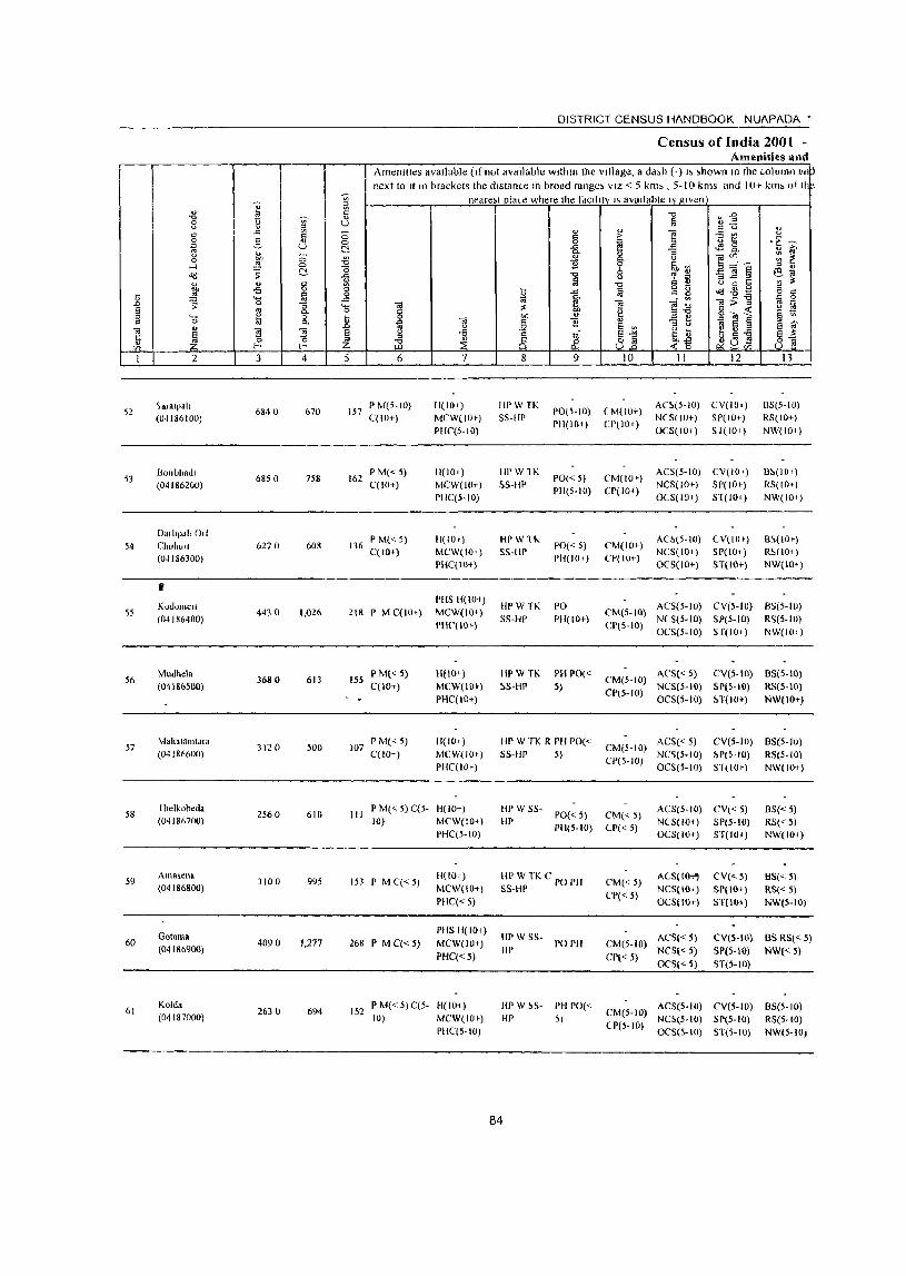
52
53
54
55
56
57
58
5Y
60
61
2
~aIalpa"
(04186100)
BOllbhadl (04186200)
Dmhpd!lOle ChuhUlI
(04186300)
" Kodolllell (04186400)
Mudnol. (04186500)
Mahatamtara (04186600)
Illelkobeda (04186700)
Alllas.ena (04 (86800)
Gotall\a (041&6900)
Kold. (01187000)
] tl " .c
3
6840
6850
6270
4430
3680
3120
2560
3100
4090
2630
4
670
7S8
608
1,026
613
500
610
995
1,277
694
DISTRICT CENSUS HANDBOOK NUAPADA •
Census of India 2001 -Amenities and
Amenities aVailable (Ifnot available wlthm the Village, a dash (-) I> >hown In the WIUllIl1 an next to It In brackets the dlstan(.e In broad range, VIZ < 5 km" 5-10 kms and 10+ km> o( II
neare;t[lla(.e where the fdCliltv I; available IS gIven
5 6
lS7 I)M(S-IO) C(to+)
162 PM«5) C( 10+)
136 P M« 5) C( 10+)
218 P M C(IO+)
155 P M« 5) C( 10+)
107 PM«5) C(lO+ )
7
H(IO+) MCW(IO» PHC(S-IO)
H(IO+) MCW(IO+) PHC(5-IO)
III 10+) MCW(IO+) PHC(IO+)
PHS H(IO+) MCW(IO+) PHC'(IO+)
H(IO+) MCW(IOI-) PHC(IO+)
11(10 c) MCW(IO+) PHC(lOt)
III P M« 5) C(S- B(IO+) 10) MCW(IOt)
PHC(5-1O)
153 PMC«5)
268 P MC«5)
H(IO+) MCW(IO+)
PHC« 5)
PHS H(IOt) MeW(lO»
PHC«5)
152 P M« 5) C(5- H(lOt) 10) MCW(IO+)
PHC(5-1O)
8
HPWTK SS-IIP
IlPW1K SS-HP
HPW11.. SS-HP
HPWTK SS-HP
HPW TK ~S-HP
9
I)O(S-IO)
PIl(IO+)
PO«5) PH(5-IO)
PO«5) PH(IO.)
PO PII(IO+)
PH PO« 5)
III' W TK R PII 1'0« S5-flP 5)
10
( M(IO+) CP(lO+)
CM(IO» CP(IO+)
CM(lOe) CP(IO+)
II 12
ACS(S-IO) CV(lO+) NCS(IO+) 51'(10+) OCS(IO+) S 1(10t)
ACS(S-IO) CV(IO+) NCS(IO+) SP(IOe) 0(5(10,) ST(IO+)
ACS(S-IO) CV(to') NCS(IO+) Sp(I(H) OC5(10+) ST(lO+)
OS(5-1O)
RS(IO+) NW(IO+)
B~(IO,)
RS(IO+) NW(IO,)
OS(IO') RS(IO+) NW(IOt)
CM(S-IO) ACS(5-10) eV(5·to) 85(5-10) CP(5-10) NeS(5-IO) SP(5-10) R~(5.1O)
OeS(5-IO) S f(IOI-) NW(I()i)
CM(5-10) ACS« 5) CV(5-IO) BS(5-10) CI'(5-1O) NCS(5-IO) SP(5-10) RS(5-10)
OCS(5-10) ~T(lO+) NW(IO+)
CM(5-IO) ACS« 5) eV(5-1O) 8S(5-IO) CP(S-IO) NC5(5-IO) ~P(5-1O) RS(S-JO)
OeS(5-10) ST(IO,) NW(IO+)
HP W SS-HP 1'0« 5) CM« 5)
PH(5-10) CP« 5)
AeS(S-IO) CV« S) NCS(lOt) SP(S-IO)
8S« 5) R5« 5) NW(IO+)
flP W TKe PO PH 5S-HP
HP W 5S- PO PH HI'
HI' W ~S- PH 1'0(<-HI' 5)
84
OC8(10+) ST(IM)
CM«5) CP« 5)
ACS(lO_'" NCS(IO+) OCS(IO+)
CM(5-10) ACS« 5) CP« 5) NCS« 5)
OCS« 5)
CV«5) 51'(10+) ST(IO+)
8S« 5) RS« 5) NW(5-10)
CV(5-10) BS RS« 5) SP(5-10) NW« 5) ST(S-IO)
CM(5-10) AeS(5·10) eV(5-1O) B5(5-10) (1'(5-10) NC~(5-1O) SP(5- (0) R5(S-IO)
OCS(S-IO) ST(S-IO) NW(S-IO,
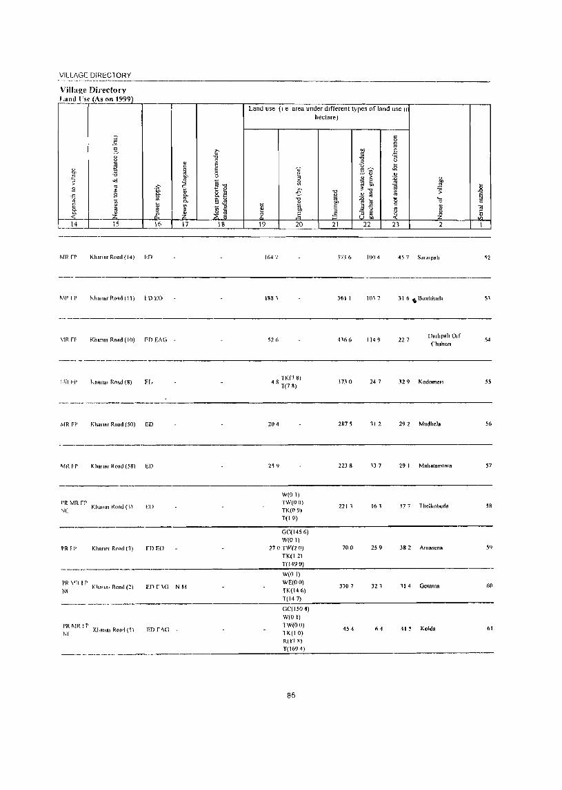
VILLAGE DIRECl ORY ----------Village Directory
,'!"_! 'r"n ~ 999)
MR rr Khana, Road (14) Iof)
MP I P hllaT1", Ro.rl (\ \) I D EO
MRFf' Kh.na, R".d (10) FD EAG
---- - ~--- ~---------
j}f{ FI) knana, Ro.d (8) Fr.
-- ---- --_._----_ .. _--
,'viR FI' Kha"., Road (50) ED
~1t{ ~r Kha"a, Road (58) ED
------
PR MR rr NC
Khan., Road ( 1\ ED
------
PR f P Khanm Road (1) rn EO
~--------------.
PR "R f P N( Kh."., Road (2) EO r \0 NM
-~----~
PR MR n' N(
KI,.l1., Ron'i (5) ED r"o
-----
Land use (I e area under different types orland use II hectare)
1647 3736 100 4 45 -, Sa'.'pail
\8111 361 1 \017 3 \ 6 .. B01rhhad,
526 4166 1149 227 Oa,ilpail O,f
(,huhufl
4 S TK(7 8) T(78)
J730 247 329 Kodomel1
204 2875 11 2 292 Mudhela
259 2238 137 29 I Mahatamtara
W(OI)
TW(OO) 2211
TK(09) 161 177 Thelkobeda
T(IO)
GC(1456)
W(O I)
270 TW(2 0) 700 2S 9 382 Amasena
TK(12)
T( 1490)
W(O I)
WE(OO) 3107
fK(146) 321 114 ODium a
T(147)
OC(1504)
W(OI)
TW(OO)
1 K(I 0) 454 64 415 Kolda
R(l7S)
T(1694)
85
54
55
56
57
58
5<)
6(l
61

DISTRIC r CENSUS HANDBOOK NUAPADA'
Censu!> of India 2001 -Amenities and
Amenilies available (If not available within the village, a dash (-) IS ~hown In the column an next 10 It In bracket" the distance In broad range, VIZ < 5 kms , 5-10 kms and 10+ km, of H
I ~ nearest place where lhe facility IS available IS given .g
I 5 ] ~-!il
0 u OJ __
1i u '" u
" ..c ;:; OJ !! ~ "E~ 0 S 0 § '§ ~ ~ ~ u d ..c ~ g_
u " ;:; g. 8. :; e "'. ~ ~ 0 ~ {j u
,_) 0 "0 11 0 E,!'i a"" i " " ~ d 6 eo; "d ..c " <.> '? a :;~
" " .. ~ §j -0 § ~ <.> 0 § '" :l: ~I -£ 0 il .e § .. g "d.g- 6 " il ~ 0
~ '0 ..:: li! 0-, '" Ol:>-g f.i 0
.D :; <... 03 ~ 03
]i '" :s: §(;a~ " is 8 g Q. 0 § g a ;:J <... 8. ] '" ... "' .. 0 fa ~ c 11 lO f: § " ,",
" ~ §~ " <> E ~ 03
~ 03 ~ § " -a of ~~
1! ')-a il '0 " ~8~ 8] ..,
~ ~ .L~ 8 Vl ~ ~ Z I 2 3 4 S 6 7 8 9 10 II 12 13
KalyauplII 4960 1,161 249
P M« 5) C« H(W,) IIPW SS- PH PO(<-CM« 5)
AeS« 5) eV« 5) BS« i) 02
(04187100) 5) MCW(IO,) HP 5) NCS« 5) SP« ~) RS« 5) PHC(,- 5)
CI'«5) OeS« 5, ST(S-IO) NW(,5)
Chall.bedd 313 0 791 171
P M« 5) C(5- H(IO+) , HP W TK PH rO« CM(5-IO)
AeS(5-IO) eV(5-1O) B~(5 to) 63
(04187200) 10) MeW(IO') SS,HP 5) NeS(5-IO) SP(S-to) R~(5-1O)
PHC« 5) ep(5-1O)
OeS(5-JO) 5T(5-10) NW(5-10)
64 Salth. (Kald)
4670 1,021 257 P MCS- 10) C(5 H( lOt) HPWTK PH 1'0(5-
CM(S-IO) AeS(5-1O) eV(S-IO) BS(5-1O)
(04187300) 10) MCW(IO,) ~S-HP 10) ep(5-IO)
NeS(S-IO) SP(S-IO) RS(5-IO)
PHC« 5) OeS(5-1O) ST(5-IO) NW(S-IO)
65 Sahlla (KJu"d) «()41874oo)
890 -------- Ulllllhablled --------,-"
66 )halbahdl
4690 762 153 P M(S-IO) C(5 HlIO+) HPWTK PH PO(5-
CM(IO!-) ACS(5-to) eV(lot) B~(5-IO)
(04r87S00) (0) MCW(IO<j 55-HI' 10) Cr(IOi)
NCS(IO+) SP(IO+) RS(5-10)
PIlC(5-IO) O('S(IO+) ST(5-1O) NW(IO+)
67 Kennell
5470 793 169 P M« 5) C(.5- H(IO+) HPWTK PH PO«
CM(5-IOl AeS« 5) CVClO+) 05(5-10)
(04187600) 10) MCW(Hl+) S5-HP 5) CP(IO!-)
NCS(5-10) 51'(5-10) RS(5-IO)"
PUC« 5) OeS(S-IO) ST(5-1O) NW(5-IO)
6X Ma~Ull'anl
5610 717 149 P M« 5) H(IO+) THPTW PH PO(S-
CM(IO+) AeS(<- 5) CV{lO+) BS« 5)
(04187700) C(lOI) MeW(IO+) W SS-HI' 10) NC5(5-IO) SI'(IO+) RS(IOI-)
PHC« 5) CP(IOt)
Oe5(5-10) ST(lO. ) NW(IO+)
Druhmundd PHC PH~
HPWTK AC~ NeS(5- eV(;o+) BS RS(5-69
(04187800) 9550 1,014 238 P M C(5-!O) H(IO+)
SS-IIP POI'H eM(S-IO) 10) OCS(S- SP(IO+) 10) NW,5-
MCW(lO+) ep(IO,) 10) ST(5- (0) 10)
70 Khahapalll
7590 1,109 235 P M« 5) C(5- 1-1(10+) HPWTK PH PO«
CM(lO+) AeS« 5) eV(ID+) BS(S-lO)
(01187900) 10) MCW(IO+) SS,Hp S) CP(IO+)
NC5(10!-) 51'(10+) R5(10+)
PHC« 5) Oe5(10') ST(lOi) NW(IOt)
Rohenpant PC<
HelD. ) HPWTK AeS(5-1O) eV(lO+) B5(10+) 71 2890 57 13 5)M«5)e« PO«5) CMiIO t )
(04188000) 5)
MCW(IO+) 58-HI' PH(IOt) CI'(IO+)
NeS(5-IO) 51'(10+) R8(IO'> PHC(5-1D) OCS(S-IO) 5T(10+) NW(IO+)
FOIioll) P«
H(IO+) PH PO(S- ACS(IO+) CV(IO+) BS(IO+) 72 2650 138 35 5) M(IO+} HP S5-HP CM(lO-.-) (041&&100)
C(lO+) MCW(IO+) 10)
CP(IO+) NCS(IO+) SP(IO+) RS(IO+)
PHC(5-1O) OeS(IO,) ST(lOi) NW(lOt)
B6

Vil LAGE DIREC roRY
ViIla2C Directorv L~lId 1I se ~!.£.'!.!999
§. 2 1;
<U N "" -8 2 ;; ''<! 9 ~ .<: 8 u
> I ~ _it=. =--=
" -Z_ 15
r-'-r
16 17 18
L~T1d lIS~ (I e area under dIfferent types of land use II
hectare)
19 20 21 22 23 2
----------.----------------------------------------------------------------~
~~. MR r r KI13"ar Rood (1) Ell
MR fr f. ho"o, Road (6)
MR FP KhaJ llll Rood (8) [D EO
. ---- llmnhaiJ-lted -----.------
MR.I!'
Mil. rf' Khan., Road (II ) Ell
MI> rr Kh.",,, Roo,1 (14) EAG
Mil. FI' Kho"" Rond (u5) FD
-------
Mil. fP KI.., 10' Rood (70) ElJ
------------------
MRIP "1'8"0' Road (68)
---_.
PR i(ho"8' Road (42)
W(08)
20 I TW(O 2) T(IO)
22 J
499
864
1031
1922
96 ~
105
TK(10) 1516 T(4 0)
87
397 I 175 404 Kalyanpur
2875 62 19 2 Chonobed.
3502 420 52 0 Sahha (Kala)
Sohho (Khurd)
3071 84 I 278 Jhalbohal
3166 945 492 Kennell
1673 652 275M agurl'aOl
3899 1287 442 Darhmunda
5285 975 167 Khalla"aOl
112 2671 Rohenpanl
611 148 113 10rfOl'l
62
61
64
65
66
67
68
69
70
71
72
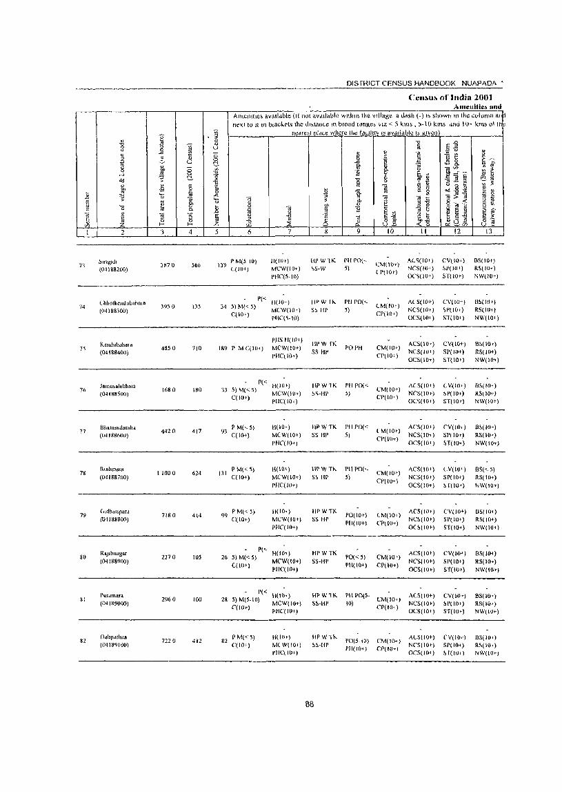
DISTRICT CENSUS HANDBOOK NUAPADA •
Ccnl>ulJo of India 2001 Amellitie~ lind
Amenttle; avalldble (II nOI aV<lIlable "'Itilln the village a dash (-) I!> shown In the column an next to II In bl~Ck('ts the JI,tance In broad [doge. VIZ <: 5 kms , j-I 0 kms ,mel 10, kms oj tr •
j j nedfe;llll<lLe where the t<l<-llnv IS aVdlldble IS given
" ~ '0 llE -0 ~ !i 0
<.)
" "" <.) ~ ~ - " ] iit " " <::> § ;;.
t~ 0 0
~ ~ 0 u 0- 1 ] ~ " ., lit C; ·CJ 0- ~~~ ~ ~ 0 £1 ] ~ th '" ...l 0 -0
o<l s: 0- "" '" 2 ::;]§ ~~ ~ !i <.l , 'is
" " " -0 § - " 0 r:: '"' -s 0 !i ~.g.g " il _"! ~ 0 t 1 ~ £ 0 §
'- ..c: ;; .. ;;;:11 ~ n "'=2 0 ::; .... .. ~ M ~ -:: u ~
§ '" 0 13 " <>: 0- § Cll " ail o~~ E 1)\
'5 ~ 0 t " "'- ~ N .. '" ] '"3 b ~ fi § " ", <.l
~ g~ s '" .. " .. 'ij 5 -a ~~ s ~ r:: ~ 0 0 :::I ::s -~ c5 ~ 8.2 ~0] 3"§ " i.il C/l Z f- f- 7- ~ ~cn
1 2 3 4 5 6 7 8 9 10 11 12 13
~ln~Jdl P M(5 to) H(IOe) HI'W1K PH POI' CM(H)1") AC~(IO+) CV(IOl-) BS(IO+)
73 (04188200)
387 () 566 139 L(1O') MCW(IO-t) \S-W 5) NCS(IO+) ~r(J(I .) RS(iOi")
PilC(S·IO) ( 1"(10+)
OC<;(iO e) ST( 10+) NW(IOr)
LhholkendubuhHI. 1'« H(IO+) IJPW 1"- PH 1'0(<- ALS(lO r ) CV(I(J+) SS( 10 t)
74 3950 135 34 5) M« 5) MCW(IO+) S~ HI' j)
CM(IO') NCS(IOt) W(IO'l RS( 101) (04188300)
C( 10+) CI'(lO+) PIIC(S·IO) OC5(\O+) ST(10,) NW(lO+)
Kend"b.h., a PHS H(IO+)
HI'W fK ACS(IOt) CV(IO+) B~(lOt) 15 4850 710 189 I' M C(IO+) MC'W(lOt) PO PH CM(lOt)
«()4188400) SS HI' NCS(lO+) 51'( 10+) RS(lOt ) PHC\ 10+) CPlIOI)
OCS(IO+) ST(IOI) NW(IO+)
Jamusalebl,al' 1'« H(ID') IlPW1K PIl 1'0« ACS(lO t ) C V(lO t ) B-'>(IO+ )
76 (04188500)
1680 180 33 5) M« 5) MCW(IO') S~·HP 5)
CM(IO+) NCS(IOr) ~P(IO+) RS( 10+)
C(lO+) PHC(IO I)
CP(IO+) OC',(IOe) ST(IO') NW(lO+)
Bhalllsadarah. 4420 417
P M(,S) H(IOe) HPWTK PH PD« (M(lOe)
ACS(IO+) CV(IO+) B~(lOt) 77
(04188600) 93
C(IO+) MCW(IO,) S5 HI' 5) NCS(IOi) SI'(IO+) RS(IO+)
PHC(IO+) CI'(lO+)
OCS(IO') H(IO+) NW(IOT)
78 Rr.almw.m
11000 624 131 I' M« S) H(IOt) HPWTh PHPO("-
CM(IOt) ACS(lOt) LV(IOt) BS«5)
(04188700) C(lO+) MCW(IOt) S~ HP 5) CP(IO+)
NCS(IO+) Sp(IO+) RS( 10+)
PlIC(JO+) OCS(IO+) ~ f(lO+) NW(IO+)
79 (Jldluntpam
7180 414 99 P M« S) H(IO.) IIPWTK
1'0(10)) <-M(WI) ACS(IO') CV(IOt) IlS(IOt)
(01188800) C(lO+) MCW(IO+) SS HI' PH(IO+) CP(lO+)
NC~(IO') 51'(10+) RS(IO+) PHC(IO+) O(~(IO+) ST( lOt) NW(IO~)
RuJlbna~ar P("
H(IO~) HPWTK ACS(IO+) CV(IO+) 05(10;) 80 2270 105 26 5)M«S) PO«5) CM(IO')
(04188900) C(lOt)
MCW(IO+) SS-HP PH(IO+) CP(IO+)
NCS(IO+) SP(lO+) RS(JO+) PHC(JO+) OCS(IOt) ST(IOt) NW(IO+)
Pasdmara P« B(IO+) IWW1K PHI'O(S. ACS(IO+) CV(IO+) BS(IO+) 81 2960 loa 28 5) M(S·IO) CM(IO+)
(04189000) C(lO»
MCW(IO+) S~·HP 10) CP(lO; )
NCS(IOr) SP( 10+) RS(IOI) PHC(IO+) OC$(lO+) ST(IOt) NW(IO+)
82 f),hpathlla
7220 412 82 I' M« S) HlIO~) IlPWlh
1'0(5-10) eM(IO+) ALS(IO+) (,V(IO+) B5(1O"
(04189100) C(lO+) MLW(IO+) "S·HP 1'11(10+) CP(IO+) NCS(IO+) Sr( 10+) R~(lOt)
rllC\ 10+) OCS(lO-t) H(lO.) NW(IO+j
88
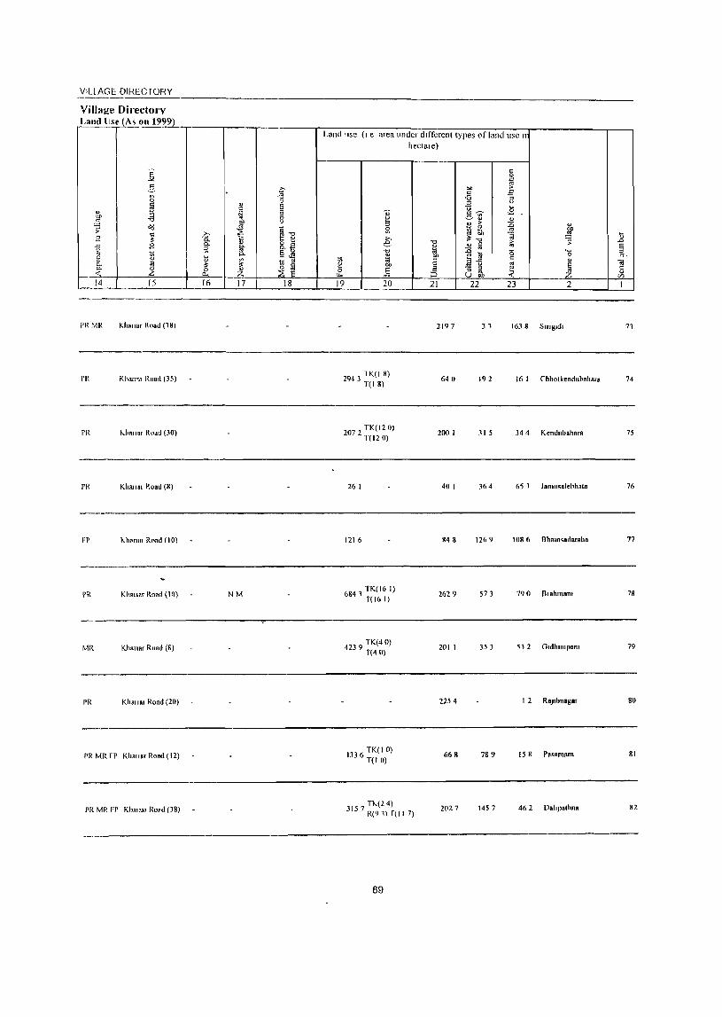
VIllAGE DIRECTORY
Village Directorv Land lise (A~ on 19~2L
] 2-" " ~ " blJ -a ..s
~ o'<l
~ 8 -'-' 2 .., ..
~ e 0-0-
~ -< I-,__...!.:L_L...--. 15
PRMR Khanar Road (18)
rR Khan" Road (35)
PR I-honar ROdU (30)
PR Khalisl Road (8)
Fl' 1<-h""OI Road (10)
PR KII.",r Road (10)
MR Khan,r Road (8)
PR KhaliRI Rond (20)
PR MR rr Khallat Road (12)
PR MR FP Khn"31 ROHd (38)
c -g
'" Ei ~ Ei
0 00 <)
'" ~1l ~ >. .~
8.E !ij-:;l
"" e u
~ -$
~ ti :::s ~ 0 ::E ~ Z ..e.._ 16 17 18
NM
Land lise (I e area under dllTerent types of land usc II
" ~ ~
€ ."
" 1;; Oi ~ bl)
.§ ~ 19 20
2943 1 K( I 8) T(18)
207 TK(l20) 2 T(12 0)
26 I
121 (,
6841 TK(16 I) T(16 I)
4239 TK(40) T(40)
133 TK(IO) 6 T(I 0)
hectale)
..",
B .. bO
E ;: ;:> 21
2197
640
200 I
40 I
848
2629
201 I
2254
668
T1<..(14) 3157 R(91) r(1I 7) 2027
89
" 0 jij
"" >
" E -6 " :::s <)
<:i ... "'~ ,_£ ~ll .£ " > " 0 ..0 lil .!:! bO !ib ,g ~." ;;
> :; " fii .. :a ._
" <. l;! c 0
E-fi " '" ~ :; ~ ~ U 00
22 23 2
31
192 16 I Chholkendubahata
3 15 34 4 Kendubahnra
364 65 1 lamusalebhal.
1269 1086 Bham<.dataha
573 790 Blahmam
353 51 2 Gldhlllipam
I 2 RaJlbllagat
789 15 8 Pasalllsf.
1457 46 2 Daltp'tllna
I> ..0
§ c.
<i! c: .... '" I
71
74
75
76
77
78
79
80
81
82

DISTRICT CENSUS HANDBOOK NUAPADA'
CenslIs of India 2001 -Amenities lind
Amenllles available (If not available within the village, a dash (-) IS shown In the column an~ next to It In brackets the dl~tance In broad range, VIZ < 5 "ms 5-10 kill' and I 0+ km~ 01 tl
" ~ nearest plaLe where Ihe facility IS available IS given
.g I .§ i.i "0 ~.g 0 <) ~ u iii " -= u I " " ~
== <.J ., " -'"
~ ;; § E! "B i! " 0 '" 0 B z ~~
~ c ~ -'" ~ 8. 11.1 ~ " 0- "'3 <.) ;; ., " " ]'~~ ~ c. 0 01) .;g 0-
....1 .<:2 "" 11 0 ~ ~ ::l " o(j s: ~ '0
"0 6 "'3 ~ § I'll -.c " , == ~'"
" ., § :ll i\i -0 '" .. " 0 t: ~ ~
01) oS ::l
~ f.i 2, ~ Qd g g '" " .<: 0 il .<:2 "" ~ 0 0- 0l:>1l == 0 .<:l ~ S 0 "'3 '0 .. " ~, .. ii ~ ~ S '" 8: c ~
c « § Vi ::l '0 " II 0 01, .. o .. _
c &J ~ .. c 11 " ::l " ~ S §
S '" ., '-' ,Q S '" .. j
.. ~ § '-' .c;
8 Vi ~j fi.M ~ ~ ..a s~ t: " ::l
::E ~ cJ 65 ., f- f- Z .. ~. J: 4:0 8 § </)
1 2 3 4 5 6 7 8 9 10 11 12 13
Drlldhll PM«5) 11(10+) IIPWTK PH PO« CM(IO-r)
AC~(IO+) CV( 10+) B5(10,) 83 1930 123 25
(01189200) C(10+) MCW(IO+) S\-IlP 5) CP(IO+)
NCS(IO,) SP(IOe) RS(IO+)
PIlCCIO,) OCS(lO,) ST(IO+) NW(IO+)
DA PHS
Amanala 4910 786 P M C(IO+)
H(IO+) HP W1K PO PH CM(IO+}
ACS(10e) CV(Hh) B5(IO') 84
(04189300) 166
MCW(IO+) 55-HI' NCS(lO e) ~P(IO') RS(IOIJ
PHC(IO+) (,P( 10+)
OC5(10+) ST(IO+) NW(IO+)
85 Moh.ra
6090 791 167 P M«5) 14(10+) HP W TK C PH PO«
CM(lO+) ACS«5) CV(IO+) B~« 5)
(04IH9400) C(lO+) MCW(IO+) 55-HI' 5) CP« 5)
NCS(fO+) SP(IO+) RS(fO+) PIlC( 10+) OCS(lO+) ST(IO+) NW(IO+)
86 Patdlghutku"
1900 767 153 P M«5) U(lO,) III' W TK C PH PO«
CM(IOt) AC~(<. 5) eV\lO t ) BS(5-10)
(04189500) C(IO+) MCW(IO+) 55 HP 5) NC~(IO+) !tP(IO+) RS(IO+) pllC( 10+)
CP(5-10) OCS(IO+) ST(lO+) NW(IOt)
Paw.rlol. RMP H(IO+)
HP WTK R PH 1'0« A(,S(lO+) CV(IOi) BS(<.5) 87 5900 1,192 244 I' M C(lO+) MCW(IO+) CM(IO+)
(04189600) PHqIO+)
C S~-HP 5) Cp(IO+)
NCS(IO+) SP(IO+) RS(lO t ) OCS(IO+) ST(IO+) NW(IO,}
88 KhohmJ
2990 727 138 P M«5) 11(10+) iiI' W TK C PH 1'0« ACS«5) CV(IOt) BS« 5)
CM(IO+) (04189700) C(IO+) MCW(IO+) \S-IlP 5)
CP« 5) NCS(IO+) SP( 10+) RS(IO+)
PilL{ 10+) OC5(1O+) ST(tot) NW(IO+)
Sarabang P M S (5-PHS H(IO+)
HI' WTKC ACS(5-1O) ('V(IOt) BS RS(5-
89 572 0 1,861 41~ MCW(IO+) SS-HP PO PH CM(5 10) 10) (04189800) 10) NCS(5-1O) SP(5-IO) PIIC(IO+) CP(5-IO)
OCS(\O+) ST(S-IO) NW(IO+)
90 Bhdlllslmundl
3850 1,007 21J I' M« 5) C(5- H(IO+) HP W TK C PH PO« ACS(S-IO) CV(5-10) BS« 5)
CM(5-1O) (04189900) 10) MCW(IO+) 55-HP 5)
CP(5-10) NCS(5-10) SP(5-1O) RS(5-IO)
PHC(S-IO) OCS(5-IO) H(S-IO) NW(10e)
91 Haldl
3760 759 153 P M(5-1O) H(IO+) HI' WTKC PH PO« ACS(IO+) CV( 10+) BS« 5)
CM(IO+) (04190000) C(IO+) MCW(IO+) S5-IlP 5} CP(IO+)
NCS(IO+) SP(lO+) RS(IO+) PHC(IOt) OCS(IO+) ST(IOt) NW(IO+)
92 BhaJlp.l.
5490 720 147 P M« 5) C« H(IOt) HpWTKCPHPO«
CM(5-1O) ACS(5-1O) CV(5-10) BS(5-10)
(04190100) 5) MCW(JO+) SS-HP 5) CP(5-10)
NCS(5-10) SP(IOt) R~(5-10) PHC(IO+) OCS(5-10) 51(10+) NW(IOt)
90
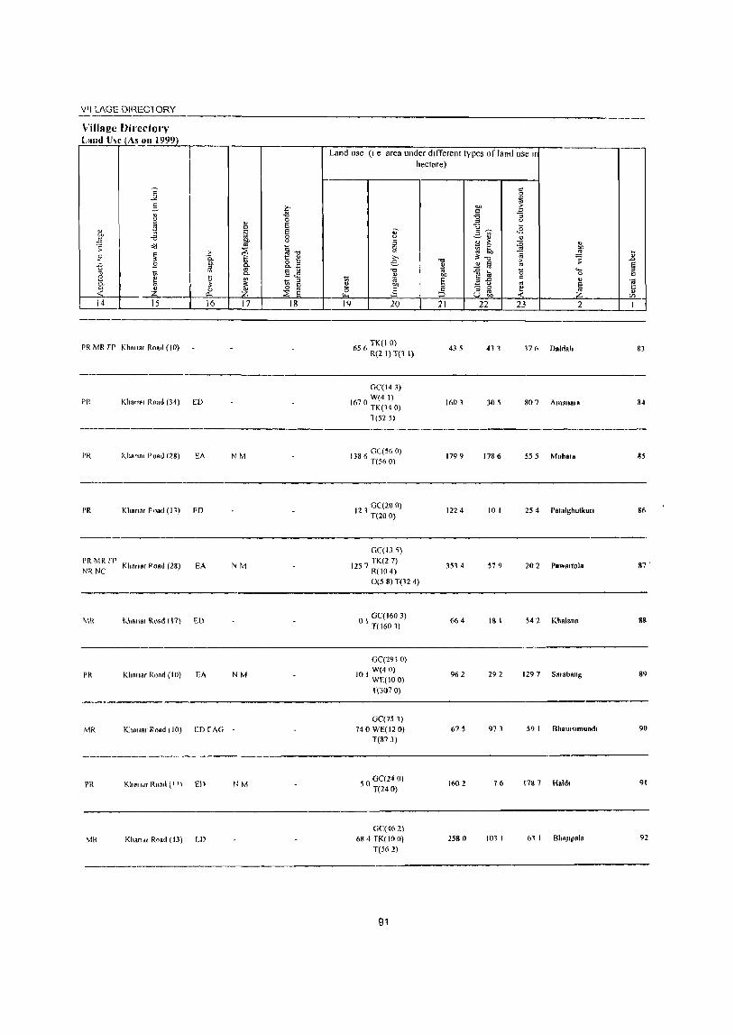
VII lAGE DIREClORY
ViIlag~ Dil"edol")-' Land U~C ASJ.l1I 1999)_
PR MR rp Khal1.' Road (10)
Land use (I e area under dlfTerent types of land use Ir hectare)
5 TK(IO) 6 6 R(2 I) T(l I)
435 411 171\ Dalda"
----------------_._---------------------PH Kh.n", Road (34) [D
GC(14 J)
70 W(4 I) 16 TK(140)
T(525)
1603 305 807 Am.na,a
83
84
--------_._---------------------------------------------PH "hana, Puad (28) EA
I'R Khanar road (11) FD
PR MR rr NR NC Khan.r POBd (28) EA
MR I.h3"a, Road (17) ED
I'R Khanar Road (10) EA
MR Kho".r Road (10) ED rAG
PH KlmldT Ron,\ ( I' \ En
MR Khan,1I R~ad (13) tD
NM
NM
NM
NM
138 6 GC(56 0) T(56 0)
121 GC(20 0) T(20 0)
GC(13 5)
I 57 TK(2 7) 2 R(IO 4)
0(58) T(12 4)
I GC(160 3) o T(160 1)
GC(2910) W(40)
10 I WE(IOO)
T(3070)
GC(753) 740 WE(12 0)
T(&73)
50 GC(24 0) T(24 0)
GC(462)
68" TK(IO 0) T(562)
91
1799 1786 555 Mohara 85
1224 10 I 25 4 Patalghutkutl 86
3514 579 20 2 rBwal10la 87 •
664 18 I 542 Kh.lana Sg
962 292 129 7 S .r.bang S9
675 973 59 I Bhall,,,mund, 90
160 2 76 1787 Hold, 91
2580 101 I 61 I BhaJlpala

I '" " ~ -g '" ..> ~ § -"
2- ... ~
U ~ 8 ....l '"
od ~ ~
" " 15 "" ..s t ~ .... a
..0 :;: 0
I E '" " '0 ~ 0::
" OJ ] g t: ~ .... a C/l l- I--
I 2 3 4
93 Ndnd,IIHIJ
3820 495 (0'lt')0200)
Dllmeflldlll 970 94
(04190300) 4080
Slid. 95
(0" !90400) 5120 1.215
Parpa'll." 2090 402 96
(04190500)
97 Bheld
3360 669 (01190600)
98 flallspun
1140 311 (O·n90700)
99 (wdlulo
(01190800) 2990 511
IfJO JUIlRIll
2880 673 (04190900)
Pogorpanl 101 4540 612
(04191000)
102 T.lelJhar
(04191100) 5970 642
j " " U ;; 0 ~ ~ -0 ..c
1A g ..c '-0
Ji § :z 5
109
DISTRICT CENSUS HANDBOOK NUAPADA'
Census of India 2001 -Amenities and
Amel1ltles avalldble (If not avalldble wlthm the Village, a da;h (-) IS shown 111 the 1:o\ulI1n an next to JIm brackets the olstdnce m broad ranges VIZ < 5 kms, 5-10 km; and lOT "ms 01 tI
nearest place where the laclllly IS available IS j(lven "0 '" iii t) "
" " .E i:l " c > 1 t! " 0 ~ i:l ~~ -a .n 0
0. " ~
" g_ <.> e":~ ~ ~ }l Z a v ~ ~ ~ " " "0 ~ ~ (il -u ~'" f.i "0 " ... " 0 t: v :S
o i:l ~"t2 ~ " ti ..c f.i '" 0 0 " OJ 0. e ~ '.ii a OJ
'" ~ OJ ~ > ::I
" ~ e g _g~ g - < ;: 0 01, ...
C t~ e ~ OJ " }l "
~ ..2 E '" ::l " ~ fi :: E OJ " 8j " '-
E '" " 8 .~ ~~ o ,= "t:I
iE ;:i; ~os 8] ~, C/l
6 7 8 9 10 II 12 11
P M« 5) ((5- II(lOt) flP W H. C I'll PO(~ CM(IO+)
AC~(IO+) C. V(IUI) BS(IO,)
10) MC.W(IOi) SS HP 5) CI'(H)<)
NCS( 10+) SP(IOt) RS(IOt)
PHL( 10 1) OC.'.(IO+) Sl(IO t) NW(IO+)
193 I' M C(5-1O) H(lOt) Ill' WS.'.-
POrH (,M(IO") AC.'.(IO') CV(IOt) B5«5)
MCW(IO+) HI' NCS{IO+) SP( 10+) RS(IOI)
PHC( 10+) CP(IO+)
OC~(IO+) ST(lOI) NW(IOT)
PM«5) H(lO+) HP W 55- ACS« 5) CV(5-iO) B!. RS(5-
260 C(lO+) MCW(IO+) HI'
1'0« 5) C.M« 5) NC5« 5) ~P(IOtl
10)
PHC(5-10) PH(IO+) CP« 5)
OCS(IOI) .',T«5) NW(IO<)
90 P M« 5) l« H(lO t) IIPWS5- PH 1'0«
(1.1« 5) AC~(' 5) CV« 5) B5« 5)
5) MCW(IO I ) Ill' 5) NCS(IO,) Sl'( 10 f) RS« 5)
PIlC( 10+) CP«5)
OC5(IOI) 5 f(, S) NW(IO+)
158 P M(, 5) C« H(IO+) HI' W 55-
1'0(<-5) (1.1« 5) ACS« 5) CY(IO+) BS(~ 5)
5) MCW(IO+) HI' PH(5-1O) CP« 5)
NCS(IO+) SP(IO+) RS« 5)
PHC(IO+) OCS(IO+) 5T( 10,) NW(I()+)
68 1'1\;1« 5) C« H(IO+) HP W 55- PH PO«
CM«S) ACS« 5) CV(IO+) BS(' ~)
5) MCW(IO+) HI' 5) (P(<.5)
NCS(IO+) SP(W+) R~« 5) PIlC'( 10+) OCS(IO+) Sl« 5) NW(IO<)
I' M« 5) C« PH~II(IOI)
AC5« 5) (V(IO+) BS RS(~ 5) 116 MCW(IOf) III' ~5-HP POrH CM(,S)
5) PHC( 10<) CP« 5)
NC~(I(H ) SP(IO+) NW(IO+)
OC5(1O+) 5TrI0+)
145 P MC(5-IO) H(IO+)
HI' 55 IlP PH PO«
CM(5-IO) ACS(5-10) CV(IO+-) B~ RS« 5)
MCW(IO+) 5) CP(5-10)
NCS(IO+) SP(IOI-) NW(IO+)
PHC(IO+) OCS(IO+) S f(IO+)
P M(5-10)(5 H(IO+) HI' WTK ACS(5-IO) CV(IO+) BS
123 1'0(5-10) CM(5-IO) RS\iO+) 10) MCW(IO,) .'.S HI'
PH(S-IO) CP(IO+) NCS(IO+) 51'(5-10)
NW(IO+) PHC( 10+) OCS(IO+) ST(5-10)
I I; P M(5-10) C(5 Il( 10+) III' W fK I'll PO(5-
LM«5) ACS(S-IO) CY(W+) BS(5-IO)
10) MCW(IO+) 5~ III' 10) CP(5-10)
NCS(IO+) SP(IO,) RS(5-IO) PH((IO+) OCS(IOt) ST( 10+) NW(IO+)
92
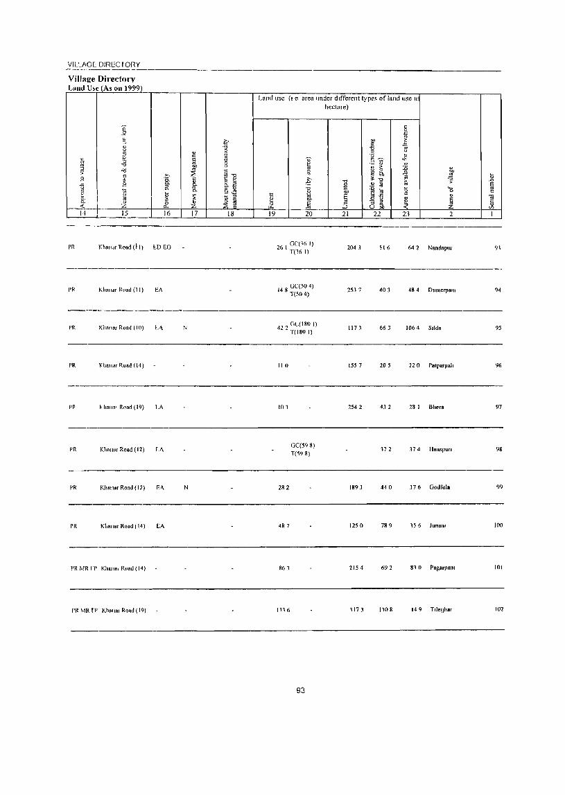
VILLAGE: DIRECTORY
VilIaj!e Directm-v Land tl~c _LAs on 1999)
PR Khalt,1f Road (11) I:.D EO
PR Kha"., Road (II) EA
----~~-----------
PI( Kiln"" Roat! (10) L-\
PR Khallar Road (14)
PP ~ hail.' Road (19) LA
PR Klmlla, Road (12) LA
PR Khalil" Road (12) E-\
PR Khall"r Road (14) EA
PR MR rr Khalla, Road (14)
PR MR rp Khalla, Road (19)
N
N
Land usc (I e area under different typt's of land use II
hectare)
26 I GC(J6 I) T(16 I)
148 GC(50 4) T(SO 4)
422 GL(180 I) T(180 I)
110
101
282
487
86 J
1116
GC(598) T(598)
93
2043
2537
1173
1557
2542
1893
1250
2154
117 J
516 642 Nandapur
403 484 Dumerpolll
663 1064 S,id.
205 220 Patparpah
43 2 28 I Bhe,.
372 374 HanspuTI
440 37 6 Godfulo
789 156 Juno",
692 81 0 Pagorpam
1108 14 9 T,leljh.,
91
94
95
96
97
98
99
100
101
102
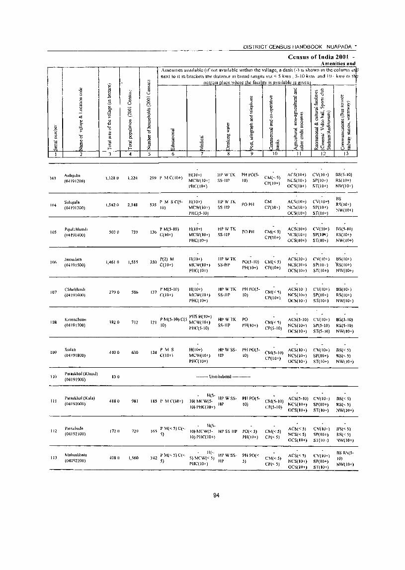
\0)
104
105
106
107
108
109
110
III
112
113
AnlaJuba (04191200)
Sdillpaia
(041')1300)
Plp"khhendl
(04191400)
J8lluu.larH (04191500)
Chhehlendl
(04191600)
Kotenchu811 (04191700)
5181011
(04191800)
Para.khol (KhUlu) (04191900)
Poras~hol (Kala)
(04192000)
PalSdblida
(04192100)
M.IIlI.bhata
(04192200)
1,128 \) 1,224
1,542 (I 2,548
5030 739
1,4610 1,555
2790 586
3820 712
4400 630
130
4180 981
1720 729
4180 1,560
DISTRICT CENSUS HANDBOOK NUAPADA •
Census of India 2001 -Amenities and
Amenlttes av,lliable (If nOE availdble wlthm the vIllage, a dash (-) IS ;hown HI the column dll next to 11111 bracket; the dl,tanle In broad fdnges VIZ < 5 kms , 5-10 km> and 10· klns o~ It
nearest pidce whele the facIlIty IS avaIlable IS given'
29'} I' M C( 10+)
535 P M 5 C(S-10)
136 P M(5-10) C(lO+)
350 1'(2) M C(IO+)
137 P M(5-1O) C(lOI-)
H(IO+)
MCW(IO-t)
PHC(IO+)
H(IO+)
MCW(IO+)
PHC(5-IO)
H(IO+)
MCW(IO+)
PHC(IO+)
11(10+)
MCW(IO+)
PHC(lO t )
H(10+)
MCW(lO t )
PHC(IO+)
HI' WTK
55-HP
HPW fK
55-Ill'
HPWTK
5S-HP
Ill' W TK
55·HP
HPWTK
55-HI'
PH PO(5- CM(, ,)
10) CP(IO+)
POPH
PO PH
PO(5-10)
PHI 10+)
CM
CP(IO+)
CM«5) CP(IOr)
eM«5) CP(IO+)
PH 1'0(5- CM« 5)
10) CP(IO+)
Ar5(IO+)
Ne5(10+)
OCS(IOt)
AC5(1O+)
NC~(IO+)
OCS(IO+)
ACS(IO+)
NCS(lO+)
OCS(IO+)
ACS(IO+)
NCS(lOt)
OeS(lol)
ACS(IO+)
NCS(IO+)
OeS(IO+)
CV(IOt)
SP(IOt)
ST(IO+)
ev( 10+' SP(IO+)
ST(IO+)
eV(ID+)
SP(lo-.)
ST(IO+)
CV(IOI)
SP(lOt)
ST(IO+)
CV(IO+)
SP(lO+)
ST(IO+)
P M(5-1O) C(S PIIS H( 10+) 121 0 MCW(JO+)
HI' WTK
55-UP
PO
PH(IO+) CM«5)
CP(5·IO)
AeS(5-1O) CV( 10+)
I ) PHC(5-10) NeS(IO+) SP(5-10)
Oes(lo t) ST(5-1O)
124 P M S C(lO+)
185 I' M C(lO+)
!l(ID+)
MCW(JO»
PHC(IO+)
HP WSS
liP PH PO(5. CM(5-lll) ACS(IO+)
10) CP(IOI-) NCS(lO+) OCS(lO+)
.. ------ lJlIIllhablted ---.. -------
H(S- HP W S5- PH PO(S- AeS(5 10) 10) MCW(5- HP 10) CM(5-IO) NCS(I~) 10) PHC(IO+) CP(5-IO) +
OCS(IO+)
fI(S· 165 P M« 5) C("'- 10) MCW(5. HPSS HP PO« 5)
5) 10) PHC(JO+) PH(ID+) CM«5)
CI'«5)
AC!.«5)
NCS« 5)
OCS(IO+)
H(, 342 PM«5)C« 5) MCW«5) IIPWSS- PIIPO«
5) PHC(IO+) HP 5)
94
CM«5)
CP("'- 5)
ACS«5)
NCS(IO+)
OCS(IO+)
CV(IDt)
SP(IO+)
ST(IO+)
CV(w+)
SP(IO+)
ST(W+)
CV(ID+)
SP(lO+)
ST(IO')
CVIIO+)
SP(IO+)
ST(IO+)
B5(5-1O)
RS( 10+)
NW(IOi)
BS
R~(IO+)
NW(IO+)
BS(5-IO)
R5(1O+)
NW(IO+)
B5(1O+)
'R5(IOt)
N\v(IO+)
B5(10+)
RS(IO')
NW(IO+)
BS(S-IO)
RS(S-IO)
NW(IO+)
BS« S) RS(",- S)
NW(IOt)
BS« 5)
RSC' 5) NW(IO+)
B~« 5)
RS« 5) NW(IO+)
BS R\(5-
10)
NW(IO+)
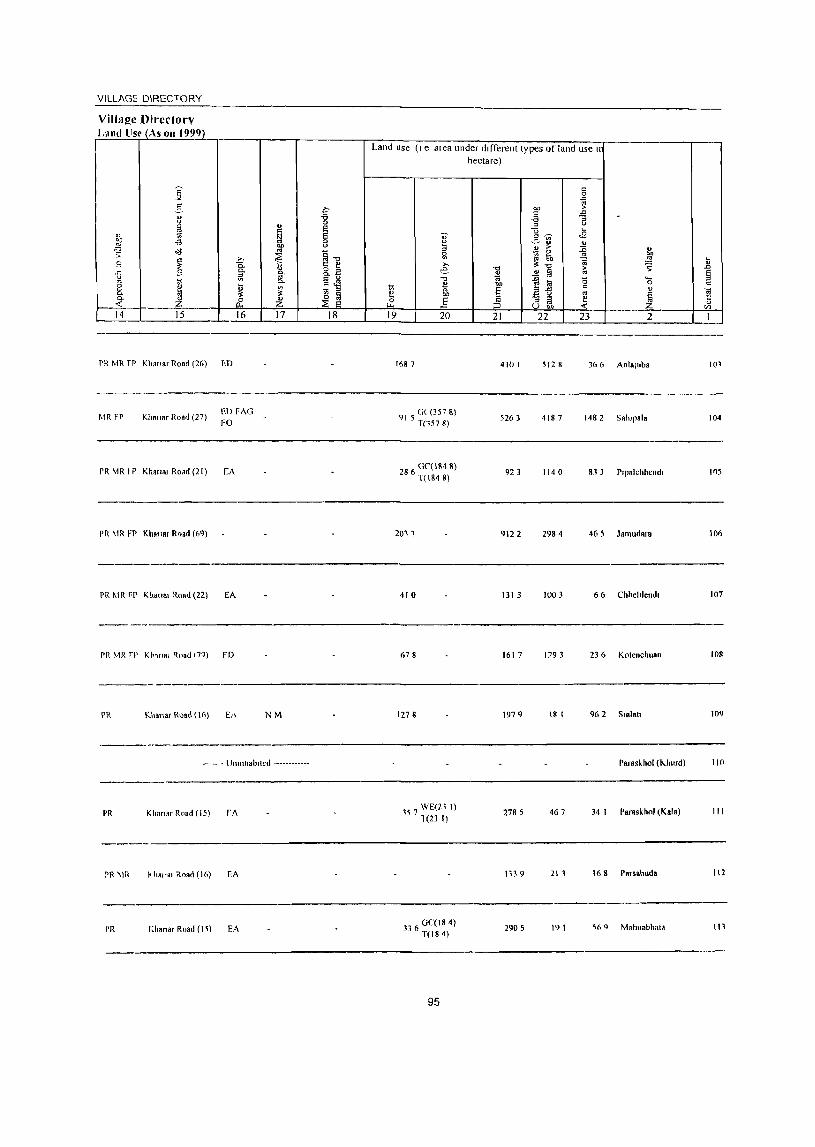
VILLAGE DIRECTORY
Villa!!c Dit·ectorv Land lise (As on 1999)
----~--_r-----.~~~----~=_~--=_~~------~--~ Land lise (I e alea under dIfferent types of land use"
14 15 16
PR MR fr Klm,.r Road (26) ED
MR FP Khanar Road (27) ED FAG
FO
PR MR f P Kha,,", ROdd (21) CA
PR MR FP Khallar Rnad (69)
PR ~IR FP KhanB' Road (22) EA
------PR MR ,p KI,,,,", Il.oad (79) FD
----- ------~.--.
PR Khan,r R"ad (16) Et\
_____ o __
17
NM
•...•. UmnllOb,ted _ ...........
-------_._----
PR Khanar Road (15) rA
_----
PR \Ii< J<haJTa' Road (16) EA
I'R I~h.nsr Road (I i) EA
18 19 20
1687
91 5 GL(357 8) T(1578)
28 0('(1848) 6 T(1848)
2011
410
678
127 II
357 WE{21 1) 1(23 I)
GC(IS 4) 336 T(18 4)
95
hectare)
21 22 23 2
4101 5128 366 Anlaluba 101
5263 4187 1482 Sah'pala 104
923 1140 83 3 P'palchhend, 105
9122 2984 465 JBroudara 106
1313 1003 66 Chhelrlend, 107
1617 1793 236 Kotenchuan 108
1979 18 I 962 Sudal! 109
Paraskhof (Khurd) 110
2785 467 34 I Paraskhof (Kala) III
1"\39 21, 168 Porssbuda 112
2905 191 %9 Mahuabhata 111
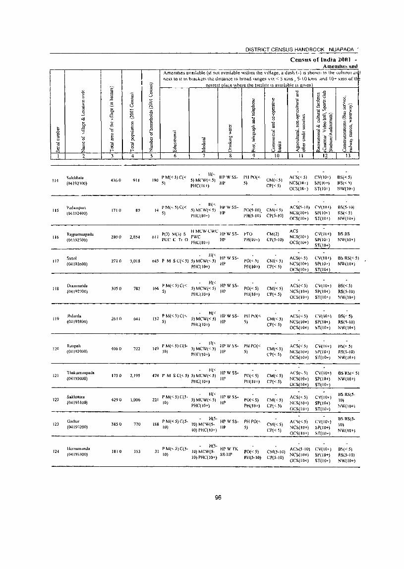
114
115
116
117
118
119
1211
121
122
123
124
2
~alebhat.
(04192300)
Pildampun (04192400)
RajpulTluapada (04192500)
511101
(04192600)
D,anmutlda (04192700)
Jh,hlllia
(04192800)
Raup.1t (04192900)
1 hahllllllapad. (04193000)
SakhatOia (04193100)
Gadt", (04191200)
Heillamunda (04193300)
3 4
4360 931
1710 89
2800 2,854
271 0 3,018
3050 782
2610 641
4060 722
1750 2,195
4290 1,006
3850 770
1810 153
DISTRICT CENSUS HANDBOOK NUAPADA '
Census of India 2001 -AmeDltle~ and
AmenIties avsllabie (It not available wlthtrllhe village, a dash (-) IS shown In the column an~ next to It In bra~kets the dlstatlcc HI broad ranges VIZ < 5 Kms , 5-10 "ms ,md 10-;- Kms of Iii"
nearest pid('e where the taclhty IS available IS given
5 6 7 8 9
I) M( 5) C( 11(''- liP W SS- I'll PO( 190 < < 5) MeW« 5) <
5) PIIC( I 0+) III' 5)
10
CM«5)
CP« 5)
II
AeS« 5) NCS(lOr)
OCS(IO~)
12
CV(IO+)
SP(lO+) ST(lO+ )
Ii« 14 ~t« 5)C« 5) MCW« 5) ~~ W 55- 1'0(5-10). CM« 5)
PIIC(IO+) 1'11(5-10) CP(5-10)
I\C5(5-IO) eV(IO,}
NCS(IOT) 51'(101)
P(J) M(3) S H MCW CWC HI' W 55- PTO
611 PUC C Tr 0 ~~~lOr) In> PH(IOt)
H('" HI' W SS-645 I' M S C« 5) 5) MCW(<- 5) IlP 1'0« 5)
PHC(JO+) PH(IO+)
P M( 5) C( H« HI' W SS-166 < < 5) MCW« 5) PO« 5)
5) PHC(JO+) HP PH(IO+)
P M( 5) C( H« HP W S5- PH P'"\[ 132 < < 5) MCW« 5) ~\<
5) PHC(lOt) HI' 5)
PM( 5) C(5 11« HP W ~S- PH POe 149 < - 5) MCW« 5) <
10) PHC( 10+) liP 5)
Ii« HI' WSS-474 P M S C(" 5) 5) MCW« 5) HI'
PflC( 10+) PO«5) PH(IO+)
P M( 5) C(5 H« HP W 55-221 < - 5) MCW« 5) POC' 5)
10) PHC(IO+) liP PH(;Or)
11(5-188 P M« 5) C(5- (0) MCW(5- HP W SS- PH 1'0("
10) IO)PHC(IO+) HP 5)
P M( ") C(5 H(5- HP W TK 31 <.) - 10) MeW(S-
10) 10) PHC(IOt) SS-HP
96
PO«5) PII(5-IO)
CM(2)
CP(5-1O)
C/\I«5)
CP« 5)
CM«5) CP« 5)
CM«5) CP« 5)
CM«5)
CP« 5)
CM«5)
CP« 5)
CM«5)
CP« 5)
CM« 5}
CP« 5}
OCS(IO+) ST(IO+)
ACS NCS(IO+)
OCS(IO+)
ACS« 5) NCS(IO+)
OCS(IO+)
ACS«5) NCS(IO+)
OCS(IO+)
I\CS«5)
NCS(IO+)
OCS(IO+)
ACS« 5) NC5(1O+)
OC5(IO+)
ACS(,5)
NCS(IO+) OC5(10+)
ACS« 5) NCS(IO+)
OCS(lO+)
AC~« 5) NC~(lOq
OC~(IO+)
CV(IO+)
SP(IO+)
SHIO+)
CV(IOt)
SP(IO,)
ST(IO+)
CV(IO+)
SP(IO') ST(IO+)
CV(IOr)
51'(10+)
!IT(IO>)
CV(IOt)
!'P(IO+) Sf(IO+)
CV(IO+)
SP(lOt)
ST(IO+)
CV(IO+)
SP(IO+)
ST(IO+)
CV(lO+)
~P(IO+)
H(IO+)
CM(5-IO) AC~(5-IO) CV(W+) CP(5-IO} NCS(lO+) SP(IO+)
OCS(IO+) 5T(10+)
13
DS«5)
RS«5) NW(lO+)
BS(5-10)
RS« 5) NW(IO+)
BS RS NW(IO+)
as RS« 5) NW(lO+)
B5«5) RS(5-IO)
NW(104)
BS« 5} RS(~-IO)
NW(IO+)
Il!>« 5) RS(5-10) NW(IO.)
BS R!>« 5) NW(IO.)
BS RS(5-
10)
NW(IO+)
BS RS(5-
10)
NW(IO+)
B!'« 5) RS(5-IO)
NW(IO+)

VILLAGE DIRECTORY "----------------"-----------------------------------Village Din~ctorv Land ll~e (As on 1991))
~ S .i:'
" -a '"' ... 0
~ ~ E
;J, § .!S -a 00 " ~ "<l '" ~""" t ~ '" 8 §: t .,
~ 8.a ..c: g '"' iJl Ii: U
" ~ Cl. -<l!l 0
~ t;. ~ 1ft " D. Z tf Z ~ ~ <: 14 15 16 17 18
I'R Khanar Road (18) EA
PR ~IR KiI",,", Ro,d (11) rA
I'R Khanar Road (13) CA NM
I'R KllOn.r Road (13) FA N
I'RMR Khan.r Road (11) EA
I'R MR Kh.".r Road (II) EA
PR Khan.r Ro"d (11) EA
I'F KIt.nar Road (11) EA NM
I'R Kh.nar Road (22) EA
PR Khan.r Road (20) EA
PR Khal1Rl Ro.d(IS) ED NM
Land use (I e area under different types of land use"
~ 19
0;-
~ ~ >, e
""0 B gJ, .§ 20
27 0C(10 I) T(30 I)
(1("(105 8)
T(1058)
195 0C(12 9) T(129)
60 0("{61 4) T(614)
529 0C(7 6) T(76)
0("(1418)
T(1418)
102 0L(RO 0) T(80 0)
97
hectare)
""Cl
~ OIl
5 " ;:J
21
3217
1003
J402
192 9
2156
1580
2330
1334
183 2
1418
61 2
" 0
'" '" .. ;>
" '" -a 1i :> "i3 ... ,,~ J'l c~ " " > :0 g, _ 0
i(l 6b " ~ ~ :<""" > 0;-
" a " :0 0 '-1! li1 0 e ail '" " :; " ~ ~ " U bQ
22 23 2
676 465 Salebhata
54 324 Parlampun
204 14 I RRJpumuapada
191 595 511101
282 2S 5 Dlanmund.
95 257 Jhllm,la
365 763 Ratrpah
91 32& Thakurnua"ada
75 I 284 Sakhatora
114 30 I Gadtor
162 113 Hemamunda
ij .0 E " c
OJ t:
" '" I
114
115
116
117
liS
119
120
121
122
121
124
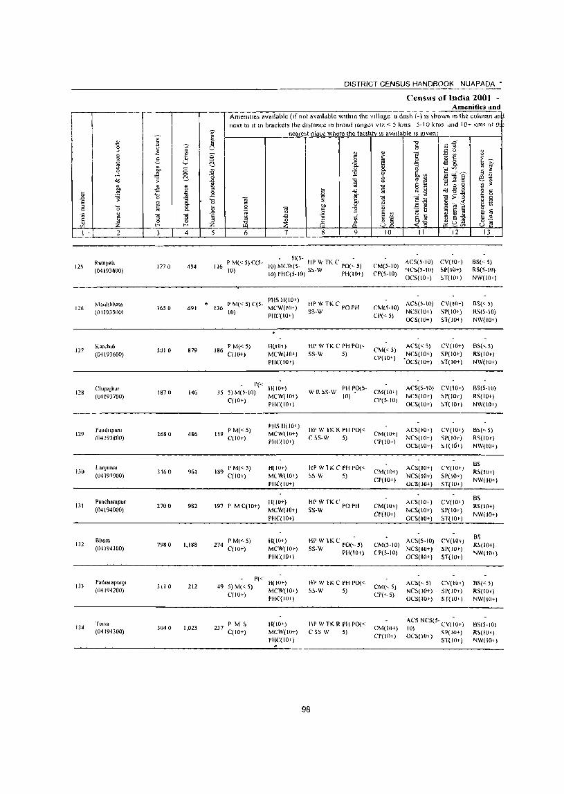
I
I·
125
126
127
128
129
130
131
132
133
134
2
Rata?I, (0419J~OO)
Mauhbl\R,a (OI193500)
Karch"1 (O~ 193600)
CllIpaJhar (04193700)
PUllunpanJ (04193800)
LanJllnal (04191900)
Pallchampur (04194000)
Rhera (O~ 194100)
PO!I>"OPlIIlJ'
(04194200)
Tona (04194300)
I
3 4
1770 494
3650 691
501 0 879
187 a 146
2680 486
316 () 961
2700 982
7980 1,188
311 0 212
3040 1,023
DISTRICT CENSUS HANDBOOK NUAPADA •
Census of India 2001 -Amenities Ilnd
Amemtles available (If not aV811dbie wllhm the Village a dash (-) IS ,hown mIlle column dn~ next 10 It In brackets the dl;tance III broad range< VIZ < 5 kms 5-10 kms ,md I O~ Km' oj th~
neare;! pld~e where the taellil'! IS available IS given
5 6 7 8 9
Il(S- -116 P M« 5) C(5- 10) M( W(S. liP W TK e PO{<- 5)
10) 10) PHC(S.IO) s~·w rH(IO+)
PIIS H( 10+) 136 P M«5) C(S- MCW(IOi)
10) PIIC(IO+)
186 P M« 5) C(lO+)
B(lO,.)
MCW(IO+)
PHC(IO+)
liP WTKC PO PH SS·W
liP W TK C PB POe' ss·w 5)
10 II 12
ACS(5·1O) CV(IO+) CM{5-1O) NC~(S-IO) ~P( 10+) Cr(.HO) OCS(IO+) H(IO+)
CM(S.IO) AC!.(5-1O) CV(IO+) NCS(IO-t-) 51'(10+)
CI'« 5) OCS(IO+) ST(IO+)
CM« 5) CP(IO+)
ACS« 5)
NCS(IO-t-) 'OCS(IO+)
CV(IO+)
SP(IO')
H(lOt )
35 P« 11(10+) 5)M(5-IO) MCW(IO+)
C(lO+) PIIC(IO+)
WR~S.W PIIPO(5. CM(IO+) 10) •
CP(5·10)
ACS(5-IO) CV(IO»
NCS(IO+) ~I)(IO+)
119 PM«5) C(lO+)
189 I' M« 5) C(lO-t)
PHS H(IO+) MCW(IO+)
l'HC(IO')
H(IO+)
MC W(IO+)
PHC{ 10+)
197 I' M C(IO+) H(lO+)
MCW(IO-t)
!'HC( 10+)
274 P M« 5) C(lO-t)
H(IO-t)
MCW(IO')
PHC(IO')
P« H(IO+) 49 5) M« 5) MCW(IO+)
C(lO+) PHC(IO')
237 P M 5 C(lO+)
H(!O+)
MCW(lO+)
PHC(IO+)
liP W fK R PH 1'0« C ~S-W 5)
liP W TK C PH PO« ~~-W 5)
HI' WTK C PO I'll SS-W
BP WTKC PO(~5) 5S-W PH(IO+)
HI' W TK C PH 1'0« ~~-W 5)
Ill' W TK R I'll 1'0« C S5 W 5)
98
CM(IO+)
CPt lOt)
CM{IOt)
CP(IO+)
CM(IOl-)
Cp(IO+)
OCS(lO') H(IO-t)
ACS(IO+)
NCS(IO+)
OeS(lo+)
ACS(IO+)
NCS(IO+)
OCS(IO+)
ACS(IO+)
NCS(IO+)
OCS(IO+)
CV(IO+)
SP(IO+)
S f( Hl+)
("V(IO+)
SP(IO+)
5T(JO+)
CV(IO+)
SP(IO+)
ST(IO»
CM(5.10) ACS(S-IO) CV(IO+)
(1'(5-10) NCS(IO+) SP(IO+)
CM(~ 5)
CP(" 5)
CM(IOt) CI'(IOt)
OCS(IO+) ST(IO+)
ACS(,5)
NC~(IO+)
OC5(10+)
CV(I01-) SP(lO.)
sr(lO+ )
ACS NCS(5- CV(- t) 10) 10 OCS{IO+) 51'(10+)
5T(IO+)
13
B5« 5) RS(S-IO)
NW(IO')
BS« 5) RS(S·IO)
NW(IO+)
BS(<- 5)
RS(IO+)
NW(IO+)
BS{5-IO)
RS(lO+)
NW(IO-t)
B~{" 5) RS(IO+)
NW(IO+)
BS R~(lO+)
NW(IO+)
BS
RS{IO+)
NW(lO+)
BS
R~(IO+)
NW(IO+)
BS{< 5)
R5(10+)
NW(lO-t)
FlS(5·10) R~(IO+)
NW(IO+)
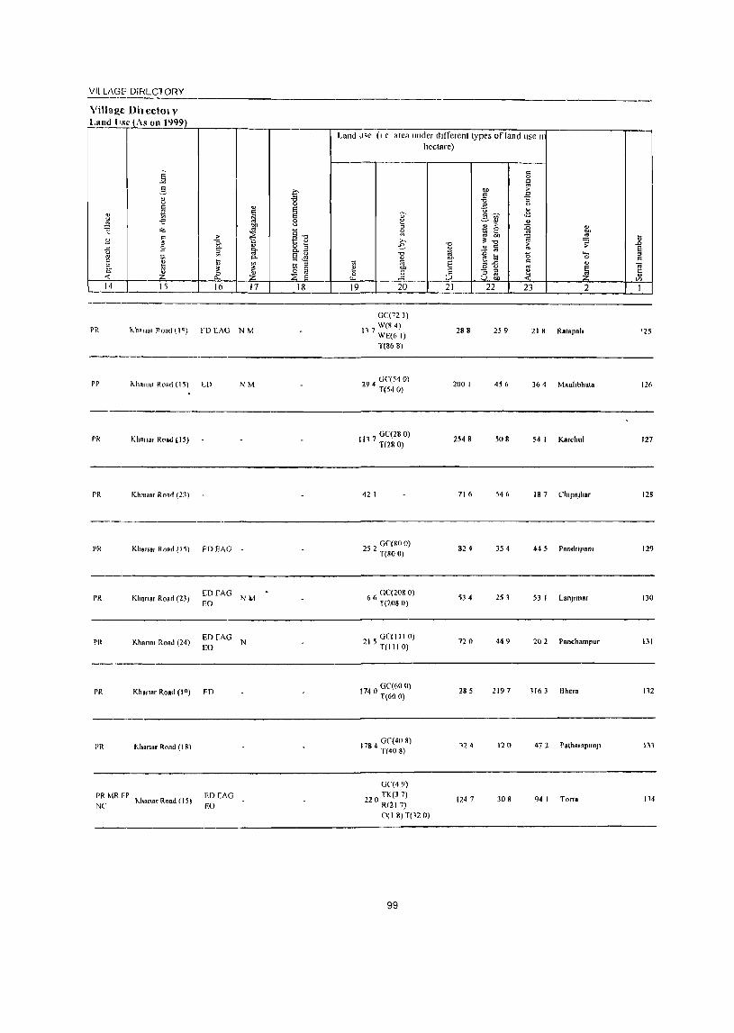
VII LAGI' DIHLCIORY
Land J,(" (I C area ullder different types of land use II
hectare)
c 0
il "" :>
.g '" B E ... ;;- g~ ..g ~ -.:::..~ ... ::I
~ '" :0 " :;; ~ " bIJ
» ~ "t:> ~ ~ ] "0 :> ;; e- " 2 lii " E -0 1'l ~~ () ..... '" " 00 0 c
1;; 0; E c " " "" a u '" ~
";;j
& .§ " ""3 ~ ~ t:
:::> ... en
16 17 18 19 20 21 22 23 2 1
---------------------------------------------------------------------------------GC(72 3)
PR 1<...'"8. flonet (I~) rD CAG N M 11 7 W(g 4)
WE(6 I) 288 259 218 R.lapah '25
T{EO 8)
PP ,,"hana, Rood (15) LO NM 294 GC(54 0) T(54 0)
200 I 456 364 Mauhbhala 126
--------------------------------------------------------------------------------PR Khanar R".d (15)
11 7 GC(28 0) I T(280)
2548 508 54 1 Karchul 127
PR Khn".r R",~ (23) 42 I 716 546 18 7 Ch'paJhar 128
PI{ Khana, Road (15) FDEAG 252 GC(80 0) T(80 0)
824 354 445 Panrlnpam 129
PR Khan.r Road (23, [DCAG
NIo4 66 GC(20& 0)
EO T(20S 0) 534 253 53 1 LallJ.nIar 130
PR Khana. Road (24) EDCAG
N 215 GC(1I10) EO T(IIIO)
720 449 202 PanchanIpur 131
------
PR Kh."ar Road (1°) FO 174 0 Gq600) T(60 0)
285 2197 1163 Bhera 112
PR Khan.r Road (18) 1784 GC(408)
T(40 8) 124 120 472 rath.,.punJ' 133
GC(49)
PR MR FP !<-harlar Road (! 5)
EDCAG 220 TK(J 7) 1247 308 94 I TotT. 114 NC EO R(217)
0( 1 8) T(12 0)
99
DISTRICT CENSUS HANDBOOK NUAPADA •
Census of India 2001 -,..-_-r-_____ ..,-__ --,...-__ -r-__ ,...-_____ -.,..,-_: __ ---,:-:-:--_:---._-:-:-__ -:--:-:--__ -:-_Amenitie\ and
AmenitieS available (If not available within the Village, a dash (-J IS ,howil Il1lhe column dnl
135
136
138
139
140
141
142
143
144
2
Motal1uapadd (04194400)
I anamahuabhata (04194500)
Kukulalal (04194600)
OhwaJabhald (04194700)
SUPdh (04194800)
Kukunmundl (04194900)
Bamore (04195000)
Musarangl (04195100)
SethJampano (04195200)
Kal.ulldadar (04195300)
3 4 5
3750 840
1440 129
444 ° 699
1490 183
4710 475
4790 345
80
1340 197
4390 406
4080 49)
next to II In bracket, the distance In broad ranges VIZ < 5 kms , 5-10 kIn; and 10+ km> 0111 ~ neare,l place where the facility is avallabl" IS given
6 7
DA PHS H(IO') MCW(lOi-)
PHC(lO+)
P« H(I01') 31 S)M«5) MCW(IO+)
C(IO+) PIlC(IO'l
166 I' M« 5) C(10+)
37 P M« 5) C( 10+)
102 I' Ml< 5) C(lO+)
69 P M(S-IO) C(lO+)
H(IO+)
MCW(IO+)
PHC(IO+)
H(IO+)
MCW(IO+)
PHC( lOt)
H(lO+)
MCW(IO+)
PHC(IO+)
H(lO-l-)
MCW(IO+)
PHqIO+)
P« H(IO-l-) 5) M« 5) MCW(IO+)
C(IO+) PHC(IO+)
52 P M« 5) C(IO+)
96 P M(5-1O) C(10+)
127 I'M(5-1O) C(lO+)
H(IO+)
MCW(lO+)
PHC(IO+)
H(LO+)
MCW(IO+)
PHC( 10+)
~1(1O+)
MCW(IO+)
PHC(IO+)
8 9 10
HI' W fK R PlI PO(5- CM(IO+)
C SS-IlP 10) CI'(lOc)
HI' WTK R I'll 1'0« CM(IO+)
CP{IO,) CSS-W ;)
HPWTK
SS-W
HPTKC
55-HI'
HPTKC
SS-HI'
HPWTK
SS-HP
HPW TK
SS-W
HI'WTK
S5-HP
HPWTK
SS-HP
HPW TK
S~-Hl'
100
PH 1'0« 5)
PH PO« 5)
1'0« 5) PH(IO+)
PO(5-IO)
PH(IO+)
1'0« 5) PH(5-10)
PO« 5)
PII(IO+)
CM(IO+)
CP(IO+)
CM(IO+)
CPt 10+)
CM(lO+)
CP(IO+)
CM(IO+)
CP(IO+)
CM(lO+)
CP(IO+)
CM(lO+)
CP(lO+)
PH 1'0(5-10) CM(IO+)
CP(IO+)
PH 1'0(5- CM(IO+)
10) CP(IO+)
II
ACS(IOc)
NCS(l01 )
OCS(10+)
ACS(IO+ )
NCS( 10+)
OCS(IO+)
12
CV(to c)
SP(10')
51(10+)
CV(IO')
SP(IO')
S I( lOt)
ACS(IO+) 'CV(IO+)
NCS(IO+) SI'(IO »
OCS(IOt) ST(IO»
ACS(IO+)
NCS(IOt)
OCS(IO»
ACS(IO+)
NCS(IO')
OCS(lO t )
ACS(lO+)
NCS(IO+)
OCS(IO+)
ACS(101 )
NCS(IO+)
OCS(IO+)
ACS(IO+)
NCS(IO+)
OCS(IO,)
ACS(IO+ )
NCS(IO+)
OC5(IO+)
ACS(IO+)
NCS(IOt-)
OCS{IOt)
CV(lO+)
SP(IO+)
ST(IO<)
CY(IO»
SP(IO+)
ST( 10+)
CV(IO+ )
SP( lOt)
ST(IO+)
CY(IOt)
SP(IO+)
ST(IO+)
CV(IO+)
SP( 10+)
ST(IO+)
CY(IO»
SP(IO+)
ST(IO»
CV(IO+)
SP(lOI)
STC 10+)
13
BS(5-IO)
RS(IO')
NW(Hh)
BS(5-IO)
RS(IOt)
NW(IO')
BS(5-10)
RS(IO+)
NW(IO+)
NW BS« 5) RS(IO+)
B~(IO»
RS(IO+)
NW(IO+)
BS(5-10)
R5( 10+)
NW(IO+)
BS(5-10)
RS(IO+)
NW(IO+)
BS(IO+)
RS( 10+)
NW(IO+)
BS(5-1O)
RS( 10+)
NW(IO+)
BS(5-10)
RS(IO')
NW(IO+)
VILLAGE DIRECTORY
Village Directory Land (JSl' (As on 1999)
14 15
PR MR FP KImll.r Road (15)
N( NW
PI{ MR FP I,h""ar Road (16)
PR MI{ rp "har"" Road (17)
PI{ MR rP NW Khan ar Road (20)
-------
16
ED EO
EA
~~IR rr Khall"r Road (18) FD EO
PR MR rp Khana' Road (18)
PR MR fr "h.no, Road (20)
PR MR rr Khana, Road (17)
PR MR I P ""a"ar Road (19)
PR MR rP KII.l1a, Rood (42)
17 18
NM
Land use (I e area under different typf'S of land use If hectare)
19 20
0C(441) 121 TK(4 8)
T(49 0)
0C(144) 142 TK(I 4)
R(6 6) T(42 4)
889
OC(O 1)
12 I TK(06) T(09)
OC(17 I)
148 TK(8 7) R(186)
T(444)
020 TK( 1069) I T(I069)
1K(12) 522 R( I 4) T(2 6)
486 TK(I 2) T(12)
TK(11) 1296 0 (42) r(S 'i)
101
21
2992
21 2
2648
886
1570
III 3
1& 1
108 I
863
22 23 2
130 16M otan\lapada
526 14 2 Tallam"huabh.ta
571 32 6 K uku,atal
298 18 0 Dhw"labhato
522 2024 Supa"
407 117 9 Kukurnnund,
8 I) B"glore
263 '4 2 Mu .. arang'
668 14 2 SethJ.mpam
1559 31 I KalalOldadar
115
136
137
138
139
140
141
142
143
144
I ~ -;:--g ~ '" , ~ 8 '- " -'"
.<: c <:> 0 2- " <:> la u ~ U " 0 0
.., -0 ...l ~ 0 -0
o(j ~ ~ .<:
" " '" 1;l bIJ ;s 0 ::J
Ii ~ ~ 0 .... .c ,D ;; 0 ~ ..... E .. "- 0 ::J .... ~ 8- t c 0
OJ U ,D
f;j -yg 5 E 5 0 0 ::J
CI1 i l- t- :z. I 2 3 4 5
145 BlialSadaddr (041954 00)
20S 0 367 86
Pakhanpadal 146 200 169 39
(04195500)
147 (Ilul.hllat
5700 838 168 (04195600)
148 Pandnpalll
1,0470 947 206 (04195800)
149 Gangadlgarh
2020 298 73 (04195900)
SIIIMlbahara 150 177 0 53 14
(04196000)
Kodopail 151 3140 643 14K
(04196100)
Bholh. 152 117 0 53 16
(04196200)
Chhollo<l,. 153 1510 I 13 22
(04196300)
154 Kdtmgpant
6810 399 101 (04196400)
DISTRICl CENSUS HANDBOOK NUAPADA •
Census of India 2001 -Ame!1itielt and
Amenities available (If 110t available within the village d dash ( ) I, shown In Ihe column al: next [0 It In brdckets the dlstdnce In brodd ranges VIL < 5 I<m, '-10 ~m; dn(. iO+ kill; Of!J,
nearest pld~e where the laulJlV " dvallable " given I • i
I
~ .0 I ~ .2
... " _:g " " ~
e ~ u
'" i3 E~ 0 a -'" <i'l 0 0. " ~ 0.. ~ v. '"
" " u ""§":_ ;g E "-1i b b1,~ .3 '@ E -0 ~ 15 al-
" ""3..c ::I ~ ~ !il -0 0:: .,
" 0 C Ii § g g cld~g 0::
..: 0 '" iii ~ - <I> as>"'§ ~ 0
OJ ~ OJ e a ~ c OIl ~ § OJ ~ a 0 00 " .3 ., '" ~ '" 1i u
~ u 5 e § ::J ;,
1'l .2 §~ ~~
E: '" -a 8 <i ~ " -a E ~
t2 ~ rf 8] ~a81 8e 6 7 g 9 10 II 12 13
P M(5 10) H(IOt) HPW fK PI! (~I( lOt)
A( S(III» l V(IOI) B~(1 0+) (10 » MCW(IO') S~-IJr 1'0(101)
(1'(10') NC'l(IOt) ~P(IO; ) RS(IO,)
Pfl(( 10+) OC~\ 101) S {(IOl) NWlI()l}
P« H(IIl+) HPW 1K AC~(IO+) l V(IO+) 1150(5 10)
5)M« 5) 1'0(5 10) (M(IO»
C(IO+) MCW(IO+) S'>-HP
I'H(IO+) CP(IO» N(~(IO+) '>P(III, ) R~(lO+ }
PHC(IO+) OCS(IO» H(IO+) NW(IOt)
P M« 5) H(ID+) liP W 11-. R I'll 1'0« (M(IO; )
AC~(IOt) l V(IOt) B5« 5) C(IO+) M(W(IO+) ( ~S III' 5) NCS(IO+) ~P(IOt) R~(lO t)
1'11(( 10+) (P(,5)
OCS(IO'} ~T(IOT) NW(IO»
P M(~ 5) 11(10+) HI' W TK C PH PO« (,M(IO+)
AC~(IOt) (V(lO e) n~(, 5)
C(lO+) MCW(IIH) ~S HI' 5) (P( IO·tj
NC~(IO+) ~P(IOt ) R~(llJt)
PflC(IO+) OCS(IO+) ~T(IOT) NW(IO .. )
P M(5 10) H(IO') HPW lK PI1 1'0(5-(M(IO+)
AC~(IO+) CV(IOe) B~()-IO)
C(IO') MCW(IO+) ~S III' ID) ( 1'(10+)
Nr5(10") ~I'(IU') RS(IOt) P11C()Qt) OC5(10') ST(IO ) NW(IO+)
P« 11(10+) III' f" 5~- ACS(IO+) ( V(IDt) 8S(<.5) S) M« 5) 1'0« 5) CM(IOt) C(IO+)
MCW(IO+) HI' PH(IO+) ep(lo»
NCS(IO+) SP(IO+ ) RS(IO+ ) PHC(5-IO} OC~(IO+) ST(IO+) NW(IO+)
PM«5) 11(10)) HI' W T" A(~
( V(IOt) B~(IO» PO(,5) CM(510) NC~(IO+)
C(IO+) MCW(IOt) SS Ill' P"(lOt) CP(lO+) OCS(IO+)
SP(IOt) R5(101) PHC(5 10) 501 (10+) NW(IO+)
P« 11(10+) HPWH. 1'111'0« AC~(IO"l) CV(JOt) B~(' 5)
5) M«5) CM(S-ID) C(IO+)
M(W(IO+) 55-III' 5) CP(IO+)
NCS(IO"l) SP(IO+) R~(IO+)
PflC(5-IO) OC5(10+) 51 (10') NW(IO+)
P« 11(10+ ) HPWH .. 1'111'0(<. AC~( 10+) CV(IO') B5« 5)
5) M(5-1O) CM(5-10) C(IO+)
MCW(IO+) ss, III' 5) (P(IO+)
NCS(IO") 51'(10+) R5(10+) P{1C(5 10) OCS(IO+) 51(10,) NW(IOt)
P M(5-IO) H(IO") HI' W1KR I'll CM«5)
A(~(IO+) (V(IO') B~(IO+ ) C(IO» MCW(lO+) S5 HP 1'0(10 .. )
CI'(IO+) N(~(IO"l) 51'(10') R~( 10+)
PHC« 5) Oe5(10+) ~ 1(10+) NW(IOt)
102
VILLAGE DIRECTORY
Village DircctOl-V Land Use (A"'s:....o;_n-"-'19;..;:9...:9J-)_T' ___ r-_, ____ ,-;-:-;_--::-___ -;---:--;:::-___ --:~_;_-_r--____ ,..-_,
Land use (I e area under different types of land use Ir
14 15 16
PR MR fI' Khan .. Road (42)
I'R MR r P KI,alla. Road (12)
-------------
PR MR FP Kh.TIOI Road (W) lA
NR N(
-------
PR Mit r,' I<.ha\\., Roo<l (42) 1/\
PR MR fP Khallal Road (21)
I'lt MR fP Klla""' Road (42)
PR MR J I' IJwlUr Road (42) FD FO
PR MR ~p Khallal Road (42)
I'R MR r I' Khallar Rood (48)
PR MR rr KhanAl Road (43) NP
17 18
NM
hectare)
19 20
1 4 TK(O 5) 8 T(O 5)
GC(S(,)
1~5 7 TK(O 6) R(160)
T(?46)
GC(3 I)
9 I TK(28) 3 R(21 3)
T(272)
() TK(O 4) (,6 T(O 4)
457 TK(I J) T(ll)
4 TK(O 6) 32 R(2 6) T(3 2)
9 fK(O 8) 80 1 (0 8)
42460(1 3) rrI 1)
103
21
694
1473
221 3
708
1952
138
446
22 23 2
75 () 25 I Bhalsadadar 14,\
200 Pakhanpadar 146
692 2030 Lhulohha! 147
664 2 406 Pandllpdlll 148
202 () GRngadlgflT h 149
299 10 I SIIJ.noaha" 150
649 65 Kodopoh 151
587 23 I Bhotha 152
202 15 2 Chhollodr. 153
1584 52 Ii Ka!lIlgpam

I
155
156
157
158
159
160
161
162
163
164
165
2
Lod,a
(04196500)
Bltal uamunda (01196600)
Dhanllllbdndild (04196700)
PdtOl8
(04196800)
lhal"p (04196900)
Tlk,.pada (04197000)
Maraguda (04197100)
Pellnapall (04197200)
Kennell (04197300)
Golab,"dh
(04197400)
KallkennanJI (04197500)
3
5M50
3910
1,1660
4590
•
2530
4210
5620
4760
2690
2880
3400
4
629
784
2967
929
35
124
243
392
394
DISTRICT CENSUS HANDBOOK NUAPADA •
Census of IndIa 2001 -Amemtle~ and
Amenities available (If not available within the Village, a dash (-) IS ;howl) in the column dn~ next to It In brackets the dl;tance In broad ranges viZ < 5 km", 5 10 kms and 10+ kms ot th
neare". place where the tacllltv IS available '" glv"n
5 6
118 PM(5-IO) C(lO+)
176 1'11.1« 5) C(lO+)
614 1'(2) 11.1 5 C(IO+)
236 1'11.1«5) ((10 1)
7
H(IO") M(W(IOt)
I'll(_« 5)
H(I01)
MCW(IOI)
PIIC« 5)
I'HC PHS Il( 10+)
MCW(IOt)
H(lOt)
MCW(IOI)
PHC«5)
!
8 9
III' W ff,. R 1'0(; 10)
~~ III' pfI(JO+)
IIPW ff,.
% HI' 1'0« 5) 1'11(10+)
HP WTf,. R 1'0 PH C 55-III'
HPWfKCPII
55-HI' 1'0(10+)
10
CM(,5)
(1'(10+)
CM(,5)
CP(S 10)
(11.1 (p(~
5)
(11.1« 5)
LP« 5)
II
AC~( 10 ')
NC~( 10+)
OC~(IO+)
ACS(IOI)
NC~( lOt)
OC~(IO+)
AC~
NCS(IO+)
OC!'(IO+)
AC~« 5)
NCS(lO+ )
OCS(IO')
-------- Unillhablled --
1'« 10 5) 11.1« 5) H(lO+)
C(10+) I\1CW(IOI) PHq,5)
1'(5- PHS H(IO+)
33 10) M(IO+) MCW( 10+)
C(101) PHC«5)
so I' 11.1 C(IO+)
133 P M ((10+)
88 I' 11.1 C(lO+)
81 PM«5) C(lO+)
11(10+)
MCW(IOt)
PHC(,5)
DA H(Il)l)
MCW(J()+)
l'flC(5-10)
11(10+)
MCW(IO+)
PHC(5-IO)
III 10+) MCW(IO+)
PHC(IO+)
fI I' S~-HP I'll 1'0« 5)
~~ W R S5 PO I'll C'M(5-1O) ACS(IOt) NC~( lOt)
Cpr 10+) OC S( 101)
III' WTf,.
5S HI'
HI' WTf,.
5~-HP
HI' WTK
~~-HP
III' W rf,.
5S-HP
104
PH 1'0(5- AC5( 10+) 10) C'M(5-10) NC~( 10+)
PH 1'0(,
5)
POI'H
CP( 10+) OC'S( 10+)
CM(5 10) AC5(10+)
CP(IOI) NCS(IOt\ OC~( 10+)
CM(5 10) A(,~(I()+) CP(IO+) NCS(IOI)
OCS(IO+)
PH 1'0(5- CM(S-IV) AC 5( lOt)
10) CP(101) NCS(IO+) OCS(IO+)
12
lV(lO I)
~I'(IO+ )
~l(IOI)
CV(IO~)
51'(10 1 )
51 (10 1)
( V(IO+)
51'(10+) ST(IOI)
CV(IO.)
51'( 10+)
~T(lO+)
( V(IO')
~P(lO' ) ~T(lOI )
CV(I01)
~P(IO+ )
H(lO+)
CV(IO.)
SP(IOt)
5T(10+)
(V(IO+)
SP(10+\
ST(lO+)
CV(IO+)
~P(lOt)
H(101)
( V(IO+)
~P(IO+)
ST(IO+)
13
BS() 10)
RS(IOI)
NW(IO+)
B~« ) R5(IO.)
NW(IO+)
B5 NW
R5(1O')
B~
RS(IO I )
NW{lO+)
U~(, 5)
R5(101)
NW(IO+)
B5(101)
R~(I0+)
NW(IO+)
B~(IO')
RS(IO+)
NW(IO+)
B5(10+)
R5( 10+) NW(IO+)
B~(IO+l
RS(IO+)
NW(IO+)
8S(101 )
RS(IO+)
NW(IO+)
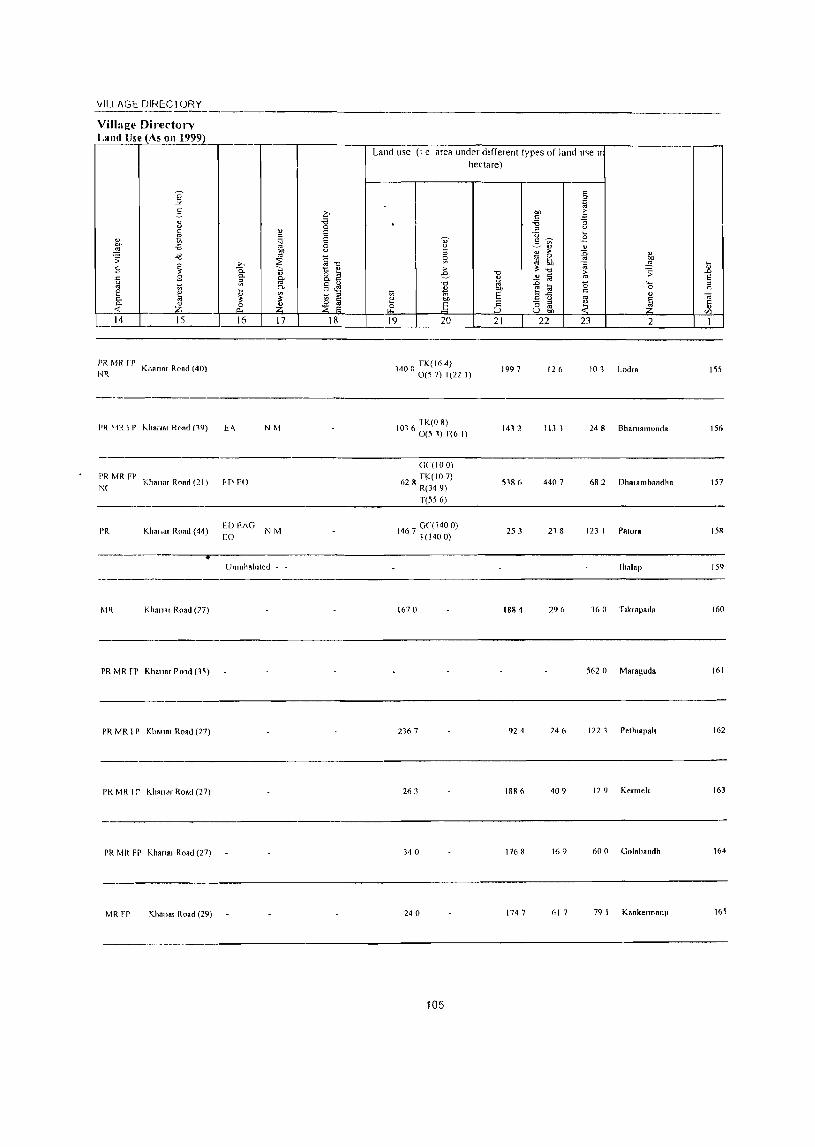
\iILl AGE DIRECTORY -----------------,-------Village Directo.-;' Land lise (As on 199?l ____ , ___ ,-____ ;-:_-;-_;--___ --;---;-;:;-___ --::-:---:--_,--_____ --,-_-,
Land use (I e area under different types of land U~e II hectare)
5
14 15 16 17 18 19 20 21 22 23 2
PR MR fr KIlRnnr Road (40)
NR 1997 126 101 Lodra ISS
----------------------------------------------------------------
PR MR FP Kha"ar Road (21 ) f fI EO NC
PR Kh ... ar Road (44) ED £)\0
EO
NM
NM
01 1K(O 8) I 6 0(5 1) T(6 I)
Gl(IO 0)
62 R TK(IO 7) R(349) T(556)
467 GC( 1400) I 1(1400)
1432 113 1 24 8 Bhamamullda 156
51& 6 4407 682 DhOlambandha 157
253 21 8 123 I POlorR 158
-----------~r------------------------------------------------------UnJllhab'led - - Ihalap 159
Khanor Road (77) 1670 1884 296 360 T,k,apada 160
PR MR rP Kha"ar P01d (1~) 562 0 Maragud. 161
PR MR 1 P KIl."., Road (27) 2167 924 246 122 1 Pelh'.pail 162
PI{ MR 1 r Kh.n", Road (27) 263 1886 409 129 Kenneh 163
PR MR FP Khan .. Road (27) 340 1768 169 600 Golab.lldh 164
MR FP Kha" .. Road (29) 240 174 7 617 79 I Kankermanl' 165
105
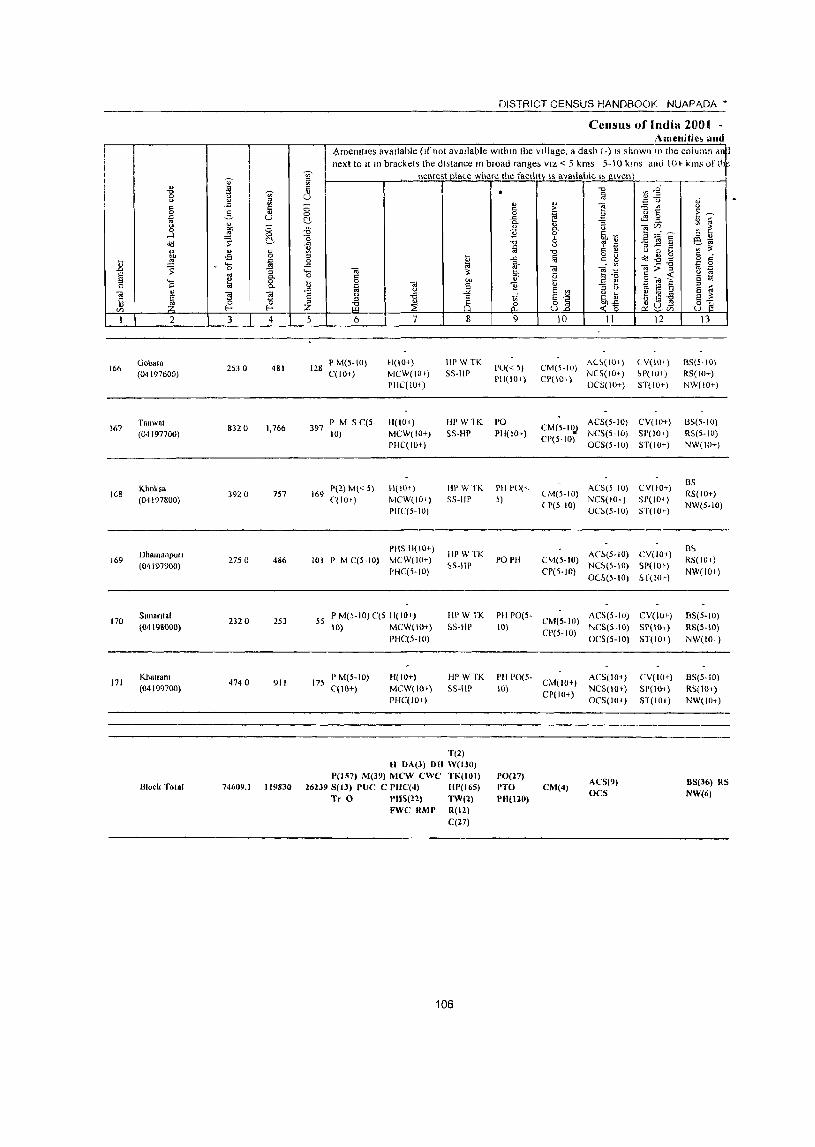
I
166
167
1GB
169
170
171
2
Gob ... (04197600)
Tarlwat (0·1197700)
Khoksa (04197800)
DhamanpUlI (04197900)
Sunonlal (04198000)
Khalrolll (04199700)
Blocl< Total
I f I " ..<:
2. ... l :;
._ • 0
3
2530
832 0
3920
2750
2320
4740
1 u
4
481
1,766
757
486
253
911
DISTRICT CENSUS HANDBOOK NUAPADA'
Census of India 2001 -Amenitie~ and
.?menlttes available (If not available wlthm the village, a dash (-) IS shown 111 the column dn~ next to II 111 brackets the distance In broad range; VIZ < 5 kms 5-10 kms and \ 0+ kms of!h
nearest pla~e where the faCility IS available I> given
o <::> C
5 6 7
128 P M(S-IO) C(IO+)
H(IO+) MCW(IOf) PHC(lO+)
397 P M 5 C(5-10)
169 P(2)M«5) C(lO+)
H(IOI)
MCW(IO+) PHC(IO+)
H(lO+) MCW(IO+) 1'HC(5-10)
PHS 11(10+) 101 P M C(5-10) MCW(I()+)
1'HC(5-10)
55 PM(5-10)C(5 11(10,) 10) MCW( 10~)
PHC(5-IO)
175 P M(5-10) C(IO+)
H(IO+) MCW(lO+)
PHC(IO»
8
liP WTK 55-111'
9
1'0«5) PII(IO+)
fir W1K PO
55-HP PHI 10+)
IW W TK PH PO« 55-HI' »
I1PWTK !>S-IIP
POPH
10 11
CM(5-10) AU(IOt) CP(IO,) NC5(IO+)
OCS(IO+)
12
( V(I\)+) ~P( 10+) ST(IO+)
ACS(5-IO) CV(IO+) CM(S-IIl.) NCS(5-10) 51'(10+) CP(5-IO) OCS{5-10) 5T(10+)
CM(5-10) ACS(5 10) CV(HI+) NCS(IO+) SI'(IOI-)
(1'(5-10) OC~(5-10) 5T(IOI-)
An(5-IO) CV(IO+) CM(S-IO) NC~(S-IO) SP(IO»
CP(5-IO) OeS(5-10) H(IO»
HI' WTK
55-liP PI! 1'0(5- CM(5-IO) ACS(5-IO) CV(IOI-) 10) NCS(S-IO) SP( 10+)
HI' WTK
5S-HP
T(2)
CP(5-IO) OC5(5-10) ST(IO+)
I'll 1'0(5- CM(IO+)
10) CP(IO+)
ACS(IO+)
NC5(IO') OCS(IOi)
CV(IO') SP(IO~)
51(10.)
H OA(J) 01{ \V(t30) P(157) M(39) MeW ewe TK(IOI) 1'0(27)
13
BS(5-10) RS{IO+) NW(IO+)
13S(5-10) RS(5-10) NW(IO+)
BS R5(1O+) NW(5-1O)
m, RS(lO ,)
NW(IOI)
B5(5-IO)
RS(5-IO)
NW(IOI)
BS(5-IO)
RS(IO~)
NW(IO+)
74609,1 119830 262398(13) pue e rUC(4) HP(165) PTO CM(4) ACS(9) OCS
BS(36) RS
NW(6) Tr 0 .'118(22) TW(2) PH(l20)
FWC RMP R(I2) C(27)
106
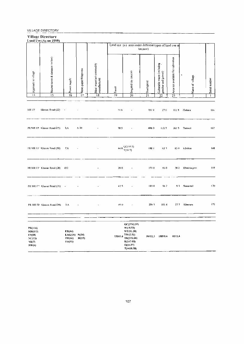
VILLAGE DIRECTORY
Village ()irectory Luud l'sp. (As on 1999)
1-.14 15
MR fP Kha,,", Road (22)
PR MR fr Kha"., Road (25)
I'R MR fr Khan", Road (50)
16
EA
EA
PR MR r I' Khan., Road (28) flJ
PI{ MR fr Khan., Road (26)
PR MR r!' Kha"., Road (28) EA
PR(116)
MR(112) FP(SS)
N(12) NR(7)
NW(6)
EO(S4)
EAG(J6) EO(16) EA(32)
17
NM
N(24)
M(19)
18
Land use (I e area under different types of land lise II
hectare)
19 20
21 (,
185
4 8 GC( 105) 4 1(10 S)
200
475
4S 0
GC(3762.97)
W(IS.53)
WF(5J.38)
1304 6 TW(2.52) 1. TK(332.06)
R(247 05)
0(24.07) T(44JS.58)
107
21
1019
4080
188 I
1710
1198
2901
38322,3
22 2
270 102 8 Goba,"
122 7 2625 Ta,,,,al
651 830 Khoksa
460 382 Dhnmanpllli
567 81 Sunantal
1014 377 Kha"a",
10010.4 8212.4
166
167
168
169
170
171

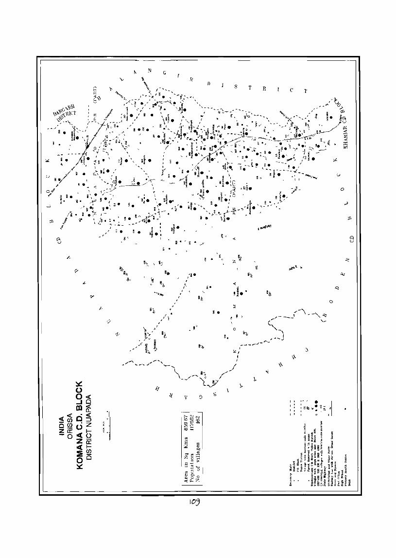
I . •
~
• i.
jl i • 11, • ,...l
, p ,
~ 0 g(§ m8: .« <t«C:J
CJ) .z -CJ)O 0_ I-:Z1I:«O -0 _
Za: «I-:!~ 0° ~
v
• ~ . ~ 0
8q~ .so
N G I
§"';.
! , 8!. , ! ,
" , 15'
'§ ~
..... ""
/f
" . :; .
.
!.
~
R D
g . /' "
, '~ . ,"- g'
'-
9-z
•• ~o
we.
V ~ s
105
~ 0
0
~.
\
s
<
t ! 0
\
o
I
'IL./ !
T R c
': I,
I'
T
o
,- - • ~ I I • ~ ~ I §~ @. )(
I 0 II

VILLAGE DIRECTORY OF
KOMANA C.D. BLOCK- 0002

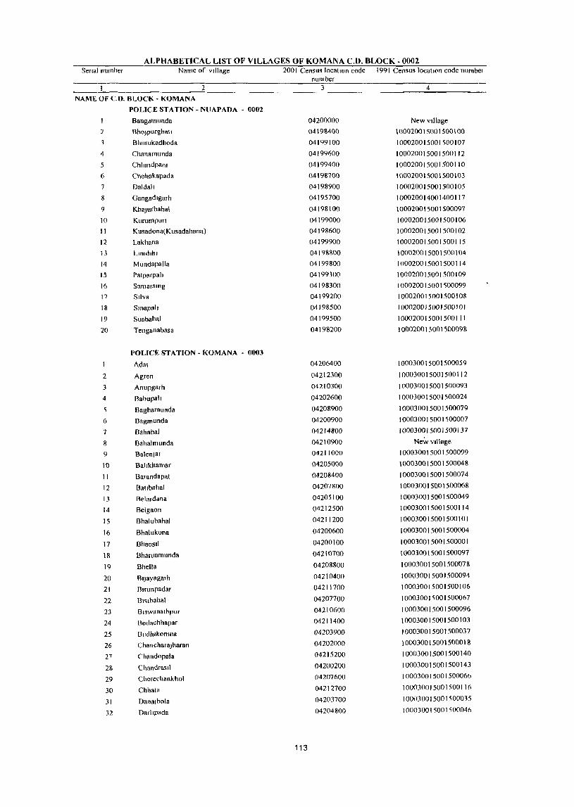
ALPHABETICAL LIST OF VILLAGES OF KOMANA C.D. BLOCK - 0002 Senal number Name of village 200 I Census location code 1991 Census location code numbel
number 2 3 4
NAME Of CO. BLOCK - KOMAN A
POLICE STATION - NUAPADA - 0002
Bang~munda 04200000 New village
'2 BhoJpurghati 04198400 100020015001500\00
3 Bhurukadhoda 04199100 10002001500lS00107
4 Chanamunda 04199600 100020015001500112
5 Chlimdpalll 04199400 100020015001$00110
6 Chohakapada 04198700 100020015001500103
7 Daldah 04198900 100020015001500105
Gangadlgarh 04195700 100020014001400117
9 KhaJurbahal 04198100 100020015001500097
10 KlIrumpuri 04199000 100020015001500106
11 KlIsadona(Kusadahana) 04198600 100020015001500102
12 Lakhana 04199900 100020015001500115
13 Llmdllll 0419&&00 100020015001500104
14 Mundapalla 04199800 100020015001500114
15 Patparpah 04199300 100020015001500109
16 Samarsmg 04198300 10002001500lS00099
17 Silva 04199200 100020015001500108
18 Smapah 04198500 100020015001500101
19 Suabahal 04199500 1000200150015001 II
20 Tenganabasa 04198200 100020015001500098
POUCE STATION - KOMANA - 0003
1 Adal 04206400 100030015001500059
2 Agren 04212300 100030015001500112
3 Anupgarh 04210300 100030015001500093
4 BabupaIJ 04202600 100030015001500024
Baghamllnda 04208900 100030015001500079
6 I3agmunda 04200900 100030015001500007
7 Bahabal 04214800 100030015001500137
8 Bahalmllnda 04210900 New village
9 BalenJar 04211000 100030015001500099
10 Bahkhamar 04205000 100030015001500048
II Barandapat 04208400 100030015001500074
12 Ballbahal 04207800 100030015001500068
13 Belarddna 04205100 100030015001500049
14 Belgaon 04212500 100030015001500114
15 Bhaillbahal 04211200 100030015001500101
16 Bhalllkona 04200600 100030015001500004
17 Bhaosil 04200100 100030015001500001
18 Bharuamunda 04210100 100030015001500091
19 Dhella 04208800 100030015001500078
20 Bljayagarh 04210400 100030015001500094
21 Blnll1padar 04211700 100030015001500106
... ., "''- Dl~lhahal 04207700 100030015001500067
23 Biswanathpur 04210600 100030015001500096
24 Bodachhapar 04211400 100030015001500103
25 !JvdhrkorTIll8 04203900 100030015001500037
26 ChancharaJharan 04202000 100030015001500018
27 (,handopala 04215200 100030015001500140
2& Chandrasil 04200200 100030015001500143
29 Cherechankhol 04207600 I 000300 I 5001 500066
30 Chhata 04212700 1000300150015001lA
31 DlInalhola 04203700 1000300150015000,5
32 Darllpada 04204800 10003001S001500046
113
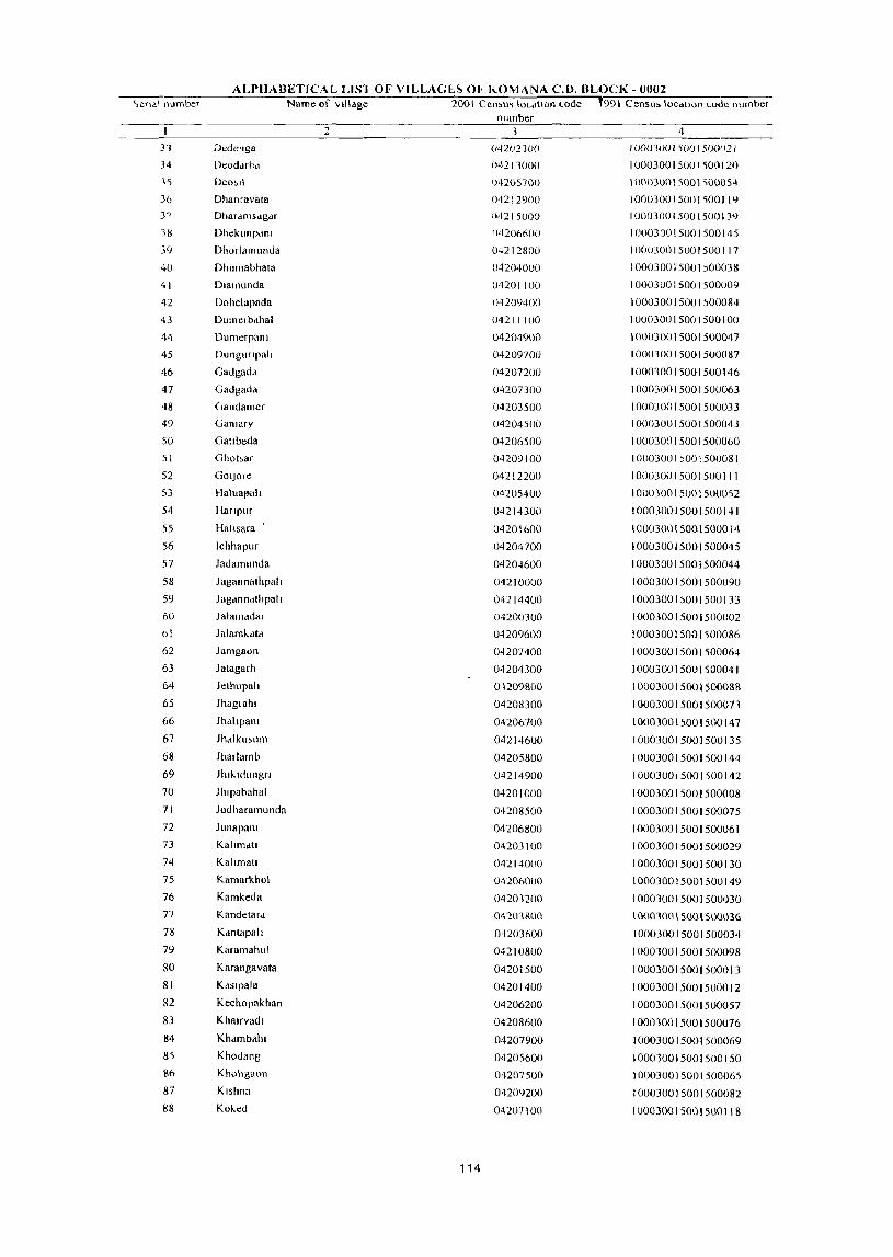
ALPHABETICAL L1S1 OF VILLAG(;~ 0(' KOMAN A C.D. BLOCK - OllO2 c,eq<\\ I1lllnber Name of village 2001 Cell'u~ IOl-dUOIl Loele t991 Censll' locatIOn Lode nllmbeT
number 2 3 4
33 Dedenga (,42(1210() 1 00U3UOI SOO / 50(1)2 1 34 Deoddri1d {)42/3000 100030015001500120 \5 Deo~l\ 04205700 10003001S()01~0()OS4
36 Dhanravata 04212900 /000300/ SOO / '100119 3 7 DhaTdmsdgd[ 042/5000 100030015001500139
38 Dhekullpdlll (14206600 /00030015001500145
39 Dhorlamunda 04212800 100030015001500117
40 Dhumabhata 04204000 I OOOJOOI 5(01)00038
41 Dlamunda 04201100 1000300lS001500009
42 Dohelapada 04209400 100030015001500084
43 Dumelbdhal 04211100 100030015001500100
1\4 Dumerpam 04204900 10003001 SOOI 500047
4S DlIngurlpall 04209700 100030015001500087
46 Gadgadd 04207200 100030015001S00146
47 Gadgad<1 04207300 100030015001500063
48 Gandamer 042OJSOO 100030015001500033
49 Ganlary 0420450(J 100030015001500043
50 Gallbeda 04206500 10003001500lS00060
51 Ghobar 04209100 100(3001)001500081
52 GOlloTe 04212200 1000300150015001 I I
53 !-laillal'ult 04205400 100030015001500052
54 lIanplir 04214300 100030frl5001500141
S5 Hallsara 04201600 100030015001500014
56 Ichhapur 04204700 100030015001500045
57 ladamllnda 04204600 100030015001500044
58 Jagannathpall 04210000 100030015001500090
S9 Jagdnndthpall 04214400 100030015001500133
60 Jalanlddal 04200300 100030015001500002
61 Julam\...dtcl 04209600 100030015001500086
62 Jamgaon 0--1207400 100030015001500064
63 Jatagarh 04204300 100030015001500041
64 Jelhupalt 01209800 100030015001500088
65 Jhagl ahl 04208300 100030015001500071
66 Jhdltpanl 04206700 100030015001500147
67 Jhdlkll,lIlTI 04214600 100030015001500135
68 Jharlarnb 04205800 IOO0300lS001500144
69 Jhlkldllngrt 04214900 10003001500J500142
70 Jhlpabahal 04201000 100030015001500008
71 Jodharamllnda 04208500 1000300lS00150007S
72 Junapanl 04206800 100030015001500061 73 Kallmdll 04203100 100030015001500029 74 Kallmatl 04214000 100030015001500130 75 Kamarkhol 04206000 100030015001500149 76 Kamkeda 04203200 I 0003001 SOOI 500030 77 Kandetard 04203800 10001001 50()\ SOOIH6 78 Kdntapall 04203600 100030015001500034 79 Karamahul 04210800 100010015001500098 80 Karangavata 04201500 100030015001500013 81 Kdslpala 04201400 1000300lS001500012 82 Kechopakhan 04206200 1000300lS001500057 83 Khalrvadl 04208600 100030015001500076 84 Khdmballl 04207900 1000300lS00lS00069 85 Khodang 04205600 IOOO10015001S00150 86 Khohgaon 04207500 100030015001500065 87 Klshna 04209200 100030015001500082 88 Koked 04207100 100030015001500118
114

ALPHABETICAL LIST OF VILLAGES OF KOMANA C.D. BLOCK - 0002 Senal number Name of Village 200 I Census location code 1991 ('en~lls location code number
number 2 3 4
89 Komana 04211900 100030015001500108
90 Konabrra 04211500 100030015001'00104
91 Kotenghatbodachhapar 04211300 100030015001100102
92 Kotrabeda 04206100 1000300150015000S6
93 Kllmutlmunda 04208200 10003001~OO1500072
94 Kureswar 04208700 100030015001<;00077
95 Lamblpam 04214500 100030015001500134
96 Larkl 04203400 1000100150(11100032
97 Latkanpada 04201300 100030015001500011
98 Mdhulbhata 04210100 100030015001100091
99 MaJhagaon 04205300 100030015001100051
100 Makhapadar 04202500 10003001100lS00023
101 Manrkaguda 04204400 100030015001500042
102 Matlapadar 04212600 100030015001S0011<;
103 Mendhatal 04202400 10003001 <;001500022
104 Mlchhapah 04208000 100030015001500070
105 Mundapala 04201200 100030015001500010
106 Musapah 04204100 100030015001<;00039
107 Nuagaon 04203300 100030015001500031
108 Pal'lsipanr 04201800 100030015001500016
109 Pahlpam 04215100 10003001,00150013B
110 Pandarapathar 04209500 10001001500150008'
III Pandelbahalr 04211600 10003001<;001500105
112 Patapam 04210100 1()O()300\5001~OO092
113 Pendraban 04214700 1000300150015001,6
114 POlllf 04210500 100030015001500095
115 Raghupah 04211800 100030015001500107
116 RaJaHa 04213900 100030015001500129
117 Rang 04209300 100030015001500083
118 Ruplamba 04205500 100030015001500053
119 SahaJat 04201900 100030015001500017
120 Sandabahalt 04212400 1000~0015001500)13
121 Sarasmal 04202200 100030015001500020
122 Sernelpah 04202900 100030015001500027
123 Sialatr 04200700 100030015001500005
124 Sibanarayanpur 04205900 100030015001500055
125 Slhmamunda 04204200 100030015001500040
126 Stletpam 04205200 100030015001500050
127 Solbandh 04212000 100030015001500109
128 Soseng 04206300 100030015001500058
129 SlIkuhmundt 04202700 100030015001500025
130 Sunabeda 04206900 )00030015001500062
131 Talabela 04200400 100030015001500003
132 Tarabpd 04201700 100030015001500015
133 Telenpah 04202100 100030015001500019
134 Tenganabasa 04209000 '10003001500 I 500080
13S Tetelpada 0410080() 1000300\5001500006
136 Thogapah 0420280() 100030015001500026
137 Thongo 04208100 100030015001500071
138 Thutlbar 04201000 100030015001)OQD2R
139 Tlkrapada 04209900 100030015001500089
140 Ulva 04212100 100030015001500110
141 Upkapam 04207000 100030015001500148
115

n . " " is -0 ~
I 0 <> u '" ill .a " " 0 2- 0)
~ u U '" ;:; 0 bI)
...l ~ 0 t!, "d ;>
'" '" § 01) -s ~ g ~ '-~ 0 .0 :;
12 '" g-" -'0 ~ " 0-
';;j OJ
~ <ii
.. ~ c '0 " I-< I-< Vl
1 2 3 4
CD Block: Kom.nn (0002)
Gdngadlgalh (04195700)
368
KhaJlU b.hal (04198100)
2420 327
Tengandbasa (04198200)
4910 879
~amarslllg 4 5440 960
(04198300)
B1loJPUtghall 1170 229
(04198400)
SID.palt 404 6
(04198500) 3620
Kusadona(Kusada 927 7 3500
halla) «()4198600)
Chohukftpada 4040 759
(04198700)
9 Llllld.h. (04198800)
1800 726
Daldah 10
(04198900) 2080 614
DISTRICT CENSUS HANDBOOK NUAPADA •
Census of India 2001 -Amenities and
AmenitieS available Ilfnot available within the village, a dash (-) IS shown In the Ll)jumn an j next to It In braci-.ers the dl;tan~e 111 broad range; VIZ <_ 5 kms , 5-10 kms and 101 km; ot II ~
~ nearest l)ldCe where the facility IS avaIlable I; gIven ~ I '" '" t;~ " iii I u
OJ OJ e " " ;:; ] u 0::
~ '5 ~ 1: <:> 0 -t!, .a ,!,! 0 1A '"' 0- :; 0.
'" '" (.) -c/)
~ {j 11 "'- e -~ ~
"0 ~ @,~ 2 ~ E " " -0 '" " ~ .. ..c: iii u , '" :; ..c ~
~ ~ 1A -0 0:: " U 0 t:: 0 i3 1>6 ..g g 0::
" ~ ..c: iii " 0 " 0 0 ..c: .. 0- --' ~ .~ :> -g ~ .:>
'" <ii i6 '- -0;
" I;j, ~.a u o " g § « a 1;; 0 0/) <> .=: ~ g~] il g <ii " 11 " ~,
..0 u J2 12 ~ " u E '" § u -a E -'" u ~ ~ g ~ ~4 " " Vi ~~ iil " t:: g: o Iii ,~(3 s :z ::E Q U..o U '" ~c/)
5 6 7 8 9 10 II 12 13
86 PM«5) H(IO+)
WS~-W PH 1'0«
CM(IOr) At S(IO+) (V(IO+) [I~(IO')
qIO+) MCW(IO+) 5) CP(IO.)
NCS(IOr) SP(lO+) RS(IO+)
PII(,(IOr) OCS(IO') s r(lo+) NW(IGTj
71 P M(5-10) 11(10 r) IIPWTK I'll
(,M(ID+) AC~( lOt) CV(IO+) 1I'(IOr)
qlUr) MCW(IO+) ,5-IIP PO(IOT) CP(IO+)
NCS(IO+) SP(IOt) R,(IO')
1'1I<(lOt) OCS(IO+) 5f(10 .. ) NW(IOT)
205 P MqIO+) H(IOt) HPWH ..
PO(5-10) CM(IOf) ACS( lOT) CV(IO+) BS(5-1O)
MCW(IOr) 5S-HP PII(IOf) CP(IO+)
NCS( 10+) SP(lO t ) RS(IO' ) PHC(IOt) OC~(IO') S f( 10+) NW(IO;)
PII~ Il( 10 t) IIPWTK PIII'0(5- A"(IO,) eV(IOI) B~(' 'J 232 P M l (lOt) MCW(IO+) CM(5-1O)
PIIC(IOt) ,S-HP 10)
CP(5-10) NCS(IOq 51'(10+) R~(5-10)
OCS(IO, ) Sr(IO+) NW(IO')
P M« 5) C(5- H(IOt) IIPWTK PH 1'0(5- ACS( lOt) CV(IO.) B5
52 CM(5-10) R~(IO') 10) MCW(IOT) .':.~-HP 10) NC~(IOt) ,,>( 10,)
Plle(IO+) CP(5-10)
OCS(IOt) 5 r(IOt) NW(IOt)
90 PM(5-1O) H(IO+) IIPWTK PH 1'0«
CM(IO+) ACS(IO+) CV(IO+) 85(<.5)
qIO+) MCW(IOf) 5S-IIP 5) NCS(IO+) SP( 10+) RS(IO+)
PHe(lO t ) CP(lO+)
OCS(IO+) ST(IO+) NW(IO,)
220 P M(<.5) H(lO+) HPWTK
PO« 5) CM(IO+) AC5(10') C V(lOt-) BS« 5)
C(lO+) MCW(IO+) SS-HP PH(IO+) CP(IO+)
NCS(IO+) SP(IO+) RS(IOI) PHC(IO+) OC5(10') 5 r( 10+) NW(IOt)
177 P M«5) H(ID;) III' W TK C PH PO«
(M(IO+) AC5( 10+) CV(IO+) AS« 5)
qlOt) MCW(IO.) 5S-liP 5) CP( 10+)
NCS(I!H) 51'(10+) RS(lO r ) PIICC 10+\ OCS(IOt) ST(IO .. ) NW(I!H)
166 P M« 5) H(IOt) HP W 1K C PH 1'0(,--
CM(IO,) AC5(lO t ) CV(IOT) 85« 5)
qlOt) M(W(IO+) 55-HI' 5) Cpr 10+)
NC,(IO+) 51'(10+) RS(lOt) PII( (10') OCS(IO+ ) ~l (lOt) NW(IOt)
PM«5) H(IO+) HI' W fK C PH PO« ACS(ID+) CV(ID+) B5
129 CM(IO+) RS(IO+) C(lO+ ) MCW(IO') S5-HI' 5) NC,(ID+) SP(IOt)
PHC(IO+) CP(IO+)
OCS(IO+) ~l(lO') NW(IO+)
116
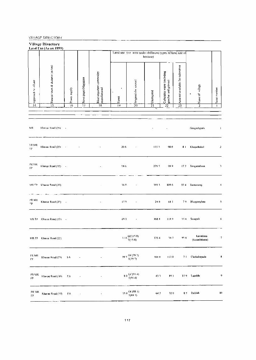
VILL AGE DIHECTOR (
Villal!.c Directory L,,,d l'" (A, "" 199
1 " 0/
~ ? -'" " " e 0-0-·t
14
MR
IRMR
fP
!'RMR
fr
MR rP
PR MR pp
~
" <J
~ -6 ~ c: ~ S i1 :a Z 15
Kh.lla, Roarl (26)
Khona, Road (251
Khanar Road (15)
Khanar Road (20)
Khanar Road (21)
~IR FP KI,""n, Road (22)
MR fP Kha"A' Road (27)
PR MR
fr
PR ~IR
FP
Khallar Road (2'»
Kh."ar ROAd (lll)
PR MR Khona, Road (11) fro
16
FA
FA
FA
17 18
Land lise (I e area under different types of land lise II
hectare)
;;; 1! 0
19
" ~ " , 51 >
C' -0 u ;; OIl
Ji 20
206
946
160
171
6~ I
110 GC(158) 1(158)
197 G( (797) 1(797)
80 GC(914) 1(914)
I ~ 0 Of (88 I) 1(88 I)
117
"1:l
~ "" E ~ 21 ..
1151
2797
145 1
240
t684
1754
1644
41 1
645
" 0
~ "" > c: '" -6 :;
" " 'U ~
c: - <S V> c::- O) 0)
~ > :;;; 0
6ll '" ~"1:l @
> " !;i '" :;;; <5 t! :a 2-5
c
'" ;3 " ~ '" bD
22 23
980
9R9
t09 (,
68 I
114 <)
147
1130
19 I
120
" OIl
~ :; . ..... 0
" ~ 2
GnlJgadlgarh
81 KhallirballRl
t77 1 cngRnahao:;a
53 4 Samarsmg
79 BhOJPlIrghAt'
11 4 Sll1apalt
91 (,
7 I
179
Ku<odona
(Kusadahana)
Chohakapada
Llmdllu
89 Daldah
6
9
10
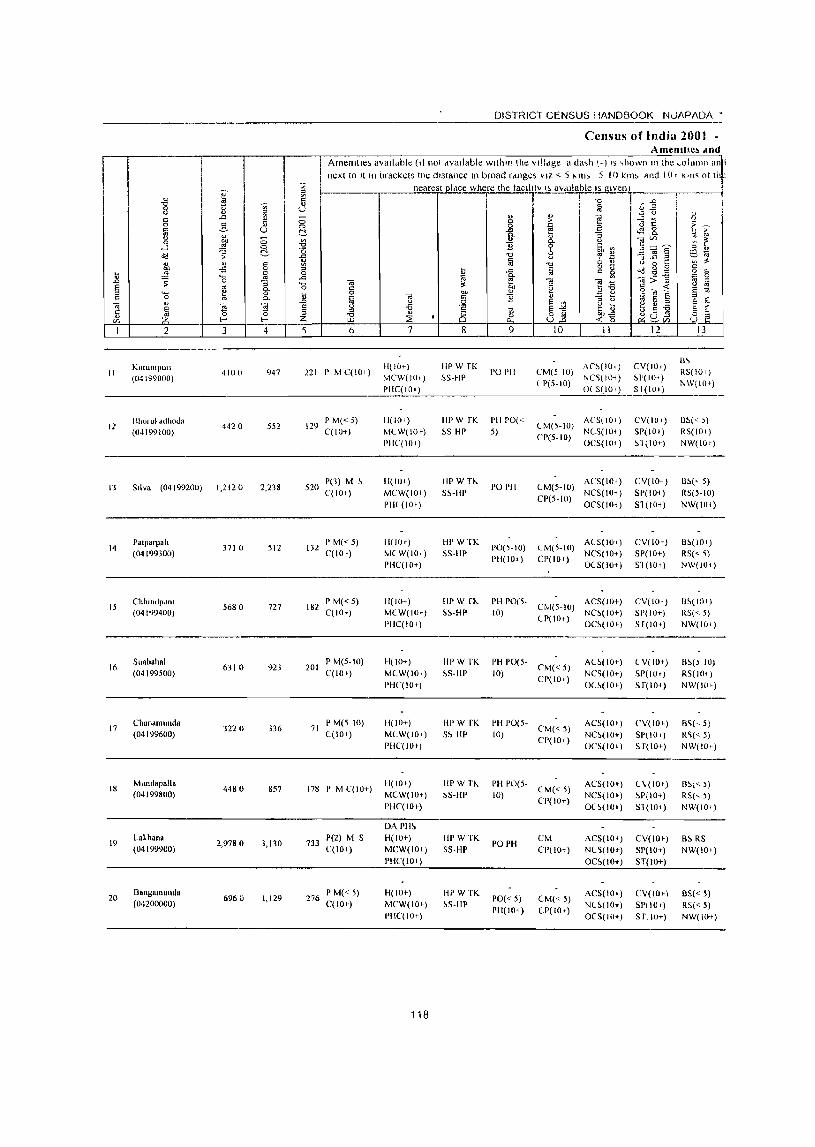
I
II
12
JJ
14
15
16
17
18
19
20
2
KluumpUI~
(04199000)
Blnll u~ ,ulhoda
(04199100)
Silva (04199200)
Palpall,aII (04199300)
CIlhllldpdOl (04199400)
S"abalial (04199500)
Chandmunda (04199600)
Mlilldapalia (04199800)
Lakhana (04199900)
l)ang811lunda (04200000)
I
3 4
4100 947
442 a 552
1,2120 2,238
3710 512
5680 727
6310 923
3220 3]6
4480 857
2,9780 3,130
6960 1,129
DISTRICT CENSUS HANDBOOK NLlAPADA'
Census of India 2001 -AmenlUe~ dnd
Amenllie, aVailable (It not available within the village a da,h i-) IS ,hown 111 the ~Ollll1lll an i
next 10 It 111 brackets tile distance III broad rdnges VIZ <, 5 "tn, 5-! 0 km, find 1 (I, K,n~ 01 Ill'
r-________ r-____ ~n~e=ar~efst~p~ll~a~ce~w:~h~erre~th~e~t~a~cl~iIrtv~I'~a~v~d~ll~arb~le~!s~gll~Ve~l~lr_------r_~ ~. ~o ..a I,
b
221 I' M C(IO+)
129 PM«5) C(IO+)
520 P(3) M ~ C(lO+)
132 I' M« 5) C(IOt)
182 PM«5) C(IO+)
201 PM(5-10) C(JO+)
71 P M(5 10) ((10+)
178 I' M C(JO+)
733 P(2) M 5 C(lO+)
276 I' M« 5) C(lO+)
7
H(IO+)
MCW(IO') PHC(IO+)
11(10') MCW(IOt)
PHC(IO')
11(10+)
MCW(IOt)
PIH (10')
1I(IOt) MCW(IO+) PHC(IO+)
H(IO+) M(W(IOr)
PIIC(JO+)
H(IO+)
MCW(I()i)
PHC(IOt)
11(10+) MCW(IOt)
PUC(IOt)
H(IOt) MCW(IOt)
PHC(lOt)
DAPH~
H(lOt) MCW(IO+)
I'H(,(IO+)
H(IOt)
MCW(IO') PllC(IO+)
118
8
liP W TK SS-Hl'
flPW rK ~S HI'
IIPWH,
SS-IIP
HI' WTK SS-HI'
HI' W rf.. ~~-HP
HI' WTK ~S-IlP
HI' WTK
S~ HP
IIPWTf.. ~S-HP
lIPWTK 55-HP
HP WTK ~S-llP
~ ~ (~ ..E ~:: 0 -" ~ (j t:: <0 0 ~. "'-
9
POPH
I'll 1'0« 5)
1'0 PH
1'0(5-10) PU(IOt-)
10 11
CM(5 10) AC~(IOI) (1'(5-10) NC~(I\)<)
OC5(101)
CM(5-1O) ACS(IO+) CP(5-IO) NCS(IO<)
OCS(IO<)
Uvl(5-10) AC5(10+) CP(5-10) NC5(IO+)
OC5(IOt)
CM(5-IO) A( S(IO+) CP(lO r ) NCS(IO+)
0(5(10+)
PH 1'0(5- CM(5-IO) ACS(J()+)
10) CP(IO+) ~~~i:~:~
PH 1'0(5-10) ('1\1« 5)
CP(IO')
PH 1'0(5- CM« 5)
10) CP(IO+)
PH 1'0(5- CM« 5)
10) CI'(IO+)
POPH
1'0« 5) PH(IO+)
CM CP(IO+)
CM« 5) CP(IOt)
A(~(IO+)
NC~(IO+)
OC~(IOt)
ACS(IO+) NC~(IO+)
OCS(IO')
ACS(IO') NCS(IO+)
O(~(IO')
ACS(IO+)
NC~(IO')
OC~(IO+)
ACS(IO+) NU(IO+) O(S(IO+)
'Cd C/.l
~ ~ E -3 ...c: ==' () 0 r: ~ ~ g cd "> 15 g -- ~ ~~ S § i~ 5 -g ;~i15
12
CV(IOI)
~I'(IO')
S I(IU')
C,/(IU+)
SP(I 0 I) ~1(10+)
CI/(IO<) SP(I01 )
Sl (10+)
CV(IO.) SP(IO+) Sl (101)
CV(IO.) SP(IO+)
ST(lO+)
( V(IOt)
SP(IOI)
Sr(lo1)
CV( 10+)
SP(IO') Sf(IO+)
C\;(IOt) ~P(IO+)
Sl(101)
CV(IOt)
Sr(lo+) ST(IO+)
CV( lOr)
sri 10+) Sr,IOT)
13
B~
RS(IO' )
NW(IOt)
I)~« )
RS(IO' )
NW(IO')
B~(' 5) R5(5-10) NW(Hlt)
B~(IO+)
R5« 'i)
NW(JO.)
I)~(JOI )
RS(<- 5)
NW(IOt)
R~() 10)
RS(IOt) NW(IOt)
B~(' 5) R~« 5) NW(IOt)
Il~l< )) R5(~ 5)
NW(IO+)
B~ RS
NW(IO+)
8S« 5) RS« 5) NW(IO+)
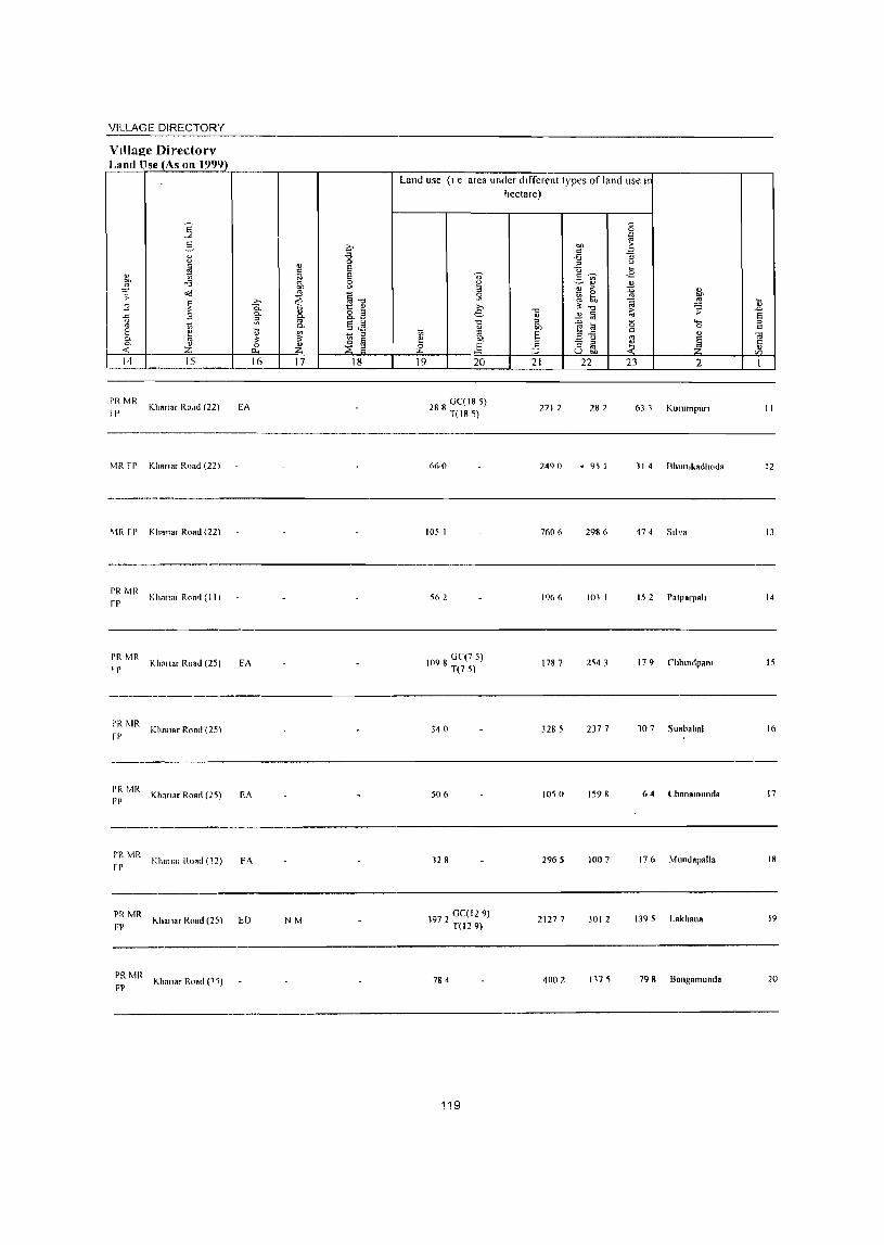
VILLAGE DIRECTORY
Village Directorv Land Use (As 011 1999)
rRMR fP
Kha"., Ro.td (22)
MR fr Khann, Road (22)
\1R fP
PI< MR fP
K hanar Road (22)
Khallal Ro.~ (1 t I
PI< MR Kh""a, ROAd (25) I r
PR MR fI'
PR MR FI'
Kilo,,", Road (25)
Khana, ROAd (2~)
---~---~
!'R MR Kllnll"1 ROAd (12)
fl'
----PRMR
Khallar Road (25) FP
PR Mit Khanar Rond (1 r,)
FP
EA
fA
EA
FA
ED NM
Land use (I e area under different types of land use II
hectare)
288 0C(185) T(185)
105 1
562
1098 0C(7 5) T(75)
340
506
128
1972 GC( 129) n129)
784
119
2712
2490
7606
1966
1787
3285
IDS 0
2965
2127 7
4002
28 2 63 1 KUlumpurl
• 95 1 11 4 Bhlll1lkadhoda
2986 474 Sliva
101 1 15 2 ratparpah
2543 17 9 Chhmdpam
2377 107 Suabahal
1598 64 Lhanamunda
1007 176 Mllndapal1a
3012 1395 Lakh.na
117 ~ 798 Bnngalltunda
11
12
13
14
15
16
17
18
19
20
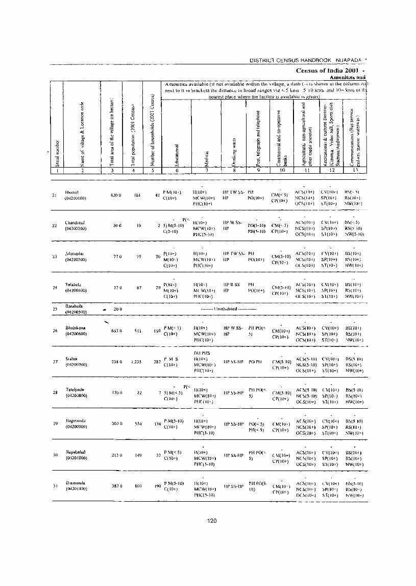
i I i I
21
22
23
24
25
26
27
28
29
30
J I
2
BhdOS!l (04200100)
(halldeaSiI
(04200200)
1.101IIOd81 (04200300)
Tal.bel. (04100400)
Baedbed.
(04200500)
BhalnKona (04200600)
Sidiatl (04200700)
Telelpada (04200800)
Bag.lnUlldd (04200900)
lhlpabfthal (01201000)
Dlamunda (04201100)
J 4 5
4200 164
200 10
770 75
370 87
20 °
6330 511
23M 0 1,235
1700 22
3070 554
2130 149
3870 803
DISTRICT CENSUS HANDBOOK NUA.PAOA •
Census of lndia 20t» -Amenitle~ ami
Amenltle, dvallable (II not available Within the Village, a ddSh (-, I, shown II1lhe column 'I,p ne"t to 11111 brachcts Ihe distance In broad rdnges VI" < 5 km;; 5 10 krn!> and IO~ kills 01 th~
neare"t olace where the tacllny IS dVdllahle "alven I
6
41 P M(IOI) C(lO+)
11(10+) MCW(IO.) I'HC(IO+)
P« 11(10+) 2 5) M(5~IO) MCWpO+)
C(5-10) PIIC(5-IO)
20 P( 10+) MOO+ ) C(1O+)
20 1'(10.) M(IO-t) C(\()+)
H(IO') MCW(IO.)
PIIC( 10+)
II( 10,)
M( W(lO+)
I'IIC(I<l+)
8 9
Itl' IW S~- I'll
HI' PO(IO+)
liP W S!>liP
PO(5-IO)
PH(~-IO)
liP rw ~~- PH
liP PO(IO')
Ill' R SS
III'
PH 1'0(10+)
-------- Unlllhdbned ------------
110 P M« 5) C(lO+)
287 r M S C(lO+ )
11(10+)
MCW(IOt)
I'HC( 10+)
011 PHS
11(10') MCW(IO') PllC(l(h)
P« 11(10+) 5)M«5) MCW(IOt) C(IO+)
134 I' M(5-1 0) C(lO+)
33 P M« 5) C(JO+)
PIIC( 10+)
11(10 1 )
MCW(IO+)
PilC(5- 10)
1I(IOi)
MCW(JO+)
PIIC(5-10)
HI' W SS- PH 1'0« HI' 5)
HI' ~S-HP 1'0 I'll
III' ~~-HP PH 1'0« 5)
HI' ~S-HP 1'0« 5) 1'11« 5)
liP SS-HP I'll 1'0(,,-
5)
10 II 12 n
CM« 5) CP(IOt)
CM(~ 5)
CP(IO+)
AC~(IO+)
NCS(ltJ+) OCS(IOt)
ACS(IO') NCS(IOt)
OCS(lOI)
AC~(IOt) CM(5-10) NCS(IOf)
Cpr 10') (JL~(IO+)
CM(5-10) AC~(IO')
CP( lOt) ~~~~ :~;:
(,M(IOt)
Cl'(IO+)
ACS(IO+)
NC~(IO')
OC~(IO+)
CV(IO.)
SP(W+) ~ T(lO+)
(V(I(H)
::'P(IO')
~1(IOt)
CV(IO+)
SP(W') HOO+)
C V(IO+)
~P(IO+)
~1(10+)
CV(IO+)
~P(IO+)
ST(IO+)
CM(5-10) AC~(5-1() CV{IO»
(1'(10+) NCS(5-IO) ~P(IO') OC~(HH) ~T(IO+)
CM(5-10) AC~(5 10) (V(loq
Cpr 10+) NC~(5-IO) ~P( 10') 0(5(10') H(lOI)
(M(IO+)
CP(IO+)
ACS(IO') NC~(IO+)
OCS(IOI)
AC~(IO;)
NC~(IO')
OCS( HI.)
CV(IO+ )
~P(IO+)
H(IO+)
(,V(IO+)
SP(IO+)
ST(IO')
B~(~ 5)
RS(IO.)
NW(IO')
B~(~ 5)
RS() (0)
NW(5-IO)
13~(J0 I)
R~(IO+)
NW(lO t )
HS(IOI)
R~(IOt)
NW(IO+)
llS(IO') R~(lOt)
NW(H);)
[\'>(5 10)
RS(IO') NW{IO+)
B~(5-10)
R~(I0t ) NW(IOr)
B~(S 10)
RS(lO t )
NW(lO r )
B5(10))
R~(JO » NW(Wr)
190 PM(S-IO) C(IO+)
11(10. )
MCW(IOt)
PHC(5-IO)
III' 5~-IIP I'll 1'0(5-(0) (,M(lOt)
CP( 10')
AC~(JO')
N(~(l()t)
O(~( 10+)
C V(lO+) ~P(J(h)
ST(JO')
B~(5-1())
R~(lO.)
NW(HH)
120

VILLAGE DIREC roR '(
Villng~ Dh'ectory Lal~_!I~~SonI9~9.~')~ ____ -r ____ '-________ ~~~~~ ______ ~~~~~ __ ~ __ ~ __ .-__________ ,-__ ,
Land use (I e fUca under different types of land use Ir hectare)
II' 1<.)"",", Roar1(55/ J051 408 687 47 81'80s(1 21
Ivm I\Lona, Ro,d ( 16) 204 rhandra,,1 22
-_ ... _-----_._-----------------------------_.
Khana, R,wl (60 ) 1& 4 118 204 4 5 J alamadar 21
II' K,,",,", R,wl (00) 98 42 61 170 Talabela 24
---~----~---~- ~--
Unlllhallited ------------ Ba,abeda 15
-------\
~IR Kha"., Road (42) 687 1380 1099 1165 Bhalukoll8 26
PK MR Klw,", Road (4ll) ED EO 227 1616 316 20 I ","Iat, 27
11 3 113 1 24 1 21 7 Tetelp.da 2R
~1R 485 161 7 704 26 7 Ragmunda 29
Mit Kim,., Road (4,) 81 I 647 34 7 Jh'pabahal 10
"han., Road (14) 418 2128 1(l/4 2R 0 DlamuNla J 1
121
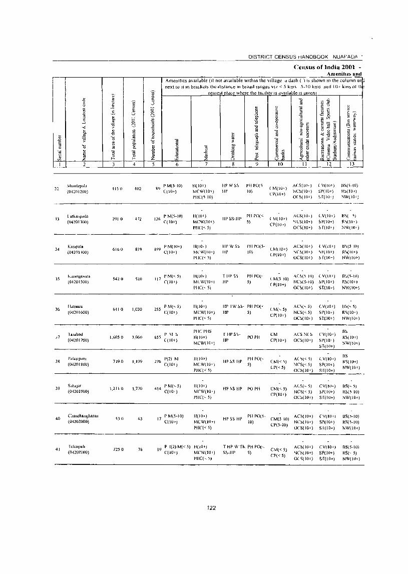
DISTRICT CENSUS HANDBOOK NUAF'ADA •
Census of India 2001 -Amenitle~ 1I11t1
I Amenities avalldble (It not dVdllable with III the village d dash ( ) I, shown III the column a1 next to II In bra~keb the dl,tan~e III brodd ranges VIL < 5 kIm 5-10 kms dnd 10+ kin; 01 II
~ neale,t pld~e where the taLlhtv IS dvalldble IS given i [;l
I -1:; " I ~ ~ 1:5 " I iij ;(J E 0
~ -.) 0 <-
0 " '" 0 " " .e c: ::; c: ;> ""§ :; ~ u
0 2- " 0 c ~ Z U to ~-~ U C!, .e ':'! 8- " ~
" - "'- " -a ~ '" 0 ou {j " "'- 0
~ ~ E rJ ~ 0 0 -l ..!! 0 ~ c 6i, "<i ~ C'.. 0
-0 b '" ;(J edi -'" 0 ::; J:! :3
" " c M la -0 ~ i)
" 0 t: I'l ~
"" .s 0 :> -" iij g g dd-8g c " ..!! ~ 0 t;; II '- -" "'-OJ ~ <a>~ E 0
..0 ~ 0 -a "- '"iii ;$ ~ OJ u ~ § '" 0- 0 c: e 2~ " « ;: "- " 0 0 co " o oj ~
c 0 lil Q. .8 5 '"iii '" ~ " -a t; ~ 5 5 :s ~
OJ " 19 ~ u .Q 8 '"
-~~ 8 '"
~ 8 -a 8 .~ g~ t; 5 -a 8 :S C 0 :> ::l
~ ~ub'l 0"" " ~ Vl E- E- Z U..o U '" I 2 3 4 5 6 7 8 9 10 II 12 13
MUlIllal'ala 402 89
PM(5-10) H(IO') HI' W ~~ PH 1'0(5 CM(IO+)
A(S( 10+) L V(IO'") 1:l~(5-10) 32
(OnOI200) 4150
((HH) MCW(IO+) HI' 10) NC~(IO<) 51'(IOt) R~(IU')
PIIC(5 10) CP(IU,")
O(~( 10+) ~ f(lO r ) NW(IOI)
33 I atkdllpdda
2910 472 126 PM(5-10) 11(10r)
HI' 55-III' PH 1'0«
(M(IO+) ALS( 10,) CV(IO+) B~( 'i)
(04201300) q 10+) MCW(IO+) 5} CP(IO,)
NLS(IO+) SP(IO+} R~(IOI)
PIIC« 5) OCS(IOt) H(IO,") NW(IO I )
34 Kaslpala
61b 0 819 199 P M{lOt) 1l(IOt} Ill' W5~ PH 1'0(5-
CM(IOr) AC-'>(IOt) ( V(IO+) B~(5 10)
(04201100) qIO+) MCW(IO,) Ill' 10) LP(IO+)
NC-'>(IO< ) ~P(IOt) R~(IO+)
PIIC(<- 5) OC5(101) H(IO<) NW(IOr)
35 k..uangavatd
5420 520 117 P M« 5) 1l(IO+} TIII'SS PH 1'0(,
CM(510) A.C!'(5 10) LV(IOI) B:'(5-IO}
(04201500) ('(10+) MlW(IOi} HI' 5) ( P(IO+)
NC~(5-IO) ~P(IO,) R!>(IOI)
PHe(, 5) OC~(IOf) ST(lD+) NW(I(H)
36 HdlJsara
6410 1,030 255 P M(~5) 11(10+) HI' IW 1>~- PH 1'0«
LM(~ 5) AC~(" 5) LV(IOI) U~« 5)
(04201600) C(lOt) MCW(IO+) Ill' 5) Cr(lo+)
NCS(,5) 51'(10+) R~(IOr)
1'11('« 5) ()C~( 10 I) ST(IO,) NW(IOr}
hi Rbod I' M !, PIlC PHS TIIPS'>- CM ACS N(5 eV(IO t)
B~
,7 1,6050 3,060 655 11(10+) PO PII R~(IO,) (04201700) C( 10 f}
MCW(IOi) liP CPt 10 ') OC!'(IO+) SP(IO+)
NW(IOi) Sf(IO+)
Pal,blpilJIl 1'(2) M 1I(IOr) 1'111'0(- A( '>l < ,) CV(IO.) BS
3H 7190 1,1')9 276 liP !,S liP LM«5) R5(IOt) (04l01800) C(IOf} MCW(IO.) 5)
CP« 5) NeS« 5) SP(IOi}
NW(IO,) PIIC« 5) OC!'(IO') Sf(101)
39 S.1ihtjdt
1,211 () 1,770 414 PM(~5) 11(10+)
Hp!>S Ill' PO I'll CM«5) ACS(,5) CV(lO+) BS(<.5}
(04201900) C(IO+) MCW(IOt) Cr(lOl)
NCS« 5) -'>P(IU1-) R5(5 10) I'IIC(,,-S} OC!'(IO+) S f(IO') NW(IO')
40 Chanch8laJharan
530 63 17 PM(5-IO) 11(10+)
HP SS III' PII PO(5-
CM(510) AO(IO+) CV(10 11 BS(5-1O)
(O42ll2000) qlOr) MCW(IOt) 10) CP(5-10)
NC!>(IOr) SP(lOr) RS(5-10) 1'11('« 5) OCS(IO+) SJ(IOr) NW(IO<)
41 ToIenp."
2250 76 19 I' 1(2) M« 5) 1I(IOt) T HP W n .. PH PO(~
CM«5) AC~(I()I) CV(IO+) BS(5-IO}
(O~202100) C{lO+) MCW(IO+) S-'>-HP 5) CP«5)
'1C~(IOt) 51'(10+) RS(~ 5) PUC(,5) ()L~(IOl) Sf(lOr) NW(IOi)
122
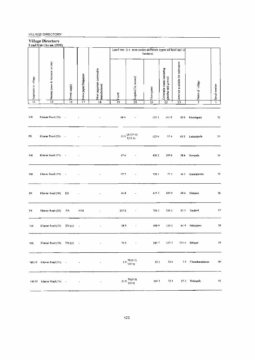
VILLAGE DIRECTORY
Village Directorv Land UseJAs on 1999)
14 15
~IR Kh.na, ROdd (10)
PR Killin., Road (22)
!VIR KhallB' Road (1~)
!VIR Kha,,", Road (17)
PR Khan., Road (30) ED
i'R Khan., Road (35) EA
16
MR Khan.r Road (25) ED EO
MR Kiln,,", Road (30) ED EO
MR FP Khm.ar Road (21)
~IR FP Khanar Road (1(,)
17 18
N!VI
Land use (I e area under different types of land use Ir hectare)
19 20
68 (>
339 0 (,(114) T(13 4)
476
977
468
2476
589
745
59 TK(O I) T(O I)
210 TK(O 4) T(O 4)
123
21
155 1
1236
4202
150 1
4253
750 I
498 9
5857
15 2
1041
22 23 2
1419 500 Mundapala
574 63 0 LalkanpBda
1096
777 16 3 Karangav.ta
1009 68 4 Halls"ra
524 1 83 5 Tarabod
1292 61 9 Palas'p.1lI
2152 3354 S.haJat
240 7 5 Chancharalharan
725 27 2 Telenpah
12
31
34
15
36
17
38
39
40
41
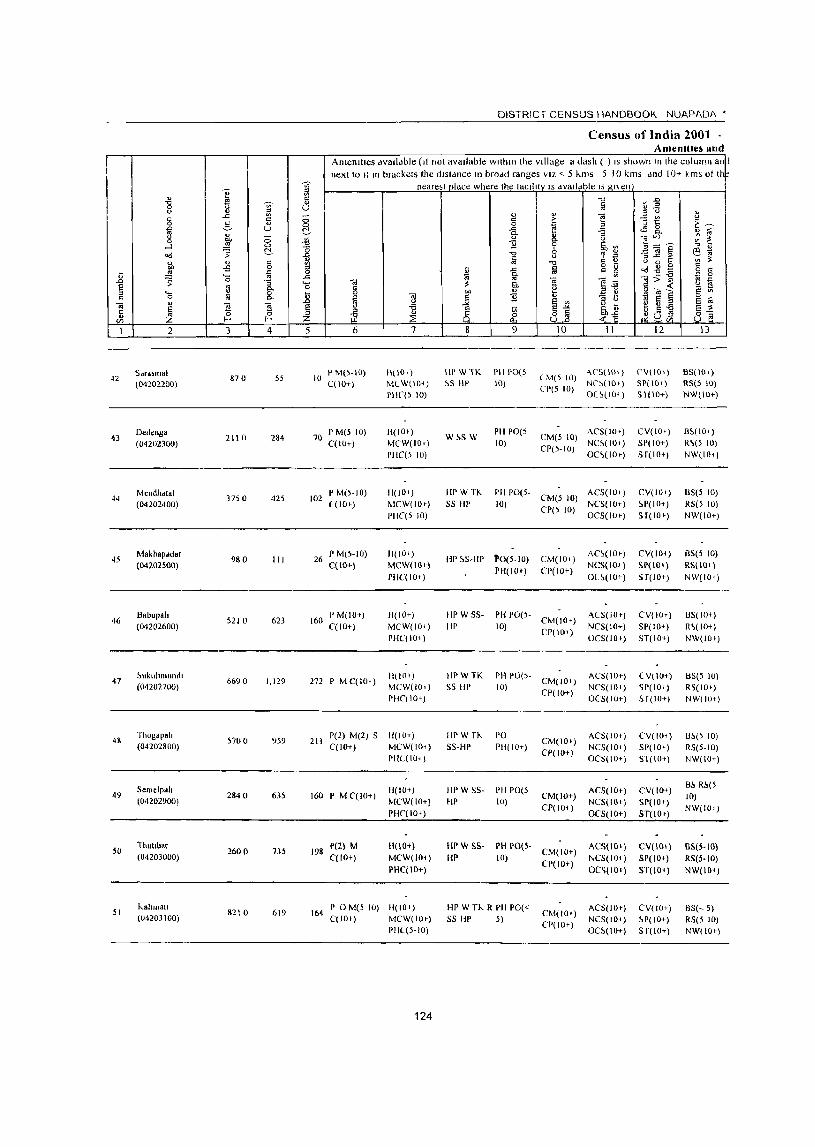
42
43
44
45
46
47
49
50
51
2
Sdrdsmal (04202200)
Oedt!nga (04202300)
Mendlldlal (04202400)
Makhapddar (04202500)
Babupalt (04202600)
~ukuhmundl
(04202700)
Thogap"h (04202800)
Semelpah (04202900)
Thuubar
(04203000)
hahmalt (U4203100)
3 4
870 55
2110 284
37S 0 425
980 III
5210 623
6690 1,129
5700 959
2840 635
2600 735
S210 619
DISTRIC r CENSUS IIAND800K. NUAPADA •
Census of India 2001 -Amenilles and
AmenJlles available (It not available wllhltllhe Village a dash ( ) IS shown In the column all J
next to It III brackets the dlSldnce In brodd ranges VIZ <. 5 killS 5 10 kms dnd 10+ kms ot II nearesl place where Ihe laclllly IS dvaildble IS gnen
5 6
10 P M(S-IO) C(IOT)
70 P M(5 10) C(lO+)
102 I'M(S-IO) l(lO+)
26 pM(5-10) C(IO+)
160 PM(IO+) C(lO+)
272 PMClIO+)
7
11(10,)
MlW(lO+)
PIl((S 10)
11(101)
MCW(lO+)
pHe(5 10)
11(1 0+)
~ICW(IO')
PHC(5 10)
11(10+)
MCW(lIH)
PIIC(IO+)
H(IO+)
MCW(IO~)
PHC(IO~ )
ll(to~ ) MCW(IOt)
PHC(IO+)
211 1'(2) M(2) S fl(IO+) C(IO+) MCW(IO+)
160 P M CCIO+)
198 1'(2) M CCI O+)
PHL(IO; )
H(lO+)
MCW(IO+)
PHC(IO+)
11(10+)
MCW(lO+)
PHC(IO+)
164 I' 0 M(5 10) H(lO+) C(lO') MCW(IO»
1'11((5-10)
124
8
Ill' W TK ~S III'
W~SW
9
1'111'0(5
10)
PllpO(5 10)
10 11
(M(5 10) ~~~~ ~~:~ CI'(5 10) Ol~(IO~)
CM(S 10) ACS(IO+)
CP(5-10) NC~(IOI) OC~(IO')
HPWTK
55 HI' PII 1'0(5- CM(5 10) ACS(IOt)
10) CP(5 10) NCS( 10+) OCS(IIJr)
HI' 5S-HP 'P0(5-10)
PH(IO~)
CM(ID+)
CP(IO+)
HI' WSS
liP PI1 PO(5- CM(IO+)
10) CPt 10+)
IIPWTK
55 III' PH 1'0(5- CM(IO+)
10) CPt 10+)
IIPWTK
55-HI'
PO PH(IO+)
Ill' W 5S- I'll PO(5
HI' 10)
CM(IO+)
CP(IO+)
CM(IO+)
CP(IO~)
Ill' W SS- PH 1'0(5-HP 10) CM(IO+)
CP(IO+)
HI' W Th R 1'111'0« SS HI' 5)
CM(10;)
CJ>(IO+)
AC~(IOt)
NCS(I(l.+)
OC~(IO+)
AlS(IO»
NCS(IO+)
OCS(IO»
ACS(IO+) NCS(IO;)
OCS(IO+)
ACS(IOt) NCS(IO;)
OCS(IO+)
ACS(IO+)
NCS(IO+)
OCS(IO+)
ACS(IO+)
NCS(IO; )
OC~{IO»
AC5(10))
NCS(IO; )
OC5(10+)
12
(,V(IO~)
SP( 10 ,)
SI(IO+)
CV(ID+)
SP(IO+)
ST(IO+)
CV(IO') ~P(lO+)
ST(IO+)
CV(IO+)
SP( 10+)
ST(IO+)
CVI 10+)
51'(10+)
ST(IO+)
l V( 10+)
~P(IO;)
H(IO+)
CV(IO+)
SI'(IO+)
ST(IO+)
CV(ID+)
SP(IO+)
ST(IO»
CV(Hlt)
SP(IO+)
ST(IO+)
CV(JO+)
~P(IO+)
S[(IO+)
13
B5(10+)
RS(S Ill) NW(lll+)
B~( 10')
R'>(5 10) NW(IOt)
BS(5 10)
RS(5 10)
NW(IO+)
BS(5 10)
RS(IO+)
NW{IO~)
05(10+)
R<'(IO+) NW(l!)I)
85(5 10)
R~(IO+)
NW(IO+)
0.'>(5 10)
RS(5-10)
NW(IO+)
B!. R.'>(5
10)
NW(IO+)
IlS(S·IO)
RS(5-10)
NW(IO+)
85(,5) RS(5 10) NW(IOt)
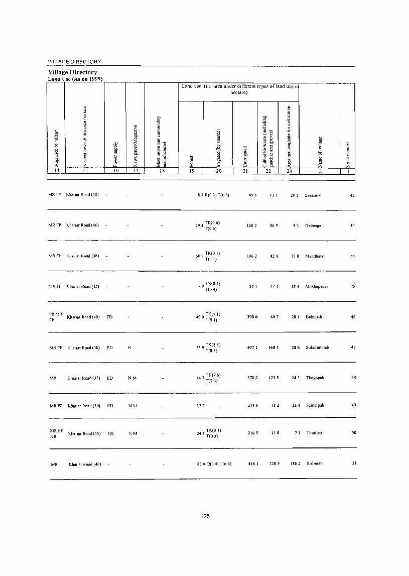
VILl AGE DiRt=CTORY
Villae:c DircctOfl' Land!~(ASon~~1~99~9~}).-____ .-__ -, ________ ~~~ __ ~ ______ ~~~ ______ ~~ __ -, __ ---------r---,
Land use (I e area under different types of land use II
j 2 " u
" ~ on -a d'! :;: ~
8 ~ "" .9 <>
'" ~
2 " p. :. -~ Z 14 15
MR FP I<.h8"a, Road (40)
MRFP
MRfP
MR FI'
PRMR
FP
MR FP
MR
MR FP
MR FP NR
MR
I<.hana, Road (40)
Khn"a, Road (38)
Khana, Road (15)
Khans, Road (40)
KI,ana, Road (3!,)
Khana, Road (3 '>)
Khanar Road (10)
Khana, Road (45)
Khana, Road (40)
16 17 18 19
ED
ED N
ED NM
ED NM
ED NM
20
8 8 R(O 1) T(O 1)
294 TK(O 6) T(O 6)
609 TK(O I) T(O I)
79 TK(O 4) T(O 4)
490 TK(5 I) T(5 I)
559 TK(8 8) T(88)
4 7 TK(7 6) 4 T(76)
172
TK(O 1) 24 I T(O 3}
hectare)
21
45 J
1162
196 2
34 I
3980
407 I
n02
233 I
2165
8360(64) T(6 4) 416 I
125
22
12 I
569
424
37 I
407
168 I
123 5
112
II R
1285
23 2
20 5 Sa,asmal 42
83 Dedenga 43
75 8 Mendhalal 44
184 Makh8padar 45
28 I Babupah 46
286 Sukuhmund, 47
24 I Thogapah 48
224 Semelpah 49
7 I Thutlba, 50
1862 Kahmatl 51

52
53
54
55
56
57
58
59
60
61
62
2
Kamked. (04203200)
NUligaoll
(04203300)
LaJkJ (04203400)
Gandamer (04203500)
KaniRpal1 (04203600)
08"oJholo (04203700)
Kanuetara (04203800)
BudlukomU8 (0420)900)
Dhumabhata (04204000)
Mllsapa" (04204100)
Slhmamund,a (04204200)
3 4
6070 1,011
5200 1,473
2820 391
5160 872
5070 733
372 0 882
8360 2,122
3870 1,528
2520 619
liS 0 26S
5910 817
DISTRICT CENSUS HANDBOOK NUAPAOA •
Census of India 2001 -Amenities and
Amemtles avalldble (If not available within the village, a dash (-) IS shown In the column !I.lJi nexlto It In brackets the dl~tan,-e In broad rdngcs VIL < 5 kill, 5 10 "Ill' and 10+ kills 01 '1*
nearest place where the taclhly~!s available IS g_lven
5 6 7
239 P M L(IO,) H(IO+)
MCW(IO+)
PHC(5-tO)
II( lOt)
M(W(IO+)
PIIC(5 10)
104 I' M C(5.10) H(IO') MCW(IO+)
217 I' M C(IO+)
191 PM S C(lOt)
PIIC(5-10)
Pl!~ H(lO+)
MCW(IO') PflC(,5)
H( 10+)
MCW(IOI)
PHC« 5)
H(IOt) 195 P M C(5-10) MCW(IOt)
PHC« 5)
DA PHS
541 I' M S C("- 5) H(IOt) M(W(IO+)
PHC« 5)
I' M S PUC Pile PfI~ 329 H(IOr)
C(IOc) MCW(IOi)
136 P M« 5)C« H(IO+) 5) MCW(IOt)
PHC« 5)
67 I' M« 5) C« H( lOt) 5) MCW(IO+)
PHC« 5)
170 PM{<5) C(lOt)
II{IO+)
MCW(IO+)
PHC("" 5)
126
8
HPWS5
liP
T IIPTW
55-HI'
9
1'0(5-10)
PH(lO+)
PO Pit
10
(M(IOr)
CP(IO+)
CMeIO+) CP(lOt)
II
AC~(IOr)
NC~(IO' ) OCS(IO+)
ALS(IO+)
NO(IO+)
O(S(IO')
HpW IK SS HI'
PH 1'0(5- CM(IO+)
10) Cp( 10+)
ALS(IO+)
NCS(IO+) OC5(10+)
T IIpTW
W SS-III' pOI'H CM(IO')
CP( 10+)
ACS(IO+)
NC~(IO+)
OCS(IOr)
HI' W SS· PH 1'0(5-HI' 10) CM(IO+)
CP(lOt)
AC~(IO+)
NCS(IOt)
OC5(10+)
T HI' W 55- PH 1'0(5- CM(5-10) ACS(lOt)
HI' 10) CP(IO') NCS(IO+) OCS(lOt)
HI'WTK
SS HI' PO PH
III' W1I.. PO S5-Hp PH(IO+)
III' W C SS· PH PO« HI' 5)
~~ W C SS 1'0«,)
PH(IO+)
Ill' TW S~- PH 1'0«
liP 5)
ACS(IO+)
NCS(IO') OCS(IO+)
CM [1'« AC~(IOI)
5) N(~(IO+j
OC5(IOq
CM(5-10) ACS(IO+) CP( 10+) NCS(IO+)
OC5(10+)
CM«S)
CP« 5)
CM« 5) CP(IO+)
ACS(IO+)
NCS(IO+ )
OCS(IO+)
AC~« 5)
NC5« 5)
OC5(10+)
12
CV(IO')
SP(IO+)
ST(IO+)
LV(IO+)
~.P(lO+)
!>T(IO+)
(V(IO+)
51'(10+)
ST(IO+)
CV(IOt)
SI'(IO+)
ST(IO+)
CV( lOr)
SI'(IO+)
sr(lO+)
CV(IO+)
S['OO+)
S1(10 t )
51' CV(IOt)
ST(IOt)
CV(IO+)
5P(IO+)
ST(IO+)
CV(IO+)
SP(IO+)
ST(IO+)
CV(IO+)
SP(IO+)
ST(lD+)
(V(IOt)
!>P(lO+)
S f( 10+)
13
B5(10+)
RS(IOt)
NW(IO+)
B~(5-1(l)
R~(IO')
NW(lOt)
BS RS(IOt)
NW(lO+)
85(5-10)
R~(I0+)
NW(JOt)
BS(IOr)
RS(IO+)
NW(IOt)
BS(5-IO)
RS(IO+)
NW(IOt)
BS RS(IO+)
NW(IOtj
B~
RS(IOt)
NW(IO+)
B~(5-10)
RS(IO+)
NW(lOt)
B5« 5) RS(IO+)
NW(IOt)
B~(' 5) R~(IO')
NW(IO+)
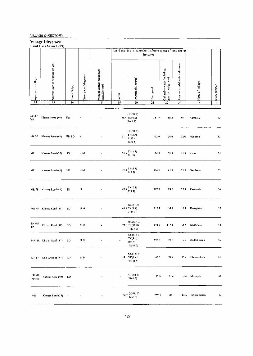
VILLAGE DIRECTORY
Village Directol'V Land lise (As on 1999)
·~-~lr------r-----'-----------~L~a~n~d~u~se~(~I~e-a~r=e~au=n~d~er~~dlt~~-r-el-lt~l~y-p-e-s-o~f~la-n-d~u-se--l1lr-------------'---~
MRII'
NK KhAnar Road (40) FD N
MR FP Khanar Road (40) ED EO N
MR Khanar Road (30) EA NM
MR Khan.r Road (40) ED NM
MR FP Khanar Road (4 I) ED N
MR FP KhanRt Road (41) ED NM
PI'MR Khall"t Road (40)
FP ED NM
MR NR Khanat Road (4~) ED NM
MR FP Khallaf Road (1,) ED NM
PR MR ~PNR
Khanaf Road (4()) ED
MR Khanaf Road (35)
OC(394) 864 TK(4 8)
T(442)
OC(ll 7)
21 I TK(25) R(124) T(466)
345 TK(I 1) T(13)
428 TK(5 5) T(55)
6 TK(7l) 73 T(7 I)
OC(ll2) 652 TK(4 I)
T(152)
OC(1290) 738 TK(IO 0)
T( 1390)
OC( 1343) TK(84) R(99) T(1527)
OC(1299) 1861K(16)
T(131 5)
OC(613) T(613)
OC(663) 602 T(661)
127
hectare)
3817 502 44 I Kamkeda 52
1939 240 32 0 Nuagaon 53
1745 598 li3 Latkt 54
3940 415 32 2 Oandamet 55
2977 980 374 Kanl8palt 56
2168 59 I 16 I DanaJhola 57
4742 118 I 31 5 Kandelara 58
1953 223 172 Budhtkomna 59
663 224 114 Dhumabhala 60
279 214 44 Musapalt 61
2595 90 I I J 4 6 Slhlllamunda 62
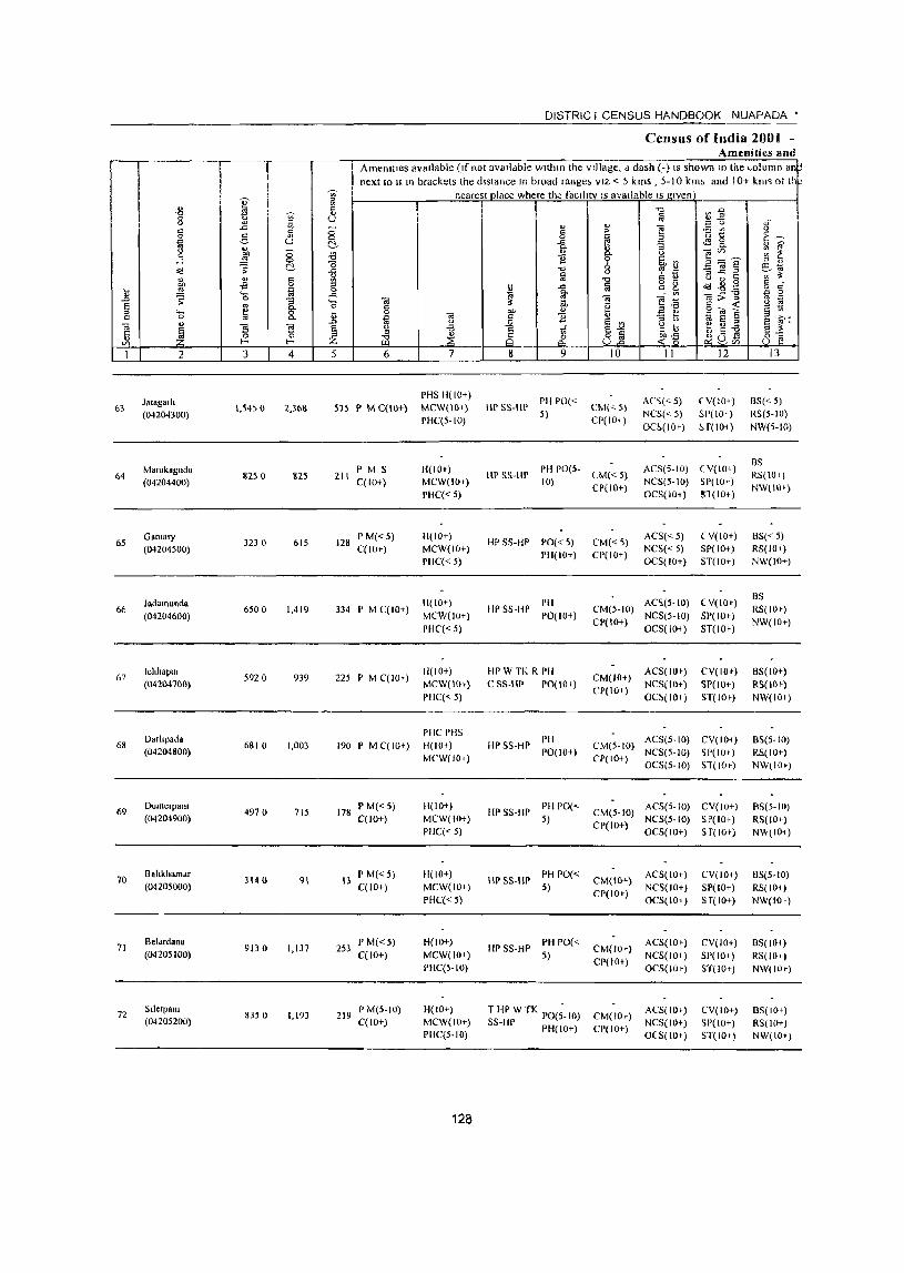
I
63
64
65
66
67
68
69
70
71
72
2
Jaiagalil (04204300)
Mamkagllda (04204400)
G.malY (04204500)
Jadamunda (04204600)
IchhaplIl (04204700)
Darhpad. (04204800)
Dumelpam (04204900)
Bahkhamar (04205000)
Belardan. (04205100)
Slletpalll (04205200)
I .c
" C
3
1.5450
11250
323 °
6500
5920
6810
4970
314 (l
9J30
8350
4
2,3611
825
615
1.419
939
1.003
715
91
1.137
1.193
DISTRICT CENSUS HANDBOOK NUAPADA •
Census of India 2001 -Amenities ;!ud
Amenllies available (Ifnol aV811dbie Wllllln the village, d dash (-) IS shown 111 the ~olumn an next 10 It III brackets the distance In broad range, VIZ < 5 kms , 5-10 km, and I 0+ km~ 01 lh~
nearest place where the facIlity IS available IS given
o o ~
5 6 7
PHS H(IO+) 515 P M C(IO+) MCW(lO+)
211 PM S C(IO+)
128 P M« 5) C(lO+)
334 P M C(lO+)
225 P M C( 10,)
190 P M C( 10+)
178 P M«S) C(lO+)
13 PM«5) C(lO+)
253 P M« 5) C(lO+)
219 P M(S-IO) C(lO+)
PHC(5-10)
H(IO+) MCW(IOt)
PIlC« 5)
H(IO+) MCW(lO+)
PHC« 5)
H(IO+)
MCW(IO+)
PHC« 5)
H(IO+)
MCW(lO+)
PHC« 5)
PIIC PHS 11(10+)
MCW(IOt)
H(IO+)
MCW(IO+) PHC« 5)
Ji(IO+)
MCW(IOt)
PHC« 5)
H(IO+)
MCW(IO+) PIIC(5-10)
H(IO+) MCW(IO+) PHC(S-IO)
128
8 9
liP 5S-HP Pit PO« 5)
10
CM«5) CP(IO+)
II
An(<-5)
NCS« 5) OC~(IOt)
12
(Y(IO+)
SP(IO+)
H(IO+)
HP 55-HP PH 1'0(5- eM« 5) 10) CP(IO+)
ACS(5-1O) (Y( 10+) NeS(5-IO) SP(IO+) OCS(IO+) Sl(IO+)
HPSS-HP PO« 5)
1'11(10+)
IIPSS-HP PH PO(tO+)
liP W TK R I'll
C SS-IIP PO(IO+}
HP SS-li? I'fl PO(IO+)
liP S5-IIP PH 1'0(<-5)
HPS5-IIP PH PO« 5)
III'SS-HP PH 1'0« 5)
THP WTK -S5-IIP PO(5-10)
!'H(lO+)
CM«5) CI'(IO+)
ACS« 5)
NCS« 5) OCS(IO+)
( V(IO+) SP( 10+) ST(IO+)
AC'l(5-IO) (V(ID+) CM(5-10) NCS(5-10) SP(lOe)
CP(IO+) OCS( 10+) ST(IO+-)
CM(IO+)
CI'(IO+)
ACS(IO+)
NCS(IO+)
OC5(10+)
CV(IO+) SP(lO+)
ST(IO+)
CM(5-10) ACS(S-IO) CV(IO+) CP(IO+) NCS(5-1O) ~P(IO+)
OCS(5-1O) ST(IOe)
CM(5-1O) ACS(S-IO) CV(IO+)
CP(IO+) NCS(S-IO) SP(IO+) OCS(IO+) S r(lo+)
CM(IO+) ACS(IO+) CP(IO+) NCS( 10+)
OCS(IO+)
CM(IOe)
CP(IO+)
CM(IOC) CP(IO+)
ACS( 10+)
NCS(IO+) OCS(IOe)
ACS(IO+) NCS(IO+) OeS(lO t )
CV(IOt)
SP(IO+) 5r(10+)
CV(IO+) 51'(10+) ST(IO+)
CV(IO+) SI'(IO+) 5T(10+)
13
BS« 5) RS(5-1O)
NW(5-10)
BS RS(IOI)
NW(IO+)
8S« 5) RS(lOt )
NW(IO+)
8S RS(IOe)
NW(IOt)
BS(lO+)
RS(10 e) NW(IOi)
BS(S-IO) RS(IO+) NW(IOe)
RS(5-IO)
RS(IO+) NW(IO+)
BS(5-10) RS(IOt)
NW(IOt)
BS(JOt) RS(IO,)
NW(IO,)
BS( lOt) RS(IO+) NW(IO+)
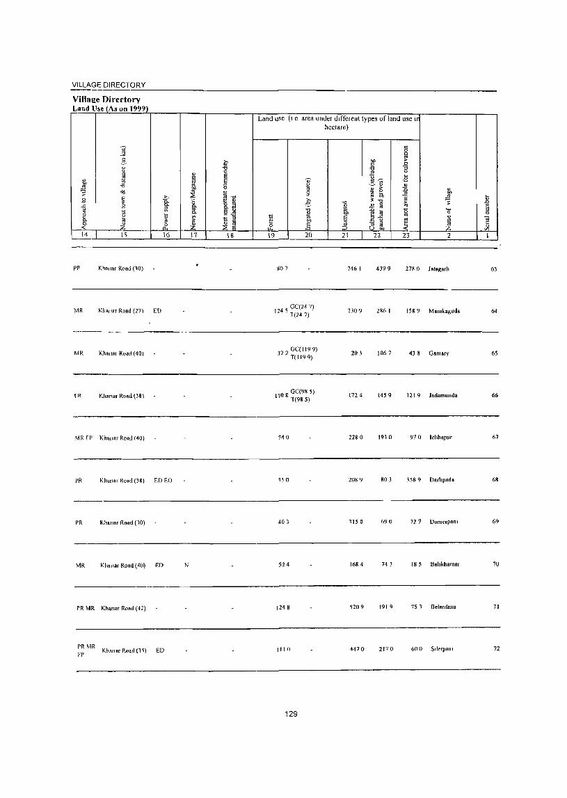
VILLAGE DIRECTORY .~----------------~------------------------------
Village Dirertory Land Use (As on 1999)
14
pp Khanar Road (l0)
MR Khan.r Road (27) ED
MR Khana, Road (40 I
IR Khanar Road (38)
MR fl' Khanar Road (40)
16
PR Khanar Road (38) ED EO
PR Khanar Road (10)
MR Kha"M Road (40) ED
PR MR Khan.r Road (4])
PR MR FI) Khan.r Road (11) ED
17 18
N
Land use (1 e area under dIfferent types of land lise 11
hectare)
19 20
go 7
45 GC(24 7) 11 1(247)
322 GC(119 9) T(1199)
08 GC(98 5) II T(985)
140
130
403
524
1248
1110
129
21
746 I
2309
203
172 4
2280
2089
1150
1684
5209
4470
22
4399
286 I
1067
1459
1910
803
690
743
1919
2170
23
'o
2
278 0 ht.sarh
158 9 Mamkaguda
438 Galllary
1219 ladamunda
970 Ichhapur
3589 Darhpada
72 7 Dumerpam
18 5 Bahkhamar
75 1 Bel.rd."a
600 Siletpatli
63
64
65
66
67
68
69
70
71
72
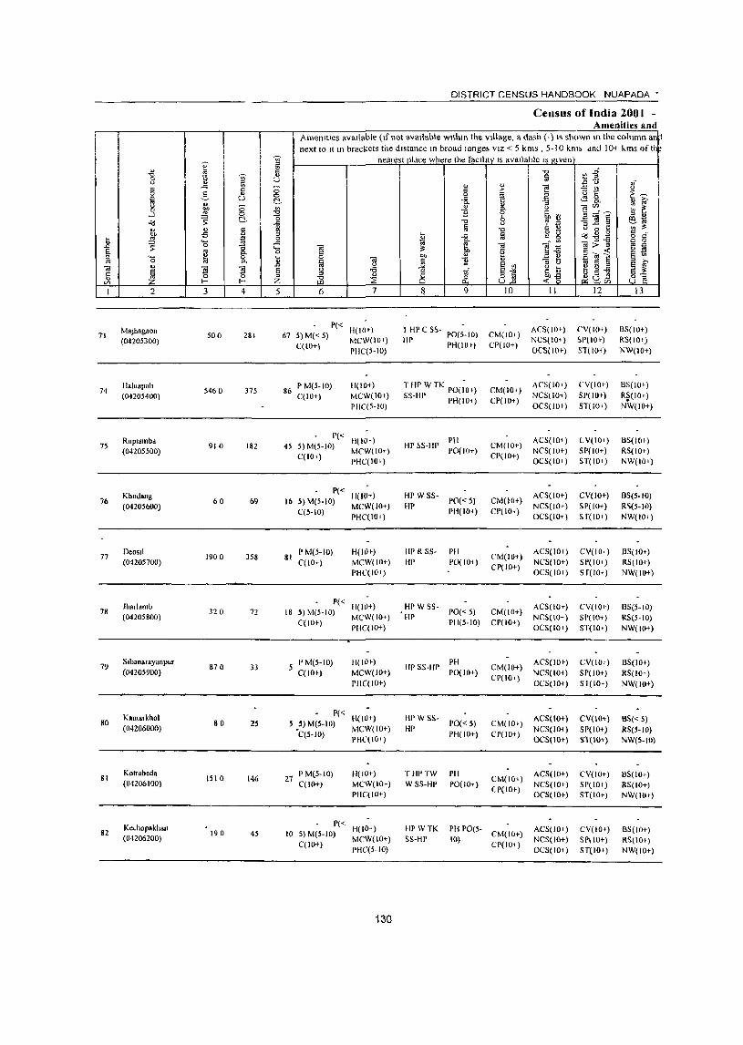
" ~ V)
" l'J " -0 V) " C <.> U <.> " ~ .c -" " C)
0 2, " 0 lil u t!,
" u :;p 8 ~ 0 -' "l ~ t!, -0
.c
'" " § 1;l 00 ;5 " tl '" '- ,g 0
~ 0 ,.c
,.0 13 .... !l ~ 8:
0 '-
" 0 .E '" 01
~ 79 ~ EO
Ii 0 " '" l- I--' Z I 2 3 4 5
MaJhagaon 73
(04205300) 500 281 67
74 lIaJual'ah
5460 375 86 (04205400)
Ruplambd 75
(04205500) 910 182 45
Khodang 76 60 69 16
(04205600)
77 Deosll
1900 358 (04205700)
81
jharlaml> 78 320 72 18
(04205800)
79 5tbanarayanpur
870 33 (04205900)
Kamatkltol 80 80 2S
(04206000)
81 KOlrabeda
1510 146 27 (04206100)
Kc .. hopakhan 82 190 45 10
(04206200)
DISTRICT CENSUS HANDBOOK NUAPADA •
Census of India 2001 -Amenities and
Amel1ltles available (If not available within the village, a dash (-) IS shown In the col limn an:l next to It In brac!(ets the distance 10 broad lange; VIZ < 5 kms , 5-10 krn; dnd 10-1 kms of th
nearest pldce where the facllitv IS available IS given
"0 Vl-g § ~'O " "
oJ 'E! '5 t! u
" :> E~ 0 ~ E! .c <!:g_ " iO' c,
" :;
" §' <.> 'E!"'.~ ~ ~ '2 ~ ~ ~]!l " " '"0 6 " " e~ <.> , '" § '0 " " <.> 0 to: v> i!: g g "l,gB " ~
,.c § 0 d'
~ ~~ OI>~ c 0 01 .. '" 01 i!:
" e £] §(iI-t: !l S 0 00 § '" lil 01 " '2 " " <J
iii EO e EO iO' <.>
~ ~j " " " <.> oS vf ~~ tl ~-a EO i!: " " Q.l(ilS B'§ ;i3 ::E ~ ~'" 6 7 ~ 9 10 II 12 13
P« H(IO') 1 HP C S~- ACS( 10+) (,V(IO+) BS(IO+)
5) M« 5) MCW(IOi) HP
PO(5-IO) CM(lOt) NCS(IOi) ~P(IO+) RS(IO+)
CClO+) PIIC{5-IO)
PHIlO ') CP(JO+) OC5(1O+) ST(IOi) NW(IO+)
P M(5-10) H(lO+) T liP WTK PO(;O,) CM(IOi) ACS(IO+) CV(lO+) BS(IOt)
C(IO+) MCW(lO+) SS-IIP PH(IO+) CP(IO+) NCS(IO+) SP(lO+) R~(I0+)
PIIC(5-IO) OCS(to» ST(lOl) NW(lO+)
P« H(lO+) PH ACS(IO+) eV(lo+) 8S(lOr) 5)M(5-10)
MCW(IO+) HP ~S-HP
PO(IO+) CM(IO+)
NCS(IO+) SP( 10+) RS(IO+) C(IO+)
PHC(IO+) CP(JO+)
OCS(IO+) ST(lO') NW(IOi)
P« H(IO+) HI' WSS- ACS(IO+) CV(IO+) 8S(5-1O)
5) M(5-IO) 1'0«5) CM(lO+)
C(5-10) MCW(lO+) HI'
PH(IO+) CP(lO+) NCS(IO+) 5P(10+) R~(S-IO)
pHe(IO+) OCS(IO+) ST(IO+) NW(lOi )
P M(5-10) H(IO+) flP R SS- PH CM(IO+)
ACS(lO+) CV(IOi) 85(10') C(lO+) MCW(IO+) HI' pO(IOi) NCS(IO+) SP(IO') RS(lO+)
PHC(IOr) CP(IO+)
OCS(IO+) S r(lo+) NW(IO+)
P« H(IO+) HP W SS- ACS(IOr) CV(IQ+) 8S(5-IO)
5) M(5-IO) PO« 5) CM(IO+) MCW(IO+) HI' NCS(IO+) SI'(IO+) RS(5-10)
C(IO+) PHC(IO+)
PH(S-IO) CP(IO+) OCS(IO+) ST(IO') NW(IO+)
P M(5-to) H(IO+) HPS$-flP
PH CM(IO+)
ACS(IO+) CV(IOi) 8S(IO+) C(lO+) MCW(IO+) PO(IO+)
CP(IO+) NCS{IO+) SP(IO+) RS(IOt)
PHC(IO+) OCS(IO+) Sl(IO+) NW(IO+)
P« H(10+) HP W SS- ACS(IO+) CV{IO*) BS« 5)
5) M(S-IO) PO«5) CM(IO+) 'C(S-IO)
MCW(IO+) HP PH(IO+) CP(IO+)
NC5(1O+) SP(IO+) RS(S-lO) PHC(IO+) OC5(10+) ST(IO+) NW(S-IO)
P M(5-IO) H(I()+) THPTW PH CM(IO+)
ACS(IO+) CV(IO+) 8S(10+) C(lO+) MCW(IO+) W SS-HP POe 10i)
(P(IO+) NCS(IO+) 51'(10+) RS(lO+)
PHC(IO+) OCS(IO+) ST(IO+) NW(IO+)
P« H(ID+) HP \v TK PH PO(S- ACS(IO+) CV(IO+) 8S(10+) 5) M(S-IO) CM(IO+) C(lO+)
MCW(IO+) 5S-HP 10) CP(lOi)
NCS(lO+) SPIIO+) RS(IO') PUC(5-IO) OCS(IO+) ST(IO+) NW(IO+)
130
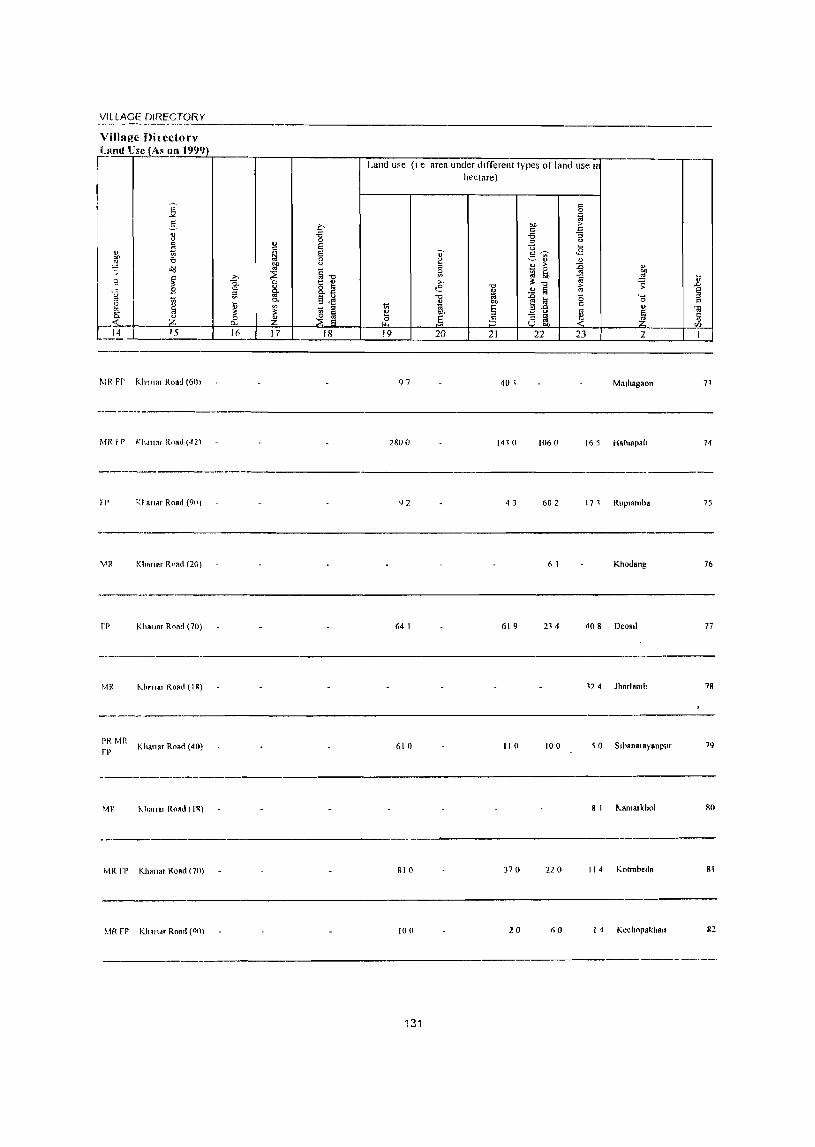
VILLAGE DIRECTORY
Villap.:c Dil cctorv
I\,fR FI' Kh'll1~r Road (60 ~
MR r p n""IOf Rnad (~21
!I' RI aTldr Road (90 ~
\.IR Kho,,"r Road (20)
FP Kh.11.r Road (70)
1'.1R "'"rnar Rond (I B)
----------
PR Mil Khanar Road (40)
1"1'
---~-----
MF ~,I,""a, RnRtlIIR)
MR rr Khanar Road (70)
MR rp Khan,,' Roarl (011\
Land use (I e area under different types of land use In
hectare)
97 401 Malhag80n
2800 1410 1060 16 5 Halnapali
92 43 602 17 1 Rup,amba
6 I Khod811g
64 I 619 234 408 Deosll
'24 Jharlamh
610 110 100 50 S,hana,.yanpur
8 I Kamalkhol
SIO 370 220 I I 4 Kotrabed.
100 20 ('0 I ~ Kechnpakhall
131
._-
71
74
75
76
77
78
79
RO
81
82
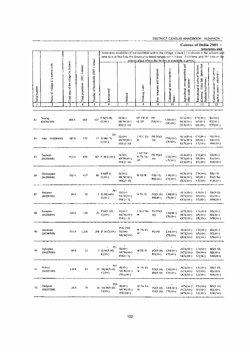
I~ I
83
86
87
gg
89
90
91
o ~ g ....l "<l
" F ~ ti
1 2
~oseng
(04206300)
Ad" (0-1206400)
(iaubed. (04206500)
Dhtklll\pani
(04206600)
Jhnhpalll (01206700)
JlInapanl
(04206800)
~unabed.
(04206900)
Upkapnn! (04207000)
Ko'ed (04207100)
Gadgada
(04207200)
3 4
4&4 0 663
1117 0 379
9120 8~O
2020 417
280 35
4180 150
9730 1.256
490 21
IJ80 53
200 79
5
DISTRICT CENSUS HANDBOOK NUAPI\DA'
Censu5. of India 1001 -Ame.uhe" ~lIul
Amemlle, aVdilctble (If not available wltnll' the Village a da"h ( } l' shown I!' the column ai next 10 II In brac~el~ the dJ,tanl-e In broad ranges VI? < ~ kms 5-10 kms and 10' hm 0' I
nearest plaLe where the tacllJty IS available IS given
6 7 9
" >
!
10 II 12 13
127 P M(5-IO) C(lO+)
H(W+)
MC'W(IOe)
PHC(S 10)
HP rw W PH
~S III' 1'0(10.) CM(IO+)
CP(IO+)
AC!>(IO.> NCS(lOt)
OCS(IO+)
(,V(IO.)
~P(IOt)
S r( JO+)
B~(IOe)
RS(IO,)
NW(lO t )
77 1'« H(IO+) S) M« 5) MCW(IO+) ((10+) PIlC'(5 10)
167 I' M C( lOt)
83 P M(" 5) C(IO+ )
IJ(IIH) MCW(IOt)
PHC(5 10)
H(IOe)
MCW(IO+) 1)1IC(5 10)
P« H(IOt) 5) M(~...jO) ~lL W( 10+)
C(IO+) PHl« 5)
29 P M(; 10) C(IOt)
268 P M C(lO+)
11(104 )
MCW(IOt) PHC(,5)
PIIC PIIS H(IO+)
MCW(IO+)
P« H(IO+) 5) M(S-IO) MCW( 10+)
C(JO+) PHC« 5)
1'(5 15 10)M(S-IU) JI(IO+)
C(IO+) MeW(IO+) PH((IOt)
- P(s- -16 10) M(5-10) H( 10+)
C{IO+) MeW(JO') PUC(lO t )
132
r W C SS- PH 1'0(5
W 10)
I HP1W \V TJ<. ~~HI'
W~S-W
WS~ W
I'H 1'0(5
10)
1'0«5) PH(lO+)
1'0(5 10)
PH(lO+)
I W C S\- PH PO(5
W 10)
W TK ~\ W
WSS W
W 1 Jo. S~
W
POPH
PO(5-IO)
PH(IO+)
1'0(5 JIl)
PH(5 10)
~ 1 J-,. ~~- 1'0(5-10)
PH(S-IO)
CM(lOt)
CP( 10+)
(,M(IOe)
LP(IO')
CM( 10 ')
CP(IO+)
CM(IO+)
CP(I01 )
(M(IO')
CP(IO+)
CM(IO+)
CP(IO+)
CM(IO+)
CP(IO+)
CM(IO+)
Cr(lo+)
CM(104) rp{Hl+)
AC~(IOt)
NC~(IO.)
OCS(IOt)
AU,(lO t )
NC!>(IO') OCS(IO+)
AeS(IOt)
NCS(lQ.)
Oe!>(lO+)
A(~( 101)
NC~(lOtJ
OC~IIO )
AC5(1O+)
NC5(10')
OeS(IO')
;l.CS(IO+)
NCS(IOe)
O(S(lO+)
ACS(IO+)
NC'>(IO+)
OC~(IO+)
AC1.(JO') N(S( 10+) OC5(10;-)
AC\(IU+) NCS(IO+)
OCS(H»)
CV(IO') SP(IOe)
H(lOt)
CV(IV+)
51'(10+)
ST(IO+)
CV(I()+)
'>r(lo+ ) \T(IOt)
l V(IO') ~p( lOt)
~T(IO+)
( V(IO+)
~P(IOt)
5T(IO+)
CV(IO')
~P(lO+)
ST(IO+}
CV(IOt)
SI'(IO+)
5 f(IO+)
CV(IO+) ~f'(10+)
~ 1(10+)
CV(IO+) 51'(1o, ) 5 f( JOt)
B!>(lO+ ) RS(IO,)
NW{IO;-)
I]S(IO t)
R.,(IU+)
NW(IOt)
BS«5) R'i(5 W)
NN(ll't)
B~(5-1O)
R~(IIl')
NW(IOt)
fiS( 10+) RS(J()+)
NW(IOt)
fi~(I(J.)
RS(IO+)
NW(IO')
BS(5-10) RS(IO+)
NW(IOt)
ilS(~ l(l) R!>(H!t)
N\~(IO')
85(5 10) RS(lO+)
NW('O+)
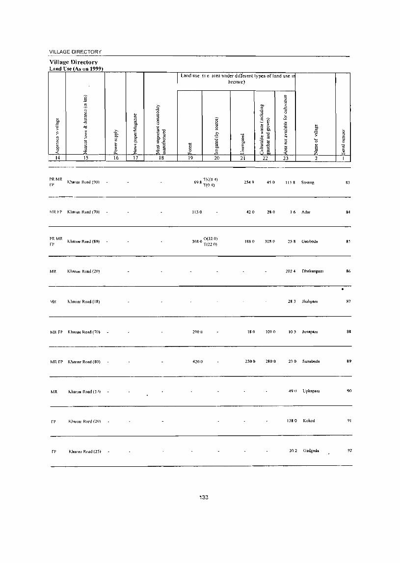
VILLAGE DIRECTORY
Village Directory Lantl Use (As on 1999)
14
PRMR
fP
MRH
PRMR
fP
MR
MR
15
Khan .. Road (90)
Klla".r Road (70)
Khan., Road (80)
Khan., Road (20)
I<..hann, Road (18)
MR FP Khanar Road (70)
MR FP Kha"ar Road (80)
MR Khanar Road (1 7)
fP Khan .. Rord (20)
fP Khannr Road (25)
16 17 18
Land use (I e area under different types of land use In hectare)
19 20
6 8 TK(O 4) 9 T(O 4)
1130
368 0(220) o T(22 0)
2900
4200
133
21
2549
420
1880
180
2500
22 23 2
450 113 8 SO'ieng
280 36 Adar
3080 258 Gallbeda
202 4 DhekunpaOl
28 3 JhahpaOl
1000 10 5 Junapan,
2800 23 0 Sun abeda
490 Upkap.OI
1380 Koked
202 Gadg_da
83
84
85
86
• 87
88
89
90
91
92
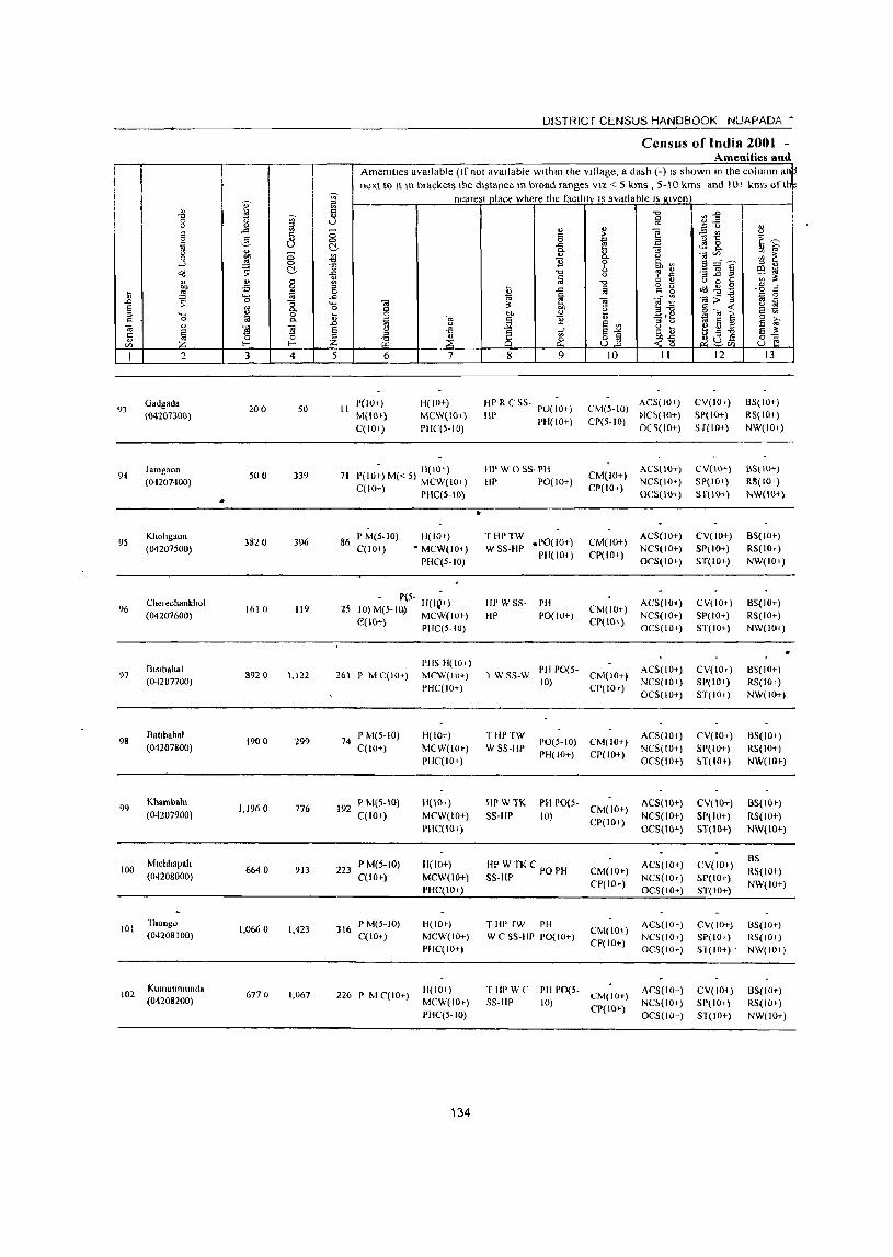
DISTRICT CENSUS HANDBOOK NUAPADA'
Census of India 2001 -Amenities and
Amemlles aVailable (Ifnol available wlthm the Village, a dash (-) IS shown In the column al ~ next to It In brackets the distance In broad range; VIZ < 5 kms , 5-\ 0 kms and 10+ kms of th~
~ nearest place where the faCIlity IS available I, given
" I i '0 ~j '0 ~ iii 0 u ()
'" " c: " u
'" .a g " ] ~::: v.. <> 5 c " n 1:: ~-;:; 0 3 0
~ ~ U ~ -a ..:g 2-"
:; '" '" <> ;::; ., <> ~~ en ~ ~ 0 ~ (OJ C>.
.-l 0 B 0 ~ '" e~,? o<J ~ ~ "0
"0 6 '? ~ III -ii <> w:; ...c ;::l ~'"
~ " c '" iii "0 '" " t) 0 J: '" ~ -Ei 0 :> § g g ,~ ~ .g " c
i; ~ 0 ~ .c: '0
'- -'" ~ i;;; 'iii :> -g ~ 0 -" ;: 0 :; "- '"iii ~ '"iii " ~ E '" 0- 0 g ~ .Ele §"'~ 2 ::l ..... " 0 i; ell " '" 0 Ii! 0.
~ '"iii " B
., :> "
i;i E E 13 ~ " -" <> .Q E '" e v ~ '"iii
~ 'I§ 'T9 § -a 8 ~
E-'" .~~ <> "] E ~ c 0 0 ::l
~ 8] 8;a " f-< f-< Z til ,~ 0 Vi Vl
1 2 J 4 5 6 7 8 9 10 II 12 13
93 Gadgada
200 50 II P(IOt) H(IO+) HI' R C SS- POe ~o+) CM(5·1O)
ACS(IO+) CV(IOr) 8S(10+)
«()4207300) M(HH) MCW(IO+) HI' pH(IO+) CP(5·IO) NC~(IO+) SP(IO+) RS( 10+)
C(lO+) PIIC(5·IO) OCS(IO+) Sf(IO+) NW(IO+)
94 Jamgaon
500 339 71 P(lO~) M« 5) H(lO+) liP W OSS·PH CM(IO+)
ACS(IO+) CV(IO+) BS(IO+)
(04201400) MCW(IO+) HI' 1'0(10+) CP(lO+)
NCS(IO+) SI'(IO+) R8(IOr)
'" C(JO+) pHC(5.10) OCS(IO+) Sf(IO+} NW(IO+)
• 95
KhohgaOIl 3820 396 86
P M(5-10) H(IO+) THPTW .. 1'0(10+) CM(IO+)
ACS(IO+) CV(IO+) BS(IO+)
(04201500) C(IO+ ) - MCW(IO+) W SS-liP 1'11(10+) CP(IO+)
NCS(IO+) SP(IO+) RS(IO+)
PHC(5-10) OCS(IOt) ST(lO+) NW(IOr)
Che. echankhol - 1'(5- -
HI' W 55- PH AC5(IO+) CV(IO+) B5(10+) 96 1610 119 25 10) M(5-1U) H(I~') CM(IO+)
(04207600) MCW(IOt) HI' 1'0(10+) Cp(!O+)
NCS(IO+) SI)(IO+) RS(IO+) e(lo+} PHC(5-IO) OCS(lO+) ST(IO+) NW(lO+)
• I3lslbahal
PIIS III 10+) PII 1'0(5- ACS(IO+) CV(IOI) BS(lO+)
97 892 0 1,122 261 P M C(IO+) MCW(IO+) 1 W SS-W CM(IO+) (04207700)
PHC(IO+) 10)
CP(JO+) NCS(IO+) SI'(IO+) RS(IO+) OCS(IO+) ST(IOI) NW(IO+)
98 BRUbahRI
1900 299 74 I'M(S-IO) H(IO+) T HPTW AC5(10+) CV(IO+) RS(IO+)
1'0(5-10) CM(IO+) (04207800) C(lO+) MCW(IOt-) W 5S·IIP
pH(IO+) CP( 10+) NCS(IO+) 51'(10+) RS(IO+)
PIIC( 10+) OCS(IO+) H(IO+) NW(IO+)
99 Khamb.!l\
1,1960 776 192 P M(S-IO) H(IO+) HPWTK PH 1'0(5- ACS(IO') CV(IO+) B5(10t)
CM(IO+) (04207900) C(IO+) MCW(IO+) SS-HP 10)
CP(IO+) NCS(IO+) SI'(IO+) RS(lO+)
PHC(I(H) OC5(10+) ST(IO+) NW(IO+)
Mlchhapah P M(5-10) 11(10+) HI' WTK C PO PH ACS(IO+) CV(IO+) BS
100 6640 913 223 CM(IO+) RS(IO+) (0·1208000) C(lO+) MCW(lO+) 5S-HP CP(IOr)
NC5(10+) SP(lO t) NW(IO+)
PHC(IO+) OCS(IO+) ST(10+)
101 Thongo
1,0660 1,423 316 pM(5-1O) H(IO+) THp rw PH
CM(IO,) AC5(IOt) CV(IO+) BS(IO+)
(04208100) C(IO+) MCW(IO+) W C SS-HP 1'0(10+) CP(IO+)
NC5(IOT) SP(IO+) R5(10+) PIIC( 10+) OCS(IO+) Sl(IO+) , NW(IO I )
102 Kumutlmunda
6770 1,067 226 I' M C(IO+) 1I(10t) Till' WC PH 1'0(5- ACS(IO+) CV(IO+) B5(10+)
CM(IOT) (04208200) MCW(IO+) SS-HP 10) CP(IO+)
NC~(IO+) SP(lO" ) RS(lO t )
PHC(5-1O) OCS(lO+) S1(10+) NW(IO+)
134
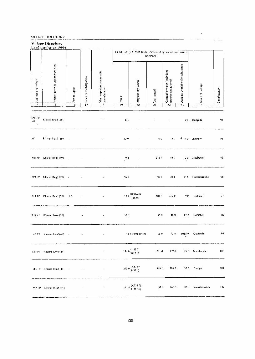
V:LLA(3F DIRECTORY
vm~gt' ni.-ertnry
. ~'''''-"f!J As on 11)99 -----
I
I ~ ~
I " '-'
" I fi " 01, -a
~ I ~
~
~ 1 " :3
g " " ~ ~ " .,.
_ _£,_------ ~4- -L ___ L. : 5
KI anar R.."d (45)
rr ",hal'" Rc.rt (69)
!viI{ ~p no,,", Rodd (69)
r-
'" 5: 5l ~ il: ~ r--16 18 17
Land u~e (I e area uhuel dlflercnt type~ of land me II
hectare)
19 20 21 22 21 2
111 \\9 Gads"'·
150 100 180 ~ 70 lamraon
94 278 7 840 10 0 K hohgaol1
135
9)
91
95
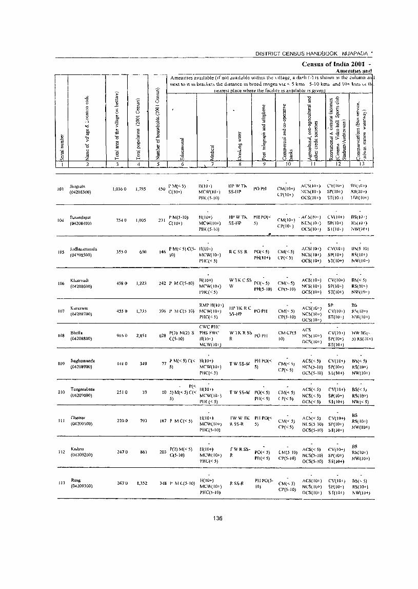
II
103
104
105
106
107
108
109
J}lllgldlll
(04208300)
Bdldndupat (04208400)
J"dhar.mumlo (041 085t}O)
Kholfvadl (04208600)
Kureswat [042087(0)
Bhello (04208800)
Baghamunda (04208900)
110 Tellsallauasa (O42(9000)
III
112
113
Ghotsar (04209100)
KH.llOR (04209200)
Rallg (04209300)
I
1,0360 1,795
7540 1,005
DISTRICT CENSUS HANDBOOK NlJAPAO)\ '
CenslIs of India 2001 -Amemlle~ lind
Amenities available (I(not dvaildble within tb~ \ Illage, a da<h (.) IS shown In tbe culumn ,11, I next to II In bra"ket, the distance In broad ranges VIL < 5 kms 5-10 km, dnJ 10..- kll1> t" III
nearest place where the faulltv IS avaIlable IS g,ven
450 I' M« 5) C(IO+)
2JI I'M(5-10) C(IO+)
11[10')
MCW(IO'l
PHL(5-1O)
H(IO+)
MCW(J[)+)
PHC (5-10)
H!'WTi'-
5S-H!'
HI'wn.
55-liP
POI'H
I'll 1'0«
5)
CM(lO+)
(P(101)
AC'>[IO') NC~(lOi)
OCS(I()+)
CM(IO+) - A( ~(101) CP(IO+) NC~(Hn)
OC5(1O+)
(,Y(lIH)
SP(JOI) ~T(J01 )
( V(IO+)
51'(10+)
51(10, )
BS[IOt)
RS(IOc)
IJW(I01)
B5(10')
R~l!Ot)
N\v(IOl)
-------------------------------------------------, . 3550 650
4980 1,223
4550 1,735
9650 2,85 I
1410 349
2510 39
220 ° 793
2470 861
2670 1,352
146 PM{<5)C{5- H(IO+) 10) MCW(IOt)
PHC« 5)
H(IO+} 242 r MC(5-IO) MCW(IO+)
PHC« 5)
R C SS R 1'0«5)
rH(IO+)
W1KCS~ PO(~5) W PH(5-10)
CM«S)
CP{< 5)
CM(,S)
CP(5-10)
Ae5tI0+)
NeS(lo+)
OCS(IO+)
ACS(IO+)
NCS(IO+)
OCS(IO+)
CV{IO»
SP(IO+)
~T(IO+)
CV(IO+)
SP(IO+)
ST(101)
RMP H(I01) HI' lK R C 396 P MC(5 10) MCW(IO+} ~5-HP 1'01'11 CM«;)
CP(S-IO)
ACS(IO+)
NC~(IOf)
OCS(IO+)
SP
CV(lO I)
ST(JOt) PHC« 5)
CWC PlIC
628 P(3) M(2) S PHS FWC «5-10) H(IO+)
MCW(101)
77 P M« 5) ('« H(lO+)
5) MCW(IO+)
PIlC« 5)
10 P« lI(IOt) 5)M«5)C« MCW(IO+)
S) 1'11((<5)
187 P M C« 5)
203 1'(2) M( < 5) C(5-10)
H(lO+)
MCW(IO+)
PHC(5-IO)
11(10+)
MeW(IO+)
PHC« 5)
H(IO+) 348 P M ((5-10) MCW(IO+)
PIlC(5-10)
136
W1K R S5 PO PH R
T W S5-W PH 1'0« 5)
T W SS-W PO« 5)
1'11« 5)
fW W fK PH PO« R 5S-1t 5)
~WRS!o- 1'0«5)
PH« 5)
CM CP(5 ~~~(IOf) 10) OC'>[ 10+)
CV(IOt}
SP(IO+)
S T(IOt)
CM«5)
CP« 5)
CM«;)
(P« 5)
CM('" 5)
CP«5)
ACS« 5) eY(lo+)
NC~(5-10) SP(IO+)
OC~(5-I(I) SI(IO+)
ACS« 5)
NCS« 5)
OC!o« 5)
CV(tot)
SP(IO+)
51(10+)
AC~« 5) CV(IO+)
N(S(5 10) 51'(10+)
OCS(5-10) H(lO+)
(M(S 10) ACS« 5) CV(IO+)
CP(5-IO) NCS(5-to) 51'(10+) OCS(5-10) 5 f(IO+)
R SS-R PII PO(5- CM(<.5)
10) CP(5- I 0)
ACS(IO+)
NCS(IOI-)
OCS(IO+)
CV(la,)
SP{IO+)
S f(lOI)
6'>(5 101
R~(lOI )
NW(IOt)
B~«SJ
RS( 101 )
NW(IO+)
B~
j(<,( lOt)
NW(IO+)
NW IIS(, J) RS(IOt)
B~« 5)
RS(lOt)
NW(101)
BS« 5)
RS(lO+)
NW«5)
BS RS(to+)
NW(IO+)
as R!>(101)
NW(IOt)
B!>(" S) RS(lO+)
NW(IO+)
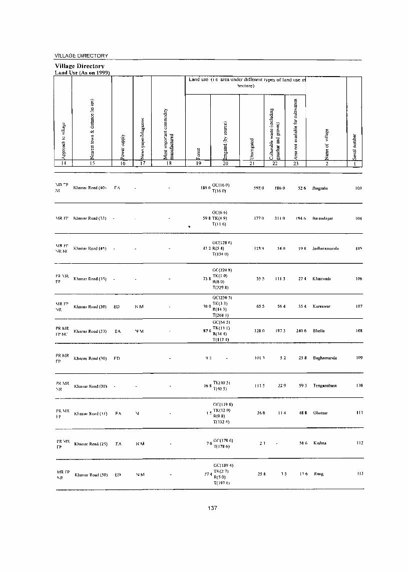
VILLAGE DIRECTORY
VilIae:e Directory Land Use (As on 1999)
14
MRfr Nl
15
Khan", Road (40 I
MR Ff' "'hanar Road (13)
MR FP NR N(
Khana, ROdd (45)
I'R ~IR FP Khan., Road (15)
MR FP NR
PR MR FP Nt
Khan., Ro.d (30)
Khan.r Road (33)
16
EA
ED
EA
~: MR Khansl Road (30) ED
~~ MR Kha"a, Road (30)
PRMR I P
I'RMR rr
MR FP NR
Khana, Road (31)
KharlH' Road (21)
Khan", Road (50)
FA
EA
En
17 18
NM
NM
N
NM
NM
Land use (I e area under different types of land use 11
hectare)
•
19 20
1890 0C(16 0) T(160)
0C(66) 598 TK(4 9)
T(116)
OC(1286) 432 R(54)
T(1340)
0(2208)
738 TK(I 0) R(S 0)
T(2298)
0C(250 5)
100 TK(3 3) R(143) T(268 I)
GC(645)
87 (\ TK(ll I) R(144) T(1I2 I)
92
168 TK(40 5) T(40 5)
GC(1I96)
15 TK(12 0) R(O 8) T( 132 4)
76 GC(178 6) T(1786)
GC(1894) TK(27)
274 R(5 0)
T(197 OJ
137
21
5920
177 0
1219
555
655
3280
1011
III 5
26 (I
2 I
256
22 23 2
1860 526 Jhagralll
311 0 194 6 B .. andapal
340 198 Jodha,amunda
III 3 274 Khall-vad,
564 354 Kureswar
1973 2406 Bhella
52 25 8 Bagh.mund,
229 59 J Tengan,basa
114 488 Ghal •• r
586 K,shna
, 5 116 Rang
10J
104
105
106
107
108
109
110
III
liZ
113
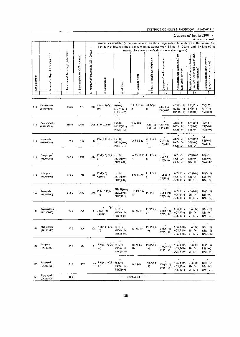
114
115
116
117
118
"-' o
j 2
Ooheldpada (04209400)
Pa"dRrapalha, (04209500)
J.lamkato (04209600)
Ounguflp"h (04209700)
Jethupah (04209800)
119 Tlkrapada (04209900)
120
121
122
123
124
Jagannathpall (04210000)
Mahlllbhata (042 JO 100)
1>"lapalll (04210200)
Anllpgarh (04210300)
Bljayal!arl, (04210400)
3 4
1700 578
603 0 1,404
770 486
4570 1,005
1560 740
3140 1,492
900 306
1390 806
650 134
510 137
850
DISTRICT CENSUS HANDBOOK NUAPADA'
Census of India 2001 -Amenitiel> and
Amenities available (If not available within the village. a dash (-) IS shown In the column an~ next to It In brackets the distance In broad ranges VIZ < 5 kms 5-10 kml. and 10+ kms of th
nearest place where the facllltv IS available IS ~Iven
5 6 7
136 I' M« 5) q5- H(10+) 10) MCW(IO+)
PBC(5-to)
305 P M C(5- 10) H( 10i) MCW(IO+)
PHq5-10)
120 P M« 5) q< H(IO+) 5) MCW(IO+)
PHC(IO+)
243 P M«~) C« H(IO+) 5) MCW(IO+)
PHC(5-IO)
186 P M« 5) qIO+)
34& I' M S C(5-10)
H(IO+}
MCW(IO+)
PHC(5-10)
PHS H(IO+)
MCW(lO') PHC(IO+)
81 P« H(IO+) 5) 1.1« 5) MCW(IO+)
C(IO+) PHC(5-10)
178 P M« 5) C(5- H(IO+) 10) MCW(IO+)
PHC(5-IO)
21 I' M(5-10)C(5 11(10+) 10) MCW(IO+)
PHC{5-10)
32 P 1.1« 5) C(5- H(lOt) 10) MCW(IO+)
I'IIC(10+)
g 9
TK R C 55- I'll PO« R 5)
TW CSS-W 1'0(5-10)
1'11(5-10)
W R SS-R PII PO« 5)
W TK R 55· PH PO«
R 5)
r W S5-W PH 1'0« 5)
HI' TK SS- PO PH flP
Ill' 55-HP PH PO« 5)
10 11 12
CM'<5) CP(5-10)
AC5(5-10) eV(lo+) NCS(5-1O) 5P( 10i)
OCS(5-tO) H(IO+)
ACS(lOi) CM(5-10) NC5(IOi) CP(5-tO) OC5(10+)
CM«5)
CP(5-10)
CM«5) CP(5-10)
CM(IO+) CP(IO+)
ACS(IO+)
NC5(10+)
OCS(IO+)
ACS(IOi)
NCS( 10+)
OCS(IOt)
ACS(IOi)
NCS(IOt) 0('5(10+)
CM(S-IO) ACS(IO+) NCS(IO+)
CP(5-10) OC5(10+)
CM(5-to) ACS(IO+)
CI>{5-10) NCS(IO+) OCS(IO+)
CV(IOi)
5P(10+) ST(IOt)
CV(IO+)
SP(IO+)
ST(IO+)
CV(lO+)
SP(IO+)
5T(10+)
CV(IOt)
5P(10+) 5 f(10+)
CV(IO+)
SP(IO+)
S f(IO+)
CV(IO+) SI'(IO+) ST(IO+)
HP 55-HP PIII'0(5- CM(5-IO) AC5(5-10) CY(lO+) 10) CP(5-10) NCS(5-IO) 51'(10+)
OeS(5-10) 5T(IOt)
HI' W S5- PH PO(5- ACS(5-IO) CV(IO+) liP H) CM(5-1O) NCS(5-lO) 51'(10+)
CP(5-10) OCS(5-10) 5T(10')
w SS-W PH 1'0(5- CM(5-1O) ACS(5-10) CV(IOt)
10) CP(5-10) NCS(IO+) 51'(10+) OC5(10+) 5T(10+)
-.------ Unlllhablted ------------
138
13
B5« 5) R5(1O+) NW(IOt)
BS« 5) RS(5-10) NW(IO+)
BS R5(1O+)
NW(IOt)
BS« 5) R5( 10+) NW(IO+)
BS(5-10)
RS(IO+)
NW(IO+)
BS(5-10) RS(IO+) NW(IO+)
BS(5-1O) RS(IO+)
NW(IO+)
BS(5-10)
RS(5-to) NW(5-tO)
BS(5-IO) RS(lOi) NW(lO+)
BS(5-10)
RS(IOt) NW(lO+)
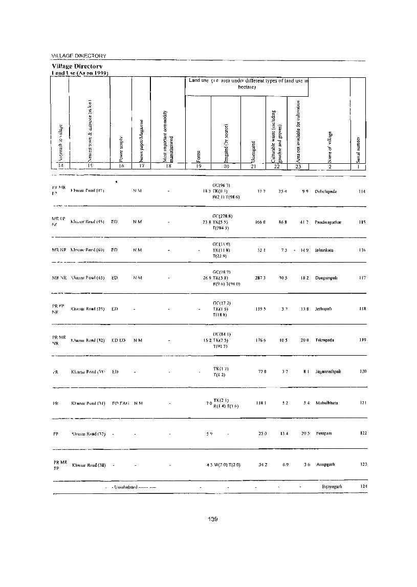
'IILlAGF DiRECTORY
Villa!!e Directorv lR1II1 ( I~e (As (111 1999) -----r--~ --~~~~~-------r"-----r-----------r~L-a-n~d~l-IS-e~(I-e--a-re-a--un-d7e-r-d~1~ffi~e-re-l-lt-l-y-pe-s--07f~la-n~d~u-s-e-l-lr-------------r----,
hectare)
pr ~jR [1'
; hilRI road (40 I
ED
Mil. NR KIt"18' POf,1 (6?) ED
- -- ---------------
Mil NR "<118IIar Pond (43) ED
I'R fP
NR
PRMR NR
iR
Khanor Road (2S) ED
;.h.II81 Road (12) WEO
NM
NM
NM
NM
NM
I'R Khan.( Foatl n I) F~ FAG N M
FP '<IIqll.r Road (17)
PR MR Kho"a. Road (38) FP
-" - Unonh.biled -"---- ----
0C(961) 183 TK(O 3)
R(2 I) T(98 6)
0\(2788) 23 8 TK(5 5)
T(2843)
GC(II () TK(118) T(229)
OC(787)
269 TK(5 8) R(9 6) T(94 0)
0C(172}
TK(16) T(18 8)
GC(84 I}
152 TK(7 5)
T(917)
1K(12)
T(12)
TK(2 I) 70 R(14)T(3 6)
59
4 3 Wp 0) T(2 0)
139
177 254 99 DohelRpada 114
1660 868 417 Pandalopathar II~
32 1 73 149 Jal.mkala 116
2873 105 18 2 Dungunpah 117
1195 3 7 13 8 Jelhnp.h 118
1766 105 200 T.krapada 119
770 3 7 8 I J agonn'thpah 120
118 I 52 5 4 Mahulbhala 121
250 134 20 5 Palapa", 122
342 69 3 6 Allupgarh 123
OIJAy.garh 124
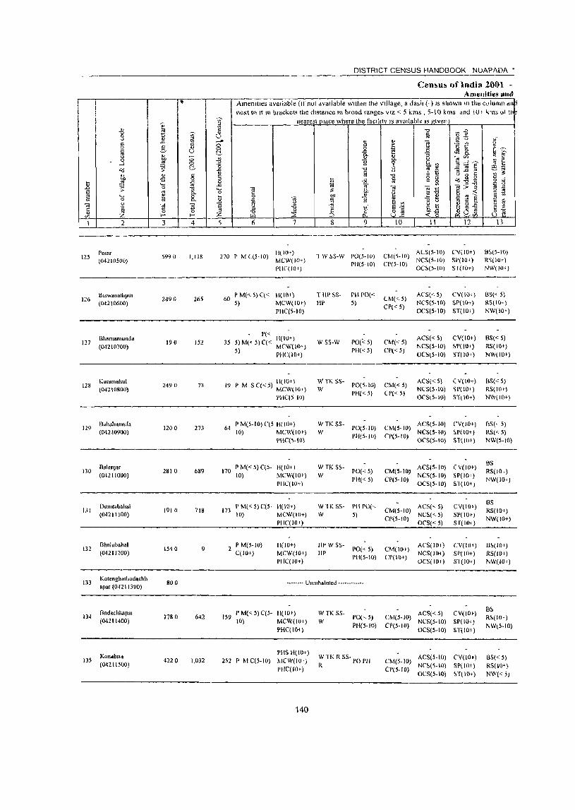
II, .,
~ ~ t
-J ... "
.c
8 a 5 a '" '" u a .& g ....l
Od ~ ~
" " '" ~ .s a til .8 ~.
0 ;; :; § 5 0-....,
til 8. '" 0
Oil " ~ ~ ~
Jl 0 t-- t--
1 2 3 4
125 POUlf
S990 1,118 (04210500)
Blswanathpur 2490 265 126
(04210600)
BhBruamUl\(I. 127 190 152
(04210700)
Karam.hul 2490 73 128
(O~210800)
129 BdlldllllllllJa
1200 273 (04210900)
BalenJar 130 2810 689
(04211000)
Oumert.hal 131 1910 718
(04211100)
112 Bh.lubahal
1540 9 (04211200)
13) Kotenghal1>odachh
800 apar (04211300)
Boddchhapas 134 17& 0 642
(04211400)
KonabuB 135 422 0 1,032
(04211500)
~ 8 --'" 0 0 ~ ~ -0 .a M ::> a .a ~ 0
.8 § Z 5
DISTRICT CENSUS HANDBOOK NUAPADA'
Cen1>u!> of India 2001 -Amenities lind
Amenilles available (If not dvallable within the village, a dash (-) IS shown .n the c<llulTln dll
next to It m brackets the distance HI broad range. VIZ < 5 kms , 5-10 kms and 10' k'us or u\ nearest place where the faclhtv IS available IS given
"'" ~:E l;j ,; '" '"
::: <J>
" ;- ] "5 ~
<> 0 ~ E ~-..<: <fl " >, "'- <U :; "'-
~ ~ " e tn~ ___ 0- U
E '( @,~ .§ ~ § ., " -0 a "' !! ~~ iii
u d
~ -0 U 8 § l3 .a § a g .i " Q(i"O<;z 'ai 0. ~>-g ~ 0
" Oil ""§ ., ~ Oil ,:; 6h u g " ..: " 0() " .E~ 9 oJ Ii! Ei 0 Oil E " g " §J2 " " .. S " E '" u ~ u ... ~ g-t3 u >Q 1 ~~ E " " " ~a:9 ~ 8 82 (.~ ~ ::a ~/ Of>
6 7 8 9 10 II 12 13
270 P M C(5-IO) H(IO+)
1 W ~S-W PO(3-1O) CM(S-lO) AU,(5-IO) CY(IO+) B~(5-IO)
MCW(
I/ILl..r\GE DiRECTOHY
PI'MR I P
p~ \1R FP
KiHHlal Road (ll)
".hanar Road (JO)
PI{ \1R Kha"ar Road (30)
EA
Land usc (I c area under different types of land use II hectare)
1fi S TK(7 I) T(7 I)
79
360 S
191 Ii
73
1969
877
294
3 5
158
1075 POinT
207 Biswanathpur
6 1 Bhantamunda
28 7 Karamahlll
12~
126
127
128
----------------------------------------
"-hanar Road (20 ) 1202 Bahahnunda 129
PR MR GC(134)
FP f(h."ar Road (25) ED 149 W(I 2) 186 I 449 05 BalenJar no
T(146)
GC(789)
PR Mit '<harm Road (19) EA 82 W(4 0)
fP TK(06) 650 121 21 8 Dumerbahal 131
T(815)
MR Khnal I{oad (20) 08 GC(49 ~) I T(49 S)
190 74 47 I Bhaillbahal 132
---------- .. -- Unmhablted ------------
Kotenghatboda 133
chhapar
-----
PR'vIR Khan., Road \21) FD 67 GC(106 0)
T(I060) 277 108 265 Bndachhapa, 134
GC(1965)
PRMR W(40)
Khanar Road (2}) ED EAG N 1651K(43) 1421 318 II 1 Konai')lrR 13~ rp R(149) 1 (2197)
141

DISTRICT CENSUS HANDBOOK NUAPAuA •
Census of India 2001 -Amenitlel> and
Amemtles aVailable (If not aVailable wlthll1 the Village, d dash (-) I'> shown III the column an~ next to II In brad.et5 the distance III broad ranges VIZ < 5 kms , 5-1 0 km~ an(j 10,_ ~nl> 01 thl:
'O? ~ neare,( place where the facility 15 available I, given
" I J'! 5 -0 ~~ I " ~ § c <> U () " Bl ., "
::; t.> 13 '"
.J:: fi 0 " ;> ~ ..:: ~
0 2. 0 0 ~ a ~ R ~-iii u C- "" " ... " 0-
~ "3 '" '" " "" 0 ~
OJ " ~"'.~ ~ ~ 0 ....l ~ 0 11 5,~
" II) C- o a::;a E 61ii ad ;; .c -0
" ~ ~ "3"'= ::i
" § ~ 0$ "
., § '" -0 " II) " 0 <= o 0 '" ~ .s " u 1 ~ Q(i~g 0 g ~ \a a '" a '- -" 1ii
l~ <a>1l iii .t:> ~ 0 "3 '- ~ ~ <a " ~ E '" 0- 0 <3 §-...~ ;;;
" ._ " 0 II 0 "" '" i;
" 0 li! 0- ~ ""iij
~ 11 "3 t; e ~ ~ " ;;.,
" " E '" ~~
§ ~ (ij
~ <il <a § 1 " 1i ~1
t3 c:...a <= 15 15 '" ti ~a."l (3 ] " ~ tf </l f- f- :z: ~'" 1 2 3 4 '5 6 7 8 9 10 II 12 13 -
136 PanddbahdiJ
3990 816 193 P M« 5) C(S- H(lo+) W rKRSS PO(~5) (M(5-IO)
ACS« 5) (V(lo+) B~« 5) (0'1211600) 10) MCW(lO') R PH(5-IO) CP(5-IO)
NCS(5-IO) 51)(10+) RS(IOt) PI1C(IOt) OC5(5-IO) ~l(lO+) NW«i)
137 81runpaddf
1840 416 94 PM«5)C« IIi 10 I) lIP W 11< R PH PO(S-
CM«5) ACS«5) (V(IO+) BS« 5)
(04211700) 5) MCW(IO+) SS-R 10) CP«5)
NCS(5-IO) SP(IOt) RS(lO+)
PHC(5-1O) OCS(5-10) ST(IOt) NW«5)
138 Raghupalt
1090 649 139 P M« 5) C(<- 1l(IOr) W TK R 5S- PH PO«
CM«5) ACS(5-IO) CV(IOt) NW 8S«
(04211800) 5) MCW(IO+) R 5) CI'« 5}
NCS(5-1O) SP(IOT) 5) RS« 5) PI-IC(5-10) OC5(5-IO) SI(IO+)
CWC HC T HP1W ACS NCS(5- - as
139 Komana
8120 4,810 1,022 1'(4) M(l) FWC H(IO+)
W rK R 55- Pl0 PH CMCP 10) OCS( 5- C V( IlH ) RS(I()+) (04211900) S(2) PVC C MCW(IO+)
III' 10) SP(ltJ+) NW(q) PIlC( 10') ST(IOt)
140 Solballlih
J470 828 185 PM«5)C« H(IO+) W TK R 55- PH 1'0(5-
CM«5) AC5(5-IO) CV(IO+) NW 85('
(04212000) 5) MCW(IO+) R 10) CP« 5)
NCS(5-10) SP( 10+) 5) RS( lOr) PHC(5-10) ,OCS(5-10) ST(IO+)
141 Viva (04212100) 2560 837 184 1I(IOt) W fKSS- I'll 1'0«
CM(S-IO) ACS(5-1O) CY(IO+) BS(5-1O)
P M S C« 5) MCW(lO+) W 5) CP(5-1O)
NCS(S-IO) SP(IO+) RS(IOt) 1'11('(5-10) OCS(5-1O) 5 f( 10+) NW«5)
142 GOlJore
2170 586 136 I' M« 5) ('(5- H(IO+) HPW1K
PO«5) CM«5) ACS« 5) CV(IO+) BS(5-10)
(04212200) 10) MCW(IO+) SS-HP PH«5) CP« 5)
NCS«5) SP( 10+) RS(5-10) PHC« 5) OCS« 5) ST(IO+) NW« 5)
A~rel1 P M« 5) C(5-PHS H(lOr)
HP WTK ACS(5-1O) CV(IOI) B5(5-1O) 143 5550 796 181 MCW(IO+) PO PH CM(5-10) (04212300) 10)
1'1IC(5-IO) 5S-W
CP(5-10) NCS(5-1O) 51'(10+) RS(5-10) OCS(5-IO) ST(IO+) NW«5)
144 i..ndabahah
2020 586 138 P M« 5) C(5- H(IO+) HI' W SS- PH 1'0« ACS(5-1O) CV(IO+) 85(,,- 5)
CM(5-tO) (04212400) 10) MCW(IO+) HI' 5)
CP(5-10) NCS(5-1O) SI'(IO+) RS(IOI)
PHC(5-10) OCS(5-1O) ST(IO+) NW(5-10)
145 Helgson
6020 1,118 270 P M ('(5-10) H(IO+)
HP SS-Hl' PH 1'0«
CM(5-1O) ACS(5-IO) CV(IO+) 85« 5)
(04212500) MCW(lO+) 5) CI'(5-IO)
NCS(5-1O) Sf'(IO+) R~(5-1O)
PIIC(5-IO) OCS(5-1O) 51(10+) NW(5-10)
142
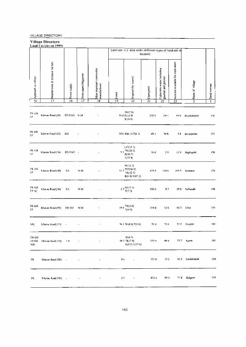
VILLAGE DIRECTORY
Village Directory Land Use (A, on 1999)
14 15 16 17
~~ MR KllallaT Road (25) ED EAG N M
PR MR I P Khn"ar Road (22) ED
PRMR N(
PR MR
H'
Kha"a. Road (14)
I<.h."ar Road (10)
PR MR Kha,,", ROBd (10) fr NC
PR MR Khallar Road (10)
fP
MR "ha"ar Road (11)
PR MR rt'NR Kh"tar Road (10) ,"W
PR KI.a"., Road (28)
PR Kha"a, Rand (10)
ED FAG -
EA NM
EA NM
ED EO NM
rA
18
Land use (1 e area lInder different types of land use l' hectare)
19 20
TK(l9)
JOO R(l2 9)
1( 16 &)
546 W(6 I) T(6 I)
(,(,(12 I)
5 7 TK(20 2) R(40 5) 1(72 8)
W(12 I)
117 WF(16 2) TK(12 I) R(o &)1(47 2)
27 G(71) T(7 I)
194 TK(4 0) T(40)
16 I W(4 0) T(4 0)
W(40) 4& 1 TI<.(7 9)
R(5 5) 1( 174)
86
6 S
143
21
n05
687
160
4155
1000
1140
51 4
311 4
1518
4126
22 23 2
291 93 a randelbaha',
,08 , 8 Bllunpadar
29 119 Raghupah
1146 2015 Komana
87 29 0 Solbandh
326 662 Ulv8
726 512 GOIJore
804 757 Ag,en
155 265 Sandabahal.
&94 71 8 Belgaon
136
117
138
139
140
141
142
141
144
145
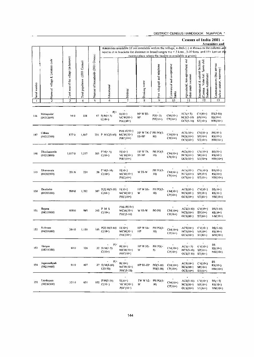
146
147
149
2
Matlaradar
(04212600)
Chhata (04212700)
Dhollamunda (04212800)
Dhalllavata (04212900)
150 Deadal ha (04213000)
lSI
152
153
154
155
RftJana
(042JJ900)
Kllllmatl (04211000)
lIanpUi (04214300)
J ag.nnalhralt (04214400)
Lamb'l"lalll (04214500)
I u
3 4
940 IS8
877 0 1,407
1,0370 1,357
33 10 224
9990 1,702
6380 945
2840 1,150
400 128
910 107
3210 631
DISTRICT CENSUS HANDBOOK NUAPADA •
Census of India 2001 -Amenities lind
Amenities available (If not available within the vilidge, a dash (-) IS shov.n III the column d~tl next to It In brac~ets the distance In broad rdnges VIL < 5 kms , 5-10 kms and 10+ kms oj t
nearest place where the tacillty IS available IS given ---j
5 6 7
P« H(IOI) 47 5) M« 5) MCW(IO+)
C(IIH) PHC(IO+)
PHS 11(10')
3Jl I' M C(5-10) MCW(IO+)
PHC'{IO+)
305 P M« 5) C(IOI)
50 pM(5-W) C(IO+)
H(IO+)
M(W(IO+)
PHC(IO+)
H(IOI)
MCW(IO+)
PIIC(IO' )
387 P(2) M(5-IO) H( 10+) C(IOt) MCW(IO,)
245 P M S C(to+)
PHC(lO+)
PitS 1l(IOt)
MCW(IO+)
PIIC(5-10)
315 1'(2) M(5- 10) III 10+) C(IO+) MCW(IOt)
PIIC(IOI)
P« 32 5) M« 5) H( 10+)
C(lOt) MCW(IOt) PHC(IO+)
27 P« H(IO+) S) M(S-IO) MCW(IO+)
C(5-1O) PHC(5-10)
152 P M(5-10) C(IO+)
H(IO+)
MCW(IO+)
rIlC(IO+)
144
8
HI' W S5-
HP
9
1'0« 5}
PHi 10+)
10
CM(IO')
('P(IO+)
HPW1KCPHPO(5- CM(IO+)
55-liP 10) CP(IO+)
Itl' Wn.. SS-HI'
PH 1'0(5-IU) CM(IO+)
CP(IO+)
] ~ E t ~ -lle ~-:,' E J~8. ~~. B "Ca lI) =t
• :fj 5 ~~ i~~E i!:i .::: ":;...c: =' -- ~
C 4.1 (.) 0 C VI ... gg ~~g §g _..: jo:>"g ~o ~~ 1~<'3~ §~ "3 t i;:i S § E;;" g~ ~g-6 e~ ~-g ~u~ 8] II 12 13
AC~« 5) CV(IO+)
NCS(5-IO) SI'(IO+)
OCS(,-IO) ST(IO,)
ACS(IO,)
NCS(IO+)
OeS(IO,)
AC~(IO, )
NCS(IO+)
OCS(lO c)
CV(IO+)
SI'(IO+)
Sf(IO+)
CV(IO+)
Sp(IO+)
SI(IO+)
8S(5-10)
RS(IOc)
NW(IUc)
8S(IOI)
RS( 10 ')
NW(JOt)
B5(IOc)
RS(IO+)
NW(IO+)
wss-w I'll 1'0(5- AC~(IOI) 10) CM(IOc) NCS(IO)
CV(IOc)
51'(10')
Sf(IO+)
BS{lOt)
RS( 10+)
NW(IO,) CP(IO+) +
OCS(lO c)
IIPW SS
W I'll 1'0(5- CM( 10+)
10) CP(IO+)
WSS-W PO PH CM(IO+)
Cr(lo+)
III' W S~- I'll 1'0(5-III' 10) CM( 10+)
CP(IO+)
HI' W SS- PH 1'0(,-
W 5)
HI' 55-HI' 1'0(5-10)
PH(5-1O)
CM(IO+)
CP(IO+)
CM(IO+)
CP(IO+)
rw W ~S- PH 1'0(5-W 10) CM(IO+)
CI'(IO+)
ACS(IO,)
NCS(IO+ )
OCS(IO, )
CV(IO+)
SP(IO+)
H(lOt)
ACS(5-IO) CV( 10+)
NCS(IO+) SI'(lO+)
OCS(IO,) ST(IO+)
AC'S(IO' ) NCS(IO+)
OC~(lO+)
CV(tol) 1,['(10+)
Sl (10.)
AC~«5) (V(IOI)
NC'S(5- 10) ~P( lOt)
OCS(5-10) ST(IO+)
ACS(IO+)
NCS(IO+)
OCS(lO+)
(V(IO+)
SP(IO+)
ST(tot)
ACS(5-10) (V(IO+)
NCS(lOt) SP(IO+)
OCS(IO+) &1(10+)
BS( 10+)
RS(to+)
NW(IO+)
1I~(5-JO)
RS(IOt)
NW(IO+)
BS(5-10)
R5(IOt)
N\v(IO')
BS
RS(IO+)
NW(IO+)
B5
RS(IO+)
NW(IO+)
BS« 5)
R5(IOt)
NW(IO+)

'Jill N~l:: ! JIHEC IOHY
T--1 I
~ -i3 0
" S
i s 0 U
~ ~-c ~
0. ~
1:: e! C- 8.a iii §~ ~
C-
" ,
1;; ::I ;<
,. §
0 ~ 0
~ § - 0..
In 17 18
r'a Y..IH-III<lf RO!1112?)
-~---~--
MR fP ... h.p.r Road (' I)
----PR MP
K1l'\lilr Rtlld (40) FP
-----------~--
J>R k.1 a.'ar (40)
------
PR Klmnar (11)
PR Kh." .. (27)
---------MR.FP
Kha"or RONd (1 12) NR
----
Pi~ Khano. (15)
!vlR Khapa, (18)
I<",ono, ( 18)
Land u;~ (I e area under different lvpe~ of land use 11
hectare)
" ~ ::> 5l
'" -e il .", '" " on
1;; OJ § e! "" .;: E c ;:;>
19 20 21
472 35 1
2000 GC(I 0) T(IO)
4200
3360 4210
541 882
784 4710
1151 2718
GC(310)
286 TK(2 5) 1812
R( I 3) T(14 8)
II 3
424 TK(O 4) 1(04)
145
1'>64
c 0 l::
" "" >
" ~ -i3 ::I U
-;:; .8 " ~ - '" ~" <U > ~
:0 g, ~ '" @ ~ 3; -c
.!! @ :0
.0 a "-< I:! til 0
a-5 c
" '" ~ :; ::I
~ '" U "" Z. 22 23 2
82 3 8 Mat.apadar
1900 660 Chhoto
2580 220 Dhorlamur~d8
261 1624 Dhanrava(a
2045 2449 Deodarha
742 1141 Rajana
270 125 Kahmal.
292 Harrpur
9 I I Jaganllalhpah
477 740 l amblpa",
U .0 F. ::J c
-;; t: " '" I
14(,
147
148
149
150
151
1'>2
151
154
ISS
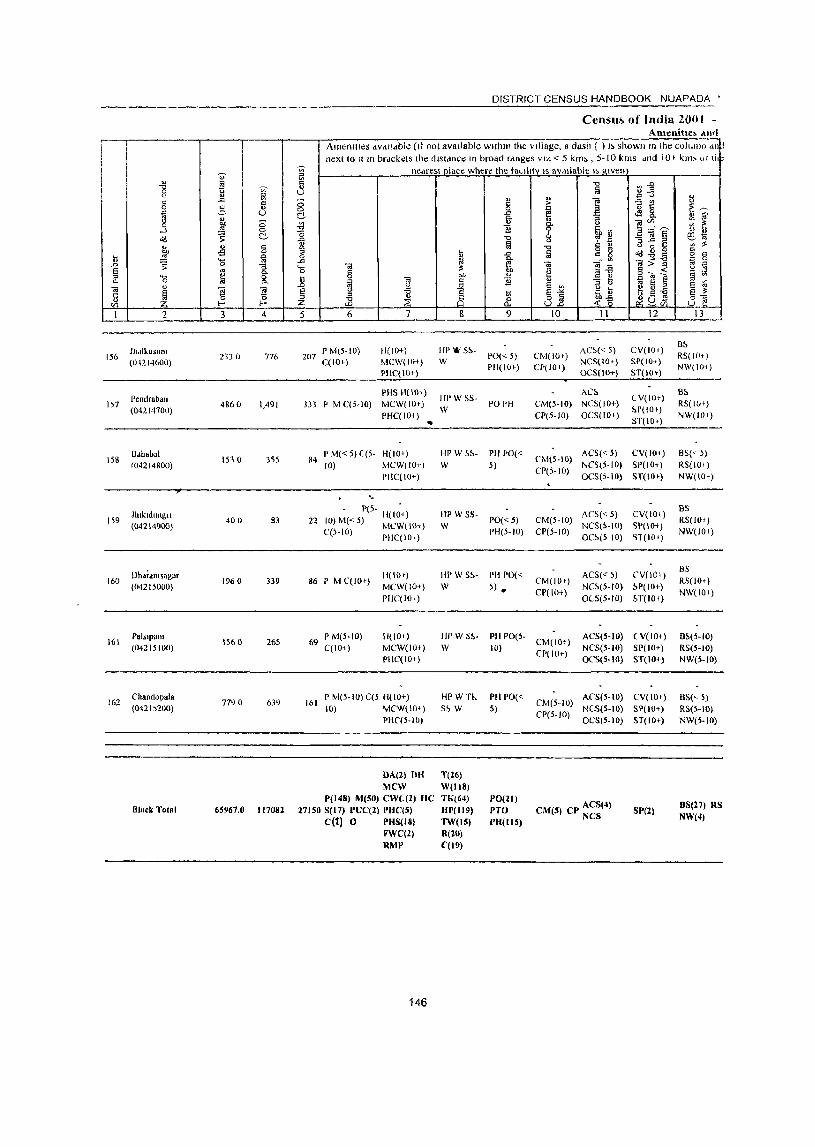
r. I ~ 0 u
" " " .c <:l
0 g " D (.) .. " <.>
'" 0 !;f ....l
~ 0
"<l C-
'" ... § bll .s n '" i ~ '0 "" :;
S '" ::0 '0 ~ &: Co
c;; " c;; c;;
~ t: 0 15 " r/> I-< I-<
1 2 3 4
Jh,lIkllSlIllI 156
(01214600) 2330 776
157 Pendraban
4860 1.491 (04214700)
158 Ddhabal
153 (} 355 f()42 14800)
Jlukldungll 1,9
«()42 14900) 400 83
Dh~;amsagar 160 1960 339
(04215000)
161 PalslpaOl
1560 265 (04215100)
162 Chandopala
7790 639 (O42l~200)
Block Total 65967.0 117082
DISTRICT CENSUS HANDBOOK NUAPADA •
Censu~ of India 2001 -Anumitle, .tn,1
AmBllllles available (II not available within the village, a dash ( ) I> showlI 111 Ihe colullln dll ! next to Itm brdckets the distance III broad rdnges VIZ < 5 km>, 5-10 kills dnd 10 t km' (J[ 11,-
~ nedreSI place where the taLlllty IS available I, I!.IVen Bl " '" U
C; 0 C-.l!J -0 -& g ..c '0 c;;
§ n ij <il .c <.)
§ () -a " ~ ~ :z
5 6 7
P M(5-to) 11(10+) 207
C(IOr) MCW(lOi)
PHC(Hl+)
PHS H(IO+)
333 P M C(5-IO) IvIC\V(IO+)
PHC(IO; )
84 P M« 5) ((5- H(IO+)
to) MCW(IO+)
Pile( 10+)
'-
- 1'(5- II(I~+) 22 IO)M«5) IvICW(IOT)
C(S-IO) PIIC(IO,.)
H(IO+) 86 P IvI C(lOc)
MCW(IO+)
69
161
PIlC(lO+)
P M(S-IO) H(IO+)
C(lO+) MCW(IO+)
PHC(IO+)
P M(5-IO) C(5 H(IO+)
10) MCW(IO+}
PHC(5-IO)
OA(') OR MeW
•
P(148) M(50) CWe(2) HC 27150 S(l7) PUC(2) PRC(5)
C(1) 0 PHS(18)
FWC(l) RMI'
146
~ is all c
.~ &
HP'&'%-W
11[' W SS-
W
HPW S!>-W
liP W 55-
W
HPW S!>-
W
HPW 51,. W
HPWn.
S~ W
T(Z6)
WillS) TJ«64)
111'(119) 1W(1S) K(lO) C(19)
<U c 0 -'" 0-
" 1i "0
t\l
1 " 1l
~ 9
PO« 5) PH(IO+)
PO PH
PH PO«
5)
PO«5)
PH(5-10)
PH 1'0« S) •
PH PO(;-
10)
PH 1'0« 5)
1'0(21)
PTO 1'11(115)
"0
!a !;! ] ~ "
:; <.) 0-
~ s:. '" ~ ~
"0 " <lJ
t\l g g c;; --,,'"
'" -~
.... -<3 E ~
Ei '" " ()
JJ s -'" o ii U..o
10 11
AC~« 5) CM(lO+)
NCS(IO+) CP(IO+)
OCS(IO+)
AC~
CM(5-IO) NCS(IO+)
CP(5-10) OCS(lO+)
CM(5-IO) ACS«5)
NCS(S-IO) CP(5-IO)
OCS(5-10)
ACS« 5) CM(S-to)
NCS(S-IO) CP(5-10)
OC~(5 10)
ACS(<' 5) CM(IOr)
Cr(lo+) NC~(5-IO)
OeS(5-10)
CM(lOT) ACS(S-IO)
CP(IO+) NCS(S-IO)
OCS(5-10)
CM(S-IO) ACS(5-IO)
CP(5-to) NeS(S-IO)
OeS(5-1O)
CM(5) CP ACS(4) NCS
~j '" .... .:; '" <) 1:: .e 8. ]~E ""3...c::~ (.) 0 § o'd~-c;;;>] §~~ ~ 5 § .... c -a ~G~ , C/l
12
CV(tO+)
SP(IO .. ) ST(IOt)
( V(IO+)
~P(IO')
ST(lO+)
CV(IO+)
51'(10+)
ST(IO+)
CV(IO+)
SPOO+)
'>1 (10 t)
(,V(W+)
~.P( 10+)
H(lOt)
(V(IO+)
81'(10+)
ST(IO+)
CV(IOt)
SP(lO+) ST( 10+)
SI'(2)
tl
~~ :;; ~ :5 4J
~ .. '" :<
" g § ~ <.)
§ Vi
Ei ~ s ~
3_fl-13 ---
B~
RS(I(lt)
NW(IO;)
B5
RS(lOt)
NW(IO;)
BS« ;)
R5(1U 1 )
NW(IO+)
BS
RS(IO+)
NW(IOI)
BS
RS(IOq
NW(IO;)
D~(5-1()
R5(5-1O)
NW(S-IO)
8S(<-5)
RS(5-IO)
NW(5-IO)
8S(27) RS NW(4)
VILLAGE DIRECTORY
Villae:e Oirectory Land U~e (As 011 19"9)
K 2-" u
~ " bO -i3 .::: ~ ~
8 ~ .c 8 u
" ~
8 " 0- a ~ ~ 14 15
PR Khan., (18)
rR Khanar (20)
PI{ Kilanar (22)
PR Khanal (18)
I'R Khanar (15)
MR Khallsr (22)
PR Khallar Road (15)
PR(74) I\IR(12S)
FP(94) N{'(6)
NR(\5)
NW(4)
>, C. 0. 5l ~ ::. rf 16
ED 1'0
ED
ED(42) EAG(4) EO(S)
EA(19)
" " ~ bI)
" ~ " ~ 0-
~ ~ 17
NM
N(33)
M(26)
e--i3 0 e e a u
~1l 8.a E ~ .:1;l
~ ~ 18
Land use (I e area under different lypes of land use 11
10 ~ .;: 19
';) ~ ::l 5l >, e-
"1:1
~ on .§ 20
177
288 GC(89 8) T(898)
79 GC(63 I) T(G) I)
3 2
460
2 0(11 I) 10 T(II I)
2 GC(366) 91 T(36 6)
GC(3615.01) W{37.6) WE(16.18)
8872.2 TK(245.4\) R(185.44) 0(334.5) T(4434.14)
147
hectare)
"1:1
~ OJ)
S :5 21
1528
2556
398
753
783
1882
30815.2
c 0
" '" M >
" " -i3 :;
'" " ]~
... <8
~" " ~
>- :0 " ~ ~ ~ ~"1:1 ;;J
~ § >-" '" :0 0 '-f:! l;; 0
B-B c
" '" ~ - ::l ~ o g:, 22 23 2
295 132 ihalkusum
31 7 80 I Pendraban
148 278 Bah.bal
31 7 5 6 Jh,kldungn
360 38 6 Dh.ramsagar
85 374 PalSlpanl
1027 422 7 Chandopala
12551.3 9117.3
... '" .c E '" " .. " ... '" I
156
157
15&
159
160
161 '
162

INDIA ORISSA
BODEN C.D. BLOCK DISTRICT NUAPADA
-
u
Boundary. Slale C.D. mock PolICE Station Villa", .. Ith locallon code number F~t-Resttved with name
Headquarters C.P Bloct. Police Station Vma .. With population SIze! Below 200. 200-&99. !IOO-999. 1<100-'_ UDlnhablted vlll9ges with locabon code number Stlte BiRh •• y Importonl IIelalled !!oed. UDmetalled and other Roadl! RaOny line with station, Broad Gauge RIver and stream Poot Office BJch School Primary Realth Cenl .... BaDt
:-·· .. 8-·--·-: f)'~/J''''''''''''''"-,,. t ••• __ ••••••• !
@
o ••• :··';'·i.i O
.":
... : ... :':ll .. L.:.'
::at:.: :::::::;::=
1'0
S
'"
C.D.
" _" :
4
.: .. : lJ
L
14.1
0
o
c
Area III Sq. Kms. PopulatIOn No. of vIllages
338.28 72056
89

VILLAGE DIRECTORY OF
BODEN C.D. BLOCK- 0003
ALI)IlAllE'IICAL L1~ r OF VILLAGf<.,S OF BODEN CO. 8LOCK - O()O.J Selja) numbel Name of village 2001 Cen~us locauon code J 991 Cen~u, lo~atwn cod~ numbe!
number ----2 4
NAME OF CD. BLOCK - BODEN
POLl( E STA T10l'l - KOMANA - 0003
Bhulnpanl 01213100 100030018001800121
2 Bolda 04213800 100030018001800128
3 Dardgaofl 04214200 IOOO3001800180{Jl32
4 Dardgaon(Khurdl 04214100 IOOO3001800180013J
5 Jhardnamdl 04213200 100030018001800122
6 Karlakot 04213500 1000)0018001800125
7 Klrekda 04213600 100030018001800126
Kotamal 04213700 100030018001800127
9 Ndgpdda 04213300 10003001800180UI23
10 Sir!! 04213400 100030018001800124
POLICE STATION - KHARIAI~ - 0004
Dudukamunda(Khurd) 04218800 100050018001800035
2 Mlichenamal 04219200 100050018001800019
3 Salepadd 04218900 100050018001800036
I'OLICE STATION - nODEN - 0005
Ambaguda 04231100 100040018001800039
2 Amerd 04227800 100040018001800006
3 Anakapur 04233500 100040018001800063
4 Allldbhala 04232400 100040018001800052
5 Babeblr 0~234400 10004001800 I ~OI)072
6 Bdgabahal 04228800 100040018001800016
7 Baglor 04230000 100040018001800028
Bakullkhunll(Kdld) 04231800 100040018001800046
9 Bdkullkhunll(Khurd) 04231700 100040018001800045
10 BanJlbahal 04228400 10004001800lS00012
11 Bartansil 04234600 100040018001800074
12 BhalOsadam 04229600 100040018001800024
n Bheilimal 04231300 1000400 I 8001800041
14 BU18pllr 04231000 100040018001800038
15 Blreskela 04230800 100040018001800016
16 Boden 04229100 IOO04001800180()019
17 BOlrgaon 04230100 100040018001800029
18 CllIkakhllan 04229800 100040018001800026
19 Ddbll 04228300 1000400180018000 I I
20 Dahanapall 04234100 100040018001800069
21 DamaJhar 04227900 100040018001800007
22 Dhamanapara 04230300 100040018001800031
23 Dharnnnal 04214300 10004001800180(1071
24 Dhobel 04229500 100040018001800023
25 Dolo 04232800 100040018001800056
26 Dumerpadar 04232700 100040018001800055
27 Durkamunda(Kala) 04228200 100040018001800010 28 GhMltlguda 04232000 100040018001800048
29 Gumabahal 04233600 100040018001800064
30 Jamugaon 04230400 100040018001800032 31 Jayabahal 04233000 100040018001800058 32 Jhtrlnlkhol 04232100 100040018001800049 33 JugaraJPur 04231200 100040018001800040 34 Kamrllamal 04231400 100040018001800042 35 Kdmpur 04233800 100040018001800066
152
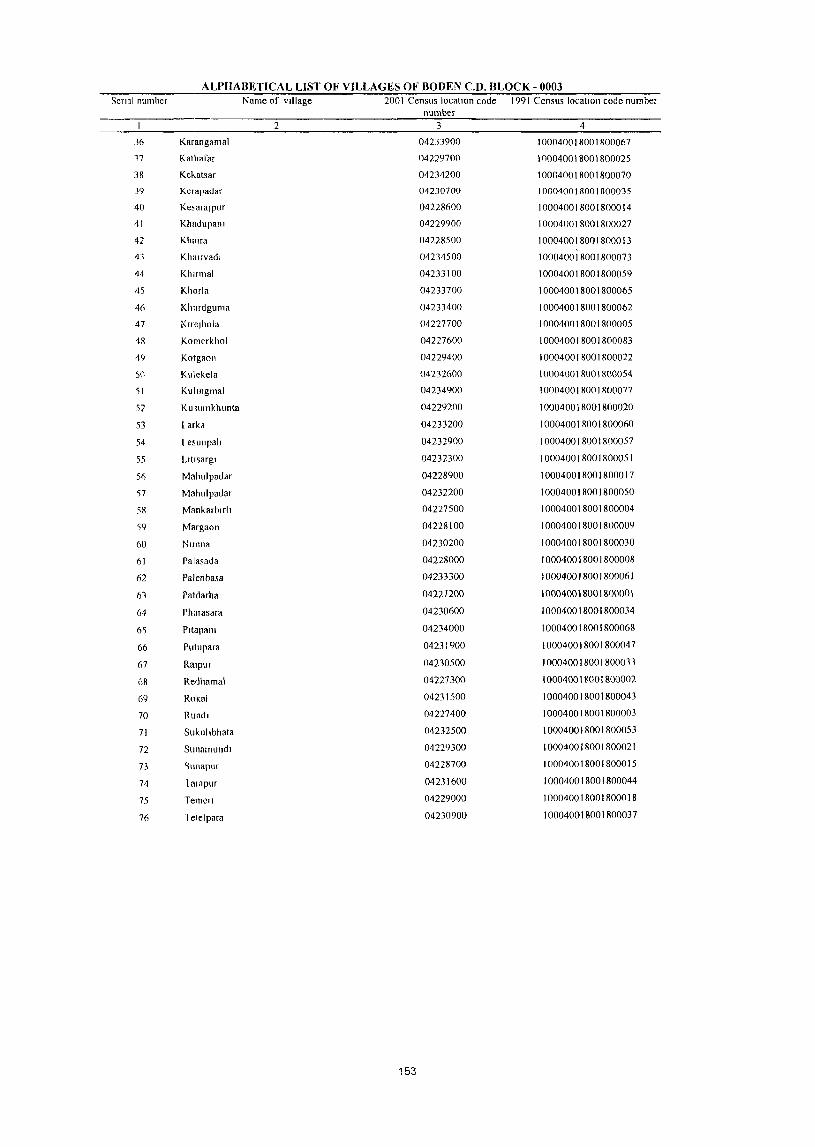
ALPHABETICAL LIST OF VILLAGES OF BODEN CD. BLOCK - 0003 Serial number Name of village 2001 Census location code 1991 Census location code number
number 2 3 4
36 Karangamal 04233900 100040018001800067
,7 Kathafar 04229700 100040018001800025
38 Kekatsar 04234200 100040018001800070
39 Kerapadar 04230700 100040018001800035
40 KesaralPur 04228600 100040018001800014
41 Khadupatll 04229900 100040018001800027
42 Khmra 04228500 100040018001800013
43 Khmrvadl 04234500 100040018001800073
44 Klmmal 04233100 100040018001800059
45 Khorla 04233700 100040018001800065
46 Khmdguma 04233400 100040018001800062
47 Klrelhola 04227700 100040018001800005
48 Kom~rkhol 04227600 100040018001800083
49 Kotgaon 04229400 100040018001800022
)0 Kulekela 04232600 100040018001800054
51 Kulmgmal 04234900 100040018001800077
57 Ku lumkhunta 04229200 100040018001800020
53 Larka 04233200 100040018001800060
54 L esunpah 04232900 100040018001800057
55 Lltlsargl 04232300 100040018001800051
5(, Mahulpadar 04228900 100040018001800017
')7 Mahulpadar 04232200 100040018001800050
58 Mankarblrh 04227500 100040018001800004
'59 Margaon 04228100 100040018001800009
60 Nlmna 04230200 100040018001800030
61 Palasada 04228000 100040018001800008
62 Palellbasa 042JJ300 100040018001800061
61 Patdarha 04227200 100040018001800001
64 Phalasara 04230600 100040018001800034
6'; Pltapalll 04234000 100040018001800068
66 Pulupara 04231900 100040018001800047
67 RalPUf 04230500 100040018001800033
68 Redhamal 04227300 100040018001800002
69 Rokal 04231500 100040018001800043
70 Rundl 04227400 100040018001800003
71 Sukullbhata 04232500 100040018001800053
72 SUllamlindl 04229300 100040018001800021
73 "lIl1apur 04228700 100040018001800015
74 I at npllr 04231600 100040018001800044
75 TemcfI 04229000 100040018001800018
76 1 elelpara 04230900 100040018001800037
153
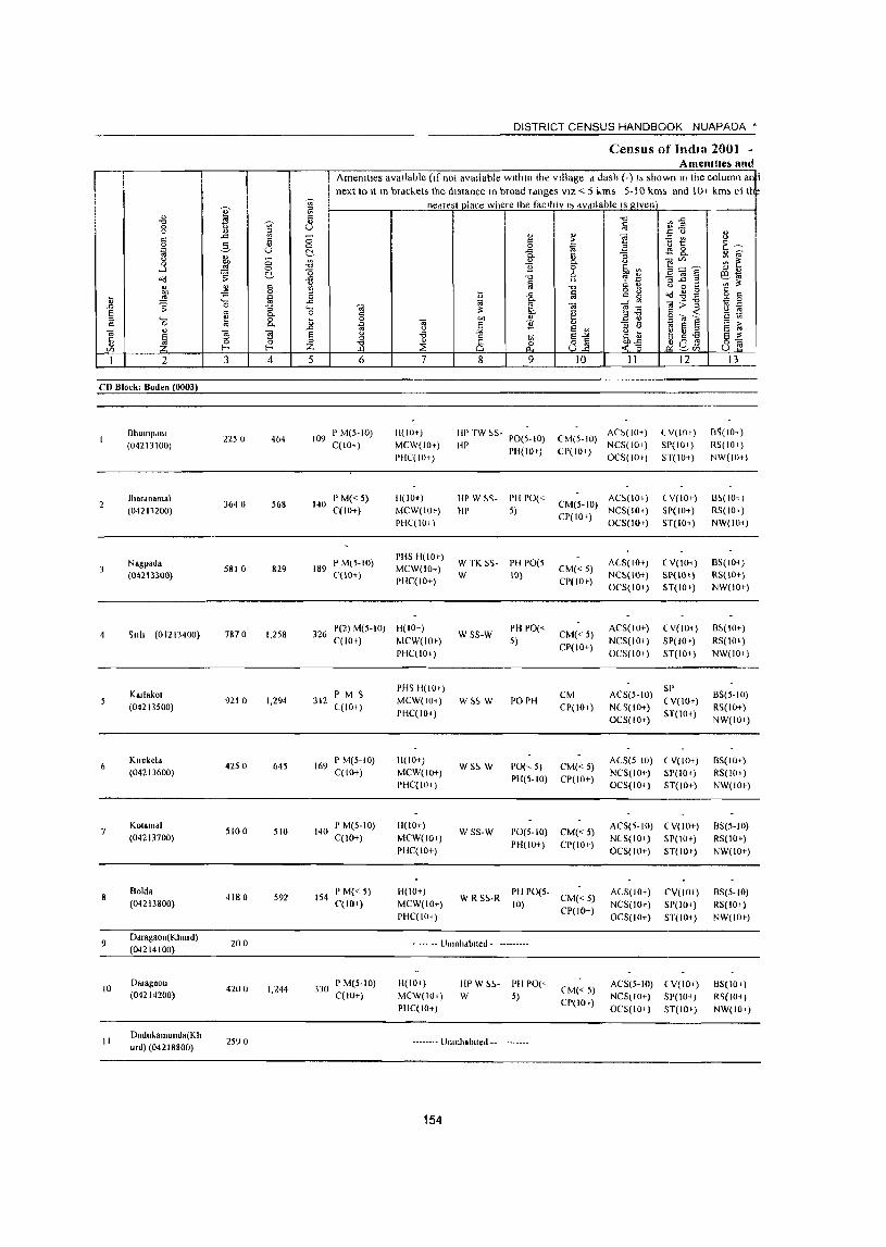
DISTRICT CENSUS HANDBOOK NUAPADA •
Census of Imila 2001 -AmenDlle~ and
Amenttles available (If not available within the village a dash (-) I; shown In the column an t next to It In brad.els the distance In broad ranges VIZ < 51-ms 5-1 0 km~, and 10+ km" 01 IhF
I ~ nedfesi place where the facllltv I~ aVdllable IS given
I " ii -c ~ :E .", 'VC ~ 0 u
" " 5l " " .g ~ " -" 0 ] <)
'" ii " :> ~~ 0 2- 0 0 ~ .E ~ 0 iii u ~ .c::
~ "- " ~ ~ "- " ::l '" '" <.) 0 " Cl'" '" ~ 0 .(g Q. " ....l .!S 0 11 0 6h'" .E7,j~ '" " ~ ~ 0
"0 '" '" " 61ii o(! .c:: " , '" ".c::
" '" § ~ § -0 C ., " c C '" ~ g g " il ~) ;S
iii 0 il 1 lii ~-89 0 " ._ .c:: ~ ....;'" 0;:>] ~
0 .0 ;; 0 "3 '0 0; 0;
~0f3 ~ E ., 0- r:: i:! § .. ~ C ::l ._
~ 8. il 0 ell " .B ~ r:: 0
~ 0; ] ]: '" iii E § El 1<
" .0 <) E '" '" <) 0; '5 ~ § -8 ~~ ~ ~-a t:: ~ ::l " 8 ~
E-'" E " 0 ~ 8] ~u£9 0-=
" f- f- Z ~ u '" (/) ~(/)
I 2 3 4 5 6 7 8 9 10 II 12 13
CD Block: Boden (0003)
BhulIlPdll1 2250 464 109
P M(5-IO) II(IOt) liP TW ~S-PO(5-10) CM(5-IO)
A,!>(IO+) { V(IO,) [lS(IO+ )
(04213100) C(IO' ) MCW(IO+) HP PH(I(H) CP(IO+)
NCS(IOt) SP(IO+) RS(lOr)
PflC(I01-) OCS(IO') ST(IO+) NW(IO+)
Jhardnamai 364 0 568 140
P M«5) H(IO+) HP W ~~- PH PO« CM(5-10)
AC5(10 1 ) ( V{lO+) 1l~(IOl )
(04211200) C(lO+) MCW(IO') HP 5) NCS(IO+) SP(IO+) RS(IO+)
PHC(IOI) CP(IO')
OCS(IO') ST(IO+) NW(lOt)
Nagpada P M(5-IO) PHS 11(10+)
W TK S$- PII PO(5 ACS(IO+) ( V(lOt ) 6S(10+) 5810 829 189 MCW(IO+) CM«5)
(04213300) ('(10+) PHC(iO+)
W 10) CP(IO')
NC~(IO+) SP(IO+) R5(IO+)
oes(lo+) 5T(IO+) NW(IO.)
~lIh (01213400) 7870 1,258 326 P(2) M(5-10) H(IO+) wss-w PH PO«
CM«5) ACS(IO+} (V(IOt) 6S(10<)
C(lO+) MCW(IO') 5) NCS(IO+) SP(IO+) RS(IOt) PHC(lOi)
CP(IO+) OCS(IO+) ST(IO+) NW(IOi)
Karlakat P M S PHS 11(10')
CM ACS(5-1O) SP
BS(5-10) (04213500)
9210 1,294 312 C(lO+)
MCW(IO+) W~~ W POPH CP(IOt) NCS(IO+)
(V(IOr) RS(IO+)
PHC(IO+) OCS(IO+)
ST(IO+) NW(IO')
6 Klfekela
4250 645 169 I'M(5-10) H(lO+)
WS~ W 1'0(,5) CM« 5) ACS(5 10) ( V(IO+) 6S(IO<)
(04213600) C(IO+) MCW(IO+) NCS(IO+) SP(IO+) RS(IO+) PHC(lOi)
PH(5-IO) CP(IO+) OCS(IO+) ST(lO+) NW(IO')
Kalama( SID 0 510 140
P M(5-10) H(IO+) WSS-W PO(5-10)
ACS(5-10) ( V(ID+) 65(5-10) (04213700) C(IO+) MCW(IO+)
CM«5) NCS(IO+) SP(IO+) RS(IO+)
PHC(IO+) PH(ID+) CP(IO+)
OCS(IO+) ST(IO') NW(IO+)
Bolda 4180 592 154
P M« 5) H(IO+) PH PO(5- ACS(IO+) CV(IOt) 8S(5-1O) (04213800) C(lO+) MCW(IO+)
W RS~-R 10)
CM«5) NCS(IO+) SP(IO') RS(IO+)
PHC(IO.) CP(IO+)
OC5(10+) ST(IO+) NW(IO')
9 Ddragaon(Khurd)
200 - --- -- Ulltnlldbued -(04214100)
10 Dalagaon
4200 1,244 330 P M(5-10) 1I(IOi) IIPW S~- PII PO(,-
eM«5) ACS(5-1O) ( V(IO+) BS(IO+)
(04214200) C(IO+) MCW(IOI) W 5) CP(IO+)
NCS(IO+) SP(IO') R~(IO' ) PHC(IO+) OCS(IO+) ST(IOt) NW(IO.)
II Dudukamunda(Kh
2590 -------- Ullillhabued --urd) (04218800)
154
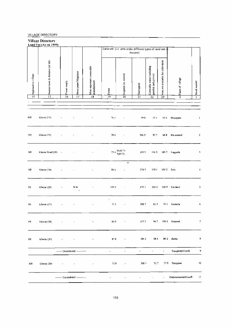
VILLAGE DIRECTORY
ViIlal!e Directorv Land lJse_1As on 1999)
14 15
MR Khan.r (15)
MR hhana, (10)
MR Khanar Road (21)
MR Khanar ('0)
PR Khanar (lK)
PR Khan.r (25)
PR Khanar (28)
PR Khana, (30)
16 17
NM
._ ..... UmnhRb,ted ............
MR Khan., (20)
.. _._ ... U"mhalllted ... _ ... -..• -
18
Land use (I e area under dIfferent types of land use I hectare)
19 20
162
3& 4
714 W(45 7) T(457)
866
1450
133
849
818
128
155
21
998
\66 9
2195
3745
415 I
2RO 7
1777
1862
3001
22 23 2
25 I 63 6 Bhlllnpal11
9\ 1
1165 1057 Nagpada
170 I ISS 5 SlTh
2145 1269 Kadokot
61 1 50 I KlTekela
967 150 2 KOlamal
585 892 Bolda
Daragaon(Khurd)
52 7 139 Daragaon
Dudukamunda(Khurdl
2
6
9
10
II
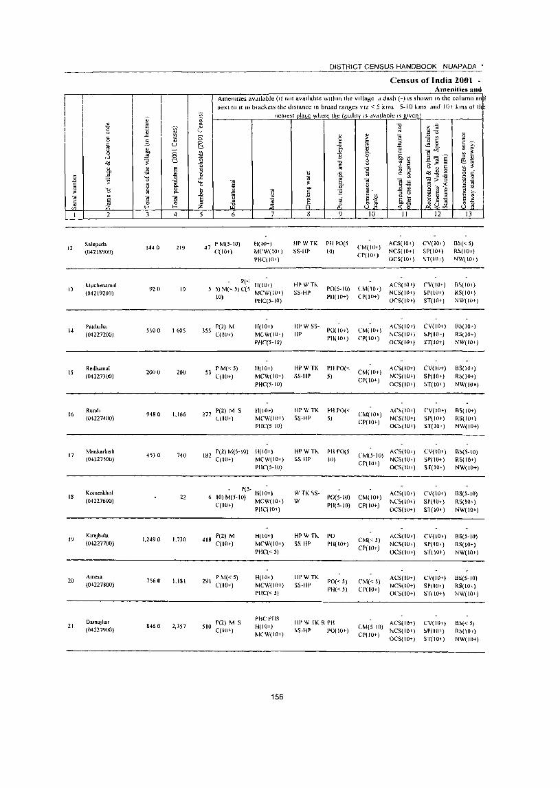
I II
I
12
J3
14
15
16
17
18
19
20
21
2
Salepddo
{042 1&900)
Muchenamal (04219200)
Pald.,lla (04227200)
Redlldlnal (04227300)
Rundl (04227400)
M.,Ik.rb"h (04227500)
Komerkhol (04221600)
Klrejhola (04227700)
Amela (04227800)
OamaJhar (04221900)
I
3 4
144 a 2t9
92 a 19
5100 1605
2000 200
9480 1,166
4530 740
22
1,2490 1,710
7560 1,ISI
8460 2,357
DISTRICT CENSUS HANDBOOK NUAPADA *
Census of India lOOl -Amenities and
Amenities aVdllable (It not avallabte within the village d dash (-) IS shown III the column an~ next to It III brac~ets the distance In broad ranges VIZ < 5 kms 5-10 "ms and )0+ ~ms ot ti e
neares!Dlace where the tdCllity IS dVdllaole Isg,ven
6
47 P M(S-W) C(lO+)
7
H(lO+)
MCW(to l )
PHqIO+)
1'« H(IO I )
5) M(~ 5) C(5 MCW(IO+)
10) PHC(5- 10)
355 P(2) M C(lO+)
51 P M« 5) C(lO+)
277 P(2) M S ((10+)
H(IOn M(W(IO+)
PIIC(5-ID)
11(10+)
MCW(JO+)
PIIC(5-10)
H(IO,)
MCW(IO I )
PIIC(5 10)
182 1'(2)M{5-10) H(IO+) C(IO+) MCW(IO+)
Pllq,-IO)
- P(5- H(I~+) 6 10)M(5-1O) MCW(IOI)
C(IO+) PHC(IO+)
418 1'(2) M C(lOt)
291 P M« 5) C(lO+)
510 P(2) M S C( 10,)
H(IO+)
MCW(IO+)
PIIC« 5)
H(IO+)
MCW(IOt)
PIIC(" 5)
PIIC 1'115
H(lO+)
MCW(IOt)
156
8
liP W TK 55-III'
HPwn, 5S-Hp
HI'W5S
liP
IWWTK 55-HP
HI'WTK 5S-HP
9
PII PO(5 (0)
PO(S-IO)
1'11(10+)
PO(IO+)
PI1(IO+)
PIl PO«
5)
PII PO« 5)
HI' W T'" I'll 1'0(5 SS Ill' 10)
10
(,M(IO+)
CP(IO+)
(M(IOT)
CP(lO+)
CM(IOt)
CP(lO+)
CM(IO+)
CP(IO+}
CM(JO+)
CP(IO»
II
ACS(IO+ )
NCS(IO+)
OCS(IO+)
A('S( 10 ,)
NCS(JO+ )
Oe5(1O»
AC5(IO»
NCS(IO+ )
OeS(IO,)
AC~(IO+)
NCS( 10+) OCS(IO I)
AC~{lOt)
NC5(10+)
OC~(IO+ )
CM(5-IO) ACS{IO+) CP(IO I) NeS(IOI)
OCS{IOI)
WTK<,S-W PO(5-10) CM( 10+)
PIi(5-10) CP(lOt)
ACS(IO+)
NCS{IO+)
OCS(IO+)
HPWH.. S5 HP
IIPWTK 5S-HP
PO
1'11(10+)
PO« 5) PH« 5)
HI' W fK R PH
~S-Hr POe lOr)
CM«5)
CP(IO+)
(,M(";) CP(IO+)
ACS(IO+)
NCS(lO+)
OCS(IO,)
ACS(IO+)
NC5(1O+)
OC5(10+)
CM(5 (0) ACS(IO+)
CP(lO+) NCS(IO,) OCS(IO+)
12
CV(IO+)
Sp(IO+)
H(IO,)
CV(IO+)
SP(IO')
ST(IO+)
CV(IOt)
~P(IO,)
ST(IO+ )
CV(IO+)
SP(IO+)
~.T(lO+)
('V(IO+)
SP(IO+)
ST(IO+)
CV(IO,)
SP(IO+)
ST(IO+)
CV(ID+)
SI'(lO+)
Sl (l0+)
CV(IOt-)
SP( 10+}
~1(10+)
CV(lO+)
SP(lO+ ) STOO+)
CV(IO,)
~P(IO+)
ST(lO+)
13
Il~« 5) R~(IO,)
NW(IOl)
B\(IOI)
RS(IO+)
NW(IO+)
B~(IO+)
RSIIO+)
NW(IO+)
B5(10+)
R~(IO+)
NW(lOt)
B~(I0+)
R5(lOt)
NW(IO+)
B~(5-10)
RS(lO+)
NW(IO+)
BS(5-IO)
RS(IO+)
NW(IO+)
8S(5-1O)
RS(IO+)
NW(IO+)
BS(5-1O)
RS(IO+)
NW(lOt)
Bf>« 5)
R~(IOI)
NW(lll+)

VILLAGE DIRECTORY
Villae:e Directorv Land Use (As on 1999)
Land use (I e area under different types of land use 1
hectare)
]' c 0
~ 2- ~ t>D >
8 -g J ~ .. u
~ t El u ...
i ~ 'OJ' c~ <E - '" -6 ~ ~" .!! o'd " > ~ Ii:, 5: I] 5l 13 ~
s ~ ~ >,
"'"'" ~ ~ u
~ I e 1 ~ .0
1 s .!! i § t;; 13,M -c
l~ 0 ... ., .. 0 c
j ~ ~ i t;; " t;; ... § " " "i!
~ ~ " .§ 8~ ! ~ ~ ~ Ji ::3 c " til
14 15 16 17 18 19 20 21 22 23 2 1
W(40) MRFP Khana, (16) 176 TK(3 2) 346 612 234 Salepada 12
T(73)
PRMR Kharaa, (14)
FP 130 110 656 27 Muchenamal 13
MR FP Khana, Road (56) 540 W(g I) T(8 I) 860 361 5 Patda,ha 14
MR FP Khana. Road (53) 237 W(4 0) T(4 0) 429 SO 7 48 7 Redhamal 15
W(81)
MRFP Khana, Road (5 I) 276 TK(20 2) 2479 2119 432 5 Rundl 16 T(283)
W(32)
MRFP Khana, (15) 447 TK(4 0) 2226 1084 703 Manka,blflt 17 T(73)
FP Khana, (25) Kome,khol 18
W(121)
MRFP Khana, (10) N 427 7 TK(20 2) 4397 1807 1605 KlfeJhola 19
R(SI)T(40S)
GC(IOO 3)
MRFP Khana, (16) W(81)
1134 TK(40) 2818 1301 1178 Arne,a 20
T(1124)
W(IOI)
PRMR WE(20)
Khana, (13) EA N 662 TWE(124) 4624 1005 1236 DRm8jha, 21 FP TK(40 5)
R(8 I) T(93 I)
157
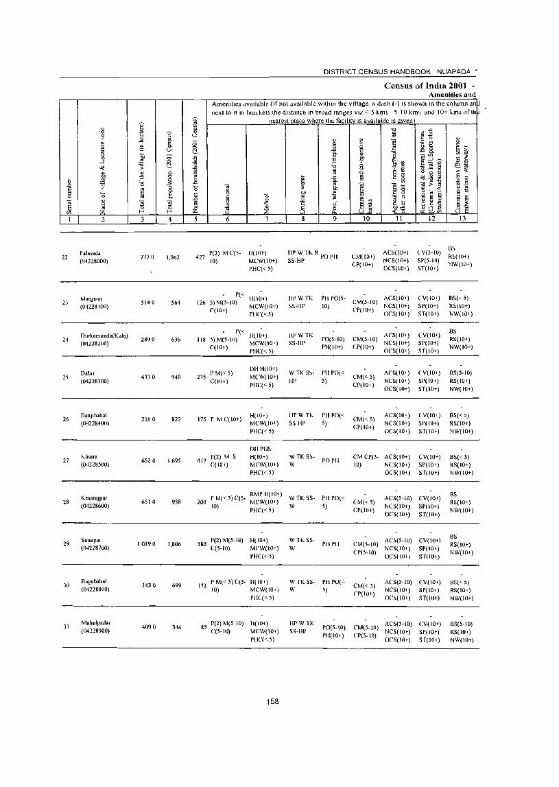
DISTRICT CENSUS HANDBOOK NUAPADA •
Census of India 2001 -Amenities and
Amenities dvallable (If not dvallable within the vIllage, a ddsh (-) IS shown In the column an~ next to It In bra~kets Ihe dl;tance In brodd ranges VIZ < 5 I..ms 5 10 kIm and 10+ kms ofll*
~ ~ nearest place where the facIlity IS avaIlable IS given
" '" ! "0 .0 -0 % " § ~ " 9 u " _
" '" 0 " ..c: V> ;:; " " 1! -= V> 0
" ,.
0 2- Ii 0 § ~ ~
o 1:: ~-;; iii u C!, ..c: ~ 8.. ... Q.
'" ~ ~ 0 ;:; " 0 1! tIl_ ~ 0 OIl ~ Q.
....l '" 0 11 ~ ~V> ~] § '" OJ &d ~ c:!- o "0 oS 2 e~ ii f;j
0
'" OJ '" >t ... " '" V> "0 ~ B ~ .;' 73 0 '" ~ .a § i ~ § c t iii 0
~ "0 - '" 0 ..... ..c: «I>] ~ 0 «I '" '" .0 % 'tl «I >t 0
E :.'l § g §'"~ <= ~ '" '- 8. Qj) " _]
'" 0 til ] ~ ] '" 11 iii 5 § '" ,. jj '" 0 E ~ «I " «I ~ E -a 1<
1 ~~ e I:. -a
c:: ~ '0 '" '" ::E ~ ~a~ ~~ " :z ill til f-< b ~tIl
1 2 3 4 5 6 7 8 9 10 11 12 13
HI' W H .. R PO P11 ACS(lO+) (Y(5-10) B~
22 Pala;add
7770 1,962 427 J'(2) M C(5- H(IO+)
CM(IO+) RS(IO+) (04228000) 10) MCW(IO+) SS-Hp
CP(IO+) NCS(IO+) SP(5-10)
NW(IO+) PHC« 5) OCS(IO+) ST(IO+)
Margaon P«
H(IO+) IIPWTK I'll PO(5- ACS(IO+) (Y(IO+) BS(,5) 23
(04228100) 5140 564 126 5) M(5-10)
MCW(IO+) ~~-HI) 10) CM(5-10)
NCS(IO+) SI'(IO+) R~(I0+) C(IO+)
1'11('« 5) CP(IO+)
OCS(IO+) ST(IO+) NW(IO+)
Durkamunda(Kdla) 1'«
HPWTK ACS(IO+) eY(lo+) BS
24 2890 636 118 5) M(5-10) H(IO+)
PO(5-1O) CM(5-IO) RS(IO+) (04228200)
C(IO+) MCW(lO+) SS-IlP
PH(IO+) (P(IO+) NCS(IO+} SP(IO+)
NW(lO+) PHC« 5) OCS(IO+} ST(IO+)
Dabn PM«5) DH H(IO+)
WTK S~- PII PO« ACS(IO+) ey(IO+) BS(5-10) 25
(04228300) 4330 940 235
C(lO+) MCW(IO+)
HI' 5) CM«5)
NCS(IO+) SP( 10+) RS(lOt) PHC« 5) CP(IO+)
OCS(IO+) ST(IO+) NW(lOt )
26 a.nJlhahal
2160 822 175 I' M C(lO+) H(lO t ) HPW TI~ PH 1'0«
CM«5) ACS(IO+) eY(lo+) 8S« ~)
(04228400) MCW(IO+) SS HI' 5) CP(IO+)
NCS(IO+) SP(IO+) RS(IO+)
PHC« 5) OC~(IO+) ST(lOt ) NW(lOt)
DII 1'115
27 k..halra
6520 1,695 417 1'(2) M S H(IO+) W TK5~·
PO PH CM CP(5- ACS(IO+) eY(lo+) B~«5)
(04228500) C(IO+) MCW(IOt) W 10) NCS(IO+) SP(IOt) RS(IO+)
PHC« 5) OCS(IO+) ST(IOt) NW(IO+)
KesaraJpur I' M« 5) C(5· RMP H(IO+)
W TK5S· PH 1'0« AC5(5·10) CY(IO+) BS
28 (04228600)
6530 958 200 10)
MCW(IO+) W 5)
CtvJ« 5) NCS(IOt) SP(IO+)
RS(IO+)
PHC« 5) CP(IO+) OCS(IO+) ST(IO+)
NW(IO+)
Sunapur 1'(2) M(5-10) H(IO+) W TK SS- AC~(5-1O) CV(IO+) BS
29 10390 1,806 380 PO PH CM(5-IO) RS(IO+) (04228700) C(5-1O) MCW(IO+) W
CP(5-10) NC5(10+) SP(IO..-)
NW(IO+) PHC« 5) OCS(IO+ ) ST(IO+)
30 Bag.bahal
3430 699 172 I' M« 5) C(5- H(lO t ) W rK SS- PH PO«
CM«5) ACS(5-10) ey(IO+) BS« 5)
(04228800) (0) MCW(IO+) W 5) CP(IO+)
NCS(IO+) SP(IO+) RS(IO+) PHC« 5) OC~(IO+) 5 f( 10+) NW(IO+)
31 Mahulpadar
4090 344 85 P(2) M(5 10) H(IO"!) HPW1K
1'0(5-10) CM(5-10) ACS(5-10) CY(IO+) BS(5-1O)
(04228900) C(5·10) MC\v(IO+) SS-HP PH(IO+) CP(5-10)
NC5(IOt) SP(IOt) RS(IO..-) PHC« 5) OCS(IO+) S f(IOt) NW(IO+)
158
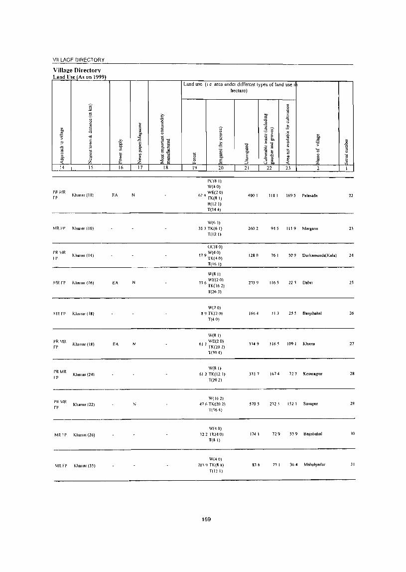
VILLAGE DIRECTORY --------------------------------------------------Villa2e Directorv Land Use (As on 1999)
Land use (I e area under different types of land use I
hectare)
]: c 0 g
~ ?;> "" > 5 c ... "8 "3 u "'" u
~ " E " ~ c U ... ~ E ~ ,,~ <E OIl -a 0
~ ,.::.,~ " ~ OIl u
~ > :0 " ~ ~ ~ ~1l ~ 0
'" 00
~ >, Iih ~ ~ .8 .9 C. e ;!: "'" ~ 0- 15. 8.E -c >
.c: B " " f,j '" E ~
~ a '" §JS "0 1;j :0 a ._
" c. 7;l I>J)
~~ 0 c
5. i;
~ ~ ~ 1;; 5
c " 3: e "" '" ~ '" ~ z ~ .i' .§ :5 - " ~ Ii U gb Vl
14 15 16 17 18 19 20 21 22 23 2 I
pe(8 I) W(40)
I'll Mil fP
Khamr (II) EA N 6 4 WE(2 0) 2 fK(8 I)
400 I III I 1695 Palasada 22
R(l2 I) T(344)
W(61) MR FP Khall"r (16) 35 3 TK(6 I) 2602 945 III 9 Margaon 21
T(12 I)
0((80) I'll MR
Khana, (14) 179 W(40) fp lK(40)
1280 76 I 509 Durkamunda(Kala) 24
T(16 I)
W(BI)
~IR rr "han.r(16) EA N 116 WE(2 0) TK(162)
213 9 1165 221 Dabn 25
T(263)
W(20) ~IR rp Khan.r (18) 89 TK(2 0) 1664 II) 255 Banj1bahal 26
T(40)
W(BI)
I'RMR fl'
Khan.r (18) EA N WE(20)
61 I TK(20 2) 1149 1165 109 I Kha"a 27
1(104)
PR MR W(BI)
Khanar (24) 612 TK(ll I) 311 7 1674 727 KesaralPur 2B fl'
T(lO 2)
I'R MR W(162)
Khanar (22) N 476 TK(20 2) 5705 212 3 152 I SUl1apur 29 il' T(164)
W(40)
MR II' Khan", (26) 122 TK(4 0) 174 I 729 559 Bagabahal 10
T(8 I)
W(40)
MR fl' Khanar (35) 2019 TK(8 I) 83 6 71 I 364 Mnhulpadar 31
T(12 I)
159
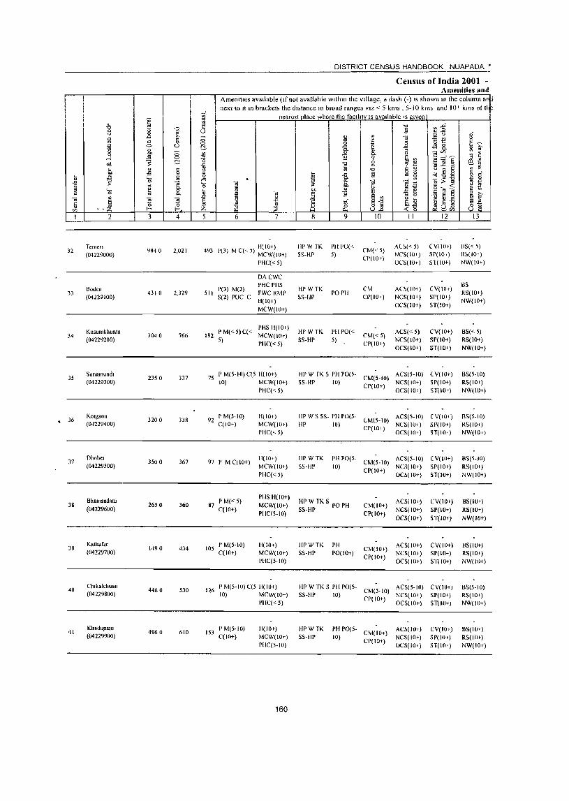
I
32
33
34
35
• 36
37
38
39
40
41
2
Temen (04229000)
Boden (04229100)
KlIsumkhunta (04229200)
Sunamundl (04229300)
Kotgaon (04229400)
Dhobel (04229500)
Bhalnsadam (04229600)
Kathaf.r (04229700)
Chlkalchuan (04229800)
Khadupant (04229900)
3 4
9840 2,021
4310 2,329
3040 766
2350 337
3200 338
3500 367
2650 360
1490 434
4460 530
496 0 610
DISTRICT CENSUS HANDBOOK NUAPADA •
Censlis of India 2001 -Amenities and
Amenities aVailable (If not available within the village, a da,h (-) IS showlIlO the column an next to It III bracket; the dl;tance In broad ranges VIZ < 5 kms _ 5-10 kim and !O~ kms of th
nearest place where the faCIlity IS available IS given
5 6 7
493 1'(3) M C« 5) 1l(IO+) MCW(IOt)
pHC« 5)
DACWC
I'HC PHS 511 1'(3) M(2) FWC RMP
S(2) PUC C H(IO+)
MCW(IO+)
I'M«5)C« PHS H(IO» 192 5) MCW(IOt)
I'HC« 5)
75 I' M(5-IO) C(5 11(10+) 10) MCW(IO+)
pHC« 5)
92 PM(5-10) C(IO+)
97 I' M CCIO+)
87 PM«5) C(lO+)
105 P M(5-IO) CCIO+)
H(IO+)
MCW(IOt)
PHC(<.5)
H(IO+)
MCW(IO+)
pHC« 5)
PHS ~I(IO+)
MCW(IO+)
PHC(S-IO)
H(IO+)
MCW(lO+)
PHC(5-10)
126 P M(5-10) C(5 H(IO+) 10) MCW(IO+)
PIIC« 5)
153 P M(5-10) C(lO+)
H(lO t )
MCW(IO+)
PHC(S-IO)
160
8 9
HI' W TK I'll 1'0«
SS-HP 5)
HI'WTK
SS-HP
IIPWTK
SS-HP
rOPH
I'll 1'0«
5)
10
CM« 5)
CI'(IO+)
CM
CI'(IO+)
CM«5)
CP(IO+)
11
AC~(" 5) NCS(IO+)
OCS(IO+)
AC~(lO< )
NCS(IO»
O(,S(IO+)
ACS« 5)
NCS(IO+)
OCS(IO+)
12
(VIIO+)
51'(10+)
ST(IO+)
(V(IOt)
SP(IO<)
ST(IO+)
(,V(IO+)
SP(IO+)
ST(lO-l )
HI' W fK S PH pO(S- CM(5-IO) ACS(S-IO) (V(lD+)
SS-IlP 10) CP(IO+) NCS(IO+) SP(IO+) OCS( 10+) ST( 10+)
liP W S SS- PH 1'0(5- CM(S-IO) ACS(5-10) (V(IO<)
Ill' 10) CP(lO+) NCS(lO<) SP(IO+)
IIPWTK
SS-HP
OCS(IO+) ST(IO+)
I'H 1'0(5- ACS(S-IO) (V(IO+) 10) CM(5-10) NCS(IO+) SP(IO+)
CP(IO+) OC!.(IO+) ST(IO+)
HPWTKS PO PH SS-HP
CM(IO+)
CP(IO+)
ACS(IO+)
NCS(IO+)
OCS(IO+)
CV(IO+)
SP(lO+)
ST(W+)
HPWTK
SS-HP
PH
PO(IO+) CM(IO+)
CP(IO+)
ACS(IO+)
NCS(IO+)
OCS(IOe)
(,V(IO+)
SP(IO+)
ST(IO+)
HP W TK S PH 1'0(5- CM(5-10) ACS(5-IO) CV(IOt)
S5-flP 10) Cr(lo+) NCS(IO+) SP(lO+)
HPWTK
SS-flP PH PO(S- CM(IO+)
10) CP(IO+)
OCS(IO+) ST(IO+)
AC~(JO+)
NCS(IO+)
OCS(lO+)
CV(IO+)
SP(IOt)
ST(IO+)
13
6S« 5)
R!.(IO+)
NW(IO+)
BS
RS(IO+)
NW(IO+)
B5« 5) RS(lO+)
NW(IO+)
B5(5-1O)
RS(IO+)
NW(IO+)
B5(5-1O)
RS(IO<)
NW(IO+)
BS(5-IO)
RS(IOt)
NW(IO+)
8S(IO+)
RS(IO+)
NW(W+)
BS(IO+)
RS(IO+)
N\v(IO< )
BS(5-10)
RS(lO t )
NW(IO+)
BS(IO+)
RS(lOt)
NW(IO+)
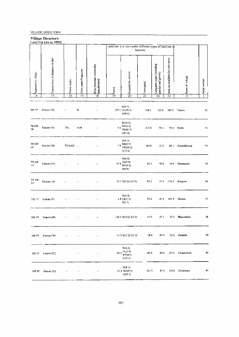
'JILLP,GE DIRECTOHY ---------------_.------------------------------------------------Village Oil ectorv r~ .!!~1As un 1999)
MR "P K'lR"ar (32)
PRMR fP
PRMR ~P
PR 1\IR I P
PI( MR fr
Mk'l'
MR FP
MR FP
MR fr
Mil FP
Kh.n.r (3~)
~.~Cflal (lS)
"hallar (15)
Khallaq.J5)
UIAnal (4c;j
".I.anar (48)
Khanar (70)
1.1",'", (S I)
Khanar (51)
N
FA NM
FDI:AG
Land me (I e area under dIfferent types of land use I hectare)
W(B I)
205 5 TK( 405) T(486)
W(162) WE(40)
53 TK(60 7)
T(810)
W(8 I) WE(40)
79 TW(20 2)
T(324)
W(40)
459 TK(O 8) Wf(40) T(S 9)
527 W(2 0) T(2 0)
W(24) 68 TK(l 2)
T(57)
1283 W(4 0) T(4 0)
II 3 W(I 2) T(I 2)
W(40)
493 lK(2 0) WF(40) T(IO I)
W(8 I)
514 TK(202) T(281)
161
418 1
2138
1648
81 3
832
974
610
189
1509
2113
1238 1879 Teme"
752 554 Roden
15 2 84 I KlIsllmkhllnla
596 19 0 Sunamllnd,
279 154 2 Kotgaon
473 192 9 Dhobel
47 I 23 0 Bhall1s.dam
8'i 9 316 Kalharar
830 151 I Ch,kalcllllAn
81 I> 1130 Khadupam
12
31
14
35
36
37
38
39
40
41
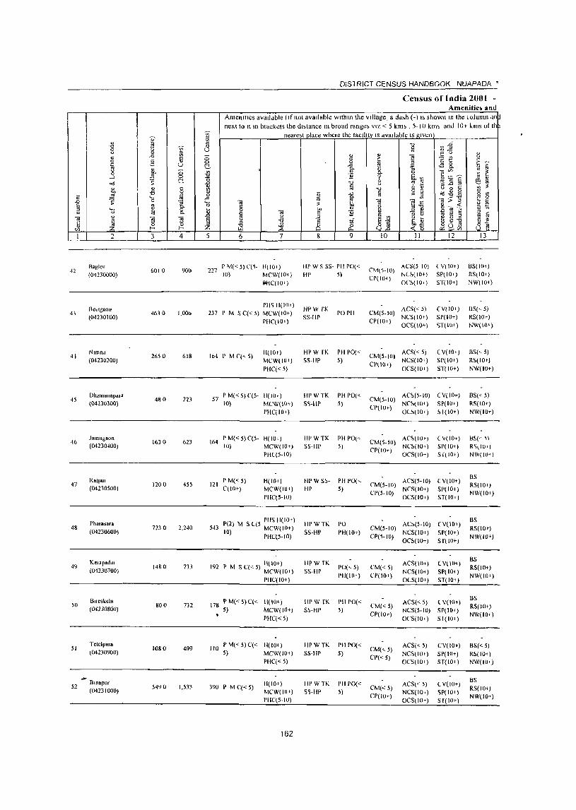
OISl RICT CENSUS HANDBOOK NUAPAOA •
Census of India 2001 -Amenitie~ and
AmenIties avalldble (If not available within the village, a dd,h (-) I> shown In the column .1I1~ next to It In brackets the dl>tance III broad range, VIZ < 5 kill> , 5-' 0 klll~ and lOT "illS 01 II ~
'" neare,t place where the lacllitYlS dvallable IS given j fil
" C '0 Vl~ -0
'" " 1il 0 u U ,,-u ... '" '" u " ..c: '" '" " " il ;:; .:: ;;. is! -= ~
~ 0 c 0 0 ~ 2 ~~ ;-~
-:::- U ~ ..c:
" "'- " :; .. 0 bI) ;::; ~
., %
u ~~~ '" ~ .-l ~ 0 ']l 6b'" '" .. od S ~ -0
'0 ~ ~ 2 OJ E 6 ... 13 ~
u -:3 .c ::3
'" " " " c '" '0 C " U 0 to CJJ -s 0 '" I:; § g g id-8.9 c
U ~ til 0 -a ~ § s .... ..c: ... [ OJ ~~
OJ>-g g .D 0 g_ '- \il ;$ u E '" 0 6 ~ g - « ? 1;\
'" ._
~ 0 II "" v g ~] c 0 "'- '" 'iii " ']l -0 t; S ~ v 1l u
~ ~j 'iii 5 ~ ~ 1 'Ii <.l ~ t ~ -a e " " ~ '" 6b~ 0
~ of ~(i~ 8] v .... I--< Z «0 '" I 2 3 4 5 6 7 8 9 10 II 12 13 -
>\2 8aglor
6010 900 227 PM«S)C(S- H(IOI) HI' W 5 55- PH 1'0«
CM(S-IO) ACS(S 10) l V( lOt) 85(IOt)
(04230000) 10) MCW(IO,) HI' S) CP(IOt)
NL~(IO+) 5P(lOt) RS,IO+)
IOHC(IOI) O('~(IOT) ST(IO+) NW(IO+)
BOJrgaou PHS 1l(IOI)
HPW fK ACS« 5) eV( 10+) BS(' S) 4} 46) 0 1,00b B7 I' M S C« 5) MCW(IO+) PO I'll CIvI(5-1O)
(04230100) PIIC(IO+)
5S-HP CP(IO+)
NCS(IOT) 51'(10+) RS(IOr)
OCS(IO+) <;T(IO+ ) NW(IO+)
41 Nlmnd
2650 618 164 I' M ('(<- 5) III lOt) HPW fK Pil 1'0«
CM(S-IO) ACS« 5) ( V(IO.) BS(, 5)
(042J0200) MCW(IO+) 55-liP 5) CI'(IO')
NCS(IOI) SP(IO I) RS(IOt)
PUC« 5) 0('5(101) ST(IO+) NW(IO+)
45 Dhdlnanapalft
480 223 57 P M« 5) ('(5- H(IO T ) HPWTK PH 1'0«
(,M(5-10) AC~(S-IO) (V(IO+) BS« 5)
(04230300) 10) MCW(IO+) S'>-IlP 5) CP(IOT)
N('~\IO<) SP(IOt) RS(lOt)
PHC(IO+) O(~IIOt) ~I(IOT) NW(IO+)
46 Jamugaon
1630 623 164 I' M« S) C(S- H(IOt) III' W TK PH POl<-
CM(5-1O) AC~IIOI) ( V(IO+) B~(' ~)
(04230400) 10) MCW(IO+) 55-III' S) CI'(IO+)
NC!>(IOI) SP(IO+) R'>\IU.) PIIC(5-10) OCS(IOT) S r( 10+) NW(IO+)
RalPUi P M« 5) H(lOi) HI'W5~- I'll 1'0(, ACS(5-10) (V(lOt ) BS
47 1200 4S5 121 CIvI(S-IO) RS(lOI) (04210500) (,(10+) MCW(IOI) HI' 5)
CI'(5-10) NeS(IO+) 51'(10+)
NW(IOi) PHC(5-IO) OCS(IO I) ST(IOt)
Pl,a.asara 1'(2) M S C(5 PHS 11(10') Ill' W TK PO AC:-(5-10) (V(lOt) BS
48 (04230600)
7230 2,240 543 10 MCW(IO+) CM(5-10) RS(IOt) ) PflC(5-1O)
SS-HI' PU(IOt) CP(5-10)
NCS(IOI) 51'(10+) NW(IO I)
OC~(IO+) 5 r(lo+)
Ktlapadal I'M SC«5) H(IO+) III' W [K ACSllllt) (V(lOt) 8S
49 1480 733 192 1'0(<., 5) CIvI«5) RS(IOt) (0'12)0700) MCW(IOI) S5-fII' 1'11(10 1) CP(IO+)
NCS(IOt) 51'(10+ ) NW(IOI)
PIlC(IOt) 0(5(10+) ST(IO+)
Blfeskela PM«5)C« 11(10+) HPW fK I'H 1'0« ACS« 5) t V(IO') BS
50 800 732 178 (,M«S) RS(JOt) (04230800) 5) MCW(IO+) 5S-HP 5) CP(IO+)
NCS(5-10) SP(IO+ ) NW(IO+)
PIlC« 5) O(,S(IO+) Sl( 10+)
51 Tetelpara
1080 409 110 I' M«5)C« H(IOt) HPWTK PU 1'0«
CIvI(<.,5) ACS« 5) CViIO') BS« 5)
(04230900) 5) MCW(IO+) S5-IIP 5) CP« 5)
NCS(IO I) SP(IO+) RS(IO<) PIIC« 5) OCS(IO+) ST(IOt) NW(JO<)
... Bmapur BS
S2 5490 1,5B 390 P M C« 5) 11(10+) HPWTK I'll PO«
CM«5) ACS« 5) CV(IO+)
(04231000) MCW(lU t ) S5-IIP 5) NCS(IO') SP(IO+ ) RS(IOq
1'11('(5-10) ('1'(10+)
OCS(IO+) Sr(IOt) NW(IO+)
162
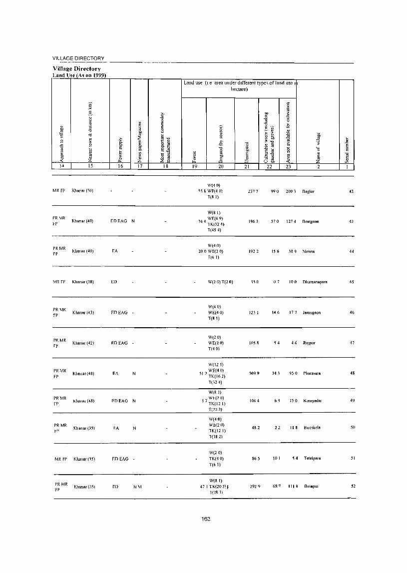
VILLAGE DIRECTORY
Villa1!e Directory Land Use (As on 1999)
Land use (I e area under dIfferent types of land use I hectare)
]' c: 0
'" g '" c on ;>
" '" " "" "" :;
u
" 0 .a u
~ " Ei u ~
" ~ Ei " ,,~ <B
bl) - '" "" 0 ;3 ~" ~ ~ on 0 " ;> ~ '" ~.", ~ ~
..0 " s: ~ ~ ~ bIl
.9 ~ b " .",
<ii ~ ] 8: 1:: i!l e ~ ..c: .9 " 8.5 .",
" iii ~ Ei ~ " 0 iii .", 7<j :0 (5 '- " '" ~ <>. §~ 1;j OIl ~~
0 c 8 IiJ '" ~ § " " <il 0- " " til bl) '" ~ .~ ~ ~ - ::J ~ 5 Z d: Z ~ .§ :3 U gJ, til
14 15 16 17 18 19 20 21 22 23 2 1
W(40) MR FP Khan91 (50) 558 WF(4 0) 2377 990 2003 Baglor 42
T(8 I)
W(81) PR MR
Khanar (40) EDEAG WE(49)
rP N 164 TK(32 4) 1963 570 1274 Boorgaon 43
T(454)
PR MR W(40)
FP Khanar (40) EA 200 WE(2 0) 192 2 156 309 Nlmna 44
T(61)
MR fl' Khanar (38) ED W(2 0)T(2 0) 150 07 10 0 Dhamanapara 45
PRMR W(40)
FP Khanar (43) EDEAG WE(40) 123 I 146 177 Jamugaon 46
T(8 I)
PRMR W(2D)
Khanar (42) EDEAG WE(20) 1058 54 46 RaJ pur 47 FP
T(40)
W(121)
PR ~1R Khana, (48) EA N
WE(40) 5099 34 1 9S 0 Pharasa,a 48
FP 512 TK(162)
T(324)
W(81)
PRMR Khana, (48) FDEAG N
WF(20)
fP 17 TK(12 I) 1044 64 130 Kerapada, 49
T(223)
W(40)
PRMR Khana, (35) FA N
WE(20)
~P TK(12 I) 482 22 II 8 Boreskela 50
T(182)
W(20)
MRFP Khana, (15) EDEAG TK(40) 865 10 I 54 Tetelpara 51
T(6 I)
PR MR W(81)
Khana, (35) ED NM 47 1 TK(20 2), 2929 68 ? III 8 BlI10pm 52 FP T(281)
163
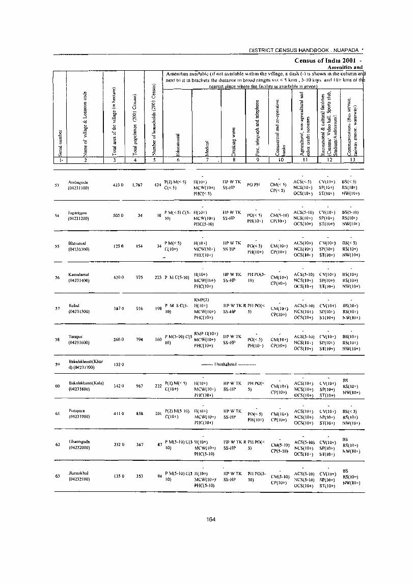
I·
53
54
55
56
57
58
59
60
61
62
63
2
Ambaguda (04231100)
JugaraJPur (04231200)
Bherumal (04231300)
Kamalamal (04231400)
Rokal (04231500)
Tarapllr (04231600)
BakullkhllnlI{Khur d)(0423 1700)
Bakllhkhllllll(Kala) (04231800)
PUlupara (04231900)
Ghallllguda (04232000)
Jlunmkhol (04232100)
3 4
4230 1,767
5050 34
1250 154
4200 975
3870 936
2660 794
1520
3420 967
4110 SSS
2320 367
1350 353
DISTRICT CENSUS HANDBOOK. NUAPADA •
Census of India 2001 -Amenitie~ and
AmenitIes avaIlable (If not available wIthIn the VIllage, a dash (-) I, shown In the column an~ next to It 10 brackets the dIstance In broad ranges VIZ < 5 kms , 5-10 klp', and lOr kms of II ~
nearest place where the facIlity IS avaIlable IS gIven
5 6
434 1'(2) M« 5) C« 5)
7
11(10+) MCW(IO+)
!'HC« 5)
10 PM«5)C(5- 11(10 1 )
10} MCW(IOi)
I' M«5) 34 C(IO+)
PIIC(5-10)
H(IO+) MCW(IO+)
PHC( lOt)
ti(IO+) 223 I' M C(5-IO) MC\v(IO+)
198 I' M 5 C(5· 10)
PIIC( lOi )
RMP(2) ti{IO+)
MC\v(IOf) PHC( lOt)
8
HI' WTK SS-HP
HPW TK SS-Hl'
IIPWTK
55-liP
9
pOPB
1'0« 5) PI1(IO+)
1'0« 5) PH(IO+)
10
CM«5) CP« 5)
II
ACS«5) NCS(IO+)
OCS(IO+)
12
(,V(IO+)
SP(IO+)
ST(lO, )
CM(5-IO) ACS(5-1O) (,V(IO+) NC5(10+) SP(1O+)
CP(lO+) OCS(IO+) ST(IO+)
CM(lO+) CP(IO+)
ACS(IO+)
NCS(IO+)
OCS(lOi)
CV(IO+)
SP(IO+) 5T(10+)
tiP \V TK
5~-tiP
PH PO(5· CM(IO+) ACS(5-IO) CY(IO+)
10) CP(lO+) NCS(lO+) SP(IO+)
III' W TK R I'll 1'0« 55-III' 5)
CM(IO+)
CP(lOf)
OC5(1O+) 5T(IO+)
AC5(5-IO) (,V(IO+)
NCS(IO+) SP(lO+) OC5(1O+) 51(10+)
PM(5-10}C(5 RMPII(IOt) IIPWTK 160 10) MCW(IO+) SS-IIP
PIIC(IO+) 1'0«5) PH(IO+)
CM(IO+) CP(IO+)
AC5(5-1O) CV(IO+)
NCS(IO+) SP(IO+)
OCS(IO+) ST(IO+)
---.---. Unlllhablled ------------
222 P(2) M(<5) C(lO+)
11(10+)
MCW(IOt)
PIIC( 101 )
201 1'(2) M(5-1O) H(IO+) C(IO+) MCW{IO+)
PHC(lO+)
87 P M(5-11l) C(S 1I(11l1-) 10) MCW{IO+)
PIIC(5-10)
94 P M(S-IO)C(S 1I(10t) 10) MCW(lOt)'
PHC(S·IO}
164
HPWTK
55-liP
IIPWTK 55-HI'
PH PO{<
5)
PO{< ;) PH{IO+)
HPWTK R PHPO« 55-liP 5)
CM{IOt)
CP(lO+)
CM(lO+) CP(IO+)
ACS(lOi)
NCS(IOt)
OCS(IO+)
AC5(1O+) NC5(10+) OCS{10+)
eY{lo+)
SP(IO+) 5T{IO+)
eV(IOt) ~P{IO+)
5T(10+)
CM{S-IO) ACS{S-IO) CV{IO+)
CP(5-1O) NCS{ 10+) SP(lO+) OCS{IO+) 51'(10+)
HPWTK 55-liP
PH potS· CM(5-10) ACS{5·1O) CV(IO+) 10) CP(IO+) NeS(S-IO) SP(IO+)
OCS(IO+) ST(IO+)
13
ElS«5) RS(IO+)
NW(IOt)
85(5-10) RS(IO+)
NW(IO+)
B5« 5) RS(IO+)
NW(IO+)
BS(IO+)
RS(IO+) NW(IO+)
8S(10+}
RS(IO+) NW(IOt)
BS(IOf)
RS(lO+)
NW(IO+)
BS RS{IO+)
NW{IO+)
8S« 5) RS{IOI) NW(IO+)
BS RS{IO+)
NW(lO+)
BS RS(IO+) NW(lO+)
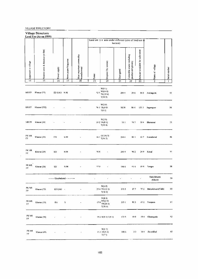
VILLAGE DIRECTORY
Villal!e Directory Land UseJAs on 1999)
" OJ)
.!:! ~ .9 .<: u oj
2 c. ~ 14
MR fP
MRfP
MR FP
PRMR
FP
PR hlR FP
PRMR
FP
i " c '" u
~ -i3 o(!
~ .9
~ Z 15
Khan.r (3~)
Khan.r (352)
Khana, (16)
Khan., (20)
Khanar (24)
Khanar (26)
" C
~ bIl
'" ~ ;"
0. C- " c. iii '" c. !J ~ ~
11 Z 16 17
EDEAG NM
ED NM
ED NM
ED NM
._ ..• _ •• Umnhablted _ •• _._. __ •••
PRMR Khan" (15) EDEAG rp
PRMR Khan", (35) rp EA N
PR MR Khana, (15)
FP
PRMR Khan., (4~)
~P
0 -g = = 0 u
~] 8.~ §..e - ::I
~ ~ 18
Land use (I e area under different types of land use 1
hectare)
" 0
~ ""
,. c E
-i3 '" ::I u "0 "-
0' c ~ ..s ~ - '" ~ " "
~ ,. :c " ~ ~ '" bIl
@ .!:! ~ ;" :t-o ~ .0 e -0
" § > § * '" -0 :c 0 '-
" blJ '" til 0 " ~ '" § a-u " " 7ij OJ) '" ~ - ::I ~ Ii ~ .§ :5 o ~ '" 19 20 21 22 23 2 I
W(8 I)
12 5 WE(40) TK(32 4)
2894 206 360 Ambaguda 53
T(445)
W(20)
76 I TK(40) 1828 864 1533 JugaraJPur 54 T(6 I)
W(20)
to 2 TK(8 I) III 747 194 Bherumal 55 T(IO I)
16 I GC(167) T(167)
264 4 801 227 Kamalamal 56
108 2414 902 249 Rokal 57
179 1466 616 198 Tarapur 58
Bakuhkhuntl 59
(Khurd)
W(40)
254 TK(12 I) 2355 277 172 BakllhkhuntJ(Kala) 60
T(162)
W(8 I)
170 WE(2 0) TK(20 2)
235 I 855 43 2 Pulupara 61
T(10 4)
152 W(4 I) T(4 I) 1735 198 194 Ghantlguda 62
W(41)
112 I K(3 2) 1006 53 104 J1l1rJ1l1khol 63
T(71)
165
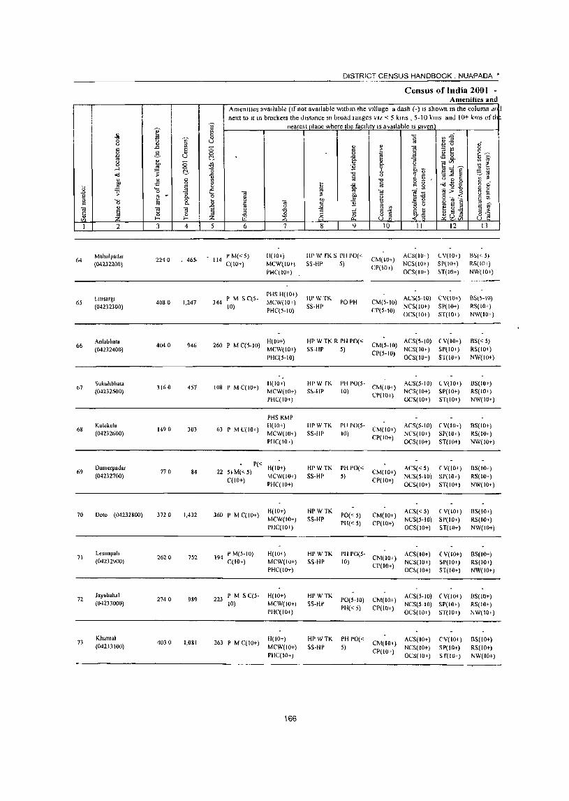
64
65
66
67
68
69
70
71
72
73
2
M.hulp.ddr (04232200)
Llllsargl (04232300)
Anl.bhat. (04232400)
Sukuhbh.t. (04232500)
Kulekela (04232600)
Oumerpadar (04232700)
Ooto (04232800)
Lesunpall (04232900)
Jayabahal (04233000)
Klunnal (04233100)
3 4
2240 • 46>
4080 1.247
4040 946
3160 457
1490 303
770 84
372 0 1.432
2620 752
2740 989
4030 1.081
DISTRICT CENSUS HANDBOOK. NUAPADA •
Census of India 2001 -Amenities and
Amenttles avaIlable (If not available within the village a dash (-) IS shown In the column dll~ next to 11 In brackets the distance In broad ranges VIZ < 5 kms , 5-10 kms and i 0+ krn~ of II
nearest place where the faCility IS available IS given
5 6
• 114 P M« 5) C(LO+)
7
H(IO') MCW(IO') PIolC( 10+)
PHS H(IO+) 344 I' M 5 C(S- MCW(IO')
10) PHC(5-10)
H(IO+) 260 P M C(S-to) MCW(IO+)
108 P M C( 101-)
63 P M C(lOi)
PHC(5-10)
11(10+) MCW(IO+) PHC(IO+)
PH5 RMP H(lO+) MCW(IO+) PHC(IOI)
P« H(IO+) 22 5) M« S) MCW(lO+)
C(lO+) pHC(IO+)
360 P M C(lO+)
194 P M(5-10) C(lO+)
223 P M S C(S-10)
263 P M C( 10+)
H(IO+) MCW(IO+) PHqlO+)
H(IO,) MCW(IO+) PHC(IO+)
H(IO+) MCW(IO+) PllqIO+)
H(lO+) MCW(IO+) PHql0+)
166
8 9 10 II 12
liP W fK 5 PH 1'0("" CM(LO+) ACS(lOi) CP(IO.) NCS(IO')
OCS(HH)
lV(IO+) 51'(10+) H(IO+)
S~·l!P 5)
1\I'WTK POPH S5-HP
CM(S.IO) ACS(S-IO) CV(IO+) NCS(JO+) 51'(10+)
CP(S-IO) OC5(10+) ST(IOi)
HPWTKRPHpO« CM(S-to) ACS(S-to) eV(lo+) S5-lIP 5) CP(5-10) NC5(1O+) 51'(10+)
HPW [I(
S&-HP
HPWTK 5S-HP
PH 1'0(5· CM(IO+)
10) CP(IO.)
OC5(10+) ST(IO+)
ACS(5-IO) (Y(IOI) NCS(IO+) SI'(IO+) OCS(IO+) 5T(10+)
PH PO(S- CM(IO+) AC5(S-10) (V(IO+) 10) CI'(I0+) NC5(10+) SP(IO+)
OCS(IO+) 5T(10+)
HP W TK PH 1'0« CM(IO+) ACS«5) (V(IO+) CI'(IO+) NCS(5-10) SP(lO+) 5S-HP 5)
HPWTK SS-HP
HPWTK SS-Hp
flPWTK SHIP
1'0«5) PH«5)
OCS(IO+) ST(IO+)
ACS« 5) (V(IO+) CM(IO+) NC5(S-10) Sp(IO+) CP(IO+) OCS(IO+) ST(IO+)
PH 1'0(5- CM(IO+) ACS(IO+) 10) CP(IO+) NCS(IO+)
OC5(10+)
( V(lO+) SP(lO+) ST(IO+)
PO(5.10) CM(IO+) ACS(5-1O) (V(lOi) PH« 5) CP(IO+) NC5(5-10) SP(Io.)
OCS(IO+) ST(lO+)
Hr W TK PH PO« CM(IO+) ACS(IO+) CP(lO+) NCS( 10+)
OCS(IO+)
CV(IOi) SP(lO+) Sf(IO+)
SS-HP 5)
13
B5« 5) RS(IOI)
NW(IO')
B5(5-IO) RS(IO+) NW(IOI)
BS« 5) RS(lO+) NW(IO+)
B5(10)) R5(10+) NW(IO+)
B5(1O+) RS(lO+) NW(IO+)
BS(IO+) RS(IO+)
NW(IO+)
8S(l0+) RS(IO+) NW(IO+)
BS(lO+) RS(IO+) NW(IO+)
BS(IO+) RS(IO+) NW(IO+)
8S(10+) RS(IO+) NW(IO+)
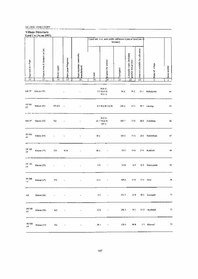
VILLAGE' D'I~EG10RV
Villa{!e Directorv Land (Ioe (A;;;:s_;o;.:;n:...l;_;9c.:9,~9~)r-_'_'-__ r-_____ ,...,.._"-_:--___ :---:-:::::-___ -'-"'--:-_-r-__ 1- .----.-----, I Land use (I e area under different types 01 land lise I
MR FP Kha"., (d8)
Pf'MR
rr
MR FI'
PR HR FP
PR MR fP
PI( MR I)'
MR
PR \'IR FP
PR MR FP
Khall.' (41)
Kha'lR' (43)
Khana, (41)
K',ana, (1~)
Khan.r (29)
Khanar (27)
Khan.r (26)
Khana, (26)
Khans, (\1)
ED to
ED
FD NM
ED
ED
ED
W(81)
55 TK(4 0)
T(12 I)
hectare)
8 5 W(2 8) T(2 8)
W(32)
45 I TK(4 9)
T(S \)
7S 6
192
99
125
94
120
29 I
167
940 792 33 I Mahulpada, 64
3402 17 I 19 7 L,llSR'g' 65
304 7 170 28 8 Anl.hhala 66
1432 714 22 6 Sukuhbhata 67
935 196 170 Kulekela 68
478 69 \ 2 5 Dumerpadar 69
3080 338 175 Doto 70
2217 124 18 4 Lesunpah 71
2063 34 I 212 Jayahahal 72
2785 898 51 Klllnnal 71

DISTRICT CENSUS HANDBOOK NUAPADA·
Ccn!>us of India 2001 -Amenititlo and
Ameilitles dVaIldble (If not avaiidble wlthm the village, a dash (-) IS shown In the wlumn an
next to It In bra~kets the dlstdn~e In broad ranges VIZ < 5 kms 5-10 kms and lOt- kms ot th
'0 ~ nemest place where the faclllly IS available I~ given
" lO """ ~~ ."
~ ~ " ~ 0 u oJ " ;:J " .<: Vl ;; ... " ] -B t! '" " I'i " > ~~ 0 3 0 0 ~ ~ u C- -" ~ g_ " iO'
" " 0 e- " ] ~~s :;: ~ "" .<J cc 0
'" 11 0 6,,,, ,_l 0 " " ~ C- o b e'iii o(! 7i -0
" ~ ~ '"3..t: :l ~ Vl 3;
" " " Vl -0 " OJ " 0 c: " bIJ .s 0 " M -" ~ g g .id~g 0 " b ~ ~ 0 cc ~
0 '0 -" ~J Oi "i~ Oi>'g
~ .s:;, ;: -;; ..... Oi 3; 8 ~ cc 0 § "" " Q a~ § - ..: " "
._ 0 b g ~] " 0 cc ~ <i3 j 11 " :; t) " >,
Oi " Oi "Ii .s:;, " ~~ " ~ e V "N 8 '"
~ 8 " -a 1 6,<> g 5 g~ 5 -0 0 ::I '" .~ 8] C/) l- I- Z iil ..:~ p:;8C/) u
I 2 3 4 5 6 7 8 9 10 II 12 13
Larka PM 5 PHS H(IO,)
HPW IK ACS(IOr) C'V(IO+) B5(10+) 7~
(04233200) }690 1,042 231
('(IOi) M(,W(IO+)
5~-IIP 1'0(10+) (,M(lO+)
NC5(IOr) ,)P(IOf) R~(I0T) PHC(5-10) PII(IO,) CP(IO+)
OC5(1O+) ,)1(10+) NW( 10+)
75 Palenbasa
1880 l05 48 PM(5-lO) H(IO+) III'W [K PH 1'0«
CM(lOf) ACS(IO+) (,V(IO+) BS(IO+)
(04231JOO) • C(IO+) MCWllO+) SS-HP 5) CP(IO+)
NCS(IO+) SP(lO+) R<;(I0+)
PHC(5- 10) OCS(IO+) ST(lO+) NW(IO+)
76 Kluulfguma
2150 128 31 P M« 5) C(5- H(lOt) HPW1K I'll 1'0«
CM(lOf) AC5(5-10) CV(IOt) BS(lOI-)
(04233400) 10) MCW(IOi) ~S-IiP 5) CP(IO+)
NCS(<-5) SP(IO+) R5(IOT)
I'HC(5-10) OCS(IO+) S r(1o+) NW(iO")
77 AnakapUl
5390 1,170 270 P M« 5) C(5- H(lO+) HPWTK PH 1'0«
CM(IO+) AC!>(5-1O) CV(IO,) B~(IOt)
(04233500) 10) MCW(IO+) 5~-HI' 5) CP(IO+)
NC5(5-1O) :,1'(10+) RS(IO+)
PHC« 5) OC5(10+) !,T(101) NW(IOI-)
78 Gumabahal
1210 200 44 P M« 5) C(5- H(lOt) HPWTK PH PO«
CM(IO+) AC5(5-1O) eV(lor) 1:15(10')
(04233600) 10) MCW(JOr) 55 Ill' 5) CP(IO,)
NC5(5-10) SP(IO+) R5(10+)
PHC« 5) OC5(1O+) ST(lO+) NW(IO+)
79 KhOila
1870 343 84 I' M« 5)C(5- H(lOr) HPWTK
1'0(10+) CM(IO+) AC5(IO+) (,V(to+) BS(IO+)
(04231700) 10) MCW(IO+) 55-Ill' PH(IO+) CP(IO+)
NCS(IOt) SP(IO+) RS(IO»
PHC« 5) OC5(10I-) ST(lO+) NW(IO+)
80 Knmpllf
4280 1,233 281 I' M C(5-10) H(IO+) HPWTK I'll 1'0«
CM(IO+) AC5« 5) CV(IO,) B5(10+)
(04233800) MCW(IO+) 55-Ill' 5) NCS« 5) 51'(10+) RS(IO+)
PHC« 5) CP(IO+)
OCS(lO+) ST(IOt) NW(IO+)
K:uangamal P(2) M(2) S PHC PHS
HPWTh PH 1'0(5- CM CP(5- ACS NCS(5- CV(~ B5 81 3810 892 201 H(Hl+) 10) 10) R5(1O+) (04233900) PUC C(5-10) SS-HP 10) 10) OCS(IO+) &P(lOt) MCW(IO+)
5T(10+) NW(IO+)
Pllapanl P« H(IO+) HPWTKR - ACS(IO,) CV(IOt) I:I~(IO+) 82 940 38 12 5) M(5-IO) 55-III) 1'0(10,) CM« 5) (04234000)
C(JO+) MCW(IO+)
PH(IO+) CP(IO+) NCS(IO+) 51'(10+) RS(lO r )
PHC« 5) OCS(IOI-) 5 r(IO,) NW(IO+)
83 Dah.napah
2340 1,074 288 P M« 5) ('(5- H(lO') HP WTK R PO(~5) CM(5-1O)
ACS(5-IO) CV(IO+) B5« 5) (04234100) 10) MCW(IO,j 5S-HP PHI I 0+) ('1'(5-10)
NCS(IO+) 51'(10+) RS(IO+)
PHC« 5) 0('5(10+) 5T(IO+) NW(IO+)
168
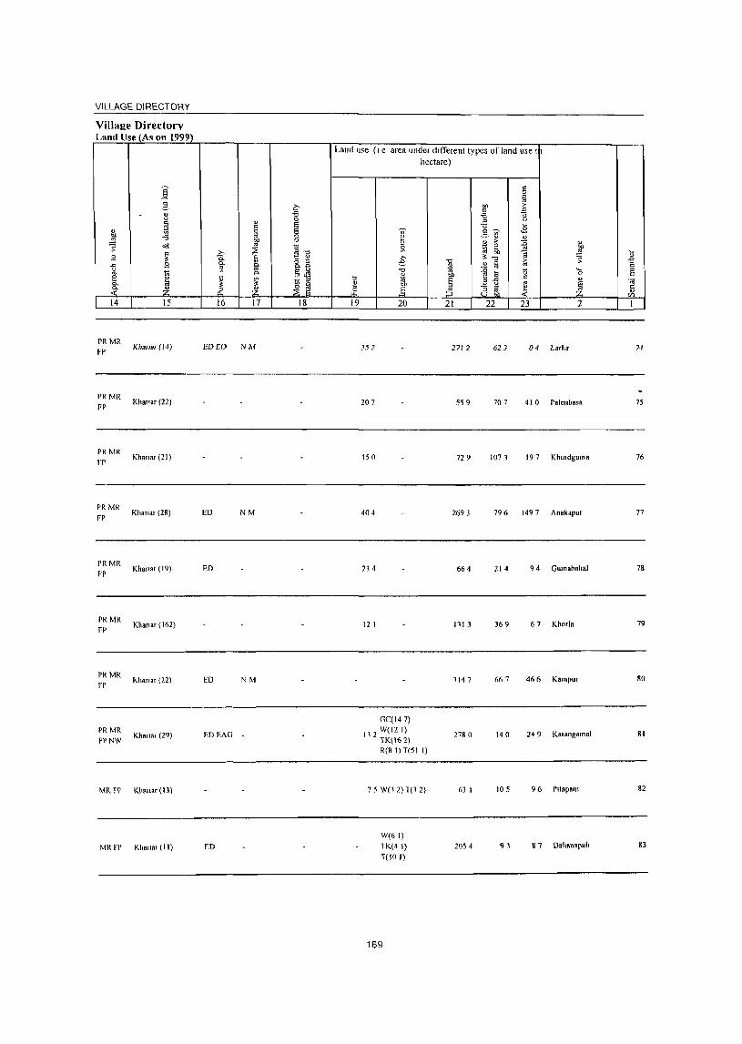
VILLAGE DIRECTORY
Village Directory Land Use (As on 1999)
s
14
PRMR FP
PR MR
FP
PRMR
rr
PRMR
FP
PR MR
FP
PRMR
FP
PR MR
FP
PR MR FPNW
MR FP
15
K},anar (!4)
Khanar (22)
Khanar (21)
Khanar (28)
Khanar (19)
Khanar (162)
I<-.hanar (22)
Khanar (29)
Kha"ar (13)
MR FP Khanar (II)
16 17 18
EDEO NM
ED NM
ED
ED NM
ED EAG
LD
Land llse (I e area under different types of land use I
hectare)
19 20
352
207
150
404
234
12 I
GC(l47)
11 2 W(12 I) TK(162) R(8 l)l(51 I)
7 5 W(l 2)1(12)
W(61)
lK(4 I) l(IO I)
169
21
2712
559
729
2693
664
111 3
1147
2780
63 I
2054
22 23 2
62 ] 04 Larka
707 410 ralcnbasa
1073 197 Khurdguma
796 1497 Anokapur
214 9 4 Gumabahal
369 67 Khorla
667 466 Kampur
140 249 Kalangnmal
105 96 Prtapam
93 8 7 Dahanapall
74
75
76
77
78
79
80
81
82
83
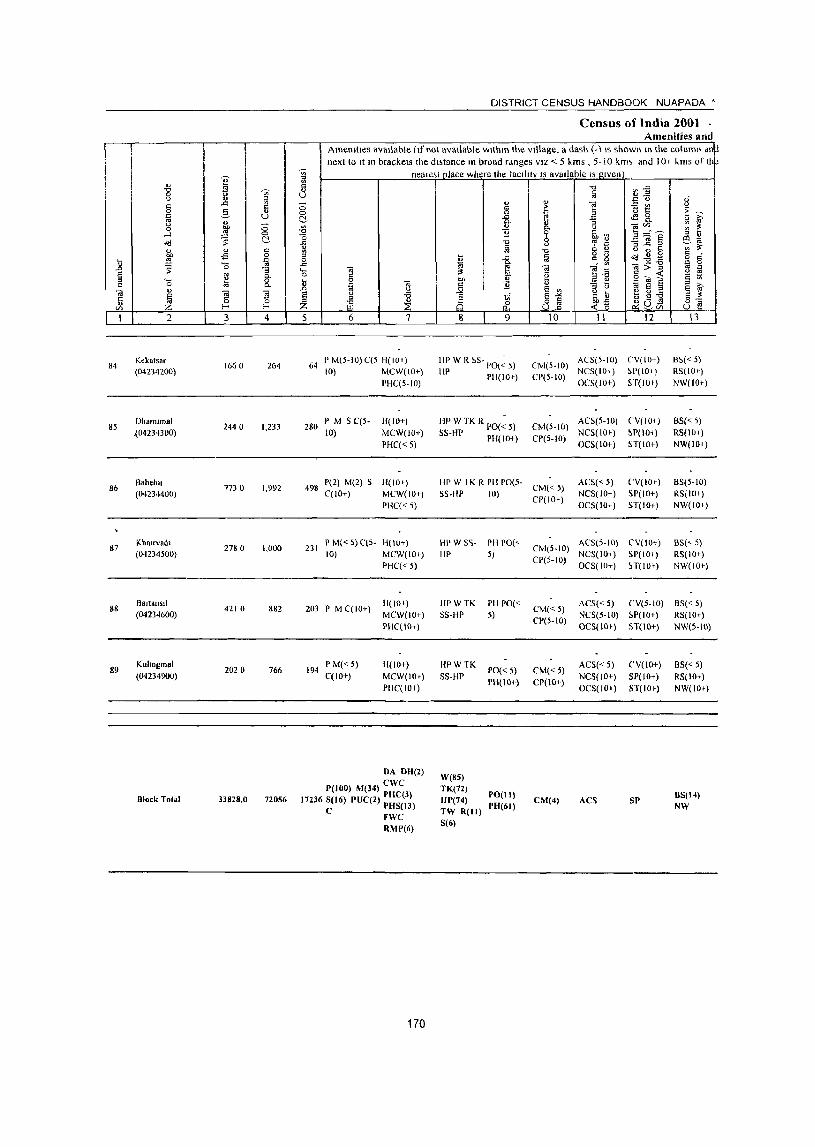
'" " ~ -0 0 :l u " '"
..:: '" c:: 0 2- 0
'" u '" " u ;:; 0 ~ ....l
~ <:>
o'IJ ~
" " § 01) .s '" ~ ii ~ "0 .0 :;
E '" "" " .... ~ 0
" 0 <>. ., OJ
~ S S Ii 0 0
V> !- !-
1 2 3 4
84 Kckatsar
1660 264 (04234200)
85 DhaIDJlnal
2440 1,233 ,{O4234300)
86 Babebll
1730 1,992 (042344()0)
87 Kha.rvad.
278 ° 1,000 (04234500)
88 Bartallstl
4210 882 (04234600)
89 Kllhnllmal
2020 766 (04234900)
Olock Total 33828,0 72056
DISTRICT CENSUS HANDBOOK NUAPADA'
Census of India 2001 -Amenities and
Amemtles available (If not available WlthlO the village, a dash (-liS shown HI the column dn~ next to It 111 brackets the dl;tance 10 broad ranges VIZ'" 5 kms , 5- iO km'. and 10+ "ms of II p
'Vi neal est place where the taclilty IS available IS Jl.lven a " " u ;:; 0 c:!-{l C ..c
~ 0 ..c .... ... 0 § ii ta ...
..0 <J
E <J
~ " " IE Z 5 6 7
64 P M(5-10) C(5 1i(lO r) 10) MCW(IO+)
PHC(5·10)
280 P M S C(s- H(IO+}
1O} MCW(10+}
PHC« 5)
498 P(2) M(2) S H(IO+) C(lO+) MCW(IO+)
PHC« 5)
231 I' M« 5) C(5- H(IO+) 10) MCW(IO+)
PHC« S)
203 I' M C(IO+) H(IO+) MCW(IO+) PHC(IO+)
194 P M«5) 11(10+) C(IO+) MCW(IOt)
PHC(IO+)
DA DH(2)
P(IOO) M(34) ewc 17236 S(16) PUC(2) PHC(3)
e PHS(13) FWC RMP(6)
170
" c: 0 ..c
"" " 11 -0
~ t ..c OJ "" ~ " CI) " c: 11 .Q c: 1i 8 ~ 8 9
HI' W R 55- PO(~ 5)
III' PH(IO+)
I~P W TK R PO(~ 5)
5S-UP PHI 10+)
HP W I K R PH potS· S5-flP
HPWS'i-HP
HPWTK S5-HP
HPWTK 5S-HP
W(8S) TK(12) HP(74) TW R(Il) S(6)
10)
PII 1'0(<-5)
PH 1'0« 5)
PO«5) PH(IO+)
PO(II)
1'"(61)
-0 §
" 1! ,. E a "
:;
i u
~J ~ <J , '"
"0 '" " iii g g ""iii: OJ
g ... -a E ~ " e '" " <J
E "'" ~j_ 8] 10 II
CM(S-IO) AC5(5-IO)
CP(5.1O} NC5(101-) OC5(101-)
CM(5·IO) AC5(S-IO)
CP(5-10) NCS(lOf) OC5(10+)
CM«5) ACS« 5)
CP(lO+) NC5(1O+) OC5(1O+)
CIvI(S-IO) ACS(5·10)
CP(5-IO) NC5(10+) OC5(1O+)
CM«S) AC5« 5)
CP(5-10) NC5(5-10) OCS(IOr)
CIvI«5) ACS«5)
CP(lO+) NC5(10+) OC5(IOf)
CM(4) ACS
iJ:S :: 0
~ t ~ 8. ~~s ""3] ~ u 0 J: ~~B ... --i3 c>~ o'"~ ~ e § ~ g -€I ~ab'l
12
(,V(IO+) ~P(IOr)
ST(lOf)
(,V(IO+)
~P(IOt)
ST(10+)
('V(IO+)
SP(IO+) ST(IO+)
C'V(IO+) 51'(10+) H(IOr)
CV(5-1O) 5P(10+) ST(IO+)
CV(IO+)
SP(lO+) ST(IOf)
SP
OJ' <J
~ ~ " '"' ~ ~ iQ -~~ '" 0 ti ~ c
'" ~ '" ti
'"' e " E ~ 8"§
13
85« 5) RS(lO r) NW(IO+)
B5« 5) RS(10+) NW(IO+)
BS(5-10) RS(IO I )
NW(JO+)
8S(<.. 5) RS(IO+) NW(lOr)
8S« 5) RS(IO+) NW(S-IO)
85« 5) RS(IO+) NW(IO+)
OS(14) NW
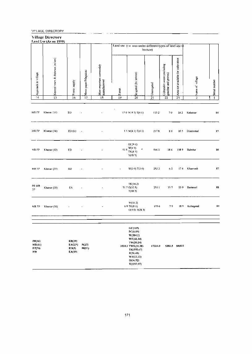
'illl AGE DIRECTORY ~-------------------------------------------------------
"illage Di rectory !,am!_ lm- (As on 1999)
-~ g " u
~ " OJ) -a ~
~ o<!
8 ~ .c 8 u
'" 'ii ~ ia "- :£ -< 14 15
MR fr Kham, (II)
MRFP
~~R FP
MR rr
PRMR
FP
MR rp
PR(46) MR(81) FP(76)
NW
Khana, (14)
Khan" (32)
Khalla, (35)
Khana, (35)
Khan.r (30)
;., C.
~
" ~ 0
t:l.
16
ED
EDEO
ED
ED
EA
ED(29)
EAG(9) EO(3) EA(IO)
~ bIl
'" ~ ~ p.
~ :£ 17
N(23) M(lI)
Q -a 0 E S 8 §-o 1: ~
8.fi ~~ ~ ~
18
Land use (I e area under different lypes of land use I
hectare)
1;; ~ ~ 19
u-~ Sl ;.,
e "0
" " OIl
.§ 20
15 a W(4 I) T(4 I)
l1W(41)T(41)
GqQ 4)
515 W(49) TK(4 I) 1(181)
We2 0) T(2 0)
TK(162) 11 7 0(325)
T(487)
W(162)
69 TK(8 I) O( 40) r(28 3)
G('(169) PC(8.09)
W(J84.2) WE(4J.34)
TW(20.24) 3520.3 TWE(32.38)
TK(555.67) R(36.41)
WF(I2.12) 0(36.~2)
T(1297.97)
171
"0
" '" OIl
E ;3 21
1132
2178
5162
2522
251 I
1196
17324.0
r:: 0
~ OIl > r:: '" -a ] :::
U ~
S";) <2 ~" " ~
> :0 " 0
'" bIl !;;,
~ -"l ~ -0 > ~ " !ii '" :0 0 """' ~ ~ 0
a"5 r::
" '" ~ "3 iil ~ U "" 22 23 2
70 26 2 Kekatsar
80 105 Dhanllmal
286 1589 B.beb"
62 176 Khall"Vad,
31 7 559 Bart.n,,1
79 189 Kulll1gmal
5381.~ 5868.0
E § r:: .. t:: " '/)
1
84
85
86
87
88
89

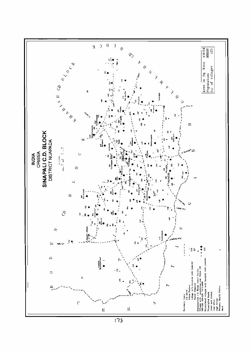
~ -
a
• ~ .
~ 0 ~ •
o
c
o
« Se\\
i
7
:; .:: I
~ .r ,
. . ~ • "O~
' .. , ~
~ '. ~ ~
ill« , . -u 1.
~ '~:i. t· I
". I
H
V~ •
•
~
~ ." lIi.
'" . ~ . " ~ ,
il
~
" , , MO ~ ,
~ .
113
, V~ •
~ .
~ .
, ' <, ~. , , , ,
, .. . .,.. "-
~ . !! •
&';?'" \~. ,/ I
H
, Q ~ •
4_
I
o I : I
I
/ 0 i. /
~ 1 /~1Jl1Di'(l~' \Ij.LIJ-A .. i. ",,/-"" " (
I { I \ I
} ..... I
J f.... I
I I

VILLAGE DIRECTORY OF
SINAPALI C.D. BLOCK- 0004


ALPHABETICAL LIST OF VILLAGES OF SINAPALI C.D. BLOCK - 0004
'>erml numher Name of village 200 I Census location code 1991 Census location code number number
2 3 4 NAME OF (.D. BLOCK - SINAPALl
POLICE STATION - BODEN - 0005
Haragaon 04234800 100040017001700076
2 BOlopal1 04235000 100040017001700079
Salekela 04234700 100040017001700075
POLlCE STATION - SINAPAU - 0006
Akhadabhata 04244400 100060017001700090
2 Armala 04235300 100060017001700003
3 Badhunpanl 04247200 100060017001700118
4 Badlbahal 04244900 100060017001700095
Balgapada 04236000 100060017001700010
6 Barpadar 04242000 100060017001700066
7 Bharuamunda 04242100 100060017001700067
8 Bhatapalll 04237600 100060017001700026
9 Bhulrabhata 04238000 100060017001700030
10 BIJoIlpur 04236900 100060017001700019
11 Brahmanrguda 04245700 100060017001700103
12 Brahmanpada 04246100 100060017001700107
13 Ch,llna 04240000 100060017001700050
14 Ch,tncharabhata 04241900 100060017001700065
15 Chandel 04243500 100060017001700081
16 Ch,lrpah 04241600 100060017001700062
17 Chlltraguda 04239300 100060017001700043
18 Cholunra 04241300 100060017001700059
19 Chltarama 04237300 100060017001700023
20 Dangargaon 04242800 100060017001700074
21 Dangargaon 04244200 100060017001700088
22 Darllpada 04238500 100060017001700035
23 Darhpada 04244500 100060017001700091
24 Dauda 04237900 100060017001700029
25 Dengamancha 04243400 100060017001700080
26 Dhlng,amunda (Dhungtamunda) 04244600 100060017001700092
27 Dhunglamunda 04235700 100060017001700007
28 Dhllng ramllnda 04241700 100060017001700063
29 Dumerbahal 04237000 100060017001700020
30 Dungnguda 04243300 100060017001700079
11 Dungnkhol 04243600 100060017001700082
32 I ulchl 04238100 100060017001700031
33 Gadaramal 04239000 100060017001700040
34 Gallapanr 04246800 100060017001700114
35 Gambhanguda 04240200 100040017001700078
36 Gandabahall 04240400 100040017001700081
37 Ghotuguda 04239900 100060017001700049
38 Ghuchaguda 04238800 100060017001700038
39 Gldhamal 04241100 100060017001700057
40 Godal 04242700 100060017001700073
41 GOJladllngrr 04244700 100060017001700093
177
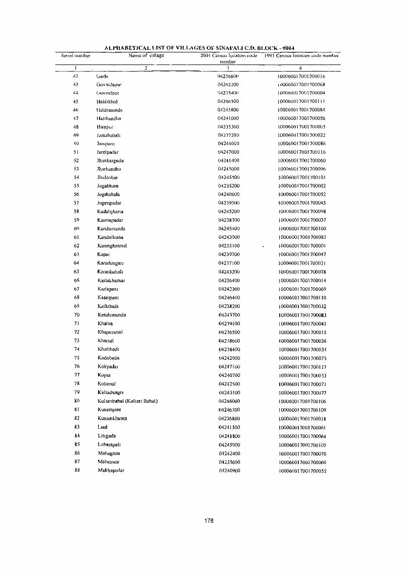
ALPHABETICAL LIST OF VILLAGES OF SINAPALI C.D. BLOCK .I}OM
Senal number Name of village 2001 Cen,us IOCdllon code 1991 Census locatIOn code nllmbe. number
2 3 4
42 vorla 04236600 100060017001700016
43 Govmdapur 04242200 100060017001700068
44 GovlIldplI! ')4235400 100060017001700004
45 Haldlkhol 04246500 100060017001700111
46 Haldllnllnda 04243800 100060017001700084
47 IIdtlbdndha 04241000 100060017001700056
48 Hlrapllr 04235500 100060017001700005
49 Jdmabahall 04237200 100060017001700022
50 Jampanl 04244000 100060017001700086
51 Jarelpadar 04247000 100060017001700116
52 Jhankargllda 04241400 100060017001700060
53 Jharbdndha 04245000 100060017001700096
54 Jhllienbar 04245500 100060017001700101
55 Jogabhata 04235200 100060017001700002
56 Jog.bahala 04240600 100060017001700052
57 Jugenpadar 04239500 100060017001700045
58 KadahJhana 04245200 100060017001700098
59 Kamtapadar 04238700 100060017001700037
60 Kandamllnda 04245400 100060017001700100
61 Kandolkona 04243900 100060017001700085
62 Kanetghatmal 04235100 100060017001700001
63 Kapsi 04239700 100060017001700047
64 Karadungan 04237100 100060017001700021
65 Karanbahalt 04243200 100060017001700078
66 Karlakhamar 04236400 100060017001700014
67 Knrlapanl 04242300 100060017001700069
68 Kaselpalll 04246400 100060017001700110
69 Kathlbadl 04238200 100060017001700032
70 Kendumunda 04243700 100060017001700083
71 Khalna 04239100 100060017001700041
72 Khapunmal 04236500 100060017001700015
73 Khar~el 04238600 100060017001700036
74 Khlrbhadl 04238400 100060017001700034
15 Kodobeda 04242900 100060017001700075
76 Kokpadar 04247100 100060017001700117
77 Kopla 04240700 100060017001700053
78 Kotamal 04242500 100060017001700071
79 KulJadungn 04243100 100060017001700077
80 KulJanbahal (KolJan Bahal) 04246000 100060017001700106
81 KusumJore 04246300 100060017001700109
82 Kusumlhunta 04236800 100060017001700018
83 Llad 04241500 100060017001700061
84 L1IIguda 04241800 100060017001700064
85 Loharapall 04245900 100060017001700105
86 Mahagaon 04242400 100060017001700070 87 Maheswar 04235600 100060017001700006 88 Makhapadar 04240900 100060017001700055
178
ALPHABETICAL LIST OF VILLAGES OF SINAPALI C.D. BLOCK - 0004 Senal number Name of VIllage 2001 Census locatIon code 1991 Census locatIOn code number
number 2 3 4
89 Malapada 04245600 100060017001700102
90 Malpada 04236700 100060017001700017
91 Malpada 04241200 100060017001700058
92 Mandlarucha 04235800 100060017001700008
93 Mankarguda 04245100 100060017001700097
94 Mundapala 04240500 100040011001100082
95 Nagajhar 04245300 100060011001100099
96 Nandagaon 04240100 100060017001700051
97 NBngalbod 04231700 100060017001700027
98 NIIJI 04238900 100060017001700039
99 Nuaguda 04246200 100060011001700108
100 Nuamalpada 04244300 100060017001700089
101 Nuapara 04246900 100060017001700115
102 Palsapara 04239200 1000600\7001700042
103 Pahalpara 04246700 1000600\700\700\13
104 Pendraban 04243000 100060017001700076
105 Rampur 04240300 100040017001700080
106 Rallldungun 04236100 100060017001700011
107 Ralllmunda 04235900 100060017001700009
lOS Rebadl 04236300 100060017001700013
109 Sagunbhadl 04239400 100060017001700044
110 Sandhlbahah 04246600 100060017001700112
111 Sardhapur 04238300 100060017001100033
112 Sardhapur 04239800 100060011001100048
113 SJallatJ 04244100 100060011001100087
114 Smapah 04239600 100060017001700046
115 Smdursll 04237400 100060017001700024
116 SmruhBr 04242600 100060017001700072
117 Sltalkhaha 04240800 100060017001700054
118 SonBbBrsa 04245800 100060011001700104
119 Talakot 04237500 100060011001700025
120 Tankamal 04237800 100060017001700028
121 Tllelmal 04244800 100060017001700094
122 Tlmanpur 04236200 100060017001700012
179
I
I '4J " li! "0 0 I 0 ,g '-' " .<: '" '" fl 0 5-iii (.)
" u .& C; 0
--1 "" ~ C!-0(1
" " § "" -5 .!! la ] ,_ ~ 0
1 § .. .... ~ '" 0
<a " g Ii ~ g c/J l- I-
1 2 3 4 CD Block: Smaeah (0004)
Salekel. 4210 926
(04234700)
BaragaoJl 3,498 2
(04234800) 1,0210
Bolopah 1300 395
(04235000)
4 Kalletghatmal
6350 1,032 (04235100)
Jogabhata 3800 618
(04235200)
6 Armal.
2680 417 (04235300)
7 Govmdpur
3610 1,091 (04235400)
S Btlapur
2790 992 (04235500)
9 Mahe.war
2760 667 (04235600)
Dbuns'amunda 10 131 0 157
(04235700)
DISTRICT CENSUS HANDBOOK NUAPADA •
Census of India 2001 -Amenities and
Amelllties available (I f not available wlthm the village, a da,h (-) IS shown In the column dJ
next to It III brackets the distance In broad ranges VIZ <: 5 kms , 5-10 kill> and 10+ kms 01 t~
~ nearest place where the taclh!y I, available Isglven
li -0 ~j fa 0 ;: " " ;::::; " ~ i :g i <)
'" ~> 0 0 '" C!- .<: l"! ~ 1;;' Cl. " ~ ~ '6 -8 " "- "' ~ ] 0 lib", :;J " o "0 6 .. " eli! ~ ~
u c: ti .:;;...c: ::I '" 3: ." " 0 t:: g g ~:d .g 8 " :;J il 1 ~ 0 § 0
.<:l ;;;
~~ 'iij :> -g ~ .... .. "
.. a 0 g [! '" <{ § ~
i OIJ " ~~] ~
.. '" ] " "3 ts ~ ~' <>
~ §~ ~~ '"
-i3 1 " ::l -i3 :z: ~ _i 8.8 ,~ a b5 13] 5 6 7 8 9 10 11 12 13
247 I" M« 5) q< H(IO+) HI" W TK R PH PO«
CM« 5) ACS« 5) CV«5) BS(<.5)
5) MCW(IO*) SS-HP 5) (1"« 5)
NCS« 5) 51'(10+) RS(IO*) PHC(IO+) OCS(IO+) 5 r(IO~) NW«5)
1"(2) M(2) S H(IO+) HI" W TK R 1"11 1"0« CM(IO+)
AC5« 5) CV« 5) BSNW 856
C« 5) MCW(IO+) 55-HI" 5) NCS« 5) 51'(10+) RS(10+)
PII('(IO» CP« 5)
OC5(IOT) ~ r( lOt)
91 P M« 5) C(5- 11(10+) HI' W TJ<,. R I'll 1'0(<-
CM(5-IO) ACS(5-IO) CV(5-IO) 8S« ;)
10) MCW(IO+) 55-Ill' 5) CP(5·1O)
NC~(5-10) SI'(5-10) R5(lO+) PIK(IO-t) OC5(10+) Sr(IO+) NW«5)
237 P M (,(10+) H(lO+) TlWWR I'll
CM(IO+) ACS(IO+) CV(IO') B5(IO')
MCW(IO+) ~S-W PO(IO+) CP(IO+)
NCS(lOT) 5P( 10+) RS(IO+) PH((lO>J OC5(10+) S r(IO+) NW(JO+)
138 I" M C(lO» H(IO» HPWTKR PH
CM(IOr) AC~(I0T) CV(IO+) BS(IO-t)
MCW(IO+) ~5-HP PO(IO+) NCS(lO+) 51'(10)) R5(1O» PllqIO,)
('P(IO+) OCS{IOT) ST( 10+) NW(IOT)
110 I' M«5) H(lD+) HPWTKR PH
CM( 10+) AC~(IO+) CV(IO+) 85(10+)
C(IOt) MCW(IO.) SS-HP 1'0(10+) NC5(10+) ~I'(IO+) RS(IOt) PHC(IO+)
CP(IO+) OC5(10+) ST(IO+) NW(IO+)
268 P M C(lO+) H(lO-t) HPWTK
1"0«5) CM(S-IO) AC5(S·IO) CV(IO+) B1.« 5)
MCW(IO+) S5-HJ' PH(IO+) CI'(IO+)
NCS(IOT) SI'(IO+) RS(IO+) PHC« 5) OC5(1O+) Sl(IO+) NW(IO+)
255 P MC(IO+) H(IO+) HP W TK R PH PO«
CM(S-IO) ACS(5-10) CV(IO+) BS« 5)
MCW(I(J+) 5S-HP 5) CI'(IO+)
NCS(IO+) SP( 10+) R5(10+) PHC« 5) OeS(lo+) 51(10+) NW(IO')
153 PM«5) H(lO+) HP W TK R PH PO(5-
CM(lO+) ACS(IOT) CV(lO+) B5(5-10)
C(lOT) MCW(IO+) S5·HP 10) CP(IO+)
NCS(IO» SP(IO+) RS(IO') PH('(5-10) OeS(lo+-) Sl{IO+) NW(IO')
P« 11(10+) HpW rK PH 1'0« AC5(10+) CV(ID+) B~(IO» 33 5)M«5) CM(ID+)
C(lO+) MCW{l(l+) S5-IIP 5)
CP(lO+) NCS(HI+) SP(IO+) RS(IO~)
PllC(IO+) OCS(lO+) S(IO+) NW{IOt)
180
VILLAGE DIRECTORY
Villaee Dkectorv Land Use_(As on 1999)
]: 2- 0 " -g u
OJ fa " E " ~ ~ E bIl -6 8 ..!2 "" -; ~ '" ~1l ~ ~
>, 8 C.
'" 8.a -" 8 p.. §-u 01
" ~ p.. §~ e u <II ~ ::l p.. ~ ~
~ Z ~ Z ~ ~ 14 15 16 17 18
MR I P NR Khanar (40) EDEAG
PR MR FP NR Khanar (45) EA
PR MR FP
NR Khanar (40) EA
MRFP Khanar (48)
MR~P Kho".r (28)
MR rp Khan.r (19)
PR MR FP Khanar (19) ED EO
PR M R FP Khanar (20) ED N
MR FP Khanar (20)
MRFP Khanar (30)
Land use (I e area under dllTerent types of land use I
~ cf 19
hectare)
" u 3 ~ >, e "t:I
~ "t:I
~ bIl
E bI)
,§ ~ 20 21
W(IO I) 72 TK(16 2) 3194
T(261)
W(202)
100 TK(l6 2) R(405)
6694
0(8 I) T(85 0)
640(12 I) T(12 I)
1916
1892
130 GC(52 5) T(525)
I 5 0 (,(1827) T(1827)
1520("(151 5) T(1515)
172 0C(47 9) T(479)
106
181
860
2762
1566
1566
122 I
637
1623
1043
c 0
~ 0.0 ;>
" a -6 -a ::l u 'U ~
2-~ <E ... ~
> :0 " ~ '" 01)
~ ..!2 ~ "t:I -; 1; J! fa .... ~] '0 0
" " a u " ~ - ::l ~ ::l ~n
22 23 2
143 537 Salekel.
140 2182 Baragaon
59 195 Botopah
515 1134 Kanetghattnal
186 155 )ogabhata
16 I 302 Annal.
139 4 I 0 GovLhdpur
101 379 Hllapur
101 38 7 Maheswar
61 103 Dhunglamunda
U .0
E ::l
" Iil Ii en I
8
9
10
I
I '" '<:l ';;: 0 " " " c .c '" 5 0 2-~ U g " 0 ~ _I 0
oil ~ C:!-
'" '" c
"" -s 0 t; ..!':l ..... ~
..0 ~ 0 '3 8 ~
0.
" '- 8. C a
" '" ~ ~ 'l! Ii 0 Vl f-< I-
I 2 3 4
II Mandtanlcha
2770 571 (04235800)
Ranlfllunda 1,1050 1,701 12
(04235900)
Bo.gapada 2590 717 13
(04236000)
14 Ranidungufl
1060 272 (04236100)
TUllanpur 15 3050 851
(04236200)
16 Rebad.
3220 380 (04236300)
17 Ka.lakhamar
3010 552 (04236400)
18 Khapunmal
2840 813 (04236500)
Gorl. 19 5710 1,270
(04236600)
20 Malpada
3070 1053 (04236700)
DISTRICT CENSUS HANDBOOK NUAPADA •
Census oflndia 200t -Amenities and
Amenltles available (It not dvallable wlthlll the village, a dash t-) IS ShOWllln the column dn 1 next to It In brackets the distance III broad ranges VIZ < 5 kms 5-10kms dlld 10+ km. ofth
] neare,t Place where the tacllitv IS av,ulable I; gIVen '"0
~ :E § .: 0 " ;:; II " ] "~ t! ~ ;.
0
i 'e ~-;:; C:!- .:l 8. " '3
-~ ~ ~ "' '" ~ g- o ~ ~ §, '" o 1
6 '" " .§] § e:a .c u , '" '" ., ~ -0 C " " 0 c:
t; .a iii g 8 ~..8g g d' .c 1;1 ~ E : 'iii > -g ~ 0
'0 OJ :;: OJ 0 til " ~ ::11 §~~ " 1);
li a bIl " ~ '" c B '3 tl fi Ii § " '" 0 J2 8
J~ 8 '" § 13 c 1i Jj t; c CO ~~ ::>
iE ~ 8 ~ ~u£l :z;
5 6 7 8 9 10 II 12 13
129 P M« 5) C(5- H(IO+) HP W TI-- R PH PO(5-
CM(5 10) ACS,(IOt) CV(IO+) BS(5-1O)
10) MCW(IO+) <,S HI' 10) CP(IO+)
NCS(IO+) SI'(lOt-) RS(lO' )
PHC(5 10) OC5(10+) 5 f(IO+) NW(lO t )
P(2) M(2) H(lO+) HPWTK AC'>(5 10) CV(IO!-) BS.
395 PO PH CM(5-10) R<;(IO') C(1O+) MlW(IOI) SS III' NCS.(IO') SI'(IO+)
PH((< 5) CP(IO+)
OCS(IO+) ST(IO+) MVllO, )
158 P M C(IO+) H(IO+) HPW1K
PO(5-10) CM« 5) AC~« 5) CV{lO+) D'i« 5)
MlW(IO+) S~ HP NC~(IO+) SI'(IO+) RS(IO+)
PHC« 5) PH(IO+) CP(IO+)
OCS(IOI) ST(IO+) NW(IO+)
70 PM(,5) H(IO+) HP W SS· PH PO(5-CM«5)
AC~(' 5) CV(lO+) DS(<. S) C(IO+) MCW(IO+) HP 10)
CP(IO+) NC5(10+) SI'(IO+) RS(IO+)
PHC« 5) OCS(IO+) ST(IO+) NW(IO+)
PM S PHC PHS
HPWTK AC!>(,S) CV(W+) BS
190 H(IO+) PO PH CM« 5) RS(lO') C(1O+)
MCW(IO+) SS HP
CP{IO+) NCS(IO+) SI'(IO+)
NW(IO+) OCS(IO+) S1"(IO+)
89 P M«S) 11(10+) HPW1K PH PO«
CM«5) ACS« 5) CV(IO+) 8S« 5)
C(IO+) MCW(IO+) SS-IIP 5) CP(IO+)
NC5(10+) SP(IOr) RS(IOr) PHC« 5) OCs.(lO+) 51 (10+) NW(IO+)
140 PM«5) 11(10+) HI' W rK R PH 1'0«
CM«5) ACS« 5) CV(IO+) 8S«5)
C(IO+) MCW(IO') 5S HI' 5) NCS(lO t ) SP(IO') RS(IO+) PHC« 5)
CP(IO+) OCS(IO+) Sl(IO+) NW(IO+)
180 P M C(5-10) H(lO+) HPWTK PH 1'0«
CM(S·IO) ACS(S·IO) CV(JO+) BS(S.IO)
MCW(IO+) SS·HP 5) CP(IO+)
NCS(IO+) SP(IO+) RS(IO+)
PHC« 5) OCS(lO+) 51(10+) NW(IO+)
P M S PHS H(IO+)
HI' W TK R PO PH ACS« S) CV(IO+) B~(S.IO) 313 MCW(IO+) CM«5)
C(lO+) PIle('S)
!>S-IIP CP{IO+)
NCS(IO+) 5P(IO+) RS(IO+) OCS(IO+) ST(IO+) NW(IO+)
249 P M C(lO+) 11(10+) HPWTK PH PO(5-
CM(S·IO) ACS(5-10) CV(IO+) 8S(5-10)
M(,W(IO+) 5S·IIP 10) ('1'(10+)
NCS(lOt) SP(IOI-) R~(IOI-)
PHC(5 10) OCS(IOI-) Sl(IO+) NW(IO+)
182

VILLAGE DIRECTORY
VillalZe Directory Land Use (As on 1999)
Land use (I e area under different types ofland use I
hectare)
i § ~
3- ~ .. j ., -g .g a i
e .fi ~
f ~ 'OJ' "'~ ,£ .;; ~
..:-rl ..!! u ~ > o'd
~"O .0 g,
iil .. ~ ~: ~ .!!! 1l g ~ ~ !l e: 1 ~ ~
1 g ..!! Ii 8 tI "0
l~ '0 ... " ., .. 0 c ~ ~ ~ ~ j ~
c " 7il .. ~ ~ ~ .f ~ ~ & ;a ~n ~ 5
en 14 15 16 17 18 19 20 21 22 23 2 I
MRFP Khanar(31) ED 150 0C(61 9) T(619)
1307 173 52 I Mand,arucha II
W(81) PR MR FP Khanar (22) ED 83 8 TK(4 I) 8234 4S I 141 I Rammunda 12
T(122)
W(32) MRFP Khanar(35) ED 18 TK(4 I) 224 I 118 144 BalgapadR 13
T(? 3)
MRFP Khanar (37) W(2 0)T(2 0) 9S 2 18 66 Ramdungun 14
PR MR FP Khanar (16) EDEO N 168 W(2 0) T(2 0) 2499 129 23 3 l,mal1pur 15
MRFP Khanar(43) ED 28 0 W(2 0) T(2 0) 2366 IS S 364 Rebad, 16
W(SI)
MRFP Khanar (42) 122 TK(4 I) 2392 115 260 Karlakhamar 17
T(122)
0C(64)
MRFP Khanar (45) 184 W(4 I) 2244 117 188 Khapullmal 18
T(IOS)
W(4 \)
MRFP Khanar (45) N 49 I TK(4 I) 4328 239 567 Oorla 19
T(S I)
0C(115)
MRFP Khanar (46) W(49) 2578 58 269 Malpada 20
T(163)
183

I
21
22
23
24
25
26
27
28
30
2
Kusumkhunta (04236800)
B1Jaipur (04236900)
DUI'1,1I)"hal (04237000)
Karadungao (04237100)
lamdbahah (04237200)
rhuarallla (0-1237300)
Smdllwl (04237400)
1 alakot (04237500)
Bhdtapalll (01237600)
Nangalbod (04237700)
3 4
1820 469
1290 299
586 (I 223
680 97
1730 171
2040 201
1560 266
2400 908
4050 646
2840 651
DISTRICT CENSUS HANDBOOK NUAPAOA·
Census of India 2001 -Amemtiea lind
AmenltJes available (Ifno! available wllhm the village, d da,h (-) 11> shown In the column <In j
next 10 It In brdckets the dlMaoce In broad range, VIZ" 5 kms 5-10 km; and 10'" Kms ot II neare,t Dlace where the faclhtv IS available IS Riven
o o ~
5 6 7
116 P M«5) C(IOt)
H(IOt)
MCW(IO+)
PHCC' 10)
72 I' M« 5) CCIO+)
53 PM(5-10) C(IOt)
H( ID-t) MCW(IOt-)
PHL(IOt)
11(IOt)
MCW(IO+)
PHC(IO')
P« H(I()+) 24 5) M« 5) MCW(IO+)
C(IO+) PHC(IO+)
P« H(IOf) 525)M«5) MCW(IO+)
C(lO+) PHC{IO+)
51 PI\I(5-1O) C(lO+)
54 P M(S-IO) C(IO+)
182 P M« 5) C(IO+)
132 I' M S C(lO+)
140 P M C(\O+)
1l(IO+)
MCW(IO+)
PHC(IO+)
H(IO+)
MCW(IOi)
PHC(IO+)
H(IOt)
MCW(IO+)
PHC(IO+)
H(IO+)
MCW(IO+)
I'HC(IO+)
DA H(IO+)
MCW(IO+)
PHC(IO+)
184
8
III' W TK SS HP
HI' W ~~ HI'
" §
fr ]
9
PH 1'0« 5)
1'0« 5) (,H(IO+)
HP WTK R PH
55 lll' POl 10+)
IIPWTK
SS liP PH PO(IO+)
HI' W 11\. I'U
55-HP POllOi)
UPW fK
S~ HI'
/lP W TK
55-HI'
HPWT" S~-HP
PIl 1'0(10+)
PH 1'0(10+)
PH
1'0(10+)
HPWTKS PH 1'0« SS-HP 5)
Hl'WTK !>S HI'
POPH
10
CM("-5) CP(lOi)
CM(lO+) ep(lo+)
II
ACS« 5) NeS(IO+)
OC~(IOt)
ACS(,5)
NC5(10+)
Or5(10+)
AC5(10+) NC5(1()+)
OCS(I()+)
AC5(IOt)
NCS(IO')
OCS(IO+)
CM(IO+) Ae5(IOt)
CP(IO+) NCS(IOf) DeS{IO+)
CM(IOT )
ep(lo+)
CM(IO+)
CP(IO+)
CM(IO+)
CP(IO+)
CM(lO+)
CP(IO+)
CM(IOT)
CP(IO+)
AC5(IO+)
NeS(IO+)
OC5(10+)
ACS(IO+)
NCS(IO+)
OCS(\O+)
ACS(IO+)
NCS(IO+)
DC~(IO+)
AeS(IO+)
NCS(lOf)
OCS(IO+)
AC~(IO+)
NCS(IO+)
OCS(IO+)
12
ev( 10+)
SP\IO+) 5T(10+)
CV(IO+)
5P(l0+ )
51(10+)
CV(IO+)
SI'(IO+) ST(lOt)
CV(IO') 5P(lOt)
5f(10+)
rV(lo+) SP(IO;)
S r{IOI)
ev(IO+)
SP(JOT)
5 f( lOi)
ev(IO+)
51'(10+)
Sf(\O»
CV(IO+-) SI'(IO+)
S f(1O+)
13
n~(5-1O)
RS(I(H)
NW(IO+)
B~(IO+)
R5(10;)
NW(IO+)
B~(I0t )
RS(IO+)
NW(lu+)
B5(10')
RS(IO I )
NW(IO+)
B5(1O+)
R&(IOIJ
NW(IOT)
B!>(IOIJ
R&(IOI) NW(IOt)
RS(fU+)
R5(JOI)
NW(IO+)
05(10+) RS\IO+)
NW(IO+)
CV(5-JO) 65(10+)
~P(5-IO) RS(IO')
5f(5-10) NW(IO+)
CV(IOI) SI'(IO+)
H(IO+)
B5(1O') RS(IO+)
NW(IOt)
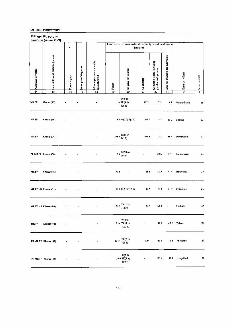
VILLAGE DIRECTORY
Villa2e Directorv Land Use (As on 1999)
.
i ..§_
~ " <>
~ l ~ ~ -a == <>
old t ~1l ;:
i >. g 1 8. ...
1 Ed n I> <II 1;; "
~ iJ iJ ~ ~ ~ ,f ~
14 15 16 17 18
MR FP Khanar (46)
MR FP Khanar (46)
MR FP Khanar (24)
PR MR FP Khanar (50)
MRFP Kharlar (45)
MR FP NR Khanar (51)
MR FP NR Khanar (80)
MRFP Khanar(82)
PR MR FP Khanar (67)
PR MR FP Khanar (75)
Land use (I e area under dIfferent types of land use I hectare)
OJ' g
" Sl
€ "0 £ 1;; gj, ~
rf .§ 19 20
W(20) 16 TK(4 I)
T(6 I)
8 4 W(2 0) T(2 0)
3085 TK(l 9) T(19)
52 WF(4 0) T(40)
738
90 8 R(2 I) T(2 I)
511 TK(25) T(25)
W(40) 754 TK(6 I)
T(IO I)
1144 TK(21) T(2 I)
W(21) 506 TK(8 4)
T(IO 4)
185
1 bO
§ :5 21
162 I
977
1095
26 I
475
373
1007
c 0
~ ." > '" c ] "3
'-' ... g~ <2 -=-~ .!! " > ~ ~
.c j ~ iJ"O > S' ..!! Ii '" ~ I;j 0 '-C
0
ail " ~ ~ 8 m. 22 23 2
75 47 Kusumkhunta
87 II 9 BtJ.lpur
773 88 4 Dumerbahal
206 377 Karadungan
315 41 4 lamabahah
418 21 7 Chuarama
653 SmdurSiI
889 652 Talakot
1566 31 3 Bhatapant
1256 97 I Nangalbod
.8 § C
"iil !i
VJ
1
21
22
23
24
25
26
27
28
29
30
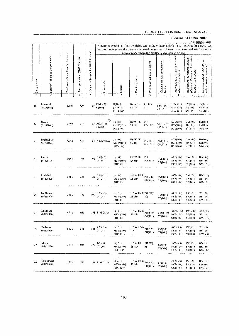
~ " I <.> " iil " -'" " 2 :: ~ lii ~ <.> ~ ;::; o ill' 0 ...l :=: t!, ":l ;>
" " " .. ..s 0
~ ~ il '-
" 0 ~ § "' 0-.... ~ 8. " 0
" "iii
1 <i! ]I
U 15 0 til f- ~,
I 2 3 4
T.nkam.1 31
(04237800) ]200 21.9
D.ud8 32
(04237900) 2190 213
Bhlllta~haia 3420 341 33
(042nuaO)
~lllclll 2aS 0 194 34
(04238100)
3) I\.alhlba,h
291 0 235 (0423S200)
36 ~.rdh.pur
2080 17l (04238300)
)7 Klurbhad,
4740 687 (04238400)
1& Oarhpada
6120 536 (04238500)
39 I-..h.".1
5330 1084 (04238600)
40 Ka,ut.padal
271 0 762 (04238700)
~ '" " ., ~
8 t:! -l9 -0
il g "'" '-0
t5 .0
§ Z 5
DISTRICT CENSUS HANUBOOI\ NUAPJ,ljf\
Censu!> of h,dl3. 200 ( A",enlll"~ .md
Amemlles avalldble (If not dvallable wlthm the village a da,h ( ) I, ,h01.\,1 It! the C'IlU1J:;;; --, dnl'
neAt \0 It In brat keb the distance In broad range~ VIZ < 5 km" .) ,0 kln~ "'hl IO~ kin'> o! l't neare;_t Illdce where the taclitty IS ava,ldbie " !!JVen
'C 'ij
" ~ ~ " 0 ~ -a ""3
" 8. " 11 0 t;;,~ 6 -0 'l' '" §
(.)
-0 0::: .,
il -a § <? G '" 0
'" -I'l : .." ~" l § ~ E] OJ) " ~ <i! S ~ " (.) E if " (.) <.> -a " til E- a~ " ~ ~ 8l ] t, <..._2_
6 7 8 t) IO II
67 r M(, 5) P(IOi) IWWII-.. I'll POt
(M(iO+) t\C'~( 10 ')
C(lOt) M[W\IO') ~S HI' 5) N( 5( 10+)
I'HC(IOT) U(lO f)
Ol~[IO')
P« 11(IOT) HPWTK PH AC~(lO; ) 55 5) M(<. 5) CM(lO')
C(lO+) "'(W(IO) 55 HI' 1'0\10+)
CP(IO f) NC~(IO*)
PHC(IO+) Ot S(IO+)
81 P M('(lO+) 11(10-1) IIPW fK
1'0(10+) CM(lO+) <\('5(10+)
MLW(lO,) S~ HP NC~(IO')
PHC(lO+) PH(IO+) CP(lOI) or S(IG+)
96 P M«5) H(IOt) IlI'W fK PH
lM\lIl.) ACS(IOT)
C(lO+) MCW(lOt) ~S III' PO(IO+) NCS(IO+)
PHC(IO+) lP(IO')
or~(I0t)
45 P M« 5) H(lOt) HPW1KR pO(51O) [,M(IOi)
AC~(IO-l )
C(IO,) MLW(IO+) ~S HI' PH(IO+) CP(IO+) NC')(llll)
PHC(IO') OCS(IO-t )
109 P M(<- 5) H(IO<) HI' W fl\. R PH 1'0[5
(M(IO,) ACSllO,)
((10+) M(W(IO,) SS flP 10) NL~(IO+)
~!lC( 10+) CI'(IOI)
O(S(IO+)
158 P Iv! C(lO f) H(IO+) HI' W TI-.. R 1'0(; 10) lM(5.IO)
"C\(5 10) MCW(IOt) S!> Ill' 1'«(10+) NC~lIO+)
PHC(IO+) CI'(IO+)
OC~(!O+)
124 PM«5) 11(10+) liP W R SC;· 1'0(; 5) C'M« 5)
ACS« 5' C(lO+) MCW(IO+) HP Pli(IO+) CI'(lO+)
NCS(IO+) PHC(IO+) OCS(lO+)
:~--v S 4) ..::. z::: t) QJ
~ E ~ ~
-1 I
~ St ~ to L _ ~ ::, l';
~~§ ~~ ~ D r ~ ~ ~ ~ ~ ~ E; ~;;, tl ~ 2ro« ~t' ~ 5 § E "J
~ s ~ § ~ ':;:Uv; U ,.
I I
l2 Ij ---(V(II'+) d~(llh)
SI'(IO+) RS(If,t)
S ruo+) NW,h\ ,
--------- -
LV(lO,) llS(lu ) <;1'(10, ) R~(I(JI)
Sl(1,h) NW(IU<
(V(IO+) 6~(JlH)
~P(IOT) R~(H\')
5.T(IIH) N\\(I(")
C'V(IO+) B~(Ii)q
~r(lo,) Ri.OOI)
ST(lO+ ) NWIIl)')
(V(IOI) BS\ \ 10) ,PfIO,) R~{Ilh)
~ T( lOTI NlA(IO+ )
( V(IO,) B~(IO<)
SP(lO') R~(IO')
~TlI01) NW(IO,)
e\'(5 IO} IlStS 10)
SP(lO+) ~~(IO')
51(IOt) N\\(S to)
CV(IO+) ll~(~ I)
51'(10+) R~(I(I+ ) ST(IO+) NW(<-5)
279 1'(2) M H(lOt) HPWTK PH rO«
CM«5) AC1>« 5) CV(lOt} B~« 5)
C(lO+) M(W(lO,) S5 HI' 5) CP(IO+)
NCS(IO+) SP( 10+) R~(IO+)
I'll( (<.5) OC5(10+) ST(H)"') NW(lO,)
194 P M C(IO+) H(IO+) HI' W TK R 1'0(" 5) CM« 5)
A(S(,5) C"(lO+) B~( 5) MCW(IO I ) S1> HI' PHI 10+) CP(IO+)
NCS(IO') ~P( 10+) RS(lOi) mC(IO+) OC~(IO+) SflIO+) NW(lO.)
186
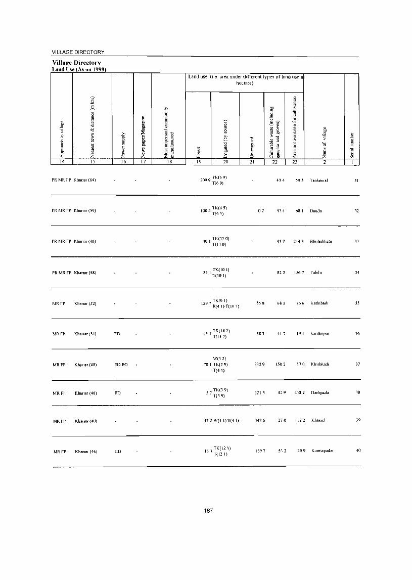
VILLAGE DIRECTORY
Village Directorv Land Use (As on 1999)
14 15
PR MR fP Khana, (64)
PR MR FP Khon., (59)
PR MR FP Khana, (46)
PR MR FP Khana, (58)
MR fP Kh.na, (32)
MRFP Khalla, (51)
MRFP Khalla, (48)
MRFP Khanar (48)
MRFP Khallar (40)
MRFP IUI.n., (46)
16 17 18
ED
ED EO
ED
[0
Land use (I e area under different types orland use 11
hectare)
19 20
2099 TK(6 9) T(69)
1004 lK(6 5) T(65)
191 TK(130) T(130)
39 I TK(IO I) 1(10 I)
TK(6 I) 1297 R(4 I) T(lO 1)
4) I lK(14 2) T(142)
W(12) 70 I TK(29)
T(4 I)
57 TK(3 9) T(19)
472 W(4 I) T(4 I)
161 TK(12 I) f(12 I)
187
21
07
558
883
2129
121 J
3426
1597
22 23 2
434 59 5 Tankamal
414 6R I Oauda
457 244 3 Bhuhabhala
822 156 7 fulclu
682 26 6 J<,.allllbad,
417 19 I Sd,dhapu,
1502 170 Kh"bhad,
429 4182 Oarhpada
270 1122 KJ,arsel
512 29 9 Kamtap.dar
31
11
34
35
16
37
18
39
40
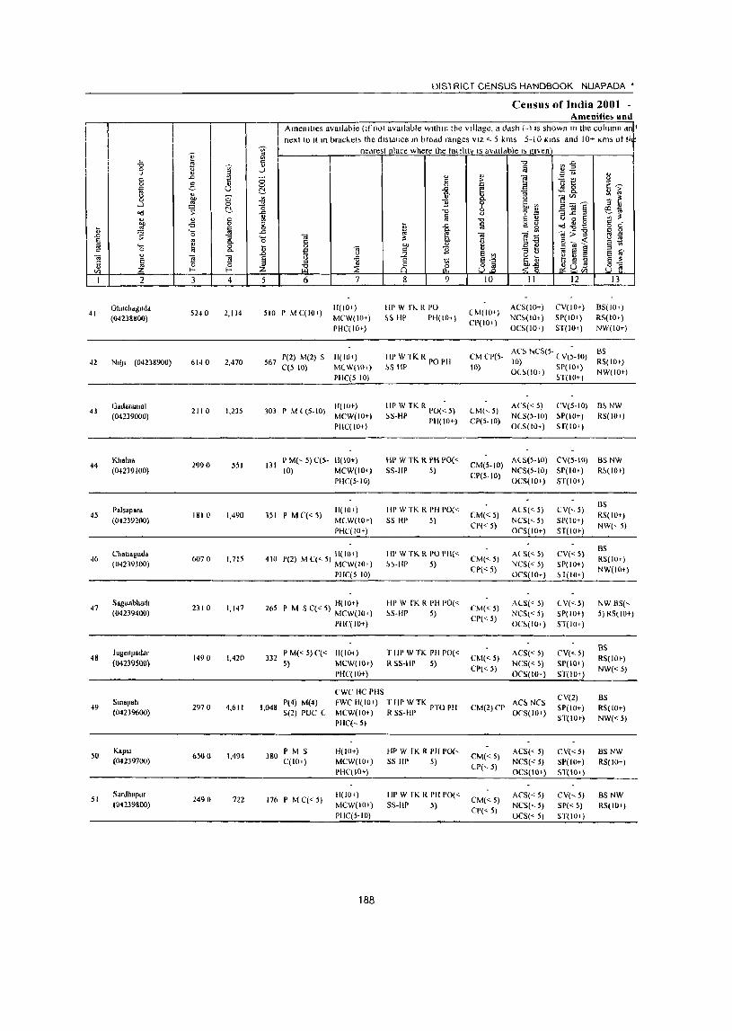
I I I
41
42
43
44
45
46
47
48
49
50
51
2
Ghuchdguda (0423&&00)
N.I). (04238900)
Gad.rmnsl (04239000)
Khaln. (04239100)
Palsapar. (04239200)
Chall·sud. (04239300)
Sagunbhad. (04239400)
JugenpatJar (04239500)
Smapah (04239600)
KapSl (04239700)
Sardhapur (04239800)
§
i ]
3 4
5240 2,114
6140 2,470
211 0 1,235
2990 551
1810 1,490
6070 1,715
2310 1,147
1490 1,420
2970 4,611
6500 1,494
2490 722
DISTRICT CENSUS HANDBOOK NUAPADA *
Census ofIndia 2001 -Amenitie~ and
Amenities available (If not available wltlllll the vJilage, a ddsh (-i IS shown In the column dn~ next to It III bracket> the dlstdnce In brodd ranges VIZ < 5 kms 5-10 Kms and 10+ Km, ot !i
nedrest place where the lauhtv IS aVdllable "g"en
5 6
510 PMC(IO,)
7
H(IO+)
MeW(IO+)
PHC(IO+)
567 1'(2) M(2) 5 H( 10+) C(5 10) MCW(IO+)
PIIC(510)
II( lOt) 303 P M (5-10) MCW(IO+)
PIIC(IO+)
131 P M(, 5) C(5- III 10+) 10) MCW(IO+)
pHe(S-IO)
351 P MC«5) H(IO+)
MCW(IOt)
PHC(IO+)
lIe 10') 410 P(2) MC«5) MeW(IO,l
PHC(5 10)
H(IOt) 265 I' M 5 C«5) MCW(IO+)
PHC(IO+)
332 P M« 5) C« H(IO+) 5) MCW(IOt)
PHC(IO+)
CWC HC plIS
9
HI' W fl. .. R PO
&SHP PH(IOi)
Ill' W lK RI'O PII ~S Ill'
HI' W TK R PO(~ 5)
~5-HP PH(IO+)
HP W TK R PH 1'0« 55-Ill' 5)
Ill' W TK R PH 1'0« SS HI' 5)
III' W TK R PO 1'11« ~~-HP 5)
HI' W fK R PH 1'0« ~S-HP 5)
Till' WTK PH 1'0« R 55-III' 5)
1,048 P(4) M(4) FWC H(IOt) T Hr' W TK PTO PH S(2) PUC C MCW( I 0+) R SS-IIP
380 I' M S C(lO+)
176PMC«5)
PHCE- 5)
H(IO+) MCW(IO,)
PHC(IO+)
11(10+)
MCW(IOt)
PHC(S-IO)
188
HP W fK R PII 1'0(, 55 Ill' 5)
HP W fK R PH 1'0« SS·lIp 5)
10
(M(IO+)
CP(IO')
CM CP(5-
10)
CM(,5)
CP(5-10)
11
ACS(IO+)
NC~(IO+)
OCS(IO,)
12
CV(IO,)
SP(lOi)
ST(IO+)
13
B5(1O.)
RS(lO+)
NW(IO+)
ACS NCS(5- (V(~-IO) BS 10) RS( 10+) OU(IO.) SP(IO+) NW(lO+)
~T(IO+)
AC5« 5) CV(5-10) B~ NW
NCS(5· 10) ~P( I 0+) RS( 10.)
OlS(IO+) sr(lO')
ACS(5·10) CV(S-IO) BS NW CM(5·to) NCS(5.tO) SP(IO+) R!>(lOt)
CP(5-IO) OCS(IO+) ST(IO+)
CM«5)
CP« 5)
CM(<-5)
CP« 5)
CM«5)
CP« 5)
CM«5)
CP« 5)
A(S« 5)
NCS('- 5)
OCS(IO+)
ACS(<- 5)
NCS« 5) oeS(lo+)
Al5« 5)
NCS« 5)
OC!>(IOi)
ACS« 5)
NC5« 5) OeS(lo+)
CM(2) ep AC!> NCS OeS(lo+)
CM«5) CP(,5)
CM«5)
CP« 5)
ACS« 5) NCS« 5) OeS(lo+)
AeS« 5) NCS("- 5) OCS(,5)
CY(,5)
SP(lO+)
ST(IO+)
CV« 5) SP(IO+)
~ 1(10+)
CY«5) SP(IO+)
ST(IOt)
CY«S) SP(IO+)
ST(lO+)
CY(2)
SP(IO+)
5T(10+)
CV«5)
SP(IO+)
ST(IO+)
CV(,5)
51'« 5) ST(lOi)
BS
RS(IO+) NW(, 5)
BS RS( JOt)
NW(Hl+)
NW 8S(,
5) RS(lO+)
as RS(IO+)
NW«5)
B5 RS( 10+)
NW«5)
BSNW
RS(IO+)
BS NW
RS(IOt)
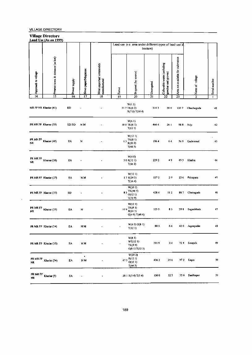
VILLAGE DIRECTORY
Villae;e Directory Laud Use (As on 1999)
Land use (I e area under different types of land use I
hectare)
i c 0 g
2- i=' "" >
" ] " -g -a " " -5 ~ .. E! ~
S> I e 0;- s ... .g
-a 0
~ ~" " = ~ " " > ~ " s: i] J! .. j .i:' 1 ~ .8 g
8: e 1l 5: 1 ..!! Ii §
j iii §~ 1 t;l
l~ '0 '-
~ ~ .. c 0 c
! 'f;; '" ~ E .. " 01
~ ~ ~ .§ :5 ell ~ ~ c ~ ~ Jl
14 15 16 17 18 19 20 21 22 23 2 I
W(13) MRFPNR Kh.riar(41) ED 317 TK(6 2) 3143 304 1337 Ghuchaguda 41
R(7 0) T(14 4)
W(61) PR MR FP Khanar (35) ED EO NM 100 TK(6 1) 4664 26 I 988 NII)I 42
T(12 l)
W(l2 I)
~~ MR FP Khansr (40) EA N TK(81)
13 R(20 2) 1064 64 569 Gadar.mal 43
T(40 5)
~~ MR FP Khanar (38) W(40)
EA 30 R(12 I) 2292 49 453 Khalna 44 T(162)
W(12 I) PR MR FP Khariar (27) EA NM 17 R(24 3) 1172 20 236 Pals.para 45
T(364)
W(202)
PR MR FP Khanar (37) ED 83 TK(40 5)
0(12 I) 4284 112 867 Challaguda 46
T(72 9)
W(12 I)
~~ MR FP Khanar (35) EA N TK(8 I)
109 R(24 3) 1235 83 398 Sagunbhadl 47
O( 40) T(48 6)
PR MR FP Khariar (34) EA NM W(4 0) 0(8 I) T(12 I)
885 66 420 Jugenpadar 48
W(8 I)
PR MR FP Khariar (35) EA NM WE(121) TK(40)
1919 04 724 Smapah 49
0(8 1) T(32 3)
W(202)
PR MR FP Kh . (34) NR anar EA NM 475 R(12 I)
0(12 I) 4362 246 972 KapSl 50
T(445)
PR MR FP Kh . (5) NR anar EA 28 I R(3 4) T(3 4) 1500 325 350 Sardhapur 51
189
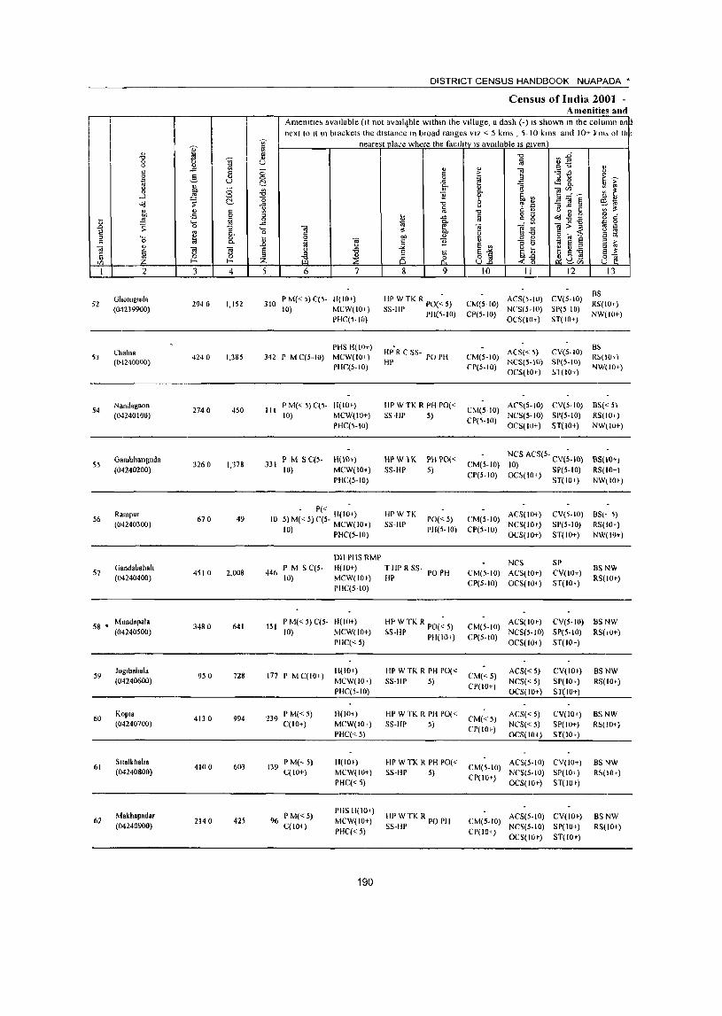
52
53
54
55
56
57
2
Gho(ugud. (04239900)
Chalna (04240000)
Nand.gaon (04240100)
Gambhanguda
(04240200)
R.mpur (04240300)
Gandabah.it (04240400)
S8 • Mundapala (04240500)
S9
60
61
62
Jogtbahal. (04240600)
Kopt. (04240700)
Stt.lkh.lt. (04240800)
Makhapadar (04240900)
3 4
2940 1,152
4240 1,385
2740 450
3260 1,378
670 49
4SI0 2,008
3480 641
9S 0 728
413 0 994
4100 603
2140 425
DISTRICT CENSUS HANDBOOK NUAPADA'
Census of India 2001 -Amenities and
Amemtte; available (It not avali1ble within the village, a dash (-) IS shown In the column an next to II III blackets the distance In broad ranges VIZ < 5 km;, 5-10 kms and 10+ km, 01 th
nearest place where the facIlity IS available IS given
5 6 7
310 PM«S)C(S- 11(10') 10) MCW(IO+)
PHC(5-10)
PHS H(IO+) 342 I' M C(S-IO) MeW(lOi)
PIIC(S-IO)
III P M« 5) C(5- H(lOr) 10) MCW(IO+)
PHC(5-10)
331 I' M S C(5-10)
H(IOt)
MCW(IO+)
PHC(5-IO)
-~ P« H(IO+) 10 5)M('5)C(5- MCW(IO+)
10) PHC(5-1O)
DB I'BSRMP
8 9
I,IP W TK R PO(~ 5)
55-HP PII(5-1O)
HP R e SS- PO PH Ill'
liP W TK R PH 1'0« 55-Ill' 5)
HPW1K
55-liP
HPWTK
5S-HP
PH 1'0« 5)
PO«5) PH(5-10)
446 P M 5 C(5-10)
H(lO+) T HI' R 55-PO PH
MCW(IOf) HI'
PHC(S-IO)
151 PM«S)C(5- H(IO+) 10) MCW(IO+)
PHC« S)
177 P M e(lo+)
239 I' M« 5) e(lo+)
139 P M(<- 5) C(lO+)
96 PM«5) C(lOt)
H(IO+)
MeW(IO» PHC(5-1O)
H(lOt)
MCW(IO+)
PIIC« S)
III 10+) MCW(IO+)
I'HC« 5)
PHS H(IO+)
MCW(IO+)
I'HC« 5)
190
HPWTKRPO(~5) ~S-IIP PH(IO+)
HP W TK R PH PO« 5S-HP 5)
HP WTK R PH PO« 55-III' 5)
HI' WTK R PH PO« SS-HP 5)
HPWTK RpOPH
55-HP
10 Ii 12 13
CM(5-IO) ACS(5-lll) CP(5-10) NCS(5-10)
OCS(IOr)
eY(5-1O) :~(IO+) SpeS 10) NW(IO+) ST(IO+)
eM(5-10) CP(5-IO)
ACS« 5) eY(5-10) BS NCS(5-to) SP(5-IO) R~(I0t\ OeS(IOt) ~-I(IO+) "iW(IO+)
ACS(5-IO) eY(5-10) BS« 5\ CM(S-IO) NCS(S-IO) SP(S-IO) RS(1U1) ep(5-10) OeS(IO+) ST(IO+) NW(IO+)
CM(5-10)
CP(5-10)
NCS ACS(5- CV(~-IO)
~~~(IO+) SP(5-10) ST( 10+)
8S(IO+1
RS(IO+l
NW(IOI-)
CM(S-IO) ACS(IO+) CY(5-10) BSI' 5) NCS(IOt)
ep(5-1O) OeS(lo+) SP(5-10) RS( 10+)
ST( 10+) NW( 10+)
NCS CM(S-IO) AC5(1O+) CP(5-10) OC5(1O+)
SP eY(lo+)
ST(IO+)
8SNW RS(lO+)
CM(S.IO) AeS(IO+) CY(S-IO) BS NW
CP(5-10) NCS(S-IO) SP(5-10) RS(,O+) OCS(IO+) ST(H,h)
CM«5) CP(IO+)
CM«5) CP(IO+)
AC5« 5) NC5« 5) OCS(IO+)
ACS« 5) NCS«5) OCS(IO+)
CY(IO+)
SP(IO+) 5T(IO+)
eY(lo+)
SP(IO+) ST(IO+)
eM(5-10) AC5(5-10) eY(lo+) CP(IO» NC5(5·IO) SP(IO+)
OCS(IO+) ST(lOI-)
CM(S-IO) ACS(5-10) eY(lo+) CP(lOt ) NCS(S-IO) SP(IO+)
OCS(IO+) ST(IO+)
B5NW RS(lO+)
BSNW RS(IO+)
BSNW R~(lOt)
BSNW RS(IO+)
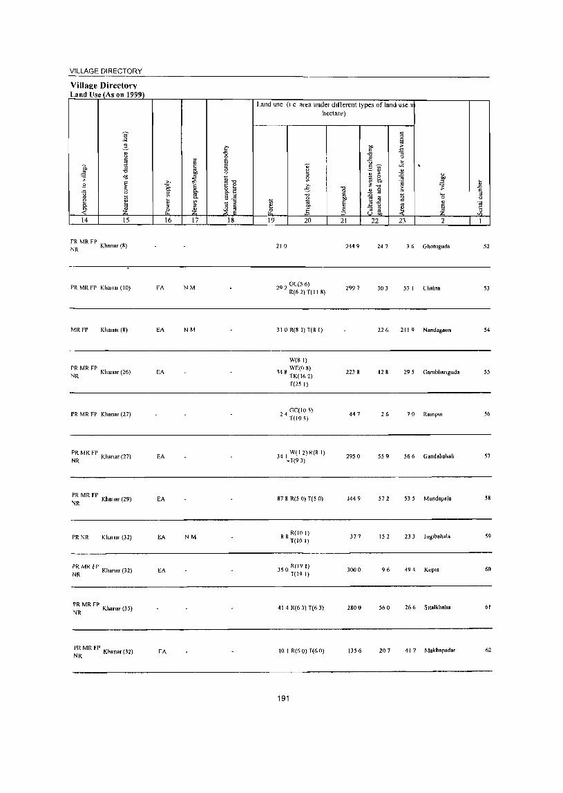
VILLAGE DIRECTORY
Villal!e Directorv Land Use (As on 1999)
14 15
PR MR FP NR Khanar (8)
PR MR FP Khallal (10)
MRFP Khallar (8)
PR MR FP Khallar (26)
NR
PR MR FP Khanar (27)
PR MR FP NR Khanar (27)
~~ MR FP Khan.r (29)
PR NR Khall.r (32)
~~ MR Fr Khan"r (32)
~~ MR FP Khanar (35)
~~ MR FP Khanar (32)
16 17 18
FA NM
EA NM
EA
EA
EA
EA NM
EA
EA
Land use (I e area under dlfTerent types of land use I
hectare)
19 20
210
292 GC(5 6) R(6 2) T(II 8)
310 R(8 I)T(8 I)
W(81)
148 WECO 8) TK(162)
T(25 I)
24 GC(105) T(IO 5)
34 I W(1 2) R(8 1) -T(93)
87 8 R(5 0) T(5 0)
88 R(ID I) T(IO 1)
350 RU9 I) T(19 I)
414 R(o 3) T(6 3)
10 I R(6 0) T(6 0)
191
21
2449
2997
2238
447
2950
1449
377
3000
2800
1356
22 23 2
247 3 6 Gholuguda
303 53 I Chalna
226 211 9 Nandagaon
128 295 Gambhanguda
26 70 Rampur
559 56 6 Gandabahah
572 535 Mundapala
152 233 Joglbahala
96 494 Kopl.
560 266 Slialkhaha
207 41 7 Makhapadar
52
53
54
55
56
57
58
59
60
61
62
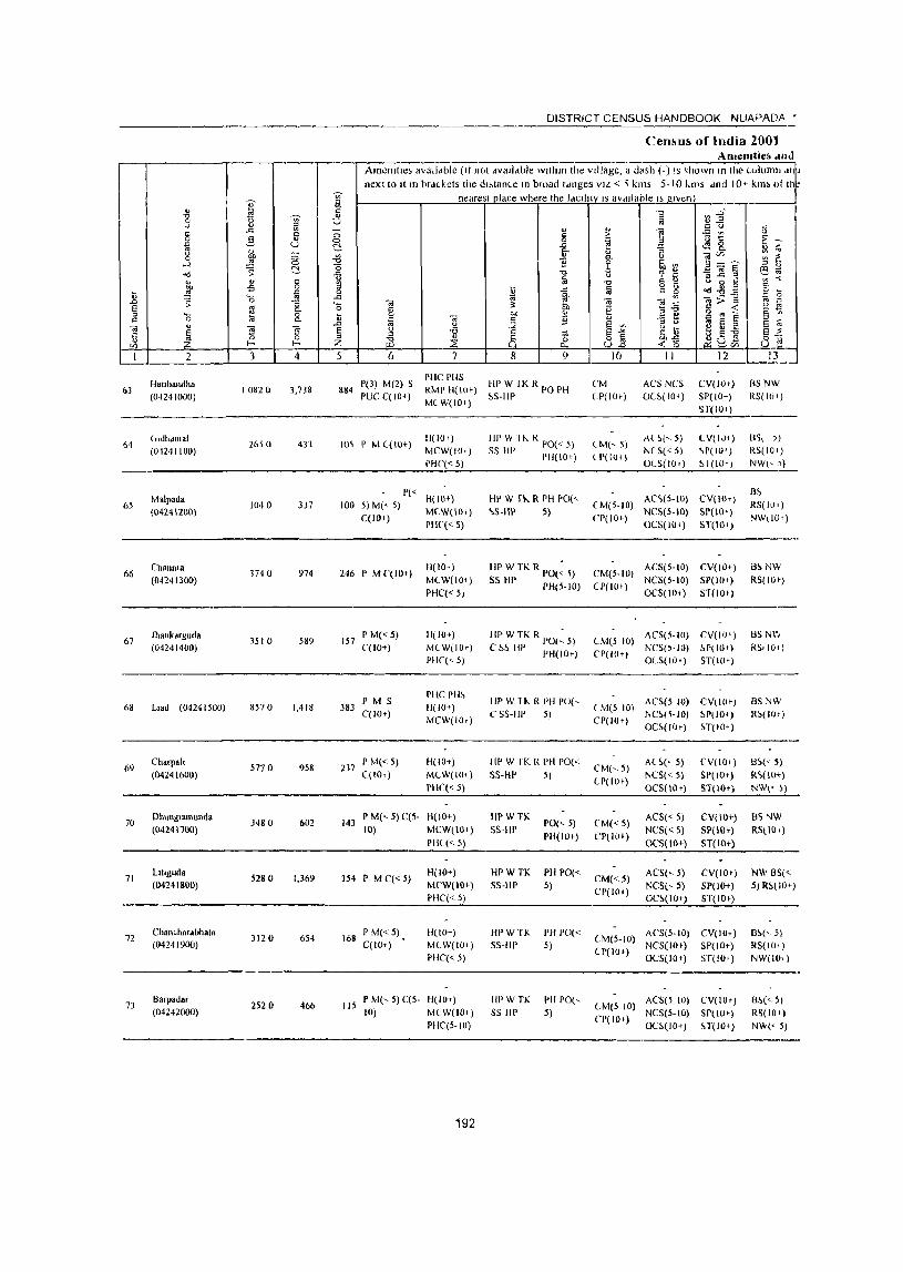
DISTRICT CENSUS HANDBOOK NUAPADA •
Cen!>u!> of India 200t Alllemtie. ,lIId
Amctlillc, avalldble (II not dvall.ble wllhtn the village, a d~sh (-) IS ~hown In the luiumn dt} next to Jt In brd(.kets the dl,tance In broad Idllges VIL < " kms 5-10 kms dnd 10.- kim 01 th
'" nearest place where the tdcllity IS aVdllable I> given j ~ ----
" "0 ~~ "0 '" (l ~ 0 " .) OJ ::l .E u " .c: '" " ...
c 5 ;::; § > i t! u
0 2- 0 'e 13 ~ -., U ~ -a <l'l 8. ~
'" ... " Il '" g 01) ;::; -<l " 0- u e Vl _, ~ c "~ _!!! 0
0 ] Z ~ '" ~ ~ ~ ::l " od ~ ~ -" "0 u '? ~ eo; ... " Q " ;j "CJ '" " ~~g '" -< .. -s 0 ~ g ~ c:
~ ~ ., 0 il ~ fa " '0 '" -'" 0; 01;;:;15
c
~ .0 ;;: 8_ '- 01
'" 01 01 - '" bb u
S :! 0 Q g ]] c -< is ::l '0 8. 1: c bIJ " o '" ~ :. '" Q jj " ~ 5 § ::l Q
~ :;I " E ;;; "
u
~ E ~ 01
~ ~ g S -a ;;; S-" U il n c: --a E~ ii 0 ::l ~ ~ rf 3E ~-g ~0~ 8-;,L Ul l- I- Z
1 2 3 4 5 6 7 8 9 10 II 12 I~-
f ,
Hal,ualldha 1'(3) M(2) S PIIC PIIS
HP W II< R PO PH CM ACS NCS CV(hh) BSNW 63 1082Q 3,738 884 RMP 11(10,)
(0~241000) PUC C(IO+) MCW(IO,)
~S-HI' (1'(10,) O(~(IO') SP(IO+) RS(lO t ) ~r(Io,)
64 Lrldhdlllal
2650 413 105 I' M ((10+) H(IO I ) III' IN H .. R 1'0« 5) <-1.1(,5)
A( ~(, 5) ( V(IJ+) I:l~\ ) )
(012411 00) MCW(IO') SS HI' PH(IO+) ( P(IOr) NCS« 5) ~P(IO' ) RS(1U 1 )
PHC« 5) OeS(IOI) ~ I (lOTI NW(, )
Malpad" 1'«
H(IO+) HI' W rl-.. R PH 1'0(" AC~(5-10) CV(IOT) 8~
65 1040 337 100 5) M« 5) (M(5-IO) RS(IUfj (042412GO)
C(IO+) M(W(IO+) '>5-111' 5)
CP(IO+) NCS(S-IO) Sp(IOr)
NW(IO I) PHC'«5) OCS(IOI) ST(IO, )
66 ChaullIa
1740 974 246 P M C(lO+) H(IO+) HI> W TK R PO(~ ~) CM(S-IO)
ACS(S-IO) CV(IO+) B~NW
(04241300) M(W(II)l) SS HP rH(S-to) NCS(S-IO) SP(IO+) RS(IO,)
PHC(<5) CP(IOt)
OCS(IO I ) ST(lOI)
67 Jhankdrguda
35 I 0 589 157 P M« 5) IJ(IO+) HP W TK R PO(~ 5) (M(; 10)
ACS(S-IO) CV(IO') 8SNW (04241400) (,(10+) MCW(IO,) C ~6 III' PH(IO+) NCS(,-IO) 6P(IU+) RS, 10,)
PIIC(<- 5) ('1'(10+1
OeS(IOI) ST(lO r)
I' M S PHC PH~
liP W 11-.. R PH PO(, ACS(5 10) CV(IOt) 8SNW 68 L,ad (04241500) 8570 1,418 383 11(10+) (M(5 10)
C(lO r) MCW(IOt)
CS5-IIP 5) CP(IOr)
NC6(~-IO) 61'(10+) R~(IO+)
OC~(I(H) H(lD, )
69 Charll.l.
577 0 958 237 I' M« 5) 11(10+) HpW rKRPIIPO("
CM(,S) AC6(, S) (,V(IOI) B6« 5)
(04241600) (,(10') MeW(lO') 5S-HP 5) (P(lO t )
NCS« 5) SP(IO+) R~(IO+)
PHC« 5) OCS(IO,) ST(IOr) NW« l)
70 DllUllg,amunda
3480 602 143 I' M(" 5) C(S- H(J(H) IIPWTK
PO(,5) (,M« 5) ACS« S) CV(\O+) 5S "iW
(04241700) 10) MCW(IO') SS-Hr I'H(IO+) ('P(lO t )
NCS« 5) SP(IO+) RSl\OT) 1'11(< 5) OCS(IO+) ST(IO+)
71 LlIIguda
5280 1,369 354 P MC«5) H(lO+) HPWTK PH PO«
CM« 5) ACS(<- 5) CV(IO+) NW B5«
(04241800) MCW(IO+) SS-III' 5) CP(IOI)
NCS(' 5) SP(\O+) 5)RM\G+) PIlC« 5) OC~(IO+) ST(IO+)
72 Chan"hardbhata
312 0 654 168 P M« 5) H(IO+) HPWTK PH PO«
(M(S-IO) AC5(5-10) CV(IOT) 86(,5)
(04241900) C(lO,) M(W(lOt) 55-Ill' 5) (P(IO+)
NCS(IO+) 51'(10+) RS(IOi)
PHC« 5) OCS(IO+) ST(IO+) NW(IOi)
73 Barp.dar
2520 466 115 P M(' 5) C(5- H(IO+) IlI'WTK PH 1'0(,
lM(5 10) ACS(5 10) CV(IO+) B~« 5)
(04242000) 10) MeW(IO+) SS HI' 5) CP(IO+)
NCS(5-IO) SP(lO t ) RS(IO+) pHC(5-101 OC~(IO+) H(IO+) NW« 5)
192
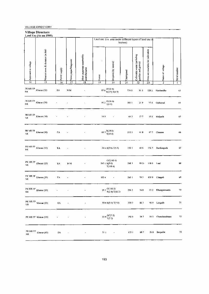
VILLAGE DIRECl ORY
Villa!!e Directory Land Use_(As on 1999)
j 5 " <>
~ " bll -e ~ ::: .,;;
~ B
"" ~ U e
0.
:t ~ 14 15
PR MR FP NR Khanar (32)
PR MR FP NR Khanar (30)
PR MR FP NR Kha",r (10)
PR MR FP Kh (30) NR anar
PR MR FP NR Khanar (32)
~~ MR fP Khanar (25)
~~ MR FP Khanar (25)
~~ MR FP Khans. (20)
PR MR FP Kh (25) NR anar
PR MR FP Khan.r (l0)
PR MR FP Khanar (42) NR
c -e 0
" Si c ~ S
0
"" u
~ ~1l .Q C-
~ 8.il ~ §..s C-~ ~ ~ ~ ~
& *. 16 17 18
EA NM
EA
EA
EA NM
EA
EA
EA
Land use (I e area under different types of land use I hectare)
c 0
~ ""
,. .§ :::
"3
'" <> U ...
'" "'~ <9 13 - '" ~" " " ,. :c " Sl %i ~ '" OIl
~ .!:! _g >. ~"" "$ e '" it; i;l .£ !ii e
'" "§ til 0 .... '" " OJ) 0 '" 1;; 1il § " " ","" .. " "" ~ <J '" ~ & .§ :5 "3 '" ~ 1: U '" '" OIl <Zl
19 20 21 22 23 2 I
83 0C(24) 6 R(2 5) T(4 9)
7740 91 5 1282 Hallbandha 63
162 0C(6 6) T(66)
183 3 21 9 l75 O.dhatnal 64
149 645 13 7 105 Malpada 65
617 R(100) T(IO 0)
2123 41 8 477 Chaunra 66
346 R(5 0) T(5 0) 1501 446 1167 lhankarguda 67
OC( 1404) 243 I R(90) 2483 992· 1169 L.ad 68
T(1494)
1034 263 I 793 1309 Charpah 69
29 OC(IO 2) I R(2 0) T(l2 2)
2363 368 33 2 Dhung.amunda 70
590 R(5 0) T(5 0) 3305 863 469 L.ltguda 71
339 0C(7 2) T(72)
192 0 247 542 Chancharabhot. 72
21 I 135 I 687 26 8 Barpadar 73
193

~ 0-
Il tl -;;;-..) ::>
§ ..c "' " 5 " g u " 0 ~ ...l ~
0
"d c:'.-
" " Q
"" f'i 0
il ~ ~ '0 .0 -0 E '" "-::> '-.,
0 c::: 0 :a 0.
" Oi
1 ] ~ Ii (/) i-< i-<
1 2 3 4
BharuatnUJlda 74
(04242100) 1970 689
GovlJIJapur 75
(04242200) 3300 317
76 Karlapam
2970 269 (04242300)
77 Mahagaon
4610 1,201 (M242400)
78 Kotamal
377 0 875 (04242500)
~lJ1g)hdr 79
(04242600) 8620 2,601
Godal 80 3010 1,37&
(04242700)
81 Dangargaon
940 362 (04242800)
82 KoJooeda
2490 778 (04242900)
83 Pcndraban
1420 643 (04243000)
Kuhadungll 84 251 () 691
(04243100)
DISTRICT CENSUS HANDBOOK NUAPADA •
Census of India 2001 -Amenities and
Amcnlltes available (Ifnol available Wllhll1 the village, a dash (-) IS shown III the column an~ next to It III brackets the distance In broad rdnges VIL < 5 km'> 5-10 km, and 10+ kms 01 Ih~
~ nearest place where the laclltty I, available IS given
j "0 ~:2 [;j
'" (J
" 0 " " ] .;:; t! u § >
0 ~ ~ 8. 1:~ c:'.- e- " ~
" -a ]~~ ~ ~ {j 11 "- (J
-0 9 ~ ~ :1 " "0 0 -a]§ e3_t;;
-il a (J , '" ~ " '" "0 Q " ~~g " 0 ;; "' i; ..c [;j o " 0
~ Q 0
'" c ..c t;j Oi <i~ 0i;;;:1l '0 Ii! :- ~ ~ c::: g ... 'il g .. ~ il 0 "" ] .E e § '"
~, Ii! c::: ~ il § .0 " ..Q §~
::I (J E ~ § 'il 8 1£ ~~ .... c:. -a
~~ ~ 8~ ~a.'! Z ;E .,c: ~(/)
5 6 7 8 9 10 II 12 13
PHS H(IO+) III' W fK PO ACS(IOt) CV(IO+) 8S(lOt}
165 P M qlOl) MCW(lO'} ~S HI' PH(IO+)
CMi5-IO) NCS(IO,) 51'(10+) RS(IO+)
PHC(5-IO} CP(tO+} OCS( 10+) ST{IO+} NW(IOt")
1'« 11(10+) HPW1K PH 1'0« ACS(IO'} CV(IO+) BS(IOt) 74 5) M«5)
MCW(IO.} 5S-IIP 5) CM(IO+)
NCS(IO+) SP(IO+) RS(IO'} C(lOt)
PHC(5 10) CP(IO+)
OC~(IO+) ST(IOt) NW«5}
52 I' M« 5) C(5- 11(10+) HI'W1KR I'll 1'0«
CM(5-10} ACS(5-1O) CV(5-IU) B~« 5)
10) MCW(IO*) !'~-IIP S) Cp(5-IO)
NCS(S-IO) SP{5-IO) RS(IO,)
PHC(5-IO) OCS(IO+) ST(IO+) NW(<..S)
283 I'M S H(101) III'WTK
PO«5) CM«5} ACS« S) CV«5) B~« 5)
C(lO+) MCW(10+} SS-HP PH« 5) CP«5)
NCS« 5) SP(lO+) RS(IO+) PHC(101) OCS(IO+) ST(W+) NW«S)
212 P M C(IO+) H(IO+ ) HPWTK
PO« 5) CM« 5) ACS« 5) CV«5) BS« 5)
MCW(lO+) SS-IW PH« 5) CP« 5)
NCS«5) SI'(IO+) RS( 10,)
PHC(IO,} OeS(IOt) ST(W+) NW(5-1O)
P(2) M(2) S PHS H(IO')
HPW1K ACS(5-IO) CV(5-W) BS
626 PVC C(lD,)
MCW(lOt) SS-Hp
POPH CM(5-1O) NCS(S-to) 51'(10.)
RS(IOt}
PHC(IO') CP(S-IO) OCS(W+) ST(IO+)
NW(iO+)
PIIS H(IO+) HPWTK ACS« 5) CV« 5)
BS 322 I' M C(IO+) MCW(IO+) PO PH CM«5) RS(IO+}
Pill( 10+) SS-UP
CP« 5) NCS« S) SP(IO+)
NW«5) OCS(W+) ST(IO+)
87 P M« 5) H(IO,) HPWTK PH 1'0«
CM«5) ACS« S) CV« 5) BS« 5)
C(IOr) MCW(IO+} SS-HP 5) CP« 5)
NCS« 5) SP(10+) RS(lO+) PHC(IO+) OCS(IO+) ST(IO+) NW«S)
185 P M C(S-IO) 1l(IO+) HPW rK
PO« 5) CM(S-IO) ACS(S-IO) CV(S-IO) 8S«5)
MCW(IO*} SS-HP PH« 5) CP(5-10)
NCS(5-to) SP(IO+) RS(IO+) PIK(IO;} On(lo+) ST(lOt) NW«S)
179 I' M C(S-IO) H(lO+) HpWTK PH 1'0«
CM(S-IO) ACS(S-lO) CV(5-10) BS« 5)
MCW(IO+) S5-HP 5) NCS(S-IO) SP(IO< ) RS(IO+} PIIC(IO+)
CP(5-10) OCS(IO+) Sf(IO+) NW«5)
PHS H(IO+) HPWTK PH PO« ACS(5-IO) CV(5-lO) HS« 5)
156 P M C(5-10) MCW(101-) CM(5-10) PBC(IO+)
SS-HP 5) CP(5-1O)
NCS(5-1O) 51'(10;) RS(IO+) OCS(IO+) ST(I{)+) NW« 5}
194
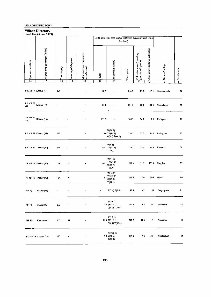
VILLAGE DIRECTORY
ViI1a2e Directory Land Use (As on 1999)
Land use (I e area under different types of I and use I
hectare)
j g g
,§, ~ 1>0 ;>-
= '" j -g -a "3
" Ei -5 " " ...
" ~ Ei ..,. 5]' .a 1>0 8 ~ .. OIl ~ ~ o'd ~ 11 ~ ~
u Sl ""
~ ~ 1
.. U 3 >. l!:", ~ Q. g. e 1 .c
.c g- o!! fa § " .... .. j
., Q. ei "'" lJ ~ " 0 " e ~ ., il .. § j " <a Co " ~ ~ .§ ~ ~ ~ z .P ::§ '" .. ~ U 1>0
14 15 16 17 18 19 20 21 22 23 2 I
PR MR FP Khanar (8) EA 134 1467 213 16 I Bharuamunda 74
PR MR FP Kh (10) NR anar 91 I 1345 70 I 345 Govmdapur 75
PR MR FP NR Khanar (II) 1553 1007 342 7 I Karlapam 76
W(202) PR MR FP Khansr (38) EA 256 TK(I6 2) 2932 232 74 I Mahasaon 77
0(8 I) T(44 5)
W(8I) PR MR FP Khanar (40) ED 633 TK(I2 I) 239 I 240 305 KOlamal 78
T(202)
W(4IO)
PR MR FP Khanar (46) EA N 61 I TK(243) 0(157)
SS29 319 13S I SIn&lhar 79
T(BIO)
W(l62)
PR MR FP Khanar (52) EA N 28 TK(I2 I) 0(162)
2065 79 399 Godal 80
T(44 S)
MRFP Khansr (45) W(2 4)T(2 4) 829 32 58 Dangargaon 81
W(1O I)
MRFP Khanar (43) ED 72 TK(16 2) 1773 52 292 Kodobeda 82 0(4 0) T(30 4)
W(121)
MRFP Khanar(40) ED N 294 TK(12 I) 2285 416 121 Pcndraban 83
0(6 I) T(30 4)
GC(19I)
PR MR FP Khanar (38) ED 21 W(36) 1892 66 31 1 Kuhadungn 84
T(227)
195

I ] ,.... iii
§ ..c:: ~
~ ,§.
~ 8 '" "<:I ~ C-
fo u i§
.8 ~ -El fa "0
1 ~ "0 g '" " ..
~ ~ ~ ii <Il l- I-
I 2 3 4
85 Karanbahah
2100 415 (04243200)
86 Dungrlguda
IS40 449 (04243300)
87 Dcnglllnancha
850 19 (04243400)
88 Chandel
1170 168 (04243500)
DUlIgnkhol 89 1440 94
(04243600)
Kcndumunda 90· 4080 1,207
(04243700)
91 Haldlmunda
2080 641 (04243800)
92 Kandolkona
2540 1,085 (04243900)
Jampa"l 93 4370 708
(04244000)
94 Slallau
2260 179 (04244100)
95 Dangargaon
2980 2S0 (04244200)
DISTRICT CENSUS HANDBOOK NUAPADA'
Census of India 2(}Ol -Amenities and
AmenJlles available (If not available within the vIllage, a dash C-) JS shown In the column ar.j
next to It 10 brackets the distance In broad ranges VIZ < 5 kms, 5-10 kms and 10~ kms oftt
J nearest place where the facility IS available IS RIven --.., tj Ia ., .. I!l " 1l § § ;> ~ ~~ C- 1- ~ "3 ~&. ~ ~>; .:g i <.J ~~" ¥i ~ 1i lib.,. o
"" '" Cl 1i]~ e:!~ 1 fa " d ii g ~ ..,
0 tl "'" fa 2. ~ "<:I~g ..c:: ~ .~ ""§>g I!l 0
"0 .. ] ~.a I'l " _g §
~ " tl gCa~ a ~ f.l 1i 1i - ~ § iO' I
~ e '" G ... ii a " e ! ~ 1 ~ ... lib " 3 g -a ~] J ~ <~ naua :z
5 6 7 8 9 10 II 12 13 I _J
101 P M C(5·1O) H(IO+) HPWTK
PO PH CM(5·10) AC'S(S-IO) CV(S·IO) 8S« 5)
MCW(IO+) SS·Up CP(5·IO)
NCS(S·IO) SP(IO,) RS(IO+}
PHC(IO+) OCS(IO+) ST(IO.) NW«S)
114 P M« 5) C(5. H(IO+) HPWTK PH PO« CM(5-10)
ACS(5-1O) CV(5·IOl flS« 5)
10) MCW(IO+) SS·IIP 5) ep(S·IOI
NCS(5-10) SP(lOr) RS(IO+)
PHC(IO+) OCS(IO+) ST(IO+) NW« 5)
• P« 11(10+) HPWTK PO«S} CM«5)
ACS« 5} CV(S·IO) flS(<. S) 8 5) M« 5) C(5· MCW(IO+) SS·HP
PH(S·IO) CP(5·10) NCS(5.IO) SP(H}t-) RS(IOt)
10} PHC(IO+) OCS(lO+) ST(lot) NW«5)
-----
35 • P« H(IO+) HPWTK PH PO«
CM(S·IO) ACC;(j·lO) eV(s.IO) BS(~. (0)
5) M« S) C(S. MCW(lOt) SS-HP ~) NCS(~·IO) SP(IO+) RS,IO+\ (0) PHC(IO+) ·CP(5·IO)
OCS(IO+) SI(IO+) NW(S IOJ
. 1'«
H(IO+) HPTKSS· ACS«5) CV(IO..-) 85« 5) 22 5) M« S) 1'0«5) CM«S)
C(lO+) MCW(IO+) HI'
PH(IO+) CP(lO+) NCS(IOt) SP(lO+) RS(lO+)
PHCCI O+) OCS(IOt) STIIOt) NW\IOt\
PM S PHS H(IOt)
HPTKSS· CM ACS(IO+) CV(W~) B~
287 MCW(IO+) PO PH RS(lOt) C(10+}
PHC(I~) HI' CP(lO+) NCS(lO+) SI'(IO+)
NW(iOt ) OCS(IO+) ST(1U+)
146 P M«S) H(lO+) HP TK SS· PH 1'0(<-
CM«S) ACS«S) CV(IO+) 8S« 5)
C(IO+) MeW(IO+) HP 5) CP(IOt)
NCS(IOt) SP(lO+} a'>(IIH) PHC(W+) OCS(IO+) ST(IO+) NW«5)
266 P M« 5) H(IO+) HPTKSS· PH PO« CM«5)
ACS«') CV(I!)+) BS(<. ~)
C(10+) MCW(IO+) HI' 5) CP(IOt)
NCS(lOt) C;P(IO+) RS(JOr) PHC(IO+) OCS(IO+) S1(10+) NW«S)
P« H(lO..-) HPWTK PH PO« ACS(lO+) CV(IO+) BS(IO+) 163 S) M« 5) CM(lO+)
C{lO+) MCW(IO+) SS·HP 5)
CP(lO~) NCS(IO+) SP(lOr) RS(IO+)
PHC(lOt) OCS(IO+) ST(IO+) NW(IO+)
40 PM«5) H{lOt) HP TK SS· PH 1'0« CM«S)
ACS«S) CV(IO+) ES« 5) C(IOt) MCW(IOt) HI' 5)
CP(IO+) NCS(IO+) SP(IO+) IlS( 10+) •
PHC(IO+) OCS(W) ST(IO+) NW(IO~)
S6 P M(S-to} H(lo,+) HPWTK PO(IO+) CM(IO+)
ACS(IO,.) CV(IO+) nS(IOr)
C(lO+) MCW(lOt ) SS-HP PH(IO+) CP(IO+)
NCS(IO+) SP(10+) RS(lOt ) PHC(IO+) OCS(IO+) ST(IO+) NW(IO+)
196
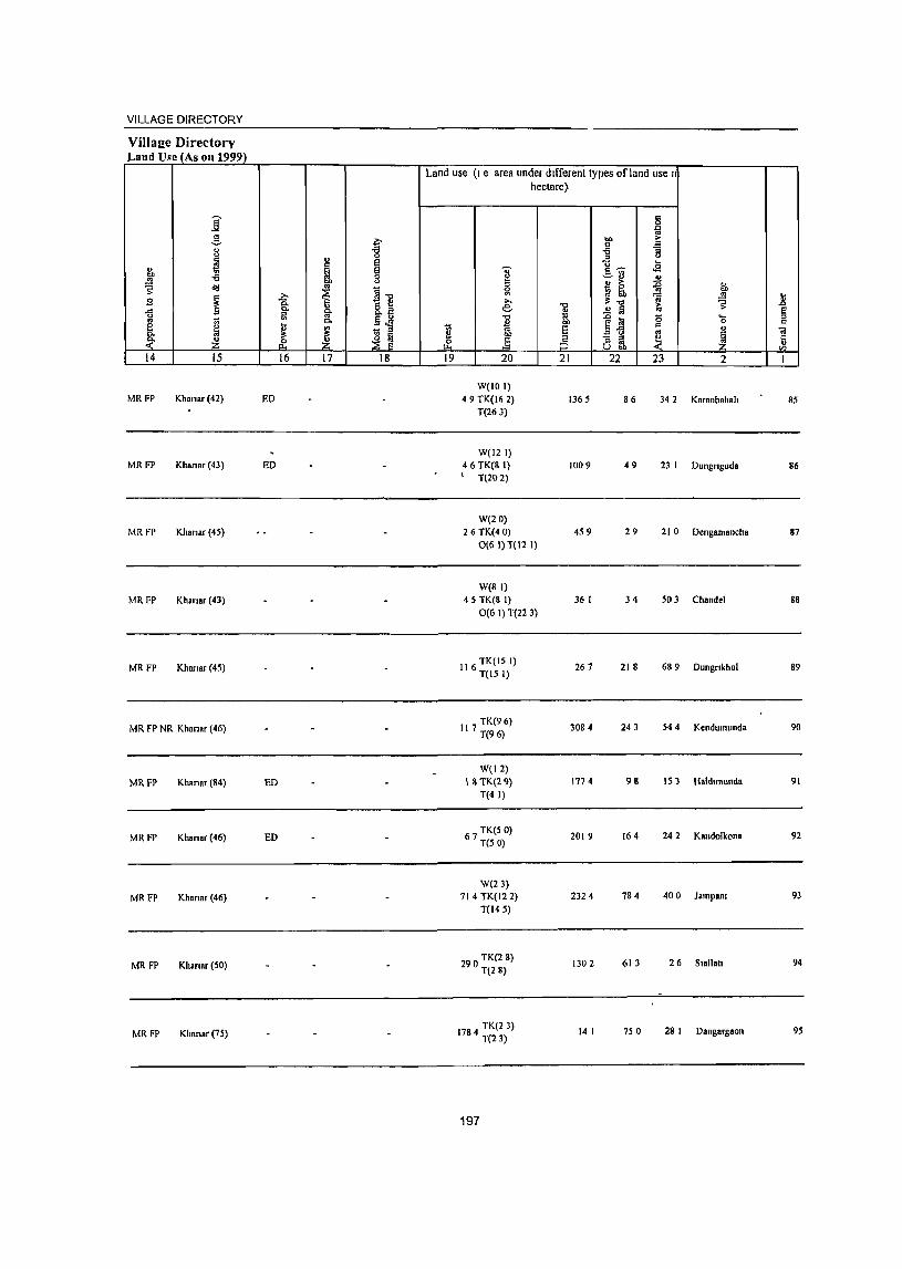
VILLAGE DIRECTORY
Village Directorv Lalld Usc (As 011 1999)
j .§_
~ 8 ~ ::! i " !;j OIl -t3 .!!! OIl
~ ~ .,
I] ! ~ t B ... (l,
u a " " ~ 0. ~'§ [ !;
~ ~ ~ ~ rP ~ ~ 14 15 16 17 18
MRFP Khana.(42) ED
MRFP Khana. (43) ED
MRFP Khana. (45)
MRFP Khana. (43)
MRFP Khana. (45)
MR FP NR Khanar (46)
MRFP Khanar (84) ED
MRF? Khanar (46) ED
MRFP Khanar (46)
MRFP Kllanar (50)
MRFP Kllano, (75)
Land use (I e area under different types ofland use I
1;; e 0
19
hectare)
~ ~ ,., e. "" 8
j 20
W(IOI) 49 TK(16 2)
T(263)
W(l2 I) 46 TK(8 I)
T(202)
W(lO) 26TK(40)
0(6 I) T(12 I)
W(8 I) 45 TK(8 I)
0(6 I) T(22 3)
116 TK(15 I) T(15 I)
117 TK(9 6) T(96)
W(12) 18 TK(29)
T(4 I)
67 TK(5 0) T(50)
W(2l) 71 4 TK(12 2)
T(145)
290 TK(2 8) T(28)
1784 TK(23) T(23)
197
"'" " 'iii OIl
5 5 21
1365
1009
459
36 I
261
3084
177 4
2019
2324
1302
14 I
'" 0
'" " '" ,.
~ '" "3
" '" ]'ii) ... .s c" OJ
~ ~ :g M> 'fa " ~'" ~ 10 .£ I(i
e] 0 .... 0 c
.E l:l j " ~ " oJ U 00
22 23 2
86 342 Ka.anbahah
49 23 I Dungnguda
29 21 0 Dengamallcha
34 503 Chan del
218 689 Dungnkhol
243 544 Kendumunda
91\ 153 Haldlmunda
164 242 Kandolkona
784 400 Jampam
613 26 Siallall
750 28 I Danga.gaon
!; .0
~ '" iii Ii rJl
I
85
86
87
88
89
90
91
92
93
94
95
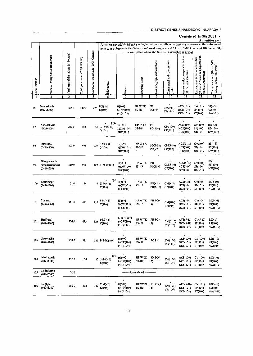
I " '8 '§' ..co on
g '" ~
~ -=-~ (;
§, o(! ~ u ., C 00 -5 0
l .. .... la "" ,: 0
1 § .. .... * c 0
" "iii
~ ~ ! . ~ I-
I 2 3 4
Nuamalpada 8670 1,095 96
(04244300)
97 Akhadabhata
2090 166 (04244400)
98 Darhpada
2000 498 (04244S00)
DhlRglamunda 99 (Dhllnglamunda) 5390 918
(04244600)
OOJladungn 100
(04244700) 210 34
101 Tlleun.1
3210 495 (04244800)
8adlbahal 102 S26,O 48S
(04244900)
103 Jharbandh.
4540 1,312 (04245000)
Mankarguda 104
(04245100) 1500 SO
lOS KadaIlJhana
700 (04245200)
106 NagaJhar
1880 504 (04245300)
DISTRICT CENSUS HANDBOOK NUAPADA'
Census of India 2001 -Amenities and
Amenities available (If not available within Ihe Village, a dash (-) IS shown In the cOlumn~ next to II m brackets the distance In broad ranges VIZ < 5 kms , 5-10 kms and 10+ kms of I
'[ nearesl place where the facIlity IS available IS given
~ -0 Vl.g fij ~~ 8 § .. !i! ] :fi e 6 G'>: C!. ]- I <IS&. "'3 ~ E ~
u ]~~ 1.1 ~ ~rl -&
-0 "'3]1 § ~~ fij "0 ~ ~ u ~ 5 6 i -= fa g & old - g d'
~ "iii:>] " 0 -= -e" : 'cl "iii "iii :1 lil c g .§1 §~1 § ti
1 0 00 " B 11 c: 1.! E '" - S E f i l'l g -a
~ Ii s ..... U I;
:z: ~ & 8] ~-g ! a,b1 ~~ 5 6 7 8 9 10 II 12 13
270 P(2) M H(IO+) HPWTK PH CM(lO+)
ACS(IO+) CV(IO+) 8S« 5)
C(IO+) MCW(IO+) SS-HP PO(lO+) NCS(IO+) SP(IO+) RS(IO+)
PHC(IO+) CP(IO+)
OCS(IO+) ST(IO+) NW(IO+)
42 " P(5- H(I~+) HPWTK PH
CM(IO+) ACS(IO+) CV(lO+) 8S« ~)
10) M(S-IO) MCW(IO+) SS-HP PO(IO+) CP(IO+)
NCS(IO+) SP(IO+) RS(lO+) C(10+) PHC(IO+) OCS(IO+) ST(IO+) NW(IOr)
129 P M«S) H(IO+) HPWTK PO(S-IO) CM(5-IO)
ACS(5-10) CV(IO+) BS« S)
C(10+) MCW(IO+) SS-HP PH«5) CP{IO+)
NCS(lIl-f) SP(IO+) RS(IO+)
PHC(lO+) OCS(IO+) ST(IO+) NW(IO+)
H(lO+) HPWTK PH ACS(S:IO) CV(lO+) BS
239 P M C(IO+) MCW(IO+) SS-HP PO(IO+)
CM(S-10} NCS(IO+) SP(IO+)
RS(IO+)
PHC(IO+) CP(IO+)
OCS(IO+) ST(IO+) NW(IO+)
P« H(IO+) lIPWTK ACS«S) CV(IO+) B8(5-10) 9 S) M« S)
MCW(IO+) S8-HP 'PO« S) CM«S)
NCS(IO+) SP(IO+) RS(lO~) C(IO+)
PHC(IO+) PH(S-IO) CP(IO+)
OCS(IO+) ST(10+) NW(S-IO)
132 P M«5) H(lO+) HPWTK PH PO«
CM(IO+) ACS(IO+) CV(IO+) BS(S-IO)
C(IO+) MCW(IO+) SS-HP S) CP(IO+)
NCS(10+) SP(lO+) RS(IO+)
PHC(IO+) OCS(IO+) ST(IO+) NW(5-10)
P M« 5) PHS H(lO+)
HPWTK PH PO« ACS(5-10) CV(S-IO) BS« S) 125 MCW(lO+) CM(5-IO)
C(IO+) PHC(IO+)
SS-HP S) ep(s-IO)
NCS{5-10) SP(lO+) RS(IO+) OCS(IO+) ST(IO+) NW(5-IO)
))5 P M C{IO+) H(IO+) HPWTK
PO NI CM(IO+) ACS(1O+) CV(lO+) BS(5-10)
MCW{IO+) SS-HP NCS{IO+) SP(IO+) RS(IO+) PHC(lO+)
CP(IO+) OCS(IO+) ST(lO+) NW(IO+)
P« H(IO+) HPWTK PH PO« ACS(IO+) eV(lo+) BS(5-1O) 10 S) M« 5)
MCW(lO+) SS-HP 5) CM(IO+)
NCS(IO+) SP(IO+) RS(IO+) C(1O+)
PHC(IO+) CP(IO+)
OCS(IO+) ST(IO+) NW(5-10)
.------ UnInhabited ------------
132 P M« 5) H(IO+) HPWTK PH PO« CM(IO+)
ACS(S-IO) CV(IO+) BS(5-10) C(IO+) MCW(lO+) SS-HP 5) NCS(IO+) SP(IO+) RS(IO+)
PHC(IO+) CP(IO+)
OCS(IO+) ST(IO+) NW(S-IO)
198
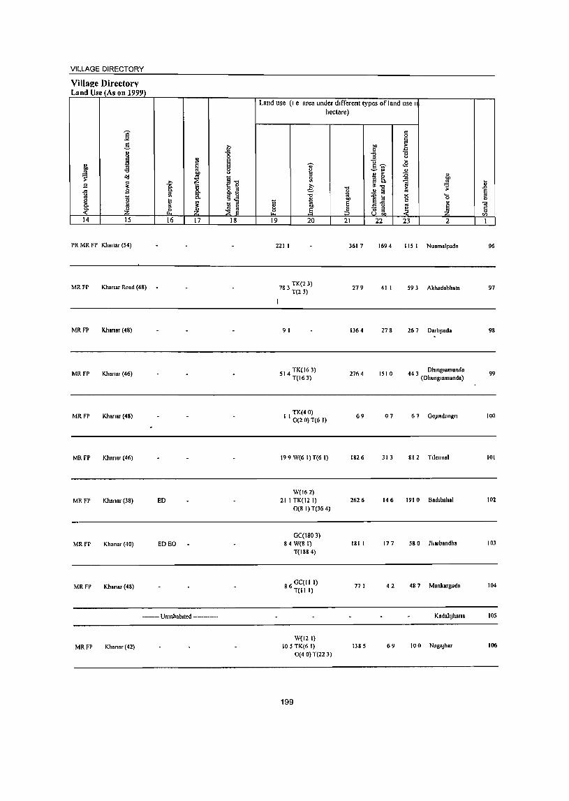
VILLAGE DIRECTORY
Village Directory Land Use (As 011 1999)
]' g
~ u
I u 0
~ ~ " on -a ~ I u
>= o<J
~] J3 ~ i ..c: J3 8. u ~ g_ I ~-a e Ii ~ 0.
'" ~ ~ .~ ~ ~ ~ 14 15 16 17 18
PR MR FP Khanar (54)
MRFP Khanar Road (48)
MRFP Khanar (48)
MRFP Khanar (46)
MRFP Khanar (48)
MRFP Khanar (46)
MRFP Khanar (38) ED
MRFP Khanar (40) ED EO
MRFP Khanar(48)
•••••••• Umnhablted ••••••••••••
MRFP Khanar(42)
Land use (I e area under different types ofland use II
hectare)
't;'
~ £ e: 1 t:l
~ .§ ~ 19 20
221 I
I
783 TK(23) T(23)
91
514 TK(I63) T(163)
TK(40) I I 0(20) T(6 I)
199 W(6 I) T(6 I)
W(162) 21 I TK(12 I)
0(8 I) T(36 4)
GC(I80 3) 84 W(B I)
T(1884)
86 GC(I1 I) T(11 I)
W(121) 105 TK(6 I)
0(40) T(22 3)
199
"'" a E :3 21
3617
279
1364
2764
69
1826
2626
181 I
771
1385
§
on ~ .g ] .E u .... s-;;- <E ~" ~ ~ > " ~! ~
] ~ ..!! Iii
1~ g .... 0
" ., ~ "3 ~ ~. u OIl
22 23 2
1694 115 I Nuamalpada
41 I 59 3 Akhadabhata
278 26 7 Darhpada
1510 44 3 Dhm81amunda (Dhunglamunda)
07 6 7 GOJladungn
313 812 Tllellnal
146 1910 Badibahal
177 580 Jharbandha
42 487 Mankarguda
KadallJhana
69 100 NagaJhar
.8 § " "lil 5 en 1
96
97
98
99
100
101
102
103
104
105
106
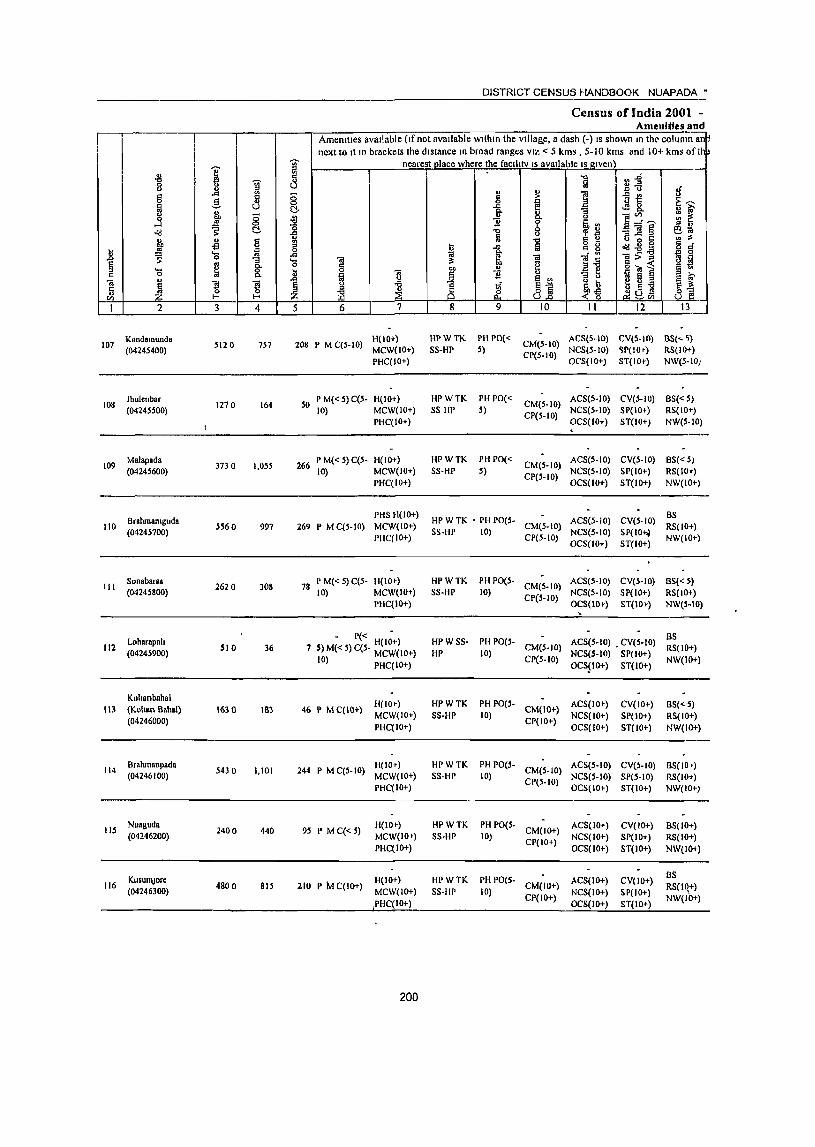
1 .::l 8 " ~ g ... ..
8 _§_ B ~ ;; j = 0
<td ,: C!. u " g "" -fi .. iii .8 ~
._ 0 -a § ~ 8: " '0
<a " 1 1 Ii ~ Vl f-< I-<
I 2 3 4
Kalldamullda 5120 107
(04245400) 757
lhulenbnr 1270 164 108
(04245500)
109 Malapada
3730 1,055 (04245600)
Oralunanlguda 110 S560 997
(04245700)
III Sonabar ••
2620 308 (04245800)
Loharapnh 112
(04245900) 510 36
Kuhanbahal III (Kohan Rahal) 1630 183
(04246000)
114 Orahmanpad.
5430 1,101 (04246100)
lIS Nuaguda
2400 440 (04246200)
KusumJore 116 4800 815
(04246300)
DISTRICT CENSUS HANDBOOK NUAPADA·
Census of India 200t -Amenities and
Amenities avaIlable (If not avaIlable wlthm the vIlIa&.e, a dash C-) IS shown In tht' column a~ next to It In brackets the dIstance In broad ranges VIZ < 5 kms, 5-10 kms and 10+ kms oft~
j nearest place where the faclltty IS avaIlable IS gIven
8 -0 ln1 !ij ~u If ;; " ~ ] iii'! " ~~ §_ 0
! ... ~ 8. it -a ~ 0 ]~~ '0 11 lib .. '" " "0 '1' ~ -a]§ 60; 11 ~
0 .. ~ "0 " " 001:: ~
~ .a ~ g 8 ca:d 0 s 5 d' 0 .a ~ ca ci:! ]~] 5 g '0 <a ~ g ""
1l ~] g(;j~ §~ .8 3 "j) " 11 il
~ §~ '" 0 e ~ .a 8 ~
~ .a 1if o Iu
~ ~ ~-g Jlu~ ~] t5 d: 8.0 ~ Vl
5 6 7 8 9 10 II 12 13
208 P M C(S-IO) H(lO+) HPWTK PHPO«
CM(S-IO) ACS(5-10) CV{S-IO) as{<- ~)
MCW(IO+) SS-HP 5) NCS(5-1O) ~P(IO+) RS(IO+) PHC(IO+)
CP(S-IO) O('S(IO+) ST(IO+) NW(5-1O;
50 P M« 5) C(S. H(lO+) HPWTK PH 1'0«
CM(5-10) ACS(S-IO) CV(5-10) as«5)
10) MCW(IO+) SS HP 5) NCS(S-IO) S 1'(1 0+) RS(IO ... ) I'HC(IO+)
CP(5-IO) OCS(IO+) ST(IO+) NW(S-lO) .
266 P M« 5) C(5- H(IO+) HPWTK PH PO«
CM(5-1O) ACS(S-IO) CV(5-10) 8S«5)
10) MCW(IO+) SS-HP 5) CP(5·10)
NCS(S-IO) SI'(IO+) RS(IO+) I'HC(IO+) OCS(IO+) ST(IO+) NW(IO+)
PHS H(IO+) HI' W TK • PH PO(5- ACS(S-IO) CV(S·IO)
OS 269 P MC(5·10) MCW(IO+) CM(5.10) RS(IO+)
PHC(IO+) SS-HP 10)
CP(5-1O) NCS(S-IO) SP(lO~
NW(IO+) OCS(IO+) ST(IO+)
78 I' M«S) C(5- H(IO+) HPWTK PH 1'0(5-
CM(S.IO) ACS(5-1O) CV(5-10) BS«5)
10) MCW(IO+) SS-HP 10) CP(S-lO)
NCS(S-to) SP(IO+) RS(IO+) PHC(IO+) OCS(IO+) ST(IO+) NW(S-IO)
- P« H(IO+) HPWSS· PH PO(S- ACS(5-10) • CV(S·IO) BS
7 5) M« 5) C(S- MCW(IO+) HP 10) CM(5-10}
NCS(S-IO) SP(IO+) RS(IO+)
10) PHC(IO+) CP(S-IO) OCS$IO+) ST(IO+)
NW(IO+)
H(lO+) HPWTK PH PO(S- ACS(IO+) CV(IO+) BS« 5) 46 P M C(IO+) CM(IO+)
MCW(IO+) SS-HP 10) CP(IO+)
NCS(IO+) SP(IO+) RS(IO+) PHC(IO+) OCS(IO+) ST(IO+) NW(IO+)
244 P M C(5- 10) H(IO+) HI'WTK PH PO(5-
CM(S-IO) ACS(S-IO) CV(~-lO) 85(10')
MCW(IO+) SS-HP 10) CI'(5-10)
NCS(S-IO) SP(S-IO) RS(IO+) PHC(IO+) OCS(IO+) ST(IO+) NW(IO+)
95 P MC«S) H(IO+) HPWTK PH PO(S-
CM(lO+) ACS(IO+) CV(IO+) 8S(10+)
MCW(lO» SS-HI' 10) CP(IO+)
NCS(IO+) SP(IO+) RS(IO+) PHC(IO+) OCS(IO+) ST(IO+) NW(IOt)
H{IO+) HI'WTK PH PO(S- ACS(IO+) CV(lO+) as
210 P tv! C{IO+) CM(IO+) RS(I~+) MCW(IO+) SS·IIP 10) NCS(IO+) SP(lO+) PHC(10+)
CP(IO+) OCS(IO+) ST(IO+)
NW{IO+)
200
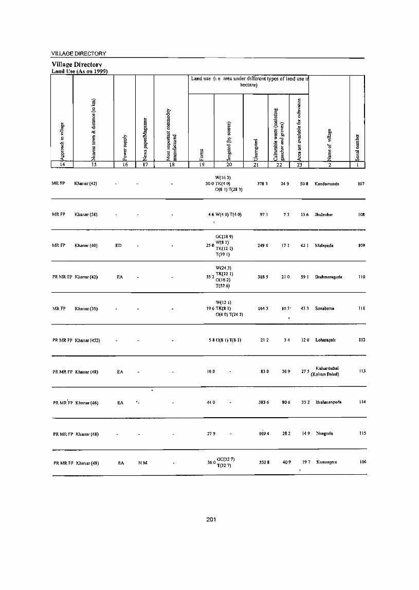
VILLAGE DIRECTORY
Village Directory Land Use (As on 1999)
j _g_ 0
" .a " ... 0
~ " ~ " !:l "" -a 0
~ ~ " ~ ~'g ~ ~ B ~
..c: B c. ~ 8.a
" iil §~ '" 10 e ~ I; ., c. ~ ~ ~ ~ <- :z: .:E :z: 14 15 16 17 18
MRFP Khanar(42)
MRFP Khanar(S8)
MRFP Khanar (40) ED
PR MR FP Klmnar (42) EA
MR FP Khanar (35)
PR MR FP Khanar (452)
PR MR FP Khanar (48) EA
PR MR'FP Khanar (46) EA ._
PR MR FP Kharlar (48)
PR MR FP Khanar (48) EA NM
Land use (I e area under dIfferent types of land use I
~ ~ 19
hectare)
..,. ~ Sl >-e ."
* on ..§ 20
W(162) 300 TK(4 0)
0(8 I) T(28 3)
46W(40)T(40)
GC(189) W(81)
250 TK(12 I)
T(39 I)
W(243)
352 TK(12 I) 0(162) T(526)
W(12 I) 196 TK(8 I)
0(4 0) T(24 3)
580(8 1)T(8 I)
160
440
279
360 GC(32 7) T(327)
201
11 gj, § :5 21
3783
97 I
2496
3885
1643
212
830
3836
. 1694
3508
c 0 J::l
CD ~ " ~ .a il " .. ,,~ .a c.~ u ... > :g ~ ~ ~ ] '" il:"t) ~ ..!l a '" 1~ 0 ....
0 c " '" ~ [l ~ ~
22 23 2
249 S08 Kandamunda
73 136 Jhulenbar
17 I 42 I Malapada
210 S9 I Brahmanlguda
103- 433 Sonabarsa
34 120 Loharapalt
369 27 5 Kuhanbahal (Kohan Bahal)
806 35 2 Brahmanpada
282 149 Nuaguda
409 197 KusuInJore
i! e " c ;;; c: "I I
107
108
109
110
III
112
113
114
liS
116
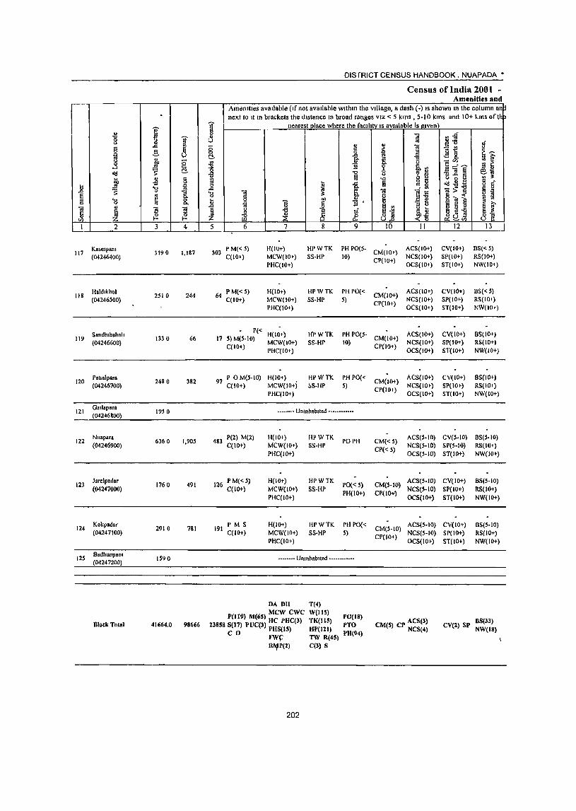
-
I ~ ~ ..c 15 g 8 ~ " -.s bO co
~ & ~ u u 15 H .£j
iiJ ... ia ..Cl ;: 0
1 ~ ~ 'a C>.. .. u
~ ]l Ii ~ 0 Ul f- f-
1 2 3 4
117 Kaselpam
3190 1,187 (04246400)
118 Baldlkhol
2510 244 (04246500)
Sandlubahnll 119 1330 66
(04246600)
120 Paualpara
2480 382 (04246700)
121 Oallapanl
19S 0 (04246800
122 NII.para
6360 1.905 (04246900)
123 Jarelpadar
1760 491 (04247000)
124 Kokpadar
2910 7&1 (04247100)
125 6adhunpam
1590 (04247200)
Block Total 41664.0 9S666
J :; & ~ '0 "ii g ..Cl .... 0
iiJ
J 5
303
DIS fRICT CENSUS HANDBOOK. NUAPADA •
Census of India 2001 -Amenities and
Amenities avaJ)able (If not available wlthm the village, a dash (-) IS shown In the column an~ next to It In brackets the distance In broad ranges VIZ < 5 kms , 5-10 kms and 10+ kms ofth
nearest place where the facl(Jty IS available is given '"0 V!~ fa "'_
tf u ... ., 0
i .:; ~ 15 ,.
E~ 1 I .M 8.
~ r ~~~ 'Ii lib", '"0 .. ... '3]~ ~~ fiI '"0 'ti 005 15 - c
iiJ ..c fa c. ~ ~-8- o d' 1;j ~ .. :>] '" 0
"iii ~ "iii Ii i ~ 15 ~ IS ..... blI OJ
~ 13 ~ 1]' ~ Ii ~ e ~ -a 1;[ ~j -~~ " ~QJ ~] ill ~ 8 Jf_
6 7 8 9 10 11 12 13
PM«5) H(IO+) HI'WTK PH PO(5· CM(lO+)
ACS(lO+) CY(IO+) BS«5) C(1O+) MCW(IO+) SS·HP (0)
CP(IO+) NCS(IO+) 8P(10+) RS(IO+)
PHC(IO+) OC8(1O+) ST(IO+) NW(10i)
64 PM«S) H(lO+) HPWTK PHPO« CM(IO+)
ACS(JO+) CY(IO+) B8«5) C(IO+) MCW(IO+) SS·HP S) NCS(lO+) SP(IO+) RS(IOi)
PHC(IO+)
P« H(IO+) H'P WTK PH 1'0(5· 17 S) M(S·IO)
C(lO+) MCW(IO+) SS·HP (0)
PHC(IO+)
97 P OM(S.IO) H(IO+) HPWTK PH PO« C(10+) MCW(IO+j 1>S·HP 5)
PHC(IO+)
•••••••• Uninhabited ••••••••• _ ••
483 1'(2) M(2) H(IO+) HPWTK
PO PH C(lO+) MCW(IO+) SS·HP
PHC(JO+)
PM«5) H(JO+} HPWTK PO« 5) 126 C(IO+) MCW(IO+) SS·HP PH(IO+)
PHC(IO+)
191 PM S H(IO+) HPWTK PH PO« C(IO+) MCW(IO+) SS·HP 5)
PHC(LO+)
•••••• -. Umnhablled ••••• _ ••••••
DA DH T(4)
P(II!!) M(65) MCW cwe W(IIS) PO(IS) 2385S S(17) PUC(J) HC PHC(l) TK(JIS) PTO
C 0 PHS(IS) HP(121) 1'11(94) FW(: TW R(45)
R~P(2) C(3) 5
202
CP(IO+) OCS(IO+)
ACS(lO+) CM(JO+) CP(IO+)
NCS(IO+) OCS(IO+)
CM(JO+) ACS(IO+)
CP(IO+) NCS(IO+) OCS(IO+)
CM«S) ACS(S·IO) NCS(S-IO)
CP« S) OCS(S-IO)
CM(S·IO) ACS(S-JO)
CP(lO+) NCS(S-IO) OCS(IO+)
CM(5·1O) ACS(S·IO)
CP(IO+) NCS(S·to) OCS(lO f)
CM(S) CP ACS(3) NCS(4)
ST(10+) NW(10,)
CY(IO+) 6S(10+) SP(lO+) RS(JO+) ST(IO+) NW(IO+)
C Y(I 0+) 6S(10+) SP(IO+) RS(IO+) ST(IO+) NW(IO+)
CY(5·1O) 6S(5·10) SP(S·IO) RS(IO+) ST(IO+) NW(IO~)
CV(IO+) 8S(S-IO) SP(IO+) RS(IO+)
ST(IO+) NW(IO+)
CY(IO+) BS(5-10) SP(IO+) RS(IO+) ST(to+) NW(lO+)
CV(2) SP BS(33) NW(IS)
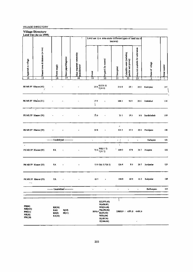
VILLAGE DIRECTORY
Village Directorv Land Use (As on 1999)
,
j -! 8 ~
f -a Jd
i B g B
J j 14 1 15
PR MR FP Khanar (45) I
,
~
"8
i ~ u
11 ,?;-S: iil §~ b
~ l ~ ~ 16 17 18
Land use (I e area under dIfferent types of land use 1
til e ~ 19
OJ'
~ e: ..,
1 20
2S 8 GC(16 I) T(16 I)
hectare)
1 .. ~ 21
2168
6 OIl ~ .§ '" ]
1~ .. .e " u > :0 " i(j ~ 1 ~
ll.., ~ .!l Iii
it g ....
0
" ~ ~ 22 23 2
28 I 32 5 K."'paRl
.8 ~ '" 'a
-~ 1
117
--------~----------------------------------------------------------
PR MR FP Kh~ar (51)
PR MR FP Khanar (50)
PR MR FP Khanar (55)
PR MR FP Khanar (55)
Pll Mil FP Khanar (55)
Pll MR FP Khanar (55)
PR(66) MR(tZt) Fp(llt) NR(3l) NW(18)
------- Umnhablted -----------
EA
EA
EA
----_- Umnhabi~d-----------
ED{l6)
EAG EO(5) EA(36)
N(19) M(It)
174
7; 0
328
72 S WE(Jf 7) T(117)
1390(6 I) T(6 I)
423
GC{975.43) W(450.87) WE(14.68)
5 75 4 TK(494.!l4) o . R(151.51)
203
WF(4.04)
0(183.54) T{1386.01)
1085 929 32 I H.ld,khol 118
33 I 193 9 8 Sandh,bahah 119
1245 675 23 0 PatJ.lpara 120
- 1 Gailapam 121
4695 4711 347 Nuapara 122
1264 119 20 7 Jarelpadar 123
1948 409 13 3 Kokpadar 124
Badhunpan. 125
23032.9 I 4251.5 16491.6
\

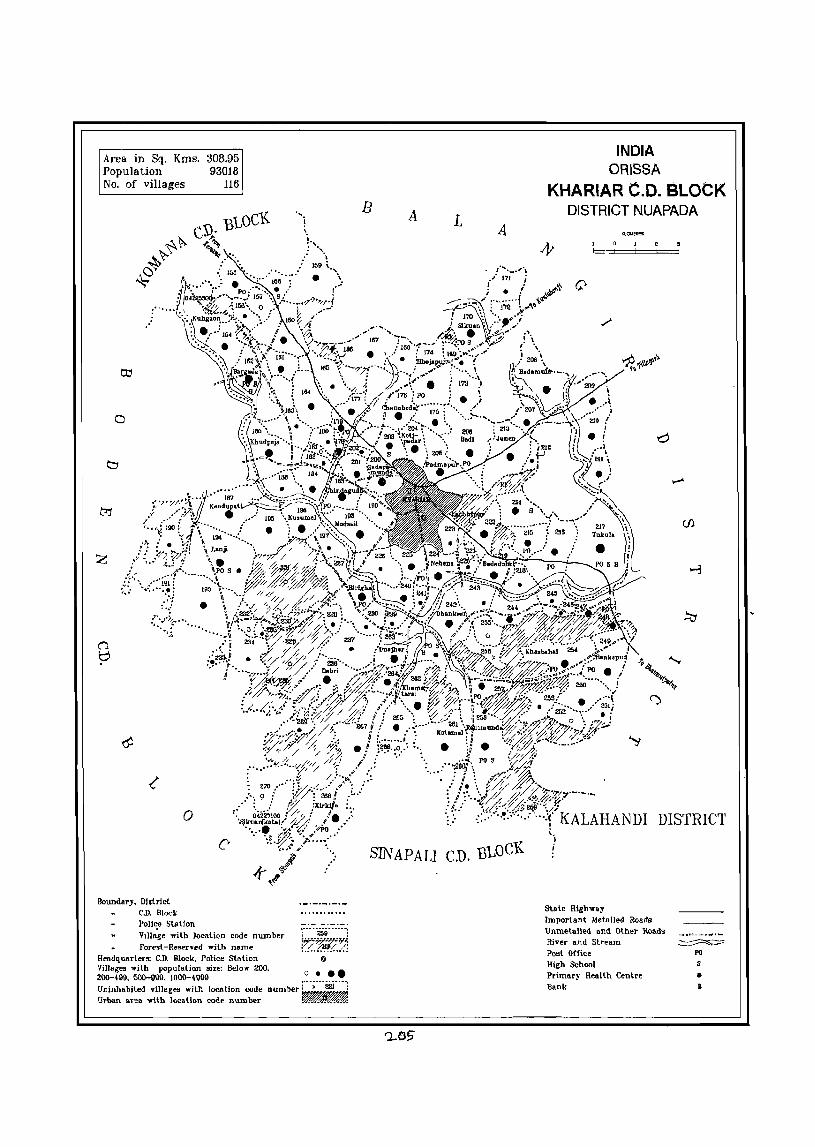
Area in Sq. Kms. Population No. of villages
a
o
Boundary. District C.D. Block Poll,;e Station
308.95 93018
116
VIllage with location code number Forest-Reserved with name
He.dquarters: C.D. Block. Police Station Villages with population size: Below 200.
".
:·-···~9··-··"!
l77-f%'.;."'l'~ :.!..~f!. . .!.]
@
o ••• ZOG--l9i). 50Q-9\l1l. 1000-41)911 Uninhabited villages with location code number r··;···2i!j·· .. i Urban area 'With location code number .. ~
B A L
SIN APALl CD. BLOCK
INDIA ORISSA
KHARIAR C.D. BLOCK DISTRICT NUAPADA
,,,,,,,,,,
DISTRICT
Slate High"ay Important Metalled Roads UnmetaJled and Other Roads River and Stream Post Office High School Primary Health Centre Bank
PO
• B

VILLAGE DIRECTORY OF
KHARIAR C.D. BLOCK- 0005

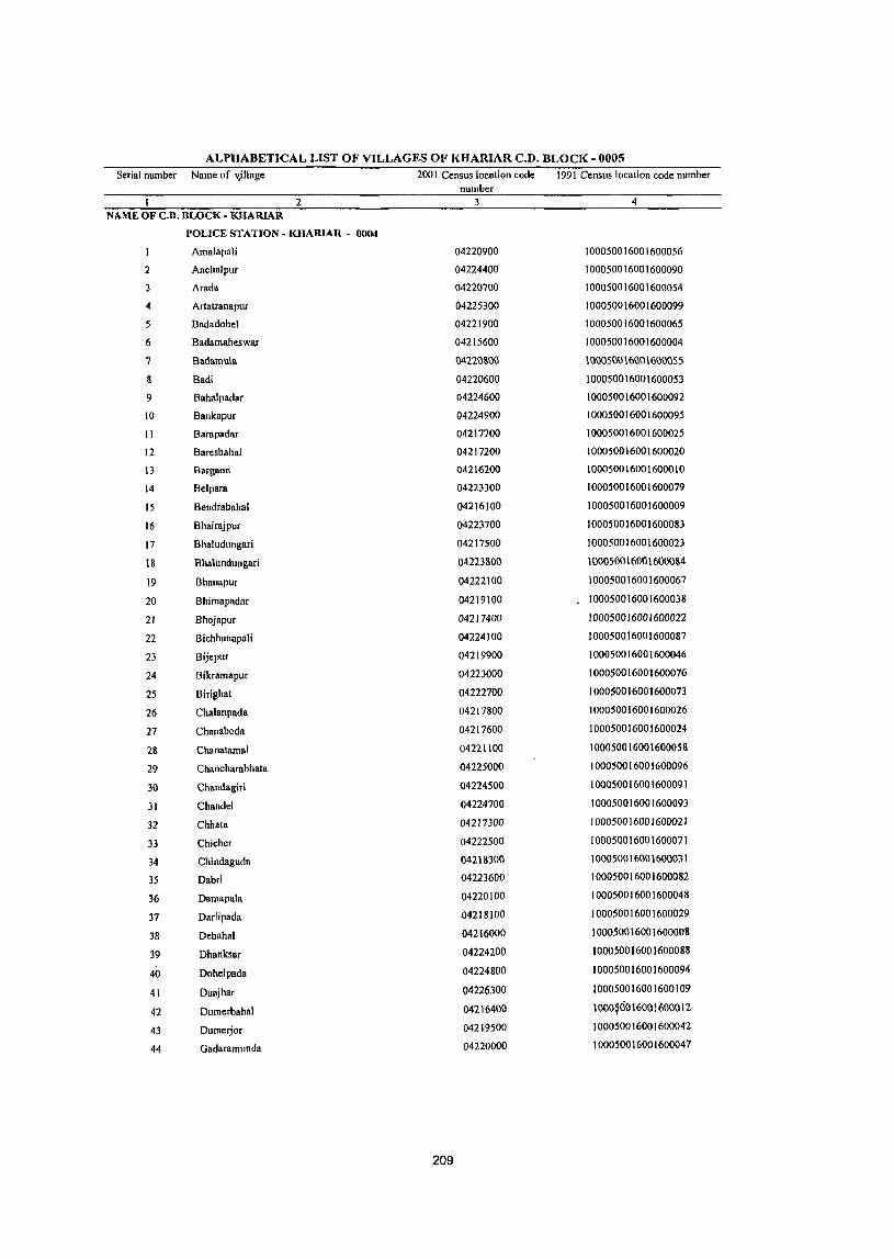
ALPHABETICAL LIST OF VILLAGES OF KHARIAR C.D. BLOCK - 0005 Serial number Name of v)llage 200 I Census location code 1991 Census location code number
number 2 3 4
NAME OF C.D. BLOCK - KHARIAR
POLICE STATION - KHARIAR - 0004
Amalapali 04220900 100050016001600056
2 Anchalpur 04224400 100050016001600090
3 Arada 04220700 100050016001600054
4 Artatranapur 04225300 100050016001600099
5 Badadohel 04221900 100050016001600065
6 Badamaheswa.r 04215600 100050016001600004
7 Baclamula 042201\00 100050016001600055
8 Badi 04220600 100050016001600053
9 Bahalpadar 04224600 100050016001600092
10 Bankapur 04Z24900 100050016001600095
II Barapadar 04217700 100050016001600025
12 Baresbahal 04217200 100050016001600020
\3 Bargaon 04216200 100050016001600010
14 Belpara 04223300 100050016001600079
15 Bendrabahal 04216100 100050016001600009
16 Bhairajpur 04223700 100050016001600083
17 Bhaludungari 04217500 100050016001600023
18 Bhalundungari 04223&00 10005001600160001\4
19 Bhanapur 04222100 100050016001600067
20 Bhimapadar 04219100 100050016001600038
21 Bhojapur 04217400 100050016001600022
22 Bichhanapali 04224100 100050016001600087
23 Bijepur 04219900 100050016001600046
24 Bikramapur 04223000 100050016001600076
25 Birighat 04222700 100050016001600073
26 Chalanpada 04217800 100050016001600026
27 Chanabeda 04217600 100050016001600024
2& Chanatamal 04221100 10005001600160005&
29 Chancharabhata 04225000 100050016001600096
30 Chandagiri 04224500 100050016001600091
31 Chandel 04224700 100050016001600093
32 Chhata 04217300 100050016001600021
33 Chieher 04222500 100050016001600071
34 Chindaguda 04218300 100050016001600031
35 Dabri 04223600 100050016001600082
36 Damapala 04220100 100050016001600048
37 Darlipada 04218100 100050016001600029
38 Debahal 04216000 100050016001600008
39 Dhanksar 04224200 100050016001600088
40 Dohelpada 04224800 100050016001600094
41 Duajhar 04226300 100050016001600109
42 Dumerbahal 04216400 1000~6016001600012
43 Dumerjor 04219500 100050016001600042
44 Gadaramunda 04220000 100050016001600047
209
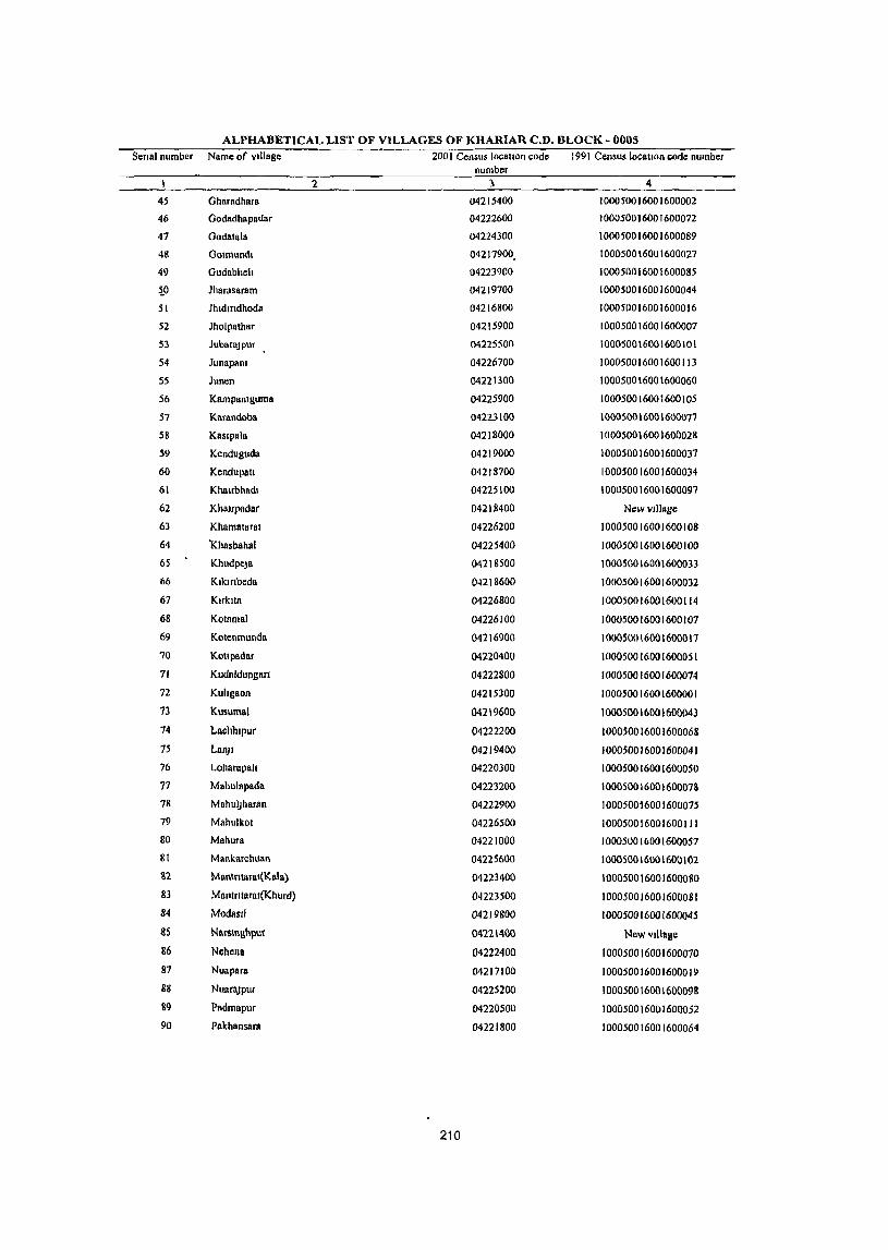
ALPHABETICAL LIST OF VILLAGES OF KHARIAR C.D. BLOCK - 0005 Scnal number Name of village 2001 Census locallon code 1991 Census location code number
number '2 3 4
45 Oharadhara 04215400 100050016001600002
46 Oodadhapadar 04222600 100050016001600072
47 Godatala 04224300 100050016001600089
48 GOimundl 04217900. 100050016001600027
49 Gudabhelt 04223900 100050016001600085
iO Jharasaram 04219700 100050016001600044
51 Jhldmdhoda 04216800 100050016001600016
52 Jholpathar 04215900 100050016001600007
53 JubarnJPur 04225500 100050016001600101
54 Junapsm 04226700 100050016001600113
55 Junen 04221300 100050016001600060
56 Kampanlguma 04225900 100050016001600105
57 Kanmdoba 04223100 100050016001600077
58 Kaslpala 04218000 100050016001600028
59 Kenduguda 04219000 100050016001600037
60 KendupaU 04218700 1000500160016000)4
61 Khsubhadl 04225100 100050016001600097
62 Khaupadar 04218400 NewvJJJage
63 Khnmfttaral 04226200 100050016001600108
64 'l<hasbahal 04225400 100050016001600100
65 Khudpej8 04218500 100050016001600033
66 Klkmbeda 04218600 100050016001600032
67 KirklIn 04226800 100050016001600114
68 Kolamal 04226100 100050016001600107
69 KOlenrnunda 04216900 100050016001600017
70 Kotlpadar 04220400 100050016001600051
11 Kudllldungan 04222800 100050016001600014
72 Kuhllaon 04215300 100050016001600001
73 Kusurnal 04219600 100050016001600043
74 Lllchhlpur 04222200 100050016001600068
15 Ll1l1JI 04219400 100050016001600041
76 Loharapall 04220)00 100050016001600050
77 Mahuillpada 04223200 100050016001600073
78 MahulJhanln 04222900 100050016001600075
79 Mahulkol 04226500 100050016001600111 80 Mahura 04221000 100050016001600057
81 Mankarchuan 04225600 100050016001600102
112 MantntaTlII(Kala) 04223400 100050016001600080
83 Montrttaral(Khurd) 04223500 100050016001600081 84 ModflSrl 04219800 100050016001600045
~S Nllrs\l\allpur 04221400 Newvlilalle
86 Nehena 04222400 100050016001600010
87 Nuapara 04217100 100050016001600019 88 NuaraJpur 04225200 100050016001600098 89 Plldmapur 04220500 100050016001600052 90 Pnkhansara 04221800 100050016001600064
210
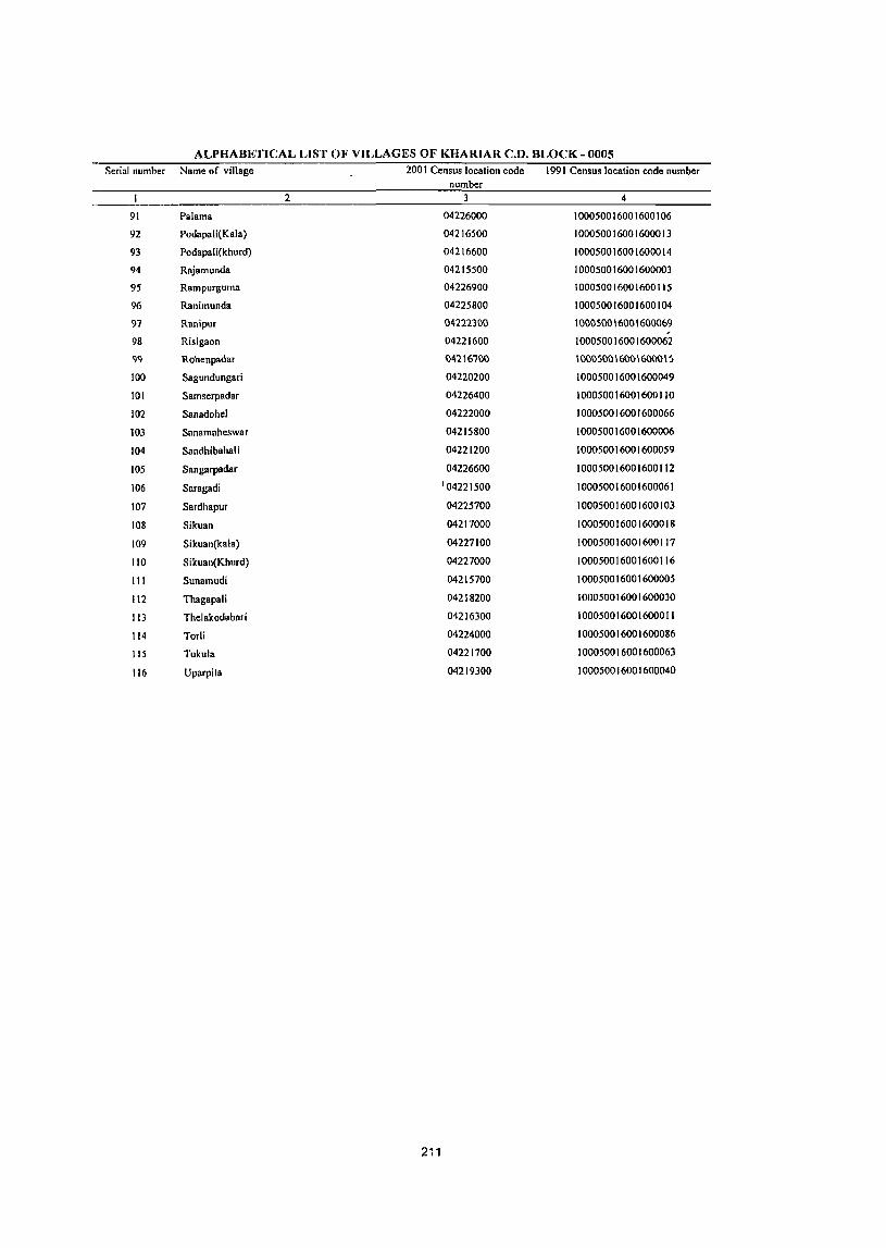
ALPHABETICAL LIST OF VILLAGES OF KHARIAR C.D. BLOCK - 0005 Serial number Name of village 2001 Census location code 1991 Census location code number
number 2 3 4
91 Palama 04226000 100050016001600106
92 Podapali(Kala) 04216500 100050016001600013
93 PodapaJi(khurd) 04216600 100050016001600014
94 Rajamunda 04215500 100050016001600003
95 Rampurguma 04226900 100050016001600115
96 Ranimunda 04225800 100050016001600104
97 Ranipur 04222300 100050016001600069 , 98 Risigaon 04221600 100050016001600062
99 Rohenpadar 042\6700 \00050016001600015
100 Sagundungari 04220200 100050016001600049
101 Samserpadar 04226400 100050016001600110
102 Sanadohel 04222000 100050016001600066
103 Sanamaheswar 04215800 100050016001600006
104 Sandhibahali 04221200 100050016001600059
105 Sangarpadar 04226600 100050016001600112
106 Snragadi '04221500 100050016001600061
107 Sardhapur 04225700 100050016001600103
108 Sikuan 04217000 100050016001600018
109 Sikuan(kala) 04227100 100050016001600117
110 S i kuan(Khurd) 04227000 100050016001600116
III Sunamudi 04215700 100050016001600005
112 Thagapali 04218200 100050016001600030
113 Thelakodabari 04216300 100050016001600011
114 Torli 04224000 100050016001600086
115 Tukula 04221700 100050016001600063
116 Uparpita 04219300 100050016001600040
211

I ~ '"" ii! "" ~ '" 3 -::,
.3 11 § ~ o<J C!.
f " § £ n .... ~ .0 0 "3 8 .. Q. :::> ._
~ 8. c 0 ., .. ~
13 13 c "
0 0 C/) l- I-
I 2 3 4
CD Block: Khansr ~OOOSl
KI1\\'I,""" 3880 1,175 (04215300)
Gharadh.t. 2700 647
(04215400)
RaJamunda III 0 369
(04215500)
B adamsl,e.war 4
(042IS600) 2590 817
Sunwnudl 1370 163
(04215700)
Sanamaheswar 6
(04215800) 1060 369
7 Jholpathar
477 0 S72 (04215900)
Debabal & 4160 S7S
(04216000)
9 Bendrabahal
1700 589 (O4216100)
Bargaon 10 5050 2,043
(04216200)
DISTRICT CENSUS HIl.NDBOOK NUAPADA'
Census of India 2001 -AMenitie~ and
Amenities available (If not available within the village, a da~h (-) IS shown In the columnl\n next to It III brackets the distance In broad ranges VIZ < 5 kms , 5-10 kms and 10+ kms of th
1 nearest place where the faelht'! IS available IS given) 'tl cn.g fa ii ,;
;:; j ...
] C.) > t~ §, ~ .r:l " lO'
i B- r ]
]~e :: ~ 1! ~. 11 " ., '"CI ~, l ~ . '" "3 .r ::I
"0 g g <.> g 6 a ~ 1 § o<J-ot:: 0 '" 0 . .. ~>-g '" 0 "" '0 1 g ]i i ~ o~~ I:l "" u
f.l ~ c 1! §.rI :::> C.) ! ~ :::> § f "" ~ § 0 ~ ti ~~ ",0(3
" ~ 8 & 8..8 p;O~ 8] :z ::E 5 6 7 8 9 10 II 12 13
'].72 P M C(10+) H(Hl+\ HP W TK R PH l'0«
CM(5-IO) t\C&(S-lO\ C\l<.lO+) !!~« S)
MC~(IO+) SS·HP 5) CP(IO+)
NCS(IO+) ,)P(ICH) RS(ICl-r)
PHC(IO+) OCS(IO+) ST(lO+) NW(IO+)
184 P M C(lO+) H(IO+) IIPWTK!PO(~5) CM« 5)
ACS«S) CV(IO+) BS(S·IO)
MCW(IO+) SS·HP PHi 10+) NCS(IO+) 8P«5) RS(II)+)
PIIC(IO+) CP(IO+)
OCS(lO+) ST(IO+) NW(IO.,.)
82 P M« 5) H(IO+) HPWTK PH PO('"
CM«S) ACS«S) CV(IO+) BS(<. ~)
C(IO+) MCW(IO+) S8·HP 5) CP(lO+)
NCS(JO+) 8P(10+) RS(IO+} PHC(lO+) OC1>(IO+) ST(IO+) NW(IO+J
P M« 5) PHS H(10+)
HPWTK ACS(S-IO) CV(IO+) BS
196 C(lO+)
MCW(IO+) SS·HP
PO PH CM(5·10) NCS(lO+) SP(10+)
RS(IO+) PHC(IO+) CP(IO+)
OCS(lO+) ST(lO+) NW{lO+)
46 P M« 5) H(10+) HPWTK
PO« S) CM«5) ACS(5·10) CV(IOI-) 85« ~l
C(IO+) MCW(IO+) SS·HP PH(IO+) CP(lO+)
NCS(IO+) SP{S·IO) R!>(IO+I PHC(IO+) OCS(IO+) ST(IO+) NW(IOi\
11(10+) HPWTK AC'>(S·IO) C V(l 0+) as
76 P M S C(lO+) MCW(IO+) SS·HP
PO« 5) CM(S·IO) NCS(IO+) SP(IO+)
RS(IO+)
PHC(IO+) PH(IO+) CP(IO+)
OCS(IO+) ST(lO+) NW(IO+)
138 P M«S) H(IO+) liP WTK
PO«S) CM(S·IO) ACS(S·IO) CV(lO+) 6S(5·1O)
C(IO+) MCW(IO+) SS·HP PH(IO+) CP(IO+)
NCS(IO+) SP(S-IO) RS(IO+) PHC(IO+) OCS(IO+) ST(IO+) NW(IO+)
H(IO+) HPWTK ACS«S) CV(S·IO) 6S
126 P M C(S-IO} PO«5} CM«S) RS(lO+) MCW(lO+) SS·HP
PH(S·IO) CP(IO+) NCS(IOt-) SP« S)
NW(IO+) PHC(5.IO) OCS(IO+) ST(IO+)
144 P M C(IO+) H(IO+) HPWTK
PO«S} CM«5) ACS«5) CV(S-IO) BS«~)
MCW(IO+) 1>S·HP PH« S) CP(IO+)
NCS(IO+) SP« 5) RS(IO+) PHC(IO+) OCS(IO+) ST(IO+) NW(ICl-r)
PHS H(IOI-) HPWTK CM
ACS SP 6S«5)
450 P M .'l C(lO+) MCW(IO+) PO PH NCS(IO+) CV(IO+) PHC(IO-t')
SS-HP CP(lO+) OCS(IO+) ST(IO+)
RS(IO+) NW(IO+)
212
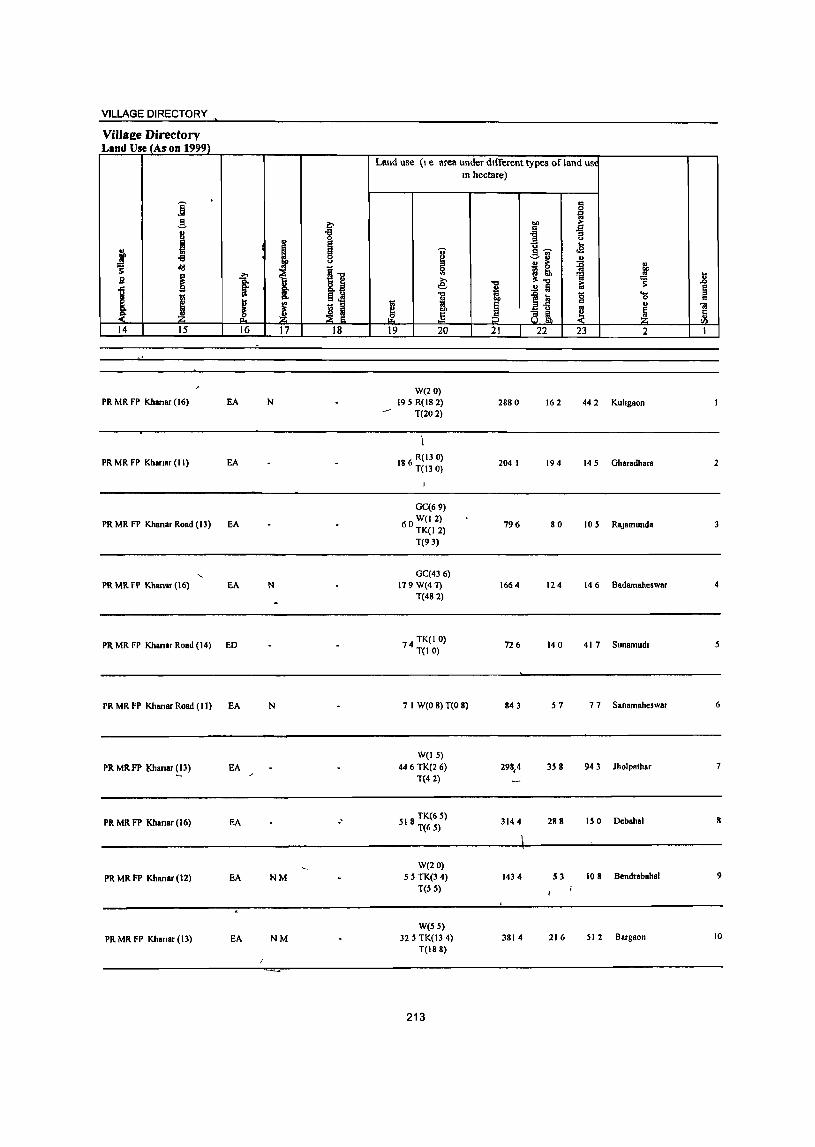
VILLAGE DIRECTORY
Villa~e Directory Lind Use (Ann 1999)
Land use (I e area under dIfferent types of land USl
In hectare)
j . co
0
~ ~ "" i j
I "8
111 ~ ...
f I .s oS
~ old <>
i! ~
11 Sl
g ~ I e: ~ _g
1 ! .!! Iii 1:; ~
i i 1~ is .... ~
0 '" I ~ I j " <iI
Z g, ~ ~ r'1 .§ 8 ~ ! ~ 14 15 16 17 18 19 20 21 22 23 2 I
W(20) PR Mit FP Khanar (16) EA N 195 R(18 2) 2880 162 442 Kuhgaon
T(202)
PR MR FP Khanar (II) EA 186 R(13 0) T(130)
2041 194 14 S Gharadhara 2
GC(69)
PR MR FP Khanar Road (13) EA 60 W(12) TK(12)
796 80 105 RaJamullda
T(93)
GC(436) PR Mit FP Khansr (16) EA N 179W(47) 1664 124 146 Badamaheswar 4
T(482)
PR MR FP Khanar Road (14) ED 74 TK(I 0) T(IO)
726 140 417 Sunamud. S
Pit MR FP Khmar Road (II) EA N 7 1 W(O 8) T(O 8) 843 57 7 7 Sanamaheswar 6
W(IS)
PR MR.FP t<hanar ( 13) EA 446 TK(2 6) 298,4 35 g 943 Jholpathar 7 T(42)
Pit MR FP Khanar (16) EA .' 518 TK(6 S) T(65)
3144 288 150 Debahal S
W(20)
Pit MR FP Khanar (12) EA NM 55 TK(3 4) 1434 S3 108 Bendrabahal 9
T(55)
W(55)
Pit MR FP KI.ana, (13) EA NM 32 5 TK(13 4) 3814 216 512 Bargaon 10
T(188)
213
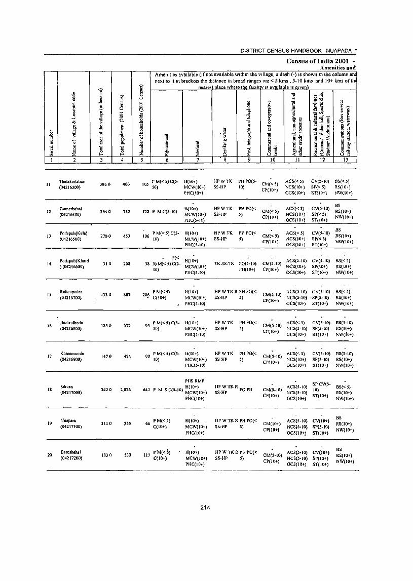
I ] J g ... " 13 -=-" t>Il 8 0 .!'l ....l
<ld S c:!-g, " §
Jl .. il
~ ~
..... 0
1 8 !! El 'C1 il 'iii J ~ ~ 11 '"
,,_. ,,_. I 2 3 4
II Tbelakodaban
3860 400 (04216300)
Dum.thahal 12 364 0 732
(04216400)
Podapola(Kala) 13 2700 4S3
(04216500)
Podap.Ia(Kh urd 14 310 2S8
}(04216600)
IS Roltenpadar
4330 887 (04216700)
16 Jhldludhod.
ISS 0 3'77 (04216800)
17 KOtJ!nmund ..
1470 424 (04216900)
18 SlkuBn
3420 2,826 (04217000)
Nuapara 19 3130 255
(04211100)
Baresbaltal 20 1830 S39
(04217200)
~ " ~ ;; 0 c:!-~ "0
1 .c 'C1 u .., ~ 5
lOS
DISTRICT CENSUS HANDBOOK NUAPADA *
Census of India 2001 -Amenities and
Amenities available (If not available within the village, a dash (-) IS shown In the column an next to It In brackets the distance In broad ranges VIZ < 5 kms , 5-10 kms and 10+ kms of Ih
nearest place where the facII! tv IS available IS given) "C cn.g m ~u u !;! ] "5~ 1l
§ ~ ~~
fr ~ 8.. o ;>,
" :; :: ~ f 0 01'"
~ §, ~ E_"~ " OJ oo .. " :;]§ ~~ fa ' .,
"C g g ., ~ t: IJ 1 !il <ld .e § d . '" 1~
OI- oil ., 0
1 ~ g § :> ~ ~ ~ t>Il "ll § ~.
~ ] i ~
~j 1l a ~ ~ i 1i .~~ « g oil
~ .~ ~u£ 8] 6 7 • 8 9 10 II 12 13
P M« 5) C(5- H(lO+) HPWTK PH PO(5. CM« 5)
ACS« 5) CV(5·IO) 8S«5)
10) MCW(IO+) SS·HP 10) CP(IO+)
NCS(IO+) SP« 5) RS(IO+) PHC(IO+) OCS(IO+) ST(IO+} NW(IO+}
8S H(IO+) HPWTK PH 1'0« ACS« 5) CVeS·IO)
172 P MC(S·IO) CM«S) RS(IO+) MCW(lO+) SS·HP 5) NCS(IO+) SP« S) PHC(S.lO)
CP(IO+) OCS(IO+) ST(IO+)
NW(lOt)
P M«5)C(S· H(IO+) HPWTK PH PO« ACS« 5) CV(S·IO) 8S
106 CM«5) RS(IO+) 10) MCW(IO+) 5S·HP 5)
CP(IO+) NCS(lO+) SP« .5)
NW(IO+) PHC(S.IO) OCS(IO+) ST(IO+)
P« H(lO+) ACS(S·IO) CV(S-IO) 8S«5)
58 5) M« S) C(S· TKSS·TK PO(S·IO) CM(S·IO)
10) MCW(IO+)
PH(IO+) CP(IO+) NCS(\O+) SP(IO+) RS(IO+)
PHC(S.IO) OCS(lO+) ST(IO+) NW(IO+)
20_!i P M«S) H(IO+) HPWTKRPHPO«
CM(S·IO) ACS(S·IO) eV(s·IO) BS{< 5)
C(IO+) MCW(IO+) SS·IIP 5) CP(lO+)
NCS(S.lO) .SP(5·10) RS{lO+)
. PHC(S.IO) OCS(lO+) ST(IO+) NW(IO+)
9S P M« S) C(S. H(IO+) HPWTK PH PO«
CM(5·10) ACS« S) CV(S·IO) 8S(S·10)
10) MCW(IO+) SS·HP S) NCS(S·IO) SP(S·IO) RS(10+)
PHC(S.IO) CP(IO+)
OCS(IO+) ST(IOt) NW(fo+)
99 P M«5) C(S· H(IO+) HPWTK PH PO«
CM(.5·IO) ACS« 5) CV(S·IO) BS(S·IO)
10) MCW(IO+) SS HP 5) CP(IO+)
NCS(IO~) SP(S.IO) RS(1O+) PHC(S.IO) OCS(IO+) ST(IO+) NW(lO.-)
PHS RMP SPCV(S·
643 H(IO+) HP WTKR POPH CM(S·IO)
AeSls·to) 10)
8S«5) P M S C(S·to) ~CW(IO+) SS·HP
CP(IO+) NCS(S·IO)
ST(IO+) RS(lO+)
PHC(IO+) OC5(IO+) NW(IO+)
66 P M«5) 11(10+) HP WTK R PH PO« ACS(S.IO) CV(lO+) as
CM(lOr) RS(IO+) C{lO+) MCW(IO+) S!'·HP S)
CP(lO+) NCS(S-IO} SP(S·IO)
NW(IO+) PHC(IO+) OCS{IO+) ST(IO+)
P'M«5) H(IO+) liP WTK R PH PO{< AeS(S.IO) CV(IO+) BS
117 CM(S·IO) RS(IO+) C(lO+) MCW(IO+) 5S·HP S)
CP(lO+) NeS(S·IO) SP(IO+)
NW(IO+) PHC(IO+) OCS(IO+) ST(IO+)
214
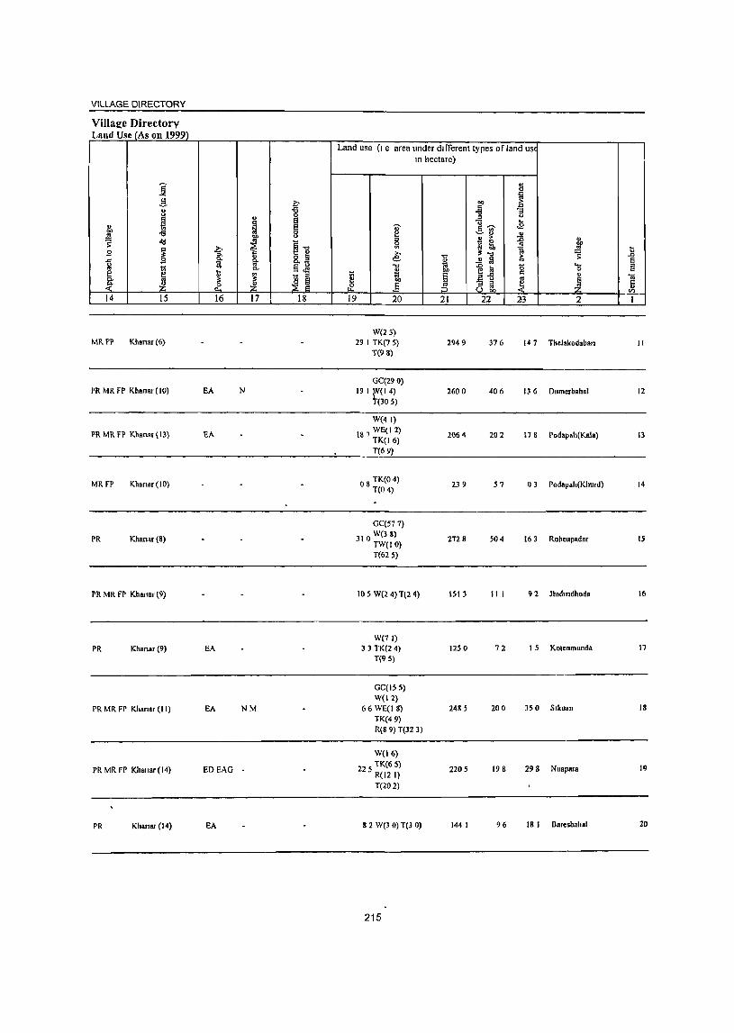
VILLAGE DIRECTORY
Village Directory Land Use (As on 1999)
Land use (I e area under different types of land us~ In hectare)
j c 0
til .!1 ~ 1
;>
'" 8 -g "3 ., .a (J
N e .. ... '" ~ e 1 !13 .s
"" -€I 0
1 .. ... (J ., > ~ Qj
~ 11 " 1ii ~ w E
b l.l 1l 9 "" " e: "" ;!: "" ~ .., "" g- " ..!! ~ § 0 a "" 1;i
1~ c; .... .,
J 0- §~
~ on 0 " e ~ ~ - " 1;; 9 " ... 01 0.
~ ~ I:l l ~ ~ c ~ rP ~ .e :3 ;3 ~ ..
Vl
14 15 16 17 18 19 20 21 22 23 2 1
W(2l) MRfP Kllanar (6} 291 TK(75} 2949 376 147 Thelakodaban II
T(98)
GC(29 0) PR MR FP Khanar (10) EA N 19 I fr(l 4) 2600 406 136 Dumerbahal 12
(305)
W(4 I)
PR MR FP Khanar (13) EA 187 WE(I 2} TK(16)
2064 202 178 Podapah(Kala) 13
T(69)
MRfP Khanar (10) 08 TK(O 4) T(04)
239 57 03 Podapah(Khurd) 14
GC(577)
PR Khanar(8) 310 W(3 8) TW(IO)
2728 504 163 Rahenpadar 15
T(625)
PR MR FP Khanar (9) 105 W(2 4) T(2 4) 1513 III 92 Jh,dllldhoda 16
We7 I) PR Khanar (9) EA 33 TK(24) 1250 72 15 Kotenmunda 17
T(95)
GC(IS 5) W(! 2)
PRMRFP KhanaT(I!) EA NM 66WE(IS) 2485 200 350 Slkuan 18
TK(49) R(8 9) T(32 3)
W(16)
PR MR FP Khanar (14) EDEAG 225 TK(6 5) 2205 198 298 Nuapara !9 R(121) T(202)
PR Khanar (14) EA 82 W(3 0) T(3 0) 144 I 96 18 I Oarosbahal 20
215
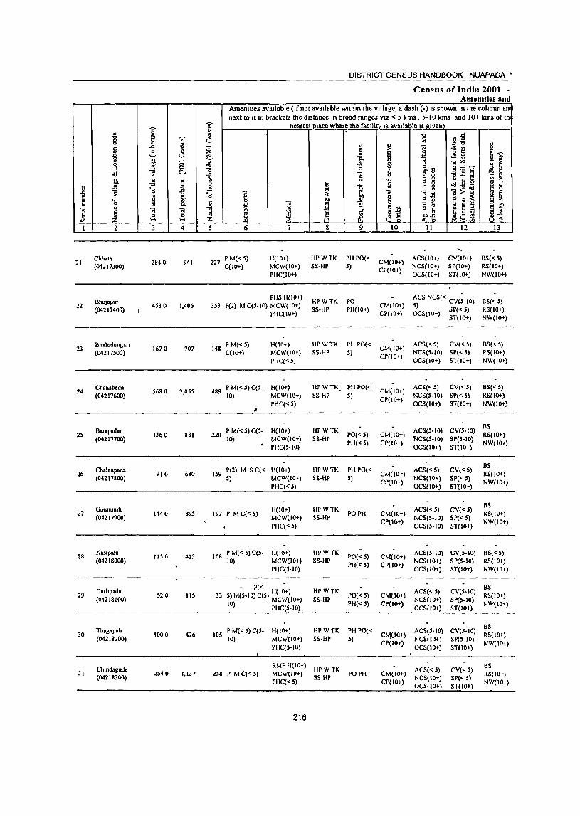
I ] J " § ..., '" ~ c. " 0 11' ~ ...J
0(1 ~ ~ " § -s n :l:! '0 ~
.0 s: 13
~ ~ 8: 'a .. u
~ ~ i ~ I-<
I 2 3 4
21 Chhata
2840 941 (04217300)
BhllJapur 22
(04217400) 4530 1,406
23 Bhaludungan
1670 707 (04217S00)
24 Chanabeda
5680 2,05S (04217600)
Barapadar 25 1360 881
(04217700)
Chalanpada 26 910 680
(04217800)
Gotmundt 27
(04217900) 1440 895
28 KaSlpala
liS 0 423 (04218000)
Darltpada 29
(04218100) 520 liS
Thagapah 30
(04218200) 1000 426
ChtndRguda 31
(04218300) 2540 1,137
1l ~ ;0 0 !::\. ~ "'5 -'" '" g -'" 'a .8 ~ 5
227
3.53
148
489
DISTRICT CENSUS HANDBOOK NUAPADA'
Census of India 2001 ~ Amenities and
Amenities available (If not available within the village, 8 dash (-) IS shown In the column an next to It In brackets the distance In broad ranges VIZ < 5 kms , 5-10 kms and 10+ kms of th
nearest ll!ace where the facIlltv IS available IS Rlvenl "0 r:~ fa
'" u If '" ~ ] -= t:! § ~ oM &. ~~
& ~ [ 11 t !iI'" 11 ~:J a__"~
-0 11] § ~~ ~ , 'il -0 § - o c
I:i 1 1il "'- ~ o(I-sg g § OJ !iI:>-g .. 3: !iI ]i ~ ~ g g 6':;J1
~ ~ i 1i jj :::J OJ ~§-a e ~ ~ 1if ~u ~ 8 & ~ ~a&l ~@
6 7 8 9 10 II 12 13
PM«S) H(IO+) HPWTK PH PO« CM(10+)
ACS(IO+) CV(lO+) 8S«S) C(IO+) MCW(IO+) SS-HP S)
CP(IO+) NCS(IO+) 51'(10+) RS(IO+)
PHC(IO+) OCS(IO+) ST(IO+) NW(IO+)
PHS H(10+) HPWTK PO ACS NCS« CV{~-IO) 8S« S)
P(2) M C(S-IO) MCW(IO+) SS-HP PH(lO+)
CM(IO+) S) SP« 5) RS(IOt-) PHC(IO+) CP(IO~) OCStIO+) ST(IO+) NW(IO+)
P M«S) H(lO+) HPWTK PH 1'0« CM(lO+)
ACS«5) CV«5) BS« 5) C(lO+) MCW(IOi-) S5-HP S)
CP(IO+) NCS(S-IO) SP« 5) RS(IO+)
PHC«5) OCS(IO+) ST(10+) NW(IO')
P M«S) qs- H(JO+) HPWTK PH 1'0« CM(IO+)
ACS«5) CV{< 5) 8S« S) 10) MCW(IO+) SS-HP 5)
CP(IO+) NCS(S-IO) SP« S) RS(lO+)
PHC«S) OCS(IO+) ST(IO+) NW(IO+)
• 220 P M« S) qs- H(lO+) HPWTK ACS(S-IO) CV(S-IO)
as PO«S) CM(IO+) RS(IO+)
10) • MCW(lO+) S5-HP 'NCS(S-IO) SP(S-IO) PHC(S-IOI
PH«S) cr(IO+) OCS(IO+) ST(IO+)
NW(IOi-)
pel) M S C« H(IO+) HPWTK PH PO« ACS«5) CV«5) as
159 CM(IO+) RS(lO+) 5) MCW(IO+) SS-HP .1)
CP(IO+) NCS{lOt) SP« S)
NW(I04) PHC«S) OCS(IO+) ST(lO+)
11(10+) HPWTK ACS« 5) CV(Q) BS
197 P M C«5) MCW(IO+) SS-HP
PO PH CM(IO+) NCS(S-IO) Sf'« 5)
RS(IO+)
PHC«S) CPlIO+)
OCS(5·10) ST(lOt) NW(IO+)
108 P M« 5) C(S- H(IO+) HPWTK
PO«5) CM(IO+) ACS(S-IO) eV(S-IO) BS« 5)
10) MCW(IO+) SS-HP PH« 5) CP(lOT)
NCS(lOt) SP(5-10) RS(IO+) PHqS-IO) OC5(10+) ST(IO+) NW(IO')
- P« H{IO+) HPWTK ACS«S) CV(S-IO) as
33 S)MlS-IO)qS- MCW(IO+) 5S-HP PO«5) CM(IO+)
NCS(IO+) SP(S-IO) R5(lO+)
(0) PHC(S- I 0) PH« S) CP(lO+) OC5(IO+) ST(IO+)
NW(I(}l)
P M« 5) q5- H(IO+) HPWTK PH PO« AC5(S-10) CV{S-IO) BS
lOS 10) MCW(IO+) S5-HP 5)
C~(I0t) NCS(IO+) SP(S-IO)
RS(lOt)
PHC(S-IO) CP(lO+)
OCS(lO+) ST(lO+) NW(IO+)
RMPH(IO+) HPWTK AC5«S) CV«S)
as 258 I' M C«S) MCW(IO+)
5S HI' POPH CM(IO+)
NCS(IO+) SP«5) RS(lOT)
PHC«S) CP(IOt) OCS(IO+) ST(IO+)
NW(IO+)
216
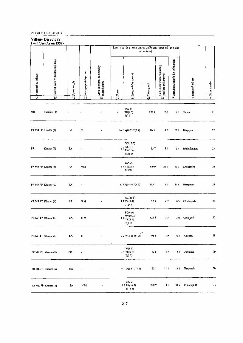
VILLAGE DIRECTORY
VilIa,2c Directorv Land tlse (As on 1999)
Land use (I e area under dIfferent types of land USI
In hectare)
i g
,g ~
." ~ j s:s
u "'3
j .. " I ...
fo ~ '0' g~ .E ~ ~ -=-11 " f " > ~ u ~ <113
_ ., ~1l Sl L~
CD
B ~ ..?:;- e: a ~ u 0. "0 S .c
.c: 9 ~ ~ 8.s ~ ..!! ~ 1; e g
Vi §.M "" ~ a 5 ._ :::I
~ 0 c e u ~ - :::I
1:;; 5 2-5 c " " c.
~ :!: ~ ~ ~ .§ ~ ~ ~ ~ ~ ~ :5 2\ ~ r: " til
14 15 16 17 18 19 20 21 22 23 2 I
W(25) MR Khanar(14) TK(45) 2732 26 10 Chit ala 21
T(70)
PR MR FP KlIariar (8) EA N 14 2; ~(6 7) T(6 7) 3942 146 232 BhoJapur 22
GC(IS 6)
PR Khanar (4) EA W(7 I) 48 TK(25) 1157 114 99 Bhaludungan 23
T(25 I)
W(34) PR MR FP Khanar (4) hA NM 97 TK(2 5) 4709 227 59 I Chanabeda 24
T(59)
PR MR FP Kharrar (7) EA til? W(4 9) T(4 9) 115 I 4 I 116 Barapadar 25
GC(235)
PR MR FP Khanaf (4) EA NM 43 TK(I 0) 529 27 63 Chalanpada 26
T(24 5)
PC(49)
PR MR FP Khan')f (4) EA NM 13 WE(24)
TK(17) 1248 55 30 Gou,\undl 27
T(90)
PR MR FP Khanar (5) FA N 22 W(12)T(1 2) 96 I 89 6 I KBsrpBla 28
W(IS)
PR MR FP Khanar (8) ED 43 TK(O 8) 328 87 37 Darltpada 29
T(23)
PR MR FP Khannr (6) FA 47 W(IS)T(18) 62 I 111 198 Thagapah 30
W(22)
PR MR FP Khansr (3) EA NM () 7 TK(16 3) 2009 30 312 Chtndaguda 31
T(185)
217
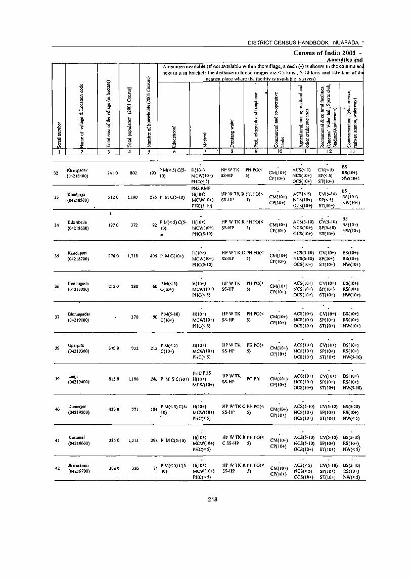
1 ] ~ g ..:: <II
8 _g, ] " ~ ;:;
0
"<:l ~ el-
j " c oS 0
] ~ ~ 'C; "3
~ .... g & 0
"i! " ~ ~ Ii ~ (I) t- 1--
1 2 3 4
KbSlrpodar J2 2410 802
(04218400)
33 KhudpeJa
5120 1,190 (04218500)
Klkfllbeda 34 1970 372
(04218600)
35 K~ndup.1l
?760 1,718 (04218700)
36 Kcnduguda
2150 280 (04219000)
37 Bhlmapadar
370 (04219100)
38 Uparplt8
3790 932 (04219300)
LonJI 39 8150 1,186
(04219400)
40 DumerJor
4S90 771 (04219500)
41 Kusum.1
2840 1,215 (04219600)
42 Jhorosorom
20S 0 326 (04219700)
DISTRICT CENSUS HANDBOOK NUAPADA •
Census ofIndia 2001 -Amenities and
Amenltles avaIlable (Ifnol available wlthm the; village, a dash (-) IS shown In the column an next to It 1n brackets the distance m broad ranges VIZ < 5 kms , 5-10 kms and JOT kms ofth
J nearest olace where the facllltv IS available 15 Plven' .", Vi~ ~ 8u 8 § " " i "B ~ § ;>
~ E~ el- ]. .a &. ~ 6-
~ 0- ]~~ • ;g ~ B ~ ~13
l .", -=] § ~~ Iii
,.c .", c u
" II 5
i -'" Ia o 0 § d' c 0 "<:l.",-
'l> "i! ~ -a i: "i!:>] B ~ kl S ]
bIl " g ~1 sOl] li ~ B J 1l '" a 1 oil t{ (~ j ju g g-i3 jI ~ ~ ,p ~ ..:!U S Z ~'"
5 6 7 8 9 10 11 12 11....]
P M«S) C(S- H(IO+) HPWTK PH PO« ACS« 5) CV«S) BS
193 CM(IO+) RS(IO+) 10) MCW(IO+) S8-HP 5)
CP{IO+) NCS(lO+) SP«5)
NW(IO+l PHC« 5) OCS(IO+) ST(IO+)
PHS RMP BS
276 P M C(S·IO) H(1{1+) UPW,K R PHl'Dl<'
CM(IO+) ACSlq) C\ll5-)()
RS(IO+) MCW(IO+) SS-HP 5) NCS(IO+) SP«S) PHC(S-IO}
CP(IO+) OCS(IO+) ST(IO+)
NW(IOi)
P M« 5) C(S. H(IO+) HP W TK R PH PO« ACS(5·10) eV(5-1O) BS
92 CM(IO+) RS(lo-.) Itl) MCW(IO+) S5·HP 5)
CP{JO+) NCS(IO+) SP(5-10)
NW(IO+) PHC(5·10) OCS(IO+) ST(IO+)
406 P M C(IO+) H(IOt) HP WTKC PH PO«
CM(IO+) ACS(5·10) CV(IO+) BS(IO+)
MCW(IO+) SS·HP 5) NCS(S·IO) SP(IO+) RS(lO-r)
PHC(S·JO) CP(IO+)
OCS(IO+) ST(IO+) NW(IO+)
60 PM«S) H(lOt) BPWTK PH PO« CM(IO+)
ACS(IO+) CV(lO+) BS(lO+) C(IO+) MCW(IO+) SS·HP S)
CP(IO+) NCS(IO+) 8P(10+) RS(IO .)
PHC« 5) OCS(IO+) ST(lO+) NW(lO+)
90 P M(S.IO) H(IO-t) BPWTK PH PO« CM(IO+)
ACS(IO+) CV(W+) 8S(10+)
C(IO+) MCW(IO+) SS·HP S) CP(lO+)
NCS(lO+) Sf'(IO+) RS(lO+)
PHC«S) OCS(IO') ST(IO+) NW(IO+)
212 P M« 5) H(IO+) HPWTK PH PO«
CM(IO+) ACS(IO+) CV(IO+) 8S(10+)
C(JO+) MCW(lO+) SS·HP 5) CP(IO+)
NCS(lO+) SP(IO+) RS(IO+) PHC«S) OCS(IO+) ST(IO+) NW(5·10)
I'HCPHS HPWTK ACS(IO+) CV(lO+) 8S(10+)
246 P M S C(lO+) H(IO+) PO PH CM(IO+) MCW(IO+)
SS·HP CP(lO+)
NCS(IO+) SP(IO+) RS(IO+) OCS(lO+) ST(IO+) NW(5-HI)
184 P M« 5) C(5· H(IO+) HP WTK C PH PO(<. CM(IO+)
ACS(S·IO) CV(5·IO) 8S(S·IO) 10) MCW(lO+) SS·HP 5)
CP(IO+) NCS(IO+) SP(IO+) RS(IO+)
PHC«S) OCS(IO+) ST(IO+) NW«5)
298 P M C(S·IO) HPO+) HP WTK R PH PO«
CM(IO+) ACS(S·IO) CV(S·IO) 8S(S·10)
MCW(IO+) C SS-HP S) CP(IO+)
NCS(S·IO) SP(IO+) ~~~~1)\ PHC«S) OCS(IO+) ST(IO+)
71 P M« 5) C(S· H(IO+) HP W TK R PH PO«
CM(IO+) ACS«5) CV(S-IO) BS(S·IO)
10) MCW(IO+) SS-HP 5) CP(IO+)
NCS«S) SP(IO+) RS(IO+) PHC«S) OCS(IO+) ST(IO+) NW«S)
218
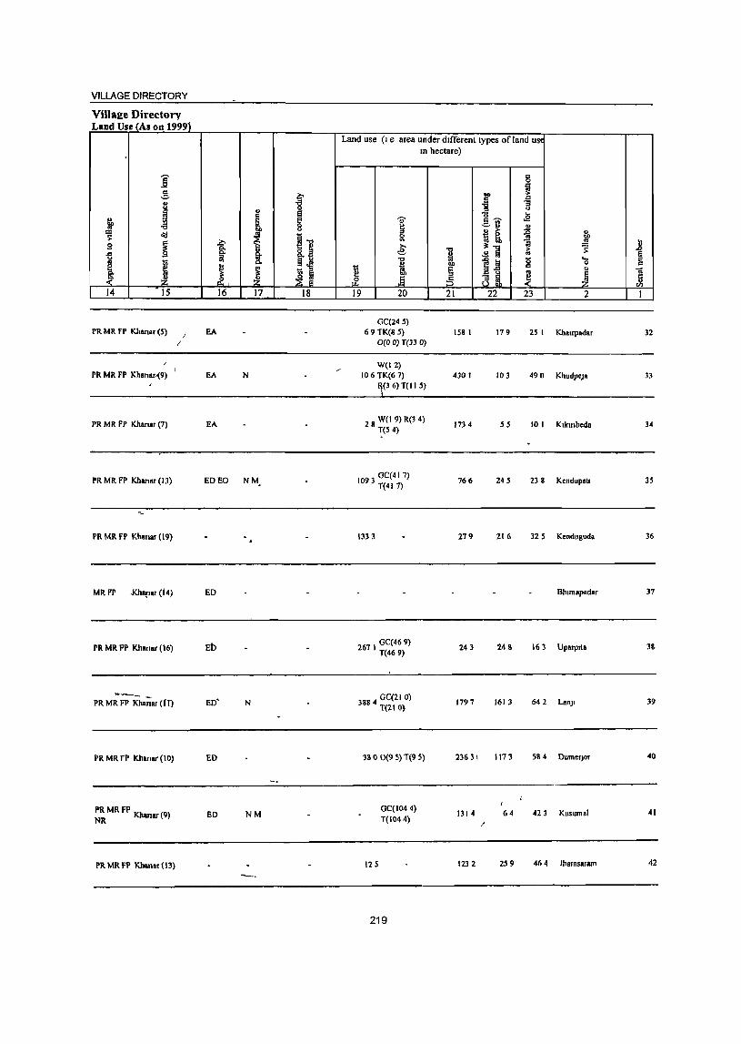
VILLAGE DIRECTORY
Villalle Directory Land Use _fAs on 1999}
j S f .. S I j ~ .a ~
i I) ~
t 9 I 1 J ~ ~ i i rf 14 15 16 17 18
PR MR FP Ki,anar (5) J EA /
PR MR FP Khanar.-(9) EA N
PR MR FP Khanar (7) EA
PR MR FP Khanar (13) ED EO NM_
PR MR FP Khanar (19)
MR FP J<hapar (14) ED
PR MR FP Kil8nar (16) ED
-_ PR MR FP Kha;;ar (fT) ED' N
PR MR FP Khanar (10) ED
PR MR FP Kh (9) NR mar ED NM
PR MR FP Khanllf (13)
Land use (I e area under different types of land usc In hectare)
'U'
~ '" e:
"1:1
J ! .§
19 20
GC(24S) 69 TK(8 5)
0(0 0) T(33 0)
W(12) 106 TK(6 7)
(36) T(lI S)
28 W(I 9) R(3 4) ~(5 4)
1093 GC(41 7) T(417)
1333
261 I GC(469) T(469)
3884 GC(21 0) T(210)
380 0(9 5) T(9 5)
12 S
GC(1044) T(1044)
219
...
111 i ~
1 .2] 1~ ..
~ 81 21 22
158 I 179
430 I 103
1734 55
766 24 S
279 216
243 243
1797 1613
2363\ 1113
1314 64 ;'
1232 2S 9
is
! :; u ...
<E ., ~ " llf' ~ ~ g ...
0
" .. .~ ~
23 2
25 I Kha'rpadllr
490 KhudpeJa
10 I KlklMbeda
238 Kendupatl
32 5 Kenduguda
Bhlmapadar
! 6 3 Uparplla
642 Lan)1
584 DumefJor
423 Kusumal
46 4 Jharasaram
..ll ~ -a £ 1
32
33
34
3S
36
37
3&
39
40
41
42
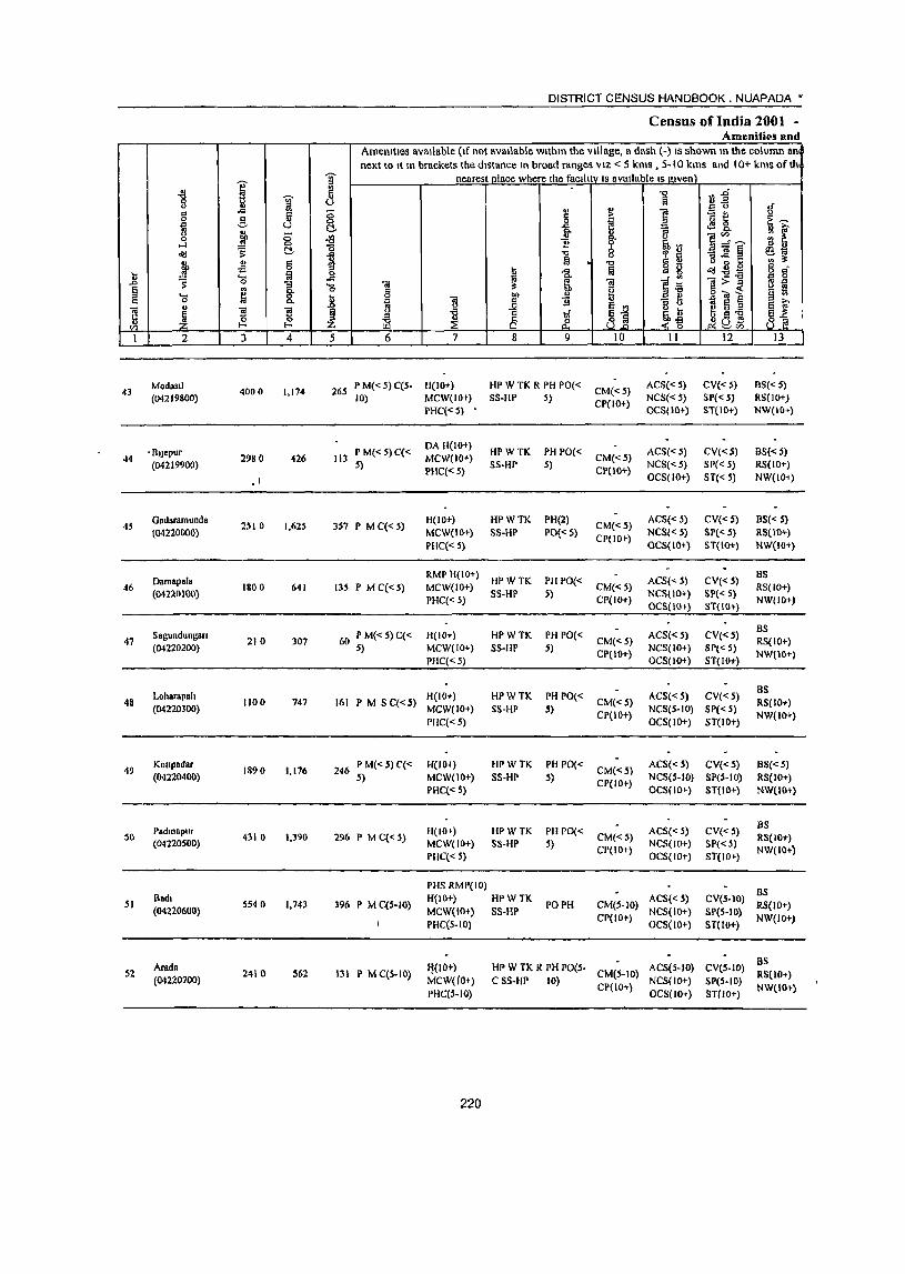
I 1 ]' !l
.Q
'" .g a ~ .. 0 ~ 0
...l c <ill s: £::!,
11 '" !l b ~
;9 'ia 'a ..0 S' 2. § ., .... ~ 8. 0:: 0
~ OJ -g ..
u ~ t- ~ '" I 2 3 4
43 Modasll 4000 1,174 (04219800)
• Blj.pur 44 2980 426
(04219900)
.1
45 Gadaramunda
2510 1,625 (04220000)
Damap.l. 46 1800 641
(04220100)
Sagundungan 47 210 307
(04220200)
LoharapalJ 48 1100 747
(04220300)
49 Koupadar
1890 1,176 (04220400)
Padmapur S(} 4310 1,3<)0
(04220500)
51 Badl
5540 1,743 (04220600)
Arada 52
(04220700) 2410 562
DISTRICT CENSUS HANDBOOK. NUAPADA •
Census ofIndia 2001 -Amenities and
Amenities available (If not available within the village, a dash (-) IS shown In the column an next to It In brackets the distance In broad ranges VIZ < 5 kms, 5-10 kms and 10+ kms ofth
J nearest place where the faclh:v IS available IS_J!.lven) ""C1 ~1 Ii v
~ " <>
~ § i ~ tl <>
~ l;! 0 ~~ -& ... 0-
-l:I .,
f e"'.~ ~ ~ "0 1i ~rJ ~]§ 1 '" ~~ fil ." .. tl <> 3 5
i .Q § g g <iIl.,,- § R"
.c: a ]~ 1>-g " 0 'a .. .. ~ ~ IS g o ~ i .R
.., " § » p iil
j 1i - g ., e ~ j ~ 'Ii ~j
U ... ~ ill oS E ~ z & --~~ Jia B S] ~CIl
5 6 7 8 9 10 II 12 I3 --
265 P M«5) C(5- H(IO+) HP W TK R PH PO« CM«S)
ACS«S) CV«5) BS«5) 10) MCW(IO+) SS-HP 5) CP(IO+) NCS«S) SP« 5) RS(IO+)
PHC«5) OCS(IO+) ST(IO+) NW(IO+)
P M{<5)C« OA 1-1(10+)
HPWTK PH PO« ACS«5) CV«S) BS« 5) 113 MCW(IO+) CM«5)
S) PHC« 5)
SS-HP 5) CP(IO+) NCS« 5) SP« 5) RS{IO+) OCS(lO+) ST« 5) NW(lO-i)
357 P M C« 5) H(IO+) HPWTK PH(2l
CM«5) ACS« 5) CV«S) BS« 5)
MCW(IO+) SS-HP 1'0«5) CP(IO+) NCS« 5) SI'« 5) RS(IO+)
PHC« 5) OCS(IO+) ST{IO+) NW(IO+)
RMP H(IO+) HPWTK PH PO« ACS« 5) CV«5)
as 135 P M C« 5) MCW(IO+) CM«S) RS(IO+)
PHC« 5) SS-HP 5)
CP(IO+) NCStIO+) SPt< 5)
NW(IO+) OCS(lO+) ST(IO+)
60 P M« 5) C« H(IO+) HPWTK PHPO« ACS« 5) CV«S) BS
CM«5) RS(IO+) 5) MCW(IO+) SS-HP 5)
CP(IO+) NCS(IO+) SP«S)
NW(IO+) PHC« S) OCS(lO+) ST(IO+)
H(IO+) HPWTK PH 1'0« ACS« S) CV«5) as
161 P M S C« 5) CM«S) RS(IO+) MCW(IO+) SS-HP 5)
CP(IO+) NCS(5-1O) SP« 5)
NW(IO+) PHC« 5) OCS(IO+) ST(IO+)
246 P M« 5) C{< H(IO+) HPWTK PH PO« CM«5)
ACS« 5) CV«S) BS« 5) 5) MCW(IO+) SS·HP S)
CP(IO+) NCS(5-1O) SP(5-1O) RS(IO+)
PHC« S) OCS(IO+) ST(lO+) NW(IO+)
H(IO+) HPWTK PH PO« ACS« 5) CV«S) as
2<)6 P MC«5) CM«5) RS(10+) MCW(IO+) SS·HP S)
CP(IO+) NCS(IO+) SP« 5)
NW(IO+) PHC« 5) OCS(IO+) ST(IO+)
PHSRMP(IO) as 396 P M C(S-IO)
H(IO+) HPWTK PO PH CM(5-1O)
ACS« 5) CV(S.IO) RS(IO+)
MCW(IO+) SS-HP NCS(IO+) SP(S-IO) PHC(S-IO)
CP(IO+) OCS(lo+) ST(IO+)
NW(IO+)
H(lO+) HP W TK R PH PO(S· ACS(S-IO) eV(S-IO) as
131 P MC(S-IO) Mcw(lo+) CSS-HP 10)
CM(S-IO) NCS(IO+) SP(S-IO)
RS(IO+)
PHC(5-1O) CP(IO+)
OCS(IO+) ST{IO+) NWtIO+)
220
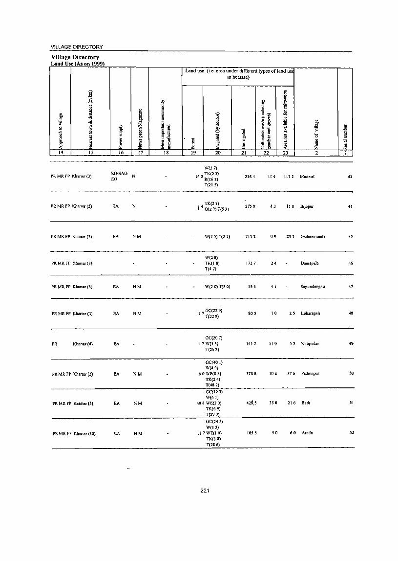
VILLAGE DIRECTORY
Villaae Directory Land Use (As on 1999)
Land use (I e area under different types of land us( In hectare)
j 5 g ~ co ~
d '" 3 -a ] "3 0 ..,
~ 8 e .. f ~ S 'U' !~ ,£
.;;
f 8 ~ ~ ~ :E "d ~'g g
~!' .g g,
9 ~ ~ »
1 ~ ~ .8
.n 9 c. g. ~J e .£ !a .. § u a "" .0 :a 0 .... " U
c. £ 0 " e u 1;; E"l.i c ~ 1;; "
.. E ] .,
'" Q.
"" e .§ ~ ~ ~ ~ ~ ~ ~ ;§ 8 ~ c ~ " ..,
14 15 16 17 18 19 20 21 22 23 2 I
W(27)
PR MR FP Khsnsr (3) EI>EAG
N 140 TK(2 3) 2364 114 1172 Mods •• 1 EO R(162) 43
T{212)
PR MR FP Khanar (2) EA N TK(27)
14 0(2 7) T(5 3) 2759 43 110 BIJepur 44
PR MR FP Khanar (2) EA NM W(2 5) T(2 5) 213 2 99 2S 3 Gadaramunda 45
W(28) PR MR FP Khanar (3) TK(18) 172 7 24 Damapals 46
T(47)
PR MR FP Khansr (5) EA NM W(2 0) T(l Q) 1504 4 I SagundungaI1 47
PR MR FP Khanar(3) EA NM 27 GC(229) T(229)
805 10 25 l-obarapnh 48
GC(20 7)
PR Khanar(4) EA 47 W(5 5) 1417 110 57 KOllpadar 49
T(262)
GC(40 I) W(49)
PR MR FP KhanAr (2) EA NM 60 WECO 8) 328 S 108 376 Padmapur 50 TK(24) T(482)
GC(!23) W(61)
PR MR FP Khansr (5) EA NM 408 WE(l 0) 42~S 350 216 Bad. 51
TK(69) T(273)
GC(245) W(13)
PR MR FP Khansr (10) EA NM 117 WE(I 0) 1855 90 60 Arads 52
TK(l8) T(286)
221
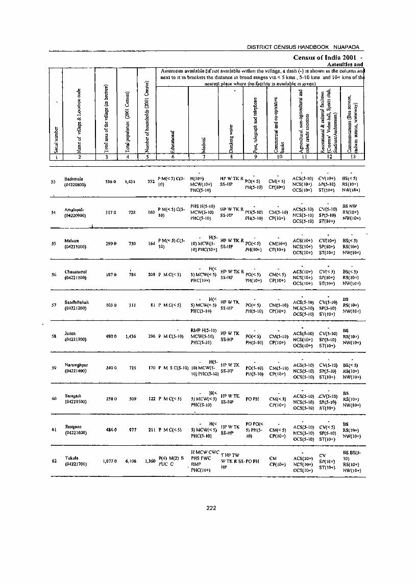
I '" "8 j g -= d a ~ f § o(j t:!.
" " ~ oS 0 U ~ ..... ia .D 0
1 ~ g ..... 0
] .,
~ ~ ~ l- I-
I 2 3 4
53 Badnmula
5360 1,431 (04220KOO)
54 AmJllapah
3170 728 (O4220900)
Mahura SS 2990 750
(04221000)
ChanatamaJ 56 1810 184
(04221100)
Sandlllbahalt 57 1030 311
(04221200)
Juncn 58 4800 1,436
(04221300)
Nar.mghpur 59 24Q a 72S
(04221400)
Saragadl 60 2580 S09
(04221500)
Rt.lgnon 61 4860 977
(04221600)
62 Tukula
1,0710 6,106 (04221700)
DISTRICT CENSUS HANDBOOK NUAPADA
Census of India 2001 -Amenities and
Amenllles available (If not available within the Village, a dash (-) IS shown In the col limn an next to It In brackets the distance In broad ranges VIZ < 5 kms , 5-10 kms and 10+ kms of th
1 nearest olace where the faclhtyts aVllllable Is~glven "0 fjj u Ii
If " !;' '" 0 § I ~~ 8 ~ E~ t:!. -& .e 8. ., i:i' -l9 " ]~~ ~ ~ 1i go
~~ c; .", 8 -=] ~ ~~ -Ii !i '\1 o 0 c: g .", !5 - g d" u
1 m " g o(j~B ..co ~ 1i Ol:>';; ~ ~ .... ] Ol
§ ~ i 0 g l "" § ..
~ 1'l '" 11 SlJ "3 t> g 8 § ; § 1 ! 1if ~~ e ~ .;; Z ~~ .~ J] ~ua 82 5 6 7 8 9 10 II 12 13
332 P M« S) C(S- H(IO+) HP WTK R PO(:5) CM«5) ACS(5-1O) CV(JO+) 6S« 5)
10) MCW(lO+) SS-HP PH(S- 10) CP(IO+) NCS(IO+) !'P(5-IO) RS(IO+)
PHC(5-IO) OCS(lO+) ST(IO+) NW(IO-l)
P M«5)C(S-PHS H(S-IO)
HP W TK R PO{;-IO) ACS(5-10) CV(S-IO) BSNW
160 MeWeS-IO) CM{S-IO) R'i(IO+} 10)
PHC(5-IO) SS-HP PIi(S-IO) CP(IO+) NCS(S-IO) SP(S-IO)
NW(IO+) OCS(S-lO) ST(lO+)
PM«S) C(S-H(5- -
ACS(lO+) CV{IO+) BS{< SI 164 10) MCW(5- HP W TK R PO« S) CM(IO+)
10) 10) PHC(10+) SS-HP PH(IO+) CP{IO+) NCS{IO+) SP(IO+) RS(IO+) OCS(lO+) ST(IO+) NW(lO+)
H« HP W TK R 1'0{: 5) ACS(IO+) CV« 5) 8S«5)
209 I' M C«5) 5) MCW«5) CM«S) PHC(IO+) SS-HP PH(IO+) CP(lO+)
NCS(IO+) SP(lO+) RS(IO+) OCS(IO+) ST(lO+) NW(IO~)
H« HPWTK ACS(S-IO) eV(S-IO)
BS 81 P MC«S) S) MCW«S} 1'0« S) CM(S-IO) RS( 10+)
PHC(S-IO) SS-HP
PH(S-IO) CP{to+1 NC-S(S-IO) SP(5-10)
NW(t01") OCS(S-IO) ST(IO+)
RMP H(S-IO) HPWTK ACS(S-IO) CV(S-IO)
as 2% I' M C(S-IO) MCW(5-10) 1'0« 5) CM(S-IO) RS(JOt)
PHC(S-IO) SS-HP
PH(s-lO) CP(IO+) NCS{lO+) SP(S-IO)
NW(lO+) OCS(IO+) ST(IO+)
- HeS-ACS(S-IO) CV(S-IO) BS« 5) 170 P M 5 C(S-IO) 10) MCW(S- HI' W TK 1'0(5-10) CM(S-IO)
10) PHC(s-IO) 55-HP PH(S-IO) CP(IO+) NCS(S-IO} SpeS-to) RS(IO+) OCS(S-tO) ST{IO+) NW(lO+)
tI(<-HPWTK ACS{S-IO) .eV(S-IO}
BS 122 I' M C«5) S) MCW« S} PO PH CM«5) RS(IO+)
PHC(S-IO) SS-HP
CP(lO+) NCS(S-IO) SP(S-10)
NW(IO+) OCS(S-IO) ST(IO+)
H« HPWTK
PO PO« ACS(S-IO) CV«5)
BS 211 P M q<. 5) S} MCW«5) S) PH(S- CM«S) RS(IO+)
PHC(S-IO) SS-HP
10) CP(IO+} NCS(S-tO) SpeS-to)
'NW(IO+) OCS{S-IO) ST(IO+)
HMcwewc THPTW CV BS BS(5-
1,360 P(4) M(2) S PHS fWC W TK R SS- PO PH CM ACS(lO+)
SP(lO+) 10)
PUC C RMP CP(IO+) NCS(IO+) RS(lO+) I PHC(IO+) HI' OCS(lO+)
ST(IO+) NW{IO+)
222
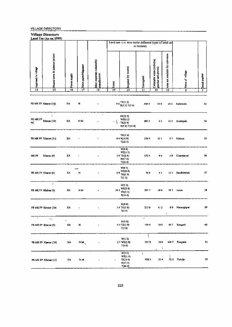
VILLAGE DIRECTORY
VlllalZe Directory Land Use_{As on 1999)
Land use (I e area under dIfferent types ofland USI
In hectare)
i § ~
.!! c ... >-
J 1 l~ ~ u
..,
t ...
f 'U' oS
i ~U .!!
olI3
I] !! ~ fo B ~ -a: ~ ~ ::l! 1 1 a- t .!! Ii s:
1i\ El'a "" .0] j ...
I .!l 0
j ~ tl
E ~ ~ u u
] ~ e e ~ ~ ,2 tiS, 14 15 16 17 18 19 20 21 22 23 2 I
PR MR F1' KhllJlar (19) EA N TK(l2)
9 6 R(2 2) T(3 4) .4665 156 206 Badamula 53
) GC(20)
~~ MR FP Khanar (10) EA NM . \ WE(32) 2833 53 165 Amalapah 54
TK(O 8) R(5 8) T(II 8)
TK(56) PR MR FP Khanar (11) EA 04R(168) 2569 10 I 97 Mahura SS
T(224)
W(OS) WE(ll)
MRFP Khanar(6) EA 18 TK(28) 1524 66 48 Chanatamal 56 R(174) T(224)
W(OS)
PR MR FP Khansr (6) EA N 68 WE(OS) TK(19)
768 4 I 12 I Sandhlbahah 57
T(32)
W(32)
PR MR FP Khiner (0) EA NM WE(2S)
343 TK(43) 3977 186 185 Junen 58
T(IO 4)
W(OS) PR MR FP Khansr (10) EA 34 TK(I 8) 2138 112 88 Narstnghpur 59
T(26)
W(OS)
PR MR FP Kharllr (6) EA N 60 TK(I 8) 1946 100 447 Saragadl 60 T(26)
W(ll) PR MR FP Khanar(JO) EA NM
'< 27 WE(2S)
T(40) 3678 108 1007 Rlslgaon 61
W(20) WE(14) 1
PR MR FP Khanar(lI) EA NM TK(l6) 9585 204 522 Tukula 62 R(410) T(46 0)
223
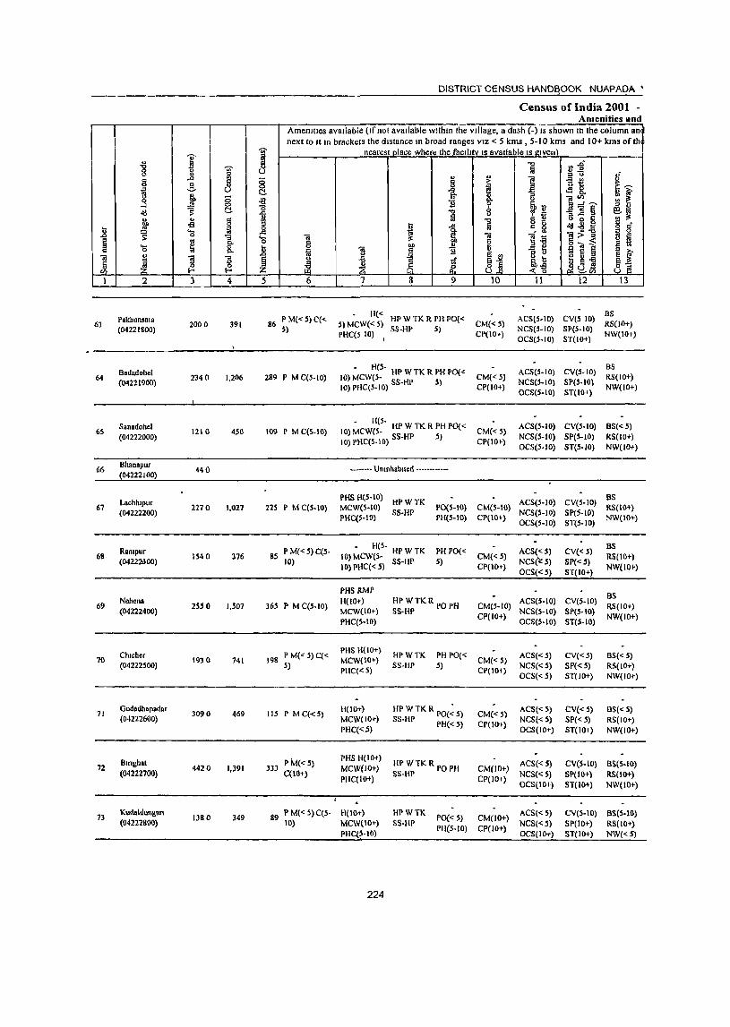
I '" "8 8 J Ii .... .!! ] ~ g :::
<ld s: c:!.
f .. § oS
j '- ta 0
I ~ .. ..... ~ a
u "iii
~ 1 "5 5 ~ '" I-<
1 2 3 4
63 Pakhansara
2000 391 (04221800)
Badadohel 64 2340 1,206
(04221900)
Sanadohcl 65 1210 450
(04222000)
66 Bhanapur
440 (04222100)
Lachhlpur 67 2270 1,027
(04222200)
RaOlpur 68 1540 376
(0422:20300)
69 Nehena
255 0 1,501 (04222400)
Chlcher 70 1930 741
(04222500)
71 Godadhapadar
3090 469 (04222600)
Bm~hal 72 4420 1,391
(04222700)
73 Kudaldungan
1380 349 (04222800)
DISTRICT CENSUS HANDBOOK NUAPADA·
Census of India 2001 -Amenities Hod
Amenities available (Ifnot available within the village, a dash (-) IS ShOWlllh the column an next 10 It In brackcls the distance III broad ranges VIZ < 5 kms , 5-10 kms and 10+ kms ofth
-;;;- nearest place where thefacdltv IS available IS given :>
~ "'" ~1 ~ If " ~
<> ... 0 e -= ., Ii o t: ~~ 0
"& I E <fl 8. c:!. ""3 .:g 0 ]~~ :;: ~ "0 1i ~rJ '" " 11 -0 ""3] ~ ~~ fil
,,,, 1 5 !l o 0 C g tl o(I..gS
c _
-= l! 1 c. ~ "iiI:>"B g 5 'c; "iii ;l: "iii ].a ~ ~ I:l ~ Ii iii i j ! "
J 11 1i - ~ '" e '" » ~~ B u 8 ~ § ~ tf ~ g oS
~ 8.]5 ~~ ~cJ&l ~B :z: 5 6 '} 8 9 10 11 12 13
P M«S) C« H« HPW TK R PH PO« ACSlS-IO) CV(S 10) BS
86 S) MCW« S) CM«S) RS(lO+) S)
PHC(S 10) SS-HP 5)
CP(lO+) NCS(S-IO) SpeS-to)
NW(IO+) I OCS(S-IO) S1(10+)
- H(S-ACS(S-IO) CV(S-IO)
as 289 P M C(S-IO) 10) MCW(S- HP W TK R PH PO« CM«S) RS(lO+)
10) PHC(S-IO) SS-HP S) NCS(S-IO) SP(S-IO) CP(IO+)
OCS(S-IO) ST(IO+) NW(IO+)
- H(5-ACS(S-IO) CV(5-10) BS«5)
109 P M C(5-10) 10) MCW(5- HP W TK R PH POt < CM« 5) 10) PHC(S-I 0) SS-HP S) NCS(S-IO) SpeS-to) RS(IO+)
CP(IO+) OCS(S-IO) ST(5-10) NW(lO+)
------- Unmhabllcd ---------
PHS H{S-IO) HPWTK ACS(S-IO} CV(S-IO)
as 225 P MC(S-IO) MCW(S-IO) PO(S-to} CM(S-IO) RS(I(H}
PHC(S-IO} SS-HP
PH(S-IO) CP{IO+) NCS(S-IO} SP(S-IO)
NW(IO+} OCS(S-IO) ST(S-W}
P M« 5) C(S-- H(S-
PH PO« ACS«S) CV« 5) BS
85 10) MCW(S- HP W TK CM« S) RS(IO+} 10) IOj PliC«.5) SS-HP 5)
CP(IO+) NCSr: S) SP« 5)
NW(lO+} OCS« S) ST(tO+)
PHS ItMP as 365 P M C(S-IO}
H(IO+) HPWTKR PO PH CMCS-IO) ACS(S-IO) CV(S-IO)
RS(IO+) MCW(IO+) SS-HP
CP(IO+) NCS(S-IO) SP(S-IO)
NW(IO+) PHC(S-IO} OCS(S-IO) ST(S-IO)
P M« S)C« PHS H{IO+)
HPWTK PH PO« ACS«S) CV« 5) BS« 5) 198 MCW(IO+) CM« S) 5) PHC«S)
SS-HP 5) CP(IO+)
NCS«S) SP« 5) RS(IO+) OCS« 5) 81(10+) NW(IO+)
liS P M C«S) H(lO+) HP WTK R poe; S) CM«S)
ACS«S) CV« S) BS« .5) MCW{IO+) SS-HP PH« 5) CP(IO+)
NCS«S) SP«5) RS(IO+) PHC«~) OCS(IO+) ST(IO+) NW(IO+)
P M« 5) PHS li(IO+)
HP WTKR PO PH ACS« S) CVeS-IO) BS(5-10) 333 MCW(IO+) CM(JO+) C(tO+)
PHC(IO+) SS-HP
CP(lO+) NCS«S) SP(IO+} RS(lO+} OCS(IO+} ST(IO+) NW(lO+)
89 P M« S)C(S- H(IO+) HPWTK PO« 5) CM(lO+)
ACS«S) eV(S-IO) BS(S-IO) 10) MCW(IO+) S5-UP NCS«5) SP(IO+) RS(lO+)
PHC(S-IO) PH(5-10} CP(IO+)
OCS(IO+) ST(IO+) NW«5)
224
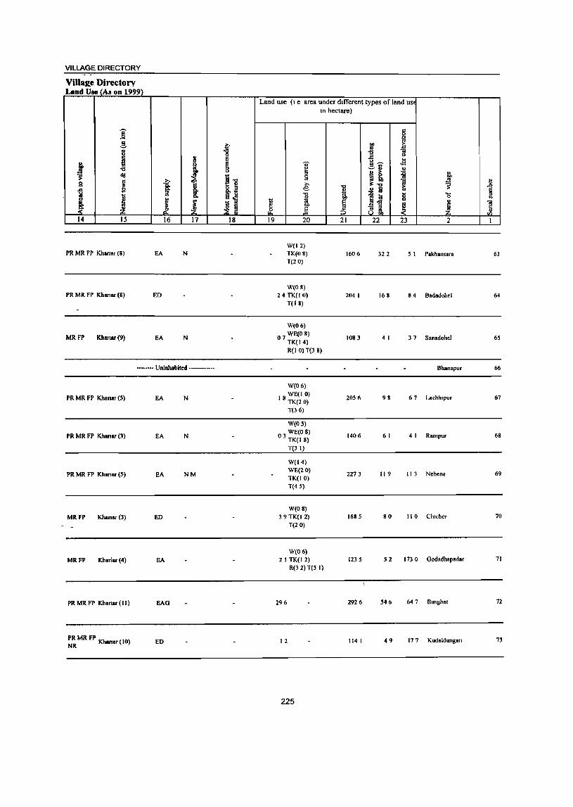
VILLAGE DIRECTORY
Villa~e Directory Land Use (As OD 1999)
Land use (I e area under dIfferent types of land USE
In hectare)
i g
g t on 1 OJ ~ ::I
I .. 1- '" ~
... .i I
'0' .a -a ~ ~~ ~ '" " ~ ~
~ 5l ~ ~ 1 bO
B ~ t 11 e: i ~'" ~ .x
1 ..!! Ii §
J "t:l
~~ j ....
~ M 0 c
! 1;;
~ ..
] e i ~ .e ~ m i£ (3 ! 14 15 16 17 18 19 20 21 22 23 2 I
W(12) PR MR FP Khanar (8) EA N TK(08) 1606 322 5 I Pakhansara 63
T(20)
W(08) PR MR FP Khanar (8) ED 24 TK(I 0) 204 I 168 84 Badadohel 64
TO 8)
W(06)
MRFP Khanar(9) EA N WE(O 8)
07 TK(14) 1083 4 I 37 Sanadohel 6S
R(I 0) T(3 8)
•• _ •••• Uninhabited ••••• _ ••• Bhanapur 66
W(06)
PR MR FP Khanar (S) EA N 18 WE(I 0) TK(20)
2056 98 67 Lachhlpur 67
T(J 6)
W(OS)
PR MR FP Khanar (3) EA N 03 WECO 8) TK(18)
1406 6 I 4 I Rampur 68
TeJ I)
W(14)
PR MR FP Khanar (S) EA NM WE(20)
2273 119 I 13 Nehena 69 TK(IO) T(4 S)
W(OS)
MRFP Khanar (3) ED 39TK(12) 168 S 80 I 10 Chlcher 70
T(20)
W(06)
MRFP Khariar(4) EA 2 I TK(I 2) 123 S S2 1730 Oodadhapadar 71
R(J 2) T(S I)
PR MR FP Khanar (II) EAG 296 2926 S46 647 Bmghat 72
PR MR FP Kh (10) NR anar ED I 2 114 I 49 17 7 Kudaldungan 73
225
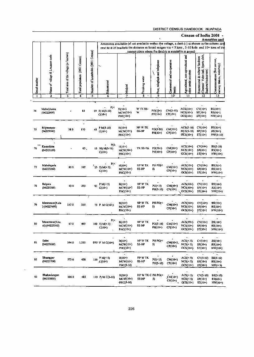
DISTRICT CENSUS HANDBOOK NUAPADA
Census of India 2001 . Amenities and
Amenities available (If not available withIn the village, a dash (-) IS shown In the column an next to It i(1 brackets the distance In broad ranges VIZ < 5 krns , 5-10 knis and 10+ kms of th
I 1 nearest nlace where the faclhlV IS available IS I!lven\
~ J i ¥l~ oj
~ .,
'" 0 IS "" ~
... ] -at! u
" i I !f ~ -=- " "3 ~ 8. j g oS u f1~~
...:l "0 i13 a:;;a~ <!d" ~ (:!.. \ .., ~~ M> " IS 1 Iii 1
.!: fl llB5 -s I ~ g_ ~ <!d..,- g d'
J! ~ 'a i -= ;; 2:>11 Bj 'c; ;; il § 9 j jj 0"'1 .. 'a ] '3 I B Jt 1 u
1 ! ~ ~ .r J:D JtJ CI> ~ .... .~ ~
1 2 3 4 5 6 7 8 9 10' II 12 13
MabulJharan P« H(IO+) WTKSS- ACS(lO+) CV(IO+) BS(IO+)
74 (04222900)
85 19 5) M(S-IO) MCW(IO+) W PO(I~+) CM(S-IO)
NCS(lO+) SP(IO+) RS(IO+) C(lO+)
PHC(IO+) PH(I +) CP(IO+)
OCS(IO+) ST(IO+) NW(IO+)
75 Bt k,ram8pur
380 170 P M(S.IO) H(lO+) HPWTK
PO(S:)O) CM(IO+) ACS(S.IO) CV(IO+) BS(IO+)
(04223000) 43
C(10+) MCW(IO+) SS-HP NeS(S-IO) SP(IO+) RS(IO+)
PHC(IO+) PH(IO+) CP(IO+)
OCS(IO+) ST(IO+) NW(S-IO)
- Karandoba P(S-
H(ID-r) ACS(IO+) CV(IO+) B5(S-IO) 76 (04223100) 63. IS 10) M(S-IO) TKSS·TK PO(IO+) CM(10+)
C(IO+) MCW(IO+)
PH(IO+) CP(IO+) NCS(IO+) SP(IO+) R5(lO; )
PHC(IO+) OCS(IO+) ST(IO+) NW(lO+)
Mahulapada J2S
P« H(lO+) HPWTK PHPO« ACS(IO+) CV(ID-r) B5(1O+) 77 800 107 5) M« S) CM(IO+)
(04223200) C(IO+)
MCW(IO+) SS-HP S) CP(IO+)
NCS(IO+) SP(IO+) RS(lO r) PHC(IO+) OCS(IO+) ST{IO+) NW{IO+)
78 Belpata
430 293 '61 P M« S) H(W) HPWTK PO« S) CM(JO+)
ACS(IO+) CV(IO+) 85(10+) (0422-3300) C(lO+) MCW(IO+} 5S·HP
PH(5-10) CP(lO+) NCS(JO+) SP(lO+) RS(lO+)
PHC(IO+) "OCS(1O+) ST(IO+) NW(IO+)
19 Mantnlaral(Kala
3370 335 75 P M qHi+) H(IO+) HPWTK PH PO«
CM(IO+) AC8(10+) CV(IO+} B8(1O+)
} (04223400) MCW(IO+} SS·HP 5) NCS(IO+) SI'(IO+) RS(IO+) PHC(IO+)
CP(IO+) OCS(IO+) ~T(IO+) NW(lO+)
Mantnlarat(Khu 1'« H(IO+) HPWTK ACS(IO+) CV(IO+) B8(10+) 80 670 407 109 S) M« S) , PO(S-IO) CM(IO+) rd) (04223500)
C(lO+) MCW(IO+) SS·HP
PH(IO+) CI'(IO+) NCS(IO+) SP(IO+) RS(lO+)
PHC(IO+) OCS(IO+) ST(IO+) NW(lO+)
81 Dab" 3940 1,225 2'7tJrM C(IO+) H(IO+) HPWTK PHPO«
CM(IO+J, ACS«j) CV(IO+) 8S(10+)
(04223600) MCW(IO+) SS·HP S) CP(IO+)
NC8« 5) SP(IO+) RS(lO+) PHC(IO+) OCS(IO+) STelO+) NW(IO+)
82 BhatraJPur
3730 458 120 PM«S) H(IO+) HPWTK PO«5) CM(lO+) AC8« 5) eV(s·IO) BS(S·IO)
(04223700) ,C(IO+) MCW(IO+) SS·HP PH(S-IO) CP(lO+)
NCS« S) SP(IO+) RS(lO+) pHe(S·IO) OCS(IO+) ST(lO+) NW«S)
83 Bhalundunllan
1860 48S 119 PI M C(S-IO) H{W;) HPWTKC PH 1'0« ~CM(IO+) ACS« 5) eV(S-IO) B8(5-IO)
(04223800) MCW(IO+) SS·HI' S) NCS« S) SP(IO+) RS~IO~) -PHC(S·IO)
CP(IO+) ~ QC8(1O+) ST(IO+) NW(JO+)
226
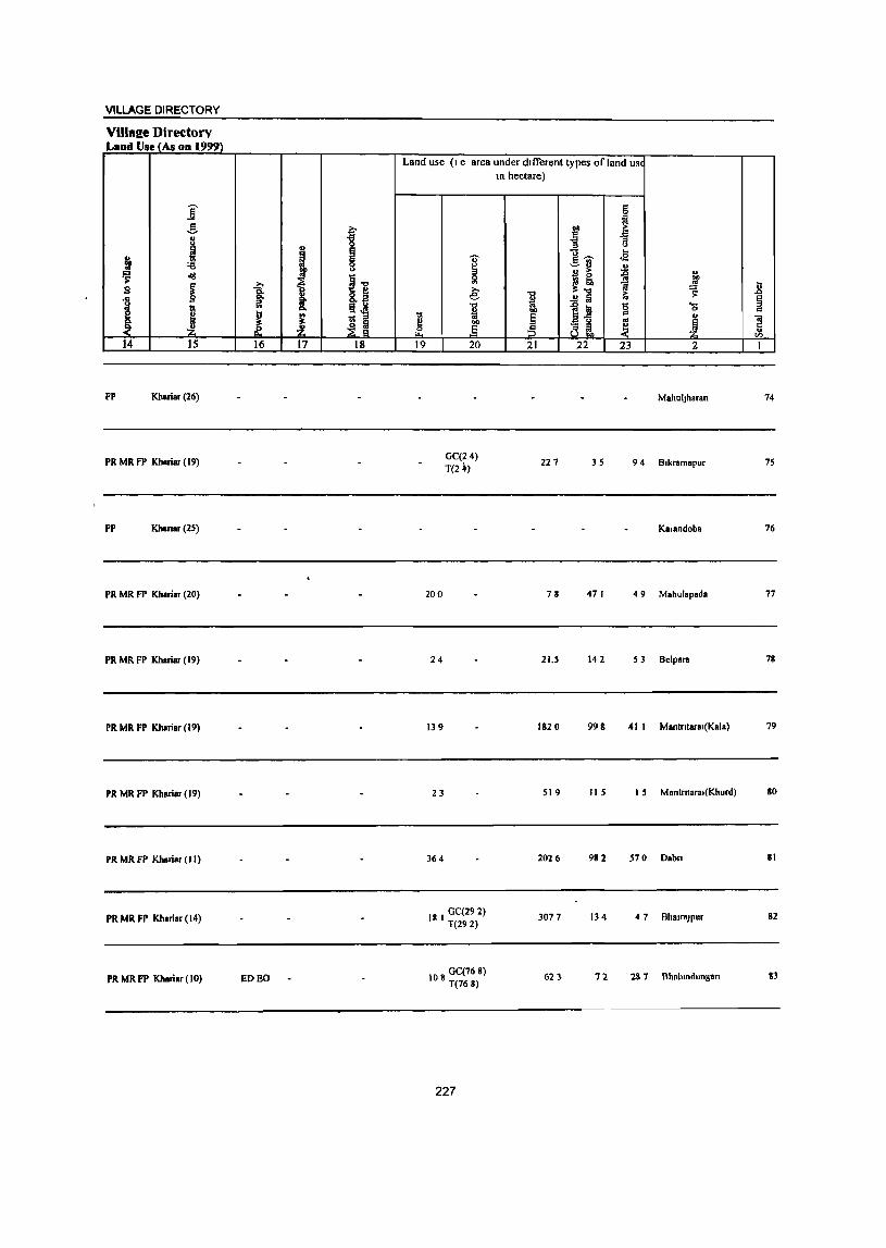
VILLAGE DIRECTORY
Villal!e Directory Land Use (As on 1999)
]' -! t 8
u 0
J e i
I §
~ <Ig
Ii ~ i s
1 j ~ u ; 1;1
~ :£ ~ m 14 15 16 17 18
FP Khariar (26)
PR MR FP Khariar (19)
FP Khanar (25)
PR MR FP Khariar (20)
PR MR FP Khariar (19)
PR MR FP Khariar (19)
PR MR FP Khariar (19)
PR MR FP Kharier (II)
PR MR FP Khariar (14)
PR MR FP Khariar (10) ED EO
Land use (I e area under dIfferent types of land USI
tl e ~ 19
" ~ ~ >, e
"t:I
" OJ .§ 20
GC(24) T(2 ~)
200
24
139
23
364
18 I GC(292) T(292)
108 GC(76 8) T(168)
227
In hectare)
"t:I
~ ~ 21
221
78
21.S
182 0
519
2026
3077
62 :}
§
~ ~ .:!3
] B ... g~ ..s .:::-13 u
I! ~ " "" 1 .!l ~ ..!! Iii
]~ '0 '15
j " ~~ ~ 22 23 2
MallUljharan
3S 9 4 Blkramapur
Kerandoba
47 I 4 9 Mahulapada
142 53 Belpara
998 41 I Mantntaral(Kala)
liS I 5 Mantntaral(Khurd)
982 570 Dabn
134 4 7 Bhalr8Jpur
72 2& 7 Bhalundungafl
.8 § " ca c " tI)
I
14
75
76
77
78
79
80
81
82
83
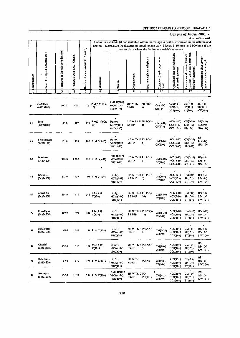
]' ... "8 <> j .,
.c § 8 g ] g,
8 '" o(S ~ C!-
" ... § H -5
I; . 'CS iii
~ ~ "3
~ §: ... c 0 .. ..
~ ~ Ii ~ '" f-< f-<
I 2 3 4
Gudabheh 84
(04223900) 1000 400
85 Torh
19S 0 587 (04224000)
Blchhanapah 86
(04224100) 1610 429
Dhanksar 87
(04224200) 372 0 1,382
S8 Godatala
2730 457 (04224300)
89 Anchalpur
2640 610 (04224400)
90 Chandagul
1800 498 (04224500)
91 Bahalpadar
680 347 (04224600)
Chandel 92
(04224700) 132 0 SID
Dohelpada 93
(04224800) S90 970
Bankapur 94 4320 1,122
(04224900)
DISTRICT CENSUS HANDBOOK NUAPADA'
Census of India 2001 -Amenities and
Amenities available (If not available wlthm the Village, a dash (-) IS shown In the column an next 10 It In brackets the distance In broad ranges VIZ < 5 kms , 5-10 kms and 10+ kms of th
J nearest place where the faclll tv IS available IS given \ "C rlj fa Ii ., "
., <> ;:; ~ .:: e § > E ,~ <:> I ] 8. C!- ..c :: f fr :; {l <> ]~~ 1l ~ ~l'.l '" .. o
-0 :;]§ ~~ 1 Ii! "0 Q 5 o il 15 g g '" . I:l 1 fa o(S-o- o '" "" ~ li 'il:>-g ., 0
.... 'il 'il B § 0 § co ... i.! 5-.s1 § "' .8 J l J 1l ... "3 0 ., ~ e f § .J ~j _~l ;p ti 9 oS ~S :z: ~ .~ u_tl 5 6 7 8 9 10 II 12 13
106 P M« S) C(s· RMP H(IO+)
HPWTK PH PO« ACS«S) CV« 5) BS« 5) 10)
MCW{lO+) SS-HP s)
CM{lO+) NCS«5) SP(lO+) RS(IO+)
PHC(S.tO) CP(IO+) OCS(IO+) ST(IO+) NW(IO~)
159 P M(5·10}C(S H(IO+) HP W TK R PH P0(5-
CM(5·10) ACS(S.IO) CV(5-10) 8S(S·10)
10) MCW(IO+) SS·HP 10) CP(IO+)
NCS(5·10) SP(S·IO) RS(JOi) PHC(S.IO) OCS(lO+) ST(IO+) NW(IO+)
H(IO+) HP WTK R PH PO« ACS(S·IO) CV(S·IO) BS
102 P M C(5·10) MCW(IO+) SS·HP 5)
CM(S·IO) NCS(5.IO) SP(S-IO)
RS(IO+)
PHC(S.IO) CP(IO+)
OCS(S·IO) ST(5-10) NW(IO+)
PHS H(IO+) HP WTK R PH PO« ACS(5·10) CV(5·IO) BS«5)
33S P M C(S-IO) MCW(IO+) SS·HP S)
CM(S·IO) NCS(S.IO) SP(S-IO) RS(lO+)
PHC(5.IO) CP(IO+) OCS(5.1O) ST(IO+) NW(IO+)
93 P M C(lO+) H(IO+) HP W TK R PH PO«
CM(IO+) ACS(IO+) CV(IO+) 8S« 5)
MCW(IO+) S SS-HP 5) NCS(IO+) SP(IO+) RS(IO+) PHC(I()+)
CP(IO+) OCS(lO+) ST(IO+) NW(IO+)
145 P M«') H(lDt) HP W TK R PH PO(S. CM(5-1D)
ACS(5-1D) CV(IO+) 8S«5) C(IO+) MCW(IO+) S SS-HP 10)
CP(IO+) NCS(5·IO) SP(IO+) RS(IO+)
PHqIO+) OCS(IO+) ST(lO+) NW(IO+)
121 PM«S) 11(10+) HP W TK R PH PO(S·
CM(S·IO) ACS(5·10) CV(S·IO) BS(S.IO)
C(IO+) MCW(IO+} S SS-HP 10) CP(IO+)
NCS(IO+) SP(IO+) RS(lO+) PHC(IO+) OCS(IO+) 5T(l0+) NW(IO+)
&4 P MC(IO+) H(IO+) HP W TK R PH PO«
CM(S-IO) ACS(IO+) CV(IO+) BS«S)
MCW(IO+) S5-HP 5) CP(IO+)
NCS(IO+) SP(IO+) RS(IO+) PHC(IO+) OCS(IO+) ST,IO+) NW(IO+)
P M(S·IO) H(IO+) HP WTK R PH PO« ACS(IO+) CV(lO+) BS
q8 C(ID+) MCW(IO+) SS-HP 5)
CM(IO+) NCS(IO+} SP(lO'!-)
RS(IO+)
PHC(IO+) CP(IO+)
OCS(lO+} ST(IO+) NW(ID+)
H(IO+) HPWTK ACS(lO+) CV«S) BS
174 P M C(IO+) , MCW(IO+) SS·HP
PO PH CM«S) NCS(IO+) SP(IO+)
RS(IO+)
PHC(IO+) CP(IO+)
OCS(IO+) ST(IO+) NW(IO+)
I if RMP H(IO+) BS
294 P M C(IO+) MCW(IO+) HPWTKC PO
CM«5) ACS(lO+) CV(IO+)
RS(IO+) SS-HP PH(lO+) NCS(IO+) SP(IO+)
PHC(IO+) CP(IO+) OCS(IO+) ST(IO+)
NW(IO+)
228
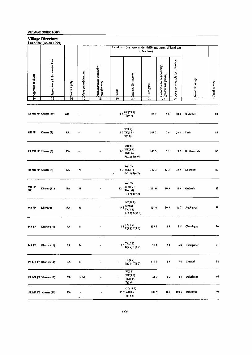
VILLAGE DIRECTORY
ViJlare Directory L •• d Use (As on 1999)
Land use (I e area under dIfferent types of land USt
In hectare)
i €I il g ~ ... >
t~ '" 8 "8 "3
! t I .., w
i I ..a ~ o'IJ
~ j! ~ .. on
s I 1 8,] € ~ £l l:i
'" s: ..0
I i .!! Ii §
I §i '" ]~ '0 'e;
~ i c
~ t;; E c
" .. ~ ~ e ~ ~ ~ ,p ~ Ii' .§ :3 al £
14 15 16 17 18 19 20 21 22 23 2 1
PR MR FP Khanar (10) ED 14 GC(39 7) T(397)
339 66 184 Gudabheh 84
W(l2) MRFP Khanar (8) EA 112 TK(18) 1482 76 246 Torh 85
T(30)
W(08)
PR MR FP Khanar (5) EA 01 WE(14) TK(16)
1463 5 I 35 Btcbhanapah 86
R(2 2) T(60)
W(12) PR MR FP Khansr (8) EA N 52 TK(21) 3103 122 384 Dhanksar 87
R(2 8) T(6 2)
W(12) MRFP
Khanar(ll) EA N WE(I 2)
Godalala NR 12 I TK(I 6) 2310 105 124 88
R(3 2)T(7 2)
GC(32 8)
MRFP Khan.r(6) EA N W(06)
94 TK(12) 1910 103 167 Anchalpur 89
R(2 2) T(36 9)
MRFP Khanar(IO) EA N TK(12)
I 5 R(2 ') T(4 0) 1597 61 88 Chandagm 90
MRFP Khanar(lI) EA N TK(O 8)
2 6 R(2 2) T(3 0) 55 I 28 48 Bahalpadar 91
PR MR FP Khanar (II) EA N TK(12) R{2 0) T(3 2)
1199 14 70 Chandel 92
W(08)
PRMRFP Khan.r(13) EA NM WE(l8) TK{IO)
517 12 2 I Dohelpada 93
T(36)
GC(13 3)
PRMRrP Khanar(16) EA 137 W(O 8) 2849 185 1010 Bankapur 94
T(14 I)
229

« " "0
1 3 c "'" 0 _g ~ fa g fo ;;
...l .. 0
o<l ~ C-
" " 8 :lI' £ ..8 fa
~ .... 0 -;; e .. g-
" '8 ~ c "'" Ul " "3 ~ 5 ~ 0 Vl :z. l- I-
I 2 3 4
95 Chanch.r.bhal.
2780 701 (04225000)
96 KJlalrbhnd,
1550 375 (04225100)
97 NUalftJPIIl
1470 82 (04225200)
98 Annteanal'ur
2080 293 (04225300)
Kha.bahal 99 4540 1,370
(04225400)
JubaraJPur 100 71
(04225500)
101 Mankarchuan
1430 (04225600)
102 Sardhaplir
3480 991 (04225700)
103 Rammunda
6120 1,665 (04225800)
104 Kampalllguma
1110 208 (0422S900)
lOS Palama
2310 317 (04226000)
DISTRICT CENSUS HANDBOOK NUAPADA •
Census of India ·2001 --Amenities and
Amenities available (If not available within the village, a dash (.) IS shown In the column ant next to It In brackets the dIstance In I.>road ranges VIZ < 5 kms , 5·\ 0 kms and 10+ kms o{ Ih
]' neareSI place where the faclltty IS uvallable IS given • C "0
~:a ~ 11 '" u
,j
~ " i I ~ tl 0
Il ~~ .co ~ 8. o ~l
~ g.
i ]:'r~ :;: ~ g 61", '" " o "0 '" '" -;;}g§ ~~ 1 a 0 , " --0 " " o 0 c: 1l .cI I;j o U ~.gg g r!
0 ". g "'" ~
_ ---0 '" (J
'- 01 ~ 01 ]06 '" ;> " ri fJ o 8 e g .. ~ § ~ tJ .. .. .= ~
~ ~ " B .. .0 .>2
~j " 0 ~ e :::I e ~-.
§ oil ti ~~ t\ g ..a e :l: ~ " ~ a ~ ~af! ti_ Z <0 ~Vl
5 6 7 8 9 10 II 12 13
156 P M{S·IO) 11(10.) liP W 1 K C PH POtS· • CM(~'I 0) ACS(S·IO) CV('·IO) BStS·to)
CCto+) MCW(IO+) SS·HP 10) Cr(lo,,) NCS(S·I() SP(IO+) R5(IOT)
PHCCIO+) OCS(IO'} 51 (to') NW(IO~)
81 P M CCIO+) H(IO+) tiP W TK C I'III'O(S·
CIvI(S·IO) AC5(S·IO) CV(5·10) nS(<.5}
MCW(IOi) 5 SS·HI' 10) (,P{IOt)
NeS(S·IO) SP(lO.) R'itI O»
PHCCIO+) OCStIO.) ST(IO+) NW(lOr)
21 P 1\1«5) 11(10+) Hr' \V lK
1'0(" 5) CM(~·IO) ACS(lOt) CV(IO+) B5(5.1O)
C(lO+) MCW(IO+) SS·I1P 1'1I( 10+) CP(IO+)
NC!>(W+) SP(JOt) RS(IO+)
PHCCIO t ) OCS(IO+) ST(W+) NW(I01)
73 P M(5·1O) H(IO+) HPWTK
1'0« 5) CM(lOt) ACS(IO~ ) CV('s·IO) 38«5)
C(lO+) MCW(IO+) S!>·lIP PH(IOt} CP(IO+)
NCS(IO+) SP(lO') IlS(IO+) PUC(IO» OCS(IO+) ST(IOr) NW(IO.)
PHS 1l(IO~} WTKCS ACS(IO+) CV(S·IO) B!>« 5)
342 l' M CCIO') MCW(IO+) PO PH CM(S.IO)
I'HCCIO+) 55·W
CP(IO+) NCS(IO+) SP(IO+) RS(IO+)
OCS(IO+) 5T(IO+) I'< W(l 0+)
P« H(IO+) ACS(IO+) CV(IO+) OS( 10+) 18 5) M(S·IO) WS5·W PO« 5) CM(lO~)
C(IO+) MCW(IO+)
PH(IO+) Cp(IO+) NCS(IO+) 51'(10+) RS(IO+)
PUCCIO+) OCS(IO+) ST(IO+) NW(IO+)
••••.••• Uninhabited ............
PHS RMP
236 l' M C(IO+) HeIO+) HI' WTKR POPIl CM(S·IO)
ACSUO+) CV(IO+} 8S(5·10) MCW(IO+) S 55·HP
Cp(IO+) NC5(10+) 51'(10+) RS(IO+)
PHq5·1O) OCS(IO+) Sf(IO+) NW(IO+)
RMP(2)
435 l' M S CCIO+) H(IO+) HP WTKC PO PH CM«S)
ACS(S·IO) CV(JO+) BS(IO+) MCW(IO+) 555·HP
CP(IO+) NCS(IO+) SP(IO+) RS(IO+)
PUC(S·lO) OCS(IO+) ST(IO+) NW(IO-t)
41 P M(5·10) C(S. HeIO+) HI' W TK 5 1'0(;.10) CM(S·IO)
AC5(10+) CV(IOt) BS(S·IO) 10) MCW(IO+) S5·HP PH(IO+) CP(IO+)
NC5(1O') SP(IO+) R')(lO+)
PHC(S·IO) OC5(10+) ST(IO+} NW(IO+)
83 P M«5) H(IO+) HP WTKC PO(;5) CM(S·IO)
ACS(IO~) CV(IO+) BS(IO+) C(lO+) MCW(lO+) 5 S5·HP PH(IO+) CP(lO+)
NC5(lO r) SP(IO+) RS(IO+) PHC« 5) OC5(IOt) ST(IO+) NW(lO+)
230
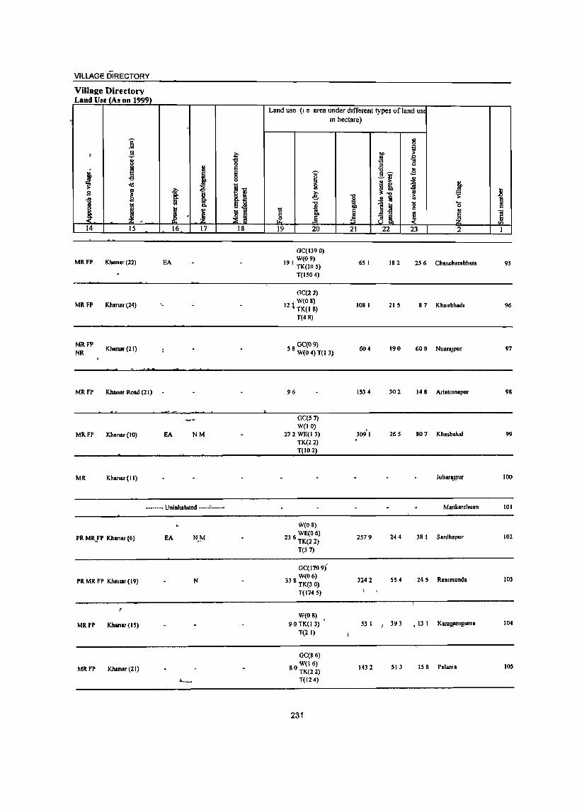
VilLAGE DIRECTORY
VilialIe Directory Land Use (As on 1999)
Land use (I e area under different types of land us. , In hectare)
,
j 8 ! .! a ... ! -g " 11 8 ] j ~ t ~ I !Ii' .s
-a ~ ...
I! j ~ <I!I
11 g i t e: 1 ~ ~ ii
1 .!! iii ~
J "0
1~ '0 ....
I "" 11 ~ 0 c
I I § j u ca , ]" tli ~ Ji , d: rf ~ 14 15 16 17 18 19 20 21 22 23 2 1
GC(1390)
MRFP Khanar(22) EA W(09)
19 I TK(lO S) 65 I 182 2S 6 Chancharabhata 9S
T(150 4)
GC(22)
MRFP Khanar(24) W(OS)
12~ TK(IS) 108 I 215 87 Kha,rbhad, 96
T(48)
MRFP Kharllr (21)
OC(09) NR 5 8 W(O 4) T( I 3) 604 190 600 NuaraJpur 97
MRFP Khanar Road (21) 96 IS34 302 148 Artatranapur 98
OC(S 7) W(IO)
309'1 MRFP Khanar(IO) EA NM 272 WE(I 3) 265 807 Khasbahal 99 TK(22) T(IO 2)
MR Khanar(lI) JubaraJPur 100
------- Uninhabited -----,------ Mankarchuan 101
W(08)
PR MRlP Khanar (6) EA N~M WECO 6)
236 TK(2 2) 2579 244 38 I Sardhapur 102
T(37)
GC(1709}
PR MR FP Khanlr (19) N W(06)
338 TK(3 0) 3242 5S 4 24 S Rammunda 103
T(1745)
W(O 8) ,
MRFP Khanar(15) 90 TK(l3) 53 I I 393 .13 I Kamp,amguma 104
T(2 I)
GC(86)
MRFP Khanar (21) W(16)
80 TK(2 2) 1432 SI3 IS 8 Palama IDS
~ T(124)
231
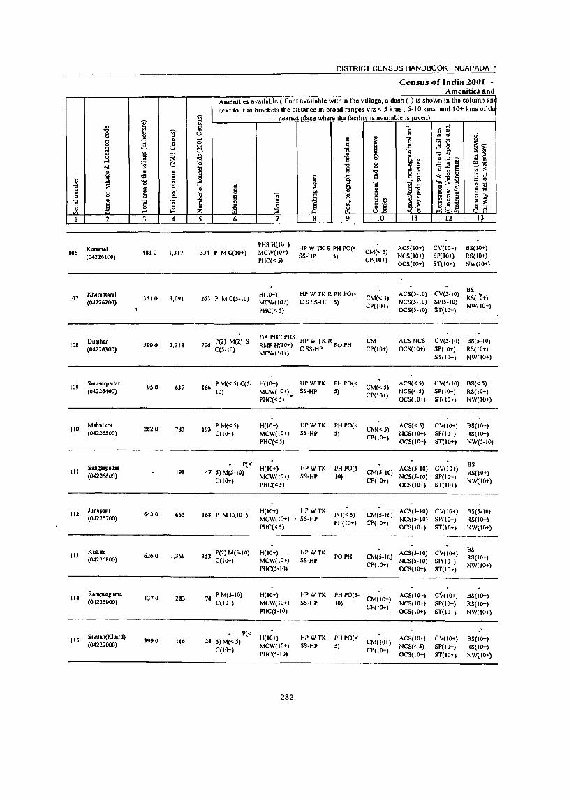
I " 8 J ,..c, § g ~
f 0 0 0-1 0
o(j C
j " §
.2 oil
~ '(; ~ § " 0. ..... ~ 8-" 0
'"iii " 11 l Ii ~ t/) f-o
I 2 3 4
Kotamal 106
(04226100) 4810 1,317
107 Khamataral
3610 1,091 (04226200)
DuaJhar 108 5990 3,318
(04226300)
109 Samserpadar
9S 0 637 (04226400)
110 Mahulkot
2820 783 (04226S00)
Sangarpadar III 198
(04226600)
112 Jun.pam
6430 6SS (04226700)
Klfkua 113 6260 1,369
(04226800)
114 Rampurguma
1370 283 (04226900)
liS S.kuan(Khurd)
3990 116 (04227000)
DISTRICT CENSUS HANDBOOK NUAPADA •
Census of India 200J -Amenities and
AmenitIes avaIlable (Ifnot avaIlable wIthin the VIllage, II dash (-) IS shown In the column an next to It 10 brackets the dIstance In broad ranges VIZ < 5 kms , 5-10 kms and 10+ kms of th
~ nearest Dlace where the faclhty IS available IS j(lven
~ "'" l'j.g ~ :::'U 1£ 0 " ~ i ~t: 0
§ ~
s:~
I c J .:l 8-~ i ~
0. 1~,..._ ~
g,,,, -0 .. '" "3]~ ~lQ
ii ," ii 6 ~ o 0 t: VI :$ gj "'" -idoo8 S g r:! 0 ~ 1 ii "'_ g
~>-g ia 0 .<: '13 '"iii ;;: '"iii ]~ " iii § ~ 2"'~ § tl .2 ]
.., 1! '" ..., ~
~ J Ai g g 2 a ~ ~
i3 1 " t ill ~ j~ ~(i! ~]
5 6 7 8 9 10 11 12 13
PHS H(IO+) HPWTKS PHPO« ACS(lO+) CV(IO+) BS(lO+)
334 P M C(lO+) MCW(JO+) SS-Hp 5)
CM«5) NCS(IO+) SP(IO+) RS(IO+)
PHC« S) CP(IO+) OC5(1O+) STllO+) NV, (10+)
H(IO+) HP WTK R PH PO« ACS(S-IO) CV(5-10) 8S
263 P M C(S-IO) CM«5) RS{liH) MCW(IO+) CS 58-HP 5)
CP(IO+) NC8(S-IO) SpeS-IO)
NW(IO+) PHC« 5) OCS(5-10) ST(lO+)
796 P(2) M(2) S DAPHC PHS
HPv,. TKRpOPH
CM ACS NCS eV(S-W) 8S(5-IO) RMP H(IO+)
C(s-IO) MCW(IO+)
CSS-HP CP{IO+) OCS(IO+) SP(IO+) Il.S(IO+) ST(IO+) NW(IO+)
166 P M«S) C(s- H(IO+) HPWTK PH PO«
CM«S) ACS« S) CV(S-IO) 8S« S)
10) MCW(IO+) S8-HP 5) CP(lO+)
NCS« S) SP(IO+) RS(IO+) PHC« S) • OCS(IO+) ST(IO+) NW(IO+)
193 PM«S) H(IO+) HPWTK PHPO«
CM« S) ACS« S) CV(lO+) 8S(10+)
C(IO+) MCW(IO+) SS-HP S) CP(IO+)
~S(lO+) SP(IO+) RS(IO+)
PHC(" 5) OCS(IO+} ST(lO+) NW('-lO)
P« H(lO+) HPWTK PH PO(S- ACS(s-IO) CV(lO+)
BS 47 S) M(S-IO) CM(S-IO) RS(lO+)
MCW(ID+) SS·HP 10) NCS(S-IO) SP(IO+) C(IO+)
PHC«5) CP(IO+)
OCS(IO+) ST(IO+) IIIW(lO+)
168 P M C(IO+) H(IO+) HPWTK
PO« S) CM(S-to) ACS(S-IO) CV(lO+) 8S(S·10)
MCW(IO+) , SS-HP PH(IO+} CP(IO+)
NCStS-IO) SP(to+) RS(IO+) PHC« 5) OCS(IO+) ST(lO+) NW(IO+)
P(2) M(S-IO) H(lO+) HPWTK ACS(S-IO) CV(lO+) as
352 PO PH CM(S-to) RS(IO+) C(IO+) MCW(IO+) SS-HP NCS(S-IO) SP(IO+) PHC(S-IO)
CP(IO+) OCS(10+) ST(lO+)
NW(IO+)
74 P M(S-IO) H(lO+) HPWTK PH PO(S-
CM(IO+) ACS(IO+) CV(IO+) 8S(10+)
C(lO+) MCW(IO+) SS-HP 10) CP(IO+)
NCS(IO+) SP(10+) RS(lO+) PHC(S-IO) OC5(10+) ST(lO+) NW(IO+)
P« -' 24 S) M(" S)
H(IO+) HPWTK PHPO(" CM(IO+)
ACS(IO+) CV(lO+) 8S(10+)
C(lO+) MCW(IO+) SS-HP 5)
CP(lO+) NeS« S) SP(IO+) RS(IO+)
PHC(5-IO) OCS(IO+) ST(lO+) NW(IO+)
232
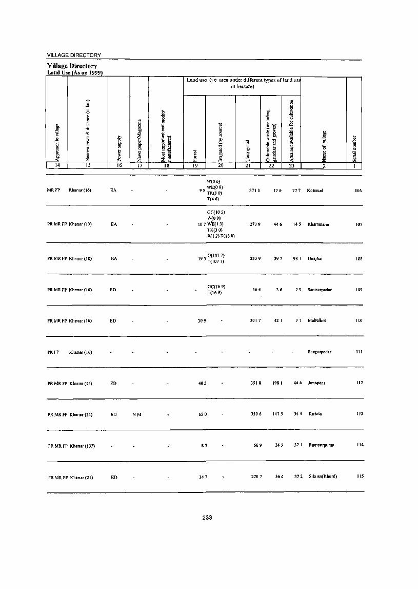
VILLAGE DIRECTORY
Land Use (As I)n 1999) Land use (I e area under different types Qf land us,
III hectare)
j c 0 l:l
.§, t .. !l! " l:l
u j "3 u u
J I ~ ...
" I g~ .B
]' -=-'3 " " " > 1 &'0 S' o'<! ~ ~1:l ~ ~ ~
~ .?;> _g .8 g §: " 8.~ € is
3:..., S' ~
g §' ..!l Ia ~ '" ..., 1a .c I<l '0 ....
t;; p. §~ " .. 0 c e ~
l> ~ ~ } § ~"5 c " p.
~ ~ ~ ~ ~ "iii
_k Z D. ~ & :5 a ~ Ii til
14 15 16 17 18 19 20 21 22 23 2 1
W(O 6)
MRPl' Khanar(16) EA WE(09)
98 TK(3 0) 371 I 176 777 Kalamal 106
T(46)
GC(IO 5) W(09)
PR MR PP Khanar (13) EA 107 w\;:( I 3) 2739 446 145 Khamalaral 107 TK(30) R(1 2) T(16 8)
PR MR PI' Khsnar (10) EA 0(1077)
195 T(107 7) 3339 397 98 I Dua)har 108
PR MR FP Khansr (16) ED GC(169)
664 36 79 Samserpadar 109 T(169)
PR MR FP Khansr (16) ED 309 2017 42 I 77 Mahulkol 110
PRFP Khanar (16) Sangarpadar III
PR MR FP Khanar (16) ED 485 351 S 198 I 44 6 Jun_pam 112
PR MR FP Khanar (24) ED NM 650 3596 1475 544 Klrkll. 113
PR MR FP Khanar (132) 83 669 245 37 I Rampurguma 114
PR MR FP Khanar (21) ED 347 2707 564 37 2 S I kuan(KllUrd) 115
233
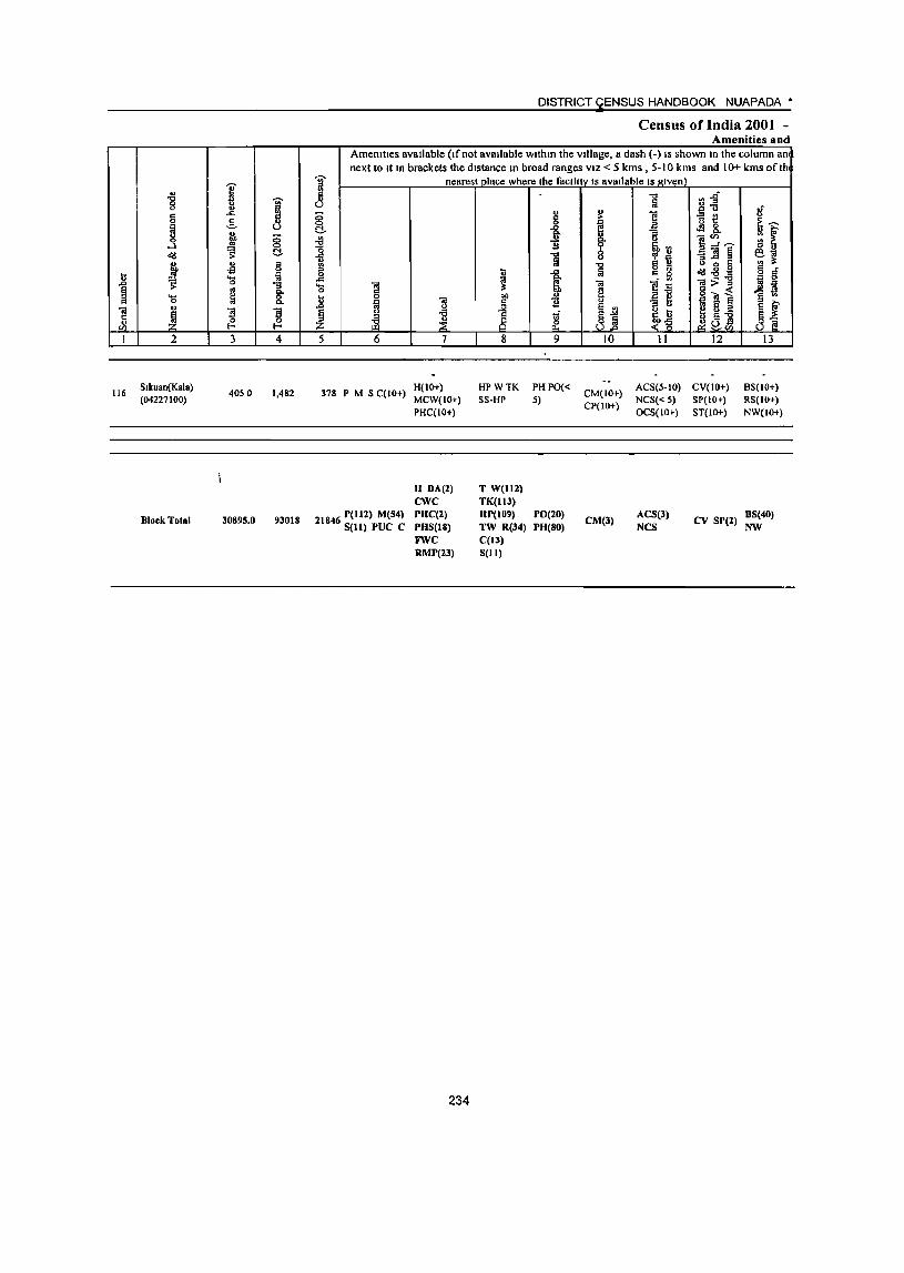
116
2
Slkuan(Kala) (04227100)
Block Total
3 4
4050 1,482
30895.0 93018
5
DISTRICT ~ENSUS HANDBOOK NUAPADA·
Census of India 2001 -Amenities and
Amenities avaIlable (Ifno( avaIlable wlthm the VIllage, a dash (-) IS shown In the column an next to It In brackets the dIstance In broad ranges VIZ < 5 kms , 5-10 kills and 10+ kills of th
nearest place where the faelh IV IS avaIlable IS gIven'
6 7 8 9 10 11 12 13
H(IO+) 378 P M S C(IO+) MCW(IO+)
HPWTK PHPO« SS-HP 5)
CM(IO+) ACS(5-10) CV(JO+) NCS« 5) SP{IO+)
CP(IO+) OCS(IOI-) ST(IO+)
8S(10+) RS(lO+) NW(IO+) PHC(IO+)
H DA(2) T W(1l2) CWC TK(lI3)
21846 P(lll) M(S4) PHC(2) IIP(I09) PO(20) CM(3)
ACS(J) CV SP(2)
BS(40) S(l1) PUC C PHS(18) TW R(34) PH(80) NCS NW
FWC C(13) RMP(23) S(1I)
234
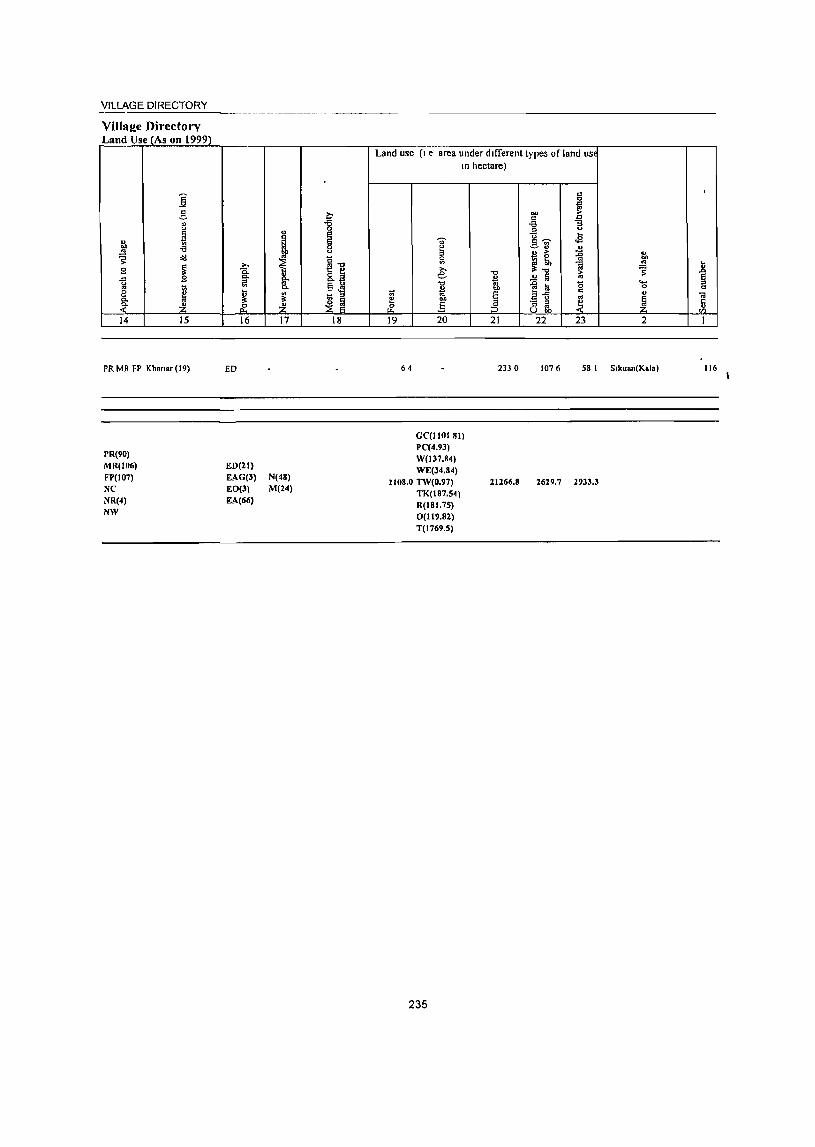
VILLAGE DIRECTORY
VilIs!!e Directory Land Use (As on 1999)
j .§.
" " ~ u
"" -a '" ~ old
E ~ "" l\l 'in e ~ Q,
<" 14 15
PR MR FP Khan., (19)
PR(90) MR(106) FP(107) NC NR(4)
NW
~ Q,
~ ~ ~ 16
ED
ED(21) EAG(3) EO(3) EA(66)
" ! i .. Q,
~ ~. 17
N(48) M(24)
~ Ii 0 u
~." 8.~ ~~ i~
18
Land use (I e area under dlITerent types of land us 10 hectare)
~ & 19
64
'" ~ e: .",
" 10 .§ 20
GC(IIOJ 81) PC(4.93) W(137.84) WE(34.84)
210S.0 nV(O.97) TK(187.54) R(18t.7S) 0(119.82) T(1769.5)
235
-c ~ .., €
.:3. 21
233 0
21266.S
l:l
"" ~ '" ] -a ::I
]_fj ... .s ~ " i!; '" ~ tb ""
~." a ~ ~ .£ fJ
1~ '0 ....
0 c "
;3 ~ ~ ~ 22 23 2
1076 58 I S,kuan(Kala)
2629.7 2933.3
,
.8 ~ c
01
~ I
116

VILLAGEANp TOWN DIRECTORY
APPENDICES TO
VILLAGE DIRECTORY
237
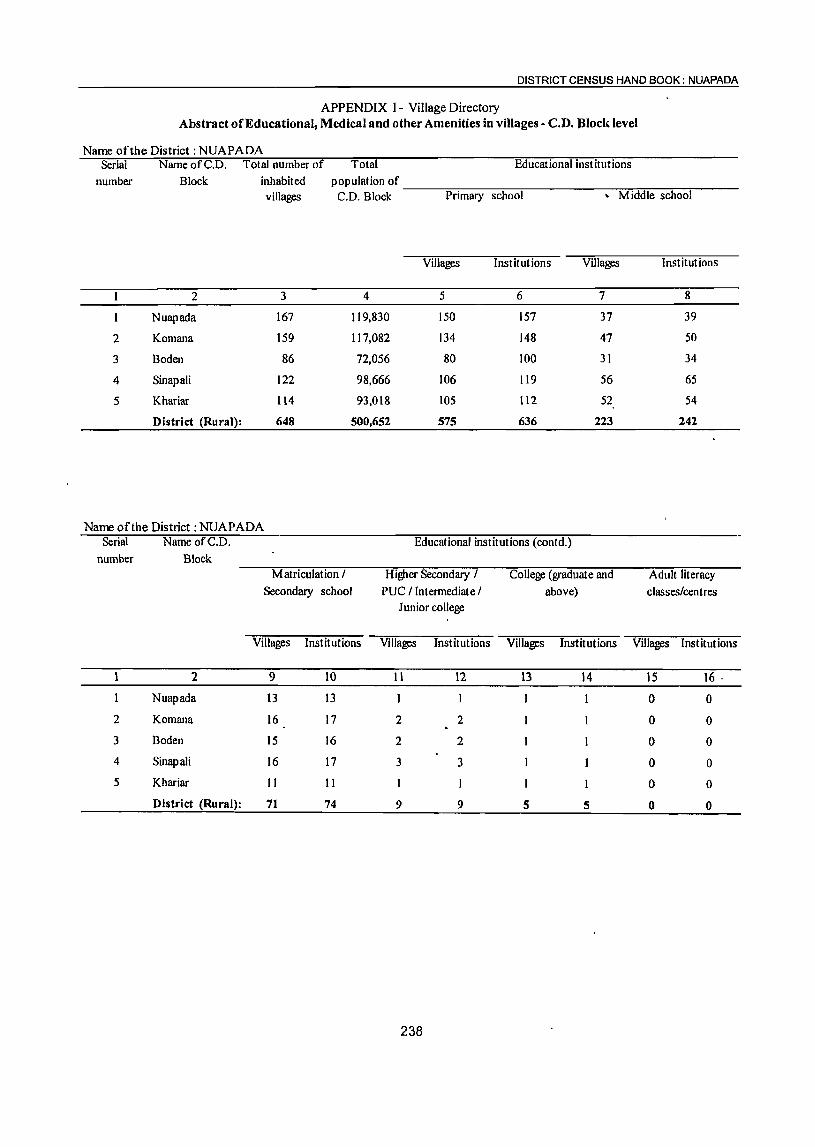
DISTRICT CENSUS HAND BOOK: NUAPADA
APPENDIX I - Village Directory Abstract of Educational, Medical and other Amenities in villages - C.D. Block level
Name of the District: NUAPADA Serial Name ofC.D. Total number of
number Block inhabited
Total population of
Educational institutions
villages C.D. Block ----:P=-r..,...im-ary--s-c:-ho-o-:-�------.--=-M..,.,i:-.d~dl:-e-s-c,....ho-o-:-l---
Villages Institutions Villages Institutions
2 3 4 5 6 7 8
N uap ada 167 119,830 150 157 37 39
2 Komana 159 117,082 134 148 47 50
3 Boden 86 72,056 80 100 31 34
4 Sinapali 122 98,666 106 119 56 65
5 Khariar 114 93,018 105 112 52 54
District (Rural): 648 500,652 575 636 223 242
Name of the District: NUAPADA Serial Name ofC.D. Educational institutions (contd.)
number Block Matriculation / Higher Secondary / College (graduate and Adult literacy
Secondary school PUC / Intermediate / above) classes/centres Junior college
Villages Inst itutions Villages Institutions Villages Institutions Villages Institutions
2 9 10 11 12 13 14 15 16 .
N uap ada 13 13 0 0
2 Komana 16 17 2 2 0 0
3 Boden 15 16 2 2 0 0
4 Sinapali 16 17 3 3 0 0
5 Khariar 11 11 0 0
District (Rural): 71 74 9 9 5 5 0 0
238

~ANt?tOWN DIFkEOTORY
APPENDIX I - Village Directory Abstract of Educational, Medical and other Amenities in villages - C.D. Block level
Nalm ofth~ District: NUAPADA SeriaJ Name ofC.D. Educational institutions (contd)
I Medical institutions
number Block Others No Hospital Dispensary
educational facilities
Villages Institutions Villages Institutions Villages Institutions
2 17 18 19 20 21 22 23
Nuapada 2 17 I 4 4
2 Komana 2 3 25 0 0 3 3
3 Boden 0 0 6 0 0 3 3
4 Sinapali 1 16 0 0 2 2
5 Khariar 0 0 9 2 2
I District (Rural): 4 6 73 1 2 14 14
Name ofthF District: NUAPADA -. I
Serial I Name ofC.D. Medical institutions
number Dlock J (contd.) Primary Health Centre I Primary Health Sub- Maternity and, Child Family Welfare Centre
Health Ceiitre centre Welfare Centre I M aternity Hom~ I Child
Welfare Centre
ViI1~s Institutions Villages Institutions Villages Institutions Villages Institutions
2 24 25 26 27 28. 29 30 31
__ Nu~~ 4 4 22 22 1 2 I
2 Komana 6 6 18 18 2 2 2 2
3 Boden 3 3 13 13 1
4 Sinapali 4 4 15 15 I
5 Khariar 2 2 18 18 2
District (Rural): 19 19 86 86 6 8, 6 6
239
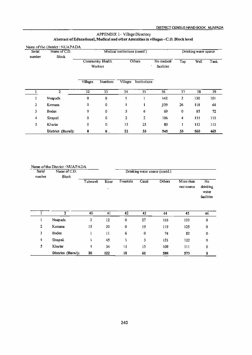
DISTRICT CENSUS HAND BOOK NUAPADA
APPENDIX I - Village Directory Abstract of Educational, Medical and other Amenities in villages - c.n. Block level
Name of the District :NUAPADA Serial NameofC.D. Medical institutions (eontd )
number Block Community Health Others No medIcal
Workers facIlities
Villages Numbers Villages Institutions
2 32 33 34 35 36
Nuapada 0 0 142
2 Komana 0 0 I )39
3 Boden 0 0 5 6 69
4 Sinapali 0 0 2 2 106
5 Khariar 0 0 13 23 89
District (Rural): 0 O. 22 33 545
Name of the District: NUAPADA Serial
number
2
3
4
5
NameofC.D. Block
2
Nuapada
Komana
Boden
Sinapali
Khariar
District (Rural):
Drinking water source (contd.)
TubeweH River Fountain Canal Others
40 41 42 43 44
2 12 0 27 165
15 20 0 19 119
II 6 0 74
45 3 121
34 II 13 109
20 122 18 62 588
240
Drinking water spurce
Tap Well Tank
37 38 39
2 130 101
26 118 64
0 85 72
4 115 115
112 113
33 560 465
More than No one source drinking
45
133
125
82
122
III
573
water facilities
46
0
0
0,
0
0
0
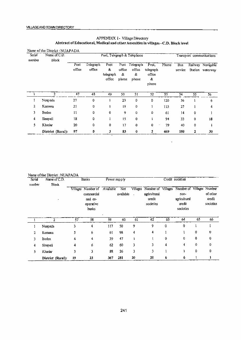
VILLAGE AND TOWN DIRECTORY
APPENDIX I - Village Directory Abstract of Educational, Medical and other Amenities in villages - C.D. BloJ.!k level
Name of the District: NUAPADA Serial NameofC.D. Post, Telegraph & Telephone Transport communications
number Block Post Telegraph Post Post Telegraph Post, Phone Bus Railway Navigable office office & office office telegraph service Station waterway
telegraph & & office office phone phone &
phone
2 47 48 49 50 51 52 53 54 55 56
Nuapada 27 0 23 0 0 120 36 6
2 Komana 21 0 I 19 0 1 115 27 4
3 Boden 11 0 0 9 0 0 61 14 0 I
4 Sinapali 18 0 15 0 I 94 33 0 18
5 Khariar 20 0 0 17 0 0 79 40 0
District (Rural): 97 0 3 83 0 2 469 150 2 30
Name of the District: NUAPADA Serial NameofC.D. Banks Power supply Credit societies
number Block Villages Number of Available Not Villages Number of Villages Number of Villages Number
commercial available agricultural non- of other
and co- credit agricu It ural credit operative societies credit societies
banks societies
2 57 58 59 60 61 62 63 64 65 66
Nuapada 3 4 117 SO 9 9 0 0 1 1
2 Komana 5 6 61 98 4 4 0 0
3 Boden 4 4 39 47 0 0 0 0
4 Sinapali 4 6 62 60 3 3 4 4 0 0
5 Khariar 3 3 88 26 3 3 0 0
District (Rural): 19 23 367 281 20 20 6 6 1
241
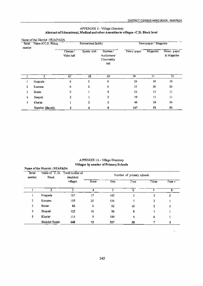
DISTRICT CENSUS HAND BOOK. NUAPADA
APPENDIX I - Village Directory Abstract of Educational, Medical and other Amenities in villages - c.n. Block level
Name of the District: NUAPADA Serial NameofC.D. Block
number
2
Nuapada
2 Komana
3 Boden
4 Sinapali
5 Khariar
District (Rural):
Cinema I Video hall
67
0
0
0
2
3
Recreational facility
Sports club StadIUm I
68
0
2
I
2
6
AuditOrium! Community
hall
69
0
0
0
0
0
0
APPENDIX IA - Village Directory
Newspaper I Ma!!flZine
News- paper Ma!!flZine News- paper & Magazine
70 71 72
24 19 19
33 26 12.6
23 11 11
19 11 11
48 24 Q.4
147 91 !>1
Villages by number of Primary Schools Name of the District: NUAPADA
Serial Nameof C. D. Total number of Number of primary schools
number Block inhabited villages None One Two Three Four+
2 3 4 5 6 7 8
Nuapada 167 17 145 3 2 0 2 Komana 159 25 124 7 2
3 Boden 86 6 62 16 2 0
4 Sinapali 122 16 96 8 1
5 Khariar 114 9 100 4 a District Total: 648 73 527 38 7 3
242

VILLAGEANIj> TOWN DII}ECTORY
APPENDIX IB - Village Directory Villages by Primary, Middle and Secondary Schools
Nam, ortbe District: NUAPADA Seriaillumber Name of C. D. Total number Type of educational institutions available
Block of inhabited ~N-:-o-:S~c-:-ho-o-;I--""A-:-t7Ie-as-:t-o-n-e --A-:-t'"'l:-eas---"-t -on-e-p-r-:-im-ary--A-:-t"""'l:-eas-t -on-e-m-'i'"'"dd-:":I"-e
villages primary school and school and one middle school and one no middle school school secondary school
2 3 4 5 6 7
Nuapada 167 17 113 37 13
2 Komana 159 25 87 47 16
3 Boden 86 6 49 31 15
4 Sinapali 122 16 50 S6 16
5 Khariar 114 9 53 52 11
District Total: 648 73 352 223 71
APPENDIX IC - Village Directory Villages with different sources of drinking water facilities available
Name of the District: NUAPADA Serial Name of Number ofvilla~es with different sources of drinking water available
number C. D. Block Only.tap Only well Only tube well Only handpump More than one source
only from tap, well, tube
well, handeun:!E
2 3 4 5 6 7
Nuapada 0 0 33 129
2 Komana 0 9 0 24 101
3 Boden 0 4 0 0 74
4 Sinapali 0 0 0 0 116
5 Khariar 0 0 0 109
District Total 0 15 0 57 529
243
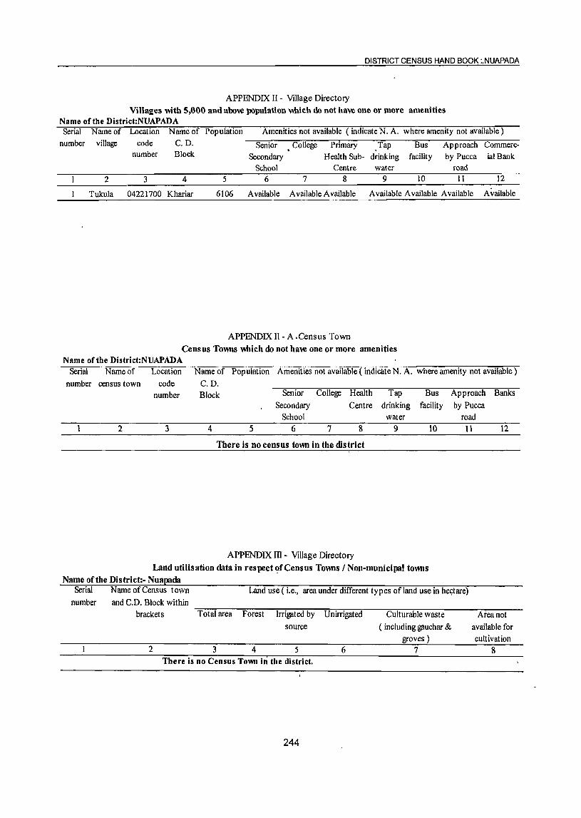
DISTRICT CENSUS HAND BOOK :,NUAPADA
APPENDIX IT - Village Directory Villages with 5,000 and above population which do not have one or more amenities
Name of the District:NUAPADA Serial Name of Location Name of Population Amenities not available ( indicate N. A. where amenity not available)
number village code C.D. Senior • College Primary Tap Bus Approach Commerc-number Block Secondary Health Sub- drinking facility by Pucca ial Bank
School Centre water road 2 3 4 5 6 7 8 9 10 11 12
Tukula 04221700 Khariar 6106 Available Available Available A vailable Available Available Available
APPENDIX II - A .Census Town Census Towns which do not have one or more amenities
Name of the District:NUAPADA Serial Name of Location Name of Population Amenities not available (indicate N. A. where amenity not available)
number census town code C.D. number Block Senior College Health Tap Bus
Secondary Centre drinking facility School water
2 3 4 5 6 7 8 9 10
There is no census town in the district
APPENDIX III - Village Directory Land utilisation data in respect ~fCensus Towns / Non-municipal towns
Name of the District:- Nuapada
Approach Banks by Pucca
road 11 12
Serial Name of Census town Land use (i.e., area under different types of land use in he9tare) number and C.D. Block within
brackets Total area Forest Irrigated by Unirrigated Culturable waste Area not source ( including gauchar & available for
groves ) cultivation 2 3 4 5 6 7 8
There is no Census Town in the district.
244
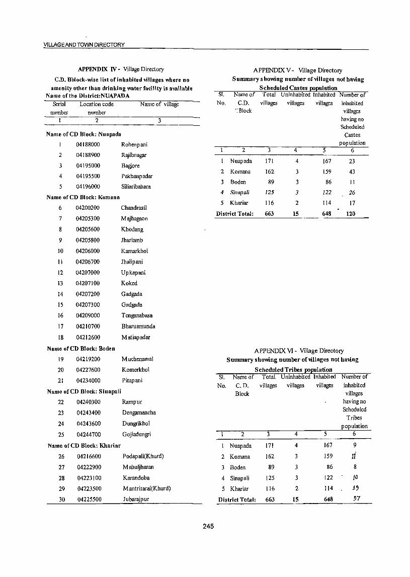
YILLAGEANO TOWN DIRECTORY
APPENDIX IV - Village Directory APPENDIX V - Village Directory
C.D. Bblock-wise list of inhabited villages where no Summary showing number of villages not having
amenity other than drinking water facility is awilable Scheduled Castes po~ulation Name of the District:NUAPADA SI. Narneof Total Uninhabited Inhabited Number of
Serial Location code N arne of village No. C.D. villages villages villages inhabited
number number ':fllock villages
2 3 having no Scheduled
Name ofeD Block: Nuapada Castes
04188000 Rohenpani population 2 3 4 5 6
2 04188900 Rajibnagar
3 04195000 Bagjore Nuapada 171 4 167 23
4 04195500 Pakhanpadar 2 Komana 162 3 159 43
5 04196000 Siliaribahara 3 Boden 89 3 86 II
Name ofeD Block: Komana 4 Sina{lali 125 3 122 26
5 Khariar 116 2 114 17 6 04200200 Chandrasil
District Total: 663 15 648 120 7 04205300 Majhagaon
8 04205600 Khodang
9 04205800 Iharlarnb
10 04206000 Karnarkhol
11 04206700 Jhalipani
12 04207000 Upkapani
13 04207100 Koked
14 04207200 Gadgada
15 04207300 Gadgada
16 04209000 T enganabasa
17 04210700 Bharuarnunda
18 04212600 Matiapadar
Name ofeD Block: Boden APPENDIX VI - Village Directory 19 04219200 Muchenarnal Summary showing number of villages not having
20 04227600 Komerkhol Scheduled Tribes po~ulation
21 04234000 Pitapani
Name ofeD Block: Sinapali
SI. Narneof Total. Uninhabited Inhabited Number of
No. C.D. villages villages villages inhabited Block villages
22 04240300 Rarnpur having no
23 04243400 Dengamancha Scheduled Tribes
24 04243600 Dungrikhol population
25 04244700 Gojiadungri 2 3 4 5 6
Name ofeD Block: Khariar Nuapada 171 4 167 9
26 04216600 Podapali(Khurd) 2 Komana 162 3 159 11' 27 04222900 Mahuljharan 3 Boden 89 3 86 8
28 04223100 Karandoba 4 Sinapali 125 3 122 10 29 04223500 M antritarai(Khurd) 5 Khariar 116 2 114 1., 30 04225500 Jubarajpur District Total: 663 15 648 57
245

DISTRICT CENSUS HAND BOOK; NUA.PADA
APPENDIX vn A- Village Directory APPENDIX vn A- Village Directory List of villages according to the proportion of the List of villages according to the proportion .of the
Scheduled Castes to the total population by ranges Scheduled Castes to the total population by ranges
Name of the District:NUAPADA .. Name of the District:NUAPADA ..
Range'of Location code Name of village Range of Lpcation code Name of village Scheduled number Scheduled number
Castes Castes population population
(p ercentages) (percentages)
1 2 3 1 2 3 Name ofeD Block: Nuapada Less than 5 04181100 Amodi
04189100 Dalipathna 04184000 Bhanpur
04196400 Katingpani 04193300 Hemamunda
04197900 Dhamanpuri 04189400 Mohara
04183800 Gaharendihi 04188200 Sirigidi
04195300 Kalamidadar 5-10
04189700 Khalana 04194900 Kukurimundi
04196500 Lodra 04182400 Masankunda
04193700 Chipajhar 04195600 Chulabhat
04185700 Chichiripani 04194700 Dhwajabhata
04196600 Bharuamunda 04185400 Darlinawapara
04188700 Brahmani 04194200 Patharapunji
04186300 Darlipali Orf Chuhuri 04196100 Kodopali
04192800 Jhilmila 04191200 Anlajuba 04182200 Barakothi 04185100 Baloda 04187700 Magurpani 04191500 Jamudara
04181900 Pandripani 04192000 Paraskhol (Kala) 04184900 Jangula 04197300 Kermeli
04188800 Gidhinipani 04193100 Sakhatora 04192200 Mahuabhata 04191100 Tileijhar 04193400 Ratapali 04189600 Pawartola 04191700 Kotenchuan 04192700 Dianmunda 04197000 Tikrapada 04194000 Panchampur 04189300 Amanara 04182700 Bisora 04195800 Pandripani 04185800 Chhindpani 04190300 Dumerpani 04187100 Kalyanpur 04199700 Khairarii 04190400 Silda 04190100 Bhajipala 04186800 Amasena 04182300 Kandadhap 04186000 Tangopani 04183100 Lukupali 04185500 Jamuli 04191400 Pipalchhendi 04193200 Gadtor 04184600 Amalidadar 04189900 Bhainsimundi 04190700 Hanspuri 04188400 Kendubahara 04187200 Chanabeda 04187600 Kermeli 04187500 Jhalballai 04191600 Chhelilendi 04189500 Patalghutkuri 04187000 Kolda 04197600 Gobara 04182500 Kadamberi 04194400 Motanuapada 04191000 Pal?flTpani 04193500 Maulibhata 04182100 Singpur 04185900 Jampani 04197800 Khoksa
246
Vlt':t.AGEANqrowN DIRECTORY
APPENDIX VB A- Village Directory APPENDIX VB A- Village Directory Ust of -,ill ages according to the proportion of the Us~ of villages according to the proportion of the
Sdteduled Castes to the total population by ranges Scheduled Castes to the total population by ranges
Name ofthe District:NUAPADA * Name ofthe District:NUAPADA * Range of Location code N arne of village Range of Location code Name of village Scheduled number Scheduled number
Castes Castes population population
(percentages) (percentages) 1 2 3 1 2 3
11-10 04187800 Darlimunda 04192500 Rajpurnuapada 21-30 04195200 SetlUampani 04194100 Bhera 04197700 Tanwat 04192600 Sirtol 04189800 Sarabang 04181700 Bakharmal 04182600 Dhanora 04197400 Golabandh 04187900 Khaliapani 04196000 Siliaribahara 04190200 Nandapur 04183600 Semeria 04196700 Dharambandha 04190600 Bhera 04187300 Saliha (Kala) 04194600 Kukuratal 04186400 Kodomeri 04181200 Tamakidadar(KaJa) 04197200 Pethiapali 04190900 Junani 04186200 Boirbhadi 04185200 Bhaisatal 04186900 Gotama 04184400 Parkod
04190500 Patparpali 04185300 Bhandarpuri
04183900 Kuliabandha 31-40 04190000 Haldi 04183700 Senbhata
04190800 Godfula 04182900 Negipali
04181800 Beltukuri 04192900 Ratipali
04183500 Bhainsmundi Orf Bhusudi 04181600 Bhaleswar
04183300 Doto 04194300 Torra
04193900 Lanjimar 04183400 Chingarasara
04197100 Maraguda 41-50 04181000 Kurumunda 04186500 Mudhela
04191300 Sahipala 04184300 Kukurimundi
04181500 Saraipali 04193800 Pandripani
04188600 Bhainsadaraha 51-75 04192300 Salebhata 04184700 Beheradihi
04184200 Bhotha 04186700 Thelkobeda
04196800 Patora 76 and above
04186600 Mahatamtara 04181400 Kodoguda
04193000 Thakumuapada Name of CD Block: Komana
04184500 Parasabhadar Less than 5
04191800 Sialati 04207500 Kholi!?ilOn
04193600 Karchul 04198600 K usadona(K usadahana)
04184800 Jenjera 04206400 Adar
04183000 Jhitiki 04206300 Soseng
04192100 Parsabuda 04199200 Silva
04183200 B!iQankera 04205300 Majhagaon
04185600 Biromal 04214500 Lambipani
04182800 Gudapatara 04207700 Bisibahal
247
DISTRICT CENSUS HAND BOOK: NUAPADA
APPENDIX vn A- Village Directory APPENDIX vn A- Village Directory list of villages according to the proportion of the list of villages according to the proportion ofthe
Scheduled Castes to the total population by ranges Scheduled Castes to the total population by ranges
Name of the District:NUAPADA .. Name of the Dlstrict:NUAPADA ..
Range of Location code Name of village Range of Location code Name of village Scheduled number Scheduled number
Castes Castes population population
(p ercentages) (percentages)
1 2 3 I 2 3 04210200 Patapani 04199100 Bhurukadhoda 04204800 Darlipada 04203500 Gandamer 04212500 Belgaon 04213900 Rajana 04198500 Sinapali 04204600 Iadamunda 04208100 Thongo 04203200 Kamkeda 04201100 Diamunda 04211900 Komana 04201300 Latkanpada 04210500 Poinr 04199300 Patparpali 04209300 Rang 04212800 Dhorlamunda 04207900 Khambahi
5-10 04208600 Khairvadi 04198300 Samarsing 04201200 M undap ala 04214000 Kalimati 04198200 T en gan ab as a 04210700 Bharuamunda 04209700 Dunguripali 04202300 Dedenga 04212400 Sandabahali 04204200 Sihinamunda 04201600 Hatisara 04210900 Bahalmunda 04208700 Kureswar 04211800 Raghupali 04195700 Gangadigarh 04203700 Danajhola 04206500 Gatibeda 04199600 Chanamunda 04208000 Michhapali 04208400 Barandapat 04205100 Belardana 04209200 Kishna 04214700" Pendraban 04212000 Solbandh 04204700 lchhapur 04202700 Sukulimundi 04199500 'Suabahal 04204100 Musapali 04215200 Chandopala 04201900 Sahajat 04199000 Kurumpuri 04211500 Konabira 04200000 Bangamunda 04209100 Ghotsar 04206900 Sunabeda 04204000 Dhumabhata 04211000 Balenjar 04215000 Dharamsagar 04212900 Dhanravata 04201500 Karangavata 04200900 Bagmunda 04209600 lalamkata 04210100 M ahulbltata 04205200 Siletpani 04203400 Larki 04204400 Manikaguda 04201700 Tarabod 04205400 Haluapali 04211400 Bodachhapar 04201400 Kasipa1a 04208800 Bhella 04198400 Bhojpurghati 04208200 Kumutimunda 04199800 Mundapalla 04201800 . Palasipani 04204300 Jatagarh 04212300 Agren 04200700 Sialati 04209900 Tikrapada
11-20 04212700 Chhata 04203600 Kantapali 04204900 Dumerpani
248
VILLAGEAND TOWN DIRECTORY
APPENDIX vn A- Village Directory APPENDIX vn A- Village Directory Ust of villages according to the proportion of the list of villages according to the proportion ofthe
Scheduled Castes to the total population by ranges Scheduled Castes to the total population by ranges
Name oCthe District:NUAPADA " Name orthe District:NUAPADA "
Range of Location code Name of village Range of Location code Name of village Scheduled number Scheduled number
Castes Castes population population
(percentages) (p ercentages) I 2 3 1 2 3
21-30 04228900 Mahulpadar 04208300 Jhagrahi 04213800 Bolda 04211600 Pandelbahali 04228000 Palasada 04203100 Kalimati 04218900 Salepada 04214600 Ihalkusum 04213200 Jharanarnal 04202800 Thogapali 04234500 Khairvadi 04212200 Goijore 5-10 04209500 Pandarapathar 04227200 Patdarha 04203900 Bu"dhikomna 04229800 Chikalchuan 04202400 Mendhatal 04234100 Dahanapali 04212100 Viva 04230000 Baglor 04200600 Bhalukona 04229200 Kusumkhunta 04213000 Deodarha 04228700 Sunapur
04203000 Thutibar 04231600 Tarapur
04203300 Nuagaon 04229500 Dhobei
04208900 Baghamunda 04232600 Kulekela
04199400 Chhindpani 04228100 Margaon
31-40 04213700 Kotamal
04211100 Dumerbahal 04~31800 Bakulikhunti(Kala)
04210000 J agannathp ali 04229300 Sunamundi
04202100 Telenpali 04230600 Pharasara
04203800 Kandetara 11-20 04202900 Semelpali 04231900 Putupilra
04215100 Palsipani 04229900 Khadupani
04209800 Jethupali 04227300 Redhamal
04199900 Lakhana 04227700 Kirejhola
04202600 Babupali 04214200 Daragaon
04198700 Chohakapada 04233400 Khurdguma
41-50 04232000 Ghantiguda
04207800 Batibahal 04227900 Damajhar
76 and above 04233500 Anakapur
04210800 Karamahul 04233900 Karangamal
Name of CD Block: Boden 04233200 Larka
Less than 5 04234900 Kulingmal
04213100 Bhuinpani 04228500 Khaira I
04227400 Rundi 04228600 Ke~arajpur
04231500 Rokal 04213500 Karlakot
04229600 Bhainsadani 04228300 Dabri
04232900 Lesunpali 04228800 Bagabahal
04232200 Mahulpadar 04231100 Ambaguda
249
DISTRICT CENSUS HAND BOOK: NUAPADA
APPENDIX VII A- Village Directory APPENDIX VII A- Village Directory
list of villages according to the proportion of the list of villages according to the prl)portion of the Scheduled Castes to the total population by ranges Scheduled Castes to the total population by ranges
, Name of tile District:NUAPADA • Name of the District:NUAPADA •
Range of Location code Name of village Range of Location code Name of village Scheduled number Scheduled number
Castes Castes population population
(percentages) (percentages)
1 2 3 1 2 3
04234600 Bartansil 04237400 Sindursil
04213400 Sirli 04244300 Nuamalpada
04229000 Temeri 04240900 Makhapadar
04233300 Palenbasa 04240600 . Jogibahala
04231300 Bherumal 04241600 Charpali
04213600' Kirekela 04238100 Fulchi
04213300 Nagpada 04237500 Talakot
04233000 Jayabahal 04235500 Hirapur
04233800 Kampur 04236200 Timanpur
04234300 Dharnimal 5-10
04228400 Banjibahal 04244400 Akhadabhata
04231000 Binapur 0424()200 Gambhariguda
04234400 Babebir 04244600 Dhingiamunda (Dhungiamunda)
04232300 Litisargi 04239900 Ghotuguda
04232100 Ihirinikhol 04242800 Dangargaon
04227500 Mankarbirli 04241700 Dhungiamunda
04227800 Amera 04236600 Gorla
21-30 04237300 Chitarama
04232800 Doto 04240500 Mundapala
04231400 Kamalamal 04243000 ",Pendraban
04230100 Boirgaon 04239500 Jugenpadar
04230200 Nimna 04240000 Chalna 04230700 Kerapadar 04246300 Kusumjore
04233100 Khirmal 04244800 Tileimal
04229100 Boden 04245500 Jhulenbar
04230400 Jamugaon 04247100 Kokpadar
04233600 Gumabahal 04239000 Gadaramal
04230800 Bireskela 04244900 Badibahal
31-40 04243800 Haldimunda 04230500 Rajpur 04236400 Karlakhamar 04230300 Dhamanapara 04241000 Hatibandha 04232400 Anlabhata 04245400 Kandamunda
41-50 04237600 Bhatapani 04228200 Durkamunda(Kala) ll-20
Name of CD Block: S inapaU 04238700 Kaintapadar Less than 5 04244000 Jampani
04235800 M andiarucha 04241400 Jhankarguda 04235100 Kanetghatmai 04242700 Goda! 04240800 Sitalkhalia 04239600 Sinapali 04236100 Ranidunguri 04236000 Baigapada
250
VILLAGE AND TOWN DIRECTORY
APPENDIX vn A- Village Directory APPENDIX vn A- Village Directory Ust ohiJJlIges accO! ding to the proportion ofthe LISt of villages according to the proportion of the
Scheduled Castes to the total population by ranges Scheduled Castes to the total population by ranges
Name orthe District:NUAPADA .. Name of the District:NUAPADA '"
Range of LocatIOn code Name of village Range of Location code Name ofvlUage Scheduled number Scheduled number
Castes Castes populatIOn populatIOn
(percentages) (p ereen t ages)
1 2 J I 2 3
04235900 Ranlmunda 04238500 Darhpada
04237700 NangaJbod 04239300 Chatlaguda
04246400 Kaselpanl 04235600 Maheswar
04238400 Khlrbhadl 04243300 Dungnguda
04239800 Sardhapur 04247000 Jarelpadar
04236300 Rebadl 04242100 Bharuanlunda
04238900 NIIJI 04246100 Brahmanpada
04235300 Armala 31-40
04246900 Nuapara 04243900 Kandolkona
04242000 Barpadar 04243100 Kuhadungrl
04234800 Baragaon 04238000 Bhuhabhata
04245600 Malapada 04245300 NagaJhar
04234700 Salekela 04242900 Kodobeda
04240400 Gandabahali 04240100 Nandagaon
04241500 Lmd 41-50
04245700 Brahmanlguda 04239100 Khalna
04236700 Ma1pada 51-75
04241200 Malpada 04235000 Botopall
04245000 Jharbandha Name of CD Block: Khariar
04241800 Lltlguda Less than 5
04235400 Govtndpur 04226700 Junapanl
04241100 Gldhamal 04225000 Chancharabhata
04238800 Ghuchaguda 04226800 Klrklta
04239700 Kapsl 04218600 Klklnbeda
04242500 Kotamal 04224700 Chandel
04236900 BlJalpur 04217300 Chhata
04238300 Sardhapur 04221200 Sandhlbahah
04242600 Stnglhar 04225300 Artatranapur
04240700 Kopla 04217000 Sikuan
04241300 Chaunra 04218000 Kaslpala
21-30 04217800 Cha1anpada
04239200 Palsapara 04216900 Kotenmunda
04238600 Kharsel 04217700 Barapadar
04236800 Kusumkhunta 04226100 Kotamal
04242400 Mahagaon 04220000 Gadaramunda
04239400 Sagunbhadl 5-10
04244100 Slallatl 04219000 Kenduguda
04241900 Chancharabhata 04226500 Mahulkot
04243700 Kendumunda 04224100 Blchhanapah
04244500 Darhpada 04219300 Uparplta
251
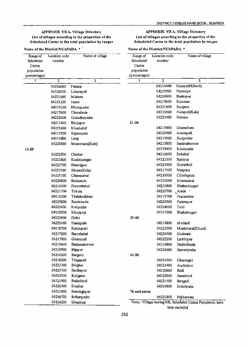
DISTRICT CENSUS HAND BOOK. NUAPADA
APPENDIX VII A- Village Directory APPENDIX VII A- Village Directory list ofviUages according to the proportion orthe Ust orviJlages according to the proportion orthe
Scheduled Castes to the total population by ranges Scheduled Castes to the total population by ranges
Name afthe District:NUAPADA '" I Name orthe District:NUAPADA '"
Range of Location code Name of vIllage Range of Location code Name of village Scheduled number Scheduled" number
Castes Castes population population
(percentages) (percentages)
1 2 3 1 2 3
04226000 Palama 04216600 Podap ali(Khurd)
04220300 Loharapali 04219500 Dumerjor
04221000 Mahura 04224900 Bankapur
04221300 Junen 04219600 Kusumal
04219100 Bhimapadar 04221600 Rlsigaon
04217600 Chanabeda 04216500 Podap ali(Kala)
04222600 Godadhapadar 04222400 Nehena
04217400 Bhojapur 21-30
04225400 Khasbahal 04215400 Gharadhara
04215500 Rajamunda 04220900" Amalapali
04219400 Lanji 04215900 Jholpathar
04223400 Mantritarai(Kala) 04215800 Sanamaheswar
11-20 04218400 Khairpadar
04222500 Chicher 04216000 Debahal
04222800 Kudaldungari 04222300 Ranipur
04223700 Bhairajpur 04223900 Gudabheli
04227100 Sikuan(Kala) 04217100 Nuapara
04221100 Chanatarnal 04218300 Chindaguda 04220800 Badamula 04226200 Kharnatarai 04216400 Dumerbahal 04223800 Bhalundungari 04221700 Tukula 04220700 "Arada • 04216300 Thelakodabari 04219700 Jharasararn 04225800 Ranimunda 04220500 Padmapur 04220400 Kotipadar 04224000 Torli 04218500 Khudpeja 04217500 Bhaludungari 04223600 Dabri 31-40 04220100 DamapaJa 04219800 Modasil 04218700 Kendupati 04223500 M antritarai(Khurd) 04217200 Baresbahal 04224300 Godatala 04217900 Goimundi 04222200 Lachhipur 04215600 Badarnaheswar 04216800 Jhidiridhoda 04219900 Bijepur 04226400 Samserp adar 04216200 Bargaon 41-50
04218200 ThagapaJi 04224500 Chandagiri 04222700 Birighat 04224400 Anchalpur 04225700 Sardhapur 04220600 Badi 04215300 KuJigaon 04222000 Sanadohel 04221900 Badadohel 04221500 Saragadi 04226300 Duajhar 04224800 Dohe\pada 04221400 Narsinghpur 76 and above 04216700 Rohenpadar 04221800 Pakhansara 04224200 Dhanksar N ote:- Villages having NIL Scheduled Castes Pop ulation have
been excluded
252
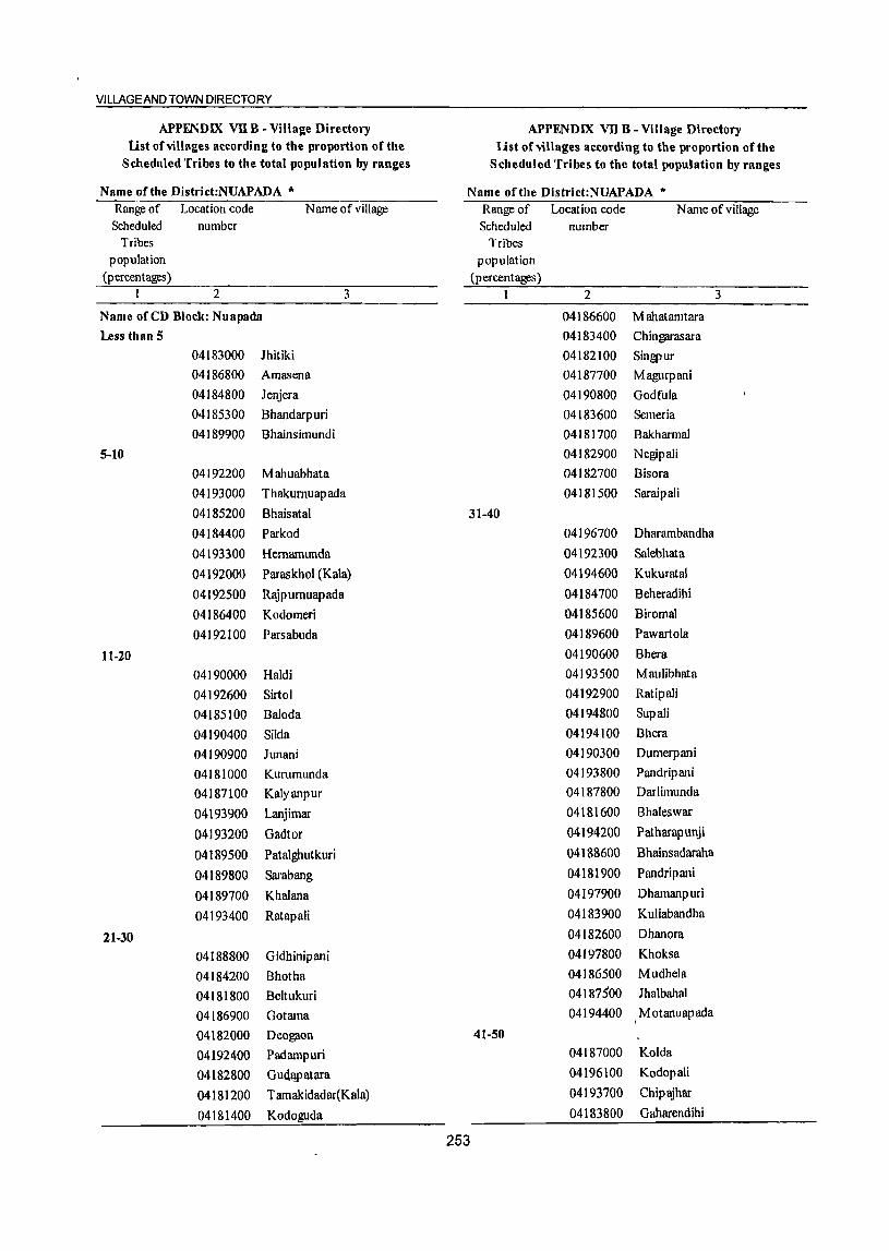
VILLAGEAND TOWN DIRECTORY
APPENDIX vn B ~ Village Directory APPENDIX vn B ~ Village Directory Ust of villages according to the proportion of the Ust of viII ages according to the proportion of the
Scheduled Tribes to the total population by ranges Scheduled Tribes to the total population by ranges
Name oftbe District:NUAPADA '" Name of the District:NUAPADA to
Range of Location code Name of village Range of Location code Name ofvillagc Scheduled number Scheduled number
Tribes Tribes population popUlation
(percentages) (percentages) t 2 3 1 2 3
Name oreD Block: Nuapada 04186600 M ahatamtara Less than 5 04183400 Chinl?fll"asara
04183000 Jhitiki 04182100 Singpur 04186800 Amasena 04187700 Magurpani
04184800 J enj era 04190800 Godfula
04185300 Bhandarpuri 04183600 Semeria
04189900 Bhainsimundi 04181700 Bakharmal
5-10 04182900 Negipali
04192200 Mahuabhata 04182700 Bisora
04193000 Thakurnuap ada 04181500 Saraipali
04185200 Bhaisatal 31-40
04184400 Parkod 04196700 Dharambandha
04193300 Hernamunda 04192300 Salebhata
04192000 Paraskhol (Kala) 04194600 Kukuratal
04192500 RlYpumuapada 04184700 Beheradihi
04186400 Kodomeri 04185600 Biromal
04192100 Parsabuda 04189600 Pawartola
11~20 04190600 Bhera
04190000 Haldi 04193500 Maulibhata
04192600 Sirtol 04192900 Ratipali
04185100 Baloda 04194800 Sup ali
04190400 Silda 0419410Q Bhera
04190900 Junani 04190300 Dumerpani
04181000 Kurumunda 04193800 Pan drip ani
04187100 Kalyanpur 04187800 Darlimunda
04193900 Lanjimar 04181600 Bhaleswar
04193200 Gadtor 04194200 PatharapuJ1ji
04189500 Patalghutkuri 04188600 Bhainsadaraha
04189800 Sarabang 04181900 Pandripani
04189700 Khalana 04197900 Dhamanpuri
04193400 Ratapali 04183900 Kuliabandha
21-30 04182600 Dhanora
04188800 Gidhinipani 04197800 Khoksa
04184200 Bhotha 04186500 Mudhela
04181800 Beltukuri 04187500 Jhalbahal
04186900 Gotama 04194400 I M otanuap ada
04182000 Deogaon 41-50
04192400 Padampuri 04187000 Kolda
04182800 GuQ.1!P atara 04196100 Kodopali
04181200 T amakidadar(Kala) 04193700 Chip~har
04181400 Kodoguda 04183800 Gaharendihi
253
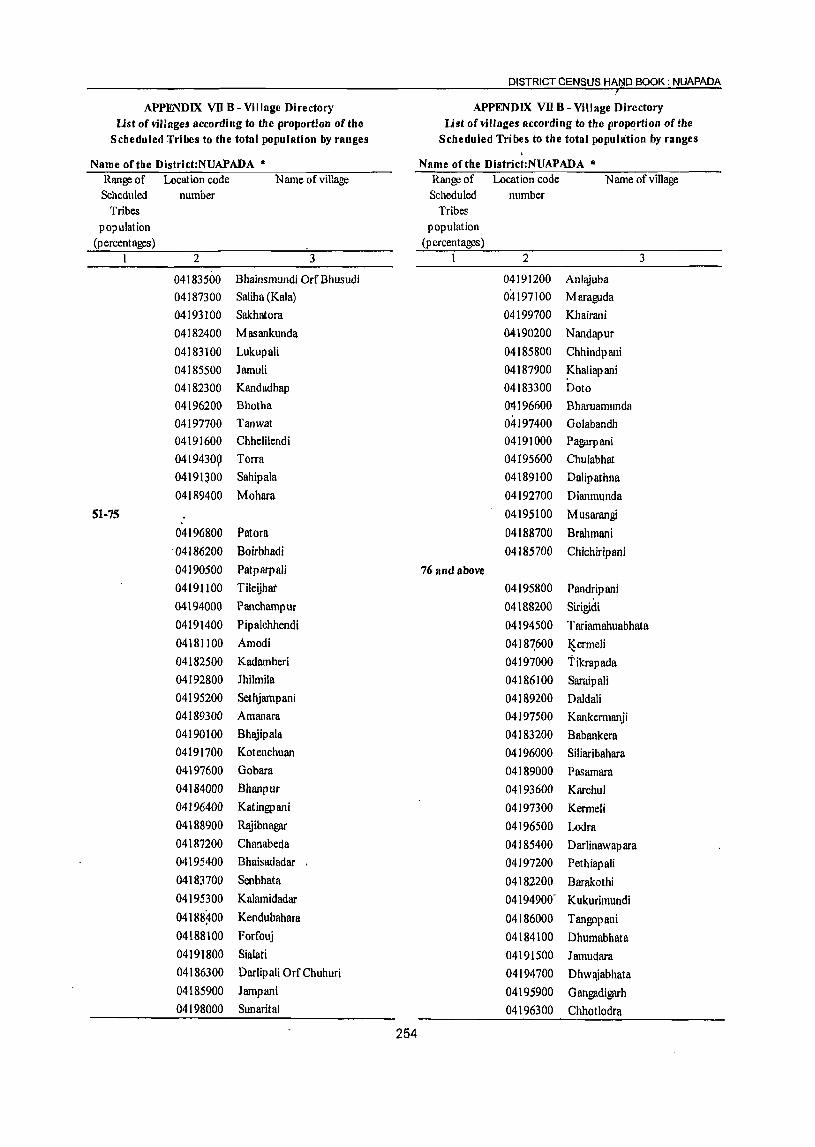
DISTRICT CENSUS HA~D BOOK: NUAPADA I
APPENDIX vn B - Village Directory APPENDIX vn B - Village Directory Ust of villages according to the proportion of the Ust of villages according to the proportion of the
Scheduled Tribes to the total population by ranges Scheduled Tribes to the total popuhition by ranges \
Name ofthe District:NUAPADA " Name of the District:NUAPADA " Range of Location code N arne of village Range of Location code N arne of village Scheduled number Scheduled number
Tribes Tribes population population
(p ercentages) (p ercen tages ) 1 2 3 I 2 3
04183500 Bhainsmundi OrfBhusudi 04191200 Anlajuba
04187300 Saliha (Kala) 04197100 Maraguda
04193100 Sakhatora 04199700 Khairani
04182400 Masankunda 0.4190200 Nandapur
04183100 Lukupali 04185800 Chhindpani
04185500 Jarnuli 04187900 !<haliapani 04182300 Kandadhap 04183300 Doto
04196200 Bhotha Oil 1 96600 Bharuamunda 04197700 Tanwat 04197400 Golabandh 04191600 Chhelilendi 04191000 Pagarpani
04194309 Torra 04195600 Chulabhat
04191300 Sahipala 04189100 Dalipathna
04189400 Mohara 04192700 Dianmunda
51-75 04195100 Musarangi
04196800 Patora 04188700 Brahmani
'04186200 Boirbhadi 04185700 Chichiripani
04190500 Patparpali 76 and above
04191100 Tileijhat 04195800 Pandripani 04194000 Panchampur 04188200 Sirigidi
04191400 Pipalchhendi 04194500 T ariarnahuabhata 04181100 Amodi 04187.600 I$ermeli 04182500 Kadarnberi 04197000 T ikrap ada 04192800 Jhilmila 04186100 Saraipali 04195200 Sethjarnpani 04189200 Daldali 04189300 Amanara 04197500 Kankermanji 04190100 Bhajipala 04183200 Babankera 04191700 Kotenchuan 04196000 Siliaribahara 04197600 Gobara 04189000 Pasarnara 04184000 Bhanpur 04193600 Karchul 04196400 Katingpani 04197300 Kermeli 04188900 Rajibnagar 04196500 Lodl'a 04187200 Chanabeda 04185400 Darlinawapara 04195400 Bhaisadadar 04197200 Pethiapali 04183700 Senbhata 04182200 Barakothi 04195300 Kalarnidadar 04194900- Kukurimundi 04188~00 Kendubahara 04186000 Tangopani 04188100 Forfouj 04184100 Dhumabhata 04191800 Sialati 04191500 Jamudara 04186300 Darlipali OrfChuhuri 04194700 Dhwajabhata 04185900 Jampani 04195900 Gangadigarh 04198000 Sunarital 04196300 Chhotlodra
254

VI U.AG E AND TOWN DIRECTORY
APPENDIX VII B - Village Directory APPENDIX VII B - Village Directory Ust of villages according to the proportion of the Ust of villages according to the proportion ofthe
Scheduled Tribes to the total population by ranges Scheduled Tribes to the total population by ranges
Name of the District:NUAPADA it Name of the District:NUAPADA it
Range of Location code Name of village Range of Location code Name of village Scheduled number Scheduled number
Tribes Tribes population population
(percentages) (p ercentages) 1 2 3 1 2 3
04188500 J amusalebhata 04215200 Chandopala 04195500 Pakhanpadar 04211000 Balenjar 04188300 Chhotkendubahara 04208mO Kureswar
Name of CD Block: Komana 04198700 Chohakapada
Less tban 5 04202900 Semelpali 04208900 Baghamunda 04204600 Jadamunda
04207900 Khambahi 31-40 04212000 SoJbandh 04207800 Batibahal
04203300 Nuagaon 04209300 Rang
04211100 Dumerbahal 04199000 Kurumpuri
04198600 Kusadona(Kusadahana) 04199900 Lakhana
5-10 04203800 Kandetara
04204000 Dhumabhata 04204200 Sihinamunda
04203400 Larki 04212500 Belg;'lon
04209600 lalamkata 04198200 T eng;'lnabasa
04211400 Bodachhapar 04207100 Koked
04210000 J ag;'lnnathp ali 04198900 Daldali
04202000 ChancharlYharan 04215100 Palsipani
04204700 Ichhapur 04211600 Pandelbahali
11-20 04208200 Kumutimunda
04211900 Komana 41-50
04209400 DoheJapada 042Q8800 Bhella
04200800 Tetelpada 04209700 Dunguripali
04204500 Ganiary 04214800 Bahabal
04213900 R!\iana 042J~400 Jag;:tnnathpali
04209200 Kishna 04191noo Samarsing
04215000 Dharamsagar 04204300 Jatag;:tTh
04201700 Tarabod 04210100 Mahulbhata
04200000 Bangamunda 04209500 Pandarapathar
21-30 04210900 Bahalmunda
04209100 Ghotsar 04211500 Konabira
04208300 Jhagrahi 04204900 Dumerpani
04200900 Bagmunda 04201500 Karangavata
04206600 Dhekunpani 04203700 Danajhola
04198800 Limdihi 04212400 Sandabahali
04203100 Kalimati 04214~00 Lambipani
04203900 Budhikomna 04201300 Latkanpada
04209900 T ikrap ada 04198500 Sinapali
04212300 - Agren 51-75
04212100 Ulva 04213000 Deodarha
04202100 Telenpali 04202400 Mendhatal
255
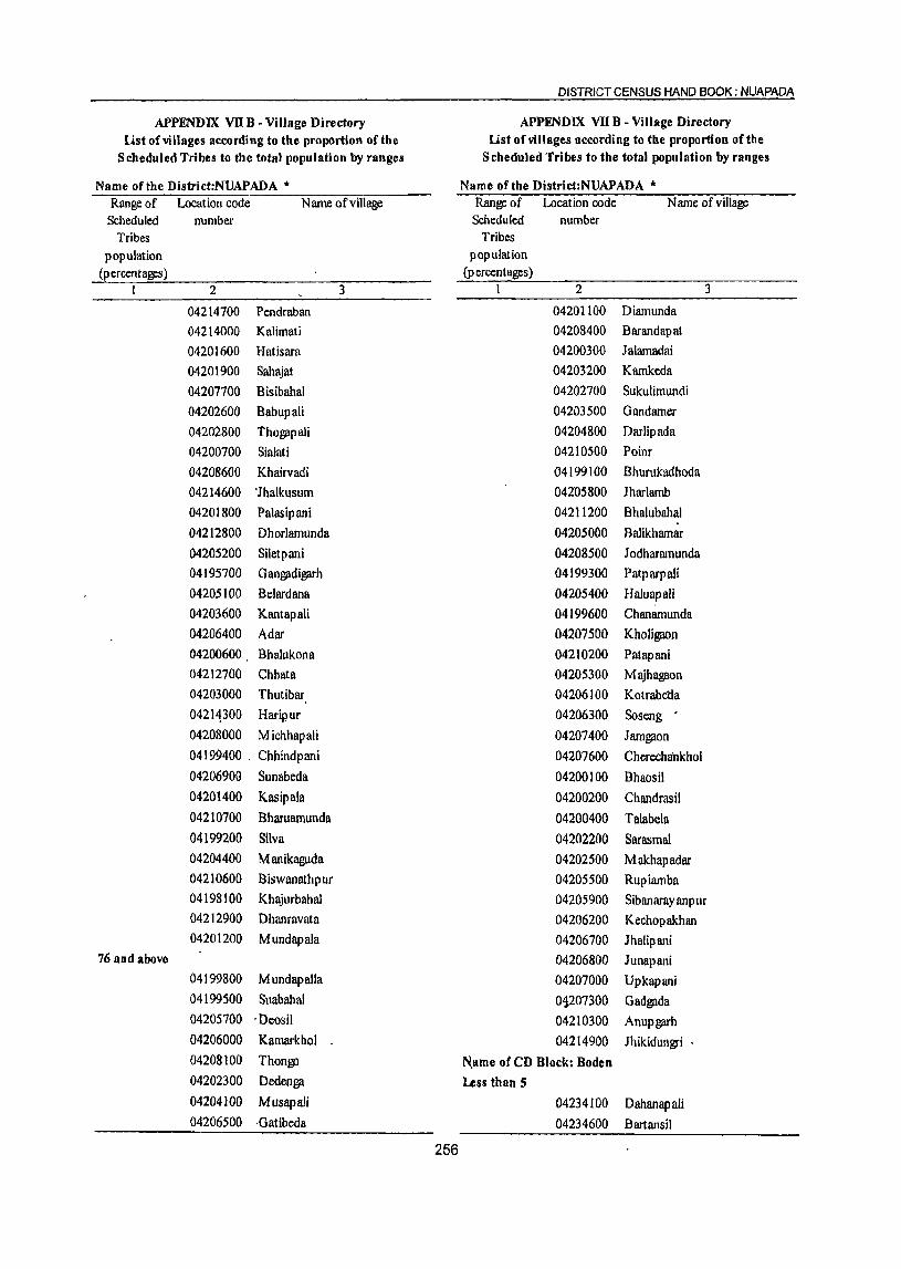
DISTRICT CENSUS HAND BOOK: NUAPADA
APPENDIX vn B - Village Directory APPENDIX vn B - Village Directory list of vi lIages according to the proportion of the list of villages Recording to the proportion of the
Scheduled Tribes to the total population by ranges Scheduled Tribes to the total population by ranges
Name of the District:NUAPADA • Name ofthe District:NUAPADA '" Range of Location code Name of village Range of Location code Name of village
Scheduled number Scheduled number Tribes Tribes
population population (percentages) (p ercentages)
1 2 3 1 2 3
04214700 Pendraban 04201100 Diamunda
04214000 Kalimati 04208400 Barandapat
04201600 Hat is ara 04200300 lalamadai
04201900 8ahajat 04203200 Kamkeda
04207700 Bisibahal 04202700 Sukulimundi
04202600 Babupali 04203500 Gandamer
04202800 Thog;:tpali 04204800 Darlipada
04200700 8ialati 04210500 Poinr
04208600 Khairvadi 04199100 Bhurukadhoda
04214600 "lhalkusum 04205800 Iharlamb
04201800 Palasipani 04211200 Bhalubahal
04212800 Dhorlamunda 04205000 Balikhamar
04205200 Siletpani 04208500 Jodharamunda 04195700 Gang;:tdig;:trh 04199300 Patparpali 04205100 Belardana 04205400 Haluapali 04203600 Kantapali 04199600 Chanamunda 04206400 Adar 04207500 Kholigaon 04200600 Bhalukona 04210200 Patapani 04212700 Chhata 04205300 Majhagaon 04203000 Thutibar 04206100 Kotrabetla
04211300 Hadp'ur 04206300 Soseng 04208000 Michhapali 04207400 Jamg;:ton 04199400 . Chhindpani 04207600 Cherechankhol 04206900 Sunabeda 04200100 Bhaosil 04201400 Kasipala 04200200 Chandrasil 04210700 Bharuamunda 04200400 Talabela 04199200 Silva 04202200 Sarasmal 04204400 Manikaguda 04202500 Makhapadar 04210600 Biswanathpur 04205500 Rupiamba 04198100 Khajurbahal 04205900 Sibanarayanpur 04212900 Dhanravata 04206200 Kechopakhan 04201200 Mundapala 04206700 Jhalipani
76 and above 04206800 Junapani 04199800 MundapaUa 04207000 Upkapani 04199500 Suabahal 01207300 Gadgada 04205700 . Deosil 04210300 Anupg;:trh 04206000 Kamarkhol 04214900 Jhikidungri . 04208100 Thongo Name of CD Block: Boden 04202300 Dedenga Less than S 04204100 MusapaJi 04234100 Dahanapali 04206500 ·Gatibeda 04234600 Bartansil
256
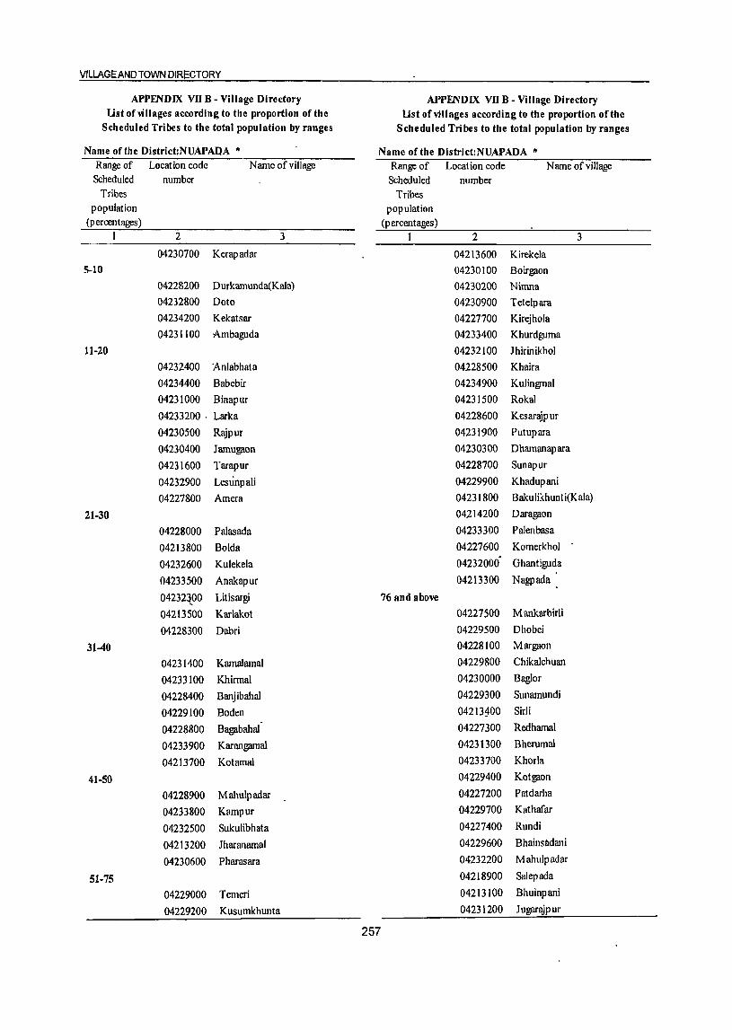
VI LLAGE AND TOWN DIR!::CTORY
APPENDIX VII B - Village Directory APPENDIX VII B - Village Directory Ust of villages according to the proportion of the Ust of villages according to the proportion of the
Scheduled Tribes to the total population by ranges Scheduled Tribes to the total population by ranges
Name of the District:NUAPADA it Name of the District:NUAPADA it
Range of Location code Name of village Range of Location code N arne of village Scheduled number Scheduled number
Tribes Tribes population population
(percentages ) (p ercentages) 1 2 3 1 2 3
04230700 Kerapadar 04213600 Kirekela 5-10 04230100 Boirgaon
04228200 Durkamunda(Kala) 04230200 Nimna 04232800 Doto 04230900 Tetelpara 04234200 Kekatsar 04227700 Kirejhola 04231100 Ambaguda 04233400 Khurdguma
11-20 04232100 Ihirinikhol
04232400 Anlabhata 04228500 Khaira
04234400 Babebir 04234900 Kulingmal
04231000 Binapur 04231500 Rokal
04233200 . Larka 04228600 Kesarl!ipur
04230500 Rajpur 04231900 Putupara
04230400 Jamugaon 04230300 Dhamanapara
04231600 Tarapur 04228700 Sunapur
04232900 Lesunpali 04229900 Khadupani
04227800 Amera 04231800 Bakulikhunti(Kala)
21-30 04214200 Daragaon
04228000 Palasada 04233300 Palenbasa
04213800 Bolda 04227600 Komerkhol
04232600 Kulekela 04232000' Ghantiguda
04233500 Anakapur 04213300 Nagpada
04232{00 Litisargi 76 and above
04213500 Karlakot 04227500 M ankarbirli
04228300 Dabri 04229500 Dhobei
31-40 04228100 Margaon
04231400 Kamalamal 04229800 Chikalchuan
04233100 Khirmal 04230000 Baglor
04228400 BanjibahaI 04229300 Sunarnundi
04229100 Boden 04213~00 Sirli .
04228800 Bagabahal 04227300 Redhamal
04233900 Karangamal 04231300 BherumaI
04213700 Kotamal 04233700 Khorla
41-50 04229400 Kotgaon
04228900 Mahulpadar 04227200 Patdarha
04233800 Kampur 04229700 Kathafar
04232500 Sukulibhata 04227400 Rundi
04213200 Jharanamal 04229600 Bhainsadani
04230600 Pharasara 04232200 Mahulpadar
51-75 04218900 Salepada
04229000 Temeri 04213100 Bhuinpani
04229200 Kusumkhunta 04231200 Jugarajpur
257

DISTRICT CENSUS HAND BOOK. NUAPADA
APPENDIX VII B - Village Directory APPENDIX vn B - Village Directory list of villages according to the proportion ofthe list of villages according to the proportion ofthe
Scheduled Tribes to the total population by ranges Scheduled Tribes to the total population by ranges
Name ofthe Distriet:NUAPADA ." Name of the District:NUAPADA ." Range of Location code Name of village Range of Location code Name of village Scheduled number Scheduled number
Tribes Tribes population population
(p ereen t ages) (percentages) I 2 3 I 2 3
04234000 Pitapani 21-30 Name ofeD Block: Sinapali 04236300 Rebadi
Less than 5 04236400 Karlakhamar
04242000 Barpadar 04239700 Kapsi
04236700 MaJpada 04246100 Brahmanpada
04239400 Sagunbhadi 04243700 Kendumunda
04239000 Gadaramal 04244600 Dhmgiamunda tDhungiamunda)
04239800 Sardhapur 04241500 'Liad
04240200 Gambhariguda 04243900 Kandolkona
04242500 Kotamal 04241700 Dhungiamunda
04239600 , Sinapali 04234700 Salekela
5-10 04239500 Jugenpadar
04244900 8adibahal 04242600 Singjhar
04243100 Kuliadungri 04240600 Jogibahala
04238700 Kaintapadar 31-40
04241100 Gidhamal 04240500 MundapaJa
04235500 Hirapur 04242400 Maha~on
04235400 Govindpur 04243800 Haldimunda 04238800 Ghuchaguda 04241800 Lltiguda
11-20 04242100 Bharuamunda 04239900 Ghotuguda 04236200 TimlUlpur 04247100 Kokpadar 04245000 Iharbandha 04242900 Kodobeda 04243400 Den~mancha
04241900 Chancharabhata 04245800 Sonabarsa 04240000 Chalna 04235900 Ranimunda
04240400 Gandabahali 41-50
04241300 Chaunra 04243000 Pendraban
04244800 Tileimal 04243200 Karanbahali
04246300 Kusumjore 04238300 Sardhapur 04246400 Kaseipani 04244500 Darlipada 04238600 Kharsel 04236800 Kusumkhunta 04245300 Nagajhar 04241600 Charpali 04236500 Khapurimal 04239300 Chatiaguda 04241400 Jhankarguda 04240700 Kopia 04241000 Hatibandha 04235600 Maheswar 04242700 Godal 04245700 Brahmaniguda 04245400 Kandamunda 04244100 Si~lIa(i 04238900 Nilji 04246900 Nuapara 04234800 Bara~n 51-75 04239100 Khalna 04244000 Jampani 04239200 Palsapara 04240900 Makhapadar
258
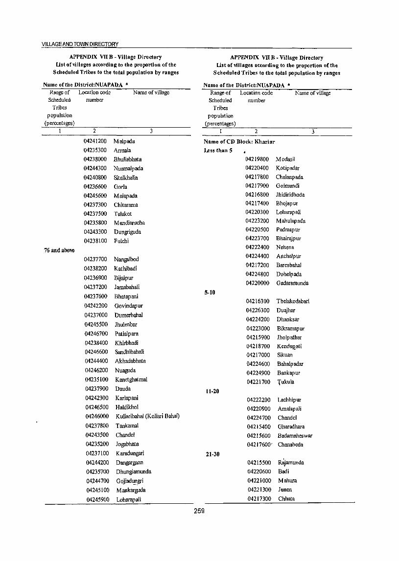
VILLAGE AND TOWN DIRECTORY
APPENDIX VII B - Village Directory APPENDIX vn B - Village Directory list of villages according to the proportion of the list of villages according to the proportion of the
Scheduled Tribes to the total population by ranges Scheduled Tribes to the total population by ranges
Name ofthe District:NUAPADA " Name of the District:NUAPADA * Range of Location code Name of village Range of Location code Name of village Scheduled number Scheduled number
Tribes Tribes population popUlation
(percentages) (p ercen t ages ) 1 2 3 1 2 3
04241200 M alp ada Name of CD Block: Khariar 04235300 Armala Less than 5
04238000 Bhuliabhata 04219800 Modasil
04244300 Nuamalpada 04220400 Kotipadar
04240800 Sitalkhalia 04217800 Chalanpada
04236600 Gorla 04217900 Goimundi
04245600 Malapada 04216800 Ihidiridhoda
04237300 Chitarama 04217400 Bhojapur
04237500 Talakot 04220300 Loharapali
04235800 Mandiarucha 04223200 Mahulapada
04243300 Dungriguda 04220500 Padmapur
04238100 Fulchi 04223700 Bhairajpur
76 and above 04222400 Nehena
04237700 Nangalbod 04224400 Anchalpur
04238200 Kathibadi 04217200 Baresbahal
04236900 Bijalpur 04224800 Dohelpada
04237200 Jamabahali 04220000 Gadaramunda
04237600 Bhatapani 5-10
04216300 Thelakodabari 04242200 Govindapur
04226300 Duajhar 04237000 Dumerbahal
04224200 Dhanksar 04245500 Jhulenbar
04223000 Bikramapur 04246700 Patialpara 04215900 Jholpathar 04238400 Khirbhadi 04218700 Kendup'ati 04246600 Sandhibahali 04217000 Silman 04244400 Akhadabhata 04224600 Bahalpadar 04246200 Nuaguda 04224900 Bankapur 04235100 Kanetghatmal 04221700 Tukula 04237900 Dauda 11-20 04242300 Karlapani 04222200 Lachhipur 04246500 Haldikhol 04220900 Amalapali 04246000 Kuliaribahal (Koliari Bahal) 04224700 Chandel 04237800 Tankamal 04215400 Gharadhara 04243500 ChandeJ 04215600 Badamaheswar 04235200 Jogabhata 04217600' Chanabeda
04237100 Karadungari 21-30 I
04244200 Dangargaon 04215500 Rajamunda
04235700 Dhungiamunda 04220600 Badi
04244700 Gojiadt!!l.gri 04221000 Mahura
04245100 Mankarguda 04221300 Junen
04245900 Loharapali 04217300 Chhata
259

DISTRICT CENSUS HAND BOOK NUAPADA
APPENDIX vn B - Village Directory APPENDIX vn B - Village Directory list of villages according to the proportion of the list of Vl II ages according to the proportion of the
Scheduled Tribes to the total population by ranges Scheduled Tribes to the total populatIon by ranges
Name of the Distrid:NUAPADA .. Name ofthe DlStrict:NUAPADA .. Range of Location code Name of vIllage Range of LocatIon code Name of vIllage Scheduled number Scheduled number
Tnbes Tnbes populatIOn populatton
(percentages) (percentages) 1 2 3 1 2 3
04220800 Badamula 04223500 M antntaral(Khurd)
04216900 Kotenmunda 04224100 Blchhanapah
04218300 Chmdaguda 04222600 Godadhapadar
04219400 LanJI 04226200 Khamatarat
04217700 Barapadar 04215700 Sunamudl
04219700 Jharasaram 04216500 Podapah(Kala)
04225800 Ranlmunda Ml\9900 B\_le-Pu!
04227100 Srkuan(Kala) 04218600 Klklnbeda
04221500 Saraglldl 04223800 Bhalundungarl
31-40 04220700 Arada
0422JI00 Kotamal 04225400 Khasbahal
04221600 Rlslgaon 04226700 Junapanl
04225200 NlJaraJPur 04225700 Sardhapur
04218500 KhudpeJa 04223900 Gudabheh
04216200 Bargaon 04226800 Klrklta
04215300 Kuhgaon 76 and above
04216400 Dumerbahal 04216100 Bendrabahal
04218400 Khmrpadar 04222800 Kudaldungarl
41-50 04219100 Bhlmapadar
04219600 Kusutnal 04221900 Badadohel
04227000 Srkuan(Khurd) 04223400~ M antrrtaral(Kala)
04224300 Godatala 04223600 Dabrr
04216000 Debahal 04216600 Podapah(Khurd)
04219500 DumerJor 04219300 Uparplta
04222700 Blrlghat 04226500 Mahulkot
51-75 04226600 Sangarp adar
04215800 Sanamaheswar 04219000 Kenduguda
04226000 PaJama 04225900 Kamp anlguma
04225100 Khalrbhadl 04222900 MahulJharan
Oit226400 Samserp adar 04223100 Karandoba
04216700 Rohenpadar
04221100 Chanatamal Note:- Villages havmg NIL Scheduled Trzbes PopulatIOn have been excluded
04223300 Belpara
260

VILLAGE AND TOWN DIBECTORY
Appendix - VIII: Number ofvlllages under each Gram Panchayat District: Nuapada ( 25 )
Name of the C.D.Block Gram Panchayat No. of Area in Sq. Number of Total Scheduled Scheduled C.D.Block Code Name Villages Km. Households Population Caste Tribe
Population Population
2 3 4 5 6 7 8 9
Nuapada 0001 Bhaleswar 9 40.29 1,163 5,328 872 2,150
Beltukuri 8 32.88 1,165 5,254 698 1,606
Bisora 7 38.88 1,239 5,396 631 2,005
Kuliabandha 7 45.72 1,349 5,645 546 2,610
Parkod 10 31.05 1,215 5,226 1,164 1,147
Budhip-alli 6 14.52 696 3,314 515 159
Biromal 7 50.73 1,261 5,785 555 3,409
Kodomeri 9 45.74 1,401 6,355 464 2,917
Amsena 5 17.84 952 4,834 742 916
Dumerpani 6 24.90 1,014 4,853 379 1,587
Rl\ipurnuapada 6 19.76 2,329 10,774 1,507 1,640
Godfulla 8 2Q.63 879 3,996 645 1,185 \
Darlimunda 3 28.42 772 3,347 395 1,945
Saipalla 3 25.19 846 4,198 410 2,272
Kotenchuan 8 38.22 1,117 5,359 383 3,044
Tanwat 8 31.42 1,584 7,195 617 2,807
Saraban~ 6 20.26 1,103 5,167 475 868
Bhera 7 27.94 1,096 4,822 819 2,384
Amanara 10 34.73 1,033 5,037 190 2,031
Kendubahara 9 40.94 805 3,381 171 2,087
M otanuap ada 10 35.73 1,130 4,931 648 2,457
Dharambandha 8 36.13 1,278 5,968 458 2,998
Bharuamunda 4 18.08 417 1,925 21 1,411
Kerrnunda 7 26.09 395 1,71J0 168 1,361
CDBlock Total 171 746.09 26,239 119,830 13,473 46,996
Komana 0002 Kurumpuri 10 31.24 1,460 6,283 596 2,363
Silbha 8 39.23 1,488 6,258 517 3,953
Lakhana 10 59.73 1,746 7,583 1,712 3,632
Tho~pali 4 20.44 803 3,346 739 2,021
Gandamer 5 17.75 733 2,989 284 1,708
Kandetara 2 9.51 608 2,387 735 932
Jat~h 5 44.95 1,498 6,395 471 2,943
Tarbod 4 35.12 1,247 5,598 841 2,057
Sialati 7· 27.88 837 3,699 500 1,867 I
Sunabeda 25 51.65 1,237 5,883 361 4,473
Darlipada 4 26.54 842 3,941 412 2,434
Jadamunda 4 29.85 1,101 4,848 536 2,031
Koresore 5 16.10 1,309 5,681 591 1,819
261

DISTRICT CENSUS HAND--BOOK : NUAPADA
Appendix - vm : Number of villages under each Gram Panchayat District: Nuapada (25)
Name of the C.D.Block Gram Panchayat No. of Area in Sq. Number of Total Scheduled Scheduled
C.D.Block Code Name Villages Km. Households Population Caste Tribe Population Population
2 3 4 5 6 7 8 9
Budhikomana 5 17.76 1,133 5,042 926 1,483
Nuagaon 4 22.08 979 3,838 845 1,516
Tikrapada 6 8.15 846 3,615 767 1,043
Komana 5 17.64 1,387 6,365 695 1,772
Bhella 5 19.59 1,064 4,750 642 1,888
Jhagrahi 5 49.00 1,509 6,340 846 2,913
Michhapali 6 23.39 736 3,130 292 2,090
Rajana 6 29.48 1,314 5,297 697 2,174
Agren 6 14.86 963 4,282 654 732
Konabira 8 20.24 1,124 4,659 768 1,176
Pendraban 13 27.49 1,186 4,873 602 2,277
CDBlock Total 162 659.67 27,150 117,082 16,029 51,297
I Boden 0003 Nagpada 6 28.28 1,100 4,451 477 3,116
Karlakote 6 35.45 1,369 5,423 643 2,749
Domjhar 6 28.29 1,228 5,738 694 1,126
Khaira 8 45.01 1,955 8,445 1,069 3,951
Boden 6 24.96 1,956 8,114 1,592 2,550
Bhainsadani 7 27.42 1,066 4,470 145 4,012
Boirgaon 9 29.41 1,317 5,312 780 3,469
Farasara 9 29.09 1,675 6,884 788 2,918
Rokal 5 17.50 1,067 4,775 679 1,37~
Litisargi 9 21.38 1,320 5,049 762 1,228
Babebir 4 17.16 1,212 5,107 719 246
Karangamal 6 12.94 977 3,948 512 1,042
Larka 8 21.39 994 4,340 569 1,494
CDBlock Total 89 338.28 17,236 72,056 9,429 29,274
Sinapali 0004 Nangalbod 17 56.74 1,730 7,502 364 5,595
Garla 8 21.48 1,226 5,145 612 2,044
Timanpur 5 23.27 1,237 5,206 459 1,531
Nilji 9 31.84 2,281 9,572 1,493 1,646
Bargaan 3 15.72 1,194 4,819 814 915
Gandabahali 4 11.92 938 4,076 401 527
Mukhapadar 8, 28.18 1,537 6,068 718 2,032
Hatibandha 6 29.70 1,822 7,566 785 1,4~3
Sinapali 5 16.39 2,246 9,399 1,032 . 1,044
Gadal 7 22.56 1,630 6,958 1,428 1,308
Karanballali 9 20.87 1,059 4,391 748 947
Kendumunda 14 42.93 1,931 8,056 1,376 2,709
262

VILLAGE AND TOWN DIRECTORY
Appendix - vm: Number of villages under each Gram Panchayat District: Nuapada (25)
Name of the C.D.Block Gram Panchayat No. of Area in Sq. Number of Total Scheduled Scheduled C.D.Block Code Name Villages Km. Households Population Caste Tribe
Population Population
2 3 4 5 6 7 8 9
Jharbandha 6 19.75 1,123 4,287 648 1,573
Singjhar 6 19.29 1,121 4,549 800 1,423
Kusumjhore 5 18.46 941 3,683 348 1,399
Bharuamunda 13 37.54 1,842 7,389 1,065 2,716
CDBlock Total 125 416.64 23,858 98,666 13,091 28,852
Khariar 0005 Sanmaheswar 8 21.66 1,120 4,690 828 1,338
Bargaon 7 18.41 1,143 4,898 (i04 1,936
Bhojapur 7 21.31 1,757 7,489 977 1,141
Bhuliasikuan 6 18.05 1,484 6,416 472 956'
Badi 8 26.12 1,733 7,704 1,750 1,827
Chindaguda 7 15.14 1,349 6,057 933 656
Khudpeja 7 13.37 1,055 4,480 588 970
Lanji 12 26.71 1,501 6,533 749 2,902
Birighat II 25.09 1,551 6,456 954 3,259
Nehena 10 17.84 1,618 6,714 1,769 1,383
Tukula 4 20.61 1,863 8,317 1,309 1,081
Sardhapur 6 15.80 933 3,938 1,002 1,045
Duajhar 4 11.55 1,331 5,446 1,161 1,560
Kirkita 4 20.73 922 3,622 213 1,932
Ranimunda 5 16.06 1,092 4,280 351 1,905
Khasbahal 10 20.50 1,394 5,978 831 1,646
CDBlock Total 116 308.95 21,846 .93,018 14,491 25,537
263

SECTION -II TOWN DIRECTORY


VilLAGE AND TOWN DIRECTORY
Section II -Town Directory
NOTE EXPLAINING THE ABBREVIATIONS USED IN THE
TOWN DIRECTORY
Statement I : Status and Growth History
Column 2 : Class, name and civic administration status of town :
Class has been introduced to facilitate analysis of town directory data at the state and all India levels. It is presented according to 2001 Census Population of the town as follows:
Population Class
100,000 and above I
50,000 - 99,999 II
20,000 - 49,999 III
10,000 - 19,999 IV
5,000 - 9,999 V
Below 5,000 VI
Town with a population of one hundred thousand (l,OO,OOO)and above is treated as a city.
The civic administration status of the towns is indicated within bracket against the name of the town. The following abbreviations are used to denote civic status of town.
(I) Municipal Corporation. M.Corp.
(II) Municipal Committee . MC -
(III) f.aunicipal Council MCI
(IV) City Municipal Council CMC
(V) Town Municipal Council TMC
(VI) Municipal Board MB
(VII) Municipality M
(VIII) Cantonment Board/Cantonment CB
(IX) Notified Area NA
(X) Notified Town NT
(XI) Notified Area Committee/
Notified Area Council NAC
(XU) Notified Town Area NTA
(XIII) Industrial Notified Area - INA
(XIV) Industrial Township ITS
(XV) Township TS
(XVI) Town Panchayat TP
(XVII) Nagar Panchayat NP
(XVIII) Town Committee!
Town Area Committee TC
(XIX) Small Town Committee ST
(XX) Estate office EO
(XXI) Gram Panchayat GP
(XXII) Census Town CT
Other columns need no explanations.
Statement II - Physical Aspects and Location of
towns, 1999 : I
Cohimn 3 to 5 : Physical Aspects
In these columns the Rainfall and Maximum &
Minimum Temperature of the town are recorded.
Column 6, 7 and 8 :
Name of the State headquarters, District
headquarters and Sub-Divisional headquarters with
distance from the referent town in kilometers, is to
be recorded respectively. If the names mentioned in
these columns are the same as the referent town
itself, the distance is recorded as (0) zero.
Column 9 & 10 :
Name of the nearest city with one lakh and more
and five lakh and more population are recorded.
267
Column 11, 12 and 13 :
If referent town enjoys the facility of railway
station, bus route fa,cility or navigable river/canal, its
name is to be mentioned. If not available, then the
name of nearest place with distance, where such
facility exists is to be mentioned. I
Statement III : Municipal Finance 1998 - 1999
Item-wise amount of receipt and expenditure in
thousand rupees, relating to municipal finance of the
town for the year 1998-99 is to be recorded.
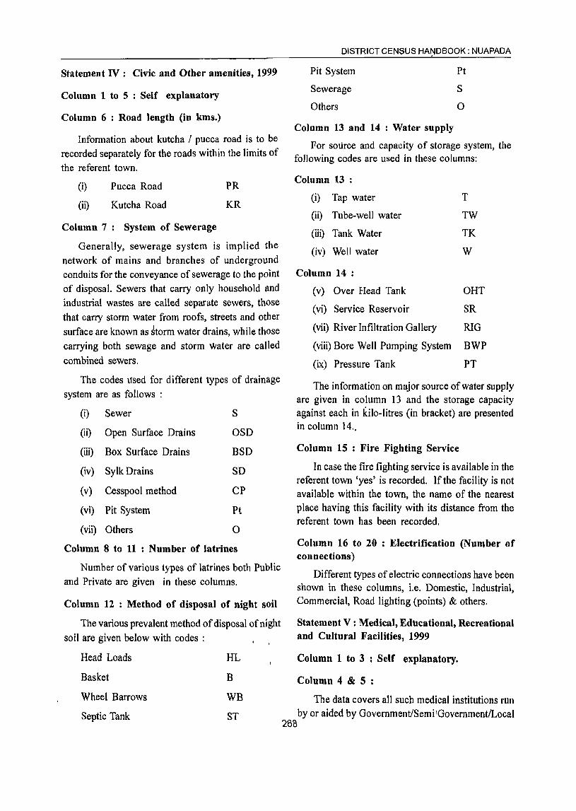
Statement IV: Civic and Other amenities, 1999
Column 1 to 5 : Self explanatory
Column 6 : Road length (in kms.)
Information about kutcha / pucca road is to be recorded separately for the roads within the limits of the referent town.
(i)
(ii)
Pucca Road
Kutcha Road
Column 7: System of Sewerage
PR
KR
Generally, sewerage system is implied the network of mains and branches of underground conduits for the conveyance of sewerage to the point of disposal. Sewers that carry only household Ilnd industrial wastes are called separate sewers, those that carry storm water from roofs, streets and other surface are known as ~torm water drains, while those carrying both sewage and storm water are called combined sewers.
The codes \Ised for different types of drainage system are as follows :
(i) Sewer S
(ii) Open Surface Drains OSD
(iii) Box Surface Drains BSD
(iv) Sylk Drains SO
(v) Cesspool method CP
(vi) Pit System Pt
(vii) Others 0
Column 8 to 11 : Number of latrines
Number of various types of latrines both Public and Private are given in these columns.
Column 12 : Method of disposal of night soil
The various prevalent method of disposal of night soil are given below with codes :
Head Loads
Basket
Wheel Barrows
Septic Tank
HL
B
WB
ST
DISTRICT CENSUS HAt)lDBOOK : NUAPADA
Pit System
Sewerage
Others
Column 13 and 14 : Water supply
Pt
S
o
For source and capacity of storage system, the following codes are used in these columns:
Column 13 :
(i) Tap water
(ii) Tube-well water
T
TW
(iii) Tank Water TK
(iv) Well water W
Column 14 :
(v) Over Head Tank OHT
(vi) Service Reservoir SR
(vii) River Infiltration Gallery RIG
(viii) Bore Well Pumping System BWP
(ix) Pressure Tank PT
The information on major source of water supply are given in column 13 and the storage capacity against each in kilo-litres (in bracket) are presented in column 14.,
Column 15 : Fire Fighting Service
In case the fire fighting service is available in the referent town 'yes' is recorded. If the facility is not available within the town, the name of the nearest place having this facility with its distance from the referent town has been recorded.
Column 16 to 20 : Electrification (Number of connections)
Different types of electric connections have been shown in these columns, i.e. Domestic, Industrial, Commercial, Road lighting (points) & others.
Statement V : Medical, Educational, Recreational and Cultural Facilities, 1999
Column 1 to 3 : Self explanatory.
Column 4 & 5 :
The data covers all such medical institutions run by or aided by Government/Semi I GovernmentlLocal
288
VILLAGE AND TOWN DIRECTORY
bodies and Charitable institutions or Social agencies like the Missionaries. Where the family planning centres are attached to hospitals or maternity and child welfare centres or. primary health centres, may be treated as independent units and counted separately using following codes:
(i) Hospital H
(ii) Dispensary D
(iii) Health Centre HC
(iv) Family Welfare Centre FWC
(v) TB. Clinic TB
(vi) Nursing Home NH
(vii) Others 0
In case of more than one institutions of any. type, it is indicated within brackets the number of such institution (s) e.g. D(3), NH(8), etc. The institutions have further been distinguished by providing additional codes within the bracket as given below :
Ayurvedic
Unani
Homoeopathic
Column 6 to 9 :
A
U
Hom
The codes used for these columns are as follows:
(i) Arts only
(ii) Science only
(iii) Commerce only
(iv) Arts & Science only
(v) Arts & Commerce only
A
S
C
AS
AC
(vi) Combined for all ASC categories-Arts, Science and Commerce
(vii) Law L
(viii) University U
(ix) Others 0
Column 10 : Recognized shorthand, typewriting and vocational training institutes
"Recognised" should mean recognised by some
statutory authority, like education department,
commerce department, labour department etc. of the
government or semi government or autonomous
bodies, public sector undertakings etc.
The following codes are used:
(i) Shorthand SH
(ii) Typewriting Type
(iii) Shorthand & Typewriting SH Type
(iv) Others a
The vocational institutions like - Applied Art! Painting college, Pharmacy college, B. Ed. College,
Teacher's Training Institute, Music / Dance School,
Nursing School etc. are covered under 'Others'.
Column 11 to 14 : Higher Secondary/ Intermediate/Senior Secondary/PUC/Junior College level, Secondary/Matriculation, Middle Schools/ Junior Secondary and Primary Schools
School up to class V are treated as Primary or
elementary schools. These include Nursery schools,
Kindergarten schools, Pre-Primary schools, Junior
Basic schools upto class V and Primary schools upto
class IV.
Schools upto VIII are considered as Middle
school or Junior Secondary.
Schools upto class X are considered as
Matriculation or Secondary schools.
Schools upto XI or XII classes are considered as
Higher Secondary / Intermediate / Pre University /
Junior College etc. This would cover 10+2 classes
whether held in schools or colleges.
If there are composite schools like middle schools
with primary classes or Secondary schools with Middle
classes, these are also included in the number of
Primary and Middle schools, respectively. For
example, if in a town, there are two Primary Schools
and one Middle school with Primary classes, the
number of Primary schools in the town is given as
three and that of Middle school as one though there
are only three educational institutions.
269
If there are more institutions of a type in the town,
the number is indicated within bracket along with the
abbreviation, e.g. P(4), M(3).

Column 15 : Adult literacy class/centres
This column has been introduced keeping in view the Minimum Needs Programme of the Planning Commission. There are number of Adult Education Centres which are included in these columns.
If an educational facility is not available in the town, the name of the nearest place and its distance in kilometres from the town where the facility is available is mentioned.
Column 16 : Working Women's hostels with 'number of seats
The number of working women's hostel if available in the referent town is mentioned with number of seats. If the facility is not available in the town the name of nearest place with distance where the facility is available is recorded.
Column 17 to 19: Recreational and Cultural Facilities
Stadium, Cinema\ AuditoriumlDramaiCommunity Hall are covered under recreational & cultural facilities. The particulars of permanent recreational facilities are considered for these columns.
Column 20 : Public Libraries, Reading Rooms
Number of public libraries and reading rooms available in tpe referent town are recorded in codes as foHows :
(i) Public Library
(ii) Reading room
PL
RR
Statement VI : Trade, Commerce, Industry and
Banking, 1999
Column 3 to 8 : Name of three most important
commodities exported and names of three most
important'commodities manufactured in the town are
recorded.
270
Column 9 : Number of Banks
Number of Banks available in the referent town
both Commercial and Co-operative banks are
recorded against this column.
Column 10 & 11 : Number of Agricultural Credit
Societies and Non Agricultural Credit Societies
The total number of Agricultural Credit Societies
and Non-Agricultural Credit Societies in the referent
town are recorded against these columns.
Statement VII : Civic and other Amenities in
Slums, 1999
This is the statement on civic and other amenities
in all slums whether notified or not and for all towns
having statutory bodies, like Municipality, Municipal
Corporation, Town area committee etc.

:VIL.LAG~AND TOWN blRECTORY
STA'fliMENT - I
81. Class, name aM Location Status and Growth lis to!)::
Name of Talukl Name of Area Number of Population and growth rate No. civic status code TahasiV Pollce C.D. Block (in sq. km.) households inel (in brackets) ofthe town at
of town number StationlIsland etc. houseless the censuses of households
(2001 Census) 1901 1911 1921 1 2 3 4 5 6 7 8 9 10 'I IV Khariar Road (NAC.) 42501000 Jonk Nuapada 11.4 3,398
2 IV Khariar (NAC.) 42502000 Khariar Khariar 23.8 2,874
STATEMENT-I
Population and growth rate (in brackets) Density Sex ratio of the town at the Censuses of (2001 19&1 1991 2001
Census)
1931 1941 1951 1961 1971 1981 1991 2001 11 12 13 14 15 16 17 18 19 20 21 22
.- 6,400 9,226 11,448 14,027 16,629 1,458.7 953 968 979.6
(+44.2) (+24.1) (+22.5) (+18.5)
7,873 7,651 9,946 11,738 13,409 562.7 991 936 957.5 (-2.8) (+30.0) (+18.0) (+14.2)
STATEMENT-n Physical Aspects and LocatioD of Towns, 1999
Serial number
2
Class, name and Physicaiaspects civic status
of town Rainfall Temperature (in centigrade) (in mm) Maximum Minimum
2 3 4 5
IV Khariar Road (N.A.C.) 1168.35 34.4 13.2
IV Khariar (N.A.C.) 1168.35 34.4 13.2 .
Name 0 and road distance in kilometer(s) from Sub-division rr uk! Neatest city with Nearest city with
Tahasill Police popUlation of one popUlation of five Railway Station
Station! lakh and more lakh and more
.C.D.Block/Island HQ
8 9 10 II
Nuapada Raipur(M.P.) Khariar Road
(II) (Ill) (0)
Kharlar Raipur(M.P.) Kantabanji
(Q) (148) (40) 271
Name of and road distance in kilometer(s) from·
State HQ. District HQ.
6 7
Bhubaneswar Nuapada
(II)
Nuapada
(70)
(535)
Bhubaneswar
(488)
Navigable riverl canal (if wihthin
Bus facilit y ten kilometers)
12 13
Yes Jonk (R)
(0) (2)
Yes
(0)

Serial . number
2
Serial
2
Serial numbers
STATEMENT - III Municipal Finance, 1998-99
Class, nllIl1e and civ ie Receipt (in Rs.'OOO) status of town Receipt Revenue derived Government Loan Advance Other Total
through from municip al grant sources receipt taxes, etc. properties and (specify)
power apart from taxation
2 3 4 5 6 7 8 9
IV Khariar Road (N.A.C.) 3,104 176 2,485 140 1,101 1,794 8,800
IV Khariar (N .A. C.)
Class, nllIl1e and civic
2
IV Khariar Road (N.A.C.)
IV Khariar (N.A.C.)
Class, nllIl1e and civic tatus of town
2
IV Khariar Road (N.A.C.)
1,186
General administration
10
486
1,001
Public safety
11
1,416
479
337 2,393 150
Expenditure (in Rs.'OOO) Plj,blic health Public Public
and works institutions conveniences
.12 13 14
0 1,687 550
751 1,380 140
STA TEMENT - IV
20
Civic and other Amenities 1999 Population Population 2001 Census Road System of
(2001 Census) Scheduled Scheduled length (in km.) sewerage Castes Tribes
3 4 6 7-
16,629 2,953 1,241 KR(l9) PR(12) OSD
Others (specify)
IS
5,130
1,072
611 4,697
Total expenditure
16
9,269
4,829
Number of latrines Total Water
borne
8 9
548 475
2 IV Khariar (N.A.C.) 13,409 2,830 1,024 KR(26) PR(69) OSD 752 752
Number of latrines Method of Water supply Fire fighting Electrification (number Vf connections) Service Others disposal of Source of System of storage service· Domestic Industrial Comm'e- Road Others
night soil supply with capacity in rcial lighting kllolitres (in (points)
brackets)
10 11 12 13 14 . 15 16 17 18 19 20 73 ST, PI T,TW SR Yes 1,264
\ 15 ,318 564 0
(409)
0 ST T,TW BWP Bhawanipatna 968 24 176 185 0 ( -) . :", (70)
272
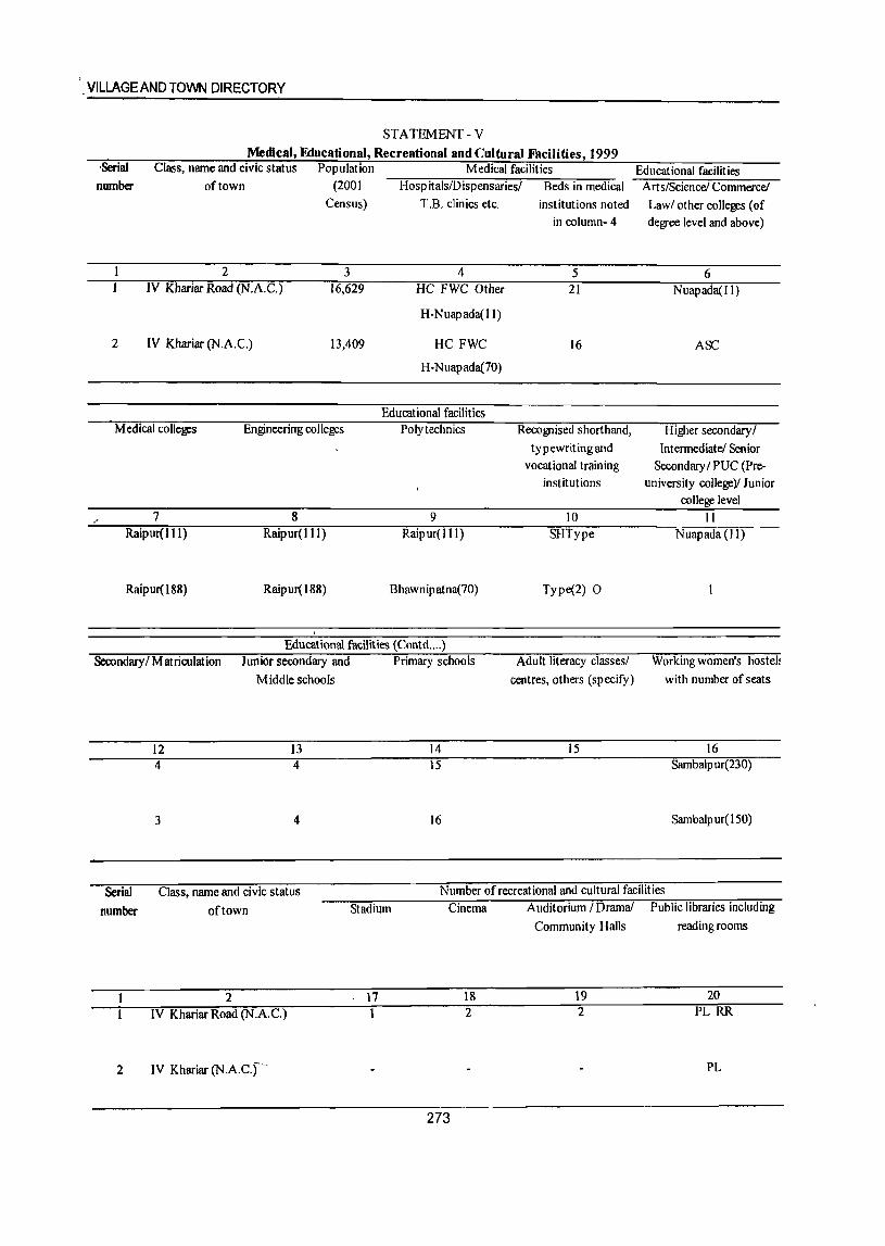
',VILLAGEANDTOWN DIRECTORY
STATEMENT - V Medical, Educational, Recreational and Cultural Facilities, 1999
-Serial number
Class, name and civic status Population Medical facilities of town (2001 I-iospitals/Dispensaries/ Beds in medical
Census)
2 3 IV Khariar Road (N.A.C.) 16,629
2 IV Khariar (N.A.q 13,409
Medical colleges Engineerirrg colleges
7 8 Raipur(J 11) Raip ur( J 11)
Raipur(J88) Raipur( 188)
T .B. clinics etc.
4 HC FWC Other
H-Nuapada(ll)
HC FWC
H-Nuapada(70)
Educational facilities Polytechnics
9 Raipur(IIJ)
Bhawnipatna(70)
Educational facilities (Contd .... )
institutions noted in column- 4
5 21
16
Recognised shorthand, typewritingand
vocational training institutions
10 SHIype
Iype(2) 0
Educational facilities Arts!Science! Commerce!
Law! other colleges (of degree level and above)
6 Nuapada(ll)
ASC
Higher secondary/ Intermediate! Senior
Secondary / PUC (Preuniversity college)! Junior
college level II
Nuapada(ll)
Secondary/Matriculation Junior secondary and Primary schools Adult literacy classes! Working women's hostel:
Middle schools centres, others (specify) with number of seats
12 13 14 15 16 4 4 15 Sambalpur(230)
3 4 16 Sarnbalpur(150)
Serial Class, name and civic status Number of recreational and cultural facilities
number of town Stadium Cinema Auditorium /Drama! Public libraries including
Community Halls reading rooms
2 17 18 19 20 IV Khariar Road (N.A.q 2 2 PL RR
2 IV Khariar (N.A.C.,- PL
273
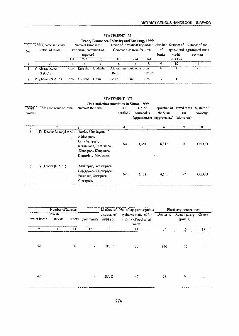
DISTRICT CENSUS HANDBOOK NUAPADA
STA TEMENT - VI Trade, Commerce, Industry and Bankmg, 1999
SI Class, name and CIVIC Name of three most Name of three most Important Number Number of Number of non-
No status of town tmportant commodItIes CommodIties manufactured of agricultural agricultural credit exported banks credIt SocIetIes
1st 2nd 3rd 1 st 2nd 3rd Societies 2 3 4 5 6 7 8 9 10 11'
IV Khanar Road Rice RIce Barn Gudakhu AlummlUm Gudakhu Iron 4 1
(N AC) UtensIl FIXture
2 IV Khanar (N A C) Rice 011 seed Gram Bread Oal RIce 3
STATEMENT-VII Civic and other amenities in Slums, 1999
Serial Class and name of town Name of the slum Is It No of Population of Paved roads System of
number notified ? households the Slum (10 sewera~
(apprmomate) (apprOlomate) kilometers)
2 3 4 5 6 7 8 IV Khartar Road (N A C ) Banka, M undagaon,
Adlbaslpara, Llmatdabnp ara,
No 1,458 6,847 8 OSD,O Kurumunda, Chalmunda, Ohoblpara, Khopetara, Dumerdlhl, M ongrap all
2 IV Kharlar (N A C ) M uktapur, Satnamtpada, Chhehapada, Ohobapada,
No 1,171 4,551 22 OSO,O Putupada, Dunapada, Ghaslpada
Number oflatrmes Method of No of tap pomts/pubhc ElectriCity connectIOns Private disposal of hydrants mstalled for Domestic Road IIghtmg Others
water borne servIce others Communtty ntght soli supply of protected (pomts) water
9 10 11 12 13 14 15 16 17
42 20 ST,Ft 30 230 115
42 8T,0 47 77 74
274

PART-B PRIMARY CENSUS ABSTRACT


Brief note on Primary Census Abstract
~e first census of the third millennium and twenty ~ first century the Census of India 2001 was the
14th continuous and uninterrupted Indian Census since 1872. Thus, 2001 Census will provide data on popUlation and its characteristics marking transition from one century and millennium to another. •
The gigantic operation of popUlation enumeration (c<?}1sidered by many to be the single largest and complex peace time administrative exercise in the wotld) was made possible due to the door to door universal canvassing of the Household Schedule by a~ut 2 million enumerators and supervisors covering 593 . districts, 5,463 sub-districts, 5,161 towns and 63~',588 Villages. The comprehensive Household ich~ule which replaced the individual slip had three ;~~"and two sides A and B. Part I contained the U)eation Particulars; Part II related to the Individual PartiCUlars and Part III' contained questions for Hoti~ehold engaged in CultivationIPlantation. The part II of the Household Schedule had 39 columns and 23
.\
qu~stions all of which were universally canvassed and no:sanipling was resorted to during enumeration.
> ,
Data Processing
1,028 million records were scanned and processed within a span of only 10 months starting October, 2002.
Task Force on Quality Assurance
After the data is processed, it is expedient on
the part of the data producing agency to satisfy itself
about its quality before putti~g the same in public
domain. This has to be done mainly through the
process of internal consistency, comparison with similar data in the past and also through validation
with like-wise data if available, from external sources.
Quite often the local knowledge and perception has
to be brought into play to understand both the existing
and the new emerging trends of population distribution
and characteristics. The other very important aspect
of the data quality is to ensure complete coverage of
all geographical areas especially for the population
enumeration phase where the data is disseminated
right up to the village level in the rural areas and the
ward level in the urban areas. Thus ensuring the
complete coverage and correct geographical linkage
of each enumeration block was one of the major
:: A quantum leap was made in the technology froot planks of the quality control, specially for small area
whii~' processing the Census 2001 data both for population statistics.
HObsClisting and Population Enumeration. The Census schedules for both tbe phases were scanned through hiW'.speed scanners in fifteen data centers across th"i~Qqntry and hand-written data from the sche,dulcs V:eitc~nverted into digitized form through Intelligent Character Reading (lCR) software for creation of ASQifJ~ords for further processing. The designing and formatting of the Household Schedule had to be dqfi~:;ery ,carefully using specialized software so as to ensure uniformity, which was an essential prerequi~ite for scanning. The selection of appropriate
state-of-art technology in data processing has made
A very comprehensive check and edit mechanism
was put in place to objectively examine the preli
minary Census 200 I Population Enumeration results
and finally clear them for use. The responsibility of
the final clearance of data was with the Task Force
on Quality Assurance (TFQA), headed by the
Registrar General and Census Commissioner, India.
The other members of the TFQA were the Heads
and senior officers of the Census Division, Data
Processing Division, Map Division, Demography
Division and Social Studies Division. The Directors
it possible to produce all the Houselisting as well as of Census Operations were co-opted as members
Population Enumeration tables on full count basis for whenever the TFQA discussed the data for their the first time in the history of Census. For Census States/Union territories. The Directors and their senior 2001, about 202 million schedules consisting of about officers were required to make detailed presentations
277

of data for their own state both in respect to the quality and the coverage and only after the full possible cleared.
There has been a major departure in Census 2001 from the past in respect of the procedure followed for finalization of the Scheduled Castes and the Scheduled Tribes population. In the earlier censuses, the total Scheduled Castes and Scheduled Tribes . populations were finalized at the time of the manual compilation of the Primary Census Abstracts (PCA) at the Regional Tabulation Offices which were specially set up for this purpose. The individual Scheduled Castes and the Scheduled Tribes population for each state was finalized much later based 011
manual coding done by the coders. In '2()()1 Census, each individual Scheduled Caste and the Scheduled Tribe have been coded directly on the computers by the Data Entry Operators through a process known as Computer Assistedl Coding (CAC) and taken up along with the processing of PCA data. The CAe process involves pulling down, from the relevant dictionary of the Scheduled Castes and the Scheduled Tribes, on the computer screen and coding from the dictionary by referring to the image of the specific individual entry in the Household Schedule appearing on the screen. The CAC of the response on Religion wherever required, was also undertak.en along with the processing of PCA. This is because the Scheduled Castes status had to be determined in relation to the
religion of the individual. Two Spe~ial Task Forces,
one on Religion and the other on Scheduled Castes/ Scheduled Tribes were constituted for scrutiny and appropriate classification of these responses.
DISTRICT CENSUS HAN9BOOK : NUAPADA
Scheduled Tribes population in 2001 Census, is thus being finalized by aggregating the population data for individual Scheduled Castes and the Scheduled Tribes at appropriate geographical levels.
The entire work relating to the data validation and scrutiny· was completed by all the StateslUnion Territories under the overall supervision and monitoring of the Census Division of the Office of the Registrar General, India with active cooperation and support of the Social Studies Division, Data Processing Division, Data Dissemination Division and
Map Division.
Primary Census Abstract
The Primary Census Abstract which is yet another important publication of 2001 Census gives basic information on Area, Tqtal Households, Total population, Scheduled Castes, Scheduled Tribes population,
. Population in the age grQUP 0-6, Literates, Main workers and Marginal workers classified by the -four broad industrial categories, namely, (i) . Cultivators, (ii)
Agricultural laborers, (iii) Household Industry Workers, and (iv) Other workers and also Non-workers. The characteristics of the Total Population includes Scheduled
Castes, Scheduled Tribes, Institutional and Houseless population and are presented by sex and rural-urban residence. This data is presented at different levels, namely, India, States/Union territories, Districts and Cities, Urban Agglomerations (Population 1,00,000 and above) in three different tables. In addition, the
Appendix of said publication provides Houseless and Institutional Households and their population by residence and sex for 2001 for India, State and Union territory. .,
The main task of the Special Task Force on Religion was to appropriately merge or group the new responses Apart from the India and StatelUnion Territory encountered and code it into the appropriate-religious volumes for Primary Census Abstract, the District community based on available literature and local Census Handbook contains District Primary Census knowledge. The Special Task Force on Scheduled Abstract, Appendix to District Primary Census Castes and Scheduled Tribes examined the different Abstract, Primary Census Ab'stract for Scheduled Scheduled Castes and Scheduled Tribes entries Castes, Primary Census Abstract for Scheduled
encoun-tered and classified these into appropriate Tribes, Village Primary Census Abstract and Urban category of the Scheduled Castes or the Scneduled Primary Census Abstract of the concerned district in
Tribes principally based on the Presidential Notifica~on the state.
and the available literature. Thus a very systematic It was for the first time at the 1'981 Census _that
and scientific mechanism was operationalised to finn the Primary Census Abstract (PCA) was brought out
up the individual religion and the individual Scheduled for the Scheduled Castes and the Scheduled Tribes Castes/Tribes returns. The Scheduled Castes and the separately on the pattern of General Primary Census
278
VILLAGE AND TOWN DIRECTORY
Abstract. This practice was continued in 1991 also. In the 1961 and 1971 Censuses, such data were made available in Table C-VIn-Social and Cultural table and to some extent in the series 'Special Tables for Scheduled Castes/Scheduled Tribes'.
The fomlat of Primary Census Abstract has been restructured slightly in the 2001 Census as compared to that of 1991 Census. The nine-fold industrial classification of main workers given in the Primary Census Abstract of 1991 Census has been discontinued and its place, four-fold industrial classification of both 'main workers' and 'marginal workers' are included. In 1981 Census only main workers were presented in to four categories. One of th~ novel features of the primary census abstract of 1991 Census was the presentation of data of the popUlation of age group 0-6 is continued in 2001 Census also. This will help the data users in better analysis and understanding of this literacy data. I
Level of presentation in District Census Handbooks:
The Primary Census Abstract data in different PC As are presen!ed at different levels.The level of presentation of Primary Census Abstracts areas under:
The PCA Data for villages was presented CD Block wise for the first time in 1991 Census. This
practice is continued in 2001 Census also. The data for each CD Block is presented both for rural and
urban areas separately. All the villages within the CD Block constitute the rural portion and the Census Towns and Outgrowths are shown under the urban portion of the CD Block. In case a CD Block is spread over two or more districts, than portion which falls within the district is presented, the data pertaining to remaining portion of the CD Block is presented in the concerned District Census Handbook. The data in the Urban Primary Census Abstract for each town as well as for town with outgrowths in the district
are presented. The data for all the wards and the outgrowths of the town(s) are also presented
separately below the concerned town(s).
The District Primary Census Abstract is presented in 59 columns. The Primary Census Abstract for Scheduled Castes and Primary Census Abstract for Scheduled Tribes are presented in 52 columns. The Village Primary Census Abstract and Urban Primary Census Abstract are presented in 58 columns.
The concepts and definitions used in the column heading are explained under the sub heading 'Census Concepts' in the Analytical Note. The term 'Total Population' includes the Scheduled Castes, the Scheduled Tribes, the Institutional and the Houseless populations. The explanatio~ regarding area figures presented at various level in the Primary Census Abstracts are as follows:
Area Figures
The area figures supplied by local revenue authorities of the district in respect oftahasils, Police Stations and by the local bodies in respect of towns are given in square kilometers. The area figures of the villages supplied by the Tahasildars in acres have been converted and shown in hectares. The area figures of the CD Block is the total of the village areas coming under each CD Block. The area figures for the district. are the same as adopted by the Surveyor General of India to maintain uniformity at the national level. The total area figures of all the tahasils/CD Blocks within the district may not tally with area figures of the district because former represents land use area only. Similarly, the total of all the villages may not tally with the entire rural of Police StationlTahasil. The difference may be due to the fact that while the area covered by hills, forests and rivers etc, have been accounted in the Tahasils and P.S. level the same may not be covered under the area of the villages. Apart from this it may also differ due to varying methods of computation adopted at different levels.
An appendix to District Primary Census Abstract has also been furnished showing urban enumeration block-wise particulars on Total Population, the Scheduled Castes Population and the Scheduled Tribes Population for each town.
279

DISTRICT PRIMARY CENSUS ABSTRACT
281

DISTRICT PRIMARY
LocatIOn Dlstnct! CD Block! TotaV Area of Number of Toldl population (mcludlng Population to the code VA! City! Town Rural! Town! households mstltullonal and houseless age-group 0-6
number Urban Ward In population) square
ktlometre Persons Males Females Persons Males Females
2 3 4 5 6 7 8 9 10 11
15 Nuapada • Total 3852.00 122,601 530,690 264,396 266,294 84,521 42,921 41,594 Rural 3816.17 116,329 500,652 249,146 251,506 80,310 40,785 39,525 Urban 35.23 6,272 30,038 15,250 14,788 4,nl 2,142 2,069
0001 Nuapada Total 26,239 119.830 59.635 60,195 19,751 10,160 9,591 Rural 26.239 119,830 59,635 60,195 19,751 10,160 9,591 Urban
0002 Komana Total 27,150 117,082 57,906 59,176 18,615 9,449 9,166 Rural 27,150 117,082 57,906 59,176 18,615 9,449 9,166 Urban
0003 Boden Total 11,236 72.056 35,888 36,168 11,691 5,899 5,792 R\lta! \7,1% 11,056 35,888 %,\68 \\,69\ 5,899 5,191 Urban
0004 SlOapaIJ Total 23,858 98,666 49,309 49,357 15,975 7,962 8,013 Rural 23,858 98,666 49,309 49,357 15,975 7,962 8,013 Urban
0005 Khanar Total 21,846 93,018 46,408 46,610 14,278 7,315 6,963 Rural 21,846 'i3,018 46,408 46,610 14,278 7,315 6,963 Urban
URBAN 42501000 Khllnar Road (NAC) Urban 1140 3,398 16,629 8,400 8.229 2,468 1,231 1,'Z37 42502000 Khanar (NAC) Urban 2383 2,874 13,409 6,850 6,559 1,743 911 832
282
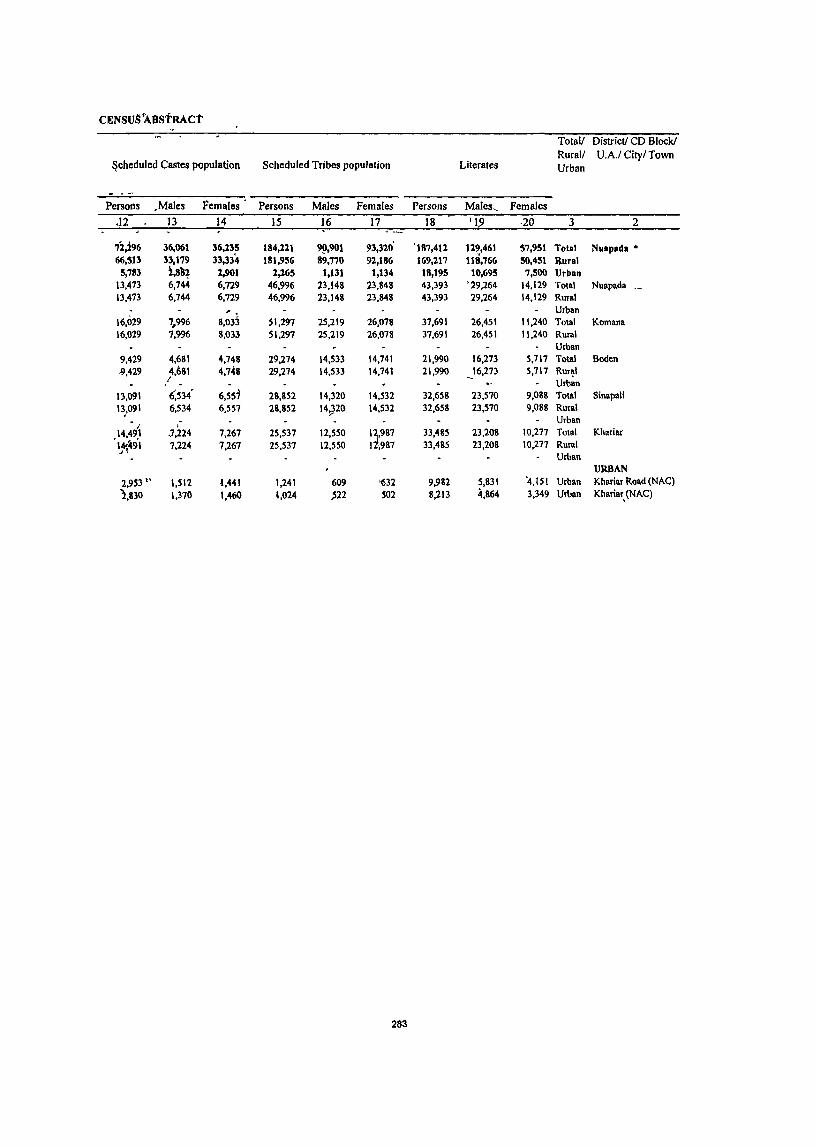
CENSUS 'ABSTRACt
Total! District! CD Block! Rural! U.A.I City! Town
~cheduled Castes population Scheduled Tribes population Literates Urban
Persons .Males Females Persons Males Females Persons Males, Females
<12 13 14 15 16 17 18 1J9 ·20 3 2
71,196 36,061 36,235 184,111 9Il,901 93,320' '187,411 12~,461 57,951 Total Nuapada • 66,513 33,179 33,334 181,956 89,770 92,186 169,117 118,766 50,451 If,ural
5,783 i,8~~ 1.901 2,165 1,131 1,134 18,195 10,695 7,500 Urban 13,473 6,744 6,729 46,996 23,148 23,848 43,393 '29,264 14,129 Total Nuapada _ 13,473 6,744 6,729 46,996 23,148 23,848 43,393 29,264 14,129 Rural
S,03j Urban
16,029 7 .. 996 51,297 25,219 26,078 37,691 26,451 11,240 Total Komana 16,029 7,996 8,033 51,297 25,219 26,078 37,691 26,451 11,240 Rural
Urban 9,429 4,681 4.748 29,274 14.533 14.741 21,990 16,273 5,717 Total Boden -9,429 4,6SI
I 4,748 29,274 14,533 14,741 21,990 _16,273 5,717 Rur~1
Urban 13,091 6.534 6,557 28,852 14,320 14,532 32,658 23,570 9,088 Total Sinapali 13:091 6,534 6,557 28,852 1920 14,532 32,658 23,570 9,088 Rural
14,~9l . Urban -1,224 7,267 25,537 12,550 1},987 33,485 23,208 10,277 Total Khariar
'1.1~~9·1 7,224 7,267 25,537 12,550 I ,987 33,485 23,208 10,277 Rural Urban
URBAN 2,953 " 1,512 t,441 1,241 609 '632 9,982 5,831 '4,151 Urban Khariar Road (NAG)
2,830 1,370 1,460 1,024 ;'22 S02 8,213 4,864 3,349 Urban KhariBr, (NAG)
283

OISTRlL'T ~>RIMAR,\ ------Location DIstnctl CD Block! Total!
code U A ! City! Town Rural! number Urban IIhterates Total workers Main workers
Persons Males Females Persons Males Females Persons Males hmal.:s
2 3 21 22 23 24 25 26 27 2& __ 32_
25 Nuapuda • Total 343,278 134,935 208,343 244,360 146,378 97,982 131,561 108.90" 22,654 Rural 331,435 130,380 201,055 234,000 138,460 95,540 123,087 101,739 21,3411 Urban 11,843 4,555 7,288 10,360 7,918 2,442 8,474 7,1611 I ,lOt.
0001 Nuapada Total 76,437 30,371 46,066 59,941 33,132 26,809 35.150 27,416 7.704 Rural 76,437 30.371 46,066 59941 33.13l 26,809 35,150 27,446 7,704 Urban
0002 Komana Total 79,391 31,455 47,936 58,072 32,571 25,501 28,193 12,722 5471 Rural 79,391 31.4S5 47.936 58072 32.571 25,501 211,193 22.722 5,'111 Urban
0003 Boden Total 50,066 19,615 30,451 33.907 20.096 13.811 Ib,067 13,803 2,204 Rural 50,066 19.615 30,451 33,907 20,096 13,811 16,067 13,8J3 2,264 Urban
0004 Smapah rntal 66,008 25,739 40.269 42.0~ 27,465 14,570 25,246 21,920 3.32b Rural 66,008 25,739 40,269 42.035 27,465 14.~70 25,246 21,910 3,326 Urban
0005 Khanar Total 59,533 23,200 36,333 40,045 25,196 14.849 18,431 15.848 2,58J RUfdl 59,533 23,200 36.,33 40,045 25,196 14,849 18.431 15,848 2,583 Utbnn
URBAN 42501000 Khanar Roael (NAC) Urban 6,647 2,569 4,078 5,994 4,488 1,50b 4,966 4212 7~4
42502000 Khanar (NAC) Urban 5,196 1.986 3,210 4.366 3,430 936 3,)0& 2,9)6 552
284
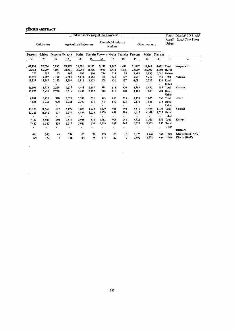
'-CENSUS ABSTRACT
... \ ~ ~
Industrial cateao!X of main workers Total/ District! CD Block! Rural/ UA/ City! Town
Cultivators Agricultural labourers Household industry
Other workers Urban workers
Persons Males Females Persons Males FemalesPersons Males Females Persons Males Females
--30 31 32 33 34 35 36 37 38 39 40 41 3 2
: 65,134 57,204 7,930 29,363 21,091 8,272 5,197 3,767 1,430 31,867 26,845 5,022 Total Nuapada • 64,564 56,687 7,877 28,901 20,795 8,106 4,953 3,548 1,405 24,669 20,709 3,960 Rural
570 517 53 462 296 166 244 219 25 7,198 6,136 1,062 Urban 18,827 15,667 3,160 9,664 6,111 3,553 568 431 137 6,091 5,237 854 Total Nuapada 18,827 15,667 3,160 9,664 6,111 3,553 568 431 137 6,091 5,237 854 Rural
Urban 16,193 13,973 2,220 6,615 4,448 2,167 918 618 300 4,467 3,683 784 Total Komana 16,193 13,973 2,220 6,615 4,448 2,167 918 618 300 4,467 3,683 784 Rural
Urban 9,891 8,921 970 3,023 2,397 631 975 650 325 2,173 1,835 338 Total Boden 9,891 8,921 970 3,028 2,397 631 975 650 325 2,173 1,835 338 Rural
Urban 12,223 11,546 677 6,077 4,854 1,223 1,329 931 398 5,617 4,589 1,028 Total Sinapali 12,223 11,546 677 6,077 4,854 1,223 1,329 931 398 5,617 4,589 1,028 Rural
Urban 7,430 6,580 850 3,517 2,985 532 1,163 9,18 245 6,321 5,365 956 Total Khariar
7,430 6,580 850 3,517 2,985 532 1,163 918 245 6,321 5,365 956 Rural Urban
URBAN
441 395 46 274 182 92 125 107 18 4,126 3,528 598 Urban Khariar Road (NAC)
129 122 7 188 114 74 119 112 7 3,072 2,608 464 Urban Khariar (NAC)
285
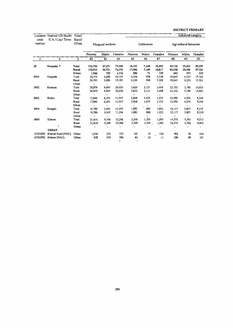
DISTRICT PRIMARY
LocatIOn Dlstnct/ CD Block! Total/ Industnal categ0!1 code U A / Clty/ Town Rural/
number Urban Marginal workers Cultivators Agnculturallabourers
Persons Males Females Persons Males Females Persons Males Females
2 3 42 43 44 45 46 47 48 49 50
25 Nuapada • Total 112,799 37,471 75,328 18,192 7,240 10,952 83,722 25,463 58,259 Rural 110,913 36,721 74,192 17,986 7,169 10,817 83,030 25,306 57,724 Urban 1,886 750 1,136 206 71 135 692 157 535
0001 Nuapada Total 24,791 5,686 19,105 4,326 998 3,328 19,645 4,323 15,122 Rural 24,791 5,686 19,105 4,326 998 3,328 19,645 4,323 15,321 Urban
0002 Komana Total 29,879 9,849 20,030 5,629 2,131 3,498 23,103 7,180 15,923 Rural 29,879 9,849 20,030 5,629 2,131 3,498 23,103 7,180 15,923 Urban
0003 Boden Total 17,840 6,293 11,547 2,848 1,475 1,373 13,590 4,234 9,356 Rural 17,840 6,293 11,547 2,848 1,475 1,373 13,590 4,234 9,356 Urbsn
0004 Smapah Total 16,789 5,545 11,244 1,883 860 1,023 12,117 3,807 8,310 Rural 16,789 5,545 11,244 1,883 860 1,023 12,117 3,807 8,310 Urban
0005 Khansr Total 21,614 9,348 12,266 3,300 1,705 1,595 14,575 5,762 8,8\3 Rural 21,614 9,348 12,266 3,300 1,705 1,595 14,575 5,762 8,813 Urban
URBAN 42501000 Khanar Road (NAC) Urban 1,028 276 752 143 19 124 492 58 434 42502000 Kbanar (NAC) Urban 858 474 384 63 52 II 200 99 101
286
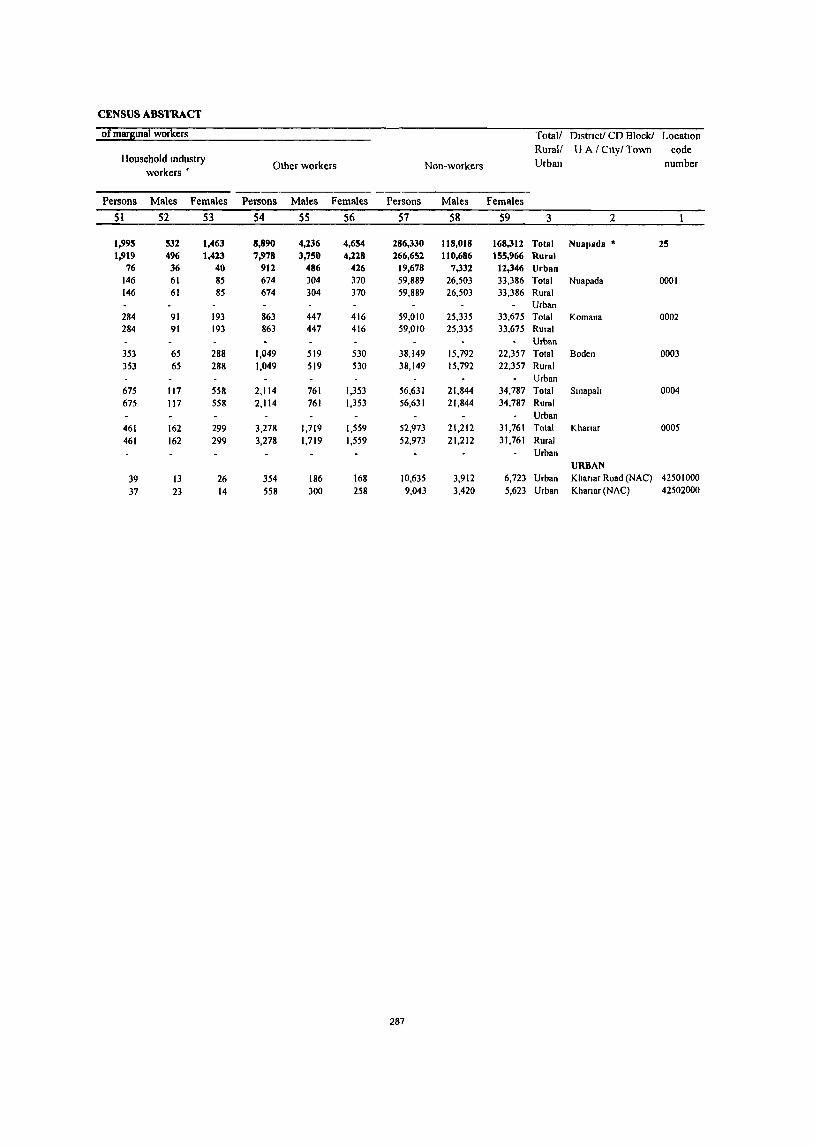
CENSUS ABSTRACT
of marsmal workers Total/ DIstrIct! CD Block! LocatIOn Rural/ U A / Cltyl Town code
IIousehold mdustry Other workers Non-workers Urban number
workers'
Persons Males Females Persons Males Females Persons Males Females
51 52 53 54 55 56 57 58 59 3 2
1,995 532 1,463 8,890 4,236 4,654 286,330 118,018 168,312 Total Nuapada • 25 1,919 496 1,423 7,978 3,750 4,228 266,652 110,686 155,966 Rural
76 36 40 912 486 426 19,678 7,332 12,346 Urban 146 61 85 674 304 370 59,889 26,503 33,386 Total Nuapada 0001 146 61 85 674 304 370 59,889 26,503 33,386 Rural
Urban 284 91 193 863 447 416 59,010 25,335 33,675 Total Komana 0002 284 91 193 863 447 416 59,010 25,335 33,675 Rural
Urban 353 65 288 1,049 519 530 38,149 15,792 22,357 Total Boden 0003
353 65 288 1,049 519 530 38,149 15,792 22,357 Rural Urban
675 117 558 2,114 761 1,353 56,631 21,844 34,787 Total Smapah 0004
675 117 558 2,114 761 1,353 56,631 21,844 34,787 Rural Urban
461 162 299 3,278 1,719 1,559 52,973 21,212 31,761 Total Khanar 0005
461 162 299 3,278 1,719 1,559 52,973 21,212 31,761 Rural Urban
URBAN 39 13 26 354 186 168 10,635 3,912 6,723 Urban Khanar Road (NAC) 42501000
37 23 14 558 300 258 9,043 3,420 5,623 Urban Khanar (NAC) 42502000
287


· APPENDIXTO DISTRICT PRIMARY CENSUS ABSTRACT

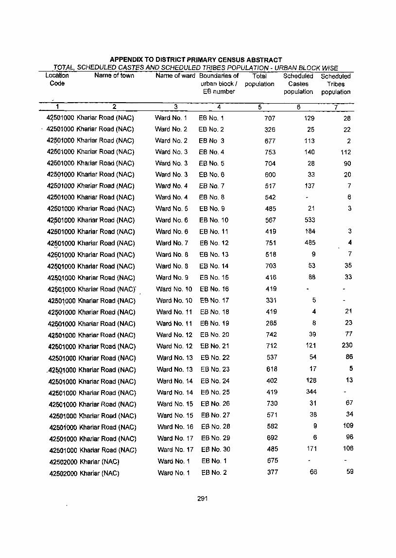
APPENDIX TO DISTRICT PRIMARY CENSUS ABSTRACT TOTAL, SCHEDULED CASTES AND SCHEDULED TRIBES POPULATION - URBAN BLOCK WISE
Location Name of town Name of ward Boundaries of Total Scheduled Scheduled Code urban block I population Castes Tribes
EB number population population
1 2 3 4 5 6 7
4~501000 Khariar Road (NAC) Ward No.1 EB No.1 707 129 28
. 42501000 Khariar Road (NAC) Ward No.2 EB No.2 326 25 22
42~01000 Khariar Road (NAC) Ward No.2 EB No 3 677 113 2
42501000 Khariar Road (NAC) Ward NO.3 EB NO.4 753 140 112
42601000 Khariar Road (NAC) Ward NO.3 EB NO.5 704 28 90
425Q1000 Khariar Road (NAC) Ward NO.3 EB NO.6 600 33 20
42501000 Khariar Road (NAC) Ward NO.4 EB NO.7 517 137 7
42501000 Khariar Road (NAC) Ward No.4 EB NO.8 542 6
42501000 Khariar Road (NAC) Ward No.5 EB No.9 485 21 3
42.601000 Khariar Road (NAC) Ward No.6 EB No. 10 567 533
42601000 Khariar Road (NAC) Ward NO.6 EB No. 11 419 184 3
42~_01000 Khariar Road (NAC) Ward NO.7 EB No. 12 751 485 4
42~01 000 Khariar Road (NAC) Ward NO.8 EB No. 13 518 9 7
42~Q1000 Khariar Road (NAC) Ward NO.8 EB No. 14 703 53 35
42~Q1000 Khariar Road (NAC) Ward NO.9 EB No. 15 416 88 33
4250,1000 Khariar Road (NAC)' Ward No. 10 EB No. 16 419 .. 42501000 Khariar Road (NAC) Ward No. 10 EB No. 17 331 5
42ey01000 Khariar Road (NAC) Ward No. 11 EB No. 18 419 4 21
42~91000 Khariar Road (NAG) Ward No. 11 EB No. 19 285 8 23
42501000 Khariar Road (NAC) Ward No. 12 EB No. 20 742 39 77
42Sb1000 Khariar Road (NAC) Ward No. 12 EB No. 21 712 121 230
42501000 Khariar Road (NAC) Ward No. 13 EB No. 22 537 54 86
.42~Q1000 Khariar Road (NAG) Ward No. 13 EB No. 23 618 17 5
42501000 Khariar Road (NAG) Ward No. 14 EB No. 24 402 128 13
42501000 Khariar Road (NAG) Ward No. 14 EB No, 25 419 344
42501000 Khariar Road (NAG) Ward No. 15 EB No. 26 730 31 67
42501000 Khariar Road (NAG) Ward No. 15 EB No. 27 571 38 34
42501000 Khariar Road (NAC) Ward No, 16 EB No. 28 582 9 109
42501000 Khariar Road (NAG) Ward No. 17 EB No. 29 692 6 96
42501000 Khariar Road (NAC) Ward No, 17 EB No, 30 485 171 108
42502000 Khariar (NAG) Ward No, 1 EB No.1 675
42502000 KhaTiar (NAG) Ward No.1 EB No.2 377 66 59
291
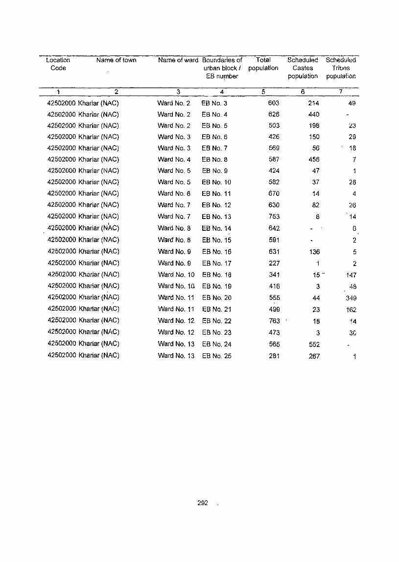
Location Name of town Name of ward Boundaries of Total Scheduled Scheduled Gode urban block I population Castes Tribes
EB nU!l1ber population popUlat:on
1 2 3 4 5 6 "] -----
42502000 Khariar (NAG) Ward No.2 EB NO.3 603 214 49
42502000 Khariar (NAG) Ward No.2 EB No.4 626 440
42502000 Khariar (NAG) Ward No.2 EB NO.5 503 '198 ~3
42502000 Khariar (NAG) Ward No.3 EB NO.6 426 150 29
42502000 Khariar (NAC) Ward No.3 EB NO.7 569 56 18
42502000 Khariar (NAG) Ward NO.4 EB NO.8 587 456 7
42502000 Khariar (NAG) Ward NO.5 EB NO.9 424 47 1
42502000 Khariar (NAG) Ward No.5 EB No. 10 582 37 28
42502000 Khariar (NAG) Ward NO.6 EB No. 11 670 14 4
42502000 Khariar (NAG) Ward NO.7 EB No. 12 630 82 26
42502000 Khariar (NAG) Ward NO.7 EB No. 13 753 8 14 • I
42502000 Khanar (NAC) Ward NO.8 EB No. 14 642 6
42502000 Khariar (NAG) Ward NO.8 EB No. 15 591 2
42502000 Khariar (NAG) Ward No.9 EB No. 16 631 136 5
42502000 Khariar (NAG) Ward No.9 EB No. 17 227 1 2
42502000 Khariar (NAG) Ward No. 10 EB No. 18 341 15 o. 147
42502000 Khariar (NAG) Ward No. 10 EB No. 19 416 3 48
42502000 Khariar (NAG) Ward No. 11 EB No. 20 555 44 3'19
42502000 Khariar (NAG) Ward No. 11 EB No. 21 499 23 162
42502000 Khariar (NAG) Ward No. 12 EB No. 22 763 18 '~4
42502000 Khariar (NAG) Ward No. 12 EB No. 23 473 3 30
42502000 Khariar (NAC) Ward No. 13 EB No. 24 565 552
42502000 Khariar (NAC) Ward No. 13 EB No. 25 281 267 1
292
PRIMARY CENSUS ABSTRACT FOR SCHEDULED CASTES
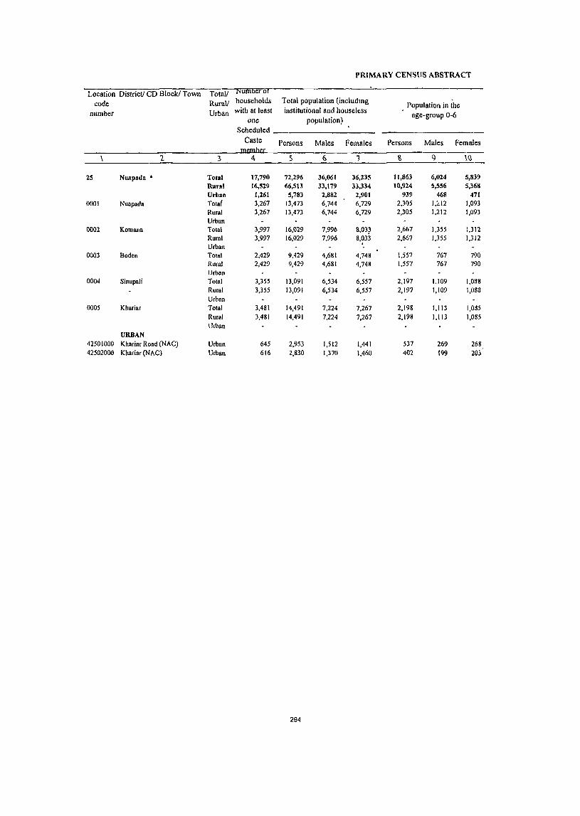
PRIMARY CENSUS ABSTRACT
Location District! CD Block! Town Total/ Number or
code Rural/ households Total population (includtng Population in the
number Urban with at least institutional and houseless age-group 0-6
one population) Scheduled
Caste Persons Maies Females Persons Males Females
1 3 S 6 1 R <} \(}
25 Nuapada • Total 17,790 72,296 36,061 36,235 11,863 6,024 5,839
Rural 16,529 66,5U 33,179 33,334 10,924 5,556 5,368
Urban 1,261 5,783 2,882 2,901 939 468 471 0001 Nuapada Total 3,267 13,473 6,744 6,729 2,305 1,:<12 1,093
Rural 3,267 13,473 6,744 6,729 2,305 1,212 1,093
Urban 0002 Komana Total 3,997 16,029 7,996 S,03? 2,667 1,355 1,312
Rural 3,997 16,029 7,996 8,033 2,667 1,355 1,3J2
Urban , -
0003 Boden Total 2,429 9,429 4,681 4,748 1,557 767 790 Rural 2,429 9,429 4,681 4,748 1,557 767 790
Urban 0004 Sinapali Total 3,355 13,091 6.534 6,557 2,197 1.109 1,038
Rural 3,355 13,091 6,534 6,557 2,197 1,109 1,083
Urban 0005 Khariar Total 3,481 14,491 7,224 7,267 2,198 1.113 I,OH5
Rural 3,481 14,491 7,224 7,267 2,198 1,113 1,085
Urban URBAN
42501000 Khariar Road (NAC) Urban 645 2,953 1,512 1,441 537 269 268 42502000 Khariar (NAC) Urban 616 2,830 1,370 1,460 402 199 20l
294
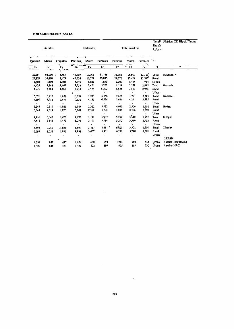
FOR SCHEDULED CASTES
Totall District! CD Block! Town Rurall
Literates Illiterates Total workers Urban
~ons Males _ Velpales Persons, Males Females Persons Males FemMes " ", I •
11· 12 13 •• 14 15 16 17 - 18 19 3 2
'" 16,587 t8,100 ~ 8,487 45,709 17,961 17,748 31,980 18,869 13.11 ( Total Nuapada • 13,879 16,400 7,4'29 41,634 16,779 25,855 29,771 17,424 12,347 Rural
2.708 1,700 1,008 3,075 1,182 1,893 2,209 1,445 764 Urban 4,735 3,261t ),467 8,738 3,476 5,262 6,524 3,579 2,945' Total Nuapada 4.735 3.268 1.467 8,738 3,476 5,262 6.524 3,579 2.945 Rural
1 Urban 5.390 3.71l 1.677 10.639 4,283 6,356 7.656 4,271 3,385 Total Komana 5,390 3,7J.l 1,6n 1O,63~ 4.283 6,356 7,656 4,271 3,385 Rural
Urban 3,~45 2,319 '1,026 6,084" 2,362 3,722 4,070 2,506 1,564 Total Boden 3,345 2,319 !,026 6,084 2,362 3,722 4,070 2,506 I,~ Rural
Urban 4,1116 \34j 1,47J< 8,275 3,191 5,Q84- 5,292 3:340 1,952 Total Smapah 4,816 H43 1,473 8,275 3,191 5,084 5,292 3,340 1,952 Rural
6~29 " Urban
5,593 '3,757 ,1,836 8,898 3,467 5,431 3,728 2,501 Total Khariar 5,593 3,757 1,836 8,898 3,467 5,431 6,229 3,728 2,501 Rural
Urban . URBAN
1,299 8~2 447 1~654 660 994 1,214 780 434 yrban Khariar Road (NAC) 1,409 848 561 1,421 522 899 995 665 330 Urban Khariar (NAC)
295
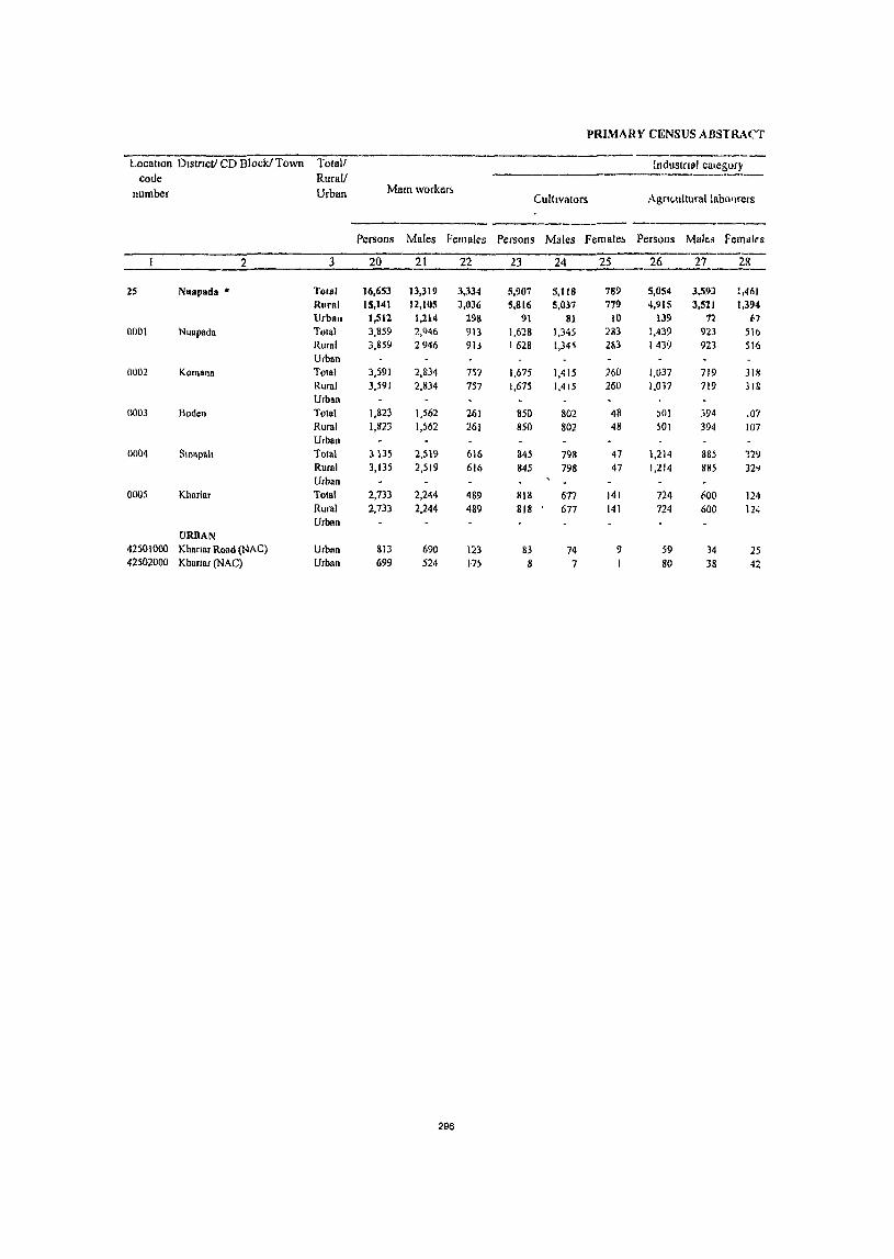
PRIMARY CENSUS A BSTRAt"'T
-----_ .. ----Location District! CD Block! Town Totall !ndustfl81 category
code Rurall number Urban Mam worker~
Culttvators Agrtwltural laho'Jrers
Persons Males Fernaks Persons Males Female~ Persons Malts Fernlilrs
----2 3 20 21 22 23 24 25 _2L_...1L_-2L.
25 NU81lada * Total 16,653 13,319 3,334 5,907 5,118 789 5,054 3.59J 1,461
Rural 15,141 12,105 3,036 5,816 5,037 779 4,915 3,521 1,394 UrbAn 1,512 1,214 298 91 81 10 131} 7~ (,7
0001 Nuapada Total 3,859 2,()46 913 1,628 1,345 283 1,439 923 SIb Rural 3,859 2946 913 1628 l,34~ 2&3 1439 923 516 Urban
0002 Komann TOlal 3,591 2,834 757 1,675 1,415 260 1,037 719 318 Rural 3,591 2,834 757 1,675 1,415 260 1,017 719 lI8 Urban
0003 Boden Total 1,823 1,562 261 850 802 48 )01 394 .07 Rural 1,823 1,)62 261 850 802 48 501 31)4 107 Urban
0004 Slnapah Total 3135 2,519 616 845 798 47 1,214 885 129 Rural 3,135 2,519 616 845 798 47 1,214 885 J2o.) Urban
0005 Kharlnr Tolal 2,733 2,244 489 818 677 141 724 1\00 124 Rural 2,733 2,244 489 818 677 141 724 600 124 Urban
URBAN 42501000 Khanar Road (NAC) Urban 813 690 123 83 74 9 S9 34 25 42502000 Khanar (NAC) Urban 699 524 n) 8 7 80 38 42
296

FOR SCHEDULED CASTES
oflllain workers Total! District! CD Block! Town Rural!
Household industry workers Other workers Marginal workers Urban
.Persons Males Females Persons Males' F~males Persons Males Femaiys
29 30 31 32 33 34 35 36 37 3 2
.. 21 296 125 5,271 4,312 959 15;:m 5,550 9,777 Total Nuapada " 399 179 120 toft 3,268 743 14,630 5,319 9,311 Rural 11 17 5 1,160 1,044 216 697 131 466 Urban 51 42 9 741 6~6 105 2,665 633 2,032 Total Nuapada 51 42 9 741 636 105 2,665 633 2,032 Rural
Urban 63 41 22 816 659 157 4,065 1,437 2,628 Total Komana 63 41 22 816, 659 157 4;065 1,437 2,628 Rural
Urban 78 4( 32 39"- 320 74 2,247 944 1,303 Total Boden 78 4( 32 394 320 74 2,247 944 1,303 'Rural
Urban 76 5! 17 1,000 777 223~ 2,157 821 1,336 Total Smapah 76 5! 17 1,000 777 22~ 2,157 821 1,336 Rural
Urban 131 91 40 1,Q60 876 184 3,496 1,484 2,012 Total Khariar 131 9 40 1,060 876 . 184 3,496 1,484 2,012 Rural
Urban URBAN
12' 12 659 570 89 401 90 311 Urban Khanar Road (NAC) 10 5 5 601 474 127 296 141 155 Urban Khansr (NAC)
297
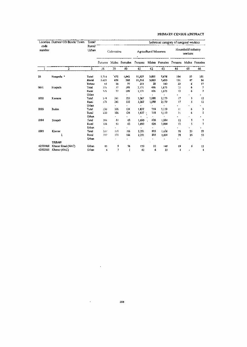
PR[MARY CENSUS ABSTRACT
Location DlstTlCt/ CD Block! Town Total! Industrtal category ofmargmal workers code Rural!
number Urban Cultivators Agnculturallabourers Household Industry
workers
Pat-oils Mdles Females Persons Males Females Persons Males Females
2 3 38 39 40 41 42 43 44 45 46
15 Nuapada - Total 1,714 '672 1,042 11,527 3,851 7,676 154 S3 10l Rural 1,621 656 965 1I,316 3,823 7,493 131 47 84 Urban 93 16 77 211 28 Ill) 23 6 17
0001 Nuapada Total 37b 77 299 2,171 496 1,675 13 6 7 Rural 3/6 77 299 2,171 496 1,675 iJ 6 7 Urban
0002 Komana Total ;/4 241 333 3,267 1,088 2,179 17 12 Rural 574 241 333 3,267 1,088 2,179 17 12 Urban
0003 Boden Total 230 106 124 1,837 718 1,119 II 6 Rural 230 106 124 1,837 718 1,119 II 6 Urban
0004 Smapah Total 104 61 43 1,690 626 1,064 12 7 Ruml 104 61 43 1,690 626 1,064 12 7 Urban
0005 Khanar Total 33/ 17l 166 2,351 895 1,456 78 25 53 Rural 337 171 166 2,351 895 1,456 18 2S 53 Urban
URDItN 42501000 Knanar Road (NAC) Urban 85 9 76 170 22 148 19 6 13 42502000 Kllanar(NAC) Urban 8 7 1 41 6 35 4 4
298
, FOR SCHEDULED CASTES
Total/ Dlstnct/ CD Block! Town LocatIon Rural! code
Non-workers Urban number Other workers
Persons Males Females Persons Males Females
47 48 49 50 51 52 3 2
1,932 974 958 40,316 17,192 23,124 Total Nuapads • 25 1,562 793 769 36,742 15,755 20,987 Rural
370 18t 189 3,574 1,437 2,137 Urban 105 54 51 6,949 3,165 3,784 Total Nuapada 0001 105 54 51 6,949 3,165 3,784 Rural
Urban 207 103 104 8,373 3,725 4,648 Total Komana 0002
207 103 104 8,373 -3,725 4,648 Rural Urban
169 114 55 5,359 2,175 3,184 Tolal Boden 0003
169 114 55 5,359 2,175 3,184 Rural Urban
351 129 222 7,799 3,194 4,605 Total Smapah 0004
351 129 222 7,799 3,194 4,605 Rural Urban
730 393 337 8,262 3,496 4,766 Total Khanar 0005
730 393 337 8,262 3,496 4,766 Rural Urban
URBAN 127 53 74 1,739 732 1,007 Urban Khanar Road (NAC) 42501000
243 128 115 1,835 .705 1,130 Urban Khanar (NAC) 42502000
299

PRIMARY CENSUS ABSTRACT FOR SCHEDULED TRIBES
PRIMARY CENSUS ABSTRACT
Locanon District! CD Block! Town rotall Numbt:rOI
code Rurdll household~ Totdl population (mcludmg POpUldtlOn III the
number Urban with at lea~t 1115I1tu11onal and housele~s age-group 0-6
one population) Scheduled ------------ -
Tnbe Persons Males Females Persons Males Females
2 3 5 6 7 8 9 10 ----25 Nuapada • Total 42,741 184,221 90,901 93,320 30,135 15,248 14,887
Rural 42,183 181,956 89,770 92,186 29,755 15,059 14,696 Urban 558 2,265 1,131 1,134 380 189 191
0001 Nuapada Total 10,377 46,996 23,148 23,848 8,lI51 4,Og~ 3,966 Rural 10,377 46,996 23,148 23,848 8,051 4,085 3,966 Urban
0002 Komana TOldl 11,667 51,297 25,219 26,078 8,218 4,165 4,053 Rural 11,667 51,297 25,219 26,tl78 8,218 4,165 4,05J Urban
0003 Boden Tolal 7,006 29,274 14,533 14,741 4,1"6 2,431 2,345 Rural 7,006 29,274 14,533 14,741 4,776 2,431 2,34S Urban
0004 Slllapah Total 6,971 28,852 14,320 14,532 4,795 2,404 1,391 Rural 6,971 28,852 14,320'" 14,532 4,795 2,404 2,391 Urban
0005 Khanar Total 6,162 75,537 11,550 12,987 3,915 1,974 1,941 Rural 6,162 25,537 12,550 12,987 3,915 1,974 1,941 Urban
URBAN 42501000 Khanar Road (NAC) Urban 291 1,241 609 632 207 100 107 42502000 Khanar (NAC) Urban 267 1,024 522 502 173 89 &4
302

FOR SCHEDULED TRIBES
Total! District! CD Block! Town Rural!
Literates I1hterates Total workers Urban
Persons Males Females Persons Males Females Persons Males Females
11 12 13 14 15 16 17 18 19 3 2
51,035 38,345 12,690 133,186 52,556 80,630 92,366 51,685 40,681 Total Nuapada • 50,122 37,759 12,363 131,834 52,011 79,823 91,496 51,074 40,422 Rural
913 586 327 1,352 545 807 870 611 259 Urban 13,741 9,944 3,797 33,255 13,204 20,051 24,639 13,121 11,518 Total Nuapada 13,741 9,944 3,797 33,255 13,204 20,051 24,639 13,121 11,518 Rural
Urban 13,770 10,384 3,386 37,527 14,835 22,692 26,741 14,380 12,361 Total Komana 13,770 10,384 3,386 37,527 14,835 22,692 26,741 14,380 12,361 Rural
Urban 7,904 6,158 1,746 21,370 8,375 12,995 14,501 8,309 6,192 Tolal Boden 7,904 6,158 1,746 21,370 8,375 12,995 14,501 8,309 6,192 Rural
Urban 7,335 5,727 1,608 21,517 8,593 12,924 13,719 8,190 5,529 Total SmapalJ 7,335 5,727 1,608 21,517 8,593 12,924 13,719 8,190 5,529 Rural
Urban 7,372 5,546 1,826 18,165 7,004 11,161 11,896 7,074 4,822 Total Khanar 7,372 5,546 1,826 18,165 7,004 11,161 11,896 7,074 4,822 Rural
Urban URBAN
523 319 204 718 290 428 507 334 173 Urban Khanar Road (NAC) 390 267 123 634 255 379 363 277 86 Urban Khanar (NAC)
303
PRIMARY CENSUS ABSTRACT
LocatIOn DistriCt! CD BlockJ Town Total! Industnal category code Rural!
number Urban Main workers Cultivators Agncultural labourers
Persons Males Females Persons Males Females Persons Males Femnles
2 3 20 21 22 23 24 25 26 27 28
25 Nuapada • 1'otal 45,080 36,535 8,545 27,483 23,817 3,666 11,117 7,607 3,510 Hura( 44,358 35,967 8,391 21,421 23,767 3,654 11,050 7,572 3,478 Urban 722 568 154 62 50 12 67 35 32
0001 Nuapada Total 13,936 10,679 3,257 8,460 7,014 1,446 4,148 2,557 1,591 Rural 13,936 10,679 3,257 8,460 7,014 1,446 4,148 2,557 1,59! Urban
0002 Komana Total 12,112 9,605 2,507 8,055 6,870 1,185 2,926 1,865 1,061 Rural 12,112 9,605 2,507 8,055 6,870 1,1&5 2,926 1,865 1,061 Urban
0003 Boden Total 6,970 5,923 1,047 5,090 4,485 605 1,016 762 254 Rural 6,970 5,923 1,047 5,090 4,485 605 1,016 762 254 Urban
0004 Smapah Total 7,174 6,102 1,072 3,902 3,627 275 1,933 1,489 444 Rural 7,174 6, 107 1,072 3,!1ll2 3,627 275 1,933 1,489 444 Urban
0005 Khanar Total 4,166 3,658 508 1,914 1,771 143 1,027 899 128 Rural 4,166 3,658 508 1,914 1,771 143 1,027 899 128 Urban
URBAN 42501000 Khanar Road (NAC) Urban 414 311 103 56 45 II 60 31 29 42502000 Khanar (NAC) Urban 308 257 51 6 5 7 4 3
304
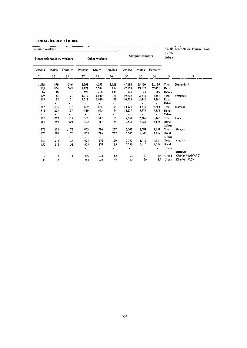
FOR SCHEDULED TRIBES
of main workers Totalf Distnctl CD Block! Town Rural!
Household industry workers Other workers Marginal workers Urban
Persons Males Females Persons Males Females Persons Males Females
29 30 31 32 33 34 3S 36 37 3 2
1,225 879 346 5,255 4,232 1,023 47,286 15,150 32,136 Total Nuapada * 1,209 864 345 4,678 3,764 914 47,138 15,107 32,031 Rural
16 IS I 577 468 109 148 43 105 Urban 109 88 21 1,219 1,020 199 10,703 2,442 8,261 Total Nuapada 109 88 21 1,219 1,020 199 10,703 2,442 8,261 Rural
Urban 312 205 107 819 665 154 14,629 4,775 9,854 Total Komana 312 205 107 819 665 154 14,629 4,775 9,854 Rural
Urban 362 259 103 502 417 85 7,531 2,386 5,145 Total Boden 362 259 103 502 417 85 7,531 2,386 5,145 Rural
Urban 276 200 ~ 76 1,063 786 277 6,545 2,088 4,457 Total Sinapali 276 200 76 1,063 786 277 6,545 2,088 4,457· Rural
Urban 150 112 38 1,075 876 199 7,730 3,416 4,314 Total Khariar 150 112 38 1,075 876 199 7,730 3,416 4,314 Rural
Urban URBAN
2 296 234 62 93 23 70 Urban Khariar Road (NAC)
14 14 281 234 47 55 20 35 Urban Khariar (NAC)
305
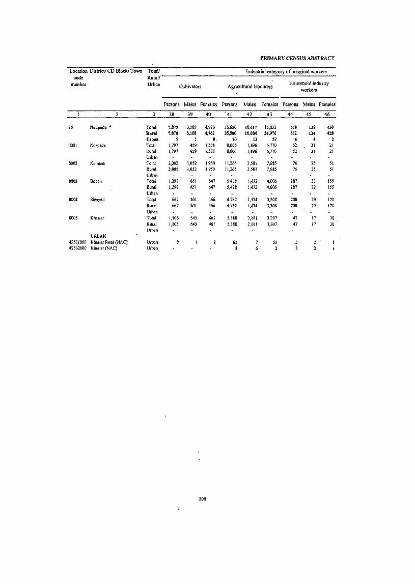
PRIMARY CENSUS ABSTRACT
Location District! CD Block! Town Tolall Industrial category of marginal workers code Rural!
number Urban Cultivators Agnculturallabourers Household industry
workers
Persons Males Females Persons Males Females Persons Males Females
2 3 38 39 40 . 41 42 43 44 45 46
2S Nuapado - Total 7,879 3,109 4,770 35,650 10,617 25,033 568 138 430 RurAl 7,870 3,108 4,762 35,580 10,604 24,976 562 134 428 Urbim 9 1 8. 70 13 57 6 4 1
0001 Nuapada Total 1,191 459 1,338 8,666 1,896 6,710 52 31 21 Rural 1,197 459 1,338 . 8,666 1,896 6,770 52 31 21 Urban
0002 Komana Tolal 3,002 1,052 1,950 11,266 3,581 7,685 76 25 51 Rural 3,002 1,052 1,950 11,266 3,581 7,685 76 25 51 Urban
0003 Boden Total 1,298 651 641 5,478 1,472 4,006 187 32 ISS Rural 1,298 651 647 5,47& 1,472 4,006 187 32 ISS Urban
0004 Sil1apali Total 667 301 366 4,182 1,474 3,308 200 29 171 Rural 667 301 366 4,782 1,474 3,308 200 29 171 Urban
0005 Kharinr Total 1,106 645 461 5,388 2,181 3,207 47 17 30 Rural 1,106 645 461 5,388 2,1&1 3,207 47 17 30 Urban
URBAN 42501000 K!uuiaf Road (NAC) Urban 9 62 7 55 3 2 42502000 Khari.r (NAC) Urban 6 2
308
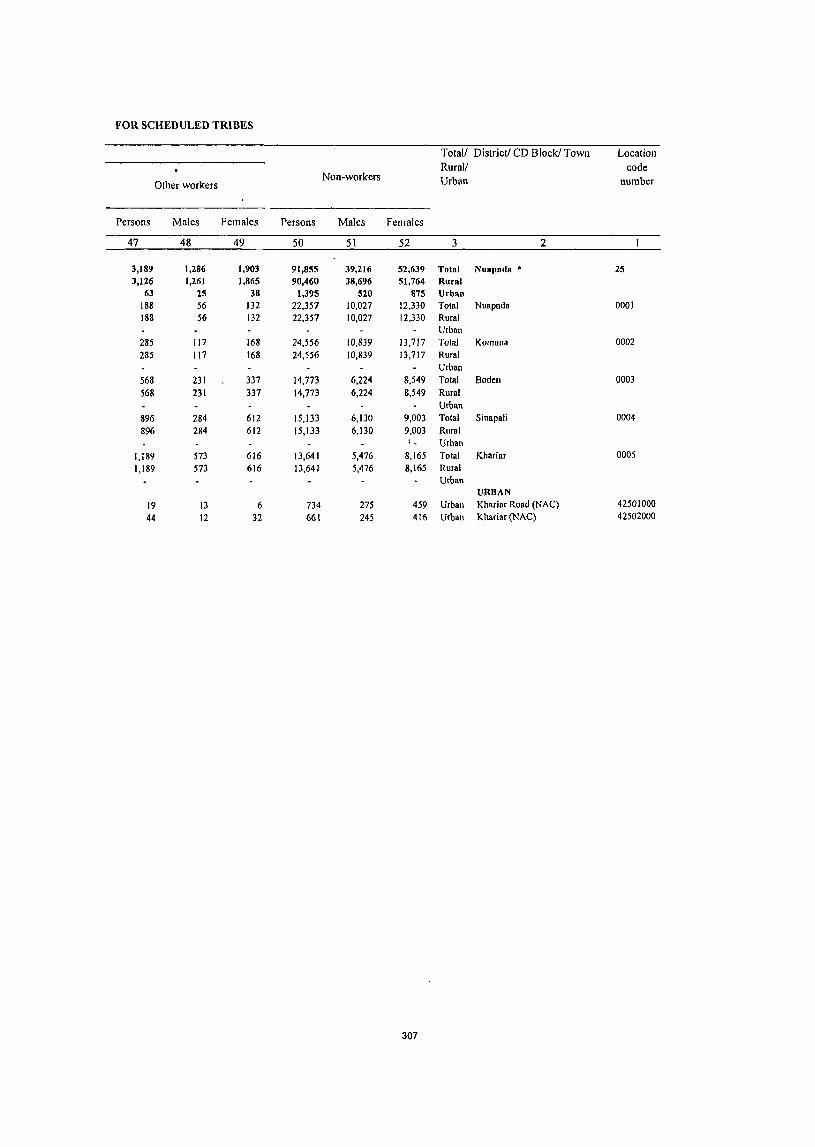
FOR SCHEDULED TRIBES
Total/ District! CD Block! Town Location Rural/ code
Other workers Non-workers Urban number
Persons Males Females Persons Males Females
47 48 49 50 51 52 3 2
3,189 1,286 1,903 91,855 39,216 52,639 Total Nuapada • 25 3,126 1,261 1,865 90,460 38,696 51,764 Rural
63 25 38 1,395 520 875 Urban 188 56 132 22,351 10,027 12,330 Total Nuapada 0001 188 56 132 22,351 10,027 12,330 Rural
Urban 285 117 168 24,556 10,839 13,717 Total Komana 0002
285 117 168 24,556 10,839 13,717 Rural Urban
568 231 337 14,773 6,224 8,549 Total Boden 0003
568 231 337 14,773 6,224 8,549 Rural Urban
896 284 612 15,133 6,130 9,003 Total Sinapali 0004
896 284 612 15,133 6,130 9,003 Rural I _ Urban
1,189 573 616 13,641 5,476 8,165 Total Khariar 0005
1,189 573 616 13,641 5,476 8,165 Rural Urban
URBAN 19 13 6 734 275 459 Urban Khariar Road (NAC) 42501000
44 12 32 661 245 416 Urban Khariar (NAC) 42502000
307


PRIMARY CENSUS ABSTRACT OF NUAPADA C.D. BLOCK- 0001
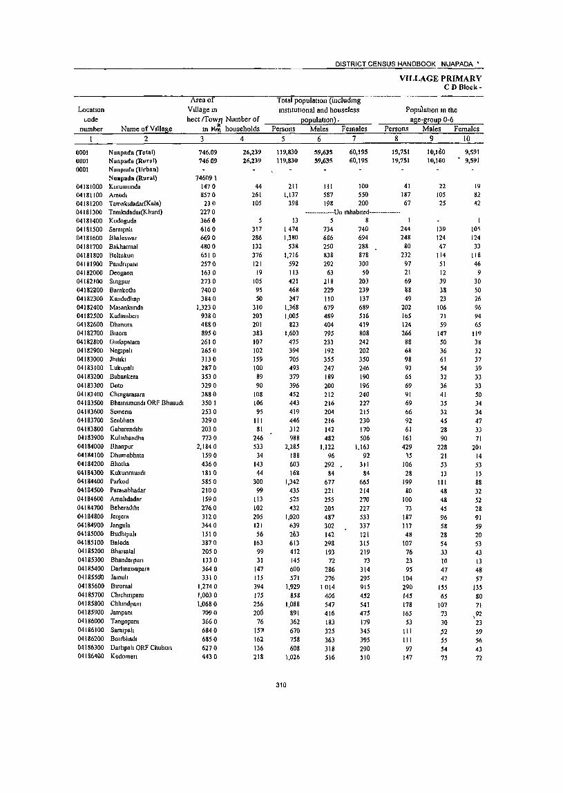
Locatlon c.,ode
number Name ofV1Uage 2
0001 0001 0001
NlIapada (folal) NU811ada (Rural) Nuapada (Urban) Nuapada (Rural)
041KIOOO Kurumunda 04181100 Amodl 04181200 Tamakldadar(Kala) 04181300 Tamkldadar(Khurd) 04 181400 Kodogllda 04181500 Saralpah 04181600 Bhaleswar 04181700 Bal..harmal 04181800 Beltukun 0418 I 900 Pandn pant 04182000 Deogaon 04182100 StnllPur 04 I 82~00 Barakothl 04182300 Kandadhap 04182400 Ma~ankundn
04182500 Kudamben 04182600 Dhanom 04182700 Rlsora 04182800 Gudapatara 04182900 Negtpah 04183000 Jhulkl 04183100 Lukupah 04183200 Babankera 04183300 Doto 04183400 Chmgarasara 04183500 Bhamsmundl ORF Bhusudl 04183600 Semena 04 I 83700 Senbhata 04183800 Gaharendthl 04183900 Kuhabandha 04184000 Bhanpur 04 184 I 00 Dhumnbhnta 04184200 Bhotha 04184300 Kukunmundl 04184400 Parkod 04184500 Para.ahhadar 04184600 Amahdadar 04184100 Beheradlhl 04184800 JeuJcfII 04184900 Jangula 04185000 Budhlpah 04185100 Baloda 04 I 85200 Bhalsatal 04 185300 Bhandarpun 04185400 Darhnawapara 0418550'0 Jamuh 04185600 Blromal 04185700 Chlchmpam 04 I 85800 ChhlOdpa01 04 I 85900 Jampa01 04 I 86000 Tangopam 04186100 Saralpah 04186200 B01rbhadl 04186300 Darhpah ORF Chuhun 04 I 86400 Kodomen
Area of Village In
hect rrowTJ Number of In I-<m households
3 4
746.09 74609
746091 1470 8570 230
2270 3660 6160 6690
4800 6510
2510
1630 2130 1400 3840
1,3230 9380 4880
8950 2610 2650 3130
2870
3530
3290 3880
3501
2530 3290
2030 7730
2,1840
1590 4360
1810 5850
210 0
1590
2760 3120 3440
1510
3810 2050 1330
3640
3310 1,2740
1,0030 1,0680
7090
3660
6840 6850
6270
4430
26,239 26,239
44 261 105
317 286
132 376
121 19
105 95
50 310 203 201
383 107 102
159-100 89
90 108 106
95
III 81
246
533
34
143 44
300
99
113 102 205
121 56
163 99
31
147 115 394
175
256 200
76
1571 162
136 2\8
DISTRICT CENSUS HANDBOOK NUAPADA •
Total populatIOn (including institutional and houseless
population) . Persons
5
119,830 119,830
211 1,137
398
Males Females 6 7
59,635 59,635
60,195 60,195
111 100 587 550 198 200
VILLAGE PRIMARY CD Block-
Populatton In the age-group 0-6
Persons Males Females 8 9 10
19,151 19,151
41 187 67
10,160 10,160
22 105 25
9,591 9,591
19 82 42
-------------Un lhhablted--------------13
1474 1,380
538
1,716 592
113 421
468 247
1,368 1,005
823 1,603
475 394 705
493
319
396 452
443 419
446
312 988
2,285
188 603
168
1,342
435 525
432
1,020 639
21>3
613 412 145 600
571 1,929
858 1,088
891
362
670
758 608
1,026
310
5 8 734 740 686 694 250 288
838 878 292 300
63 50
218 203 229 239
110 137 679 689 489 516 404 419
795 808 233 242 192 202
355 350 247 246 189 190
200 196
212 240 216 227
204 215 216 230
142 110
482 506 1,122 1,163
96 92
292 31 J 84 84
677 665
221 214
255 270
205 227
487 533 302 337
142 121 298 315 193 219
72 286 216
1014
406
547 416
183
325 363
318 516
73
314 295
915 452
541 475
179
345
395 290
510
244 248
80 232
97
21 69
88 49
202 Ib5 124
266 88 68
98 93
65
69
91 69
66
92 61
161 429
15
106
28 199
80
100
73 187
117 48
107
76 23 95
104
290
145 178
165
53
III JIl 91
147
139 124 47
114 51 12
39
38 23
106 71 59
147
50 36 61
54
32 36
41 35
32
45 28 90
228
2J 53
13 IJJ 48
48 45
96
58 28
54 33 10
47 47
155
65 107
13 30
fJ2 55
54 15
10'i
124 33
118 46 9
30 50
26 96 94 65
119 38 32 37
39
33
33 50
34
34
47 3J 71
201
14 53
15 88
32 52
28
91 59
20 53
43 13
48
57
135 80
71
,92 23 59
56 43
72
PRIMARY CENSUS ABSTRACT
CENSUS ABSTItACT N •• p.da
SchedUled Castes popuatlOn Persons Males Females
~ 11 12 < ] 3
13,473 13,473
29 SO
102
10 207 .456 III 225
12
41 9 9,
73 96 90
132 90
123 113
18 68 ~3
174 59 87
-137 2
128 103
36 74
361 .66 20
254 161
14
39 111 42 33 50
349 13 90 39 31
95 11
122
6,744 6,744
14 23 52
4 "110 238
54 105
5 I
24 6 2
33 46 46 62 44 61 56
9 32 29 8S 26 43 61
2 59 55
40 39
189 35 10
119 -.83
8
19 53 20 15 23
182 7
44 19 17
46 6
69
6,729 6,729
15 27 50
6 97
218 57
120 7
17 3 7
40 50 44 70 46 62 57
9 36 24 89 33 44 7fl
69 48
46 35
178 31 10
135 73-6
20 58 22 18 27
167 6
46 20 14
49 5
53
Scheduled Tribes POpuhttloll Persons Males Females
14 15 16
46,996 46,996
31 596 90
23,148 23,148
16 301
49
23,848 23,8~8
15 295
41 .············Un·lnhabited··············
3 I 2 427 492 152 364 215
24 109 396 115 619 527 301 464 102 113
4 226 298 278 116 193 117 256 131 360
1,270 167 125
105
137 22
76 26 5
502 263 613 643 753 581 317 517 384 376
97
209 239
65 177 110
13 ' 55
198 51
307 262 144 219 46 58
3 108 153 139 49 91 60
128 59
181 618
86 57
50
63 12
42 11 2
235 130 331 301 390 274 159 252 182 192 52
218 253
87 187 lOS II 54
198 \ 64
312 265 157 245
56 55
I 118 145 139 67
102 57
128 72
179 652
81 68
55
74 10
34 15 3
267 133 282 342 363 307 158 265 202 184 45
311
Literates Persons
17
43,393 43,393
85 413 133
5 605 598 170 920 224
32 122 130 83
647 358 261 462 209 135 273 148 95
131 157 179 159 130 41
215 70S
41 152 41
560 134 161 127_ 430
87 II} 168 1'38
52 118 219 741 259 234 224 122 146 243
I~~~-
Males ,Females Name of Village 18 19 2
19,264 19,164
61 283 106
5 390 369 105 549 154 28 94 93 45
406 250 186 317 134 100 189 109 70 921 Ill!. tq 100~
I 91 36
188 502
32' 103 28
361 104 103
, 88
!l58 63 69
119 84
~~ 141
\521 1188 1181 174 87
lOS 172
95 244
14,129 Nuapada (Total) 14,119 Nuapada (Rural)
Nuapada (Urban) Nuapada (Rural)
24 Kurumunda 130 Amodl 27 Tamakldadar(Kala)
Tamkldadar(Khurd) Kodoguda
215 Sarslpah 229 Bhaleswar
65 Bakharmal 371 Beltukun
70 Pandnpam 4 Deogaon
28 Smgpur 37 Barakolhl 38 Kandadhap
241 Masankunda 108 Kadamben 75 Dhanora
145 Bisora 75 Gudapatara 35 Neglpah 84 Jhltlkl 39 Lukupah 2S Babankera 39 Doto 46 Chlllgarasara 66 Bhamsmundl ORF Bhusudl 59 Semens 39 Senbhata II Gaharendlhl 87 Kuhabandha
203 Bhanpur 9 Dhumabhala
49 Bhotha 13 Kukunmundl
199 Parkod 30 Parasabhadar 58 Amahdadar 39 Beheradlhl
172 Jelljera 24 Jangula 46 Budhlpah 49 Baloda 54 Bhalsatal 20 B handarpun 46 Darhnawapara 78 lamuh
221 Blromal , 71 Chlchmpam 53 Chhmdpsm 50 l~mpam
35 Tangopam 41 Sarslpah 71 BOIrbhadl 39 Darhpah ORF Chuhun
107 Kodomen
Locallon code
number Name ofYlllage
2
0001 0001 0001
Nilapadll (Totlll) Nuopada (Rural) Nuapada (Urban) Nilapads (Rural)
04181000 Kurumunda 04181100 Amodl 04181200 Tamakld,ldar(Kala) 04181300 Tumkldadar(Khurd) 041 g 1400 Kodoguda 04181500 Sarolpah 04181600 Bhaleswar 04181700 Bakharmal 04181&00 Beltukull 04181900 Pandnpanl 04182000 Deogaon 04182100 Smgpur 04182200 Barakothl 04182300 Kandadhap 04182400 Masankunda 04182500 Kadambcn 04182600 Ohallorft 04182700 Blsora 04112800 Gudapalam 04182900 NeglpalJ 04183000 Jhlllkl 04183100 LukupaIJ 04 \ 83200 Babankera 04183300 0010 04183400 Chmgarasara 04183500 Bhatllsmundl ORF Bhusudl 04183600 Semena 04183700 Senbhala 04183800 Gaharcndlhl 04183900 Kultabandhn 04184000 Bhanpur G4134loo Dhumabhata 04184200 Bbotlla 04184300 Kukunmundl 04184400 Parkod 04184500 P8fasabhadar 04184600 Amaltdadar 04184700 Beheradthl 04184800 Jen)era 04184900 Jangula 04185000 Budhlpah 04185100 Baluda 04185200 Bhalsalal 04 I 85300 Bbandarpun 04185400 Darhnawapam 04185500 Jamul! 04185600 Blromal 04 I 85700 Cbtchmpam 04185800 Cbhtndpam 04185900 Jampant 04186000 Tangopalll 04186100 Saralpah 04186200 BOlmhadl 04186300 Darhpalt ORF Chuhurl 04 I 86400 Kodomert
Persons 20
16,437 76,437
126 724 265
& 869
-;'82
368 796 368
81 299 338 164 721 647 562
1,141 266 259 432 345 284 265 295 264 260 316 265 713
1,580 141 451 127 782 301 364 305 590 552 148 445 214 93
482 352
1,181 599 854 667 240 524 SIS 474 675
IIluer dIes
Males
21
30,311 30,371
50 304
92
344 317 145 289 138 35
124 136
65 273 239 218 478
99 92
166 138 1\9 108 101 103 104 125 106 294 620
M 189 56
316 117 152 111 229 239 73
179 109 40
214 135 493 218 366 242 96
220 191 223 272
Females 22
46,066
46,066
76 420 173
8 525 465 223 507 230
46 175 202
99 448 408 344 663 167 167 266 207 It,S 157 194 161 156 191 159 4J9 961J
&1 262
71 466 184 212 188 361 313 75
266
165 53
268 217 694 381 488 425 144 304 324 251 403
312
DISTRICT CENSUS HANDBOOK NtJAPAOA:_
VILLAGE PRIMAR'Y C l} nlock-
Toldl workers Persons
23
59,941 59,941
103 477 191
Males 24
33,132 33,132
56 ·279
96
Females 25
26,809 26,809
47 198 95
-------------Un-Inhabltcd----·---·---·-8 4 4
702 681 295 781 325
57 21 I 240 \\0 663 487 493 810 233 236 398 280 2~,)
220 249 211 196 216 140 465
1,195 9&
359
84 635 252 279 232 600 330 151 308 228
77
299
314 939 476 545 414 197 230
454 312 490
392 368 139 447 161 33
III 130 62
387 282 234 4J4 116 110 196 139 122 111 126 115 104 103 73
255 632
54 169 52
356 130 141 109 291 173 84
164 120 44
161 168 524 252
307 240 103 161 232 182 318
310 313 156 334 164 24 90
llO 48
276 205 259 396 117 126 202 141 117 107 123 96 92
113 67
21D $63 44
190 32
279 122
138 123 309 157 67
144 108 33
138 146 415 224 238 174 94 69
222 130
172
Mdtn workers Persons Males Fem8le~
26 27 2R
35.150 35,150
72 342 142
4
373 257 129 466
70 28
l19 114
54 391 313 378 364 III 113 PI
S()
llJ 190 211 III 97
103 62
323 616
30
210 37
408 26
I !2 76
229 288 107 225 159 63
170 170
455 216 303 202
86 149 235 177 328
27,446 27.446
55 246
8D
" 185 228 '06 386
61
.28 1114 III )4
353 225 199 J06 105 84
145 73 III 106 117 102 60 16
56 240 554
30
161 3S
307 25
109 10
215 168 78
150 106 36
t52 148 421 210 279 193 78 83
191 165 301
7,704 7,704
17 96-I1l
1)
3
19 26
}
10f 114 9)
'J 3, " I (;
xl 82
49 2
101
6
14 120 29 15 53 27 18 n 28 6
14 y
~
6t 4q I' .. 21
PRIMARY CENSUS ABSTRACT
CENSUS ABSTRACT Nuapada
IndustrIal category of 111all1 workers Household Industry
Cultivators Agnculturallabourers wOIkers Other workers Persons Males Females Persons Males Females Persons Males Females Persons Males Females Name of Village
29 30 31 32 33 34 35 36 37 38 39 40 2
18,827 18,827
68 151
51
122 132 82
241 38 20 69 26 24
268 205
144 215
97
69 95 68 62 84
150 95 67 36 58
207 519
18 125 26
122 24
107 68
172 136 76
\2\\ 99
30 123 119 338 188 239 107 77 22
221
159 296
15,667 15,667
52 114 39
102 114 69
206
31 20
61 25
24 246 147 74
181 93 51 86
61 31 49 77
87
36 29 53
163 451
18 III 24
106 23
105 65
167
85 55
93 74 18
113 104 323 187
221 105 69 20
181 151 276
3,160 3,160
16 37 12
20 18 13 35 7
22 58 70 34
4
18 9 7
31 35 73
8 31
7 5
44 68
14 2
16
2 3
5 51 21 35 25 12 10 15 15 I
18 2 8 2
40 8
20
9,664 9,664
4
158 82
4 194 45 42 92 28
5 31 83 28 74 80
220 81 11 25 37 8
144 99 53 11 7
52
64
78
10 77 10
196
20 130
17 79 50 27 43 41 86
21 51 72
7
117 8 9
6,111 3,553 6,111 3,553
3 I 103 55 32 50
568 568
7
2
431 431
7 2
-------------Un-Inhablted--------------4
137 40
57
5 32 10 60 27
5
28 82 28 65 52
115 75
9
15 30
8 69 52 29 10 4
35 I
35
69 10 42 10
120
16 64
9 43 24 13 35 35 78
17 47 70
7 55 6 7
3
32 1
3
9 28
105 6
2 10 7
75 47 24
I
3 17
29 9
35
76
I 4
66 8
36 26 14 8 6
4 4 2
62 2
2 2
6
4
12 1
2
7
7
14
6
2 3
7
II
2 2
12
2 I 4
313
5 4
10
6
10 I
.. 5
10
2 2
10
2
137 137
2
3 I
4
2
2
6,091 6,091
26 7
51 76 4
121 3
17 5 2
42
21 14 S4 2
19 33 4
II 7
8 5
21 12 3
45 28
2 7
I 89
2 3
25 22 14 18 9 5 4
10 31 5
12 19 I 9 5 8
27
5,237 5,237
22 7
41 • 70
4 110
3 3
13 4 2
38 20 10 40 2
18 24 4
II 5 6
18 10 2
37 24
2 7
gO
2 2 3
22 19 14 14 7 5
4 9
26 4
10 15 I 7 3 6
22
854 Nuapada (Total) 854 Nllapada (Rural)
Nuapada (Urban) Nuapada (Rural) Kurumunda
4 Amodl Tamakldadar(Kala) Tamkldadar(Khurd) Kodoguda
10 Saralpah 6 Bhaleswar
Bakhannal II Beltukun
Pandnpam Deogaon
4 Smgpur I Barakothl
Kandadhap 4 Masankunda I Kadamben 4 Dhanora
14 BIsora Gudapatara Ncglpah
9 Jllltlkl Lukupah Babankera
2 DOlo 2 Chmgarasara
Bhalllsmundl ORF Bhusudl 3 Semen a 2 Senbhata
Gaharendlhl 8 Kullabandha 4 Bhanpur
Dhumabhata Bhotha Kukunmundl
9 Parkod Parasabhadar Amahdadar
2 Beheradlhl 3 Jenjera 3 Jangula
Budhlpah 4 Balada 2 Bhalsatal
Bhandarpun Darlmawapara Jamul!
5 Blromal I Chlclllnpam 2 Chhlndpam 4 Jampam
Tangopam 2 Saralpah 2 BOirbhadl 2 Darhpah ORF Chuhun 5 Kodomen

Locatton code
number
0001 0001 0001
Name of Village 2
Nuapada (Total) Nuapada (Rural) Nuapada (Urban) Nuapada (Rural)
04181000 Kurumunda 04181100 Amodl 04181200 Tamakldadar{Knla) 04181300 Tamkldadar(Khurd) 04181400 Kodoguda 04181500 Saralpalt 04181600 Bhaleswar 04181700 Bakharma1 04181800 Beltllkun 04181900 Pandnpant 04182000 Deogaon 04182100 'Stngpur 04182200 Baral..othl 04182300 Kandadhapl 04182400 Masankunda 04182500 Kadamben 04182600 Dhanora 04182700 Blsnra 04182800 Gudapatara 04182900 Neglpalt 04183000 Jhlllki 04183100 Lukupah 04183200 Babankera 04183300 Dolo 04183400 ChlOgarasnra 04183500 Bhatnsmllndl ORr Bhusudl 04183600 Semena 04183700 Senbhala 04183800 Gabarendlhl 04183900 Kuhabandha 04184000 Bhallpur 04184100 Dhumabhata 04184200 Bhotha 04184300 KukuTimundl 04184400 Parkod 04184500 Pnrl1sabhadar 04184600 Amahdadar 04184700 Beheradlhl 04184800 Jen)era 04184900 Jangula 04185000 Budlupah 04185100 Baloda 04185200 Bhalsatal 04185300 Bhandarpufl 04185400 Darhnawapara 04185500 Jamuh 04185600 Buomal 04185700 Chlchmpam 04185800 Chhmdpanl 04185900 Jampam 04186000 Tangopanl 04186100 Sarnlpah 04186200 Boubhadl 04186300 Dnrhpah ORF Chuhufl 04186400 Kodomerl
Margmal workers Persons Males Females
41 42 43
24,791 24,791
31 135 49
4
329 424 166 315 255 29 92
126 56
272 174 115 446 122 123 227 200
22 30 38
100 99
IJ3 78
142 559
68 149 47
227 226 167 156 371 42 44 83 69 14
\29 144 484 260 242 212 III 81
219 135 162
5,686 5,686
31 16
107 140 33 61
100 5
17 19
8 34 57 35
108 II 26 51 66
11 7
14 13 44 27 17 IS 78 24 8
17 49
lOS 32 39 76
5 6
14 14 8 9
20 97 42 28 47 25 78 41 17 17
19,105 19,105
30 102 33
4 222 284 B3 254 155 24 75
107 48
238 117 80
338 III 97
176 134 II 23 24 87 55 86 61
127 481
44 141 30
178 121 135 117 295 37 38 69 55 6
120 124 387 218 214 165 86 3
178 118 145
314
DISTRICT CENSUS HANDBOOK NUAPADA· ,
Colttvators Persons Males Females
44 45 46
4,326 4,326
27
998 998
76 18 I 1
-- ----------Un-tnhabtted---
10 <)
108 19 9 2
24 10 50 27 21 4 35 6
66 II 55 17 39 11
160 40 9 I
55 15
9 4 6
18 5 I
13 4 82 19
87 6 119 3
I 143 8
7 3
38 41 5 14 2 60 II 14 8 36 2 53 5
9 2 5
202 26 58 25 2 1 5 4
107 22 52 3
152 16
3,328 3 .. 128
26 58
89 • 7
14 23 17 29
55 38 28
120 6
I 40
5 5
13
9 63
81 116
I 135
4
33 36 12 49
6 34 48
7 4
176 33
1 I
85 49
\36
VILLAGE PRIMARY CD 81ot:l{-
Industnal category
Agricultural labourers Persons Males Females
47 48 49
19,645 19,645
4
50 4S
4
3\0 312 152 252 203
8 57
126 56
204 107 76
281 113 121 172 200
12 23 16 99 &f 29 78 52
439
66 6
47 215 225 166 155 366
4 3
69 7
93 88
475 247 40
147 !08 73
III 83 8
4,323 4,323
12 14
93 120 27 33 73
I II 19 8
22 34 24 63
8 25 36 66 6 6 5
12 39 6
17 9
74 24
17 45
104 31 39 74
12 3
7
12 9S 33
2 16 24 71 19 14
15,322 15,322
4
38 31
4
217 192 125 219 110
7 46
107 48
182 73 52
218 105 96
136 134
6 17 II 87 45 23 61 43
365 42
(>
30 170 121 135 116 292
4 2
57 4
86 76
380 214
38 131 84 2
92 69 8
PRIMARY CENSUS ABSTRACT
CENSUS ABSTRACT Nuapada
ofmatBlUal workets Location
Household mdust!1 workers Other workers Non-workers code
Persons Males Females Persons Males Females Persons Males Females Name of Village number
50 51 52 53 54 55 56 57 58 2 1
146 61 85 674 304 370 59,889 26,503 33,386 Nuapada (Total) 0001 146 61 85 674 304 370 59,889 26,503 33,386 Nuapada (Rural) 0001
Nuapada (Urban) 0001 Nuapada (Rural)
108 SS S3 Kurumunda 04181000 8 2 6 660 30& 352 Amodl 041&1100 , 2 207 102 105 Tamakldadar(Kala) 04181200
------------Un-Inhablled-------------- Tamkldadar(Khurd) 04181300 I 4 Kodoguda 04181400
8 5 3 772 342 430 Saralpah 04181500 I 3 1 2 699 318 381 Bha1eswar 04181600 2 3 243 III 132 Bakharmal 04181700 9 3 6 30 15 I~ 935 391 544 Beltukun 04181800 2 2 267 131 136 Pandnpam 04181900
56 30 26 Deogaoll 04182000 210 97 113 Smgpur 04182100 228 99 129 Barakolhl 04182200 137 48 89 Kandadhap 04182300
2 705 292 413 Masankunda 04182400
8 5 3 4 3 51& 207 311 Kadamben 04182500 330 170 160 Dhanora 04182600
4 4 793 381 412 Bisora 04182700 242 117 125 Gudapatara 04182800 158 82 76 Negtpah 04182900 307 159 148 JhttJkl 04183000 213 108 105 Lukupal! 04183100 140 67 73 Babankera 04183200 176 87 89 Ooto 04183300
3 3 203 86 117 Chmgarasara 04183400 232 101 131 Bhamsmundl ORF Bhusudl 04183500
2 223 100 123 Semena 04183600
2 2 230 1f3 117 Senbhata 04183700 172 69 103 Gaharendlhl 04183800
2 2 523 227 296 Kul!abandha 04183900 1,090 490 600 Bhanpur 04184000
90 42 48 Ohumabhala 04184100 244 123 121 Bhotha 04184200
84 32 52 Kukunmundl 04184300
4 3 707 321 386 Parkod 04184400 183 91 92 Parasabhadar 04184500
246 114 132 Amahdadar 04184600
1 200 96 104 Beheradthl 04184700
2 2 2 2 420 196 224 JenJera 04184800 309 129 180 Jangula 04184900
112 58 54 Budhlpali 04185000 305 134 171 Baloda 0418~100
184 73 111 Bhalsatal 04185200
68 28 40 Bhandarpun 04185300
301 125 176 Darhnawapara 04185400
3 3 257 108 149 Jamul! 04185500
990 490 500 Blroma) 04185600
6 6 2 2 382 154 228 I
ChlclllnpallI 04J85700
543 240 303 Chhmdpam 04185800
4 3 3 477 176 301 lampalll 04185900
165 80 8~ Tangopam 04186000
2 2 440 164 276 Saralpah 04186100
304 131 173 BOIrbhadl 04186200 -; 296 136 160 Darhpah ORF Chuhun 04186300
2 536 198 338 Kodomen 04186400
315
._._---,------- _____ •. ____ ..:.OISTRI~E!'}US~NQ~OOI< ,\jUA,PADA :~
VILLAGE l'RIMARY (' D Dhldl-
---"Area or Total population (mcludlllg Village III lIIslltullondl and house less POjmlatlon In Ihe LocatIOn
code number
heet (fowlI Number of populatlon~ ___ age-group ~.:.2 ____ _ Name of V 11Ia:"gc::.e ___ .:;11:.:..1 :;I<si\::!::t~h;:;:ou!!:s::::e:!h::;::ol~d::!.s _.!P..:."!:.rs:.::o!!:ns~-...!M~a\~e!!.s _ . ..!F.!·e:!!m!!:t1~le:'2S·~-_ _;P:.:e::.rs~o:::.11:.::s_ Males ___ I'_el'1_fll_cs_.
'). 3 4 5 6 7 8 _._..2 ____ E__.
04186500 Mudhela 04186600 Mahatamtara 04186700 Thelkobeda 04186800 Amasena 04186900 Gatamn 04187000 Kalda 04187100 Kdlyanpur 04187200 Chnnabeda 04187300 Saliha (Kala) 04187400 Sallha (Khurd) 04(87)00 lhnlbahal 01187600 Kemlcli 04187700 Mauurpam 04187800 Darhmunda 04187900 Khahap,ml 04188000 R6henpam 04188100 ('orfallj 04188200 Smgldl 04188300 Chhotkendub~hara
04188400 Kendubaharn 04188500 Jamusalt:bhat~
04188600 uhnmsadarahll 04188700 Brahmalll 04188800 Gldhlmpam 04188900 RaJlbnagar \)~ \ ~<)\)\)\) ?a~amal!l
04189100 Dahpathna 041 ~910() Daldah 04189300 Amanllra 04189400 Mahara 04189500 Palalllhutkun 04189600 Pawartola ().J 189700 Khalsna 04 189800 Sarabang ()4189900 Bhumsunundl 04190000 Haldl 04190100 Bhlljlpnla 041902(',0 Nand~pur
04190300 Dumerpalll 04190400 Sllda 04190500 Pntpnrpall 04190600 Bhern 04190700 Hanspufl 04190800 Godfula 04190900 Junam 04191000 Pagarpam 04191100 TllctJhar 04191200 Anlf1Juba 04191100 Sahlpala 04191400 Plpalchhcndl 04t9tSlIO lamlldata 0419160() Chhelilendl 04191700 Kotenchuan 04191800 SlnlatJ 04191900 Parnskhol (Kllurd) 0·1192000 Paraskhal (K~la) 04192100 'Parsabuda 04192200 Mahuabhata 04192300 Salebhata
3680 3120 2560 'HOO 4090 26,0 4960 313 0 4670
890 4690 5470 5630 9550 7590 2890 2650
38"J 0 3950 4850 1680 442.0
1,1000 7180 2270 "l%~
7220 1930 4910 6090 1900 5900 2990 572 0 3850 3760 5490 3820 4080 5120 2090 3360 1340 2990 2880
4540 5970
1,1280 1,5420
5030 tA610
2790 3820
4400 130
4180 1720 4180 4360
155 107 III 153 268 152 249 171 257
153 169 149 238 235
13 35
139 34
189 33 93
131 99 26 "l~
82 25
166 167 153 244 138 418 213 153 147 109 193 260
90 158 68
116 145 123 145 299
535 136 3~O
137 121 124
18,) 165 342 190
613 500
610 99~
1,211 694
I 161 791
1,021
762 793 717
1,014 1,109
57 13& 566 135 710 180 4J7 624 414 105 \\)I)
412 123 186 791 767
1,192 727
I 861 1,007
759 720 495 970
1,215
402 669
311 511 673 612 642
1,224 2,548
739 \,55)
586 712 630
981 729
1,560 931
316
306 248 295 534 660 339 ~h3
39\1
301
HZ 31, 461 611 3~5
573 39;!
1:9 <)2
III 125 196 13~
202
149 506 51, 148
.••.•••••.. Un·mhablled············ • 390 3T). 122 387 ~o6 151 364 '5:3 120 502 51:! 178 542 561 :87
27 30 14 63 70 16
270 296 S(l 66 69 25
332 378 104 90 90 11
206
302 19()
50 ......
203 61
399 388 365 ,86 370 0)32 494 391 346
248 50S 588 208
326 164 254 332 297 309 590
1,273 374 1Y.~
289
264 387
2!l 322 21;
55 S6
209 62
387
403 402 606 357 92(j 513 368 374
247
462 627 194
343 147 257 341 315 333 634
1,275 365 %9 291 448 24J
7\1 116 59 26 \\1
80 24
144 131 145 121 114 J'2'1
J63
I J6 120 73
138 20)
65 100 42 79
104 85 99
191 380 134 15~
100 llo 65
·············Un·mhabued·· .......... -484 497 140 375 354 114 780 780 283 474 457 149
59 4~
47 . 70
101 67 IO~
78 1\8
"0 7(, ~8
113 °l
8 8
41 13 47 10 39 60 34 14 S
39 12
73 70 67
124 65
16J 77 62 62 41 67 (17
38 54 31 38 54 43 ~4
89 Ig~
6\1 \4:'. 50 41 31
7'1 63
152 83
6U
18 M 5'> 9~
68
91 7' 80
51 S2 67 '/~
J)
6
S )\)
12 51 II 40 56
12 5
41 12 71 61 78 '17 49
104 ~6
'"' S~
j2
71 lOb
27 4()
II 41 50 42 4,
102 192 65 in 50 69
\32
70 51
131 60
PRIMARY CENSUS ABSTRACT
CENSUS ABSTRACT NUlpad.
.Scheduled Castes popuatlOu Petsons Males Females
11 12 13
263 72
369 84
161 66 97 31
119
30 73 14
196 123
27
65
S9 10 10
23 37 31
89 9
, 203 92 99 26
• 55 31
102 52
152 12 67
178 59
, 46 76
m f. 28
·102 54 19 96
66 125 38
132
137 39
180 42 85 32 48 20 55
14 31
5 97 55
12
34
28 6 4
14 20 19 39 4
97
43 51 12
25 16 49 27 72 5
34 91 24 21 37
169
13 54 27
56
37 65 21 66
126 33
189 42 76 34 49 II 64
16 42
9 99 68
15
31
31
4 6
9 17
12 50
5
106 49 48 14 30 15
53 25
80 7
33 87 35 25 39
182 15 48
27 19 40
29 60 17
66
Scheduled Tnbes populatIon Persons Males Females
14 15 16
236 126
16 271 279 178 451 454
112 67
6 135 132 95
222 217
124 59
10 136 147
83
229 237
-------------Un-Inhablted--------------295 146 149 608 294 314 186 99 87 349 178 171 777 383 394
84 427 135 418 173 151 467
85 59 80
302 95
430 395 133 380 139 333
42 88
398 336 327 159 205 215
135 96
443 328 819
1,271 383
1,412 278 394 386
44
205 66
187 86 77
226 38
27 34
144 46
212
189 64
178
68 166
19
45 196 ISO 172 67
101 97
71 46
218 160 384
631 188 714
U8 122 257
40 222
69
231 87
74 241
47 32
46 158 49
21& 206
69
202 71
167
23 43
202
156
155 92
104
118
64 50
225 168 435 640 195 698
140 272 129
.·---•• ·-----Un-Inhablted----·---------78 37 41
72 35 37 ~_ 86
289
40 148
46 141
317
Persons 17
163 119 190 599 618 189 369
125 327
176
207 192 382 294
18
13 135 25
179 81 93
217
116 20 20 93 33
257 308 316
419 250 774 388 348 298 190 512 353 139
242 165 185 333 234
122 358 749 178 458 191 331 320
471 297
539 313
Literates Males
18
III 89
151 381 400 134 264 100 229
126 153 138 249 207
14 10
100 18
141 58 69
142 87 16
13 64 25
m 207 196
285 187 513 259 238 200
132 334 237
95 157 100 128 221 153
91 253 519 \39 350 128 135 266
301 200 402 209
Females Name ofYtllage 19
52 Mudhela 30 Mahatamlara 39 Thelkobeda
218 Am8sena 218 Golama
S5 Kolda 105 Kalyanpur
25 Chanabeda 98 SalIha (Kala)
2
SalIha (Khurd) 50 Jhalbahal 54 Kermeh 54 Magurpanl
133 Darltmunda 37 Khahapam
4 Rohenpam 3 Forfouj
35 Smg1dl 7 Chhotkendubahara
38 Kendubahara 23 Jamusalebhala 24 Bhamsadaraha 75 Brahmam 29 Gldlumpam 4 Rajlbnagar 7 Pasamara
29 Oallpathna 8 Daldah
82 Amanara 101 Mohara 120 PatalghutkufI 134 Pawartola 63 Khalana
261 Sara bang 129 Bhamslmundl 110 Haldl 98 Bhajlpa\a 58 Nandapur
178 Dumerpant 116 Sllds 44 Patparpah 85 Bhera 65 Hanspufl 57 Godfula
112 Junam 81 Pagarpam 31 TllelJhar
105 AnlaJuba 230 Sahlpa\a
39 Plpalchhendl 108 Jamudara 69 Chhehlendl
\ 96 Kolenchuan 54 Slalati
Paraskhol (Khurd) 170 Paraskhol (Kala) 97 Parsabuda
137 Mahuabhata 104 Salebhata
· ________________________ --=D~ISTRICT C,;:NSUS HANDBOOK NUAPADA •
Locallon code
number Name ofVdlage 2
04186500 Mudhela 04 186600 Maha tam tara 04186700 Thelkobeda 04186800 Amasena 04 J 86900 GOlama 04187000 Kolda 04187100 Kalyanpur 04187200 Chnnabeda 04187300 Sahha (Kala) 04187400 Sahha (Khurd) 04187500 jhalbahal 04187600 Kermeh 04187700 .Magurpant 04187800 Darhmunda 04187900 Khahapam 04188000 Rohenpam 04188100 ForfouJ 04188200 Slngldl \ 04188300 Chhotkelldubnhara 04188400 Kendubaharn 04188500 Jamusalebhata 0418~600 Bhatnsadaraha 04188700 Brahmant 04188800 Gldhtnlpam 04188900 RaJlbnngar 04189000 Pasamara 04189100 DaIJpalhnn 04189200 Daldnh 04189300 Amanara 04189400 Mohnra 04189500 Patalghutkun 04189600 Pawnrtola 04189700 Khalalla 04189800 Sarabang 04189900 Bhatnslrnllndl 04190000 Haldl 04190100 BhllJ1paia 04190200 Nandapur 04190300 Dumerpanl 04190400 Sllda 04190500 Patparpah 04190600 Bhem 04190700 Hanspurl 04190800 Godfula 04190900 J lInnnl 04191000 Pagarpam 041911 00 Tllel)har 04191200 Anlajuba 04191300 Sahlpaln 04191400 Plpalchhendl 04191500 Jamudara 04191600 Chhehlendl 04191700 Kotenchuan 04191800 Smlatl 04191900 Paraskhol (Khurd) 04192000 Paraskhol (Kala) 04192100 Parsabuda 04192200 Mahuabhala 04192300 Salebhatn
Persons 20
450 381 420 396 659, 505 792 666 694
586 586 525 632 815
39 125 431 110 531 99
324 407 298
85 80
319 90
529 483 451 773 4n
1,087 619 411 422 305 458 862 263 427 146 326 340 378 520 866
1,799, 561
1,097 389 381 310
510 432
1,021 618
Illiterates Males
21
195 159 144 153 260 205 319 299 277
264 234 226 253 335
13 58
170 48
19J 32
137 160 112 34 31
139 36
224 181 169 301 183 419 235 153 146 116 174 351 113 169 64
126 III 144 218 337 754 235 436 161 129 121
183 175 378 265
Females 22
255 222 276 243 399 300 473 367 417
322 352 299 379
480 26 67
261 • 62
340 67
187 247 186
51 4lJ
180 54
305 302 282 472 294 668 384 25& 276 189 284 511 150 258
82 200 229 234 302 529
1,045 326 661 228 252 189
327 257 643 353
318
fotal workers Persons
23
3\3 272 312 302 544 402 560 325 572
Males Females 24 25
156 142 152 220 371 208 320 193 297
157 130 160 82
173 194 240 132 275
--- --·------Un-mhablted--------------430 230 200 493 420 418 641
30 89
352 83
421 98
220 357 241
40 62
222 62
448 444 383 553 447 913 539 390 398 243 521 651 254 346 167 189 350 293 J21 575
1.318 426 829 270 242 210
252 217 280 334
15 46
168 39
203 52
113 173 127 27 30
117 30
226 220' 199 313 228 502 295 207 188 150 300 343 128 200
85 145 184 153 189 354 738 216 449 158 147 141
241 203 138 307
15 43
184 44
218 46
107 184 114
13 32
105 32
222 224 1&4 240 219 411 244 IS3 210
93 221 308 126 146 82 44
166 140 132 221 580 210 380 112 95 69
-------------Un-Inhablled--------------440 290 150 356 209 147 906 432 474 426 257 169
VILLAGE PRIMARY CO Blocl,-
Mam workers Persons Males Females
26 27 l& 167 133 178 160 336
246 357 190 182
305 385 393 280 469
30 47
174 50
126 31
100 144 100 25 27
119 46
147 162 234 249 392 373 244 349 IS7 134 457 434 254 240 47
138 ISS 161 260 526 944 172 437 140 126 107
286 317 409 280
152 120 136 147 304 193 290 IS3
169
208 217 204 252 301
15 46
168 38
106 28 92 72 71 22 27 97 27
142 87
155 233 211 321 207 18S 172 125 291 288 128 196 42
127 154 94
187 341 680 171 348 130 III 92
24& 195 l84 215
I~
IJ 42
13 32 53 67
7 13
97 16M 189 28
168 15 I 6
12 20 3 8
72 29
22 19 ~
7~
79 16
131 52 37
161 15 9
166 146 126 44
5 II 4
67 73
ISS 264
I &9 10 15 15
38 122 25 65

PRIMARY CENSUS ABSTRACT
CENSUS ABSTRACT Nuapada
Industnal category ofmam workers Household mdustry
Cultivators Agnculturallabourers workers Other workers Persons Males Females Persons Males Females Persons Males Females Persons Males Females Name of VIllage
29 30 31 32 33 34 35 36 37 38 39 40 2
ISIS 116 138 93
117 134 178 151 119
2&4 321 III 139 161
28 109 36 50 27 60
139 60
21 17 56 21
115 150 57 65
210 142 115 221
78 85
148 152 93 83
22 70
109 75
169 83
380 159 336
54 94 78
149 150 273 123
149 " 104
108 92
110 103 159 149 tl6
194 186 %
137 118
28 109 28 42 25 55 68 43 19 17 45 14
112 79 38 62
116 126 114
119 74
81 141 138 81 80 19 69
106 44
136 73
258 159 279
53 86 67
143 93
210 91
7 12 30
7' 31 19 2 3
90 '\35
55 2
43
8 8 2 5
71 17 2
II 7 3
71 19 3
94 16
102 4 4
14 6 3
31 33 10
122
57 I 8
II
6 57
3 32
II 12 36 II 19 19
107 15 54
t2 43
271 49
~210
30 19 58 12 60
38
26
9 56 .
23 7
2 164 114 161 76
96 120 82 24
224 220 155 38 19 53 38 76 58
228 404
84 62 14
80 119 54 80
3 8 II 24
7 18 13 68 \2 46
12 4
6 39
3 8
4 9
IS
-------------Un-mhab\\ed--------- ----663
19 24 140 38
111
131 \I 99
15 15 18 1 52
8 6 4
48. 12
2 4
2
4
9 IS
3
2 3
2
4
36 2
4 1 2 , 1
15 11
9 46 10 13 10 6 I
2 105 59 101 7 79 82
55 21 61 35 62 58 73 9 20 4 60 164
100 120 37 118 14 24 17 2 45 8 37 40 27
1\4 283
57 58 13
36 31
114 121
27 4
2 I
17
I
2 12
3
4 3
2 7
3 13 15 I 4
17
I
I 9 3
3 3
7
q
8 I 3
-----···-·---Un·lnhablt~d·------··-·---
57 23 6 5
57 40 61
62
14 19
I 16 8
319
I Jl 4
1 3
4 7
5 4
4
56 196
84 57 24
8
6 21 II 90 94
5 2
12 3
5 14
6
2 8 9-
13 70 19
143
30 7
27 21 82 61
4 112
6 15 II 7
30 202 145
12 13 24 18 27
51 47 66 69
4 3
48 172
, 68 48 22 6
5 12 8
75 69
5 ~
12 2
4 13
5
7 7
12 64 15
131 29 6
25 21 81 50
3 95
6 13 II 7
21 145 131 II 9
19 12 23
43
44 63 59
Mudhela Mahatamtara Thelkobeda
8 Amasena 24 Go\ama 16 Kolda 9 Kalyanpur 2 Chanllbeda 2 Sahlla (Kala)
Sahha (Khurd) I lhalbahal 9 Kenneh 3 Mngurpam
15 Darhmunda 25 Khahapam
Rohenpam ForfouJ Smgllh Chhotkendubahara Kendubahara Jamusalebhata Bhamsadaraha Brahmal11 Gldhmlpam RaJlbnagar Pasamara Dahpathna
2 Daldah Amanara
2 Mohara Patalghutkurl
6 Pawartola 4 Khalana
12 Sarabang Bhamslmundl Haldl
2 Bhajlpala Nandapur Dumerpam
II Sllda Patparpah
17 Bhera Hanspurl
2 Godfula Junam Pagarpam
9 TJlelJhar 57 AnlBjuba 14 Sahlpala
Plpalchhendl 4 Jamudara 5 Chhehlendl 6 Kotcnchuan 4 Slain\!
Par\lskhol (Khurd) 8 Paraskhol (Kala) 3 Parsnbuda 3 Mahuabhata
10 Salebhata
Location code
number Name ofVIUage
2
04186500 Mudhela 04 I 86600 Mahatamtara 04186700 Thelkobeda 04186800 Amasena 04186900 Gotama 04187000 Kolda 04187100 Ka1yanpur 04187200 Chanabeda 04187300 Sahha (Kala) 04187400 Sahha (Khurd) 04187500 Iha1baha1 04187600 Kermeh 04 I 87700 Magurpan! 04187800 Darhmunda 04187900 Khnhapan! 041 &gOOO Rohenpam 04188100 Forfonj 04188200 Smgldl 04188300 Chhotkendubahara 04188400 Kendubaham 04188500 Jamusalebhatn 04188600 Bhamsadaraha 04188700 Bmhmam 04188800 Gldhmlpam 04188900 RaJlbnagar 04189000 Pasamara 04189100 Dahpathna 04189200 Daldah 04189300 Amanara 04189400 Mohara 04189500 Pntalghutkun 041 &9600 Pawartola 04189700 Khalana 04189800 Sara bang 04189900 Bhamslmundl 04190000 Ho1dl 04190 I 00 BhaJlpala 04190200 Nandapur 04190300 Dumerpam 04190400 Sllda 04190500 Patparpah 04190600 Bhera 04190700 Hanspun 04190800 Godfula 04190900 Junan! 04191000 Pagarpam 04191100 TllelJhar 04191200 Anlajubll 04191300 Sahlpala 04191400 Plpalchhendl 04191500 Il1mudafll 04191600 Chhchlendl 04191700 Kotenchuan 041918QO Stalatl 04191900 Paraskho1 (Khurd) 04192000 Paraskhol (Kala) 04 192100 Parsdbuda 04192200 Mahuabhata 04192300 Snlebhata
Margmal workers Persons Males Females
41 42 43
146 139 134 142 208 156 203 135 390
125 108 27
138 172
42 17& 33
295 67
120 213 141
15 35
103 16
301 282 149 304
55 540 295
41 211 109 64
217
106 120
51 192 132 61 49
374 254 392 130 116 103
154 39
497 146
4 22 16 73 67 15 30 10
12&
22 35 13 28 33
97 24 21
101 56 5 3
20 3
84 133 44 80 17
181 88 19 16 25 9
55
4 43 18 30 59 2
13 58 45
101 28 36 49
42 14 48 42
142 117 11& 69
141 141 173 125 262
103 73 14
110 139
42 178 32
198 43 99
112 85 10 32 83 13
217 149 105 224
38 359 207 2~
195 &4 55
162
102 77 33
162 73 59 36
316 209 291 102 80 54
112 25
449 104
320
DISTRICT CENSUS HANDBOOK NUAPADA'
Cultivators Persons Males Females
44 45 46
15 47 80 18 4
72 90
7 84
I 10 5
15 3 7
10
20
14 37 75
3 1
65 80 6
64 -------------Un-lnhabIICd--- ----------
89 10 79 93 34 59
17 39
4 2
30 5
40 3
2 8
29
2 2
15 31
4 2 1 4
3&
3 2
8 3
11 1
23 5
29 22 6
24 62
2 24 21
125 58 30 11
155 5
73 3
10
5 I 3
12 15 4
10 3
7 &
18 29
4 36
3 23
7
6
20
17 7 2
14 59
1
2 17 13
\07 29 30 7
119 2
SO 2 3
--------·---·Un-tnhabttcd-··-----------76 33 43 2 2 7 4 3
27 19
VILLAGE PRIMARY (: DBloc:k-
Industnal category
Agflculturallabourer~
Persons Males Females 47 48 49
130 92 52
104 1&9 72
104 120 293
35 15 4
120 101
42 174
31 262
61 79
210 141
12 35 94 13 •
2&7 273 119 298 24
512 283
16 147 107 63
216
65 95 25 66 73 25 34
215 244 310 124 103 100
76 23
486 109
3 12 10 48 54 7
14 7
97
11 I 1
25 19
I 66 23 18 99 56 4 3
17 2
76 1,24 34 • 75 3
161 79
9
11 24 9
55
36 9
11 29
7 21 39 74 24 27 47
8 2
43 33
127 80
42 56
135 65 90
I J3 196
24 14 3
95 82
42 174 30
196 38 61
111 &5 8
32 77 11
211 149 85
223 21
351 204
7 136 83 54
161
64 59 16 55 44 25 27
194 205 236 100 76 53
68 21
443 76
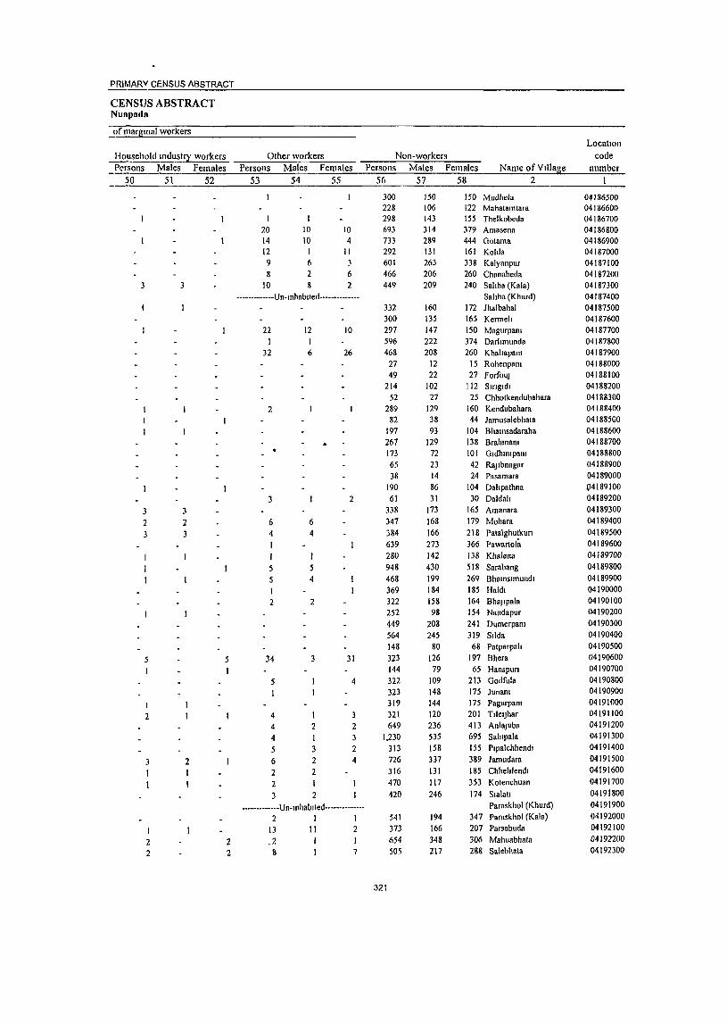
PRIMARV CENSUS ABSTRACT
CENSUS ABSTRACT NUI'pada
()fmaqpnal workers LocatIon
Household llIdu5t~ workers Other workers Non-workers code Pt'fsons Males Females Persons Males Females Persons Males Females Name ofVl1la~e number
50 51 52 53 54 55 56 57 58 2
300 150 150 Mudhela 04186500 228 106 122 Mahatamtara 04186600 298 143 155 Thelkobeda 04186700
20 10 10 693 314 379 Amasena 04186800 14 10 4 733 289 444 Gotama 04186900 12 I II 292 131 161 Kolda 04187000 9 6 3 601 263 338 Kalyanpur 04187100 8 2 6 466 206 260 Chanabeda 04187200
3 3 10 8 2 449 209 240 Sahha (Kala) 04187300 ·-·_··_--··-·Un·lnhablted····-·_·····_· Sahha (Khurd) 04187400
332 160 172 Jhalbahal 04187500 300 135 165 Kermeh 04187600
22 12 10 297 147 150 Magurpal1l 04187700 596 222 374 Darhmunda 04187800
32 6 26 468 208 260 Khahapal1l 04187900 27 12 15 Rohenpal1l 04188000 49 22 27 Forfou] 04188100
214 102 112 Smgldl 04188200 52 27 25 Chhotkendubahara 04188300
2 289 129 160 Kendubahara 04188400 82 38 44 Jamusalebhata 04188500
197 93 104 B hall1sadaraha 04188600 267 129 138 BrahmaOi 04188700 173 72 101 Gldhmlpam 04188800 65 23 42 Ra]lbnagar 04188900 38 14 24 Pasamara 04189000
190 86 104 Dahpathna (J4189100
3 2 61 31 30 Daldah 04189200
3 338 173 165 Amanara 04189300
2 2 6 6 347 168 179 Mohara 04189400
3 4 4 384 166 218 Patalghutkun 04189500 639 273 366 Pawartol~ 04189600 280 142 138 Khalana 04189700
5 5 948 430 518 Sarabang 04189800
5 4 468 199 269 Bhamslmundl 04189900 369 184 185 Ha1dl 04190000
2 2 322 158 164 BhaJlpala 04190100 252 98 154 Nandapur 04190200
449 208 241 DumerpaOl 04190300 564 245 319 Sllda 04190400 148 80 68 Patparpah 04190500
5 5 34 3 31 323 126 197 Bhera 04190600
1 144 79 65 Hanspun 04190700
5 4 322 109 213 Godfula 04190800
I 323 148 175 JunaOl 04190900
I 319 144 175 PagarpaOl 04191000
2 4 3 321 120 201 TllelJhar 04191100
4 2 2 649 236 413 AnlRjuba 04191200
4 I 3 1,230 535 695 Sahlpala 04191300
5 3 2 313 158 155 Plpalchhendl 04191400
2 6 2 4 726 337 389 Jamudara 04191500
2 2 JI6 131 185 Chhehlendl 04191600
2 470 117 353 Kotenchuan 04191700
3 2 420 246 174 Slala!1 04191800
--•••• • •••••• Un·lnhablted •• • •••• • •••• •· Paraskhol (Khurd) 04191900
2 I I 541 194 347 Paraskhol (Kala) 04192000
13 11 2 373 166 207 Parsabuda 04192100
2 2 .2 654 348 306 Mahuabhata 04192200
2 2 1\ 7 505 217 288 Salebhata 04192300
321

lOLatton code
number Name of Village
2
04192400 Padampun 04192500 R8jpumuapada 04192600 Smo1 04192700 Dlanmunda 04192800 Jhllmlla 04192900 Rallpalt 04193000 fhllhlmuapada 04193100 Sakhalora 04193200 Oadtor 04193300 Hernamunda 04193400 Ralupnlt 04193.500 M<lultbhat.l 04193600 Karchul 04193700 Chlpajhar 04193800 PandnpaOl 04193900 LallJlmar 04194000 Panchampur 04194100 Bheen 04194200 PalharapllllJI 04194300 Torra 04194400 Molanuapada 04194500 Tannmahuabhata 04194600 Kulurata1 04194700 DhwBJabhala 04194800 Supah 04194900 Kllkunmundl 04.195000 BagJore 04195100 Musarangl 04195200 ScthJampanl 04195300 Kll1amldadar 04195400 Bhalsadadar 04195500 Pakhanpadar 04195600 Chu1abhllt 04195800 Pandnpam 04195900 Oangadlgarh 04196000 Slltanbahara 04196100 Kodopah 04196200' Bholha 04196300 Chhotlodrn 04196400 Katmgpant 04196500 Lodrn 04196600 Bhllruamunda 04196700 Dharambundha 04196800 Patora 04196900 Jhalap 04197000 Tlkrapada 04197100 Maraguda 04197200 Pcthtapalt 04197300 K':Imeh 04197400 Golabandh 04197500 KankennanJI 04197600 Gobaen 0419"'700 Tanwat 04197800 Khoksa 04197900 Dhamanpun 04198000 Sunanlal 04199700 Khatr8m
Area of Village In
hect rrOWA Number of ml<1 housenolds
3 4
1710 2800 2710 3050 2610 4060 1750 4290 3850 1810 177 0 3650 5010 1870 2680 3460 2700 7980 3110 3040 3750 1440 4440 1490 4710 4790
80 1340 4390 4080 2080 200
5700 1,0470
2020 177 0 3140 1110 1510 6810 5850 3910
1,1660 4590 2530 4210 562 0 4760 2690 2880 3400 2530 8320 3920 2750 2320 4740
14 611 645 166 132 149 474 221 188
31 116 136 186 35
119 189 197 274
49 237 182
31 166 37
102 69
I 52 96
127 86 39
168 206
73 14
148 16 22
101 118 176 614 236
10 33 50
133 88 81
128 397,
' 169 101 55
I7S
DISTRICT CENSUS HANDBOOK NUAPAq_A_:_
VILLAGE PRIMARY CD Block·
Total populallon (lncludmg mstltutlOnal and houseless Population 111 the
populatIOn) • age-group 0-6 __ Persons Males Feml!le~ Persons Malob Fenlales
5 6 7 8 9 10
89 H54 3,018
782 641 722
2,195 1,006
770 153
494 691 879 146 486 961 982
1,188 212
1,023 840 129 699 183 475 345
5 197 406 493 )67 169 838 947 298
53 643
53 113 399 629 784
2,967 929
322
35 124 243 552 392 394 481 .766 757 486 253 91 I
49 1,491 1,584
380 322 370
1,151 487 373
76
256 341 436
76 236
485 506 587 112 505 408 63
354 90
237 164
2 94
196 230 J70 75
410 482 142 26
323 25 56
188 311 389
1,566 496
40 1,363 1,434
402 319 352
1,044 519 397
77 238 350 d4J
70 250 476 476 601 100 518 432 66
345
93 238 181
3 103 210 263 197 94
428 465 156 27
320 28 57
211 318 395
1,401 433
9 398 424 132 III 109 289 178 134 28 82
109 137
17 87
150 170 189 40
180 172 23
120 33 94 64
37 71 88 84 19
180 166 47
9 iOO
8 18 83
104 152 484 144
···········_·Un·tnhahUed··-······_-- • 14 21 2 ~ M 17
116 127 S5 269 190 188 234 858 356 237 116 451
283 202 206 247 9C8 401 249 1..37
460
113 71 59 74
264 151 80 35
168
(,
204 199 63 61 57
154 85 '59 16 42 57 75 11 52 80
104 107 25 92 88 13 66
19 51 32
17 32 40 42 5
94 93 18 7
55 4
10 35 57 90
265 86
8 28 49 24 77 14
132 74 40 17 86
J 194 225 69 ~n
52 135 91 7) II ~O
~?
62 \, 3) 70 66 82 15
,88 31 I{I
51
14 43 32
in 39 4S 42 14 8~
7, 29 2
45 4 8
4S 47 62
219 58
2 9
27 64 47 32 4('
132 77 40 18 ~2

PRIMARY CENSUS ABSTRACT
CENSUS ABSTRACT Nuapada
Scheduled Castes popuatlOn Persons Males Females
II 12 13
295 611
59 12
226 329
72 68 7
13 30
138
2 215 130 79
240 12
369 36
169 10
18
42 4
45 29
II 38
8 12
335 133
I 17 30 39 81
20 185
74 3
31
163 322 26
7 121 169 36 33
2
7 12 69
I 105 68 49
124 6
192 18
83
7
22 2
20 15
4 23
I 3 6
177 75
I 6
13 18 36
7 81 32 2
14
132 289
33 5
105 160 36 35
5 6
18 69
I 110 62 30
116 6
177 18
86 5
II
20 2
25 14
7 15
5 6
158 58
II 17 21 45
13 104 42
17
Scheduled Tnbes population Persons Males Females
14 15 16
19 258 374 581 342 237 131 455 133
12 95
225 715
61 166 161 503 397
76 487 333 98
218 168 158 301
147 218 234 210 163 608 713 275 42
268 25
107 224 522 558 904 466
II 133 217 282 168 119 79
210 60 7
46 119 354 32 84 79
261 187 39
227 155 47 98 82 77
148
72 103 \34 101 72
298 364 135 22
135 12 53
106 257 280 500 237
8 125 157 299 174 118 52
245 73 5
49 106 361
29 82 82
242 210
37 260 178
51 120
86 81
153
75 115 ISO 109 91
310 349 140 20
133 13 54
118 265 278
404 229
-------------Un-mhablted--------------27 10 17 83 41 42
205 99 106 458 227 231 280 139 141 308 147 161 267 131 136 834 407 427 283 135 148 177 168 618
88 76
307
89 92
311
323
Persons 17
47 1,905 2,007
303 233 269
1,423 395 315
25 108 337 200
53 158 470 400 361 38
295 262
44 240
25 158 107
36 82
\57 61 19
230 232
28 6
226 10 22 53
177 212
1,242 440
8
20 64
145 127 84
152 760 191 168
83 254
Literates Males
18
32 1,114 1,189
216 162 187 827 267 208
18 79
207 161 45
112 290 277 2S7
27 214 187
31 166
21 107 80
25 68
\\3 47 14
166 179
21 2
141 7
19 46
115 142 842 302
6 17 46
115 100 69
126 540 141 125
51 199
Females Name of Village 19 2
15 Padampun 791 RaJPurnuapada 818 Sirtol 87 Dmnmunda 71 Jhllmlla 82 Ratlpah
596 Thakurnuapada 128 Sakhatora 107 Gadlor
7 Hernamunda 29 Ratapah
130 Mauhbhata 39 Karchul
8 Chlpajhar 46 Pandnpam
180 LallJ1mar 123 Panchampur 104 Bhera
11 PatharapunJI 81 Torra 75 Motanuapada 13 Tanamahuabhata 74 Kukuratal
4 DhwaJabhata 51 Supah 27 KukuTlmundl
Bamore 11 Musarangl 14 SethJampam 44 Kalamu\adar 14 Bhalsadadar 5 Pakhanpadar
64 Chulabhat 53 Pandnpam
7 Gangadlgarh 4 Slhanbahara
85 Kodopah 3 Bhotha 3 Chhotlodra 7 Katlllgpam
62 Lodra 70 B haruamunda
400 Dharambandha 138 Patora
Jhalap 2 Tlkrapada 3 Maraguda
18 PethJapah 30 Kermeh 27 Golabandh 15 KankermallJl 26 Gobara
220 Tanwat 50 Khoksa 43 DhamanpuTl 32 Sunantal 55 Khalranl
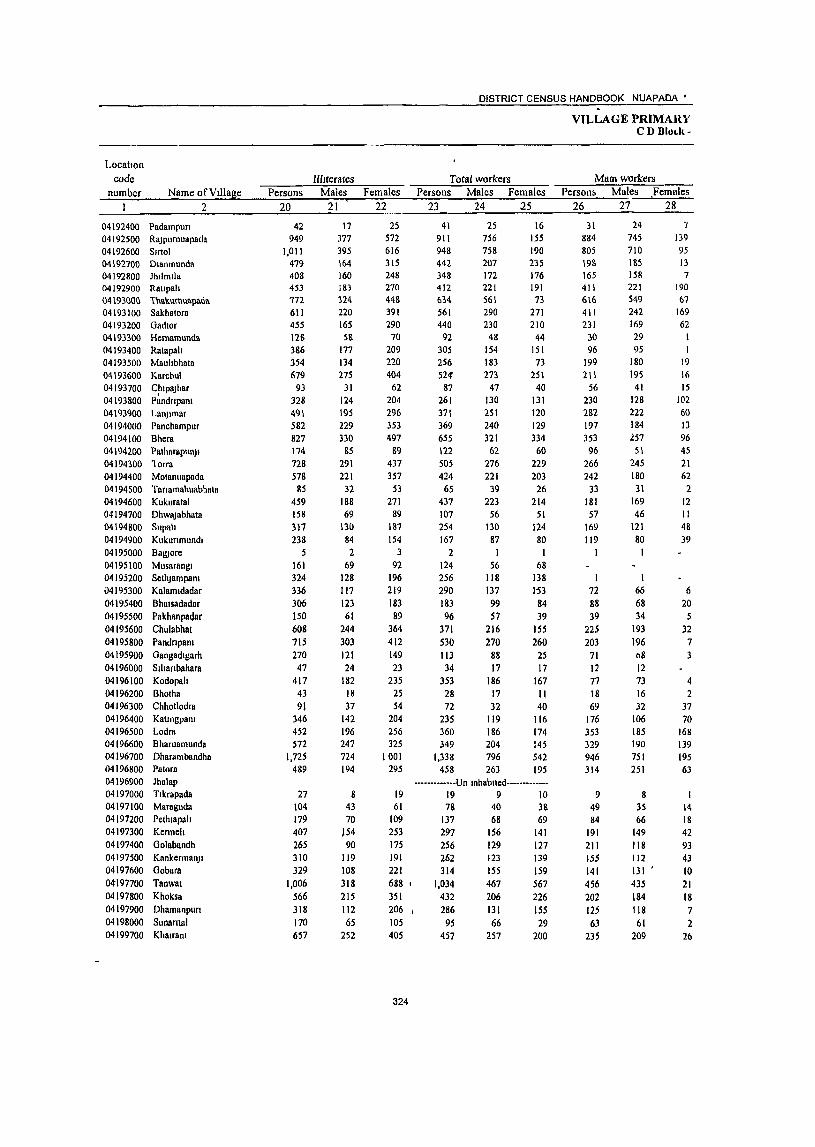
Locatton code
number Name of VIllage 2
04192400 Padampun 04192500 ROjpurnuapada 04192600 Slrtol 04192700 Dlanmunda 04192800 Jhllnllia 04192900 Rallpah 04 \ 93000 1'hakurnuapada 04193100 Sakhatora 04193200 Gadtor 04193300 Hernamunda 04193400 Ratapah 04193500 Mauhbhata 04193600 Karchul 04193700 Cptpojhar 04193800 Pandnpam 04193900 Lanjtmar 04194000 Panchampur 04194100 Bhern 04194200 PalhllTllpunJt 04194300 lorra 04194400 Motanllapada 04194500 Tanamahuabhala 04194600 Kllkuratal 04194700 DhwaJ8bhata 04194800 Supalt 04194900 Kukunmundt 04195000 Bag)ore 04195100 Musarnngt 04195200 Seth Jam pam 04195300 Kalamtdadar 04195400 Bhatsadadar 04195500 Pakhanpadar 04195600 Chulabhat 04195800 Pandnpam 04195900 Gangadtgarh 04196000 Sthanbahara 04196100 Kodopah 04196200 Bhotha 04196300 Chhotlodra 04196400 Katmgpam 04196500 Lodm 04196600 Bharuamunda 04196700 Dhammbandha 04196800 Patont 04196900 Jhalap 04197000 Ttkrapada 04197100 Mnraguda 04197200 Pethlapalt 04197300 Kenneh 04197400 Golabandh 04197500 KankemlanJI 04197600 Gobara 04'197700 Tanwsl 04197800 Khoksn 04197900 Dhamanpurt 04198000 Sunartlal 04199700 Khatrnm
Persons 20
42 949
1,011 479 408 453 172 611 455 128 386 354 679
93 328 49\ 582 827 114 728 578
85 459 158 317 238
5 161 324 336 306 150 608 715 270 47
417 43 91
346 452 572
1,725 489
27 104 179 407 265 310 329
1,006 566 318 170 657
Illiterates Males
21 '
17 377 395 164 160 IS3
114 220 165 58
177 134 275
31 124 \95 229 330
85 291 221
32 188 69
130 84 2
69 128 117 123
61 244 303 121 24
182 18 37
142 196 247 724 194
8 43 70
)54 90
119 108 318 215 112 65
252
Females 22
25 572 616 315 248 270 448 391 290
70 209 220 404
62 204 296 353 497
89 437 357
53 271
89 187 154
3 92
196 219 \83 89
364 412 149 23
235 25 54
204 256 325
1001 295
19 61
109 253 175 191 221 688 , 351 206 I
105 405
324
DISTRICT CENSUS HANDBOOK NUAPADA'
Total workers Persons Males Females
23 24 25
41 911 948 442 348 412 634 561 440
92 305 256 524
87 261 371 369 655 122 505 424
65 437 107 254 167
2 124 256 290 183 96
371 530 113 34
353 28 72
235 360 349
1,338 458
25 756 758 207 172 221 56\ 290 230
48 154 183 273
47 130 251 240 321
62 276 221
39 223
56 130
87
56 118 137 99 57
216 270
88 17
186 17 32
119 186 204 796 263
16 155 190 235 176 191 73
271 210
44 151 73
251 40
131 120 129 334 60
229 203
26 214
51 124 80
I 68
138 1'53
84 39
155 260
25 17
167 11 40
116 174 145 542 195
-------------Un tnhabllcd-------------19 9 10 78 40 38
137 68 69 297 256 262 314
1,034 432 286
95 457
156 129 123 155 467 206 131 66
257
141 127 139 159 567 226 155 29
200
VILLAGE PRIMARY CD BloLll-
MaIO workers Person& Males ,Females
26 27 28
31 884 805 198 165 411 6\6 411 231
30 96
199 21 \
56 230 282 197 353 96
266 242
33 181 57
169 119
72 88 39
225 203
71 12 77 18 69
176 353 329 946 314
9 49 84
191 211 ISS 141 456 202 125 63
235
24 745 710 185 158 221 549
242 169 29 95
180 \9S
41 128 222 184 257
51 245 180 31
169 46
121 80
I
1 66 68 34
193 196 08 12 73 16 32
106 185 190 751 251
8 35 66
149 1t8 112 131 ' 435 184 118 61
209
-, 139 95 13 7
190 67
169 62
1
19 16 15
102 60 13 96 45 21 62 2
12 II 48 39
6 20 5
32 7 3
4 2
37 70
168 139 195 63
14 18 42 93 43 10 21 18 7 2
26
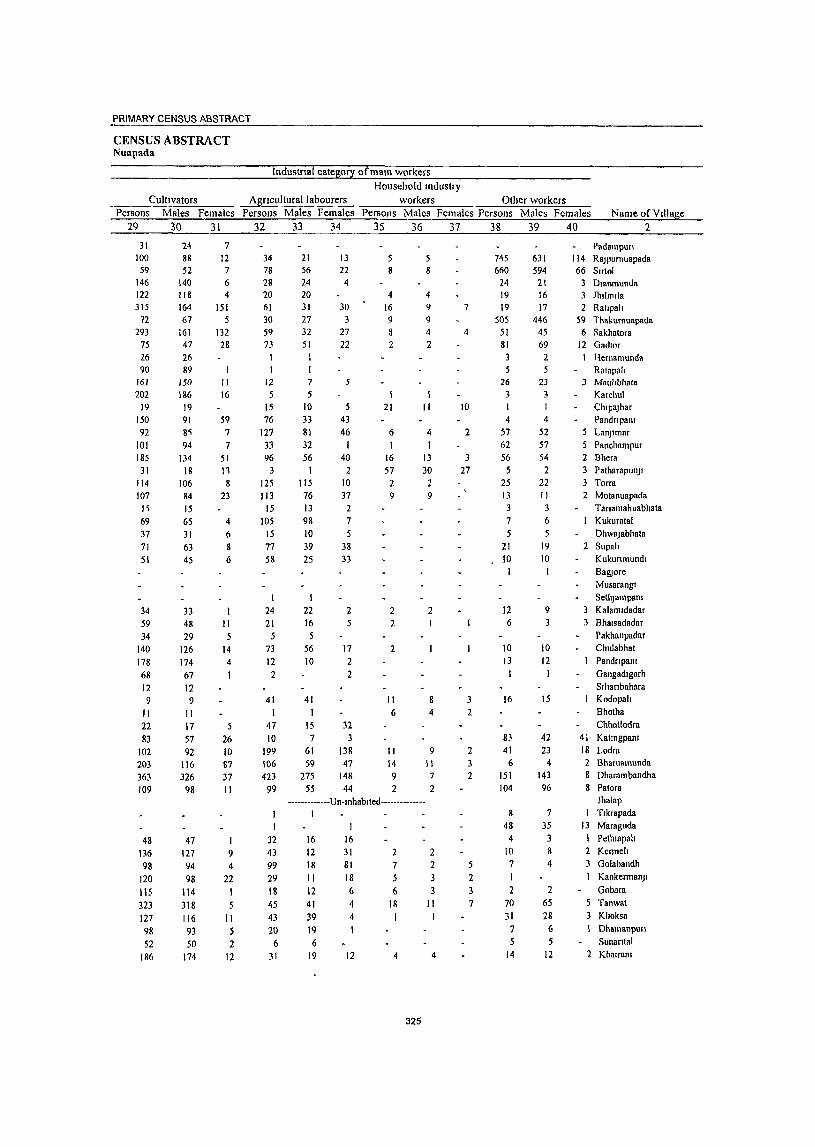
PRIMARY CENSUS ABSTRACT
CENSUS ABSTRACT Nuapada
Industrial category ofmam workers
Cultivators Agncu!turallabourers Household mdustry
workers Olher workers Persons Males Females Persons Males Females Persons Males
29 30 31 32 33 34 35 36
31 100 59
146 122 315
72 293
75 26 90
161 202
19 150 92
101 185
31 114 107
I ~
69 37 71 51
34 59 34
140 178 68 12 9
11 22 83
102 203 363 109
48 136 98
120 lIS 323 127 98 52
186
24 88 52
140 118 164 67
161 47 26 89
150 186
19 91 8~
94 134
18 106
84 15 65
31 63
45
33 48 29
126 174 67 12 9
11 17 57 92
116 326
98
47 127 94 98
114 318 116 93 50
174
7
12 7 6 4
151 5
132 28
11 16
59 7 7
51
11 8
23
4 6 8
6
11 5
14 4
5 26
10 87
37 11
9 4
22 I 5
11 5 2
12
34 78 28 20
61 30 59 73
1 1
12 5
15 76
127 33 96 3
125 113
15 105
15 77 58
24 21
5
73 12 2
41 1
47 10
199 106 423
99
32 43 99 29 18 45 43 20 6
31
21 56 24 20
31 27 32 51
I
7
5 10 33 81 32 56
1 115 76 13 98 10 39 25
1 22 16 5
56
10
41 I
15 7
61 59
275 55
13 22 4
30 3
27 22
5
5 43 46
I 40
2 10 37
2 7 5
38
33
2 5
17 2 2
32
3 138 47
148 44
4 16 9
8 2
21
6
16 57 2 9
2 2
2
II 6
11 14 9 2
5 8
4 9 9 4
2
11
4
I 13 30 2 9
2
8
4
9 II 7 2
•••.. -.•••• --Un-Inhablted •.••• -••• -•••• 1
16 12 18 11 12 41 39 19
6 19
16 31 81 18 6
4 4 1
12
7
5
6 18 I
4
325
2 2
3 11
4
Females Persons Males Females Name ofV111age 37 38 39 40 2
7
4
10
2
3
27
3
2
2 3
2
5
2
7
745 660
24 19 19
50S 51 81
3
5 26
3 I 4
57 62 56
5 25 13 3
7
5 21 10
12 6
10 13
16
83
41 6
151 104
8
48
4 10 7 1 2
70 31 7
14
631 594
21 16 17
446 45 69
2
5
23 3
4 52 57 54
2 22 11 3 6
19 10
9 3
10 12
15
42 23
4
143 96
7 35
3 8
4
2 65
28 6 5
12
Padampun 114 Rajpumuapada 66 Slrtol
3 Dlanmunda 3 Jhllmlla 2 Ratlpah
59 Thakurnuapada 6 Sakhatora
12 Gadtor I Hernamunda
Ratapah 3 Mauhbhata
Karchul Chlpajhar Pandnpam LanJlmar Panchampur
2 Bhera 3 Patharapunjl 3 Torra 2 Motanuapada
Tanamahuabhata Kukuratal Dhwajabhata
2 Supall Kukunmundl Baruore Musarangl Setilpmpam Kalamldadar
3 Bhalsadadar Pakhanpadar Chulabhat PandnpaOl Gangadlgarh SllIanbahara Kodopah Bhotha Chhotlodra
41 KatmgpaOl 18 Lodra 2 Bharuamunda 8 Dharambandha 8 Patora
JhaJap 1 Tlkrapada
13 Maraguda 1 Pelhmpah 2 Kennell 3 Golabandh
Kankemlanjl Gobara
5 Tanwat 3 Khoksa
Dhamanpun Sunantal
2 Khalral1l

DISTRICT CENSUS HANDBOOK NUAPAOA'
VILLAGE PRIMAPY CD Block-
Industrial cateM!Y --Location
coae number
Margmal workers Cultivators Agnculturallab~~~_ Name of V lllag_e -=-p-er-s-on';"S'-="":'-'M~a':-le-'-sO=":::F,o.e-m.~a~le~s_-...:"::p;e::..:r-s:::o~n-=-s-__ M:..:..:.:a:::le;:s_..:.F.:::em:.:.:::al:.:e:::.s _.:..P.:::er:.;:s::,on:..:;s;._...:M.:..::::al~e=-~ _.;Fo..;e:.;;m:=;ft;:;le;;.:_s
2 41 42 43 44 45 46 47 48 49 --~--------~--------~~----~----~----~~--------~.;.._----04192400 Padamj'lurt 04192500 Rajpurnuapada 04192600 Slrtol 04192700 Dlanmunda 04192800 Jhllmlla 04192900 Rallpall 04193000 Thakurnuapada 04193100 Sakhatora 04193200 Gadtor 04193300 Hernamun~a
04193400 Ratapah 04193~00 Mauhbhata 04193600 Karchu! 04193700 Chlpajhar 04193800 Pandnpam 04193900 LanJlmar 04194000 Panchampur 04194100 Shern 04194200 Palhllrapunjl 04194300 fOITa 04194400 Motanuapadn 04194500 Tanamahuabhata 04 194600 Kukuratal 04194700 Dh\\8jabhata 04194800 Supah 04194900 Kukunmundl 04195000 Sa.ruore 0419~ 100 Musarangl 04 195200 SetIlJampam 04 195300 Kalamldatlar 04195400 Bhalsadadar 04195500 Pakhanpadar 04195600 Chulabhat 04195800 PlIodnpant 04195900 Oangadlgarh 04196000 Sihanbaharn 04196100 Kodopah 04196200 Bhotha 04 196300 Chhotlodra 04196400 KallngpHnl 04196500 Lodra 04196600 Bharuamunda 04196700 Dharambandhn 04196800 Patora 04196900 Jhalap 04197000 Tlkrapada 041971 00 Maraguda 04197200 Pelhlapah 04197300 Kemlch 04197400 Oolabandh 04197500 KankcrmanJi 04197600 Oobara 04197700 Tanwat 04197800 Khoksa 04197900 Dhamanpun 04198000 Sunamal 04199700 Khalrana
10 27
143 244 183
18 ISO 209 62
209 57
313 31 31 89
172 302
26 239 182 32"
256 50 85 48
124 255 218
95 57
146 327 42
, 22 276
10 3
59 7
20 392 144
10 29 53
106 45
107 173 578 230 161 32
222
11 48 22 14
12 48 61 19 59
3 78
6 2
29 56 64 11 31 41
8 54 10 9 7
56 117 71 31 23 23 74 20 5
113 1
13
14 45 12
5 2 7
11 11 24 32 22 13 5
48
9
16 95
222 169
I 6
102 148 43
ISO S4
235 25 29 60
116 238
15 208 141 24
202 40 76 41
I 68
138 147 64 34
123 253
22 17
163 9 3
46 6
6 347 132
9 24 51 99 34 96
149 546 208
1148 27
174
326
7
12 I 7
4
7
I 11 6 54 32
40 4
2 6 5
25 22 50 7
9 2 I3 4
40 6 1 I
52 5 11 2
2 57 26 27 11
7 5 3 2 3
2
2 I 3
30 3
3 2 40 3
I -------------Un-Illhablled-- --
4 2 9 8
132 33
7 1 8
~
22
39 4
2 1 3
43
7 9 1
34
47 9
3 1
16 2 I 2 2
3 27
37
2
99
14 6
239 175
7 135 142 62
205 14
'30Q 31 29 82
140 204
26 229 168
31 216 47 33 37
124 253 149 63
SO 143 322
39 22
266 6
7 6
16
351 142
52 104 45
101 ,71 571 221 161
8 75
1 7 1
21
2 41 2J 19 56
78 6
2 23 11 31 11 28 36
8 48
C)
4 5
56 116 36 Ii 18 2: 72 19 5
III I
12 41 11
I 6
11 j
24 29 14 13 2 9
2 12
" 218 168
91 119 43
149 .3
2'1 25 27 59
Ifi9 173 I ~
2UI 112 )1
loS 38 lQ
17 I
6~
137 113 46 32
122 2~O
20
17 155
6 I>
4 310 131
51 98 34 94
147
S<!~ 207 1411
6 06
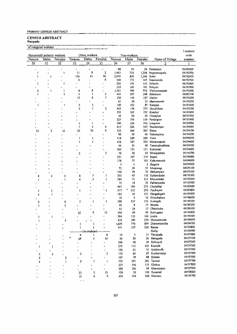
PRIMARY CENSUS ABSTRACT
CENSUS ABSTRACT NUllpada
of marglllal workers Location
Household mdusI!1 workers Other workers Non-workers code Persons Males Females Persons Males Females Persons Males Females Name of Village number
50 51 52 53 54 55 56 57 58 2
48 24 24 Padampun 04192400 11 9 2 1,943 735 1,208 RaJPurnuapada 04192500
124 41 83 2,070 826 1,244 Smol 04192600 4 4 340 173 167 Dlanmunda 04192700
293 150 143 Jhllmlla 04192800 310 149 161 Ratlpah 04192900
2 8 8 1,561 590 971 Thakurnuapada 04193000 3 1 2 445 197 248 Sakhatora 04193100
13 6 7 330 143 187 Gadtor 04193200 61 28 33 Hernamunda 04193300
2 2 189 102 87 Ratapah 04193400 3 1 2 435 158 277 Mauhbhata 04193500
355 163 192 Karcflul 04193600 59 29 30 ChlpaJhar 04193700
225 106 119 Pandnpam 04193800 590 234 356 Lalljlmar 04193900
7 3 4 613 ' 266 347 Panchampur 04194000
15 2 13 33 24 9 533 266 267 Shern 04194100 90 50 40 Patharapullj 1 04194200
518 229 289 Torra 04194300 416 187 229 Motanuapada 04194400
64 24 40 Tanamahuabhata 04194500
262 131 131 Kukuratal 04194600
2 2 76 34 42 DhwaJabhata 04194700 221 107 114 Supah 04194800 178 77 101 Kukunmundl 04194900
3 I 2 BagJore 04195000
73 38 35 Musarangl 04195100 150 78 72 SethJsmpam 04195200
4 2 2 8 7 203 93 110 Kal am I dadar 04195300
I 4 3 184 71 113 Bhalsadadar 04195400 73 18 55 Pakhanpadar 04195500
467 194 273 Chulabhat 04195600 417 • 212 205 Pandnpam 04195800
185 54 131 Gangadlgarh 04195900 19 9 10 Sihanbahara 04196000
6 6 2 290 137 153 Kodopah 04196100
3 3 25 8 17 Bhotha 04196200
41 24 17 Chhotlodra 04196300
22 9 13 164 69 95 Katmgpam 04196400
269 125 144 Lodra 04196500
435 185 250 Bharuamullda 04196600
1,629 770 859 Dharambandha 04196700
471 233 238 Patora 04196800
-_ ••••• • ... -·Un-Inhablled···----------- Jhnlap 04196900
9 I 8 16 5 11 Tlkrapada 04197000
29 5 24 46 20 26 Maraguda 04197100
106 48 58 p'ethl3pah 04197200
255 113 142 Kerrneh 04197300
136 61 75 Golabandh 04197400
3 3 2 2 132 65 67 KankermanJI 04197500
2 2 167 79 88 Gobara 04197600
2 732 391 341 Tanwat 04197700
325 150 175 Khoksa 04197800
200 106 94 Dhamanpun 04197900
23 2 21 158 50 108 Sunantal 04198000
15 6 9 454 194 260 Khalralll 04199700
327

PRIMARY CENSUS ABSTRACT OF KOMANA C.D. BLOCK- 0002
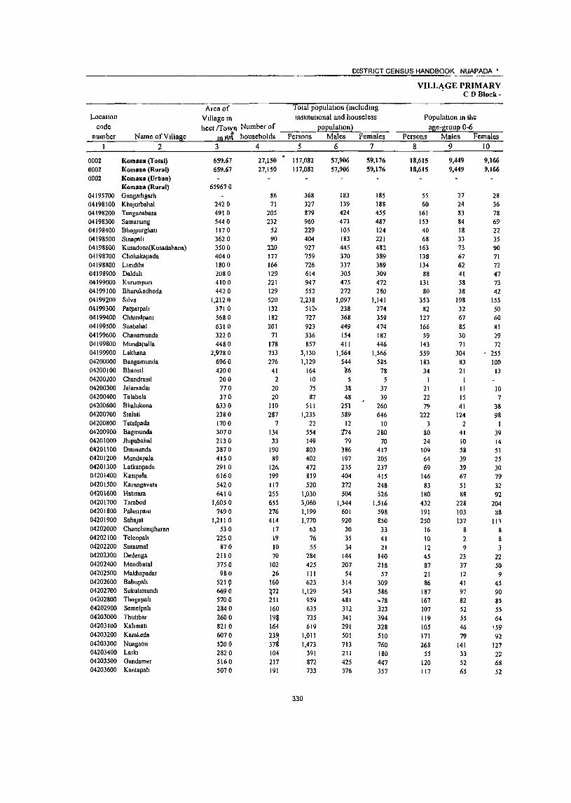
Location code
number
0002 0002
Name of VIllage 2
Komana (Total) Komann (Rural)
0002 Komana (Urban) Komana (Rural)
04195700 Gangadtgarh 04198100 KhaJurbahal 04198200 Tenganabasa 04198300 Samarsmg 04198400 BhoJPurghau 04198500 Smapah 04198600 Kusadonn(Kusadahana) 04198700 Chohakapada 04198800 Llmdthl 04198900 Daldah 04199000 Kurumpun 04199100 BhuruJ..adhoda 04199200 Silva 04199300 Patparpah 04199400 Chhmdpam 04199500 Suabahal 04199600 Chanamunda 04199800 Mundapalla 04199900 Lakhana 04200000 Bangamunda 04200 I 00 Bhaosll 04200200 Chandrastl 04200300 Jalamadat 04200400 Talabela 04200600 Bhalukona 04200700 Sialati 04200800 Tetelpada 04200900 Bagmunda 04201000 Jhlpabahal 04201100 Dlamunda 04201200 Mundapala 04201300 Latkanpada 04201400 Kaslpala 04201500 Karangavata 04201600 Hatlsara 04201700 Tarabod 04201800 Pnlaslpam 04201900 SahaJat 04202000 Chanchar8Jharan 04202100 Telenpah 04202200 Sarasmal 04202300 Dedengn 04202400 Mendhatal 04202500 Makhapadar 04202600 Babupah 04202700 Sukultmundl 04202800 Thogapah 04202900 Semelpah 04203000 Thutlbar 04203100 Kahmall 04203200 KamJ..eda 04203300 Nuagaon 04203400 Larkl 04203500 Gandamer 04203600 Kantapah
DISTRICT CENSUS HANDBOOK NUAPADA'
Area of Total populatIOn (mcludmg Village m Instltutlonal and houseless hecl !Tow'! Number of --:::--__ "-po:.Jp;-;;u;:.:la:;.:.ll:.;o,;;;;n~) -;:;-_-:-_
ID K~ households Persons Males Females 3 4 5 6 7
659.67 659.67
659670
2420 4910
5440 1170 3620 3500 4040 1800 2080 4100 4420
1.212 0 3710 5680
6310
3220 4480
2,978 0 6960 4200 200
770 370
6330 2380
1700 3070
2130 3870 4150 2910 6160
5420
6410 1,6050
7490 1,2110
530 2250
870
21 10 3750 980
5219 6690 5700 2840 2600
8210
6070
5200 2820
5160 5070
27,150
27,150
86 71
205 232
52 90
220 177 166
129 221 129 520
132 182 201
71
178 733 276
41 2
20 20
ltO 287
7 134 33
190 89
126. 199
117
255 655 276 414
17 19 10 70
102
26 160 ~72 211 160
19~ 164 23~ 37&
104 217 191
117,082 117,082
368 :)27
879
960 229
404 927 759 726 614 947 552
2,238
512· 727 923 336
857 3,130
1,129
164 10
75 87
511 1,235
22 554 149
803 402 472 819 520
1,030 3,060
1,199 1,770
63 76
55
284
425 III 623
1,129 959 635
735 619
1,011
1,473
391 872 733
330
57,906
57,906
183 139 424 473 105 183 445 370 337 305 475 272
1,097 238 368 449 154
411 1,564
544 116 5
38 48
251 589
12 174
79 386 197 235 404
272 504
1,544 601
920
30
35 34
144
207 54
314 543 481 312 341 291 501 713 211 425 J76
59,176
59,176
185 188 455
487 124 221 482 389
389 309 472 280
1,141
274 359
474
182 446
1,566
585 78
5 37 39
260 646
10 280
70 417 205
237 415 248 526
1,516
598 850
33 41 21
140
218
57 309 586 .. 78
323 394 328
510 760 180 447 357
VILLAGE PRIMARY . CD Block-
PopulutlOn m the age-group 0-6
Persons Males Females 8 9 10
18,615 18,615
55 60
161 153 40 68
163
138 134
88 131 80
353 82
127
166 59
143
559
183 34
I 21 22 79
222
3 80 24
109 64 69
146 83
180
432 191 250
16 10 12 45 87
21 86
187 167 107
119 105
171
268 55
120 117
9,449 9,449
27 24
83 84 18 33 73 67 62 41
58 38
198
32 67 85 30 71
304
83 21
II 15
41 124
2 41 10 58 39 39 67
51 88
228 103
137
8 2 9
23 37
12 41 97 82 52 55 46 79
141 33 52 65
9,166 9,166
28 36 78 69
22 35 90 71
72 47 73
42 155 50 60
81
29
72 255
100
13
10 7
38
98 I
39 14 51
25 30 79
32 92
204 88
111
8 8 3
22 50 9
45 90 85 55
64 \59 92
127 22 68 52
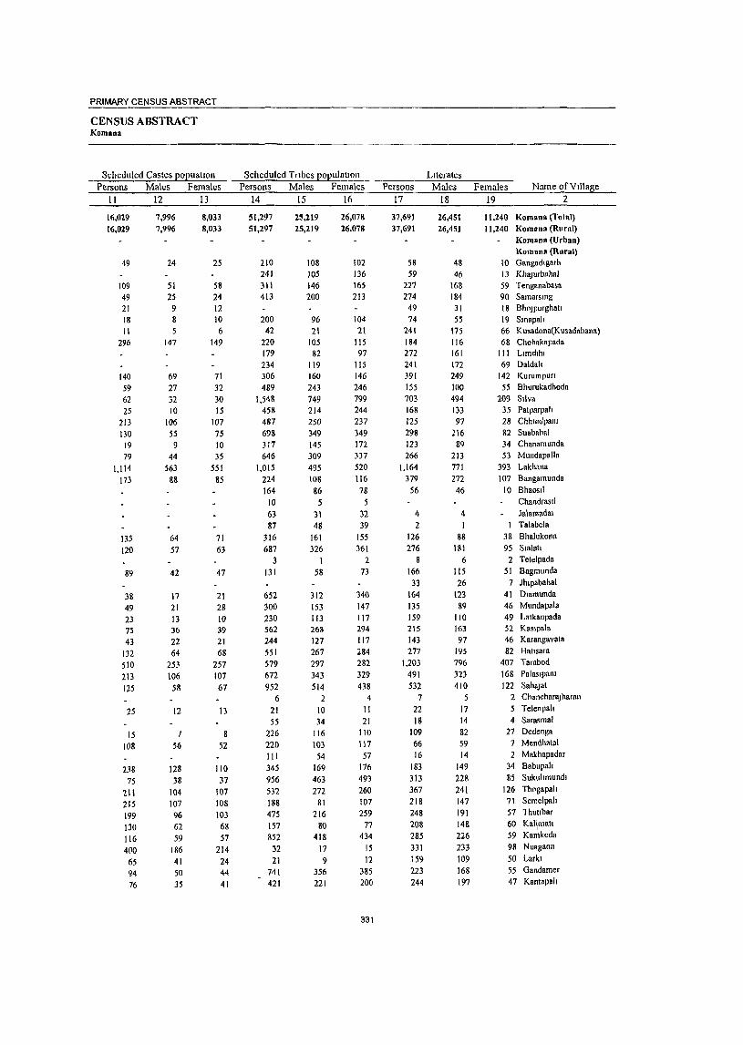
PRIMARY CENSUS ABSTRACT
CENSUS ABSTRACT Komana
Scheduled Castes popuahon Scheduled Tribes populattoll LIterates Persons Ma\es Females Persons Males Females Persons Males Fema\es Name of Village
1\ 12 .~13~ ____ ~1~4 ____ ~15~ __ ~1~6 ______ 1~7 ____ ~1~8 ____ ~19~ ________ ~2 ____ ___
16,029
16,029
49
109 49 21 18 II
296
140
S9 62 25
213 130
19 79
1,114
173
135 120
89
38 49 23 75 43
132 510 213 125
25
15 108
238 15
211 215 199 130 116 400
65 94 76
7.996 7,996
24
51 25 9 8 5
147
69 27 32 10
J06 55 9
44 563
88
64 57
42
11
21 13 36 22 64
253 106
58
12
56
128 38
104 107 96 62 59
186 41 50
35
8,033 8,033
25
58 24 12 10 6
149
71 32 30 15
107 75 10 35
551 85
71 63
47
21 28 10 39 21 68
257 107 67
13
8 52
110 37
107 108 103
68 57
214 24 44 41
51,297 25,219 26,078 51,297 25,219 26,078
210 108 102 241 105 136 311 146 165 413 200 213
200 96 104 42 21 21
220 105 115 179 82 97 234 119 115 306 160 146 489 243 246
1,548 749 799 458 214 244 487 250 237 698 349 349 317 145 172 646 309 337
1~15 495 520 224 108 116
164 86 78 10 5 5 63 31 32 n 48 ~
316 161 155 687 326 361
3 2 131 58 73
652 312 340 300 153 147 230 113 117 562 268 294 244 121 117 551 267 284 579 297 282 672 343 329
952 514 438 6 2 4
21 10 II 55 34 21
226 116 110 220 103 117 III 54 57 345 169 176 956 463 493 532 272 260 188 81 107 475 216 259 157 80 77 852 418 434
32 17 15 21 9 12
741 356 385 421 221 200
331
37,691 26,451 37,691 26,45)
58 48 59 46
227 168 274 184
49 31 74 55
241 175 184 116 272 161 241 172 391 249 155 100 703 494 168 133 125 97 298 216 123 89 266 213
1,164 771 379 272
56 46
4 4 2
126 88 276 181
8 6 166 115 33 26
164 123 135 89 159 110 215 163 143 97 277 195
1.203 796 491 323 532 410
7 5 22 17 18 14
109 82 66 59 16 14
183 149 313 228 367 241 218 147 248 191 208 148 285 226 331 233
159 109 223 168 244 197
11,240 Komana (Total) II ,240 Komana (Rural)
Komana (Urban) Komana (Rural)
10 Gangadlgarh 13 Kha)urbahaJ 59 Tenganabasa 90 Samarsmg 18 Bho)purghatl 19 Smapalt 66 Kusadona(Kusadahana) 68 Chohakapada
III Llmdlhl 69 Daldah
142 Kurumpun 55 Bhurukadhoda
209 SIlva 35 Patparpah 28 Chhmdpanr 82 Suabahal 34 Chanamunda 53 Mundapalla
393 Lakhana 107 Bangamunda
10 Bhaosll ChandrasI! Ja\amada\
1 Talabela 38 Bhalukona
95 Smlatl 2 Telelpada
51 Bagmunda 7 )hlpabahal
41 Dlamunda 46 Mundapala 49 Latkanpada 52 Kaslpa\a 46 Karangavala 82 Haltsara
407 Tarabod 168 Palaslpam 122 Saha)at
2 Chanchara)haran 5 Telenpah 4 Sarasmal
21 Dedenga 7 Mendhatal 2 Makhapadar
34 Babupah 85 Sukullmundl
126 Thogapah 71 Sernelpah 57 lhuubar 60 KaHmall
I
59 Kamkcda 98 Nuagaon
50 Larkl 55 Gandamer 47 Kantapah
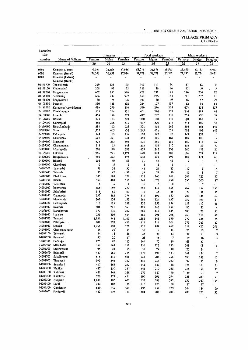
----_.--------------------__ --.--------- DISTRICT CENSUS i-IANDBOOI( ~~9!,_'
VIl"LAGE PRI~ARY CD B1oci("
Location code
number Illiterates Total workers Main workers
Name of Village Persons Males Females Persons Males Fenloles Persons Males Fe.n(1Ie;:-__ ~ ________ ~2~ ______ ~2~O ____ ~2~1 ____ ~2=2 ____ _=23~ ___ ~24~ ___ ;2~5 _____ 26 27
22,711 22,72.
28
0002 Komana (Total) 0002 I(omana (Rural) 0002 Kumana (Urban)
Komana (Rural) 04195700 Gangadigarh
04198100 Khajurbahal
04198200 Tcnganabasa
04198300 Samarsing
04198400 Bhojpurghati
04198500 Sinapah
04198600 KusadonalKusadahana)
04198700 Chohakapada 04198800 Limdihi
04198900 Daldali
04199000 Kurumpuri
04 199100 Bhurukadhoda o.t199200 Silva I 04199300 Patparpali
04199400 Chhindpani
04199500 Suabahal
04199600 Chanamunda
04199800 Mundapalla 04199900 Lakhann
04200')00 Bangamunda
04200 I 00 D haosil
04200200 Cilandrasli
04200300 Jalamadai
04200400 Talabela
04200600 Bhalukona
04200700 Sialati
04200800 Tetelpada
04200900 Bagmunda
04201000 Jhipabahal
04201100 Oiarnunda
04201200 MUlldnpnla
04201300 Latkallpadn
04201400 Kasipala
042<l1500 Karangavata
04201600 Hausara
04201700 Tarabod
04201800 Palasipani
04201900 Sahajat
04202000 . Chnncharajharl\1l
04202100 Te1enpali
04202200 Sarasmal 04202300 Oedenga
04202400 Mendhatal
04202500 Makhapadar
04202600 Babupali
04202700 Sukulimundi
04202800 Titogapali
04202900 Semelpali
04203000 Thutibar
04203100 Kalirnati
04203200 Kamkeda
04203300 Nuagaon
04203400 Larki
04203500 Gandarner
04203600 Knntapali
79,391 79,391
310
268
652 686 180 330
686
575 454
373
556
397
1,535 344 602 625
213 591
1,966 750 108
10 71 85
385
959
14 388 116 tj39· 267
313 604 377 753
1,857 708
1,238
56 S4 37
175 359
95 440 816 592 417 487 411 726
1,142 232 649 489
31,455 31,455
135
93
256 289
74 128 270 254
176
133 226 172 603
lOS 271 233
65 198
793 272
40
5 34 47
163
408 6
159 53
263 108
125 241
175
309
748 278
510 25' 18 20 62
148 40
165 315 240
j 165 150 143 275 , 480
102 257
179
47,936 47,936
175
175
396
397 106 202 416
321
278
240
330
225 932
239 331 392 148 393
1,173
478 68
37 . 38 222 551
8
229 63
376 159 188 363
202 444
1,109 430 728
31 36 17
113 211
55 275 501
352
252 337 268 451
662 130 392 310
332
58,072
58,072
145 182 422
469
109
224 550
401 412 350 487 ~28
1,245 168 368 525
213
479 1,698
608 91
8 48 59
321 541
16 268
73 377 261 330 49g 287 587
1.382 517 955
30 34
23 160
250 59
375 543 440 341 445 377
590
733 210 498 404
32,571 32,571
III 86
249
286
60
107 296
224 202 180 270
166 621 142 185 266 103 247 898
309
48 3
26 29
160 323
8 132 38
197 124 156 246 142
291 843 316 488
!9 21 16 80
127
29 192 285 238 183 210 187 296 391 120 259 203
25,501 25,501
34 96
173 183
49
I !7
254 177 210 no 217
162 624
26 183
259 110 232
800 299
43
5 22
30
161 218
8 136 35
180
137 174 252 145
296 539 201
467 11
13 7
80 123 30
183 258 202 158 235 190 294 342 90
239 201
28,193 28,193
87
13
216
243 86
162
407 264
253
1~0 243 J08 682
143
187 180 153 260 696 181
7
12 15
202 387
7 267
73 208 152 158 85
103 263 272 275 719
26 30
19 63
103
25
161 193 92
124 216
80
338 531
77 204 208
M2 ,0
204 132
57 \I()
254 203
196 161
180 16t 495 134 180 113 33
173 577 121
3
8 g
125
300
7
132 38
145 101 112
81
72 214 246 243 423
19 21 16 63 98 24
154
182 83
101
174
73 247 357
77 184 176
5.471 5,47:
, 3
12 II 1~
66 15.\
I}1 51 19 ')3
147 Ig7 ~ ./
67
7(1
87 119
60 4
4
7 n &7
IJ; 35
63
51
46 4
31 ~9
21> 32
296
7 9
7
11 9
2J 42
7
91 174
20 32
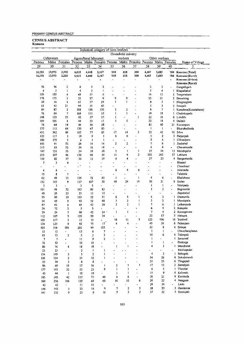
PRIMARY CENSUS ABSTRACT
CENSUS ABSTRACT I(ontana
Industrtal category of mam workers Household mdustry
Cultivators Agnculturallabourers workers Persons Males Females Persons Males Females Persons Males Females
29 30 31 32 33 34 35 36 37
16,193 16.193
7& 4
159 178 20 63 89 76
148 109 78
177 451 122 180 143 115 187 253 119
7
4 15 62
152 3
101 48 95 54 67 74 29
112 120 134 505
12 15 7
52 80 23
154 126 53
88 177 45
185 360
42 146 141
13,973 13,973
76 3
155 175
16 42 87 69
123 105 64
113 362 117 175 91 63
132 207
82 3
4 8
49
143
49
25 85 45
61 72 24
107 117 125 316
12 13 7
52 76
23 149 124 50 69
145 44
143 256
42 143 132
2,220 2,220
2
4 3 4
21 2 7
25 4
14
64 89
5
5 52 52 55 46
37
4
7 13 9
52 23 10 9 6 2
5 5 3 9
189
2
4
5 2 3
19 32
I 42
104
3 9
6,615 6,615
6 4
43 33 61 94
308 168 82 44 84
130 162
10 2
28 34 34
130 31
135 157
3
163 25
103 92 81 5
66 129
12 92
202 13 5
II 10 18 2 3
33 8
17 32 19
117 129 II 23 25
4,448 4,448
3 3
37 27 37
51 158 115 57
33
56 47 77
9
14 16 16 96 12
72 107
3 80 13 52 52 43
5 42 90 12 75
99 6
2 9
10 18
2 32
8 16 23 19 77 69 II 14 9
2,167 2,167
3
6 6
24 43
150 53 25 II 28 83 85
I
14 18 18 34 19
63 50
83 12 51 40 38
24 -39
17 103
7 3 2
1 9
40 60
9 16
918 918
9
2
17 6
2
2 II 4
I 48
6
18 4
2
6
16
7
5
618 618
333
9
2
1
5
14 6
2
1 9 4
4
29
5 2 2
11 4
I 6
10
2 3
300 300
3
2
4
19
7
6
2
Other workers Persons Males Females Name of VIllage
38 39 40 2
4,467 3,683 4,467 3,683
3 3 5 4
14 12 23 21
4 3
5 3 8 7
19 18 22 16 22 18 81 60
I 52 42
5 2 5 4 7 6 4 4
37 24
302 265 27 23
4 30
3
4 3
7 6 7
22
122 45
12 I
10 I
4
4 34 31 17 6
15 30 26 24 28 37
4 21 I 3
3 2 6 4
5 17
106 39
8
6
1 3
26 25 15 5 9
21 22 24 25 32
784 Komana (Total) 784 KomanH (Rural)
KomanH (Urban) Komana (Rural) Gangadlgarh KhaJurbahal
2 Tenganabasa 1 Samarsmg I BhoJPurghal1 2 Smapah
Kusadona(Kusadahana) Chohakapada
6 Llmdlhl 4 Oaldall
21 Kurumpun Bhurukadhoda
10 SlIva 3 Palparpah
Chhtndpalll Suabahal Chanamunda
13 Mundapalla 37 Lakhana
4 Bangamunda Bhaosil Chandrasll lalamadal Talabela Bhalukona
9 Sialal, Tetelpada Bagmunda Jh'pabahal Ommunda Mundapala Latkanpada
2 Kaslpala 2 Karangavata 5 Hallsara
16 Tarabod 6 Palas'pam 4 SahaJat
ChancharaJharan 4 Telenpah
Sarasmal Dedenga Mendhatal Makhapadar Babupah
8 Sukulllllundl 6 ThogapaJr 2 SemelpaJr I Thutlbar 6 Kahmnll 9 Kamkeda 4 Nuagaon
Lark' 3 Gandamer 5 KantapaJr

LocatIon code
number
0002 0002 0002
04195700 04198100 04198200 04198300 04198400 04198500 04198600 04198700 04198800 04198900 04199000 04199100 04199200 04199300 04199400 04199500 04199600 04199800 04199900 04200000 04200100 M'200'200 04200300 04200400 04200600 04200700 04200800 04200900 04201000 04201100 04201200 04201300 04201400 04201500 04201600 04201700 04201800 04201900 04202000 04202100 04202200 04202300 04202400 04202500 04202600 04202700 04202800 04202900 04203000 04203100 04203200 04203300 04203400 04203500 04203600
Name of VIllage 2
Komana (Total) KaIDlina (Rliral) Komana (U rban) Komana (Rllral) Gangadlgarh KhaJurbahal Tenganabasa Samarsmg Bho)PUIghall Smapah Kusadona(Klisadahnna) Chohakapada Llmdlhl Daldah KurumpurJ Bhurukadhoda Silva Patparpalt Chhmdpanl Suabahal Chanamunda Munt,lapalla Lakhana Bangamunda Bhaosil Chandras\\ Jalamadat Talabela Bhalukona SIBlal! Tetelpada Bagmunda Jlupabahal Dtamunda Mundapaln Lntkanpada Kastpala Karangavata Hahsara Tarabod Palastpant SahaJat ChancharaJharan Telenpalt Sarasmal Dedenga Mendhatal Makhapadar Babupalt Sukuhmundl Thogapah Semelpah Thuttbar Kaltmall Kamkeda Nuagaon Larkt Gandamer Kantapalt
Margmal workers Persons Males Females
41 42 43
29,879 29,879
58 169 206 226 23 62
143 137 159 170 244
20 563
25 181 345
60
219 1,002
427 84
& 36 44
119 154
9
169 109 17..! 413 184 324
1,110 242
236 4 4 4
97 147 34
214 350
348 217 229 297 252 202 133 294 196
9,849 9,849
29 76 45 54 3
II 42 21
6 19 90
5 126
8
153 20 74
321 188 45
3 18 21 35 23
52 23 44
165
70
77 597
73
65
17 29
5 38
103 155 ,82
36 114 49 34 43 75 27
20,030 20,030
29 93
161 172 20 51
101 116 153 151 154 15
437 17
176 192 40
145 681
239 39
S 18 23 84
131 8
117 86
128 248 114 247 513 169 171
4 4 4
80 118 29
176 247 193 135 193 183 203 168
90 219 169
334
DISTRICT CENSUS HANDBOOK NUAPADA'
CultIVators Persons Males Females
44 45 46
5,629 5,629
8 31
9 15
6 82
124 44 II
123
2 44 21 II
280 51
7 33
41 30
4 22 53 99
120 175 224
6 83
3
2
101 76
31 126 95 87 42 30
5 26
2,131 2,131
6
2
I 6
14 10 4
30
34 II I
109 33
'2 17 21 17
3 9
27 61 50 42
221 3
29
14 31
4
7 12 59 18 5
7 2 7
3,498
3,498
2 26
7 14
5 76
110 34
7 93
10 10
10 171
18
5 16 20 13
I 13 26
38 70
133 3 3
54
3 I 2
87 45
I 24
114 36 69 37 23
3 19
VILLAGE PRIMARY CD Blocl{-
Indu~tnal category
Agnculturallabourers Persons Males Females
47 48 49
23,103 23,103
56 169 198 188
14 47
135 131 77 46
198 9
437 25
178 301
39 193 668 288
82 \ 3 3
89 152
9
162 8=7
119 314
63 143 875
214 153
4
3 94
147 34
109 272 338 182 101 197
'164 153 102 284 165
7.180 7,180
28 76 39 44
1 10 42 20
79 I
93 8 4
119 9
63 188 93 44
\ I
18 23
I
49 14 17
104 19 32
366 52 36
16 29
5 23 71
147 74 23 50 31 27 36 69 18
15.923 15.921
28 93
159 144
11 37 93
III 77 41
119 8
344 17
174 182 30
130 480 195 38
2 3
71 129
8 I
113 73
102 210
44 III 509 162 117
4
3 78
118 29
86 201 I'll 108 78
PI7 133 126 66
215 147
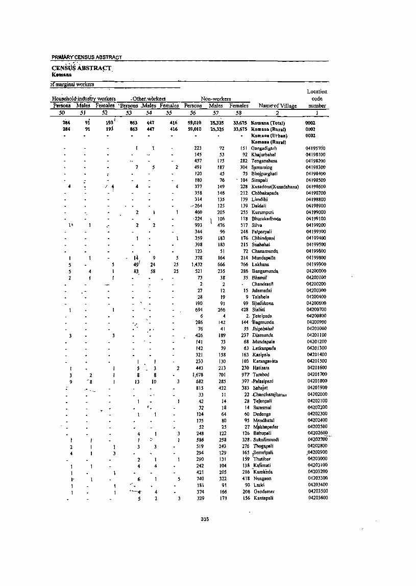
PRIMAAYC~NSUS ABSTRACT
CENStlS ABSTRA~T. Komana
'Jf margInal workers Location
Ho~eholctindus'irr workers • Other. workers Non-workers code Persons Males Females ·P..ersons ,Males Females Persons Males Females Name-of Village number
50 51 52 53 54 55 56 57 58 .2 J
184 9i 193~ 863 44' 416 59,010 15,335 33,6'15 Komana (fotal) 0001 184 91 19j 863 "", 416 59,010 1S.3~5 33,675 Komana (Rural) 0002
Komana (Urban) 0001 Komana (Rural)
1 223 72 151 Gangadigarh 04195700 145 53 92 Khajurbahal 04198100 457 175 282 Tenganabasa 04198200
7 5 2 491 187 304 SJlmarsing 04198300 120 45 75 Bhojpurghali 04198400
: 180 76 • 104 Sinapali 04198500
" I 4 4 4 377 149 228 Kusadona(Kusadahana) 04198600 358 146 212 Chobakapada 04198700 314 135 179 Limdihi 04198800
~264 125 139 Daldali 04198900 2 460 205 255 Kurumpuri 04199000
,224 106 118 Bhurukadhoda 04199100 I~ - 2 2 993 476 517 Silva 04199200
344 96 248 Patparpali 04199300 359 183 176 C~hindpani 04199400 398 183 215 Suabahal 04199$00 123 51 72 Chanamundll. 04199600
14 9 5 378 164 214 Mundapalla 04199800 f
5 5 49' 24 25 1,432 666 766 Lakhana 04199900 5 4 83, 58 25 521 235 286 Bangamunda 04200000 2 73 38 35 Bhaosil 04200100
.- 2 2 Chandrasil 04200200 27 12 15 Jalamadai 04200300 28 19 9 Talabela 04200400
190 91 99 Bpalukona 04200600 694 266 428 Sialati 04200700
6 4 2. ~etelpada 04200800 286 142 144 agmunda 04200900 .
76 41 35 Jhipababal 04201000 3 3 426 189 237 Diamunda 04201100
141 73 68 Mundapala 04201200 142 79 63 Lalkanpada 04201300 321 158 163 Kasipala 04201400
I 233 130 103 Karangavata 04201500 I 5 3 2 443 213 230 Halisara 04201600
3 2 8 8 1,678 701 9Tl' Tarabod 04201700 9 -8 13 10 3 682 285 397 .Palasipani 04201800 ~ 815 432 383 Sahajat 04201900
33 II 22 .chancharajharan 04202000 42 14 28 Tefcnpali 04202100 32 18 14 Sarasmal 04202200
124 64 60 Dedenga 04202300 175 80 95 Mendhatal 04202400
52 25 27 MpkhBpadar 04202500 4 3 248 122 126 BllbupaJi 04202600 I ~ 586 258 328 , Sukulimundi 04202700"
2 I 3 3 519 243 276 ThogBpali 04202800
4 3 294 129 165 \Semelpali ,04202900 2 290 131 1 59 Thutibar 04203000
1 4 4 242 104 138 Kaflmati 04203100
1 421 205 216 -KBmfeda 04203200
I' 6 5 740 322 418 Nuagaon 04203300
1 " lSI 91 90 Larki 04203400 ~ 4 374 166 208 GBndamer 04203500
S 2 3 329 m 156 Kantapali 04203600
335
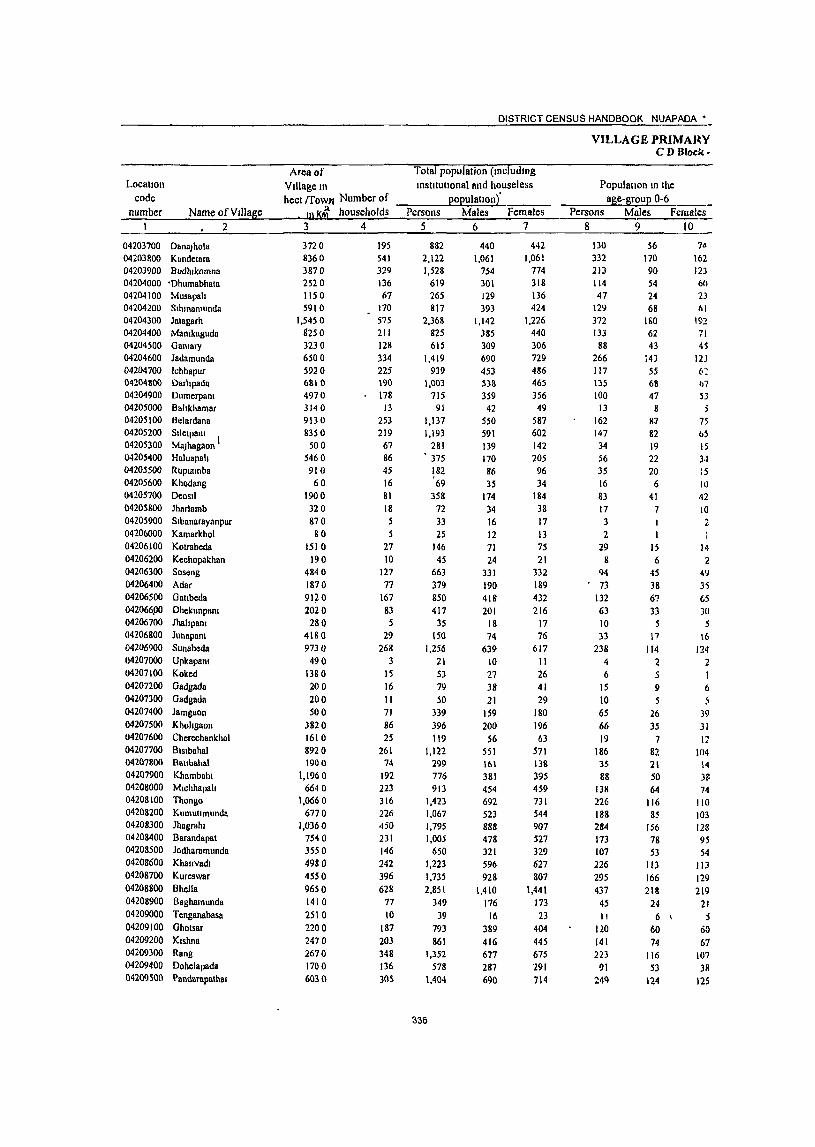
DISTRICT CENSUS HANDBOOK NUAPADA'
Area of Total populatIon (mcludmg
VILLAGE PRIMARY C DBlock-
Locatton VIllage In InstttutlOnalllnd houseless PopulatIOn In the code hect (fown Number of ......",.--__ P .... o ..... p;_;u;.:.:la"'-u:..;:o"'n),_·_=-_...,.-_ age-group 0-6 __
number Name ofVdlage tn Ki households Persons Males Females Persons Males Females ~=1~~~~~2~~~--~~3~~~~4~~~~5~~~~6~~~7~--~-78~-- 9 10
04203700 DanaJhola 04203800 Kandelarll 04203900 Budblkomna 04204000 'Dhumabhllla 04204100 04204200 04204300 04204400 04204500 04204600 04204700 04204800 04204900 04205000 04205100 04205200 04205300 04205<100 04205500 04205600 04205700 04205800 04205900 04206000
Musapah Sthmamunda Jalagarh Mamkaguda Galllary Jadamunda Ichhapur Darltpada Dumerpam Bahkhamar Belardana Sllclpalll I MaJhagaon Haluapah Ruprarnba Khodang Deosil Jharlamb Sibanarayanpur Karnarkhol
04206100 Kotrabcda 04206200 Kechopakhan 04206300 Soseng 04206400 Adar 04206500 GBubeda 042066PO Dhekunpalll 04206700 Jhahpant 04206800 Junapam 04206900 Sunabeda 04207000 UpkapanJ 04207100 Koked 04207200 Gadgada 04207300 Gadgada 04207400 Jarngaon 04207500 Kholtgnon 04207600 Cherechankhol 04207700 Blslbahal 04207800 Battbahal 04207900 Khambahl 04208000 Mlchhapah 04208100 Thongo 04208200 Kumuumunda 04208300 Jhagrahr 04208400 Barandapat 04208500 JOdharamunda 04208600 Khauvllw 04208700 Kurcswar 04208800 BIICIlB 04208900 Baghamunda 04209000 Tcnganabasa 04209100 Ghotsar 04209200 Krshna 04209300 Rang 04209400 Dohelapada 04209500 Pandarapathar
3720 8360 3870 2520 1150 5910
1,5450 g250 3230 6500 5920 6810 4970 3140 9130 8350
500 5460 910 60
1900 320 870 80
1510 190
4840 1870 91~ 0 2020
28 Q 4180 9730 490
1380 200 200 500
3820 1610 8920 1900
1,1960 6640
1,0660 6770
1,0360 7540 3550 4980 4550 9650 1410 2510 2200 2470 2670 1700 6030
195 541 329 136 67
170 575 211 128 334 225 190 178
J3 253 219
67 86 45 16 81 18 5 5
27 10
127 77
167 83 5
29 268
3 15 16 II 71 86 25
261 74
192 223 316 226 450 231 146 242 396 628
77 10
187 203 348 136 30S
882 2,122 1,528
619 265 817
2,368 825 615
1,419 939
1,003 715
91 1,137 1,193
281 375 182 '69 358
72 33 25
146 45
663 379 850 417
35 150
1,256 21 53 79 50
339 396 119
1,122 299 776 913
1,423 1,067 1,795 1,005
650 1,223 1,735 2,851
349 39
793 861
1,352 578
1,404
336
440 1,061
754 301 129 393
1,142 385 309 690 453 538
359 42
550 591 139 170 86 35
174 34 16 12 71 24
331 190 418 201
18 74
639 10 27 38 21
159 200
56 551 161 381 454 692 523 888 478 321 596 928
1,410 176
16 389 416 677 287 690
442 1,061
774 318 136 424
1,226 440 306 729 486 465 356 49
587 602 142 205 96 34
184 38 17 13 75 21
332 189 432 216
17 76
617 II 26 41 29
180 196 63
571 138 395 459 731 544 907 527 329 627 807
1,441 173 23
404 445 675 291 714
130 332 213 114 47
129 372 133 88
266 117 135 100
13 162 147 34 56 35 16 83 17 3 2
29 8
94
73 132 63 10 33
238 4 6
15 10 65 66 19
186 35 88
138 226 188 284 173 107 226 295 437
45 II
120 141 223
91 2<1Q
56 170 90 54 24 68
ISO 62 43
143 55 68 47 8
8:7 82 19 22 20 6
41 7
IS 6
45 38 67 33
5 17
114 2 5 9
5 26 35
7 82 21 50 64
116 85
156 78 53
113 166 218
24 6 \
60 74
116 53
124
74 162 123 60 23 61
192 71 45
12J 6~
b7
53 ;
75 bS IS 3~
:5 10 42 to 2
14 2
49 35 65 )0
5 16
124 2 I 6 5
39 31 12
104 14 3f. 74
110 103 128 95 54
Il3 129 219
21 5
60 67
107 38
125
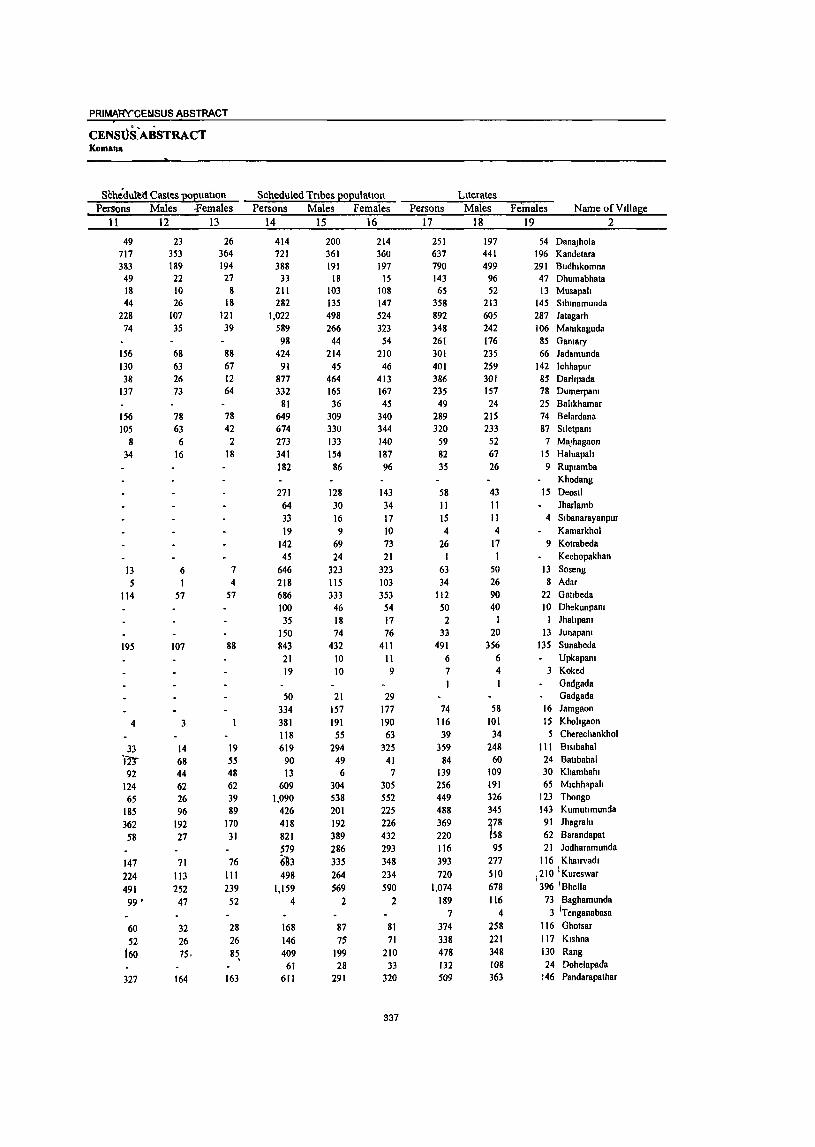
PRIMAR'CCEblSUS ABSTRACT
CENStiSAJiSTRACT Koman.
Schedultd Castes popuallon Persons Males .females
11 12 13
49 717 383
49 18 44
228 74
156 130 38
137
156 105
8
34
13 5
114
195
4
33 In"
92 124 65
185 362 58
147 224 491 99 '
60 52
160
327
23 353 189 22 10 26
107 35
68 63 26 73
78 63
6 16
6 I
57
107
3
14 68 44 62 26 96
192 27
71 113 252 47
32 26 75.
164
26 364 194 27
8 18
121 39
88 67 12 64
78 42
2 18
7
4 57
88
19 55 48 62 39 89
170 31
76 III 239 52
28 26
8~
163
SCheduled Tribes population Persons Males Females
14 15 16
414 121 388
33 211 282
1,022 589 98
424 91
877 332
81 649 674 273 341 182
271 64 33 19
142 45
646 218 686 100
35 150 843
21 19
50 334 381 118 619
90 13
609 1,090
426 418 821 579 6'93 498
1,159 4
168 146 409
61 611
200 361 191
18 103 135 498 266
44 214
45 464 165 36
309 330 IJJ
"4 86
128 30 16 9
69 24
323 115 333
46 18 74
432 10 10
21 157 191
55 294
49 6
304 538 201 192 389 286 335 264 569
2
87 75
199 28
291
214 360 197
15 108 147 524 323
54 210
46 413 167 45
340 344 140 187 96
143 34 17 10 73 21
323 103 353
54 17 76
411 11 9
29 177 190
63 325
41 7
305 552 225 226 432 293 348 234 590
2
81 71
210 33
320
337
Persons 17
251 637 790 143 65
358 892 348 261 301 401 386 235 49
289 320
59 82 35
58 II 15 4
26 I
63 34
112 50 2
3J 491
6 7 1
74 116 39
359 84
139 256 449 488 369 220 116 393 720
1,074 189
7 374 338 478 132 509
Literates Males
18
197 441 499
96 52
213 605 242 176 235 259 301 157 24
215 233
52 67 26
43 11 II 4
17 I
50 26 90 40
I 20
356 6 4
58 101 34
248 60
109 191 326 345 ~78 158 95
277 510 678 116
4 258 221 348 108 363
Females Name ofVlllage 19
54 DanaJhola 196 Kandetara 291 Budhlkomna 47 Dhumabhata 13 Musapah
145 Slhmamunda 287 Jatagarh 106 Mamkaguda
85 Gamary 66 Jadamunda
142 lchhapur 85 Darhpada 78 Dumerpam 25 Bahkhamar 74 Belardana 87 Slletpam 7 MaJhagaon
15 Haluapah 9 Ruplamba
Khodang 15 Deosll
Jharlamb
2
4 Sibanarayanpur Kamarkhol
9 Kotrabeda Kechopakhan
13 Soseng 8 Adar
22 Gaubeda 10 Dhekunpam I Jhahpam
13 Junapam 135 Sunabeda
Upkapam 3 Koked
Gadgada Gadgada
16 Jamgaon 15 Khohgaon 5 Cherechankhol
III BlSlbahal 24 Ballbahal 30 Khambahl 65 Mlchhapah
123 Thongo 143 Kumullmunda
91 Jhagrahl 62 Barandapat 21 Jodharamunda
116 Khalrvadl 1210 I Kureswar 396 'Bhella
73 Baghamunda 3 iTenganabasa
116 Ghotsar 117 KIshna 130 Rang 24 Dohelapada
146 Pandarapathar
Locatlon code
number Name ofVtllage 2
04203700 DanaJhola 04203800 Kandelara 04203900 Budhlkomna 04204000 Dhumabhata 04204100 Musapah 04204200 Slhtnamunda 04204300 Jatagarh 04204400 Mamkagudd 04204500 Ganl81)' 04204600 Jadamunda 04204700 Ichhapur 04204800 Oarllpada 04204900 Oumerpam 04205000 Bahkhamar 04205100 Belardana 04205200 Slletpanl 04205300 MaJhagaon 04205400 Haluapalt 04205500 Ruplamba 04205600 Khodang 04205700 Ooosll 04205800 Jhar1amb 04205900 Sibanarllyanpur 04206000 Kamarkhol 04206100 Kotrabeda 04206200 Kcchopakhan 04206300 Soseng 04206400 Adar 04206500 Gatlbcda 04206600 Dhekunpam 04206700 Jhaitpalll 04206800 JU!lapam 04206900 Sunnbeda 04207000 Upkapam 04207100 Koked 04207200 Gadgada 04207300 Gadgada 04207400 Jamgaon 04207500 Khohgaon 04207600 Cherechanl..hol 04207700 Blslbahal 04207800 Ballhahal 04207900 Khambahl 04208000 Mlchhapah 04208100 Thongo 04208200 Kumullmunda 04208300 Jhagrahl 04208400 Barnndapal 04208500 Jodhnramunda 04208600 Kholrvadl 04208700 Kureswar 04208800 Bhella 04208900 Baghamunda 04209000 Tenganabasa
• 04209100 'Ghotsar 04209200 Klshnll 04209300 Rang 04209400 Dohelapada 04209500 Pllndarapathar
Persons 20
631 1,485
738 476 200 459
1.476 477 354
1,118 538 617 480
42 848 873 222 293 147 69
300 61 18 21
120 44
600 345 738 367
33 117 765
15 46 78 50
265 280
80 763 215 637 657 974 579
1,426 785 534 830
1,015 1,777
160 32
419 523 874 446 895
Illiterates Males
21
243 620 255 205 77
180 537 143 133
455 194 237 202
18 335 358
87 103 60 )5
131 23 5 8
54 23
281 164 328 161
17 54
283 4
23 37 21
101 99 22
303 101 272 263 366 178 610 320 226 319 418 732 60 12
131 195 329 179 327
Females 22
388 865 483 271 123 279 939 334 221 663 344 380 278
24 513 515 135
190 87 34
169 38 13 13 66 21
319 181 410 206
16 63
482 II 23 41 29
164 181 58
460 114 365 394 608 401 816 465 308 511 597
1,045 100 20
\288 328 545 267 568
336
DISTRICT CENSUS HANDBOOK NUAPAOA'
Total workers Persons Males Females
23 24 25
488 1066
727 360 140 402 989 327 178 583 425 393 398 44
690 645 171 224 121 44
188 43 23 20 87 18
336 166 471 214
7
46 546
11 33 47 30
197 207 77
622 162 450 580 639 497 970 643 375 599 841
1,091 150
18 417 366 574 336 794
241 589 442 199 78
229 583 208 159 359 254 234 217
17 348 356
82 III
55 25 98 23 11 II 42 12
197 97
232 117
7
36 296
14 24 13 91
107 34
325 105 214 299 371 285 515 318 192 306 526 704
85 9
204 212 374 182 387
247 477 285 161 62
173 406 119
19 224 171 1?9 181 27
342 289
89 113 66 19 90 20 12 9
45 6
139 69
239 97
to 250
6 19 23 17
106 100 43
297 57
236 281 268 212 455
325 183 293 315 387
65 9
213 154 200 154 407
VILLAGE PRIMARY C DBlock-
Main workers Persons Males Females
26 27 28
172 513 457
214 79
275 539 138 165 406 148 214 209
18 181 491
3 35
116
15 11
146 116
13 119
5 31
250
41 21
136 7
48 296
67 200 488 ~81
377 391 164 99
247 509 525
50
253 131 237 158 375
143 453 388
193 72
206 476 120 156 339 133 203 183
11 165 330
1 3
20 73
1
12 11
133 89 13
100 5
31 167
21 11 71 6
24 216
63 166 263 225 244 370 151 99
239 452 429
46
183 98
221 152 325
29 60 69 21
7
69 63 18 9
67 15 II 26
7
16 161
15 43
I 3
13 27
19
83
20 10 65
I 24 80
34 225
56 133 21 13
8 57 96 4
• I
70 33 II 6
SO
PRIMA~Y CENSUS ABSTRACT
CENSUS ABSTRACT Komana
Industnal category of mam workers Household mdustry
Culllvators' -. Agnculturallabourers workers Other workers Persons" Males Females Persons Males Females Persons Males Females Persons Ma1es Females Name of Village
29 30 31 32 33 34 35 36 37 38 39 40 2
149 274 135
82 36
200 457
99 98
1 182 60
159 32 )5 119 281
2
S3
125 262 128 ,82 33
162 408
88 91
174 60
151 29 9
113 249
2
40
14 11 9 9
77 75 3S 35
8 8 49 46
3 3 29 29
130 97
130 67 3 3
44 22 117 104 '58 _ 56
177 153 376 193 225 198 365 233 309 300 ISO 141 96 96
156 153 227 225 165 154
19 19
139 112 60 43
140, 140
80 80 310 292
24 12 7
3 38 49 Il 7 8
2 3 6
,6 32
13
3
2
3
33
63
22
13 2
24 183 27
132 9 9
3 2
II
27 17
18
13 100 178 101 43 45 10
53 179 13 33
135 2
47 201
2
. \
\ I 2
56 25
16 2 2
78
3 2 2
142 3
10 88 48
3 63
7
62 96
39 5
33 33 36
----'S 36
9 82
142 86 39 23 10
52 128 60 26
117 I
39 72
2
2 53 16
IS 2 2
39
2
81 2 2
52 21 2
58 7
60 54 30 5
10
23 36 50
12
4 18 36 15 4
22
51 13 7
18
I 8
129
3 9
39
2
2 61
I 8
36 27
I 5
2 42
9
23
10
5 24
6 6 4 4 2
4 2 14 10
\ .
35 20
54 26
51
51
41 21
I
10 7
, 4
I
9 5
57
23
8
339
35
38
21 II I
9 4
2
8 3
32
14
4
2 4
15
28
16
13
20 10
3
2
I 2
25
9
4
10 133 140 29
26 58 39 13 44 IS 21 42
I 15 9
7 I
9 103 114 24
19 48 32 12 36 13 19 37
13 9
5 1
13 5 51 3 5 5 3
41 30
2 2 2 I 2 2
36 30 6 5
------3- 2 17 14 8 6 9 9
,15 10 \ 6 2
3 3 20 18
181 17? 264 I 213
26 22
80 60 37 31 33 31
23 22 21 17
DanaJhola 30 Kandetara 26 Budlllkomna
Dhumabhata Musapah
7 Slhmamunda 10 Jatagarh 7 Mamkaguda I Gamary
Jadamunda 2 Ichhapur 2 Darhpada 5 Dumerpam
Bahkhamar 2 Belardana
Siletpam MaJhagaon Haluapah Ruplamba Khodang
2 Deosll Jharlamb Sibanarayanpur Kamarkhol Kotrabeda Kechopakhan
8 Soseng 2 Adar
Gatlbeda 2 Dhekunpam
Jhahpam lunapam
II Sunabeda Upkapam Koked Gadgada Gadgada Jamgaon Khohgaon Cherechankhol
6 Blslbahal Batlbahal Khambahl
3 Mlchhapah 2 Thongo
Kumullmunda 5 Ihagrahl 4 Barandapat
10dharamunda 2 Khauvadl
II Kureswar , 51 Bhella
4 Baghamunda I . Tenganabasa . 20 Ghotsar
6 Kishna 2 Rang I Dohelapada 4 Pandarapathar
Location code
number
04203700 04203800 04203900 04204000 04204100 04204200 04204300 04204400 04204500 04204600 04204700 04204800 04204900 04205000 04205100 04205200 04205300 04205400 04205$00 04205600 04205700 04205800 04205900 04206000 04206100 04206200 04206300 04206400 04206500 04206600 04206700 04206800 04206900 04207000 04207100 04207200 04207300 04207400 04207500 04207600 04207700 04207800 04207900 04208000 04208100 04208200 04208300 04208400 04208500 04208600 04208700 04208800 04208900 04209000 04209100 0,1209200 04209300 04209400 04209500
Name of Village 2
Danajhola KBndctara BudhikomnB Dhumabhata Musapali SihinBmunda Jatagach Manikaguda Ganiary Jadamunda Ichhapur Darlipada Dumcrpani Balikhamar Belardana Siletpani Majhagapn Haluapat. Rupiamba Khodang DeosiJ Jhllrlamb Sibanarayanpur Kamarkhol Kotrabeda Kechopakhan Soseng Adar Gatibeda Dhekunpani Jhalipani lunapani Sunabcda Upkapani Koked Gadgada Gadgada Jamgnon Kholigaon Cherechankhol Bisibahal Batibahal Khambahi Michhapali Thongo Kumutlmunda lhagrahi Barandapat Jodharamunda Khairvadi Kureswar Bhella Baghamunda Tcnganabasa Ghotsar Kishna Rang Dohelnpada Pllndarapathar
Marginal workers Persons Males Females
41 42 43
316 553 270 146 61
127 450 189
13 177 277 179 \89 26
509 154 171 223 118
9 72 42 23 19 72
7 190
SO 458
95 2
i5 296 II 33
6
9 61
200 29
326 95
250 92
358 120 579 479 276 352 332 566 100
18 164 235 342 178 419
98 136
54 6 6
23 107 88 3
20 121 31 34
6 183 26 82
110 52 5
2S 22 11 II 30 I
64 8
219 17 . 2 5
129 5
14 3 2
20 101
10 109 42
, 48 36
146 41
145 167 93 67
.74 275 39
9 ~I
\14 153 30 62
218 417 216 140 55
104 343 101
10 157 156 148 155
20 326 128
89 113 66
4 47 20 12 8
42 6
126 42
239 78
10 167
6 19 3 7
41 99 19
217 53
202 56
212 79
434 312 183 285 258 291
61 9
143 121 189 148 357
340
DISTRICT CENSUS HANDBOOK: NUAPADA •
Cnltivators Persons
44
165 132
91 S 7
27 278
7 5 8
50 32 16
257 31
II 91
5 6
24
9
41
3
27
2
167 37 77
220 117
8 26
123 3 3
42 103
12 10 2
Males Females 45 46
60 73 13 4 5 6
48 2
2
II 4
105 3
4 49
2
8
4
14
4
53 11 23 63 24 5
17 76
I 2 7
59 12 9
105 59 78 4 2
21 230
5 5 6
_ 49
21 12
152 28
7 42
3 5
16
5
27
3
23
114 26 54
157 93
3 9
47 2
35 44
2
VILLAGE PRIMARY - CD Block-
Industrial category
Agricultural labourers Persons Males Females
47 48 49
147 372 158 138 54 96
157 175
6 168 269 128 141 -
9 242 123 171 211
27 -
61 42 22 18 71 7
70 30
458 53 2
14 251 II 33
58 200
28 296
95 239
87 190 77
496 256 156 326 293 427
96 15
119 122 321 168 416
37 53 30 2
16 54 79 2
18 116 30 18
I 70 23 82
106 1
21 22 11 10 30
23 7
219 11 2 5
114 5
14
20 101
10 104 42 47 36 92 2S
119 104 66 55 45
189 38 7
12 46
133 21
-62
110 319 128 136 53 80
103 96 4
150 153 98
\23 8
172 100 89
105 24
40 20 11 8
41 6
47 2)
239 42
9 137
6 19
38 99 18
192 53
192 51 98 52
377 152 90
271 248 238
58 8
107 76
188 147 354
PRIMARY CE'NSl)!:; ABSTRACT
CENSUS ABSTRACt Komana
>
'Jf marginal workers Location
Household indust!! workers Other 'workers Non-workers code Persons Males Females ·Persons Males Females Persons Males Females Name of Village number
So 51 52 53 54 55 56 57 58 2 1
4 I 3 394 199 195 Danajhola 04203700 7 6 42 9 33 1,056 472 584 Kandetara 04203800
21 11 10 801 312 489 Budhikomna 04203900 259 102 157 Dhumabhata 04204000 12S 51 74 Musapali 04204100
2 2 2 415 164 251 Sihinamunda 04204200 10 3 7 5 2 3 1,379 559 820 Jatagarh 04204300
7 7 498 171 321 Manikaguda 04204400 437 150 287 Ganiary 04204500 836 331 50S Jadamunda 04204600
6 3 3 514 199 315 Ichhapur 04204700 610 304 306 Dal1ipada 04204800
15 5 10 317 142 175 Dumerpani 04204900 -/ 1 I 47 25 22 Balikhamar 04205000
6 / 4 2 4 4 447 202 245 Belardana 04205100 548 235 313 Siletpani 04205200 110 57 53 Majhagaon 04205300 151 59 92 Haluapali 04205400 61 31 30 Rupiamba 04205500
4 3 25 10 15 Khodang 04205600 5 3 2 170 7/J 94 DeosiJ 04205700
29 II 18 Jharlamb 04205800 10 5 5 Sibanarayanpur 04205900 5 I 4 Ka"markhol 04206000
59 29 30 Kotrabeda 04206100 27 12 15 !<echopakhan 04206200
96 33 63 327 134 193 Soseng 04206300 20 19 213 93 120 Adar 04206400
379 186 193 Gatibeda 04206500 33 2 31 203 84 119 Dhekunpani 04206600
28 11 17, Jhalipani 04206700 104 38 66 Junapani 04206800
3 3 710 343 367 Sunabeda 04206900 1Q 5 5 Upkapani 04207000 20 13 1 Koked 04207100
5 3 2 32 14 18 Gadgada 04207200 9 2 7 20 8 12 Gadgada 04207300
142 68 74 Jamgaon 04207400 189 93 96 Kholigaon 04207500 42 22 20 Cherechankhol ' 04207600
2 2 500 226 274 Bisibahal 04207700 --- 137 56 81 Batibahal 04207800 9 9 326 167 159 -&hambahi 04207900 5 5 333 155 178 Michhapali 04208000
I 784 321 463 Thongo 04208100 5 5 570 238 332 Kumutimunda 04208200
1 1 5 3 2 825 373 452 ,Jhagrahi 04208300 3 3 362 160 202 \ Barandapat 04208400
3 3 275 129 146 Jodharamunda .04208500 18 7 It 624 290 334 Khairvadi 04208600
t3 12 894 402 492 Kureswar 04208700 5 2 3 11 8
, 3 1,760 706 1,054 Bhella I 04208800
1 199 91 '108 Baghamunda 04208900 21 7 14 Tenganabasa 04209000
3 2 376 185 191 Ghotsar 04209100
4 3 6 6 495 204 291 Kishna 04209200 5 4 4 4 778 303 475 Rang 04209300
242 105 137 Dohelapada 04209400 610 303 307 Pandarapathar 04209500
341
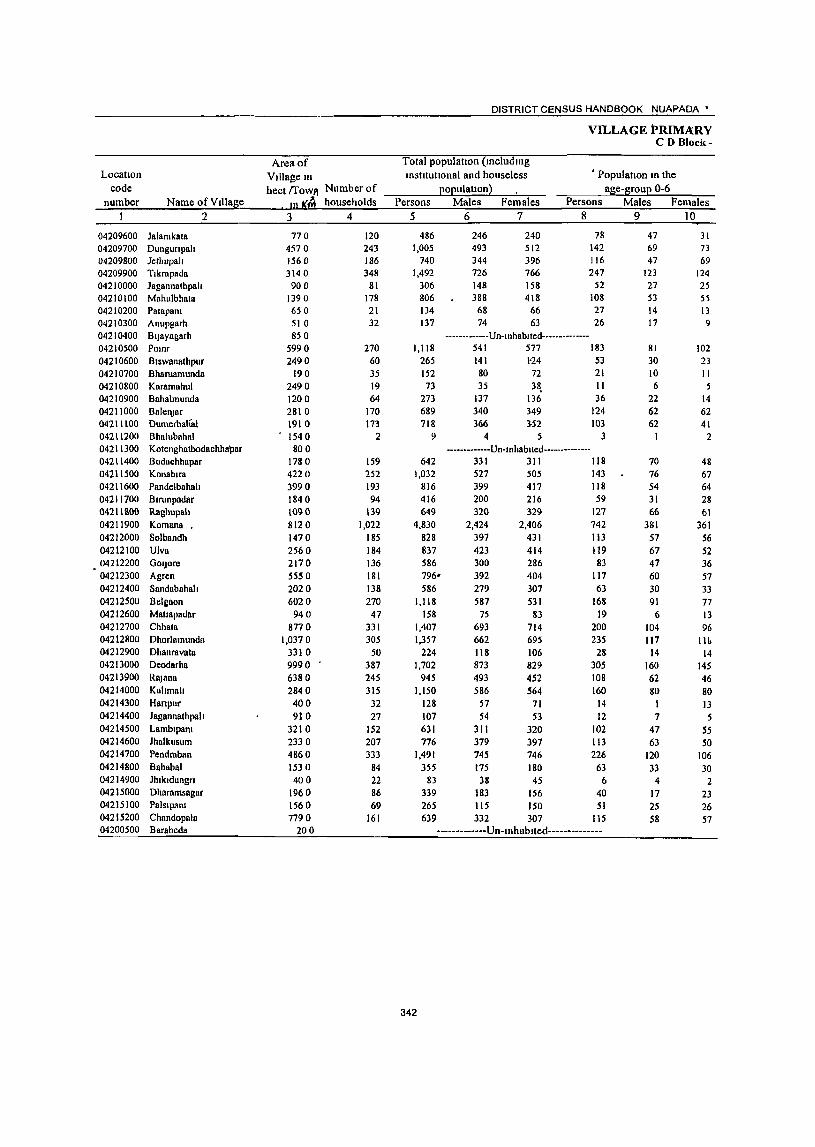
DISTRICT CENSUS HANDBOOK NUAPADA'
VILLAGE PRIMA:RY CD Block-
Area of Total population (mcludmg Location Village m mstltutlonal and houseless • Population In the
code hect {fOWl'! Number of EOEulatlon} age-grouE 0-6 number Name ofVllla~e In IS:~ households Persons Males Females Persons Males Females
2 3 4 5 6 7 8 9 10
04209600 Jalamkala 770 120 486 246 240 78 47 31 04209700 Dungurtpah 4570 243 1,005 493 512 142 69 73 04209800 Jethupall 1560 186 740 344 396 J 16 47 69 04209900 Tlkrapada 3140 348 1,492 726 766 247 123 124 04210000 Jagannathpah 900 81 306 148 158 52 27 25 04210100 Mahu1bhata 1390 178 806 388 418 108 53 5) 04210200 Palapana 650 21 134 68 66 27 14 13 04210300 Anupgarh 510 32 137 74 63 26 17 9 04210400 Bljayagarh 850 -------------Un-Inhablted--------------04210500 POlnr 5990 270 1,118 541 577 183 81 102 04210600 Biswanathpur 2490 60 265 141 1'24 53 30 23 04210700 Bharuamunda 190 35 152 80 72 21 10 II 04210800 Karamahul 2490 19 73 35 38, II 6 5 04210900 Bnha1munda 1200 64 273 137 136 36 22 14 04211000 BalenJar 2810 170 689 340 349 124 62 62 04211100 DumerbaKal 1910 173 718 366 352 103 62 41 04211200 Bhalubaha1 1540 2 9 4 5 3 2 04211300 Kotenghntbodachhapar 800 -------------Un-Inhablted--------------04211400 Bodachhapar 1780 159 642 331 311 118 70 48 04211500 Konablra 4220 252 1,032 527 505 143 76 67 04211600 Pandelbahah 3990 193 816 399 417 118 54 64 04211700 Blrunpadar 1840 94 416 200 216 59 31 28 04211800 Raghupah 1090 139 649 320 329 127 66 61 04211900 Komana . 8120 1,022 4,830 2,424 2,406 742 381 361 04212000 Solbandh 1470 185 828 397 431 113 57 56 04212100 Viva 2560 184 837 423 414 119 67 52 04212200 GOIJore 2170 136 586 300 286 83 47 36 04212300 Agren 5550 181 796- 392 404 117 60 57 04212400 Sandabahala 2020 138 586 279 307 63 30 33 04212500 Belgaon 6020 270 1,118 587 531 168 91 77 04212600 Matlapadar 940 47 158 75 83 19 6 13 04212700 Chhata 8770 331 1,407 693 714 200 104 96 04212800 Dhorlamunda 1,0370 305 1,357 662 695 235 117 lit. 04212900 Dhanravata 3310 50 224 118 106 28 14 14 04213000 Deodarha 9990 387 1,702 873 829 305 160 145 04213900 Rajann 6380 245 945 493 452 108 62 46 04214000 Kahmall 2840 315 1.150 586 564 160 80 80 04214300 Hanpur 400 32 128 57 71 14 1 13 04214400 Jagannathpah 910 27 107 54 53 12 7 5 04214500 Lamblpant 3210 152 631 311 320 102 47 55 04214600 Jhalkusum 2330 207 776 379 397 113 63 50 04214700 Pendraban 4860 333 1,491 745 746 226 120 106 04214800 Bahabal 1530 84 355 175 180 63 33 30 04214900 Jhlkldungn 400 22 83 38 45 6 4 2 04215000 Dharamsagar 1960 86 339 183 156 40 17 23 04215100 Palslpana 1560 69 265 115 150 51 25 26 04215200 Chnndopala 7790 161 639 332 307 115 58 57 04200500 Barabeda 200 -------------Un-tnhablted--------------
342
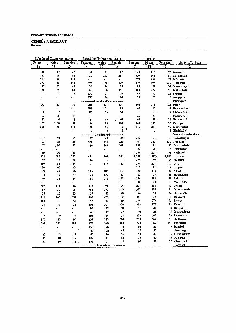
PRIMARY CENSUS ABSTRACT
CENSUS ARSTRACT Koman ••
Scheduled Castes £ol2uallon Scheduled Tribes l2ol2ulahon Literates Petsons Males F.emales • Persons Males Females Persons Males Females Name ofVIUage
11 12 13 14 15 16 17 18 19 2
41 19 22 31 12 19 173 116 57 Jalamk"ata 126 58 68 420 202 218 406 268 138 Dungunpah 258 124 134 279 202 77 Jethupah 277 135 142 398 178 220 639 406 233 T1krapada
97 52 45 29 14 15 99 73 26 Jagannathpah 131 68 63 349 168 181 383 222 161 Mahulbhata
4 I 3 130 67 63 69 47 22 Pat8pam 137 74 63 33 27 6 Anupgarh
---.------.-. Un-mhablted--·-·-·-·-···· BI)ayagarh 132 57 75 985 484 501 360 258 102 Pomr
191 101 90 46 42 4 Biswanathpur 8 2 6 105 55 50 15 11_ 2 Bharuamunda
73 35 38 29 23 6 Karamahul 15 4 II 121 59 62 94 68 26 Bahalmunda
107 / 50 57 196 96 100 167 137 30 BalenJar '226 115 III 30 15 15 310 211 99 Dumerbahal
8 3 5 4 3 Bhalubahal
-·-----·-·-Un-mhablted-·-·-···-·-·- Kotenghatbodachhapar 107 53 54 47 23 24 232 164 68 Bodachhapar 73 35 38 466 244 222 464 325 139 KonablTn
167 1 90 77 316 149 167 281 195 86 P8ndelbahah 92 76 16 Blrunpadar
36 20 16 261 203 58 Raghupah
555 282 273 491 243 248 2,651 1,5471 1,104 Komana
52 28 24 14 5 9 225 159 66 Solbandh
219 105 114 227 117 110 394 277 117 Ulva
130 60 70 110 91 19 GOIJore
143 67 76 213 106 107 274 194 80 Agren
74 37 37 278 129 149 103 77 26 Sandabahah
49 31 18 386 213 173 384 334 50 Belgaon
16 13 3 Matlapadar
267 151 116 899 424 475 257 '184 73 Chhata
.jJ7 32 35 762 372 390 222 197 25 Dhorlamunda
35 22 13 167 87 80 74 50 24 Dhanravata
451 243 208 860 428 432 443 338 105 Deodarha
103 SO 53 157 88 69 346 273 73 RlIJana 59 31 28 604 304 300 375 276 99 Kahmall
85 37 48 35 27 8 Han pur
46 19 27 30 25 5 J agannathpah
18 9 9 305 154 151 128 105 23 LamblpanJ
170 80 90 434 210 224 208 167 41 Jhalkusum
"'""20S-- 101 104 774 390 384 520 369 151 Pendraban
150 76 74 64 55 9 Bahabal
83 38 45 10 10 Jhlkldungn
27 13 14 62 36 26 53 47 6 Dharamsagar
92 40 52 102 41 61 37 30 7 Pnlslpalll
90 49 41 .,.. 178 101 77 99 79 20 Chandopala
----------·--Un·mhablted·-·--·--····-· Barabeda
343
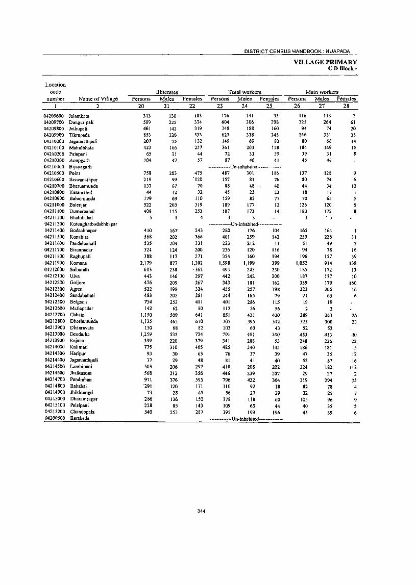
Location
DISTRICT CENSUS HANDBOOK: NUAPAD~_
VILLAGE PRIMARY CD Block-
code Illiterates Total workers Main workers numbe~r __ ~N~a=m~e~o~f~V~i1~la~g~e~ __ ~P~er~s7o~n~s __ ~M~a~l=es~~F=em~al~e~s __ ~P~e~~7o~n~S __ ~M~a~le~s~~F~e~m~a~!e~s~~P~e~~~'o~n=s~_:~~a~le~s __ ~F=em~al~e;:_s
I 2 20 21 22 23 24 25 26 27 28
04209600 Jalamkata 04209700 Dunguripali 04209800 Jethupali 04209900 iikrapada 04210000 Jagannathpali 04210100 Mah\llbhata 04210200 Patapani 04210300 Anupgarh 04210400 Bijayagarh 04210500 Poinr 04210600 Biswanathpur 04210700 Bharllamunda 04210800 Karamahul 04210900 Bahalmunda 04211000 Balcnjar 04211100 Dumerbahal 04211200 Bhaillbahal 04211300 Kotenghatbodahhhapar 04211400 Bodachhapar 04211500 Konabira 04211600 Pandelbahali 04211700 Birunpadar 04211800 Raghupali 04211900 Komana 04212000 Solbandh 04212100 Ulva 04212200 Goijnre 04212300 Agren 04212400 Sandabahali 04212500 Belgaon 04212600 Matiapadar 04212700 Chhat8 04212800 Dhorlamundn 04212900 Dhanravata 01213000 Deodarhn 04213900 Rajana 04214000 Kalimati 04214300 Haripur 04214400 Jagannathpali 04214500 Lambipani 04214600 Jhalkusum 04214700 Pendraban 04214800 Bahabal 04214900 Jhikidungri 04215000 Dharamsagar 04215100 Palsipani 04215200 Chandopala 04200500 Barabeda
313 599 461 853 207 423 65
104
758 219 137 44
179 522 408
5
410 568 535 324 388
2,179 603 443 476 522 483 734 142
1,150 1,I3S
150 1,259
599 775
93 77
503 568 971 '291
73 286 228 540
130 225 142 320
75 166 21 47
283 99 67 12 69
203 155
I
167 202 204 124 117 &77 238 146 209 198 202 253
62 509 465 68
535 220 310
30 29
206 212 376 120 28
136 85
253
183 374 319 533 132 257 44 57
475 -120
70 32
110 319 253
4
243 366 331 200 271
1,302 - 365
297 297 324 281 481
80 641 670
82 724 379 465
63 48
297 356 595 171 45
ISO 143 287
344
176 604 348 623 149 361
72 87
141 306 188 378
69 203
33 46
35 298 160 245
80 158 39 41
-------------Un-Inhablted--------------487 301 186 157 81 76 88 48, 40 45 23 22
159 82 77 189 177 12 187 173 14
3 3 -------------Un-inhabited--------------
280 176 104 401 259 142 223 236 354
1,598 493 442 343 455 244 401 112 851 707 103 791 341 485
76 81
410 446 796 110 56
178 109 395
212 120 160
1,199 243 242 III I 257 165 286
56 431 395
60 491 288 340
37 41
208 239 432
92 27
118 65
199
II 116 194 399 250 200 162 198 79
liS 56
420 312
43 300
53 145 39 40
202 207 364
18 29 60 44
196 ------------- Un-inhabited--------------
116 325
94 366
80 184 39 45
137 80 44 18 70
126 180
3
165 259
51 94
196 1,052
185 187 339 222
71
19 2
289 313
52 453 248 186 47 53
324 29
319 82 32
105 40 45
113 264
74 331
66 169 3 ! 44
128 74 34 17 65
120 172 , 3
164 228
49 78
157 914 172 177 179 206
65 19 2
263 300
52 -113 22(> 181
3S 37
182 27
294 78 25 96 3S 39
3 61 20 35 14 15 8 I
9 6
10
5 6 II
1 31
2 16 39
138 13 10
11)0 16 6
26 13
40 22 5
12 16
142 2
25 4 7 9 5 6
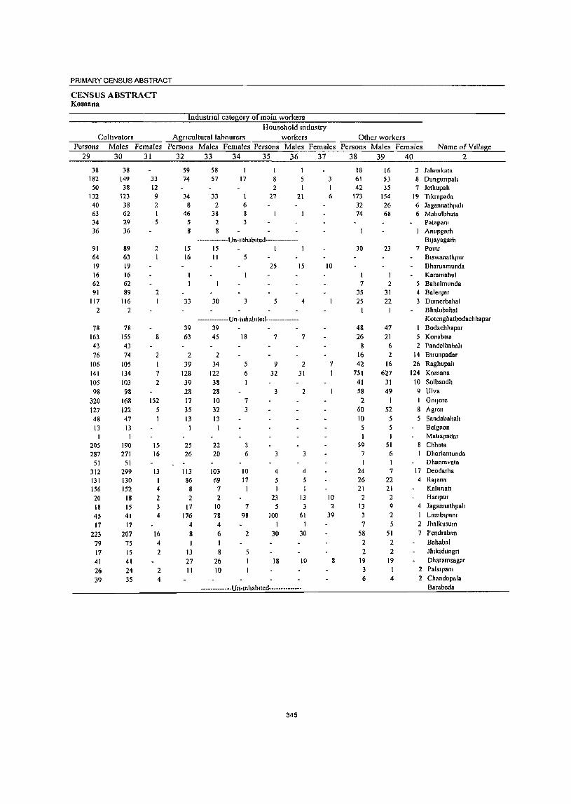
PRIMARY CENSUS ABSTRACT
CENSUS ABSTRACT Komana
lndustnal category ormaln workers Household mdustry
Cultivators Agricultural labourers workers Other workers Persons Males Females Persons Males Females Persons Males Females Persons Males Females Name of Village
29 30 31 32 33 34 35 36 37 38 39 40 2
38 182
50 132 40 63 34 36
91 64 19 16 62 91
117 2
78 163 43
76 106 141 105 98
320 127 48 13 I
205 287
51 312 131 156 20 18 45
17 223
79 17 41 26 39
38 149 38
123 38 62 29 36
89 63 19 16 62 89
116 2
78 155 43 74
105 134 103 98
168 122 47 13
190 271
51 299 130 152
18 15 41 17
207 75 15 41 24 35
33 12 9 2
2
2 I
8
2
7
2
152 5
I
15 16
13
4
2 3 4
16 4 2
2 4
59 74
34 8
46 5 8
15 16
33
39 63
2 39
128 39 28 17 35 13
25 26
113 86
8 2
17 176
4 8
13 27 II
58 57
I 17 5
33 2
38
8 2
27 21 6 8
2 3 8
-------------Un-Inhablled--------------15 I 11 5
25
30 3
15
4
-------------Un-mhabfled--------------39 45
2 34
122 38 28 10
18
5 6
7 32 3 13
22 20
103 69
7 2
10 78
4 6
8 26 10
3 6
10 17
7
98
2
5
I
7
9 32
3
3
4
5 J
23
100 I
30
18
7
2
31
2
3
4
J
13 3
61 1
30
10
-------------Un-mhablted--------------
345
3 I 6
10
7
10 2
39
8
18 61 42
173 32 74
30
7
35 25
I
48 26
8 16 42
751 41 58 2
60 10 5
59 7 I
24 26 21 2
13 3 7
58 2 2
19 3 6
16 53 35
154 26 68
23
2 31 22
47
21 6
2 16
627 31
49 I
52 5 5
51 6 I 7
22 21
2 9 2 5
51 2 2
19 I 4
2 Jalamkata 8 Dungunpah 7 Jethupah
19 Tlkrapada 6 Jagannathpah 6 Mahulbhata
Patapam Anupgarh BIJayagarh
7 Pomr Blswanathpur Bharuamunda Karamahul
5 Bahalmunda 4 BalenJar 3 Dumerbahal
Bhalubahal Kotenghatbodachhapar Bodachhapar
5 KonablTa 2 Pandelbahall
14 Blrunpadar 26 Raghupah
124 Komana
10 Solbandh
9 Ulva
I GOIJore
8 Agren
5 Sandabahah Belgaon Matlapadar
8 Chhata Dhorlamunda Dhanravata
17 Deodarha
4 RaJ ana Kahmau Hanpur
4 Jagannathpah I Lamblpam
2 Jhalkusum 7 Pendrabnn
Bahahal JllIkldungn
Dharamsagar 2 Palslpam 2 Chandopala
Barabeda
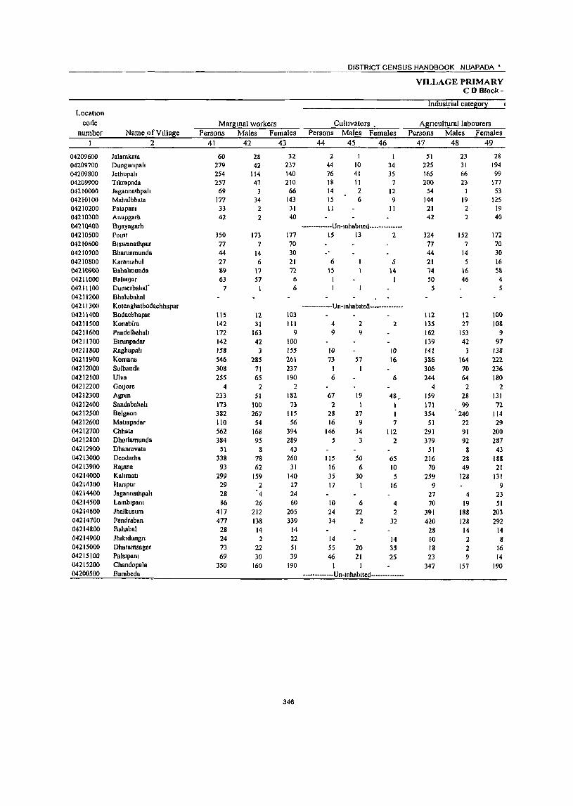
DISTRICT CENSUS HANDBOOK NUAPADA •
VILLAGE PRIMARY CD Block-
Industrial cates0!X Location
code ~arStnalvvorkers CultIVators • ASflculturallabourers number Name ofVtllase Persons ~ales Females Persons ~ales Females Persons ~ales Females
1 2 41 42 43 44 45 46 47 48 49
04209600 Jalamkata 60 28 32 2 51 23 28 04209700 Dungunpah 279 42 237 44 10 34 225 31 194 04209800 Jethupah 254 114 140 76 41 35 165 66 99 04209900 Ttkrapada 257 47 210 18 II 7 200 23 177 04210000 Jagannathpah 69 3 66 14 2 12 54 53 04210100 Mahulbhata 177 34 143 15 6 9 144 19 125 04210200 Patapam 33 2 31 11 II 21 2 19 04210300 Anupgarh 42 2 40 42 2 40 0421 ()400 BtJayagarh -------------Un-tnhllbtted----------____ 04210500 POlllr 350 173 177 15 13 2 324 152 172 04210600 Btswanathpur 77 7 70 77 7 70 04210700 Bharuamunda 44 14 30 44 14 30 04210800 Karamahul 27 6 21 6 5 21 5 16 0421(91)0 Bahalmunda 89 17 n 15 \4 74 16 58 04211000 BalenJar 63 57 6 I 50 46 4 04211100 Dumerbahar 7 I 6 5 5 04211200 Bhalubahal 04211300 Kotenghatbodachhapaf -------------Un-tnhabttell--------------04211400 Bodachhapar 115 12 103 112 12 100 04211500 Konabira 142 31 III 4 2 2 135 27 108 04211600 Pandelbahah 172 163 9 9 9 162 153 9 04211700 Btmnpadar 142 42 100 139 42 97 04211800 Ragbupah 158 3 155 IO 10 141 3 138 04211900 Komana 546 285 261 73 57 16 386 164 222 04212000 Solbandh 308 71 237 I 306 70 236 04212100 Viva 255 65 190 6 6 244 64 180 04212200 GOlJore 4 2 2 4 2 2 04212300 Agren 233 51 182 67 19 48 159 28 131 04212400 Sandabahalt 173 100 73 2 1 1 171 99 72 04212500 Belgaon 382 267 115 28 27 I 354 240 114 04212600 Mallapadar 110 54 56 16 9 7 51 22 29 04212700 Chhata 562 168 394 146 34 112 291 91 200 04212800 Dhorlamunda 384 95 289 5 3 2 379 92 287 04212900 Dhanravata 51 8 43 51 8 43 04213000 Deodarha 338 78 260 115 50 65 216 28 188 04213900 RaJana 93 62 31 16 6 10 70 49 21 04214000 Kahmatt 299 159 140 35 30 5 259 128 131 04214300 Hanpur 29 2 27 17 I 16 9 9 04214400 Jagannathpah 28 4 24 27 4 23 04214500 Lambtpam 86 26 60 10 6 4 70 19 51 04214600 Jhalkusum 417 212 205 24 22 2 391 188 203 04214700 Pendraban 477 138 339 34 2 32 420 128 292 04214800 Bahaba1 28 14 14 28 14 14 04214900 Jhtkldungrt 24 2 22 14 14 10 2 8 04215000 Dharamsagar 73 22 51 55 20 35 18 2 16 04215100 Palstpam 69 30 39 46 21 2S 23 9 14 04215200 Chandopala 350 160 190 347 157 190 04200500 Barabeda -------------Vn-tnhablted--------------
346
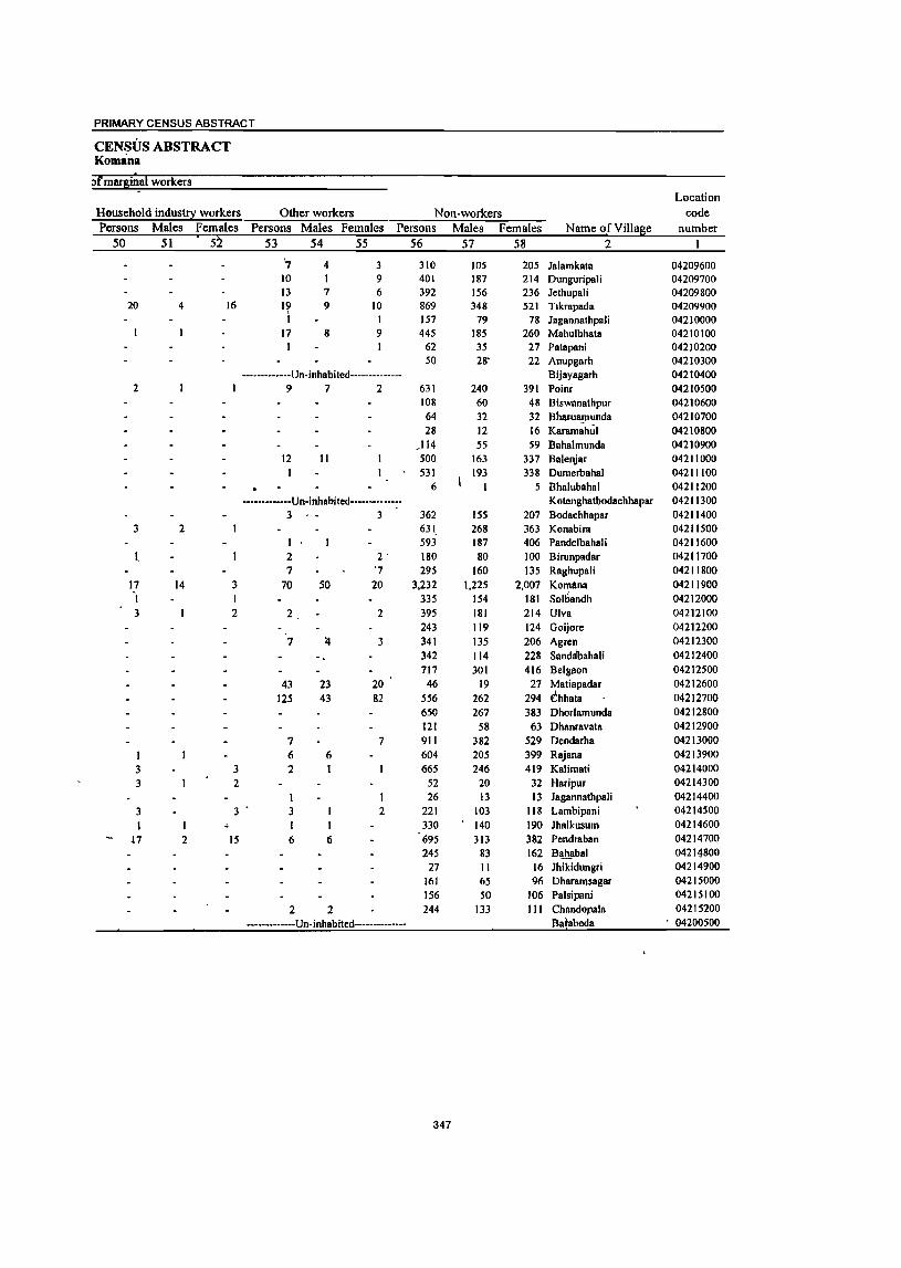
PRIMARY CENSUS ABSTRACT
CENSUS ABSTRACT Komana
Jlmar&i~a( workers Location
Household industry workers Other workers Non-workers code Persons Males Females Persons Males Females Persons Males Females Name of Village number
50 51 52 53 54 55 56 57 58 2 I
~ 4 3 310 105 205 Jalamkata 04209600 10 1 9 401 187 214 Dunguripali 04209700 13 7 6 392 156 236 Jethupa1i 04209800
20 4 16 19 9 10 869 348 521 Tlkrapada 04209900 I 1 157 79 78 Jagannathpali 04210000
17 8 9 445 185 260 Mahu1bhata 04210100 I 62 35 27 Patapani 04210200
SO 28- 22 Anupgarh 04210300 -------------Un-inhabited-------------- Bijayagarh 04210400
2 9 7 2 631 240 391 Poinr 04210500 108 60 48 Biswanalhpur 04210600 64 32 32 Bharua!Jlunda 04210700 28 12 16 KBramahul 04210800
.114 55 59 Bahalmunda 04210900 12 11 500 163 337 Balenjar 04211000 1 531 193 338 DumerbahBI 04211100
6 5 Bhalubahal 04211200 -------------Un-inhabited------------- Kotenghatbodachhapar 04211300
3 3 362 1.55 207 Bodachhapar 04211400 3 2 631, 268 363 Konabira 04211500
I .593 187 406 Pandelbahali 04211600
l 2 2' 180 80 100 Birunpadar 04211700 7 '7 295 160 135 Raghupali 04211800
17 14 3 70 50 20 3,232 1,22.5 2,007 Komana 04211900 ) I 335 154 181 Sol6andh 04212000 3 2 2 2 395 181 214 Ulva 04212100
243 119 124 Goijore 04212200 7 1I 3 341 13.5 206 Agren 04212300
342 114 228 Sandabahali 04212400 717 301 416 Bclgaon 04212500
43 23 20 46 19 27 Matiapadar 04212600
125 43 82 556 262 294 Chhala 04212700 650 267 383 Dhorlamunda 04212800 121 58 63 Dhanravata 04212900
7 7 911 382 529 Deodarha 04213000
1 6 6 604 205 399 Rajana 04213900
3 3 2 665 246 419 Kalimat; 04214000
3 2 .52 20 32 Haripur 04214300
I 26 13 13 Jagannathpali 04214400
3 3 3 2 221 103 118 Lambipani 04214500
I I I 330 140 190 Jhalkusum 04214600
-l7 2 15 6 6 695 313 382 Pendraban 04214700 245 83 162 Bahabal 04214800
27 II 16 Jhikidungri 04214900 161 65 96 Dharamsagar 04215000 1.56 50 106 Palsipani 0421.5100
2 2 244 133 III Chandopala 0421.5200
-------------Un-inhabited------------- Ba!abeda ' 04200500
347

PRIMARY CENSUS ABSTRACT OF BODEN C.D. BLOCK;- 0003
I
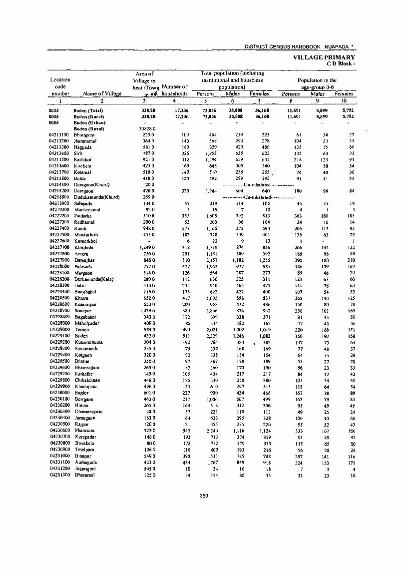
Locatton code
number Name ofVIUage 2
0003 Boden (Total) 0003 Boden (Rural) 000] Boden (Urban)
Boden (Rural) 04213100 Bhulnpllnt 04213200 Jharanamlll 04213300 Na6pada 04213400 Strll 04213500 Karlakot 04213600 Ktrekela 04213700 Kolamal 04213800 Bolda 04214100 Daragaon(Khurd) 04214200 Daragaon 04218800 Dudukamunda(Khurd) 04218900 Salepada 04219200 Muchenamal 04 227200 Patdarha 04227300 Redhamal 04227400 Rund. 04227500 Mankarblrh 04227600 Komerkhol 04227700 KlreJhola 04227&00 Amera 04227900 Damajhar 04228000 Palasada 04228100 Margaon 04228200 Durkamunda(Kala) 04228300 Dabn 04228400 BanJlbahal 04228500 Khalra 04228600 Kesarajpur 04228700 Sunapur 042211800 Bagabahal 04228900 Mabulpadar 04229000 Temen 04229100 Boden 04229200 Kusumkhunta 04229300 Sunamund. 04229400 Koigaon 04229500 Dhobel 04229600 B hamsadam 04229700 Kathafnr 04229800 Chlkalchuan 04229900 Khaduparu 04230000 Baglor 04230100 BOlrgaon 04230200 Nlmna 04230300 Dhamanapara 04230400 Jamugaon 04230500 RSJpur 04230600 Pharasara 04230700 Kerapadar 04230800 Blreskela 04230900 Tetelpara 04231000 Bmapur 04231100 Ambaguda 04231200 JugaraJPur 04231300 Bherumal
Area of
Village m hect (fowJ\ Number of
In j(.(i households
3 4
338.28 338.28
338280 22.$ 0 3640 5810 7870 9210 4250 510 0 4180 200
4200 2590 1440 920
5100 2000 9480 4530
1.2490 7560 8460 7770 5140 2890 4330 2160 6520 6530
1,0390 3430 4090 9840 4310 3040 2350 3200 3500 2650 1490 4460 4960 6010 4630 2650
480 1630 1200 7230 1480 800
1080
5490 4230 5050 1250
17,236 17,236
109 140 189 326 312 169 140 154
330
47 5
355 53
277 182
6 418 291 510 427 126 118
235 175 417 200 380 172
85 493 511 192
75 92 97 87
105 126 153 227 237 164 57
164 121 543 192 178 110 390 434
10 34
DISTRICT CENSUS HANDBOOK NUAPADA·
VILLAGE PRIMARY CD Block-
Total population (mcludmg IOstttutlonaf and housefess
populatlon) Population 10 the
age-group 0-6 Persons
5
72,056 72,056
464 568 829
1,258 1,294
645 510
592
1,244
219 19
1.605 200
1.166 740
22 1,730 1,)81 2,357 1.962
564 636 940 822
1.695 958
1,806 699 344
2,021 2,329
766 337 338 367 360 434 530 610 900
1,006 618 223 623 455
2,240 733 732 409
1,533 1,767
34 154
350
Males Females Persons Males Females 6 7 8 9 10
35,888 35,888
239 290 420 635 659 305 255 299
36,168 36,168
225 278 409 623 63S 340 255 293
11,691 11,691
61 104 135 135 218 104 76 92
-·-----------Un-Inhablted-------------. 604 640 180
---·---------Un-Inhablted-------------· 114 105
7 12 792 813
96 104 573 593 339 401
9 13 874 856 SS9 592
1,102 977 2&7 325 465 422 858 472 874 328 182
1,002 1,246
384 168 184 178 170 217 250 297 434 507 312 110 295 235
1.116 374 379 193 785 849
16 &0
1,255 985 277 311 475 400 837 486 932 371 162
1,019 1,083
382 169 154 189 190 217 280 313 466 499 306 113 328 220
1.124 359 353 216 748 918
18 74
44 4
363 24
206 135
I 266 185 390 346
85 123 141 107 265 150 330
91 77
320
350 137 77 64 SS S6 84
103 118 167 162 95 49
100 95
333 91
115 56
257 324
7 33
5,899 5,899
34 53 75 64
125 50 40 41
96
25 I
180 10
113 63
144 96
180 179 46 63 7& 54
140 80
161 41 41
169 192 73 40 35 27 23 42 S4 64 78 79 49 25 40 52
167 49 65 28
141 153
3 23
5,792 5;'92
27 51 60 71 93 54 36 51
84
19
183 14 93 72
I 122 89
210 167 39 60 6J 53
125 70
169 50 16
151 158 64
37 29 28 33 42 49 54 89 83 46 24 60 43
16b 42 Sp 28
lib 171
4 10
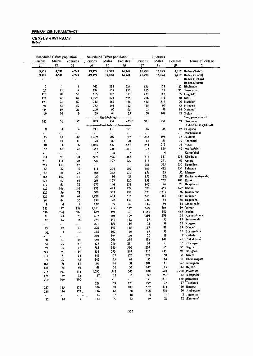
PRIMARY, CENSUS ABSTRACT
CENSUS ABSTRACT Bodelf
Scheduled CaStes popuation Persons Males Females
11 12 13
9,419 9,429
2 22
123 174 173 95
'44 19
143
8
85 21 10
137
188
.231 287
68 . 48
283 126 139 222 127 122 94
8 285 596
51 32
25 .,.!_
30 64 59
213 131 77
165 138 214 174 219
267 238
22
4,681 4,681
13 70 92 93 43 19 10
61
4
43 10 4
65
90 111 130 32 21
152 57 67
106 56 58 44
4 147 294 28 16
11
16 27 32 99 73 32 76 75
103 89
109
145 116
10
4,748 4,748
9 53 82 80 52 25
9
82
4
42 11 6
72
98 120 157 36 27
131 69 72
116 11 64 50 4
138 302
23 16
13 3
14 37 27
114 58 45 89 63
111 85
110
122' 122;
12
Scheduled Tribes population . Persons Males Females
14 15 16
19,174 29,174
462 274 615
1,069 345 3'43 200 129
14,533 14,533
238 139 302 534 161 161 95 64
14,141 14,741
224 135 313 535 178 182 105 65
·············Un·inhabited····· .. ••••••• 889 434 455 .
······_·_····Un·inhabited·.:'·-· .. ······- . 211 110 101
1,439 170
1,086 567
16 '972 227
411 465 39
256 277 973 lIOO
1,220 259 139
1,051 859 407 284 291 298 338 390 440 427 753 538 343 142 .95
68 1,095
21 /'
229 206 13(; 34
132
702 80
532 256
8 505 107
204 235
16 127 146 495 302 604 120 77'
512 498 208 142 155 143 162 194 206 216 363 273 167 75 44 36
548 15
109 97 68 16 70
737 90
554 311
8 467 120
207 230
23 129 131 478 298 616 139
62 539 361 199 142 136 155 . 116 196 234 211 390 265 176 67 51 32
547 12
120 109 68 18 62
351
Persons 17
21,990 21,990
130 113 233 206 415 135 103 190
311
46
" 232
81 244 178
4 514 314 785 563 155 150 353 147 622 321 613 230 113 525
1,354 260 67 72
117 68 20
181 67
202 336 222
55 208 147 808 392 351 199 561 506
6 39
Literates Males
18
16,273 '6,273
108 92
168 176 319 92 89
148
254
34
195 51
213 136
4 381 2H 555 432 123 1221 252J 126 455
/235 466 152 95
406 889 199 55 59 88 53 19
141 51
167 245
168 '44 141 115 608 250 2,31 132 4JI 386
4 27
Females Name of Village 19 2
5,717 Boden (Total) 5,717 Boden (Rural)
Boden (Urban) Boden (Rural)
22 Bhuinpam 21 Jharanllmal 65 Nagpada 30 Sirli 96 Karlako! 43 Kirekela 14 Kotamal 42 Bolda
Daragaon(Khurd) 51 Daragaon
Dudukamunda(Khurd) 12 Salepada
Muchenamal 37 Patdarha 30 Redhamal 31 Rundl 42 Mankarbirli
Komerkhol 133 Kirejhola 63 Amera
230 Damajhar 131 Palasada 32 Margaon 28 Durkamunda(Kala)
101 Dabri 21 Banjibahal
167 Khaira 86 Kesaraj pur
147 Sunapur 78 Bagabahal 18 Mahulpadar
119 Temeri 465 Boden
61 Kusumkhunta 12 Sunamundi J3 Kotgaon 29 Dhobei 15 B hainsadani
I' Kathafar 40 Chikalchuan 16 Khadupani 35 Baglor 91 Boirgaon 54 Nimna II Dhamanapara 67 Jamugaon 32, Rajpur
I 200 ' Pharasara i '
142 Kerapadar
120 '\BireSkela 67 Tetelpara
156 Binapur 120 Ambaguda
2 Jugarajpur 12 BherumaJ
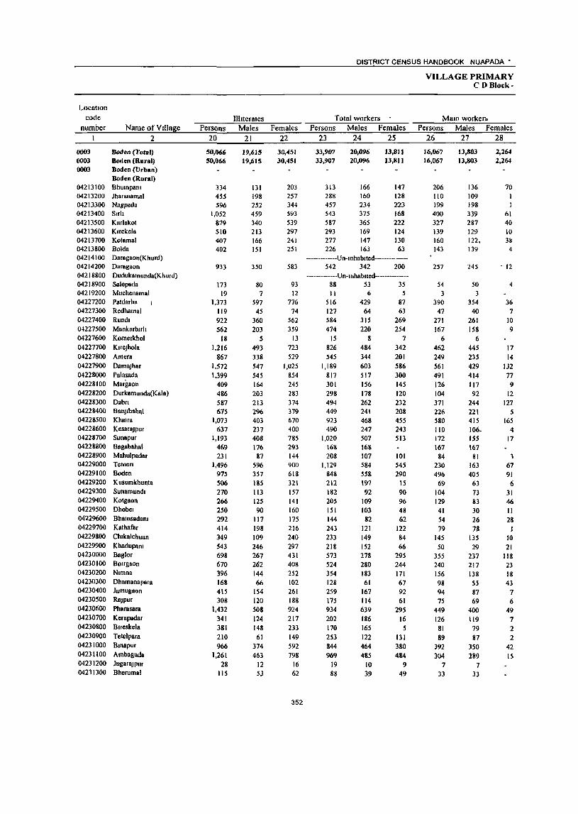
Location code
number Name of Village 2
0003 Boden (Total) 0003 Boden (Rural) 0003 Boden (Urban)
Boden (Rural) 04213100 Bhumpanl 04213200 Jharanamal 04213300 Nagpada 04213400 Suit 04213500 Karlakol 04213600 Klrekela 04213700 Kalamal 04213800 Bolda 04214100 Daragaon(Khurd) 04214200 Daragaan 04218800 Dudukamunda(Khurd) 04218900 Salepada 04219200 Muchenamal 04227200 Paldarha I
04227300 Redhamal 04227400 Rund. 04227500 Mankarbult 04227600 Kamerkhol 04227700 KneJh()la 04227800 Amera 04227900 DamllJhar 04228000 Palasada 04228100 Margaon 04228200 Durkamunda(Kala) 04228300 Dabn 04228400 Bal\)lbahlll 04228500 Khalra 04228600 KesaraJPur 04228700 Sunapur 04228800 BagabahaJ 04228900 Mahulpadar 04229000 Temen 04229100 Boden 04229200 Kusumkhunta 04229300 Sunamundl 04229400 KOlgaon 04229500 Dhobel 04229600 BhamsadaRl 04229700 Kalhafar 04229800 Chlkalchuan 04229900 KhadupaRl 04230000 Baglor 04230100 BOlrgaon 04230200 Nlmna 04230300 Dhamanapara 04230400 Jamugaon 04230500 RaJpur 04230600 Pharasara 04230700 Kerapadar 04230800 Btreskela 04230900 Tetelpara 04231000 Bmapur 04231100 Amhaguda 04231200 JugaraJPur 04211300 Bherumal
Persons 20
50,066 50,066
334 455 596
1,052 879 510 407 402
933
173 19
1,373 119 922 562
18 1,216
867 1,572 1,399
409 486 587 675
1,073
637 1,193
469 231
1,496 975 506 270 266 250 292 414 349 543 698 670 396 168 415 308
1,432
341 381 210 966
1.261 28
115
Ilhterates Males
21
19,615 19,615
131 198 252 459 340 213 166 151
350
80 7
597 45
360 203
S 493
338
547 545 164 203 213 296 403 237 408 176 87
596 357 185 113 125 90
117 198 109 246 267 262 144 66
154 120 508 124 148 61
374 463
12 53
Females 22
30,451 30,451
203 257 344 593 539 297 241 251
583
93 12
776 74
562 359
13 723 529
1,025 854 245 283 374 379 670 400 785 293 144 900 618 321 157 141 160 175 216 240 297 431 408 252 102 261 188 924 217 233
149 592
798 16 62
352
DISTRICT CENSUS HANDBOOK NUAPADA'
Total workers Persons Males Females
23 24 2S
33,907 33,907
313 288 457 543 587 293 277 226
20,096 20,096
166 160 234 375 365 169 147 163
Il,S)) 13,811
147 128 223 168 222 124 130 63
-------------Un-Inhablled--------------542 342 200
-------------Un-Inhllblled--------------88 53 35 II 6 5
516 429 87 127 64 63
584 474
15 826
545 1,189
817 301 298 494 449 923 490
1,020 168 208
1,129 848 212 182 205 151 144 243 233 218 573 524 354 128 259 175 934 202 170
253 844 969
19 88
315 220
8
484 344 603 517 156 178 262 241 468 247 507 168 107 584 558 197 92
109 103 82
121 149 152 278 280 183
61 167 114 639 186 165
122 464 485
10 39
269 254
7 342 201 586 300 145 120 232 208 455 243 513
101 545 290
15 90 96 48 62
122 84 66
295 244 171 67 92 61
295 16
5
131 380 484
9 49
VILLAGE PRIMARY CD Block-
MalO worker~ Persons Males Females
26 27 28
16,067 16,067
206 110 199 400 327 139 160 143
257
54 3
390
47 271 167
6 462 249 561 491 126
104 371 226 580 110 172 167
84 230 496
69
104 129 41 54 79
145 50
355 240 156 98 94 75
449
126 81 89
392 304
7 J3
1l,803 13,803
136 109 19B 339 287 129 122. 139
245
50 3
354 40
261 158
6 445 235 429 414 117 92
244 221 415 106. 155 167
81 163 405
63 73 83 30 26 78
135 29
237 217 138
55 87 69
400 119 79 87
350 289
7 33
2,264 2,264
70 I
61 40 10 311
4
-12
4
36
7 10 9
17
14
132 77
9 12
127 S
165 4
17
1 67 91
6 31 46 II 28
J 10 21
118 23 18 43
7 6
49 7 2 2
42 15
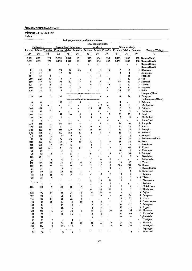
PRIMAR¥ CENSUS ABSTRACT
CENSUS ABSTRACT Boden"
Industnal category of maID workers
Culttvators Agnculturallabourers Household mdustry
workers Persons Males Females Persons Males Females Persons Males Females
29 30 31 32 33 34 35 36 37
9,891 9,891
81 51
184 380 159 121 100 116
8,921 8,921
54 51
[83
323 147 115
84 114
210 209
36 35 2 2
269 268 44 37
207 206 154 146
6 6 253 248
194 191
305 239 ~06 175 112 106 '35 32
287 202 2[ 1 208 434 298
98 98 J8 92
161 161 73 71
148 106 118 96 21 21 67 50 78 50 30 25
..240 176 127 120 116 105 56 40 43 39 38 37
303 287
32 32 18 18 85 83
192 177 221 216
7 7 30 30
970 970
27
57 12 6
16 2
7 I 8
5 3
66 31
6 3
85 3
136
6
2 42 22
11 28
5
4
64 7
11 16 4 1
16
2 IS 5
3,028 3,028
108 57
5 98
45 3
"2,397 2,397
72 57
4 83
27 3
631 631
36
15
18
975 975
8
4
6 4 1
650 650
5
4
6
3
••••••• -•• -.-Un.lnhablted ••••••••••••••
27 21 6 1 1 ·······_·····Un·lnhablted···-·········-
17 15 2
3
28
195 17
186 192
9 43 36 10 67
2 17 1 4
34 44
5 26 31
20
35 61 26 37
14 16 31 36
3
26
186 II
137 162
7 36 17 10 50
2 17
I 4
24 21 5
15 20
15
24 57 22 12 14 16 30 36
4 80 13
2 2
2 1
9 6
49 30
2 7
19
17
10 23
II 11
5
II 4 4
25
15
lIS
g
4
12 25
8
10
8
10
7 23 25
2
13
- I 81
6 4
10 14
4
7
6 13 17
1
7
52 25 78 13 44 76 18
2 3 4
47 5 7
31 4
77 12 24 36 14
3 3
27 5 7
22
353
325
325
3
34
2
2 11 4
9
3
3
10 8 1
6
27 I 1
20 40
4
20
9 3
Other workers Persons Males Females Name of Village
38 39 40 2
2,173 2,173
9 2
11 14 64 13 14 24
19
1 1 3 3
28 8
13 26
4S 85
5 26 38
4 71 10' 47 5
25 309
41 11 7
11 2
6 6
4 34
14 3
34 17 68 ,53
56
74 66
1,835 1,835
5
11
12
51 10 10 22
ll8 Boden (Total) 338 Boden (Rural)
Boden (Urban) Boden (Rural)
4 BhUinpam Jharanamal Nagpada
2 Sirh 13 Karlakol 3 Klrekela 4 Kotamal 2 Bolda
Daragaon(Khurd) 14 5 Daragaon
Dudukamunda(Khurd) Sa1epada Muchenamal
2 Patdarha 3 Redhamal
23 5 Rundl 8 Mankarblrh
Komerkhol
10 3 KlrcJhola 23 3 Amera
39 6 DamaJhar 73 12 Plllasada
4 Margaon 24 2 Durkamunda(Kala) 24 14 Dabn
2 2 BanJlbahal 62 9 Khana
6 4 KesaraJpur 39 8 Sunapur
5 Bagabahal Mahulpadar
20 5 Temen 271 38 Boden
36 5 Kusumkhunta 8 3 Sunamundl 6 I Kotgaon 5 6 Dhobel
1 B hamsadaRl Kathafar
6 Chlkalchuan 5 I Khad upam
3 Baglor 26 8 Bougaon II 3 Nlmna 2 Dhamanapara
31 3 Jamugaon
13 4 RaJpur S~ j 12 , PharasarB 46 7 KerapadBr
54 2 I Blreskela Tetelpara
71 3 Bmapur 59 7 Ambaguda
JugaraJPur Bherumal
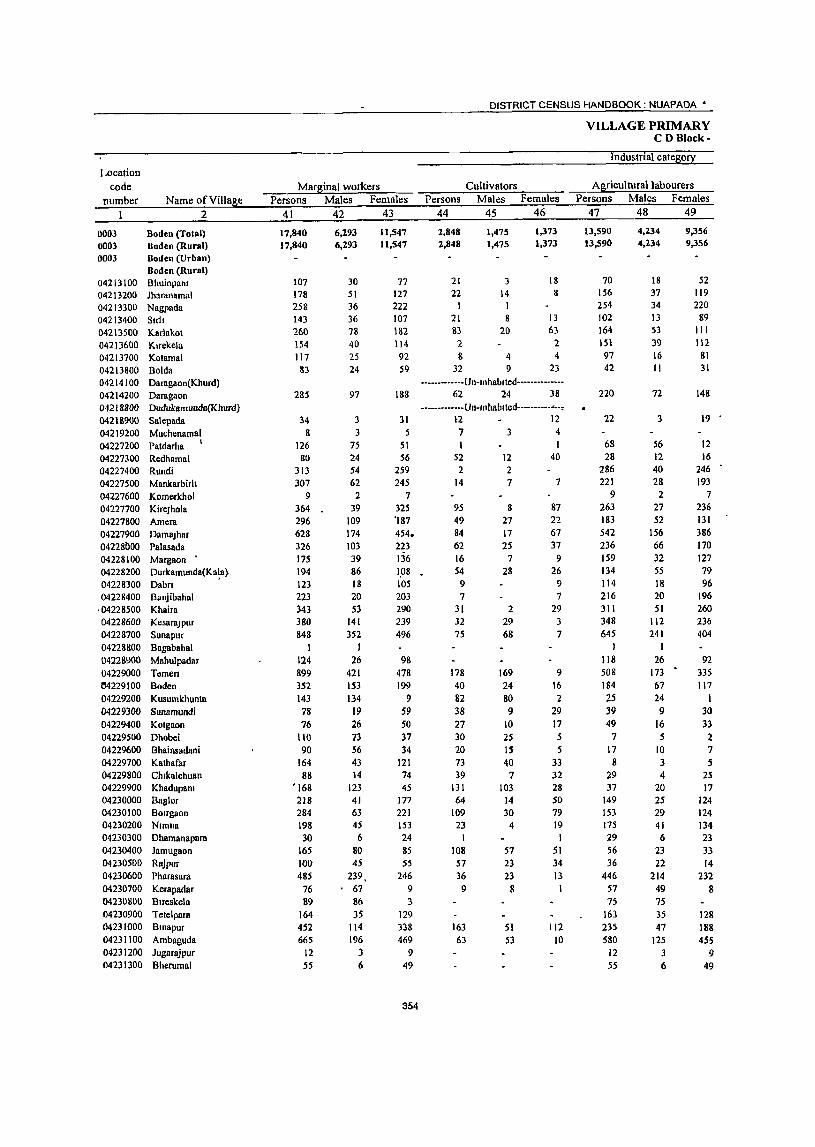
Location code
number Name ofViUage 2
0003 Boden (Total) 0003 Boden (Rural) 0003 Boden (Urban)
Boden (Rural) 04213100 Bhuinpam 04213200 Jharanamal 04213300 Nagpada 04213400 Slrl! 04213500 Karlakot 04213600 Klrekela 04213700 Kotamal 04213800 Bolda 04214100 Daragaon(Khurd) 04214200 Daragnon 04218800 Dudukamunda(Khurd) 0421B900 Sa\epada 04219200 Muchenamal 04227200 Patdarha I
04227100 Redhamal 04227400 Rundi 04227500 Mankarbirh 04227600 Komcrkhol 04227700 KircJhola 04227800 Amera 04227900 DamaJhar 042281lO0 Palasadn 04228100 Margaon • 04228200 Durkamunda(Ka1a} 04228300 Dabn • 04228400 Banjibaha1
,04228500 Khaira 04228600 Kesarajpur 04228700 Sunapur 04228800 Bngabahal 04228900 Mahu1padar 04229000 Tcmcn 04229100 Boden 04229200 Kusumkhunta 04229300 Sunamundi 04229400 Kotgaon 04229500 Dhobei 04229600 Bhainsadani 04229700 Kathafar 04229800 Chlka1chuan 04229900 Khadupanl 04230000 Bag10r 04230100 BOirgaon 04230200 Namna 04230300 Dhamanapara 04230400 Jamugaon 04230500 Rajpur 04230600 Pharasara 04230700 Kerapadar 04230800 Bueskela 04230900 Tete1para 04231000 Bmapur 04231100 Ambaguda 04231200 Jugarajpur 04231300 Bherumal
Marginal workers Persons Males Females
41 42 43
17,840 17,840
107 178 258 143 260 154 117
83
285
34 8
126 80
313 307
9 364 296 628 326 175 194 123 223 343 380 848
1 124 899 352 143 78 76
110 90
164 88
'168 218 284 198 30
165 100 485 76 89
164 452 665
12 55
6,293 6,293
30 51 36 36 78 40 25 24
97
3 3
75 24 54 62
2 39
109 174 103 39 86 )8
20 53
141 352
I 26
421 153 134
19 26 73 56 43 14
123 41 63 45 6
80 45
239, , 67
86 35
114 196
3 6
11,547 11,547
77 127 222 107 182 114 92 59
188
31 5
51 56
259 245
7 325 '187 454. 223 136 1,08 105 203 290 239 496
98 478 199
9 S9 SO 37 34
121 74 45
177 221 153 24 85 55
246 9 3
129 338 469
9 49
354
DISTRICT CENSUS HANDBOOK: NUAPADA •
Cultivators Persons Males Females
44
2,848 2,848
21 22
\ 21 83 2 8
32
45
1,475 1,475
3 14 1 8
20
4 9
46
1,373 1,373
18 8
13 63
2 4
23
·············Un·mhablted·············· 62 24 38
• ••••• ······.Un·,nhablted·············. .2 12 734
1 52 2
14
95 49 84 62 16 54
9 7
31 32 75
178 40 82 38 27 30 20 73 39
131 64
109 23
1 108 57 36 9
163 63
12 2 7
8 27 17 25
7 28
2 29 68
169 24 80 9
10 2S IS 40
7 103
14 30
4
57 23 23
8
51 53
40
7
87 22 67 37
9 26
9 7
29 3 7
9 16 2
29 17 5 5
33 32 28 50 79 19 1
51 34 13 1
112 10
VILLAGE PRIMARY CD Block·
Industrial category
Agricultural labourers Persons Males Females
47 48 49
13,590 13,590
70 156 254 102 164 151
97 42
220
22
68 28
286 221
9 263 183 542
236 159 134 114 216 311 348 645
I 118 508 184 25 39 49
7 17 8
29 37
149 153 175 29 56 36
446 57 75
163 235 580
12 55
4,234 4,234
18 37 34 13 53 39 16 11
72
3
56 12 40 28 2
27 52
156 66 32 55 18 20 51
112 241
26 173 67 24 9
16 5
10 3 4
20 25 29 41 6
23 22
214 49 75 35 47
125
3 6
9,356 9,356
52 119 220
89 111 H2
81 31
148
19
12 16
246 193
7 236 131 386 170 127 79 96
196 260 236 404
92 335 117
1 30 33 2 7 S
25 17
124 124 134 23 33 14
232 8
128 188 455
9 49
PRIMARY CENSUS ABSTRACT . '. CENSUS>ABSTRACT Boden
of maramal workers Locatton
Household mdus~ workers Other workers Non-workers code
Persons Males Females Persons Males Females Persons Males Pe!!!ales Name ofVdlase number
50 51 52 53 54 55 56 57 58 2 I
353 65 288 1,049 519 530 38,149 15,792 2%,357 Boden (Total) 0003 353 65 288 1,049 519 530 38,149 15,792 21,357 Boden (Rural) 0003
Boden (Urban) 0003 Boden (Rural)
7 5 2 9 4 5 151 73 78 Bhulnpam 04213100 280 130 150 Iharanamal 04213200
2 1 I I 1 372 186 186 Nagpada 04213300
7 4 3 13 11 2 715 260 455 81rh 04213400 13 5 8 707 294 413 Karlakot 04213500 I I 352 136 216 Klrekela 04213600
1 11 4 7 233 108 125 Kotamal 04213700
4 - I 4 .5 4 1 366 136 230- Bolda 04213800 -------------Un-mhablted- --_ ••••••• -. Daragaon(Khurd) 04214100 . 3 1 -"2 702 262 440 Daragaon 04214200 r
·············Un·'nhablted······_······- Dudukamunda(Khurd) 04218800
\ 131 61 70 8alepada 04218900
I I 8 1 7 Muchenamal 04219200
56 18 38 1,089 363 726 Patdarha 04227200
73 32 41 Rcdhamal 04227300
2 2 23 12 11 582 258 324 Rundl 04227400
11 2 9 61 25 36 266 119 147 Mankarblfh 04227500
7 I 6 Komerkhol 04227600
3 2 3 3 904 390 514 KlreJhola 04227700
30 2 28 34 28 6 636 245 391 Amcra 04227800 .r 2 I 1 1,168 499 669 DamaJhar 04227900
6 2 4 22 10 12 1,145 460 685 Palasada 04228000
263 131 132 Margaon 04228100
5 2 3 338 147 191 Durkamunda(Kala) 04228200
446 203 243 Dabn 04228300
373 181 192 BaRJlbahal 04228400
772 390 382- Khalra 04228500
468 225 243 KesaraJJ1ur 04228600
6 5 m 42 80 786 367 419 Sunapur 04228700
531 160 371 Bagabahal 04228800
5 5 1 • 1 136 75 61 Mahulpadar 04228900
16 9 7 197 70 127 892 418 474 Temen 04229000
2 2 126 60 66 1,481 688 793 Boden 04229100
36 30 6 554 187 367 Kusumkhunta 04229200
155 76 79 Sunamundl 04229300
J33 15 58 Kotgaon 04229400
73 43 30 216 75 141 Dhobel 04229500
53 31 22 216 88 128 Bhamsadam 04229600
83 ~- 83 191 96 "'"95 Kathafar 04229100
19 2 17 297 101 196 Chlkalchuan 04229800
392 145 247 Khadupam 04229900
5 2 3 327 156 171 Baglor 04230000
16 2 14 6 2 4 482 227 r5 BOirgaon 04230100
264 129 35 Nlmna 04230200
95 49 46 Dhamanapara 04230300
364 128 236 Jamugaon 04230400
5 5 2 2 280 121 159 RBJPu~ 04230500
1 2 1,306 477 829 Pharasara 04230600
9 9 531 188 343 Kerapadar 04230700
2 2 12 9 3 562 214 348 Blreskela 04230800
156 71 85 Tete1para 04230900
33 6 27 21 10 11 689 321 368 Bmapur 04231000
4 3 18 17 798 364 434 Ambaguda 04231100
15 6 9 ]ugaraJPur 04231200
66 41 25 Bherumal 04231300
355
DISTRICT CENSUS HANDBOOK NUAPADA •
VILLAGE PRIMARY CD Block-
Area of Total population (including
Location Village In mstl(utlonal and houseless Population 10 the
code hect (fowl! Number of EOEulatlon2 age-grouE 0-6 number Name of Village , ID.J:. households Persons Males Females Persons Males Females
2 3 4 5 6 7 8 9 10
04231400 Kamalamal 4200 223 975 471 504 160 74 &6 04231500 Rokal 3870 198 936 437 499 177 84 93 04231600 Tarapur 2660 160 794 401 393 133 66 67 04231700 Bakultkhuntt(Khurd) 1520 -------------Un-Illhablied ------------. 04231800 Bakultkhunl1(Kala) 3420 222 967 463 504 144 64 80
04231900 Putupara 4110 201 858 427 431 118 44 74 04232000 Ghantlguda 2320 87 367 182 185 84 46 38 04232100 Jhlflmkhal 1350 94 353 163 190 61 28 33 04232200 Mahulpadar 2240 114 465 231 234 69 31 38 04232300 Llllsargl 4080 344 1,247 630 617 211 106 105 04232400 Anlabhata 4040 260 946 476 470 152 80 72 04232500 Sukuhbhata 3160 108 457 231 226 83 39 44 04232600 Kulekela 1490 63 303 149 154 37 17 20 04232700 Dumerpadar 770 22 84 40 44 13 7 6
04232800 Doto 3720 360 1,432 727 705 213 102 III 04232900 Lesunpall 2620 194 752 365 387 86 38 48 04233000 Jayabahal 2740 223 989 475 514 161 63 98 04233100 Khlrmal 4030 263 1,081 567 514 174 79 95 04233200 LlIrka 3690 231 1,042 516 526 153 72 81
04233300 Palenbasa 1880 48 205 101 104 20 9 II 04233400 Khurdguma 2150 31 128 64 64 16 10 6 04233500 Anakapur 5390 270 1,170 595 575 193 85 108 04233600 Gumabahal 1210 44 200 97 103 36 20 16 04233700 Kharla 1870 84 343 177 166 57 32 25 04233800 Kempur 4280 281 1,233 598 635 196 91 lOS 04233900 Karangamal 3810 201 892 453 439 113 57 56 04234000 Pllapanl 940 12 38 21 17 4 I J 04234100 Dahanapah 2340 288 1,074 531 543 166 7S 91 04234200 Kekatsar 1660 64 264 138 126 40 24 16 04234300 Dhamlmnl 2440 280 1,233 632 601 207 115 92 04234400 Babeblr 7730 498 1,992 1,023 969 330 184 146 04234500 Khl\lrvlldl 2780 231 1,000 504 496 159 86 73 04234600 Bertansl1 4210 203 882 452 430 132 71 61 04234900 Kuhnsmal 2020 194 766 379 387 107 55 52
356
PRIMARY CENSUS ABSTRACT
CENSUS ABSTRACT Boden
Scheduled Castes I!oEuatlOn Scheduled Tnbes I!oI!ulatlon Literates • Persons Males Females Persons Males Females Persons Males Females Name ofVJllage
11 12 13 14 15 16 17 18 19 2
198 105 93 305 156 149 289 204 85 Kamalamal 9 6 3 569 274 295 303 213 90 Roknl
54 26 28 145 73 72 304 203 101 Tampur -------------Un-Inhablted-------------- Bnkullkhuntl(Khurd)
89 48 41 682 319 363 230 171 59 Bakuhkhuntl(Kala) 87 44 43 542 26\ 28\ 230 \79 51 Putupara 44 25 19 270 129 141 117 90 27 Ghanllguda 64 32 32 201 92 109 115 85 )0 lhlrllllkhol
9 4 5 447 223 224 100 80 20 Mahulpadar 226 liS III 317 155 162 469 345 124 Ltusargt 345 179 166 102 51 51 251 188 63 Anlabhala
204 104 100 88 83 5 Sukuhbhata 22 9 13 74 38 36 143 92 51 Kulekela
16 II 5 Dumerpadar 288 153 135 102 57 45 135 104 31 Dolo
13 7 6 140 67 73 80 68 12 Lesunpah 154 65 89 271 196 75 Jayabahal 264 141 123 354 184 170 429 338 91 K1urmal 130 63 67 151 74 77 462 293 169 Larka 29 13 16 147 72 75 38 33 5 Palenbasa 15 6 9 72 35 37 24 19 5 Khurdguma
145 80 65 290 139 151 287 228 59 Anakapur 54 25 29 50 40 10 Oumabahal
295 ISO 145 94 80 14 Khorla 196 95 101 539 2S0 289 347 266 &1 Kampur 111 48 63 332 170 162 542 331 211 Karangamal
38 21 17 Pltapam 61 29 32 2 I I 327 246 &1 Dahanapah
20 11 9 59 44 15 Kekatsar 199 99 100 430 330 100 Dharnlmal 358 182 176 220 116 104 566 413 153 Babebtr
41 19 22 277 224 53 Khallvadl 121 61 60 26 14 12 362 244 118 Bartansll 100 46 54 452 220 232 285 219 66 Kuhngmal
357

DISTRICT CENSUS HANDBOOK NUAPADA •
VILLAGE PRIMARY CD Block-
Locallon code Illiterates Total workers MaIO workers
number Name ofVllla~e Persons Males Females Persons Males Females Persons Males Females 2 20 21 22 23 24 25 26 27 28 •
04231400 Kamalamal 686 267 419 471 269 202 271 235 36 042~1500 Robl 633 224 409 580 274 306 177 155 22 04231600 Tarapur 490 198 292 426 248 178 79 59 20 042~1700 Bakullkhuntl(Khurd) ·············Un·lnhablted .......... _ .. -04231800 Bakuhkhuntl(Kala) 737 292 445 464 267 197 230 217 13 04231900 Putupara 628 248 380 497 263 234 251 166 ·85 04232000 Ghantlguda 250 92 158 193 97 96 56 55 04232100 Jhmmkhol 238 78 160 187 93 94 50 47 04232200 Mahu1padar 365 151 214 254 138 116 98 91 7 04232300 L1Hsargi 778 285 493 488 342 146 113 102 16 04232400 Anlabhata 695 288 407 482 262 220 160 153 7 04232500 Sukuhbhata 369 148 221 140 131 9 99 98 I 04232600 Kulekela 160 57 103 93 91 2 77 75 2 04232700 Dumerpadar 68 29 39 45 23 22 27 17 10 04232800 Doto 1,297 623 674 647 400 247 367 333 34 04232900 Lcsunpah 672 297 375 418 :130 188 244 '216 28 04233000 Jayabahal 718 279 439 621 311 310 230 218 12 04233100 Khlrmal 652 229 423 S06 324 182 240 236 4 04233200 Larka 580 223 357 464 295 169 219 201 18 04233300 Palenbasa 167 68 99 116 63 53 56 55 04233400 Khurdguma 104 45 59 69 38 31 35 31 4 04233500 Anakapur 883 367 516 659 383 276 307 285 22 04233600 Gumabahal 150 57 93 86 45 41 26 26 04233700 Khorla 249 97 152 157 84 73 60 58 2 0423j800 Kampur 886 332 554 469 329 140 321 284 37 04233900 Kllrangamal 350 122 228 282· 227 55 204 187 17 04234000 Pltapanl 38 21 17 28. 16 12 13 13 04234100 Dahanapalt 747 285 462 490 323 167 106 102 4 04234200 Kekatsar 205 94 III 152 86 66 74 . 72 2 04234300 Dhamlmal 803 302 501 481 323 158 137 129 8 04234400 Babcblr 1,426 610 816 792 540 252 621 415 206 04234500 Khalrvadl 723 280 443 360 261 99 116 112 4 04234600 Bartansll 520 208 312 339 245 94 198 175 23 04234900 Kuhnl;!mal 481 160 321 325 237 88 322 236 86
358
PRIMARY CENSUS ABSTRACT
CENSUS ABSTRACT Boden
Industrial catego~ of mam workers Household mdustry
Cultivators Agnculturallabourers workers Other workers Persons Males Females Persons Males Females Persons Males Females Persons Males Females Name of Village
29 30 31 32 33 34 35 36 37 38 39 40 2
140 133 7 94 76 18 I I 36 25 II Kamalamal 70 65 5 41 35 6 4 4 62 51 \\ Rokal 24 12 12 5 4 I 9 8 41 35 6 Tarapur
·············Un·tnhabtted·············· Bakultkhunh(Khurd) 209 201 8 18 14 . 4 3 2 Bakuhkhuntl(Kala) 219 148 71 32 18 14 Putupara
55 54 I Ghantlguda 48 46 2 2 Jhmnrkhol 93 87 6 3 3 I I Mahulpadar 75 69 6 I 42 32 10 LIIIsargl 70 70 77 76 13 7 6 Anlabhata 74 74 22 22 3 2 I Sukuhbhata 42 42 16 16 18 16 2 Kulekela
5 5 22 12 10 Durnerpadar . 219 199 20 131 118 13 16 16 Doto
68 64 4 155 132 23 20 ~9 Lesunpalt
161 158 3 41 38 3 27 21 6 Jayabahal
215 212 3 2 2 23 22 I Khlrrnal
70 68 2 48 47 5 5 96 81 15 Larka
55 55 I Palenbasa
35 31 4 Khurdgurna
201 198 3 9 8 66 50 16 31 29 2 Anakapur
22 22 4 4 Gumabahal
52 51 I 4 4 4 3 Khorla
236 223 13 35 29 6 19 6 13 31 26 5 Kampur
69 69 37 35 2 3 3 95 80 15 Karangarnal
9 9 4 4 Pltapant
68 66 2 26 25 2 10 10 Dahanapalt
55 55 14 14 5 3 2 Kekatsar
87 87 4 3 1 46 39 7 Dhamlrnal
148 138 10 363 196 167 50 28 22 60 53 7 Babeblr
92 91 I I I 3 2 20 18 2 Khalrvadl
65 65 42 40 2 29 12 17 62 58 4 Bartansl!
185 144 41 125 84 41 8 5 3 4 3 Kultngmal
359
DISTRICT CENSUS HANDBOOK NUAPADA '.
VILLAGE PRIMARY CD Block-
Industnal categ0!1 Location
code Margmal workers Cultivators Agnculturallabourers number Name of Village Persons Males Females Persons Males Females Persons Males Female:.
2 41 42 43 44 45 46 47 48 49
04231400 Kamalamal 200 34 166 25 13 12 162 17 145 04231500 Rokal 403 119 284 95 40 55 284 73 211 04231600 Tarapur 347 189 1S8 101 68 33 245 120 i25 04231700 Bakultkllllnlt(Khurd) •••• -•••. ·-Un-Inhablted--- • 04231800 Baktlltkhuntl(Kala) 234 50 184 2 2 231 50 18: 04231900 Putupara 246 97 149 246 97 149 04232000 Ghantlguda 137 42 95 137 42 95 04232100 Jhlnmkhol 137 46 91 137 46 91 04232200 Mahulpadar 156 47 109 1 155 47 108 04232300 LI!lsargl 370 240 130 26 23 3 342 215 127 04232400 Anlabhata 322 109 213 12 9 3 307 97 210 04232500 Sukultbhala 41 33 8 7 7 34 26 8
042:32600 Kulekela 16 16 )2 l2 4 4 04232700 Dumerpadar 18 6 12 4 2 2 14 4 to 04232800 Doto 280 67 213 6 4 2 256 62 194 04232900 Lesunpalt 174 14 160 39 38 117 13 104 04233000 Jayabahal 391 93 298 19 10 9 '372 83 189 04233100 Khlrmal 266 88 • 178 8 1 7 256 86 170 04233200 Larka 245 94 151 9 6 3 222 110 i42 04233300 Palenbasa 60 8 52 60 8 52 04233400 Khurdguma 34 7 27 34 7 27 04233500 Anakapur 352 98 254 2 2 332 93 239 04233600 Gumabahal 60 19 41 60 19 41 04233700 Khorla 97 26 71 2 2 95 26 69 04233800 Kampur 148 45 103 50 17 33 88 22 66 04233900 Karllngamal 78 40 38 17 16 47 II 36 04234000 Pltapana IS 3 12 15 3 12 04234100 Dahanapah 384 221 163 146 90 56 237 130 107 04234200 Kekatsar 78 14 64 37 12 2S 41 2 39 04234300 Dhamlmal 344 194 150 5 5 337 187 150 04234400 BabeblT 171 125 46 2S 23 2 124 86 38 04234500 Khalrvadl 244 149 95 39 37 2 193 103 90 04234600 Bartansil 14'1 70 71 14 14 119 52 67 04234900 Kuhnllmal 3 I 2 3 I 2
360
PRIMARY CENSUS ABSTRACT
CENSUS ABSTRACT Boden
ofmargmal workers LocatIon
Household mdustry workers Other workers Non·workers code Persons Males Females Persons Males Females Persons Males Females Name ofVllIase number
50 51 52 53 54 55 56 57 58 2
13 4 9 504 202 302 Kamalamal 04231400 23 .5 18 356 163 193 Rokal 04231500
I t 368 153 215 Tarapur 04231600 ·············Un·lnhablted·············· Bakullkhunll(Khurd) 04231700
503 196 307 Bakuhkhuntl{Kala) 04231800 361 164 197 Putupara 04231900 174 S5 &9 Ghal\tlgu{\a 04232()QO 166 70 96 Jhtrlnlkhol 04232100 21 I 93 118 Mahulpadiu 04232200
2 2 759 288 471 Lltlsargl 04232300 3 3 464 214 250 Anlabhata 04232400
317 100 217 Sukuhbhata 04232500 210 53 152 Kulekela 04232600
39 17 22 Dumerpadar 04232700 18 17 785 327 458 Doto 04232800 18 18 334 135 199 LesunpaIJ 04232900
368 164 204 Jayabahal 04233000 2 I 575 243 332 Khlfmal 04233100
13 8 5 578 221 357 Larka 04233200 89 38 51 Palenbasa 04233300 59 26 33 Khurdguma 04233400
14 13 4 2 2 51 I 212 299 Anakapur 04233500 114 52 62 Gumabahal 04233600 186 93 93 Khorla 04233700
4 4 6 6 764 269 495 Kampur 04233800 4 4 10 9 610 226 384 Karangamal 04233900
10 5 Pltapam 04234000 584 208 376 DahanapalJ 04234100 112 52 60 Kekatsar 04234200
2 2 752 309 443 Dharnlmal 04234300 4 3 I 18 13 5 1,200 483 717 Babeblf 04234400
6 3 3 6 6 640 243 397 Khalrvadl 04234500
6 2 4 2 2 543 207 336 Bartansll 04234600 441 142 299 Kuhnllmal 04234900
361


PRIMARY CENSUS ABSTRACT OF SINAPALI C.D. BLOCK- 0004

Location code
number Name ofVdlage 2
0004 Smapah (Total) 0004 Sinapals (Rural) 0004 Smapah (Urban)
Smopah (Rural) 04234700 Sa1ekela 04234800 Baragaon 04235000 Botopall 04235100 Kanetghatmal 04235200 Jogabhllta 04235300 Arma1a 04235400 Govmdpur 04235500 Huapur IWB561)1) Maheswar 04235700 Dhunglomunda 04235800 Mandlorucha 04235900 Rantmunda 04236000 Balgapada 04236100 Ramdullgun 04236200 Tlmanpur 04236300 Rebadl 04236400 Karlakhamar 04236500 Khapunmal 04236600 Gorla 04236700 Ma1pada 04236800 Kusumkhunta 04236900 B Ijalpur 04237000 Dumerbahal 04237100 Knradu ngarl 04231200 lamabahah 04237300 Chllarama 04237400 Smdursil 04237500 Talakot 04237600 Bhatapam 04237700 Nangalbod
.04237800 Tankamal 04237900 Dauda 04238000 Bhullabhata 04238100 Fulchl 04238200 Kalhlbadl 04238300 Sardhapur 04238400 Khlrbhadl 04238500 Darhpada 04238600 Kharsel 04238700 Kamlapadar 04238800 Ghuchaguda 04238900 NIIJI 04239000 Gadarnmal 04239100 Khalna 04239200 Paisa para 04239300 Challaguda 04239400 Sagunbhadl 04239500 Jugenpadar 04239600 Sinapah 04239700 Kapsi 04239800 Sardhapur 04239900 Ghotuguda 04240000 Cha1na 04240100 Nandagaon 04240200 Gambhanguda
Area of Village In hect (fow7) Number of
ID Km households 3 4
416.64 416.64
416640 4210
1,0210 1300 6350 :l80 0 2680 3610 2790 2760 1310 2770
1,1050 2590 1060 3050 3220 3010 2840 5710 3070 1820 1290 5860 680
1730 2040 1560 2400 4050 2840 3200 2190 3420 2880 2910 2080 4740 6120 5330 2710 5240 6140 2110 2990 1810 6070 2310 1490 2970 6500 2490 2940 4240 2740 3260
23,858 23,858
247 856 91
237 138 ItO 268 255 \51 33
129, 395 158 70
190 89
140 180 313 249 116 72 53 24 52 51 54
182 132 140 67 55 8\ 96 45
109 158 124 279 194 510 567 303 131 351 410 265 332
1,048 , 380 176 310 342 III 331
DISTRICT CENSUS HANDBOOK NUAPADA·
Total populatIOn (mcludmg Instltutlonal and house less
populallon) Persons Males Females
5 6 7
98,666 98,666
926 3,498
395 1,032
618 417
1,091 992 667 157 571
1.701 717 272 851 380 552 813
1.270 1,053
469 299 223
97 171 202 266 908 646 651 229 213 341 394 235 472 687 536
1.084 762
2.114 2.470 1,235
551 1.490 1,715 1,147 1.420 4,611 1.494
722 1.152 1.385
450 1,378
364
49,309 49,309
466 1,746
1&4 516 304 220 523 490 :no
73 286 862 361 145 416 188 271 398 674 533 218 144 102 48 95
102 138 432 320 366 108 104 1'78 190 115 223 355 277 552 382
1,080 1,247
617 260 764 868 580 753
2,348 750 367 589 699 227 705
49,357 49,357
460 1,752
211 516 314 197 568 502 337
84 285 839 356 127 435 192 281 415 596 520 251 155 121 49 76
100 128 476 326 285 121 109 163 204 120 249 332 259 532 380
1,034 1,223
618 291 726 847 567 667
2,263 744 355 563 686 223 673
VILLAGE PRIMARY CD Block-
PopulatIOn In the age-group 0-6
Persons Males Females 8 9 10
15,975 '15,975
152 577
69 187 108 63
156 131 D7
28 98
264 115 41
158 59 85
142 225 180 73 47 40 23 31 34 56
214 116 97 36 38 63 68 43 80
121 94
144 127 370 396 195 89
224 253 162 IS7 628 233 125 227 175 88
214
7,962 7,962
75 273
29 103 49 32 77 53 710 11. 49
136 55 22 78 33 40 78
126 91 26 17 13 13 19 18 32 93 65 63 15 16 40 28 19 36 68 53 74 60
190 192 90 39
118 131 83 97
310 122
59 122 95 49
104
8,013 8,013
77 304
40 84
• 59 31 79 78 59 17 49
128 60 19 80 26 45 64 99 89 47 30 27 10 12 16 24
121 51 34 21 22 23 40 24 44 53 41 70 67
180 204 105 50
106 122 79 90
318 III 66
105 80 39
110

• PRIMARY CENSUS ABSTRACT
CENSUS ABSTRACT Siup.JI
Scheduled Castes popuation ;.Persons Males Females
-.11 12 13
13.091 13,091
127 413 214
7
S4 178 44
165
3 193 80 5
41 47 51
90 153 97 53
15 5
35 64 75
118 14
84 80
131 224
19 355 314 111 244 298 421 240 115 509 , 254
87 61
117 165 75
6,534 6,534
58 238
95 3
31 83 21 84
99 37
4 19 22 25
51 78 41
23
5
19 37 45
61 4
40 46 68
118 38
178 156 54
114 163 222 125 57
252 128 48 36 51 85 42
6,557 6,557
·69 235 119
4
23 95 23 81
2 94 43
1 22 25 26
39 75 56 30
10 4
16 27 30
57 10
44 34 63
106 41
177 158 57
130 135 199 115 58
257 126 39 31 66 80 33
Scheduled Tnbes populatIOn Persons Males Females
14 15 16
28,852 28,852
253 662
93S 605 222
91 74
310 157 384 670
312 76
113 133 770
6 204 242 184 95
139 129
596 527 496 223 199 184 267 187 202 596
165 52
183 465
21 109 297 787
19 388 206 307
26 111 177
51
14,320 14,310
132 335
471 298 118 44 40
153 73
197 341
154 35 58
68 405
3 99
118 83 47 78 68
287 256 276 105 91 94
132 89 96
304
83 24 94
234 9
55 150 378
9 203 101 147
16 59 87
27
14,532 14,532
121 321
464 307 104 47 34
157 84
187 329
158 41 55 65
365 3
105 124 101 48 61 61
309 271 220 118 102 90
135 98
106 292
82 28 89
231 12 54
147 409
10 185 105 160
10 58 90
24
365
Persons 17
32,658 32,658
239 1.360
138 174 139 87
290 204 119 37
136 484 261
95 246 101 189 175 455 279 179 74 39 32 40 17 58
203 60
220 51 33 71 20 30
105 262 17& 421 210 916 945 449
254 529 738 612 869
2,683
520 326 313 497 157 508
Literates Males
18
23,570 23,570
192 967
97 137 102 74
212 168 93 27
109 362 189 77
177 81
141 135 359 226 130 60 34 31 33 12 50
160 48
168 42 26 53 16 23 71
189 137 302 165 660 659 328 160 I
366 519 383 543
1,689
377 239 216 342
92 358
Females Name ofVIUage 19 2
9,088 Sinapali (Total) 9,088 Sinapali (Rural)
Sinapali (Urban) Sinapali (Rural)
47 Salekela 393 Baragaon
41 Botopall 37 Kanetghatmal 37 Jogabhata 13 Armala 78 Govmdpur 36 Hlrapur 26 Maheswar 10 Dhunglamunda 27 Mandl8rucha
122 Rammunda 72 8algapada 18 Ramdungun 69 Tlmanpur 26 Rebadl 48 Karlakhamar 40 Khapunmal 96 Gorla 53 Malpada 49 Kusumkhunta 14 BlJalpur
Dumerbahal Karadungan
7 Jamabahah .5 Chltarama 8 Smdursll
43 Talakot 12 Bhatapam 52 Nangalbod 9 Tankamal
7 Dauda I 8 Bhuh8bhala 4 Fulchl 1 Kathlbadl
34 Sardhapur 73 Khlrbhadl
41 Darhpada 119 Kharsel 45 Kamtapadar
256 Ghuchaguda
286 NIIJI 121 Gadaramal 94 Khalna
163 Palsapara 219 Chlluaguda 229 Sagunbhadl 326 Jugenpadar 994 SIn~palt
143 Kapsi 87 Sardhapur 37 Ghotuguda
155 Chalna 65 Nandagaon
150 Gambhartguda
DISTRICT CENSUS HANDBOOK NUAPADA •
VILLAGE PRIMARY CD Block-
Illiterates Total workers Main workers Location
code number Name of Village Persons Males Females Persons Males Females Persons Males Females
__ ~ ________ ~2~ _______ ~2~O~ __ ~2~1 ____ ~2~2 ____ ~23~ __ ~2~4~, __ ~2~5 ____ ~2~6 ___ 27 28
0004 Smapah (Total) 0004 Sinopoli (Rural) 0004 Sinapah (Urban)
Smopah (Rural) 04234700 Salekela 04234800 Baragaon 04235000 Botopal! 04235 I 00 Kanetghatmal 04235200 Jogabhata 04235300 Ammla 04235400 GovmdpuT 04235500 l-hrapur 04235600 Maheswar 04235700 Dhungulmunda 04235800 Mandlarucha 04235900 Ranhn~nda 04236000 Balgapada <l4236 1 00 Ranldungurl 04216200 Tlmanpur 04236300 Rebadl 04236400 Karlakhamar 04236500 Khapunmal 04236600 Oorla 04236700 Malpada 04236800 Kusumkhunta 04236900 BIJalpur 04237000 Dumerbahal 04237100 Karadungan 04237200 Jamabahah 04237300 Chltatama 04237400 Stndursll 04237500 Talllkot 04237600 Bl131apam 04237700 Nangalbod 04237800 Tllnkamal 04237900 Dauda 04238000 Bhuhabhata 04238100 Fulchl 04238200 Kathlbadl 04238300 Sardhapur 04238400 Khtrbhadl 04238500 Darhpada 04238600 Kharsel 04238700 Kstntapadar 04238800 Ohuchaguda 04238900 NtlJI 04239000 Gadaramal 04239100 Khalna 04239200 Pilisapara 04239300 Challaguda 04239400 Silgunbhadl 04239500 Jugenpadar 04239600 Sumpall 04239700 Kapst 04239800 SardhapuT 04239900 Ohotuguda 04240000 Chalna 04240100 Nandagaon 04240200 Gambhanguda
66,008 66,008
687 2,138
257 858 479 330 801 788 54& 120 435
1,217 456 177 605 273 363 638 815 774 290 225 184 6~
131 \85 208 705 586 431 178 180 270 374 205 367 425 358 663 552
1,198 1,525
786 297 961 977 535 551
1,928 974 396 839 888 293 870
25,739 25,739
274 779
87 379 202 146 311 322 237
46 177 500 172 68
239 107 130 263 315 307
88 84 68 17 62 9(} 88
272 272 198 66 78
125 174 92
152 166 140 250 217 420 588 289 100 398 349 {97 210 659 373 128 313 357 135 347
40,269 40,269
413 1,359
170 479 277 184 490 466 311 14
258 717 284 109 366 166 233 375 500 467 202 141 116 48 69 95
120 433 314 233 112 102 145 200 113 215 259 218 413 335 778 937 497 197 563 628 338 341
1,269 601 268
I 526
531 158 523
366
42,035 42,035
505 1.423
145 524 362 253 490 691 444 102 346 819 315 167 477 201 248 477 763 478 231 163 133 47
108 140 124 491 329 284 149 115 195 184 92
195 354 290 445 448 759 912 367 202 635 532 434 470
1.517 414 189 345 622 150 558
27,465 27,465
286 1,004
110 300 188 137 312 355 205
53 176 469 189 88
247 101 151 238 387 269 119 82 58 25 60 75 73
260 161 182 74 60 99
104 53
128 191 162 316 238 549 662 353 133 448 436 3\0 400
1,277 405 181 292 424 108 393
14,570 14,570
219 419
35 224 174 116 178 336 239
49 170 350 126
79 230 100 97
239 376 209 112 81 75 22 48 65 51
231 168 102
75 55 96 80 39 67
163 128 129 210 210 250
14 69
IS7 • 96
124 70
240 9 8
53 198 42
165
25,246 25,246
316 974
90 236
47 144 305 266 134 49
149 383 217
61 223
90 142 203 386 251 129 77 57 37 96 46 33 70
169 112 34
26 127 61
146 157 131 315 201 335 514 365 64
499 305 404 407
1,333 402 181 264 380
78 377
21,920 21,921l
245 854
81 227
45 132 279 214 124 49
137 )53 l75 53
195 87
128 192 310 23S 107 76 49 23 S4 34 32 44
143 99 31
13 89 48
118 144 124 278 191 309 487 352
58 415 278 300 363
1.225 393 173 260 3J6
73 340
3,326 3,326
71 '20
9
9 2
12 26 52 10
12 30 42
8 28
.}
g II 76 16
22 1 g
14 42 \2
26 26 \3 3
13 38 13 28 13 7
37 10 26 27 13 6
84 27
104 44
lOS 9 8 4
44 5
37
PRIMARY CENSUS ABSTRACT
CENSUSvABSTRACT Sinapali
Industnal category ofmall1 workers Household mdustry
Culuvators AgTlculturallabourers workers Other workers Persons Males Females Persons Males Females Persons Males Females Persons Males Females Name of VIllage
29 30 31 32 33 34 35 36 37 38 39 40 2
12,223 12,223'
99
398 57
196 37 74
241 181 68 41
122 258 107
19 93 71 77
129 205 211
63 33
28 17 14 12 21
9 III 56 2S
15 29 87
93 102 160 94
209 254 206
43 182 106 173
86
259 57
121 203 224
51 180
11,546 11,546
9S
395 53
191 37 73
234 [44
66 41
119 250 102
19
86 70 74
126 193 211
61 33 26 17 10 12 21 7
105 54 24
15 27 83 88
101 156 92
204 244 206
42 177 102 122
81 248
56 120 201 205
49 173
677 677
4 3 4 5"
7 37
2
3 8
5
7
3 3
12
2
2
4
2 6 2
2 4
4 2
10
I S 4
51 5
II
2 19
2 7
6,077 6,077
101 240
20 [9 5
41 25 66
5
13 85
33 3
35
15 7
69 liS
3 56 24 14
8
31
4
2 2
31 3
12 63 41
111 89
I 86
104 8
34 68
204 46
56 69 II 61
4,854 4,854
76 189
18 [5
.5 37
19 53
3
9 68 16 3
32 14 6
(il 74
3 39 24 13
6 21
3
2
2 28
3 II 60
32 106
81 I
60 93
6
25 55
203 42 S5 56
10 59
1,113 1,113
25 51 2 4
4 6
[3
2
4
17 17
3
8 44
17
2 10
3
3 9 5 8
26 II 2 9
13
4
13
I 2
1,329 1,329
2 55
5 18 2
25 8
3 12 I
13
26 28
I 16
3
77 33
8 50 16 15 I
22 14 22 42
7
2
I 19. 20
.5 10 2
16 18 16
194 89
13
7
931 931
44
3 18
367
18 6
I 12\
II
16 14 I
16
39 21
8
28 10 7
11 8
12 22
5
I 13 18 4 8
13 11 15
ISS 85
5
[[
6
398 398
11 2
2 7 2
2
2
10 14
2
38 12
22 6 8
11 6
10 20
2
6 2
I 2 I 3 7
39 4
2
5,617 5,617
114 281
8 3 J 4
31 18 60
8 II 28 76 38 82
4 57
5 37
9 9 4
12 20
5
4 3
II 41
4
4
98 8
15 26 26
141 43 66
-129 65
10 229
79 205 271 812
52 9 5
74 16
129
4,589 4,589
73
226 7 J J 4
20 [6 54
8
8
23 56 30 66
3 48
5
27 7 6 3 9 6 5 I 3 3 7
38 3
2
66 7
II 23 20
110 38 60
119 61
7 177 70
161 242 767
49 6 4
64 14
102
1,028 Smapah (Total) 1,028 Smapali (Rural)
Sinllpali (Urban) SinaplllI (Rural)
41 Salekela 55 Baragaon
I Botopah Kanetghatmal Jogabhata Armala
II Govlndpur 2 Hlrapur 6 Maheswar
Dhunglamunda 3 MandlBrucha 5 Ranllnunda
20 Balgapada 8 Ramdungun
16 Tlmanpur I Rebadl 9 Karlakhamar
Khapurnnal 10 Gorla 2 Ma[pada 3 Kusumkhunta
BIJalpur 3 Dumerbahal
14 Karadungan Jamabahah Chltarama Slndursll Talakot
4 BhatapanJ 3 Nangalbod I Taokamal
Dauda 2 Bhuhabhata
32 Fulehl Katlllbadl
4 Sardhapur 3 Khlrbhadl 6 Darhpada
31 Kharsel 5 Kalntapadar 6 Ghuchaguda
10 NIIJI 4 Gadaramal
3 Khalna 52 Palsapara
9 Challaguda 44 Silguobhach 29 Jugenpadar 45 Slpapah
3 Kapsi 3 Sardhapur
Ghotuguda [0 Chalna 2 Nandagaoo
27 Gambhanguda
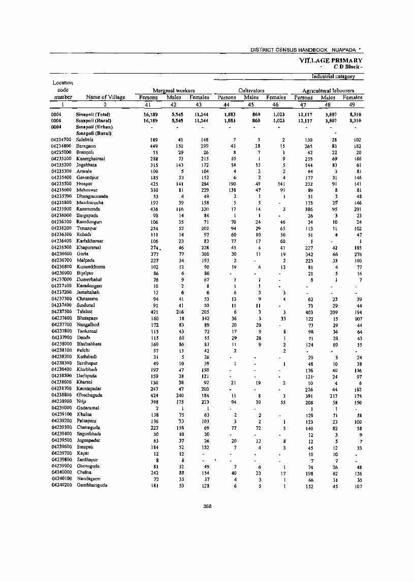
LocatIOn code
number Name ofYlIlage 2
0004 Sinapali (TGtal) 0004 Smapali (Rural) 0004 Smopali (Urban)
Smapali (Rural) 04234700 Salekela 04234800 Baragaon 04235000 Botopah 04235100 Kanetghatmal 04235200 Jogabhata 04235300 Armala 04235400 Govmdpur 04235500 Hlrapur 04235600 Maheswar 04235700 Dhunglamunda 04235800 Mandlarucha 04235900 Rammunda 04236000 BllIgapada 04236100 Ramdungun 04236200 Tlmanpur 04236300 Rebadl 04236400 Karfakhamar 04236500 Khapunmal 04236600 Gorla 04236700 Malpada 04236800 Kusumkhunta 04236900 BlJalpur 04237000 Dumerbahal 04237100 Kamdungarl 04237200 Jamabahah 04237300 Chltarama 04237400 Slndursll 04237500 Talakot 04237600 Bhatapanl 04237700 Nangalbod 04237800 Tankamal 04237900 Dauda 04238000 Bhullabhata 04238100 Fulchl 04238200 Kathlbadl 04238300 Sardhapur 04238400 Klurbhadl 04238500 Darhpada 04238600 Kharsel 04238700 Kamtapadar 0423&800 Ghuchaguda 04238900 NIIJl 04239000 Gildaramal 04239100 Khnlnll 04239200 Palsapara
04239300 Chatlaguda 04239400 Sagunbhadl 04239500 Jugenpadar 04239600 Smapah 04239700 Kapsi 04239800 Sardhapur 04239900 Ghotuguda 04240000 Chalna 04240100 Nandagaon 04240200 Gambhanguda
Margtnal workers Persons Males Females
41 42 43
16,789 16,789
189 449
SS 288 315 109 185 425 310
53 191 436
98 106 254 111 106
274. 377 227 102 86 76 10 12 94 91
421
160 172
115 115 169 57 31 49
197 159 130 247 424 398
2 138 136 227
30
63 184
12 8
81 242
72 181
5,545 5,545
41 150 29 73
143 5
33 141
81 4
39 116
14 35 52 14 23 46 77 34 12 6 9 2 6
41 41
216 18 83 43 60 86 15 5
10 47 38 38 47
240 175
I 75 1)3
158 10 37 52 12 8
32 88 35 53
ll,244 11,244
148 299
26 215 172 104 152 284 229
49 158 320
84 71
202 97 83
228 300 193 90 80 67
8 6
53 50
205 142 89
72 55 83 42 26 39
150 121 92
200 184 223
I 63
103 69 20 26
132
49 154
37 128
368
Persons 44
1,883 1,883
7 43
8 10 58
4 6
190 138
2 5
17 I
70 94 60
77 45 30
2 19
6
13 11 6
36 20
17 29 11 2
21
II 94
2 3
77
20
7
7 40
4 6
DISTRICT CENSUS HANDBOOK NUAPADA •
CultIVators Males Females
45 46
860 860
5 28
7
53 2 2
49 47
I 5
14 I
24 29 10
17 4 II
6
I 1 3 9
11 3
3 20
9 28
9
19
8 39
2 2
72
12 4
6 23
3 5
1,023 1,023
2 15
9
2 4
141 91
1
3
46 65 50 60 41 19 2
13
3 4
3 33
8
2 2
2
3 55
5
8
3
17 I I
VILLAGE PRIMARY CD Block-
Industnal category
Agnculturallabourers Persons Males Females
47 48 49
12,117 12,117
130 265
42 255 144 84
177 232
89 51
175 386
26 34
113 51
I 227 342 223
81 21 8
62 73
403 122 73 98 71
124
29 48
176 121'
10 226 391
208
129 123 140
12 12 45 10
7 74
198 66
152
3,807 3,807
28 83 22 69 83
3 31 91
8 3
2~ 95
3 10 II 4
42 66 33 4 5
23
29 209
IS 29
34 28 69
5 10 40 24
4 44
217 58
I 71 23
82 3 5
12 10 7
26 62 31 45
8,310 8,310
102 182 20
186 61 81
146 141
81 48
146 291
23 24
102 47
185 276 190 77 16 7
39 44
194 107
44 64 43 55
24 38
136 97 6
182 174 150
58 100 58 9 7
33
48 136 35
107
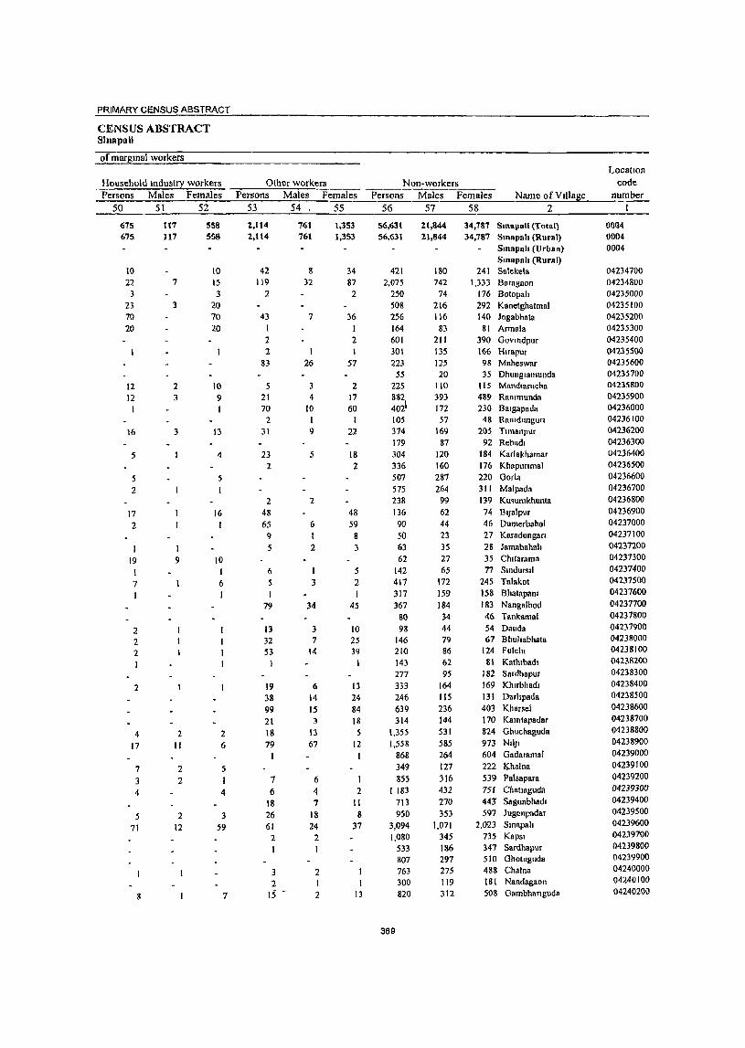
PRIMARY CENSUS ABSTRACT
CENSUS ABSTRACT Sillllpali
of margmal workers
Household Industry workers Persons Males Females
50 51 52
675 675
10 22
3 23 70 20
12 12
16
5
5 2
17 2
19
7 1
2 2 2 1
2
4 17
7
3 4
5 71
8
it7 117
7
3
2 3
3
9
2 II
2 2
2 12
558 558
to 15 3
20 70 20
10 9
13
4
5
16 I
10 t 6 I
2 6
5
4
3 59
7
Other workers Persons Males Females
53 54, 55
2,114 2,114
42 119
2
43 I 2 2
83
5 21 70
2 31
23 2
2 48
65 9 5
6 5 I
79
13 32 5:?
19 38 99 21 18 79
7 6
IS 26 61
2 I
3 2
IS
76t 761
8 32
7
I 26
3 4
10 1 9
.5
2
6 I 2
1
3
34
3 7
14
(\
14 1.5 3
13 67
6 4 7
18 24
2 I
2
2
1,353 1,353
34 87
2
36
2
57
2 17 60
1 22
18 2
48 59
8 3
.5 2 I
45
to 25 39
13 24 84 18 5
12 I
2 II 8
37
13
Non-workers Persons Males Females Name ofVrJlage
56 57 58 2
56,631 56,631
42t 2,075
250 508 256 164 601 301 223
55 225 882 402\ 105
374 179 304 336 507 575 238 t36 90 50 63 62
142 417 317 367
80 98
146 210 143 277 333 246
639 314
1,355 1,558
868 349 855
I 183 713 950
3,094 1,080
533
369
807 763 300 820
2.1,844 2.1,844
180 742
74 216 116
83 211 13S 125 20
110 393 172 57
169 87
120 160 287 264
99 62 44 23 35 27 65
172 159 184 34 44 79 86 62 95
164 115 236 144 531 585 264 127 316 432 270 353
1,071 345 186 297 275 119 312
34,787 SmapaU (Total) 34,787 Smapah (Rural)
SmapRh (Urban) SmapRh (Rural)
241 Salekela 1,333 Baragaon
176 Botopall 292 Kanetghatntal 140 Jogabhata
81 Armala 390 Govtndpur 166 Htrapur 98 Maheswar 35 Dhungtamunda
115 Mandlarucha 489 RaOlmunda 230 Balgapada
48 Rantdungun 205 Ttmanpur
92 Rebadl 184 Karlakhamar 176 Khapunmal 220 Gorla 311 Malpada 139 Ku~umkhunta
74 BIJBlpur 46 DumerbahBI 27 Karadungan 28 Jantabahall 35 Chllarama 77 SlOdursll
245 Talakot 158 Bhalapanr 183 Nangalbod 46 Tankamal 54 Dauda 67 Bhuhabhata
124 Fulclu 81 Kathlbadl
182 Sardhapur 169 Khrrbhadl 131 Darhpada
403 Kharsel 170 Kamtapadar 824 Ghuchaguda 973 NII)I 604 Gadaramal 222 I<;.halna
539 Palsapara 751 Chatraguda 443' Sagunbhadl 597 Jugenpadar
2,023 Smapa" 735 Kapst 347 Sardhapur 510 Gholuguda 488 Chalna 181 Nandagaon 508 Gambhanguda
Location code
number
0004 0004 0004
04234700 04234800 04235000 04235100 04235200 04235300 04235400 04235500 04235600 04235700 04235800 04235900 04236000 04236100 04236200 04236300 04236400 04236500 04236600 04236700 04236800 04236900 04237000 04237100 04237200 04237300 04237400 04237500 04237600 04237700 04237800 04237900 04238000 04238100 04238200 04238300 04238400 04238500 04238600 04238700 04238800 04238900 04239000 04239100 04239200 04239300 04239400 04239500 04239600 04239700 04239800 04239900 04240000 04240100 04240200
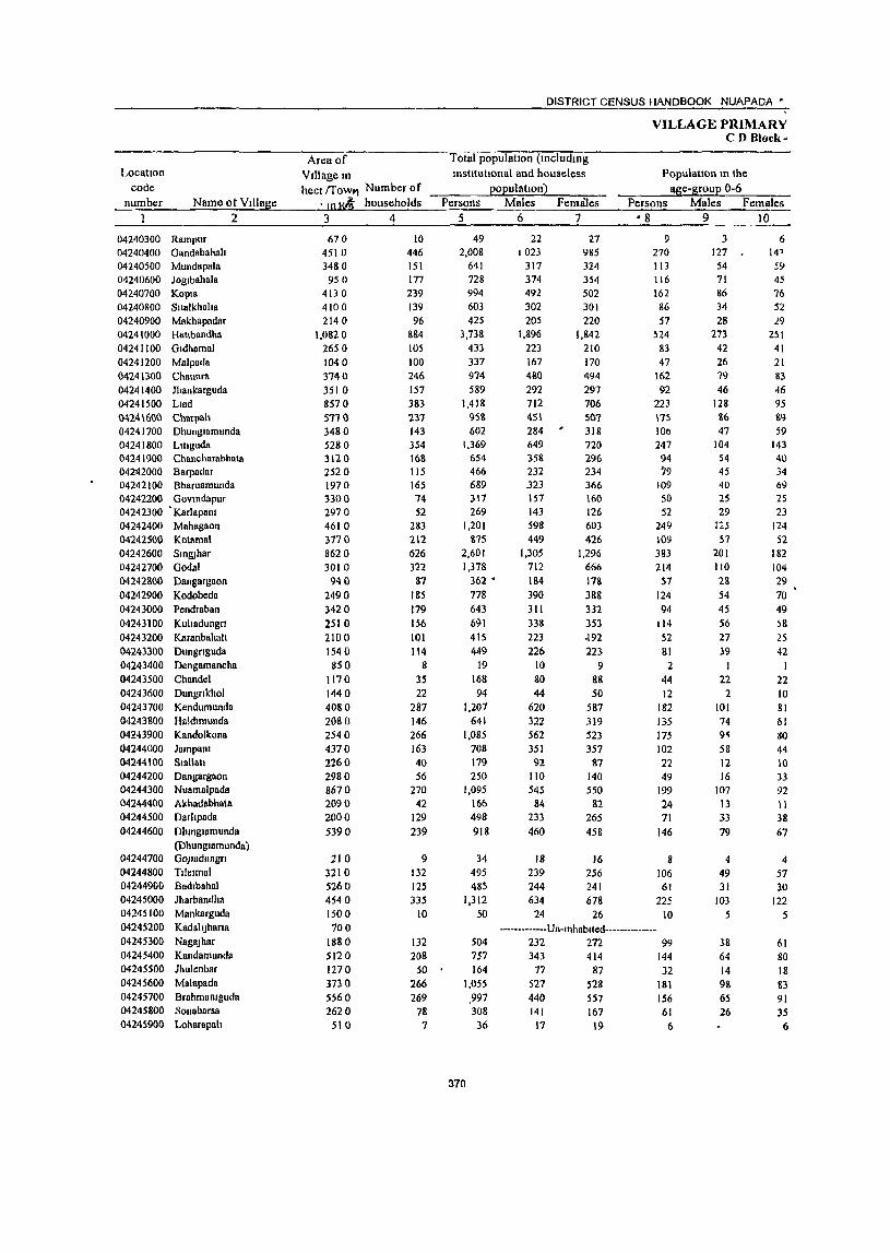
Locatton code
number Name ot Village
04240300 RampuT 04240400 Gandabahah 04240500 Mundapala 04240600 Joglbahala 04240700 KOpt8 04240800 Snalkhalta 04240900 Makhapadar 04241000 Hattbandha 04241100 Gldhamal 04241200 Malpada 04241300 Chaunra 04241400 Ihankarguda 04241500 Ltad
2
M24\600 Charpah 04241700 Dhungtamunda 04241800 Ltuguda 04241900 Chancharabhllta 042112000 Barpadar 04242100 Bharuamunda 04242200 Govmdapur 04242300 'Karlapant 04242400 Mahagaon 04242500 Kolamal 04242600 Stnruhar 04242700 Godal 04242800 Dangargaon 04242900 Kodobeda 04243000 Pendraban 04243100 Kultadungrt 04243200 Karanbahall 04243300 Dungrtguda 04243400 Dengamancha 04243500 Chandel 04243600 Dungrtkhol 04243700 Kendumunda 04243800 Hllldlmunda 04243900 Kandolkona 04244000 Jarnpam 04244100 Siallati 04244200 Dangargaon 04244300 Nuamalpada 04244400 Akhadabhala 04244500 Darhpada 04244600 DhlnglPmunda
(Dhunglamunda) 04244700 GOJuldungn 04244800 Tllelmal 04244900 Badlbahnl 04245000 Jharbandha 04245100 Mankarguda 04245200 KBdahJhana 04245300 NagaJhar 04245400 Kandamunda 04245500 Jhulenbar 04245600 Malapada 04245700 Brahmamguda 04245800 Sonabarsa 04245900 Loharapah
Area of Villagem
DISTRICT CENSUS HANDBOOK NUAPADA *
Total populatton (lOcludmg institutional and houseless
popul allOn)
VILLAGE PRIMARY CD Block-
Population m the age-group 0-6 hecl rrowl1 Number of
, JO K~ households Persons Males Females Persons Males Females 3 4
670 4510 3480 950
413 0 4100 2140
1,0820 2650 1040 3740 3510 8570 57H 3480 5280 3120 2520 1970 3300 2970 4610
3770 8620 3010
940
2490 3420
2510 2100 1540 850
1170 1440 4080
2080 2540 4370 2260 2980 8670 2090 2000
5390
210 3210 5260 454 0 1500 100
1880 5120 1270 3130 5560 2620 510
10 446 151 177 239 139 96
&84 105 100
246 157 383 231 143 354 168 115 165 74 52
283 212 626 322
87 185 179 156
101 114
8 3S 22
287
146 266 163 40 56
270 42
129 239
9 132 125 335
to
132 208
50 ' 266 269
78 7
5
49 2,008
641 728 994 603 425
3,73& 433 337 974 589
1,418 95& 602
1,369 654 466 689 317 269
1,201 875
2,601 1,378
362 •
778 643 691 415 449
19 168 94
1,207
641 1,085
708 179 250
1,095 166 498
918
34 495 485
1,312 50
504 757 164
1,055
,997 308
36
370
6 7 • 8 9 10
22 1023
317 374 492 302 205
1,896 223 167 480 292 712 45\ 284 649 358 232 .323 157 143 598 449
1,305
712 184 390 311 338
223 226
10 80
44 620 322 562 351
92 110 545
84 233
460
18 239 244 634
24
27 985 324 354 502 301 220
1,842 210 170 494 297 706 Sn1 318 720 296 234 366 160 126 603
426 1,296
666 178
388 332 353 ,192 223
9 88 50
587 319 523 357
87 140 550
82 265
458
16 256 241 678
26
9 270 113 116 162 86 57
524 83 47
162 92
223 \75 JOb 247 94 79
109 50 52
249 J09 383 21>1
57
124 94
114
52 81 2
44 12
182 135 175 102 22 49
199 24 71
146
8 106 61
225 10
-----.. ---.. -Un-tnhabtled .... ---.. -----232 272 99 343 414 144 77 87 32
527 528 181 440 557 156 141 167 61
17 19 6
3 127 54
71 86 34 28
273 42 26 79 46
128 8{) 47
104 54 45 40 25 29
1:<'5 57
201 110 28
54
45 56 27 39
I 22
2 101 74 9'\
58 12 16
107 13 33
79
4 49 31
!O3 5
38 64 14 98 65 26
6 14' SY 45 76 52 29
251 41 21 83 46 95 119 59
143 40 34 69 25 23
124 52
182 104 29 70 49
~8
25 42
22 10 81 61 gO
44 10 33 92 II 38 67
4 57 30
122 5
61 80 IS 83 91 3S
6

PRIMARY CENSUS ABSTRACT
CENSUS ABSTRACT SlRllPRb
Scheduled Castes popuaUon PersOIis Males Females
II 12 13
277 49 17
181 9 9
359 72 50
191 64
197 31 41
215 149 .62 188
250 150 472 150 22
277 51
235
114
292 59
363 76 3<1
22 9
121 52
42 44
199
176 73 14
144 142
133 22
9 98
5 5
175 33 27 93 34
100 15 17
103 82 27 92
123 79
251 15 10
134 23
123
67
151 34
184 34
21
II 6
52 24
22 20
104
71 33
5 78 61
144 27
8 83
4 4
184 39 23 98 30 97 16 24
112 61 35 96
127 71
221 75 12
143 28
112
47
141 25
119 42 18
II 3
69 28
20 24 95
99
40 9
66 81
Scheduled Tnbes population Persons Males Females
14 15 16
280 196 216 459 360 221 650
31 177 136 101 362 428 157 476
83 2
243 261 252 393
39 743 241
93 259
41 114 302
7 164
253 212 279 358
86 245 625 146 216 234
34 70 26
482 50
143 98
114 225 118 III 332
17 86 72 39
183 194 71
216 47
I 116 131 134 194
16 369 121
5S 128 22 93
143 3
71
131 99
151 182 45
109 307
71 101 112
18 39 14
229 24
137 98
102 234 182 110 318
14 91 64 62
179 234
86 260
36 I
127 130 118 199 23
314 120
3& 131
19 81
159 4
87
122 113 128 176
41 136 318
75 115 122
16 31 12
253 26
--------.----Un-Inhablted·-----··------80 34 46
136 62 74 137 64 73 668 414 114 _ 36
337 210
52 17
331 264
62 19
371
Persons 17
19 950 162 299 215 204 116
1.720 45 50
19')
193 494 265 203 379 196 160 131 70 61
341 280
1,131 545
95 396 224 261 176 98
4 32 20
346 108 383 223
75 28
268 23 94
227
9 100 125 370
III 185
14 167 306
79
2
Literates Males
18
13 638 126 192 162 165 92
1,134 34 43
161 144 355 194 157 289 171 113 106 64 51
257 211 777 392 65
263 180 181 121 77
4 29 19
260 88
297 166
47 20
198 19 82
169
8 78 89
295 1
79 140
12 146 218
55 2
Females Name of Village 19
6 Rampur 312 Gandabahall
36 MundapaJa 107 Joglbahala 53 Kopla 39 Silalkhaha 24 Makhapadar
586 Hattbandha 11 Gldhamal 7 Malpada
38 Chaunra 49 Jhankarguda
139 Llad 71 Charpall
2
46 DhunglJmunda
90 Llbguda 25 Chancharabhata 47 Barpadar 25 Bharuamunda
6 Govmdapur 10 Karlapam 84 Mahagaon 69 Kolamal
354 SmgJhar 153 Godal 30 Dangargaon
133 Kodobeda 44 Pendraban 80 Kuhadungll 55 Karanbahah 21 Dungnguda
Dengamancha 3 Chandel
Dungnkhol 86 Kendumunda 20 Haldlmunda 86 Kando1kona 57 Jampam 28 Siallau
8 Dangargaon 70 Nuamalpada
4 Akhadabhata 12 Darhpada
58 Dhmglamunda (Dhunglamunda) GOJladungn
22 Tlle.mal 36 Badlbahal 75 Jharbandha
Mankarguda
KadahJhana
32 NagaJhar 45 Kandamunda
2 Jhulenbar 21 Malapada 88 Brahmamguda 24 Sonabarsa
Loharapah
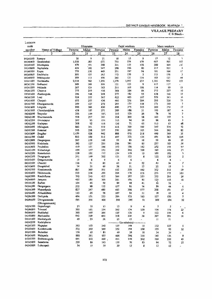
Locution code
number Name ofV!llase 2
04240300 Rampur 04240400 Gandabahah 04240500 Mundapala 04240600 Joglbahala 04240700 Kopla 04240800 Sltalkhaha 04240900 M&khapadar 04241000 HaUbandha 04241100 Gldhamal 04241200 Malpada 04241300 Chaunra 04141400 Jhankarguda 04241500 Llad 04241600 Charpah 04241700 Dhungl8munda 04241800 LIUguda 04241900 Chanch8ra~hata 04242000 Barpadar 04242100 Bhnruamunda 04242200 GovlUdapur 04242300 Karlapnm 04242400 Mahagaon 04247500 Kalamal 04242600 Slngjhar 04242700 Gadal 04242800 Dangargaon 04242900 Kadobeda 04243000 Pendraban 04243100 Kuhadungn 04243200 Kllranbahah 04243300 Dungnguda 04243400 Dengamancha 04243500 Chan del 04243600 Dungnkhol 04243100 Kcndumunda 04243800 Haldlmullda 04243900 Kandolkona 04244000 04244100 04244200 04244300 04744400 04244500 04244600
04244700 04244800 04244900 04245000 04245100 04245200 04245300 04245400 04245500 04245600 04245700 04245800 04245900
laml'l\m SlaUat! Dangargaon Nuarnalpadl\ Akhadabhata Darhpadll Dhmglornunda (Dhunglomunda) GOJlodungn Tllclmal Badlbahlll lharbandha Mankarguda KadahJhana NagaJhar Kandamunda lhulenbar Malapllda Brahmalllguda Sonabarsa Loharapah
Persons 20
30 1,058
479 429 779 399 309
2,018 388 287 775 396 924 693 399 990 458 306 558 247 208 860 595
1,470 833 267 382 419 430 239 351
15 136 74
861 533 702 485 104 222 827 143 404 691
25 395 360 942
49
393 572 150 888 691 229 34
I1hterates Males
21
9 385 191
'182 330 137 113 762 189 124 319 148 357 257 127 360 187 119 217 93 92
341 238 528 320 119 127 131 157 102 149
6 51 25
360 234 265 185 4S 90
347 6S
151 291
10 161 ISS 339 , 23
153 203
65 381 222
86 1.5
______ DISTRICT CENSUS HANDBOOK NUAPADA •
VILLAGE PRIMARV CO Rlock-
Females 22
21 673 288 247 449 J.62 196
1,256 199 163 456 248 567 436 272 630 271 187. 341 154 116 519 357 942 513 148 255 288 273 1'\7 202
9 85 49
501 299 437 300
59 132 480
78 253 400
15 234 205 603 26
240 369
, 85 507 469 I
143 19
372
rotal workers Persons
23
18 755 331 296 291 173 245
1,279 131 211 368 277 622 460 295 690 209 155 228 113 136 418 370 888 497
99 286 372 302 134 131
6
63 38
532 294 564 2S1
89 157 483 107 296 296
13 262 129 358
15
Males Females 24 25
13 576 175 216 197 170 131
1,001
123 105 284 182 4il5 256 177 375 188 129 200
94 71
309 265 670 373
89 201 190 202 119 123
6 41 21
350 178 307 196 48 81
306 56
133 245
9 134 120 320
15
S 179 156
80 94
114 271
8 106
84 95
197 204 118 315
21 26 28 19 65
109 lOS 218 124
10 8;
182 100
15 8
22 11
182 I !6 257
85 41 76
177 51
163 51
4 128
9 38
--_·_···_· __ ·Un·lnhablled-···-····_··_· 159 144 15 352 194 158
49 39 10 606 296 310 45\ 159 20
249 76 12
202 83 8
-----------------Mam wOlkers
Persons Males -Teiiiiife; 26 27 28
17 607 280 217 181 173 165
1,105 117 114 217 158 379 295 171 269 193 78
162 88
\1:5 347 344 400 491
99 237 252 165 \05 122
6 43 22
337 275 :m 123
37. 51)
208 19
127 204
5 136 122 307 II
132 125 34
145 269
94 12
12 500 164 211 164 170 121 952 117 99
227 14b 343 220 164 2i2 187 76
157 83 67
275 262 369 367
89 183 155 142 102 120
Ii 36 19
312 175 204 113 32 41i
(91 15
120 194
5 114 116 293 II
127 93 34
136 220 n 12
~
107 tiE
6
17 3
44 153
I~
10 12 !6 75
7 17
()
? ::. 5
48 72 82 31
124 10 54 91 21 , 1
1 20
101) 28 10
-t 17
" 1 10
22 6
14
5 32
9 49 22

PRIMARY CENSUS ABSTRACT
CENSUS ABSTRACT Sinapali
Industrial category 0 f m am workers Household mdustry
CultIvators Agnculturallabourers workers Other workers Persons Males Fc~males Persons Males Females Persons Males Females Persons Males Females Name ofVtllage
29 30 31 32 33 34 35 36 37 38 39 40 2
7 187 137 108 91 84 68
616 76 30
123 71
184 153 147 153
13
14 59 24 70
100
132 78 17 96 76 85 70 87
6 34 21
172 88 95 99 28 28
157
88 174
2 60 73
248 to
117 64
33 122 139 44 11
6 179 86
107 75 83 60
580 76 29
123 66
180 140 145 150
13
12 59
17
70 99
129 75 17 86 56 80 69 86
6 30 19
170 86 89
97 28 26
148
86 167
2 53 73
237
10
117 52 33
117 131
41 11
I 8
51
16 1 8
36
5 4
I~ 2 3
2
7
3 3
10 20
5
4
2
2 2 6 2
2 9
2 7
7
11
12
5 8
3
212 111 71 It 81 19
174 40 67 79 66
120 129
7 55
174
66 119
13 89
200 205 \Ol 287
69 85 97 43 18 32
9 -I 53
2 34
6 '3
20 25 2
28 5
'3 67 37
44 1
12
41 I
14 89
3
135 61 69 11 80 14
132 40 58 77 63
101 70
6 55
170 66
118 13 49
148 127 93
216 69 48 46
36 18 31
77 50
2
5 42
9 2 3
19 59
4
40 52 78 9
71
37 51
7
6 3
53
34 6
3
18 24
2 27
5
3
1
2
2 I
56 II 33 4 42 2
9 15 4 6 2
16 72
15 19 10 30
3 6
10
3
6 8 II
10 6 3 Il
45
13
6
I I 5
2
5 15
6 2
4 28
11 13 7
28 3 3
7,
3
6 8
5 I
3 3 6
39
7
3
4
2
·_···········Un·lnhablted········-····· 8 4 I
28
\3 60
2
13
29
2
3 3
373
4
3
12
44
4 6 3 2
3 3
3
10 '3
5
6
6
3
2
3 2
1 193 28 32 77
8 62
243
2 16 II 45 10 II 51
6
12 26 16 2
71
31 \5f, 125
3 50 76 26 17 3
62 18S 90 18
1
2 20 16 10 20
8 12 13
2 18
6 36 47
1
I 171
16 29 76
7
43 212
14 10 34
7
10 40 4
10 24 II
I 51 28
\<\1 75
3 46
50 20 15
'3
50 89 74 10 1 2
16 12 6
18
4 10 12
13
6 26
29
Rampur 22 Oandabahah 12 Mundapala
3 J oglbahala
KOPla SlIalkhaha
19 Makhapadar
31 HaUbandha Oldhamal
I Malpada 2 Chaunra 1 Jhankarguda
11 Llad
3 Charpali Dhunglamunda
II Lluguda 2 Chancharabhata 2 Barpadar
2 Bharuamunda
5 Govcndapur
I Karlapam
20 Mahagaon
3 Kolamal
16 Sml!Jhar
50 Oodal
Dangargaon
4 Kodobeda
26 Pendraban 6 Kuliadungn
2 Karanbahah Dungnguda Dengamancha
Chandel Dungnkhol
12 Kendumunda
96 Haldlmunda 16 Kandolkona
8 Jampam
S1811a11
Dangargaon
4 Nuamalpada
4 Akhadabhala 4 Darhpada
2 Dhmgmmunda
(Dhunglamunda) GOJiadungn
4 Tllelmal
2 Badlbahal
Jharbandha Mankarguda
KadahJhana
NagaJhar 5 Kandamunda
Jhulenbar lyIalapada
10 Brahmal1lguda
18 Sonabarsa
Loharapah
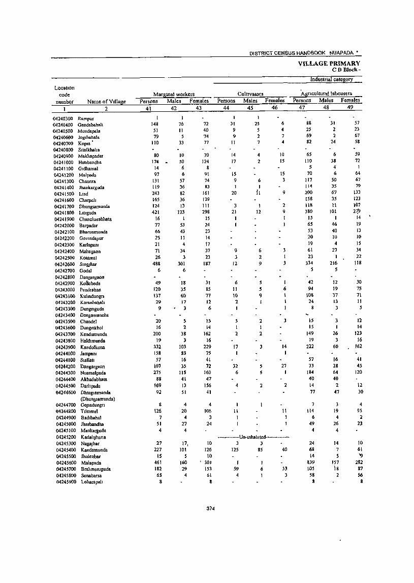
Location code
number Name of Village
04240300 Rampur 04240400 Oandabahnh 04240500 Mundapnla 04240600 Joglbahala 04240700 Kopla' 04240800 Sltalkhaha 04240900 Makhapadar 04241000 Hatlbandha 04241100 Oldhamal 04241200 Malpada 0424 \300 Chaunra 04241400 Jhankarguda 04241500 Llad
2
04241600 Charpah 04241700 Dhunglamunda 04241800 LIUguda 04241900 Chancharabhata 04242000 Barpadar 04242100 Bharuamunda 04242200 GOYlndapur 04242300 Karlapam 04242400 Mahagaan 04242500 Kalamal 04242600 Smruhar 04242700 Oadal 04242800 Dangargaon 04242900 Kaaobeda 04243000 Pendraban Q424'3100 Kulladungn 04243200 Karanbahah 04243300 Dungnguda 04243400 Dcngamancha 04243500 Chandel 04243600 Dungnkhol 04243700 Kendumunda 04243800 Haldtmunda 04243900 KBndolkonB 04244000 Jampa", 04244100 SIBllall 04244200 Dangargaon 04244300 Nuamalpada 04244400 Akhadabhata 04244500 Darhpada 04244600 Dhmglamunda
(Dhunglamunda) 04244700 GOJladungn 04244800 Tllelmal 04244900 Badlbahnl 04245000 Jharbandha 04245100 Mankarguda 04245200 KadahJharta 04245300 NagaJhar 04245400 Kandamunda 04'2.45500 lhulenbar 04245600 Mallipada 04245700 Brahmamguda 04245800 Sonabarsa 04245900 Loharapall
Margmal workers Persons Males Females
41 42 43
148 51 79
110
80 174 •
14 97
131 119 243 165 124 421
16 77 66 25 21 71 26
488 6
49 120 \37 29 9
20 16
200 19
332 158 57
107 275
88 169 92
8 126
7 51 4
27 227
IS 461 182 6S
8
I 76 11
.5 33
10 50 6 6
57 36 82 36 13
123 I
53 43 II 4
34 3
301 6
18 35 60 17 3
5 2
38 3
103 83 16 35
liS 41 13 51
4 20 4
27 4
17, 101
5 160 29
4
72 40 74 77
70 124
8 91 74 83
161 129 111 298
IS 24 23 14 17 37 23
187
31 85 77 12 6
15 14
162 16
229 75 41 72
160 47
156 41
4
106 3
24
10 126 10
, 301 153 61
8
374
DISTRICT CENSUS HANDBOOK NUAPADA'
Culnvators Persons Males Females
44
1 31 9 9
II
14 17
IS 9 I
20
3 21
9 3
12
6 II 10
'2.
.5
45 46
25 .5 '2. 7
4 2
6 I
{I
1 12
6 2 9
S S 9
2 I I 2 2
17 1
32 6
4
11 I
3
5 5
2
6 4 7 4
10 15
IS 3
9
2 9 1 I
3 I 3
I 6
3
14 J
27 J
2
11 1
------------Un-tnhablted--------------3 3
125 85 40
S9 4
I 6 53
.3
VILLAGE PRIMARY CD Block-
Industnal category
Agnculturallabourers Persons Males Females
47 48 49
88 25 69 82
65 110
5 70
117 114 200 158 118 380
IS 65 53 20 19 61 23
334 5
42 94
108 24
8
15 IS
149 19
222
57 73
184 40 14 77
7 \t4
6 49 4
24 68 14
1I,39 lOS 58
8
31 2 2
24
6 38 4 6
50 35 67 35 tl
101 I
46 40 10 4
27 I
216 S
12 19 37 13 3
3 I
26 3
60
16 28 64 40
2 47
3 19 4
26 4
14 7 5
157 18 2
57 23 67 58
59 72
64 67 79
133 123 107 21J
14 19 13 10 15 34 22
118
30 75 71 11 5
12 14
123 16
162
41 45
120
12 30
4 9S 2
23
10 61 '9
282 87 56
8

PRIMARY CENSUS ABSTRACT
CENSUS ABSTRACT Sinapali
of mar!1zmal workeTs Locatton
Household mdust!1 workers Other workers Non-workers code Persons Males Females Persons Males Females Persons, Males Females Name of VIllage number
50 51 52 53 54 55 56 57 5'8 2
31 9 22 Rampur 04240300 7 2 5 22 18 4 1,253 447 806 Gandabahah 04240400 1 t 16 4 12 310 142 1611 Mundapala 04240500
1 432 158 274 Joglbahala 04240600 17 2 15 703 295 408 Kopla 04240700
430 132 298 SlIalkhaha 04240800 I 180 74 106 Makhapadar 04240900
31 3 28 16 7 9 2,459 894 1,565 Hatlbandha 04241000 9 2 7 302 100 202 Gldhamal 04241100
12 12 126 62 64 Malpada 04241200 5 4 606 196 410 Chaunra 04241300 4 4 312 110 202 Jhankarguda 04241400
21 3 18 2 796 287 509 Llad 04241500 6 6 1 498 195 303 Charpall 04241600 2 2 I 307 107 200 Dhunglamunda 04241700 5 4 IS 9 6 ff19 214 405 Lltlguda 04241800
445 170 275 Chancharabhata 04241900 11 7 4 311 103 208 Barpadar 04242000
11 10 2 2 461 123 338 Bharuamunda 04242100 5 4 204 63 141 Govmdapur 04242200 2 2 133 72 61 Karlapam • 04242300
783 289 494 Mahagaon 04242400 505 184 321 Kolamal 04242500
10 9 132 15 57 1,713 635 1,078 Smruhar 04242600 I I 881 339 542 Godal 04242700
263 95 168 Dangargaon 04242800 1 492 189 303 Kodobeda 04242900
4 2 2 11 9 2 271 121 150 Pendraban 04243000 I 18 13 5 389 136 253 Kuhadungn 04243 I O(}
3 3 281 104 177 Karanbahah 04243200 318 103 215 Dungnguda 04243300
13 4 9 Dengamancha 04243400 105 39 66 Chandel 04243500 56 23 33 Dungnkhol 04243600
33 4 29 16 6 10 675 270 405 Kendumunda 04243700 347 144 203 Haldlmunda 04243800
9 8 84 39 45 521 255 266 Kandolkona 04243900 I 1 156 83 73 427 ISS 272 Jampam 04244000
90 44 46 Slallall 04244100 93 29 64 Dangargaon 04244200
12 3 9 73 43 30 612 239 373 Nuamalpada 04244300 48 I 47 59 28 31 A khadabhata 04244400
151 9 142 202 100 102 Darhpada 04244500
II 10 4 3 622 215 407 Dhmglamunda 04244600 (Dhungl8munda)
21 9 12 GOJlBdungn 04244700 233 105 128 Tllelmal 04244800 356 124 232 Badlbahal 04244900 954 314 640 Jharbandha 04245000
35 9 26 Mankarguda 04245100
·--·-···--·--Un-mhablled-- ----------- KadahJhana 04245200 345 88 257 NagaJhar 04245300
15 15 19 9 10 405 149 256 Kandamunda 04245400
I 115 38 77 Jhulenbar 04245500
6 I :s 15 14 449 231 218 Malapada 04245600
3 2 I 15 3 12 546 191 355 Brahmamguda 04245700
3 2 149 65 84 Sonabarsa 04245800 16 5 II Loharapah 04245900
375
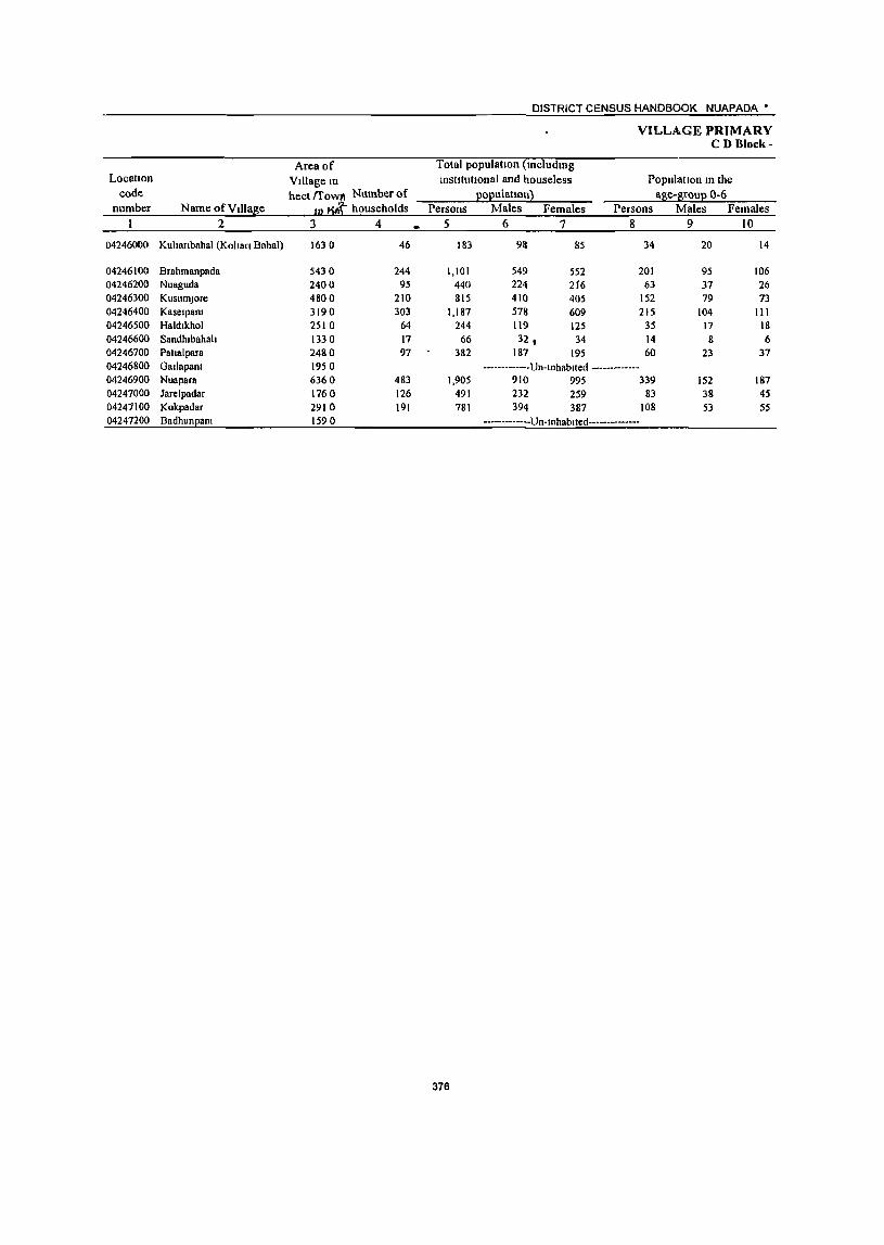
DISTRICT CENSUS HANDBOOK NUAPADA •
VILLAGE PRIMARY CD Bloek-
Area of Total population (lncludmg Locallon VIllage In institutional and houseless Population In the
code heet {fowlI Number of EOEulatlon} al?!e-~rouE 0-6 number Name ofVll1a~e IU J households Persons Males Females Persons Males Females
2 3 4 5 6 7 8 9 10
04246000 Kuhanbahal (Kohan Bahal) 1630 46 183 911 85 34 20 14
04246100 Brahmanpada 5430 244 1,101 549 552 201 95 106 04246200 Nuaguda 2400 95 440 224 216 63 37 26 04246300 KusumJore 4800 210 815 410 405 152 79 73 04246400 Kaselpanl 3190 303 1,187 578 609 215 104 III 04246500 Haldlkhol 2510 64 244 119 125 35 17 18 04246600 Sandhlbahah 1330 17 66 32, 34 14 8 6 04246700 Patlalpara 2480 97 382 187 195 60 23 37 04246800 Gallapanl 1950 -------------Un-Inhablted -------------04246900 Nuapara 6360 483 1,905 910 995 339 152 187 04247000 Jarc1padar 1760 126 491 232 259 83 38 45 04247100 Kokpadar 2910 191 781 394 387 108 53 55 04247200 Badhun28n1 1590 -------------Un-Inhablted--------------
376
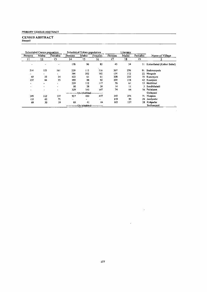
PRIMARY CENSUS ABSTRACT
CENSUS ABSTRACT Sinapall
Scheduled Castes po(!uation Scheduled Tribes Eo(!ulation Literates Persons Males Females Persons Males Females Persons Males Females Name of Village
11 12 13 14 15 16 17 18 19 2
178 96 82 4S 34 II Kuliaribahal (Koliari Bahal)
314 153 161 229 113 116 367 276 91 Brahmanpada 394 202 192 134 112 22 Nuaguda
69 35 34 122 61 61 308 233 75 Kusumjore 137 64 73 180 88 92 200 158 42 Kaseipani
229 112 117 76 61 15 Haldikhol 58 28 30 14 II 3 Sandhibahali
329 162 167 74 64 10 Patialpara -------------Un-inhabited-------------- Gailapani
249 112 137 927 450 477 345 274 71 Nuapara 133 62 71 119 9S 24 Jarelpadar
69 30 39 85 41 44 165 137 28 Kokpadar
-------------Un-inhabited-------------- Badhun[!ani
377
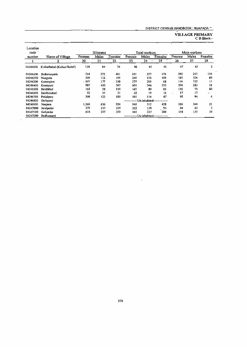
DISTRICT CENSUS HANDBOOK: NUAPADA -.
VILLAGE PRIMARY CD Block-
Location code' Illiterates Total workers Main workers
number Name of Village Persons Males Females Persons Males Females Persons Males Females 2 20 21 22 ·23 24 25 26 27 28
04246000 Kutiatlbahal (Kollati Bahal) U8 64' 74 86 45 41 47 45 2
04246100 Brahmanpada 734 273 461 451 277 174 392 257 135 04246200 Nuaguda 306 112 194 244 135 109 164 104 60 04246300 Kusumjorc .507 177 330 277 209 68 146 135 11 04246400 Kaseipani 987 420 567 601 346 255 294 283 II 04246500 Haldikhol 168 58 110 165 80 85 155 75 80 04246600 Sandhibahali 52 21 31 35 19 16 17 17 04246700 Patialpara 308 123 185 161 114 47 98 94 4 04246800 GaiJapani -------------Un-inhabited-.------------04246900 Nuapara 1,560 636 924 940 512 428 369 348 21 04247000 Jarelpadar 372 137 235 222 129 93 64 61 3 04247100 Kokpadar 616 257 359 441 237 204 154 135 19 04247200 BadhunEani ----·--------Un-inhabited-~------------
378
PRIMARY CENSUS ABSTRACT
CENSUS ABSTRACT Sinapalj.
Cultlvators Persons Males Females
29 30 31
40 40
170 156 14 92 70 22
110 109 I 156 154 2 117 61 56 _ 9 9 44 42 2
291 281 10 II 9 2
107 92 15
Industrial cateaoEX of main workers Household industry
A~ricultural1abourers workers Other workers Persons Males Females Persons Males Females Persons Males Females
32 33 34 35 36 37 38 39 40
6 5
196 85 III 9 2 7 17 14 3 63 27 36 I 8 6 2
8 6 2 28 20 8 101 99 2 36 ' 29 7 37 14 23
8 8 49 47 2 4 4
-------------Un-inhabiled--------------54 SO 4 4 2 2 20 15 5 53 52 I 24 24 6 6 17 J3 4
-------------Un-inhablted--------------
379
Name of VIllage 2
Kuhanbahal (Kolian Bahal)
Brahmanpada Nuaguda KusumJore Kasetpant Haldlkhol Sandhlbahah Patla1para GBllapam Nuapara Jarelpadar' Kokpadar BadllUnEanl
DISTRICT CENSUS HANDBOOK NUAPADA'
VILLAGE PRIMARY CD Block-
Industnal categ0!1 Location
code Margmal workers Cultivators Agnculturallabourers number Name ofVlllase Persons Males Females Persons Males Females Persons Males Females
2 41 42 43 44 45 46 47 48 49
04246000 Kuhanbahal (Kohan Bahal) 39 39 39 39
04246100 Brahrnanpada 59 20 39 10 9 I 49 II 38 04246200 Nuaguda 80 31 49 5 2 3 70 26 44 04246300 KusurnJore 131 74 57 3 2 122 69 53 04246400 Kasetpant 307 63 244 274 50 224 04246500 Haldtkhol 10 5 5 9 5 4 04246600 Sandhtbahah 18 2 16 18 2 16 04246700 Paltalpara 63 20 43 60 20 40 04246800 Oatlapant -------------Un-tnhabtted--------------04246900 Nuapam 571 164 407 35 5 30 462 125 337 04247000 Jarelpadar 158 68 90 158 68 90 04247100 Kokpadar 287 102 185 5 3 2 262 96 166 04247200 I\ildhuneant -------------Un-tnhabtled--------------
380
PRIMARY CENSUS ABSTRACT
CENSUS ABSTRACT Sinapali
of margmal workers
Household mdustry workers Persons Males l"emales
50 51 52
2 3 2
18 18
3 3
33 II 22
13 12
Other workers Persons Males Females
53 54 55
3 2 I 3 2
14 13
-------------Un-tnhablted--------------41 23 18
7 2 5 -------------Un-Inhablted--------------,
Non-workers Persons Males Females
56 57 58
97 53 44
650 272 378 196 89 107 538 201 337 586 232 354
79 39 40 31 13 18
221 73 148
965 398 567 269 103 166 340 157 183
381
Name of Village 2
LocatIon code
number
Kuhanbahal (Kohan Bahal) 1)4246000
Brahmanpada 04246100 Nuaguda 04246200 KusumJore 04246300 Kaselpanl 04246400 Haldlkhol 04246500 Sandhlbahah (14246600 Pallalpara 04246700 Gallapam 04246800 Nuapara 04246900 Jarelpadar 04247000 Kokpadar 04247100
Badhunpam 04247200 "

-PRIMARY CENSUS ABSTRACT OF .
KHARIAR C.D. BLOCK- 0005

DISTRICT CENSUS HANDBOOK NUAPADA •
VILLAGE PRIMARY CD Block-
Area of Total populatton (lOcludlOg Location Village 10 institutIOnal and house less Population 10 the
code heet !fow" Number of EOEulat1on~ aSe-arouE 0-6 number Name of Vii lase ID ~ households Persons Males Females Persons Males Females
2 3 4 5 6 7 8 9 10
OOOS Khanar (Total) 308.95 21,846 93,018 46.408 46.610 14,278 7,315 6.963 0005 Kharlar (Rural) 308.95 21,846 93,018 46.408 46,610 14,278 7.315 6,963 OOOS Khariar (Urban)
KharJar (Rural) 308950 04215300 Kullgaon 3880 272 1,175 610 565 226 127 99 04215400 Gharadhara 2700 184 647 323 324 96 48 48 04215500 RaJamunda II3 0 82 369 174 195 69 29 40 04215600 Badamaheswar 2590 196 817 397 420 141 63 78
04215700 Sunamudl 1370 46 163 83 80 25 12 13 04215800 Sanamaheswar 1060 76 369 187 182 54 27 27 04215900 Jholpathar 4770 \38 572 281 291 90 46 44 04216000 Dcbahal 4160 126 578 303 275 68 38 30 04216100 Bendrabahal 1700 144 589 309 280 77 42 35 04216200 Bargaon 5050 450 2,043 1.056 987 217 114 103 04216300 Thelakodaban 3860 lOS 400 194 296 6~ 34 31 04216400 Dumerl5ahal 3640 \72 732 352 1to \29 64 65 04216500 PodapalJ(Kala) 2700 106 453 216 !37 85 43 42 04216600 PodapalJ(khurd) I 310 58 258 \31 127 41 26 15 04216700 Rohenpadar 4330 206 887 427 160 144 76 68 04216800 Ihldmdhoda 1850 95 377 198 179 80 51 29 04216900 Kotenmunda 1470 99 424 211 213 83 39 44 04217000 Sikuan 3420 643 2,826 1,434 1,392 428 226 202 04217100 Nuapara 3130 66 255 123 132 39 25 14 04217200 Baresbahal 1830 117 539 274 265 87 47 40 04217300 Chhata 2840 227 941 480 461 150 85 65 04217400 BhoJapur 4530 353 1,406 731 675 216 120 96 . 04217.500 Bhaludungan 167 o· 148 707- 345 362 114 58 56 04217600 Chanabeda 5680 489 2,055 1,022 1,03~ 323 172 151 04217700 Barapadar 1360 220 881 444 437 142 71 71 04217800 Chalanpada 910 159 680 352 328 93 45 48 04217900 OOlmundl 1440 197 895 453 442 145 75 70 04218000 Kaslpala ItS 0 108 423 211 212 65 31 34 04218100 Darhpada 520 33 115 61 54 16 9 7 04218200 Thagapall 1000 105 426 211 215 60 30 30 04218300 Chtndaguda 2540 25g 1,'37, 597 540 168 85 83 04218400 Khalrpadar 2410 193 802 399 403 125 62 63 04218500 KhudpeJa 5120 276 1,190 584 606 188 99 89 04218600 Klklflbeda 1970 92 372 190 182 67 36 31 04218700 Kendupall 2760 406 1,718 865 853 265 127 138 04219000 Kenduguda 2150 60 280 137 143 42 )7 25 04219100 Bhlmapadar 90 370 185 185 73 38 35 04219300 Uparplla 3790 212 932 445 487 157 75 82 04219400 Lan]l 8150 246 1.186 589 597 221 108 113 04219500 DumerJor 4590 184 771 381 390 103 46 ~J7
M219600 Kusumal 2840 298 1,215 622 593 1&6 98 88 04219700 Jharasaram 2080 71 326 166 160 47 21 26 04219800 Modasll 4000 265 r.174 558 616 242 117 125 04219900 B1Jcpur 2980 113 426 222 204 72 36 36 04220000 Gadaramunda 2510 357 1,625 783 842 219 102 117 04220100 Damapala 1800 135 641 314 327 76 30 46 04220200 Sagundungan 210 60 307 171 136 48 25 23 04220300 Loharapah 1100 161 747 379 368 105 61 44 04220400 K011padar 1890 246 1.176 574 602 213 93 120 04220500 Padmapur 4310 296 1,390 703 687 249 137 112, 04220600 Badl 5540 396 1,743 871 872 289 145 144 04220700 Arada 2410 131 562 279 283 97 5\ 46 04220800 Badamula 5360 332 1.01 687 744 219 94 125 04220900 Amalapah 3170 160 728 365 363 111 54 57 04221000 Mahura 2990 164 750 382 368 127 65 62
384
PRIMARY CENSUS ABSTRACT
CENSUS ABSTRACT Khariar
Scheduled Castes popuatlon Persons Males Females
II 12 13
14,491 14,491
185 134 35
122
87 125 140
313
52 90 85 45
152 121 20
110 65 77 25
125 201 179 42 31
133 19
66 290 190 159
9 241
15 31 54
115 137 224
88 354
64 80 87
58 157 379 780 151 175 158
61
7,224 7,224
93 67 18 61
45 61 70
149 24 41 41 26 78 63 10 54 29 35 10 65 91
101 22 15 69
9
31 156 98 84 3
124 8
15 22 65 66
120 44
161
37 41 44
25
75 199 373
80 82 86 30
7,267 7,267
92 67 17 61
42 64 70
164 28 49 44 19 74 58 10 56 36 42 15 60
110 78 20 16 64 10
35 134 92 75
6
117 7
16 32 50 71
104
44 193
27 39 43
33 82
180 407
71 93 72 31
Scheduled Tnbes population Persons Males Females
14 15 16
25,537 25,537
417 98 74
138 107 199
51 254 442 693
21 274 298 208 517
5 102
272
26 218
27
350 238
3 5
274 316 397 249 158 265 289 778 311 342 508
90
1 281
81
19 4
42 353 388 338
95 164
12,550 12,550
228 43 33 68 53
100 27
134 236 354 II
127 144 103 245
3 49
126
14 112
15
173 118
2 3
148 155 201 136 76
129 144 373
• 160 169 252
43 I
141 44
7 2
18 179 187 151 49 88
12,987 12,987
189 55 41 70 54 99 24
120 206 339
10 147
154 105 272
2 53
146
12 106
12
177 120
I 2
126 161 196 113 82
136 145 405 151 173 256
47
140 37
12 2
24 174 201 187 46 76
3B5
Persons 17
33,485 33,485
389 292 139 228
80 132 248 298 197
1,091 159
323 192
94 231 110 191
1,396 90
233 374 510 336 736 348 489 509 309
63 220 555 381 498 145 416
56 110 295 370 312 383 136 364 145 985 428 185 436 359 431 805 249 434 281 260
Literates Males
18
23,208 23,208
294 208
86 112
54 85
167 210 154 714 126 198 131 76
172 83
138 884
58 168 267 376 232 514 244 278 293 168 46
147 367 249 368 109 315
53 92
214 260 223 288
88 240 108 563 247 128 265 258 291 539 177 335 208 207
Females Name of VIllage 19 2
10,277 Kharinr (Total) 10,277 Khannr (Rural)
Kharinr (Urban) Kharlnr (Rural)
95 Kuhgaon 84 G haradhara 53 RllJamunda S6 Badamaheswar 26 Sunamudl 47 Sanamaheswar 81 Jholpathar 88 Debahal 43 Bendrabahal
377 Bargaon 33 Thelakodaban
125 Dumerbahal 61 Podapah(Kala) 18 Podapah(khurd)
59 Rohenpndar 27 Ihldmdhoda 53 Kotemnunda
512 Sikuan 32 Nuapara 65 Baresbahal
107 Chhata 134 BhoJapur 104 Bhnludungan 222 Chanabeda 104 Barapadar 21 I Chalanpada
216 GOimundl 141 Kaslpala
17 Darllpada
73 Thagapah 188 Chmdaguda
132 Khalrpadar 130 KhudpeJ8 36 Klkmbeda
101 Kendupatl 3 Kenduguda
18 Bhlmapadar 81 Uparplta
IJ 0 LallJl 89 DumerJor 95 Kusumal 48 Jharasaram
124 Modasll
37 BIJepur 422 Gadaramunda 181 Damapala 57 Sagundungan
171 Loharapah 101 Kotlpadar 140 Padmapur 266 Badl
72 Arada 99 Badamula 73 Amalapah 53 Mallura

Locatton code
number Name ofVtllage 2
0005 Khariar (Total) 0005 Khariar (Rural) 0005 Kharjar (Urban)
Khariar (Rural) 04215300 Kultgaon 04215400 Gharadhara 04215500 RaJamunda 04215600 Badamaheswar 04215700 Sunamudl 04215800 Sanamaheswar 04215900 Jholpathar 04216000 Debahal 04216100 Bendrabahal 04216200 Bargaon 04216300 Thelakodaban 04216400 Dumerbahal 04216500 Podapah(Kala) 04216600 Podapah(khurd) 04216700 Rohenpadar 04216800 Jhldmdhoda 04216900 Kotenmunda 04217000 Sikuan 04217100 Nuapara 04217200 Baresbahal 04217300 Chhata 042 \1400 Bhoj8pUr 04217500 Bha1udungan 04217600 Chanabeda 04217700 Barapadar 04217800 Chalanpada 04217900 GOlmundt 04218000 Kaslpala 04218100 Darhpada 04218200 Thagapah 04218300 Chlndaguda 04218400 Khalrpadar 04218500 KhudpeJa 04218600 Klkmbeda 04218700 Kendupatl 04219000 Kenduguda 04219100 Bhlmapadar 04219300 UparpUa
04219400 LanJI 04219500 DumerJor 04219600 Kusumlll 04219700 Jhllrasaram 04219800 Modasil
04219900 B IJepur 04220000 Gadaramunda 04220100 Darnapala 04220200 Sagundul\gan 04220300 Loharapab 04220400 KoUpadar 04220500 Padmapur 04220600 Badl 04220700 Arada 04220800 Badarnula 04220900 Amalapah 04221000 Mahura
Persons 20
59,533 59,533
786 355 230 589
83 237 324 280 392 952 241 409
261 164 656 267 233
1,430
165 306 567 896 371
1,319 533 191 386 114 52
206
582 421 692 227
1,302 224 260 637 816 459 832 190 810 281 640 213 \'2'2 311 817 959 938 313 997 447 490
Illtterates Males
21
23,200 23,200
316 llS 88
225 29
102 114 93
155 342
68 154 85 55
255 115 73
550 65
106 213 355 113 SOB 20G
74 160 43 15 64
230 150 216
81 550
84 93
231 329 158 334
78 318 114 220
61 43
114 316 412 332 102 352 157 175
Females 22
36,333 36,333
470 240 142 364
54 135 210 187 ~37
610 173 255 176
109 401 152 160 880 100 200 354 54\ 258 811 33J 117 226
71 37
142 352 271 476 146 752 140 167 406 487 301 498 112 492 167 420
146 19
197 501 547 606 211 645 290 315
386
DISTRICT CENSUS HANDBOOK NUAPAOA •
Total workers· Persons Males Females
23 24 25
40,045 40,045
438 233 156 346
95 200 136 133 248 735 156 J75
111 96
323 154 174
1,106 143 272 423 538 244 628 296 172 225 105
, 43
193 408 303 365 141 723 135 189 361
522 257 494 142 393 206 556 144 14
289 389 454 666 214 608 368 337
25,196 15,196
267 175 92
211 54
104 128 131 157 498 110 170 100 68
246 92
112 762 66
142 262 395 171 499 216 161 203 100 36
117 297 202 318 112 501 70
100 2S8 297 196
346 83
271
114 409 132 10
184 308 359 431 130 393 193 188
14,849 14,849
171 58 64
135 41 96
8 2
91' 237
46 5
II 28 77 62 62
344 77
130 161 143
73 129 80 1 \ 22
5 7
76 111 101 47 29
222 65 89
103 225
6] 148 59
122 92
147 12
4 105
81 95
235 84
215 175 149
VILLAGE PRIMARY CD Block-
MaIO workers Persons Males Females
26 27 28
18,431 18,431
159 17 16 61 10 13 43 22 64
295 77
133 85 28
196 50
22 809 138 180 274 314
58 461 198 87
223 S6 2
113 195 59 86 98
207 10 19 73
271 75 94 13
179 38
499
144 63
222 299 353 350 117 378
79 220
15,848 15,848
116 12 15 59 9
13 39 22 60
278 76
128 80 27
183 42 16
727 64 94
196 :!o()\
56 387 169 85
202 52 2
93-178 58 83 97
187 10 )9 69
267 66 87
" 163
33 3§4 132
S9 157 279 324
.309 98
331 63
160
l,583 1,583
43 5 I 2
4
4 17 I 5
13 8 6
82 74 86 78 13
2 74 29 2
21 4
20 17 I 3 I
20
4 4 9 7 2
16 S
115 12 4
65 20 29 41 '19 47 16 60
PRIMARY CENSUS ABSTRACT
CENSUS ABSTRACT Khariar
Industrial category ofmam workers
Cultivators Agnculturallabourers Household mdustry
workers Persons Males Females Persons Males Females Persons Males Females
29 30 31 32 33 34 35
7,430 7,430
30
28
2 24
45 83 75 93 30 12
105 40
206 76
159 181 121 48
176 57 40 54
8
14 67 16 6
53 78
9 16 40
165 73 37
7 67
5 45 38 15 2
105 117 108
282 70
187
6,580 6,580
29 2
28
2 24
45 82 74 91 27 II 96 32
200 34 84
132 108 48
155 57 39 54
8
12 64 16 6
53 73
9 16 40
165 64 37
7 59 4
42 34 15 2
101 115 103
3 249
58 134
850 850
2 3
9 8
6 42 75 49 13
21
2 3
5
9
8
3 4
4
2 5
33 12 53
3,517 3,517
10
19
3 50
4 27 II 15 2
112 60 16 78
100 2
82 12
105 4
65 31 24 41 35 51
3 76
6
9 4
44 14 4
47 53 93 46 14
29
2,985 2,985
8
18
2 49
4 27 II 14 2
77 29
7 51 94
2 63 II
88 4
50 31 24 41 35 47
3 75
6
7 4
25 \\ 4
40 49 78 39 II
23
532 532
2
35 31
9 27
6
19
17
15
4
2
19 :I
7 4
15 7 3
6
1,163 1,163
9 1
2
3
3
15
3 4
6
161 2
3
13 58
2
2
7 4 3
35
2
7
31
3S
4 10
4
36 37
918 918
4
2
3
3
15
2 4
4
141 I
3
12 36
2
2
5 4
26
2
7
30
3 8
4
387
245 245
5
2
20
22
2
9
2
2
Other workers Persons Males Females Name of VIllage
38 39 40 2
6,321 6,321
1\0 13 16 12 10 8
18 19 IS
147 2
33 24
5 70
8 22
330
5 15
100 8
190 71 45 64 42
2 34 90 15 36 10 43
I
30 23
51 6
72 29
410 57 44
215 137 183 145 67 81 9 4
5,365 5,365
75 9
15 11 9 8
14 19 12
132 2
31 22
5 69
8 16
309
3 13 96
6 157 65 44 60 38
2 31 78 14 33
9 41
I
26 20
I 44
4 67 25
317 54 40
151 130 160 124 55 70
5 3
956 Khanar (Total) 956 Khartar (Rura 1)
Khanar (Urban) Khartar (Rural)
35 Kuhgaon 4 G haradhara
Ra)amunda Badamaneswar Sunamudl Sanamaheswar
4 Jholpathar Debahal
3 Bendrabahal IS Bargaon
Thelakodaban 2 Dumerbahal 2 Podapah(Kala)
Podapah(khurd) Rohenpadar Jhldmdhoda
6 Kotenmunda 21 Slkuan
Nuapara 2 Baresbahal 2 ehhata 4 BhoJapur 2 8haludungan
33 Chanabeda 6 8arapadar I Chalanpada 4 GOimundl 4 Kaslpala
Darhpada 3 Thagapah
12 Chmdaguda Khalrpadar KhudpeJa KlkIrlbeda
2 KendupatI Kenduguda 8hlmapadar
4 Uparplta 3 Lan)1
Dumer)or 7 Kusumal 2 Jharasaram
Modasil 4 BlJepur
93 Gadaramunda 3 Damapala 4 Sagundungan
64 Loharapah 7 Kohpadar
23 Padmapur 21 Badl 12 Arada 11 Badamula 4 Amalapali
Mahura

LocatIOn code
number Name ofVJ)lage 2
OOOS Khllriar (Total) OOOS Khariar (Rural) OOOS Kharlar (Urban)
Khanar (Rurnl) 04215300 Kultgaon 04215400 Gharadhara 04215500 RaJamunda 04215600 Badamaheswar 04215700 Sunamudl. 04215800 Sanamaheswar 04215900 Jholpathar 04216000 Debahal 04216100 Bendrabahal 04216200 Bargaon 04216300 Thelakodabarl 04216400 Dumerb!!hai 04216500 PodaPl\h(Kala) 04216600 PodapalJ(khurd) 04216700 Rohenpadar 04216800 Jhldmdhoda 04216900 Kotenmunda 04217000 Slkuan 04217100 Nuapara 04217200 Baresbahal 04217300 Chhata
041\1400 BhoJap\lf 04217500 B~aludungart
04217600 Chanabeda 04217700 Barapadar 04217800 ChaJanpada 04217900 GOImundl 04218000 Kaslpala 04218100 DarUpada
• 04218200 Thagapah 04218300 Chrndaguda 04218400 Khalrpadar 04218500 KhudpeJa 04218600 Ktkmbeda 04218700 Kendupatt 04219000 Kenduguda 04219100 Bhlmapadar 04219300 Uparplta 04219400 LanJI 04219500 DumerJor 04219600 Kusumal 04219700 Jharasaram 04219800 Modasll 04219900 Bljepur 04220000 Gadaramunda 04220100 Damapala
04220200 Sagundungan 04220300 Loharapah 04220400 Kotlpadar 04220500 Padmapur 04220600 Badl 04220700 Arada 04220800 Badamllia 04220900 Amalapah 04221000 Mahura
Margmal workers Persons Males Females
41 42 43
21,614 21,614
279 216 140 285
85 187 93
111 184 440
79 42 26 68
121 104 152 297
5 92
149 2\4 186 167 98 85
2 49 41 80
213 244 279 43
516 125 170 288 251 182 400 129 214 168 57
H 67 90
101
316 97
230 289 117
9,348 9,348
\51 \63 77
152 4S 91 89
109
97 220
34 42 20 41 63 50 96 35 2
48 66 94
115 112
47 76
I 48
34 24
119 144 235
15 314 60 81
189 30
130 259
72 108 81
2S
H 17 29 35
122 32 62
130 28
12,266 1l,266
128 53 63
133 40 96
4 2
87 220
45
6 27 64 54 56
262 3
44 83
110 71 55
51 9 1 1 7
56 94
100 44 28
202 65 89 99
221 52
141 57
106 87. 32
40
61 66
194 65'
168 159 89
388
DISTRICT CENSUS HANDBOOK NUAPADA'
Cultivators Persons Males Females
44 45 46
3,300 3,300
22 45 15 11 10
2 23 21
1 50
1
5 6
10 26 31
207 2 2
22 53
IS8
26
2
30 28
1 53 6 7
13 59 28
9 17 4
43 32 30 49
9 4
I 20 45 20
81 4
140 21 65
1,705 1,705
22 42 IS 7
10 I
23 20
I 50
3 6 5
13 24
3 1 1
14 \1 99 20
30
28
1 20
4 '}
6 57 28 9 8 3
41 24 27 25
3 3
7 14 13 30
1 5
14 15
1,595 1,595
3
4
2
5
13 7
204 1 1 8
36 59 6
33 2
7 2
9 1 2 8 3
24 6
1
13 31 7·
51 '3
135 7
50
VILLAGE PRIMARY CD Block-
Industnal category
Agnculturallabourers Persons Males Females
47 48 49
14,575 5,762 14,575 5,762
153 63 144 101 104 45 257 137
75 35 184 90 63 60 78 78
179 92 297 115
10 27 31 31 19 16 61 35
106 50
57 22 118 69 37 7 3 1
88 46 121 49 \48 68 25 13 61 40
91 44 74 66
I 16 IS JI. 4 76 .20
131 77 213 124 267 223
27 7 414 239 97 32
161 72 187 142 245 27
51 41 162 86 90 36 76 30
60 24
40 12
2 10 9
20 138 20 37
180 38
2 2
9 44 6
24 51 9
8,813 8,813
90 43 59
120 40 94
3
87 182
43
3 26 56 35 49 30 2
42
72 SO 12 21 47
8 1
7 56 54 89 44 20
175 65 89 4S
218 10 76 54
46
36 28
8 8
II 94 14 13
129 29
PRIMARY CENSUS ABSTRACT
CEN'SU~ ABSTRAt:T <Kharlar
ofmargm~ workers
Household industry workers ¥ersons Males Females
50 51 52
,461 ,461
22 2 2
6 3
35
2
19
19
2
5 9 2
3
4 2_ 2 2
8
5
4
9
162 162
16 2 I
5
3
I 13
5
2
7 2
3
"1 2
5
5
2
299 29?
6
28
6
14
4
4
2
2
., 2
3
-,
2
9
3
Other workers Persons Males Females
53 54 55
3,278 3,278
103 5
19 15
"9 4
58 8
11
10 2 3
34
2 6
\3 I
68 7
- 7 I 1: I 3
24
16 )
3 40
80
86 204
9 81 99
8
8 37. 32 60 88 73 53.
/ 88 --....1-1
1,719 1,719
66 4
15 7
I 8 4
48 7
11
7 2 3
20
I 3 9 I
44 3 7 1 2 1 3
21
9 3 2
17
36
46 141
9 48 54
8 18 12 13-48 25 33 65
4
1,559 1,559
37 I 4 8
10 1
3
14
1 3 4
24 4
3 7
I 23
44
40 51
33 45
3
19
20 47
40 48 20 23
7
Non-workers Persons Males Females , Name of Village
56 57 58' 2
52,973 52,973
737 414 213 471
68 169 436 445 J41
1,308 244
557 \342
162 564 223 250
1,720 112 261 518 868 463
1,427 585 508 670
.318 72
233 729 499 825 231 995 145 181 571
664 514 721 184
781 220
1,069 497 233
458 787 936
1,077
348 823 360
413
369
21,211 21,212
343 148 82
186 29 83
153 172 152 558
84 182 116 63
181 106 99
672 57
132 218 336 174 523
228 191 250 III 25 94
300 197 266
78 364 67 85
181 292 185 276
83 287 108 374 182 \01 195 266 344 440 149 294 172
! 194
31,761 Kharlar (Total) 31,761 Kharlar (Rural)
Kharlar (Urban) Khariar (Rural)
394 Kuligaon 266 G haradhara 131 Rajamunda 285 Badamaheswar
39 Sunamudi 86 Sanamaheswar
283 Jholpathar 273 Debahal 189 BendralJllhal 750 Bargaon 160 Thelakodabari 375 Dumerbahal 226 Podapali(Kala)
99 Podapali(khurd) 383 Rohenpadar 117 Jhidiridhoda 151 Kotenmunda
1,048 Sikuan 55 Nuapara
135 Baresbahal 300 Chhata 532 Bhojapur 289 Bhaludungari 904 Chanabeda 357 Barapadar 317 Chalanpada 420 Goimundi 207 Kasipala
47 Darhpada 139 ihagapali 429 Chindaguda 302 Khairpadar ~59 Khudpeja 153 Kikiribeda 631 Kendupati
78 KeJlduguda 96 BhimBpadar
384, Uparpita 372 Lanji_ 329'l)umerjor 445 Kusumal 101 Jharasaram 494 Modasil 1\12 Bijepur 6~5 6adaramunda 315 Damapala 132 Sagundunga~i 263 Loharal'ali
'521 Kbtipadar 592 Padmapur 631 Badi 199 Arada 529 Badamula 188 Amalapali 219 Mahura
Location' code
number
0005 0005 0005
04215300 04215400 04215500 04215600 04215700 04215800 04215900 04216000 04216100 04216200 04216300 04216400 04216500 04216600 04216700 04216800 04216900 04217000 04217100 04217200 04217300 04217400 04217500 04217600 04217100 04217800 04217900 04218000 04218100 04218200 04218300 04218400 04218500 04218600 04218700 04219000 04219100 04219300 04219400 04219500 04219600 04219700 04219800 04219900 04220000
·04220100 04220200 04220300 04220400 04220500 04220600 04220700 04220800 04220900 04221000
DISTRICT CENSUS HANDBOOK NUAPADA'
VILLAGE PRIMARY CD Block-
Area of Totai population (mcludmg Location Village In institutional and houseless Populatlon In the
code hect !fow ... Number of E02ulallon~ age-grou2 0-6 number Name of Village III 1<': households Persons Males Females Persons Males Females
2 3 4 5 6 7 8 9 ("()
04221100 Chanatamal 1870 209 784 379 405 101 49 52 04221200 Sandhlbahah 1030 81 311 152 159 57 26 31 04221300 Junen 4800 296 1,436 749 687 228 122 106 04221400 Narsmghpur 2400 170 725 363 362 126 70 56 04221500 Saragadl 2580 122 509 255 254 75 38 37 04221600 Risigaon 4860 211 977 485 492 141 72 69 04221700 Tukula 1,0770 1,360 6,106 3,065 3,041 901 479 422 04221~00 Pakhansara 2000 86 391 197 194 74 44 30 04221900 Badadohel 2340 289 1,206 580 626 170 86 84 04222000 Sanadohel 1210 109 450 235 215 68 35 33 04222100 Bhanapur 440 -- --------- Un-tnhaQlled--------------04222200 Lachhlpur 2270 225 1,027 495 532 160 81 79 04222300 Rsmpur 1540 85 376 197 179 59 32 27 04222400 Nehena 2550 365 1,507 780 727 206 119 87 04222500 Chlcher 1930 198 741 370 371 136 72 64 04222600 Godadbapadar 3090 115 469 230 239 70 33 37 04222700 Bmghat 4420 333 1,391 708 683 189 95 94 04222800 Kudnldungan 1380 89 349 171 178 45 25 20 04222900 MahulJharan 19 85 44 41 7 2 5 04223000 Blkramapur 380 43 170 86 84 25 12 13 04223100 Karandoba 15 63 34 29 7 5 2 04223200 Mahulapada 800 25 107 54 53 to 6 4 04223300 Belpara 430 61 293 151 142 48 24 24 04223400 Mantrltaral(Kala) 3370 75 335 175 160 48 21 27 04223500 Manlfltaral(Khurd) 670 109 407 195 212 62 30 32 04223600 Dabrl 3940 270 1.225 588 637 231 121 110 04223700 BhalraJPur 3730 129 458 234 224 57 32 25 04223800 Bhalundungan 1860 119 485 238 247 70 38 32 04223900 Gudabbeh 1000 106 400 199 201 52 34 18 04224000 Torh 1950 159 587 298 289 108 57 51 04224100 Blchhanapah 1610 102 449 229 200 42 21 21 04224200 Dhanksar 3720 338 1.382 656 726 218 100 118 04224300 Godatala 2730 93 457 229 228 69 36 33 04224400 A(lchalpur 2640 145 6\0 321 289 68 40 28 04224500 Chandaglrl 1800 121 498 243 255 89 41 48 04224600 Bahalpadar 680 84 347 180 167 61 37 24 04224700 Chandel 1320 128 510 248 262 61 29 32 04224800 Dohelpada 590 174 970 504 466 156 85 71 04224900 Bankapur 4320 294 1,122 561 561 134 78 56 04225000 Chancharabbata 2780 156 701 351 350 80 34 46 04225100 Khalrbhadl \550 81 l75 202 173 67 37 30 04225200 NuaraJpur 1470 21 82 43 39 10 7 3 04225300 Artatranapur 2080 73 293 153 140 34 22 12 04225400 Khasbahlll 4540 342 1,370 633 737 179 88 91 04225500 JubllraJPur 18 71 34 37 17 8 9 04225600 Mankarchuan 1430 -------------Un-mhablted -------------04225700 Sardhapur 348'0 236 991 449 542 166 77 89 04225800 Ranlmunda 6120 435 1,665 823 842 246 129 117 04225900 Kampamguma 1170 41 208 98 110 45 15 30 04226000 Palama 2310 83 317 170 147 49 31 18 04226100 Kolamal 4810 334 1.317 630 687 210 105 105 04226200 Khamataral 3610 263 1.091 536 555 170 83 87 04226300 DuaJhar 5990 796 3,318 1.660 1.658 419 209 210 04226400 Samserpadar 950 166 637 314 323 85 45 40 04226500 Mahulkol 2820 193 783 392 391 \08 62 46 04226600 Sangarpadar ,47 198 103 95 39 17 22 04226700 Junapam 6430 168 655 320 335 105 54 51 \ 04226800 Kirklin 6260 352 1.369 656 713 215 III 104 04226900 Rampurguma 1370 74 283 136 147 53 21 32 04227000 Slkuan(Khurd) 3990 24 116 62 54 22 II II 04227100 Sikuan(kala) 4050 378 1,482 724 758 253 127 126
390

PRIMARY CENSUS ABSTRACT
'CENSUS ABSTRACT Kharlar
~ _ Scheduled Castes ~o~uallon Scheduled Tribes ~o~ulatlOll Literates '_ Persons Males Females Persons Males Females Persons Males Females Name ofVIUoge
11 12 13 14 IS 16 17 18 19 2 ,.
93 45 48 465 223 242 294 222 72 Chanatamal 9 6 3 145 99 46 Sandhlbahah
119 59 60 320 164 156 661 459 202 Junen 122 63 59 172 134 38 Narsmghpur 239 116 123 151 72 79 113 74 39 Saragadl 183 90 93 320 158 162 343 222 121 Risigaon 765 373 392 610 303 307 2.120 1,382 738 Tukula 391 197 194 134 90 44 Pakhansara 192 96 96 948 454 494 261 210 57 Bada<lPhei 204 III 93 160 118 42 Sanadohel
-------------Un-Inhablted-------------- Bhanapur 321 148 173 113 55 58 326 202 124 Lachhlpur 94 50 44 169 119 50 Rampur
301 149 152 52 27 25 694 454 240 Nehena
77 36 41 216 163 53 Chlcher 41 22 19 296 143 153 185 137 48 Godadhapadar
218 108 110 666 349 317 465 359 106 BInghal 38 18 20 211 130 141 98 73 25 Kudaldungan
85 44 41 10 8 2 MahulJharan 15 6 9 62 45 17 Blkramapur 63 34 29 Karandoba
3 2 I 5 4 Mahulapada
175 91 84 83 74 9 Belpara
33 IS 18 266 139 127 136 102 34 Mantnlaral(Kala)
[23 59 64 252 119 133 102 84 18 Mantnlaral{Khurd)
166 81 85 979 469 510 359 278 81 Dabn
52 27 25 15 7 8 127 96 31 BhanaJpur
127 62 65 334 164 170 178 120 58 Bhalundungall
101 52 49 286 142 144 192 129 63 Gudabheh
165 sa 77 184 133 51 Torh
24 13 11 270 136 134 96 74 22 Blchhanapall
241 107 134 121 58 63 343 231 112 Dhanksar
142 72 70 199 100 99 111 80 31 Godalala
256 139 117 29 15 14 172 143 29 Allchalpur
207 94 113 140 104 36 Chandagm
34 14 20 101 78 23 Bahalpadar
13 8 5 71 40 31 115 89 26 Chandel
472 242 230 48 24 24 265 189 76 Dohelpada
200 103 97 110 61 49 338 224 114 Bankapur
13 4 9 218 172 46 Chancharabhata
209 113 96 104 83 21 Khaltbhadl
27 15 12 21 18 3 NuaraJpur
9 4 5 84 69 15 Artatranapur
124 59 65 946 429 517 512 381 131 Khasbahal 5 5 }ubaraJPur
-------------Un-lnllBbrted--------_ .. _-- Mankarchuan
156 76 80 696 309 387 242 182 60 Sardhapur
221 111 110 412 230 242 424 337 87 RaOlmunda
201 95 106 29 26 3 Kampanrguma
24 14 10 176 90 86 39 35 4 Palama
63 31 32 404 189 215 164 130 34 Kotamal
281 144 137 702 335 367 382 270 112 Khamalara.
S49 272 277 209 97 112 1.480 959 521 DuaJhar
230 115 115 363 177 186 92 66 26 Samserpadar
43 21 22 667 330 337 186 136 50 Mahulkot
186 100 86 32 30 2 Sangarpadar
11 7 4 457 218 239 82 10 12 Junapam
29 14 15 992 470 522 223 175 48 Klrklla
36 28 8 Rampurguma
50 28 22 18 14 4 Slkuan(Khurd)
173 87 86 -_ 433 208 225 405 285 120 Slkuan(kala)
391

DISTRICT CENSUS HANDBOOK NUAPADA'
VILLAGE PRIMARY CD Block-
Location code Ilhterates Total workers Main workers
number Name ofVllla~e Persons Males Females Persons Males Females Persons Males Females
2 20 21 22 23 24 25 26 27 28
04221100 Chanatamal 490 157 333 483 248 235 118 100 18 04221200 Sandhlbahah 166 53 113 9J 86 5 40 37 3 04221300 Junen 775 290 485 367 344 23 301 292 9 04221400 Narslnghpur 553 229 324 386 207 179 37 36 1 0422J500 Saralladl 396 181 215 228 150 78 126 114 12 04221600 Risigaon 634 263 311 462 261 201 344 222 122 04221700 Tukula 3,986 1,6&3 2,303 2,692 1,719 973 1,177 1082 95 04221800 Pakhans8ru 257 107 150 187 99 88 97 87 10 04221900 Badadohel 939 370 569 593 345 248 294 272 22 04222000 Sanadohel 290 117 173 320 169 151 150 133 17 04222100 Bhanapur --- --Un-I nhablled------·-------04222200 Lachhlpur 701 293 408 502 304 198 222 180 42 04222300 Rampur 207 18 129 161 108 53 104 93 II 04222400 Nehena 813 32(> 487 505 3110 HI5 304 204 40 04222500 Chlcher 525 207 318 408 212 196 202 175 27 04222600 Godadhapadar 284 93 191 149 116 33 19 19 04222700 BlfIghat 926 349 577 584 368 216 190 174 16 04222800 Kudaldungan 251 98 153 193 100 93 12 11 I 04222900 MahulJ)!aran 75 36 39 S4 30 24 j 5 04223000 Blkramapur 108 41 67 84 53 31 04223100 Karand(lba 63 34 29 37 20 17 04223200 Mahulapada 102 50 52 64 37 27 04223300 Belpara 210 77 133 137 7& 59 25 25 04223400 Mantntaral(Kala) 199 73 126 181 103 78 10 6 4 04223500 Mantntaral(Khurd) 305 III 194 238 liS 123 59 58 I 04223600 Dabn S66 310 556 624 336 2gS 424 312 112 04223700 BhalraJPur 331 138 193 239 143 96 142 116 26 04223800 Bhalundungan 307 118 189 320 ISS 165 .5 3 2 04223900 Gudabheh 208 70 138 178 110 68 "76 71 .5 04224000 Torh 403 165 238 277 169 108 114 109 5 04224100 Blchhanapall 333 ISS 178 262 147 115 33 29 4 04224200 Dhanksar 1,039 425 614 654 369 285 456 339 117 04224300 Godatala 346 149 197 136 116 20 121 109 12 04224400 Anchalpur 438 178 260 405 220 185 378 212 166 04224500 Chandagm 358 139 219 281 144 137 105 100 5 04224600 Bahalpadar 246 102 144 182 W5 77 78 70 8 04224700 Chandel 395 159 236 360 175 185 170 160 10 04224800 Dohelpada 705 315 390 478 252 226 249 238 11 04224900 Bankapur 784 337 447 696 353 343 419 312 107 04225000 Chancharabhata 483 179 304 390 211 179 96 87 9 04225100 Khalrblladl 271 119 152 217 113 104 61 59 2 04225200 NuaraJpur 61 25 36 46 24 22 18 18 04225300 Artatranapur 209 84 125 173 97 76 55 55 04225400 Khasbahal 858 252 606 672 351 321 238 215 23 04225500 JubaraJPuT 66 29 37 45 24 21 33 20 J3 04225600 Mankarchuan -------------Un-Inhablted--------------04225700 Sardhapur 749 1.67 482 559 257 302 164 143 21 04225800 Rammunda 1,241 486 755 832 469 363 462 360 102 04225900 Kamp8mguma "9 72 107 75 )13 32 43 43 04226000 Palama 278 135 143 179 99 80 100 92 8 04226100 Kotamal 1,153 500 653 702 384 318 305 273 32 04226200 Khnmataral 709 266 443 626 317 309 245 228 17 04226300 DuaJhar 1,838 701 1,\37 1,353 925 428 789 724 65 04226400 Samserpadar 545 248 297 442 219 223 4 2 2 04226500 Mahulkot 597 256 341 410 229 181 88 83 5 04226600 Sangnrpadar 166 73 I
, 93 129 72 57 42 42
04226700 Junapant 573 250 323 316 178 138 124 115 9 04226800 Klrklta 1,146 481 665 I 576 358 218 54 37 17 04226900 Rampurguma 247 108 139 161 92 69 92 69 23 04227000 Slkuan(Khurd) 98 48 50 48 32 16 23 18 5 04227100 Sikuan(kala) 1,077 439 638 801 449 352 434 373 61
392
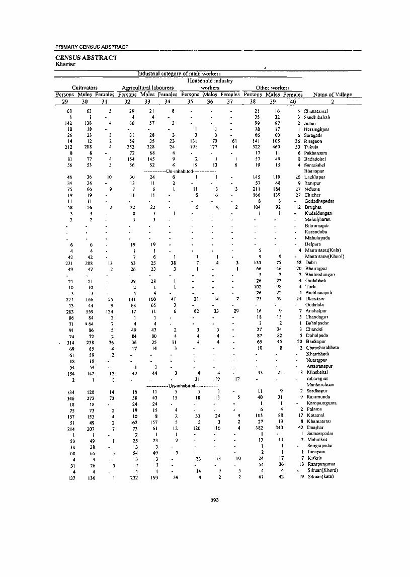
PRIMARY CENSUS ABSTRACT
CENSUS ABSTRACT Khariar
Industnal category ofmam workers Household mdustry
Cultivators Agncufturallabourers workers Other workers Persons Males Females Persons Males Females Persons Males Females Persons Males Females Name of Village
29 30 31 32 33 34 35 36 37 38 39 40 2
68 1
142 18 26 14
212 8
81 56
46 34 75 19 II 58 3 2
6 4
42 221
49
21 10 3
221 53
283 86 71 91 74
314 69 61 18 54
154 2
134 346
18 75
157 51
214 I
50 38 68
4 31 4
137
63
138 18 23 12
208 8
77 53
36 34 66 19 II 56 3 2
6 4
42 208
47
21 10 3
166 44
159 84
t 64 86 72
238 65 59 18 54
142 I
120 273
18 73
153 49
207 I
49 38 65
4 26 4
136
5
4
3 2 4
4 3
10
9
2
13 2
55 9
124 2 7 5 2
76 4 2
12 I
14 73
2 4 2 7
29 4
60
31 58
252 72
154 56
30 13 7
II
22 8 3
19 I 7
63 26
29 2 4
141 68 17
I 4
49 84 36 17
I 47
16 58 24 19 10
162 73 2
25 3
54 3 7 1
23:2
21 4
57
28 35
228 68
145 52
8
3
3 23 24 4 9 4
I 3
131 191
2 19
I 3
70 177
1 13
-------------Un-Inhablted--------------24 6 I 1 II 2 6 I II 8
11 6 6
22 7 3
19 I 6
25 23
28 I 4
100 65 11
I 4
47 80 25 14
1 44
I 38
3
41 3 6
2 4
II 3
3
6
1 7 I
21
62
3 4 4
4 31
4,
4
14
33
3 4 4
4 19
------------- Un-mhablled--------------1\ 5 3 3 43 15 18 13 24 15
8 157
61
4 2 5
12 I I
23 2 3
49 5 3 7 I
193 39
33 5
120
23
14 4
24 3
116
J3
393
9 2
61 14
1 6
3
2
3 I
7
29
12
9 2 4
10
5 2
21 35 99 18 66
141 522
17 57 19
145 57
211 166
8 104
I
9 133 66
5 26
102 26 73
16 18
3 27 87 65
10
33
11 40
I 6
105 27
382 1
13 1 2
24 54
4 61
16 32 97 17 60
105 469 II 49 15
119 48
184 139
8 92
1
9 75 46
3 22 98 22 59
9 15 2
24 82 45
8
25
9 31
I 4
88 19
340
II 1 1
17 36 4
42
5 Chanatamal 3 Sandhlbahah 2 Junen
Narsmgbpur 6 Saragadl
36 Risigaon 53 Tukula 6 Pakhansara 8 Badadohel 4 Sanadohel
Bhanapur 26 Lachhlpur
9 Rampur 27 Nehena 27 Chlcher
Godadbapadar 12 Bmghal
Kudaldungan MahulJharan Blkramapur Karandoba Mahulapada Belpara
4 Manlntaral(Kaln) Manln laral(K hurd)
58 Dabn 20 BhalraJPur 2 Bhalundungan 4 Gudabheh 4 Torh 4 Blchhanapah
14 Dhanksar Godatala
7 Anchalpur 3 Chandagm
Bahalpadar Chandel
5 Dohelpada 20 Bankapur
2 Chancharabhata Khalrbhadl
NuaraJPur Artatranapur
1\ Khasbaha1
)ubaraJPur Mankarchuan
2 Sardhapur 9 Rammunda
Kampamguma
2 Palama 17 Kotamal
8 Khamataral 42 DuaJhar
1 Samserpadar 2 Mahulkot
Sangarpadar Junapam
7 Klrklla l8 Rampurguma
Slkuan(Khurd) 19 Sikuan(kala)
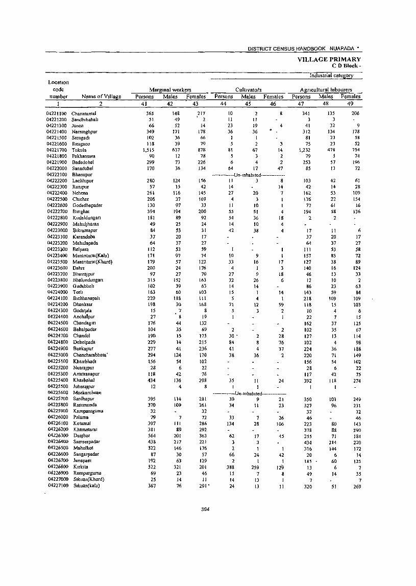
DISTRICT CENSUS HANDBOOK NUAPADA •
VILLAGE PRIMARY CD Bloci{-
Industrial categ0!X LocatIOn
code Margmal workers Cult! vatots Agricultural labourers number Name ofVdlage Persons Males Females . Persons Males Females Persons Males Females
2 41 42 43 44 45 46 47 48 49
04221100 Chanatatrtal 365 148 217 to 2 8 341 135 206 04221200 Sandhlbahah 51 • 49 2 II II 3 3 04221300 Junen 66 52 14 23 19 4 41 32 9 04221400 Narslnghpur 349 171 178 36 36 .. 312 134 178 04221500 Saragadl 102 36 66 81 23 58 04221600 RIsIg80n 118 39 79 5 2 3 75 23 52 04221700 Tukula 1.515 637 878 SI 67 14 1,232 478 754 04221800 Pakhansara 90 12 78 5 3 2 79 5 74 04221900 Badadohel 299 73 226 6 4 2 253 57 196 04222000 Sanadohel 170 36 134 64 17 47 85 13 72 04222100 Bhanapur -------------Un-Inhablted--------------04222200 Lachhlpur 280 124 156 II 3 8 103 42 61 04222300 Rantpur 57 15 42 14 14 42 14 28 04222400 Nehena 261 1\6 145 27 20 7 162 53 109 04222500 Clllcher 206 31 169 4 3 116 22 154 04222600 Godadhapadar 130 97 33 II 10 I 77 61 16 04222700 BlfIghat 394 194 200 55 51 4 194 58 136 04222800 Kudalduogan 181 89 92 54 36 18 2 2 04222900 MahulJ haran 49 25 24 14 10 4 04223000 Bikramaplir 84 53 31 42 38 4 17 11 6 04223100 Karandoba 37 20 17 37 20 17 04223200 Mahulapllda 64 37 27 64 37 27 04223)00 Belpara 112 53 59 I I III S3 58 04223400 Mantntaral(Kala) 171 97 74 10 9 I 157 85 72 04223500 Mantntar81(Kllurd) 179 57 122 33 16 17 127 38 89 04223600 Dabn 200 24 176 4 I 3 140 16 124 04223700 Bhalr8Jpur 97 27 70 27 9 18 46 13 33 04223800 Bhalundungan 315 152 163 32 26 6 12 10 2 04223900 Gudabheh 102 39 63 14 14 86 23 63 04224000 Torh 163 60 103 15 1 14 143 59 84 04224100 Blchhanapall 229 lIS III 5 4 I 218 109 109 04224200 Dhanksar 198 30 168 71 12 59 118 15 103 04224300 Goda\dla 15 7 8 5 3 2 10 4 6 04224400 Anchatpur 27 8 19 22 7 15 04224500 Chandaglfl 176 44 132 162 37 125 04224600 Bahalpadar 104 35 69 2 2 102 3S 67 04224700 Chllndel 190 15 17~ 30 - 2 28 127 J3 114 04224800 Dohelpada 229 14 215 84 8 76 102 4 98 04224900 Bankapur 277 41 236 41 4 37 224 36 188 04225000 Chancharabhata' 294 124 170 38 36 2 220 71 149 04225100 Khalrbhadl 156 54 102 156 54 102 04225200 NuaraJpur 28 6 22 28 6 22 04225300 Artatranapur 118 42 76 117 42 75 04225400 Khasbaha1 434 136 298 35 II 24 392 118 274 04225500 JubaraJPur 12 4 8 I 1 I 04225600 Mankarchuan -------------Un-Inhabltcd--------------04225700 Sardhapur 395 114 281 30 9 21 350 101 249 04225800 Rammunda 370 109 261 34 II 23 327 96 231 04225900 Kampamguma 32 3Z 32 32 04226000 Palama 79 7 72 33 7 26 46 46 04226100 Kolamal 397 III 286 134 28 106 223 80 143 04226200 Khamataral 381 89 292 378 88 290 04226300 DuaJhar 564 201 363 62 17 45 255 71 184 04226400 Samserpadar 438 217 221 3 3 434 214 220 04226500 Mahulkol 322 146 176 2 I I 316 144 172 04226600 Sangarpadar 87 30 57 66 24 42 20 6 14 04226700 JunapaOl 192 63 129 2 I I 185 60 125 04226800 Klrklla 522 321 201 388 259 129 13 6 7 04226900 Rampurguma 69 23 46 15 7 8 49 14 35 04227000 Slkuan(Khurd) 25 14 II 14 13 I 7 7 04227100 Sikuan(kala) 367 76 291 • 24 13 II 320 51 269
394

PRIMARY CENSUS ABSTRACT
CENSUS ABSTRACT Kharlar'
of marsinal workers Location
Household indus!!X workers Other workers Non-workers code
Persons Males Females Persons Males Females Persons Males Females Name ofVilla~e number
50 51 52 53 54 55 56 57 58 2
14 II 3 301 131 170 Chanatamal 04221100 37 35 2 220 66 154 Sandhibahali 04221200
2 1,069 405 664 Junen 04221300 1 I 339 156 183 Narsinghpur 04221400
20 12 8 281 105 176 Samgadi 04221500 15 3 12 23 11 12 515 224 291 Risigaon 04221600 98 26 72 104 66 38 3,414 1,346 2,068 Tukul8 04221700
6 4 2 204 98 106 Pakhansara 04221800 21 3 18 19 9 10 613 235 378 Badadohel 04221900 13 3 10 8 3 5 130 66 64 Sanadohel 04222000
-------------Un-inhabited-------------- Bhanapur 04222100 165 79 86 525 191 334 Lachhipur 04222200
I I 215 89 126- Ranipur 04222300 71 43 28 942 400 542 Nehena 04222400 25 11 -14 333 158 175 Chicher 04222500 41 2S 16 320 114 206 Godadhapadar 04222600
145 85 60 807 340 467 Birighat 04222700 124 50 74 156 71 85 Kudaldungari 04222800 35 15 20 31 14 17 Mahuljharan 04222900 25 4 21 86 33 53 Bikramapur 04223000
26 14 12 Karandoba 04223100 43 17 26 Mahulapada 04223200
156 73 83 Belpara 04223300 I 3 3 154 72 82 Mantrit8rai(Kala) 04223400 ~ , I \ 18 3 IS 169 80 89 Mantritarai(Khurd) 04223500 2 2 " S~ 7 47 601 252 349 Dab!'1 04223600
24 5 \9 2\9 91 128 Bhairajpur 04223700 271 116 155 165 83 82 Bhalundungari 04223800
2 2 222 89 133 Gudabheli 04223900 5 310 129 181 Torti 04224000 6 5 167 82 85 Bichhanapali 04224100
2 2 7 3 4 728 287 441 Dhanksar 04224200 321 Jl3 208 Godatala 04224300
4 3 205 101 104 Anchalpur 04224400 14 7 7 217 99 118 Chandagiri 04224500
165 75 90 Bahalpadar 04224600
3 3 30 30 150 73 77 Chandel 04224700 3 3 40 2 38 492 252 240 Dohelpada 04224800 3 .2 9 9 426 208 218 Bankapur 04224900
36 17 19 311 140 171 Chancharabhata 04225000 158 89 69 Khairbhadi 04225100
. 36 19 17 Nuarajpur 04225200
I 120 56 64 Artatranapur 04225300 _I 6. 6 698 282 416 Khasbahal 04225400
8 .. - 8 2 2 26 10 - t6 lubarajpur 04225500
---·---------Un-inhabited-------·------ Mankarctiuan 04225600
II 3 8 4 I 3 432 192 240 Sardhapur 04225700
5 5 4 2 2 833 354 479 Ranimun~a 04225800 133 55 78 Kam'paniguma 04225900 . 138 71 I 67 Palama 04226000
2 2 38 3 35 615 246 369 Kotamal 04226100
3 I 2 465 219 246 Khamatarai 04226200
63 16 47 184 97 87 1,965 735 1,230 Duajhar , 04226300
I I 195 95 I 00 lSamserpadar 04226400 3 3 373 163 I 210 Mahulkot 04226500
I I 69 31 • 38 Sangarpad~r 04226600
5 2 3 339 142 197 Junap!lni . 04226700
121 56 65 793 298 495 Kirkita 04226800
.5 2 3 122 44 78 Rampurguma 04226900
3 2 I I 68 30 38 Sikuan(Khurd) 04227000
3 2 2() II 9 681 275 406 Sikuan(kala) 04227100
395

,URBAN PRIMARY CENSUS ABSTRACT
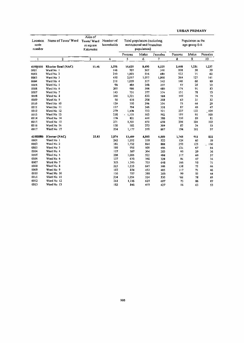
URBAN PRlMARY
Area of Location Name ofTownl Ward Town/Ward Number of Total populatIOn (includIng Populallon In the
code m square households Instltutlonal and houseless age-group 0-6
number Kilometre populallon)
Persons Males Females Persons Males Females
2 3 4 5 6 7 8 9 10
425())1l00 Kharlar Road (NAC) lUll 3.398 16,629 8,400 8,229 2,468 1,231 1,237 0001 Ward No 1 148 707 367 340 108 58 50 0002 WardNo 2 219 1,003 514 489 133 71 62 0003 WardNo 3 450 2,057 1,057 1,000 268 127 141 0004 WardNo 4 211 1,059 517 542 140 60 80 0005 WardNo 5 98 485 248 237 47 25 22 0006 Ward No 6 205 986 506 480 174 91 83 0007 Ward No 7 143 751 377 374 151 78 73 0008 Ward No 8 240 1,221 633 588 149 74 75 0009 Ward No 9 90 416 208 208 63 31 32 0010 WardNo 10 129 750 396 354 73 44 29 0011 Ward No II 137 704 346 358 87 40 47 0012 Ward No 12 279 1,4501 733 721 237 132 105 0013 Ward No \3 238 1,155 563 592 197 92 lOS 0014 Ward No 14 176 821 441 380 150 69 81 0015 Ward No 15 271 1,301 651 650 206 104 102 0016 Ward No 16 130 582 273 309 87 34 53 0017 Ward No 17 234 1,177 570 607 198 101 97
42502000 Khanar (NAC) 23.83 2,874 13,409 6,850 6,559 1,743 911 832 0001 Ward No 1 262 1,052 530 522 124 65 59 0002 Ward No 2 381 1,732 844 888 253 123 130 0003 Ward No 3 199 995 509 486 131 67 64 0004 Ward No 4 127 587 304 283 65 29 36 0005 Ward No 5 206 1,006 522 484 117 60 57 0006 WardNo 6 137 670 346 324 81 47 34 0007 Ward No 7 323 1,383 735 648 166 95 71 0008 Ward No 8 223 1,233 647 586 138 72 66 0009 Ward No 9 182 858 453 405 117 71 46 0010 Ward No 10 156 757 388 36'1 99 55 44 0011 Ward No II 234 1,054 524 530 '6;) 78 85 0012 WardNo 12 261 1,236 629 607 73 86 87 0013 Ward No 13 183 846 419 427 16 63 53
398
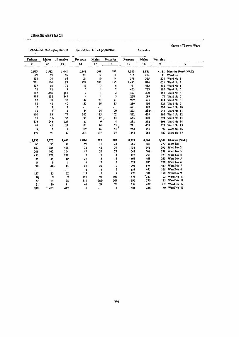
CENSUS ABSTRACT
Name ofTownl Ward Scheduled Castes population Scheduled Tnbes populatton Literates
Pcn;ons Mares .Females Persons Males Females Persons Males Females
11 12 13 14 15 16 17 18 19 2
2,953 1,512 1,441 1,241 609 631 9,982 5,831 4,151 Kharlar Road (NAC) 129 63 66 28 17 II 315 204 III WardNo I 138 74 64 24 10 14 579 355 224 Ward No 2 201 104 97 222 107 115 1,495 844 651 Ward No 3 137 66 71 13 7 6 731 413 318 Ward No 4
21 12 9 3 1 2 405 219 186 Ward No 5 717 366 ~51 3 I 2 463 300 163 Ward No 6 485 238 247 4 I 3 268 189 79 Ward No 7
62 30 32 42 21 21 939 525 414 Ward No 8 88 48 40 33 20 13 280 156 124 Ward No 9 5 3 2 641 347 294 Ward No 10
12 It 6 44 24 20 523 2'32- 241 Ward No II 160 83 77 307 14.5 162 832 465 367 Ward No 12
71 35- 36 91 47 __ 44 644 370 274 Ward No 13 472 248 224 13 9 4 388 282 106 WardNo 14 69 41 28 101 46 55 \ 781 459 322 WardNo 15
9, 5 4 109 46 63 254 157 97 WardNo 16 177 90 87 204 \07 97 444 264 180 Ward No 17
.2,130 1,370 1,460 1,024 522 502 8,213 4,864 3,349 Kharlar (NAC) . 66 35 31 59 31 28 661 382 279 WardNo I
852 384 468 72 42 30 934 541 393 Ward No 2 206 102 104 47 20 27 648 369, 279 W8TdNo 3 456 228 228 7 3 4 426 253 17f Ward No 4
84 44 40 29 13 16 661 408 253 WardNo 5 14 9 S 4 2 2 524 286 238 Ward No 6 90 4&-, 42 40 21 19 991 574 417 Ward No 7
8 6 2 858 4~0 368 WardNo 8 137 65 72 • 7 5 2 478 30,8 170 Ward No 9 la 9 9 195 93 102 475 '283 192 WardNo 10 67 29 38 511 262· 249 395 270 125 WardNo 11 21 10 II 44 24 20 754 452 3d2 WardNo 12
1119 - 407 412 I 408 248 16~ WardNo 13
399
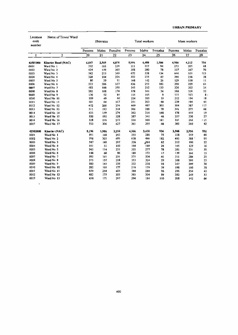
URBAN PRIMARY
Locatton Name ofTownl Ward code Illiterates Total workers Mam workers
number
Persons Males Females Persons Males Females Persons Males Females
2 20 21 22 23 24 25 26 27 28
42501000 Khariar Road (NAC) 6,647 2,569 4,078 5,994 4,488 1,506 4,966 4,212 754 0001 WardNo I 392 163 229 311 217 94 253 205 48 0002 WardNo 2 424 159 265 358 280 78 337 267 70 0003 Ward No 3 562 213 349 672 538 134 644 531 113 0004 WardNo 4 328 104 224 322 275 47 294 256 38 0005 WardNo 5 80 29 51 168 142 26 129 118 II 0006 Ward No 6 523 206 317 436 253 183 290 229 61 0007 WardNo 7 483 188 295 345 212 133 226 202 24 0008 Ward No 8 282 108 174 378 344 34 368 336 32 0009 Ward No 9 136 52 &4 114 105 9 III 103 8· 0010 Ward No 10 109 49 60 224 205 19 212 194 18 0011 Ward No II 181 64 117 251 203 48 239 194 45 0012 Ward No 12 622 268 354 609 407 202 504 387 117 0013 Ward No 13 511 193 318 366 288 78 341 275 66 0014 Ward No 14 433 159 274 362 214 148 178 159 19 0015 Ward No 15 520 192 328 381 341 46 351 330 27 0016 Ward No 16 328 116 212 330 169 161 181 166 ·15 0017 WardNo 11 733 306 427 361 295 66 302 260 42
41.502000 Kharlar (NAC) 5,196 1,986 3,210 4,366 3,430 936 3,508 1.,956 55l 0001 WardNo I 391 148 243 355 280 75 328 259 69 0002 WardNo 2 198 303 495 628 446 182 483 388 ' 95 0003 Ward No 3 347 140 207 326 _.264 62 212 190 22 0004 WardNo 4 161 51 110 164 140 24 145 129 16 0005 WardNo 5 345 114 231 355 277 78 281 231 50 0006 Ward No 6 146 60 86 189 172 17 179 164 15 0007 Ward No 7 392 161 231 375 334 41 311 286 25 0008 Ward No 8 375 157 218 353 324 29 318 295 23 0009 WardNo 9 380 145 235 332 238 94 247 209 38 0010 WardNo 10 282 105 177 218 179 39 198 160 38 0011 WardNo II 659 254 405 384 288 96 296 254 42 0012 WardNo 12 482 117 305 393 304 89 302 249 53 0013 WardNo 13 438 111 267 294 184 110 208 142 66
400

CENSUS ABSTRACT
Industrial cate~0!1 of mam workers
Household tndustry Name ofTownl Ward
CultIvators Agncultural labourers workers
Other workers
Persons Males Females Persons Males Females Persons Males Females Persons Males Females
29 30 31 32 33 34 35 36 37 38 39 40 2
441 395 46 274 182 92 125 107 18 4,126 3,528 598 Khartar Road (NAC) 69 58 11 44 27 17 I I 139 119 20 WardNo I
120 104 16 39 22 17 5 4 173 137 36 Ward No 2 9 7 2 61 40 21 21 21 553 463 9(} WardNo 3 2 2 5 4 287 250 37 Ward No 4 2 2 127 116 II Ward No 5 I I 34 16 18 3 3 252 209 43 Ward No 6
73 71 2 4 4 149 127 22 Ward No 7 3 2 18 18 347 316 31 Ward No 8
3 3 2 2 106 98 8 Ward No 9 3 1 2 209 193 16 Ward No 10
1 I 6 5 232 188 44 Ward No II 36 24 12 21 12 9 8 8 439 343 96 Ward No 12
7 3 4 334 272 62 WardNo 13
10 10 6 6 13 13 149 130 19 Ward No 14
7 7 2 2 20 14 6 328 307 21 Ward No 15
63 63 48 41 7 2 2 68 62 6 Ward No 16
43 42 9 7 2 16 13 3 234 198 36 Ward No 17
129 121 7 188 114 74 119 112 7 3,071 2,608 464 KhanaT (NAC)
31 31 50 33 17 1 I 246 194 52 Ward No I
5 5 8 4 4 2 2 468 377 91 Ward No 2
16 15 2 2 4 3 190 170 20 Ward No 3
1 2 2 142 127 15 Ward No 4
9 9 6 5 16 12 4 250 205 45 Ward No 5
5 5 2 I 8 8 164 • 150 14 Ward No 6
9 9 14 14 288 263 25 Ward No 7
4 4 12 12 302 279 23 Ward No 8
6 5 3 2 3 3 235 199 36 Ward No 9
7 5 2 8 7 28 28 155 120 35 Ward No 10
10 9 9 9 15 14 .262 222 40 WardNo 11
22 22 20 13 7 12 II 248 203 45 Ward No 12
4 3 80 38 42 2 2 122 99 23 Ward No 13
401
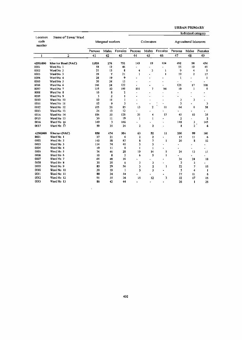
URBAN PRIMARY
Industrial catello!1 Location Name ofTownl Ward
code Margmal workers Cultivators Agnculturallabourers number
Persons Males Females Persons Males Females Persons Males Females
2 41 42 43 44 45 46 47 48 49
42501000 Khariar Road (NAC) 1,028 276 752 143 19 124 492 58 434 0001 WardNo I 58 12 46 55 10 45 0002 WardNo 2 21 13 8 4 3 9 4 5 0003 WardNo 3 28 7 21 I 19 2 17 0004 WardNo 4 28 19 9 I I 0005 WardNo 5 39 24 15 0006 WardNo 6 146 24 122 125 17 108 0007 WardNo 7 119 10 109 101 7 94 10 I 9 0008 WardNo 8 10 8 2 0009 WardNo 9 3 2 0010 WardNo 10 12 II I 3 3 0011 WardNo II 12 9 3 3 3 0012 Ward No 12 lOS 20 85 13 2 II 64 6 58 0013 Ward No 13 25 13 12 0014 Ward No 14 184 55 129 21 4 17 45 10 35 00J.5 Ward No 15 30 II 19 2 2 0016 WardNo h 149 3 146 148 3 145 0017 WardNo I 59 35 24 2 2 8 2 6
42502000 Khanar (NAC) 858 474 384 63 52 11 200 99 101 0001 WardNo I 27 21 6 2 2 17 II 6 0002 Ward No 2 145 58 87 8 7 20 8 12 0003 Ward No 3 114 74 40 3 3 0004 Ward No 4 19 II 8 I I 0005 Ward No 5 74 46 28 19 14 5 24 13 II 0006 Ward No 6 10 8 2 6 5 I 0007 Ward No 7 64 48 16 34 24 10 0008 Ward No 8 35 29 6 3 3 3 3 0009 Ward No 9 85 29 56 3 2 22 7 IS 0010 Ward No 10 20 19 I 3 3 .5 4 I 0011 Ward No II 88 34 54 17 II 6 0012 Ward No 12 91 55 36 IS 12 3 32 17 IS 0013 WardNo 13 86 42 44 26 1 25
402

CENSUS ABSTRACT
of marginal workers
Household industry Name of Townl Ward Location
Other workers Non-workers code workers
number.
Persons Males' Females Persons Males Females Persons Males Females
50 51 52 53 54 55 56 57 58 2
39 13 26 354 186 168 10,63S 3,912 6,723 Khariar Road (NAC) 42501000 3 2 1 396 150 246 Ward No.1 0001 8 6 2 645 234 411 Ward No.2 0002 8 5 3 1.385 519 866 Ward No.3 0003
27 19 8 737 242 495 Ward No.4 0004· 39 24 15 317 106 211 Ward No.5 0005 21 7 14 550 253 297 Ward No.6 0006
8 2 6 406 165 241 Ward No. 7 0007 10 8 2 843 289 554 WacdNo.8 0008 2 2 302 103 199 Ward No. 9 0009
.' 9 8 526 191 335 Ward No 10 0010 9 9 453 143 "3lQ Ward No. 11 0011
2 2 26 12 14 845 326 519 Ward No. 12 0012
13, 5 8 12 8 4 789 275 514 Ward No. 13 0013
14 4 10 104 37 67 459 227 232 Ward No. 14 0014
5 1 4 22 9 13 914 310 604 Ward No. 15 0015
1 1 252 104 148 Ward No. 16 0016
4 3 45 28 17 816 275 541 Ward No 17 0017
37 23 14 558 300 258 9,043 3,420 5,623 Kharlar (iliAC) 42502000
8 8 '. 697 250 1147 Ward No. 1 0001
116 42 74 1.104 398 706 Ward No. 2 0002
III 71 40 669 245 424- Ward No. 3 0003
1 I 17 10 7 423 1M ,259 Ward No. 4 0004
7 7 24 19 5 651 . 245 406 Ward No. S 0005 .( 3 1 481 174 307 Ward No. 6 0006
1 29 24 5 1,008 401 607 Ward No. 1 0007
3 ~ 26 20 6 880 323 557 Ward·No.8 0008
I 59 20 39 526 215 311 Ward No. 9 0009
8 8 4 4 539 209 ,330 WardNo 10 0010
8 4 4 63 19' 44 670 236 43.4 Ward No. II 0011
7 7 37 19 18 843 325 518 Ward~o. 12 0012
6Q 41 19 552 235 317 Ward No. 13 0013
403


ANNEXURES

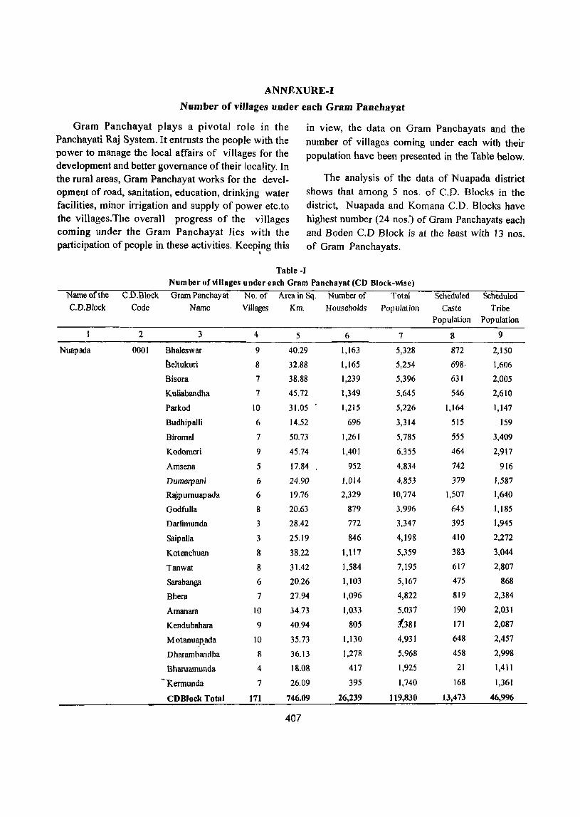
ANNEXURE-I
Number of villages under each Gram Panchayat
Gram Panchayat plays a pivotal role in the Panchayati Raj System. It entrusts the people with the power to manage the local affairs of villages for the development and better governance of their locality. In the rural areas, Gram Panchayat works for the development of road, sanitation, education, drinking water facilities, minor irrigation and supply of power etc.to the villages.The overall progress of the villages coming under the Gram Panchayat lies with the participation of people in these activities. Keeping this
in view, the data on Gram Panchayats and the number of villages coming under each with their popUlation have been presented in the Table below.
Name of the
C.D.Block
Nuapada
. Table -I
The analysis of the data of Nuapada district shows that among 5 nos. of C.D. Blocks in the district, Nuapada and Komana C.D. Blocks have highest number (24 nos:) of Gram Panchayats each and Boden C.D Block is at the least with 13 nos. of Gram Panchayats .
Number of villages undereach Gram Panchayat(CD Block-wise)
C.D.Block Gram Panchayat No. of Area in Sq. Number of Total
Code Name Villages Km. Households Population
2 3
0001 Bhaleswar
Beltukuri
Bisora
Kuliabandha
Parkod
Budhipalli
Biromal
Kodomeri
Amsena
Dumerpan;
RlYP umuap ada
Godfulla
Darlimunda
SaipaUa
Kotenchuan
Tanwat
Saraban~
Bhera
Amanara
Kendubahara
M otanu~.ada
Dharambandha
Bharuamunda
~Kermunda
CDBlock Total
4
9
8
7
7
10
6
7
9
5
6
6
8
3
3
8
8
6
7
10
9
10
8
4
7
171
5
40.29
32.88
38.88
45.72
31.05
14.52
50.73
45.74
17.84
24.90
19.76
20.63
28.42
25.19
38.22
31.42
20.26
27.94
34.73
40.94
35.73
36.13
18.08
26.09
746.09
407
6
1,163
1,165
1,239
1,349
1,215
696
1,261
1,401
952
1,014
2,329
879
772
846
1,117
1,584
1,103
1,096
),033
805
1,130
1,278
417
395
26,239
7
5,328
5,254
5,396
5,645
5,226
3,314
5,785
6,355
4,834
4,853
10,774
3,996
3,347
4,198
5,359
7,195
5,167
4,822
5,037
1,381
4,931
5,968
1,925
1,740
It9,830
Scheduled
Caste Scheduled
Tribe Population Population
g
872
698·
631
546
1,164
515
555
464
742
379
1,507
645
395
410
383
617
475
819
190
171
648
458
21
168
13,473
9
2,150
1,606
2,005
2,610
1,147
159
3,409
2,917
916
1,587
1,640
1,185
1,945
2,272
3,044
2,807
868
2,384
2,031
2,087
2,457
2,998
1,4 t I
1,361
46,996
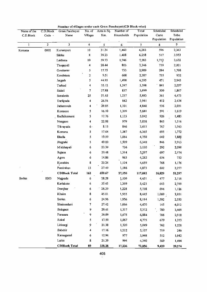
Number of villages under each Gram Panchayat (CD Block-wise)
Name of the C.D.Block Gram Panchayat No. of Area in Sq. Number of Total Scheduled Scheduled
C.D.Block Code· Name Villages Km. Households Population Caste Tribe Population Population
2 3 4 5 6 7 8 9
Komana 0002 Kurumpuri 10 31.24 1,460 6,283 596 2,363
Silbha 8 39.23 1,488 6,258 517 3,953
Lakhana 10 59.73 1,746 7,583 1,717 3,632
ThogjipaJi 4 20.44 803 3,346 739 2,021
Gandamer 5 17.75 733 2,989 284 1,708
Kandetara 2 9.51 608 2,387 735 932
Jatgjifh 5 44.95 1,498 6,395 471 2,943
Tarbod 4 35.12 1,247 5,598 841 2,057
Sialati 7 27.88 837 3,699 500 1,867
Sunabeda 25 51.65 1,237 5,883 361 4,473
Darlipada 4 26.54 842 3,941 412 2,434
ladamunda 4 29.85 1,101 4,848 536 2,031
Koresore 5 16.10 1,309 5,681 591 1,819
Budilikomana 5 17.76 1,133 5,042 926 1,483
Nuagjion 4 22.08 979 3,838 845 1,516
Tikrapada 6· 8.15 846 3,615 76.7 1,043
Komana 5 17.64 1,387 6,365 695 1,772
Bhella 5 19.59 1,064 4,750 642 1,88~
Jhagrahi 5 49.QO 1,509 6,340 846 2,91J
Michhapali 6 23.39 736 3,130 292 2,090
Rajana 6 29.48 1,314 5.797 697 2,174
Agren 6 14.86 963 4,282 654 732
Konabira 8 20.24 1,124 4,659 768 1,176 . Pendraban 13 27.49 1,186 4,873 602 2,277
CDBlock Total 162 659.67 27,150 117,082 16,029 51,297
Boden 0003 Nagpada 6 28.28 l,lOO 4,451 477 J,116
Karlakote 6 35.45 1,369 5,423 643 2,.749
Domjhar 6 . 28.29 1,228 5,738 694 1,126
Khaira 8 45.01 1,955 8,445 1,069 3,951
Boden 6 24.96 1,956 8,114 1,592 2,550
Bhainsadani 7 27.42 1,066 4,470 145 4,012
Boirgaon 9 29.41 1,317 5,312 780 3,469
Farasara 9 29.09 1,675 6,884 788 2,918
Rokal 5 17.50 1,067 4,775 679 1,373
Lit is argi 9 21.38 1,320 5,049 762 1,228
Babebir 4 17.16 1,212 5,107 719 246
Karangamal 6 12.94 977 3,948 512 1,042
Larka 8 21.39 994 4,340 569 1,494
CDBlock Total 89 338.28 17,236 72,056 9,429 29,274
408
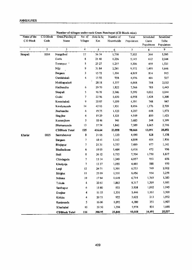
ANNEXURES
Number of villages under each Gram Panchayat (CD Block-wise)
Nameofthe C D.Block Gram Panchayat No of Area in Sq Number of Total Scheduled Scheduled CD Block Code Name VIllages Km Households Population Caste Tribe
PopulatIOn Population
2 3 4 5 6 7 8 9
Sinapali 0004 Nangalbod 17 5674 1,730 7,502 364 5,595
Gorla 8 2148 1,226 5,145 612 2,044
Tlmanpur • 5 2327 1,237 5,206 459 1,531
Nil.Ji 9 3184 2,281 9,572 1,493 1,646
Bargaon 3 1572 1,194 4,819 814 915
Gandabahah 4 1192 938 4,076 401 527
Mukhapadar8 2818 1,537 6,068 718 2,032
Hatibandha 6 2970 1,822 7,566 785 1,443
Sinapali 5 1639 2,246 9,399 1,032 1,044
Godal 7 2256 1,630 6,958 1,428 1,308
Koranbahali 9 2087 1,059 4,391 748 947
Kendumunda 14 4293 1,931 8,056 1,376 2,709
lharbandha 6 19.75 1,123 4,287 648 1,573
Singjhar 6 1929 1,121 4,549 800 1,423
Kusumjhore 5 1846 941 3,683 348 1,399
Bharuamunda 13 3754 1,842 7,389 1,065 2,716
CDBlock Total 125 416.64 23,858 98,666 13,091 28,852
Khariar 0005 Sanmaheswar 8 2166 1,120 4,690 828 1,338
Bargaon 7 1841 1,143 4,898 604 1,936
Bhojapur 7 2131 1,757 7,489 977 1,141
Bhuliasikuan 6 1805 1,484 6,416 472 956
Badi 8 2612 1,733 7,704 1,750 1,827
Chindaguda 7 15 14 1,349 6,057 933 656
Khudpeja 7 1337 1,055 4,480 588 970
Lanji 12 2671 1,501 6,533 749 2,902
Birighat 11 2509 1,551 6,456 954 3,259
Nehena 10 1784 1,618 6,714 1,769 1,383
Tukula 4 2061 1,863 8,317 1,309 1,081
Sardhapur 6 1580 933 3,938 1,002 1,045
Duajhar 4 II 55 1,331 5,446 1,161 1,560
Kirkita 4 2073 922 3,622 213 1,932
Ranimunda 5 1606 1,092 4,280 351 1,905
Khasbaha1 10 2050 1,394 5,978 831 1,646
CDBlock Total 116 308.95 21,846 93,018 14,491 25,537
409
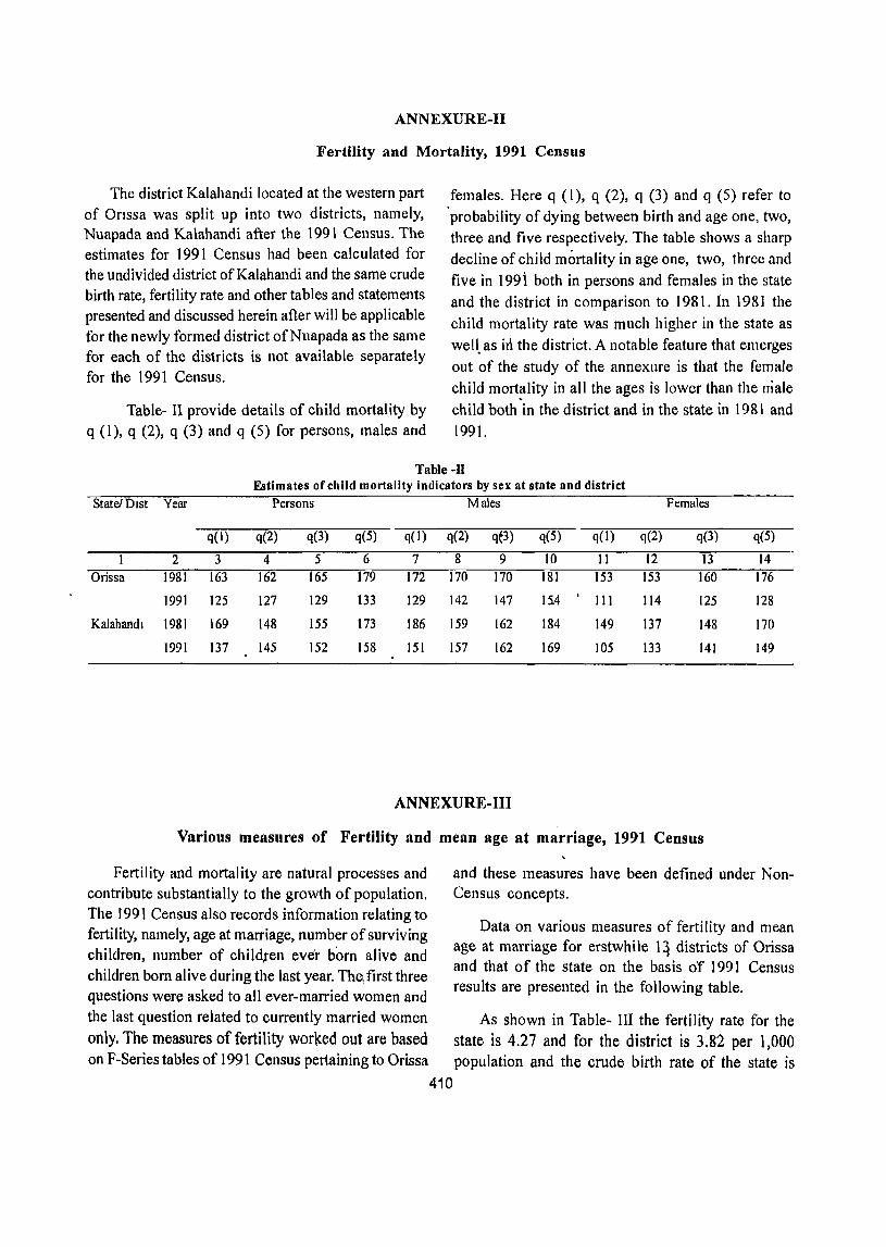
ANNEXURE-II
Fertility and Mortality, 1991 Census
The district Kalahandi located at the western part of Onssa was split up into two districts, namely, Nuapada and Kalahandi after the 1991 Census. The estimates for 1991 Census had been calc ulated for the undivided district of Kalahandi and the same crude birth rate, fertility rate and other tables and statements presented and discussed herein after will be applicable for the newly formed district ofNuapada as the same for each of the districts is not available separately for the 1991 Census.
Table- II provide details of child mortality by q (1), q (2), q (3) and q (5) for persons, males and
females. Here q (1), q (2), q (3) and q (5) refer to 'probability of dying between birth and age one, two, three and five respectively. The table shows a sharp
decline of child mortality in age one, two, three and
five in 199 i both in persons and females in the state
and the district in comparison to 1981. In 1981 the
child mortality rate was much higher in the state as
well. as in the district. A notable feature that emerges
out of the study of the annexure is that the female
child mortality in all the ages is lower than the male
child both'in the district and in the state in 1981 and
1991.
Table-ll Estimates of child mortality indicators by sex at state and district
State! Dlst Year Persons Males Females
q(l) q(2) q(3) q(5) q(l) q(2) qt3) q(5) q(l) q(2) q(3) q(5)
2 3 4 5 6 7 8 9 10 11 12 13 14 Orissa 1981 163 162 165 179 172 170 170 181 153 153 160 176
1991 125 127 129 133 129 142 147 15.4 I
III 114 125 128
Kalahandl 1981 169 148 155 173 186 159 162 184 149 137 148 170
1991 137 145 152 158 151 157 162 169 105 133 141 149
ANNEXURE-III
Various measures of Fertility and mean age at marriage, 1991 Census
Fertility and mortality are natural processes and and these measures have been defined under Non-contribute substantially to the growth of population. Census concepts.
Data on various measures of fertility and mean age at marriage for erstwhile 14 districts of Orissa and that of the state on the basis of 1991 Census
The 1991 Census also records information relating to fertility, namely, age at marriage, number of surviving children, number of child,ren ever born alive and children born alive during the last year. The, first three
results are presented in the following table. questions were asked to all ever-married women and
the last question related to currently married women As shown in Table- III the fertility rate for the
only. The measures of fertility worked out are based state is 4.27 and for the district is 3.82 per 1,000 on F-Series tables of 1991 Census pertaining to Orissa population and the crude birth rate of the state is
410
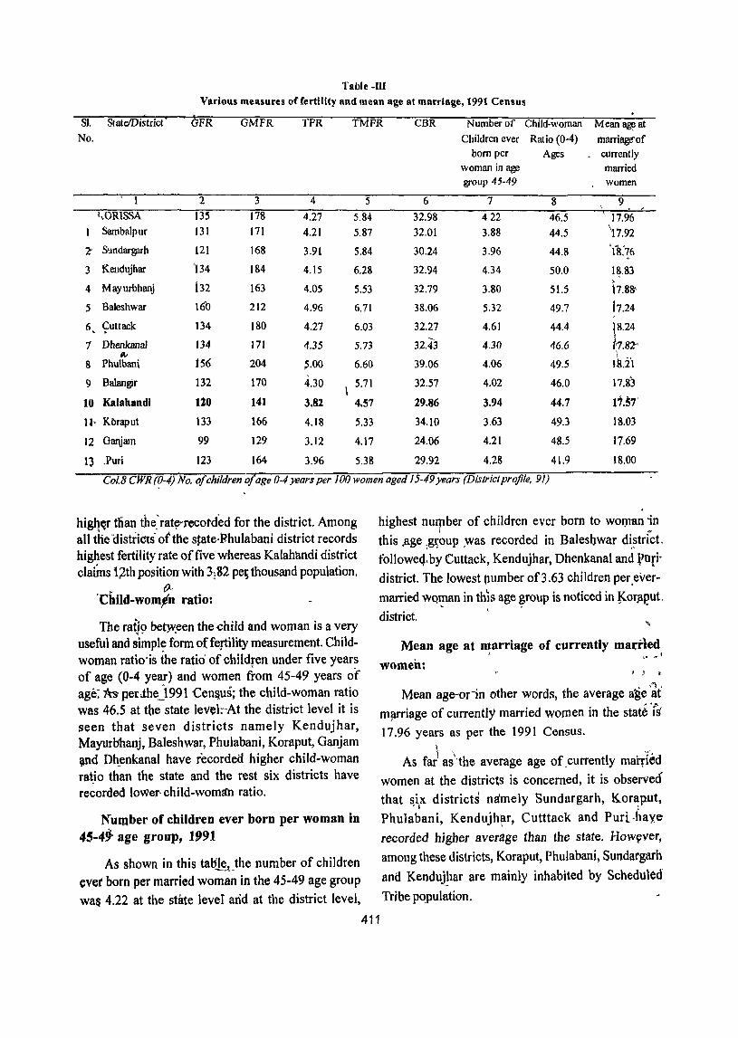
Table -m Various measures offertility and mean age at marriage, 1991 Census
Sk StateIDistrict GFR GMFR TFR TMFR CBR Number of Child-woman Mean~at
No. Children ever Ratio (0-4) marriage-of bom per Ages currently
woman in age married group 45-49 women
1 2 3 4 5 6 7 8 9 \
<,ORISSA 135 17'8 4.27 5.84 32.98 422 46.5 \ 17.96 I Sambalp ur J31 171 4.21 5.87 32.01 3.88 44.5 \17.92
2- Sundargarh 121 168 3.91 5.84 30.24 3.96 44.8 'ft76
3 Kendujhar '134 184 4.15 6.28 32.94 4.34 50.0 1~.S3
4 Mayurbhanj 132 )63 4.05 5.53 32.79 3.80 51.5 b.S8'
5 Baleshwar 160 212 4.96 6.71 38.06 5.32 49.7 i7.24 f
6 Cuttack 134 180 4.27 6.03 32.27 4.61 44.4 1S.24 , .
1 Dhenkanal 134 171 4.35 5.73 32.43 4.30 46.6 ?-82'" jII" I ..
8 Phulbani 156 204 ~.oo 6.60 39.06 4.06 49.5 1~.21
9 ~alangir 132 170 4.30 \ 5.71 32.57 4.02 46.0 17.83
10 Kalahand! 120 141 3.82 4.57 29.86 3.94 44.7 It.57' H' Kbraput 133 166 4.18 5.33 34.10 3.63 49.3 IS.03
12 Ganjam 99 129 3.12 4.17 24.06 4.21 48.5 17.69
Q .Puri 123 164 3.96 5.38 29.92 4.28 41.9 18.00
Col 8 CWR (0-4) No. a/children o/age 0-4 years per 100 women aged 15-49 years (Districlprofile. 9/)
higq~r tllan the~ rat~Tecorcl'ed for the district. Among all tlie Ciistri<!ts-otthe state,Phulabani district records highest fertility rate of five whereas Kalahandi district claiins 1)th position with 3182 pe~thousand population.
• t}--
'Child-worn,n ratio:
The raij9 be~een the-child and woman is a very useful and simple form of fertility measurement. Childwoman ratio"is the ratio of children under five years of age (0-4 year) and women from 45-49 years of age:"tts perJ:hej99 1 "Cen&us; the child-woman ratio was 46.5 at the state le~l:""At the district level it is seen that seven districts namely Kendujhar, Mayurbhanj, Baleshwar, Phulabani, Koraput, Ganjam ~nd Dh.enkanal have recorde(f higher child-woman ratJo than the state and the rest six districts have recorded lower' child-womro1 ratio.
Number of children ever born per woman in 45-4" age group, 1991
, highest nUlpber of children ever born to worpan ~n this .age ;g~oup ,was recorded in Balesbwar d~~trict, followeq.by Cuttack, Kendujhar, Dhenkanal and Pori' district. The lowest t1umber of 3 .63 children per.evermarried wQman in thiS age group is noticed in !<OIJiPut. district. ~ \ ' >
" Mean age at marriage of currently ma.;rled . ,
.. P ....
women: • J •
, ,", Mean age-or-in other words, the average a~e at
m~rriage of currently married women in the stat~ 'is 17.96 years as per the 1991 CensuS.
I I ' ·e
As far' as\the average age of ,currently maqied women at the districts is concerned, it is observed that six districts namely Sundargarh, Koraput,
" >
Phulabani, Kendujh~r, Cutttack and Puri .baye
As shown in this talJ.kt.the number of children (lvet born per married woman in the 45-49 age group wa$ 4.22 at the state lever arid at the district level,
411
recorded higher average than the state. How~ver,
among these districts, Koraput, Phulabani, Sundargarh
ana Kenduj~ar are mainly inhabited by Scheduled
Tribe population.
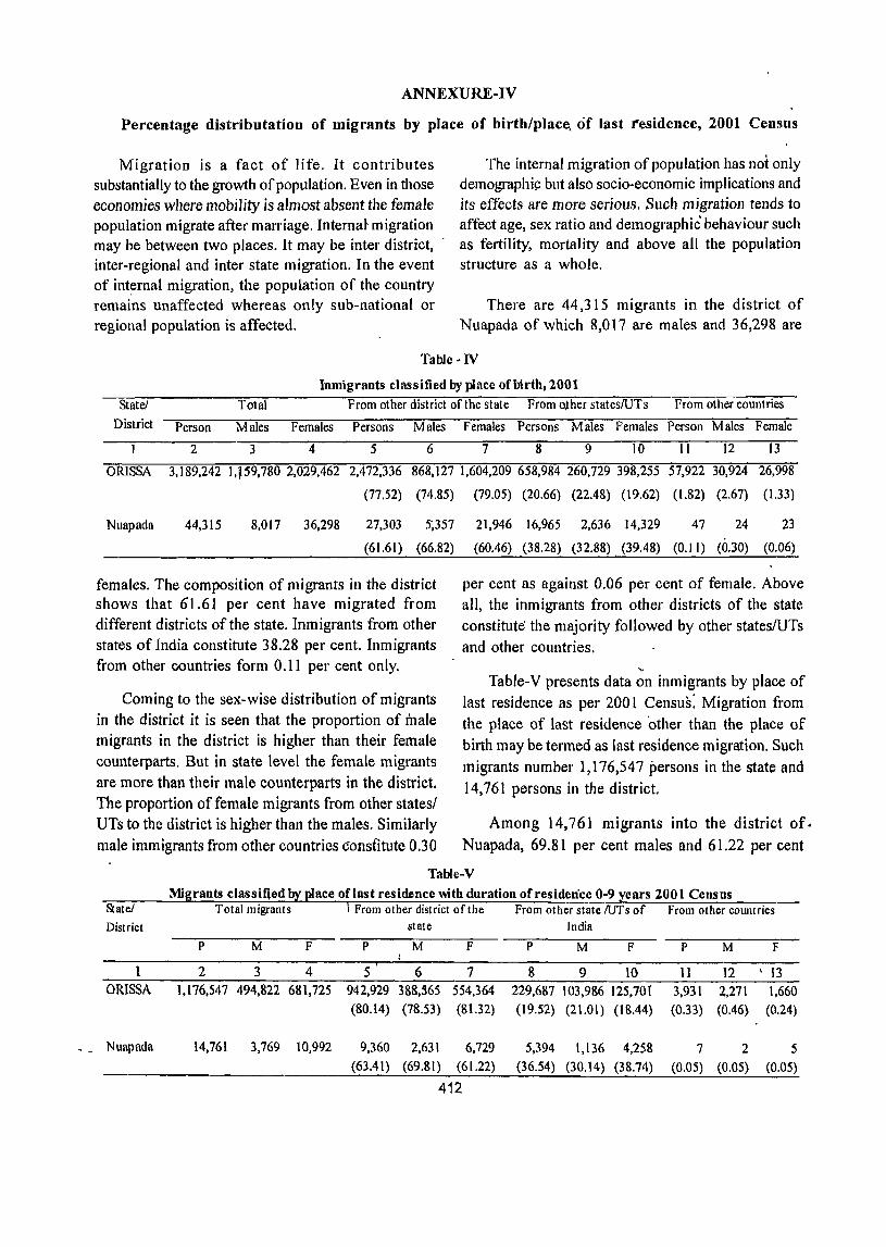
- -
ANNEXURE-IV
Percentage distributation of migrants by place of birth/place, of last residence, 2001 Census
Migration is a fact of life. It contributes substantially to the growth of population. Even in those economies where mobility is almost absent the female popUlation migrate after marriage. Interna~ migration may be between two places. It may be inter district, inter-regional and inter state migration. In the event of int~rnal migration, the popUlation of the country remains unaffected whereas only sub-national or regional population is affected.
The internal migration of population has not only demographi~ but also socio-economic implications and its effects are more serious. Such migration tends to affect age, sex ratio and demographic behaviour such as fertility, mortality and above all the population structure as a whole.
There are 44,315 migrants in the district of Nuapada of which 8,017 are males and 36,298 are
Table -IV
Inmigrants classified by place of birth, 2001
Statei Total From other district of the state From o,ther stateslUTs From other countries
District Person Males Females Persons Males Females Persons Males Females Person Males Female
234 5 6 7 8 9 10 11 12 13
ORISSA 3,189,242 1,,59,780 2,029,462 2,472,336
(77.52)
868,127 1,604,209 658,984 260,729 398,255 57,922 30,924
(74.85) (79.05) (20.66) (22.48) (19.62) (1.82) (2.67)
26,998
(1.33)
Nuapada 44,315 8,017 36,298 27,303 5',357
(61.61) (66.82)
females. The composition of migrants in the district shows that 61.61 per cent have migrated from different districts of the state. Inmigrants from other states of India constitute 38.28 per cent. Inmigrants from other countries form 0.11 per cent only.
Coming to the sex-wise distribution of migrants in the district it is seen that the proportion of male migrants in the district is higher than their female counterparts. But in state level the female migrants are more than their male counterparts in the district. The proportion of female migrants from other states/ UTs to the district is higher than the males. Similarly male immigrants from other countries constitute 0.30
21,946 16,965 2,636 14,329 47 24 23
(60.46) (38.28) (32.88) (39.48) (0.11) (0.30) (0.06)
per cent as against 0.06 per cent of female. Above all, the inmigrants from other districts of the state constitute the majority followed by other stateslUTs and other countries.
" Table-V presents data on inmigrants by place of last residence as per 2001 Census: Migration from the place of last residence 'other than the place of birth may be termed as last residence migration. Such migrants number 1,176,547 persons in the state and 14,761 persons in the district.
Among 14,761 migrants into the district of. Nuapada, 69.81 per cent males and 61.22 per cent
Table-V
State/ District
1 ORISSA
Nuapada
Mi rants classifled ace oflast residence mth duration of residence 0-9 ears 2001 Census Total migrants
P M F
2 3 4 1,176,547 494,822 681,725
14,761 3,769 10,992
From other district of the state
P M F
5 6 7 942,929 388,565 554,364 (80.14) (78.53) (81.32)
9,360 2,631 6,729 (63.41) (69.81) (61.22)
412
From other state IUTs of From other cOW1lries India
P M F P M F
8 9 10 11 12 113
229,687 103,986 125,70{ 3,931 2.,271 1,660 (19.52) (21.01) (18.44) (0.33) (0.46) (0.24)
5,394 1,136 4,258 7 2 5 (36.54) (30.14) (38.74) (0.05) (0.05) (0.05)
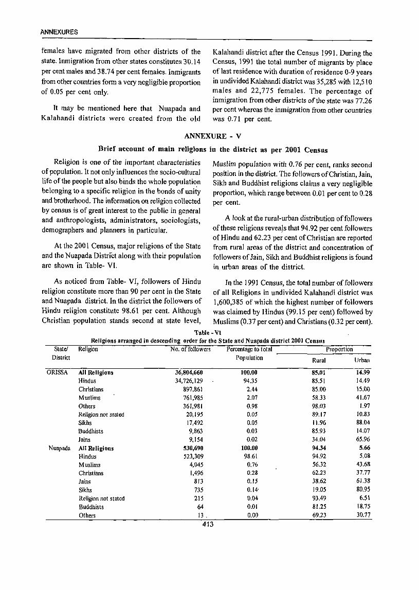
ANNEXURES
females have migrated from other districts of the state. Inmigration from other states constitutes 30.14
per cent males and 38.74 per cent females. Inmigrants
from other countries form a very negligible proportion of 0.05 per cent only.
It may be mentioned here that Nuapada and Kalahandi districts were created from the old
Kalahandi district after the Census 1991. During the Census, 1991 the total number of migrants by place of last residence with duration of residence 0-9 years in undivided Kalahandi district was 35,285 with 12,510 males and 22,775 females. The percentage of inmigration from other districts of the state was 77.26 per cent whereas the inmigration from other countries was 0.71 per cent.
ANNEXURE - V
Brief account of main religions in the district as per 2001 Census
Religion is one of the important characteristics of popUlation. It not only influences the socio-cultural life of the people but also binds the whole populati~n belonging to a specific religion in the bonds of unity and brotherhood. The information on religion collected by census is of great interest to the public in general and anthropologists, administrators, sociologists, demographers and planners in particular.
At the 2001 Census, major religions of the State and the Nuapada District along with their popUlation are shown in Table- VI.
As noticed from Table- VI, followers of Hindu religion constitute more than 90 per cent in the State and Nuapada district. In the dis~rict the followers of Hindu religion constitute 98.61 per cent. Although Christian popUlation stands second at state level,
Muslim population with 0.76 per cent, ranks second position in the district. The followers of Christian, Jain, Sikh and Buddhist religions claims a very negligible proportion, which range between 0.01 per cent to 0.28 per cent.
A look at the rural-urban distribution offollowers ofthese religions revea!s that 94.92 per cent followers of Hindu and 62.23 per cent of Christian are reported from rural areas of the district and concentration of followers of Jain, Sikh and Buddhist religions is found in urban areas of the district.
In the 1991 Census, the total number of followers of all Religions in undivided Kalahandi district was 1,600,385 of which the highest number of followers was claimed by Hindus (99.15 per cent) followed by Muslims (0.37 per cent) and Christians (0.32 per cent).
Tab\e - VI Religions arranged in descending order for the State and Nuapada district 2001 Census
State! Religion No. of followers Percentage to total Proportion District Population Rural Urban
ORISSA All Religions 36,804,660 100.00 85.01 14.99 Hindus 34,726,129 94.35 85.51 14.49 Christians 897,861 2.44 85.00 15.00 Muslims 761,985 2.07 58.33 41.67 Others 361,981 0.98 98.03 1.97 Religion not stated 20,195 0.05 89.17 10.83 Sikhs 17,492 0.05 11.96 88.04 Buddhists 9,863 0.03 85.93 14.07 lains 9,154 0.02 34.04 65.96
Nuapada All Religions 530,690 100.00 94.34 5.66 Hindus 523,309 98.61 94.92 5.08 Muslims 4,045 0.76 56.32 43.68 Christians 1,496 0.28 62.23 37.77 lains 813 0.15 38.62 61.38 Sikhs 735 0.14' 19.05 80.95 Religion not stated 215 0.04 93.49 6.51 Buddhists 64 0.01 81.25 18.75 Others 13 . 0.00 69.23 30.77
413
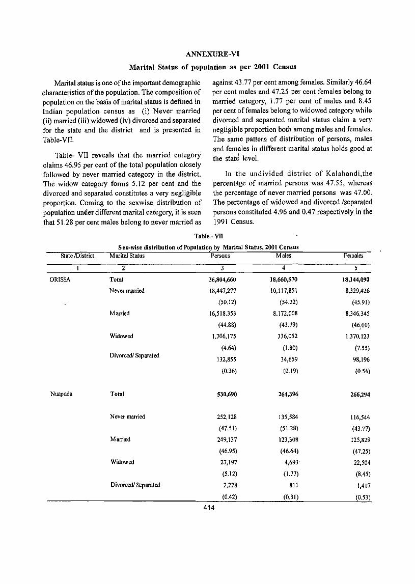
ANNEXURE-VI
Marital Status of population as per 2001 Census
Marital status is one of the important demographic characteristics of the population. The composition of population on the basis of marital status is defined in Indian population census as (i) Never married (ii) married (iii) widowed (iv) divorced and separated for the state and the district and is presented in Table-VII.
Table- VII reveals that the married category claims 46.95 per cent of the total population closely followed by never married category in the district. The widow category forms 5.12 per cent and the divorced and separated constitutes a very negligible proportion. Coming to the sexwise distribution of population under different marital category, it is seen that 51.28 per cent males belong to never married as
against 43.77 per cent among females. Similarly 46.64 per cent males and 47.25 per cent females belong to married category, 1.77 per cent of males and 8.45 per cent offemales belong to widowed category while divorced and separated marital status claim a very negligible proportion both among males and females. The same pattern of distribution of persons, males and females in different marital status holds good at
)
the state level.
In the undivided district of Kalahandi,the percentage of married persons was 47.55, whereas the percentage of never married persons was 47.00. The percentage of widowed and divorced /separated persons constituted 4.96 and 0.47 respectively in the 1991 Census.
Table - vn Sex-wise distribution of Population by Marital Status, 2001 Census
State !District Marital Status Persons Males
2 3 4
ORISSA Total 36,804,660 18,660,570
Never ffi!IITied 18,447,277 10,ll7,851
(50.12) (54.22)
Married 16,518,353 8,172,008
(44.88) (43.79)
Widowed 1,706,175 336,052
(4.64) (1.80) Divorced/ Separated
132,855 34,659
(0.36) (0.19)
Nuapada Total 530,690 264,396
Never married 252,128 135,584
(47.51) (51.28)
Married 249,137 123,308
(46.95) (46.64)
Widowed 27,197 4,693'
(5.12) (1.77)
Divorced/ Separated 2,228 811
(0.42) (0,31)
414
Females
5
18,144,090
8,329,426
(45.91)
8,346,345
(46;00)
1,370,123
(7.55)
98,196
(0.54)
266,294
116,544
(43.77)
125,829
(47.25)
22,504
(8.45)
1,417
(0.53)

ANNEXURE-VII
Age, Sex and Education in the district, 2001 Census
Educational qualification according to age and sex is dep.icted in various tables of Census. Certain concepts/definitiens associated with literacy have been defined in the earlier paragraphs under "Census Concepts"
Distribution of literate persons in different Educational levels in the State : 2001
Distribution of literate persons in differen~ educational levels at the state level is shown below.
The proportion of literate persons in different educational levels does not provide an encouraging picture since more than 55 per cent (58.25 per cent)
among literate persons, 55. I I per cent males and 68.04 per cent females have attained only primary and below primary level of education followed by middle standard with 14.50 per cent persons 14.87 per cent males and 13.93 per cent females.
As far as technical education is concerned, it may be mentioned here that the proportion of such persons to total literate persons is abysmally low. It is only 0.74 per cent.
Among the higher educational levels graduate and above educational level claims 5.98 per cent followed by higher secondary/ intermediate with only 5.15 per cent.
Table -VIll Distribution of literate and educated persons in different educational levels in the State, 2001
Nmne of State Educational Level Persons Males Females I 2 3 4 5
ORISSA Total Population 36,804,660 18,660,570 18,144,090
Literate 19,837,055 11,992,333 7,844.722
i) Literate without any formal schooling 428,001 279,304 148,697
including educational level unclassified (2.16) (2.33) (1.90)
ii) Below Primary 5,755,797 3,328,385 2,427,412
(29.02) (27.~5) (30.94)
iii) Primary 5,798,954 3,280,957 2,517,997
(29.23) (27.36) (32.10)
iv). Middle 2,875,760 1,783,236 1,092,524
(14.50) (14.87) (13.93)
v) M at ric/Secondary 2,616,294 1,665,245 951,049
(13.19) (13.89) (12.12)
vi) Higher secondary nntermediate 1,021,802 664!408 357,394
Pre-University/Senior secondary (5.15) (5.54) (4.56)
vii) N on-technical dip lorna or 8,944 7,495 1,449
r. certificate not equal to degree (0.05) (0.06) (0.02)
I
viii) Technical dip lorna or cert ificate 145,863 1)6,593 29,270
not equal to degree (0.74) (0.97) (0,37)
ix) Graduate & above 1,185,640 866,710 318,930
(5.98) (7.23) (4.07)
415
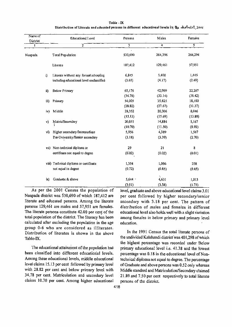
Table -lX Distribution of literate and educated persons in different educational levels btl ~ JiStttict,2MI
Name of Educational Level
District I 2
Nuapada Total Population
Literate
i) Literate without any formal schoQling including educational level unclassified
ii) Below Primary
iii) Primary
iv) Middle
v) M atriclSecondary I
vi) Higher secondary /Intermediate
Pre-U nivers ity {Senior secondary
VIi) Non-technical diploma or
certificate not equal to degree
viii) Technical diploma or certificate
not equal to degree
ix) Graduate & above
As per the 2001 Census the population of Nuapada district was 530,690 of which 187,412 are literate and educated persons. Among the literate persons 129,461 are males and 57,951 are female~. The literate persons constitute 42.00 per cen~ of the total population of the district. The literacy has been calculated after excluding the population in the age group 0-6 who are considered as illiterates. Distribution of literates is shown in the above Table-IX.
Persons Males Females
3 4 5
530,690 264,396 266,294
187,412 129,461 57,951
6,845 5,400 1,445
(3.65) (4.17) (2.49)
65,176 42,909 22,267
(34.78) (33.14) (38.42)
54,005 35,825 18,180
(28.82) (27.67) (31.37)
28,352 20,306 8,046
(J5.13) (15.69) (I3.88)
20,051 14,884 5,167
(10.70) (1.1.50) (8.92)
5,956 4,389 1,567
(3.18) (3.39) (2.70)
29 21 8
(0:02) (0.02) (0.01)
1,354 1,096 258
(0.72) (0.85) (0.45)
5,644 . 4,631 1,013
(3.01) (3.58) (1. 75)
levei, graduate and above educational level claims 3.01 per cent followed by higher secondary/senior secondary with 3.18 per cent. The pattern of distribution of males and females in different educational level also holds well with a slight variation among females in below primary and primary level education.
In the 1991 Census the total literate persons of the undivided Kalahandi district 'was 401,298 of which the highest percentage was recorded under Below
The educational attaimnent of the population has primary educational level i.e. 41.38 and the lowest been classified into different educational levels. percentage was 0.18 in the educational level of Non-
Among these educational levels, middle educ~tional technical diploma not equal to degree, The percentage level claims 15.13 per cent followed by primary level of Graduate and above persons was 0.52 only whereas with 28.82 per cent and below primary level with Middle standard and Matriculation/Secondary claimed 34.78 per cent. Matriculation and secondary level 2l.89 and 7.50 per cent respectively to total literate claims 10.70 per cent. Among higher educational persons of the district.
416

ANNEXVRES
State/
Districi'
ORISSA
Nuapada
Table -x Distribution of females in tbe age group 15-44 years by educationalle\el, 2001
Total
Rural
Urban
No. of Women
aged 15-44
years
Percentage of Women aged 15-44 years by educational level
Total Illiterate Uterate but Middle but Matrie but Qaduate &
2 3 4 5. Total 8,589,378 100 46.29 Rural 7,224,698 100 50.62 Urban 1,364,680 100 23.39
Total 118,769 100 75.13 Rural III ,617 100 77.52 \.}rban 7,152 100 37.74
below below Middle Matrie
6 7 26.39 9.06 27.07 8.72 22.76 10.89
13.51 4.S9
.J3.15 4.51
below
Graduate
8 14.78 11.74 30.84
5.67 4.33
above
9 '3.48 \ 1.85
12.12
q.S1 Q.48
19.04 10.75 26.52 ~.94
Table-X as pepicted above, presents the women During-the €ensus 1991, in the undivided~istrict of Kalahandi the percentage of illiterate in the !emale age group of 15-44 was 86.35. On the literary group; the highest percentage with 7.73 was claimed by literate but below middle followed by middle but belowmatric with 3.62 per cent, matric but belo~ gradlJate with 1.94 per cent and lastly graduate and above was claimed ,with Q..35 per cent. The percentage oYitrban literacy waS more than the rural literacy rate in all. most all of ~he educational levels.
'under the age group 15-44 in different educational levels in th/e 'di'Strict of Nuapada: The propOrtion of female literacy of the district in this age group is leS}; than 'the/state average for totai, rural and urban 'areas p-ertaining to different levels of education.The highest peroent~ge is shown in the educational level of Literate but below middle with 13.51 per cent and tbe Gradua~e and above 1evel is at· the least with 0.81 per c~ht in-the dis~rict 'of Nuapada.
Table -XI Children in the llge group 0-14 years with number of children 'attending school, 2001 Census
f
N~e of the Description Total Rural Urban stato'District
_ .1 2 ORISSA Total
Nuapada
Population in the"age group 0-14 years
_No. of Children attending School Percentlige
To]~1
Populat'ion in thc¥gfoup O-14Ye8rs
No. of Children attendin,g School Percentage
'persons Males Females Persons Males Females Persons Males Females 3 _ 4 5 6 7 8 9 10 11
12,207,872 6,235,873 5,971,999 10,592,499 5,402,181 5,190,318 1,615,373 833,692 781,.681
5,618,880 3,042,840 2,576,040 4,721,148 2,569,899- Z,151,339 897,732 473,031 '424,761
(46.03) (48.S0) (43.14)
184,868 93,602 91,266
70,356 41,563 28,793
(44.57)
175,058
(47.57) ,
88,611 \ '
(41.45)
86,447
64,81S 38,651 26.i67
(38.06) (44.40) (31.55) (31.03) - (43.62) (30.27)
417
(55.57) (56.74} (54.33)
9,810 4,99L 4,819
5,538 2,912, ,2,626
(56.45) (58.35) (54;49)
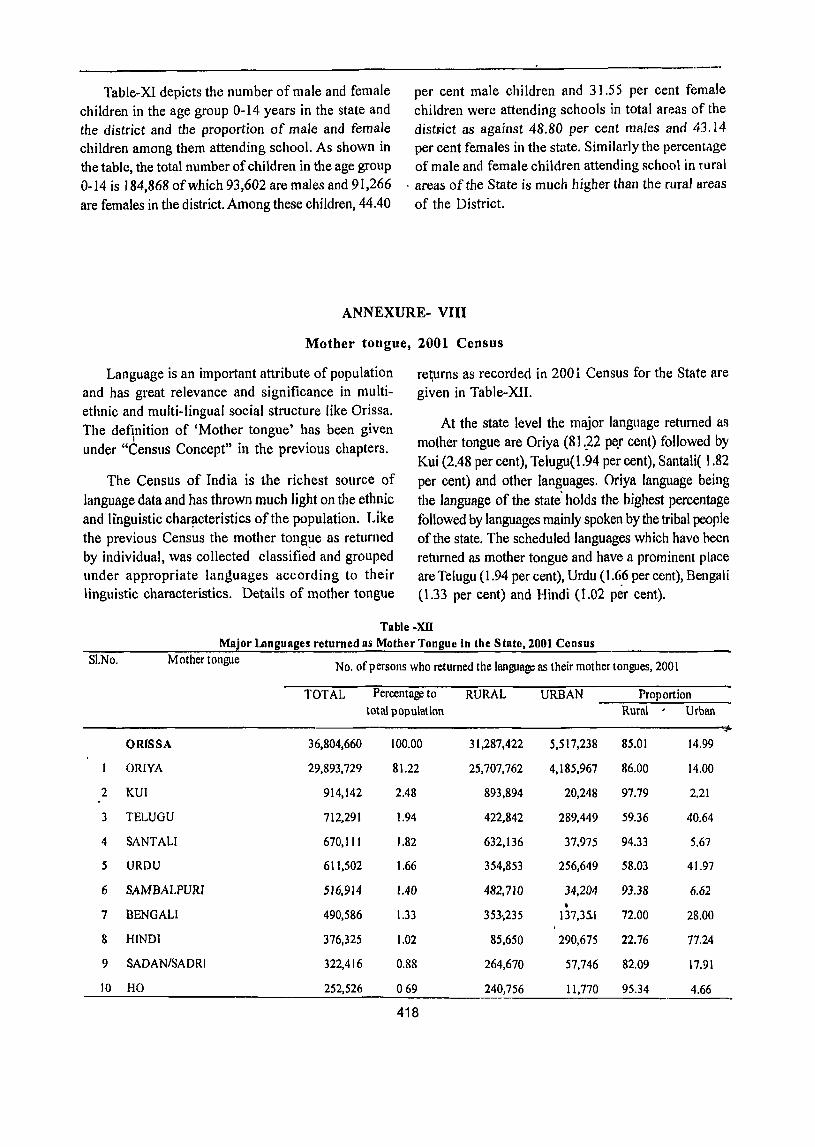
Table-XI depicts the number of male and female children in the age group 0-14 years in the state and the district and the proportion of male and female children among them attending school. As shown in the table, the total number of children in the age group 0-14 is 184,868 of which 93,602 are males and 91,266 are females in the district. Among these children, 44.40
per cent male children and 31.55 per cent female children were attending schools in total areas of the distFict as against 48.80 per cent males and 43.14 per cent females in the state. Similarly the percentage of male and female children attending school in rural
. area~ of the State is much higher than the rural areas
of the District.
ANNEXURE- VIII
Mother tongue, 2001 Census
Language is an important attribute of population and has great relevance and significance in multiethnic and multi-lingual social structure like Orissa. The definition of 'Mother tongue' has been given
I under "Census Concept" in the previous chapters.
The Census of India is the richest source of language data and has thrown much light on the ethnic and linguistic char~cteristics of the population. Like the previous Census the mother tong?e as returned by individual, was collected classified and grouped under appropriate languages according to their linguistic characteristics. Details of mother tongue
re~urns as recorded in 200 i Census for the State are given in Table-XII.
At the state level the major language returned as mother tongue are Oriya (8] _.22 pe.r cent) followed by Kui (2.48 per cent), Telugu(I.94 per cent), Salltali( 1.82 per cent) and other languages. Oriya language being the language of the state' holds the highest percentage followed by languages mainly spoken by the tribal people of the state. The scheduled languages which have heen returned as mother tongue and have a prominent place are Telugu (1.94 per cent), Urdu (1,6.6 per cent), Bengali (1.33 per cent) and Hindi (T.02 per cent).
Table -XU Major languages returned as Mother Tongue in the State, 2001 Census
SI.No. Mother tongue No. of persons who returned the language as their mother tongues, 200 I
TOTAL Percentage to RURAL URBAN Proportion total population Ruml Urban
ORISSA 36,804,660 100.00 31,287,422 5,517,238 85.01 14.99
ORIYA 29,893,729 81.22 25,707,762 4,185,967 86.00 14.00
2 KUI 914,142 2.48 893,894 20,248 97.79 2.21
3 TELUGU 712,291 1.94 422,842 289,449 59.36 40.64
4 SANTALI 670,111 1.82 632,136 37,975 94.33 5.67
5 URDU 611,502 1.66 354,853 256,649 58.03 41.97
6 SAMBALPURI 516,914 1.40 482,710 34,204 93.38 6.62 •
7 BENGALI 490,586 1.33 353-,235 137,35.1 72.00 2a.OO
8 HINDI 376,325 1.02 85,650 290,675 n.76 77.24
9 SADAN/SADRI 322,416 0.88 264,670 57,746 82.09 17.91
10 HO 252,526 069 240,756 11,770 95.34 4.66
418
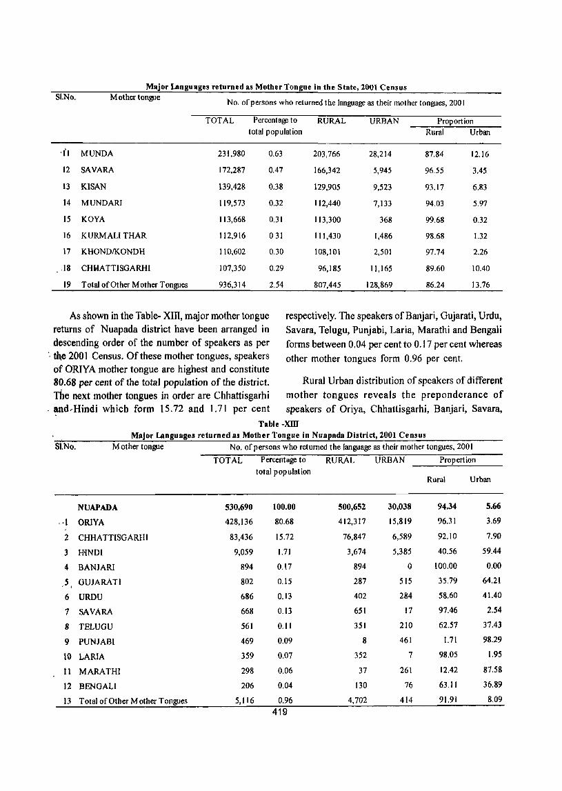
Major I.Jlnguages returned as Mother Tongue in the State, 2001 Census SI.No. M other tongue
No. of persons who returned the language as their mother tongues, 2001
TOTAL Percentage to RURAL URBAN Proportion total population Rural Urban
'il MUNDA 231,980 0.63 203,766 28,214 87.84 12.16
12 SAVARA 172,287 0.47 166,342 5,945 96.55 3.45
13 KlSAN 139,428 0.38 129,905 9,523 93.17 6.83
14 MUNDARI 119,573 0.32 112,440 7,133 94.03 5.97
15 KOYA 113,668 0.31 113,300 368 99.68 0.32
16 KURMALI THAR 112,916 031 111,430 1,486 98.68 1.32
17 KHONDIKONDH 110,602 0.30 108,101 2,501 97.74 2.26
.18 CHI,fA TTISGARHI 107,350 0.29 96,185 11,165 89.60 10.40
19 Total of Other Mother Tongues 936,314 2.54 807,445 128,869 86.24 13.76
As shown in the Table- XIll, major mother tongue returns of Nuapada district have been arranged in descending order of the number of speakers as per
respectively. The speakers ofBanjari, Gujarati, Urdu,
Savara, Telugu, Punjabi, Laria, Marathi and Bengali
forms between 0.04 per cent to 0.17 per cent whereas
other mother tongues form 0.96 per cent. ", the 2001 Census. Of these mother tongues, speakers of ORIYA mother tongue are highest and constitute 80.68 per cent of the total population of the district. The next mother tongues in order are Chhattisgarhi
. ~d ... Hindi which form 15.72 and 1.71 per cent
Rural Urban distribution of speakers of different
mother tongues reveals the preponderance of
speakers of Oriya, Chhattisgarhi, Banjari, Savara,
Table -XID
Major I.Jlnguages returned as Mother Tongue in Nuapada District, 1001 Census
SI.No. M other tongue No. of persons who returned the language as their mother tongues, 2001
TOTAL Percentage to RURAL URBAN Prop ert ion
total population Rural Urban
NUAPADA 530,690 100.00 500,652 30,038 94.34 5.66
, ·1 ORlYA 428,136 80.68 412,317 15,819 96.31 3.69
2 CHHA TTISGARHI 83,436 15.72 76,847 6,589 92.10 7.90
3 HINDI 9,059 1.71 3,674 5,385 40.56 59.44
4 BANJARI 894 0.17 894 0 100.00 0.00
,5 i GUJARATI 802 0.15 287 515 35.79 64.21
6 URDU 686 0.13 402 284 58.60 41.40
7 SAVARA 668 0.13 651 17 97.46 2.54
8 TELUGU 561 0.11 351 210 62.57 37.43
9 PUNJABI 469 0.09 8 461 1.71 98.29
10 LARIA 359 0.07 352 7 98.05 1.95
11 MARATHI 298 0.06 37 261 12.42 87.58
12 BENGALI 206 0.04 130 76 63.11 36.89
13 Total of Other Mother T oRgues 5,116 0.96 4,702 414 91.91 8.09
419
Laria, mother tongue in rural areas of the district and
the speakers of Hindi,Gujarti, Punjabi and Marathi •
mother tongues are more in number in the urban areas
of the district.
It is pertinent to note here that mother tongues
as returned in the population Census are basically
the designations, or mother tongue labels and are
always not identical with the actual linguistic medium.
For ascertaining the co-relation between the mother
420
tongue designation and the actual languages and the dialects, the raw returns were subjected to thorough scrutiny and rationalization.
The total number of Oriya speakers in undivided Kalahandi district was 1,433,325 during 1991 Census and their percentage to total population was 89.56 per cent. The speakers of Hindi mother tongue was in the second position with 6.27 per cent The remaining mother tongues were varying in between 0.01 to 3.23 per cent. -
Copyright © 2022 FDOKUMEN