District Census Handbook, Andamans District & Nicobars, Part ...
378
SERIES-36 CENSUS OF INDIA 2001 AN DAMAN & NICOBAR ISLANDS DISTRICT CENSUS HANDBOOK Part - A & B ANDAMANS DISTRICT & NICOBARS DISTRICT VILLAGE & TOWN DIRECTORY -c} VILLAGE AND TOWNWISE PRIMARY CENSUS ABSTRACT Directorate of Census Operations Andaman & Nicobar Islands
-
Upload
khangminh22 -
Category
Documents
-
view
1 -
download
0
Transcript of District Census Handbook, Andamans District & Nicobars, Part ...
SERIES-36
CENSUS OF INDIA 2001
AN DAMAN & NICOBAR ISLANDS
DISTRICT CENSUS HANDBOOK
Part - A & B
ANDAMANS DISTRICT &
NICOBARS DISTRICT VILLAGE & TOWN DIRECTORY
-c}
VILLAGE AND TOWNWISE PRIMARY CENSUS ABSTRACT
Directorate of Census Operations
Andaman & Nicobar Islands

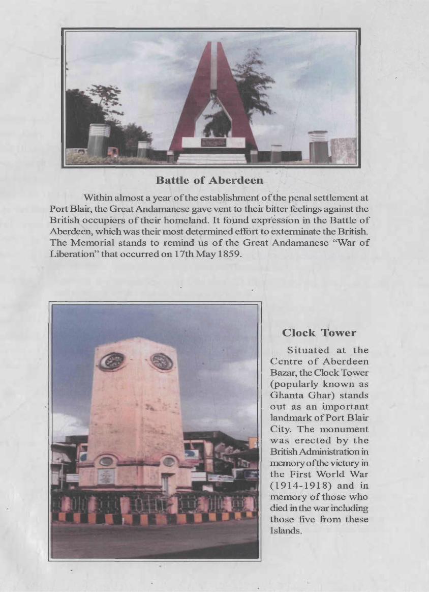
Battle of Aberdeen
Within ahnost a year of the establishment or"the penal settlement at Port Blair, the Great Andamanese gave vent to their bitter feelings against the British occupiers of their homeland. It fopnd '€J{ptessi~n in the Battle of Aberdeen, which was their most determined effort to ,exterminate the British. The Memorial stands to remind us of the Great Andamanese "War of Liberation" that occurred on 17th May 1859 ..
Clock Tower
Situated at the Centre of Aberdeen Bazar, the Clock Tower (popular ly known as Ghanta Ghar) stands out as an important landmark of Port Blair City.. The monument was er,ected by the British Administration in memory of the victory in the First World War (1914-1918) and in memory of those who died in the war including those five from these Islands.

Foreword
Preface
Acknowledgements
Map of the District (Andamans)
Map of the District (Nicobars)
Highlights - 2001 Census
Important Statistics
Highlights - 2001 Census: UT/Districts
Ranking ofTehsils in the District
Ranking of Towns in Andaman District
Statements 1 to 9
Contents
Pages
(ix)
(xi)
(xiii)
(xv)
(xvii)
(xix)
(xx)
(xxi)
(xxiii)
(xxiv)
Statement - 1 : Name ofthe administrative units of District / CD Blocks/Towns, their Rural - (xxiv) Urban status and distance from District Headquarters, 200 I
Statement - 2: Name of the Headquarters of District / CD Block, their Rural -Urban status (xxiv) and distance from District Headquarters, 2001
Statement - 3: Population of the Districts at each Census from 190 I to 200 I (xxv)
Statement - 4: Area, Number of Villages IT owns and population of Districts and Tahsils, 2001 (xxvi)
Statement - 5: CD Block-wise number ofvillages and rural population, 2001
Statement - 6: Population of Urban Agglomerations including constituent Units/Towns, 2001
Statement - 7: Villages with population of 5,000 and above at CD Block Level as per 2001 Census and Amenities available
Statement - 8: Statutory Towns with Population less than 5,000 as per 2001 Census and Amenities available
Statement - 9: Houseless and Institutional population of CD Blocks, Towns, Rural and Urban, 2001
Analytical Note
(i) History and Scope of District Census Handbook
(ii) Brief history of the District
(iii) Administrative Setup: (i) Region of the state where district is located (ii) Total number of CD Blocks orthe next administrative units after district and changes therein includingjurisdictional Changes during 1991-2001 (iii) Total number of towns/ Villages etc., (iv) If the district is newly created, the area from which it has been carved out, (v) Urban local bodies
(v)
(xxvii)
(xxvii)
(xxvii)
(xxviii)
(xxviii)
3
3
5
(iv) Physical features: Location and Size, Physiography, Drainage, Climate, Flora 7 and Forestry, Fauna, Conservation of Wild Life, Agriculture, Fishery, Aniaml Husbandry, Minerals & Mining. Industry, Shipping Services, Electricity and Power
(v) Census Concepts 20
(vi) Non Census Concepts 25
(vii) 2001 Census findings - Population, its distribution 29
(a) Distribution of population in rural-urban areas
(b)Size, Class and Status of Towns, Population, Growth, Density and Sex ratio, Work participation rate, Literacy, Religion, Availability of University education in the district
(viii) Brief analysis of Inset Tables based on PCA, 1 to 36 . Village Directory, Town Directory, 37-47
Houses and Household amenities data of House listing Operations, 48-52
38
(ix) Major natural events, Administrative development and achievements in Sports 70 and Culture
(x) Brief description of places of religious, historical or archaeological importance 70 in villages and places of Tourist interest in the town ofthe district
(xi) Scope of Vi lIage and Town Directory
PART -A: VILLAGE AND TOWN DIRECTORY
Section - I : Village Directory
(a) Note explaining the abbreviations used in Village Directory
(b) List of Villages merged in towns and outgrowths at 2001 Census
(c) CD Block wise presentation of Village Directory Data
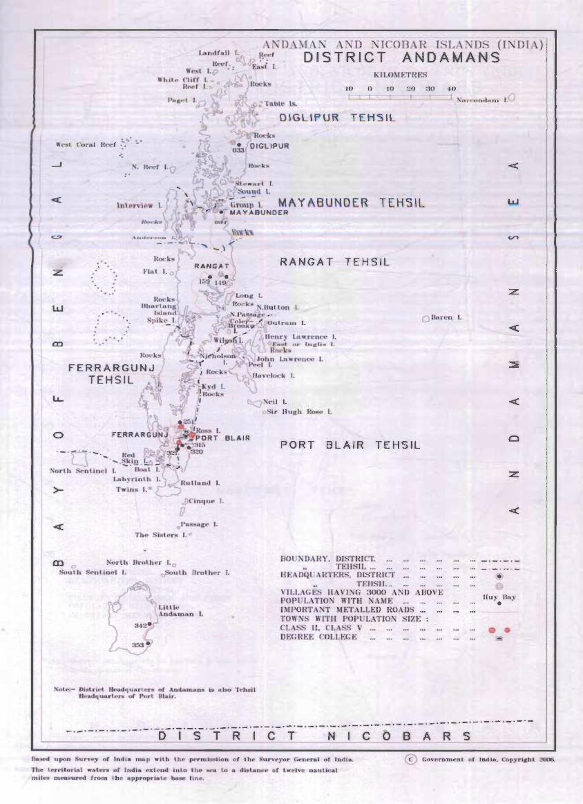
Andamans District: Map ofDiglipurTehsil
Map of Mayabunder Tehsil
Map of Rangat Tehsil
72
79
82
83
85
87
Map of Ferrarganj Tehsil 89
Map of Port Blair Tehsil 91
(ii) Alphabetical list of Villages of North Andaman along with location Code 92 1991 and 2001
(iii) Presentation of Village Directory Data of North Andaman 94
(d) (i) Alphabetical I ist of Vi lIages of Middle Andaman along with location Code 107 1991 and 2001
(ii) Presentation of Village Directory Data of Middle Andaman 110
(e) (i) Alphabetical list of Villages of South Andaman along with location Code 126 1991 and 2001
(ii) Presentation of Village Directory Data of South Andaman
(f) NicobarsDistrict: Map of Nan cowry Tehsil
Map of Car Niccobar Tehsil
(vi)
130
153
155
(i i) Alphabetical I ist of Vi llages of Car N icobar along with location Code 1991 and 2001
(iii) Presentation of Village Directory Data of Car Nicobar
(g) (i) Alphabetical list of Villages of Nan cowry along with location Code 1991 and 2001
(iii) Presentation of Village Directory Data of Nan cowry
(h) Appendices to Vi II age Directory
157
158
163
168
Appendix - I : Abstract of educational, medical and other amenities in 193
Appendix - IA
Appendix - IB
Appendix - IC
Appendix - II
Appendix - III
Appendix - IV
Appendix- V
Villages - CD Block level
: Villages by number of Primary Schools
: Villages by Primary, Middle and Secondary Schools
: Villages with different sources of drinking water facilities available
: Villages with 5,000 and above population which do not have one or more amenities available
: Land utilisation data in respect of Census TownslNon Municipal Towns
: CD Block wise list of inhabited villages where no amenity other than drinking water facility is available
SummaI)' showing number of Villages having or not having Scheduled Caste Population
195
195
196
196
196
197
197
Appendix - VI : Summary showing number of Villages having or not having 198 Scheduled Tribe Population
Appendix - VlIA: List of Villages according to the proportion of the Scheduled 198 Castes to the total population by ranges
Appendix - VIIB: List of Villages according to the proportion of the Scheduled 199 Tribes to the total popUlation by ranges
Section II - Town Directory
(a) Note explaining the abbreviations used in Town Directory
(b) Town Directory Statements (I to VII)
Statement - I
Statement - II
Statement - III
Statement - IV
Statement - V
Status and growth History
Physical aspects and location of Towns, 1999
Municipal Finance, 1999
Civic and other amenities, 1999
Medical, Educational, Recreational and Cultural facilities, 1999
205
209
209
210
210
212
Statement - VI : Trade, Commerce, Industry and Banking, 1999 212
Statement- VlI: Civic and other amenities in Slum, 1999 214
Appendix to Town Directory -Towns showing their outgrowth with population 214
PART B -PRIMARY CENSUS ABSTRACT
a) Brief note on Primary Census Abstract 219
(vii)
b) District Primary Census Abstract (General) 222
c) Appendix to District Primary Census Abstract i.e. Urban Block wise figures 228 of total. SC and ST Population
Primary Census Abstract for Scheduled Tribes 234
CD Block wise Village Primary Census Abstract 240
Urban Primary Census Abstract 324
Annexure - I N umber of Vi Ilages under each Gram Panchayat
Annexure - II Note on Fertility and Mortality, 1991 Census
Annexure - III Various measures of based on SRS
Annexure - IV Note on Migrants, 2001 Census
Annexure - V Religions in the Districts as per 2001 Census
Annexure - VI Marital Status of Population as per 2001 Census
Annexure - VII Age, Sex and Education Level in the district, 2001 Census
Annexure - VIII Distribution of different Mother Tongues returned in 1971-2001 Censuses
Annexure - IX Scheduled Tribes of Andaman & Nicobar Islands
(viii)
333
334
336
337
340
341
341
343
344
Foreword
The District Census Handbook CDCHB) published by Census Organisation since 1951 census, is one of the important publications in the context of planning and development at grass-root level. The publication,
which is brought out for each district, contains several demographic and socio-economic characteristics villagewise and town-wise of the district alongwith the status of avai labil ity of civic amen ities, infrastructural facilities, etc.
2. The scope of the DCHB was initially confined to a few Census Tables and primary Census Abstract (PCA) of each village and town within the district. Thereafter, at successive censuses, its scope and coverage has been enlarged. The DCHB published at the 1961 census provided a descriptive account of the district, administrative statistics, census tables and a village and town directory including PCA. The 1971 censusDCHB series was in three parts: Part-A related to village and town directory, Part-B to village and town PCA and Part-C comprised analytical report, administrative statistics, district census tables and certain analytical tables based on PCA and amenity data in respect of vi lIages. The 1981 census DCHB was in two parts : Part-A contained village and town directory and Part-B the PCA of village and town including the SCs and STs PCA up to tahsil/town levels. New features alongwith restructuring of the formats of village and town directory were added into it. In Village Directory, all amenities except electricity were brought together and if any amenity was not available in the referent village, the distance in broad ranges from the nearest place having such an amenity, was given. Information on new items such as adult literacy centres, primary health sub-centres and community health workers in the village were provided so as to meet the requirements of some of the Revised Minimum Needs Programme. Information on approach to the village was provided for the first time in the Village Directory so as to give the details on number of inaccessible villages in each district. In the Town Directory, a statement (lV-A) on slums was introduced to provide the details on civic and other amenities in the notified slums of Class I and Class II towns.
3. The 1991 census DCHB, by and large, followed the pattern of presentation of 1981 census, except the format of PCA was restructured. Nine-fold industrial classification of main workers was given against the four-fold industrial classification presented in the 1981 census. In addition, sex-wise population in 0-6 age group was included in the PCA for the first time with a view to enable the data users to compile more realistic literacy rate as all children below 7 years of age had been treated as illiterate at the time of 199 I census. One of the important innovations in the 1991 census was the Community Development Block (CD Block) level presentation of village directory and PCA data instead of the traditional tahsil/taluk/PS level presentation. It was expected that the presentation of village directory and PCA data at CD block level will help the planners in formulation of micro level development plans, CD block being the lowest administrative unit.
4. The present series of 2001 census DCHBs have been made more informative and exhaustive in terms of coverage and content. The Village Directory has been enlarged in scope by including a number of other facilities like banking, recreational and cultural facilities, newspapers and magazines and 'most important commodity' manufactured in village. Income and expenditure of gram panchayat, wherever possible, has been provided. Apart from these, more details on distance(s) at which basic amenities are available (if not available in the village), are given. This includes educational facilities (namely primary and middle schools and college), medical facilities (viz. Allopathic Hospital, Maternity & Child Welfare Centre and Primary Health Centre), drinking water, post & telegraph (post office and phone), communication, bank, credit societies and recreational facilities. In Town Directory, the statement on Slums has been modified and its coverage enlarged by including details on all slums instead of ' notified slums'. The information is given in case of all statutory towns irrespective of their class, against only Class I and Class II towns in the 1981 and 1991 censuses. The basic amenities
(ix)
available in the villages and towns are analysed in depth with the help of a number of cross-classified inset tables and statements. Two other significant additions in the publication are inclusion of 'motif' highlighting significant characteristic of the district and analytical notes as annexures. The analytical notes on (i) fertility and mortality and (ii) various measures of fertility and mean age at marriage are prepared based on 1991 census. Whereas, in the notes relating to (i) percentage distribution of migrants by place of birth/place of last residence, (ii) main religions, (iii) marital status of population, (iv) age, sex and education, and (v) distribution of spectrum of mother tongue, nature and extent of changes occurred in the district in its basic socio-demographic features during the decade 1991-2001 are analysed. The eight digits permanent location code (PLCN) to all the villages and towns have been assigned keeping in view the future needs.
5. The village and town level amenity data have been collected, compiled and computerized in prescribed record structure under the supervision of Shri Vikram Sen, lAS, Director of Census Operations, West Bengal. Thereafter, efforts have been made to ensure comparabi I ity ofthe information with that of 1991 census data and the information brought out by the respective state governments in their annual reports and statistical handbooks for various years after 1991. The task of planning, designing and coordination of this publication was carried out by Shri R.G. Mitra, Deputy Registrar General (C&T) and Dr. I.C. Agrawal, Senior Research Officer of Social Studies division. Dr. R.P. Singh, Deputy Registrar General (Map) provided the technical guidance in the preparation of maps. Whereas, Shri Anil Kumar Arora, Deputy Director of Data Processing Division who worked under the overall supervision of Shri Himakar, Add!. Director (EDP) helped in preparation of record structure for computerization of village and town directory data and the programme for the generation of Village Directory and Town Directory statements including analytical inset tables. The draft DCHB manuscripts received from the Census Directorates have been scrutinized in the Social Studies Division under the guidance of Shri S.L. Jain, Deputy Director and Shri R.K. Mehta, Assistant Director. I am thankful to all of them and others who have contributed to make this publication possible.
New Delhi
Dated: 17.10.2006
(x)
O.K. Sikri
Registrar General &
Census Commissioner, India
Preface
The Directorate of Census Operations, Andaman and Nicobar Islands has been publishing the combined volume of District Census Hand Book (DCHB) for both Andamans district and Nicobars district since 1981
census. The present one is the third in the series. The DCHB is ajoint venture of the UT administration and census organisation. The 1981 census DCHB represented village/town wise Primary Census Abstract and other important census data along with data on certain basic amenities available in the villages and towns in the form of village and town directory. The DCHB of 1991 census was prepared in the same style that of 1981 census provided instead of presenting the tehsils level village directory and PCA, data were presented Community Development Block wise. The coverage of DCHB are being widened from census year to census year by addition of various new items that commensurate with the requirements of respective era and simultaneously deleting the less important items.
The DCHB of2001 census is mainly presented in three parts viz. general part, part A and part B. The general part contains various important information on the districts viz. district highlights, important statistics, history, administrative set up, location and size, physiography, drainage, climate, economic resources, places of historical and tourist importance, various summary and inset tables on census and non-census data and brief analysis of those inset tables etc. Part A comprises Village Directory (VD) and Town Directory (TD) and related appendices. Part B represents Primary Census Abstract (PCA) at district level, PCA of Scheduled Tribes, CD Block/village level PCA and urban PCA. Apart from these, a large number of annexures on fertility, migration, religion, marital status, education, mother tongue and various aspects of primitive tribes are given.
The village and town level amenity data, the basic inputs of VD and TD were supplied by district administrations whereas information on physical features, administrative set up and various economic activities etc. were supplied by concerned departments under UT administration and central govt. offices. Efforts have been made to crosscheck the village and town amenities data, with secondary data available from various departments and also with 1991 District Census Hand Book, as far as possible.
[ am grateful to Shri D. K. Sikri, Registrar General and Census Commissioner, India for his help and guidance in bringing out this publication. I am also grateful to Shri Jayant Kumar Banthia, former Registrar General and Census Commissioner, India for his inspiration and guidance at various stages in compiling this volume. I heartily record the guidance rendered by Shri R.G. Mitra, Deputy Registrar General (C&T), Dr. I.C. Agrawal, Senior Research Officer (SS), Shri R.P. Singh, Deputy Registrar General (Map), Shri C. Chakravorty, Jt. Director (Printing and Data Dissemination). I am also very much thankful to Shri S.L. Jain, Deputy Director (SS) and Shri Anil Kumar, Deputy Director (EDP) and their colleagues.
The collection of non-census data of this volume was initiated under the direction of Dr. Sharat Chouhan, Ex-Officio-Director of Census Operations, A&N Islands. Compilation of this volume right from collection of data to editing of manuscript was a gigantic task. Major portion of these works were done at this Directorate. The assistance rendered in this project by Shri P.K.T. Nair, Investigator Gr. I, Shri V.O. Koshy, Sr. Compiler, Shri Jagadeesan, Compiler, Shri V.K. Sundaramurthy, Compiler and Shri K. Baburaj, LDC of this office is praiseworthy. Finally, in this office every individual has put in their best efforts in some way or other to make this endeavour a success for which I express my deepest thanks to all.
Port Blair
8th June, 2005
(xi)
P. K. Majumdar
Deputy Director of Census Operations

Acknowledgements A. The Directorate of Census Operations respectfully acknowledges the sincere hard work rendered by the
Census Enumerators, Supervisors and Officials at the District, Tehsil and Municipal levels without whose efforts, the Census 200 I could not be successfu I.
B. The Census Directorate, Andaman & Nicobar Islands also gratefully acknowledges the sincere and dedicated work of the following officers/officials of this Directorate.
81 No. Name Designation
1.
2.
3. 4.
5.
6.
7.
8.
9.
10.
II. 12. 13.
14.
15. 16. 17. 18.
19.
20.
21. 22.
23.
1.
2.
3.
4. 5.
1. 2.
Dr. V.Candavelou Ex-Officio DCO
Shri K.N.Mishra S.I.Grade I
Shri B.N.Mishra S.A.(Expired)
Shri P.Das Gupta S.I.Grade III
Smt. M.V.Saraswathi Compiler
Smt.Thankom Thomas Compiler
Shri Darickson Compiler
Shri Sajeev Asst. Compiler
Smt. Saramma Samuel O.S.(Retired)
Shri R. Sasi O.S.(Retired)
Smt. Pennamma Cherian O.S.
Shri K.V.K.Nair Stenographer Gr.II
Smt. K.S.Nalini Assistant
Shri Churchil Assistant
Smt. G.Sobhana Amma U.D.C.
Shri Sarat Chandran P.S L.D.C.
Shri P.Suryam Daftry (Retired)
Shri R.Nagalingam Daftry
Shri Gregory Peon
Shri E. Sathaiah Farash
Shri S.Lakshmanan Chowkidar
Shri Stephen Chowkidar
Shri K.Narasaiah Sweeper
Drawing of Maps
Map Division, Office of the Registrar General and Census Commissioner, India, New Delhi
Preparation of Camera Ready Copy (CRC)
Shri Prasun Ganguly D.E.O. Grade B - DCO, West Bengal
Shri Bibhas Kanti Hira
Shri Prasant Kumar
Shri Prasun Ganguly
Shri Prasanta Roy
Shri Tapan Bhattacharjee
Shri Mohan Lal Das
Shri Sudarsan Ganguly
Preparation of e-book
D.E.O. Grade B - DCO, West Bengal
D.E.O. Grade B - DCO, West Bengal
D.E.O. Grade B - DCO, West Bengal
Draughtsman - DCa, West Bengal
Draughtsman - DCa, West Bengal
In-house Printing
Gestener Operator - DCO, West Bengal
Peon - DCa, West Bengal
(xiii)

W._·st Coral Reef .:. .... ' -
• Rc<"f I. g
'. w * .. . .
to
o
>- Twins I. '"
j)Cinque I.
[) ",Passage I.
The Si tera I. <>
m 0 Norlh IlroU"'ol r J· o South ' entine. I,. tlSoulh (I;rolher I.
Li 'lUe Alldal"l'Ian I.
Nole:- I>i lrjel Ilead'luarlers of Andamans i~, also Teln.iI lIead'lli rl.",r" of Po .. t BI .. ir.
MAN AND NICOBAR, ISLANDS (INDIA) DISTRICT ANDAMANS
KFI"OME-:1'HF.S
1'0 ao 1'0 a r-::c-
20 i t --j Nn r conlflom 1.0
---
RANGAT - TEHSIL
O llaren I.
TEHSIL
130 NI)AI~Y. DISTRICT. .. TEflSIL , ..
HEAIJQUARTI-:RS, DISTRICT .. TfmSH ...
VILLAGES HAVI:"G 3000 AND ADOVE POPULATlON Wlnl NAME IMPORTANT METALLED ROADS , .• TOWNS 1nTH POPULATION SIZE: CLASS If, ClJ.\ SS V DEGI~EE COLl.BGE
@
@
~,
:z
<C
:z:
Huy Ila.)' •
• • el
Bascd upon S.nvey of Ind ia mop wilh the permis8iion o r the Surveyor General of 'India.
Tbe l errilorial .... le .... Df India ""Lend inlo the sea to B dislanc,," of twelve .... ,utical mil."" m"8~ured: f ront lhe appropria te b"se I;oe,
® G,,,,',ernment o f India. Copyright ZOO6.

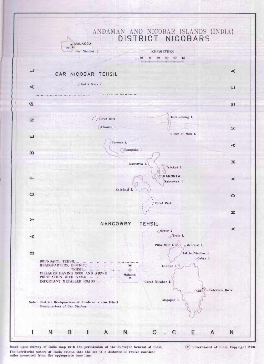
A0!DAMAN AND NICOBAR ISLANDS (INDIA) { DISTR ICT NICOBARS
w
w
>-
KI!.OM t:T\~ ~~5
J(l 0 ,I) ~I)' ;jl) 41}
CA R NICOB AR TEH SI L
o (lolli MRlv I'.
- . -.-.-.-.-.-. - .- . - . ~ . ~ . -.- . -.~.- ~ - . -
: • ' ,: Co,raJ Reel ~Tm.~h.n. I.
U Chaul'll I.
'" ,,,Ie of Man I.
Kamorto I. ~l Tl"inkal I.
no NDARY, TEll 11 ... HEADQUARTERS. DISTRICT
., TEIISII. ..
NANCOW RY
@ ... @
VH.LAGES HAVING 3000 AND AROVE Malacca
• POPUL/\TION WITH AME ... IMPORTANT METALLED ROAD ...
. . . :
" . .
v ~ ~~\r~MOR T A ~Nl'lnCOwry I.
: Corn I Red
TEH S IL (,)Meroe I.
COTrell! I.
1'1110 Mi{?O I. o ~lerlf'h!ll I.
Lilth:! ieobur ,I.
o Cobra I.
Koodul I. ()
w
::z
z
o Ccberous Rock.
Nole:- lli~lricl licadquarlers of NiCQbus is also 'J'eh5i1 Bc,udquarlcrs DC Car 'icobar.
N ID A N o
Dased uJ'(!n Survey of Ind'ia map with t,he permissiion 01 Uu.' Surveyor G'enera l of Indio!.
The lerritorial waters ur India ex lend liliLo Ute' seo Lo n dishmre of lwelve n8uUeal mile!! measured from lhe Ilppropriate base line.
Megopod I.
• c E A N
© Glnrerlllmenl or J'ndia. Copyrigbl 2006.

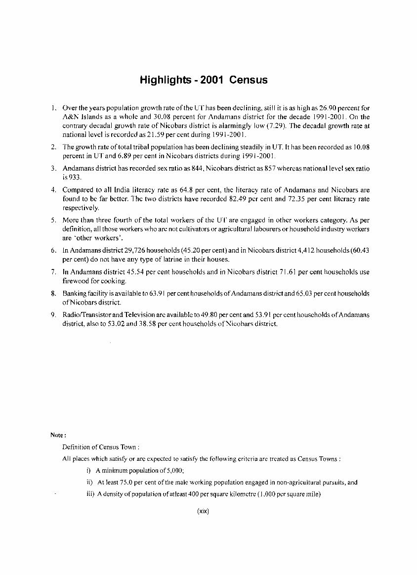
Highlights - 2001 Census
I. Over the years population growth rate of the UT has been declining, still it is as high as 26.90 percent for A&N Islands as a whole and 30.08 percent for Andamans district for the decade 1991-200 I. On the contrary decadal growth rate ofNicobars district is alarmingly low (7.29). The dec ada I growth rate at national level is recorded as 21.59 per cent during 1991-200 I.
2. The growth rate of total tribal population has been declining steadily in UT.1t has been recorded as 10.08 percent in UT and 6.89 per cent in N icobars districts during 1991-200 I.
3. Andamans district has recorded sex ratio as 844, Nicobars district as 857 whereas national level sex ratio is933.
4. Compared to all India literacy rate as 64.8 per cent, the literacy rate of Andamans and Nicobars are found to be far better. The two districts have recorded 82.49 per cent and 72.35 per cent literacy rate respectively.
5. More than three fourth of the total workers of the UT are engaged in other workers category. As per definition, all those workers who are not cultivators or agricultural labourers or household industry workers are 'other workers'.
6. In Andamans district 29,726 households (45.20 per cent) and in Nicobars district4,412 households (60.43 per cent) do not have any type of latrine in their houses.
7. In Andamans district 45.54 per cent households and in N icobars district 7 J .6 J per cent households use firewood for cooking.
8. Banking facility is available to 63.91 per cent households of Andamans district and 65.03 per cent households ofNicobars district.
9. Radiorrransistor and Television are available to 49.80 per cent and 53.91 per cent househo Ids of Andamans district, also to 53.02 and 38.58 per cent households ofNicobars district.
Note:
Definition of Census Town:
All places which satisfY or are expected to satisfy the following criteria are treated as Census Towns:
i) A minimum population of 5,000;
ii) At least 75.0 per cent of the male working population engaged in non-agricultural pursuits, and
iii) A density of population of at least 400 per square kilometre (1,000 per square mile)
(xix)
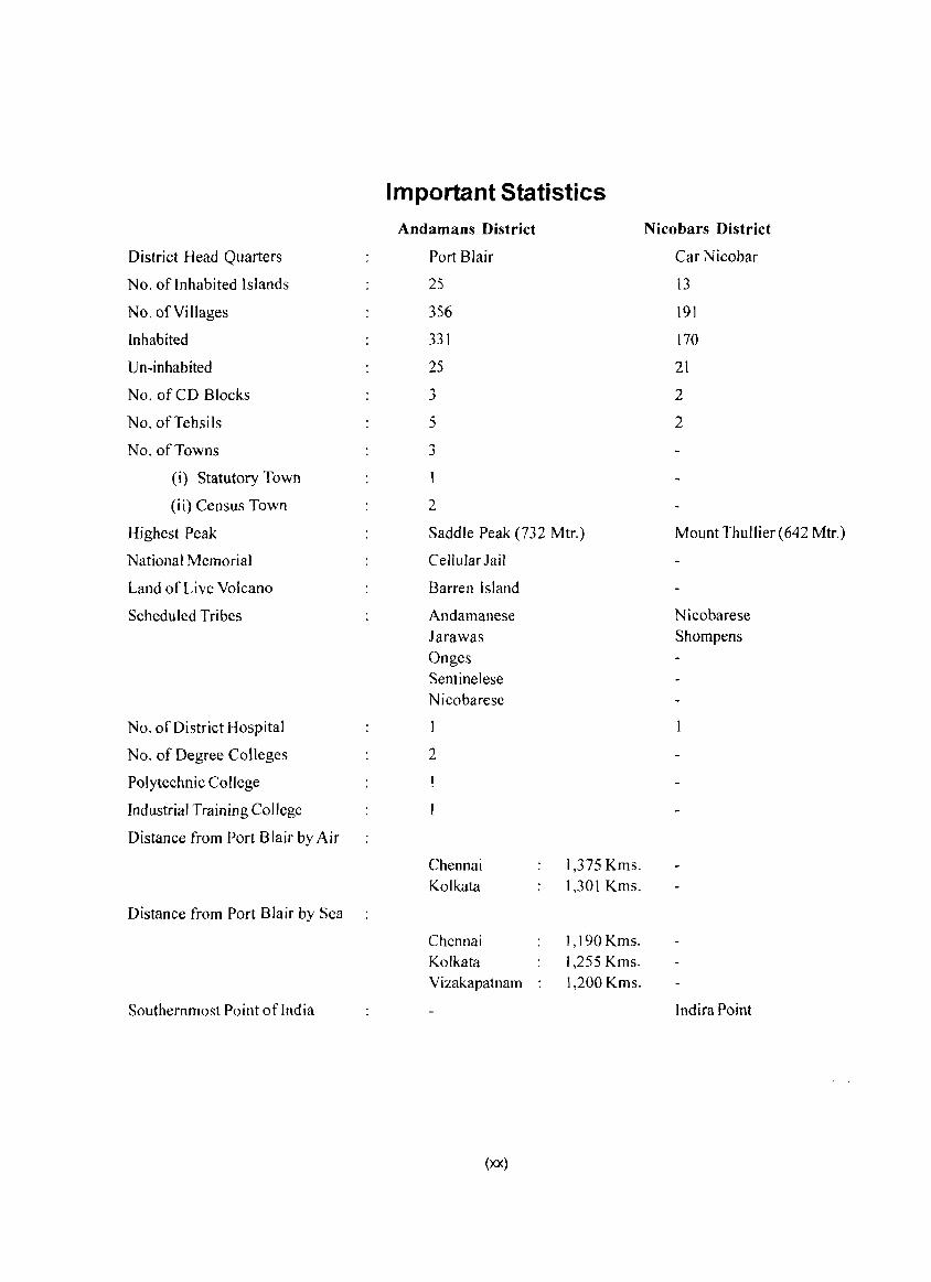
District Head Quarters
No. of Inhabited Islands
No. of Villages
Inhabited
Un-inhabited
No. of CD Blocks
NO.ofTehsils
No. of Towns
(i) Statutory Town
(ii) Census Town
Highest Peak
National Memorial
Land of Live Volcano
Scheduled Tribes
No. of District Hospital
No. of Degree Colleges
Polytechnic College
Industrial Training College
Distance from Port Blair by Air
Distance from Port Blair by Sea
Southernmost Point oflndia
Important Statistics Andamans District
Port Blair
25
356
331
25
3
5
3
2
Saddle Peak (732 Mtr.)
Cellular Jail
Barren Island
Andamanese Jarawas Onges Sentinelese Nicobarese
2
Chennai Kolkata
Chennai Kolkata Vizakapatnam
(xx)
1,375 Kms. 1,301 Kms.
1,190Kms. 1,255 Kms. 1,200 Kms.
Nicobars District
Car Nicobar
13
191
170
21
2
2
Mount Thullier (642 Mtr.)
Nicobarese Shompens
Indira Point
Highlights - 2001 Census UT/Districts
UTof SI. A&N Andamans Nicobars
No. Description Islands District District
2 3 4 5
Number of Households Normal 77,578 69,586 7,992 Institutional 447 368 79 Houseless 217 213 4
2 Population Total Persons 356,152 314,084 42,068 Males 192,972 170,319 22,653 Females 163,180 143,765 19,415
Rural Persons 239,954 197,886 42,068 Males 128,961 106,308 22,653 Females 110,993 91,578 19,415
Urban Persons 116,198 116,198 0 Males 64,011 64,011 0 Females 52,187 52,187 0
3 Percentage Urban Population 32.63 37.00 0.00
4 Decadal Population Growth 1991-2001 Persons 75,491 72,631 2,860 (Percentage given within bracket) (26.90) (30.08) (7.29)
Males 38,603 37,261 1,342 (25.01) (28.00) (6.30)
Females 36,888 35,370 1,518 (29.21 ) (32.63) (8.48)
5 Area in Sq.Km. 8,249 6,408 1,841
6 Density of Population (Persons per Sq. Km) 43 49 23
7 Sex Ratio Total 846 844 857 (N umber of Females per 1 000 Males) Rural 861 861 857
Urban 815 815 0
8 Literates and Literacy rates Persons 253,135 226,600 26,535 (81.30) (82.49) (72.35)
Males 146,831 131,223 15,608 (86.33) (87.36) (78.55)
Females 106,304 95,377 10,927 (75.24) (76.62) (65.01)
9 Scheduled Caste Population There is no Notified Scheduled Castes in this UT
10 Scheduled Tribe Population Persons 29,469 2,904 26,565 (8.27) (0.92) (63.15)
Males 15,127 1,625 13,502 (7.84) (0.95) (59.60)
Females 14,342 1,279 13,063 (8.79) (0.89) (67.28)
(xxi)
~~------~~~--~~~~~
UTof SI. A&N Andamans Nicobars
No. Description Islands District District
2 3 4 5
11 Workers and Non-Workers
i) Main Workers Persons 113,607 100,683 12,924 . (31.90) (32.06) (30.72)'"
Males 97,349 86,327 11,022 (50.45) (50.69) (48.66)
Females 16,258 14,356 1,902 (9.96) (9.99) (9.80)
ii) Marginal Workers Persons 22,647 15,948 6,699 (6.36) (5.08) (15.92) .....
Males 11,813 9,034 2,779 (6.12) (5.30) (12.27)
Females 10,834 6,914 3,920 (6.64) (4.81) (20.19)
jii) Non-Workers Persons 219,898 197,453 22,445 (61.74) (62.87) (53.35) /'
Males 83,810 74,958 8,852 (43.43) (44.01) (39.08)
Females 136,088 122,495 13,593 (83.40) (85.21 ) (70.01 )
12 Category of Workers (Main + Marginal)
(i) Cultivators Persons 21,461 21,190 271 ( 15.75) ( 18.17) ( 1.38)
Males 14,937 14,753 184 (13.68) (15.47) (1.33)
Females 6,524 6,437 87 (24.08) (30.26) (1.49)
(ii) Agricultural Labourers Persons 5,169 5,040 129 (3.79) (4.32) (0.66)
Males 4,043 3,939 104 (3.70) (4.13) (0.75)
Females 1,126 1,101 25 (4.16) (5.18) (0.43)
(iii) Workers in Household Industry Persons 7,086 1,001 6,085 (5.20) (0.86) (31.01)
Males 4,655 707 3,948 (4.26) (0.74) (28.61 )
Females 2,431 294 2,137 (8.97) ( 1.38) (36.71 )
(iv) Other Workers Persons 102,538 89,400 13,138 (75.26) (76.65) (66.95)
Males 85,527 75,962 9,565 (78.35) (79.66) (69.31 )
Females 17,011 13,438 3,573 (62.79) (63.18) (61.37)
(xxii)
Ranking of Tahsils in the District
Andamans District
SI Diglipur Mayabunder Ran~at Ferrar!1:unj
No In Terms of Value Rank Value Rank Value Rank Value Rank
I 2 3 4 5 6 7 8 9 10 Total Population 42,877 3 23,912 5 38,824 4 48,626 2
2 Total area (in sq. kms.) 118.2 * 5 151.0 * 3 126.7 * 4 202.4 * 3 Density of population per sq.km. @ NA
4 Sex Ratio 896 I 876 4 876 3 877 2
5 Proportion Urban 0 0 0 0 0 0 13.96 2 6 Proportion Scheduled Castes 0 0 0 0 0 0 0 0 7 Proportion Scheduled Tribes 0.05 5 0.31 4 0.53 2 0.43 3 8 Proportion Literate 75.61 5 80.97 3 79.84 4 82.47 2 9 Work participation rate (Main + Marginal 39.52 2 39.87 35.17 4 33.44 5
Workers)
10 Percentage of vi llages having Primary School 60 58 2 41 5 54 4
II Percentage of vi II ages having Primary Health 19 4 20 3 18 5 24 2
Sub-Centre
12 Percentage of villages having Well 91 68 5 69 4 82 2
13 Percentage of villages having Post Office 14 5 16 3 15 4 22 2
14 Percentage of villages having Bus facility 38 5 44 4 45 3 71 2
15 Percentage of villages having approach by 39 5 50 4 51 3 84
Pucca Road
16 Percentage of villages having Electricity for 44 5 50 4 68 3 83 2
domestic purpose
17 Percentage of vi Ilages having forest area NA
18 Percenta£e of vi lla~es havin~ I rri~ated Area NA
A ndamans District N icobars District
SI Port Blair Car N icobar Nancowry
No In Terms of Value Rank Value Rank Value Rank
I 2 11 12 13 14 15 16
I T olal Pop ulat ion 159,845 I 20,292 2 2l,776 1
2 Total area (in sq. kms.) t 53.4 * 2 129.0 2 t ,712.0 1 3 Density of population per sq.km. @ NA
4 Sex Ratio 809 5 903 816 2 5 Proportion Urban 68.45 I a 0 0 0
6 Prop ortion Scheduled Castes 0 0 0 0 0 0 7 P rap ort ion Schedu led Tribes 1.50 78.35 48.98 2 8 Proportion Literate 85.13 I 74.14 70.62 2 9 Work participation rate (M ain + Marginal Workers) 37.68 3 52.49 41.20 2
10 Percentage of villages having Primary School 55 3 75 23 2 II Percentage of villages having Primary Health Sub- 34 31 15 2
Centre
12 Percentage of villages having Well 72 3 94 85 2 13 Percentage of villages having Post 0 flice 26 31 8 2 14 Percentage of villages having Bus facility 74 I 100 19 2 15 Percentage of villages having approach by Pucca 77 2 100 21 2
Road
16 Percentage of villages having Electricity for 89 lao 46 2 domestic purpose
17 Percentage of villages having forest area NA 18 Percentage of villages having Irrigated Area NA
Note ': • Tehsilwise area figures include that of revenue areas only and do not include the area under Reserved/Protected forest. {(i! Due to non availability of the total geographical area of the tehsils. the density has not been workedout.
(xxiii)
Ranking of Towns in the Andaman District
Sl. Port Blair (MCI.) Bambooflat (CT) Garacharma (CT)
No. In terms of Value Rank Value Rank Value Rank
1 2 3 4 5 6 7 8
I. Total Population 99,984 6,787 3 9,427 2
2. Total Area (in sq. km.) 16.9 3.6 3 5.9 2
3. Density of population per sq. km. 5,916 1 1,885 2 1,598 3
4. Sex Ratio 806 3 874 2 879 5. Proportion of Scheduled Castes
6. Proportion of Scheduled Tribes 1.0 0.1 3 0.3 2
7. Proportion of Literates 87.0 81.3 3 86.1 2
8. Work Participation Rate 36.7 30.9 3 35.7 2 (Main + Marginal Workers)
Note: Nicobar district entirely rural
STATEMENT-l
NAME OFTHE ADMINISTRATIVE UNITS OF DISTRICT / CD BLOCK/ TOWN, THEIR RURAL-URBAN STATUS AND DISTANCE FROM DISTRICT HEAD QUARTERS, 2001
Distance from tehsil headquarters to
Sl. Name of Union Territory! District Name of District! Whether district headguarters b~
No.
I
2
3 4
5 6 7
8 9
10
Serial
number
2
/ Tehsil Tehsi I headguarters Urban / Rural Road (km.) Sea + Road (km.)
2 3 4 5 6
A&N Islands Port Blair Urban 0 0
Andamans District Port Blair Urban 0 0
Diglipur Tehsil Diglipur Rural 265 185+10
Mayabunder Tehsil Mayabunder Rural 245 159+0
Rangat T ehs i I Rangat Rural 175 90+10
Ferrargunj Tehsil Ferrargunj Rural 34 0
Port Blair Tehsil Port Blair Urban 0 0 Nicobars District Malacca Rural 0 0
Car Nicobar Tehsil Malacca Rural 0 0
Nancowry Tehsil Kamorta Rural 0 159+0
STATEMENT - 2
NAME OFTHE HEAD QUARTERS OF DISTRICT / CD BLOCKS, THEIR RURAL-URBAN STATUS AND DISTANCE FROM DISTRICT HEADQUARTERS, 2001
Whether Distance from CD Block headquarters to
Name of District I Name of District I Urban! district headquarters by
CD Block CD Block headquarters Rural Road (km.) Sea + Road (km.)
2 3 4 5 6
Andamans District Port Blair Urban* 0 0
North Andaman CD Block Diglipur Rural 265 185+10
Middle Andaman CD Block Rangat Rural 175 90+10
South Andaman CD Block Ferrargunj Rural 34 0
Nicobars District Car Nicobar Rural 0 0
Car Nicobar CD Block Car Nicobar Rural 0 0
Nancowry CD Block Kamorta Rural 0 159+0 Note: Asterik in column 4 denotes that the district I tahsil headquarters is a statutoty tovm
(xxiv)
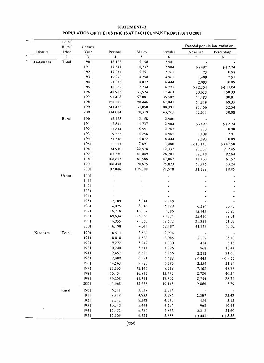
STATEMENT -3
POPULATIONOFTHE DISTRICTS AT EACH CENSUS FROM 1901 TO 2001
Total! Rural! Census Decadal population variation
District Urban Year Persons Males Females Absolute Percentage 2 3 4 5 6 7 8
Andamans Total 1901 18,138 15.158 2,980
1911 17,641 14,737 2,904 (-) 497 (-) 2.74 1921 17,814 15,551 2,263 173 0.98 1931 19,223 14,258 4,965 1,409 7.91 1941 21,316 14,872 6,444 2,093 10.89 1951 18,962 12,734 6.228 (-) 2,354 (-) 11.04 1961 48,985 3U24 17,461 30,023 158.33 1971 93.468 57.881 35.587 44,483 90.81 1981 158,287 90.446 67.841 64,819 69.35 1991 241,453 133,058 108.395 83,166 52.54 2001 314,084 170.319 143.765 72,631 30.08
Rural 1901 18,138 15.158 2.980 1911 17,641 14.737 2.904 (-) 497 (-) 2.74 1921 17.814 15.551 2.263 173 0.98 1931 19,223 14.258 4.965 1.409 7.91 1941 21,316 14.872 6,444 2,093 10.89 1951 11,173 7,693 3,480 (-) 10, 143 (-) 47.58 1961 34,910 22,578 12,332 23,737 212.45 1971 67,250 41,049 26,201 32,340 92.64 1981 108,653 61,586 47,067 41,403 61.57 1991 166,498 90,675 75,823 57,845 53.24 2001 197,886 106,308 91.578 31,388 18.85
Urban 1901
1911 1921
1931
1941 1951 7.789 5,041 2,748 1961 14,075 8.946 5.129 6,286 80.70 1971 26,218 16,832 9,386 12,143 86.27 1981 49,634 28.860 20,774 23,416 89.31 1991 74,955 42.383 32,572 25,321 51.02 2001 116.198 64,011 52.187 41,243 55.02
Nicobars Total 1901 6,511 3,537 2,974 1911 8,818 4,833 3,985 2,307 35.43 1921 9,272 5,242 4,030 454 5.l5 1931 10,240 5.444 4,796 968 10.44 1941 12,452 6,586 5,866 2,212 21.60 1951 12,009 6.321 5,688 (-) 443 (-) 3.56 1961 14,563 7,780 6,783 2,554 21.27 1971 21,665 12,146 9,519 7,102 48.77 1981 30,454 16,815 13,639 8,789 40.57 1991 39,208 21,311 17,897 8,754 28.74 2001 42,068 22,653 19,145 2,860 7.29
Rural 1901 6.511 3.537 2,974 1911 8.818 4,833 3.985 2,307 35.43 1921 9,272 5,242 4,030 454 5.15 1931 10.240 5.444 4.796 968 10.44 1941 12,452 6,586 5,866 2,212 21.60 1951 12,009 6.321 5,688 (-) 443 (-) 3.56
(xxv)
Total/ Rural/ Census Decadal population variation
District Urban Year Persons Males Females Absolute Percentage I 2 3 4 5 6 7 8
1961 14.563 7,780 6,783 2,554 21.27 1971 2].665 12,146 9,519 7,102 48.77 1981 30.454 16,815 13,639 8,789 40.57 1991 39.208 2I,311 17,897 8,754 28.74 2001 42.068 22,653 19,415 2,860 7.29
Urban There is no urban area in this district
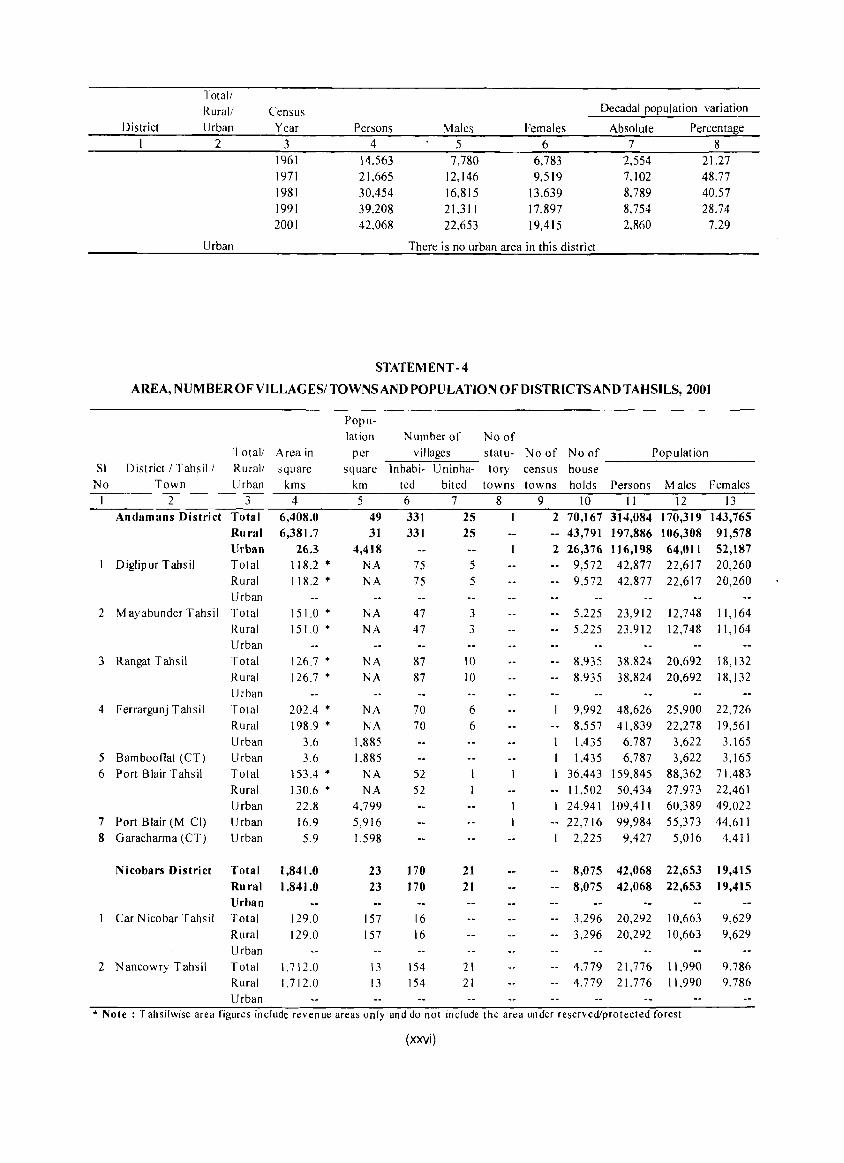
STATEMENT -4
AREA, NUMBER OFVILLAGESI TOWNS AND POPULATION OF DISTRICTS AND TAHSILS, 2001
Popu-lation Number of No of
Total/ Area in per villages statu- No of No of Population SI District! Tahsil / Rural! square square lnhabi- Uninha- tory census house
No Town Urban kms km ted bited towns towns holds Persons Males Females I 2 3 4 5 6 7 8 9 10 II 12 13
Andamans District Total 6,408.0 49 331 25 2 70,167 314,084 170,319 143,765 Rural 6,381.7 31 331 25 43,791 197,886 106,308 91,578 Urban 26.3 4,418 2 26,376 116,198 64,011 52,187
I Diglipur Tahsil Total 118.2 '" NA 75 5 9,572 42,877 22,617 20,260 Rural 118.2 '" NA 75 5 -- 9,572 42,877 22,617 20,260 Urban
2 M ayabunder Tahsil Total 151.0 '" NA 47 3 -- 5,225 23,912 12,748 11,164 Rural 151.0 '" NA 47 3 5,225 23,912 12,748 11,164 Urban
3 Rangat Tahsil Total 126.7 * NA 87 10 -- 8,935 38,824 20.692 18,132 Rural 126.7 '" NA 87 10 8.935 38.824 20,692 18,132 Urban
4 Ferrargunj Tahsil Total 202.4 '" NA 70 6 9,992 48,626 25.900 22,726 Rural 198.9 '" NA 70 6 -- 8,557 41,839 22,278 19,561 Urban 3.6 1,885 1,435 6.787 3,622 3,165
5 Bambootlat (CT) Urban 3.6 1.885 1,435 6,787 3,622 3,165 6 Port Blair Tahsil Total 153.4 '" NA 52 36,443 159,845 88,362 71,483
Rural 130.6 * NA 52 -- 11,502 50,434 27.973 22,461 Urban 22.8 4,799 24,941 109,411 60.389 49.022
7 Port Blair (M CI) Urban 16.9 5.916 -- 22,716 99,984 55,373 44,611 8 Garacharma (CT) Urban 5.9 1,598 2,225 9,427 5,016 4,411
Nicobars District Total 1,841.0 23 170 21 -- 8,075 42,068 22,653 19,415 Rural 1,841.0 23 170 21 8,075 42,068 22,653 19,415 Urban
1 Car Nicobar Tahsil Total 129.0 157 16 -- 3,296 20,292 10.663 9,629 Rural 129.0 157 16 -- 3,296 20,292 10,663 9,629 Urban
2 Nancowry Tahsil Total 1.712.0 13 154 21 -- 4.779 21,776 11,990 9,786 Rural 1.712.0 13 154 21 -- 4.779 21.776 11,990 9.786 Urban
,. Note: Tahsilwise area figures include revenue areas only and do not include the area under reserved/protected forest
(xxvi)
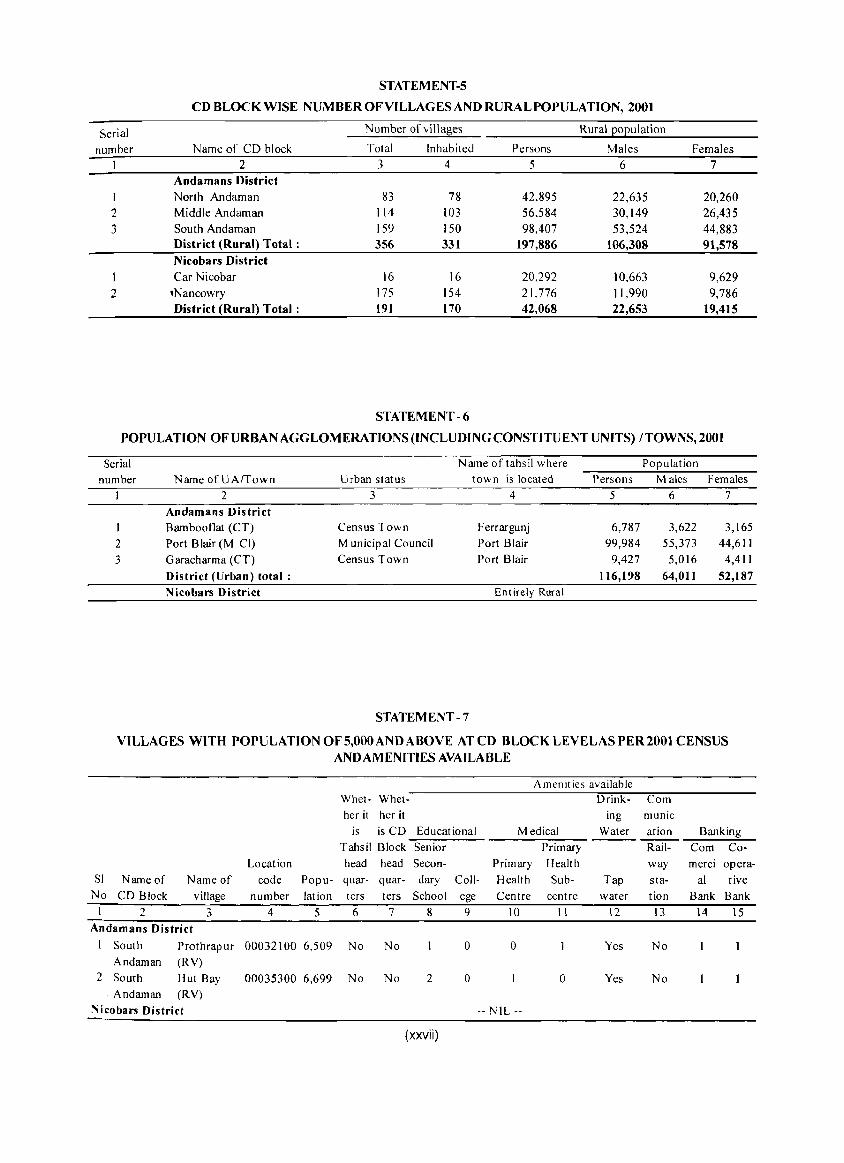
STATEMENT-5
CD BLOCK WISE NUMBER OF VILLAGES AND RURAL POPULATION, 2001
Serial Number of villages Rural population
number Name of CD block Total Inhabited Persons Males Females I 2 3 4 5 6 7
Andamans District
I North Andaman 83 78 42,895 22,635 20,260 2 Middle Andarnan 114 103 56.584 30,149 26,435 3 South Andaman 159 150 98,407 53,524 44,883
District (Rural) Total: 356 331 197,886 106,308 91,578 Nicobars District Car Nicobar 16 16 20,292 10,663 9,629
2 .Nancowry 175 154 21.776 11,990 9,786 District (Rural) Total: 191 170 42,068 22,653 19,415
STATEMENT - 6
POPULATION OF URBAN AGGLOMERATIONS (INCLUDING CONSTITUENT UNITS) I TOWNS, 2001
Serial Name of tahsil where Population number NameofUArrown Urban status town is located Persons Males Females
2 3 4 5 6 7
Andamans District I Bambooflat (CT) Census Town Ferrargunj 6,787 3,622 3,165 2 Port Blair (M Cl) Municipal Council Port Blair 99,984 55,373 44,611 3 Garacharma (CT) Census Town Port Blair 9,427 5,016 4,411
District (Urban) total: 116,198 64,011 52,187 Nicobars District Entirely Rural
STATEMENT -7
VILLAGES WITH POPULATION OF 5,000 AND ABOVE AT CD BLOCK LEVELAS PER 2001 CENSUS AND AMENITIES AVAILABLE
Amenities available Whet- Whet- Drink- Com her it her it ing munic
is is CD Educational Medical Water ation Banking Tahsil Block Senior Primary Rail- Com Co-
Location head head Secon- Primary Health way merci opera-Sl Name of Name of code Popu- quar- quar- dary Call- Health Sub- Tap sta- al tive
No CD Block village number lation ters ters School ege Centre centre water tion Bank Bank I 2 3 4 5 6 7 8 9 10 II 12 13 14 15
Andamans District I South Prothrapur 00032100 6,509 No No 0 0 Yes No
Andaman (RY) 2 South Hut Bay 00035300 6,699 No No 2 0 0 Yes No
. Andaman (RY)
:"Iicobars District -- NIL --
(xxvii)
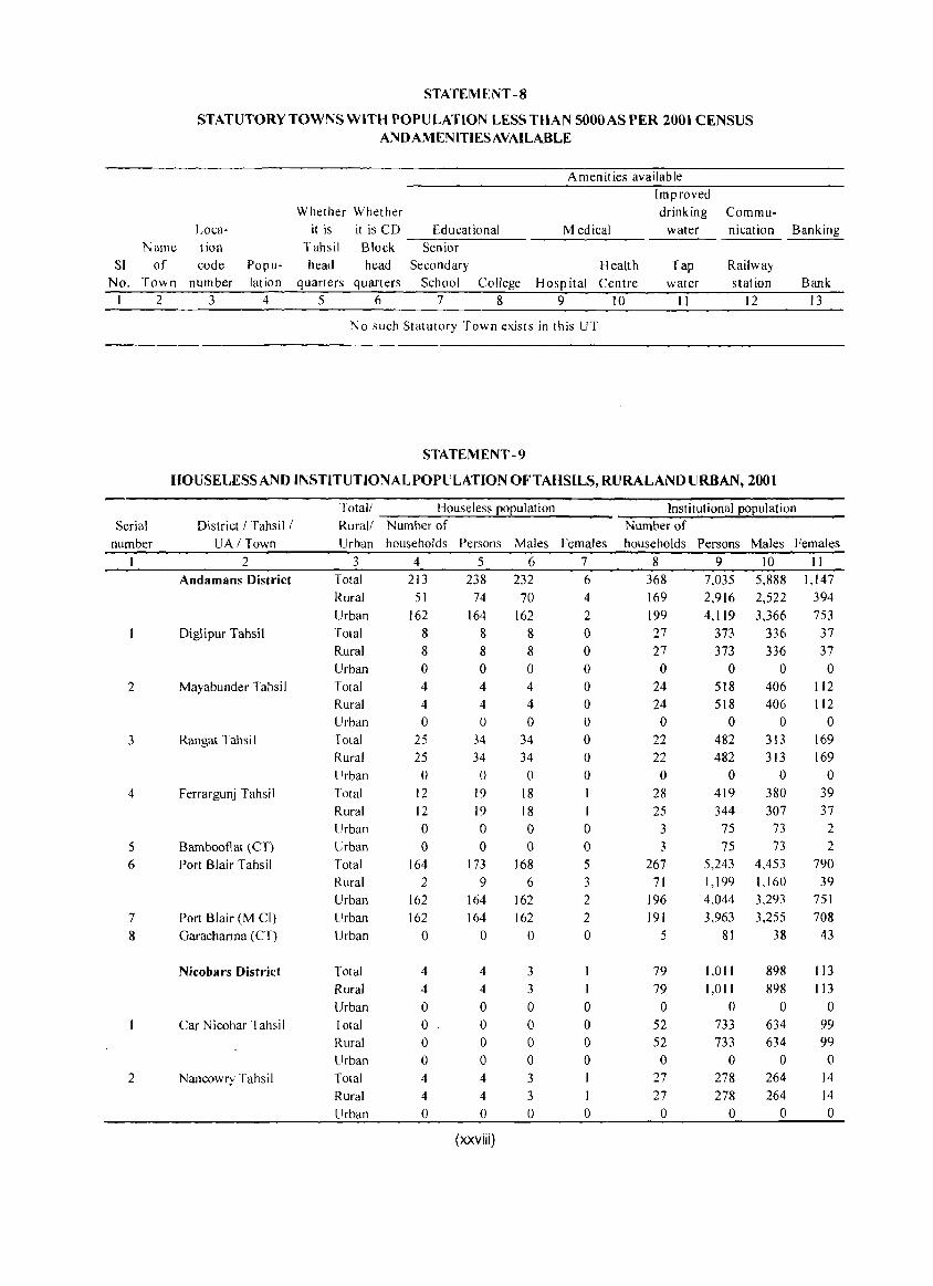
STATEMENT -8
STATUTORY TOWNS WITH POPU LATION LESS THAN 5000 AS PER 2001 CENSUS ANDAMENlTlESAVAILABLE
Loca-Name tion
SI of code No. Town number
I 2 3
Population
4
Amenities available
Whether Whether it is
Tahsil head
it is CD Educational Block -S"-'e-n"-io-r ----
head Secondary
Medical
Health quarters quarters School College Hospital Centre
5 6 7 8 9 10
No such Statutory Town exists in this UT
STATEMENT -9
Improved drinking Commu-
water
Tap water
II
nication
Railway station
12
Banking
Bank 13
HOUSELESSAND INSTlTUTIONALPOPULATlON OFTAHSILS, RURALAND URBAN, 2001
Serial number
2
3
4
5 6
7 8
2
District I Tahsil I UAI Town
2 Andamans District
Diglipur Tahsil
Mayabunder Tahsil
Rangat Tahsi I
Ferrargunj Tahsil
Bambooflat (CT) Port Blair Tahsil
Port Blair (M Cl) Garacharma (CT)
Nicobars District
Car Nicobar Tahsil
Nancowry Tahsil
Totall Houseless population Rurall Number of Urban households Persons Males Females
3 4 5 6 7 Total 213 238 232 6 Rural 51 74 70 4 U~~ I~ 1M I~ 2 Total 8 8 8 0 Rural 8 8 8 0 Urb~
Total Rural Urban Total Rural Urban Total Rural Urban Urban Total Rural Urban Urban Urban
Total Rural Urban Total Rural Urban Total Rural Urban
o 4 4
o 25 25 o
12 12 o o
164 2
162 162
o
4 4 o o o o 4 4 o
o 4 4 o
34 34 o
19 19 o o
173 9
164 164
o
4 4
o o o o 4 4 o
(xxviii)
o 4 4 o
34 34 o
18 18 o o
168 6
162 162
o
3
3 o o o o 3 3
o
o o o o o o o
I o o 5 3 2 2 o
I
o o o o
I o
Institutional population Number of households Persons Males Females
8 9 10 II 368 169 199 27 27 o
24 24 o
22 22 o
28 25
3 3
267 71
196 191
5
79 79 o
52 52 o
27 27 o
7.035 2,916 4,119
373 373
o 518 518
o 482 482
o 419 344
75 75
5,243 1,199 4.044 3.963
81
1.011 1,011
o 733 733
o 278 278
o
5,888 2,522 3,366
336 336
o 406 406
o 313 313
o 380 307
73 73
4,453 1.160 3.293 3.255
38
898 898
o 634 634
o 264 264
o
1,147 394 753 37 37 o
112 112
o 169 169
o 39 37
2 2
790 39
751 708
43
113 113
o 99 99 o
14 14 o
ANALYTICAL NOTE

Analytical Note
(i) History and scope of the District Census Handbook
The District Census Handbook (DCHB) is the exclusive Census publication, which incorporates the Census/and Non-census data from district level down to village or town level. As such, it has been considered as the most important and widely used publication among the series of all Census publications. The infonnation given in this publication has enormous value to the administrators, planners and scholars for the purpose of macro to micro level planning and studies.
In other states of Union of India, the history of District Census Handbook goes back to 1951 when a single volume, giving village wise statistics and other Census tables for each district was brought out. The coverage of the DCHB has undergone considerable changes since 1961. To enhance the utility of this publication, improvements were made in 1961 by including many non-census data. In 1971, it was decided to publish the DCHB in three parts, viz. part A relating to village and town directory, part B containing village and town wise primary census abstract and part C on some administrative statistics and district census tables. The 1981 Census DCHB was brought out in two parts when the part C containing administrative statistics was dropped. During 1991 Census, it was decided to print the DCHB in the same style of 1981 Census DCHB.
As regards the Union Territory of Andaman and Nicobar Islands, the first DCHB was brought out in 1981 Census though the village level basic population data was published in some Census publication in the earlier Censuses of 1971, 1961 and 1951. The 1981 Census DCHB was a combined volume for both the districts of Andamans and Nicobars. The 1991 Census DCHB of the UT was also brought out in the same pattern ofDCHB for 1981 Census provided instead of presenting the tehsils level village directory and PCA, data were presented Community Development Block wise.
The DCHB for Census of India 2001 of this UT has also been decided to bring out as a combined volume for both the districts. It contains mainly two parts, viz. part A and part B. Part A comprises Village Directory
3
(VD) and Town Directory (TD) and related appendices. Part B represents Primary Census Abstract (PCA) at district level, PCA of Scheduled Tribes, CD Block! village level PCA and urban PCA. Apart from these a general portion containing district highlights, important statistics, history, administrative set up, physiography and economic resources, various summary and inset tables on Census and non- census data, brief analysis of those inset tables and a large numbers of annexures involving fertility, migration, religions, marital status, education, mother tongue and primitive tribes are given.
The village and town level amenities data, the basic inputs of VD and TD, were supplied by district administrations whereas information on physical features, administration set up and various economic activities etc. were provided by concerned departments under UT administration and central government offices. Efforts have been made to cross check the village and town amenities data, with secondary data available from various departments and also with 1991 District Census Hand Book, as far as possible.
(ii) Brief history of the district:
Being located in the long trade route of India, Burma, and the Far East the mention of Andaman Islands can be found in various old histories. Ancient travellers used to land the islands to take refuge in bad weather and to replenish water. The renowned Geographer and Astronomer of 2nd century AD, Claudius Ptolemy of Alexandria had mentioned these islands in his writings. These islands were noticed by I'Tsing, the Chinese Buddhist monk in 672, by the Arab travellers in 9th century, by Marcopolo in 1292, Friar Odonic mentioned these islands in 1322, Nicolo Conti knew it as 'Andemona' in 1430. The Malays used these islands for piratical practice and trade of Andamanese slaves and knew them by the term Handuman, which most likely preserves the very ancient Hanuman of Ramayana epic carried down to the Malays in story and translation (Census Report 190 I by Sir Richard Temple). The name' Andaman' might be the derivation of Malay term' Handuman' as suggested in the report.
Up to later part of 18th Century the Islands were not much noticed of, but after then East India Company
took a serious view in the events of high sea piracies and murders of ship-wrecked crews along the coast of Andamans. Aggrieved by the situation Lord Cornwallis sent Lt. Archibald Blair and Lt. Colebrook in 1788 to survey the Islands to explore a suitable place for settlement.
The first settlement of a free colony was established in 1789 at Chatham Island by Lt. Blair, now part of Port Blair, although it was then called as Port Cornwallis. Later on, due to strategic reason the settlement was shifted to present Port Cornwallis at North Andaman in 1792. Gradually this settlement also had to abolish miserably in 1796 due to unhealthy climate and high mortality rate. For next 60 years, there was hardly any settlement in these Islands. But for continued harassment and killings of ship-wrecked crews, the idea of setting one naval set up at Andaman again cropped up. Finally, the Sepoy Mutiny in 1857, the first major revolt to overthrow British from India, prompted British Government to form an 'Andaman Committee' to examine a suitable site for penal settlement. On the recommendation of the committee the settlement had been re-established at old Port Cornwallis i.e. present Port Blair in 1858. The Ross island became the headquarters. Dr. J.P. Walker arrived here in March 1858 alongwith 200 mutineers and 50 guards of old Naval Brigade. Later on within 3 months number of total convicts increased to 773 but only 481 remained as 292 had either died in hospital or escaped or hanged while captured during escape. Dr. Walker was said to be strict 'disciplinarian'.
The aborigines naturally could not tolerate the occupation of their land by new comers resulting to frequent confrontations between aborigines and new comers. The Battle of Aberdeen, the great war of liberation occurred on 17th May 1859 which was their most determined effort to exterminate the British. From 1859 onwards, convicts from all provinces from India started deporting in abundance. When General Man took the charge of Superintendent in 1865, the number of convicts was 8875. During 1869 to 1870 many Wahabi movement activists were deported. It was on 8th February 1872, Lord Mayo, the then Viceroy of India was assassinated by a Wahabi activist Md. Sher Ali Khan at Hope Town Jetty.
Prior to construction of Cellular Jail male convicts were kept in Viper Island and female convicts in a barrack at South Point. Gradually, depending upon prolonged good conduct, convicts were allowed to live in free style in villages. They could marry female convicts or bring their wives from mainland, cultivate
4
DISTRICT CENSUS HANDBOOK. ANDAMAN & NICOBAR ISLANDS
land for supporting their livelihood. The construction of Cellular Jail was started in 1896 and it was completed by 1906.
During 1909 to 1922 a large number of revolutionaries like Veer Vinayak Damodar Savarkar and his elder brother of Nasik conspiracy case, Ullashkar Dutta, Barindra Kumar Ghosh - brother of revolutionary and Yogi Sri Aurobindo of Alipur Bomb case, Wamanrao Joshi of Jackson murder case, Babu Sohan Singh with about 40 companions of Lahore conspiracy case, Mujtaba Husain of Mandalay conspiracy case, Sachindranath Sanyal of Banaras conspiracy case and others were sent to this jail. These political prisoners faced inhuman treatment and torture, 8 to 10 of them died because of brutality, many lost their mental balance and became physically handicapped.
The deplorable conditions of the penal settlement and that of prisoners in Cellular jail were spread among the Indian public through the correspondences of these revolutionaries. The patriots like Rastraguru Surendra Nath Banerjee raised questions on the condition of the jail in the floor of the Central Legislative Assembly. As a result of these protests, British government in England set up a Jail Commission to examine the conditions of jails in India. During 1919-1920, the members ofthe Jail Commission visited this Island and recommended the abolition of the penal settlement which were not materialised practically. Prisoners from mainland were continued to transport here again but only those who volunteered to come to settle with their family, were brought. A large number ofMoplah rebels from Malabars, were deported and they were allowed to bring their families to settle in separate villages. These Moplah communities had started a rebellion against British Raj in 1921. Among the other prisoners who were brought at that period, Rampa revolutionaries from West Godavari and Visakhapattanam districts and Tharawady Rebels of Burma are worth mentioning. A large number of Bhantus from the then United province were also transported.
Before 1932, political activities against British Govt. in the form of terrorist movement again broke up in the country severely and due to this reason Govt. withdrew its policy of not sending the political prisoners to Cellular jail. Under this renewed policy during 1932 to 1938, a large number of political prisoners mostly from Bengal were deported to Cellular jail. Some of the prominent figures among these revolutionaries are Shri Batukeshwar Dutta of Legislative Assembly bomb case, Shri Jai Dev Kapur of 2nd Lahore Conspiracy
ANALYTICAL NOTE
case, Lok Nath Ball, Ananta Singh and Ganesh Ghosh of Chittagong Armoury Raid case and Shambu Nath Azad of Travancore Bank dacoity case and others. While the islands was changing outside the Cellular jail because of establishment of the free colony, inside the jail the picture was totally different. Discriminatory treatment and brutal tortures to the political prisoners inside the jail, forced them to organise series of agitations and during the first hunger strike in 1933 three of the freedom fighters died martyr's death, the news of which shocked the rest of India. At last, the strike was called off and demands of the strikers such as availability of reading and writing materials, relaxation in the rules of communication, supply of improved quality food and other basic amenities were agreed upon to meet up by the Govt. In July 1937, India's freedom struggle entered in a new era when in seven provinces Congress Ministry were formed and political prisoners of Cellular jail went on second hunger strike on the demand of civil I iberties and unconditional release of all political prisoners. This news of hunger strike triggered severe uproar throughout India. A huge demonstration started in Bengal and telegrams from friends and relatives of the strikers to withdraw the hunger strike started pouring in followed by a telegram from Fazlul Haque. On behalf of Indian National Congress Working Committee, Mahatma Gandhi sent a telegram on 28th August 1937 to the prisoners on hunger strike. The British Govt. was very much disturbed and finally at the intervention of national leaders the strike was called off after 45 days of its commencement when Govt. assured to repatriate all political prisoners to main land. Repatriation ofpolitical prisoners started in 1937 and the last batch of them left this territory on 18th January 1938.
During 2nd world war, Japanese occupied these islands on 23rd March, 1942 without getting any resistance from British. On 6th November 1943, Japan announced that they had decided to hand over A&N Islands to the Provisional Government of Azad Hind. On 29th December 1943 Netaj i Subhas Chandra Bose, the head of the state of Azad Hind Government landed on this Indian soil and on 30th December he hoisted the tri-coloured Indian National flag at Gymkhana ground, Port Blair. He decided to name these islands as Sahid and Swaraj islands respectively. During Japanese occupation, the island was blockaded by British leading to near starvation condition of the islanders. Japanese started severe torture especially on English knowing people in the charge of espionage. A large number of men were killed. Finally, allied forces recaptured the islands on 8th October, 1945. The penal
5
settlement was closed and a general amnesty was awarded to all convicts and they were offered to repatriate to their homes in mainland when 4,000 convicts took the advantages of this offer. On the 15th August, 1947 these Islands became part of independent India.
(iii) Administrative set up :
Prior to 1974, the Union Territory of Andaman and Nicobar Islands was a un i-district territory. Two districts viz. Andamans and Nicobars were formed in the year 1974 vide Andaman & Nicobar Administration's notification dated 19-7-1974
Andamans District:
The Andamans district was constituted with two sub-divisions viz. South Andaman and Mayabunder consisting of four tehsils while the Nicobars district was constituted with Car N icobar and Nancowry subdivisions covering two tehsils. The four tehsils of Andamans district were Diglipur, Mayabunder, Rangat and South Andaman and the two tehsils ofNicobars district were Car Nicobar and Nancowry. The South Andaman tehsil was further bifurcated into two tehsils viz. Port Blair and Ferrargunj in the year 1975 vide Notification dated 30-10-1975. Thus since 1975, the district of Andamans comprises five tehsils.
Community Development Blocks of Andamans District : Andamans District consists of three Community Development Blocks viz. North Andaman, Middle Andaman and South Andaman. This clearly indicates that in Andamans district, the CD Blocks are not coterminus with the tehsils. North Andaman CD Block comprises 80 vi Ilages of Diglipur Tehsil and 3 villages ofMayabunder Tehsil, Middle Andaman CD Block comprises 47 villages of Mayabunder Tehsil and 67 villages of Rangat Tehsil and South Andaman CD Block comprises 30 villages of Rangat Tehsil, 76 villages of Ferrargunj Tehsil and 53 villages of Port Blair Tehsil.
The North Andaman CD Block covers 83 villages comprising 75 inhabited and 8 uninhabited villages, out of which 80 falls in 6 different Islands viz. Narcondam, East, North Andaman, Smith, Curlew and Stewart Islands of Dig Ii pur tehsil and the remaining 3 villages falls in Mayabunder tehsil.
Middle Andaman CD Block consists of the remaining area of Mayabunder tehsil comprising 47 inhabited and 3 uninhabited villages spread over in 3 Islands viz., Middle Andaman Island (part), Aves and Interview Island and 88 inhabited and 9 uninhabited
villages of the entire Rangat tehsil spread over in 7 Islands viz., Middle Andaman (part), Porlob, Long, North Passage, Strait, Baratang and Spike Islands.
South Andaman CDBlock, the biggest one in Andamans district comprises the entire Ferrargunj tehsil covering 70 inhabited and 6 uninhabited villages spread over in 3 islands viz., South Andaman (part), Viper and Flat Bay islands and the entire Port Blair tehsil covering 52 inhabited and 1 uninhabited villages spread over in 8 Islands viz., John Lawrance, Havelock, Neil, Rutland, North Sentinel, Spike and Little Andaman islands.
Tehsils of Andamans District : The Andamans district is comprised of 5 tehsils viz. Diglipur, Mayabunder, Rangat, Ferrargunj and Port Blair. The Little Andaman Island, a part of Port Blair tehsil is situated around 104 Kms. away from the main South Andaman Islands. For the administrative facility a full time Tehsildar has been posted here, though this has not been notified as a separate tehsi I.
Diglipur Tehsil : This tehsil consists of 75 inhabited villages which are spread over in 6 inhabited islands, namely Narcondam, East, North Andaman, Smith, Curlew and Stewart Islands This tehsil is located at the northern most part of this territory.
MayabunderTehsil: Mayabundertehsil comprising 47 inhabited and 3 uninhabited villages spread over in 3 Islands viz., Middle Andaman Island (part), Aves and Interview Island.
Rangat Tehsil : This tehsil consists of 88 inhabited and 9 uninhabited villages spread over in 7 Islands viz., Middle Andaman (part), Porlob, Long, North Passage, Strait, Baratang and Spike Islands.
Ferrargunj Tehsil: This tehsil consists 0[70 inhabited and 6 uninhabited villages spread over in 3 islands viz., South Andaman (part), Viper and Flat Bay islands. Bambooflat area under Ferrargunj Tehsil has been treated as Census Town.
Port Blair Tehsil : This tehsil consists of 52 inhabited and 1 uninhabited villages spread over in 8 Islands viz., John Lawrance, Havelock, Neil, Rutland, North Sentinel, Spike and Little Andaman islands. The lone statutory town 'Port Blair' which is the seat of the Andaman and Nicobar Administration, is also located in this tehsil. Apart from this, Garacharma village of 1991 Census under Port Blair tehsil has been given the status of 'Census Town' during Census of India 2001.
6
Ui~ I Kll, I l,t:N;:,U;:, HANUbUUK • ANUAMAN & NICUBAK I~LANU;:,
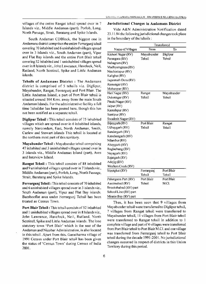
Jurisdictional Changes in Andamans District
Vide A&N Administration Notification dated 23.11.94 the followingjurisdictional changes took place in the boundary of the tehsils :
Name of Villages
Kishori Nagar (RV) Parangara (RV) Nabagram CRY) Madhyamgram CRY) Nischintapur (RV) Kalighat CRY) Jagannath Dera (RV) Ramnagar CRY) Mohanpur CRY) Hari Nagar (RV) Dukenagar CRY) Pinaki Nagar (RV) Jaipur(RV) Kamalapur (RV) Santipur CRY) Swadesh Nagar (RV) Bijoygarh (RV) Udhaygarh (RV) Sundargarh CRY) Kanchangarh CRY) N ilambur CRY) Abaygarh CRY) Raglachang CRY) Nayagarh (RV) Rajatgarh (RV) Adojig(RV) Wrafters Creek CRY) Sippighat CRY)
Pahargaon Part CRY) Austinabad CRY) Brookshabad (RV) part School Line CRY) part Minnie Bay CRY) part
Transferred From
Mayabunder Tehsil
Rangat Tehsil
Port Blair Tehsil
Ferrargunj Tehsil Port Blair Tehsil
To
Diglipur Tehsil
Mayabunder Tehsil
Rangat Tehsil
Port Blair Tehsil Port Blair M.CI.
Thus, it has been seen that 9 villages from Mayabunder tehsil were transferred to Diglipur tehsil, 7 villages from Rangat tehsil were transferred to Mayabunder tehsil, 11 villages from Port Blair tehsil were transferred to Rangat tehsil in addition to 1 complete village and part of 4 villages were transferred from Port Blairtehsil to Port Blair M.C!' and one village was transferred from Ferrargunj tehsi1 to Port Blair tehsil during the decade 1991-2001. No jurisdictional changes occurred in respect of districts in this Union Territory during this period.
ANALYTICAL NOTE
Inhabited Islands of Andamans District
Though there are 306 islands in this UT, only 38 islands comprising 25 in Andamans and 13 in N icobars District are inhabited. The inhabited islands of Andamans District are: (I) East, (2) Narcondam, (3)North Andaman, (4) Smith (5) Curlew, (6) Stewart, (7) Interview (8) Aves (9) Middle Andaman (10) Porlob (II) Long (12) North Passage (13) Strait (14) Baratang (15) Spike (16) South Andaman (17) Viper (18) Flat Bay (19) John Lawrance (20) Havelock (21) Neil (22) Rutland (23) North Sentinel (24) Cinque (25) Little Andaman.
Nicobars District
The District ofNicobars lies in the southern part of this Union Territory.
Community Development Blocks of Nicobars District and Tehsils : There are two CD Blocks in this district viz., Car Nicobar comprising only 16 villages and Nancowry comprising of 175 villages, which are placed under respective Tehsils i.e. Car Nicobar and Nancowry. Thus it may be seen here that the two CD Blocks are co-terminus with their respective Tehsils. However, for administrative purpose, an Assistant Commissioner and a Tehsildar are posted at Campbell Bay as headquarters, in the Great Nicobar Islands which is at a distance of around 80 kms. away from Kamorta, the headquarters of Nancowry Tehsil.
Inhabited Islands of Nicobars District : (1) Car Nicobar, (2) Choura, (3) Tillang Chong, (4) Teressa, (5) Bomboka, (6) Katchal, (7) Nancowry (8) Kamorta, (9) Trinket, (10) Pulomilo, (11) Little Nicobar, (12) Kondul, (13) Great Nicobar
(iv) Physical features
Location and size :
The Union Territory of Andaman and Nicobar Islands is a group of 306 picturesque Islands, big and small, inhabited and uninhabited, lying in the SouthEastern part of the Bay of Bengal, cut off from the mainland by vast stretches of sea. The Islands are sprawling in the Bay of Bengal from North to South and, with the exception of Narcondam Island, these Islands fonn almost like an arch within a parallelogram located between 6° and 14° ofthe North Latitude and 92° and 94° of East Longitude. The total area of the Union Territory of Andaman and Nicobar Islands as supplied by the Surveyor General is 8,249 sq.kms.
Andamans District
The district of Andamans lies between 10° and
7
14° north latitude and 92° and 94° east longitude covering an area of 6,408 Sq. Km comprising 25 inhabited and many uninhabited Islands. The northern most inhabited Island of this district is East Island and the southern most one is Little Andaman Island. The east and west of this district is occupied by sea. This district, having largest area among the two districts, covers 77.68 per cent area of the Union Territory.
Nicobars District
The district of Nicobars lies between 6° and 10° north latitude and 92° and 94° east longitude covering an area of 1,841 Sq. Km comprising 13 inhabited and many uninhabited Islands. The northern most inhabited Island ofNicobars district is Car Nicobar and that of the southern most is Great Nicobar. It is worthy to mention here that the southern most point ofNicobars district viz. Indira Point is the southern most part of our country. This district covers only 22.32 per cent of the total geographical area of the Union Territory.
Physiography and Geological Background
Andaman and Nicobar group, comprising 572 Islands, islets and rocks, represents a part of an acurate chain of Islands, running from Myanmar in the north to Indonesia in the south along Indo-Sumatra subduction zone.
The Andaman Islands are characterised by rugged hilly terrain with north-south trending ridges separated by narrow elongated valleys. Broadly, the terrain can be divided into hill ranges and isolated hills, hill slopes, plains and swamps. The high relief of the ridges and also the higher peaks ranging between 200 m - 300 m are generally found in the eastern part of the Islands, Saddle peak in the North Andaman with a height of 732 m above mean sea level (msl) is the highest point in these islands. The hill slopes are moderate to steep and rugged and susceptible to heavy soil erosion. Flat lands are comparatively scarce. The village Betapur and Diglipur constitute the main plain lands in Andaman group of Islands. There are few perennial streams, which can be designated as rivers, viz., Kalpong river arising from Saddle peak in the North Andaman, Betapur and Rangat rivers in Middle Andaman and Dhanikhari in South Andaman.
The Islands of the Nicobar group are generally less hilly and present flat to undulatory terrain with rare hills and hill ranges. Car Nicobar, with an area extent of 129 sq.km. forms the northernmost extension of the Nicobar group ofIslands. It is a flat Island, except for the central part. The elevated area is gently undulating with low linear ridges trending NNW- SSE.
The maximum elevation in the central raised parts is approximately 69 m above mean sea level. The Island shelf is fringed by coral on all sides. The shelf is relatively steep in the east and west sides of the island as compared to the north and south sides. The coral reefs around the Island get submerged during the high tide period. Sandy beaches, with a width varying between 5 m and 50 m, occur all along the coast of the Island between the coral reef and the main landmass. Most of the water courses to the south converge in an extensive mangrove swamps, north ofKimois village. The high tide water enters all these water courses for over 2 km along upstream.
The Great Nicobar Island exhibits highly undulating and immature topography, formed by coastal highland gradually coming down to the sea all around. The shape of the Island is roughly elliptical. Mt. Thullier (642m) is the highest peak and lies in north-central part of the Island. There are many other peaks, reaching more than 200 m above ms!. The hill ranges are in N-S direction and some embayments have been formed all around, like, Campbell Bay and South Bay in the eastern part and Mata Tanuwa, Nanjappa Bay etc, in the west. The Islands are surrounded by coral reefs which are inundated by tides of the sea. The E-W road of the Island passes through a hilly terrain and the maximum height attained on this road is about 180m above ms!. South of this road, the relieffalls gradually and near Pygmalion Point and west of Galathea Bay the topography is almost flat. The eastern as well as the western coastlines of Great Nicobar is highly irregular and deeply incised. Recent coral reefs fringe the coastline in the extreme south and southeast. The central part of the Island is the watershed, with the rivers and nallahs distributed in all parts of Islands. The drainage pattern of Great Nicobar Island is essentially trellised, but locally dendritic and parallel. Coastal plains and swamps are also common in the Islands.
Geologically, the rock types in the Andaman and Nicobar group ofIslands include metamorphic rocks, sedimentaries and an igneous suite of rocks called ophiolites. The general trend of all these rocks marginally veer around N-S. The metamorphic rocks, comprising quartzite, quartz-sericite schist, phyllite, amphiobolite, etc. hae Precambrian age (550 ma). The ophiolites, representing oceanic crust are Cretaceous age (80-100ma); they comprise various types of ultramafic rocks, mafic rocks (gabbros, basalts etc.), plagiogranite, diorite, dolerite and some sedimentaries, chert, limestone and shale. The sedimentary rocks
8
DISTRICT CENSUS HANDBOOK. ANDAMAN & NICOBAR ISLANDS
having younger age (Eocene-Pliocene) are composed of lithopackages of conglomerate, sandstone, siltstone, shale, limestone etc., classified under different groups of rocks, like Mithakhari Group, Andaman flysch Group and Archipelago Group, in the order of younging. The Quaternary sediments of shell conglomerate, sand, clay etc. overlie all the above rocks at places.
The Andaman and Nicobar Islands evolve as a result of subduction ofIndian plate below the Southeast Asian plate. The Narcondam and Barren Islands to the east of the main Andaman-N icobar chain are volcanic Islands in the inner arc/primary arc of the subduction zone. The Andaman and Nicobar Islands fall under a high seismic zone (Zone V) or 'very high damage risk zone'. So, suitable precautionary measures are required to be taken in course of construction activities.
Diverse and complex topographic features characterise the seabed to the east and west of Andaman and Nicobar Islands. To the west, in the Bay of Bengal, a series of parallel stepped up ridges, with intervening valleys, an arcuate subduction trench, the Ninety Degree East submarine ridge, fan valleys as well as the vast expanse of undulating fan and finally the abyssal plain have been brought out as the most prominent geomorphic feature.
In the Andaman sea, to the east of the Islands, a different geomorpho-tectonic set up could be seen. The seabed represents a complex topography, depicting the volcanic are system and the backarc spreading ridge. Severa) seamounts, with heights ranging from 500 to 2,000 m, are mapped near the volcanic are region. Invisible bank, lying south of volcanic Islands, is about ) 70 km. long and approximately 50 km. wide with a flat top has been recognised. Calcareous rock fragments with shell fragments, corals etc., have been collected during surveys across this bank. The Andaman sea is transected by a number ofN-S faults prominent amongst which is the West Andaman Fault, represented by a steep gradient in the bathymetric contour. The multi-peaked Alcock and Sewell seamounts are located in the eastern part of the Andaman sea. the northeastern part of the sea exhibits a smooth bottom topography due to rapid sediment deposition from the Irrawaddy river. A narrow valley or more than 1,000 m deep is conspicuous in this otherwise flat topographic region. This feature continues southward and corresponds to backarc spreading centre. The spreading centre is characterised by an isolated rift valley in the northeast and a narrow rift valley (Nicobar Rift Valley) in the southwest.
ANALYTICAL NOTE
In the Bay of Bengal, west of the Islands, the sediments are mostly biogenic in nature within a depth range of30-230 m and thereafter, upto a depth of nearly 4,300 m, the sediments are pelagic ooze (microorganisms like, cocolith, foraminifera, radiolaria etc.). Infilling of terrigenous sediments continues in an active channel, which defines the trace of the subduction oozes.
In the Andaman sea, volcanic effusions, both in the past and present, contribute to the non-biogenic and biogenic sediments near the volcanic ridges. Central parts of the basin floor comprise mainly silty clay or clayey silt sediments. Seamounts are generally covered by foraminiferal oozes. In the mid-proximal Bengal fan, adsorbed gaseous hydrocarbon has been located by GSI. Indications, so far obtained during cruises, show the possibility of hydrothermal mineralisation along the west Andaman fault or sulphide mineralisation in an around central Andaman trough. (Courtesy: Geological Survey ofIndia, Kolkata)
Minerals
Mineral search conducted by Geological Survey ofIndia in these Islands led to results of some interest. Investigation by drilling in the Long Island has established a good reserve oflimestone (4 million tones) suitable for cement manufacture. Drilling for basemetals and gold in parts of South Andamans and for nickel-cobalt in parts of Middle Andaman, South Andaman and Rutland Islands, were however, not successful in locating any deposit of economic significance.
Drainage
originate on the hills and flow in all directions. The moderate to steep slopes of hills in the Islands drain out the rainwaters rapidly. Due to close proximity of hill and sea, no natural stream can be considered as river worth the name. However, the large streams Kalpong in North Andaman and Galathia, Alexandra and Dogmar in Great N icobar are popularly known as rivers. Others streams are called 'Nalha'. In Andamans district some of the main nalhas are Keralapuram Nalha, Korang Nalha, Thoratang Nalha at North Andaman, Rangat Nalha, Kalshi Nalha, Jarawa Nalha, and Shankar Nalha at Middle Andaman and Berma Nalha, Kamsarat Nalha, Manjeri Nalha, Dhanikhari Nalha and Chouldari Nalha at South Andaman. The Neil and Havlock islands of Andamans district and Car Nicobar, Chowra ofNicobars district don't have such type of na lha. Among nalahs of Great Nicobar Island, Prembahadur Nalha, Swarup Nalha and Mogor Nalha are remarkable.
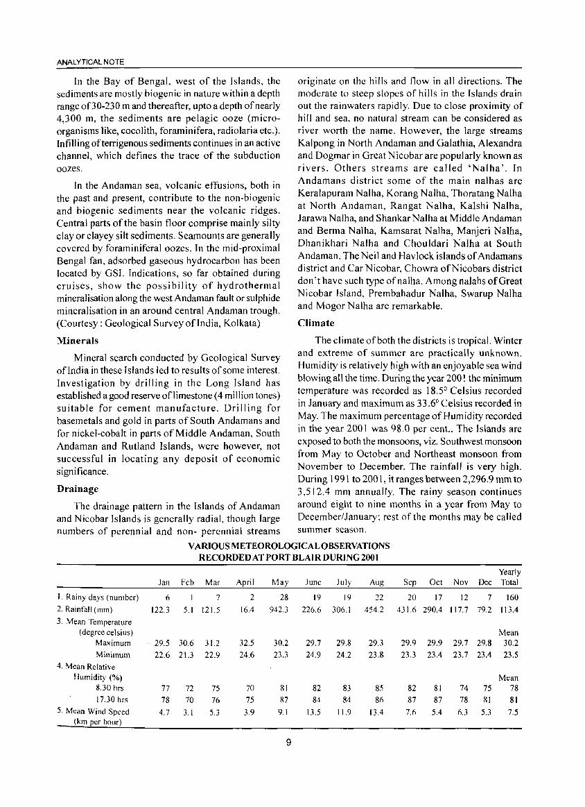
Climate
The climate of both the districts is tropical. Winter and extreme of summer are practically unknown. Humidity is relatively high with an enjoyable sea wind blowing all the time. During the year 2001 the minimum temperature was recorded as 18.5° Celsius recorded in January and maximum as 33.6° Celsius recorded in May. The maximum percentage of Humidity recorded in the year 2001 was 98.0 per cent.. The Islands are exposed to both the monsoons, viz. Southwest monsoon from May to October and Northeast monsoon from November to December. The rainfall is very high. During 1991 to 2001, it ranges between 2,296.9 mm to 3,512.4 mm annually. The rainy season continues
The drainage pattern in the Islands of Andaman around eight to nine months in a year from May to and Nicobar Islands is generally radial, though large December/January~ rest of the months may be called numbers of perennial and non- perennial streams summer season.
Jan
1. Rainy days (number) 6
2. Rainfall (mm) 122.3
3. Mean Temperature (degree celsius)
Maximum 29.5
Minimum 22.6
4. Mean Relative Humidity (%)
8.30 hrs 77 17.30 hrs 78
5. Mean Wind Speed 4.7 (km per hour)
VARIOUS METEOROLOGICAL OBSERVATIONS RECORDED AT PORT BLAIR DURING 2001
Feb Mar April May June July Aug
7 2 28 19 19 22
5.1 121.5 16.4 942.3 226.6 306.1 454.2
30.6 31.2 32.5 30.2 29.7 29.8 29.3
21.3 22.9 24.6 23.3 24.9 24.2 23.&
72 75 70 81 82 83 85
70 76 75 87 84 84 86
3.1 5.3 3.9 9.1 13.5 11.9 13.4
9
Yearly Sep Oct Nov Dec Total
20 17 12 7 160
431.6 290.4 117.7 79.2 113.4
Mean 29.9 29.9 29.7 29.8 30.2
23.3 23.4 23.7 23.4 23.5
Mean 82 81 74 75 78
87 87 78 81 81
7.6 5.4 6.3 5.3 7.5
Flora and Forestry
More than 86.0 per cent of the total area of Andaman and N icobar Islands is covered with luxuriant growth of tropical forest rarely found elsewhere in India. The forest type in these Islands depends almost entirely on the underlying soil and rock formation for their distribution.
It has been stated in the 1999 report of the Forest Survey of India that out of a geograph ical area of 8,249 Sq. Kms. of this Union Territory 92.2 per cent is under forest cover. Out of this, 86.0 per cent (7, 171 sq. kms.) are recorded forest comprising about 40.0 per cent (2,929 sq. kms.) under reserved forest and remaining 60.0 per cent (4,242 sq. kms.) under protected forest i.e. Wild Life Sanctuaries, National Park, Tribal Reserve and Biosphere overlapping with each other. The main type of forests mostly found in this Union Territory are (1) Mangrove forest (2) Beach forests (3) Low level Evergreen forests and (4) Dec iduous and Semi deciduous forests. Mangroves surround the rain forest and these are found in nearly all areas inundated by the high tide but sheltered from the force of monsoon wind and waves, usually in creeks and estuaries, in belts varying from a few yards to over a mile in width. The remaining 3 types, merge into one another imperceptibly and can not be separated easily. The most important species of timber are Padauk (Perecarpus dalbergioisdes), Gurjan (Dipterocarpas SPP), White Dhup (Canarium euphyllium) and Pap ita (Stercullia campanulata). Padauk is the only Indian wood that not only equals the standard timber Teak in every respect but also beats it in some extents. Various rare and exotic species of timber namely Marble wood, Silver leaf tree etc. are found in Andaman forests.
Though, the working of the Andaman forests dates back to the penal settlement in 1857, the forest Department was established in 1883. In those early days, extraction was confined only to a few selected species like Padauk (Pterocarpus Dal bergioides), Gurjan (Dipterocarpus), White Chuglam (Terminalia Bealata) etc. on more or less 'pick-the-plum-basis'.
The working plan for the forests of Andaman prepared by Mr. Todd in 1906 and that by Mr. Bonnington in 1914 could not be implemented fully due to the exigencies of war and immense efforts needed for clearing the forest for penal settlement. Taking into account the problems of regeneration, the first working plan on scientific basis was prepared in 1935. Later on in 1951, Shri B.S. Chengappa extra Assistant Conservator of Forests prepared a working plan giving
10
DISTRICT CENSUS HANDBOOK: ANDAMAN & NICOBAR ISLANDS
importance to natural regeneration and thus gave birth to a new system called 'Andaman Canopy Lifting Shelter Wood System' for working the forest.
Timber Extraction
The Forests in this territory are being managed on the basis of well established principles of Forest management as per the Working Plans approved by the Central Government. A&N Islands has three plywood industries, six Pencil Slat industries, two cottage match industries, two composite units and twenty two private saw mills apart from two Government Saw mills at Chatham and Betapur,. These industries get their timber requirement from Forest Dept. and Forest Corporation at the administered prices, which are fixed by the A&N Adm inistration every year. The harvesting of timber is carried out by the Forest Department and Forest Corporation as per the prescriptions of approved working plan. Timber extraction to the extent 0[70,000 cbm. of timber is the maximum permissible limit as per working plan. Now the major two plywood industries has been closed and they have not lifted the quota oftimber allotted to them last year and thus the Forest dept. and Corporation are having sufficient surplus timber and therefore, it is felt necessary that the harvesting of timber be kept market driven and the same is subject to the decisions of the Hon'ble Supreme Court of India in Public Interest Litigation on cutting of naturally grown tress in A&N Islands. The export of timber logs to mainland has been stopped to ensure ade!Juate supply of these raw materials to the local wood based industries. The forests subjected to timber harvesting are regenerated through aided natural regeneration which is supplemented with enrichment planting and broadcasting of seeds of local species, subsidiary Silviculture operation such as weeding, climber cutting etc. which are carried out over four years to establish the regeneration. During the year 2000-200 1, a quantity of 40,067 cbm. of timber and 32,816 cbm. offirewood has been extracted from the forest of this Union Territory. Keeping in view the guidelines issued by the Government of India regarding the conservation of forests for maintaining the eco-system, the level of timber extraction was restricted to the tune of 70,000 cbm per annum.
Revenue
The main source offorest revenue is sale oftimber. The timber extracted from the forest is supplied to the local forest based industries, Departmental saw mills and other Government departments etc. After meeting
ANALYTICAL NOTE
the local requirement for logs and sawn timber, the surplus is shipped to mainland depots for sale and supply to the various agencies through the agency of DGS&D. Due to shift in the emphasis from production to conservation, a significant reduction took place in the revenue because of the reduction of the level of intake of timber by industries. The department earned a revenue of Rs.] ,24].74 lakhs during the year 2000-200] through various sources such as Timber sale and royalty, firewood and charcoal sale, sand royalty and non-timber forest produce royalty etc.
Regeneration
After the forestry operations were started in Andamans, consequent upon the setting of the Forest Department in 1883 in these Islands, regeneration of the worked over forests was taken up through artificial regeneration. Under this system, plantations of teak as well as local species like Padauk and Pyinma, which were considered valuable and marketable at that time, were attempted.
However, this was subsequently given up when the technique of natural regeneration was developed and perfected. This technique along with the silvicultural system followed is known as 'Andaman Canopy Lifting Shelter Wood System'. Under this system, both the forests evergreen and deciduous are being regenerated without clear felling. Apart from ensuring the successful and adequate stocking of the area with economical species, it aims at retaining the original multiple character of the forests as far as practicable and possible. Clear felling afforests for raising Teak, Padauk plantations and other species was stopped during 1977. Commercial exploitation of mangroves has since been stopped to conserve the luxuriant mangroves, which are also acting as the shore protectors.
Fauna
The Islands have an equally unique and interesting fauna. Some of the animals, birds and reptiles are rare and endemic to these Islands. Out of 55 species of mammals recorded from the Islands, 20 are endemic in origin. Similarly, out of242 species and sub species of birds, 90 are endemic and out of the 81 species of reptiles 22 are endemic. Some of the important indigenous species are:
1. Andaman Wild Pig (Sus scrofa andamanensis)
2. Andaman Teal (Anas gibberifrons albogularis)
3. Nicobar Megapode (Megapoduir treycinet abbotti)
4. Nicobar Monkey (Macaca fascicularis Umbrosa)
11
5. Nicobar Pigeon (Coloenar nicobarica)
6. Narcondum Hornbil (Rhyticeros narcondami)
7. Salt Water Crocodile (Crocodilus Porosas)
8. Dugong or Sea Cow (Dugong dugon)
9. Common Dolphin (Delphinus delphis) and Sperm Whale (Physeter macro cephalus)
Sea water habitat is equally rich with 75 species of corals, (1) Coelenterate Phylum, 5 species of sea pens, (2) Ceolenterate Phylum, 49 species of polychaetes, (3) Annelida Phylum, 10 species of crabs, (4) Cerustacca-class, 30 species of molluscs (5) Phylum Mollusca, 12 species of chitons, 24 species Halothuroides, 20 species of star fish, 15 species of urchins, 600 species offish, (6) Piscs-class, 2 species of mammals, (7) Mammalia-class, 4 species of turtles and a variety of the sea snakes (both belongs to Reptilias-class). For effective protection and conservation of the Wild Life, Wild Life (Protection) Act, 1972 and Wild Life (Protection) A&N Islands, Rules, 1972 are effectively in force in this territory. Major part of Great Nicobar Island has been declared as Biosphere Reserve.
Conservation of Wild Life
For effective management of the wild life, which are mostly endangered and endemic to these Islands, a separate Wild Life Wing was established during the last two decades under the Chief Wild Life Warden in the rank of Conservator of Forests. Under him Wild Life Divisions are functioning viz., Wild Life DivisionI at Port Blair, Wild Life Division-II at Mayabunder and Wild Life Division, Campbell Bay.
To conserve the bio-diversity, A&N Administration has created 9 National Parks and 96 Wildlife sanctuaries under the management of Wildlife circle of the Forest Department as a massive protected area network. Andaman and Nicobar also have a distinction of having one of the few Biosphere Reserves established in the country. It has also got 2 Marine National parks. A modern biological park is being established at Chidiyatapu over 40 hectares with full fledged administrative, managerial and veterinary facilities. The Central Zoo authority is providing 100.0 per cent central funding for enclosures and 50.0 per cent funding on certain items for infrastructure development and balance fund will be provided under State plan. It will be developed as a place of excellence for conservation of various endemic fauna and flora of these islands and it wi II also serve as a centre for generation awareness for wildlife conservation.
A number of animal species found in this territory
are not found in other parts of the country. Most of the rare animal species found here are declared as Endangered Species and they are included in the Schedule I of the Wild Life (Protection) Act. 1972. These Species are given special status for protection and conservation. The plan programme of the department also includes carrying out research and breeding of endemic and endangered species besides promoting eco-tourism in the Islands. The work on improvement of existing Mini zoo at Port Blair has also been taken up. The Department is also taking effective steps for protection of coral reefs found around the Islands. The department maintains many of the popular tourist destinations for viewing corals, snorkeling and scuba diving such as Jolly Buoy, Red Skin and Cinque Islands.
Agriculture
The total geographical area of the islands is 8,249 sq. km. of which about 86.0 per cent of land is covered under thick forest and only 14.0 per cent has been cleared for the rehabilitation purpose including agriculture. The area under agriculture is around 50,000 ha. which accounts to 6.0 per cent of the total area. Out of the 572 islands only 38 islands are inhabited and of which 8 islands have been covered under the various settlement programme.
The island enjoys a tropical and humid climate and receives an average rainfall of3, 180 mm in about nine months commencing from May to January. Rests of the months are generally clear and dry and may be called summer months. The average mean temperature varies from 23°C to 30°C with more than 90.0 per cent humidity during rainy months and 70.0 to 80.0 per cent in summer. These Islands enjoy both the monsoon, namely South West from May to September and North East during October to January. The topography of land is very much undulating with a steep terrain and very much exposed to soi I erosion due to heavy rainfall.
Achieving sustainable food production to feed the increasing population and demand of the fragile Islands of the Andamans and Nicobars is enormous challenge. In these Islands agriculture is barely 130 years old as 86.0 per cent of the land area is protected and reserved for forest and due to fragile ecological condition, further release of land is not possible. Sustainability can be
. maintained by incr-easing long term production without damaging or depleting the resource base. While making such attempts for the development of agriculture sector in the Islands great strain is placed on the natural resource base that supports agriculture. Further
12
DISTRICT CENSUS HANDBOOK. ANDAMAN & NICOBAR ISLANDS
expansion ofland for cropping leads to soil erosion. It may also entail the sacrifice of primary forest with its rich flora and fauna. Overgrazing by livestock can lead to degradation pastures. The overuse of chemicals to intensify crop production may poison environment, water and soil resources. And increasing dependence on water for irrigation may deplete acquirers and watercourses, causing shortage for other users and rising levels of soil salinity. These are some of the threats which affect the environment and the quality of life when attempts are made for increasing food production.
Soils
The soils of Andaman and Nicobar Islands have been developed under the dominant influence of vegetation and climate over diversified parent materials. These soils show considerable variation in profile and characteristics. There is extreme variability of soils from place to place which itself rules out uniform crops either for field or for plantation. In general the soils vary from heavy clay with poor organic carbon and totally impeded drainage where it is difficult for roots to penetrate, clay loam to sandy loams and finally sand where porosity is too much to retain water nutrients to support plant growth.
History of Agriculture
Agriculture in these Islands is not very old. The original inhabitants of Andamans lived in isolation and depended for the food on forest products, fish and wild animals etc. for their survival. Cultivation of crops was unknown to them. In Nicobar group of Islands, the tribals have been growing plantation crops like coconut and arecanut for centuries. It is, reported that they used to exchange coconut and arecanut for rice and cloth etc. with foreign shippers visiting these Islands from China, Malaysia and Indonesia etc.
In 1789 when a small colony was established at Chatham Island, the conventional agriculture in a small area was taken up to support the population to meet the demands of vegetables and also a few tropical fruits etc. However, this project was subsequently abandoned due to aboriginal menace and diseases. With the establishment of penal settlement during 1857 and with gradual increase of settlers by repatriation, land distribution started in Andaman and Nicobar Islands, providing each settler about 2 ha. paddy land, 2 ha. hilly land and 0.4 ha. of homestead land. This marked the initiation of agriculture in these Islands. Thus by and large the history of agriculture dates back a little more than a century, although plantation of coconut
ANALYTICAL NOTE
and arecanut in Nicobar group of Island was started several centuries back.
The Department of Agriculture was established in 1945 to develop agriculture in these Islands in a systematic and scientific line. After Independence, major stress was given to expansion of area under agricultural development, and land for agriculture expanded up to the end of 4 th Five Year Plan (1969-74). However, with the report ofMc Vean in 1976 on "Land use in the Andaman and Nicobar Islands", which emphatically indicated that these lands are essentially forest terrains and not suitable for large scale agricultural settlement and agro-based enterprise, the thrust was diverted from area expansion to intensive agricultural practices in the existing area. As on date, agricultural activities are therefore confined to an area of about fifty thousand hectare.
Present system of Agriculture
Since beginning, the Department of Agriculture is playing a vital role in the over all development of agriculture in these Islands. Out of the total geographical area of 8,249 sq.km land, the land available for agriculture activities is only about 50000 ha. At present initiative are taken to utilize available fallow land and unutilized land under horticulture and plantation crops.
The land utilization patterns are as follows:
1. Paddy 12,000 ha.
2. Vegetables 4,250 ha.
3. Coconut 25,205 ha.
4. Arecanut 4,354 ha.
5. Fruits 4,136 ha.
6. Spices 1,299 ha.
7. Rubber 1,500 ha.
8. Red Oil Palm 1,593 ha.
9. Cashew 800 ha.
10. Fallow land/ Vacant land 461 ha.
Total 55,598 ha. (This area include inter crops also)
Consequent on blanket ban imposed on clearance of further forest land for agriculture purpose, more emphasis has been given for increasing the agricultural production in the limited existing land by adopting mUltiple cropping system for which department is extending all possible assistance to the farmers in the form of supplying all required agricultural inputs, technology and extension support. Keeping in view of the ever increasing population of these Islands and very limited land available for agriculture purpose, the
Department of Agriculture has formulated suitable schemes for increasing the productivity of the land from every unit area.
Out of the total 50,000 ha. land available for agriculture purpose, 12,000 ha. are flat land. Paddy is the main field-crops of these Islands during Kharif season. Cultivation of paddy is spread over 8-10 Islands where settlement have been established. Paddy cultivation in kharif is followed by cultivation of a second crop of paddy, oilseeds and pulses. Though the Islands fall under humid tropics with more than 3,180 mm of rainfall annually, field crops like pulses, oilseeds have limited scope in these Islands owing to uncertain weather cond itions.
Most of the farmers in these Islands have been allotted with 2 ha. of hilly land and 2 ha. of paddy land. The hilly lands are utilized for cultivation of plantation and horticulture crops like coconut, arecanut, fruits like mango, banana, pineapple, guava, jackfruit, sapota, citrus fruits and spices crops in these Islands. In addition red oil palm, rubber, cashew nut are also cultivated.
Pineapple, guava and sapota are grown in hilly land in a scattered way and no pure fruit orchard is available. Since the climatic condition of these Islands is quite congenial for development of fruits, the Department is encouraging the farmers to take up fruit cultivation both under UT plan schemes as well as centrally sponsored schemes. In addition to the horticulture crops, vegetables also cover as a major crop in these Islands in about 3,900 ha. every year. Vegetables are cultivated in Kharif season in the limited area of Neil Island, Havelock,. Maccapahar and Little Andaman where the soils are mostly porous, well drained and suitable for vegetable cultivation. Generally indigenous vegetables like bhindi, lobia, brinjal, cucurbits, marsa, poi, radish etc. are cultivated in Kharif season. Cultivation of vegetable is taken up through out the Islands in the Rabi season in the fallow land available after harvest of paddy. Some varieties of exotic vegetables like cauliflower, knolkhol, tomato, capsicum etc are also cultivated during Rabi season taking advantage of short spell of winter season. The major chunk of this type of cultivation falls in Diglipur, Rangat and Little Andaman. Though vegetables are cultivated in summer season (Rabi) their cultivation is confined
. to selected areas only where there are facilities for
irrigation either from sunken well, ponds or in certain places from perennial nallahs.
Unlike mainland, there is no Agro-Industries/
13
Cooperation or private agencies exist in this UT to deal with the procurement and supply of agriculture inputs. Due to non existence of such agencies, the Department of Agriculture is shouldering the full responsibilities for procurement, transportation and distribution of all kinds of inputs even to the remote areas of these Islands through a network of godowns/ sub-depots and agriculture sub-depots established through out the Islands.
The development of agriculture depends fully upon adopting of improved and latest technology in the field of farmers. Emphasis has been laid in intensifying inservice training programme for the technical personnel of Central Agriculture Research Institute, Port Blair and also arranging training programme by uti I izing the expertise from mainland. Such training programmes are repeated to enable the departmental technical hands to get acquainted with the latest available technology in agriculture fields and to make them resourceful to transfer such latest technology to the farmers of these Islands. In addition, farmers are selected and deputed to study tour on mainland to acquaint themselves with the latest methodology adopted by the farmers of different parts of India. Churcha mondals are also held from time to time, to get feed back from the farmers.
The Department of Agriculture maintained 34 nos. of plantation/farms/ nurseries in different parts of the territory to produce better seeds, planting materials and also to provide necessary demonstration in growing different crops systematically and by using latest technology for the benefit of the farmers.
The role of CARl
The Central Agricultural Research Institute (CARl) established in 1978, by the amalgamation of Regional Research Centre of various ICAR Institutes, has the mandates to address the problems of the Island's rural community and augment the productivity of land and water resources in sustainable manner with a multidisciplinary approach.
The efforts made by the Institute in the field of research and development during the last one and a half decade have resulted in the identification of several high yielding, pest and disease resistant varieties of rice, pulse, vegetables, fruits and plantation crops. Significant achievements have also been made in fisheries and ,livestock disciplines, besides, characterisation and documentation of natural resources like soil, water, flora and fauna of these Islands.
Amongst the major achievements of CARl, the
14
DISTRICT CENSUS HANDBOOK: AN DAMAN & NICOBAR ISLANDS
development of detailed map soil resources, site suitability maps for coconut, arecanut, tree spices and black peeper, rainwater management technology, broad bed and furrow land manipulation for cultivation of vegetables and fodder in rice fields, identification of wilt resistant lines of solanaceous vegetables, introduction of high yielding varieties of vegetable crops, plantation based multi-storied cropping system, standardisation of technology for year round pine apple and fruit production etc. are remarkable in the field of agri-horticulture based research. The contribution in the field of feed and fodder for Livestock, survey on disease of Livestock and Poultry, composite Fish and Prawn culture, mud crab and marine ornamental fishes etc. are the other main achievements of CARl.
The institute has developed a database for weather parameters describing humidity, sunshine, temperature, wind speed, rainfall etc. which augment the needs of various data users. Similar database has also been developed for animal science, crop science and for medicinal plants of Andaman and Nicobar Islands. The Agriculture Technology Information Centre (A TIC) of the institute provides information to the farming community to adopt the new and better technologies to improve their socio-economic status. To provide the immediate solution for the farmer in the remotely located Islands "Farmer Help Line Service" has been established in ATIC in collaboration with All India Radio, Port Blair.
Fishery
Situated in the Bay of Bengal between 6° and 14°N Latitude and 92° and 94°E Longitude the Andaman and N icobar Islands have a vast coastline of 1962 Kms. The Exclusive Economic Zone (EEZ) of the Islands is 0.6 million sq.kms., which is about 30.0 per cent of Indian EEZ of 2.02 million sq.kms. The Continental Shelf (0-200 mtrs.) of the Islands is limited to 35,000 sq. kms., as against 449,500 sq.kms. for the country as a whole. Being oceanic Islands, there is practically no Continental Slope. The territorial waters for the purpose of fishing was extended upto the 24 Nautical Miles during 1995. Having such a vast and rich marine area, fishing and fish based industries would have a flourishing scope in these Islands.
The estimated fishery potential of the EEZ around A&N Islands forms 6.21 per cent of the estimated fishery potential of the entire EEZ ofIndia. Based on the above estimates a comparative account showing the group wise/species wise fisheries potential in '000 tonnes of the Islands and that of India is given in the following table:
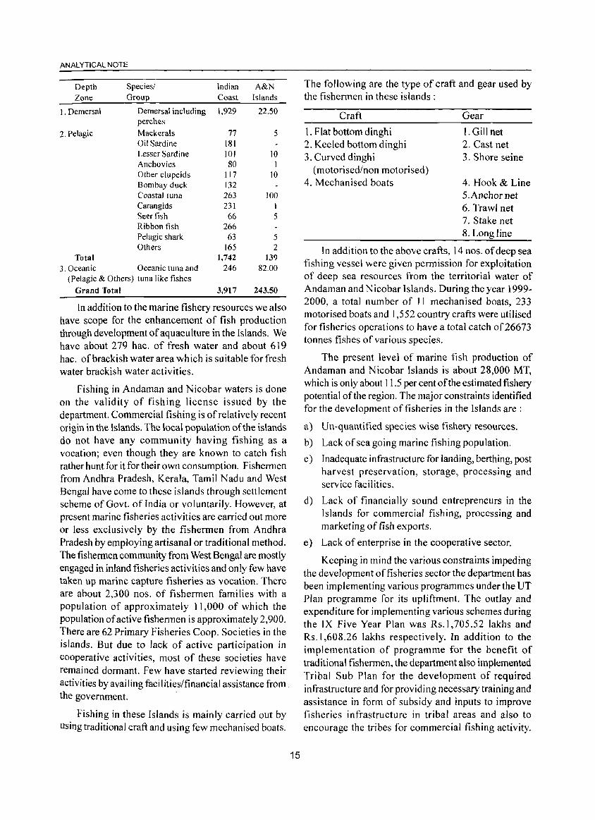
ANALYTICAL NOTE
Depth Species/ Indian A&N Zone Group Coast Islands
1. Demersal Demersal including 1,929 22.50 perches
2. Pelagic Mackerals 77 5 Oil Sardine 181 Lesser Sardine 101 10 Anchovies 80 J Other clupeids J 17 10 Bombay duck 132 Coastal tuna 263 100 Carangids 231 I Seer fish 66 5 Ribbon fish 266 Pelagic shark 63 5 Others 165 2
Total 1,742 139 3. Oceanic Oceanic tuna and 246 82.00
(Pelagic & Others) tuna like fishes
Grand Total 3,917 243.50
In addition to the marine fishery resources we also have scope for the enhancement of fish production through development of aquaculture in the Islands. We have about 279 hac. of fresh water and about 619 hac. of brackish water area which is suitable for fresh water brackish water activities.
Fishing in Andaman and Nicobar waters is done on the validity of fishing license issued by the department. Commercial fishing is of relatively recent origin in the Islands. The local population of the islands do not have any community having fishing as a vocation; even though they are known to catch fish rather hunt for it for their own consumption. Fishermen from Andhra Pradesh, Kerala, Tamil Nadu and West Bengal have come to these islands through settlement scheme of Govt. of India or voluntarily. However, at present marine fisheries activities are carried out more or less exclusively by the fishermen from Andhra Pradesh by employing artisanal or traditional method. The fishermen community from West Bengal are mostly engaged in inland fisheries activities and only few have taken up marine capture fisheries as vocation. There are about 2,300 nos. of fishermen families with a population of approximately 11,000 of which the population of active fishermen is approximately 2,900. There are 62 Primary Fisheries Coop. Societies in the islands. But due to lack of active participation in cooperative activities, most of these societies have remained dormant. Few have started reviewing their activities by availing facilities/financial assistance from. the government.
Fishing in these Islands is mainly carried out by using traditional craft and using few mechanised boats.
15
The following are the type of craft and gear used by the fishermen in these islands:
Craft
1. Flat bottom dinghi 2. Keeled bottom dinghi 3. Curved dinghi
(motorised/non motorised) 4. Mechanised boats
Gear
1. Gill net 2. Cast net 3. Shore seine
4. Hook & Line 5.Anchor net 6. Trawl net 7. Stake net 8. Long line
In addition to the above crafts, 14 nos. of deep sea fishing vessel were given permission for exploitation of deep sea resources from the territorial water of Andaman and Nicobar Islands. During the year 1999-2000, a total number of 11 mechanised boats, 233 motorised boats and 1,552 country crafts were utilised for fisheries operations to have a total catch of 26673 tonnes fishes of various species.
The present level of marine fish production of Andaman and Nicobar Islands is about 28,000 MT, which is only about 11.5 per cent ofthe estimated fishery potential of the region. The major constraints identified for the development of fisheries in the Islands are:
a) Un-quantified species wise fishery resources.
b) Lack of sea going marine fishing population.
c) Inadequate infrastructure for landing, berthing, post harvest preservation, storage, processing and service facilities.
d) Lack of financially sound entrepreneurs in the Islands for commercial fishing, processing and marketing of fish exports.
e) Lack of enterprise in the cooperative sector.
Keeping in mind the various constraints impeding the development of fisheries sector the department has been implementing various programmes under the UT Plan programme for its upliftment. The outlay and expenditure for implementing various schemes during the IX Five Year Plan was Rs.l,705.52Iakhs and Rs.I,608.26 lakhs respectively. In addition to the implementation of programme for the benefit of traditional fishermen, the department also implemented Tribal Sub Plan for the development of required infrastructure and for providing necessary training and assistance in form of subsidy and inputs to improve fisheries infrastructure in tribal areas and also to encourage the tribes for commercial fishing activity.
The outlay and actual expenditure for implementing the above scheme during the IX Five Year Plan was Rs. 241.65 lakhs and Rs.197.50 lakhs respectively. In addition to this, certain Centrally Sponsored Schemes viz. Group Accident Insurance Scheme and Savingscum-Relief Scheme etc. were implemented by the Fisheries Department for the benefit of the licenced fishing personnel of this Union Territory.
The Fisheries Department has set up and maintaining a Fisheries Museum! Aquarium in the heart of the city. About 40 number of live ornamental fishes of different varieties, 200 preserved specimen of marine species, 38 varieties of corals, a few stuffed fishes and skulls of fishes etc. are some of the spectacular items exhibited in the Museum. The museum attracts the islanders in general and the Indian as well as foreign tourists in particular.
Animal Husbandry
Scientific management and upgradation of genetic resources are the integral services for developing a healthy and profitable animal population for which the Department of Animal Husbandry and Veterinary Services has been implementing various schemes and motivating the people to engage in Animal Husbandry and earn a higher subsidiary income through enhanced production of eggs, meat and mi Ik.
This Union Territory is free from many of the dreaded infectious and contagious diseases of the livestock like Rinderpest disease, foot and mouth disease, Rabies, HS Anthrax etc. The continuous disease free status of this territory has also been recognised by the Government of India and O.l.E., Paris by declaring A&N Islands free from Rinderpest w.e.f. 1994. Concerted efforts are being made to maintain this disease free status by providing veterinary health services even to the remotest part of this territory through its wide network of veterinary institutions. Specialised treatment and diagnostic facilities is being provided to the livestock and poultry population through the newly established modern veterinary Polyclinic and Animal Disease Diagnostic Laboratory. Blanket Health coverage, zero-surveillance and monitoring of diseases are other important activities for disease control measures adopted in this Union Territory.
In order to cover the entire area of this Union Territory for upgrading the bovine population through Artificial Insemination (A.I), an intensive A.I and Castration Programme has been undertaken with the aim to attain the goal for covering the entire breedable cattle population in this Union Territory by the end of
16
~,'-'" ,,'-' I ,-,C',,"U':> n!-\I~Ut:lUUK. ANUAMAN & NICOtlAK ,;:,LANu;:,
Ninth Plan to enhance milk production. The local population of cattle and buffalo are being upgraded using the superior quality frozen semen. To popularise the programme, the department of Animal Husbandry & Veterinary Services is organising Veterinary Camps/ Sterility Camps at village level etc. and providing continuous training to Paragraph-veterinary staff in the technique. The department is also implementing a programme of training and inducting Part Time Volunteers (PTV) for taking up A.I and Castration in the vi lIage, who are paid incentives. A programme of Oestrous Synchronisation induction in Cows through Minerals and Vitamins supplementation and medication for reducing inter calving period thus enhancing productivity is also under implementation.
For expanding poultry development in these Islands, the Government, through the Department of Animal Husbandry has launched several programmes. The introduction of supplying backyard poultry of Girirani/ Vanaraja/Nicobari breeds, which can be easily maintained under the low management conditions. This programme has become popular among the farmers and as a result a large number of Desi birds have been replaced by VanarajaiGirirani birds. The department is providing practical training to the farmers through the departmental Poultry Demonstration -cum- Training Farms.
Apart from this, the Directorate of Animal Husbandry and Veterinary Services is maintaining Pig Demonstration Farms and Goat Demonstration-cumTraining Farms to impart training to the respective farmers for the development of Pig and Goat rearing. Besides, imparting in-service training to the departmental personnel, this department also imparts training to the interested farmers and unemployed youths to encourage them to take up their own livestock! poultry farms. Progressive farmers are also deputed to mainland for training in the field of cattle, poultry, artificial insemination etc. The department has also introduced a programme for developing grazing land at Panchayat level in order to fulfil the demand of nutritious variety of fodder. The department has also implemented an Integrated Diary Development Project, which has given a boost to diary development activities in this Union Territory.
As per the Live Stock and Poultry Census, 1997, the total number of livestock and poultry in this Union Territory are 188,310 and 800,950 respectively.
Industry
The Industries Department was set up during 1958
ANALYTICAL NOTE
as Cottage Industries headed by an Industries Officer at Port Blair as its headquarters. The department underwent expansion and branch offices were set up at out stations at Car N icobar in 1962, at Rangat in 1975, at Diglipur in 1986, at Campbell Bay in 1996 and at Little Andaman in 1999. Due to the expansion the Department was upgraded and brought under the control of the Director ofIndustries.
The Industries Department has implemented various programmes to develop the skill of the unemployed youths of these Islands, a few of which are given below:
Imparting training to the unemployed youths of this territory in reputed firms at mainland.
2 Organising workshop to motivate the unemployed youths to adopt self-employment.
3 Organising training programme for wood, cane and bamboo and shell handicrafts to the concerned artisans in association with DC handicrafts.
4 Promotion of cane and bamboo activities under UNDP projects.
During the year 2000-2001 the department has conducted 8 training sessions for carpentry, 24 for general engineering, 50 for tailoring and garment making, 5 for cane and bamboo and 3 for coir. In addition to this 7 candidates were sent on mainland institutions for undergoing training in computer hardware maintenance, 3 for web technology, 4 each for web designing and beautician and 13 for fashion designing.
Registration
The Department grants provisional registration and permanent registration to industrial/service unit as per the guidelines of Government ofIndia. The provisional registration is granted to enable the entrepreneur to avail various facilities under pre-production stage and the permanent registration is granted after the commencement of Commercial production. The permanent registered units are eligible for incentive like Capital Subsidy, Transport Subsidy, DG subsidy etc. During the year 2000-200 I an amount ofRs. 24.07 lakhs has been invested for 65 units.
Special Schemes organised by the Department
A special scheme has been designed to provide employment to educated unemployed youths by setting up micro enterprises through Industry, Service and Business routes. The Scheme has got special relevance in these Islands. During the year 200 1 though the target
17
was 200 units (cases), 65 cases were sanctioned and an amount of Rs.27.15 lakhs were disbursed for 34 cases. A composite loan up to a maximum of Rs.5 lakhs has been sanctioned to each SSIISSSBE units under a special scheme viz Loan to Tiny & Cottage Industries Projects at Reduced rate ofInterest. Under the scheme 9.41 lakhs rupees were disbursed to 8 such units. A Rural employment generation programme (REGP) under the KYI sector was launched on the basis of the recommendations of the high Power committee report, headed by the then Prime minister and an amount of Rs.21, 708 lakhs were disbursed to 33 such units.
Island Transport Subsidyllnter Island Transport Subsidy
Under the scheme, 85.0 per cent of the freight charges shall be reimbursed as transport subsidy for transporting raw material from Chennai Port to location of the unit in this territory and for transporting finished goods from the location of the unit to Chennai Port. The units which are eligible under the transport subsidy scheme of Government of India shall not be eligible for availing the transport subsidy under these scheme. Such subsidy is applicable in transporting goods in the inter Islands also. The Industry dept. provides infrastructural support including subsidy on installation of generator set, water-harvesting equipment, land development and marketing support to small and tiny industries through Sagarika Emporium and KG Bhawan.
Role of ANIDCO
The Andaman and Nicobar Islands Integrated Development Corporation Limited (ANIIDCO) was incorporated under the Companies Act, 1956 during 1988 on due recommendations of IDA (Islands Development Authority) for rapid economic growth of the Islands. The main objective of the company is to develop and commercially exploit the natural resources and operating on sound business principles. Its area of operation spread in fisheries, tourism, industry sectors and in supply of essential commodities to the islanders.
The Board of Directors of ANIIDCO are Chief Secretary, Commissioners of Revenue, Finance and Industries of A&N Administration besides the Director of Ministry of Industries, Government ofIndia and one non-official member. The Lt. Governor, A&N Islands appoints the Chairman and Managing Director of the Company from amongst the Directors.
The main divisions working under this Company
are the POL Division, which deals with storage and sale of petrol and HSD oil, tourism division which promote Island tourism by providing hotel and transport facilities etc., IMFL Division which looks after the storage and sale of Indian Made Foreign Liquor, Fisheries where Cold Storage facilities and fish processing for export is conducted, Milk Division where collection and distribution of milk is carried out, Steel Division where steel materials are procured and supplied to Government departments and public, Green Shop Division where Green Vegetables and Fruits were brought from various small Islands and from mainland and distributed to the islanders. Apart from this, a book shop, ship catering and an air ticketing division are also functioning under this Corporation. During the year 1999-2000 the Corporation earned a profit ofRs. 70.10 lakhs from POL Division, Rs. 7.79lakhs from Tourism Division, Rs. 481.79 lakhs from IMFL Division Rs. 11.64 lakhs from Milk Division and Rs. 27 .89Iakh~ from Steel Division.
Shipping Services
The Andaman and Nicobar Islands consists of38 inhabited and a number of uninhabited Islands which are separated from each other by a vast spread of832 Kms of sea. The shipping services playa very crucial role in the day today life of the islanders as this is the only mode of transportation for passengers and cargo to these far flung Islands and hence this can be called the 'Mother Industry' ofthe Islands. The Directorate of Shipping Services is responsible for operation and maintenance of ships, boats and ferry crafts owned by the A&N Administration. The Department is presently providing Shipping Services to 29 out ofthe 38 inhabited Islands of this Union Territory.
The Shipping Services are mainly divided into two categories viz. Mainland-Island and Inter-Island sectors.
i) Mainland-Island Sector
Presently 5 no. Passengers-cum-Cargo ships are operating in Mainland-Island sector to meet the requirement of the islanders. The Directorate provides regular Shipping Services to Chennai, Kolkata and Visakhapatnam as follows:
Name of Passenger Cargo Year of Vessel Capasity Capasity Development
·M.V. Harshawardhana. 749 1500 MT 1974 M.V. Nicobar 1200 1500 MT 1991 M.V. Nancowry 1200 1500 MT 1992 M.V. Akbar 1433 1500 MT 1994
M.V. Swaraj Dweep 1200 1500 MT 1999
18
DISTRICT CENSUS HANDBOOK. ANDAMAN & NICOBAR ISLANDS
During the year 2000-200 I a total no. of 158,306 passengers and 73,256 Metric tones of cargo have been transported by the above vessels between the Island and mainland.
ii) The Inter-Island sector
The inter-Island sector can be divided into 3 services viz. (1) Inter-Island service, (2) Foreshore service, and (3) Harbour ferry service.
1. Inter-Island service
The inter-Island services are maintained by deploying MY Sentinel, MV Choura, TSS Yerewa & MV Dering. These ships are being manned and maintained by SCI. The ships make voyage to Diglipur in North and to Campbell Bay in South. A round voyage to Diglipur takes three days and to Campbell Bay takes seven days. In a month, on an average eight round voyages are made in the Northern sector and six round voyages in the Southern sector excluding cargo vessels. During the year 2000-200 I a total number of 119,680 passengers and 39,815 Metric tones cargo have been transported by the inter-Island sector.
2. Foreshore Services
This service is operated between Port Blair and nearby Islands like Neil, Havelock, Long Island and Rangat by smaller vessels of the Administration. There are two regular weekly services. As the ships operated on these routes are smaller in size, these services are heavily dependent on weather conditions. At present 6 vessels are operated in this sector by which 158,975 passengers and 37,115 Metric tones cargo have been transported during the year 2000-2001.
3. Harbour Ferry Service
There are 10 routes operated for Harbour ferry service and 16 vessels are being operated for these purposes. Out of the 10 routes 5 are operated in Port Blair by means of 7 vessels and one each at Mayabunder and Kadamtala by means of 2 vessels each, Baratang and DigIipur by means of one vessel each and Nancowry by means of 3 vessels.
Also the department has six cargo vessels exclusively for carrying cargo for inter-island sector and there is also a small tanker of 100 ton capacity for supplying diesel to nearby islands. Apart from passenger and cargo services, there are a number of utility services like transportation of water to remote Islands/ships, touring for VIP and also for smooth operation of Shipping Services, for which 11 number of vessels are utilised as and when required. In addition
ANALYTICAL NOTE
to this vehicle ferry services are provided in 4 selected ports with the help of II vessels.
Marine Dockyard
The Marine Dockyard is one of the oldest and largest workshops in these islands. It has number of workshops, which include Sail maker, Fitting, Shipwright, Plating, Welding and Molding workshops and are equipped to carry out the repair of all vessels. All vessels owned by the A&N Administration and small boats of other departments are repaired by Marine Dockyard except those maintained by Shipping Corporation of India. There are two dry docks and seven slipways for docking the ships for under water repairs. The private ship owners also use these facilities.
Computerised Ship Ticketing
A fully computerised ticketing terminal has been introduced at Phoneix Bay in 1998-99 for the issue of tickets for passenger vessels operating between mainland-Island and inter-island/foreshore sectors.
Ship Acquisition
During the year 1991-2001, a total number of 44 vessels comprising of 3 vessels in Mainland-Island sector,l vessel in Inter Island sector, 2 Cargo vessels, 4 vessels in Foreshore service sector, 12 vessels in Harbour ferry service, 10 vessels in Vehicle ferry service, 1 vessel for General purpose, 5 Touring vessels, 2 Mooring vessels, 3 Motor launches and 1 Ton Bollard Pull Tug vessel were acquired to strengthen the water transport system prevailing in this UT.
Electricity
Power development had a modest beginning in these Islands. Prior to Independence, a small steam driven reciprocating engine direct current generator of 1 00 KW capacity was installed by the Britishers at Ross Island in 1932. After the departure of the Japanese occupation forces and British re-occupation in these Islands in 1945, the power house was shifted from Ross Island to Atlanta Point, Aberdeen, Port Blair and two 50 KW diesel engine driven DC generators were then installed and commissioned. Only the bungalows and offices of the British were provided with electricity. After Independence two steam turbine generating sets of 550 KW each were established during 1951 in the Power House at Chatham Island. The boilers were operated on wood, fuel and saw dusts which were the waste products of Chatham Saw Mill, and later on Mangrove wood was also used as fuel. This was the starting of the alternating current power
supply at Port Blair.
Due to the geograph ical and topographical peculiarities of these Island, including separation by sea over great distances, there is no single power grid for all the electrified Islands and instead a power house caters independently to the power requirements of an area/Island. At present there are 34 power houses with diesel generating sets of capacity ranging from 6 KW to 2500 KW, aggregating a capacity of38.8 MW.
The Electricity Department is operating and maintaining power generation, transmission and distribution systems & networks in these Islands for providing electric power supply to the general public and various categories of consumers in different parts of these Islands. The Electricity Department also functions as a Nodal Agency for implementing Renewable Energy Programmes and schemes and Integrated Rural Energy Programmes of the Ministry of Non Conventional Energy Sources in these Islands.
At present there are 34 power houses in different locations in these islands having diesel generating sets of capacity ranging from 6 K W to 2,500 K Wand the present total installed capacity is 38.8 MW. Round the clock power supply is available in South, Middle, North Andaman Islands, Neil, Havelock, Long, Little Andaman, Car N icobar, Katchal, Kamorta Islands and Campbell Bay and 16 Hrs. power supply is provided in Choura, Campion and Teressa Islands. The development of electric power supply in these Islands during the last 10 years is given below:
SI. Unit 1990-91 2000-2001 No. Particulars Andaman Nicobar Andaman Nicobar
I. Installed KW 13,708 1993 31,512 7293 Capacity
2. Generation MU 36.27 3.15 109.45 9.11
3. Consumption MU 29.15 2.54 81.57 7.54
4. Consumers Nos. 32,897 3,931 58,734 6462
5. Villages Nos. 327 164 308 171 electrified
Hydro Electric Power
The Hydro Electric Project at Kalpong River at Diglipur in North Andaman was taken up for irrigation purpose in 1977 and later on for power generation. Feasibility report of the Kalpong Hydro Electric Project to harness the potential of the Kalpong river was
. prepared by the CWC in 1979 and finally cleared techno-economically by the Central Electricity Authority, New Delhi during September 1991. The project utilises water of both the left and right forks of the Kalpong River by constructing a 35 .5m. high
19
concrete dam on the left fork and 25 M high rock fill dam on the right fork. A link channel connects both the left fork and the right fork reservoirs. The project has since been completed, commissioned and the Electricity Department of A&N Administration has started distribution of power in the North Andaman areas with effect from June 2002. The project is having a total installed capacity of 5.25 MW (3xl.75 MW) and will yield an annual generation of 14.83 MU, which will meet the power demand of North and Middle Andaman. The revised cost of the project was estimated as Rs. 4,937 Crores as per January 1998 price level.
NRSE & lREP Schemes
The Andaman and Nicobar Islands have considerable potential of solar, wind, ocean, hydro and bio-mass based energy sources. In order to exploit! utilise more and more new and renewable sources of energy, the Electricity Department has been implementing the New and Renewable Sources of Energy (NRSE) and Integrated Rural Energy Programme (IREP) schemes, as a Nodal agency for the Ministry of Non Conventional Energy Sources (MNES) during the year 1982. The NRSE Division of the Electricity Department is implementing these schemes in different remote and isolated locations of these islands. These schemes deal with NonConventional energy systems and conserve energy which is otherwise generated by costly imported HSD oil in these islands. Added advantages of these schemes are pollution free environment and are of much relevance to these islands for conserving its delicate fragile eco-system & environment. The different schemes/systems introduced under this schemes are:
1. Solar Photovoltaic Energy Systems
A total of35 nos. SP plants with aggregate capacity of 166.54 Kwh have been established at 24 different locations for providing 6 to ] 2 hrs. of power supp Iy for lighting homes and streets.
2. Wind Energy
10 (ten) nos. wind masts for studying the potential of wind were installed at different locations during 1993-99 for installation of suitable capacities of wind battery chargers, wind pumps and wind generators.
3. Hydro Energy
The hydro potential of Andaman & Nicobar Islands are being analyzed for establishment of mini/micro hydro electric power generating units. The Alternate Hydro Energy Centre of University of Roorkee
20
UI0 I KIG I CtNSUS HANDBOOK. ANDAMAN & NICOBAR ISLANDS
conducted detailed survey and investigation of different streams and nalhas in these islands during 1997 and submitted pre-feasibility reports for establishing Micro hydro plants at the following locations:
SI. Capacity No. Area (KW)
I. Vasundhara Nalha, South Andaman 2xIS
2. Dhanikhari, South Andaman 2x5O
3. Shoal Bay 19, South Andaman 1x5
4. Bada Khari, Rutland Island 2x5 5. Panchwati, Middle Andaman 2x25
6. Korang Nalah, Middle Andaman 2x1O
The National Hydro Electric Power Corporation, Ltd. has been entrusted the work of preparation of detailed project reports for establishment of micro hydro electric stations at the above locations.
4. Ocean Energy
The MNES had conducted a preliminary study of various locations in these Islands during 199] and had indicated that tidal power generation would be feasible at some locations with reference to cost of generation by diesel.
5. Biomass Based System
The Andaman & Nicobar Islands are having tropical rain forests and through gasification system of biomass, power req uirement of remote & isolated areas can be met. During the year 1998 the Karnataka State Council of Science & Technology indicated that around 1,200 K W of power potential could be harvested by exploiting available biomass at different islands.
Integrated Rural Energy Planning Programme
The IREP programme was initiated with a view to develop, design and implement rural energy projects so as to meet the cooking and lighting energy needs of people living in rural area. This is a component of minimum need programme under the 20 point programme of the Government of India. Household energy survey is conducted to ascertain energy needs and resources availability. IREP cells have been established at 5 blocks in these islands and project report submitted to the MNES for other islands. Fuel and energy saving devices and renewable energy system are being provided at subsidised cost by availing MNES subsidy.
(v) Census Concepts
Building:
A 'building' is generally a single structure on the
ANALYTICAL NOTE
ground. Sometimes it is made up of more than one component unit which are used or likely to be used as dwellings (residences) or establishments such as shops, business houses, offices, factories, workshops, worksheds, schools, places of entertainment, places of worship, godowns, stores, etc. It is also possible that buildings which have component units may be used for a combination of purposes such as shopcum-residence, workshop-cum-residence, office-cumresidence, etc.
Usually a structure will have four walls and a roof. But in some areas the very nature of construction of houses is such that there may not be any wall. Such is the case of conical structures where entrance is also provided but they may not have any walls. Therefore, such of the conical structures are also treated as separate buildings.
Permanent Houses :
Houses, the walls and roof which are made of permanent materials. The material of walls can be anyone from the following, namely, galvanized iron sheets or other metal sheets, asbestos sheets, brunt bricks, stones or concrete. Roof may be made of anyone of the following materials, namely, tiles, slate, galvanized iron sheets, metal sheets, asbestos sheets, bricks, stones or concrete.
Semi-Permanent Houses :
Houses in which either the wall or the roof is made of permanent material and the other is made of temporary material.
Temporary Houses :
Houses in which both walls and roof are made of materials which have to be replaced frequently. Walls may be made from anyone of the following temporary materials, namely, grass, thatch, bamboo, plastic, polythene, mud, unbumt bricks or wood. Roof may be made from anyone of the following temporary materials, namely, grass, thatch bamboo, wood, mud, plastic or polythene.
Dwelling Room :
A room is treated as a dwelling room if it has walls with a doorway and a roof and should be wide and long enough for a person to sleep in, i.e. it should have a length of not less than 2 meters and a breath of at least 1.5 meters and a height of 2 meters. A dwelling room would include living room, bedroom, dining room, drawing room, study room, servant's room and other habitable rooms. Kitchen, bathroom,
21
latrine, store room, passageway and verandah which are not normally usable for living are not considered as dwelling room. A room, used for multipurpose such as sleeping, sitting, dining, storing, cooking etc. is regarded as dwelling room. In a situation where a census house is used as a shop or office etc., and the household also stays in it then the room is not considered as a dwelling room. But if a garage or servant's quarter is used by a servant and if she/he also lives in it as a separate household then this has been considered as a dwelling room available to the servant's household. Tent or conical shaped hut if used for living by any household is also considered as dwelling room.
A dwelling room, which is shared by more than one household, has not been counted for any ofthem. If two households have a dwelling room each but in addition also share a common dwelling room, then the common room has not been counted for either of the households.
Census House :
A 'Census House' is a building or part of a building used or recognized as a separate unit because of having a separate main entrance from the road or common courtyard or, staircase, etc. It may be occupied or vacant. It may be used for a residential or non-residential purpose or both.
In certain peculiar situations, the manner in which buildings and census houses were identified for numbering in the field by the enumerators is described hereunder:
Sometimes a series of different buildings are found along a street which are joined with one another by common walls on either side looking like a continuous structure. These different units are practically independent of one another and are likely to have been built at different times and owned by different persons. In such cases, though the whole structure with all the adjoining units apparently appears to be one building, each portion was treated as a separate building and its constituent units as separate census houses.
On the other hand, one may come across cases, particularly in large cities of multi-storied ownership flats. In these cases while the structure looks like one building, different persons own the flats. In case of such multi-storied structures, having a number of flats owned by different persons, the entire structure was treated as one building and each flat as a separate census house.
If within a large enclosed area there are separate buildings owned by different persons then each such building is treated a separate building. There can be a situation where within an enclosed compound there are separate buildings owned by an undertaking or company or even government that are actually in occupation of different persons. For example, Indian Oil corporation colony where the bui Idings are owned by the Corporation but these are in occupation of their employees. Each such building should treated as a separate building. But ifin any of these buildings there are flats in occupation of different households, each such flat should be reckoned as a separate census house.
Sometimes it becomes difficult to apply the definition of census house strictly in certain cases. For example, in an urban area, if a flat has five rooms, each room having direct entrance from the common staircase or courtyard. By definition, this has to be treated as five census houses. If all these five rooms are occupied by a single household it should not be realistic to treat them as five census houses. In such a case, 'singleness' of use of these rooms along with the main house should be considered and the entire flat should be treated as one census house. On the other hand, if two independent households occupy these five rooms, the first household living in three rooms and the second household occupying two rooms, then considering the use, the first three rooms together should be treated as one census house and the remaining rooms as another census house. But if each room was occupied by an independent household, then each such room was treated as a separate census house.
In case of hostels, hotels etc., even if the door of each room in which an inmate lives opens to a common verandah, staircase, courtyard or a common room, as it happens almost invariably, the entire hostel/hotel building should be treated as one census house. But if such hostels/hotels have out-houses or other structures used for different purposes of the same purpose, then each structure attached to the main hostel/hotel should be treated as a separate census house.
In some parts of the country, in rural areas, the pattern of habitation is such that a group of huts, located in a compound, whether enclosed or unenclosed, is occupied by one household. While the main residence may be located in one hut, other huts may be used for sleeping, as a kitchen, bathroom, baithak etc. Though each of the huts is a separate structure, they form single housing unit and therefore, have to be treated
22
DISTRICT CENSUS HANDBOOK. ANDAMAN & NICOBAR ISLANDS
collectively as one building and one census house. If some of the huts are used by one household and the others by a second household as residence, then the two groups of huts should be treated separate census houses. However, if there are also other huts in the compound used for other purposes and not as part of the household's residence such as, cattle shed, workshed etc., these should be treated as separate census houses.
On the other hand, in urban areas, where more than one structure within an enclosed or open compound (premises) belonging to the same person, e.g., the main house, the servant's quarter, the garage, etc., only one building number is given for this group and each of the constituent a separate census house number.
Only cases where a structure with roof and pillars has come up is treated as a building.
Rural-Urban Area:
The data in tables on Houses, Household Amenities and Assets are presented separately for rural and urban areas. The unit of classification in this regard is 'town' for urban areas and 'village'; for rural areas. In the Census of India 200 I, the definition of urban area adopted is as follows:
(a) All places with a municipality, municipal corporation, cantonment board or notified town area committee, etc.
(b) A place which satisfy or are expected to satisfy the following criteria simultaneously:
i) A minimum population of5,000;
ii) At least 75 per cent of the male working population engaged in non-agricultural pursuits; and
iii) A density of population of at least 400 per square kilometre (1 ,000 per square mile).
F or identification of places which would qualify to be classified as 'urban', all vi lIages, which, as per the 1991 Census had a population of 4,000 and above, a population density of 400 persons per sq. km. and having at least 75 per cent of male working population engaged in non-agricultural activities were considered. To work out the proportion of male working population referred to above against b) (ii), the data relating to main workers were taken into account.
Apart from these, the outgrowths (OOs) of cities and towns have also been treated as urban artlas under Urban Agglomerations. Examples of out-growths are railway colonies, university campuses, port areas, military camps, etc., may have come up near a statutory
ANALYTICAL NOTE
town or city but these are within the revenue limits of a village or vi Ilages contiguous to the town or city. Each such individual area by itself may not satisfy the demographic criteria laid down at (b) above to qualify it to be treated as an independent urban unit but may deserve to be clubbed with the towns as a continuous urban spread. Thus, the town level data, wherever presented, also includes the data for outgrowths of such towns.
Household:
A 'household' is usually a group of persons who normally live together and take their meals from a common kitchen unless the exigencies of work prevent any of them from doing so. Persons in a household may be related or unrelated or a mix of both. However, if a group of unrelated persons live in a census house but do not take their meals from the common kitchen, then they are not constituent of a common household. Each such person was to be treated as a separate household. The important link in finding out whether it was a household or not was a common kitchen. There may be one member households, two member households or multi-member households.
Institutional household :
A group of unrelated persons who live in an institution and take their meals from a common kitchen is called an Institutional Household. Examples of Institutional Households are boarding houses, messes, hostels, hotels, rescue homes, jails, ashrams, orphanages, etc. To make the definition more clearly perceptible to the enumerators at the Census 2001, it was specifically mentioned that this category or households would cover only those households where a group of unrelated persons live in an institution and share a common kitchen.
Houseless household :
Households who do not live in buildings or census houses but live in the open on roadside, pavements, in hume pipes, under fly-overs and staircases, or in the open in places ofworship, mandaps, railway platforms, etc., are treated as Houseless Households.
Scheduled Castes and Scheduled Tribes :
Article 341 of the Constitution provides that the President may, with respect to any State or Union territory, specify the castes, races or tribes or parts of or groups within castes, races or tribes which shall for the purposes of the Constitution be deemed to be Scheduled Castes in relation to that State or Union territory. Article 342 similarly provides for specification
23
of tribes or tribal communities or parts of or groups within tribes or tribal communities, which are to be deemed for the purposes of the Constitution to be Scheduled Tribes in relation to the various States and Union territories. In pursuance of these provisions, the list of Scheduled Castes and lor Scheduled Tribes are notified for each State and Union territory and are valid only within the jurisdiction of that State or Union territory and not outside.
It is important to mention here that under the Constitution (Scheduled Castes) Order, 1950, no person who professed a religion different from Hinduism was deemed to be a member of a Scheduled Castes in addition to every member of the Ramdasi, Kabirpanthi, Majhabi or Sikligar caste resident in Punjab or Patiala and East Punjab States Union were in relation to that State whether they professed the Hindu or the Sikh religion. Subsequently, in September 1956, by an amendment, the Presidential Order of 1950 and in all subsequent Presidential Orders relating to Scheduled Castes, the Hindu and the Sikh religions were placed on the same footing with regard to the specification of Scheduled Castes. Later on, as per the amendment made in the Constitution (Scheduled Castes) Order 1990, the Hindu, the Sikh and the Buddhist were placed on the same footing with regard to the recognition of the Scheduled Castes.
In the statutory list of Scheduled Castes, which was notified in pursuance of Scheduled Castes and Scheduled Tribes Orders (Amendment) Act of 1976, no caste was notified as Scheduled Caste in relation to Andaman & Nicobar Islands. Hence, no data could be collected for Scheduled Castes.
The lists containing the names of the Scheduled Tribes in relation to this Union territory are given below:
LIST OF SCHEDULED TRIBES ANDAMAN & NICOBAR ISLANDS
I. Andamanese including Chariar, Chari, Kora, Tabo Bo, Vera, Kede, Bea, Balawa, Bojigiyab, Juwai, Koi.
2. Jarawas 3. Nicobarese 4. Onges 5. Sentinelese 6. Shompens
Language and Mother Tongue
As per the census concept, each language is a group of mother tongues. The census questionnaire collects information on the mother tongue of each
person and mother tongue is defined as the language spoken in childhood by the person's mother to the person. If the mother died in infancy, the language mainly spoken in the person's home in childhood will be the mother tongue. In the case of infants and deaf mutes, the language usually spoken by the mother is considered as mother tongue. It is not necessary that the language spoken as mother tongue should have a script. The mother tongues returned by the respondents in census are classified and grouped under appropriate languages according to their linguistic characteristics.
Literate:
A person age 7 years and above who can both read and write with understanding in any language is taken as literate. A person who can only read but cannot write is not literate. It is not necessary that to be considered as literate, a person should have received any formal education or passed any minimum educational standard. Literacy could also have been achieved through adult literacy classes or through any non-formal educational system. People who are blind and can read in Braille are treated as literates.
Literacy rate :
Literacy rate of the population is defined as the percentage of literates in the age group seven years and above. For different age groups the percentage of literates in that age group gives the literacy rate.
Educational Level :
The highest level of education a person has completed.
Work:
Work is defined as participation in any economically productive activity with or without compensation, wages or profit. Such participation may be physical and/or mental in nature. Work involves not only actual work but also includes effective supervision and direction of work. It even includes part time help or unpaid work on farm, family enterprise or in any other economic activity. All persons engaged in 'work' as defined above are workers. Persons who are engaged in cultivation or milk production even solely for domestic consumption are also treated as workers.
Reference period for determining a person as worker and non-worker is one year preceeding the date of enumeration.
Main Worker :
A person who has worked for major part of the reference period (i.e. six months or more during the
?4
DISTRICT CENSUS HANDBOOK. ANDAMAN & NICOBAR ISLANDS
last one year precceding the date of enumeration) in any economically productive activity is tenned as 'Main worker'.
Marginal Worker:
A person who worked for less than six months of the reference period (Le. in the last one year preceeding the date of enumeration) in any economic activity is termed as 'Marginal worker'.
Non Worker:
A person who has not worked at all in any economically productive activity during the reference period (i.e. last one year preceeding the date of enumeration) is termed as 'Non worker'.
Cultivator:
For purposes of the Census a person is classified as cultivator if he or she is engaged in cultivation on land owned or held from government or held from private persons or institutions for payment in money, kind or share. Cultivation includes effective supervision or direction in cultivation.
A person who has given out herlhis land to another person or persons or institution (s) for cultivation for money, kind or share of crop and who does not even supervise or direct cultivation in exchange of land, is not treated as cultivator. Similarly, a person working on another person's land for wages in cash or kind or a combination of both (agricultural labourer) is not treated as cultivator.
Cultivation involves ploughing, sowing, harvesting and production of cereals and millet crops such as wheat, paddy, jowar, bajra, ragi, etc., and other crops such as sugarcane, tobacco, ground-nuts, tapioca, etc., and pulses, raw jute and kindred fiber crop, cotton, cinchona and other medicinal plants, fruit growing, vegetable growing or keeping orchards or groves, etc. Cultivation does not include the following plantation crops - tea, coffee, rubber, coconut and betel-nuts (areca).
Agricultural Labourer:
A person who works on another person's land for wages in money or kind or share is regarded as an agricultural labourer. She/he has no risk in the cultivation, but merely works on another person's land for wages. An agricultural labourer has no right of lease or contract on land on which she/he works.
Household Industry Worker :
Household industry is defined as an industry
ANALYTICAL NOTE
conducted by the head of the household herselflhimself and or by the members of the household at home or within the village in rural areas and only within the precincts of the house where the household lives in urban areas. The larger proportion of workers in household industry should consist of members of the household including the head. The industry should not be run on the scale of a registered factory which would qualify or has to be registered under the Indian Factories Act and should be engaged in manufacturing, processing, servicing and repairs of goods.
It does not include professions such as a pleader, Doctor, Musician, Dancer, Waterman, Astrologer, Dhobi, Barber, etc. or merely trade or business, even if such professions, trade or services are run at home by members of the household.
Other Worker:
A person who has been engaged in some economic activity during the reference period but not as a cultivator or agricultural labourer or in Household Industry is termed as a 'Other Worker (OW)'. The type of workers that come under this category of "OW' include all government servants, municipal employees, teachers, factory workers, plantation workers, those engaged in trade, commerce, business, transport, banking, mining, construction, political or social work, priests, entertainment artists, etc. In effect, all those workers other than cultivators or agricultural labourers or household industry workers, are 'Other Workers' .
Work Participation Rate:
Percentage of workers (main + marginal) to total population.
Population Density :
Population density is the number of persons inhabited per square kilo-metre of the area.
Age:
Age is measured in terms of the completed number of years.
Sex-ratio:
Numberoffemales per 1,000 males in a population.
(vi) Non Census Concepts
Improved drinking w~ter :
If the household had access to drinking water supplied from a tap, hand pump, tube well or well (protected or covered) situated within or outside the premises, it is considered as having access to improved drinking water .. It may be mentioned that such uniform
25
definition may not be valid across all states.
System of sewerage :
Generally, a sewerage system would mean a network of mains and branches of underground conduits for the conveyance of sewerage to the point of disposal. Sewers that carry only household and industrial wastage are called separate sewers; those that carry storm water from roofs, streets and other surfaces are known as storm water drains, while those carrying both sewage and storm water are called combined sewers. However, in some towns, which are not provided with such underground sewerage system, it is served by open surface drain, box drain, silk pattern drain, etc., in these towns.
Type of latrine and Method of disposal of night soil :
There are three prevalent systems of disposal of human wastes, viz. (i) underground sewerage, (ii) sanitary water flush latrines with individual disposal systems, like septic tank, leaching cess pool and collecting well, and (iii) dry type oflatrines with manual scavenging.
The system of underground sewerage provides for the street sewerage with which are connected the sanitary latrines constructed in the houses having water closets and fitted with flushing cistern (or hand flushing). Through this sewer the faecal matter is transported without the need for scavenging. This system generally exists in cities and big towns.
Where the street sewer does not exist these sanitary water flush latrines are connected to a local septic tank with a sub-soil dispersion system or a leaching pit. Here the liquid wastes from the water closet is disposed of locally in leaching pit, a septic tank with a soil dispersion system is constructed. This dispersion requires an optimum travel through the pores of the soil, which renders the harmful liquid bacterially innocuous by the slow process offiltration through the soil traversed.
Where the soil is impermeable, collecting wells are constructed and the sanitary water flush latrines are connected with them. These wells are cleaned at periodic intervals by a suitable device. The dry type of latrines are of service type latrines from where human excreta is removed by scavengers from house to house, in most cases carrying it on their heads or shoulders or in baskets with handle or wheel barrows. These are then collected in bullock carts or trucks or tractors and trolleys for being carried to the dumping grounds.
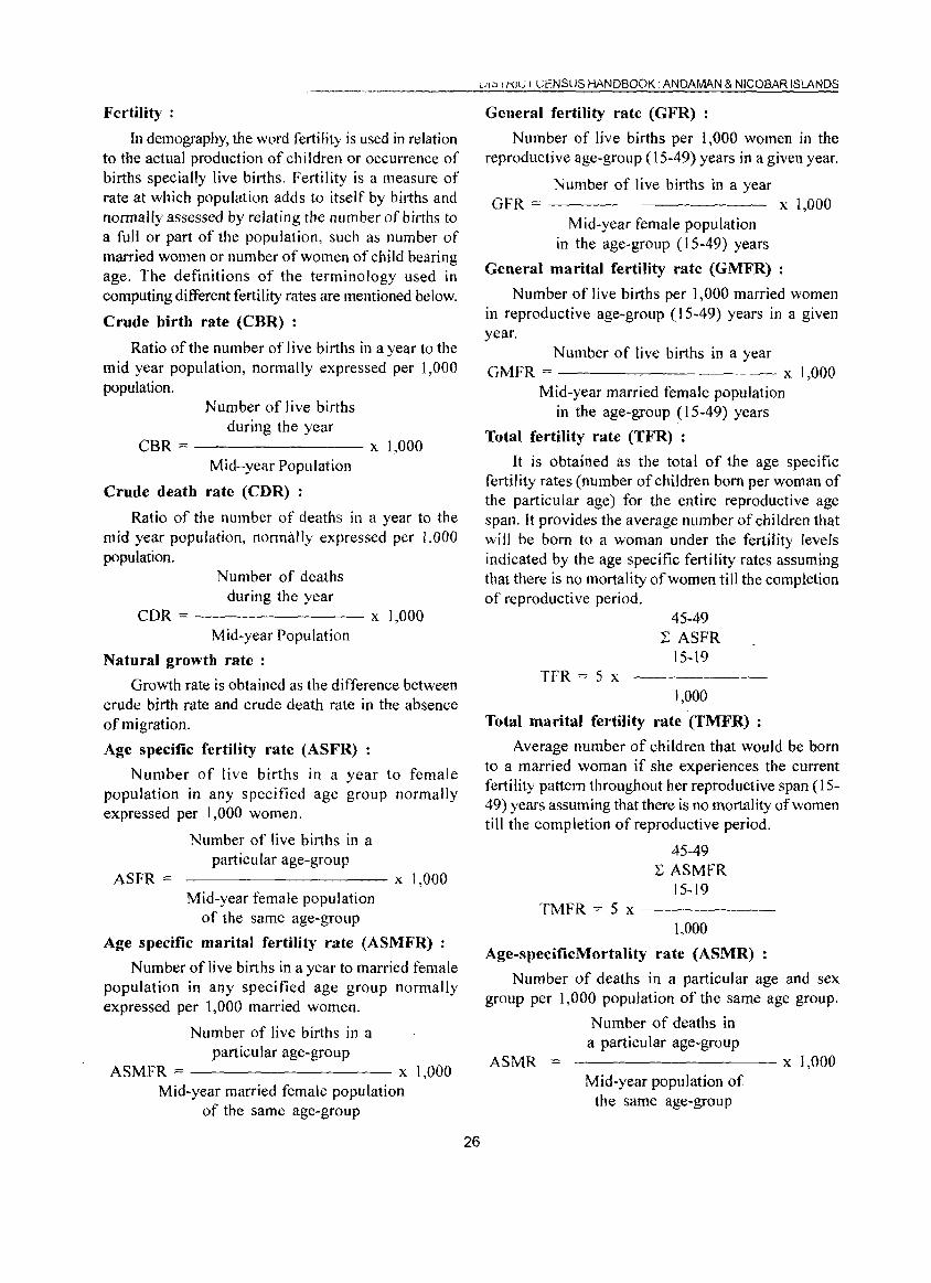
Fertility:
In demography, the word fertility is used in relation to the actual production of children or occurrence of births specially live births. Fertility is a measure of rate at which population adds to itself by births and normally assessed by relating the number of births to a full or part of the population, such as number of married women or number of women of child bearing age. The definitions of the terminology used in computing different fertility rates are mentioned below.
Crude birth rate (CBR) :
Ratio of the number of live births in a year to the mid year population, normally expressed per 1,000 population.
Number of live births during the year
CBR::= -------- X 1,000 Mid-year Population
Crude death rate (CDR) :
Ratio of the number of deaths in a year to the mid year population, normally expressed per 1,000 population.
N umber of deaths during the year
CDR = x 1,000 Mid-year Population
Natural growth rate :
Growth rate is obtained as the difference between crude birth rate and crude death rate in the absence of migration.
Age specific fertility rate (ASFR) :
Number of live births in a year to female popUlation in any specified age group normally expressed per 1,000 women.
ASFR =
Number of live births in a particular age-group
----------x 1,000 Mid-year female population
of the same age-group
Age specific marital fertility rate (ASMFR)
Number of live births in a year to married female population in any specified age group normally expressed per 1,000 married women.
Number of live births in a particular age-group
ASMFR ~ x 1,000 Mid-year married female population
of the same age-group
26
UI;:' I KIC I (.;ENSUS HANDBOOK. ANDAMAN & NICOBAR ISLANDS
General fertility rate (GFR) :
Number of live births per 1,000 women in the reproductive age-group (15-49) years in a given year.
Number of live births in a year GFR := x 1,000
Mid-year female population in the age-group (15-49) years
General marital fertility rate (GMFR)
Number of live births per 1,000 married women in reproductive age-group (15-49) years in a given year.
Number of live births in a year GMFR == x 1,000
Mid-year married female population in the age-group (15-49) years
Total fertility rate (TFR) :
It is obtained as the total of the age specific fertility rates (number of children born per woman of the particular age) for the entire reproductive age span. It provides the average number of children that wi II be born to a woman under the fertility levels indicated by the age specific fertility rates assuming that there is no mortality of women till the completion of reproductive period.
TFR = 5 x
45-49 2: ASFR
15-19
1,000
Total marital fertility rate (TMFR) :
Average number of children that would be born to a married woman if she experiences the current fertility pattern throughout her reproductive span (15-49) years assuming that there is no mortality of women till the completion of reproductive period.
45-49 2: ASMFR
15-19 TMFR == 5 x ------
1,000
Age-speciflcMortality rate (ASMR)
Number of deaths in a particular age and sex group per 1,000 population of the same age group.
ASMR
Number of deaths in a particular age-group ---------- x 1,000
Mid-year population of the same age-group
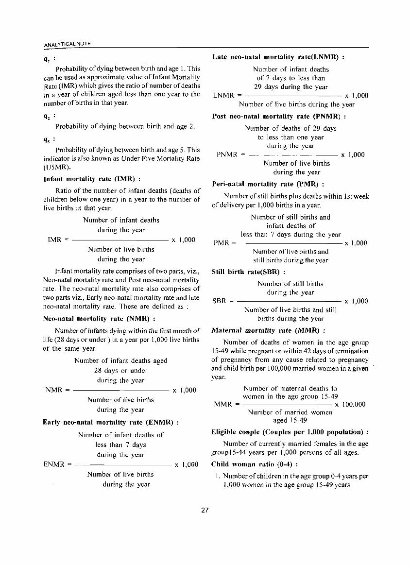
ANALYTICAL NOTE
ql : Probability of dying between birth and age 1. This
can be used as approximate value of Infant Mortality Rate (lMR) which gives the ratio of number of deaths in a year of children aged less than one year to the number of births in that year.
Probability of dying between birth and age 2.
Probability of dying between birth and age 5. This indicator is also known as Under Five Mortality Rate (U5MR).
Infant mortality rate (IMR) :
Ratio of the number of infant deaths (deaths of children below one year) in a year to the number of Jive births in that year.
Number of infant deaths
during the year IMR == ----------- x 1,000
Number of live births
during the year
Infant mortality rate comprises of two parts, viz., Neo-natal mortality rate and Post neo-natal mortality rate. The neo-natal mortality rate also comprises of two parts viz., Early neo-natal mortality rate and late neo-natal mortality rate. These are defined as :
Neo-natal mortality rate (NMR) :
Number of infants dying within the first month of life (28 days or under) in a year per 1,000 live births of the same year.
Number of infant deaths aged
28 days or under
during the year
NMR = ----------- x 1,000
Number of Jive births
during the year
Early neo-natal mortality rate (ENMR)
Number of infant deaths of
less than 7 days
during the year
ENMR = ---------- x 1,000
Number of live births
during the year
27
Late neo-natal mortality rate(LNMR)
Number of infant deaths of 7 days to less than
29 days during the year LNMR = x 1,000
Number of live births during the year
Post neo-natal mortality rate (PNMR)
Number of deaths of 29 days to less than one year
during the year PNMR = ---------- x 1,000
Number of live births during the year
Peri-natal mortality rate (PMR) :
NumberofstiJl births plus deaths within 1st week of delivery per 1,000 births in a year.
Number of still births and infant deaths of
less than 7 days during the year PMR = x 1,000
Number of live births and still births during the year
Still birth rate(SBR) :
Number of still births during the year
SBR = x 1,000 Number of live births and still
births during the year
Maternal mortality rate (MMR) :
Number of deaths of women in the age group 15-49 while pregnant or within 42 days of termination of pregnancy from any cause related to pregnancy and child birth per 100,000 married women in a given year.
Number of maternal deaths to women in the age group 15-49
MMR = x 100,000 Number of married women
aged 15-49
Eligible couple (Couples per 1,000 population) :
Number of currently married females in the age group 15-44 years per 1,000 persons of all ages.
Child woman ratio (0-4) :
1. Number of children in the age group 0-4 years per 1,000 women in the age group 15-49 years.
Child woman ratio (5-9) ;
2. Number of children in the age group 5-9 years per 1,000 women in the age group 15-49 years.
Migration;
Migration is the third component of population change, the other two being mortality and fertility.
A person is considered as a migrant by place of birth if the place in which he/she is enumerated during the census is other than the place of his/her birth.
Similarly a person is considered as a migrant by place oflast residence if the place in which he/she is enumerated during the census is other than his/her place of immediate last residence outside the village or town and not simply in another house or locality in the same village or town.
Certain aspects concerning temporary movement! migration of people has been explained below as these are important components concerning migration:
(i) Migration of persons in search of job is high in the country. In many cases such migrants are only seasonal in nature. People migrate to other places for work in a particular season and come back again to their usual place of residence after three or four months. All such workers are treated as migrants. Similarly, if a person moved to any other place for attending short term vocational or educational course that lasted for only few months of a year, she/he too were considered as a migrant.
(ii) Where a person had merely gone out to another place or had been shifting from one place to another purely on tour, pilgrimage, visit to hospital for treatment or for temporary business purposes, such persons are not deemed to have had another residence different from the place where she/he or her/his family normally resides. She/he is not considered as migrant.
(iii) A woman temporarily moves into a hospital or to her parents or other relative's house for delivery and if the hospital or the parents/relatives houses is in a place different from usual place of residence, the place where the hospital or parents/ relative's house is the place of last residence of the child but not of the mother.
A new response category 'Moved after birth' was added in Census of India 200 I in the question on 'reasons for migration' to bring out additional migration patterns. Natural calamities or distress migration as a reason for migration for last residence migrants
28
DISTRICT CENSUS HANDBOOK. ANDAMAN & NICOBAR ISLANDS
included in 1991 Census, is covered under category of 'Others'. The reason for migration has been determined as applicable at the time of migration and not in reference to any point of time after that. For example, if a person had moved from the place of her/his last residence for the purpose of education and subsequently at some point of time got employment there only, the reason for migration would be 'education' and not • work/employment' .
Internal and International migration ;
The migrational movements are of three types (i) Migration within the state itself with its components (a) Migration within the district of enumeration (intra district migration) (b) Migration from one district of state to another district of state (inter district migration), (ii) Migration from one state to another State of the country (inter-state migration), (iii) Migration from one country to another country. The first two streams together constitute internal migration, while the last type of movement is called international migration. The present name of the country, state or district and not the name by which they were known at the time of her/his birth or last residence were recorded.
Rural - Urban components of migration ;
Rural or Urban status in respect of migrants have been determined as applicable at the time of migration and not with reference to any point of time after that.
The flow of migrants consists of four streams viz. rural to rural, rural to urban, urban to rural and urban to urban.
Civic status of urban units ;
Civic Status of a town/city is determined on the basis of Civic Administrative authority .of the town e.g., Municipal Corporation / Corporation, Municipal Committee/ Municipal council, Municipality etc.
Size class of U A / town :
Size-class ofUA/Town is based on the popUlation size of the UA/City/Town UAs.lTowns with 100,000 and above population are classified as Class-I UAs / towns. These Class-I UAs / towns are now further sub classified in to seven sub classes namely M J to M7 depending on the population size ofUNCity/Town. These are M7(5,000,000 and above); M6(2,000,000 to 4,999,999); M5 (1,000,000-1,999,999) M4 (500,000-999,999); M3(300,000-499,999), M2 (200,000-299,999) & M I (100,000-199,999). Towns with, 50,000 to 99,999 population are classified as Class-II towns, 20,000 to
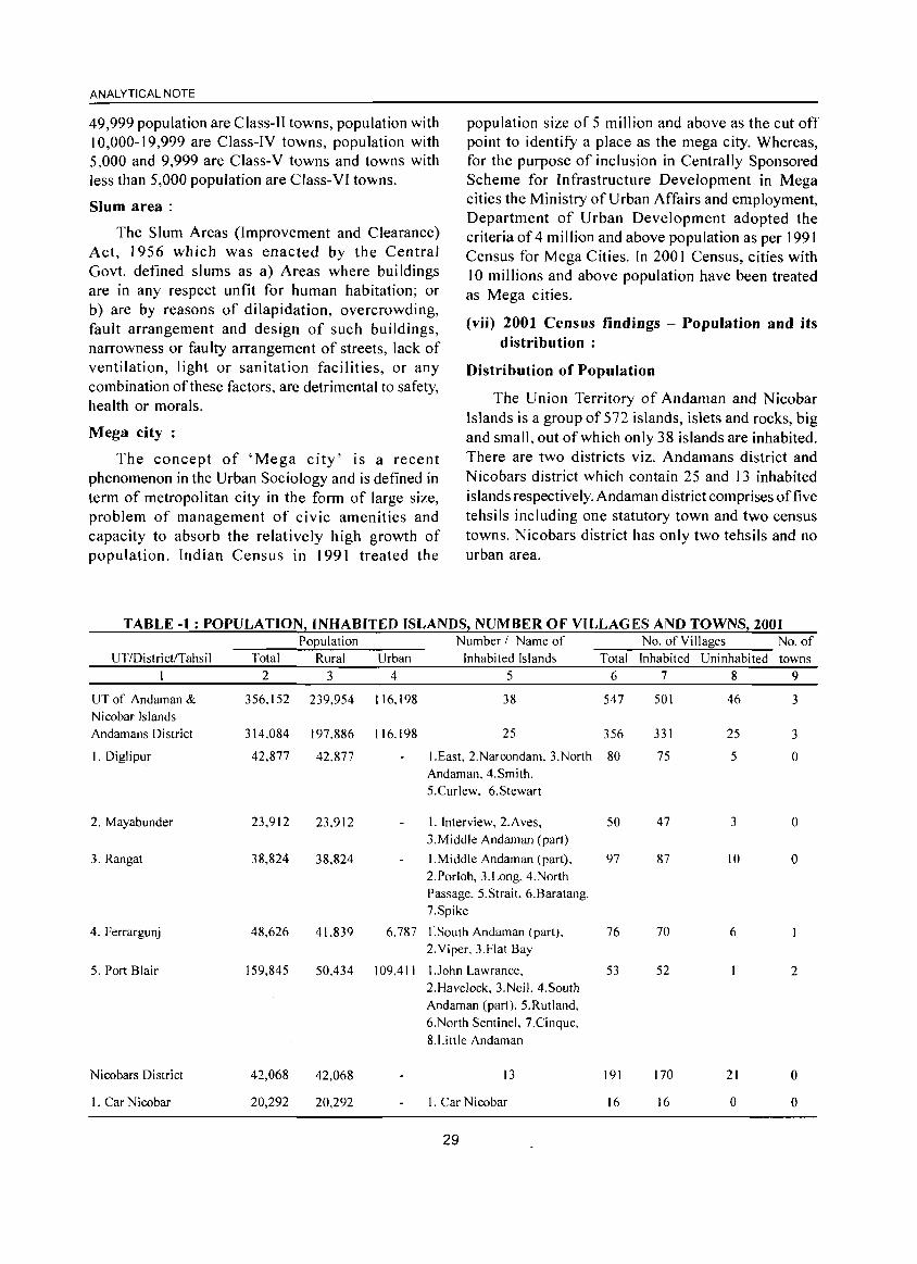
ANALYTICAL NOTE
49,999 population are Class-II towns, population with 10,000-19,999 are Class-IV towns, population with 5,000 and 9,999 are Class-V towns and towns with less than 5,000 population are Class-VI towns.
Slum area:
The Slum Areas (Improvement and Clearance) Act, 1956 which was enacted by the Central Govt. defined slums as a) Areas where buildings are in any respect unfit for human habitation; or b) are by reasons of dilapidation, overcrowding, fault arrangement and design of such buildings, narrowness or faulty arrangement of streets, lack of ventilation, light or sanitation facilities, or any combination of these factors, are detrimental to safety, health or morals.
Mega city:
The concept of 'Mega city' is a recent phenomenon in the Urban Sociology and is defined in term of metropolitan city in the form of large size, problem of management of civic amenities and capacity to absorb the relatively high growth of population. Indian Census in 1991 treated the
population size of 5 million and above as the cut off point to identify a place as the mega city. Whereas, for the purpose of inclusion in Centrally Sponsored Scheme for Infrastructure Development in Mega cities the Ministry of Urban Affairs and employment, Department of Urban Development adopted the criteria of 4 million and above population as per 1991 Census for Mega Cities. In 2001 Census, cities with 10 millions and above population have been treated as Mega cities.
(vii) 2001 Census findings - Population and its distribution :
Distribution of Population
The Union Territory of Andaman and Nicobar Islands is a group of 572 islands, islets and rocks, big and small, out of which only 38 islands are inhabited. There are two districts viz. Andamans district and Nicobars district which contain 25 and 13 inhabited islands respectively. Andaman district comprises offive tehsils including one statutory town and two census towns. Nicobars district has only two tehsils and no urban area.
TABLE -1: POPULATION: INHABITED ISLANDS! NUMBER OF VILLAGES AND TOWNS: 2001 POEulation Number I Name of No. of Villages No. of
UTlDistrict/TahsiI Total Rural Urban Inhabited Islands Total Inhabited Uninhabited towns I 2 3 4 5 6 7 8 9
UT of Andaman & 356.)52 239,954 116,198 38 547 SOl 46 3 Nicobar Islands Andamans District 314.084 197,886 116.198 25 356 331 25 3
I.Diglipur 42,877 42.877 LEast, 2.Narcondam. 3.North 80 75 5 0 Andaman.4.Smith. 5.Curlew. 6.Stewart
2. Mayabunder 23.912 23.912 I. Interview, 2.Aves, 50 47 3 0 3.Middle Andaman (part)
3. Rangat 38,824 38,824 I.Middle Andaman (part), 97 87 10 0 2.Porlob. 3.Long, 4.North Passage. 5.Strait. 6.Baratang. 7.Spike
4. Ferrargunj 48,626 41.839 6.787 I.South Andaman (part). 76 70 6 2.Viper. 3.Flat Bay
5. Port Blair 159,845 50.434 109,411 1 John Lawrance. 53 52 2 2.Havelock, 3.Neil. 4.South Andaman (part), 5.Rutland. 6.North Sentinel, 7.Cinque, 8.Little Andaman
Nicobars District 42,068 42,068 13 191 170 21 ° l. Car Nicobar 20,292 20,292 L Car Nicobar 16 16 0 0
29
DISTRICT CENSUS HANDBOOK: ANDAMAN & NICOBAR ISLANDS
Population UTlDistrictlTahsil Total Rural Urban
Number! Name of Inhabited Islands
No. ofVilla~es No. of
Total Inhabited Uninhabited towns 2 3 4 5 6 7 8 9
2. Nancowry 21. 776 2L776 I.Choura, 2.Tillang Chong, 3. Teressa. 4. Bompoka, 5.Katchal. 6.Nancowry, 7.Kamorta,8.Trinket, 9.Pulomilo, 10.Little
175 154 21 0
Nicobar. II.Kondul, 12.Greal Nicobar
The population of Andaman and Nicobar Islands with reference to 00.00 hours of 1 sf March, 2001 is 356,152 of which 192,972 are males and 163,180 are females against 280,661 population comprising 154,369 males and 126,292 females as per 1991 census. Of these 67.4 per cent population is residing in rural areas while 32.6 per cent in the urban areas. Among the districts the population of Andamans district is 3 14,084 persons (88.2 per cent) and that for Nicobars district is 42,068 persons (11.8 per cent). The rural urban break up of the population of Andamans district is 197,886 persons (63.0 per cent) and 116,198 persons (37.0 per cent). As stated above Nicobars is an entirely rural district. Andaman and Nicobar Islands is the abode of
aborigines, migrants, settlers and their descendants. Aborigines have been notified as scheduled tribes. But there is no notified scheduled caste population in this Union Territory. According to 200 I census the number of scheduled tribes population is 29,469 against 26,770 in 1991 census. The contribution of Institutional population and Houseless population in 200~ census is 8,046 and 242 respectively.
Port Blair (MCI) is the only statutory town in this UT and as per definition of census town two erstwhile villages have been considered as census town viz. Bambooflat (CT) and Garacharma (CT) in 2001 census. All these three towns are situated in Andamans district.
TABLE - 2: SIZE, CLASS AND STATUS OF TOWNS IN UNION TERRITORY, 2001
Serial Number Name of the Town Population Size & Class Type I 2 3 4 5 I Port Blair (M CI) 99,984 Class 11(50,000-99,999) Statutory Town
2 Bambootlat (CT) 6.787 Class V (5,000-9,999) Census Town
3 Garacharma (CT) 9,427 Class V (5,000-9,999) Census Town
Growth rate
The percentage decadal growth of population of Andaman and Nicobar Islands has decreased from 48.70 per cent in 1981-91 to 26.90 per cent in 1991-2001. Despite decline it is still higher than the national decadal growth rate of21.54 per cent in 2001. Similar patterns of declining growth rate of population in 1991-
2001 have been observed in both the districts as compared to 1981-1991. Whi Ie growth rate of population in Andamans district is 30.08 per cent during 1991-2001, this is significantly low (7.29 per cent) in the Nicobars district which is mainly inhabited by N icobarese Tribes.
TABLE - 3: DECADAL VARIATION OF TOTAL POPULATION, 1901-200 U. T. of A & N Islands Andamans District Nicobars District
Total Percentage Total Percentage Total Percentage
Year Population decadal variation Population decadal variation Population decadal variation I 2 3 4 5 6 7
1901 24,649 18.138 6,511 1911 26,459 7.3 17.641 -2.7 8,818 35.4 1921 27.086 2.4 17,814 1.0 9,272 5.1
1931 29,463 8.8 19,223 7.9 10,240 10.4
1941 33,768 14.6 2L316 10.9 12,452 21.6
1951 30,971 -8.3 18,962 -11.0 12,009 -3.6
30
ANALYTICAL NOTE
U. T. of A & N Islands Andamans District Nicobars District
Total Percentage Total Percentage Total Percentage Year Population decadal variation Population decadal variation Population decadal variation
1 2 3 4 1961 63,548 105.2 48,985 1971 115,133 81.2 93.468 1981 188.741 63.9 158,287 1991 280,661 48.7 241.453 2001 356,152 26.9 314.084
Trend in population growth in UT during last 100 years shows that the decadal growth in 1951-1961 was highest (105.2 per cent). The growth rate was on negative side (-8.3 per cent) during 1941-1951, the
5 6 7 158.3 14,563 21.3 90.8 21.665 48.8 69.3 30,454 40.6
52.5 39.208 28.7 30.1 42,068 7.3
decade of Second World War and Japanese invasion to these Islands. However, over the years the decadal growth rate of population has been found to be steadily decreasing since 1961-1971.
CHART 1 : TREND OF POPULATION GROWTH IN UT, 1901- 2001
Census Year and Population
Density of Popluauull
The density of population of A&N Islands as per census 2001 is 43 persons per sq. km. against 34 persons per Sq. Km in 1991. The population density of Andamans district has gone up from 38 in census 1991
to 49 in census 2001. During the period the density of Nicobars district has increased marginally from 21 to 23 persons per sq. km. At all India level the population density has been recorded as 325 in 2001 and 267 in 1991 census.
TABLE-4: DENSITY OF POPULATION, 1911-2001
U.T. of A & N Islands Andamans District V Nicobars District I Year Total Rural Urban Total
1 2 3 4 5 1911 3 3 0 3 1921 3 3 0 3 1931 4 4 0 3 1941 4 4 0 3 1951 4 NA NA 3
1961 8 6 1,788 8
1971 14 II 3,298 15
1981 23 17 3.510 25 1991 34 25 5,301 38 2001 43 29 4,401 49
Trend in population density of urban area shows that it has increased steadily during 1961 to 1991 when Port Blair (M. CI.) was the only town in the UT, but after inclusion of Bambooflat (CT) and Garacharma (CT) at 200 I census the urban population density has
31
Rural Urban Total Rural Urban
6 7 8 9 10
3 0 5 5 0
3 0 6 6 0
3 0 6 6 0
3 0 8 8 0 NA NA 6 NA NA
5 1.788 7 7 0 II 3,298 II II 0 17 3,510 17 17 0 26 5,30 I 21 21 0 31 4,401 23 23 0
come down from 5,301 persons per Sq. Km. to 4,401 persons per Sq. Km.
Sex Ratio
As per 2001 census the sex ratio of the total
population of the union territory is 846 which shows an increase from 818 recorded at the 1991 census. As compared to national level sex ratio of 933 in 2001 census, sex ratio of the state is highly masculine. Among districts, Andamans has 844 while Nicobars district has recorded 857 sex ratio of total population.
DISTRICT CENSUS HANDBOOK. ANDAMAN & NICOBAR ISLANDS
Child Sex Ratio (0-6 age)
In India over the years child sex ratio has declined from 945 in 199 I to 927 in 200 I census. In this union territory also child sex ratio has come down from 973 in 1991 to 957 in 2001 census. In predominantly tribal Nicobars district the child sex ratio has marginally increased from 930 to 937 during the decade.
TABLE- 5: SEX RATIO OF ur AND DISTRICT, 1901-2001 Union Territory of
Census A & N Islands District Andamans District Nicobars Year Total Rural Urban Total Rural Urban Total Rural Urban
I 2 3 4 5 6 7 8 9 10 1901 318 318 197 197 841 841 1911 352 352 197 197 825 825 1921 303 303 146 146 769 769 1931 495 495 348 348 881 881 1941 574 574 433 433 891 891 1951 625 654 545 489 452 545 900 900 1961 617 630 573 554 546 573 872 872 1971 644 671 558 615 638 558 784 784 1981 760 774 720 750 764 720 811 811 1991 818 837 769 815 836 769 840 840 2001 846 861 815 844 861 815 857 857
Note: Sex ratio has been defined here as t he number of females per 1000 males.
CHART 2 : TREND IN SEX RATIO OF 0-6 AGE GROUP, 1961-2001
1040
1020
1000 .
980
.2 960
~ 940 )(
'" 920 IJ)
900
880
860
840 .
1961 1971 1981 1991 2001
Census Year
_A & N Islands ____ Andamans -.-Nicobars
Literacy Rate
The literacy rate of Andaman and Nicobar Islands has substantially increased during 1991 to 200 I. The literacy rates for the union territory, Andamans district and Nicobars district are 81.30, 82.49 and 72.35 per cents in 200 I census whereas in 1991 census the corresponding rates were 73.02, 74.52 and 63.72 per
. cents respectively.· Compared to all India literacy level of64.8 percent, literacy status of the union territory is found to be better.
Male and Female Literacy : As per 200 I census
32
male literacy rates in the union territory of Andamal and Nicobar Islands, Andamans and Nicobars district are 86.33, 87.36 and 78.55 per cents against 78.99 80.31 and 70.68 per cents in 1991 census respectivel) which shows a significant increase in the literac: during the decade. The gap in male female literac: rates has also reduced during the decade from 13.5: to 11.09 in union territory, 13.16to 10.74 in Andamans district and 15.42 to 13.54 in N icobars district. The gap in male female literacy rates in Nicobars district is higher compared to union territory as a whole and Andamans district.
ANALYTICAL NOTE
TABLE- 6 : TREND IN LITERACY RATE, 1961-2001 Total!
UT of A & N Islands Andamans District Nicobars District Rural!
Year Urban P M F P M F P M F I 2 3 4 5 6 7 8 9 10 11
1961 Total 40.07 48.76 24.54 46.57 54.19 31.02 17.06 24.67 8.28 Rural 34.64 43.59 19.04 41.62 49.56 25.14 17.06 24.67 8.28 Urban 58.73 65.82 44.91 58.73 65.82 44.91
1971 Total 51.15 58.82 38.29 56.17 62.97 44.11 29.28 38.54 16.97 Rural 45.40 53.88 31.81 50.61 58.36 37.37 29.28 38.54 16.97 Urban 69.80 73.74 62.10 69.80 73.74 62.10
1981 Total 60.25 67.32 50.51 63.08 69.69 53.81 45.58 54.43 34.47 Rural 54.89 62.46 44.71 57.55 64.66 47.78 45.58 54.43 34.47 Urban 74.77 80.04 67.04 74.77 80.04 67.04
1991 Total 73.02 78.99 65.46 74.52 80.31 67.15 63.72 70.68 55.26 Rural 69.73 75.99 61.99 71.15 77.25 63.61 63.72 70.68 55.26 Urban 81.69 86.59 75.08 81.69 86.59 75.08
2001 Total 81.30 86.33 75.24 82.49 87.36 76.62 72.35 78.55 65.01 Rural 78.70 84.14 75.26 80.05 85.33 73.80 72.35 78.55 65.01 Urban 86.57 90.65 81.47 86.57 90.65 81.47
Note: During the Censuses of 1951 to 1981. '0-4' population was treated as ill iterate. Therefore the effective I iteracy rate has been worked out excluding this population. However. during 1991·200 I the population under group '0-6' has been treated as 'illiterate' and the literacy rate has been woked out excluding the population.
• Based on 10 per cent sample tabulation
Work Participation Rate (WPR) :
The work participation rate (WPR) is defined as the percentage of total worker (main plus marginal worker) to total population. The work participation rate in union territory has increased from 35.24 in 1991 to 38.26 in 2001 census due to increase in percentage of marginal worker from 2.89 to 6.36. Both male and female work participation rate have also increased in
union territory as well as in districts.
Main Workers and Marginal Workers :
It is evident that in the Andamans district the percentage of marginal workers increased substantially while percentage of main workers declined during 1991 to 200 I. In Nicobars district there is a big boost in percentage of marginal workers from 5.94 in 1991 to 15.93 in 2001. .
TABLE-7: NUMBER AND PERCENTAGE OF MAIN, MARGINAL, TOTAL
AND NON WORKERS TO TOTAL POPULATION, 1991-2001
Number and percentage Number and percentage Number and percentage of Number and percentage of
of main workers to total a f marginal workers to total workers to total non workers to total
UTI population total popUlation population population
Districts Year P M F P M F P M F P M F 2 3 4 5 6 7 8 9 10 II 12 I3 14
UTof 1991 90,807 80,665 10,142 8,094 1,652 6,442 98,901 82.317 16,584 181,760 72,052 109,708 Andaman & (32.35) (52.25) (8.03) (2.89) ( 1.07) (5.10) (35.24 ) (53.32) ( 13.13) (64.76) (46.68) (86.87) Nicobar 2001 113,607 97,349 16,258 22,647 11,813 10,834 136,254 109.162 27,092 219,898 83,810 136,088 Islands (31.90) (50.45) (9.96) (6.36) (6.12) (6.64) (38.26) (56.57) ( 16.60) (61.74) (43.43) (83.40)
Andamans 1991 77,559 69,363 8,196 5,765 1,271 4,494 83,324 70,634 12,690 158,129 62,424 95,705 District (32.12) (52.13) (7.56) (2.39) (0.96) (4.15) (34.51 ) (53.09) (11.71) (65.49) (46.91) (88.29)
2001 100,683 86,327 14,356 15,948 9.034 6.914 116,631 95,361 21,270 197,453 74,958 122,495 (32.06) (50.69) (9.99) (5.07) (5.30) (4.80) (37.13) (55.99) (14.79) (62.87) (44.01) (85.21)
Nicobars 1991 13,248 11,302 1,946 2,329 381 1.948 15,577 11,683 3,894 23,631 9,628 14,003 District (33.79) (53.03) (10.87) (5.94) ( 1.79) ( 10.89) (39.73) (54.82) (21.76) (60.27) (45.18) (78.24)
2001 12,924 11,022 1,902 6,699 2.779 3,920 19.623 13.801 5.822 22,445 8,852 13,593 (30.72) (48.66) (9.80) (15.93) (12.26) (20.19) (46.65) (60.92) (29.99) (53.35) (39.08) (70.01)
33
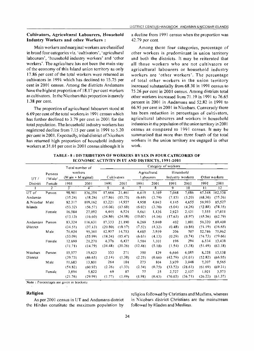
Cultivators, Agricultural Labourers, Household Industry Workers and other Workers:
Main workers and marginal workers are classified in broad four categories viz. 'cultivators', 'agricultural labourers', 'household industry workers' and 'other workers'. The agriculture has not been the main stay of the economy of this Island union territory as only 17.86 per cent of the total workers were returned as cultivators in 1991 which has declined to 15.75 per cent in 2001 census. Among the districts Andamans have the highest proportion of 18.17 per cent workers as cultivators. In the Nicobars this proportion is merely 1.38 per cent.
The proportion of agricultural labourers stood at 6.69 per cent of the total workers in 1991 census which has further declined to 3.79 per cent in 2001 for the total population. The household industry workers has registered decline from 7.15 per cent in 1991 to 5.20 per cent in 2001. Expectedly, tribal district ofN icobars has returned high proportion of household industry workers at 31.01 per cent in 2001 census although it is
DISTRICT CENSUS HANDBOOK. AN DAMAN & NICOBAR ISLANDS
a decline from 1991 census when the proportion was 42.79 per cent.
Among these four categories, percentage of other workers is predominant in union territory and both the districts. It may be reiterated that all those workers who are not cultivators or agricultural labourers or household industry workers are 'other workers'. The percentage of total other workers in the union territory increased substantially from 68.30 in 1991 census to 75.26 per cent in 2001 census. Among districts total other workers increased from 71.19 in 1991 to 76.65 percent in 2001 in Andamans and 52.82 in 1991 to 66.95 per cent in 2001 in Nicobars. Conversely there has been reduction in percentages of cultivators, agricultural labourers and workers in household industries in the population of the union territory in 2001 census as compared to 1991 census. It may be summarised that more than three fourth of the total workers in the union territory are engaged in other work.
TABLE- 8: DISTRIBUTION OF WORKERS BY SEX IN FOUR CATEGORIES OF ECONOMIC ACTIVITY IN UT AND DISTRICTS, 1991-2001
Total number of Category of workers
Persons workers Agricultural Household
UTI I Malel (M ain + Marginal) Cultivators Labourers Industry workers Other workers
District Female 1991 2001 1991 2001 1991 2001 1991 2001 1991 2001 I 2 3 4 5 6 7 8 9 10 II 12
UT of Person 98,901 136,254 17,666 21,461 6,619 5,169 7,068 7,086 67,548 102,538
Andaman (35.24) (38.26) ( 17.86) ( 15.75) (6.69) (3.79) (7.15) (5.20) (68.30) (75.26)
& Nicobar Male 82,317 109.162 13,221 14,937 4,958 4,043 4,145 4,655 59,993 85,527
Islands (53.32) (56.57) ( 16.06) ( 13.68) (6.02) (3.70) (5.04) ( 4.26) (72.88) (78.35)
Female 16,584 27,092 4,445 6,524 1,661 1,126 2,923 2,431 7,555 17,011
( 13.13) (16.60) (26.80) (24.08) (10.02 ) (4.16) ( 17.63) (8.97) (45.56) (62.79)
Andamans Person 83,324 116,631 17,333 21. 190 6,269 5,040 402 1.001 59,320 89,400
District (34.51) (37.13) (20.80) (\8.17) (7.52) (4.32) (0.48) (0.86) (71.19) (76.65)
Male 70,634 95,361 12,957 14,753 4,685 3,939 206 707 52,786 75,962
(53.09) (55.99) ( 18.34) ( 15.47) (6.63) ( 4.13) (0.29) (0.74) (74.73) (79.66)
Female 12,690 21,270 4,376 6,437 1,584 1,101 196 294 6,534 13,438
(11.71) (14.79) (34.48) (30.26) (12.48) (5.18) ( 1.54) (1.3 8) (51.49) (63.18)
Nicobars Person 15,577 19,623 333 271 350 129 6,666 6,085 8,228 13,138
District (39.73) ( 46.65) (2.14) (I.3 8) (2.25) (0.66) (42.79) (31.01) (52.82) (66.95)
Male 11,683 13,801 264 184 273 104 3,939 3,948 7,207 9,565 (54.82) (60.92) (2.26) (1.33) (2.34) (0.75) (33.72) (28.61 ) (61.69) (69.31)
Female 3,894 5,822 69 87 77 25 2,727 2,137 1.021 3,573
(21.76) (29.99) (1.77) ( 1.49) ( 1.98) (0.43) (70.03 ) (36.71) (26.22) (61.37)
Note: Percentages are given in brackets
Religion religion followed by Christians and Muslims, whereas As per 200 I census in UT and Andamans district in Nicobars district Christians are the mainstream
the Hindus constitute the maximum population by followed by Hindus and Muslims.
34
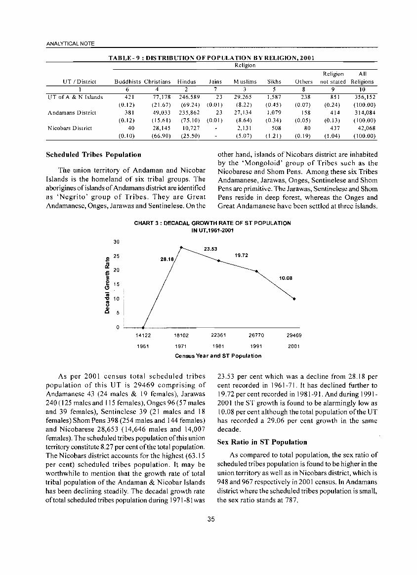
ANALYTICAL NOTE
TABLE-9: DISTRmUTIONOFPOPULATION BY RELIGION, 2001
UT / District Buddhists Christians Hindus 1 6 4 2
UT of A & N Islands 421 77.)78 246,589 (0.12) (21.67) (69.24)
Andamans District 381 49,033 235,862 (0.12) (15.61 ) (75.10)
Nicobars District 40 28,145 10,727 (0.10) (66.90) (25.50)
Scheduled Tribes Population
The union territory of Andaman and Nicobar Islands is the homeland of six tribal groups, The aborigines of islands of Andamans district are identified as 'Negrito' group of Tribes, They are Great Andamanese, Onges, Jarawas and Sentinelese, On the
Religion
Religion All Jains Muslims Sikhs Others not stated Religions
7 3 5 8 9 10 23 29,265 1,587 238 851 356,152
(0.01 ) (8.22) (0.45) (0.07) (0.24 ) ( 100.00) 23 27,134 1,079 158 414 314,084
(0.01 ) (8.64 ) (0.34) (0.05) (0.13) ( 100.00) 2,131 508 80 437 42,068 (5.07) (1.21 ) (0.19) (1.04 ) ( 100.00)
other hand, islands ofNicobars district are inhabited by the 'Mongoloid' group of Tribes such as the Nicobarese and Shorn Pens, Among these six Tribes Andamanese, Jarawas, Onges, Sentinelese and Shorn Pens are primitive. The Jarawas, Sentinelese and Shorn Pens reside in deep forest, whereas the Onges and Great Andamanese have been settled at three islands.
CHART 3: DECADAL GROWTH RATE OF ST POPULATION IN UT,1961-2001
30
S 25
~ 20 5 ~ 0 15 ...
C)
IV
" IV 10
U CII C 5
0 14122
1961
28.18
18102
1971
22361
1981
26770
1991
10,08
29469
2001
Census Year and ST Population
As per 200 I census total scheduled tribes population of this UT is 29469 comprising of Andamanese 43 (24 males & 19 females), Jarawas 240 (125 males and 115 females), Onges 96 (57 males and 39 females), Sentinelese 39 (21 males and 18 females) Shorn Pens 398 (254 males and 144 females) and Nicobarese 28,653 (14,646 males and 14,007 females). The scheduled tribes population of this union territory constitute 827 per cent of the total population. The Nicobars district accounts for the highest (63.15 per cent) scheduled tribes population. It may be worthwhile to mention that the growth rate of total tribal population of the Andaman & Nicobar Islands has been declining steadily. The decadal growth rate of total scheduled tribes population during 1971-81 was
35
23.53 per cent which was a decline from 28.18 per cent recorded in 1961-71. It has declined further to 19.72 per cent recorded in 1981-91. And during 1991-2001 the ST growth is found to be alarmingly low as 10.08 per cent although the total population ofthe UT has recorded a 29,06 per cent growth in the same decade.
Sex Ratio in ST Population
As compared to total population, the sex ratio of scheduled tribes population is found to be higher in the union territory as well as in Nicobars district, which is 948 and 967 respectively in 2001 census. In Andamans district where the scheduled tribes population is small, the sex ratio stands at 787.

DISTRICT CENSUS HANDBOOK: ANDAMAN & NICOBAR ISLANDS
CHART 4 : SEX RATIO OF ST POPULATION IN UT, 1961-2001
950 947 948
945 942 0 940 :;:::;
~ 935 )( 930 Q) 930
D (f)
925 ,
.
920
930
D .
1961 1971 1981 1991 2001
Census Year
Child sex ratio among the scheduled tribes population has also increased both in the union territory and Nicobars district during last decade. These are 956 and 977 in 2001 census against 897 and 895 in ] 991 census respectively.
Literacy Rate
A steady growth has been observed in the literacy rates of scheduled tribes population during last four decades. In 200 I, it is recorded as 66.79 percent against 56.62 per cent in 1991.
CHART 5: LITERACY RATE OF ST POPULATION IN UT,1961-2001
80
70 66.79
60 56.62 '~~~~ .s ,~~~~ co 50 ~%~~ 0:: ~%~~
%%~%
~ 40 36.03 ~~~~ co t~~~ ... 30 ~~~~ Q) ~~~~ ..... 17.85 :~t~~ :J 20 ~%~~% 11.1 :~~~~
%1,%% 10 ~%~~ .~~~%
0 ,%~~~ - r ---I
1961 1971 1981 1991 2001
Census Year
Work Participation Rate and Economic Activity of the ST Population
Both male and female work participation rate
36
among the scheduled tribes also have increased in this union territory as well as in districts although proportion of main workers has declined.
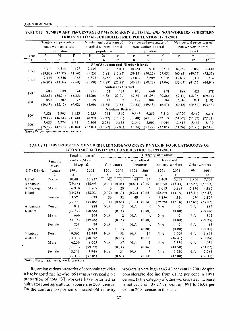
ANALYTICAL NOTE
TABLE 10: NUMBER AND PERCENTAGE OF MAIN, MARGINAL, TOTAL AND NON WORKERS SCHEDULED TRIBES TO TOTAL SCHEDULED TRIBE POPULATION, 1991-2001
Year
1991
2001
1991
2001
1991
2001
N umber and percentage of
main workers to total
population
P M F
2
8.0 II (29.93)
7.944 (26.96)
683 (35.63)
859 (29.58)
7,328 (29.49)
7,085 (26.67)
3 4
6.514 1.497 (47.37) (11.50)
6,556 1.388 (43.34) (9.68)
609 (56.34)
782 (48.12)
5,905 (46.61)
5,774 (42.76)
74 (8.85)
77 (6.02)
1,423 (11.68)
1,311 (10.04)
Note: Percentages are given in brackets
Number and percentage of
marginal workers to total
population
Number and percentage of total workers to total
population
P M F P M F 5 6 7 8 9 10 lfT of Andaman and Nicobar Islands
2,470 396 2.074 10,481 6.910 (9.23) (2.88) (15.93) (39.15) (50.25)
5,893 2,253 3.640 13.837 8,809 (20.00) (14.89) (25.38) (46.95) (58.23)
235 (12.26)
29 ( 1.00)
2,235 (8.99) 5.864
(22.07)
Andamans District 51 184 918
(4.72) (22.01) (47.89) 22 7 888
(1.35) (0.55) (30.58)
Nicobars District 345 1,890 9.563
(2.72) (15.51) (38.48) 2,231 3.633 12,949
(16.52) (27.81) (48.74)
660 (61.05)
804 ( 49.48)
6.250 (49.33)
8,005 (59.29)
3.571 (27.43 )
5.028 (35.06)
258 (30.86)
84 (6.57)
3.313 (27.19)
4,944 (37.85)
Number and percentage of non workers to total
population
P M F II
16,289 (60.85)
15.632 (53.05)
999 (52.11)
2,016 (69.42)
15,290 (61.52) 13,616
(51.26 )
12
6,840 (49.75)
6,318 (41.77)
421 (38.95)
821 (50.52)
6,419 (50.67)
5,497 (40.71)
13
9,449 (72.57)
9,314 (64.94)
578 (69.14)
1,195 (93.43)
8,871 (72.81)
8,119 (62.15)
TABLE 11 : DISTRIBUTION OF SCHEDULED TRIBE WORKERS BY SEX IN FOUR CATEGORIES OF ECONOMIC ACTIVITY IN UT AND DISTRICTS, 1991-2001
Personsl
Male!
UT I District Female 1 2
UT of Person
Andaman
& N icobar Male
Islands
Female
A ndamans Person
District Male
Female
N icobars Person
District
Male
Female
Total number of
workers(M ain + Marginal)
1991 3
10,481 (39.15)
6,910 (50.25)
3,571 (27.43)
918 (47.89)
660 (61.05)
258 (30.86)
9,563 (38.48)
6.250 (49.33)
3.313 (27.19)
2001 4
13,837 (46.95)
8,809 (58.23)
5,028 (35.06)
888 (30.58)
804 (49.48)
84 (6.57)
12.949 (48.74)
8.005 (59.29)
4,944
(37.85) Note: Percentages are given in brackets
Cultivators
1991 2001 5 6 42 61
(0.40) (0.44)
6 29 (0.09) (0.33)
36 32 (1.01) (0.64) N.A 3
(0.34)
N.A 2 (0.25)
N.A 1
( 1.19)
N.A 58 (0.45)
N.A 27 (0.34)
N.A 31 (0.63)
Category of workers -------'''-
Agricultural Household
Labourers
1991 2001 7 8 64 14
(0.61) (0.10)
15 5 (0.22) (0.06)
49 9 (1.37) (0.18)
N.A 0 (0.00)
N.A 0 (0.00)
N.A 0 (0.00)
N.A 14 (0.11 )
N.A 5 (0.06)
N.A 7 (0.14)
Industry workers
1991 9
6,469 (61.72)
3.613 (52.29)
2,856 (79.98)
N.A
N.A
N.A
N.A
N.A
N.A
2001 10
6,009 (43.43)
3,889 (44.15)
2.120 (42.16)
o (0.00)
o (0.00)
o (0.00)
6.009 (46.41)
3.889 (48.58)
2,120 (42.88)
Other workers
1991 11
3.906 (37.27)
3,276 (47.41)
630 (17.64)
N.A
N.A
N.A
N.A
N.A
N.A
2001 12
7,753 (56.03)
4,886 (55.47)
2,867 (57.02)
885 (99.66)
802 (99.75)
83 (98.81)
6,868 (53.04)
4,084 (51.02)
2,784 (56.31)
Regarding various categories of economic activities it is to be noted that likewise 1991 census very negligible proportion of total ST workers have returned as cultivators and agricultural labourers in 2001 census. On the contrary proportion of household industry
workers is very high at 43.43 per cent in 2001 despite considerable decline from 6 L 72 per cent in 1991 census. In the category of other workers steep increase is noticed from 37.27 per cent in 1991 to 56.03 per cent in 2001 census in th is UT.
37
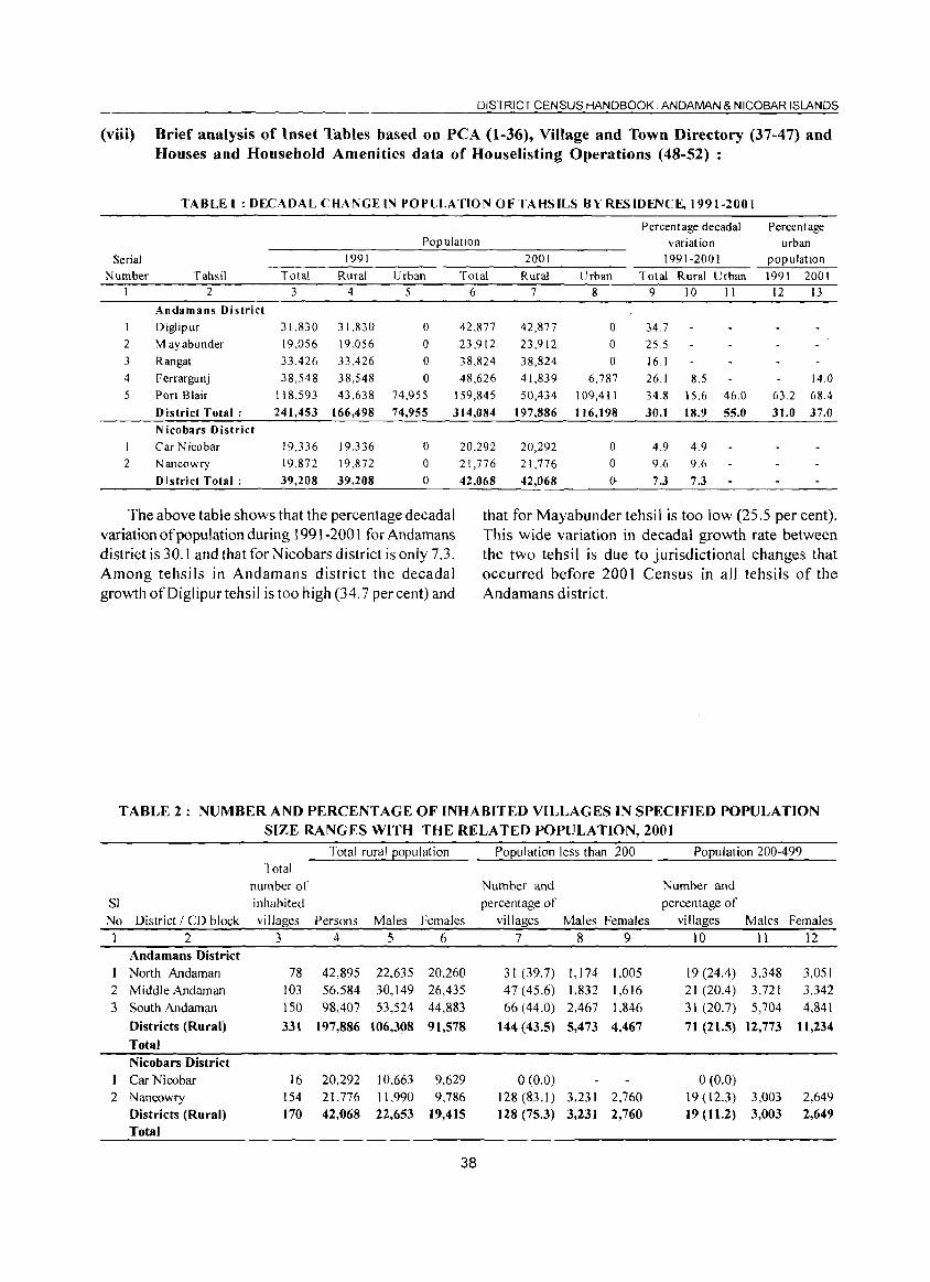
DISTRICT CENSUS HANDBOOK. AN DAMAN & NICOBAR ISLANDS
(viii) Brief analysis of Inset Tables based on peA (1-36), Village and Town Directory (37-47) and Houses and Household Amenities data of Houselisting Operations (48-52) :
TABLE I : DECADAL CHANGE IN POPliLA nON OF TAHS ILS BY RES IDENCE, 1991-2001
Percentage decadal Percentage Population variation urban
Serial 1991 2001 1991-2001 population
Number Tahsil Total Rural Urban Total Rural Urban Total Rural Urban 1991 2001 I 2 3 4 5 6 7 8 9 10 II 12 13
Andamans District Diglipur 31,830 31,830 0 42,877 42,877 0 34.7
2 M ayabunder 19,056 19,056 0 23,912 23,912 0 25.5 3 Rangat 33,426 33,426 0 38,824 38,824 0 16.1 4 Ferrargunj 38,548 38,548 0 48,626 41,839 6,787 26.1 8.5 14.0 5 Port Blair 118,593 43,638 74,955 159,845 50,434 109,411 34.8 15.6 46.0 63.2 68.4
District Total: 241,453 166,498 74,955 314,084 t 97,886 116,198 30.1 18.9 55.0 31.0 37.0 Nicobars District
I Car Nicobar 19,336 19,336 0 20,292 20,292 0 4.9 4.9 2 Nancowry 19,872 19,872 0 21,776 21,776 0 9.6 9.6
District Total: 39,208 39,208 0 42,068 42,068 (). 7.3 7.3
The above table shows that the percentage decadal that for Mayabunder tehsil is too low (25.5 per cent). variation of population during 1991-2001 for Andamans This wide variation in decadal growth rate between district is 30. I and that for N icobars district is only 7.3. the two tehsil is due to jurisdictional changes that Among tehsils in Andamans district the decadal occurred before 2001 Census in all tehsils of the growth of Dig Ii pur tehsil is too high (34.7 per cent) and Andamans district.
TABLE 2: NUMBER AND PERCENT AGE OF INHABITED VILLAGES IN SPECIFIED POPULATION SIZE RANGES WITH THE RELATED POPULATION, 2001
Total rural population Population less than 200 Population 200-499 Total
number of Number and Number and
SI inhabited percentage of percentage of
No District / CD block villages Persons Males Females villages Males Females villages Males Females
1 2 3 4 5 6 7 8 9 10 11 12 Andamans District
North Andaman 78 42,895 22,635 20.260 31 (39.7) I, 174 1,005 19(24.4) 3.348 3,051
2 Middle Andaman 103 56.584 30,149 26,435 47 (45.6) 1.832 1,616 21 (20.4) 3.721 3,342
3 South Andaman 150 98,407 53,524 44,883 66 (44.0) 2,467 1,846 31 (20.7) 5,704 4,841
Districts (Rural) 331 197,886 106,308 91,578 144 (43.5) 5,473 4,467 71 (21.5) 12,773 1l,234
Total
Nicobars District 1 Car Nicobar 16 20,292 10,663 9,629 0(0.0) 0(0.0)
2 Nancowry 154 21.776 11.990 9.786 128(83.1) 3,231 2,760 19 (12.3) 3,003 2,649 Districts (Rural) 170 42,068 22,653 19,415 128 (75.3) 3,231 2,760 19(11.2) 3,003 2,649
Total
38
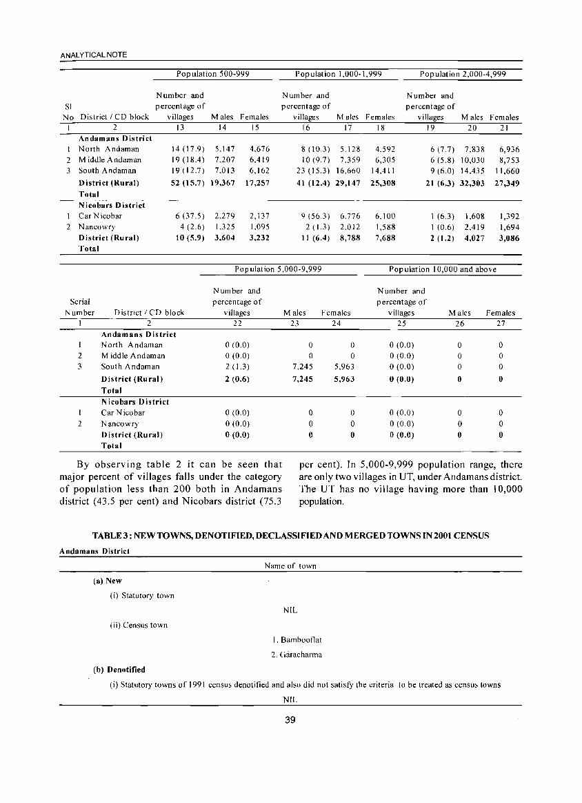
ANALYTICAL NOTE
Pop ulation 500-999 Population 1,000-1,999 Population 2,000-4,999
Number and Number and Number and SI percentage of percentage of percentage of
No District I CD block villages Males Females villages Males Females villages Males Females I 2 13 14 15 16 17 18 19 20 21
Andamans District I North Andaman 14(17.9) 5,147 4.676 8 (10.3) 5.128 4.592 6 (7.7) 7.838 6,936 2 Middle Andaman 19 (18.4) 7.207 6,419 10 (9.7) 7.359 6,305 6 (5.8) 10,030 8,753 3 South Andaman 19 (12.7) 7.013 6,162 23(15.3) 16.660 14,411 9 (6.0) 14,435 11,660
District (Rural) 52 (15.7) 19,367 17,257 41 (12.4) 29,147 25,308 21 (6.3) 32,303 27,349 Total Nicobars District
1 Car Nicobar 6(37.5) 2,279 2,137 9 (56.3) 6,776 6,100 1 (6.3) 1,608 1,392 2 Nancowry 4 (2.6) 1,325 1,095 2(1.3) 2.012 1,588 I (0.6) 2,419 1,694
District (Rural) 10(5.9) 3,604 3,232 II (6.4) 8,788 7,688 2 (1.2) 4,027 3,086 Total
Population 5,000-9,999 Pop ulat ion 10,000 and above
Number and Serial percentage of
Number District I CD block villages I 2 22
Andamans District I North Andaman 0(0.0) 2 Middle Andaman 0(0.0) 3 South Andaman 2 (1.3)
District (Rural) 2 (0,6)
Total
Nicobars District Car Nicobar 0(0.0)
2 Nancowry 0(0.0) District (Rural) 0(0.0) Total
By observing table 2 it can be seen that major percent of villages falls under the category of population less than 200 both in Andamans district (43.5 per cent) and Nicobars district (75.3
Number and percentage of
Males Females villages Males Females 23 24 25 26 27
0 0 0(0.0) 0 0 0 0 o (0.0) 0 0
7,245 5,963 o (0.0) 0 0
7,245 5,963 o (0.0) 0 0
0 0 0(0.0) 0 0 0 0 0(0.0) 0 0 0 0 o (0.0) 0 0
per cent). In 5,000-9,999 population range, there are only two villages in UT, under Andamans district. The UT has no village having more than 10,000 population.
TABLE3:NEWTOWNS,DENOTIFIED,DECLASSIFIEDANDMERGEDTOWNSIN2001 CENSUS
Andamans District
Name of town
(a) New
(i) Statutory town
NIL
(ii) Census town
I. Bambooflat
2. Garacharma
(b) Denotified
(i) Statutory towns of 1991 census denotified and also did not satisfy the criteria to be treated as census towns
NIL
39
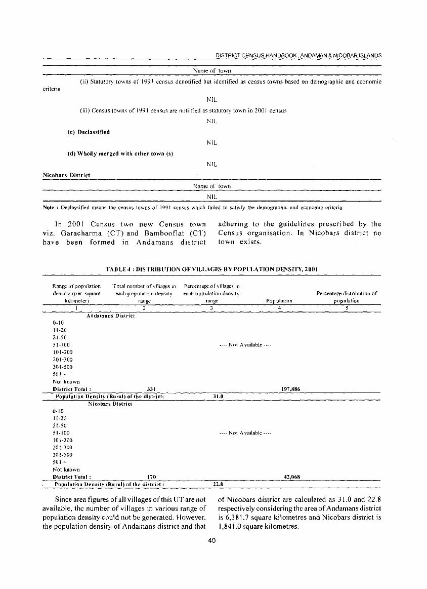
DISTRICT CENSUS HANDBOOK: ANDAMAN & NICOBAR ISLANDS
Name of town
(ii) Statutory towns of 1991 census denotified but identified as census towns based on demographic and economic criteria
NIL
(iii) Census towns of 1991 census are notiitied as statutory town in 2001 census
NIL
(c) Declassified
NIL
(d) Wholly merged with other town (s)
NIL
Nicobars District
Name of town
NIL
Note: Declassified means the census towns of 1991 census which failed to satisfy the demographic and economic criteria.
In 2001 Census two new Census town viz. Garacharma (CT) and Bambooflat (CT) have been formed In Andamans district
adhering to the guidelines prescribed by the Census organisation. In Nicobars district no town exists.
TABLE4: DlSTRIBFflON OF VILLAGES BVPOPliLATION DENSITY, 2001
Range of population density (per square
kilometer)
Total number of villages in each population density
range
Percentage of villages in each population density
range Population Percentage distribution of
population
0-10 11-20 21-50 51-100 101-200 201-300 301-500 501 +
Andamans District
Not known District Total:
2
331 Population Density (Rural) of the district:
0-10 11-20 21-50 51-100 101-200 201-300 301-500 501 +
Nicobars District
Not known District Total: 170 Population Density (Rural) of the district:
Since area figures of all villages of this UT are not available, the number of villages in various range of population density could not be generated. However, the population density of Andamans district and that
3 4 5
---- N 01 Available ----
197,886 31.0
---- Not Available ----
42,068 22.8
of Nicobars district are calculated as 31.0 and 22.8 respectively considering the area of Andamans district is 6,381.7 square kilometres and Nicobars district is 1,841.0 square kilometres.
40
ANALYTICAL NOTE
TABLE 5: SEX RATIO OF UT AND DISTRICT, 1901-2001 Union Territory of
Census A& N Islands District Andamans District Nicobars Year Total Rural Urban Total Rural Urban Total Rural Urban
I 2 3 4 5 6 7 8 9 10 1901 318 318 197 197 841 841 1911 352 352 197 197 825 825 1921 303 303 146 146 769 769 1931 495 495 348 348 881 881 1941 574 574 433 433 891 891 1951 625 654 545 489 452 545 900 900 1961 617 630 573 554 546 573 872 872 1971 644 671 558 615 638 558 784 784 1981 760 774 720 750 764 720 811 811 1991 818 837 769 815 836 769 840 840 2001 846 861 815 844 861 815 857 857
Note: Sex ratio has been defined here as the number of females per 1000 males.
From the above table it can be seen that sex ratio of the UT has been steadily increasing from the Census year
190 I (318) to 2001 (846). The sex ratio ofNicobars district has always been higher than that of Andamans district.
TABLE 6 : SEX RATIO BY TEHSILS, 2001
Serial number Name of DistrictlTehsil I 2
AndamaRs District I Diglipur 2 Mayabunder 3 Rangat 4 Ferrargunj 5 Port Blair
District Total: Nicobars District
I Car Nicobar 2 Nancowry
District Total:
Examining tehsil wise sex ratio in the UT it can be seen that Car Nicobar tehsil has the highest sex ratio
Total 3
896 876 876 877 809 844
903 816 857
Sex ratio Rural
4
896 876 876 878 803 861
903 816 857
Urban 5
874 812 8]5
(903) whereas Port Blair tehsil is having lowest sex ratio (809) among all tehsils.
TABLE 7 : SEX RATIO BY CD BLOCKS, 2001
Serial number Name of CD block Sex ratio
1 2 3
2
2 Andamans District North Andaman
Middle Andaman South Andaman District (Rural) Total: Nicoba rs District Car Nicobar
Nancowry
District (Rural) Total:
Among all CD blocks of the UT, Nancowry CD Block has the lowest sex ratio and Car
41
3
895 877 839 861
903 816 857
Nicobar CD Block contributes to highest sex ratio.
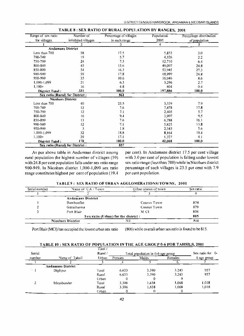
DISTRICT CENSUS HANDBOOK. ANDAMAN & NICOBAR ISLANDS
TABLE 8: SEX RATIO OF RURAL POPULATION BY RANGES. 2001
Range of sex ratio Number of Percentage of villages Population Percentage distribution for villages inhabited villages in each range 2001 of population
I 2 3 4 5 Andamans District
Less than 700 58 17.5 5,853 3.0 700-749 19 5.7 4,326 2.2 750-799 24 7.3 12,710 6.4 800-849 45 13.6 49,007 24.S 850-899 54 16.3 53,945 27.3 900-949 59 17.8 48,999 24.8 950-999 35 10.6 16,946 8.6 1,000-1,099 21 6.3 5.296 2.7 1,100+ 16 4.8 804 0.4
District Total: 331 100.0 197,886 100.0 Sex ratio (Rural) for District: 861
Nicobars District Less than 700 40 23.5 3,339 7.9 700-749 13 7.6 7,478 17.8 750-799 12 7.1 2,405 5.7 800-849 16 9.4 3,997 9.5 850-899 13 7.6 6,788 16.1 900-949 12 7.1 5,825 13.8 950-999 3 1.8 2.345 5.6 1,000-1,099 32 18.8 8,164 19.4 1,100+ 29 17.1 1,727 4.1
District Total: 170 100.0 42,068 100.0 Sex ratio (Rural) for District : 857
As per above table in Andamans district among rural population the highest number of villages (59) with 24.8 per cent population falls under sex ratio range 900-949. In N icobars district 1,000-1,099 sex ratio range constitutes highest per cent of population (19.4
per cent). In Andamans district 17.5 per cent village with 3.0 per cent of population is falling under lowest sex ratio range (less than 700) while in N icobars district percentage of such villages is 23.5 per cent with 7.9 per cent population.
TABLE9: SEX RATIO OF URBAN AGGLOMERATIONS/TOWNS. 2001
Serial number Name of UA I Town Urban status of town I 2 3
Andamans District I Bambootlat Census Town 2 Garacharma Census Town 3 Port Blair M CI
S ex ratio (llrban) for the district: Nicobars District Nil
Sex ratio 4
874 879 806 815 Nil
Port Blair (Mel) has occupied the lowest urban sex ratio (806) while overall urban sex ratio is found to be 815.
TABLE 10: SEX RATIO OF POPULATION IN THE AGE GROUP 0-6 FOR TAHSILS, 2001 Total!
Serial Rural! Total EOEulation in 0-6 a~e ~ouE Sex ratio for number Name of Tahsil Urban Persons Males Females 6 age ~ouE
1 2 3 4 5 6 7 Andamans District
Diglipur- Total 6,633 3,390 3,243 957 Rural 6,633 3.390 3,243 957 Urban 0 0 0
2 Mayabunder Total 3.306 1,638 1.668 1.018 Rural 3,306 1,638 1,668 1,018 Urban 0 0 0
42
0-
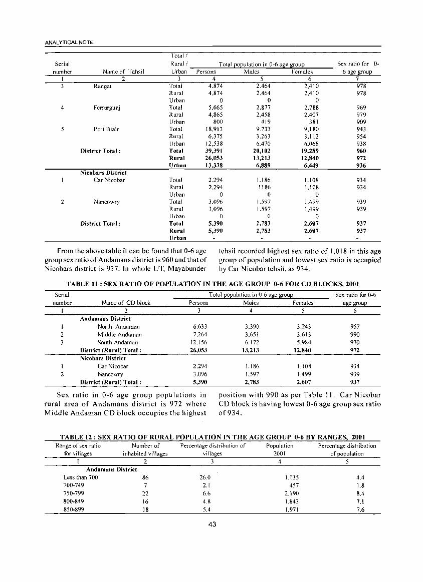
ANALYTICAL NOTE
Total!
Serial Rural! Total eoeulation in 0-6 a~e 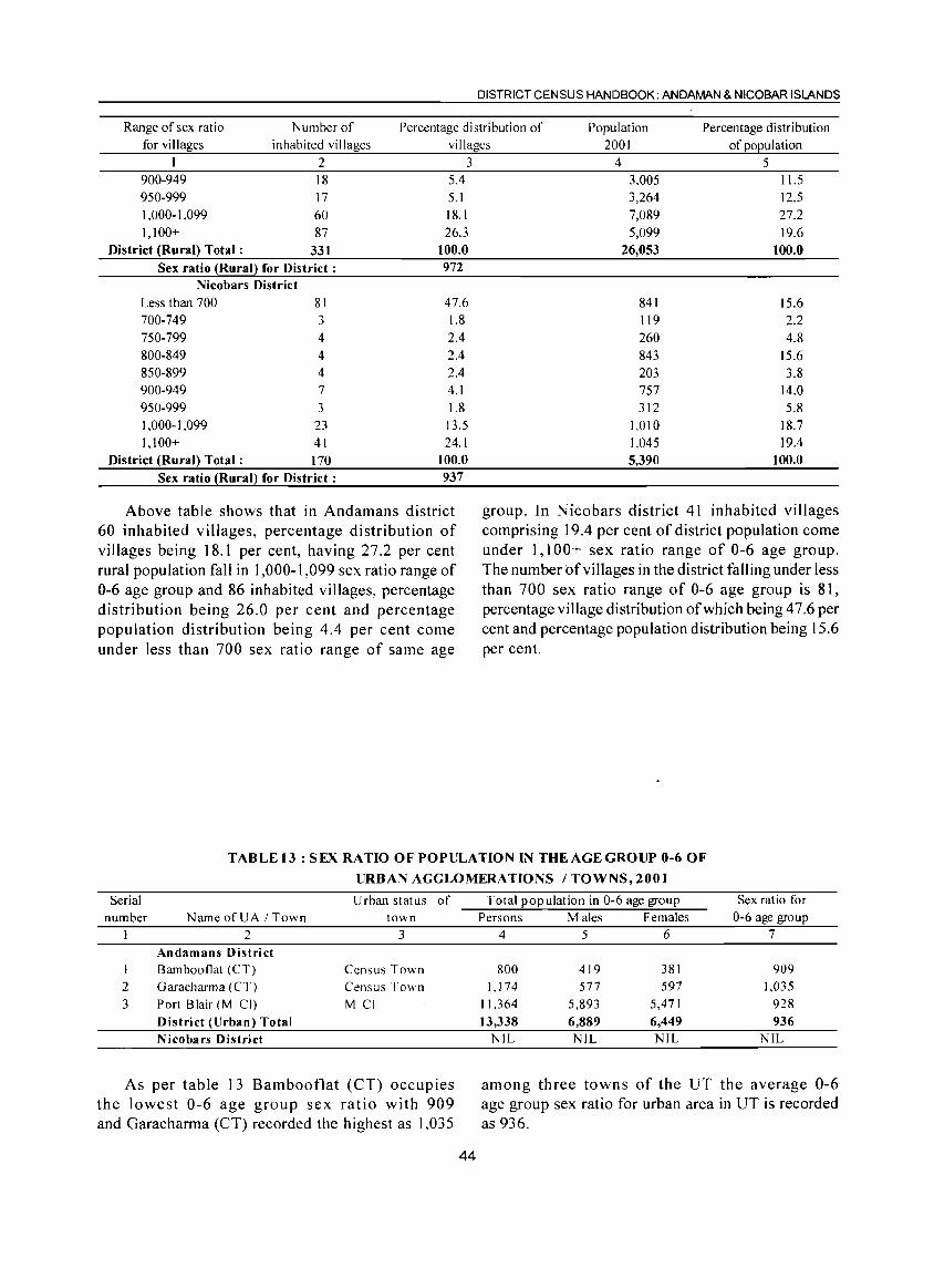
DISTRICT CENSUS HANDBOOK: AN DAMAN & NICOBAR ISLANDS
Range of sex ratio Number of Percentage distribution of Population Percentage distribution for villages inhabited villages villages 2001 of population
I 2 3 900-949 18 5.4 950-999 17 5.1 1.000-1,099 60 18.1 1.100+ 87 26.3
District (Rural) Total: 331 100.0 Sex ratio ~RuraQ for District: 972
Nicobars District Less than 700 81 47.6 700-749 3 1.8 750-799 4 2.4 800-849 4 2.4 850-899 4 2.4 900-949 7 4.1 950-999 3 1.8 1,000-1,099 23 13.5 1.100+ 41 24.1
District (Rural) Total: 170 100.0 Sex ratio ~Rural} for District: 937
Above table shows that in Andamans district 60 inhabited villages, percentage distribution of villages being 18.1 per cent, having 27.2 per cent rural population fall in 1,000-1,099 sex ratio range of 0-6 age group and 86 inhabited villages, percentage distribution being 26.0 per cent and percentage population distribution being 4.4 per cent come under less than 700 sex ratio range of same age
4 5 3,005 11.5 3,264 12.5 7,089 27.2 5,099 19.6
26,053 100.0
841 15.6 119 2.2 260 4.8 843 15.6 203 3.8 757 14.0 312 5.8
1.010 18.7 1.045 19.4 5,390 100.0
group. In Nicobars district 4 I inhabited villages comprising 19.4 per cent of district population come under 1,100+ sex ratio range of 0-6 age group. The number of villages in the district falling under less than 700 sex ratio range of 0-6 age group is 81, percentage village distribution of which being 47.6 per cent and percentage population distribution being 15.6 per cent.
TABLE 13: SEX RATIO OF POPULATION IN THE AGE GROUP 0-6 OF
URBAN AGGLOMERATIONS / TOWNS, 2001
Serial number
2 3
Name ofUA I Town 2
Andamans District Bambooflat (CT) Garacharma (CT) Port Blair (M CI) District (Urban) Total N icobars District
Urban status of town
3
Census Town Census Town M CI
As per table 13 Bambooflat (CT) occupies the lowest 0-6 age group sex ratio with 909 and Garacharma (CT) recorded the highest as 1,035
44
Total population in 0-6 age group Persons Males Females
4 5 6
800 419 381 1,174 577 597
11.364 5,893 5,471 13,338 6,889 6,449
NIL NIL NIL
Sex ratio for 0-6 age group
7
909 1,035
928 936
NIL
among three towns of the UT the average 0-6 age group sex ratio for urban area in UT is recorded as 936.
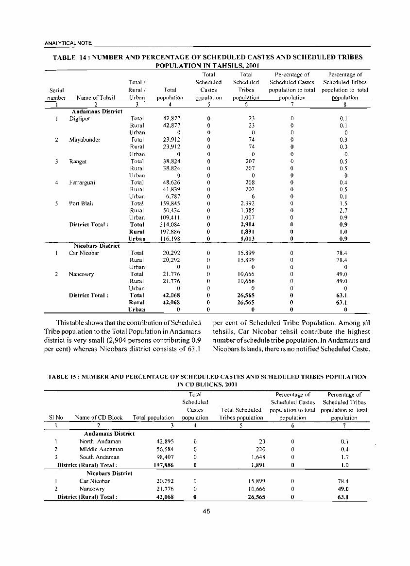
ANALYTICAL NOTE
TABLE 14: NUMBER AND PERCENTAGE OF SCHEDULED CASTES AND SCHEDULED TRIBES POPULA TION IN T AHSILS, 2001
Total Total Percentage of Percentage of Total! Scheduled Scheduled Scheduled Castes Scheduled Tribes
Serial Rural! Total Castes Tribes population to total population to total
number Name of Tahsil Urban ~o~ulation l2o~ulation 120l2ul ation 12°l2ulation ~o~ulation I 2 3 4 5 6 7 8
Andamans District Diglipur Total 42,877 0 23 0 0.1
Rural 42,877 0 23 0 0.1 Urban 0 0 0 0 0
2 Mayabunder Total 23,912 0 74 0 0.3 Rural 23,912 0 74 0 0.3 Urban 0 0 0 0 0
3 Rangat Total 38.824 0 207 0 0.5 Rural 38.824 0 207 0 0.5 Urban 0 0 0 0 0
4 Ferrargunj Total 48.626 0 208 0 0.4 Rural 41.839 0 202 0 0.5 Urban 6.787 0 6 0 0.1
5 Port Blair Total 159,845 0 2.392 0 1.5 Rural 50.434 0 1.385 0 2.7 Urban 109,411 0 1,007 0 0.9
District Total: Total 314.084 0 2,904 0 0.9 Rural 197.886 0 1,891 0 1.0 Urban 116.198 0 1,013 0 0.9
Nicobars District Car Nicobar Total 20,292 0 15.899 0 78.4
Rural 20,292 0 15,899 0 78.4 Urban 0 0 0 0 0
2 Nancowry Total 21,776 0 10.666 0 49.0 Rural 21,776 0 10,666 0 49.0 Urban 0 0 0 0 0
District Total: Total 42,068 0 26,565 0 63.1 Rural 42,068 0 26,565 0 63.1 Urban 0 0 0 0 0
This table shows that the contribution of Scheduled per cent of Scheduled Tribe Population. Among all Tribe population to the Total Population in Andamans tehsils, Car Nicobar tehsil contribute the highest district is very small (2,904 persons contributing 0.9 number of schedule tribe population. In Andamans and per cent) whereas Nicobars district consists of 63.J Nicobars Islands. there is no notified Scheduled Caste.
TABLE 15: NUMBER AND PERCENTAGE OF SCHEDULED CASTES AND SCHEDULED TRIBES POPULATION IN CD BLOCKS, 2001
Total Percentage of Percentage of Scheduled Scheduled Castes Scheduled Tribes
Castes Total Scheduled population to total population to total SINo Name of CD Block Total population population Tribes population population population
2 3 4 5 6 7 Andamans District
North Andaman 42.895 0 23 0 0.1 2 Middle Andaman 56,584 0 220 0 0.4
3 South Andaman 98,407 0 1,648 0 1.7
District (Rural) Total: 197,886 0 1,891 0 1.0
Nicobars District
I Car Nicobar 20,292 0 15,899 0 78.4 2 Nancowry 21.776 0 10,666 0 49.0
District (Rural) Total: 42,068 0 26,565 0 63.1
45
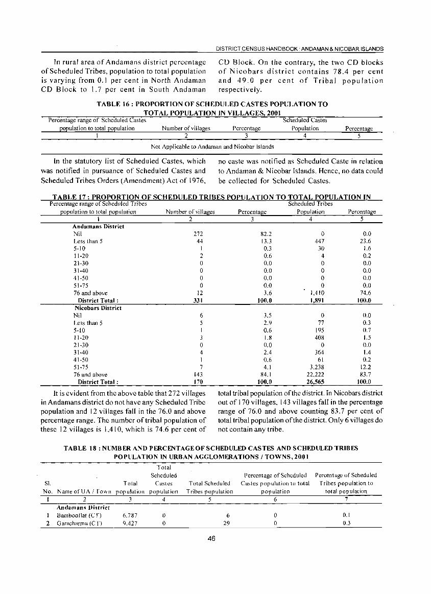
In rural area of Andamans district percentage of Scheduled Tribes, population to total population is varying from 0.1 per cent in North Andaman CD Block to 1.7 per cent in South Andaman
DISTRICT CENSUS HANDBOOK. ANDAMAN & NICOBAR ISLANDS
CD Block. On the contrary, the two CD blocks of Nicobars district contains 78.4 per cent and 49.0 per cent of Tribal population respectively.
TABLE]6: PROPORTION OF SCHEDULED CASTES POPULATION TO TOTAL POPULATION IN VILLAGES, 200]
Percentage range of Scheduled Castes Scheduled Castes population to total population Number of villages Percentage Population Percentage
1 2 3 4 5
Not Applicable to Andaman and Nicobar Islands
In the statutory list of Scheduled Castes, which was notified in pursuance of Scheduled Castes and
Scheduled Tribes Orders (Amendment) Act of 1976,
no caste was notified as Scheduled Caste in relation to Andaman & Nicobar Islands. Hence, no data could be collected for Scheduled Castes.
TABLE 17: PROPORTION OF SCHEDULED TRIBES POPULATION TO TOTAL POPULATION IN Percentage range of Scheduled Tribes Scheduled Tribes
population to total population Number of villages Percentage Population Percentage I 2 345
Andamans District Nil 272 Less than 5 44 5-10 I 11-20 2 21-30 0 31-40 0 41-50 0 51-75 0 76 and above 12
District Total: 331 Nicobars District Nil 6 Less than 5 5 5-10 I 11-20 3 21-30 0 31-40 4 41-50 I 51-75 7 76 and above 143
District Total: 170
It is evident from the above table that 272 villages in Andamans district do not have any Scheduled Tribe population and 12 villages fall in the 76.0 and above percentage range. The number of tribal population of these 12 villages is 1,410, which is 74.6 per cent of
82.2 0 0.0 13.3 447 23.6 0.3 30 1.6 0.6 4 0.2 0.0 0 0.0 0.0 0 0.0 0.0 0 0.0 0.0 0 0.0 3.6 1,410 74.6
100.0 1,891 100.0
3.5 0 0.0 2.9 77 0.3 0.6 195 0.7 1.8 408 1.5 0.0 0 0.0 2.4 364 1.4 0.6 61 0.2 4.1 3,238 12.2
84.1 22.222 83.7 100.0 26,565 100.0
total tribal population of the district. In Nicobars district out of 1 70 vi lIages, 143 villages fall in the percentage range of 76.0 and above counting 83.7 per cent of total tribal population of the district. Only 6 villages do not contain any tribe.
TABLE 18: NUMBER AND PERCENTAGE OF SCHEDULED CASTES AND SCHEDULED TRIBES POPULATION IN URBAN AGGLOMERATIONS I TOWNS, 2001
SI. Total
Total Scheduled
Castes No. NarneofUAITown population population
I 2 3 4
Andamans District 1 Barnbooflat (CT) 2 Garacharma (CT)
6.787 9,427
o o
Total Scheduled Tribes population
5
46
6 29
Percentage of Scheduled Castes population to total
population 6
o o
Percentage of Scheduled Tribes population to
total population 7
0.1 0.3
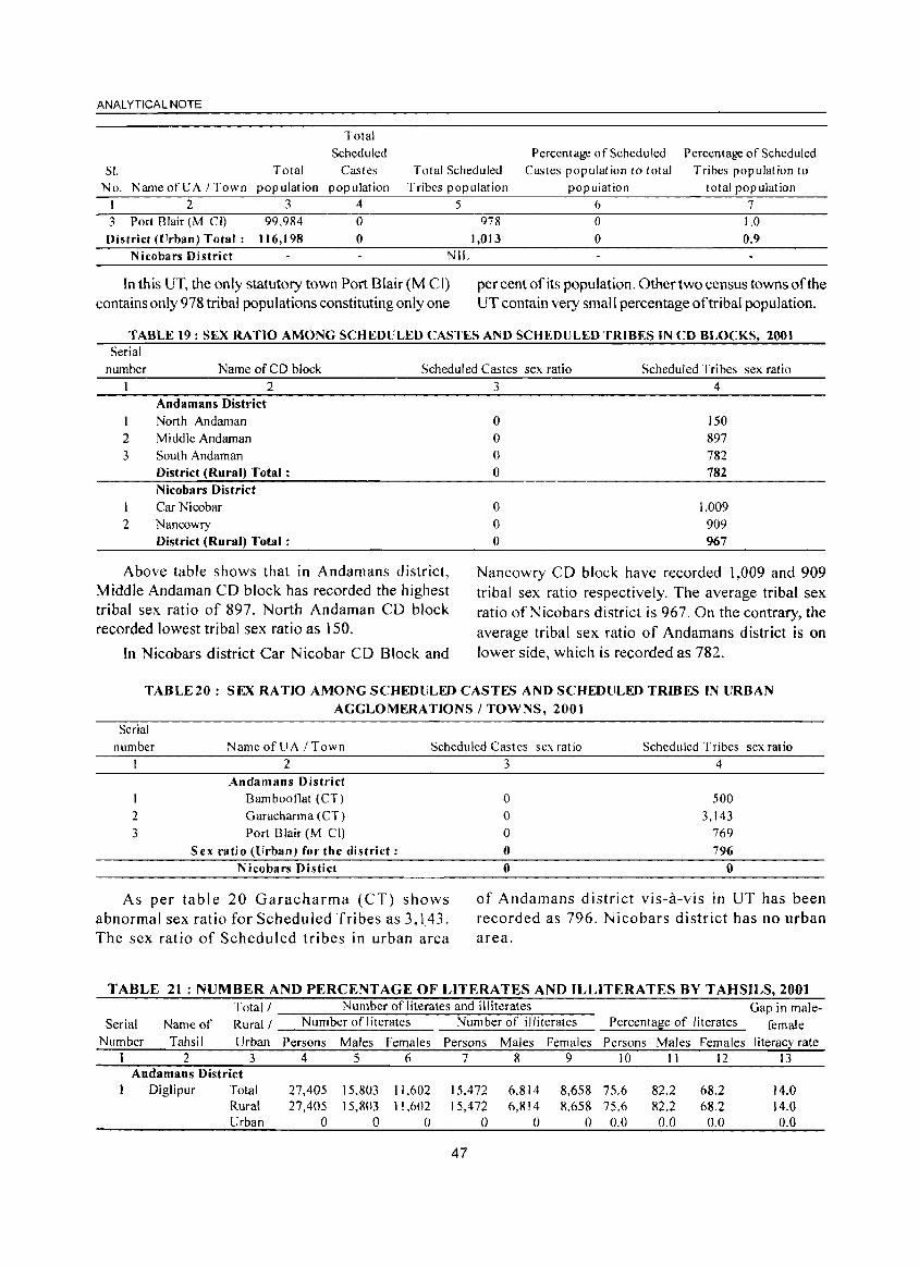
ANALYTICAL NOTE
Total
Scheduled Percentage of Scheduled Percentage of Scheduled
SI. Total Castes Total Scheduled Castes population to total Tribes population to No. Name ofUA I Town population population Tribes population population total population
1 2 3 4 5 6 7 3 Port Blair (M CI) 99,984 0 978 0 1.0 District (lJrban) Total: 116,198 0 1,013 0 0.9
Nicobars District NIL
In this UT, the only statutory town Port Blair (M CI) contains only 978 tribal populations constituting only one
per cent of its popUlation. Other two census towns of the UT contain very small percentage of tribal population.
TABLE 19: SEX RATIO AMONG SCHEDULED CASTES AND SCHEDULED TRIBES IN CD BLOCKS, 2001 Serial
number Name of CD block Scheduled Castes sex ratio Scheduled Tribes sex ratio
I 2 3
2
2 Andamans District
North Andaman Middle Andaman
South Andaman District (Rural) Total: Nicobars District
Car Nicobar Nancowry District (Rural) Total:
Above table shows that in Andamans district, Middle Andaman CD block has recorded the highest tribal sex ratio of 897. North Andaman CD block recorded lowest tribal sex ratio as 150.
In Nicobars district Car Nicobar CD Block and
3 4
0 150
0 897
0 782 0 782
0 1.009 0 909 0 967
Nancowry CD block have recorded 1,009 and 909 tribal sex ratio respectively. The average tribal sex ratio ofNicobars district is 967. On the contrary, the average tribal sex ratio of Andamans district is on lower side, which is recorded as 782.
TABLE20: SEX RATIO AMONG SCHEDULED CASTES AND SCHEDULED TRIBES IN URBAN
AGGLOMERATIONS / TOWNS, 2001
Serial
number NameofUA ITown Scheduled Castes sex rat io Scheduled Tribes sex ratio
2 3
2
Andamans District Bambooflat (CT)
Garacharma (CT)
Port Blair (M Cll
Sex ratio (Urban) for the district:
Nicobars Distict
As per table 20 Garacharma (CT) shows abnormal sex ratio for Scheduled Tribes as 3,143. The sex ratio of Scheduled tribes in urban area
3 4
0 500
0 3,143 0 769
0 796
0 0
of Andamans district vis-a-vis in UT has been recorded as 796. Nicobars district has no urban area.
TABLE 21 : NUMBER AND PERCENTAGE OF LITERATES AND ILLITERATES BY TAHSILS, 2001
Total/ Number of literates and illiterates Gap in male-Serial Name of Rural I N um ber of Ii terates Number of illiterates Percenta~e of literates female
Number Tahsil Urban Persons Males Females Persons Males Females Persons Males Females I iteracl: rate I 2 3 4 5 6 7 8 9 10 II 12 13
Andamans District Diglipur Total 27,405 15.803 11.602 15.472 6,814 8,658 75.6 82.2 68.2 14.0
Rural 27,405 15.803 11,602 15,472 6,814 8,658 75.6 82.2 68.2 14.0 Urban 0 0 0 0 0 0 0.0 0.0 0.0 0.0
47
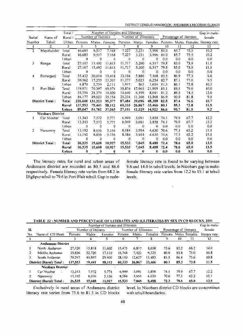
DISTRICT CENSUS HANDBOOK. AN DAMAN & NICOBAR ISLANDS
Total! Number of literates and illiterates Gap in male-Serial Name of Rural! Number of literates Number of illiterates Percenta~e of literates female
Number Tahsil Urban Persons Males Females Persons Males Females Persons Males Females I i terac~ rat e I 2 3 4 5 6 7 8 9 10 II 12 13 2 Mayabunder Total 16,685 9,517 7,168 7,227 3,231 3,996 81.0 85.7 75.5 10.2
Rural 16,685 9.517 7,168 7,227 3,231 3,996 81.0 85.7 75.5 10.2 Urban 0 0 0 0 0 0 0.0 0.0 0.0 0.0
3 Rangat Total 27,107 15,492 11.615 11,717 5,200 6,517 79.8 85.0 73.9 ILl Rural 27,107 15,492 11.615 11,717 5,200 6,517 79.8 85.0 73.9 11.1 Urban 0 0 0 0 0 0 0.0 0.0 0.0 0.0
4 Ferrargunj Total 35,432 20,014 15,418 13,194 5,886 7,308 82.5 86.9 77.3 9.6 Rural 30,562 17,255 13,307 11,277 5,023 6,254 82.7 87.1 77.6 9.5 Urban 4,870 2,759 2,111 1,917 863 1,054 81.3 86.1 75.8 10.3
5 Port Blair Total 119,971 70,397 49.574 39,874 17.965 21,909 85.1 89.5 79.6 10.0 Rural 35,794 21,374 14,420 14,640 6,599 8,041 81.2 86.5 74.5 12.0 Urban 84,177 49,023 35,154 25,234 11,366 13,868 86.9 90.9 81.8 9.1
District Total: Total 226,600 131,223 95,377 87,484 39,096 48,388 82.5 87.4 76.6 10.7 Rural 137,553 79,441 58,112 60,333 26,867 33,466 80.1 85.3 73.8 11.5 Urban 89,047 51,782 37,265 27,151 12,229 14,922 86.6 90.7 81.5 9.2
Nicobars District Car Nicobar Total 13,343 7,572 5.771 6,949 3,091 3,858 74.1 79.9 67.7 12.2
Rural 13.343 7,572 5,771 6,949 3,091 3,858 74.1 79.9 67.7 12.2 Urban 0 0 0 0 0 0 0.0 0.0 0.0 0.0
2 Nancowry Total 13,192 8,036 5.156 8.584 3,954 4,630 70.6 77.3 62.2 15.1 Rural 13,1 92 8,036 5,156 8,584 3,954 4,630 70.6 77.3 62.2 15.1 Urban 0 0 0 0 0 0 0.0 0.0 0.0 0.0
District Total: Total 26,535 15,608 10,927 15,533 7,045 8,488 72.4 78.6 65.0 13.5 Rural 26,535 15,608 10,927 15,533 7,045 8,488 72.4 78.6 65.0 13.5 Urban 0 0 0 0 0 0 0.0 0.0 0.0 0.0
The literacy rates for rural and urban areas of female literacy rate is found to be varying between Andamans district are recorded as 80.1 and 86.6 9.6 and 14.0 in tehsillevels. In Nicobars gap in male-respectively. Female literacy rate varies from 68.2 in female literacy rate varies from 12.2 to 15.1 at tehsil Diglipur tehsil to 79.6 in Port Blair tehsiL Gap in male- levels.
TABLE 22: NUMBER AND PERCENTAGE OF LITERATES AND ILLITERATES BY SEX IN CD BLOCKS, 2001 Number of literates and illiterates Gap in male-
S!. Number ofliterates Number of illiterates Percentage of literates female No. Name of CD Block Persons Males Females Persons Males Females Persons Males Females literacy rate
1 2 3 4 5 6 7 8 9 10 11 12
Andamans District 1 North Andaman 27,420 15,818 11,602 15,475 6,817 8,658 75.6 82.2 68.2 14.0 2 Middle Andaman 39,836 22,726 17.110 16,748 7,423 9,325 80.8 85.8 75.0 10.8 3 South Andaman 70,297 40,897 29,400 28,110 12,627 15,483 81.5 86.4 75.6 10.8
District (Rural) Total: 137,553 79,441 58,112 60,333 26,867 33,466 80.1 85.3 73.8 11.5
Nicobars District , I Car Nicobar 13,343 7,572 5,771 6,949 3,091 3,858 74.1 79.9 67.7 12.2 2 Nancowry 13,192 8,036 5.156 8,584 3,954 4,630 70.6 77.3 62.2 15.1
District (Rural) Total: 26,535 15,608 10,927 15,533 7,045 8,488 72.3 78.6 65.0 13.5
Exclusively in rural areas of Andamans district leveL In Nicobars district CD blocks are co-terminus literacy rate varies from 75.6 to 81.5 in CD blocks with tehsil boundaries.
48
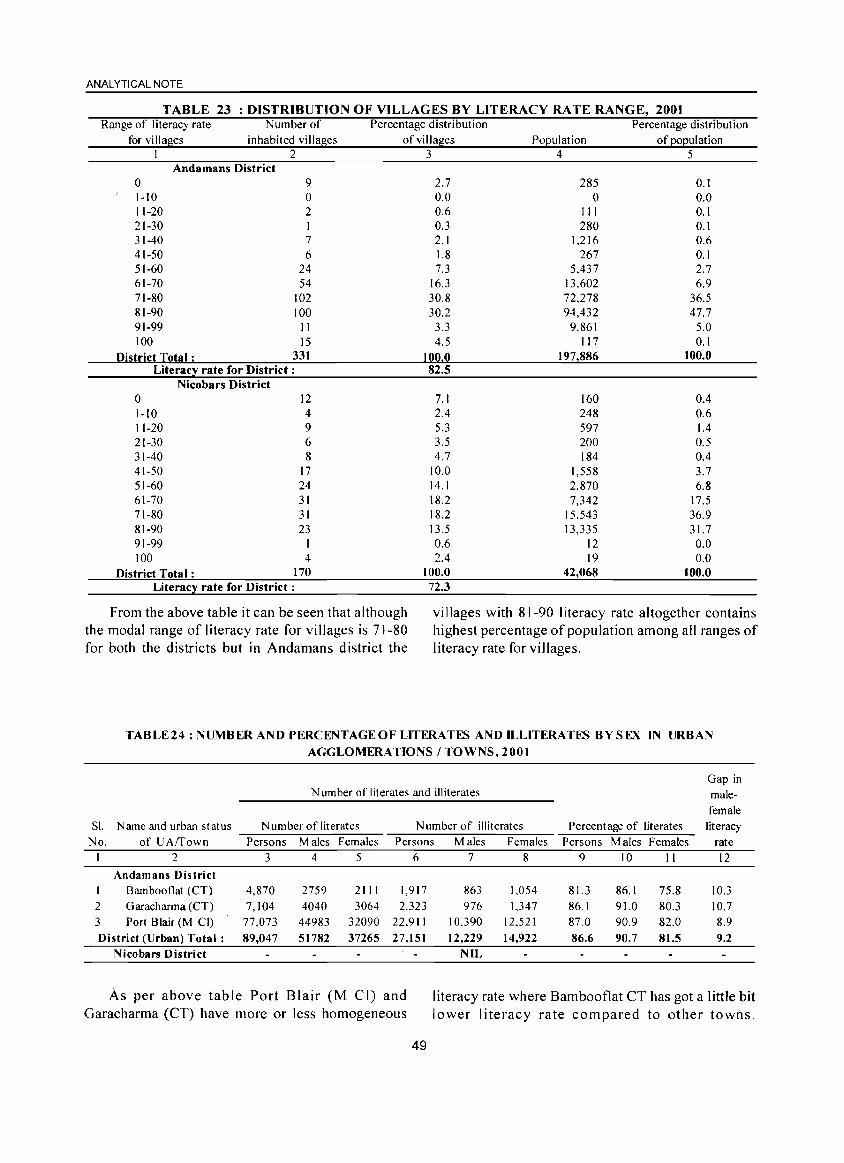
ANALYTICAL NOTE
TABLE 23 : DISTRIBUTION OF VILLAGES BY LITERACY RA IE RANGE, 2001 Range of literacy rate
for villages Number of
inhabited villages
o 1-10 11-20
Andamans District 2
9 o 2
21-30 I 31-40 7 41-50 6 51-60 24 61-70 54 71-80 102 81-90 100 91-99 II 100 15
District Total ; 331 Literacy rate for District:
Nicobars District 0 12 1-10 4 11-20 9 21-30 6 31-40 8 41-50 17 51-60 24 61-70 31 71-80 31 81-90 23 91-99 I 100 4
District Total; 170 Literacy rate for District:
Percentage distribution of villages
3
2.7 0.0 0.6 0.3 2.1 1.8 7.3
16.3 30.8 30.2
3.3 4.5
100,0 82,5
7.1 2.4 5.3 3.5 4.7
10.0 14.1 18.2 18.2 13.5 0.6 2.4
100,0 72.3
Population 4
285 o
III 280
1.216 267
5.437 13.602 72,278 94,432
9,861 117
197,886
160 248 597 200 184
1,558 2,870 7,342
15,543 13,335
12 19
42,068
Percentage distribution
of population 5
0.1 0.0 0.1 0.1 0.6 0.1 2.7 6.9
36.5 47.7
5.0 0.1
100,0
0.4 0.6 1.4 0.5 0.4 3.7 6.8
17.5 36.9 31.7 0.0 0.0
100,0
From the above table it can be seen that although the modal range of literacy rate for villages is 71-80 for both the districts but in Andamans district the
vi lIages with 81-90 I iteracy rate altogether contains highest percentage of population among all ranges of literacy rate for villages.
Sl.
No. I
I
2 3
TABLE24: NUMBER AND PERCENTAGE OF LITERATES AND ILLITERATES BY SEX IN URBAN
AGGLOMERATIONS / TOWNS, 2001
N umber of literates and illiterates
Name and urban status N umber of literates Number of illiterates
of UAffown Persons Males Females Persons Males Females
2 3 4 5 6 7 8
Andamans District Bambooflat (CT) 4,870 2759 2111 1,917 863 1,054 Garacharma (CT) 7,104 4040 3064 2,323 976 1.347 Port Blair (M CI) 77,073 44983 32090 22,911 10.390 12.521
Percentage of literates
Persons Males Females 9 10 II
81.3 86.1 75.8 86.1 91.0 80.3 87.0 90.9 82.0
Gap in male
female literacy
rate
12
District (Urban) Total: 89,047 51782 37265 27,151 12,229 14,922 86,6 90.7 81.5
10.3 10.7 8.9 9.2
Nicobars District
As per above table Port Blair (M CI) and Garacharma (CT) have more or less homogeneous
49
NIL
literacy rate where Bambooflat CT has got a little bit lower literacy rate compared to other towns.
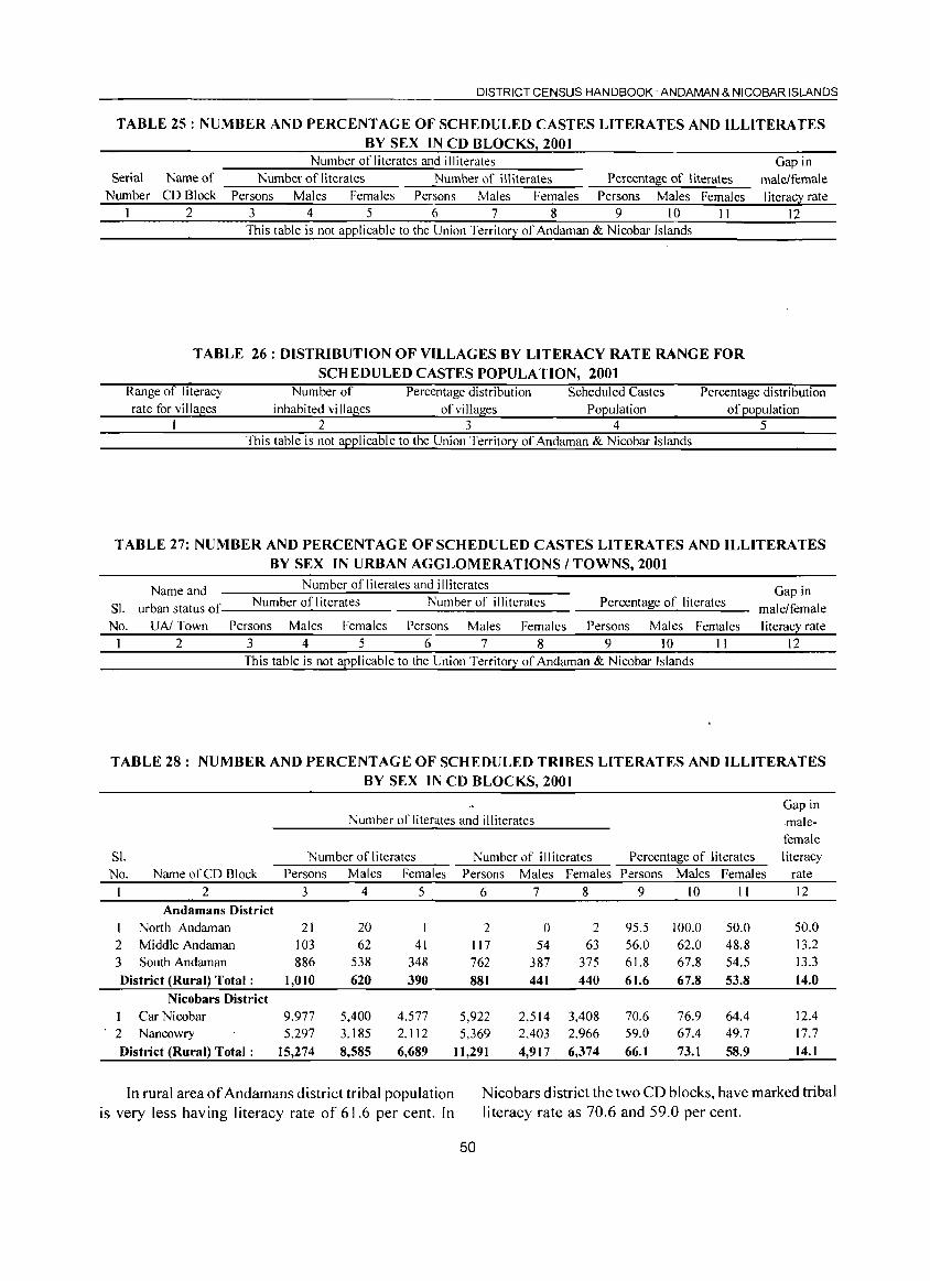
DISTRICT CENSUS HANDBOOK. ANDAMAN & NICOBAR ISLANDS
TABLE 25 : NUMBER AND PERCENT AGE OF SCHEDULED CASTES LITERATES AND ILLITERATES
Serial Number
1
BY SEX IN CD BLOCKS 2001 Number of literates and illiterates
Name of Number of literates Number of illiterates Percental;l:e of I iterates CD Block Persons Males Females Persons Males Females Persons Males Females
2 3 4 5 6 7 8 9 10 11 This table is not applicable to the Union Territory of Andaman & Nicobar Islands
TABLE 26: DISTRIBUTION OF VILLAGES BY LITERACY RATE RANGE FOR
SCHEDULED CASTES POPULATION, 2001
Gap in male/female I iterac~ rate
12
Range of literacy rate for vi II ages
Number of inhabited villages
Percentage distribution of villages
Scheduled Castes Population
Percentage distribution of population
2 3 4 5 This table is not applicable to the Union Territory of Andaman & Nicobar Islands
TABLE 27: NUMBER AND PERCENTAGE OF SCHEDULED CASTES LITERATES AND ILLITERATES
BY SEX IN URBAN AGGLOMERATIONS / TOWNS, 2001
Name and Number of literates and illiterates Gap in SI. urban status of Number of I iterates Number of illiterates Percentage of literates male/female No. UN Town Persons Males Females Persons Males Females Persons Males Females literacy rate
1 2 3 4 5 6 7 8 9 10 1 I 12 This table is not applicable to the Union Territory of Andaman & Nicobar Islands
TABLE 28: NUMBER AND PERCENT AG E OF SCH EDULED TRIBES LITERATES AND ILLITERATES
BY SEX IN CD BLOCKS, 2001
Gap in Number of literates and illiterates .male-
SI. Number of literates No. Name of CD Block Persons Males Females
1 2 3 4 5 Andamans District
1 North Andaman 21 20 2 Middle Andaman 103 62 41 3 South Andaman 886 538 348
District (Rural) Total: 1,010 620 390 Nicobars District
1 Car Nicobar 9,977 5,400 4,577 2 Nancowry 5.297 3.185 2,112
District (Rural) Total: 15,274 8,585 6,689
In rural area of Andamans district tribal population is very less having literacy rate of 61.6 per cent. In
female Number of illiterates Percenta~e of literates literacy
Persons Males Females Persons Males Females rate
6 7 8 9 10 11 12
2 0 2 95.5 100.0 50.0 50.0 117 54 63 56.0 62.0 48.8 13.2 762 387 375 61.8 67.8 54.5 13.3
881 441 440 61.6 67.8 53.8 14.0
5,922 2,514 3,408 70.6 76.9 64.4 12.4 5,369 2,403 2,966 59.0 67.4 49.7 17.7
11,291 4,917 6,374 66.1 73.1 58.9 14.1
N icobars district the two CD blocks, have marked tribal literacy rate as 70.6 and 59.0 per cent.
50
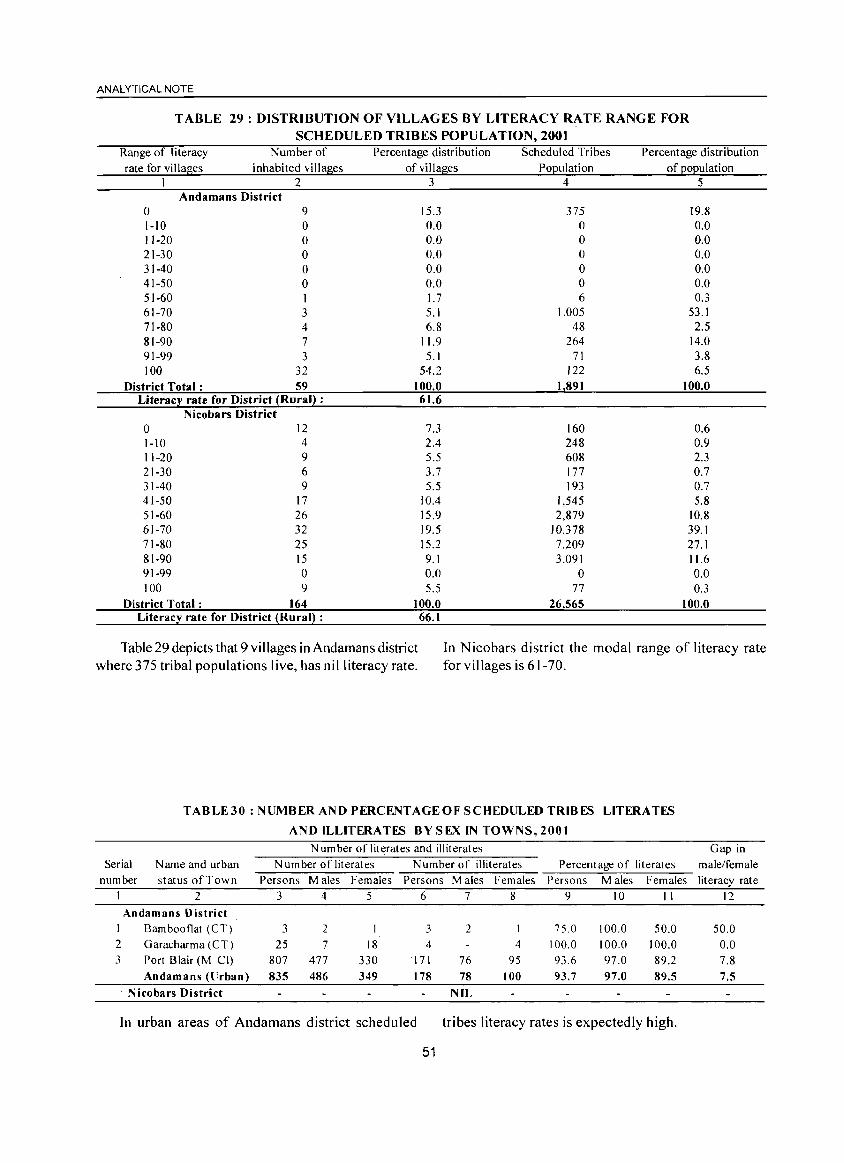
ANALYTICAL NOTE
TABLE 29: DISTRIBUTION OF VILLAGES BY LITERACY RATE RANGE FOR
SCHEDULED TRIBES POPULATION, 2001 Range of literacy Number of Percentage distribution Scheduled Tribes Percentage distribution rate for villages inhabited villages of villages Population of population
I 2 3 4 5 Andamans District
0 9 15.3 375 19.8 1-10 0 0.0 0 0.0 11-20 0 0.0 0 0.0 21-30 0 0.0 0 0.0 31-40 0 0.0 0 0.0 41-50 0 0.0 0 0.0 51-60 I 1.7 6 0.3 61-70 3 5.1 1.005 53.1 71-80 4 6.8 48 2.5 81-90 7 11.9 264 14.0 91-99 3 5.1 71 3.8 100 32 54.2 122 6.5
District Total: 59 100.0 1 891 100.0 Literacy rate for District (Rural) : 61.6
Nicobars District 0 12 7.3 160 0.6 1-10 4 2.4 248 0.9 11-20 9 5.5 608 2.3 21-30 6 3.7 177 0.7 31-40 9 5.5 193 0.7 41-50 17 10.4 1,545 5.8 51-60 26 15.9 2,879 10.8 61-70 32 19.5 10,378 39.1 71-80 25 15.2 7,209 27.1 81-90 15 9.1 3.091 11.6 91-99 0 0.0 0 0.0 100 9 5.5 77 0.3
District Total: 164 100.0 26565 100.0 Literacy rate for District (Rural) : 66.1
Table 29 depicts that 9 villages in Andamans district where 375 tribal populations live, has nil literacy rate.
In Nicobars district the modal range of literacy rate for villages is 61-70.
TABLE30 : NUMBER AND PERCENTAGE OF SCHEDULED TRIBES LITERATES
AND ILLITERATES BY SEX IN TOWNS, 2001
N urn ber of literates and illiterates Gap in Serial N arne and urban Number of literates N umber of illiterates Percentage of literates male/female
number status of Town Persons Males Females Persons Males Females Persons Males Females literacy rate 2 3 4 5 6 7 8 9 10 II 12
Andamans District 1 Barnboot1at (CT) 3 2 3 2 75.0 100.0 50.0 50.0 2 Garacharma (CT) 25 7 18 4 4 100.0 100.0 100.0 0.0 3 Port Blair (M Cl) 807 477 330 171 76 95 93.6 97.0 89.2 7.8
Andamans (llrban) 835 486 349 178 78 100 93.7 97.0 89.5 7.5 . N icobars District NIL
In urban areas of Andamans district scheduled tribes literacy rates is expectedly high.
51
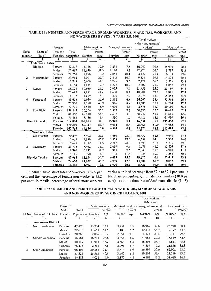
DISTRICT CENSUS HANDBOOK. ANDAMAN & NICOBAR ISLANDS
TABLE 31 : NUM BER AND PERCENT AG E OF MAIN WORKERS, MARG INAL WORKERS, AND NON-WORKERS BY SEX IN T AHSILS. 2001
Persons / Males /
Main workers
Total Serial number
Name of Tahsil Females population Number
2 3 4 5 Andamans District
Diglipur Persons Males Females
2 Mayabunder Persons Males Females
3 Rangat
4 Ferrargunj
5 Port Blair
District Total:
Persons Males Females Persons Males Females Persons Males Females Persons Males Females
Nicobars District Car Nicobar Persons
Males Females
2 Nancowry
District Total:
Persons Males Females Persons Males Females
42,877 22,617 20.260 23.912 12.748 11.164 38,824 20,692 18,132 48,626 25,900 22.726
159.845 88,362 71.483
314,084 170,319 143,765
20,292 10.663 9.629
21. 776 11,990 9,786
42,068 22,653 19,415
13.716 11.640 2,076 7,091 6.006 1.085
10,660 9,191 1,469
12,950 11.380
1.570 56.266 48,110
8.156 100,683 86,327 14,356
5.992 4.880 1.112 6,932 6,142
790 12,924 11,022
1,902
Percentage
6
32.0 51.5 10.2 29.7 47.1
9.7 27.5 44.4
8.1 26.6 43.9
6.9 35.2 54.4 11.4 32.1 50.7 10.0
29.5 45.8 11.5 31.8 51.2
8.1 30.7 48.7
9.8
Marginal workers
PercenNumber tage
7 8
3,231 1,180 2,051 2,443 1,221 1,222 2,995 1,690 1.305 3,312 2,306 1,006 3.967 2,637 1,330
15,948 9,034 6,914
4,660 1.878 2,782 2,039
901 1,1 ~.8 6,699 2,779 3,920
7.5 5.2
10.1 10.2 9.6
10.9 7.7 8.2 7.2 6.8 8.9 4.4 2.5 3.0 1.9 5.1 5.3 4.8
23.0 17.6 28.9
9.4 7.5
11.6 15.9 12.3 20.2
Total workers (Main and marginal
workers)
PercenNumber tage
9 10
16,947 12,820 4,127 9,534 7,227 2,307
13,655 10,881 2,774
16,262 13,686 2,576
60,233 50,747
9,486 116,631 95,361 21,270
10,652 6,758 3,894 8,971 7,043 1,928
19,623 13,801 5,822
39.5 56.7 20.4 39.9 56.7 20.7 35.2 52.6 15.3 33.4 52.8 11.3 37.7 57.4 13.3 37.1 56.0 14.8
52.5 63.4 40.4 41.2 58.7 19.7 46.6 60.9 30.0
Non workers
PercenNumber tage
II 12
25,930 9,797
16,133 14.378 5.521 8,857
25,169 9,811
15,358 32,364 12,214 20,150 99,612 37,615 61,997
197,453 74,958
122,495
9,640 3,905 5,735
12,805 4,947 7,858
22,445 8,852
13,593
60.5 43.3 79.6 60.1 43.3 79.3 64.8 47.4 84.7 66.6 47.2 88.7 62.3 42.6 86.7 62.9 44.0 85.2
47.5 36.6 59.6 58.8 41.3 80.3 53.4 39.1 70.0
In Andamans district total non-worker is 62.9 per cent and the percentage of female non-worker is 85.2 per cent. In tehsils, percentage of total male workers
varies within short range from 52.6 to 57.4 per cent. In Nicobars percentage of female total worker (30.0 per cent), is double than that of Andamans district (14.8).
SI.No
2
3
TABLE 32: NUMBER AND PERCENTAGE OF MAIN WORKERS, MARGINAL WORKERS AND NON-WORKERS BY SEX IN CD BLOCKS, 2001
Total workers (Main and
Persons! Main workers Marginal workers marginal workers) Non workers -----=--Males/ Total
Name of CD block Females Population Number 2 3 4 5
Andamans District North Andaman
Middle Andaman.
South Andaman
Persons Males Females Persons Males Females Persons Males Females
42,895 22,635 20,260 56,584 30,149 26,435 98.407 53.524 44,883
13,734 11.658 2,076
16,211 13,943 2,268
30,585 26.563
4,022
Percent Percent Percent Percent age 6
32.0 51.5 10.2 28.6 46.2
8.6 31.1 49.6
9.0
52
Number 7
3.231 1.180 2.051 4,854 2,563 2,291 5.814 3,642 2,172
age 8
7.5 5.2
10.1 8.6 8.5 8.7 5.9 6.8 4.8
Number 9
16,965 12,838 4,127
21,065 16,506 4,559
36,399 30.205
6,194
age 10
39.6 56.7, 20.4 37.2 54.7 17.2 37.0 56.4 13.8
Number II
25,930 9.797
16.133 35,519 13.643 21,876 62,008 23,319 38,689
age 12
60.4 43.3 79.6 62.8 45.3 82.8 63.0 43.6 86.2
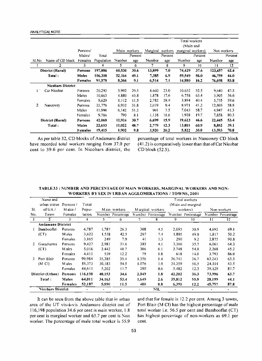
ANALYTICAL NOTE
Total workers (Main and
Persons/ Main workers Marginal workers marginal workers) Non workers Males/ Total Percent Percent Percent Percent
SI.No Name of CD block Females POEulation Number age Number age Number age Number age I 2 3 4 5 6 7 8 9 10 II 12
District (Rural) Persons 197,886 60,530 30.6 13,899 7.0 74,429 37.6 123,457 62.4 Total: Males 106,308 52,164 49.1 7,385 6.9 59,549 56.0 46,759 44.0
Females 91,578 8,366 9.1 6,514 7.1 14,880 16.2 76,698 83.8 Nicobars District
1 ' Car Nicobar Persons 20,292 5,992 29.5 4.660 23.0 10.652 52.5 9,640 47.5 Males 10,663 4.880 45.8 1.878 17.6 6.758 63.4 3,905 36.6 Females 9,629 1,112 11.5 2.782 28.9 3,894 40.4 5,735 59.6
2 Nancowry Persons 21.776 6,932 31.8 2.039 9.4 8.971 41.2 12,805 58.8 Males 1).990 6,142 51.2 901 7.5 7.043 58.7 4,947 41.3 Females 9.786 790 8.1 1.138 11.6 1.928 19.7 7,858 80.3
District (Ru ral) Persons 42,068 12,924 30.7 6,699 15.9 19,623 46.6 22,445 53.4
Total: Males 22,653 11,022 48.7 2,779 12.3 13,801 60.9 8,852 39.1 Females 19,415 1,902 9.8 3,920 20.2 5,822 30.0 13,593 70.0
As per table 32, CD blocks of Andamans district percentage of total workers in Nancowry CD block have recorded total workers ranging from 37.0 per (41.2) is comparatively lower than that of Car Nicobar cent to 39.6 per cent. In Nicobars district, the CD block (52.5).
TABLE33: NUMBER AND PERCENTAGE OF MAIN WORKERS, MARGINAL WORKERS AND NONWORKERS BY SEX IN URBAN AGGLOMERATIONS / TOWNS, 2001
Name and Total workers urban status Persons I Total (M ain and marginal
S1. ofUA I Males / Popu- Main workers Marginal workers workers) Non workers No. Town Females lation Number Percentage Number Percentage Number Percentage N umber Percentage
I 2 3 4 5 6 7 8 9 10 II 12 Andamans District Bamboo flat Persons 6,787 1,787 26.3 308 4.5 2,095 30.9 4,692 69.1 (CT) Males 3,622 1,538 42.5 267 7.4 1,805 49.8 1,817 50.2
Females 3,165 249 7.9 41 1.3 290 9.2 2,875 90.8 2 Garacharma Persons 9,427 2,981 31.6 385 4.1 3,366 35.7 6,061 64.3
(CT) Males 5.016 2,442 48.7 306 6.1 2.748 54.8 2,268 45.2 Females 4,411 539 12.2 79 1.8 618 14.0 3,793 86.0
3 Port Blair Persons 99,984 35,385 35.4 1,356 1.4 36.741 36.7 63,243 63.3 (M CI) Males 55,373 30,183 54.5 1,076 1.9 31,259 56.5 24,114 43.5
Females 44,611 5,202 11.7 280 0.6 5,482 12.3 39,129 87.7
District (Urban) Persons 116,198 40,153 34.6 2,049 1.8 42,202 36.3 73,996 63.7
Total: Males 64,011 34,163 53.4 1,649 2.6 35.812 55.9 28,199 44.1 Females 52,187 5,990 11.5 400 0.8 6,390 12.2 45,797 87.8
Nicobars District NIL
It can be seen from the above table that in urban and that for female is 12.2 per cent. Among 3 towns, area of the UT vis-a-vis Andamans district out of Port Blair (M CI) has the highest percentage of male 116,198 population 34.6 per cent is main worker, 1.8 total worker i.e. 56.5 per cent and Bambooflat (CT) per cent is marginal worker and 63.7 per cent is Non has highest percentage of non-workers as 69.1 per worker. The percentage of male total worker is 55.9 cent.
53
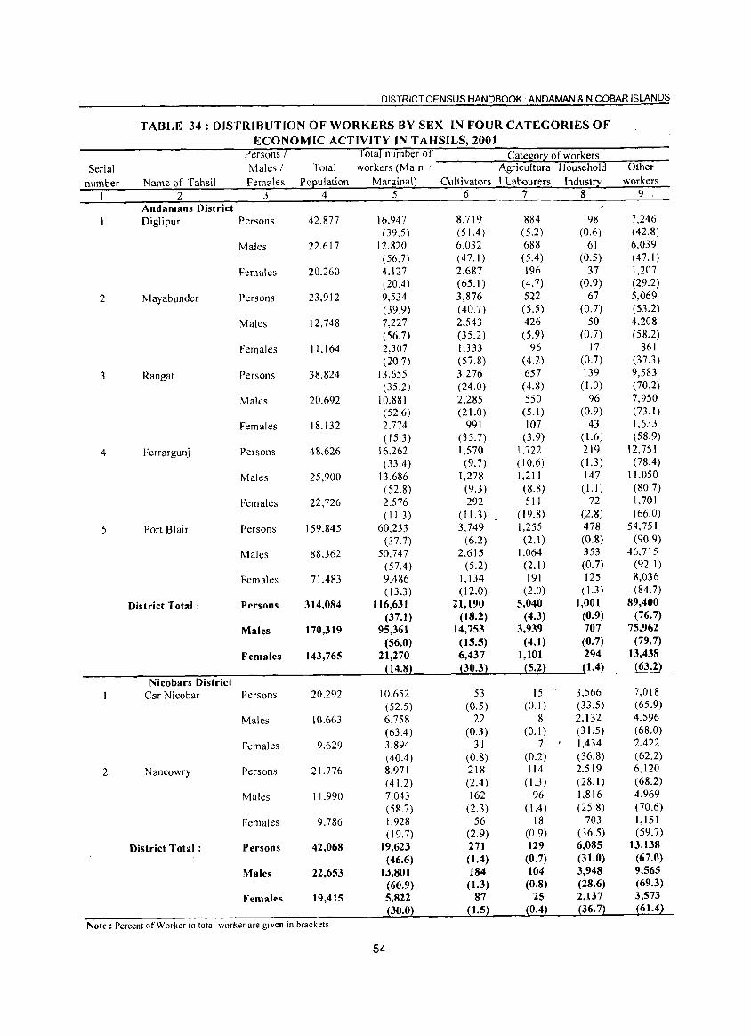
DISTRICT CENSUS HANDBOOK: ANDAMAN & NICOBAR ISLANDS
TABLE 34: DISTRIBUTION OF WORKERS BY SEX IN FOUR CATEGORIES OF ECONOMIC ACTIVITY IN TAHSILS, 2001
Persons / Total number of Catesor~ of workers Serial Males I Total workers (Main + Agricultura Household Other
number Name of Tahsil Females Po£ulation MarsinaQ Cultivators I Labourers Industry workers
1 2 3 4 5 6 7 8 9 ,
Andamans District Diglipur Persons 42.877 16.947 8.719 884 98 7,246
(39.5) (51.4 ) (5.2) (0.6) (42.8) Males 22.617 12.820 6,032 688 61 6,039
(56.7) (47.1 ) (5.4) (0.5) (47.1 ) Females 20.260 4.127 2,687 196 37 1,207
(20.4) (65.1) (4.7) (0.9) (29.2)
2 Mayabunder Persons 23.912 9,534 3,876 522 67 5,069 (39.9) (40.7) (5.5) (0.7) (53.2)
Males 12,748 7,227 2,543 426 50 4,208 (56.7) (35.2) (5.9) (0.7) (58.2)
Females 11.164 2,307 I.333 96 17 861 (20.7) (57.8) (4.2) (0.7) (37.3)
3 Rangat Persons 38.824 13,655 3,276 657 139 9,583 (35.2) (24.0) (4.8) ( 1.0) (70.2)
Males 20.692 10.881 2.285 550 96 7,950 (52.6) (21.0) (5.1 ) (0.9) (73.1)
Females 18.132 2.774 991 107 43 1,633 (15.3) (35.7) (3.9) ( 1.6) (58.9)
4 Ferrargunj Persons 48.626 16.262 1,570 1,722 219 12,751 (33.4 ) (9.7) ( 10.6) ( 1.3) (78.4 )
Males 25,900 13.686 1,278 1,211 147 11,050 (52.8) (9.3) (8.8) ( 1.1) (80.7)
Females 22,726 2.576 292 511 72 1,701 (11.3 ) (11.3 ) ( 19.8) (2.8) (66.0)
5 Port Blair Persons 159,845 60.233 3.749 1,255 478 54,751 (37.7) (6.2) (2.1) (0.8) (90.9)
Males 88.362 50.747 2.615 1,064 353 46,715 (57.4) (5.2) (2.1 ) (0.7) (92.1)
Females 71.483 9,486 1.134 191 125 8,036 (13.3 ) ( 12.0) (2.0) ( 1.3) (84.7)
District Total: Persons 314,084 116,631 21,190 5,040 1,001 89,400 (37.1) (18.2) (4.3) (0.9) (76.7)
Males 170,319 95,361 14,753 3,939 707 75,962 (56.0) (15.5) (4.1) (0.7) (79.7)
Females 143,765 21,270 6,437 1,101 294 13,438
~14.8} pO.3} ~5.2} p.4} ~63.2}
Nicobars District Car Nicobar Persons 20.292 10.652 53 15 - 3,566 7.018
(52.5) (0.5) (0.1 ) (33.5) (65.9)
Males 10.663 6,758 22 8 2,132 4.596 (63.4 ) (0.3) (0.1 ) (31.5) (68.0)
Females 9.629 3.894 31 7 1,434 2,422 (40.4) (0.8) (0.2) (36.8) (62.2)
2 Nancowry Persons 21.776 8.971 218 114 2.519 6,120 (41.2) (2.4) (1.3) (28.1) (68.2)
Males 11.990 7.043 162 96 1,816 4,969 (58.7) (2.3) (1.4 ) (25.8) (70.6)
Females 9.786 1.928 56 18 703 1,151 ( 19.7) (2.9) (0.9) (36.5) (59.7)
District Total: Persons 42,068 19,623 271 129 6,085 13,138 (46.6) (1.4) (0.7) (31.0) (67.0)
Males 22,653 13,801 184 104 3,948 9,565 (60.9) (1.3) (0.8) (28.6) (69.3)
Females 19,415 5,822 87 25 2,137 3,573
pO.O~ ~1.5~ {0.4~ {36. 7~ ~61.4}
Note: Percenf of Worker to total worker are given in brackets
54
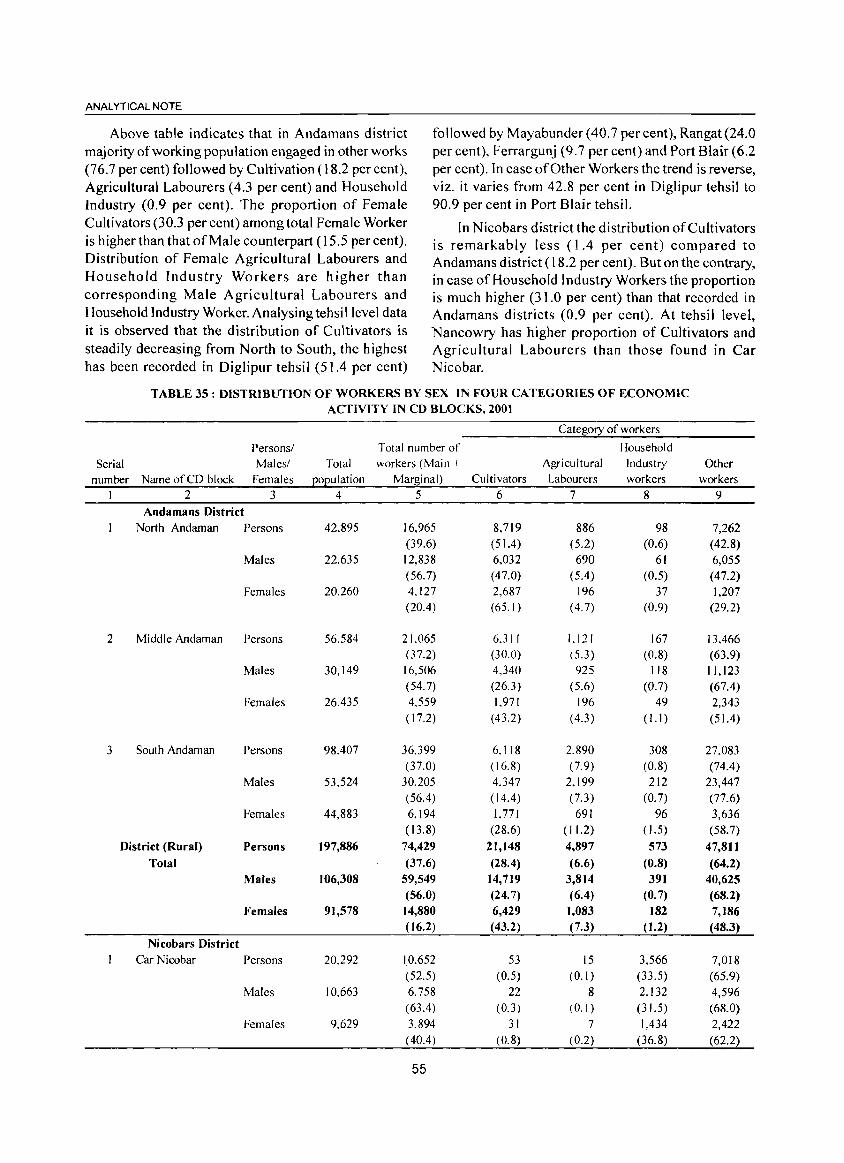
ANALYTICAL NOTE
Above table indicates that in Andamans district majority of working population engaged in other works (76.7 percent) followed by Cultivation (} 8.2 per cent), Agricultural Labourers (4.3 per cent) and Household Industry (0.9 per cent). The proportion of Female Cultivators (30.3 per cent) among total Female Worker is higher than that of Male counterpart (15.5 per cent). Distribution of Female Agricultural Labourers and Household Industry Workers are higher than corresponding Male Agricultural Labourers and Household Industry Worker. Analysing tehsi I level data it is observed that the distribution of Cultivators is steadily decreasing from North to South, the highest has been recorded in Diglipur tehsil (51.4 per cent)
followed by Mayabunder(40.7 percent), Rangat(24.0 per cent), Ferrargunj (9.7 per cent) and Port Blair (6.2 per cent). In case of Other Workers the trend is reverse, viz. it varies from 42.8 per cent in Diglipur tehsil to 90.9 per cent in Port Blair tehsil.
In Nicobars district the distribution of Cultivators is remarkably less (1.4 per cent) compared to Andamans district (18.2 per cent). But on the contrary, in case of Household Industry Workers the proportion is much higher (31.0 per cent) than that recorded in Andamans districts (0.9 per cent). At tehsil level, Nancowry has higher proportion of Cultivators and Agricultural Labourers than those found in Car Nicobar.
TABLE 35 : DISTRIBUTION OF WORKERS BY SEX IN FOUR CATEGORIES OF ECONOMIC ACTIVITY IN CD BLOCKS, 2001
Category of workers
Persons/ Total number of Household
Serial Males/ Total workers (Main + Agricultural Industry Other number Name of CD block Females pOEulation Mar~inal) Cultivators Labourers workers workers
2 3 4 5 6 7 8 9 Andamans District
North Andaman Persons 42,895 16,965 8,719 886 98 7,262 (39.6) (51.4) (5.2) (0.6) (42.8)
Males 22.635 12,838 6,032 690 61 6,055 (56.7) (47.0) (5.4) (0.5) (47.2)
Females 20.260 4.127 2,687 196 37 1,207 (20.4) (65.1 ) (4.7) (0.9) (29.2)
2 Middle Andaman Persons 56.584 21.065 6.311 1.121 167 13.466 (37.2) (30.0) (5.3) (0.8) (63.9)
Males 30.149 16,506 4,340 925 118 11,123 (54.7) (26.3 ) (5.6) (0.7) (67.4)
Females 26.435 4.559 1.971 196 49 2,343 ( 17.2) (43.2) (4.3) (I.I ) (51.4)
3 South Andaman Persons 98.407 36.399 6.118 2.890 308 27.083 (37.0) ( 16.8) (7.9) (0.8) (74.4)
Males 53,524 30.205 4.347 2,199 212 23,447 (56.4) (14.4 ) (7.3) (0.7) (77.6)
Females 44,883 6.194 1,771 691 96 3,636 (13.8) (28.6) (11.2) ( 1.5) (58.7)
District (Rural) Persons 197,886 74,429 21,148 4,897 573 47,811 Total (37.6) (28.4) (6.6) (0.8) (64.2)
Males 106,308 59,549 14,719 3,814 391 40,625 (56.0) (24.7) (6.4) (0.7) (68.2)
Females 91,578 14,880 6,429 1,083 182 7,186 (16.2) (43.2) (7.3) (1.2) (48.3)
Nicobars District Car Nicobar Persons 20.292 10.652 53 15 3,566 7,018
(52.5) (0.5) (0.1 ) (33.5) (65.9) Males 10.663 6.758 22 8 2.132 4,596
( 63.4) (0.3) (0.1 ) (31.5) (68.0) Females 9.629 3.894 31 7 1,434 2,422
( 40.4) (0.8) (0.2) (36.8) (62.2)
55
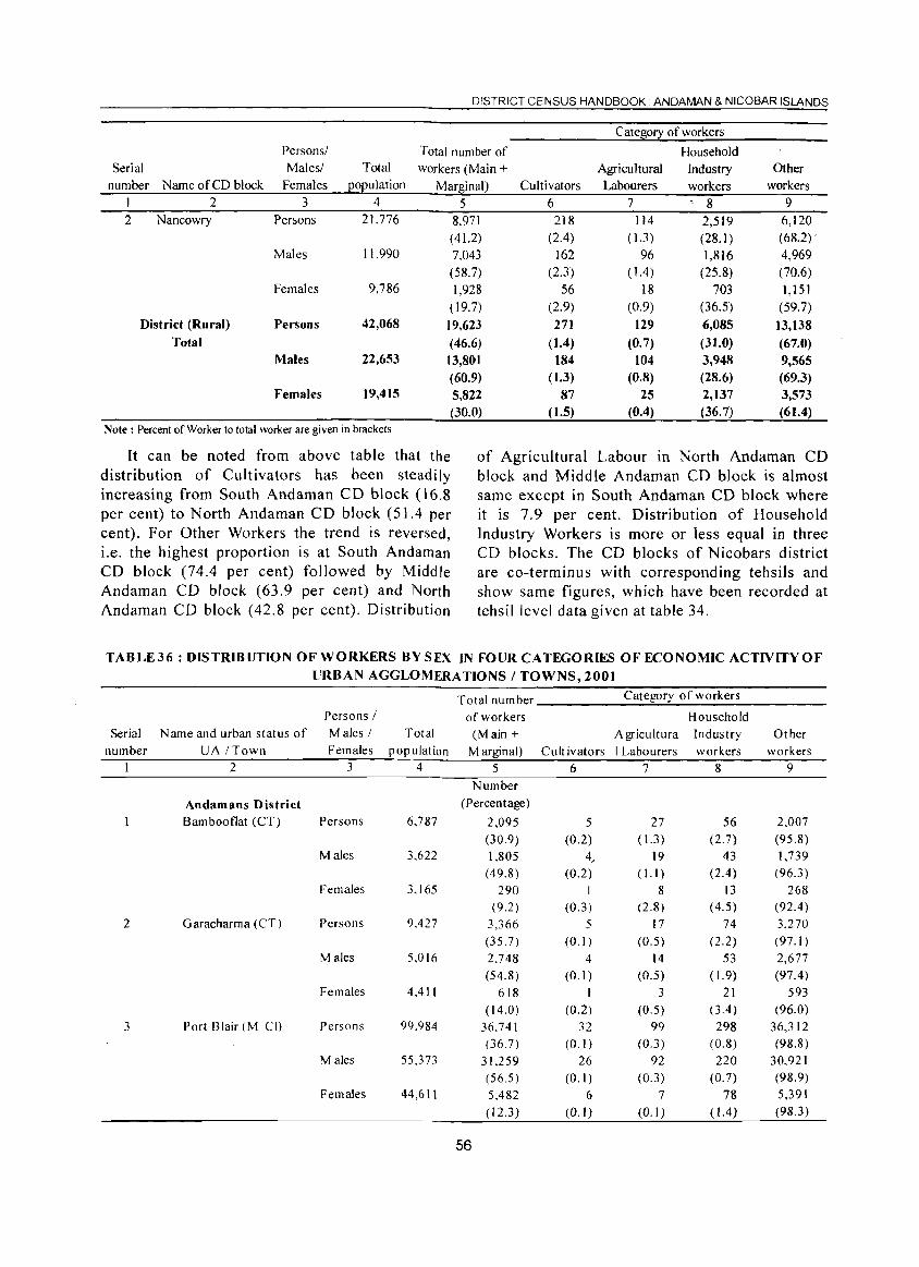
DISTRICT CENSUS HANDBOOK. ANDAMAN & NICOBAR ISLANDS
Cate~0!2: of workers Personsl Total number of Household
Serial Malesl Total workers (Main + Agricultural lndustry Other number Name of CD block Females EOEulation Marginal) Cultivators Labourers workers workers
1 2 3 4 5 6 7 ~ 8 9 2 Nancowry Persons 21.776 8,971 218 114 2,519 6,120
( 41.2) (2.4) ( 1.3) (28, I) (68,2) . Males 11,990 7,043 162 96 1,816 4,969
(58.7) (2.3) ( 1.4) (25.8) (70.6) Females 9,786 1,928 56 18 703 1,151
( 19.7) (2.9) (0.9) (36.5) (59.7) District (Rural) Persons 42,068 19,623 271 129 6,085 13,138
Total (46,6) (1.4) (0.7) (31.0) (67.0) Males 22,653 13,801 184 104 3,948 9,565
(60.9) (1.3) (0.8) (28.6) (69.3) Females 19,415 5,822 87 25 2,137 3,573
(30.0) (1.5) (0.4) (36.7) (61.4) Note: Percent of Worker to total worker are given in brackets
It can be noted from above table that the distribution of Cultivators has been steadily increasing from South Andaman CD block (16.8 per cent) to North Andaman CD block (51.4 per cent). For Other Workers the trend is reversed, i.e. the highest proportion is at South Andaman CD block (74.4 per cent) followed by Middle Andaman CD block (63.9 per cent) and North Andaman CD block (42.8 per cent). Distribution
of Agricultural Labour in North Andaman CD block and Middle Andaman CD block is almost same except in South Andaman CD block where it is 7.9 per cent. Distribution of Household Industry Workers is more or less equal in three CD blocks. The CD blocks of Nicobars district are co-terminus with corresponding tehsils and show same figures, which have been recorded at tehsil level data given at table 34.
TABLE36: DISTRIBUTION OF WORKERS BYSEX IN FOUR CATEGORIES OF ECONOMIC ACTIVITY OF
URBAN AGGLOMERATIONS I TOWNS, 2001
Total number Category of workers
Persons / of workers Household Serial N arne and urban status of Males ( Total (M ain + Agricultura Industry Other
number UA (Town Females population Marginal) Cult ivators I Labourers workers workers 2 3 4 5 6 7 8 9
Number
Andamans District (Percentage)
Bambooflat (CT) Persons 6,787 2,095 5 27 56 2,007
(30.9) (0.2) (1.3 ) (2.7) (95.8) Males 3,622 1,805 4, 19 43 1,739
(49.8) (0.2) (I. I) (2.4) (96.3) Females 3,165 290 1 8 13 268
(9.2) (0.3) (2.8) (4.5) (92.4 ) 2 Garacharma (CT) Persons 9.427 3,366 5 17 74 3,270
(35.7) (0.1 ) (0.5) (2.2) (97.1 ) Males 5,016 2,748 4 14 53 2,677
(54.8) (0.1 ) (0.5) ( 1.9) (97.4 ) Females 4.411 618 I 3 21 593
(14.0) (0.2) (0.5) (3.4) (96.0) 3 Port Blair (M CI) Persons 99.984 36,741 32 99 298 36.312
(36.7) (0.1) (0.3) (0.8) (98.8) Males 55,373 31.259 26 92 220 30.921
(56.5) (0.1 ) (0.3) (0.7) (98.9) Females 44,611 5,482 6 7 78 5,391
( 12.3) (0.1) (0.1 ) (1.4) (98.3)
56
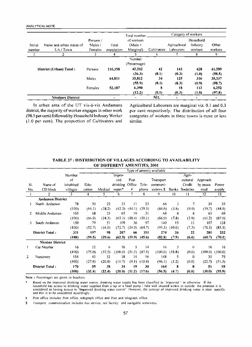
ANALYTICAL NOTE
Serial
number
Name and urban status of
UA I Town
2
District (Urban) Total:
Nicobars District
Persons I Males /
Females
3
Persons
Males
Females
Total
population
4
116,198
64,011
52,187
Total number
of workers (Main +
Marginal)
5 Number
(Percentage)
42,202 (36.3)
35,812 (55.9) 6,390 (12.2)
Category of workers
Household
Agricultural Industry Other
Cultivators Labourers workers workers
6 7 8 9
42 143 428 41,589 (0.1) (0.3) (1.0) (98.5)
34 125 316 35,337 (0.1) (0.3) (0.9) (98.7)
8 18 112 6,252 (0.1) (0.3) (1.8) (97.8)
NIL
In urban area of the UT vis-a-vis Andamans district, the majority of worker engages in other work (98.5 per cent) followed by Household Industry Worker (1.0 per cent). The proportion of Cultivators and
Agricultural Labourers are marginal viz. 0.1 and 0.3 per cent respectively. The distribution of all four categories of workers in three towns is more or less similar.
TABLE 37: DISTRIBUTION OF VILLAGES ACCORDING TO AVAILABILITY OF DIFFERENT AMENITIES, 200t
Type of amenity available
Number Impro- Agri-
of ved Post Transport cultural Approach
SI. Name of inhabited Edu- drinking Office Tele- communi- Credit by pucca Power
No. CD block villages cation Medical water* # phone cations $ Banks Societies road supply
1 2 3 4 5 6 7 8 9 10 11 12 13 Andaman District
North Andaman 78 50 22 33 II 23 66 3 7 31 35 (100) (64.1 ) (28.2) (42.3) (14.1 ) (29.5) (84.6) (3.8) (9.0) (39.7) (44.9)
2 Middle Andaman 103 68 25 65 19 31 68 8 4 63 69 (100) (66.0) (24.3) (63.1 ) ( 18.4) (30.1 ) (66.0) (7.8) (3.9) ( 61.2) (67.0)
3 South Andaman 150 79 51 109 36 97 140 15 II 107 128 (100) (52.7) (34.0) (72. 7) (24.0) (64.7) (93.3) ( 10.0) (7.3) (71.3) (85.3)
District Total: 331 197 98 207 66 151 274 26 22 201 232 (100) (59.5) (29.6) (62.5) (19.9) (45.6) (82.8) (7.9) (6.6) (60.7) (70.1)
Nicobar District
Car Nicobar 16 12 6 16 5 14 16 3 0 16 16 (100) (75.0) (37.5) (100.0) (31.3 ) (87.5) (100.0) (18.8) (0.0) (100.0) (100.0)
2 Nancowry 154 43 32 18 14 16 148 5 0 35 79 (100) (27.9) (20.8) (II. 7) (9.1 ) ( 10.4) (96.1 ) (3.2) (0.0) (22.7) (51.3)
District Total: 170 55 38 34 19 30 164 8 0 51 95 (100) (32.4) (22.4) (20.0) (11.2) (17.6) (96.5) (4.7) (0.0) (30.0) (55.9)
Note: Percentages are given in brackets
* Based on the improved drinking water source, drinking water supply has been classified as 'Improved . or otherwise. If the household has access to drinking water supplied from a tap or'a hand pump / tube well situated within or outside the premises it is considered as having access to 'Improved drinking water source'. However, the concept of improved drinking water is state specific and this is to be considered accordingly.
# Post office includes Post office, telegraph office and Post and telegraph office.
$ Transport communication includes bus service. rail facility and navigable waterways.
57
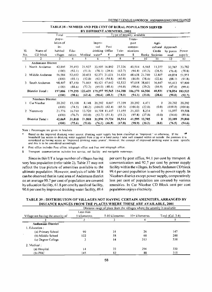
DISTRICT CENSUS HANDBOOK: ANDAMAN & NICOBAR ISLANDS
TABLE38 : NUMBER AND PER CENT OF RURAL POPULATION SERVED BY DIFFERENT AMENITIES, 2001
Total Ty pe of amenity available popu- Trans-
lation of Impro- port Agri-in- ved Post commu- cultural Approach
Sl. Name of habited Edu- drinking Office Tele- nications Credit by pucca Power No. CD block villages cation Medical water* # phone $ Banks Societies road supply
1 2 3 4 S 6 7 8 9 10 11 12 13 Andamans Distrct
North Andaman 42.89S 39,493 21.937 33.S0S 16,892 27,336 40,S14 6,565 1U77 32,767 33,782 (100) (92.1 ) (S1. I ) (78.1 ) (39.4) (63.7) (94.4) (15.3 ) (26.5) (76.4) (78.8)
2 Middle Andaman 56,584 52,652 30,433 52,271 31,031 34,420 48,638 21,740 12,807 49,874 51,951 (100) (93.1 ) (53.8) (92.4) (54.8) (60.8) (86.0) (38.4) (22.6) (88.1 ) (91.8)
3 South A ndaman 98,407 87,1 SO 71,065 93,521 47.642 92,532 97,018 38,601 16,647 95,413 97,800 (100) (88.6) (72.2) (9S.0) (48.4) (94.0) (98.6) (39.2) (16.9) (97.0) (99.4)
District Total: 197,886 179,295 123,435 179,297 95,565 154,288 186,170 66,906 40,831 178,054 183,533 (100) (90.6) (62.4) (90.6) (48.3) (78.0) (94.1 ) (33.8) (20.6) (90.0) (92.7)
Nicobars District Car Nicobar 20.292 15,1 08 8,148 20,292 8,607 17,359 20,292 4,471 0 20,292 20,292
(100) (74.S) (40.2) (100.0) (42.4) (8S.5) (100.0) (22.0) (0.0) (100.0) (100.0)
2 Nancowry 21,776 16.710 13.720 11,7041Ll17 11, ISS 21,303 8,234 0 11,897 19,508 (100) (76.7) (63.0) (53.7) (51.1 ) (51.2) (97.8) (37.8) (0.0) (54.6) (89.6)
District Total: 42,068 31,818 21,868 31,996 19,724 28,514 41,595 12,705 0 32,189 39,800 (100) (75.6) (52.0) (76.1) (46.9) (67.8) (98.9) (30.2) (0.0) (76.5) (94.6)
Note: Percentages are given in brackets
* Based on the improved drinking water source, drinking water supply has been classified as 'Improved' or otherwise. If the ,~
household has access to drinking water supplied from a tap or a hand pump / tube well situated within or outside the premises it is considered as having access to 'Improved drinking water source'. However, the concept of improved drinking water is state specific and this is to be cons idered accordingly.
# Post office includes Post office. telegraph office and Post and telegraph office.
$ Transport communication includes bus service, rail facility and navigable waterways.
Since in this UT a large number of villages having very less population (refer table 2), Table 37 may not reflect the true picture of amenities available to the ultimate population. However, analysis of table 38 it can be observed that in rural area of Andamans district on an average 90.7 per cent of population are covered by education facility, 6 1.8 per cent by medical facility, 90.6 per cent by improved drinking water facility, 49.4
per cent by post office, 94. I per cent by transport & communication and 92 .. 7 per cent by power supply facility within the villages. In South Andaman CD block 99.4 per cent population is served by power supply. In Nicobars district except power supply, comparatively less per cent of population are covered by various amenities. In Car Nicobar CD Block cent per cent population enjoys electricity.
TABLE 39 : DISTRIBUTION OF VILLAGES NOT HAVING CERTAIN AMENITIES, ARRANGED BY DISTANCE RANGES FROM THE PLACES WHERE THESE ARE AVAILABLE, 2001
Village not having the amenity of
Andamans District 1. Education:
(a) Primary School (b) Middle School (c) Degree College
2. Medical: (a) Hospital (b) PHC
Distance range of place from the villages where the amenity is available Less than
5 kilometres 5-10 kilometres 10+ kilometres Total (Col. 2-4)
2 3 4 5
90 31 26 147
122 58 68 248
3 14 313 330
14 22 294 330
145 82 88 315
58
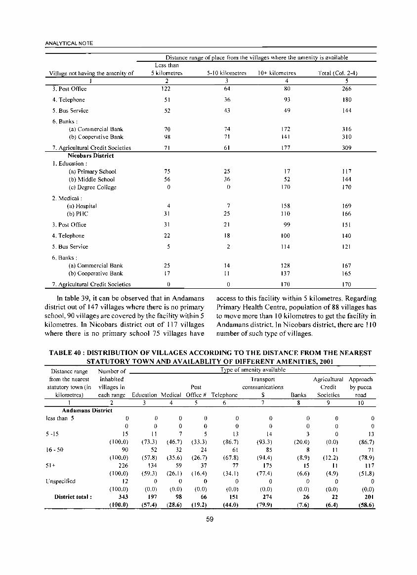
ANALYTICAL NOTE
Distance range of place from the villages where the amenity is available Less than
Village not having the amenity of 5 kilometres I 2
3. Post Office 122
4. Telephone 51
5. Bus Service 52
6. Banks: (a) Commercial Bank 70 (b) Cooperative Bank 98
7. Agricultural Credit Societies 71 Nicobars District
I. Education: (a) Primary School 75 (b) Middle School 56 (c) Degree College 0
2. Medical: (a) Hospital 4 (b) PHC 31
3. Post Office 31
4. Telephone 22
5. Bus Service 5
6. Banks: (a) Commercial Bank 25 (b) Cooperative Bank 17
7. Agricultural Credit Societies 0
In table 39, it can be observed that in Andamans district out of 147 villages where there is no primary school, 90 villages are covered by the facility within 5 kilometres. In Nicobars district out of 117 villages where there is no primary school 75 villages have
5-10 ki lometres 10+ kilometres Total (Col. 2-4) 3 4 5 64 80 266
36 93 180
43 49 144
74 172 316 71 141 310
61 177 309
25 17 117 36 52 144
0 170 170
7 158 169 25 110 166
21 99 151
18 100 140
2 114 121
14 128 167 II 137 165
0 170 170
access to this facility within 5 kilometres. Regarding Primary Health Centre, population of 88 villages has to move more than 10 kilometres to get the facility in Andamans district. In N icobars district, there are 110 number of such type of villages.
TABLE 40: DISTRIBUTION OF VILLAGES ACCORDING TO THE DISTANCE FROM THE NEAREST STATUTORY TOWN AND AVAILABLITY OF DIFFERENT AMENITIES, 2001
Distance range Number of T~e of amenity avai lable
from the nearest inhabited Transport Agricultural Approach statutory town (in villages in Post communications Credit by pucca
ki lometres) each range Education Medical Oftice # Telephone $ Banks Societies road I 2 3 4 5 6 7 8 9 10
Andamans District less than 5 0 0 0 0 0 0 0 0 0
0 0 0 0 0 0 0 0 0 5 -15 15 II 7 5 I3 14 3 0 13
(100.0) (73.3) (46.7) (33.3) (86.7) (93.3) (20.0) (0.0) (86.7) 16 - 50 90 52 32 24 61 85 8 II 71
(100.0) (57.8) (35.6) (26.7) (67.8) (94.4) (8.9) (12.2) (78.9) 51+ 226 134 59 37 77 175 15 I I 117
(100.0) (59.3) (26. I) ( 16.4) (34.1 ) (77.4) (6.6) (4.9) (51.8) Unspecified 12 0 0 0 0 0 0 0 0
( 100.0) (0.0) (0.0) (0.0) (0.0) (0.0) (0.0) (0.0) (0.0) District total: 343 197 98 66 151 274 26 22 201
( 100.0) (57.4) (28.6) (19.2) (44.0) (79.9) (7.6) (6.4) (58.6)
59
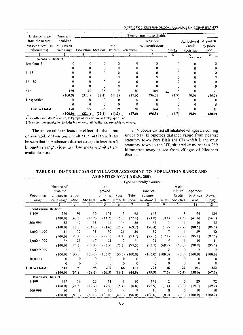
DISTRICT CENSUS HANDBOOK. ANDAMAN & NICOBAR ISLANDS
Di stance range Number of Type of amenity available
from the nearest inhabited Transport Agricultural Approach statutory town (in villages in Post communications Credit by pucca
kilometres) each range Education Medical Office # TeleEhone $ Banks Societies road I 2 3 4 5 6 7 8 9 10
Nicobars District less than 5 0 0 0 0 0 0 0 0 0
0 0 0 0 0 0 0 0 0 5 -15 0 0 0 0 0 0 0 0 0
0 0 0 0 0 0 0 0 0 16 - 50 0 0 0 0 0 0 0 0 0
0 0 0 0 0 0 0 0 0 51+ 170 55 38 19 30 164 .. 8 0 51
(100.0) (32.4) (22.4) ( 11.2) ( 17.6) (96.5) (4.7) (0.0) (30.0) Unspecified 0 0 0 0 0 0 0 0 0
0 0 0 0 0 0 0 0 0 District total: 170 55 38 19 30 164 8 0 51
(100.0) (32.4) (22.4) ( 11.2) ( 17.6) (96.5) (4.7) (0.0) (30.0) # Post office includes Post office, Telegraph office and Post and telegraph office. $ Transport communication includes bus service, rail facility and navigable waterways.
The above table reflects the effect of urban area on availability of various amenities in rural area. It can be seen that in Andamans district except in less than 5 kilometres range, close to urban areas amenities are available more.
In Nicobars district all inhabited villages are coming under 51 + kilometres distance range from nearest statutory town Port Blair (M Cl) which is the only statutory town in the UT, situated at more than 289 kilometres away in sea from villages of Nicobars district.
TABLE 41 : DISTRIBUTION OF VILLAGES ACCORDING TO POPULATION RANGE AND AMENITIES AVAILABLE, 2001
T~Ee of amenity available Number of Im- Agri-
inhabited proved Transport cultural Approach Population villages in Educ- drinking Post Tele- commu- Credit by Pucca Power
range each ran~e ation Medical water* Ofl1ce # Ehone nications $ Banks Societies road sUEEly I 2 3 4 5 6 7 8 9 10 I 1 12
Andamans District 1-499 226 91 30 101 13 62 165 I 3 94 124
(100.0) (40.3) (13.3) ( 44.7) (5.8) (27.4 ) (73.0) (0.4) ( 1.3) ( 4l.6) (54.9)
500-999 52 46 18 44 14 36 47 I 4 46 45
(100.0) (88.5) (34.6) (84.6) (26.9) (69.2) (90.4 ) ( 1.9) (7.7) (88.5) (86.5) 1,000-1,999 41 37 31 39 21 30 39 7 4 39 40
(100.0) (90.2) (75.6) (95.1 ) (51.2) (73.2) (95.1 ) ( 17.1) (9.8) (95.1) (97.6)
2,000-4,999 22 21 17 21 17 21 21 15 II 20 21
(100.0) (95.5) (77.3) (95.5) (77.3) (95.5) (95.5) (68.2) (50.0) (90.9) (95.5)
5,000-9,999 2 2 2 2 I 2 2 2 0 2 2
( 100.0) (100.0) (100.0) (J 00.0) (50.0) (100.0) (100.0) (100.0) (0.0) (100.0) (100.0)
10,000 + 0 0 0 0 0 0 0 0 0 0 0
0 0 0 0 0 0 0 0 0 0 0
District total: 343 191 98 207 66 151 274 26 22 201 232
(100.0) (57.4) (28.6) (60.3) (19.2) (44.0) (79.9) (7.6) (6.4) (58.6) (67.6)
Nicobars District· 1-499 147 36 26 II 8 10 141 2 0 29 72
(l00.0) (24.5) (17.7) (7.5) (5.4) (6.8) (95.9) (1.4 ) (0.0) ( 19.7) ( 49.0)
500-999 10 8 6 10 4 9 10 0 0 10 10
(100.0) (80.0) (60.0) (100.0) (40.0) (90.0) (100.0) (0.0) (0.0) (l00.0) ( 100.0)
60
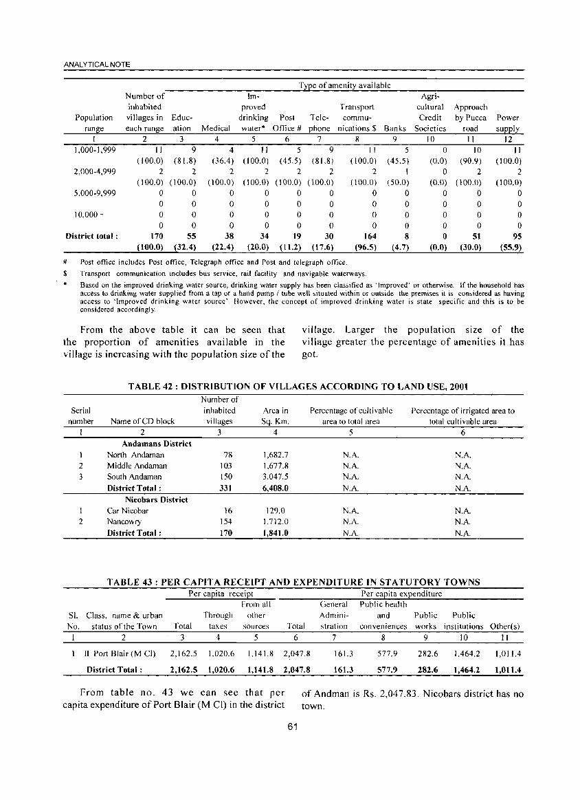
ANALYTICAL NOTE
Type of amenity available Number of Im- Agri-inhabited proved Transport cultural Approach
Population villages in Educ- drinking Post Tele- commu- Credit by Pucca Power
ran~e each range ation Medical water" Office # ehone nications $ Banks Societies road sUEel~ I 2 3 4 5 6 7 8 9 10 I I 12
1,000-1,999 II 9 4 II 5 9 II 5 0 10 II ( 100.0) (81.8) (36.4 ) (100.0) (45.5) (81.8 ) (100.0) (45.5) (0.0) (90.9) (100.0)
2,000-4,999 2 2 2 2 2 2 2 1 0 2 2 ( 100.0) (100.0) (100.0) (100.0) ( 100.0) (100.0) (100.0) (50.0) (0.0) (100.0) (100.0)
5,000-9,999 0 0 0 0 0 0 0 0 0 0 0 0 0 0 0 0 0 0 0 0 0 0
10,000 + 0 0 0 0 0 0 0 0 0 0 0 0 0 0 0 0 0 0 0 0 0 0
District total: 170 55 38 34 19 30 164 8 0 51 95 (100.0) (32.4) (22.4) (20.0) (11.2) (17.6) (96.5) (4.7) (0.0) (30.0) (55.9)
# Post office includes Post office, Telegraph office and Post and telegraph office.
$ Transport communication includes bus service, rail facility and navigable waterways. .. Based on the improved drinking water source, drinking water supply has been classified as . Improved' or otherwise . If the household has
access to drinking water supplied from a tap or a hand pump I tube well situated within or outside the premises it is considered as having access to 'Improved drinking water source'. However, the concept of improved drinking water is state specific and this is to be considered accordingly.
From the above table it can be seen that the proportion of amenities available in the vi II age is increasi ng with the pop u lation size of the
village. Larger the population size of the village greater the percentage of amenities it has got.
TABLE 42: DISTRIBUTION OF VILLAGES ACCORDING TO LAND USE, 2001 Number of
Serial inhabited Area in Percentage of culti vable Percentage of irrigated area to number Name of CD block villages Sq. Km. area to total area total cultivable area
2 3 4 5 6 Andamans District
I North Andaman 78 1,682.7 N.A. N.A.
2 Middle Andaman 103 1.677.8 N.A. N.A. 3 South Andaman 150 3.047.5 N.A. N.A.
District Total: 331 6,408.0 N.A. N.A.
Nicobars District I Car Nicobar 16 129.0 N.A. N.A. 2 Nancowry 154 1.712.0 N.A. N.A.
District Total: 170 1,841.0 N.A. N.A
TABLE 43: PER CAPITA RECEIPT AND EXPENDITURE IN STATUTORY TOWNS Per capita receipt Per capita expenditure
From all General Public health
SI. Class. name & urban Through other Admini- and Public Public
No. status of the Town Total taxes sources Total stration conveniences works institutions Other(s)
I 2 3 4 5 6 7 8 9 10 II
Il Port Blair (M CI) 2,162.5 1,020.6 1.141.8 2,047.8 161.3 577.9 282.6 1,464.2 1,01104
District Total: 2,162.5 1,020.6 1,141.8 2,047.8 161.3 577.9 282.6 1,464.2 1,011.4
From table no. 43 we can see that per capita expenditure of Port Blair (M CI) in the district
of Andman is Rs. 2,047.83. Nicobars district has no town.
61
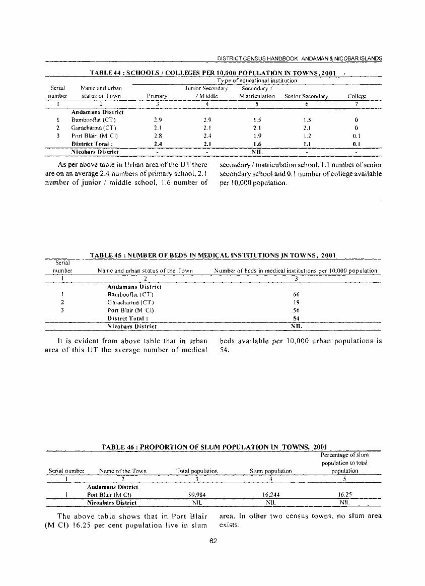
DISTRICT CENSUS HANDBOOK: ANDAMAN & NICOBAR ISLANDS
TABLE44: SCHOOLS / COLLEGES PER 10,000 POPULATION IN TOWNS,200t Ty pe of educational institution
Serial Name and urban Junior Secondary Secondary I number status of Town Primary 1M iddle
2 3 4 Andamans District
I Bambootlat (CT) 2.9 2.9
2 Garacharma (CT) 2.1 2.1
3 Port Blair (M Cll 2.8 2.4
District Total: 2.4 2.1 Nicobars District
As per above table in Urban area of the UT there are on an average 2.4 numbers of primary school, 2.1 number of junior / middle school, 1.6 number of
M at riculat ion Senior Secondary College
5 6 7
1.5 1.5 ° 2.1 2.1 ° 1.9 1.2 0.1
1.6 1.1 0.1 NlL
secondary / matriculation school, 1.1 number of senior secondary school and 0.1 number of college available per 10,000 population.
TABLE45 : NUMBER OF BEDS IN MEDICAL INSTITUTIONS IN TOWNS, 2001 Serial
number
2 3
Name and urban status of the Town
2 Andamans District Bamboot1at (CT) Garacharma (CT) Port Blair (M CI)
Distrct Total: Nicobars District
It is evident from above table that in urban area of this UT the average number of medical
Number of beds in medical institutions per 10,000 population 3
66 19 56
54 NIL
beds available per 10,000 urban populations IS
54.
TABLE 46 : PROPORTION OF SLUM POPULATION IN TOWNS, 2001
Serial number Name of the Town Total population
2 Andamans District Port Blair (M CI)
Nicoabars District
3
99.984 NIL
The above table shows that in Port Blair (M CI) 16.25 per cent population live in slum
62
Slum population
4
16,244
NIL
Percentage of slum
population to total . population
5
16.25 NIL
area. In other two census towns, no slum area exists.
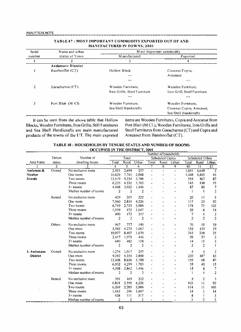
ANALYTICAL NOTE
Serial number
2
3
TABLE 47 : MOST IMPORTANT COMMODITY EXPORTED OUT OF AND
MANUFACTURED IN TOWNS, 2001
N arne and urban status of Town
2 Andamans District
Bambooflat (CT)
Garacharma (CT)
Port Blair (M CI)
Most important commodity
Manufactured Exported
3 4
Hollow Block
Wooden Furniture,
Iron Grills. Steel Furniture
Wooden Furniture,
Sea Shell Handicrafts
Coconut Copra,
Arecanut
Wooden Furniture,
[ron Grill, Steel Furniture
Wooden Furniture,
Coconut Copra, Arecanut,
Sea Shell Handicrafts
It can be seen from the above table that Hollow items are Wooden Fum itures, Copra and Arecanut from Blocks, Wooden Fumitures, Iron Grills, Still Fumitures Port Blair (M CI.), Wooden Fumitures, Iron Grills and and Sea Shell Handicrafts are main manufactured Steel Fumitures from Garacharma (CT) and Copra and products of the towns of the UT. The main exported Arecanut from Bambooflat (CT).
TABLE 48 : HOUSEHOLDS BY TENURE STATUS AND NUMBER OF ROOMS
OCCUPIED IN THE DISTRICT 2001 Number of households
Tenure Number of Total Scheduled Castes Scheduled Tribes Area Name status dwelling rooms Total Rural Urban Total Rural Urban Total Rural Urban
I 2 3 4 5 6 7 8 9 10 II 12 Andaman & Owned No exclusive room 2.951 2.694 257 1,651 1,649 2 Nicobar One room 10.629 7.741 2,888 1,448 1,405 43 Islands Two rooms 13.[ 19 9331 3,788 554 467 87
Three rooms 6.235 4.532 1,703 145 130 15 3+ rooms 4.468 3.022 1.446 87 80 7 Median number of rooms 2 2 2 I 2
Rented No exclusive room 429 207 222 20 17 3 One room 7,060 2,834 4,226 [ 17 25 92 Two rooms 6,719 2,735 3,984 174 71 103 Three rooms 1,519 472 1,047 20 6 14 3+ rooms 490 173 317 7 4 3 Median number of rooms 2 2 2 2 2 2
Others No exclusive room 967 777 190 70 51 19 One room 5,342 4.275 1,067 152 133 19 Two rooms 10,077 8.407 1.670 243 218 25 Three rooms 2,417 1,971 446 59 57 2 3+ rooms 640 482 158 14 II 3 Median number of rooms 2 2 2 2 2
l. Andamans Owned No exclusive room 1,274 1.017 257 5 3 2 District One room 9.242 6.354 2,888 230 187 43
Two rooms 12.408 8.620 3,788 155 68 87 Three rooms 6.002 4.299 1.703 55 40 15 3+ rooms 4,308 2,862 1.446 15 8 7 Median number of rooms 2 2 2 I 2
Rented No exclusive room 391 169 222 5 2 3 One room 6,821 2,595 4,226 103 II 92 Two rooms 6,269 2,285 3,984 114 II !O3 Three rooms 1,443 396 1,047 15 14 3+ rooms 428 111 317 4 1 3 Median number of rooms 2 2 2 2 2 2
63
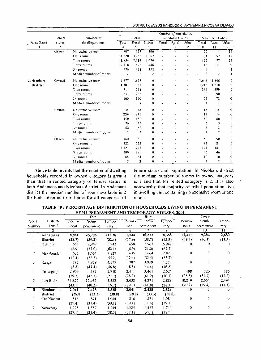
Area Name
2. Nicobars District
Tenure
status 2
Others
Owned
Rented
Others
Number of dwelling rooms
3 No exclusive room One room Two rooms Three rooms 3+ rooms Median number of rooms
No exclusive room One room Two rooms Three rooms 3+ rooms Median number of rooms
No exclusive room One room Two rooms Three rooms 3+ rooms Median number of rooms
No exclusive room One room Two rooms Three rooms 3+ rooms Median number of rooms
DISTRICT CENSUS HANDBOOK: ANDAMAN & NICOBAR ISLANDS
N umber of households Total Scheduled Castes
Total Rural Urban Total Rural Urban 456 789 807 617
4,820 3,753 8,854 7,184 2,118 1,672
576 418 2 2
1,677 1,387
711 233 160
38 239 450
76 62
2
1,677 1,387
711 233 160
38 239 450
76 62
2
160 160 522 522
1,223 1,223 299 299
64 64 2 2
190 1,067 1,670
446 158
2
o o o o o o o o o o o o o o o o o o
Scheduled Tribes Total Rural Urban
10 II 12 20 71
102 13 4
2
1,646 1,218
399 90 72
15 14 60
5 3 2
50 81
141 46 10 2
52 77 11
1
2
1,646 1,218
399 90 72
15 14 60
5 3 2
50 81
141 46 io 2
19 19 25
2 3
o o o o o o o o o o o o o o o o o o
Above table reveals that the number of dwelling households recorded in owned category is greater than that in rented category of tenure status in both Andamans and Nicobars district. In Andamans district the median number of room available is 2 for both urban and rural area for all categories of
tenure status and population. In Nicobars district the median number of rooms in owned category is 1 and that for rented category is 2. It is also noteworthy that majority of tribal population live in dwelling unit containing no exclusive room or one room.
Serial Number
2
3
4
5
II
2
TABLE 49: PERCENTAGE DISTRIBUTION OF HOUSEHOLDS LIVING IN PERMANENT, SEMI PERMANENT AND TEMPORARY HOUSES, 2001
Total Rural Urban District/ Tahsil
Perma- Semi- Tempo- Perm a- Semi- Tempo- Perma- Semi- Tempo-
2 Andamans District Diglipur
Mayabunder
Rangat
Ferrargunj
Port Blair
Nicobar District Car Nicobar
Nancowry
nent 3
18,861 (28.7)
658 (6.9)
635 ( 12.4)
787 (8.8)
2,909 (29.7) 13,872 (43.1) 2,041
(28.0) 816
(29.4) 1,225
(27.1 )
permanent 4
25,706 (39.2) 2,967 (31.0) 1,664
(32.5) 3.959 (44.4 ) 4,181 (42.7)
12,935 (40.2) 2,428
(33.3) 871
(31.4) 1.557
(34.4)
rary 5
21,038 (32.1 ) 5.942 (62.1) 2.827 (55.2) 4,177 (46.8) 2,710 (27.7) 5,382 (16.7) . 2,828
(38.8) 1,084
(39.1 ) 1.744
(38.5)
nent 6
7,544 (17.9)
658 (6.9)
635 ( 12.4)
787 (8.8)
2,411 (28.7) 3,053
(29.9) 2,041
(28.0) 816
(29.4 ) 1,225
(27.1 )
64
permanent 7
16,322 (38.7) 2,967 (31.0) 1,664
(32.5) 3,959 ( 44.4) 3.461 ( 41.2) 4,271 (41.8) 2,428
(33.3) 871
(31.4 ) 1,557
(34.4 )
rary 8
18,358 (43.5) 5,942 (62.1) 2,827 (55.2) 4,177 (46.8) 2,524 (30.1) 2,888 (28.3) 2,828
(38.8) 1,084
(39.1) 1.744
(38.5)
nent 9
11,317 (48.4)
o
o
o
498 (35.5) 10,819 (49.2)
o
o
o
permanent 10
9,384 (40.1)
o
o
o
720 (51.3) 8,664
(39.4) o
o
o
rary 11
2,680 (11.5)
o
o
o
186 (13.2) 2,494 (11.3)
o
o
o
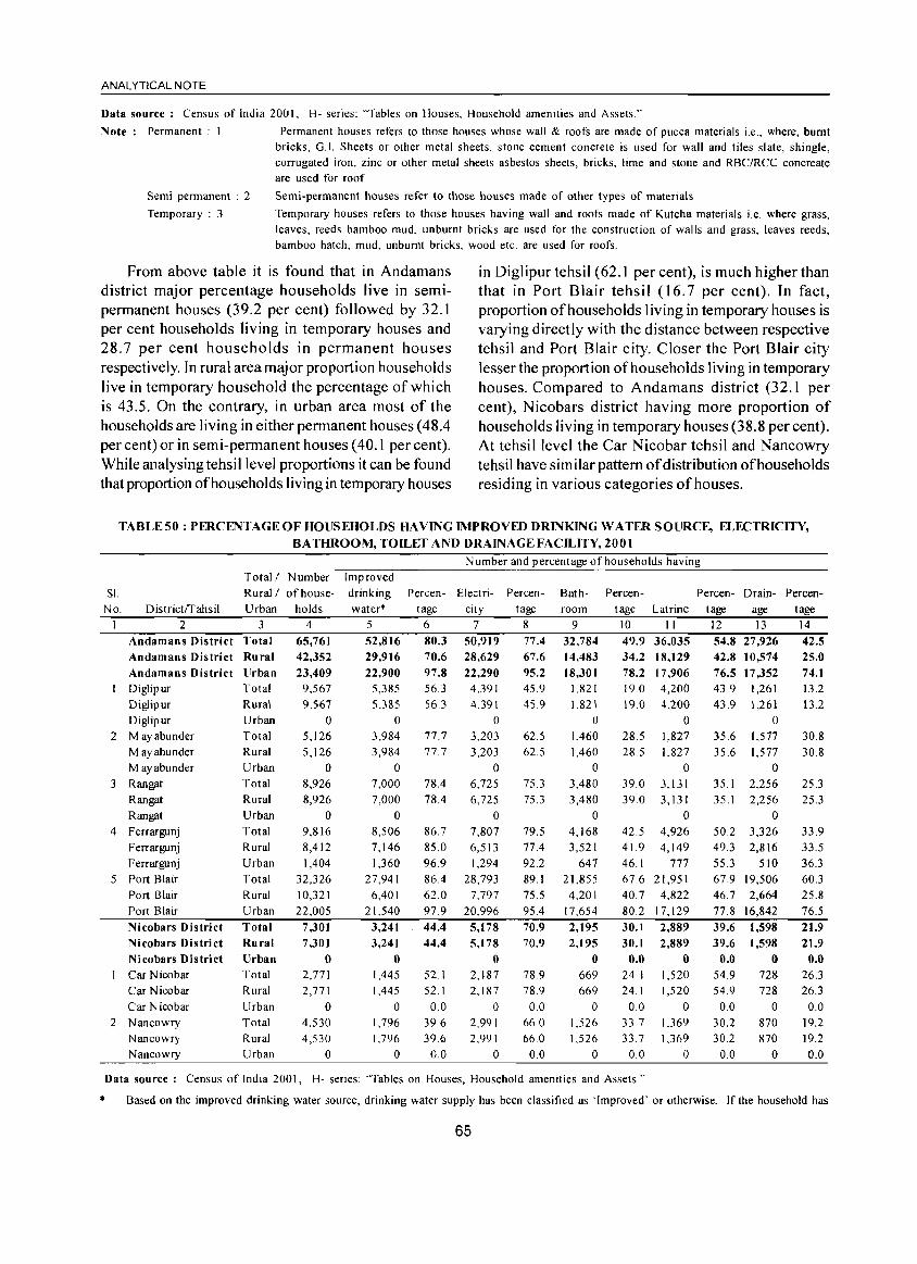
ANALYTICAL NOTE
Data source: Census of India 2001. H- series: "Tables on Houses, Household amenities and Assets."
Note: Permanent: Permanent houses refers to those houses whose wall & roofs are made of pucca materials i.e., where, burnt bricks, 0.1. Sheets or other metal sheets, stone cement concrete is used for wall and tiles slate, shingle, corrugated iron, zinc or other metal sheets asbestos sheets, bricks, lime and stone and RBC/RCC concreate are used for roof
Semi permanent : 2
Temporary : 3
Semi-permanent houses refer to those houses made of other types of materials
Temporary houses refers to those houses having wall and roofs made of Kutcha materials i.e. where grass, leaves, reeds bamboo mud, un burnt bricks are used for the construction of walls and grass, leaves reeds, bamboo hatch, mud, unbumt bricks, wood etc. are used for roofs.
From above table it is found that in Andamans district major percentage households live in semipermanent houses (39.2 per cent) followed by 32.1 per cent households living in temporary houses and 28.7 per cent households in permanent houses respectively. In rural area major proportion households live in temporary household the percentage of which is 43.5. On the contrary, in urban area most of the households are living in either permanent houses (48.4 per cent) or in semi-permanent houses (40.1 per cent). While analysing tehsillevel proportions it can be found that proportion of households living in temporary houses
in Diglipur tehsil (62.1 per cent), is much higher than that in Port Blair tehsil (16.7 per cent). In fact, proportion of households living in temporary houses is varying directly with the distance between respective tehsil and Port Blair city. Closer the Port Blair city lesser the proportion of households living in temporary houses. Compared to Andamans district (32.1 per cent), Nicobars district having more proportion of households living in temporary houses (38.8 per cent). At tehsil level the Car N icobar tehsil and Nancowry tehsil have similar pattern of distribution of households residing in various categories of houses.
TABLE 50 : PERCENTAGE OF HOUS EHOLDS HAVING IMPROVED DRINKING WATER SOURCE, ELECTRICITY, BATHROOM, TOILET AND DRAINAGE FACILITY, 2001
Number and percentage of households having Total I Number Improved
SI. Rural I of house- Percen- Electri- Bath- Percen- Percen- Drain- Percen-No. DistrictlTahsil Urban holds
drinking water' tage city
Percentage room tage Latrine tage age tage
*
I 2 3 4 Andamans District Total 65,761 Andamans District Ru ral 42,352 Andamans District lIrban 23,409 DigJipur Total 9,567 Diglipur Rural 9,567 Diglipur
2 M ayabunder M ayabunder M ayabunder
3 Rangat Rangat Rangat
Urban Total Rural Urban Total Rural Urban
4 Ferrargunj Total Ferrargunj Rural Ferrargunj Urban
5 Port Blair Total Port Blair Rural Port Blair Urban Nicobars District Total Nicobars District Rural Nicobars District Urban Car Nicobar Total Car Nicobar Rural Car Nicobar Urban
2 Nancowry Nancowry Nancowry
Total Rural Urban
o 5,126 5,126
o 8,926 8,926
o 9,816 8,412 1,404
32,326 10,321 22,005
7,301 7,301
o 2,771 2,771
o 4,530 4,530
o
5
52,816 29.916 22,900
5,385 5.385
o 3,984 3,984
o 7,000 7,000
o 8,506 7,146 1,360
27,941 6,401
21.540
3.241 3,241
o 1,445 1,445
o 1,796 1,796
o
6 7
80.3 50.919 70.6 28,629 97.8 22,290 56.3 4,391 56.3 4,391
o 77.7 3,203 77.7 3,203
o 78.4 6,725 78.4 6,725
o 86.7 7,807 85.0 6,513 96.9 1,294 86.4 28,793 62.0 7,797 97.9 20,996
44.4 5.178 44.4 5,178
o 52.1 2,187 52.1 2,187
0.0 0 39.6 39.6
0.0
2,991 2.991
o
8
77.4 67.6 95.2 45.9 45.9
62.5 62.5
75.3 75.3
9 32.784 14.483 18.301
1,821 1,821
o 1,460 1,460
o 3,480 3,480
o 79.5 4,168 77.4 3,521 92.2 647 89.1 21,855 75.5 4,20 I 95.4 17,654
70.9 2.195 70.9 2.195
o 78.9 669 78.9 669 0.0 0
66.0 66.0
0.0
1,526 1.526
o
10 II
49.9 36,035 34.2 18,129 78.2 17,906 19.0 4,200 19.0 4,200
o 28.5 1,827 28.5 1,827
o 39.0 3,131 39.0 3,131
o 42.5 4,926 41.9 4,149 46.1 777 67.6 21,951 40.7 4,822 80.2 17,129 30.1 2,889 30.1 2,889
0.0 0 24.1 1,520 24.1 1,520
0.0 0 33.7 1,369 33.7 1,369
0.0 0
Data source: Census of India 2001, H- series: 'Tables on Houses, Household amenities and Assets."
12 13 14 54.8 27,926 42.5 42.8 10,574 25.0 76.5 17,352 74.1 43.9 1,261 13.2 43.9 1,261 13.2
o 35.6 U77 30.8 35.6 1,577 30.8
o 35.1 2,256 25.3 35.1 2,256 25.3
o 50.2 3,326 49.3 2,816 55.3 510 67.9 19,506 46.7 2,664 77.8 16,842
39.6 1,598 39.6 1,598
0.0 0 54.9 728 54.9 728
0.0 0 30.2 30.2
0.0
870 870
o
33.9 33.5 36.3 60.3 25.8 76.5 21.9 21.9
0.0 26.3 26.3
0.0 19.2 19.2 0.0
Based on the improved drinking water source, drinking water supply has been classified as 'Improved' or otherwise. If the household has
65
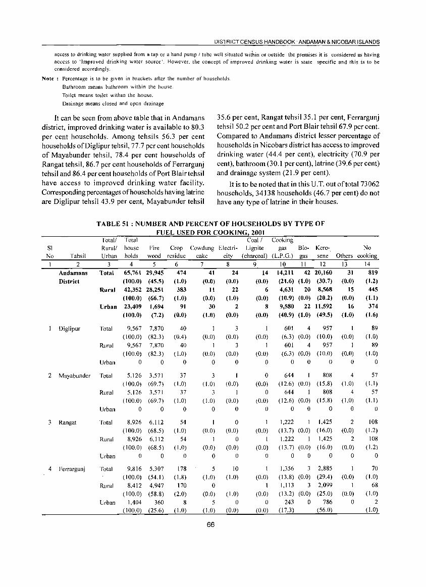
DISTRICT CENSUS HANDBOOK: ANDAMAN & NICOBAR ISLANDS
access to drinking water supplied from a tap or a hand pump I tube well situated within or outside the premises it is considered as having access to 'Improved drinking water source'. However, the concept of improved drinking water is state specific and this is to be considered accordingly.
Note: Percentage is to be given in brackets after the number of households.
Bathroom means bathroom within the house.
Toilet means toilet within the house.
Drainage means closed and open drainage
It can be seen from above table that in Andamans district, improved drinking water is available to 80.3 per cent households. Among tehsils 56.3 per cent households ofDiglipurtehsil, 77,7 per cent households of Mayabunder tehsil, 78.4 per cent households of Rangat tehsil, 86.7 per cent households of Ferrargunj tehsil and 86.4 per cent households of Port Blair tehsil have access to improved drinking water facility. Corresponding percentages of households having latrine are Diglipur tehsil 43.9 per cent, Mayabunder tehsil
35.6 per cent, Rangat tehsil35.1 per cent, Ferrargunj tehsil 50.2 per cent and Port Blair tehsil67.9 per cent. Compared to Andamans district lesser percentage of households in Nicobars district has access to improved drinking water (44.4 per cent), electricity (70.9 per cent), bathroom (30.1 per cent), latrine (39.6 per cent) and drainage system (21.9 per cent).
It is to be noted that in this U. T. out of total 73062 households, 34138 households (46.7 per cent) do not have any type of latrine in their houses.
TABLE 51 : NUMBER AND PERCENT OF HOUSEHOLDS BY TYPE OF FUEL USED FOR COOKING 2001
SI No Tahsil
2
Andamans District
Diglipur
2 Mayabunder
3 Rangat
4 Ferrargunj
Total! Rural! Urban
3 Total
Rural
Urban
Total
Rural
Urban
Total
Rural
Urban
Total
Rural
Urban
Total
Rural
Urban
Total house Fire holds wood
4 5 65,761 29,945 (l00.0) (45.5) 42,352 (l00,O) 23,409 (100.0)
9,567 (100.0)
9,567 ( 100.0)
o
28,251 (66.7) 1,694 (7.2)
7,870 (82.3)
7,870 (82.3)
o
5,126 3.571 (100.0) (69.7)
5.126 3.571 (100.0) (69.7)
o 0
8,926 (100.0)
8.926 ( 100.0)
o
6,112 (68,5)
6,112 (68.5)
o
9,816 5.307 (100.0) (54.1 )
8,412 4,947
(100.0) (58.8) 1,404 360
(100.0) (25.6)
Crop residue
6
474 (1.0) 383
(1.0) 91
(0.0)
40
(0.4) 40
( 1.0)
a
37 ( 1.0)
37 ( 1.0)
a
54 ( 1.0)
54 ( 1.0)
o 178
( 1.8) 170
(2.0) 8
(1.0)
Cowdung Electri-cake city
7 8 41 24
(0.0) (0.0)
tt
(0.0)
30 (1.0)
1 (0.0)
1 (0,0)
a
3 (1.0)
3
( 1.0)
a
1
(0.0)
I
(0.0) a
5 (1.0)
o (0.0)
5 ( 1.0)
66
22 (1.0)
2 (0.0)
3 (0.0)
3 (0.0)
a
1
(0.0) 1
(0.0) a
o (0.0)
o (0.0)
a
10 ( 1.0)
( 1.0)
a (0.0)
Coal! Cooking Lignite gas
(charcoal) (L.P.G.)
9 10 14 14,211
(0.0) (21.6)
Biogas
11 42
(1.0)
Kerosene
12 20,160 (30.7)
6 (0.0)
8 (0.0)
4,631 20 8,568 (10.9) (0.0) (20.2)
9,580 22 11,592 (40.9) (1.0) (49.5)
I (0.0)
I
(0.0)
o
o (0.0)
o (0.0)
o
1
(0,0)
1 (0.0)
o
I
(0.0)
I (0.0)
o (0.0)
601 4 (6.3) (0.0)
601 4 (6.3) (0.0)
a 0
644 1
(12.6) (0.0) 644 I
(12.6) (0.0)
a 0
1,222 1 (13.7) (0.0)
1,222 1 (13.7) (0.0)
a 0
1,356 3 (13.8) (0.0)
1,113 3 (13.2) (0.0)
243 0 (17.3)
957 (l0.0)
957 (10.0)
o
808 (15.8)
808 (15.8)
a
1,425 (16.0) 1,425
(16.0)
o
2,885
(29.4) 2,099 (25.0)
786 (56.0)
Others
13 31
(0.0) 15
(0.0) 16
(1.0)
1
(0,0)
I (0.0)
o
4 ( 1.0)
4 ( 1.0)
o
2 (0,0)
2 (0.0)
o
1
(0.0)
1
(0.0)
o
No
cooking
14
819 (1.2) 445
(1.1)
374 (1.6)
89 (1.0)
89 ( 1.0)
o
57 (I.I )
57 (1.1 )
o
108 ( 1.2)
108 ( 1.2)
o 70
(1.0)
68 ( 1.0)
2 ( 1.0)
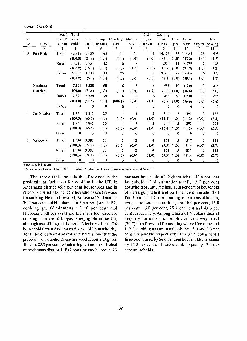
ANALYTICAL NOTE
T otall Total Coal! Cooking SI Rural!
Urban house Fire holds wood
Crop residue
Cowdung Electri- Lignite gas Bio- Kerogas sene
No Others cooking No Tahsil cake city (charcoal) (L.P.G.)
1 2 3 4 5 6 7 8 9 10 11 12 13 14 5 Port Blair Total 32,326 7,085
( 100.0) (21.9)
10,321 5,751 (100.0) (55.7) 22,005 1,334
(100.0) (6.1)
165 ( 1.0)
82 (1.0)
83
(1.0)
31 10 11 10.]88 33 14,085 (1.0) (43.6)
11 3,279 (1.0) (31.8)
22 10,806
(1.0) (49.1)
23 495 (1.0) (0.0) (0.0) (32.1) (1.0) (1.5)
Rural 6 8 3 1,051 7 123 (1.0) (1.0) (0.0) (10.2) (1.0) (1.2)
Urban 25 2 8 9.337 16 372
(1.0) (0.0) (0.0) (42.4) (1.0) (1.7)
Nicobars
District
Total 7,301 5,228 58 6 3 6
(1.0)
6
(1.0)
o
495 20 1,210 0 275 (100.0) (71.6) (1.0) (1.0) (0.0) (6.8) (1.0) (16.6) (0.0) (3.8)
Car Nicobar
2 Nancowry
Percentage in brackets
Rural 7,301 5,228 58
Urban
Total
Rural
Urban
Total
Rural
Urban
(100.0) (71.6) (1.0)
o o
2.771 1.845 (100.0) (66.6)
2,771 1,845 (100.0) (66.6)
o 0
4,530 3,383 (100.0) (74.7)
4,530 3,383 (100.0) (74.7)
o 0
o
25 ( 1.0)
25 ( 1.0)
o
33
( 1.0)
33
( 1.0) o
6 (800.1 )
o 4
( 1.0)
4 ( 1.0)
o
2
(0.0)
2 (0.0)
o
3
(0.0)
o
I (0.0)
I (0.0)
o
2 (0.0)
2
(0.0)
o
2 (1.0)
2 ( 1.0)
o
4 ( 1.0)
4 ( 1.0)
o
495 20 1,210 0
(6.8) (1.0) (16.6) (0.0)
o o 344 5
(12.4) (1.0)
344 5 (12.4) (1.0)
o 0
o
393
( 14.2)
393 ( 14.2)
o 151 15 817
(3.3) (1.0) (18.0)
151 15 817 (3.3) (1.0) (18.0)
o 0 0
o
o (0.0)
o (0.0)
o
a (0.0)
o (0.0)
o
275
(3.8)
o
152
(5.5) 152
(5.5) o
123
(2.7)
123 (2.7)
a
Data source: Census oflndia 200 I. H- series: "Tables on Houses, Household amenities and Assets."
The above table reveals that firewood is the predominant fuel used for cooking in the UT. In Andamans district 45.5 per cent households and in Nicobars district 71.6 per cent households use firewood for cooking. Next to firewood, Kerosene (Andamans : 30.7 per cent and Nicobars : 16.6 per cent) and L.P.G. cooking gas (Andamans : 21.6 per cent and Nicobars : 6.8 per cent) are the main fuel used for cooking. The use of biogas is negligible in the UT, although use ofbiogas is better in Nicobars district (20 households) than Andamans district (42 households). Tehsillevel data of Andamans district shows that the proportion of households use firewood as fuel in Diglipur Tehsil is 82.3 per cent, which is highest among all tehsil of Andamans district. L.P.G. cooking gas is used in 6.3
67
per cent household of Diglipur tehsil, 12.6 per cent household of Mayabunder tehsil, 13.7 per cent household of Ran gat tehsil, 13.8 per cent of household of Ferrargunj tehsil and 32.1 per cent household of Port Blair tehsi I. Corresponding proportions of houses, which use kerosene as fuel, are 10.0 per cent, 15.8 per cent, 16.0 per cent, 29.4 per cent and 43.6 per cent respectively. Among tehsils ofNicobars district majority portion of households of Nancowry tehsil (74.7) uses firewood for cooking where Kerosene and L.P.G. cooking gas are used only by 18.0 and 3.3 per cent households respectively. In Car Nicobar tehsil firewood is used by 66.6 per cent households, kerosene by 14.2 per cent and L.P.G. cooking gas by 12.4 per cent households.
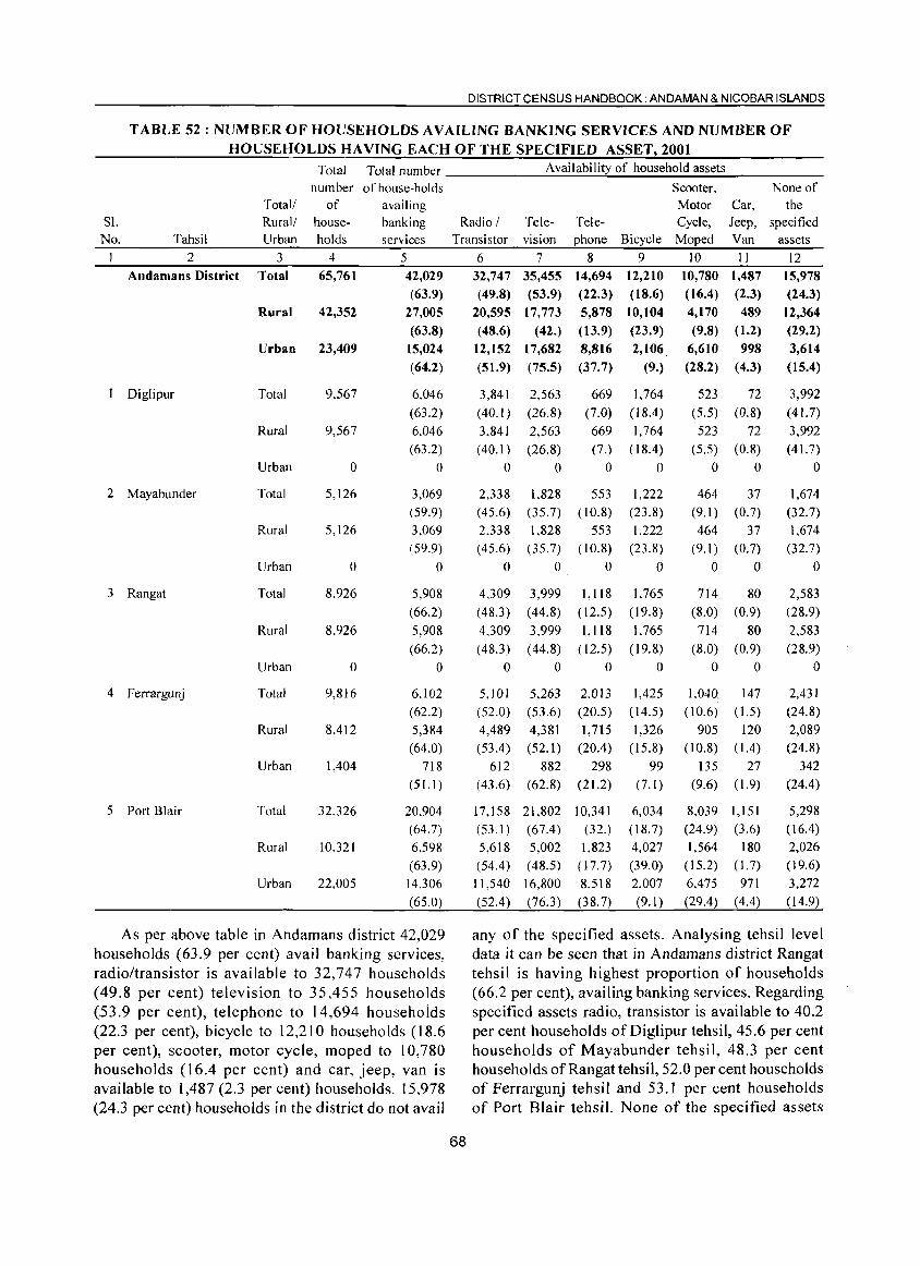
DISTRICT CENSUS HANDBOOK: ANDAMAN & NICOBAR ISLANDS
TABLE 52 : NUMBER OF HOUSEHOLDS AVAILING BANKING SERVICES AND NUMBER OF HOUSEHOLDS HAVING EACH OF THE SPECIFIED ASSET, 2001
Total Total number _____ __;_:A~va:.;;;.il:..;;a~bi:..;;li~ty~o:..;;f....;h~o...;.;u~se:..;;h~ol;..::d...;.;a;:;.:ss;.;;.et;.;;s ____ _
number of house-holds Scooter, None of the
specified assets
Total! Rural/ Urban
of availing Motor Car, Jeep, Van
Sl. No.
house- banking Radio / Tele- Tele- Cycle, Tahsil holds services Transistor vision phone Bicycle Moped
2 3 4 5 6 7 8 9 10 11 12 Andamans District Total
Rural
Urban
1 Diglipur Total
Rural
Urban
2 Mayabunder Total
Rural
Urban
3 Rangat Total
Rural
Urban
4 Ferrargunj Total
Rural
Urban
5 Port Blair Total
Rural
Urban
65,761
42,352
23,409
9,567
9,567
o 5,126
5,126
o 8,926
8.926
o 9,816
8,412
1,404
32.326
10.321
22,005
42,029 (63.9)
27,005 (63.8)
15,024
(64.2)
6.046 (63.2)
6,046 (63.2)
o 3,069 (59.9) 3,069 (59.9)
o 5,908 (66.2)
5.908 (66.2)
o 6.102 (62.2)
5,384 (64.0)
718 (51.1)
20.904 (64.7)
6,598 (63.9)
14,306
(65.0)
As per above table in Andamans district 42,029 households (63.9 per cent) avail banking services, radio/transistor is available to 32,747 households (49.8 per cent) television to 35,455 households (53.9 per cent), telephone to 14,694 households (22.3 per cent), bicycle to 12,210 households (18.6 per cent), scooter, motor cycle, moped to 10,780 households (16.4 per cent) and car, jeep, van is available to 1,487 (2.3 per cent) households. 15,978 (24.3 per cent) households in the district do not avail
68
32,747 (49.8)
20,595 (48.6)
35,455 14,694 12,210 (53.9) (22.3) (18.6)
17,773 5,878 10,104 (42.) (13.9) (23.9)
12,152 17,682
(51.9) (75.5)
8,816
(37.7)
3,841
(40.1 )
3,841 (40.1 )
o 2,338 (45.6) 2,338 (45.6)
o
4.309 (48.3 )
4,309
(48.3 )
o
2,563
(26.8) 2,563
(26.8)
o
669
(7.0)
669 (7.)
o 1.828 553
(35.7) (10.8) 1,828 553
(35.7) (10.8)
o 0
3.999 (44.8)
3,999 (44.8)
o
1,118 ( 12.5)
J,118 ( 12.5)
o 5,101 5,263 2.0!3
(52.0) (53.6) (20.5)
4,489 (53.4 )
612 (43.6)
17,158 (53.1 )
5,618 (54.4)
11,540
(52.4 )
4,381 (52.1)
882
(62.8)
21,802 (67.4)
5,002 (48.5)
16,800 (76.3)
1,715 (20.4)
298 (21.2)
10,341 (32.)
1,823 (17.7)
8.518 (38.7)
2,106. (9.)
1,764
(18.4)
1,764 (18.4)
o 1,222
(23.8) 1,222
(23.8)
o
1.765 (19.8)
1.765 (19.8)
o 1,425
(14.5)
1,326 (15.8)
99 (7.1)
6,034 (18.7) 4,027 (39.0)
2.007 (9.1)
10,780 1,487 (16.4) (2.3)
4,170 489
(9.8) (1.2) 6,610 998
(28.2) (4.3)
523 72 (5.5) (0.8)
523 72 (5.5) (0.8)
o 0
464 37 (9.1) (0.7)
464 37 (9. I) (0.7)
o 0
714 80 (8.0) (0.9)
714 80 (8.0) (0.9)
o 0
1.040 147 (10.6) (1.5)
905 120 (10.8) (1.4)
135 27 (9.6) (1.9)
8,039 1,151 (24.9) (3.6)
1,564 180 (15.2) (I. 7)
6.475 971 (29.4) (4.4)
15,978 (24.3)
12,364 (29.2) 3,614
(15.4)
3,992
(41. 7)
3,992 (41. 7)
o 1,674
(32.7)
1.674 (32.7)
o 2,583 (28.9)
2,583 (28.9)
o
2,431 (24.8)
2,089 (24.8)
342 (24.4)
5,298 (16.4) 2,026 (19.6)
3,272 (14.9)
any of the specified assets. Analysing tehsil level data it can be seen that in Andamans district Rangat tehsi 1 is having highest proportion of households (66.2 per cent), availing banking services. Regarding specified assets radio, transistor is available to 40.2 per cent households of Diglipur tehsil, 45.6 per cent households of Mayabunder tehsil, 48.3 per cent households of Rangat tehsil, 52.0 per cent households of Ferrargunj tehsil and 53.1 per cent households of Port Blair tehsil. None of the specified assets
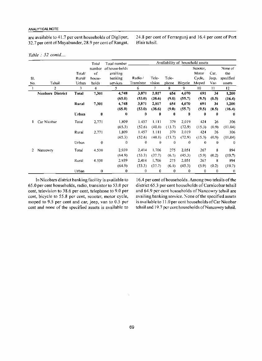
ANALYTICAL NOTE
are available to 41.7 per cent households of Dig Ii pur, 32.7 per cent of Mayabunder, 28.9 per cent of Rang at,
Table: 52 contd ....
24.8 per cent of Ferrargunj and 16.4 per cent of Port Blair tehsi I.
Total Total number ______ A_v_a_il_ab_i_lit..:..y_o_f_h_o_u_se_h_ol_d_a_ss_e_ts _____ _
Sl. No. Tahsil
2 Nicobars District
I Car Nicobar
2 Nancowry
Total/ Rural/ Urban
3 Total
Rural
Urban
Total
Rural
Urban
Total
Rural
Urban
number of house-holds of availing
house- banking holds services
4 5 7,301 4,748
7,301
o
2.771
2.771
o 4,530
4.530
o
(65.0)
4,748 (65.0)
o
1.809 (65.3)
l.809 (65.3)
o
2.939 (64.9)
2.939 (64.9)
o
In Nicobars district banking facility is available to 65.0 per cent households, radio, transistor to 53.0 per cent, television to 38.6 per cent, telephone to 9.0 per cent, bicycle to 55.8 per cent, scooter, motor cycle, moped to 9.5 per cent and car, jeep, van to 0.5 per cent and none of the specified assets is available to
None of Car, the
Radio/ Transistor
Television
Telephone Bicycle
Scooter, Motor Cycle, Moped
Jeep. specified Van assets
69
6 3,871 (53.0)
3,871 (53.0)
o 1.457
(52.6)
1.457 (52.6)
o
2.414 (53.3)
2,414
(53.3 )
o
7 2,817 (38.6) 2,817 (38.6)
o
l.III (40.1 )
l. III (40.1)
o 1.706
(37.7)
1.706 (37.7)
o
8 654
(9.0) 654
(9.0) o
379 (13.7)
379 ( 13.7)
o 275
(6.1 )
275
(6.1 )
o
9 4,070 (55.7) 4,070 (55.7)
o
2.019 (72.9)
2.019 (72.9)
o
2.051 (45.3)
2,051
( 45.3)
o
10 11 12 691
(9.5) 34 1,200
(0.5) (16.4) 691 34
(9.5) (0.5)
o 0
424 26 (15.3) (0.9)
424 26
(15.3) (0.9)
o 0
267 8 (5.9) (0.2)
267 8 (5.9) (0.2)
o 0
1,200 (16.4)
o
306 (11.04)
306 ( 11.04)
o 894
(19.7)
894 (19.7)
o
16.4 per cent of households. Among two tehsils of the district 65.3 per cent households of Camicobar tehsil and 64.9 per cent households of Nan cowry tehsil are availing banking service. None of the specified assets is available to I I .0 per cent households of Car Nicobar tehsil and 19.7 per cent households of Nan cowry tehsil.
(ix) Major natural events, administrative developments and achievements in sports and culture
Volcanic eruption at Barren Island
The Barren Island of Andaman Sea situated at 135 km northeast to Port Blair contains the only live volcano of the Indian peninsula. This volcano after around one hundred years' hibernation restarted erupting violently on 29th March 1991. This spell of eruption continued for seven months. Again it wake up during mid December of 1994 and the volcanism continued up to end of June 1995. Geologists and Scientists of various disciplines studied this natural phenomenon and recorded their observations.
Introduction of Gram Panchayat system
On promulgation of A&N Islands (Panchayat) Regulation, 1994, enforcing from 23rd April 1994 by the President ofIndia, in the Light of73rd Constitutional Amendment, the three tier Panchayat system consisting of 67 Gram Panchayats, 7 Panchayat Samities and at the apex Zilla Parishad was started functioning from October 1995.
Achievements in Sports and Culture
Since the establishment of a centre by the Sports Authority ofIndia in these Islands, the raw and natural talents of this Island's youth identified and brought them upto national and intemationallevel games. From 1990 to April 2001, the Island's team sponsored by the Department of Youth Affairs and Culture had bagged a total number of 18 and 285 medals in international and national level games respectively. The Kayaking, Canoeing, Rowing and Cycl ing teams sponsored from this UT are regarded as some of the best teams in our country. In the national games held during 1990-1991, a six member team of this Island had won 51 medals comprising 22 gold, 22 silver and 7 bronze whereas during 2000-2001,4 players represented the team and won 34 medals comprising 11 gold, 10 silver and 13 bronze. Not only in national games, but also in the international level sports this Island's team also recorded their position by winning 5 medals each during 1991-92 and 1992-93, 2 medals in 1993-94 and 6 medals during 1994-95.
Though the Department of Youth Affairs and Culture is organising various activities with the aim to preserve the cultural heritage of these Islands, Island Tourism Festival attracts the masses in large, where mega cultural bonanza is organised every year in collaboration with the Zonal Cultural Centres viz.
70
DISTRICT CENSUS HANDBOOK: ANDAMAN & NICOBAR ISLANDS
Eastern Zonal Cultural Center, South Zone Cultural Centre, Lalit Kala Academy, Sahitya Academy, Song & Drama Division, NSD, Government oflndia etc. as well as local cultural institutions. For staging these activities, an amphitheatre has also been established at Anarkali village of Port Blair city where open air theatre, drama and cultural programmes are being organised time to time.
(x) Brief description of places of historical and places of tourist importance
The Andaman and Nicobar Islands, rightfully termed as tourists destination has captured a slot in the World Tourism Map. The once-dreaded Islands, abound in natural beauty has of late become a dreamland. Exquisite beaches, unpolluted environment, thick tropical forests and the friendliest people are its attractions. As a perfect place for holiday makers, the Andamans has got many things to offer. The places of historical and tourist importance which attract the tourist are listed below:
Cellular Jail
Apart from the scenic beauty the Island has a history in waging a valiant fight against the British Empire. After the First Indian War of Independence in 1857, the British rulers found a new use for the Island and established a penal settlement here. A lot offreedom fighters were deported from mainland and kept in this seven-pronged, double storied massive edifice which was later known as Cellular Jail. Now the Jail with its remaining three wings arouse patriotism in any Indian and stands as a testimony of our elders, dedication to the Nation. Declared as a National Memorial in 1979, the gates of Jail are opened for visitors everyday from 9.00 AM to 5.00 PM. Jail Museum and the Art Gallery are other attractions of this historical monument.
Light and Sound Show
The sage of the heroic struggle of our freedom fighters in Cellular Jail is brought alive in a moving programme Son-Et-Lumiere every evening (except monsoon season) in the Jail premises. This programme is conducted in both Hindi and English language.
Anthropological Museum
With its models and habitat of the aborigines, the tools and the implements they use, the Anthropological Museum depicts the life of Paleolithic Islanders.
Fisheries Museum
It preserves about 40 number of live ornamental
ANALYTICAL NOTE
fishes of different varieties, 200 preserved specimen of marine species, 36 varieties of corals, a few stuffed fishes and skulls etc. that are found in the water of Andamans. Except Monday, it opens every day from 9.00 AM to 1.00 PM and 2.00 PM to 4.45 PM.
Naval Marine Museum
Established and maintained by the Indian Navy, the Marine Museum in Delanipur, creates awareness on oceanic environment. The display of shells and crafts of this Museum are of immense interest.
Cottage Industries Museum
Local artefacts, handicrafts are exhibited and sold in this Emporium. This is a right place for memento seekers.
Mount Harriet
Situated at a height of 1,200 feet above the sea level Mount Harriet, the once-summer resort of British Administrator, is an ideal place for trekking. 10 minutes ride in the motor launch from Phoenix Bay to Hope Town and thereafter half an hour trekking will bring a tourist on the top of Mount Harriet. The Agriculture Department has got an orchard there. The Forest Department has also established a Guest house of limited capacity.
Chatham Saw Mill
This is one of the Asia's largest Saw Mills, where one can see some of the world's best species of timber being transformed into various sizes for use in railways, shipbuilding yards, building construction and other manufacturing industries.
Zoological Garden
Situated at Haddo, the Zoological garden exhibit the rarest species of birds and wildlife found in these Islands.
Sippighat Farm
Situated about 14 km. away from the city of Port Blair the Government Agricultural Farm is spread over an area of 80 acres. It is a research centre where experiments on different crops, including horticulture, spices like clove, nutmug, dalchini and pepper etc. are undertaken for their extensive propagation in these Islands.
Dilthaman Tank
Situated in the heart of the Port Blair city, this tank once provided drinking water to the entire town but has now become a busy water sports picnic spot.
71
Chidiya Tapu
The southernmost tip of South Andaman Islands has become a picn ic spot for bird watchers and hence earned the name 'Chidiya Tapu'. Half an hour country drive from Port Blair by bus or taxi in the evening to Chidiya Tapu will be enchanting.
Wandoor Beach
Situated in the West Coast of South Andaman, Wandoor Beach is famous for diving, swimming and picnic. Now, it has been named as Mahatma Gandhi Marine National Park.
Jolly Buoy
Half an hour boating from Wandoor wi]] take a tourist to Jolly Buoy Island, which is famous for under water corals. The white sandy beach and the mangrove forest complements scene. Ideal place for scuba diving, snorkeling etc.
Viper Island
Not very far from the Haddo Wharf is the Viper Island. Before the construction of the famous Cellular Jail, this Island was used to harbour the convicts.
Carbyn's Cove
Just 4 km. away from Veer Savarkar Airport, Port Blair the arch shaped Carbyn's Cove is an ideal place for picnic. During the week-ends, the beach is crowded with the tourists both local and foreign. A hotel run by Peerless Company (P) Ltd., serves the needs of tourists.
Ross Island
Facing the Port Blair harbour, Ross Island was once the residence of Chief Commissioner during the British times. The archeological ruins of the British establishments create curiosity in tourists. Spotted deers and peacocks are in abundance here. Regular boat service is available between Phoenix Bay Jetty and Ross Island.
Radha Nagar Beach in Havelock
4 kms. from Havelock Jetty, Radha Nagar is situated away from the activities of the local population. The sugary beach rest on a thick fringe of woods. Havelock has a guest house of limited capacity owned by the Andaman Public Works Department and a guest house viz. Dolphin Beach Resort is being maintained by the Department of Information, Publicity and Tourism.
Sitapur Beach in Neil Islands
15 minutes boatjoumey from Havelock Island, one
can reach Neil Island, which is mostly inhabited by the earlier settlers of Andamans. The Sitapur beach there has much to offer to a visitor who enjoys leisure tourism.
Other Islands of Tourist Interest :
Rangat
95 kms. north to Port Blair, Rangat, the Island in Middle Andaman is approachable by road and sea. The Amkunj beach just 10 kms. away from Rangat township has got immensed tourism potetial. A Government Guest House and few private lodges cater to the needs of tourists.
Mayabunder
Situate 160 kms. north to Port Blair, the Avis Island, a famous Karmatang Beach, is a better spot for water sports. One can reach Mayabunder from Port Blair and Rangat by road and sea routes. Guest House accommodation may be available.
Diglipur
185 kms. north to Port Blair, Diglipur has got sandy beaches like Kalipur, Aerial Bay and Lamia Bay which got scope for Beach Tourism and Water Sports. Diglipur is connected to Port Blair by inter Island ferry. Accommodation may be available in Andaman Public Works Department Guest House.
Long Island
The palm fringed long beach in Long Island at Lalajig Bay,just 5 kms. from the jetty is an ideal spot for boating, fishing and water sports. The Directorate of Shipping Services offers regular ferry service to this Island.
Directive for Foreigners
While domestic tourists can visit any part of Andaman and Nicobar Islands except restricted areas, foreigners are allowed to visit only the fo llowing areas with prior permission:
For visiting including night halt - 1. Port Blair city 2. Havelock 3. Long Island 4. Mayabunder 5. Diglipur 6. Rangat, and .
7. Neil Island
For day visit- 1. Jolly Buoy 2. Red Skin 3. South Cinque Island
DISTRICT CENSUS HANDBOOK: ANDAMAN & NICOBAR ISLANDS
72
4. Mount Harriet S. Madhuban 6. Ross Island 7. Wandoor, and 8. Chidiya Tapu
(xi) Scope of Village Directory and Town Directory
Village Directory :
The "Village Directory" is one of the traditional compilations of the census. The format of the directory is almost the same as was prescribed in the 1991 census. It bears the list of villages, their location code numbers, areas, popUlation, amenities such as educational, medical, communications, drinking water facilities etc. available to them and also the land use pattern for each village. For this purpose, villages have been arranged CD Block wise in order of their location code numbers. The inclusion of alphabetical list of villages with 200 1 census population and the map of every Tahsil depicting location of villages by popUlation size, urban-spread and important infrastructural facilities available therein will further help the reader in identifying any village in the CD Block.
'Village' is a statutorily recognized unit having a definite boundary and separate land records. For those villages, which have partly merged in a Town, data pertaining to remaining part of the village is shown in the Vi Ilage Directory and for the part merged, the details have been given under the cohcerned urban agglomeration. Land use data for villages treated as Census Towns (Urban) in 2001 census can be seen in Appendix-III ofthe Village Directory.
In A&N Islands villages mean not only revenue villages but also all places of human habitations where people were found living at the time of 200 1 census. The census villages here comprise of all revenue villages and permanent and temporary camps of Forest, Andaman Public Works Department, Bush Police, Contractors, A&N Forest & Plantation Development Corporation's Camp, Jarawas, Shompens etc. tribal residing areas besides encroachment areas located on forest land and outside the boundaries of revenue villages. All such camps located within the boundaries of a revenue village have been treated as part of the revenue village for all purposes. All types of camps and encroachment areas etc., located outside the revenue boundaries have been treated as separate census vi lIages with their known names showing the type of use of the area within brackets. The readers

ANALYTICAL NOTE
will find that in certain cases there are two census villages with the same name, one being the revenue village and the other encroachment area.
In case a complete village is treated as an outgrowth of urban agglomeration, data on amenities and land use for that village have not been given in the Village Directory but shown along with the urban component. However, in this UTthere is no outgrowth of Towns which has been treated as Urban Agglomeration.
The 'uninhabited' villages (villages with no population) have been indicated as such after furnish ing details in columns 1 to 2 i.e., Serial number, Name of village, location code number and total area of the village. The villages which have been considered as Census Towns, the corresponding amenities data are shown in the Town Directory.
In addition to the above details, following eight appendices to Village Directory have also been included.
Appendix - I
Appendix-IA
Appendix-IB
Appendix-IC
Appendix-II
Appendix-IIA
Appendix-III
Appendix-IV
Appendix-V
Appendix-VI
Abstract of educational, medical and other amenities in VillagesCD Block level
Villages by number of Primary Schools
Villages by Primary, Middle and Secondary Schools
Villages with different sources of drinking water facilities available
Villages with 5000 and above population which do not have one or more amenities available
List of Census Towns which do not have one or more amenities
Land utilisation data in respect of Census Towns/Non Municipal Towns
CD Block wise list of inhabited villages where no amenity other than drinking water facility is available
Summary showing number of Villages having or not having. Scheduled Caste Population
Summary showing number of Villages having or not having Scheduled Tribe Population
73
Appendix-VIlA
Appendix-VIIB
List of Villages according to the proportion of the Schedule Castes to the total population by ranges
List of Villages according to the proportion of the Schedule Tribes to the total population by ranges
The above twelve appendices are expected to help the planners for planning inputs in areas / villages where basic infrastructure is lacking and also for evolving suitable plans for the welfare of Scheduled Tribes, in particular.
Town Directory :
The town directory is presented for each town covering different aspects of urban life through a set of seven statements from I to VII. The data contained in these statements are about the identification particulars of town, the area, number of households (including houseless households), population and growth rate in 200 I and past censuses, density, sex ratio, physical aspects and location of towns, communications, municipal finances, civic and other amenities, medical, educational, recreational, cultural facilities, trade, commerce, industry, banking, and civic and other amenities in slums. It covers all the towns in the district statutorily notified as well as non-municipal towns (Census Towns). All the towns in the district are arranged in ascending order of location code number.
The data co llected in these statements have largely been furnished by the municipal bodies. In case of non municipal towns (Census Towns) the Block level office supplied the information.
Statement I shows status and growth history of the towns in the district. Column 2 in this statement indicates class, name and civic administration status of town (as in 2000). Class of the town indicated under this column has been introduced to factilities the analysis of town directory data at the state and the national level. Census towns have no urban civic status.
Size and Class of Towns :
Class Size I 100,000 and above II 50,000 to 99,999 III 20,000 to 49,999 IV 10,000 to 19,999 V 5,000 to 9,999 VI below 5,000
Column 3 is for representing eight digit pennanent code number for each town in the district.
Coulmn 4 indicates the name of police station in which the town is located.
Column 5 is for recording the name of CD Block ifthe town is located in it.
Column 6 gives area (in sq. kms.) of the town.
Column 7 gives information about number of households including houseless households.
Columns 8 to 18 gives population and growth rate of the town since the Censuses of 190 I, which would help in drawing the trends in their growth rate.
Column 19 present density in 200 I Census and 20 to 22 represent the sex ratio.
Statement II shows physical aspects and location of towns. In physical aspects only the rainfall, maximum and minimum temperature data as obtained from the Director General of Meteorological Survey of India have been shown. Towns for which Information could not be obtained from Meteorological Survey oflndia, the same has been collected locally or calculated in relation to the nearest town, to the extent possible. Columns 6 to 12 have been filled up on the basis of information received from the respective district authority. Distances respectively from the state, district and tahsil/CD Block headquarters as well as the nearest city (urban area with a population of 100,000+) would help in determining the location of a town. Communication facilities are shown mentioning railway station, bus route and navigable river/canal.
Statement HI deals with municipal finance for the statutory and also non-statutory town bodies managing civic administration of the town provided they have separate budgets and accounts of their own.
Statement IV Scheduled Castes/Scheduled Tribes population figure given in columns 4 and 5 would help in measuring amenities in respect of population size of the weaker sections in the towns. The information on road length within the town shown under column 6 has been obtained from Municipality (except for the highways).
Columns 7 to 12 reflects the information on system of sewerage number of latrines and method of dispo~al of night soil.
Columns 13 and 14 indicate sources and system of storage with capacity of protected water supply to the inhabitants of the towns.
74
DISTRICT CENSUS HANDBOOK. ANDAMAN & NICOBAR ISLANDS
Column IS gives information regarding availability of fire fighting services. In case, it is not available in the referent towns, the name of the nearest place where it is available has been mentioned and the distance from the town has also been indicated within brackets. Columns 16 to 20 pertain to the number of connection of electricity supply available for domestic, industrial, commercial, road lighting (points) and for any other purposes.
Statement V gives information regarding amenities like medical, educational, recreational and cultural facilities available in the town. 2001 population figures for each town have balso been indicated and this wi 11 facil itate in analyzing data on facilities available to the people.
Data related to medical facilities have been obtained from the concerned district authority and shown under columns 4 and 5. All types of medical institutions whether allopathic, ayurvedic, unani or homoeopathic have been covered.
If the medical institution is Ayurvedic, Unani or Homoeopathic the same is indicated in bracket by recording the number of institutions.
In case, more than one institution of any type is available, the exact number is shown within the brackets.
The information on educational facilities are depicted in column 6 to 14.
Column 10 pertains to the number of recognized shorthand, typewriting and vocational training institutes (grouped as others) which include Applied Art / Painting college, Pharmacy college, B.Ed. college, Teacher's training institute, Music / Dancing, Nursing school, etc.
Column 15 shows the information in respect of Adult Literacy classes / Centres etc. Similarly in view of the spurt in the employment of women in towns, information on number of working women's hostels and seats available therein has been given under column 16. This data would help in formulating plans for opening new hostels in order to meet the problems of the single working women.
Columns 17 to 20 show recreational and cultural facilities available in the town. These include stadia, cinema, auditoria / drama / community halls, public libraries indicated as 'PL' and reading rooms indicated as'RR'.
Statement VI presents information in respect of Trade, Commerce, Industry and Banking services in
ANALYTICAL NOTE
the town. Columns 3,4 and 5 contain information about the three most important comodities exported out from the town, column number 6, 7 and 8 in the other hand bears information about the three most important commodities manufactured in the town. Column no.
75
number 9, 10 and II show the number of agricultural and non-agricultural credit societies in the town.
Statement VII provides data in respect of civic and other amenities in the slums.

Part - A Village and Town Directory

Section -I : Village Directory (a) Note explaining the abbreviation used in
Village Directory :
The "Village Directory" is one of the traditional compilations of the Census. It gives the list of villages, their location codes, area, popUlation, number of households, amenities such as educational, medical, drinking water, post and telegraph, commercial and cooperative banks, agricultural non-agricultural and other credit societies, recreational and cultural facilities, communication, approach to village, nearest town with distance, power supply, availability of newspaper and magazines, most important commodity manufactured and land use data of each village. For this purpose, villages have been arranged CD Block wise in order of their location code numbers. The inclusion of alphabetical list of villages with 200 I census population and the map of every Tahsil depicting location of villages by population size, urban-spread and important infrastructural facilities available therein will further help the reader in identifying any village in the CD Block.
Generally, village is a statutorily recognized unit having a definite boundary and separate land records. For those villages, which have partly merged in a Town, data pertaining to remaining part ofthe village is shown in the Village Directory and for the part merged, the details have been given under the concerned urban agglomeration. Land use data for villages treated as Census Towns (Urban) in 2001 census can be seen in Appendix-III of the Village Directory.
In A&N Islands villages mean not only revenue villages but also all places of human habitations where people were found living at the time of 2001 census. The census villages here comprise of all revenue villages and permanent and temporary camps of Forest, Andaman Public Works Department, Bush Police, Contractors, A&N Forest & Plantation Development Corporation's Camp, Jarawas, Shompens etc tribal residing areas besides encroachment areas located on forest land and outside the boundaries of revenue villages. All such camps located within the boundaries of a revenue village have been treated as part of the revenue village for all purposes. All types of camps and encroachment areas etc., located outside the revenue boundaries have been treated as separate census villages with their known names showing the type of use of the area within brackets. The readers will find that in certain cases there are two census villages with the same name, one being the revenue
79
village and the other encroachment area. The 'uninhabited' villages (villages with no population) have been indicated as such after furnishing details in columns I to 2 i.e., Serial number, Name of village, location code number and total area of the village. The villages which have been considered as Census Towns, the corresponding amenities data are shown in the Town Directory.
The Village Directory format has 23 columns and the details given under each column are as follows:
Columns 1 & 23 : Serial Number
Self explanatory. All the villages within the CD Block are presented serially in the ascending order of their location code number.
Columns 2: Name, Location Code Number and Area of village
The name, location code number and area of the villages in hectares are shown against this columns. Wherever the area figure was not furnished by the concerned department, N.A. is shown against Area. The name and location code number of the villages includes uninhabited villages also. In A&N Islands apart from revenue villages, a large number of other areas are treated as census villages. Following are the abbreviations used in names of census villages.
(i) Agriculture Camp AC
(ii) Andaman Public Works APWDC Department Camp
(iii) Agricultural Research Farm ARF
(iv) Andamanese Settlement AS (v) Encroached Forest Area EFA
(vi) Forest Camp FC
(vii) Forest Coconut Plantation Area FCPA
(viii) Forest Development Corporation FDCA Area
(ix) Forest Plantation Development FPDCA Corporation Area
(x) Forest Settlement FS (xi) Jarawa Area JA
(xii) Jarawa Protection Police Camp JPPC
(xiii) Not Available NA
(xiv) Nicobarese Settlement NS
(xv) Onges Settlement OS
(xvi) Police Outpost PO
(xvii) Revenue Village RV
(xviii) Sentinelese Area SA
(xix) Wild Life Sanctuary WLS
Column 3 : Total population and Number of households
The total population and number of households of the village as per 200 I Census are given against this column.
Column 4 to 11 :
In column 4 to 11, availability in respect of different amenities such as education, medical, drinking water, post, telegraph, banks, credit societies, communication etc. in each village has been depicted with appropriate abbreviations against the column concerned. Wherever the amenities are not available in the village, the distance in broad ranges viz. <5 kms., 5-10 kms. and 10+ kms of the nearest place where the facility is available is given next to it in brackets. Column wise details are given below.
Column 4 : Educational
Classes upto class V are included in Primary School. This will include nursery SGhool, kindergarten school, pre-basic school, pre-primary school, junior basic school upto class V. Classes from VI to VIII are included in middle school and Classes from IX and X in secondary school and Classes XI and XII are included in senior secondary school. Composite schools like Middle schools with primary classes or Secondary schools with middle classes are included in the Primary and Middle schools respectively separately. For example, ifin a village, there are two Primary Schools and one Middle school with Primary classes, the number of Primary schools in the village is given as three and that of Middle schools as one though there are only three educational institutions.
Accordingly any of the following types of institutions if exists within the village is shown as per codes given below:
(i) Primary School P
(ii) Middle School M
(iii) Secondary School
(iv) Senior Secondary School
(v) College
(vi) Industrial School
s SS
C
(vii) Training School Tr
(viii) Adult literacy class/centre AC
'(ix) Others (specify) e.g, Sanskrit EO Pathshala, Senior basic school, Navodaya Vidyalaya, Makhtab etc.
Number of institution of a type in the village has
80
been prefixed against the abbreviation, e.g. 3P, 4S, etc.
Column 5 : Medical
Availability of medical facility within the village is indicated by following codes:
(i) Allopathic Hospital Ayurvedic Hospital Unani Hospital Homeopathic Hospital
(ii) Allopathic Dispensary Ayurvedic Dispensary Unani Dispensary Homeopathic Dispensary
(iii) Maternity & Child Welfare
(iv) Maternity Home
(v) Child Welfare Centre
(vi) Health Centre
(vii) Primary Health Centre
(viii) Primary Health Sub-Centre
(ix) Family Welfare Centre
(x) T.B. Clinic
(xi) Nursing Home
(xii) Registered Private Medical Practitioner
(xiii) Subsidised Medical Practitioner
(xiv) Community Health Worker
(xv) Others
H AH HU HH
D AD UD HD
MCW
MH
CWC
HC
PHC
PHS
FWC
TB
NH
RMP
SMP
CHW
HO
Number of institution of a type in the village has been prefixed against the abbreviation, e.g. 3 H, 2PHC etc.
Column 6: Drinking Water
The type of the drinking water supply sources available within the village are indicated by codes as follows:
(i) Tap Water T
(ii) Well Water W
(iii) Tank Water TK
(iv) Tubewell Water TW
(v) Handpump HP
(vi) River Water R
(vii) Canal C
(viii) Lake L
(ix) Spring S
(x) Others 0
(xi) Summer Source SS=

Column 7: Post, Telegraph and Telephone
It is indicated by codes as shown below if the following amenities exists within the village:
(i) Post Office
(ii) Telegraph Office
(iii) Post & Telegraph Office
(iv) Telephone Connection
PO
TO
PTO
Ph
Column 8 : Commercial and Co-operative Banks
If the village is served by any banking service, commercial bank, co-operative bank etc.
The same is indicated in codes mentioned below along with the number of banks prefixed. If not available, the distance of nearest place where the facility exist is given in brackets:
(i) Commercial Bank Cm
(ii) Co-operative Bank Cp
Column 9 : Credit Societies
If the village enjoys the services of Credit Societies i.e. Agricultural Credit Societies, Non Agricultural Credit Society or Other Credit Societies within the village, the same is indicated in codes mentioned below along with the number of such societies in brackets. In case the facility is not available within the village the distance of the nearest place where such facility exist IS gIven :
(i) Agricultural Credit Society AC
(ii) Non- Agricultural Credit Society NC
(iii) Other Credit Society OC
Column 10 : Recreational and cultural facilities
Iffacilities such as CinemaIVideo hall, Sports Club, Stadium! Auditorium is available in the village, the same is recorded in these columns. If not available the particulars of the nearest place with the facility is recorded. The information is indicated in codes mentioned below along with the number of such facilities prefixed:
(i) Cinema / Video Hall CV
(ii) Sports Club SC
(iii) Stadium / Auditorium
Column 11 : Communications
SA
If the village is served by any mode of public / private transport like Bus, Railway station or Navigable water ways they are mentioned as follows:
(i) Bus BS
(ii) . Railway Station
(iii) Navigable Waterway
RS
NW
81
Column 12 : Approach to village
Approach to village refers to the status of road leading to village. The approach to the village is indicated in following codes:
(i) Paved Road
(ii) Mud road
(iii) Foot path
(iv) Navigable River
(v) Navigable Canal
(vi) Navigable waterways other than River, Canal
Column 13 : Nearest Town and distance
PR
MR
FP
NR
NC
NW
The distance is given in kilometers in brackets against the name of the town nearest to the village.
Column 14 : Power supply
Availability of Power Supply in the village, whatever may be the form of its use is given by using following codes:
(i) Electricity for domestic use ED
(ii) Electricity for agricultural use EAg
(iii) Electricity for other purposes EO
(iv) Electricity for all purposes EA
Column 15 : News Paper / Magazine
If the village receives any News Paper / Magazines the same is noted in this column using following codes:
(i) News Paper N
(ii) Magazine M
Column 16 : Most important commodities manufactured
The name of three most important commodities manufactured in the village is recorded against this column.
Column 17 to 21 : Land use i.e. area under different types of land use
Land use data maintained by the UT Govt.are furnished against these columns. The data concerning area under Forest, Irrigated land (by source), Unirrigated land, Culturable waste and Area not available for cultivation in the village are shown against these columns. The area figures are given in hectare(s) up to one decimal. Wherever the information is not made available by the concerned department' .... ' is shown against corresponding cell.
Village levelland use data in this territory is only
available partially. Neither the total are nor the land use data is available for all the non revenue census villages which comprise different types of temporary and permanent camps and encroachment area, etc. located on the forest Jand. Similarly the land use data for all the villages of Nicobar tehsil and most of the villages in Nancowry tehsil ofNicobars district is also not available, as villages are yet to be cadas,trally surveyed in this district. The land use data is available only in respect of revenue villages falling in the five tehsils of Andamans district and 7 vi lIages of Nan cowry tehsil. Thus, in case of non-revenue villages of Andamans district and in the case of tribal villages of both the tehsils ofN icobars district, the information is not available and' .... ' is shown in these columns.
The codes used for different types of irrigation facilities available in the village are indicated below:
(i) Government Canal GC
(ii) Private Canal PC
(iii) Well (without electricity) WE
(iv) Well (with electricity) WE
(v) Tubewell (without electricity) TWE
(vi) Tubewell (with electricity) TW
(vii) Tank TK
(viii) River R
(ix) Lake L
(x) Waterfall WF
(xi) Others 0
(xii) Total T
The village directory carries following twelve appendices.
Appendix-I Abstract of educational, medical and other amenities in Villages - CD Block level
Appendix-IA
Appendix-IB
Appendix-IC
Appendix-II
Appendix-IIA
Appendix-III
Appendix-IV
Appendix-V
Appendix-VI
Appendix-VilA
Appendix-VIIB
Villages by number of Primary Schools
Villages by Primary, Middle and Secondary Schools
Villages with different sources of drinking water facilities available
Villages with 5,000 and above population which do not have one or more amenities available
List of Census Towns which do not have one or more amenities
Land utilisation data in respect of Census Towns/Non Municipal Towns
CD Block wise list of inhabited villages where no amenity other than drinking water facility is available
Summary showing number of Villages having or not having Scheduled Caste Population
Summary showing number of Villages having or not having Scheduled Tribe Population
List of Villages according to the proportion of the Schedule Castes to the total population by ranges
List of Villages according to the proportion of the Schedule Tribes to the total population by ranges
(b) List of villages merged in Port Blair M. CI. at 2001 Census:
Serial Number
1. 2. 3. 4. 5.
82
Name of the merged villages
Entire village of Austinabad (RV) Part of Pahargoan (RV) Part of School Line (RV) Part of Minnie Bay (RV) Part of Brookshabad (RV)
A I DAMAN AND lCOBAR ISLAN-DS (INDIA)
:z
w
CD
o
TEHSIL DIGLIPUR DL'TIHCT ANDAMANS
Point
S ugllr.IOl.' f_
Jubjus I .•
"'awol! Tung 1.0
" '-\
'Y , 'crpent J.'
J.. 0 ", 0'" .
-y d.
d)
(/
+() R
.2
I
KILOMETHf:S o I
(J «I
L ::::J
,/'
~ll.
~r" If.
• W.17S.P O • • 02:1 !KIll (t].5 . S
..;., . _ @ • Q3~ oo:! 8 1GLlPUR
S .Pr_ . B.PS
• 04~!P O
au
o.l2
Bruoed upon Sur .. ., ot In<lH' map 'with til<!' perml lion o'r the $ur\leyor ·Genera l Dr Indi ...
The lerritorial wal,ers of India extend ' nto the _ to a Ilisb ... c u of twel"" n .• utlca l mU"" m"."u""" ,from the appropriate ba." line.
O Pocock I.
xcelllior I.
O De lg"rllo I.
NORTH A'ND .AUAN ISLAND
OOUNI.l.II.RY. :rEIISlt _. _ _. _ _ _ IIIMDQIJARTERS. Tim IL.. _ _ _ ._ _
I'OPIJLA'flo:.'1 IZE CLASS OP VILI.AGES
BKI.01i 200. :ro1-~9'9c. r.oo-lIIJ9. 11lOO-<I999. 0000 AND ABOVE . ... _ _ ...
POLla: ~'1'M'ro:< _ _ _ _ _ _ _ _
PRIMAR¥ IJEALTI! Ct;J\iTlU; _ _ _
"ANI(: COM'NflRCllI.l..j CO-QP,ImATIYf. . _ ...
w
''i(l
:;z
z
@
• ••
s p,o,.pro
PS .. 8

A J)AM l) . fCOllf\H fSL. DS t HI }
z
m
D I
, \ , ,
t\ .. rl"'nl 1.'-1 ....
( I
Snake 1.c;:1(7 -\
l!Lu~ba.hn" 1.0 ', \ f( lJ O\ \S \ (lD [1~O . - . - .
llIIutl ~iIIe I. 0 ~1 t:ntero n« I .. c: Suml I. 1I ? C>a 5".,1<" I. a Rana'" I.
_)ij ) 8rn~"lt L •
101
T,rH S)L MA VA9UNDt:R DISTRICT ANDAMANS
:KII,Om;rRf:S 2 0 2 4 II II
l:::::.:±:=L::J L:1
Curlew I. I;) o
s
o Dot_lrel I. . _ . -' - - - ._._ .,_ . ... ,.- .. _._ ,. ; · "PTo,.a,p~ I I • /) . f',.l}!S'S .
MAYABUH9ER v >:u I. ~
1/."- ~c ~~ ~:/}~--
1 _ _.- ~J . .f'-~ til ~ ~J v t ' S'Il3ll.,
- IlIIII 000
. • 0Il!I
00II
• 117' U6
118
.J
. 001
119 120
W: illS · I2I.S,PO
>-.\ndcrSOfl I.
<
I3OtlND!\RY. rEH II. ... _ _ _. ... _. . .. _ . _ . _ HflAOQ ARTERs. 'f};IiSll._ ._ _. ._ ... _ @ POPULATIO:.! SIZE CL,\ OF VILLAGES rn;LOI' 200. 201-499', 50!)-999, 1600-41)99. 5000 AND ABOVE. .•. ._ _ _ ._. , • .•• U INIIADlnD VII.LAGf:S 'Wllli PERMANENT L.C. NU,\lBKR .•. _ ... ..... X UJ6
I_MPOR1'ANT lETAlLED ROADS... _. ... _ ECONDARl1/ ENIOR "''tor-mARY SCHOOL _ S
PO!>" on'ICE/POST k. TELEGHAI'II OFnCE_PO,PTO rOUCE STATION... ... _ _. ..'. _ "'. ._ PS PRIMARY IJEALTH CF.:'IITRE ... ... •• A BAN.K: COMMERCIAL/CO-OPERATIVE.. 8
t.lIDIDlE ... NOA,.AN ISLAND
• IV
... ... .... .... '_ ' ....
It A
N
. 1~4 I~
· I~
~-:e . f '0.9 .
12Il • 128
• 0001:1000 ... S," O ........ , ....... . _ . ..;
G A r
r E
l
w
z
z
Based upon urvey of India map with the perlllissilon of the SUTvey,or General of India. The terriLorial wate,rs ,of India extend inlo the sea, to a dislance of twelve nautical milL'S me!:lsured from the appropriate base line.
© Government of India, Copyrilhl 2006.
•

II l !
_JI
:z Fla l l. (]
W I
o
>-
....
ANDAMA. Al\D ~lCOBAR ISLANDS (INDIA) TEHSIL RANIGAT
DI TRICT A DAMANS
17Q
KILO~I ETRE 6 () 2 <I
r----r-+- +1 ,,---~+---i
. 1M Ii!!-! 103
1G2
L ." .. ----
,",,'
w . 1311
. 137
V1
:z • l6!lS,PO liig
1111 ' 152
Jill) . 171
z
• orl.h HuHan I,A
i(lill HuUon I. , .... . _ ' . ...
South ;oUUOIlO
\
BOVND{\R Y, TEH lL ... HEJ\DQ j\RTER , TEH H~"
_"
POPULil.TION SIZE CLA.. OF VIl.L GES UELOW 200, 201-499, 500-999, 1000- ,1999, 5000 AN:U ABO' E. U ' l:-Jlh\BITED VILl..AGE 'WITH PERMA ' ENT L.C. l UMBER ... IMPOHTA T METALLED IWADS ,".
\
@
. ... . .. ' ' .. X l?;'
SECO:'llDAln' / ENIOH SECa ' VARY SCHOOL S POST OrnCE/POST & TELEGRAPIii DFFICE .. , PO,PTO POLICE STATION ... PS PRlM RY HE l:HI CENTRIE ... BANK: CO IMERel L/CO-OPER TIVE .. 8'
0....00 upon "rvey Df India 'map with t he permi- "ion of Ih", " ... .,yor Ge neral of India.
The lerrili>rial wliler.! or Indli. e"tend i'nlo the ""' .. tD .. dj"lsnce of l"r!\' e ofltl l i .1 mil"" me .... un~d .rom t he ,II,ppropri.h, 1m"" line,
@ Co,'eromenl of InIH ... CopyriahL 20M.

l AND \~[AN AKD ICOBAR ISLAl'\DS (lNDIi\) TEHS I L FERR'ARG,UNJI
DI TRICT AJ'\DAAI \ .NS Ku.m.lIETRES
2' 0 2 .• 6 1-- +--
w
:z
i'don lgolner)' I~
«
o
:z
>-
B L A II R T E IHlSIL m
1.
018;'r o dB,
~~lrCU~QI. ~ . • :~~~.:. ~ <> , 'T ' ,."_"!;, I'OI'VI. TIO::O; SIZE CLASS OF \fIU.ACES (j' 0 1111 • laOII 298 ;.... BELOlf ~OO. 2'01 499. I!JOO 999, 100II 4999,
lcxenc_lcr ~Q lIobda).'; '7:"'"0 . 8. '5!",' Red Skin I 0 I _ . :;,000 liN!) ABO\ft: . _. - - -A.' i '"I' NINIIABliTEI) VILLAGES lI'UIl
Hoot 1. 'i¥_ . _. ,_ .~ ... I!!_}~ I . • !to;300 i lPER~,\NENT U;. N NBER _ • _ * _ - _ ........... _ .. - - "" ;0.., U,RBA~" AREA .... ....... .... _ _ ~
J: . _ . _ . _. L JWPORTA::-;T Mt.."'AILLED' RGAOS ._
S.t.1JOND'AHT JSENIOR SEOO ·,D.IIRY licllooL _ S
ROUND,\RV. 'tEH SIl. •.. _. _. _ __ ._ • _ _ • _ . _ _
lIF],\DQUARTERS. TE.IISIL.. _. ._. _ _._ @ Tarm.ugH I.
,. . , iii •
POST OFFICE/P9ST .1.: n:U;GR.I\PH O.FnCE ... IPO. P' T 0
POLlCE SJAl'ION_ .• _ _. PS
PRIMARY IIII;,'I.TII O::N"lRE ._ ~ _. A BANK: CJ;llIMER'C1 L/ CO-OPERATI\·E. 8 '
Thl! teririLoriall .a'te-nli 01" IlDd:i •• 'KLe:nd Inlo th.
1" 'lil Du ... aJiUr ... :.d frOoIll the .p,PrQprl.L~ ba!iiJe Une~
I I

ND MAN AND NICOnAr~ ISLA:.!DS (INDIA) TEHSIL PORT BLA IIR
DISTHICT AXDAMA\lS ",, -
t.:lLOllF.1R b] 2ol l'llii
.. -I,. I
_~rell I.(~
z
w
I ,
KILOm:TRE:i 024 ~ D
--t j_....._L=1
I
, I
I
~
, (
(,
~ t-
..-,
~ ,... .,
..-,
FERR ARGU NJ TEHSI'L
I
\
I
I , m
u....
o
>-
Twills 1. 00
Ds!lt>d upon Su!,vey of India map' with the pcrmi iioll
I
I
~ ..... -
I
I
I
I ,
SOU TIH AN DAMA N ISLAND
IIOU)<DARY. TEI~~L - - - - - -IIHAIlQ llfTlffil', TE!ISIL. _ _ _ -
POPlJLATlo.~ Slt: CL!\SS Of \'I~LAG&'>
BSUl. 200. l!Ol-411!1, :lll!l-m. IOOO-UJIII!,
tICIOO AXD "'tIIVE. ... _ ... • _ _ ' •••
UNIN11'A911R'D VILI.AI: 'I'.11f11
I'ERlIi\N!Jil1 LC NV;W IIER _ .• _ :J!!II
!;RB~N AREA .. _ _ _ - - •• ~ rMl'ORT","'T IIE:rAIJ.ED ROADS _ _
SIDl:"1)AJt~/SFN"IOIl S[(OXDAR't SCUOOL _ S 1'0lI07 OFfICF./1'\ISl' k TELmUPI! IlFI'ICiI_ PO,PTO, routE STATIO _ _ _ _ _ _ PS
I'RlliAlt1l' II EALlll CE.U!!E _ _ _ .A: B
Tllr terrilorial Willers ,or India extend 'iu'lo the I'll to a (lislauee of twelve 1l8utical mile mea urcd from the appropriate base line.
z
I.
o
},i;V II~ ~~l NeBI. z
-Ir lIu~h Rose I.
PH Ie 1.0 w The isll~T8 15_0
z
w o olllh orLh nrullier 1.0 Sentinel I. oSQ., lh
CD BroLh"T J. Z
«
a
>-z
m
Note: Distrid II adqu.olrters of And mails is also reh jJ Jleadquarl"rs or Porl IlJ. 'ir.
© Go,'emmenl of India, CopyrighL 2006.

Alphabetical list of Villages (CD block wise)
2001 Census location 1991 Census location Serial number Name of village code number code number
2 3 4
43 Laxmipur(EFA) 00002200 010010001000100018 44 Laxmipur CRY) 00002300 010010001000100017 45 Madhupur (RY) 00002500 010010001000100020 46 Madhyamgram (RY) 00005400 010020001000100005 47 Milangram (RY) 00002000 010010001000100015 48 Mohanpur (RY) 00007400 010020001000100025 49 Mutha Nallaha (EFA) 00004900 50 Nabagram (RY) 00004500 010020001000100004 51 Narayan Tikri (EFA) 00005600 010020001000100008 52 Narcondam Island 00000200 010010001000100001 53 Narkul Danga CEFA) 00006100 010020001000100013 54 Nischintapur CRY) 00005500 010020001000100006 55 Paranghara CRY) 00004600 010020001000100003 56 Paschimsagar (EFA) 00002700 010010001000100016 57 Pathi Level (EFA) 00006200 010020001000100014 58 Pemaiahdera CFDCA) 00006000 010020001000100015 59 Pilone Nallaha (FDCA) 00006500 010020001000100007 60 Rabindrapalli (RY) 00003100 010010001000100022 61 Radha Nagar (EFA) 00001700 010010001000100012 62 Radha Nagar CRY) 00001600 010010001000100013 63 Rahil (FDCA) 00007000 010020001000100017 64 Ramakrishnagram (RY) 00003400 010010001000100029 65 Ramnagar (RY) 00005900 010020001000100011 66 Sagar Dweep (RY) 00007700 010010001000100040 67 Santi Nagar (EFA) 00001300 010010001000100004 68 Shibpur CRY) 00003900 010010001000100034 69 Shyam Nagar (EFA) 00000900 010010001000100009 70 Shyam Nagar CRY) 00001000 010010001000100011 71 Sitanagar CEFA) 00002900 010010001000100025 72 Sitanagar CRY) 00003000 010010001000100024 73 Smith CEFA) 00007600 010010001000100042 74 Smith (Timber Export Depot) 00007800 010010001000100041 75 Srinagar (EFA) 00005200 010020001000100071 76 Stewart Island 00008000 010020001000100029 77 Subhashgram CRY) 00003200 010010001000100023 78 Swarajgram CRY) 00001900 0100]0001000100014 79 Tal Bagan (EFA) 00002800 010020001000100001 80 Vidyasagarpalli (RV) 00003500 010010001000100030
Code of the CD Block : 0002
Aves Island CRY) 00008300 010020001000100031 2 Interview Island CPO) 00008200 010020001000100032 3 Interview Island (WLS) 00008100 010020001000100033
93
DISTRICT CENSUS HANDBOOK: Census of India 2001 - Village Directory :
Amenities available (if not available within the village, next to it in brackets, the distance in ranges viz.< 5 kms., 5-10 kms. and 10+ kms of the nearest place where the facility is available is given)
2 3 4 CD. Block : North Andaman. Code: 0001
I East Island P(l 0+), Code: 00000100 Pop: 17 M(IO+),
_'f,t\r~~_(~~c.t.): ]\J":~, Hh: 7 C(IQ:J:),.
2 Nareondam Island Code: 00000200 T.Area (hect.): N.A.
3 Karen Basti (EFA)
Pop: 17 Hh: 1
Code: '00000300 Pop: 145
.. _T.,A!.~a.(I1.~et):.N.A: .... Hh: 24
P(IO+), M(10+), qlO+),
P(5-10), M(IO+), <::(10+),
5
H(lO+),IO, MCW(IO+), PHqIO+),
H(10+),IO, MCW(JO+), PHC(IO+),
H(IO+), MCW(IO+), PHqIO+),
4 Elezabeth Bay (EFA) IP, M(JO+), H(IO+), Code: 00000400 Pop: 585 C(JO+), MCW(JO+),
... _T:..A!'.~.{h~£.t).:.]'J:A.:.... .. ,HI1.:J3}, ." lEO" PHC(1Q+),
IP, 5 Beaeh Dera (EF A) Code: 00000500 T.Area (h~et.): N.A.
Pop: 314 M(5-10), H(lO+), MCW(IO+), PHqIO+), Hh: 71 qIO+),
P«5), 6 Coffe Dera (EFA) Code: 00000600 TArea (heeL): NA
Pop: 118 M(lO+), H(IO+), MCW(IO+), PHqlo+), Hh: 28 <::(10+),
7 Bandhan Nallaha (EFA) Code: 00000700 Pop: 130
.,.I,A!~ll.(~~!J: .. ]\J"",A: .... J:!I1.: ~~ 8 Haridas Kattai (EF A)
Code: 00000800 Pop: 436
__ 1 f'\t:~.lll.l1..'!c;;t.L~:~, ...... rIh:.?I .
9 Shyam Nagar (EFA) Code: 00000900 Pop: 72 T.Area (hl':c.t): NA Hh: 15
P(I 0+), H(1 0+), M(lO+), MCW(lO+),
<::..(1Q:+:),I§Q, ]H<::.(I0.:t:L
IP, H(lO+), M«5), MCW(IO+),
<::.(10:1:)" .•... J,'rI<::(5-! 0),
P«5), M«5), C(10+),
H(10+), MCW(IO+), PHq<5),
6
W, SS=W,
W, SS=W,
W,
0, SS=W,
W, 0, SS",,\\!,
W,
0, SS=W,
W, 0, SS=W,
W, 0, SS=W,
W,S, 0,
SS=W'"
W, S, SS=W,
10 Shyam Nagar (RV) IP, H(lO+), MCW(IO+), T, W,
Code: 00001000 Pop: 471 T.Area (heel.): 724.1 Hh: 103
II Ganesh Nagar (EF A) Code: 00001100 Pop: 1052
..•.. I.A!'.eil.(I1..e~!l..tI.A Hh: 211 A~~ ••• ~~ ,....~ •• _~_"
12 Amber Chad (EFA) Code: 00001200 Pop: 215
_ ... IArea _(I1.s:£tJ:~A .. __ I:!I1.:. 4J 13 Santi Nagar (EFA)
Code: 00001300 Pop: 435 Lt\rell Ql~et.): NA" Hh: 98
14 Gandhi Nagar (EFA) Code: 00001400 Pop: 244 T.Area (heet): N.;\. Hh: 48
IS Gandhi Nagar (Forest Beat) Code: 00001500 Pop: 624
....1.:.A£e.a_(l1,e.e.!} t!,.t:\ ... Hh: 135
16 Radha Nagar (RV) Code: 00001600 Pop: 715
_T,Ar.e.l! Ch~et.):. ?,25.4. Hh: 168
2M, C(lO+),
2P, 1M,
.(:(10:1:),
P«5), M(IO+),
C.(I0+2,
IP, M(IO+),
.. C(I.O+),
2P, M(lO+), qIO+),
P(5-10), M(lO+),
C(I_D+» ..
4P, M«5), C(IO+),
PHqIO+), 0, ICHW, SS=T,
H(lO+), MCW(IO+), PHqIO+), I PHS.,
H(JO+), MCW(IO+),
.. _J'HC(5-JQ),
H(10+), MCW(lO+), PHC(lO+),
H(IO+), MCW(IO+), PHC(JO+), IPHS,
H(lO+), MCW(IO+), PHC(5-IO),
H(lO+), MCW(IO+), IPHC,
94
W,
0, .SS=W,
W, 0, SS=W,
W, 0, SS=W,
W, 0, SS=W,
W, 0, SS=W,
T,W, 0, SS=T,
7 8 9 10 11 Island : East
PO(lO+), Cm(lO+), AqIO+), CV(IO+), BS(1O+). Ph(lO+), Cp(IO+), NC(lO+), SC(IO+), RS(lO+).
oct I 0+), ~IA1(1 Q+), NN~L'r--sand: arconuam
PO(IO+), Cm(IO+), AC(IO+), CV(IO+), BS(IO+), Ph(IO+), Cp(IO+), NC(IO+), SC(IO+), RS(IO+),
OC(IO+,)' I SAd(INO+)'hNWA .. -a' ........ __ ... s an : ort n aman
PO(IO+), Cm(IO+), AC(lO+), CV(lO+), BS(lO+), Ph(IO+), Cp(lO+), NqIO+), SC(lO+), RS(lO+),
OC(IO+), SA(10+2,.)'I~.L._ ...
PO(lO+), Cm(lO+), AqIO+), CV(IO+), BS(IO+). Ph(lO+), Cp(IO+), NqIO+), SC(lO+), RS(lO+),
QCUQ.1:») ... ~~UQ:!::1._tI~! __
PO(IO+), Cm(IO+), AqlO+), CV(IO+), BS(10+), Ph(IO+), Cp(lO+), NC(IO+), SC(IO+), RS(lO+),
OC(IO+), SA(lO+), NW,
PO(lO+), Cm(IO+), AC(IO+), CV(IO+), BS(IO+), Ph(lO+), Cp(lO+), NqlO+), SC(IO+), RS(lO+),
OC(IO+), SA(IO+), ___ NW,.
PO(IO+), Cm(lO+), AC(10+), CV(10+), BS(10+), Ph(10+). Cp(lO+), NC(lO+), SC(lO+), RS(10+),
.QC;:_(lQ:r2,_ .. ~Nl..Q:t:1. NW, .. __
PO(lO+). Cm(lO+), AC(10+), CV(10+), BS«5), Ph(lO+). Cp(lO+), NqIO+), SqlO+), RS(10+),
Q~(l.O'+.L ~AQ .. Q..-j:2, NW(lO+),
PO«5), Cm(IO+), AC(lO+), CV(IO+), BS, Ph(IO+), Cp(IO+), NqIO+), SC(I 0+), RS(10+),
OC(IO+), SA(IO+), ]\J"Wo.Q::),
PO(lO+), Cm(IO+), AC(IO+), CV(lO+), BS, IPh, Cp(lO+), NC(IO+), SqlO+), RS(IO+),
OqlO+), SA(IO+), N\\,(<::~),
PO(IO+), Cm(lO+), Aq 1 0+), CV(lO+), BS(IO+), Ph(lO+), Cp(lO+), Nq I 0+), SC(I 0+), RS(10+),
O_<::(I°1:2, .. ~~(lO.:t:).1_~_,__ __
PO(lO+), Cm(IO+), AC(IO+), CV(IO+), BS(IO+), Ph(IO+), Cp(IO+), NC(IO+), SC(IO+), RS(lO+),
0~{10.:t:), .SA(IO:+:), .tI~._
PO(IO+), Cm(IO+), AC(IO+), CV(lO+), BS(IO+), Ph(lO+), Cp(IO+), NC(IO+), SqlO+), RS(IO+),
0<::0 0+), SA(1 0+), .. l'-lF,_ __ .....
PO(IO+), Cm(IO+), AC(lo+), CV(IO+), BS(IO+), Ph(10+), Cp(lO+), NC(lO+), SC(lO+), RS(10+),
OC(IO+), SA(10+), ~"
PO(lO+), Cm(lO+), AC(IO+), CV(IO+), BS(IO+), Ph(lO+), Cp(IO+), NC(IO+), SC(lO+), RS(!O+),
OqlO+), SA(l.Q+),. ~_~
PO«5), Cm(lO+), lAC, CV(IO+), BS, Ph«5), Cp(IO+), NC(IO+), SC(lO+), RS(IO+),
OCD.o+), _ .SA_( 102),-~i!.Q.:t:)_,_.
VILLAGE DIRECTORY - DISTRICT ANDAMANS Amenities and Land Use (As on 1999)
12 13 14 Tahsil: DigJipur, Code: 0001 NW, Port Blair ED
(222)
NW,
FP, NW,
FP, NW,
FP, NW,
FP, NW,
FP, NW,
MR,
PR, FP,
PR, MR, FP,
FP, NW,
FP, NW,
FP, NW,
FP, NW,
FP, NW,
PR, MR, FJ>,
Port Blair (259)
Port Blair (200)
Port Blair (225)
Port Blair (236)
Port Blair (245)
Port Blair (225)
Port Blair (220)
Port Blair (245)
Port Blair (240)
Port Blair (200)
Port Blair (200)
Port Blair (255)
Port Blair (199)
Port Blair (200)
Port Blair (232)
ED
ED
ED
15 16
Rice
Rice
Rice
Rice, Dal
Wood Furniture
Rice
Rice
Rice
Rice
Rice
Land use (i.e. area under different types of land use in
hectare)'·
17 18 19 20 21
288.1 69.0 84.5 282.6
22 Island : East
East Island Code: 00000100
23
Island :' Nilrcoildam- -.. _ Narcondam Island 2
Code: 00000200
Island: North An(lama-ii"-' Karen Basti (EFA) 3
Code: 00000300
Elezabeth Bay (EFA) 4 Code: 00000400
Beach Dera (EFA) 5 Code: 00000500
Coffe Dera (EFA) 6 Code: 00000600
Bandhan Nallaha (EFA) 7 Code: 00000700
Haridas Kattai (EF A) 8 Code: 00000800
Shyam Nagar (EFA) 9 Code: 00000900
Shyam Nagar (RV) 10 Code: 00001000
Ganesh Nagar (EFA) II Code: 00001100
Amber Chad (EFA) 12 Code: 00001200
Santi Nagar (EFA) 13 Code: 00001300
Gandhi Nagar (EFA) 14 Code: 00001400
Gandhi Nagar (Forest Beat) 15
Code: 00001500
423.7 86.7
95
54.7 360.3
Radha Nagar (RV) 16 Code: 00001600
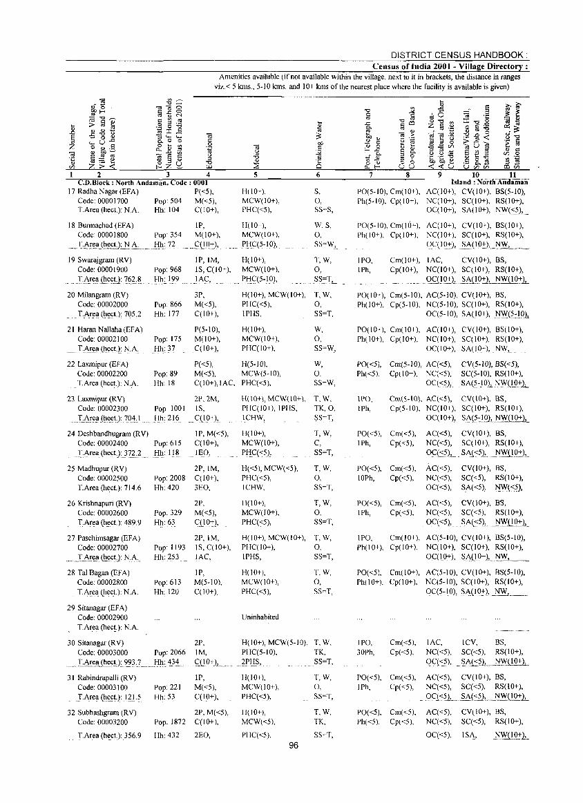
DISTRICT CENSUS HANDBOOK: Census of India 2001 - Village Directory :
Amenities available (if not available within the village, next to it in brackets, the distance in ranges viz.< 5 kms., 5-10 kms. and 10+ kms of the nearest place where the facility is available is given)
2 3 4 C.D.Block: North Andaman, Code: 0001
17 RadhaNagar(EFA) P«5), Code: 00001700 Pop: 504 M«5), T.Area(hect.): N.A. Hh: 104 C(lO+),
18 Burmachad (EFA) IP, Code: 00001800 Pop: 3S4 M(lO+),
~~'I.Ar~(~~.J'J_:_~-,,_. __lih:.7~ _ g!.Q:+-»
19 Swarajgram (RV) IP,IM, Code: 00001900 Pop: 968 IS, C(lO+),
.. J.Are~J~~~L 762& .,.I:I~:_1?2 ,}t\~,_ ....
20 Milangram (R Y) 3P, Code: 00002000 Pop: 866 M«5), T.Area (h~ct.): 705.2 Hh: 177 C(lO+),
21 Haran Nallaha (EFA) P(5-10), Code: 00002100 Pop: 175 M(lO+), T.Area (hect.): N.A. Hh: 37 C(lO+),
22 Laxmipur (EFA) P«5), Code: 00002200 Pop: 89 M«5), T.Area (hect.): N.A. Hh: 18 C(IO+),IAC,
23 Laxmipur (RY) 2P.2M, Code: 00002300 Pop 1001 IS,
... T_:..,.\r~~ .(~~~~): ~Q4, I. Hh: 216 .,C(lO+),.
24 Deshbandhugram (R Y) IP, M«5), Code: 00002400 Pop:61S C(lO+),
.'!':Area (~ectJ 372.2 Hh: 118 lEO,
25 Madhupur (RY) 2P,IM, Code: 00002500 Pop: 2008 C(lO+), T.Area (heet.): 714.6 Hh: 420 3EO,
26 Krishnapuri (RV) 2P, Code: 00002600 Pop: 329 M«5), T:Area (h~ct): 4~9.9 Hh:63 ql0+),
27 Pasehimsagar (EFA) 2P,IM, Code: 00002700 Pop: 1193 IS, C(lO+),
" ... _:rl~Ee~ (h~D: N_.A. Hh: 253 lAC,
28 Tal Bagan (EFA) IP, Code: 00002800 Pop: 613 M(5-10), T.Area (heet.): N.A. Hh: 120 C(lO+),
29 Sitanagar (EF A) Code: 00002900 T.Area (heet.): N.A.
30 Sitanagar (RY) 2P, Code: 00003000 Pop: 2066 1M,
._~:!.:.6!_l:<lJh~C!J,~3.) ... _ ... f:Il1: '!31~ .... ~(lg+),_ .. ,. 31 Rabindrapalli (RV) IP,
Code: 00003100 Pop: 221 M«5), TArea (~ect.): I2L? Hh: 53 qIO+),
32 Subhashgram (RY) 2P, M«5), Code: 00003200 Pop: 1872 C(lO+),
'_f.Area (heet): 356.9 Hh: 432 2EO,
5
H(10+), MCW(IO+), PHC«5),
H(lO+), MCW(IO+),
P!i~(5-IOI,
H(lO+), MCW(IO+),
PI:I~(5-10),
H(IO+), MCW(IO+), PHC«5), IPHS,
H(lO+), MCW(IO+), PHC(lO+),
H(5-IO), MCW(5-10), PHq<S),
H( 10+" MCW( 10+\, PHqIO+),IPHS, lCHW,
H(lO+), MCW(IO+), PHC«5),
H«5), MCW«5), PHq<S), ICHW,
H(IO+), MCW(lO+), PHC«5),
H(IO+), MCW(IO+), PHC(IO+), IPHS,
H(lO+), MCW(IO+), PHC«5),
Uninhabited
H(lO+), MCW(5-10), PHC(5-10),
. ~l.'Ii~, H(IO+), MCW(10+), PHq<5),
H(lO+), MCW«5),
PHq<5),
96
6
S, 0, SS=S,
W,S, 0, SS=W, _
T,W, 0, .S~~:T, __
T,W, 0, SS=T,
W, 0, SS=W,
W, 0, SS=W,
T.W, TK,O.
SS""T,
T,W, C, SS=T,
T,W, 0, SS=T,
T,W, 0, SS=T,
T,W, 0, SS=T,
T.W, 0, SS=T,
T,W. TK, SS=T,
T,W, 0, SS=T,
T,W, TK,
SS=T,
7 8
PO(S-IO), Cm(10+), Ph(S-IO), Cp(IO+),
PO(S-IO), Cm(IO+), Ph(IO+), Cp(IO+),
IPO, Cm(lO+), IPh, Cp(lO+),
9 10 11 Island: NorthAndiimaii'
AC(IO+), CV(lO+), 8S(5-10), NC(IO+), SC(IO+), RS(IO+), OC(IO+), SA(lO+), N\y«5), .
AC(IO+), CV(lO+), BS(lO+), NC(IO+), SC(IO+), RS(IO+),
OqlO:+-), . §~(I 0:+-)" NW,
lAC, CV(IO+), BS, NC(IO+), SC(IO+), RS(IO+),
Q,Cl!.Q:+-)J. .. ~J.l.g2:2,-NW( I O+l,_
PO(lO+), Cm(S-IOl, AC(5-10), CY(IO+), BS, Ph(lO+), Cp(5-10), NC(5-10), SC(I 0+), RS(lO+),
OC(5-10), SA(lO+), N\\:,(5:IOj,
POe I 0+), Cm(l 0+), AC(IO+), CY(lO+), 8S(10+), Ph(lO+), Cp(IO+), NC(IO+), SC(IO+), RS(IO+),
OC(IO+), SA(lO+), NW,.
PO«5), Cm(5-IO), AC«5), CY(5-1O), B5«5), Ph«5), Cpt 10+), NC«5), SC(5-10), RS(lO+),
oq:c5.), SA(5.~J.g), .. ~~L!.Q:+-1..
lPO, Cm(S-IOl, AC«Sl, Cy(tO+), BS, IPh, Cp(S-IO), NqIO+), SC(I 0+), RS(IO+),
OC(lO+» . Si\(5.:!.Q),._~(10+1_
PO«S), Cm«5), Aq<5), CV(lO+), 8S, IPh, Cp«5), NC«5), SC(I 0+), RS(IO+),
Oq<5), .. SAC <5),.. ~(10:+:),.
PO«5), Cm«5), AC«5), CY(IO+), BS, 10Ph, Cp«5), Nq<5), SC«5), RS(IO+),
OC«5), SA«5), ~«5),
PO«5), Cm«5), AC«5), CV(JO+), BS, IPh, Cp«5), Nq<5), SC«5), RS(lO+),
Oq<5),. SAC <5».. .~,~i!_Q:+:)-,.
IPO, Cm(lO+), AC(5-10), CY(lO+), 8S(5-10), Ph(lO+), Cp(lO+), NC(IO+), SC(IO+), RS(IO+),
OqIO+), SA(_10+)~~ tlYI........____
PO«5), Cm(lO+), AC(5-10), CY(lO+), BS(5-10), Ph(lO+), Cp(lO+), NC(5-10), SC(lO+), RS(IO+),
0C(5-10), SA(10+), N~l., .. ___ ..
IPO, Cm«5), lAC, ICY, BS, 30Ph, Cp«5), NC«5), SC«5), RS(IO+),
QC«5), ~At:c?L 1:!'~( I 0+),
PO«5), Cm«5), AC«5), CV(lO+), BS, IPh, Cp«5), NC«5), SC«5), RS(IO+),
9<::.( 'S?1 ____ §~(:::~,_ __ NW( I 0+1..
PO«5), Cm«5), AC«5), CV(IO+), BS,
Ph«5), Cp«5), NC«5), SC«5), RS(IO+),
Oq<5), ISA, .. ~'VIJ.!..~L
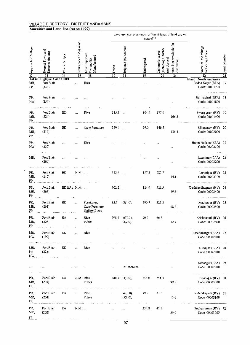
VILLAGE DIRECTORY - DISTRICT ANDAMANS Amenities and Land Use {As on 1999}
Land use (i.e. area under different types ofland use in hectare)·· .., .... . S <B .., .., 1;j 0)
til ..,
~ E '"0 ~ <.) :0 §~
~ 9 ~-5 '" a~ ;; ~] » § 0 ~ a 'a > 0 .... 0. -- '"0 '" ..,u .,
S .... t: » ~ » ;:::0--;;;- ;>
1 o .S g- ., e '"0 <: c -5 ~ ..c E-'-' g. 8.:a a ., ~ gf ~ 0 ;;l ..... 8 VJ E 0 ~ '"0 os ~~e -0 .~ ""' '" c..
~ 01J Z 0;:;: 8 ~ § ....
'" :: ~ ::I ..... ·E .... ::I 0 ;>
~~ ta .., '" c.. ~ ::: ., 01J .Eu~ '" ._
til '" ~ 0 § .... ·2 .,.::: .;:: c.. .., ._
0 ..,
0 ] 0S§ .... :l .,
<: zo "'" z ::Su::S "'" :::J <:u z § VJ
12 13 14 15 16 17 18 19 20 21 22 23 Tahsil: DigJipur. Code: 0001 Island: North Andaman MR, Port Blair Rice Radha Nagar (EF A) 17 FP, (233) Code: 00001700
FP, Port Blair Burmachad (EFA) 18 NW. (250) Code: 00001800
PR, Port Blair ED Rice 315.1 104.4 177.0 Swarajgrarn (RV) 19 MR, (224) 166.3 Code: 00001900
PR, Port Blair ED Cane Furniture 329.4 99.0 140.5 Milangrarn (RV) 20 MR, (216) 136.4 Code: 00002000 FP,
FP, Port Blair Rice Haran Nallaha (EFA) 21 NW, (230) Code: 00002100
MR, Port Blair Laxmipur (EFA) 22 (209) Code: 00002200
_o~~ __
PR, Port Blair ED N,M ... 185.1 157.2 287.7 Laxmipur (RV) 23 MR, (210) 74.1 Code: 00002300
.I:I:". _~· __ ~V_~ ___
PR, Port Blair ED,EAg N,M ... 102.2 124.9 125.5 Deshbandhugrarn (RV) 24 MR, (205) 19.6 Code: 00002400 FP,
PR, Port Blair ED Furnitures, 33.1 0(1.0), 290.7 321.2 Madhupur (RV) 25 MR, (203) Cane Furniture, 68.6 Code: 00002500 FP, Hollow Block
PR, Port Blair EA Rice, 298.7 W(0.3), 90.7 66.2 Krishnapuri (RV) 26 MR, (206) Pulses 0(2.0), 32.4 Code: 00002600 _!:'P,
MR, Port Blair ED Rice Paschimsagar (EFA) 27 NW, (190) Code: 00002700
C~· _________
MR, Port Blair ED Rice Tal Bagan (EFA) 28 FP, (225) Code: 00002800 NW,
Sitanagar (EFA) 29 Uninhabited Code: 00002900
PR, Port Blair EA N,M Rice, 380.5 0(3.0), 256.0 254.3 Sitanagar (RV) 30 MR, (207) Pulses 99.8 Code: 00003000
I'P", ._ .. _-,._-
PR, Port Blair EA Rice, W(O.O), 79.8 31.0 Rabindrapalli (RV) 31 MR. (204) Pulses 0(1.0). 15.6 Code: 00003100
•...... ~"- .. ~-.------
PR, Port Blair EA N,M ... 254.8 43.1 Subhashgrarn (RV) 32 MR, (202) 59.0 Code: 00003200
FP.
97
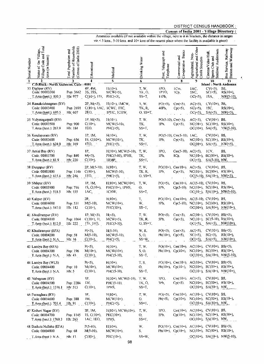
DISTRICT CENSUS HANDBOOK: Census of India 2001 - Village Directory.:
Amenities available (if not available within the village, next to it in brackets, the distance in ranges
viz. < 5 kms., 5-10 kms. and 10+ kms of the nearest place where the facility is available is given)
1 2 3 4 CD.Block: North Andaman, Code: 0001
33 Diglipur (RY) 4P,4M, Code 00003300 Pop: 3662 3S, 3SS,
Ti\re!! (h.eEt):lQO) Hh: 977 C(10+), ITr,
5
H(!O+), MCW«5), PHCC<5),
6
T,W, TK,O, SS=T,
34 Ramakrishnagram (RY) 2P, M«5), H(lO+), IMCW, T,W, TK,R, 0, SS=T,
Code 00003400 Pop: 2691 C(JO+), lAC, ICWC,IHC,
.T.i\re!l(h.~etJ.§'?5.:.,5 Hh: 607 2EO, IPHC, ICHW,
35 Yidyasagarpalli (RY) Code: 00003500 T.Area (heeL): 263.9
36 Keralapuram (RY) Code: 00003600
TArea (heeL): 62~:0
37 Aerial Bay (RY) Code: 00003700
.~T·A~e!!.(hec!J.8L9. ..
Pop: 900 Hh: 184
Pop: 656 Hh: 169
IP, M«5), C(IO+), lEO,
IP,IM, IS, C(lO+), IIlO,
IP, Pop: 840 M«5), Hh: 220 C(IQ+),
H(lO+), MCW(5-10), PHCC<5),
H(lO+), MCW(IO+), PHCC<5),
T,W, TK, SS=T,
T,W, TK, SS=T,
H(lO+), MCW(5-10), T, W, PHCC5-10),IPHS, TK,
!l3MPJ SS~T,
38 Durgapur (RY) 2P, M(5-1O), H(lO+), T,W, TK.R, 0, SS=T,
Code: 00003800 Pop: 1146 C(lO+), MCWeS-IO),
~.J.i\rea{~e.(;!.): ~15.:L.):!~:?46 . ..lEO, . PHCC"55),
39 Shibpur (RY) Code: 00003900
T,Area (heeL): S)8.S
40 Kalipur (R Y)
Pop: 716 Hh: ISS
Code: 00004000 Pop: 531 T.Area (heeL): S47.0 Hh: 112
IP,IM, IS, C(10+), lAC,
2P, M(S-IO), CCIO+),
41 Khudirampur (RY) IP, M«S), Code: 00004100 Pop: 1064 C(lO+), II,
... :r.f\r~!! (~e.et).: ~J2..:..0.. Hh: 222 JTr, lEg,
42 Khudirampur (EFA) P«S), Code: 00004200 Pop: 58 M(S-IO),
._T.:A~~!!.(I:l~.~.).:~A:.__ .. !:!~:J§ ....... q I 9.:J:2,
43 Lamiya Bay (EF A) Code: 00004300 T.Area (heeL): N.A.
44 Lamiya Bay (WLS) Code: 00004400 T.Area (heeL): N.A.
P«S), Pop: 196 M(lO+), Hh: 43 C(IO+),
P«S), Pop: 10 M(lO+), Hh: S C(lO+),
4S Nabagram (RY) 3P, Code: 00004S00 Pop: 2284 1M, J-Area.(he£t.):I316.1 Hh: SI3 C(IO+),
IP, 46 Paranghara (RY)
Code: 00004600 Pop: 388 1M,
...... I:f\!~!l~e(;!.):_?OI.:.4 Hh: 91 .C(g)+) ....
47 Kishori Nagar (RY) Code: 00004700 Pop: 114S T.Area (hect.): 17603 Hh: 263
48 Baskata Nallaha (EFA) Code: 00004800 Pop: 68
T.Area (heet.): N.A. Hh: 13
2P,IM, IS, C(lO+), lAC, lEO,
P(S-IO), M(5-10),
CCI 0+),
H(lO+), MCW(lO+), T, W, PHCCIO+), lPHS, 0, lCHW, SS=T,
H(lO+), MCW(IO+l. PHC(IO+),
H«5), MCW«5), PHC(S-IO),
H(5-1O), MCW(S-IO),
.. P!:! (,:.(<_5),
H(lO+), MCW(lO+), PHCCS-IO),
H(lO+), MCW(lO+), PHC(S-IO),
T, W, SS=I,
T,W, TK,R, 0, SS=T,
W,R, S,O, SS=W,
T,W, S,O, SS=T,
T, S, 0, SS=I,
H(lO+), MCW(5-IO), T, W, PHC(S-IO), . TK,O, IPHS, SS=I,
H(lO+), MCW(lO+),
.J>HC«S),
I,W,
0, SS=I,
H(lO+), MCW(lO+), I, W, PHC(lO+). 0, IPHS, SS=I,
H(IO+), MCW(lO+),
PHCC IO+),
98
W, S,
SS=W,
7
IPO, IPTO, IIPh,
8
ICm, ICp,
9 10 11 Island: North Aiidiiiniin'
lAC, INC,
OC«S),
CY«5), BS, SC«S), RS(lO+), ISA, . _~(5-1O),
PO«5). Cm«5). 40Ph, Cpr <S),
AC«S), CY(lO+), BS, NC«5), ISC, RS(IO+),
()Q<S),_.§AJ.<_,5)". NW«5),
PO(5-10), Cm«S), I Ph, Cpt <5),
AC«S), CY(lO+), BS, NC(10+), SC(I 0+), RS(JO+),
OC(IO+), SA«5), NY"i5.:_l.9»)
PO(S-IO), Cm(S-IO), lAC, CY(lO+), BS, IPh, Cp«S), NC(lO+), SC(IO+), RS(lO+),
0C(10+), SA«5), j\j1,\'("55.),.
IPO, IPh,
Cm(S-IO), AC«S), ICY, BS, ICp, NC(IO+), ·SC(lO+), RS(10+),
09(-::S), ..... S.~(5:I.Q1 NW, _
P0(10+), Cm(10+), AC«S), CY(IO+), BS, 1 Ph, Cp«S), NC(IO+), SC(IO+), RS(lO+),
QC..(5.:) Q}). SAD.O+)~_NW~
PO«S). Cm(IO+). AC(S-IO), CY(10+), BS, IPh, Cp(S-IO), NC(IO+), SC(I 0+), RS(IO+),
OC( 10+), .. SAC !O+), .1\IW(5..:1.0),
P0(10+), Cm(IO+), AC(S-IO), CY(10+), BS, IPh, Cp(S-IO), NCOO+), SC(lO+), RS(lO+),
OC( I 0+), SA(1 0+), N\YQQ+),.
PO«S), Cm«5), AC(IO+), CY(10+), BS«5), 5Ph, Cp«5), NC(lO+), SC(5-IO), RS(IO+),
oq <~)'.' SA(<_~L .. ~..illl':!:)-,-PO«S), Cm«S), AC«5), CY(10+), BS«5), Ph(IO+), Cp«5), NC«S), SC«5), RS(lO+),
Qc"(-::S.),_.s~i:::~), NW(IO+),
P0(10+), Cm(10+), AC(10+), CY(JO+), BS«5), Ph(IO+), Cp(10+), NC(IO+), SC(lO+), RS(lO+),
OC( I 0+), SA(lO:t),. j\j1,\'~:J9)1
P0(10+), Cm(10+), AC(lO+), CY(lO+), BS«5), Ph( I 0+), Cp(l 0+), NC( I 0+), SC( I 0+), RS(l 0+),
OC(IO+), SA(IO+), N\V(IQ:t),
IPO, 3Ph,
Cm(IO+), AC«S), CY(lO+), BS, Cp«5), NC(IO+), SCCIO+), RS(lO+),
OC( 10+), SAC 10+), Ji\V_, __
PO«5), Cm(lO+), AC(lO+), CY(lO+), BS, Ph«S), Cp(lO+). NC(JO+), SCCIO+), RS(lO+),
g(':(l.O:tl, .$.6(10+), NW,
IPO, IPh,
Cm(10+), AC(JO+), CY(IO+), BS, Cp(IO+), NC(IO+), SC(I 0+), RS(lO+),
OC(JO+), SA(IO+), ~L ....
PO(IO+), Cm(IO+), AC(10+), CY(IO+), B3«S), Ph(lO+), Cp(lO+), NC(IO+), SC(JO+), RS(lO+),
OC(lO+), SA(I(l+), 'liW(S.:!Q},
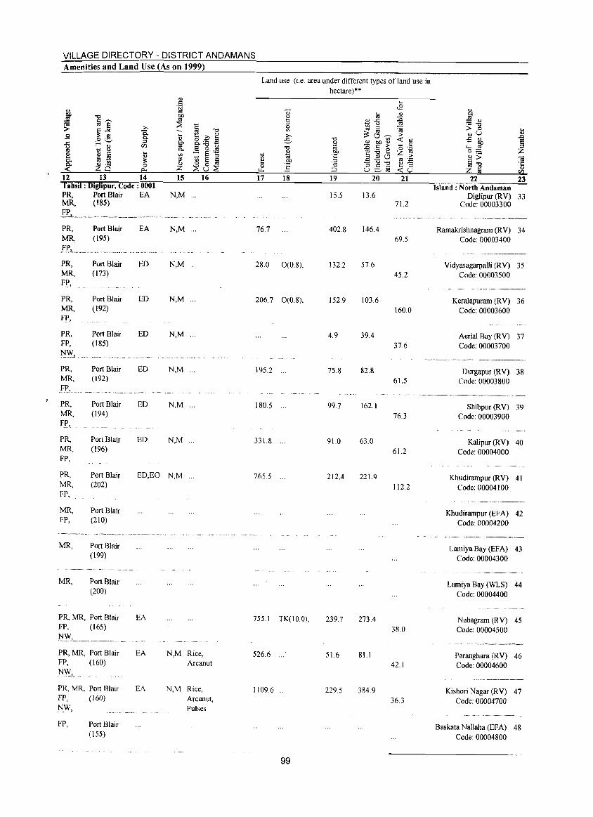
VILLAGE DIRECTORY - DISTRICT ANDAMANS Amenities and Land Use (As on 1999)
12 13 14 15 16 Tahsil: Diglipur. Code: 0001 PR, Port Blair EA N,M ... MR, (185)
F....._ .. _. __ .~ _ .. _ .. ___ . __ .. ___ ... ___ ... _ ... PR, MR,
PR, MR.
.Fe. PR, MR,
F!',
PR, FP,
PR, MR,
f.f', PR, MR, Fjl,
PRo MR, FP,
PR, MR, FP,
MR, FP,
MR,
MR,
Port Blair (195)
Port Blair (173)
Port Blair {I 92)
Port Blair (185)
Port Blair (192)
Port Blair (194)
Port Blair (196)
Port Blair (202)
Port Blair (210)
Port Blair (199)
Port Blair (200)
PR, MR, Port Blair FP, (165)
PR, MR, Port Blair FP, (160)
]\J_\\"
PR, MR, Port Blair FP, (160) NW,
FP, Port Blair (155)
EA N,M ...
ED N,M ...
ED N,M ...
ED N,M ...
ED N,M ...
ED N,M
ED N,M ...
ED,EO N,M ...
EA
EA
EA
N,M Rice, Arcanut
N,M Rice, Arcanut, Pulses
Land use (i.e. area under different types of land use in
hectare)"
17 18 19 20 21
15.5 13.6 71.2
76.7 402.8 146.4 69.5
28.0 0(0.8), 132.2 57.6
45.2
206.7 0(0.8), 152.9 103.6 160.0
4.9 39.4
37.6
195.2 ... 75.8 82.8
61.5
180.5 ... 99.7 162.1
76.3
331.8 ... 91.0 63.0
61.2
265.5 ... 212.4 221.9
112.2
755.1 TK(IO.O), 239.7 273.4
38.0
526.6 51.6 81.1
42.1
1109.6 229.5 384.9
36.3
99
22
.... ... ~ Z ] ... Vl
23 Island: North Andaman
Diglipur (RY) 33 Code: 00003300
Rarnakrishnagrarn (RY) 34 Code: 00003400
Yidyasagarpalli CRY) 35 Code: 00003500
Keralapurarn CRY) 36 Code: 00003600
Aerial Bay CRY) 37 Code: 00003700
Durgapur (RY) 38 Code: 00003800
Shibpur (RY) 39 Code: 00003900
Kalipur (RY) 40 Code: 00004000
Khudirarnpur (RY) 41 Code: 00004100
Khudirarnpur (EFA) 42 Code: 00004200
Lanliya Bay (EFA) 43 Code: 00004300
Larniya Bay (WLS) 44 Code: 00004400
Nabagrarn (RY) 45 Code: 00004500
Parangl1ara (RY) 46 Code: 00004600
Kishori Nagar (RY) 47 Code: 00004700
Baskata Nallal1a (EFA) 48 Code: 00004800
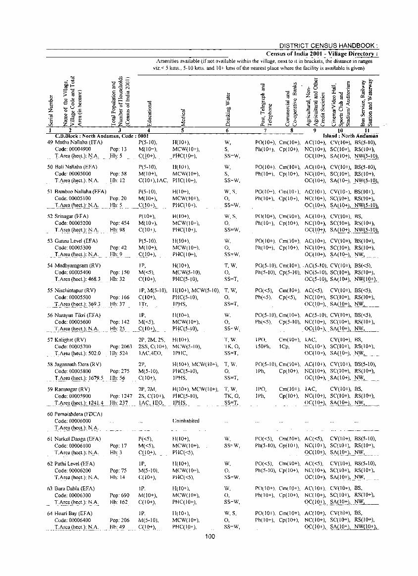
DISTRICT CENSUS HANDBOOK: Census of India 2001 - Village Directory;
Amenities available (if not available within the village, next to it in brackets, the distance in ranges viz. < 5 kms., 5-10 kms. and 10+ kms of the nearest place where the facility is available is given)
1 2 3 4 c.n.Block : North Andaman, Code: 0001
49 Mutha Nal1aha (EFA) P(5-IO), Code: 00004900 Pop: 13 M(JO+), T.Area(h(lct.): N.A. Hh: 5 C(IO+),
5
H(lO+), MCW(lO+), PHC(IO+),
50 Bali NaHaha (EFA) Code: 00005000 T.Area (hect.): NA
P(5-IO), H(lO+),
51 Bamboo Nallaha (EF A)
Pop: 58 Hh: 12
Code: 00005100 Pop: 20
.. J::Ar~aJ~~~!l.N_:~: .... _H.h: .? 52 Srinagar (EF A)
Code: 00005200 Pop: 454
. T:i\~e_~_(h~£t)~N_:"~:. Hh: 98
53 Ganna Level (EF A) Code: 00005300 Pop: 42 T.i\re_a (heet): NA Hh: 9
54 Madhyamgram (RV) Code: 00005400 Pop: 150 T,Area (heet.): 4~?3 Hh: 32
M(IO+), MCW(IO+), qIO+),IAC, PHC(IO+),
P(5-10), M(IO+),
. __ C{lO+),
P(IO+), M(lO+), qIO+),
P(5-10), M(10+),
. C(lO+),
IP, M«5), C(IO+),
H(IO+), MCW(IO+), PHqIO+),
H(IO+), MCW(lO+), PHC(lO+),
H(lO+), MCW(IO+), PHC(IO+),
H(lO+), MCW(5-10),
PHC(5~10),
6
W, S, SS=W,
W, S, SS=W,
W,S, 0, SS=W,
W,S, 0, SS=W,
W, 0, SS=W,
T,W,
0, SS=T,
55 Nischintapur (RV) IP, M(5-10), H(lO+), MCW(5-10), T, W, Code: 00005500 Pop: 166
. _-r::i\~~~(h~ctJ 369). Hh: 37
56 Narayan Tikri (HA) Code: 00005600 Pop: 142
I:~~~(h~~: EA,.. Hh: 25
C(lO+), PHC(5-10), 0, ITr, IPtIS, SS=T,
IP, M«5), C(10+),.
H(IO+), MCW(IO+), PHC(5~10),
W, 0, SS=W,
57 Kalighat(RV) 2P, 2M, 2S, H(lO+), T,W. TK,O, SS=T,
Code: 00005700 Pop: 2063 2SS, C(lO+), MCW(S-IO), T.Area (heet.): 502.0 Hh: 524 IAC,4EO, IPHC,
58 Jagannath Dera (RV) Code: 00005800 Pop: 275 T.Area(heet.): 1679.5 Hh: 56
2P, M(5-10), C(lO+),
H(lO+), MCW(lO+), T, W. PHC(5-10), 0, IPHS, SS=T,
59 Ramnagar (RV) 2P,2M, H(10+), MCW(lO+), T, W, Code: 00005900 Pop: 1247 2S, C(IO+), PHC(5-10), TK,O,
~ .. _T:i\~~.(he.ctJ:_lliLi _!!h, 2~! lA~,_IEO, ..... IPl-I_~, SS.=T,
60 Pemaiahdera (FDCA) Code: 00006000
. T:i\~~~ ~h.tl£~J.N_·t\·
61 Narkul Danga (EFA) Code: 00006100 Pop: 17 T.A~ea(hect.): N,A. Hh: 3
62 Pathi Level (EF A) Code: 00006200 Pop: 75 T.Area (heeL): N.A. Hh: 14
63 Sara Dabla (EF A) Code: 00006300 Pop: 690
T.i\,,!a.(hect.):.1'i.0. Hh: 162
64 Hoari Bay (EFA) Code: 00006400 Pop: 206
.. ,._T,0!:~~(~.e~tJ,l::L~: ........ Hh: 49
P«5), M«5), C(10+),
IP, M(5-10), C(1O+),
lP, M(lO+), C(lO+),
IP, M(5-10),
... G(IQ+), ..
Uninhabited
H(lO+), MCW{10+),
PHC«5),
H(IO+), MCW(IO+), PHC«5),
H(lO+), MCW(IO+), PHC(IO+),
H(lO+), MCW(IO+), PI-IC(IO+),
100
W,
SS=W,
W, 0, SS=W,
W, 0, SS=W,
W,S,
0, SS=W,
7 8 9 10 11
PO(IO+), Cm(IO+), Ph(l 0+), Cp( I 0+),
Island: NortbAridamaii AC(IO+), CV(lO+), BS(5-10), NC(JO+), SC(JO+), RS(IO+),
OC( 1 0+), SA(IO-:l:), ~(~~J_Q)..!.
PO(lO+), Cm(lO+), AC(lO+), CV(IO+), BS(5-IO), Ph(IO+), Cp(lO+), NC(IO+), SC(lO+), RS(lO+),
OC(IO+), SA{lO+), NW(5.~101!
PO(lO+), Cm(10+), AC(IO+), CV(IO+), 8S(10+), Ph(IO+), Cp(lO+), NC(JO+), SC(lO+), RS(IO+),
0C(10+), . SA.t! 0+)J..JiW(5-1 0),
PO(IO+), Cm(IO+), AC(lO+), CV(IO+), BS, Ph(IO+), Cp(IO+), NC(IO+), SC(I 0+), RS(IO+),
O~(1.Q-:I:)! ~;\(l,~2, ... NWJ~:1Q1
PO(IO+), Cm(IO+), AC(lO+), CV(lO+), BS(IO+), Ph(IO+), Cp(IO+), NC(IO+), SC(I 0+), RS(IO+),
OC(IO+), SA(IO+), 1'l\\'L .... _.
PO(S-IO), Cm(lO+), .AC(S-IO), CV(IO+), 8S«5), Ph(5-10), Cp(5-l0), NC(5-10), SC(I 0+), RS(lO+),
OC(5-IO), SA(lo+), NW(IQ+),
pO«S), Cm(lO+), AC«5), CV(IO+), 8S«5), Ph«5), Cp«5), NC(IO+), SC(IO+), RS(IO+),
OC(I_O+),_S,;\(!Q-:l:L~, ._
PO(5-IO), Cm(IO+), AC(5-10), CV(IO+), 8S«5), Ph«5), Cp(5-10), NC(IO+), SC(IO+), RS(lO+),
OC(IO+), SAO()+lL_NW, ._
IPO, Cm(IO+), lAC, CV(IO+), 8S, 150Ph, lCp, NC(lO+), SC(IO+), RS(IO+),
OC(IO+), SA(IO+), N_'I\'L ._.
PO(S-IO), Cm(IO+), AC(lO+), CV(IO+), BS(5-10), IPh, Cp(IO+), NC(IO+), SC(IO+), RS(IO+),
OC( I 0+), SA(lO+), 1'l\!"
IPO, lPh,
Cm(lO+), lAC, CV(JO+), BS, Cp(IO+), NC(IO+), SC(IO+), RS(lO+),
ogl_Q-:l:1 §.;\(!Q:!"1,~1'l.F_, __
PO«5), Cm(lO+), AC«5), CV(lO+), 8S(5-10), Ph(5-10), Cp(IO+), NC(lO+), SC(IO+), RS(IO+),
0C(10+), SA(IO+), l'l\Y, ____ _
PO«5), Cm(lO+), AC«5), CV(lO+), 8S(5-10), Ph(5-IO), Cp(lO+), NC(lO+), SC(IO+), RS(IO+),
OC(IO+), SA(lO+), N}\', _ ....
PO(IO+). Cm(IO+), AC(IO+), CV(IO+), BS, Ph(IO+), Cp(lO+), NC(IO+), SC(lO+), RS(lO+),
OC( I Q+ L ~;\i!O_:lL.~"-'-'-__
~1~C~I~AC(IO+~C~I~~ Ph(lO+), Cp(10+), NC(IO+), SC(IO+), RS(lO+),
O_C(IO+)J. ~;\_(IQ.:':2,_ NW(IO+),
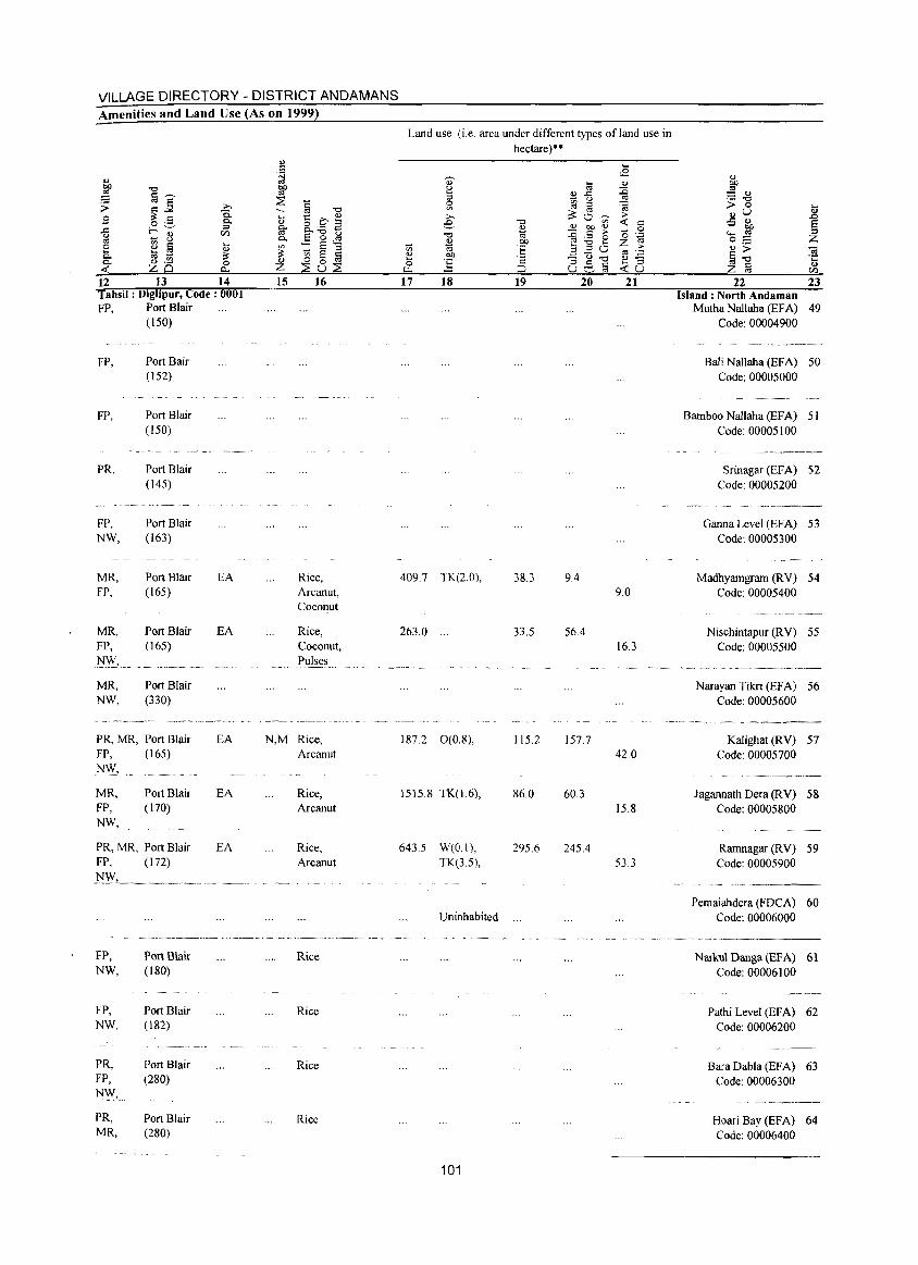
VILLAGE DIRECTORY - DISTRICT ANDAMANS Amenities and Land Use (As on 1999)
.., S
<I) bD "" '" §~
~ ~~ >. Q. .s 0.. o ._ ::I
{l ,__.~
(/) ~ 8
'" ~ § .... e ., 0.. til ~ ~ 0- d) .~ 0 <t: ZQ c:>...
~ bD
'" ~ § ~ "" ~ t:: C ~ §' 8. - .:1
E-g~ 0..
~ :: E ::l '" E §
Z ~8~ 12 13 14 15 16 Tahsil: Diglipur, Code: 0001 FP, Port Blair
(150)
FP, Port Bair (152)
FP, Port Blair (150)
PR, Port Blair (145)
FP, Port Blair NW, (163)
MR, Port Blair EA Rice, FP, (165) Arcanut,
Coconut
MR, Port Blair EA Rice, FP, (165) Coconut,
l'i~L_ Pulses
MR, Port Blair NW, (330)
PR, MR, Port Blair EA N,M Rice, FP, (165) Arcanut NW,
MR, Port Blair EA Rice, FP, (170) Arcanut NW,
PR, MR, Port Blair EA Rice, FP, (172) Arcanut
FP, Port Blair Rice NW, (180)
FP, Port Blair Rice NW, (182)
PR, Port Blair Rice FP, (280) N\V, ...
PR, Port Blair Rice MR, (280)
Land use (i.e. area under different types ofland use in hectare)··
.... ~
<2 Q) til <l)
~ ::c .,..0 ::I 'gj <..) ~ ~ '" .<;
~ '" >. 0 ~ ;-
e "" '" <t: ~ Q) 0.> 00 .,
0
"" ., ::c .5 ;- o .'§
0.> OIl E! "" 0 .... Z ;-t'i .,
E a '" 0 0.> OIl (3-0 c:a .:= ....
J§ a ::; 0.> -0 e.,§ .... ::l u.. ~ U <t:u 17 18 19 20 21
409.7 TK(2.0), 38.3 9.4 9.0
263.0 ... 33.5 56.4 16.3
187.2 0(0.8), 115.2 157.7 42.0
1515.8 TK(1.6), 86.0 60.3 15.8
643.5 W(O I), 295.6 245.4 TK(3.5), 53.3
Uninhabited
101
22 23 Island: North Andaman
Mutha Nallaha (EFA) 49 Code: 00004900
Bali Nallaha (EFA) 50 Code: 00005000
Bamboo Nallaha (EFA) 51 Code: 00005100
Srinagar (EFA) 52 Code: 00005200
Ganna Level (EFA) 53 Code: 00005300
Madhyamgram CRV) 54 Code: 00005400
Nischintapur CRV) 55 Code: 00005500
Narayan Tilm (EFA) 56 Code: 00005600
Kalighat (RV) 57 Code: 00005700
Jagannath Dera (RV) 58 Code: 00005800
Rarnnagar CRY) 59 Code: 00005900
Pemaiahdera (FDCA) 60 Code: 00006000
Narkul Danga (EF A) 61 Code: 00006100
Pathi Level (EFA) 62 Code: 00006200
Bara Dabla (EFA) 63 Code: 00006300
Hoari Bay (EF A) 64 Code: 00006400
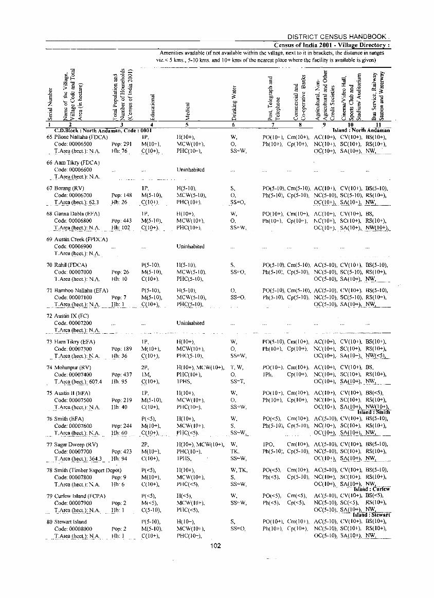
DISTRICT CENSUS HANDBOOK. Census of India 2001 - Village Directory:
Amenities available (if not available within the village, next to it in brackets, the distance in ranges viz.< 5 krns., 5-10 krns. and 10+ krns of the nearest place where the facility is available is given)
2 3 4 C.O.Block: North Andaman, Code: 0001
65 Pilone Nallaha (FOCA) IP, Code: 00006500 Pop: 291 M(lO+), TArea (heeL): N.A. Hh: 76 qlO+),
66 Aam Tikry (FOCA) Code: 00006600 TArell (h_eeL): t-j.A.
67 Borang (RY) Code: 00006700
T·A.!e_a (heeL): g3 68 Ganna Dabla (EFA)
Code: 00006800
_XA~t!_aih.t!£!·t~·A.
69 Austin Creek (FPOCA) Code: 00006900 T.Area (heeL): N.A.
70 Rahil (FDCA) Code: 00007000 T.Area (heet.): N.A.
Pop: 148 Hh: 26
Pop: 443
.. flh: .. lO.2
Pop: 26 Hh: 10
IP, M(5-10),
. qIO+),
IP, M(5- IOl, (:(1 Q:+::), ,
P(5-10), M(5-10), C(lO+),
71 Bamboo Nallaha (EFA) P(5-1O), Code: 00007100 Pop: 7 M(5-10),
... _I·A~~_ajh.e.s: .. tJ: l'I.!>: ... _ flh.: L ...... _q10+), ..
71 Austin IX (FC) Code: 00007200
..... L~r~ll (heel.): l'I:~; ... IP, 73 Hara Tikry (EFA)
Code: 00007300 T.Area (heet.): N.A.
Pop: 189 M(10+), Hh: 36 qIO+),
74 Mohanpur (RY) Code: 00007400 Pop: 437 T.Area (heet.): 607.4 Hh: 95
75 Austin II (EFA) Code: 00007500 .:r.~rea (hect): N.A.
76 Smith (EFA) Code: 00007600
T,Ar.ell.(h_ec.!_): .l'!:~.
77 Sagar Dweep (RY) Code: 00007700 T.Area(hecL): 3~4.3
Pop: 219 Hh:40
Pop: 244 Hh: 60
Pop: 423 Hh: 94
78 Smith (Timber Export Depot) Code: 00007800 Pop: 9 T.Area (heet.): N.A. Hh: 6
79 Curlew Island (FCPA) Code: 00007900 Pop: 2 TArea (Ile_et):_)\J.A. Hh: I
80 Stewart Island Code: 00008000 Pop: 2
... T·A.re.a(~e.eU: NA . Hh: I
2P, 1M, C(lO+),
IP, M(5-10), qIO+),
P«5), M(lO+),
. C(IQ+),_
2P, M(lO+), C(IO+),
P«5), M(10+), C(10+),
P«5), M«5), q5-10),
P(5-10), M(5-!O), C(lO+),
5
H(lO+), MCW(10+), PHC(10+),
Uninhabited
H(5-10), MCW(5-10), PHqIO+),
H(lO+), MCW(IO+), PHC(10+),
Uninhabited
H(5-10), MCW(5-10), PHC(5-10),
H(5-10), MCW(5-10),
!lJ:Ig{?~l Q),
Uninhabited
H(10+), MCW(10+), PHC(5-10),
6
W, 0, SS=W,
S 0, SS"'O,
W,
0, SS"'W,
S, SS=O,
O. SS=O,
W, 0, SS=W,
H(lO+), MCW(IO+), T, W, PHCCIO+), 0, IPHS, SS=T,
H(lO+), MCW(lO+), PHC(IO+),
H(IO+), MCW(IO+), PIIC.«5),
W, 0, SS=W,
W, S, SS=W,_
H(10+), MCW(IO+), W, PHC(lO+), TK, IPHS, SS=W,
H(IO+), MCW(lO+), PHC«5),
H«5), MCW(IO+), PHCC<5),
H(lO+), MCW(IO+), PHC(IO+),
102
W,TK, S, SS=W,
W, SS=W,
S, SS=O,
7 8
PO(l 0+), Cm(l 0+), Ph(IO+), Cp(10+),
9 10 11 Islalld : North AlloiRi-aii
AqIO+), CY(10+), BS(1O+), NC(IO+), SqIO+), RS(IO+), 0(:(10+), SA(IO+), 't>/'.\',--- __ __
PO(5-JO), Cm(5-10), AC(IO+), CY(lO+), BS(5-10), Ph(5-10), Cp(5-10), NC(5-10), SC(5-10), RS(IO+),
()q!O+1.~~(IO+1._~_, __
PO(10+), Cm(lO+), AC(10+), CY(10+), BS, Ph(IO+), Cp(IO+), NC(IO+), SC(I 0+), RS(IO+),
OqlO+), S~(IO:+::)Lt-JW(IO+),
PO(5-JO), Cm(5-10), AC(5-10), CY(lO+), 8S(5-10), Ph(5-10), Cp(5-10), NC(5-10), Sq5-10), RS(IO+),
0C(5-10), SA(JO+), N\V,
PO(5-10), Cm(5-10), AC(5-10), CY(lO+), 8S(5-10), Ph(5-10), Cp(5-10), NC(5-10), SCC5-10), RS(IO+),
Cl(:(5:1Q), ~~LIQ:+::2L NW, __
PO(5.10), Cm(lO+), AC(IO+), CY(IO+), BS(1O+), Ph(JO+), Cp(10+), NC(IO+), SC(I 0+), RS(IO+),
oq 10+), SAC 10+), N.'~(~?), __
PO(IO+), Cm(IO+), AC(IO+), CY(IO+), 8S, IPh, Cp(10+), NC(IO+), SC(I 0+), RS(IO+),
0C(1O+), SA(10+), NW,
PO(IO+), Cm(IO+), AC(IO+), Ph(IO+), Cp(10+), NC(IO+),
OC(IO+),
CY(10+), BS«5), SCCI0+), RS(IO+), ~~.uO+), _ NW(IO+),
fSTand : Smith AC(5-10), CY(IO+), 8S(5-10), NC(IO+), SC(IO+), RS(lO+),
OC(l9::1:)L~~Q~LNW_, __
POe <5), Cm( I 0+), Ph(5-10), Cp(5-10),
IPO, Cm(JO+), Ph(5-10), Cp(5-10),
PO«5), Cm(10+), Ph«5), Cp(5-10),
PO«5), Cm«5), Ph«5), Cp«5),
PO(IO+), Cm(lO+), PhO 0+), Cp(1 0+),
AC(5-IO), CY(IO+), 8S(5-1O), NC(5-10), SCCIO+), RS(IO+), OC(I 0+), SA(IQ+), N.'\Y.L .... _
ACC5-10), CY(IO+), BS(5-10), NC(10+), SC(IO+), RS(1O+),
OC(IO+), SA(lO+),_ NFC"_" .... _
Island: unew AC(5-10), CY(IO+), BS«5), Nq5-10), SC«5), RS(lO+),
0C(5-10), SA(IO+h_ NW~±:, =:r .. . . -'" -mand : Stewart
Aq5-10), CY(lO+), 8S(10+), NC(5-10), SC(I 0+), RS(IO+),
Oq5-10), SA(IO+),._~--,---_
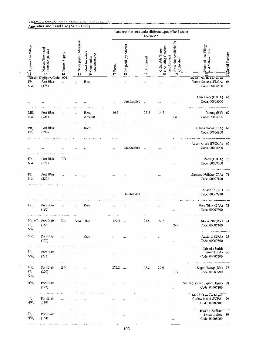
VILL..I"'\\.::H:::' LJIJ'L-V I '-'1'\ I - LJI'-' I 1'1"-' I , '\1''-'' """ " .... _
Amenities and Land Use (As on 1999l
Land use (i.e. area under different types of land use in hectare)**
OJ .... . S <2 Q) Q) [;j ~
OJ ~ OJ ~ ~ .., OJ) (.)
~ [;3'-" '" .... OJ..c: :::: OJ :::: ::E ::l ... (.) .- "Cl ;;;: ~~ ..... § "Cl 0 ~ ::l '(;j ;> 0 ] -.. '" ~c3~ Q)U
Sl -a .... t:c~ ..... :> 0'- Q.. OJ e "Cl -< r:: -5 OJ
~ ..c: f-~ ::l fJ' 8.-..2
* 2 ~ ~ 0 OJ) <Zl e'8J1 "Cl o '~ ""' '" ~ ... 8 Q.. OJ OJ) ~:.a2 oS e i'j B ....
'" :: ~ ::l 'iii t\'i 'E 3.20 Z :> Q) ;> O! Q)
Q.. S '" ~ ~ ~ OJ) ,!::: u "0 c;S ',,=
ij"Cl ·c Q) ~ 0 fa ] '2 OJ -Q.. Q) .- 0 0 8g~ .... ::l Q)
-< ZQ A. Z ::Eu::E :.:.. ;::;, -<U Z a <Zl
12 13 14 15 16 17 18 19 20 21 22 23 Tahsil: DigJipur, Code: 0001 Island: North Andaman FP, Port Blair Rice Pilone Nallaha (FDCA) 65 NW, (175) Code: 00006500
-... -.. _----_ .. -
Aam Tikry (FDCA) 66 Uninhabited Code: 00006600
- _-----_ .. _ ... _ .. _._ .. __ . MR, Port Blair Rice, 10.5 33.5 14.7 Borang(RV) 67 NW, (225) Arcanut 3.6 Code: 00006700
,- ----~~ .. ----.~ .. ---PR, Port Blair Rice Gaona Dabla (BFA) 68 FP, (290) Code: 00006800
Austin Creek (FPDCA) 69 Uninhabited Code: 00006900
FP, Port Blair ED Rahil (FDCA) 70 NW, (220) Code: 00007000
FP, Port Blair Bamboo Nallaha (EFA) 71 NW, (220) Code: 00007100
c.~_ ... _,,_,,__ ___
Austin IX (FC) 72 Uninhabited Code: 00007200
·~_~~WMW··."'· ______
FP, Port Blair Rice Hara Tikry (EFA) 73 (160) Code: 00007300
PR, MR, Port Blair EA N,M Rice 409.4 ... 91.5 79.7 Mohanpur (R V) 74 FP, (165) 26.9 Code: 00007400 NW,
MR, Port Blair Rice Austin II (EFA) 75 (170) Code: 00007500
Ishind':Sni~-FP, Port Blair Smith (BFA) 76 NW, (222) Code: 00007600
_··.·_~ •.. w~.,, __
MR, Port Blair ED 272.2 45.2 29.0 Sagar Dweep (RV) 77 FP, (220) 17.9 Code: 00007700 NW,
NW, Port Blair Smith (Timber Export Depot) 78 (222) Code: 00007800
Island: Curlew 1S-lanil FP, Port Blair Curlew Island (FCPA) 79 NW, (159) Code: 00007900
Islait~d': 'Stewart FP, Port Blair Stewart Island 80 NW, (154) Code: 00008000
103
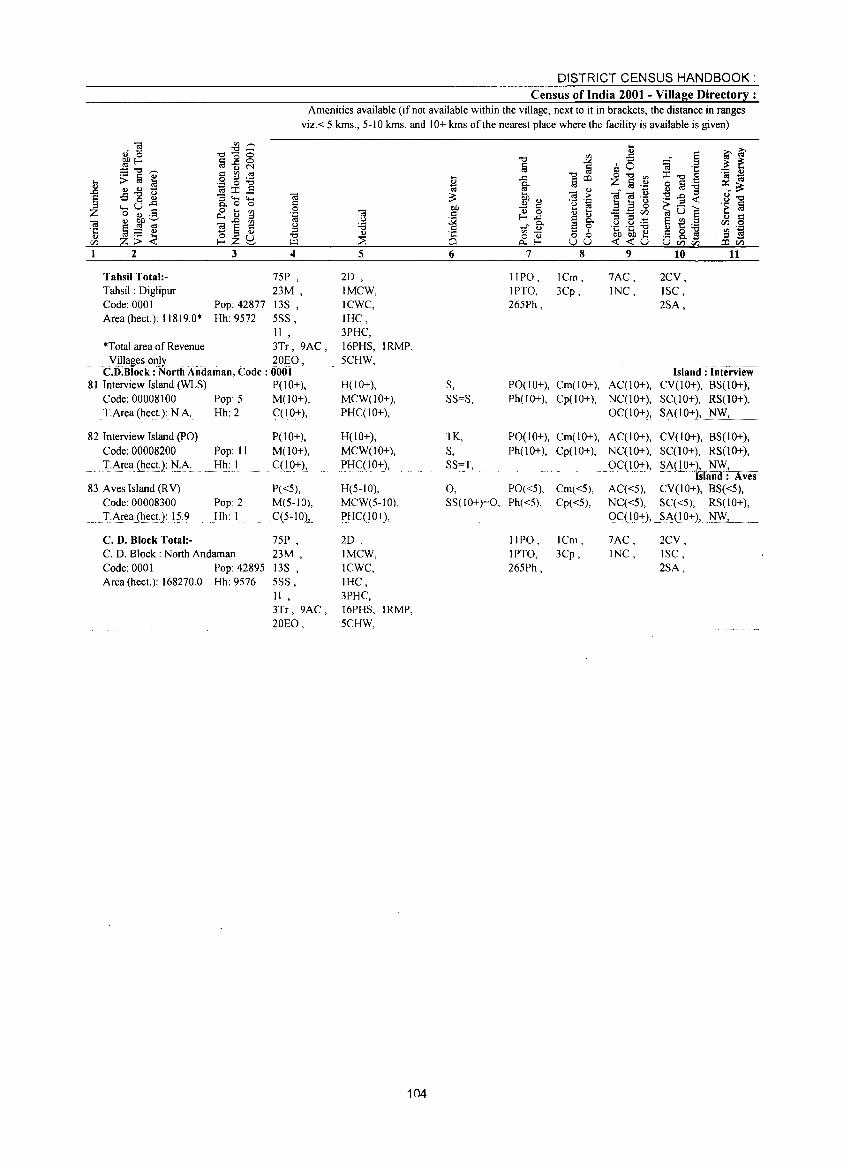
DISTRICT CENSUS HANDBOOK: Census of India 2001 - Village Directory :
Amenities available (if not available within the village, next to it in brackets, the distance in ranges viz.< 5 kms., 5-10 kms. and 10+ kms of the nearest place where the facility is available is given)
2 3 4
Tahsil Total:Tahsil: Diglipur Code: 0001 Area (hect.): 11819.0*
75P , 23M,
Pop: 42877 13S , Hh 9572 5SS,
11, *Total area of Revenue 3Tr, 9AC, . Yillagesonly ..... 20EO, C.D.Block : North Andaman, Code: 0001
81 Interview Island (WLS) P(IO+), Code: 00008100 Pop: 5 M(JO+), T.Area (heet.): NA Hh: 2 C(IO+),
82 Interview Island (PO) Code: 00008200 Pop: II
;:'~rea (~~c,.t.2~ :tJ':~:.... Hh: I
83 Aves Island (RY) Code: 00008300
.I:~rea(~ect.2: 1?:9
C. D. Block Total:-
Pop: 2 Hh: I
C. D. Block: North Andaman Code: 0001 Pop: 42895 Area (hect.): 168270.0 Hh: 9576
P(IO+), M(10+),
,C(!Q+),
P«5), M(5-10),
C(5- IOl" 75P , 23M, 13S , 5SS, I I , 3Tr, 9AC, 20EO,
5
2D , IMCW, ICWC, !HC, 3PHC, 16PHS, IRMP, 5CHW,
H(IO+), MCW(lO+), PHC(lO+),
H(IO+), MCW(lO+), PHC(IO+),
H(5-10), MCW(5-1O), PHC(IO+),
2D, IMCW, ICWC, IHC, 3PHC, 16PHS, IRMP, 5CHW,
104
6
S, SS=S,
TK, S, SS=T,
0, SS(IO+)=O,
7
IIPO, IPTO, 265Ph,
8
ICm, 3Cp,
PO(IO+), Cm( 10+), Ph(10+), Cp(1o+),
PO(IO+), Cm(IO+), Ph(10+), Cp(1o+),
PO«5), Cm«5), Ph«5), Cp«5),
IIPO, ICm, IPTO, 3Cp, 265Ph,
9
7AC, INC,
AC(IO+), NC(IO+), OC(IO+),
AC(IO+), NC(IO+), 0C(10-+),
AC«5), NC«5), OC(IO+),
7AC, INC,
10
2CY, ISC, 2SA,
11
Island: Interview CY(IO+), BS(1O+), SC(10+), RS(lO+), SA(10+), NW,
CY(IO+), 8S(10+), SC(I 0+), RS(lO+),
~NLO:1:f~--san : Aves
CY(IO+), 8S«5), SC«5), RS(lO+),
_SA(1.°+), ___ ~~~.
2CY, ISC, 2SA,
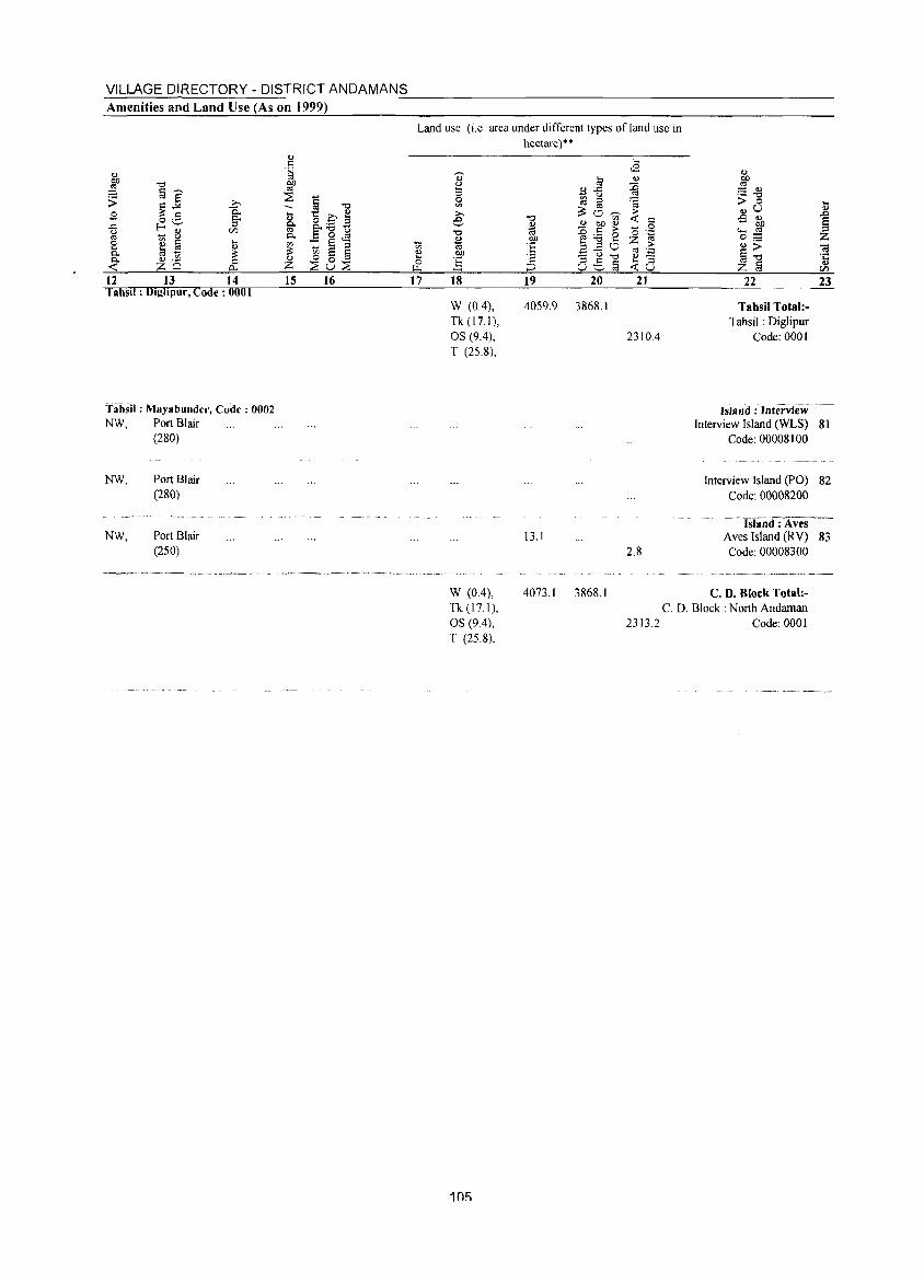
VILLAGE DIRECTORY - DISTRICT ANDAMANS Amenities and Land Use (As on 1999)
12 13 14 I ahs!l : Dighpur, Code: 0001
Tahsil: Mayabunder, Code: 0002 NW, Port Blair
(280)
NW,
NW,
Port Blair (280)
Port Blair (250)
15 16
Land use (i.e. area under different types ofland use in hectare)"
17 18
W (0.4), Tk (17.1), OS (9.4), T (25.8),
W (0.4), Tk(17.1), OS (94), T (25.8),
105
19 20 21
4059.9 3868.1
2310.4
13.1 2.8
22
Tahsil Total:Tahsil: Diglipur
Code: 0001
Isla nd : Interview .
23
Interview Island (WLS) 81 Code: 00008100
Interview Island (PO) 82 Code: 00008200
~Isiaiiil : Aves --Aves Island CRV) 83 Code: 00008300
4073.1 3868.1 C. D. Block Total:-C. D. Block: North Andaman
2313.2 Code: 0001

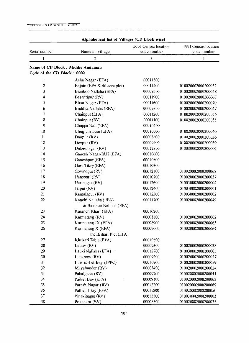
t'ICrnGEf'iI'ilD I OWN LJIKECTORY
Alphabetical list of Villages (CD block wise)
200 I Census location 1991 Census location Serial number Name of village code number code number
2 3 4
Name of CD Block : Middle Andaman Code of the CD Block : 0002
Asha Nagar (EFA) 00011500 2 Bajato (EFA & 40 acre plot) 00011400 010020002000200052 3 Bamboo Nallaha (EFA) 00009500 010020002000200048 4 Basantipur (RV) 00011900 010020002000200067 5 Birsa Nagar (EFA) 00011600 010020002000200070 6 Buddha Nallaha (EFA) 00009800 010020002000200047 7 Chainpur(EFA) 00011200 010020002000200056 8 Chainpur (RY) 00011100 010020002000200055 9 Chappa Nali (EFA) 00010400
10 Chuglum Gum (EFA) 00010000 010020002000200046 11 Danpur (RY) 00008600 010020002000200036 12 Devpur (RY) 00009400 010020002000200039 13 Dukennagar (RY) 00012800 010030002000200006 14 Ganesh Nagar-I&II (EFA) 00010600 15 Ganeshpur (EFA) 00010800 16 Gora Tikry (EFA) 00010300 17 Govindpur (RY) 00012100 010020002000200068 18 Hanspuri (RY) 00010700 010020002000200057 19 Harinagar (RY) 00012600 010030002000200004 20 Jaipur(RY) 00012400 010030002000200001 21 Kamalapur (RY) 00012300 010030002000200002 22 Kanchi Nallaha (EFA) 00011700 010020002000200049
& Bamboo Nallaha (EFA) 23 Karanch Khari (EFA) 00010200 24 Karmatang (RY) 00008800 010020002000200062 25 Karmatang IX (EFA) 00008900 010020002000200063 26 Karmatang X (EFA) 00009000 010020002000200064
incl.Bihari Plot (EFA) 27 Khukari Tabla (EFA) 00010500 28 Lataw (RY) 00009300 010020002000200038 29 Lauki NalJaha (EFA) 00012700 010030002000200005 30 Lucknow (RY) 00009200 010020002000200037 31 Luis-in-Let-Bay (JPPC) 00010900 010020002000200059 32 Mayabunder (RY) 00008400 010020002000200034 33 Pahalgaon (RY) 00009700 010020002000200041 34 Paiket Bay (EF A) 00009100 010020002000200065 35 Paresh Nagar (RY) 00012200 010020002000200069 36 Pather Tikry (EFA) 00011800 010020002000200050 37 Pinakinagar (RY) 00012500 010030002000200003 38 Pokadera (RY) 00008500 010020002000200035
107
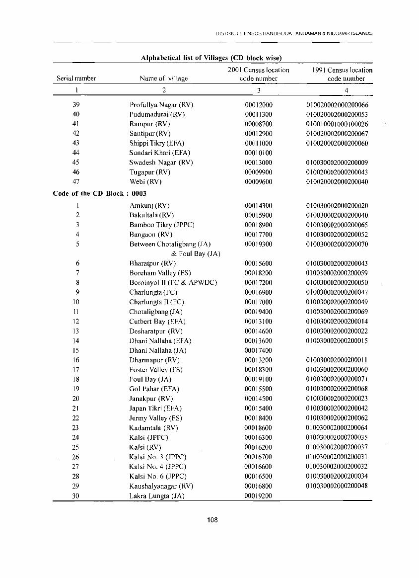
Ul::O I KIt., I tJeN::'U::' HANUtlUUK ANUAMAN & NICUtlAK I;:,LANU:':'
Alphabetical list of Villages (CD block wise)
200 I Census location 1991 Census location Serial number Name of village code number code number
2 3 4
39 Profullya Nagar (RY) 00012000 010020002000200066 40 Pudumadurai (RY) 00011300 010020002000200053 41 Rampur (RY) 00008700 010010001000100026 42 Santi pur (RY) 00012900 010020002000200067 43 Shippi Tikry (EFA) 00011000 010020002000200060 44 Sundari Khari (EFA) 00010100 45 Swadesh Nagar (RV) 00013000 010030002000200009 46 Tugapur (RY) 00009900 010020002000200043 47 Webi (RY) 00009600 010020002000200040
Code of the CD Block : 0003
Amkunj (RY) 00014300 010030002000200020 2 Bakultala (RV) 00015900 010030002000200040 3 Bamboo Tikry (JPPC) 00018900 010030002000200065 4 Bangaon (RY) 00017700 010030002000200052 5 Between Chotaligbang (JA) 00019300 010030002000200070
& Foul Bay (JA) 6 Bharatpur (RY) 00015600 010030002000200043 7 Boreham Yalley (FS) 00018200 010030002000200059 8 Boroinyol II (FC & APWDC) 00017200 010030002000200050 9 Charlungta (FC) 00016900 010030002000200047
10 Charlungta II (FC) 00017000 010030002000200049 II Chotaligbang (JA) 00019400 010030002000200069 12 Cutbert Bay (EFA) 00013100 010030002000200014 13 Desharatpur (RY) 00014600 010030002000200022 14 Dhani Nallaha (EFA) 00013600 010030002000200015 15 Dhani Nallaha (JA) 00017400 16 Dharmapur (RY) 00013200 010030002000200011 17 Foster Yalley (FS) 00018300 010030002000200060 18 Foul Bay (JA) 00019100 010030002000200071 19 Gol Pahar (EFA) 00015500 010030002000200068 20 Janakpur (RY) 00014500 010030002000200023 21 Japan Tikri (EFA) 00015400 010030002000200042 22 Jenny Valley (FS) 00018400 010030002000200062 23 Kadamtala (RY) 00018600 010030002000200064 24 Kalsi (JPPC) 00016300 010030002000200035 25 Kalsi (RY) 00016200 010030002000200037 26 Kalsi No.3 (JPPC) 00016700 010030002000200031 27 Kalsi No.4 (JPPC) 00016600 010030002000200032 28 Kalsi No.6 (JPPC) 00016500 010030002000200034 29 Kaushalyanagar (RY) 00016800 010030002000200048 30 Lakra Lungta (JA) 00019200
108
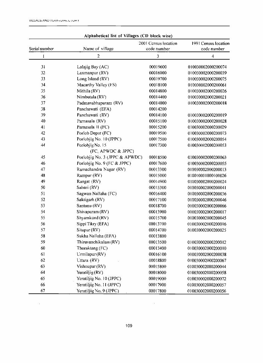
VILLA\.:il: /\NU I UVVh UIKL ..... I UK T
Alphabetical list of Villages (CD block wise)
2001 Census location 1991 Census location Serial number Name of village code number code number
2 3 4
31 Lalajig Bay (AC) 00019600 010030002000200074 32 Laxmanpur (RV) 00016000 010030002000200039 33 Long Island (RV) 00019700 010030002000200075 34 Macarthy Valley (FS) 00018100 010030002000200061 35 Mithila (RV) 00014800 010030002000200026 36 Nimbutala (RV) 00014400 010030002000200021 37 Padmanabhapuram (RV) 00014000 010030002000200018 38 Panchawati (EFA) 00014200 39 Panchawati (RV) 00014100 010030002000200019 40 Parnasala (RV) 00015100 010030002000200028 41 Parnasala II (FC) 00015200 010030002000200029 42 Porlob Depot (FC) 00019500 010030002000200073 43 Porlobjig No.1 0 (JPPC) 00017500 010030002000200054 44 Porlobjig No. 15 00017300 010030002000200053
(FC, APWDC & JPPC) 45 Porlobjig No.3 (JPPC & APWDC) 00018500 010030002000200063 46 Porlobjig No.9 (FC & JPPC) 00017600 010030002000200055 47 Ramachandra Nagar (RV) 00013300 010030002000200013 48 Rampur (RV) 00015000 010010001000100026 49 Rangat (RV) 00014900 010030002000200024 50 Sabari (RV) 00015300 010030002000200041 51 Sagwan Nallaha (FC) 00016400 010030002000200036 52 Saktigarh (RV) 00017100 010030002000200046 53 Santanu (RV) 00018700 010030002000200066 54 Shivapuram (RV) 00013900 010030002000200017 55 Shyamkund (RV) 00015700 010030002000200045 56 Sippi Tikry (EFA) 00013700 010030002000200016 57 Sitapur (RV) 00014700 010030002000200025 58 Sukha Nallaha (EFA) 00013800 59 Thiruvanchikulam (RV) 00013500 010030002000200012 60 Thoraktang (FC) 00013400 010030002000200010 61 Urmilapur (RV) 00016100 010030002000200038 62 Uttara (RV) 00018800 010030002000200067 63 Vishnupur (RV) 00015800 010030002000200044 64 Yeratiljig (RV) 00018000 010030002000200058 65 Yeratiljig No.1 0 (JPPC) 00019000 010030002000200072 66 Yeratiljig No. 11 (JPPC) 00017900 010030002000200057 67 Yeratiljig No.9 (JPPC) 00017800 010030002000200056
109
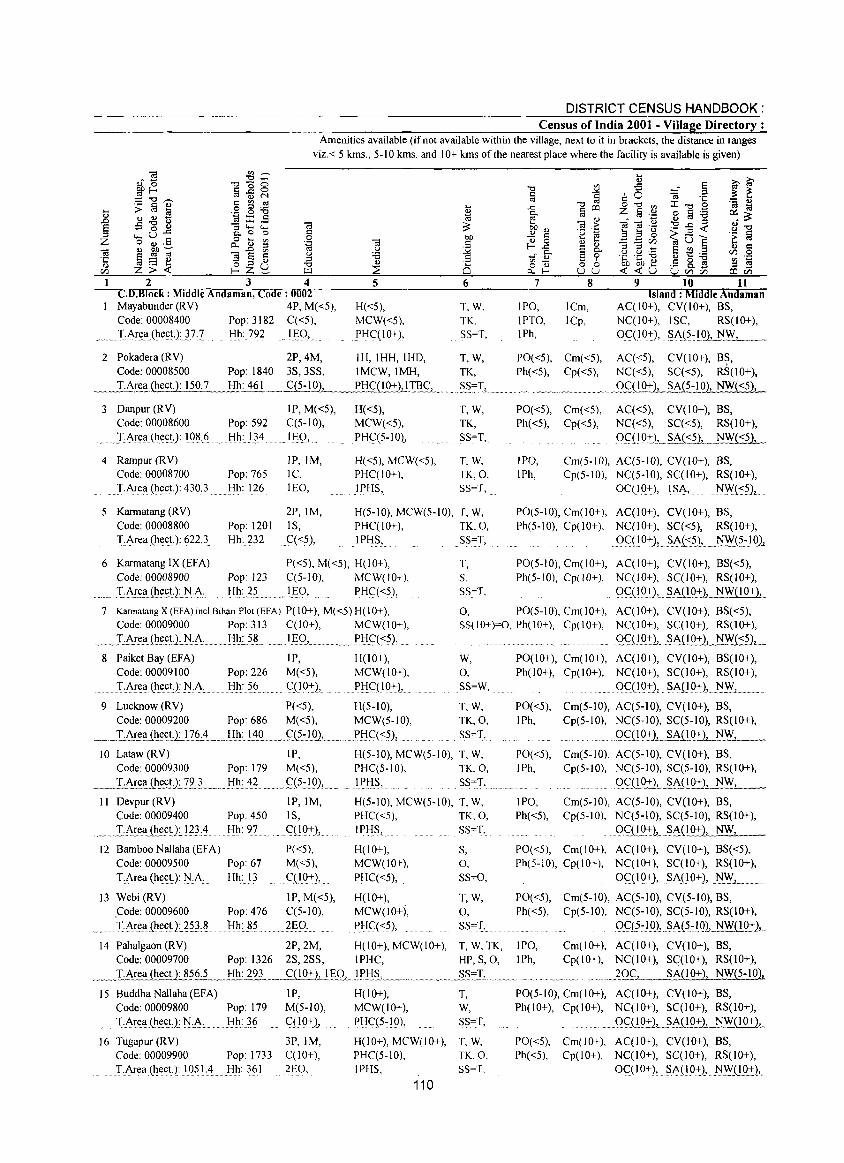
DISTRICT CENSUS HANDBOOK: Census of India 2001 - Village Directory :
Amenities available (if not available within the village, next to it in brackets, the distance in ranges viz.< 5 kms., 5-10 kms. and 10+ kms of the nearest place where the facility is available is given)
2 3 4 CD.Block : Middle Andaman, Code: 0002 Mayabunder (RY) 4P, M«5), Code: 00008400 Pop: 3182 q<5), I·Ar~!l.(he~tJ.F} Hh: 792 IgO,.
5
H«5), MCW«5), PHC(IO+),
2 Pokadera (R Y) Code: 00008500
~_I.Ar~(hect.): 150.7
2P,4M, IH, IHH, IHD,
3 Danpur (RY) Code: 00008600
.. I:Ar~a(l~e~t.): !O~·6 ..
4 Rampur (R Y) Code: 00008700
. TArea (hecL):4}0)
Pop: 1840 3S,3SS, IMCW,IMH,
Hh: 461.~_ q5-!..Ql,__~.R!'!'~(!.Q:t)JIl!.s...
IP, M«5), H«5), Pop: 592 C(5-10), MCW«5), Hh: 134 _1J:;:.Q, PHq5~10),
IP,IM, H«5), MCW«5), Pop: 765 IC, PHC(lO+), Hh: 126 lEO, IPHS,
6
T,W, TK, SS=T,
T,W, TK, SS=T,
<,~~.~ .. "" ">~.,-,~".,
T,W, TK, SS=T,
T, W, TK,O, SS=T,
5 Karmatang (R V) Code: 00008800
!:Ar~a.(h.~ct:):. ~.22..3.
2P,IM, H(5-10), MCW(5-10), T, W,
6 Karmatang IX (EFA) Code: 00008900
_ .... I·A£~~~UJ'~ .. A.· .
Pop: 1201 Hh: 232
Pop: 123 Hh: 25
IS, PHqIO+), TK,O, C«5), IPI-I?, SS=T,
P«5), M«5), H(lO+), T, C(5-10), MCW(lO+), S,
.. ' I:§O, .. PHC«5), SS~T,
7
IPO, IPTO, IPh,
8
lCm, lCp,
9 10 11 Island: Middle Andaman
AqlO+), CY(lO+), BS, NC(lO+), ISC, RS(lO+),
OC(IO+.), . ?A.(5:LO).._l!~._
PO«5), Cm«5), Aq<5), CY(lO+), B~, Ph«5), Cp«5), Nq<5), SC«5), RS(IO+),
()c(!.Q:!:L~A~.-10), NW«5),
PO«5), Cm«5), AC«5), CY(lO+), BS, Ph«5), Cp«5), NC«5), Sq<5), RS(10+),
O<:JI0:tL §bJSi),_. NWf§j,_
IPO, IPh,
Cm(5-10), AC(5-10), CY(lO+), BS, Cp(5-10), Nq5-10), SC(IO+), RS(IO+),
0CCIO+), ISA, N\\i(:.::,s),
PO(5-10), Cm(lO+), AC(IO+), CY(lO+), BS, Ph(5-10), Cp(lO+), Nq I 0+), SC«5), RS(10+),
QC::(IO+.), SA,(S?), .J:!FJ~:lQ)-<
PO(5-10), Cm(IO+), AqIO+), CY(lO+), BS«5), Ph(5-10), Cp(IO+), NC(lO+), SC(lO+), RS(lO+),
" ()qIO.+),.§.AJ!9i), NW(10+),
7 Kannatang X (EFA) incLBihari Plot (EFA) P(IO+), M«5) H(lO+), 0, PO(5-10), Cm(lO+), AC(IO+), CY(lO+), BS«5), Code: 00009000 Pop: 313 C(10+), MCW(10+),
~ JA~!l(.l!~~ttJ::!:A ....... I-Ih~?~ .. _Jgg,.... .. .. PI-Ic::«5),
SS(IO+)=O, Ph(IO+), Cp(IO+), NqIO+), SC(I 0+), RS(lO+),
QC(.1°:t), .... §A{~02:2L_N~
8 Paiket Bay (EFA) IP, H(lO+), W, Code: 00009100 Pop: 226 M«5), MCW(IO+), 0,
... TAr~a (l1~~D: !'I·A: Hh: 56. qIO+.), . I'I-IC(I0:t), SS=W,
9 Lucknow (RY) P«5), H(5-10), T, W, Code: 00009200 Pop: 686 M«5), MCW(5-10), TK,O,
___ T.Ar!!l."(h..~J.l176.4_ .... Hh:,J.1.Q. ... __ q5.:X01 .. _ .. _PtIq<~), . SS=T, ..
10 Lataw (RY) IP, H(S-IO), MCW(5-10), T, W, Code: 00009300 Pop: 179 M«5), PHC(5-10), TK,O,
_ J.:...A£~ .. !l.ih!c.tJ.:.I2:1 .... _ .. J:!h.~.<l.2.._ ... S::(5.:..LO),_ ....... J.P!:I.S, .. SS~}, .....
II Devpur (RY) Code: 00009400 Pop: 450
IP,IM, IS,
....... I:.A~ellih.~~tJJn4_ Hh: 97 .. C(IO+),
12 Bamboo Nallaha (EFA) Code: 00009500 T.Area (he~t.): N.A.
13 Webi (RY) .Code: 00009600
.... IAr.~..!l.(hectL2.,sl,~ ....
Pop: 67 Hh: 13
P«5), M«5), C(lO+),
IP, M«5), Pop: 476 q5-10), Hh: 85 .. 2.gg,
H(S-IO), MCW(5-10), T, W, PHC«5), TK.O, IPHS, SS=T,
H(JO+), S, MCW(IO+), 0, PHC«5), SS=O,
H(lO+), T, W, MCW(IO+), 0, PHq<,s), SS=T,
P0(10+), Cm(IO+), AqIO+), CY(lO+), BS(IO+), Ph(IO+), Cp(lO+), NC(IO+), SC(I 0+), RS(IO+),
....... ()c(10:':), . ?A(10:':), !'IF,. . ..... .
PO«5), Cm(5-JO), AC(5-10), CY(lO+), BS, IPh, Cp(5-10), NC(5-10), SC(5-10), RS(10+),
.. ()c::.u0.:t1_.§AU.Q~N:..;..Wo.:...I.-_
PO«5), Cm(5-10), AC(5-10), CV(lO+), BS, IPh, Cp(5-10), Nq5-10), SC(5-10), RS(lO+),
IPO, Ph«5),
. Qc::i I 0:':2L._?.AJ1Q::t)Jc._:.:NW..:..cL __
Cm(5-10), AC(5-10), CY(lO+), BS, Cp(5-10), Nq5-10), SC(5-10), RS(lO+),
. ()C::.(!O.~L.§A(IO+),,_NW~.L' __
PO«5), Cm(IO+), AC(IO+), CV(lO+), BS«5), Ph(5-10), Cp(IO+), NC(IOT), SC(IO+), RS(10+),
0C(19+), SA(lO+), I'IW, PO«5), Cm(5-10), AC(5-10), CY(S-IO), BS, Ph«5), Cp(5-10), NC(5-10), SC(5-10), RS(10+),
()q,5~.1.Q), .... ?A(?~I.Q2, ... ~(lQ:!::1..
14 Pahalgaon (RV) 2P,2M, H(lO+), MCW(lO+), T, W, TK, IPO, Cm(IO+), AC(IOT), CV(lO+), BS, Code: 00009700 Pop: 1326 2S,2SS, IPHC, HP, S, 0, IPh, Cp(lO+), NC(JO+), SC(10+), RS(10+),
~ .. ~I.Area (heel): 8~~2. ___ .l-Ih:.l?]_M_Sl.!Q:t).J~.91....n;.li§', __ ._ .~ ___ . __ S:~~.1, ................................. 20C,t....__ SA(IO+), NW(5-10},
15 BuddhaNallaha(EFA) IP, H(lO+), T, PO(5-10), Cm(IO+), AC(IO+), CV(lO+), BS, Code: 00009800 Pop: 179 M(5-10), MCW(IO+), W, Ph(IO+), Cp(IO+), NC(IO+), SC(IO+), RS(lO+), .TA!~.!l.(h.e..~t}: }:LA ". Hh: 36 . C::Q.O+), PHC(5~IO), SS""T, .. gQ!.D:+:)..L..§A(10+),_J',[W(10+1..
16 Tugapur(RV) 3P,IM, H(lO+), MCW(IO+), T, W, PO«5), Cm(IO+), AC(IO+), CV(IO+), BS, Code: 00009900 Pop: 1733 C(lO+), PHC(5-10), TK,O, Ph«5), Cp(JO+), NC(IO+), SC(lO+), RS(IO+), T.Area(hect): IQ51:~ Hh: 361 2EO, IPHS, SS=T, OC(IO+), SA(IO+:), NW(!Q:!::).,
110
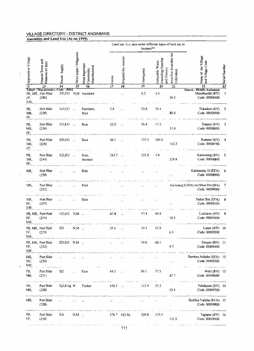
VILLAGE DIRECTORY - DISTRICT ANDAMANS Amenities and Land Use (As on 1999)
ij "=' t:: C ~ 8. ~ z E 0 .M :: ~ ::I ~ 0 § ;:;Su;:;S
12 13 14 15 16 Tahsil: Mayabullder, Code: 0002 PR, MR, Port Blair ED,EO N,M Furniture FP, (240)
~:-.vl
PR, MR, FL. PR, MR,
PR, MR, FP,
PR, MR,
MR,
MR,
MR, FP, 1\1:-.v,
Port Blair (238)
Port Blair (236)
Port Blair (238)
Port Blair (244)
Port Blair (250)
Port Blair (252)
Port Blair (257)
PR, MR, Port Blair FP, (234)
.~W,~ _"'~"""~""'~~'" PR, MR, Port Blair FP, (233)
PR, MR, Port Blair FP, (232)
MR, NC, NW,
PR, MR,
PR, MR,
MR,
PR, FP,
Port Blair (220)
Port Blair (23 I)
Port Blair (228)
Port Blair (238)
Port Blair (230)
ED,EO ... Furniture, Rice
ED,EO ... Rice
ED,EO ... Rice
ED,EO ... Rice, Arcanut
Rice
Rice
Rice
ED,EO N,M ...
ED N,M ...
ED, EO N,M ...
ED Rice
ED,EAg N Timber
EA N,M ...
Land use (i.e. area under different types of land use in hectare)·'
Q) li3 (.) ... o..c: ::I '§ (.) 0 ~ '" ;>., ~O--;;;-e "0 .,
~ gf ~ "0 id .!:> .- 0 ., 01) ~-go ~ 'iii 'E OJ 01) '::::U"'O ... '2 0 ~ 8,s§ ... :::l
17 18 19 20
0.2 1.0
5.8 23.6 33.4
22.0 36.4 17.2
46.1 137.3 104.6
263.7 ... 125.8 4.0
67.8 57.4 40.9
25.4 34.4 12.9
." .. - _. "",,' .
54.0 60.1
44.5 89.1 77.5
636.5 113.4 53.3
276.7 0(2.8), 320.8 319.3
111
... <2
Q)
::c '" ~ > ~ '" 0 '0 ',p Z '" >
<":$ 'p ~ "3 ~u
21
36.5
88.0
33.0
142.2
228.8
~ ::= Q) .- "=' ;> 0 ... .,U .,
1 -5 Q)
W ._ 0;::: z ~ ~ til .t:: ., Z § </)
22 23 Island: Middle Alldaman
Mayabunder (RV) Code: 00008400
, . 0.' O~h~O~.h ._ ••••• ~=.
Pokadera (RV) 2 Code: 00008500
0.= ___ ... N. ~'" .~=~',,_ .. ~_
Danpur (RV) 3 Code: 00008600
•••• vv __ '~"'v,v_v~··vv_. •• ,_vvv··~v~-,
Rampur (RV) 4 Code: 00008700
Karmatang (R V) 5 Code: 00008800
Karmatang IX (EF A) 6 Code: 00008900
Kannatang X (EfA) incl.Bihari Plot (EFA) 7 Code: 00009000
10.3
6.5
9.7
42.7
53.4
131.9
Paiket Bay (EFA) 8 Code: 00009100
Lucknow (RV) 9 Code: 00009200
Lataw (RV) 10 Code: 00009300
Devpur (R V) 11 Code: 00009400
Bamboo NaHaha (EFA) 12 Code: 00009500
Webi (RV) 13 Code: 00009600
Pahalgaon (RV) 14 Code: 00009700
Buddha Nallaha (EFA) 15 Code: 00009800
Tugapur (RV) 16 Code: 00009900
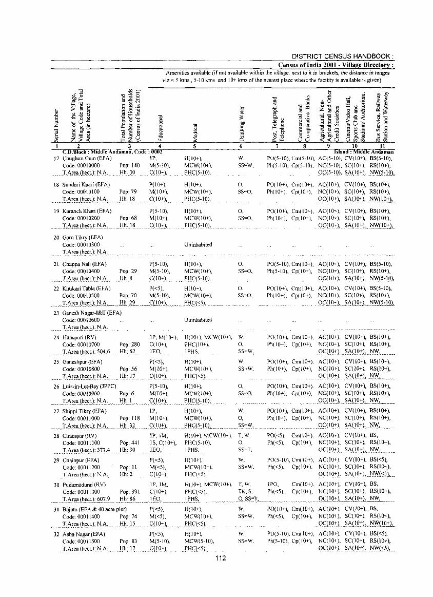
DISTRICT CENSUS HANDBOOK: Census of India 2001 - Village Directory :
Amenities available (if not available within the village, next to it in brackets, the distance in ranges viz.< S kms., 5-10 kms. and 10+ kms of the nearest place where the facility is available is given)
OJ c o .~ :l
"" f..I..l 2 3 4
C.D.Block : Middle Andaman, Code: 0002 17 ChuglumGum(EFA) IP,
Code: 00010000 Pop: 140 M(S-IO),
· __ T~r~[l{~e(;t.1I:J·.~· ..... Hh~}O. ~nQ+),
18 Sundari Khari (EFA) P(10+), Code: 00010100 Pop: 79 M(IO+),
.. ".~~T:Ar~[lJh.~ctlJ:l"t\, .... }:Ih~.I.~ ... _ql ()+),_
19 Karanch Khari (EFA) P(S-IO), Code: 00010200 Pop: 68 M(IO+),
· .... :Ct\r~'!.£J:te.c~1 !i:.t\:_ Hh: 18 ,._ £(1.Q:t),,, ·~·v·_·~·v····· __ · ~
20 Gora Tikry (EFA) Code: 00010300
· ..... TArel.! (he,ct,1 )'l.t\:
21 Chappa Nali (EF A) P(5-10), Code: 00010400 Pop: 29 M(S-IO),
.... T.~re,1.! (he,ct.):N:A, Hh:8 C(lO+),
5
H(10+), MCW(IO+),
... PI:!<;( 5 :10),
H(IO+), MCW(10+),
PI:!C(5-10),
H(lO+), MCW(lO+),
...... PI!qS::19)!
Uninhabited
H(lO+), MCW(lO+), PHC(5-IQ),
22 Khukari Tabla (EFA) P«S), H(10+), Code: OOOIOSOO Pop: 70 M(S-IO), MCW(lO+),
_~~.ea (hecLtI:JA _~.Hh2~_, __ t::{!Q:t'),-, __ .,_I)gft;:S),
23 Ganesh Nagar-I&II CEFA) Code: 00010600
T:~rell(J:t(:yt):~:~.
Uninhabited
... ~~ '" E
"" '" ..s ",,§ =a :l ~ ~ § =0 '1:
0"" '" :C""B ~ '" ... i g co t;l
'" Z g.~ ~ Iii :g ., '" <if OJ .~ .::::
~ ... OJ > :9.g<c 8"" bIl", .~ .~ B ... <.>
bIl ~ c El 0 ~O§ .~ g c '" 0 '" '"
~ _ VJ
~ f-..c:: § 8 B .-=: '" c 0. 0. e t: ._ rJJ 0 tf~ 9 ._ ._ "'"
.5 8.] :g .~ ·c o OJ 0 0 15h15h~ p o...f- uu <c<cu UrJJrJJ coci5 6 7 8 9 10 11
Island: Middle Andaman W, PO(S-IO), Cm(S-IO), ACCS-IO), CV(IO+), BS(5-10), 55~W, Ph(S- I 0), Cp(S-IO), NC(S-IO), SCCIO+), RS(IO+),
OCt 5~10), .. ~~O_Q:LJiW{5-1 0.1
0, PO(IO+), Cm(IO+), AC(IO+), CV(IO+), BS(lO+), 55=0, Ph(lO+), Cp(IO+), NC(IO+), SCC 1 0+), RS(lO+),
gC(I~-J:)L~St\J.1Q::l-LNW(10+2,
0, POe I 0+), Cm(l 0+), AC(IO-t), CV(10+), BS(lO+), SS=O, Ph(IO+), Cp(IO+), NCCIO+), SC(10+), RS(lO+),
.. QC(I 0+),_ S_t\(IQ+L~<J.Q2:L
0, PO(S-IO), Cm(IO+), AC(lO+), CV(IO+), BS(S-IO), SS~O, Ph(S-IO), Cp(10+), NC(W+), SCC I 0+), RS(IO+),
0. SS=O,
OC(IO+), SA(IO+), }\IW{~:1.Q1
P0(10+), Cm(IO+), AC(IO+), CV(IO+), BS(5-10), Ph(IO+), Cp(IO+), NC(IO+), SCC I 0+), RS(lO+),
9~l!<?f)! .... ~~Q~{S-102,
24 Hanspuri CRY) Code: 00010700
JP, M(10+), H(IO+), MCW(IO+), W. PO(lO+), Cm(IO+), AC(IO+), CV(10+), BS(IO+), Ph(IO+), Cp(IO+), NC(IO+), SCCIO+), RS(IO+). Pop: 280
Hh: 62 C(IO+), PHC(IO+), 0,
......... T-t\rea(hectJ 504,6 lEO, IPHS, SS=W, 0C(10+), ~~09+), N~L .......... . 25 Ganeshpur (EFA)
Code: 00010800 Pop: S6
,.,T:t\.r~lILh,t:,c~J:J;:{A ....... ~h: P ...
P«5), M(lO+),
f(l9:+:),
H(10+), MCW(lO+),
'. PHq<5),
26 Luis-in-Let-Bay (JPPC) P(5-lO), H(lO+), Code: 00010900 Pop: 6 M(10+), MCW(10+),
___ I~E!alh~£!.,L~L~, _, , .. t!h:. J . __ ._ .. <;(l.Q:+:l ..... ]!:!fJl·)O), .. 27 Shippi Tikry (EFA) IP, H(lO+),
Code: 00011000 Pop: 118 M(lO+), MCW(IO+),
~.L~'!e.I.I_ilie.~!l~,A: __ l:!h~}L ..... QL9±l.. . .... J~l:IC(5~19L_ 28 Chainpur CRY) IP,IM, H(IO+), MCW(lO+),
Code: 00011100 Pop: 441 IS, C(IO+), PHCC5-10),
'J'.ArellJhectJ: 377.4 Hh: 90 lEO, IPH5,
;!9 Chainpuf (EFA) P«S), H(10+),'
Code: 00011200 Pop: II M«S), MCW(IO+),
T~rea(hect.): NA Hh: 2 C(lO+), PHC«5),
30 Pudumadurai (RV) IP, 1M, H(lO+), MCW(lO+),
Code: 00011300 Pop: 391 C(10+), PHCC<S),
W,
SS=W,
0, 55=0,
w, 0,
,.5S",'\Y, ..
T.W, 0, SS=T,
W,
S5=W,
PO(IO+), Cm(IO+), ACCIO+), CV(lO+), BS(IO+), Ph(1 0+ ), Cp( 10+), NC( 10+), SCC 10+), RS( 10+),
9.C(19:+:), .S.~(lQ:)2 .NW, _ ...... PO(lO+), Cm(lO+), AC(IO+), CV(lO+), BS(IO+), Ph(lO+), Cp(lO+), NC(JO+), SC(!O+), R5(1O+),
_.' _ ... Q£LL<1:+:1..SA(1921 NW,
P0(10+), Cm(IO+), ACCIO+), CV(JO+), BS(IO+), Ph(lO+), Cp(lO+), NC(IO+), SCC I 0+), RS(lO+),
............ ,.Qfl12.+),_§...AJ!0+), NW...L......._
PO«S), Cm(IO+), ACC1()+), CV(10+), BS, Ph«S), Cp(iO+), NCCIO+), SCCIO+), RS(IO+),
OC(10+), SA(10:+:}, NW,
PO(S-IO), Cm(IO+), AC(10+), CV(IO+), BS«5), Ph«S), Cp(IO+), NCCIO+), SCC I 0+), RS(IO+),
OCC IO+), SA(10+),,,)'lW(~5.1.__
T, W, lPG, TK. s, Ph( <5),
_ .. T.Area ~£!.1.607. 9 ...... Hh':'.?L,~JE.Q, ....... " .. " .. ~g~J .. . ..." ,Q, .??=I,,___ .....
Cm(lO+), ACCIO+), CV(lO+), BS, Cp(IO+), NCCIO+), SCClO+), RS(lO+),
........ , ...... QfQQ:!:LSA(IO+}, NW,
31 Bajato(EFA&40acreplot) P«5), H(IO+), Code: 00011400 Pop: 74 M«5), MCW(10+),
I~.r.e,~(~~t.).:)'lc~..:..._ Hh: 15 .<::(10+),. ." P1:I<;:«5), .'
32 Asha Nagar (EFA) Code: 00011500 T.Area (heeL): NA
Pop: 83 Hh: 17
P«5), M(S-IO), Q10+),
H( I 0+), MCW(5-10),
PHq<S),
112
w, SS~W,
W, SS~W,
P0(10+), Cm(IO+), AC(JO+), CV(IO+), BS, Ph«5), Cp(IO+), NC(IO+), SC(I 0+), RS(lO+),
. Q£(!O+)L.~~J.LQ::I-2t NW(lO+),
PO(S-IO), Cm(IO+), ACClO+), CV(lO+), BS«5), Ph(5-10), Cp(IO+), NC(IO+), SC(IO+), RS(IO+),
OC(IO+), . SA(lQ+)" )'lW{~?),
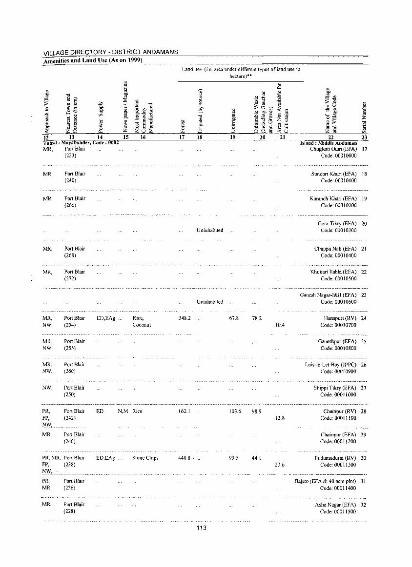
VILLAGE DIRECTORY - DISTRICT ANDAMANS Amenities and Land Use (As on 1999)
12 13 14 Tahsil: Mayabunder, Code: 0002 MR, Port Blair
(233)
MR,
MR,
MR,
MR,
MR, NW,
MR, NW,
MR, NW,
NW,
Port Blair (240)
Port Blair (266)
Port Blair (268)
Port Blair (272)
Port Blair (254)
Port Blair (255)
Port Blair (260)
Port Blair (250)
ED,EAg '"
OJ
J
15 16
Rice, Coconut
PR, FP, NW,
Port Blair (242)
ED N,M Rice
MR, Port Blair (246)
PR, MR, Port Blair FP, (238)
PR, MR,
MR,
Port Blair (236)
Port Blair (228)
ED,EAg ; .. Stone Chips
Land use (i.e. area under different types of land use in hectare)"
17 18 19 20
Uninhabited ."
Uninhabited
348.2 67.8 78.2
162.1 103.6 98.9
440.8 . 99.5 44.1
113
21
10.4
12.8
23.6
22 23 Island: Middle Andamsn
Chuglum Gum (EFA) 17 Code: 000 I 0000
Sundari Khari (EFA) 18 Code: 00010100
Karanch Khari (EFA) 19 Code: 00010200
Gora Tikry (EFA) 20 Code: 00010300
Chappa Nali (EFA) 21 Code: 000 I 0400
Khukari Tabla (EFA) 22 Code: 00010500
Ganesh Nagar-I&II (EFA) 23 Code: 00010600
Hanspuri (RY) 24 Code: 00010700
Ganeshpur (EFA) 25 Code: 00010800
Luis-in-Let-Bay (JPPC) 26 Code: 00010900
Shippi Tikry (EFA) 27 Code: 000 11000
Chainpur (RY) 28 Code: 00011100
Chainpur (EFA) 29 Code: 00011200
Pudumadurai (RY) 30 Code: 00011300
Bajato (Ef A & 40 acre plot) 3 I Code: 00011400
Asha Nagar (EFA) 32 Code: 00011500
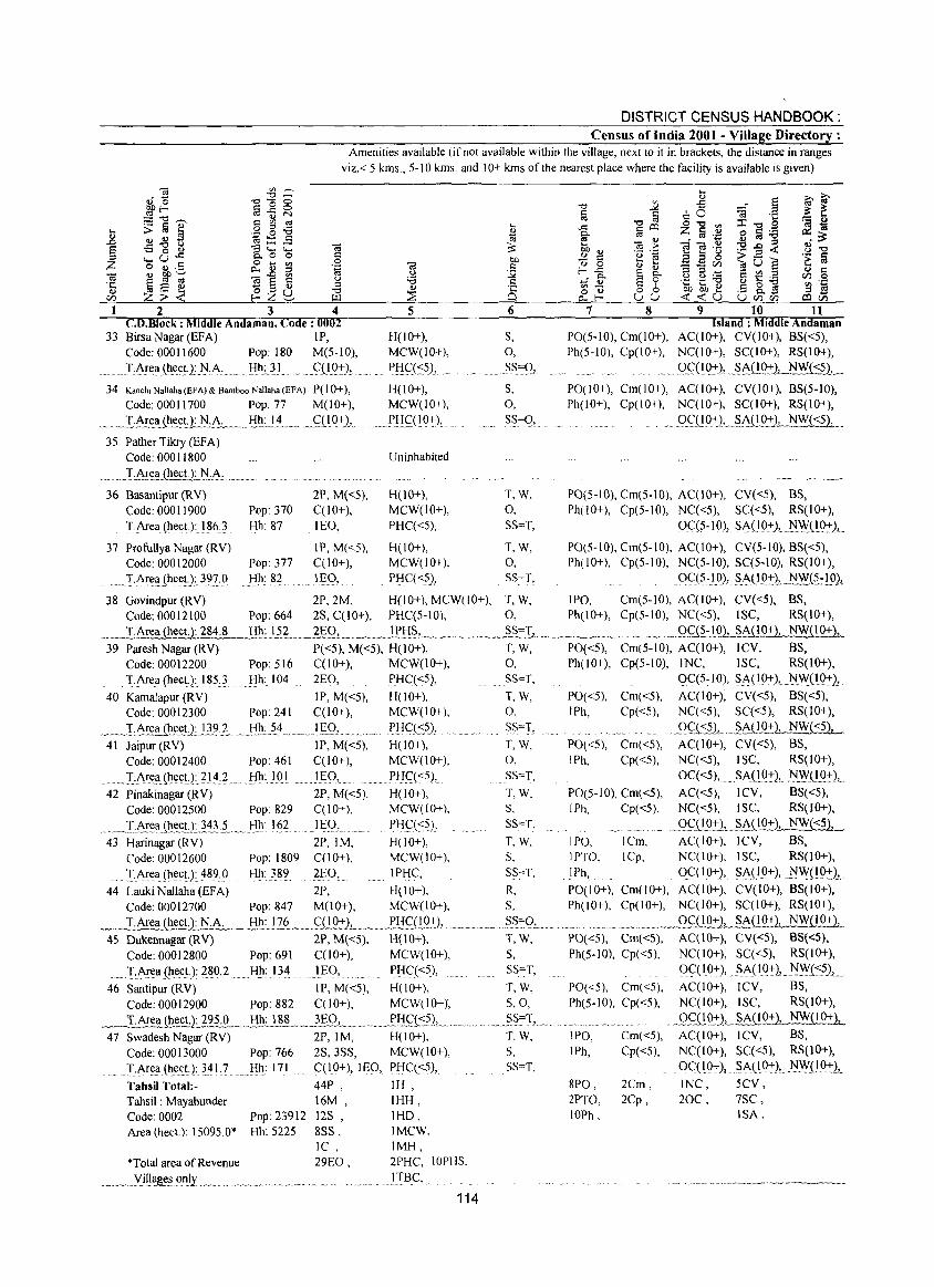
DISTRICT CENSUS HANDBOOK: Census of India 2001 - Village Directory :
Amenities available (if not available within the village, next to it in brackets, the distance in ranges viz. < 5 kms., 5-10 kms. and 10+ kms of the nearest place where the facility is available is given)
2 3 4 CO.Block : Middle Andaman, Code: 0002
33 Birsa Nagar (EFA) IP, Code: 00011600 Pop: 180 M(5-1O),
_TA.f(~a(h.~c!J.1'1~A· __ , !ih:. 31 ... "C(1.Q±)l
34 Kanch. NaHaha (EfA) & Bamboo NaHaha (EFA) P(lO+), Code: 00011700 Pop: 77 M(l 0+),
., .... .lA.!t:_a,ih.l:cU: ... N.A .......... lih:J.4 ... ___ ~.c I Q±l, 35 PatherTikry(EFA)
Code: 00011800
. __ _T.A!~1!JhecU_:_tiJ\:.. ... __ _
5
H(IO+), MCW(IO+),
PI:!CJ::=5), '
H(lO+), MCW(IO+),
_ " ?.!:!~( l 0,:),
Uninhabited
6
S, 0,
.§S=g,
S, 0,
S~~O,
36 Basantipur(RV) 2P,M«5), H(IO+), T,W. Code: 00011900 Pop: 370 C(lO+), MCW(lO+), 0, TArea(hect.):186.3 Hh: 87 lEO, PHC«5), SS=T,
37 Profullya Nagar (RV) IP, M«5), H(IO+), T, W, Code: 00012000 Pop: 377 C(lO+), MCW(IO+), 0,
.. )·.Ar~1I(hectJ:3nQ Hh: 82 lEO, PHC«?), SS=T,
... ;>,~ Q)
.~ "0
'0 1 oS ....: ; ~ g 6° «l o '0 '" ::X::",,;a ~~ ,.0::: gOO ;Z; § .~ §" Q)
<i«l .~ g a :a .~
t>ll <!) <a :> 'O..o~ 8"0 'B 'e ... ... <.>
~o ..!:! ::: E E 0 't § Q) 0 Q) Q)
__ CIl
s t! ~ f-,.o::: § 9-::l ::l _ Q) :::
~fr u u ._ CIl .!ia .- ._ '0
'" - .... .... Q) .5 8.] ~ s o Q) 0 0 t>ll0ll ... o..f- uu <C<CU UCllr/l a:lCll
7 8 9 10 11 Island: Middle Andaman
PO(5-10), Cm(lO+), AC(IO+), CV(IO+), BS«5), Ph(5-10), Cp(IO+), NC(IO+), SC(JO+), RS(IO+),
OS:(IQ+l, _§A(JQ±).!.J~}y[~L
PO(l 0+), Cm(l 0+), AC(IO+), CV(lO+), BS(5-10), Ph(lO+), Cp(lO+), NC(IO+), SC(lO+), RS(IO+),
Q~~(I()+),_,~AUQ:t:2, N~ _
PO(5-10), Cmt5-10), AC(lO+), CV«5), BS, Ph(IO+), Cp(5-10), NC«5), SC«5), RS(IO+),
0C(5-10), SA(10+), ~\:y(10±),
PO(5-10), Cm(5-10), AC(IO+), CV(5-10), BS«5), Ph(IO+), Cp(5-10), NC(5-10), SC(5-1O), RS(IO+),
0<::(5~lQ),. ~A(lQ±L_~J~.~1Q),
38 Govindpur (RV) 2P,2M, H(lO+), MCW(lO+), T, W, IPO, Cm(5-10), AC(IO+), CV«5), BS, Code: 00012100 Pop: 664 2S, C(10+), PHC(5-10), 0, Ph(IO+), Cp(5-10), NC«5), ISC, RS(lO+),
_~~ Hh: 152 2EO, ~~~ __ !!'.!:!§J_.~ __ ~_ .. ~ _~_._~§'''''_'L .... __ ~_' ___ M __ Q.q~:IO), SA~lO+), NW(IO+}!
39 Paresh Nagar (RV) P«5), M«5), H(lO+), T, W, PO«5), Cm(5-10), AC(10+), ICV, BS, Code: 00012200 Pop: 516 C(lO+), MCW(lO+), 0, Ph(IO+), Cp(5-10), INC, ISC, RS(lO+),
T.Area(hect.):185} Hh:I04 2EO, PHC«5), SS=T, QC(5-JO), SA(lO+), 1'1W(l9±),
40 KamaJapur (RV) IP, M«5), H(lO+), T, W, PO«5), Cm«5), AC(IO+), CV«5), BS«5), Code: 00012300 Pop: 241 C(10+), MCW(lO+), 0, [Ph, Cp«5), NC«5), SC«5), RS(IO+),
~_.I.A.~t;~.~ctJ: .. 11?l Hh:J4 ......... I£_Q,. PtIC:(-:5),. SS=T, 9c:ts21 ....... §A(L9.:t.:~ 41 Jaiput (RV) IP, M«5), H(IO+), T, W, PO«5), Cm«5), AC(IO+), CV«5), BS,
Code: 00012400 Pop: 461 C(lO+), MCW(IO+), 0, IPh, Cp«5), NC«5), ISC, RS(lO+),
.. IA~(!1I(ht:(;t.):II4:2. ..... Hh:JQI ..... IEO, ... PHc:«5), SS=T, OC«5), SAOQ±), N.WOQ±), 42 Pinakinagar(RV) 2P, M«5), H(lO+), T, W. PO(5-10), Cm«5), AC«5), ICV, BS«5),
Code: 00012500 Pop: 829 C(lO+), MCW(lO+), S, IPh, Cp«5), NC«5), ISC, RS(JO+),
. __ J:A!~~(hl:~U:343~._!tll: I?L lEQ) .. PH.C:(<;5), SS""T, Q.fDQ:+JL_~~Q_(t~1 NW{<51! 43 Harinagar(RV) 2P,IM, H(lO+), T, W, IPO, ICm, AC(IO+), ICV, BS,
Code: 00012600 Pop: 1809 C(lO+), MCW(JO+), S, IPTO. ICp, NC(10+), ISC, RS(JO+),
... T.Area(hect.): 489,0 Hh: 389 2r:O, IPHC, SS=T. I Ph, . 0C( I 0+), SA(lO+), .J:'IWQ.Q:!:)L
44 LaukiNaIlahaCEFA) 2P, H(JO+), R, PO(IO+), Cm(IO+), AC(IO+), CV(10+), BS(IO+), Code: 00012700 Pop: 847 M(lO+), MCW(IO+), S, Ph(JO+), Cp(IO+), NC(IO+), SC(lO+), RS(IO+),
~".~.",I~~ct.): J:'I·1L._,!iQ:JZ~._,.,q! 0+ 2,~" p.!:!£,nQ.·t:),. """__ ." ,~~~<1", ,~ OCi!Q:+::).L...§MIQ2:1~ 45 Dukennagar(RV) 2P, M«5), H(\O+), T, W, PO«5), Cm«S), AC(\O+), CV«S), BS«S),
Code: 00012800 Pop: 691 C(IO+), MCW(lO+), S, Ph(5-10), Cp«5), NC(IO+), SC«5), RS(IO+),
IArl:a(hect.):}~O,2 Hh: 134 ...... IEQ, pf1C(<;5), SS=T, QC(IO:+:), §A(IO+), NWt<:?),.
46 Santipur (RV) IP, M«5), H(IO+), T, W, PO«5), Cm«5), AC(IO+), ICV, BS, Code: 00012900 Pop: 882 C(lO+), MCW(lO+), S,O, Ph(5-10), Cp«5), NC(IO+), ISC, RS(IO+),
__ T.Are~.Qlect.): ~95.0 . __ .J!h.:.l.8A. .. ___ 3.E:.Q, ____ ... , __ .EIj.~,\::52,.. __ .2§=T, . _Qc:DQ:'+-l __ ~c\.(lQ~::1_ 47 Swadesh Nagar (RV) 2P,IM, H(lO+), T. W. IPO, Cm«5), AC(IO+), ICV, BS,
Code: 00013000 Pop: 766 2S,3SS, MCW(IO+), 5, lPh, Cp«5), NC(IO+), SC«5), RS(IO+),
TAr~~Che~t.):3~L? Hh: 171 C(IO+), lEO, PHC«5), 5S=T, OqIQ+), SA(I9±), 1'1W(lQ±),
Tahsil Total:- 44P , IH , Tahsil: Mayabunder 16M, IHH, Code: 0002 Pop: 23912 12S , lHD, Area (hect.): 15095.0* Hh: 5225 8SS, IMCW,
IC, IMH, *Total area of Revenue 29EO, 2PHC, 10PIIS,
. _., " .. y.m~g_t;~. ()IlJy .,. .. .. JIBC, ..
114
gPO,
2PTO, IOPh,
2Cm, 2Cp,
INC, 20C,
5CV, 7SC, ISA,
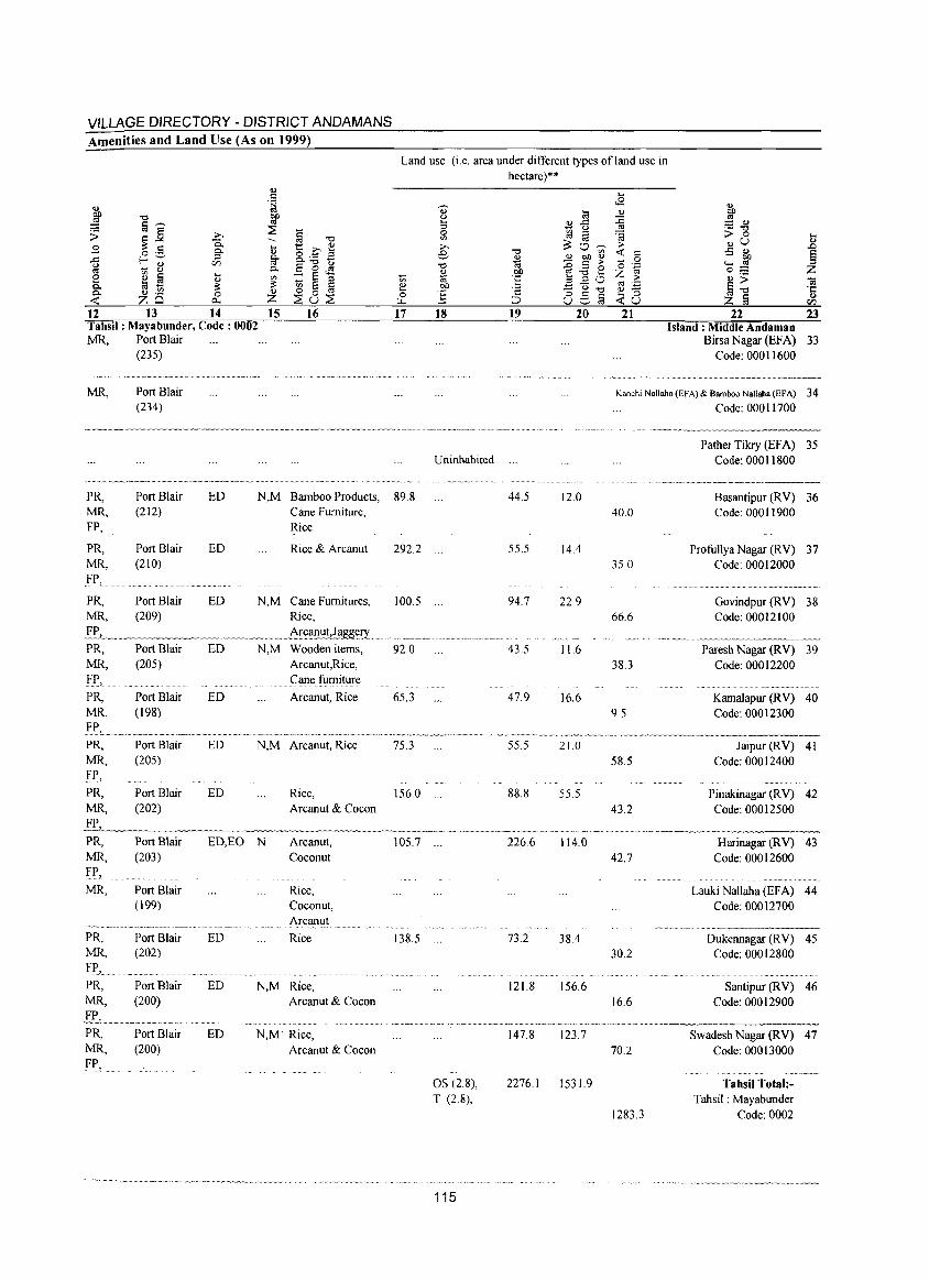
VILLAGE DIRECTORY - DISTRICT ANDAMANS Amenities and Land Use (As on 1999)
Land use (i.e. area under different types ofland use in hectare)**
12 13 14 15 16 17 Tahsil: Mayabunder, Code: 0002 MR, Port Blair
(235)
MR,
PR, MR, FP,
PR, MR, FP,
PR, MR,
Port Blair (234)
Port Blair (212)
Port Blair (210)
Port Blair (209)
ED
ED
N,M Bamboo Products, 89.8 Cane Furniture, Rice
Rice & Arcanut 292.2
ED N,M Cane Furnitures, 100.5 Rice,
'::":~.t_"_>_"_~ •• _~._~.~,. _"." .•••.• ~~ •• ~~£~.lI.!d~g~ry ... , PR, MR, FP,
PR, MR,
PR, MR, FP,
PR, MR,
Port Blair (205)
Port Blair (198)
Port Blair (205)
Port Blair (202)
ED N,M Wooden items,
ED
ED
Arcanut,Rice, Cane furniture
Arcanut, Rice
N,M Arcanut, Rice
92.0
65.3
75.3
ED Rice, 156.0 Arcanut & Cocon
18
Uninhabited
PR, MR, FP,
MR,
Port Blair (203)
ED,EO N Arcanut, Coconut
105.7 ."
PR, MR, Fr., PR, MR,
PR, MR,
Fr,
Port Blair (199)
Port Blair (202)
Port Blair (200)
Port Blair (200)
ED
ED
ED
Rice, Coconut, Arcanut
Rice
N,M Rice, Arcanut & Cocon
N,M Rice, Arcanut & Cocon
138.5
os (28), T (2.8),
115
19 20
44.5 12.0
55.5 14.4
94.7 22.9
43.5 11.6
47.9 16.6
55.5 21.0
88.8 55.5
226.6 114.0
73.2 38.4
121.8 156.6
147.8 123.7
2276.1 1531.9
21
Q)
~ = ., ._ -0
> 0 .,u .:; ~ ..... 0:1 0= .,> §-o z [ij 22 23
Island: Middle Andaman Birsa Nagar (EFA) 33
Code: 00011600
Kanchi Nallaha (EFA) & Bamboo Nallaha (EFA) 34 Code: 00011700
40.0
35.0
Pather Tikry (EFA) 35 Code: 00011800
Basantipur (RV) 36 Code: 00011900
Profullya Nagar (RV) 37 Code: 00012000
Govindpur (RV) 38 66.6 Code: 00012100
Paresh Nagar (RV) 39 38.3 Code: 00012200
Kamalapur (R V) 40 9,5 Code: 00012300
58.5
43.2
42.7
30.2
16.6
70.2
1283.3
Jaipur (RV) 41 Code: 00012400
Pinakinagar (RV) 42 Code: 00012500
Harinagar (RV) 43 Code: 00012600
Lauki Nallaha (EF A) 44 Code: 00012700
Dukennagar (RV) 45 Code: 00012800
Santipur (RV) 46 Code: 00012900
Swadesh Nagar (RV) 47 Code: 00013000
Tahsil Total:Tahsil: Mayabunder
Code: 0002
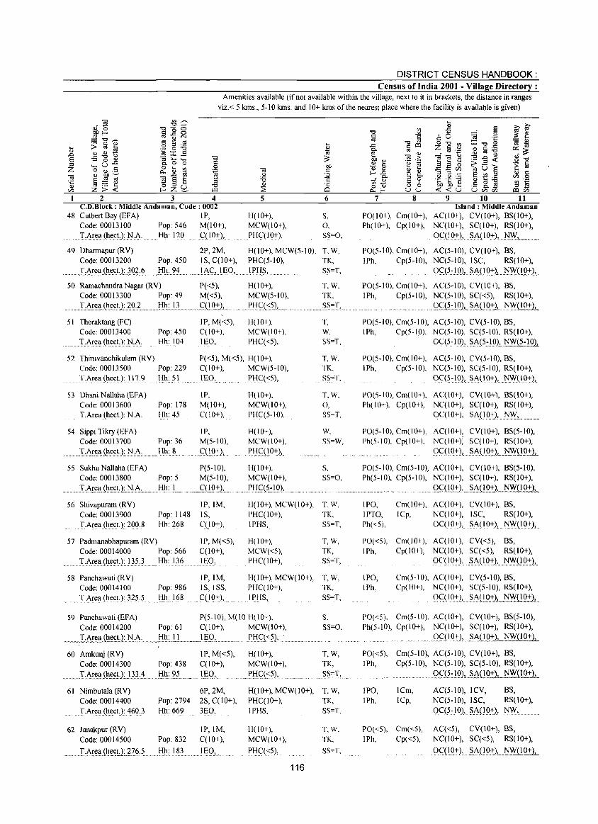
DISTRICT CENSUS HANDBOOK: Census of India 2001 - Village Directory :
Amenities available (if not available within the village, next to it in brackets, the distance in ranges viz.< 5 kms., 5-10 kms. and 10+ kms of the nearest place where the facility is available is given)
2 3 4 C.D.Block: Middle Andaman, Code; 0002
48 CutbertBay(EFA) IP, Code: 00013100 Pop: 546 M(10+), T,.i\r(:lI(hect): NJ\. Hh: 120 C(IO~},
5
H(IO+), MCW(IO+), PHC(IO+),
6
S, 0, SS=O,
49 Dharmapur (RY) 2P,2M, H(lO+), MCW(5-10), T, W, Code: 00013200 Pop: 450 IS, C(10+), PHCC5-1O), TK,
~_ .. J""J\rel_l(~~c!,,L}Q.~:~ Hh: 94 .!AC, lEO, .IPl!~, SS=T,
SO RamachandraNagar(RY) P«5), H(IO+), T,W, Code: 00013300 Pop: 49 M«5), MCW(5-10), TK,
~. __ T.~~ (hectllQ;l __ .... fl~.u._ .. __ C(lO~ ....... . RH~(::?21.~ .. ~ ..... _ .. S.~~I~ .. . 51 Thoraktang (FC)
Code: 00013400 IP, M«5),
Pop: 450 C(lO+), H(IO+), MCW(IO+),
PHC«5), . T.A!e~ (ht:c.t): ];JA Hh: 104 lEO,
52 Thiruvanchikulam (RY) P«5), M«5), H(IO+), Code: 00013500 Pop: 229 C(10+), MCW(5-10),
1':.i\rea(~ec.tJ:117.? Hh: 51 lEO, PHC«5),
S3 Dhani Nallaha (EFA) JP, M(IO+), C(lO+),
H(lO+), MCW(IO+), PHCC5-10),
Code: 00013600 Pop: 178 TArea(hect.): N.A. Hh: 45
54 SippiTikry(EFA) IP, H(lO+), Code: 00013700 Pop: 36 M(5-10), MCW(lO+),
.... _I6!~l_I~~t)~~:.i\; ........... .l:!~:.,.L ...... .5=(19::1..... ..PI:l~.O.9~., ..
55 Sukha Nallaha (EFA) P(5-10), H(10+), Code: 00013800 Pop: 5 M(5-10), MCW(IO+),
_ .•. I:.J\r~a (hec!l .. ~.cJ\.:.... .... I:IJ1:J~ .~c(lQ~L. _._.l'H~(~- I 02,._ ...
56 Shivapuram (RY) IP,IM, H(IO+), MCW(IO+),
Code: 00013900 Pop: 1148 IS, PHCC!O+),
.. T-A~ea (hect.):. 200.8 Hh: 268 CCI 0+), IPHS,
57 Padmanabhapuram (R Y) IP, M«5), H(IO+),
Code: 00014000 Pop: 566 C(10+), MCW«5),
T . .i\!el,l (~(!<:.t.):1}.5:3 Hh: 136 ... 1~O, PHCCIO+),
58 Panchawati (R Y) IP,IM, H(lO+), MCW(IO+), Code: 00014100 Pop: 986 IS, ISS, PHCCIO+),
.. T.i\rea (he(;(,L125.5 Hh: 168 C(10+.k IPI:lS,
S9 Panchawati (EFA) P(S-IO), M(lO H(IO+), Code: 00014200 Pop: 61 C(lO+), MCW(IO+),
T, W, SS=T,
T,W, TK, SS=T,
T,W,
0, SS=T,
W, SS=W,
S, Ss=o,
T,W, TK, SS=T,
T,W, TK, SS=T,
T,W, TK, SS=T,
S. SS=O,
_~_1-At:ea ~.c.t)~ .. ~·.~· ....... J.!~: .. lL.~__lI_:.Q!......... ~l:lf.(<5), ......... ~ ............ .
60 Amkunj (RY) IP, M«5), H(IO+), T,W, Code: 00014300 Pop: 438 C(lO+), MCW(lO+), TK,
SS=T, ..... T:.i\~(!l_I{t~:.4 .... !:!l!:?L .. I~QI ....... PH.~«5), 61 Nimbutala (RY)
Code: 00014400 T .Area (~(:ctJ: 460.3
6P,2M, Pop: 2794 2S, C(lO+), Hh: 669 3EO,
62 Janakpur (RY) IP,IM, Code: 00014500 Pop: 832 C(10+),
~_ L.i\I~~_(h~~!L~I6; 5. . .. I:I!_1: l§L.ww J r;Q,
H(lO+), MCW(lO+), T, W, PHCCIO+), TK, IPHS, SS=T,
1I(l0+), MCW(IO+),
PI-iC«5), .
116
T,W, TK,
SS=T,
7 8 9 10 11 Island: Middle Andaman
PO(IO+), Cm(lO+), ACCIO+), CY(IO+), BS(IO+), Ph(lO+), Cp(lO+), NC(IO+), SC(I 0+), RS(IO+),
0<::(10+), S.A(IO+), ~~,
PO(5-10), Cm(lO+), ACC5-10), CY(IO+), BS, IPh, Cp(5-10), NCC5-10), ISC, RS(JO+),
Oq5~.lQLS:J\S_l9.~2,_l!_~~j,_
PO(5-10), Cm(lO+), ACC5-10), CY(lO+), BS, IPh, Cp(5-10), NCC5-10), SCC<5), RS(IO+),
.Q~IO), SA(lO+), NW(10+),
PO(5-10), Cm(5-10), ACC5-10), CY(5-10), BS, IPh, Cp(5·10), NC(5-10), SC(5-10), RS(IO+),
Oq5~10), S.AJ5.-)O)LtlW(5-191.
PO(5-10), Cm(IO+), ACC5-10), CY(5-1O), BS, IPh, Cp(5-10), NCC5-10), SCC5-10), RS(IO+),
0C(5~lO), S.i\(l Q~), tlYl.(19:!:)}.
PO(5-10), Cm(lO+), ACC10+), CY(lO+), BS(10+), Ph(IO+), Cp(IO+), NC(lO+), SCC I 0+), RS(10+),
OC( I 0+), SA( 10+), .. tl~L .. _,,_
PO(5-10), Cm(IO+), ACCIO+), CY(lO+), BS(5-10), Ph(5-10), Cp(lO+), NC(lO+); SC(I 0+), RS(lO+),
9<::(I9:+-1,.5A( I Q:t-l,--~~( 1 0+),
PO(5-tO), Cm(5-10), ACCIO+), CY(IO+), BS(5-IO), Ph(5-10), Cp(5-10), NCCIO+), SCCIO+), RS(IO+),
... _ .... ,... . ..... Q.C(!921_SA(IO+_1_ NW(lO+),
IPO, IPTO, Ph«5),
Cm(lO+), AC(lO+), CY(lO+), BS, ICp, NCCIO+), ISC, RS(IO+),
OC(10+), SAO 0+), . ~Yl.(lQ:t-)L
PO«5), Cm(lO+), ACCIO+), CY«5), BS, IPh, Cp(lO+), NCCIO+), SCC<5), RS(10+),
OCC IO+), §A(10~), NYl.QQ:l:) ..
IPO, Cm(5-10), ACCIO+), CY(5-10), BS, IPh, Cp(IO+), NCCIO+), SCC5-10), RS(IO+),
9<::(19:t:),_ §.A(l921 .. _NW(10+L
PO«S), Cm(5-10), AC(IO+), CY(IO+), BS(5-10), Ph(5-10), Cp(lO+), NCCIO+), SCClO+), RS(lO+),
.... 9S:(IO .. ~), .~~U.9_~, NW(IO+),
PO«5), Cm(5-10), ACC5-10), CY(IO+), BS, IPh, Cp(5-10), NCC5-10), SCC5-10), RS(IO+),
IPO, IPh,
ICm, ICp,
PO«5), Cm«5), I Ph, Cpr <5),
Qq~:l.9L~D9::1 NW(IO+),
AC(5-10), ICY, BS, NCC5-1O), ISC, RS(IO+),
0C(5~IO), §ACl~), NYl.,
AC«5), CY(IO+), BS, NCCIO+), SCC<5), RS(IO+),
QC::(LQ:t), .. § .. J\: .. (1..Q.:J:), NW{1O+2,
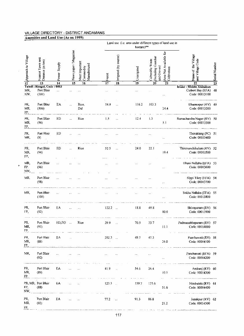
VILLAGE DIRECTORY - DISTRICT ANDAMANS Amenities and Land Use (As on 1999)
Land use (i.e. area under different types ofland use in hectare)**
<U ... . ~
0-c.8 .,
~ til .,
~ -c ~ u ~ a--- !3 <l) ..<: :::: <l)
~ § ~ u «l ._ -c
:> s:~ >. 0 ::l '§ > 0 ... p. -c '" ;::Ov;- OJU
., £ ... '8 c ~ >. >
~ <5 .5 0.. ., e -c <t: ::: .s ., -= f-<"_" ::l 0.. o..'_ a ~ 2 & ~ 0 ..... ~ ~ - 8
rFJ «l E-g~ -c ~ ~ e '0 ''::;: Z 0.. OJ OJ) Z «l 0;:;: e ~ ta ... ~ :: § ;:l ti 'oj :~ ., > ., a20 > <il
0.. ~ .1?i ~ ~ OJ) ~ ';:: §-c ~ 0 ta _ u -c .,- 'J:: 0.. 0 Z 0 ~ ::: 8:s§ ... ;:l .,
<t: ~Q 0... ~u~ ~ ;:J <t:u z § rFJ
12 13 14 15 16 17 18 19 20 21 22 23 Tahsil: Rangat, Code: 0003 Island: Middle Andaman MR. Port Blair Cutbert Bay (EFA) 48
.NW. (101) Code: 00013100
. ........................ _-_ ........
PRo Port Blair EA Rice. 58.8 116.2 103.3 Dharrnapur (RV) 49 MR. (106) Oat 24.4 Code: 00013200
····v_,·'"w·.· __ '"w. __ . ," .. -.. -,","',"-'-"'-~-----
PRo Port Blair ED Rice 1.5 12.4 I.3 Rarnachandra Nagar (R V) 50 MR. (96) 5.1 Code: 00013300
-,--~.~.---~,".~,-
PRo Port Blair ED Thoraktang (FC) 51 MR. (9) Code: 00013400
po'_ ~"'~,","~',"" ~-"-"-~~--~'''~''--'-''' .. --~.=~.~---
PR •. Port Blair ED Rice 52.5 24.0 22.1 Thiruvanchikularn (RV) 52 MR. (94) 19.4 Code: 00013500 FP.
MR. Port Blair Dhani Nallaha (EFA) 53 FP. (96) Code: 00013600 NW.
~ •••• ~ •• o ••••••••••• ~_.~_._ •••••
MR. Port Blair Sippi Tikry (EFA) 54 (98) Code: 00013700
. " . ~."~" ~_N. ,_".,,~.~.~~,_._ ...
MR. Port Blair Sukha Nallaha (EFA) 55 (100) Code: 00013800
. _o_, .~~ ... __ ._~~ .. __ .. _._,, __ .... _~ . ·._W···~·_"_· ._~_._ ...... . ..... ~ .. --~-.-
PRo Port Blair EA 122.2 ". IS.S 49.S Shivapurarn (RV) 56 FP. (92) 10.0 Code: 00013900
.................. " .. _ ........
PRo Port Blair ED.EO ". Rice 29.9 70.5 23.7 Padmanabhapurarn (RV) 57 MR. (91) 11.1 Code: 00014000 FP.
'" ... '"'".~, ........ -~
PRo Port Blair EA 202.3 49.7 47.5 Panchawati (RV) 58 MR. (88) 26.0 Code: 00014100
~~~~_~VA~ ________
MR. Port Blair Panchawati (EFA) 59 (92) Code: 00014200
.... -~-.. --.--.
PRo Port Blair EA 41.9 54.6 26.4 Amkunj (RV) 60 MR. (89) 10.5 Code: 00014300 E!', v''··yy· _____
PRo MR. Port Blair EA 123.3 159.7 125.6 Nimbutala (RV) 61 FP. (88) 51.6 Code: 00014400 }.!W.
PRo Port Blair EA 77.2 91.3 86.8 Janakpur (RV) 62 MR. (92) 21.2 Code: 00014500 E,E,. ___
o.Y'~"_" .. _.~ ____ ._
117
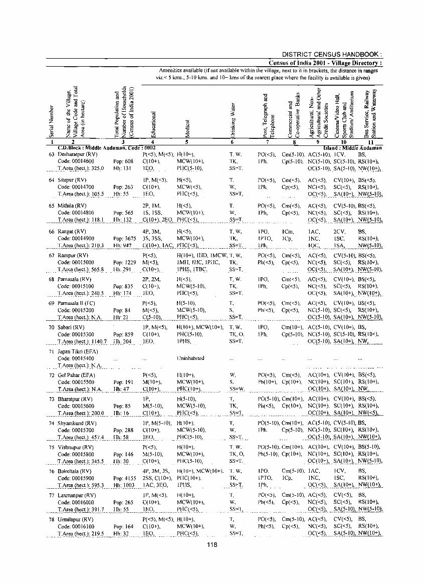
DISTRICT CENSUS HANDBOOK: Census of India 2001 - Village Directory :
Amenities available (if not available within the village, next to it in brackets, the distance in ranges viz.< 5 kms., 5-10 kms. and 10+ kms of the nearest place where the facility is available is given)
2 3 4 5 c.n.Block : Middle Andaman, Code: 0002
63 Desharatpur(RV) P«5), M«5), H(10+), Code: 00014600 Pop: 608 C(10+), MCW(IO+), T:Are(i(~ect):3?5,0 Hh: 131 IE9, PlIq5~10),
64 Sitapur (RV) Code: 00014700 Pop: 263
Hh: 55
IP, M«5), C(10+), lEO,
H«5), MCW«5), PHC«5), . T ~Ar(!a.(hectJ!05,5
65 Mithila(RV) 2P,IM, H«5), Code: 00014800 Pop: 565 IS, ISS, MCW(lO+),
~ __ ~1:Area.(~~~nJ.!!L",_ .... !!~: .. 1}~._.~C(!0+2,.2§Q.L.PtIC:(::=~lL ..... _ ..
66 Rangat (RV) 4P,3M, H«5), Code: 00014900 Pop: 3675 3S,3SS, MCW(lO+),
6
T.W. TK. SS=T.
T. W,
SS=T,
T. W, SS=T.
T,W, TK,
_.~!~I~a (hect.): 210.3 ....J:!!!:_~Q.._ . .fQQ2:1_.I.AC,_~!!.9~1. .. ____ .. S.S.",I,. 67 Rampur(RV) P«5), H(lO+), IHD, IMCW, T, W,
Code: 00015000 T.Area (hect.):565.8
68 Pamasala (R V) Code: 00015100
........ ·T,Are(i(h(!ct.):.24Q.5
69 Pamasala II (FC) Code: 00015200 T.Area {hect.): N.A.
70 Sabari (RV) Code: 00015300
..... JAr(!a (~e~tJ II ~O. 7
71 Japan Tikri (EFA) Code: 00015400 Thea (hect): N.A.
Pop: 1229 M«5), IMH, !HC, IPHC, Hh: 291 ql0+), IPHS,ITBC,
2P,2M, H«5), Pop: 835 C(lO+), MCW(5-10), Hh: 174 lEO, PHC«5),
P«5), H(5-10), Pop: 84 M«5), MCW(5-10),
Hh~.?L ____ <::{?-1 OL._J:'HC(::?2, ___ ...... _ ...
IP, M«5), H(IO+), MCW(IO+), Pop: 859 C(lO+), PHC(5-10), Hh: 204 lEO, IPHS,
Uninhabited
TK, SS=T,
T,W, TK. SS=T,
T, S,
.. S§",T,
T,W, TK.O, SS=T,
72 Gol Pahar (EFA) P«5), H(lO+), W, Code: 00015500 Pop: 191 M(lO+), MCW(IO+), S,
~ I:~~~~U:)'.I·A ... H!t:..±? .. ~ .~DQ_-+:), ..... _~e!!g)Q+)L.. .§§:\V,
73 Bharatpur (RV) IP, H(5-10), T, Code: 00015600 Pop: 85 M(5-10), MCW(5-10), TK,
... ~ .... .I·~:.c:~Jh~,:tJ~.?O.Q,Q .... ~:J.L ...... ~nQ7:1 .. " ..... ~P!:!.c::(::=5),.. ..~ .. ~~~I~ 74 Shyamkund (RV) IP, M(5-10), H(lO+), T,
Code: 00015700 Pop: 288 C(10+), MCW(5-10), W,
._ .... J..:.~!:e,(i.{h.~~U.:.±?.?c4__ .. _!!!J: .. 5.~_ ... _.1J;:Q,...... ... ~l.'q5~~Q),.. SS=T,
75 Vishnupur(RV) P«5), H(IO+), T, W, Code: 00015800 Pop: 146 M(5-10), MCW(IO+), TK,O, :T.~ea(he£t):}~5:5 Hh: 30 C(IO+), PHC(5-10), SS=T,
76 Bakultala(RV) 4P, 3M, 3S, H(IO+), MCW(IO+), T, W, Code: 00015900 Pop: 4155 2SS, C(lO+), PHC(IO+). TK.
... I:~r~(i(h._e~tl??5}. Hh: 1003 ... I~<::,JEO, IPHS, SS=T,
77 Laxmanpur (RV) IP, M«5), H(lO+), Code: 00016000 Pop: 265 C(10+), MCW(IO+),
... ___ T.A~!iJ.h~lJ 39LL,,..l:!L5_? __ ......... IJ;:Q, .. __ ,_. , ____ Xf:IG«5), ...
78 Urmilapur(RV) P«5),M«5), H(IO+), Code: 00016100 Pop: 164 C(10+), MCW(1O+),
.. _.~_1:}\I.~a_(h.e_ctJ~?l'?:~ .... _ .... _l:-Ih.:~ .......... )~9L ..... Plt(:«5),
118
T,
w. SS=T,
A '" ~ w "~ .'A' _
T, W,
SS=T,
7
PO«5), IPh,
8 9 10 11 Island: Middle Andaman
Cm(5-10), AC(5-10), ICV, BS, Cp(5-10), NC(5-10), SC(5-10), RS(10+),
0C(5~10), .SA(5-10), )'.I\y'(IQ:+:),
PO«5), Cm«5), I Ph, Cp( <5),
AC«5), CV(lO+), BS«5), NC«5), SC«5), RS(1O+), OC.( <5), SA(1Q+), .1'I.\Y.(~:!Q2t
PO«5), Cm«5), AC«5), CV(5-10), BS«5), IPh, Cp«5), NC«5), SC«5), RS(lO+),
QQ::=5), ... §An9..-+:)L_NFJ5..:lQ1.
IPO, ICm, lAC, 2CV, BS, IPTO, ICp, INC, ISe, RS(10+),
. •• _~~~L. ••••...•....•• . ... I.Q<2,. ~ .. Y~!'-, NW{5-102,
PO«5), Cm«5), AC«5), CV(5-IO), BS«5), Ph«5), Cp«5), NC«5), SC«5), RS(lO+),
gc:«?), ... Si\(IQ-+:), )'.I\Y.(?:l.Q),
IPO, Cm«5), AC«5), CV(IO+), BS«5), IPh, Cp«5), NC«5), SC«5), RS(IO+),
0C«5), Si\(IQ:+:),.)'.I\y'U.Q:+l, ..
PO«5), Cm«5), AC«5), CV(IO+), BS«5), Ph«5), Cp«5), NC(5-10), SC«S), RS(lO+),
gc::(5-IQl SA(lO+), NW(5-102,
IPO, Cm(lO+), AC(5-10), CY(IO+), BS, IPh, Cp(5-10), NC(5-10), SC(5-10), RS(1O+),
0C:<?~1.0),. §_f\o. 0+ LN.\Y.,___
PO«5), Cm«5), AC(IO+), CV(lO+), BS«5), Ph(IO+), Cp(lO+), NC(IO+), SC(IO+), RS(10+),
. 9.f(!Q.+L §~'(1.Q:t)-'. __ ~
PO(5-10), Cm(IO+), AC(IO+), CV(IO+), BS«5), Ph«5), Cp(IO+), NC(IO+), SC(IO+), RS(10+),
_ .. g<::(LQ'!:1_ .. ~M!Q+l, NW..J.:2L
PO(5-10), Cm(IO+), AC(5-1O), CV(5-IO), BS, IPh, Cp(5-10), NC(5-10), SC(I 0+), RS(lO+),
9<::.<?:1.Q), ~~Q~2L_~l.Q:!:1.. PO(S-IO), Cm(IO+), AC(lO+), CV(IO+), BS(5-10), Ph(5-10), Cp(IO+), NC(IO+), SC(10+), RS(lO+),
OqIO:+:}, ~A(10:+:), )'.I~(?:IQ),
IPO, Cm(S-IO), lAC, ICV, BS, IPTO, ICp, INC, ISC, RS(IO+),
I Ph, oq <?), . ~}\nQ.:+:),._N!YU.Q~_
PO«5), Cm(5-10), AC«5), CV«5), BS, Ph«5), Cp«5), NC«5), SC«5), RS(1O+),
" .... Q.f{:55)1._~,~}\1~:IQ2, NW(5-10),
PO«5), Cm(5-10), AC«5), CV«5), BS, Ph«S), Cp«5), NC«5), SC«5), RS(IO+),
.Qq:c?L. ~.~.(~:!Q), NW(1O+2, .
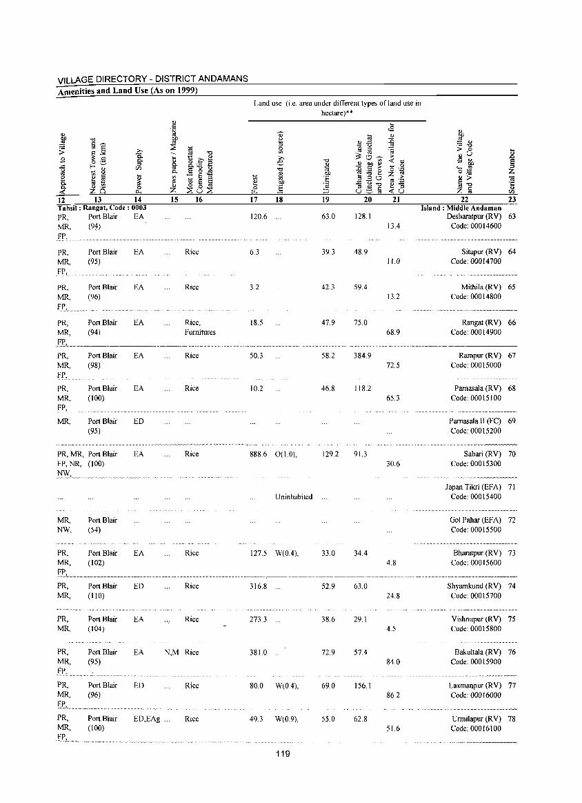
VILLAGE DIRECTORY - DISTRICT ANDAMANS Amenities and Land Use (As on 1999)
12 13 14 Tahsil: Rangat, Code: 0003 PR, Port Blair EA MR, (9~)
FP,
PR, MR, FP,_ .
PR, MR, FY,
PR, MR,
PR, MR, FP,
PR, MR. FP, ..
MR,
Port Blair (95)
Port Blair (96)
Port Blair (94)
Port Blair (98)
Port Blair (100)
Port Blair (95)
PR, MR, Port Blair FP, NR, (100)
MR, NW,
PR, MR,
PR, MR,
PR, MR,
PR, MR,
PR, MR,
Port Blair (54)
Port Blair (102)
Port Blair (110)
Port Blair (104)
Port Blair (95)
Port Blair (96)
EA
EA
EA
EA
EA
ED
EA
EA
ED
EA
EA
ED
15 16
Rice
Rice
Rice, Furnitures
Rice
Rice
Rice
Rice
Rice
Rice
N,M Rice
Rice
PR, Port Blair ED,EAg ... Rice MR, (100)
£_1_>1.. _.~ .. _ ............. ~ .......... _ ................. .
Land use (i.e. area under different types of land use in hectare)"
17 18 19 20 21
120.6 63.0 128.1 13.4
6.3 39.3 48.9 11.0
3.2 42.3 59.4 13.2
18.5 47.9 75.0 68.9
22 23 Island: Middle Andaman
Desharatpur (RV) 63 Code: 00014600
Sitapur (RV) 64 Code: 00014700
Mithila (RV) 65 Code: 00014800
Rangat (R V) 66 Code: 00014900
.................... _-_ .. _ ... _------50.3 58.2
10.2 46.8
888.6 O( 1.0), 129.2
Uninhabited
127.5 W(0.4), 33.0
316.8 ... 52.9
2733 ... 38.6
381.0 ... 72.9
80.0 W(04), 69.0
49.3 W(0.9), 55.0
119
384.9 72.5
118.2 65.3
91.3 30.6
34.4 4.8
63.0 24.8
29.1 4.5
57.4 84.0
156.1 86.2
62.8 51.6
Rarnpur (RV) 67 Code: 00015000
Pamasala (RV) 68 Code: 00015100
Pamasala II (FC) 69 Code: 00015200
Sabari (RV) 70 Code: 00015300
Japan Tilai (EFA) 71 Code: 00015400
Gol Pahar (EFA) 72 Code: 00015500
Bharatpur (RV) 73 Code: 00015600
Shyarnkund (RV) 74 Code: 00015700
Vishnupur (RV) 75 Code: 00015800
Bakultala (RV) 76 Code: 00015900
Laxmanpur (R V) 77 Code: 00016000
Urmilapur (RV) 78 Code: 00016100
. ..... _ ... _ ... _---
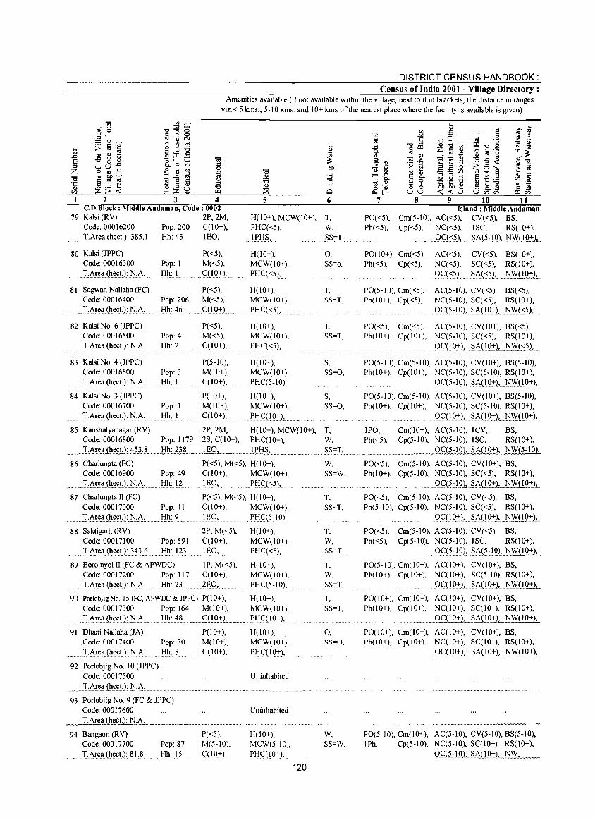
1 2 3 4 C.D.Block : Middle Andaman, Code: 0002
DISTRICT CENSUS HANDBOOK: Census of India 2001 - Village Directory:
Amenities available (if not available within the village, next to it in brackets, the distance in ranges viz.< 5 kms., 5-10 kms. and 10+ kms of the nearest place where the facility is available is given)
5 6 7 8 9 10 11 Island: Middle Andaman
79 Kalsi (RV) 2P,2M, H(10+), MCW(10+), T, PO«5), Ph«5),
Cm(5-10), AC«5), CV«5), BS, Code: 00016200 Pop: 200 C(10+), PHC«5), W, TArea(he(;t):}8?J Hh: 43 .... lflQ, IPH~, SS=T,
80 Kalsi (JPPC) Code: 00016300 .T,AreliJh.ect): r-/:.'<\.
Pop: I Hh: I
P«5), M«5), C(10+),
81 Sagwan Nallaha (FC) P«5), Code: 00016400 Pop: 206 M«5),
_ .... I~~~~£.t,,2: N·A., .. _ .... Hh~ ~~~_ ... C:(LQ:!:)J ....
H(10+), MCW(10+), PHC«5),.
H(IO+), MCW(lO+),
I'H_c:(~),
82 Kalsi NO.6 (JPPC) P( <5), H( I 0+), Code: 00016500 Pop: 4 M«5), MCW(lO+),
_ ._L.A!:e~.(h~~tlJi.A·.. . }:.rh~ L ," .... Cn 0:+-), ............ PtIC:L<j),
0, SS=o,
T, SS=T,
T, SS=T,
Cp«5), NC«5), ISC, RS(IO+), OC«5), .SA(5~10),NWO~),
P0(10+), Cm«5), AC«5), CV«5), BS(1O+), Ph«5), Cp«5), NC«5), SC«5), RS(lO+).
.9.<::«?2 •..... SA(~5)L .. N\Y.QQ:+-l
PO(5-10), Cm«5), AC(5-10), CV«5), BS«5), Ph(lO+), Cp«5), NC(5-10), SC«5), RS(IO+),
. Qc:J1:IQ_h SA(IO+), NW«5),
PO«5), Cm«5), AC(5-10), CV(IO+), BS«5), Ph(IO+), Cp(IO+), NC(5-10), SC«5), RS(IO+),
g~('!021_§.A(10+), NW«5),
83 Kalsi No.4 (JPPC) P(5-10), H(10+), S, PO(5-10), Cm(5-1 0), AC(5-10), CV(IO+), BS(5-10), Code: 00016600 Pop: 3 M(IO+), MCW(IO+), S5=0, Ph(lO+), Cp(IO+), NC(5-10), SC(5-10), RS(IO+),
. T,Area{hect,): N,A Hh: I C(10+), PHC(5-10), OC(5~10), SA(19:+-), NWOQ±),
84 Kalsi NO.3 (JPPC) P(10+), H(10+), S, PO(5-10), Cm(5-10), AC(5-10), CV(IO+), BS(5-10), Code: 00016700 Pop: 1 M(10+), MCW(10+), SS=O, Ph(IO+), Cp(IO+), NC(5-10), SC(5-10), RS(IO+) •
.. I~~.li(h~c.tJ: .r-/:!~ ............ Jih: . ..!. ~ .~00±)., .. ....... PtIC(IO+),. 0<::(10:+-}, ~A{!O±2, ... NW(,!9:!-)-, .. 85 Kaushalyanagar (RV) 2P,2M, H(10+), MCW(IO+), T, IPO, Cm(lO+), AC(5-1O), ICV, BS,
Code: 00016800 Pop: 1179 2S, C(10+), PHC(IO+), W, Ph«5), Cp(5-10), NC(5-10), ISC, RS(IO+),
_ .. ~ T.Are<lJ!t~.tJ~.:!.53.8 .. _ H~~~._._!.fl..9 ... L.~ •• , ... lPB.S-'-- __ .. _. __ ..... "S§.:I, ... _ ... ". __ ............ m_ 0C(5-10), SA(lO+), NW{5-10),
86 Charlungta(FC) P«5), M«5), H(lO+), W. PO«5), Cm(5-10), AC(5-10), CV(JO+), BS, Code: 00016900 Pop: 49 C(JO+), MCW(IO+), SS=W, Ph(lO+), Cp(5-10), NC(5-10), SC«5), RS(IO+),
...... .T:Ar.(:l!.~c!:LN,.A, Hh: 12 _1~9,.. .PJ:IC(<:;5),. Q<::(5:J.ol.~A00+), NW(IO+),
87 CharlungtaII(FC) P«5), M«5), H(IO+), T, PO«5), Cm(5-10), AC(5-10), CV«5), BS, Code: 00017000 Pop: 41 C(10+), MCW(lO+), SS=T, Ph(5-10), Cp(5-10), NC(5-10), SC«5), RS(IO+), T·A!~<l(he(;tJ:N,A: Hh: 9 ........ IEQ, PtIC(5~JO), 0<::(10+), ~A(IO+)., .NY.{(.!Q:t:)1...
88 Saktigarh (RV) 2P, M«5), H(IO+), T, PO«5), Cm(5-10), AC(5-IO), CV«5), BS, Code: 00017100 Pop: 591 C(10+), MCW(IO+), W, Ph«5), Cp(S-IO), NC(5-10), ISC, RS(lO+),
.. T.Area,(he~t.J:}.~3§ Hh: 123 lEO, PHC«5), SS=T, Oq5~lg), ~A(5~lg)'__NW092),__
89 Boroinyol II (FC & APWDC) IP, M«5), H(IO+), Code: 00017200 Pop: 117 C(10+), MCW(lO+),
.. ~ .... ,"",,T .A!~~(h~!l}!:~_~!ih.:..~3 .. ,~ .. __ ~£Q.L. ~,,,. "PtICJ~~IO),
T,
W, SS=T,
PO(S-IO), Cm(IO+), AC(IO+), CV(IO+), BS, Ph(lO+), Cp(lO+), NC(lO+), SC(5-IO), RS(IO+),
QlliQ::I:).!..... SAC!.D:+-), NW(IO+),
90 PorlobjigNo.15(FC,APWDC&JPPC) P(10+), H(10+), T, PO(IO+), Cm(IO+), AC(JO+), CV(10+), BS, Code: 00017300 Pop: 164 M(lO+), MCW(lO+), SS=T, Ph(10+), Cp(IO+), NC(IO+), SC(1O+), RS(10+),
_ . ..1 .. Area (hect.): N.A._ .... Hh:~ __ C(10+)", ___ J'!f£(LQ:!:L,_~.~ __ . ______ ~_ _ _____ g~.i!O:+-J,_§MIO+), NW(IO+),
91 Dhani Nallaha(JA) P(IO+), H(lO+), 0, PO(IO+), Cm(JO+), AC(IO+), CV(JO+), BS, .Code: 00017400 .Pop: 30 M(10+), MCW(IO+), SS=O, Ph(10+), Cp(10+), NC(IO+), SC(IO+), RS(IO+), T·Area(he.ct.J:N,A. Hh: 8 C(10±), PtIC(IO+), 0<::(10+), ~A(19:+-), NW.(1Q~1
92 Porlobjig No, 10 (JPPC) Code: 00017500 Uninhabited
.I,A!e.<l(~~~!): r-/·A·
93 Porlobjig No.9 (FC & JPPC) Code: 00017600 T .Area (hec_!:L N .A .. _~_. ___ ._~ ... __ . ___ , ___ ,_
94 Bangaon (RY) P«5), Code 00017700 Pop: 87 M(5-10), T.Area(hect): 818 Hh: 15 C(lO+),
Uninhabited
H(IO+), MCW(5-10), PHC(lO+),
W, SS=W,
120
PO(5-10), Cm(IO+), AC(5-10), CV(5-IO), BS(5-10), lPh, Cp(5-10), NC(5-10), SC(I 0+), RS(IO+),
0C;:(5-1 0), ~A.L!Q±L.r-/c.;.,:WCL' _~
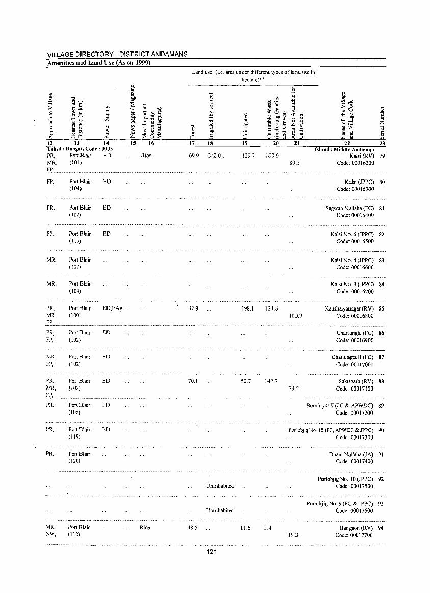
VILLAGE DIRECTORY - DISTRICT ANDAMANS Amenities and Land Use (As on 1999)
'" E "" :;: §]: ;> .g .9 ~ o .5 g. ]
E-<"_' U'J ..... 8
~ § .... 8 '" 0- til ..... ::: ~
tV .~ 0 ZQ c..,
12 13 14 Tahsil: Rangat, Code: 0003 PR, MR,
FP,
PR,
FP,
MR,
MR,
PR, MR,
PR, FP,
MR, FP,
PR, MR, FP,» ...
PR,
PR,
Port Blair (101)
Port Blair (104)
Port Blair (102)
Port Blair (115)
Port Blair (107)
Port Blair (104)
..... ~-.~ ...... ~ .. ~ .. "~ .. '"
Port Blair (100)
Port Blair (102)
Port Blair (102)
Port Blair (102)
Port Blair (106)
Port Blair (119)
ED
ED
ED
ED
ED,EAg
ED
ED
ED
ED
ED
~~··-~·-'-'-~·""~'Y"'-Y""'~- .. -.... --~--"-
PR,
MR, NW,
Port Blair (120)
Port Blair (l12)
'" .S t;J ~
::E § "" .... E .E' ~ '" fir p. "" .....
0- E o.IS '" :: S :::l ::: '" S § Z ~8~ 15 16
Rice
'"
Rice
Land use (i.e. area under different types ofland use in hectare)'"
., ~ 0
'" ;;., e "" OJ ;;; 1;;
~ OJ)
0 ] ~
17 ]8 ]9
69.9 0(2.0), 129.7
32.9 198.1
70.1 52.7
Uninhabited ...
Uninhabited
48.5 11.6
121
20
103.0
121.8
147.7
2.4
2]
80.5
100.9
73.2
22 23 Island: Middle Andaman
Kalsi (RV) 79 Code: 00016200
Kalsi (JPPC) 80 Code: 00016300
Sagwan Nallaha (FC) 81 Code: 00016400
Kalsi No.6 (JPPC) 82 Code: 00016500
Kalsi NO.4 (JPPC) 83 Code: 00016600
Kalsi NO.3 (JPPC) 84 Code: 00016700
Kaushalyanagar (RV) 85 Code: 00016800
Charlungta (FC) 86 Code: 00016900
Charlungta II (FC) 87 Code: 00017000
Saktigarh (RV) 88 Code: 00017100
Boroinyol II (Fe & APWDC) 89 Code: 00017200
Porlobjig No. 15 (FC, APWDC & JPPC) 90 Code: 00017300
19.3
Dhani Nallaha (JA) 91 Code: 00017400
Porlobjig No. 10 (]PPC) 92 Code: 00017500
Porlobjig No.9 (FC & JPPC) 93 Code: 00017600
Bangaon (R V) 94 Code: 00017700
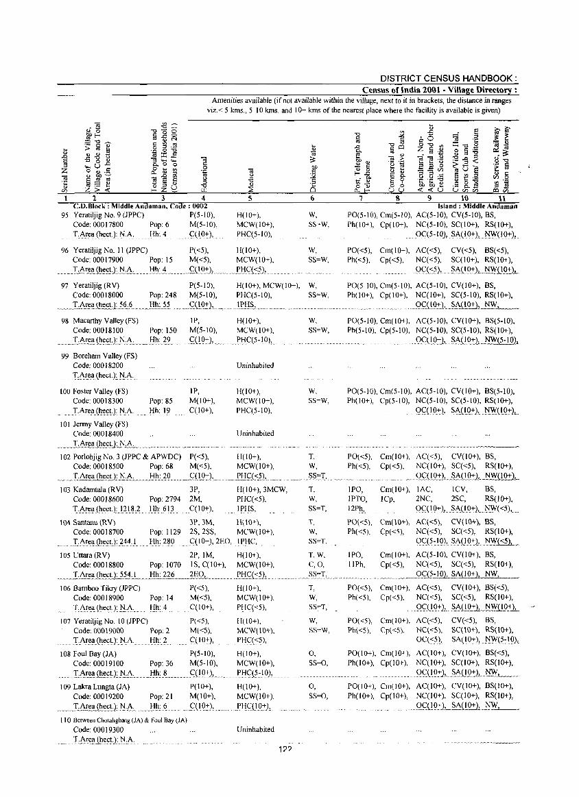
DISTRICT CENSUS HANDBOOK: Census of India 2001 - Village Directory :
Amenities available (if not available within the village, next to it in brackets, the distance in ranges viz.< 5 kms., 5-10 kms. and 10+ kms of the nearest place where the facility is available is given)
2 3 4 C.D.Block: Middle Andaman, Code: 0002
95 Yeratiljig No.9 (JPPC) P(5-JO), Code: 00017800 Pop: 6 M(5-10),
T,ArellChl!ct.J:N·A: Hh: 4 CCIO+),
5
H(IO+), MCW(IO+), PHqs-IO),
96 Yeratiljig No. II (JPPC) P«5), H(JO+), Code: 00017900 Pop: IS M«5), MCW(lO+),
. _.I;..A~~~ iliI!~U:.~.L ........ ~:~ ... __ ...... ~{1.~L ............ ~H~.\<:.?2, .. .
6
W, SS=W,
W, SS=W,
'0 §
j s 9 10 11 Island: Middle Andaman
PO(5-10), Cm(S-IO), AC(5-10), CV(5-10), BS, Ph(lO+), Cp(lO+), NC(5-1O), SC(IO+), RS(IO+),
.. oC(S-} 0), .. SA(IO+), ~"Y(1<J::r2,
PO«5), Cm(lO+), AC«5), CV«5), BS«5), Ph«5), Cp«5), NC«S), SC(10+), RS(IO+),
.9C(<:_5), .. m .$.A{!'():+:)L..~~( 1 0+) ...
97 Yeratiljig (RV) P(5-10), H(lO+), MCW(lO+), W, PO(5-10), Cm(S-IO), AC(5-10), CV(10+), BS, Code: 00018000 Pop: 248 M(5-10), PHC(5-1O), SS=W, Ph(lO+), Cp(lO+), NC(IO+), SC(S-IO), RS(IO+),
~m__lA!:l!ll(hect.):l§':~._ .. ~ Hh: 1.1.~ ... _ .. £Qg.::'::2, ... ~.m. !!:.li~, .. ~ 'm'~ •••••• w, ••• Wm. ••• .Qm<;:i!.9.::'::)2._~Al!'<J::r), NW,
98 Macarthy Valley (FS) IP, H(IO+), Code: 00018100 Pop: ISO M(5-10), MCW(JO+),
_m •• ...LA~~..llilil!.~t·LN..:.A~·~I:!h.~:!2. .. <;:n()":L. . .. Pf:lq5~IO),-
99 Boreham Valley (FS) Code: 00018200
.............. I·A.rI!.ll.(IlI!(;~): l':l.,A:. . ..................... .
100 Foster Valley (FS) Code: 00018300
. T·A~t:a(h(!ct.): )',I,A.
101 Jermy Valley (FS) Code: 00018400
Pop: 85 Hh: 19
IP, M(10+), C(10+),
:rhea (hec.tl__)\j.A. . __ W ........... ~._ •• _ •••••
Uninhabited
H(IO+), MCW(10+), PHC(5-10),
Uninhabited
102 Porlobjig No.3 (JPPC & APWDC) P( <5), H( I 0+), Code: 00018500 Pop: 68 M«5), MCW(IO+),
...... I-AreaJl.l.e~~LN.A. _Jill:.?Q.... ... _q!.():I:),~. ~Lf:lC;;{<:J),
103 Kadamtala (RV) 3P, H(l0+),3MCW, Code: 00018600 Pop: 2794 2M, PHC«5),
.. TArell(hect):I21~,? Hh: 613 qIO+), IPHS,
\04 Santanu (RV) 3P,3M, HOO+), Code: 00018700 Pop: 1129 2S,2SS, MCW(IO+),
T:A.re_~(h~(;t:.L?~4L Hh: 280 .<::(IO+),2EO, IPHC,
105 Uttara (RV) 2P, 1M, H(lO+), Code: 00018800 Pop: 1070 IS, C(10+), MCW(IO+),
.... _1:_Area (hect125..1.:L.... Hh: 22~ ... ..l§O, ......... ~!:!£«:?1 .. 106 Bamboo Tikry (JPPC) P«5), H(lO+),
Code: 00018900 Pop: 14 M«S), MCW(IO+), TArellJhect.): )',I:A.. Hh: 4 qIO+), PHC«5),
107 Yeratiljig No. 10 (JPPC) Code: 00019000 Po~:2
LArea(hect):)',IA Hh: 2
P«5), M«5), qIO+),
H(lO+), MCW(\O+), PHC«5),
108 Foul Bay (JA) Code: 00019100
P(5-1O), H(IO+), Pop: 36 M(5-1O), MCW(lO+),
..... ... ,!:.A.I~1l ili.(:<;t.1.J'l.:...I\" Hh: 8 ....... ,<::'09:1:2,., .... l'.f:lC(?:IO),
109 Lakra Luogta (JA) P(10+), Code: 00019200 Pop: 21 M(lO+),
.. ~. ]:AII!llJ!!e.£t.L.J::i·j\· ..... J:llx.~ ........ 5=( I.Q+),
110 Between Chotaligbang (JA) & Foul Bay (JA)
Code: 00019300
...... T:.I\~~.ll.Ql(!ctJ:.1'l:...I\, ....
H(10+), MCW(lO+),
_PHC:.ll_Q-t)"
Uninhabited
1??
W, SS=W,
W, SS=W,
T, W, SS=T,
T, W, SS=T,
T, W, SS=T,
T,W, C,O,
T, W, SS=T,
w, SS=W,
0, SS=O,
0, SS=O,
PO(5-10), Cm(IO+), AC(5-10), CV(IO+), BS(5-10), Ph(5-10), Cp(S-IO), NC(5-10), SC(5-10), RS(IO+),
.. gCQQ:tJ,__SAn9:+:L NW(5-IO),
PO(5-10), Cm(S-IO), AC(5-10), CV(IO+), BS(5-10), Ph(IO+), Cp(5-10), NC(5-10), SC(5-10), RS(IO+),
0C(IO:+:), SI\OO+), Ny,'(!.Q:I:)L
PO«S), Cm(IO+), AC«5), CV(I 0+), BS, Ph«5), Cp«5), NC(IO+), SC«5), RS(IO+),
Qc;;.(!9.:-L§,i\(!.Q:rl NW(lO+),
IPO, Cm(IO+), lAC, lCV, BS, IPTO, lCp, 2NC, 2SC, RS(lO+), 12Ph, 9<::'(10:+:),. SA(I ():+:),. N.W(<:?),.
PO«5), Cm(\O+), AC«5), CV(\O+), BS, Ph«5), Cp«5), NC«5), SC«5), RS(10+),
()C(5~IO), .SA(l0:tL)',Iy.r«5),_
IPO, Cm(lO+), AC(5-10), CV(10+), BS, IIPh, Cp«5), NC«5), SC«5), RS(IO+),
_.9q:;:lQ2, SAC I 0+ ), NW,
PO«5), Cm(IO+), AC«5), CV(10+), BS«5), Ph«5), Cp«5), NC«5), SC«5), RS(lO+),
. ()~(!.9+)1 .~A(~~(10+),
PO«5), Cm(IO+), AC«5), CV«5), BS,
Ph«5), Cp«5), NC«5), SC(\O+), RS(lO+), Oq<5), SA(IO+), N.W(.?:lQ),
PO(IO+), Cm(IO+), AC(IO+), CV(10+), BS«5), Ph(IO+), Cp(10+), NC(lO+), SC(I 0+), RS(IO+),
...... ()<;:(1.9_'i:)L,~.I\Q_():l:2, .. !iW1.~ __ . PO(IO+), Cm(IO+), AC(IO+), CV(10+), BS(10+), Ph(IO+), Cp(10+), NC(lO+), SC(I 0+), RS(10+),
•. "_> m ~,.'" A , •••• A , gg_10+), SA(lO+), NW,
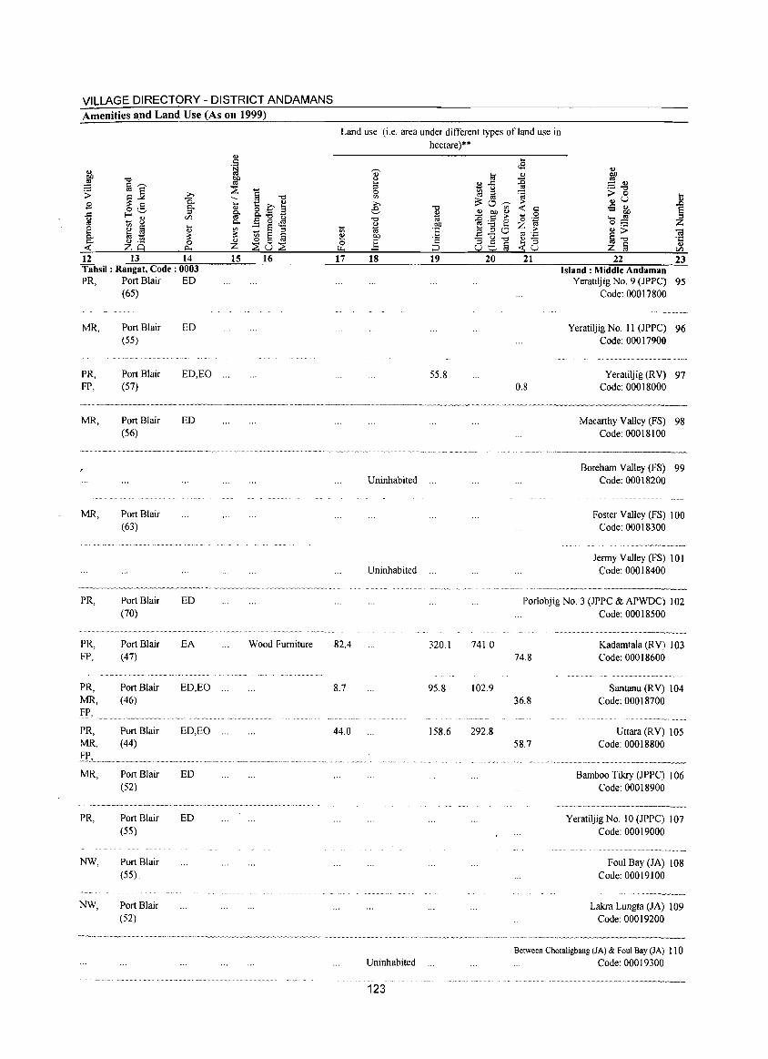
VILLAGE DIRECTORY - DISTRICT ANDAMANS Amenities and Land Use (As on 1999)
~ """ ~ 1a'-'" $ ~~ ;;..,
.9 -a o ._ §" ..::: f-<"-' g - 8
Ul
8 ~ !a ... .., c.. a 1;; ~ c.. .., ._
0 -< zq ~
12 13 14 Tahsil: Rangat, Code: 0003 PR,
MR,
PR, FP,
MR,
MR,
PR,
PR, FP,
PR, MR,
~p,
Port Blair (65)
Port Blair (55)
Port Blair (57)
Port Blair (56)
Port Blair (63)
Port Blair (70)
Port Blair (47)
Port Blair (46)
ED
ED
ED,EO
ED
ED
EA
ED,EO
...
PR, Port Blair ED,EO ... MR, (44)
IE, .......... _."."".""."" ....... " ... _ .. """ ... . MR, Port Blair ED
(52)
PR, Port Blair ED (55)
NW, Port Blair (55) .
NW, Port Blair (52)
.., . ~ ~ :2 § """ ~ ... t::c~ .., §- 8.;a B c.. E 0 .;s on :: § ::l ~ .., ~ 0 a z ::Eu::E 15 16
Wood Furniture
Land use (i.e. area under different types of land use in
hectare)**
., u .. ::l 0 on ;;..,
e """ ~ "'" .., OIl 1;; ta 'E ~ OIl 0 ] '2
r... :J 17 18 19
55.8
Uninhabited
Uninhabited
82.4 320.1
8.7 95.8
44.0 158.6
Uninhabited
123
a £-5 gj til i3:o--;;;-~ gp ~ ~~2 ::l ::l 0 .!::u--o oe§
20
741.0
102.9
292.8
.. ..s
~ 'a :> -< :::
0 '0 .~ Z ~
C'::I .;:::
~8 21
0.8
22 23 Island: Middle Andaman
Yeratiljig NO.9 (JPPC) 95 Code: 00017800
Yeratiljig No. 11 (JPPC) 96 Code: 00017900
Yeratiljig (RV) 97 Code: 00018000
Macarthy Valley (FS) 98 Code: 00018100
Boreham Valley (FS) 99 Code: 00018200
Foster Valley (FS) 100 Code: 00018300
Jenny Valley (FS) 101 Code: 00018400
Porlobjig NO.3 (JPPC & APWDC) 102 Code: 00018500
74.8
36.8
58.7
Kadamtala (RV) 103 Code: 00018600
Santanu (RV) 104 Code: 00018700
Uttara(RV) 105 Code: 00018800
Bamboo Tikry (JPPC) 106 Code: 00018900
............................. ,,-_._---Yeratiljig No. 10 (JPPC) 107
Code: 00019000
Foul Bay (JA) 108 Code: 00019100
Lakra Lungta (JA) 109 Code: 00019200
Between Chotaligbang (JA) & Foul Bay (JA) 110 Code: 00019300
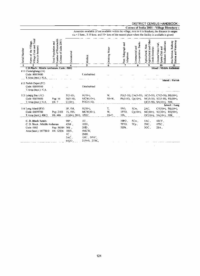
DISTRICT CENSUS HANDBOOK: Census of India 2001 - Village Directory:
Amenities available (if not available within the village, next to it in brackets, the distance in ranges viz. < 5 kms., 5-10 kms. and 10+ kms of the nearest place where the facility is available is given)
2 3 4 CD.B1ock: Middle Andaman, Code: 0002
III Chotaligbang (JA) Code: 00019400 TArea (heeL): lI):A.
112 Porlob Depot (FC) Code: 00019500 TArea (heeL): N.A.
5
Uninhabited
Uninhabited
113 LaJajig Bay (AC) P(5-10), H(lO+), Code: 00019600 Pop: 16 M(5-10), MCW(JO+),
_._ .. 1 ·h!~~J~t:.~tl~ .A:_.~J:ih.:.1 ~ .... ,<;:09::)., ...... , .Elj~(?:_1 Q),
6
W, SS=W,
114 Long Island (RY) 3P, 1M, H(IO+), T, Code: 00019700 Pop: 2183 IS, ISS, MCW(IO+), W,
__ ~ T.Area (heet.): 400L_ Hh: §_Q§__ .. _.Si!2:2J.f:Q, ... !r_lij:_,__ ........... __ .~._§§=I,~.
C. D. Block Total:- 98P , C. D. Block: Middle Andaman 43M , Code: 0002 Pop: 56584 30S , Area (hect.): 167780.0 Hh: 12836 18SS,
IC, 3AC, 64_§O,
IH, IHH, 2HD, 5MCW, 2MH, IHC,5PHC, 21 i>HS, 2TB~,
124
7 8 9 10 11 Island: Middle Andaman
"'lSlarid:Por!ob
PO(5-10), Cml5-10), AC(5-10), CY(S-IO), BS(10+), Ph(5-10), Cp(IO+), NC(5-10), SC(5-10), RS(IO+),
IPO, IPTO,
JEh, ... 19PO, 7PTO, 52Ph,
...... Q~.(S.:~Q2,.~\gt:).-':--, ,,;...N-:-W--,-::-_ Island: Long
ICm, 2AC, CY(IO+), BS(10+), Cp(IO+), NC(IO+), SC(IO+), RS(lO+),
gq.Ij~=:)~~itQ::t:l, N.:..;W.1...' __
5Cm, 7Cp,
SAC, 5NC, 30C,
12CY, 17SC, 2SA,
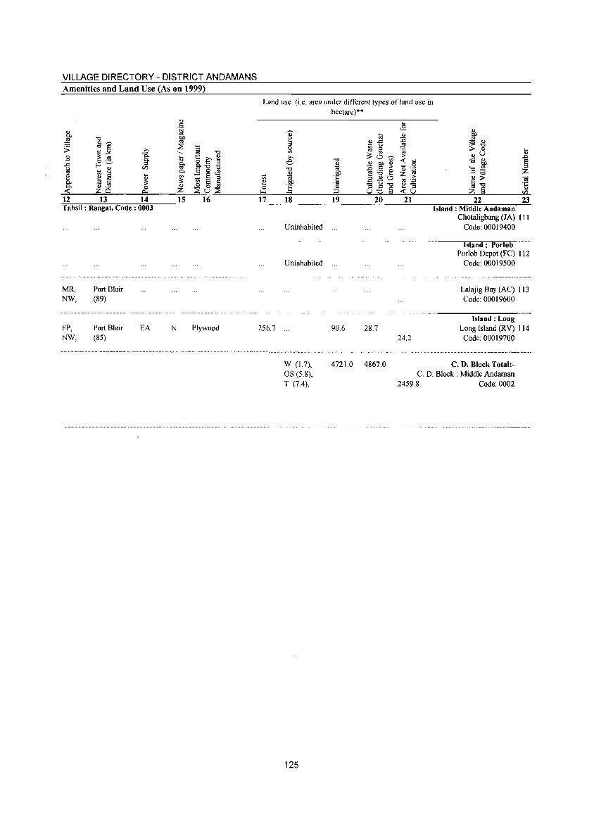
VILLAGE DIRECTORY - DISTRICT ANDAMANS Amenities and Land Use (As on 1999)
12 13 14 Tahsil: Rangat, Code: 0003
MR, NW,
FP, NW,
Port Blair (89)
Port Blair (85)
EA
<I)
.5
!
15 16
N Plywood
Land use (i.e. area under different types of land use in hectare)"
17
256.7
18
Uninhabited
Uninhabited
W (1.7), OS (5.8), T (7.4),
125
19 20 21
90.6 28.7 24.2
22 23 Island: Middle Andaman
ChotaJigbang (IA) III Code: 00019400
Island: Porlob Porlob Depot (FC) 112
Code: 00019500
Lalajig Bay CAC) 113 Code: 00019600
Island: Long Long Island (RV) 114 Code: 00019700
4721.0 4867.0 C. D. Block Total:-C. D. Block: Middle Andaman
2459.8 Code: 0002
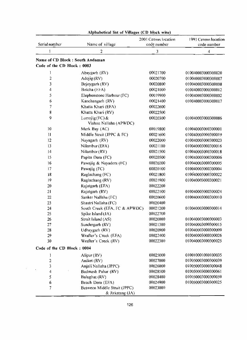
Alphabetical list of Villages (CD block wise)
Serial number Name of village
2
Name of CD Block: South Andaman Code of the CD Block : 0003
Abaygarh CRY) 2 Adojig(RV) 3 Bejoygarh (RV) 4 Bolcha (EFA) 5 Elephenstone Harbour (FC) 6 Kanchangarh (RY) 7 Khatta Khari (EFA) 8 Khatta Khari (RY) 9 Lorrojig (FC) &
Vishnu Nallaha (APWDC) 10 Merk Bay (AC) 11 Middle Strait (JPPC & FC) 12 N ayagarh (RV) 13 Nilambur (EFA) 14 Nilambur (RV) 15 Pap ita Dera (FC) 16 Pawajig & Nayadera (Fe) 17 Pawajig (FC) 18 Raglachang (FC) 19 Raglachang (RV) 20 Rajatgarh (EFA) 21 Rajatgarh (RV) 22 Sanker Nallaha (Fe) 23 Shastri Nallaha (FC)
200 I Census location code number
3
00021700 00020700 00020800 00021000 00019900 00021400 00022600 00022500 00020300
00019800 00021600 00022000 00021100 00021500 00020500 00020200 00020100 00021800 00021900 00022200 00022100 00020600 00020400
24 South Creek (EFA, Fe & APWDC) 00021200 25 Spike Island (JA) 00022700 26 Strait Island (AS) 00020000 27 Sundergarh (RV) 00021300 28 Udhaygarh (RV) 00020900 29 Wrafter's Creek (EFA) 00022400 30 Wrafter's Creek (RV) 00022300
Code of the CD Block : 0004
Alipur(RV) 00025000 2 Aniket (RV) 00027000 3 Anjali Nallaha (JPPC) 00026000 4 Badmash Pahar (RV) 00028500 5 Balughat (RV) 00028400 6 Beach Dera (EFA) 00024900 7 Between Middle Strait (JPPC) 00023000
& Jirkatang (JA)
126
1991 Census location code number
4
010040003000300020 010040003000300007 010040003000300008 010040003000300012 010040003000300002 010040003000300017
010040003000300086
010040003000300001 010040003000300019 010040003000300023 010040003000300016 010040003000300018 010040003000300006 010040003000300005 010040003000300004 010040003000300022 010040003000300021
010040003000300024 010040003000300010
010040003000300014
010040003000300003 010040003000300015 010040003000300009 010040003000300026 010040003000300025
010010001000100035 010050003000300039 010050003000300048 010050003000300061 010050003000300059 010050003000300025
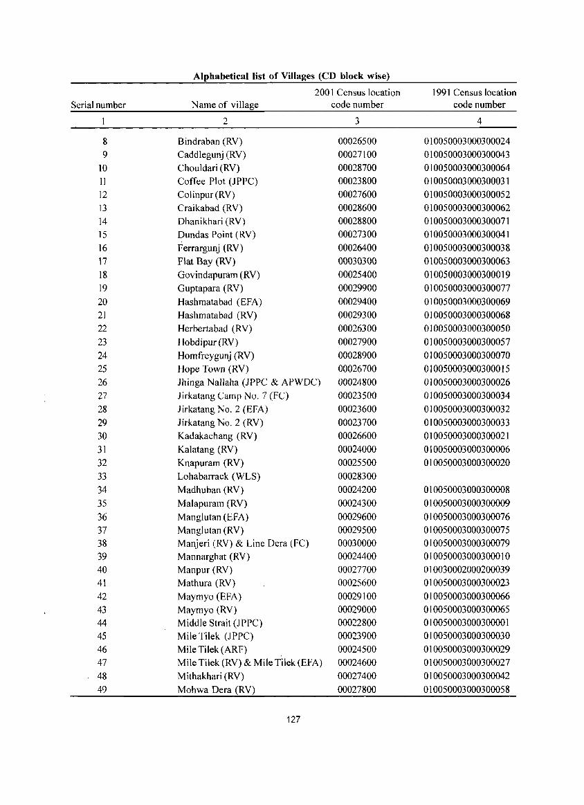
Alphabetical list of Villages (CD block wise)
2001 Census location 1991 Census location Serial number Name of village code number code number
2 3 4
8 Bindraban (RY) 00026500 010050003000300024 9 Caddlegunj (RY) 00027100 010050003000300043
10 Chouldari (RY) 00028700 010050003000300064 11 Coffee Plot (JPPC) 00023800 010050003000300031 12 Colinpur (RY) 00027600 010050003000300052 13 Craikabad (RY) 00028600 010050003000300062 14 Dhanikhari (RY) 00028800 010050003000300071 15 Dundas Point (RY) 00027300 010050003000300041 16 F errargunj (RY) 00026400 010050003000300038 17 Flat Bay (RY) 00030300 010050003000300063 18 Govindapuram (RV) 00025400 010050003000300019 19 Guptapara (RY) 00029900 010050003000300077 20 Hashmatabad (EFA) 00029400 010050003000300069 21 Hashmatabad CRY) 00029300 010050003000300068 22 Herbertabad (RY) 00026300 010050003000300050 23 Hobdipur (RY) 00027900 010050003000300057 24 Homfreygunj (RY) 00028900 010050003000300070 25 Hope Town (RY) 00026700 010050003000300015 26 Ihinga Nallaha (JPPC & APWDC) 00024800 010050003000300026 27 Jirkatang Camp No.7 (FC) 00023500 010050003000300034 28 Iirkatang No.2 (EFA) 00023600 010050003000300032 29 Jirkatang No.2 (RY) 00023700 010050003000300033 30 Kadakachang (RY) 00026600 010050003000300021 31 Kalatang (RY) 00024000 010050003000300006 32 Knapuram (RY) 00025500 010050003000300020 33 Lohabarrack (WLS) 00028300 34 Madhuban (RY) 00024200 010050003000300008 35 Malapuram (RY) 00024300 010050003000300009 36 Manglutan (EFA) 00029600 010050003000300076 37 Manglutan (RY) 00029500 010050003000300075 38 Manjeri (RY) & Line Dera (FC) 00030000 010050003000300079 39 Mannarghat (RY) 00024400 010050003000300010 40 Manpur (RY) 00027700 010030002000200039 41 Mathura (RY) 00025600 010050003000300023 42 Maymyo (EFA) 00029100 010050003000300066 43 Maymyo (RY) 00029000 010050003000300065 44 Middle Strait (IPPC) 00022800 010050003000300001 45 Mile Tilek (JPPC) 00023900 010050003000300030 46 Mile Tilek (ARF) 00024500 010050003000300029 47 Mile Tilek (RY) & Mile Tilek (EFA) 00024600 010050003000300027 48 Mithakhari (RY) 00027400 010050003000300042 49 Mohwa Dera (RY) 00027800 010050003000300058
127
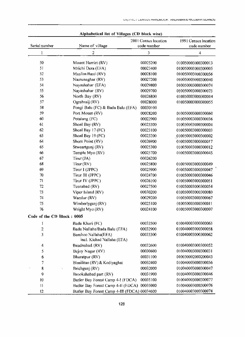
UI0 I ({II._, I I._,cN:::'U:::' HANUtlUUK ANUAMAN (x NIIJUtlf\K I:::'LANU~
Alphabetical list of Villages (CD block wise)
200 I Census location 199 I Census location Serial number Name of village code number code number
2 3 4
50 Mount Harriet (RY) 00025200 010050003000300013 51 Mrichi Oera (EFA) 00023400 010050003000300005 52 Muslim Basti (RY) 00028100 010050003000300056 53 Namunaghar (RY) 00027200 010050003000300040 54 Nayashahar (EFA) 00029800 010050003000300074 55 Nayashahar CRY) 00029700 010050003000300073 56 North Bay (RY) 00026800 010050003000300014 57 Ograbraij (RY) 00028000 010050003000300055 58 Pongi Balu (FC) & Bada Balu (EFA) 00030100 59 Port Mouat (RY) 00028200 010050003000300060 60 Potatang (Fe) 00022900 010050003000300036 61 Shoal Bay (RY) 00023300 010050003000300004 62 Shoal Bay 17 (FC) 00023100 010050003000300003 63 Shoal Bay 19 (FC) 00023200 010050003000300002 64 Shore Point (RY) 00026900 010050003000300017 65 Stweartgunj (RY) 00025300 010050003000300012 66 Temple Myo (RY) 00025700 010050003000300045 67 Tirur(JA) 00026200 68 Tirur(RY) 00025800 010050003000300049 69 Tirur I (JPPC) 00025900 010050003000300047 70 Tirur III (JPPC) 00024700 010050003000300046 71 Tirur IY (JPPC) 00026100 010050003000300051 72 Tusnabad (RV) 00027500 010050003000300054 73 Yiper Island CRY) 00030200 010050003000300080 74 Wandur (RY) 00029200 010050003000300067 75 Wimberlygunj (RY) 00025100 010050003000300011 76 Wright Myo (RY) 00024100 010050003000300007
Code of the CD Block : 0005
I Bada Khari (FC) 00033500 010040003000300063 2 Bada NallahalBada Balu (EFA) 00032900 010040003000300058 3 Bamboo Nallaha(EFA) 00033300 010040003000300062
incl. Kichad Nallaha (EFA) 4 Beadnabad (RY) 00032600 010040003000300052 5 Bejoy Nagar (RY) 00030600 010040003000300031 6 Bharatpur (RY) 00031100 010030002000200043 7 Bimilitan (RY) & Kodiyaghat 00032400 010040003000300056 8 Brichgunj (RY) 00032000 010040003000300047 9 Brookshabad part (RY) 00031900 010040003000300046
10 Butler Bay Forest Camp 4-1 (FOCA) 00035100 010040003000300077 11 Butler Bay Forest Camp 4-11 (FOCA) 00035000 010040003000300076 12 Butler Bay Forest Camp 4-III (FOCA) 00034600 010040003000300074
128
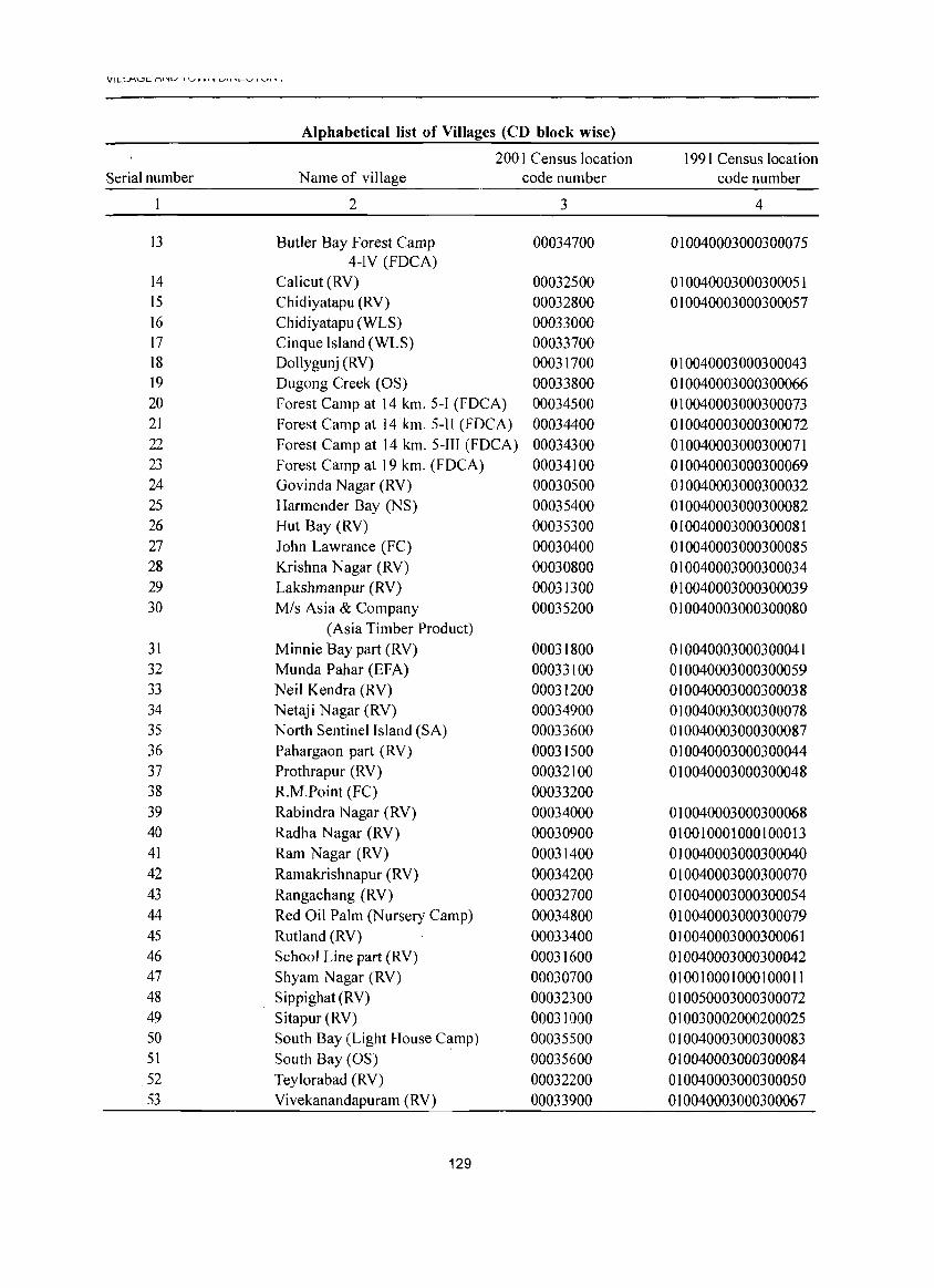
VILLI"'UC./"'\I"IU I \..JV VI 'lI L.o>ll'-L.-"-" , ......... , ,
Alphabetical list of Villages (CD block wise)
200 I Census location 1991 Census location Serial number Name of village code number code number
2 3 4
13 Butler Bay Forest Camp 00034700 010040003000300075 4-IY (FDCA)
14 Calicut (RY) 00032500 010040003000300051 15 Chidiyatapu (RY) 00032800 010040003000300057 16 Chidiyatapu (WLS) 00033000 17 Cinque Island (WLS) 00033700 18 Oollygunj (RV) 00031700 010040003000300043 19 Ougong Creek (OS) 00033800 010040003000300066 20 Forest Camp at 14 km. 5-1 (FOCA) 00034500 010040003000300073 21 Forest Camp at 14 km. 5-H (FOCA) 00034400 010040003000300072 22 Forest Camp at 14 km. 5-111 (FOCA) 00034300 010040003000300071 23 Forest Camp at 19 km. (FOCA) 00034100 010040003000300069 24 Govinda Nagar (RV) 00030500 010040003000300032 25 Harmender Bay (NS) 00035400 010040003000300082 26 Hut Bay (RV) 00035300 010040003000300081 27 John Lawrance (FC) 00030400 010040003000300085 28 Krishna Nagar (RY) 00030800 010040003000300034 29 Lakshmanpur (RV) 00031300 010040003000300039 30 Mis Asia & Company 00035200 010040003000300080
(Asia Timber Product) 31 Minnie Bay part (RY) 00031800 010040003000300041 32 Munda Pahar (EFA) 00033100 010040003000300059 33 Neil Kendra (RV) 00031200 010040003000300038 34 Netaji Nagar (RV) 00034900 010040003000300078 35 North Sentinel Island (SA) 00033600 010040003000300087 36 Pahargaon part (RV) 00031500 010040003000300044 37 Prothrapur (RV) 00032100 010040003000300048 38 R.M.Point (FC) 00033200 39 Rabindra Nagar (RY) 00034000 010040003000300068 40 Radha Nagar (RV) 00030900 010010001000100013 41 Ram Nagar (RY) 00031400 010040003000300040 42 Ramakrishnapur (RV) 00034200 010040003000300070 43 Rangachang (RV) 00032700 010040003000300054 44 Red Oil Palm (Nursery Camp) 00034800 010040003000300079 45 Rutland (RV) 00033400 010040003000300061 46 School Line part (RV) 00031600 010040003000300042 47 Shyam Nagar (RY) 00030700 010010001000100011 48 Sippighat (RV) 00032300 010050003000300072 49 Sitapur (RY) 00031000 010030002000200025 50 South Bay (Light House Camp) 00035500 010040003000300083 51 South Bay (OS) 00035600 010040003000300084 52 Teylorabad (RV) 00032200 010040003000300050 53 Vivekanandapuram (RV) 00033900 010040003000300067
129
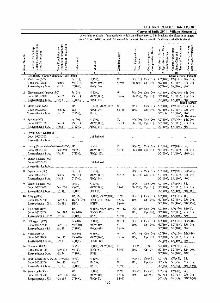
DISTRICT CENSUS HANDBOOK: Census of India 2001 - Village Directory :
Amenities available (if not available within the village, next to it in brackets, the distance in ranges viz. < 5 kms., 5-10 kms. and 10+ kms of the nearest place where the facility is available is given)
2 3 4 C.D.Block : South Andaman, Code: 0003 Merk Bay (AC) P(lO+), Code: 00019800 Pop: 9 M(lO+), l'i\rea(~ect.):N:A, Hh:6 C(IO+),
2 Elephenstone Harbour (FC) Code: 00019900 Pop: 2 !:~r.ea(~e.£t):.N.p':. Hh: 2
3 Strait Island (AS) Code: 00020000 Pop: 42
._ .. :r:l'.J"e.Il.(h~~U: ..r~:LA;... .-'dh :}5.
P(lO+), M(lO+), qIO+),
IP, 1M,
.. _qIQ~),
5
H(10+), MCW(IO+), PHC(IO+),
H(lO+), MCW(IO+), PHC(IO+),
H(lO+), MCW(IO+), PHC(lO+),
. IPKS,
4 Pawajig (FC) P(IO+), H(IO+), Code: 00020100 Pop: 4 M(JO+), MCW(IO+),
._._J:':Area,.L~~~1i.A. ._ .. Bh~_. _., ~<;:UQ~L _ ... f>HS:UQ:I:),
S Pawajig & Nayadera (FC) Code: 00020200
.T-~rea(he(;t): l'JA
6 Lorrojig (FC) & Vishnu NaHaha (APWOC) I P, Code: 00020300 Pop: 240 M«5),
...... :LJ\re.aJh~(;t):l'J":A._ Hh: 51 qIQ+),
7 Shastri NaHaha (FC) Code: 00020400
._~T.Are~ect.): N.A.
8 Pap ita Dera (FC) Code: 00020500
I·.J\~e.ll.(h!.cUHA: .. 9 Sanker NaHaha (FC)
Code: 00020600
............. TArt!a,(lu:<:t):HA ..
Pop: 5 Hh: 3
Pop: 204 Hh:48
P(IO+), M(IO+),
C.(10:+:),
P«5), M«5),
....... C(10+),
Uninhabited
H«5), MCW(lO+),
PHc:(?-1 Q),
Uninhabited
H(lO+), MCW(lO+), PHC(lO+),
H(lO+), MCW(IO+),
PHC«5),
ID Adojig (RY) IP, 1M, H(lO+), MCW(IO+), Code: 00020700 Pop: 835 IS, C(lO+), PHgIO+), IPHS,
.:r.:A!.~.Il.Jhe<:t)-, .. I.oO .. L Hh: lSI 11:;9.>... . lCIj.~, .
II Bejoygarh (RY) IP, H(10+), MCW(lO+),
6
W, SS=W,
W, SS=W,
W, SS=W,
0, SS=O,
T, SS=T,
S, SS=O,
T, SS=T,
T,W, TK, S, S5=W,
W,TK, Code: 00020800 Pop: 297 M(5-10), PHg5-1O), S,
~~_I·Ar~Il~E!J:..l~~Hh:.M__~::+:.L._._IPH~, .............. ~.'" ....... ~~_~.~L ••.
12 Udhaygarh (RV) P(5-10), H(IO+), Code: 00020900 Pop: 115 M(5-10), MCW(IO+),
......... :LA!~lIJh~(;D:._'!.lL4 .... _ . .1!l1~)~ ......... gl.9::), ... ~ ..... PfI~iS~lO), .'
13 Bolcha (EFA) Code: 00021000 TJ\rea(hect.): N.A.
Pop: 31 Hh: 5
P(5-10), M(5-10), C(IO+),
H(lO+), MCW(10+), PHC(5-IO),
W,TK, S, SS=W,
w, SS=W,
14 Niiambur(EFA) Code: 00021100
P«5), Pop: 137 M«5),
Hh: 34 ..... C;(lQ~),
H(lO+), MCW(lO+), T, PHC«5), SS=T,
............. I:J\!.~lIJh~(;tJN:A: .. IPI-f~'
15 South Creek (EFA, FC & APWDC) P«5), H(lO+), Code: 00021200 Pop: 40 M«5), lMCW,
T:.i\I~~(ht!~9cli,A:_ ~~~B~:_~~._ .. ~. q!O:t L . ~ " l.EliC,
16 Sundergarh(RV) IP, H(lO+), Code: 00021300 Pop: 1049 1M, MCW(lO+),
IA£e~l(~~.<:tl}??:~ ..... Hh: 20Q.. q}Q:I:), Pl::Ig<?), 130
T, W, SS=T,
T,W, TK,S, SS=T,
7 8 9 10 11 Island: North Passage
PO(lO+), Cm(lO+), AC(IO+), CV(10+), BS(lO+), Ph(lO+), Cp(JO+), NC(IO+), SC(IO+), RS(IO+),
OC(IO+), SA(IQ:+:),.l'J.~, .. _. . __ .
PO(1 0+), Cm(1 0+), A C( I 0+), CY (10+), BS(J 0+), Ph(!O+), Cp(IO+), NC(lO+), SC(I 0+), RS(IO+),
OCOO+)," ::;A(10+IL.l'J"~-,=~~ slanu : .. trait
IPO, Cm(lO+), AC(lO+), CY(IO+), 'BS(IO+), IPh, Cp(IO+), NC(lO+), SC(I 0+), RS(IO+),
9\"1<?), __ §ASID_:l:), ~_ 'lSlana: Daratang
PO(IO+), Cm(IO+), AC(IO+), CV(IO+), BS(10+), Ph(lO+), Cp(lO+), NC(IO+), SC(lO+), RS(IO+),
Qc:n~JAD.Q+), NW,
PO«5), Cm(lO+), AC(lO+), CV(IO+), BS, Ph(5-10), Cp(IO+), NC(ID+), SC(10+), RS(lO+),
.... gqIO:+: ),_ S.A(1Q:t),_ N~t:?»~
PO(lO+), Cm(IO+), AC(lO+), CV(10+), 8S(5-10), Ph(IO+), Cp(lO+), NC(lO+), 5C(10+), RS(lO+),
OC:(IO+), .. §_A(l .. ~), NW,-__
IPO, Cm(lO+), AC(lO+), CY(IO+), BS, Ph(IO+), Cp(lO+), NC(IO+), SC(IO+), RS(IO+),
0c:{10+), . ~A(IQ::),_),~:~(S5), ..
PO(lO+), Cm(IO+), AC(IO+), CY(IO+), BS, IPh, Cp(lO+), NC(IO+), SC(I 0+), RS(IO+),
OC(19+ L §.AHQ:L. NW.u.Q2:1_
PO(S-IO), Cm(lO+), AC(IO+), CV(lO+), 8S«5), IPh, Cp(lO+), NC(IO+), SC(I 0+), RS(1O+),
_2f{!.Q.+.l, SA(lO+), NW;..:.;..z., __
PO(lO+), Cm(lO+), AC(IO+), CV(lO+), BS(5-10), IPh, Cp(lO+), NC(IO+), SC(lO+), RS(IO+),
... .9SJ.l O+)..L. SACI 0+1._ NW_, __
PO(IO+), Cm(lO+), AC(IO+), CV(IO+), BS(5-10), lPh, Cp(lO+), NC(IO+), SC(lO+), RS(IO+),
0C(10+), SA(IO+), l'J~, __ _
PO«5), ICm, AC(10+), CY(IO+), BS, IPh, Cp«5), NC(IO+), SC(I 0+), RS(10+),
9(:(1.9:+:), . ~J\(IQ:t),_~_,_."PO«5), Cm«5), AC«5), CY«5), BS, IPh, Cp«5), NC«5), Sg<5), RS(lO+),
••• u .9_q-:~. __ SA«5), NW(5-10},
PO«S), Cm«5), Ag<5), CY«5), BS, lPh, Cp«5), NC«5), SC«5), RS(lO+),
oc;c:::n .. §At:::?J,. NW(5-10),
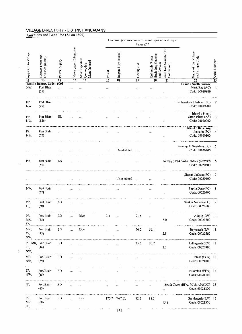
VILLAGE DIRECTORY - DISTRICT ANDAMANS Amenities and Land Use (As on 1999)
12 13 14 Tahsil: Rangat, Code: 0003 NW, Port Blair
(SS)
FP. NW,
FP, NW,
Port Blair (45)
Port Blair (126)
FP, Port Blair NW, (S2)
PR,
NW.
PR, FP,
PR, MR.
MR. FP.
Port Blair (55)
Port Blair (52)
Port Blair (SO)
Port Blair (45)
Port Blair (45)
PR, MR, Port Blair FP, (46)
MR, NW,
FP, NW,
FP.
PR. MR, FP,
Port Blair (69)
Port Blair (65)
Port Blair (60)
Port Blair (60)
ED
EA
ED
ED
ED
ED
ED
ED
ED
ED
15 16
Rice
Rice
Rice
Land use (i.e. area under different types ofland use in hectare)**
17 18 19 20
Uninhabited
Uninhabited
3.4 91.5
56.0 56.1
25.6 20.7
170 7 W(7.0), 82.2 98.2
131
21 22 Island: North Passaee
Merk Bay (AC) Code: 00019800
23
Elephenstone Harbour (FC) 2 Code: 00019900
Isliul<) : Str8lt---Strait Island (AS) 3 Code: 00020000
-~·-Islaiid:-Baratane
Pawajig (FC) 4 Code: 00020 I 00
Pawajig & Nayadera (FC) 5 Code: 00020200
Lorrojig (FC) & Vishnu Nallaha (APWDC) 6 Code: 00020300
6.0
5.8
2.2
Shastri Nallaha (FC) 7 Code: 00020400
Papita Dera (FC) 8 Code: 00020500
Sanker Nallaha (FC) 9 Code: 00020600
Adojig (RV) 10 Code: 00020700
Bejoygarh (R V) 11 Code: 00020800
Udhaygarh (RV) 12 Code: 00020900
Bolcha (EFA) 13 Code: 00021000
Nilambur (EFA) 14 Code: 00021100
South Creek (EFA. FC & APWDC) 15 Code: 00021200
15.8 Sundergarh (RV) 16 Code: 00021300
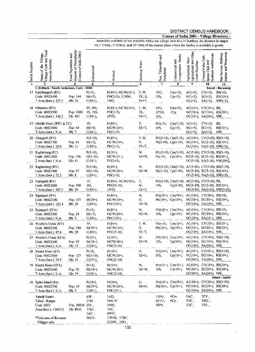
DISTRICT CENSUS HANDBOOK: Census of India 2001 - Village Directory :
Amenities available (if not available within the village, next to it in brackets, the distance in ranges viz. < 5 kms., 5-10 kms. and 10+ kms of the nearest place where the facility is available is given)
~1~~~2~~ ________ ~3~ __ ~~4~ ______ ~5~ _________ 6 C.O.B1ock : South Andaman, Code: 0003
17 Kanchangarh (RV) P«5), Code: 00021400 Pop: 164 M«5),
... TArl!a.{lll!ct.): ?57,1 Hh: 24 q10:l:),
18 Nilambur (RV) Code: 00021500 T.Area (ilect.): 14?2
2P,2M, Pop: 1600 IS, ISS, Hh: 401 C(19+),
H(lO+), MCW(10+), T, W, PHC«5),ICHW, TK, S, ll:{Q, SS=T,
H(10+), MCW(10+), T, W, PHC«5), TK, IPHS, SS=T,
7
IPO, IPh,
IPO, IPTO, IPll,
8
Cm«5), Cp«5),
Cm«5), ICp,
9 10 11 ............. _ ...... _._-Island: Baratang
AC«5), CV«5), BS«5), NC«5), SC«5), RS(IO+), 0C«5),. ~A(<::?), )\j\\,f(::?),
AC(IO+), CV(IO+), BS, NC(IO+), SC(I 0+), RS(IO+),
OC(I 0+), SA09:1:),. NFL. ._. 19 Middle Strait (JPPC & FC) IP, H(10+), T, PO«5), Cm(5-10), AC«5), CV«5), BS,
Code: 00021600 Pop: 44 M«5), MCW(lO+), SS=T, IPh, Cp«5), NC«5), SC«5), RS(IO+), T.Area (hect.): NA _.Jil!:...L... _ _____g]_921_, ____E!:I_C(__~». _ .. o __ _
"''' __ •• _ .............. _. __ .......... m .. .9C«::~~«5), NW,
20 Abaygarh (RV) P(5-10), H(tO+), T, W, PO(5-tO), Cm(5-10), AC(lO+), CV(5-tO), BS(5-1O), Code: 00021700 Pop: 61 M«5), MCW(IO+), 0, Ph(5-10), Cp(5-10), NC(IO+), SC(5-JO), RS(IO+),
.... _I:AE~a_(1l~U~~9:.? Hh: I I . <::(l9-+-}, ~HC«5), SS=T, . QC(IQ-+-), §A(5~.!Q), NW«5),
21 Raglachang (FC) P(S-JO), H(IO+), W, PO(5-10), Cm(5-10), AC(5-JO), CV(5-JO), BS(5-1O), Code: 00021800 Pop: 196 M(5-10), MCW(IO+), SS=W, Ph«5), Cp(IO+), NC(5-10), SC(5-10), RS(lO+), T.Area (hect.): NA Hh: 41 C(lO+), PHC«5), 0C(5-IO), §A(5~10), NWn9-+-),
22 Raglachang (RV) P(S-IO), H(10+), W, PO(5-10), Cm(5-10), AC(5-10), CV(5-10), BS(5-1O), Code: 00021900 Pop: 67 M(5-JO), MCW(IO+), SS=W, Ph(5-10), Cp(5-10), NC(5-10), SC(5-10), RS(lO+),
_ ... ]:AI!~(Il.l!~J:]L?_. . l:lll:__!l ..... _ . c:'1.!0+), . Pl:{C( <5), . . QS::~:!91. §A~:lQ1_ NW( <5)1........
23 Nayagarh (RV) IP, H(JO+), MCW(lO+), T, PO(5-1O), Cm(5-10), AC(5-10), CV(5-1O), BS, Code: 00022000 Pop: 300 1M, PHC(5-JO), W, IPh, Cp(5-JO), NC(5-10), SC(5-10), RS(lO+),
_" ..... LA.!:c:~Cll.~.~.!).:J87 },._ .l!1l:.29 .. ~ ... q}.9-+-)L_._. .!!l:{§L._ ....... _ .. ~~ .. §.~:I,_ ........ _. __ . . .. __ Q.f_(1:!.9')' SA{ 5~.!.Q1._ NW( 5-1 Oll
24 Rajatgarh (RV) IP, H(lO+), W, PO(lO+), Cm(IO+), AC(IO+), CV(IO+), BS«5), Code: 00022100 Pop: 197 M(lO+), MCW(lO+), 0, Ph(lO+), Cp(lO+), NC(lO+), SC(IO+), RS(IO+), T.Area (hect.):1~3,4 Hh: 30 C(IO+), PHC(IO+), SS=W, 0C(10~), SA(IQ+), )\j~,.",
25 Rajatgarh (EFA) P«5), H(IO+), Code: 00022200 Pop: 24 M«5), MCW(lO+),
____ .. I.1~~_<1l~~U: N:.A, __ .. ~l:!Il_:~~_ ._~~_ .. ~(19':)J_. . ..... ~!:IqLQ:t), 26 Wrafter's Creek (RV) IP,
Code: 00022300 Pop: 188 M(lO+),
............. IArea(ll~ct): 87.6 Hh: 38 C(lO+),
27 Wrafter's Creek (EF A) P(I 0+), Code: 00022400 Pop: 45 M(lO+),
.. ~~ ... L~~~ .. (Il~c.U;__l'i~A._ ... .!:-lh.: ... I.~." . C(!Q+),
28 Khatta Khari (RV) P«5), Code: 00022500 Pop 127 M(S-IO),
.. T.A~e!l{hect): 24,9 Hh: 22 C(10+),.
H(lO+), MCW(lO+), PHC(5-10),
H(IO+), MCW(IO+), PHC(5:1 0), ~
H(IO+), MCW(IO+), PHC(5-10),
W, SS=W,
T,W, 0, SS=T,
W,
SS=W,
0, SS=O,
29 KhattaKhari(EFA) Code: 00022600 .T.Area (hect.): NA
P«5), H(IO+), W, Pop: 92 M(IO+), MCW(IO+), SS=W, ,Hh: 19 __ ........f(lQ:+1 .. __ PHC(1:!.0)_, _ .. _ ................ ..
30 Spike Island (JA) P(IO+), H(IO+), 0, Code: 00022700 Pop: 19 M(lO+), MCW(lO+), SS=O,
...... _"I:~..I!~~!),:_J;:I:A: .... .!:!h~ .. ~ ...... _ ... ..f(lQ.+)L .. "' .... Pl:{ql_Q,,-+-), ...
Tahsil Total:Tahsil: Rangat Code: 0003 Pop: 38824 Area (hect.): 12667.0 Hh: 8935
*Total area of Revenue
........ yil~~Q!!!y._ ........
65P , 33M, 20S , IISS, 3AC, 36EO,
IHD, 5MCW, IMH, IHC, 4PHC, 17PHS, I TBC,
2<::I:lW,IHO,
132
PO(lQ+), Cm(lO+), AC(IO+), CV(IO+), BS«5), 1 Ph, Cp(IO+), NC(IO+), SC(IO+), RS(IO+),
~._ ._Q9l9.:t:1.....§M!_0+}, NW,
PO«5), Cm(IO+), AC(IO+), CV(IO+), 8S(10+), Ph(lO+), Cp(IO+), NC(IO+), SC(IO+), RS(10+),
OC( 10-+-}, . ~A( I 0-+-), )\jW,
PO(IO+), Cm(IO+), AC(lO+), CV(lO+), BS(5-10), I Ph, Cp(lO+), NC(IO+), SC(IO+), RS(IO+),
.... 9~ilQ-+-)~.~A(!Q~), NW,
PO(IO+), Cm(lO+), AC(IO+), CV(IO+), 8S(5-10), IPh, Cp(lO+), NC(IO+), SC(lO+), RS(10+),
OqIO+), .. SA(IO+), N:WJ. PO(IO+), Cm(IO+), ACC 1 0+), CV(lO+), BS(10+), IPh, Cp(IO+), NC(IO+), SC(lO+), RS(lO+),
.. ",~_~_Q9l9+2, SA(l0+2, NW, Island: Spike
PO(lO+), Cm(IO+), AC(IO+), CV(lO+), BS(5-1O), Ph(lO+), Cp(IO+), NC(lO+), SC(lO+), RS(lO+),
._~.9C(102:1_ SA{IO-+-), NW,
15PO, 6PTO, 58Ph,
4Cm, 6Cp,
5AC, 4NC, 10C,
7CV, 10SC, ISA,
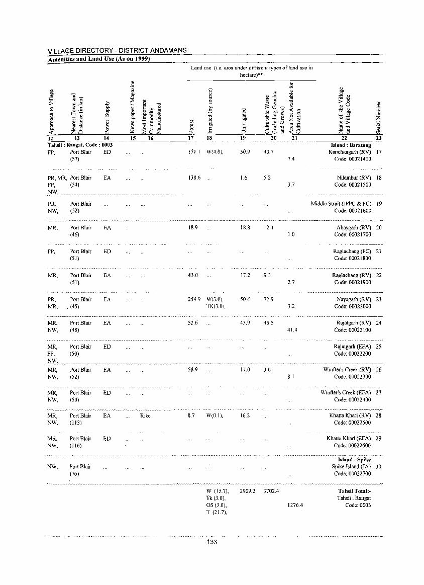
VILU\GE DIRECTORY - DISTRICT ANDAMANS Amenities and Land Use (As on 1999)
Land use (i.e. area under different types of land use in hectare)**
<U .... . 5 <8 ~ ~
~ j <I.> t<l <I.> ""0 ~
<.) {j a'""' 3 ~~ :::: <I.>
~ .- ""0 ;; ~~ -a § ""0 ~ [q ~ ~ > 0 ~ £ .... '§ .£ ~ » ~"-;;;- > <u U
~ o .5 p., <U e ""0 <r: c ..s <U f-<'-' :::l ~ <U <U 00 <U 0 00
-§ VJ 0..""0 t) ""0 til - '" ;> "0 .=: ..... ~
~ ... ~ p., E 0 <::3 2 00 ~ :.0 e z OJ 0;:; z e ~ § ....
'" :: § :::l :;; ·E > <U> <U ~ :::l :::l" ] ~ .~ ~ ~ ~ OJ) ~c:::)"O ~ '';:: §""O P. ~ 0 [ij C <U -0.. 0 <U 0 ] 06§ .... :::l <U <r: ZO 0- Z ~u~ ~ ::J <r:u ~ § en 12 13 14 15 16 17 18 19 20 21 22 23 Tahsil: Rangat, Code: 0003 Island: Baratang FP, Port Blair ED 171.1 W(4.0), 30.9 43.7 Kanchangarh (RV) 17
(57) 7.4 Code: 00021400
PR, MR, Port Blair EA 138.6 1.6 5.2 Nilambur (RV) 18 FP, (54) 3.7 Code: 00021500
N\V, .. --~ .. --.-,,--.---.~"
PR, Port Blair Middle Strait (JPPC & FC) 19 NW, (52) Code: 00021600
~.~~~~~ ___ .~~_~'w_~_. __ v __ ~~vw_~.~~~v,~,~_~_~~~ ~_ ~~~, __ ~<_~_A_ MR, Port Blair EA 18.9 18.8 12.1 Abaygarh (RV) 20
(46) 1.0 Code: 00021700
·_·.···'"···_.·v·w_~·~._, __ .~_
FP, Port Blair ED Raglachang (FC) 21 (51) Code: 00021800
MR, Port Blair EA 43.0 17.2 9.3 Raglachang (RV) 22 (51) 2.7 Code: 00021900
•.•. ~ ... "'"y •. ~--~--
PR, Port Blair EA 254.9 W(3.0), 50.4 72.9 Nayagarh CRY) 23 MR, (45) TK(3.0), 3.2 Code: 00022000
___ ~.~_,_~~~··~_···_~~~¥_~~·=.v_·~··.
MR, Port Blair EA 52.6 43.9 45.5 Rajatgarh (RV) 24 NW, (48) 41.4 Code: 00022100
............................. " .. _. .....
MR, Port Blair ED Rajatgarh (EFA) 25 FP, (50) Code: 00022200
MR, Port Blair EA 58.9 17.0 3.6 Wrafter's Creek (RV) 26 NW, (52) 8.1 Code: 00022300
MR, Port Blair ED Wrafter's Creek CEF A) 27 NW, (50) Code: 00022400
,~,~"'~,~~~~- .. -~~
MR, Port Blair EA Rice 8.7 W(O.I), 16.2 Khatta Khari CRY) 28 NW, (113) Code: 00022500
MR, Port Blair ED Khatta Khari (EF A) 29 NW, (116) Code: 00022600
----~----~~-~-.,~,-~,-~~~~~ , _o •• ~~v_ •• "_~~_
Island: Spike NW, Port Blair Spike Island (JA) 30
(76) Code: 00022700
"._._,_~ __ .. ,~"""' .. " .. __ "". __ ,~.,.~_,~~ __ ~~.~.m~._.~._~_~,, __ ·~·_·~=·'" 'w_. __ =._ .. _" __ ._='.,, _~ "'''_, " .. -~-,---~~.-~----~------W (15.7), 2909.2 3702.4 Tahsil Total:-Tk (3.0), Tahsil: Rangat OS (3.0), 1276.4 Code: 0003 T (21.7),
133
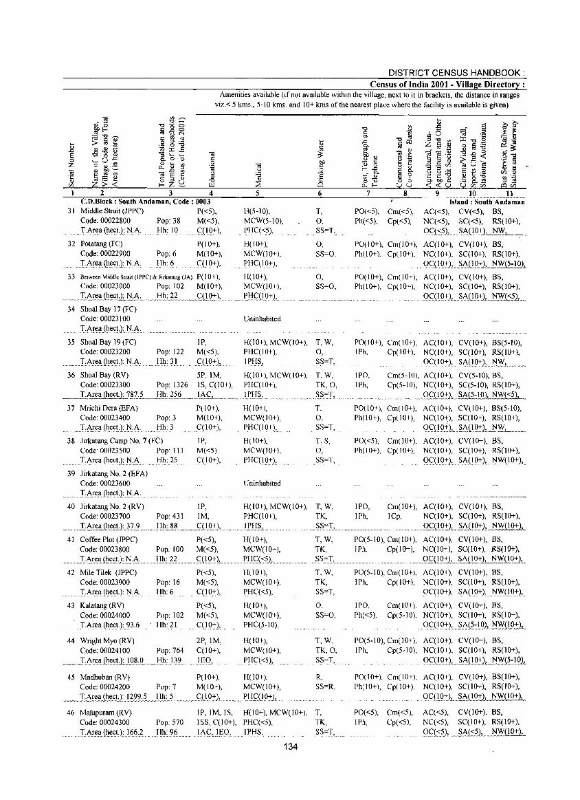
DISTRICT CENSUS HANDBOOK: Census of India 2001 - Village Directory :
Amenities available (if not available within the village, next to it in brackets, the distance in ranges viz.< 5 kms., 5-10 kms. and 10+ kms of the nearest place where the facility is available is given)
2 3 4 C.D.Block : South Andaman, Code: 0003
31 Middle Strait (]PPC) P«5), Code: 00022800 Pop: 38 M«S),
'M ••• T:A~~ll(h.e~t):l'iA Hh: 10 . <::LlQ+)2
32 Potatang (FC) Code: 00022900
.... ~ .. ~T:.A.!:~llJ~~~t.:t.N ,A, ..
P(IO+), Pop: 6 M(lO+), Hh: 6 QlO+},
5
H(S-IO), MCW(S-IO),
.. PtIC«~),
H(lO+), MCW(lO+),
J>HC(IQ+),
33 Between Middle Strait (lPPC) & lirkatang (lA) P(I 0+), H(I 0+), Code: 00023000 Pop: 102 M(lO+), MCW(IO+),
._ .... _Lt.Ie~.Q!~£tJ:_N.A:.__._!:!!!.~~ ... ~fI!9.:1 .. __ ~.tI:I<::'O'9+1,. 34 Shoal Bay 17 (FC)
Code: 00023100
TNell(hect,): N,A,
Uninhabited
6
T, 0, SS=T,
0, SS=O,
0, SS=O,
3S Shoal Bay 19 (FC) IP, H(IO+), MCW(IO+), T, W, Code: 00023200 Pop 122 M«S), PHC(IO+), 0,
. TAr()ll{h.eet):l':I.A. Hh: 31 . <::(19+), IPI:I~, SS",T,
36 Shoal Bay (RV) SP,IM, H(lO+), MCW(IO+), T, W, Code: 00023300 Pop: 1326 IS, C(lO+), PHC(IO+), TK,O,
_ _lArea (heet.): ?.E1____!:!b.:.~~6 .~._l A C, _ .. ~._E~Ij.~,.. __ ... _ S_S.=.T,
37 MriehiDera(EFA) P(IO+), H(lO+), T, Code: 00023400 Pop: 3 M(10+), MCW(IO+), 0, LA!e.ll(h_een.N,A: . Hh: 3 C(IO+), PHC(IO+), SS=T,
38 Jirkatang Camp No.7 (FC) IP, H(IO+), T, S, Code: 00023500 Pop: III M«5), MCW(10+), 0,
......... I:i\re.a{h_e.et):HA. Hh: 2S C(IO+), PHqIQ+), SS=T,
39 Jirkatang No.2 (EFA) Code: 00023600 Uninhabited
......... :LArea .. (h_e~t,}:J,!:A ...
7 8
PO«S), Cm«5), Ph«S), Cp«S),
9 10 11 Island: SouiiiAiidamllD
AC«5), CV«5), BS, NC«S), SC«S), RS(lO+),
Q<::C~)L .. ~8i!Q:+J,~ NW, ~"
PO(lO+), Cm(lO+), AC(IO+), CV(lO+), BS, Ph(lO+), Cp(IO+), NC(IO+), SC(I 0+), RS(IO+),
. Qc::tlg':+)L_~!Q-r2,-NW(5-10),
PO(IO+), Cm(IO+), AC(IO+), CV(IO+), BS, Ph(lO+), Cp(IO+), NC(IO+), SC(I 0+), RS(lO+),
. _QfQQ-r)",JiA(!Q.:+), NW«5),
PO(lO+), Cm(lO+), AC(IO+), CV(lO+), BS(5-10), IPh, Cp(lO+), NC(IO+), SC(lO+), RS(IO+),
QC(IO-r)' SA(IO+), .~L .... _,
IPO, Cm(5-10), AC(lO+), CV(5-10), BS, IPh, Cp(S-IO), NC(IO+), SC(5-10), RS(IO+),
' .. , ... " .. , .... Qf11 0+), __ SA(5-1 0), NW«5),
PO(IO+), Cm(IO+), AC(IO+), CV(IO+), BS(5-10), Ph(IO+), Cp(IO+), NC(IO+), SC(IO+), RS(lO+),
Q<::LIg±).l....~ALlg-r 2L . ..:.N:._:W:.L' __
PO«5), Cm(IO+), AC(IO+), CV(IO+), BS, Ph(IO+), Cp(IO+), NC(IO+), SC(IO+), RS(IO+),
()qIQ-r)' SA(1Q+), ~nQ7),
40 Jirkatang No.2 (RV) IP, H(10+), MCW(IO+), T, W, IPO, Cm(IO+), AC(IO+), CV(IO+), BS, Code: 00023700 Pop: 431 1M, PHC(IO+), TK, JPh, ICp, NC(IO+), SC(I 0+), RS(lO+),
____ .LA~~h_~E!l:llL. __ . .!:Ih: J~.~ .. _._.~(!Q±L ... _ ... _},PHS, .. _. .. " ~~",L _~~ ............ ,,~. Oq1Q-!:)"' ... .§..i\(l0+), NW(lO+),
41 Coffee Plot (]PPC) P«S), H(10+), Code: 00023800 Pop: 100 M«S), MCW(lO+),
_.~LA~~~E.!J N_:~L ... _I!h..:].~.. C_(IQ+\ J>~If(<:52, .....
42 Mile Tilek (JPPC) P«S), H(10+), Code: 00023900 Pop: 16 M«S), MCW(IO+),
..... IArea(heet.): N,i\, Hh: 6 C(IO+), PHC«5),
43 Kalatang (RV) Code: 00024000 Pop: 102
J.i\re.a(heet):.2},(J . Hh: 2 I
P«5), M«S),
C(l0-r}'
44 WrightMyo(RV) 2P,IM, Code: 00024100 Pop: 764 C(IO+),
_~ __ Li\r~ti_h_~.U.:1.Q~J!." ~!ih_J}2.. ... l§Q-,
H(lO+), MCW(lO+), PHC(5-1O),
H(lO+), MCW(IO+),
. PHC«S)L
45 Madhuban (RV) P(lO+), H(lO+), Code: 00024200 Pop 7 M(lO+), MCW(IO+),
_ ._!A~e~".Q!()£U:J122~~"~"!::I_,!:§ ~ .. " _ __£(I_0-rl .. ", ..... ~.tI£L!Q-rlL .. 46 Malapuram (RV)
Code: 00024300 Pop: 570
TA~l!(h.~£t:Ll6.(J)... Hh: 96
1P, 1M, IS, H(lO+), MCW(IO+), ISS, C(lO+), PHC«5),
. 1i\<::,.II3(), ', .. IPIjS,
134
T, W, PO(5-10), Cm(IO+), AC(IO+), CV(IO+), BS, TK, IPh, Cp(IO+), NC(IO+), SC(lO+), RS(lO+),
SS=T, ...... m. .. OC(IQ:l:1 ... ~AL~ .. -r), NW(IO+),
T,W,
TK, SS=T,
0, SS=O,
T,W, TK,O, SS=T,
R, SS=R,
T, TK,
.SS=T, ....
PO(5-IO), Cm(IO+), AC(IO+), CV(IO+), BS, IPh, Cp(IO+), NC(IO+), SC(I 0+), RS(lO+),
IPO, Ph«5),
OC(IO+), SA(IO+), ~(_I9-r),
Cm(IO+), AC(IO+), CV(IO+), BS, Cp(S·IO), NC(IO+), SC(I 0+), RS(IO+),
.Q<::(19-r), Si\(?~IQU:-!y'y(1.Q:!:)J...
PO(5-10), Cm(IO+), AC(IO+), CV(lO+), BS, IPh, Cp(5-10), NC(IO+), SC(IO+), RS(IO+),
QC::(IQ±L~t.(IO+), NW(5-10),
PO(IO+), Cm(IO+), AC(IO+), CV(IO+), BS(IO+), Ph(IO+), Cp(lO+), NC(lO+), SC(I 0+), RS(lO+),
QC,(1"Q1:)L~~(10+2, NW(IO+),
PO«5), Cm«5), AC«5), CV(IO+), BS, IPh, Cp«5), NC«5), SC(I 0+), RS(lO+),
9£t:.5)) .. ~At:?L_~Y.Y{ I 0+),
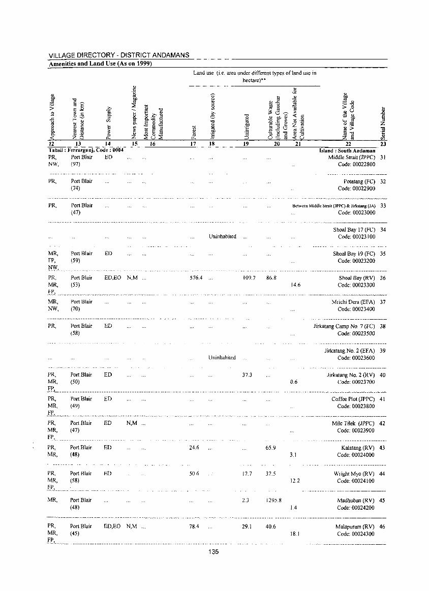
VILLAGE DIRECTORY - DISTRICT ANDAMANS Amenities and Land Use (As on 1999)
~ "0
~ fij~
~] >,
1 .9 o .S g E-""'" r/J ~ ~ 0 ~ !
.... .... OJ 0. ::: 0. OJ .~ 0 <r: zo CL,
12 13 14 Tahsil: Ferrargunj, Code: 0004 PR, Port Blair ED NW, (97)
PR,
PR,
MR, FP,
~,
PR, MR,
I!'"" MR, NW,
PR,
PRo MR.
PR, MR,
PRo MR, FP,
PR, MR.
PR, MR,
£!,,,,,~ .... --MR,
Port Blair (74)
Port Blair (47)
Port Blair (59)
Port Blair (53)
Port Blair (70)
Port Blair (58)
Port Blair (50)
Port Blair (49)
Port Blair (47)
Port Blair (48)
Port Blair (58)
Port Blair (48)
ED
ED,EO
ED
ED
ED
ED
ED
ED
., .~ tiP
::E ~ -g --.... ., 0.£ s g- o.. "tS 1:)
0. E 0 <S ~ :: § :; ~8~ .,
Z 15 16
N,M «.
N,M «.
PRo Port Blair EO,EO N,M '" MR, (45)
l'?L_ ..... _
Land use (i. e. area under di fferent types ofland use in hectare)**
<> OJ .... :; 0 '" >, e
"0 ., til l;j ., 00 B ] ~
17 18 19 20
Uninhabited «.
576.4 .« 109.7 86.8
Uninhabited
37.3
24.6 65.9
50.6 12.7 32.5
2.3 1295.8
78.4 29.1 40.6
135
21 22 23 Island; South Andaman
Middle Strait (]PPC) 31 Code: 00022800
Potatang (FC) 32 Code: 00022900
Between Middle Strait (JPPC) & Jirkatang (JA) 33 Code: 00023000
14.6
0.6
3. I
12.2
IA
Shoal Bay 17 (FC) 34 Code: 00023100
Shoal Bay 19 (FC) 35 Code: 00023200
Shoal Bay (RV) 36 Code: 00023300
Mrichi Dera (EFA) 37 Code: 00023400
Jirkatang Camp No.7 (FC) 38 Code: 00023500
Jirkatang No.2 (EFA) 39 Code: 00023600
Jirkatang No.2 (RV) 40 Code: 00023700
Coffee Plot (JPPC) 41 Code: 00023800
Mile Tilek (]PPC) 42 Code: 00023900
Kalatang (RV) 43 Code: 00024000
Wright Myo (RV) 44 Code: 00024100
Madhuban (R V) 45 Code: 00024200
N ".v~.""_,,'»,,~~~.~
Malapuram (RV) 46 18.1 Code: 00024300
_~.V· "v~._. __ ._ •• vv_ •• _~,
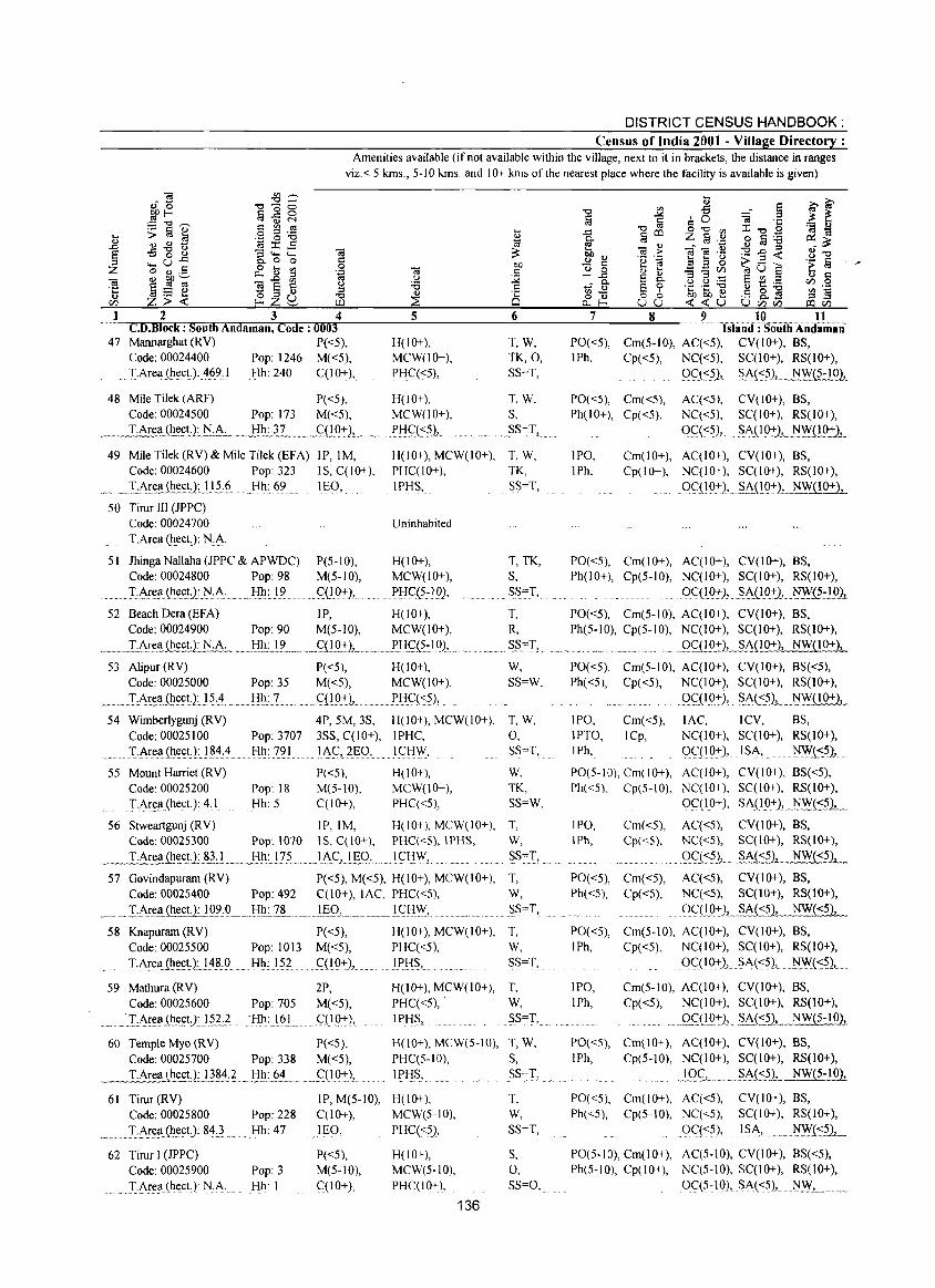
DISTRICT CENSUS HANDBOOK: Census of India 2001 - Village Directory :
Amenities available (if not available within the village, next to it in brackets, the distance in ranges viz.< 5 kms., 5-10 kms. and 10+ kms of the nearest place where the facility is available is given)
1 234 CD.Block : South Andaman, Code: 0003
47 Mannarghat (RV) P«5), Code: 00024400 Pop: 1246 M«5),
.. I-Are!l{lle.cL):AWI Hh: 240 qIO+), ..
48 Mile Tilek (ARF) P«5), Code: 00024500 Pop: 173 M( <5),
_ ..... I:.~('!.~t.}: N:A.:.~1l:.3.? ......... CQ07:L
49 Mile Tilek (RV) & Mile Tilek (EFA) IP,IM, Code: 00024600 Pop: 323 IS, C( I 0-+ ),
., .. I:.A~e.!l.(ll~c.tJ .. L1.?§ Hh: 69 lEO,
50 Tirur III (JPPC) Code: 00024700 T.Area (heet.): N.A·
51 Jhinga Nallaha (JPPC & APWDC) P(5-10), Code: 00024800 Pop: 98 M(5-10),
......... I:A~e.!l(lle.<::t:2:.l'J:A Hh:]9 ... '" g!~),
5
H(IO+), MCW(IO+), PHC«5),
H(IO+), MCW(IO+),
E!:Iq:::51
6
T,W, TK,O, SS=T,
T, W, 5,
HSS",T'e .
H(IO+), MCW(IO+), T, W, PHC(IO+), TK, IPHS, 5S=T,
Uninhabited
H(IO+), T, TK, MCW(IO+), s,
PtIC(5~102, SS=T,
52 Beach Dera (EFA) IP, H(lO+), T, Code: 00024900 Pop: 90 M(5-10), MCW(IO+),
~_,,~_I..:~r.e,'!.ili<:~!l]'J"·A,~~!ih:J,?~_ ... _Cl!.Q:t:L ..... ..iI:I_<;:(~::19L. 53 Alipur (RV) P( <5), H(I 0+),
Code: 00025000 Pop: 35 M«5), MCW(IO+),
.•.. _I,6!:~l!.J.!!~<:UJ~:~ .. ~.J.Ill:L .... ~ .. <':UQ:r), ... ]tIQ<:5),.
R, ~?",T2.
W, SS=W,
54 Wimberlygunj (RV) 4P, 5M, 3S, H(IO+), MCW(IO+), T, W, Code: 00025100 Pop: 3707 3SS, C(lO+), IPHC, 0,
....... TAr~!l(1le.<:t):}~4,~ Hh: 791 L".<::,2EO, ... ICHW, SS=T,
55 Mount Harriet (RV) P«5), H(lO+), W, Code: 00025200 Pop: 18 M(5-10), MCW(IO+), TK, TArea.(hect.): 4:1 Hh: 5 C(lO+), PHq<5), SS=W,
56 Stweartgunj (RV) IP,IM, H(IO+), MCW(IO+), T, Code: 00025300 Pop: 1070 IS, C(IO+), PHq<S),IPHS, W,
7
PO«5), IPh,
8 9 10 11 ISliiiid: South Aiidamaii
Cm(5-IO), Aq<5), CV(lO+), BS, Cp«5), Nq<5), SC(IO+), RS(1O+),
9C(~1_ Si'\_k:52,_ NW(5-IO),
PO«5), Cm«5), Ph(lO+), Cp«5),
AC«5), CV(lO+), BS, Nq<5), SqIO+), RS(10+),
0<::«5),. _~~A(IO:'"LNW{lO+},
IPO, Cm(IO+), AqIO+), CV(IO+), BS, IPh, Cp(IO+), NqIO+), SC(IO+), RS(IO+),
QC(I()+L~~(1():,:), NWJ!O+),
PO«5), Cm(IO+), AqIO+), CV(IO+), BS, Ph(IO+), Cp(5-10), NC(lO+), SC(I 0+), RS(10+),
Oql~), .~A{10:,"), l'J}Y<1:191 PO«5), Cm(5-10), AqIO+), CV(lO+), BS, Ph(5-10), Cp(5-10), NC(IO+), SC(I 0+), RS(IO+),
e. "' _Q~(l():,:LSAjW+), NW(lO+),
PO«5), Cm(5-10), AC(IO+), CV(IO+), BS(<5), Ph«5), Cp«5), NqlO+), SC(IO+), RS(10+),
IPO, IPTO, IPh,
Cm«5), ICp,
. Q<,:(10:+:),. §'A(s?2,_~F(I 0+), .
lAC, ICV, BS, NqIO+), SC(I 0+), RS(10+),
oqIO:'"), IS1\, ... . ..... tlWC::?),
PO(5-10), Cm(IO+), Aq I 0+), CV(IO+), BS«5), Ph«5). Cp(S-IO), NC(IO+), Sql0+), RS(lO+),
OqIO+), SA(10+2'eN..~:t~~.L.
IPO, IPh,
Cm«5), Cp«5),
.~._ .. I:Area.111e.c.U: 83:L.,~ljll.:l.7'? ..... _J.A.<::J.lg_Q., .. ~!'<::f:I\v.L .. ~S,,",,:L ..... "'"-
Aq<5), CV(IO+), BS, NC«5), SC(lO+), RS(lO+),
9_£l<:Th___e ~.AJ::?1_ NW«5),
AC«5), CV(10+), BS, NC«5), SC(I 0+), RS(10+),
Q<::m::t:)LSA«5), NW«5),
57 Govindapuram (RV) P«5), M«5), H(IO+), MCW(IO+), T, Code: 00025400 Pop: 492 C(10+), lAC, PHq<5), W,
_ .. _.TA~fuect. ): JQ~:L. J!h.:~ ....... LE.9>._.. . __ I.. CI{"W,. .. ....... .... ~~=T,.
58 Knapuram (RV) P«5), H(lO+), MCW(IO+), T, Code: 00025500 Pop: 1013 M«5), PHq<5), W,
IA~e.!l(lle.<:t): 14~:9 Hh: 152 . C(IQ+), IPJ:-l§, SS=T,
59 Mathura (RV)
Code: 00025600 Pop: 705
.. ·LAr_t!!l.(lle.<:tJ:l~~} 'Hh: 161
2P,
M«5),
<::(1g~),
60 Temple Myo (RV) P«5), Code: 00025700 Pop: 338 M«5),
__ . .T.Are!lJll_t!ctJ,..!384.~_.f:I_!l:§! ... ~S(lQ:t:l," e
61 Tirur (RV) IP, M(5-10), Code: 00025800 Pop: 228 C(JO+),
.. _ I:Are!l(~e.~t.):J~} .. Hh: 47 lEO,
62 Tirur I (JPPC) P«5), Code: 00025900 Pop: 3 M(5-10),
T:Are~ (heet) ]\J.A Hh: I <::(10+),
H(IO+), MCW(IO+), T, PHq<5), . W,
IPH~, ~S""T,
H(lO+), MCW(5-10), T, W, PHC(5-10), s,
I Eli?] ... ~.. 55=1.,
H(lO+), T, MCW(5-10), W,
PHq<5), S5=T,
H(IO+), S, MCW(5-10), 0, PHC(IO+), S5=0,
136
PO«5), Cm«5), Ph«5), Cp«5),
PO«5), Cm(5-10), Aq I 0+), CV(IO+), BS, IPh, Cp«5), NqlO+), SC(I 0+), RS(10+),
QC( I 0:+:), §A(<:5), tlW(~?2'.e
IPO, IPh,
Cm(5-10), AC(10+), CV(lO+), BS, Cp«5), NC(IO+), SqIO+), RS(lO+),
.9gl.9:+:)1_ §..A«5), NW(5-IO),
PO«5), Cm(IO+), AC(IO+), CY(IO+), BS, IPh, Cp(5-10), NC(lO+), SC(IO+), RS(1o+),
_IQL._._.~~?.1.. NW(5-1O),
PO«5), Cm( 10+), AC«5), CV(IO+), BS, Ph«5), Cp(5-10), Nq<5), SC(lO+), RS(IO+),
9q<5), ISA, ...... ~~2,__
PO(5-1O), Cm(IO+), Aq5-1O), CV(IO+), BS«5), Ph(5-10), Cp(IO+), NC(5-IO), sq I 0+), RS(1O+),
.OC(5~IO), Si'\«5), tlWL..
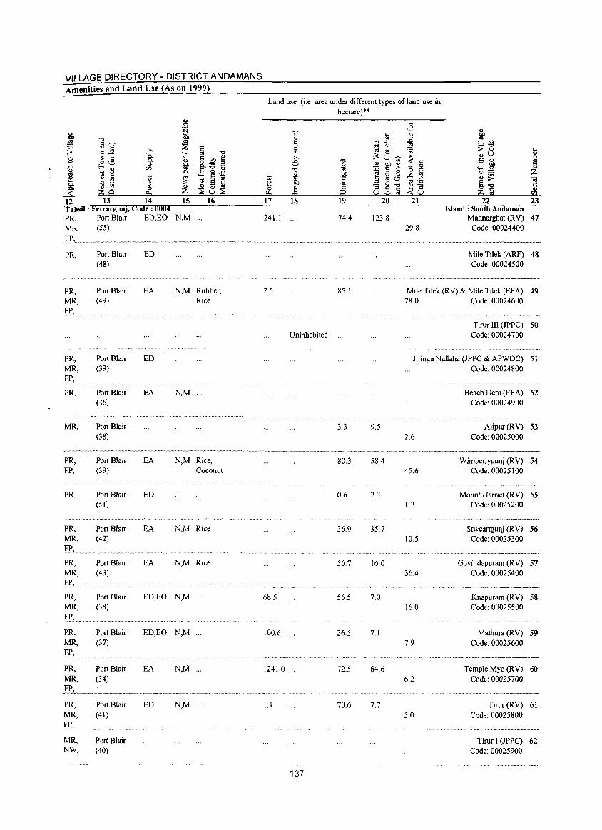
VILLAGE DIRECTORY - DISTRICT ANDAMANS Amenities and Land Use (As on 1999)
12 13 14 Tahsil: Ferrargunj, Code: 0004
15 16
PR, Port Blair ED,EO N,M ... MR, (55)
fP, . PR,
PR, MR, l'I.', ..
PR, MR, FI',. PR,
MR,
PR, FP,
PR,
PR, MR,
'f'.I'L. ... PR, MR,
PR, MR, FP, PR, MR,
PR, MR,
PR, MR,
Fl',
MR, NW,
Port Blair (48)
Port Blair (49)
Port Blair (39)
Port Blair (36)
Port Blair (38)
Port Blair (39)
Port Blair (51)
Port Blair (42)
Port Blair (43)
Port Blair (38)
Port Blair (37)
Port Blair (34)
Port Blair (41)
Port Blair (40)
ED
EA N,M Rubber, Rice
ED
EA N,M ...
EA N,M Rice, Coconut
ED
EA N,M Rice
EA N,M Rice
ED,EO N,M ...
ED,EO N,M ...
EA N,M ...
ED N,M ...
Land use (i.e. area under different types of land use in hectare)**
~
OJ U
3 0 '" ;;., e "0
OJ "0 'iii OJ !lO
'" 'iii :§ ~ !lO
] c:: 0
"" :=> 17 18 19
241.1 ... 74.4
2.5 85.1
Uninhabited ...
3.3
80.3
0.6
36.9
56.7
68.5 56.5
100.6 ... 36.5
1241.0 ... 72.5
1.1 70.6
137
~
~ .c u ::l
3: '" 0 ~ '" OJ !lO <l)
::c s::: ;>
:.a 0 '" ... a '" 0
<:l "3 s::: "0 § u '---'
20
123.8
9.5
58.4
2.3
35.7
16.0
7.0
7.1
64.6
... <9 OJ :g '8 ;> ~ s:::
0 '0 ':g Z ;>
'" OJ "3 ..< u 21
29.8
OJ
~ OJ
;; "t:I 0 .... u OJ
OJ
1 -5 OJ
~ ..... 0 Z ;; ~ 1<1
"0 ·c § OJ Z co
22 23 tshinii : Souih Anlliiiiiilii-.-.·.
Mannarghat (RV) 47 Code: 00024400
Mile Tilek (ARF) 48 Code: 00024500
Mile Tilek (RY) & Mile Tilek (EFA) 49 28.0 Code: 00024600
Tirur III (JPPC) 50 Code: 00024700
Jhinga Nallaha (JPPC & APWDC) 51 Code: 00024800
2.6
45.6
1.2
10.5
36.4
16.0
7.9
6.2
Beach Dera (EFA) 52 Code: 00024900
Alipur (RY) 53 Code: 00025000
Wimberlygunj (RY) 54 Code: 00025100
........................ _ ..........
Mount Harriet (R Y) 55 Code: 00025200
~~ ... ~~~~~~~,,-~-~---.-~.~
Stweartgunj (RY) 56 Code: 00025300
-.. ~ .. ,,-.,,---... ---.--..
Govindapuram (RY) 57 Code: 00025400
••• _" _ M~' ••• _ •• ~~ ___
Knapuram (RV) 58 Code: 00025500
................. '"'"_ .....•.....•..
Mathura (RV) 59 Code: 00025600
.·'"·_w·'"_~ __ ~·_
Temple Myo (RV) 60 Code: 00025700
"=~.,"."- ..• ,,.-... ~ ... ".~~""--,,,~~ .. ~
7.7 Tirur (RV) 61 5.0 Code: 00025800
.. ... , .. , ......... __ ................. h._._
Tirur I (JPPC) 62 Code: 00025900
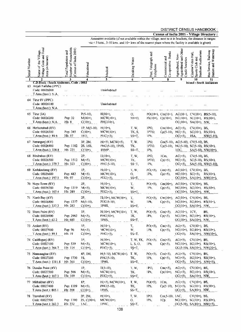
DISTRICT CENSUS HANDBOOK: Census of India 2001 - Village Directory :
Amenities available (if not available within the village, next to it in brackets, the distance in ranges viz. < 5 kms., 5-10 kms. and 10+ kms of the nearest place where the facility is available is given)
2 3 4 CD. Block : South Andaman, Code: 0003
63 Anjali Nallaha (JPPC) Code: 00026000
.. IA~~!I.{h_!:(;t.): :!'l,A.:. 64 Tirur IV (JPPC)
5
Uninhabited
Code: 00026100 Uninhabited
_. _ _I.Ar~ (hec!.): N.1"'-.~ __ ... ~. __ .. _ ....... _ .. _._.~ ......... ............. .
6
65 Tiror (JA) P(5-10), H(lO+), 0, Code: 00026200 Pop: 32 M(lO+), MCW(IO+), SS=O,
. T.Are!l (hect.):N,A. Hh: 8 C(IO~), PHc:(I0+),
66 Herbertabad (RV) I P, M(S-IO), H(IO+), MCW(lO+),
.. . PHq~S)J
Code: 00026300 Pop: 345 C(lO+),
~ .... ~IArea (l.!..e.c.UJ!2,.~ .... _!:f.h~.s .. L. _ .... }.§P..l.. .. ... ..
67 Ferrargunj (RV) 3P, 2M, Code: 00026400 Pop: 1182 2S, 1 SS,
...... :LAr~(h~c.!.):}} .. ~& J:!h.: 2.2..1. .. c(lO.-l:),
68 Bindraban (RV) 2P, Code: 00026500 Pop: 1512 M«5),
.. _.J~AE~~.(h~c!J:J'7~J.. Hh: 323 ql0+),
H«5), MCW«S), PHC(5-l0), lPHS,
I~P, ..
H(IO+), MCW(IO+), PHqS-lO),
T,W, TK, S,
~.S=T, ... T,W, TK, SS=T,
T,W, TK. SS=T,
7 8 9 10 11 .. island: SoufhAiidiiiiiiJi
PO(lO+), Cm(lO+), AC(IO+), CV(IO+), BS(S-IO), Ph(IO+), Cp(lO+), NC(lO+), SC(I 0+), RS(lO+),
OC(IO+), SA(IO+:), ... ~, .... ~.
lP~,
IPTO, lPh,
lP~,
IPTO, I Ph,
lP~,
lPTO, IPh,
Cm(IO+), AC«S), CV(IO+), BS, Cp(5-10), NC«5), SC(IO+), RS(IO+),
. PC:\<:5)L .. __1SA, .... _ NW(5-lQ1_
Cm(S-lO), AC(S-lO), CV(5-l0), BS, Cp(5-10), NC(S-IO), SC(5-10), RS(IO+),
lCm, Cp«5),
1 QC:L. . ~ .. A(.5.:!.o.bJi!yJ..lQ_:I-)L
AC«5), CV(5-l0), BS, NC«S), SC(S-lO), RS(IO+),
. QC«5), ... ~A(S:'!QJ, NW(S-lQ1
69 Kadakachang (RV) IP, H(lO+), T, W, PO«5), Cm«5), AC(lO+), CV(lO+), BS, Code: 00026600 Pop: 482 M«S), MCW(IO+), 0, lPh, Cp«S), NC(IO+), SC«S), RS(IO+),
......... T:1r~~{h~~tJ:l~?:5 Hh: 97 ... (:(IQ:rl, pHc:«5), SS=T, QqIQ:,:), ~A(1Q+),.~('!'9.!1_
70 Hope Town (RV) 2P, H(IO+), T, PO«S), Cm(IO+), AC(lO+), CV(lO+), BS, Code: 00026700 Pop: 1319 M«5), MCW(IO+), W, lPh, Cp«S), NC(IO+), SC(I 0+), RS(lO+),
~~LArea~t.): 107.'L .... Ij_.!!: 289 .. _gLQ2:1 __ ~.~!:!gt.::?'),_~ ... ~ ..... S_S.~T..L.. ......... ___ ....... ___ .. .9C(IQ:::-.LSA(IO+), NW,
71 North Bay (RV) 2P, Code: 00026800 Pop: 1377 M(S-10),
. T,AI~a(he<:!.):}37,L ... I:Ih:}§~ .... qIO:rL ...
n Shore Point (RV) IP, Code: 00026900 Pop: 2962 M«S),
_ ... _I;~~1I...(h~<:!~_.2 ..... ~~I:Ih_:__§§? .. _ .... C:L!Q:J::l, __ . 73 Aniket (RV)
Code: 00027000 Pop: 96 TAr:ea .. (h.ect):?9,1 Hh: 19
lP, M«S), C(1O+),
H(IO+), MCW(lO+), PHC(S-IO), IPl:!S, .
T, W, SS=T,
H(IO+), MCW(lO+), T, W, PHC(IO+), TK, lPHS, SS=T,.
H(lO+), MCW(IO+), PHC«S),
T, W, SS=T,
PO«S), Cm(IO+), AC(IO+), CV(IO+), BS, lPh, Cp«5), NC(IO+), SC(IO+), RS(IO+),
gqIO+), .. ~A(_l_Q+), NW, __ ~
PO«S), Cm«S), AC(IO+), ICV, BS, IPh, Cp«5), NC(JO+), SC(lO+), RS(IO+),
Qq!_o:r2, .... s_A(!Q2L~_, __ PO«S), Cm«5), AC«S), CV(IO+), BS, lPh, Cp«S), NC(lO+), SC(IO+), RS(lO+),
0C«5), . ~A(IQ+.)L~QQ:!:2,.
74 Caddlegunj (RV) lP, Code: 00027100 Pop: S39 M«S),
__ ~T:A!~!I(h~c.tJ}_si~ .. 7..... !:!h:.lJi ..... C:(l9~)J_.. .
H(lO+), MCW(lO+), PHq<~J,
T, W, TK, PO«5), Cm«5), L, S, 0, lPh, Cp«S), S~=T,
AC«S), CV(lO+), BS, NC(IO+), SC(I 0+), RS(IO+), Qg(~':'!'Q2, ~A{!'O+), NW(IO+),
75 Namunaghar (RV) 4P, 1M, H(5-10), MCW(IO+), T, W, Code: 00027200 Pop: 1730 IS, PHC(5-10), TK,
....... TAre~(he~t.):J3.l.L~ .. ·_I:Ih:}§I ........... (:(lQ~)L.. . ... Ij>IjS, SS=T,
PO«5), Cm«5), lPh, Cp«5),
AC«5), CV(lO+), BS, NC«5), SC(IO+), RS(lO+),
0C::{<5), __ . ~A_(1Q:t2,. N\\_'t:~l ... _
76 Dundas Point (RV) IP, H(S-lO), T, W, lP~, Cm«5), AC«5), CV(lO+), BS, Cp(IO+), NC«S), SC(I 0+), RS(IO+), Code: 00027300 Pop: 566 M«S), MCW(lO+),
_ ... I·Area ~£!.): 167 L _ ____!!h.:JQL .... _g 10+1, ____ J>1jC::_('S?1. .
77 Mithakhari (RV) IP, Code: 00027400 Pop: 1109 M«5),
... I-i\~~~(hect.): 80S. I . Hh: 208 C(IO+),
78 Tusnabad (RV) 2P,2M, Code: 00027500 Pop: 1190 2S, C(lO+),
.... ~T1I~!(h.~~U.~§.2}_ ...... ljh:~}2 ......... IAC,
H«S), MCW(lO+), PHC(5-10), IPHS,
H(lO+), MCW(lO+), lPHC,
138
TK, lPh,
.... Ss_=l", ....... . T,W, TK, SS=T,
T,W, 0, SS=T,
ggt'2)L ... ~A_QO+)J NW,
PO«5), ICm, AC«5), CV(IO+), BS, IPh, Cp(5-l0), NC«5), SC(IO+), RS(IO+),
lP~,
IPh,
Qq.-::S), .... ~A.(10:::-),.~, ...... _ .... Cm(S-IO), lAC, CV(IO+), BS, lCp, NC(IO+), SC(I 0+), RS(IO+),
. Qq?~.lQ), SAnQ.::'}, NW( <5),
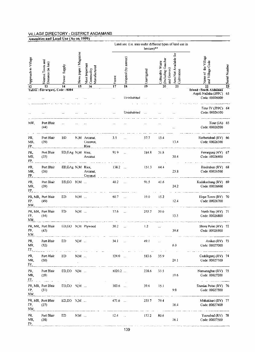
VILLAGE DIRECTORY - DISTRICT ANDAMANS Amenities and Land Use (As on 1999)
<U .5
j: ~ -,:) ~
:;::: §'"' ::::E ~] § -,:) > .b 9 Q.. .... 1:: C <U o .5 Q.. <U ..c: f-<'-' :::s ~ 8.._ B
VJ E]~ ~ ~ 8 Q..
e CI) fii .... '" :: § :::l <!)
Q.. ~ t;; ~ ~
~ <!) ._
0 <!) ~ 0 fa ZQ 0... Z ::::Eu:::2
12 13 14 15 16 Tahsil: Ferrargunj, Code: 0004
NW, Port Blair (44)
PR, Port Blair ED N,M Arcanut, MR, (39) Coconut,
EP,_~ ... ~ __ .......... __ ... _ .... _ ..... ~ .... _ .. Bj.£t! ...... . PR, MR, .FP}
PR, MR,
PR, MR, FP, .
Port Blair (35)
Port Blair (36)
Port Blair (39)
PR, MR, Port Blair FP, (49)
PR, MR, Port Blair FP, (54)
PR, MR, Port Blair FP,
N~L
PR, MR,
PR, MR,
PR, MR,
Fr., .
(43)
Port Blair (32)
Port Blair (30)
Port Blair (28)
PR, MR, Port Blair FP, (31)
PR, MR, Port Blair FP, (27) NW,
EO,EAg N,M Rice, Arcanut
ED,EAg N,M Rice, Arcanut, Coconut
ED,EO N,M
ED N,M ...
ED N,M ...
EO,EO N,M Plywood
ED N,M ...
ED N,M '"
ED,EO N,M ".
ED,EO N,M ...
ED,EO N,M '"
PR, Port Blair ED N,M '" MR, (28)
E!\ ... ' ....... _ ....... _ ......... _ .............. ~ ......... _ .... _ ................ ..
Land use (i.e. area under different types ofland use in hectare)**
., ~ ~ :::s ~fj
0 ~ fJ on ;;.., ~O-;n
..0 -,:) '-"" ~
<l) OJ) <l)
-,:) - c:: ;>
* E e ~ 8 :;; '" :::l 0 ~ OJ) ':::u"'O
0 1; '2 G5§ ~ ;::l
17 18 19 20
Uninhabited
Uninhabited
3.1 57.7 15.4
91.9 184.8 31.8
138.2 ... 151.3 64.4
40.2 915 41.6
60.7 19.0 15.2
17.6 255.7 50.6
30.2 1.2
34.1 49.1
124.0 ... 183.6 35.9
1020.2 238.6 33.5
103.6 39.6 15.1
471.6 ... 235.7 79.4
12.4 153.2 80.6
139
2]
13.4
22 23 .. Islaiid: South AiiiJliiiiiin------
Anjali Nallaha (IPPC) 63 Code: 00026000
Tirur IV (JPPC) 64 Code: 00026100
Tirur (JA) 65 Code: 00026200
Herbertabad (R V) 66 Code: 00026300
••• •• v_. ~ 'vvv •• __ ~~ ___ -...._ •• _ • .,,_. __ ••
30.4
25.8
24.2
12.4
13.5
30.8
6.0
21.1
19.6
9.0
18.4
16.1
Ferrargunj (RV) 67 Code: 00026400
~ ~~~~n __ " _____ ~_'~ __
Bindraban (RV) 68 Code: 00026500
.. v_~._.~_~",.~_· _____
Kadakachang (RV) 69 Code: 00026600
.. ········m'·~_'·.·"'~,,_,,_.,, ___ ,,_
Hope Town (RV) 70 Code: 00026700
v·.··· .•.... ~ __ .~ .... _~ ..
North Bay (R V) 71 Code: 00026800
-'~"--~~"-"-'-'-~""~------
Shore Point (RV) 72 Code: 00026900
"~"""'-'-----
Aniket (RV) 73 Code: 00027000
.. '.~~~ .. " .. -.. ~ .. ",-'-,"",
Caddlegunj (RV) 74 Code: 00027100
,".-.-""~,".,,,","~.-,""
Namunaghar (RV) 75 Code: 00027200
~"~ _~A~~AA ____ ' ______
Dundas Point (R V) 76 Code: 00027300
Mithakhari (RV) 77 Code: 00027400
Tusnabad (RV) 78 Code: 00027500
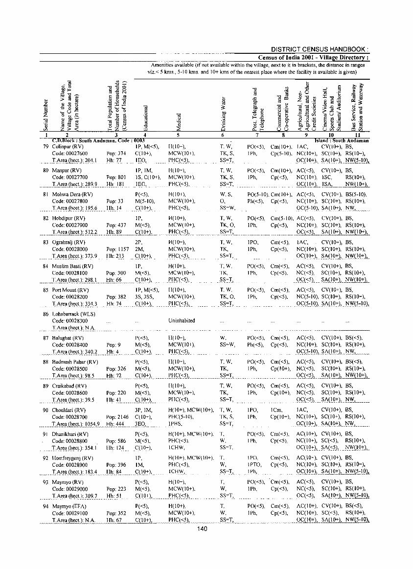
DISTRICT CENSUS HANDBOOK: Census of India 2001 - Village Directory :
Amenities available (if not available within the village, next to it in brackets, the distance in ranges viz.< 5 kms., 5-10 kms. and 10+ kms of the nearest place where the facility is available is given)
1 2 3 4 CD.Block : South Andaman, Code: 0003
79 Co!inpur (RV) IP, M«5), Code: 00027600 Pop: 374 C(lO+),
.. _ ... !:.Arel!(~~£t}:.2Sl~} Hh: 77 IE.O,
5
H(lO+), MCW(lO+), PHC«5),
6
T,W, TK, S, SS=1,
7 8 9 10 11 Island: South Andaman
PO«5), Cm(IO+), lAC, CV(IO+), BS, IPh, Cp(5-10), NC(IO+), SC(IO+), RS(JO+),
9c:.O 0+), .. ~~EQ:!:2, NW(5-10),
80 Manpur (RV) IP,IM, H(IO+), T, W, PO«5), Cm(IO+), AC«5), CV(IO+), BS, Code: 00027700 Pop: 801 IS, C(10+),
_IE.D, _ MCW(IO+), TK, S, IPh, Cp«5), NC(IO+), ISC, RS(lO+),
._. ___ :I:~~.t~~~t1.?1I9J.. _.I::Il!: 181 . PHQ<5), SS=T, .. OC:_(1 __ Q:+.1_!?i'.L ___ NW(IO+),
81 Mohwa Dera (R V) P«5), M(5-10),
H(lO+), W, S, PO(5-10), Cm(lO+), AC«5), CV(lO+), BS(5-10), Code: 00027800 Pop: 33 MCW(IO+), 0, Ph«5), Cp«5), NC(10+), SC(10+), RS(IO+), T~re~(~(!(;t): 1?5.6 Hh: 14 . <::(10:+), PHC«5), SS=W, ()C(5-10), SA(19.:+), ~~~ __
82 Hobdipur (RV) IP, H(10+), T, W, PO«5), Cm(5-IO), AC«5), CV(10+), BS, Code: 00027900 Pop: 437 M«5), MCW(IO+), TK,O, IPh, Cp«5), NC(IO+), SC(I 0+), RS(IO+), T.Area (heet.): 512.2 .. _Bh: 89 .. _ ffiO_:+-), __ .. m PH<;:(:::~.L .. ~ __ ._. __ ._?S=T,_ .. __ .. ____ .. __ ..... ___ m. __ .9C~L S~1!_Q+), NW(I 0+),
83 Ograbraij (RV) 2P, H(IO+), Code: 00028000 Pop: 1157 2M, MCW(lO+), 'r::~Eel!(~(!c_t).:}73.9 ... Hh: 213 C(IO-:+-), PHC«5),
84 Muslim Basti (RV) IP, H(IO+), Code: 00028100 Pop: 300 M«5), MCW(IO+),
_m_T.:.~t:!(~(;!J12lLL .. .!i~;_§.L_ .. <::(19:1:),._ . P.liq<~),
85 Port Mouat (RV) IP, M«5), H(IO+), Code: 00028200 Pop: 382 3S,3SS, MCW(lO+), IAr(!a,(h~c,tJn4} _ 1::Ih:7~ c::{10+), PliC(<:5),
86 Lohabarraek (WLS) Code: 00028300
._ .. __ . _LAI~~.~.<:U:.~:.A: 87 BaIughat (RV) P«5),
Code: 00028400 Pop: 9 M«5), .. ,_."I"-.Area (hec!:).:_~4Q:.L .. 1::I!1:_L_. __ C::(!Q:+), __
Uninhabited
H(lO+), MCW(IO+), PHq~5),
88 Badmash Pahar (RV) P«5), H(IO+), Code: 00028500 Pop: 326 M«5), MCW(JO+),
_____ I~~~~c.t12~!:fl!:_}~_.m_. _gOQ~), .. _,.. ,p'g<;::C<:?),.
89 Craikabad (RV) P«5), H(JO+), Code: 00028600 Pop: 220 M«5), MCW(IO+),
... TAr~Il(~~~tJ:J?,? ........ !:f~.: ~I, ........ c:(19-:+-» ... Pli(:«?),
T,W, TK, SS=T,
T,W, TK,
. S?~T, ..
T,W, TK,O, SS=T,
w, SS=W,
T,W, TK,
T,W, TK,
............ ?S=T,
90 Chouldari (RV) 3P, 1M, H(IO+), MCW(IO+), T, W, Code: 00028700 Pop: 2146 C(lO+), PHC(5-10), TK, S,
__ I:..Area (he<1lJ 054.:2.._l:!L4j~ ~EO, 1 i'HS, SS=T,
91 Dhanikhari (RV) P«5), H(lO+}, MCW(lO+), T, Code: 00028800 Pop: 586 M«5), PHC«5), W,
. __ T.Ar~l!(hectJ354.1 Hh: 124 .C(IO+), ICHW, SS=T,
IPO, Cm«5), IPh, Cp«5),
PO«5), Cm«5), IPh, Cp«5),
PO«5), Cm«5), IPh, Cp«5),
PO«5), Cm«5), Ph«5), Cp«5),
lAC, CV(IO+), BS, NC(IO+), SC(lO+), RS(lO+), ()C(lO+),. _S.~(IQ:t2,._NWD_Q:Jl_
AC«5), CV(IO+), BS, NC«5), SC(IO+), RS(IO+), ()C(<:5), ?~(IQ:!: 1..JW( J 0+ ),
AC«5), CV(IO+), BS, NC(5-10), SC(IO+), RS(IO+), Oq5.:IO), SA(lO+), _NW(~:lQh
.......... _ •... _ ..• __ ._---AC«5), CV(IO+), BS«5), NC(IO+), SC(IO+), RS(IO+), .9.qHQ),_SA_(!_O:+)L_~' _
PO«5), Cm«5), AC«5), CV(IO+), BS«5), IPh, Cp(IO+), NC«5), SC(IO+), RS(1O+),
. .. _ . __ g_C2(:,,:5.)L_~~lQ:0, NW(IO+),
PO«5), Cm«5), AC«5), CV(IO+), BS, IPh, Cp(IO+), NC«5), SC(I 0+), RS(IO+),
IPO, IPh,
g<;:( <:?), .. ~Ao.9:t)" NW...1......... ___ ... ICm, lAC, CV(IO+), BS, Cp(IO+), NC(IO+), SC(I 0+), RS(IO+),
_ Q.c:(!_Q:+)L,?!~~:nQ:!:1__ NW_, __
PO«5), Cm«5), AC(IO+), CV(IO+), BS, IPh, Cp«5), NC(IO+), SC«5), RS(IO+),
OC( 1_Q7:)L ?A(:c.5),_ . __ ~W( 1 0.±1__
92 Homfreygunj (RV) 1P, H(10+), MCW(10+), T, IPO, Cm«5), AC(lO+), CV(10+), BS, Code: 00028900 Pop: 396 1M, PHC«5), W, IPTO, Cp«5), NC(IO+), SC(I 0+), RS(1O+),
" __ . .I~rt:.ll(h.e(;t:11S.1,4. H11_:.8~ . __ .. <;:(1.07:), ICHW, SS=T, IPh,. QQI9':+1_§_A(10:_!:), NW(5-IO),
93 Maymyo (RV) P«5), H(lO+), T, PO«5), Cm«5), AC«5), CV(IO+), BS, Code: 00029000 Pop: 223 M«5), MCW(IO+), W, IPh, Cp«5), NC«5), SC(I 0+), RS(IO+), TAr~Il(~~~t):}o.?} J:!~: 5L. <;::(10+), PH(:(<:5), SS=T, OC(<:5), ~A(IQ~t),_~~:!Q1
94 Maymyo (EFA) P«5), H(lO+), T, PO«5), Cm«5), AC(IO+), CV(lO+), BS«5), Code: 00029100 Pop: 352 M«5), MCW(lO+), W, IPh, Cp«5), NC(IO+), SC«5), RS(IO+),
_ ____:T:.:.;.Ac;::rc;;,.ea:;,_(""'h.;;.;.ec:..;.;t.t.:.}:,.;__N;.::.A:.:.:, _ _..:.;:H::.:;h: 67 C(IO+)_,___ PHq,,:~), _______ . ____ ?_S~T.!.._, ___ .. __ , __ .... ____ QQ!_Q:!:1.._?A(IO+), NW(5-10),
140
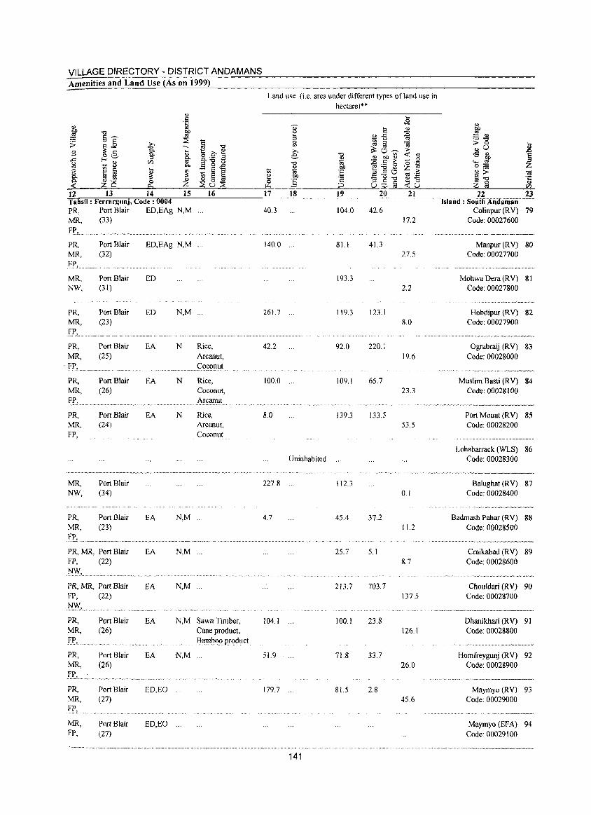
VILLAGE DIRECTORY - DISTRICT ANDAMANS Amenities and Land Use (As on 1999)
12 13 14 15 16
Land use (i.e. area under different types of land use in hectare)**
.... 0-u .... ;::I 0
'" ;;.., e "" - '" '" 'iti
~ OIl 0 :§ ~
<8 til '" ",..c: ::c
- u <IS
~ ia ~ ~"-;;;- ;..
"" -< c: (1) (1) bI) (1) 0 'iti - .:: ;;- o .~ Oil ~;.a8 z <IS
:~ 3 ;::I" >-'::c:l"O
ta ',c
;::l 8$a ~8 17 18 19 20 21 22 23
Tahsil: Ferrargunj, Code: 0004 .. Island: SiiiifilAridiimiiD"--PR, Port Blair ED,EAg N,M ... 40.3 104.0 MR, (33)
FI', ..................... ~ ....... ~ ........... . PR, Port Blair ED,EAg N,M ... 140.0 ... 81.1 MR, (32) FP,
MR, Port Blair ED 193.3 NW, (31)
PR, Port Blair ED N,M ... 261.7 119.3 MR, (23)
PR, Port Blair EA N Rice, 42.2 92.0 MR, (25) Arcanut,
Coconut ,.. ~~, .,~~,.~~~~~~,.~.~,."'~~.~.~ .....• ·.M .... ~" .. ~ .. ~ ...•
PR, Port Blair EA N Rice, 100.0 .,. 109.1
MR' (26) Coconut, Arcanut
•.•.. ~ .~."¥ .. ~"~~.~,, .. , .•
PR, Port Blair EA N Rice, 8.0 139.3 MR, (24) Arcanut, FP, Coconut
Uninhabited
MR, Port Blair 227.8 112.3 NW, (34)
PR, Port Blair EA N,M ... 4.7 MR, (23)
_If', ....... ~ .... _ .... _ .... _ .................. ~ ........... _., ........... .
PR, MR, Port Blair EA N,M '" FP. (22)
PRo MR, Port Blair EA N,M ... FP. (22)
}'~~L ..... ~ .......... _ ...........
PR, Port Blair EA N,M Sawn Timber, 104.1 ... MR, (26)
fI' •. PRo Port Blair MR, (26)
PR, Port Blair MR, (27) FP,
MR. Port Blair FP. (27)
EA
ED,EO
ED,EO
Cane product. Barnb.(){) product.
N,M '" 51.9
179.7
...
141
45.4
25.7
213.7
100.1
71.8
81.5
42.6 17.2
4l.3 27.5
2.2
123.1 8.0
220.1 19.6
65.7 23.3
133.5 53.5
0.1
37.2 11.2
5.1 8.7
703.7 137.5
23.8 126.1
33.7 26.0
2.8 45.6
Colinpur (RV) 79 Code: 00027600
Manpur (RV) 80 Code: 00027700
Mohwa Dera (R V) 81 Code: 00027800
Hobdipur (RV) 82 Code: 00027900
Ograbraij (RV) 83 Code: 00028000
Muslim Basti (RV) 84 Code: 00028100
Port Mouat (RV) 85 Code: 00028200
Lohabarrack (WLS) 86 Code: 00028300
Balughat (RV) 87 Code: 00028400
Badmash Pahar (RV) 88 Code: 00028500
Craikabad CRY) 89 Code: 00028600
Chouldari (RV) 90 Code: 00028700
Dhanikhari (R V) 91 Code: 00028800
Homfreygunj (RV) 92 Code: 00028900
Maymyo (RV) 93 Code: 00029000
Maymyo (EFA) 94 Code: 00029100
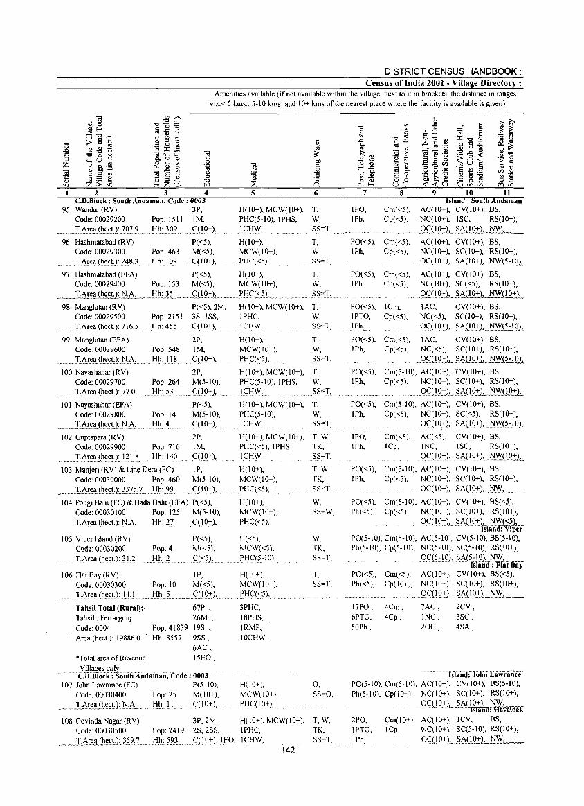
DISTRICT CENSUS HANDBOOK: Census of India 2001 - Village Directory :
Amenities available (if not available within the village, next to it in brackets, the distance in ranges
viz. < 5 kms., 5-10 kms. and 10+ kms of the nearest place where the facility is available is given)
1 2 3 4 5 6 CD.Block : South Andaman, Code: 0003
95 Wandur (RV) 3P, H(IO+), MCW(lO+), T, Code: 00029200 Pop: 1511 1M, PHCC5-10), IPHS, W,
T1r~~.{he~U:}0}'L _Jfh;)Q9 w .. qLQ+), .. I <::J:IW, SS=T,
96 Hashmatabad CRV) P«5), H(lO+), Code: 00029300 Pop: 463 M«5), MCW(IO+),
T,1re~(h(!ct.J}~8.3 Hh: 109 .CQO+), PHCC<5),
97 Hashmatabad (BFA) P«5), H(lO+), Code: 00029400 Pop: 153 M«5), MCW(IO+),
. ___ T.Ar~.£I~U;.N.A.:..... .. _l:!L~,5_ .. ~...<::.L~Q:L ........ .l:'!::If(::?1,
98 Manglutan (RV) P«5), 2M, H(lO+), MCW(lO+), Code: 00029500 Pop: 2151 3S, ISS, IPHC,
. .I,.t-r.t:llw(hl:~t_1}1§:5 Hh: 455 qlQ+), I Cl:lW,
99 Manglutan (EFA) 2P,
Code: 00029600 Pop: 548 1M,
.•.... I..~.r~ll(h~(;tJ:_N.:.A:. ._Hh:JI.8 ... q10+),
100 Nayashahar (RV) 2P, Code: 00029700 Pop: 264 M(5-10),
.,_ . .1:8:~~1l.~J:.I7& ... _!lli~5L .. _ .. S:QP+'1, . .... 101 Nayashahar (EFA)
Code: 00029800
..... Il-.!!ll. (he~.tJ: l'J:!.\ 102 Guptapara CRV)
Code: 00029900
. TArt:ll(he(;t.): 121:8
P«5), Pop: 14 M(5-10), Hh: 4 .q!O,+:),
2P, Pop: 716 1M, Hh: 140 C(1Q+),
lOS Viper Island (RY)
Code: 00030200
P«5), H«5),
Pop: 4 Hh: 2
M«5), MCW«S),
I· Arl:ll Cht:et):) 1,2 C«?),.. . .... PHC(5-10),
106 Flat Bay (RV) IP, H(IO+), Code: 00030300 Pop: 10 M«5), MCW(IO+),
.~ _I·.A~~~.(ht:£l.:1..11c.L .. _ Jih.: .. ~. "w." .<::O.():+-l,.. ~_w.rl:!q<:5), .... Tahsil Total (Rural):Tahsil: Ferrargunj
Code: 0004
67P ,
26M,
Pop:41839 19S,
Area (heet.): 19886.0 Hh: 8557 9SS, 6AC,
*Total area of Revenue 15EO,
yillageso[lly ...... ....... .. .' ... . CD.Block : South Andaman, Code: 0003
107 John Lawrance (FC) P(5-10), Code: 00030400 Pop: 25 M(lO+),
___ .D\rea (h~~!:}_N.~: Hh: II . ql0+),
3PHC, 18PHS,
IRMP, IOCHW,
H(IO+), MCW(lO+),
PHqIO+),
T, W, SS=T,
T, W,
SS:"I,
T, W, SS=T,
T, W, SS=T,
T, W,
SS':"'T,
T, W, §S~T, .. w
T,W,
TK, SS=T,
T,W, TK, SS=T,
W, SS=W,
W, TK, SS=T,
T, SS=T,
0, SS=O,
108 Govinda Nagar (RY) 3P,2M, H(lO+), MCW(IO+), T, W, Code: 00030500 Pop: 2419 2S,2SS, IPHC, TK,
~._ ~J:.Ar~.!IJ!!~£tJ: .. ~~2:X~ Hh: 593 ' .. C(I 0+L1r:O, IfHW, SS=T, 142
7
IPO, IPh,
8 9 10 11 Island: South Andaman
Cm«5), ACC I 0+), CV(IO+), BS, Cp«5), NCC 10+), ISC, RS(lO+),
. ,OC(IQ+.1...§M!O+), NW_, __
PO«5), Cm«5), ACCIO+), CY(lO+), BS, IPh, Cp«5), NCCIO+), SCCIO+), RS(IO+),
OC( I 0+), S,\(.19+.), .. NW(5-!.Q1.
PO«5), Cm«5), ACCIO+), CY(IO+), BS, IPh, Cp«5), NCC I 0+), SC«5), RS(lO+),
PO«S), ICm, lPTO, Cp«5), IPh,
PO«5), Cm«5),
I Ph, Cpt <5),
... Q<::'(IwQ:tl,._~~UQ+), NW(IO+),
lAC, CY(lO+), BS, NCC<5), SC(lO+), RS(lO+),
. QC(12:t), §A(l,Q:+-l,_~.J?:!g),_
lAC, CY(IO+), BS,
NCC<5), SCC I 0+), RS(IO+),
. Q<::1~Q+L .§AUQ:!:1.. NW(5-10),
PO«5), Cm(5-10), AC(IO+), CY(IO+), BS, IPh, Cp«5), NCCIO+), SCCIO+), RS(10+),
. ... , QqI 921 S .. ~_(l_o.+),.l:!W( 10+ },
PO«5), Cm(5-10), AC(IO+), CV(lO+), BS,
lPh, Cp«5), NC(IO+), SCC<5), RS(IO+),
lP~,
IPh, Cm«5), ICp,
g<:'LIQ:+-l, w~SA.(!Q+.2, NW(5-10},
ACC<5), CY(lO+), BS, 1 NC, ISC, RS(lO+),
0<::.(1 9+), S~( I Q+.), ~(I_Q:r)L
PO«S), Cm(S-IO), AC(IO+), CY(IO+), BS, IPh, Cp«5), NC(lO+), SCCIO+), RS(lO+),
. ... .9<='O.9_+2,_§.A.(!Q:!:2,. N,__;,.,W..;_;,c............_
PO«5), Cm(5-10), ACCIO+), CY(IO+), BS«5), Ph«5), Cp«5), NCCIO+), SC(I 0+), RS(IO+),
OC( 10+), SA(I.Q+),.,NF«5}, .. Island: Viper
PO(S-IO), Cm(5-10), ACC5-10), CY(S-IO), BS(5-10), Ph(S-lO), Cp(S-IO), NCCS-IO), SC(S-IO), RS(IO+),
Oc(:;~1 0), §A(5~ lQ),.~, . ___ _ Island: Flat Bay
PO«5), Cm«5), AC(IO+), CY(IO+), BS(<5),
Ph«5), Cp(IO+), NCCIO+), SCCIO+), RS(IO+),
17PO,
6PTO, 50Ph,
4Cm, 4Cp,
... _QC..(!Q:f:),. §.A(lQ:!1_.;:_NW:...:.:..J_, __
7AC,
INC,
20C,
2CV,
3SC,
4SA,
. hland£Joiiii Lawrance PO(5-10), Cm(5-10), ACCIO+), CV(IO+), BS(5-10),
Ph(5-10), Cp(IO+), NCCIO+), SCC 1 0+), RS(IO+),
2PO, IPTO,
IPh,
QC(IO+)l,.§A_(IO+), NW, I k TsIaiIiJ: Have OC
Cm(lO+), ACCIO+), ICV, BS, ICp, NCCIO+), SCC5-10), RS(IO+),
.9c(lP.:!:),,_§.A.OO+1 . .:.-N_W_._, __
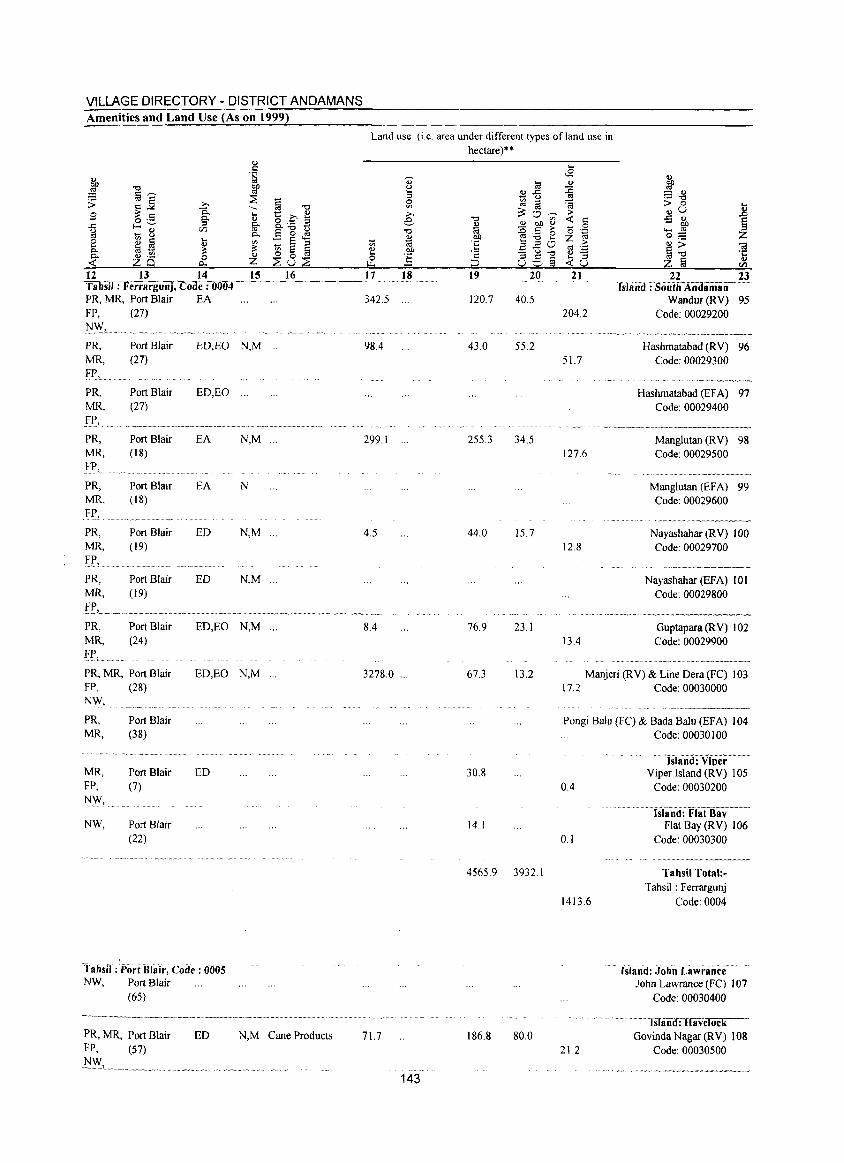
VILLAGE DIRECTORY - DISTRICT ANDAMANS Amenities and Land Use (As on 1999)
12 13 14 15 16 Tahsil: Ferrargunj, Code: 0004 PR, MR, Port Blair EA FP, (27)
PR, MR, f P,
PR, MR,
Port Blair (27)
ED,EO N,M
PR, MR, FP,
PR, MR, FR, __ PR, MR,
fE, PR, MR,
PR, MR, Fr,
Port Blair (27)
Port Blair (18)
Port Blair ( 18)
Port Blair (19)
Port Blair (19)
Port Blair (24)
PR, MR, Port Blair FP, (28) N\\I, PR, MR,
MR, FP, NY',
Port Blair (38)
Port Blair (7)
NW, Port Blair (22)
ED,EO ...
EA N,M ...
EA N
ED N,M '"
ED N,M '"
ED,EO N,M '"
ED,EO N,M ...
ED
Tahsil: Port Bllil':, Coile: 0()05 NW, Port Blair
(65)
PR, MR, Port Blair ED FP, (57)
~"-""-"'''''-~--' ---~~.--
N,M Cane Products
Land use (i.c. area under different types of land use in hectare)"
., Ia OJ
3 ~ ..c OJ
~ ;q ::I
~ '" >-, 0 ~ e "0
~ <!) oJ) <I.>
"0 :g r:: >-<I.> oJ) '6 2
Vi (;l :~ ....
20 1:! Oll .2 OJ ::; "0 0 ] c:: g § ""'
;::) u 17 18 19 20
342.S ... 120.7 40.S
98.4 43.0 5S.2
299.1 2553 34.5
4.5 44.0 15.7
8.4 76.9 23.1
3278.0 ... 67.3 13.2
30.8
14.1
4565.9 3932.1
71.7 186.8 80.0
143
.... <£
<I.>
:g ~ >-
<t: c:: 0 0 .~ z >-ro 'Z:;:
<I.> -.... ::I <t:u
21
204.2
S1.7
127.6
12.8
13.4
22 23 . Island: SoiiliiAndiiiiiiiil- ---
Wandur(RV) 95 Code: 00029200
..... __ . __ ... _----Hashmatabad (RV) 96
Code: 00029300
Hashmatabad (EFA) 97 Code: 00029400
~--~-.-.--.. ---~-.----Manglutan (RV) 98 Code: 00029500
Manglutan (EF A) 99 Code: 00029600
Nayashahar (RV) 100 Code: 00029700
Nayashahar (EFA) 101 Code: 00029800
Guptapara (R V) 102 Code: 00029900
..... ...... ~.- ...... -.-..... -.
Manjeri (RV) & Line Dera (FC) 103 17.2 Code: 00030000
.---".--.~----
Pongi Salu (FC) & Bada Balu (EFA) 104
0.4
0.1
1413.6
21.2
Code: 00030100
lSlani!:ViPer-'-" Yiper Island (RY) 105
Code: 00030200
. (siand: FiatHilv Flat Bay (RV) 106
Code: 00030300
Tahsil Total:-Tahsil: Ferrargunj
Code: 0004
Island: JohiiLiiwrance John Lawrance (FC) 107
Code: 00030400
IsliiiO:Ravelock Govinda Nagar (RY) 108
Code: 00030500
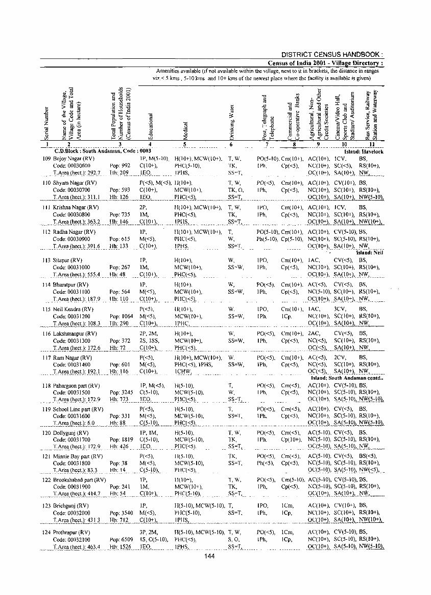
DISTRICT CENSUS HANDBOOK: Census of India 2001 - Village Directory :
Amenities available (if not available within the village, next to it in brackets, the distance in ranges viz. < 5 kms , 5-10 kms. and 10+ kms of the nearest place where the facility is available is given)
2 3 4 5 6 7 8 9 10 11 ..... ~-.. -.. --.-.-C.D.Block : South Andaman, Code: 0003 Island: Havelock
109 BejoyNagar(RV) IP,M(5-10), H(lO+), MCW(IO+), T,W, PO(5-10),Cm(10+), AC(10+), lCV, BS, Code: 00030600 Pop: 992 C(lO+), PHC(5-10), TK, IPh, Cp«5), NC(lO+), SC«5), RS(IO+),
.T:1~~~(~~~t):~?J Hh: 209 11:':9,. IPI-IS., SS""T, ()c:::(IQ:t:), S.1\(IQ:t.:),.I'ffi'_, _._
110 ShyamNagar(RV) P«5), M«5), H(lO+), T, W, PO«5), Cm(IO+), AC(IO+), CV(lO+). BS. Code: 00030700 Pop: 593 C(lO+), MCW(lO+). TK. O. I Ph, Cp«5). NC(IO+), SC(IO+), RS(IO+),
T.Area (heet.): 311.1 ___ . .l::!.Il:.J26 __ !~OL .. ~_ .. __ ~~HC(~..L~ ___ .... ~§.""IL_ .. _._ .... M~ "_M~ __ ._M .OC(10:1._SA(10+). NW(5-10)!
III Krishna Nagar (RV) 2P. H(lO+). MCW(lO+), T. W. Code: 00030800 Pop: 735 1M, PHC«5). TK.
.... _.LI\::~(~~Y~2~:? _ _l!_l!:J.~§ ___ <:.:(!2::L .... _lfJ::I§J ..... . M.... ~~""I, .. 112 Radha Nagar (RV) IP.
M«5). C(10+), .
H(IO+), MCW(IO+). T. Code: 00030900 Pop: 615
. T:Area(heetJ: 391:6.. Hh: 133
113 Sitapur (RV) Code: 00031000
T:Are.a(11e.ct): 555:~
114 Bharatpur (RV) Code: 00031100
.......... "I':Are.ll: (ht!<:tJ: IE: 9
IP. Pop: 267 1M.
Hh: 48 ...... C(19+) •.
Pop: 564 Hh: 110
IP. M«5). C(19+),
PHC«5). If>HS,
H(lO+). MCW(lO+),
PI-I<:':«5).
H(lO+). MCW(IO+).
PHC\<:5),
W. SS=T.
W. SS=W.
W,
SS=W.
115 Neil Kendra (RV) P«5), H( 10+), W, Code: 00031200 Pop: 1064 M«5). MCW(IO+). SS=W,
.~T.I~rea (heet.): 108.3 .. _J:Ih: 2_9.Q_ .. _.<:.:LI.0:t.:j"._ .. _.1 f>'i<:':L._ ............... .
116 Lakshmanpur (RV) 2P, 2M. H( I 0+). W. Code: 00031300 Pop: 372 2S. ISS. MCW(lO+). SS=W,
IPO. Cm(IO+). AC(IO+). ICV. BS. IPh, Cp«5). NC(10+), SC(10+), RS(lO+),
• .' •• n. 2<:':(!Q71,,~_A{10+). NW(lO+),
PO(5-10), Cm(10+). Ph(5-JO). Cp(5-10).
AC(IO+). CV(S-lO). BS. NC(IO+). SC(5-10). RS(lO+),
QC(IO+) •.... SA(IO:t.:), !'-l'v\f',.M
IPO, IPh,
Cm(lO+), lAC, Cp«S). Nq I 0+),
QC(IO:t.:),
Island: Neil
CV«5}. BS. SC(JO+). RS(lO+),
~I\( 19:1.:) •. 1':'"", PO«5), Cm(JO+). AC«S), CV«5). BS, IPh, Cp«S). NC(S-IO). SC(IO+), RS(IO+),
IPO, JPh,
. QQ!9:t:), . S.1\(lQ:t:),.~'v\f,_ ... _.
Cm(IO+), lAC, 3CV, BS. lCp, NC(IO+). SC(IO+), RS(lO+),
m. _ • .9.9.10+), .. ?A(IO+). NW,
PO«5), Cm(IO+). 2AC. CV«5}. BS. IPh, Cp«5). NC«S). SC(I 0+). RS(IO+),
.... ...LArea J.~~L.!?L~,_l:!h_:_1L., ... qL9:1:)L.. .,~. P .. }J~{<:?1". ~ .. _.. . ... . ............. , ................... ' , .................... Q~i.<:.?),._.s.,A.0.Q21 NW.
117 Ram Nagar (RV) P«5), H(IO+),MCW(IO+), Code: 00031400 Pop: 601 M«S), PHC«5),IPHS,
....... ' T:Are.ll:(he.ctJ:l?~,l Hh: 116 C(10+). I <:':H\y.
118 Pahargaon part (RY) JP. M«5), H(5-1O), Code: 00031500 Pop: 3245 C(5-JO). MCW(5-10).
I:A~~!l.(~~ct): I?~:? Hh: 773 ...... ]E()2 ' ...... PHC(<:5),
119 School Line part (RV) P«5). H(S-IO). Code: 00031600 Pop: 331 M«5). MCW(5·10).
~ __ J.Area (heet. }: ~_. __ J:lE~.~L ._ ... ~C?::.!q1_.~_.. P..I:!<;:',(.:2L .. 120 Dollygunj (RV) IP.IM, H(5-10),
Code: 00031700 Pop: 1819 C(5-10). MCW(5·10). ~ ... LAE~a.(~t!~tJ:.17?X Hh: 426 Igo, PI:IC«5),
121 Minnie Bay part (RV) P«5), H(5-10), Code: 00031800 Pop: 38 M«5). MCW(5·IO). T:1\r~a(1lt:~t,):8}.} Hh: 14 C(5-10), PHC«5).
122 Brookshabadpart(RV) lP, H(lO+). Code: 00031900 Pop: 241 1M. MCW(IO+).
....... ,. I.1\~l!. (ht:~U.:...111.:1 .... J:I~: 5.~.. . Q 19+ )'" ..... PHq?:lQ).
W. SS=W,
T. W, SS=T,
T, SS=T.
T,W, TK. SS=T.
TK, SS=T.
T.W, TK, SS=T,
123 Briehgunj (RV) IP, H(5-1O). MCW(5-1O), T. Code: 00032000 Pop: 3540 M«5). PHC(5-1O), SS=T,
__ ._LAEea (heeLt_43 teL_" tIh.~] 12 ____ £(!Q:t:L.. ..~J..PH~~ .. _ ....... , .. _ ... ~ .... _ ........ . 124 Prothrapur (RV) 3P.2M. H(S-IO), MCW(S-IO). T. W.
Code: 00032100 Pop: 6509 IS, C(5-10). PHC«5), S.O,
.~_IA!ea (llect1~63:4 ... J:lll~.!g6 ... lgQ,... ..... JPtI§,. S.S=I,
144
PO«5), Cm(lO+), I Ph, Cp( <5),
PO«5}. Cm«5). IPh, Cp«5).
AC«5), 2CV. BS. NC«5), SqIO+), RS(lO+),
QC«S) •... §1\(19:t.:}. I'l'v\f, ... Island: South Andaman contd ..
AC(IO+}, CV(5-IO), BS. NC(lO+). SC(5-10), RS(IO+).
. ()C( lQ:t.:), .. ~}\(?~ IQ),,,~.0.::!Q),
PO«S). Cm«5). AC(IO+). CV«S). BS. IPh. Cp«S). NC(10+). SC(5-IO). RS(lO+).
. ......... " ......... QC(l0:t.:1.2A.(5-IO). NW{S-IO),
PO«5). Cm«5), AC(5-10). CV«5). BS, IPh, Cp(IO+), NC(5-10), SC(5-1O), RS(IO+).
PO«5), Cm«5), Ph«5), Cp«5),
Q<:.:.(~i91,SA(5-.!9). NW_, __
Aq5-10), CV«5), BS«5), NC(5-10). SC(5-IO). RS(IO+), ()C(5~10), ~}\(5~19). ~""(<:?),.,
PO«5). Cm(S-lO). AClS-IO). CV(5-10), BS, IPh, Cp«5). NC(S-IO). SC(5-10). RS(lO+),
IPO. IPh.
QC:::(1.9+) .... §}\i!Q:t:1 ... tI.Y0 ___ _
ICm, lCp.
ACl I 0+), CV(IO+). BS. NC(lO+). SClIO+), RS(IO+),
_'_.d .. _ OC(!Q:!:1, SA(lO+). NW(IO+),
poe <5). 1 Cm. IPh. ICp.
ACl 1 0+). CV(S-IO), BS. NC(lO+). SC(5-10), RS(IO+),
.QC(IO+), _SA(5-10). NW(5-IO),
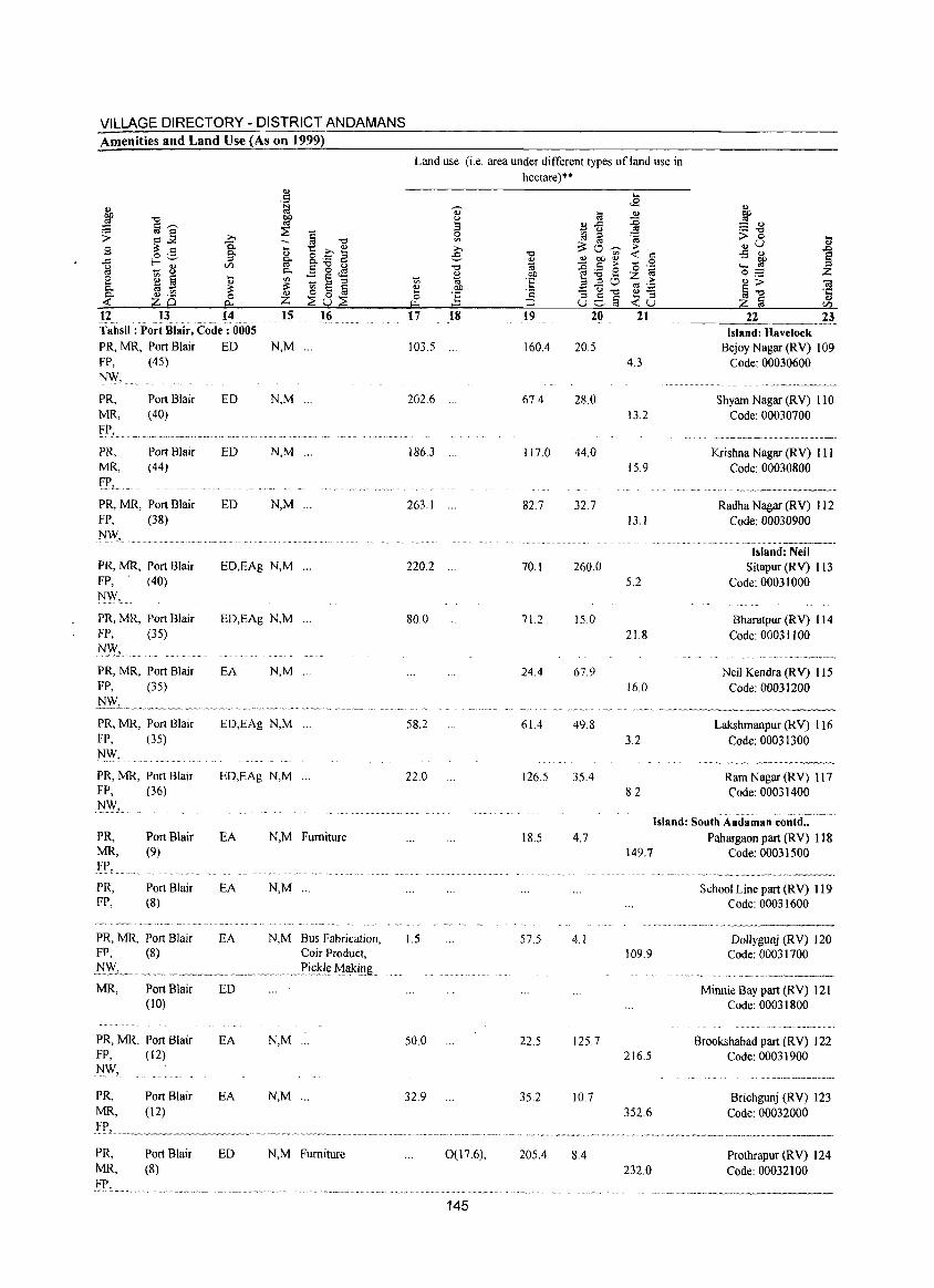
VILLAGE DIRECTORY - DISTRICT ANDAMANS Amenities and Land Use (As on 1999)
12 13 14 ·Tahsil: P~rt Blair, C~d~·; ()oos· PR, MR, Port Blair ED N,M ... FP, (45)
N\\', PR, Port Blair MR, (40)
PR, Port Blair MR, (44) FP,
PR, MR, Port Blair FP, (38)
l\f\\', ..
PR, MR, Port Blair FP, (40) NW,
PR, MR, Port Blair FP, (35)
N"Y, PR, MR. Port Blair FP, (35)
}::I!y".
PR, MR, Port Blair FP. (35) N,,,,,, PR, MR, Port Blair FP, (36) N"Y,
PRo Port Blair MR, (9)
fJ.> •..... PRo Port Blair FP, (8)
PR, MR, Port Blair FP, (8)
MR, Port Blair (10)
PR, MR, Port Blair FP, (12) NW,
ED N,M
ED N,M ...
ED N,M ...
ED,EAg N,M ...
ED,EAg N,M ...
EA N,M ...
ED,EAg N,M ...
EO,EAg N,M ...
EA N,M Furniture
EA N,M ".
EA
ED
EA
N,M Bus Fabrication, Coir Product,
... Xi(;~I~ ~akillg
N,M
Land use (i.e. area under different types of land use in hectare)**
.... <2
til ~ ., .c ..0 ~ u '" gj ~ 'a :::o~ ...
"" -:t <:: <U <U bO <IJ
'~ ~ - <:: ... '0 bO ~~8 z 'E a..30 ...
~ '';:: '2 - (.) "0 <U-
8e§ .... ::I ;:J -:tv
17 18 19 20 21
103.5 160.4 20.5 4.3
202.6 67.4 28.0 13.2
1863 ... 117.0 44.0 15.9
263.1 ... 82.7 32.7 13.1
220.2 70.1 260.0 5.2
80.0 71.2 15.0 21.8
24.4 67.9 16.0
,,~, "~'~ .. '-58.2 61.4 49.8
3.2
22.0 126.5 35.4 8.2
., ~ - ., :="" > 0 t .,v
~ ..s <V
..... ~ 0:-::: Z "'> 01 ij.", ·c ., z ta CI)
22 23 Island: Havelock
Bejoy Nagar (RV) 109 Code: 00030600
..... ~ ...•. ~~.--.~-.-
Shyam Nagar (RV) 110 Code: 00030700
",,,,, .. ,,---~-~-~-,,-.. ,,,,--.-.----
Krishna Nagar (RV) III Code: 00030800
- ~".,,~ ... -~~~--~--
Radha Nagar (RV) 112 Code: 00030900
. ...... -..•.... -.~ .. -.-... -.-.. - .. -Island: Neil
Sitapur (RV) 1 I3 Code: 00031000
Bharatpur (RY) 114 Code: 00031100
., ..... ,." .. _, -.~",~~,~"
Neil Kendra (RY) 115 Code: 00031200
Lakshmanpur (RY) 116 Code: 00031300
Ram Nagar CRY) 117 Code: 00031400
Island: South Andaman contd .. 18.5 4.7
149.7
1.5 57.5 4.1 109.9
50.0 22.5 125.7 216.5
Pahargaon part (RV) 118 Code: 0003] 500
. .....•.. ~, ..... , .. ~--......• ~'"' ...• -~., .............. ,~,
School Line part CRY) 119 Code: 00031600
Oollygunj (RY) 120 Code: 00031700
Minnie Bay part (RY) 121 Code: 00031800
Brookshabad part (R V) 122 Code: 00031900
PR, MR,
Port Blair EA N,M ... 32.9 35.2 10.7 Brichgunj CRY) 123 Code: 00032000 (12)
IP, ....... ~ .. _ ....... _~~ ...... " .. _ .............................. " ...... ~ ............. .
PR, MR. .FP,
Port Blair ED (8)
N,M Furniture
352.6
0(17.6), 205.4 8.4 Prothrapur (RV) 124 232.0 Code: 00032100
145
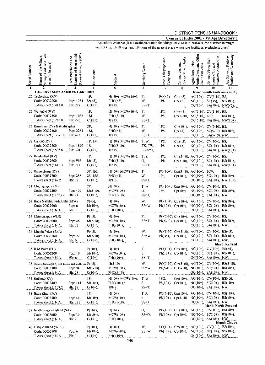
DISTRICT CENSUS HANDBOOK: Census of India 2001 - Village Directory :
Amenities available (if not available within the village, next to it in brackets, the distance in ranges viz.< 5 kms., 5-10 kms. and 10+ kms of the nearest place where the facility is available is given)
1 2 3 6 C.D.Block : South Andaman. Code: 0003
125 Teylorabad (RV) IP, H(10+), MCW(10+), T, Code: 00032200 Pop: 1284 M«5), PHC«5), W,
......... T:Art:(1 (heel): 413,.9 Hh: 277 C(10+), IPHS, SS=T,
126 Sippighat (RV) IP, H(10+), MCW(10+), T, Code: 00032300 Pop: 1038 1M, PHC(5-10), W, TAre(l(h~et):.?~5.J). Hh: 226 C(1O+), I PliS, SS=T,
7 8
PO«5), Cm«5); IPh, Cp«5),
9 10 11 Island: South Andaman contd ..
AC(IO+), CV(5-10), BS, NC(IO+), SC«5), RS(lO+), OC( 10+), SA(IO+), ti!Y(<::~),.
IPO, Cm«5), AC(5-10), CV(5-10), BS, IPh, Cp(5-IO), NC(5·10), ISC, RS(10+),
()q5~] 0),. §A(I 9:J:), _.ti\YD..Q:l:1 127 Bimilitan (RV) & Kodiyaghat 2P, H(lO+), MCW(IO+), T, IPO, Cm(IO+), AC(IO+), CV(5-IO), BS,
Code: 00032400 Pop: 2254 1M, PHC«5), W, IPh, Cp«5), NC(IO+), SC(5-1O), RS(lO+), __ T.Ar~hecl1]nl2.._J:I.h: 4?L_.<1lQ:!:).L.- lEHS,. ... ..S~~IL ..... _.~~ ...... _ .. _ ... OC(IO+), SA(5-1O), NWz
128 CaJicut (RV) IP, 1M, Code: 00032500 Pop: 1890 IS,
H(IO+), MCW(lO+), PHC(5-10),
~ ..... TA~~(I.~!L?g3.:.L ... !:!Il:.3.~4. . .... C(!Q.::), .lI:'!:!S ' ... 129 Beadnabad (RV) IP, H(10+), MCW(IO+),
Code: 00032600 Pop: 966 M«5), PHC(5-10),
_l:A~~Il(Il~~tJ~~_I§} Hh: 211 9(19::), ................. 1P.tI§,
130 Rangachang (RV) 3P,2M, H(IO+), MCW(lO+), Code: 00032700 Pop: 288 2S, ISS, PHC«5),
.TAr,ell(Il~~))~.8.?·? !I1l~72 ..... _. <::(10±),..... _ l!-'tIS,
131 Chidiyatapu (RV) 2P, H(lO+), Code: 00032800 Pop: 409 M(5-10), MCW(IO+),
~ ...... _IAr~.!(hect.1..Jl.n..:.L lih: 93-_... . £(!Q:!:1._~ ... f'lj<::<?:IQ),
132 Bada NaJlaha/Bada BaJu (EFA) P«5), H(lO+), Code: 00032900 Pop: 6 M(lO+), MCW(IO+),
__ T_.~ea (1l~~!:l1!:A:.._ .. ~ ljh...:..!~_ ..... £Q.9_:l:),_ .fl::!c;:(lQ:!:2 ............ .
133 Chidiyatapu (WLS) Code: 00033000
... T.J\rea(he~t.): N.J\. 134 Munda Pahar (HA)
Code: 00033100
~~~~ LA~ell.(Il~~t)~:t:!,A: ... ~~
Pop: 46 Hh: 12
Pop: 22 Hh: 6
P«5), H(10+), M(5-10), MCW(IO+), C(IO+), PHC(IO+),
P«5), H(lO+), M(5-10), MCW(IO+),
... qIQ::)L Pl::!qIO:J:), ."
135 R.M.Point (FC) P(lO+), H(lO+), Code: 00033200 Pop: 10 M(IO+), MCW(lO+),
~:LJ\r~~i~e.s:t)::t:!.J\.... Hh: 6 qlO+), PHC(IO+),
136 Bamboo Nallaha(EFA) inel Kichad Nallaha(EFA) P( <5), H(5-10), Code: 00033300 Pop: 94 M(5-10), MCW(10+),
_~~ T.A!~~.~(h.~~L:t:!:.~c..... !:Ih:..~.~ _ . ~'(!Q:!:),.. . ... !-'tI £(i-.!OL ~ .~ ..
137 Rutland (RV) IP, H(lO+), MCW(IO+), Code: 00033400 Pop: 144 M(10+), PHC(IO+),
.I,0-!~.Il(~~cg:JQ?,?~ ..... l:Ih.:}2 ..... (XI 0:+:), .. 1 PI:IS,.
138 Bada Khari (FC) IP, H(10+), Code: 00033500 Pop: 440 M(10+), MCW(IO+),
~. __ T,A~eii..(Il~_c~1.!iA, ...... J::l!l:.L2. !. ._. <::( IO±), . !-'Ii C( 5 ~]O),
139 North Sentinel Island (SA) PO 0+), Code: 00033600 Pop: 39 M(lO+),
___ .. I:J\.!:eIlJ~~~U~:t:!,A:... Jill:.2. ...... C;{IO+'), .. .
140 Cinque Island (WLS) P(l 0+), Code: 00033700 Pop: 6 M(IO+),
_ .. _~I,A!~~~c.t);.N .1\:. .. __ Jih.:.L .~. .. .~OQ+ 1. .
H(IO+), MCW(IO+),
!-,lj<::(IO+),
H(lO+), MCW(IO+),
I)lj~09:1:),
146
T,W, TK, TW, S, S_S==T,
T, S, 0,
. S§=l',
T, W, SS=T,
T,W, 0, SS",T,
W, SS=W,
T, SS==T,
W, SS=W,
T, S, SS=T,
IPO, IPh,
Cm«5), Cp«5),
AC(IO+), CV(lO+), BS, NC(lO+), SC(10+), RS(IO+),
.... Q_c:(~Q:!:2,~ .... ~A{JQ:!:1.B.!YQQ+..l
IPO, Cm(5-10), AC(IO+), CV(10+), BS, IPh, Cp(5-10), NC(IO+), SC(IO+), RS(IO+),
9<::(10:1:), . §A(IO::), ~(lO::),-
PO(IO+), Cm(5-10), AC(10+), lCV, BS, IPh, Cp(IO+), NC(IO+), SC(I 0+), RS(10+),
_ Q£UQ+).L .. ~J\.(lQ:t-1._NW( 1 0+ },
PO(l 0+), Cm(l 0+), A C( I 0+), CV (10+), BS, IPh, Cp(IO+), NC(lO+), SC(lO+), RS(lO+),
9~iIQ~::),. ~J\i1Q:r1~_, __ P0(10+), Cm(lO+), AC(lO+), CV(10+), BS(10+), Ph(IO+), Cp(IO+), NC(IO+), SC(IO+), RS(lO+),
. ... 9<::QQ:!:1,_.~J\.i!Q!-1. . ....:.NW.:..c.;..J.., __
PO(5.10), Cm(IO+), AC(IO+), CV(IO+), BS, Ph(5-10), Cp(lO+), NC(IO+), SC(I 0+), RS(1O+),
OqIO+), §A(IQ:!:l,I:'JW,....
PO(5-10), Cm(5-IO), AC(lO+), CV(IO+), BS«5), Ph«5), Cp(lO+), NC(IO+), SC(lO+), RS(IO+),
.. 9<::(10::), .. §Ao.Q:J:L.I:i!YL __ ._ Island: Rutland
PO(IO+), Cm(IO+), AC(IO+), CV(IO+), BS«5), Ph(IO+), Cp(IO+), NC(IO+), SC(IO+), RS(lO+),
.. QC:U0:!:}, ~~A(!9+.L.N . .;__;_W.;..,., __
W, PO(5-10), Cm(5-IO), AC(IO+), CV(lO+), BS(5-10), SS=W, Ph(5-10), Cp(5-10), NC{lO+), SC{I 0+), RS{lO+),
••••••• _. • ••• m •• _9C(J..Q:!:1_SA(IO+), NW,
T,W, S,
.. SS=T,
T,R, s, SS,:,1',_
0, SS=O,
W, SS=W,
IPO, Cm(lO+), AC(IO+), CV(IO+), 8S«5), Ph(10+), Cp(lO+), NC(IO+), SC(lO+), RS(lO+),
Q<::(IQ+), . §A{IQ::), .~-'-__
PO(5-10), Cm(10+), AC(10+), CV(10+), BS(10+), Ph(IO+), Cp(5-10), NC(IO+), SC(lO+), RS(lO+),
.. ()~.UQ::2'ls~trMP~rt~~ntinel PO(lO+), Cm(IO+), AC{IO+), CV(lO+), BS(lO+), Ph(IO+). Cp(IO+), NC(IO+), SC(IO+), RS(1O+),
Q£QOi)J_~J\(IO+),.-=..:;NW.:..:..;,;,' __ Island: Cinque
PO(10+), Cm(IO+), AC(IO+), CV(lO+), BS(lO+), Ph(IO+), Cp(10+), NC(IO+), SC(I 0+), RS(lO+),
9£(I.~:!:)2 ... §J\.(!'(l_!), ""N"",W_,_, __
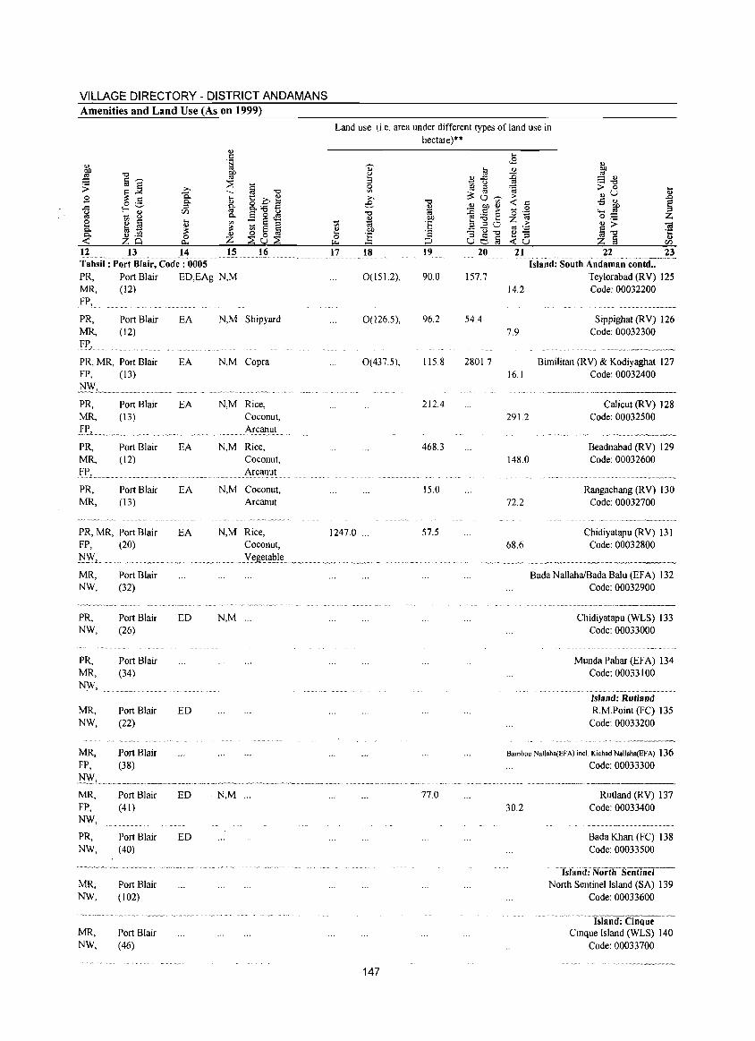
VILLAGE DIRECTORY - DISTRICT ANDAMANS Amenities and Land Use (As on 1999)
OJ . 5
~ ~
"0 ~ §~ ::E '$ ~~ ;.., § "0
i5. --El .... t::_o1:! o .- 0. Q)
.<:: f-o'-' :::s !if &.:.s a ~ - 8
en p. Ei 0 .s 0 ~ § .... '" ::: § :::s .... OJ ::: p. !il ~ ::: ~ 0 1ii ~
OJ ._ 0 OJ
zo CI.. z ::Eu;;S 12 13 14 15 16 Tahsil: Port Blair, Code: 0005 PR, Port Blair ED,EAg N,M MR, (12)
Ff',
PR, Port Blair MR, (12)
Ff', ..
PR, MR, Port Blair FP, (13)
l'I_\YL._ .. ~~. PR, Port Blair MR, (13)
Ff'L.
PR, Port Blair MR, (12)
YR, PR, Port Blair MR, (13)
PR, MR, Port Blair FP, (20)
J~F~ .. ".~,-.-",.=.~""~ .... ,,
MR, Port Blair NW, (32)
"'_~~~'~"',,_e= .... ," V'V"
PR, NW,
PR, MR, T:':f\\',
MR, NW,
MR, FP,
MR, FP, NW,
PR, NW,
Port Blair (26)
Port Blair (34)
Port Blair (22)
Port Blair (38)
Port Blair (41)
Port Blair (40)
MR, Port Blair NW, (102)
MR, NW,
Port Blair (46)
EA N,M Shipyard
EA N,M Copra
EA N,M Rice, Coconut, Arcanut
EA N,M Rice, Coconut, Arcanut
EA N,M Coconut, Arcanut
EA N,M Rice, Coconut, .y~ge.t~l.(: ..
ED N,M ...
ED
ED N,M ...
ED
Land use (i.e. area under different types ofland use in hectare) * *
0" til u .... OJ ..<:: :::s - <J 0 [q " '" ~c3~ ;.., e "0
~ ~ ~ OJ ~ :.a e
~ 'ia 3.20 OJ co .=:: 0 ~ .... ] 0 c3e-§ j..1.,
17 18 20
0(151.2), 90.0 157.7
0(126.5), 96.2 54.4
0(437.5), 115.8 2801.7
212.4
468.3
15.0
1247.0 ... 57.5
no
147
.... <2
OJ
~ Cil > « '0 z
14.2
7.9
16.1
291.2
148.0
72.2
68.6
~ a.g > 0 ... OJU
.., ..0 .:; OJ
~ ...... ~ 0;;
~~ -a 'r::
z § .., en
22 23 ................... " .. ···.··v
Island: South Andaman contd •• Teylorabad (RV) 125 Code: 00032200
Sippighat (RV) 126 Code: 00032300
Bimilitan (RV) & Kodiyaghat 127 Code: 00032400
Calicut (RV) 128 Code: 00032500
Beadnabad (RV) 129 Code: 00032600
Rangachang (RV) 130 Code: 00032700
Chidiyatapu (RV) 131 Code: 00032800
Bada Nallaha/Bada Balu (EFA) 132 Code: 00032900
Chidiyatapu (WLS) 133 Code: 00033000
Munda Pahar (EFA) 134 Code: 00033100
Island: Rutland R.M.Point (FC) 135
Code: 00033200
Bamboo Nallaba(EFA) incl. Kichad Nallaba(EFA) 136 Code: 00033300
30.2 Rutland (RV) 137
Code: 00033400
Bada Khari (FC) 138 Code: 00033500
. "Yslitiid:"NorthSentinel North Sentinel Island (SA) 139
Code: 00033600
Island: Cinque Cinque Island (WLS) 140
Code: 00033700
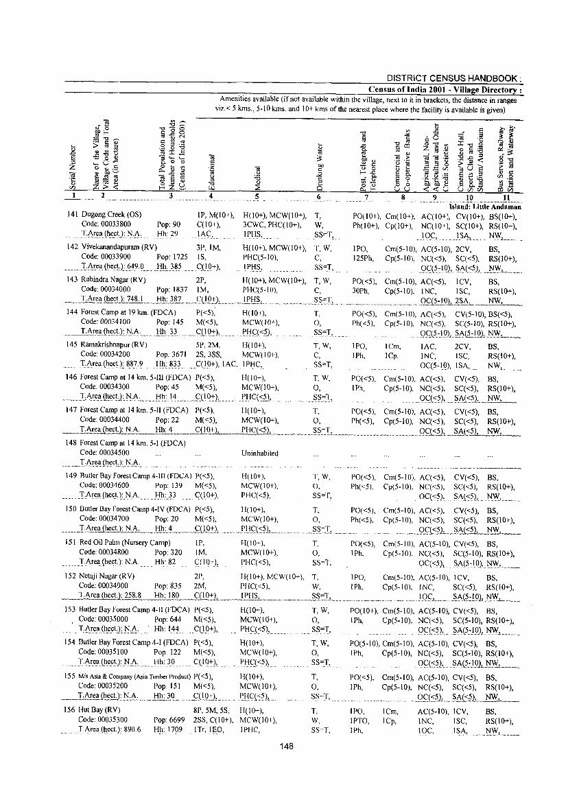
DISTRICT CENSUS HANDBOOK: Census of India 2001 - Village Directory :
Amenities available (if not available within the village, next to it in brackets, the distance in ranges viz.< 5 kms., 5-10 kms. and 10+ kms of the nearest place where the facility is available is given)
1 2 3 4
141 DugongCreek(OS) IP,M(IO+), H(lO+), MCW(IO+), T, Code: 00033800 Pop: 90 C(lO+), 3CWC, PHC(JO+), 'f:AEea(h(!ct): r-J.J\, Hh: 29 IA(':, IPJ::IS, ..
142 Vivekanandapuram (RV) 3P, 1M, H(JO+), MCW(IO+), Code: 00033900 Pop: 1725 IS, PHC(5-10),
_. ,'f:A~e~(~(!~!J:(j~9 . .Q li.J:l:} 85 qIO:+), IPlfS}
143 Rabindra Nagar (RY) 2P, H(10+), MCW(IO+), Code: 00034000 Pop: 1837 1M, PHC(5-10),
T,W, C, SS=1,
T,W, C,
T.Area (heeL): 748.1 Hh 387 ._g],Q~ .. _l!,HS,-. _ ..... ~ •....... ...::~:c__.~.L.
144 Forest Camp at 19 km. (FDCA) P«5), Code: 00034100 Pop: 145 M«S),
.. , ...l~Et:~(Il_~cU:_!'IA... . .H.l1.:. n .. ,,_Cn Q:!:}, ...
H(lO+), MCW(IO+),
PJ::I<':{<.5.),
T, 0,
.SS~I,
10 11 Island: Little Andaman
PO(lO+), Cm(IO+), AC(lO+), CV(10+), BS(10+), Ph(IO+), Cp(IO+), NC(10+), SC(JO+), RS(IO+),
IOC, )SA" l'-1~.L ..... . IPO, Cm(5-10), AC(5-10), 2CV, BS, 125Ph, Cp(5-10), NC«5), SC«5), RS(10+),
.. Q<':t5~19), ... §AL<?)J~J._ .....
PO«5), Cm(5-10), AC«5), lCV, BS, 30Ph, Cp(5-10), INC, ISC, RS(IO+),
. ........... _._ .... _ ..... g<.:{5-101 _ _2SA, NW
PO«5), Cm(5-10), AC«5), CV(5-10), BS«5), Ph«5), Cp(S-IO), NC«S), SC(5-10), RS(lO+),
gq5.:tQ), .. §A.{;i':!QL:_:N.:_:W.L-_
145 Ramakrishnapur(RV) 5P,2M, H(IO+), T, W, IPO, ICm, lAC, 2CV, BS, Code: 00034200 Pop: 3671 2S,3SS, MCW(IO+), C, IPh, ICp, INC, ISC, RS(lO+), TAre~(hectJ: 887.9 Hh: 833 . C(lQ+), lAC, IPHC, SS=T, 0C(5-IQ), ISA, NWL ."
146 Forest Camp at 14 km. 5-IIl (FDCA) P«5), H(lO+), T, W, PO«5), Cm(5-10), AC«5), CV«5), BS, Code: 00034300 Pop: 45 M«5), MCW(lO+), 0, IPh, Cp(5-10), NC«5), SC«5), RS(IO+),
... .I:J\rea.(!l~cnJi:A: .. J::IJ:l:l~ ....... <':(19:+11.. PJ::ICCS;), ... §§~T, ,Qq~?), .... §}~(:::?), NW,
147 Forest Camp at 14 km. 5-I1 (FDCA) P«5), H(IO+), T, PO«5), Cm(5-10), AC«5), CY«5), BS, Code: 00034400 Pop: 22 M«5), MCW(lO+), 0, Ph«5), Cp(5-10), NC«5), SC«5), RS(IO+),
__ T_.Ar~ect.): N.A. _ Hh: 4 Q!.Q_-t2.",___ __ . PHS:£:::1b_.".~_ ... , ... S.S.=T, "'mm.~_"m_.m_.".~ 0C«5):",..2J\(::.?1_.~NW~, __
148 Forest Camp at 14 km. 5-1 (FDCA) Code: 00034500 Uninhabited
,m __ • Il\rea(~<:c~L~:I\·_. . ...
149 Butler Bay Forest Camp 4-1I1 (FDCA) P«5), Code: 00034600 Pop: 139 M«5),
. T·AreaLh,ectJ:NA: Hh: 33 C(IO+),
H(IO+), MCW(IO+), PHC«5),
T,W, 0, SS=T,
PO«5), Cm(5-10), AC«5), CY«5), BS, Ph«5), Cp(5-10), NC«S), SC«5), RS(lO+),
0C«5), SAC':?), .... N~, ...
150 Butler Bay Forest Camp 4-IY (FDCA) P«5), H(IO+), T, PO«5), Cm(5-10), AC«5), CY«5), BS, Code: 00034700 Pop: 20 M«5), MCW(IO+), 0, Ph«5), Cp(5-10), NC«5), SC«5), RS(IO+),
_ ... LI\!.~!!JhecU: NA_ Hh.:...L_. _ _j::.fl9::1:), ... " ... ,..PI:I~L':?)l.,._m ... ' ....... ~S.S"'L _.m_...... .m .. " _, ... _"'_ ._Q~~1__~~A«5),~ __
lSI Red Oil Palm (Nursery Camp) Code: 00034800 Pop: 320 TArea(h,ect):N,A. Hh: 82
IP, 1M, C(IO+),
H(IO+), MCW(lO+), PHC«5),
T, 0, SS=T,
PO«5), Cm(5-10), AC(5-10), CY«5), BS, IPh, Cp(5-10), NC«5), SC(5-10), RS(lO+),
OCC':5), S.A(5~IQ},~WL.
152 Netaji Nagar (RY) 2P, H(IO+J, MCW(IO+), T, IPO, Cm(5-10), AC(5-10), ICV, BS, Code: 00034900 Pop 835 2M, PHC«5), W, IPh, Cp(5-10), INC, SC«5), RS(JO+), T.Area (hect.): 258.8.__!ih: 180 __ CCIO+)_, ___ If!i~. __ ._~._._,,_~~,,,,,TL ___ .... _. ___ .... _._ .. ___ lOC, SA(5-10), NW,
153 Butler Bay Forest Camp 4-I1 (FDCA) P«5), H(lO+), T, W, PO(IO+), Cm(5-10), AC(5-10), CY«5), BS, Code: 00035000 Pop: 644 M«5), MCW(lO+), 0, IPh, Cp(5-10), NC«5), SC(5-10), RS(IO+),
... I,;\.!.(!3 Q1(!ct,L1'i,i\, . I::IJ:l:1.44. qIO+), PHC(.:?), SS=T, ()q.:?), §A(5.: IQ), ~J.." .. ,,_
154 Butler Bay Forest Camp 4-1 (FDCA) P«5), Code: 00035100 Pop: 122 M«5),
......... T·t,\T(!a Lhe~t): .. !'I:J\ ..... , J::I~: 30 ....... q I Q:+2, ..
H(IO+), MCW(JO+), PF1c::«5),
155 M/sAsia & Company (Asia Timber Product) P«5), H(IO+), Code: 00035200 Pop: 151 M«5), MCW(IO+),
_l·Ar.t:.!!JIl_t:£!J:~.A.:" .... !:!~}.Q_ .... SQO::L_..... ..... ~1:Ic::(:::?j,
156 Hut Bay (RV) 8P,5M,5S, H(IO+), Code: 00035300 Pop: 6699 2SS, C(lO+), MCW(IO+), T.Area{h .. ect.): 890.6 Hh: 1709 ITr, I EO, I PHC,
148
T,W, 0, SS=}"
T, 0, SS"",T,
T, W, SS=T,
PO(5-10), Cm(5-10), AC(5-10), CV«5), BS, IPh, Cp(5-10), NC«5), SC(5-1O), RS(10+),
QC(.:?)' ...... S.A(S.~lQ)L~_, _._
PO«5), Cm(5-10), AC(5-10), CY«5), BS, IPh, Cp(5-1O), NC«5), SC«5), RS(lO+),
IPO, ICm, IPTO, ICp, IPh,
..Q.c::J:::?L ... S.A«5), NW,
AC(5-10), ICV, BS, INC, ISC, RS(1O+), 10C, ISA, ... N.~)._" ... __
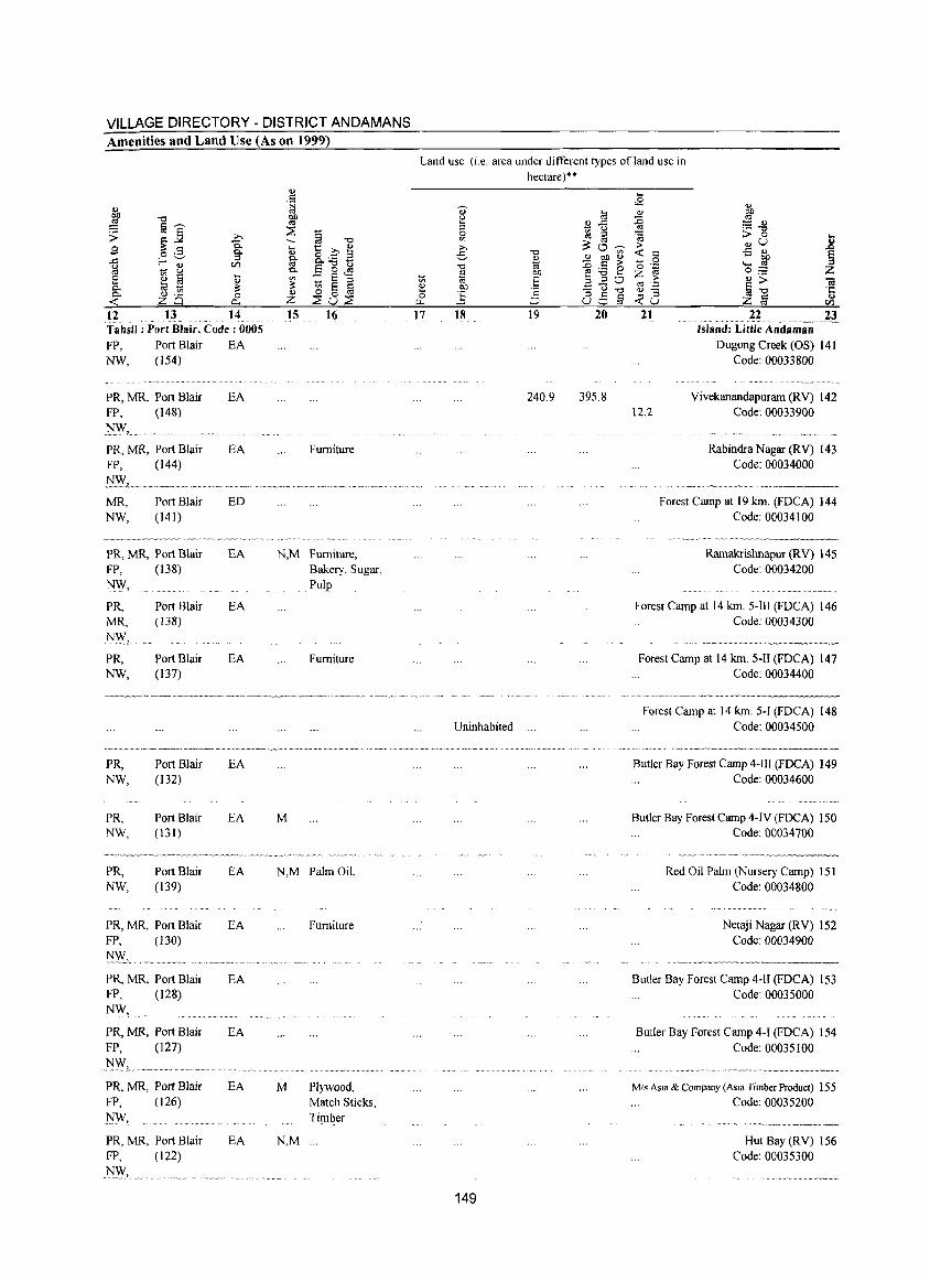
VILLAGE DIRECTORY - DISTRICT ANDAMANS Amenities and Land Use (As on 1999)
~ ." :;3 §'""'
~] ;> ,.Co S
Q.. o .S Q..
~ f-'-" ::l
en .... 8 0 ~ § ....
OJ ... til ti ~ Q.. Q.. <1.l ._
0 <: 6 0 a.. 12 13 14 Tahsil: Port Blair, Code: 0005
FP, Port Blair NW, (154)
PR, MR, Port Blair FP, (148)
.~, ...•.... ~--.....
PR, MR, Port Blair FP, (144)
MR, Port Blair NW, (141 )
_.~~.,_w,.w_v~.-__ ~.~, __ ""," ~vv
PR, MR, Port Blair FP,
N~,
PR, MR,
1'J~,
PR, NW,
PR, NW,
PR, NW,
PR, NW,
(138)
Port Blair (138)
Port Blair (137)
Port Blair (132)
Port Blair (131)
Port Blair (139)
PR, MR, Port Blair FP, (130)
l'!\\:', ..... PR, MR, Port Blair FP, (128)
NW, PR, MR, Port Blair FP, (127)
.~L. PR, MR, Port Blair FP, (126)
~,
PR, MR, Port Blair FP, (122)
.N~, ..
EA
EA
EA
ED
'"_'~~ __ ''''w''W''>'''
EA
EA
EA
EA
EA
EA
EA
EA
EA
EA
EA
<1.l . S t;j ~ ~ § ." --... 1::: Co OJ Q) o ._ 2 ~ Q..." u Q.. a 0 <El '" :: E ::l ~ ~ a § OJ
~8~ ;z 15 16
Furniture
N,M Furniture, Bakery, Sugar, Pulp
Furniture
M
N,M Palm Oil,
Furniture
M Plywood,
N,M
Match Sticks, Timber
Land use (i.e. area under different types ofland use in hectare)"
OJ u 5 0
'" ;;., e ."
%l ti ~ 00 0 ] (.J...
til
~ .<: u al ::: 0 ."
OJ Q) 00 t;:j - ~ OJ) -e:.a 'E ::l ::l
.=:<3 a ::l ~ :::J U ::::,
17 18 19 20
240.9 395.8
Uninhabited ...
149
'""' '" OJ > e 0 ." §
... <2 OJ :c '" 'a > <: t::
.~ '0 z > CI!3 '';:: OJ-... ::l <:u
21
12.2
Island: Little Andaman Ougong Creek (OS) 141
Code: 00033800
Yivekanandapuram (RY) 142 Code: 00033900
Rabindra Nagar (RY) 143 Code: 00034000
Forest Camp at 19 kin. (FOCA) 144 Code: 00034100
RamakrishnapuT (RY) 145 Code: 00034200
Forest Camp at 14 kin. 5-1II (FOCA) 146 Code: 00034300
Forest Camp at 14 kin. 5-1I (FOCA) 147 Code: 00034400
Forest Camp at 14 kin. 5-1 (FOCA) 148 Code: 00034500
Butler Bay Forest Camp 4-IJI (FOCA) 149 Code: 00034600
Butler Bay Forest Camp 4-IY (FOCA) 150 Code: 00034700
Red Oil Palm (Nursery Camp) lSI Code: 00034800
Netaji Nagar (RY) 152 Code: 00034900
Butler Bay Forest Camp 4-IJ (FOCA) 153 Code: 00035000
Butler Bay Forest Camp 4-1 (FOCA) 154
Code: 00035100
Mis Asia & Company (Asia Timber Product) 155 Code: 00035200
Hut Bay (RY) 156 Code: 00035300
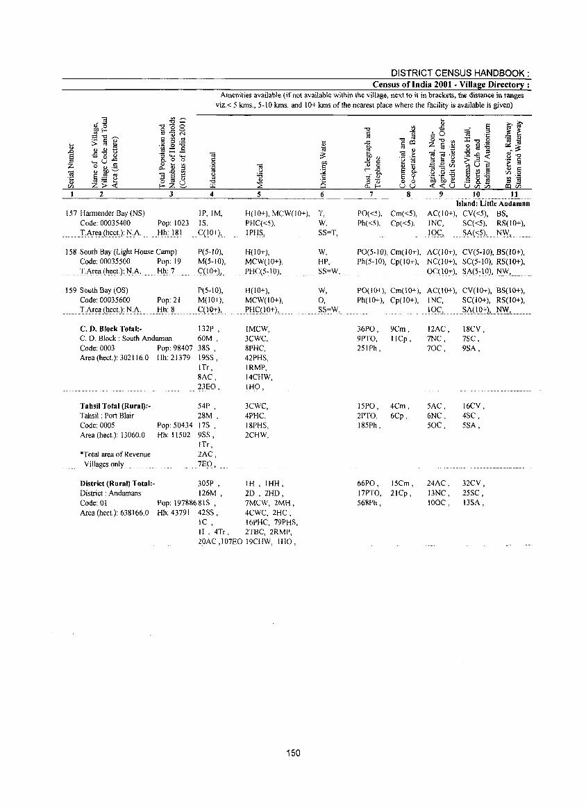
DISTRICT CENSUS HANDBOOK: Census of India 2001 - Village Directory :
Amenities available (if not available within the village, next to it in brackets, the distance in ranges viz.< 5 kms., 5-10 kms. and 10+ kms of the nearest place where the facility is available is given)
2 3 4 5 6
157 Harrnender Bay (NS) Code: 00035400
IP,IM, IS, C(10+),
H(lO+), MCW(IO+), T, Pop: 1023 Hh: 181
PHC«5), W,
.. IAreaJ~t::ct.): ]"LA. IPHS, SS=T,
158 South Bay (Light House Camp) Code: 00035500 Pop: 19 TArel! (h<:ct):l'I[:i\. Hh: 7
159 South Bay (OS) Code: 00035600 Pop: 21
......... T:ArellCht::ct.): N..;\' Hh: 8
C. D. Block Total:-C. D. Block: South Andarnan Code: 0003 Pop: 98407 Area (heet.): 302116.0 Hh: 21379
P(5-10), M(5-10), G{10+),
P(5-10), M(lO+),
... GI19,+),.
132P , 60M, 38S , 19S5, ITr, 8AC, 23EO,
Tahsil Total (Rural):Tahsil: Port Blair Code: 0005 Area (heet.): 13060.0
54P , 28M,
Pop: 50434 17S , Hh: 11502 9SS,
ITr, "Total area of Revenue
... . ..... YiIlllg<:sonly
2AC, 7EO,
H(lO+), MCW(IO+),
..... PHC(5~ 10),
H(10+), MCW(IO+), PI:IqlO+),
IMCW, 3CWC, 8PHC, 42PHS, IRMP, 14CHW, IHO,
3CWC, 4PHC, 18PHS, 2CHW,
305P , IH , IHH, 126M, 2D , 2HD,
District (Rural) Total:District: Andamans Code: 01 Pop: 19788681S , 7MCW, 2MH, Area (hect.): 638166.0 Hh: 43791 42SS, 4CWC, 2HC,
1 C , 16PHC, 79PHS, 11 , 4Tr, 2TBC, 2RMP, 20AC ,107EO 19CHW, IHO,
150
W, HP, SS=W,
W, 0, S?~W,
7
PO«5), Cm«5), Ph«5), Cp«5),
11 Island: Little Andaman
AC(lO+), CV«5), BS, 1 NC, SC«5), RS(IO+),
lOG, ?A(~?), ..... N.W,.". ,.,'
PO(5-10), Cm(IO+), ACCIO+), CV(5-W), BS(1O+), Ph(5-10), Cp(IO+), NCCW+), SC(5-1O), RS(IO+),
Oql O~), S;\(5: lQ)"N,W,.""" ,,,
PO(lO+), Cm(10+), AC(IO+), CV(IO+), BS(IO+), Ph(10+), Cp(lO+), INC, SC(I 0+), RS(IO+),
36PO, 9PTO, 251Ph,
15PO, 2PTO, 185Ph,
9Cm, IICp,
4Cm, 6Cp,
66PO, 15Cm, 17PTO, 21Cp, 568Ph,
lQG,. .. ?A(10:l:2, N.W",. ,
12AC, mc, 70C,
SAC, 6NC, 50C,
24AC, 13NC, 100C,
18CV, 7SC, 9SA,
16CV, 4SC, 5SA,
32CV, 25SC, 13SA,
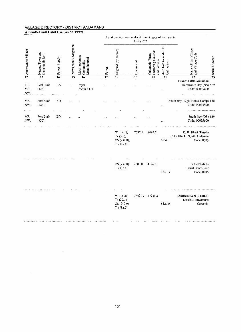
VILLAGE DIRECTORY - DISTRICT ANDAMANS Amenities and Land Use (As on 1999)
12
PR, MR, NW,
MR, NW,
MR, NW,
13
Port Blair (123)
Port Blair (126)
Port Blair (130)
14
EA
ED
ED
.5
I
15 16
Copra, Coconut Oil
Land use (i.e. area under different types of land use in hectare)**
17 18 19 20 21 22 23 ,.· ••••••••• _h •• __
Island: Little Andaman Harmender Bay (NS) 157
Code: 00035400
South Bay (Light House Camp) 158 Code: 00035500
South Bay (OS) 159 Code: 00035600
W (14.1), 7697.1 Tk (3.0),
8495.7 C. D. Block Total:-
OS (732.8), T (749.8),
OS (732.8), 2680.0 4l96.3 T (732.8),
W (16.2), 16491.2 17230.8 Tk (20.1),
C. D. Block: South Andaman 3354.1 Code: 0003
1843.3
Tahsil Total:Tahsil: Port Blair
Code: 0005
OS (747.9), 8127.0
District (Rural) 10tal:District: Andamans
Code: 01 T (782.9),
151

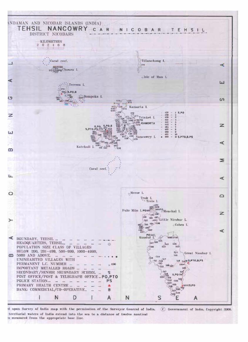
NDAMAN AND NICOBAR ISLANDS (INDIA)
TEHSIL NANCOWRY CAR N I COBAR T E H S I L DISTRICT NICODARS _ -- _ ._. _ ._ ._ ._. _ .-._ . _ ._._ ._ ._ ._ -_ ._ . _ . - -- -_ ._ ._ . _ -_ .-
_j
«
z
w
CD
o
>-
KILOMETI~ES ~(J~1(jtJ ..
, ; Corol n~t'r.
, • ':I~CllOUrR ).
,0:', Ter~ Il I, :'3,g ': '(~S,PO ,8 ~: . ~ ,~.Hompoka I. !IB~ -t ~.~ .. :. ' . ~ "!
~ .. I ~ \. "UU :. " . '
Cora l r('l'f. ·'
« BOUNDA[~Y. TEIISIL ...
CD
HEADQUARTERS. TEB IL ... POPULATION SIZE CLASS OF VILLAGES BELOW 200. 201-499, 500- 999. 1000- 4999, 5000 A D ABOVE. UNINHABITED VI LLAGES WITH PERMANENT L.C. NUMBER ... IMPORTA:-lT METALLED ROAD
@
•••
SECONDARY /SENIOR SECO DARY SCHOOL... S POST OFFICE/POST & TELEGRAPH OFFICE ... PO.PTO POLI CE ST TION... PS PRIMARY HEALTH CENTRE ... ... BA K: COMMERCIAL/CO-OPERATIVE.. B
N D A J
<:) Is le of ~Jlln I.
\)MeI"C)c I.
TI'a k I. o C) Trcis I.
Pulo
N
137 - 1 5.PO 436 - 2 431) - 3 441 - 4 442 - ~
443 - 6 )( 484 - 1
480 - 6 466 - I> 487 - 10
• 488 - II 5.PTO. 9,P5
I.
ieolmr I.
o Cobro r.
icoba ,· I.
A
w
Vl
z
«
z
Id upon Survey of India ma p wilh l he permissiion of lhe Surveyor Gener a l of Ind ia. © Govern ment or Ind ia , Copyrigh l 2006.
lerritorial walers of Indi a ex lend inlo l h e sea lo a dislance of lwelve nautical .s measured from the appropriate base line.

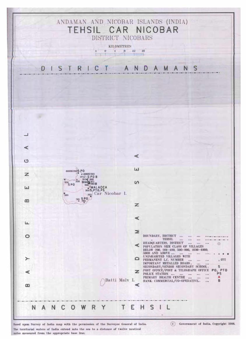
o
t\ , DAMA .· A. D . ' ICOBAH ISL.\XDS (I DIA)
TEHSIL CAR NICOBAR DI. THICT ~ICOBARS
(I I:': IU
S T R C T AND A MAN S _._._._._._._._._._._._._._._._._._._o_._._._._._._._._._._._._._._._._._._._._._._._._o_.
z
o
>-
<
CD " Balli Malv 1.
w
z
BOU, DARY, DISTRICT .• , TEIISIL
IJEAIXWARn:R DISTRICT < POI'l'l.J\TIO'\ SIZE cL,\SS OF \'1I.t.\GF~"i unow 200, 201 - ·199. 500- 900, 1000- 1999, 5000 \N'D ADOVE ...
o r:>iI:'olIlAIlITF.J) VILL/\GF.S WITIl PF.R t F.·T t,r, . nlDER IMPORTM'T Mt:rJ\I.LEO RO"OS.
E OXD,\RY /SE:'IlIOR • ECO~IHRY. 11001" Z I'O~T OfFICr./r'~,. k TEI.f.GR I'll OFf'lrF:
pOlJer. 51 i\ TIO: ... PRI~i\I~Y m:.\1.111 n: TNt: llA, K: COMMUtCI"L/ 'O-OI't::HATIVt-; ..
'-' <
NAN COW R Y T E H S L •
@
• •• )( 072
S po. PTO
PS ... B t
I
ion or thc Surveyor Gem'ral of India. @ GO\,l'rnm ni. of Indl •. Copyrlllhl 2006.
The territorial walers of India eltlend into the sea to a dl tanN! of l we1"c naulit'al miles mp un..>d hum til" pptOpriBlc b. e line.

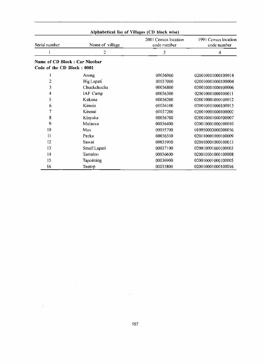
Alphabetical list of Villages (CD block wise)
2001 Census location 1991 Census location Serial number Name of village code number code number
2 3 4
Name of CD Block: Car Nicobar Code of the CD Block: 0001
1 Arong 00036000 020010001000100014 2 Big Lapati 00037000 020010001000100004 3 Chuckchucha 00036800 020010001000100006 4 IAF Camp 00036300 020010001000100011 5 Kakana 00036200 020010001000100012 6 Kimois 00036100 020010001000100013 7 Kinmai 00037200 020010001000100002 8 Kinyuka 00036700 020010001000100007 9 Malacca 00036400 020010001000100010
10 Mus 00035700 010050003000300056 11 Perka 00036500 020010001000100009 12 Sawai 00035900 020010001000100015 13 Small Lapati 00037100 020010001000100003 14 Tamaloo 00036600 020010001000100008 15 Tapoiming 00036900 020010001000100005 16 Teetop 00035800 020010001000100016
157
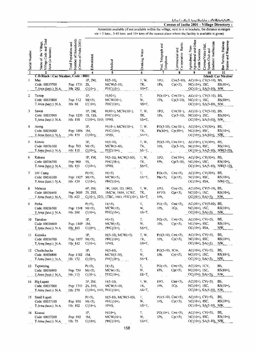
Census of India 2001 - Village Directory : Amenities available (if not available within the village, next to it in brackets, the distance in ranges
viz. < 5 kms., 5-10 kms. and 10+ kms of the nearest plaee where the.facility is available is given)
1 2 3 4 CD.Block : Car Nicobar, Code: 0001 Mus IP,2M, Code: 00035700 Pop: 1731 2S,
___ T .Ar~ (heel.): N.A. . __ .t!h.c_?2? .. .. <:::<"!'Q.-+:2,
2 Teetop Code: 00035800 TArea (heel.): N.A.
IP, Pop: 512 M«5), Hh: 68 C(lO+),
5
H(5-10), MCW(5-10),
_ P!'!<:::UQ+), ..
H(IO+), MCW(IO+), PHC(IO+),
3 Sawai IP,IM, H(10+), MCW(IO+), Code: 00035900 TArea (heeL): N.A.
Pop: 1235 IS, ISS, PHC(IO+), Hh: 158 C(10+), lEO, IPHS,
4 Arong IP, Code: 00036000 Pop: 1006 1M,
____ .IJ_\!~.<h.e.£!:Uii~:_ . __ Hh: !59 .. C(10.+ ),-,
H(lO+), MCW(lO+), PHC(lO+), I PHS,.
5 Kimois IP, H(5-10), Code: 00036100 Pop: 703 M«5), MCW(5-10),
_ .. J,Area_the.enJ'J_.;\: .. _lih:JJQ .. _ C:(!Q.-+:J,. . ... PH~( 10+)J
6 Kakana Code: 00036200 TArea (heeL): N.A.
7 IAF Camp Code: 00036300 TArea (heeL): N.A.
8 Malaeea Code: 00036400
IP,IM, Pop: 900 IS, Hh: 151 C(IO+),
P«5), Pop: 1927 M«5), Hh: 439 C(10+),
4P,3M, Pop: 3000 2S,2SS,
H(5-1O), MCW(5-10), PHC(IO+), IPHS,
H«5), MCW«5), PHC(IO+),
IH, IAH, 10, IHD, IMCW, IMH, ICWC,
6
T,W, TK, SS=T,
T, W, SS=T,
T,W, TK, SS=T,
T, W, TK, SS=T,
T,W, TK,
.. S.S~!,.
T,W, TK, SS=T,
T, SS=T,
T,W, TK,
__ .T.~~(I{he(;U:I~L;\: .. Hh: 622 qIO+),lEQ,.ITBC, INH, PHC(IO+), SS=I,
9 Perka Code: 00036500
... I:.!\re.a (heel.): .N.A.
10 Tamaloo Code: 00036600 TAre.a_(heeL): N.A.
II Kinyuka Code: 00036700 TArea (heeL): N.A.
12 Chuekehucha Code: 00036800
... TArea (hecLL.N:A..
13 Tapoiming Code: 00036900
.. -I:.i\!e.a (h~.etJ: .No,A.
14 Big Lapati Code: 00037000 I-Area (heeL): N.A.
15 Small Lapati Code: 00037100 TArea (heeL): N.A.
16 Kinmai Code: 00037200 TArea(hecl.): N.J\.
Pop: 1548 Hh: 260
Pop: 1449 Hh: 163
Pop: 1057 Hh: 142
Pop: J 182 Hh: 172
Pop: 759 Hh: 113
Pop: 1741 Hh: 270
Pop: 950 Hh: 102
Pop: 592 Hh: 75
P«5), H«5), T, M«5), MCW«5), W, C(10+), PHC(IO+), SS=T,
IP, H«5), T, 1M, MCW«5), W, C(10+), PHC(IO+), SS=T,
IP, H(5-10), MCW«5), T,W, M«5), PHC(IO+), TK, C(10+), IPHS, SS=T,
IP, H(5-10), T, 1M, MCW(5-1O), W, C(IO+), PHC(lO+), SS=T,
P«5), H«5), T, M«5), MCW«5), W, qIO+), PHC(IO+), SS=T,
IP,2M, H(5-10), T, W, 2S,3SS, MCW(5-10), TK, C(lO+), lEO, PHC(IO+), SS=T,
P«5), H(5-10), MCW(5-10), T, M«5), PHC(IO+), W, C(10+), IPHS, SS=T,
IP, H(IO+), T, 1M, MCW(IO+), W, C(IO+), PHC(IO+), SS=T,
158
7 8 9 10 11 Island: Car Nicobar
IPO, IPh,
Cm(5-10), AC(IO+), CV(5-10), BS, Cp«5), NC(IO+), ISC, RS(IO+),
.' .• _Qf_(I.Q2:),.S.A{?::!Q2l-:-NW__,_, __
PO(IO+), Cm(IO+), AC(IO+), CV(5-10), BS, IPh, Cp(5-10), NC(IO+),ISC, RS(IO+),
OC(IO+), SA(5-IO), ]\l."Y". __ ..
IPO, IPh,
Cm(IO+), AC(IO+), CV(5-10), BS, Cp(5-10), NC(IO+),ISC, RS(IO+),
OC(IO+), SA(5-10), NW, ....
PO(5-IO), Cm(IO+), AC(IO+), CV(IO+), BS, Ph(IO+), Cp(lO+), NC(IO+), ISC, RS(IO+),
OC(IQ+),§_i\(!O-t:), NW, .
PO(5-10), Cm( 10+), AC(IO+), CV(IO+), BS, IPh, Cp(5-10), NC(IO+), ISC, RS(IO+),
.9<':_(1.9.:1:)1... SA(~-IO), NW(5-10),
IPO, Cm(10+), AC(IO+), CV(10+), BS, IPh, Cp(S-10), NC{IO+),ISC, RS(lO+),
PO«5), Cm«5), Ph«5), Cp«5),
IPO, Cm«5), IPTO, Cp«5), IPh,
PO«5), Cm«5), IPh, ICp,
PO«5), Cm«5), IPh, Cp«5),
PO(5-10), Cm«5), IPh, Cp«5),
PO(5-1O), ICm, I Ph, Cp«5),
PO«5), Cm«5), IPh, Cp«5),
IPO, IPh,
Cm«5), ICp,
PO(5-10), Cm«5), IPh, Cp«5),
PO(IO+), Cm«5), IPh, Cp«5),
OC(IO+), SJ\(5-!Q),.~1HQ1.
AC(IO+), CV(IO+), BS, NC(IO+), ISC, RS(IO+), OC(IO+), ISA, NW«5),_
AC(IO+), CV(5-10), BS, NC(IO+), ISC, RS(lO+),
9~<': Q.D.:I:JL ,s,i\{::?) NW
AC(IO+), eV(5-10), BS, NC(IO+), ISC, RS(1O+),
~_QC_(19.:tLSA(::?), NW,
AC(IO+), CV«5), BS, NC(JO+), ISC, RS(IO+), OC(IO+), I SA,
.,. ....• ~L ... __
AC(10+), CV«5), BS, NC(IO+), ISC, RS(IO+), OC(IO+), SA(~5), ~~.WL._ .. _ AC(IO+), CV«5), BS, NC(10+), ISC, RS(lO+),
.... Q_e(!9+2~p'>-(<_5), NW
AC(IO+), ICV, BS, NC(10+), ISC, RS(IO+),
.OC(10":),2.J\{<_~._NW~, __
AC(10+), CV«5), BS, NC(IO+), ISC, RS(IO+), OC(IO+), SA(5-10}, 1'lF..1 _____ .
AC(10+), CV«5), BS, NC(IO+), ISC, RS(IO+), OC(10+),SA(5-10), '~"Y" ___ _
AC(IO+), CV«5), BS, NC(IO+), ISC, RS(IO+), OC(10+)!_SA(5~10)L~' __
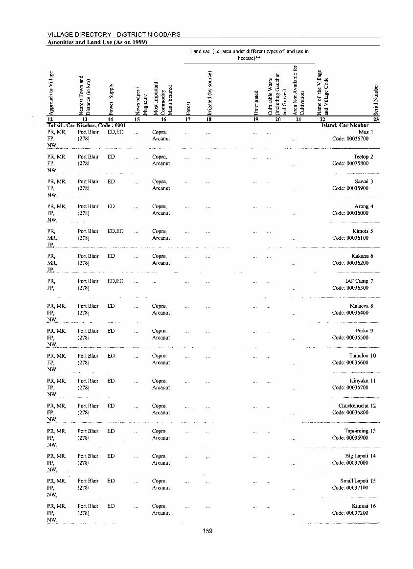
VILLAGE DIRECTORY - DISTRICT NICOBARS Amenities and Land Use (As on 1999)
12 13 14 Tahsil: Car Nicobar, Code: 0001 PR, MR, Port Blair ED, EO FP, (278)
~ .. L_ ..••
PR,MR, FP, NW,
PR,MR, FP, NW,
PR,MR, FP, .~W,
PR, MR,
.fL. PR, MR, yp,
PR, FP,
PR,MR, FP, _NW,
PR,MR, FP,
PR,MR, FP, NW,
PR,MR, FP, NW,
PR,MR, FP,
PR,MR, FP, _NW,
PR,MR, FP, NW,
PR,MR, FP, NW,
PR,MR, FP,
NW,
Port Blair ED (278)
Port Blair ED (278)
Port Blair ED (278)
Port Blair ED,EO (278)
Port Blair ED (278)
Port Blair ED,EO (278)
Port Blair ED (278)
Port Blair ED (278)
Port Blair ED (278)
Port Blair ED (278)
Port Blair ED (278)
Port Blair ED (278)
Port Blair ED (278)
Port Blair ED (278)
Port Blair ED (278)
15 16
Copra, Arcanut
Copra, Arcanut
Copra, Arcanut
Copra, Arcanut
Copra, Arcanut
Copra, Arcanut
Copra, Arcanut
Copra, Arcanut
Copra, Arcanut
Copra, Arcanut
Copra, Arcanut
Copra, Arcanut
Copra, Arcanut
Copra, Arcanut
Copra, Arcanut
17
Land use (i.e. area under different types of land use in hectare)··
18 19 20 21
159
22 23 Island: Car Nicobar
Mus I Code: 00035700
Teetop 2 Code: 00035800
Sawai 3 Code: 00035900
Arong 4 Code: 00036000
Kimois 5 Code: 00036100
Kakana 6 Code: 00036200
IAF Camp 7 Code: 00036300
Malacca 8 Code: 00036400
Perka 9 Code: 00036500
Tamaloo 10 Code: 00036600
Kinyuka II Code: 00036700
Chuckchucha 12 Code: 00036800
Tapoiming 13 Code: 00036900
............................ _--
Big Lapati 14 Code: 00037000
Small Lapati 15 Code: 00037100
Kinmai 16 Code: 00037200
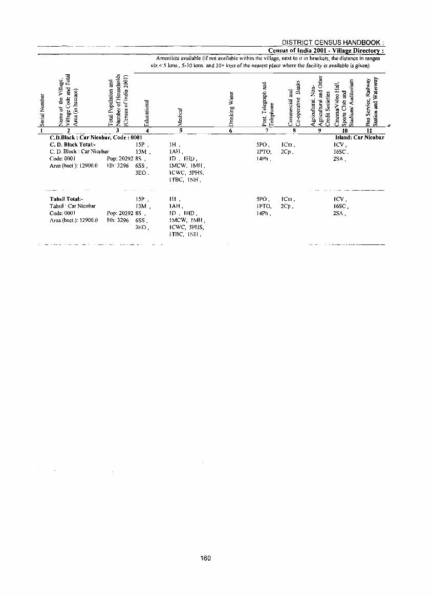
... " .0
§ Z Ol ·c " <Il
1
""IS '" .-., ""'-~~ -0-0 a 0 0 -5", ::::"'t::t-... .§ g :6 :> !a ~
" " - ~:r:: c:: -5 -g ~ :3~::: (ij
..... u~ "- 0 0 c:: 0 .... 0 o .., ._ ~ ~ ~ .~
(i) bD ~ ~ 0; 0; (ij § ;g (.) - " ::s
=-=_;;: OZL) "'" Z> r- ~ w 2 3 4
C.D.Block : Car Nicobar, Code: 0001 C. D. Block Total:- 15P , C. D. Block: Car Nicobar 13M , Code: 0001 Pop: 20292 8S , Area (heel): 12900.0 Hh: 3296 6SS,
Tahsil Total:Tahsil: Car Nicobar Code: 0001 Area (heel): 12900.0
3EO,
15P , 13M ,
Pop: 20292 8S , Hh: 3296 6SS,
3EO,
DISTRICT CENSUS HANDBOOK: Census of India 2001 - Village Directory :
Amenities available (if not available within the village, next to it in brackets, the distance in ranges viz.< 5 kms., 5-10 kms. and 10+ kms of the nearest place where the facility is available is given)
IH IAH, ID,IHO, IMCW,IMH, ICWC,5PHS, ITBC,INH,
IH, IAH, ID , IHO, IMCW,IMH, ICWC,5PHS, ITBC, INH,
160
5PO, IPTO, 14Ph,
5PO, IPTO, 14Ph,
lCm, 2Cp,
ICm, 2Cp,
Island: Car Nicobar ICV, 16SC, 2SA,
ICV, 16SC, 2SA,
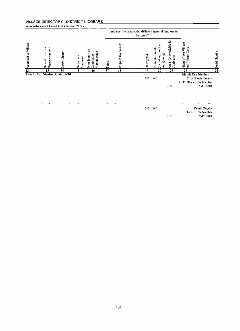
VILLAGE DIRECTORY - DISTRICT NICOBARS Amenities and Land Use (As on 1999)
12 13 14 15 16 Tahsil: Car Nicobar, Code: 0001
-'" e o .... 17
Land use (i.e. area under different types of land use in hectare)"
18 19 20 21
0.0 0.0
22 Island: Car Nicobar
C. D. Block Total:C. D. Block: Car Nicobar
0.0 Code: 0001
0.0 0.0
161
0.0
Tahsil Total:Tahsil: Car Nicobar
Code: 0001
23

Alphabetical list of Villages (CD block wise)
2001 Census location 1991 Census location Serial number Name of village code number code number
2 3 4
Name of CD Block: Nancowry Code of the CD Block : 0002
1 7 km Farm 00053600 020020002000200158 2 Akupa 00048500 020020002000200112 3 Alexandera River 00050800 020020002000200133 4 Alhiat 00037500 020020002000200003 5 Alhitothl Alhiloth 00039800 020020002000200025 6 AI-Hit-TouchlBalu Basti 00043500 020020002000200062 7 Alipal Alips 00042600 020020002000200053 8 Alkaipoh/ Alkripoh 00039700 020020002000200024 9 Alointung 00045600 020020002000200083
10 Aloora 00038000 020020002000200006 11 Aloorang 00037900 020020002000200006 12 Alpintu/ Alpintung 00045800 020020002000200085 13 Alreak 00044200 020020002000200069 14 Alsama 00042100 020020002000200048 15 Altaful 00041900 020020002000200046 16 Altheak 00043400 020020002000200061 17 Alukianl Alhukheck 00046200 020020002000200089 18 AnulJAnuJa 00048300 020020002000200110 19 Atkunal Alkun 00041100 020020002000200038 20 Ayouk 00050900 21 Bahua 00050300 020020002000200171 22 Banderkari/Pu I u 00045700 020020002000200084 23 Bengali 00038900 020020002000200016 24 BerainakiBadnak 00047000 020020002000200097 25 Bewai/Kuwak 00048900 020020002000200116 26 Bompoka Island 00039000 020020002000200017 27 Bumpal 00045000 020020002000200077 28 Campbell Bay 00054000 020020002000200160 29 Champin 00043700 020020002000200064 30 ChanellChanol 00045400 020020002000200081 31 Changua/Changup 00046000 020020002000200087 32 Chaw Nallaha 00054400 33 Chengtamilan 00041000 020020002000200037 34 Chingen 00052900 020020002000200151 35 Chonghipoh 00039500 020020002000200022 36 Chongkamong 00037400 020020002000200002 37 Chonsiyala 00040400 020020002000200031 38 Chota Inak 00046900 020020002000200096 39 Chukmachi 00038400 020020002000200011 40 Dairkurat 00050700
163
Alphabetical list of Villages (CD block wise)
2001 Census location 1991 Census location Serial number Name of village code number code number
2 3 4
41 Dakhiyon (FC) 00052400 020020002000200143 42 Danlet 00051900 020020002000200140 43 Daring 00045200 020020002000200079 44 Dogmar River 00051400 020020002000200131 45 ElahilIlhoya 00050000 020020002000200127 46 Enam 00038100 020020002000200008 47 Galathia River (FC) 00053000 48 Gandhi Nagar 00053200 010010001000100006 49 Govinda Nagar 00053900 010040003000300032 50 Hakonhala 00041400 020020002000200041 51 HalnatailHo inatai 00041800 020020002000200045 52 Hindra 00042800 020020002000200052 53 Hinnunga 00043800 020020002000200065 54 Hin-Pou-Chi 00052200 55 Hintona 00044300 020020002000200070 56 Hitlat 00039300 020020002000200020 57 Hockook 00047700 020020002000200104 58 Hoin incl. lkuia 00049200 020020002000200119 59- Hoipoh 00040800 020020002000200035 60 Hokesiang 00049500 020020002000200122 61 Hontona 00040500 020020002000200032 62 Hutnyak 00040200 020020002000200029 63 Indira Point 00052800 020020002000200150 64 In-Hig-Loi 00052600 020020002000200148 65 Inlock!Infock 00048600 020020002000200113 66 Inlock!Pattia 00049800 020020002000200125 67 lnmae 00046400 020020002000200091 68 Inod 00050100 020020002000200169 69 Inroak/Chinlak 00044000 020020002000200067 70 !toi 00044100 020020002000200068 71 Jansin 00039200 020020002000200019 72 Jhoola 00039100 020020002000200018 73 Joginder Nagar 00053500 020020002000200157 74 Kakana 00047200 020010001000100012 75 Kalara 00038300 010020001000100004 76 Kalasi 00038800 020020002000200015 77 KalminikumlKalmenkam 00041300 020020002000200040 78 KamortalKalatapu 00046800 020020002000200095 79 Kamriak 00040100 020020002000200028 80 Kanahinot 00038700 020020002000200014 81 Kapanga 00042200 020020002000200049 82 Kapila 00048000 020020002000200107
164
Alphabetical list of Villages (CD block wise)
2001 Census location I 991 Census location Serial number Name of village code number code number
2 3 4
83 Karan/Karav 00045100 020020002000200078 84 Kasintung 00051700 85 Katahu 00050600 020020002000200026 86 Katahuwa 00039900 020020002000200026 87 KavatinpeulKarahinpoh 00042000 020020002000200047 88 Kiyang 00049000 020020002000200117 89 Knot 00046300 020020002000200090 90 Koe 00051800 020020002000200141 91 Kokeon 00052300 020020002000200143 92 Kondul 00050400 020020002000200128 93 Kopenheat 00051500 020020002000200137 94 Kuikua 00047500 020020002000200102 95 Kuitasuk 00037600 020020002000200004 96 Kulatapangia 00040600 020020002000200033 97 Kumikia 00040000 020020002000200027 98 Kupinga 00042300 020020002000200050 99 Lanuanga 00043300 020020002000200060
100 Lapat 00042700 020010001000100003 101 Lawful 00054600 020020002000200165 102 Laxmi Nagar 00053300 020020002000200154 103 Luxi 00038200 020020002000200009 104 ~akhahu~akachua 00048400 020020002000200111 105 Malacca 00043600 020010001000100010 106 Manjula 00044700 020020002000200074 107 Mapayala 00040900 020020002000200036 108 Maru 00045300 020020002000200080 109 Masala Tapu 00046100 020020002000200088 110 Mavatapis/Maratapia 00039400 020020002000200021 III Mildera 00042400 020020002000200051 112 MinlanaIMinlan 00048200 020020002000200109 113 Minyuk 00038600 020020002000200013 114 MohreaklKohreakap 00047400 020020002000200101 115 Munak incl. PonioolMoul 00046600 020020002000200093 116 Mus 00042900 010050003000300056 117 Navy Dera 00054500 118 Neang 00043100 020020002000200058 119 Neeche Tapu 00044600 020020002000200073 120 Not yet named (at 27.9 km)-A 00053700 020020002000200135 121 Not yet named-B 00054200 020020002000200163 122 Not yet named-C 00054300 020020002000200164 123 Nyicalang 00047300 020020002000200100 124 OkiyalChiya 00044800 020020002000200075
165
Alphabetical list of Villages (CD block wise)
2001 Census location 1991 Census location Serial number Name of village code number code number
2 3 4
125 OlinchilBombay 00049700 020020002000200124 126 OlinponJ Alhinpon 00044900 020020002000200076 127 Ongulongho 00040300 020020002000200030 128 Patatiya 00052100 020020002000200145 129 Pattia 00049600 020020002000200123 130 Payak 00043000 020020002000200057 131 Payuha 00046500 020020002000200092 132 Pea 00049300 020020002000200120 133 Pehayo 00050200 020020002000200170 134 Pilpilow 00044500 020020002000200072 135 PulloullolPuloulo 00049100 020020002000200118 136 Pulobaha 00052700 020020002000200115 137 Pu lobahalPathath i fen 00048800 020020002000200115 138 Pulobed 00051000 020020002000200130 139 Pulobed/Lababu 00050500 020020002000200130 140 PulobhaiPulobahan 00049400 020020002000200121 141 Pulobhabi 00052000 020020002000200144 142 Pulokunji 00051100 020020002000200132 143 Pulomil0 00048100 020020002000200108 144 Pulopanja 00049900 020020002000200126 145 Pulopucca 00052500 020020002000200147 146 PulotaliaiPulotohio 00048700 020020002000200114 147 Raihion 00037700 020020002000200005 148 Ramzoo 00046700 020020002000200094 149 Ranganathan Bay 00054100 020020002000200162 150 Reakomlong 00041500 020020002000200042 151 Renguang 00051300 152 Safedbalu 00038500 020020002000200012 153 Safedbalu 00047600 020020002000200103 154 Sanaya 00039600 020020002000200023 155 Sastri Nagar 00053100 020020002000200152 156 Shompen hut 00053800 157 Shompen Village-A 00051200 158 Shompen Village-B 00051600 159 Sonomkuwa 00041600 020020002000200043 160 Tahaila 00037300 020020002000200001 _,'<
161 Tamae 00045500 020020002000200082 162 Tani 00041200 020020002000200039 163 Tapani/Tapainy 00043900 020020002000200066 164 Tapiang 00047900 020020002000200106 165 Tapong incl. Kabila 00043200 020020002000200059 166 TavinkinlTavakin 00041700 020020002000200044
166
Alphabetical list of Villages (CD block wise)
2001 Census location 1991 Census location Serial number Name of village code number code number
2 3 4
167 Tillang Chong Island 00037800 020020002000200129 168 Tomae/lnmae 00045900 020020002000200086 169 Trinket 00047800 020020002000200105 170 Trinket Bay 00054700 020020002000200167 171 Uper Tapu 00044400 020020002000200071 172 VijoyNagar 00053400 020020002000200156 173 Vikas Nagar 00047100 020020002000200098 174 Vyavtapu 00040700 020020002000200034 175 W.B .KatchallHindra 00042500 020020002000200052
167
DISTRICT CENSUS HANDBOOK: Census of India 2001 - Village Directory:
Amenities available (if not available within the village, next to it in brackets, the distance in ranges viz.< 5 kms., 5-10 kms. and 10+ kms of the nearest place where the facility is available is given)
2 3 4 5 C.D.Block ; Nancowry, Code; 0002
I Tahaila P«5), H(lO+), MCW(JO+), Code: 00037300 Pop: 404 M«5), IMH,
_ ..... ~.I.:A!I!!!..(~~.£tJ.:_t:I.:0.:... ... _I::Ih:.62_ .... __ <::(!.9.":1._ .PJ.I<::Q 0+ L .... _. . ..
2 Chongkamong P«5), H(lO+), Code: 00037400 Pop: 172 M«5), MCW(IO+),
.I~r~':I(he~t):N·0· Hh: 21 C(19+), PHC«5),
3 Alhiat P«5), H(IO+), MCW(IO+), Code: 00037500 Pop: 240 M«5), IMH, PHC(IO+), 1.'.f\rt:a(hect.): N:A: Hh: 37 .... C(10+), IPHS,
4 Kuitasuk IP, H(lO+), Code: 00037600 Pop: 271 1M, MCW(IO+),
.... IfI.l:e':l(Ilt:(;t.): l'I.:A: .. Hh: 40 . S(19":),. PH(:(<::?),
5 Raihion P{<5), H(10+), Code: 00037700 Pop: 298 M«5), MCW(10+),
.~ • .I,:_A,!~l!1.ht:Et1.NA .... J:lh.: .. 16 ...... q[Q+), _ I'H<::«?),.
6 Tillang Chong Island Code: 00037800 Pop: 13
..... I:l\rc:a(heet): .. ]'J:II.: Hh: 2
P(10+), M(!o+),
.. C(IO+),
H(IO+), MCW(lO+), PHC(IO+),
7 Aloorang Code: 00037900 Pop: 248
IP, M(5-1O),
H(lO+), MCW(IO+), PHC(5-10},
. 'TArel! (heet.): N:II.: Hh: 54 ... C(lO+),
8 Aloora P«5), Code: 00038000 Pop: III M«5),
_~J.Ar~hect.LN:8-.:.. .. ~J:lh.:.}~~ __ <::1.10+.1. ..
IPHS,
H(lO+), MCW(IO+),
.Pl::IqIO":»
9 Enam IP, H(10+), Code: 00038100 Pop: 141 M«5), MCW(IO+),
........ _IAr_~':I.(!l_~~U:.]'J:.I\:._._ ... J1.~:}Z __ .... __ .. C::.QQ":J.L.. ....... ~H<::(1 .. Q:t:), ......... .
10 Luxi Code: 00038200 Pop: 158
JP, M(5-1O),
..... C( I9:t:),
H(IO+), MCW(JO+), PHC(IO+),
......... I:II.~~':I(~I:(;t.J]'J:II.: ..... Hh: 29
11 Kalara Code: 00038300 Pop: 35
.. T:l\r~':I.(~ectJ:]'.J-A. Hh: 8
P«5), M(S-IO),
... <::(10+),
. II'tfS,
H(lO+), MCW(IO+), PHC(IO+},
12 Chukmachi IP, H(lO+), Code: 00038400 Pop: 164 M(5-1O), MCW(IO+),
. __ ~:..fI.l:ea .. (h.~_<:tJ.:J:'LtL .... Hh~.l? ...... _,<::(12.7').1...... P.H<;:(lQ:t:}, ....
13 Safedbalu IP, Code: 00038500 Pop: 22 M«S),
H(lO+), MCW(IO+), PHC(lO+),
. T/\.I:c':l .. (h~(;_t): N:I\:. Hh: 6 . C(10+),
14 Minyuk IP, Code: 00038600 Pop: 276 1M, TII.rea(~ect):NA Hh: 56 C(IO+),
IPHS,
H(IO+), MCW(lO+), PHC(?-IO),
15 Kanahinot P«5), H(lO+), Code: 00038700 Pop: 57 M«5), MCW(10+),
.......... 'T:.A~.~!l.Jllt: .. c!):.!,! ,A: ....... f:I~:.I ..... _ .... <::('~9~),. . ... P.I::Iq?~) 0),
16 Kalasi Code: 00038800 T.Area (heet.): NA
IP, Pop: 326 M«5), Hh: 54 C(lO+),
H(lO+), MCW(IO+), PHC«5),
168
6 7 8 9 10 11 Island: Choura
TK, PO(lO+), Cm(IO+), AC(IO+), CV(JO+), 8S(l0+), SS(IO+)=O, Ph(lO+), Cp(IO+), NC(IO+), SC(lO+), RS(IO+),
~'H .. _OC(lO+), SA(IO+), NW,
TK, PO(IO+), Cm(IO+), AC(IO+), CV(IO+), 8S(10+), SS(IO+)=O, Ph(IO+), Cp(IO+), NC(IO+), SC(IO+), RS(IO+),
_Q~(l.Q2:),.S~(!'Q2).L_Nw~-,-, __
TK, PO(IO+), Cm(IO+), AC(IO+), CV(IO+), 8S(10+), SS(lO+)=O,Ph(IO+), Cp(IO+), NC(IO+), SC(IO+), RS(IO+),
()C(10+),.S0(lQ+.), :!'J~L ...
TK, IPO, Cm(lO+), AC(lO+), CV(IO+), BS(IO+), SS(10+)=0, Ph(10+), Cp(IO+), NC(IO+), SC(10+), RS(lO+),
. oq 19+.), ~t\(l.9~)L ... !,!W L __ _
TK, POe 1 0+), Cm(1 0+), SS(10+)=0, Ph(lO+}, Cp(10+),
AC(10+), CV(lO+), BS(IO+), NC(IO+), SC(IO+}, RS(lO+),
().qt0:t:)~ADQ~1 NW,
0, SS=O,
W, SS=W,
W,
SS=W.
W, SS=W,
W, SS;W,
W, SS"'W,
T, W,
.?~""T,
T, W,
SS=T,
T, SS=T,
W, SS=W,
W, SS=W,
PO(10+), Cm(IO+), Ph(l 0+), CPt I 0+),
PO(lO+), Cm(lO+), Ph( I 0+), Cp(l 0+ ),
Island; Tillang Chong AC(IO+), CV(10+), BS(10+), NC(IO+), SC(IO+), RS(IO+),
OC(I.O+.), SII.(.I'Ol:i~n~'feressa' AC(IO+), CV(10+), BS(IO+), NC(IO+), SC(IO+), RS(IO+),
. aC( 10+), S.AQQ2), __ N}V_, __
PO(IO+), Cm(IO+), AC(lO+), CV(IO+), BS(IO+), Ph(lO+), Cp(lO+), NC(IO+), SC(10+), RS(IO+),
.~g_<::t10+), SA(lO+), NW,
PO(IO+), Cm(IO+), AC(lO+), CV(IO+), BS(IO+), Ph(IO+), Cp(lO+), NC(IO+), SC(IO+), RS(lO+),
.. __ Q,<::Q_O+), SA(lQ+), NW,
PO(lO+), Cm(IO+), AC(IO+), CV(IO+), BS(IO+), Ph(lO+), Cp(IO+), NC(IO+), SC(IO+), RS(IO+),
....... Q~(IQ:t:2, .. ~A(IQ.:t:)1 ...... ~1 ..... __ ..
PO(IO+), Cm(lO+), AC(!O+), CV(lO+), BS(10+), Ph(IO+), Cp(!O+), NC(IO+), SC(IO+), RS(lO+),
..... Oc:(1 9:t:2, ~A{IQ:t:)L .. E.WL __ ...
PO(lO+), Cm(IO+), AC(IO+), CV(IO+), BS(IO+), Ph(JO+), Cp(IO+), NC(IO+), SC(lO+), RS(IO+),
_OG(X9.:t:), SA(IO:t:1_ NW.;..:";,,,.., __
PO(IO+), Cm(JO+), AC(IO+), CV(IO+), 8S(10+), Ph(IO+), Cp(IO+), NC(10+), SC(IO+), RS(IO+),
_2C::_(!9:t:h.'§_1\(10+), NW,
PO(lO+), Cm(IO+), AC(10+), CV(10+), BS(IO+), Ph(lO+), Cp(5-10), NC(IO+), SC(IO+), RS(10+),
OC( 10:1:), ?A(IQ:t:), ]'.JW, .... __ ...
PO(10+), Cm(lO+), AC(lO+), CV(lO+), BS(IO+), Ph(lO+), Cp(S-IO), NC(IO+), SC(lO+), RS(IO+),
Qc(J..Q~2, .~I\(!_Q:!:L.'f\IF.L __ _
PO(lO+), Cm(IO+), AC(IO+), CV(IO+), BS(IO+), Ph(IO+), Cp«5), NC(IO+), SC(IO+), RS(IO+),
OC(lO+), SA(lO+), NW,
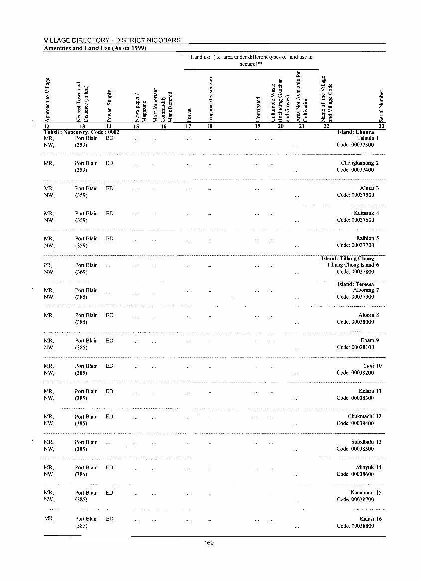
VILLAGE DIRECTORY - DISTRICT NICOBARS Amenities and Land Use (As on 1999)
12 13 14 15 Tahsil : Nancowry, Code: 0002 MR. Port Blair ED NW. (359)
MR.
~~~W'~~"_~~
MR. NW.
MR. NW.
MR. NW,
PRo NW.
MR. NW.
MR.
MR. NW.
Port Blair ED (359)
.. _" __ . ···_··¥·_·~w.~_ .. _"
Port Blair ED (359)
Port Blair ED (359)
Port Blair ED (359)
Port Blair (369)
Port Blair (385)
Port Blair ED (385)
Port Blair ED (385)
~ ____ ~,~~· __ ·~~_··_w·~·_··_· __ ·_.·
MR. Port Blair ED NW. (385)
MR. Port Blair ED NW. (385)
MR. Port Blair ED NW. (385)
MR. Port Blair NW. (385)
MR. Port Blair ED NW. (385)
MR. Port Blair ED NW. (3&5)
MR, Port Blair ED (385)
·w·· __ .···v·, .. ~" .. _.
-'---"'''''.-- .. --.~.~
16 17
Land use (i.e. area under different types of land use in hectare)""
18 19 20 21 22 Island: Choura
Tahaila 1 Code: 00037300
Chongkamong 2 Code: 00037400
Alhiat 3 Code: 00037500
Kuitasuk 4 Code: 00037600
Raihion 5 Code: 00037700
Island: Tillang Chong Tillang Chong Island 6
Code: 00037800
Island: Teressi Aloorang 7
Code: 00037900
Aloora 8 Code: 00038000
i -a ·c ., en 23
--><--_ .. _ .. _-------
169
Enam 9 Code: 00038100
Luxi 10 Code: 00038200
Ka1ara II Code: 00038300
Chukmachi 12 Code: 00038400
Safedbalu 13 Code: 00038500
Minyuk 14 Code: 00038600
Kanahinot 15 Code'. 0003&7(}(}
Ka1asi 16 Code: 00038800
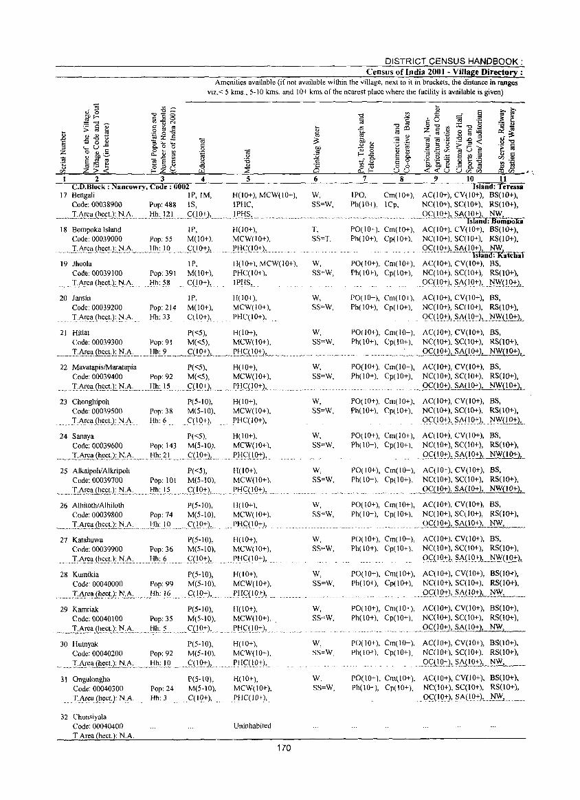
DISTRICT CENSUS HANDBOOK: Census of India 2001 - Village Directory :
Amenities available (if not available within the village, next to it in brackets, the distance in ranges viz, < 5 kms" 5- 1 0 kIDs, and 1 0+ kms of the nearest place where the facility is available is given)
~ ~- ~ 00 "0_ .£ a ~~ E ~ § ~ g ~ ~ c 0 :g 'e ~ E S:§~ C"'o:s ..<:: ",o:s o"O",::C",S 'a~
'" ,s< g '6 ~ go iii CD z iii,~ 8 113 '6 ~ :=: _g.g'i3 1;l::r:..s.", :;,.. '"< 03~ 03".",0),'0_..03 Q)_
... _g E ::s Z
., 0 Q) :; "- "- '" ;;;>- OJ) '" - '" 'u ::s ...... u ~ "- U ..c Q. 0 0 § 01).=! C '~'lij E E 0 ~ 0 -::. '~§ ~ ~ ~ ~ jJ ~ -~ 1j ~ ~ _g E ~o..... ] e ~ s ~ .~ ~ 5
~ p ~ ~ 03 E C ~:.a Cl~..J' e- E 't: 't: -0 Q)]:;""I '-
~ £;;.'i: ~Z§ ~ ~ -;SOl 88 ~~0 C~t5 ~! ~1~~~2~~------~~3~~--~4~------~5~----------~6~----~~~7~~~--~8~--~~9~~~10~~~1~1~-"
C.D.Block : Nancowry, Code: 0002 Island: Teressa 17 Bengali IP,IM, H(lO+), MCW(IO+), W, IPQ, Cm(IO+), AC(IO+), CV(JO+), BS(1O+),
Code: 00038900 Pop: 488 IS, IPHC, SS=W, Ph(lO+), lCp, NC(lO+), SC(lO+}, RS(1O+),
___ .. _T!~;F~~(h~~t.:L1'J-:A: ... ~ .. }:!~~ .. gl .... _.qlQ+L_. lfli§,._ .~gS::_Q_Q:.':)., SACIS!{d:Wo:"poka
18 Bompoka Island I P, H(I 0+), Code: 00039000 Pop: 55 M(IO+), MCW(lO+),
. ___ I :i\!~.'I{!1~c.!.2J::!~:_._!!~1 Q .. _,.fUQ+j, .. , .!.'.tI<;:(IQ-J:)J ..
19 Jhoola IP, Code: 00039100 Pop: 391 M(JO+),
.. Ti\~ea(J_1ect.): 1::I:A, Hh: 58 ' .. C(IO+),
20 Jansin IP, Code: 00039200 Pop: 214 M(lO+),
.. ... T,Arell(hect.):]'JA .. Hh: 33 C(lQ+),
H(lO+), MCW(IO+), PHC(IO+),
. IPHS,
H(10+), MCW(lO+), PHC(IO+),
T, SS'=T,
W, SS=W,
W, SS""W,
PQ(IO+), Cm(IO+), AC(IO+), CV(IO+), BS(lO+), Ph(lO+), Cp(IO+), NC(lO+), SC(IO+), RS(IO+),
.. Q~D.O::2,_~::\.U.~), ~ ISliiruf: n.atcnal
PO(IO+), Cm(IO+), AC(IO+), CV(IO+), BS, Ph(lO+), Cp(IO+). NC(IO+), SC(IO+), RS(lO+).
. OqIQ+),Si\{IQ~), f'.!.'!YCI.{)1::)~ .
PO(lO+), Cm(IO+), AC(lO+), CV(IO+), BS, Ph(lO+), Cp(lO+), NC(IO+), SC(lO+), RS(lO+),
()Ce JQ~), Si\(IQ~), .... :t!WU.Q:!:},_
21 Hillat P(<:5), H(lO+), W, PO(IO+), Cm(IO+), AC(IO+), CV(lO+), BS, Code: 00039300 Pop: 91 M«5), MCW(lO+), SS=W, Ph(lO+), Cp(lO+), NC(IO+), SC(IO+), RS(1O+),
__ TArea_.Q!.eE!): l'!.~.;_~_lIh: ~ __ C(!Q:.':2L._ ___ ._f!:Lg!.Q:i:)J. ' __ ,'_.. _, _ ....... __ . ___ .. .. _ ,__ "" _. ._,~Q_~(l~:2,_~A( I 0+2, NW(! 0+),
22 MavatapislMaratapia P( <5), H(l 0+), Code: 00039400 Pop: 92 M(<:5), MCW(10+),
., _ I:~~~_(I1~!')_:),i:i\_: __ ... .liJ_1.:.15, ." ftlQ-J:), .... , ... Pl:!.C(l O~),
23 Chonghipoh Code: 00039500
.' I.i\rea(hect): N,A.
P(S-IO), Pop: 38 M(5-10), Hh: 6 qIO+),
24 Sanaya P«5), Code: 00039600 Pop: 143 M(5-10),
~~T~~_{~~',:N:A.: __ ._l.I!}: .. 2L_ .. _,q 19::2!- ..
H(IO+), MCW(lO+), PHC(lO+),
H(lO+), MCW(JO+),
.. !.'l::!C(}Q-J:),
25 AlkaipohlAlkripoh P«5), H(lO+), Code: 00039700 Pop: 101 M(5-10), MCW(JO+),
__ ,,~T:i\~(l_.0~!;.Lt'!-.A.:._ .. , ..... tIh.:.,! L,_"q I. 0::)", ... J~Ii<;:(!Q+), .. n.
26 AlhitothiAlhiloth P(5-10), H(lO+), Code: 00039800 Pop: 74 M(S-IO), MCW(IO+),
~_].:A.r.e.Il.t~!)~:_ ... ,._tI,~:l,O .. ,. __ (JI .. Q:+},. PtIq,lO+),
27 Katahuwa Code: 00039900 Pop: 36
.. . I,~~ea. (J_1;::~t.): ?::l:A, Hh: 6
28 Kumikia Code: 00040000 Pop: 99
P(5-10), M(5-10),
qIO::},
H(lO+), MCW(10+),
PI1<::(lQ+), ...
P(S-IO), H( I 0+), M(5-10), MCW(lO+),
.. ,I,Ar;::ll,(he.<:!):1'i:~:_,,_ Hh: 16 9(l9:.':2, . __ Pliq1~), ...... .
29 Kamriak P(5-10), H(IO+), Code: 00040100 Pop: 35 M(5-10), MCW(IO+), .
_ .... __ T.:~ea,Ql££U:?::l,A.:_, ..•... !i~.: ~... . ... ,.CUO+), .... " .. ,P'i<::(IQ+), ...
30 Hutnyak P(5-10), Code: 00040200 Pop: 92 M(5-10),
.. _., .... L~e.~.U~N·~.c., __ ... !:!.~:,LQ ........ g(l.Q~)J ..
3 \ OngulonghQ Code: 00040300
TArea (~ect): ~.A
32 Chonsiyala Code: 00040400 TArea heet. : N.A.
P(S-lO), Pop: 24 M(5-10), Hh: 3 C(IQ+),
H(IO+), MCW(IO+),
P!i<::(l.O+),
H(lO+), MCW(IO+), PHC(10+),
Uninhabited
170
W, SS=W,
W, SS=W,
W, SS=W,
W, SS=W,
W, SS=W,
W, SS=W,
W, SS=W,
W, SS=W,
W, SS=W,
w, SS=W,
PO(lO+), Cm(IO+), AC(IO+), CV(IO+), BS, Ph(10+), Cp(IO+), NC(JO+), SC(IO+), RS(lO+),
.. _gg(!Q_~~Jl~{10+),
PO(IO+), Cm(IO+), AC(IO+), CV(lO+), BS, Ph(lO+), Cp(lO+), NC(IO+), SC(IO+), RS(lO+),
OqIQ~),Si\(l~), . f'.!'!Y(l,Q:+.:},
PO(IO+), Cm(10+), AC(lO+), CV(10+), BS, Ph(lO+), Cp(lO+), NC(10+), SC(10+), RS(lO+),
.gf(lQ::LS.~J1Q_~ NW{lO+},
PO(IO+), Cm(IO+), AC(IO+), CV(IO+), BS, Ph(lO+), Cp(IO+), NC(IO+), SC(lO+), RS(lO+),
~ ___ 9..fQQ:!:1 SA(IO+), NW{IO+2,
PO(IO+), Cm(IO+), AC(IO+), CV(lO+), BS, Ph(IO+), Cp(IO+), NC(1O+), SC(1O+), RS(lO+),
__ .. _Q_~QQ:'"1_jA(10.:'"), NW,
PO(IO+), Cm(IO+), AC(IO+), CV(JO+), BS, Ph(lO+), Cp(lO+), NC(10+), SC(1O+), RS(lO+),
.. Q~(I9:J:), ~A{I.Q:"), ~_W(lO+)L
PO(J 0+), Cm(J 0+), A C(I 0+), CV (10+), BS(lO+), Ph(iO+), Cp(10+), NC(lO+), SC(10+), RS(lO+),
...... Q_g(l.Q:2,.~A(l2~),_ ... ~_, _ ... _
PO(lO+), Cm(IO+), AC(JO+), CV(10+), BS(IO+), Ph(JO+), Cp(IO+), NC(lO+), SC(10+), RS(lO+),
_9f(!g:'2,...s.A_(12.:2..__~
PO(IO+), Cm(IO+), AC(IO+), CV(IO+), BS(10+), Ph(IO+), Cp(IO+), NC(lO+), SC(JO+), RS(JO+),
.Q~ .. U2::22,A<l0+2, NW,
PO(IO+), Cm(IO+), AC(IO+), CV(IO+), BS(1O+), Ph(lO+), Cp(JO+), NC(JO+), SC(IO+), RS(lO+),
.09(10:), $i\(1 Q~2, .~~,_ .. _. .
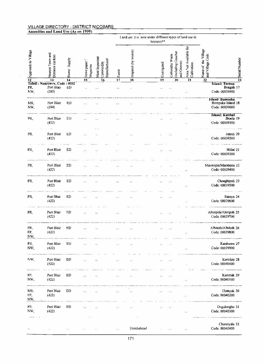
VILLAGE DIRECTORY - DISTRICT NICOBARS Amenities and Land Use (As on 1999)
12 13 14 15 Tahsil: Nancowry, Code: 0002 PR, Port Blair ED NW, (385)
MR, Port Blair ED NW, (394)
, .•. ~~.~.-~-. ~.".-- ~'-"
PR, Port Blair ED (422)
PR, Port Blair ED (422)
PR, Port Blair ED (422)
PR, Port Blair ED (422)
~ .• ____ ~v_"_'_' __ '_V~'·_~~ _~~~vV~',~ v •...
PR, Port Blair ED (422)
PR, Purt Blair ED (422)
PR, Port Blair ED (422)
~~.~ ______ •• ~ __ ._","_"'<~"~W"~~~'_O' __ '·~"
PR, FP,
J:I'>Y,. PR, NW,
NW,
FP, NW,
MR, FP,
.l'lW, .... : ..... FP, NW,
Port Blair (422)
Port Blair (422)
Port Blair (422)
Port Blair (422)
Port Blair (422)
Port Blair (422)
ED
ED
ED
ED
ED
ED
16 17
Land use (i.e. area under different types of land use in hectare)*-
18 19 20
Uninhabited
171
21 22 23 Island: Teressa
Bengali 17 Code: 00038900
········--------I·s'la-n·d·'. B"o-m-c-o-o'k-a-Bompoka Island 18 Code: 00039000
.. ···-·····----·····-·-..-:Is"laC"""n-d .. : 7K-;-'a7tc::"ih-aT"I-Jhoola 19
Code: 00039100
Jansin 20 Code: 00039200
Hitlat 21 Code: 00039300
MavatapisiMaratapia 22 Code: 00039400
Chonghipoh 23 Code: 00039500
Sanaya 24 Code: 00039600
Alkaipoh/ Alkripoh 25 Code: 00039700
Alhitothl Alhiloth 26 Code: 00039800
Katahuwa 27 Code: 00039900
Kurnikia 28 Code: 00040000
Kamriak 29 Code: 00040100
Hutnyak 30 Code: 00040200
Ongulongho 31 Code: 00040300
Chonsiyala 32 Code: 00040400
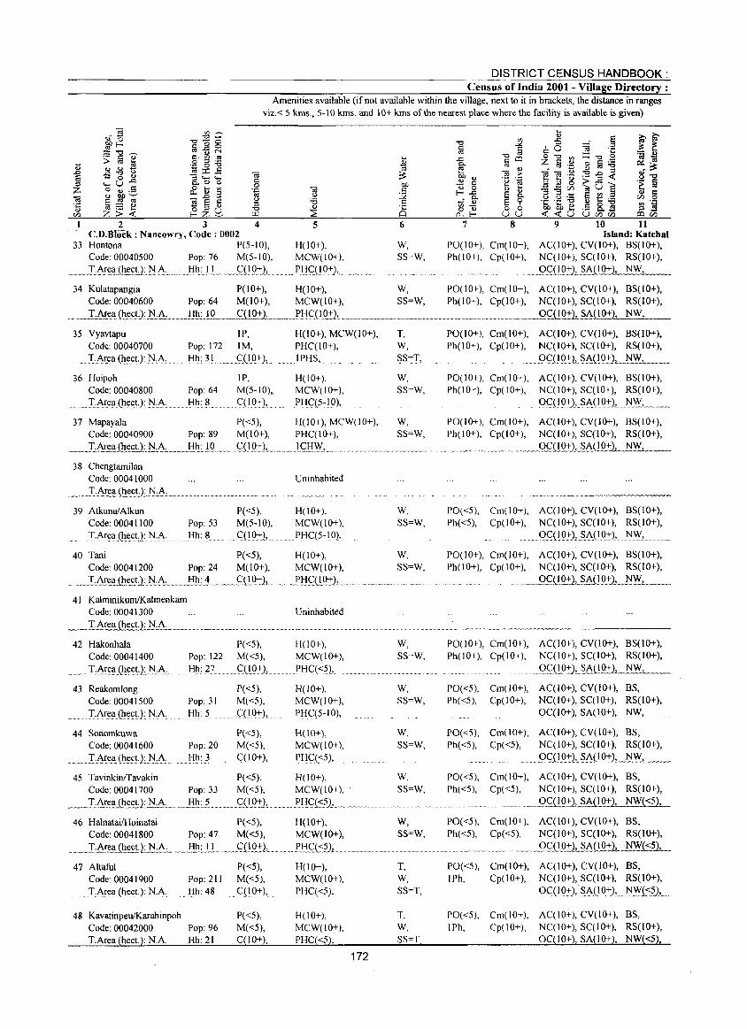
DISTRICT CENSUS HANDBOOK: Census of India 2001 - Village Directory ;
Amenities available (if not available within the village, next to it in brackets, the distance in ranges viz.< 5 kms., 5-10 kms. and 10+ kms of the nearest place where the facility is available is given)
2 3 4 5 6 7 8 9 10 11 C.D.Block: Nancowry, Code: 0002 Island: Katchal
33 Hontona P(S-IO), H(lO+), W, PO(IO+), Cm(IO+), AC(IO+), CV(IO+), BS(IO+), Code: 00040500 Pop: 76 M(5-10), MCW(IO+), SS=W, Ph(IO+), Cp(IO+), NC(IO+), SC(IO+), RS(IO+),
.~~I:_~I~.'!.ihec!:.)J~.~· .... m}:-!~'}! .. ~wClLQ+L ..... P'iqIO+),. .• . ... 9.<;QQ2).1..SA(10+), NW,
34 Kulatapangia P(IO+), H(lO+), W, PO(lO+), Cm(IO+), AC(lO+), CV(IO+), BS(1O+), Code: 00040600 Pop: 64 M(lO+), MCW(lO+), SS=W, Ph(IO+), Cp(IO+), NC(lO+), SC(IO+), RS(IO+),
__ T~eaf!!~D: N·"L_Ii!!.:..!Q___w C(IO+), w •• ___ .X'i~(l_g.:!:,L.~~_._'"._'" ....... __ '" __ .. ~. __ .. __ .. __ ._2f.liQ:t-), SA(IO+), NW,
35 Vyavtapu Code: 00040700 Pop: 172
TAre.CI(Ite.ctJ::t-J:~: ...... Hh.: 31
36 Hoipoh Code: 00040800
.... T:AreCl{It~<:tJ:t-J:~: Pop: 64 Hh: 8
IP, H(lO+), MCW(lO+), 1M, PHC(IO+),
C(19+), ..... I PHS,
IP, M(5-10), q10:+:),
H(lO+), MCW(IO+), PIic::(5-10),
37 Mapayala P«5), H(lO+), MCW(10+), Code: 00040900 Pop: 89 M(IO+), PHC(lO+),
.___L6!:ea ~.<:!.l.lLA...___):!L!"Q.... c::.(!Q.:+:1L ...... I c::!:!~'-- .. "
38 Chengtamilan Code: 00041000
39 AtkunalAlkun Code: 00041100
.!·Area (Il~et): :t-J:~:
Uninhabited
P«5), H(IO+), Pop: 53 M(5-10), MCW(lO+), Hh: 8 C(lQ:+:),.. . ... PHq5-10),
40 Tani P( <5), H(l 0+), Code: 00041200 Pop: 24 M(lO+), MCW(lO+),
T, W, SS=T,
W, SS=W,
W, SS=W,
W, SS=W,
W, SS=W,
•.... _ .• IJ~r~!!iIt~<:n .. tLA:....... Hh: 4 .••. ~(!9.:t).L •.• l'!:!C::{l0+), ............ ~ .. _ ........... .
41 KalminikumlKalmenkam Code: 00041300
42 Hakonhala P«5), Code: 00041400 Pop: 122 M«5),
_ .. lA.re.~LltecU_:_ l'l..:.A". ..JIlI:, ~L.. CCI.O:+:),
43 Reakomlong Code: 00041500
.. I:A~e.a{It~(;t·JN·A 44 Sonomkuwa
Code: 00041600
... I!.\I:e.CI.(It~(;t·).:.1'I:A: ...
Pop: 31 Hh: 5
Pop: 20 Hh: 3
P«5), M«5), qIO+),
P«5), M«5),
..... qlg+},
Uninhabited
H(lO+), MCW(lO+), PHq<?),
H(lO+), MCW(lO+), PHC(5-10),
H(IO+), MCW(lO+),
. PH.C::«5),
45 Tavinkinffavakin P«5), H(IO+), Code: 00041700 Pop: 33 M«5), MCW(lO+), .
__ ._T,~~ .. (Il~£!1. N.A, ...... ,. H~: ... L ._C:_@:+:l.... .~_I~!:!.q:::?L .... ~ ... .
46 HalnataifHoinatai P«5), H(lO+), Code: 00041800 Pop: 47 M«5), MCW(lO+),
..•.. _ ... T·..AI~_{!!~et·.LN:~.:_. __ .I:I!:_U ... mm •• qlQ:t-),_ .......... p.!:!Gt:?), _mm om. __
47 Altaful P«5), H(IO+), Code: 00041900 Pop: 211 M«5), MCW(IO+),
. T.AreCi (heeL): NA Hh: 48 C(10+), PHQ<5),
48 Kavatinpeu/Karahinpoh P«5), H(lO+), Code: 00042000 Pop: 96 M«5), MCW(IO+), T.Area (hec!.): NA Hh: 21 C(lO+), PHC«5),
172
W, SS=W,
W, SS=W,
W, SS=W,
W, SS=W,
w, SS=W,
T, W, SS=T,
T, W, SS=T,
PO(lO+), Cm(lO+), AC(IO+), CV(lO+), BS(IO+), Ph(IO+), Cp(IO+), NC(IO+), SC(IO+), RS(IO+),
... OqI9:+:LSA(IO:+:), N.~L.
P0(10+), Cm(10+), AC(IO+), CV(IO+), BS(IO+), Ph(IO+), Cp(IO+), NC(IO+), SC(lO+), RS(IO+),
()q19+), SA{IQ:+:}, 1'1~ ___ .
PO(lO+), Cm(IO+), AC(IO+), CV(IO+), BS(10+), Ph(IO+), Cp(10+), NC(IO+), SC(IO+), RS(IO+),
_ .... 0CQQ.:th1'..A(10+}, NW,
PO«5), Cm(IO+), AC(IO+), CV(IO+), BS(IO+), Ph( <5), Cp(1 0+), NC( 10+), SC(1 0+), RS(1 0+),
....... OQ1Q:+:), $A(19:+:), 1'1~.,
PO(lO+), Cm(IO+), AC(10+), CV(IO+), BS(10+), Ph(lO+), Cp(lO+), NC(lO+), SC(10+), RS(10+),
. 9_Q!.Q:t), SA(10+), NW,
P0(10+), Cm(10+), AC(IO+), CV(IO+), BS(IO+), Ph(IO+), Cp(IO+), NC(IO+), SC(IO+), RS(IO+),
_ .... QC::{!92),_§..Ai!Q+), NW,
PO«5), Cm(lO+), AC(IO+), CV(IO+), BS, Ph«5), Cp(lO+), NC(IO+), SC(IO+), RS(IO+),
OC(IO+), SA(IO:,:), .N~,
PO«5), Cm(IO+), AC(10+), CV(lO+), BS, Ph«5), Cp«5), NC(IO+), SC(IO+), RS(10+),
....... 9G(19:+:),.$A.L!Q:+:),._N.~, _ .. _
PO«5), Cm(IO+), AC(IO+), CV(IO+), BS, Ph«5), Cp«5), NC(IO+), SC(10+), RS(10+),
._..Qql02:),.1.~O+}, NW{<5),
PO«5), Cm(lO+), AC(lO+), CV(lO+), BS, Ph«5), Cp«5), NC(IO+), SC(IO+), RS(IO+),
_ .. _... '_' _ .. _9c(1O+), SA(10+), NW{<5),
PO«5), Cm(IO+), AC(IO+), CV(10+), BS, IPh, Cp(10+), NC(IO+), SC(IO+), RS(10+),
oQI 9:+:), SAO 0+), .. N~(:::?),
PO«5), Cm(IO+), AC(IO+), CV(lO+), BS, IPh, Cp(lO+), NC(IO+), SC(IO+), RS(IO+),
0C(1O+), SA(10+), NW«5),

VILLAGE DIRECTORY - DISTRICT NICOBARS Amenities and Land Use (As on 1999)
12 13 14 lahs" : Nancowry, Code: 0002 MR, Port Blair ED NW, (422)
MR, Port Blair FP, (422)
l'l.'?v' .. L •... " ...................... .
FP, NW,
FP, NW,
FP, NW,
FP, NW,
FP, NW,
PR, NW,
PR,
PR,
PR,
PR,
PR, FP,
PR,
Port Blair ED (422)
Port Blair ED (422)
Port Blair ED (422)
Port Blair ED (422)
Port Blair ED (422)
Port Blair (422)
Port Blair (422)
Port Blair (422)
Port Blair (422)
ED
ED
ED
Port Blair ED (422)
Port Blair ED (422)
Port Blair ED (422)
15 16 17
Land use (i.e. area under different types of land use in hectare)**
18 19 20 21
Uninhabited
Uninhabited
173
22 23 Island: Katchal
Hontona 33 Code: 00040500
Kulatapangia 34 Code: 00040600
. ................ __ ---Vyavtapu 35
Code: 00040700
Hoipoh 36 Code: 00040800
MapayaJa 37 Code: 00040900
Chengtarnilan 38 Code: 00041000
AtkunalAlkun 39 Code: 00041100
Tani 40 Code: 00041200
KalminikumIKalmenkarn 41 Code: 00041300
Hakonhala 42 Code: 00041400
Reakom1ong 43 Code: 00041500
Sonornkuwa 44 Code: 00041600
Tavinkinffavakin 45 Code: 00041700
HalnataiIHoinatai 46 Code: 00041800
A1taful47 Code: 00041900
KavatinpeulKarahinpoh 48 Code: 00042000
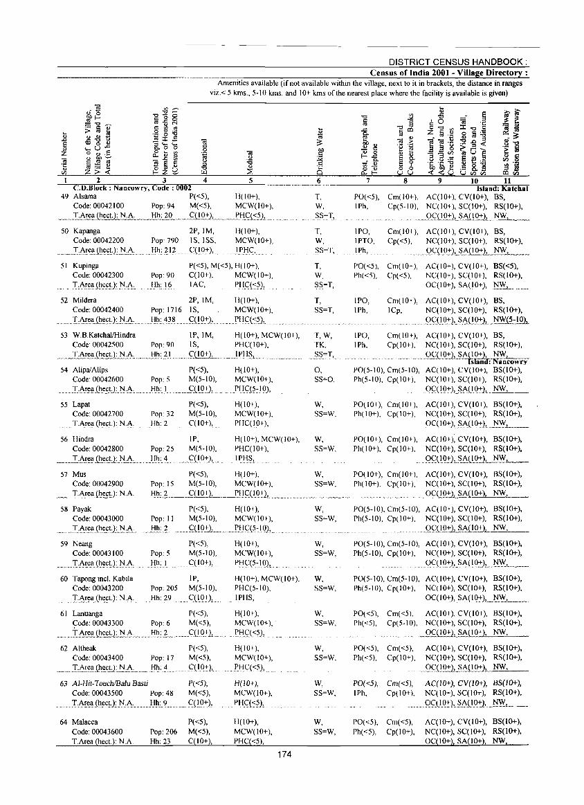
DISTRICT CENSUS HANDBOOK: Census of India 2001 - Village Directory :
Amenities available (if not available within the village, next to it in brackets, the distance in ranges
viz.< 5 krns., 5-10 krns. and 10+ krns of the nearest place where the facility is available is given)
2 3 C.D.Block: Nancowry, Code: 0002
Ol c: o .~
.g ~
4 5 6
49 Alsama P«5), H(lO+), T, Code: 00042100 Pop: 94 M«5), MCW(IO+), W,
~_I.Area (hect.): N.A. Hh: ~L .. _<;:(lO+)!...._.,,_~I-!£l<:.?).1._. _._ ..... " SS:~L
50 Kapanga Code: 00042200
..... _.I:'-'"!~.a..(ht:c.!.):}~:.~:
51 Kupinga Code: 00042300
T:~!<:!I(ht:ctJ: .r-.!:A:
2P,IM, Pop: 790 I S, ISS,
Hh: 212 ..... q~O:+),.
H(lO+), MCW(IO+),
.. 1_PI:IC,
P«5), M«5), H(lO+), Pop: 90 Hh: 16
C(lO+), MCW(IO+),
1A<::, ... PHC«?),
52 Mildera 2P, 1M, H(lO+), MCW(lO+),
PHq<::~),
Code: 00042400 Pop: 1716 IS,
....... T:A!e!l .. (ht:~t·}:.t-I:A: .... }ih:.~~8 ... <;:(19:+),.
53 W.8.KatchallHindra IP, 1M, H(IO+), MCW(IO+), Code: 00042500 Pop: 90 IS, PHC(IO+),
... ~T.:.A!:ea (he~)_:_:r:i:!\.,, __ I:!.h.:. .?L .. . ,' "C::.(!_O.:!:L ... ' _,) P!:,,§,,_
54 AlipaiAlips P«5), H(lO+), Code: 00042600 Pop: 5 M(5-10), MCW(IO+),
._._TA!~!I_(l:l_t:c.!:):_~:Ac. ___ .I-!h_:) .......... .c::.ClQ:+:), ....... Pj-{q?~} 0),
55 Lapat P«5), H(IO+), Code: 00042700 Pop: 32 M(5-10), MCW(lO+),
T.Area (heet.): NA Hh: 2 C(lO+), PHC(IO+),
56 Hindra IP, H(lO+), MCW(IO+), Code: 00042800 Pop: 25 M(5-10), PHC(IO+),
_,_I.A~~a .. {ht:£!·):.tJ.:.A .. : ..... Hh: 4 .... <::(10:+),. IPI-!S,
57 Mus P«5), H(lO+), Code: 00042900 Pop: 15 M(5-10), MCW(IO+),
T, W, SS=T,
T, W, SS=T,
T, SS=T,
T,W, TK,
._S§""T,,,
0, SS=O,
W, SS=W,
W, SS=W,
W, SS=W,
7 8 9 10 11 Island: Katchal
PO«5), Cm( 10+), AC(IO+), CV(lO+), 8S, IPh, Cp(5-10), NC(IO+), SC(IO+), RS(IO+),
IPO, IPTO,
.1Ph,
... _ _Q.c::DQ::t:'2!....~A(10+), NW,
Cm(lO+), AC(IO+), CV(IO+), BS, Cp«5), NC(IO+), SC(IO+), RS(IO+),
..... gQl_Q::t:'2,_,sAD..Q:t-), NW,
PO«5), Cm(IO+), AC(IO+), CV(IO+), BS«5), Ph«5), Cp«5), NC(IO+), SC(IO+), RS(IO+),
0C(10+), ~A(10+), ~W, . __ .. _
IPO, IPh,
Cm(IO+), AC(IO+), CV(lO+), BS, lCp, NC(10+), SC(IO+), RS(lO+),
9_c::H Q:+2,_~.All.Q:t-~_~-1 0),
IPO, Cm(IO+), AC(IO+), CV(lO+), BS, IPh, Cp(10+), NC(10+), SC(IO+), RS(JO+),
... .. ..... - . _QC(10+), SA~!~-::d: ~'coWry PO(5-10), Cm(5-1O), AC(IO+), CV(IO+), 8S(10+), Ph(5-10), Cp(IO+), NC(IO+), SC(IO+), RS(lO+),
... °.f(1Q:+1_§_AL~Q.:!:).L_N_W_,_ __
PO(IO+), Cm(IO+), AC(IO+), CV(IO+), 8S(IO+), Ph( I 0+), Cp(IO+), NC(IO+), SC(IO+), RS(IO+),
OC(IO+), ~A(IO:+)L_~'.Y.L __
PO(IO+), Cm(IO+), AC(IO+), CV(IO+), 8S(10+), Ph( I 0+), Cp(IO+), NC(IO+), SC(IO+), RS(IO+),
.. Qql.Q:t-LSA(~O+ ), NW,
PO(IO+), Cm(IO+), AC(IO+), CV(IO+), 8S(10+), Ph(JO+), Cp(IO+), NC(IO+), SC(IO+), RS(lO+),
T.Area (heel.}: NA Hh: 2 qIO+), _2HC( I O:+),_~ __ ._. ~"~~~_~~,, .... ~, ... ,_ ....... _._ .". OqIO+), SA{IO+), NW,
58 Payak P«5), H(JO+), Code: 00043000 Pop: 11 M(5-10), MCW(lO+),
__ "TArea (he~ .. t): NA .. Hh:?_ . __ ~{!9.:!:1 ___ .n::IC::{5:.IQ),,,
59 Neang Code: 00043100
........ ' ... T:~r":.!1 (ht:ct): .. 1'J,A:.
P«5), Pop: 5 M(5-10),
Hh: I ........ qIO+),
H(IO+), MCW(lO+),
Pl:fq5~10),
60 Tapong incl. Kabila IP, Code: 00043200 Pop: 205 M(5-10),
H(JO+), MCW(IO+), PHC(5-10),
.............. Tc\r.t:!l(~e,ctJ:~:A:... Hh: 29 C(10:+), IPHS,
61 Lanuanga P«5), H(lO+), <::ode: 00043300 Pop: 6 M«5), MCW(lO+), .
__ .I·Area (h .. t:c.~t_N·A .. _ .. __ .. F:I~:_~,_" .. ___ ,C:OQ':+1, ...... ~P,l:fC:«5),
62 Altheak P«5), Code: 00043400 Pop: 17 M«5),
__ " I:AEe.!l.(l!t:(;~2:_J:I.:.A.:._,,_ !i~:_~ __ . __ C(! 9:':1,
63 AI-Hit-TouchIBalu Basti P«5), Code: 00043500 Pop: 48 M«5),
...... I:Ar.!:.i'l{h!:<:tJ.: 1'J:A: Hh: 9 ......... (:(1.0:':),
64 Malacca
Code: 00043600 T.Area (heet.): N.A.
P«5), Pop: 206 M«5), Hh: 23 C(lO+),
H(lO+), MCW(IO+),
})j-{C«5),
H(lO+), MCW(IO+),
.PH<::(",?),
H(IO+), MCW(IO+), PHC«5),
174
W, SS=W,
W, SS=W,
W, SS=W,
W, SS=W,
W, SS=W,
W, SS=W,
W,
SS=W,
PO(5-10), Cm(5-10), AC(IO+), CV(IO+), BS(lO+), Ph(5-10), Cp(lO+), NC(IO+), SC(IO+), RS(IO+),
....... 0C(~_+2, SA(lO+), NW,
PO(5-1O), Cm(5-IO), AC(IO+), CV(lO+), 8S(10+), Ph(5-10), Cp(IO+), NC(IO+), SC(IO+), RS(IO+),
.. . ..... Q<::(lQ:+),§A(IO:+:)".~w.L. __
PO(5-10), Cm(5-10), AC(IO+), CV(IO+), BS(IO+), Ph(5-10), Cp(IO+), NC(IO+), SC(IO+), RS(IO+),
... QC(IO:,:), SA(IQ:':2, __ tJ.~_
PO«5), Cm«5), AC(IO+), CV(IO+), 8S(10+), Ph«5), Cp(5-10), NC(IO+), SC(IO+), RS(IO+),
_ _QC{J0+2, SA(lO+), NW,
PO«5), Cm«5), AC(IO+), CV(IO+), 8S(10+), Ph«5), Cp( I 0+), NC(IO+), SC(IO+), RS(lO+),
m. _.Qf(IO+J, SA(IO+), NW,
PO«5), Cm«5), AC(IO+), CV(10+), BS(1O+), IPh, Cp(IO+), NC(IO+), SC(IO+), RS(IO+),
Q<::(1.9:':), .... ~A(I.Q::t:2L,,]'J.JY_, ___
PO«5), Cm«5), AC(IO+), CV(IO+), BS(IO+),
Ph«5), Cp(IO+), NC(IO+), SC(IO+), RS(IO+),
OqIO+), SA(lO+), NW,
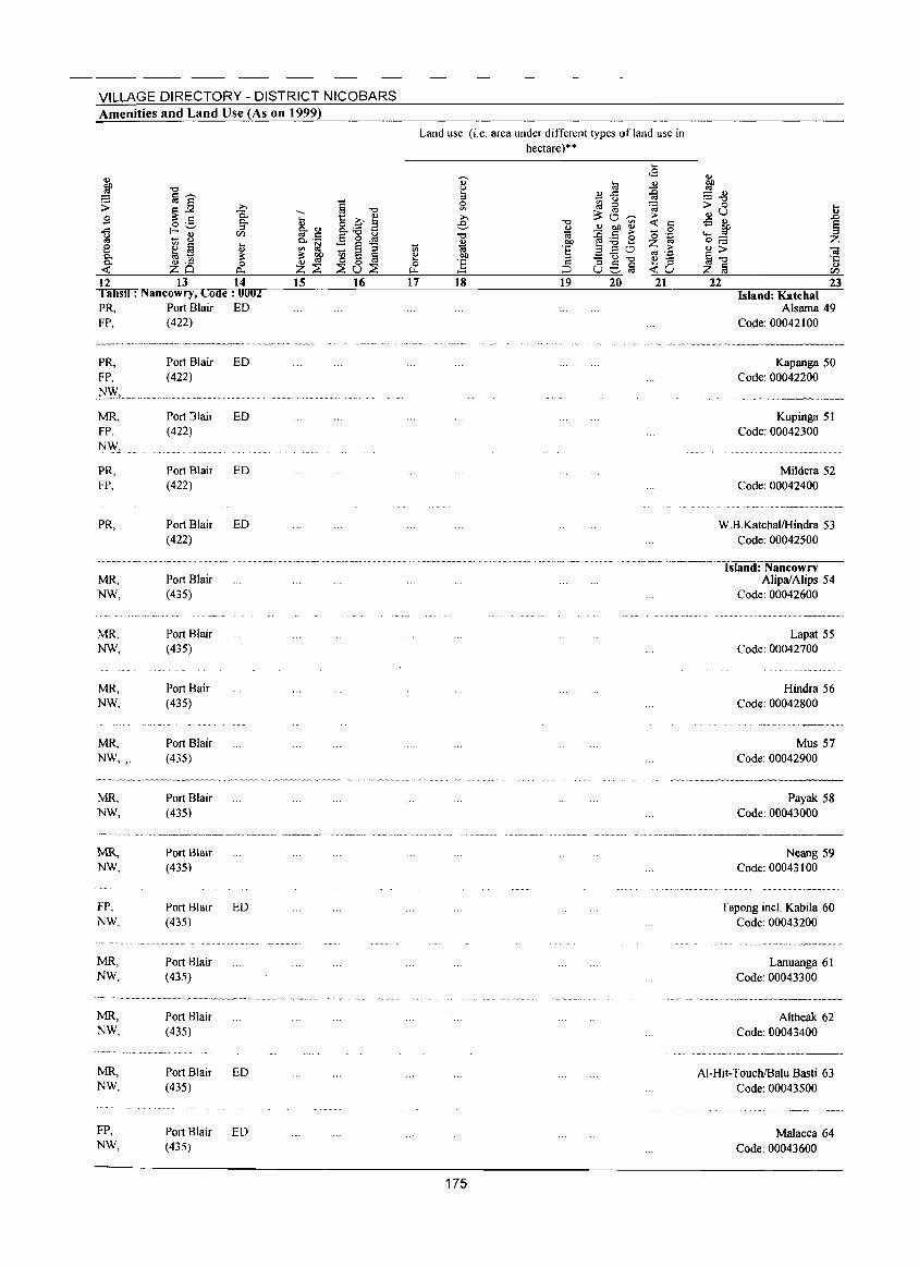
VILLAGE DIRECTORY - DISTRICT NICOBARS Amenities and Land Use (As on 1999)
j "0
;; !ij]' >-
.9 ~ c:: "i5. o ._ c.. ..c:: f-~ :::s ~ - ~
til
1:2 ~ !ij ... ., c.. ~ .~ ~ c.. 0 < zo p...
12 13 14 I ahsd : Nancowry, Code: 0002 PR, Port Blair ED FP, (422)
PR, Port Blair ED FP, (422)
.j\/'Vv', ......... _. __ ..... , ..... ~ .. MR, FP, NW,
PR, FP,
PR,
MR, NW,
MR, NW,
MR, NW,
MR, NW".
MR, NW,
MR, NW,
FP, NW,
MR, NW,
MR, NW,
MR, NW,
FP, NW,
Port Jlair (422)
Port Blair (422)
Port Blair (422)
Port Blair (435)
Port Blair (435)
Port Bair (435)
Port Blair (435)
Port Blair (435)
Port Blair (435)
Port Blair (435)
Port Blair (435)
Port Blair (435)
Port Blair (435)
Port Blair (435)
ED
ED
ED
ED
ED
ED
.... ., §-1:l c.. ._
'" l::l ~ ~ Z~ 15
ij "0
t::~" 8..- 2 E "0 u - ~ ~ - e :::s ~ 0 § ~u~
16
til ~ 0 ....
17
Land use (i.e. area under different types ofland use in hectare)"
., ~ :::s 5l >-e
"0 ., ta t>!)
] 18 19 20 21
175
22 23 Island: Katchal
Alsarna 49 Code: 00042100
Kapanga 50 Code: 00042200
Kupinga 51 Code: 00042300
Mildera 52 Code: 00042400
W.B.KatchallHindra 53 Code: 00042500
-'--' Island:'Nancowrv Alipa/Alips 54
Code: 00042600
Lapat 55 Code: 00042700
Hindra 56 Code: 00042800
Mus 57 Code: 00042900
Payak 58 Code: 00043000
Neang 59 Code: 00043100
Tapong inel. Kabila 60 Code: 00043200
Lanuanga 61 Code: 00043300
.......... _._. __ -_ Altheak 62
Code: 00043400
AI-Hit-TouchIBaiu Basti 63 Code: 00043500
Malaeca 64 Code: 00043600
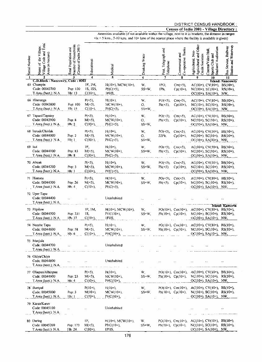
DISTRICT CENSUS HANDBOOK: Census of India 2001 - Village Directory:
Amenities available (if not available within the village, next to it in brackets, the distance in ranges viz. < 5 kms., 5-10 kms. and 10+ kms of the nearest place where the facility is available is given)
2 3 4 5 C.D.Block : Nancowry, Code: 0002
ClO c :.2 .5 CS 6
.c e ~g <!J 0 I-.c ,0-
- <!J '" -o <!J 0..1-
7 8 9 10 11
65 Champin IP, 1M, H(lO+), MCW(lO+), W, IPO, Cm«5), Island: Nancowry
AC(IO+), CV(lO+), BS(IO+), NC(lO+), SC(IO+), RS(IO+), OC(IO+), SA(IO+), NW,
Code: 00043700 Pop: 130 IS, ISS, PHC«5), SS=W, IPh, Cp(IO+), . ___ J.Arel!...~U~...:A. . __ 1:I.!:t':"!.L_~,,__ __ ... 1!'.!:!~_,. __ ._. __ ._._. ___ .. ____ ......... ~ .... _._ .... ___ .
66 Hinnunga P«5), Code: 00043800 Pop: 1 00 M( <5),
..... _IA!!!.~,(~e(;tJ.J:'I.~~_ . . .Ii.h.: I~ ..... C:::{i.P:+-),
67 Tapaniffapainy Code: 00043900 Pop: 8 :r·J\.~t:li (hec.U: j\Lh.:. Hh: 2
68 Inroak/Chinlak Code: 00044000 Pop: 2 T.J\.rea(ht:ct): N.A. Hh: I
P«5), M«5),
. C(10+),
P«5), M«5), C(IO+),
H(IO+), W, MCW(IO+), 0, PJ.IC«5), SS=\\i,
H(IO+), W, MCW(IO+), 0, PHC«5), SS=W,
H(lO+), W, MCW(lO+), 0, PHC«5), SS=W,
69 Itoi IP, H(IO+), W, Code: 00044100 Pop: 83 M«5), MCW(IO+), SS=W,
. __ ..I..:..~rt!a Qlect.): N.A.;;.;.. __ H;:_h,,;,;,,: 8 ___ CQ0.::2_, ~ . .......f.'::!..C(::.sL .. _ ........... __ .................. .
70 Alreak P«5), H(IO+), W, Code: 00044200 Pop: 3 M«5), MCW(lO+), SS=W,
. ...........I:Ar..ea (heet.): NA Hh: I .. _ .... q I O+L .... _P_HC(::~.1... ...... "_.,,._ .. __ .
71 Hintona Code: 00044300
.... T.Area (heet.): NA
72 UperTapu Code: 00044400
_ ...... LJ\.~e_a_(lIt!eU:1':!:!\.
Pop: 26 Hh: 4
P«5), M«5), C(10+),
H(lO+), MCW(10+), PHC«5),
Uninhabited
73 Pilpilow IP, 1M, H(IO+), MCW(lO+), Code: 00044500 Pop: 331 IS, PHC(lO+), T.Area (heet.): NA .•. _I:!~: }7, __ c:::Q.Q::t:L .... 1Pl::f§,. "' .. _
74 Neeche Tapu P«5), H(IO+), Code: 00044600 Pop: 58 M«5), MCW(IO+),
__ T:Are~heet.L N.A.:... ... _!:I!r L ... _ .. C::;(.lP::t:2, ......... _Pljq.1 Q,:),
75 Manjula Code: 00044700
. T:l\r!!~(lIt!(;t): 1'l·A· ..
76 OkiyalChiya Code: 00044800
........... LA.~ell (lIee!:): J:'I.A.
Uninhabited
Uninhabited
77 OlinponlAlhinpon P«5), H(lO+), Code: 00044900 Pop: 23 M«5), MCW(10+),
... _~LATea Ql_e£U:.1'l:A~ .. __ I:!!!.:.~_., ___ .fQQ_1:)_, __ ...... ~!:!<::_(192:), ... _. 78' Bumpal P(IO+), H(lO+),
Code: 00045000 Pop: 3 M(IO+), MCW(IO+),
___ .LAE~..<I_~~l:),:.J.:.A, ___ .I:!~:I.... . .. <:;(19+), ....... PHqIO+),
79 KaranlKarav Code: 00045100 Uninhabited T.Area(~eet): NA
W, SS=W,
W, SS=W,
w, SS=W,
w, SS=W,
W, SS=W,
80 Daring IP, H(IO+), MCW(IO+), W, Code: 00045200 T.Area (heet.): NA
Pop: 173 M«5), Hh: 24 C(lO+),
PHC(IO+), SS=W, IPHS,
176
PO«5), Cm«5), AC(IO+), CV(IO+), BS(IO+), Ph«5), Cp(lO+), NC(lO+), SC(IO+), RS(lO+),
._9.ql.Q2'L~A._Q9+ ), NW,
PO«5), Cm«5), AC(IO+), CV(IO+), 8S(10+), Ph«5), Cp(IO+), NC(lO+), SC(IO+), RS(1O+),
". QC(19:+-), SA( 10:,:), .. ]\I~,._
PO«5), Cm«5), AC(IO+), CV(IO+), B5(10+), 22Ph, Cp(IO+), NC(IO+), SC(lO+), RS(IO+),
oc( 19:+-)" sALI9:':2L_]\I~_ .. " __
PO«5), Cm«5), AC(IO+), CV(IO+), 85(10+), Ph«5), Cp(IO+), NC(lO+), SC(1O+), RS(lO+),
.. .... ......9CC I 0+ ),_SAi!.Q:I' ), NWI
PO«5), Cm«5), AC(1O+), CV(IO+), BS(IO+), Ph«5), Cp(10+), NC(IO+), SC(10+), RS(1O+),
.. ___ Q~(I O+)L~il 0+), NW,
PO«5), Cm«5), Ph«5), Cp(IO+),
AC(IO+), CV(lO+), BS(lO+), NC(lO+), SC(IO+), RS(1O+).
QC(I.O:,:), .. ~.I\(.I():,:), .... ]\IW,.... ._ ...
~"~~' .. e~"_' ~ .. ~,. .. ··~~·'~' .. Tsland: Kamorta PO(IO+), Cm{lO+), AC(IO+), CV(lO+), BS(lO+), Ph(lO+), Cp(IO+), NC(IO+), SC(IO+). RS(lO+),
. _QC(IO~SA(IO+), NW,
POe 10+), em( 10+), AC(IO+), CV(10+), 8S(10+), Ph(l 0+), Cpt I 0+), NCe 1 0+), SC( I 0+), RS( 10+),
__ Q~.1I.Q:I:1 SA(IO+), NW,
PO(lO+), Cm(IO+), AC(lO+), CV(10+), BS(IO+), Ph(10+), Cp(IO+), NC(lO+), SCC10+), RS(lO+),
_ __. OC(IO+), SA(10+), NW,
PO(IO+), Cm(IO+), AC(IO+), CV(lO+), BS(IO+), Ph(IO+), Cp(IO+), NC(IO+), SCCIO+), RS(IO+).
. _Qf(l9:1:L~(LO+), NW,
PO(IO+), Cm(IO+), AC(IO+), CV(IO+), 8S(10+), Ph(IO+), Cp(IO+), NC(10+), SC(lO+), RS(IO+),
OC(10+), SA(lO+). NW .•
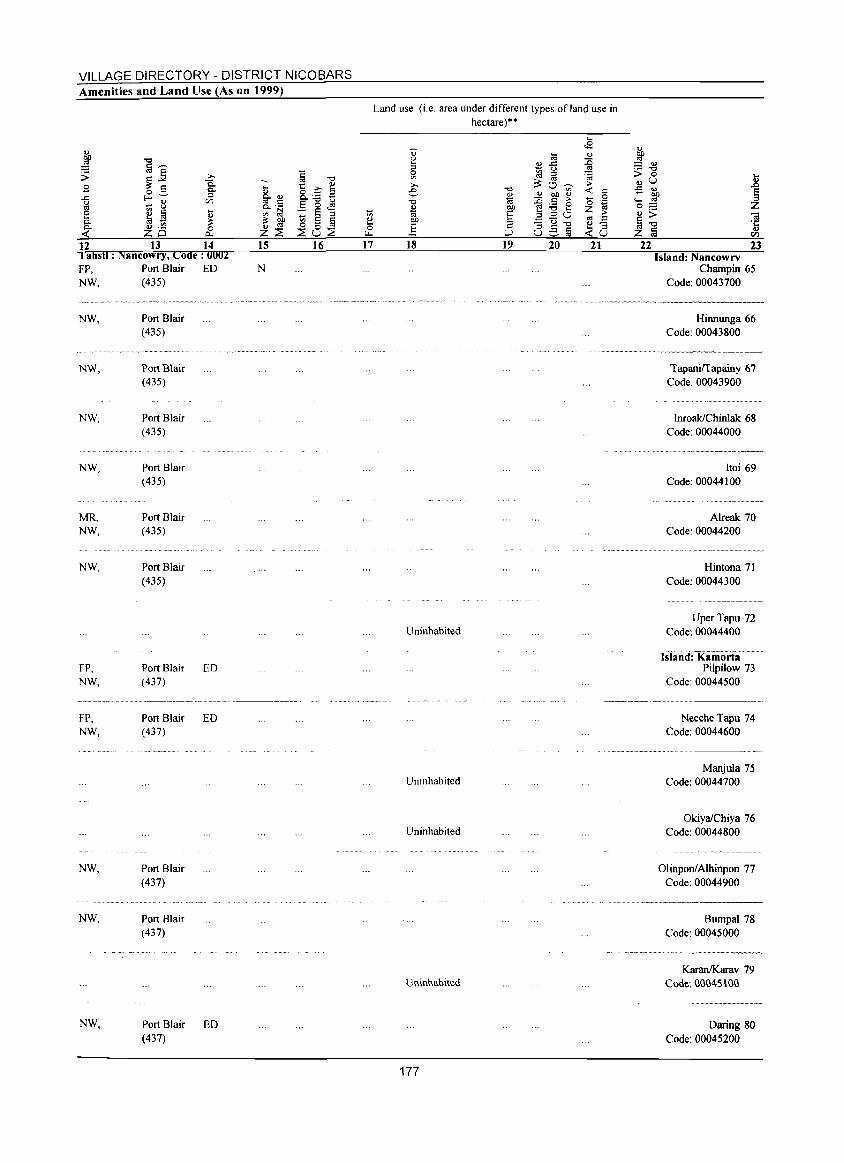
VILLAGE DIRECTORY - DISTRICT NICOBARS Amenities and Land Use (As on 1999)
12 13 14 I ahstl : Nancowry, Code: 0002 FP, Port Blair ED NW, (435)
NW, Port Blair (435)
NW, Port Blair (435)
NW,
NW,
MR, NW,
NW,
FP, NW,
Port Blair (435)
Port Blair (435)
Port Blair (435)
Port Blair (435)
Port Blair ED (437)
15
N
,,- ~., .... ~~.~-.-.--.................... ~----.. .
FP, NW,
NW,
NW,
NW,
Port Blair ED (437)
Port Blair (437)
Port Blair (437)
Port Blair ED (437)
16 17
Land use (i.e. area under different types of land use in hectare)··
.... .s .., ::E '" ~ ;> <t: c
0 '0 '~ Z ;> «I '= ~8
18 19 20 21
.., ~ = .., ._ "'" > 0 .... ..,u i -5 .,
on ._ '" 0;::: Z .., >
'" §"'" ·c z ~ ...
en 22 23
Island: Nancowrv Champin 65
Code: 00043700
..... ~.,-.. ,.---------
Uninhabited
Uninhabited
Uninhabited
Uninhabited
177
Hinnunga 66 Code: 00043800
............ _ ... _-_ ... ,-------Tapanirrapainy 67
Code: 00043900
InroaklChinlak 68 Code: 00044000
Itoi 69 Code: 00044100
Alreak 70 Code: 00044200
Hintona 71 Code: 00044300
UperTapu 72 Code: 00044400
Isiarid:'Kamorta-Pilpilow 73
Code: 00044500
Neeche Tapu 74 Code: 00044600
Manjula 75 Code: 00044700
OkiyalChiya 76 Code: 00044800
OlinponlAIhinpon 77 Code: 00044900
..... _ .. __ ... _---
Bumpal 78 Code: 00045000
KaranJKarav 79 Cwe. GG04Sl00
Daring 80 Code: 00045200
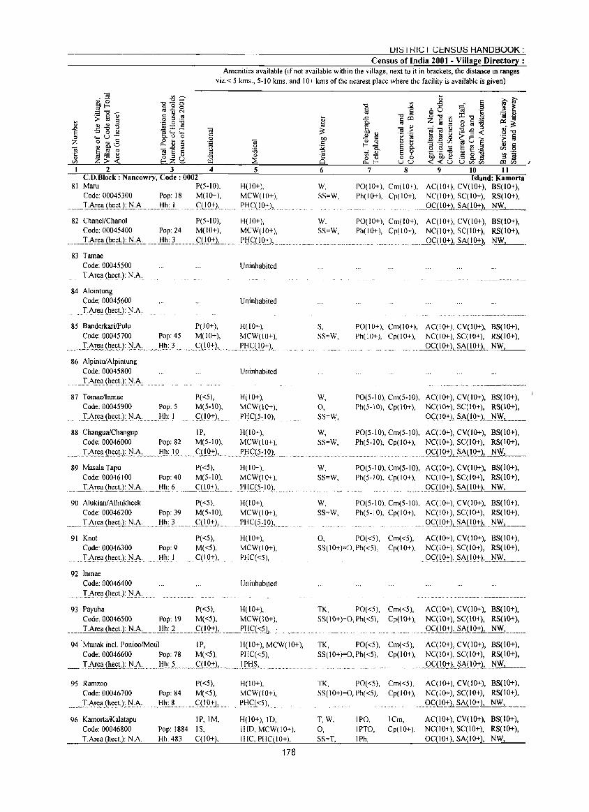
UI::5 I KIC I CI::.N::5U::5 HANDBOOK: Census of India 2001 - Village Directory :
Amenities available (if not available within the village, next to it in brackets, the distance in ranges
viz. < 5 kms., 5-10 kms. and 10+ kms of the nearest place where the facility is available is given)
.... 0)
.D
§ Z
2 3 4 CD_Block: Nancowry, Code: 0002
81 Maru P(5-10), Code: 00045300 Pop: 18 M(lO+),
__ ._ IArea (~!!_~J1:I.:~ .. _ .. ,_I:lh_l. . ..... <::.U.Q:!.-),,,
5
H(lO+), MCW(lO+),
P_HCU°:+l,
6
W, SS=W,
7 8 9 10 11 Island: Kamorta
P0(10+), Cm(lO+), AC(lO+), CY(lO+), 8S(l0+), Ph(IO+), Cp(IO+), NC(IO+), SC(IO+), RS(IO+),
._QQ!92), SA(IO+), NW,
82 Chanel/Chanol P(5-10), H(IO+), W, P0(10+), Cm(10+), AC(IO+), CY(lO+), 8S(10+), Ph(10+), Cp(10+), NC(lO+), SC(IO+), RS(1O+),
__ ._Q£.(.IO+1.SA(IO+), NW,
Code: 00045400 Pop: 24 M(lO+), MCW(IO+), SS=W,
__ "[!o-rea (hee!]: N.A. .........!!I!:..L. __ CJ.!9.:l:"1._ ... _..?HJ,::(IQ:tl, ... _ .•... _ ....
83 Tarnae Code: 00045500 Uninhabited I.Area (heeL): N.A.
84 Alointung Code: 00045600 Uninhabited
. I.Ar~~ (he~t.): N.A.
85 BanderkariIPulu P(IO+), H(lO+), Code: 00045700 Pop: 45 M(lO+), MCW(lO+),
____ _T.Area (~~!l_N.~ ___ .Hh:.? ___ J,::(!Q:l:1L_._ ... PlifO..Q:+),_
86 AlpintuiAlpintung Code: 00045800
J.,'\r~~(~e~1]'.1:~
87 Iomael1nmae Code: 00045900 Pop: 5
.T:f\rea(heet.):]'.I.A: Hh I
P«5), M(5-10), qIQ+),
Uninhabited
H(lO+), MCW(IO+),
PHC(5~10),
88 Changua/Changup IP, H(10+), Code: 00046000 Pop: 82 M(5-10), MCW(IO+),
. __ ... TAr~a.{!1_e_c.U: N.A_·_B..!!.I_D •..... _ .. Cl!..Q_:f), .. _ ... I'J::l<::~~IQ),_.
89 Masala Tapu P«5), H(lO+), Code: 00046100 Pop: 40 M(5-10), MCW(lO+),
__ T.Area~~LN.A .. __ .Hh:.6 . __ ~D..Q:lL.-.._ J>H<::_(~.:.IQ), .. ____ .
90 Alukian/Alhukheck P«5), H(IO+), Code: 00046200 Pop: 39 M(5-10), MCW(IO+),
_T.A~~~!1 .. ~A __ _!:!I!_'~. ____ fD.Q:),_ •.... PJ::lC(~::.19), ....
91 Knot Code: 00046300
.......... T,,'\!ea (h~ctJ: ]'1:1\:
92 Inmae Code: 00046400
_ ... !.:Are.~{he.~t.):]'I·A •.....
Pop: 9 Hh: I
P«5), M«5), C(lO+),
H(lO+), MCW(lO+), PHC«5),
Uninhabited
S, SS=W,
W,
0, SS=W,
W,
SS=W,
W, SS=W,
W, SS=W,
PO(IO+), Cm(lO+), AC(IO+), CY(IO+), BS(IO+), Ph(IO+), Cp(10+), NC(IO+), SC(IO+), RS(IO+),
. OC(IO-t:1.JA(IO+}, NW,
.. "~"''''--''''-''-'----
PO(5-10), Cm(5-10), AC(IO+), CY(IO+), 8S(10+), Ph(5-10), Cp(IO+), NC(IO+), SC(IO+), RS(lO+),
OC(IO+), SA{IO+), .. ~~L ... __ _
PO(5-10), Cm(5-10), AC(IO+), CY(IO+), 8S(10+), Ph(5-10), Cp(lO+), NC(IO+), SC(IO+), RS(IO+),
. __ qg!Q:,:"1_s..~IO+), NW,
PO(5-10), Cm(5-10), AC(IO+), CY(IO+), BS(IO+), Ph(5-10), Cp(lO+), NC(lO+), SC(IO+), RS(IO+),
.. _.OC(IO+), SA(IO+), NW,
PO(5-10), Cm(5-10), AC(IO+), CY(JO+), 8S(IO+), Ph(5·IO), Cp(IO+), NC(IO+), SC(IO+), RS(IO+),
_.Q<;:'(!.Q:!.-J"JA\..I0+), NW,
0, PO«5), Cm«5), AC(IO+), CY(lO+), BS(10+), SS(10+)=0,Ph«5), Cp(lO+), NC(10+), SC(IO+), RS(1O+),
OC(IO:,:,), SI\(IQ+), l'-I~-,--__ _
93 Payuha P«5), H(lO+), TK, PO«5), Cm«5), AC(IO+), CY(IO+), 8S(10+), Code: 00046500 Pop: 19 M«5), MCW(IO+), SS(10+)=0,Ph«5), Cp(lO+), NC(IO+), SC(IO+}, RS(1O+),
I.Area(heeq: N.A. __ ._J:l..1!_2 .. __ .. _Gi!Q!1 .. _ .. _J'!Lgs~.L ....... _.u.... . __ OCD..Q+), SA(IO+), NW,
94 . Munak incl. PonioolMoul IP, H(lO+), MCW(IO+), TK, PO«5), Cm«5), AC(lO+), CY(IO+), BS(IO+), Code: 00046600 Pop: 78 M«5), PHC«5), SS(lO+)=0,Ph«5), Cp(lO+), NC(IO+), SC(IO+), RS(IO+),
_ IAre..ti.~.L.l'J..:..~_ ... _"!!~.: .. ~ ...... _<::"(!o..:':"), __ . _ _I_f'!l_§, ....Q..CJ!Q+), SA(lO+), NW,
95 Rarnzoo P«5), H(IO+), Code: 00046700 Pop: 84 M«5), MCW(lO+),
_ ._. T.A~ea~I:.~·L]'J:f\..:.. ___ .. _ .. I:II!_: .. L._ .. Q I9:':")L . pHQ<5), ...
H(1O+), 10, 96 KarnortaIKalatapu Code: 00046&00 I.Area (heet.): N.A.
IP,IM,
Pop: 1884 IS, Hh: 483 C(IO+),
IHO, MCW(IO+), IHC, PHC(IO+),
178
TK, PO«5), Cm«5), AC(IO+), CY(lO+), 8S(10+), SS(l0+)=0,Ph«5), Cp(IO+), NqIO+), SqIO+), RS(IO+),
T,W,
0, SS=T,
IPO, IPTO, IPh,
.. _ .... QillQ:!.-2~~IO-!),_ . ..:....N_;,.W..l..., __
ICm, AC(lO+), CY(JO+), 8S(10+), Cp(IO+), NC(IO+), SC(IO+), RS(IO+),
0C(10+), SA(lO+), NW,
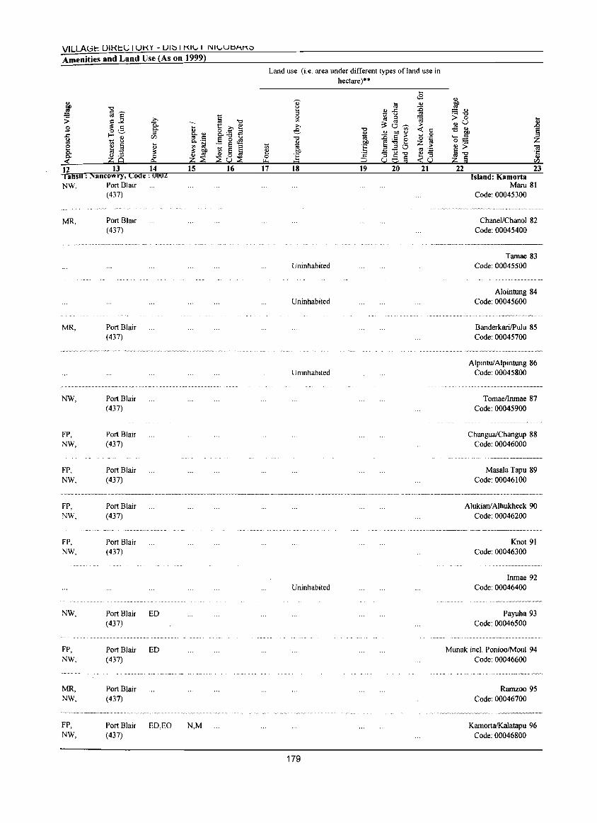
VILLAGt: [JIKt:L; I UKY - UI" I KII... I I'III...UO""~"
Amenities and Land Use (As on 1999)
12 13 14 1 ahsll : Nancowry, Code: 0002 NW, Port Blair
(437)
MR,
MR,
NW,
FP, NW,
FP, NW,
FP, NW,
FP, NW,
NW,
FP, NW,
MR, NW,
FP, NW,
Port Blair (437)
Port Blair (437)
Port Blair (437)
Port Blair (437)
Port Blair (437)
Port Blair (437)
Port Blair (437)
Port Blair ED (437)
Port Blair ED (437)
Port Blair (437)
Port Blair ED,EO (437)
15
N,M
16 17
Land use (i.e. area under different types of land use in hectare)"
18 19 20 21
Uninhabited
Uninhabited
Uninhabited
~ :::: ", .- -0 > 0 ",U -5 ", '- ~ 0:::: ",> ~-o Z !;j
22 23 Island: Kamorta
Maru 81 Code: 00045300
ChaneVChanol 82 Code: 00045400
Tarnae 83 Code: 00045500
Alointung 84 Code: 00045600
BanderkarilPulu 85 Code: 00045700
AlpintulAlpintung 86 Code: 00045800
TomaelInmae 87 Code: 00045900
ChanguaiChangup 88 Code: 00046000
Masala Tapu 89 Code: 00046100
Alukianl Alhukheck 90 Code: 00046200
....... __ •... _-_ .... ~~------
Uninhabited
179
Knot 91 Code: 00046300
Inmae 92 Code: 00046400
Payuha 93 Code: 00046500
..... ---.----~
Munak intI. PonioolMoul 94 Code: 00046600
Rarnzoo 95 Code: 00046700
KarnortaIKalatapu 96 Code: 00046800
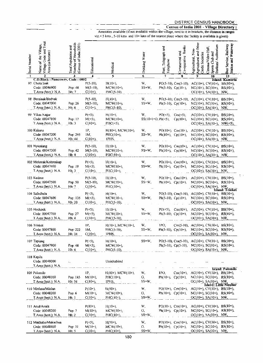
... II 8 =
DISTRICT CENSUS HANDBOOK: Census of India 2001 - Village Directory :
Amenities available (if not available within the village, next to it in brackets, the distance in ranges
viz. < 5 kms., 5-10 kms. and 10+ kms of the nearest place where the facility is available is given)
~ ~ -g ~ ~ -0 i ~ :;; .~ f ~ -"d OSijN § "=0,,, .. ~c:; :::.::., C"'OS .. ..c "dc::c o-o",::t:-o,S . ~ ::: : 5 .9 5 :a ~ §' tii z §.!:! 0 !iii ._ :::.. ..s-g~ ~E::; 16 ::: bh 16~ -i-a.~:9..o~ 8~ ..... u ..c: 0. 0 0 .15_ OJ) ~ ~ 'g'~ a a g >- F -;, '>!iii o II) .5 0 .... '" 16 r:: <U 0 <U 0:; - - Vi ~ 'W t:: .... -a <U ~ ';' c. II ::s ta.~ ._ f- ..c: ~ ~ 3 a·...: e € .;! ~ § Z
Ji ~~~ ~~~ ~ ~ ~ 1! c3c3 ~~5 ~~a ~! -='--J:::~2_":;:----'-'-'3:=-:::::""_-""':::::4'------"5=:-------=6::=------=7::-'-'--·'-=8-:=-"':::""'::9~:"_;'~1"-O.:t..:....--=l~l~-/ .
C.O.Block : Nancowry, Code: 0002 Island: Kamorta 97 Chotalnak P(5-10), H(IO+), W, PO(5-10), Cm(5-10), AC(lO+), CV(lO+), BS(lO+),
Code: 00046900 Pop: 48 M(5-10), MCW(IO+), SS=W, Ph(5-10), Cp(IO+), NC(IO+), SC(IO+), RS(IO+),
_ _lAr~(;t): NA ___ _!I_I!:.2. ___ <::lIQ:!::.L_. n_J_>Ij<;:_(:!~I_Q), ,. ._g.C:i!Q:I:'L~~O+), NW,
98 BerainaklBadnak P(5-JO), H(IO+), Code: 00047000 Pop: 26 M(5-10), MCW(IO+),
____ L~ea (~~(;_!LN.A, ____ _J::Il!:_~, __ ._.~(I0:l:'),_,_ .. PIjC(5~!O),
W, SS=W,
PO(5-10), Cm(5-10), AC(lO+), CV(lO+), BS(lO+), Ph(5-10), Cpt I 0+), NC(lO+), SC(IO+), RS(IO+),
_Q,c.i_l_221 _ _§A(lO+), NW,
99 Vikas Nagar Code: 00047100 T.Area (heet,): N.A.
P«5), Pop: 17 M«5), Hh: 3 C(IO+),
H(IO+), MCW(IO+), PHC«5),
W, PO«5), Cm«5), AC(IO+), CV(IO+), BS(IO+), SS(lO+):O,Ph«5), Cp(IO+), NC(IO+), SC(IO+), RS(IO+),
OC( 10+), SA( I 04::), ~(':~),
100 Kakana IP, H(lO+), MCW(IO+), W, PO(IO+), Cm(lO+), AC(IO+), CV(IO+), B5(1O+), Code: 00047200
..... T,A!~!i(~~(;!J N,~, Pop: 295 1M, PHC(IO+), SS=W, Ph(IO+), Cp(IO+), NC(IO+), SC(IO+), RS(IO+),
Hh: 44 ". _ C(I_Q:J:), .... If>IjS, ... gC(IO-+-)LSA{!9+)~ __ ~ __ ".
101 Nyicalang P(5-10), H(lO+), W, PO(IO+), Cm(lO+), AC(IO+), CV(IO+), B5(10+), Code: 00047300 Pop: 42 M(5-10), MCW(IO+), SS=W, Ph(IO+), Cp(IO+), NC(IO+), SC(IO+), RS(IO+),
_,...;T:..:,:.Ar.:::.ea Q!_~_~.:.~.1:!!!:__!__ __ ____fQ_O.:!:).L. ___ ,,~!:!£(JJl:!::.L,_~ ____ ,,_, _______ . ____ . _____ ,, __ ._ .__ ___ OC( 1 0+), SA{ I 0+), NW,
102 MOhreaklKohreakap Code: 00047400 Pop: 19
__ "T.A!ell_(hect): N.A. Hh: 3
103 Kuikua Code: 00047500 Pop: 50
... ..... . T-Area (heet): NA Hh: 7
104 Safedbalu Code: 00047600 Pop: 135
____ ",,:LAr.e~,,(lle~:U: .tL~: __ . .. J:lI1.:JO.
P«5), M«5),
" qIO+),,,
P(S-IO), M(5-10),
. C(lO+),
P«5), M«5),
. .... C(,IO:+-),,,
H(lO+), MCW(IO+),
f>HC(IO+),
H(lO+), MCW(IO+), PHC(IO+),
H(IO+), MCW(IO+),
PHC(S-IO),
W, SS=W,
W, SS=W,
W, SS=W,
105 Hockook P«5), H(10+), W, Code: 00047700 Pop: 27 M«5), MCW(IO+), SS=W, T.Area (hec!.): N.A. __ lil!;"±___ ___ fi!0+L _ _!,J:!~_Q:!9)-,~ ____ ,,_,, __ .. ,,
PO(lO+), Cm(lO+), AC(lO+), CV(lO+), BS(1O+), Ph(IO+), Cp(IO+), NC(IO+), SC(lO+), RS(IO+),
.... Q~(10:J:'2, ~~(_lO+), NW,
PO(IO+), Cm(IO+), AC(IO+), CY(IO+), 85(10+), Ph(lO+), Cp(IO+}, NC(IO+), SC(IO+), R5(10+),
.... OC(IO:+:), SI\(IOI:~~'ii~~rIiikef PO(5-10), Cm(5-10), AC(IO+), CV(lO+), BS(IO+), Ph(5-10), Cp(IO+), NC(lO+), SC(lo+), RS(1O+),
"O~(IQ_+L~JlliQ:t-), NW,
PO«5), Cm(IO+), AC(IO+), CY(IO+), BS(IO+), Ph(5-10), Cp(IO+), NC(IO+), SC(IO+), RS(IO+),
. _, _ .. OqlO+), SA(IO+), NW,
106 Trinket IP, H(lO+), MCW(IO+), W, IPO, Cm(5-10), AC(IO+), CY(IO+), BS(IO+), Code: 00047800 Pop: 222 1M, PHC(S-IO), SS=W, Ph(S-IO), Cp(\O+), NC(\O+), SC(IO+), RS(lO+),
_--=-T.;,:c,A:::,;re;:,::a",,(h:;:,;e..:;,ct:.;,.(.);_c: N:_c_.c;_A:;_. _...;.H_.:;h::.:,:.::....;34 q 10+)-'-____ 1 pHS, ____ . _____ ",,""_ ... _____ . __ ._. __ .... ___ _ OC(IO+), SA(IO+), NW,
107 Tapiang Code: 00047900 Pop: 48
........ I,Ar(:!i(~e(;tJ:]>J,A:..... Hh: 6
108 Kapila Code: 00048000
........ .. "TA!~,'! (~~(;tJ]>J ,A:.".
P«5), M«5), CCIg+),
H(JO+), MCW(lO+),
PH(:(5-10),
Uninhabited
SS=W,
109 Pulomilo IP, H(lO+), MCW(lO+), W, Code: 00048100 Pop: 145 M(lO+), PHC(IO+), 0,
___ LArea {he.£!J~ N.A:.." ___ f:l!!~~'!__,,_<:H0:+:).)_,, .. _LE.H§, "" ... """ __ ... SS=W,
P(IO+), H(IO+), II(} MinlanaIMinlan
Code: 00048200 T.Area (hect.): N.A.
Pop: 6 M(lO+), MCW(lO+),
Hh: t~._~"(!.Q:+:L,,,,, "f>J:l_CJ..I_D4::),,, ...
III AnullAnula P(lO+), H(IO+), Code: 00048300 Pop: 7 M(IO+), MCW(IO+),
""" _" If\r~_Ql~<:U_N:~L ___ lj"h_: L,,_ "" <:QO:+-)-,- . ,, ___ 1',11 CJ..10:+:), .
112 MakhahufMakachua Code: 00048400 Pop: 31 T.Area (hee!.): N.A. Hh: 5
P«5), M(lO+), C(lO+),
H(IO+), MCW(lO+), PHC(IO+),
180
W, 0,
""",,. SS=\V,
W, 0,
" .. S~",,\V, __
W, 0, SS=W,
PO(5-10), Cm(5-10), AC(1O+), CV(10+), BS(lo+), Ph(5-10), Cp(5-JO), NC(IO+), SC(IO+), RS(IO+),
()<::(I.O:J:), ... SA(I.0-t),_.:N_\V,_ __ __ ..... .
lsland: PlilomilO' IPO, Cm(IO+), AC(IO+), CY(lO+), BS(IO+), Ph(IO+), Cp(IO+), NC(JO+), SC(JO+), RS(IO+),
" -- Qg_I-Q:t..1lt(~+t:·tt~1 == s an: I e ICOuar PO(lO+), Cm(JO+), AC(IO+), CV(IO+), BS(IO+), Ph(IO+), Cp(IO+), NC(10+),5C(10+), RS(lO+),
" ___ Q~Q0+2, SA{lO+), NW,
PO(lO+), Cm(IO+), AC(IO+), CV(IO+), B5(10+), Ph(IO+), Cp(IO+), NC(IO+), SC(IO+), RS(IO+),
Q.<;ll",Q:t),_§A( I 0+), NW_, __
PO(IO+), Cm(IO+), AC(IO+), CV(IO+), BS(IO+), Ph(lO+), Cp(IO+), NC(lO+), SC(lO+), RS(IO+),
OqIO+), SA(lO+), NW,
-:- 'I
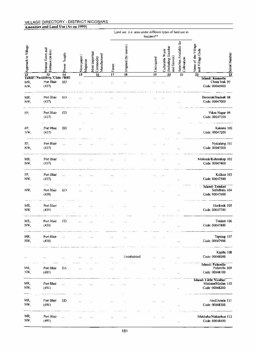
VILLAGE DIRECTORY - DISTRICT NICOBARS Amenities and Land Use (As on 1999)
1 12 13 14 , ahsil : Nancowry, Code: 0002 MR, Port Blair ED NW, (437)
MR, NW,
FP,
FP, NW,
FP, NW,
MR, NW,
FP, NW,
NW,
MR, NW,
MR, NW,
Port Blair ED (437)
Port Blair (437)
Port Blair (437)
Port Blair (437)
Port Blair (437)
Port Blair (437)
ED
ED
Port Blair ED (439)
Port Blair (439)
Port Blair ED (439)
MR, Port Blair NW, (439)
MR, NW,
Port Blair EA (485)
MR, Port Blair NW, (491)
MR, NW,
MR, NW,
Port Blair ED (491)
Port Blair (491)
15 16 17
Land use (i.e. area under different types ofland use in hectare)"
18 19 20 21
Uninhabited
181
<I)
1lP :::: <I) ._ -0
> 0 <l)U ..s %'0 '- «I 0:::: <I»
§-o Z a
22 23 Island: Kamorta
Chota Inak 97 Code: 00046900
BerainaklBadnak 98 Code: 00047000
Vikas Nagar 99 Code: 00047100
Kakana 100 Code: 00047200
Nyicalang 10 I Code: 00047300
MohreaklKohreakap 102 Code: 00047400
......• _-_ .•...... __ .. __ ..... _---Kuikua 103
Code: 00047500
. ISIiliiiETrtnkif Safedbalu 104
Code: 00047600
Hockook 105 Code: 00047700
Trinket 106 Code: 00047800
Tapiang 107 Code: 00047900
Kapila 108 Code: 00048000
... hliiiid:pliIo·i1iIio-Pulornilo 109
Code: 00048100
"--lSiillld:-Uttle Nicobar MinlanaIMinlan 110 Code: 00048200
Anulf Anula III Code: 00048300
MakhahuIMakachua 112 Code: 00048400
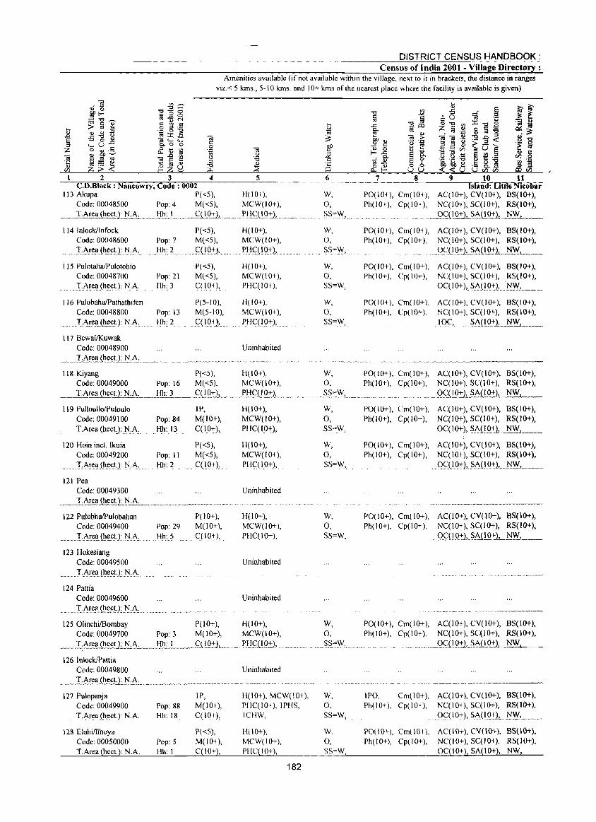
DISTRICT CENSUS HANDBOOK: Census of India 2001 - Village Directory :
Amenities available (if not available within the village, next to it in brackets, the distance in ranges
viz. < 5 kms., 5-10 kms. and 10+ kms of the nearest place where the facility is available is given)
.... ... "" E '" :z.
2 3 4 C.D.B1ock : Nancowry, Code: 0002
113 Akupa P«5), Code: 00048500 Pop: 4 Me <5),
__ T.Area(hect.): N.A...:... .. _.Hh:,_I.,_,_,_. CC 1 0+),
114 InlocklInfock Code: 00048600 Pop: 7
.•. :LAr~hec!:2:~:!>-.:. .. }:Ih",,?_
115 PulotaiiaIPulotohio Code: 00048700
TA,rea(he:ct.): N.A.
116 PulobahalPathathifen
Pop: 21 Hh: 3
Code: 00048800 Pop: 13
_ .... IA.!e!.(h~cU: .j\j..:A",.,._.!i~_c 2, ...
117 BewailKuwak Code: 00048900
___ .l:.A!e:!.ilie:~J.t1'i:A:. __
P«5), M«5),
~fJ.Q+l, ...
P«5), M«5), ct I 0+),
P(S-IO), M(5-10),
. qLQ+1L
5 6
H(IO+), W, MCW(IO+), 0,
... _P,!1._CC 10+L_._ ....... ~S~'V,fL ..
H(lO+), MCW(IO+),
PH(':(1():t-),.
H(lO+), MCW(IO+), PHC(IO+),
H(lO+), MCW(lO+), PH (:(10:+,),
Uninhabited
W, 0,
.. SS=.,!\".
W,
0, SS=W,
W,
0, SS=W,
7 8 9 10 11 Island: Little Nicobar
P0(10+), Crn( I 0+), AC(lO+), CY(1O+), BS(1O+), Ph(IO+), Cp(lO+), NCCIO+),5C(10+), RS(IO+),
o_ . .9g1.Q.-l:L~A(I0+}, NW,
PO(IO+), Crn(IO+), AC(lO+), CY(IO+), BS(IO+), Ph(lO+), Cp(lO+), NCCIO+),5CCI0+), RS(IO+),
. .. _OCCLQ:t-.2, SA(IO+), NW,
PO(IO+), Crn(IO+), AC(10+), CY(IO+), BS(lO+), Ph(IO+), Cp(IO+), NCCIO+), SCCI0+), RS(IO+),
OCCJO+), .. ~A(IO:r2, .I\I.~, ... __ ,
PO(IO+), Cm(IO+), AqIO+), CY(IO+), B5(1O+), Ph(IO+), Cp(IO+), NCCIO+), SCCIO+), RS(IO+),
,IO_C,. .§A(LQ+)_L....:...NW:.:.:J.. __
118 Kiyang P«5), H(lO+), W, POe 10+), Crn( 10+), AqIO+), CY(IO+), B5(10+), Code: 00049000 Pop: 16 M«5), MCW(JO+), 0, Ph(IO+), Cp(IO+), NqlO+),5qlO+), RS(1O+),
__ ..:r.Area (he~ N.A, __ ._!j_lJ_cl _ ____fL!.Q:Ij_,_,_ .. ,fl:fCUQ:I:l, __ . ___ o. ".~§':W, .. _ ... , ...................... ' .. 9C(10+), SA(IO+), NW,
119 PulloullolPuloulo J P, Code: 00049100 Pop: 84 M(lO+),
. _I,A,re(i(he:ct,J:.N"A, . J:!~:..1I ....... C(10+),
120 Hoin incl. Ikuia Code: 00049200 Pop: II
IA,rea. (h~,ctJ j\j,A,. Hh: 2
121 Pea Code: 00049300
P«5), M«5), C(10+),
H(IO+), MCW(lO+), PHC(lO+),
H(10+), MCW(lO+), PH(:(IO+),
Uninhabited
_~_I:Area~~JJ.A_. _"_'_'_"'~_"" _____ """ ..... " ............... " ....... .
J 22 PuJobhaIPuJobahan Code: 00049400
...... _. I·A,re .. a.(tJc::cn.~A ..
123 Hokesiang
Code: 00049500
........ T·Arell(~c::(;t.):)\j:f\-
124 Pattia Code: 00049600
.......... I.i\r~Ii.ili.e::(;t:L~:i\:
Pop: 29 Hh: 5
P(10+), M(lO+),
... C(IO+),.
H(lO+), MCW(IO+), PHC(IO+),
Uninhabited
Uninhabited
W, 0, 5S=W,
W, 0, SS=W,
W, 0, SS=W,
PO(lO+), Cm(IO+), AC(IO+), CY(lO+), BS(IO+), Ph(lO+), Cp(IO+), NC(IO+), SC(10+), RS(lO+),
OC(IO+), $A(IQ+), . ~W, .... _ .. _ PO(lO+), Cm(lO+), ACC10+), CY(IO+), BS(IO+), Ph(lO+), Cp(IO+), NC(IO+), SqIO+), RS(lO+),
.. QG(I9:), $i\(1.Q:t:)'---.. ~~ .. __
PO(lO+), Crn(IO+), AC(10+), CY(lO+), B5(10+), Ph(IO+), Cp(IO+), NqlO+), SqlO+), RS(lO+),
... Qc::LLD.:t.L$i\i!.Q:t-..1.....::...Nc.:.,W;..z__,_
1250linchiIBombay P(lO+), H(lO+), W, PO(JO+), Crn(lO+), ACCIO+), CY(IO+), BS(lO+), Code: 00049700 Pop: 3 M(lO+), MCW(lO+), 0, Ph(lO+), Cp(lO+), NqIO+), SC(lO+), RS(1O+),
__ T.Area (hecU..:..l!:.~ .. __ .. I:! .. ~L.,__ .. _9iJ_Q:2! .......... ~.1:! .. ~(1Q_:l:), ..................... SS.""'N,......... . .......... _Q.£U.Q:t.l, SA(IO+}, NW,
126 InlockIPattia Code: 00049800
127 PuJopanja IP,
Code: 00049900 Pop: 88 M(JO+),
T.A,rea (h~ct.): N.A. Hh: 18 (:(10+),
128 Elahifllhoya P«5), Code: 00050000 Pop: 5 M(lO+),
T.Area (hect.): N.A. Hh: I C(JO+),
Uninhabited
H(IO+), MCW(IO+), PHqlO+),IPHS, lCHW,
H(IO+), MCW(IO+), PHC(IO+),
182
W, 0, SS=W,
W, 0, SS=W,
IPO, Cm(IO+), AC(IO+), CY(lO+), BS(1O+), Ph(IO+), Cp(IO+), NC(IO+), SC(lO+), RS(IO+),
Oql0:t:),.Si\(IQ:)"I\I.W, ........ .
PO(IO+), Crn\IO+), AC(IO+), CY(\O+), BS(IO+), Ph( I 0+), Cpt I 0+), NC( I 0+), SC(I 0+), RS(l 0+),
OqIO+), SA(IO+), NW,
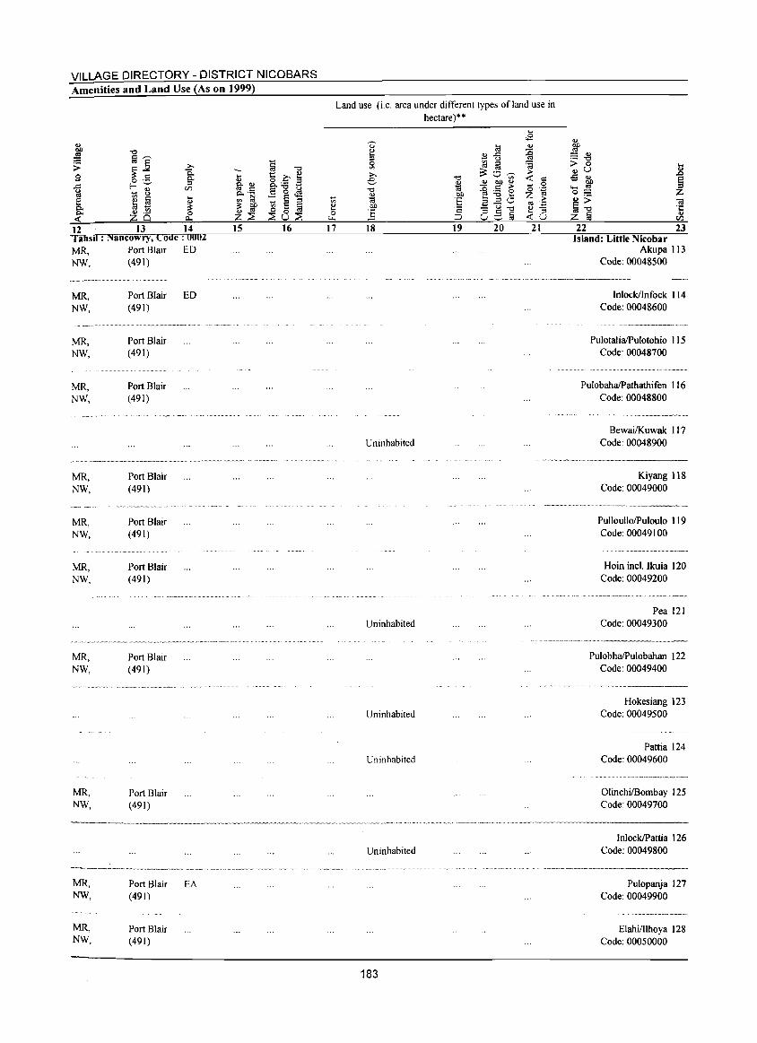
VILLAGE DIRECTORY - DISTRICT NICOBARS Amenities and Land Use (As on 1999)
~ "0 -.... 1:: .0 ~ "" ~ ~ g_ ~ B p. ._ Eo<!! '" 1;j :: ~ ::l :: t>Jl ~ 0 ~ Q) ttl
z~ ~u~ 12 13 14 I ahsd : Nancowry, Code: 0002
15 16
MR, Port Blair ED NW, (491)
.~--.-- .. __ ... __ .. _- ........ _.
MR, NW,
MR, NW,
MR, NW,
MR, NW,
MR, NW,
MR, NW,
MR, NW,
MR, NW,
MR, NW,
MR, NW,
Port Blair ED (491)
Port Blair (491)
Port Blair (491)
Port Blair (491)
Port Blair (491)
Port Blair (491)
Port Blair (491)
Port Blair (491)
Port Blair (491)
Port Blair (491)
EA
-'" <!) .... 0 ....
17
Land use (i.e. area under different types of land use in hectare)"
~
0> 10 u .... "" ..c: ::l - u ~ [(j ia
~O-;;;->. "0 e ~ "" t>Jl <!)
"0 :g~e <!) t>Jl '(;j 'E aEO t>Jl .;::; - u "0 ] Ce,§ ;::l
18 19 20
Uninhabited
Uninhabited
Uninhabited
Uninhabited
.... .s "" ~ ~ > « c
0 o ";:: Z ~ to .;::: <!) -.... ::l «U 21
<!)
~ = <!) ._ "0
> 0 ... <!) u 2 ..s "" ~ ~ ..... 0;:::
~~ <a ·c cu z ~ en
22 23 Island: Little Nicobar
Akupa 113 Code: 00048500
.. ......... ,,-_ .. _._ .. _------Inloekllnfoek I 14
Code: 00048600
PulotaliaIPulotohio I 15 Code: 00048700
PulobahalPathathifen I 16 Code: 00048800
Bewai/Kuwak 117 Code: 00048900
.. -~~,.-------
Kiyang 118 Code: 00049000
PulloullolPuloulo 119 Code: 00049100
Hoin ineI. Ikuia 120 Code: 00049200
Pea 121 Code: 00049300
PulobhaIPulobahan 122 Code: 00049400
.......... _-_. __ --Hokesiang 123
Code: 00049500
Pattia 124 Code: 00049600
OlinehiIBombay 125 Code: 00049700
InloeklPattia 126 Uninhabited Code: 00049800
183
........... "." .. , .... ,,-_ ..... ------Pulopanja 127
Code: 00049900
ElahilIlhoya ) 28 Code: 00050000
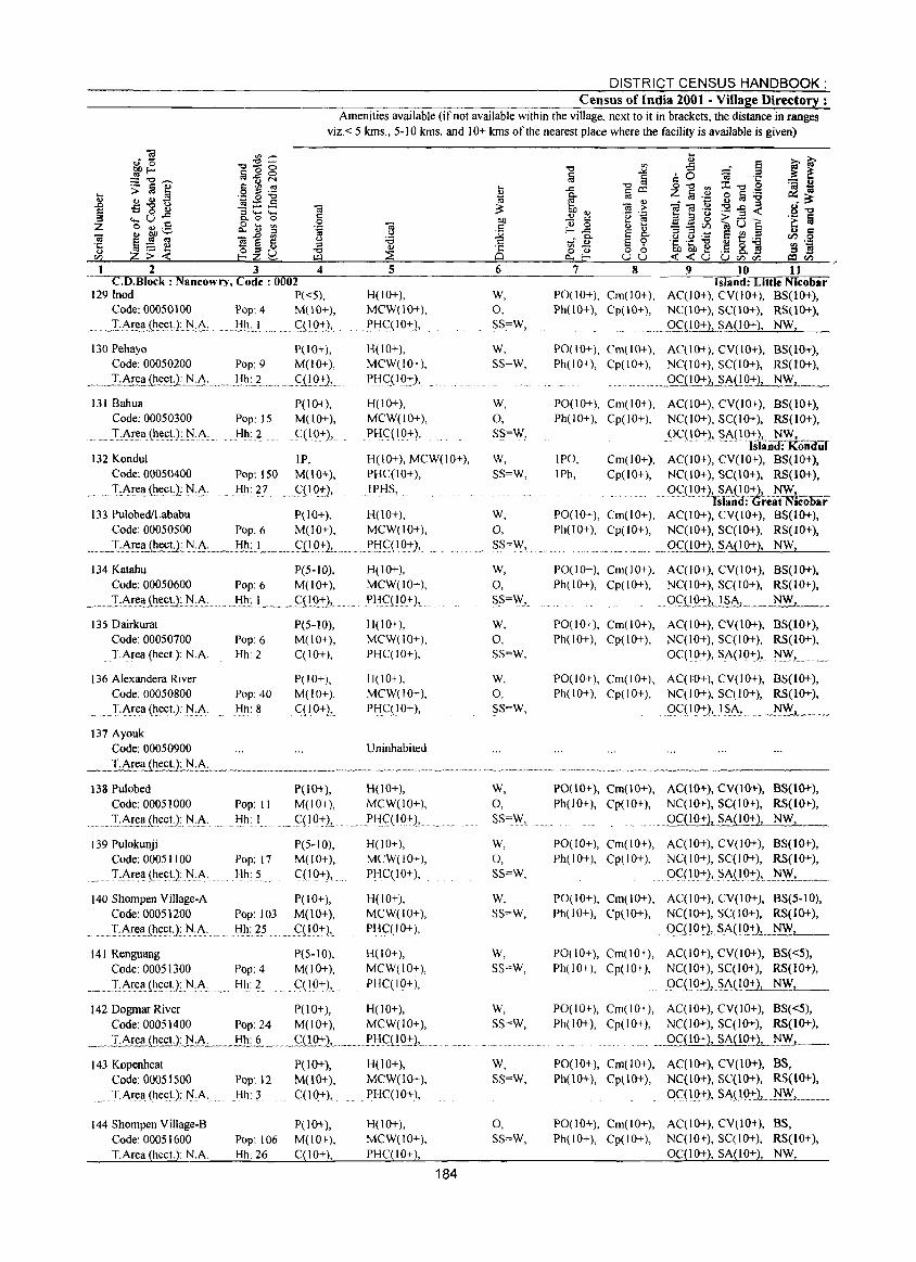
DISTRICT CENSUS HANDBOOK: Census of India 2001 - Village Directory :
Amenities available (if not available within the village, next to it in brackets, the distance in ranges viz. < 5 lans., 5-10 kms. and 10+ lans of the nearest place where the facility is available is given)
C.D.Block : Nancowry, Code: 0002 Island: Little Nicobar 129 !nod P«5), H(IO+), W, PO(lO+), Cm(IO+), AC(JO+), CV(lO+), BS(10+),
Code: 00050\00 Pop: 4 M(lO+), MCW(\O+), 0, Ph(lO+), Cp(\O+), NC(\O+), SC(\O+), RS(IO+),
~ .•.• I·Ar~~e_0.l.~:~:.~Ji~:.} .. 0 •• QIO+2, .... XHqIO+l,. SS=W, ..... ..Qf_(!O+), .?A(IO+), NW,
\30Pehayo P(IQ+), Code: 00050200 Pop: 9 M(lO+),
_ ... _l~~l!_~ct.): N:~: .... __ !i.h.:1. __ ..... f(!Q:tL
H(IO+), MCW(IO+),
PH.C.(I ().~), ...
131 Bahua Code: 00050300
... T:J\!ea(l1e(:t): .. :t'l .. J\: ... Pop: )5 Hh: 2
P(IO+), M(lO+),
C(I{}+), .
H(JO+), MCW(IO+), PHC(\O+),
132 Kondul Code: 00050400
IP, Pop: ISO M(lO+),
H(IO+), MCW(IO+), PHC(IO+),
.0' ._T ~J\~e<l_(l1ectJ: :t'l:~. Hh: 27 .f(l_O,..), IPHS, ..
133 PulobedILababu P( 10+), H(lO+), Code: 00050500 Pop: 6 M(lO+), MCW(IO+),
___ T..:.~~J!I.~"N·~. __ liho_I_ ... _c:,Q():t2L_. __ )'!-I~(I():t2,
134 Katahu P(S-IO), H(lO+),
Code: 00050600 Pop: 6 M(lO+), MCW(IO+),
~_ .. J...:~~a (I1~tJ.~.~ ___ .l:!l!:__ 1 ____ .<::11.0.:t2, ...... PH.f(lO+), ..
135 Dairkurat P(5-l0), 11(10+),
Code: 00050700 Pop: 6 M(10+), MCW(IO+),
. T:Area (heet): NA Hh: 2 C(JO+), PHC(IO+),
136 Alexandera River P(IO+), 1100+ ), Code: 00050800 Pop: 40 M(10+), MCW(lO+),
T.~rea (heet.): j\LA. Hh: 8 CC IO+),. PHCCIO+),
137 Ayouk Code: 00050900 Uninhabited
138 Pulobed P(lO+), H(lO+),
Code:0005l000 Pop: II M(lO+), MCW(IO+),
_ ... :.L~!~<l__(I1.ee~.): N.,A· Hh: I .C(IO+), . I'HC( I O:t),
139 Pulokunji P(5-10), H(IO+),
Code: 0005 1100 Pop: 17 M(lO+), MCW(IO+),
........ T:~r~<l(I1~et1 N_:A:. Hh: 5 CCI 0+), PHC(IO+),
140 Shompen Village-A P(JO+), H(lO+),
Code: 00051200 Pop: 103 M(lO+), MCW(IO+),
..... I:~~II_(~eEtJ:j\I:.A· . . Iih:.2S c::(1()+), PHC(IO+),
141 Renguang P(5-10), H(IO+),
Code: 00051300 Pop: 4 M(IO+), MCW(IO+),
_~._.LAr.~a,j.l!.eillJ-IA . Hh: 2 ~ .C(IO:tJ,_ PHC(IO+),
142 Dogmar River P(IO+), H(IO+), Code: 00051400 Pop: 24 M(lO+), MCW(lO+),
_._. T.Ar~l!.~HJ:!.:_A..:....- .. _Hh:.§._ ..... S(lO+) ........ I'!-Ic::LlQ:t),.
143 Kopenheat P(lO+), H(lO+), Code: 00051500 Pop: 12 M(10+), MCW(10+),
T,Area (hee!.): j\I.A Hh: 3 C(lO+), PHC(IO+),
144 Shompen ViIlage-B Code: 00051600 T.Area (heet.): NA
P(lO+), Pop: 106 M(lO+), Hh: 26 C(lO+),
H(lO+), MCW(lO+), PHC(IO+),
184
W, SS=W,
W, 0, SS=W,
W, SS=W,
W, 0, SS=\V,
W, 0, SS="Y,
W,
0, SS=W,
W,
0, SS=W,
W, 0, SS=W,
W, 0, SS=W,
W, SS=W,
W, SS=W,
W, SS=W,
w, SS=W,
0, SS=W,
PO(IO+), Cm(IO+), AC(IO+), CV(lO+), BS(IO+), Ph(IO+), Cp(IO+), NC(IO+), SC(IO+), RS(IO+),
.. . ...Q<::1!.Q:!:2,J>MO+), NW,
PO(lO+), Cm(IO+), AC(IO+), CV(IO+), BS(IO+), Ph(IO+), Cp(IO+), NC(IO+), SC(lO+), RS(IO+),
()C(l()+), SA(l<>;J~n~oiidul IPO, Cm(IO+), AC(IO+), CV(IO+), BS(10+), IPh, Cp(IO+), NC(IO+), SC(10+), RS(IO+),
.. ()c::·(1g:-}'··~IA(if:IO+)L_~= Is an :(jreat NICOoar
PO(IO+), Cm(IO+), AC(IO+), CV(lO+), BS(IO+), Ph(lO+), Cp(IO+), NC(IO+), SC(lO+), RS(IO+),
••• @ ••••• ~ ... QC(IO+2,_§.A(l0+), NW,
PO(IO+), Cm(10+), AC(IO+), CV(IO+), BS(JO+), Ph(IO+), Cp(IO+), NC(IO+), SC(IO+), RS(IO+),
. ()~(IQ:t),.JSA, NW
PO(lO+), Cm(IO+), AC(IO+), CV(lO+), BS(IO+), Ph(lO+), Cp(IO+), NC(IO+), SC(IO+), RS(10+),
OCC 10+), SA(IO+), j\I~L
PO(IO+), Cm(IO+), AC(IO+), CV(lO+), BS(IO+), Ph(IO+), Cp(IO+), NC(IO+), SC(IO+), RS(IO+),
. 9c::< 10:t),1 §A, ..... _~ __ _
PO(10+), Cm(lO+), AC(IO+), CV(lO+), BS(IO+), Ph(10+), Cp(IO+), NC(IO+), SC(IO+), RS(IO+),
.... .Q~(lQ:!:L§A(IO+), NW,
PO(IO+), Cm(IO+), AC(IO+), CV(IO+), BS(IO+), Ph(IO+), Cp(IO+), NC(IO+), SC(IO+), RS(lO+),
OCCI 0,,:),. SA( I 0:t), .. :t'l~, ...... _ .. PO(IO+), Cm(lO+), AC(IO+), CV(lO+), BS(5-IO), Ph(IO+), Cp(IO+), NC(IO+}, SC(IO+), RS(IO+),
9c::(1<>::t:), S.~(IQ:+:L.~~_
PO(IO+), Cm(IO+), AC(IO+), CV(IO+), BS«5), Ph(IO+), Cp(IO+), NC(IO+), SC(lO+), RS(IO+),
()C(!()_+),.S.A.(1 0+), NW,
PO(IO+), Cm(IO+), AC(IO+), CV(IO+), BS«5), Ph(IO+), Cp(lO+), NC(IO+), SC(IO+), RS(lO+),
......... OC(lO+), SA(lO+), NW,
PO(IO+), Cm(lO+), AC(lO+), CV(lO+), BS, Ph(10+), Cp(lO+), NC(10+), SC(10+), RS(10+),
OC( lQ:t), ... S.A(lQ:t),.~!Y, ......... _ ... .
PO(lO+), Cm(IO+), AC(lO+), CV(IO+), BS, Ph(IO+), Cp(IO+), NC(IO+), SC(IO+), RS(IO+),
OC(IO+), SA(lO+), NW,
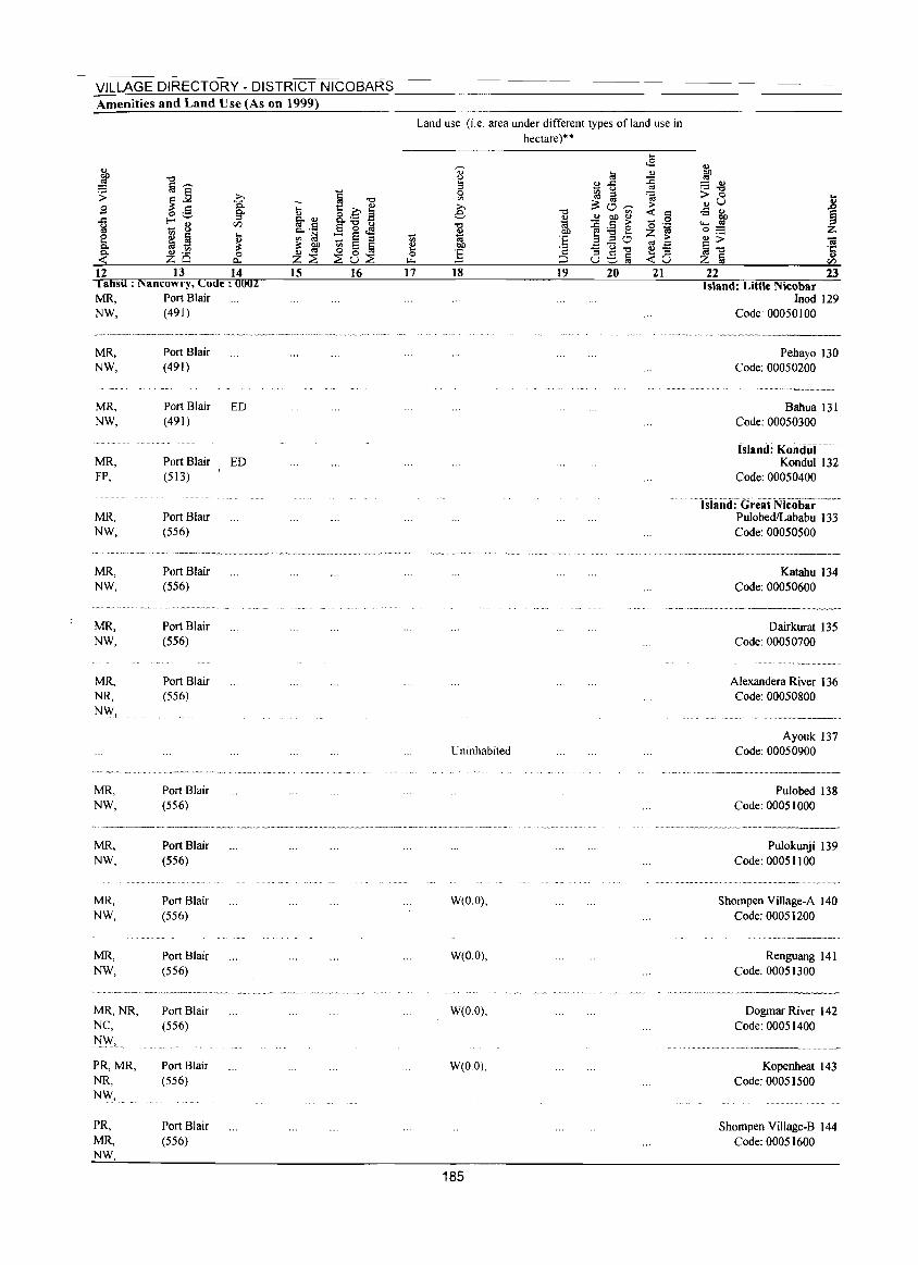
VILLAGE DIRECTORY - DISTRICT NICOBARS Amenities and Land Use (As on 1999)
12 13 14 I afisil : Nancowry, Code: 0002 MR, Port Blair NW, (491)
MR, NW,
MR, NW,
MR, FP,
MR, NW,
MR, NW,
MR, NW,
MR, NR,
N\\,!
MR, NW,
MR, NW,
MR, NW,
MR, NW,
MR,NR, NC, NW,
PR,MR, NR, NW,.
PR, MR, NW
Port Blair (491)
Port Blair ED (491)
Port Blair ED (513)
Port Blair (556)
Port Blair (556)
Port Blair (556)
Port Blair (556)
Port Blair (556)
Port Blair (556)
Port Blair (556)
Port Blair (556)
Port Blair (556)
Port Blair (556)
Port Blair (556)
-... .., g.~ "" ._ '" t:l 1!: ~ Z~ 15
~ 0 "8 8.._ .s e-g,s t; ~ ij ~8~
16
Vi ~ 0
"" 17
Land use (i.e. area under different types ofland use in hectare)""
... ~
<8 .., a!
.., ~ B-5 ::c ., 0 ~ ::I ~ '" ~o~ .... ;.
e " <t: = ~ ~ ~ ~ 0
" 0·-~
01.) e:.ae z ~ ·E ::I ::I CJ 01.) .t::u~
., .-·2 .., .=
:§ 8Stii ... ::s ;:l <t:u
18 19 20 21
Uninhabited
W(O.O),
W(O.O),
W(O.O),
W(O.O),
185
.., ~ = .., .- " > 0 .... ..,u j -5 ..,
01.) ...... ., oS Z .., > oa ~" .c:
II> z ij en 22 23
Island: Little Nicobar lood 129
Code: 00050100
Pehayo 130 Code: 00050200
Bahua 131 Code: 00050300
Island: Kondur··· Kondul 132
Code: 00050400
Island: Great Nlcobiir-·-···· PulobedILababu 133 Code: 00050500
Katahu 134 Code: 00050600
Dairkurat 135 Code: 00050700
Alexandera River 136 Code: 00050800
Ayouk 137 Code: 00050900
Pulobed 138 Code: 00051000
Pulokunji 139 Code: 00051100
Shompen Village-A 140 Code: 00051200
Renguang 141 Code: 00051300
Dogmar River 142 Code: 00051400
Kopenheat 143 Code: 00051500
Shompen Village-B 144 Code: 00051600
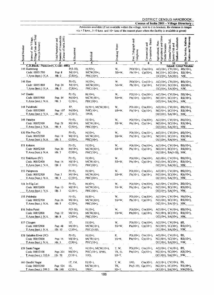
DISTRICT CENSUS HANDBOOK: Census of India 2001 - Village Directory :
Amenities available (if not available within the village, next to it in brackets. the distance in ranges viz.< 5 kms., 5-10 kms. and 10+ kms of the nearest place where the facility is available is given)
C.D.Block : Nancowry, Code: 0002 Island: Great Nicobar 145 Kasintung P(5-10), H(lO+), W, P0(10+), Cm(10+), AC(IO+), CV(1O+), BS(1O+).
Code: 00051700 Pop: 8 M(10+), MCW(10+). SS=W, Ph(lO+), Cp(10+), NC(IO+), SC(lO+). RS(1O+). _____ :L~ea (.hect. ): j'J..:..~ __ HJl:.L __ S{1.Q:!:L ____ J>f.ig]Q..+L .... _ .. __ ... _, __ .... _ ............... _ .. _.oql 0+)., SAC I 0+), NW,
146 Koe P«5), H(10+), Code: 00051800 Pop: 24 M(1O+), MCW(IO+),
__ .. J.Are~ (~ecU:J:Lt\ Hh: 5 . _ c;:(1.Q..+.1 ....... Pl:!c:(l Q.+), ~~~. -~ ... ~-~- .... -
147 Danlet P«5), H(lO+), Code: 00051900 Pop: 14 M(lO+), MCW(lO+),
..... T·A.r(!1;I (h(!ct.): ]\i·A· Hh: 3 C(IO+), PHC(IO+),
148 Pulobhabi IP, H(10+), MCW(IO+), Code: 00052000 Pop: 107 M(lO+), PHC(IO+),
T:Ar(!I;I(h.(!ct,}: ]\i.:A, Hh: 27 C(lO+),_ IPHS,
149 Patatiya P«5), H(IO+), Code: 00052100 Pop: 21 M(lO+), MCW(IO+),
_. __ I~[(!I:Iih.(!c!l_N·A.c ___ Hh.:..'L .. , . ~(!O:!:},.... Pl:!(~HQ+),
150 Hin-Pou-Chi P«5), H(lO+), Code: 00052200 Pop: II M(lO+), MCW(lO+),
__ J.Area (hecL): N.A. ,_BIU __ . __ C1!.Q:!:1_._.P!iC_UQ±), ...
151 Kokeon P«5), H(IO+), Code: 00052300 Pop: 30 M(1O+), MCW(10+), T.Area (hect.):N.A. Hh: 7 CCIO+), PHC(IO+),
152 Dakhiyon (FC) P«5), H(IO+), Code: 00052400 Pop: 14 M(lO+), MCW(IO+),
.. I..Area (h.(!CL): N cA, Hh: 2 C(IO+), . PHqIO+),
W, SS=W,
W, SS=W,
W, SS=W,
W, SS=W,
W, SS=W,
W, SS=W,
W, SS=W,
PO(lO+), Cm(10+), AC(IO+), CV(IO+), BS(IO+), Ph(IO+), Cp(lO+), NC(IO+), SC(IO+), RS(1O+) •
..... _ . __ 9C:D92)L.~AJ!.Q+), NW.
PO(IO+), Cm(lO+), AC(IO+), CV(JO+). BS(1O+), Ph(lO+), Cp(lO+), NC(IO+), SC(IO+), RS(1O+),
OC(IO+), Si\(IO:!,), .1'l.'.:Y,_ .... _
POt 10+), Cm(IO+), AC(IO+), CV(lO+), BS(IO+), Ph(IO+), Cp(IO+), NC(IO+), SCCIO+), RS(IO+),
9qlQ:r),.S.A(I.O+l.~.l..._
PO(IO+), Cm(lO+), AC(IO+), CV(IO+), BS(IO+), Ph(IO+), Cp(lO+), NCCIO+), SC(IO+), RS(IO+),
.. 9C:(!Q..+),§AiLQ_·ij, NW,
PO(IO+), Cm(IO+), AC(IO+), CV(IO+), BS(IO+), Ph(IO+), Cp(lO+), NC(IO+), SC(IO+), RS(IO+),
_. ___ Q~.u~l.L..~IO+). NW,
PO(lO+), Cm(IO+), ACCIO+), CV(IO+), BS(IO+), Ph(IO+), Cp(IO+), NC(IO+), SC(IO+), RS(IO+),
. OC:(IQ:!'),§A.(?~lQ), .I\IW, .. ___ _
PO(IO+), Cm(IO+), ACCIO+), CV(lO+), BS(IO+), Ph(IO+), Cp(IO+), NC(IO+), SC(IO+), RS(IO+),
. OC(l 0+») SA(1Q:!'1._!~W, ._
153 Pulopucca P«5), H(lO+), W. PO(lO+), Cm(lO+), AC(lO+), CY(\O+), BS(IO+), Code: 00052500 Pop: 3 M(lO+), MCW(IO+), SS=W, Ph(IO+), Cp(IO+), NC(IO+), SC(IO+), RS(IO+),
__ TArea(hect,LN.A. m mm.!:!h:J .. __ ~~{L0:!'l.m ~_,P!:!ql_Q..-r), .... ___ "_'m ___ .m __ ~.m_ .. _~_~._._m._ OC(IO+), SA(IO+), NW,
154In-Hig-Loi P«5), H( I 0+), Code: 00052600 Pop: 13 M(IO+), MCW(lO+),
. ___ l::_t..~e.I;IJh.(!ct.): NcA Hh: 3 C(IO+), PHC(IO+),
155 Pulobaha P«5), H( I 0+), Code: 00052700 Pop: 26 M(lO+), MCW(IO+), TArea (heeL): N.A, Hh: 5 C(1O+), .. PHC(lO+),
156 Indira Point P(5-1O), H(IO+), Code: 00052800 Pop: 12 M(lO+), MCW(IO+),
_ ....... m ... I:Are_a.Jh~(;U:.}/.:A: .. Hh: 8 ... G.(IQ:!,), . ... PI:I9_(IQ:!'), ... ",. .. "'-.. -,-...... ~."'"' ........ "'.
157 Chingen IP, H(IO+), Code: 00052900 Pop: 48 M(lO+), MCW(\O+),
_ .... :. .. LArea (he(;!l.}/A _.~_ J::Ih": .. IQ...m ... C1I0..-rL ..... PJ-:lC1~7IgL ___ _
158 Galathia River (FC) Code: 00053000 Pop: 16
_._I:.A.rea ili(!£!l.~.:.A.: ... _!1_h:.L.
P«5), M(lO+), qIQ+), ...
159 Sastri Nagar IP, Code: 00053100 Pop: 30] M(lO+), TArel;l(hect.} 333.6 Hh: 70 C(lO+),
160 Gandhi Nagar IP,IM, Code: 00053200 Pop: 524 IS, TArea (heeL): 599.5 Hh: 148 C(IO+),
H(IO+), MCW(IO+), PHC(lO+).,
H(10+), MCW(10+), PHC(IO+), lPHS, IHO,
H(lO+), MCW(IO+), IPHC,
186
W, SS=W,
W, SS=W,
W, SS=W,
W, SS=W,
R, SS=R.
T,W, TK,O, SS=T.
T,W, TK, SS=T,
PO(IO+), Cm(IO+), AC(lO+), CV(IO+), BS(lO+), Ph(IO+), Cp(IO+), NC(IO+), SC(IO+), RS(lO+),
QC2{IQ:l'lL SA.UQ+1 . N . .c.:W.z_, __
PO(IO+), Cm(IO+), AC(IO+), CV(IO+), BS(IO+), Ph(IO+), Cp(IO+), NC(IO+), SC(IO+), RS(lO+),
0C(IO+), S_A{IQ+), NF.L._. __
P0(10+), Cm(\O+), AC(IO+), CV(IO+), BS(IO+), Ph(lO+), Cp(lO+), NC(lO+), SC(10+), RS(1O+),
. . ..... 99(1~), .. §A.(!9_+),_ .. ~ .. _._
P0(10+), Cm(lO+), AC(IO+), CV(lO+), BS, Ph(IO+), Cp(IO+), NC(IO+), SC(lO+), RS(lO+),
....... 0C(IO+), SA(10+), NW,
PO(IO+), Cm(lO+), AC(IO+), CV(\O+), BS, Ph(lO+), Cp(IO+), NC(IO+), SC(IO+), RS(IO+),
. .. 9(,:'(19':).,$1-11.0+), NW,
PO(10+), Cm(IO+), AC(IO+), CV(lO+), BS, Ph(IO+), Cp(lO+), NC(lO+), SC(lO+), RS(lO+),
0C( 1 0+), SA(IQ±)L..~'!V . .L. .. __
IPO, Cm(IO+), AC(IO+), CV(lO+), BS, Ph(5-10), Cp(IO+), NC(IO+), SC(IO+), RS(IO+),
OC(IO+), SA(lO+), NW(lO+),
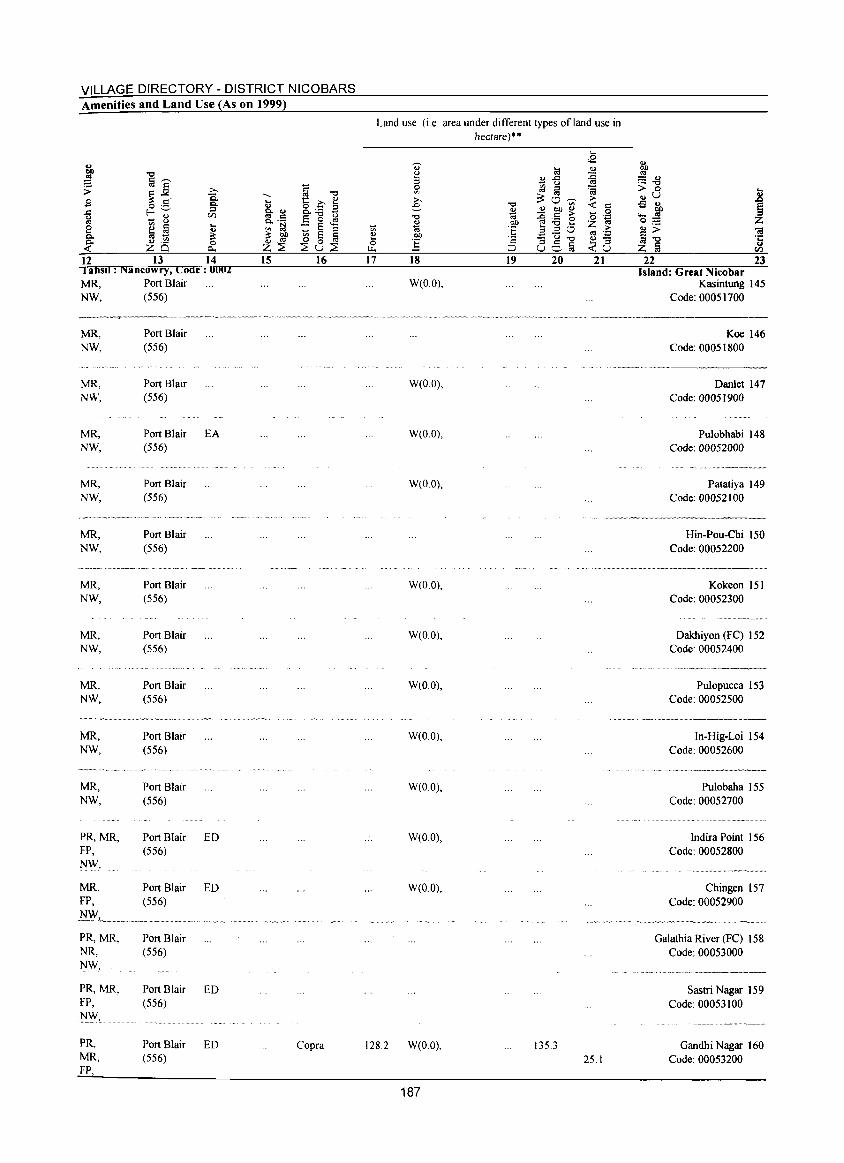
VILLAGE DIRECTORY - DISTRICT NICOBARS Amenities and Land Use (As on 1999)
~ "0
~ §~
~ ~. >.. Q.
£ o ._ Q,
..c: r--- ::l C/l u - ~ '" i:'l § ... e .,
0. til - ~ <U ,~ 0. 0 -< ZQ ~
12 13 14 , ahsU : Nancowry, Code: 0002 MR, NW,
MR, NW,
MR, NW,
MR, NW,
MR, NW,
MR, NW,
MR, NW,
MR, NW,
MR. NW.
Port Blair (556)
Port Blair (556)
Port Blair (556)
Port Blair (556)
Port Blair (556)
Port Blair (556)
... --.. -.-".-,-~-.
Port Blair (556)
Port Blair (556)
Port Blair (556)
EA
-~-- - -~ --~"=~~,~~-~.~ ... ~.,,~~~.
MR, Port Blair NW. (556)
v __ ~ ___ •• _ •• ~_ •• _ •••••
MR, Port Blair NW, (556)
PR,MR, Port Blair ED FP, (556) ]'JW,
MR, Port Blair ED FP, (556)
NWl...... __ .. ~ ._._. ___ .".
PR,MR, Port Blair NR, (556) NW,
PR,MR, Port Blair ED FP, (556) I'J'#,
PR, Port Blair ED MR. (556) FP,
... <> 0. .,
'" c: 0. ._
'" ~ ~ ~ z::E 15
~ "0 t: C ~ 8.._ :l E "0 t)
o '" - § ... _ :l
~ 0 § ::Eu::E
16
Copra
'" ., ... 0 ~
17
Land use (i.e. area under different types ofland use in hectare)·"
... ~
<E ., ~ :l 0 '" >.. e
"0 <> 'OJ I:lIl
~
til <>
B ..c :0 u '" ~ :l ~
~ '" 0 :> "0 V> '« c:
* ., OIl .,
0 - c: :> o ";:j OIl ~ :.a e Z ~ § 3.20 ~ .:;:
.:::: u ~ ., -c: 0:S§ ... :l :J <u
18 19 20 21
W(O.O),
., ~ :::: ., ._ "0
> 0 ... .,u .8 .s ., ~ ~ '-0;::::
<» <a ~"O ·c ., Z § ell
22 23 Island: Great Nicobar
Kasintung 145 Code: 00051700
Koe 146 Code: 00051800
.... _-_._ .. _-------W(OO),
W(OO),
W(O 0),
W(O.O),
W(O 0),
W(O.O),
W(O.O),
W(O.O),
W(O.O),
W(O.O),
128.2 W(O.O), 135.3
187
25.1
Danlet 147 Code: 00051900
Pulobhabi 148 Code: 00052000
Patatiya 149 Code: 00052100
Hin-Pou-Chi 150 Code: 00052200
Kokeon 151 Code: 00052300
Dakhiyon (FC) 152 Code: 00052400
Pulopucca 153 Code: 00052500
In-Hig-Loi 154 Code: 00052600
Pulobaha 155 Code: 00052700
Indira Point 156 Code: 00052800
Chingen 157 Code: 00052900
Galathia River (FC) 158 Code: 00053000
Sastri Nagar 159 Code: 00053100
Gandhi Nagar 160 Code: 00053200
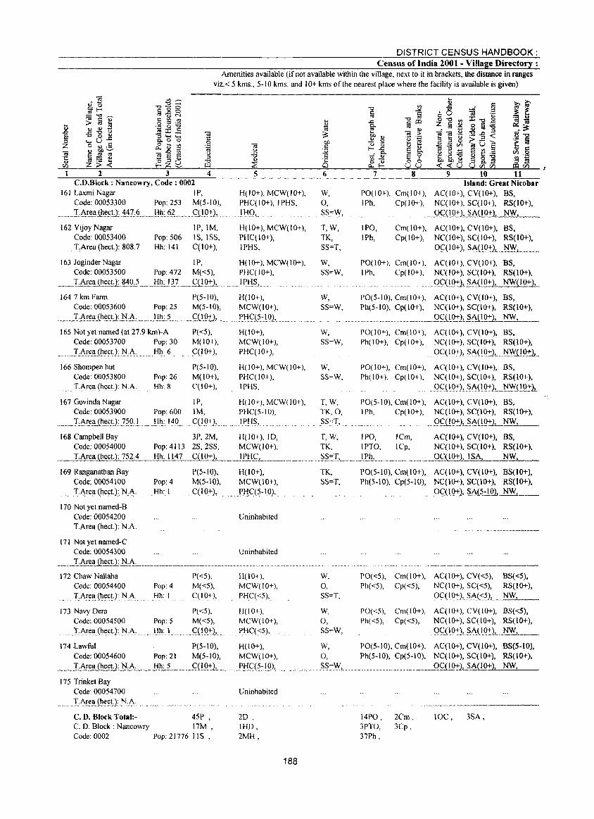
DISTRICT CENSUS HANDBOOK: Census of India 2001 - Village Directory :
Amenities available (if not available within the village, next to it in brackets, the distance in ranges viz.< 5 kms., 5-10 kms. and 10+ kms of the nearest place where the facility is available is given)
... ... .0 E :::s ;z: -.; ·c ., V'J
2 3 4 C.D.Block: Nancowry, Code: 0002
161 Laxmi Nagar IP, Code: 00053300 Pop: 253 M(5-1O),
_._J:Ar~h.~ll .. 1.'!L§__!:!l!.: §.L._. gl_O~l,. '.
162 Vijoy Nagar Code: 00053400
. T,Area(heet): ~0~.7
IP,IM, Pop: 506 IS, ISS, Hh: 141 C{lO+),
5
H(lO+), MCW(IO+), PHC(IO+), IPHS,
IHQ,_ .,
H(lO+), MCW(IO+), PHC(10+), IPHS,
6
W, 0, SS=Vv',
T,W, TK, SS=T,
7 8 9 10 11 Island: Great Nicobar
PO(IO+), Cm(IO+), AC(lO+), CV(IO+), BS, IPh, Cp(lO+), NC(lO+), SC(lO+), RS(lO+).
IPO, IPh,
._Q.CiI.9_~1,-SA(I0+), NW,
Cm(IO+), AC(IO+), CV(IO+), BS. Cp(IO+), NC(IO+), SC(IO+), RS(IO+),
OC( 1 0+), SAC 10+), 1'J_\Y,
163 JoginderNagar IP, H(IO+), MCW(IO+), W, PO(10+), Cm{IO+), AC(IO+), CV(IO+), BS, Code: 00053500 Pop: 472 M«5), PHC(IO+), SS~W, IPh, Cp(IO+), NC(IO+), SC(IO+), RS(JO+),
..... _T.Are!!._Q!~~~.9_j __ lil!.:.l ~7. __ .~i!Q::rJ" ........ ' .. 1 P!i~., ... . . .. Q~.(lQ:'il...§.A{IO+), NW(IO+),
1647 krn Farm P(5-10), H(lO+), W, PO(5-10), Cm(lO+), AC(IO+), CV(IO+), BS, Code: 00053600 Pop: 2S M(5-10), MCW(IO+), SS=W, Ph(5-10), Cp(IO+), NC(IO+), SC(lO+), RS(IO+),
___ T.Area (heet.):~.A. __ Hh: 5 __ ".s,U.Qt.1 .. _ ... ?..!:!~!2:-!QL _., .' _.' ' .•.. ' ....••.. _.. . __ ... _~ .. _ _Q£(IO+), SAPO+), NW,
165 Not yet named (at 27.9 km)-A P«5), H(lO+), Code: 00053700 Pop: 30 M(IO+), MCW(lO+),
...... :r:Ar~II_(~eet.): ~.A ,.. Hh: 6 C(lO+), PHC(lO+),
166 Shompen hut Code: 00053800 Pop: 26
.... T,Areli (heet.): ~:A, .. Hh: 8
P(5-10), M(IO+),
. C(l 0+),
H(lO+), MCW(lO+), PHC(IO+), IPHS,
167 Govinda Nagar IP, H(lO+), MCW(IO+), Code: 00053900 Pop: 600 1M, PHC(S-IO),
._ .... I.:A':.e~_(h.~~tJ: '?~Q:L .. }::l'l:_I~O. CClO+),.. . .. 1 PH~,
168 Campbell Bay 3P,2M, H(lO+), !D, Code: 00054000 Pop: 4113 2S,2SS, MCW(lO+), I.Area (heet.): 752.4
169 Ranganathan Bay Code: 00054100
.... '.. .Tt-rea. (h.e~t) : .. N..:A: 170 Not yet named-B
Code: 00054200 I.Area (heet): N.A.
171 Not yet named-C Code: 00054300 T.Area (heet.): N.A.
Hh: 1147 C£.!.922, IPHC,
Pop: 4 Hh: I
P(5-10), M(5-10), C(lO+),
H(IO+), MCW(IO+),
. .PkI.C(5-1O),.
Uninhabited
Uninhabited
W,
SS=W,
v..', SS~W,
T,W, TK, 0, SS",T,
PO(IO+), Cm(10+), AC(IO+), CV(lO+), BS, Ph(lO+), Cp(IO+), NC(IO+), SC(IO+), RS(lO+),
.... ()<::( IQ;-), ~A( !o.:-), ... ~.QQ::1. PO(JO+), Cm(IO+), AC(IO+), CV(lO+), BS, Ph(IO+), Cp(IO+), NC(IO+), SC(IO+), RS(10+),
... ()<::(IQ~), ~A(1~),._~Y{O~1
PO(5-10), Cm(lO+), AC(IO+), CV(IO+), BS, IPh, Cp(10+), NC(IO+), SC(lO+), RS(lO+),
~_ Q~QQ::1_~_(lQ:l:2L..-.:..N:..:.;W~_
T, W, IPO, ICm, AC(lO+), CV(lO+), BS, TK, IPTO, ICp, NC(IO+), SC(lO+), RS(lO+),
... _SS~T"'-~)Ph.,._._~ .. __ ..... _ OC(IO+), ISA, NW,
TK, SS=T,
PO(5-10), Cm(IO+), AC(lO+), CV(IO+), BS(lO+), Ph(5-10), Cp(5-IO), NC(IO+), SC(10+), RS(lO+),
m.()~o.Q:-2,.~A(~.:)_Q1 NW, __
172 Chaw Nallaha P«5), 11(10+), W, PO«5), Cm(IO+), AC(IO+), CV«5), BS«5), Code: 00054400 Pop: 4 M«5), MCW(IO+), 0, Ph«5), Cp«5), NC(IO+), SC«5), RS(IO+), T.Ar~a(heet.): N.A Hh: I <::(10+), PHC«5), SS~T, Oqlo+), St-(:<:~)L_J~lW, _
173 Navy Dera P«5), H(IO+), W, PO«5), Cm(IO+), AC(IO+), CV(IO+), BS«5), Code: 00054500 Pop: 5 M«5), MCW(lO+), 0, Ph«5), Cp«5), NC(IO+), SC(IO+), RS(IO+),
..... TA~ell (~t:.(;tJ.~.i\,_ Hh: I <::QQ+), p);C( <5), SS=W, 0<::( 10+), ~A( 1~2! _~'-__ ,
174 Lawful P(5-IO), H(IO+), W, PO(5-10), Cm(10+), AC(IO+), CV(IO+), BS(5-10), Code: 00054600 Pop: 21 M(5-10), MCW(IO+), 0, Ph(5·10), Cp(5-10), NC(IO+), SC(IO+), RS(lO+),
_ _.:..;T.c:.:A~re:=.a~(h:.::e.:.:ct:L'):c.:.N"",.A:..:.:__.:..;H:::.h.:.::· 5:..,__.:::,C"",(1:';;:'0+';_'):L' ____ !'Hq~.!QL. __ . ____ .. __ SS=:.!Y'__ ......... __ ." ___ ........Qg)..Q:!:2, SA(lO+), NW,
175 Trinket Bay Code: 00054700
_._ .... XA!~~h~E!J,!'I:f:.·.
C. D. Block Total:- 45P , C. D. Block: Naneowry 17M , Code: 0002 Pop: 21776 lIS,
Uninhabited
2D, IHD, 2MH,
188
14PO, 3PTO, 37Ph,
2Cm, 3Cp,
10C, 3SA,
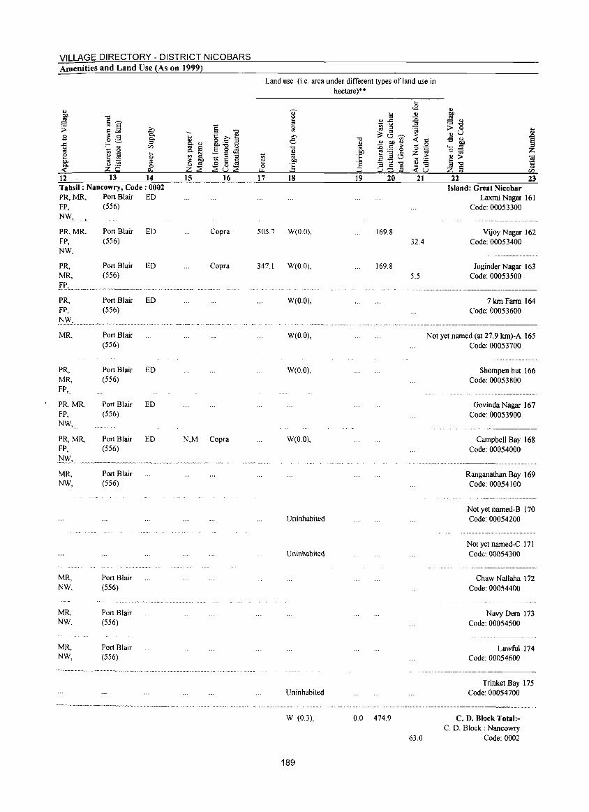
VILLAGE DIRECTORY - DISTRICT NICOBARS Amenities and Land Use (As on 1999)
12 13 14 15 16 Tahsil: Nancowry, Code: 0002 PR,MR, Port Blair ED FP, (556) NW,
PR,MR, Port Blair ED Copra FP, (556) NW,
-'" e o r..z...
17
Land use (i.e. area under different types ofland use in hectare)··
18 19 20 21
505.7 W(O.O), 169.8 32.4
22 23 Island: Great Nicobar
Laxmi Nagar 161 Code: 00053300
Vijoy Nagar 162 Code: 00053400
PR, Port Blair ED Copra 347.1 W(O.O), 169.8 Joginder Nagar 163 MR, (556) 5.5 Code: 00053500
v. ,, __ __ V'~~_~ _ _ .~
PR, Port Blair ED W(O.O), 7kmFarm 164 FP, (556) Code: 00053600
~.,-.~--.
MR, Port Blair W(O.O), Not yet named (at 27.9 km)-A 165 (556) Code: 00053700
........... -.-.-.. --.-.-.~.
PR, Port Blair ED W(O.O), Shompen hut 166 MR, (556) Code: 00053800 FP, ............................... _ ... __ ... _ ....
PR,MR, Port Blair ED Govinda Nagar 167 FP, (556) Code: 00053900 NW,
"' _ .. , _ ... ---
PR,MR, Port Blair ED N,M Copra W(O.O), Campbell Bay 168 FP, (556) Code: 00054000 :tJ":",
·_,_~v~~~V~~~y~, ~
.~~~--~ ..
MR, Port Blair Ranganathan Bay 169 NW, (556) Code: 00054100
--_ .... _ .... _ .. _-_ .. _-----Not yet named-B 170
Uninhabited Code: 00054200
Not yet named-C 171 Uninhabited Code: 00054300
-.-._ ------~~
MR, Port Blair Chaw NaHaha 172 NW, (556) Code: 00054400
MR, Port Blair Navy Dera 173 NW, (556) Code: 00054500
MR, Port Blair Lawful 174 NW, (556) Code: 00054600
_ .. --.---... -... ~-~------.
Trinket Bay 175 Uninhabited Code: 00054700
W (0.3), 0.0 474.9 C. D. Block Total:-C. D. Block: Nancowry
63.0 Code: 0002
189
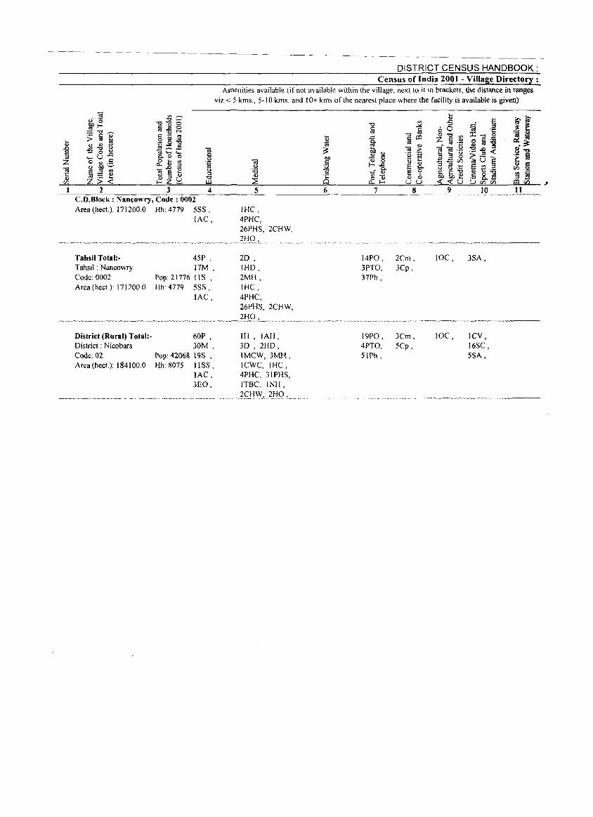
... .., .0 E = Z .. .t: .., en I
.. c o .~
~ 4
CD.Block : Nancowry, Code: 0002 Area (hect.): 171200.0 Hh:4779 555,
lAC,
Tahsil Total:Tahsil: Nancowry Code: 0002 Area (hecL): 171200.0
District (Rural) Total:District: Nicobars Code: 02 Area (hect.): 184100.0
45P , 17M,
Pop: 21776 liS , Hh: 4779 5SS,
lAC,
60P , 30M,
Pop: 42068 19S , Hh: 8075 IISS,
lAC, 3EO,
DISTRICT CENSUS HANDBOOK: Census of India 2001 - Village Directory :
Amenities available (if not available within the village, next to it in brackets, the distance in ranges viz. < 5 kms., 5-10 kms. and 10+ kms of the nearest place where the facility is available is given)
IHC, 4PHC, 26PHS, 2CHW,
20 , IHD, 2MH, IHC, 4PHC, 26PHS, 2CHW,
IH,IAH, 3D , 2HD, IMCW, 3MH, ICWC, IHC, 4PHC, 3IPHS, ITBC, INH,
.?f1:!W~ .. ~l:lQ L ....
14PO, 3PTO, 37Ph,
2Cm, 3Cp,
19PO, 3Cm, 4PTO, 5Cp, SIPh,
JOC, 3SA,
JOC, ICV, 16SC, 5SA,
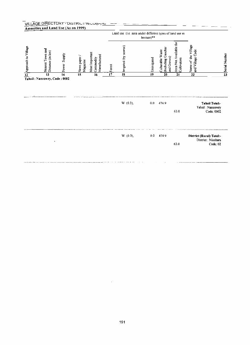
VILLAGE DIREC lORY - 01:S I KIC I 1\lICiUUI"\,m
Amenities and Land Use (As on 1999)
12 13 14 15 16 17 Tahsil: Nancowry, Code: 0002
Land use (i.e, area under different types of land use in hectare)··
18 19 20 21
W (0,3), 0,0 474,9
63,0
W (03), 0,0 474,9
63,0
191
j -.g ;> 0 .,u -5 ., ..... 1lfl 0= <u;> ij-o Z ta
22
Tahsil Total:Tahsil: Nancowry
Code: 0002
District (Rural) Total:District: Nicobars
Code: 02
23

(b) Appendices to Village Directory :
APPENDIX I - VILLAGE DIRECTORY ABSTRACT OF EDUCATIONAL, MEDICAL AND OTHER AMENITIES IN VILLAGES - CD BLOCK LEVEL
Total Total
number of population
inhabited of CD
SI No Name of CD Block villages Block
2 3 4
Educational institutions
Matri
culation /
Higher
Secondary /
PUC/ Primary Middle Secondary Intermediate /
school school school Junior college
Vill- Institu- Vill- Institu- Vill- Institu- Vill- Institu-
ages lions ages lions ages lions ages lions
5 6 7 & 9 10 II 12
College
(graduate
and above)
Vill- Institu·
ages tions
13 14
I 2 3
Andamans District North Andaman
Middle Andaman
South Andaman
District (Rural) :
78 103 150 331
42,895 56,584 98,407
197,886
48 59 78
185
75 98
130 303
16 26 41 83
23 43 60
126
9 18 22 49
13 30 38 81
2 9
11 22
5 18 19 42
o I o
o I o 1
I 2
SI
No
I
2 3
Nicobars District Car Nicobar
Nancowry District (Rural) :
Name of CD Block
2 Andamans District
North Andaman
Middle Andaman
South Andaman
District (Rural) : Nicobars District
I Car Nicobar
2 Nancowry
SI
No
District (Rural) :
Name of CD Block
2 Andamans District
I North Andaman
·2 Middle Andaman
3 South Andaman
District (Rural) :
16 154 170
20,292 12 21,776 41 42,068 53
15 45 60
9 16 25
13 17 30
5 10 15
8 11 19
3 4 7
6 5
11
o o o
o o o
Educat ional inst itut ions Medical institutions
Adult
literacy
classes/
Primary
Health
Centre /
Health
Primary
Health Sub-
centres Others No edu- Hospital Dispensary Centre centre
Vill- Institu· Vill- Institu- cational Vill- Institu- Vill- Institu- ViII- Institu- ViII- Institu
ages lions ages t ions facilit ies ages t ions ages tions ages tions ages tions
15 16 17
9 3 &
20
o
9 3
& 20
o
15 48 19 82
3 o 3
18 19 20 21 22
24 64
23 111
3
o 3
28 35 71
134
4 III
115
o I
o
I o
o 2 o 2
2 o 2
2 2 o 4
2 3
Medical institutions (contd.)
Maternity and
Child Welfare
Centre /
Maternity
Home / Child
Family
Welfare
Communi
ty Health
23
No Welfare Centre Centre Workers Others medical
Vill- Institu- Vill- InSlilu· Vill- Num- Vill- Institu- facili-
ages
28
I 3 2 6
tions
29
2 7 4 13
ages tions
30 31
o o o o
o o o o
ages bers ages t ions
32 33 34 35
5 5 o 0 14 14 19 19
193
I 2 2 5
1
2 2 5
ties
36
56
78 99
233
2 2 o 4
2 3 5
24
3
5 8
16
o 5 5
25
3 6 &
17
o 5 5
26 27
15 21 42 78
5 26 31
16 21 42 79
5 26 31
Drinking water source
Tube-
Tap Well Tank well River
37 38 39 40 41
33 69 65 77
108 115 206 261
16 0 28 0 44 88
4 I 3 8
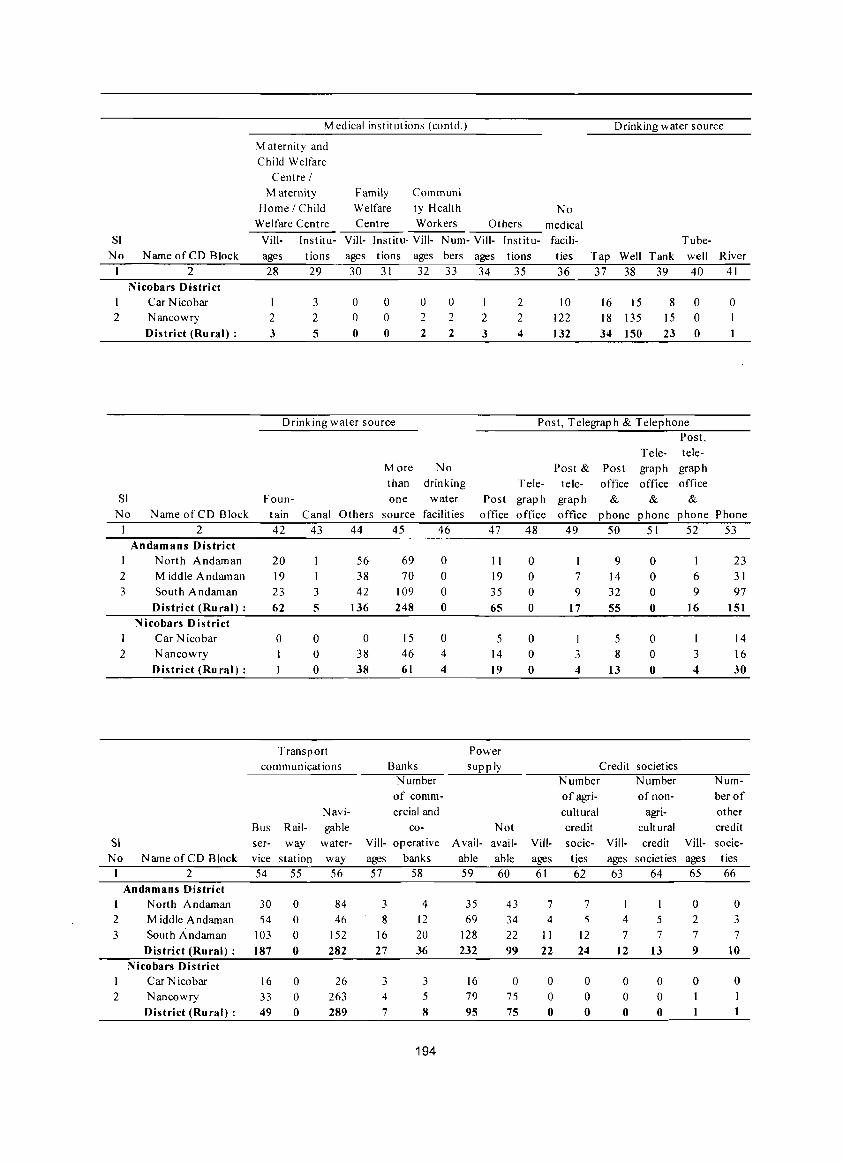
SI
No Name of CD Block
2 Nicobars District
Car Nicobar 2 Nancowry
SI
No
District (Rural) :
Name of CD Block
2 Andamans District
North Andaman
2 Middle A ndam an
3 South Andaman
District (Rural) :
2
SI
No
Nicobars District Car N icobar
Nancowry
District (Ru ral) :
Name of CD Block 2
Andamans District
Medical institutions (eontd.) Drinking water source
Maternity and
Child Welfare
Centre /
Maternity
Home / Child
Family
Welfare
Communi
ty Health No Welfare Centre Centre Workers Others medical
Vill- Institu- Vill- Institu· Vill- N um- Vill- Institu- facili- Tube-
ages tions ages tions ages bers ages tions ties Tap Well Tank well River
28 29 30 31 32 33 34 35 36 37 38 39 40 41
I
2 3
3
2
5
o o o
o o o
o 2
2
o 2
2
Drinking water source
M ore No
than drinking
Foun- one water
I 2 3
2 2 4
10
122
132
16 15
18 135
34 150
8 0 15 0
23 0
Post, Telegraph & Telephone Post,
Tele- tele
Post & Post graph graph
Tele- tele- oftice office office
Post graph graph & & &
o
tain Canal Others source facilities office office office phone phone phone Phone
42 43 44 45 46
56
38
42
20
19
23 62
3
5 136
69
70
109
248
o o o o
o o o o
Transport
communications
Bus Rail
ser- way
vice stat ion 54 55
Navi
gable
water-
way
56
o 38
38
15
46
61
Banks
o 4 4
Number
of comm
ercial and
co
Vill- operative
ages banks
57 58
47 48 49 50 51 52 53
II 19
35
65
5 14
19
Power
supply
Not
A vail- avail-
able able 59 60
o o o o
o o o
Vill
ages
61
I 7 9
17
I
3 4
9 14
32 55
5 8
13
o o o o
o o o
Cred it societ ies
6 9
16
I 3 4
Number Number
of agri
cultural
credit
socie-
ties
62
of non
agri
cultural
Vill- credit Vill
ages societ ies ages 63 64 65
23
31
97
151
14
16
30
Num
ber of
other
credit
socie-
ties
66
1 North Andaman 30 o o o o
84
46
152
282
3
8
16
27
4
12
20
36
35 69
128
232
43
34
22 99
7
4
II
22
7 5
12
24
1
5 7
o 2
7
9
o 3 7
2 Middle Andaman 54
3 South Andaman 103
I
2
District (Rural) : 187
Nicobars District Car Nicobar
Nancowry
District (Rural) :
16
33 49
o o o
26 263 289
3
4
7
3
5 8
194
16
79
95
o 75
75
o o o
o o o
4
7 12
o o o
13
o o o
o
1
10
o
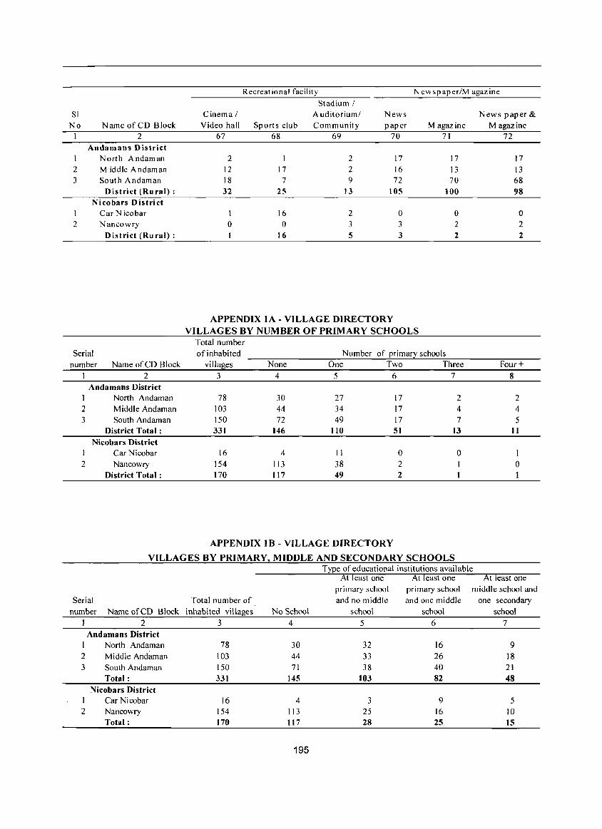
Recreational facility N ewspaper/M agazine
Stadium! SI Cinema I A uditoriuml News News paper &
No Name of CD Block Video hall Sports club Community paper Magazine Magazine I 2 67 68 69 70 71 72
Andamans District 1 North Andaman 2 I 2 17 17 17 2 Middle Andaman 12 17 2 16 13 13 3 South Andaman 18 7 9 72 70 68
District (Rural) : 32 25 13 105 100 98 Nicobars District
I Car Nicobar I 16 2 0 0 0 2 Nancowry 0 0 3 3 2 2
District (Rural) : 16 5 3 2 2
APPENDIX lA - VILLAGE DIRECTORY VILLAGES BY NUMBER OF PRIMARY SCHOOLS
Total number Serial of inhabited Number of primary schools
number Name of CD Block villages None One Two Three Four + 2 3 4 5 6 7 8
Andamans District North Andaman 78 30 27 17 2 2
2 Middle Andaman 103 44 34 17 4 4 3 South Andaman 150 72 49 17 7 5
District Total: 331 146 110 51 13 11 Nicobars District
1 Car Nicobar 16 4 11 0 0 1 2 Nancowry 154 113 38 2 I 0
District Total: 170 117 49 2 1
APPENDIX IB - VILLAGE DIRECTORY
VILLAGES BY PRIMARY, MIDDLE AND SECONDARY SCHOOLS Type of educational institutions available
Serial Total number of
number Name of CD Block inhabited villages
2 3 Andamans District
1 North Andaman 2
3
2
Middle Andaman South Andaman Total:
Nicobars District Car Nicobar Nancowry Total:
78 103 150 331
16 154 170
No School
4
30 44 71
145
4 113 I17
195
At least one At least one At least one primary school primary school middle school and and no middle and one middle one secondary
school school school
5 6 7
32 16 9 33 26 18 38 40 21
103 82 48
3 9 5 25 16 IO 28 25 15
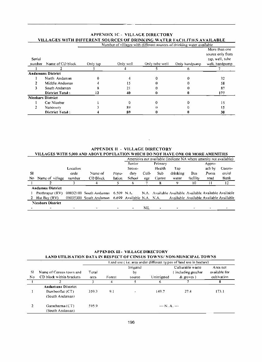
APPENDIX IC - VILLAGE DIRECTORY
VILLAGES WITH DIFFERENT SOURCES OF DRINKING WATER FACILITIES AVAILABLE Number of villages with different sources of drinking water available
More than one source only from
Serial tap, well, tube number Name of CD block Only ta~ Only well Only tube well Only handpump well, handpump
2 3 4 5 6 7 Andamans District
1 North Andaman 0 4 0 0 32 2 Middle Andaman 4 15 0 0 58 3 South Andaman 8 21 0 0 87
District Total: 12 40 0 0 177 Nicobars District
I Car Nicobar I 0 0 0 15 2 Nancowry 3 89 0 0 15
District Total: 4 89 0 0 30
APPENDIX II - VILLAGE DIRECTORY VILLAGES WITH 5,000 AND ABOVE POPULATION WHICH DO NOT HAVE ONE OR MORE AMENITIES
Location SI code
No Name of village number I 2 3 Andamns District I Prothrapur (RV) 00032100 2 Hut Bay (RV) 00035300
Nicobars District
Name of Popu-CD Block lation
4 5
South Andaman 6.509 South Andaman 6.699
Amenities not available (indicate NA where amenity not available) Senior Primary Appro-Secon- Health Tap ach by Comm-
dary Coll- Sub drinking Bus Pucca School ege Centre water facility road
6 1 8 9 10 II
ercial Bank
12
N.A. N.A. Available Availablt: Available Available Available Available N.A. N.A. Available Available Available Available
NIL
APPENDIX III - VILLAGE DIRECTORY LAND UTILISATION DATA IN RESPECT OF CENSUS TOWNS! NON-MUNICIPAL TOWNS
SI N arne of Census town and Total No CD block within brackets area
I 2 3 AndariJans District
Barnbooflat (CT) 359.3 (South Andarnan)
2 Garacharma (CT) 595.9 (South Andarnan)
Land use ( i.e. area under different types of land use in hectare)
Irrigated Culturable waste by ( including gauchar
Forest source U nirrigated & groves) 4 5 6 7
9.1 149.7 27.4
--- N. A. ---
196
Area not available for cult ivat ion
8
173.1
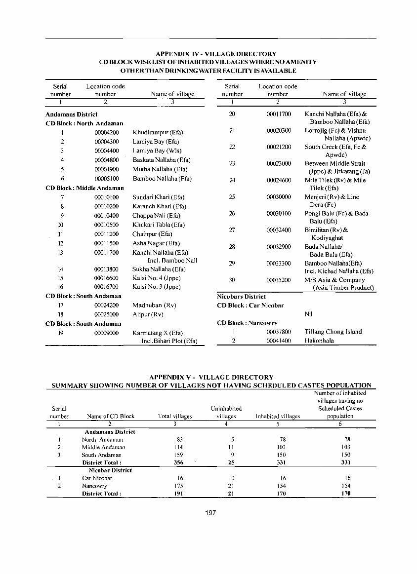
APPENDIX IV - VILLAGE DIRECTORY CD BLOCK WISE LIST OF INHABITED VILLAGES WHERE NO AMENITY
OTHER THAN DRINKING WATER FACILITY IS AVAILABLE
Serial Location code Serial Location code number number Name of village number number Name of village
1 2 3 1 2 3
Andamans District 20 00011700 Kanchi NaHaha (Efa) &
CD Block: North Andaman Bamboo NaHaha (Efa)
QOOO4200 Khudirampur (Efa) 21 00020300 Lorrojig(Fc)& Vishnu
2 00004300 Lamiya Bay (Efa) Nallaha (Apwdc)
3 0000440O Lamiya Bay (Wls) 22 00021200 South Creek (Efa, Fc &
Apwdc) 4 00004800 Baskata Nallaha (Efa)
23 00023000 Between Middle Strait 5 00004900 Mutha Nallaha (Efa) (Jppc) & Jirkatang (Ja) 6 00005100 Bamboo Nallaha (Efa) 24 00024600 Mile Tilek(Rv)& Mile
CD Block: Middle Andaman Tilek(Efa)
7 00010100 Sundari Khari (Efa) 25 00030000 Manjeri (R v) & Line
8 00010200 Karanch Khari (Efa) Dera (Fe)
9 00010400 Chappa Nali (Efa) 2D 00030 I 00 Pongi Balu (Fe) & Bada
10 000 10500 Khukari Tabla (Efa) Balu (Efa)
II 00011200 Chainpur (Efa) 27 00032400 Bimilitan(Rv)&
Kodiyaghat 12 00011500 Asha Nagar (Efa)
28 00032900 Bada N allahal I3 00011700 Kanehi Nallaha (Efa) Bada Balu (Efa)
Incl. Bamboo Nail 29 00033300 Bamboo Nallaha(Efa) 14 00013800 Sukha Nallaha (Efa) Incl. Kichad Nallaha (Efa) 15 00016600 Kalsi No.4 (Jppc) 30 00035200 MIS Asia & Company 16 00016700 Kalsi No.3 (Jppe) (Asia Timber Product)
CD Block: South Andaman Nicobars District
17 00024200 Madhuban (Rv) CD Block: Car Nicobar
18 00025000 Alipur(Rv) Nil
CD Block: South Andaman CD Block: Nancowry
19 000090OO Karmatang X (Efa) I 00037800 Tillang Chong Island
Incl.Bihari Plot (Efa) 2 00041400 Hakonhala
APPENDIX V - VILLAG E DIRECTORY SUMMARY SHOWING NUMBER OF VILLAGES NOT HAVING SCHEDULED CASTES POPULATION
Serial number
1 2 3
Name of CD Block 2
Andamans District North Andaman Middle Andaman South Andaman District Total:
Nicobar District Car Nicobar
2 Nancowry District TotaJ :
Total villages 3
83 114 159 356
16 175 191
Uninhabited villages
4
5 II
9 25
0 21 21
197
Number of inhabited villages having no Scheduled Castes
Inhabited villages population 5 6
78 78 103 103 150 150 331 331
16 16 154 154 170 170
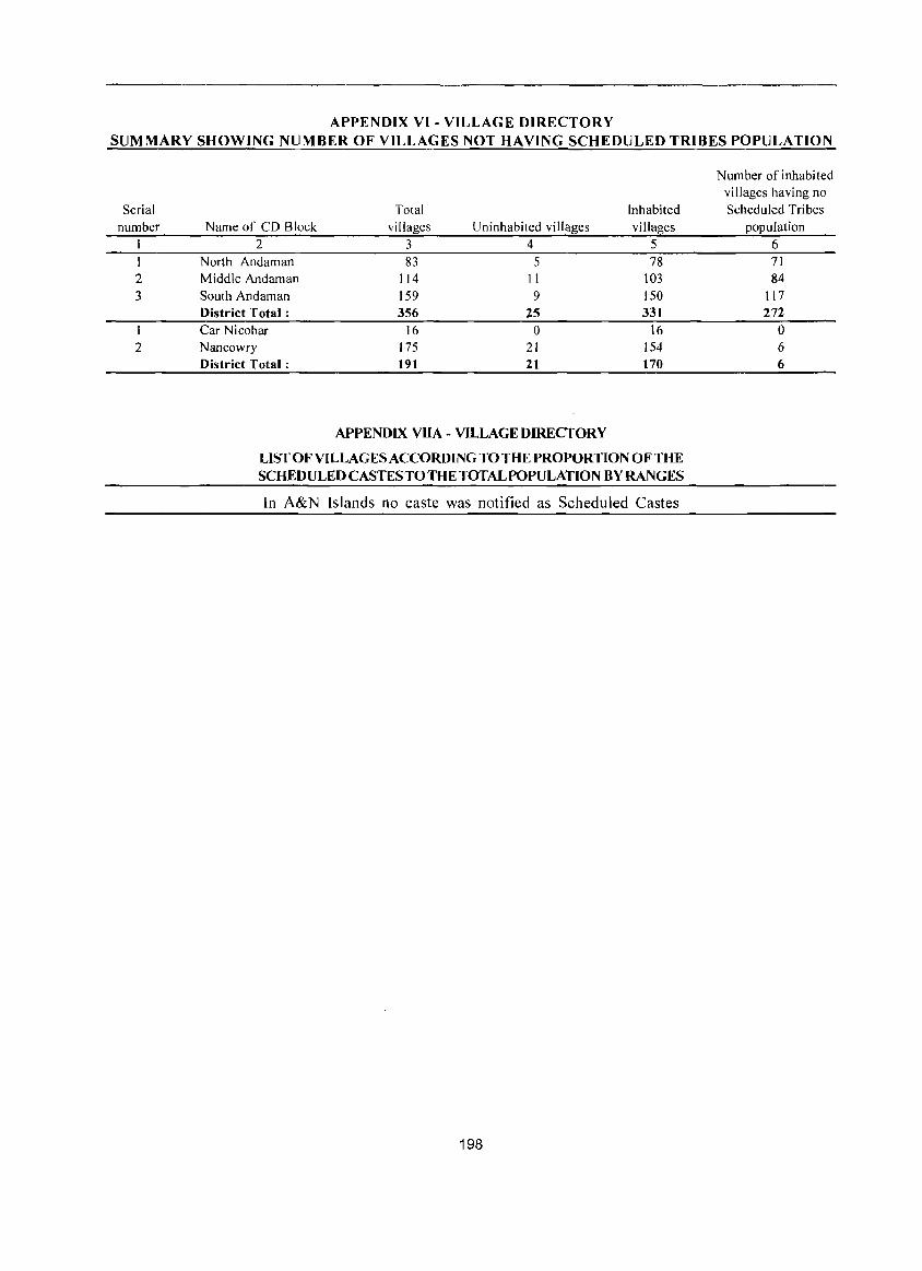
APPENDIX VI - VILLAGE DIRECTORY SUMMARY SHOWING NUMBER OF VILLAG ES NOT HAVING SCHEDULED TRIBES POPULATION
Serial number
2 3
2
Total Inhabited Name of CD Block villages Uninhabited villages villages
2 3 4 5 North Andaman 83 5 78 Middle Andaman 114 II 103 South Andaman 159 9 150 District Total: 356 25 331 Car Nicobar 16 0 16 Nancowry 175 21 154 District Total: 191 21 170
APPENDIX VIlA - VILLAGE DIRECTORY
LIST OF VILLAGES ACCORDING TO THE PROPORTION OF THE SCHEDULED CASTES TO THE TOTAL POPULATION BY RANGES
In A&N Islands no caste was notified as Scheduled Castes
198
Number of inhabited villages having no Scheduled Tribes
population 6 71 84
117 272
0 6 6
APPENDIX VIIB- VILLAGE DIRECfORY
LIST OF VILLAGES ACCORDING TO THE PROPORTION OF THE SCHEDULED TRIBES TO THE TOTAL POPULATION BY RANGES
Range of Range of Scheduled Scheduled
Tribes Location Tribes Location population Code population Code
(percentage) number NameofYillages (percentage) number Name ofyillages 1 2 3 I 2 3
Andamans District 00032100 Prothrapur (RY) 00021300 Sundergarh (RY)
CD Block: North Andaman 00023300 Shoal Bay CRy)
Less than 5 00022300 Wrafter'S Creek (RY)
00004500 Nabagram (RY) 00034900 Netaji Nagar (RY)
00003300 Diglipur(RY) 00024400 Mannarghat CRy)
00003900 Shibpur(Ry) 00024100 Wright Myo (Ry)
00003500 Vidyasagarpalli (RY) 00031500 Pahargaon Part (RY)
00007700 Sagar Dweep (Ry) 00023800 Coffee Plot (Jppc)
11-20 00034800 Red Oil Palm
00000100 East Island (N ursery Camp) 00000200 Narcondam Island 00031600 School Line Part (Ry)
CD Block: Middle Andaman 00035300 Hut Bay (RY) Less than 5 00031700 Dollygunj (RY)
00018600 Kadamtala (RY) 5-10 00019700 Long Island (Ry) 00027300 Dundas Point (RY) 00009700 Pahalgaon (RY) 76 and above 00015900 Bakultala (R v)
00020000 Strait Island (As) 00014000 Padmanabhapuram (R Y) 00035600 South Bay (Os) 00013900 Shivapuram (Ry) 00033800 Dugong Creek (as) 00008800 Karmatang (Rv) 00035500 South Bay 00014900 Rangat(Rv) (Light House Camp) 00015000 Rampur (Ry) 00035400 Harmender Bay (Ns) 00009400 Deypur (Rv) 00022700 Spike Island (Ja) 00008400 Mayabunder (Rv) 00023000 Middle Strait To Jirkatang 00014500 lanakpur (RY) (Ja) 00009300 Lataw (Rv) 00026200 Tirur (Ja) 00014100 Panchawati (Rv) 00033600 North Sentinel Island (Sa) 00010700 Hanspuri (R v) CD Block: South Andaman 00008700 Rampur (Ry) 76 and above
76 and above 00023000 Between Middle Strait 00017400 Dhani Nallaha (Ja) (Jppc) & Jirkatang (Ja) 00019100 Foul Bay (Ja) Nicobars District 00019200 Lakra Lungta (Ja)
CD Block: Car Nicobar CD Block: South Andaman
Less than 5 Less than 5
00036300 IafCamp 00026900 Shore Point (Ry)·
51-75 00021500 Nilambur(Ry)
00036400 Malacca 00031200 Neil Kendra (RY) 00037000 Big Lapati 00032000 Brichgunj (RY) 76 and above 00026500 Bindraban (Ry) 00035700 Mus 00034200 Ramakrishnapur (Ry) 00035800 Teetop 00029500 Manglutan (Rv) 00036500 Perka 00030500 Govinda Nagar (Ry) 00036800 Chuckchucha 00026400 Ferrargunj (Ry) 00036900 Tapoiming 00029200 Wandur(Rv) 00036200 Kakana
199
Range of Range of Scheduled Scheduled
Tribes Location Trihes (,ocation population Code population Code (percentage) number Name of villages (percentage) number Name of villages
1 2 3 1 2 3
00035900 Sawai 00040700 Yyavtapu 00036700 Kinyuka 00045200 Daring 00036000 Arong 00044600 Neeche Tapu 00036600 Tamaloo 00047800 Trinket 00037200 Kinmai 00038800 Kalasi 00036100 Kimois 00038200 Luxi 00037100 Small Lapati 00038400 Chukmachi
CD Block: Nancowry 00037300 Tahaila
Less than 5 00037400 Chongkamong
00053900 Govinda Nagar 00037500 Alhiat
00053400 VijoyNagar 00037600 Kuitasuk 00042400 Mildera 00037900 Aloorang
00053200 Gandhi Nagar 00038000 Aloora
00054000 Campbell Bay 00038100 Enam
11-20 00038300 Kalara
00041900 Altaful 00038500 Safedbalu
00046800 KamortaiKalatapu 00038700 Kanahinot
00042000 Kavatinpeu/Karah inpoh 00039000 Bompoka Island
31-40 00039300 Hitlat 00037800 Tillang Chong Island 00039700 Alkaipohl Alkripoh 00041800 HalnatailHoinatai 00039800 Alhitothl Alhi loth
00042200 Kapanga 00039900 Katahuwa
00042100 Alsama 00040000 Kumikia
51-75 00040100 Kamriak
00041400 Hakonhala 00040200 Hutnyak 00053000 Galathia River (Fe) 00040300 Ongulongho
00038900 Bengali 00040500 Hontona
00039500 Chonghipoh 00040600 Kulatapangia
76 and above 00040800 Hoipoh
00042700 Lapat 00040900 Mapayala
00051500 Kopenheat 00041100 Atkunal Alkun
00042800 Hindra 00041200 Tani
00043700 Champin 00041600 Sonomkuwa
00039600 Sanaya 00042300 Kupinga
00041500 Reakomlong 00042500 W. B. Katchal/H indra
00047000 BerainakJBadnak 00042600 AlipaiAlips
00039200 Jansin 00042900 Mus
00038600 Minyuk 00043000 Payak
00046600 Munak Incl. Ponioo/Moul 00043100 Neang 00049100 PulloullolPuloulo 00043200 Tapong Incl. Kabila
00041700 TavinkinlTavakin 00043300 Lanuanga
00050400 Kondul 00043400 Altheak
00043600 Malacca 00043800 Hinnunga
00048100 Pulomilo 00043900 Tapani/Tapainy
00039400 Mavatapis/Maratapia 00044000 lnroak/Chinlak
00044500 Pilpilow 00044100 Itoi
00037700 Raihion 00044200 Alreak
00043500 AI-Hit-Touch/Balu Basti 00044300 Hintona
00052900 Chingen 00044900 Olinponl Alhinpon
00039100 lhoola 00045000 Bumpal
200
Range of Range of Scheduled Scheduled
Tribes Location Tribes Location population Code population Code
(percentage) number Name ofvillages (percentage) number Name of vi llages I 2 3 I 2 3
00045300 Maru 00050000 Elahilllhoya 00045400 Chanel/Chanol 00050100 Inod 00045700 BanderkarilPu 1 u 00050200 Pehayo 00045900 Tomae/lnmae 00050300 Bahua
00046000 ChanguaiChangup 00050500 PulobedlLababu 00046100 Masala Tapu 00050600 Katahu
00046200 Alukianl Alhukheck 00050700 Dairkurat
00046300 Knot 00050800 Alexandera River
00046500 Payuha 00051000 Pulobed
00046700 Ramzoo 00051100 Pulokunji
00046900 Chota Inak 00051200 Shompen Village-A
00047100 VikasNagar 00051300 Renguang
00047200 Kakana 00051400 Dogmar River 00047300 Nyicalang 00051600 Shompen Village-B 00047400 Mohreak/Kohreakap 00051700 Kasintung
00047500 Kuikua 00051800 Koe
00047600 Safedbalu 00051900 Dan let 00047700 Hockook 00052000 Pulobhabi
00047900 Tapiang 00052100 Patatiya
00048200 MinlanaiMinlan 00052200 Hin-Pou-Chi
00048300 Anul/Anula 00052300 Kokeon
00048400 Makhahu/Makachua 00052400 Dakhiyon (Fc) 00048500 Akupa 00052500 Pulopucca
00048600 Inlock/lnfock 00052600 In-Hig-Loi
00048700 PulotaliaiPulotohio 00052700 Pulobaha 00048800 PulobahaIPathathifen 00053700 Not Yet Named 00049000 Kiyang (At 27.9 Km)-A
00049200 Hoin Incl. Ikuia 00054100 Ranganathan Bay
00049400 PulobhaIPulobahan 00054400 Chaw Nallaha
00049700 OlinchilBombay 00054500 Navy Dera
00049900 Pulopanja 00054600 Lawful
Note: Villages having NIL Scheduled Tribes Population have been excluded
201

Section II Town Directory

Note explaning the abbreviations used in Town Directory :
Town Directory statements (I to VII)
Statement I : Status and Growth History
Column (2) : Class, name and civic administration status of town :
Class has been introduced to facilitate analysis of town directory data at the state and all India levels. It is presented according to 2001 Census Population of the town as follows:
Population Class
100,000 and above I
50,000 - 99,999 II
20,000 - 49,999 III
10,000 - 19,999 IV
5,000 - 9,999 V
Below 5,000 VI
Town with a population of one hundred thousand (1,00,000) and above is treated as a city.
The civic administration status of the towns is indicated within bracket against the name of the town. The following abbreviations are used to denote civic status of town.
(i) Municipal Corporation M. Corp.
(ii) Municipal Committee MC
(iii) Municipal Council MCI
(iv) City Municipal Council CMC
(v) Town Municipal Council TMC
(vi) Municipal Board MB
(vii) Municipality M
(viii) Cantonment Board/Cantonment CB
(ix) Notified Area NA
(x) Notified Town NT
(xi) Notified Area Committee/ NAt Notified Area Council
(xii) Notified Town Area NTA
(xiii) Industrial Notified Area INA
(xiv) Industrial Township ITS
(xv) Township TS
(xvi) Town Panchayat TP
205
(xvii) Nagar Panchayat NP
(xviii) Town Committee/ TC Town Area Committee
(xix) Small Town Committee ST
(xx) Estate office EO
(xxi) Gram Panchayat GP
(xxii) Census Town CT
Others columns need no comments.
Statement II - Physical Aspects and Location of towns, 1999.
Column 3 to 5 : Physical Aspects
In this columns the Rainfall and Maximum & Minimum Temperature of the town is recorded.
Column 6, 7 and 8 :
Name of the State headquarters, District headquarters and Sub-Divisional headquarters with distance from the referent town in kilometers, is to be recorded respectively. If the names mentioned in these columns are the same as the referent town itself, the distance is recorded as (0) zero.
Column 9& 10 :
Name of the nearest city with one lakh and more and five lakhs and more population are recorded.
Column 11, 12 and 13 :
If referent town enjoys the facility of railway station, bus route facility or navigable river/canal. Its name is to be mentioned. If not available, then the name of nearest place with distance, where such facility exists is to be mentioned.
Statement III: Municipal Finance 1998 - 1999
Item-wise amount of receipt and expenditure in thousand rupees, relating to municipal finance of the town for the year 1998-99 is to be recorded.
Statement IV: Civic and Other amenities, 1999
Column (1 to 5) : Self explanatory.
Column (6) : Road length (in kms.)
Information about kutcha / pucca road is to be recorded separately for the roads within the limits of the referent town.
(i) Pucca Road
(ii) Kachha Road
PR
KR
Column (7): System of Sewerage
Generally, by sewerage system is implied the network of mains and branches of underground conduits for the conveyance of sewerage to the point of disposal. Sewers that carry only household and industrial wastes are called separate sewers, those that carry storm water from roofs, streets and other surface are known as storm water drains, while those carrying both sewage and storm water are called combined sewers.
The codes used for different types of drainage system are as follows:
(i) Sewer S
(ii) Open Surface Drains OSD
(iii) Box Surface Drains BSD
(iv) Sylk Drains SD
(v) Cesspool method CP
(vi) Pit System Pt
(vii) Others 0
Column 8 to 11 : Number of latrines
Number of various types of latrines both Public and Private are given in these columns.
Column 12: Method of disposal of night soil
The various prevalent method of disposal ofnight soil are given below with codes:
Head Loads
Basket
Wheel Barrows
Septic Tank
Pit System
Sewerage
Others
Column 13 and 14 : Water supply
HL
B
WB
ST
Pt
S
o
Source and capacity of storage system. The following codes are used in these columns:
Column 13 :
(i) Tap water T
(ii) Tube-well water TW
(iii) Tank Water TK
(iv) Well water W
206
Column 14 :
(v) Over Head Tank OHT
(vi) Service Reservoir SR
(vii) River Infiltration Gallery RIG
(viii) Bore Well Pumping System BWP
(ix) Pressure Tank PT
The information on major source of water supply are given in column 14 and the storage capacity against each in kilo-litres (in bracket) are presented in column 15.
Column 15 : Fire Fighting Service
In case the fire fighting service is available in the referent town 'yes' is recorded. If the facility is not available within the town. The name of the nearest place having this facility with its distance from the referent town has been recorded.
Column 16 to 20 : Electrification (Number of connections)
Different types of electric connections have been shown in these columns, i.e. Domestic, Industrial, Commercial, Road lighting (points) & others.
Statement V : Medical, Educational, Recreational and Cultural Facilities, 1999
Column 1 to 3 : Self explanatory.
Column 4 & 5 :
The data covers all such medical institutions run by or aided by Government/Semi Government/Local bodies and Charitable institutions or Social agencies like the Missionaries. Where the family planning centres are attached to hospitals or maternity and child welfare centres or Primary Health Centres, may be treated as independent units and counted separately using following codes:
(i) Hospital H
(ii) Dispensary D
(iii) Health Centre HC
(iv) Family Welfare Centre FWC
(v) T.B.Clinic TB
(vi) Nursing Home NH
(vii) Others 0
In case of more than one institutions of any type, it is indicated within brackets the number of such institution (s) e.g. 0(3), NH(8), etc. The institutions
have further been distinguished by providing additional codes within the bracket as given below:
Ayurvedic A
Unani
Homoeopathic
Column 6 to 9 :
U
Hom.
The codes used for these columns are as follows:
(i)
(ii)
(iii)
(iv)
(v)
(vi)
(vii)
(viii)
(ix)
Arts only
Science only
Commerce only
Arts & Science only
Arts & Commerce only
Combined for all categories-Arts, Science and Commerce
Law
University
Others
A
S
C
AS
AC
ASC
L
U
o Column 10: Recognized shorthand, typewriting and vocational training institutes
"Recognised" should mean recognised by some statutory authority, like education department, commerce department, labour department etc. of the government or semi government or autonomous bodies, public sector undertakings etc.
The following codes are used:
(i) Vocational Training Institute VT
(ii) Shorthand SH
(iii) Typewriting Type
(iv) Shorthand & Typewriting SH Type
(v) Others 0
The vocational institutions like - Applied Art! Painting college, Pharmacy college, B.Ed. College, Teacher's Training Institute, Music! Dance School, Nursing School etc. are covered under 'Others'.
Column 11 to 14 : Higher Secondary!lntermediate! Senior Secondary/PUClJunior College level, Secondary/Matriculation, Middle Schools/ Junior Secondary and Primary Schools.
School up to class V are treated as Primary or elementary schools. These include Nursery schools, Kindergarten schools, Pre-Primary schools, Junior Basic schools upto class V and Primary schools up to
207
class IV.
Schools upto VIII are considered as Middle school or Junior Secondary.
Schools upto class X are considered as Matriculation or Secondary schools.
Schools upto XI or XII classes are considered as Higher Secondary / Intermediate I Pre University I Junior College etc. This would cover 10+2 classes whether held in schools or college.
Ifthere are composite schools like middle schools with primary classes or Secondary schools with Middle classes, these are also included in the number of Primary and Middle schools, respectively. For example, if in a town, there are two Primary Schools and one Middle school with Primary classes, the number of Primary schools in the town is given as three and that of Middle schools as one though there are only three educational institutions.
If there are more institutions of a type in the town, the number is indicated within bracket along with the abbreviation, e.g. P(4), M(3).
Column 15 : Adult literacy class/centres
This column has been introduced keeping in view the Minimum Needs Programme of the Planning Commission. There are number of Adult Education Centres which are included in these columns.
If an educational facility is not available in the town, the name of the nearest place and its distance in kilometres from the town where the facility is available is mentioned.
Column 16: Working Women's hostels with number of seats
The number of working women's hostel if available in the referent town is mentioned with number of seats. If the facility is not available in the town the name of nearest place with distance where the facility is available is recorded.
Column 17 to 19: Recreational and Cultural Facilities
Stadium, Cinema, AuditoriumlDramaiCommunity Hall are covered under recreational & cultural facilities. The particu lars of permanent recreational facilities are considered for these columns.
Column 20 : Public Libraries, Reading Rooms
Number of public libraries and reading rooms available in the referent town are recorded in codes as follows:
(i) Public Library
(ii) Reading room
PL
RR
Statement VI : Trade, Commerce, Industry and Banking, 1999
Column 3 to 8 : Name of three most important commodities exported and names of three most important commodities manufactured in the town are recorded.
Column 9: Number of Banks
Number of Banks available in the referent town both Commercial and Co-operative banks are recorded against this column.
208
Column 10 & 11 : Number of Agricultural Credit
Societies and Non Agricultural Credit Societies
The total number of Agricultural Credit Societies
and Non Agricultural Credit Societies in the referent
town are recorded against these columns.
Statement VII : Civic and other Amenities in Slums,
1999
This is the statement on civic and other amenities
in all slums whether notified or not and for all towns
having statutory bodies, like municipality, Municipal
Corporation, Town area committee etc.
TOWN DIRECTORY - STATEMENT-I STATUS AND GROWTH HISTORY
Number of Name of households inc I. Population and growth
Location Taluk/ Tahsil! houseless rate (in brackets) of the SI. Class, name and code Police Station/ Name of Area households town at Censuses of
No. civic status of town number Island etc. CD Block (in sq. km.) (2001 Census) 1901 1911 1921 I 2 3 4 5 6 7 8 9 10
Andamans District V Bambooflat (CT) 40101000 Ferrargunj South Andaman 3.6 1,435
2 II Port Blair (M CI) 40102000 Port Blair 16.9 22,716
3 V Garacharma (CT) 40103000 Port Blair South Andaman 5.9 2,225
Density SI. Class, name and Population and growth rate (in brackets) of the town at Censuses of (2001 Sex ratio
No. civic status of town 1931 1941 1951 1961 1971 1981 1991 2001 Census) 1981 1991 2001 1 2 11 12 13 14 15 16 17 18 19 20 21 22
Andamans District V Bambooflat (CT) 6,787 1,885 874
(+43.6)
2 II Port Blair (M CI) 7,789 14,075 26.218 49,634 74,955 99,984 5,916 720 769 806 (+80.7) (+86.3) (+89.3) (+51.0) (+33.4)
3 V Garacharma (CT) 9,427 1,598 879
TOWN DIRECTORY - STATEMENT-II
PHYS ICAL ASPECTS AND LOCA nON OF TOWNS, 1999 Physical aspects Name and road distance in kilometer(s) from
earest Sub- city
division! with Tahsil! Nearest populat Navi-Police city with ion of gable
Temperture station/ popu- five river! (cent igrade) Developm lation of lakhs canal (if
SI. Class, name and Rainfall District ent Block/ one lakh and Railway Bus within No. civic status of town (mm) Max Min State HQ. HQ. Island HQ and more more station facility ten km)
1 2 3 4 5 6 7 8 9 10 II 12 I3 Andamans District
V Bambooflat (CT) Port Blair Port Blair Ferrargunj Chennai Chennai Chennai Yes (42) , (42) (7) ( 1.232) ( 1.232) ( 1,232) (0)
2 II Port Blair (M CI) 2,975 29.8 22.8 Port Blair Port Blair Port Blair Chennai Chennai Chennai Yes (0) (0) (0) (1.190) ( I. 190) ( 1,190) (0)
3 V Garacharma (CT) Port Blair Port Blair Port Blair Chennai Chennai Chennai Yes ( 12) ( 12) ( 12) ( 1.202) ( 1.202) ( 1,202) (0)
209
Serial Receipt through number Class. name and civic status of town taxes. etc.
I 2 3
V Bambooflat (CT) 33
2 II Port Blair (M CI) 102,048
3 V Garacharma (CT)
Population
Receipt (in Rs.'OOO)
Revenue derived from municipal properties and
power apart from Government taxation grant
4 5
791
8,3 I I 99,946
1.818
System
SfATEMENT MUNICIPAL
Loan 6
125
SfATEMENT CIVIC AND
N umber of latrines
SI. Class. name and 2001 Scheduled Scheduled Road length of Water
No. civic status of town Census Castes Tribes (in km. (s) ) Sewerage Total borne I 2 3 4 5 6 7 8 9
Andamans District V Bambooflat (CT) 6.787 6 8.0 OSD 550 275
2 II Port Blair (M CI) 99.984 978 110.0 OSD 16.376 7.888
3 V Garacharma (Cn 9.427 29 3.5 OSD 2.600 1.150
210
-m FINANCE
Receipt (Contd.) (in Rs. '000)
Other sources
Advance (specify) 7 8
650
5,906
214
-IV O1HERAMENITIES
Number oflatrines
Total receipt
9
1.599
216,211
2.032
Method of
General Public administrat ion safety
10 II
187 18
16,128
880
Water supply System of
storage with capacity in
disposal of Source of kilolitres (in Service Others night soil supply brackets)
10 II 12 13 14
275 ST T SR.PT (4.180)
8.488 ST T SR (10,728)
1,450 ST T SR ( 1,800)
Expenditure (in Rs.'OOO)
Public health and Public Public Others Total
conveniences works institutions (specify) expenditure 12 13 14 15 16
12 359 132 709
57.781 28.253 1.464 101.124 204,750
445 289 1,614
Electrification (number of connections)
Road Fire fighting lighting
service* Domestic Industrial Commercial (points) Others 15 16 17 18 19 20
Bambooflat 1,558 6 196 100 (0)
Port Blair 15.772 141 4,031 5,270 175 (0)
Pahargaon 1.253 33 228 243 20 (3 Km.)
211
Popu-lation
S!. Class, name and civic (200 I No. status of town Census)
I 2 3 Andamans District V Bambooflat (CT) 6,787
2 II Port Blair (M CI) 99,984
3 V Garacharma (CT) 9,427
Medical facilities
STATEMENT MEDICAL, EDVCATIONAL,RECREATIONAL
Arts/Science Beds in ! Commerce/
Educational facilities
medical insti- Law/ Other tutions colleges (of
Hosp itals/D ispensaries/ noted in degree level T.B. clinics etc. column 4 and above)
4 5 6
D(Hom-l) CHC FWC 45 Port Blair (42)
H D(A-I, Hom-I) 562 ASC UHC(5) TB FWC(6)
NI-I (2)
PHC FWC 18 Port Blair ( 12)
Medical colleges
7
Chennai (1,232 Km.)
Chennai (1,190
Km.)
Chennai
(1.202 Km.)
Engineer-
ing Poly-colleges technics
8 9
Chennai Dolly Gunj
( 1,232 (33 Kms.)
Km.)
Chennai Dolly Gunj (1,190 (7 Kms.)
Km.)
Chennai Dolly Gunj (1,202 (3 Kms.) Km.)
STATEMENT TRADE, COMMERCE,
Serial
number
Class, name and civic status
of town
Name of three most important commodities exported
I st 2nd 3rd
2
3
2 Andamns District V Bambootlat (CT)
II Port Blair (M Cll
V Garacharma (CT)
345
Copra Arecanut
Wooden Furniture Copra Arecanut
Wooden Furniture Iron Grills Steel Furniture
212

-V AND CULTURAL FACILITIES
Educational facilities
Higher
Recognised secondary/
shorthand, Intermediate/
ty pewriting Senior Junior
and Secondary/ PUC secon-
vocational (Pre-university Secondary I daryand
training college)/ Junior M atri- Middle Primary
inst itutions college level culation schools schools
10 II 12 13 14
3 2 2
12 19 24 28
2 2 2 2
-VI INDUSTRY AND BANKING
Name of three most important commodities manufactured
1st 2nd 3rd
678
Hollow Block
Adult
literacy Working
classes/ women's centres, hostels with
others number of (specify) seats
15 16
Port Blair Port Blair (42 Kms.) (42 Kms.)
10 1 (34)
Port Blair Port Blair
(12 Kms.) (12 Kms.)
Number of recreational and cultural
facilities
Audi-torium / Public
Drama! libraries
comm- including
unity reading Stadium Cinema Halls rooms
17 1& 19 20
2 5 10 3
Number of Number of non-
Number of
banks
agricultural credit agricultural credit
societies societies
9 10 11
2
Wooden Furniture Steel Furniture Sea Shell Handicrafts 15 17
Wooden Furniture Iron Grills Steel Furniture 3
213
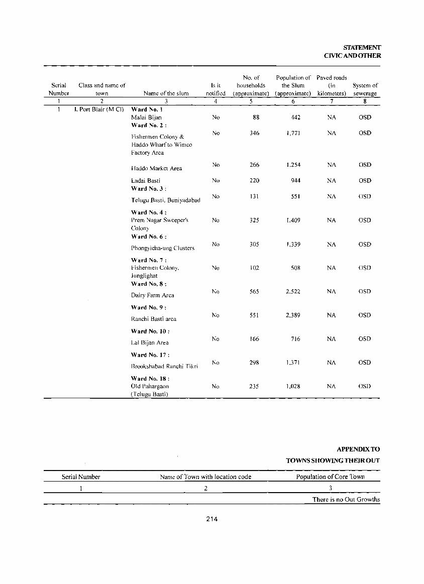
No. of Serial Class and name of Is it households
Number town Name of the slum notified (aEProximate) I 2 3 4 5
I. Port Blair (M CI) Ward No.1 Malai Bijan No 88 Ward No.2:
Fishermen Colony & No 346
Haddo Wharf to Wimco Factory Area
Haddo Market Area No 266
Ladai Basti No 220 Ward No.3:
Telugu Basti, Buniyadabad No 131
Ward No.4: Prem Nagar Sweeper's No 325 Colony
Ward No.6:
Phongyicha-ung Clusters No 305
Ward No.7: Fishermen Colony. No 102 Junglighat
Ward No.8:
Dairy Farm Area No 565
Ward No.9:
Ranchi Basti area No 551
Ward No. 10:
Lal Bijan Area No 166
Ward No. 17:
Brookshabad Ranchi Tikri No 298
Ward No. 18: Old Pahargaon No 235 (Telugu Basti)
Serial Number Name of Town with location code
2
214
SfATEMENf CIVIC AND OTHER
Population of Paved roads the Slum (in System of
(aEproximate) kilometers) sewerage 6 7 8
442 NA OSD
1,771 NA OSD
1,254 NA OSD
944 NA OSD
551 NA OSD
1.409 NA OSD
1,339 NA OSD
508 NA OSD
2.522 NA OSD
2.389 NA OSD
716 NA OSD
1.371 NA OSD
1.028 NA OSD
APPENDIX TO
TOWNS SHOWING THEIR OUT
Population of Core Town
3
There is no Out Growths
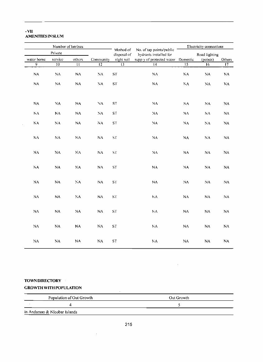
-VII AMENITIES IN SLUM
Number oflatrines Electricity connections Method of No. of tap points/public
Private disposal of hydrants installed for Road lighting water borne service others Community night soil supply of protected water Domestic (Eoints) Others
9 10 11 12 13 14 15 16 17
NA NA NA NA ST NA NA NA NA
NA NA NA NA ST NA NA NA NA
NA NA NA NA ST NA NA NA NA
NA NA NA NA ST NA NA NA NA
NA NA NA NA ST NA NA NA NA
NA NA NA NA ST NA NA NA NA
NA NA NA NA ST NA NA NA NA
NA NA NA NA ST NA NA NA NA
NA NA NA NA ST NA NA NA NA
NA NA NA NA ST NA NA NA NA
NA NA NA NA ST NA NA NA NA
NA NA NA NA ST NA NA NA NA
NA NA NA NA ST NA NA NA NA
TOWNDIRECfORY
GROWfH WITH POPULATION
Population of Out Growth OutGrowth
4 5
in Andaman & Nicobar Islands
215

Part: B Primary Census Abstract

Brief note on Primary Census Abstract
The first census of the third millennium and twenty first century the Census of India, 200 I was the
14th continuous and uninterrupted Indian census since 1872. Thus, 2001 Census will provide data on population and its characteristics marking transition from one century and millennium to another.
The gigantic operation of Population Enumeration (considered by many to be the single largest and
_ complex peace time administrative exercise in the world) was made possible due to the door to door universal canvassing of the Household Schedule by about 2 million enumerators and supervisors covering 593 districts, 5,463 sub-districts, 5,161 towns and 638,588 villages. The comprehensive Household Schedule which replaced the individual slip had three parts and two sides A and B. Part I contained the Location Particulars; Part II related to the Individual Particulars and Part III contained questions for Household engaged in Cultivation/Plantation. The part II of the Household Schedule had 39 columns and 23 questions all of which were universally canvassed and no sampling was resorted to during enumeration.
Data Processing
A quantum leap was made in the technology front while processing the Census 200 I data both for Houselisting and Population Enumeration. The Census schedules for both the phases were scanned through high speed scanners in fifteen data centers across the country and hand-written data from the schedules were converted into digitized form through Intelligent Character Reading (ICR) software for creation of ASCII records for further processing. The designing and formatting of the Household Schedule had to be done very carefully using specialized software so as to ensure uniformity, which was an essential prerequisite for scanning. The selection of appropriate state-of-art technology in data processing has made it possible to produce all the Houselisting as well as Population Enumeration tables on full count basis for the first time in the history of Census. For Census 2001, about 202 million schedules consisting of about
219
J ,028 million records were scanned and processed within a span of only 10 months starting October, 2002.
Task Force on Quality Assurance
After the data is processed, it is expedient on the part of the data producing agency to satisfy itself about its quality before putting the same in public domain. This has to be done mainly through the process of internal consistency, comparison with similar data in the past and also through validation with likewise data if available, from external sources. Quite often the local knowledge and perception has to be brought into play to understand both the existing and the new emerging trends of population distribution and characteristics. The other very important aspect of the data quality is to ensure complete coverage of all geographical areas especially for the population enumeration phase where the data is disseminated right up to the village level in the rural areas and the ward level in the urban areas. Thus ensuring the complete coverage and correct geographical linkage of each enumeration block was one of the major planks of the quality control, specially for small area population statistics.
A very comprehensive check and edit mechanism was put in place to objectively examine the preliminary Census 2001 Population Enumeration results and finally clear them for use. The responsibility of the final clearance of data was with the Task Force on Quality Assurance (TFQA), headed by the Registrar General and Census Commissioner, India. The other members of the TFQA were the Heads and senior officers of the Census Division, Data Processing Division, Map Division, Demography Division and Social Studies Division. The Directors of Census Operations were co-opted as members whenever the TFQA discussed the data for their StateslUnion territories. The Directors and their senior officers were required to make detailed presentations of data for their own state both in respect to the quality and the coverage and only after the full possible
cleared.
There has been a major departure in Census 200 I from the past in respect of the procedure followed for finalization of the Scheduled Castes and the Scheduled Tribes population. In the earlier censuses, the total Scheduled Castes and Scheduled Tribes populations were finalized at the time of the manual compilation of the Primary Census Abstracts (PCA) at the Regional Tabulation Offices which were specially set up for this purpose. The individual Scheduled Castes and the Scheduled Tribes population for each state was finalized much later based on manual coding done by the coders. In 200 I Census, each individual Scheduled Caste and the Scheduled Tribe have been coded directly on the computers by the Data Entry Operators through a process known as Computer Assisted Coding (CAC) and taken up along with the processing of PCA data. The CAC process involves pulling down, fr,om the relevant dictionary of the Scheduled Castes and the Scheduled Tribes, on the computer screen and coding from the dictionary by referring to the image of the specific individual entry in the Household Schedule appearing on the screen. The CAC of the response on Religion wherever required, was also undertaken along with the processing ofPCA. This is because the Scheduled Castes status had to be determined in relation to the religion of the individual. Two Special Task Forces, one on Religion and the other on Scheduled Castes/ Scheduled Tribes were constituted for scrutiny and appropriate classification of these responses.
The main task of the Special Task Force on Religion was to appropriately merge or group the new responses encountered and code it into the appropriate religious community based on available literature and local knowledge. The Special Task Force on Scheduled Castes and Scheduled Tribes examined the different Scheduled Castes and Scheduled Tribes entries encoun-tered and classified these into appropriate category of the Scheduled Castes or the Scheduled Tribes principally based on the Presidential Notification and the available literature. Thus a very systematic and scientific mechanism was operationalised to firm up the individual relIgion and the individual Scheduled Castes/Tribes returns. The Scheduled Castes and the Scheduled Tribes population in 200 I Census, is thus being finalized by aggregating the population data for individual Scheduled Castes and the Scheduled Tribes
220
at appropriate geographical levels.
The entire work relating to the data validation and scrutiny was completed by all the States/Union Territories under the overall supervision and monitoring of the Census Division of the Office of the Registrar General, India with active cooperation and support of the Social Studies Division, Data Processing Division, Data Dissemination Division and Map Division.
Primary Census Abstract
The Primary Census Abstract which is yet another important publication 2001 Census gives basic information on Area, Total Households, Total population, Scheduled Castes, Scheduled Tribes population, Population in the age group 0-6, Literates, Main workers and Marginal workers classified by the four broad industrial categories, namely, (i) Cultivators, (ii) Agricultural laborers, (iii) Household Industry Workers, and (iv) Other workers and also Non-workers. The characteristics of the Total Population includes Scheduled Castes, Scheduled Tribes, Institu-tional and Houseless population and are presented by sex and rural-urban residence. This data is presented at different levels, namely, India, States/Union territories, Districts and Cities, Urban Agglomerations (Population 1,00,000 and above) in three different tables. In addition, the Appendix of said publication table provides Houseless and Institutional Households and their population by residence and sex for 200 1 for India, State and Union territory.
Apart from the India and State/Union Territory volumes for Primary Census Abstract, the District Census Handbook contains District Primary Census Abstract, Appendix to District Primary Census Abstract, Primary Census Abstract for Scheduled Castes, Primary Census Abstract for Scheduled Tribes, Village Primary Census Abstract and Urban Primary Census Abstract of the concerned district in the state.
It was for the first time at the 1981 Census that the Primary Census Abstract (PCA) was brought out for the Scheduled Castes and the Scheduled Tribes separately on the pattern of General Primary Census Abstract. This practice was continued in 1991 also. In the 1961 and 1971 Censuses, such data were made available in Table C-VIII-Social and Cultural table and to some extent in the series 'Special Tables for
Scheduled Castes/Scheduled Tribes'.
The format of Primary Census Abstract has been restructured slightly in the 2001 Census as compared to that of 1991 Census. The nine-fold industrial classification of main workers given in the Primary Census Abstract of 1991 Census has been discontinued and its place, four-fold industrial classification of both 'main workers' and 'marginal workers' are included. In 1981 census only main workers were presented in to four categories. One of the novel features of the primary
Name of the Primary Census Abstract
1. District Primary Census Abstract
census abstract of 1991 census was the presentation of data of the population of age group 0-6 is continued in 2001 Census also. This will help the data users in better analysis and understanding of this literacy data.
Level of presentation in District Census Handbooks :
The Primary Census Abstract data in different PCAs are presented at different levels. The level of presentation of Primary Census Abstracts are as under:
Level of presentation
2. Primary Census Abstract for Scheduled Castes
District/CD BlocklUA/City/Town
District/CD Block/Town
District/CD Block/Town 3. Primary Census Abstract for Scheduled Tribes
4, Village Primary Census Abstract
5. Urban Primary Census Abstract
The PCA Data for villages was presented CD Block wise for the first time in 1991 Census. This practice is continued in 2001 Census also. The data for each CD Block is presented both for rural and urban areas separately. All the villages within the CD Block constitute the rural portion and the Census Towns and Outgrowths are shown under the urban portion of the CD Block. In case a CD Block is spread over two or more districts, than portion which falls within the district is presented, the data pertaining to remaining portion of the CD Block is presented in the concerned District Census Handbook. The data in the Urban Primary Census Abstract for each town as well as for town with outgrowths in the district are presented. The data for all the wards and the outgrowths of the town( s) are also presented separately below the concerned town(s).
The District Primary Census Abstract is presented in 59 columns. The Primary Census Abstract for Scheduled Castes and Primary Census Abstract for Scheduled Tribes are presented in 52 columns. The Village Primary Census Abstract and Urban Primary Census Abstract are presented in 58 columns.
The concepts and definitions used in the column heading are explained under the sub heading 'Census Concepts' in the Analytical Note. The term 'Total Population' includes the Scheduled Castes, the Scheduled Tribes, the Institutional and the Houseless populations. The explanation regarding area figures
221
CD Block/Village wise
Town/Ward level
presented at various level in the Primary Census Abstracts are as follows:
Area Figures
The area figures supplied by local revenue authorities of the district in respect of tehsils, Police Stations and by the local bodies in respect of towns are given in square ki lometers. The area figures of the villages supplied by the Tahsildars in acres have been converted and shown in hectares. The area figures of the CD Block is the total of the village areas coming under each CD Block. The area figures for the district are the same as adopted by the Surveyor General of India to maintain uniformity at the national level. The total area figures of all the tahsils/CD Blocks within the district may not tally with area figures of the district because former represents land use area only. Similarly, the total of all the villages may not tally with the entire rural of Police Station/ Tahsil. The difference may be due to the fact that while the area covered by hills, forests and rivers etc, have been accounted in the Tahsils and P.S. level the same may not be covered under the area of the villages. Apart from this it may also differ due to varying methods of computation adopted at different levels.
An appendix to District Primary Census Abstract has also been furnished showing urban enumeration block-wise particulars on Total Population, the Scheduled Castes Population and the Scheduled Tribes Population for each town.
DISTRICT CENSUS HANDBOOK . ANDAMAN & NICOBAR ISLANDS
DISTRICT PRIMARY
Location Total/ Area in Total population (including
Population in the District! CD Block! Number of institutional and houseless
code Town
Rural! square households population)
age-group 0-6
number Urban kilometre
Persons Males Females Persons Males Females
2 3 4 5 6 7 8 9 10· 11 /
01 Andamans '- Total 6408.00 70,167 314,084 170,319 143,765 39.M 20,102 19,289 Rural 6381.66 43,791 197,886 106,308 91,578 26,053 13,213 12,840 Urban 26.34 26,376 116,198./ 64,011 52,187 13,338/ 6,889 6,449
0001 North Andaman Total 1682.70 9,576 42,895 22,635 20,260 6,633 3,390 3,243 Rural 1682.70 9,576 42,895 22,635 20,160 6,633 3,390 3,243 Urban
0002 Middle Andaman Total 1677.80 12,836 56,584 30,149 26,435 7,264 3,651 3,613 Rural 1677.80 12,836 56,584 30,149 26,435 7,264 3,651 3,613 Urban
0003 South Andaman Total 3047.50 25,039 114,621 62,162 52,459 14,130 7,168 6,962 Rural 3021.16 21,379 98,407 53,524 44,883 12,156 6,172 5,984 Urban 26.34 3,660 16,214 8,638 7,576 1,974 996 978
40101000 Bambootlat (CT) Urban 3.57 1,435 6,787 3,622 3,165 800 419 381 40103000 Garacharma (CT) Urban 5.86 2,225 9,427 5,016 4,411 1,174 577 597
URBAN 40101000 Bambootlat (CT) Urban 3.57 1,435 6,787 3,622 3,165 800 419 381 40102000 Port Blair (M Cn Urban 16.91 22,716 99,984 55,373 44,611 11,364 5,893 5,471 40103000 Garacharma (CT) Urban 5.86 2,225 9,427 5,016 4,411 1,174 577 597
02 Nicobars Total 1841.00 8,075 42,068 22,653 19,415 5,390 2,783 2,607 Rural 1841.00 8,075 42,068 22,653 19,415 5,390 2,783 2,607 Urban
0001 Car Nicobar Total 129.00 3,296 20,292 10,663 9,629 2,294 1.186 1,108 Rural 129.00 3,296 20,292 10,663 9,629 2,294 1,186 1,108 Urban
0002 Nancowry Total 1712.00 4,779 21,776 11,990 9,786 3,096 1,597 1,499 Rural 1712.00 4,779 21,776 11,990 9,786 3,096 1,597 1,499 Urban
222
DISTRICT PRIMARY CENSUS ABSTRACT
CENSUS ABSTRACT
Scheduled Castes population Scheduled Tribes papulation Literates Totall District! CD Block!
Rurall Town
Urban
Persons Males Females Persons Males Females Persons Males Females
12 13 14 15 16 17 18 19 20 3 2
2,904 1,625 1,279 226,600 131,223 95,377 Total Andamans 1,891 1,061 830 137,553 79,441 58,112 Rural 1,013 564 449 89,04Y 51,782 37,265 tirban
23 20 3 27,42 15,818 11,602 Total North Andaman 23 20 3 27,420 15,818 11,602 Rural
Urban 220 116 104 39,836 22,726 17,110 Total Middle Andaman 220 116 104 39,836 22,726 17,110 Rural
Urban 1,683 936 747 82,271 47,696 34,575 Total South Andaman 1,648 925 723 70,297 40,897 29,400 Rural
35 II 24 11,974 6,799 5,175 Urban 6 4 2 4,870 2,759 2,111 Urban Bambootlat (eT)
29 7 22 7,104 4,040 3,064 Urban Garacharma (CT) URBAN
6 4 2 4,870 2,759 2,111 Urban Bambootlat (CT) 978 553 425 77,073 44,983 32.090 Urban Port Blair (M CI)
29 7 22 7,104 4,040 3,064 Urban Garacharma (CTl
26,565 13,502 13,063 26,535 15,608 10,927 Total Nicobars 26,565 13,502 J3,063 26,535 15,608 IO,927 Rural
tlrban 15,899 7,914 7.985 13,343 7,572 5.771 Total Car Nicobar 15,899 7,914 7,985 13,343 7,572 5,771 Rural
Urban 10,666 5.588 5,078 13.192 8,036 5,156 Total Nancowry 10,666 5,588 5,078 13,192 8,036 5,156 Rural
Urban
223
DISTRICT CENSUS HANDBOOK: AN DAMAN & NICOBAR ISLANDS
DISTRICT PRIMARY
Location District! CD
Total! code Rural! III iterates Total workers Main workers
number Block/Town
Urban
Persons Males Females Persons Males Females Persons Males Females
2 3 21 22 23 24 25 26 27 28 29
01 Andamans Total 87,484 39,096 48,388 116,631 95,361 21,270 100,683 86,327 14,356 Rural 60,33~ 26,867 33,466 74,429 59,549 14,880 60,530 52,164 8,366 Urban 27,15 12,229 14,922 42,202 35,812 6,390 40,153 34,163 5,990
0001 North Andaman Total 15,4 75 6,817 8,658 16,965 12,838 4,127 13,734 11,658 2,076 Rural 15,475 6,817 8,658 16,965 12,838 4,127 13,734 11,658 2,076 Urban
0002 Middle Andaman Total 16,748 7,423 9,325 21,065 16,506 4,559 16,211 13,943 2,268 Rural 16,748 7,423 9,325 21,065 16,506 4,559 16,211 13,943 2,268 Urban
0003 South Andaman Total 32,350 14,466 17,884 41,860 34,758 7,102 35,353 30,543 4,810 Rural 28,110 12,627 15,483 36,399 30,205 6,194 30,585 26,563 4,022 Urban 4,240 1,839 2,401 5,461 4,553 908 4,768 3,980 788
40101000 Bambootlat (Cn Urban 1,917 863 1,054 2,095 1,805 290 1,787 1,538 249 40103000 Garacharrna (CT) Urban 2,323 976 1,347 3,366 2,748 618 2,981 2,442 539
URBAN 40101000 Bambootlat (Cn Urban 1,917 863 1,054 2,095 1,805 290 1,787 1,538 249 40102000 Port Blair (M CI) Urban 22,911 10,390 12,521 36,741 31,259 5,482 35,385 30,183 5,202 40103000 Garacharrna (CT) Urban 2,323 976 1,347 3,366 2,748 618 2,981 2,442 539
02 Nicobars Total 15,533 7,045 8,488 19,623 13,801 5,822 12,924 11,022 1,902 Rural 15,533 7,045 8,488 19,623 13,801 5,822 12,924 11,022 1,902 Urban
0001 Car Nicobar Total 6,949 3,091 3,858 10,652 6,758 3,894 5,992 4,880 1,112 Rural 6,949 3,091 3,858 10,652 6,758 3,894 5,992 4,880 1,112 Urban
0002 Nancowry Total 8,584 3,954 4,630 8,971 7,043 1,928 6,932 6,142 790 Rural 8,584 3,954 4,630 8,971 7,043 1,928 6,932 6,142 790 Urban
224
DISTRICT PRIMARY CENSUS ABSTRACT
CENSUS ABSTRACT
Industrial catego!2: of main workers
Household industry Total! District! CD Cultivators Agricultural labourers Other workers
workers Rural/ Block! Town
Urban
Persons Males Females Persons Males Females Persons Males Females Persons Males Females
30 31 32 33 34 35 36 37 38 39 40 41 3 2
15,341 12,777 2,564 2,588 2,385 203 766 606 160 81,988 70,559 II,429 Total Andamans 15,305 12,747 2,558 2,482 2,290 192 421 341 80 42,322 36,786 5,536 Rural
36 30 6 106 95 II 345 265 80 39,666 33,773 5,893 Urban 6,700 5,607 1,093 516 471 45 63 50 13 6,455 5,530 925 Total North Andaman 6,700 5,607 1,093 516 471 45 63 50 13 6,455 5,530 925 Rural
Urban 4,037 3,460 577 527 501 26 122 104 18 11,525 9,878 1,647 Total Middle Andaman 4,037 3.460 577 527 501 26 122 104 18 11,525 9,878 1,647 Rural
Urban 4,573 3,685 888 1,456 1,329 127 311 249 62 29,013 25,280 3,733 Total South Andaman 4,568 3,680 888 1,439 1,318 121 236 187 49 24,342 21,378 2,964 Rural
5 5 17 II 6 75 62 13 4,671 3,902 769 Urban 2 2 16 10 6 39 33 6 1,730 1,493 237 Urban Bambooflat (CT) 3 3 I I 36 29 7 2,941 2,409 532 Urban Garacharma (CT)
URBAN 2 2 16 10 6 39 33 6 1,730 1,493 237 Urban Bambooflat (CT)
31 25 6 89 84 270 203 67 34,995 29,871 5,124 Urban Port Blair (M CI) 3 3 I 36 29 7 2,941 2,409 532 Urban Garacharma (CT)
164 128 36 9S 8S 10 4,026 3,360 666 8,639 7,449 1,190 Total Nicobars 164 128 36 9S 85 10 4,026 3,360 666 8,639 7,449 1,190 Rural
Urban 24 15 9 9 6 3 2,288 1.781 507 3,671 3,078 593 Total Car Nicobar 24 15 9 9 6 3 2.288 1,781 507 3,671 3,078 593 Rural
Urban 140 113 27 86 79 7 1,738 1,579 159 4,968 4,371 597 Total Nancowry 140 113 27 86 79 7 1,738 1,579 159 4,968 4,371 597 Rural
Urban
225
ISTRICT CENSUS HANDBOOK: ANDAMAN & NICOBAR ISLANDS
DISTRICT PRIMARY
Industrial categ0!2:
Location District! CD
Total/
code Rural/ Marginal workers Cultivators Agricultural labourers
number BIDck! Town
Urban
Persons Males Females Persons Males Females Persons Males Female~
2 3 42 43 44 45 46 47 48 49 50
01 Andamans Total 15.948 9.034 6.914 5.849 1.976 3.873 2.452 1,554 898 Rural 13,899 7.385 6,514 5.843 1.972 3.871 2,415 1.524 891 Urban 2,049 1,649 400 6 4 2 37 30 7
0001 North Andaman Total 3.231 1,180 2,051 2,019 425 1.594 370 219 lSI Rural 3,231 1,180 2,051 2,019 425 1.594 370 219 151 Urban
0002 Middle Andaman Total 4,854 2,563 2,291 2,274 880 1.394 594 424 170 Rural 4,854 2,563 2,291 2,274 880 1,394 594 424 170 Urban
0003 South Andaman Total 6,507 4,215 2,292 1,555 670 885 1,478 903 575 Rural 5,814 3,642 2.172 1.550 667 883 1.451 881 570 Urban 693 573 120 5 3 2 27 22 5
40101000 Bambootlat (eT) Urban 308 267 41 :, 2 11 9 2 40103000 Garacharma (CT) Urban 385 306 79 2 16 13 3
URBAN 40101000 Bambooflat (CT) Urban 308 267 41 3 2 II 9 2 40102000 Port Blair (M Cil Urban 1,356 1,076 230 I 10 8 2 40103000 Garacharma (CT) Urban 385 306 79 2 16 13 3
02 Nicobars Total 6,699 2,779 3,920 107 56 51 34 19 15 Rural 6.699 2.779 3.920 107 56 51 34 19 15 Urban
0001 Car Nicobar Total 4.660 1.878 2.782 29 7 22 6 2 4 Rural 4,660 1.878 2.782 29 7 22 6 2 4 Urban
0002 Nancowry Total 2,039 901 1,138 78 49 29 28 17 II Rural 2,039 901 1,138 78 49 29 28 17 II Urban
226
DISTRICT PRIMARY CENSUS ABSTRACT
CENSUS ABSTRACT
of marginal workers
Household industry Totall District/ CD
Location Other workers Non-workers code workers Rurall
Block/Town Urban number
Persons Males Females Persons Males Females Persons Males Females
51 52 53 54 55 56 57 58 59 3 2
235 101 134 7,412 5,403 2,009 197,453 74,958 122,495 Total Andamans 01 152 50 102 5,489 3,839 1,650 123,457 46,759 76,698 Rural 83 51 32 1,923 1,564 359 73,996 28,199 45,797 lJrban 35 II 24 807 525 282 25.930 9.797 16.133 Total North Andaman 0001 35 II 24 807 525 282 25.930 9.797 16,133 Rural
Urban 45 14 31 1,941 1,245 696 35.519 13.643 21.876 Total Middle Andaman 0002 45 14 31 1.941 1,245 696 35.519 13.643 21.876 Rural
Urban 127 59 68 3,347 2,583 764 72,761 27,404 45,357 Total South Andaman 0003 72 25 47 2,741 2,069 672 62,008 23,319 38,689 Rural 55 34 21 606 514 92 10,753 4,085 6,668 Urban 17 10 7 277 246 31 4,692 1,817 2,875 Urban Bambooflat (CT) 40101000 38 24 14 329 268 61 6,061 2,268 3,793 Urban Garacharma (eT) 40103000
URBAN 17 10 7 277 246 31 4,692 1,817 2,875 Urban Bambooflat (CT) 40101000 28 17 II 1,317 1,050 267 63,243 24,114 39,129 Urban Port Blair (M el) 40102000 38 24 14 329 268 61 6,061 2,268 3.793 Urban Garacharma (eT) 40103000
2,059 588 1,471 4,499 2,116 2,383 22,445 8,852 13,593 Total Nicobars 02 2,059 588 1,471 4,499 2,116 2,383 22,445 8,852 13,593 Rural
llrban 1,278 351 927 3,347 1,518 1.829 9,640 3,905 5,735 Total Car Nicobar 0001 1,278 351 927 3,347 1,518 1.829 9,640 3,905 5.735 Rural
Urban 781 237 544 1,152 598 554 12,805 4,947 7.858 Total Nancowry 0002 781 237 544 1,152 598 554 12,805 4,947 7.858 Rural
Urban
227
DIS I RIC I CENSUS HAI\lUBOvK. ANOM'VR'''' ex '''''\JOUMn hJLI""ij"hJV
APPENDIX TO DISTRICT PRIMARY CENSUS ABSTRACT TOTAL, SCHEDULED CA STES AND SCHEDULED TRIBES POPULATION - URBAN BLOCK WISE
Boundaries of Total Schedule Schedule Location Name of urban block / population Castes Tribes
Code Name of Town Ward EBnumber population population population I 2 3 4 5 6 7
01 Andamans District 40101000 Bambooflat (CT) Ward No. I EB No. I 418 40101000 Bambooflat (CT) Ward No. I EB No.2 395 40101000 Bambooflat (CT) Ward No. I EB No.3 362 40101000 Bambooflat (CT) Ward No. I EB No.4 245 40101000 Bambooflat (CT) Ward No. I EB No.5 320 40101000 Bambooflat (CT) Ward No. I EB No.6 306 40101000 Bambooflat (CT) Ward No.1 EB No.7 503 40101000 Bambooflat (CT) Ward No. I EB No.8 641
40101000 Bambooflat (CT) Ward No. I EB No.9 562 40101000 Bambooflat (CT) Ward No. I EB No. 10 362 40101000 Bambooflat (CT) Ward No.1 EB No. 11 524 3 40101000 Bambooflat (CT) Ward No. I EB No. 12 353
40101000 Bambooflat (CT) Ward No. I EB No. 13 608 2 40101000 Bambooflat (CT) Ward No.1 EB No. 14 619
40101000 Bambooflat (CT) Ward No. I EB No. 15 569
40102000 Port Blair (M CI) Ward No.1 EBNo. I 557 3 40102000 Port Blair (M CI) Ward No.1 EB No.2 625
40102000 Port Blair (M CI) Ward No. I EB No.3 634 9
40102000 Port Blair (M CI) Ward No. I EB No.4 363 13 40102000 Port Blair (M CI) Ward No. I EB No.5 442
40102000 Port Blair (M CI) Ward No. I EB No.6 429 5
40102000 Port Blair (M CI) Ward No.1 EB No.7 475
40102000 Port Blair (M CI) Ward No.1 EB No.8 640 13
40102000 Port Blair (M CI) Ward No. I EB No.9 446 4
40102000 Port Blair (M CI) Ward No. I EB No. 10 635
40102000 Port Blair (M CI) Ward No.1 EB No. 411 125
40102000 Port Blair (M CI) Ward No.2 EB No. 11 802
40102000 Port Blair (M CI) Ward No.2 EB No. 12 555
40102000 Port Blair (M CI) Ward No.2 EB No. 13 414
40102000 Port Blair (M CI) Ward No.2 EB No. 14 705
40102000 Port Blair (M CI) Ward No.2 EB No. 15 488
40102000 Port Blair (M CI) Ward No.2 EB No. 16 361
40102000 Port Blair (M CI) Ward No.2 EB No. 17 551
40102000 Port Blair (M CI) Ward No.2 EB No. 18 342
40102000 Port Blair (M CI) Ward No.2 EB No. 19 456
40102000 Port Blair (M CI) Ward No.2 EB No. 20 674
40102000 Port Blair (M CI) Ward No.2 EB No. 21 556
40102000 Port Blair (M CI) Ward No.2 EB No. 22 566
40102000 Port Blair (M CI) Ward No.2 EB No. 23 633
228
APPENDIX TO DISTRICT PRIMARY CENSUS ABSTRACT TOTAL, SCHEDULED CASTESANDSCHEDULED TRIBES POPULATION - URBAN BLOCK WISE
Boundaries of Total Schedule Schedule Location Name of urban block / population Castes Tribes
Code Name of Town Ward EB number population population population
1 2 3 4 5 6 7
40102000 Port Blair (M CI) Ward No.2 EB No. 410 399 40102000 Port Blair (M CI) Ward No.2 EB No. 501 359 40102000 Port Blair (M CI) Ward No.2 EB No. 502 223 40102000 Port Blair (M CI) Ward No.2 E8 No. 503 173 40102000 Port Blair (M CI) Ward No.3 E8 No. 24 471 40102000 Port Blair (M CI) Ward No.3 E8 No. 25 590 8 40102000 Port Blair (M CI) Ward No.3 EB No. 26 551 40102000 Port Blair (M CI) Ward No.3 EB No. 27 632 40102000 Port Blair (M CI) Ward No.3 EB No. 28 558 40102000 Port Blair (M CI) Ward No.3 EB No. 29 379 40102000 Port 81air (M CI) Ward No.3 EB No. 30 499 40102000 Port Blair (M CI) Ward No.3 E8 No. 31 477 40102000 Port Blair (M CI) Ward No.3 EB No. 169 219 17 40102000 Port Blair (M CI) Ward No.3 EB No. 403 184 40102000 Port Blair (M CI) Ward No.3 EB No. 404 302 40102000 Port Blair (M CI) Ward No.3 EB No. 405 186 40102000 Port Blair (M CI) Ward No.3 EB No. 406 420 40102000 Port Blair (M CI) Ward No.3 EB No. 407 100 40102000 Port Blair (M CI) Ward No.3 EB No. 408 183 40102000 Port Blair (M CI) Ward No.3 EB No. 409 220 40102000 Port Blair (M CI) Ward No.3 EB No. 412 444 40102000 Port Blair (M CI) Ward No.4 EB No. 32 402 40102000 Port Blair (M CI) Ward No.4 EB No. 33 494 40102000 Port Blair (M CI) Ward No.4 EB No. 34 474 38 40102000 Port Blair (M CI) Ward No.4 EB No. 35 439 4 40102000 Port Blair (M CI) Ward No.4 EB No. 36 752 40102000 Port Blair eM CI) Ward No.4 EB No. 37 657 40102000 Port Blair eM CI) Ward No.4 EB No. 38 636 40102000 Port Blair (M CI) Ward No.4 EB No. 39 438 40102000 Port Blair (M CI) Ward No.4 EB No. 40 674 40102000 Port Blair (M CI) Ward No.4 EB No. 41 639 40102000 Port Blair (M CI) Ward No.4 EB No. 42 710 3 40102000 Port Blair (M CI) Ward No.4 EB No. 43 292 40102000 Port Blair (M CI) Ward No.4 EB No. 44 528 36 40102000 Port Blair (M CI) Ward No.5 EB No. 45 559 8 40102000 Port Blair (M CI) Ward No.5 EB No. 46 329 5 40102000 Port Blair (M CI) Ward No.5 EB No. 47 536 40102000 Port Blair (M CI) Ward No.5 EB No. 48 760 4 40102000 Port Blair (M CI) Ward No.5 EB No. 49 292 15 40102000 Port Blair (M CI) Ward No.5 EB No. 50 419
229
APPENDIX TO DISTRICT PRIMARY CENSUS ABSTRACT TOTAL, SCHEDULED CASTES AND SCHEDULED TRIBES POPULATION - URBAN BLOCK WISE
Boundaries of Total Schedule Schedule Location Name of urban block / population Castes Tribes
Code Name of Town Ward EB number population population population I 2 3 4 5 6 7
40102000 Port Blair (M CI) Ward No.5 EB No. 51 585 40102000 Port Blair (M CI) Ward No.5 EB No. 52 645 4 40102000 Port Blair (M CI) Ward No.5 EB No. 53 525 40102000 Port Blair (M Cl) Ward No.5 EB No. 802 12 40102000 Port Blair (M CI) Ward No.6 EB No. 54 522 40102000 Port Blair (M CI) Ward No.6 EB No. 55 613 40102000 Port Blair (M CI) Ward No.6 EB No. 56 301 15 40102000 Port Blair (M CI) Ward No.6 EB No. 57 522 40102000 Port Blair (M CI) Ward No.6 EB No. 58 646 40102000 Port Blair (M CI) Ward No.6 EB No. 59 693 40102000 Port Blair (M CI) Ward No.6 EB No. 60 528 5 40102000 Port Blair (M CI) Ward No.6 EB No. 61 646 7 40102000 Port Blair (M Cl) Ward No.7 EB No. 62 700 40102000 Port Blair (M CI) Ward No.7 EB No. 63 557
40102000 Port Blair (M CI) Ward No.7 EB No. 64 313 12 40102000 Port Blair (M CI) Ward NO.7 EB No. 65 642
40102000 Port Blair (M CI) Ward No.7 EB No. 66 558 2
40102000 Port Blair (M CI) Ward No.7 EB No. 67 587
40102000 Port Blair (M CI) Ward No.7 EB No. 68 508 40102000 Port Blair (M CI) Ward No.7 EB No. 69 618 38 40102000 Port Blair (M CI) Ward No.7 EB No. 70 496 40102000 Port Blair (M CI) Ward No.7 EB No. 401 473
40102000 Port Blair (M CI) Ward No.7 EB No. 402 553
40102000 Port Blair (M CI) Ward No.8 EB No. 71 545 4
40102000 Port Blair (M CI) Ward NO.8 EB No. 72 553
40102000 Port Blair (M Cl) Ward No.8 EB No. 73 411
40102000 Port Blair (M CI) Ward No.8 EB No. 74 436
40102000 Port Blair (M CI) Ward No.8 EB No. 75 577 4
40102000 Port Blair (M CI) Ward No.8 EB No. 76 562
40102000 Port Blair (M CI) Ward No.8 EB No. 77 618
40102000 Port Blair (M CI) Ward NO.8 EB No. 78 473 4
40102000 Port Blair (M CI) Ward No.8 EB No. 79 411
40102000 Port Blair (M CI) Ward No.8 EB No. 80 355 4
40102000 Port Blair (M Cl) Ward No.9 EB No. 81 535
40102000 Port Blair (M CI) Ward No.9 EB No. 82 584
40102000 Port Blair (M Cl) Ward No.9 EB No. 83 329 6
40102000 . Port Blair (M CI) Ward No.9 EB No. 84 449
40102000 Port Blair (M CI) Ward No.9 EB No. 85 572 3
40102000 Port Blair (M Cl) Ward No.9 EB No. 86 690 19
40102000 Port Blair (M Cl) Ward No.9 EB No. 87 643 16
40102000 Port Blair (M CI) Ward No.9 EB No. 88 583
230
APPENDIX TO DISTRICT PRIMARY CENSUS ABSTRACT TOTAL, SCHEDULED CASTES AND SCHEDULED TRIBES POPULATION - URBAN BLOCK WISE
Boundaries of Total Schedule Schedule Location Name of urban block I population Castes Tribes
Code Name of Town Ward EBnumber population population population 1 2 3 4 5 6 7
40102000 Port Blair (M CI) Ward No.9 EB No. 89 500 40102000 Port Blair (M CI) Ward No.9 EB No. 90 663 40102000 Port Blair (M CI) Ward No. 10 EB No. 91 391 40102000 Port Blair (M CI) Ward No. 10 EB No. 92 325 40102000 Port Blair (M CI) Ward No. 10 EB No. 93 604 40102000 Port Blair (M CI) Ward No. 10 EB No. 94 538 40102000 Port Blair (M CI) Ward No. 10 EB No. 95 674 40102000 Port Blair (M CI) Ward No. 10 EB No. 96 643 40102000 Port Blair (M CI) Ward No. 10 EB No. 97 468 5 40102000 Port Blair (M CI) Ward No. 10 EB No. 98 374 40102000 Port Blair (M CI) Ward No. 10 EB No. 99 459 40102000 Port Blair (M CI) Ward No. 10 EB No. 100 597
40102000 Port Blair (M CI) Ward No. 10 EB No. 301 577 40102000 Port Blair (M CI) Ward No. 10 EB No. 302 480 40102000 Port Blair (M Cl) Ward No. 10 EB No. 303 571 40102000 Port Blair (M CI) Ward No. 10 EB No. 304 493 40102000 Port Blair (M CI) Ward No. 10 EB No. 305 449 40102000 Port Blair (M CI) Ward No. 10 EB No. 306 197 40102000 Port Blair (M CI) Ward No. 10 EB No. 307 413 4 40102000 Port Blair (M CI) Ward No. 10 EB No. 308 363 40102000 Port Blair (M CI) Ward No. 10 EB No. 309 238 40102000 Port Blair (M CI) Ward No. 10 EB No. 310 247 40102000 Port Blair (M CI) Ward No. 10 EB No. 311 179 40102000 Port Blair (M CI) Ward No. 10 EB No. 312 72 40102000 Port Blair (M CI) Ward No. 10 EB No. 313 56 40102000 Port Blair (M CI) Ward No. 10 EB No. 314 9 40102000 Port Blair (M CI) Ward No. II EB No. 101 562 4 40102000 Port Blair (M CI) Ward No. II EB No. 102 619 1 40102000 Port Blair (M CI) Ward No. II EB No. 103 577 24 40102000 Port Blair (M CI) Ward No. II EB No. 104 553 40102000 Port Blair (M CI) Ward No. II EB No. lOS 554 32 40102000 Port Blair (M CI) Ward No. II EB No. 106 306 13 40102000 Port BJair (M CJ) Ward No. 11 EB No. 107 555 109 40102000 Port Blair (M CI) Ward No. II EB No. 108 329 18 40102000 Port Blair (M CI) Ward No. 11 EB No. 109 373 6 40102000 Port Blair (M CI) Ward No. 11 EB No. 110 680 32 40102000 Port Blair (M CI) Ward No. 11 EB No. 801 87 40102000 Port Blair (M CI) Ward No. 12 EBNo.111 600 7 40102000 Port Blair (M CI) Ward No. 12 EBNo.112 442 40102000 Port Blair (M CI) Ward No. 12 EBNo.113 615 10 40102000 Port Blair (M cn Ward No. 12 EB No. 114 659
231
D;SfRrCTCENS6sHAN~§5'O'R° A~tmMAjt;j'&'MCOOAK iStANDS
APPENDIX TO DISTRICT PRIMARY CENSUS ABSTRACT TOTAL, SCHEDULED CASTESAND SCHEDULED TRIBES POPULATION - URBAN BLOCK WISE
Boundaries of Total Schedule Schedule Location Name of urban block / population Castes Tribes
Code Name of Town Ward EB number population population population 1 2 3 4 5 6 7
40102000 Port Blair (M CI) Ward No. 12 EB No. lIS 582 40102000 Port Blair (M CI) Ward No. 12 EB No. 116 614 9 40102000 Port Blair (M CI) Ward No. 12 EB No. 117 577 8 40102000 Port Blair (M CI) Ward No. 12 EB No. 118 587 40102000 Port Blair (M CI) Ward No. 12 EB No. 601 54 40102000 Port Blair (M CI) Ward No. 13 EB No. 119 388 9 40102000 Port Blair (M CI) Ward No. 13 EB No. 120 703 40102000 Port Blair (M CI) Ward No. 13 EB No. 121 628 40102000 Port Blair (M CI) Ward No. 13 EB No. 122 657 40102000 Port Blair (M CI) Ward No. 13 EB No. 123 591 40102000 Port Blair (M CI) Ward No. 13 EB No. 124 663 40102000 Port Blair (M CI) Ward No. 13 EB No. 125 328 40102000 Port Blair (M CI) Ward No. 13 EB No. 126 204
40102000 Port Blair (M Cl) Ward No. 14 EB No. 127 785 30 40102000 Port Blair (M CI) Ward No. 14 EB No. 128 483 40102000 Port Blair (M CI) Ward No. 14 EB No. 129 576 37 40102000 Port Blair (M CI) Ward No. 14 EB No. 130 741 24 40102000 Port Blair (M CI) Ward No. 14 EB No. 131 957 6 40102000 Port Blair (M CI) Ward No. 14 EB No. 132 587 24 40102000 Port Blair (M CI) Ward No. 14 EB No. 133 561 10 40102000 Port Blair (M CI) Ward No. 15 EB No. 134 614 7 40102000 Port Blair (M CI) Ward No. 15 EB No. 135 660 11 40102000 Port Blair (M CI) Ward No. 15 EB No. 136 666 3
40102000 Port Blair (M CI) Ward No. 15 EB No. 137 418 3 40102000 Port Blair (M CI) Ward No. 15 EB No. 138 86 15 40102000 Port Blair (M CI) Ward No. 15 BB No. 139 704 4
40102000 Port Blair (M CI) Ward No. 15 BB No. 140 505 23
40102000 Port Blair (M CI) Ward No. 16 BB No. 141 648
40102000 Port Blair (M CI) Ward No. 16 EB No. 142 581 6 40102000 Port Blair (M CI) Ward No. 16 EB No. 143 623 22
40102000 Port Blair (M CI) Ward No. 16 EB No. 144 523 5
40102000 Port Blair (M CI) Ward No. 16 EB No. 145 288 16 40102000 Port Blair (M CI) Ward No. 16 EB No. 146 539 27
40102000 Port Blair (M CI) Ward No. 16 EB No. 147 405
40102000 Port Blair (M CI) Ward No. 16 EB No. 148 486
40102000 Port Blair (M CI) Ward No. 16 EB No. 701 66
40102000 Port Blair (M CI) Ward No. 17 EB No. 149 662
40102000 Port Blair (M CI) Ward No. 17 EB No. 150 662 4
40102000 Port Blair (M Cl) Ward No. 17 EB No. 151 679 22
40102000 Port Blair (M CI) Ward No. 17 EB No. 152 493 9
40102000 Port Blair (M cn Ward No. 17 BB No. 153 751 25
232
APPENDIX TO DISTRICT PRIMARY CENSUS ABSTRACT TOTAL, SCHEDULED CASTES AND SCHEDULED TRIBES POPULA TfON - URBAN BLOCK WISE
Boundaries of Total Schedule Schedule Location Name of urban block / population Castes Tribes
Code Name of Town Ward EBnumber population population population 1 2 3 4 5 6 7
40102000 Port Blair (M CI) Ward No. 17 EB No. 154 433 9
40102000 Port Blair (M CI) Ward No. 17 EB No. 155 318 5 40102000 Port Blair (M CI) Ward No. 17 EB No. 156 541
40102000 Port Blair (M CI) Ward No. 17 EB No. 157 214 40102000 Port Blair (M CI) Ward No. 17 EB No. 158 585 40102000 Port Blair (M CI) Ward No. 17 EB No. 159 786 40102000 Port Blair (M CI) Ward No. 18 EB No. 160 760
40102000 Port Blair (M CI) Ward No. 18 EB No. 161 749 6 40102000 Port Blair (M CI) Ward No. 18 EB No. 162 437 40102000 Port Blair (M CI) Ward No. 18 EB No. 163 333 40102000 Port Blair (M CI) Ward No. 18 EB No. 164 508 4 40102000 Port Blair (M CI) Ward No. 18 EB No. 165 632 40102000 Port Blair (M CI) Ward No. 18 EB No. 166 379 40102000 Port Blair (M CI) Ward No. 18 EB No. 167 690 40102000 Port Blair (M CI) Ward No. 18 EBNo.168 338
40102000 Port Blair (M CI) Ward No. 18 EB No. 170 223
40103000 Garacharma (CT) Ward No. I EB No.1 602
40103000 Garacharma (CT) Ward No. I EB No.2 582
40103000 Garacharma (CT) Ward No.1 EB No.3 404
40103000 Garacharma (CT) Ward No.1 EB No.4 337
40103000 Garacharma (CT) Ward No.1 EB No.5 436
40103000 Garacharma (CT) Ward No.1 EB No.6 745 40103000 Garacharma (CT) Ward No. I EB No.7 392
40103000 Garacharma (CT) Ward No. I EB No.8 822 10
40103000 Garacharma (CT) Ward No.1 EB No.9 801
40103000 Garacharma (CT) Ward No. I EB No. 10 529
40103000 Garacharma (CT) Ward No. I EB No.1 I 742
40103000 Garacharma (CT) Ward No. I EB No. 12 292
40103000 Garacharma (CT) Ward No. I EBNo.13 636 9
40103000 Garacharma (CT) Ward No. I EB No. 14 427 9
40103000 Garacharma (CT) Ward No. I EB No. 15 500
40103000 Garacharma (CT) Ward No.1 EB No. 16 637
40103000 Garacharma (CT) Ward No. I EB No. 17 543
In Nicobars District there is no Urban area
233
STRICT CENSUS HANDBOOK: ANDAMAN & NICOBAR ISLANDS
PRIMARY CENSUS ABSTRACT
Number of
households
with at least Total population (including one institutional and houseless Population in the
Location Total! Scheduled EOEulation) al:le-B;fouE 0-6 code Rural/ Tribe
number District! CD Block! Town Urban member Persons Males Females Persons Males Females
2 3 4 5 6 7 8 9 10
01 Andamans Total 620 2,904 1,625 1,279 374 210 164 Rural 391 1,891 1,06] 830 252 147 105 Urban 229 1,013 564 449 122 63 59
0000 Andamans Total II 35 II 24 6 2 4 Rural 391 1,891 1,061 830 252 147 105 Urban II 35 II 24 6 2 4
0001 North Andaman Total II 23 20 3 Rural II 23 20 3 Urban
0002 Middle Andaman Total 58 220 116 104 36 16 20 Rural 58 220 116 104 36 16 20 Urban
0003 South Andaman Total 322 1,648 925 723 215 131 84 Rural 322 1,648 925 723 215 131 84 Urban
URBAN 40101000 Bambooflat (CT) Urban 3 6 4 2 2 2 40102000 Port Blair (M CI) Urban 218 978 553 425 116 61 55 40103000 Garacharma (CT) Urban 8 29 7 22 4 4
02 Nicobars Total 4,009 26,565 13,502 13,063 3,462 1,751 1,711 Rural 4,009 26,565 13,502 13,063 3,462 1,751 1,711 Urban
0001 Car Nicobar Total 2,213 15,899 7,914 7,985 1,769 888 881 Rural 2,213 15,899 7,914 7,985 1,769 888 881 Urban
0002 Nancowry Total 1.796 10,666 5.588 5,078 1,693 863 830 Rural 1,796 10,666 5,588 5,078 1,693 863 830 Urban
234
PCA FOR SCHEDULED TRIBES
FOR SCHEDULED TRIBES
Literates III iterates Total workers Total!
Rural!
Persons Males Females Persons Males Females Persons Males Females Urban District! CD Block! Town
11 12 13 14 15 16 17 18 19 3 2
1,845 1,106 739 1,059 519 540 888 804 84 Total Andamans l.O10 620 390 881 441 440 544 504 40 Rural
835 486 349 178 78 100 344 300 44 Urban 28 9 19 7 2 5 10 7 3 Total Andamans
1,010 620 390 881 441 440 544 504 40 Rural 28 9 19 7 2 5 10 7 3 Urban 21 20 2 2 18 18 Total North Andaman 21 20 2 2 18 18 Rural
Urban 103 62 41 117 54 63 41 34 7 Total Middle Andaman 103 62 41 117 54 63 41 34 7 Rural
Urban 886 538 348 762 387 375 485 452 33 Total South Andaman 886 538 348 762 387 375 485 452 33 Rural
Urban URBAN
3 2 I 3 2 1 3 2 Urban Bambooflat (CTl 807 477 330 171 76 95 334 293 41 Urban Port Blair (M Cll 25 7 18 4 4 7 5 2 Urban Garacharma (CT)
15,274 8,585 6,689 11,291 4,917 6,374 12,949 8,005 4,944 Total Nicobars 15,274 8,585 6,689 11,291 4,917 6,374 12,949 8,005 4,944 Rural
Urban 9,977 5,400 4,577 5,922 2,514 3,408 8,590 4,876 3,714 Total Car Nicobar 9,977 5,400 4,577 5,922 2,514 3,408 8,590 4,876 3,714 Rural
Urban 5,297 3,185 2,112 5,369 2,403 2,966 4,359 3,129 1,230 Total Nancowry 5,297 3,185 2,112 5,369 2,403 2,966 4,359 3,129 1,230 Rural
Urban
235
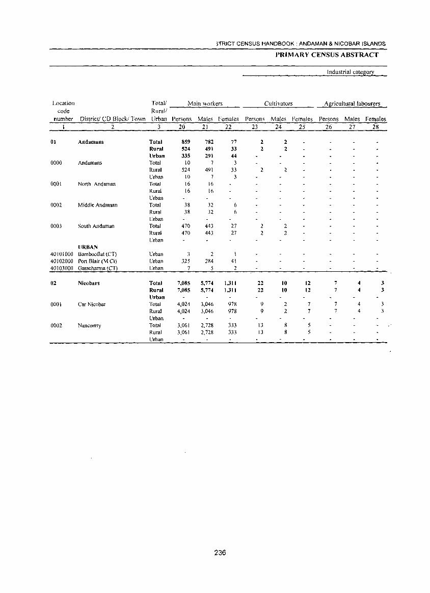
)TRICT CENSUS HANDBOOK: ANDAMAN & NICOBAR ISLANDS
PRIMARY CENSUS ABSTRACT
Industrial category
Location Total! Main workers Cultivators A8ricultural labourers code Rural!
number District! CD Block! Town Urban Persons Males Females Persons Males Females Persons Males Females I 2 3 20 21 22 23 24 25 26 27 28
01 Andamans Total 859 782 77 2 2 Rural 524 491 33 2 2 Urban 335 291 44
0000 Andamans Total 10 7 3 Rural 524 491 33 2 2 Urban 10 7 3
0001 North Andaman Total 16 16 Rural 16 16 Urban
0002 Middle Andaman Total 38 32 6 Rural 38 32 6 Urban
0003 South Andaman Total 470 443 27 2 2 Rural 470 443 27 2 2 Urban
URBAN 40101000 Bambooflat (CT) Urban 3 2 40102000 Port Blair (M Cll Urban 325 284 41 40103000 Garacharma (CT) Urban 7 5 2
02 Nicobars Total 7,085 5,774 1,311 22 10 12 7 4 3 Rural 7,085 5,774 1,311 22 10 12 7 4 3 Urban
0001 Car Nicobar Total 4,024 3,046 978 9 2 7 7 4 3 Rural 4,024 3,046 978 9 2 7 7 4 3 Urban
0002 Nan cowry Total 3,061 2,728 333 13 8 5 Rural 3,061 2,728 333 13 8 5 Urban
236
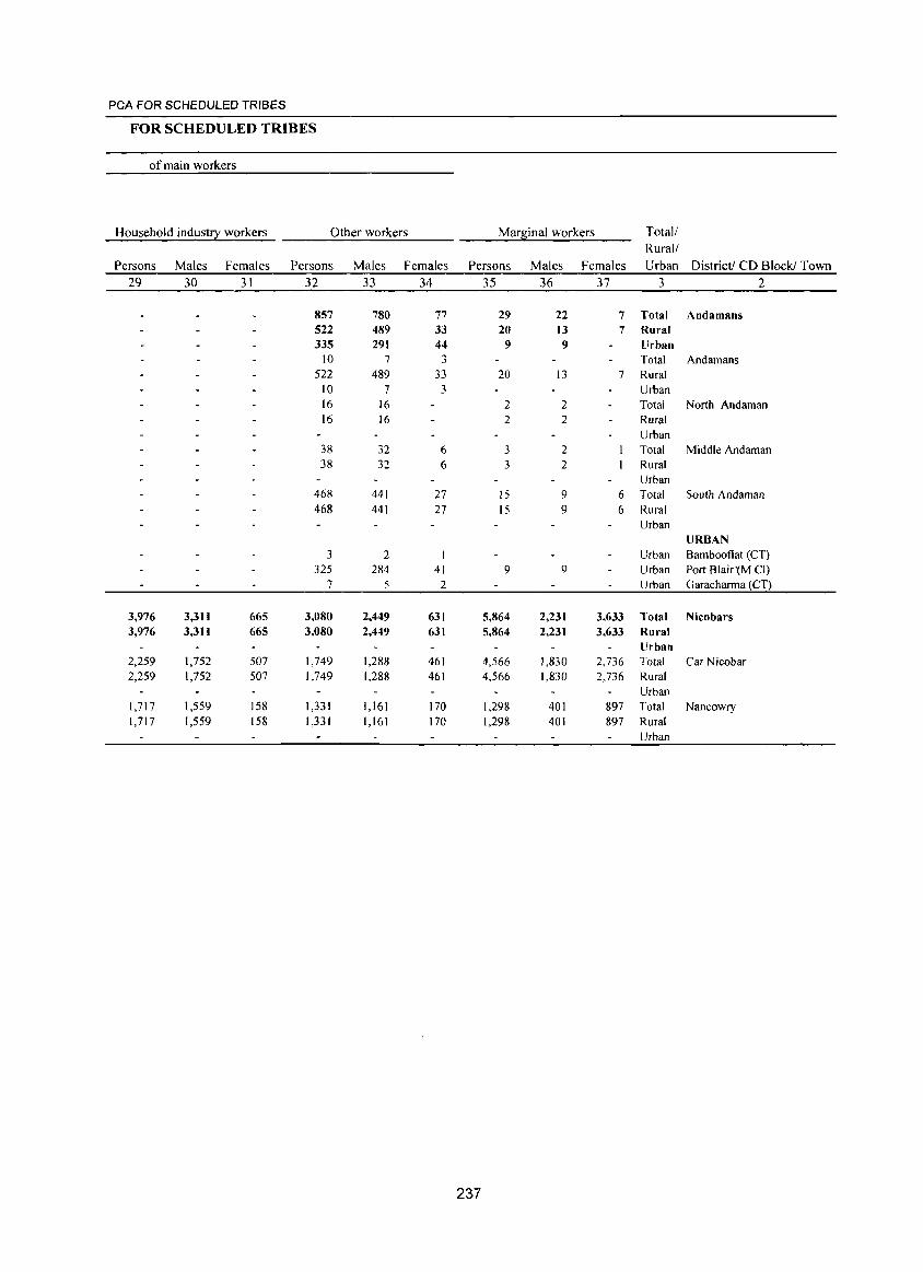
PCA FOR SCHEDULED TRIBES
FOR SCHEDULED TRIBES
of main workers
Household indust!2: workers Other workers Marsinal workers Total!
Rural!
Persons Males Females Persons Males Females Persons Males Females Urban District! CD Block! Town
29 30 31 32 33 34 35 36 37 3 2
857 780 77 29 22 7 Total Andamans 522 489 33 20 13 7 Rural 335 291 44 9 9 Urban
10 7 3 Total Andamans 522 489 33 20 13 7 Rural
10 7 3 Urban 16 16 2 2 Total North Andaman 16 16 2 2 Rural
Urban 38 32 6 3 2 Total Middle Andaman 38 32 6 3 2 Rural
Urban 468 441 27 15 9 6 Total South Andaman 468 441 27 15 9 6 Rural
Urban URBAN
3 2 I Urban Bambooflat (CT) 325 284 41 9 9 Urban Port Blair'(M CI)
7 5 2 Urban Garacharma (CT)
3,976 3,311 665 3,080 2,449 631 5,864 2,231 3,633 Total Nicobars 3,976 3,311 665 3,080 2,449 631 5,864 2,231 3,633 Rural
Urban 2,259 1,752 507 1,749 1,288 461 4,566 1,830 2,736 Total Car Nicobar 2,259 1,752 507 1,749 1,288 461 4,566 1,830 2,736 Rural
Urban 1,717 1,559 158 1,331 1,161 170 1,298 401 897 Total Nancowry 1,717 1,559 158 1,331 1,161 170 1,298 401 897 Rural
Urban
237
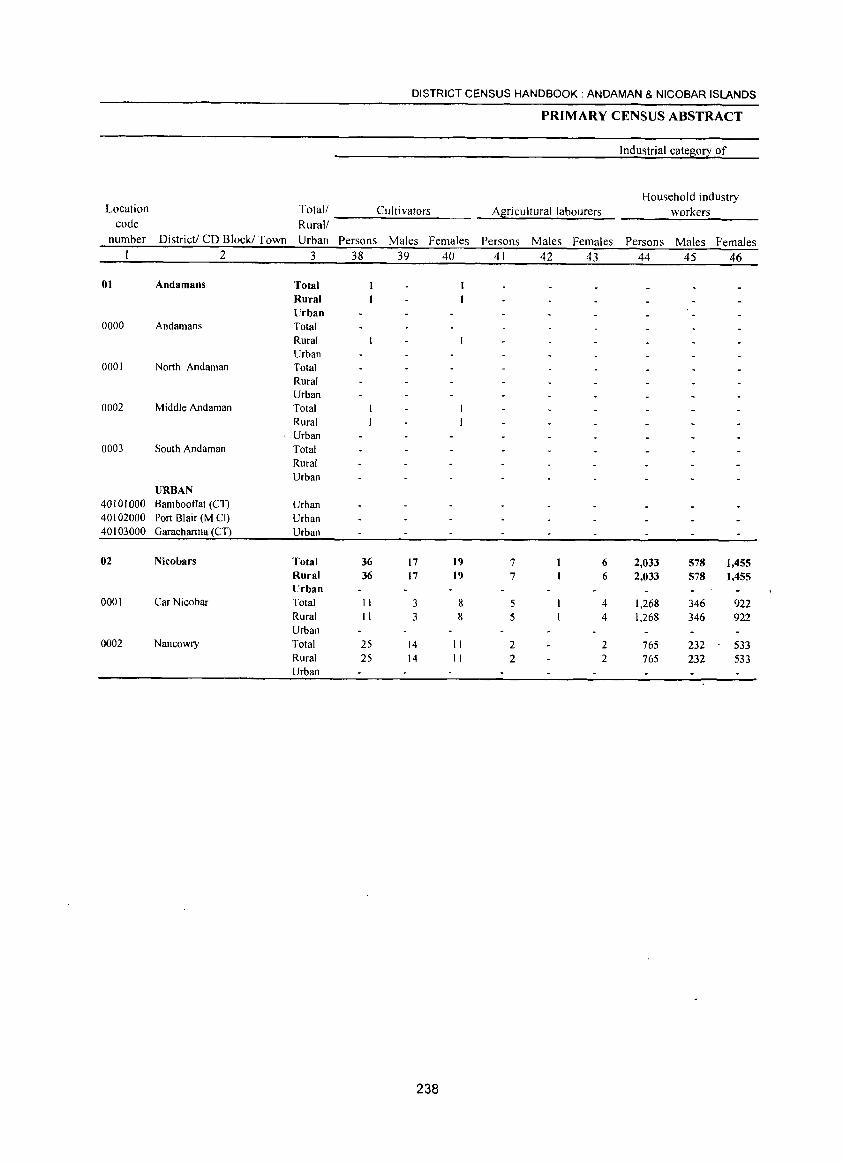
DISTRICT CENSUS HANDBOOK: ANDAMAN & NICOBAR ISLANDS
PRIMARY CENSUS ABSTRACT
Industrial category of
Household industry Location Total/ Cultivators A~?icultural labourers workers
code Rural! number District! CD Block! Town Urban Persons Males Females Persons Males Females Persons Males Females
2 3 38 39 40 41 42 43 44 45 46
01 Andamans Total Rural Urban
0000 Andamans Total Rural Urban
0001 North Andaman Total Rural Urban
0002 Middle Andaman Total Rural
, Urban 0003 South Andaman Total
Rural Urban
URBAN 40101000 Bambootlat (CT) Urban 40102000 Port Blair (M CI) Urban 40103000 Garacharma (CT) Urban
02 Nicobars Total 36 17 19 7 6 2,033 578 1,455 Rural 36 17 19 7 6 2,033 578 1,455 Urban
0001 Car Nicobar Total II 3 8 5 4 1,268 346 922 Rural II 3 8 5 4 1,268 346 922 Urban
0002 Nancowry Total 25 14 II 2 2 765 232 - 533 Rural 25 14 II 2 2 765 232 533 Urban
238
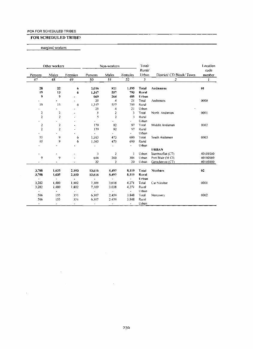
PCA FOR SCHEDULED TRIBES
FOR SCHEDULED TRIBE~
marginal workers
Other workers Non-workers Total! Location
Rural/ code
Persons Males Females Persons Males Females Urban District! CD Block! Town number
47 48 49 50 51 52 3 2
28 22 6 2,016 821 1,195 Total Andamans 01 19 13 6 1,347 557 790 Rural 9 9 669 264 405 Urban
25 4 21 Total Andamans 0000 19 13 6 1,347 557 790 Rural
25 4 21 Urban 2 2 5 2 3 Total North Andaman 0001 2 2 5 2 3 Rural
Urban 2 2 179 82 97 Total Middle Andaman 0002 2 2 179 82 97 Rural
Urban 15 9 6 1,163 473 690 Total South Andaman 0003 15 9 6 1,163 473 690 Rural
Urban URBAN
3 2 Urban Bambooflat (CT) 40101000 9 9 644 260 384 Urban Port Blair (M el) 40102000
22 2 20 Urban Garacharma (CT) 40103000
3,788 1,635 2,153 13,616 5,497 8,119 Total Nicobars 02 3,788 1,635 2,153 13,616 5,497 8,119 Rural
Urban 3,282 1,480 1,802 7,309 3,038 4,271 Total Car Nicobar 0001 3,282 1,480 1,802 7,309 3,038 4,271 Rural
Urban 506 155 351 6,307 2,459 3,848 Total Nancowry 0002 506 155 35~ 6,307 2,459 3,848 Rural
Urban
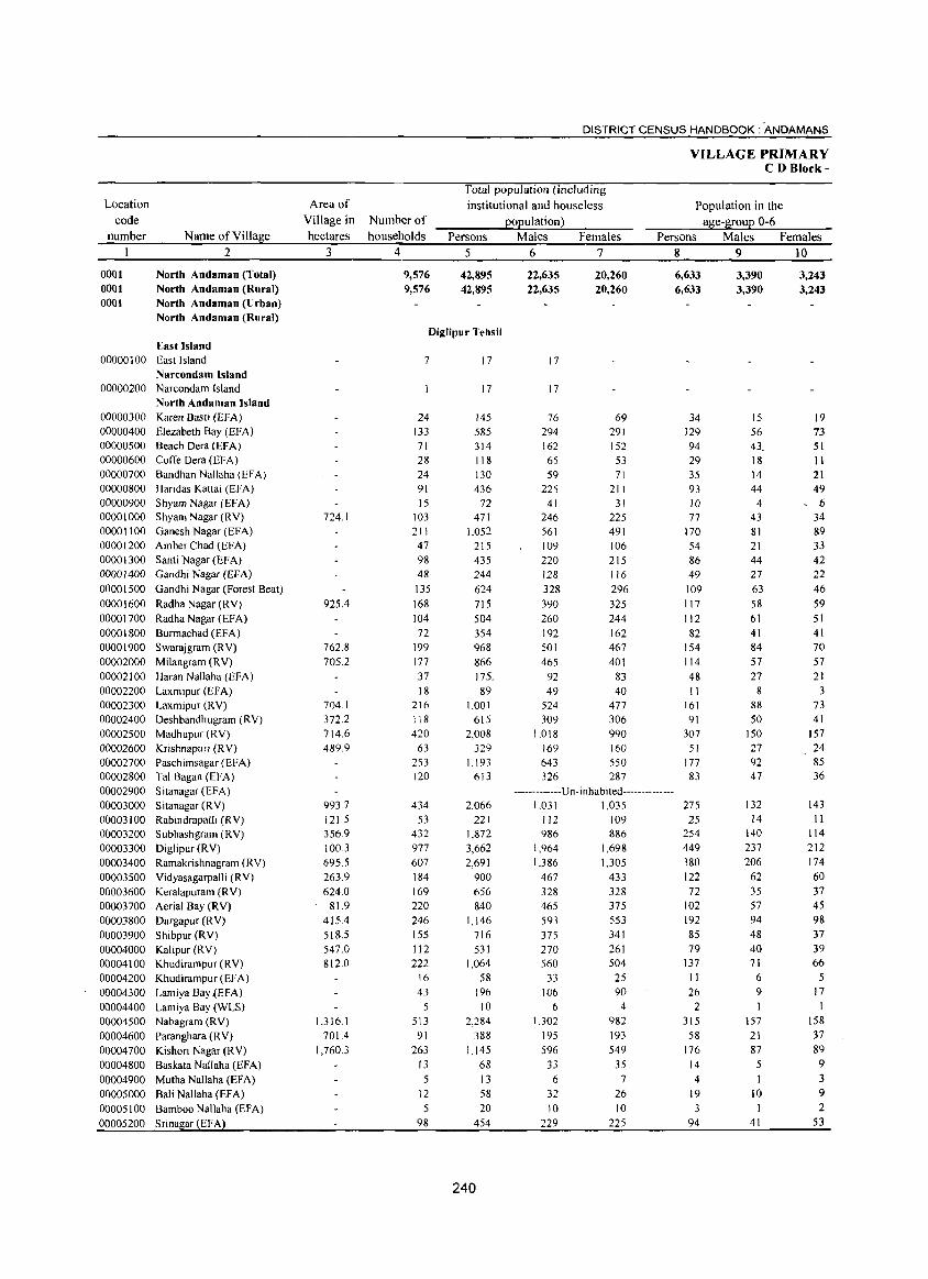
Location
code
number
0001 0001 0001
Name of Village
2
North Andaman (Total) North Andaman (Rural) North Andaman (Urban) North Andaman (Rural)
East Island 00000100 East Island
Narcondam Island 00000200 Narcondam Island
00000300 00000400 00000500 00000600 00000700 00000800 00000900 00001000 00001100 00001200 00001300 00001400
00001500
00001600 00001700 00001800 00001900 00002000 00002100 00002200 00002300 00002400 00002500 00002600 00002700 00002800 00002900 00003000 00003100 00003200 00003300 00003400 00003500 00003600 00003700 00003800 00003900 00004000 00004100 00004200 00004300 00004400 00004500 00004600 00004700 00004800 00004900 00005000 00005100 00005200
North Andaman Island Karen Basti (EFA) Elezabeth Bay (EFA) Beach Dera (EFA) CotTe Dera (EFA) Bandhan Nallaha (EFA) Haridas Kattai (EFA) Shyam Nagar (EFA) Shyam Nagar (RY) Ganesh Nagar (EFA) Amber Chad (EFA) Santi Nagar (EFA) Gandhi Nagar (EFA) Gandhi Nagar (Forest Beat) Radha Nagar (RY) Radha Nagar (EFA) Burmachad (EFA) Swarajgram (RV) Milangram (RY) Haran NaJlaha (EFA) Laxmipur (EFA) Laxmipur (RV) Deshbandhugram (RY) Madhupur (RV) Krishnapuri (R V) Paschimsagar (EFA) Tal Bagan (EFA) Sitanagar (EFA) S itanagar (R Y) Rabindrapalli (RY) Subhashgram (RY) Diglipur (RV) Ramakrishnagram (RY) Yidyasagarpalli (RY) Keralapuram (R Y) Aerial Bay (RV) Durgapur (R V) Shibpur (RV) Kalipur (RY) Khudirampur (RY) KhudirampuT (EFA) Lamiya Bay ~EFA) Lamiya Bay (WLS) Nabagram (RV) Paranghara (RV) Kishori Nagar (R V) Baskata Nallaha (EFA) Mutha Nallaha (EFA) Bali Nallaha (EFA) Bamboo Nallaha (EFA) Srinagar (EF A)
Area of
Village in Number of
hectares households
3 4
9,576 9,576
DISTRICT CENSUS HANDBOOK: 'ANDAMANS
Total population (including
institutional and houseless
population)
Persons
5
42,895 42,895
Males
6
22,635 22,635
Females
7
20,260 20,260
VILLAGE PRIMARY CD Block-
Population in the
age-group 0-6 Persons Males Females
8 9 10
6,633 6,633
3,390 3,390
3,243 3,243
Diglipur Tehsil
724,1
925.4
762,8 705,2
704 I 372.2 714,6 489,9
993,7
121.5 356,9 100,3 695,5 263,9 624,0
81.9 415.4 518.5 547,0 812,0
1,316, I 701.4
1,760.3
7
24 133 71 28 24 91 15
103 211 47 98 48 135
168 104 72
199 177 37 18
216 118 420
63 253 120
434 53
432 977 607 184 169 220 246 155 112 222 ,16 43
5 513
91 263
13 5
12 5
98
17
17
145 585 314 118 130 436
72 471
1,052 215 435 244
624 715 504 354 968 866 175. 89
1,001 615
2,008 329
1.193 613
2,066 221
1,872 3,662 2,691
900 656 840
1,146 716 531
1,064 58
196 10
2,284 388
1,145 68 13 58 20
454
240
17
17
76 69 294 291 162 152 65 53 59 71
225 211 41 31
246 225 561 491 109 106 220 215 128 116
328 296 390 325 260 244 192 162 501 467 465 401
92 83 49 40
524 477
309 306 1.018 990
169 160 643 550 326 287
-.. -.. -.. -.. -Un·inhabited .. ----·-.. ··-· 1,031 1,035
112 109 986 886
1,964 1,698 1,386 1,305
467 433 328 328 465 375 593 553 375 341 270 261 560 504
33 25 106 90
6 4 1.302 982
195 193 596 549
33 35 6 7
32 26 10 10
229 225
34 129 94 29 35 93 10 77
170 54 86 49
109 117 112 82
154 114 48 II
161 91
307 51
177 83
275 25
254 449 380 122 72
102 192 85 79
137 II 26
2 315
58 176
14 4
19 3
94
15 56 43 18 14 44
4 43 81 21 44 27
63 58 61 41 84 57 27
8 88 50
150 27 92 47
132 14
140 237 206
62 35 57 94 48 40 71 6 9
157 21 87
5 1
10 1
41
19 73 51 II 21 49
- 6 34 89 33 42 22 46 59 51 41 70 57 21
3 73 41
157 24 85 36
143 II
114 212 174 60 37 45 98 37 39 66
5 17
158 37 89 9 3 9 2
53
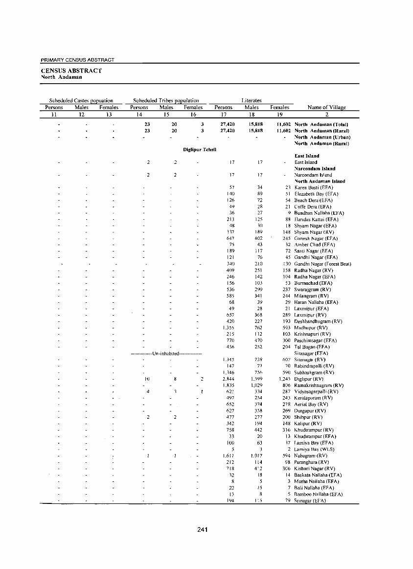
PRIMARY CENSUS ABSTRACT
CENSUS ABSTRACT North Andaman
Scheduled Castes EOEuation Scheduled Tribes EOEulation Literates
Persons Males Females Persons Males Females Persons Males Females Name of Village
11 12 J3 14 15 16 17 18 19 2
23 20 3 27,420 15,818 11,602 North Andaman (Total) 23 20 3 27,420 15,818 11,602 North Andaman (Rural)
North Andaman (Urban) North Andaman (Rural)
Diglipur Tehsil East Island
2 2 17 17 East Island Narcondam Island
2 2 17 17 Narcondam Island North Andaman Island
57 34 23 Karen Basti (EFA) 140 89 51 Elezabeth Bay (EFA) 126 72 54 Beach Oera CEFA) 49 28 21 Coffe Dera (EFA) 36 27 9 Bandhan Nallaha (EFA)
213 125 88 Haridas Kattai (EFA) 48 30 18 Shyam Nagar CEFA)
337 189 148 Shyam Nagar CRY) 647 402 245 Ganesh Nagar (EFA)
75 43 32 Amber Chad (EFA) 189 117 72 Santi Nagar (EFA) 121 76 45 Gandhi Nagar (EFA) 340 210 130 Gandhi Nagar (Forest Beat) 409 251 158 Radha Nagar CRY) 246 142 104 Radha Nagar (EFA) 156 103 53 Burmachad CEFA) 536 299 237 Swarajgram CRY) 585 341 244 Milangram CRY)
68 39 29 Haran Nallaha (EFA) 49 28 21 Laxmipur (EFA)
657 368 289 Laxmipur (RV) 420 227 193 Deshbandhugram (RV)
1,355 762 593 Madhupur CRY) 215 112 103 Krishnapuri (R V) 770 470 300 Paschimsagar (EFA) 456 252 204 Tal Bagan (EFA)
-------------U n- i n hab ited-------------- Sitanagar (EFA) J ,345 738 607 Sitallagar (RV)
147 77 70 Rabindrapalli CRY) 1,346 756 590 Subhashgram CRY)
10 8 2 2,844 1,599 1,245 Diglipur (RY) J ,835 1,029 806 Ramakrishnagram (R V)
4 3 621 334 287 Vidyasagarpalli CRY) 497 254 243 Keralapuram (RY) 652 374 278 Aerial Bay (RY) 627 358 269 Durgapur (RV)
2 2 477 277 200 Shibpur (RV) 342 194 148 Kalipur (RV) 758 442 316 Khudirampur (RV)
33 20 13 Khudirampur (EFA) 100 63 37 Lamiya Bay (EFA)
5 3 2 Lamiya Bay (WLS) 1,611 1,017 594 Nabagram CRY)
212 114 98 Paranghara (RV) 718 412 306 Kishori Nagar CRY)
32 18 14 Baskata Nallaha (EFA) 8 5 3 Mutha Nallaha (EFA)
22 15 7 Bali Nallaha (EFA) 13 8 5 Bamboo Nallaha (EFA)
194 115 79 Srina ar (EFA)
241
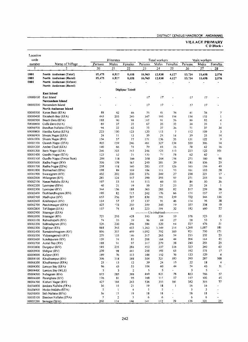
Location code
number
0001 0001 0001
Name ofYillage
2
North ADdamaD (Total) North Andaman (Rural) North ADdaman (Urban) North Andaman (Rural)
East Island 00000 I 00 East Island
Narcondam Island 00000200
00000300 00000400 00000500 00000600 00000700 00000800 00000900 00001000 00001100 00001200 00001300 00001400
00001500 00001600 00001700 00001800 00001900 00002000 00002100 00002200 00002300 00002400 00002500 00002600 00002700 00002800 00002900 00003000 00003100 00003200 00003300 00003400 00003500
Narcondam Island Nortb Andaman Island Karen Basti (EFA) Elezabeth Bay (EFA) Beach Dera (EFA) Coffe Dera (EFA) Bandhan Nallaha (EFA) Haridas Kattai (EFA) Shyam Nagar (EFA) Shyam Nagar (R V) Ganesh Nagar (EFA) Amber Chad (EFA) Santi Nagar (EFA) Gandhi Nagar (EFA)
Gandhi Nagar (Forest Beat) Radha Nagar (RV) Radha Nagar (EFA) Burmachad (EFA) Swarajgram (RV) Milangram CRY) Haran NaJlaha (EFA) Laxmipur (EFA) Laxmipur (RV) Deshbandhugram CRY) Madhupur (RV) Krishnapuri (RV) Paschimsagar (EFA) Tal Bagan (EFA) Sitanagar (EFA) Sitanagar (RV) Rabindrapalli (RV) Subhashgram (RV) Diglipur (RV) Ramakrishnagram (RV) Vidyasagarpalli (RV)
00003600 Keralapuram (RV) 00003700 Aerial Bay CRY) 00003800 Durgapur (RV) 00003900 Shibpur (RV) 00004000 Kalipur (RV) 00004100 Khudirampur (RV) 00004200 Khudirampur (EFA) 00004300 Lamiya 'Bay (EFA) 00004400 Lamiya Bay (WLS) 00004500 Nabagram (RV) 00004600 Parangbara (RV) 00004700 Kishori Nagar (RV) 00004800 Baskata Nallaha (EFA) 00004900 Mutha Nallaha (EFA) 00005000 Bali Nallaha (EFA) 00005100 Bamboo Nallaha (EF A) 00005200 Sri nagar (EFA)
Persons 20
15,475 15,475
88 445 188 69 94
223 24
134 405 140 246 123 284 306 258 198 432 281 107 40
344 195 653 114 423 157
721 74
526 818 856 279 159 188 519 239 189 306
25 96
5 673 176 427 36
5 36
7
260
III iterates Males
21
6,817 6,817
Females 22
8,658 8,658
Diglipur Tehsil
42 205
90 37 32
100 II 57
159 66
103 52
118 139 118 89
202 124 53 21
156 82
256 57
173 74
293 35
230 365 357 133 74 91
235 98 76
118 13 43
3 285
81 184
15
17 2
114
242
46 240
98 32 62
123 13 77
246 74
143 71
166 167 140 109 230 157 54 19
188 113 397
57 250
83
428 39
296 453 499 146 85 97
284 141 113 188 12 53
2 388 95
243 21
4 19
5 146
DISTRICT CENSUS HANDBOOK: ANDAMANS
Total workers Persons
23
16.965 16.965
17
Males 24
12,838 12,838
17
17 17
75 347 167 67 73
120 39
171 461
79 246 135
358 240 283 184 276 390 113
50 365 242 830 137 359 223
41 193 91 3S 37
113 25
136 327 63
133 77
204 201 157 111 249 293 60 27
283 176 591
91 340 191
Females 25
4,127 4,127
34 154 76 32 36
7 14 35
134 16
113 58
154 39
126 73 27 97 S3 23 82 66
239 46 19 32
-------------Un-inhabited--------------593 534 59 96
584 1,363 1,092
317 208 317 453 258 188 504
39 104
5 899 168 536
19 5
18 6
141
69 520
1,149 792 263 164 279 337 193 152 321 24 60
5 821 III 355
18 5
18 6
112
27 64
214 300
54 44 38
116 65 36
183 15 44
78 57
181
29
VILLAGE PRIMARY CDBlock-
Main workers Persons Males Females
26 27, 28
13,734 13,734
17
17
41 154 86 34 71
112 39
131 320
78 223
62
271 185 165 161 238 271 86 25
317 174 722 114 357 182
576 58
527 1,268
921 255 206 280 323 192 133 395
22 74
5 823
147 382
16 5
18 6
126
11,658 11,658
17
17
34 153 82 33 37
109 25
122 306 62
122 62
180 156 116 103 221 255 50 24
259 157 566
76 338 160
523 53
476 1,087
750 232 164 255 260 175 129 287
18 43
5 766 102 305
16 5
18 6
101
2,076 2,076
7 I 4 I
34 3
14 9
14 16
101
91 29 49 58 17 16 36
58 17
156 38 19 22
53 5
51 181 171 23 42 25 63 17 4
108 4
31
57 45 77
25
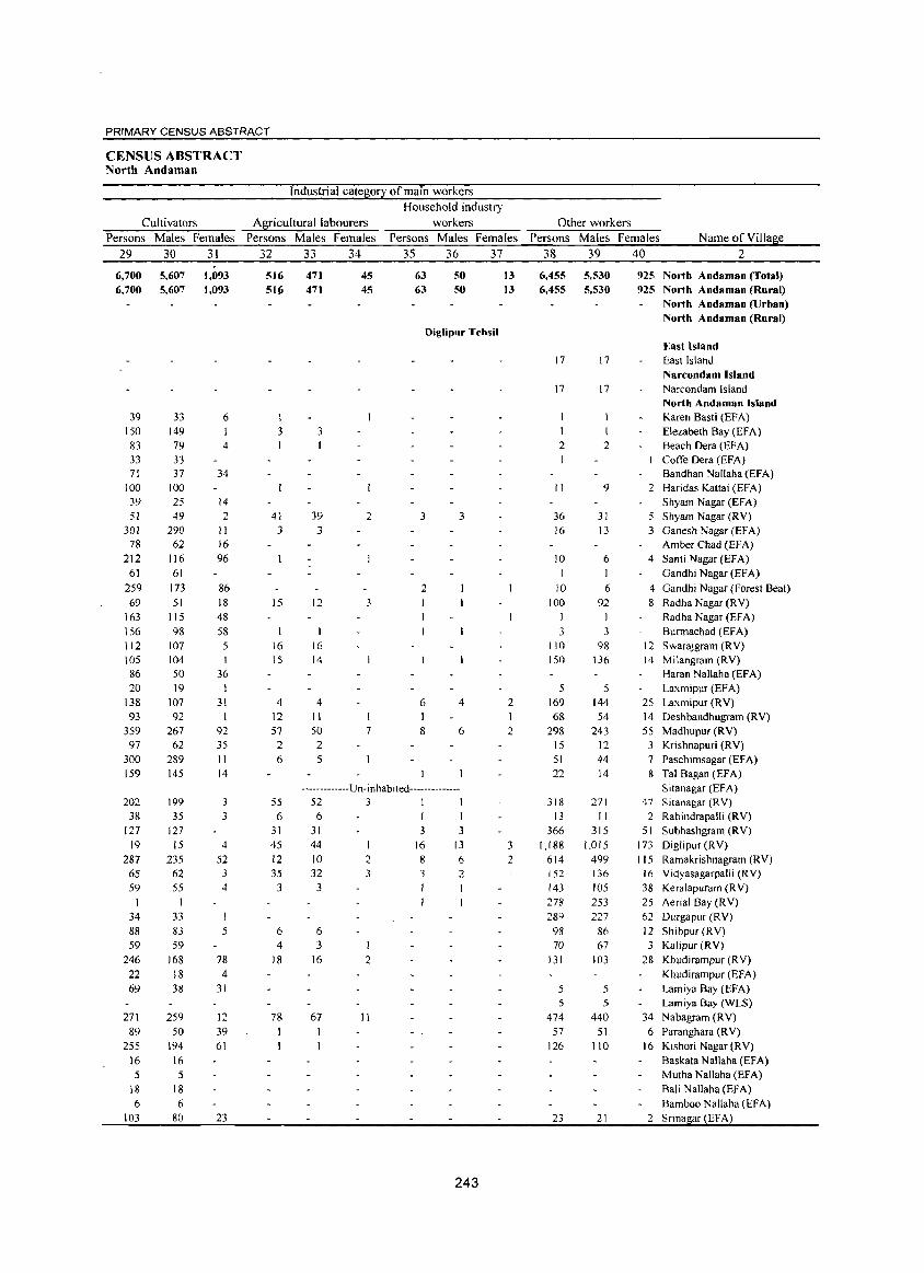
PRIMARY CENSUS ABSTRACT
CENSUS ABSTRACT North Andaman
Industrial category of main workers Household industry
Cultivators Agricultural labourers workers Persons Males Females Persons Males Females Persons Males Females
29 30 31 32 33 34 35 36 37
6,700 5,607 6,700 5,607
39 150 83 33 71
100 39 51
301 78
212 6J
259 69
163 \ 56 1 \2 105 86 20
138 93
359 97
300 \59
202 38
127 19
287 65 59
34 88 59
246 22 69
271 89
255
16 5
\8 6
103
33 149 79 33 37
100 25 49
290 62
116 61
173
51 115 98
107 104 50 19
107 92
267 62
289 145
199 35
127 15
235 62 55
1 33 83 59
168 18 38
259 50
194 16 5
18
6 80
1,093 1,093
6
4
34
14 2
II 16 96
86 18 48 58
36 1
31
92 35 11 14
3 3
4
52 3
4
I 5
78 4
31
12 39 61
23
516 51C;
I 3
41 3
15
16 15
4 12 57 2 6
55 6
31 45 12 35
3
6 4
18
78 I
47] 471
3
39 3
45 45
2
12 3
16 14
4 II 50 2 5
7
63 63
50 50
Diglipur Tehsil
3 3
2
6 4
8 6
-------------U n-i n h ab i ted--------------52 3 1 I
6 I 1
31 3 3 44 10 32
3
6
2 3
3 I 16 2
67 II
16 8 3 I
13
6 2
243
13 13
2
2
3 2
Other workers Persons Males Females Name of Village
38 39 40 2
6,455 5,530 6,455 5,530
17
17
1 2
II
36 16
10
10 100
I 3
110 150
5 169 68
298 15 51
22
318 13
366 1,188
614 152 143 278 289
98 70
131
5 5
474
57 126
23
17
17
2
9
31
13
6 I
6 92
I J
98 136
5 144 54
243 12 44 14
271
11 315
1,015 499 136 105 253
227 86 67
103
5 5
440
51 110
21
925 North ADdamaD (Total) 925 North ADdamaD (Rural)
North ADdaman (Urban) North Andaman (Rural)
East Island East Island Narcondam Island Narcondam Island North AndamaD Island Karen Basti (EFA) Elezabeth Bay (EFA) Beach Dera (EFA) Cotfe Dera (EFA) Bandhan Nallaha (EFA)
2 Haridas Kattai (EFA) Shyam Nagar (EFA)
5 Shyam Nagar (RV) 3 Ganesh Nagar (EFA)
Amber Chad (EFA) 4 Santi Nagar (EFA)
Gandhi Nagar (EFA)
4 Gandhi Nagar (Forest Beat) 8 Radha Nagar (RV)
Radha Nagar (EFA)
Burmachad CEFA) 12 Swarajgram CRY) 14 Milangram CRY)
Haran Nallaha (EFA) Laxmipur CEFA)
25 Laxmipur (RV)
14 Deshbandhugram CRY) 55 Madhupur (RV)
3 Krishnapuri (RV) 7 Paschimsagar (EFA) 8 Tal Bagan (EFA)
Sitanagar (EFA) 47 Sitanagar CRY)
2 Rabindrapal1i CRY) 51 Subhashgram CRY)
173 Diglipur CRY) 115 Ramakrishnagram (RV)
16 Vidyasagarpalli (RV) 38 Keralapuram (R V) 25 Aerial Bay (RV) 62 Durgapur (RV)
12 Shibpur(RV) 3 Kalipur(RV)
28 Khudirampur CRY) Khudirampur (EFA)
Lamiya Bay CEFA) Lamiya Bay (WLS)
34 Nabagram (RV) 6 Paranghara (RV)
16 Kishori Nagar (RV)
Baskata Nallaha CEFA) Mutha Nal1aha (EFA) Bali Nallaha (EFA)
Bamboo Nallaha (EFA) 2 Sri nagar (EFA)
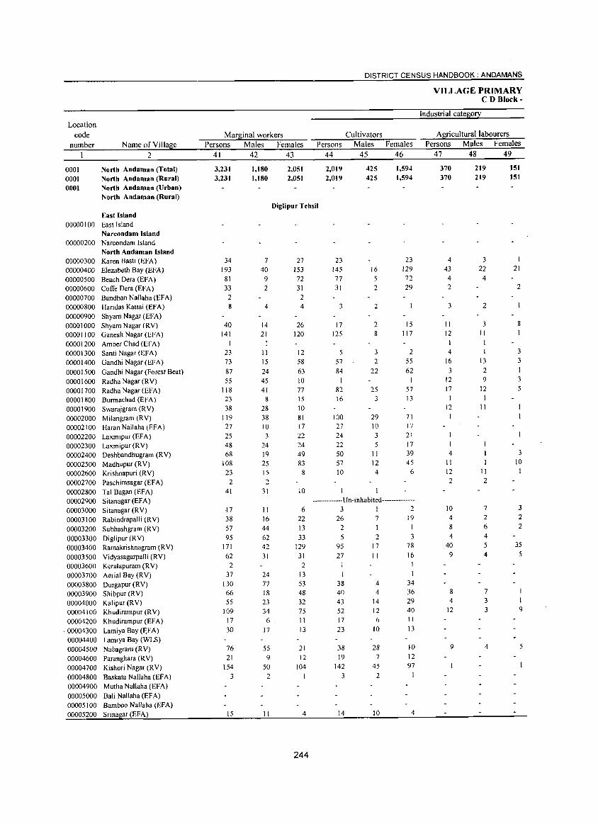
Location code
number
0001 0001 0001
Name of Village 2
North Andaman (Total) North Andaman (Rural) North Andaman (Urban) North Andaman (Rural)
East Island 00000 I 00 East Island
Narcondam Island
00000200 Narcondam Island North Andaman Island
00000300 Karen Basti (EFA) 00000400 Elezabeth Bay (EFA)
00000500 Beach Dera (EFA) 00000600 CotTe Dera (EFA) 00000700 Bandhan Nallaha (EFA) 00000800 Haridas Kattai (EFA) 00000900 Shyam Nagar (EFA) 00001000 ShyamNagar(RY) 00001100 GaneshNagar(EFA)
00001200 Amber Chad (EF A) 00001300 Santi Nagar (EFA) 00001400 Gandhi Nagar (EFA)
00001500 Gandhi Nagar (Forest Beat) 0000 1600 Radha Nagar (RY) 00001700 Radha Nagar (EFA) 00001800 Burmachad (EFA) 00001900 Swarajgram (RY) 00002000 Milangram (RY) 00002100 Haran NalJaha (EFA) 00002200 Laxmipur (EFA) 00002300 Laxmipur (RY) 00002400 Deshbandhugram (RY) 00002500 Madhupur (RY) 00002600 Krishnapuri (RY) 00002700 Paschimsagar (EFA) 00002800 Tal Bagan (EFA) 00002900 Sitanagar (EFA)
00003000 Sitanagar (RY) 00003100 Rabindrapalli (RY)
00003200 Subhashgram (RY) 00003300 Diglipur (R Y) 00003400 Ramakrishnagram (RY) 00003500 Yidyasagarpalli (RY) 00003600 Keralapuram (RY) 00003700 Aerial Bay (RY)
00003800 Durgapur (RY) 00003900 Shibpur (RY) 00004000 Kalipur (RY) 00004100 Khudirampur (RV) 00004200 Khudirampur (EFA)
·00004300 Lamiya Bay (~FA) 00004400 Lamiya Bay (WLS) 00004500 Nabagram (RY) 00004600 Paranghara (R V) 00004700 Kishori Nagar (RY)
00004800 Baskata Nallaha (EFA) 00004900 Mutha Nallaha (EFA)
00005000 Bali Nallaha (EFA) 00005100 Bamboo Nallaha (EFA) 00005200 Srinagar (EFA)
DISTRICT CENSUS HANDBOOK: ANDAMANS
Marginal workers Persons Males Females
41 42 43
3,231 3,231
1,180 1,180
2,051 2,051
Persons 44
2,019 2,019
Cultivators Males
45
425
425
Females 46
1,594 1,594
Diglipur Tehsil
34 193
81 33
2 8
40 141
I 23 73
87
55 118
23 38
119 27
25 48 68
108 23
2 41
·17 38 57 95
171 62
2 37
130 66 55
109 17 30
76 21
154
3
15
7 40
9 2
4
14 21
11 15 24 45 41
8 28 38 10 3
24 19 25 15 2
31
II 16
44 62 42
31
24 77 18 23 34
6 17
55 9
50
2
II
27 153 72 31
2 4
26 120
12 58
63 10 77 15
10 81 17 22 24 49 83
8
10
6 22 13
33 129
31 2
13 53 48 32 75 II 13
21 12
104
4
244
23 145 77
31
3
17 125
5 57 84
I 82 16
100 27
24 22 50 57 10
16 5 2
2
2 8
3 2
22
25 3
29 10 3 5
II 12 4
23 129
72 29
15 117
2
55 62
57 13
71 17
21 17 39 45
6
••......•.• _. U n· inhabited •••• _ •• _ .....•
3 I 2 26
2 5
95 27
38 40 43 52 17
23
38 19
142 3
14
7 I 2
17 II
4 4
14 12 6
10
28 7
45 2
10
19 I 3
78
16
34 36 29 40 11
13
10 12 97
4
VILLAGE PRIMARY CD Blork-
Industrial category
Agricultural labourers Persons Males Females
47 48 49
370 370
4
43 4 2
3
II 12
4
16
3 12 17 I
12
4 11 12 2
10 4
8 4
40 9
8
4 12
9
219 219
3 22
4
2
3 II
1 13
2 9
12 I
11
11 2
7 2 6 4 5 4
7
3 3
4
151 151
1 21
2
8
I
3 3
3 5
3 10
3 2 2
35
5
9
5
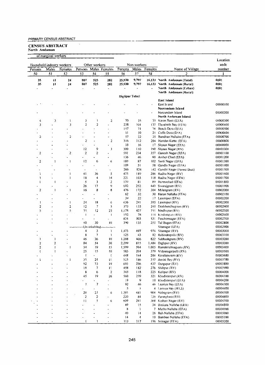
PRIMARY CENSUS ABSTRACT
CENSUS ABSTRACT North Andarnan
of marginal workers
Household industry workers Persons Males Females
50 51 52
35 35
4 3
2
2
2
2
I 2 5
11 11
3
24 24
3
2
2
2 5
Other workers Persons Males Females
53 54 55
807 807
3 2
2
12 2
12
41 18 5
26 16
24 12 35
40
525 525
2
9
2
6
36 4 3
17 8
18 7
12
30
282 282
2
2
3
6
5 14 2 9 8
6 5
23
10 -------------Un-inhabited--------------
2 2
2
4 3 1 8 7
46 36 10 84 54 30 34 19 15 25
I 35 92 18
8
45
15
24 73
7
6 19
7 7
29 2
II
23 2 5
10
II
19 11 2
26
6
6
Non-workers Persons Males Females Name of Village
56 57 58 2
25,930 25,930
9,797 9,797
Diglipur TelJsil
70 238 147
51 57
316 33
300 591 136 189 109 266
475 221 170 692 476
62 39
636 373
1,178 192 834 390
1,473 125
1,288 2,299
1,599 583 448
523 693 458 343
560 19 92
5 1,385
220 609 49
8 40 14
313
245
35 101
71 30 22
112 16
110 234
46 87 51
124 189 103
81 252 172
32 22
241 133 427
7R 303 135
497 43
466 815 594 204
164 186 256 182 118 239
9 46
I
481
84 24!
15
1 14 4
117
16,133 North Andaman (Total) 16,133 North Andaman (Rural)
North Andaman (lJrban) North Andaman (Rural)
East Island East Island Narcondam Island Narcondam Island North Andaman Island
35 Karen Basti (EFA) 137 Elezabeth Bay (EFA) 76 Beach Dera (EFA) 21 CofTe Dera (EFA) 35 Bandhan Nallaha (EFA)
204 Haridas Kanai (EFA) 17 Shyam Nagar (EFA)
190 Shyam Nagar (RV) 357 Ganesh Nagar (EFA) 90 Amber Chad (EFA)
102 Santi Nagar (EFA) 58 Gandhi Nagar (EFA)
142 Gandhi Nagar (Forest Beat) 286 Radha Nagar (RV) 118 Radha Nagar (EFA) 89 Burmachad (EFA)
440 Swarajgram (RY) 304 Milangram (RV)
30 Haran Nallaha (EFA) 17 Laxmipur (EFA)
395 Laxmipur (RV)
240 Deshbandhugram (RV) 751 Madhupur(RV) 114 Knshnapun (RV) 531 Paschimsagar(EFA) 255 Tal Bagan (EFA)
Sitanagar (EFA) 976 Sitanagar (RV)
82 Rabindrapalli (RY)
822 Subhashgram (RY) 1,484 Diglipur (RV)
1,005 Ramakrishnagram (RV) 379 Vidyasagarpalli (RY)
284 Kerafapuram (RV)
337 Aerial Bay (RY) 437 Durgapur (RV) 276 Shibpur (RV)
225 Kalipur (RY) 321 Khudirampur(RV)
10 Khudirampur (EFA) 46 Lamiya Bay (EFA)
4 Lamlya Bay (WLS) 904 Nabagram (RY) 136 Paranghara (RV) 368 Kishori Nagar (RV)
34 Baskata Nallaha (EFA) 7 Mutha Nallaha (EFA)
26 Bali Nallaha (EFA) 10 Bamboo Nallaha (EFA)
196 Sri nagar (EFA)
Location code
number
0001 0001 0001
00000100
00000200
00000300 00000400 00000500 00000600 00000700 00000800 00000900 00001000 00001100 00001200 00001300 00001400 00001500 00001600 00001700 00001800 0000\900 00002000 00002100 00002200 00002300 00002400 00002500 00002600 00002700 00002800 00002900 00003000 00003100 00003200 00003300 00003400 00003500 00003600 00003700 00003800 00003900 00004000 00004100 00004200 00004300 00004400 00004500 00004600 00004700 00004800 00004900 00005000 00005\00 00005200
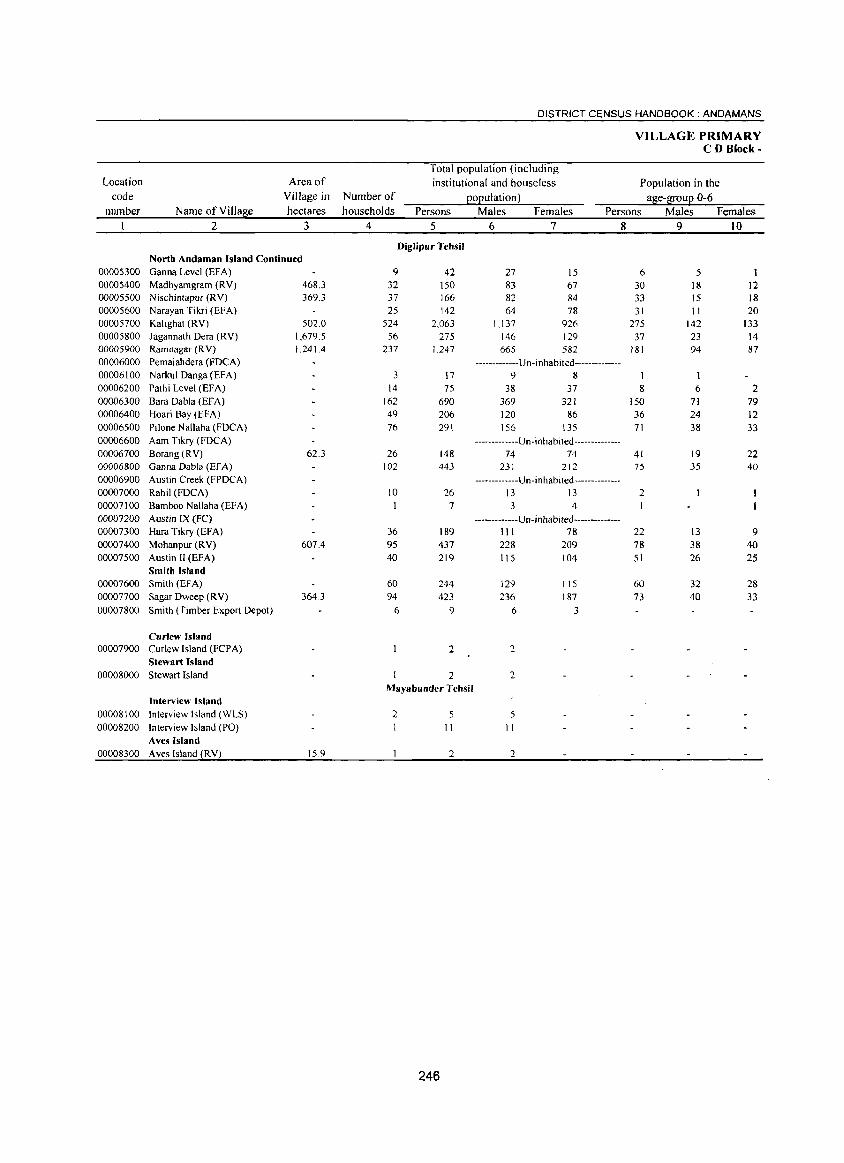
DISTRICT CENSUS HANDBOOK: ANDAMANS
VILLAGE PRIMARY CD Block-
Total population (including Location Area of institutional and houseless Population in the
code Village in Number of ~o~ulation) a!1ie-f[ou~ 0-6 number Name of Villalle hectares households Persons Males Females Persons Males Females
2 3 4 5 6 7 8 9 10
Diglipur Tehsil North Andaman Island Continued
00005300 Ganna Level (EF A) 9 42 27 15 6 5 00005400 Madhyamgram (RY) 468.3 32 150 83 67 30 18 12 00005500 Nischintapur (Ry) 369.3 37 166 82 84 33 15 18 00005600 Narayan Tikri (EFA) 25 142 64 78 31 II 20 00005700 Kalighat (RY) 502.0 524 2,063 Ll37 926 275 142 133 00005800 Jagannath Dera (RY) 1,679.5 56 275 146 129 37 23 14 00005900 Ramnagar (Ry) 1,2414 237 1,247 665 582 181 94 87 00006000 Pemaiahdera (FOCA) -------------Un -i n ha b ited --------------00006100 Narkul Danga (EFA) 3 17 9 8 00006200 Pathi Level (EFA) 14 75 38 37 8 6 2 00006300 Bara Dabla (EFA) 162 690 369 321 150 71 79 00006400 Hoari Bay (EFA) 49 206 120 86 36 24 12 00006500 Pi lone Nallaha (FOCA) 76 291 156 135 71 38 33 00006600 Aam Tikry (FOCA) -------------Un-inhabited--------------00006700 Borang(RY) 62.3 26 148 74 74 41 19 22 00006800 Ganna Dabla (EFA) 102 443 231 212 75 35 40 00006900 Austin Creek (FPOCA) -------------U n- i n habi ted --------------00007000 Rahil (FDCA) 10 26 13 13 2 00007100 Bamboo Nallaha (EFA) 7 3 4 00007200 Austin IX (FC) -------------U n- inhabi ted--------------00007300 Hara Tikry (EFA) 36 189 III 78 22 I3 9 00007400 Mohanpur (R Y) 607.4 95 437 228 209 78 38 40 00007500 Austin IT (EF A) 40 219 115 104 51 26 25
Smith Island 00007600 Smith (EFA) 60 244 129 115 60 32 28 00007700 Sagar Dweep (RY) 364.3 94 423 236 187 73 40 33 00007800 Smith (Timber Export Depot) 6 9 6 3
Curlew Island 00007900 Curlew Island (FCPA) 2 2
Stewart Island 00008000 Stewart Island 2 2
Mayabunder Tehsil Interview Island
00008100 Interview Island (WLS) 2 5 5 00008200 Interview Island (PO) II II
Aves Island 00008300 Aves Island (RY) 15.9 2 2
246
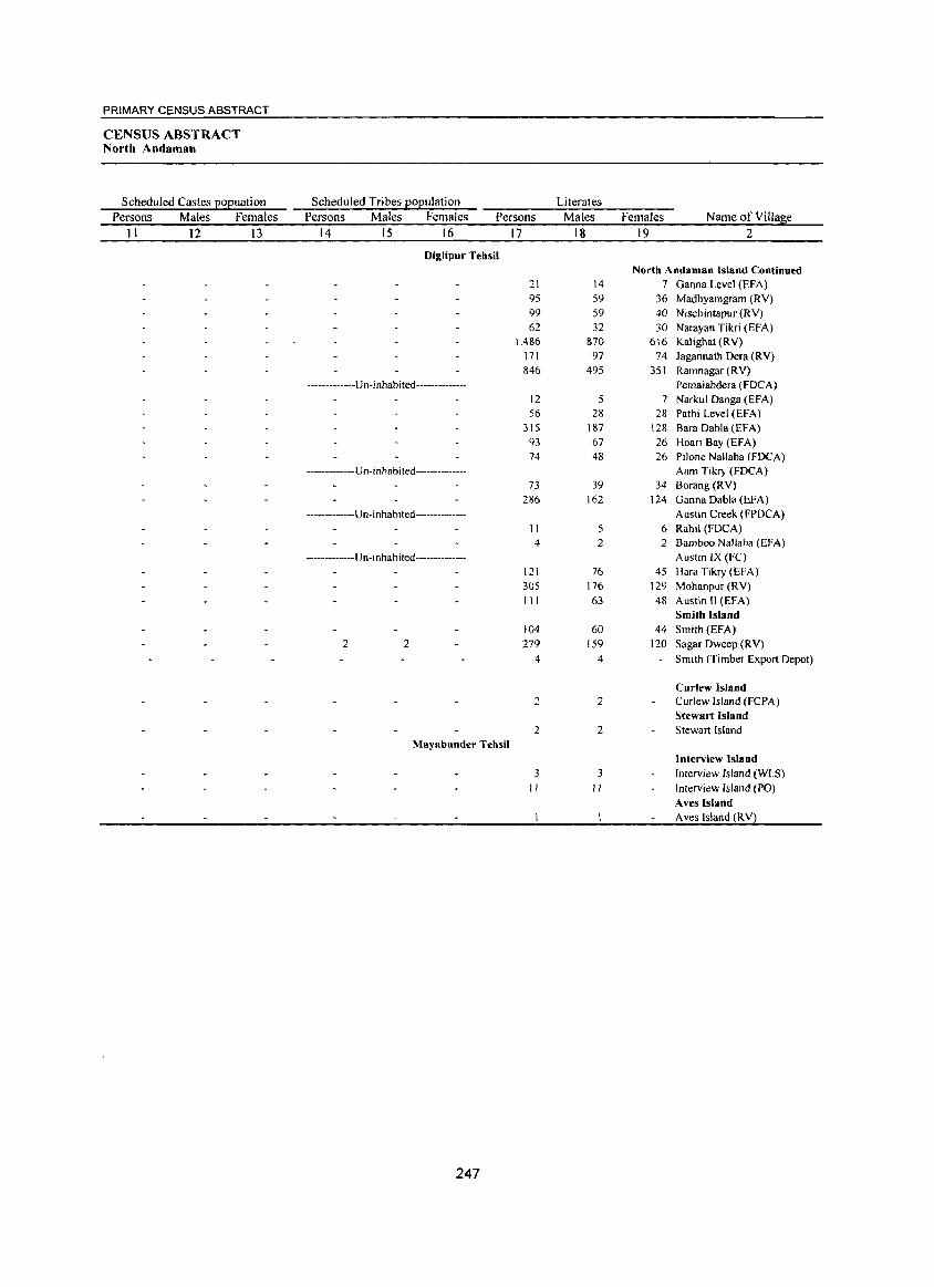
PRIMARY CENSUS ABSTRACT
CENSUS ABSTRACT North Andaman
Scheduled Castes popuation Persons Males Females
11 12 13
Scheduled Tribes population Persons Males Females Persons
14 15 16
Diglipur Tehsil
-------------Un-inhabited--------------
-------------U n- i n ha bited--------------
-- -----------U n-i nhabi ted--------------
-------------Un- inhabited --------------
2 2
Mayabunder Tehsil
247
17
21 95 99
62 L486
171 846
12 56
315 93 74
73 286
11 4
121 305
111
104 279
4
2
2
3
II
Literates Males
18
14 59 59
32 870
97 495
5 28
187 67 48
39 162
5 2
76 176
63
60 159
4
2
2
3 II
Females Name of Village 19 2
North Andaman Island Continued 7 Ganna Level (EF A)
36 Madhyamgram (RV)
40 Nischintapur (RV) 30 Narayan Tikri (EFA)
616 Kalighat (RV) 74 Jagannath Dera (RY)
351 Ramnagar (RV) Pemaiahdera (FDCA)
7 Narkul Danga (EFA) 28 Pathi Level (EFA)
128 Bara Dabla (EFA) 26 Hoari Bay (EFA) 26 Pilone Nallaha (FDCA)
Aam Tikry (FOCA) 34 Borang(RV)
124 Ganna Dabla (EFA) Austin Creek (FPDCA)
6 Rahil (FDCA) 2 Bamboo Nallaha (EFA)
Austin IX (FC)
45 Hara Tikry (EFA) 129 Mohanpur (RV) 48 Austin II (EFA)
Smith Island 44 Smith (EFA)
120 Sagar Dweep (RY)
Smith (Timber Export Depot)
Curlew Island Curlew Island (FCPA) Stewart Island Stewart Island
Interview Island
Interview Island (WLS) Interview Island (PO)
Aves Island A ves Island (RV)
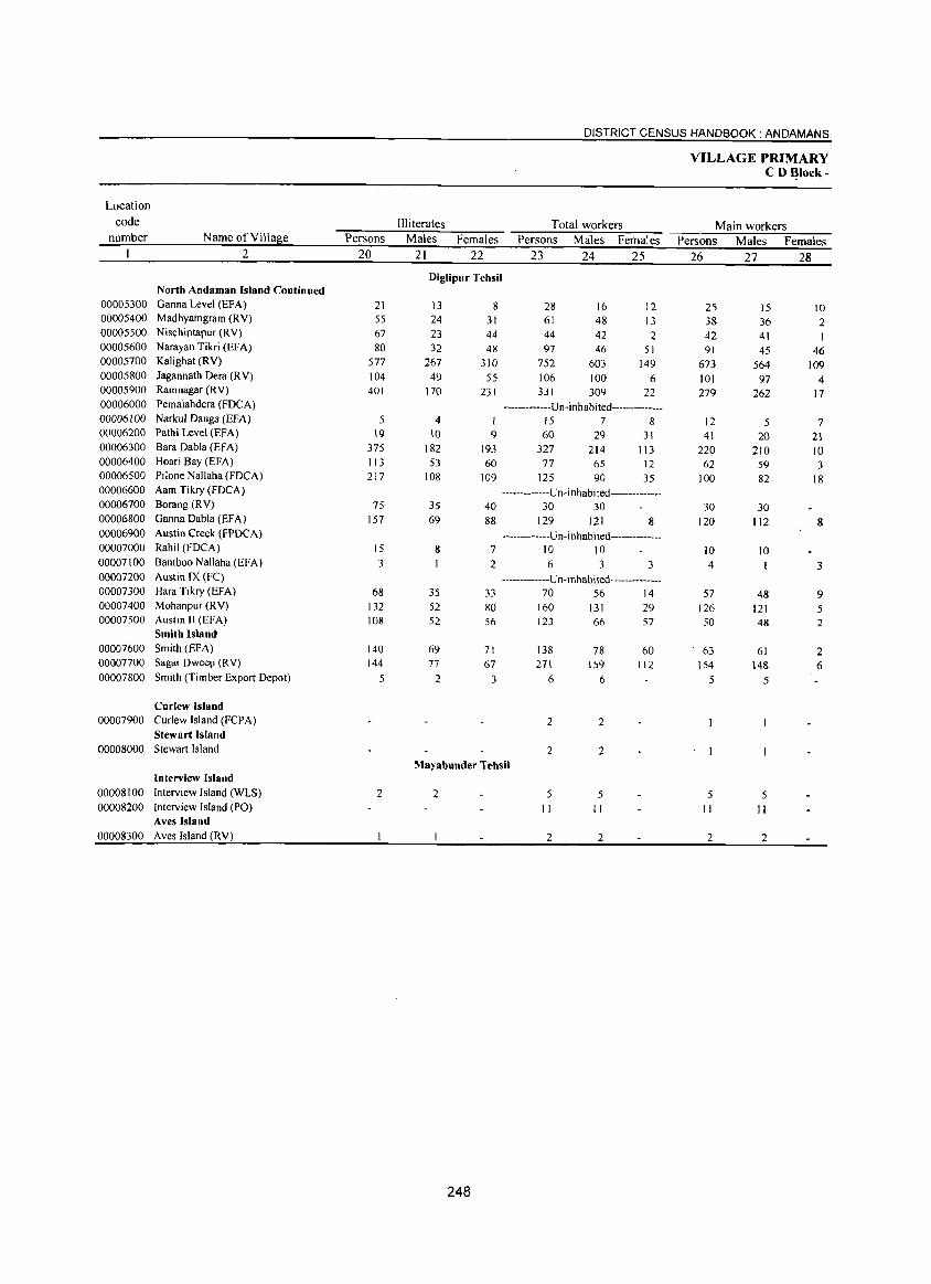
DISTRICT CENSUS HANDBOOK: ANDAMANS
VILLAGE PRIMARY C D ~Iock-
Location
code llliterates Total workers Main workers number Name of Villas:e Persons Males Females Persons Males Females Persons Males Females
2 20 21 22 23 24 25 26 27 28 Diglipur Tehsil
North Andaman Island Continued 00005300 Ganna Level (EFA) 21 13 8 28 16 12 25 15 10 00005400 Madhyamgram (RY) 55 24 31 61 48 13 38 36 2 00005500 Nischintapur (RY) 67 23 44 44 42 2 42 41 00005600 Narayan Tikri (EFA) 80 32 48 97 46 51 91 45 46 00005700 Kalighat (RY) 577 267 310 752 603 149 673 564 109 00005800 Jagannath Dera (RY) 104 49 55 106 100 6 101 97 4 00005900 Ramnagar (RY) 401 170 231 331 309 22 279 262 17 00006000 Pemaiahdera (FDCA) -------------Un-inhabited--------------00006100 Narkul Danga (EFA) 5 4 15 7 8 12 5 7 00006200 Pathi Level (EFA) 19 10 9 60 29 31 41 20 21 00006300 Bara Dabla (EFA) 375 182 193 327 214 113 220 210 10 00006400 Hoari Bay (EFA) 113 53 60 77 65 12 62 59 3 00006500 Pilone Nallaha (FDCA) 217 108 109 125 90 35 100 82 18 00006600 Aam Tikry (FDCA) -------------u n- i nhabi ted ------- -------00006700 Borang (RY) 75 35 40 30 30 30 30 00006800 Ganna Dabla (EF A) 157 69 88 129 121 8 120 112 8 00006900 Austin Creek (FPDCA) -------------Un-inhabited --------------00007000 Rahil (FDCA) 15 8 7 10 10 10 10 00007100 Bamboo Nallaha (EFA) 3 2 6 3 3 4 3 00007200 Austin IX (FC) -------------U n-i nhabited------------00007300 Hara Tikry (EFA) 68 35 33 70 56 14 57 48 9 00007400 Mohanpur (R Y) 132 52 80 160 131 29 126 121 5 00007500 Austin II (EFA) 108 52 56 123 66 57 50 48 2
Smith Island 00007600 Smith (EFA) 140 69 71 138 78 60 63 61 2 00007700 Sagar Dweep (RY) 144 77 67 27\ \59 \ \2 154 148 6 00007800 Smith (Timber Export Depot) 5 2 3 6 6 5 5
Curlew Island 00007900 Curlew Island (FCPA) 2 2
Stewart Island 00008000 Stewart Island 2 2
Mayabunder Tehsil Interview Island
00008100 Interview Island (WLS) 2 2 5 5 5 5 00008200 Interview Island (PO) II II II II
Aves Island 00008300 Aves Island (RY) 2 2 2 2
248
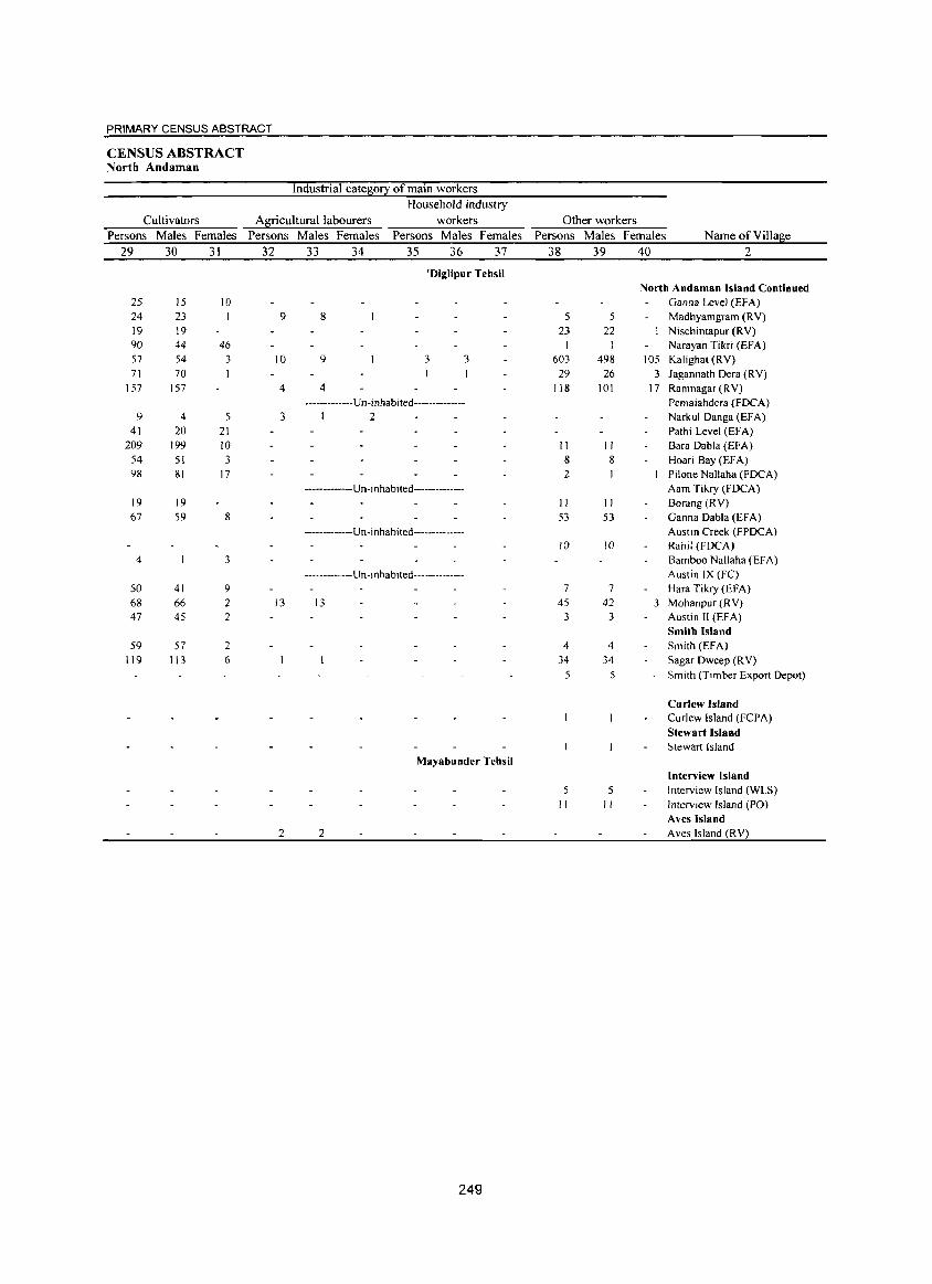
PRIMARY CENSUS ABSTRACT
CENSUS ABSTRACT North Andaman
Industrial cate~0!2 of main workers Household industry
Cultivators A,!Eicultural labourers workers Other workers
Persons Males Females Persons Males Females Persons Males Females Persons Males Females Name of Village
29 30 31 32 33 34 35 36 37 38 39 40 2
'Diglipur Tehsil North Andaman Island Continued
25 15 10 Ganna Level (EFA) 24 23 9 8 5 5 Madhyamgram (RV) 19 19 23 22 Nischintapur (RV) 90 44 46 Narayan Tikri (EFA) 57 54 3 10 9 3 3 603 498 105 Kalighat (RV) 71 70 29 26 3 Jagannath Oera (RV)
157 157 4 4 118 101 17 Ramnagar (RV) .·_·_·.-·····Un·inhabited-··-·_········ Pemaiahdera (FDCA)
9 4 5 3 I 2 Narkul Oanga (EFA) 41 20 21 Pathi Level (EFA)
209 199 10 II II Bara Dabla (EFA) 54 51 3 8 8 Hoari Bay (EFA) 98 81 17 2 Pilone Nallaha (FOCA)
.• _ .•.. _ •• _ .. Un·i nhabited-············· Aam Tikry (FDCA) 19 19 II II Borang (RV) 67 59 8 53 53 Ganna Dabla (EFA)
··_·······_··Un· i nhabited·············· Austin Creek (FPOCA) 10 10 Rahil (mCA)
4 3 Bamboo Nallaha (EFA) ··_····-··-··Un·i nhabited·············· Austin IX (FC)
50 41 9 7 7 Hara Tikry (EFA) 68 66 2 13 13 45 42 3 Mohanpur (RV) 47 45 2 3 3 Austin II (EFA)
Smith Island 59 57 2 4 4 Smith (EFA)
119 113 6 34 34 Sagar Oweep (R V) 5 5 Smith (Timber Export Depot)
Curlew Island Curlew Island (FCPA) Stewart Island Stewart Island
Mayabunder Tehsil Interview lsland
5 Interview Island (WLS)
" " Interview Island (PO) Aves Island
2 2 Aves Island (RV)
249
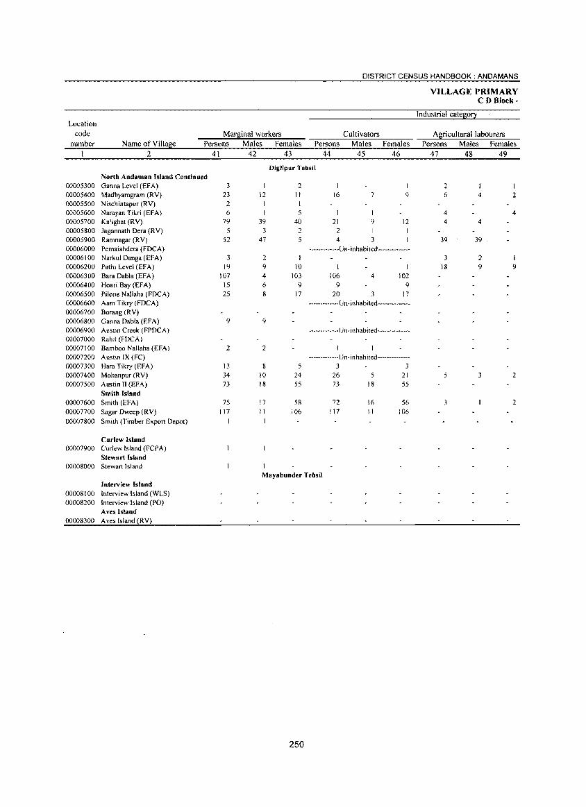
Location code
number
00005300 00005400 00005500 00005600 00005700 00005800 00005900 00006000 00006100 00006200 00006300 00006400 00006500 00006600 00006700 00006800 00006900 00007000 00007100 00007200 00007300 00007400 00007500
00007600 00007700 00007800
00007900
00008000
00008100 00008200
00008300
Marginal workers
DISTRICT CENSUS HANDBOOK: ANOAMANS
Cultivators
VILLAGE PRIMARY CD Block·
Industrial category
Agricultural labourers Name of Village Persons Males Females Persons Males Females Persons Males Females
2
North Andamsn Island Continued Ganna Level (EFA) Madhyamgram (RY) Nischintapur (RY) Narayan Tikri (EFA) Kalighat (R Y) Jagannath Dera (RY) Ramnagar (RY) Pemaiahdera (FOCA) Narkul Oanga (EFA) Pathi Level (EFA)
Bara Dabla (EFA) Hoari Bay (EFA) PHone Nallaha (FDCA) Aam Tikry (FOCA) Borang(RY) Ganna Dabla (EFA) Austin Creek (FPDCA) Rahil (FDCAl Bamboo Nallaha (EFA) Austin IX (Fe) Hara Tikry (EFA) Mohanpur (RY) Austin 11 (EFA)
Smith Island Smith (EFA)
Sagar Dweep (RY)
Smith (Timber Export Depot)
Curlew Island Curlew Island (FePA) Stewart Island Stewart Island
Interview Island Interview Island (WLS) Interview Island (PO) Aves Island Aves Island (RV)
41 42 43 44 45 46
Diglipur Tehsil
3 2 23 12 11 16 7 9
2 I 6 1 5 1 I
79 39 40 21 9 12 5 3 2 2 1
52 47 5 4 3 -------------U n -i n hab i ted --------------
3 2 19 9 10 I
107 4 103 106 4 102 15 6 9 9 9 25 8 17 20 3 17
------------- Un-inhabited --------------
9 9
------------- U n- inhabi ted-------------
2 2 ------------- Un-inhabited--------------
13 8 5 3 3 34 10 24 26 5 21 73 18 55 73 18 55
75 17 58 72 16 56 117 11 106 117 11 106
Mayabunder Tehsil
250
47 48 49
2 6
4
4
4
4
39 39
3 18
5
3
2 9
3
2
4
I 9
2
2
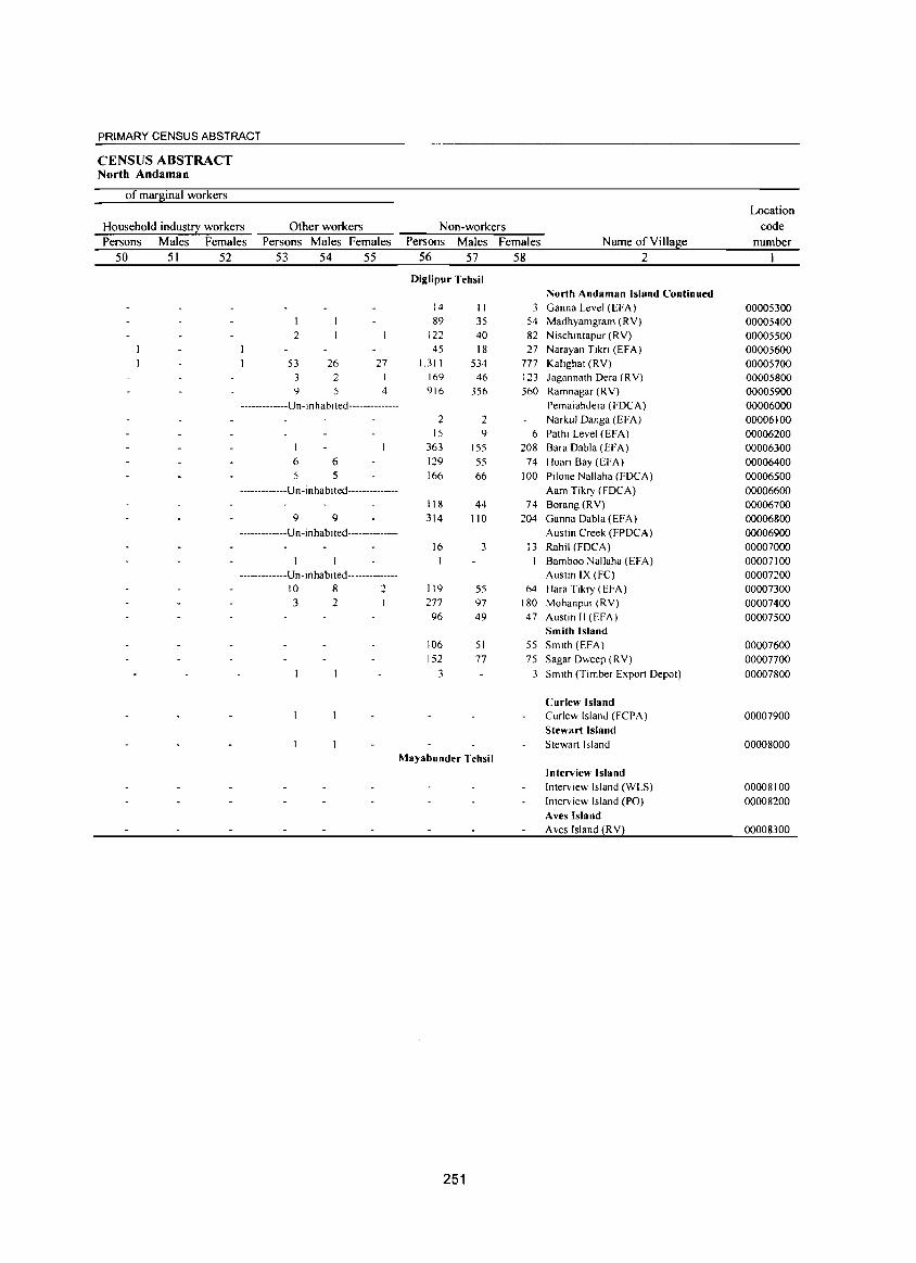
PRIMARY CENSUS ABSTRACT
CENSUS ABSTRACT North Andaman
of marginal workers
Household industry workers Persons Males Females
Other workers Persons Males Females
50 51 52 53 54 55
I 2
53 26 27 3 2 I 9 5 4
-------------U n - i n hab I ted --------------
I 6 6 5 5
-------------Un-inhabited--------------
9 9 -------------Un-inhabited--------------
-------------U n- i nha bi ted--------------10 8 2 3 2
Non-workers Persons Males Females
56 57 58
Diglipur Tehsil
14 II 3 89 35 54
122 40 82 45 18 27
1,311 534 777 169 46 123 916 356 560
2 2 15 9 6
363 155 208 129 55 74 166 66 100
118 44 74 314 110 204
16 3 13
119 55 64 277 97 180 96 49 47
106 51 55 152 77 75
3 3
Mayabunder Tehsil
251
Name of Village 2
North Andaman Island Continued Ganna Level (EFA) Madhyamgram (RV) Nischmtapur (RV) Narayan Tikn (EFA) Kallghat (RV) Jagannath Dera (RV) Ramnagar (RV) Pemaiahdera (FDCA) Narkul Danga (EFA) Pathi Level (EFA) Bara Dabla (EFA) Hoari Bay (EFA) Pilone Nallaha (FDCA) Aam Tikry (FOCA) Borang (RV) Ganna Dabla (EFA) Austin Creek (FPDCA) Rahil (FOCA) Bamboo Nallaha (EFA) Austin IX (FC) Hara Tikry (EFA) Mohanpur (RV) Austin II (EFA) Smith Island Smith (EFA) Sagar Dweep (RV)
Smith (Timber Export Depot)
Curlew Island Curlew Island (FCPA) Stewart Island Stewart Island
Interview Island Interview Island (WLS) Interview Island (PO) Aves Island Aves Island (R V)
Location code
number
00005300 00005400 00005500 00005600 00005700 00005800 00005900 00006000 00006100 00006200 00006300 00006400 00006500 00006600 00006700 00006800 00006900 00007000 00007100 00007200 00007300 00007400 00007500
00007600 00007700 00007800
00007900
00008000
00008100 00008200
00008300
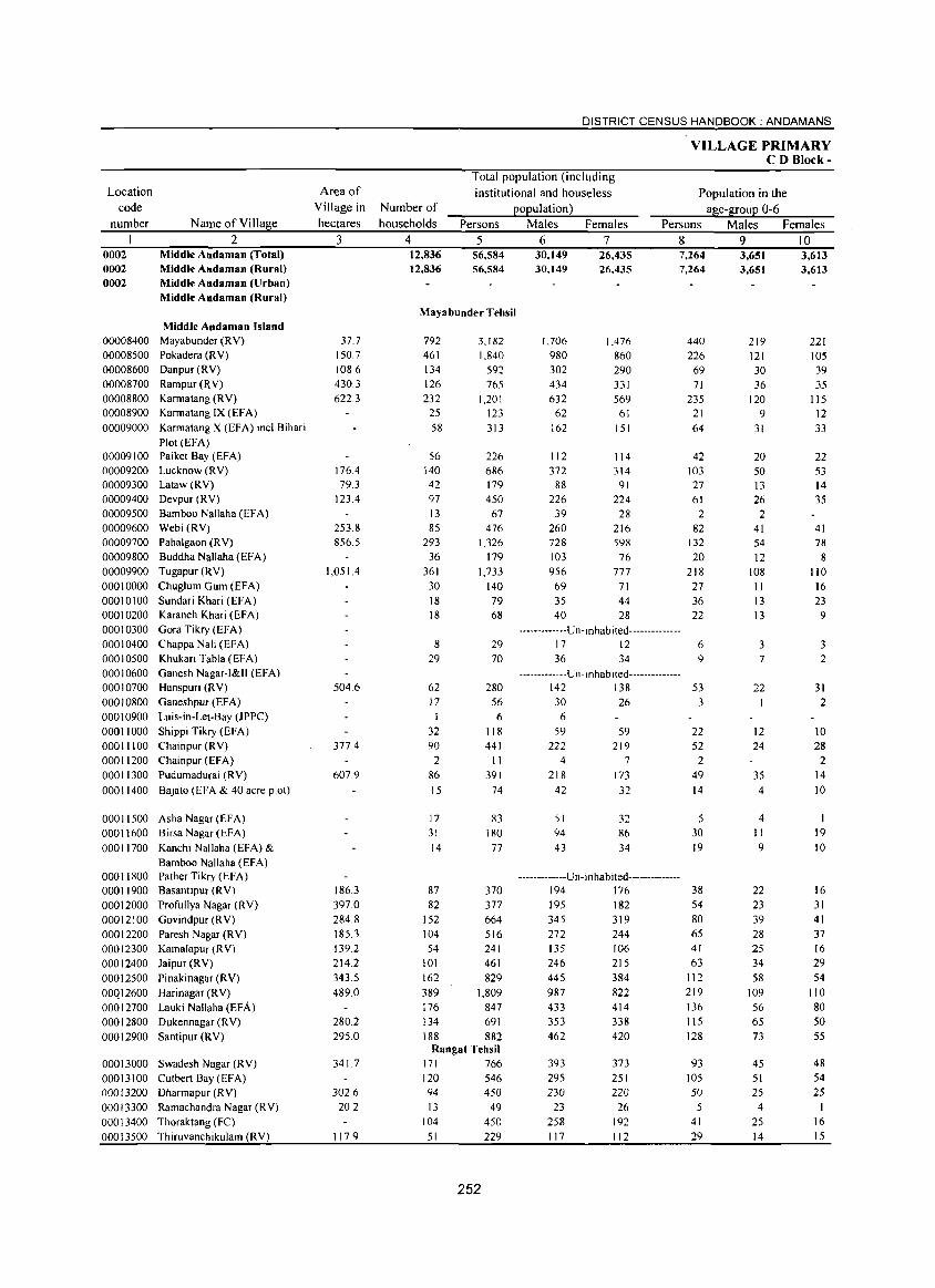
Location
code
number
0002 0002 0002
00008400 00008500 00008600 00008700 00008800 00008900 00009000
00009100 00009200 00009300 00009400 00009500 00009600 00009700 00009800 00009900 00010000 00010100 00010200 00010300 00010400 00010500 00010600 00010700 00010800 00010900 00011000 00011100 00011200 00011300 00011400
Name of Village
2 Middle Andaman (Total) Middle Andaman (Rural) Middle Andaman (Urban) Middle Andaman (Rural)
Middle Andaman Island Mayabunder (RV) Pokadera (RV) Danpur(RV) Rampur(RV) Karrnatang (RV) Karrnatang IX (EFA) Karrnatang X (EFA) incl.Bihari Plot (EFA) Paiket Bay (EFA) Lucknow (RV) Lataw (RY) Devpur (RV) Bamboo Nallaha CEFA) WebiCRV) Pahalgaon (R V) Buddha Naliaha (EFA) Tugapur CRY) Chug1um Gum (EFA) Sundari Khari (EFA) Karanch Khari (EFA) Gora Tikry (EFA) Chappa Nali (EFA) Khukari Tabla (EFA) Ganesh Nagar-I&II (EFA) Hanspuri (RY) Ganeshpur (EFA) Luis-in-Let-Bay (JPPC) Shippi Tikry (EFA) Chainpur (RV) Chainpur (EFA) Pudumadurai (RV) Bajato (EFA & 40 acre plot)
00011500 Asha Nagar (EFA) 00011600 BirsaNagar(EFA) 00011700 Kanchi Nallaha (EFA) &
00011800 00011900 00012000 00012100 00012200 00012300 00012400 00012500 00QI2600 00012700 00012800 00012900
Bamboo NaIl aha (EFA) Pather Tikry CEFA) Basantipur CRY) Profullya Nagar CRY) Govindpur (RV) Paresh Nagar CRY) Kamalapur (R V) Jaipur (RY) Pinakinagar (RY) Harinagar CRY) Lauki Nallaha (EFA) Dukennagar (RV) Santipur (RY)
00013000 Swadesh Nagar (RV) 00013100 Cutbert Bay (EFA) 00013200 Dharmapur (RV) 00013300 Ramachandra Nagar (RV) 00013400 Thoraktang (Fe) 00013500 Thiruvanchikulam (RV)
Area of
Yillage in
hectares
3
37.7 150.7 1086 430.3 622.3
176.4 79.3
123.4
253.8 856.5
1,051.4
504.6
377.4
607.9
186.3 397.0 284.8 185.3 139.2 214.2 343.5 489.0
280.2 295.0
341.7
302.6 20.2
1 17.9
DISTRICT CENSUS HANDBOOK: ANDAMANS
VILLAGE PRIMARY CD Block-
Number of
households
Total population (including
institutional and houseless
population) Population in the
age-group 0-6 Persons
4 5 12,836 12,836
56,584 56,584
Mayabunder Tehsil
792 461 134 126 232
25 58
56 140 42 97 13 85
293 36
361 30 18 18
8 29
62 17
1 32 90 2
86 15
17 31 14
87 82
152 104 54
101 162 389 176 134 188
3,182 1,840
592 765
1,201 123 313
226 686 179 450
67 476
1,326 179
1,733 140 79 68
29 70
280 56 6
118 441 II
391 74
83 180
77
370 377 664 516 241 461 829
1,809 847 691 882
Rangat Tehsil 171 766 120 546 94 450 13 49
104 450 51 229
252
Males Females Persons Males Females
6 7 8 9 10 30,149 30,149
26,435 26,435
7,264 7,264
1J06 1,476 980 860 302 290 434 331 632 569
62 61 162 151
112 114 372 314
88 91 226 224
39 28 260 216 728 598 103 76 956 777 69 71 35 44 40 28
-------------U n -I n hab i ted --------------17 12 36 34
-------------Un-I n ha b I ted --------------142 138 30 26 6
59 59 222 219
4 7 218 173
42 32
51 94 43
32 86 34
-------------Un-inhabited--------------194 176 195 182 345 319 272 244 135 106 246 215 445 384 987 822 433 414 353 338 462 420
393 295 230
23 258 117
373 251 220
26 192 112
440 226
69 71
235 21 64
42 103 27 61
2 82
132 20
218 27 36 22
6 9
53 3
22 52
2 49 14
30 19
38 54 80 65 41 63
112 219 136 115 128
93 105 50
5
41 29
3,651 3,651
219 121 30 36
120 9
31
20 50 13 26 2
41 54 12
108 11 13 13
3 7
22 I
12 24
35 4
4 11 9
22 23 39 28 25 34 58
109 56 65 73
45 51 25
4 25 14
3,613 3,613
221 105 39 35
115 12 33
22 53 14 35
41 78
8 110 16 23
9
3 2
31 2
10 28 2
14 10
19 10
16 31 41 37 16 29 54
110 80 50 55
48 54 25
16 15
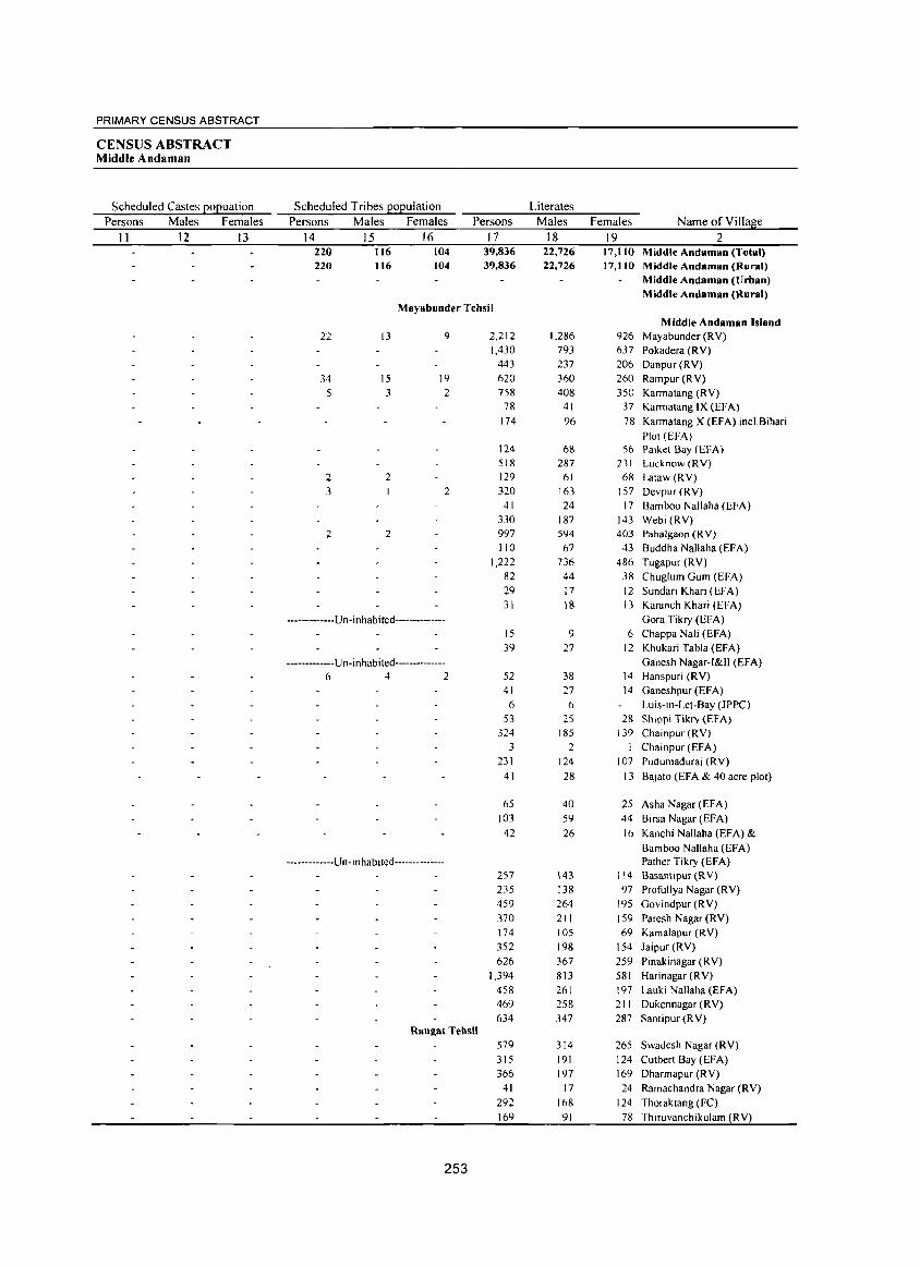
PRIMARY CENSUS ABSTRACT
CENSUS ABSTRACT Middle Andaman
Scheduled Castes EOEuation Scheduled Tribes EOEulation Literates
Persons Males Females Persons Males Females Persons Males Females Name of Village
II 12 13 14 15 16 17 18 19 2 220 116 104 39,836 22,726 17,Il0 Middle Andaman (Total) 220 116 104 39,836 22,726 17,110 Middle Andaman (Rural)
Middle Andaman (Urban) Middle Andaman (Rural)
Mayabunder Tehsil Middle Andaman Island
22 13 9 2,212 1,286 926 Mayabunder (RY) 1,430 793 637 Pokadera (RY)
443 237 206 Danpur(RY)
34 15 19 620 360 260 Rampur (RY) 5 3 2 758 408 350 Karmatang (RY)
78 41 37 Karmatang IX (EFA) 174 96 78 Karmatang X (EFA) incl.Bihari
Plot (EFA) 124 68 56 Paiket Bay (EFA) 518 287 231 Lucknow (RY)
2 2 129 61 68 Lataw (RY) 3 2 320 163 157 Devpur(RY)
41 24 17 Bamboo Nallaha (EFA) 330 187 143 Webi (RY)
2 2 997 594 403 Pahalgaon (RY) 110 67 43 Buddha Nallaha (EFA)
1,222 736 486 Tugapur (RV) 82 44 38 Chuglum Gum (EFA) 29 17 12 Sundari Khari (EFA) 31 18 13 Karanch Khari (EFA)
-------------Un-inhabited-------------- Gora Tikry (EFA) 15 9 6 Chappa Nali (EFA) 39 27 12 Khukari Tabla (EFA)
-------------Un-inhabited-------------- Ganesh Nagar-I&IJ (EFA) 6 4 2 52 38 14 Hanspuri (RY)
41 27 14 Ganeshpur (EFA) 6 6 Luis-in-Let-Bay (JPPC)
53 25 28 Shippi Tikry (EFA) 324 185 139 Chainpur (RY)
3 2 I Chainpur (EFA) 231 124 107 Pudumadurai (RY)
41 28 13 BaJ3(O (EFA & 40 acre plot)
65 40 25 Asha Nagar (EFA) 103 59 44 Birsa Nagar (EFA)
42 26 16 Kanchi Nallaha (EFA) & Bamboo Nallaha (EFA)
-------------Un-lnhabited-------------- Pather Tikry (EFA) 257 143 114 Basantipur (RV) 235 138 97 Profullya Nagar (RY) 459 264 195 Govindpur (RY) 370 211 159 Paresh Nagar (RY) 174 105 69 Kamalapur (RY) 352 198 154 Jaipur (RV) 626 367 259 Pinakinagar (RY)
1,394 813 581 Harinagar (RY) 458 261 197 Lauki Nallaha(EFA) 469 258 211 Dukennagar (RY) 634 347 287 Santipur (RY)
Rongat Tehsil 579 314 265 Swadesh Nagar (RY) 315 191 124 Cutbert Bay (EFA) 366 197 169 Dharmapur (RY)
41 17 24 Ramachandra Nagar (RY) 292 168 124 Thoraktang (FC) 169 91 78 Thiruvanchikulam (RV)
253
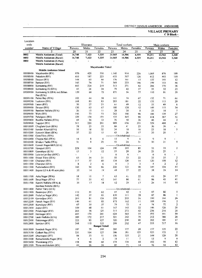
Location code
number
0002 0002 0002
Name of Village 2
Middle Andaman (Total) Middle Andaman (Rural) Middle Andaman (Urban) Middle Andaman (Rural)
Middle Andaman Island 00008400 Mayabunder (R V)
00008500 Pokadera (RV) 00008600 Danpur (RV)
00008700 Rampur (RV)
00008800 Karmatang (RV)
00008900 Karmatang IX (EFA)
00009000 Karmatang X (EFA) incl.Bihari
Plot (EFA) 00009100 Paiket Bay (EFA) 00009200 Lucknow (RV)
00009300 Lataw (R V) 00009400 Devpur (RV)
00009500 Bamboo Nallaha (EFA) 00009600 Webi (RV)
00009700 Pahalgaon (RV) 00009800 Buddha Nallaha (EFA)
00009900 Tugapur (RV)
00010000 Chuglum Gum (EFA)
00010100 Sundari Khari (EFA) 00010200 Karanch Khari (EFA)
00010300 Gara Tikry (EFA)
00010400 Chappa Nali (EFA)
00010500 Khukari TablaCEFA) 00010600 Ganesh Nagar-I&I1 CEFA)
00010700 Hanspuri (RV)
000 I 0800 Ganeshpur (EFA)
00010900 Luis-in-Let-Bay (JPPC)
00011000 Shippi Tikry (EFA) 00011100 Chainpur (RV)
00011200 Chainpur (EFA)
00011300 Pudumadurai CRY)
00011400 Bajato (EFA & 40 acre plot)
00011500 Asha Nagar (EF A)
00011600 Birsa Nagar (EFA)
00011700 Kanchi Nallaha (EFA) &
Bamboo Nallaha (EFA) 00011800 Pather Tikry (EFA)
00011900 Basantipur (RV)
00012000 Profullya Nagar (RV) 00012100 Govindpur (RV)
00012200 Paresh Nagar (RV)
000 12300 Kamalapur (RV)
00012400 Jaipur (RV)
000 12500 Pinakinagar (RV)
00012600 Harinagar (RV)
00012700 Lauki Nallaha (EFA)
000 I 2800 Dukennagar (R V)
00012900 Santipur (RV)
00013000 Swadesh Nagar (RV)
00013100 Cutbert 8ay(EFA)
00013200 Dharmapur (RV)
00013300 Ramachandra Nagar (RV)
00013400 Thoraktang (FC)
00013500 Thiruvanchikulam (RV)
DISTRICT CENSUS HANDBOOK: ANDAMANS
III iterates Total workers Persons Males Females Persons Males Females
20 21 22 23 24 25 16,748 16,748
970 410 149 145 443 45
139
102 168 50
130 26
146 329 69
511 58 50 37
14 31
228 15
65 117
8
160 33
18 77 35
113 142 205 146 67
109 203 415 389 222 248
187 231
84 8
158 60
7,423 7,423
9,325 9,325
21,065 21,065
16,506 16,506
4,559 4,559
Mayabunder Tehsil
420 187 65 74
224 21 66
44 85 27 63 15 73
134 36
220 25 18 22
8 9
104 3
34 37
2 94 14
11 35 17
51 57 81 61 30 48 78
174 172 95
115
550 223
84 71
219 24 73
58 83 23 67 II
73 195 33
291 33 32 15
6 22
124 12
31 80
6 66 19
7
42 18
62 85
124 85 37 61
125 241 217 127 133
1,140 633 176 369 313
79 171
141 203
61 180 28
262 535
76 989
66 34 43
914 507 161 223 271
42 94
74 181 49
128 20
166 445
50 656
41 18 26
226 126
15 146 42 37 77
67 22 12 52 8
96 90 26
333 25 16 17
-------------U n- i n hab i ted --------------15 9 6 55 24 31
-------------Un-inhabited--------------190 105 85 53 29 24 6 6
55 134
6
220 49
63 141 42
33 120
3
122 27
41 80 25
22 14 3
98 22
22 61 17
-------------U n- inhabIted --------------87 82 5
139 259 173 79
167 315 624 321 320 299
III 205 162 75
145 273 565 242 230 252
28 54 11 4
22 42 59 79 90 47
Rangat Tehsil 79 108 205 177
181 135
28 125 21
104 127 306 33 51 156 6 2 18
90 68 174 26 34 85
254
11 134
71
7
40 14
VILLAGE PRIMARY CD Block-
Main workers Persons Males Females
26 27 28 16,211 16,211
1,069 612 157 199 206
55 110
132 133 55
149 25
166 418
46 529
36 23 20
9 30
35 25 6
35 120
4 149 38
43 86 26
87 87
190 108 74
146 236 595 212 202 233
157 125 149
13 102 76
13,943 13,943
870 493 145 153 170 32 81
71 113 49
115 18
139 367 44
488 36 18 20
9 21
33 25
6 33
108 2
104 24
26 45 16
82 86
164 106 72
126 216 541 184 185 217
135 123 129
9
90 64
2,268 2,268
199 119
12 46 36 23 29
61 20
6 34
7 27 51 2
41
5
9
2
2 12 2
45 14
17 41 10
5
26 2 2
20 20 54 28 17 16
22 2
20 4
12 12
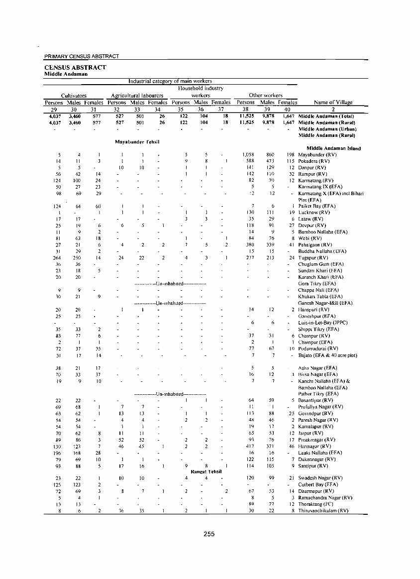
PRIMARY CENSUS ABSTRACT
CENSUS ABSTRACT Middle Andaman
Industrial category of main workers Household industry
Cultivators Agricultural labourers workers Persons Males Females Persons Males Females Persons Males Females
29 30 31 32 33 34 35 36 37 4,037 4,037
5 14
5
56
124
50
98
124
17
25
II 81
27
31
264
36
23
20
9 30
20
25
35
83
2 72 31
38
70
19
22 69
63
54
54
70
89
130
196
79
93
23
125
72 5
13
8
3,460 3,460
4 II 5
42
100
27
69
64
17
19
9 63
21
29
250
36
18
20
9 21
20
25
33 77
I
37
17
21
33 9
22
68
62
54
54
62
86
123
168
69
88
22 123
69
4 13
6
577 577
3
14
24
23
29
60
6 2
18
6 2
14
5
9
2 6 I
35
14
17
37
10
8 3 7
28
10
5
I 2 3
2
527 527
501 501
26 26
122 122
104 104
18 18
Mayabunder Tehsil
10
6
4
24
7
13
4
I II 52
46
17
10
8
36
10
5
2 2
22 2
5 5 9
I 8
I I 3 3
I
7
4
-------------Un-I nhab 1 ted --------------
-------------U n- i nhab i ted -------------
I
-------------Un-inhabited--------------
7
13
4
II
52
45
16
10
I I
2
2 2
9
I
2
2 2
8 Rangat Tehsil
4 4
I
2
7 2 2
35 2
255
Other workers Persons Males Females Name of Village
38 39 40 2 11,525 11,525
1,058
588
141
142
82 5
12
7 130
35
118
14
84
380
15
237
14
6
37
2
77 7
5
16
7
64
II 113
48
19
65
93 417
16
122
114
120
67
8 89
30
9,878 9,878
860 473
129
110
70
5
12
6 III 29
91
9 76
339 15
213
12
6
31
I
67
7
5 12
7
59
II 88
46
17
53
76
371
16
115
105
99
53
5 77 22
1,647 Middle Andaman (Total) 1,647 Middle Andaman (Rural)
Middle Andaman (Urban) Middle Andaman (Rural)
Middle Andaman Island 198 Mayabunder (RV)
115 Pokadera (RV)
12 Danpur (R V)
32 Rampur(RV)
12 Karmatang (RV) Karmatang IX (EFA)
Karmatang X (EFA) incl.Bihari
Plot (EFA) Paiket Bay (EFA)
19 Lucknow (RV)
6 Lataw(RV)
27 Devpur (RV)
5 Bamboo Nallaha (EFA)
8 Webi (RY)
41 Pahalgaon (RV)
Buddha Nallaha (EFA)
24 Tugapur (RY)
Chugfum Gum (EFA)
Sundari Khari (EFA)
Karanch Khari (EFA)
Gora Tikry (EFA)
Chappa Nali (EFA)
Khukari Tabla (EFA)
Ganesh Nagar-I&II (EFA)
2 Hanspuri (RV)
Ganeshpur (EFA)
Luis-in-Let-Bay (JPPC)
Shippi Tikry (EFA)
6 Chainpur (RV)
I Chainpur (EFA)
10 Pudumadurai (RV)
Bajato (EFA & 40 acre plot)
Asha Nagar (EFA)
4 Birsa Nagar (EFA)
Kanchi Nallaha (EF A) &
Bamboo Nallaha (EFA) Pather Tikry (EFA)
5 Basantipur (RV)
Profullya Nagar (RV)
25 Govindpur (RV)
2 Paresh Nagar (RV)
2 Kamalapur (RV)
12 Jalpur (RV)
17 Pinakinagar (RY)
46 Harinagar (RY)
Lauki Nallaha (EFA)
7 Dukennagar (R Y)
9 Santipur (RV)
21 Swadesh Nagar (RV)
Cutbert Bay (EFA)
14 Dharmapur (RV)
3 Ramachandra Nagar (RY)
12 Thoraktang (FC)
8 Thiruvanchikulam (RV)
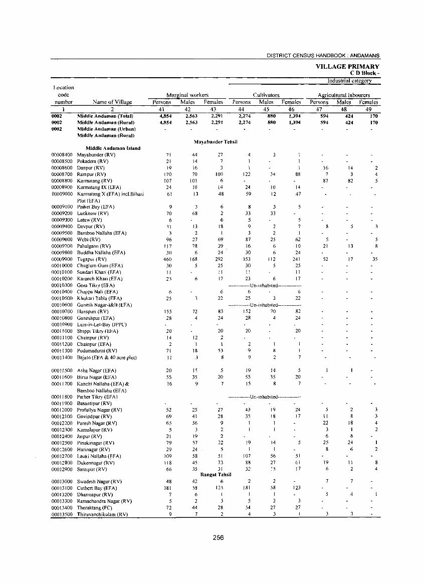
Location
code number
0002 0002 0002
Name of Village 2
Middle Andaman (Total) Middle Andaman (Rural) Middle Andaman (Urban) Middle Andaman (Rural)
Middle Andaman Island 00008400 Mayabunder (R V) 00008500 Pokadera (R V) 00008600 DanpuT (RV) 00008700 Rampur (RV) 00008800 Karmatang (RV) 00008900 Karmatang IX (EFA) 00009000 Karmatang X (EFA) incl.Bihari
Plot (EFA) 00009100 Paiket Bay (EFA) 00009200 Lucknow (RV) 00009300 Lataw (RV) 00009400 Devpur (RV) 00009500 Bamboo Nallaha (EFA) 00009600 Webi CRY) 00009700 Pahalgaon CRY) 00009800 Buddha Nallaha (EFA) 00009900 Tugapur CRY) 00010000 Chuglum Gum (EFA) 00010100 Sundari Khari (EFA) 00010200 Karanch Khari (EFA) 00010300 Gora Tikry (EFA) 00010400 ChappaNali(EfA) 00010500 Khukari Tabla (EFA) 00010600 Ganesh Nagar-I&II (EFA) 00010700 Hanspuri CRY) 00010800 Ganeshpur (EFA) 00010900 Luis-in-Let-Bay (JPPC) 00011000 ShippiTikry(EFA) 00011100 Chainpur (RV) 00011200 Chainpur (EFA) 00011300 Pudumadurai CRY) 00011400 Bajato (EFA & 40 acre plot)
00011500 Asha Nagar (EFA) 00011600 Birsa Nagar (EFA) 00011700 Kanchi Nallaha (EFA) &
Bamboo Nal1aha (EF A) 00011800 Pather Tikry (EFA) 000 11900 Basantipur (RV) 00012000 Profullya Nagar CRY) 00012100 Govindpur CRY) 00012200 Paresh Nagar CRY) 00012300 Kamalapur CRY) 00012400 Jaipur (RV) 00012500 Pinakinagar CRY) 000 12600 Harinagar CRY) P0012700 Lauki Nallaha CEFA) 00012800 Dukennagar CRY) 00012900 Santipur(RV)
00013000 Swadesh Nagar (RV) 00013100 CutbertBayCEFA) 00013200 Dharmapur (R V) 00013300 Ramachandra Nagar (R Y) 00013400 Thoraktang (Fe) 00013500 Thiruvanchikulam CRY)
DISTRICT CENSUS HANDBOOK: ANDAMANS
Marginal workers Persons Males Females
41 42 43 4,854 4,854
2,563 2,563
2,291 2,291
Persons 44 2,274 2,274
Cultivators Males
45 880 880
Females 46 1,394 1,394
Mayabunder Tehsil
71 21 19
170 107 24
61
9 70
6 31
3 96
117 30
460 30 1 I 23
6 25
155 28
20 14 2
71
II
20 55 16
52 69 65
5 21 79 29
109 I I 8 66
48 181
7
5 72
9
44 14 16 70
101 10 13
3 68
13 2
27 78
6 168
5
6
3
72 4
12
18
3
15 35
9
25 41 56
3 19 57 24 58 45 35
27 7 3
100 6
14 48
6 2 6
18 I
69 39 24
292 25 II 17
6
22
83 24
20 2
53 8
5 20
7
27 28 9 2 2
22 5
51 73
31
4 3
122
24 59
8
34
10 12
3 33 33
&8
14 47
5
5 5 9 3
87 16 30
353 30 II 23
2 2
25 6 6
112 5
6
7 I
62 10 24
241 25 11 17
------- ------Un -i nhabited--------------6 6
25 3 22
-------------U n- i n habi ted--------------152 70 82 28 4 24
20
2 9
9
19 55 15
8
2
14 35
8
20
I
7
5 20
7
-------------Un-i nhabited--------------
43 35
19
107 88 32
19 18
14
56 27 15
24 17
5
51 61 17
Rangat Tehsil 42 6 58 123
6 I
2 3 44 28
7 2
256
2 181
I
5 54 4
2 58
I
2 27
3
123
3 27
I
VILLAGE PRIMARY C DBlock-
Industrial category
Agricultural labourers Persons Males Females
47 48 49 594 594
16 7
87
8
5 21
52
5
II 22
3 6
25 8
19 6
7
5
3
424 424
14 3
82
5
13
17
2 8
18 I 6
24 6
II 2
7
4
3
170 170
2 4 5
3
5 8
35
3 3 4 2
I 2
8 4
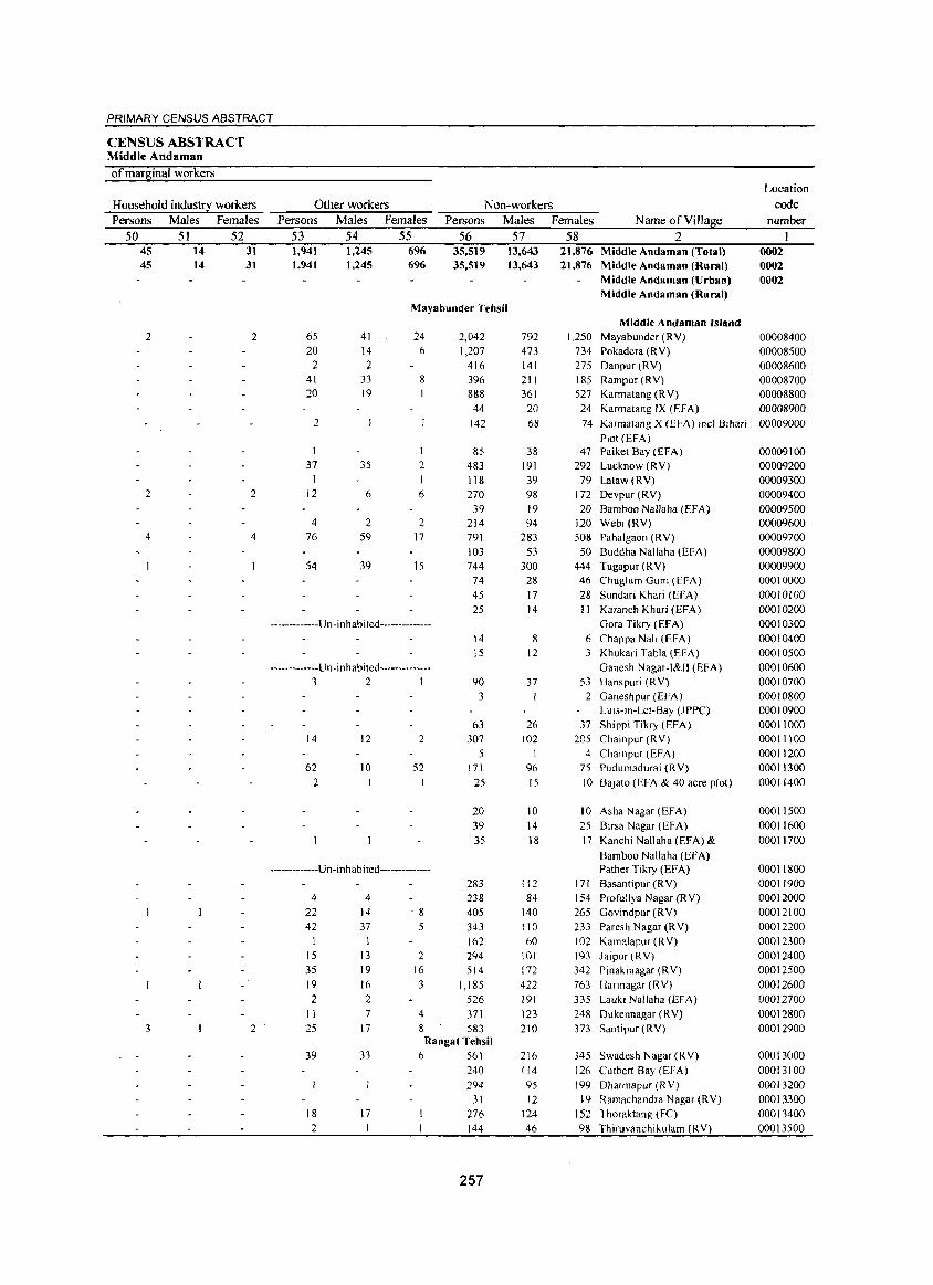
PRIMARY CENSUS ABSTRACT
CENSUS ABSTRACT Middle Andaman
of mar~inal workers Location
Household indus!!i: workers Other workers Non-workers code
Persons Males Females Persons Males Females Persons Males Females Name ofViIla~e number
50 51 52 53 54 55 56 57 58 2 I 45 14 31 1,941 1,245 696 35,519 13,643 21,876 Middle Andaman (Total) 0002 45 14 31 1,941 1,245 696 35,519 13,643 21,876 Middle Andaman (Rural) 0002
Middle Andaman (Urban) 0002 Middle Andaman (Rural)
Mayabunder Tehsil Middle Andaman Island
2 2 65 41 24 2,042 792 1,250 Mayabunder (RY) 00008400 20 14 6 1,207 473 734 Pokadera (RY) 00008500
2 2 416 141 275 Danpur (RY) 00008600 41 33 8 396 211 185 Rampur (RY) 00008700 20 19 888 361 527 Karmatang (RY) 00008800
44 20 24 Karmatang IX (EFA) 00008900 2 142 68 74 Karmatang X (EFA) incl. Bihari 00009000
Plot (EFA) 1 1 85 38 47 Paiket Bay (EFA) 00009100
37 35 2 483 191 292 Lucknow (RY) 00009200 1 118 39 79 Lataw(RY) 00009300
2 2 12 6 6 270 98 172 Devpur (RY) 00009400 39 19 20 Bamboo Nallaha (EFA) 00009500
4 2 2 214 94 120 Webi (RY) 00009600 4 4 76 59 17 791 283 508 Pahalgaon (RY) 00009700
103 53 50 Buddha Nallaha (EFA) 00009800 54 39 15 744 300 444 Tugapur (RY) 00009900
74 28 46 Chuglum Gum (EFA) 00010000 45 17 28 Sundari Khari (EFA) 00010100 25 14 II Karanch Khari (EFA) 00010200
-------------Un-inhabited-------------- Gora Tikry (EFA) 00010300 14 8 6 Chappa NaIl (EFA) 00010400 15 12 3 Khukari Tabla (EFA) 00010500
-------------Un-inhabited-------------- Ganesh Nagar-I&I1 (EFA) 00010600 3 2 1 90 37 53 Hanspuri (RY) 00010700
3 I 2 Ganeshpur (EFA) 00010800 LUls-in-Let-Bay (JPPC) 00010900
63 26 37 Shippi Tikry (EFA) 00011000 14 12 2 307 102 205 Chainpur (RY) 00011100
5 4 Chainpur (EFA) 00011200 62 10 52 171 96 75 Pudumadurai (RY) 00011300
2 25 15 10 Bajato (EfA & 40 acre plot) 00011400
20 10 10 Asha Nagar (EFA) 00011500 39 14 25 Birsa Nagar (EFA) 00011600 35 18 17 Kanchi Nail aha (EFA) & 00011700
Bamboo NaHaha (EF A) -------------Un-inhabited-------------- Pather Tikry (EFA) 00011800
283 112 171 Basanlipur CRY) 00011900 4 4 238 84 154 Profullya Nagar (R Y) 00012000
22 14 8 405 140 265 Govindpur (RY) 00012100 42 37 5 343 110 233 Paresh Nagar (R Y) 00012200
162 60 102 Kamalapur CRY) 00012300 15 13 2 294 101 193 Jaipur (RY) 00012400 35 19 16 514 172 342 Pinakinagar (RY) 00012500 19 16 3 1,185 422 763 Hannagar (RY) 00012600 2 2 526 191 335 Lauki Nallaha (EFA) 00012700
11 7 4 371 123 248 Dukennagar (RY) 00012800 3 2 25 17 8 583 210 373 Santipur (RY) 00012900
Rangat Tehsil 39 33 6 561 216 345 Swadesh Nagar CRY) 00013000
240 114 126 CUlbert Bay (EFA) 00013100 294 95 199 Dharmapur (R V) 00013200
31 12 19 Ramachandra Nagar (RY) 00013300 18 17 276 124 152 Thoraktang (FC) 00013400 2 1 144 46 98 Thiruvanchikulam CRY) 00013500
257
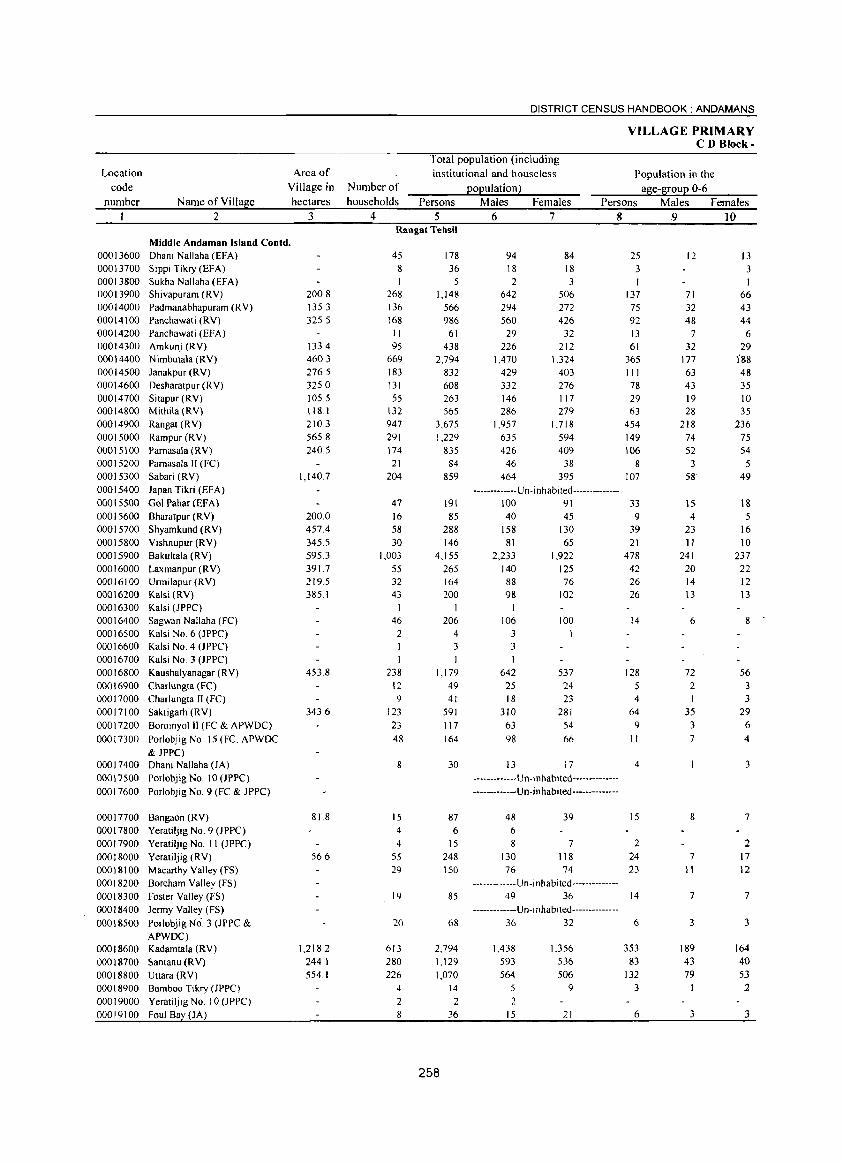
Location code
number
00013600 00013700 00013800 00013900 00014000 00014100 00014200 00014300 00014400 00014500 00014600 00014700 00014800 00014900 00015000 00015100 00015200 00015300 00015400 00015500 00015600 00015700 00015800 00015900 00016000 00016100 00016200 00016300 00016400 00016500 00016600 00016700 00016800 00016900 00017000 00017100 00017200 00017300
00017400 00017500 00017600
00017700 00017800 00017900 00018000 00018100 00018200 00018300 00018400 00018500
00018600 00018700 00018800 00018900 00019000 00019100
Name of Village 2
Area of Village in hectares
3
Middle Andaman Island Contd. Dhani Nallaha (EFA)
Sippi Tikry (EFA)
Sukha Nallaha (EFA) Shivapuram (RV)
Padmanabhapuram (R V)
Panchawati (RV)
Panchawati (EFA) Amkunj (RV)
Nimbutala (RV)
Janakpur (RV)
Desharatpur (R V) Sitapur (RV) Mithila (RV)
Rangat (RV)
Rampur (RV)
Pamasala (RV) Pamasala 1I (FC)
Sabari (RV)
Japan Tikri (EFA)
Gol Pahar (EFA)
Bharatpur (RV) Shyamkund (RV)
Vishnupur (RV)
Bakultala (RV)
Laxmanpur (RV) Urmilapur (RV) Kalsi (RV)
Kalsi (JPPC)
Sagwan Nallaha (FC)
Kalsi No.6 (JPPC) Kalsi No.4 (JPPC)
Kalsi No.3 (JPPC)
Kaushalyanagar (RV)
Charlungta (FC) Charlungta II (FC)
Saktigarh (RV)
Boroinyolll (FC & APWDC)
Porlobjig No. 15 (Fe. APWDC
& JPPC) Dhani Nallaha (JA)
Porlobjig No. 10 (JPPC)
Porlobjig No.9 (FC & JPPC)
Bangaon (RV)
Yeratiljig No.9 (JPPC)
Yeratiljig No. II (JPPC)
Yeratiljig (RV)
Macarthy Valley (FS)
Bareham Valley (FS)
Foster Valley (FS)
Jermy Valley (FS)
Porlobjig No.3 (JPPC & APWDC) Kadamtala (RV)
Santanu (RV)
Uttara (RV)
Bamboo Tikry OPPC)
Yeratiljig No. 10 (JPPC)
Foul Bay (JA)
200.8 135.3 325.5
133.4 460.3 276.5 325.0 105.5 118.1 210.3 565.8 240.5
1,140.7
200.0 457.4 345.5 595.3 391.7 2195 385.1
453.8
343.6
81.8
56.6
1,218.2 244.1 554.1
Number of households
4
DISTRICT CENSUS HANDBOOK: ANDAMANS
Total population (including institutional and houselcss
population) Persons Males Females
5 6 7
VILLAGE PRIMARY CD Block-
Population in the
age-group 0-6 Persons Males Females
8 9 10 Rangat Tehsil
45 8
268 136
168 II 95
669
183
131 55
132 947 291
174
21 204
47 16 58
30 1,003
55 32 43
46 2
238
12 9
123
23 48
8
15
4
4 55 29
19
20
613 280 226
4
2 8
178 36
5 1,148
566 986
61 438
2,794 832 608 263 565
3.675 1,229
835 84
859
191
85
288 146
4,155 265
164 200
206 4
3
1,179 49 41
591 117
164
30
87 6
15
248 150
85
68
2,794 1,129 1,070
258
14
2 36
94 84 18 18 2 3
642 506 294 272 560 426 29 32
226 212 1,470 1.324
429 403 332 276 146 117 286 279
1.957 1.718 635 594 426 409
46 38 464 395
------------- U n- i n habi ted--------------100 91 40 45
158 130 81 65
2,233 1,922 140 125 88 76 98 102
106 100 3 I 3
642 537 25 24
18 23
310 281 63 54 98 66
13 17
-------------Un-inhablted--------------
------------- Un- in habited--------------
48 39
6 8 7
130 118 76 74
-------------U n -i n h a bi ted--------------49 36
------------- U n- i n h abl ted--------------
36 32
1,438 1_356 593 536 564 506
5 9
2 15 21
25 3
137 75 92 13 61
365
III 78 29 63
454
149
106 8
107
33 9
39
21 478 42 26 26
14
128 5 4
64 9
II
4
15
2 24 23
14
6
353 83
132 3
6
12
71 32 48
7 32
177 63 43 19 28
218 74 52
3 58
15
4 23 11
241 20 14 13
6
72
2 I
35 3 7
8
7 II
7
3
189 43
79
3
13 3
66 43
44 6
29 188 48 35 10 35
236 75 S4
5 49
18 5
16 10
237
22 12
13
8
56 3 3
29
6
4
3
7
2 17 12
7
3
164 40
53 2
3
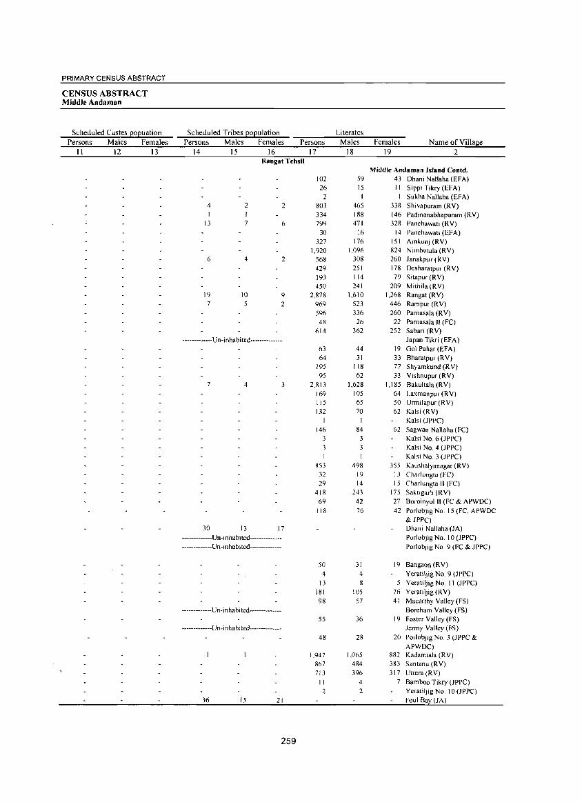
PRIMARY CENSUS ABSTRACT
CENSUS ABSTRACT Middle Andaman
Scheduled Castes EOEuation Scheduled Tribes EOEulation Literates
Persons Males Females Persons Males Females Persons Males Females Name of Village
II 12 13 14 15 16 17 18 19 2 Rangat Tehsil
Middle Andaman Island Coutd. 102 59 43 Dhani Nallaha (EFA) 26 15 II Sippi Tikry (EFA)
2 I Sukha Nallaha (EFA) 4 2 2 803 465 338 Shivapuram (RY) I 334 188 146 Padmanabhapuram (RY)
13 7 6 799 471 328 Panchawati CRY) 30 16 14 Panchawati (EFA)
327 176 151 Amkunj (RY) 1,920 1,096 824 Nimbutala (RY)
6 4 2 568 308 260 Janakpur (RY) 429 251 178 Desharatpur (R Y) 193 114 79 Sitapur(RY) 450 241 209 Mithila (RY)
19 10 9 2,878 1,610 1.268 Rangat(RY) 7 5 2 969 523 446 Rampur (RY)
596 336 260 Parnasala (RY) 48 26 22 Pamasala II (FC)
614 362 252 Sabari (RY)
·············Un·inhabited·············· Japan Tikri (EFA) 63 44 19 Gol Pahar (EFA) 64 31 33 Bharatpur (RY)
195 118 77 Shyamkund (RV) 95 62 33 Yishnupur (RV)
7 4 3 2.813 1,628 1,185 Bakultala (RY) 169 105 64 Laxmanpur (RY) 115 65 50 Unnilapur (RV) 132 70 62 Kalsi (RV)
Kalsi (JPPC) 146 84 62 Sagwan Nallaha (FC)
3 3 Kalsi No, 6 (JPPC) 3 3 Kalsi No.4 (JPPC) I Kalsi NO.3 (JPPC)
853 498 355 Kaushalyanagar (RY) 32 19 13 Charlungta (FC) 29 14 15 Charlungta II (FC)
418 243 175 Saktigarh (RY) 69 42 27 Boroinyol II (FC & APWDC)
118 76 42 Porlobjig No. 15 (FC, APWDC & JPPC)
30 13 17 Dhani Nallaha (JA) ····_··_··-··Un·i nhablted·············_ Porlobjig No.1 0 (Jppe) •••. _ .. _ ••••• U n·1 nhab i ted····_········_ Porlobjig NO.9 (FC & JPPC)
50 31 19 Bangaon (RV) 4 4 YeratilJig NO.9 (JPPC)
13 8 5 YeratiVig No. II (JPPC) 181 105 76 Yeratlljig (RY) 98 57 41 Macarthy Yalley (FS)
·····_·_·····Un·inhabited·············· Boreham Yalley (FS) 55 36 19 Foster Valley (FS)
····_· .. ·····U n· i nha b i ted·······_······ Jenny Valley (FS)
48 28 20 Porlobjig NO.3 (JPPC & APWDC)
1,947 1,065 882 Kadamtala (RV) 867 484 383 Santanu (RV) 713 396 317 Uttara (RY)
I I 4 7 Bamboo Tikry (JPPC) 2 2 Yeratiljig No. 10 (JPPC)
36 15 21 Foul Ba (JA)
259
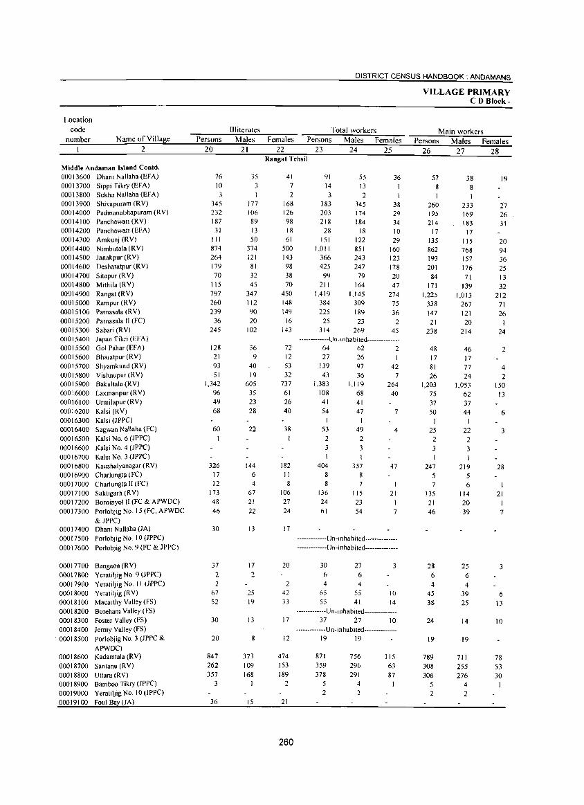
Location
code
number Name of Village
2
Middle Andaman Island Contd. 00013600 Dhani Nallaha (EFA) 00013700 Sippi Tikry(EFA) 00013800 Sukha Nallaha (EFA) 00013900 Shivapuram (RV) 00014000 Padmanabhapuram (RV) 00014100 Panchawati (RV) 00014200 Panchawati (EFA) 00014300 Amkunj (RY) 00014400 Nimbutala (RY) 00014500 Janakpur (RV) 00014600 Desharatpur (RV) 00014700 S itapur (R V) 00014800 Mithila (RY) 00014900 Rangat(RV) 00015000 Rampur (RV) 0001 5100 Parnasala (R V) 00015200 Pamasala II (FC) 00015300 Sabari (RY) 00015400 Japan Tikri (HA) 00015500 Gol Pahar (EFA) 00015600 Bharatpur (RV) 00015700 Shyamkund (RV) 00015800 Vishnu pur (RV) 00015900 Bakultala (RV) 00016000 Laxmanpur(RV) 00016100 Urmilapur(RV) 00016200 Kalsi (RV) 00016300 Kalsi OPPC) 00016400 Sagwan Nallaha (Fe) 00016500 Kalsi No.6 OPPC) 00016600 Kalsi No.4 OPPC) 00016700 Kalsi No.3 (JPPC) 00016800 Kaushalyanagar (RV) 00016900 Charlungta (FC) 00017000 Charlungta II (FC) 00017100 Saktigarh(RV) 00017200 Boroinyo1 II (FC & APWDC) 00017300 Porlobjig No. 15 (FC, APWDC
& JPPC) 00017400 Dhani Nallaha (JA) 00017500 Porlobjig No.1 0 (JPPC)
00017600 Porlobjig NO.9 (FC & JPPC)
00017700 Bangaon (RV) 00017800 Yeratiljig No 9 (JPPC) 00017900 Yerati1jig No 11 (JPPC) 00018000 Yeratiljig (RV) 00018100 MacarthyValley(FS) 00018200 Bareham Valley (FS) 00018300 Foster Valley (FS) 00018400 Jermy Valley (FS)
. 00018500 Porlobjig No.3 (JPPC &
APWDC) 00018600 Kadamtala (RV) 00018700 Santanu (RV) 00018800 Uttara (RV) 00018900 Bamboo Tikry (JPPC) 00019000 Yeratiljig No 10 (JPPC) 00019100 Foul Bay (JA)
Persons
20
76 10 3
345 232 187 31
111 874 264 179 70
115 797 260 239
36 245
128 21 93 51
1,342 96 49 68
60
326 17 12
173 48 46
30
37
2 2
67 52
30
20
847 262 357
3
36
Illiterates
Males
21
35 3
177 106 89 13 50
374 121 81 32 45
347 112 90 20
102
56 9
40 19
605 35 23 28
22
144 6 4
67 21 22
13
17
2
25 19
13
8
373 109
168
15
DISTRICT CENSUS HANDBOOK: ANDAMANS
Total workers
Females Persons Males Females
22 23 24 25 Rangat Tehsil
41 7
2 168 126 98 18 61
500 143 98 38 70
450 148 149
16 143
72 12 53 32
737 61 26 40
38 I
182 II 8
106 27 24
17
20
2 42 33
17
12
474 153 189
2
21
260
91 14 3
383 203 218
28 151
1,011 366 425 99
211 1,419
384 225
25 314
55 13 2
345 174 184
18 122 851 243 247
79 164
1,145 309 189 23
269
36 I I
38 29 34 10 29
160 123 178 20 47
274 75 36
2 45
-------------U n - i nhab i ted--------------64 62 2 27
139 43
1.383 108
26 97 36
1,119 68
41 41 54
53 2 3
404 8
47 I
49 2
3
357 8
8 7
136 24 61
115 23 54
42 7
264 40
7
4
47
21 J
7
-------------U n-i n ha b i ted-------- -------------------U n-i n ha bi ted--------------
30 27 6 6 4 4
65 55
55 41
3
10 14
-------------U n- i n ha b i ted--------------37 27 10
-------------U n- i nhab i ted--------------19 19
871 359 378
5 2
756 296 291
4 2
115 63 87
VILLAGE PRIMARY CD Block-
Main workers
Persons Males Females
26 27 28
57 8
260 195 214
17 135 862 193 201
84 171
1,225 338 147 21
238
48 17 81 26
1,203 75 37 50
1
25 2 3
247 5 7
135 21 46
28 6
4
45 38
24
19
789 308 306
5 2
38 8
233 169 183
17 115 768 157 176 71
139 1,013
267 121 20
214
46 17 77 24
1,053 62 37 44
I
22 2 3
219 5 6
114 20 39
25 6 4
39 25
14
19
711 255 276
4 2
19
27 26 31
20 94 36 25 13 32
212 71 26
24
2
4 2
150 13
6
3
28
21
7
3
6 \3
10
78
53 30
1
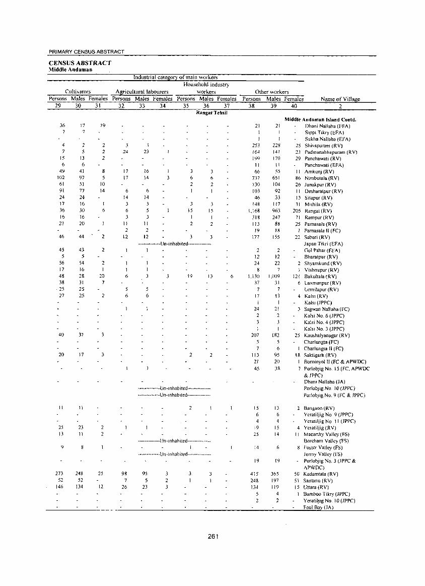
PRIMARY CENSUS ABSTRACT
CENSUS ABSTRACT Middle Andaman
Industrial cateS;0!1 of main workers
Household industry
Cultivators As;ricultural labourers workers Other workers
Persons Males Females Persons Males Females Persons Males Females Persons Males Females Name of Village 29 30 31 32 33 34 35 36 37 38 39 40 2
Rangat Tehsil
Middle Andaman Island Contd. 36 17 19 21 21 Dhani Nallaha (EFA)
7 7 Sippi Tikry (EFA) I Sukha Nallaha (EFA)
4 2 2 3 3 253 228 25 Shivapuram (RV) 7 5 2 24 23 164 141 23 Padmanabhapuram (RY)
15 13 2 199 170 29 Panchawati (RY) 6 6 II 11 Panchawati (EFA)
49 41 8 17 16 3 66 55 II Amkunj (RY) 102 97 5 17 14 3 6 6 737 651 86 Nimbutala (RY) 61 51 10 2 2 130 104 26 J anakpur (RY) 91 77 14 6 6 103 92 11 Desharatpur (R Y) 24 24 14 14 46 33 13 Sitapur (RY) 17 16 I 3 3 3 3 148 117 31 Mithila (RY) 36 30 6 6 5 15 15 1,168 963 205 Rangat (RY) 16 16 3 3 I I 318 247 71 Rampur(RY) 21 20 II II 2 2 113 88 25 Pamasala (R Y)
2 2 19 18 I ParnasaJa II (FC) 46 44 2 12 12 3 3 177 ISS 22 Sabari (RY)
------------Un- i nhab ited-------------- Japan Tikri (EFA) 45 43 2 I 2 2 Gol Pahar (EFA)
5 5 12 12 Bharatpur (RY) 56 54 2 24 22 2 Shyamkund CRY) 17 16 I 1 1 8 7 Vishnupur (RY) 48 28 20 6 3 3 19 13 6 1,130 1,009 121 Bakultala CRY) 38 31 7 37 31 6 Laxmanpur (RY)
·25 2S 5 7 7 Urmilapur (RY) 27 25 2 6 6 17 13 4 Kalsi (RY)
I I Kalsi (JPPC) 24 21 3 Sagwan Nal1aha (FC)
2 2 Kalsi No.6 (JPPC) 3 3 Kalsi NO.4 (JPPC)
Kalsi No.3 (JPPC) 40 37 3 207 182 25 Kaushalyanagar (R V)
5 5 Charlungta (FC) 7 6 Charlungta II (FC)
20 17 3 2 2 113 95 18 Saktigarh (RY)
21 20 I Boroinyol II (Fe & APWDC)
45 38 7 Porlobjig No. 15 (FC, APWDC
& JPPC) Dhani Nallaha (JA)
-------------Un- i n h ab i ted-------------- Porlobjig No. 10 OPPC) -------------Un-Inhabited-------------- Porlobjig NO.9 (Fe & JPPC)
11 11 2 15 13 2 Bangaon (RY) 6 6 Yeratiljig No.9 (Jppe) 4 4 Yeratiljig No. II (JPPC)
25 23 2 19 15 4 Yeratiljig (RY) 13 11 2 25 14 II Macanhy Valley (FS)
-------------U n -I n hab j ted-------------- Boreham Yalley (FS) 9 8 I 14 6 8 Foster Yalley (FS)
-------------U n - j n h ab ited-------------- Jermy Valley (FS) 19 19 Porlobjig NO.3 (J PPC &
APWDC) 273 248 25 98 95 3 3 3 415 365 50 Kadamtala (R V)
52 52 7 5 2 248 197 51 Santanu (RY) 146 134 12 26 23 3 134 119 15 Uttara{RY)
5 4 1 Bamboo Tikry (JPPC)
2 2 Yeratiljig No. 10 (JPPC) Foul Ba (JA)
261
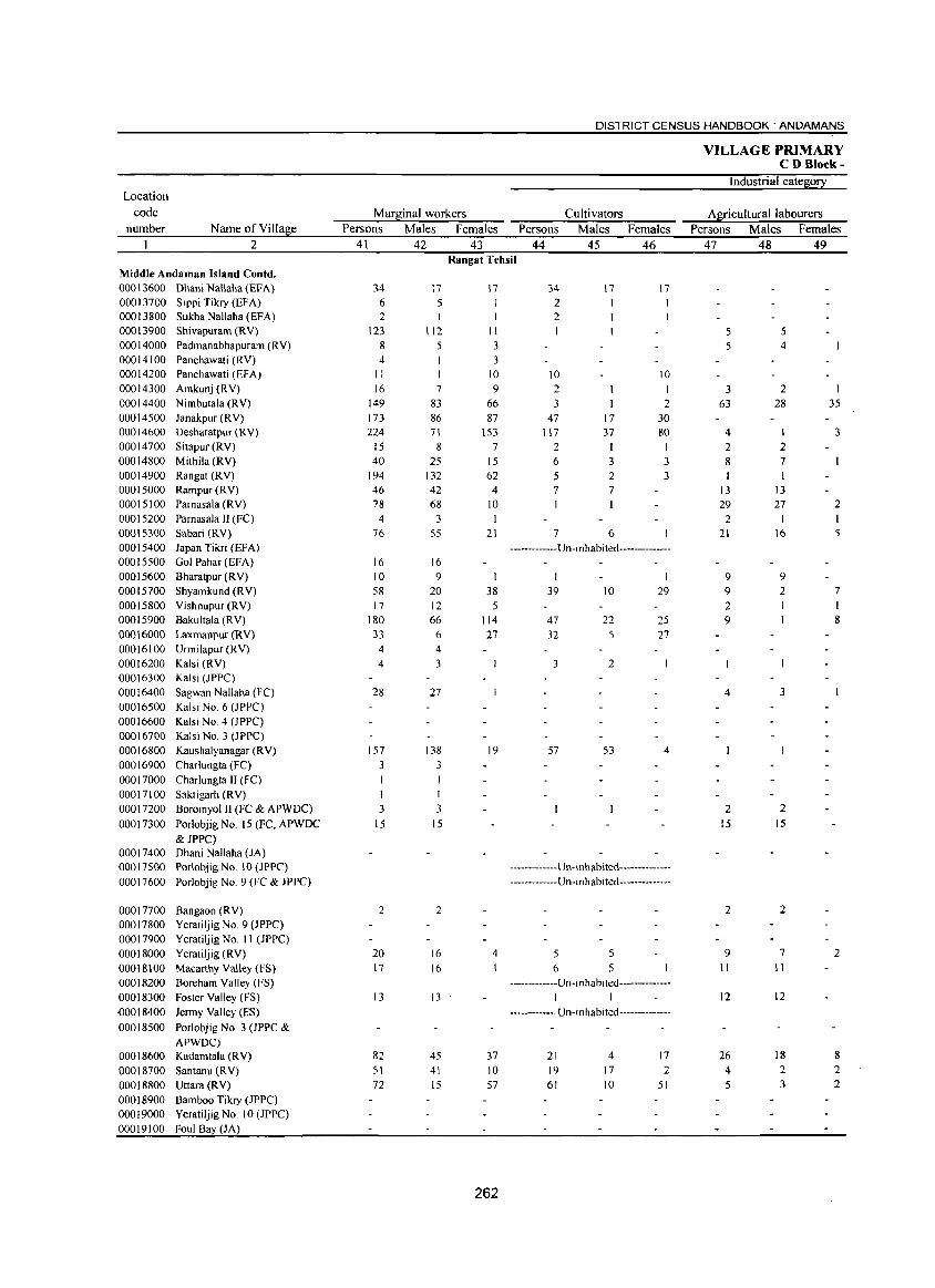
DISTRICT CENSUS HANDBOOK: ANDAMANS
VILLAGE PRIMARY CD Blotk-
Industrial cateS0!l: Location
code Mar!l:inal workers Cultivators Al[icultural labourers number Name ofVilla!l:e Persons Males Females Persons Males Females Persons Males Females
1 2 41 42 43 44 45 46 47 48 49 Ranga! Tehsil
Middle Andaman Island Contd. 00013600 Dhani Nallaha (EFA) 34 17 17 34 17 17 00013700 Sippi Tikry (EFA) 6 5 2 00013800 Sukha Nallaha (EFA) 2 I 2 00013900 Shivapuram (RY) 123 112 11 5 5 00014000 Padmanabhapuram (RY) 8 5 3 5 4 00014100 Panchawati (RY) 4 3 00014200 Panchawati (EFA) II 10 10 10 00014300 Amkunj (RY) 16 7 9 2 I 3 2 00014400 Nimbuta1a (RY) 149 83 66 3 2 63 28 35 00014500 Janakpur (RY) 173 86 87 47 17 30 00014600 DesharatpuT (RY) 224 71 153 117 37 80 4 I 3 00014700 Sitapur (RY) 15 8 7 2 I I 2 2 00014800 Mithila (RY) 40 25 15 6 3 3 8 7 00014900 Rangat (RY) 194 132 62 5 2 3 00015000 Rampur(RY) 46 42 4 7 7 13 13 00015100 Pamasa1a (RY) 78 68 10 I I 29 27 2 00015200 Pamasala II (FC) 4 3 I 2 1 1 00015300 Sabari (RY) 76 55 21 7 6 21 16 5 00015400 Japan Tikri (EFA) -------------U n-i n habi ted--------------00015500 Gol PahaT (EFA) 16 16 00015600 Bharatpur (R Y) 10 9 9 9 00015700 Shyamkund (RY) 58 20 38 39 10 29 9 2 7 00015800 Yishnupur (RY) 17 12 5 2 1 00015900 Bakultala (RY) 180 66 114 47 22 25 9 8
00016000 Laxmanpur (RY) 33 6 27 32 5 27 00016100 Urmilapur (RY) 4 4 00016200 Kalsi (RY) 4 3 3 2 00016300 Kalsi (JPPC) 00016400 Sagwan Nallaha (FC) 28 27 4 3 00016500 Kalsi NO.6 (JPPC) 00016600 Kalsi No.4 (JPPC) 00016700 Kalsi NO.3 (JPPC) 00016800 Kaushalyanagar (RY) 157 138 19 57 53 4 00016900 Charlungta (FC) 3 3 00017000 Charlungta II (FC) 00017100 Saktigarh (RV) I I 00017200 Boroinyol " (FC & APWDC) 3 3 2 2
00017300 Porlobjig No. 15 (FC, APWDC 15 15 15 15
& JPPC) 00017400 Dhani Nallaha (JA) 00017500 Por1objig No. 10 (JPPC) ------------Un-inhabited--------------00017600 Porlobjig NO.9 (FC & JPPC) -------------U n- i n h abi ted --------------
00017700 Bangaon (RY) 2 2 2 2 00017800 Yeratiljig NO.9 (JPPC) 00017900 Yeratiljig No. 11 (JPPC) 00018000 Yeratiljig (RV) 20 16 4 5 5 9 7 2 00018100 Macarthy Yalley (FS) 17 16 1 6 5 II II 00018200 Boreham Valley (FS) -------------U n-in h abi ted--------------00018300 Foster Yalley (FS) 13 13 I 1 12 12 {)0018400 Jermy Valley (ES) -------------U n- i n h ab i ted--------------00018500 Porlobjig NO.3 (JPPC &
APWDC) 00018600 Kadamtala (RY) 82 45 37 21 4 17 26 18 8
00018700 Santanu (RY) 51 41 10 19 17 2 4 2 2 00018800 Uttara (RY) 72 15 57 61 10 51 5 3 2 00018900 Bamboo Tikry (JPPC) 00019000 Yeratiljig No.1 0 (JPPC) 00019100 Foul Bay (JA)
262
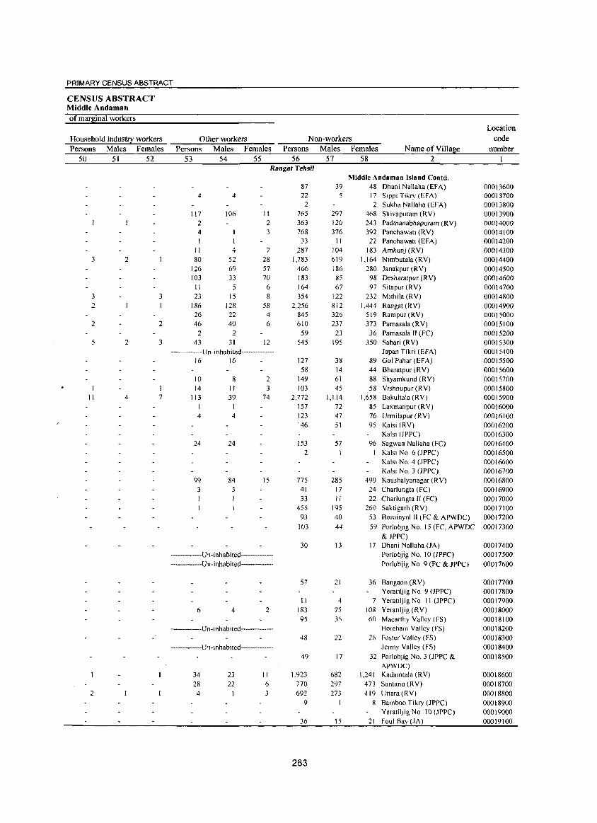
PRIMARY CENSUS ABSTRACT
CENSUS ABSTRACT Middle Andaman of mafj~inal workers
Location
Household indus!!2: workers Other workers Non-workers code
Persons Males Females Persons Males Females Persons Males Females Name ofVilla~e number
50 51 52 53 54 55 56 57 58 2 I Rangat Tehsil
Middle Andaman Island Conld. 87 39 48 Dhani Nallaha (EFA) 00013600
4 4 22 5 17 Sippi Tikry (EFA) 00013700 2 2 Sukha Nallaha (EFA) 00013800
117 106 II 765 297 468 Shivapuram (RY) 00013900 2 2 363 120 243 Padmanabhapuram (RY) 00014000 4 3 768 376 392 Panchawati (RY) 00014100 I 33 11 22 Panchawati (EFA) 00014200
11 4 7 287 104 183 Amkunj (RY) 00014300 3 2 80 52 28 1,783 619 1,164 Nimbutala (RY) 00014400
126 69 57 466 186 280 Janakpur (RY) 00014500 103 33 70 183 85 98 Desharatpur (RY) 00014600
II 5 6 164 67 97 Sitapur (RY) 00014700 3 3 23 15 8 354 122 232 Mithila (RY) 00014800 2 186 128 58 2,256 812 1,444 Rangat (RY) 00014900
26 22 4 845 326 519 Rampur(RY) 00015000 2 2 46 40 6 610 237 373 Pamasala (RY) 00015100
2 2 59 23 36 Pamasala II (FC) 00015200 5 2 3 43 31 12 545 195 350 Sabari (RY) 00015300
-------------u n- inhabi ted------------- Japan Tikri (EFA) 00015400 16 16 127 38 89 Gol Pahar(EFA) 00015500
58 14 44 Bharatpur (RY) 00015600 10 8 2 149 61 88 Shyamkund (RY) 00015700 14 II 3 103 45 58 Yishnupur (RY) 00015800
11 4 7 113 39 74 2,772 1,114 1,658 Bakultala (RY) 00015900 I 157 72 85 Laxmanpur (RY) 00016000
4 4 123 47 76 Urmilapur (RY) 00016100 146 51 95 Kalsi (RY) 00016200
Ka1si (JPPC) 00016300 24 24 153 57 96 Sagwan Nallaha (FC) 00016400
2 Kalsi No.6 (JPPC) 00016500 Kaisl No.4 (JPPC) 00016600 Kalsi No.3 (JPPC) 00016700
99 84 15 775 285 490 Kaushalyanagar (RY) 00016800 3 3 41 17 24 Charlungta (FC) 00016900 I 33 II 22 Charlungta Il (FC) 00017000
455 195 260 Saktigarh (RY) 00017100 93 40 53 Boroinyol II (FC & APWDC) 00017200
103 44 59 Porlobjig No. 15 (FC, APWDC 00017300 & JPPC)
30 13 17 Dhani Nallaha (JA) 00017400 -------------Un-inhabited-------------- Porlobjig No. 10 (JPPC) 00017500
-------------U n-inhabi ted -------------- Porlobjig No.9 (FC & JPPC) 00017600
57 21 36 Bangaon (RY) 00017700 Yeratiljig No.9 (JPPC) 00017800
II 4 7 Yeratiljig No. II (JPPC) 00017900 6 4 2 183 75 108 Yeratiljig (RV) 00018000
95 35 60 Macarthy Valley (FS) 00018100
-------------u n-inhabited -------------- Boreham Valley (FS) 00018200 48 22 26 Foster Valley (FS) 00018300
-------------U n-inhabited -------------- Jermy Yalley (FS) 00018400 49 17 32 PorlobJig No.3 (JPPC & 00018500
APWDC) 34 23 II 1.923 682 1,241 Kadamtala (RY) 00018600 28 22 6 770 297 473 Santanu (RY) 00018700
2 4 3 692 273 419 Uttara (RV) 00018800 9 8 Bamboo Tikry (JPPC) 00018900
YeratilJig No. 10 (JPPC) 00019000 36 15 21 Foul Ba~ (JA) 00019100
263
Location Area of code Village in
number Name ofVilla~e hectares I 2 3
Middle Andaman Island Conld. 00019200 Lakra Lungta (JA)
00019300 Between Chotaligbang (JA) & Foul Bay (JA)
00019400 Chotaligbang (JA) Porlob Island
00019500 Porlob Depot (Fe)
Long Island 00019600 Lalajig Bay (AC) 00019700 Lonlllsiand (RV) 400.3
Number of households
4
DISTRICT CENSUS HANDBOOK: ANDAMANS
Total population (including institutional and house less
EOl2ulation) Persons Males Females
5 6 7
VILLAGE PRIMARY CD Block-
Population in the
a~e-~roul2 0-6 Persons Males Females
8 9 10 Rangat Tehsil
6 21 13 8 5 2 3 --.--.• -.--.-Un- i n hab i ted-······_····_·
••••.• _ •..• --Un· i nhab i ted-··-·_··----·-
-_.--•.• --_ .. Un- i nha b Iled·······--·-·--
7 16 10 6 3 2 606 2,183 1,226 957 269 135 134
264
PRIMARY CENSUS ABSTRACT
CENSUS ABSTRACT Middle Andaman
Scheduled Castes popuation Persons Males Females
11 12 13
Scheduled Tribes population Persons Males Females Persons
14 15 16 17 Rangat Tehsil
21 13 g
-··--------·u n -i n hab i ted---·-·_-_·_···
_·---·_·----·Un-inhabited---·-·_-_·_-_·
-··_---_·_·_-u n-i n habi ted---·-·· __ ·_···
265
8 r ,579
Literates Males
18
6 969
Females Name ofYillage 19 2
Middle Andaman Island Contd. Lakra Lungta (JA) Between Cho!aligbang (JA) & Foul Bay (JA) Chotaligbang (JA) Porlob Island Porlob Depot (Fe) Long Island
2 Lalajig Bay (AC) 610 Long Island (RV)
Location code
number Name of Village 2
Middle Andaman Island Contd. 00019200 Lakra Lungta (J A) 00019300 Between Chotaligbang (JA) &
Foul Bay (JA) 00019400 Chotaligbang (JA) Porlob Island 00019500 Porlob Depot (FC) Long Island 00019600 Lalajig Bay (AC) 00019700 Lon~ Island (RV)
Illiterates Persons Males
20 21
21 13
8 4 604 257
DISTRICT CENSUS HANDBOOK: ANDAMANS
Total workers Females Persons Males Females
22 23 24 25 Rangat Tehsil
8
-------------U n-in hab i ted--------------
-------------Un-in habited--------------
-------------Un-inhabited--------------
4 9 9 347 840 680 160
266
VILLAGE PRIMARY CD Block-
Main workers Persons Males Females
26 27 28
8 8 694 650 44
PRIMARY CENSUS ABSTRACT
CENSUS ABSTRACT Middle Andaman
Industrial category of main workers Household industry
Cultivators Agricultural labourers workers Persons Males Females Persons Males Females Persons Males Females
29 30 31 32 33 34 35 36 37 Rangat Tehsil
Middle Andaman Island Contd.
-------------U n- in ha bited--------------
-------------U n-i nha bi ted----- ---------Porlob Island
-------------U n- i n ha bi ted --------------Long Island
38 26 12
267
Other workers Persons Males Females
38 39 40 Name of Village
2
Middle Andaman Island Contd. Lakra Lungta (JA) Between Chotaligbang (JA) & Foul Bay (JA) Chotaligbang (JA)
Porlob Depot (FC)
8 655
8 624
Lalajig Bay (Ae) 31 Long Island (RV)
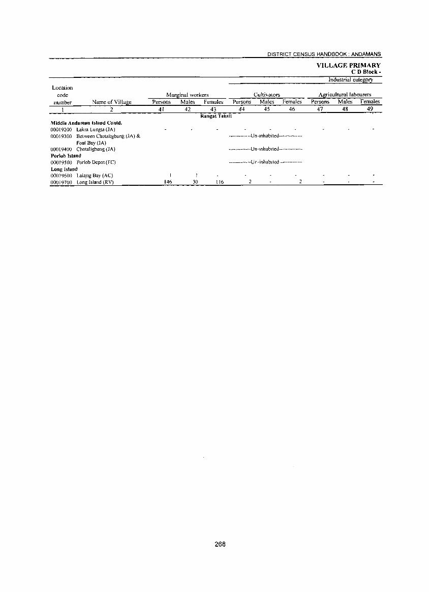
Location code
number Name of Village 2
Middle Andaman Island Contd. 00019200 Lakra Lungta (JA) 00019300 Between Chotaligbang (JA) &
Foul Bay (JA) 00019400 Chotaligbang (JA) Porlob Island 00019500 Porlob Depot (Fe)
Long Island 00019600 Lalajig Bay (AC) 00019700 Long Island (RY)
Marginal workers Persons Males Females Persons
41 42 43 44
DISTRICT CENSUS HANDBOOK: ANDAMANS
Cultivators Males Females
45 46
VILLAGE PRIMARY CD Block-
Industrial category
Agricultural labourers Persons Males Females
47 48 49 Rangat Tehsil
146 J
30 116
268
-------------U n-i n hab i ted --------------
-----------U n-i nhab i ted--------------
------- ------U n- i n ha b i ted--------------
2 2
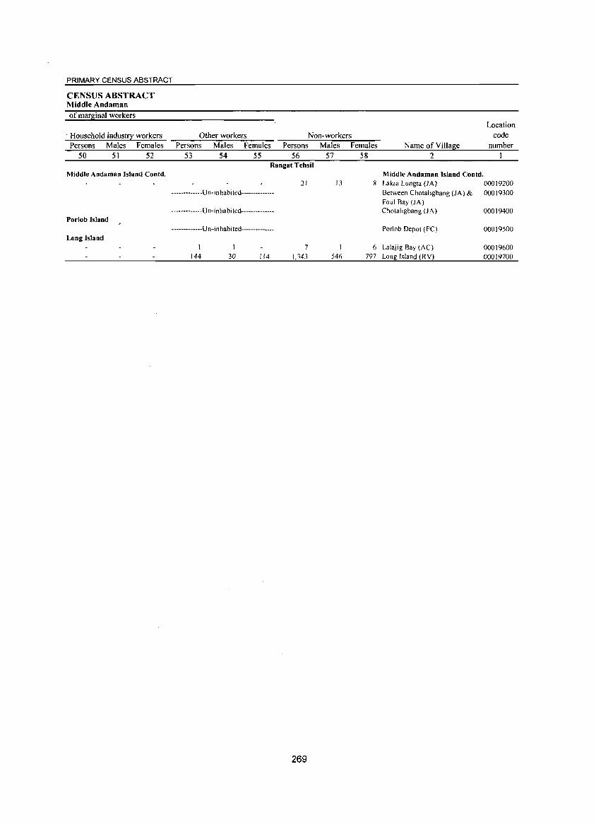
PRIMARY CENSUS ABSTRACT
CENSUS ABSTRACT Middle Andaman of marginal workers
. Household industry workers Persons Males Females
50 51 52
Other workers Persons Males Females
53 54 55
Non-workers Persons Males Females
56 57 58 Name ofYillage
2
Location code
number
Rangat Tehsil Middle Andaman Island Contd.
-------------U n- In habited--------------
-------------U n-i n hab i ted--------------Porlob Island
-------------Un-i n habi ted--------------Long Island
144 30 114
21
7 1,343
269
13
546
Middle Andaman Island Contd. 8 Lakra Lungta (JA) 00019200
Between Chotaligbang (JA) & 00019300 Foul Bay (JA) Chotaltgbang (JA) 00019400
Porlab Depot (FC)
6 Lalajig Bay (AC)
797 Long Island (RV)
00019500
00019600 00019700
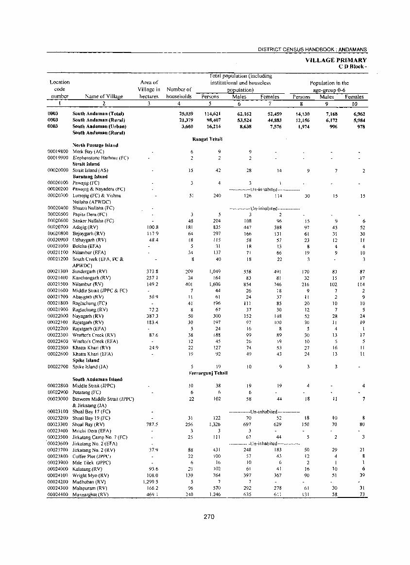
Location code
number
0003 0003 0003
Name of Village 2
South Andaman (Total) South Andaman (Rural) South Andaman (Urban) South Andaman (Rural)
North Passage Island 00019800 Merk Bay (AC) 00019900 Elephenstone Harbour (FC)
Strait Island 00020000 Strait Island (AS)
00020100 00020200
00020300
00020400 00020500 00020600 00020700
00020800 00020900 00021000 00021100
00021200
00021300 00021400
00021500 00021600 00021700 00021800
00021900 00022000 00022100
00022200 00022300 00022400 00022500 00022600
00022700
00022800
00022900
00023000
00023100
00023200 00023300 00023400 00023500 00023600 00023700 00023800 00023900 00024000 00024100
00024200 00024300 00024400
Baratang Island Pawajig (FC) Pawajig & Nayadcra (Fe)
Lorrojig (FC) & Yishnu
Nallaha (APWDC) Shastri Nallaha (FC) Papita Dera (FC) Sanker Nallaha (FC) Adojig(RY)
Bejoygarh (R Y) Udhaygarh (RY) Bolcha (EFA) Nilambur (EFA)
South Creek (EFA, FC & APWDC) Sundergarh (RY) Kanchangarh (R Y) Nilambur (RY)
Middle Strait (JPPC & FC) Abaygarh (RY) Raglachang (FC) Raglachang (RY)
Nayagarh (RY) Rajatgarh (RY) Rajatgarh (EFA) Wrafter's Creek (RY) Wrafter's Creek (EFA) Khatta Khari (R Y) Khatta Khari (EFA)
Spike Island Spike Island (JA)
South Andaman Island Middle Strait (lPPC)
Potatang (Fe)
Between Middle Strait (JPPC)
& lirkatang (JA) Shoal Bay 17 (FC)
Shoal Bay 19 (Fe) Shoal Bay (RY) Mric:hi Dera (EFA) Jirkatang Camp NO.7 (FC)
Jirkatang No. i (EFA) lirkatang No.2 (RY) Coffee Plot (JPPC) Mile Tilek (JPPC)
Kalatang (RY) Wright Myo (RY) Madhuban (RY) Malapuram (RY)
Mannarghat (RY)
Area of Village in hectares
3
100.8 117.9 48.4
373.8 257.1 149.2
50.9
72.2 387.3 183.4
87.6
24.9
787.5
37.9
93.6
108.0 1,299.5
166.2
469.1
Number of households
4
25,039 21,379 3,660
DISTRICT CENSUS HANDBOOK: ANDAMANS
Total population (including institutional and houseless
population) Persons
5
114,621 98,407 16,214
Males 6
62,162 53,524 8,638
Females 7
52,459 44,883 7,576
VILLAGE PRIMARY CD Block-
Population in the age-group 0-6
Persons Males Females 8 9 IO
14,130 12,156
1,974
7,168 6,172
996
6,962 5,984
978
Rangat Tehsil
6 2
15
3
51
3
48 181
64 18 5
34
8
209 24
401 7
11
41 8
50 30
5 38 12 22 19
5
9 2
42
4
240
5 204 835 297
115 31
137
40
1,049
164
1,600 44 61
196 67
300 197
24 188 45
127 92
19
Ferrargunj Tehsil
10 6
22
31 256
3
25
88 22
6
21
139
5 96
240
38 6
102
122 1,326
3 III
431 100
16 102
764 7
570 1,246
270
9 2
28
3
14
-------------U n-i n hab i ted --- -----------126 114
-------------U n -in ha bited --------------3 2
108 96
447 388 166 131
58 57 18 13 71 66 18 22
558 491 83 81
854 746
26 18 24 37
111 85
37 30 152 148 97 100 16 8 99 89 26 19
74 53 49 43
10 9
19 19
6 58 44
-------------Un- i n hab i ted --------------70 52
697 629 3
67 44
-------------Un-inhabited--------------248 183
57 43 10 6 61 41
397 367 7
292 278 635 611
9
30
15 97
61 23
8 19
3
170 32
216 9
II
20 12
52 30
5 30 10 27 24
3
4
18
IS 150
5
50 12
2 16
90
61 131
7
15
9 45
31 12 4 9
83
15 102
7 2
10
7 28 II 4
13
5 16 13
3
II
10 70
2
29 4
I 10 51
30
58
2
15
6 52 30 II 4
10
3
87 17
114 2 9
10 5
24 19
I 17
5 11 11
4
7
S 80
3
21 8 1 6
39
31 73
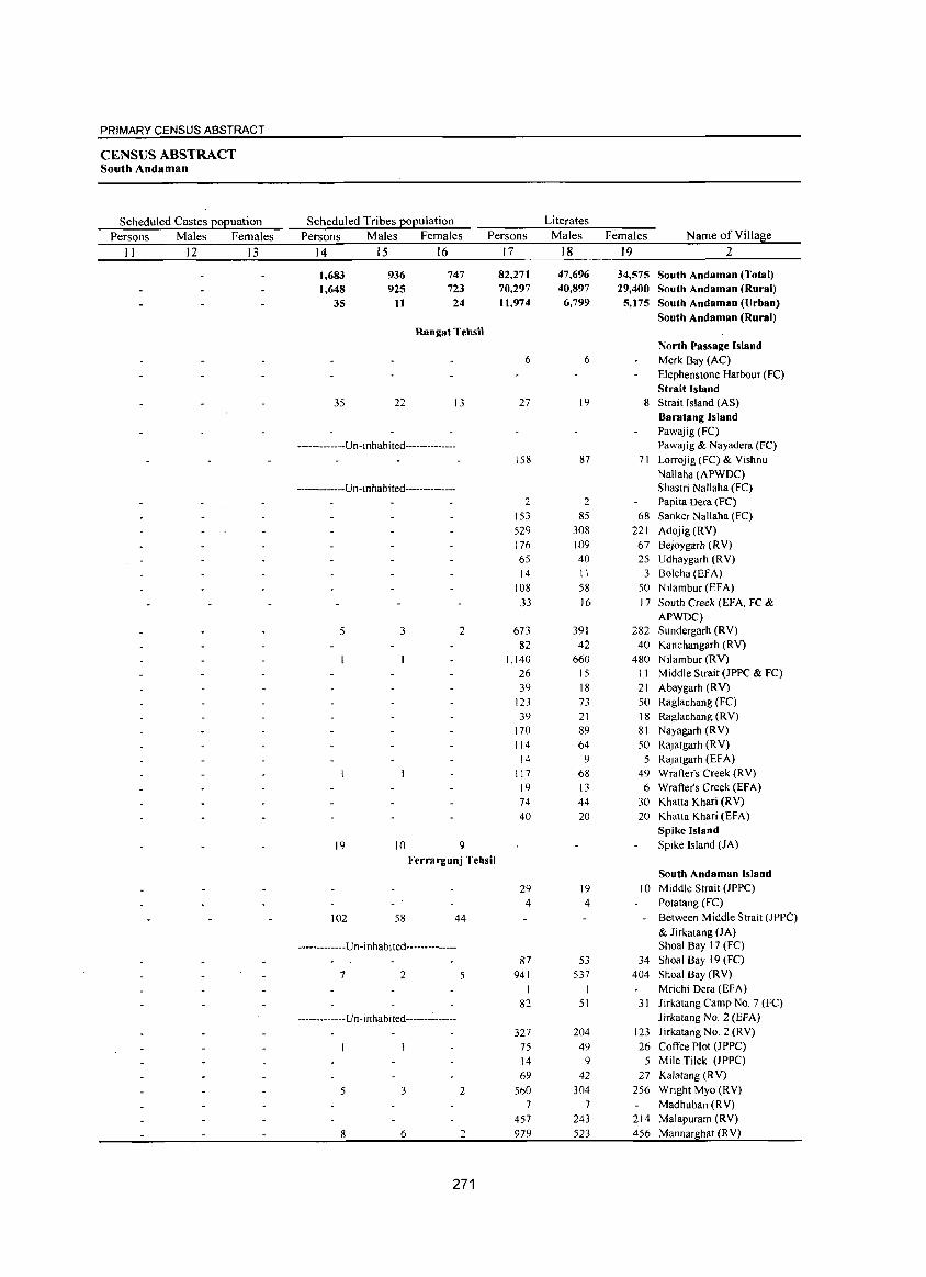
PRIMARY CENSUS ABSTRACT
CENSUS ABSTRACT South Andaman
Scheduled Castes EOEuation Scheduled Tribes EOEulation Literates
Persons Males Females Persons Males Females Persons Males Females Name ofVilla~e
II 12 13 14 15 16 17 18 19 2
1,683 936 747 82,271 47,696 34,575 South Andaman (Total) 1,648 925 723 70,297 40,897 29,400 South Andaman (Rural)
35 11 24 11,974 6,799 5,175 South Andaman (Urban) South Andaman (Rural)
Rangat Tehsil North Passage Island
6 6 Merk Bay (AC) Elephenstone Harbour (FC) Strait Island
35 22 13 27 19 8 Strait Island (AS) Baratang Island Pawajig (FC)
-------------U n -i nhabi ted-------------- Pawajig & Nayadera (Fe) 158 87 71 Lorrojig (FC) & Vishnu
Nallaha (APWDC) -------------Un-inhabited-------------- Shastri Nallaha (FC)
2 2 Papita Dera (FC) 153 85 68 Sanker Nallaha (FC) 529 308 221 Adojig(RV) 176 109 67 Bejoygarh (RV) 65 40 25 Udhaygarh (RV) 14 11 3 Bolcha (EFA)
108 58 50 Nilambur (EFA) 33 16 17 South Creek (EFA, FC &
APWDC) 5 3 2 673 391 282 Sundergarh (RV)
82 42 40 Kanchangarh (RV) 1,140 660 480 Nilambur (RV)
26 15 11 Middle Strait (JPPC & FC) 39 18 21 Abaygarh (RV)
123 73 50 Raglachang (FC)
39 21 18 Raglachang (RV) 170 89 81 Nayagarh (RV) 114 64 50 Rajatgarh (RV)
14 9 5 Rajatgarh (EF A) 117 68 49 Wrafter's Creek (RV) 19 13 6 Wrafter's Creek (EFA) 74 44 30 Khatta Khari (RV) 40 20 20 Khatta Khari (EFA)
Spike Island 19 10 9 Spike Island (JA)
Ferrargunj Tehsil South Andaman Island
29 19 10 Middle Strait (JPPC) 4 4 Potatang (FC)
102 58 44 - Between Middle Strait (JPPC) & Jirkatang (JA)
-------------Un-inhabi ted-------------- Shoal Bay 17 (FC) 87 53 34 Shoal Bay 19 (FC)
7 2 5 941 537 404 Shoal Bay CRY) Mrichi Dera (EFA)
82 51 31 Jirkatang Camp No.7 (FC)
------------Vn-inhabited-------:------ Jirkatang No.2 (EFA)
327 204 123 Jirkatang No.2 CRY) 75 49 26 Coffee Plot (JPPC) 14 9 5 Mile Tilek (JPPC) 69 42 27 Kalatang (RV)
5 3 2 560 304 256 Wright Myo (RV) 7 7 Madhuban (R V)
457 243 214 Malapuram (RV) 8 6 2 979 523 456 Mannarghat (RV)
271
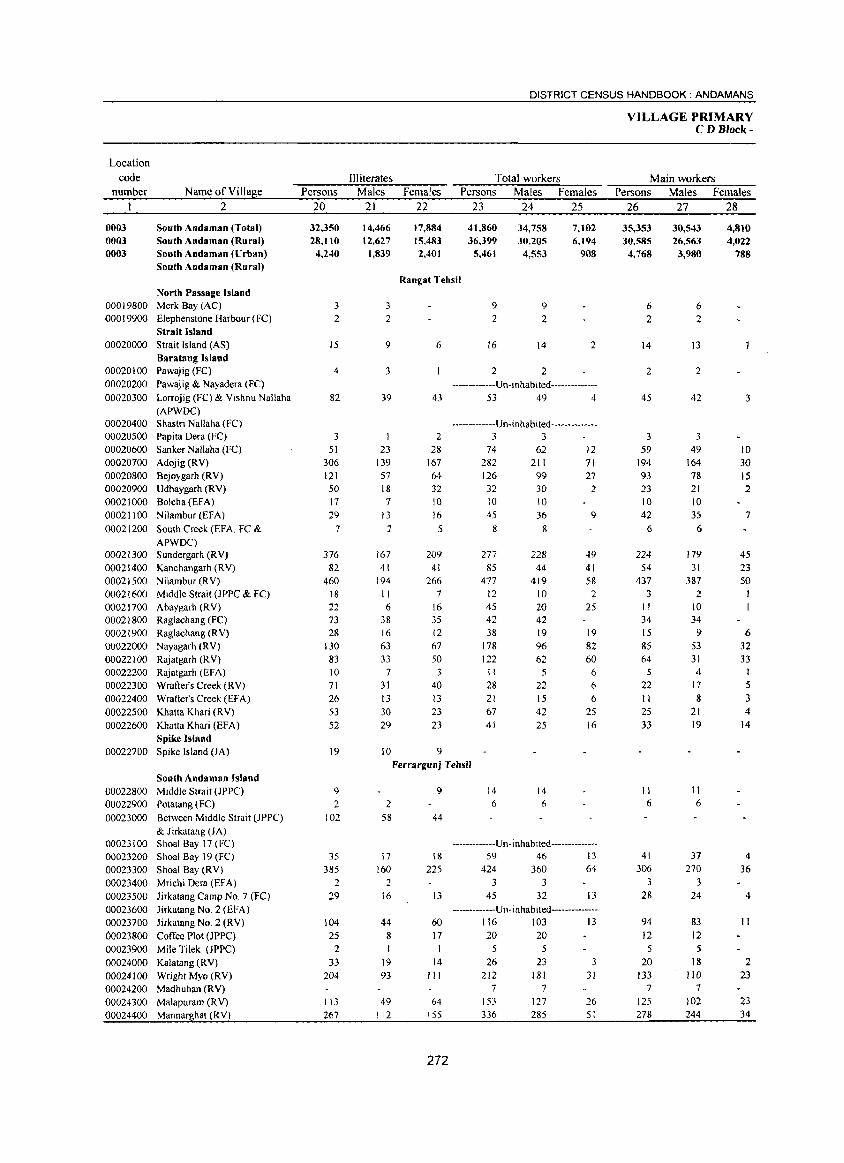
Location code
number
0003 0003 0003
Name of Village 2
South Andaman (Total) South Andaman (Rural) South Andaman (Urban) South Andaman (Rural)
North Passage Island 00019800 Merk Bay (Ae) 00019900 Elephenstone Harbour (FC)
Strait Island 00020000 Strait Island (AS)
Baratang Island 00020100 Pawajig (FC) 00020200 Pawajig & Nayadera (FC) 00020300 Lorrojig (FC) & Vishnu Nallaha
(APWDC) 00020400 Shastri Nallaha (FC) 00020500 Papita Dcra (FC) 00020600 Sanker Nallaha (FC) 00020700 Adojig (RV) 00020800 Bejoygarh (RV) 00020900 Udhaygarh (RV) 00021000 Solcha (EFA) 00021100 Nilambur(EFA} 00021200 South Creek (EFA, Fe &
APWDC) 00021300 Sundergarh (RV) 00021400 Kanchangarh (RV) 00021500 Nilambur(RV) 00021600 Middle Strait (JPPC & FC) 00021700 Abaygarh (R V) 00021800 Raglachang (FC) 00021900 Raglachang (R V) 00022000 Nayagarh (R V) 00022100 Rajatgarh (RV) 00022200 Rajatgarh (EFA) 00022300 Wrafter's Creek (RV) 00022400 Wrafter's Creek (EFA) 00022500 Khatta Khari (RV) 00022600 Khatta Khari (EFA)
Spike Island 00022700 Spike Island (JA)
South Andaman Island 00022800 Middle Strait (JPPC) 00022900 Potatang (FC) 00023000 Between Middle Strait (JPPC)
& Jirkatang (JA) 00023100 Shoal Bay 17(FC} 00023200 Shoal Bay 19 (Fe) 00023300 Shoal Bay (RV) 00023400 Mrichi Dera (EF A) 00023500 Jirkatang Camp NO.7 (FC) 00023600 Jirkatang No.2 (EFA) 00023700 Jirkatang No.2 (RV) 00023800 Coffee Plot (JPPC) 00023900 Mile Tilek (JPPC) 00024000 Kalatang (RV) 00024100 Wright Myo (RV) 00024200 Madhuban (RV) 00024300 Malapuram (RV) 00024400 Mannarghat (RV)
Persons 20
32,350 28,110 4,240
3 2
15
4
82
3 51
306 121 50 17 29
7
376 82
460 18 22 73 28
130 83 10 71 26 53 52
19
9 2
102
35 385
2 29
104 25
2 33
204
113 267
DISTRICT CENSUS HANDBOOK: ANDAMANS
Illiterates Males
21
14,466 12,627
1,839
3 2
9
3
39
23 139 57 18
7
13
2
167 41
194 II 6
38 16
63 33
7 3J 13 30 29
10
Females 22
17,884 15,483 2,401
Total workers Persons Males Females
23 24 25
41,860 36,399
5,461
34,758 30,205
4,553
7,102 6,194
908
Rangat Tehsil
6
43
2 28
167 64 32 10 16
5
209 41
266 7
16 35 12 67 50
3 40 13 23 23
9
9
2
J6
9 2
14
2 2
2
-------------Un-inhabited--------------53 49 4
-------------Un-inhabited--------------3 3
74 282 126 32
62 211 99 30
10 10 45
8
277 85
477 12 45 42 38
178 122 II
28 21 67 41
36 8
228 44
419 10 20 42 19 96 62
5
22 15 42 25
12 71 27
2
9
49 41 58 2
25
19 82 60
6
6
6
25 16
Ferrargunj Tehsil
2 58
17 160
2 16
44 8
J9 93
49 112
9
44
18
225
13
60 17 I
14 III
64 155
272
14 14 6 6
-------------Un-inhabited--------------59 46 13
424 360 64 3 3
45 32 13
-------------Un-inhabited--------------116 103 13 20 20
5 26
212 7
153 336
5 23
181 7
127 285
3 31
26 51
VILLAGE PRIMARY CD Block-
Main workers Persons Males Females
26 27 28
35,353 30,585
4,768
6 2
14
2
45
3 59
194 93 23 10 42
6
224 54
437 3
II 34 15 85 64
5
22 11 25 33
II 6
41 306
28
94 J2 5
20 J33
7 125 278
30,543 26,563 3,980
6 2
13
2
42
3 49
164 78 21 10 35
6
179 31
387 2
10 34
9 53 31
4 17 8
21 19
II 6
37 270
3 24
83 J2 5
18 110
7 102 244
4,810 4,022
788
3
10 30 15 2
7
45 23 50
6 32 33
I
5
3 4
14
4 36
4
11
2 23
23 34
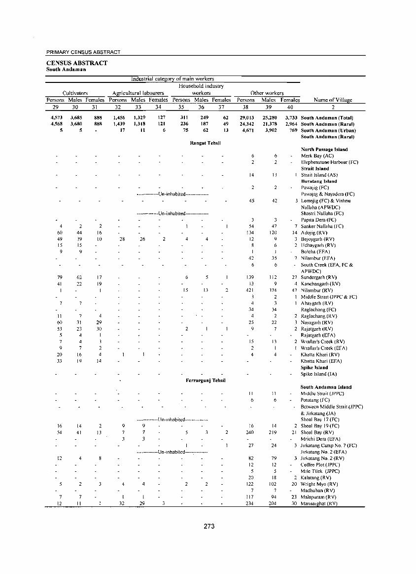
PRIMARY CENSUS ABSTRACT
CENSUS ABSTRACT South Andaman
Industrial catelli0!I of main workers
Household industry
Cultivators Alliricultural labourers workers Other workers
Persons Males Females Persons Males Females Persons Males Females Persons Males Females Name of Vi II allie
29 30 31 32 33 34 35 36 37 38 39 40 2
4,573 3,685 888 1,456 1,329 127 311 249 62 29,013 25,280 3,733 South Andaman (Total) 4,568 3,680 888 1,439 1,318 121 236 187 49 24,342 21,378 2,964 South Andaman (Rural)
5 5 17 11 6 75 62 13 4,671 3,902 769 South Andaman (Urban) South Andaman (Rural)
Rangat Tehsil North Passage Island
6 6 Merk Bay (AC) 2 2 Elephenstone Harbour (FC)
Strait Island 14 13 Strait Island (AS)
Baratang Island 2 2 Pawajig (FC)
-------------Un-inhabited-------------- Pawajig & Nayadera (FC)
45 42 3 Lorrojig (FC) & Yishnu Nallaha (APWDC)
------------Un-inhabited------------- Shastri Nallaha (FC) 3 3 Papita Oera (FC)
4 2 2 54 47 7 Sanker Nallaha (FC) 60 44 16 134 120 14 Adojig (RY) 49 39 10 28 26 2 4 4 12 9 3 Bejoygarh (RY) 15 15 8 6 2 Udhaygarh (RY) 9 9 I Bolcha (EFA)
42 35 7 Nilambur (EFA)
6 6 South Creek (EFA, FC & APWOC)
79 62 17 6 5 139 112 27 Sundergarh (RY) 41 22 19 13 9 4 Kanchangarh (RY)
15 13 2 421 374 47 Nilambur (RY) 3 2 I Middle Strait (JPPC & FC)
7 7 4 3 Abaygarh (RY) 34 34 Raglachang (FC)
11 7 4 4 2 2 Raglachang (RY) 60 31 29 25 22 3 Nayagarh (RY) 53 23 30 2 9 7 2 Rajatgarh (R Y) 5 4 1 Rajatgarh (EFA) 7 4 3 15 13 2 Wrafter's Creek (RY) 9 7 2 2 Wrafter's Creek (EFA)
20 16 4 4 4 Khatta Khari (RY) 33 19 14 Khatta Khari (EFA)
Spike Island Spike Island (JA)
Ferrargunj Tehsil South Andaman Island
II II Middle Strait (JPPC) 6 6 Potatang (FC)
Between Middle Strait (JPPC) & Jirkatang (JA)
------------- U n- i n habi ted --- ----------- Shoal Bay 17 (FC) 16 14 2 9 9 16 14 2 Shoal Bay 19 (FC) 54 41 13 7 7 5 3 2 240 219 21 Shoal Bay (RY)
3 3 Mrichi Oera (EFA) 27 24 3 Jirkatang Camp NO.7 (FC)
-------------U n -i nhabited-----.--------- Jirkatang No.2 (EFA) 12 4 8 82 79 3 Jirkatang No.2 (RY)
12 12 Coffee Plot (JPPC) 5 5 Mile Tilek (JPPC)
20 18 2 Kalatang (RY) 5 2 3 4 4 2 2 122 102 20 Wright Myo (RY)
7 7 Madhuban (RY) 7 7 117 94 23 Malapuram (RY)
12 II 32 29 3 234 204 30 Mannarghat (R Y)
273
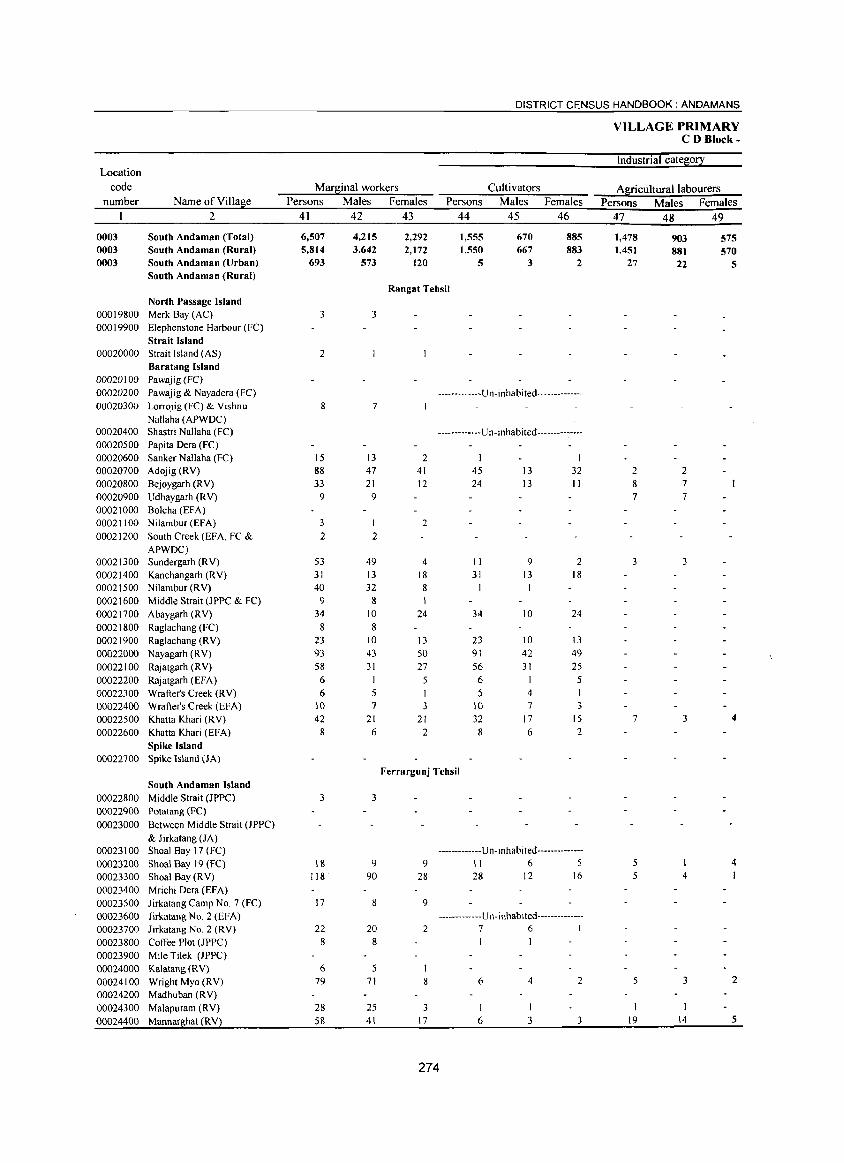
DISTRICT CENSUS HANDBOOK: ANDAMANS
VILLAGE PRIMARY CD Block-
Industrial cate~0!2: Location
code Mar~inal workers Cultivators Al[iculturallabourers number Name ofVilla~e Persons Males Females Persons Males Females Persons Males Females
2 41 42 43 44 45 46 47 48 49
0003 South Andaman (Total) 6,507 4.215 2.292 1.555 670 885 1.478 903 575 0003 South Andaman (Rural) 5.814 3.642 2.172 1.550 667 883 1.451 881 570 0003 South Andaman (Urban) 693 573 120 5 3 2 27 22 5
South Andaman (Rural) Rangat Tehsil
North Passage Island 00019800 Merk Bay (AC) 3 3 00019900 Elephenstone Harbour (FC)
Strait Island 00020000 Strait Island (AS) 2
Baratang Island 00020100 Pawajig (FC) 00020200 Pawajig & Nayadera (FC) -------------U n-i n ha b i ted--------------00020300 Lorrojig (FC) & Vishnu 8 7
Nallaha (APWOC) 00020400 Shastri Nallaha (FC) -------------U n- i nhabi ted--------------00020500 Papita Oera (FC)
00020600 Sanker Nallaha (FC) 15 13 2 I 00020700 Adojig(RV) 88 47 41 45 13 32 2 2
00020800 Bejoygarh (RV) 33 21 12 24 13 II 8 7
00020900 Udhaygarh (RV) 9 9 7 7
00021000 Bolcha (EFA) 00021100 Nilambur (EFA) 3 1 2
00021200 South Creek (EF A, FC & 2 2
APWOC) 00021300 Sundergarh (RV) 53 49 4 II 9 2 3 3 00021400 Kanchangarh (RV) 31 13 18 31 13 18
00021500 Nilambur (RV) 40 32 8 1
00021600 Middle Strait (JPPC & FC) 9 8 00021700 Abaygarh (RV) 34 10 24 34 10 24
00021800 Raglachang (FC) 8 8
00021900 Raglachang (RV) 23 10 13 23 10 13
00022000 Nayagarh (RV) 93 43 50 91 42 49
00022100 Rajatgarh (RV) 58 31 27 56 31 25
00022200 Rajatgarh (EFA) 6 6 5
00022300 Wrafter's Creek (RV) 6 5 I 5 4 I 00022400 Wrafter's Creek (EFA) 10 7 3 10 7 3
00022500 Khatta Khari (RV) 42 21 21 32 17 15 7 3 4
00022600 Khatta Khari (EFA) 8 6 2 8 6 2
Spike Island 00022700 Spike Island (JA)
Ferrargunj Tehsil
South Andaman Island
00022800 Middle Strait (JPPC) 3 3 00022900 Potatang (FC)
00023000 Between Middle Strait (JPPC)
& Jirkatang (lA) 00023100 Shoal Bay 17 (FC) -------------U n- i nhab i ted--------------
00023200 Shoal Bay 19 (FC) 18 9 9 II 6 5 5 4
00023300 Shoal Bay (R V) 118 90 28 28 12 16 5 4
00023400 Mrichi Oera (EFA)
00023500 Jirkatang Camp No.7 (FC) 17 8 9
00023600 Jirkatang No.2 (EFA) -------------U n- i nhab i ted--------------
00023700 Jirkatang No.2 (RV) 22 20 2 7 6 1
00023800 Coffee Plot (JPPC) 8 8
00023900 Mile Tilek (JPPC)
00024000 Kalatang (RV) 6 5
00024100 Wright Myo (RV) 79 71 8 6 4 2 5 3 2
00024200 Madhuban (RV)
00024300 Malapuram (RV) 28 25 3 I I I
00024400 Mannarghat CRY) 58 41 17 6 3 3 19 14 5
274
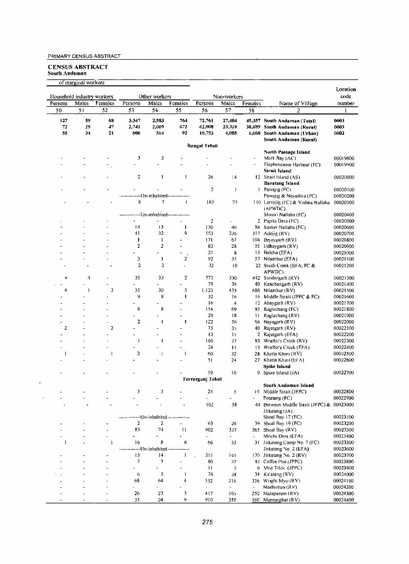
PRIMARY CENSUS ABSTRACT
CENSUS ABSTRACT South Andaman
of maq~inal workers Location
Household indust!I workers Other workers Non-workers code Persons Males Females Persons Males Females Persons Males Females Name of Yilla&e number
50 51 52 53 54 55 56 57 58 2
127 59 68 3,347 2,583 764 72,761 27,404 45,357 South Andaman (Total) 0003 72 25 47 2,741 2,069 672 62,008 23,319 38,689 South Andaman (Rural) 0003 55 34 21 606 514 92 10,753 4,085 6,668 South Andaman (Urban) 0003
South Andaman (Rural) Rangat Tehsil
North Passage Island 3 3 Merk Bay (AC) 00019800
Elephenstone Harbour (FC) 00019900 Strait Island
2 26 14 12 Strait Island (AS) 00020000 Baratang Island
2 Pawajig (FC) 00020100 -------------Un- inha b ited-------------- Pawajig & Nayadera (FC) 00020200
8 7 I 187 77 110 Lorrojig (FC) & Yishnu Nallaha 00020300 (APWDC)
-------------U n- i nha b i ted-------------- Shastri Nallaha (FC) 00020400 2 2 Papita Dera (FC) 00020500
14 13 130 46 84 Sanker Nal1aha (FC) 00020600 41 32 9 553 236 317 Adojig(RY) 00020700
171 67 104 Bejoygarh (RY) 00020800 2 2 83 28 55 Udhaygarh (RY) 00020900
21 8 13 Bolcha (EFA) 00021000 3 2 92 35 57 Nilambur (EFA) 00021100 2 2 32 10 22 South Creek (EFA, FC & 00021200
APWDC) 4 4 35 33 2 772 330 442 Sundergarh (RY) 00021300
79 39 40 Kanchangarh (RY) 00021400 4 3 35 30 5 1,123 435 688 Nilambur (RY) 00021500
9 8 32 16 16 Middle Strait (JPPC & FC) 00021600 16 4 12 Abaygarh (RY) 00021700
8 8 154 69 85 Raglachang (Fe) 00021800 29 18 11 Raglachang (RY) 00021900
2 122 56 66 Nayagarh (RY) 00022000 2 2 75 35 40 Rajatgarh (R Y) 00022100
13 11 2 Rajatgarh (EFA) 00022200 160 77 83 Wrafter's Creek (RY) 00022300 24 II 13 Wrafter's Creek (EFA) 00022400
2 60 32 28 Khatta Khari (RY) 00022500 51 24 27 Khatta Khari (EFA) 00022600
Spike Island 19 10 9 Spike Island (JA) 00022700
Ferrargunj Tehsil South Andaman Island
3 3 24 5 19 Middle Strait (JPPC) 00022800 Potatang (FC) 00022900
102 58 44 Between Middle Strait (JPPC) & 00023000 Jirkatang (JA)
-------------Un -inhabited -------------- Shoal Bay 17 (FC) 00023100 2 2 63 24 39 Shoal Bay 19 (FC) 00023200
85 74 II 902 337 565 Shoal Bay (RY) 00023300 Mrichi Dera (EFA) 00023400
16 8 8 66 35 31 Jirkatang Camp NO.7 (FC) 00023500 -------------Un-inhabited-------------- Jirkatang No.2 (EFA) 00023600
15 14 1 315 145 170 Jirkatang No.2 (RY) 00023700 7 7 80 37 43 Coffee Plot (lPPC) 00023800
II 5 6 Mile Tilek (JPPC) 00023900 6 5 76 38 38 Kalatang (RY) 00024000
68 64 4 552 216 336 Wright Myo (RV) 00024100 Madhuban (RY) 00024200
26 23 3 417 165 252 Malapuram (RY) 00024300 33 24 9 910 350 560 Mannarghat (RV) 00024400
275
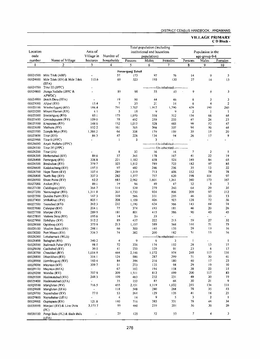
Location code
number
00024500 00024600
00024700 00024800
00024900 00025000
Name of Village 2
Mile Tilek (ARF)
Mile Tilek (RV) & Mile Tilek
(EFA) Tirur III (JPPC)
Jhinga Nallaha (JPPC & APWDC) Beach Dera CEFA) Alipur (RV)
00025100 Wimberlygunj (RV)
00025200 Mount Harriet CRY)
00025300 Stweartgunj CR V)
00025400 Govindapuram CRY) 00025500 Knapuram (RV) 00025600 Mathura (RV)
00025700 Temple Myo (RV)
00025800 Tirur CRY)
00025900 Tirur I (JPPC)
00026000 00026100 00026200 00026300 00026400 00026500 00026600 00026700 00026800 00026900 00027000 00027100 00027200 00027300 00027400 00027500 00027600 00027700 00027800 00027900 00028000 00028100 00028200 00028300 00028400 00028500 00028600 00028700 00028800 00028900 00029000 00029100 00029200 00029300 00029400 00029500 00029600 00029700 00029800 00029900
Anjali Nallaha (JPPC)
Tirur IV (JPPC)
Tirur CJA)
Herbertabad (R V) Ferrargunj (RV) Bindraban (RV)
Kadakachang (RV)
Hope Town CRY)
North Bay CRY) Shore Point CRY)
Aniket{RV)
Caddlegunj (RV)
Namunaghar (RV)
Dundas Point (RV)
Mithakhari (RV)
Tusnabad CRY)
Colinpur (RV)
Manpur{RV)
Mohwa Dera CRY)
Hobdipur CRY)
Ograbraij CRY) Muslim Basti (RV)
Port Mouat (RV)
Lohabarrack(WLS)
Balughat (RV)
Badmash Pahar CRY)
Craikabad CRY) Chouldari CRY)
Dhanikhari CRY)
Homfreygunj (RV)
Maymyo (RV) Maymyo (EFA)
Wandur(RV)
Hashmatabad (RV)
Hashmatabad (~FA) Manglutan (RV)
Manglutan (EFA)
Nayashahar (RV)
Nayashahar (EFA)
Guptapara (RV)
00030000 Manjeri (RV) & Line Dera
(Fe)
00030 I 00 Pongi Balu (Fe) & Bada Balu
EFA
Area of Village in hectares
3
115.6
15.4 184.4
4.1 83.1
109.0 148.0 152.2
1,384.2 84.3
89.6 338.8 379.7 197.5 107.4 337.3 62.2 89.1
364.7 1,311.8
167.3 805.1 262.3 204.1 289.9 195.6 512.2 373.9 298.1 334.3
340.2 98.5 39.5
1,054.9 354.1 183.4 309.7
707.9 248.3
716.5
770
121.8 3,375.7
DISTRICT CENSUS HANDBOOK: ANDAMANS
Total population (including institutional and houseless
population)
VILLAGE PRIMARY CD Block-
Population in the age-group 0-6 Number of
households Persons Males Females Persons Males Females 4 5
Ferrargunj Tehsil 37 173 69 323
19 98
19 90 7 35
791 5
175 78
152 161 64 47
I
8
57 221 323
97 289 282 685
19 114 361 109 208 232
77
181 14 89
213 66 74
4
72 41
444 124 84 51 67
309 109. 35
455 118 53
4 140
99
27
3,707
18 1,070
492 1,013
705 338 228
3
32 345
1,182 1,512
482 1,319 1,377 2,962
96 539
1,730 566
1,109 1,190
374
801 33
437 1,157
300 382
9
326 220
2,146 586 396 223 352
1,511 463 153
2,151 548 264
14 716 460
125
276
6 7
97 76 193 130
-------------Un-i nhabited--------------55 43
44 46 21 14
1,917 9
558 259 528 368 179 134
3
1,790 9
512 233 485 337 159 94
-------------U n -i n h ab i ted--------------
------------- U n- i n hab i ted--------- -----16 16
178 167 658 524 789 723 246 236 713 606 757 620
1,601 1,361 49 47
279 260 924 806 331 235 606 503 624 566 193 181 415 386
33 222 215 589 568 165 135 200 182
-------------Un-I n habi ted--------------6 3
174 152 129 91
1,172 974 287 299 216 180 125 98 194 158 812 699 232 231
87 66 1,119 1,032
280 268 129 135
9 5 385 331 259 201
72 53
8910
14 27
9
6 6
439 2
134 47 99 94 35 26
7 41
149 182 35
152 198 340
12 64
209 46
128 143 46 90
59 144 29 31
28 23
248 71 40 29 38
200 49 30
245 78 41
3 78 56
7
9 14
6
3 4
199 I
66 24 52 50 15 17
2 22 84 97 13 74
101 173
5 29 97 33 72 69 20 45
27 71 13 15
13 6
117 30 17 19 23
117 30 21
134 35 18
2
44 30
4
5
13
3
3 2
240 I
68 23 47 44 20
9
5 19 65 85 22 78 97
167 7
35 112 13 56 74 26 45
32 73 16 16
15 17
131 41 23 10 IS 83 19 9
III 43 23
34 26
3
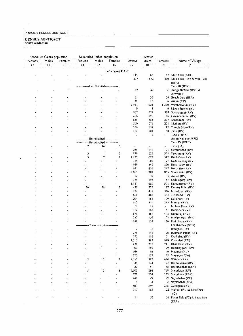
PRIMARY CENSUS ABSTRACT
CENSUS ABSTRACT South Andaman
Scheduled Castes E0l?:uation Scheduled Tribes EOEulation Literates
Persons Males Females Persons Males Females Persons Males Females Name of Villa!l:e
II 12 13 14 15 16 17 18 19 2
Ferrargunj Tehsil 115 68 47 Mile Tilek (ARF) 277 172 lOS Mile Tilek (RV) & Mile Tilek
(EFA) -------------U n-i nhabited-------------- Tirur III (JPPC)
72 42 30 Jhinga Nallaha (JPPC & APWDC)
61 35 26 Beach Dera (EFA) 18 12 6 Alipur(RV)
2,951 1,621 1,330 Wimberlygunj (R V) 9 3 6 Mount Harriet (R V)
867 479 388 Stweartgunj (RV) 406 220 186 Govindapuram (RV) 855 458 397 Knapuram (RV) 500 279 221 Mathura (RV) 266 154 112 Temple Myo (RV) 162 104 58 Tirur(RV)
3 3 Tirur I (JPPC)
-------------Un-inhabited-------------- Anjali Nallaha OPPC) ------------Un-inhabited-------------- Tirur IV (JPPC)
32 16 16 Tirur (lA) 265 144 121 Herbertabad (R V)
3 2 899 525 374 Ferrargunj (RV) 3 2 1,135 623 512 Bindraban (RV)
384 207 177 Kadakachang (RV) 938 542 396 Hope Town (RV) 681 434 247 North Bay (RV)
2,062 1,207 855 Shore Point (RV) 72 39 33 Aniket(RV)
355 198 157 Caddlegunj (RV) 1,181 680 SOl Namunaghar (RV)
30 28 2 476 279 197 Dundas Point (RV) 774 438 336 M ithakhari (R V) 866 483 383 Tusnabad (RV) 294 165 129 Colinpur (RV) 613 330 283 Manpur(RV)
17 17 Mohwa Dera (RV) 314 163 151 Hobdipur (RV) 870 467 403 Ograbraij (RV) 232 129 103 Muslim Basti (RV) 289 163 126 Port Mouat (RV)
-------------Un-inhabited-------------- Lohabarrack(WLS) 7 6 Balughat (RV)
251 145 106 Badrnash Pahar (RV) 175 114 61 Craikabad (RV)
1,512 883 629 Chouldari (R V) 436 225 211 Dhanikhari (RV) 309 180 129 Homfreygunj (RV) 165 95 70 Maymyo (RV)
222 127 95 Maymyo (EFA)
5 3 2 1,056 582 474 Wandur(RV) 346 174 172 Hashmatabad (RV)
89 51 38 Hashmatabad (EFA) 5 2 3 1,603 884 719 Manglutan (RV)
377 224 153 Manglutan (EFA) 188 99 89 Nayashahar (RV)
6 4 2 Nayashahar (EFA) 507 289 218 Guptapara (R V)
303 181 122 Manjeri (RV) & Line Dera (Fe)
91 55 36 Pongi Balu (FC) & Bada Balu EFA
277
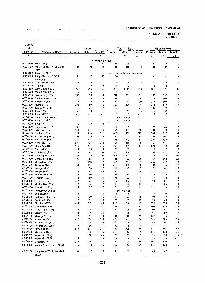
Location code
number Name of Village 2
00024500 Mile Tilek (ARF) 00024600 Mile Tilek (RY) & Mile Tilek
(EFA) 00024700 Tirur III (JPPC)
00024800 Jhinga Nallaha (JPPC & APWOC)
00024900 Beach Dera (EPA)
00025000 Alipur (RY) 00025100 Wimberlygunj (RY) 00025200 Mount Harriet CRY) 00025300 Stweartgunj (RY) 00025400 Govindapuram CRY) 00025500 Knapuram (RY) 00025600 Mathura (R V) 00025700 Temple Myo (RY) 00025800 Tirur (RY) 00025900 Tirur J (JPPC) 00026000 Anjali Nallaha (JPPC) 00026100 Tirur IY (JPPC) 00026200 Tirur (JA) 00026300 Herbertabad (RY) 00026400 Ferrargunj (RY) 00026500 Bindraban (RY) 00026600 Kadakachang (RV) 00026700 Hope Town (RV) 00026800 North Bay (RY) 00026900 Shore Point (RV) 00027000 Aniket (R V) 00027100 Caddlegunj (RV) 00027200 Namunaghar (RY) 00027300 Dundas Point (RY) 00027400 Mithakhari CRY) 00027500 Tusnabad (RY) 00027600 Colinpur (RY) 00027700 Manpur (RV) 00027800 Mohwa Dera (R Y) 00027900 Hobdipur (RY) 00028000 Ograbraij (RY) 00028100 Muslim Basti (RY) 00028200 Port Mouat (RY) 00028300 Lohabarrack(VVLS) 00028400 Balughat (RV) 00028500 Badmash Pahar (RY) 00028600 Craikabad (R Y) 00028700 Chouldari CRY) 00028800 Dhanikhari (RV) 00028900 Homfreygunj (RV) 00029000 Maymyo (RY) 00029100 Maymyo (EFA) 00029200 Wandur (RV) 00029300 Hashmatabad (RV) 00029400 Hashmatabad (EFA) 00029500 Manglutan (RY) 00029600 Manglutan (EFA) 00029700 Nayashahar (RV) 00029800 Nayashahar (EFA) 00029900 Guptapara (R Y)
00030000 Manjeri (RY) & Line Dera (FC)
00030 I 00 Pongi Balu (FC) & Bada Balu
EFA
Persons 20
58 46
26
29 17
756 9
203 86
158 205
72 66
32 80
283 377
98 381 696 900
24 184 549 90
335 324 80
188 16
123 287
68 93
2 75 45
634 150 87 58
130 455 117 64
548 171 76
8 209 157
34
DISTRICT CENSUS HANDBOOK: ANDAMANS
Illiterates Total workers Males Females Persons Males Females
21 22 23 24 25
Ferrargunj Tehsil 29 29 55 49
100 6
10 21 25 110
-------------U n-i n habi ted--------------13 13 26 25 I
9 9
296 6
79 39 70 89 25 30
20 8
460 3
124 47 88
116 47 36
16 16 34
133 166 39
171 323 394
10 81
244 52
168 141 28 85 16 59
122 36 37
29 15
289 62 36 30 67
230 58 36
235 56 30
5
96 78
17
46 150 211 59
210 373 506
14 103 305 38
167 183 52
103
64 165 32 56
2 46 30
345 88 51 28 63
225 59 28
313 115 46
3
113 79
17
278
19 20
1,287
5 278 119 217 330 124
61 3
14 12
1,069
5 255 113 197 225
99
53 3
5 8
218
23 6
20 105 25
8
-------------U n- i nhabi ted---------------------------U n-i n hab i ted --------------
100 456 687 135 448 498 994
35 320 559 188 306 329 99
254 33
131 367 109 151
96 388 475 125 390 418 883
30 219 467 162 269 301
92 225
33 127 307
97 107
4 68
212 10 58 80
III 5
101 92 26 37 28
7 29
4 60 12 44
-------------U n -i n habi ted--------------6 6
125 99 26 105 816 188 149 90
137 473 206 50
787 213
79 4
244
157
46
93
704 157 131 71
112 435 141 46
621 147 69
4
205 142
45
12 112
31 18 19 25 38 65
4
166 66 10
39 15
VILLAGE PRIMARY CD Block-
Main workers Persons Males Females
26 27 28
49 41
25
16 8
1,072
5 256 113 215 214
95 61
3
72 388 348 109 368 461 898
15 137 514 187 265 303
71 227
33 76
328 74
121
6 90 73
670 160 99 66
107 304 99 31
637 174 38
3 161
153
43
43 34
24
II 8
923
5 236 108 195 177 77 53 3
69 343 290 101 327 411 815
12 120 445 162 232 276 66
201 33 72
281 65 94
6 77 69
595 135 91 59 96
280 84 31
568 138 35 . 3
140 138
42
6 7
5
149
20 5
20 37 18 8
3 45 58
8 41 50 83
3 17 69 25 33 27
5 26
4 47
9 27
13 4
75 25
8 7
II 24 15
69 36
3
21 15
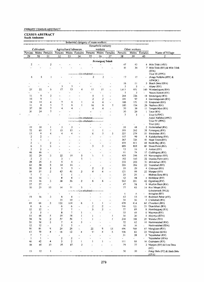
PRIMARY .cENSUS ABSTRACT
CENSUS ABSTRACT South Andaman
Industrial category of main workers Household industry
Cultivators Agricultural labourers workers Persons Males Females Persons Males Females Persons Males Females
29 30 31 32 33 34 35 36 37
2
6
27
11 10 18 11 37 31
19 72 13 2 1 2 6 2
46 32 2
28 63 31 59
7 16 19 27 30
19
69 6
12 3
53 38 20 12 90 43
7 I
46 56
13
5
22
9 9
14
8 30 24
18 65
9
2
3 2
46 29 2
25 58 30 57
7 16 16
27 20
16
66 6
12 3
48
36 18 12 81 39
7 1
42 46
12
2
5
2
4 3 7 7
7 4
2 3
3
3 5
2
3
10
3
3
5 2 2
9 4
4 10
3 17
7 7 4
3 15 4
22 3 5
14
5 43
8 38
14
8 19
122 6 7
8 19 57
7
3 29 16
2 3
l8
Ferrargunj Tehsil
----------- --Un- in hab ited --------------
3 13
6 6 4
4
2 2
17 17
1 1
2 2 4
16 4
4 9 4
-------------Un-inhabited---------------------------Un-inhabited--------------
3 15 4
19 3
5 l4 5
41 I 8
36
3
2
2
11 3
6 I
3
3 3
2 4
8
2 4
8
-------------Un-inhabited--------------
8 19
114
6 7
7 18 56
8
4 3 3
29 12
2 2
4
15 3
2 3
22 9,
1 2 3
9 4
279
7
3
13
5
Other workers Persons Males Females Name of Village
38 39 40 2
47 41
17
16 5
1,011 5
244 101 186 180 50 30
3
50 300 325 107 367 459 889
13 91
459 182 232 226
33 121 25 52
263 47 77
6
63 54
478 146 77 55 34
208 72
16 496 106
31
111 79
30
43
34
17
II
871 5
226 97
171 154 39 29
3
48 262 274
99 326 411
809 10 74
396
160 202 204
29 99 25 48
221 38 63
6 53 50
414
121 69 49 30
188 62 16
449 83 28
95
77
30
4 Mile Tilek (ARF) 7 Mile Tilek (RY) & Mile Tilek
(EFA) Tirur III (JPPC)
- Jhinga Nallaha (JPPC & APWDC)
5 Beach Dera (EFA) Alipur CRY)
140 Wimberlygunj CRY) Mount Harriet CRY)
18 Stweartgunj CRY) 4 Govindapuram (RY)
15 Knapuram CRY) 26 Mathura CRY) 1 1 Temple Myo (RY)
Tirur(RY) Tirur J CJPPC) Anjali Nallaha (JPPC) Tirur IY (JPPC) TirurOA)
2 Herbertabad CRY) 38 Ferrargunj (RY) 51 Bindraban (RY)
8 Kadakachang (RY) 41 Hope Town (RY) 48 North Bay CRY) 80 Shore Point (RY)
3 Aniket (RY) 17 Caddlegunj (RY) 63 Namunaghar (RY) 22 Dundas Point (RY) 30 Mithakhari (RY) 22 Tusnabad (RY)
4 Colinpur (RY) 22 Manpur (RY)
Mohwa Dera (RY) 4 Hobdipur CRY)
42 Ograbraij CRY) 9 Muslim Basti CRY)
14 Port Mouat (RY) Lohabarrack CWLS) Balughat (RY)
10 Badmash Pahar (RY) 4 Craikabad (RY)
64 Chouldari (RY) 25 Dhanikhari (RY)
8 Homfreygunj (RY) 6 Maymyo (RY) 4 Maymyo CEFA)
20 Wandur CRY) 10 Hashmatabad (RY)
Hashmatabad (EFA) 47 Manglutan CRY) 23 Manglutan CEFA)
3 Nayashahar (RY) Nayashahar (EFA)
16 Guptapara CRY) 2 Manjeri (RY) & Line Dera
(Fe)
Pongi Balu (FC) & Bada Balu EFA
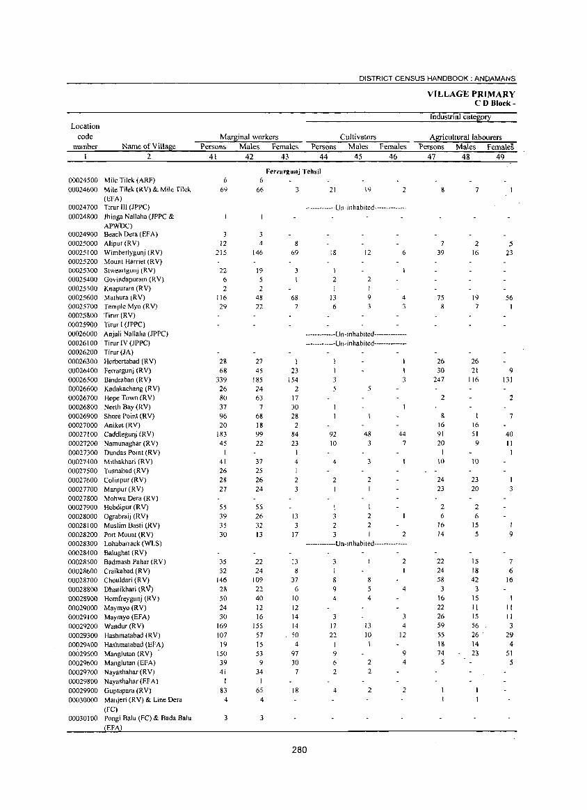
Location code
number Name of Village 2
00024500 Mile Tilek (ARf) 00024600 Mile Tilek (RV) & Mile Tilek
(EFA) 00024700 Tirur III (JPPC)
00024800 Jhinga Nallaha (JPPC & APWDC)
00024900 Beach Dera (EFA) 00025000 Alipur (RV) 00025100 Wimberlygunj (RV) 00025200 Mount Harriet (RV) 00025300 Stweartgunj (RY) 00025400 Govindapuram (RV) 00025500 Knapuram (R V) 00025600 Mathura (RV) 00025700 Temple Myo (RV) 00025800 Tirur CRY) 00025900 Tirur I (JPPC) 00026000 Anjali Nallaha (JPPC) 00026100 Tirur IY (JPPC) 00026200 Tirur (JA) 00026300 Herbertabad (RY) 00026400 Ferrargunj (R V) 00026500 Bindraban (R V) 00026600 Kadakachang (RV) 00026700 Hope Town (RY) 00026800 North Bay (RY) 00026900 Shore Point CRY) 00027000 Aniket (RY) 00027100 Caddlegunj CRY) 00027200 Namunaghar (R Y) 00027300 Dundas Point CRY) 00027400 Mithakhari (RV) 00027500 Tusnabad CRY) 00027600 Colinpur CR Y) 00027700 Manpur CRY) 00027800 Mohwa Dera (RY) 00027900 Hobdipur CRY) 00028000 Ograbraij CRY) 00028100 Muslim Basti (RY) 00028200 Port Mouat (RY) 00028300 Lohabarrack(WLS) 00028400 Balughat (RY) 00028500 Badmash Pahar (RV) 00028600 Craikabad CRY) 00028700 Chouldari (RY) 00028800 Dhanikhari (RV) 00028900 Homfreygunj CRY) 00029000 Maymyo CRY) 00029100 Maymyo (EFA) 00029200 Wandur (RY) 00029300 Hashmatabad (RY) 00029400 Hashmatabad CEFA) 00029500 Manglutan (RV) 00029600 Manglutan (EFA) 00029700 Nayashahar CRY) 00029800 Nayashahar(EFA) 00029900 Guptapara (RY) 00030000 Manjeri (RY) & Line Dera
(FC) 00030100 Pongi Balu (FC) & Bada Balu
EFA
DISTRICT CENSUS HANDBOOK: ANDAMANS
Marginal workers Cultivators Persons Males Females Persons Males Females
41 42 43 44 45 46
6
69
Ferrargunj Tehsil 6
3 12
215
22 6
2 116 29
28 68
339 26 80 37 96 20
183 45
41 26 28 27
55 39 35 30
35 32
146 28 50 24 30
169 107 19
150
39 41
I 83
4
3
66 3
3 4 8
146
19 5 2
48 22
27 45
185 24
69
3
68 7
23 154
2 63 17
7 30 68 28 18 99 22
37 25 26 24
S5 26 32 13
22 24
109 22 40
2
84 23
4
I 2
3
13 3
17
13 8
37
6 10
12 12 16
155 57
14 14 50
15 4
53 9
34 1
65 4
3
97 30
7
18
21 19 2
-------------U n-i n hab i ted--------------
18
1 2
13 6
12
2
9 3
6
4
3
-------------Un-inhabited---------------------------Un-inhabited--------------
I 3
92 10
4
2
3
2 3
5
48 3
3
2
2
2
3
44 7
2
-------------Un-inhabited--------------
3
8
9 4
3 17 22
9 6
2
4
8 5 4
13 10
2
2
2
2
1
4
3
4 12
9 4
2
280
VILLAGE PRIMARY CD Block-
Industrial category
Agricultural labourers Persons Males Females
47 48 49
8
7 39
75 8
26 30
247
2
& 16 91
20 1
10
24 23
2 6
16 14
22 24 58
:> 16 22 26 59 55 18 74 5
7
2 16
19
7
26 21
116
16 51 9
10
23 20
2 6
15 5
IS 18 42
:> IS II 15 56 26 .
14 23
5 23
56
9 131
2
7
40 II 1
3
9
7 6
16
II II 3
29 4
51 5
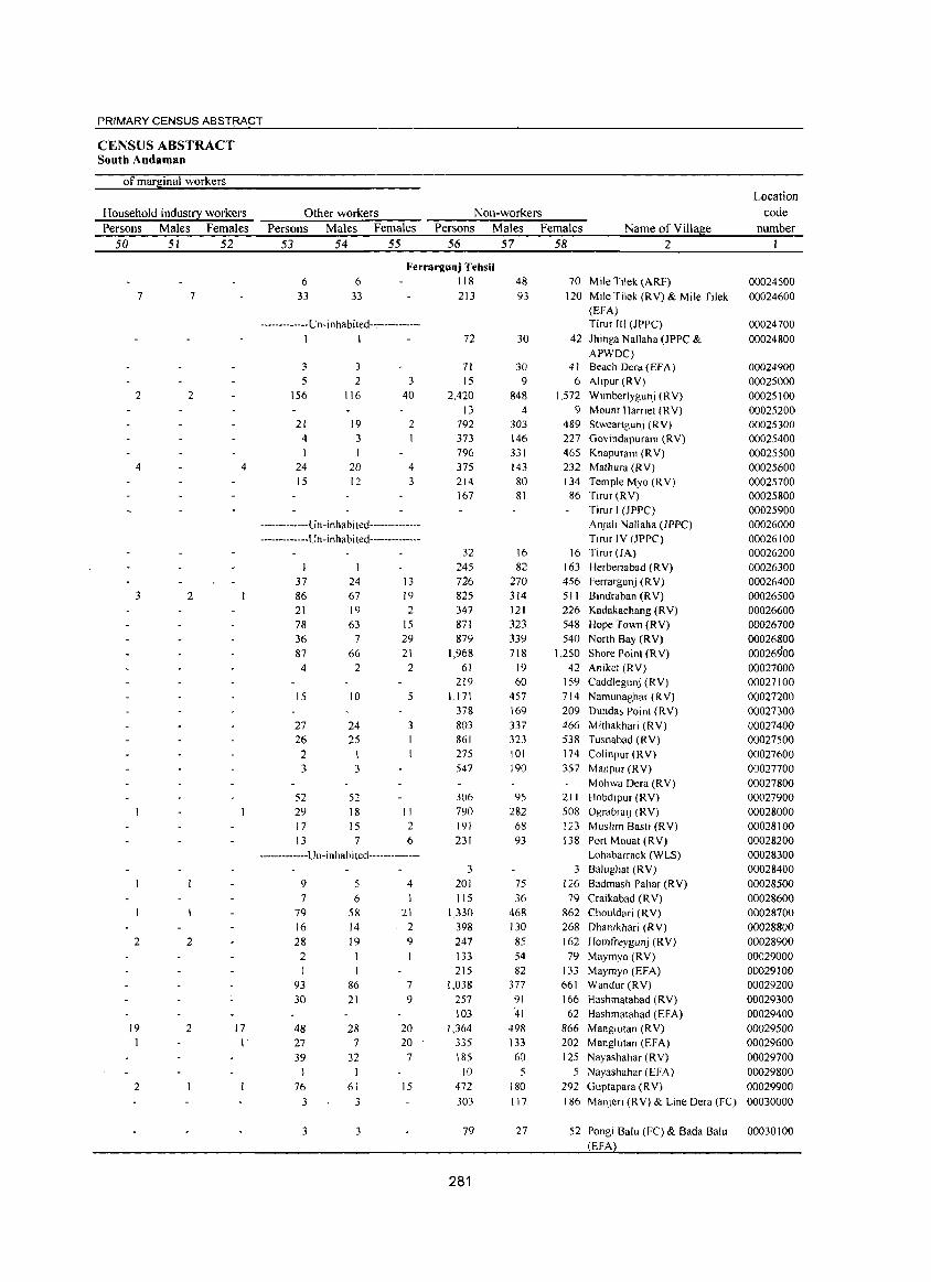
PRIMARY CENSUS ABSTRACT
CENSUS ABSTRACT South Andaman
of marginal workers
Household industry workers
Persons Males Females
50 51 52
7 7
2 2
4
3 2
2 2
19 2
2
4
17 I
Other workers Non-workers
Persons Males Females Persons Males Females Name of Village
Location
code
number
53 54 55 56 57 58 2
6 33
6 33
Ferrargunj Tehsil 118 213
-------------U n -i nhabi ted--------------I 1 72
3 5
156
21 4
I 24 15
3
2 116
19 3
20 12
3 40
2
4 3
-------------U n -in hab i ted---------------------------Un -i n habi ted--------------
37 86 21 78 36 87
4
15
27 26
2
24 67 19 63
7 66
2
10
24 25
3 3
52 29 17
13
52 18 15 7
13 19 2
15 29 21
2
5
3
II 2 6
-------------Un -i nhabi ted--------------
9 5 7 6
79 16 28 2
93
30
48 27 39
76
58 14 19
86 21
28 7
32
61
3 3
3 3
4
21 2 9
7 9
20 20
7
15
71 15
2.420 13
792 373 796 375 214 167
32 245 726 825 347 871 879
1,968 61
219 1.171
378 803 861
275 547
306 790 191
231
3 201 115
1,330
398 247 133
215 1,038
257 103
1,364 335
185 10
472
303
79
281
48 93
30
30 9
848 4
303 146 331 143 80 81
16 82
270 314 121 323 339 718
19 60
457 169
337 323 101 190
95 282
68 93
75 36
468 130
85 54
82 377
91
41
498 133 60
5 180 117
27
70 Mile Tilek (ARF)
120 Mile Tilek (RV) & Mile Tilek (EFA) Tirur III (JPPC)
42 Jhinga Nallaha (JPPC & APWDC)
41 Beach Dera(EFA) 6 Alipur (RV)
1.572 Wimberlygunj (RV) 9 Mount Harriet (RY)
489 Stweartgunj (RV) 227 Govindapuram (RV) 465 Knapuram (RV) 232 Mathura (RV) 134 Temple Myo (R V) 86 Tirur (RV)
Tirur I (JPPCl AnJali Nallaha (Jppel Tirur IV (JPPC)
16 Tirur (JA)
163 Herbertabad (RY) 456 Ferrargunj (R V) 511 Bindraban (RV) 226 Kadakachang (RV) 548 Hope TOM] (RV)
540 North Bay (R V) 1.250 Shore Point (RV)
42 Aniket (RV) 159 Caddlegunj (RV) 714 Namunaghar (RV) 209 Dundas Point (RV) 466 Mithakhari (RV) 538 Tusnabad (RV) 174 Colinpur (RV)
357 Manpur (RY)
Mohwa Oera (RV) 211 Hobdlpur(RV) 508 Ograbraij (RV)
123 Muslim Basti (RV) 138 Port Mouat (RV)
Lohabarrack (WLS) 3 Balughat (RV)
126 Badmash Pahar (RV) 79 Craikabad (RV)
862 Chouldari (RV)
268 Dhanikhari (RV) 162 Homfreygunj (RV)
79 Maymyo (RV) 133 Maymyo (EFA) 661 Wandur (RV) 166 Hashmatabad (RV) 62 Hashmatabad (EFA)
866 Manglutan (R V) 202 Manglutan (EFA) 125 Nayashahar (RV)
5 Nayashahar (EF A) 292 Guptapara (RV)
186 ManJeri (RV) & Line Dera (FC)
00024500 00024600
00024700 00024800
00024900 00025000 00025100 00025200 00025300 00025400 00025500 00025600 00025700 00025800 00025900 00026000 00026100 00026200 00026300 00026400 00026500 00026600 00026700 00026800 00026900 00027000 00027100 00027200 00027300 00027400 00027500 00027600 00027700 00027800 00027900 00028000 00028100 00028200 00028300 00028400 00028500 00028600 0002&700 00028800 00028900 00029000 00029100 00029200 00029300 00029400 00029500 00029600 00029700 00029800 00029900 00030000
52 Pongi Balu (FC) & Bada Balu 00030100 EFA
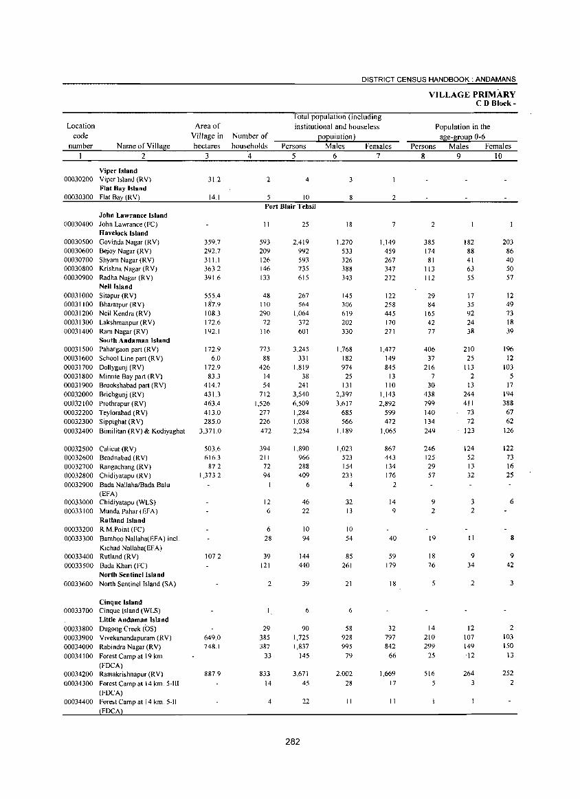
Location code
number Name of Village 2
Viper Island 00030200 Viper Island (RV)
Flat Bay Island 00030300 Flat Bay (RV)
John Lawrance Island 00030400 John Lawrance (FC)
Havelock Island 00030500 Govinda Nagar (RV) 00030600 Bejoy Nagar (RV) 00030700 Shyam Nagar (RV) 00030800 Krishna Nagar (RV) 00030900 Radha Nagar (RV)
Neil Island 00031000 Sitapur (RV) 00031100 Bharatpur (RV) 00031200 Neil Kendra (RV) 00031300 Lakshmanpur (RV) 00031400 Ram Nagar (RV)
South Andaman Island 00031500 Pahargaon part (RV) 00031600 School Line part (R V) 00031700 Dollygunj (RV) 00031800 Minnie Bay part (RV) 00031900 Brookshabad part (RV) 00032000 Brichgunj (RV) 00032100 Prothrapur (RV) 00032200 Teylorabad (RV) 00032300 Sippighat (RV) 00032400 Bimilitan (RV) & Kodiyaghat
00032500 Cali cut (R V) 00032600 Beadnabad (RV) 00032700 Rangachang (RV) 00032800 Chidiyatapu (RV) 00032900 Bada NallahaiBada Balu
(EFA) 00033000 Chidiyatapu (WLS) 00033100 MundaPahar(EFA)
Rutland Island 00033200 RM.Point (FC) 00033300 Bamboo Nallaha(EFA) incl.
Kichad Nallaha(EFA) 00033400 Rutland (RV) 00033500 Bada Khari (FC)
North Sentinel Island 00033600 North Sentinel Island (SA)
Cinque Island 00033700 Cinque Island (WLS)
Little Andaman Island 00033800 Dugong Creek (OS) 00033900 Vivekanandapuram (RV) 00034000 Rabindra Nagar (RV) 00034100 Forest Camp at 19 km.
(FDCA) 00034200 Ramakrishnapur (RV) 00034300 Forest Camp at 14 km. 5-111
(FOCA) 00034400
Area of Village in hectares
3
31.2
14.1
359.7 292.7 311.1 363.2 391.6
555.4 187.9 108.3 172.6 192.1
172.9 6.0
172.9 83.3
414.7 431.3 463.4 413.0 285.0
3,371.0
5036 616.3
87.2 1,373.2
107.2
649.0 748.1
887.9
DISTRICT CENSUS HANDBOOK: ANDAMANS
Number of households
4
2
5
Total population (including institutional and houseless
population) Persons Males Females
5 6 7
4 3
10 8 2 Port Blair Tehsil
11
593 209 126 146 133
48 110 290
72 116
773 88
426 14 54
712 1,526
277 226 472
394 211
72 94
I
12 6
6 28
39 121
2
29 385 387
33
833 14
4
25
2,419 992 593 735 615
267 564
1,064 372 601
3,245 331
1,819 38
241 3,540 6,509 1,284 1,038 2,254
1,890 966 288 409
6
46 22
10 94
144 440
39
6
90 1,725 1,837
145
3,671 45
22
282
18
1,270 533 326 388 343
145 306 619 202 330
1,768 182 974
25 131
2,397 3,617
685 566
1,189
1,023 523 154 233
4
32 13
10 54
85 261
21
6
58 928 995
79
2,002 28
11
7
1,149 459 267 347 272
122 258 445 170 271
1,477 149 845
13 110
1,143 2,892
599 472
1,065
867 443
134 176
2
14 9
40
59 179
18
32 797 842
66
1,669 17
II
VILLAGE PRIMARY CD Block-
Persons 8
2
385 174
81 113 112
29 84
165 42 77
406 37
216 7
30 438 799 140 134 249
246 125 29 57
9 2
19
18 76
5
14 210 299
25
516 5
Population in the age-group 0-6
Males Females 9 10
182 88 41 63 55
17 35 92 24 38
210 25
113 2
13 244 411
73 72
123
124 52 13 32
3 2
11
9 34
2
12 107 149
12
264 3
203 86 40 50 57
12 49 73 18 39
196 12
103 5
17 194 388
67 62
126
122 73 16 25
6
8
9 42
3
2 103 150
13
252 2
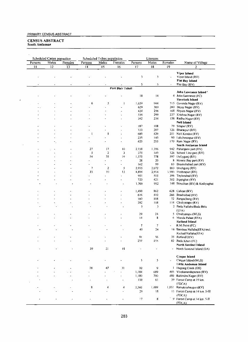
PRIMARY CENSUS ABSTRACT
CENSUS ABSTRACT South Andaman
Scheduled Castes EOEuation Scheduled Tribes EOEulation Literates Persons Males Females Persons Males Females Persons Males Females Name ofVilIaliie
II 12 13 14 15 16 17 18 19 2
Viper Island 3 3 Viper Island (RV)
Flat Bay Island 5 Flat Ba (RY)
Port Blair Tehsil John Lawrance Island'
18 14 4 John Lawrance (FC) Havelock Island
6 5 1,659 944 715 Govinda Nagar (RY) 629 369 260 Bejoy Nagar (RY) 424 256 168 Shyam Nagar (R Y) 536 299 237 Krishna Nagar (RY) 392 234 158 Radha Nagar (RY)
Neil Island 187 108 79 Sitapur (RY) 333 207 126 Bharatpur (RV) 680 429 251 Neil Kendra (RV) 230 140 90 Lakshmanpur (RV) 425 255 170 Ram Nagar (RY)
South Andaman Island 27 17 10 2,338 1,396 942 Pahargaon part (RV)
5 2 3 275 149 126 School Line part (RV) 54 35 19 1,375 778 597 Dollygunj (RV)
28 20 8 Minnie Bay part (RV) 162 99 63 Brookshabad part (RY)
7 2 5 2,935 2,072 863 Brichgunj (RV) 23 10 13 4,899 2,914 \ .985 Prothrapur (RY)
951 555 396 Teylorabad (RY) 723 421 302 Sippighat (RV)
1,700 952 748 Bimilitan (RY) & Kodiyaghat
1,490 862 628 Calicut (RV) 676 410 266 Beadnabad (RY) 180 108 72 Rangachang (RV) 282 168 114 Chidiyatapu (RV)
5 3 2 Bada NallahaIBada Balu (EFA)
29 24 Chidiyatapu (WLS) 14 8 6 Munda Pahar (EFA)
Rutland Island 7 7 KM.Point (FC)
40 24 \6 Bamboo NaUaha(EFA) incL Kichad Nallaha(EFA)
91 56 35 Rutland (RY) 237 155 82 Bada Khari (FC)
North Sentinel Island 39 21 18 Nonh Sentinel Island (SA)
Cinque Island 5 5 Cinque Island (WLS)
Little Andaman Island 78 47 31 10 9 Dugong Creek (OS)
1,184 689 495 Vivekanandapuram (RY) 1,180 700 480 Rabindra Nagar (RY)
100 61 39 Forest Camp at 19 km. (FOCA)
8 4 4 2.540 1.489 1,051 Ramakrishnapur (R V) 29 18 II Forest Camp at 14 km. S-lII
(FOCA) 17 8 9 5-1I
283
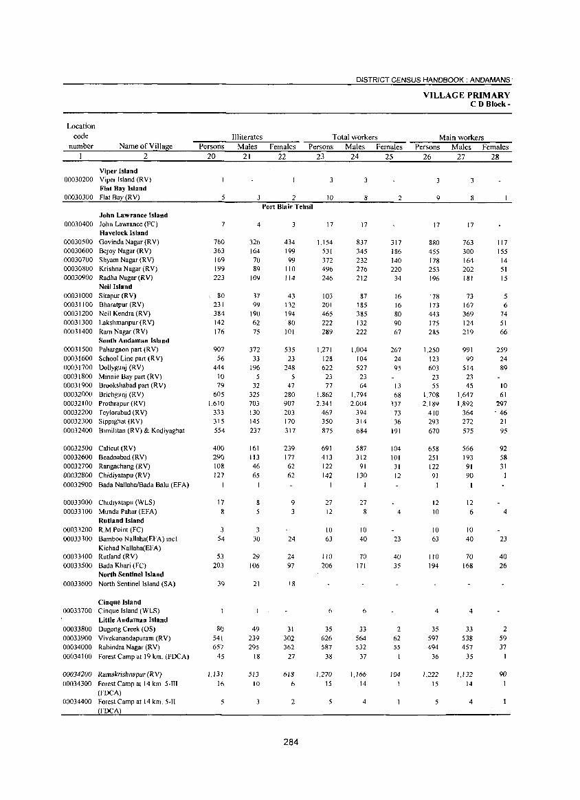
Location
code
number Name ofYillage
2
Viper Island 00030200 Yiper Island (RY)
Flat Bay Island 00030300 Flat Bay (RY)
John Lawrance Island 00030400 John Lawrance (FC)
Havelock Island 00030500 Govinda Nagar (RV) 00030600 Bejoy Nagar (RV) 00030700 Shyam Nagar (RY) 00030800 Krishna Nagar (RV) 00030900 Radha Nagar (RY)
Neil Island 00031000 Sitapur (RV) 00031 100 Bharatpur (RV) 00031200 Neil Kendra (RV) 00031300 Lakshmanpur (RY) 00031400 Ram Nagar (RY)
South Andaman Island 00031500 Pahargaon part (RY) 00031600 School Line part (R V) 00031700 Dollygunj (RV) 00031800 Minnie Bay part (RY) 00031900 Brookshabad part (RY) 00032000 Brichgunj (RV) 00032100 Prothrapur (RY) 00032200 Teylorabad (RY) 00032300 Sippighat (RV)
00032400 Bimilitan (RV) & Kodiyaghat
00032500 Calicut (RV) 00032600 Beadnabad (RV) 00032700 Rangachang (RV) 00032800 Chidiyatapu (RV)
00032900 Bada NallahalBada Balu (EF A)
00033000 Chidiyatapu (WLS) 00033100 Munda Pahar(EFA)
Rutland Island 00033200 RMPoint (FC) 00033300 Bamboo Nallaha(EFA) incL
Kichad Nallaha(EFA) 00033400 Rutland (RV) 00033500 Bada Khari (FC)
North Sentinel Island
00033600 North Sentinel Island (SA)
Cinque Island 00033700 Cinque Island (WLS)
Little Andaman Island 00033800 Dugong Creek (OS) 00033900 Vivekanandapuram (RV) 00034000 Rabindra Nagar (RV)
00034100 Forest Camp at 19 km. (FDCA)
00034200 Rllmakrishnapur (RV) 00034300 Forest Camp at 14 km. 5-1T1
(FDCA) 00034400 Forest Camp at 14 km. 5-11
FDCA
Persons
20
5
7
760 363 169 199 223
80 231 384 142 176
907 56
444 10 79
605 1,610
333 315 554
400 290 108 127
17 8
3 54
53 203
39
80 541 657
45
1,131
16
5
DISTRICT CENSUS HANDBOOK: ANDAMANS·
Illiterates Total workers
Males Females Persons Males Females
21
3
4
326 164
70 89
109
37 99
190 62 75
372 33
196 5
32 325 703 130 145 237
161
113 46 65
8 5
3 30
29 106
21
49 239 295
18
513
10
3
22
2 Port Blair Tehsil
3
434 199 99
110 114
43 132 194 80
101
535 23
248 5
47 280 907 203 170 317
239 177 62 62
9 3
24
24 97
18
31 302 362
27
618
6
2
284
23 24 25
3
10
17
1,154 531 372 496 246
103 201 465 222 289
1,271
128 622
23 77
1,862 2,341
467 350 875
691 413 122 142
27 12
10 63
110 206
6
35 626 587
38
1,270
15
5
3
8
17
837 345 232 276 212
87 185 385 132 222
1,004 104 527
23 64
1,794 2,004
394 314 684
587
312 91
130
27 8
10 40
70 171
6
33 564 532
37
1,166 14
4
2
317 186 140 220
34
16 16 80 90 67
267 24 95
13 68
337 73 36
191
104 101
31 12
4
23
40 35
2 62 55
I
104
VILLAGE PRIMARY CD Block-
Main workers
Persons Males Females
26 27 28
3
9
17
880 455 178 253 196
'78 173 443 175 285
1,250
123 603
23 55
1,708 2,189
410 293 670
658 251 122
91
12 10
10 63
110
194
4
35 597 494
36
1,222 15
5
3
8
17
763 300 164 202 181
73 167 369 124 219
991 99
514 23 4S
1,647 1,892
364 272 575
566 193 91 90
12 6
10 40
70 168
4
33
538 457
35
1,1J2 14
4
117 155
14 51 15
5 6
74 51 66
259 24 89
10 61
297 - 46
21 95
92 58 31
4
23
40 26
2 59 37
I
90
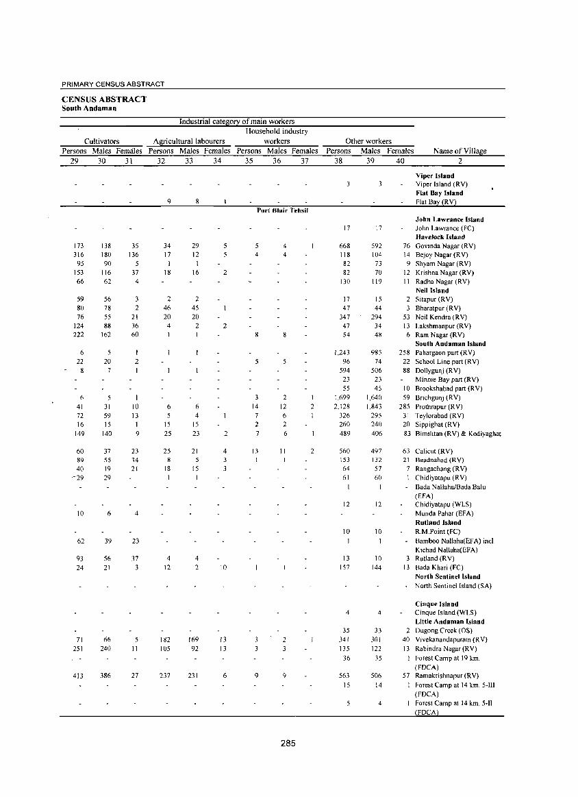
PRIMARY CENSUS ABSTRACT
CENSUS ABSTRACT South Andaman
Industrial categ0!2: of main workers Household industry
Cultivators A~icultural labourers workers Other workers Persons Males Females Persons Males Females Persons Males Females Persons Males Females Name of Village
29 30 31 32 33 34 35 36 37 38 39 40 2
Viper Island 3 3 Viper Island (RY)
Flat Bay Island 9 8 Flat Ba (RY)
Port Blair Tehsil John Lawrance Island
17 17 John Lawrance (FC) Havelock Island
173 138 35 34 29 5 5 4 668 592 76 Govinda Nagar (RY) 316 180 136 17 12 5 4 4 118 104 14 Bejoy Nagar (R Y)
95 90 5 82 73 9 Shyam Nagar (RY) 153 116 37 18 16 2 82 70 12 Krishna Nagar (RY) 66 62 4 130 119 11 Radha Nagar (RY)
Neil Island 59 56 3 2 2 17 15 2 Sitapur (RY) 80 78 2 46 45 47 44 3 Bharatpur (RY) 76 55 21 20 20 347 294 53 Neil Kendra (RY)
124 88 36 4 2 2 47 34 13 Lakshmanpur (RY) 222 162 60 8 8 54 48 6 Ram Nagar (RY)
South Andaman Island 6 5 I 1,243 985 258 Pahargaon part (RY)
22 20 2 5 5 96 74 22 School Line part (RY) 8 7 594 506 88 Dollygunj (RY)
23 23 Minnie Bay part (RY) 55 45 10 Brookshabad part (R Y)
6 5 3 2 1 1,699 1,640 59 Bflchgunj (RY) 41 31 10 6 6 14 12 2 2,128 1,843 285 Prothrapur (R Y) 72 59 13 5 4 7 6 326 295 31 Teylorabad (RY) 16 15 1 15 15 2 2 260 240 20 Sippighat (RY)
149 140 9 25 23 2 7 6 489 406 83 Bimilitan (RY) & Kodiyaghat
60 37 23 25 21 4 13 11 2 560 497 63 Calicut (RY) 89 55 34 8 5 3 153 132 21 Beadnabad (RY) 40 19 21 18 15 3 64 57 7 Rangachang (R Y)
-29 29 1 61 60 1 Chidiyatapu (RY)
Bada NallahaIBada Balu (EFA)
12 12 Chidiyatapu (WLS)
10 6 4 Munda Pahar (EFA) Rutland Island
10 10 R.M.Point (FC)
62 39 23 Bamboo Nallaha(EFA) inel. Kichad Nal1aha(EFA)
93 56 37 4 4 13 10 3 Rutland (RV)
24 21 3 12 2 10 . I 157 144 13 Bada Khari (Fe) North Sentinel Island North Sentinel Island (SA)
Cinque Island 4 4 Cinque Island (WLS)
Little Andaman Island 35 33 2 Dugong Creek (OS)
71 66 5 182 169 13 3 2 341 301 40 Yivekanandapuram (R V)
251 240 II 105 92 13 3 3 135 122 13 Rabindra Nagar (RY)
36 35 Forest Camp at 19 km. (FOCA)
413 386 27 237 231 6 9 9 563 506 57 Ramakrishnapur (RY)
15 14 Forest Camp at 14 km. 5-111 (FDCA)
5 4
285
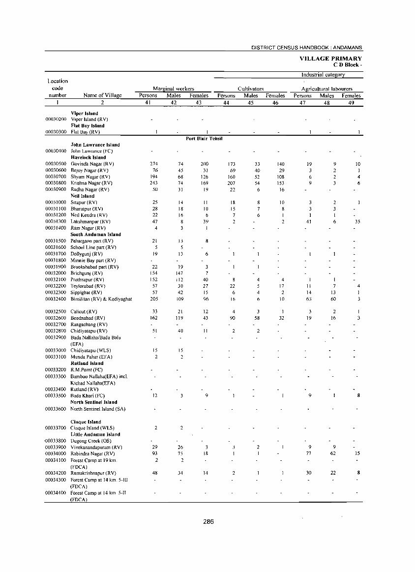
DISTRICT CENSUS HANDBOOK: ANDAMANS
VILLAGE PRIMARY CD Block-
Industrial cate~0!i: Location
code Marf.inal workers Cultivators A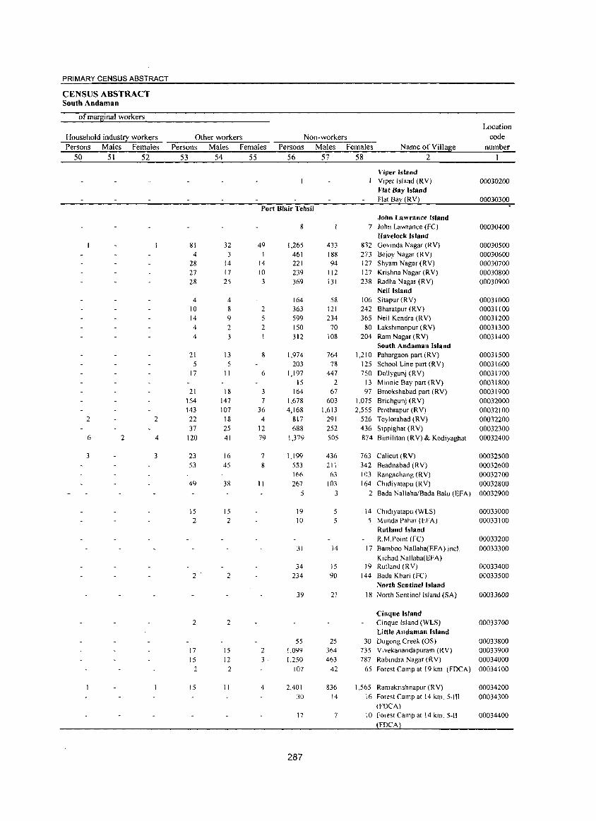
PRIMARY CENSUS ABSTRACT
CENSUS ABSTRACT South Andaman
of marsinal workers Location
Household indust!}: workers Other workers Non-workers code
Persons Males Females Persons Males Females Persons Males Females Name ofViIlase number
50 51 52 53 54 55 56 57 58 2
Viper Island Viper Island (RY) 00030200 Flat Bay Island Flat Bay (RY) 00030300
Port Blair Tehsil John Lawrance Island
8 7 john Lawrance (Fe) 00030400 Havelock Island
81 32 49 1,265 433 832 Govinda Nagar (RY) 00030500 4 3 I 461 188 273 Bejoy Nagar (RY) 00030600
28 14 14 221 94 127 Shyam Nagar (RY) 00030700 27 17 10 239 112 127 Krishna Nagar (RY) 00030800 28 25 3 369 131 238 Radha Nagar (RY) 00030900
Neil Island 4 4 164 58 106 Sitapur(RY) 00031000
10 8 2 363 121 242 Bharatpur (R Y) 00031100 14 9 5 599 234 365 Neil Kendra (R Y) 00031200 4 2 2 150 70 80 Lakshmanpur (RY) 00031300 4 3 312 108 204 Ram Nagar (RY) 00031400
South Andaman Island 21 13 8 1,974 764 1,210 Pahargaon part (RY) 00031500
5 5 203 78 125 School Line part (RY) 00031600 17 11 6 1,197 447 750 Dollygunj (RY) 00031700
15 2 13 Minnie Bay part (RY) 00031800 21 18 3 164 67 97 Brookshabad part (RY) 00031900
154 147 7 1,678 603 1,075 Brichgunj (RY) 00032000 143 107 36 4,168 1,613 2,555 Prothrapur (RY) 00032100
2 2 22 18 4 817 291 526 Teylorabad (RY) 00032200 37 25 12 688 252 436 Sippighat (RY) 00032300
6 2 4 120 41 79 1,379 50S 874 Bimihtan (RY) & Kodiyaghat 00032400
3 3 23 16 7 1,199 436 763 Cahcut (RY) 00032500 53 45 8 553 211 342 Beadnabad (RY) 00032600
166 63 103 Rangachan g (R Y) 00032700 49 38 11 267 103 164 Chldiyatapu (RV) 00032800
5 3 2 Bada NaliahalBada Balu (EFA) 00032900
15 15 19 14 Chidlyatapu (WLS) 00033000 2 2 10 5 5 Munda Pahar (EFA) 00033100
Rutland Island RM.Point (FC) 00033200
31 14 17 Bamboo Nallaha(EFA) ineL 00033300 Kichad Na11aha{EFA)
34 15 19 Rutland (RY) 00033400 2' 2 234 90 144 Bada Khari (FC) 00033500
North Sentinel Island
39 21 18 North Sentinel Island (SA) 00033600
Cinque Island 2 2 Cinque Island (WLS) 00033700
Little Andaman Island 55 25 30 Dugong Creek (OS) 00033800
17 15 2 1,099 364 735 Yivekanandapuram (RY) 00033900 15 12 3 ' 1,250 463 787 Rabindra Nagar (RY) 00034000
2 2 107 42 65 Forest Camp at 19 km. (FDCA) 00034100
15 11 4 2,401 836 1,565 Ramakrishnapur (RY) 00034200 30 14 16 Forest Camp at 14 km. 5-1II 00034300
(FOCA) 17 10 5-11 00034400
287
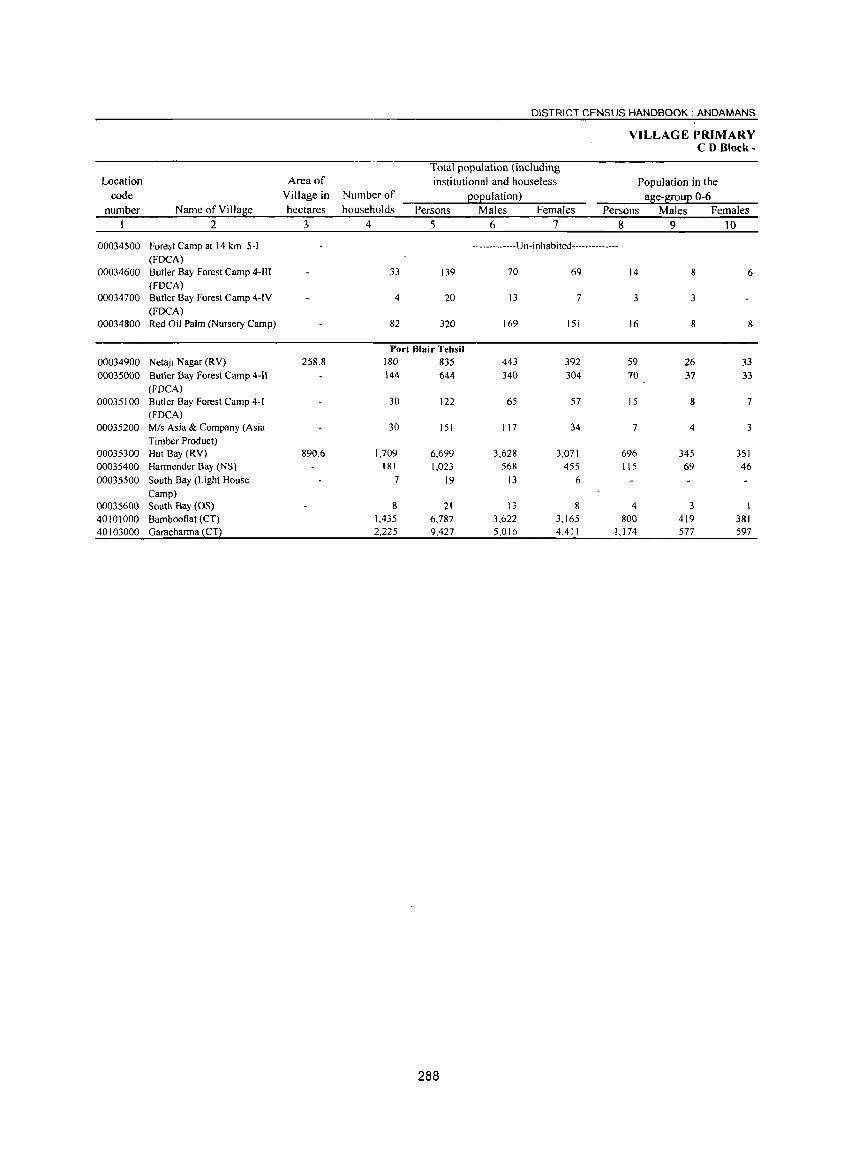
DISTRICT CENSUS HANDBOOK: ANDAMANS
VILLAGE PRIMARY CD Block-
Total population (including Location Area of institutional and houseless Population in the
code Village in Number of EOEulation) ase-lEouE 0-6 number Name ofVillase hectares households Persons Males Females Persons Males Females
1 2 3 4 5 6 7 8 9 10
00034500 Forest Camp at 14 km. 5-1 -------------Un-inhabited--------------(FOCA)
00034600 Butler Bay Forest Camp 4-1II 33 139 70 69 14 8 6 (FDCA)
00034700 Butler Bay Forest Camp 4-[V 4 20 13 7 3 3 (FDCA)
00034800 Red Oil Palm (Nursery Camp) 82 320 169 151 16 8 8
Port Blair Tehsil 00034900 Netaji Nagar CRY) 258.8 180 835 443 392 59 26 33 00035000 Butler Bay Forest Camp 4-11 144 644 340 304 70 37 33
(FDCA) 00035100 Butler Bay Forest Camp 4-1 30 122 65 57 15 8 7
(FDCA) 00035200 Mis Asia & Company (Asia 30 151 117 34 7 4 3
Timber Product) 00035300 Hut Bay (RV) 890.6 1,709 6,699 3,628 3,071 696 345 351 00035400 Harmender Bay (NS) 181 1,023 568 455 115 69 46 00035500 South Bay (Light House 7 19 13 6
Camp) 00035600 South Bay (OS) 8 21 13 8 4 3 40101000 Bambooflat (CT) 1,435 6,787 3.622 3_165 800 419 381 40103000 Garacharma CCT) 2,225 9,427 5,016 4,411 1,174 577 597
288
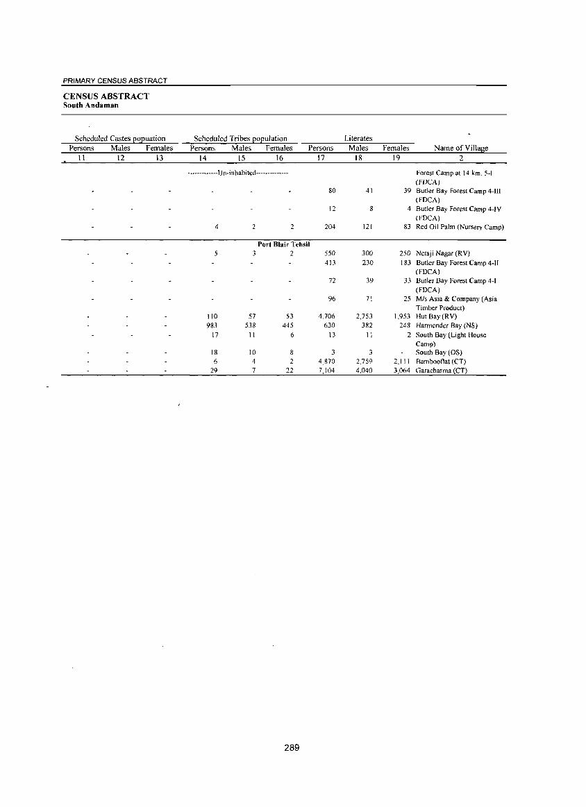
PRIMARY CENSUS ABSTRACT
CENSUS ABSTRACT South Andaman
Scheduled Castes popuation Persons Males Females
11 12 13
Scheduled Tribes population Persons Males Females Persons
14 15 16 17
-------------Un-inhabited--------------
80
)2
4 2 2 204
Port Blair Tehsil 5 3 2 550
413
72
96
110 57 53 4,706
983 538 445 630 17 11 6 13
18 10 8 3
6 4 2 4,870
29 7 22 7,104
289
Literates Males Females
18 19
41 39
8 4
121 83
300 250 230 183
39 33
71 25
2,753 1,953
382 248
11 2
3 2,759 2,111 4,040 3,064
Name of Village 2
Forest Camp at 14 km. 5-1 (fOCA) Butler Bay Forest Camp 4-111 (FOCA) Butler Bay Forest Camp 4-IV (FOCA) Red Oil Palm (Nursery Camp)
Netaji Nagar (RV}
Butler Bay Forest Camp 4-11 (FOCA) Butler Bay Forest Camp 4-1 (FOCA} Mis Asia & Company (Asia Timber Product) Hut Bay (RV} Harmender Bay (NS}
South Bay (Light House Camp) South Bay (OS) Bambooflat (CT) Garacharma (CT)
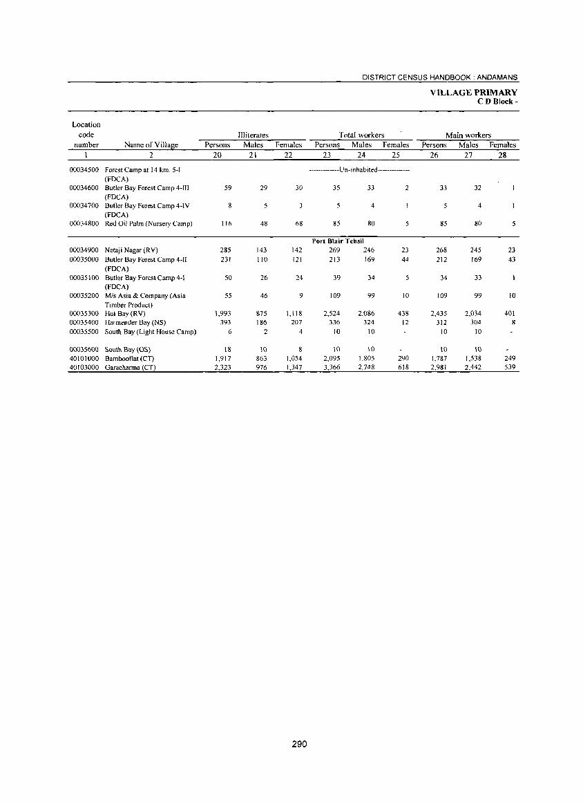
DISTRICT CENSUS HANDBOOK: ANDAMANS
VILLAGE PRIMARY CD Block-
Location
code Illiterates Total workers Main workers number Name of Villase Persons Males Females Persons Males Females Persons Males Females
2 20 21 22 23 24 25 26 27 28
00034500 Forest Camp at 14 km. 5-1 -------------U n -i nhabi ted --------------(FOCA)
00034600 Butler Bay Forest Camp 4-111 59 29 30 35 33 2 33 32 (FDCA)
00034700 Butler Bay Forest Camp 4-IV 8 5 3 5 4 5 4 (FOCA)
00034800 Red Oil Palm (Nursery Camp) 116 48 68 85 80 5 85 80 5
Port Blair Tehsil 00034900 Netaji Nagar (RV) 285 143 142 269 246 23 268 245 23 00035000 Butler Bay Forest Camp 4-11 231 110 121 213 169 44 212 169 43
(FOCA) 00035100 Butler Bay Forest Camp 4-1 50 26 24 39 34 5 34 33
(FOCA) 00035200 Mis Asia & Company (Asia 55 46 9 109 99 10 109 99 10
Timber Product) 00035300 Hut Bay (RV) 1,993 875 1,118 2,524 2,086 438 2,435 2,034 401 00035400 Harrnender Bay (NS) 393 186 207 336 324 12 312 304 8 00035500 South Bay (Light House Camp) 6 2 4 10 10 10 10
00035600 South Bay (OS) IS 10 S 10 10 10 10 40101000 Bambooflat (CT) 1,917 863 1,054 2,095 1,805 290 1,787 1,538 249 40103000 Garacharrna (CT) 2,323 976 1,347 3,366 2,748 618 2,981 2,442 539
290
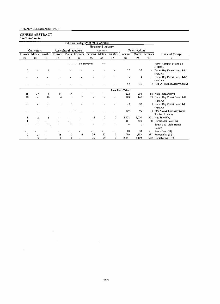
PRIMARY CENSUS ABSTRACT
CENSUS ABSTRACT South Andaman
Industrial category of main workers Household industry
Cultivators Agricultural labourers workers Other workers Persons Males Females Persons Males Females Persons Males Females Persons Males Females
29 30 31 32 33 34 35 36 37 38 39 40
31 19
3
2 3
27
2
2 3
4 19
15 4
16
-------------Un-inhabited--------------
14 I
10
1
3
6
4
39 36
2
33
29
291
32
5
85
Port Blair Tehsil 222 189
2
6 7
33
109
2,428
311 10
10 1,730 2,941
32 -
4
80 5
204 18 168 21
32
99 10
2,030 398 303 8
10 -
10 1,493 237 2,409 532
Name of Village 2
Forest Camp at 14 km. 5-1 (mCA) Butler Bay Forest Camp 4-II1 (FDCA) Butler Bay Forest Camp 4-IV (FOCA) Red Oil Palm (Nursery Camp)
Netaji Nagar (RV) Butler Bay Forest Camp 4-JI (mCA)
Butler Bay Forest Camp 4-1 (mCA) MIs Asia & Company (Asia Timber Product) Hut Bay (RV) Harmender Bay (NS)
South Bay (Light House Camp) South Bay (OS) Bambooflat (CT) Garacharma (CT)
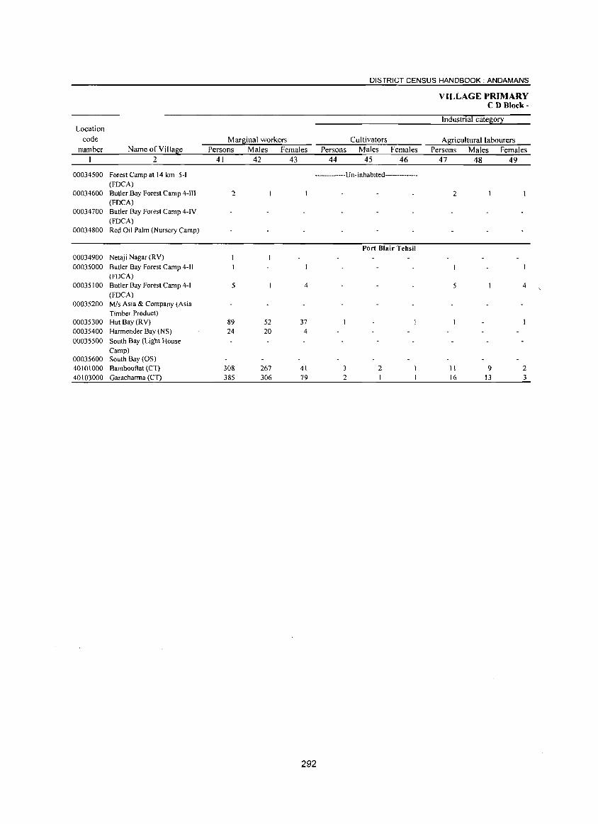
Location
code
number Name of Village
2
00034500 Forest Camp at 14 km. 5-1 (FOCA)
00034600 Butler Bay Forest Camp 4-11I (FOCA)
00034700 Butler Bay Forest Camp 4-IV
(FOCAl 00034800 Red Oil Palm (Nursery Camp)
00034900 Netaji Nagar (RY)
00035000 Butler Bay Forest Camp 4-11 (FOCA)
00035100 Butler Bay Forest Camp 4-1
(FOCA) 00035200 Mis Asia & Company (Asia
Timber Product) 00035300 Hut Bay (RV)
00035400 Harmender Bay (NS)
00035500 South Bay (Light House Camp)
00035600 South Bay (OS)
40101000 Bamboot1at (CT)
40103000 Garacharma (CT)
Marginal workers
Persons Males Females
41 42 43
DISTRICT CENSUS HANDBOOK: ANDAMANS
Cultivators
Persons Males Females
44 45 46
VILLAGE PRIMARY CD B1ock-
Industrial category
Agricultural labourers
Persons Males Females
47 48 49
-------------U n- inhab ited--------------
2
5
89 24
308 385
52 20
267
306
4
37 4
41
79
292
3 2
Port Blair Tehsil
2
2
5
II 16
9 13
4
2 3
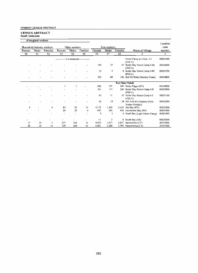
PRIMARY CENSUS ABSTRACT
CENSUS ABSTRACT South Andaman
of marginal workers
Household industry workers Persons Males Females
50 51 52
Other workers Persons Males Females
53 54 55
-------------u n-i n hab ited--------------
4
17 38
10 24
4
7
14
83 24
277 329
52 20
246 268
31 4
31 61
Non-workers Persons Males Females Name of Village
Location code
number 56 57 58 2
104 37
15 9
235 89
566 197 431 171
83 31
42 18
4,175 1,542 687 244
9 3
II 3 4,692 1,817 6,061 2,268
293
Forest Camp at 14 km. 5-1 (FOCA)
00034500
67 Butler Bay Forest Camp 4-1II 00034600 (FOCA)
6 Butler Bay Forest Camp 4-IV 00034700 (FDCA)
146 Red Oil Palm (Nursery Camp) 00034800
Port Blair Tehsil 369 Netaji Nagar (RV) 00034900 260 Butler Bay Forest Camp 4-11 00035000
(FOCA) 52 Butler Bay Forest Camp 4-1 00035100
(FOCA) 24 MIs Asia & Company (Asia 00035200
Timber Product) 2,633 Hut Bay (R V) 00035300
443 Harmender Bay (NS) 00035400 6 South Bay (Light House Camp) 00035500
8 South Bay (OS) 2,875 Bambootlat (eT) 3,793 Garacharma (CT)
00035600 40101000 40103000
DISTRICT CENSUS HANDBOOK: NICOBARS
VILLAGE PRIMARY CD Block-
Total population (including Location Area of institutional and house less Population in the
code Village in Number of EOEulation) a~e-~ouE 0-6 number Name ofVilla~e hectares households Persons Males Females Persons Males Females
I 2 3 4 5 6 7 8 9 10 0001 Car Nicobar (Total) 3,296 20,292 10,663 9,629 2,294 1,186 1,108 0001 Car Nicobar (Rural) 3,296 20,292 10,663 9,629 2,294 1,186 1,108 0001 Car Nicobar (Urban)
Car Nicobar (Rural) Car Nicobar Tehsil
Car Nicobar Island 00035700 Mus 292 1,731 899 832 167 76 91 00035800 Tectop 68 512 277 235 50 29 21 00035900 Sawai 158 1,235 599 636 140 64 76 00036000 Arong 159 1,006 528 478 115 63 52 00036\00 Kimois 1\0 703 343 360 102 54 48 00036200 Kakana 151 900 472 428 63 35 28 00036300 IAF Camp 439 1,927 1,224 703 303 179 124 00036400 Malacca 622 3,000 1,608 1,392 327 168 159 00036500 Perka 260 1,548 757 791 171 85 86 00036600 Tamaloo 163 1,449 700 749 153 69 84 00036700 Kinyuka 142 1,057 518 539 136 66 70 00036800 Chuckchucha 172 1,182 602 580 144 75 69 00036900 Tapoiming 113 759 380 379 91 52 39 00037000 Big Lapati 270 1,741 949 792 154 76 78 00037100 Small Lapati 102 950 495 455 105 60 45 00037200 Kinmai 75 592 312 280 73 35 38
294
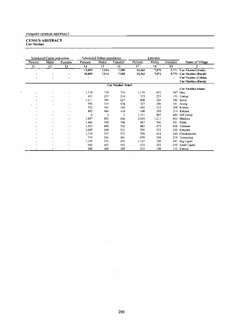
PRIMARY CENSUS ABSTRACT
CENSUS ABSTRACT Car Nicobar
Scheduled Castes EOEuation Scheduled Tribes EOEulation Literates Persons Males Females Persons Males Females Persons Males Females Name ofVilJage
II 12 13 14 15 16 17 18 19 2 15,899 7,914 7,985 13,343 7,572 5,771 Car Nicobar (Total) 15,899 7,914 7,985 13,343 7,572 5,771 Car Nicobar (Rural)
Car Nicobar (Urban) Car Nicobar (Rural)
Car Nicobar Tehsil Car Nicobar Island
1,518 739 779 1,179 672 507 Mus 451 237 214 373 223 150 Teetop
1,21 I 584 627 808 426 382 Sawai 992 514 478 727 386 341 Arong 703 343 360 440 232 208 Kimois 882 464 418 498 284 214 Kakana
6 3 3 1,371 887 484 IAFCamp 1,697 851 846 2,054 1,211 843 Malacca 1,446 700 746 947 506 441 Perka 1,433 690 743 883 475 408 Tama100 1,039 508 531 705 372 333 Kinyuka 1,119 547 572 758 418 340 Chuckchucha
719 356 363 478 259 219 Tapoiming 1,145 575 570 1,197 700 497 Big Lapat;
950 495 455 572 323 249 Small Lapati 588 308 280 353 198 155 Kinmai
295
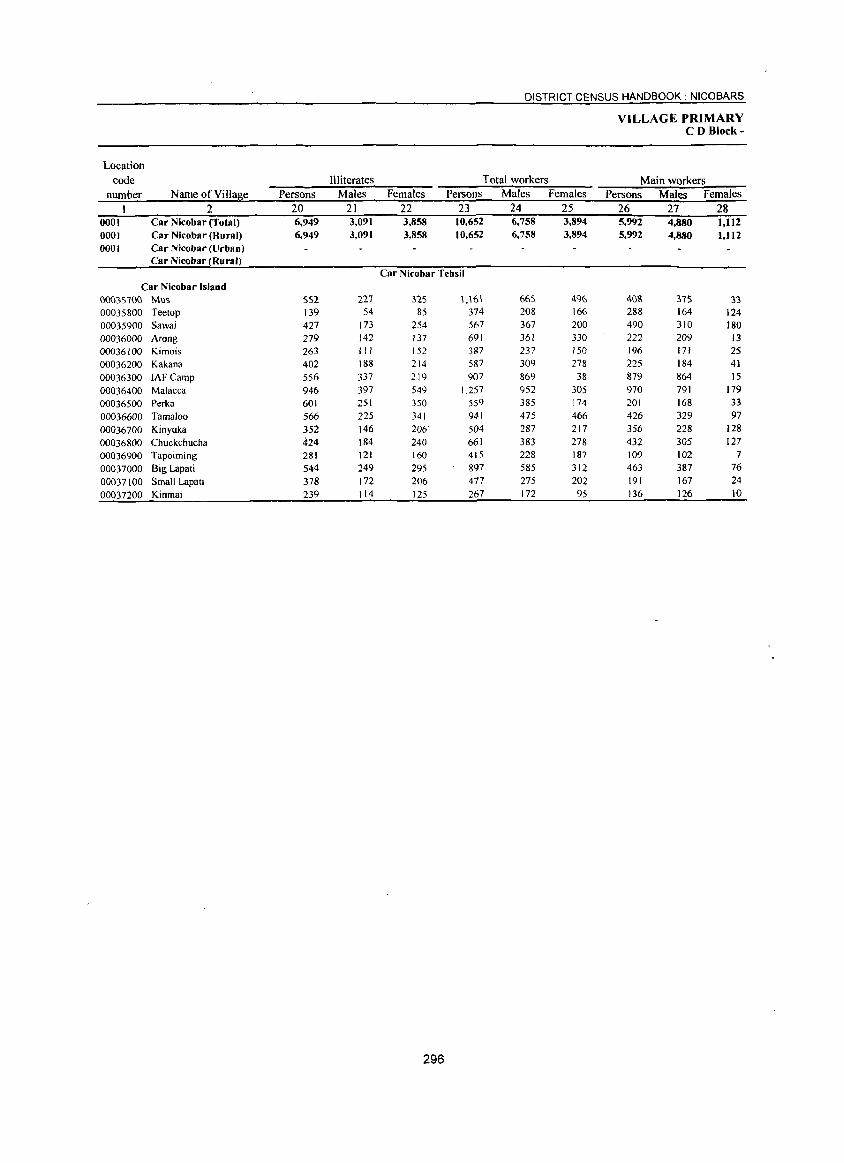
DISTRICT CENSUS HANDBOOK: NICOBARS
VILLAGE PRIMARY CD Block-
Location code Illiterates Total workers Main workers
number Name of Vil1a~e Persons Males Females Persons Males Females Persons Males Females 2 20 21 22 23 24 25 26 27 28
0001 Car Nicobar (Total) 6,949 3,091 3,858 10,652 6,758 3,894 5,992 4,880 1,112 0001 Car Nicobar (Rural) 6,949 3,091 3,858 10,652 6,758 3,894 5,992 4,880 I,J 12 0(0) Car Nicobar (Urban)
Car Nicobar (Rural) Car Nicobar Tehsil
Car Nicobar Island O{)03S700 Mus SS2 227 :ns 1.\61 665 496 408 :ns 33 00035800 Teetop 139 54 85 374 208 166 288 164 124 00035900 Sawai 427 173 254 567 367 200 490 310 180 00036000 Arong 279 142 137 691 361 330 222 209 13 00036100 Kimois 263 III 152 387 237 150 196 171 25 00036200 Kakana 402 188 214 587 309 278 225 184 41 00036300 IAFCamp 556 337 219 907 869 38 879 864 15 00036400 Malacca 946 397 549 1.257 952 305 970 791 179 00036500 Perka 601 251 350 559 385 174 201 168 33 00036600 Tamaloo 566 225 341 941 475 466 426 329 97 00036700 Kinyuka 352 146 206 504 287 217 356 228 128 00036800 Chuckchucha 424 184 240 661 383 278 432 305 127 00036900 Tapoiming 281 121 160 415 228 187 109 102 7 00037000 Big Lapati 544 249 295 897 585 312 463 387 76 00037100 Small Lapati 378 172 206 477 275 202 191 167 24 00037200 Kinmai 239 114 125 267 172 95 136 126 10
296
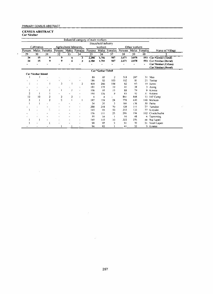
PRIMARY CENSUS ABSTRACT
CENSUS ABSTRACT Car Nicobar
Industrial cate~o2 of main workers Household industry
Cultivators A~ricultural labourers workers Other workers Persons Males Females Persons Males Females Persons Males Females Persons Males Females Name of Village
29 30 31 32 33 34 35 36 37 38 39 40 2 24 15 9 9 6 3 2,288 1,781 507 3,671 3,078 593 Car Nicobar (Total) 24 IS 9 9 6 3 2,288 1,781 507 3,671 3.078 593 Car Nicobar (Rural)
Car Nicobar (Urban) Car Nicobar (Rural)
Car Nicobar Tehsil Car Nicobar Island
I I 89 87 2 318 287 31 Mus 186 83 103 102 81 21 Teetop
3 2 404 246 158 82 63 19 Sawai 181 171 10 41 38 3 Arong 106 91 15 88 79 9 Kimois
2 1 1 140 131 9 83 52 31 Kakana 12 10 2 2 2 4 4 861 848 13 lAF Camp 3 2 2 187 159 28 778 630 148 Malacca
34 31 3 166 136 30 Perka 288 218 70 138 111 27 Tamaloo 145 95 50 210 133 77 Kinyuka 136 111 25 296 194 102 Chuckchucha 55 54 1 54 48 6 Tapoiming
140 110 30 322 276 46 BIg Lapati 99 97 2 91 70 21 Small Lapati 94 93 41 32 9 Kinmai
297
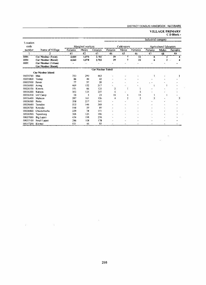
DISTRICT CENSUS HANDBOOK: NICOBARS
VILLAGE PRIMARY CD Block-
Industrial catel!i0!2: Location
code Marlliinal workers Cultivators Agricultural labourers number Name of Villal!ie Persons Males Females Persons Males Females Persons Males Females
2 41 42 43 44 45 46 47 48 49 0001 Car Nicobar (Total) 4,660 1,878 2,782 29 7 22 6 2 4 0001 Car Nicobar (Rural) 4,660 1,878 2,782 29 7 22 6 2 / 4 0001 Car Nicobar (Urban)
Car Nicobar (Rural)
Car Nicobar Tehsil Car Nicobar Island
00035700 Mus 753 290 463 00035800 Teetop 86 44 42 00035900 Sawai 77 57 20 00036000 Arong 469 152 317 00036100 Kimois 191 66 125 2 !
00036200 Kakana 362 125 237 5 5 00036300 IAFCamp 28 5 23 18 4 14 I 00036400 Malacca 287 161 126 4 2 2 3 3 00036500 Perka 358 217 141 00036600 Tamaloo 515 146 369 00036700 Kinyuka 148 59 89
00036800 Chuckchucha 229 78 151 00036900 Tapoiming 306 126 180 00037000 Big Lapati 434 198 236 00037100 Small Lapati 286 108 178 00037200 Kinmai 131 46 85
298
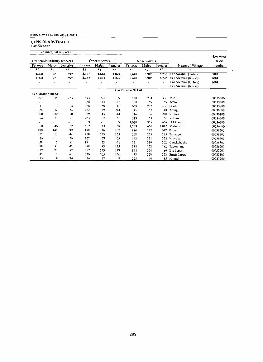
PRIMARY CENSUS ABSTRACT
CENSUS ABSTRACT Car Nicobar
ofmarginaJ workers Location
Household indus~ workers Other workers Non-workers code Persons Males Females Persons Males Females Persons Males Females Name of Villa~e number
50 51 52 53 54 55 56 57 58 2 1,278 351 927 3,347 1,518 1,829 9,640 3,905 5,735 Car Nicobar (Total) 0001 1,278 351 927 3,347 1,518 1,829 9,640 3,905 5,735 Car Nicobar (Rural) 0001
Car Nicobar (Urban) 0001 Car Nicobar (Rural)
Car Nicobar Tehsil Car Nicobar Island
277 14 263 475 276 199 570 234 336 Mus 00035700 86 44 42 138 69 69 Teetop 00035800
11 7 4 66 50 16 668 232 436 Sawai 00035900 85 12 73 383 139 244 315 167 148 Arong 00036000
100 20 80 89 45 44 316 106 210 Kimois 00036100 94 23 71 263 102 161 313 163 150 Kakana 00036200
9 9 1,020 355 665 IAFCamp 00036300 98 46 52 182 113 69 1,743 656 1,087 Malacca 00036400
180 141 39 178 76 102 989 372 617 Perka 00036500 57 13 44 458 133 325 508 225 283 Tamaloo 00036600 26 26 122 59 63 553 231 322 Kinyuka 00036700 58 5 53 171 73 98 521 219 302 Chuckchucha 00036800 78 33 45 228 93 135 344 152 192 Tapoiming 00036900 82 25 57 352 173 179 844 364 480 Big Lapati 00037000 47 3 44 239 105 134 473 220 253 Small Lapati 00037100 85 9 76 46 37 9 325 140 185 Kmmai 00037200
299
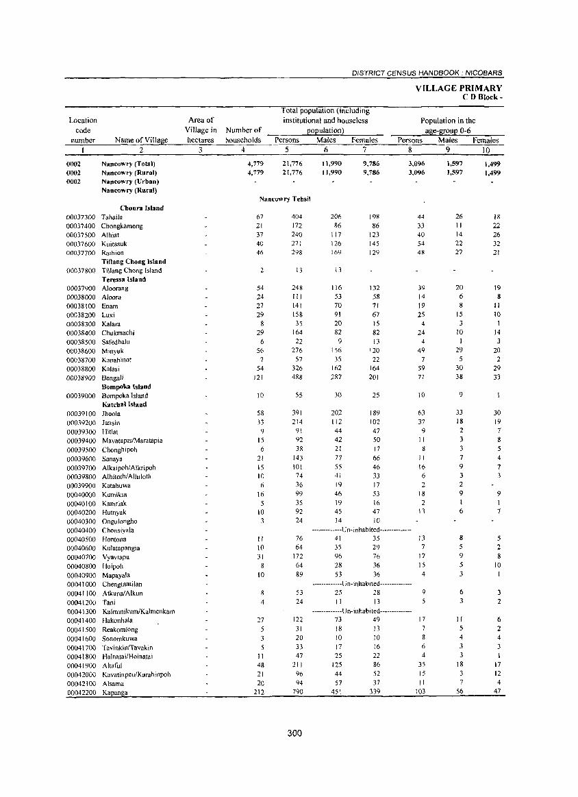
Location code
number Name of Village 2
0002 0002
Nancowry (Total) Nancowry (Rural)
0002 Nancowry (Urban) Nancowry (Rural)
Choura Island 00037300 Tahaila 00037400 Chongkamong
00037500 Alhiat 00037600 Kuitasuk 00037700 Raihion
Tillang Chong Island 00037800 Tillang Chong Island
Teressa Island 00037900 Aloorang
00038000 Aloora 00038100 Enam 00038200 Luxi 00038300 Kalara 00038400 Chukmachi
0003&500 Safedbalu 0003&600 Minyuk 00038700 Kanahinot
00038800 Kalasi 00038900 Bengali
Bompoka Island 00039000 Bompoka Island
Katchal Island 00039100 Ihoola 00039200 Jansin
00039300 Hillat 00039400 MavatapislMaratapia
00039500 Chonghipoh
00039600 Sanaya 00039700 Alkaipoh/Alkripoh 00039800 AlhitothiAlhiloth 00039900 Katahuwa
00040000 Kumikia 00040100 Kamriak 00040200 Hutnyak 00040300 Ongulongho 00040400 Chonsiyala
00040500 Hontona 00040600 Kulatapangia 00040700 Vyavtapu
00040800 Hoipoh
00040900 Mapayala 00041000 Chengtamilan
00041100 AtkunalAlkun
00041200 Tani 00041300 KalminikumiKalmenkam OOO~ 1400 Hakonhala 00041500 Reakomlong
00041600 Sonomkuwa 00041700 Tavinkinrravakin 00041800 Ha1nataiIHoinatai 00041900 Altaful 00042000 Kavatinpeu/Karahinpoh
00042100 Alsama 00042200 Kapanga
Area of Village in hectares
3
DISTRICT CENSUS HANDBOOK: NICOBARS
Total population (including institutional and house less
Number of _____ Pt;.;o::Jp:..:u:.;;la::;t;;.;io;.:n:.:..} ___ _ households Persons Males Females
4 567
4,779 4,779
21,776 21,776
Nancowry Tehsil
67 21 37 40 46
2
54 24 27 29
8
29 6
56 7
54 121
10
58 33
9 15
6
21 15 10 6
16
5 10 3
404 172 240 271 298
13
248 III 141 158 35
164
22 276
57 326 488
55
391
214 91 92
38
143 101 74
36 99 35 92 24
11,990 11,990
206
86 117 126 169
13
116 53 70 91 20 82
9 156
35 162 287
30
9,786 9,786
J98
86 123 145 129
132 58 71 67 15 82 13
120 22
164 20J
25
202 189 112 102 44 47 42 50
21 17 77 66 55 46 41 33 19 17
46 53 19 16 45 47 14 10
VILLAGE PRIMARY CD Block-
Population in the age-I[oup 0-6
Persons Males Females 8 9 10
3,096 3,096
44
33 40 54 48
39 14 19
25 4
24 4
49 7
59 71
10
63 37
9 11 8
II 16 6
2 18
2 13
1,597 1,597
26 11 14 22 27
20
6 8
IS 3
10
29 5
30 38
9
33 18
2 3 3 7
9 3 2 9
I 6
1,499 1,499
18 22 26 32 21
19 8
11
10
14 3
20 2
29 33
30 19 7 8 5 4
7 3
9 1 7
-------------U n- inhabi ted --------------II 10 31
8
10
8 4
27 5 3
11 48 21 20
212
76 64
172 64 89
53 24
122
31 20 33 47
211
96 94
790
300
41 35 35 29 96 76 2& 36
53 36
-------------U n- in habited --------------25 28 II 13
-------------U n- i nhabi ted--------------73 49 18 13
JO 10 17 16 25 22
125 86 44 52
57 37 451 339
13 7
17
15 4
9 5
17 7 8
6 4
35
15 II
103
8 5 9 5 3
6 3
II 5 4 3 3
18 3 7
56
5 2 8
10
3 2
6 2 4 3
17 12 4
47
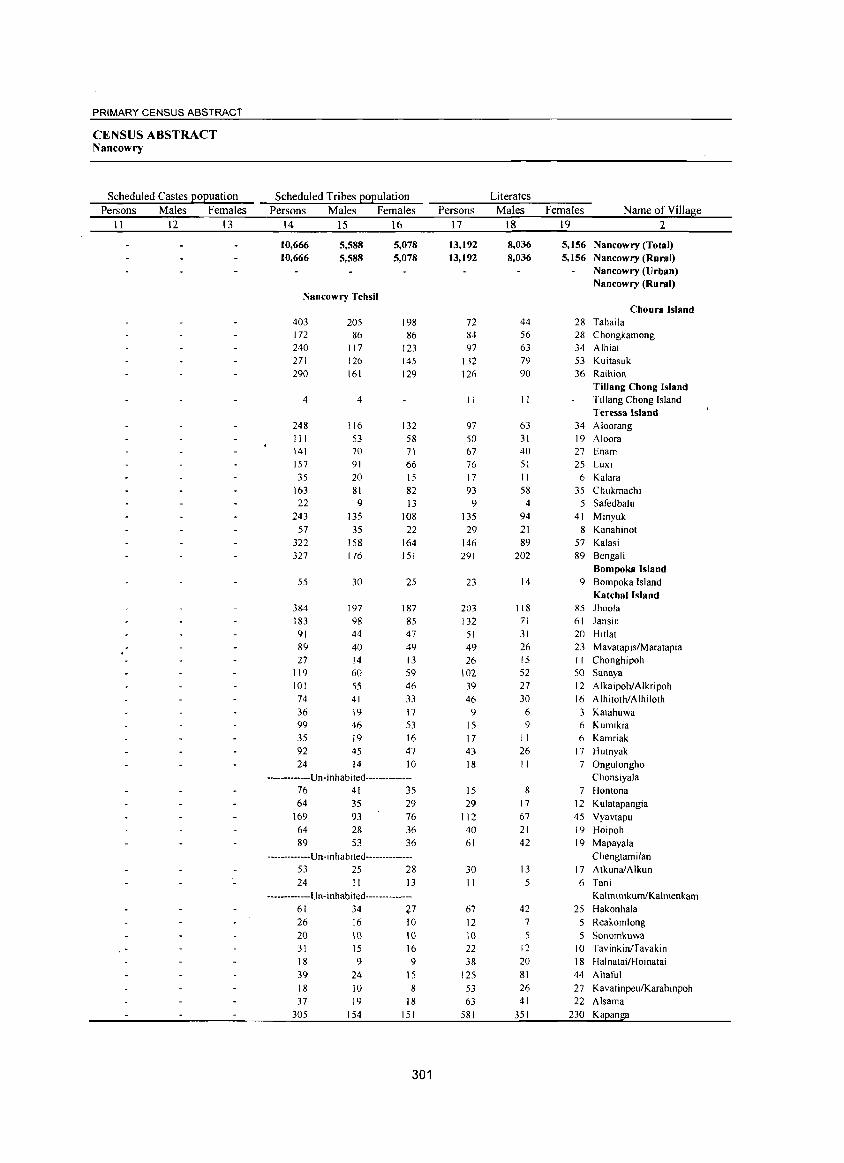
PRIMARY CENSUS ABSTRACT
CENSUS ABSTRACT Nancowry
Scheduled Castes popuation Persons Males Females
II 12 13
. -
Scheduled Tribes population Persons Males Females
14 15 16
10,666 10,666
5,588 5,588
Nancowry Tehsil
403 172 240 271 290
4
248 III 141 157 35
163 22
243 57
322 327
55
384 183 91 89 27
119 101 74 36 99 35 92 24
205 86
117 126 161
4
116 53 70 91 20 81 9
135
35 158 176
30
197 98 44
40 14 60 55 41 19 46 19 45 14
5,078 5,078
198 86
123 145 129
132 58 71 66 15 82 13
108
22 164 151
25
187 85 47 49 13 59 46 33 17 53 16 47 10
-----------Un-inhabited--------------76 41 35 64 35 29
169 64 89
93 28 53
76 36
36
-------------U n-i n hab ited--------------53 25 28
24 II 13
-------------U n- i nhab ited--------------61 34 27 26
20 31
18 39
18 37
305
16
10 15 9
24 10 19
154
10
10 16 9
15 8
18 151
301
Persons 17
13,192 13.192
72 84 97
132 126
II
97 50 67 76 17 93 9
135 29
146 291
23
203 132
51 49 26
102 39 46
9 15 17 43 18
15 29
112 40 61
30 II
67 12 10 22 38
125
53 63
581
Literates Males
18
8,036 8,036
44 56 63 79 90
11
63 31 40 51 II 58
4 94
21 89
202
14
118 71 31 26 15 52 27 30
6 9
II 26 11
8 17 67 21 42
13
5
42 7
5 12
20 81
26 41
351
Females Name of Village 19 2
5.156 Nancowry (Total) 5.156 Nancowry (Rural)
Nancowry (Urban) Nancowry (Rural)
Choura Island 28 Tahaila 28 Chongkamong 34 Alhiat 53 Kuitasuk 36 Raihion
Tillang Chong Island Tillang Chong Island Teressa Island
34 Aloorang 19 Aloora 27 Enam 25 Lux!
6 Kalara 35 Chukmachi
5 Safedbalu 41 Minyuk
8 Kanahinot 57 Kalasi 89 Bengali
Bompoka Island 9 Bompoka Island
Katchal Island 85 Jhoola 61 Jansin 20 Hitlat 23 Mavatapis/Maratapia I I Chonghipoh SO Sanaya
12 Alkaipoh/Alkripoh 16 Alhitoth/Alhiloth 3 Katahuwa 6 Kumikia 6 Kamriak
17 Hutnyak 7 Ongulongho
Chonsiyala 7 Hontona
12 Kulatapangia 45 Vyavtapu 19 Hoipoh
19 Mapayala Chengtamilan
17 AtkunalAlkun 6 Tani
KalminikumlKalmenkam
25 Hakonhala 5 Reakomlong
5 Sonomkuwa 10 TavinkinITavakin 18 Halnatai/Hoinatai
44 Altaful
27 KavatinpeulKarahinpoh 22 Alsama
230 Kapanga
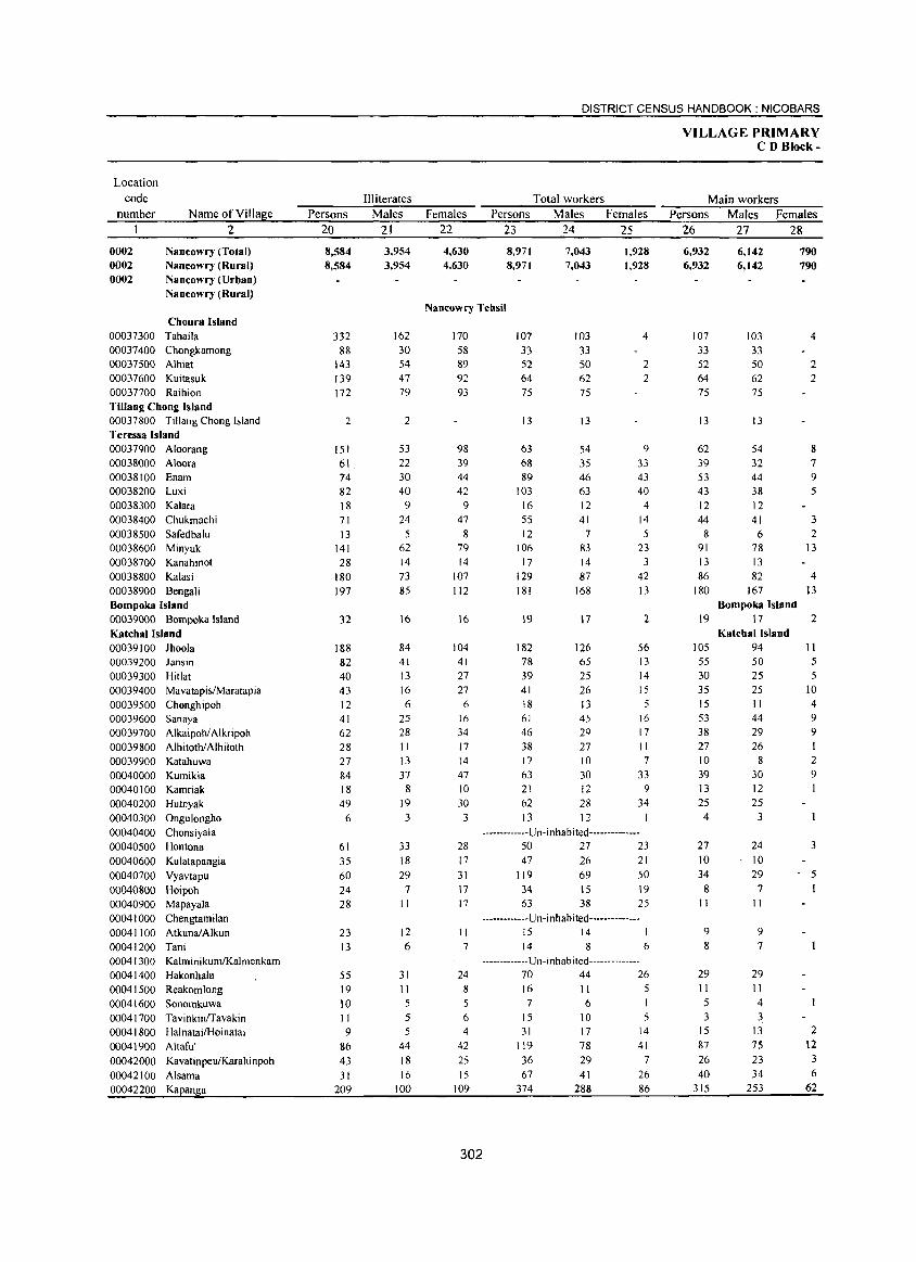
Location code
number Name ofYilIage 2
0002 0002 0002
Nancowry (Total) Nancowry (Rural) Nancowry (Urban) Nancowry (Rural)
Choura Island 00037300 Tahaila 00037400 Chongkamong 00037500 Alhiat 00037600 Kuitasuk 00037700 Raihion Tillang Chong Island 00037800 Tillang Chong Island Teressa Island 00037900 Aloorang 00038000 Aloora 00038100 Enam 00038200 Luxi 00038300 Kalara 00038400 Chukmachi 00038500 Safedbalu 00038600 Minyuk 00038700 Kanahinot 00038800 Kalasi 00038900 Bengali Bompoka Island 00039000 Bompoka Island Katchal Island 00039100 Ihoola 00039200 lansin 00039300 Hitlat 00039400 Mavatapis/Maratapia 00039500 Chonghipoh 00039600 Sanaya 00039700 Alkaipohl Alkripoh 00039800 AlhitothlAlhiloth 00039900 Katahuwa 00040000 Kumikia 00040 I 00 Kamriak 00040200 Hutnyak 00040300 Ongulongho 00040400 Chonsiyala 00040500 Hontona 00040600 Kulatapangia 00040700 Vyavtapu 00040800 Hoipoh 00040900 Mapayala 00041000 Chengtamilan 00041 100 Atkunal Alkun 00041200 Tani 00041300 KalminikumlKalmenkam 00041400 Hakonhala 00041500 Reakomlong 00041600 Sonomkuwa 00041700 Tavinkinrravakin 00041800 HalnatailHoinatai 00041900 Altaful 00042000 Kavatinpeu/Karahinpoh 00042100 Alsama 00042200 Kapanga
Persons 20
8,584 8,584
332 88
143 139 172
2
151 61 74 82 18 71 13
141 28
180 197
32
188 82 40 43 12 41 62 28 27 84 18 49
6
61 35 60 24 28
23 13
55 19 10 II 9
86 43 31
209
Illiterates Males
21
3,954 3,954
162 30 54 47 79
2
53 22 30 40
9 24
5 62 14 73 85
16
84 41 13 16 6
25 28 11 13 37
8 )9
3
33 )8
29 7
)1
12 6
31 11 5 5 5
44 )8 )6
100
DISTRICT CENSUS HANDBOOK: NICOBARS
Females 22
4,630 4,630
Total workers Persons Males Females
23 24 25
8,971 8,971
7,043 7,043
1,928 1,928
Nancowry Tehsil
170 58 89 92 93
98 39 44 42
9
47 8
79 14
)07 1I2
16
)04 4)
27 27
6 )6
34 17 )4
47 10 30
3
28 17
31 17 17
1I 7
24 8
5 6 4
42
25 15
109
302
107 33 52 64 75
13
63 68 89
103 16 55 12
106 )7
129 ) 81
19
182 78 39 4)
)8 61 46 38 )7
63 21
103 33 50 62 75
13
54 35 46 63 12 4)
7 83 )4 87
)68
17
126 65 25 26 13 45 29 27 10 30 12
4
2
2
9 33 43 40
4 14 5
23 3
42 13
2
56 13 14 15 5
16 17 II 7
33 9
62 28 34 )3 12 1
-------------U n- i n h abited --------------50 27 23 47 26 21
119
34 63
69 15 38
50 19 25
-------------Un-inhabited--------------)5 14 ) 14 8 6
-------------Un-inhabited--------------70 44 26 16 II 5 7
)5 31
119
36 67
374
6
10 ) 7
78 29 41
288
I 5
)4
41 7
26 86
VILLAGE PRIMARY CD Block-
Main workers Persons Males Females
26 27 28
6,932 6,932
6,142 6,142
790 790
107 103 4 33 33 52 50 2 64 62 2 75 75
13 13
62 54 8 39 32 7 53 44 9
43 38 5 12 12 44 41 3 862
91 78 13 13 13 86 82 4
180 167 13 Bompoka Island
19 17 2 Katchal Island
105 94 II 55 30 35 15 53
38 27 10 39 13 25
4
27 JO 34
8 11
9 8
29 II 5 3
15 87
26 40
315
50 25 25 II 44 29 26
8
30 12 25
3
24 10 29
7
11
9 7
29 II 4 3
13 7S 23 34
253
5 5
JO 4 9 9
2 9
3
- 5
2 12
3 6
62
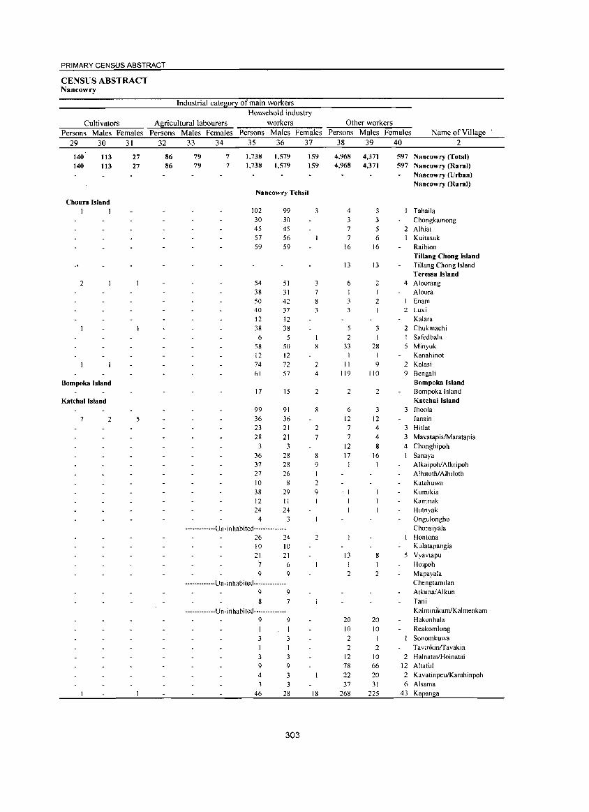
PRIMARY CENSUS ABSTRACT
CENSUS ABSTRACT Nancowry
Industrial cate~0!I of main workers
Household industry
Cultivators A~riculturallabourers workers Other workers
Persons Males Females Persons Males Females Persons Males Females Persons Males Females Name of Village
29 30 31 32 33 34 35 36 37 38 39 40 2
140 113 27 86 79 7 1,738 1,579 159 4,968 4,371 597 Nancowry (Total) 140 113 27 86 79 7 1,738 1,579 159 4,968 4,371 597 Nancowry (Rural)
Nancowry (Urban) Nancowry (Rural)
Nancowry Tehsil Choura Island
I I 102 99 3 4 3 Tahaila 30 30 3 3 Chongkamong 45 45 7 5 2 Alhiat 57 56 7 6 Kuitasuk 59 59 16 16 Raihion
Tillang Chong Island 13 13 Tillang Chong Island
Teressa Island 2 54 51 3 6 2 4 Aloorang
38 31 7 I I Aloora 50 42 8 3 2 Enam 40 37 3 3 2 Luxi 12 12 Kalara 38 38 5 3 2 Chukmachi 6 5 2 I Safedbalu
58 50 8 33 28 5 Minyuk 12 12 I Kanahinot 74 72 2 II 9 2 Kalasi 61 57 4 119 110 9 Bengali
Bompoka Island Bompoka Island 17 15 2 2 2 Bompoka Island
Katchallsland Katchal Island 99 91 8 6 3 3 lhoola
7 2 5 36 36 12 12 lansin 23 21 2 7 4 3 Hitlat 28 21 7 7 4 3 MavatapislMaratapia
3 3 12 8 4 Chonghipoh 36 28 8 17 16 1 Sanaya 37 28 9 Alkaipohl Alkripoh 27 26 I AlhitothlAlhiloth 10 8 2 Katahuwa 38 29 9 Kumikia 12 II Kamriak 24 24 Hutnyak
4 3 Ongulongho
-------------U n -i n habi ted -------------- Chonsiyala 26 24 2 Hontona 10 10 Kulatapangia 21 21 13 8 5 Vyavtapu
7 6 I I Hoipoh 9 9 2 2 Mapayala
-------------Un-inhabited-------------- Chengtamilan 9 9 AtkunalAlkun 8 7 Tani
-------------U n -i nhabi ted-------------- KalminikumIKalmenkam 9 9 20 20 Hakonhala
I I 10 10 Reakomlong
3 3 2 I Sonomkuwa 2 2 TavinkinlTavakin
3 3 12 10 2 Halnatai/Hoinatai 9 9 78 66 12 Altaful 4 3 22 20 2 KavatinpeulKarahinpoh 3 3 37 31 6 Alsama
46 28 18 268 225 43 . Kapanga
303
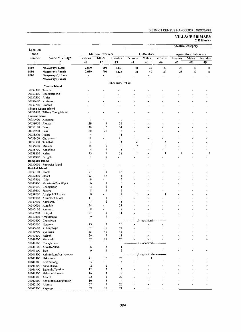
DISTRICT CENSUS HANDBOOK: NICOBARS
VILLAGE PRIMARY CD Block-
Industrial cate~0!2: Location
code Mar~inal workers Cultivators Af2:icultural1abourers number Name ofVilla~e Persons Males Females Persons Males Females Persons Males Females
2 41 42 43 44 45 46 47 48 49
0002 Nancowry (Total) 2,039 901 1,138 78 49 29 28 17 11 0002 Nancowry (Rural) 2,039 901 1.138 78 49 29 28 17 11 0002 Nancowry (Urban)
Nancowry (Rural) Nancowry Tehsil
Choura Island 00037300 Tahaila 00037400 Chongkamong 00037500 Alhiat 00037600 Kuitasuk 00037700 Raihion Tillang Chong Island 00037800 Tillang Chong Island Teressa Island 00037900 Aloorang I 00038000 Aloora 29 3 26 00038100 Enam 36 2 34 00038200 Luxi 60 25 35 00038300 Kalara 4 4 00038400 Chukmachi II II 00038500 Safedbalu 4 3 4 00038600 Minyuk IS 10 7 6 00038700 Kanahinot 4 I 3 00038800 Kalasi 43 5 38 00038900 Bengali Bompoka Island 00039000 Bompoka Island Katchallsland 00039100 Jhoola 77 32 45 00039200 Jansin 23 15 8 00039300 Hitlat 9 9 00039400 MavatapisfM aratapia 6 I 5 00039500 Chonghipoh 3 2 I 00039600 Sanaya 8 7 00039700 AlkaipohlAlkripoh 8 8 00039800 AlhitothlAlhiloth II 10 00039900 Katahuwa 7 2 5 00040000 Kumikia 24 24 00040100 Kamriak 8 8 00040200 Hutnyak 37 3 34 00040300 Ongulongho 9 9 00040400 Chonsiyala -------------U n-i nhab ited--------------00040500 Hontona 23 3 20 00040600 Kulatapangia 37 16 21 00040700 Vyavtapu 85 40 45 00040800 Hoipoh 26 8 18 00040900 Mapayala 52 27 25 00041000 Chengtamilan -------------U n- i n hab i ted --------------00041100 AtkunalAlkun 6 5 00041200 Tani 6 5 00041300 KalminikumIKalmenkam -------------U n- i nhabi ted--------------00041400 Hakonhala 41 15 26 I I
00041500 Reakomlong 5 5 00041600 Sonomkuwa 2 2 00041700 Tavinkinrravakin 12 7 5 00041800 HalnatailHoinatai 16 4 12 00041900 A Itafu I 32 3 29 00042000 KavatinpeuiKarahinpoh 10 6 4 00042100 Alsama 27 7 20 00042200 Kaean!;la 59 35 24
304
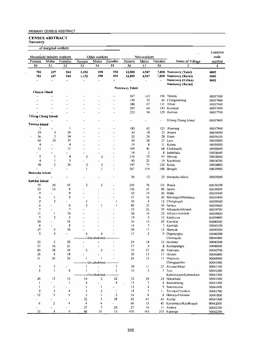
PRIMARY CENSUS ABSTRACT
CENSUS ABSTRACT Nancow':Y
of marginal workers
Household industry workers Persons Males Females
50 51 52
781 781
237 237
544 544
Other workers Persons Males Females
53 54 55
1,152 1,152
598 598
554 554
Non-workers Persons Males Females Name ofYiIlage
56 57 58 2
12,805 12,805
4,947 4,947
7,858 Nancowry (Total) 7,858 Nancowry (Rural)
Nancowry (Urban) Nancowry (Rural)
Nancowry Tehsil Choura Island
TiUang Chong Island
Teressa Island I
29 3 36 2 60 25 4
II
5 4
38 2
Bompoka Island
Katchal Island 75 23 9 6 2 6 7
II 7
24 8
37
5
23 37
83 26 51
5 5
26
I
9 12
6
13
30 15
I
2
2
3 5
3 16
38
8 26
5
12
5 3
2
4
26 34 35 4
II
4 3
36
45 8 9 5
6 7
10 5
24 8
34
20
21 4S
18 25
4
14
I
4 9
4
9
3 3
3 3
2 2
1 2
4 4 -------------Un-inhabited--------------
2 2
-------------U n- inhab i ted--------------1 1 1
-------------Un-inhabited--------------14 2 12 4
3 3
32 4
27 46
2 I 3
4
7
31
4
1 2
29
20 15
297 139 188 207 223
185 43 52 55 19
109 10
170 40
197 307
36
209 136 52 51 20
82 55 36 19
36 14
30
II
26 17
53 30 26
38 10
52 15 13
18 16 92
60
27 416
305
103 53 67 64 94
62 18 24 28
8 41
2 73 21 75
119
13
76 47 19
16 8
32 26 14 9
16 7
17
2
14 9
27
13 15
II
3
29 7 4
7 8
47
15 16
163
194 Tahaila 86 Chongkamong
121 Alhlat 143 Kuitasuk 129 Raihion
Tiltang Chong Island
123 Aloorang 25 Aloora 28 Enam 27 Luxi 11 Kalara 68 Chukmachi
8 Safedbalu 97 Minyuk 19 Kanahinot
122 Kalasi 188 Bengali
23 Bompoka Island
133 Jhoola 89 Jansin
33 Hit1at 35 Mavatapis/Maratapia J 2 Chonghipoh 50 Sanaya 29 Alkaipoh/Alkripoh 22 Alhitoth/Alhiloth 10 Katahuwa 20 Kumikia
7 Kamriak 13 Hutnyak
9 OnguJongho Chonsiya1a
12 Hontona
8 Kulatapangia 26 Vyavtapu 17 Hoipoh II Mapayala
Chengtamilan
27 AtkunalAlkun 7 Tani
Kalminikum/Kalmenkam 23 Hakonhala
8 Reakomlong
9 Sonomkuwa II TavinkmlTavakm 8 Halnatai/Hoinatai
45 Altaful
45 Kavatinpeu/Karahinpoh II Alsama
253 Kapanga
Location code
number
0002 0002 0002
00037300 00037400 00037500 00037600 00037700
00037800
00037900 00038000 00038100 00038200 00038300 00038400 00038500 00038600 00038700 00038800 00038900
00039000
00039100 00039200 00039300 00039400 00039500 00039600 00039700 00039800 00039900 00040000 00040100
00040200
00040300 00040400 00040500
00040600
00040700 00040800 00040900
00041000 00041100 00041200 00041300 00041400
00041500 00041600
00041700 00041800 00041900
00042000
00042100 00042200
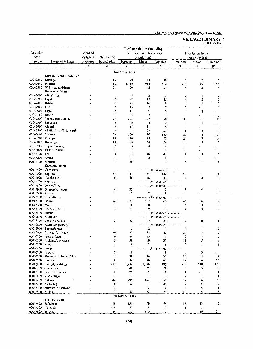
Location code
number Name of Village 2
Katcbal Island Continued 00042300 Kupinga 00042400 Mildera 00042500 W.B.Katchal/Hindra
Nancowry Island 00042600 AlipaiAlips 00042700 Lapat 00042800 Hindra 00042900 Mus 00043000 Payak 00043100 Neang 00043200 Tapong locI. Kabila 00043300 Lanuanga 00043400 Altheak 00043500 AI-Hit-Touch/Balu Basti 00043600 Malacca 00043700 Champin 00043800 Hinnunga 00043900 Tapani/Tapainy 00044000 Inroak/Chinlak 00044100 Itoi 00044200 Alreak 00044300 Hintona
Kamorta Island 00044400 Uper Tapu 00044500 Pilpilow 00044600 Neeche Tapu 00044700 Manjula 00044800 OkiyalChiya 00044900 OlinponiAlhinpon 00045000 Bumpal 00045100 KaranIKarav 00045200 Daring 00045300 Maru 00045400 Chanel/Chanol 00045500 Tamae 00045600 Alointung 00045700 Banderkari/Pulu 00045800 AlpintuiAlpintung 00045900 Tomaellnmae 00046000 ChanguaiChangup 00046100 Masala Tapu 00046200 AlukianlAlhukheck 00046300 Knot 00046400 Inmae 00046500 Payuha 00046600 Munak incl PonioolMoul 00046700 Rarnzoo 00046800 KamortaiKalatapu 00046900 Chota !nak 00047000 BerainakIBadnak 00047100 Vikas Nagar 00047200 Kakana 00047300 Nyicalang 00047400 MohreakIKohreakap 00047500 Kuikua
Trinket Island 00047600 Safedbalu 00047700 Hoekook 00047800 Trinket
Area of Village in Number of hectares households
3 4
DISTRICT CENSUS HANDBOOK: NICOBARS
Total population (including institutional and houseless
population) Persons Males Females
5 6 7
VILLAGE PRIMARY CD Block-
Population in the age-group 0-6
Persons Males Females 8910
Nancllwry Tehsil
16 438
21
2 4 2 2 I
29 2 4 9
23 13 15 2 I
8 1 4
37 6
4
24 I 3
3
10 6 3
2 5 8
483 7 6 3
44 8 3 7
90 1,716
90
5 32
2S 15 II
5 205
6 17 48
206 130 100
8 2
83 3
26
331 58
23 3
173
18 24
45
5 82 40 39 9
19 78 84
1,884 48
.26 17
295 42 19 50
Nancowry Tehsil
20 - 4
34
135 27
222
306
44 914 43
2 17 16 8 6 3
107 4
II 27 96 73 44
4
40 2
13
46 802 47
:3 15 9 7 5 2
98 2 6
21 110 57 56
4 I
43 I
13
-------------Un-inhabited-------------184 147 28 30
-------------Un- i n h ab i ted---------------------------Un- i nh ab ited--------------
II 12 2
------------Un-I nhabi ted--------------107 66
10 8 9 15
-------------U n -i n h ab ited--------------------------- U n -i n h ab ited--------------
17 28
-------------U n- inhabited --------------2 3
35 47 23 17 19 20 3 6
-------------Un-inhabited--------------II 8 39 39 40 44
1,098 786 25 23 15 11
162 19 12 22
79 18
110
II
6
133 23
7
28
56 9
112
5
214 9
3 4
4 2 2
34
I 8
30 21 II
8
5
49 II
8
4S
5 7
16
3 20
I3 II 2
3 12 14
245 8 I 2
57 7 6
10
18 I
40
3 109
4
2 I
2
17
4 13 7 4
3
31 4
4
26 3 3
8
7
7 5
3 4 4
118 5
34 5 5 S
13
16
2 105
5
2 2 3 2
17
4 17 14 7
5
4
18 7
4
19 2 4
8
2 13 6 6
8 10
127 3
23 2
5
5
24
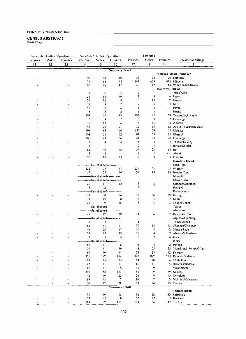
PRIMARY CENSUS ABSTRACT
CENSUS ABSTRACT Nancowry
Scheduled Castes EOEuation Scheduled Tribes EOEulation Literates
Persons Males Females Persons Males Females Persons Males Females Name of Village
II 12 13 14 15 16 17 18 19 2
Nancowry Tehsil Katchal Island Continued
90 44 46 52 26 26 Kupinga
34 16 18 1,147 669 478 Mildera 90 43 47 40 22 18 W. B. KatehallH indra
Nancowry Island
5 2 3 I AlipaiAlips
24 14 10 7 3 4 Lapat
20 12 8 15 13 2 Hindra 15 8 7 9 6 3 Mus
II 6 5 4 3 Payak
5 3 2 I Neang
205 107 98 105 66 39 Tapong incl. Kabila 6 4 2 5 3 2 Lanuanga
17 II 6 14 10 4 Altheak 47 26 21 32 19 13 AI-Hit-Toueh/Balu Basti
196 86 110 150 73 77 Malacca
108 56 52 88 53 35 Champin 100 44 56 41 21 20 Hinnunga
8 4 4 3 2 Tapanirrapainy
2 2 I Imoak/Chinlak
83 40 43 34 20 14 Itoi
3 2 I I I Alreak
26 13 13 12 7 5 Hintona Kamorta Island
-------------U n -in habited-------------- Uper Tapu
322 175 147 23() 13 I 105 Pilpilow
57 27 30 37 19 18 Neeche Tapu
-------------Un-inhabited-------------- Manjula
-------------Un-inhabited-------------- OkiyalChiya 23 II 12 3 2 Olinponl Alhinpon
3 2 2 Bumpal
-------------U n-in ha bited------------- Karan/Karav 170 104 66 95 66 29 Daring
18 10 8 7 5 2 Maru 24 9 15 6 3 3 ChanellChanol
-------------Un-inhabited-------------- Tamae
-------------U n- in habited-------------- Alointung 45 17 28 13 6 7 Banderkari/Pulu
-------------U n- i nhabited-------------- Alpintul Alpintung
5 2 3 2 I Tomae/Inmae
82 35 47 30 12 18 ChanguaiChangup 40 23 17 10 8 2 Masala Tapu
39 19 20 II 4 7 Aluklan/Alhukheck 9 6 6 2 4 Knot
-------------U n- i nha bi ted-------------- Inmae 19 II 8 6 4 2 Payuha
70 31 39 48 25 23 Munak ineL PonioolMoul
84 40 44 35 23 12 Ramroo 351 187 164 1.390 877 513 KamortaiKalatapu
48 25 23 14 10 4 Chota lnak
22 II II 16 II 5 BerainakIBadnak
17 II 6 10 9 I Vikas Nagar
295 162 133 188 109 79 Kakana
42 19 23 24 9 15 Nyicalang
19 12 7 10 7 3 MohreakiKohreakap
50 22 28 29 14 15 Kuikua
Nancowry Tehsil Trinket Island
135 79 56 82 52 30 Safedbalu 27 18 9 20 15 5 Hoekook
219 107 112 I I 3 66 47 Trinket
307
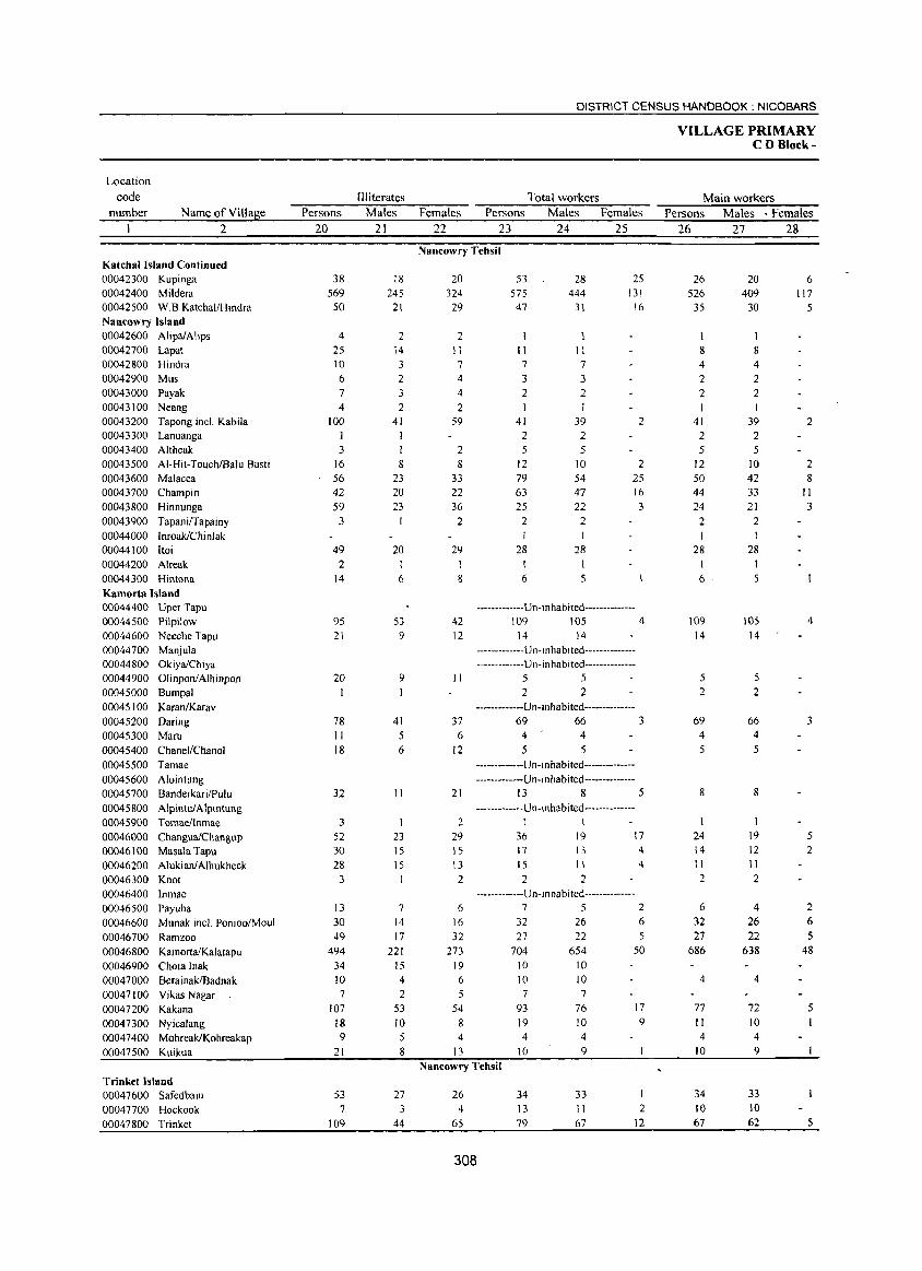
Location
code
number Name of Village
2
Katchal Island Continued 00042300 Kupinga 00042400 Mildera 00042500 W.B.KatchaI/Hindra Nancowry Island 00042600 Alipa/Alips 00042700 Lapat 00042800 Hindra 00042900 Mus 00043000 Payak 00043100 Neang 00043200 Tapong incl. Kabila 00043300 Lanuanga 00043400 Altheak 00043500 AI-Hit-TouchlBalu Basti 00043600 Malacca 00043700 Champin 00043800 Hinnunga 00043900 TapanifTapainy 00044000 Inroak/Chinlak 00044100 Itoi 00044200 Alreak 00044300 Hintona Kamorta Island 00044400 Uper Tapu 00044500 Pilpilow 00044600 Neeche Tapu 00044700 Manjula 00044800 Okiya/Chiya 00044900 OlinponiAlhinpon 00045000 Bumpal 00045100 KaranIKarav 00045200 Daring 00045300 Maru 00045400 ChanellChanol 00045500 Tamae 00045600 Alointung 00045700 Banderkari/PuIu 00045800 AlpintulAlpintung 00045900 Tomaellnmae 00046000 ChangualChangup 00046100 Masala Tapu 00046200 Alukianl Alhukheek 00046300 Knot 00046400 Inmae 00046500 Payuha 00046600 Munak mel. Ponioo/Moul 00046700 Rarnzoo 00046800 KarnortalKalalapu 00046900 Chota !nak 00047000 BerainakIBadnak 00047100 Vikas Nagar 00047200 Kakana 00047300 Nyicalang 00047400 MohreakIKohreakap 00047500 Kuikua
Trinket Island 00047600 Safedbalu 00047700 Hockook 00047800 Trinket
Persons
20
38 569
50
4 25 10 6
7 4
100
3 16 56 42 59
3
49 2
14
95 21
20
78 11 18
32
3 52 30 28 3
13 30 49
494 34 10 7
107 18 9
21
53 7
109
III iterates Males
21
18 245
21
2 14 3
2 3 2
41 1
8
23 20 23
20
6
53 9
9
41 5 6
11
23 15 15
7 14 17
221 15 4 2
53 10 5 8
27 3
44
DISTRICT CENSUS HANDBOOK: NICOBARS
Total workers Females Persons Males Females
22 23 24 25
Nancowry Tehsil
20 324 29
2 II 7
4 4 2
59
2 8
33 22 36 2
29
8
42 12
II
37 6
12
21
2 29 15 13 2
6
16 32
273 19 6
5 54
8 4
13
53 575 47
II 7
3 2
41 2 5
12 79 63 25
2
28
28 444
31
II 7
3 2
39
2 5
10 54 47 22 2 I
28
6 5
25 131
16
2
2 25 16 3
-------------Un-in habited --------------109 105 4
14 14
-------------U n-i n hab 1 ted ---------------------------U n- i n hab i ted--------------
5 5 2 2
-------------Un-inhabited--------------69 66 3 4 4 5 5
-------------U n-in ha bited--------------------------U n-i n ha b i ted--------------
13 8 5 -------------U n-i n hab ited --------------
1 I 36 17 15
19 13 11
2 2
17 4
4
-------------Un-inhabited--------------752
32 27
704
26 22
654 10 10 10 10 7 7
93
19 4
to
76 10 4 9
6
5 50
17 9
Nancowry Tehsil
26 4
65
308
34 13 79
33 11 67
2 12
VILLAGE PRIMARY CD Block-
Main workers Persons Males· Females
26 27 28
26 526
35
8 4 2 2 I
41 2 5
12 50 44 24
2 I
28
6
109 14
5 2
69 4 5
8
24 14 11 2
6
32 27
686
4
77 II 4
10
34 10
67
20 409
30
1 8 4 2 2 I
39
2 5
10 42 33 21
2 I
28
5
105 14
5 2
66 4 5
8
I 19 12 11 2
4
26 22
638
4
72 10 4 9
33 10 62
6 117
5
2
2 8
II 3
4
3
5 2
2 6 5
48
5
5
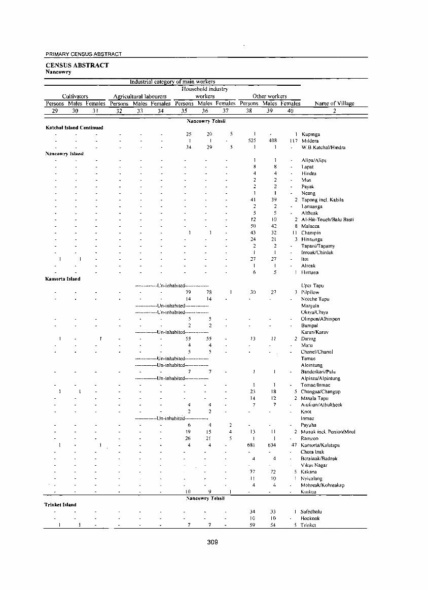
PRIMARY CENSUS ABSTRACT
CENSUS ABSTRACT Nancowry
Industrial category of main workers Household industry
Cultivators Agricultural labourers workers Other workers Persons Males Females Persons Males Females Persons Males Females Persons Males Females Name of Village
29 30 31 32 33 34 35 36 37 38 39 40 2
Nancowry Tehsil Katchal Island Continued
25 20 1
34 29 Nancowry Island
Kamorta Island
-------------Un-inhabited--------------79 78 14 14
-------------Un-i nhabi ted---------------------------Un-inhabited--------------
5 5 2 2
-------------Un-inhabited--------------55 55
4 4 5 5
-------------Un-inhabited--------------
-------------Un-inhabited--------------7 7
-------------Un-inhabited--------------
4 4 2 2
-------------Un-inhabited--------------
6 4 19 15 26 21 4 4
10 9 Nancowry Tehsil
Trinket Island
7 7
309
5
5
2 4 5
525
8 4 2 2
41 2 5
12 50 43 24 2
'27 1 6
30
13
23 14 7
13 1
681
4
77 11 4
34 10 59
408
8 4 2 2
39 2 5
10 42 32 21 2
27
5
27
"
18 12 7
11 I
634
4
72 10 4
33 10 54
I 117
2
2 8
11 3
3
Kupinga Mildera W.B.KatchallHindra
AlipalAlips Lapat Hindra Mus Payak Neang Tapong inel. Kabila Lanuanga Altheak AI-Hit-Toueh/Balu Basti Malacea Champin Hinnunga Tapani/Tapainy Inroak/Chinlak Itoi Alreak Hintona
Uper Tapu Pilpilow
Neeche Tapu Manjula OkiyalChiya Olinpon/Alhinpon
Bumpal KaranlKarav
2 Daring
5 2
2
47
Maru Chanel/Chanol
Tamae Alointung BanderkarilPulu Alpintul Alpintung Tomae/lnmae ChangualChangup
Masala Tapu Alukianl Alhukheck Knot
Inmae
Payuha
Munak incl. PonioolMoul Ramzoo
KamortalKalatapu Chota Inak
BerainakIBadnak Vikas Nagar
Kakana Nyicalang
Mohreak/Kohreakap Kuikua
Safedbalu Hockook
5 Trinket
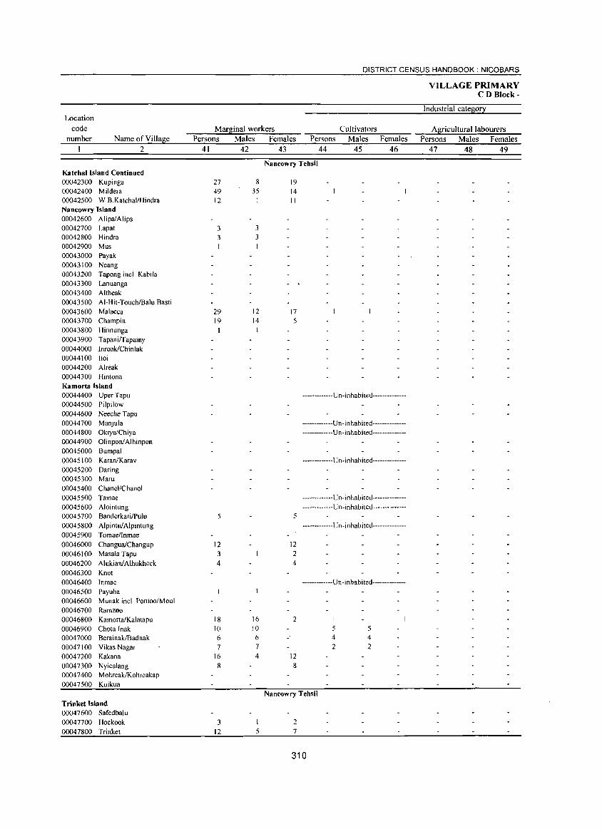
Location code
number Name of Village 2
Katchal Island Continued 00042300 Kupinga 00042400 Mildera 00042500 W.B.KatchaI/Hindra Nancowry Island 00042600 AlipaiAlips 00042700 Lapat 00042800 Hindra 00042900 Mus 00043000 Payak 00043100 Neang 00043200 Tapong incl. Kabila 00043300 Lanuanga 00043400 Altheak 00043500 AI-Hit-Touch/Balu Basti 00043600 Malacca 00043700 Champin 00043800 Hinnunga 00043900 TapanilTapainy 00044000 InroaklChinlak 00044100 Itoi 00044200 Alreak 00044300 Hintona Kamorta Island 00044400 Uper Tapu 00044500 Pilpilow 00044600 Neeche Tapu 00044700 Manjula 00044800 OkiyalChiya 00044900 OIinponiAlhinpon 00045000 Bumpal 00045100 KaranIKarav 00045200 Daring 00045300 Maru 00045400 Chanel/Chanol 00045500 Tamae 00045600 Alointung 00045700 BanderkarilPulu 00045800 Alpintul Alpintung 00045900 Tomaennmae 00046000 ChanguaiChangup 00046100 Masala Tapu 00046200 AlukianlAlhukheck 00046300 Knot 00046400 Inmae 00046500 Payuha 00046600 Munak joel. Ponioo/Moul 00046700 Ramzoo 00046800 KamortaiKalatapu 00046900 Chota Inak 00047000 BerainakIBadnak 00047100 Vikas Nagar 00047200 Kakana 00047300 Nyicalang 00047400 Mohreak/Kohreakap 00047500 Kuikua
Trinket Island 00047600 Safedbalu 00047700 Hockook 00047800 Trinket
DISTRICT CENSUS HANDBOOK: NICOBARS
Marginal workers Cultivators Persons Males Females Persons Males Females
41 42 43 44 45 46
27 49 12
3 3 I
29 19
5
12 3 4
18 10 6 7
16 8
3 12
8 35
3 3
12 14
16 10 6 7 4
I 5
Nancowry Tehsil
19 14 II
17 5
5
12 2 4
2
12 8
-------------Un-inhabited--------------
-------------Un-inhabited---------------------------U n -i n habited--------------
-------------Un-inhabited--------------
-------------Un-inhabited---------------------------Un-inhabited--------------
-------------Un-inhabited--------------
-------------U n -i n hab i ted--------------
I
5 5 4 4 2 2
Nancowry Tehsil
2 7
310
VILLAGE PRIMARY CD Block-
Industrial category
Agricultural labourers Persons Males Females
47 48 49
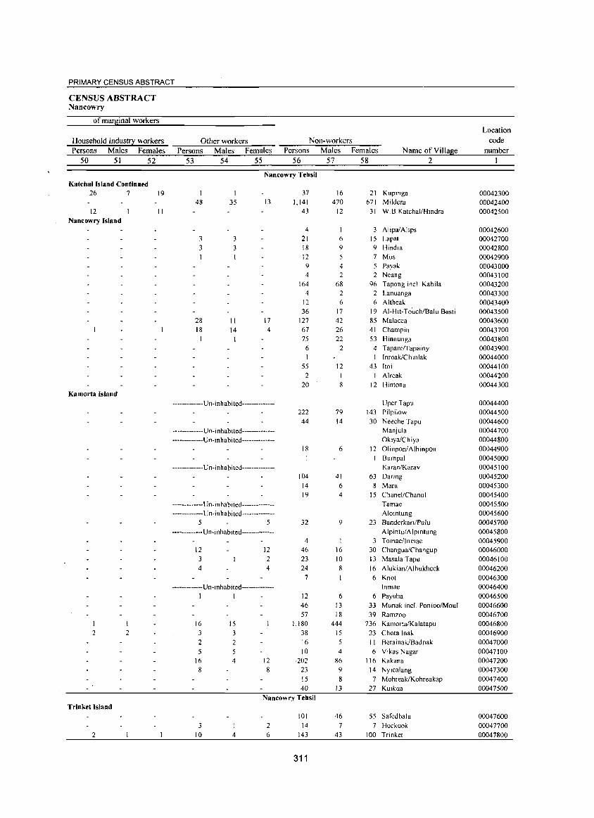
PRIMARY CENSUS ABSTRACT
CENSUS ABSTRACT Nancowry
ofmaq!.inal workers Location
Household indust!2:: workers Other workers Non-workers code
Persons Males Females Persons Males Females Persons Males Females Name of Village number
50 51 52 53 54 55 56 57 58 2
Nancowry Tehsil Katchallsland Continued
26 7 19 1 1 37 16 21 Kupinga 00042300 48 35 13 1.141 470 671 Mildera 00042400
12 11 43 12 31 W B. Katchal/Hindra 00042500 Nancowry Island
4 3 AlipalAlips 00042600 3 3 21 6 15 Lapat 00042700 3 3 18 9 9 Hindra 00042800
12 7 Mus 00042900 9 4 5 Payak 00043000 4 2 2 Neang 00043100
164 68 96 Tapongincl. Kabila 00043200 4 2 2 Lanuanga 00043300
12 6 6 Altheak 00043400 36 17 19 AI-Hit-To'uchlBalu Basti 00043500
28 11 17 127 42 85 Malacca 00043600 18 14 4 67 26 41 Champin 00043700
75 22 53 Hinnunga 00043800 6 2 4 TapanilTapainy 00043900 I I Inroak/Chinlak 00044000
55 12 43 Itoi 00044100 2 Alreak 00044200
20 8 12 Hintona 00044300 Kamorta Island
-------------U n-in habited-------------- Uper Tapu 00044400 222 79 143 Pilpilow 00044500 44 14 30 Neeche Tapu 00044600
-------------U n- inh abi ted-------------- Manjula 00044700 -------------Un-inhabited-------------- OkiyalChiya 00044800
18 6 12 Olinpon/Alhinpon 00044900 Bumpal 00045000
-------------U n-in habited-------------- KaranfKarav 00045100 104 41 63 DaTing 00045200
14 6 8 Maru 00045300 19 4 15 ChanellChanol 00045400
-------------l!n-inhabited-------------- Tamae 00045500 -------------U n-i n habi ted -------------- Alointung 00045600
5 5 32 9 23 Banderkari/Pulu 00045700 -------------Un-inhabited-------------- Alpintu/Alpintung 00045800
4 3 TomaelInmae 00045900 12 12 46 16 30 ChangualChangup 00046000 3 2 23 10 13 Masala Tapu 00046100 4 4 24 8 16 Alukianl Alhukheck 00046200
7 6 Knot 00046300 ------------Un-inhabited-------------- . Inmae 00046400
I I 12 6 6 Payuha 00046500 46 13 33 Munak inel. PonioolMouI 00046600 57 18 39 Ramzoo 00046700
I I 16 15 1,180 444 736 KamortalKalatapu 00046800 2 2 3 3 38 15 23 Chota Inak 00046900
2 2 16 5 II BerainakiBadnak 00047000 5 10 4 6 Vikas Nagar 00047100
16 4 12 202 86 116 Kakana 00047200 8 8 23 9 14 Nyicalang 00047300
15 8 7 MohreaklKohreakap 00047400 40 13 27 Kuikua 00047500
Nancowry Tehsil Trinket Island
101 46 55 Safedbalu 00047600 3 2 14 7 7 Hockook 00047700
2 10 4 6 143 43 100 Trinket 00047800
311
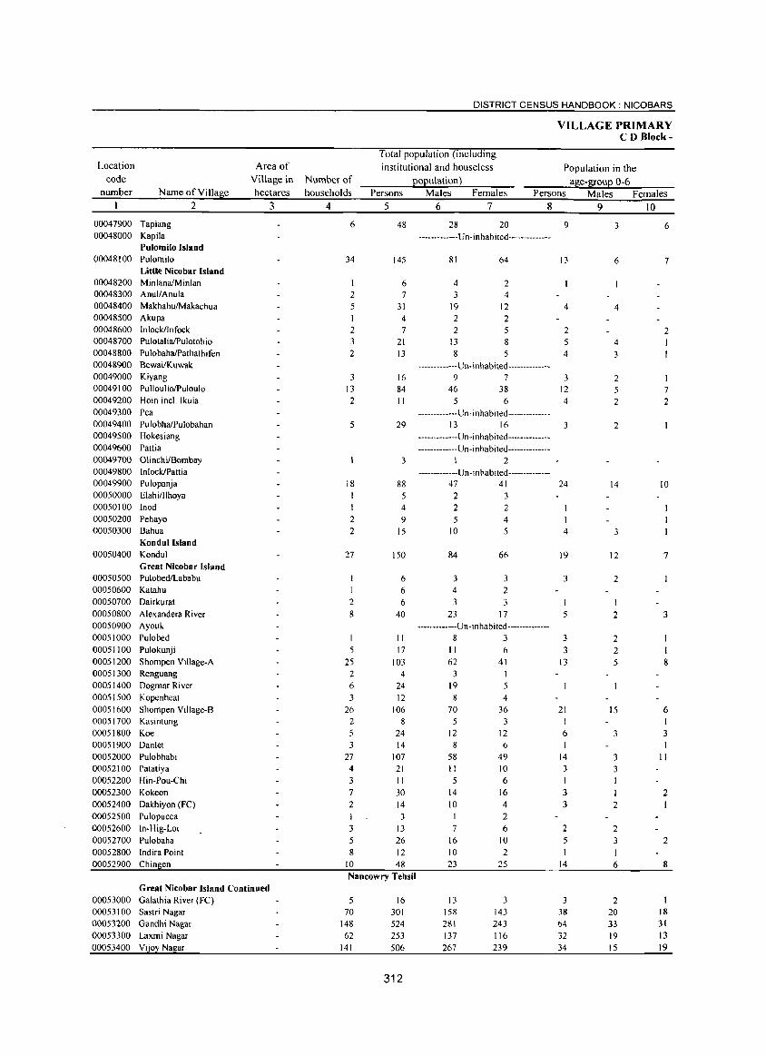
Location
code number Name of Village
00047900 Tapiang 00048000 Kapila
2
Pulomilo Island 00048100 Pulomilo
Little Nicobar Island 00048200 MinlanalMinlan 00048300 AnullAnula 00048400 Makhah~akachua
00048500 Akupa 00048600 Inlockllnfock 00048700 PulotalialPulotohio 00048800 PulobahaIPathathifen 00048900 Bewai/Kuwak 00049000 Kiyang 00049100 PulloullolPuloulo 00049200 Hoin incl. Ikuia 00049300 Pea 00049400 PulobhaIPulobahan 00049500 Hokesiang 00049600 Patti a 00049700 OIinchilBombay 00049800 InlockIPattia 00049900 Pulopanja 00050000 ElahilIlhoya 00050 100 Inod 00050200 Pehayo 00050300 Bahua
Kondul Island 00050400 Kondul
Great Nicobar Island 00050500 PulobedILababu 00050600 Katahu 00050700 Dairkurat 00050800 Alexandera River 00050900 Ayouk 00051000 Pulobed 00051100 Pulokunji 00051200 Shompen Village-A 00051300 Renguang 00051400 Dogmar River 00051500 Kopenheat 00051600 Shompen Village-B 00051700 Kasintung 00051800 Koe 00051900 Danlet 00052000 Pulobhabi 00052100 Patatiya 00052200 Hin-Pou-Chi 00052300 Kokeon 00052400 Dakhiyon (FC) 00052500 Pulopucca 00052600 In-Hig-Loi 00052700 Pulobaha 00052800 Indira Point 00052900 Chingen
Area of
Village in Number of hectares households
3 4
6
34
I 2 5 1 2 3 2
3 13 2
5
18
I 2 2
27
2 8
5 25
2
6 3
26 2 5 3
27 4
3 7 2 I
3 5 8
10
DISTRICT CENSUS HANDBOOK: NICOBARS
Total population (including
institutional and houseless
population)
VILLAGE PRIMARY CD Block-
Population in the
age-group 0-6 Persons Males Females Persons Males Females 567 8 9 10
48
145
6 7
31 4 7
21 13
16 84
" 29
3
88 5 4 9
15
150
6 6
6 40
" 17 103
4 24 12
106 8
24 14
107 21 11 30 14 3
13 26 12 48
28 20 -------------{In-inhabited--------------
81
4 3
19 2 2
13 8
64
2 4
12 2 5 8 5
-------------u n- i n habited--------------9 7
46 38 5 6
-------------U n-in habi ted--------------13 16
-------------Un-inhabited---------------------------U n -i n habi ted--------------
I 2 -------------U n -i nhab i ted --------------
47 41 2 3
2 2 5 4
10 5
84 66
3 3 4 2 3 3
23 17 -------------U n -i n ha b i ted--------------
8 3 II 6 62 41
3 19
8
70 5
12 8
58 II 5
14 10
7 16 10 23
I
5
4
36 3
12 6
49 10 6
16 4 2
6 10 2
25
9
13
4
2
5 4
3 12 4
3
24
4
19
3
I
5
3 3
13
21 I
6
14 3 I 3 3
2 5
14
3
6
4
4 3
2 5 2
2
14
3
12
2
I 2
2 2 5
15
3
3 3 I I 2
2 3
6
6
7
2
7
2
10
7
3
8
6 1
3 I
II
2
2
8 Nancowry Tehsil
Great Nicobar Island Continued 00053000 Galathia River (FC) 00053100 Sastri Nagar 00053200 Gandhi Nagar 00053300 Laxmi Nagar 00053400 Vijoy Nagar
5 70
148 62
141
16 301 524 253 506
312
13 158 281 137 267
3 143 243 116
239
3 38 64 32 34
2 20 33 19 15
18 31 13 19
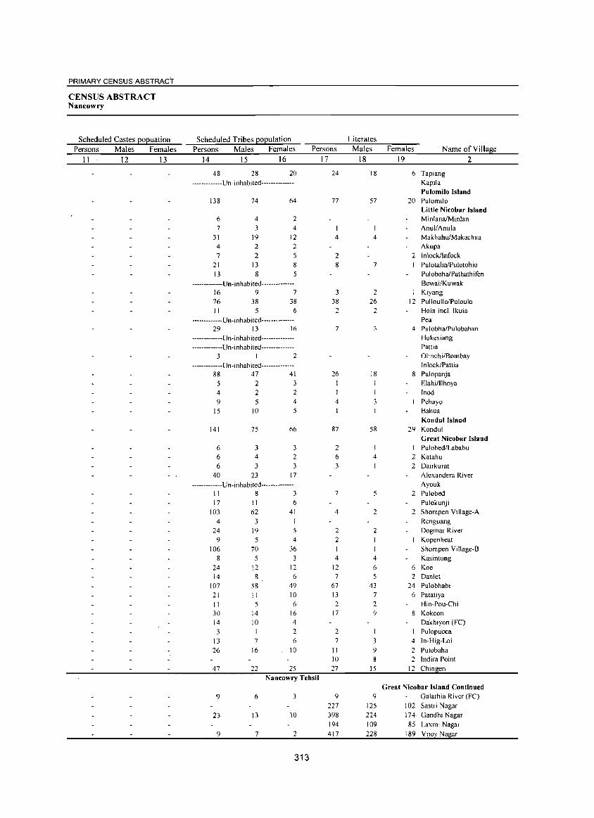
PRIMARY CENSUS ABSTRACT
CENSUS ABSTRACT Nancowry
Scheduled Castes EOEuation Scheduled Tribes EOEulation Literates
Persons Males Females Persons Males Females Persons Males Females ' Name of Village
11 12 13 14 15 16 17 18 19 2
48 28 20 24 18 6 Tapiang
-------------Un -i n hab i ted-------------- Kapila Pulomilo Island
138 74 64 77 57 20 Pulomilo Little Nicobar Island
6 4 2 MinlanaIMinlan 7 3 4 AnulfAnula
31 19 12 4 4 Makhah~akachua
4 2 2 Akupa
7 2 5 2 2 Inlockllnfock
21 13 8 8 7 PulotaliaiPulotohio
13 8 5 PulobahaiPathathifen
-------------Un-inhabited-------------- Bewai/Kuwak
16 9 7 3 2 Kiyang
76 38 38 38 26 12 PulloullolPuloulo II 5 6 2 2 Hoin inel. lkuia
-------------Un-inhabited-------------- Pea 29 13 16 7 3 4 PulobhaiPulobahan
-------------Un-inhabited-------------- Hokesiang
-------------Un-inhabited-------------- Pattia
3 I 2 Olinchi/Bombay
-------------Un-inhabited-------------- Inlock/Pattia 88 47 41 26 18 8 Pulopanja
5 2 3 Elahi/llhoya
4 2 2 lnod
9 5 4 4 3 Pehayo
15 10 5 Bahua Kondul Island
141 75 66 87 58 29 Kondul
Great Nicobar Island 6 3 3 2 I I Pulobed/Lababu
6 4 2 6 4 2 Katahu
6 3 3 3 2 Dairkurat
40 23 17 Alexandera River
-------------Un-inhabited-------------- Ayouk II 8 3 7 5 2 Pulobed
17 II 6 Pulokunji
103 62 41 4 2 2 Shompen Village-A
4 3 I Renguang
24 19 5 2 2 Dogmar River
9 5 4 2 I Kopenheat
106 70 36 Shompen Village-B
8 5 3 4 4 Kasintung
24 12 12 12 6 6 Koe 14 8 6 7 5 2 Danlet
107 58 49 67 43 24 Pulobhabi
21 II 10 13 7 6 Patatiya
II 5 6 2 2 Hin-Pou-Chi 30 14 16 17 9 8 Kokeon
14 10 4 Dakhiyon (FC)
3 2 2 I Pulopucca
13 7 6 7 3 4 In-Hig-Loi
26 16 10 II 9 2 Pulobaha 10 8 2 Indira Point
47 22 25 27 15 12 Chin en
Nancowry Tehsil
Great Nicobar Island Continued
9 6 3 9 9 Galathia River (Fe)
227 125 102 Sastri Nagar
23 13 10 398 224 174 Gandhi Nagar 194 109 85 Laxmi Nagar
9 7 2 417 228 189 Vilo Na ar
313
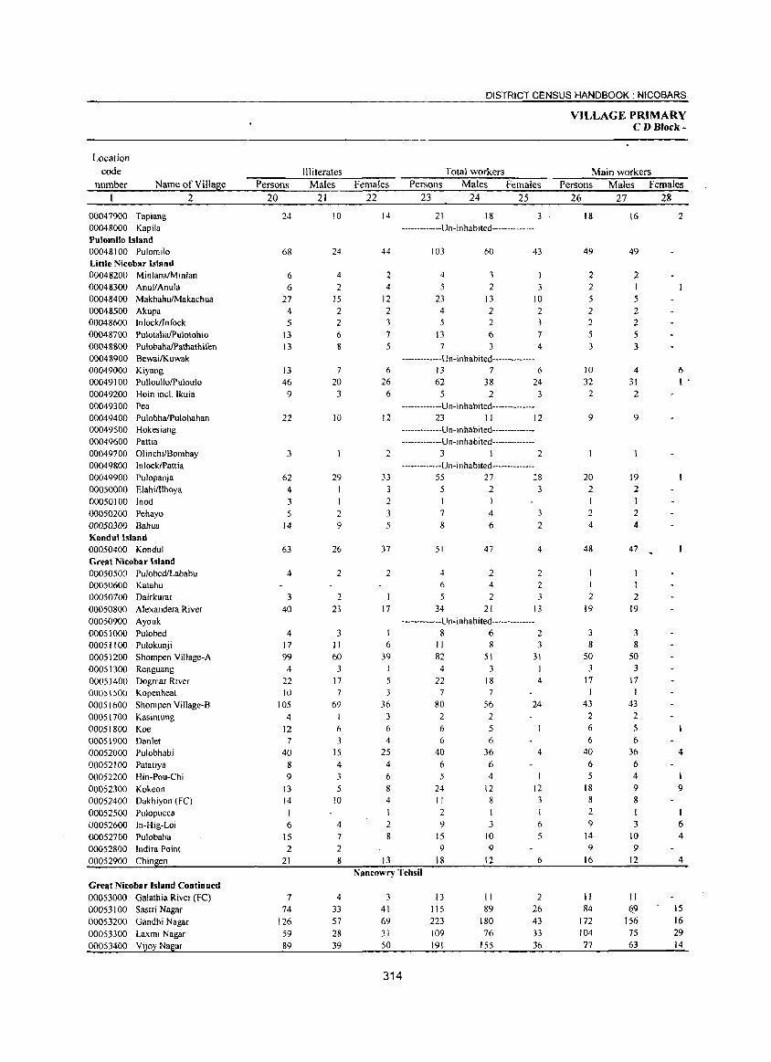
Location
code number Name of Village
2
00047900 Tapiang 00048000 Kapila Pulomilo Island 00048100 Pulomilo Little Nicobar Island 00048200 MinlanaiMinlan 00048300 Anul/Anula 00048400 MakhahulMakachua 00048500 Akupa 00048600 InlocklInfock 00048700 PulotaliafPulotohio 00048800 PulobahafPathathifen 00048900 BewailKuwak 00049000 Kiyang 00049100 PulloullolPuloulo 00049200 Hoin incL Ikuia 00049300 Pea 00049400 PulobhaiPulobahan 00049500 Hokesiang 00049600 Pattia 00049700 OlinchilBombay 00049800 InlockIPattia 00049900 Pulopanja 00050000 ElahilIlhoya 00050100 Inod 00050200 Pehayo 00050300 Bahua Kondullsland 00050400 Kondul Great Nicobar Island 00050500 Pulobed/Lababu 00050600 Katahu 00050700 Dairkurat 00050800 Alexandera River 00050900 Ayouk 00051000 Pulobed 00051100 Pulokunji 00051200 Shorn pen Village-A 00051300 Renguang 00051400 Dogmar River 00051500 Kopenheat 00051600 Shornpen Village-B 00051700 Kasintung 00051800 Koe 00051900 Dan let 00052000 Pulobhabi 000521 00 Patatiya 00052200 Hin-Pou-Chi 00052300 Kokeon 00052400 Dakhiyon (Fe) 00052500 Pulopucca 00052600 In-Hig-Loi 00052700 Pulobaha 00052800 Indira Point 00052900 Chingen
Great Nicobar Island Continued 00053000 Galathia River (Fe) 00053100 Sastri Nagar 00053200 Gandhi Nagar 00053300 Laxrni Nagar 00053400 ViJoy Nagar
Persons 20
24
68
6 6
27 4 5
13 13
13 46 9
22
3
62 4
3 5
14
63
4
3 40
4 17 99
4 22 10
105 4
12 7
40 8 9
13 14
6 15 2
21
7
74 126 59 89
III iterates Males
21
10
24
4
2 15 2 2 6 8
7
20 3
10
29 1
2 9
26
2
2 23
3 11 60
3 17 7
69 1 6 3
15
4
3 5
10
4
7 2 8
4
33 57 28 39
DISTRICT CENSUS HANDBOOK: NICOBARS
Females 22
14
44
2 4
12 2 3
7 5
6
26 6
12
2
33 3 2 3
5
37
2
17
I 6
39 I
5 3
36 3 6 4
25 4
6
8
4 I 2 8
13
Total workers Persons Males Females
23 24 25
21 18 -------------U n- i n hab i ted--------------
103
4 5
23 4
5 13 7
60
3 2
13 2 2 6 3
43
3 10 2 3 7 4
-------------Un-inhabited--------------13 7 6 62 38 24
5 2 3
-------------Un-inhabited--------------23 II 12
-------------Un-in habited--------------------------U n-in hab i ted--------------
3 I 2
-------------U n- i n hab ited--------------55 27 2& 523
I
7
8
51
4 6
5 34
4
6
47
2 4
2 21
3
2
4
2 2
3 13
-------------U n-in ha bited-------------862
II 82
4
22 7
80 2
8 51 3
18 7
56 2
6 5 6
40 6
6 36 6
5 4
24 II
2 9
15 9
18
12 8
I
3 10 9
12
3 31
4
24
4
12 3
6
5
6 Nancowry Tehsil
3 41 69 31 50
314
13 li5 223 109 191
II 89
180 76
155
2 26 43
33
36
VILLAGE PRIMARY C DBlock-
Main workers Persons Males Females
26 27 28
18
49
2 2 5 2 2
5
3
10 32 2
9
20 2
2
4
48
I
2 19
3 8
50 3
17
43
2 6 6
40 6 5
18 8
2 9
14 9
16
II 84
172 104
77
16
49
2 I 5 2 2 5 3
4
31 2
9
19 2 I 2 4
47
I
2 19
3 8
50 3
17 I
43 2 5 6
36 6 4
9 8
3 10 9
12
II 69
156 75 63
2
6 I .
4
9
6 4
4
15 16 29 14
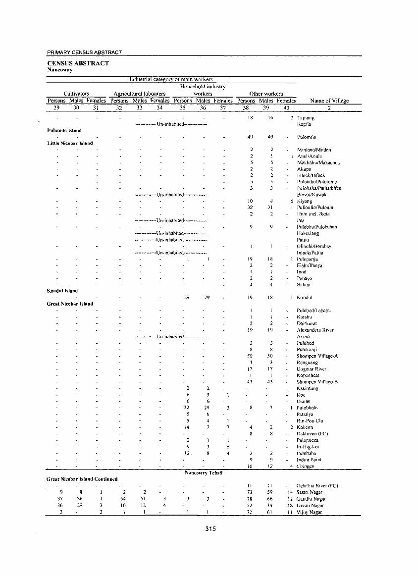
PRIMARY CENSUS ABSTRACT
CENSUS ABSTRACT Nancowry
Industrial category of main workers
Cultivators Agricultural labourers Household industry
workers Persons Males Females Persons Males Females Persons Males Females
29 30 31 32 33 34 35 36 37
-------------Un-inhabited--------------Pulomilo Island
Little Nicobar Island
------------Un-inhabited----------
------------Un-inhabited-------------
-----------Un-inhabited---------------------------Un-inhabited--------------
------------Un-inhabited--------------I I
Kondullsland 29 29
Great Nicobar Island
-------------Vn-inhabited--------------
2 2 6 5 6 6
32 29 3 6 6 5 4
14 7 7
2 9 3 6
12 8 4
Nancowry Tehsil Great Nicobar Island Continued
9 8 2 2 37 36 54 51 3 3 3 36 29 7 16 12 4
3 3
315
Other workers Persons Males Females Name of Village
38 39 40 2
18 16
49 49
2 2 2 5 5
2 2 2 2 5 5 3 3
10 4
32 31 2 2
9 9
19 18 2 2 I I
2 2 4 4
19 18
I I
2 2 19 19
3 3 8 8
50 50 3 3
17 17 I
43 43
8 7
4 2 8 8
2 2 9 9
16 12
II II 73 59
78 66
52 34
72 61
2
6
Tapiang Kapila
Pulomilo
MinlanaiMinlan AnullAnula MakhahufMakachua Akupa lnlockJlnfock Pulotal iaiPulotohio PulobahaIPathathifen
Bewai/Kuwak Kiyang PulioullolPuloulo Hoin inel. lkuia
Pea PulobhaIPulobahan Hokesiang Pattia Olinchi/Bombay In lockIPattia Pulopanja Elahi/Ilhoya Inod Pehayo Bahua
Kondul
Pulobed/Lababu Katahu Dairkurat
Alexandera River Ayouk Pulobed Pulokunji
Shompen Village-A Renguang Dogmar River Kopenheat Shompen Village-B Kasintung
Koe Daniel Pulobhabi
Patatiya Hin-Pou-Chi
2 Kokeon Dakhlyon (FC)
Pu\opucca
In-Hig-Loi Pulobaha Indira Point
4 Chin en
Galathia River (FC) 14 Sastri Nagar
12 Gandhi Nagar
18 Laxmi Nagar
II Vijoy Nagar
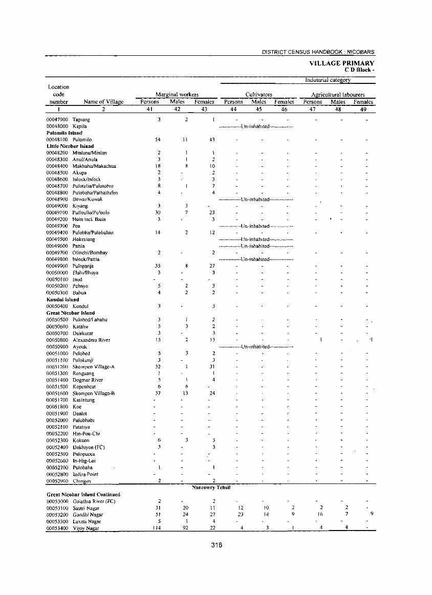
DISTRICT CENSUS HANDBOOK: NfCOBARS
VILLAGE PRIMARY CD Block-
Industrial cates:o!2: Location
code Mars:inal workers Cultivators AS:!:iculturallabourers number Name of VilIaj!;e Persons Males Females Persons Males Females Persons Males Females
2 41 42 43 44 45 46 47 48 49
00047900 Tapiang 3 2 00048000 Kapila -------------Un-inhabited--------------Pulomilo Island 00048\00 Pulomilo 54 II 43 Little Nicobar Island 00048200 MinlanaIMinlan 2 I 00048300 Anul/Anula 3 2 00048400 Makhah~akachua 18 8 10 00048500 Akupa 2 2 00048600 Inlockflnfock 3 3 00048700 PulotaliaiPulotohio 8 7 00048800 PulobahaIPathathifen 4 4 00048900 Bewai/Kuwak -------------U n -J n hab i ted--------------00049000 Kiyang 3 3
00049100 Pulloullo/Puloulo 30 7 23 00049200 Hoin incl. Ikuia 3 3 00049300 Pea -------------Un-inhabited--------------00049400 PulobhaIPulobahan 14 2 12 00049500 Hokesiang -------------U n- i n habi ted--------------00049600 Pattia -------------Un-inhabited--------------00049700 Ofinchi/Bombay 2 2 00049800 InlockIPattia -------------Un-inhabited--------------00049900 Pufopanja 35 8 27 00050000 ElahilIlhoya 3 3 00050100 Inod 00050200 Pehayo 5 2 3 00050300 Bahua 4 2 2 Kondul Island 00050400 Kondul 3 3 Great Nicobar Island 00050500 PulobediLababu 3 I 2 00050600 Katahu 5 3 2 00050700 Dairkurat 3 3 00050800 Alexandera River 15 2 13 -1 00050900 Ayouk -------------U n -i nhab i ted--------------00051000 Pulobed 5 3 2 00051100 Pulokunji 3 3
00051200 Shompen Village-A 32 31 00051300 Renguang 1 00051400 Dogmar River 5 1 4 00051500 Kopenheat 6 6
00051600 Shompen Village-B 37 \3 24 00051700 Kasintung 00051800 Koe 00051900 Danlet 00052000 Pulobhabi 00052100 Patatiya 00052200 Hin-Pou-Chi 00052300 Kokeon 6 3 3
00052400 Dakhiyon (FC) 3 3 00052500 Pulopucca 00052600 In-Hig-Loi 00~52700 Pulobaha 00052800 Indira Point 00052900 Chin en 2 2
Nancowry Tehsil Great Nicobar Island Continued 00053000 Galathia River (Fe) 2 2 00053100 Sastri Nagar 31 20 II 12 10 2 2 2 00053200 Gandhi Nagar 51 24 27 23 14 9 16 7 9
00053300 Laxmi Nagar 5 4 00053400 Vijoy Nagar 114 92 22 4 3 4 4
316
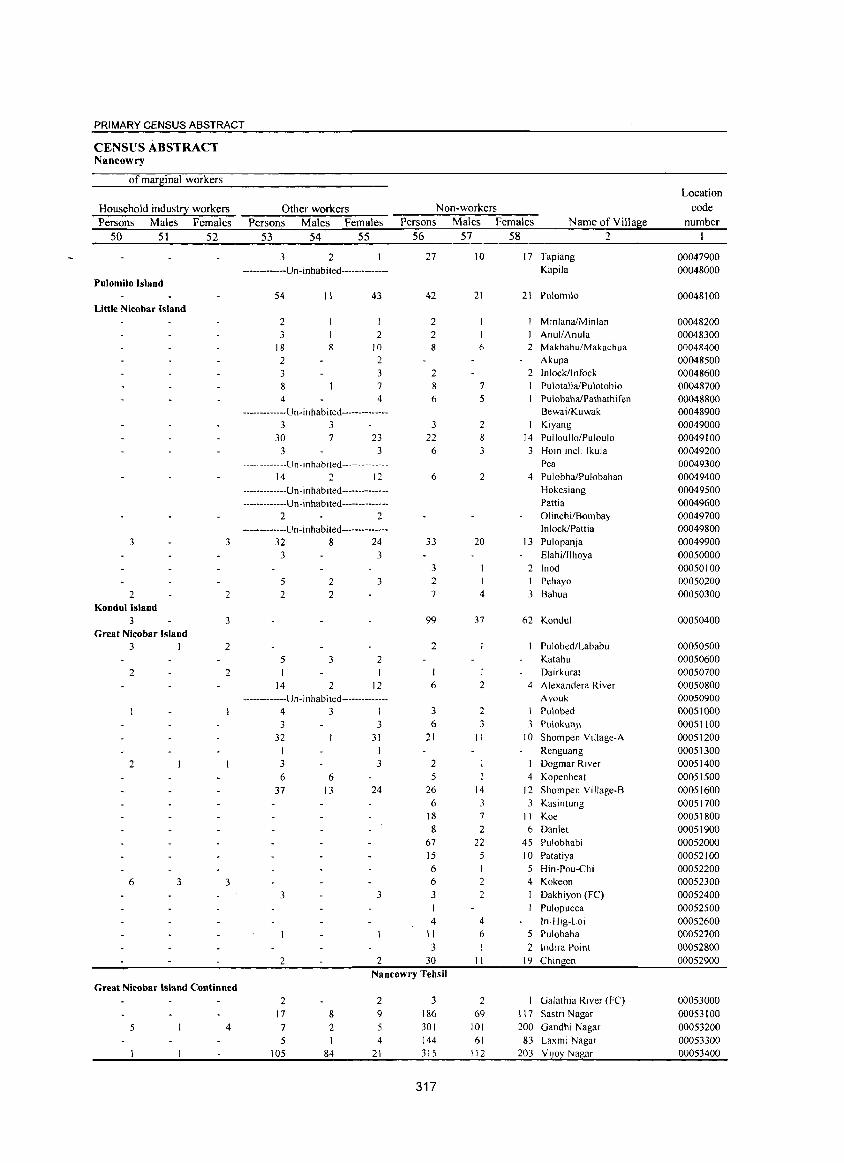
PRIMARY CENSUS ABSTRACT
CENSUS ABSTRACT Nancowry
of marginal workers
Household industry workers Persons Males Females
50 51 52
Pulomilo Island
Little Nicobar Island
3
2 Kondul Island
3 Great Nicobar Island
3 I
2
2
6 3
3
2
3
2
2
3
Other workers Persons Males Females
53 54 55
3 2 ------------Un-inhabited--------------
S4
2 3
18 2 3
8 4
II
8
43
2 10 2 3
7 4
-------------Un-inhabited--------------3 3
30 3
7 23 3
-------------U n -i n hab ited ------- -------14 2 12
-------------Un-inhabited---------------------------Un-inhabited--------------
2 2 -------------Un-inhabited--------------
32 8 24
3
5 2
5
14
2 2
3
2
3
3
2
12
-------------Un -i nhab i ted --------------431 3 3
32
3 6
37
3
2
6 13
31
I 3
24
3
2
Non-workers Persons Males Females Name of Village
56 57 58
27
42
2 2 8
2 8 6
3 22
6
6
33
3 2 7
99
2
6
3 6
21
2 5
26
6 18 8
67 15
6 6 3
4 II 3
30
10
21
6
7
S
2
3
2
20
I 4
37
I 2
2 3
II
14
3 7
2 22 5 I 2 2
4
6
II
17 Tapiang Kapila
21 Pulomilo
2
MinlanaIMinlan AnullAnula
2 Makhahu/Makachua Akupa
2 Inlock/lnfock Pul otaliaiPu lotoh io PulobahaiPathathifen BewailKuwak Kiyang
14 Pulloullo/Puloulo 3 Hoin incl. Ikuia
Pea 4 PulobhaiPulobahan
Hokesiang Patti a Olinchi/Bombay InlocklPattia
13 Pulopanja Elahi/lihoya
2 Inod I Pehayo 3 Bahua
62 Kondul
Pulobed/Lababu Katahu Dairkurat
4 Alexandera River Ayouk
I Pulobed
3 Pulokun.li 10 Shompen Village-A
Renguang Dogmar River
4 Kopenheat 12 Shompen Village-B
3 Kasintung II Koe 6 Danlet
45 Pulobhabi 10 Patatiya
5 Hin-Pou-Chi 4 Kokeon
Dakhiyon (FC) Pulopucca In-Hig-Loi
5 Pulobaha
2 Indira Point 19 Chingen
Nancowry Tehsil Great Nicobar Island Continued
5 4
2 17
7 5
105
8
2
84
2 9 5 4
21
3 186 301
144 315
317
2 69
101 61
112
Galathia River (Fe)
117 Sastri Nagar 200 Gandhi Nagar
83 Laxmi Nagar 203 Vljoy Nagar
Location code
number
00047900 00048000
00048100
00048200 00048300 00048400 00048500 00048600 00048700 00048800 00048900 00049000 00049100 00049200 00049300 00049400 00049500 00049600 00049700 00049800 00049900
00050000 00050100 00050200 00050300
00050400
00050500 00050600 00050700 00050800 00050900 00051000 00051100 00051200
00051300 00051400
00051500 00051600
00051700 00051800 00051900
00052000 00052100 00052200 00052300 00052400
00052500 00052600 00052700
00052800 00052900
00053000
00053100
00053200 00053300 00053400
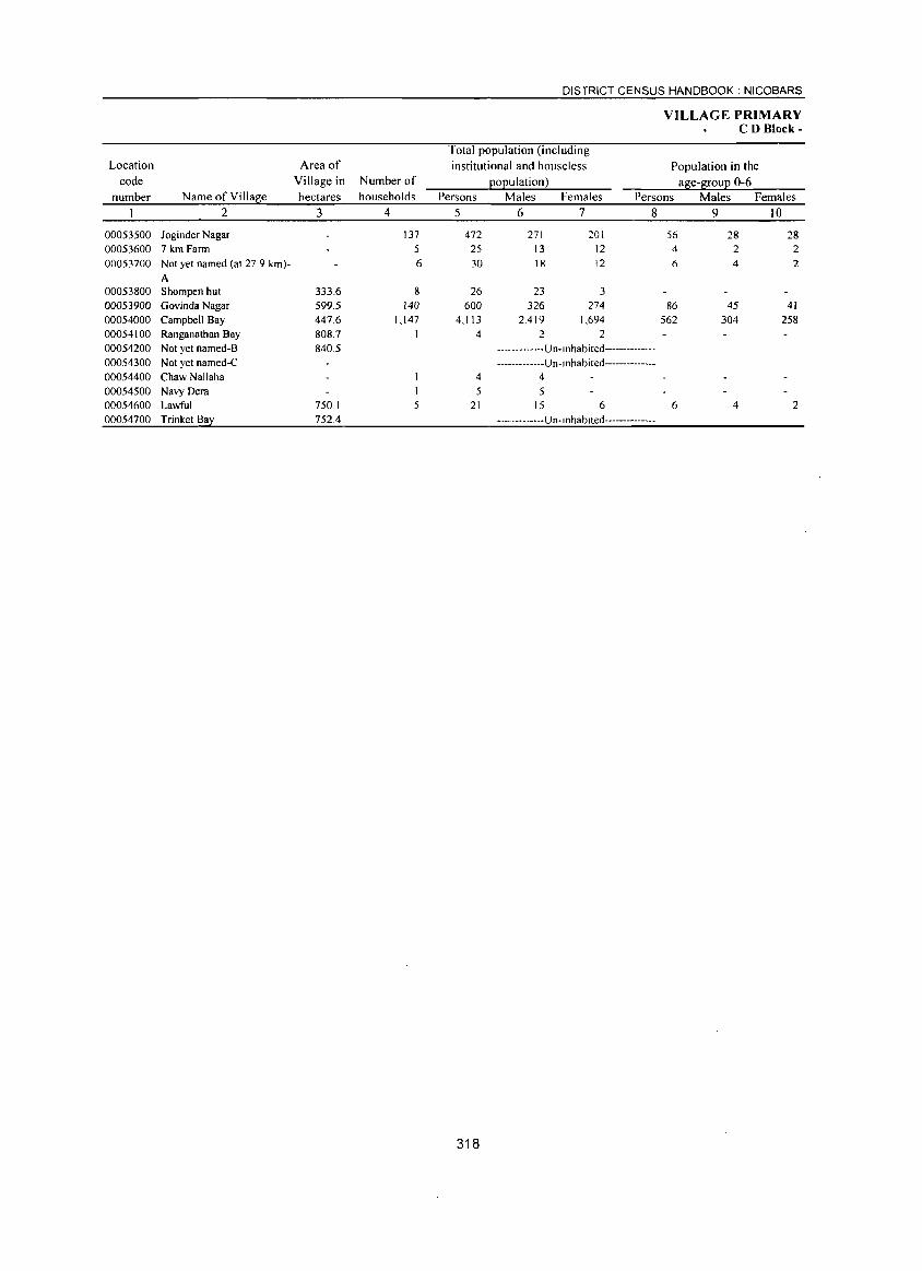
Location code
number Name of Village 2
00053500 Joginder Nagar 00053600 7 km Farm 00053700 Not yet named (at 27.9 km)-
A 00053800 Shompen hut 00053900 Govinda Nagar 00054000 Campbell Bay 00054100 Ranganathan Bay 00054200 Not yet named-B 00054300 Not yet named-C 00054400 Chaw Nallaha 00054500 Navy Dera 00054600 Lawful 00054700 Trinket Bay
Area of Village in hectares
3
333.6 599.5 447.6 808.7 840.5
750.1 752.4
Number of households
4
137 5 6
8 140
1,147
I 5
DISTRICT CENSUS HANDBOOK: NICOBARS
Total population (including institutional and houseless
EOEulation)
VILLAGE PRIMARY CD Block-
Population in the
ase-!2:0uE 0-6 Persons Males Females Persons Males Females
5 6 7 8
472 271 201 25 13 12 30 18 12
26 23 3 600 326 274
4,113 2,419 1,694 4 2 2
-------------Un-I n habi ted---------------------------U n- i n habi ted--------------
4 4 5
21
318
5 15 6
-------------U n- i n habl ted--------------
9 10
56 28 28 4 2 2 6 4 2
86 45 41 562 304 258
6 4 2
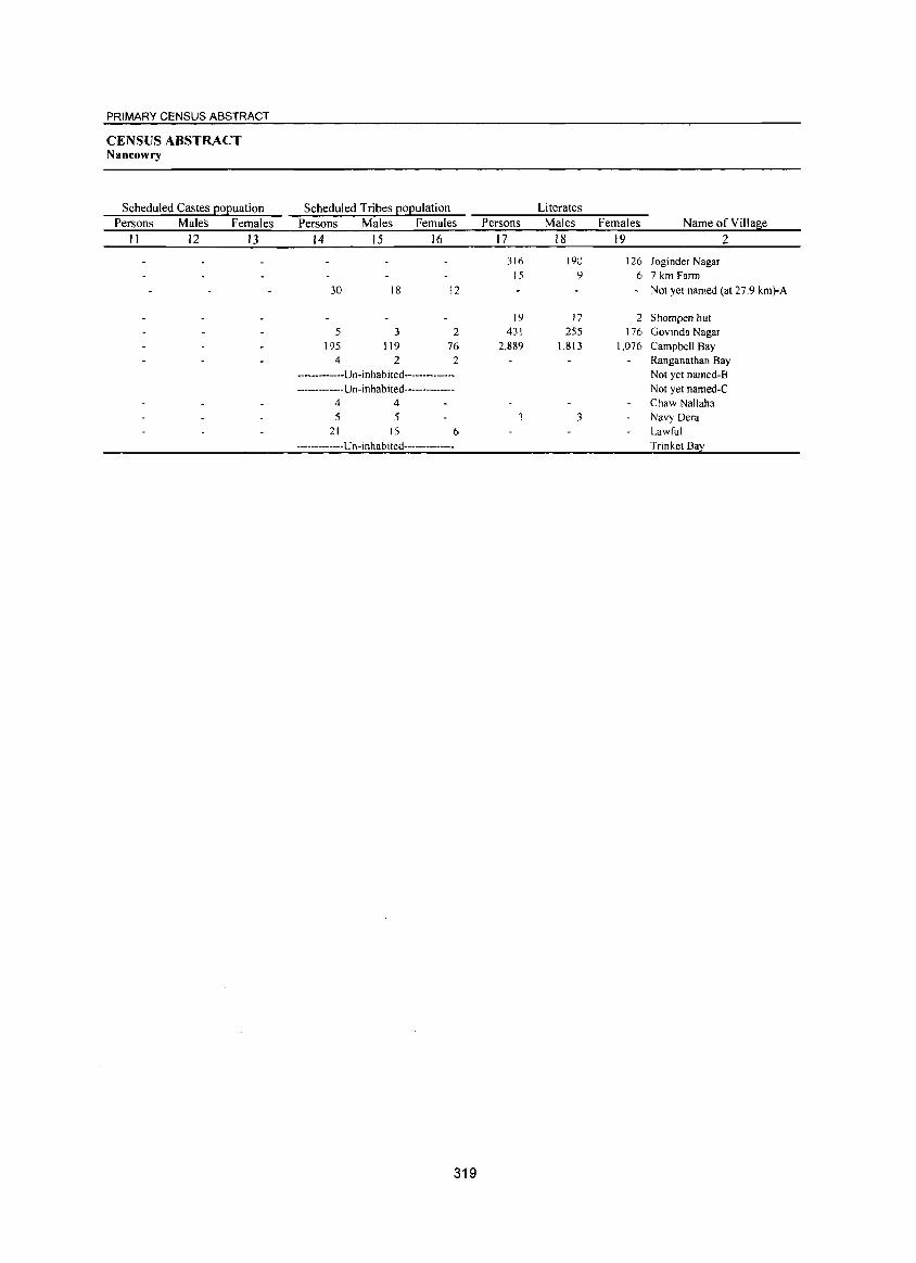
PRIMARY CENSUS ABSTRACT
CENSUS ABSTRACT Nancowry
Scheduled Castes popuation Persons Males Females
11 12 13
Scheduled Tribes population Persons Males Females
14 15 16
30
5 195
4
18
3 119
2
12
2 76 2
-------------Un-inhabited---------------------------Un-inhabited--------------
4 4 5 5
21 15 6
-------------U n -in hab i ted--------------
319
Persons
17
316 15
19 431
2,889
3
Literates Males Females Name of Village
18 19 2
190 126 Joginder Nagar 9 6 7 km Farm
Not yet named (at 27.9 km)-A
17 2 Shompen hut 255 176 Govinda Nagar
1,813 1,076 Campbell Bay Ranganathan Bay Not yet named-B Not yet named-C Chaw Nallaha
3 Navy Dera Lawful Trinket Bay
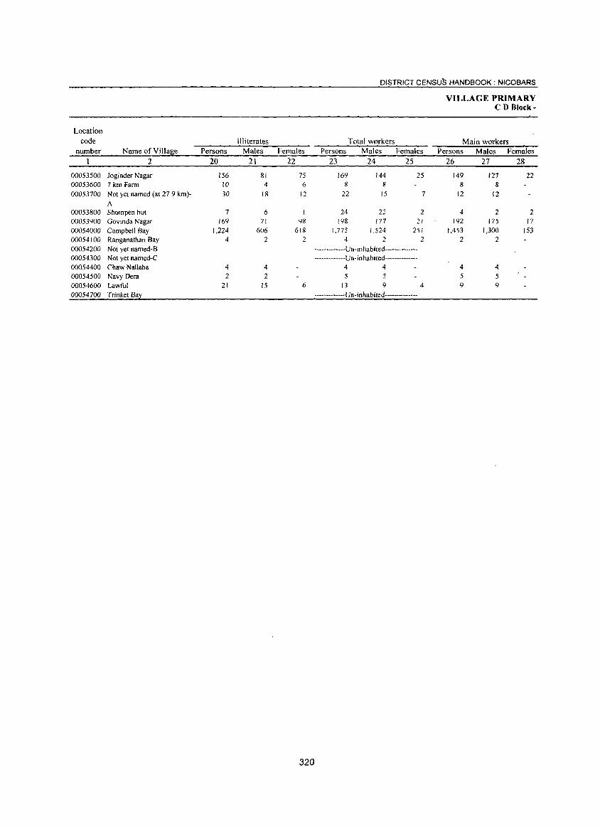
Location
code
number Name ofYiIlage Persons
2 20
00053500 Joginder Nagar 156 00053600 7 km Fann 10 00053700 Not yet named (at 27.9 km)- 30
A 00053800 Shompen hut 7 00053900 Govmda Nagar 169 00054000 Campbell Bay 1,224 00054100 Ranganathan Bay 4
00054200 Not yet named-B 00054300 Not yet named-C 00054400 Chaw Nallaha 4 00054500 Navy Dera 2 00054600 Lawful 21 00054700 Trinket Bay
Illiterates Males
21
81 4
18
6 71
606 2
4 2
15
Females
22
75 6
12
98 618
2
6
320
DISTRICT CENSUS HANDBOOK: NICOBARS
Total workers Persons Males Females
23 24 25
169 144 25 8 8
22 15 7
24 22 2 198 177 21
1,775 1,524 251 4 2 2
-------------Un-Inhabited---------------------------Un-inhabited--------------
4 4 5 .$
13 9 4
-------------Un-inhabited--------------
VILLAGE PRIMARY CD Block-
Main workers Persons
26
149 8
12
4 192
1,453 2
4 5 9
Males
27
127 8
12
2 175
1,300 2
4 5 9
Females
28
22
2 17
153
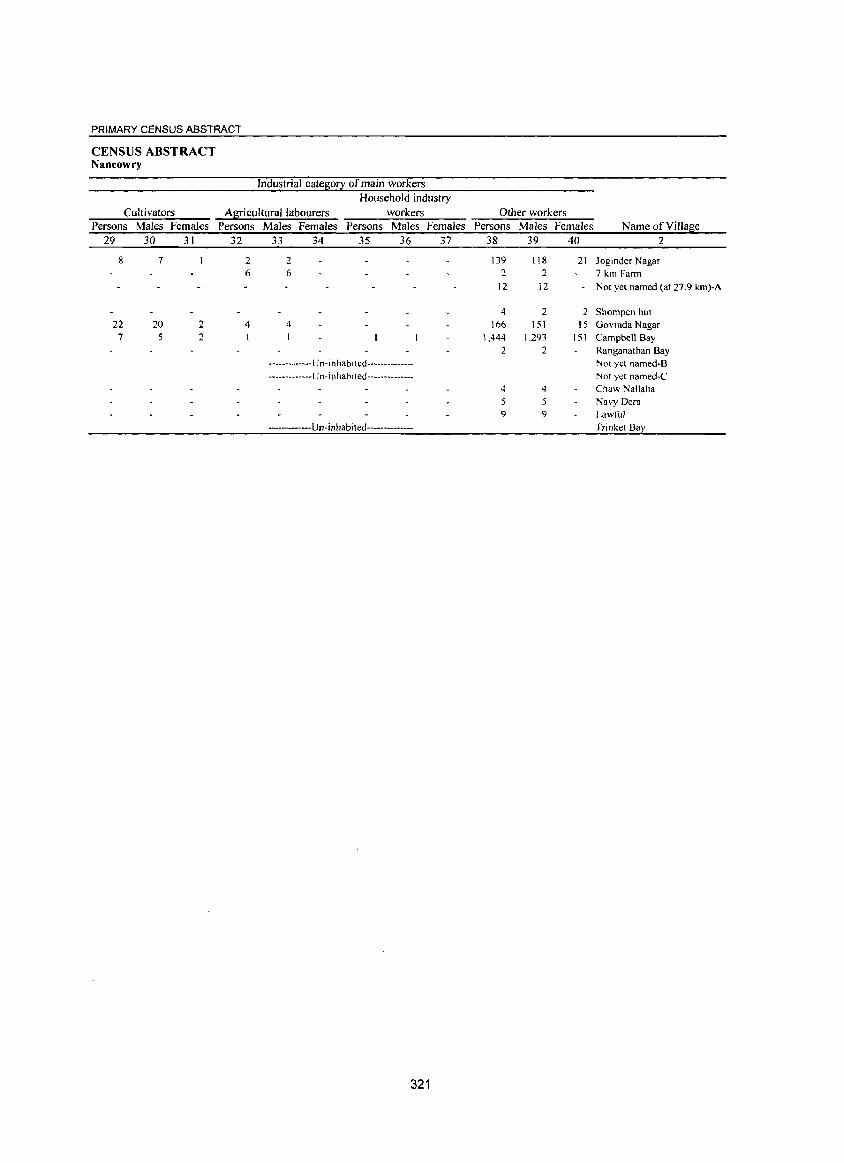
PRIMARY CENSUS ABSTRACT
CENSUS ABSTRACT Nancowry
Industrial category of main workers
Household industry
Cultivators Agricultural labourers workers Persons Males Females Persons Males Females Persons Males Females
29 30 31 32 33 34 35 36 37
8
22 7
7
20 5
2 2
2 2 6 6
4 4
-------------Un-inhabited---------------------------Un-inhabited--------------
------------Un-inhabited--------------
321
Other workers Persons Males Females Name of Village
38 39 40 2
139 118 21 Joginder Nagar 2 2 7 km Farm
12 12 Not yet named (at 27.9 km)-A
4 2 2 Shompen hut 166 151 15 Govinda Nagar
1,444 1,293 151 Campbell Bay 2 2 Ranganathan Bay
Not yet named-B Not yet named-C
4 4 Chaw Nallaha 5 5 Navy Dera 9 9 Lawful
Trinket Bay
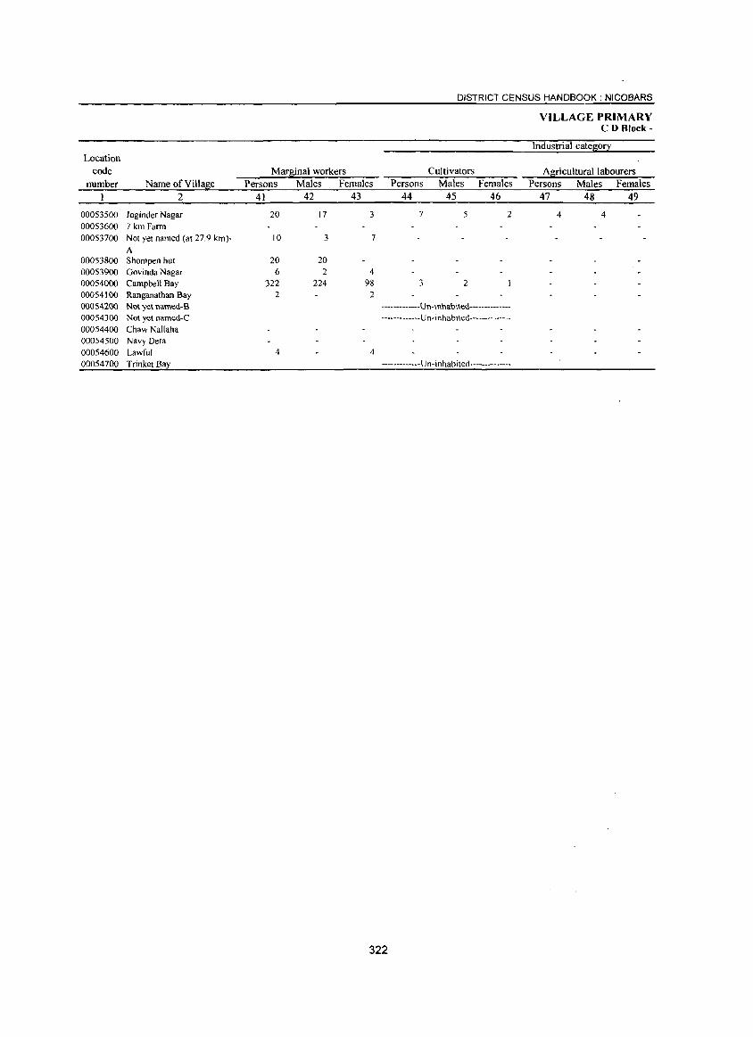
Location
code
number Name of Village
1 2
00053500 Joginder Nagar 00053600 7 km Farm 00053700 Not yet named (at 27.9 km)-
A 00053800 Shompen hut 00053900 Govinda Nagar 00054000 Campbell Bay 00054100 Ranganathan Bay 00054200 Not yet named-B 00054300 Not yet named-C 00054400 Chaw Nallaha 00054500 Navy Dera 00054600 Lawful 00054700 Trinket Bay
Marginal workers
Persons Males Females
41 42 43
20 17 3
10 3 7
20 20 6 2 4
322 224 98 2 2
4 4
DISTRICT CENSUS HANDBOOK: NICOBARS
Cultivators
Persons Males Females
44 45 46
7 5 2
3 2
-------------Un-inhabited---------------------------Un-inhablted--------------
-------------U n- i n habi ted --------------
VILLAGE PRIMARY CD Block-
Industrial category
Agricultural labourers
Persons Males Females
47 48 49
4 4
322
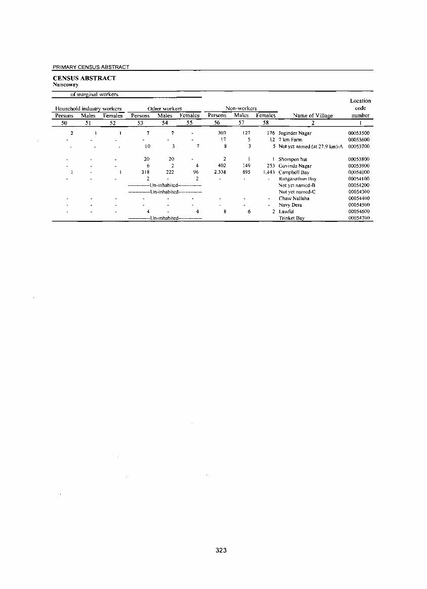
PRIMARY CENSUS ABSTRACT
CENSUS ABSTRACT Nancowry
of marginal workers
Household industry workers Persons Males Females
50 51 52
2
Other workers Persons Males Females
53 54 55
7 7
10 3 7
20 20 6 2 4
318 222 96 2 2
-------------U n -i n hab ited------- --------------------Un-inhabited--------------
4 4 ------------Un-In hab i ted--------------
Non-workers Persons Males Females
56 57 58
303 127 176 17 5 12
8 3 5
2 402 149 253
2,338 895 1,443
8 6 2
323
Name of Village
2
Joginder Nagar 7 km Farm Not yet named (at 27.9 km)-A
Shompen hut Govinda Nagar Campbell Bay Ranganathan Bay Not yet named-B Not yet named-C Chaw Nallaha Navy Dera Lawful Trinket Bay
Location
code
number
00053500 00053600 00053700
00053800 00053900 00054000 00054100 00054200 00054300 00054400 00054500 00054600 00054700
DISTRICT CENSUS HANDBOOK : ANDAMAN & NICOBAR ISLANDS
llRBAN PRIMARY
Area of Total population (including
Location Town! Ward institutional and houseless Population in the
code in square Number of EOEulation) a~e-~ouE 0-6
number Name of Townl Ward Kilometre households Persons Males Females Persons Males Females
2 3 4 5 6 7 8 9 10
40101000 Bamboonat (Cf) 3.6 1,435 6,787 3,622 3,165 800 419 381
40102000 Port Blair (M el) 17.7 22,716 99,984 55,373 44,611 11,364 5,893 5,471 0001 Ward No. I NA 1,208 5,371 2,926 2,445 581 307 274 0002 Ward No.2 NA 1,687 8,257 4,890 3,367 916 478 438 0003 Ward NO.3 NA 1,473 6,415 3,482 2,933 749 364 385 0004 Ward NO.4 NA 1,701 7,135 3,81 I 3,324 856 425 431 0005 Ward NO.5 NA 1,096 4,662 2,533 2,129 609 310 299 0006 Ward NO.6 NA 998 4,471 2,433 2,038 424 210 214 0007 Ward NO.7 NA 1,452 6,005 3,278 2,727 773 418 355 0008 Ward NO.8 NA 1,139 4,941 2,656 2,285 647 323 324 0009 Ward No.9 NA 1,299 5,548 2,984 2,564 593 303 290 0010 Ward No. 10 NA 2,245 9,417 5,185 4,232 1,165 626 539 0011 Ward No. )1 NA 1,158 5,195 2,856 2.339 556 296 260 0012 Ward No. 12 NA 1,066 4,730 2,613 2,1 17 489 252 237 0013 Ward No. 13 NA 967 4,162 2,342 1,820 443 219 224 0014 Ward No. 14 NA 898 4,690 2.693 1,997 371 190 181 0015 Ward No. 15 NA 900 3.653 1.953 1,700 395 192 203 0016 Ward No 16 NA 898 4.159 2,435 1.724 465 244 221 0017 Ward No. 17 NA 1,372 6,124 3,444 2,680 747 430 317 0018 Ward No. 18 NA 1,159 5,049 2,859 2,190 585 306 279
40103000 Garacharma (Cf) 5.9 2,225 9,427 5,016 4,411 1,174 577 597
324
URBAN PRIMARY CENSUS ABSTRACT
CENSUS ABSTRACT
Scheduled Castes EOEulation Scheduled Tribes EOEulation Literates
Persons Males Females Persons Males Females Persons Males Females Name ofTowni Ward
II 12 13 14 15 16 17 18 19 2
6 4 2 4,870 2,759 2,111 Bamboonat (CT)
978 553 425 77,073 44,983 32,090 Port Blair (M el) 47 26 21 4,218 2,426 1.792 Ward No. I
6,468 4,093 2,375 Ward No.2 25 16 9 4,857 2,820 2,037 Ward No.3 81 42 39 5,485 3,069 2,416 Ward NO.4 38 26 12 3,368 1,933 1,435 Ward No.5 27 13 14 3,621 2,035 1,586 Ward NO.6 52 34 18 4,733 2,667 2,066 Ward No.7 16 6 10 3,219 1,918 1,301 Ward No.8 44 30 14 3,832 2,255 1,577 Ward No.9 9 5 4 7,366 4,212 3,154 Ward No. 10
239 142 97 4,179 2,398 1.781 Ward No. II 34 16 18 3,888 2,226 1,662 Ward No. 12 9 4 5 3,351 1,968 1,383 Ward No 13
131 60 71 3,965 2,374 1,591 Ward No. 14 66 37 29 3,023 1,677 1,346 Ward No. 15 76 46 30 3,390 2,079 1,311 Ward No. 16 74 45 29 4,425 2,609 1,816 Ward No. 17 10 5 5 3,685 2,224 1,461 Ward No. 18
29 7 22 7,104 4,040 3,064 Garacharma (CT)
325
DISTRICT CENSUS HANDBOOK: ANDAMAN & NICOBAR ISLANDS
URBAN PRIMARY
Location
code Illiterates Total workers Main workers
number Name ofTowni Ward Persons Males Females Persons Males Females Persons Males Females
I 2 20 21 22 23 24 25 26 27 28
40101000 Bambooflat (CT) 1,917 863 1,054 2,095 1,805 290 1,787 1,538 249
40102000 Port Blair (M CI) 22.911 10,390 12,521 36,741 31.259 5,482 35,385 30,183 5,202 0001 Ward NO.1 1,153 500 653 1,796 1,561 235 1,690 1,471 219 0002 Ward No.2 1,789 797 992 3,286 3,010 276 3,222 2,958 264 0003 Ward NO.3 1,558 662 896 2361 ~,982 379 2,256 1,898 358 0004 Ward No.4 1,650 742 908 2,674 2,104 570 2,609 2,056 553 0005 Ward NO.5 1,294 600 694 1,793 1,498 295 1,723 1,456 267 0006 Ward NO.6 850 398 452 1,814 1,454 360 1,795 1,442 353 0007 Ward No. 7 1,272 611 661 2,17S 1,759 416 2,116 1,717 399 0008 Ward No. 8 1,722 738 984 1,609 1,346 263 1,579 1,325 254 0009 Ward No, 9 1,716 729 987 1,820 1,619 201 1,779 1,589 190 0010 Ward No, 10 2,051 973 1,078 3,478 3,008 470 3,320 2,884 436 0011 Ward No, II 1,016 458 558 1,864 1,588 276 1,799 1,534 265 0012 Ward No, 12 842 387 455 1,795 1,523 272 1,745 1,476 269 0013 Ward No. 13 811 374 437 1.678 1,454 224 1,651 1,431 220 0014 Ward No. 14 72S 319 406 1,73 I 1,419 312 1,682 1,379 303 0015 Ward No. 15 630 276 354 1,284 1,085 199 1.212 1,027 185
0016 Ward No, 16 769 356 413 1,470 1,231 239 1,392 1,163 229 0017 Ward No, 17 1,699 835 864 2,195 1,947 248 1,998 1,792 206 0018 Ward No, 18 1,364 635 729 1.918 1,671 247 1,817 1,585 232
40103000 Garacharma (CT) 2.323 976 1,347 3,366 2,748 618 2.981 2,442 539
326
URBAN PRIMARY CENSUS ABSTRACT
CENSUS ABSTRACT
Industrial category of main workers
Household industry
Cultivators Al[icultural labourers workers Other workers
Persons Males Females Persons Males Females Persons Males Females Persons Males Females Name ofTowni Ward
29 30 31 32 33 34 35 36 37 38 39 40 2
2 2 16 10 6 39 33 6 1,730 1,493 237 Bambooflat (CT)
31 25 6 89 84 5 270 203 67 34,995 29,871 5,124 Port Blair (M el) 1 1 6 6 1,683 ),465 218 Ward No.1
11 II 7 7 3,203 2,940 263 Ward No.2 22 21 2,234 1,877 357 Ward NO.3
2 15 15 2,591 2,039 552 Ward NO.4 2 I 3 2 )'717 1,452 265 Ward No.5
14 14 1,781 1,428 353 Ward NO.6 2 6 4 2 8 7 I 2,100 1,705 395 Ward No.7
27 22 5 1,551 1,302 249 Ward NO.8 2 2 67 34 33 1.710 1,553 157 Ward NO.9
3 3 I I 15 12 3 3,301 2,868 433 Ward No. 10 2 2 12 8 4 1,785 1,524 261 Ward No. 11
5 4 I 1,739 1,471 268 Ward No. 12 24 21 3 1,626 1,410 216 Ward No. 13
6 3 3 1,676 1,376 300 Ward No. 14 8 8 1,204 1,019 185 Ward No. 15
2 2 29 22 7 1,360 1,139 221 Ward No. 16 59 59 8 7 I 1,931 1,726 205 Ward No. 17
6 4 2 8 4 4 1,803 1,577 226 Ward No. 18
3 3 36 29 7 2,941 2.409 532 Garacharma (CT)
327
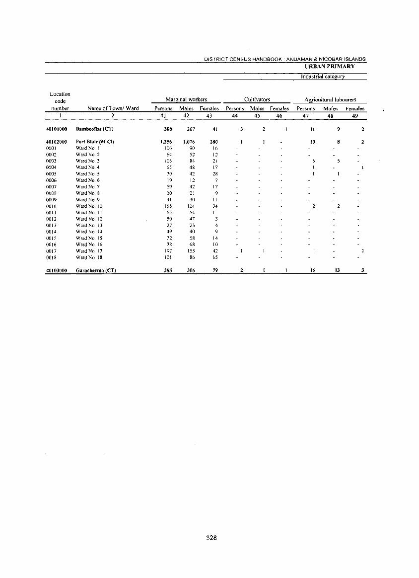
DISTRICT CENSUS HANDBOOK: ANDAMAN & NICOBAR ISLANDS
lIRBAN PRIMARY
Industrial category
Location code Mar~inal workers Cultivators Agricultural labourers
number Name ofTowni Ward Persons Males Females Persons Males Females Persons Males Females 2 41 42 43 44 45 46 47 48 49
40101000 Bambooflat (eT) 308 267 41 3 2 11 9 2
40102000 Port Blair (M CI) 1.356 1.076 280 10 8 2 0001 Ward No. I 106 90 16 0002 Ward No.2 64 52 12 0003 Ward NO.3 105 84 21 5 5 0004 Ward No.4 65 48 17
0005 Ward NO.5 70 42 28 0006 Ward No.6 19 12 7
0007 Ward NO.7 59 42 17 0008 Ward No.8 30 21 9 0009 Ward No.9 41 30 II 0010 Ward No. 10 158 124 34 2 2 0011 Ward No. II 65 54 II 0012 Ward No. 12 50 47 3 0013 Ward No. 13 27 23 4 0014 Ward No. 14 49 40 9 0015 Ward No. 15 72 58 14 0016 Ward No. 16 78 68 10 0017 Ward No. 17 197 155 42 0018 Ward No. 18 101 86 15
40103000 Garacharma (CT) 385 306 79 2 16 13 3
328
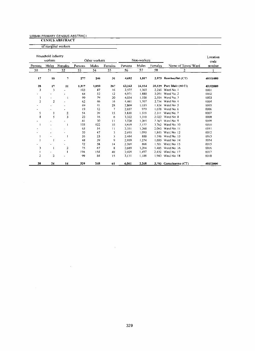
URBAN PRIMARY CENSUS ABSTRACT
CENSUS ABSTRACT
of marginal workers
Household industry Location workers Other workers Non-workers code
Persons Males Females Persons Males Females Persons Males Females Name of Townl Ward number 50 51 52 53 54 55 56 57 58 2
17 10 7 277 246 31 4,692 1,817 2,875 Bambooflat (eT) 40101000
28 17 11 1,317 1,050 267 63,243 24,114 39,129 Port Blair (M el) 40102000 3 3 103 87 16 3,575 1,365 2,210 Ward No. I 000]
64 52 12 4,971 1,880 3,091 Ward No.2 0002 1 99 79 20 4,054 1,500 2,554 Ward NO.3 0003 2 2 62 46 16 4,461 1,707 2,754 Ward NO.4 0004
69 41 28 2,869 1,035 1,834 Ward NO.5 0005 19 12 7 2,657 979 1,678 Ward NO.6 0006
5 2 54 39 1 S 3,830 I.S 19 2,311 Ward NO.7 0007 8 5 3 22 16 6 3,332 1,310 2,022 Ward NO.8 0008
41 30 II 3,728 1,365 2.363 Ward NO.9 0009 155 122 33 5,939 2,177 3,762 Ward No 10 0010 65 54 II 3,331 1,268 2,063 Ward No. II 0011 50 47 3 2,935 1,090 1,845 Ward No 12 0012 26 23 3 2,484 888 1,596 Ward No. 13 0013 48 39 9 2,959 1,274 1,685 Ward No. 14 0014 72 58 14 2,369 868 1.501 Ward No 15 0015
3 2 75 67 8 2.689 1.204 1.485 Ward No. 16 0016 194 154 40 3,929 1.497 2.432 Ward No. 17 0017
2 2 99 84 15 3,131 1,188 1,943 Ward No. 18 0018
38 24 14 329 268 61 6,061 2,268 3,793 Garacharma (eT) 40103000
329

Annexure

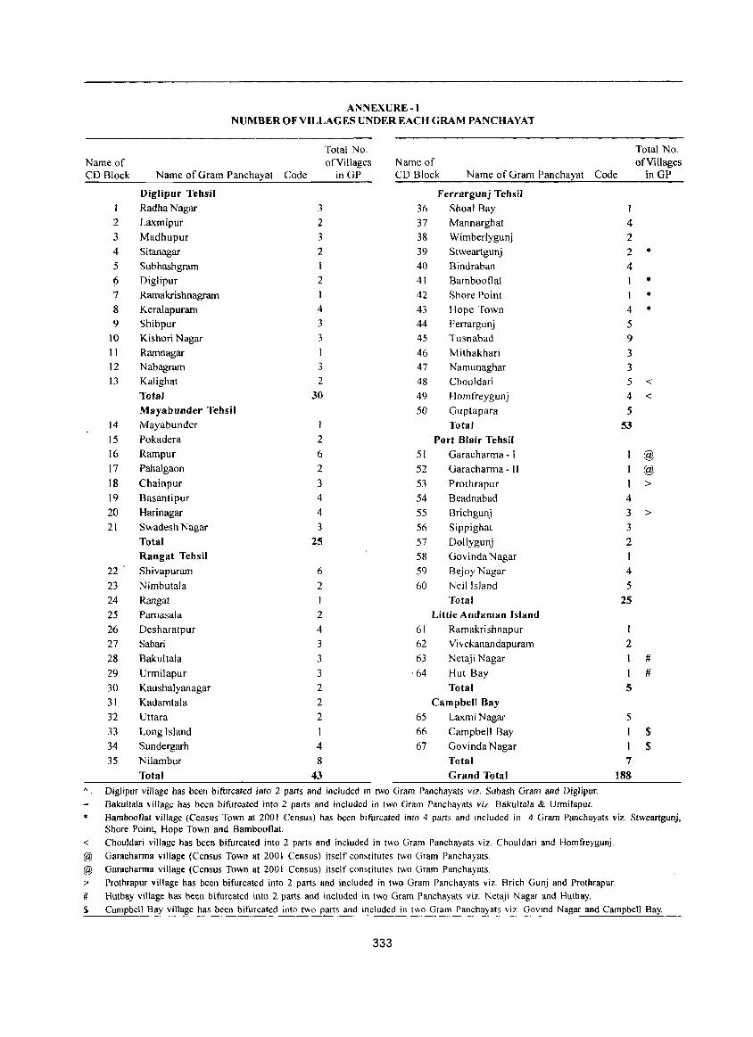
ANNEXURE-I NUMBER OF VILLAGES UNDER EACH GRAM PANCHA VAT
Total No. Total No. Name of of Villages Name of of Villages CD Block Name of Gram Panchayat Code inGP CD Block Name of Gram Panchayat Code inGP
Diglipur Tehsil Ferrargunj Tehsil
RadhaNagar 3 36 Shoal Ray
2 Laxmipur 2 37 Mannarghat 4
3 Madhupur 3 38 Wimberlygunj 2
4 Sitanagar 2 39 Stweartgunj 2 * 5 Subhashgram 40 Bindraban 4
6 Diglipur 2 41 Bambooflat * 7 Ramakrishnagram I 42 Shore Point 1 * 8 Keralapuram 4 43 Hope Town 4 * 9 Shibpur 3 44 Ferrargunj 5
10 Kishori Nagar 3 4S Tusnabad 9
11 Rarnnagar 1 46 Mithakhari 3
12 Nabagram 3 47 Namunaghar 3
13 Kalighat 2 48 Chouldari 5 < Total 30 49 Homfreygunj 4 < Mayabunder Tehsil 50 Guptapara 5
14 Mayabunder 1 Total 53 15 Pokadera 2 Port Blair Tehsil
16 Rampur 6 51 Garacharma - I @ 17 Pahalgaon 2 52 Garacharma - I I @ 18 Chainpur 3 53 Prothrapur 1 > 19 Basantipur 4 54 Beadnabad 4
20 Harinagar 4 55 Brichgunj 3 > 21 Swadesh Nagar 3 56 Sippighat 3
Total 25 57 Dollygunj 2
Rangat Tehsil 58 Govinda Nagar
22 Shivapuram 6 59 BejoyNagar 4
23 Nimbutala 2 60 Neil Island 5 24 Rangat Total 25 25 Pamasala 2 Little Andaman Island
26 Desharatpur 4 61 Ramakri shnapur 1
27 Sabari 3 62 Vivekanandapuram 2 28 Bakultala 3 63 Netaji Nagar #
29 Urmilapur 3 ·64 ~ut Bay I # 30 Kaushalyanagar 2 Total 5 31 Kadamtala 2 Campbell Bay
32 Uttara 2 65 LaxmiNagar 5
33 Long Island I 66 Campbell Bay 1 $ 34 Sundergarh 4 67 Govinda Nagar $ 35 Nilambur 8 Total 7
Total 43 Grand Total 188 A Diglipur village has been bifurcated into 2 parts and included in two Gram Panchayats viz. Subash Gram and Diglipur.
Bakultala village has been bifurcated into 2 parts and included in two Gram Panchayats viz. Bakultala & Urmilapur. Bambootlat village (Census Town at 2001 Census) has been bifurcated into 4 parts and included in 4 Gram Panchayats viz. Stweartgunj, Shore Point, Hope Town and Bambootlat.
< Chouldari village has been bifurcated into 2 parts and included in two Gram Panchayats viz. Chouldari and Homfreygunj_
@ Garacharma village (Census Town at 2001 Census) itself constitutes two Gram Panchayats.
@ Garacharma village (Census Town at 2001 Census) itself constitutes two Gram Panchayats.
>' Prothrapur village has been bifurcated into 2 parts and included in two Gram Panchayats viz. Brich Gunj and Prothrapur.
# Hutbay village has been bifurcated into 2 part!> and included in two Gram Panchayat!> viz. Netaji Nagar and Hutbay.
$ Campbell Bay village has been bifurcated into two parts and included in two Gram Panchayats viz. Govind Nagar and Campbell Bay.
333
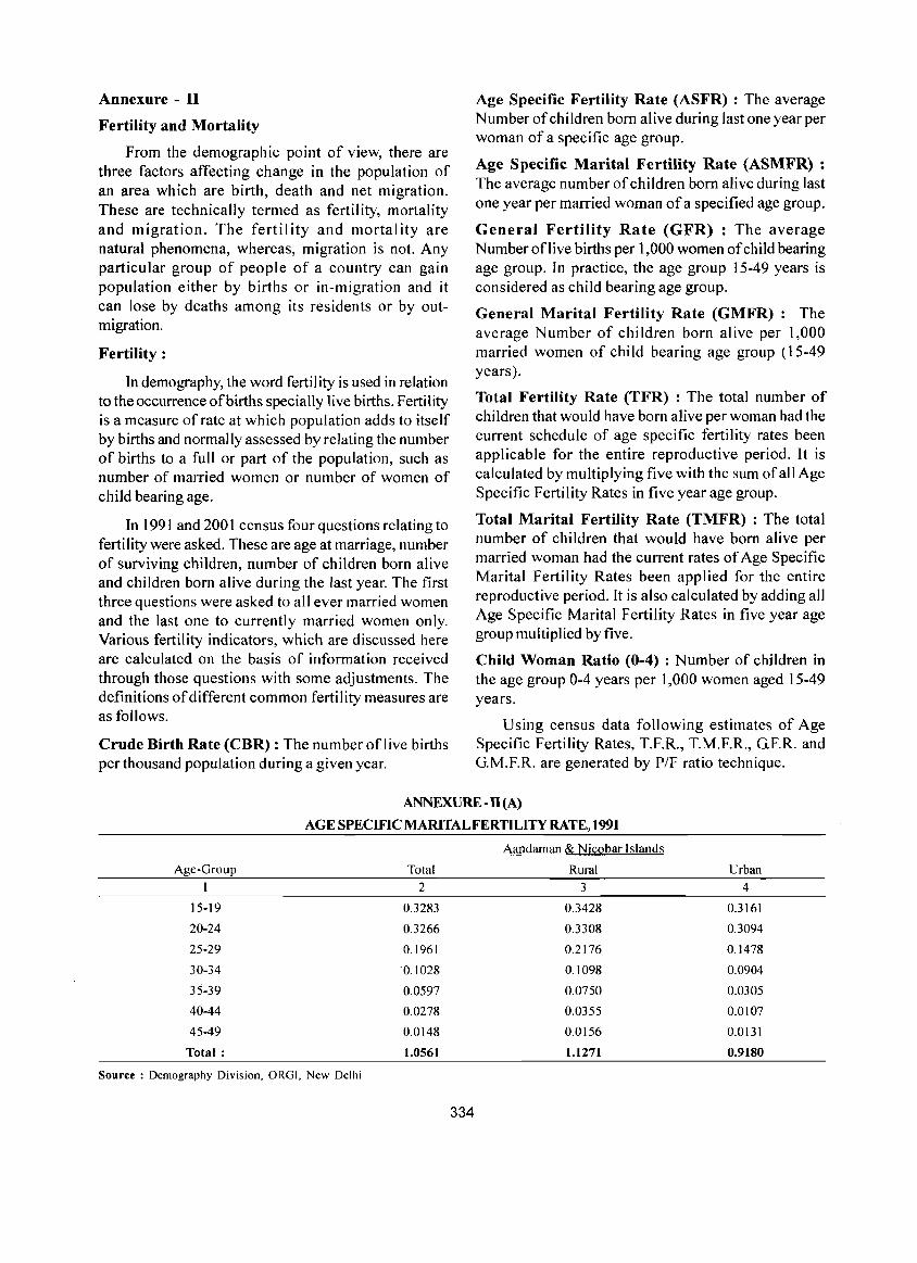
Annexure - II
Fertility and Mortality
From the demographic point of view, there are three factors affecting change in the population of an area which are birth, death and net migration. These are technically termed as fertility, mortality and migration. The fertility and mortality are natural phenomena, whereas, migration is not. Any particular group of people of a country can gain population either by births or in-migration and it can lose by deaths among its residents or by outmigration.
Fertility :
In demography, the word fertil ity is used in relation to the occurrence of births specially live births. Fertility is a measure of rate at which population adds to itself by births and normally assessed by relating the number of births to a full or part of the population, such as number of married women or number of women of child bearing age.
In 1991 and 2001 census four questions relating to fertility were asked. These are age at marriage, number of surviving children, number of children born alive and children born alive during the last year. The first three questions were asked to all ever married women and the last one to currently married women only. Various fertility indicators, which are discussed here are calculated on the basis of information received through those questions with some adjustments. The definitions of different common fertility measures are as follows.
Crude Birth Rate (CBR) : The number oflive births per thousand population during a given year.
Age Specific Fertility Rate (ASFR) : The average Number of children born alive during last one year per woman of a specific age group.
Age Specific Marital Fertility Rate (ASMFR) : The average number of children born alive during last one year per married woman of a specified age group.
General Fertility Rate (GFR) : The average Number oflive births per 1,000 women of child bearing age group. In practice, the age group 15-49 years is considered as child bearing age group.
General Marital Fertility Rate (GMFR): The average Number of children born alive per 1,000 married women of chi Id bearing age group (15-49 years).
Total Fertility Rate (TFR) : The total number of children that would have born alive per woman had the current schedule of age specific fertility rates been applicable for the entire reproductive period. It is calculated by multiplying five with the sum of all Age Specific Fertility Rates in five year age group.
Total Marital Fertility Rate (TMFR) : The total number of children that would have born alive per married woman had the current rates of Age Specific Marital Fertility Rates been applied for the entire reproductive period. It is also calculated by adding all Age Specific Marital Fertility Rates in five year age group multiplied by five.
Child Woman Ratio (0-4) : Number of children in the age group 0-4 years per 1,000 women aged 15-49 years.
Using census data following estimates of Age Specific Fertility Rates, T.F.R., T.M.F.R., G.F.R. and G.M.F.R. are generated by P/F ratio technique.
ANNEXURE - II (A)
AGE SPECIFIC MARITAL FERTILITY RATE, 1991
Aandaman & Nicobar Islands
Age-Group Total Rural Urban
I 2 3 4
15-19 0.3283 0.3428 0.3161
20-24 0.3266 0.3308 0.3094
25-29 0.1961 0.2176 0.1478
30-34 0.1028 0.1098 0.0904
35-39 0.0597 0.0750 0.0305
40-44 0.0278 0.0355 0.0107
45-49 0.0148 0.0156 0.0131
Total: 1.0561 1.1271 0.9180
Source: Demography Division, ORG1, New Delhi
334
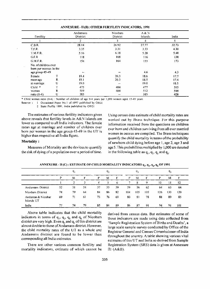
ANNEXURE - II (8): OTHER FERTILITY INDICATORS, 1991
Fertility
C.B.R. T.F.R.
T.M.F.R.
G.F.R
G.M.F.R.
No. of children ever born per woman in the age group 45-49
Female T mean age R at marriage U
Child * T woman R ratio (0-4) U
Andamans Nicobars District District
2 3
28.14 26.92
3.35 3.31
5.16 6.18
118 108
154 164
18.4 20.3 18.1 20.3 19.0
475 484 519 484 385
A&N Islands India
4 5
27.77 32.73
3.33 4.30
5.28 5.48
116 138
155 173
4.6 4.3
18.6 17.7 18.5 17.4 19.0 18.5 477 515 512 548 385 428
.. Child woman ratio (0-4) : Number of children of age 0-4 years per 1,000 women aged 15-49 years Sou rce: I Occasional Paper No.1 of 1997 published by OROI
2 State Profile 1991, India published by ORGI
The estimates ofvarious fertility indicators given above reveals that fertility levels in A&N Islands are lower as compared to all India indicators. The female mean age at marriage and number of children ever born per woman in the age group 45-49 in the UT is higher than respective all India figure.
Mortality :
Measures of Mortality are the devices to quantify the risk of dying of a population over a period oftime.
Using census data estimate of child mortality rates are worked out by Brass technique. For this purpose information received from the questions on children ever born and children surviving from all ever married women in census are compiled. The Brass techniques quantifY the child mortality in terms of the probability of newborn child dying before age 1, age 2, age 3 and age 5. This probabilities multiplied by 1,000 are denoted in the following table as ql' q2' q3 and qr
ANNEXURE -II (C): ESTIMATE OF CHILD MORTALITY INDICATORS qt' q2' Q3' Qs OF 1991
q,
P M F P
2 3 4
Andamans District 52 51 54 57
Nicobars District 74 79 64 84
Andaman & Nicobar 69 71 61 73 Islands UT
India 77 74 79 85
Above table indicates that the child mortality indicators in terms of qI' q2' q3 and qs of Nicobars district are very high. Even q3 and qs of this district are almost double to those of Andamans district. However, the child mortality rates of the UT as a whole and Andamans district are found to be lower than corresponding all India estimates.
There are other various common fertility and mortality indicators, estimate of which cannot be
q2 q) qs
M F P M F P M F
5 6 7 8 9 10 II 12
55 59 59 56 62 64 63 64
86 82 104 105 105 126 130 120
76 69 80 81 78 88 89 85
84 89 86 87 91 94 91 101
335
derived from census data. But estimates of some of those indicators are made using data collected from 'Sample Registration System of Births and Deaths', a large scale sample survey conducted by Office of the Registrar General and Census Commissioner ofIndia throughout the country. A table showing various vital estimates of this UT and India so derived from Sample Registration System (SRS) data is given at Annexure III (A&B).
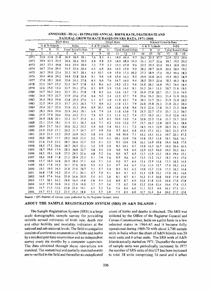
Year
1971 1972 1973 1974 1975 1976 1977 1978 1979 1980 1981 1982 1983 1984 1985 1986 1987 1988 1989 1990 1991 1992 1993 1994 1995 1996 1997 1998 1999 2000 2001 2002 2003 2004 2005 2006
ANNEXURE-Ill (A): ESTIMATED ANNUAL BIRTH RATE, DEATH RATEAND NATURAL GROWTH RATE BASED ON SRS DATA, 1971-2006
Birth Rate
A & N Islands India
T R U Total Rural Urhan 234 567
31.9 33.8 21.8 39.9 42.5 25.5 30.7 33.4 16.8 34.7 35.6 29.5 36.7 39.0 23.4 39.0 40.6 29.2 37.0 38.1 30.0 33.1 34.7 23.2 32.6 35.0 15.4 34,7 36,3 24.3 34,0 35,5 22.7 36.4 38.4 29,0 32.5 34.4 25,5 30.4 32.7 22.6 28.3 30.6 20.9 25.5 27.0 20.6 26.9 28.8 20.1 22.1 23.4 18.1 20.4 21.7 16.3 21.0 23.0 17.1 20.0 21.5 15.2 20.0 20.7 17.7 21.6 21.0 23.3 18.0 17.2 20.6 18.7 19.0 17.9 18.5 19.1 16.8 18.6 IS.8 17.8 17.7 IS.0 16.8 18.1 17.8 19.2 19.1 19.0 19.3 16.8 17.8 14.2 16.8 17.6 14.6 17.1 18.1 14.3 16.9 17.4 16.0 15.7 17.5 12.6 15.7 17.1 13.2
36.9 38.9 30.1 36.6 38.4 30.5 34.6 35.9 28.9 34.5 35.9 28.4 35.2 36.7 28.5 34.4 35.8 28.4 33.0 34.3 27.8 33.3 34.7 27.8 33.7 35.1 27.6 33.7 35.1 27.8 33.9 35.6 27.0 33.8 35.5 27.6 33.7 35.3 28.3 33.9 35.3 29.4 32.9 34.3 28.1 32.6 34.2 27.1 32.2 33.7 27.4 31.533.126.3 30.6 32.2 25.2 30.2 31.7 24.7 29.5 30.9 24.3 29.2 30.9 23.1 28.7 30.4 23.7 28.7 30.5 23.1 28.3 30.0 22.7 27.5 29.3 21.6 27.2 28.9 21.5 26.5 28.0 21.1 26.1 27.6 20.8 25.8 27.6 20.7 25.4 27.1 20.3 25.0 26.6 20.0 24.8 26.4 19.8 24.1 25.9 19.0 23.8 25.6 19.1 23.5 25.2 18.8
Death Rate Natural Growth Rate A &]'I Islands
T R U 8 9 10 7.6 8.8
8.3 4.1 9.8 2.9
7.2 7.9 6.5 6.9 9.5 10.1 9.1 9.8 8.5 8.6 8.3 8.6
3.3 4.6 5.9 5.0 7.6 6.3
8.3 8.9 3.9 7.8 8.5 3.6 8.4 9.2 2.4 6.1 6.7 3.9 7.7 8.6 4.2 8.9 10.1 4.8 6.8 7.9 3.4 7.8 8.5 5.5 6.1 6.5' 4.5 6.4 7.1 4.2 5.9 6.6 3.4 5.7 5.9 5.0 5.8 6.4 3.8 5.2 5.4 4.3 5.5 6.1 3.5 3.2 2.9 3.9 5.8 6.5 3.9 4.8 5.2 3.6 5.1 5.6 3.6 4.6 5.1 3.0 5.5 6.2 3.5 5.1 5.7 3.4 4.7 5.0 4.1 5.5 6.1 3,8 5.6 6.4 3.4 3.7 3.7 3.6 4.7 5.3 3.6 5.1 5.7 3.8
India A & N Islands India Total Rural Urban T R U Total Rural Urban II 12 13 14 15 16 17 18 19
14.9 16.4 9.7 16.9 18.9 10.3 15.5 17.0 9.6 14.5 15.9 9.2 15.9 17.3 10.2 15.0 16,3 9.5 14.7 16.0 9.4 14.2 15.3 9.4
24.3 25.5 17.7 22.0 22.5 20.4 31.1 32.7 22.6 19.7 19.5 20.2
13.0 14.1 12.6 13.7 12.5 13.7 11.9 13.1 11.9 13.1 12.613,8 11.8 13.0 11.1 12.2 10.9 12.0 11.0 12.0 10.3 11.1 9.7 10.5 9.8 10.6
10.1 10.9 9.3 10.6 9.3 10.1 9.0 9.8 9.0 9.7 8.9 9.6 9.0 9.7 8.7 9.4 8.5 9.3 8.4 9.1 8.1 8.7 8.0 8.7 7.5 8.2 7.6 8.1 7.5 8.1
23.5 25.5 13.5 28.2 28.7 24.9 27.2 28.9 17.5 29.9 30.8 24.2 28.5 29.5 22.4 24.8 26.1 16.9
8.1 24.3 26.1 11.5 7.9 26.9 27.8 20.7 7.8 25.6 26.3 20.3 7.4 30.3 31.7 25.1 7.9 24.8 25.8 21.3 8.6 21.5 22.6 17.8 7.8 21.5 22.7 17.5 7.6 17.7 18.5 15.1 7.4 20.8 22.3 15.6 7.7 15.7 16.3 13.9 7.2 14.5 15.1 12.9 6.8 15.5 17.1 12.1 7.1 14.2 15.1 11.4 7.0 14.8 15,3 13.4 5.8 16.1 14.9 19.8 6.7 14.& 14.3 16.7 6.6 12.9 12.5 14.0 6.5 13.7 13.9 13.2 6.5 13.5 13.2 14.2 6.6 13.1 12.9 13.8 6.3 12.6 11.6 15.7 6.3 14.0 13.3 15.9 6.3 12.1 12.8 10.2 6.1 11.3 11.5 10.8 6.0 11.6 11.8 il.O 5.8 13.2 13.6 12.4 6.0 11.1 12.2 9.0 6.0 10.7 11.4 9.4
19.1 18.9 19.3 20.0 20.0 19.2 19.3 19.4 18.3 19.4 19.5 18.9 18.3 18.3 18.4 19.1 19.4 18.4 20.7 21.0 19,5 21.1 21.4 19.9 21.4 21.9 19.2, 21.9 22.4 20.2 21.8 22.2 20.4 2!.3 21.5 20.8 21.1 2!.3 20.3 21.5 22.0 19.5 21.3 21.7 20.0 20.5 21.1 1&.6 20.3 21.1 18.0 20.5 21.2 17.9 19.7 20.3 17.2 19.1 20.0 16.1 19.4 19.8 17.9 19.4 20.4 \6.4 19.3 20.2 16.1 1&.5 19.6 15.1 18 .. 3 19.3 15.0 17.5 18.3 14.5 17.4 18.2 14.5 17.3 18.3 14.4 17.0 18.1 14.0 16.9 17.9 13.9 16.8 17.8 13.8 16.6 17.8 13.3 16.3 17.5 13.1 16.0 17.2 12.8
Source: SRS Bulletin of various years published by the Registrar General, India
ABOUT THE SAMPLE REGISTRATION SYSTEM (SRS) IN A&N ISLANDS:
The Sample Registration System (SRS) is a large scale demographic sample survey for providing reliable annual estimates of birth rate, death rate and other fertility and mortality indicators at the national and sub-national levels. The field investigation consists of continuous enumeration of births and deaths by a resident part time enumerator and an independent survey every six months by a computer supervisor. The data obtained through these operations are matched. The unmatched and partially matched events are re-verified in the field and thereafter an unduplicated
336
count of births and deaths is obtained. The SRS was initiated by the Office of the Registrar General and Census Commissioner, India on a pilot basis in a few selected states in 1964-65 and it became fully operational during 1969-70 with about 3,700 sample units in India where the share of A&N Islands was 20 rural units and 4 urban units. The SRS work of A&N Islands actually started on 1971. Thereafter the number of sample units was periodically increased. In 1977 the number ofSRS units of this UT has been increased to total 38 units comprising 34 rural and 4 urban
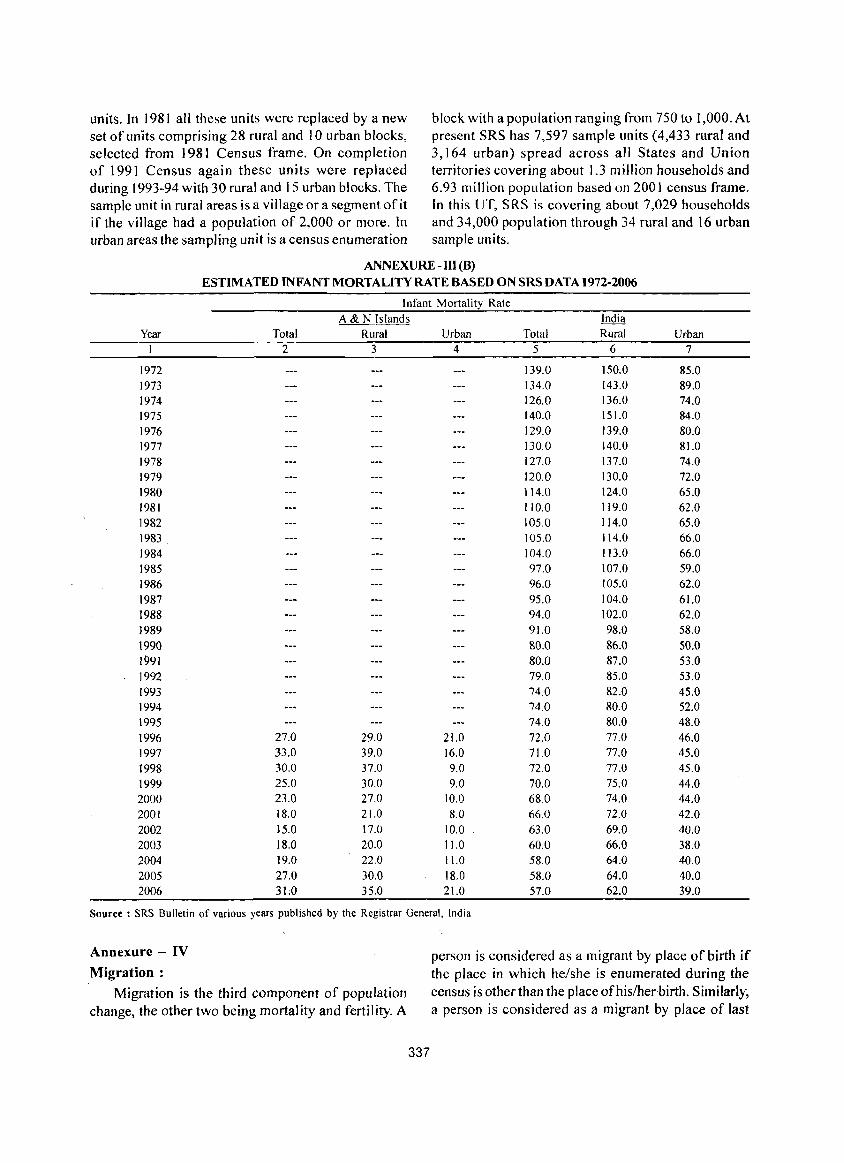
units. In 1981 all these units were replaced by a new block with a population ranging from 750 to 1,0OO.At set of units comprising 28 rural and 10 urban blocks, present SRS has 7,597 sample units (4,433 rural and selected from ] 98] Census frame. On completion 3,164 urban) spread across all States and Union of 1991 Census again these units were replaced territories covering about 1.3 million households and during 1993-94 with 30 rural and 15 urban blocks. The 6.93 million population based on 2001 census frame. sample unit in rural areas is a village or a segment of it In this UT, SRS is covering about 7,029 households if the village had a population of 2,000 or more. In and 34,000 population through 34 rural and 16 urban urban areas the sampling unit is a census enumeration sample units.
ANNEXURE - III (8) ESTIMATED INFANT MORTALITY RATE BASED ON SRS DATA 1972-2006
Infant Mortality Rate
A & N Islands India
Year Total Rural Urban Total Rural Urban 1 2 3 4 5 6 7
1972 139.0 150.0 85.0 1973 134.0 143.0 89.0 1974 126.0 136.0 74.0 1975 140.0 151.0 84.0 1976 129.0 139.0 80.0 1977 130.0 140.0 81.0 1978 127.0 137.0 74.0 1979 120.0 130.0 72.0 1980 114.0 124.0 65.0 1981 110.0 119.0 62.0 1982 105.0 114.0 65.0 1983 105.0 114.0 66.0
1984 104.0 113.0 66.0 1985 97.0 107.0 59.0 1986 96.0 105.0 62.0
1987 95.0 104.0 61.0 1988 94.0 102.0 62.0 1989 91.0 98.0 58.0 1990 80.0 86.0 50.0 1991 80.0 87.0 53.0 1992 79.0 85.0 53.0 1993 74.0 82.0 45.0 1994 74.0 80.0 52.0 1995 74.0 80.0 48.0
1996 27.0 29.0 21.0 72.0 77.0 46.0 1997 33.0 39.0 16.0 71.0 77.0 45.0 1998 30.0 37.0 9.0 72.0 77.0 45.0
1999 25.0 30.0 9.0 70.0 75.0 44.0 2000 23.0 27.0 10.0 68.0 74.0 44.0 2001 18.0 21.0 8.0 66.0 72.0 42.0 2002 15.0 17.0 10.0 63.0 69.0 40.0
2003 18.0 20.0 11.0 60.0 66.0 38.0 2004 19.0 22.0 11.0 58.0 64.0 40.0 2005 27.0 30.0 18.0 58.0 64.0 40.0 2006 31;0 35.0 21.0 57.0 62.0 39.0
Source: SRS Bulletin of various years published by the Registrar General, India
Annexure - IV Migration:
Migration is the third component of population change, the other two being mortality and fertility. A
337
person is considered as a migrant by place of birth if the place in which he/she is enumerated during the census is other than the place ofhislher·birth. Similarly, a person is considered as a migrant by place of last
residence if the place in which he/she is enumerated during the census is other than his/her place of immediate last residence outside the village or town and not simply in another house or locality in the same village or town. Certain aspects concerning temporary movement/migration of people has been explained below as these are important components concerning migration:
(i) Migration of persons in search of job is high in the country. In many cases, such migrants are only seasonal in nature. People migrate to other places for work in a particular season and come back again to their usual place of residence after three or four months. All such workers are treated as migrants. Similarly, if a person moved to any other place for attending short term vocational or educational course that lasted for only few months of a year, she/he too were considered as am igrant.
(ii) Where a person had merely gone out to another place or had been shifting from one place to another purely on tour, pilgrimage, visit to hospital for treatment or for temporary business purposes, such persons are not deemed to have had another residence different from the place where she/he or her/his family normally resides. She/he is not considered as migrant.
(iii) A woman temporarily moves into a hospital or to her parents or other relative's house for delivery and if the hospital or the parents/relatives houses is in a place different from usual place of residence, the place where the hospital or parents/relative's house is the place of last residence of the child but not of the mother.
A new response category 'Moved after birth' was added in Census of India 2001 in the question on 'reasons for migration' to bring out additional migration
338
patterns. Natural calamities or distress migration as a reason for migration for last residence migrants included in 1991 Census, is covered under category of 'Others'. The reason for migration has been determined as applicable at the time of migration and not in reference to any point of time after that. For example, if a person had moved from the place of her/his last residence for the purpose of education and subsequently at some point of time got employment there only, the reason for migration would be 'education' and not 'work/employment' .
Internal and International Migration :
The migrational movements are of three types (i) Migration within the state itself with its components (a) Migration within the district of enumeration (intra district migration) (b) Migration from one district of state to another district of state (inter district migration), (ii) Migration from one state to another State of the country (inter-state migration), (iii) Migration from one country to another country. The first two streams together constitute internal migration, while the last type of movement is called international migration. The present name of the country, state or district and not the name by which they were known. at the time of her/his birth or last residence were recorded.
Rural - Urban Components of Migration:
Rural or Urban status in respect of migrants has been determined as applicable at the time of migration and not with reference to any point of time after that. The flow of migrants consists offour streams viz. rural to rural, rural to urban, urban to rural and urban to urban.
Using 2001 census data following migration tables. have been prepared. .
ANNEXURE-IV (A)
PERCENTAGE DISTRIBUTION OF MIGRANTS BY PLACE OF BIRTH - UT AND DISTRICTS,200t
Andaman & Nicobar Islands Andamans District Nicobar District
Place of Birth Person Male Female Person Male Female Person Male Female ) 2 3 4 5 6 7 8 9 lO
(A) Migrants born within the 48,420 22,095 26,325 43,606 19,508 24,098 4,814 2,587 2,227 State of Enumeration (28.2) (23.7) (33.6) (27.5) (22.8) (33.1) (36.8) (33.7) (41.1)
i) Migrants born 43,693 19,582 24,111 40,791 18,035 22,756· 2,902 1,547 1,355 elsewhere in (25.5 ) (21.0) (30.8) (25.8) (21.1 ) (31.2) (22.2) (20.2) (25.0) district of enumeration
ii) Migrants born in other 4,727 2,513 2,214 2,815 1.473 1.342 1,912 1,040 872 district of the State (2.8) (2.7) (2.8) ( 1.8) ( 1.7) ( 1.8) ( 14.6) (13.6) (16.1 )
(B) Migrants born in other 107,453 62,540 44,913 99,397 57,569 41,828 8,056 4,971 3,085 States oflndia (62.7) (67.1 ) (57.4 ) (62.8) (67.3) (57.4) (61.6) (64.8) (57.0)
(C) Migrants born 15,614 8,604 7,010 15.396 8,491 6,905 218 113 105 in other Countries (9.1 ) (9.2) (9.0) (9.7) (9.9) (9.5) ( 1.7) ( 1.5) (1.9)
Total Migrants 171,487 93,239 78,248 158,399 85,568 72,831 13,088 7,671 5,417 (100.0) (100.0) (100.0) (100.0) (100.0) (100.0) (100.0) (100.0) (100,0)
Above table reveals that among total migrants of In Nicobars district intra district movement of the UT by place of birth 71.8 per cent moved from the the persons who took birth in the district is low in places outside the UT comprising 62.7 per cent from terms of percentage of migrants born elsewhere in other state ofIndia and 9.1 per cent from other country district of enumeration, which is 22.2 per cent, where they took birth. In Andamans District there are compared to that of Andamans district which is 25.8 2,815 migrants by place of birth (1.8 per cent) who per cent. The female intra district migrants by place of took birth in Nicobars district, the number of migrants birth are higher than corresponding intra districts of Andamans district who took birth in the other state migrants by place of birth for male in both the districts ofIndia and outside India are 99,397 persons (62.8 per probably due to contribution of marriage migrants of cent) and 15,396 persons (9.7 per centl respectively. female population.
ANNEXURE - IV (8): INTERSTATE MIGRANTS TO UT AND DISTRICTS, 2001
A& N Islands Percentage to
Place of Birth Migrants total migrants
2 3 4
Andhra Pradesh 18,224 17.0
2 Bihar 2,161 2.0
3 Chhatisgargh 3,949 3.7
4 lharkhand 16,203 15.1
5 Kerala 8,870 8.3
6 Maharashtra 1.086 1.0
7 Orissa 1.636 1.5
8 Tamil Nadu 27,950 26.0
9 Uttar Pradesh 4.008 3.7
JO West Bengal 18,519 17.2
Total for 10 States 102,606 95.5
Other States 4,847 4.5
Total 107,453 100.0
. Observing the table for inter state migrants to the UT it can be seen that highest percentage of migrants have come from Tamil Nadu (26.0 per cent) followed by West Bengal ( I 7.2 per cent), Andhra Pradesh ( 1 7.0
339
Andamans District Nicobars District Percentage to Percentage to
Migrants total migrants Migrants total migrants
5 6 7 8
17.324 17.4 900 11.2
1,933 1.9 228 2.8
3,337 3.4 612 7.6
14.372 14.5 1,831 22.7
8,351 8.4 519 6.4
902 0.9 184 2.3
1,483 1.5 153 1.9
25,982 26.1 1,968 24.4
3,694 3.7 314 3.9
17.871 18.0 648 8.0 95,249 95.8 7,357 91.3
4,148 4.2 699 8.7
99,397 100.0 8,056 100.0
per cent), Jharkhand (15.1 per cent), Kerala (8.3 per cent), Chhatisgarh (3.7 per cent) and Uttar Pradesh (3.7 percent). The contribution of Bihar (2.0 percent), Orissa (1.5) and Maharashtra (1.0) are very less.
ANNEXURE-V BRIEF ACCOUNT OF MAIN RELIGIONS IN THE UNION TERRITORY AND DISTRICTS, 2001
Per cent to all Per cent to Total POEulation Reli~ious Communi~ Total Rural Urban Religions Rural Urban
1 2 3 4 5 6 7 Andaman & Nicobar [slands
All Religions 356,152 239,954 116,198 100.0 67.4 32.6 Hindus 246,589 158,644 87,945 69.2 64.3 35.7 Muslims 29,265 15,326 13,939 8.2 52.4 47.6 Christians 77,178 63,996 13,182 21.7 82.9 17.1 Sikhs 1,587 825 762 0.4 52.0 48.0 Buddhists 421 137 284 0.1 32.5 67.5 Jains 23 5 18 0.0 21.7 78.3 Others 238 191 47 0.1 80.3 19.7 Religion not stated 851 830 21 0.2 97.5 2.5
Andamans All Religions 314,084 197,886 116,198 100.0 63.0 37.0 Hindus 235,862 147,917 87,945 75.1 62.7 37.3 Muslims 27,134 13,195 13,939 8.6 48.6 51.4 Christians 49,033 35,851 13,182 15.6 73.1 26.9 Sikhs 1,079 317 762 0.3 29.4 70.6 Buddhists 381 97 284 0.1 25.5 74.5 Jains 23 5 18 0.0 21.7 78.3 Others 158 111 47 0.1 70.3 29.7 Religion not stated 414 393 21 0.1 94.9 5.1
Nicobars All Religions 42,068 42,068 0 100.0 100.0 0.0 Hindus 10,727 10,727 0 25.5 100.0 0.0 Muslims 2,131 2,131 0 5.1 100.0 0.0 Christians 28,145 28,145 0 66.9 100.0 0.0 Sikhs 508 508 0 1.2 100.0 0.0 Buddhists 40 40 0 0.1 100.0 0.0 Jains 0 0 0 Others 80 80 0 0.2 100.0 0.0 Religion not stated 437 437 0 1.0 ]00.0 0.0
It can be observed from the above table that both percentage respectively) and Muslims (8.2 and 8.6 in U.T. of Andaman & Nicobar Islands and Andaman percentage respectively). In Nicobar distr'ict the district, Hindus constitute the highest percentage of predominant religion is Christians (66.9 percentage) population among all religions as 69.2 and 75.1 followed by Hindus (25.5 percentage) and Muslims(5.I respectively followed by Christians (21. 7 and 15.6 percentage) respectively.
340
ANNEXVRE- VI
PERCENTAGEDISTRffiUTION OF POPULATION BY MARITAL STATUS - UT AND DISTRICTS, 1991-2001 Total Never Divorced or
NameofUTlDistricts Population Married Married Widowed Separated Unspecified I 2 3 4 5 6 7
2001 UT of A&N Islands 356,152 182,279 161,737 10,707 1,429 0
( 100.0) (51.2) (45.4) (3.0) (0.4) (0.0) Andamans 314,084 160,264 143,343 9,240 1.237 0
(100.0) (51.0) (45.6) (2.9) (0.4) (0.0) Nicobars 42,068 22,015 18,394 1,467 192 a
(100.0) (52.3) (43.7) (3.5) (0.5) (0.0) 1991
UT of A&N Islands 280,661 156,689 118,150 5.401 408 13 ( 100.0) (55.8) (42.1 ) (I. 9) (0.1 ) (0.0)
Andamans 24 I .453 134,200 102,397 4,484 363 9 ( 100.0) (55.6) (42.4) ( 1.9) (0.2) (0.0)
Nicobars 39,208 22,489 15,753 917 4S 4 (100.0) (57.4) (40.2) (2.3) (0.1) (0.0)
It is observed from the above table that the proportion of never married has decreased in both the districts, i.e. Andamans and Nicobars by 4.6 and 5.1 per cent respectively in 2001 census over 1991 census. Whereas, the percentage of married persons have increased in both the districts by 3.2 per cent and 3.5 per cent respectively d\lring the same period. It is to be
noted that the proportion of widoweds which is a pointer to mortality has slightly increased in both the districts, i.e. in Andamans by 1.0 per cent and in Nicobars it is 1.2 per cent in 2001 census over 1991. It is also observed that the proportion of divorced or seperated has increased in both the districts during the same period though not significantly.
ANNEXURE-VII
AGE, SEX AND LEVEL OF EDUCATION IN THE UT & DISTRICTS, 2001 CENS US Education Levcl
Literate without any formal schooling including
Total Population Illiterate Literate education level Below Primary Age Group Persons Males Females Males Females Males Females M ales Females Males Females
Andaman & Nicobar Islands All ages· 356,152 192,972 163,180 46,141 56,876 146,831 106,304 1,224 745 29,3 i 2 24,089 0-6 44,781 22,885 21,896 22,885 21,896 0 0 0 0 0 0 7-10 29,000 14,760 14,240 1,834 1.972 12,926 12,268 57 41 11,741 11,085 11-14 30,263 15,545 14,718 590 813 14,955 13,905 20 17 3,785 3,044 15-19 38,448 20,801 17,647 999 1,165 19,802 16,482 56 37 1,345 946 20-24 38,290 20,956 17,334 1,400 1,887 19.556 15.447 101 86 1,514 1,059 25-29 36,751 19,383 17,368 I, 725 2,864 17,658 14.504 155 116 1,381 1,347 30-34 28,599 15,911 12,688 1,842 3.202 14,069 9,486 144 89 1,272 1,185 35-44 49,140 26,911 22,229 4,639 8,114 22,272 14,115 259 154 2,864 2,605 45+ 58,601 34.608 23,993 9,853 14,633 24,755 9.360 353 157 5,180 2,594 Age not stated 2.279 1.212 1,067 374 330 838 737 79 48 230 224
Andamans All ages 314,084 170,319 143,765 39.096 48,388 131,223 95.377 995 628 26,459 21,880 0-6 39,391 20,102 19,289 20,102 19.289 0 0 0 0 ° 0 7-10 25.726 13,036 12,690 1;474 1,657 11.562 11,033 48 37 10,552 10,018 11-14 26.884 13,806 13,078 495 673 13,311 12.405 19 13 3,375 2,730 15-19 34,278 18,621 15,657 818 960 17,803 14,697 51 31 1,211 853 20-24 34,369 18,906 15,463 1.183 1,615 17,723 13,848 89 78 1,384 958 25-29 32,447 17,129 15,318 1,423 2,377 15,706 12,941 132 94 1,262 1,255
341
Education Level
Literate without any formal schooling including
Total Population Illiterate Literate education level Below Prima~ A~e Group Persons Males Females Males Females Males Females Males Females Males Females
30-34 25,048 13,981 11,067 1,547 2,663 12,434 8,404 110 68 1,159 1,074 35-44 42,945 23,492 19,453 3,838 6,720 19,654 12,733 187 122 2,586 2,380 45+ 50,788 30,076 20712 7855 12111 22221 8601 287 140 4707 2396 Age not stated 2,208 1,170 1038 361 323 809 715 72 45 223 216
Nicobars All ages 42,068 22,653 19,415 7,045 8,488 15,608 10,927 229 117 2,853 2,209 0-6 5,390 2,783 2,607 2,783 2,607 0 0 0 0 0 0 7-10 3,274 1,724 1,550 360 315 1,364 1,235 9 4 1,189 1,067 11-14 3,379 1,739 1,640 95 140 1,644 1,500 4 410 314 15-19 4,170 2,180 1,990 181 205 1,999 1,785 5 6 134 93 20-24 3,921 2,050 1,871 217 272 1,833 1,599 12 8 130 101 25-29 4,304 2,254 2,050 302 487 1,952 1,563 23 22 119 92 30-34 3,551 1,930 1,621 295 539 1,635 1,082 34 21 113 III 35-44 6,195 3,419 2,776 801 1,394 2,618 1,382 72 32 278 225 45+ 7,813 4,532 ,3,281 1,998 2,522 2,534 759 66 17 473 198 A~e not stated 71 42 29 13 7 29 22 7 3 7 8
Education Level
Higher Secondary! Non-technical Technical
Intermediate/ pre- diploma or diploma or Matriculation! University/ Certificate not certificate not Graduate and
"i; Age Primary Middle Secondary Senior Secondary ~ua) to degree equal to degree above
Group Males Females Males Females Males Females Males Females Males Females Males Females Males Females Andaman & Nicobar Islands All ages 40,793 29,984 32,982 23,188 20,937 13,719 10,779 7,766 29 21 1,857 790 8,905 5,998 0-6 0 0 0 0 0 0 0 0 0 0 0 0 0 0 7-10 1,128 1,142 0 0 0 0 0 0 0 0 0 0 0 0 11-14 9,011 8,445 2,139 2,399 0 0 0 0 0 0 0 0 0 0 15-19 5,371 3,646 7,708 6,713 4,278 4,071 976 1,002 0 1 67 66 0 0 20-24 4,188 3,092 6,094 4,699 3,474 2,667 2,750 2,397 7 2 338 212 1,089 1,230 25-29 3,907 3,358 4,744 3,488 3,072 2,311 2,200 1,855 2 13 331 169 1,866 1,847 30-34 3,009 2,502 3,227 1,876 2,389 1,298 1,814 1,155 6 0 315 127 1,891 1,254 35-44 5,997 4,451 4,756 2,577 3,635 2,019 1,946 987 6 3 438 134 2,366 1,185 45+ 7,958 3,145 4,138 1,286 4,016 1,288 1,060 338 8 2 363 81 1,676 468 Age not 224 203 176 150 73 65 33 32 0 0 5 1 17 14 stated Andamans All ages 35,748 26,485 29,228 20,503 18,937 12314 9,867 7,154 24 19 1,723 710 8,229 5,680 0-6 0 0 0 0 0 0 0 0 0 0 0 0 0 0 7-10 962 978 0 0 0 0 0 0 0 0 0 0 0 0 11-14 8,047 7,531 1,870 2,131 0 0 0 0 0 0 0 0 0 0 15-19 4,705 3,186 6,925 5,980 3,912 3,630 931 952 0 67 64 0 0 20-24 3,723 2,721 5,459 4,159 3,119 2,328 2,567 2,215 7 I 319 196 1,055 1,189 25-29 3,409 2,969' 4,200 3,062 2,740 2,048 1.967 1.654 2 12 301 143 1,693 1,704 30-34 2,602 2,195 2,846 1,612 2,140 1,124 1,620 1,057 4 0 288 109 1,663 1,165 35-44 5,158 3,913 4,131 2,239 3,240 1,879 1,753 922 3 3 397 120 2,194 1,155 45+ 6925 2796 3625 1170 3714 1243 998 323 8 2 347 77 1607 453 Age not 217 196 172 150 72 62 31 31 0 0 4 17 14 stated
342
Education Level Higher
Secondary/ Intermediate/ Non-technical Technical
pre-Universityl diploma or diploma or Matriculation/ Senior Certificate not certi ticate not Graduate and
Age Primary Middle Secondary Secondary equal to degree equal to degree above Group Males Females Males Females Males Females Males Females Males Females Males Females Males Females Nicobar~
All ages 5.045 3.499 3,754 2,685 2,000 1.405 912 612 5 2 134 80 676 318 0-6 0 0 0 0 0 0 0 0 0 0 0 0 0 0 7-10 166 164 0 0 0 0 0 0 0 0 0 0 0 0 11-14 964 914 269 268 0 0 0 0 0 0 0 0 0 0 15-19 666 460 783 733 366 441 45 50 0 0 0 2 0 0 20~24 465 371 635 540 355 339 183 182 0 1 19 16 34 41 25-29 498 389 544 426 332 263 233 201 0 30 26 173 143 30-34 407 307 381 264 249 174 194 98 2 0 27 18 228 89 35-44 839 538 625 338 395 140 193 65 3 0 41 14 172 30 45+ 1,033 349 513 116 302 45 62 15 0 0 16 4 69 15 Age not 7 7 4 0 3 2 0 0 0 0 0 stated
It can be observed from the above table that 82.5 cent for Nicobars district) are found in 45+ age group. per cent of the total population of Andamans district,
In Andamans district the percentage of graduates excluding 0-6 age group population, are literates as per
and above of total population is 4.5 per cent and Census 2001. In case of Nicobars district the
percentage of graduates and above of total literates is percentage ofliterates, excluding 0-6 age group, is,72.3 per cent. Total illiterates are 17.5 per cent and 27.7 per
6. I per cent.
cent excluding 0-6 age group in district Andamans and Similarly, for Nicobars district percentage of
district Nicobars respectively. Highest proportion of graduates and above of total population is only 2.4 per
illiterates (22.8 per cent for Andamans and 29.1 per cent and that of total literates is 3.7 per cent.
ANNEXURE - VIII DISTRIBUTION OF POPULATION BY MOTHER TONGUE WITH PERCENT AGE TO TOTAL POPULATION,
1971-2001
SI. Mother U.T. of A&N Islands Andamans District Nicobars District No. Tongue 1971 1981 1991 2001 1971 1981 1991 2001 1971 1981 1991 2001
1 Assa- 17 18 54 66 17 18 51 60 0 0 3 6 mese (0.0) (0.0) (0.0) (0.0) (0.0) (0.0) (0.0) (0.0) (0.0) (0.0) (0.0) (0.0)
2 Bengali 28,120 44,147 64,706 91,580 28,005 43,966 64,108 90,642 115 181 598 938 (24.4) (23.4) (23.1 ) (25.7) (30.0) (27.8) (26.6) (28.9) (0.5) (0.6) (1.5) (2.2)
3 Gujarati 159 110 193 374 118 100 157 330 41 10 36 44 (0.1) (0.1) (0.1) (0.1 ) (0.1 ) (0.1 ) (0.1 ) (0.1) (0.2) (0.0) (0.1 ) (0.1)
4 Hindi 18,499 32,446 49,469 48,073 17,620 30,478 44,900 45,473 879 1,968 4,569 2,600 (16.1) (17.2) (17.6) ( 13.5) (18.9) (19.3) ( 18.6) (14.5) (4.1) (6.5) (II. 7) (6.2)
5 Kann- 201 234 323 299 192 226 292 255 9 8 31 44 ada (0.2) (0.1) (0.1 ) (0.1) (0.2) (0.1) (0.1 ) (0.1 ) (0.0) (0.0) (0.1) (0.1)
6 Kash- 8 5 8 6 8 5 8 6 0 0 0 0 miri (0.0) (0.0) (0.0) (0.0) (0.0) (0.0) (0.0) (0.0) (0.0) (0.0) (0.0) (0.0)
7 Kharia 1,166 1.971 . 2,498 4,090 1,132 1,902 2,363 3,761 34 69 135 329 ( 1.0) ( 1.0) (0.9) ( 1.2) ( 1.2) (1.2) ( 1.0) ( 1.2) (0.2) (0.2) (OJ) (0.8)
8 Kon- 34 24 64 44 33 24 62 38 I 0 2 6 kani (0.0) (0.0) (0.0) (0.0) (0.0) (0.0) (0.0) (0.0) (0.0) (0.0) (0.0) (0.0)
9 Kurukh 3,215 5,761 9,253 13,757 2.949 5,121 8,595 11,988 266 640 658 1,769 10000h (2.8) (3.1 ) (3.3) (3.9) (3.2) (3.2) (3.6) (3.8) ( 1.2) (2.1) (1.7) (4.2)
10 Mala- 13,953 18,662 26,075 28,859 13.385 17.760 24.922 27,845 568 902 1,153 1,014 yalam ( 12.1) (9.9) (9.3) (8.1 ) (14.3) ( 11.2) (10.3) (8.9) (2.6) (3.0) (2.9) (2.4)
343
Sl. Mother U.T. of A&N Islands -----------------------No. Tongue 1971 1981 1991
11 Mani- 1 0 7 (0.0) puri (0.0) (0.0)
12 Marathi 115 332 539 (0.2)
2,945 ( 1.1)
13 Munda
14 Nepali
IS Nico
baresc
16 Oriya
17 Punjabi
18 Sadan /Sadri
19 Sindhi
20 Tamil
21 Telugu
22 Urdu
23 Total of Other Mother Tongues
(0.1) (0.2)
1,065 1,866 (0.9) (1.0)
250 254
(0.2) (0.1)
17,955 21,424 (15.6) (11.4)
250 91 (0.2) (0.1)
1,023 1.775
(0.9) (0.9)
393
(0.1)
26,206 (9.3)
841 (OJ)
1,752
(0.6)
7 14 24 (0.0)
14,518 (12.6)
9,361 (8.1)
2,488 (2.2)
2,728 (2.4)
(0.0) (0.0)
26,485 53,536 (14.0) (19.1)
17,632 32,979
(9.3) (11.8)
1,797 1,492 (1.0) (0.5)
3,837 7,304
(2.0) (2.6)
2001
19 (0.0)
1,292 (0.4)
4,582
( 1.3) 781
(0.2)
28,651 (8.0)
861 (0.2)
1,759
(0.5) 15,739
(4.4)
8 (0.0)
62,956 (17.7)
45,629
( 12.8)
1,615 (0.5)
5,112 ( 1.4)
1971
I (0.0)
107 (0.1)
1,034 (1.1 )
239
(OJ) 77
(0.1 )
238 (OJ) 577
(0.6)
6 (0.0)
13,747 (14.7) 8,984
(9.6) 2,450
(2.6)
2,549 (2.7)
Andamans District
1981 1991
o (0.0)
103 (0.1)
1,748 (1.1 )
240
(0.2)
916 (0.6)
88 (0.1)
1,021
(0.7)
7 (0.0)
337 (0.1)
2,678 (1.1 )
374
(0.2) 1,680
(0.7)
706 (0.3)
1,159
(0.5)
12 24 (0.0) (0.0)
24,353 49,543 (15.4) (20.5)
16,874 3 1,436
(10.7) (13.0)
1,772 1,439 (1.1) (0.6)
3,156 6,612
(2.0) (2.7)
2001 16
(0.0)
1,039 (0.3)
4,056 ( 1.3) 764
(0.2)
2,565 (0.8)
717 (0.2)
1,175
(0.4) 14,542
(4.6)
8 (0.0)
59,046 (18.8)
43,726
(13.9) 1,553 (0.5)
4,479
( 1.4)
1971 o
(0.0)
8 (0.0)
31 (0.1)
II
(0. I) 17,878
(82.5)
12 (0.1)
446
(2. I)
I (0.0)
771 (3.6)
377
(I. 7)
38 (0.2)
179 (0.8)
Nicobars District
1981 1991 o 0
(0.0) (0.0)
229 202 (0.8) (0.5)
118 267 (0.4) (0.7)
14 19
(0.1) (0.1) 20,508 24,526
(67.3) (62.6)
3 135
(0.0) (OJ) 754 593
(2.5) (1.5)
2 0 (0.0) (0.0)
2,132 3,993 (7.0) (10.2)
758 1,543
(2.5) (3.9)
25 53 (0.1) (0.1)
681 692 (2.2) (1.8)
2001 3
(0.0)
253 (0.6)
526 ( 1.3)
17
(0.0)
26,086
(62. I) 144
(OJ) 584
(1.4) 1,197
(2.9)
o (0.0)
3,910 (9.3)
1,903
(4.5)
62 (0.2)
633 (1.5)
Total Population
115,133 188,741 280,661 356,152 (100.0) (100,0) (100.0) (100.0)
93,468 158,287 241,453 314,084 (100.0) (100.0) (100.0) (100.0)
21,665 30,454 39,208 42,068 (100.0) (100.0) (100.0) (100.0)
It can be seen from the table VlIl that in U.T. of A&N Islands and Andaman districts the major percentage of population is Bengali speaking by mother tongue followed by Tamil and Hindi respectively. In Nicobar district the major percentage of population is Nicobarese followed by Tamil and Hindi by mother tongue.
ANNEXURE - IX
SCHEDULED TRIBES OF ANDAMAN AND NICOBAR ISLANDS :
The Andaman and Nicobar archipelago is the homeland of six tribal groups viz. Andamanese, Jarawas, Nicobarese, Onges, Sentinelese and Shorn Pens inhabiting for thousand of years in the evergreen tropical rain forests. Those living in the Andaman .Islands are short in stature, dark skin colour with peppercorn hair, which identify them as negrito (a subgroup of Negroid people). They are the Great Andamanese, the Onges, the Jarawas and the Sentinelese. On the other hand, the Nicobar group of islands are inhabited by the mongoloid group of tribes
344
such as the Nicobarese and the Shorn Pens having yellowish brown complexion, flatten nose, broaden lips with epicanthic fold in eyes and straight type of hair.
However, how these tribes came to the islands in general or how the other Negrito tribes populated in the Andamans in particular, cannot be said with certainty due to the absence of sufficient palaeontological evidences. Some scholars are of the view that in the remote past there might have been a land bridge between the islands and the mainland and that the negrito people reached the Andamans via Burma. Radcliffe-Brown (1948) opined that the Andamans were peopled, either by sea or by land, by migrating from region of lower Bunna. But how and when they arrived in the islands was not cleared. Cipriani (1966) suggested that the Negritos came through the Nicobar group islands. This view was strongly opposed by Dutta (1974). Dutta opined, " ......... no cultural remnants of the people in some recognisable form could be found anywhere in the Nicobar group of islands" (ibid: 54). On the basis of his studies on the kitchen midden in the Andamans he
concluded that the Negritos came to the Andamans by sea from islands along the coast of lower Burma. Negritos lived on at least one of these islands - the Margui. He also believed that it was not impossible to travel from those islands by raft or indigenous canoe of the sort that the Andamanese or the Onges have. However he ruled out any deliberate migration or attributed that movement to the vagaries of the wind and wave or any accidents (wreckages of ship). After dating of the kitchen midden excavated by Dutta the presence of Negritos in the Andaman group of the islands at least 2000 years ago it has been established. The typology and the techniques of the findings from those.. sites' have considerable similarities with the two other aboriginal negrito communities, namely the Semang of Malaysia and the Aeta of Philipines.
The Great Andamanese :
The Great Andamanese earlier comprised ten tribes of different dialects, namely Cari, Bo, Jeru, Kede, Puchikwar, Bale, Bea, Kol, Juwoi and Kora. Each tribe was further divided into two sub-groups : Ar-yoto (coastal people) and Erem-taga (forest dweller). At present, there are only three tribes, namely Jeru, Cari and Bo.
Group exogamy was strictly maintained prior to their permanent settlement in the Strait Island in 1970. But, this is not practised now due to the decrease in population. The post-marital residence now-a-day is neolocal. Divorce is permitted. The divorcees, widows and the widowers are allowed to remarry. Monogamy is strictly practised and the nuclear type offamily is a common phenomenon.
During pregnancy, adolescence and death, the Andamanese follow taboos on certain food items and activities. The old and the experienced women render help during childbirth and a baby is named before birth. A ceremony is performed to mark the onset of adolescence for both the males and females. To celebrate marriage, the people assemble at a common place and the bridegroom is made to sit on the lap of the bride and they embrace each other. They bury the dead body at the burial ground which is situated beside the shore, adjacent to the settlement. There is no fixed period of death pollution. On the last day ofthe pollution, they hunt a turtle and arrange a communal feast.
Presently the Great Andamanese neither do hunt and catch fish for subsistence nor follow the way. Some of them are employed as salaried staff in the go~ernment departments. They make use of the plantation and horticultural facilities provided by the
345
administrative authority. Otherwise they are regularly supplied of ration articles by the A & N Administration.
Owing to a dec! ine in the popu lation, the traditional political organisation of the community has ceased to exist. The Great Andamanese follow their traditional religion. At present, some of them keep pictures depicting Hindu gods and goddesses in their houses and offer prayer to them.
The Jarawa :
In the Aka-bea dialect the term Jarawa, meaning 'the other people' or 'strangers', the name given by the Great Andamanese. But the Jarawa call themselves Ang. Radcliffe-Brown (1948) opines "they are the descendants of emigrants who some time in the past made their way across from Little Andaman and thrust themselves upon the inhabitants of Rutland Island and the South Andamans, maintaining their footing in the new country by force of arms". The Jarawa now confine themselves to the forested areas of about 765 sq. km. along the west coast of South and Middle Andamans, which is known as the "Jarawa Reserve".
The Jarawa have basically three types of huts constructed of different varieties of canes and leaves. The permanent habitation is a comparatively big one in nearly circular shape, where 15-25 nuclear households are situated. For shelter the Jarawas built community huts and share in groups. They have their own material culture based on the raw materials available and accessible from the nearby forests. Their major hunting and gathering artefacts are arrow (patho) , bow (aab) , knife (towad) , chest guard (kekad) , cane basket (tai-ga) , torch (tuhu-ga). Female folk~ use different types of leaf and floral ornaments. Both men and women adorn their face and body with natural clay.
The Jarawa are the classical example of foraging community who completely depend on hunting, gathering and fishing. They hunt wild boars, monitor lizards and collect various kinds of roots, tubers, fruits and honey from the forest in addition to fishing. They also hunt turtle and collect turtle eggs from the sandy beach and different kinds of molluscs from the sea. Men hunt with bows, arrows and spear with iron heads while the women use hand nets for fishing and also for carrying the collected items like, roots and tubers, shells etc.
The Onges :
The term Onge means' man'. They are presently concentrated in two different settlements, namely the
Dugong Creek and the South Bay, both situated in the Little Andaman Island. They were divided into three territorial groups, Giremeka-gobeule, Engakwale and Girera-gabeule in the past. Each such group was constituted with a number of patrilineal descent units (herai). A berai is composed of five to seven nuclear families, which are linked through agnatic relations. Marriage between two berai is norm. They are monogamous. Marriage by mutual consent and with parental approval is the social norm. A traditional method of greeting, whereby the bride sits on the bridegroom's lap and they embrace each other, is an important aspect of an Onge marriage. A communal feast is also hosted on the occasion. Divorce is not socially recognised, but separation between the spouses might take place. Widow and widower remarriage is permitted. Their rule of residence has changed from patrilocal to neolocal. The nuclear family has become the common type now.
Among the Onge, the rituals and ceremonies associated with the initiation of boys (tanagiru) and the onset of the girls (horangabey) are important, while birth and marriage rituals are conducted in a simple manner. Soon after childbirth, the placenta is buried on the spot where the baby born. They bury the dead body inside the hut, under the cot of the deceased person. The custom of exhuming the lower jaw (innihirangey) of the corpse after some period is the traditional practice.
The Onge depend upon hunting and collection of forest produces, fishing and hunting of aquatic resources for their subsistence. The tusk of wild roots and tubers, fruits, frrewoods and fishing is mainly carried out by the female folk, in addition to their usual household duties. Nowadays, they are also employed as wage labourers on the plantations in their own settlement, where they are paid wages in cash. Some essential food items and other items are given free to them. A few of them are also engaged in service.
The Onge exhibit considerable skill at making baskets (foley), mats, wood containers (ooku) for the collection and storing of honey, and making dugout canoes scooping a singletree trunk and fitted with outriggers. They adorn their face and the body with clay and this signifies their relationship with the nature in a symbolic form. White clay (oikaloi) is painted on the face and body almost daily as a protection from evil spirits. Red ochre (oikaro) mixed with lard is smeared during the mourning period. They also decorate the bows and arrows with bark strings.
346
The Sentinelese :
This is perhaps the most isolated community of the world. The name by which they identifY themselves is not known. The term Sentinelese is derived from the name of the island they inhabit. The Sentinelese men wear a bark waist belt, which is specific to this community. Both men and women wear nothing except leafy ornaments. They are a community of hunters and gatherers. They hunt wild boar. turtle and fish with bow and arrows and spears. They often use single out-rigger canoes during fishing and turtle hunting. Wild boars, sea turtles, different kinds offish and molluscs, fruits, roots and tubers form their main food. They are reported to have communal huts. Only a large encampment of eighteen small lean-to type huts was. seen in the forests clearing in 1967. Each hut had a fireplace.
Their crafts include making of baskets, mats, bows, arrows and spears; bark belts for men, shell necklaces, headbands etc. Culturally they seem to be in no way different from the other negrito foragers in the Andamans.
The Shorn Pen :
The Shorn Pen is mongoloid hunter-gatherer a community of the Great Nicobar Island in Andaman and Nicobar islands. Owing to thick forest cover in the area, their settlements are not easily approachable. While the origin of this community is still a mystery, some scholars believe them to be of Malayan origin (Kloss, 1903; Man,1923).
They live in bands of five to ten families mainly in the river basins, in the hills and in the interior jungles of the island. Each band is further divided into smaller mobile groups. The formation of these bands often changes generally depend upon the seasonal availability and accessibility of the natural resources on which they live.
The economic activities of the Shorn Pen are related with forest, river and sea. Those inhabiting a particular area, exert as right over the natural resources of that area. Hunting, fishing and food gathering are the economic pursuits of the community. They usually barter items like lemon, honey, arecanuts, eggs of the megapode birds for items like sugar and cloth with the neighbouring Nicobarese.
They are monogamous, but some men are found to be bigamous. Their rule of residence is duolocal and occasional neolocal. .
The Shorn Pen perform magical rights, the details are not yet known. They also believe in benevolent as well as malevolent spirits. When they plan for going out for hunting or fishing to a distance place, they worship a particular type of tree to avoid danger. They are skilled in making dugout canoes and wooden spears, which are sometimes attached with iron shafts.
The Shorn Pen, who are in contact with the administration are provided with food, drinking water, utensils, medical and elementary educational facilities etc. free of cost.
The Nicobarese :
This is a generic category for those tribal people, \Yho inhabit the Nicobar group of islands. These people describe themselves in discreet terms, like Tarik (native of Car Nicobar), Som Bai (inhabitant of Chowra), Som-Luroo (belonging to Teressa), Somita (indigenous people of Katchal, Camorta, Nancowry Trinket), Sop-Piheun (belonging to Pulo Milo), Sop Panjang (belonging to Little Nicobar), Sop Lamongshe (resident of Kondul), Sop Kalaio (belonging to Pulo Bhabi of Long, i.e. Great Nicobar).
The Nicobarese are endogamous and a member of this community is free to marry anyone provided they are not related consanguineally for at least two ascending generations. Marriage between the inhabitants of different islands and between Muslims and Christian Nicobarese are common. Monogamy is the rule of marriage. The Nicobarese are in general patrilocal, but a few cases of matrilocal residence have also been reported.
The major life cycle rituals observed among the Car Nicobarese are connected with birth pollution, the naming ceremony, marriage and death. The central and southern N icobarese do not observe birth pollution. Many Nicobar villages have a separate birth house (chuk-kamyo) on the periphery ofthe village. Puberty rites are observed in an elaborated manner among the central and southern Nicobarase, but it is not so in the northernmost islands.
The traditional marriage customs of the Nicoberese were devoid of the rituals, but it did involve a grand feast. These days their marriage ceremony has a good share of Christian and Muslim rituals along with a few traditional features.
Horticulture and fishing is the traditional occupation of the Nicobarese. They grow coconut, areca nut, banana, Jackfruit, mango etc. Rearing pig and relishing pork, particularly during feast and festivals
347
is an important custom among the non-Muslims. Of late, a sizeable number of them have acquired salaried jobs in various government and private organisations.
The Nicobarese are very skilful in canoe making and other crafts. The Nicobarese of the Chowra have fame for making earthen pots and large out-rigger cones.
Tuhet, kinen or mirooto are lineages in the character. However, they have a number of lineages on different islands. Kinen or mirooto is the outcome of a tuhet having a corporate group, which has dissociated itselffrom the original tuhet and is formed of several households with a separate identity as a tuhet. Tuhet is a maximal lineage unit. The affiliation of such a tuhet, known as kinen or mirooto, is not so noticeable in the central and southern islands. Their indigenous religious faith prevails in some part of the archip~lago, in spite of the Christianity in the northern most islands.
The island council, as existing in Car Nicobar, comprises a chief and a vice chief captains. Each village is under the control of the first, second and third captains, assisted by the head of the lineages, elders and the priest as a religious head. Such a well organised political institution does not exist on other islands.
The religious festivals like Christmas, Easter and Saint's day are celebrated by the Christian Nicobarese, while Id-UI-Fitr and Id-UI Zuha are celebrated by the Muslim Nicobarese. Generally, the Nicobarese celebrate their traditional festivals held according to the seasonal variations. Each season starts with a festival, which is mostly related to the horticultural operations. The men and women perform group dancing and folk songs separately during such festivals.
Data Highlights of Tribal Population of A&N Islands as per Census of India, 2001 :
The total popUlation of the Union territory of Andaman and Nicobar Islands at 2001 Census has been 356,152. Of these 29,469 persons are Scheduled Tribes (STs), constituting 8.3 per cent of the total population of the Union Territory (UT). The UT has registered 10.1 per cent decadal growth of the ST population in 1991-200 I. There are six notified STs in the UT and all have returned population at 200 I Census. There is no notified scheduled caste population in the UT.
The en umeration of ST population in the UT has
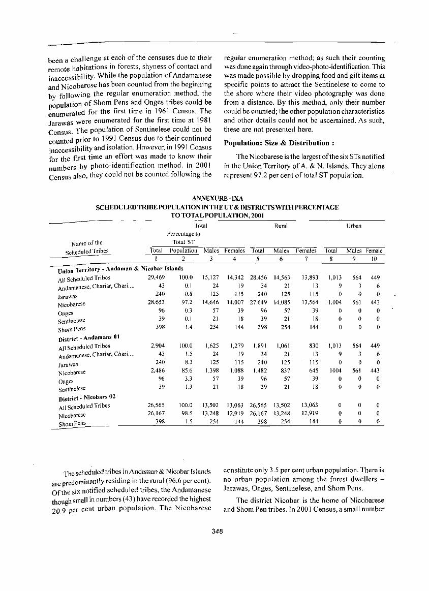
been a challenge at each of the censuses due to their remote habitations in forests, shyness of contact and inaccessibility. While the population of Andamanese and Nicobarese has been counted from the beginning by following the regular enumeration. method, the population of Shorn Pens and Onges tnbes could be enumerated for the first time in 1961 Census. The Jarawas were enumerated for the first time at 1981 Census. The population of Sentinelese could not be counted prior to 1991 Census due to their continued inaccessibility and isolation. However, in 1991 Census for the first time an effort was made to know their numbers by photo-identification method. In 200 I Census also, they could not be counted following the
regular enumeration method; as such their counting was done again through video-photo-identification. This was made possible by dropping food and gift items at specific points to attract the Sentinelese to come to the shore where their video photography was done from a distance. By this method, only their number could be counted; the other population characteristics and other details could not be ascertained. As such, these are not presented here.
Population: Size & Distribution :
The Nicobarese is the largest of the six STs notified in the Union Territory of A. & N. Islands. They alone represent 97.2 per cent of total ST population.
ANNEXURE - IXA
SCHEDULED TRIBE POPULATION IN THE UT & DISTRICTS WITH PERCENTAGE TO TOTAL POPULATION, 2001
Total Percentage to
Name of the Total ST
Scheduled Tribes Total Population Males I 2 3
Union Territory - Andaman & Nicobar Islands
All Scheduled Tribes 29,469 100.0 15,127
Andamanese, Chariar, Chari. '" 43 0.1 24
Jarawas 240 0.8 125
Nicobarese 28,653 97.2 14,646
Onges 96 0.3 57
Sentinelese 39 0.1 21
ShomPens 398 1.4 254
District - Andamans 01
All Scheduled Tribes 2,904 100.0 1,625
Andamanese, Chariar, Chari .... 43 1.5 24
Jarawas 240 8.3 125
Nicobarese 2,486 85.6 1,398
Onges 96 3.3 57
Sentinelese 39 1.3 21
District - Nicobars 02
All Scheduled Tribes 26,565 100.0 13,502
Nicobarese 26,167 98.5 13,248
ShomPens 398 1.5 254
The scheduled tribes in Andaman & N icobar Islands are predominantly residing in the rural (96.6 per cent). Of the six notified scheduled tribes, the Andamanese though small in numbers (43) have recorded the highest 20.9 per cent urban population. The Nicobarese
348
Rural Urban
Females Total Males Females Total Males Female 4 5 6 7 8 9 10
14,342 28,456 14,563 13,893 1,013 564 449
19 34 21 13 9 3 6 115 240 125 115 0 0 0
14,007 27,649 14,085 13,564 1,004 561 443
39 96 57 39 0 0 0 18 39 21 18 0 0 0
144 398 254 144 0 0 0
1,279 1,891 1,061 830 1,013 564 449
19 34 21 13 9 3 6 lIS 240 125 115 0 0 0
1,088 1,482 837 645 1004 561 443
39 96 57 39 0 0 0 18 39 21 18 0 0 0
13,063 26,565 13,502 13,063 0 0 0 12,919 26,167 13,248 12,919 0 0 0
144 398 254 144 0 0 0
constitute only 3.5 per cent urban population. There is no urban population among the forest dwellers -Jarawas, Onges, Sentinelese, and Shorn Pens.
The district Nicobar is the home of Nicobarese and Shorn Pen tribes. In 2001 Census, a small number
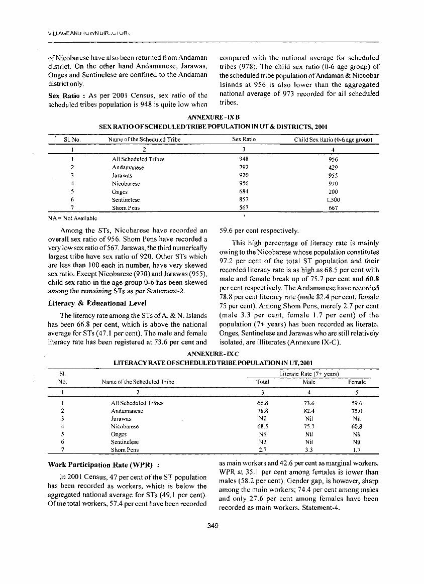
VILLAl.:>EANU I uvVN UIR_\"'I uR I
ofNicobarese have also been returned from Andaman district. On the other hand Andamanese, Jarawas, Onges and Sentinelese are confined to the Andaman district only.
Sex Ratio : As per 2001 Census, sex ratio of the scheduled tribes population is 948 is quite low when
compared with the national average for scheduled tribes (978). The chi Id sex ratio (0-6 age group) of the scheduled tribe population of Andaman & Niccobar Islands at 956 is also lower than the aggregated national average of 973 recorded for all scheduled tribes.
ANNEXURE -IX B
SEX RATIO OF SCHEDULED TRIBE POPULATION IN UT & DISTRICTS, 2001
SI. No. Name of the Scheduled Tribe
2
1 All Scheduled Tribes 2 Andamanese 3 Jarawas 4 Nicobarese 5 Onges 6 Sentinelese 7 Shorn Pens
NA = Not Available
Among the STs, Nicobarese have recorded an overall sex ratio of956. Shom Pens have recorded a very low sex ratioof567. Jarawas, the third numerically largest tribe have sex ratio of 920. Other STs which are less than J 00 each in number, have very skewed sex ratio. Except Nicobarese (970) and Jarawas (955), child sex ratio in the age group 0-6 has been skewed among the remaining STs as per Statement-2.
Literacy & Educational Level
The literacy rate among the STs of A. & N. Islands has been 66.8 per cent, which is above the national average for STs (47.J per cent). The male and female literacy rate has been registered at 73.6 per cent and
Sex Ratio Child Sex Ratio (0-6 age group)
3 4
948 956 792 429 920 955 956 970 684 200 857 1,500 567 667
59.6 per cent respectively.
This high percentage of literacy rate is mainly owing to the Nicobarese whose population constitutes 97.2 per cent of the total ST population and their recorded literacy rate is as high as 68.5 per cent with male and female break up of 75.7 per cent and 60.8 per cent respectively. The Andamanese have recorded 78.8 per cent literacy rate (male 82.4 per cent, female 7S per cent). Among Shorn Pens, merely 2.7 per cent (male 3.3 per cent, female 1. 7 per cent) of the population (7+ years) has been recorded as literate. Onges, Sentinelese and Jarawas who are still relatively isolated, are illiterates (Annexure IX-C).
ANNEXURE - IX C LITERACY RATE OF SCHEDULED TRIBE POPULATION IN UT,2001
SI. No. Name ofthe Scheduled Tribe
2
I All Scheduled Tribes 2 Andamanese 3 Jarawas 4 Nicobarese 5 Onges 6 Sentinelese 7 Shorn Pens
Work Participation Rate (WPR)
In 2001 Census, 47 per cent of the ST popUlation has been recorded as workers, which is below the aggregated national average for STs (49.1 per cent). Ofthe total workers, 57.4 per cent have been recorded
349
Literate Rate (7+ years) Total Male Female
3 4 5
66.8 73.6 59.6 78.8 82.4 75.0 Nil Nil Nil
68.5 75.7 60.8 Nil Nil Nil Nil Nil Nil 2.7 3.3 1.7
as main workers and 42.6 per cent as marginal workers. WPR at 35.1 per cent among females is lower than males (58.2 per cent). Gender gap, is however, sharp among the main workers; 74.4 per cent among males and only 27.6 per cent among females have been recorded as main workers, Statement-4.
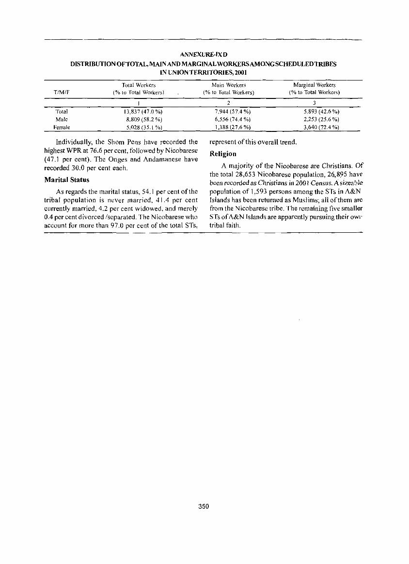
ANNEXURE-IX D
DISTRIBUTION OFTOTAL, MAIN AND MARGINAL WORKERS AMONG SCHEDULED TRIBES IN UNION TERRITORIES, 2001
Total Workers T/M/F (% to Total Workers)
Total 13,837 (47.0 %)
Male 8,809 (58.2 %)
Female 5,028 (35.1 %)
Individually, the Shorn Pens have recorded the highest WPR at 76.6 percent, followed by Nicobarese (47.1 per cent), The Onges and Andamanese have recorded 30.0 per cent each.
Marital Status
As regards the marital status, 54.1 per cent of the tribal population is never married, 41.4 per cent currently married, 4.2 per cent widowed, and merely 0.4 per cent divorced (separated. The Nicobarese who account for more than 97.0 per cent of the total STs,
Main Workers Marginal Workers (% to Total Workers) (% to Total Workers)
350
2
7,944 (57.4 %)
6,556 (74.4 %)
1,388 (27.6 %)
represent of this overall trend.
Religion
3
5,893 (42.6 %)
2,253 (25.6 %)
3,640 (72.4 %)
A majority of the Nicobarese are Christians. Of the total 28,653 Nicobarese population, 26.,895 have been recorded as Christians in 200 I Census. A sizea ble population of 1,593 persons among the STs in A&N Islands has been returned as Muslims; all of them are from the Nicobarese tribe. The remaining five smaller STs of A&N Islands are apparently pursuing their OWl'
tribal faith.