1 DISTRICT CENSUS HANDBOOK-UKHRUL - 200 OK
192
1 DISTRICT CENSUS HANDBOOK-UKHRUL
-
Upload
khangminh22 -
Category
Documents
-
view
0 -
download
0
Transcript of 1 DISTRICT CENSUS HANDBOOK-UKHRUL - 200 OK
1
DISTRICT CENSUS HANDBOOK-UKHRUL

2
DISTRICT CENSUS HANDBOOK-UKHRUL
3
DISTRICT CENSUS HANDBOOK-UKHRUL
M
Y
A
N
M
AR
N
A
G A
LA
N
D
SE
NA
PA
TI
D
I
S
T
RI
C
T
I N D I A
SH
SH
UKHRUL (CT)
SH
SH
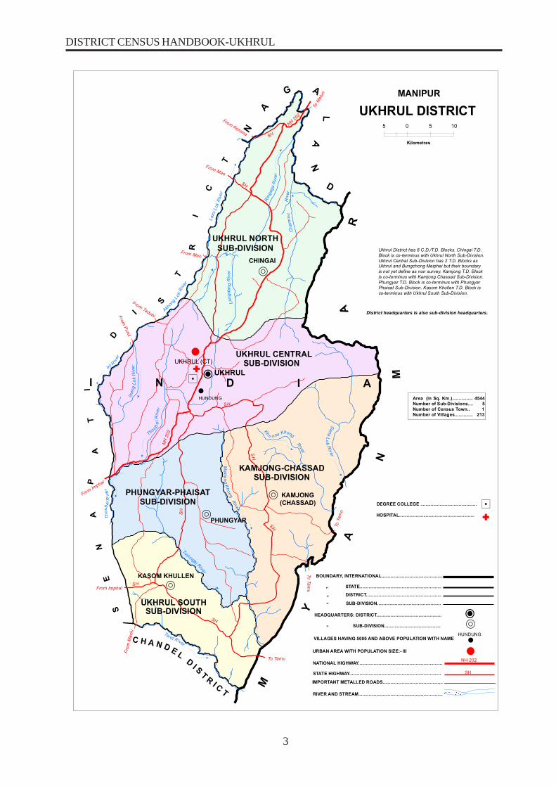
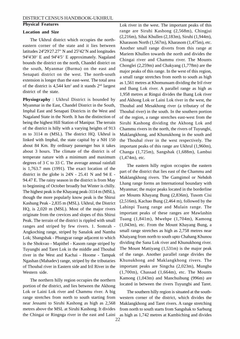
District headquarters is also sub-division headquarters.
Fro
m M
ach
i
BOUNDARY, INTERNATIONAL................................................
!
RP
NH 202
DISTRICT...........................................................
,,
,,
STATE................................................................,,
VILLAGES HAVING 5000 AND ABOVE POPULATION WITH NAME
URBAN AREA WITH POPULATION SIZE:- III
NATIONAL HIGHWAY..................................................................
STATE HIGHWAY........................................................................
IMPORTANT METALLED ROADS...............................................
RIVER AND STREAM..................................................................
HEADQUARTERS: DISTRICT...................................................
SUB-DIVISION..................................................
SUB-DIVISION............................................,,
SH
!
!HUNDUNG
!
HUNDUNG
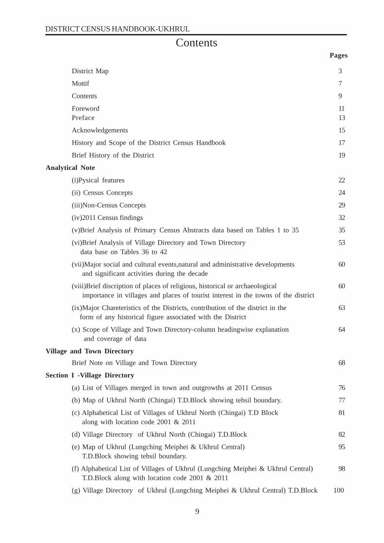
Ukhrul District has 6 C.D./T.D. Blocks. Chingai T.D.
Block is co-terminus with Ukhrul North Sub-Division.
Ukhrul Central Sub-Division has 2 T.D. Blocks as Ukhrul and Bungchong Meiphei but their boundary
is not yet define as non survey. Kamjong T.D. Block
is co-terminus with Kamjong Chassad Sub-Division.
Phungyar T.D. Block is co-terminus with Phungyar
Phaisat Sub-Division. Kasom Khullen T.D. Block is
co-terminus with Ukhrul South Sub-Division.
P
R
R
R
R
DEGREE COLLEGE ............................................
HOSPITAL...........................................................G
6
6
G
Area (in Sq. Km.)................ 4544
Number of Sub-Divisions.... 5
Number of Census Town.. 1
Number of Villages.............. 213
10505
PHUNGYAR-PHAISAT
KAMJONG-CHASSADSUB-DIVISION
SUB-DIVISION
UKHRUL SOUTHSUB-DIVISION
UKHRUL CENTRALSUB-DIVISION
CHINGAI
PHUNGYAR
UKHRUL NORTH
SUB-DIVISION
KASOM KHULLEN
UKHRUL
KAMJONG(CHASSAD)
C H A N D EL
DI S
TR
I CT
MANIPUR
UKHRUL DISTRICT
Kilometres
To T
am
u
To
Ta
mu
To Tamu
To M
elu
ri
SH
SH
SH
SH
From Imphal
From Imphal
From Mao
From Mao
From TadubiFro
m P
uru
l
NH
202
From Kohima
NH
202
Taret River
Akh
ong L
ok
Riv
er
Iril R
iver
Thouba
l R
iver
Th
ou
ba
l R
ive
r
Tuyungbi R
iver
Lan
gd
an
g R
iver
Sana
Lo
k R
iver
Riv
er
Ma
kla
ng
Kho
ng
Rive
r
Kh
u nnu Khong
Riv
er
Rin
gaga R
ive
r
Cha
mm
u
Lain
i Lok R
ive
r
Ihan
g L
ok R
ive
r

4
DISTRICT CENSUS HANDBOOK-UKHRUL
5
DISTRICT CENSUS HANDBOOK-UKHRUL
CENSUS OF INDIA 2011
MANIPUR
SERIES-15
DISTRICT CENSUS HANDBOOK
UKHRUL
VILLAGE AND TOWN DIRECTORY
Directorate of Census OperationsManipur
PART XII- A

6
DISTRICT CENSUS HANDBOOK-UKHRUL
7
DISTRICT CENSUS HANDBOOK-UKHRUL
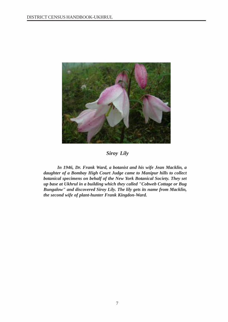
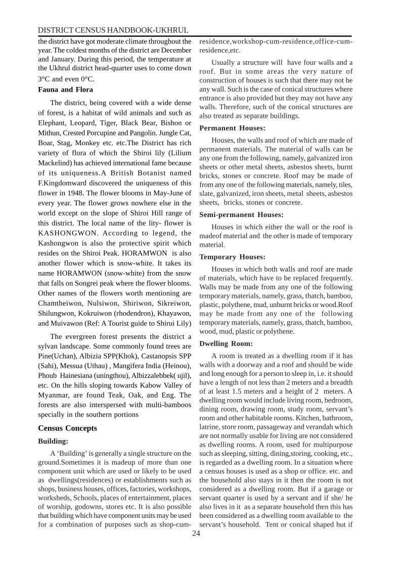
In 1946, Dr. Frank Ward, a botanist and his wife Jean Macklin, adaughter of a Bombay High Court Judge came to Manipur hills to collectbotanical specimens on behalf of the New York Botanical Society. They setup base at Ukhrul in a building which they called "Cobweb Cottage or BugBungalow" and discovered Siroy Lily. The lily gets its name from Macklin,the second wife of plant-hunter Frank Kingdon-Ward.
Siroy Lily

8
DISTRICT CENSUS HANDBOOK-UKHRUL
9
DISTRICT CENSUS HANDBOOK-UKHRUL
PagesContents
District Map 3
Mottif 7
Contents 9
Foreword 11Preface 13
Acknowledgements 15
History and Scope of the District Census Handbook 17
Brief History of the District 19
Analytical Note
(i)Pysical features 22
(ii) Census Concepts 24
(iii)Non-Census Concepts 29
(iv)2011 Census findings 32
(v)Brief Analysis of Primary Census Abstracts data based on Tables 1 to 35 35
(vi)Brief Analysis of Village Directory and Town Directory 53 data base on Tables 36 to 42
(vii)Major social and cultural events,natural and administrative developments 60 and significant activities during the decade
(viii)Brief discription of places of religious, historical or archaeological 60 importance in villages and places of tourist interest in the towns of the district
(ix)Major Chareteristics of the Districts, contribution of the district in the 63 form of any historical figure associated with the District
(x) Scope of Village and Town Directory-column headingwise explanation 64 and coverage of data
Village and Town DirectoryBrief Note on Village and Town Directory 68
Section I -Village Directory
(a) List of Villages merged in town and outgrowths at 2011 Census 76
(b) Map of Ukhrul North (Chingai) T.D.Block showing tehsil boundary. 77
(c) Alphabetical List of Villages of Ukhrul North (Chingai) T.D Block 81 along with location code 2001 & 2011
(d) Village Directory of Ukhrul North (Chingai) T.D.Block 82
(e) Map of Ukhrul (Lungching Meiphei & Ukhrul Central) 95 T.D.Block showing tehsil boundary.
(f) Alphabetical List of Villages of Ukhrul (Lungching Meiphei & Ukhrul Central) 98 T.D.Block along with location code 2001 & 2011
(g) Village Directory of Ukhrul (Lungching Meiphei & Ukhrul Central) T.D.Block 100
10
DISTRICT CENSUS HANDBOOK-UKHRUL(g) Map of Kamjong T.D.Block showing tehsil boundary. 125
(h) Alphabetical List of Villages of Kamjong T.D.Block 128along with location code 2001 & 2011
(i) Village Directory of Kamjong T.D.Block 130
(j) Map of Phungyar T.D.Block showing tehsil boundary. 143(k) Alphabetical List of Villages of Phungyar T.D.Block 147
along with location code 2001 & 2011
(l) Village Directory of Phungyar T.D.Block 148
(m) Map of Ukhrul South (Kasom Khullen) T.D.Block showing tehsil 161boundary.
(n) Alphabetical List of Villages of Ukhrul South (Kasom Khullen) T.D.Block 163along with location code 2001 & 2011
(o) Village Directory of Ukhrul South (Kasom Khullen) T.D.Block 164(p) Appendices to Village Directory
Appendix-I: Summary showing total number of villages having 176
educational,medical and other amenities in villages - T.D.Block levelAppendix 1-A : Villages by number of the primary Schools 178
Appendix I-B: Villages by primary, middle and secondary Schools 179
Appendix I-C:Villages with different sources of drinking water 179facilities availableAppendix II: Villages with 5000 and above population which do not have 179
one or more amenities available
Appendix V: Summary showing number of villalges not having 180
Scheduled Caste Population
Appendix VI: Summary showing number of villalges not having 180
Scheduled Tribes Population
Appendix VII-A: List of Villalges according to the proportion of the 181
Scheduled Castes to the total Population by ranges
Appendix VII-B: List of Villalges according to the proportion of the 184
Scheduled Tribes to the total Population by ranges
Section II-Town Directory(a) Town Directory Statement I- Status and growth history 188
(b) Town Directory Statement II- Physical Aspect and location of Towns,2009 188
(c) Town Directory Statement III- Civic and other amenities,2009 188
(d) Town Directory Statement IV- Medical facilities,2009 189
(e) Town Directory Statement V- Educational,Recrational and Cultural facilities, 2009 190
(f) Town Directory Statement VI- Industry and Banking,2009 190

11
DISTRICT CENSUS HANDBOOK-UKHRUL
FOREWORD
The District Census Handbook (DCHB) is an important publication of the Census Organization since1951. It contains both Census and non Census data of urban and rural areas for each District. The Censusdata provide information on demographic and socio-economic characteristics of population at the lowestadministrative unit i.e. of each Village and Town and ward of the District. The Primary Census Abstract(PCA) part of this publication contains Census data including data on household amenities collected during1st.phase of the Census i.e. House Listing and Housing Census. The non Census data presented in theDCHB is in the form of Village Directory and Town Directory contain information on various infrastructurefacilities available in the village and town viz; education, medical, drinking water, communication and transport,post and telegraph, electricity, banking, and other miscellaneous facilities. Later on, the Telegraph Serviceswere closed by the Government of India on 15th. July, 2013. The data of DCHB are of considerable importancein the context of planning and development at the grass-root level.2. In the 1961 Census, DCHB provided a descriptive account of the District, administrative statistics,Census tables and Village and Town Directory including Primary Census Abstract. This pattern was changedin 1971 Census and the DCHB was published in three parts: Part-A related to Village and Town Directory,Part-B to Village and Town PCA and Part-C comprised analytical report, administrative statistics, DistrictCensus tables and certain analytical tables based on PCA and amenity data in respect of Villages. The 1981Census DCHB was published in two parts: Part-A contained Village and Town Directory and Part-B thePCA of Village and Town including the SCs and STs PCA up to Tahsil/Town levels. New features alongwith restructuring of the formats of Village and Town Directory were added. In Village Directory, allamenities except electricity were brought together and if any amenity was not available in the referentVillage, the distance in broad ranges from the nearest place having such an amenity, was given.3. The pattern of 1981 Census was followed by and large for the DCHB of 1991 Census except the formatof PCA. It was restructured. Nine-fold industrial classification of main workers was given against the four-fold industrial classification presented in the 1981 Census. In addition, sex wise population in 0-6 age groupwas included in the PCA for the first time with a view to enable the data users to compile more realisticliteracy rate as all children below 7 years of age had been treated as illiterate at the time of 1991 Census.One of the important innovations in the 1991 Census was the Community Development Block (CD Block)level presentation of Village Directory and PCA data instead of the traditional Tahsil/Taluk/PS levelpresentation.4. As regards DCHB of 2001 Census, the scope of Village Directory was improved by including someother amenities like banking, recreational and cultural facilities, newspapers & magazines and ‘most importantcommodity’ manufactured in a Village in addition to prescribed facilities of earlier Censuses. In TownDirectory, the statement on Slums was modified and its coverage was enlarged by including details on allslums instead of ‘notified slums’.5. The scope and coverage of Village Directory of 2011 DCHB has been widened by including a numberof new amenities in addition to those of 2001. These newly added amenities are: Pre-Primary School, Engineering College, Medical College, Management Institute,Polytechnic, Non-formal Training Centre, Special School for Disabled, Community Health Centre,Veterinary Hospital, Mobile Health Clinic, Medical Practitioner with MBBS Degree, Medical Practitionerwith no degree, Traditional Practitioner and faith Healer, Medicine Shop, Community Toilet, Rural SanitaryMart or Sanitary Hardware Outlet in the Village, Community Bio- gas, Sub Post Office, Village Pin Code,Public Call Office, Mobile Phone Coverage, Internet Cafes/ Common Service Centre, Private CourierFacility, Auto/Modified Autos, Taxis and Vans, Tractors, Cycle-pulled Rickshaws, Carts driven by Animals,Village connected to National Highway, State Highway, Major District Road, and Other District Road,Availability of Water Bounded Macadam Roads in Village, ATM, Self-Help Group, Public DistributionSystem(PDS) Shop, Mandis/Regular Market, Weekly Haat, Agricultural Marketing Society, NutritionalCenters (ICDS), Anganwadi Centre, ASHA (Accredited Social Health Activist), Sports Field, Public Library,Public Reading Room, Assembly Polling station, Birth & Death Registration Office. In the Town Directory,
12
DISTRICT CENSUS HANDBOOK-UKHRULseven Statements containing the details and the data of each Town have been presented viz.; (i)-Status andGrowth History of Towns,(ii)- Physical Aspects and Location of Towns, (iii)-Civic and other Amenities, (iv)-Medical Facilities, (v)-Educational, Recreational & Cultural Facilities, (vi)- Industry & Banking, and (vii)-Civic & other amenities in Slums respectively. CD Block wise data of Village Directory and Village PCAhave been presented in DCHB of 2011 Census as presented in earlier Census.6. The data of DCHB 2011 Census have been presented in two parts, Part-A contains Village and TownDirectory and Part-B contains Village and Town wise Primary Census Abstract. Both the Parts have beenpublished in separate volumes in 2011 Census.7. The Village and Town level amenities data have been collected, compiled and computerized under thesupervision of Shri Balwant Rai Joint Director of Census Operations, Manipur. The task of Planning,Designing and Co-ordination of this publication was carried out by Dr. Pratibha Kumari, Assistant RegistrarGeneral (SS) under the guidance & supervision of Dr. R.C.Sethi, Ex-Addl. RGI and Shri Deepak Rastogipresent Addl.RGI. Shri A.P. Singh, Deputy Registrar General, (Map) provided the technical guidance in thepreparation of maps. Shri A.K. Arora, Joint Director of Data Processing Division under the overall supervisionof Shri M.S.Thapa, Addl. Director (EDP) provided full cooperation in preparation of record structure fordigitization and validity checking of Village and Town Directory data and the programme for the generationof Village Directory and Town Directory including various analytical inset tables as well as Primary CensusAbstract (PCA). The work of preparation of DCHB, 2011 Census has been monitored in the Social StudiesDivision. I am thankful to all of them and others who have contributed to bring out this publication in time.
(C.Chandramouli)Registrar General &
Census Commissioner, IndiaNew Delhi.Dated:- 16-06-2014
13
DISTRICT CENSUS HANDBOOK-UKHRUL
Preface
The District Census Handbook is an important set of census publication of the census organization andare widely used by the State Government and its district level and other officers for Planning, developmentand administrative purposes as well as by a large cross section of data users like academicians, scholars,researchers and other non- governmental agencies.This volume presents the Village and Town Directoryunder part A and the Primary Census Abstract under part B. The village Directory gives each village itsarea, population, educational, medical, and civic and other amenities and land use pattern. The Town Directorygives for each town, the area, population characteristics, physical aspects, communications, municipal finance,educational, medical, civic and other amenities and trade, commerce, industry and banking facilities. Theprimary census Abstract presents other basic data like number of residential houses and household, literates,Scheduled Caste and Tribes population, Workers by main categories, marginal workers and Non-workers.The data presented under Village and Town Directories were furnished by the Village Officers through theSub-district collector in respect of rural areas i.e villages and by the Excutive officers concerned in respectof urban areas respectively. The data presented under Primary Census Abstract were collected during thecensus operations by the field workers consisted of Enumerators, Supervisors, Charge Officers and DistrictCensus Officers. Question on Sex (Male / Female /others )into three adding code 3 for others during 2011Census and one additional question was canvass during 2011 Census for marginal workers who worked forless than 6 months by splitting it into two viz. 1) Marginal workers who have worked for 3 months or morebut less than 6 months, 2) Marginal workers who have worked for less than 3 months. Thanks are due to allthese field officials who have provided the basic data required for the compilation of this volume.The 2011census DCHB, by and large, followed the pattern of 2001 census in presenting and publication of PrimaryCensus Abstract at the level of Community Development /Tribal Development blocks (CD/TD Blocks)instead of tahsil and sub-divisional level. But as decided the Registrar General and Census Commissioner,India District Census Handbook (DCHB) will be printed into two separate volumes Part – A and Part – Bin 2011 Census instead of single volume as was the practice during previous Censuses.I am extremelythankful to Dr. C. Chandramouli, Registrar General and Census Commissioner, India for his guidance andinspiration in bringing out this publication. I am also grateful to Shri D. K Sikri, former Registrar General andCensus Commissioner of India for his constant guidance and advice in the initial stage.I am thankful to Dr.D. Roy Chaudhary then Deputy Registrar General ( C&T) and Shri P. K. Banerjee for Planning , Designingand Co-ordination of this publication, Mrs. Pritibha Kumari, Assistant Registrar General Social StudiesDivision, for finalizing data and analytical notes, Shri A. P. Singh, Deputy Registrar General, Map Divisionfor providing technical guidance in preparation of Maps, Shri M.S. Thapa, Additional Director and Shri AnilKumar, Joint Director, Data processing Division, for record structure and data computerization.I would liketo place my heartful thanks to all the officers and officials of this Directorate who have played vital role atvarious stages of census and overall supervision of collection and compilation of this volume. My thanks arealso due to Shri Biju Basumatary, Shri R.K. Manisana Singh, Assistant Directors, Dr. M. Manimohon Meetei,

14
DISTRICT CENSUS HANDBOOK-UKHRULSenior Geographer, and Shri Govind Soni, S.I. Grade II,Pallab Jyoti Konwar,S.I.Gr-II and Shri O. JugindroSingh, Senior Technical Assistant for their painstaking labour and constant involvement in different stageswhile bringing out this publication. I would also express my thanks to all those who rendered timely andnecessary help at different stages in the finalization of this publication.
Balwant Rai Joint Director of Census
Operations, Manipur
15
DISTRICT CENSUS HANDBOOK-UKHRUL
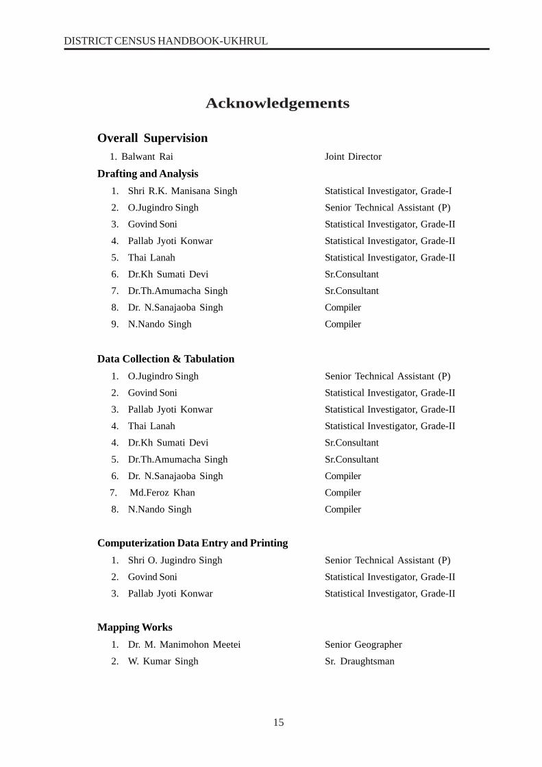
Acknowledgements
Overall Supervision 1. Balwant Rai Joint Director
Drafting and Analysis1. Shri R.K. Manisana Singh Statistical Investigator, Grade-I
2. O.Jugindro Singh Senior Technical Assistant (P)
3. Govind Soni Statistical Investigator, Grade-II
4. Pallab Jyoti Konwar Statistical Investigator, Grade-II
5. Thai Lanah Statistical Investigator, Grade-II
6. Dr.Kh Sumati Devi Sr.Consultant
7. Dr.Th.Amumacha Singh Sr.Consultant
8. Dr. N.Sanajaoba Singh Compiler
9. N.Nando Singh Compiler
Data Collection & Tabulation1. O.Jugindro Singh Senior Technical Assistant (P)
2. Govind Soni Statistical Investigator, Grade-II
3. Pallab Jyoti Konwar Statistical Investigator, Grade-II
4. Thai Lanah Statistical Investigator, Grade-II
4. Dr.Kh Sumati Devi Sr.Consultant
5. Dr.Th.Amumacha Singh Sr.Consultant
6. Dr. N.Sanajaoba Singh Compiler
7. Md.Feroz Khan Compiler
8. N.Nando Singh Compiler
Computerization Data Entry and Printing1. Shri O. Jugindro Singh Senior Technical Assistant (P)
2. Govind Soni Statistical Investigator, Grade-II
3. Pallab Jyoti Konwar Statistical Investigator, Grade-II
Mapping Works1. Dr. M. Manimohon Meetei Senior Geographer
2. W. Kumar Singh Sr. Draughtsman

16
DISTRICT CENSUS HANDBOOK-UKHRUL
17
DISTRICT CENSUS HANDBOOK-UKHRUL
History and Scope of District Census Handbook
The need of data at the grass root level for theadministrative and planning purposes at sub microlevel as well as academic studies prompted theinnovation of District Census Handbook. DistrictCensus Handbook is a unique publication from theCensus organization which provides most authenticdetails of census and non-census information fromvillage and town level to district level. The DistrictCensus Handbook was firstly introduced during the1951 Census. It contains both census and non censusdata of urban as well as rural areas for each district.The census data contain several demographic andsocio-economic characteristics of the lowestadministrative unit i.e. of each village and town andward of the district. The non census data compriseof data on availability of various civic amenities andinfrastructural facilities etc. at the town and villagelevel which constitute Village Directory and TownDirectory part of the DCHB. The data of DCHBare of considerable importance in the context ofplanning and development at grass-root level.
In 1961 census DCHB provided a descriptiveaccount of the district, administrative statistics,census tables and village and town directoryincluding Primary Census Abstract. This patternwas changed in 1971 Census and the DCHB waspublished in three parts: Part-A related to villageand town directory, Part-B to village and town PCAand Part-C comprised analytical report,administrative statistics, district census tables andcertain analytical tables based on PCA and amenitydata in respect of villages. The 1981 census DCHBwas published in two parts: Part-A contained villageand town directory and Part-B the PCA of villageand town including the SCs and STs PCA up totahsil/town levels. New features along withrestructuring of the formats of village and towndirectory were added into it. In Village Directory,all amenities except electricity were broughttogether and if any amenity was not available inthe referent village, the distance in broad rangesfrom the nearest place having such an amenity,
was given. The pattern of 1981 census wasfollowed by and large for the DCHB of 1991 Censusexcept the format of PCA. It was restructured.Nine-fold industrial classification of main workers wasgiven against the four-fold industrial classificationpresented in the 1981 census. In addition, sex wisepopulation in 0-6 age group was included in the PCAfor the first time with a view to enable the data usersto compile more realistic literacy rate as all childrenbelow 7 years of age had been treated as illiterate atthe time of 1991 census. One of the importantinnovations in the 1991 census was the CommunityDevelopment Block (CD Block) level presentationof village directory and PCA data instead of thetraditional tahsil/taluk/PS level presentation.
As regards DCHB of 2001 Census, the scope ofVillage Directory was improved by including someother amenities like banking, recreational and culturalfacilities, newspapers & magazines and ‘mostimportant commodity’ manufactured in a village inaddition to prescribed facilities of earlier censuses.In Town Directory, the statement on Slums wasmodified and its coverage was enlarged by includingdetails on all slums instead of ‘notified slums’.
The scope and coverage of Village Directory of 2011DCHB has been widened by including a number ofnew amenities in addition to those of 2001. In the TownDirectory, seven Statements containing the detailsand the data of each town have been presented viz.;(i)-Status and Growth History of towns,(ii)- PhysicalAspects and Location of Towns, (iii)-Civic and otherAmenities, (iv)-Medical Facilities, (v)-Educational,Recreational & Cultural Facilities, (vi)- Industry &Banking, and (vii)- Civic & other amenities in Slumsrespectively. CD Block wise data of Village Directoryand Village PCA have been presented in DCHB of2011 census as presented in earlier census. The dataof DCHB 2011 Census have been presented in twoparts, Part-A contains Village and Town Directory andPart-B contains Village and Town wise PrimaryCensus Abstract. Both the Parts have been publishedin separate volumes in 2011 Census.

18
DISTRICT CENSUS HANDBOOK-UKHRUL
19
DISTRICT CENSUS HANDBOOK-UKHRUL
Brief History of the District
Manipur remained a single district having tensub-divisions till November,1969 while the presentUkhrul District was one of them. As a result ofdistrict re-organisation in 1969, the former ten sub-divisions were reorganized into 25 sub-divisions andthe entire Manipur state having one district hithertowas divided into 5 districts namely, (i) ManipurCentral (ii) Manipur North (iii) Manipur East (iv)Manipur West and (v) Manipur South District. Thepresent Ukhrul District then known as Manipur Eastdistrict ( Sl.No.iii) was one of them. The villageUkhrul became its district headquarters. It comprises5 sub-divisions namely, (1) Ukhrul North (2) UkhrulCentral (3) Phungyar Phaisat (4) Kamjong Chassad(5) Ukhrul South having their headqauartersrespectively at Chingai,Ukhrul,Phungyar Phaisat,Kamjong Chassad and Kamsong Khullen. UnderManipur Gazette Notification No.174 dated August5,1983, the name of the district became known asUkhrul District after the name of the Districtheadquarters as in the case of other districts.
The respective sub-divisions constitute one TribalDevelopment Block each. The Sub-DivisionalOfficer serves concurrently as Block DevelopmentOfficer having the Headquarter at the same station.The Tangkhul- Nagas are the largest single dominanttribe in the district whereas the Tadhou (Of Chin-Kuki origin) are the next. The history of theTangkhul is obscure but some traces of its antiquityare found in their Folklores. They are said to belongto sub-Himalayan or Neo- Tibetan Tribe. In thecourse of their movement they probably settled inthe upper Chindwin (Ningthi or Higthi) valley beforethey settled to their present habitat.
According to some scholars dealing withTangkhul Folklore and antiquity,the name of thechief of the first settlers at the present location ofUkhrul was Hungphun. The village was named afterhim. At a later stage when the settlers came intouch with the valley dwellers i.e. the Meities,thename became corrupt and Hungphun was
pronounced as Ukhrul. The second view is thatwhen the Meities found the Hungphun village thecountry liquor known as ‘Yu” was abundant in thevillage and the villagers were found mostly drunk.Afterwards, the plain dwellers gave the name ofvillage Yukhul (wine village). From the Yukhul camethe word Ukhurl.
The district was said to be effected by the pastTwo World Wars.Many Tangkhuls were said to jointhe British Labour Corpse whereas the Kukiesobjected to and even fought against the Britishers.In1944 at the concluding stage of the Second WorldWar, many battles were fought within the district tocheck the advance of Japanese Invasion Army.The battle at Sansak and Kongkan Thana Areaswere well known.
Administrative set up
The District is located on the North-Easterncorner of the State. It shares an international borderwith Myanmar on its eastern side. The Districtadministration is headed by a Deputy Commissionerwho is assisted by an Additional DeputyCommissioner, five Sub-Divisional Officersrespectively in-charge of Ukhrul North Sub-Division,Ukhrul Central, Kamjong, Phungyar and UkhrulSouth. There is no jurisdictional change in2011Census. There is no Census town in the Districtin 2001 Census but in 2011 Census there is oneCensus Town. The administration of District Councilaffairs is looked after by the Deputy Commissionerdue to non-functioning of the Council following non-election of Council member for the past many years.
The District comprises 213 villages. The Sub-Divisional boundary is coterminous with that ofTribal Development Block and each Sub-DivisionalOfficer is his respective jurisdiction.
The District Police is headed by aSuperintendent of Police assisted by his DeputySuperintendent of Police. The Judicial/Judiciaryadministration is looked after Chief JudicialMagistrate.

20
DISTRICT CENSUS HANDBOOK-UKHRUL
21
DISTRICT CENSUS HANDBOOK-UKHRUL
Analytical Note
22
DISTRICT CENSUS HANDBOOK-UKHRULPhysical Features
Location and Size
The Ukhrul district which occupies the north-eastern corner of the state and it lies betweenlatitudes 24029/27.27" N and 25042’N and longitudes9404/30// E and 9404/5// E approximately. Nagalandbounds the district on the north, Chandel district onthe south, Myanmar (Burma) on the east andSenapati district on the west. The north-southextension is longer than the east-west. The total areaof the district is 4,544 km2 and it stands 2nd largestdistrict of the state.
Physiography : Ukhrul District is bounded byMyanmar in the East, Chandel District in the South,Imphal East and Senapati Districts in the West andNagaland State in the North. It has the distinction ofbeing the highest Hill Station of Manipur. The terrainof the district is hilly with a varying heights of 913m to 3114 m (MSL). The district HQ. Ukhrul islinked with Imphal, the state capital by a NH 150about 84 Km. By ordinary passenger bus it takesabout 3 hours. The climate of the district is oftemperate nature with a minimum and maximumdegrees of 3 C to 33 C. The average annual rainfallis 1,763.7 mm (1991). The exact location of thedistrict in the globe is 24N - 25.41 N and 94 E -94.47 E. The rainy season in the district is from Mayto beginning of October broadly but Winter is chilly.The highest peak is the Khayang peak-3114 m (MSL),though the more popularly know peak is the ShiruiKashung Peak - 2,835 m (MSL). Ukhrul, the DistrictHQ, is 2,020 m (MSL). Most of the major riversoriginate from the crevices and slopes of this ShiruiPeak. The terrain of the district is rippled with smallranges and striped by few rivers. 1. Somrah -Angkoching range, striped by Sanalok and NambaLok; Shangshak - Phungyar range adjacent to whichis the Shokvao - Mapithel - Kasom range striped byTuyungbi and Taret Lok in the middle and Thoubalriver in the West and Kachai - Hoome - TampakNgashan (Mahadev) range, striped by the tributariesof Thoubal river in Eastern side and Iril River in theWestern side.
The northern hilly region occupies the northernportion of the district, and lies between the AkhongLok or Laini Lok river and Chammu river. A bigrange stretches from north to south starting fromnear Jessami to Siruhi Kashong as high as 2,568metres above the MSL at Siruhi Kashong. It dividesthe Chingai or Ringnga river in the east and Laini
Lok river in the west. The important peaks of thisrange are Siruhi Kashong (2,568m), Chingjui(2,216m), Sihai Khullen (2,183m), Siruhi (1,944m),Kharasom North (1,567m), Kharasom (1,475m), etc.Another small range diverts from this range atMariem Khullen towards the north and divides theChingai river and Chammu river. The MountsChonglei (2,259m) and Chakyang (1,778m) are themajor peaks of this range. In the west of this region,a small range stretches from north to south as highas 1,561 metres at Khomunuam dividing the Iril riverand Ihang Lok river. A parallel range as high as1,958 metres at Ringui divides the Ihang Lok riverand Akhong Lok or Laini Lok river in the west, theThoubal and Mesakhong river (a tributary of theThoubal river) in the south. In the southern portionof the region, a range stretches east-west from theSiruhi Kashong dividing the Akhong Lok andChammu rivers in the north, the rivers of Tuyungbi,Maklangkhong, and Khunukhong in the south andthe Thoubal river in the west respectively. Theimportant peaks of this range are Ukhrul (1,960m),Changa (1,725m), Sangshak (1,688m), Lambui(1,474m), etc.
The eastern hilly region occupies the easternpart of the district that lies east of the Chammu andMaklangkhong rivers. The Gamgimol or NehdohLhang range forms an International boundary withMyanmar; the major peaks located in the borderlineare Mounts Khayang Bung (2,836m), Tusom Cisi(2,516m), Kachao Bung (2,464 m), followed by theLahinpi Tuang range and Mulain range. Theimportant peaks of these ranges are MawlashinTuang (1,841m), Mwehpe (1,704m), Kamong(1,043m), etc. From the Mount Khayang Bung, asmall range stretches as high as 2,758 metres nearKhaiyang from north to south upto Chahang Khunoudividing the Sana Lok river and Khunukhong river.The Mount Mattiyang (1,531m) is the major peakof the range. Another parallel range divides theKhunukhong and Maklangkhong rivers. Theimportant peaks are Singcha (2,023m), Mungba(1,700m), Chassad (1,664m), etc. The MountsKamong (1,043m) and Manchuibung (996m) arelocated in between the rivers Tuyungbi and Taret.
The southern hilly region is situated at the south-western corner of the district, which divides theMaklangkhong and Taret rivers. A range stretchingfrom north to south starts from Sangshak to Sarbungas high as 1,742 metres at Kambiching and divides
23
DISTRICT CENSUS HANDBOOK-UKHRULthe Maklangkhong river and Tuyungbi river. TheMounts Kambiching (1,742m), Neuphung (1,701m)and Sarathen (1,359m) are the major peaks of therange. The Marphitel range as high as 2,055 metresnear Singkap stretching north-south divides theMaklangkhong, Tuyungbi and Taret rivers in the eastand the Thoubal river in the west.
Drainage
The district is drained by the 2(two) riversystems, viz. i) The Chindwin river system in thenorth and south-east, and ii) The Manipur riversystem in the south-west.
The Akhong Lok or Laini Lok river rises fromthe Mount Siruhi Kashong (2,568m) and flowsnorthwards. In the sources its name is known asthe Marou Lok or Langdang river upto near Namlifor about 29 km long and then turns towardswestward. The Meshakhong river starts from theTallui village (1,961m) and flows northwards forabout 19 km and falls into the Marou Lok river.After meeting the Wondi or Akhong Lok river, whichoriginates from the Kachai village, the Marou Lokriver turns northwards and forms the districtboundary for about 32 km long. It then forms stateboundary with Nagaland for about 10 km in its ownname and joins with the Tizu river (a tributary ofthe Chindwin river) and further forms the stateboundary with Nagaland for about 13 km and lastlyenters into Nagaland. The Wondi river also formsthe district boundary before joining the main streamfor about 24 km. The Chingai or Ringnga river risesfrom the height of 2,286 metres near Mariem Khullenand flows northwards for about 32 km and falls intothe Chammu river, a tributary of the Tizu river. TheChammu river starts from the Mount Siruhi Kashong(2,568m) and flows northwards. It drains more than68 km including about 16 km of state boundary withNagaland. In the borderline, its name is known asthe Ther or Thetsiru or Viratai river. The Thingngaior Riokong or Riori river starts from the Mount MolHe (2,597m) of Nagaland and flows north-west. Itforms the state boundary with Nagaland for about16 km long and falls into the Chammu river.
The Sana Lok river, Khunukhong river, Nam-ya river, Maklangkhong river, Tuyungbi river andTaret river are the important tributaries of the Yuriver. The Sana Lok river rises from the MountKhayang Bung (2,836m) and flows southwards. Itdrains for about 42 km and falls into the
Khunukhong river near Chahong Khunou. TheKhunukhong river starts from the Chingsou village(about 2,730m) and flows towards the sout-east. Itserves more than 45 km including an Internationalboundary with Myanmar for about 8 km and entersinto Myanmar to join the Chindwin river at Tilawngas Nam Panga river. The Nam-ya river rises fromNew Molvaihip village and flows southwards forabout 16 km and enters into Myanmar to meet theYu river (a big tributary of the Chindwin river) atNanthalan.
The Iril river and Thoubal river are the maintributaries of the Manipur river and also drains thedistrict. The Iril river rises from the Lakhamai Villageof Senapati district and flows southwards. It formsa district boundary with Senapati for about 17 kmlong and turns westwards to enter into the ImphalEast district. The Ihang Lok river rises from theKachai Ngarei village and flows southwards uptoSanakeithel village for about 32 km including about6 km of district boundary with Senapati district inthe source areas. From Sanakeithel village, it turnsnorthwards and forms the district boundary withSenapati for about 8 km and meets the Iril river.The Thoubal river rises from the Fumi village andflows southwards for about 39 km and enters intoSenapati district. The Lungshang orNungshangkhong river, a tributary of the Thoubalriver starts from the Mount Siruhi Kashong(2,568m) and flows towards the south-west for about31 km and falls into the main stream near Pharung.
Climate
The climate of Ukhrul district is sub-tropicalmonsoon type. The climate of the district is oftemperate nature with a minimum and maximumdegrees of 3°C to 33°C. The average annual rainfallis 1,763.7 mm (1991).
As the district headquarter lies on the top of thehigh hills it is very cold throughout the year. It isalways covered by the clouds. Regarding weatherof the district Headquarter, the sudden changes ofthe position of cloud are openly seen within a fewmoments. but in other places outside the districtHeadquarter, it is hot in summer and very cold inwinter. However, the whole district is having amoderate temperature.
The hill range that lies in the district HeadquarterUkhrul Central sub-division has got very cold climatein winter while other parts of the vast hilly areas of
24
DISTRICT CENSUS HANDBOOK-UKHRULthe district have got moderate climate throughout theyear. The coldest months of the district are Decemberand January. During this period, the temperature atthe Ukhrul district head-quarter uses to come down3°C and even 0°C.Fauna and Flora
The district, being covered with a wide denseof forest, is a habitat of wild animals and such asElephant, Leopard, Tiger, Black Bear, Bishon orMithun, Crested Porcupine and Pangolin. Jungle Cat,Boar, Stag, Monkey etc. etc.The District has richvariety of flora of which the Shiroi lily (LiliumMackelind) has achieved international fame becauseof its uniqueness.A British Botanist namedF.Kingdomward discovered the uniqueness of thisflower in 1948. The flower blooms in May-June ofevery year. The flower grows nowhere else in theworld except on the slope of Shiroi Hill range ofthis district. The local name of the lity- flower isKASHONGWON. According to legend, theKashongwon is also the protective spirit whichresides on the Shiroi Peak. HORAMWON is alsoanother flower which is snow-white. It takes itsname HORAMWON (snow-white) from the snowthat falls on Songrei peak where the flower blooms.Other names of the flowers worth mentioning areChamtheiwon, Nulsiwon, Shiriwon, Sikreiwon,Shilungwon, Kokruiwon (rhodendron), Khayawon,and Muivawon (Ref: A Tourist guide to Shirui Lily)
The evergreen forest presents the district asylvan landscape. Some commonly found trees arePine(Uchan), Albizia SPP(Khok), Castanopsis SPP(Sahi), Messua (Uthau) , Mangifera India (Heinou),Phoub Hainesiana (uningthou), Albizzalebbek( ujil),etc. On the hills sloping towards Kabow Valley ofMyanmar, are found Teak, Oak, and Eng. Theforests are also interspersed with multi-bamboosspecially in the southern portions
Census ConceptsBuilding:
A ‘Building’ is generally a single structure on theground.Sometimes it is madeup of more than onecomponent unit which are used or likely to be usedas dwellings(residences) or establishments such asshops, business houses, offices, factories, workshops,worksheds, Schools, places of entertainment, placesof worship, godowns, stores etc. It is also possiblethat building which have component units may be usedfor a combination of purposes such as shop-cum-
residence,workshop-cum-residence,office-cum-residence,etc.
Usually a structure will have four walls and aroof. But in some areas the very nature ofconstruction of houses is such that there may not beany wall. Such is the case of conical structures whereentrance is also provided but they may not have anywalls. Therefore, such of the conical structures arealso treated as separate buildings.
Permanent Houses:
Houses, the walls and roof of which are made ofpermanent materials. The material of walls can beany one from the following, namely, galvanized ironsheets or other metal sheets, asbestos sheets, burntbricks, stones or concrete. Roof may be made offrom any one of the following materials, namely, tiles,slate, galvanized, iron sheets, metal sheets, asbestossheets, bricks, stones or concrete.
Semi-permanent Houses:
Houses in which either the wall or the roof ismadeof material and the other is made of temporarymaterial.
Temporary Houses:
Houses in which both walls and roof are madeof materials, which have to be replaced frequently.Walls may be made from any one of the followingtemporary materials, namely, grass, thatch, bamboo,plastic, polythene, mud, unburnt bricks or wood.Roofmay be made from any one of the followingtemporary materials, namely, grass, thatch, bamboo,wood, mud, plastic or polythene.
Dwelling Room:
A room is treated as a dwelling room if it haswalls with a doorway and a roof and should be wideand long enough for a person to sleep in, i.e. it shouldhave a length of not less than 2 meters and a breadthof at least 1.5 meters and a height of 2 meters. Adwelling room would include living room, bedroom,dining room, drawing room, study room, servant’sroom and other habitable rooms. Kitchen, bathroom,latrine, store room, passageway and verandah whichare not normally usable for living are not consideredas dwelling rooms. A room, used for multipurposesuch as sleeping, sitting, dining,storing, cooking, etc.,is regarded as a dwelling room. In a situation wherea census houses is used as a shop or office. etc. andthe household also stays in it then the room is notconsidered as a dwelling room. But if a garage orservant quarter is used by a servant and if she/ healso lives in it as a separate household then this hasbeen considered as a dwelling room available to theservant’s household. Tent or conical shaped hut if
25
DISTRICT CENSUS HANDBOOK-UKHRULused for living by any household is also consideredas dwelling room.
A dwelling room, which is shared by more thanone household, has not been counted for any of them.If two households have a dwelling room each but inaddition also share a common dwelling room, thenthe common room has not been counted for either ofthe households.
Census House:
A ‘census house’ is a building or part of a buildingused or recognised as a separate unit because ofhaving a separate main entrance from the road orcommon courtyard or staircase, etc. It may beoccupied or vacant. It may be used for residential ornon- residential purpose or both.
In certain peculiar situations, the manner in whichbuildings and census houses were identified fornumbering in the field by the enumerators is describedhereunder:
Sometimes a series of different buildings arefound along a street which is joined with one anotherby common walls on either side looking like acontinuous structure. These different units arepractically independent of one another and are likelyto have been built at different times and owned bydifferent persons. In such cases, though the wholestructure with all the adjoining units apparentlyappears to be one building, each portion was treatedas a separate building and its constituent units asseparate census houses.On the other hand, one maycome across cases, particularly in large cities of multi-storeyed ownership flats. In these cases while thestructure looks like one building, different persons ownthe flats. In case of such multi-storeyed structures,having a number of flats owned by different persons,the entire structure was treated as one building andeach flat as a separate census house.
If within a large enclosed area, there are separatebuildings owned by different persons then each suchbuilding is treated as a separate building. There canbe a situation where within an enclosed compoundthere are separate buildings owned by an undertakingor company or even government that are actually inoccupation of different persons. For example, IndianOil Corporation colony where the buildings are ownedby the Corporation but these is in occupation of theiremployees. Each such building was treated as aseparate building. But if in any one of these buildingsthere were flats in occupation of different households,each such flat was reckoned as a separate censushouse.
Sometimes it becomes difficult to apply thedefinition of census house strictly in certain cases.
For example, in an urban area, if a flat has five rooms,each room having direct entrance from the commonstaircase or courtyard. By definition, this has to betreated as five census houses. If all these five roomsare occupied by a single household it was not realisticto treat them as five census houses. In such a case,‘singleness’ of use of these rooms along with the mainhouse should be considered and the entire flat wastreated as one census house. On the other hand, iftwo independent households occupy these five rooms,the first household living in 3 rooms and the secondhousehold occupying 2 rooms, then considering theuse, the first three rooms together were treated asone census house and the remaining rooms as anothercensus house. But if each room was occupied by anindependent household, then each such room wastreated as a separate census house.
In case of hostels, hotels, etc., even if the doorof each room in which an inmate lives opens to acommon verandah, staircase, courtyard or a commonroom, as it happens almost invariably, the entire hostel/Hotel building was treated as one census house. Butif such hostels/ hotels have out- houses or otherstructures used for different purposes or the samepurpose, then each such structure attached to themain hostel / hotel was treated as a separate censushouse.
In some parts of the country, in rural areas, thepattern of habitation is such that a group of huts,located in a compound, whether enclosed orunenclosed, is occupied by one household. While themain residence may be located in one hut, other hutsmay be used for sleeping, as a kitchen, bath room,baithak, etc. Though each of the huts was a separatestructure,they form a single housing unit and therefore,have to be treated collectively as one building andone census house. If some of the huts are used byone household and the others by a second householdas residence, then the two groups of huts were treatedas separate census houses. However, if there werealso other huts in the compound used for otherpurposes and not as part of the household’s residencesuch as, cattle shed, workshed, etc., these weretreated as separate census houses.
On the other hand, in urban areas, where morethan one structure within an enclosed or opencompound (premises) belonging to the same person,e.g., the main house, the servant’s quarter, the garage,etc., only one building number was given for this groupand each of the constituent a separate census housenumber.
26
DISTRICT CENSUS HANDBOOK-UKHRULAn only case where a structure with roof and
pillars has come up was treated as a building.
Rural-Urban Area:
The data in tables on Houses, HouseholdAmenities and Assets are presented separately forrural and urban areas. The unit of classification inthis regard is ‘town’ for urban areas and ‘village’ forrural areas. In the Census of India 2001, the definitionof urban area adopted is as follows:
a) All places with a municipality, corporation,cantonment board or notified town areacommittee, etc.
b) A place satisfying the following three criteriasimultaneously:
i) A minimum population of 5,000;
ii) at least 75 per cent of male workingpopulation engaged in non-agriculturalpursuits; and
iii) a density of population of at least 400per sq. km.(1,000 per sq.mile)
For identification of places which would qualifyto be classified as ‘urban’ all villages, which, as perthe 1991 Census had a population of 4,000 and above,a population density of 400 persons per sq. km. andhaving at least 75 per cent of male working populationengaged in non-agricultural activity were considered.To work out the proportion of male workingpopulation referred to above against b) (ii), the datarelating to main workers were taken into account.
Apart from these, the outgrowths (OGs) of citiesand towns have also been treated as urban under‘Urban Agglomerations’. Examples of out-growthsare railway colonies, university campuses, port areas,military camps, etc., that may have come up near astatutory town or city but within the revenue limits ofa village or villages contiguous to the town or city.Each such individual area by itself may not satisfythe demographic criteria laid down at (b) above toqualify it to be treated as an independent urban unitbut may deserve to be clubbed with the towns as acontinuous urban spread. Thus, the town level data,wherever presented, also includes the data foroutgrowths of such towns.
Household:
A ‘household’ is usually a group of persons whonormally live together and take their meals from acommon kitchen unless the exigencies of workprevent any of them from doing so. Persons in ahousehold may be related or unrelated or a mix ofboth. However, if a group of unrelated persons livein a census house but do not take their meals from
the common kitchen, then they are not constituent ofa common household. Each such person was to betreated as a separate household.The important linkin finding out whether it was a household or not wasa common kitchen. There may be one memberhouseholds, two member households or multi-memberhouseholds.
Institutional Household:
A group of unrelated persons who live in aninstitution and take their meals from a commonkitchen is called an Institutional Household. Examplesof Institutional Households are boarding houses,messes, hostels, hotels, rescue homes, jails, ashrams,orphanages, etc. To make the definition more clearlyperceptible to the enumerators at the Census 2001, itwas specifically mentioned that this category orhouseholds would cover only those households wherea group of unrelated persons live in an institution andshare a common kitchen.
Scheduled Caste and Scheduled Tribe:
Article 341 of the Constitution provides that thePresident may, with respect to any State or Unionterritory, specify the castes, races or tribes or partsof or groups within castes, races or tribes which shallfor the purposes of the Constitution be deemed to beScheduled Castes in relation to that State or Unionterritory. Article 342 similarly provides forspecification of tribes or tribal communities or partsof or groups within tribes or tribal communities whichare to be deemed for the purposes of the Constitutionto be Scheduled Tribes in relation to the various Statesand Union territories. In pursuance of these provisions,the list of Scheduled Castes and / or Scheduled Tribesare notified for each State and Union territory andare valid only within the jurisdiction of that State orUnion territory and not outside.
It is important to mention here that under theConstitution (Scheduled Castes) Order, 1950, noperson who professed a religion different fromHinduism was deemed to be a member of aScheduled Caste in addition to every member of theRamdasi, Kabirpanthi, Majhabi or Sikligar casteresident in Punjab or Patiala and East Punjab StatesUnion were in relation to that State whether theyprofessed the Hindu or the Sikh religion. Subsequently,in September 1956, by an amendment, the PresidentialOrder of 1950 and in all subsequent PresidentialOrders relating to Scheduled Castes, the Hindu andthe Sikh religions were placed on the same footingwith regard to the specification of Scheduled Castes.Later on, as per the amendment made in theConstitution (Scheduled Castes) Order 1990, the
27
DISTRICT CENSUS HANDBOOK-UKHRULHindu, the Sikh and the Buddhist were placed on thesame footing with regard to the recognition of theScheduled Castes.
The lists containing the names of the ScheduledCastes and the Scheduled Tribes applicable for theCensus of India 2001 in the State are given below:
CENSUS OF INDIA 2011
MANIPUR
List of Scheduled Castes andScheduled Tribes
[The Scheduled Castes and Scheduled TribesOrders (Amendment) Act, 1976
(No. 108 of 1976, dated the 18th September, 1976)]
-Scheduled Castes
1. Dhupi, Dhobi
2. Lois
3. Muchi, Ravidas
4. Namsudra
5. Patni
6. Sutradhar
7. Yaithibi
Scheduled Tribes--
1. Aimol
2. Anal
3. Angami
4. Chiru
5. Chothe
6. Gangte
7. Hmar
8. Kabui
9. Kacha Naga
10. Koirao
11. Koireng
12. Kom
13. Lamgang-
14. Mao
15. Maram
16. Maring
17. Any Mixo ( Lusai ) tribes
18. Monsang
19. Moyon
20. Paite
21. Purum
22. Ralte
23. Sema
24. Simte
25. Sahte
26. Tangkhul
27. Thadou
28. Vaphui
29. Zou
30. Poumai Naga
31. Tarao
32. Kharam
33. Any Kuki Tribes
Language and Mother Tongue:
As per the census concept, each language is agroup of mother tongues. The census questionnairecollects information on the mother tongue of eachperson and mother tongue is defined as the languagespoken in childhood by the person’s mother to theperson. If the mother died in infancy, the languagemainly spoken in the person’s home in childhood willbe the mother tongue. In the case of infants and deafmutes, the language usually spoken by the mother isconsidered as mother tongue. It is not necessary thatthe language spoken as mother tongue should have ascript. The mother tongues returned by therespondents in census are classified and groupedunder appropriate languages according to theirlinguistic characteristics.
Literate:
A person age 7 years and above who can bothread and write with understanding in any language istaken as literate. A person who can only read butcannot write is not literate. It is not necessary thatto be considered as literate, a person should havereceived any formal education or passed anyminimum educational standard. Literacy could alsohave been achieved through adult literacy classes orthrough any non-formal educational system. Peoplewho are blind and can read in Braille are treated asliterates
Literacy Rate:Literacy rate of the population is defined as the
percentage of literates in the age group seven yearsand above. For different age groups the percentageof literates in that age group gives the literacy rate.Educational Level:
28
DISTRICT CENSUS HANDBOOK-UKHRULThe highest level of education a person has
completedWork:
Work is defined as participation in anyeconomically productive activity with or withoutcompensation, wages or profit. Such participation maybe physical and/or mental in nature. Work involvesnot only actual work but also includes effectivesupervision and direction of work. It even includespart time help or unpaid work on farm, familyenterprise or in any other economic activity. Allpersons engaged in ‘work’ as defined above areworkers. Persons who are engaged in cultivation ormilk production even solely for domestic consumptionare also treated as workers.
Reference period for determining a person asworker and non-worker is one year preceding thedate of enumeration.Main Worker:
A person who has worked for major part of thereference period ( i.e. six months or more during thelast one year preceding the date of enumeration) inany economically productive activity is termed as‘Main worker’ .Marginal Worker:
A person who worked for less than six monthsof the reference period ( i.e. in the last one yearpreceding the date of enumeration ) in any economicactivity is termed as ‘Marginal worker’ .Non Worker:
A person who has not worked at all in anyeconomically productive activity during the referenceperiod ( i.e. last one year preceding the date ofenumeration ) is termed as ‘Non worker’.Cultivator:
For purposes of the Census a person is classifiedas cultivator if he or she is engaged in cultivation onland owned or held from government or held fromprivate persons or institutions for payment in money,kind or share. Cultivation includes effectivesupervision or direction in cultivation.
A person who has given out her/his land toanother person or persons or institution(s) forcultivation for money, kind or share of crop and whodoes not even supervise or direct cultivation inexchange of land, is not treated as cultivator. Similarly,a person working on another person’s land for wagesin cash or kind or a combination of both (agriculturallabourer) is not treated as cultivator.
Cultivation involves ploughing, sowing, harvestingand production of cereals and millet crops such as
wheat, paddy, jowar, bajra, ragi, etc., and other cropssuch as sugarcane, tobacco, ground-nuts, tapioca,etc., and pulses, raw jute and kindred fiber crop,cotton, cinchona and other medicinal plants, fruitgrowing, vegetable growing or keeping orchards orgroves, etc. Cultivation does not include the followingplantation crops – tea, coffee, rubber, coconut andbetel-nuts (areca).
Agricultural Labourer:
A person who works on another person’s landfor wages in money or kind or share is regarded asan agricultural labourer. She/he has no risk in thecultivation, but merely works on another person’s landfor wages. An agricultural labourer has no right oflease or contract on land on which she/he works
Household Industry Worker:
Household industry is defined as an industryconducted by the head of the household herself/himselfand or by the members of the household at home orwithin the village in rural areas and only within theprecincts of the house where the household lives inurban areas. The larger proportion of workers inhousehold industry should consist of members of thehousehold including the head. The industry should notbe run on the scale of a registered factory which wouldqualify or has to be registered under the IndianFactories Act and should be engaged in manufacturing,processing, servicing and repairs of goods.
It does not include professions such as a pleader,Doctor, Musician, Dancer, Waterman, Astrologer,Dhobi, Barber, etc. or merely trade or business, evenif such professions, trade or services are run at homeby members of the household.
Other Worker:
A person who has been engaged in someeconomic activity during the reference period but notas a cultivator or agricultural labourer or in HouseholdIndustry is termed as a ‘Other Worker (OW)’. Thetype of workers that come under this category of‘OW’ include all government servants, municipalemployees, teachers, factory workers, plantationworkers, those engaged in trade, commerce, business,transport, banking, mining, construction, political orsocial work, priests, entertainment artists, etc. Ineffect, all those workers other than cultivators oragricultural labourers or household industry workers,are ‘Other Workers’
Work Participation Rate:
Percentage of workers (main + marginal) to totalpopulation
Population Density:
29
DISTRICT CENSUS HANDBOOK-UKHRULPopulation density is the number of persons
inhabited per square kilometre of the area.
Age:
Age is measured in terms of the completednumber of years
Sex-ratio:
Number of females per 1000 males in apopulation.
NON CENSUS CONCEPTS
Improved Drinking Water:
If the household had access to drinking watersupplied from a tap, hand pump, tube well or well(protected or covered) situated within or outside thepremises, it is considered as having access toimproved drinking water. It may be mentioned thatsuch uniform definition may not be valid across allstates.
System of Sewerage:
Generally, a sewerage system would mean anetwork of mains and branches of undergroundconduits for the conveyance of sewerage to the pointof disposal. Sewers that carry only household andindustrial wastage are called separate sewers; thosethat carry storm water from roofs, streets and othersurfaces are known as storm water drains, while thosecarrying both sewage and storm water are calledcombined sewers. However, in some towns whichare not provided with such underground seweragesystem, it is served by open surface drain, box drain,sylk pattern drain, etc., in these towns.
Type of latrine and Method of disposal of nightsoil:
There are three prevalent systems of disposal ofhuman wastes, viz.(i) underground sewerage, (ii)sanitary water flush latrines with individual disposalsystems, like septic tank, leaching cess pool andcollecting well, and (iii) dry type of latrines withmanual scavenging.
The system of underground sewerage providesfor the street sewerage with which are connectedthe sanitary latrines constructed in the houses havingwater closets and fitted with flushing cistern (or handflushing). Through this sewer the faecal matter istransported without the need for scavenging. Thissystem generally exists in cities and big towns.
Where the streets sewer does not exist thesesanitary water flush latrines are connected to a localseptic tank with a sub-soil dispersion system or aleaching pit. Here the liquid wastes from the water
closet is disposed of locally in leaching pit, a septictank with a soil dispersion system is constructed. Thisdispersion requires an optimum travel through thepores of the soil which renders the harmful liquidbacterially innocuous by the slow process of filtrationthrough the soil traversed.
Where the soil is impermeable, collecting wellsare constructed and the sanitary water flush latrinesare connected with them. These wells are cleanedat periodic intervals by a suitable device. The drytype of latrines are of service type latrines from wherehuman excreta is removed by scavengers from houseto house, in most cases carrying it on their heads orshoulders or in baskets with handle or wheel barrows.These are then collected in bullock carts or trucks ortractors and trolleys for being carried to the dumpinggrounds.
Fertility:
In demography, the word fertility is used in relationto the actual production of children or occurrence ofbirths specially lives births. Fertility is a measure ofrate at which population adds to itself by births andnormally assessed by relating the number of births toa full or part of the population, such as number ofmarried women or number of women of child bearingage. The definitions of the terminology used incomputing different fertility rates are mentionedbelow:
Crude birth rate (CBR) :
Ratio of the number of live births in a year to themid year population, normally expressed per 1000population.
Number of live births during the year
CBR = x 1000
Mid–year Population
Crude death rate (CDR) :
Ratio of the number of deaths in a year to themid year population, normally expressed per 1000population.
Number of deaths during the yearCDR = x 1000
Mid- year Population
Natural growth rate:
Growth rate is obtained as the difference betweencrude birth rate and crude death rate in the absenceof migration.Age specific fertility rate (ASFR):
Number of live births in a year to femalepopulation in any specified age group normally
30
DISTRICT CENSUS HANDBOOK-UKHRULexpressed per 1000 women.
Number of live births in a particular age-group
ASFR = x 1000 Mid-year female population of
the same age-groupAge specific marital fertility rate (ASMFR) :
Number of live births in a year to married femalepopulation in any specified age group normallyexpressed per 1000 married women.
Number of live births in aparticular age-group
ASMFR = x 1000
Mid-year married femalepopulation of the same
age-groupGeneral fertility rate (GFR) :
Number of live births per 1000 women in thereproductive age-group (15-49) years in a given year.
Number of live births in a yearGFR = x 1000
Mid-year female population in the age-group (15-49) years
General marital fertility rate (GMFR):
Number of live births per 1000 married womenin reproductive age-group (15-49) years in a givenyear
Number of live births ina year
GMFR = x 1000Mid-year married female
population in the age-group(15-49) years.
Total fertility rate (TFR) :
It is obtained as the total of the age specificfertility rates (number of children born per woman ofthe particular age) for the entire reproductive agespan. It provides the average number of children thatwill be born to a woman under the fertility levelsindicated by the age specific fertility rates assumingthat there is no mortality of women till the completionof reproductive period.
45-49
TFR = 5 x Σ ASFR 15-19
1000Age-specific mortality rate (ASMR) :
Number of deaths in a particular age and sexgroup per 1000 population of the same age group.
Number of deaths in aparticular age-group
ASMR = x 1000Mid-year population of
the same age-group
q1 :
Probability of dying between birth and age 1. Thiscan be used as approximate value of Infant MortalityRate (IMR) which gives the ratio of number of deathsin a year of children aged less than one year to thenumber of births in that year.
q2 :
Probability of dying between birth and age 2.
q5 :
Probability of dying between birth and age 5. Thisindicator is also known as Under Five Mortality Rate(U5MR)
Infant mortality rate (IMR) :
Ratio of the number of infant deaths (deaths ofchildren below one year) in a year to the number oflive births in that year.
Number of infant deathsduring the year
IMR = x 1000Number of live births
during the year
Infant mortality rate comprises of two parts, viz.,Neo-natal mortality rate and Post neo-natal mortalityrate. The neo-natal mortality rate also comprises oftwo parts viz., Early neo-natal mortality rate and lateneo-natal mortality rate. These are defined as:
Neo-natal mortality rate (NMR) :
Number of infants dying within the first monthof life (28 days or under ) in a year per 1000 livebirths of the same year.
Number of infant deaths aged 28days or under during the year
NMR = x 1000Number of live births during
the year
Early neo- natal mortality rate :
Number of infant deaths of lessthan 7 days during the year
= ————————————— x 1000Number of live births during
31
DISTRICT CENSUS HANDBOOK-UKHRULthe year
Late neo-natal mortality rate :
Number of infant deaths of 7 days toless than 29 days during the year
= x 1000Number of live births during the year
Post neo-natal mortality rate (PNMR) :
Number of deaths of 29 daysto less than one year during
the year PNMR= x 1000
Number of live births duringthe year
Peri-natal mortality rate (PMR) :
Number of still births plus deaths within 1st weekof delivery per 1000 births in a year.
Still birth rate (SBR):
Number of still births duringthe year
SBR = x 1000Number of live births and still
births during the year
Maternal mortality rate (MMR) :
Number of deaths of women in the age group15-49 while pregnant or within 42 days of terminationof pregnancy from any cause related to pregnancyand child birth per 1000 live births in a given year.
Number of maternal deaths towomen in the age group 15-49
MMR= x 1000Number of live birth
Eligible couple (Couples per 1000 population):
Number of currently married females in the agegroup15-44 years per 1000 persons of all ages.
Child woman ratio (0-4) :
1. Number of children in the age group 0-4 yearsper 1000 women in the age group 15-49 years
Child woman ratio (5-9) :
2. Number of children in the age group 5-9 yearsper 1000 women in the age group 15-49 years.
Migration :
Migration is the third component of populationchange, the other two being mortality and fertility.
A person is considered as a migrant by place of
birth if the place in which he/she is enumerated duringthe census is other than the place of his/her birth.
Similarly a person is considered as a migrant byplace of last residence if the place in which he/she isenumerated during the census is other than his/herplace of immediate last residence outside the villageor town and not simply in another house or locality inthe same village or town.
Certain aspects concerning temporarymovement/migration of people has been explainedbelow as these are important components concerningmigration :-
(i) Migration of persons in search of job is highin the country. In many cases such migrantsare only seasonal in nature. People migrate toother places for work in a particular seasonand come back again to their usual place ofresidence after three or four months. All suchworkers are treated as migrants. Similarly, ifa person moved to any other place forattending short term vocational or educationalcourse that lasted for only few months of ayear, she/he too were considered as a migrant.
(ii) Where a person had merely gone out toanother place or had been shifting from oneplace to another purely on tour, pilgrimage, visitto hospital for treatment or for temporarybusiness purposes, such persons are notdeemed to have had another residencedifferent from the place where she/he or her/his family normally resides. She/he is notconsidered as migrant.
(iii) A woman temporarily moves into a hospitalor to her parents or other relative’s housefor delivery and if the hospital or the parents/relatives houses is in a place different fromusual place of residence, the place where thehospital or parents/relative’s house is the placeof last residence of the child but not of themother.
A new response category ‘Moved after birth’was added in Census of India 2001 in the question on‘reasons for migration’ to bring out additionalmigration patterns. Natural calamities or distressmigration as a reason for migration for last residencemigrants included in 1991 Census, is covered undercategory of ‘Others’. The reason for migration hasbeen determined as applicable at the time of migrationand not in reference to any point of time after that.For example, if a person had moved from the placeof her/his last residence for the purpose of educationand subsequently at some point of time gotemployment there only, the reason for migration
32
DISTRICT CENSUS HANDBOOK-UKHRULwould be ‘education’ and not ‘work/employment’.
Civic status of urban units :
Civic Status of a town/city is determined on thebasis of Civic Administrative authority of the towne.g., Municipal Corporation / Corporation, MunicipalCommittee/ Municipal council, Municipality etc.
Size class of UA/town :
Size-class of UA/Town is based on the populationsize of the UA/City/Town. UAs./Towns with 1,00,000and above population are classified as Class I UAs./ towns. These Class I UAs./towns are now furthersub classified in to seven sub classes namely M1 toM7 depending on the population size of UA/City/Town. These are :
M7 (5,000,000 and above);
M6 (2,000,000 to 4,999,999);
M5 (1,000,000-1,999,999);
M4 (500,000-999,999);
M3 (300,000-499,999);
M2 (200,000-299,999) &
M1 (100,000-199,999).
Towns with 50,000 to 99,999 population areclassified as Class II towns,
Towns with 20,000 to 49,999 population as ClassIII towns,
Towns with 10,000-19,999 population as ClassIV towns,
Towns with 5000 and 9999 population as ClassV towns and
Towns with less than 5000 population as ClassVI towns.
Slum area:
The Slum Areas (Improvement and Clearance)Act, 1956 which was enacted by the Central Govt.
defined slums as a) Areas where buildings are inany respect unfit for human habitation; or b) are byreasons of dilapidation, overcrowding, faultarrangement and design of such buildings, narrownessor faulty arrangement of streets, lack of ventilation,light or sanitation facilities, or any combination of thesefactors, are detrimental to safety, health or morals.
Mega city:
The concept of ‘Mega city’ is a recentphenomenon in the Urban Sociology and is definedin term of metropolitan city in the form of large size,problem of management of civic amenities andcapacity to absorb the relatively high growth of
population. Indian Census in 1991 treated thepopulation size of 5 million and above as the cut offpoint to identify a place as the mega city. Whereas,for the purpose of inclusion in Centrally SponsoredScheme for Infrastructure Development in Megacities the Ministry of Urban Affairs and employment,Department of Urban Development adopted thecriteria of 4 million and above population as per 1991Census for Mega Cities. In 2011 Census, cities with10 millions and above population have been treatedas Mega cities.
2011 Census findings-Population, itsdistribution:-
Ukhrul is an entirely rural district. TangkhulNagas constitute the major bulk of populatioon. OtherCommunities which constitute small percentage ofthe district population are the Kukis, Nepalese, andother Non-tribals. According to 2011 Census, thedistrict has a population of 183998 comprising about6.44 per cent of the total State population. Out of thetotal district population, 94718 are males and 89280are females. Again, out of total population of 183998in Ukhrul district, the rural population is 156811persons comprising of 80801 males and 76010females population while the urban population is 27187persons comprising of 13917 males and 13270females population. The percentage of urbanpopulation to total population in Ukhrul district is14.78. The growth rate of population in the districtduring 2001-2011 is 30.7 per cent out of which malespopulation grows by 28.93 per cent and femalespopulation by 32.63 per cent. The district has 35,694normal households. The average size of household is5.2 against 6.0 recorded in 2001 census.Ukhrul has213 inhibited villages and no uninhhibited village.There is no statutory town in the district except oneCensus town formed in 2011 Census.The district ispredominantly inhabited by scheduled tribes populationas 94.4 per cent population of the district belong toscheduled tribes. It may be noted that there are only0.1 per cent almost negligible Scheduled Castespopulation in the district as per 2011 Census whereasin 2001 Census, there were no Scheduled Castespopulation.The percentage of general population isonly 5.5 per cent.
The total area of the district is 4544 squarekilometre as next to Churachandpur (4570 squarekilometre). Ukhrul is one among the low populateddistricts of Manipur. With a population density of only40 persons per square kilometre, it is the thinlypopulated district after Tamenglong (32 persons persquare kilometre) among hill districts of the State.Sex ratio returns 943 females per 1000 males andranks 5th alongwith Tamenglong district in the state.
33
DISTRICT CENSUS HANDBOOK-UKHRULThe total literacy rate of the district is 81.4 per cent ,85.5 per cent for males and 76.9 per cent forfemales.T|he district occupy 4th position in literacyin the state.
The work participation rate (WPR) of the districtis 47.79 per cent , 49.13 per cent are males and
46.37 per cent are females. There are 67724 (36.81per cent) main workers of which 37336 (39.42percent) are males and 30388 (34.04 per cent) arefemales. As regards Marginal Workers, 20205 (10.98per cent) are total marginal workers; 9197 (9.71 percent) males and 11008 (12.33 per cent) females.

34
DISTRICT CENSUS HANDBOOK-UKHRUL
35
DISTRICT CENSUS HANDBOOK-UKHRUL
Brief Analysis of Primary Census Abstractdata based on Tables 1-35

36
DISTRICT CENSUS HANDBOOK-UKHRUL
Persons Males Females Males Females1 2 3 4 5 6 7 8 9
1 0031-Chingai 27 31,004 15,740 15,264 0 ( 0 %) 0 0
2 0032-Ukhrul 40 44,044 23,095 20,949 2 ( 5 %) 150 131
3 0033-Lungchong Meiphei 28 36,147 18,493 17,654 0 ( 0 %) 0 0
4 0034-Kamjong 45 16,717 8,729 7,988 17 ( 38 %) 1,085 1,052
5 0035-Phungyar 37 16,539 8,511 8,028 4 ( 11 %) 330 347
6 0036-Kasom Khullen 36 12,360 6,233 6,127 12 ( 33 %) 811 780
Total 213 1,56,811 80,801 76,010 35 ( 16 %) 2,376 2,310
Table 2: Number and percentage of inhabited villages in specified population size ranges with the related population, 2011 (Rural)
Sr.No. T .D. Block Total number of inhabited villages
Total rural population Number and percentage of village
Population less than 200
Males Females Males Females Males Females10 11 12 13 14 15 16 17 18
7 ( 26 %) 1,312 1,416 7 ( 26 %) 2,391 2,214 10 ( 37 %) 7,183 7,065
12 ( 30 %) 2,044 1,874 13 ( 32 %) 4,629 4,462 9 ( 22 %) 6,503 6,049
7 ( 25 %) 1,322 1,255 9 ( 32 %) 3,346 3,165 6 ( 21 %) 4,319 4,159
19 ( 42 %) 3,154 3,029 8 ( 18 %) 2,858 2,823 0 ( 0 %) 0 0
22 ( 59 %) 3,417 3,220 7 ( 19 %) 2,463 2,405 4 ( 11 %) 2,301 2,056
18 ( 50 %) 2,685 2,723 5 ( 14 %) 2,206 2,137 1 ( 3 %) 531 487
85 ( 40 %) 13,934 13,517 49 ( 23 %) 17,893 17,206 30 ( 14 %) 20,837 19,816
Number and percentage of
village
Population 200 - 499 Number and percentage of
village
Population 500 - 999 Number and percentage of
village
Population 1000 - 1999
Table 1 depicts percentage decadal variationduring the census years 2001-2011 in population atthe district and sub-district level by residence. Thetotal population of the district recorded in 2011census is 183998 against 140778 in 2001 registeringan increase of 30.7 per cent comprising 11.4 percent for rural areas whereas urban componentshows nil decadal variation as there was no urbanarea at the time of census taking in 2001 census.Among the sub-division, the highest population
Sl. No. Sub-division
Total Rural Urban Total Rural Urban Total Rural Urban 2001 20111 2 3 4 5 6 7 8 9 10 11 12 131 Ukhrul North 25151 25151 0 31004 31004 0 23.3 23.3 - 0.0 0.02 Ukhrul Central 79191 79191 0 107378 80191 27187 35.6 1.3 - 0.0 25.33 Kamjong Chassad 12937 12937 0 16717 16717 0 29.2 29.2 - 0.0 0.04 Phungyar-Phaisat 13293 13293 0 16539 16539 0 24.4 24.4 - 0.0 0.05 Ukhrul South 10206 10206 0 12360 12360 0 21.1 21.1 - 0.0 0.0
140778 140778 0 183998 156811 27187 30.7 11.4 - 0.0 14.8District Total:
Table 1: Decadal change in Population of Sub-division by residence:2001-2011: District Ukhrul
Population Percentage decadal variation 2001-2011
Percentage urban
population2001 2011
increase of 35.6 per cent during the decade 2001-2011 is recorded in Ukhrul Central, followed byKamjong Chassad 29.2 and Phungyar-Phaisat 24.4per cent respectively whereas Ukhrul South hasrecorded the lowest population increase of 21.1 percent preceded by Ukhrul North 23.3 per cent .Thepercentage of urban population to total populationis 14.8 per cent for the district as the district hasonly one urban component and that fall in Ukhrulcentral with percentage of 25.3 to total population.

37
DISTRICT CENSUS HANDBOOK-UKHRUL
Males Females Males Females Males Females19 20 21 22 23 24 25 26 27
3 ( 11 %) 4,854 4,569 0 ( 0 %) 0 0 0 ( 0 %) 0 0
3 ( 8 %) 4,194 3,223 0 ( 0 %) 0 0 1 ( 2 %) 5,575 5,210
6 ( 21 %) 9,506 9,075 0 ( 0 %) 0 0 0 ( 0 %) 0 0
1 ( 2 %) 1,632 1,084 0 ( 0 %) 0 0 0 ( 0 %) 0 0
0 ( 0 %) 0 0 0 ( 0 %) 0 0 0 ( 0 %) 0 0
0 ( 0 %) 0 0 0 ( 0 %) 0 0 0 ( 0 %) 0 0
13 ( 6 %) 20,186 17,951 0 ( 0 %) 0 0 1 ( 0 %) 5,575 5,210
Population 5000 - 9999 Number and percentage of
village
Population 10000 and above
Number and percentage of
village
Population 2000 - 4999
Number and percentage of
village
Table 2 shows number and percentage ofinhabited villages with population size-range at thedistrict and among each T.D Blocks in 2011 Census.District Ukhrul have 213 villages inhabited by156811 persons, out of which 27 villages fall inChingai T.D block being the lowest, 45,the highestin Kamjong, 40 in Ukhrul, 28 in LungchongMeiphei, 37 in Phungyar and 36 in Kasom KhullenT.D blocks . Bulk of the villages in T.D blocks of
Ukhrul district are of small size and fall in thepopulation range of less than 200(35) 200-499(85)and 500-999(49) and constitute 16 per cent ,40 and23 per cent respectively. There are 44 villages inthe district that fall in the population range of 1000-1999(30) 2000-4999(13) 10000 and above (1) withpercentage of 14, 6 and 1 per cent only. There isno village in the population range of 5000-9999 inthe district.
(i) Nil
(ii) Census town Ukhrul
(i)
Nil
(ii)
Nil
(iii) Census towns of 2001 census are notified as statutory town in 2011 census.
Nil
( c )Declassified Nil
(d) Wholly merged with other town(s).
Nil
Statutory town of 2001 census denotified and also did not satisfy the criteria to be treated as census town.
Statutory towns of 2001 census denotified but identified as census towns based on demographic and economic criteria.
*Declssified means the census towns of 2001 census which failed to satisfy the demographic and economic criteria.
District Ukhrul
Table 3: New towns, de-notified, declassified and merged town in 2011 census (a) New
Statutory town
(b) Denotified
Table 3 gives the growth history of the townduring the census year 2001 to 2011. During 2011Census, village Ukhrul has been treated ascensus town as per norms and criteria adopted
by the office of Registrar General, India fordeclaring a village as census town.There is nostatutory town in the district either in 2001 and2011 census.

38
DISTRICT CENSUS HANDBOOK-UKHRUL
Census Year
Total Rural Urban Total Rural Urban1 2 3 4 5 6 7
1901 1,037 1,038 1,036 - - -
1911 1,029 1,023 1,051 - - -
1921 1,041 1,029 1,091 - - -
1931 1,065 1,048 1,137 - - -
1941 1,055 1,044 1,102 - - -
1951 1,036 1,039 633 1,061 1,061 -
1961 1,015 1,018 985 1,034 1,034 -
1971 980 980 980 969 969 -
1981 971 971 969 917 920 881
1991 958 951 975 884 884 -
2001 974 963 1,009 916 916 -
2011 985 969 1,026 943 941 954
Table 4: Sex ratio of state and district, 1901-2011
Manipur Ukhrul Table 4 shows distribution of sex ratio in Stateand district from the census 1901 to 2011 Census.It can be observed from the table that sex ratioremain in favour of females for the state ofManipur up to 1961 highest 1065 in 1931 and lowest1015 in 1961 census. Thereafter sex ratiocontinuously registered declining trend highest in2011 (985) and lowest in 1991 with sex ratio of958 only.Simmilarly, when district Ukhrul wascreated in 1951 it registered sex ratio of 1061followed by 1034 in 1961 in favour of females andthen sex ratio started showing declining trend andthe subsequent censuses registered sex ratio in therange of 969 in 1971 and lowest was recordedduring 1991 census with 884 only. Sex ratiorecorded during 2011census is 943 which arecomparatively better than 916 recorded in 2001census.
Total Rural Urban1 2 3 4 51 01887-Ukhrul North 970 970 0
2 01888-Ukhurl Central 935 928 954
3 01889-Kamjong-Chassad 915 915 0
4 01890-Phungyar-Phaisat 943 943 0
5 01891-Ukhrul South 983 983 0
District: 279-Ukhrul 943 941 954
Table 5: Sex ratio by Sub-division, 2011Sr.No.
Name of Sub-division Sex ratio
Table 5 shows the distribution of sex ratio of
Ukhrul district along with sub-district level during2011 Census. Total sex ratio for Ukhrul district is943 females per 1000 males. Similarly, rural and urbansex ratios for Ukhrul are 941 and 954 females per1000 males respectively. Among the sub-districts,Ukhrul South has the highest sex ratio of 983 femalesper 1000 males followed by Ukhrul North 970,Phungyar Phaisat 943, Ukhrul Central 935 andKamjong Chassad with 915 being the lowest sex ratio.Ukhrul Central is the only Sub-District having urbancomponent and urban sex ratios are 954 females per1000 males.
Table 6 presents the distribution of Sex ratioby T.D Blocks of 2011 census. The rural sex ratioof the district is 941 females per 1000 males.Among the T.D Blocks of the district, KasomKhullen has recorded the highest sex ratio of 983females per 1000 males closely followed byChingai with 970 females. The lowest sex ratio of907 females per 1000 males is recorded in UkhrulT.D. Block. The sex ratio in the remainingT.D.Blocks of Lunchung Meiphei, Kamjong andPhunyar is 955, 915, and 943 females per 1000males respectively.
1 2 3 4 5
Less than 700 6 2.82 6453 4.12
700 - 749 2 0.94 747 0.48
750 - 799 5 2.35 1203 0.77
800 - 849 10 4.69 5764 3.68
Table 7: Sex ratio of rural population by ranges, 2011Range of sex ratio for
villagesNumber of
inhabited villagesPercentage of villages
in each rangePopulation 2011 Percentage distribution of
population
Sr.No. Name of TD block Sex ratio
1 2 31 0031-Chingai 9702 0032-Ukhrul 907
3 0033-Lungchong Meiphei 955
4 0034-Kamjong 915
5 0035-Phungyar 943
6 0036-Kasom Khullen 983
Total 941
Table 6: Sex ratio by TD Blocks, 2011
39
DISTRICT CENSUS HANDBOOK-UKHRUL
850 - 899 22 10.33 11010 7.02
900 - 949 53 24.88 55230 35.22
950 - 999 36 16.90 38575 24.60
1000 - 1099 60 28.17 32763 20.89
1100+ 19 8.92 5066 3.23
District: Ukhrul (279) 213 100 156811 100
Sex ratio District (Rural):941
Table 7 shows the distribution of rural populationby sex ratio ranges in 2011 Census. This distributionof sex ratio is categorized into 9 (nine) rangesdepicting number of villages and population fallingunder each range respectively. A close look at thetable indicate that there are 79 villages(37.09 percent) with population of 37829(24.12 per cent) inthe highest sex ratio range of 1000-1099 and 1100+
in favour of females.In the sex ratio range of 900-949 and 950-999 there are 89 villages (41.78 per cent)with population of 93805(59.82 per cent) that maybe considered as having satisfactory sex ratio. Thelowest sex ratio in the sex ratio range of less than700,700-749 and 750-799 has been recorded only in13 villages (5.11 per cent) with population of8403(5.37 per cent).which is a cause of concern.
1 2 3 41 270457-Ukhrul (CT ) (CT ) 954
Se x ratio (Urban) district: 954
Table 8: Sex ratio of towns, 2011Sr.No. Name of town Urban status
of townSex ratio Table 8 depict urban sex ratio as per 2011 Census
in the urban areas of the district. There is only onecensus town in Ukhrul district. The sex ratio in Ukhrulcensus town is 954 females per 1000 males.
Persons Males Females1 2 3 4 5 6 7
1 01887-Ukhrul North Total 4528 2340 2188 935
Rural 4528 2340 2188 935
Urban 0 0 0 0
2 01888-Ukhurl Central Total 13645 7125 6520 915
Rural 10282 5392 4890 907
Urban 3363 1733 1630 941
3 01889-Kamjong-Chassad Total 2323 1172 1151 982
Rural 2323 1172 1151 982
Urban 0 0 0 0
4 01890-Phungyar-Phaisat Total 2336 1242 1094 881
Rural 2336 1242 1094 881
Urban 0 0 0 0
5 01891-Ukhrul South Total 1581 814 767 942
Rural 1581 814 767 942
Urban 0 0 0 0
District: 279-Ukhrul Total 24413 12693 11720 923
Rural 21050 10960 10090 921
Urban 3363 1733 1630 941
Table 9: Sex ratio of population in the age group 0-6 for Sub-division, 2011Sr.No. Name of Sub-division Total/ Rural/
UrbanTotal population in 0-6 age group Sex ratio for
0-6 age group
Table 9 reveals sex ratio of population in the agegroup 0-6 commonly known as child sex ratio at Sub-district level by residence in 2011 census. The sex ratiofor the district in the age group 0-6 is 923 females per1000 males comprising of 921 for rural and 941 for urbanareas of the district. The highest sex ratio of 982 females
per 1000 males in the age group 0-6 is recorded inKamjong Chassad Sub-district while the lowest sex ratioof 881 is recorded in Phungyar-Phaisat. There is onlyone urban component known as census town fallingunder Ukhrul central sub-district and sex ratio for urbanareas recorded in Ukhrul census town is 941.
40
DISTRICT CENSUS HANDBOOK-UKHRUL
Persons Males Females1 2 3 4 5 61 0031-Chingai 4528 2340 2188 9352 0032-Ukhrul 5644 2941 2703 9193 0033-Lungchong Meiphei 4638 2451 2187 8924 0034-Kamjong 2323 1172 1151 9825 0035-Phungyar 2336 1242 1094 8816 0036-Kasom Khullen 1581 814 767 942
Total 21050 10960 10090 921
Table 10: Sex ratio of population in the age group 0-6 for TD Blocks, 2011Sr.No. Name of TD Block
Total population in 0-6 age groupSex ratio for 0-6
age group
Table 10 shows the distribution of sex ratio inthe age group 0-6 for each TD Block as per 2011Census. The child sex ratio in the age group 0-6for the district for all the TD Block is 921 femaleschild per 1000 males child. The highest sex ratio of982 females per 1000 males is recorded in Kamjong
among TD Blocks while the lowest sex ratio having881 females per 1000 males is recorded inPhungyar TD Block. TD Block of Kasom Khullen,Chingai, Ukhrul and Lungchong Meiphei arehaving sex ratios of 942, 935, 919 and 892respectively.
Range of sex ratio for villages
Number of inhabited villages
Percentage distribution of
villages
Population 2011 Percentage distribution of
population1 2 3 4 5
Less than 700 36 16.90 2561 12.17700 - 749 11 5.16 631 3.00
750 - 799 8 3.76 954 4.53
800 - 849 13 6.10 2022 9.61
850 - 899 20 9.39 2170 10.31
900 - 949 17 7.98 3404 16.17
950 - 999 12 5.63 2482 11.79
1000 - 1099 36 16.90 3591 17.06
1100+ 60 28.17 3235 15.37
District: Ukhrul (279) 213 100 21050 100
Sex ratio District (Rural):921
Table 11: Sex ratio of rural population in the age group 0-6 by ranges, 2011
Table 11 presents sex ratio of rural population inthe age group 0-6 by ranges in 2011 Census. A glanceat the table show that there are 96 villages(45.07 percent) with population of 6826 persons(42.43 per cent)falling in the sex ratio range of 1000-1099 and 1100+in favour of females. In the sex ratio range of 900-949 and 950-999 there are 29 villages (13.61 per cent)
with population share of 5886(27.96 per cent) whichcan be termed as satisfactory. On the other handthere are 68 villages(35.92 per cent) with populationof 6168 persons(30.31 per cent) that fall in the sexratio range of less than 700,701-749,749,799 and 800-849 where the sex ratio is adverse to females child inthe age group 0-6.
Persons Males Females1 2 3 4 5 6 71 270457-Ukhrul (CT) (CT) 3363 1733 1630 941
District (Urban): 279-Ukhrul 3363 1733 1630 941
Table 12: Sex ratio of population in the age group 0-6 of towns, 2011Sr.No. Name of town Urban status
of town Total population in 0-6 age group Sex ratio for 0-
6 age group
Table 12 reflect sex ratio of population in theage group 0-6 for towns as per 2011 Census. Theurban child sex ratio in the age group 0-6 is 941
females per 1000 males recorded in Ukhrulcensus town only the lone urban component ofthe district.
41
DISTRICT CENSUS HANDBOOK-UKHRUL
Sr.No.
Name of Sub-Division Total/ Rural/ Urban
Total popu-lation
Total scheduled
castes population
Total scheduled
tribes population
Percentage of scheduled castes
population to total population
Percentage of scheduled tribes
population to total population
1 2 3 4 5 6 7 81 01887-Ukhrul North Total 31004 4 29810 0.01 96.15
Rural 31004 4 29810 0.01 96.15
Urban 0 0 0 0 0
2 01888-Ukhurl Central Total 107378 221 99750 0.21 92.9
Rural 80191 127 75645 0.16 94.33
Urban 27187 94 24105 0.35 88.66
3 01889-Kamjong-Chassad Total 16717 21 15589 0.13 93.25
Rural 16717 21 15589 0.13 93.25
Urban 0 0 0 0 0
4 01890-Phungyar-Phaisat Total 16539 1 16215 0.01 98.04
Rural 16539 1 16215 0.01 98.04
Urban 0 0 0 0 0
5 01891-Ukhrul South Total 12360 1 12242 0.01 99.05
Rural 12360 1 12242 0.01 99.05
Urban 0 0 0 0 0
279-Ukhrul Total 183998 248 173606 0.13 94.35
Rural 156811 154 149501 0.1 95.34
Urban 27187 94 24105 0.35 88.66
Table 13: Number and percentage of scheduled castes and scheduled tribes population in Sub-division, 2011
Table 13 provides total, rural and urban distributionof scheduled castes and scheduled tribes populationat district and Sub-divison level according to 2011Census. The Ukhrul district is predominantlyinhabited by Scheduled Tribes population withpercentage of 94.35 comprising of 95.34 for ruraland 88.66 per cent in urban areas of the district.Whereas the proportion of Scheduled Castespopulation to total population is 0.13 per cent only.
The highest percentage of Scheduled Tribespopulation has been recorded in Ukhrul North (99.05)closely followed by Phungyar 98.04 and Ukhrul North96.15 per cent whereas Kamjong Chassad andUkhrul central sub-districts are at a little distance with93.25 and 92.90 respectively. The only census townthat fall in Ukhrul central has recorded Scheduledtribes population of 88.66 whereas Scheduled Castespopulation share is only 0.35 per cent.
Sr.No.
Name of TD Block Total popu-lation
Total scheduled
castes population
Total scheduled
tribes population
Percentage of scheduled castes
population to total population
Percentage of scheduled tribes
population to total population
1 2 3 4 5 6 71 0031-Chingai 31004 4 29810 0.01 96.152 0032-Ukhrul 44044 59 41011 0.13 93.113 0033-Lungchong Meiphei 36147 68 34634 0.19 95.814 0034-Kamjong 16717 21 15589 0.13 93.255 0035-Phungyar 16539 1 16215 0.01 98.046 0036-Kasom Khullen 12360 1 12242 0.01 99.05
Total 156811 154 149501 0.1 95.34
Table 14: Number and percentage of scheduled castes and scheduled tribes (rural) population in TD Blocks, 2011
Table 14 provides the distribution of scheduledcastes and scheduled tribes population in absoluteas well as in percentage at the TD Block level in2011 Census. The district being predominantlyinhabited by the Scheduled Tribes population has
recorded a percentage share of 99.05 per cent inKasom Khullen TD block closely followed byPhangyar 98.04,Chingai 96.15 and LungchongMeiphei 95.81 per cent respectively whereas theshare of Scheduled Tribes population in the remaining
42
DISTRICT CENSUS HANDBOOK-UKHRULT.D blocks of Kamjong 93.25 and Ukhrul 93.11per cent respectively. There are only 154persons belonging to the Scheduled Castes
population residing in all the six TD blocks ofthe district with percentage share of 0.1 percent only.
1 2 3 4 5NIL 201 94.37 0 0.00Less than 5 11 5.16 90 58.44 5 - 10 0 0.00 0 0.00 11 - 20 1 0.47 64 41.5621 - 30 0 0.00 0 0.0031 - 40 0 0.00 0 0.0041 - 50 0 0.00 0 0.0051 - 75 0 0.00 0 0.0076 and above 0 0.00 0 0.00District: Ukhrul(279) 213 100.00 154 100.00
Table 15: Proportion of scheduled castes population to total population in villages, 2011Percentage range of scheduled castes
population to total populationNumber of
villagesPercentage Scheduled castes
populationPercentage
Table 15 depicts the percentage distribution ofscheduled castes population to total population invillages as per 2011 Census. Out of total 213 villagesin Ukhrul district, only 12 villages are inhabited byscheduled castes population. The proportion ofvillages not having SC population is 94.37 per cent.
There are only 154 persons belonging to ScheduledCastes population residing in 12 villages of theUkhrul district. There are 11 (eleven) villages in thepercentage range of less than five whereas there isonly one village in the percentage range of 11-20for scheduled castes population to total population .
1 2 3 4 5NIL 0 0.00 0 0.00
Less than 5 0 0.00 0 0.00
5 - 10 0 0.00 0 0.00
11 - 20 0 0.00 0 0.00
21 - 30 0 0.00 0 0.00
31 - 40 0 0.00 0 0.00
41 - 50 1 0.47 1176 0.79
51 - 75 2 0.94 2235 1.49
76 and above 210 98.59 146090 97.72
District: Ukhrul(279) 213 100.00 149501 100.00
Table 16: Proportion of scheduled tribes population to total population in villages, 2011
Percentage range of scheduled tribes population to total population
Number of villages Percentage Scheduled tribes population
Percentage
Table 16 reveals the proportion of ScheduledTribes population to total population in villages byranges according to 2011 Census. Ukhrul districtis predominantly inhabited by the Scheduled Tribespopulation as hence there is no village falling in thelower population ranges of less than 5 to 31-40.
Bulk of the villages 210(98.59 per cent) withpopulation of 146090 (97.72 per cent) fall in thehighest population range of 76 and above There isonly one village in the percentage range of scheduledtribes population of 41-50 and two villages in therange of 51-75.
Sr.No. Name of town Total Population
Total scheduled castes population
Total scheduled tribes population
Percentage of scheduled castes population to total
Percentage of scheduled tribes population to total population
1 2 3 4 5 6 71 270457-Ukhrul (CT) 27187 94 24105 0.35 88.66
District (Urban) : 279-Ukhru 27187 94 24105 0.35 88.66
Table 17: Number and percentage of scheduled castes and scheduled tribes population in towns, 2011
43
DISTRICT CENSUS HANDBOOK-UKHRULTable 17 presents number and percentage of
Scheduled Castes and Scheduled Tribespopulation in towns as per Census 2011. Ukhruldistrict has only one census town i.e. Ukhrul
census town in which percentage share ofScheduled Castes population is 0.35 whereaspercentage of Scheduled Tribes population is 88.66per cent
Sr.No.
Name of T.D.block Scheduled castes sex
ratio
Scheduled tribes sex
ratio1 2 3 41 0031-Chingai 333 9932 0032-Ukhrul 439 9533 0033-Lungchong Meiphei 789 9664 0034-Kamjong 235 9705 0035-Phungyar 0 9486 0036-Kasom Khullen 0 988
Total 530 968
Table 18: Sex ratio among scheduled castes and scheduled tribes (rural) in TD Blocks, 2011
Table 18 gives sex ratio among scheduled castesand scheduled tribes at the TD Block level in rural
areas of the district according to 2011 Census. TheUkhrul district is sparsely inhabited by ScheduledCastes population hence sex ratio among scheduledcaste population is 530 females per 1000 maleswhereas among scheduled tribes being predominantinhabitants sex ratio is far better of 968 females per1000 males. Among the TD Blocks, Chingai hasrecorded sex ratio of 993 closely followed by KasomKhullen 988 whereas other TD blocks having thelowest range of sex ratio vary from 948 in Phungyarto 970 in Kamjong for Scheduled Tribes populationof the TD blocks.
Sr.No.
Name of town Scheduled castes sex
ratio
Scheduled tribes sex
ratio1 2 3 41 270457-Ukhrul (CT) 567 1009
District (Urban): 279-Ukhrul 567 1009
Table 19: Sex ratio among scheduled castes and scheduled tribes in towns, 2011 Table 19 provides the urban sex ratio among
scheduled castes and scheduled tribes as per 2011Census. For the Ukhrul district, the urban sex ratioamong the scheduled castes and scheduled tribes is567 and 1009 respectively. The same being for theUkhrul census town only urban component of thedistrict.
Table 20 highlights number of literates and illiterates and their percentages at the district and sub-district during
Persons Males Females Persons Males Females Persons Males Females
1 2 3 4 5 6 7 8 9 10 11 12 13
1 Total 18913 10356 8557 12091 5384 6707 71.43 77.28 65.44 11.84
Rural 18913 10356 8557 12091 5384 6707 71.43 77.28 65.44 11.84
Urban 0 0 0 0 0 0 0 0 0 0
2 Total 78853 42353 36500 28525 13152 15373 84.13 87.54 80.48 7.06
Rural 57668 31183 26485 22523 10405 12118 82.49 86.15 78.56 7.59
Urban 21185 11170 10015 6002 2747 3255 88.92 91.68 86.04 5.64
3 Total 12240 6768 5472 4477 1961 2516 85.04 89.56 80.04 9.52
Rural 12240 6768 5472 4477 1961 2516 85.04 89.56 80.04 9.52
Urban 0 0 0 0 0 0 0 0 0 0
4 Total 11124 6016 5108 5415 2495 2920 78.32 82.76 73.67 9.09
Rural 11124 6016 5108 5415 2495 2920 78.32 82.76 73.67 9.09
Urban 0 0 0 0 0 0 0 0 0 0
5 Total 8699 4655 4044 3661 1578 2083 80.7 85.9 75.45 10.45
Rural 8699 4655 4044 3661 1578 2083 80.7 85.9 75.45 10.45
Urban 0 0 0 0 0 0 0 0 0 0
District: Ukhrul(Total 129829 70148 59681 54169 24570 29599 81.35 85.52 76.95 8.57
Rural 108644 58978 49666 48167 21823 26344 80.03 84.45 75.34 9.11
Urban 21185 11170 10015 6002 2747 3255 88.92 91.68 86.04 5.64
Table 20: Number of literates and illiterates, literacy rate by sex in sub-division, 2011Number of literates and illiteratesSr.No. Name of Sub-
divisionTotal/ Rural/ Urban
Number of literates Number of illiterates
Literacy rate
01887-Ukhrul North
01888-Ukhurl Central
01889-Kamjong-Chassad
01890-Phungyar-Phaisat
01891-Ukhrul South
Gap in male-female literacy
t
44
DISTRICT CENSUS HANDBOOK-UKHRUL
Table 21 shows the rural distribution of literatesand illiterates and their percentages at TD Block levelduring 2011 census. In the district, 108644 persons(80.03 per cent) are literates comprising of 48167(84.45 per cent) males and 49666 persons (75.34 percent) females.The gap between male-female literacyrate is 9.11 per cent. Amongst T D Blocks, KamjongT D recorded the highest literacy rate in total(85.0 4per cent) in which males are (89.56 per cent ) and
2011 census. A person aged 7 and above who can readand write with understanding in any language was takenas literate during census. In the district, 129829 persons(81.35 per cent) are literates and 54169 persons (18.65per cent) are illiterates. Of the total literate persons, 70148persons (85.52per cent) are males and 59681 persons(76.95 per cent) are females while the males illiteratesare 24570 persons and females illiterates are 29599persons. The gap between the male -female literates is8.57 per cent. Among the Sub-districts, Kamjong Chassad
shows the highest literacy rates in total (85.04 per cent ),males(89.56 per cent ) and females(80.04 per cent ),followed by Ukhrul Central with 84.13 for total, 87.54for males and 80.48 per cent for females. On the otherhand, the lowest literacy rate is found in Ukhrul Northhaving 71.43 per cent for total, 77.28 for males and 65.44per cent for females. The minimum gap in male-femaleliteracy rate of 7.06 per cent is seen in Ukhrul Centralsub-district while the highest is in Ukhrul North sub-districtwith 11.84 per cent .
Persons Males Females Persons Males Females Persons Males Females
1 2 3 4 5 6 7 8 9 10 11 12
1 0031-Chingai 18913 10356 8557 12091 5384 6707 71.43 77.28 65.44 11.842 0032-Ukhrul 32055 17694 14361 11989 5401 6588 83.48 87.79 78.71 9.083 0033-Lungchong Meiphei 25613 13489 12124 10534 5004 5530 81.29 84.09 78.39 5.74 0034-Kamjong 12240 6768 5472 4477 1961 2516 85.04 89.56 80.04 9.525 0035-Phungyar 11124 6016 5108 5415 2495 2920 78.32 82.76 73.67 9.096 0036-Kasom Khullen 8699 4655 4044 3661 1578 2083 80.7 85.9 75.45 10.45
Total 108644 58978 49666 48167 21823 26344 80.03 84.45 75.34 9.11
Table 21: Number of literates and illiterates, literacy rate by sex in TD Blocks (rural), 2011Gap in male-
female literacy rate
Number of literates Number of illiteratesSr.No. Name of TD Block Number of literates and illiterates Literacy rate
females(80.04per cent ), followed by Ukhrul TD Blockwith 83.48 per cent for total, 87.79 per cent males and78.71 per cent females. On the other hand, the lowestliteracy rate is found in Chingai TD Block having 71.43per cent for total whereas percentage of males is 77.28per cent and of females 65.44 per cent. The minimumgap in male-female literacy rate of 5.7 per cent is seenin Lunchong Meiphei TD Block while the highest oneis in Chingai TD Block with 11.84 per cent.
Range of literacy rate for villages
Number of inhabited villages
Percentage distribution of villages
Population Percentage distribution of population
1 2 3 4 50 0 0.00 0 0.00 1 - 10 0 0.00 0 0.00
11 - 20 1 0.47 336 0.21
21 - 30 2 0.94 1001 0.64
31 - 40 1 0.47 467 0.30
41 - 50 7 3.29 5907 3.77
51 - 60 14 6.57 6709 4.28
61 - 70 29 13.62 16594 10.58
71 - 80 45 21.13 33190 21.17
81 - 90 60 28.17 61846 39.44
91 - 99 53 24.88 30160 19.23
100 1 0.47 601 0.38
District: Ukhrul(279) 213 100.00 156811 100.00
Literacy rate for District: 80.03
Table 22: Distribution of villages by literacy rate range, 2011
45
DISTRICT CENSUS HANDBOOK-UKHRULTable 22 shows the distribution of villages by range
of literacy rate as per 2011 census. There are 114villages(53.42 per cent) with population of92607(59.05 per cent ) that fall in the highest literacyrange of 81-90,91-99 and 100+ followed by a set of88 villages(41.32 per cent) with population of
56493(36.03 per cent) that fall in the literacy rangeof 71-80,61-70 and 51-60. There are only smallnumber of villages 11(5.17 per cent) with 7711 (4.92per cent) population that fall in the 0-50 combinedrange of literacy rate. Literacy rate for the district is88.03 per cent.
Table 23 depicts the number of literates, illiteratesand their percentages by sex in 2011 census for urbanareas of the district. There is only one town i.e. Ukhrulcensus town in the district. Number of literatesrecorded in the census town are 21185 persons (88.92
per cent) comprising of 11170(91.68) males and10015(86.04 per cent) for females, thus recording amale-female literacy gap of 5.64 per cent only. Thenumbers of illiterate persons are only 6002 persons(11.08 per cent).
Persons Males Females Persons Males Females Persons Males Females
1 2 3 4 5 6 7 8 9 10 11 12
1 270457-Ukhrul (CT) 21185 11170 10015 6002 2747 3255 88.92 91.68 86.04 5.64
District (Urban): Ukhrul(279 21185 11170 10015 6002 2747 3255 88.92 91.68 86.04 5.64
Table 23: Number of literates and illiterates, literacy rate by sex in towns, 2011Number of literates and illiterates
Number of literates Number of illiteratesName of town Sr.
No. Literacy rate Gap in
male-female literacy rate
Persons Males Females Persons Males Females Persons Males Females1 2 3 4 5 6 7 8 9 10 11 12
1 0031-Chingai 4 3 1 0 0 0 100 100 100 0
2 0032-Ukhrul 41 33 8 18 8 10 74.55 80.49 57.14 23.35
3 27 14 13 41 24 17 39.71 36.84 43.33 -6.49
4 0034-Kamjong 18 15 3 3 2 1 94.74 100 75 25
5 0035-Phungyar 1 0 1 0 0 0 100 0 100 -100
6 0036-Kasom Khullen 1 1 0 0 0 0 100 100 0 100
Total 92 66 26 62 34 28 62.16 67.35 52 15.35
0033-Lungchong Meiphei
Table 24: Number of scheduled castes literates and illiterates, literacy rate by sex in TD Blocks, 2011Gap in male-
female literacy rate
Number of literates Number of illiteratesSr.
No.Name of TD Block Number of literates and illiterates Literacy rate
Table 24 reveals the distribution of literatesand illiterates population of scheduled castes bysex at TD Block level in 2011 census. The districtis sparsely inhibited by Scheduled castespopulation as only 92 persons (62.16 per cent) areliterates and remaining 62 persons (37.84 per cent)are illiterates. Of the total literates among thescheduled castes at TD Block level, 66 persons(67.35 per cent) are males and 26 persons (52
per cent) are females. The gap in male-femaleliteracy rate is shown as 15.35 per cent. Amongthe TD Blocks, Chingai TD Block has recordedcent percent literacy rate for total, males andfemales thereby giving the gap in male-femaleliteracy rate as nil. On the other hand, LunchongMeiphei TD Block comes in the lowest literacyrange of 39.71 per cent for total, 36.84 for malesand 43.33 per cent for females literates.
Range of literacy rate for villages
Number of inhabited villages having Scheduled cas tes
Percentage dis tribution of villages
Scheduled cas tes population
Percentage dis tribution of population
1 2 3 4 50 0 0.00 0 0.00 1 - 10 0 0.00 0 0.00
11 - 20 0 0.00 0 0.00
Table 25: Dis tribution of villages by literacy rate range for scheduled cas tes population (rural), 2011
46
DISTRICT CENSUS HANDBOOK-UKHRUL
Table 26 reflects the urban distribution ofl i t e ra tes , i l l i t e ra tes and l i t e racy ra te o fscheduled castes population in 2011 census. TheUkhrul district having only one census town andthe scheduled castes population residing there
is 72 persons. The number of Literates amongthem is (87.8 per cent) comprising of 96.23males and 72.41 per cent females recording agap of 23.82 per cent in male-female literacyrate.
Table 25 shows the distribution of villages byrange of literacy rate for scheduled castespopulation in the district.The over all literacy ratefor the scheduled castes rural population of the districtis 62.16 per cent . In rural region of Ukhrul district,there are 12 (twelve) villages having total
scheduled castes population of 154. There is onlyone village having the highest scheduled castespopulation of 64 and fall in the literacy rate rangeof 31-40. Interestingly, there are 8 (eight)scheduled castes inhabited villages having 100 percent literacy rate.
21 - 30 0 0.00 0 0.00
31 - 40 1 8.33 64 41.56
41 - 50 0 0.00 0 0.00
51 - 60 0 0.00 0 0.00
61 - 70 1 8.33 43 27.92
71 - 80 1 8.33 7 4.55
81 - 90 0 0.00 0 0.00
91 - 99 1 8.33 20 12.99
100 8 66.67 20 12.99Total 12 100.00 154 100.00S ch e du l e d caste s 62.16
Persons Males Females Persons Males Females Persons Males Females1 2 3 4 5 6 7 8 9 10 11 12
1 270457-Ukhrul (CT) 72 51 21 22 9 13 87.8 96.23 72.41 23.82
District: Ukhrul (279 72 51 21 22 9 13 87.8 96.23 72.41 23.82
Table 26: Number of scheduled castes literates and illiterates, literacy rate by sex in towns, 2011Number of literates and illiterates
Number of literates Number of illiterates
Name of TownSr.No.
Gap in male-female literacy rate
Literacy rate
Persons Males Females Persons Males Females Persons Males Females
1 2 3 4 5 6 7 8 9 10 11 12
1 0031-Chingai 18079 9746 8333 11731 5209 6522 71.1 76.77 65.44 11.33
2 0032-Ukhrul 29645 15903 13742 11366 5097 6269 83.1 87.19 78.83 8.36
3 0033-Lungchong Meiphei 24602 12883 11719 10032 4737 5295 81.47 84.35 78.54 5.81
4 0034-Kamjong 11321 6057 5264 4268 1856 2412 84.66 89.09 80.09 9
5 0035-Phungyar 10913 5888 5025 5302 2437 2865 78.34 82.84 73.65 9.19
6 0036-Kasom Khullen 8622 4604 4018 3620 1553 2067 80.68 85.94 75.38 10.56
Total 103182 55081 48101 46319 20889 25430 79.81 84.13 75.38 8.75
Table 27: Number and percentage of scheduled tribes literates and illiterates by sex in TD Blocks, 2011Gap in male-
female literacy
Number of literates Number of illiterates
Sr.No. Name of T D Block Number of lit erates and illiterates Literacy rate
Table 27 highlights number of literates andilliterates among scheduled tribes by sex at TDBlock level in 2011 census. The district ispredominantly inhabited by scheduled tribespopulation accordingly the total number of literatesrecorded at the TD block s of the district ispersons 79.81 per cent comprising of 84.13 malesand 75.38 per cent females with male-female
literacy gap of 8.75 per cent. Among the TDBlocks, Kamjong is ahead of all with 84.66 for total,89.09 for males and 80.09 per cent for females,followed by Ukhrul TD Block having 83.1 for total,87.19 for males and 78.83 per cent for females.On the other hand, Chingai TD Block has thelowest literacy rate at 71.1 for total, 76.77 for malesand 65.44 per cent for females. The minimum gap
47
DISTRICT CENSUS HANDBOOK-UKHRULin male-female literacy rate of 5.81 per cent isrecorded in Lunchong Meiphei TD Block while the
highest one is seen in Chingai TD Block with 11.33per cent..
Range of literacy rate for villages
Number of inhabited villages having Scheduled tribes
Percentage distribution of villages
Scheduled tribes population
Percentage distribution of population
1 2 3 4 50 0 0.00 0 0.00 1 - 10 0 0.00 0 0.00
11 - 20 0 0.00 0 0.00
21 - 30 3 1.41 1255 0.84
31 - 40 1 0.47 467 0.31
41 - 50 7 3.29 5807 3.88
51 - 60 14 6.57 6570 4.39
61 - 70 30 14.08 16091 10.76
71 - 80 44 20.66 32139 21.50
81 - 90 57 26.76 57397 38.39
91 - 99 56 26.29 29176 19.52
100 1 0.47 599 0.40
District: Ukhrul(279) 213 100.00 149501 100.00
Lite racy rate for District: 79.81
Table 28: Distribution of villages by literacy rate range for scheduled tribes population (rural), 2011
Table 28 shows the rural distribution of villagesby range of literacy rate for scheduled tribespopulation in 2011 census.The over all literacy ratefor scheduled tribes population recorded at the districtlevel is 79.81 per cent. Majority of the villages124(53.52 per cent ) with population 87172(58.31 per
cent) inhabited by Scheduled Tribes population fall inthe highest literacy range of 81-90,91-99 and 100.Thenumber of villages 88(41.31 per cent) with populationof 50800(36.65 per cent) fall in the mid literacy rangeof 71-80,61-70 and 51-60.There is only one villagewith literacy range of 100.
Persons Males Females Persons Males Females Persons Males Females1 2 3 4 5 6 7 8 9 10 11 121 270457-Ukhrul (CT) 18936 9656 9280 5169 2344 2825 89.51 92.15 86.92 5.23
District (Urban): Ukhrul(279 18936 9656 9280 5169 2344 2825 89.51 92.15 86.92 5.23
Table 29: Number and percentage of scheduled tribe literates and illiterates by sex in towns, 2011Number of Literates and Illiterates
Number of literates Number of illiteratesName of townSr.
No.Gap in male-female literacy rate
Literacy rate
Table 29 provides the urban distribution ofnumber and percentage of scheduled tribes literatesand illiterates by sex in 2011 census.Ukhrul districthave only one census town and the number ofscheduled tribes literate population is 18936
persons (89.51 per cent) whereas 5169 persons(10.49 per cent) are illiterates. Of which 9656persons (92.15 per cent) are males and 9280 (86.92per cent) are females. The gap in male-femaleliteracy rate is 5.23 .
Number Percen-tage
Number Percen-tage
Number Percen-tage
Number Percen-tage
1 2 3 4 5 6 7 8 9 10 11 121 P ersons 31004 12921 41.68 2532 8.17 15453 49.84 15551 50.16
Males 15740 6736 42.80 1130 7.18 7866 49.97 7874 50.03
Females 15264 6185 40.52 1402 9.19 7587 49.71 7677 50.29
01887-Ukhrul North
Table 30: Number and percentage of main workers , marginal workers , and non-workers by sex in Sub-divis ion, 2011
Main workers Marginal workers Total workers (main and marginal morkers)
Non workersSr.No.
Name of tahsil Persons/ Males / Females
Total popu-lation
48
DISTRICT CENSUS HANDBOOK-UKHRUL
Table 30 presents distribution of main workers,marginal workers, and non-workers by sex at districtand sub-division level in 2011 Census. Work is definedin census as participation in any economic productiveactivity with or without compensation, wages or profit.Ukhrul district has recorded 36.81 per cent as mainworkers, 10.98 marginal workers and 52.21 per centnon-workers. The main workers and marginalworkers combined together form total workers. Inthe category of main workers, 39.42 are males and34.04 per cent are females whereas in marginalworkers, males constitute only 9.71 whereas females
are 12.33 per cent which are 2.62 per cent morethan that of males. Percentage of total workers is47.79 comprising of 49.13 males and 46.37 per centfemales.At the sub-division level, Kamjong-Chassadhas the highest percentage of main workers 45.54whereas Ukhrul South the least 41.04 per cent. Theproportion of marginal females workers is higher thanthe males at the district with 12.33 as against 9.71per cent recorded for males.At the sub-division levelas well females marginal workers outnumberedmales marginal workers highest in Ukhrul central at13.66 amd lest in Ukhrul North at 9.19 per cent.
2 Persons 107378 36737 34.21 13059 12.16 49796 46.37 57582 53.63
Males 55505 20827 37.52 5975 10.76 26802 48.29 28703 51.71
Females 51873 15910 30.67 7084 13.66 22994 44.33 28879 55.67
3 Persons 16717 7613 45.54 1535 9.18 9148 54.72 7569 45.28
Males 8729 4137 47.39 745 8.53 4882 55.93 3847 44.07
Females 7988 3476 43.52 790 9.89 4266 53.41 3722 46.59
4 Persons 16539 5380 32.53 2043 12.35 7423 44.88 9116 55.12
Males 8511 2912 34.21 951 11.17 3863 45.39 4648 54.61
Females 8028 2468 30.74 1092 13.60 3560 44.34 4468 55.66
5 Persons 12360 5073 41.04 1036 8.38 6109 49.43 6251 50.57
Males 6233 2724 43.70 396 6.35 3120 50.06 3113 49.94
Females 6127 2349 38.34 640 10.45 2989 48.78 3138 51.22
Persons 183998 67724 36.81 20205 10.98 87929 47.79 96069 52.21
Males 94718 37336 39.42 9197 9.71 46533 49.13 48185 50.87
Females 89280 30388 34.04 11008 12.33 41396 46.37 47884 53.63
01888-Ukhurl Central
01889-Kamjong-Chassad
01890-Phungyar-Phaisat
01891-Ukhrul South
District: Ukhrul (279)
Number Percen-tage
Number Percen-tage
Number Percen-tage
Number Percen-tage
1 2 3 4 5 6 7 8 9 10 11 121 0031-Chingai Persons 31004 12921 41.68 2532 8.17 15453 49.84 15551 50.16
Males 15740 6736 42.80 1130 7.18 7866 49.97 7874 50.03Females 15264 6185 40.52 1402 9.19 7587 49.71 7677 50.29
2 0032-Ukhrul Persons 44044 15661 35.56 5552 12.61 21213 48.16 22831 51.84Males 23095 8633 37.38 2660 11.52 11293 48.90 11802 51.10Females 20949 7028 33.55 2892 13.80 9920 47.35 11029 52.65
3 Persons 36147 12997 35.96 4581 12.67 17578 48.63 18569 51.37Males 18493 7357 39.78 2002 10.83 9359 50.61 9134 49.39Females 17654 5640 31.95 2579 14.61 8219 46.56 9435 53.44
4 0034-Kamjong Persons 16717 7613 45.54 1535 9.18 9148 54.72 7569 45.28Males 8729 4137 47.39 745 8.53 4882 55.93 3847 44.07Females 7988 3476 43.52 790 9.89 4266 53.41 3722 46.59
5 0035-Phungyar Persons 16539 5380 32.53 2043 12.35 7423 44.88 9116 55.12Males 8511 2912 34.21 951 11.17 3863 45.39 4648 54.61Females 8028 2468 30.74 1092 13.60 3560 44.34 4468 55.66
6 Persons 12360 5073 41.04 1036 8.38 6109 49.43 6251 50.57Males 6233 2724 43.70 396 6.35 3120 50.06 3113 49.94Females 6127 2349 38.34 640 10.45 2989 48.78 3138 51.22
Name of TD Block
Persons/ Males/ Females
Total popu-lation
0033-Lungchong Meiphei
0036-Kasom Khullen
Table 31: Number and percentage of main workers, marginal workers and non-workers by Sex in TD Blocks, 2011Main workers Marginal workers Total workers
(main and marginal k )
Non workersSr. No.
49
DISTRICT CENSUS HANDBOOK-UKHRUL
Table 31 presents distribution of rural population intomain workers, marginal workers and non-workers by sexat the district and TD Block level in 2011 Census. Ukhruldistrict has recorded 38.04 per cent as main workerscomprising of 40.22 males and 35.71 per cent females.The proportion of marginal workers is 11.02 per cent inwhich males constitutes 9.76 whereas share of femalesis slightest more at 12.36 per cent.The proportion of totalworkers(main+marginal workers) is 49.06 consisting of49.98 males and 48.07 per cent females total workers.
At the TD Block level, Kamjong TD Block has recordedthe highest percentage of 45.54 of main workers closelyfollowed by Chingai 41.68 and Kasom Khullen TD Blockat 41.04 per cent. The percentage of females marginalworkers is higher than the males marginal workers in allthe TD blocks of the district, highest in Lungchang at14.61 closely followed by Ukhrul 13.80 whereas it is least9.19 per cent in chingai TD block.The percentage of nonworkers is 50.94 in which share of females non-workersis slightestly more 51.93 as against 50.02 per cent of males.
Total Persons 156811 59645 38.04 17279 11.02 76924 49.06 79887 50.94Males 80801 32499 40.22 7884 9.76 40383 49.98 40418 50.02Females 76010 27146 35.71 9395 12.36 36541 48.07 39469 51.93
Number Percen-tage
Number Percen-tage
Number Percen-tage
Number Percen-tage
1 2 3 4 5 6 7 8 9 10 11 121 Persons 27187 8079 29.72 2926 10.76 11005 40.48 16182 59.52
Males 13917 4837 34.76 1313 9.43 6150 44.19 7767 55.81Females 13270 3242 24.43 1613 12.16 4855 36.59 8415 63.41Persons 27187 8079 29.72 2926 10.76 11005 40.48 16182 59.52Males 13917 4837 34.76 1313 9.43 6150 44.19 7767 55.81Females 13270 3242 24.43 1613 12.16 4855 36.59 8415 63.41
Name of townSr. No.
District(Urban): Ukhrul(279)
270457-Ukhrul (CT)
Table 32: Number and percentage of main workers, marginal workers, and non-workers by sex in towns, 2011Main workers Marginal
workersTotal workers
(main and Non workersPersons/
Males/ Females
Total popu-lation
Table 32 highlights urban distribution of mainworkers, marginal workers and non-workers by sexin 2011 Census. In Ukhrul district having only onecensus town, out of 27187 persons, 8079 (29.72 per
cent) are main workers, 2926 persons (10.76) aremarginal workers and 16182 persons (59.52 per cent)are non-workers. The proportion of females marginalworkers is higher 12.16 than the males 9.43 per cent.
Number Percen-tage
Number Percen-tage
Number Percen-tage
Number Percen-tage
1 2 3 4 5 6 7 8 9 10 11 12 13
1 Persons 31004 15453 11803 76.38 298 1.93 200 1.29 3152 20.40
Males 15740 7866 5458 69.39 156 1.98 85 1.08 2167 27.55
Females 15264 7587 6345 83.63 142 1.87 115 1.52 985 12.98
2 Persons 107378 49796 27762 55.75 2886 5.80 1525 3.06 17623 35.39
Males 55505 26802 13401 50.00 1364 5.09 558 2.08 11479 42.83
Females 51873 22994 14361 62.46 1522 6.62 967 4.21 6144 26.72
3 Persons 16717 9148 6870 75.10 119 1.30 197 2.15 1962 21.45
Males 8729 4882 3363 68.89 56 1.15 88 1.80 1375 28.16
Females 7988 4266 3507 82.21 63 1.48 109 2.56 587 13.76
4 Persons 16539 7423 5439 73.27 415 5.59 192 2.59 1377 18.55
Males 8511 3863 2638 68.29 207 5.36 86 2.23 932 24.13
Females 8028 3560 2801 78.68 208 5.84 106 2.98 445 12.50
Total popu-lation
01887-Ukhrul North
01888-Ukhurl Central
01889-Kamjong-Chassad
01890-Phungyar-Phaisat
Total workers (main + marginal workers)
CultivatorsAgricultural
labourers
Household industry workers
Sr. No.
Table 33: Distribution of workers by sex in four categories of economic activity in Sub-division, 2011
Other workers
Category of workersName of Sub-
Division
Persons/ Males/ Females
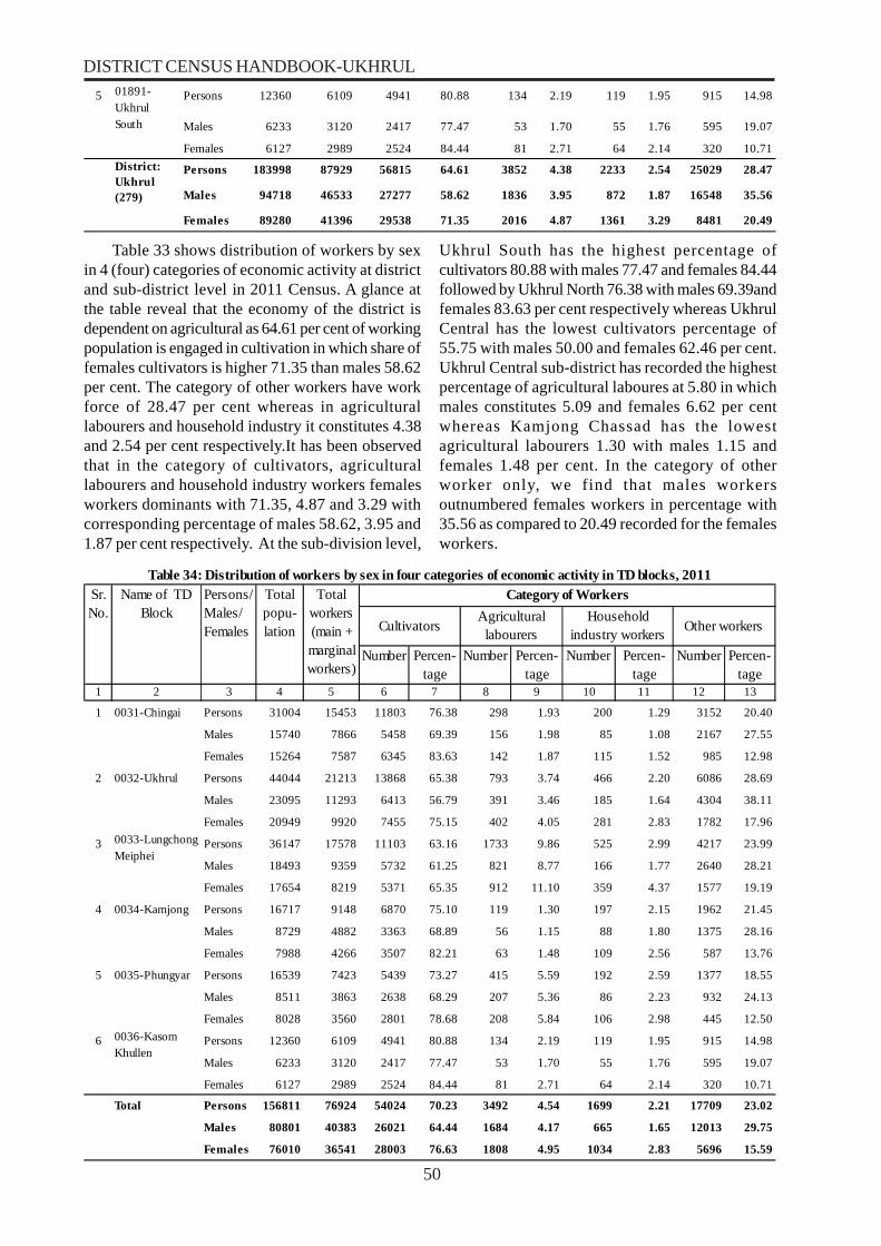
50
DISTRICT CENSUS HANDBOOK-UKHRUL
Number Percen-tage
Number Percen-tage
Number Percen-tage
Number Percen-tage
1 2 3 4 5 6 7 8 9 10 11 12 13
1 0031-Chingai Persons 31004 15453 11803 76.38 298 1.93 200 1.29 3152 20.40
Males 15740 7866 5458 69.39 156 1.98 85 1.08 2167 27.55
Females 15264 7587 6345 83.63 142 1.87 115 1.52 985 12.98
2 0032-Ukhrul Persons 44044 21213 13868 65.38 793 3.74 466 2.20 6086 28.69
Males 23095 11293 6413 56.79 391 3.46 185 1.64 4304 38.11
Females 20949 9920 7455 75.15 402 4.05 281 2.83 1782 17.96
3 Persons 36147 17578 11103 63.16 1733 9.86 525 2.99 4217 23.99
Males 18493 9359 5732 61.25 821 8.77 166 1.77 2640 28.21
Females 17654 8219 5371 65.35 912 11.10 359 4.37 1577 19.19
4 0034-Kamjong Persons 16717 9148 6870 75.10 119 1.30 197 2.15 1962 21.45
Males 8729 4882 3363 68.89 56 1.15 88 1.80 1375 28.16
Females 7988 4266 3507 82.21 63 1.48 109 2.56 587 13.76
5 0035-Phungyar Persons 16539 7423 5439 73.27 415 5.59 192 2.59 1377 18.55
Males 8511 3863 2638 68.29 207 5.36 86 2.23 932 24.13
Females 8028 3560 2801 78.68 208 5.84 106 2.98 445 12.50
6 Persons 12360 6109 4941 80.88 134 2.19 119 1.95 915 14.98
Males 6233 3120 2417 77.47 53 1.70 55 1.76 595 19.07
Females 6127 2989 2524 84.44 81 2.71 64 2.14 320 10.71
Total Persons 156811 76924 54024 70.23 3492 4.54 1699 2.21 17709 23.02
Males 80801 40383 26021 64.44 1684 4.17 665 1.65 12013 29.75
Females 76010 36541 28003 76.63 1808 4.95 1034 2.83 5696 15.59
Sr. No.
Table 34: Distribution of workers by sex in four categories of economic activity in TD blocks, 2011
Other workers
Category of WorkersName of TD Block
Persons/ Males/ Females
Total popu-lation
0033-Lungchong Meiphei
0036-Kasom Khullen
Total workers (main + marginal workers)
CultivatorsAgricultural
labourersHousehold
industry workers
Table 33 shows distribution of workers by sexin 4 (four) categories of economic activity at districtand sub-district level in 2011 Census. A glance atthe table reveal that the economy of the district isdependent on agricultural as 64.61 per cent of workingpopulation is engaged in cultivation in which share offemales cultivators is higher 71.35 than males 58.62per cent. The category of other workers have workforce of 28.47 per cent whereas in agriculturallabourers and household industry it constitutes 4.38and 2.54 per cent respectively.It has been observedthat in the category of cultivators, agriculturallabourers and household industry workers femalesworkers dominants with 71.35, 4.87 and 3.29 withcorresponding percentage of males 58.62, 3.95 and1.87 per cent respectively. At the sub-division level,
Ukhrul South has the highest percentage ofcultivators 80.88 with males 77.47 and females 84.44followed by Ukhrul North 76.38 with males 69.39andfemales 83.63 per cent respectively whereas UkhrulCentral has the lowest cultivators percentage of55.75 with males 50.00 and females 62.46 per cent.Ukhrul Central sub-district has recorded the highestpercentage of agricultural laboures at 5.80 in whichmales constitutes 5.09 and females 6.62 per centwhereas Kamjong Chassad has the lowestagricultural labourers 1.30 with males 1.15 andfemales 1.48 per cent. In the category of otherworker only, we find that males workersoutnumbered females workers in percentage with35.56 as compared to 20.49 recorded for the femalesworkers.
5 Persons 12360 6109 4941 80.88 134 2.19 119 1.95 915 14.98
Males 6233 3120 2417 77.47 53 1.70 55 1.76 595 19.07
Females 6127 2989 2524 84.44 81 2.71 64 2.14 320 10.71
Persons 183998 87929 56815 64.61 3852 4.38 2233 2.54 25029 28.47
Males 94718 46533 27277 58.62 1836 3.95 872 1.87 16548 35.56
Females 89280 41396 29538 71.35 2016 4.87 1361 3.29 8481 20.49
District: Ukhrul (279)
01891-Ukhrul South
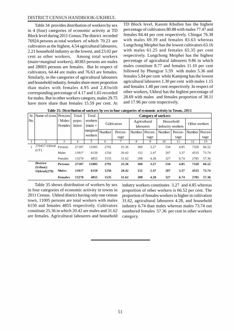
51
DISTRICT CENSUS HANDBOOK-UKHRULTable 34 provides distribution of workers by sex
in 4 (four) categories of economic activity at TDBlock level during 2011 Census.The district recorded76924 persons as total workers of which 70.23 arecultivators as the highest, 4.54 agricultural labourers,2.21 household industry as the lowest, and 23.02 percent as other workers. Among total workers(main+marginal workers), 40383 persons are malesand 28003 persons are females. But In respect ofcultivators, 64.44 are males and 76.63 are females.Similarly, in the categories of agricultural labourersand household industry, females share more proportionthan males with females 4.95 and 2.83withcorresponding percentage of 4.17 and 1.65 recordedfor males. But in other workers category, males 29.75have more share than females 15.59 per cent. At
TD Block level, Kasom Khullen has the highestpercentage of cultivators 80.88 with males 77.47 andfemales 84.44 per cent respectively. Chingai 76.38with males 69.39 and females 83.63 whereasLungchong Meiphei has the lowest cultivators 63.16with males 61.25 and females 65.35 per centrespectively. Lungchong Meiphei has the highestpercentage of agricultural labourers 9.86 in whichmales constitute 8.77 and females 11.10 per centfollowed by Phungyar 5.59 with males 5.36 andfemales 5.84 per cent while Kamjong has the lowestagricultural labourers 1.30 per cent with males 1.15and females 1.48 per cent respectively. In respect ofother workers, Ukhrul has the highest percentage of28.69 with males and females proportion of 38.11and 17.96 per cent respectively.
Number Percen-tage
Number Percen-tage
Number Percen-tage
Number Percen-tage
1 2 3 4 5 6 7 8 9 10 11 12 13
1 Persons 27187 11005 2791 25.36 360 3.27 534 4.85 7320 66.52
Males 13917 6150 1256 20.42 152 2.47 207 3.37 4535 73.74
Females 13270 4855 1535 31.62 208 4.28 327 6.74 2785 57.36
Persons 27187 11005 2791 25.36 360 3.27 534 4.85 7320 66.52
Males 13917 6150 1256 20.42 152 2.47 207 3.37 4535 73.74
Females 13270 4855 1535 31.62 208 4.28 327 6.74 2785 57.36
Total workers (main + marginal workers
)270457-Ukhrul (CT)
District (Urban): Ukhrul(279)
Sr. No.
Table 35: Distribution of workers by sex in four categories of economic activity in Towns, 2011
Other workers
Category of workersName of town Persons/ Males/ Females
Total popu-lation Cultivators Agricultural
labourersHousehold
industry workers
Table 35 shows distribution of workers by sexin four categories of economic activity in towns in2011 Census. Ukhrul district having only one censustown, 11005 persons are total workers with males6150 and females 4855 respectively. Cultivatorsconstitute 25.36 in which 20.42 are males and 31.62are females. Agricultural labourers and household
indutry workers constitutes 3.27 and 4.85 whereasproportion of other workers is 66.52 per cent. Theproportion of females workers is higher in cultivation31.62, agricultural labourers 4.28, and householdindustry 6.74 than males whereas males 73.74 outnumbered females 57.36 per cent in other workerscategory.

52
DISTRICT CENSUS HANDBOOK-UKHRUL
53
DISTRICT CENSUS HANDBOOK-UKHRUL
Brief Analysis of village and town directorydata based on Tables 36-45
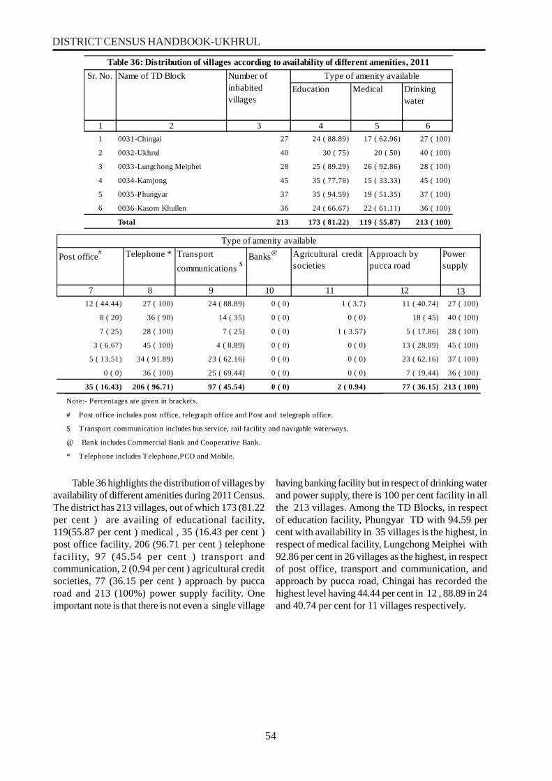
54
DISTRICT CENSUS HANDBOOK-UKHRUL
Education Medical Drinking water
1 2 3 4 5 61 0031-Chingai 27 24 ( 88.89) 17 ( 62.96) 27 ( 100)
2 0032-Ukhrul 40 30 ( 75) 20 ( 50) 40 ( 100)
3 0033-Lungchong Meiphei 28 25 ( 89.29) 26 ( 92.86) 28 ( 100)
4 0034-Kamjong 45 35 ( 77.78) 15 ( 33.33) 45 ( 100)
5 0035-Phungyar 37 35 ( 94.59) 19 ( 51.35) 37 ( 100)
6 0036-Kasom Khullen 36 24 ( 66.67) 22 ( 61.11) 36 ( 100)
Total 213 173 ( 81.22) 119 ( 55.87) 213 ( 100)
Number of inhabited villages
Name of TD BlockSr. No.Table 36: Distribution of villages according to availability of different amenities, 2011
Type of amenity available
Post office# Telephone * Transport communications $
Banks@ Agricultural credit societies
Approach by pucca road
Power supply
7 8 9 10 11 12 1312 ( 44.44) 27 ( 100) 24 ( 88.89) 0 ( 0) 1 ( 3.7) 11 ( 40.74) 27 ( 100)
8 ( 20) 36 ( 90) 14 ( 35) 0 ( 0) 0 ( 0) 18 ( 45) 40 ( 100)
7 ( 25) 28 ( 100) 7 ( 25) 0 ( 0) 1 ( 3.57) 5 ( 17.86) 28 ( 100)
3 ( 6.67) 45 ( 100) 4 ( 8.89) 0 ( 0) 0 ( 0) 13 ( 28.89) 45 ( 100)
5 ( 13.51) 34 ( 91.89) 23 ( 62.16) 0 ( 0) 0 ( 0) 23 ( 62.16) 37 ( 100)
0 ( 0) 36 ( 100) 25 ( 69.44) 0 ( 0) 0 ( 0) 7 ( 19.44) 36 ( 100)
35 ( 16.43) 206 ( 96.71) 97 ( 45.54) 0 ( 0) 2 ( 0.94) 77 ( 36.15) 213 ( 100)
Type of amenity available
Note:- Percentages are given in brackets.
# Post office includes post office, telegraph office and Post and telegraph office.
$ T ransport communication includes bus service, rail facility and navigable waterways.
@ Bank includes Commercial Bank and Cooperative Bank.
* Telephone includes Telephone,PCO and Mobile.
Table 36 highlights the distribution of villages byavailability of different amenities during 2011 Census.The district has 213 villages, out of which 173 (81.22per cent ) are availing of educational facility,119(55.87 per cent ) medical , 35 (16.43 per cent )post office facility, 206 (96.71 per cent ) telephonefacility, 97 (45.54 per cent ) transport andcommunication, 2 (0.94 per cent ) agricultural creditsocieties, 77 (36.15 per cent ) approach by puccaroad and 213 (100%) power supply facility. Oneimportant note is that there is not even a single village
having banking facility but in respect of drinking waterand power supply, there is 100 per cent facility in allthe 213 villages. Among the TD Blocks, in respectof education facility, Phungyar TD with 94.59 percent with availability in 35 villages is the highest, inrespect of medical facility, Lungchong Meiphei with92.86 per cent in 26 villages as the highest, in respectof post office, transport and communication, andapproach by pucca road, Chingai has recorded thehighest level having 44.44 per cent in 12 , 88.89 in 24and 40.74 per cent for 11 villages respectively.
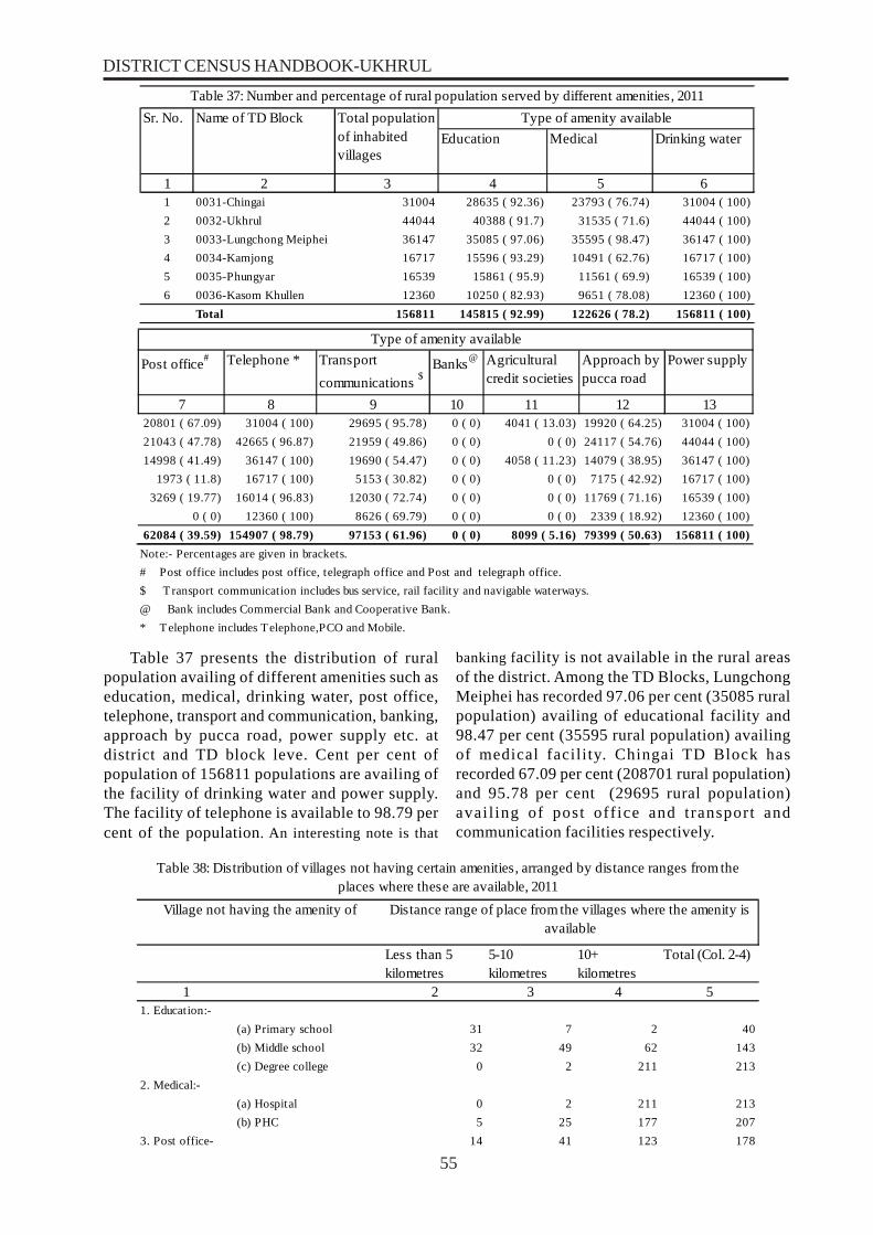
55
DISTRICT CENSUS HANDBOOK-UKHRUL
Post office# Telephone * Transport communications $
Banks@ Agricultural credit societies
Approach by pucca road
Power supply
7 8 9 10 11 12 1320801 ( 67.09) 31004 ( 100) 29695 ( 95.78) 0 ( 0) 4041 ( 13.03) 19920 ( 64.25) 31004 ( 100)21043 ( 47.78) 42665 ( 96.87) 21959 ( 49.86) 0 ( 0) 0 ( 0) 24117 ( 54.76) 44044 ( 100)14998 ( 41.49) 36147 ( 100) 19690 ( 54.47) 0 ( 0) 4058 ( 11.23) 14079 ( 38.95) 36147 ( 100)
1973 ( 11.8) 16717 ( 100) 5153 ( 30.82) 0 ( 0) 0 ( 0) 7175 ( 42.92) 16717 ( 100)3269 ( 19.77) 16014 ( 96.83) 12030 ( 72.74) 0 ( 0) 0 ( 0) 11769 ( 71.16) 16539 ( 100)
0 ( 0) 12360 ( 100) 8626 ( 69.79) 0 ( 0) 0 ( 0) 2339 ( 18.92) 12360 ( 100)62084 ( 39.59) 154907 ( 98.79) 97153 ( 61.96) 0 ( 0) 8099 ( 5.16) 79399 ( 50.63) 156811 ( 100)
Type of amenity available
Note:- Percentages are given in brackets.# Post office includes post office, telegraph office and Post and telegraph office.$ T ransport communication includes bus service, rail facility and navigable waterways.@ Bank includes Commercial Bank and Cooperative Bank.* T elephone includes T elephone,PCO and Mobile.
Table 37 presents the distribution of ruralpopulation availing of different amenities such aseducation, medical, drinking water, post office,telephone, transport and communication, banking,approach by pucca road, power supply etc. atdistrict and TD block leve. Cent per cent ofpopulation of 156811 populations are availing ofthe facility of drinking water and power supply.The facility of telephone is available to 98.79 percent of the population. An interesting note is that
banking facility is not available in the rural areasof the district. Among the TD Blocks, LungchongMeiphei has recorded 97.06 per cent (35085 ruralpopulation) availing of educational facility and98.47 per cent (35595 rural population) availingof medical facility. Chingai TD Block hasrecorded 67.09 per cent (208701 rural population)and 95.78 per cent (29695 rural population)avail ing of post off ice and transport andcommunication facilities respectively.
Less than 5 kilometres
5-10 kilometres
10+ kilometres
Total (Col. 2-4)
1 2 3 4 51. Education:-
(a) Primary school 31 7 2 40(b) Middle school 32 49 62 143(c) Degree college 0 2 211 213
2. Medical:-(a) Hospital 0 2 211 213(b) PHC 5 25 177 207
3. Post office- 14 41 123 178
Table 38: Distribution of villages not having certain amenities, arranged by distance ranges from the places where these are available, 2011
Village not having the amenity of Distance range of place from the villages where the amenity is available
Education Medical Drinking water
1 2 3 4 5 61 0031-Chingai 31004 28635 ( 92.36) 23793 ( 76.74) 31004 ( 100)2 0032-Ukhrul 44044 40388 ( 91.7) 31535 ( 71.6) 44044 ( 100)3 0033-Lungchong Meiphei 36147 35085 ( 97.06) 35595 ( 98.47) 36147 ( 100)4 0034-Kamjong 16717 15596 ( 93.29) 10491 ( 62.76) 16717 ( 100)5 0035-Phungyar 16539 15861 ( 95.9) 11561 ( 69.9) 16539 ( 100)6 0036-Kasom Khullen 12360 10250 ( 82.93) 9651 ( 78.08) 12360 ( 100)
Total 156811 145815 ( 92.99) 122626 ( 78.2) 156811 ( 100)
Sr. No. Name of TD Block Total population of inhabited villages
Type of amenity availableTable 37: Number and percentage of rural population served by different amenities, 2011
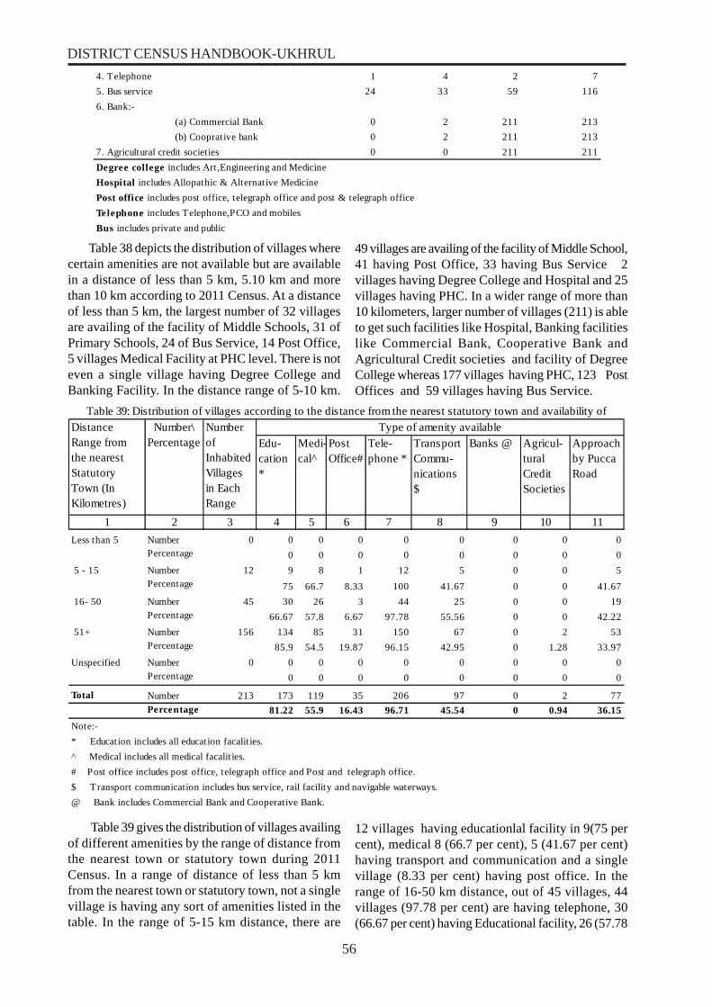
56
DISTRICT CENSUS HANDBOOK-UKHRUL
Table 38 depicts the distribution of villages wherecertain amenities are not available but are availablein a distance of less than 5 km, 5.10 km and morethan 10 km according to 2011 Census. At a distanceof less than 5 km, the largest number of 32 villagesare availing of the facility of Middle Schools, 31 ofPrimary Schools, 24 of Bus Service, 14 Post Office,5 villages Medical Facility at PHC level. There is noteven a single village having Degree College andBanking Facility. In the distance range of 5-10 km.
49 villages are availing of the facility of Middle School,41 having Post Office, 33 having Bus Service 2villages having Degree College and Hospital and 25villages having PHC. In a wider range of more than10 kilometers, larger number of villages (211) is ableto get such facilities like Hospital, Banking facilitieslike Commercial Bank, Cooperative Bank andAgricultural Credit societies and facility of DegreeCollege whereas 177 villages having PHC, 123 PostOffices and 59 villages having Bus Service.
4. Telephone 1 4 2 75. Bus service 24 33 59 1166. Bank:-
(a) Commercial Bank 0 2 211 213(b) Cooprative bank 0 2 211 213
7. Agricultural credit societies 0 0 211 211Degree college includes Art,Engineering and MedicineHospital includes Allopathic & Alternative MedicinePost office includes post office, telegraph office and post & telegraph officeTelephone includes Telephone,PCO and mobilesBus includes private and public
Edu-cation*
Medi-cal̂
Post Office#
Tele-phone *
Transport Commu-nications $
Banks @ Agricul-tural Credit Societies
Approach by Pucca Road
1 2 3 4 5 6 7 8 9 10 11Less than 5 Number 0 0 0 0 0 0 0 0 0
Percentage 0 0 0 0 0 0 0 0 5 - 15 Number 12 9 8 1 12 5 0 0 5
Percentage 75 66.7 8.33 100 41.67 0 0 41.67 16- 50 Number 45 30 26 3 44 25 0 0 19
Percentage 66.67 57.8 6.67 97.78 55.56 0 0 42.22 51+ Number 156 134 85 31 150 67 0 2 53
Percentage 85.9 54.5 19.87 96.15 42.95 0 1.28 33.97Unspecified Number 0 0 0 0 0 0 0 0 0
Percentage 0 0 0 0 0 0 0 0
Total Number 213 173 119 35 206 97 0 2 77Percentage 81.22 55.9 16.43 96.71 45.54 0 0.94 36.15
Note:-* Education includes all education facalit ies.^ Medical includes all medical facalit ies.# Post office includes post office, telegraph office and Post and telegraph office.$ T ransport communication includes bus service, rail facility and navigable waterways.@ Bank includes Commercial Bank and Cooperative Bank.
Table 39: Distribution of villages according to the distance from the nearest statutory town and availability of Type of amenity availableDistance
Range from the nearest Statutory Town (In Kilometres)
Number of Inhabited Villages in Each Range
Number\ Percentage
Table 39 gives the distribution of villages availingof different amenities by the range of distance fromthe nearest town or statutory town during 2011Census. In a range of distance of less than 5 kmfrom the nearest town or statutory town, not a singlevillage is having any sort of amenities listed in thetable. In the range of 5-15 km distance, there are
12 villages having educationlal facility in 9(75 percent), medical 8 (66.7 per cent), 5 (41.67 per cent)having transport and communication and a singlevillage (8.33 per cent) having post office. In therange of 16-50 km distance, out of 45 villages, 44villages (97.78 per cent) are having telephone, 30(66.67 per cent) having Educational facility, 26 (57.78
57
DISTRICT CENSUS HANDBOOK-UKHRUL
Note:- Percentages are given in brackets.
* Education includes all education facalities.
^ Medical includes all medical facalit ies.
# Post office includes post office, telegraph office and Post and telegraph office.
$ T ransport communication includes bus service, rail facility and navigable waterways.
@ Bank includes Commercial Bank and Cooperative Bank.
* Telephone includes Telephone,PCO and Mobile.
per cent) having medical facilities, 25 (55.56 percent ) having transport and communication, 19(42.22 per cent ) having Pucca Road facility. Further,in the highest range of distance of more than 51km, out of 156 villages in total, 150 villages (96.15per cent) are having telephone facility, 134 (85.9per
cent) having educational facility, 85 villages(54.49%) having medical facility, 31 villages(19.87%) having post office, 67 villages (42.95%)having transport and communication, 2 (1.28 percent) having agricultural credit societies and 53villages (33.97 per cent) having Pucca Road facility.
Education* Medical̂ Drinking water
Post office #
1 2 2 3 4 5 61-499 Number 120 85 41 120 4
Percentage 70.83 34.17 100 3.33500-999 Number 49 45 39 49 10
Percentage 91.84 79.59 100 20.411000 - 1999 Number 30 29 26 30 13
Percentage 96.67 86.67 100 43.332000 - 4999 Number 13 13 12 13 7
Percentage 100 92.31 100 53.855000 - 9999 Number 0 0 0 0 0
Percentage 0 0 0 010000 + Number 1 1 1 1 1
Percentage 100 100 100 100District Total Number 213 173 119 213 35
Percentage 81.22 55.87 100 16.43
Number of inhabited villages in each range
Population range
Number\ PercentageTable 40: Distribution of villages according to population range and amenities available, 2011
Type of amenity available
Telephone * Transport communications $
Banks@ Agricultural credit societies
Approach by pucca road
Power supply
7 8 9 10 11 12114 44 0 0 37 120
95 36.67 0 0 30.83 10048 22 0 0 15 49
97.96 44.9 0 0 30.61 10030 19 0 0 14 30
100 63.33 0 0 46.67 10013 11 0 2 10 13
100 84.62 0 15.38 76.92 1000 0 0 0 0 00 0 0 0 0 01 1 0 0 1 1
100 100 0 0 100 100206 97 0 2 77 213
96.71 45.54 0 0.94 36.15 100
Type of amenity available
58
DISTRICT CENSUS HANDBOOK-UKHRULTable 40 reveals the distribution of villages by
range of population with amenities available inpercentage as per 2011 Census. In the populationrange of 1-499, largest number of 120 villages fallsout of total 213 villages for the district as a whole.Out of 120 villages, 120 villages (100 per cent ) arehaving amenities- drinking water and power supply,85 (70.83 per cent ) having educational facility, 41(34.17 per cent ) having medical facility, 114 (95 percent ) having telephone, 44 (36.67 per cent ) havingtransport and communication and 37 (30.83 per cent) having pucca road facility. The second populationrange of 500-999 covers 49 villages, and all 49 villages(100 per cent) are availing of drinking water and
power supply; educational facility is available in 45villages (91.84 per cent), medical facility in 39 (79.59per cent), post office in (20.41 per cent), telephonein 48 (97.96 per cent), transport and communicationin 22 (44.9 per cent) and pucca road in 15 villages(30.61 per cent ). In the population range of 1000-1999, out of 30 villages, all 30 have (100 per cent )drinking water, telephone and power supply whereas29 villages 96.67 per cent ) getting educational facility,26 (86.67 per cent ) medical facility, 19 (63.33)transport and communication, 14 (46.67) pucca roadand 13 (43.33 per cent ) post office. On the otherhand, in the remaining population ranges, distributionof villages with such amenities is negligible.
Sr.No. Name of TD Block Number of inhabited villages
Total area (in Hectares)
Percentage of cultivable area to total area
Percentage of irrigated area to total cultivable area
1 2 3 4 5 61 0031-Chingai 27 0.00 0.00 0.002 0032-Ukhrul 40 0.00 0.00 0.003 0033-Lungchong Meiphei 28 0.00 0.00 0.004 0034-Kamjong 45 0.00 0.00 0.005 0035-Phungyar 37 0.00 0.00 0.006 0036-Kasom Khullen 36 0.00 0.00 0.00
Total 213 0.00 0 0.00Note:- Culativable area= irrigated area + unirrigated area
Table 41: Distribution of villages according to land use, 2011
Table 41 shows distribution of villages accordingto land use in Ukhrul district. The Directorate of LandRecord, Government of Manipur has not yet surveyed
the land areas of the district and hence land use datafor all the villages falling in Ukhrul district is notavailable.
Primary Middle Secondary / matriculation
Senior secondary
College
1 2 3 4 5 6 71 270457-Ukhrul (CT) 4.41 4.78 4.41 2.57 0.00
Total 4.41 4.78 4.41 2.57 0.00
Table 42: Schools/ colleges per 10,000 population in towns, 2011Type of educational institutionName of the townSr. No.
Table 42 provides the distribution of schoolsand colleges per 10000 population in towns as per2011 Census record. The Ukhrul district has onlyone census town. So, the information relating tothe Ukhrul census town itself represents theinformation for the whole district. In urban region
of Ukhrul district, number of institutions per 10000populations available is 4.41 for Primary Schools,4.78 for Middle Schools, 4.41 for Secondary/Matriculation and 2.57 for Senior SecondarySchools but institute like college is not available inthe town.
Sr. No. Name of the town Number of beds in medical institutions per 10,000 population
1 2 31 270457-Ukhrul (CT) 22.07
Total 22.07
Table 43: Number of beds in medical institutions in towns, 2011
Table 43 highlights the distribution of number ofbeds in medical institutions per 10000 population intowns according to 2011 Census record. Number ofbeds in medical institutions per 10000 populations inUkhrul census town is 22.7.
59
DISTRICT CENSUS HANDBOOK-UKHRUL
Sr. No. Name of the town Name of three most important commodities manufactured
1 2 31 270457-Uk h ru l (C T) C an e An d Bam boo Produ ct
Table 45: Most important commodity manufactured in towns , 2011 Table 45 shows that the most important
commodity manufactured in towns according to 2011Census is cane and bamboo product, handloomproduct and embroidery.
1 2 3 4 5
Table 44 : Proportion of slum population in towns, 2011Sr.No.
There is no notified or recognised slum in the District
Name of the town having slum
Total population Slum population
Percentage of slum population to total population
60
DISTRICT CENSUS HANDBOOK-UKHRULMajor Social and Cultural Events, natural andadministrative development during the decade2001-2011
Ukhrul is dominated by the Tangkhul Nagas. Theyhave a rich culture. Each cultural activity is centredon the propitiation of deity known as ‘Kameo”. Theyhave their own traditional folk dance known as‘Pheichak’. Pheichak occupies an important place inthe live of the Tangkhul. There are many forms ofpheichak and every pheichak depicts or expressesthe life of the people. Raiyot is the war dance whichis performed before and after going to war. Luivatyot,Shomkhapyot, Luirayot etc. are different forms ofPheichak associated with agricultural life of thepeople. The life and art of the Tangkhul are attractiveand captivating. Their different costumes, utensils,architecture, monuments and memorials depict theirdexterity in art, which also speak of their sense ofbeauty and finesse.Fairs & Festivals
The ancestors were agriculturists and the yearcycle festivals are associated with the year-roundseasonal agricultural activities. All these festivalsassociated with sacred religious rituals and there werestrict codes of conduct for all these feasts. The majoryear cycle festivals are:-
LuiraThe seed sowing festival which falls around the
month s of January to March. This feast is celebratedwith great fervor at Longpi and Hundung. Longpi,befitting their generosity, entertain their guests withlavish eats and drinks, whilest in Hundung one cansee the maiden virgin dance performance.
Yarra
This is ante-cultivation festival and it falls aroundthe months of April and May. Thought it celebratedby all, it is a youth festival.
Mangkhap
Post-trans-plantation festival. This festival fallsaround the month of July. During this festival thepeople pray for luxurious growth the crops afterthanksgiving prayer for the timely rain.
Darreo
This is a pre-harvest festival. means the pluckingof the new crop. On this day the first crops, fishes,live-stocks and other items are brought out for salein the village market. It is fete day for the village.This day specially observed in Hundung village.
Chumpha
This is a festival of thanksgiving for rich harvest,now gathered in the granary. The mother performs
special offerings to the God of harvest and the keeperof the granary. While the mother performs her ritualsall males are not allowed to enter the house, hencethey outside the house for the night but with lavishsupplies of eats and drinks. Because of the nature ofits celebration, it is sometimes known as the Feast ofthe mother or the Feast of the granary. It falls aroundthe months November and December.
Longra Khamang :
This festival is not general in nature but the familywhich had a rich harvest celebrates this festivalinviting the group of the son’s or daughter’s partywho had worked in groups rotation-wise. This is afestival for giving special treatments to the sons anddaughters.
Thisham :
Thisham is a festival in commemoration of thedead. It is on this occasion that the dance of the Deadis performed. This is the final rite performed by thefamily for the dead. It falls around the month ofJanuary.
Apart from these 6 (six) major festivals, theresome event-occasioned festivals like; KashongKahao Zakhalat, a sacred ritual for dispelling pestsand germs;Maa Khungkashat, acknowledgement ofthe rich crop. Ears of corn are plucked and placed ata post set apart for this sacred ritual in the house;Mawonzai, a feast to invoke the graceful blessingsof God to human labour; Khana Kasa, a purificationand naming feast; Ming Kaphok , this is a titleendowment feast; Chumsin Sa Kashai, this is theordaining feast of the daughter-in-low to priestess-hood, thereby endowing her with all the rights andduties of a family mother. Prior to this, she is noallowed to enter into the granary; Shimsak Kasa, thisis the royal or noble house construction feast; Maran-sak & Tarung Khangkasang, stone or tree trunkserection feast to display the wealth and power of thenoble.
Brief description of places of religious,historical or archaeological importance invillages and places of tourist interest in thetowns of the districts.
Ukhrul has so many Tourist attractions to visit.Here NativePlanet Provides you List of Tourist Placesto Visit in Ukhrul to give you the detailed informationabout each and every places for your Travel in Ukhrul.
Duncan park, Ukhrul
oreThe Duncan Ecological Park is one of largest parksin Ukhrul district. Located 3 kilometres fromthe Ukhrul district headquarters in Phungrei, it is a
61
DISTRICT CENSUS HANDBOOK-UKHRULpopular picnic spot. It was established in the year1984. The children’s park inside its campus is a crowd-puller and locals are regularly seen revelling in theopen spaces.
However, over the years the park’s condition hasdeteriorated to a large extent mainly due to lack ofmaintenance. The government has also failed to takeany steps to promote the Duncan ecological park.Measures are now being taken to improve thecondition of the large park, and one of the first stepstowards it has been the inclusion of a children’s park.Local leaders have been very vocal about theirconcern for improving the conditions of the park.Many have said that steps should be taken to planttrees in the park.
Kachouphung Lake, Ukhrul
Situated on the slopes of the Achuwa Magi Hills,Kachouphung Lake is a natural lake close to Ukhrul.It is 7 kilometres from Khayang Falls. The lake isspread over 9 acres and is roughly shaped formingthe Indian map. The size of the lake usually increasesduring the rainy season, and if the water from thenearby Nily River is added, the size will furtherincrease.
The Kachouphung Lake is bound by severalhillocks on all side heightening the beauty of the place.The lake has tremendous potential to attract tourists.Many colourful fish live on the lake thus increasingthe scope for pisciculture too.
The lake is also called Azoa Jenephiu Magi Lakeof Ukhrul. The Kachouphung Lake is an ideal locationto spend a day amidst fresh water and beautifulhillocks all around. Climbing the small knolls can bequite an exciting exercise too.
Khangkhui Cave, Ukhrul
The Khangkhui Cave, locally called theKhangkhui Mangsor Cave, is essentially a naturallimestone cave. Archaeologists have discovered manyimportant artefacts, dating back to the Palaeolithicculture, from this cave. There is also a huge hall insidethe cave, which is known as the durbar hall of thedevil king. The northern hall inside the cave is believedto be his royal bedroom, where he used to live withhis two wives. There are two separate chambersinside the cave for his first and second wives. Thecave is about 11 km away from Ukhrul city, whichwas used as a shelter by the local people during WorldWar II.
Shirui Kashong Peak, Ukhrul
Shirui Kashong Peak is a popular tourist attraction,lying at an altitude of 2,835 metres above sea level.The peak is famous for two main reasons- most of
the major rivers flowing across Ukhrul originate fromthe slopes and crevices of the peak. Secondly, it isthe place where the famous Shirui lilies grow in thisplace. The flower blooms for a short period of timeduring the months of May and June.
The Shirui lily (which has been declared as thestate flower of Manipur) grows only here thusattracting many botanists from around the world. Thelocals call the flower Kashing Timrawon andaccording to local believe, a kind spirit rests on theflower.
The Shirui Kashing Peak is also home to rarebirds such as Mrs. Hume’s bar-backed pheasant andBlyth’s Tragopan. The peak is just 18 kilometres awayfrom Ukhrul lying to the east of the districtheadquarters.
Ango Ching
A virgin forest cover yet unknown too many,Ango Ching is a place to reckon. Covering a forestarea of 150 sq. kms, Ango Ching lies on the Myanmarborder in the east while on the west the Sanalok(Chamu) River flows, the Kachouphung lies in thenorth and Chatric is in the south.
The way to the forest cover is mostlyinaccessible as it passes through difficult terrain. Sinceit is yet unexplored, the natural beauty of the place ismore or less intact. It is a heaven of flora and fauna.Elephants, Sambar, tigers barking deer, deers, wildbison, black bear, hook lock, leopard, horn bills, wildcat, peacock Tragopan are some of the animals foundin the Ango Ching forest.
It is also a bio-diversity hub and needs adequateconservation. The government needs to step up itsconversation plans to sustain such a heavenly place.
Khayang Peak
The Khayang Peak is the highest peak of Ukhruldistrict. It lies at an altitude of 3114 metres above sealevel. The peak truly gives a complete kaleidoscopic viewof the entire region- the flowing hills, the winding streams,undulating valleys and the colourful hamlets. The viewfrom the Khayang Peak is magical in simple words.
Trekking up the hill to reach the peak is a favouriteactivity of many locals as well as tourists. Whiletrekking up the hill, one will witness beautiful sceneryall around that is bound to mesmerise one and all.However, the Khayang peak is not very popularmainly because the adjoining Shirui Kashung Peak ismore easily accessible and more popular.
Travelling to Khayang Peak from Ukhrul townis not difficult. Private vehicles can be hired or elseif anyone is interested in trekking, they can also walkup the hills.
62
DISTRICT CENSUS HANDBOOK-UKHRULKhayang Waterfalls
The Khayang waterfalls in the biggest waterfallsin Manipur near the Indo-Myanmar border. Thewaterfall is also called the Telly Waterfalls, thoughthe locals know it by the name Khayang. Accordingto the survey done by the district commissioner ofUkhrul, the height of the waterfalls is 754 feet.
It is a majestic waterfall that slowly cascadesdown the hills. However, it is quite tucked away insidethe jungles of Ukhrul and is not yet a popular touristdestination. Moreover, the government hasn’t takenmuch initiative to promote the waterfalls.
It takes almost 5 to 6 days of full-day trekkingover jungles, crossing rivers that one can reach thewaterfalls. Though the effort is much, the end resultcannot be justly described in words. For theadventurers who prefer travelling the unbeaten roads,a visit to the Khayang Waterfalls is definitely worthit. Make sure that proper arrangements are madebefore trekking to the waterfalls.
El Shadai Park
Though abundant open spaces are one of thereasons tourists visit Ukhrul, the numerous parks addto the attraction in many ways. The El Shadai Parksituated right at the heart of the Ukhrul town is onesuch park popular among the tourists and locals alike.
Being right at the centre of the town, it is alwaysfilled with people. Children can be seen playing inthe open grounds while the adults enjoy a walk aroundthe park. The park is well connected to the otherparts of the town and buses, private cabs as well asauto rickshaws are available to reach the place.The park is embedded with beautiful flowers thatsprinkle the area with colours. Walking on the shadesof the blooming trees relaxes not just a tired body butalso lifts the spirits. The El Shadai Park is an idealplace to spend a well-spent day of touring the outskirtsof Ukhrul.
Japanese Pond
Japanese Pond is a pond located in Ukhrul city.The pond is used for commercially breeding fish. Thearea around the pond is used for terrace farming andhas been adding to the economy of the districtsubstantially. The large pond and the accompanyingarea around also add to the beauty of green Ukhrul.
The fish here are specially reared in the JapanesePond amidst all modern infrastructures. The specialattention that is given to the fish here has helpedimprove the quality as well the quantity. The initiativeto use the Japanese Pond for pisciculture has beenapplauded by locals and has increased theemployment opportunity too. The fish from the pond
is also used for trade.Since the Japanese Pond is located within Ukhrul citythus it can easily be reached on foot or on autorickshaws. Private and state-run buses also ply onthis route.
Lunghar Sihai Phangrei
Lunghar Sihai Phangrei is a long, flat hill rangein the Ukhrul district. The Sihai Phangrei is a popularpicnic spot of the locals also frequented by tourists.The Sihai Phangrai, also spelled as Sihai Phangreijoins the Shirui Peak which is famous for the ShiruiLilies.
The Lunghar Sihai Phangrei is very rich in flora.A variety of flowers and fruits grows in the hill rangeincluding rare orchids and fruits such as grapes,passion fruit, apple, pear, plum, peach etc.There is abeautiful and serene waterfall that cascades downthe hill range adding to the beauty of the place. Aday spent on the Lunghar Sihai Phangrei is somethingthat will stay clearly etched out in anyone’s mindbecause of its virgin beauty.The term ‘Sihai’ is ageneral reference term used for a group of villagesin Ukhrul including Sihai Khullen, Sihai Khunou andSihai Kahaophung.
Transport and Telecommunication
Transport and communication is the basicinfrastructure needed for generation ofeconomicactivity. A well-developed transport andcommunication system plays a vital role in ensuringsustained economic growth. Roads are the life lineof the people of the district of Ukhrul as there arepractically no other means of transport andcommunication Two National Highways viz. NH-39and NH-150 pass through the district. The majorroads in the district are: (i) Imphal-Ukhrul-Jessami(NH-150)- 199km. (ii) Imphal - Kamjong (BRTF)-127 km. (iii) Imphal - Phungyar -Tengnoupal (NH-39)- 104 Km. (iv) Imphal - Kasom Khullen (PWD) -55 km. As length of roads by classification in thedistrict, the National Highways occupy 165 km (asin 2002) while as in 2010-11, the State Highwaysoccupy 209.20 km, Major District Roads 77 km, otherDistrict Roads 296.58 km and Inter Village Roads1121.32 km. Manipur has road density of 56.51 kmper 100 sq. km. against the all India average of 62km. But Ukhrul district has 41.13 km. The inter-district road density in 2002 for Ukhrul was 24.47km per 100 square km, which is much lower thanthe state average of 51.2 km per 100 square km.Altogether 32 percent villages in the district areconnected by all weather roads. Pathetic roadcondition in the hill districts of the state has alwaysbeen detrimental for their development.
63
DISTRICT CENSUS HANDBOOK-UKHRULAllied to the transport system is the
communication system. The communication systemcomprises of postal services, telegraph services,telephone services, Internet services, etc. As per theEconomic Survey of Manipur 2007-08, the districtUkhrul had only one telephone exchange, 3 combinedoffices (post and telegraph) and 655 telephone (DEL)connections. It had a total of 35 public call officeswith 2 local and 33 STD connections in 2005-06. Thedistrict is served by three sub-Post Offices and fiftyfour Branch Offices.
Veterinary and Animal Husbandry:
In the essentially agrarian economy of the district,animal husbandry is an important source of income.Important livestock found in the district are cattle,sheep, goats, pigs dogs etc. They are reared for milkand meat and also for motive power in cultivationworks. Fowls and ducks are the most importantpoultry of Ukhrul. As per the Economic Survey ofManipur 2007-08 (based on the Livestock CensusReport 2003) Ukhrul had 28953 cattles, 18090buffaloes, 43809 pigs, 841 goats, 15 sheep, 9266mithun, 12534 dog and 55 horses and ponies. Thedistrict has 15 percent of the total livestock populationand 15 percent of the poultry population of the hilldistricts. The veterinary infrastructure in the districtcomprises 6 (six) veterinary hospitals, 18 (eighteen)veterinary dispensaries, 4 (four) Cross Breeding (A.I.)Centres as in the year 2010-11.
Agriculture:
Agriculture is the most important source oflivelihood for the people of the district. More than 70per cent of the total population of the district is directlyor indirectly depended on agricultural activities. Rice,Maize, Potato, Pulse, Cabbage, Leafy vegetable,chillies, groundnuts etc. are the main agriculturalproducts. Banana, sugarcane, fruits like lemon andorange are also planted. Plantation of cotton is alsodone for their domestic consumption. Jhum cultivationis practised in the southern and eastern parts ofUkhrul district. In some cases the shifting cultivationis practiced in small pockets keeping the adjoiningarea for regeneration. Thus, after 2-3 years theycultivate a fresh piece of land, which was kept underforest for about 8-10 years, which gives better yield.Besides jhuming cultivation, terraced and wetcultivation particularly in low lying areas arepractised.
Education and Adult Education
An important indicator of human development isthe literacy rate. The size andproportion of literateand educated population gender wise has significant
bearing on the socio-economic development. Whileliteracy and education in general has direct positiveimpact on social and economic development ofcommunities, the female literacy rate is moreintrinsically linked to health and social developmentof the child.
Major Characteristics of the District,Contribution of The District In The Form of AnyHistorical Figure Associated With The District:
Ukhrul District is best introduced by its beautifulShirui Lily, Lilium Mackleanae Sealy, grown only onthe peak of Shirui Kashung, some 18 Km. East ofthe district HQ. Shirui Lily was declared the StateFlower by the Government of Manipur in 1989 onMarch 21. An area of 100 Sq. Km. around ShiruiPeak has been declared as the National Park in 1998by the Government of Manipur.
The District is gifted with rich flora and fauna.There are hundreds of varieties of trees, barderianflowering plants, orchids of enumerable hues andkinds, Epiphetic ferns, varied species of plants andshrubs. Some of the known species of plants andtrees are : Alder (Alnus nepalensis), Prunuscirosirdes, Symingtonia, Acacia auriculifornis, Parkiajavanica, Paraserrianthes falcotaria, Michelia oblanga,Cmilina arborea, pinus kerya, robinea psedudoacacia,besides various iris species, wild roses, red and whiterhododendrons etc.
There are three lakes in the district namely,Achau Maki, Khamtak Ngayi and Kachawui. Theselakes are associated with different folk stories. Themost famous lake in the region is Achau Maki thatlies in Kachouphung Mountain range. It is wonderfor many, as the water never dries up throughout theyear although it is situated at a high altitude. The waterdoes not flow out from the lake nor it is seen how thespring water erupts into the lake. It remains silent.
One of the historically related caves in Ukhruldistrict is Khangkhui Mangsor located about 15 kmeast of Ukhrul. Since the cave is located within thearea of Kangkhui village. It is generally known asKangkhui cave(Mangsor). It comprises of two largechambers and five tunnels.The Khangkhui mangsor(cave) is one of the wonders of nature. Many legendsand folklores are associated with Mangsor Cave tellsof the deity of Mangsor as a very powerful spiritwho is benevolent and romantic .He had two wives.The first wife hailed from Shirui peak and had noissue and the second wife was from Koubru hills ofSenapati District. One chamber each was allotted toboth the wives, the better and bigger one to the firstwife and lesser but more rooms to the second wife,implying that she had issues. Khangkhui Cave is a
64
DISTRICT CENSUS HANDBOOK-UKHRULremarkable natural lime- stone cave. The big hall inthe cave is the darbar hall of the Devil King livingdeep inside while the northern hall is the royalbedroom, according to another local folklore. DuringWorld War II, the villagers sought shelter in this cave.
Shangshak War Memorial
The Shangshak War Memorial is one of thehistorical monuments built in memory of the first battlein Indian soil during the Second World War betweenthe Japanese and the allied forces fought inShangshak. The battle of Shangshak fought for twoweeks from 21 to 26 March 1944 is considered asone of the bloodiest battles of the Second World war.
Scope of Village and Town Directory
Village Directory
The Village Directory provides amenities andland use data for each village within every Sub-Division/Community Development block of thedistrict. The villages refer to the revenue villagesand other clusters of habitation located outside anyrevenue village. They are arranged according totheir location code in ascending order. For facilityof the readers an alphabetical list of the villagesalong with their location numbers for both 1991 and2001 for each C.D. Block is also provided at thebeginning of the Village Directory. The Directory ispreceded by a map of the concerned sub-division inwhich the location of all the villages is indicated.
To help understanding easily the VillageDirectory data a note explaining the codes used ordenoting various amenities is given at the beginning.Besides the village name and the correspondinglocation code the village level data furnished in theVillage Directory are area, number of householdsand population, availability of basic amenities, meansof approach to the village, its distance from thenearest town, availability of power supply and newspaper/magazine, important commoditiesmanufactured and land use data. Amenities - dataare divided under the sub-heads of educational,medical, drinking water, post & telegraph andtelephone, communication, (i.e., presence of bus stop,railway station and waterway), availability of banks,number of agricultural and non-agricultural creditsocieties and number of co-operative societies.Under cultural and recreational facilities data onnumber of cinema/video hall, sports club andstadium/auditorium are provided. Land use dataconsists of area under different types of land such
as forest, irrigated, un-irrigated, cultural waste andarea not available for cultivation. Cultivable land isclassified into areas of wet rice cultivation and dryrice cultivation. In respect of the states of ArunachalPradesh, Manipur, Mizoram and Nagaland wherejhum cultivation is prevalent the village directoryformat has been suitably modified to provide dataon the total area under jhum cultivation, period ofrotation and main crops under jhum cultivation.
There are 9 appendices to the Village Directory.Appendix –I is divided into three sub-parts andAppendix – II has one sub part. The appendicesadopted in 2001 Census are presented below:-
Appendix – I A - Villages by number of Primary Schools
This appendix gives the number of inhabitedvillages in each C.D. Block classified the numberof villages having no primary school, one, two, threeand more than four primary schools.
Appendix – I B – Villages by Primary,Middle and Secondary Schools
This appendix also presents the number ofinhabited villages, in each C.D.Block, classified bythe number of villages having no school, villageshaving at least one primary school and no middleschool, villages having at least one primary schooland one middle school and villages having at leastone primary school and one secondary school.
Appendix –I C –Villages by different sourcesof drinking water facilities available
This appendix gives number of villages withdifferent sources of drinking water facilitiesavailable. Sources are divided as only tap, only well,only tube well, only hand pump and more than onesource.
Appendix – II – Villages with 5,000 and abovepopulation which do not have oneor more basic amenities
In this appendix the name of village having 5,000and above population where the amenities of seniorsecondary school, college, primary health sub-centre,tap, drinking water, bus facility, approach by puccaroad and commercial bank are not available.
Appendix presents the name of census townwhere the amenities of Higher Secondary/PUC/Intermediate/Jr.College, College Primary health sub-centre, Tap drinking water, Bus facility, approachby pucca road and Commercial bank are notavailable.

65
DISTRICT CENSUS HANDBOOK-UKHRULAppendix – III - Land utilisation data in respect
of non-municipal towns (CensusTowns )
In this appendix data on the area under forest,irrigation by source, cultivable waste and wastelandnot available for cultivation are given.
Appendix- IV – C.D. Block wise list of inhabitedvillages where no amenity otherthan drinking water facility isavailable
This appendix gives the list of villages whereno educational, medical and public health and otherfacilities are available.
Appendix - V – Summary showing numberof villages not havingScheduled Caste population
This appendix gives the list of inhabited villageshaving no Scheduled Caste population and havingsome Scheduled Caste Population.
Appendix – VI – Summary showingnumbers of villages not havingmay be mentioned as leadingone followed Scheduled Tribepopulation
This appendix gives the list of inhabited villageshaving no Scheduled Tribe population and havingsome Scheduled Tribe population.
Appendix -VII – List of villages according
to the proportion of ScheduledCastes and Scheduled Tribepopulation to the totalpopulation by ranges
It has got two parts, Part A gives the proportionof Scheduled Caste population in ranges of nil, lessthan 5, 5-10, 11-20, 21-30 and 31-40,41-50,51-75 and76 above. Part B is for Scheduled Tribes and theranges are also nil, less than 5, 5-10, 11-20, 21-30and 31-40,41-50,51-75 and 76 and above.
Appendix VIII – Number of villages,households,Population etc.. in each GramPanchayat
This appendix presents the number of villages,households, populations, total Scheduled Castespopulation, total Scheduled Tribes population andincome and expenditure of the Gram Panchayatsin each C.D. Block. This appendix on GramPanchayats is presented for the first time in 2001Census.
Appendix – IX- Statement showing name of girl schools in the villages.
This is a new statement introduced in 2001Census. In this appendix the name of villages havinggirl schools in the categories of primary school,middle school, matriculation/secondary school andhigher secondary/PUC/Intermediate/Junior Collegeis presented.

66
DISTRICT CENSUS HANDBOOK-UKHRUL
67
DISTRICT CENSUS HANDBOOK-UKHRUL
Part A-Village and Town Directory
68
DISTRICT CENSUS HANDBOOK-UKHRUL
Note explaining the abbreviations used in thevillage directory
The “Village Directory” is one of the traditionalcompilations of the Census. It gives the list ofvillages, their location numbers, their area, population,number of households, amenities such as educational,medical, drinking water, post and telegraph,commercial and co-operative banks, agriculturalnon-agricultural and other credit societies,recreational and cultural facilities, communication,approach to village, nearest town with a distance,power supply availability of newspaper andmagazines, most important commodity manufacturedand land use of each village.
Village is a statutory recognized unit having adefinite boundary and separate land records. In case,a complete village is treated as an outgrowth ofurban agglomeration, data on amenities for thatvillage, have not been given in the Village Directorybut shown along with the urban component. Thevillages which are considered as a Census Town ,the amenities data are shown in the TownDirectory. For those villages which have partlymerged in an outgrowth of U.A., the amenities dataare shown in the Village Directory for that particularvillage.
The ‘un-inhabited’ villages ( villages with nopopulation) have been indicated as such afterfurnishing details in columns 1 to 3 i.e., Serialnumber, Name of village & location code numberand area of the village against column no. 4 to 18.The land use data for such villages are shown incol. 19 to 23.
The Village Directory format has 23 columnsand the details given under each column are thevillage are as follows:-
Columns 1 : Serial Number
Self explanatory. All the villages within the CDBlock are presented serially in the ascending orderof their location code number.
Columns 2 : Name and Location Code Number ofvillage.
The name and location code number of thevillage are shown against these columns. This alsoincludes the forest and uninhabited villages.
Column 3 : Area of the village
The area of the villages in hectares are given.Wherever the area figures was not furnished bythe concerned department the column is left blank.
Column 4 : Total population
The total population of the village as per 2001Census is given against this column.
Column 5 : Number of households
The number of households as per 2001 Censusis given in this column.
Amenities :
In column 6 to 23, availability in respect ofdifferent amenities such as education, medical,drinking water, post, telegraph, banks, creditsocieties, communication, power, approach road etc.in each village has been depicted with appropriatecodes against the column concerned. Wherever theamenities are not available in the village, a dash (-) is shown in the column and next to it in bracketsthe distance in broad ranges viz.< 5 kms., 5-10 kms.and 10+ kms of the nearest place where the facilityis available is given. Column wise details are givenbelow:
Column 6 : Educational
Classes upto class V included in PrimarySchool. This will include nursery school,kindergarten school. Pre-basic school, pre-primaryschool, junior basic school upto class V.
Classes from VI to VIII are included in themiddle school.
Classes from IX and X included in Highsecondary school. Classes XI and XII are includedin senior secondary school.
In case of composite schools like middle schoolwith primary school or secondary school with middleschool, these are also included in the number ofprimary and middle schools, respectively.
Village Directory
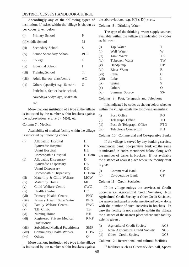
69
DISTRICT CENSUS HANDBOOK-UKHRULAccordingly any of the following types of
institutions if exists within the village is shown asper codes given below :
(i) Primary School P
(ii)Middle School M
(iii) Secondary School S
(iv) Senior Secondary School PUC
(v) College C
(vi) Industrial School I
(vii) Training School Tr
(viii) Adult literacy class/centre AC
(ix) Others (specify) e.g. Sanskrit O
Pathshala, Senior basic school,
Navodaya Vidyalaya, Makhtab,
etc.
More than one institution of a type in the villageis indicated by the number within brackets againstthe abbreviation, e.g. P(3), M(4), etc.
Column 7 : Medical
Availability of medical facility within the villageis indicated by following codes :
(i) Allopathic Hospital HAyurvedic Hospital HAUnani Hospital HUHomeopathic Hospital H Hom
(ii) Allopathic Dispensary DAyurvedic Dispensary DAUnani Dispensary DUHomeopathic Dispensary D Hom
(iii) Maternity & Child Welfare MCW(iv) Maternity Home MH(v) Child Welfare Centre CWC(vi) Health Centre HC(vii) Primary Health Centre PHC(viii) Primary Health Sub-Centre PHS(ix) Family Welfare Centre FWC(x) T.B. Clinic TB(xi) Nursing Home NH(xii) Registered Private Medical RMP
Practitioner(xiii) Subsidised Medical Practitioner SMP(xiv) Community Health Worker CHW(xv) Others O
More than one institution of a type in the villageis indicated by the number within brackets against
the abbreviations, e.g. H(3), D(4), etc.
Column 8 : Drinking Water
The type of the drinking water supply sourcesavailable within the village are indicated by codesas follows :
(i) Tap Water T(ii) Well Water W(iii) Tank Water TK(iv) Tubewell Water TW(v) Handpump HP(vi) River Water R(vii) Canal C(viii) Lake L(ix) Spring S(x) Others O(xi) Summer Source SS-
Column 9 : Post, Telegraph and Telephone
It is indicated by codes as shown below whetherwithin the village exists the following amenities:
(i) Post Office PO(ii) Telegraph Office TO(iii) Post & Telegraph Office PTO(iv) Telephone Connection PH
Column 10: Commercial and Co-operative Banks
If the village is served by any banking service,commercial bank, co-operative bank etc.the sameis indicated in codes mentioned below along withthe number of banks in brackets. If not availablethe distance of nearest place where the facility existis given:
(i) Commercial Bank CP(ii) Co-operative Bank CP
Column 11: Credit Societies
If the village enjoys the services of CreditSocieties i.e. Agricultural Credit Societies, NonAgricultural Credit Society or Other Credit Societies,the same is indicated in codes mentioned below alongwith the number of such societies in brackets. Incase the facility is not available within the villagethe distance of the nearest place where such facilityexist is given :
(i) Agricultural Credit Society ACS(ii) Non- Agricultural Credit Society NCS(iii) Other Credit Society OCS
Column 12 : Recreational and cultural facilities
If facilities such as Cinema/Video hall, Sports
70
DISTRICT CENSUS HANDBOOK-UKHRULClub, Stadium/Auditorium is available in the village,the same is recorded in these columns. If notavailable the particulars of the nearest place withthe facility is recorded. The information is indicatedin codes mentioned below along with the number ofsuch facilities in brackets:
(i) Cinema / Video Hall CV(ii) Sports Club SP(iii) Stadium / Auditorium ST
Column 13 : Communications
If the village is served by any mode of public/ private transport like Bus, Railway station orNavigable water ways they are to be mentioned asfollows:
(i) Bus BS(ii) Railway Station RS(iii) Navigable Waterway NW
Column 14 : Approach to village
Approach to village refers to the state of roadleading to village. The approach to the village isindicated in following codes :
(i) Paved Road PR(ii) Mud road MR(iii) Foot path FP(iv) Navigable River NR(v) Navigable Canal NC(vi) Navigable waterways other than
River, Canal NW
Column 15 : Nearest Town and distance
The distance is given in kilometers in bracketsagainst the name of the town nearest to the village.
Column 16 : Power supply
Availability of Power Supply in the village,whatever may be the form of its use is given byusing following codes :
(i) Electricity for domestic use ED(ii) Electricity for agricultural use EAG(iii) Electricity for other purposes EO(iv) Electricity for all purposes EA
Column 17 : News Paper / Magazine
If village receives any News Paper/Magazinesthe same is noted in this column using followingcodes :
(i) News Paper N
(ii) Magazine M
Column 18 : Most important commoditiesmanufactured
The name of three most important commoditiesmanufactured in the village is recorded against thiscolumn.
Column 19 to 23 : Land use i.e. area under differenttypes of land use
Land use data maintained by the State/ UTGovts. are furnished against these columns. Thedata concerning area under Forest, Irrigated land(by source), Un-irrigated land, Culturable waste andArea not available for cultivation in the village areshown against these columns. The area figures aregiven in hectare(s) up to one decimal. Desh ‘-‘ isrecorded wherever the information is not madeavailable by the concerned department. The codesused for different types of irrigation facilitiesavailable in the village are indicated below:
(i) Government Canal GC(ii) Private Canal PC(iii) Well (without electricity) W(iv) Well (with electricity) WE(v) Tubewell(without electricity) TW(vi) Tubewell(with electricity) TWE(vii) Tank TK(viii) River R(ix) Lake L(x) Waterfall WF(xi) Others O(xii) Total T
The village directory also carries the followingappendices.
Appendix-I It gives the abstract of educational,medical and other amenities available in villages T.DBlock wise of the district.
Appendix-I-A Indicates number of villages T. DBlock wise having one or more primary schools.
Appendix-I-BIndicates number of villages T. DBlock wise having primary, middle and secondaryschools.
Appendix-I-CShows number of villages T. D Blockwise with different sources of drinking waterfacilities.
Appendix-II Indicates the list of villages with 5,000and above population which do not have one ormore important amenities.
Appendix-II-A Indicates list of Census Towns
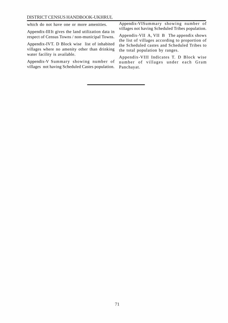
71
DISTRICT CENSUS HANDBOOK-UKHRULwhich do not have one or more amenities.
Appendix-III It gives the land utilization data inrespect of Census Towns / non-municipal Towns.
Appendix-IVT. D Block wise list of inhabitedvillages where no amenity other than drinkingwater facility is available.
Appendix-V Summary showing number ofvillages not having Scheduled Castes population.
Appendix-VISummary showing number ofvillages not having Scheduled Tribes population.Appendix-VII A, VII B The appendix showsthe list of villages according to proportion ofthe Scheduled castes and Scheduled Tribes tothe total population by ranges.Appendix-VIII Indicates T. D Block wisenumber o f v i l l ages under each GramPanchayat.
72
DISTRICT CENSUS HANDBOOK-UKHRUL
Town DirectoryThe Town Directory covers all the towns in the
district notified statutorily as well as the non-municipalor census towns. The towns within each district arearranged in alphabetical order. The data on amenitiesand other aspects are presented in the Directory incodes for which relevant explanations are given atthe beginning of the Town Directory.
There are altogether 7 statutory towns in thedistrict notified by the State Government. They areNambol, Oinam, Bishnupur, Ningthoukhong, Moirang,Kwakta and Kumbi. Of these 6 towns fall whollywithin the district, whereas the jurisdiction of 1 townnamely Nambol spreads over partly in Imphal districtand partly in Bishnupur district.
Information on town directory has been furnishedin 7 separate statements. The scope and the contextof the statements are explained below briefly:
Statement I – Status and growth history
It deals with status and growth history for eachtown in the shape of the number of households,population and growth rate at each census since 1901(since 1951 in case of Bishnupur district), densityaccording to 2001 census and sex ratio at 1981, 1991and 2001 censuses. A dash under these columnsindicates that the town under reference did not havean urban status in the particular census. Density ofpopulation per sq.km. for 2001 Census and sex-ratios(number of females per 1,000 males ) have beenindicated for each town for censuses years from1971to 2001.
Statement II- Physical aspects and location oftowns, 2009
This Statement gives information about thephysical aspects and location particulars of the townas per 2001 Census. Data on rainfall, temperature,road distance (in kms) from the state, district andsub-divisional headquarters, nearest city, nearestrailway station, bus route and presence of navigableriver/canal within a distance of 10 kms. are theinformation presented in this statement. Rainfall dataare given in millimeter (mm) and maximum andminimum temperature in centigrade. As there is nometeorological station in the district rainfall andtemperature statistics furnished in this statement
Town Directory
relates to the ten year average data of the neighboringdistrict of Imphal district.
Statement III- Municipal finance 1998-99
This statement provides information on thefinancial status of the civil administration of each townfor the year 1998-99. The civic administration statusof the town, receipts through taxes, municipalproperties etc. government loans, advances and othersources and the expenditures on generaladministration, public safety, public health andconveniences, public works and institutions and otherservices are given in the statement. The informationon many items of income and expenditure in respectof the municipal councils /Nagar Panchayats in thedistrict are not available and where these are notavailable ‘NA’ has been provided for these itemsagainst the towns.
Statement IV – Civic and other amenities 2009
It presents data on the Scheduled Castes andScheduled Tribes population and civic and otheramenities available for each town in 1999. The roadlength, sewerage system, number of latrines, methodof disposal of night soil, source and capacity ofprotected water supply, fire fighting services andnumber of electric connections are also presented inthis statement. However, data on number of latrinesgiven in the statement refer only to the number ofpublic latrines while the numbers of electricconnections are available for road lighting points only.
Statement –V Medical educational, recreationaland cultural facilities, 2009
The statement contains data on number ofhospitals T.B.Clinics, dispensaries and number ofhospital beds under the heading of medical facilities.Under educational facilities number of Arts/Science/Commerce/Other Colleges of degree level and above,number of medical, engineering and other colleges,polytechnics, vocational training institutes, juniorcolleges and schools, stadia, places of entertainment,libraries, etc. are given. Figures given under the headprimary schools and junior secondary and middleschools do not include number of schools run by
73
DISTRICT CENSUS HANDBOOK-UKHRULprivate and missionary bodies not recognised by theGovernment. Similar is the case for shorthand, typingand vocational training institutions. Information onthe recreational and cultural facilities in the form ofworking women’s hostels, stadium, cinema,auditorium, public libraries are also available in thisstatement.
Statement VI – Trade, Commerce, Industry andBanking 2009
This statement gives trade, commerce, industryand banking aspects for each town. The importantcommodities manufactured, imported and exported,number of banks and agricultural and non-agriculturalcredit societies are given in this statement.
Statement VII– Civic and other amenities in
slums, 2009
This statement intends to furnish informationon civic and other amenities in all slums whethernotified or not and for all towns having statutorybodies, like municipality, municipal corporations,town area committee, etc. having slum areas.There is slum area in the district and the informationfor this statement is therefore nil. However, aformat of this statement is given here for the sakeof information.
Appendix to Town Directory:- Towns havingtheir outgrowth with population.This appendix isintended to show population of each outgrowth oftowns having outgrowths. However, as there is nooutgrowth for any of the towns in the district theformat is presented for the sake of information only.

74
DISTRICT CENSUS HANDBOOK-UKHRUL
75
DISTRICT CENSUS HANDBOOK-UKHRUL
Section I-Village Directory
76
DISTRICT CENSUS HANDBOOK-UKHRUL
LIST OF VILLAGES MERGED IN TOWN AND OUTGROWTHS AT2011 CENSUS
No Village of Ukhrul District either merged in Town or outgrowths during2011 Census

77
DISTRICT CENSUS HANDBOOK-UKHRUL
Map of Ukhrul North T.D.Block

78
DISTRICT CENSUS HANDBOOK-UKHRUL
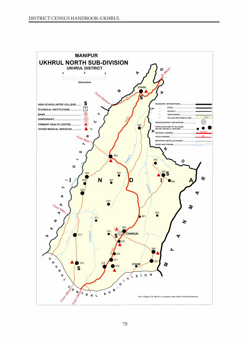
79
DISTRICT CENSUS HANDBOOK-UKHRUL
!
!
!
!!
!!
!
!
!
!!
!! !
!
!
!
!
!
!
!
!
!
!!
!
MANIPUR
UKHRUL NORTH SUB-DIVISIONUKHRUL DISTRICT
Kilometres
S
EN
AP
AT
I
DI
ST
R
IC
T
UK
HR
UL
C
EN
TR A L S
UB
-
D
IV
I S I O N
Fro
m U
khru
l
CHINGAI
5 0 5
R
N
A
AG
L A
N D
Note: Chingai T.D. Block is co-terminus with Ukhrul North Sub-Division.
!μ
LÒE
#
SHIGH SCHOOL/INTER COLLEGE........
OTHER MEDICAL SERVICES..............
DISPENSARY........................................
PRIMARY HEALTH CENTRE...............
BANK.....................................................
TECHNICAL INSTITUTIONS.................
POPULATION SIZE OF VILLAGES:
200-499, 500-999, & 1000-4999 .............................
HEADQUARTERS: SUB-DIVISION.........................
VILLAGE WITH MDDS CODE .......,,
DISTRICT........................................
SUB-DIVISION................................,,
BOUNDARY, INTERNATIONAL..............................
,,
STATE..............................................,,
RIVER AND STREAM.............................................
NATIONAL HIGHWAY..............................................
STATE HIGHWAY....................................................
IMPORTANT METALLED ROADS..........................
!!
R!
NH 202
SH
270362
!μ
#
S
S
#
#
#
#
S
S
#
#
M
Y
A
N
M
A
RI N D I A
To M
eluri
From Kohim
a
Fro
m U
khru
l
From Mao
From Mao
NH
202
NH
202
SH
Lain
i Lok
R.
Cham
mu R
.
Rin
gaga R
.
La
ng
da
ng
R.
380
387
386
385
384
383
382
381
379
378
377
376375374
373
372
371
370
369
368 367
366365
364
363
270388
270362

80
DISTRICT CENSUS HANDBOOK-UKHRUL
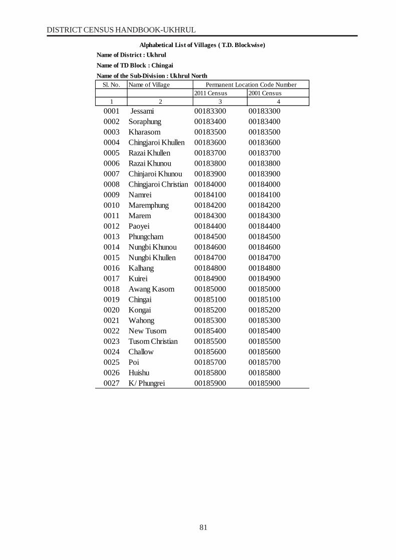
81
DISTRICT CENSUS HANDBOOK-UKHRUL
Name of District : UkhrulName of TD Block : ChingaiName of the Sub-Division : Ukhrul North
Sl. No. Name of Village2011 Census 2001 Census
1 2 3 40001 Jessami 00183300 001833000002 Soraphung 00183400 001834000003 Kharasom 00183500 001835000004 Chingjaroi Khullen 00183600 001836000005 Razai Khullen 00183700 001837000006 Razai Khunou 00183800 001838000007 Chinjaroi Khunou 00183900 001839000008 Chingjaroi Christian 00184000 001840000009 Namrei 00184100 001841000010 Maremphung 00184200 001842000011 Marem 00184300 001843000012 Paoyei 00184400 001844000013 Phungcham 00184500 001845000014 Nungbi Khunou 00184600 001846000015 Nungbi Khullen 00184700 001847000016 Kalhang 00184800 001848000017 Kuirei 00184900 001849000018 Awang Kasom 00185000 001850000019 Chingai 00185100 001851000020 Kongai 00185200 001852000021 Wahong 00185300 001853000022 New Tusom 00185400 001854000023 Tusom Christian 00185500 001855000024 Challow 00185600 001856000025 Poi 00185700 001857000026 Huishu 00185800 001858000027 K/ Phungrei 00185900 00185900
Alphabetical List of Villages ( T.D. Blockwise)
Permanent Location Code Number
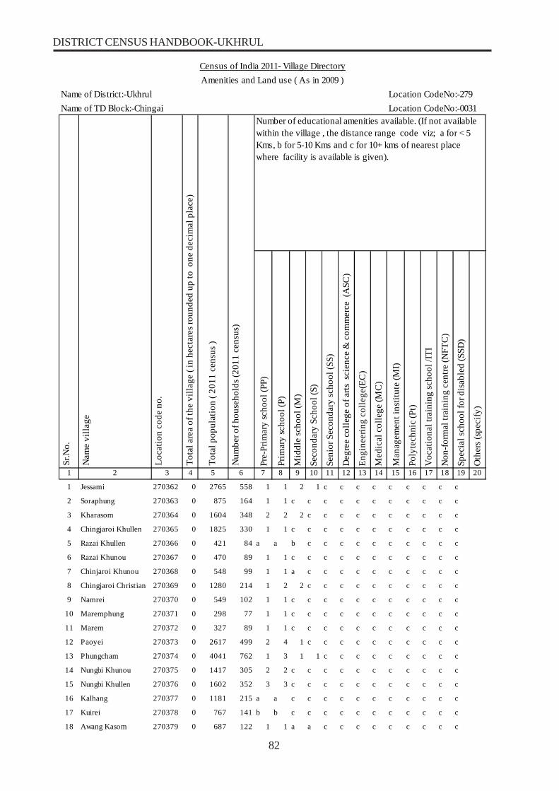
82
DISTRICT CENSUS HANDBOOK-UKHRUL
Name of District:-Ukhrul Location CodeNo:-279Name of TD Block:-Chingai Location CodeNo:-0031
Pre-
Prim
ary
scho
ol (P
P)
Prim
ary
scho
ol (P
)
Mid
dle
scho
ol (M
)
Seco
ndar
y Sc
hool
(S)
Seni
or S
econ
dary
scho
ol (S
S)
Deg
ree
colle
ge o
f arts
sci
ence
& c
omm
erce
(A
SC)
Engi
neer
ing
colle
ge(E
C)
Med
ical
col
lege
(MC
)
Man
agem
ent i
nstit
ute
(MI)
Poly
tech
nic
(Pt)
Voc
atio
nal t
rain
ing
scho
ol /I
TI
Non
-form
al tr
aini
ng c
entre
(NFT
C)
Spec
ial s
choo
l for
dis
able
d (S
SD)
Oth
ers (
spec
ify)
1 2 3 4 5 6 7 8 9 10 11 12 13 14 15 16 17 18 19 20
1 Jessami 270362 0 2765 558 1 1 2 1 c c c c c c c c c
2 Soraphung 270363 0 875 164 1 1 c c c c c c c c c c c
3 Kharasom 270364 0 1604 348 2 2 2 c c c c c c c c c c
4 Chingjaroi Khullen 270365 0 1825 330 1 1 c c c c c c c c c c c
5 Razai Khullen 270366 0 421 84 a a b c c c c c c c c c c
6 Razai Khunou 270367 0 470 89 1 1 c c c c c c c c c c c
7 Chinjaroi Khunou 270368 0 548 99 1 1 a c c c c c c c c c c
8 Chingjaroi Christian 270369 0 1280 214 1 2 2 c c c c c c c c c c
9 Namrei 270370 0 549 102 1 1 c c c c c c c c c c c
10 Maremphung 270371 0 298 77 1 1 c c c c c c c c c c c
11 Marem 270372 0 327 89 1 1 c c c c c c c c c c c
12 Paoyei 270373 0 2617 499 2 4 1 c c c c c c c c c c
13 Phungcham 270374 0 4041 762 1 3 1 1 c c c c c c c c c
14 Nungbi Khunou 270375 0 1417 305 2 2 c c c c c c c c c c c
15 Nungbi Khullen 270376 0 1602 352 3 3 c c c c c c c c c c c
16 Kalhang 270377 0 1181 215 a a c c c c c c c c c c c
17 Kuirei 270378 0 767 141 b b c c c c c c c c c c c
18 Awang Kasom 270379 0 687 122 1 1 a a c c c c c c c c c
Number of educational amenities available. (If not available within the village , the distance range code viz; a for < 5 Kms, b for 5-10 Kms and c for 10+ kms of nearest place where facility is available is given).
Num
ber o
f hou
seho
lds (
2011
cen
sus)
Tota
l pop
ulat
ion
( 201
1 ce
nsus
)
Tota
l are
a of
the
villa
ge (
in h
ecta
res r
ound
ed u
p to
one
dec
imal
pla
ce)
Census of India 2011- Village DirectoryAmenities and Land use ( As in 2009 )
Loca
tion
code
no.
Nam
e vi
llage
Sr.N
o.
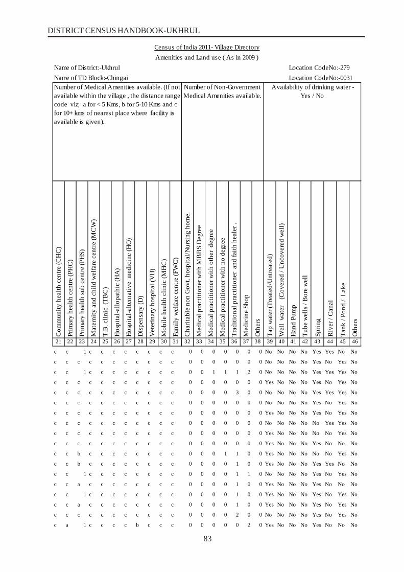
83
DISTRICT CENSUS HANDBOOK-UKHRUL
Name of District:-Ukhrul Location CodeNo:-279Name of TD Block:-Chingai Location CodeNo:-0031
Com
mun
ity h
ealth
cen
tre (C
HC
)
Prim
ary
heal
th c
entre
(PH
C)
Prim
ary
heal
th su
b ce
ntre
(PH
S)
Mat
erni
ty a
nd c
hild
wel
fare
cen
tre (M
CW
)
T.B
. clin
ic (
TBC
)
Hos
pita
l-allo
path
ic (H
A)
Hos
pita
l-alte
rnat
ive
med
icin
e (H
O)
Dis
pens
ary
(D)
Vet
erin
ary
hosp
ital (
VH
)
Mob
ile h
ealth
clin
ic (M
HC
)
Fam
ily w
elfa
re c
entre
(FW
C)
Cha
ritab
le n
on G
ovt.
hosp
ital/N
ursi
ng h
ome.
Med
ical
pra
ctiti
oner
with
MB
BS
Deg
ree
Med
ical
pra
ctiti
oner
with
oth
er d
egre
e
Med
ical
pra
ctiti
oner
with
no
degr
ee
Trad
ition
al p
ract
ition
er a
nd fa
ith h
eale
r .
Med
icin
e Sh
op
Oth
ers
Tap
wat
er (T
reat
ed/U
ntre
ated
)
Wel
l w
ater
(C
over
ed /
Unc
over
ed w
ell)
Han
d Pu
mp
Tube
wel
ls /
Bor
e w
ell
Sprin
g
Riv
er /
Can
al
Tank
/ Po
nd /
Lak
e
Oth
ers
21 22 23 24 25 26 27 28 29 30 31 32 33 34 35 36 37 38 39 40 41 42 43 44 45 46
c c 1 c c c c c c c c 0 0 0 0 0 0 0 No No No No Yes Yes No No
c c c c c c c c c c c 0 0 0 0 0 0 0 No No No No Yes No Yes No
c c 1 c c c c c c c c 0 0 1 1 1 2 0 No No No No Yes Yes Yes No
c c c c c c c c c c c 0 0 0 0 0 0 0 Yes No No No Yes No Yes No
c c c c c c c c c c c 0 0 0 0 3 0 0 No No No No Yes Yes Yes No
c c c c c c c c c c c 0 0 0 0 0 0 0 No No No No Yes No Yes No
c c c c c c c c c c c 0 0 0 0 0 0 0 Yes No No No Yes No Yes No
c c c c c c c c c c c 0 0 0 0 0 0 0 No No No No No Yes Yes No
c c c c c c c c c c c 0 0 0 0 0 0 0 Yes No No No No No Yes No
c c c c c c c c c c c 0 0 0 0 0 0 0 Yes No No No Yes No No No
c c b c c c c c c c c 0 0 0 1 1 0 0 Yes No No No No No Yes No
c c b c c c c c c c c 0 0 0 0 1 0 0 Yes No No No Yes Yes No No
c c 1 c c c c c c c c 0 0 0 0 1 1 0 No No No No Yes No Yes No
c c a c c c c c c c c 0 0 0 0 1 0 0 Yes No No No Yes No No No
c c 1 c c c c c c c c 0 0 0 0 1 0 0 Yes No No No Yes No Yes No
c c a c c c c c c c c 0 0 0 0 1 0 0 Yes No No No Yes No Yes No
c c c c c c c c c c c 0 0 0 0 2 0 0 No No No No Yes No Yes No
c a 1 c c c c b c c c 0 0 0 0 0 2 0 Yes No No No Yes No No No
Number of Non-Government Medical Amenities available.
Number of Medical Amenities available. (If not available within the village , the distance range code viz; a for < 5 Kms, b for 5-10 Kms and c for 10+ kms of nearest place where facility is available is given).
Availability of drinking water - Yes / No
Census of India 2011- Village DirectoryAmenities and Land use ( As in 2009 )

84
DISTRICT CENSUS HANDBOOK-UKHRUL
Name of District:-Ukhrul Location CodeNo:-279Name of TD Block:-Chingai Location CodeNo:-0031
Com
mun
ity to
ilet i
nclu
ding
bat
h.
Com
mun
ity to
ilet e
xclu
ding
bat
h.
Rur
al s
anita
ry m
art o
r san
itary
har
dwar
e ou
tlet a
vaila
ble
near
the
villa
ge.
Com
mun
ity b
io- g
as o
r rec
ycle
of w
aste
for p
rodu
ctiv
e us
e.
Post
offi
ce(P
O)
Sub
post
offi
ce (S
PO)
Post
& T
eleg
raph
offi
ce
(P&
TO)
Vill
age
Pin
Cod
e
Tele
phon
es
(L
and
lines
)
Publ
ic c
all o
ffice
(PC
O)
Mob
ile p
hone
cov
erag
e
Inte
rnet
caf
es/ C
omm
on se
rvic
e ce
ntre
(CSC
)
Priv
ate
cour
ier f
acili
ty
Bus
serv
ice
(Pub
lic &
Priv
ate)
Rai
lway
stat
ions
Aut
o/M
odifi
ed A
utos
Taxi
s and
Van
s
Trac
tors
Cyc
le-p
ulle
d ric
ksha
ws(
Man
ual &
Mac
hine
driv
en)
Car
ts d
riven
by
anim
als
Sea
/Riv
er fe
rry se
rvic
e47 48 49 50 51 52 53 54 55 56 57 58 59 60 61 62 63 64 65 66 67
No No No No c Yes c 795142 c c Yes c c Yes c c Yes c c
No No No No c c c 795142 c c Yes c c Yes c c c c c
No No No No c Yes c 795142 c c Yes c c Yes c c Yes c c
No No No No c Yes c 795142 c c Yes c c Yes c c c c c
No No No No c b c 795142 c c Yes c c b c c c c c
No No No No c c c 795142 c c Yes c c Yes c c c c c
No No No No c Yes c 795142 c c Yes c c Yes c c c c c
No No No No c Yes c 795142 c c Yes c c Yes c c c c c
No No No No c c c 795142 c c Yes c c Yes c c c c c
No No No No c b c 795142 c c Yes c c Yes c c c c c
No No No No c b c 795142 c c Yes c c Yes c c c c c
No No No No c Yes c 795142 c c Yes c c Yes c c c c c
No No No No c Yes c 795142 c c Yes c c Yes c c c c c
No No No No c Yes c 795142 c c Yes c c Yes c c Yes c c
No No No No c c c 795142 c c Yes c c Yes c c Yes c c
No No No No c c c 795142 c c Yes c c Yes c c Yes c c
No No No No c c c 795142 c c Yes c c Yes c c c c c
No No No No c a c 795142 a a Yes c c Yes c c c b c
Census of India 2011- Village DirectoryAmenities and Land use ( As in 2009 )
Communication and transport facilities (If amenities available code -Yes is given except for Village Pin Code ,If not available within the village , the distance range code viz; a for < 5 Kms, b for 5-10 Kms and c for 10+ kms of nearest place where facility is available is given).
Availability of toilet & others Yes / No
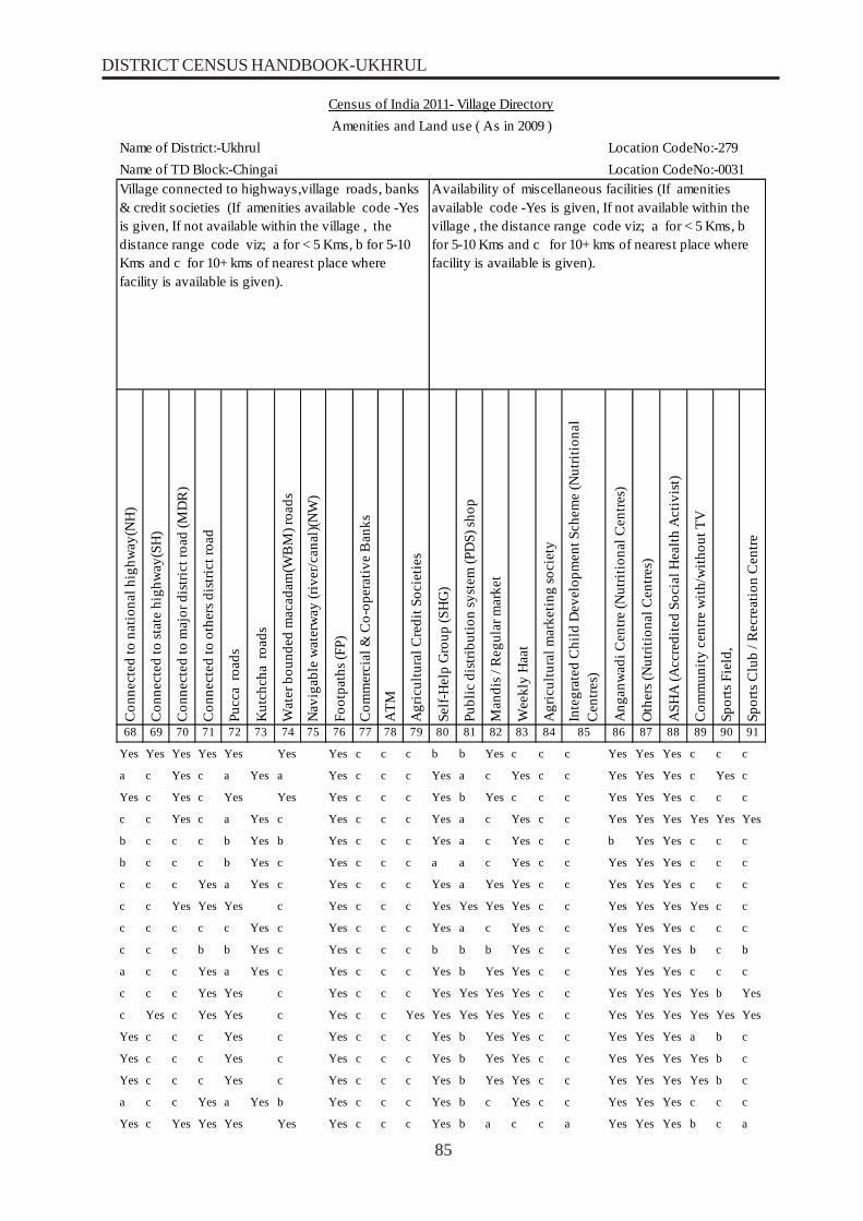
85
DISTRICT CENSUS HANDBOOK-UKHRUL
Name of District:-Ukhrul Location CodeNo:-279Name of TD Block:-Chingai Location CodeNo:-0031
Con
nect
ed to
nat
iona
l hig
hway
(NH
)
Con
nect
ed to
stat
e hi
ghw
ay(S
H)
Con
nect
ed to
maj
or d
istri
ct ro
ad (M
DR
)
Con
nect
ed to
oth
ers d
istri
ct ro
ad
Pucc
a ro
ads
Kut
chch
a ro
ads
Wat
er b
ound
ed m
acad
am(W
BM
) roa
ds
Nav
igab
le w
ater
way
(riv
er/c
anal
)(NW
)
Foot
path
s (FP
)
Com
mer
cial
& C
o-op
erat
ive
Ban
ks
ATM
Agr
icul
tura
l Cre
dit S
ocie
ties
Self-
Hel
p G
roup
(SH
G)
Publ
ic d
istri
butio
n sy
stem
(PD
S) sh
op
Man
dis /
Reg
ular
mar
ket
Wee
kly
Haa
t
Agr
icul
tura
l mar
ketin
g so
ciet
y
Inte
grat
ed C
hild
Dev
elop
men
t Sch
eme
(Nut
ritio
nal
Cen
tres)
Ang
anw
adi C
entre
(Nut
ritio
nal C
entre
s)
Oth
ers (
Nut
ritio
nal C
entre
s)
ASH
A (A
ccre
dite
d So
cial
Hea
lth A
ctiv
ist)
Com
mun
ity c
entre
with
/with
out T
V
Spor
ts F
ield
,
Spor
ts C
lub
/ Rec
reat
ion
Cen
tre68 69 70 71 72 73 74 75 76 77 78 79 80 81 82 83 84 85 86 87 88 89 90 91
Yes Yes Yes Yes Yes Yes Yes c c c b b Yes c c c Yes Yes Yes c c c
a c Yes c a Yes a Yes c c c Yes a c Yes c c Yes Yes Yes c Yes c
Yes c Yes c Yes Yes Yes c c c Yes b Yes c c c Yes Yes Yes c c c
c c Yes c a Yes c Yes c c c Yes a c Yes c c Yes Yes Yes Yes Yes Yes
b c c c b Yes b Yes c c c Yes a c Yes c c b Yes Yes c c c
b c c c b Yes c Yes c c c a a c Yes c c Yes Yes Yes c c c
c c c Yes a Yes c Yes c c c Yes a Yes Yes c c Yes Yes Yes c c c
c c Yes Yes Yes c Yes c c c Yes Yes Yes Yes c c Yes Yes Yes Yes c c
c c c c c Yes c Yes c c c Yes a c Yes c c Yes Yes Yes c c c
c c c b b Yes c Yes c c c b b b Yes c c Yes Yes Yes b c b
a c c Yes a Yes c Yes c c c Yes b Yes Yes c c Yes Yes Yes c c c
c c c Yes Yes c Yes c c c Yes Yes Yes Yes c c Yes Yes Yes Yes b Yes
c Yes c Yes Yes c Yes c c Yes Yes Yes Yes Yes c c Yes Yes Yes Yes Yes Yes
Yes c c c Yes c Yes c c c Yes b Yes Yes c c Yes Yes Yes a b c
Yes c c c Yes c Yes c c c Yes b Yes Yes c c Yes Yes Yes Yes b c
Yes c c c Yes c Yes c c c Yes b Yes Yes c c Yes Yes Yes Yes b c
a c c Yes a Yes b Yes c c c Yes b c Yes c c Yes Yes Yes c c c
Yes c Yes Yes Yes Yes Yes c c c Yes b a c c a Yes Yes Yes b c a
Availability of miscellaneous facilities (If amenities available code -Yes is given, If not available within the village , the distance range code viz; a for < 5 Kms, b for 5-10 Kms and c for 10+ kms of nearest place where facility is available is given).
Census of India 2011- Village DirectoryAmenities and Land use ( As in 2009 )
Village connected to highways,village roads, banks & credit societies (If amenities available code -Yes is given, If not available within the village , the distance range code viz; a for < 5 Kms, b for 5-10 Kms and c for 10+ kms of nearest place where facility is available is given).

86
DISTRICT CENSUS HANDBOOK-UKHRUL
Name of District:-Ukhrul Location CodeNo:-279Name of TD Block:-Chingai Location CodeNo:-0031
Cin
ema
/ Vid
eo H
all
Publ
ic L
ibra
ry
Publ
ic R
eadi
ng R
oom
New
spap
er S
uppl
y
Ass
embl
y Po
lling
stat
ion
Birt
h &
Dea
th R
egis
tratio
n O
ffice
Pow
er S
uppl
y fo
r Dom
estic
Use
(ED
)
Pow
er S
uppl
y fo
r Agr
icul
tura
l Use
(EA
G)
Pow
er S
uppl
y fo
r Com
mer
cial
Use
(EC
)
Pow
er S
uppl
y fo
r All
Use
s (EA
)
Nam
e
Dis
tanc
e ra
nge
code
i.e
. a
for <
5 K
ms,
b fo
r 5-1
0 K
ms
and
c f
or 1
0+ k
ms .
Fore
sts
Are
a un
der N
on-a
gric
ultu
ral U
ses
Bar
ren
and
Un-
culti
vabl
e la
nd
Perm
anen
t Pas
ture
s and
Oth
er G
razi
ng L
ands
Land
Und
er M
isce
llane
ous T
ree
Cro
ps e
tc.
Cul
tura
ble
Was
te L
and
92 93 94 95 96 97 98 99 100 101 102 103 104 105 106 107 108 109
c c c Yes Yes Yes Yes No No Yes LAMLAI N.P. c 0 0 0 0 0 0
c c c c Yes c Yes No No Yes LAMLAI N.P. c 0 0 0 0 0 0
c c c c a Yes Yes No No Yes LAMLAI N.P. c 0 0 0 0 0 0
c c c c Yes c Yes No No Yes LAMLAI N.P. c 0 0 0 0 0 0
c c c c b c Yes No No Yes LAMLAI N.P. c 0 0 0 0 0 0
c c c c b c Yes No No Yes LAMLAI N.P. c 0 0 0 0 0 0
c c c b a c Yes No No Yes LAMLAI N.P. c 0 0 0 0 0 0
c c c c Yes c Yes No No Yes LAMLAI N.P. c 0 0 0 0 0 0
c c c c Yes c Yes No No Yes LAMLAI N.P. c 0 0 0 0 0 0
c c c c b c Yes No No Yes LAMLAI N.P. c 0 0 0 0 0 0
c c c c a b Yes No No Yes LAMLAI N.P. c 0 0 0 0 0 0
c b b c Yes b Yes No No Yes LAMLAI NAGAR PANCHYAT c 0 0 0 0 0 0
c c c c a Yes Yes No No Yes LAMLAI N.P. c 0 0 0 0 0 0
c c c c a a Yes No No Yes LAMLAI N.P. c 0 0 0 0 0 0
c c c c Yes Yes Yes No No Yes LAMLAI N.P. c 0 0 0 0 0 0
c c c c Yes a Yes No No Yes LAMLAI N.P. c 0 0 0 0 0 0
c c c c a c Yes No No Yes LAMLAI N.P. c 0 0 0 0 0 0
c c c a a Yes Yes No No Yes LAMLAI N.P. c 0 0 0 0 0 0
Availability of electricity (Yes/No)
Census of India 2011- Village DirectoryAmenities and Land use ( As in 2009 )
Nearest Town Land Use
Area under different types of land use ( in hectares
rounded up to one decimal place)
Availability of miscellaneous facilities (If amenities available code -Yes is given, If not available within the village , the distance range code viz; a for < 5 Kms, b for 5-10 Kms and c for 10+ kms of nearest place where facility is available is given).

87
DISTRICT CENSUS HANDBOOK-UKHRUL
Name of District:-Ukhrul Location CodeNo:-279Name of TD Block:-Chingai Location CodeNo:-0031
Fallo
w la
nds o
ther
than
cur
rent
fallo
ws
Cur
rent
Fal
low
s
Net
Are
a So
wn
Tota
l Irri
gate
d La
nd A
rea
Tota
l Un-
irrig
ated
Lan
d A
rea
Can
als (
C )
Wel
ls/T
ube-
wel
ls(W
/TW
)
Tank
s/La
kes(
T/L)
Wat
er F
alls
(WF)
Oth
ers(
O)
Firs
t
Seco
nd
Third
110 111 112 113 114 115 116 117 118 119 120 121 122 2 1
0 0 0 0 0 0 0 0 0 0 Jessami 1
0 0 0 0 0 0 0 0 0 0 Soraphung 2
0 0 0 0 0 0 0 0 0 0 Kharasom 3
0 0 0 0 0 0 0 0 0 0 Chingjaroi Khullen 4
0 0 0 0 0 0 0 0 0 0 Razai Khullen 5
0 0 0 0 0 0 0 0 0 0 Razai Khunou 6
0 0 0 0 0 0 0 0 0 0 Chinjaroi Khunou 7
0 0 0 0 0 0 0 0 0 0 Chingjaroi Christian 8
0 0 0 0 0 0 0 0 0 0 Namrei 9
0 0 0 0 0 0 0 0 0 0 Maremphung 10
0 0 0 0 0 0 0 0 0 0 Marem 11
0 0 0 0 0 0 0 0 0 0 Paoyei 12
0 0 0 0 0 0 0 0 0 0 Phungcham 13
0 0 0 0 0 0 0 0 0 0 Nungbi Khunou 14
0 0 0 0 0 0 0 0 0 0 Pottery Nungbi Khullen 15
0 0 0 0 0 0 0 0 0 0 Kalhang 16
0 0 0 0 0 0 0 0 0 0 Kuirei 17
0 0 0 0 0 0 0 0 0 0 Awang Kasom 18
Census of India 2011- Village DirectoryAmenities and Land use ( As in 2009 )
Area irrigated by source (in hectare).
Nam
e of
Vill
age
Seria
l Num
ber
Land UseArea under different types of land use ( in hectares rounded up to one decimal place)
Name of three most important commodities manufactured
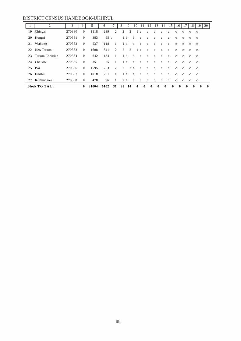
88
DISTRICT CENSUS HANDBOOK-UKHRUL1 2 3 4 5 6 7 8 9 10 11 12 13 14 15 16 17 18 19 20
19 Chingai 270380 0 1118 239 2 2 2 1 c c c c c c c c c
20 Kongai 270381 0 383 95 b 1 b b c c c c c c c c c
21 Wahong 270382 0 537 118 1 1 a a c c c c c c c c c
22 New Tusom 270383 0 1608 341 2 2 2 1 c c c c c c c c c
23 Tusom Christian 270384 0 642 134 1 1 a a c c c c c c c c c
24 Challow 270385 0 351 75 1 1 c c c c c c c c c c c
25 Poi 270386 0 1595 253 2 2 2 b c c c c c c c c c
26 Huishu 270387 0 1018 201 1 1 b b c c c c c c c c c
27 K/ Phungrei 270388 0 478 96 1 2 b c c c c c c c c c c
Block T O T A L : 0 31004 6102 31 38 14 4 0 0 0 0 0 0 0 0 0 0
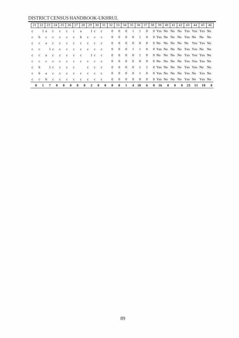
89
DISTRICT CENSUS HANDBOOK-UKHRUL21 22 23 24 25 26 27 28 29 30 31 32 33 34 35 36 37 38 39 40 41 42 43 44 45 46
c 1 a c c c c a 1 c c 0 0 0 1 1 0 0 Yes No No No Yes Yes Yes No
c b c c c c c b c c c 0 0 0 0 1 0 0 Yes No No No Yes No No No
c c a c c c c c c c c 0 0 0 0 0 0 0 No No No No No Yes Yes No
c c 1 c c c c c c c c 0 0 0 1 1 0 0 Yes No No No Yes Yes No No
c c a c c c c c 1 c c 0 0 0 0 1 0 0 No No No No Yes Yes Yes No
c c c c c c c c c c c 0 0 0 0 0 0 0 No No No No Yes Yes Yes No
c b 1 c c c c c c c 0 0 0 0 1 1 0 Yes No No No Yes Yes No No
c b a c c c c c c c c 0 0 0 0 1 0 0 Yes No No No Yes No Yes No
c c b c c c c c c c c 0 0 0 0 0 0 0 Yes No No No Yes No Yes No
0 1 7 0 0 0 0 0 2 0 0 0 0 1 4 18 6 0 16 0 0 0 23 11 19 0
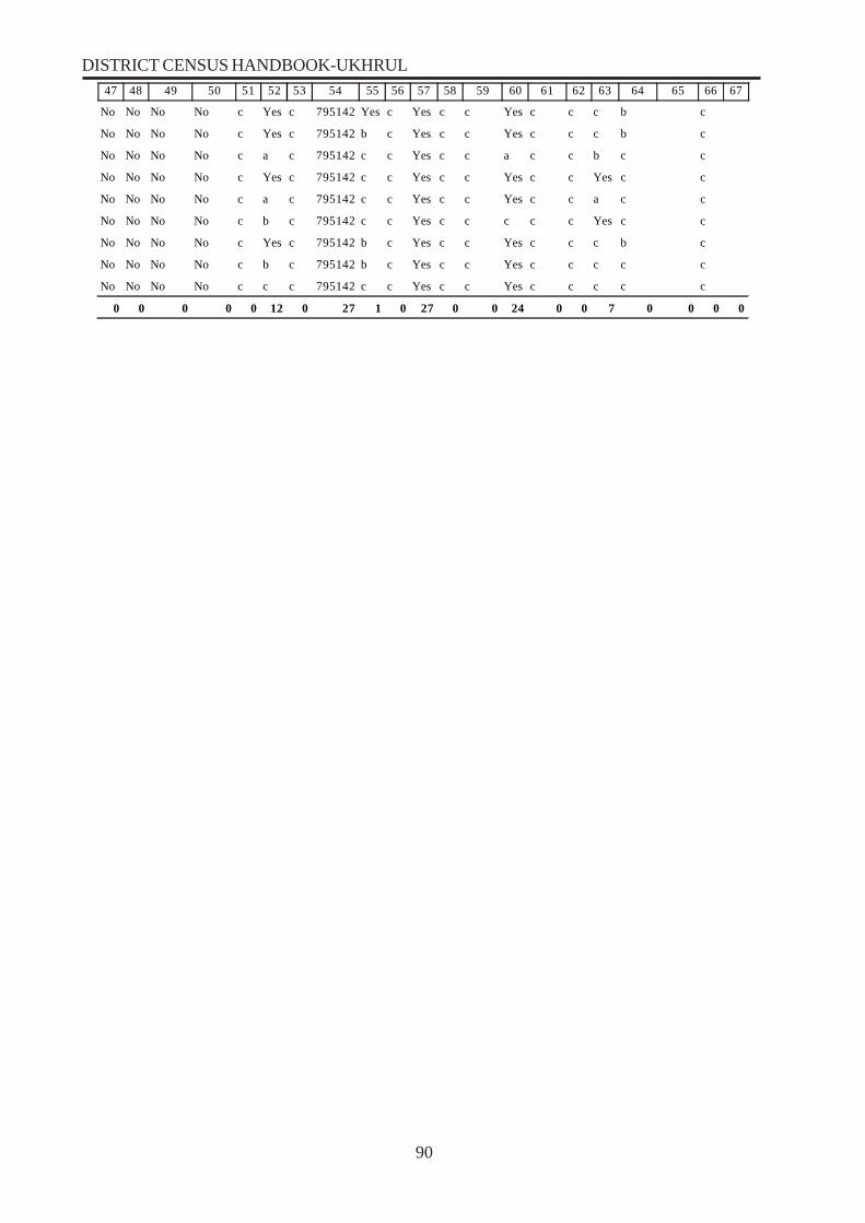
90
DISTRICT CENSUS HANDBOOK-UKHRUL47 48 49 50 51 52 53 54 55 56 57 58 59 60 61 62 63 64 65 66 67
No No No No c Yes c 795142 Yes c Yes c c Yes c c c b c
No No No No c Yes c 795142 b c Yes c c Yes c c c b c
No No No No c a c 795142 c c Yes c c a c c b c c
No No No No c Yes c 795142 c c Yes c c Yes c c Yes c c
No No No No c a c 795142 c c Yes c c Yes c c a c c
No No No No c b c 795142 c c Yes c c c c c Yes c c
No No No No c Yes c 795142 b c Yes c c Yes c c c b c
No No No No c b c 795142 b c Yes c c Yes c c c c c
No No No No c c c 795142 c c Yes c c Yes c c c c c
0 0 0 0 0 12 0 27 1 0 27 0 0 24 0 0 7 0 0 0 0
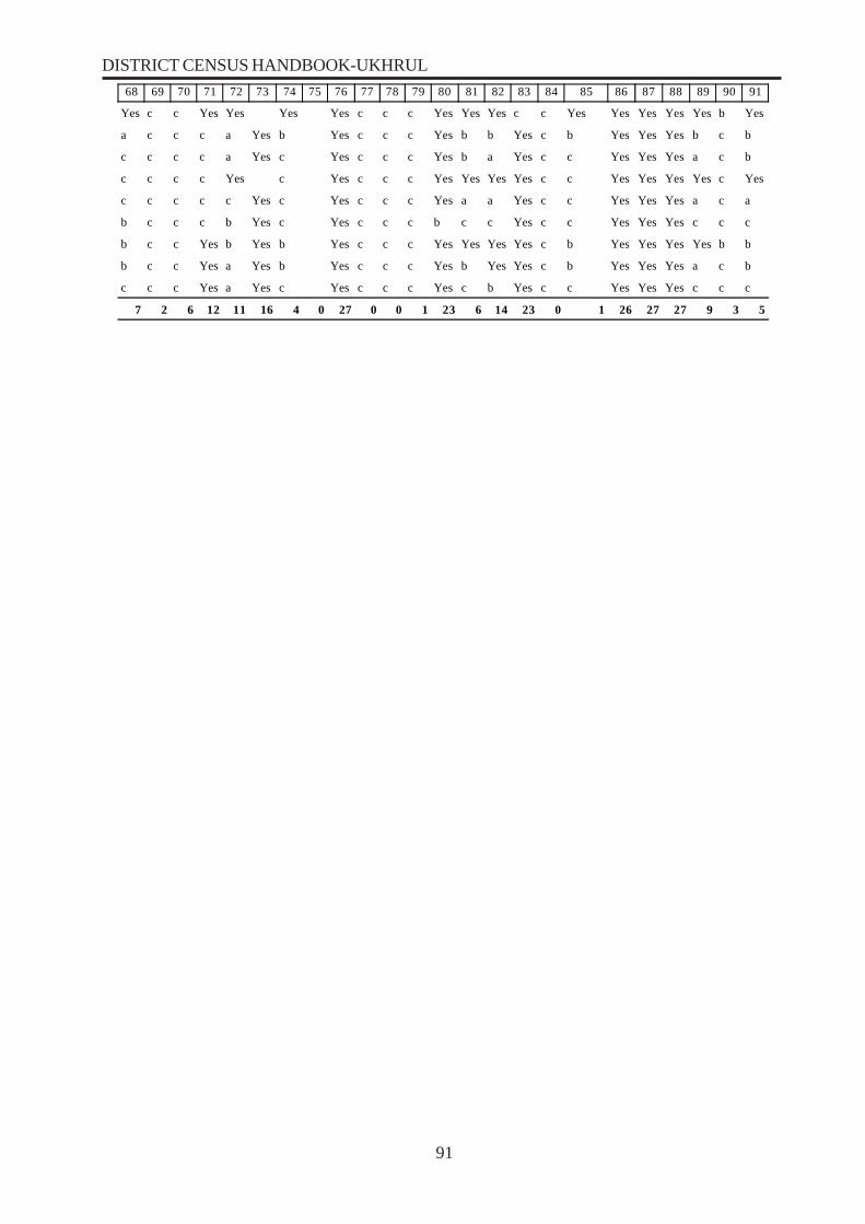
91
DISTRICT CENSUS HANDBOOK-UKHRUL68 69 70 71 72 73 74 75 76 77 78 79 80 81 82 83 84 85 86 87 88 89 90 91
Yes c c Yes Yes Yes Yes c c c Yes Yes Yes c c Yes Yes Yes Yes Yes b Yes
a c c c a Yes b Yes c c c Yes b b Yes c b Yes Yes Yes b c b
c c c c a Yes c Yes c c c Yes b a Yes c c Yes Yes Yes a c b
c c c c Yes c Yes c c c Yes Yes Yes Yes c c Yes Yes Yes Yes c Yes
c c c c c Yes c Yes c c c Yes a a Yes c c Yes Yes Yes a c a
b c c c b Yes c Yes c c c b c c Yes c c Yes Yes Yes c c c
b c c Yes b Yes b Yes c c c Yes Yes Yes Yes c b Yes Yes Yes Yes b b
b c c Yes a Yes b Yes c c c Yes b Yes Yes c b Yes Yes Yes a c b
c c c Yes a Yes c Yes c c c Yes c b Yes c c Yes Yes Yes c c c
7 2 6 12 11 16 4 0 27 0 0 1 23 6 14 23 0 1 26 27 27 9 3 5
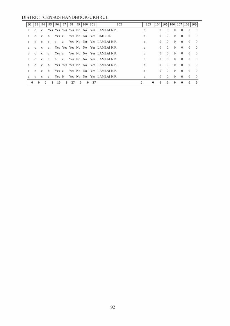
92
DISTRICT CENSUS HANDBOOK-UKHRUL92 93 94 95 96 97 98 99 100 101 102 103 104 105 106 107 108 109
c c c Yes Yes Yes Yes No No Yes LAMLAI N.P. c 0 0 0 0 0 0
c c c b Yes c Yes No No Yes UKHRUL c 0 0 0 0 0 0
c c c c a a Yes No No Yes LAMLAI N.P. c 0 0 0 0 0 0
c c c c Yes Yes Yes No No Yes LAMLAI N.P. c 0 0 0 0 0 0
c c c c Yes a Yes No No Yes LAMLAI N.P. c 0 0 0 0 0 0
c c c c b c Yes No No Yes LAMLAI N.P. c 0 0 0 0 0 0
c c c b Yes Yes Yes No No Yes LAMLAI N.P. c 0 0 0 0 0 0
c c c b Yes a Yes No No Yes LAMLAI N.P. c 0 0 0 0 0 0
c c c c Yes b Yes No No Yes LAMLAI N.P. c 0 0 0 0 0 0
0 0 0 2 15 8 27 0 0 27 0 0 0 0 0 0 0 0
93
DISTRICT CENSUS HANDBOOK-UKHRUL110 111 112 113 114 115 116 117 118 119 120 121 122 2 1
0 0 0 0 0 0 0 0 0 0 Chingai 19
0 0 0 0 0 0 0 0 0 0 Kongai 20
0 0 0 0 0 0 0 0 0 0 Wahong 21
0 0 0 0 0 0 0 0 0 0 New Tusom 22
0 0 0 0 0 0 0 0 0 0 Tusom Christian 23
0 0 0 0 0 0 0 0 0 0 Challow 24
0 0 0 0 0 0 0 0 0 0 Poi 25
0 0 0 0 0 0 0 0 0 0 Huishu 26
0 0 0 0 0 0 0 0 0 0 K/ Phungrei 27
0 0 0 0 0 0 0 0 0

94
DISTRICT CENSUS HANDBOOK-UKHRUL
95
DISTRICT CENSUS HANDBOOK-UKHRUL
Map of Ukhrul T.D.Block

96
DISTRICT CENSUS HANDBOOK-UKHRUL
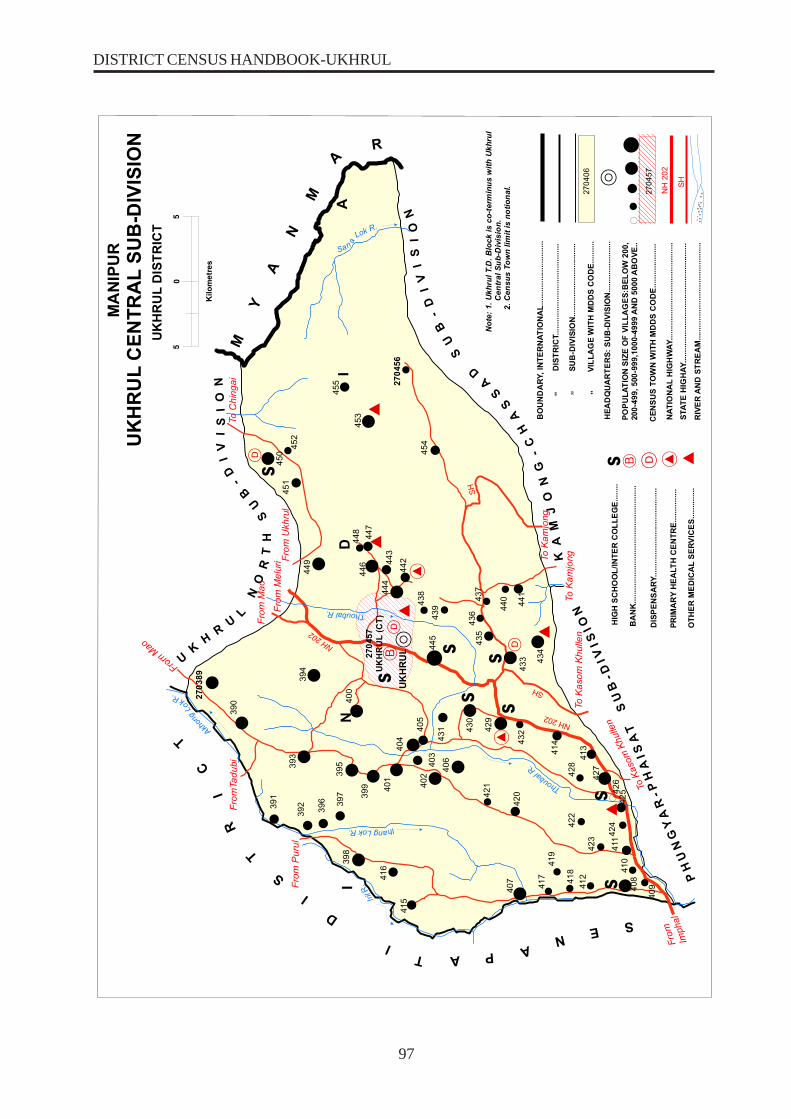
97
DISTRICT CENSUS HANDBOOK-UKHRUL
!
!
!
!!
!
!
!
!
!!
!
!
!
!! !
!
!
! !
!!
!
!
!
!
! !
!
!
!
!!
!
!
!
(
!
!!!
!
!
!
!
!
!
!!
! !
!
!
!
!!
!
!
!
!
!
!
!
!
!
!
!
SEN
APAT
I
D
I
S
T
RI
C
T
UK
HR
U
L
NO
RT
H
SU
B-
DI
VI
SI
ON
KA
MJ
ON
G-
CH
AS
S
AD
SU
B-
DI
VI
SI
ON
Fro
m M
elu
ri
To K
aso
m K
hulle
n
SH
SH
To
Ka
mjo
ng
No
te:
1.
Uk
hru
l T.D
. B
loc
k i
s c
o-t
erm
inu
s w
ith
Uk
hru
l
C
en
tra
l S
ub
-Div
isio
n.
2
. C
en
su
s T
ow
n l
imit
is
no
tio
na
l.
R
RIV
ER
AN
D S
TR
EA
M..
....
....
....
....
....
....
....
....
....
....
..
R
BO
UN
DA
RY
, IN
TE
RN
AT
ION
AL
....
....
....
....
....
....
....
.
VIL
LA
GE
WIT
H M
DD
S C
OD
E..
....
....
,,
SU
B-D
IVIS
ION
....
....
....
....
....
....
....
....
.,,
HE
AD
QU
AR
TE
RS
: S
UB
-DIV
ISIO
N..
....
....
....
....
....
.
DIS
TR
ICT..
....
....
....
....
....
....
....
....
....
...
27
04
06
PO
PU
LA
TIO
N S
IZE
OF
VIL
LA
GE
S:B
EL
OW
20
0,
20
0-4
99
, 5
00
-99
9,1
00
0-4
99
9 A
ND
50
00
AB
OV
E..
CE
NS
US
TO
WN
WIT
H M
DD
S C
OD
E..
....
....
....
....
..
NA
TIO
NA
L H
IGH
WA
Y..
......
....
....
....
....
....
....
....
....
....
27
04
57
ST
AT
E H
IGH
AY
....
....
....
....
....
....
....
....
....
....
....
......
....
SH
NH
20
2! μÒ E #S
HIG
H S
CH
OO
L/I
NT
ER
CO
LL
EG
E..
....
..
OT
HE
R M
ED
ICA
L S
ER
VIC
ES
....
......
....
DIS
PE
NS
AR
Y..
....
....
....
....
......
....
....
....
....
PR
IMA
RY
HE
ALT
H C
EN
TR
E..
....
....
....
.
BA
NK
....
....
....
....
....
....
....
....
....
....
....
....
....
.
! μ
Ò
E
S
S
S
#
#
#
! μ
S
S
S
S
E
#
#E
S
(!
!!!
,,
Kil
om
etr
es
55
0
UK
HR
UL
M
Y
A
N
M
A
RU
KH
RU
L C
EN
TR
AL
SU
B-D
IVIS
ION
MA
NIP
UR
UK
HR
UL
DIS
TR
ICT
IN
DI
A
PH
UN
GY
AR
-P
HA
IS
AT
S
UB
-D
IV
IS
IO
N
Fro
mTa
du
bi
Fro
m P
uru
l
To
Ka
mjo
ng
Imphal
Fro
m
From
Mao
Fro
m M
ao
Fro
m U
kh
rul
To
Ch
ing
ai
To
Ka
so
m K
hu
llen
NH 202
NH 202
Iril
R
.
Thoubal R.
San
a L
ok R.
Thoubal R
.
Akh
ong
Lo
k R.
Ihang Lok R.452
432
419
270
457
UK
HR
UL
(C
T)
453
455
450
451
449
448
445
444
446
447
443
442
441
439
438
436
435
440437
433 434
425
413
428
427
423
424
426
422
421
454
431 430
429
420
418
417416
415
414
412
411
410
409408
407
406
405
404
403
402
401
400
399
398
397
396
395
394
393
392391
390
270
456
270
389
98
DISTRICT CENSUS HANDBOOK-UKHRUL
Name of District : UkhrulName of TD Block :Lungchong MeipheiName of the Sub-Division : Ukhrul Central (part)
Sl. No. Name of Village2011 Census 2001 Census
1 2 3 40001 Champhung 00186800 001868000002 Huime 00186000 001860000003 Jalembung 00189300 001893000004 Kachai 00186100 001861000005 Khamanom 00188700 001887000006 Lamlai Chingphei 00189200 001892000007 Lamlang 00187600 001876000008 M.Kamsei 00188600 001886000009 Maichon 00186300 001863000010 Molnom 00188900 001889000011 Moulsohoi 001888100012 Mullam 00189100 001891000013 Ngaimu 00187100 001871000014 Pashong 00188800 001888000015 Phadang 00187000 001870000016 Pharung 00187500 001875000017 Phungthar 00186200 001862000018 Sanakeithel 00187800 001878000019 Seikhor 00187400 001874000020 Shangkai 00189400 001894000021 Shongphel 00189000 001890000022 Sirarakhong 00187300 001873000023 Somdal 00186600 001866000024 Tanrui(leisan) 00186900 001869000025 Tolloi 00186400 001864000026 Tora 00186700 001867000027 Tuinem 00187200 001872000028 Tungou 00187700 001877000029 Yaolen 00189800 00189800
Permanent Location Code Number
99
DISTRICT CENSUS HANDBOOK-UKHRUL
Name of District : UkhrulName of TD Block :UkhrulName of the Sub-Division : Ukhrul Central (part)
Sl. No. Name of Village2011 Census 2001 Census
1 2 3 41 Changa 00190900 001909002 Chingshou(Zingsui) 00192400 001924003 Choithar 00191300 001913004 Hatha 001900105 Huining(Halang) 00186500 001865006 Hundung 00191400 001914007 Khamasom 00192000 001920008 Khangkhui Khullen 00191100 001911009 Khangkhui Khunou 00191200 0019120010 Lambui 00189900 0018990011 Langdang 00191600 0019160012 Leiyaram 00188000 0018800013 Litan 00189600 0018960014 Litan Sareikhong 00189700 0018970015 Lonshak 00192500 0019250016 Lunghar 00191900 0019190017 Lungshang Chingkha 00190500 0019050018 Lungshang Chingthak 00190600 0019060019 Mangkot Chepu 00189500 0018950020 Mapum 00192200 0019220021 Mayophung 00188300 0018830022 Muirei 00188100 0018810023 New Cannon 00187900 0018790024 Nungou 00191000 0019100025 Nungshong Khullen 00190700 0019070026 Nungshong Khunou 00190800 0019080027 Pushing 00192300 0019230028 Shangshak Khullen 00190200 0019020029 Shangshak Khunou 00190300 0019030030 Shangzing 00190400 0019040031 Shiroy Chingkha 00191700 0019170032 Shiroy Chingthak 00191800 0019180033 Shokvao 00188500 0018850034 Sihai 00192100 0019210035 Sihai Khunou 0019211036 T.Chanhong 00190100 0019010037 T.M.Kasom 00188400 0018840038 Tushen(Tushar) 00190000 0019000039 Wunghon 00188200 00188200
Permanent Location Code Number

100
DISTRICT CENSUS HANDBOOK-UKHRUL
Name of District:-Ukhrul Location CodeNo:-279Name of TD Block:-Ukhrul Location CodeNo:-0032
Pre-
Prim
ary
scho
ol (P
P)
Prim
ary
scho
ol (P
)
Mid
dle
scho
ol (M
)
Seco
ndar
y Sc
hool
(S)
Seni
or S
econ
dary
scho
ol (S
S)
Deg
ree
colle
ge o
f arts
sci
ence
& c
omm
erce
(A
SC)
Engi
neer
ing
colle
ge(E
C)
Med
ical
col
lege
(MC
)
Man
agem
ent i
nstit
ute
(MI)
Poly
tech
nic
(Pt)
Voc
atio
nal t
rain
ing
scho
ol /I
TI
Non
-form
al tr
aini
ng c
entre
(NFT
C)
Spec
ial s
choo
l for
dis
able
d (S
SD)
Oth
ers (
spec
ify)
1 2 3 4 5 6 7 8 9 10 11 12 13 14 15 16 17 18 19 20
28 Huining (Halang) 270394 0 2878 688 3 3 1 c c c c c c c c c c
29 New Cannon 270408 0 1030 220 2 2 1 1 c c c c c c c c c
30 Leiyaram 270409 0 205 44 a a a a c c c c c c c c c
31 Muirei 270410 0 324 65 a a a a c c c c c c c c c
32 Wunghon 270411 0 504 104 1 1 a a c c c c c c c c c
33 Mayophung 270412 0 435 108 a a a a c c c c c c c c c
34 T.M.Kasom 270413 0 570 103 1 1 b c c c c c c c c c c
35 Shokvao 270414 0 698 146 2 2 1 b c c c c c c c c c
36 Shangkai 270424 0 284 64 1 1 a a c c c c c c c c c
37 Mangkot Chepu 270425 0 676 132 a a a a c c c c c c c c c
38 Litan 270426 0 127 27 2 2 2 1 c c c c c c c c c
39 Litan Sareikhong 270427 0 1000 158 1 1 a a c c c c c c c c c
40 Lambui 270429 0 1940 322 1 2 1 2 c c c c c c c c c
41 Tushen (Tushar) 270430 0 2098 345 5 5 2 1 c c c c c c c c c
42 T.Chanhong 270431 0 784 165 a a a a c c c c c c c c c
43 Hatha 270432 0 154 30 a a a b c c c c c c c c c
44 Shangshak Khullen 270433 0 2441 281 2 2 2 1 c c c c c c c c c
45 Shangshak Khunou 270434 0 1025 174 2 2 1 a c c c c c c c c c
Number of educational amenities available. (If not available within the village , the distance range code viz; a for < 5 Kms, b for 5-10 Kms and c for 10+ kms of nearest place where facility is available is given).
Sr.N
o.
Nam
e vi
llage
Loca
tion
code
no.
Tota
l are
a of
the
villa
ge (
in h
ecta
res r
ound
ed u
p to
one
dec
imal
pla
ce)
Tota
l pop
ulat
ion
( 201
1 ce
nsus
)
Num
ber o
f hou
seho
lds (
2011
cen
sus)
Amenities and Land use ( As in 2009 )Census of India 2011- Village Directory
101
DISTRICT CENSUS HANDBOOK-UKHRUL
Name of District:-Ukhrul Location CodeNo:-279Name of TD Block:-Ukhrul Location CodeNo:-0032
Com
mun
ity h
ealth
cen
tre (C
HC
)
Prim
ary
heal
th c
entre
(PH
C)
Prim
ary
heal
th su
b ce
ntre
(PH
S)
Mat
erni
ty a
nd c
hild
wel
fare
cen
tre (M
CW
)
T.B
. clin
ic (
TBC
)
Hos
pita
l-allo
path
ic (H
A)
Hos
pita
l-alte
rnat
ive
med
icin
e (H
O)
Dis
pens
ary
(D)
Vet
erin
ary
hosp
ital (
VH
)
Mob
ile h
ealth
clin
ic (M
HC
)
Fam
ily w
elfa
re c
entre
(FW
C)
Cha
ritab
le n
on G
ovt.
hosp
ital/N
ursi
ng h
ome.
Med
ical
pra
ctiti
oner
with
MB
BS
Deg
ree
Med
ical
pra
ctiti
oner
with
oth
er d
egre
e
Med
ical
pra
ctiti
oner
with
no
degr
ee
Trad
ition
al p
ract
ition
er a
nd fa
ith h
eale
r .
Med
icin
e Sh
op
Oth
ers
Tap
wat
er (T
reat
ed/U
ntre
ated
)
Wel
l w
ater
(C
over
ed /
Unc
over
ed w
ell)
Han
d Pu
mp
Tube
wel
ls /
Bor
e w
ell
Sprin
g
Riv
er /
Can
al
Tank
/ Po
nd /
Lak
e
Oth
ers
21 22 23 24 25 26 27 28 29 30 31 32 33 34 35 36 37 38 39 40 41 42 43 44 45 46
c c c c c c c c c c c 0 1 0 0 0 0 0 No No No No Yes No Yes No
c c c c c c c c c c c 0 0 0 0 1 1 0 No No No No Yes No Yes No
c c c c c c c c c c c 0 0 0 0 0 0 0 No No No No No No Yes No
c c b c c c c c c c c 0 0 0 0 0 5 0 No No No No No No Yes No
c c b c c c c c c c c 0 0 0 0 0 0 0 No No No No Yes Yes No No
c c c c c c c c c c c 0 0 0 0 0 0 0 No No No No Yes No Yes No
c c b c c c c c c c c 0 0 0 0 1 1 0 No No No No Yes No Yes No
c b c c c c c c c c c 0 0 0 0 1 0 0 No No No No Yes No Yes No
c c a c c c c c c c c 0 0 0 0 0 0 0 No No No No Yes Yes No No
c c 1 c c c c c c c c 0 0 0 0 1 0 0 No No No No Yes Yes Yes No
c c a c c c c c c c c 0 0 0 0 0 0 0 No No No No No Yes Yes No
c c b c c c c c c c c 0 1 0 1 1 1 0 No No No No Yes Yes Yes No
c 1 c c c c c b c c c 0 0 0 2 3 2 0 No No No No Yes No Yes No
c a b c c c c c c c c 0 0 0 0 0 0 0 No No No No Yes No Yes No
c b a c c c c c c c c 0 0 0 0 0 0 0 No No No No Yes No Yes No
c b c c c c c c c c c 0 0 0 0 0 0 0 No No No No Yes No Yes No
c c a c c c c 1 1 c c 0 1 0 1 2 2 0 No No No No Yes No Yes No
c c 1 c c c c a c c c 0 0 0 0 1 1 0 No No No No Yes Yes Yes No
Number of Medical Amenities available. (If not available within the village , the distance range code viz; a for < 5 Kms, b for 5-10 Kms and c for 10+ kms of nearest place where facility is available is given).
Number of Non-Government Medical Amenities available.
Availability of drinking water - Yes / No
Amenities and Land use ( As in 2009 )Census of India 2011- Village Directory
102
DISTRICT CENSUS HANDBOOK-UKHRUL
Name of District:-Ukhrul Location CodeNo:-279Name of TD Block:-Ukhrul Location CodeNo:-0032
Com
mun
ity to
ilet i
nclu
ding
bat
h.
Com
mun
ity to
ilet e
xclu
ding
bat
h.
Rur
al s
anita
ry m
art o
r san
itary
har
dwar
e ou
tlet a
vaila
ble
near
the
villa
ge.
Com
mun
ity b
io- g
as o
r rec
ycle
of w
aste
for p
rodu
ctiv
e us
e.
Post
offi
ce(P
O)
Sub
post
offi
ce (S
PO)
Post
& T
eleg
raph
offi
ce
(P&
TO)
Vill
age
Pin
Cod
e
Tele
phon
es
(L
and
lines
)
Publ
ic c
all o
ffice
(PC
O)
Mob
ile p
hone
cov
erag
e
Inte
rnet
caf
es/ C
omm
on se
rvic
e ce
ntre
(CSC
)
Priv
ate
cour
ier f
acili
ty
Bus
serv
ice
(Pub
lic &
Priv
ate)
Rai
lway
stat
ions
Aut
o/M
odifi
ed A
utos
Taxi
s and
Van
s
Trac
tors
Cyc
le-p
ulle
d ric
ksha
ws(
Man
ual &
Mac
hine
driv
en)
Car
ts d
riven
by
anim
als
Sea
/Riv
er fe
rry se
rvic
e47 48 49 50 51 52 53 54 55 56 57 58 59 60 61 62 63 64 65 66 67
No No No No c Yes c 795142 c c Yes c c c c c Yes c c
No No No No c c c 795142 c c Yes c c c c c Yes c c
No No No No c c c 795142 c c Yes c c Yes c c Yes c c
No No No No c c c 795142 c c Yes c c a c c Yes c c
No No No No c c c 795142 c c Yes c c Yes c c Yes c c
No No No No c c c 795142 c c Yes c c c c c Yes c c
No No No No c c c 795142 c c Yes c c Yes c c a c c
No No No No c c c 795142 c c Yes c c Yes c c b c c
No No No No c c c 795142 c c Yes c c a c c Yes c c
No No No No c c c 795142 c c Yes c c Yes c c Yes c c
No No No No c c c 795142 c c Yes c c Yes c c b c c
No No No No c c c 795142 c c Yes c c Yes c c Yes c c
No No No No c a c 795142 c c Yes c c Yes c c Yes c c
No No No No c Yes c 795142 c c Yes c c a c c Yes c c
No No No No c a c 795142 c c Yes c c c c c Yes c c
No No No No c b c 795142 c c a c c a c c Yes c c
No No No No c c c 795142 c c Yes c c Yes c c Yes c c
No No No No c c c 795142 c c Yes c c a c c Yes c c
Availability of toilet & others Yes / No
Communication and transport facilities (If amenities available code -Yes is given except for Village Pin Code ,If not available within the village , the distance range code viz; a for < 5 Kms, b for 5-10 Kms and c for 10+ kms of nearest place where facility is available is given).
Census of India 2011- Village DirectoryAmenities and Land use ( As in 2009 )
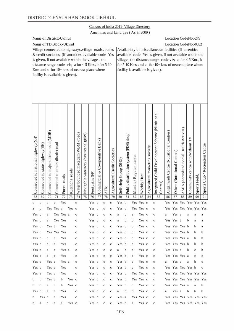
103
DISTRICT CENSUS HANDBOOK-UKHRUL
Name of District:-Ukhrul Location CodeNo:-279Name of TD Block:-Ukhrul Location CodeNo:-0032
Con
nect
ed to
nat
iona
l hig
hway
(NH
)
Con
nect
ed to
stat
e hi
ghw
ay(S
H)
Con
nect
ed to
maj
or d
istri
ct ro
ad (M
DR
)
Con
nect
ed to
oth
ers d
istri
ct ro
ad
Pucc
a ro
ads
Kut
chch
a ro
ads
Wat
er b
ound
ed m
acad
am(W
BM
) roa
ds
Nav
igab
le w
ater
way
(riv
er/c
anal
)(NW
)
Foot
path
s (FP
)
Com
mer
cial
& C
o-op
erat
ive
Ban
ks
ATM
Agr
icul
tura
l Cre
dit S
ocie
ties
Self-
Hel
p G
roup
(SH
G)
Publ
ic d
istri
butio
n sy
stem
(PD
S) sh
op
Man
dis /
Reg
ular
mar
ket
Wee
kly
Haa
t
Agr
icul
tura
l mar
ketin
g so
ciet
y
Inte
grat
ed C
hild
Dev
elop
men
t Sch
eme
(Nut
ritio
nal
Cen
tres)
Ang
anw
adi C
entre
(Nut
ritio
nal C
entre
s)
Oth
ers (
Nut
ritio
nal C
entre
s)
ASH
A (A
ccre
dite
d So
cial
Hea
lth A
ctiv
ist)
Com
mun
ity c
entre
with
/with
out T
V
Spor
ts F
ield
,
Spor
ts C
lub
/ Rec
reat
ion
Cen
tre
68 69 70 71 72 73 74 75 76 77 78 79 80 81 82 83 84 85 86 87 88 89 90 91
c c a c Yes c Yes c c c Yes b Yes Yes c c Yes Yes Yes Yes Yes Yes
a c Yes Yes a Yes c Yes c c c Yes c Yes Yes c c Yes Yes Yes Yes Yes Yes
Yes c a Yes Yes a c Yes c c c a b a Yes c c a Yes a a a a
Yes c a Yes Yes c Yes c c c a b b Yes c c Yes Yes b b a a
Yes c Yes b Yes c Yes c c c Yes b b Yes c c Yes Yes Yes b b a
Yes c Yes Yes Yes c Yes c c c Yes c c Yes c c Yes Yes Yes b b b
Yes c b c Yes c Yes c c c Yes c c Yes c c Yes Yes Yes a b b
Yes c b c Yes c Yes c c c Yes b c Yes c c Yes Yes Yes b b b
Yes c a c Yes a c Yes c c c a b c Yes c c Yes Yes a b c b
Yes c a c Yes c Yes c c c Yes b c Yes c c Yes Yes Yes a c c
Yes c Yes c Yes a c Yes c c c Yes b c Yes c c a Yes a a b c
Yes c Yes c Yes c Yes c c c Yes b c Yes c c Yes Yes Yes Yes b c
Yes a Yes c Yes c Yes c c c Yes b Yes Yes c c Yes Yes Yes Yes Yes Yes
b b Yes c b Yes c Yes c c c Yes b Yes Yes c c Yes Yes Yes Yes Yes Yes
b c a c b Yes c Yes c c c Yes b c Yes c c Yes Yes Yes a a b
Yes b a c Yes c Yes c c c a b b Yes c c a Yes a b b b
b Yes b c Yes c Yes c c c Yes a Yes Yes c c Yes Yes Yes Yes Yes Yes
b a c c a Yes c Yes c c c Yes c a Yes c c Yes Yes Yes Yes Yes Yes
Village connected to highways,village roads, banks & credit societies (If amenities available code -Yes is given, If not available within the village , the distance range code viz; a for < 5 Kms, b for 5-10 Kms and c for 10+ kms of nearest place where facility is available is given).
Availability of miscellaneous facilities (If amenities available code -Yes is given, If not available within the village , the distance range code viz; a for < 5 Kms, b for 5-10 Kms and c for 10+ kms of nearest place where facility is available is given).
Census of India 2011- Village DirectoryAmenities and Land use ( As in 2009 )
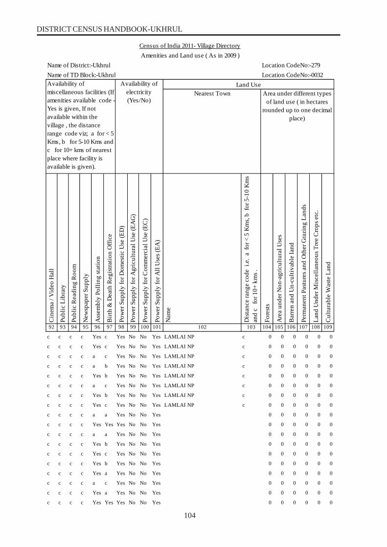
104
DISTRICT CENSUS HANDBOOK-UKHRUL
Name of District:-Ukhrul Location CodeNo:-279Name of TD Block:-Ukhrul Location CodeNo:-0032
Cin
ema
/ Vid
eo H
all
Publ
ic L
ibra
ry
Publ
ic R
eadi
ng R
oom
New
spap
er S
uppl
y
Ass
embl
y Po
lling
stat
ion
Birt
h &
Dea
th R
egis
tratio
n O
ffice
Pow
er S
uppl
y fo
r Dom
estic
Use
(ED
)
Pow
er S
uppl
y fo
r Agr
icul
tura
l Use
(EA
G)
Pow
er S
uppl
y fo
r Com
mer
cial
Use
(EC
)
Pow
er S
uppl
y fo
r All
Use
s (EA
)
Nam
e
Dis
tanc
e ra
nge
code
i.e
. a
for <
5 K
ms,
b fo
r 5-1
0 K
ms
and
c f
or 1
0+ k
ms .
Fore
sts
Are
a un
der N
on-a
gric
ultu
ral U
ses
Bar
ren
and
Un-
culti
vabl
e la
nd
Perm
anen
t Pas
ture
s and
Oth
er G
razi
ng L
ands
Land
Und
er M
isce
llane
ous T
ree
Cro
ps e
tc.
Cul
tura
ble
Was
te L
and
92 93 94 95 96 97 98 99 100 101 102 103 104 105 106 107 108 109
c c c c Yes c Yes No No Yes LAMLAI NP c 0 0 0 0 0 0
c c c c Yes c Yes No No Yes LAMLAI NP c 0 0 0 0 0 0
c c c c a c Yes No No Yes LAMLAI NP c 0 0 0 0 0 0
c c c c a b Yes No No Yes LAMLAI NP c 0 0 0 0 0 0
c c c c Yes b Yes No No Yes LAMLAI NP c 0 0 0 0 0 0
c c c c a c Yes No No Yes LAMLAI NP c 0 0 0 0 0 0
c c c c Yes b Yes No No Yes LAMLAI NP c 0 0 0 0 0 0
c c c c Yes c Yes No No Yes LAMLAI NP c 0 0 0 0 0 0
c c c c a a Yes No No Yes 0 0 0 0 0 0
c c c c Yes Yes Yes No No Yes 0 0 0 0 0 0
c c c c a a Yes No No Yes 0 0 0 0 0 0
c c c c Yes b Yes No No Yes 0 0 0 0 0 0
c c c c Yes c Yes No No Yes 0 0 0 0 0 0
c c c c Yes b Yes No No Yes 0 0 0 0 0 0
c c c c Yes a Yes No No Yes 0 0 0 0 0 0
c c c c a c Yes No No Yes 0 0 0 0 0 0
c c c c Yes a Yes No No Yes 0 0 0 0 0 0
c c c c Yes Yes Yes No No Yes 0 0 0 0 0 0
Nearest Town Area under different types of land use ( in hectares
rounded up to one decimal place)
Availability of miscellaneous facilities (If amenities available code -Yes is given, If not available within the village , the distance range code viz; a for < 5 Kms, b for 5-10 Kms and c for 10+ kms of nearest place where facility is available is given).
Availability of electricity (Yes/No)
Land Use
Census of India 2011- Village DirectoryAmenities and Land use ( As in 2009 )
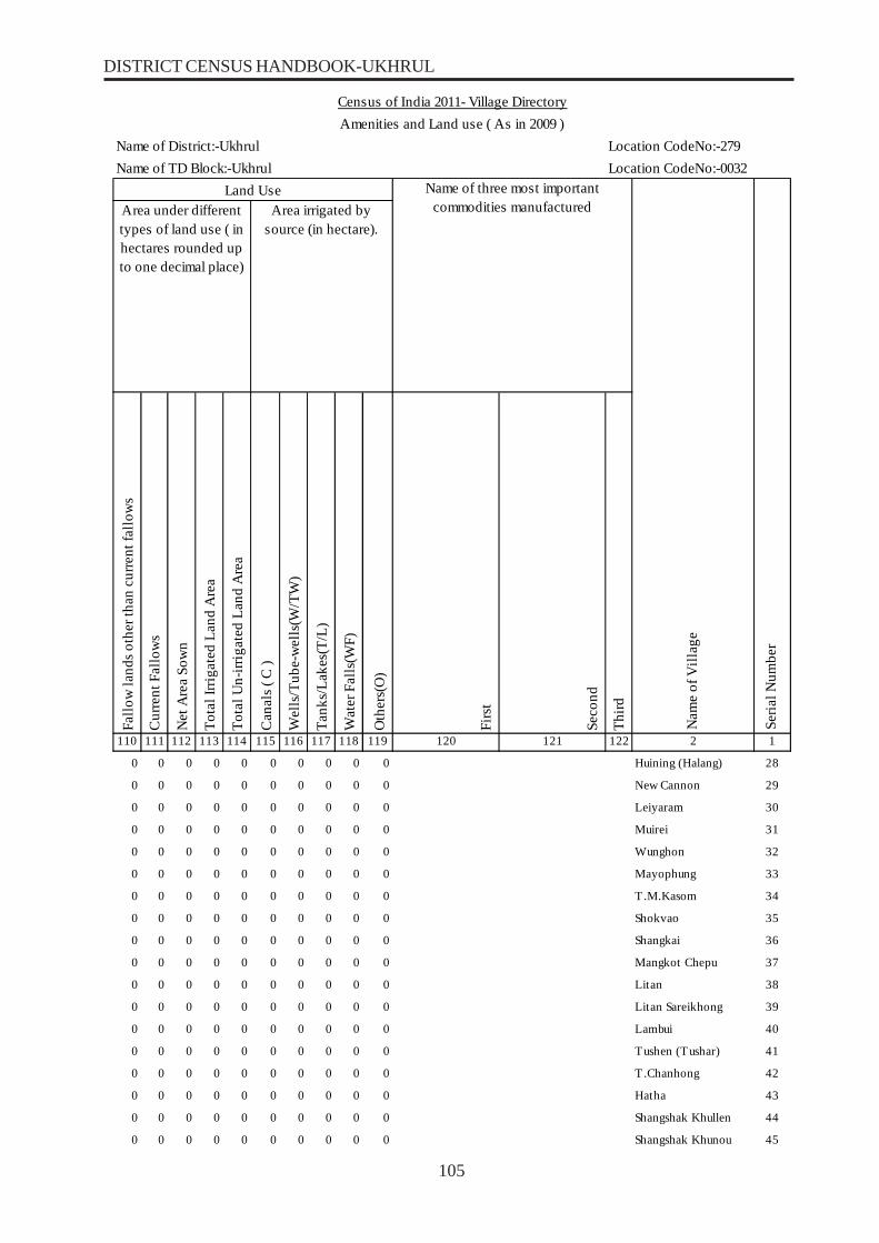
105
DISTRICT CENSUS HANDBOOK-UKHRUL
Name of District:-Ukhrul Location CodeNo:-279Name of TD Block:-Ukhrul Location CodeNo:-0032
Fallo
w la
nds o
ther
than
cur
rent
fallo
ws
Cur
rent
Fal
low
s
Net
Are
a So
wn
Tota
l Irri
gate
d La
nd A
rea
Tota
l Un-
irrig
ated
Lan
d A
rea
Can
als (
C )
Wel
ls/T
ube-
wel
ls(W
/TW
)
Tank
s/La
kes(
T/L)
Wat
er F
alls
(WF)
Oth
ers(
O)
Firs
t
Seco
nd
Third
110 111 112 113 114 115 116 117 118 119 120 121 122 2 1
0 0 0 0 0 0 0 0 0 0 Huining (Halang) 28
0 0 0 0 0 0 0 0 0 0 New Cannon 29
0 0 0 0 0 0 0 0 0 0 Leiyaram 30
0 0 0 0 0 0 0 0 0 0 Muirei 31
0 0 0 0 0 0 0 0 0 0 Wunghon 32
0 0 0 0 0 0 0 0 0 0 Mayophung 33
0 0 0 0 0 0 0 0 0 0 T.M.Kasom 34
0 0 0 0 0 0 0 0 0 0 Shokvao 35
0 0 0 0 0 0 0 0 0 0 Shangkai 36
0 0 0 0 0 0 0 0 0 0 Mangkot Chepu 37
0 0 0 0 0 0 0 0 0 0 Litan 38
0 0 0 0 0 0 0 0 0 0 Litan Sareikhong 39
0 0 0 0 0 0 0 0 0 0 Lambui 40
0 0 0 0 0 0 0 0 0 0 Tushen (Tushar) 41
0 0 0 0 0 0 0 0 0 0 T.Chanhong 42
0 0 0 0 0 0 0 0 0 0 Hatha 43
0 0 0 0 0 0 0 0 0 0 Shangshak Khullen 44
0 0 0 0 0 0 0 0 0 0 Shangshak Khunou 45
Name of three most important commodities manufactured
Nam
e of
Vill
age
Seria
l Num
ber
Area under different types of land use ( in hectares rounded up to one decimal place)
Area irrigated by source (in hectare).
Land Use
Census of India 2011- Village DirectoryAmenities and Land use ( As in 2009 )
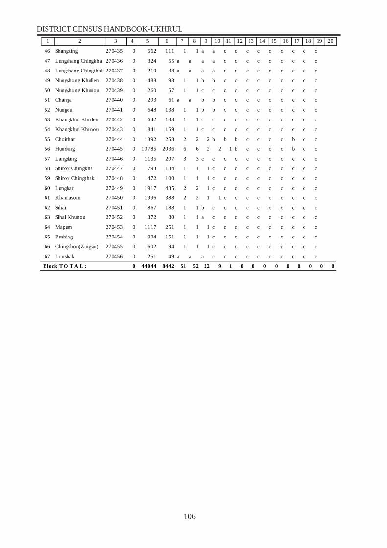
106
DISTRICT CENSUS HANDBOOK-UKHRUL1 2 3 4 5 6 7 8 9 10 11 12 13 14 15 16 17 18 19 20
46 Shangzing 270435 0 562 111 1 1 a a c c c c c c c c c
47 Lungshang Chingkha 270436 0 324 55 a a a a c c c c c c c c c
48 Lungshang Chingthak 270437 0 210 38 a a a a c c c c c c c c c
49 Nungshong Khullen 270438 0 488 93 1 1 b b c c c c c c c c c
50 Nungshong Khunou 270439 0 260 57 1 1 c c c c c c c c c c c
51 Changa 270440 0 293 61 a a b b c c c c c c c c c
52 Nungou 270441 0 648 138 1 1 b b c c c c c c c c c
53 Khangkhui Khullen 270442 0 642 133 1 1 c c c c c c c c c c c
54 Khangkhui Khunou 270443 0 841 159 1 1 c c c c c c c c c c c
55 Choithar 270444 0 1392 258 2 2 2 b b b c c c c b c c
56 Hundung 270445 0 10785 2036 6 6 2 2 1 b c c c c b c c
57 Langdang 270446 0 1135 207 3 3 c c c c c c c c c c c
58 Shiroy Chingkha 270447 0 793 184 1 1 1 c c c c c c c c c c
59 Shiroy Chingthak 270448 0 472 100 1 1 1 c c c c c c c c c c
60 Lunghar 270449 0 1917 435 2 2 1 c c c c c c c c c c
61 Khamasom 270450 0 1996 388 2 2 1 1 c c c c c c c c c
62 Sihai 270451 0 867 188 1 1 b c c c c c c c c c c
63 Sihai Khunou 270452 0 372 80 1 1 a c c c c c c c c c c
64 Mapum 270453 0 1117 251 1 1 1 c c c c c c c c c c
65 Pushing 270454 0 904 151 1 1 1 c c c c c c c c c c
66 Chingshou(Zingsui) 270455 0 602 94 1 1 1 c c c c c c c c c c
67 Lonshak 270456 0 251 49 a a a c c c c c c c c c c
Block T O T A L : 0 44044 8442 51 52 22 9 1 0 0 0 0 0 0 0 0 0
107
DISTRICT CENSUS HANDBOOK-UKHRUL21 22 23 24 25 26 27 28 29 30 31 32 33 34 35 36 37 38 39 40 41 42 43 44 45 46
c c b c c c c b c c c 0 0 0 0 0 0 0 No No No No Yes Yes No No
c c c c c c c b c c c 0 0 0 0 0 0 0 No No No No Yes Yes Yes No
c c c c c c c b c c c 0 0 0 0 0 0 0 No No No No Yes No Yes No
c b c c c c c c c c c 0 0 0 0 1 0 0 No No No No Yes Yes Yes No
c b c c c c c c c c c 0 0 0 0 0 0 0 No No No No No Yes No No
c c c c c c c c c c c 0 0 0 0 0 0 0 No No No No Yes No Yes No
c c c c c c c c c c c 0 0 0 0 1 0 0 No No No No Yes Yes Yes No
c 1 b c c c c c c c c 0 0 0 0 0 1 0 No No No No Yes Yes Yes No
c a a c c c c c c c c 0 0 0 0 1 0 0 No No No No Yes Yes Yes No
c a b b b b c c b c b 0 0 0 0 1 0 0 No No No No Yes Yes No No
c c c b b b c c b c b 0 4 2 1 4 7 0 No No No No Yes Yes Yes No
c b a c c c c c c c c 0 0 0 0 0 0 0 No No No No No Yes Yes No
c b 1 c c c c c c c c 0 0 0 0 0 0 0 No No No No Yes Yes No No
c b a c c c c c c c c 0 0 0 0 0 0 0 No No No No Yes No Yes No
c c b c c c c c c c c 0 0 0 0 0 0 0 No No No No Yes No Yes No
c c c c c c c 1 c c c 0 0 0 0 1 1 0 No No No No Yes Yes Yes No
c c c c c c c b c c c 0 0 0 0 0 0 0 No No No No Yes No Yes No
c c c c c c c a c c c 0 0 0 0 0 0 0 No No No No Yes Yes No No
c c 1 c c c c c c c c 0 0 0 0 1 1 0 No No No No No No Yes No
c c b c c c c c c c c 0 0 0 0 0 0 0 No No No No Yes No Yes No
c c b c c c c c c c c 0 0 0 0 0 0 0 No No No No Yes Yes No No
c c c c c c c c c c c 0 0 0 0 1 0 0 No No No No No No Yes No
0 2 4 0 0 0 0 2 1 0 0 0 7 2 5 22 23 0 0 0 0 0 33 20 32 0
108
DISTRICT CENSUS HANDBOOK-UKHRUL47 48 49 50 51 52 53 54 55 56 57 58 59 60 61 62 63 64 65 66 67
No No No No c c c 795142 c c Yes c c Yes c c Yes c c
No No No No c c c 795142 c c Yes c c Yes c c a c c
No No No No c c c 795142 c c Yes c c Yes c c b c c
No No No No c c c 795142 c c Yes c c b c c Yes c c
No No No No c c c 795142 c c Yes c c b c c Yes c c
No No No No c c c 795142 c c Yes c c b c c Yes c c
No No No No c c c 795142 c c Yes c c b c c Yes c c
No No No No c b c 795142 c c Yes c c c c c Yes c c
No No No No c a c 795142 c c Yes c c c c c Yes c c
No No No No b b c 795142 b b Yes c c b c c Yes c c
No No No No b Yes c 795142 b b Yes c c Yes c c Yes c c
No No No No c a c 795142 c c Yes c c c c c Yes c c
No No No No c Yes c 795142 c c Yes c c c c c Yes c c
No No No No c Yes c 795142 c c Yes c c c c c Yes c c
No No No No c c c 795142 c c Yes c c Yes c c Yes c c
No No No No c Yes c 795142 c c Yes c c c c c Yes c c
No No No No c b c 795142 c c Yes c c c c c Yes c c
No No No No c a c 795142 c c b c c c c c Yes c c
No No No No c Yes c 795142 c c Yes c c c c c Yes c c
No No No No c Yes c 795142 c c Yes c c c c c Yes c c
No No No No c c c 795142 c c b c c c c c Yes c c
No No No No c c c 795142 c c c c c c c c c c c
0 0 0 0 0 8 0 40 0 0 36 0 0 14 0 0 34 0 0 0 0
109
DISTRICT CENSUS HANDBOOK-UKHRUL68 69 70 71 72 73 74 75 76 77 78 79 80 81 82 83 84 85 86 87 88 89 90 91
b Yes a c Yes c Yes c c c Yes c b Yes c c Yes Yes Yes a c b
c Yes a c Yes c Yes c c c a b b Yes c c a Yes Yes b c c
c Yes Yes c Yes a c Yes c c c a b c Yes c c a Yes a b b c
c b a c b Yes c Yes c c c Yes b b Yes c c Yes Yes Yes b b c
c b Yes c b Yes c Yes c c c a b b Yes c c a Yes a b b c
c b Yes c b Yes c Yes c c c a b c Yes c c a Yes a c c c
c b Yes c b Yes c Yes c c c Yes b c Yes c c Yes Yes Yes c c c
b c Yes a c Yes b Yes c c c Yes c b Yes c c Yes Yes Yes a b b
c c Yes Yes c Yes c Yes c c c Yes c b Yes c c Yes Yes Yes a c b
b c Yes b b Yes b Yes b c c Yes b Yes Yes b b Yes Yes Yes Yes Yes Yes
Yes b b c Yes Yes Yes b c c Yes b Yes c b b Yes Yes Yes Yes Yes Yes
b c Yes Yes c Yes b Yes c c c Yes c Yes Yes c c Yes Yes Yes Yes c b
c c Yes c c Yes c Yes c c c Yes c b Yes c c Yes Yes Yes a c c
c c Yes c c Yes b Yes c c c a c b Yes c c Yes Yes Yes a c c
b b Yes c b Yes c Yes c c c Yes b Yes Yes c c Yes Yes Yes Yes Yes Yes
c c a c c Yes Yes Yes c c c Yes b Yes c c c Yes Yes Yes Yes Yes Yes
c c Yes c c Yes b Yes c c c Yes c b Yes c c Yes Yes Yes b b c
c c Yes c c Yes b Yes c c c a c b Yes c c Yes Yes Yes a c c
c c b c c Yes Yes Yes c c c Yes c c c c c Yes Yes Yes Yes c c
c b Yes c b Yes b Yes c c c Yes c c Yes c c Yes Yes Yes Yes c c
c c b c c Yes c Yes c c c Yes c c Yes c c Yes Yes Yes b c c
c c Yes c c Yes c Yes c c c b c c Yes c c b Yes b b c c
13 4 22 6 18 22 3 0 40 0 0 0 29 0 10 37 0 0 32 40 31 14 10 10
110
DISTRICT CENSUS HANDBOOK-UKHRUL92 93 94 95 96 97 98 99 100 101 102 103 104 105 106 107 108 109
c c c c Yes b Yes No No Yes 0 0 0 0 0 0
c c c c a c Yes No No Yes 0 0 0 0 0 0
c c c c a c Yes No No Yes 0 0 0 0 0 0
c c c c Yes c Yes No No Yes 0 0 0 0 0 0
c c c c a c Yes No No Yes LAMLAI NP c 0 0 0 0 0 0
c c c c b c Yes No No Yes LAMLAI NP c 0 0 0 0 0 0
c c c c Yes c Yes No No Yes LAMLAI NP c 0 0 0 0 0 0
c c c c Yes b Yes No No Yes LAMLAI NP c 0 0 0 0 0 0
c c c c Yes a Yes No No Yes LAMLAI NP c 0 0 0 0 0 0
b b b b Yes b Yes No No Yes 0 0 0 0 0 0
b b b b Yes c Yes No No Yes 0 0 0 0 0 0
c c c c Yes a Yes No No Yes 0 0 0 0 0 0
c c c c Yes Yes Yes No No Yes 0 0 0 0 0 0
c c c c Yes a Yes No No Yes 0 0 0 0 0 0
c c c c Yes b Yes No No Yes LAMLAI NP c 0 0 0 0 0 0
c c c c Yes c Yes No No Yes LAMLAI NP c 0 0 0 0 0 0
c c c c Yes c Yes No No Yes LAMLAI NP c 0 0 0 0 0 0
c c c c b c Yes No No Yes LAMLAI NP c 0 0 0 0 0 0
c c c c Yes Yes Yes No No Yes LAMLAI NP c 0 0 0 0 0 0
c c c c Yes b Yes No No Yes LAMLAI NP c 0 0 0 0 0 0
c c c c Yes b Yes No No Yes LAMLAI NP c 0 0 0 0 0 0
c c c c a c Yes No No Yes LAMLAI NP c 0 0 0 0 0 0
0 0 0 0 28 4 40 0 0 40 0 0 0 0 0 0 0 0
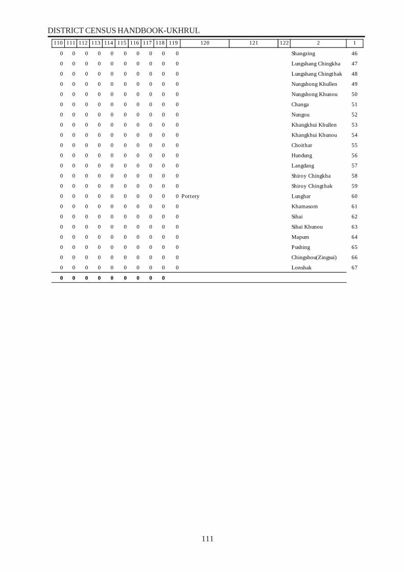
111
DISTRICT CENSUS HANDBOOK-UKHRUL110 111 112 113 114 115 116 117 118 119 120 121 122 2 1
0 0 0 0 0 0 0 0 0 0 Shangzing 46
0 0 0 0 0 0 0 0 0 0 Lungshang Chingkha 47
0 0 0 0 0 0 0 0 0 0 Lungshang Chingthak 48
0 0 0 0 0 0 0 0 0 0 Nungshong Khullen 49
0 0 0 0 0 0 0 0 0 0 Nungshong Khunou 50
0 0 0 0 0 0 0 0 0 0 Changa 51
0 0 0 0 0 0 0 0 0 0 Nungou 52
0 0 0 0 0 0 0 0 0 0 Khangkhui Khullen 53
0 0 0 0 0 0 0 0 0 0 Khangkhui Khunou 54
0 0 0 0 0 0 0 0 0 0 Choithar 55
0 0 0 0 0 0 0 0 0 0 Hundung 56
0 0 0 0 0 0 0 0 0 0 Langdang 57
0 0 0 0 0 0 0 0 0 0 Shiroy Chingkha 58
0 0 0 0 0 0 0 0 0 0 Shiroy Chingthak 59
0 0 0 0 0 0 0 0 0 0 Pottery Lunghar 60
0 0 0 0 0 0 0 0 0 0 Khamasom 61
0 0 0 0 0 0 0 0 0 0 Sihai 62
0 0 0 0 0 0 0 0 0 0 Sihai Khunou 63
0 0 0 0 0 0 0 0 0 0 Mapum 64
0 0 0 0 0 0 0 0 0 0 Pushing 65
0 0 0 0 0 0 0 0 0 0 Chingshou(Zingsui) 66
0 0 0 0 0 0 0 0 0 0 Lonshak 67
0 0 0 0 0 0 0 0 0
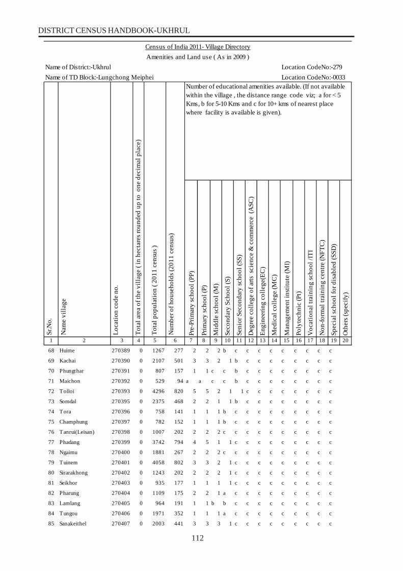
112
DISTRICT CENSUS HANDBOOK-UKHRUL
Name of District:-Ukhrul Location CodeNo:-279Name of TD Block:-Lungchong Meiphei Location CodeNo:-0033
Pre-
Prim
ary
scho
ol (P
P)
Prim
ary
scho
ol (P
)
Mid
dle
scho
ol (M
)
Seco
ndar
y Sc
hool
(S)
Seni
or S
econ
dary
scho
ol (S
S)
Deg
ree
colle
ge o
f arts
sci
ence
& c
omm
erce
(A
SC)
Engi
neer
ing
colle
ge(E
C)
Med
ical
col
lege
(MC
)
Man
agem
ent i
nstit
ute
(MI)
Poly
tech
nic
(Pt)
Voc
atio
nal t
rain
ing
scho
ol /I
TI
Non
-form
al tr
aini
ng c
entre
(NFT
C)
Spec
ial s
choo
l for
dis
able
d (S
SD)
Oth
ers (
spec
ify)
1 2 3 4 5 6 7 8 9 10 11 12 13 14 15 16 17 18 19 20
68 Huime 270389 0 1267 277 2 2 2 b c c c c c c c c c
69 Kachai 270390 0 2107 501 3 3 2 1 b c c c c c c c c
70 Phungthar 270391 0 807 157 1 1 c c b c c c c c c c c
71 Maichon 270392 0 529 94 a a c c b c c c c c c c c
72 Tolloi 270393 0 4296 820 5 5 2 1 1 c c c c c c c c
73 Somdal 270395 0 2375 468 2 2 1 1 b c c c c c c c c
74 Tora 270396 0 758 141 1 1 1 b c c c c c c c c c
75 Champhung 270397 0 782 152 1 1 1 b c c c c c c c c c
76 Tanrui(Leisan) 270398 0 1007 202 2 2 2 c c c c c c c c c c
77 Phadang 270399 0 3742 794 4 5 1 1 c c c c c c c c c
78 Ngaimu 270400 0 1881 267 2 2 2 c c c c c c c c c c
79 Tuinem 270401 0 4058 802 3 3 2 1 c c c c c c c c c
80 Sirarakhong 270402 0 1243 202 2 2 2 1 c c c c c c c c c
81 Seikhor 270403 0 935 177 1 1 1 1 c c c c c c c c c
82 Pharung 270404 0 1109 175 2 2 1 a c c c c c c c c c
83 Lamlang 270405 0 964 191 1 1 b b c c c c c c c c c
84 Tungou 270406 0 1971 352 1 1 1 a c c c c c c c c c
85 Sanakeithel 270407 0 2003 441 3 3 3 1 c c c c c c c c c
Number of educational amenities available. (If not available within the village , the distance range code viz; a for < 5 Kms, b for 5-10 Kms and c for 10+ kms of nearest place where facility is available is given).
Sr.N
o.
Nam
e vi
llage
Loca
tion
code
no.
Tota
l are
a of
the
villa
ge (
in h
ecta
res r
ound
ed u
p to
one
dec
imal
pla
ce)
Tota
l pop
ulat
ion
( 201
1 ce
nsus
)
Num
ber o
f hou
seho
lds (
2011
cen
sus)
Amenities and Land use ( As in 2009 )Census of India 2011- Village Directory
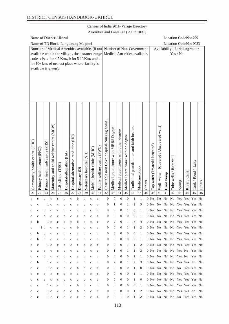
113
DISTRICT CENSUS HANDBOOK-UKHRUL
Name of District:-Ukhrul Location CodeNo:-279Name of TD Block:-Lungchong Meiphei Location CodeNo:-0033
Com
mun
ity h
ealth
cen
tre (C
HC
)
Prim
ary
heal
th c
entre
(PH
C)
Prim
ary
heal
th su
b ce
ntre
(PH
S)
Mat
erni
ty a
nd c
hild
wel
fare
cen
tre (M
CW
)
T.B
. clin
ic (
TBC
)
Hos
pita
l-allo
path
ic (H
A)
Hos
pita
l-alte
rnat
ive
med
icin
e (H
O)
Dis
pens
ary
(D)
Vet
erin
ary
hosp
ital (
VH
)
Mob
ile h
ealth
clin
ic (M
HC
)
Fam
ily w
elfa
re c
entre
(FW
C)
Cha
ritab
le n
on G
ovt.
hosp
ital/N
ursi
ng h
ome.
Med
ical
pra
ctiti
oner
with
MB
BS
Deg
ree
Med
ical
pra
ctiti
oner
with
oth
er d
egre
e
Med
ical
pra
ctiti
oner
with
no
degr
ee
Trad
ition
al p
ract
ition
er a
nd fa
ith h
eale
r .
Med
icin
e Sh
op
Oth
ers
Tap
wat
er (T
reat
ed/U
ntre
ated
)
Wel
l w
ater
(C
over
ed /
Unc
over
ed w
ell)
Han
d Pu
mp
Tube
wel
ls /
Bor
e w
ell
Sprin
g
Riv
er /
Can
al
Tank
/ Po
nd /
Lak
e
Oth
ers
21 22 23 24 25 26 27 28 29 30 31 32 33 34 35 36 37 38 39 40 41 42 43 44 45 46
c c b c c c c b c c c 0 0 0 0 1 1 0 No No No No Yes Yes Yes No
c c 1 c c c c c c c c 0 1 0 1 2 3 0 No No No No Yes Yes Yes No
c c c c c c c c c c c 0 0 0 1 0 1 0 No No No No Yes Yes Yes No
c c b c c c c c c c c 0 0 0 0 0 1 0 No No No No Yes Yes Yes No
c b 1 c c c c b c c c 0 2 0 1 3 4 0 No No No No Yes Yes Yes No
c 1 b c c c c b c c c 0 0 0 1 1 2 0 No No No No Yes Yes Yes No
c b b c c c c c c c c 0 0 0 0 0 1 0 No No No No Yes Yes Yes No
c b b c c c c c c c c 0 0 0 0 0 1 0 No No No No Yes Yes Yes No
c c 1 c c c c c c c c 0 0 0 1 1 2 0 No No No No Yes Yes Yes No
c a a c c c c a c c c 0 1 0 1 1 3 0 No No No No Yes No Yes No
c c c c c c c c c c c 0 0 0 0 1 1 0 No No No No Yes No Yes No
c b 1 c c c c c c c c 0 2 0 1 2 3 0 No No No No Yes Yes No No
c c 1 c c c c b c c c 0 0 0 0 1 0 0 No No No No No Yes Yes No
c c a c c c c a c c c 0 0 0 0 1 1 0 No No No No Yes Yes Yes No
c c a c c c c a c c c 0 0 0 0 1 0 0 No No No No Yes Yes Yes No
c c 1 c c c c b c c c 0 0 0 0 0 1 0 No No No No Yes Yes Yes No
c c 1 c c c c b c c c 0 0 0 0 1 2 0 No No No No Yes Yes No No
c c 1 c c c c c c c c 0 0 1 0 1 2 0 No No No No No Yes Yes No
Census of India 2011- Village DirectoryAmenities and Land use ( As in 2009 )
Number of Medical Amenities available. (If not available within the village , the distance range code viz; a for < 5 Kms, b for 5-10 Kms and c for 10+ kms of nearest place where facility is available is given).
Number of Non-Government Medical Amenities available.
Availability of drinking water - Yes / No
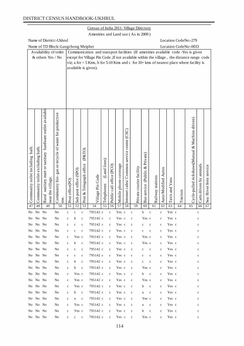
114
DISTRICT CENSUS HANDBOOK-UKHRUL
Name of District:-Ukhrul Location CodeNo:-279Name of TD Block:-Lungchong Meiphei Location CodeNo:-0033
Com
mun
ity to
ilet i
nclu
ding
bat
h.
Com
mun
ity to
ilet e
xclu
ding
bat
h.
Rur
al s
anita
ry m
art o
r san
itary
har
dwar
e ou
tlet a
vaila
ble
near
the
villa
ge.
Com
mun
ity b
io- g
as o
r rec
ycle
of w
aste
for p
rodu
ctiv
e us
e.
Post
offi
ce(P
O)
Sub
post
offi
ce (S
PO)
Post
& T
eleg
raph
offi
ce
(P&
TO)
Vill
age
Pin
Cod
e
Tele
phon
es
(L
and
lines
)
Publ
ic c
all o
ffice
(PC
O)
Mob
ile p
hone
cov
erag
e
Inte
rnet
caf
es/ C
omm
on se
rvic
e ce
ntre
(CSC
)
Priv
ate
cour
ier f
acili
ty
Bus
serv
ice
(Pub
lic &
Priv
ate)
Rai
lway
stat
ions
Aut
o/M
odifi
ed A
utos
Taxi
s and
Van
s
Trac
tors
Cyc
le-p
ulle
d ric
ksha
ws(
Man
ual &
Mac
hine
driv
en)
Car
ts d
riven
by
anim
als
Sea
/Riv
er fe
rry se
rvic
e47 48 49 50 51 52 53 54 55 56 57 58 59 60 61 62 63 64 65 66 67
No No No No c c c 795142 c c Yes c c b c c Yes c c
No No No No c b c 795142 c c Yes c c Yes c c Yes c c
No No No No c c c 795142 c c Yes c c c c c Yes c c
No No No No c c c 795142 c c Yes c c c c c Yes c c
No No No No c Yes c 795142 c c Yes c c Yes c c Yes c c
No No No No c b c 795142 c c Yes c c Yes c c Yes c c
No No No No c c c 795142 c c Yes c c c c c Yes c c
No No No No c c c 795142 c c Yes c c c c c Yes c c
No No No No c b c 795142 c c Yes c c c c c Yes c c
No No No No c b c 795142 c c Yes c c Yes c c Yes c c
No No No No c Yes c 795142 c c Yes c c b c c Yes c c
No No No No c Yes c 795142 c c Yes c c Yes c c Yes c c
No No No No c Yes c 795142 c c Yes c c b c c Yes c c
No No No No c b c 795142 c c Yes c c a c c Yes c c
No No No No c a c 795142 c c Yes c c Yes c c Yes c c
No No No No c Yes c 795142 c c Yes c c a c c Yes c c
No No No No c Yes c 795142 c c Yes c c b c c Yes c c
No No No No c c c 795142 c c Yes c c Yes c c Yes c c
Census of India 2011- Village DirectoryAmenities and Land use ( As in 2009 )
Availability of toilet & others Yes / No
Communication and transport facilities (If amenities available code -Yes is given except for Village Pin Code ,If not available within the village , the distance range code viz; a for < 5 Kms, b for 5-10 Kms and c for 10+ kms of nearest place where facility is available is given).
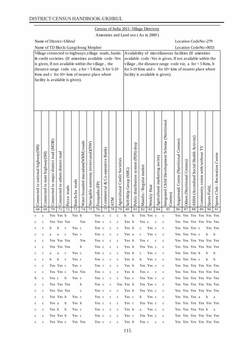
115
DISTRICT CENSUS HANDBOOK-UKHRUL
Name of District:-Ukhrul Location CodeNo:-279Name of TD Block:-Lungchong Meiphei Location CodeNo:-0033
Con
nect
ed to
nat
iona
l hig
hway
(NH
)
Con
nect
ed to
stat
e hi
ghw
ay(S
H)
Con
nect
ed to
maj
or d
istri
ct ro
ad (M
DR
)
Con
nect
ed to
oth
ers d
istri
ct ro
ad
Pucc
a ro
ads
Kut
chch
a ro
ads
Wat
er b
ound
ed m
acad
am(W
BM
) roa
ds
Nav
igab
le w
ater
way
(riv
er/c
anal
)(NW
)
Foot
path
s (FP
)
Com
mer
cial
& C
o-op
erat
ive
Ban
ks
ATM
Agr
icul
tura
l Cre
dit S
ocie
ties
Self-
Hel
p G
roup
(SH
G)
Publ
ic d
istri
butio
n sy
stem
(PD
S) sh
op
Man
dis /
Reg
ular
mar
ket
Wee
kly
Haa
t
Agr
icul
tura
l mar
ketin
g so
ciet
y
Inte
grat
ed C
hild
Dev
elop
men
t Sch
eme
(Nut
ritio
nal
Cen
tres)
Ang
anw
adi C
entre
(Nut
ritio
nal C
entre
s)
Oth
ers (
Nut
ritio
nal C
entre
s)
ASH
A (A
ccre
dite
d So
cial
Hea
lth A
ctiv
ist)
Com
mun
ity c
entre
with
/with
out T
V
Spor
ts F
ield
,
Spor
ts C
lub
/ Rec
reat
ion
Cen
tre
68 69 70 71 72 73 74 75 76 77 78 79 80 81 82 83 84 85 86 87 88 89 90 91
c c Yes Yes b Yes b Yes c c c b b Yes Yes c c Yes Yes Yes Yes Yes Yes
c c Yes Yes Yes Yes Yes c c c Yes b Yes c c c Yes Yes Yes Yes Yes Yes
c c b b c Yes c Yes c c c Yes b c Yes c c Yes Yes Yes c Yes Yes
c c a a c Yes c Yes c c c Yes a c Yes c c Yes Yes Yes c b b
c c Yes Yes Yes Yes Yes c c c Yes b Yes c c c Yes Yes Yes Yes Yes Yes
c c Yes Yes Yes b Yes c c c Yes b Yes Yes c c Yes Yes Yes Yes Yes Yes
c c a a c Yes c Yes c c c Yes b c Yes c c Yes Yes Yes b b b
c c b b c Yes c Yes c c c Yes b b Yes c c Yes Yes Yes c b b
c c Yes Yes c Yes c Yes c c c Yes b Yes Yes c c Yes Yes Yes Yes Yes Yes
c c Yes Yes c Yes Yes Yes c c c Yes b Yes c c c Yes Yes Yes Yes Yes Yes
b c Yes c b Yes c Yes c c c Yes c Yes Yes c c Yes Yes Yes Yes Yes Yes
c c Yes Yes Yes b Yes c c Yes Yes b Yes Yes c c Yes Yes Yes Yes Yes Yes
c c Yes Yes Yes c Yes c c c Yes b Yes Yes c c Yes Yes Yes Yes Yes Yes
c c Yes Yes b Yes c Yes c c c Yes c b Yes c c Yes Yes Yes a b a
c c Yes a b Yes b Yes c c c Yes c Yes Yes c c Yes Yes Yes Yes Yes Yes
c c Yes b b Yes c Yes c c c Yes b a Yes c c Yes Yes Yes Yes b a
c c Yes Yes b Yes c Yes c c c Yes c Yes Yes c c Yes Yes Yes Yes Yes Yes
c c Yes Yes c Yes Yes Yes c c c Yes b Yes c c c Yes Yes Yes Yes Yes Yes
Census of India 2011- Village DirectoryAmenities and Land use ( As in 2009 )
Village connected to highways,village roads, banks & credit societies (If amenities available code -Yes is given, If not available within the village , the distance range code viz; a for < 5 Kms, b for 5-10 Kms and c for 10+ kms of nearest place where facility is available is given).
Availability of miscellaneous facilities (If amenities available code -Yes is given, If not available within the village , the distance range code viz; a for < 5 Kms, b for 5-10 Kms and c for 10+ kms of nearest place where facility is available is given).

116
DISTRICT CENSUS HANDBOOK-UKHRUL
Name of District:-Ukhrul Location CodeNo:-279Name of TD Block:-Lungchong Meiphei Location CodeNo:-0033
Cin
ema
/ Vid
eo H
all
Publ
ic L
ibra
ry
Publ
ic R
eadi
ng R
oom
New
spap
er S
uppl
y
Ass
embl
y Po
lling
stat
ion
Birt
h &
Dea
th R
egis
tratio
n O
ffice
Pow
er S
uppl
y fo
r Dom
estic
Use
(ED
)
Pow
er S
uppl
y fo
r Agr
icul
tura
l Use
(EA
G)
Pow
er S
uppl
y fo
r Com
mer
cial
Use
(EC
)
Pow
er S
uppl
y fo
r All
Use
s (EA
)
Nam
e
Dis
tanc
e ra
nge
code
i.e
. a
for <
5 K
ms,
b fo
r 5-1
0 K
ms
and
c f
or 1
0+ k
ms .
Fore
sts
Are
a un
der N
on-a
gric
ultu
ral U
ses
Bar
ren
and
Un-
culti
vabl
e la
nd
Perm
anen
t Pas
ture
s and
Oth
er G
razi
ng L
ands
Land
Und
er M
isce
llane
ous T
ree
Cro
ps e
tc.
Cul
tura
ble
Was
te L
and
92 93 94 95 96 97 98 99 100 101 102 103 104 105 106 107 108 109
c c c c Yes b Yes No No Yes LAMLAI NP c 0 0 0 0 0 0
c c c c Yes Yes Yes No No Yes LAMLAI NP c 0 0 0 0 0 0
c c c c Yes c Yes No No Yes LAMLAI NP c 0 0 0 0 0 0
c c c c a b Yes No No Yes LAMLAI NP c 0 0 0 0 0 0
c c c c Yes Yes Yes No No Yes LAMLAI NP c 0 0 0 0 0 0
c c c c Yes Yes Yes No No Yes LAMLAI NP c 0 0 0 0 0 0
c c c c Yes b Yes No No Yes LAMLAI NP c 0 0 0 0 0 0
c c c c Yes b Yes No No Yes LAMLAI NP c 0 0 0 0 0 0
c c c c Yes Yes Yes No No Yes LAMLAI NP c 0 0 0 0 0 0
c c c c Yes a Yes No No Yes LAMLAI NP c 0 0 0 0 0 0
c c c c Yes c Yes No No Yes LAMLAI NP c 0 0 0 0 0 0
c c c c Yes Yes Yes No No Yes LAMLAI NP c 0 0 0 0 0 0
c c c c Yes Yes Yes No No Yes LAMLAI c 0 0 0 0 0 0
c c c c Yes a Yes No No Yes LAMLAI c 0 0 0 0 0 0
c c c c Yes a Yes No No Yes LAMLAI NP c 0 0 0 0 0 0
c c c c Yes Yes Yes No No Yes LAMLAI NP c 0 0 0 0 0 0
c c c c Yes Yes Yes No No Yes LAMLAI NP c 0 0 0 0 0 0
c c c c Yes Yes Yes No No Yes LAMLAI NP c 0 0 0 0 0 0
Census of India 2011- Village DirectoryAmenities and Land use ( As in 2009 )
Availability of miscellaneous facilities (If amenities available code -Yes is given, If not available within the village , the distance range code viz; a for < 5 Kms, b for 5-10 Kms and c for 10+ kms of nearest place where facility is available is given).
Availability of electricity (Yes/No)
Land Use Nearest Town Area under different types
of land use ( in hectares rounded up to one decimal
place)
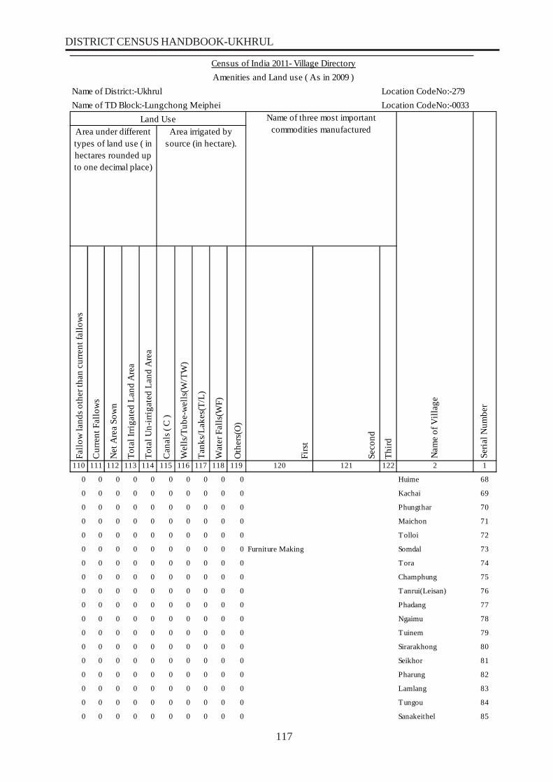
117
DISTRICT CENSUS HANDBOOK-UKHRUL
Name of District:-Ukhrul Location CodeNo:-279Name of TD Block:-Lungchong Meiphei Location CodeNo:-0033
Fallo
w la
nds o
ther
than
cur
rent
fallo
ws
Cur
rent
Fal
low
s
Net
Are
a So
wn
Tota
l Irri
gate
d La
nd A
rea
Tota
l Un-
irrig
ated
Lan
d A
rea
Can
als (
C )
Wel
ls/T
ube-
wel
ls(W
/TW
)
Tank
s/La
kes(
T/L)
Wat
er F
alls
(WF)
Oth
ers(
O)
Firs
t
Seco
nd
Third
110 111 112 113 114 115 116 117 118 119 120 121 122 2 1
0 0 0 0 0 0 0 0 0 0 Huime 68
0 0 0 0 0 0 0 0 0 0 Kachai 69
0 0 0 0 0 0 0 0 0 0 Phungthar 70
0 0 0 0 0 0 0 0 0 0 Maichon 71
0 0 0 0 0 0 0 0 0 0 Tolloi 72
0 0 0 0 0 0 0 0 0 0 Furniture Making Somdal 73
0 0 0 0 0 0 0 0 0 0 Tora 74
0 0 0 0 0 0 0 0 0 0 Champhung 75
0 0 0 0 0 0 0 0 0 0 Tanrui(Leisan) 76
0 0 0 0 0 0 0 0 0 0 Phadang 77
0 0 0 0 0 0 0 0 0 0 Ngaimu 78
0 0 0 0 0 0 0 0 0 0 Tuinem 79
0 0 0 0 0 0 0 0 0 0 Sirarakhong 80
0 0 0 0 0 0 0 0 0 0 Seikhor 81
0 0 0 0 0 0 0 0 0 0 Pharung 82
0 0 0 0 0 0 0 0 0 0 Lamlang 83
0 0 0 0 0 0 0 0 0 0 Tungou 84
0 0 0 0 0 0 0 0 0 0 Sanakeithel 85
Census of India 2011- Village DirectoryAmenities and Land use ( As in 2009 )
Land Use Name of three most important commodities manufactured
Nam
e of
Vill
age
Seria
l Num
ber
Area under different types of land use ( in hectares rounded up to one decimal place)
Area irrigated by source (in hectare).
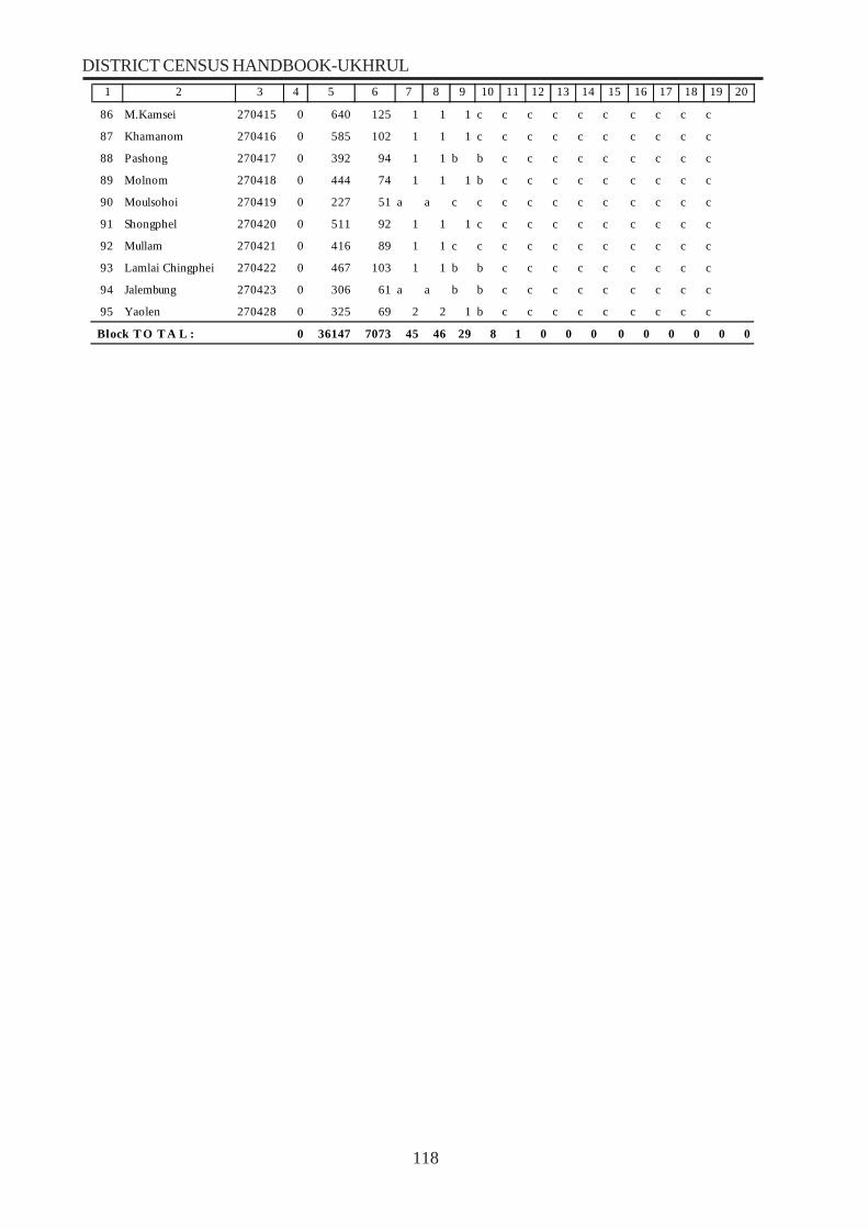
118
DISTRICT CENSUS HANDBOOK-UKHRUL1 2 3 4 5 6 7 8 9 10 11 12 13 14 15 16 17 18 19 20
86 M.Kamsei 270415 0 640 125 1 1 1 c c c c c c c c c c
87 Khamanom 270416 0 585 102 1 1 1 c c c c c c c c c c
88 Pashong 270417 0 392 94 1 1 b b c c c c c c c c c
89 Molnom 270418 0 444 74 1 1 1 b c c c c c c c c c
90 Moulsohoi 270419 0 227 51 a a c c c c c c c c c c c
91 Shongphel 270420 0 511 92 1 1 1 c c c c c c c c c c
92 Mullam 270421 0 416 89 1 1 c c c c c c c c c c c
93 Lamlai Chingphei 270422 0 467 103 1 1 b b c c c c c c c c c
94 Jalembung 270423 0 306 61 a a b b c c c c c c c c c
95 Yaolen 270428 0 325 69 2 2 1 b c c c c c c c c c
Block T O T A L : 0 36147 7073 45 46 29 8 1 0 0 0 0 0 0 0 0 0
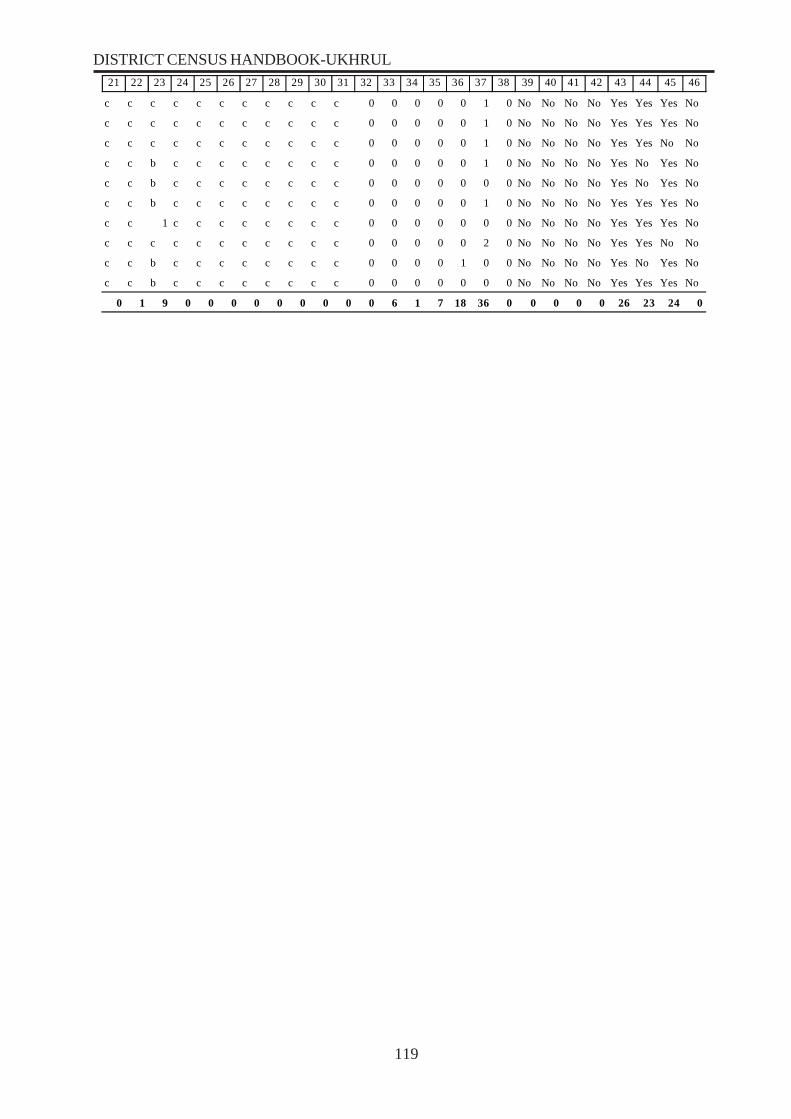
119
DISTRICT CENSUS HANDBOOK-UKHRUL21 22 23 24 25 26 27 28 29 30 31 32 33 34 35 36 37 38 39 40 41 42 43 44 45 46
c c c c c c c c c c c 0 0 0 0 0 1 0 No No No No Yes Yes Yes No
c c c c c c c c c c c 0 0 0 0 0 1 0 No No No No Yes Yes Yes No
c c c c c c c c c c c 0 0 0 0 0 1 0 No No No No Yes Yes No No
c c b c c c c c c c c 0 0 0 0 0 1 0 No No No No Yes No Yes No
c c b c c c c c c c c 0 0 0 0 0 0 0 No No No No Yes No Yes No
c c b c c c c c c c c 0 0 0 0 0 1 0 No No No No Yes Yes Yes No
c c 1 c c c c c c c c 0 0 0 0 0 0 0 No No No No Yes Yes Yes No
c c c c c c c c c c c 0 0 0 0 0 2 0 No No No No Yes Yes No No
c c b c c c c c c c c 0 0 0 0 1 0 0 No No No No Yes No Yes No
c c b c c c c c c c c 0 0 0 0 0 0 0 No No No No Yes Yes Yes No
0 1 9 0 0 0 0 0 0 0 0 0 6 1 7 18 36 0 0 0 0 0 26 23 24 0
120
DISTRICT CENSUS HANDBOOK-UKHRUL47 48 49 50 51 52 53 54 55 56 57 58 59 60 61 62 63 64 65 66 67
No No No No c c c 795142 c c Yes c c c c c Yes c c
No No No No c Yes c 795142 c c Yes c c c c c Yes c c
No No No No c c c 795142 c c Yes c c b c c Yes c c
No No No No c c c 795142 c c Yes c c b c c Yes c c
No No No No c c c 795142 c c Yes c c b c c Yes c c
No No No No c b c 795142 c c Yes c c c c c Yes c c
No No No No c b c 795142 c c Yes c c c c c Yes c c
No No No No c c c 795142 c c Yes c c b c c Yes c c
No No No No c c c 795142 c c Yes c c b c c Yes c c
No No No No c c c 795142 c c Yes c c b c c Yes c c
0 0 0 0 0 7 0 28 0 0 28 0 0 7 0 0 28 0 0 0 0
121
DISTRICT CENSUS HANDBOOK-UKHRUL68 69 70 71 72 73 74 75 76 77 78 79 80 81 82 83 84 85 86 87 88 89 90 91
c c Yes Yes c Yes c Yes c c c Yes c c Yes c c Yes Yes Yes b c b
c c Yes Yes c Yes c Yes c c c Yes c c Yes c c Yes Yes Yes c c b
c c Yes Yes c Yes c Yes c c c b b b Yes c c Yes Yes Yes c b a
c c Yes Yes c Yes c Yes c c c b b b Yes c c Yes Yes Yes b b b
c c a c c Yes c Yes c c c b c b Yes c c Yes Yes a b b a
c c Yes c c Yes c Yes c c c b b b Yes c c Yes Yes Yes c b b
c c Yes c c Yes c Yes c c c Yes b Yes Yes c c Yes Yes Yes c b b
b c a c b Yes c Yes c c c Yes b c Yes c c Yes Yes Yes c c b
b c Yes c b Yes c Yes c c c Yes c c Yes c c Yes Yes a c b b
b c b c b Yes c Yes c c c a b c Yes c c a Yes a a c c
0 0 21 15 5 23 4 0 28 0 0 1 22 0 13 24 0 0 27 28 25 13 13 13
122
DISTRICT CENSUS HANDBOOK-UKHRUL92 93 94 95 96 97 98 99 100 101 102 103 104 105 106 107 108 109
c c c c Yes c Yes No No Yes LAMLAI NP c 0 0 0 0 0 0
c c c c Yes c Yes No No Yes LAMLAI NP c 0 0 0 0 0 0
c c c c Yes c Yes No No Yes LAMLAI NP c 0 0 0 0 0 0
c c c c Yes b Yes No No Yes LAMLAI c 0 0 0 0 0 0
c c c c a b Yes No No Yes 0 0 0 0 0 0
c c c c Yes b Yes No No Yes 0 0 0 0 0 0
c c c c Yes Yes Yes No No Yes 0 0 0 0 0 0
c c c c Yes c Yes No No Yes 0 0 0 0 0 0
c c c c a b Yes No No Yes 0 0 0 0 0 0
c c c c a b Yes No No Yes 0 0 0 0 0 0
0 0 0 0 24 10 28 0 0 28 0 0 0 0 0 0 0 0
123
DISTRICT CENSUS HANDBOOK-UKHRUL110 111 112 113 114 115 116 117 118 119 120 121 122 2 1
0 0 0 0 0 0 0 0 0 0 M.Kamsei 86
0 0 0 0 0 0 0 0 0 0 Khamanom 87
0 0 0 0 0 0 0 0 0 0 Pashong 88
0 0 0 0 0 0 0 0 0 0 Molnom 89
0 0 0 0 0 0 0 0 0 0 Moulsohoi 90
0 0 0 0 0 0 0 0 0 0 Shongphel 91
0 0 0 0 0 0 0 0 0 0 Mullam 92
0 0 0 0 0 0 0 0 0 0 Lamlai Chingphei 93
0 0 0 0 0 0 0 0 0 0 Jalembung 94
0 0 0 0 0 0 0 0 0 0 Yaolen 95
0 0 0 0 0 0 0 0 0

124
DISTRICT CENSUS HANDBOOK-UKHRUL
125
DISTRICT CENSUS HANDBOOK-UKHRUL
Map of Kamjong T.D.Block

126
DISTRICT CENSUS HANDBOOK-UKHRUL
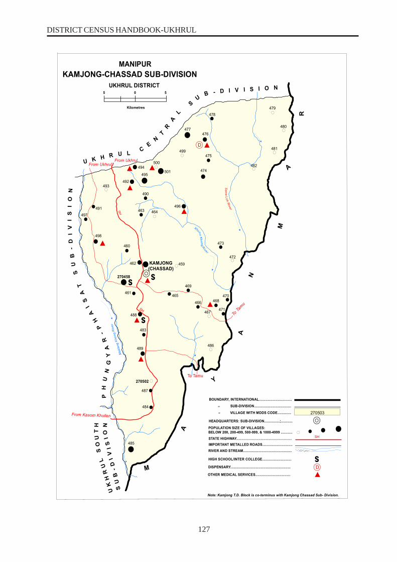
127
DISTRICT CENSUS HANDBOOK-UKHRUL
!
(
!
!
!
! (
!
!
(
!
!
!
!
(
!
!
!
!
!
(
(
(
(
!
!
(
!
!
!
!
!
!
(
!
!
!
!
(
(
(
!
!
!
!
!
M
A
Y
A
N
M
A
R
PH
UN
GY
AR
-P
HA
IS
AT
S
UB
-D
IV
IS
IO
N
U K H R U L CE
NT
RA
L
SU
B - D I V I S I O N
From Ukhrul
Khunu K
ho
ng
River
Sa
na
Lo
k R
iver
To Tamu
459
465
466
467
468
469
470
471
472
473
474
475
476
478
479
480
481
482
486
496
499
477
501
To T
amu
55 0
R
Note: Kamjong T.D. Block is co-terminus with Kamjong Chassad Sub- Division.
270503
R
SH( ! ! !
BOUNDARY, INTERNATIONAL..................................
,, SUB-DIVISION......................................
,, VILLAGE WITH MDDS CODE..............
HEADQUARTERS: SUB-DIVISION................;............
STATE HIGHWAY.........................................................
IMPORTANT METALLED ROADS...............................
RIVER AND STREAM..................................................
POPULATION SIZE OF VILLAGES:
BELOW 200, 200-499, 500-999, & 1000-4999 ............
E#
SHIGH SCHOOL/INTER COLLEGE..............................
OTHER MEDICAL SERVICES....................................
DISPENSARY..............................................................
E
#S
S
S
#
#
##
#
#
#
#
#
KAMJONG
(CHASSAD)
UK
HR
UL
S
OU
TH
Kilometres
UKHRUL DISTRICT
KAMJONG-CHASSAD SUB-DIVISION
MANIPUR
SU
B-
DI
VI
SI
ON
SH
SH
From Kasom Khullen
From Ukhrul
Ma
kla
ng
Kho
ng
Riv
er
495
485
500
498
497
494
493492
491
490
489
488
487
484
483
464463
462
461
460
270502
270458
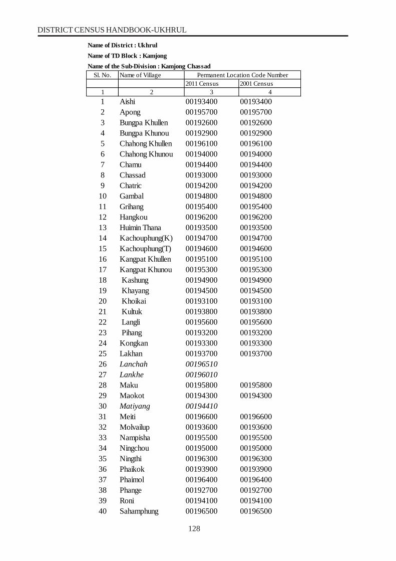
128
DISTRICT CENSUS HANDBOOK-UKHRUL
Name of District : UkhrulName of TD Block : KamjongName of the Sub-Division : Kamjong Chassad
Sl. No. Name of Village2011 Census 2001 Census
1 2 3 41 Aishi 00193400 001934002 Apong 00195700 001957003 Bungpa Khullen 00192600 001926004 Bungpa Khunou 00192900 001929005 Chahong Khullen 00196100 001961006 Chahong Khunou 00194000 001940007 Chamu 00194400 001944008 Chassad 00193000 001930009 Chatric 00194200 0019420010 Gambal 00194800 0019480011 Grihang 00195400 0019540012 Hangkou 00196200 0019620013 Huimin Thana 00193500 0019350014 Kachouphung(K) 00194700 0019470015 Kachouphung(T) 00194600 0019460016 Kangpat Khullen 00195100 0019510017 Kangpat Khunou 00195300 0019530018 Kashung 00194900 0019490019 Khayang 00194500 0019450020 Khoikai 00193100 0019310021 Kultuk 00193800 0019380022 Langli 00195600 0019560023 Pihang 00193200 0019320024 Kongkan 00193300 0019330025 Lakhan 00193700 0019370026 Lanchah 0019651027 Lankhe 0019601028 Maku 00195800 0019580029 Maokot 00194300 0019430030 Matiyang 0019441031 Meiti 00196600 0019660032 Molvailup 00193600 0019360033 Nampisha 00195500 0019550034 Ningchou 00195000 0019500035 Ningthi 00196300 0019630036 Phaikok 00193900 0019390037 Phaimol 00196400 0019640038 Phange 00192700 0019270039 Roni 00194100 0019410040 Sahamphung 00196500 00196500
Permanent Location Code Number
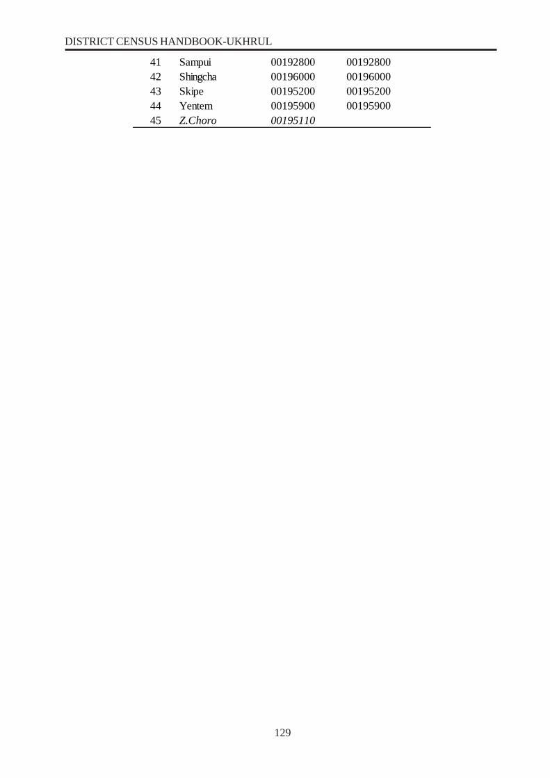
129
DISTRICT CENSUS HANDBOOK-UKHRUL
41 Sampui 00192800 0019280042 Shingcha 00196000 0019600043 Skipe 00195200 0019520044 Yentem 00195900 0019590045 Z.Choro 00195110

130
DISTRICT CENSUS HANDBOOK-UKHRUL
Name of District:-Ukhrul Location CodeNo:-279Name of TD Block:-Kamjong Location CodeNo:-0034
Pre-
Prim
ary
scho
ol (P
P)
Prim
ary
scho
ol (P
)
Mid
dle
scho
ol (M
)
Seco
ndar
y Sc
hool
(S)
Seni
or S
econ
dary
scho
ol (S
S)
Deg
ree
colle
ge o
f arts
sci
ence
& c
omm
erce
(A
SC)
Engi
neer
ing
colle
ge(E
C)
Med
ical
col
lege
(MC
)
Man
agem
ent i
nstit
ute
(MI)
Poly
tech
nic
(Pt)
Voc
atio
nal t
rain
ing
scho
ol /I
TI
Non
-form
al tr
aini
ng c
entre
(NFT
C)
Spec
ial s
choo
l for
dis
able
d (S
SD)
Oth
ers (
spec
ify)
1 2 3 4 5 6 7 8 9 10 11 12 13 14 15 16 17 18 19 20
96 Bungpa Khullen 270458 0 2716 422 2 3 3 1 c c c c c c c c c
97 Phange 270459 0 119 19 2 1 b b c c c c c c c c c
98 Sampui 270460 0 343 71 1 1 b b c c c c c c c c c
99 Bungpa Khunou 270461 0 309 45 1 1 a b c c c c c c c c c
100 Chassad 270462 0 729 121 3 3 2 2 c c c c c c c c c
101 Khoikai 270463 0 240 56 1 1 c c c c c c c c c c c
102 Pihang 270464 0 178 35 1 1 b b c c c c c c c c c
103 Kongkan 270465 0 348 49 1 1 b b c c c c c c c c c
104 Aishi 270466 0 350 50 1 1 b c c c c c c c c c
105 Huimin Thana 270467 0 33 7 b b c c c c c c c c c c
106 Molvailup 270468 0 386 63 1 1 c c c c c c c c c c c
107 Lakhan 270469 0 200 39 b b b b c c c c c c c c c
108 Kultuk 270470 0 214 37 1 1 c c c c c c c c c c c
109 Phaikok 270471 0 391 81 1 1 c c c c c c c c c c c
110 Chahong Khunou 270472 0 145 28 1 1 c c c c c c c c c c c
111 Roni 270473 0 206 34 2 2 b c c c c c c c c c c
112 Chatric 270474 0 854 142 2 2 1 c c c c c c c c c c
113 Maokot 270475 0 314 41 1 1 1 c c c c c c c c c c
Census of India 2011- Village DirectoryAmenities and Land use ( As in 2009 )
Sr.N
o.
Nam
e vi
llage
Loca
tion
code
no.
Tota
l are
a of
the
villa
ge (
in h
ecta
res r
ound
ed u
p to
one
dec
imal
pla
ce)
Tota
l pop
ulat
ion
( 201
1 ce
nsus
)
Num
ber o
f hou
seho
lds (
2011
cen
sus)
Number of educational amenities available. (If not available within the village , the distance range code viz; a for < 5 Kms, b for 5-10 Kms and c for 10+ kms of nearest place where facility is available is given).
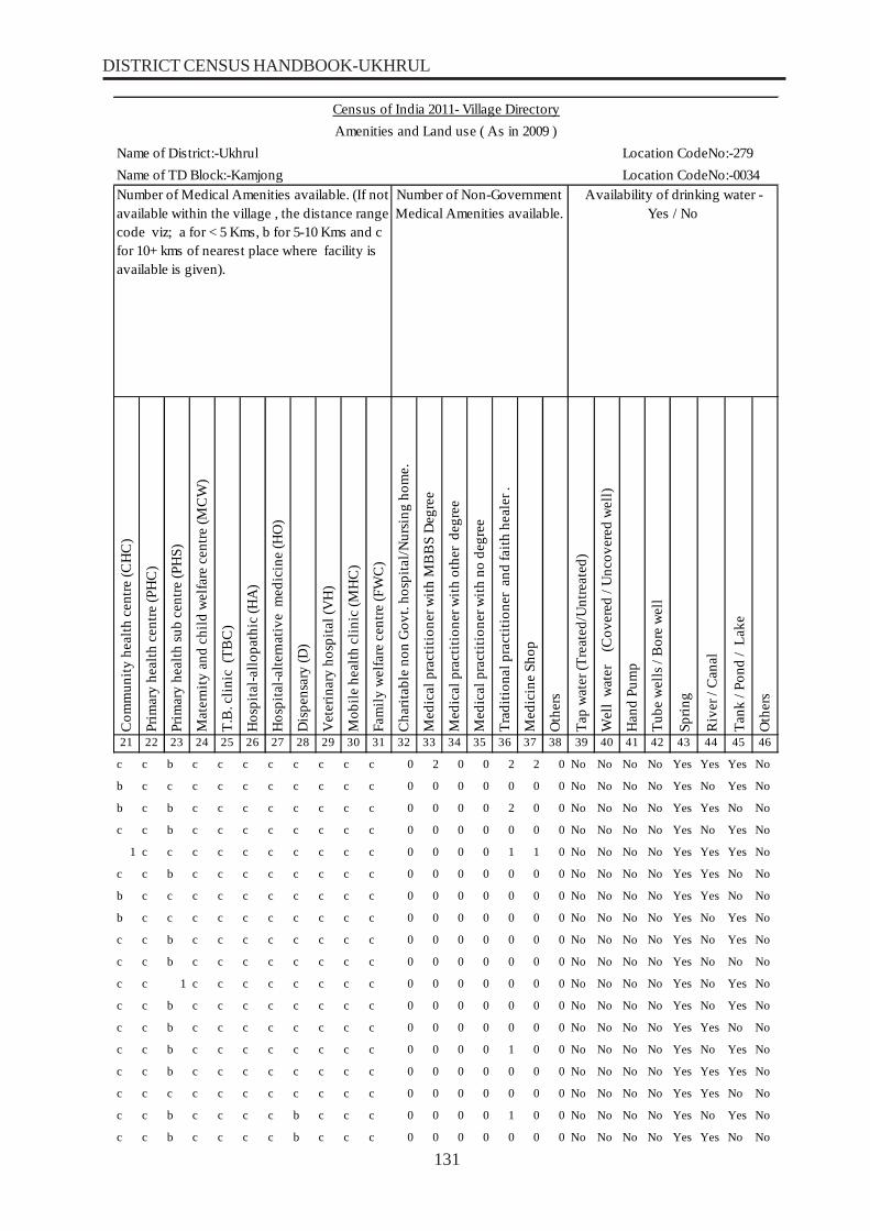
131
DISTRICT CENSUS HANDBOOK-UKHRUL
Name of District:-Ukhrul Location CodeNo:-279Name of TD Block:-Kamjong Location CodeNo:-0034
Com
mun
ity h
ealth
cen
tre (C
HC
)
Prim
ary
heal
th c
entre
(PH
C)
Prim
ary
heal
th su
b ce
ntre
(PH
S)
Mat
erni
ty a
nd c
hild
wel
fare
cen
tre (M
CW
)
T.B
. clin
ic (
TBC
)
Hos
pita
l-allo
path
ic (H
A)
Hos
pita
l-alte
rnat
ive
med
icin
e (H
O)
Dis
pens
ary
(D)
Vet
erin
ary
hosp
ital (
VH
)
Mob
ile h
ealth
clin
ic (M
HC
)
Fam
ily w
elfa
re c
entre
(FW
C)
Cha
ritab
le n
on G
ovt.
hosp
ital/N
ursi
ng h
ome.
Med
ical
pra
ctiti
oner
with
MB
BS
Deg
ree
Med
ical
pra
ctiti
oner
with
oth
er d
egre
e
Med
ical
pra
ctiti
oner
with
no
degr
ee
Trad
ition
al p
ract
ition
er a
nd fa
ith h
eale
r .
Med
icin
e Sh
op
Oth
ers
Tap
wat
er (T
reat
ed/U
ntre
ated
)
Wel
l w
ater
(C
over
ed /
Unc
over
ed w
ell)
Han
d Pu
mp
Tube
wel
ls /
Bor
e w
ell
Sprin
g
Riv
er /
Can
al
Tank
/ Po
nd /
Lak
e
Oth
ers
21 22 23 24 25 26 27 28 29 30 31 32 33 34 35 36 37 38 39 40 41 42 43 44 45 46
c c b c c c c c c c c 0 2 0 0 2 2 0 No No No No Yes Yes Yes No
b c c c c c c c c c c 0 0 0 0 0 0 0 No No No No Yes No Yes No
b c b c c c c c c c c 0 0 0 0 2 0 0 No No No No Yes Yes No No
c c b c c c c c c c c 0 0 0 0 0 0 0 No No No No Yes No Yes No
1 c c c c c c c c c c 0 0 0 0 1 1 0 No No No No Yes Yes Yes No
c c b c c c c c c c c 0 0 0 0 0 0 0 No No No No Yes Yes No No
b c c c c c c c c c c 0 0 0 0 0 0 0 No No No No Yes Yes No No
b c c c c c c c c c c 0 0 0 0 0 0 0 No No No No Yes No Yes No
c c b c c c c c c c c 0 0 0 0 0 0 0 No No No No Yes No Yes No
c c b c c c c c c c c 0 0 0 0 0 0 0 No No No No Yes No No No
c c 1 c c c c c c c c 0 0 0 0 0 0 0 No No No No Yes No Yes No
c c b c c c c c c c c 0 0 0 0 0 0 0 No No No No Yes No Yes No
c c b c c c c c c c c 0 0 0 0 0 0 0 No No No No Yes Yes No No
c c b c c c c c c c c 0 0 0 0 1 0 0 No No No No Yes No Yes No
c c b c c c c c c c c 0 0 0 0 0 0 0 No No No No Yes Yes Yes No
c c c c c c c c c c c 0 0 0 0 0 0 0 No No No No Yes Yes No No
c c b c c c c b c c c 0 0 0 0 1 0 0 No No No No Yes No Yes No
c c b c c c c b c c c 0 0 0 0 0 0 0 No No No No Yes Yes No No
Census of India 2011- Village DirectoryAmenities and Land use ( As in 2009 )
Number of Medical Amenities available. (If not available within the village , the distance range code viz; a for < 5 Kms, b for 5-10 Kms and c for 10+ kms of nearest place where facility is available is given).
Number of Non-Government Medical Amenities available.
Availability of drinking water - Yes / No
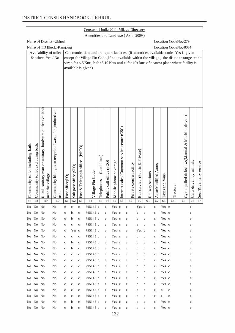
132
DISTRICT CENSUS HANDBOOK-UKHRUL
Name of District:-Ukhrul Location CodeNo:-279Name of TD Block:-Kamjong Location CodeNo:-0034
Com
mun
ity to
ilet i
nclu
ding
bat
h.
Com
mun
ity to
ilet e
xclu
ding
bat
h.
Rur
al s
anita
ry m
art o
r san
itary
har
dwar
e ou
tlet a
vaila
ble
near
the
villa
ge.
Com
mun
ity b
io- g
as o
r rec
ycle
of w
aste
for p
rodu
ctiv
e us
e.
Post
offi
ce(P
O)
Sub
post
offi
ce (S
PO)
Post
& T
eleg
raph
offi
ce
(P&
TO)
Vill
age
Pin
Cod
e
Tele
phon
es
(L
and
lines
)
Publ
ic c
all o
ffice
(PC
O)
Mob
ile p
hone
cov
erag
e
Inte
rnet
caf
es/ C
omm
on se
rvic
e ce
ntre
(CSC
)
Priv
ate
cour
ier f
acili
ty
Bus
serv
ice
(Pub
lic &
Priv
ate)
Rai
lway
stat
ions
Aut
o/M
odifi
ed A
utos
Taxi
s and
Van
s
Trac
tors
Cyc
le-p
ulle
d ric
ksha
ws(
Man
ual &
Mac
hine
driv
en)
Car
ts d
riven
by
anim
als
Sea
/Riv
er fe
rry se
rvic
e47 48 49 50 51 52 53 54 55 56 57 58 59 60 61 62 63 64 65 66 67
No No No No c c c 795145 c c Yes c c Yes c c Yes c c
No No No No c b c 795145 c c Yes c c b c c Yes c c
No No No No c b c 795145 c c Yes c c b c c Yes c c
No No No No c c c 795145 c c Yes c c a c c Yes c c
No No No No c Yes c 795145 c c Yes c c Yes c c Yes c c
No No No No c c c 795145 c c Yes c c b c c Yes c c
No No No No c b c 795145 c c Yes c c c c c Yes c c
No No No No c b c 795145 c c Yes c c b c c Yes c c
No No No No c c c 795145 c c Yes c c c c c Yes c c
No No No No c c c 795145 c c Yes c c c c c Yes c c
No No No No c c c 795145 c c Yes c c c c c Yes c c
No No No No c c c 795145 c c Yes c c c c c Yes c c
No No No No c c c 795145 c c Yes c c c c c Yes c c
No No No No c c c 795145 c c Yes c c c c c Yes c c
No No No No c c c 795145 c c Yes c c c c c b c c
No No No No c c c 795145 c c Yes c c c c c c c c
No No No No c b c 795145 c c Yes c c c c c Yes c c
No No No No c b c 795145 c c Yes c c c c c Yes c c
Census of India 2011- Village DirectoryAmenities and Land use ( As in 2009 )
Availability of toilet & others Yes / No
Communication and transport facilities (If amenities available code -Yes is given except for Village Pin Code ,If not available within the village , the distance range code viz; a for < 5 Kms, b for 5-10 Kms and c for 10+ kms of nearest place where facility is available is given).
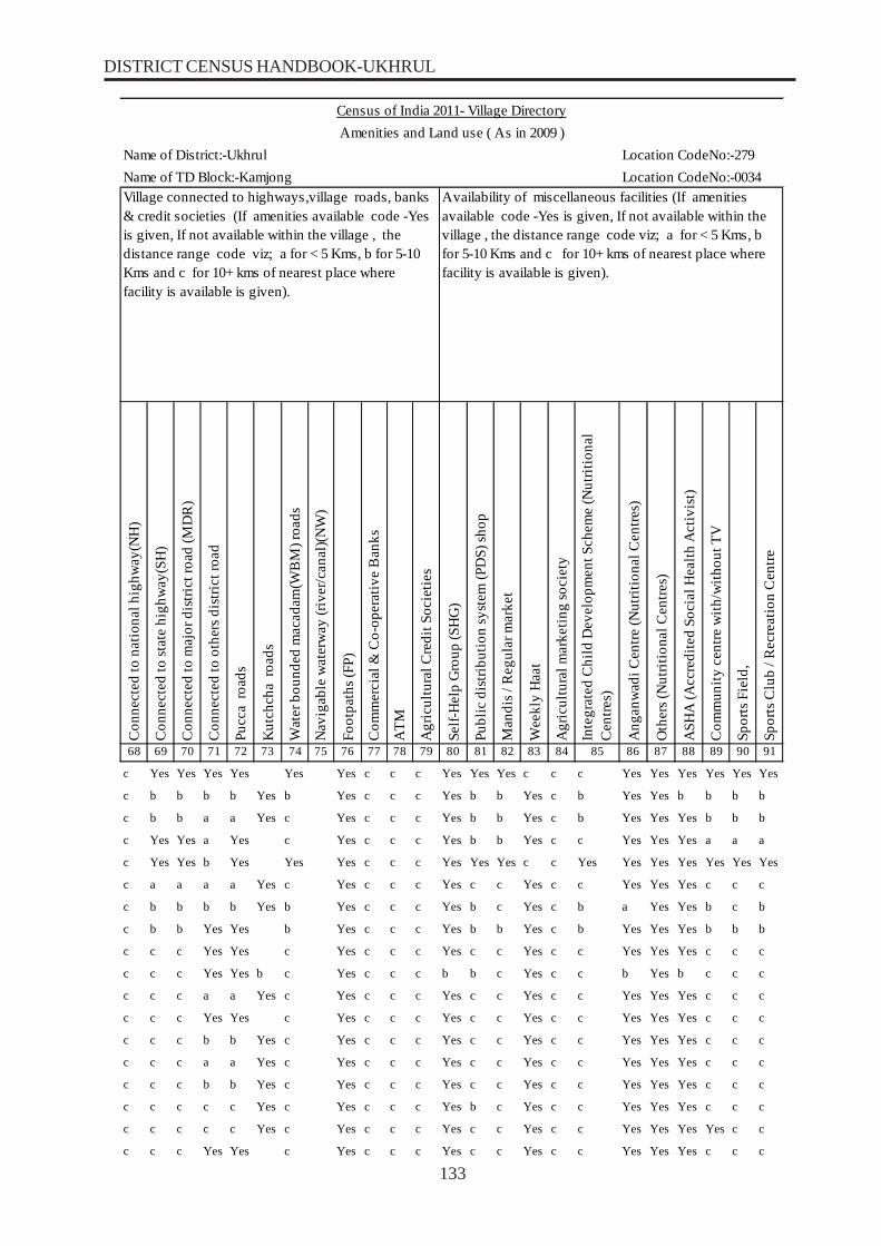
133
DISTRICT CENSUS HANDBOOK-UKHRUL
Name of District:-Ukhrul Location CodeNo:-279Name of TD Block:-Kamjong Location CodeNo:-0034
Con
nect
ed to
nat
iona
l hig
hway
(NH
)
Con
nect
ed to
stat
e hi
ghw
ay(S
H)
Con
nect
ed to
maj
or d
istri
ct ro
ad (M
DR
)
Con
nect
ed to
oth
ers d
istri
ct ro
ad
Pucc
a ro
ads
Kut
chch
a ro
ads
Wat
er b
ound
ed m
acad
am(W
BM
) roa
ds
Nav
igab
le w
ater
way
(riv
er/c
anal
)(NW
)
Foot
path
s (FP
)
Com
mer
cial
& C
o-op
erat
ive
Ban
ks
ATM
Agr
icul
tura
l Cre
dit S
ocie
ties
Self-
Hel
p G
roup
(SH
G)
Publ
ic d
istri
butio
n sy
stem
(PD
S) sh
op
Man
dis /
Reg
ular
mar
ket
Wee
kly
Haa
t
Agr
icul
tura
l mar
ketin
g so
ciet
y
Inte
grat
ed C
hild
Dev
elop
men
t Sch
eme
(Nut
ritio
nal
Cen
tres)
Ang
anw
adi C
entre
(Nut
ritio
nal C
entre
s)
Oth
ers (
Nut
ritio
nal C
entre
s)
ASH
A (A
ccre
dite
d So
cial
Hea
lth A
ctiv
ist)
Com
mun
ity c
entre
with
/with
out T
V
Spor
ts F
ield
,
Spor
ts C
lub
/ Rec
reat
ion
Cen
tre68 69 70 71 72 73 74 75 76 77 78 79 80 81 82 83 84 85 86 87 88 89 90 91
c Yes Yes Yes Yes Yes Yes c c c Yes Yes Yes c c c Yes Yes Yes Yes Yes Yes
c b b b b Yes b Yes c c c Yes b b Yes c b Yes Yes b b b b
c b b a a Yes c Yes c c c Yes b b Yes c b Yes Yes Yes b b b
c Yes Yes a Yes c Yes c c c Yes b b Yes c c Yes Yes Yes a a a
c Yes Yes b Yes Yes Yes c c c Yes Yes Yes c c Yes Yes Yes Yes Yes Yes Yes
c a a a a Yes c Yes c c c Yes c c Yes c c Yes Yes Yes c c c
c b b b b Yes b Yes c c c Yes b c Yes c b a Yes Yes b c b
c b b Yes Yes b Yes c c c Yes b b Yes c b Yes Yes Yes b b b
c c c Yes Yes c Yes c c c Yes c c Yes c c Yes Yes Yes c c c
c c c Yes Yes b c Yes c c c b b c Yes c c b Yes b c c c
c c c a a Yes c Yes c c c Yes c c Yes c c Yes Yes Yes c c c
c c c Yes Yes c Yes c c c Yes c c Yes c c Yes Yes Yes c c c
c c c b b Yes c Yes c c c Yes c c Yes c c Yes Yes Yes c c c
c c c a a Yes c Yes c c c Yes c c Yes c c Yes Yes Yes c c c
c c c b b Yes c Yes c c c Yes c c Yes c c Yes Yes Yes c c c
c c c c c Yes c Yes c c c Yes b c Yes c c Yes Yes Yes c c c
c c c c c Yes c Yes c c c Yes c c Yes c c Yes Yes Yes Yes c c
c c c Yes Yes c Yes c c c Yes c c Yes c c Yes Yes Yes c c c
Census of India 2011- Village DirectoryAmenities and Land use ( As in 2009 )
Village connected to highways,village roads, banks & credit societies (If amenities available code -Yes is given, If not available within the village , the distance range code viz; a for < 5 Kms, b for 5-10 Kms and c for 10+ kms of nearest place where facility is available is given).
Availability of miscellaneous facilities (If amenities available code -Yes is given, If not available within the village , the distance range code viz; a for < 5 Kms, b for 5-10 Kms and c for 10+ kms of nearest place where facility is available is given).
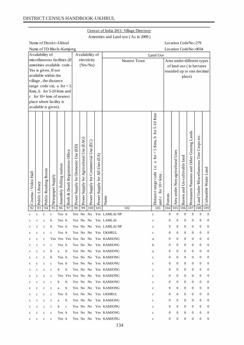
134
DISTRICT CENSUS HANDBOOK-UKHRUL
Name of District:-Ukhrul Location CodeNo:-279Name of TD Block:-Kamjong Location CodeNo:-0034
Cin
ema
/ Vid
eo H
all
Publ
ic L
ibra
ry
Publ
ic R
eadi
ng R
oom
New
spap
er S
uppl
y
Ass
embl
y Po
lling
stat
ion
Birt
h &
Dea
th R
egis
tratio
n O
ffice
Pow
er S
uppl
y fo
r Dom
estic
Use
(ED
)
Pow
er S
uppl
y fo
r Agr
icul
tura
l Use
(EA
G)
Pow
er S
uppl
y fo
r Com
mer
cial
Use
(EC
)
Pow
er S
uppl
y fo
r All
Use
s (EA
)
Nam
e
Dis
tanc
e ra
nge
code
i.e
. a
for <
5 K
ms,
b fo
r 5-1
0 K
ms
and
c f
or 1
0+ k
ms .
Fore
sts
Are
a un
der N
on-a
gric
ultu
ral U
ses
Bar
ren
and
Un-
culti
vabl
e la
nd
Perm
anen
t Pas
ture
s and
Oth
er G
razi
ng L
ands
Land
Und
er M
isce
llane
ous T
ree
Cro
ps e
tc.
Cul
tura
ble
Was
te L
and
92 93 94 95 96 97 98 99 100 101 102 103 104 105 106 107 108 109
c c c c Yes b Yes No No Yes LAMLAI NP c 0 0 0 0 0 0
c c c b Yes b Yes No No Yes LAMLAI c 0 0 0 0 0 0
c c c b Yes b Yes No No Yes LAMLAI NP c 0 0 0 0 0 0
c c c c Yes b Yes No No Yes UKHRUL c 0 0 0 0 0 0
c c c Yes Yes Yes Yes No No Yes KAMJONG a 0 0 0 0 0 0
c c c c Yes b Yes No No Yes KAMJONG b 0 0 0 0 0 0
c c c b a b Yes No No Yes KAMJONG a 0 0 0 0 0 0
c c c b Yes b Yes No No Yes KAMJONG c 0 0 0 0 0 0
c c c c Yes b Yes No No Yes KAMJONG c 0 0 0 0 0 0
c c c c b b Yes No No Yes KAMJONG c 0 0 0 0 0 0
c c c c Yes Yes Yes No No Yes KAMJONG c 0 0 0 0 0 0
c c c c b b Yes No No Yes KAMJONG c 0 0 0 0 0 0
c c c c a b Yes No No Yes KAMJONG c 0 0 0 0 0 0
c c c c Yes b Yes No No Yes UKHRUL c 0 0 0 0 0 0
c c c c a b Yes No No Yes KAMJONG c 0 0 0 0 0 0
c c c c b c Yes No No Yes KAMJONG c 0 0 0 0 0 0
c c c c Yes b Yes No No Yes KAMJONG c 0 0 0 0 0 0
c c c c Yes b Yes No No Yes KAMJONG c 0 0 0 0 0 0
Census of India 2011- Village DirectoryAmenities and Land use ( As in 2009 )
Availability of miscellaneous facilities (If amenities available code -Yes is given, If not available within the village , the distance range code viz; a for < 5 Kms, b for 5-10 Kms and c for 10+ kms of nearest place where facility is available is given).
Availability of electricity (Yes/No)
Land Use Nearest Town Area under different types
of land use ( in hectares rounded up to one decimal
place)

135
DISTRICT CENSUS HANDBOOK-UKHRUL
Name of District:-Ukhrul Location CodeNo:-279Name of TD Block:-Kamjong Location CodeNo:-0034
Fallo
w la
nds o
ther
than
cur
rent
fallo
ws
Cur
rent
Fal
low
s
Net
Are
a So
wn
Tota
l Irri
gate
d La
nd A
rea
Tota
l Un-
irrig
ated
Lan
d A
rea
Can
als (
C )
Wel
ls/T
ube-
wel
ls(W
/TW
)
Tank
s/La
kes(
T/L)
Wat
er F
alls
(WF)
Oth
ers(
O)
Firs
t
Seco
nd
Third
110 111 112 113 114 115 116 117 118 119 120 121 122 2 1
0 0 0 0 0 0 0 0 0 0 Bungpa Khullen 96
0 0 0 0 0 0 0 0 0 0 Phange 97
0 0 0 0 0 0 0 0 0 0 Sampui 98
0 0 0 0 0 0 0 0 0 0 Bungpa Khunou 99
0 0 0 0 0 0 0 0 0 0 Chassad 100
0 0 0 0 0 0 0 0 0 0 Khoikai 101
0 0 0 0 0 0 0 0 0 0 Pihang 102
0 0 0 0 0 0 0 0 0 0 Kongkan 103
0 0 0 0 0 0 0 0 0 0 Aishi 104
0 0 0 0 0 0 0 0 0 0 Huimin Thana 105
0 0 0 0 0 0 0 0 0 0 Wooden Furniture Molvailup 106
0 0 0 0 0 0 0 0 0 0 Lakhan 107
0 0 0 0 0 0 0 0 0 0 Carpentry Kultuk 108
0 0 0 0 0 0 0 0 0 0 Phaikok 109
0 0 0 0 0 0 0 0 0 0 Chahong Khunou 110
0 0 0 0 0 0 0 0 0 0 Roni 111
0 0 0 0 0 0 0 0 0 0 Chatric 112
0 0 0 0 0 0 0 0 0 0 Maokot 113
Census of India 2011- Village DirectoryAmenities and Land use ( As in 2009 )
Land Use Name of three most important commodities manufactured
Nam
e of
Vill
age
Seria
l Num
ber
Area under different types of land use ( in hectares rounded up to one decimal place)
Area irrigated by source (in hectare).
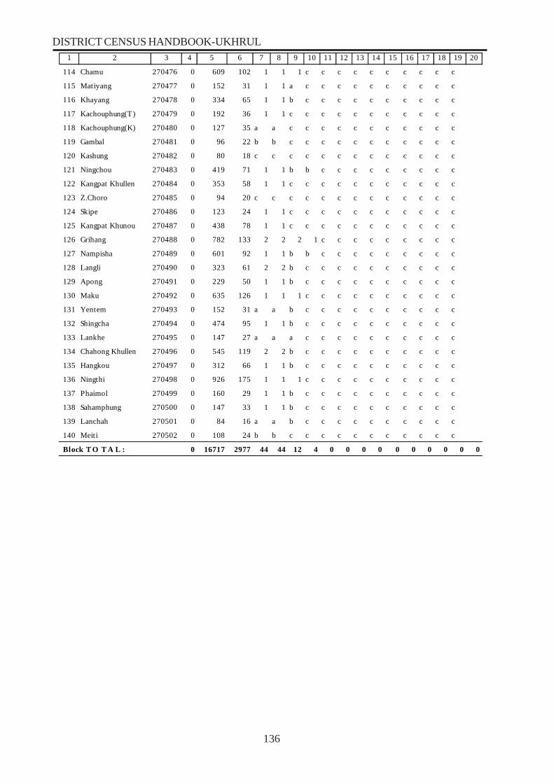
136
DISTRICT CENSUS HANDBOOK-UKHRUL1 2 3 4 5 6 7 8 9 10 11 12 13 14 15 16 17 18 19 20
114 Chamu 270476 0 609 102 1 1 1 c c c c c c c c c c
115 Matiyang 270477 0 152 31 1 1 a c c c c c c c c c c
116 Khayang 270478 0 334 65 1 1 b c c c c c c c c c c
117 Kachouphung(T) 270479 0 192 36 1 1 c c c c c c c c c c c
118 Kachouphung(K) 270480 0 127 35 a a c c c c c c c c c c c
119 Gambal 270481 0 96 22 b b c c c c c c c c c c c
120 Kashung 270482 0 80 18 c c c c c c c c c c c c c
121 Ningchou 270483 0 419 71 1 1 b b c c c c c c c c c
122 Kangpat Khullen 270484 0 353 58 1 1 c c c c c c c c c c c
123 Z.Choro 270485 0 94 20 c c c c c c c c c c c c c
124 Skipe 270486 0 123 24 1 1 c c c c c c c c c c c
125 Kangpat Khunou 270487 0 438 78 1 1 c c c c c c c c c c c
126 Grihang 270488 0 782 133 2 2 2 1 c c c c c c c c c
127 Nampisha 270489 0 601 92 1 1 b b c c c c c c c c c
128 Langli 270490 0 323 61 2 2 b c c c c c c c c c c
129 Apong 270491 0 229 50 1 1 b c c c c c c c c c c
130 Maku 270492 0 635 126 1 1 1 c c c c c c c c c c
131 Yentem 270493 0 152 31 a a b c c c c c c c c c c
132 Shingcha 270494 0 474 95 1 1 b c c c c c c c c c c
133 Lankhe 270495 0 147 27 a a a c c c c c c c c c c
134 Chahong Khullen 270496 0 545 119 2 2 b c c c c c c c c c c
135 Hangkou 270497 0 312 66 1 1 b c c c c c c c c c c
136 Ningthi 270498 0 926 175 1 1 1 c c c c c c c c c c
137 Phaimol 270499 0 160 29 1 1 b c c c c c c c c c c
138 Sahamphung 270500 0 147 33 1 1 b c c c c c c c c c c
139 Lanchah 270501 0 84 16 a a b c c c c c c c c c c
140 Meiti 270502 0 108 24 b b c c c c c c c c c c c
Block T O T A L : 0 16717 2977 44 44 12 4 0 0 0 0 0 0 0 0 0 0
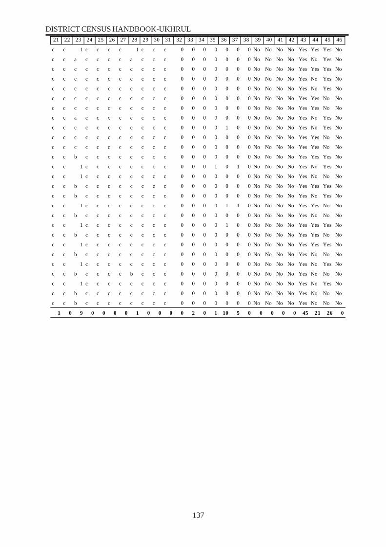
137
DISTRICT CENSUS HANDBOOK-UKHRUL21 22 23 24 25 26 27 28 29 30 31 32 33 34 35 36 37 38 39 40 41 42 43 44 45 46
c c 1 c c c c 1 c c c 0 0 0 0 0 0 0 No No No No Yes Yes Yes No
c c a c c c c a c c c 0 0 0 0 0 0 0 No No No No Yes No Yes No
c c c c c c c c c c c 0 0 0 0 0 0 0 No No No No Yes Yes Yes No
c c c c c c c c c c c 0 0 0 0 0 0 0 No No No No Yes No Yes No
c c c c c c c c c c c 0 0 0 0 0 0 0 No No No No Yes No Yes No
c c c c c c c c c c c 0 0 0 0 0 0 0 No No No No Yes Yes No No
c c c c c c c c c c c 0 0 0 0 0 0 0 No No No No Yes Yes No No
c c a c c c c c c c c 0 0 0 0 0 0 0 No No No No Yes No Yes No
c c c c c c c c c c c 0 0 0 0 1 0 0 No No No No Yes No Yes No
c c c c c c c c c c c 0 0 0 0 0 0 0 No No No No Yes Yes No No
c c c c c c c c c c c 0 0 0 0 0 0 0 No No No No Yes Yes No No
c c b c c c c c c c c 0 0 0 0 0 0 0 No No No No Yes Yes Yes No
c c 1 c c c c c c c c 0 0 0 1 0 1 0 No No No No Yes No Yes No
c c 1 c c c c c c c c 0 0 0 0 0 0 0 No No No No Yes No No No
c c b c c c c c c c c 0 0 0 0 0 0 0 No No No No Yes Yes Yes No
c c b c c c c c c c c 0 0 0 0 0 0 0 No No No No Yes No Yes No
c c 1 c c c c c c c c 0 0 0 0 1 1 0 No No No No Yes Yes No No
c c b c c c c c c c c 0 0 0 0 0 0 0 No No No No Yes No No No
c c 1 c c c c c c c c 0 0 0 0 1 0 0 No No No No Yes Yes Yes No
c c b c c c c c c c c 0 0 0 0 0 0 0 No No No No Yes Yes No No
c c 1 c c c c c c c c 0 0 0 0 0 0 0 No No No No Yes Yes Yes No
c c b c c c c c c c c 0 0 0 0 0 0 0 No No No No Yes No No No
c c 1 c c c c c c c c 0 0 0 0 0 0 0 No No No No Yes No Yes No
c c b c c c c b c c c 0 0 0 0 0 0 0 No No No No Yes No No No
c c 1 c c c c c c c c 0 0 0 0 0 0 0 No No No No Yes No Yes No
c c b c c c c c c c c 0 0 0 0 0 0 0 No No No No Yes No No No
c c b c c c c c c c c 0 0 0 0 0 0 0 No No No No Yes No No No
1 0 9 0 0 0 0 1 0 0 0 0 2 0 1 10 5 0 0 0 0 0 45 21 26 0
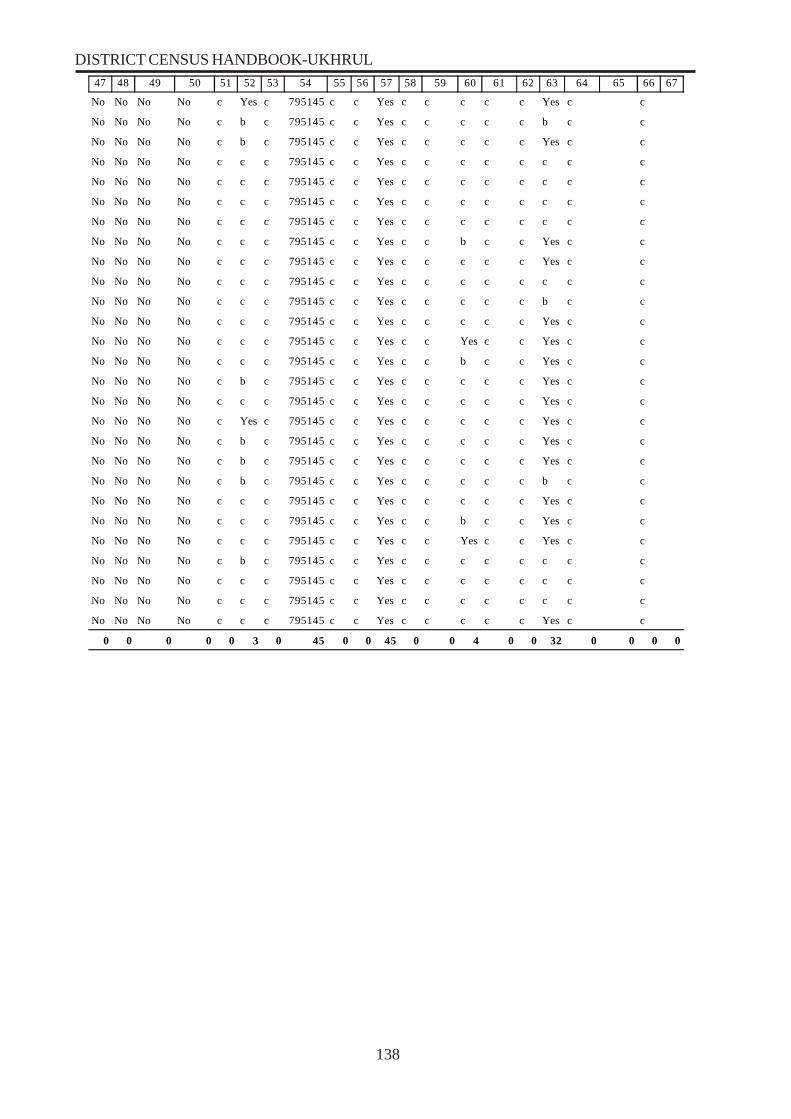
138
DISTRICT CENSUS HANDBOOK-UKHRUL47 48 49 50 51 52 53 54 55 56 57 58 59 60 61 62 63 64 65 66 67
No No No No c Yes c 795145 c c Yes c c c c c Yes c c
No No No No c b c 795145 c c Yes c c c c c b c c
No No No No c b c 795145 c c Yes c c c c c Yes c c
No No No No c c c 795145 c c Yes c c c c c c c c
No No No No c c c 795145 c c Yes c c c c c c c c
No No No No c c c 795145 c c Yes c c c c c c c c
No No No No c c c 795145 c c Yes c c c c c c c c
No No No No c c c 795145 c c Yes c c b c c Yes c c
No No No No c c c 795145 c c Yes c c c c c Yes c c
No No No No c c c 795145 c c Yes c c c c c c c c
No No No No c c c 795145 c c Yes c c c c c b c c
No No No No c c c 795145 c c Yes c c c c c Yes c c
No No No No c c c 795145 c c Yes c c Yes c c Yes c c
No No No No c c c 795145 c c Yes c c b c c Yes c c
No No No No c b c 795145 c c Yes c c c c c Yes c c
No No No No c c c 795145 c c Yes c c c c c Yes c c
No No No No c Yes c 795145 c c Yes c c c c c Yes c c
No No No No c b c 795145 c c Yes c c c c c Yes c c
No No No No c b c 795145 c c Yes c c c c c Yes c c
No No No No c b c 795145 c c Yes c c c c c b c c
No No No No c c c 795145 c c Yes c c c c c Yes c c
No No No No c c c 795145 c c Yes c c b c c Yes c c
No No No No c c c 795145 c c Yes c c Yes c c Yes c c
No No No No c b c 795145 c c Yes c c c c c c c c
No No No No c c c 795145 c c Yes c c c c c c c c
No No No No c c c 795145 c c Yes c c c c c c c c
No No No No c c c 795145 c c Yes c c c c c Yes c c
0 0 0 0 0 3 0 45 0 0 45 0 0 4 0 0 32 0 0 0 0
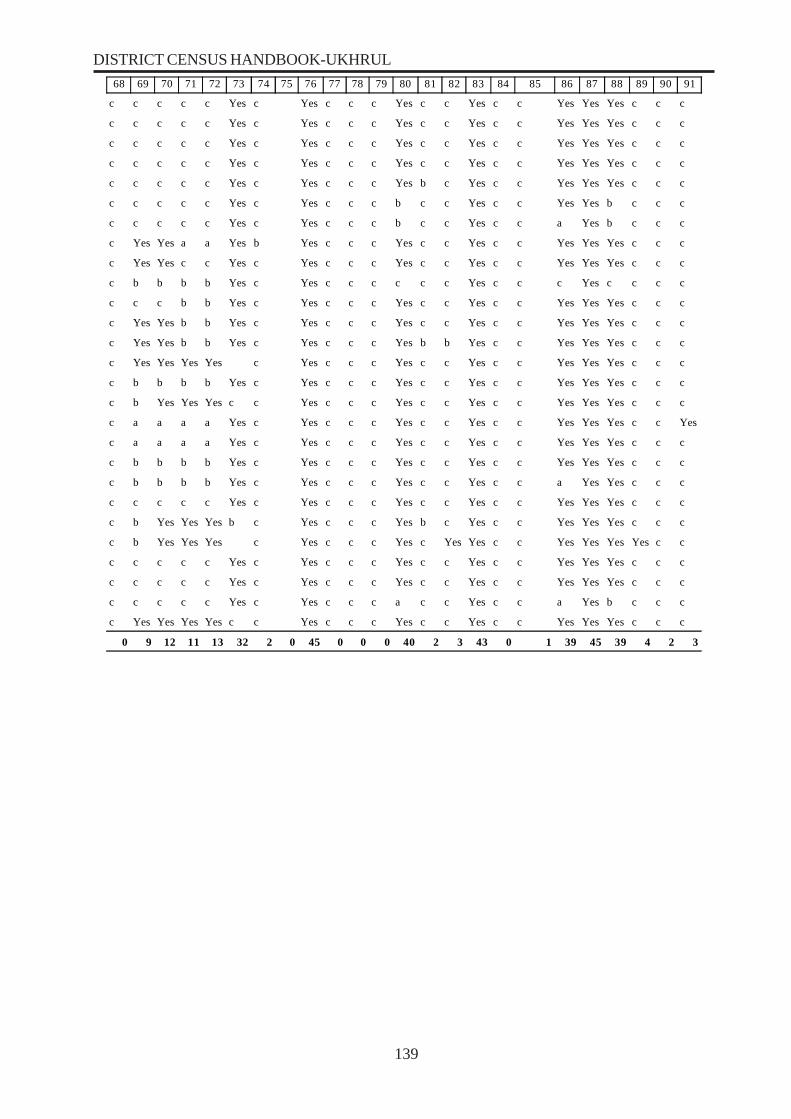
139
DISTRICT CENSUS HANDBOOK-UKHRUL68 69 70 71 72 73 74 75 76 77 78 79 80 81 82 83 84 85 86 87 88 89 90 91
c c c c c Yes c Yes c c c Yes c c Yes c c Yes Yes Yes c c c
c c c c c Yes c Yes c c c Yes c c Yes c c Yes Yes Yes c c c
c c c c c Yes c Yes c c c Yes c c Yes c c Yes Yes Yes c c c
c c c c c Yes c Yes c c c Yes c c Yes c c Yes Yes Yes c c c
c c c c c Yes c Yes c c c Yes b c Yes c c Yes Yes Yes c c c
c c c c c Yes c Yes c c c b c c Yes c c Yes Yes b c c c
c c c c c Yes c Yes c c c b c c Yes c c a Yes b c c c
c Yes Yes a a Yes b Yes c c c Yes c c Yes c c Yes Yes Yes c c c
c Yes Yes c c Yes c Yes c c c Yes c c Yes c c Yes Yes Yes c c c
c b b b b Yes c Yes c c c c c c Yes c c c Yes c c c c
c c c b b Yes c Yes c c c Yes c c Yes c c Yes Yes Yes c c c
c Yes Yes b b Yes c Yes c c c Yes c c Yes c c Yes Yes Yes c c c
c Yes Yes b b Yes c Yes c c c Yes b b Yes c c Yes Yes Yes c c c
c Yes Yes Yes Yes c Yes c c c Yes c c Yes c c Yes Yes Yes c c c
c b b b b Yes c Yes c c c Yes c c Yes c c Yes Yes Yes c c c
c b Yes Yes Yes c c Yes c c c Yes c c Yes c c Yes Yes Yes c c c
c a a a a Yes c Yes c c c Yes c c Yes c c Yes Yes Yes c c Yes
c a a a a Yes c Yes c c c Yes c c Yes c c Yes Yes Yes c c c
c b b b b Yes c Yes c c c Yes c c Yes c c Yes Yes Yes c c c
c b b b b Yes c Yes c c c Yes c c Yes c c a Yes Yes c c c
c c c c c Yes c Yes c c c Yes c c Yes c c Yes Yes Yes c c c
c b Yes Yes Yes b c Yes c c c Yes b c Yes c c Yes Yes Yes c c c
c b Yes Yes Yes c Yes c c c Yes c Yes Yes c c Yes Yes Yes Yes c c
c c c c c Yes c Yes c c c Yes c c Yes c c Yes Yes Yes c c c
c c c c c Yes c Yes c c c Yes c c Yes c c Yes Yes Yes c c c
c c c c c Yes c Yes c c c a c c Yes c c a Yes b c c c
c Yes Yes Yes Yes c c Yes c c c Yes c c Yes c c Yes Yes Yes c c c
0 9 12 11 13 32 2 0 45 0 0 0 40 2 3 43 0 1 39 45 39 4 2 3
140
DISTRICT CENSUS HANDBOOK-UKHRUL92 93 94 95 96 97 98 99 100 101 102 103 104 105 106 107 108 109
c c c c Yes Yes Yes No No Yes KAMJONG c 0 0 0 0 0 0
c c c c a a Yes No No Yes KMAJONG c 0 0 0 0 0 0
c c c c Yes c Yes No No Yes UKHRUL c 0 0 0 0 0 0
c c c c Yes c Yes No No Yes KAMJONG c 0 0 0 0 0 0
c c c c b c Yes No No Yes KAMJONG c 0 0 0 0 0 0
c c c c a c Yes No No Yes KAMJONG c 0 0 0 0 0 0
c c c c a c Yes No No Yes UKHRUL c 0 0 0 0 0 0
c c c c Yes a Yes No No Yes KAMJONG c 0 0 0 0 0 0
c c c c Yes c Yes No No Yes KAMJONH c 0 0 0 0 0 0
c c c c b c Yes No No Yes KAMJONG c 0 0 0 0 0 0
c c c c a c Yes No No Yes KAMJONG c 0 0 0 0 0 0
c c c c Yes b Yes No No Yes KAMJONG c 0 0 0 0 0 0
c c c c Yes Yes Yes No No Yes KAMJONG c 0 0 0 0 0 0
c c c c Yes Yes Yes No No Yes KAMJONG c 0 0 0 0 0 0
c c c c Yes b Yes No No Yes KAMJONG c 0 0 0 0 0 0
c c c c a b Yes No No Yes APONG c 0 0 0 0 0 0
c c c c Yes Yes Yes No No Yes KAMJONG c 0 0 0 0 0 0
c c c c b b Yes No No Yes KAMJONG c 0 0 0 0 0 0
c c c c Yes Yes Yes No No Yes KAMJONG c 0 0 0 0 0 0
c c c c a b Yes No No Yes KAMJONG c 0 0 0 0 0 0
c c c c Yes Yes Yes No No Yes UKHRUL c 0 0 0 0 0 0
c c c c Yes b Yes No No Yes KAMJONG c 0 0 0 0 0 0
c c c c Yes Yes Yes No No Yes UKHRUL c 0 0 0 0 0 0
c c c c b b Yes No No Yes KAMJONG c 0 0 0 0 0 0
c c c c Yes b Yes No No Yes KAMJONG c 0 0 0 0 0 0
c c c c a b Yes No No Yes KAMJONG c 0 0 0 0 0 0
c c c c a b Yes No No Yes KAMJONG c 0 0 0 0 0 0
0 0 0 1 27 9 45 0 0 45 0 0 0 0 0 0 0 0
141
DISTRICT CENSUS HANDBOOK-UKHRUL110 111 112 113 114 115 116 117 118 119 120 121 122 2 1
0 0 0 0 0 0 0 0 0 0 Chamu 114
0 0 0 0 0 0 0 0 0 0 Matiyang 115
0 0 0 0 0 0 0 0 0 0 Khayang 116
0 0 0 0 0 0 0 0 0 0 Kachouphung(T) 117
0 0 0 0 0 0 0 0 0 0 Kachouphung(K) 118
0 0 0 0 0 0 0 0 0 0 Gambal 119
0 0 0 0 0 0 0 0 0 0 Kashung 120
0 0 0 0 0 0 0 0 0 0 Ningchou 121
0 0 0 0 0 0 0 0 0 0 Kangpat Khullen 122
0 0 0 0 0 0 0 0 0 0 Z.Choro 123
0 0 0 0 0 0 0 0 0 0 Skipe 124
0 0 0 0 0 0 0 0 0 0 Kangpat Khunou 125
0 0 0 0 0 0 0 0 0 0 Grihang 126
0 0 0 0 0 0 0 0 0 0 Nampisha 127
0 0 0 0 0 0 0 0 0 0 Langli 128
0 0 0 0 0 0 0 0 0 0 Apong 129
0 0 0 0 0 0 0 0 0 0 Maku 130
0 0 0 0 0 0 0 0 0 0 Yentem 131
0 0 0 0 0 0 0 0 0 0 Shingcha 132
0 0 0 0 0 0 0 0 0 0 Lankhe 133
0 0 0 0 0 0 0 0 0 0 Chahong Khullen 134
0 0 0 0 0 0 0 0 0 0 Hangkou 135
0 0 0 0 0 0 0 0 0 0 Ningthi 136
0 0 0 0 0 0 0 0 0 0 Phaimol 137
0 0 0 0 0 0 0 0 0 0 Sahamphung 138
0 0 0 0 0 0 0 0 0 0 Lanchah 139
0 0 0 0 0 0 0 0 0 0 Meiti 140
0 0 0 0 0 0 0 0 0

142
DISTRICT CENSUS HANDBOOK-UKHRUL
143
DISTRICT CENSUS HANDBOOK-UKHRUL
Map of Phungyar T.D.Block

144
DISTRICT CENSUS HANDBOOK-UKHRUL
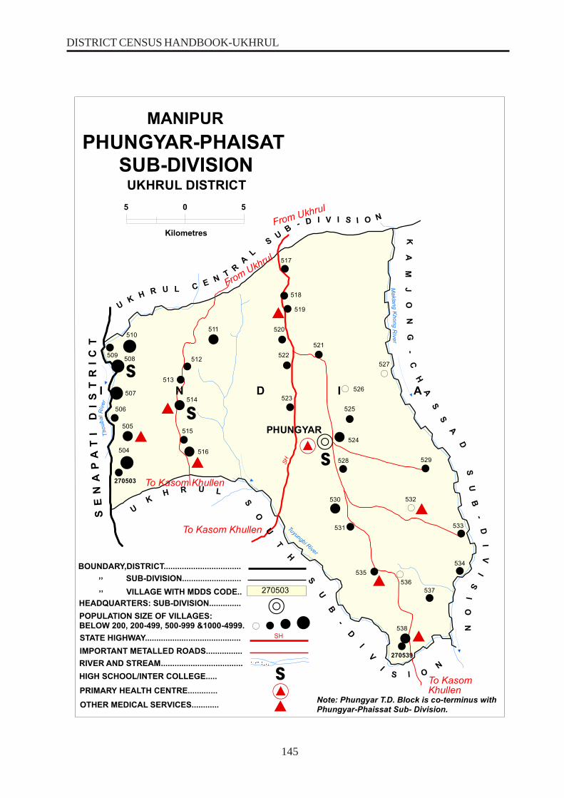
145
DISTRICT CENSUS HANDBOOK-UKHRUL
!!
!
!
!
!
!!
!
!
!
!
!
!
!
!
!
!
!
!
!
(
(
! !
!
!
(
!
!! (
!
!
!
!
!
UK
H R U L C EN
TR
AL
S
UB
- D I V I S I O N
UK
H R U L
S
O
U
T
H
S
U
B
-D
IV
IS I O
N
KA
MJ
ON
G-
CH
AS
SA
D
SU
B-
DI
VI
SI
ON
I N D I A
From Ukhrul
To Kasom Khullen
R
5 50
Note: Phungyar T.D. Block is co-terminus withPhungyar-Phaissat Sub- Division.
270503
R
BOUNDARY,DISTRICT..................................,, SUB-DIVISION..........................
,, VILLAGE WITH MDDS CODE..
HEADQUARTERS: SUB-DIVISION..............
POPULATION SIZE OF VILLAGES: BELOW 200, 200-499, 500-999 &1000-4999.
SHSTATE HIGHWAY..........................................
IMPORTANT METALLED ROADS................
RIVER AND STREAM....................................
!μ#
SHIGH SCHOOL/INTER COLLEGE.....
OTHER MEDICAL SERVICES............
PRIMARY HEALTH CENTRE.............
!μ#
S
#
#
#
#
#
# S
S
( ! ! !
PHUNGYAR
SE
NA
PA
TI
D
IS
TR
IC
T
UKHRUL DISTRICT
MANIPUR
PHUNGYAR-PHAISAT SUB-DIVISION
Kilometres
From Ukhrul
SH
To KasomKhullen
To Kasom Khullen
Tho
ub
al R
iver
Tuyungbi River
Ma
kl a
ng
Kh
on
g R
ive
r
509
524
538
537
536
535
534
533
532
531
530
529528
527
526
525
523
522
521
520
519
518
517
516
515
514
513
512
511510
508
507
506
505
504
270539
270503

146
DISTRICT CENSUS HANDBOOK-UKHRUL
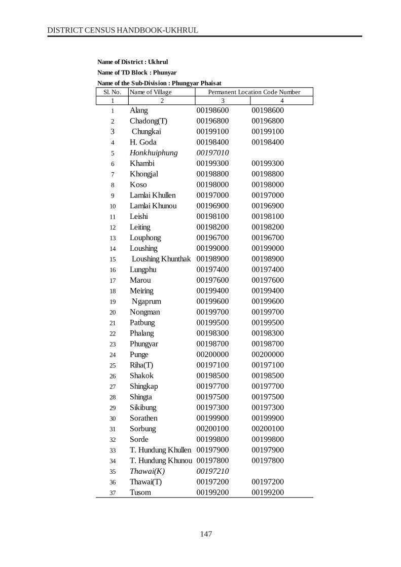
147
DISTRICT CENSUS HANDBOOK-UKHRUL
Name of District : UkhrulName of TD Block : PhunyarName of the Sub-Division : Phungyar Phaisat
Sl. No. Name of Village1 2 3 41 Alang 00198600 001986002 Chadong(T) 00196800 001968003 Chungkai 00199100 001991004 H. Goda 00198400 001984005 Honkhuiphung 001970106 Khambi 00199300 001993007 Khongjal 00198800 001988008 Koso 00198000 001980009 Lamlai Khullen 00197000 0019700010 Lamlai Khunou 00196900 0019690011 Leishi 00198100 0019810012 Leiting 00198200 0019820013 Louphong 00196700 0019670014 Loushing 00199000 0019900015 Loushing Khunthak 00198900 0019890016 Lungphu 00197400 0019740017 Marou 00197600 0019760018 Meiring 00199400 0019940019 Ngaprum 00199600 0019960020 Nongman 00199700 0019970021 Patbung 00199500 0019950022 Phalang 00198300 0019830023 Phungyar 00198700 0019870024 Punge 00200000 0020000025 Riha(T) 00197100 0019710026 Shakok 00198500 0019850027 Shingkap 00197700 0019770028 Shingta 00197500 0019750029 Sikibung 00197300 0019730030 Sorathen 00199900 0019990031 Sorbung 00200100 0020010032 Sorde 00199800 0019980033 T. Hundung Khullen 00197900 0019790034 T. Hundung Khunou 00197800 0019780035 Thawai(K) 0019721036 Thawai(T) 00197200 0019720037 Tusom 00199200 00199200
Permanent Location Code Number
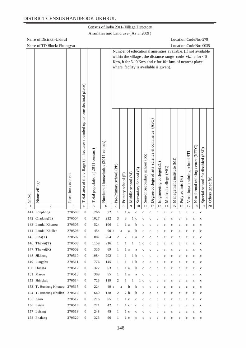
148
DISTRICT CENSUS HANDBOOK-UKHRUL
Name of District:-Ukhrul Location CodeNo:-279Name of TD Block:-Phungyar Location CodeNo:-0035
Pre-
Prim
ary
scho
ol (P
P)
Prim
ary
scho
ol (P
)
Mid
dle
scho
ol (M
)
Seco
ndar
y Sc
hool
(S)
Seni
or S
econ
dary
scho
ol (S
S)
Deg
ree
colle
ge o
f arts
sci
ence
& c
omm
erce
(A
SC)
Engi
neer
ing
colle
ge(E
C)
Med
ical
col
lege
(MC
)
Man
agem
ent i
nstit
ute
(MI)
Poly
tech
nic
(Pt)
Voc
atio
nal t
rain
ing
scho
ol /I
TI
Non
-form
al tr
aini
ng c
entre
(NFT
C)
Spec
ial s
choo
l for
dis
able
d (S
SD)
Oth
ers (
spec
ify)
1 2 3 4 5 6 7 8 9 10 11 12 13 14 15 16 17 18 19 20
141 Louphong 270503 0 266 52 1 1 a c c c c c c c c c c
142 Chadong(T) 270504 0 1027 212 3 3 1 c c c c c c c c c c
143 Lamlai Khunou 270505 0 524 106 1 1 a b c c c c c c c c c
144 Lamlai Khullen 270506 0 454 90 a a a b c c c c c c c c c
145 Riha(T) 270507 0 1087 264 2 2 1 a c c c c c c c c c
146 Thawai(T) 270508 0 1159 216 1 1 1 1 c c c c c c c c c
147 Thawai(K) 270509 0 336 69 1 1 a a c c c c c c c c c
148 Sikibung 270510 0 1084 202 1 1 1 b c c c c c c c c c
149 Lungphu 270511 0 776 145 1 1 1 b c c c c c c c c c
150 Shingta 270512 0 322 63 1 1 a b c c c c c c c c c
151 Marou 270513 0 309 55 1 1 a a c c c c c c c c c
152 Shingkap 270514 0 723 119 2 1 1 1 c c c c c c c c c
153 T. Hundung Khunou 270515 0 224 49 a a b b c c c c c c c c c
154 T. Hundung Khullen 270516 0 640 138 2 2 b b c c c c c c c c c
155 Koso 270517 0 216 65 1 1 c c c c c c c c c c c
156 Leishi 270518 0 221 42 1 1 c c c c c c c c c c c
157 Leiting 270519 0 248 45 1 1 c c c c c c c c c c c
158 Phalang 270520 0 325 66 1 1 c c c c c c c c c c c
Census of India 2011- Village DirectoryAmenities and Land use ( As in 2009 )
Sr.N
o.
Nam
e vi
llage
Loca
tion
code
no.
Tota
l are
a of
the
villa
ge (
in h
ecta
res r
ound
ed u
p to
one
dec
imal
pla
ce)
Tota
l pop
ulat
ion
( 201
1 ce
nsus
)
Num
ber o
f hou
seho
lds (
2011
cen
sus)
Number of educational amenities available. (If not available within the village , the distance range code viz; a for < 5 Kms, b for 5-10 Kms and c for 10+ kms of nearest place where facility is available is given).
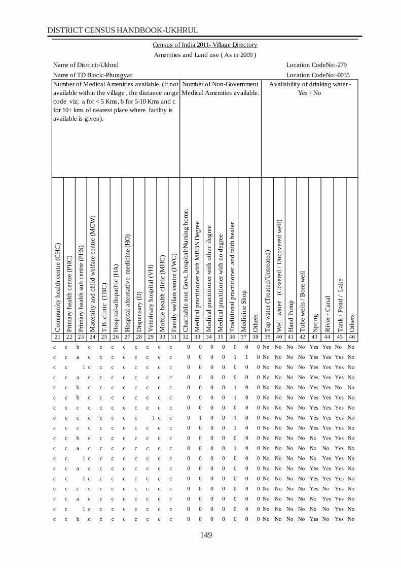
149
DISTRICT CENSUS HANDBOOK-UKHRUL
Name of District:-Ukhrul Location CodeNo:-279Name of TD Block:-Phungyar Location CodeNo:-0035
Com
mun
ity h
ealth
cen
tre (C
HC
)
Prim
ary
heal
th c
entre
(PH
C)
Prim
ary
heal
th su
b ce
ntre
(PH
S)
Mat
erni
ty a
nd c
hild
wel
fare
cen
tre (M
CW
)
T.B
. clin
ic (
TBC
)
Hos
pita
l-allo
path
ic (H
A)
Hos
pita
l-alte
rnat
ive
med
icin
e (H
O)
Dis
pens
ary
(D)
Vet
erin
ary
hosp
ital (
VH
)
Mob
ile h
ealth
clin
ic (M
HC
)
Fam
ily w
elfa
re c
entre
(FW
C)
Cha
ritab
le n
on G
ovt.
hosp
ital/N
ursi
ng h
ome.
Med
ical
pra
ctiti
oner
with
MB
BS
Deg
ree
Med
ical
pra
ctiti
oner
with
oth
er d
egre
e
Med
ical
pra
ctiti
oner
with
no
degr
ee
Trad
ition
al p
ract
ition
er a
nd fa
ith h
eale
r .
Med
icin
e Sh
op
Oth
ers
Tap
wat
er (T
reat
ed/U
ntre
ated
)
Wel
l w
ater
(C
over
ed /
Unc
over
ed w
ell)
Han
d Pu
mp
Tube
wel
ls /
Bor
e w
ell
Sprin
g
Riv
er /
Can
al
Tank
/ Po
nd /
Lak
e
Oth
ers
21 22 23 24 25 26 27 28 29 30 31 32 33 34 35 36 37 38 39 40 41 42 43 44 45 46
c c b c c c c c c c c 0 0 0 0 0 0 0 No No No No Yes Yes No No
c c a c c c c c c c c 0 0 0 0 1 1 0 No No No No Yes Yes Yes No
c c 1 c c c c c c c c 0 0 0 0 0 0 0 No No No No Yes Yes Yes No
c c a c c c c c c c c 0 0 0 0 0 0 0 No No No No Yes Yes Yes No
c c b c c c c c c c c 0 0 0 0 1 0 0 No No No No Yes Yes No No
c c b c c c c c c c c 0 0 0 0 1 0 0 No No No No Yes Yes Yes No
c c c c c c c c c c c 0 0 0 0 0 0 0 No No No No Yes Yes Yes No
c c c c c c c c 1 c c 0 1 0 0 1 0 0 No No No No Yes Yes Yes No
c c c c c c c c c c c 0 0 0 0 1 0 0 No No No No Yes Yes Yes No
c c b c c c c c c c c 0 0 0 0 0 0 0 No No No No No Yes Yes No
c c a c c c c c c c c 0 0 0 0 1 0 0 No No No No No No Yes No
c c 1 c c c c c c c c 0 0 0 0 0 0 0 No No No No No Yes Yes No
c c a c c c c c c c c 0 0 0 0 0 0 0 No No No No Yes Yes Yes No
c c 1 c c c c c c c c 0 0 0 0 0 0 0 No No No No Yes Yes Yes No
c c c c c c c c c c c 0 0 0 0 0 0 0 No No No No Yes No Yes No
c c a c c c c c c c c 0 0 0 0 0 0 0 No No No No No Yes Yes No
c c 1 c c c c c c c c 0 0 0 0 0 0 0 No No No No No No Yes No
c c b c c c c c c c c 0 0 0 0 0 0 0 No No No No Yes No Yes No
Census of India 2011- Village DirectoryAmenities and Land use ( As in 2009 )
Number of Medical Amenities available. (If not available within the village , the distance range code viz; a for < 5 Kms, b for 5-10 Kms and c for 10+ kms of nearest place where facility is available is given).
Number of Non-Government Medical Amenities available.
Availability of drinking water - Yes / No

150
DISTRICT CENSUS HANDBOOK-UKHRUL
Name of District:-Ukhrul Location CodeNo:-279Name of TD Block:-Phungyar Location CodeNo:-0035
Com
mun
ity to
ilet i
nclu
ding
bat
h.
Com
mun
ity to
ilet e
xclu
ding
bat
h.
Rur
al s
anita
ry m
art o
r san
itary
har
dwar
e ou
tlet a
vaila
ble
near
the
villa
ge.
Com
mun
ity b
io- g
as o
r rec
ycle
of w
aste
for p
rodu
ctiv
e us
e.
Post
offi
ce(P
O)
Sub
post
offi
ce (S
PO)
Post
& T
eleg
raph
offi
ce
(P&
TO)
Vill
age
Pin
Cod
e
Tele
phon
es
(L
and
lines
)
Publ
ic c
all o
ffice
(PC
O)
Mob
ile p
hone
cov
erag
e
Inte
rnet
caf
es/ C
omm
on se
rvic
e ce
ntre
(CSC
)
Priv
ate
cour
ier f
acili
ty
Bus
serv
ice
(Pub
lic &
Priv
ate)
Rai
lway
stat
ions
Aut
o/M
odifi
ed A
utos
Taxi
s and
Van
s
Trac
tors
Cyc
le-p
ulle
d ric
ksha
ws(
Man
ual &
Mac
hine
driv
en)
Car
ts d
riven
by
anim
als
Sea
/Riv
er fe
rry se
rvic
e47 48 49 50 51 52 53 54 55 56 57 58 59 60 61 62 63 64 65 66 67
No No No No c a c 795010 c c Yes c a c c a c c
No No No No c Yes c 795010 c c Yes c c Yes c c Yes c c
No No No No c a c 795010 c c Yes c c b c c Yes c c
No No No No c b c 795010 c c Yes c c b c c Yes c c
No No No No c b c 795010 c c Yes c c Yes c c Yes c c
No No No No c c c 795010 c c Yes c c Yes c c Yes c c
No No No No c c c 795010 c c Yes c c a c c Yes c c
No No No No c c c 795010 c c Yes c c Yes c c Yes c c
No No No No c Yes c 795010 c c Yes c c Yes c c Yes c c
No No No No c b c 795010 c c Yes c c Yes c c a c c
No No No No c b c 795010 c c Yes c c Yes c c a c c
No No No No c c c 795010 c c Yes c c Yes c c Yes c c
No No No No c c c 795010 c c Yes c c Yes c c a c c
No No No No c c c 795010 c c Yes c c a c c Yes c c
No No No No c c c 795010 c c Yes c c Yes c c b c c
No No No No c a c 795010 c c Yes c c Yes c c Yes c c
No No No No c Yes c 795010 c c Yes c c Yes c c Yes c c
No No No No c a c 795010 c c Yes c c a c c a c c
Census of India 2011- Village DirectoryAmenities and Land use ( As in 2009 )
Availability of toilet & others Yes / No
Communication and transport facilities (If amenities available code -Yes is given except for Village Pin Code ,If not available within the village , the distance range code viz; a for < 5 Kms, b for 5-10 Kms and c for 10+ kms of nearest place where facility is available is given).
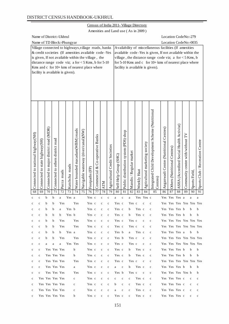
151
DISTRICT CENSUS HANDBOOK-UKHRUL
Name of District:-Ukhrul Location CodeNo:-279Name of TD Block:-Phungyar Location CodeNo:-0035
Con
nect
ed to
nat
iona
l hig
hway
(NH
)
Con
nect
ed to
stat
e hi
ghw
ay(S
H)
Con
nect
ed to
maj
or d
istri
ct ro
ad (M
DR
)
Con
nect
ed to
oth
ers d
istri
ct ro
ad
Pucc
a ro
ads
Kut
chch
a ro
ads
Wat
er b
ound
ed m
acad
am(W
BM
) roa
ds
Nav
igab
le w
ater
way
(riv
er/c
anal
)(NW
)
Foot
path
s (FP
)
Com
mer
cial
& C
o-op
erat
ive
Ban
ks
ATM
Agr
icul
tura
l Cre
dit S
ocie
ties
Self-
Hel
p G
roup
(SH
G)
Publ
ic d
istri
butio
n sy
stem
(PD
S) sh
op
Man
dis /
Reg
ular
mar
ket
Wee
kly
Haa
t
Agr
icul
tura
l mar
ketin
g so
ciet
y
Inte
grat
ed C
hild
Dev
elop
men
t Sch
eme
(Nut
ritio
nal
Cen
tres)
Ang
anw
adi C
entre
(Nut
ritio
nal C
entre
s)
Oth
ers (
Nut
ritio
nal C
entre
s)
ASH
A (A
ccre
dite
d So
cial
Hea
lth A
ctiv
ist)
Com
mun
ity c
entre
with
/with
out T
V
Spor
ts F
ield
,
Spor
ts C
lub
/ Rec
reat
ion
Cen
tre
68 69 70 71 72 73 74 75 76 77 78 79 80 81 82 83 84 85 86 87 88 89 90 91
c c b b a Yes a Yes c c c a c a Yes Yes c Yes Yes Yes a a a
c c b b Yes Yes Yes c c c Yes c Yes c c c Yes Yes Yes Yes Yes Yes
c c b b a Yes b Yes c c c Yes c b Yes c c Yes Yes Yes b b b
c c b b b Yes b Yes c c c Yes c b Yes c c Yes Yes Yes b b b
c c b b Yes Yes Yes c c c Yes c Yes c c c Yes Yes Yes Yes Yes Yes
c c b b Yes Yes Yes c c c Yes c Yes c c c Yes Yes Yes Yes Yes Yes
c c b b b Yes a Yes c c c Yes b a Yes c c Yes Yes Yes a b b
c c b b Yes Yes Yes c c c Yes b Yes c c c Yes Yes Yes Yes Yes Yes
c c a a a Yes Yes Yes c c c Yes c Yes c c c Yes Yes Yes Yes Yes Yes
c c Yes Yes Yes b Yes c c c Yes c b Yes c c Yes Yes Yes b b b
c c Yes Yes Yes b Yes c c c Yes c b Yes c c Yes Yes Yes b b b
c c Yes Yes Yes Yes Yes c c c Yes c Yes c c c Yes Yes Yes Yes Yes Yes
c c Yes Yes Yes a Yes c c c a c b Yes c c Yes Yes Yes b b b
c c Yes Yes Yes Yes Yes c c c Yes b Yes c c c Yes Yes Yes Yes b b
c Yes Yes Yes Yes c Yes c c c c c c Yes c c Yes Yes Yes c c c
c Yes Yes Yes Yes c Yes c c c b c c Yes c c Yes Yes Yes c c c
c Yes Yes Yes Yes c Yes c c c a c c Yes c c Yes Yes Yes c c c
c Yes Yes Yes Yes b Yes c c c Yes c c Yes c c Yes Yes Yes c c c
Census of India 2011- Village DirectoryAmenities and Land use ( As in 2009 )
Village connected to highways,village roads, banks & credit societies (If amenities available code -Yes is given, If not available within the village , the distance range code viz; a for < 5 Kms, b for 5-10 Kms and c for 10+ kms of nearest place where facility is available is given).
Availability of miscellaneous facilities (If amenities available code -Yes is given, If not available within the village , the distance range code viz; a for < 5 Kms, b for 5-10 Kms and c for 10+ kms of nearest place where facility is available is given).
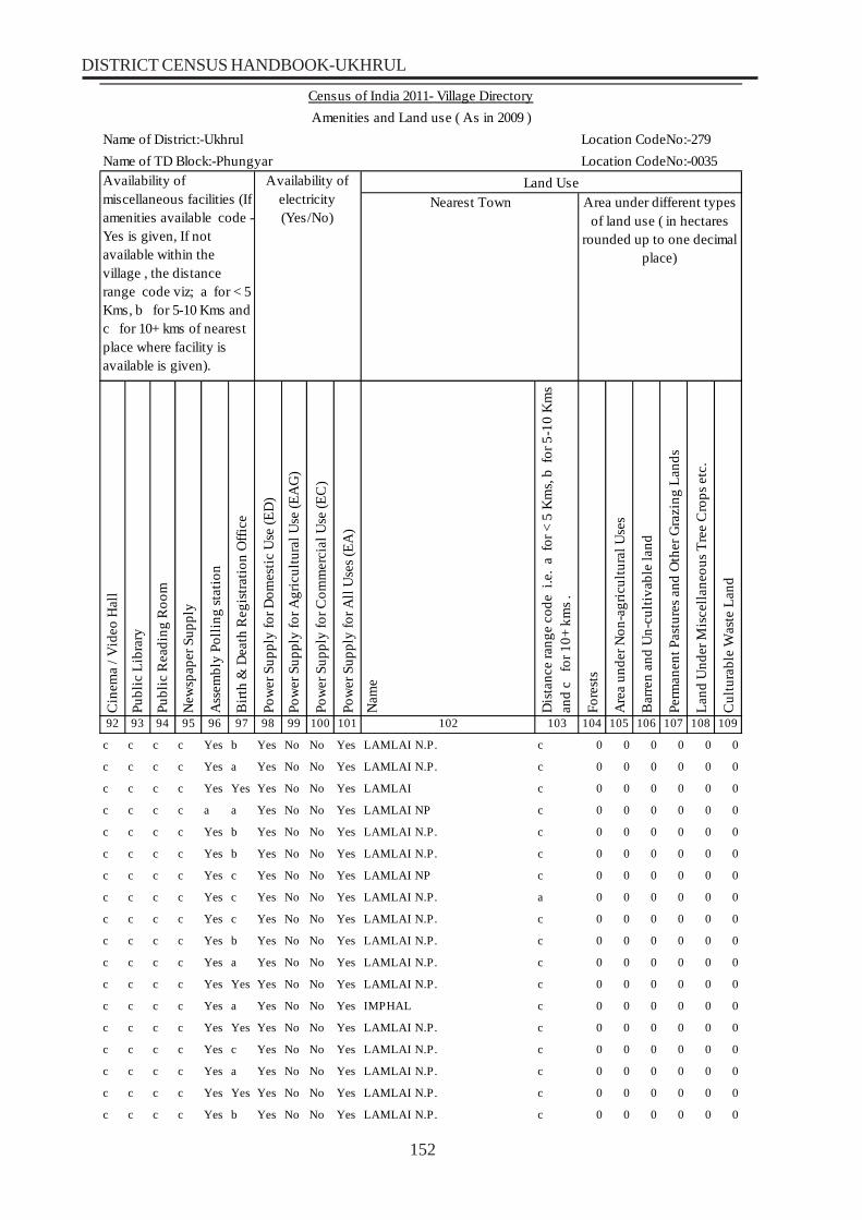
152
DISTRICT CENSUS HANDBOOK-UKHRUL
Name of District:-Ukhrul Location CodeNo:-279Name of TD Block:-Phungyar Location CodeNo:-0035
Cin
ema
/ Vid
eo H
all
Publ
ic L
ibra
ry
Publ
ic R
eadi
ng R
oom
New
spap
er S
uppl
y
Ass
embl
y Po
lling
stat
ion
Birt
h &
Dea
th R
egis
tratio
n O
ffice
Pow
er S
uppl
y fo
r Dom
estic
Use
(ED
)
Pow
er S
uppl
y fo
r Agr
icul
tura
l Use
(EA
G)
Pow
er S
uppl
y fo
r Com
mer
cial
Use
(EC
)
Pow
er S
uppl
y fo
r All
Use
s (EA
)
Nam
e
Dis
tanc
e ra
nge
code
i.e
. a
for <
5 K
ms,
b fo
r 5-1
0 K
ms
and
c f
or 1
0+ k
ms .
Fore
sts
Are
a un
der N
on-a
gric
ultu
ral U
ses
Bar
ren
and
Un-
culti
vabl
e la
nd
Perm
anen
t Pas
ture
s and
Oth
er G
razi
ng L
ands
Land
Und
er M
isce
llane
ous T
ree
Cro
ps e
tc.
Cul
tura
ble
Was
te L
and
92 93 94 95 96 97 98 99 100 101 102 103 104 105 106 107 108 109
c c c c Yes b Yes No No Yes LAMLAI N.P. c 0 0 0 0 0 0
c c c c Yes a Yes No No Yes LAMLAI N.P. c 0 0 0 0 0 0
c c c c Yes Yes Yes No No Yes LAMLAI c 0 0 0 0 0 0
c c c c a a Yes No No Yes LAMLAI NP c 0 0 0 0 0 0
c c c c Yes b Yes No No Yes LAMLAI N.P. c 0 0 0 0 0 0
c c c c Yes b Yes No No Yes LAMLAI N.P. c 0 0 0 0 0 0
c c c c Yes c Yes No No Yes LAMLAI NP c 0 0 0 0 0 0
c c c c Yes c Yes No No Yes LAMLAI N.P. a 0 0 0 0 0 0
c c c c Yes c Yes No No Yes LAMLAI N.P. c 0 0 0 0 0 0
c c c c Yes b Yes No No Yes LAMLAI N.P. c 0 0 0 0 0 0
c c c c Yes a Yes No No Yes LAMLAI N.P. c 0 0 0 0 0 0
c c c c Yes Yes Yes No No Yes LAMLAI N.P. c 0 0 0 0 0 0
c c c c Yes a Yes No No Yes IMPHAL c 0 0 0 0 0 0
c c c c Yes Yes Yes No No Yes LAMLAI N.P. c 0 0 0 0 0 0
c c c c Yes c Yes No No Yes LAMLAI N.P. c 0 0 0 0 0 0
c c c c Yes a Yes No No Yes LAMLAI N.P. c 0 0 0 0 0 0
c c c c Yes Yes Yes No No Yes LAMLAI N.P. c 0 0 0 0 0 0
c c c c Yes b Yes No No Yes LAMLAI N.P. c 0 0 0 0 0 0
Census of India 2011- Village DirectoryAmenities and Land use ( As in 2009 )
Availability of miscellaneous facilities (If amenities available code -Yes is given, If not available within the village , the distance range code viz; a for < 5 Kms, b for 5-10 Kms and c for 10+ kms of nearest place where facility is available is given).
Availability of electricity (Yes/No)
Land Use Nearest Town Area under different types
of land use ( in hectares rounded up to one decimal
place)
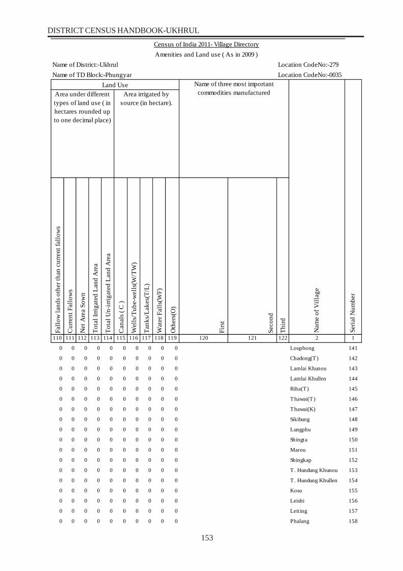
153
DISTRICT CENSUS HANDBOOK-UKHRUL
Name of District:-Ukhrul Location CodeNo:-279Name of TD Block:-Phungyar Location CodeNo:-0035
Fallo
w la
nds o
ther
than
cur
rent
fallo
ws
Cur
rent
Fal
low
s
Net
Are
a So
wn
Tota
l Irri
gate
d La
nd A
rea
Tota
l Un-
irrig
ated
Lan
d A
rea
Can
als (
C )
Wel
ls/T
ube-
wel
ls(W
/TW
)
Tank
s/La
kes(
T/L)
Wat
er F
alls
(WF)
Oth
ers(
O)
Firs
t
Seco
nd
Third
110 111 112 113 114 115 116 117 118 119 120 121 122 2 1
0 0 0 0 0 0 0 0 0 0 Louphong 141
0 0 0 0 0 0 0 0 0 0 Chadong(T) 142
0 0 0 0 0 0 0 0 0 0 Lamlai Khunou 143
0 0 0 0 0 0 0 0 0 0 Lamlai Khullen 144
0 0 0 0 0 0 0 0 0 0 Riha(T) 145
0 0 0 0 0 0 0 0 0 0 Thawai(T) 146
0 0 0 0 0 0 0 0 0 0 Thawai(K) 147
0 0 0 0 0 0 0 0 0 0 Sikibung 148
0 0 0 0 0 0 0 0 0 0 Lungphu 149
0 0 0 0 0 0 0 0 0 0 Shingta 150
0 0 0 0 0 0 0 0 0 0 Marou 151
0 0 0 0 0 0 0 0 0 0 Shingkap 152
0 0 0 0 0 0 0 0 0 0 T. Hundung Khunou 153
0 0 0 0 0 0 0 0 0 0 T. Hundung Khullen 154
0 0 0 0 0 0 0 0 0 0 Koso 155
0 0 0 0 0 0 0 0 0 0 Leishi 156
0 0 0 0 0 0 0 0 0 0 Leiting 157
0 0 0 0 0 0 0 0 0 0 Phalang 158
Census of India 2011- Village DirectoryAmenities and Land use ( As in 2009 )
Land Use Name of three most important commodities manufactured
Nam
e of
Vill
age
Seria
l Num
ber
Area under different types of land use ( in hectares rounded up to one decimal place)
Area irrigated by source (in hectare).
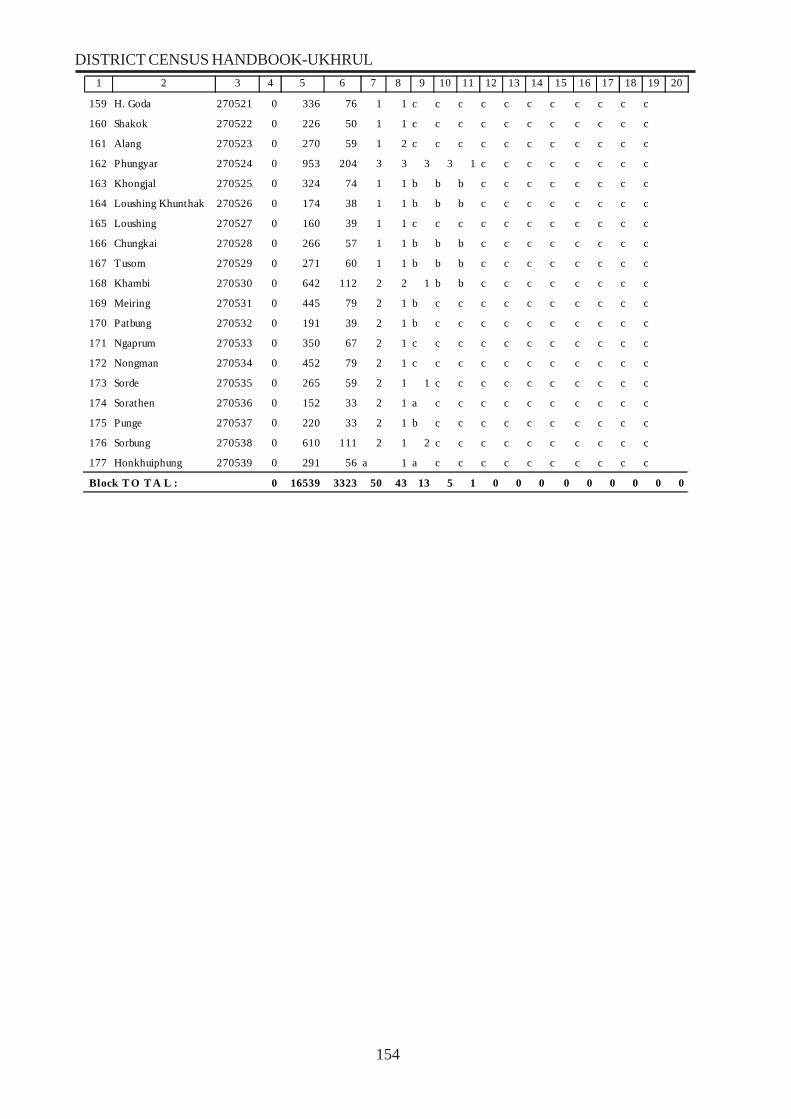
154
DISTRICT CENSUS HANDBOOK-UKHRUL1 2 3 4 5 6 7 8 9 10 11 12 13 14 15 16 17 18 19 20
159 H. Goda 270521 0 336 76 1 1 c c c c c c c c c c c
160 Shakok 270522 0 226 50 1 1 c c c c c c c c c c c
161 Alang 270523 0 270 59 1 2 c c c c c c c c c c c
162 Phungyar 270524 0 953 204 3 3 3 3 1 c c c c c c c c
163 Khongjal 270525 0 324 74 1 1 b b b c c c c c c c c
164 Loushing Khunthak 270526 0 174 38 1 1 b b b c c c c c c c c
165 Loushing 270527 0 160 39 1 1 c c c c c c c c c c c
166 Chungkai 270528 0 266 57 1 1 b b b c c c c c c c c
167 Tusom 270529 0 271 60 1 1 b b b c c c c c c c c
168 Khambi 270530 0 642 112 2 2 1 b b c c c c c c c c
169 Meiring 270531 0 445 79 2 1 b c c c c c c c c c c
170 Patbung 270532 0 191 39 2 1 b c c c c c c c c c c
171 Ngaprum 270533 0 350 67 2 1 c c c c c c c c c c c
172 Nongman 270534 0 452 79 2 1 c c c c c c c c c c c
173 Sorde 270535 0 265 59 2 1 1 c c c c c c c c c c
174 Sorathen 270536 0 152 33 2 1 a c c c c c c c c c c
175 Punge 270537 0 220 33 2 1 b c c c c c c c c c c
176 Sorbung 270538 0 610 111 2 1 2 c c c c c c c c c c
177 Honkhuiphung 270539 0 291 56 a 1 a c c c c c c c c c c
Block T O T A L : 0 16539 3323 50 43 13 5 1 0 0 0 0 0 0 0 0 0
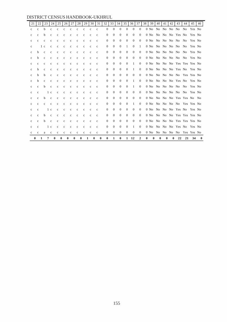
155
DISTRICT CENSUS HANDBOOK-UKHRUL21 22 23 24 25 26 27 28 29 30 31 32 33 34 35 36 37 38 39 40 41 42 43 44 45 46
c c b c c c c c c c c 0 0 0 0 0 0 0 No No No No No No Yes No
c c b c c c c c c c c 0 0 0 0 0 0 0 No No No No Yes No Yes No
c c c c c c c c c c c 0 0 0 0 0 0 0 No No No No No No Yes No
c 1 c c c c c c c c c 0 0 0 1 0 1 0 No No No No No No Yes No
c b c c c c c c c c c 0 0 0 0 0 0 0 No No No No No No Yes No
c b c c c c c c c c c 0 0 0 0 0 0 0 No No No No No No Yes No
c c c c c c c c c c c 0 0 0 0 1 0 0 No No No No Yes Yes Yes No
c b c c c c c c c c c 0 0 0 0 1 0 0 No No No No Yes No Yes No
c b b c c c c c c c c 0 0 0 0 0 0 0 No No No No No Yes Yes No
c b c c c c c c c c c 0 0 0 0 1 0 0 No No No No Yes No Yes No
c c b c c c c c c c c 0 0 0 0 1 0 0 No No No No No No Yes No
c c 1 c c c c c c c c 0 0 0 0 0 0 0 No No No No No No Yes No
c c b c c c c c c c c 0 0 0 0 0 0 0 No No No No Yes Yes No No
c c c c c c c c c c c 0 0 0 0 1 0 0 No No No No No Yes Yes No
c c 1 c c c c c c c c 0 0 0 0 0 0 0 No No No No Yes No Yes No
c c b c c c c c c c c 0 0 0 0 0 0 0 No No No No Yes Yes Yes No
c c b c c c c c c c c 0 0 0 0 0 0 0 No No No No Yes Yes Yes No
c c 1 c c c c c c c c 0 0 0 0 1 0 0 No No No No Yes No Yes No
c c a c c c c c c c c 0 0 0 0 0 0 0 No No No No No Yes Yes No
0 1 7 0 0 0 0 0 1 0 0 0 1 0 1 12 2 0 0 0 0 0 22 21 34 0
156
DISTRICT CENSUS HANDBOOK-UKHRUL47 48 49 50 51 52 53 54 55 56 57 58 59 60 61 62 63 64 65 66 67
No No No No c c c 795010 c c Yes c c Yes c c Yes c c
No No No No c c c 795010 c c Yes c c Yes c c Yes c c
No No No No c c c 795010 c c Yes c c Yes c c Yes c c
No No No No c Yes c 795010 Yes c Yes c c Yes c c Yes c c
No No No No c b c 795010 b c Yes c c a c c b c c
No No No No c b c 795010 b c b c c a c c Yes c c
No No No No c c c 795010 c c c c c b c c Yes c c
No No No No c b c 795010 b c Yes c c Yes c c a c c
No No No No c b c 795010 b c Yes c c Yes c c b c c
No No No No c b c 795010 b c Yes c c Yes c c Yes c c
No No No No c b c 795010 c c Yes c c Yes c c Yes c c
No No No No c c c 795010 c c b c c a c c a c c
No No No No c c c 795010 c c Yes c c Yes c c Yes c c
No No No No c c c 795010 c c Yes c c b c c Yes c c
No No No No c Yes c 795010 c c Yes c c Yes c c Yes c c
No No No No c a c 795010 c c Yes c c a c c Yes c c
No No No No c b c 795010 c c Yes c c b c c Yes c c
No No No No c c c 795010 c c Yes c c Yes c c Yes c c
No No No No c c c 795010 c c Yes c c a c c Yes c c
0 0 0 0 0 5 0 37 1 0 34 0 0 23 0 0 27 0 0 0 0
157
DISTRICT CENSUS HANDBOOK-UKHRUL68 69 70 71 72 73 74 75 76 77 78 79 80 81 82 83 84 85 86 87 88 89 90 91
c a Yes Yes a Yes Yes Yes c c c Yes c c c c c Yes Yes Yes c c c
c Yes Yes Yes Yes b Yes c c c b c c Yes c c Yes Yes Yes c c c
c Yes Yes Yes Yes c Yes c c c c c c Yes c c Yes Yes Yes c c c
c c Yes Yes Yes b Yes c c c Yes Yes Yes Yes c Yes Yes Yes Yes Yes Yes Yes
c c a a a Yes Yes Yes c c c Yes b b c c b Yes Yes Yes b b b
c c a a a Yes b Yes c c c a b b Yes c b a Yes Yes b c c
c c b b b Yes b Yes c c c b c c Yes c c b Yes Yes c c Yes
c c a a a Yes b Yes c c c Yes b b Yes c b Yes Yes Yes b b b
c c Yes Yes Yes c Yes c c c b b b Yes c b Yes Yes Yes b b b
c c Yes Yes Yes Yes Yes c c c Yes b Yes c c b Yes Yes Yes Yes Yes Yes
c c Yes Yes Yes b Yes c c c Yes c b Yes c c Yes Yes Yes b b b
c c a a a Yes c Yes c c c Yes c c Yes c c b Yes Yes c c c
c c Yes Yes Yes c Yes c c c b c c Yes c c Yes Yes Yes c c c
c c b b b Yes c Yes c c c c c c Yes c c b Yes Yes c c c
c c Yes Yes Yes c Yes c c c Yes c c Yes c c Yes Yes Yes c c c
c c Yes Yes Yes b Yes c c c a c c Yes c c a Yes Yes c c c
c c a a a Yes b Yes c c c b c b Yes c c Yes Yes Yes b b c
c c Yes Yes Yes Yes Yes c c c Yes c Yes c c c Yes Yes Yes Yes Yes Yes
c c a a a Yes a Yes c c c a c a Yes c c a Yes Yes a a a
0 6 20 20 23 14 11 0 37 0 0 0 22 1 10 26 1 1 31 37 37 10 9 10
158
DISTRICT CENSUS HANDBOOK-UKHRUL92 93 94 95 96 97 98 99 100 101 102 103 104 105 106 107 108 109
c c c c Yes b Yes No No Yes LAMLAI N.P. c 0 0 0 0 0 0
c c c c Yes b Yes No No Yes LAMLAI N.P. c 0 0 0 0 0 0
c c c c Yes c Yes No No Yes LAMLAI N.P. c 0 0 0 0 0 0
c c c Yes Yes Yes Yes No No Yes UKHRUL c 0 0 0 0 0 0
c c c b Yes c Yes No No Yes UKHRUL c 0 0 0 0 0 0
c c c b Yes c Yes No No Yes UKHRUL c 0 0 0 0 0 0
c c c c Yes c Yes No No Yes UKHRUL c 0 0 0 0 0 0
c c c b Yes c Yes No No Yes UKHRUL c 0 0 0 0 0 0
c c c b Yes b Yes No No Yes LAMLAI NP c 0 0 0 0 0 0
c c c b Yes c Yes No No Yes UKHRUL c 0 0 0 0 0 0
c c c c Yes b Yes No No Yes UKHRUL c 0 0 0 0 0 0
c c c c Yes Yes Yes No No Yes PHUNGYAR c 0 0 0 0 0 0
c c c c Yes b Yes No No Yes UKHRUL c 0 0 0 0 0 0
c c c c Yes c Yes No No Yes UKHRUL c 0 0 0 0 0 0
c c c c Yes Yes Yes No No Yes UKHRUL c 0 0 0 0 0 0
c c c c Yes b Yes No No Yes UKHRUL c 0 0 0 0 0 0
c c c c Yes b Yes No No Yes UKHRUL c 0 0 0 0 0 0
c c c c Yes Yes Yes No No Yes LAMLAI N.P. c 0 0 0 0 0 0
c c c c a a Yes No No Yes IMPHAL c 0 0 0 0 0 0
0 0 0 1 35 8 37 0 0 37 0 0 0 0 0 0 0 0
159
DISTRICT CENSUS HANDBOOK-UKHRUL110 111 112 113 114 115 116 117 118 119 120 121 122 2 1
0 0 0 0 0 0 0 0 0 0 H. Goda 159
0 0 0 0 0 0 0 0 0 0 Shakok 160
0 0 0 0 0 0 0 0 0 0 Alang 161
0 0 0 0 0 0 0 0 0 0 Phungyar 162
0 0 0 0 0 0 0 0 0 0 Khongjal 163
0 0 0 0 0 0 0 0 0 0 Loushing Khunthak 164
0 0 0 0 0 0 0 0 0 0 Loushing 165
0 0 0 0 0 0 0 0 0 0 Chungkai 166
0 0 0 0 0 0 0 0 0 0 Tusom 167
0 0 0 0 0 0 0 0 0 0 Khambi 168
0 0 0 0 0 0 0 0 0 0 Meiring 169
0 0 0 0 0 0 0 0 0 0 Patbung 170
0 0 0 0 0 0 0 0 0 0 Ngaprum 171
0 0 0 0 0 0 0 0 0 0 Nongman 172
0 0 0 0 0 0 0 0 0 0 Sorde 173
0 0 0 0 0 0 0 0 0 0 Sorathen 174
0 0 0 0 0 0 0 0 0 0 Punge 175
0 0 0 0 0 0 0 0 0 0 Sorbung 176
0 0 0 0 0 0 0 0 0 0 Honkhuiphung 177
0 0 0 0 0 0 0 0 0

160
DISTRICT CENSUS HANDBOOK-UKHRUL
161
DISTRICT CENSUS HANDBOOK-UKHRUL
Map of Ukhrul South T.D.Block

162
DISTRICT CENSUS HANDBOOK-UKHRUL
!!
!
!
!
(
!
!
(
!
!
!
!
!
!
(
!
!
!
!
!
!
!
(
(
!
(
(
!
(
( !
!
(
(
(
ToTamu
C H A ND
EL
D
IS
TR
I
CT
PH
UN G Y A R - P
HA
IS
AT
S
UB
-D
IV
IS
IO
N
Ukh
rul
SU
B-D
IVIS
ION
KA
MJO
NG
-CH
AS
SA
D
I N D I AS
H
570
R
5 0 5
Note: Kasom Khullen T.D. Block is co-terminus
with Ukhrul South Sub-Division.
!μ#
SHIGH SCHOOL/INTER COLLEGE...............................
OTHER MEDICAL SERVICES.....................................
PRIMARY HEALTH CENTRE.......................................
HEADQUARTERS: SUB-DIVISION..............................
SUB-DIVISION.........................................
VILLAGE WITH MDDS CODE ...............,,
DISTRICT.................................................
,,
BOUNDARY, INTERNATIONAL....................................
,,
RIVER AND STREAM...................................................
STATE HIGHWAY...........................................................
IMPORTANT METALLED ROADS................................
POPULATION SIZE OF VILLAGES:
BELOW 200, 200-499, 500-999, & 1000-4999..............
SH
( ! ! !
R
270540
!μ
#
S
#
#
#
S
S
Kilometres
KASOM KHULLEN
MY
AN
MA
R
MANIPUR
UKHRUL DISTRICT
SE
NA
PA
TI
D
IS
TR
IC
T
UKHRUL SOUTH SUB-DIVISION
Imphal
From
Kamjo
ng
To Phungyar
SH
To
Fro
m P
alle
l
To
To
Ukhru
l
SH
SH
Makla
ng K
hong
Riv
er
Taret River
Tuyungbi River
553
551
550
549
548
541
558
566
574
573
572
571
569
568
567
565
564
563
562
561
560
559
557
556
555554
552
547
546
545
544
543
542
270575
270540
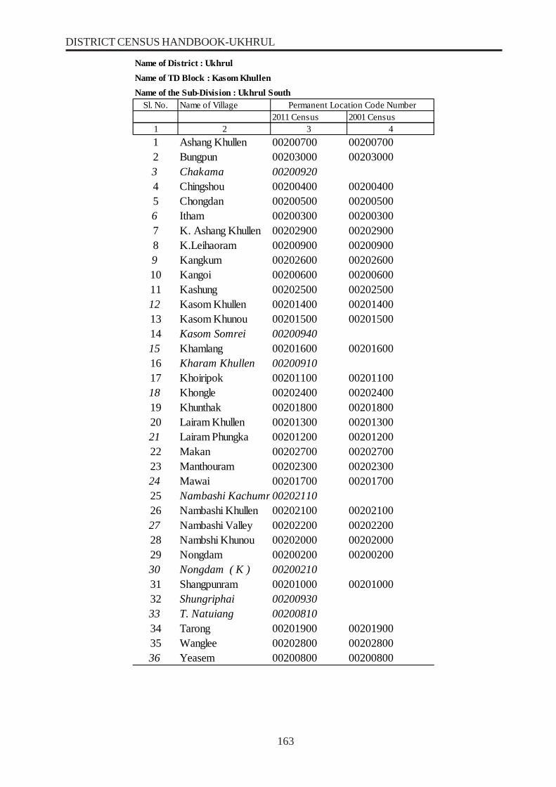
163
DISTRICT CENSUS HANDBOOK-UKHRUL
Name of District : UkhrulName of TD Block : Kasom KhullenName of the Sub-Division : Ukhrul South
Sl. No. Name of Village2011 Census 2001 Census
1 2 3 41 Ashang Khullen 00200700 002007002 Bungpun 00203000 002030003 Chakama 002009204 Chingshou 00200400 002004005 Chongdan 00200500 002005006 Itham 00200300 002003007 K. Ashang Khullen 00202900 002029008 K.Leihaoram 00200900 002009009 Kangkum 00202600 0020260010 Kangoi 00200600 0020060011 Kashung 00202500 0020250012 Kasom Khullen 00201400 0020140013 Kasom Khunou 00201500 0020150014 Kasom Somrei 0020094015 Khamlang 00201600 0020160016 Kharam Khullen 0020091017 Khoiripok 00201100 0020110018 Khongle 00202400 0020240019 Khunthak 00201800 0020180020 Lairam Khullen 00201300 0020130021 Lairam Phungka 00201200 0020120022 Makan 00202700 0020270023 Manthouram 00202300 0020230024 Mawai 00201700 0020170025 Nambashi Kachumr 0020211026 Nambashi Khullen 00202100 0020210027 Nambashi Valley 00202200 0020220028 Nambshi Khunou 00202000 0020200029 Nongdam 00200200 0020020030 Nongdam ( K ) 0020021031 Shangpunram 00201000 0020100032 Shungriphai 0020093033 T. Natuiang 0020081034 Tarong 00201900 0020190035 Wanglee 00202800 0020280036 Yeasem 00200800 00200800
Permanent Location Code Number
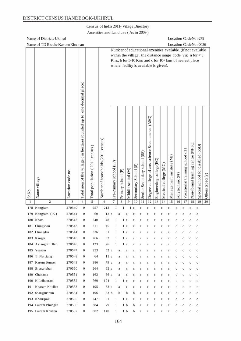
164
DISTRICT CENSUS HANDBOOK-UKHRUL
Name of District:-Ukhrul Location CodeNo:-279Name of TD Block:-Kasom Khuman Location CodeNo:-0036
Pre-
Prim
ary
scho
ol (P
P)
Prim
ary
scho
ol (P
)
Mid
dle
scho
ol (M
)
Seco
ndar
y Sc
hool
(S)
Seni
or S
econ
dary
scho
ol (S
S)
Deg
ree
colle
ge o
f arts
sci
ence
& c
omm
erce
(A
SC)
Engi
neer
ing
colle
ge(E
C)
Med
ical
col
lege
(MC
)
Man
agem
ent i
nstit
ute
(MI)
Poly
tech
nic
(Pt)
Voc
atio
nal t
rain
ing
scho
ol /I
TI
Non
-form
al tr
aini
ng c
entre
(NFT
C)
Spec
ial s
choo
l for
dis
able
d (S
SD)
Oth
ers (
spec
ify)
1 2 3 4 5 6 7 8 9 10 11 12 13 14 15 16 17 18 19 20
178 Nongdam 270540 0 957 212 1 1 1 c c c c c c c c c c
179 Nongdam ( K ) 270541 0 60 12 a a a c c c c c c c c c c
180 Itham 270542 0 240 48 1 1 c c c c c c c c c c c
181 Chingshou 270543 0 211 45 1 1 c c c c c c c c c c c
182 Chongdan 270544 0 336 61 1 1 c c c c c c c c c c c
183 Kangoi 270545 0 266 53 1 1 c c c c c c c c c c c
184 Ashang Khullen 270546 0 123 26 1 1 c c c c c c c c c c c
185 Yeasem 270547 0 253 52 a a c c c c c c c c c c c
186 T. Natuiang 270548 0 64 11 a a c c c c c c c c c c c
187 Kasom Somrei 270549 0 386 79 a a c c c c c c c c c c c
188 Shungriphai 270550 0 264 52 a a c c c c c c c c c c c
189 Chakama 270551 0 162 36 a a c c c c c c c c c c c
190 K.Leihaoram 270552 0 769 174 1 1 c c c c c c c c c c c
191 Kharam Khullen 270553 0 195 33 a a c c c c c c c c c c c
192 Shangpunram 270554 0 196 53 b b b b c c c c c c c c c
193 Khoiripok 270555 0 247 51 1 1 c c c c c c c c c c c
194 Lairam Phungka 270556 0 384 79 1 1 b b c c c c c c c c c
195 Lairam Khullen 270557 0 802 140 1 1 b b c c c c c c c c c
Census of India 2011- Village DirectoryAmenities and Land use ( As in 2009 )
Sr.N
o.
Nam
e vi
llage
Loca
tion
code
no.
Tota
l are
a of
the
villa
ge (
in h
ecta
res r
ound
ed u
p to
one
dec
imal
pla
ce)
Tota
l pop
ulat
ion
( 201
1 ce
nsus
)
Num
ber o
f hou
seho
lds (
2011
cen
sus)
Number of educational amenities available. (If not available within the village , the distance range code viz; a for < 5 Kms, b for 5-10 Kms and c for 10+ kms of nearest place where facility is available is given).
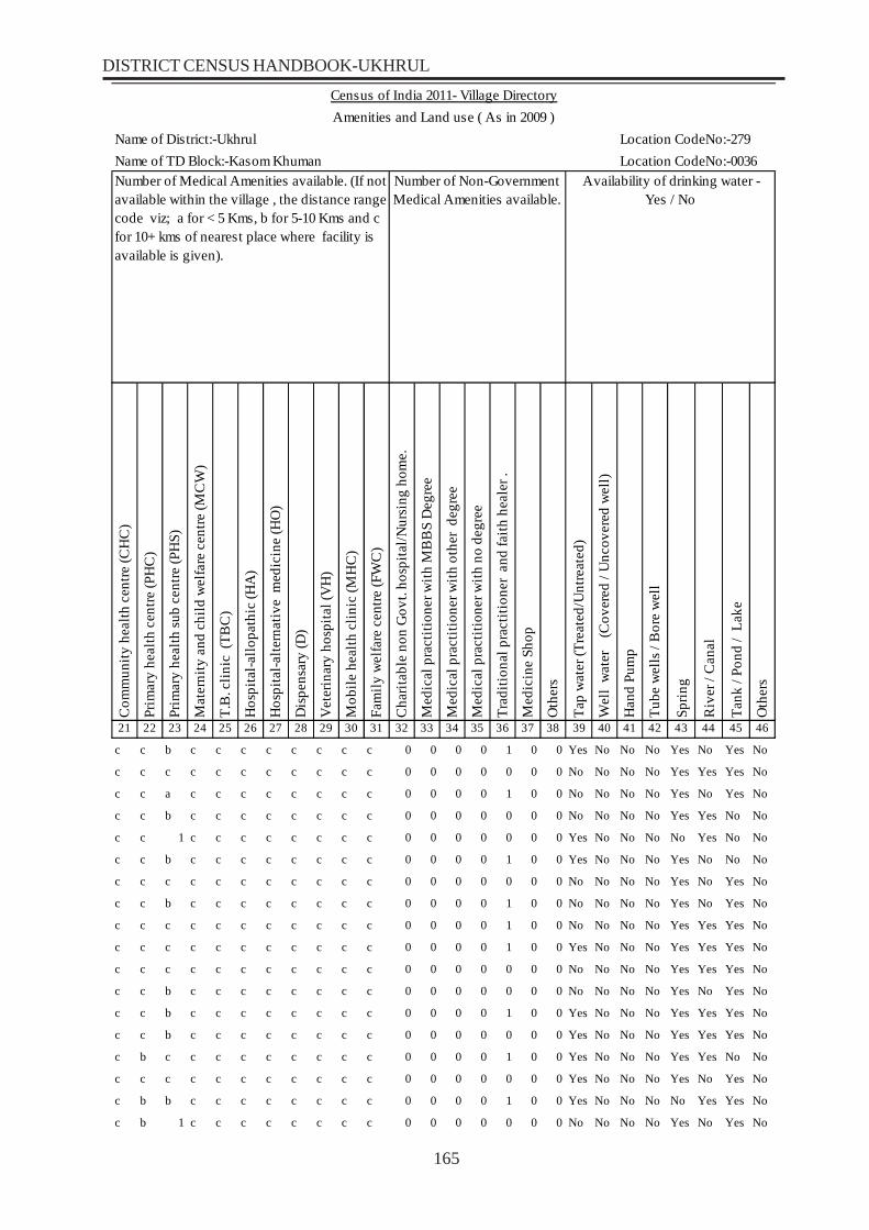
165
DISTRICT CENSUS HANDBOOK-UKHRUL
Name of District:-Ukhrul Location CodeNo:-279Name of TD Block:-Kasom Khuman Location CodeNo:-0036
Com
mun
ity h
ealth
cen
tre (C
HC
)
Prim
ary
heal
th c
entre
(PH
C)
Prim
ary
heal
th su
b ce
ntre
(PH
S)
Mat
erni
ty a
nd c
hild
wel
fare
cen
tre (M
CW
)
T.B
. clin
ic (
TBC
)
Hos
pita
l-allo
path
ic (H
A)
Hos
pita
l-alte
rnat
ive
med
icin
e (H
O)
Dis
pens
ary
(D)
Vet
erin
ary
hosp
ital (
VH
)
Mob
ile h
ealth
clin
ic (M
HC
)
Fam
ily w
elfa
re c
entre
(FW
C)
Cha
ritab
le n
on G
ovt.
hosp
ital/N
ursi
ng h
ome.
Med
ical
pra
ctiti
oner
with
MB
BS
Deg
ree
Med
ical
pra
ctiti
oner
with
oth
er d
egre
e
Med
ical
pra
ctiti
oner
with
no
degr
ee
Trad
ition
al p
ract
ition
er a
nd fa
ith h
eale
r .
Med
icin
e Sh
op
Oth
ers
Tap
wat
er (T
reat
ed/U
ntre
ated
)
Wel
l w
ater
(C
over
ed /
Unc
over
ed w
ell)
Han
d Pu
mp
Tube
wel
ls /
Bor
e w
ell
Sprin
g
Riv
er /
Can
al
Tank
/ Po
nd /
Lak
e
Oth
ers
21 22 23 24 25 26 27 28 29 30 31 32 33 34 35 36 37 38 39 40 41 42 43 44 45 46
c c b c c c c c c c c 0 0 0 0 1 0 0 Yes No No No Yes No Yes No
c c c c c c c c c c c 0 0 0 0 0 0 0 No No No No Yes Yes Yes No
c c a c c c c c c c c 0 0 0 0 1 0 0 No No No No Yes No Yes No
c c b c c c c c c c c 0 0 0 0 0 0 0 No No No No Yes Yes No No
c c 1 c c c c c c c c 0 0 0 0 0 0 0 Yes No No No No Yes No No
c c b c c c c c c c c 0 0 0 0 1 0 0 Yes No No No Yes No No No
c c c c c c c c c c c 0 0 0 0 0 0 0 No No No No Yes No Yes No
c c b c c c c c c c c 0 0 0 0 1 0 0 No No No No Yes No Yes No
c c c c c c c c c c c 0 0 0 0 1 0 0 No No No No Yes Yes Yes No
c c c c c c c c c c c 0 0 0 0 1 0 0 Yes No No No Yes Yes Yes No
c c c c c c c c c c c 0 0 0 0 0 0 0 No No No No Yes Yes Yes No
c c b c c c c c c c c 0 0 0 0 0 0 0 No No No No Yes No Yes No
c c b c c c c c c c c 0 0 0 0 1 0 0 Yes No No No Yes Yes Yes No
c c b c c c c c c c c 0 0 0 0 0 0 0 Yes No No No Yes Yes Yes No
c b c c c c c c c c c 0 0 0 0 1 0 0 Yes No No No Yes Yes No No
c c c c c c c c c c c 0 0 0 0 0 0 0 Yes No No No Yes No Yes No
c b b c c c c c c c c 0 0 0 0 1 0 0 Yes No No No No Yes Yes No
c b 1 c c c c c c c c 0 0 0 0 0 0 0 No No No No Yes No Yes No
Census of India 2011- Village DirectoryAmenities and Land use ( As in 2009 )
Number of Medical Amenities available. (If not available within the village , the distance range code viz; a for < 5 Kms, b for 5-10 Kms and c for 10+ kms of nearest place where facility is available is given).
Number of Non-Government Medical Amenities available.
Availability of drinking water - Yes / No
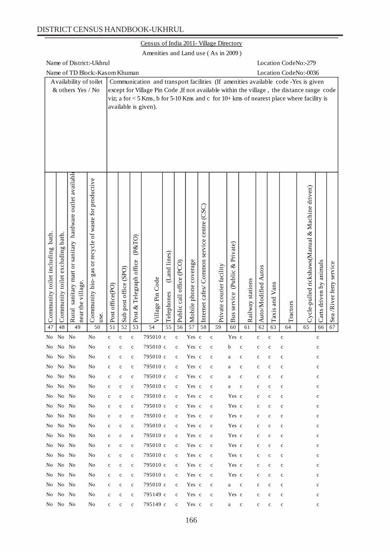
166
DISTRICT CENSUS HANDBOOK-UKHRUL
Name of District:-Ukhrul Location CodeNo:-279Name of TD Block:-Kasom Khuman Location CodeNo:-0036
Com
mun
ity to
ilet i
nclu
ding
bat
h.
Com
mun
ity to
ilet e
xclu
ding
bat
h.
Rur
al s
anita
ry m
art o
r san
itary
har
dwar
e ou
tlet a
vaila
ble
near
the
villa
ge.
Com
mun
ity b
io- g
as o
r rec
ycle
of w
aste
for p
rodu
ctiv
e us
e.
Post
offi
ce(P
O)
Sub
post
offi
ce (S
PO)
Post
& T
eleg
raph
offi
ce
(P&
TO)
Vill
age
Pin
Cod
e
Tele
phon
es
(L
and
lines
)
Publ
ic c
all o
ffice
(PC
O)
Mob
ile p
hone
cov
erag
e
Inte
rnet
caf
es/ C
omm
on se
rvic
e ce
ntre
(CSC
)
Priv
ate
cour
ier f
acili
ty
Bus
serv
ice
(Pub
lic &
Priv
ate)
Rai
lway
stat
ions
Aut
o/M
odifi
ed A
utos
Taxi
s and
Van
s
Trac
tors
Cyc
le-p
ulle
d ric
ksha
ws(
Man
ual &
Mac
hine
driv
en)
Car
ts d
riven
by
anim
als
Sea
/Riv
er fe
rry se
rvic
e47 48 49 50 51 52 53 54 55 56 57 58 59 60 61 62 63 64 65 66 67
No No No No c c c 795010 c c Yes c c Yes c c c c c
No No No No c c c 795010 c c Yes c c b c c c c c
No No No No c c c 795010 c c Yes c c a c c c c c
No No No No c c c 795010 c c Yes c c a c c c c c
No No No No c c c 795010 c c Yes c c a c c c c c
No No No No c c c 795010 c c Yes c c a c c c c c
No No No No c c c 795010 c c Yes c c Yes c c c c c
No No No No c c c 795010 c c Yes c c Yes c c c c c
No No No No c c c 795010 c c Yes c c Yes c c c c c
No No No No c c c 795010 c c Yes c c Yes c c c c c
No No No No c c c 795010 c c Yes c c Yes c c c c c
No No No No c c c 795010 c c Yes c c Yes c c c c c
No No No No c c c 795010 c c Yes c c Yes c c c c c
No No No No c c c 795010 c c Yes c c Yes c c c c c
No No No No c c c 795010 c c Yes c c Yes c c c c c
No No No No c c c 795010 c c Yes c c a c c c c c
No No No No c c c 795149 c c Yes c c Yes c c c c c
No No No No c c c 795149 c c Yes c c a c c c c c
Census of India 2011- Village DirectoryAmenities and Land use ( As in 2009 )
Availability of toilet & others Yes / No
Communication and transport facilities (If amenities available code -Yes is given except for Village Pin Code ,If not available within the village , the distance range code viz; a for < 5 Kms, b for 5-10 Kms and c for 10+ kms of nearest place where facility is available is given).
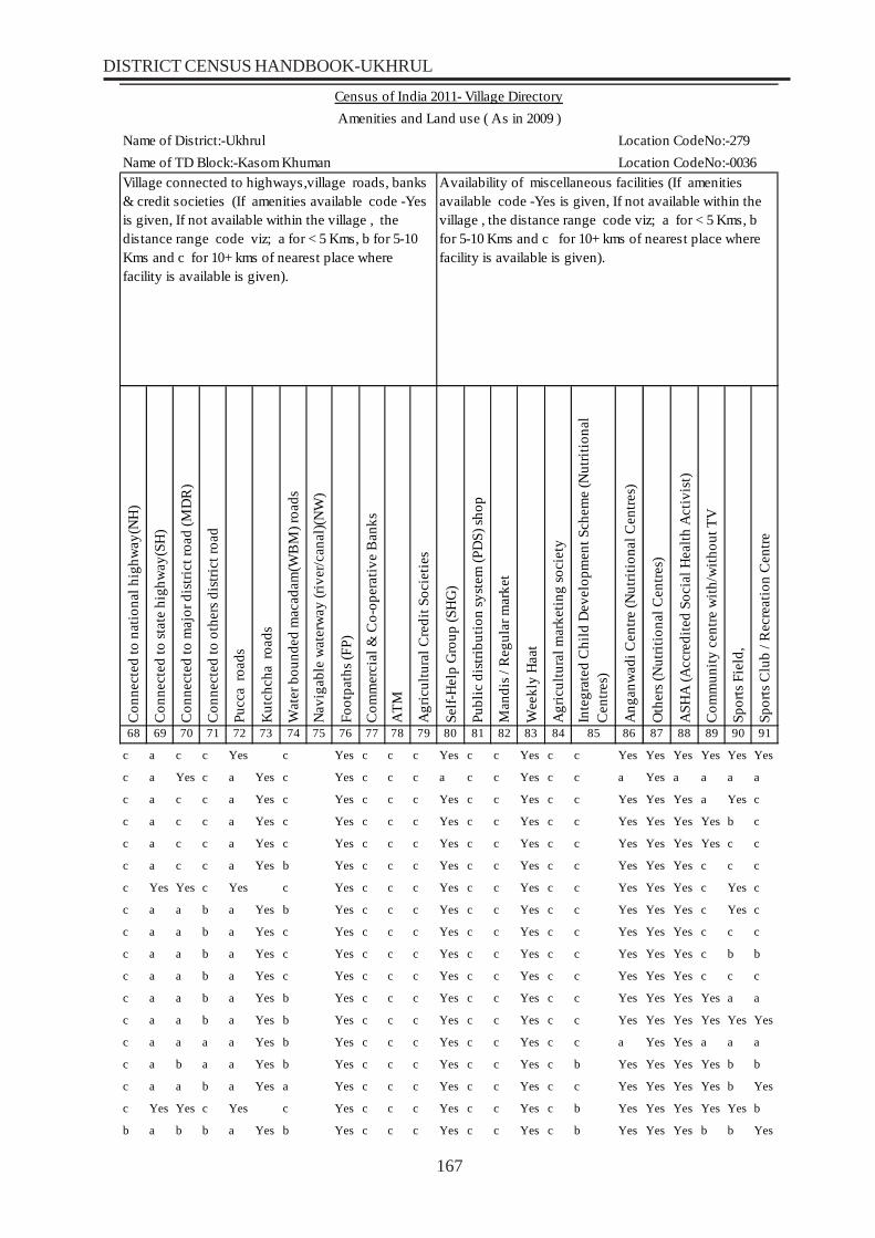
167
DISTRICT CENSUS HANDBOOK-UKHRUL
Name of District:-Ukhrul Location CodeNo:-279Name of TD Block:-Kasom Khuman Location CodeNo:-0036
Con
nect
ed to
nat
iona
l hig
hway
(NH
)
Con
nect
ed to
stat
e hi
ghw
ay(S
H)
Con
nect
ed to
maj
or d
istri
ct ro
ad (M
DR
)
Con
nect
ed to
oth
ers d
istri
ct ro
ad
Pucc
a ro
ads
Kut
chch
a ro
ads
Wat
er b
ound
ed m
acad
am(W
BM
) roa
ds
Nav
igab
le w
ater
way
(riv
er/c
anal
)(NW
)
Foot
path
s (FP
)
Com
mer
cial
& C
o-op
erat
ive
Ban
ks
ATM
Agr
icul
tura
l Cre
dit S
ocie
ties
Self-
Hel
p G
roup
(SH
G)
Publ
ic d
istri
butio
n sy
stem
(PD
S) sh
op
Man
dis /
Reg
ular
mar
ket
Wee
kly
Haa
t
Agr
icul
tura
l mar
ketin
g so
ciet
y
Inte
grat
ed C
hild
Dev
elop
men
t Sch
eme
(Nut
ritio
nal
Cen
tres)
Ang
anw
adi C
entre
(Nut
ritio
nal C
entre
s)
Oth
ers (
Nut
ritio
nal C
entre
s)
ASH
A (A
ccre
dite
d So
cial
Hea
lth A
ctiv
ist)
Com
mun
ity c
entre
with
/with
out T
V
Spor
ts F
ield
,
Spor
ts C
lub
/ Rec
reat
ion
Cen
tre
68 69 70 71 72 73 74 75 76 77 78 79 80 81 82 83 84 85 86 87 88 89 90 91
c a c c Yes c Yes c c c Yes c c Yes c c Yes Yes Yes Yes Yes Yes
c a Yes c a Yes c Yes c c c a c c Yes c c a Yes a a a a
c a c c a Yes c Yes c c c Yes c c Yes c c Yes Yes Yes a Yes c
c a c c a Yes c Yes c c c Yes c c Yes c c Yes Yes Yes Yes b c
c a c c a Yes c Yes c c c Yes c c Yes c c Yes Yes Yes Yes c c
c a c c a Yes b Yes c c c Yes c c Yes c c Yes Yes Yes c c c
c Yes Yes c Yes c Yes c c c Yes c c Yes c c Yes Yes Yes c Yes c
c a a b a Yes b Yes c c c Yes c c Yes c c Yes Yes Yes c Yes c
c a a b a Yes c Yes c c c Yes c c Yes c c Yes Yes Yes c c c
c a a b a Yes c Yes c c c Yes c c Yes c c Yes Yes Yes c b b
c a a b a Yes c Yes c c c Yes c c Yes c c Yes Yes Yes c c c
c a a b a Yes b Yes c c c Yes c c Yes c c Yes Yes Yes Yes a a
c a a b a Yes b Yes c c c Yes c c Yes c c Yes Yes Yes Yes Yes Yes
c a a a a Yes b Yes c c c Yes c c Yes c c a Yes Yes a a a
c a b a a Yes b Yes c c c Yes c c Yes c b Yes Yes Yes Yes b b
c a a b a Yes a Yes c c c Yes c c Yes c c Yes Yes Yes Yes b Yes
c Yes Yes c Yes c Yes c c c Yes c c Yes c b Yes Yes Yes Yes Yes b
b a b b a Yes b Yes c c c Yes c c Yes c b Yes Yes Yes b b Yes
Census of India 2011- Village DirectoryAmenities and Land use ( As in 2009 )
Village connected to highways,village roads, banks & credit societies (If amenities available code -Yes is given, If not available within the village , the distance range code viz; a for < 5 Kms, b for 5-10 Kms and c for 10+ kms of nearest place where facility is available is given).
Availability of miscellaneous facilities (If amenities available code -Yes is given, If not available within the village , the distance range code viz; a for < 5 Kms, b for 5-10 Kms and c for 10+ kms of nearest place where facility is available is given).
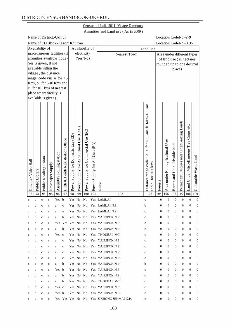
168
DISTRICT CENSUS HANDBOOK-UKHRUL
Name of District:-Ukhrul Location CodeNo:-279Name of TD Block:-Kasom Khuman Location CodeNo:-0036
Cin
ema
/ Vid
eo H
all
Publ
ic L
ibra
ry
Publ
ic R
eadi
ng R
oom
New
spap
er S
uppl
y
Ass
embl
y Po
lling
stat
ion
Birt
h &
Dea
th R
egis
tratio
n O
ffice
Pow
er S
uppl
y fo
r Dom
estic
Use
(ED
)
Pow
er S
uppl
y fo
r Agr
icul
tura
l Use
(EA
G)
Pow
er S
uppl
y fo
r Com
mer
cial
Use
(EC
)
Pow
er S
uppl
y fo
r All
Use
s (EA
)
Nam
e
Dis
tanc
e ra
nge
code
i.e
. a
for <
5 K
ms,
b fo
r 5-1
0 K
ms
and
c f
or 1
0+ k
ms .
Fore
sts
Are
a un
der N
on-a
gric
ultu
ral U
ses
Bar
ren
and
Un-
culti
vabl
e la
nd
Perm
anen
t Pas
ture
s and
Oth
er G
razi
ng L
ands
Land
Und
er M
isce
llane
ous T
ree
Cro
ps e
tc.
Cul
tura
ble
Was
te L
and
92 93 94 95 96 97 98 99 100 101 102 103 104 105 106 107 108 109
c c c c Yes b Yes No No Yes LAMLAI c 0 0 0 0 0 0
c c c c a c Yes No No Yes LAMLAI N.P. b 0 0 0 0 0 0
c c c c a a Yes No No Yes LAMLAI N.P. c 0 0 0 0 0 0
c c c a a b Yes No No Yes YAIRIPOK N.P. c 0 0 0 0 0 0
c c c c Yes Yes Yes No No Yes YAIRIPOK N.P. c 0 0 0 0 0 0
c c c c a b Yes No No Yes YAIRIPOK N.P. c 0 0 0 0 0 0
c c c c Yes c Yes No No Yes THOUBAL MCI c 0 0 0 0 0 0
c c c c a c Yes No No Yes YAIRIPOK N.P. c 0 0 0 0 0 0
c c c c a c Yes No No Yes YAIRIPOK N.P. c 0 0 0 0 0 0
c c c c a c Yes No No Yes YAIRIPOK N.P. c 0 0 0 0 0 0
c c c c a c Yes No No Yes YAIRIPOK N.P. c 0 0 0 0 0 0
c c c c a b Yes No No Yes YAIRIPOK N.P. b 0 0 0 0 0 0
c c c c Yes b Yes No No Yes YAIRIPOK N.P. c 0 0 0 0 0 0
c c c c a b Yes No No Yes YAIRIPOK N.P. c 0 0 0 0 0 0
c c c c a b Yes No No Yes THOUBAL MCI c 0 0 0 0 0 0
c c c c Yes c Yes No No Yes YAIRIPOK N.P. c 0 0 0 0 0 0
c c c c Yes b Yes No No Yes YAIRIPOK N.P. c 0 0 0 0 0 0
c c c c Yes Yes Yes No No Yes SIKHONG SEKMAI N.P. c 0 0 0 0 0 0
Census of India 2011- Village DirectoryAmenities and Land use ( As in 2009 )
Availability of miscellaneous facilities (If amenities available code -Yes is given, If not available within the village , the distance range code viz; a for < 5 Kms, b for 5-10 Kms and c for 10+ kms of nearest place where facility is available is given).
Availability of electricity (Yes/No)
Land Use Nearest Town Area under different types
of land use ( in hectares rounded up to one decimal
place)

169
DISTRICT CENSUS HANDBOOK-UKHRUL
Name of District:-Ukhrul Location CodeNo:-279Name of TD Block:-Kasom Khuman Location CodeNo:-0036
Fallo
w la
nds o
ther
than
cur
rent
fallo
ws
Cur
rent
Fal
low
s
Net
Are
a So
wn
Tota
l Irri
gate
d La
nd A
rea
Tota
l Un-
irrig
ated
Lan
d A
rea
Can
als (
C )
Wel
ls/T
ube-
wel
ls(W
/TW
)
Tank
s/La
kes(
T/L)
Wat
er F
alls
(WF)
Oth
ers(
O)
Firs
t
Seco
nd
Third
110 111 112 113 114 115 116 117 118 119 120 121 122 2 1
0 0 0 0 0 0 0 0 0 0 Carpentry Nongdam 178
0 0 0 0 0 0 0 0 0 0 Carpentry Nongdam ( K ) 179
0 0 0 0 0 0 0 0 0 0 Wooden Furnitures Itham 180
0 0 0 0 0 0 0 0 0 0 Chingshou 181
0 0 0 0 0 0 0 0 0 0 Chongdan 182
0 0 0 0 0 0 0 0 0 0 Kangoi 183
0 0 0 0 0 0 0 0 0 0 Ashang Khullen 184
0 0 0 0 0 0 0 0 0 0 Wooden Furnitures Yeasem 185
0 0 0 0 0 0 0 0 0 0 Wooden Furnitures T . Natuiang 186
0 0 0 0 0 0 0 0 0 0 Kasom Somrei 187
0 0 0 0 0 0 0 0 0 0 Shungriphai 188
0 0 0 0 0 0 0 0 0 0 Wooden Furnitures Chakama 189
0 0 0 0 0 0 0 0 0 0 Wooden Furnitures K.Leihaoram 190
0 0 0 0 0 0 0 0 0 0 Wodden Furnitures Kharam Khullen 191
0 0 0 0 0 0 0 0 0 0 Shangpunram 192
0 0 0 0 0 0 0 0 0 0 Wooden Furniture Khoiripok 193
0 0 0 0 0 0 0 0 0 0 Wooden Furniture Lairam Phungka 194
0 0 0 0 0 0 0 0 0 0 Lairam Khullen 195
Census of India 2011- Village DirectoryAmenities and Land use ( As in 2009 )
Land Use Name of three most important commodities manufactured
Nam
e of
Vill
age
Seria
l Num
ber
Area under different types of land use ( in hectares rounded up to one decimal place)
Area irrigated by source (in hectare).
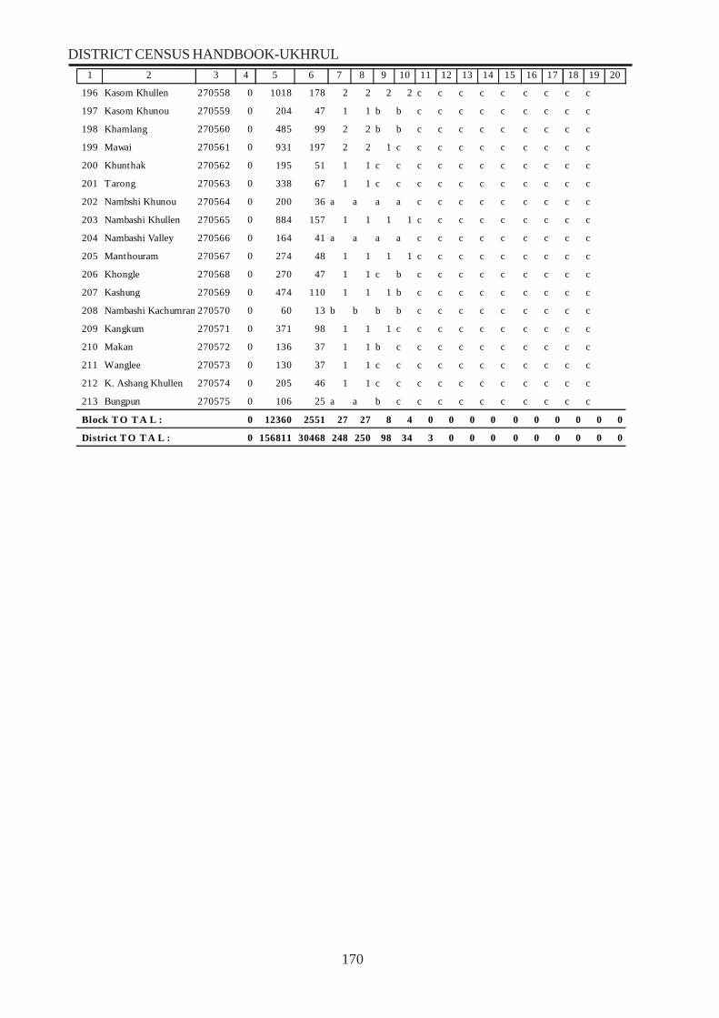
170
DISTRICT CENSUS HANDBOOK-UKHRUL1 2 3 4 5 6 7 8 9 10 11 12 13 14 15 16 17 18 19 20
196 Kasom Khullen 270558 0 1018 178 2 2 2 2 c c c c c c c c c
197 Kasom Khunou 270559 0 204 47 1 1 b b c c c c c c c c c
198 Khamlang 270560 0 485 99 2 2 b b c c c c c c c c c
199 Mawai 270561 0 931 197 2 2 1 c c c c c c c c c c
200 Khunthak 270562 0 195 51 1 1 c c c c c c c c c c c
201 Tarong 270563 0 338 67 1 1 c c c c c c c c c c c
202 Nambshi Khunou 270564 0 200 36 a a a a c c c c c c c c c
203 Nambashi Khullen 270565 0 884 157 1 1 1 1 c c c c c c c c c
204 Nambashi Valley 270566 0 164 41 a a a a c c c c c c c c c
205 Manthouram 270567 0 274 48 1 1 1 1 c c c c c c c c c
206 Khongle 270568 0 270 47 1 1 c b c c c c c c c c c
207 Kashung 270569 0 474 110 1 1 1 b c c c c c c c c c
208 Nambashi Kachumram270570 0 60 13 b b b b c c c c c c c c c
209 Kangkum 270571 0 371 98 1 1 1 c c c c c c c c c c
210 Makan 270572 0 136 37 1 1 b c c c c c c c c c c
211 Wanglee 270573 0 130 37 1 1 c c c c c c c c c c c
212 K. Ashang Khullen 270574 0 205 46 1 1 c c c c c c c c c c c
213 Bungpun 270575 0 106 25 a a b c c c c c c c c c c
Block T O T A L : 0 12360 2551 27 27 8 4 0 0 0 0 0 0 0 0 0 0
District T O T A L : 0 156811 30468 248 250 98 34 3 0 0 0 0 0 0 0 0 0
171
DISTRICT CENSUS HANDBOOK-UKHRUL21 22 23 24 25 26 27 28 29 30 31 32 33 34 35 36 37 38 39 40 41 42 43 44 45 46
c 1 c c c c c c c c c 0 0 0 0 0 1 0 Yes No No No Yes No No No
c b b c c c c c c c c 0 0 0 0 1 0 0 No No No No Yes No Yes No
c b b c c c c c c c c 0 0 0 1 0 0 0 Yes No No No Yes No No No
c c 1 c c c c c c c c 0 0 0 0 0 0 0 No No No No No Yes Yes No
c c b c c c c c c c c 0 0 0 0 1 0 0 No No No No No Yes Yes No
c c c c c c c c c c c 0 0 0 0 0 0 0 Yes No No No Yes Yes Yes No
c c b c c c c c c c c 0 0 0 1 1 0 0 No No No No No Yes Yes No
c c b c c c c c c c c 0 0 0 0 1 0 0 Yes No No No Yes No Yes No
c c c c c c c c c c c 0 0 0 0 0 0 0 Yes No No No Yes Yes Yes No
c c c c c c c c c c c 0 0 0 0 0 0 0 Yes No No No Yes No No No
c c c c c c c c c c c 0 0 0 0 0 0 0 Yes No No No Yes Yes Yes No
c c c c c c c c c c c 0 0 0 0 1 0 0 Yes No No No Yes Yes Yes No
c c b c c c c c c c c 0 0 0 0 0 0 0 No No No No Yes No Yes No
c c 1 c c c c c c c c 0 0 0 0 0 0 0 Yes No No No Yes No No No
c c b c c c c c c c c 0 0 0 0 0 0 0 Yes No No No Yes Yes Yes No
c c b c c c c c c c c 0 0 0 0 1 0 0 No No No No No Yes Yes No
c c b c c c c c c c c 0 0 0 0 0 0 0 Yes No No No No Yes Yes No
c c b c c c c c c c c 0 0 0 0 1 0 0 Yes No No No Yes No No No
0 1 4 0 0 0 0 0 0 0 0 0 0 0 2 16 1 0 21 0 0 0 29 20 27 0
1 6 40 0 0 0 0 3 4 0 0 0 16 4 20 96 73 0 37 0 0 0 178 116 162 0
172
DISTRICT CENSUS HANDBOOK-UKHRUL47 48 49 50 51 52 53 54 55 56 57 58 59 60 61 62 63 64 65 66 67
No No No No c c c 795149 c c Yes c c Yes c c Yes c c
No No No No c b c 795149 c c Yes c c Yes c c c c c
No No No No c c c 795010 c c Yes c c Yes c c c c c
No No No No c c c 795010 c c Yes c c b c c c c c
No No No No c c c 795142 c c Yes c c Yes c c c c c
No No No No c c c 795142 c c Yes c c Yes c c c c c
No No No No c c c 795142 c c Yes c c Yes c c c c c
No No No No c c c 795149 c c Yes c c Yes c c c c c
No No No No c c c 795149 c c Yes c c b c c c c c
No No No No c c c 795149 c c Yes c c Yes c c c c c
No No No No c c c 795149 c c Yes c c Yes c c c c c
No No No No c c c 795149 c c Yes c c Yes c c c c c
No No No No c c c 795149 c c Yes c c Yes c c c c c
No No No No c c c 795149 c c Yes c c b c c c c c
No No No No c c c 795149 c c Yes c c Yes c c c c c
No No No No c c c 795149 c c Yes c c Yes c c c c c
No No No No c c c 795149 c c Yes c c Yes c c c c c
No No No No c c c 795149 c c Yes c c b c c c c c
0 0 0 0 0 0 0 36 0 0 36 0 0 25 0 0 1 0 0 0 0
0 0 0 0 0 35 0 213 2 0 206 0 0 97 0 0 129 0 0 0 0
173
DISTRICT CENSUS HANDBOOK-UKHRUL68 69 70 71 72 73 74 75 76 77 78 79 80 81 82 83 84 85 86 87 88 89 90 91
c Yes Yes Yes a Yes c Yes c c c Yes c c Yes c Yes Yes Yes Yes Yes Yes Yes
c b c c a Yes c Yes c c c Yes c c Yes c b Yes Yes Yes Yes Yes Yes
c b b b b Yes c Yes c c c Yes c c Yes c b Yes Yes Yes Yes Yes Yes
c b c c b Yes c Yes c c c Yes c c Yes c c Yes Yes Yes b c c
c Yes c c Yes c Yes c c c Yes c c Yes c c Yes Yes Yes b Yes b
c a b b a Yes c Yes c c c Yes c c Yes c c Yes Yes Yes b Yes b
c a c c a Yes c Yes c c c Yes c c Yes c c Yes Yes Yes Yes b b
c a c c a Yes c Yes c c c Yes c c Yes c c Yes Yes Yes Yes Yes Yes
c b c c b Yes c Yes c c c Yes c c Yes c c Yes Yes Yes b b c
c Yes c c Yes c Yes c c c Yes c c Yes c c Yes Yes Yes Yes Yes c
c Yes c c Yes c Yes c c c b b c Yes c c Yes Yes Yes c b c
c a Yes Yes a Yes c Yes c c c Yes c c Yes c c Yes Yes Yes Yes c Yes
c b c c b Yes c Yes c c c a c c Yes c c Yes Yes Yes b b Yes
c b c c b Yes c Yes c c c Yes c c Yes c c Yes Yes Yes Yes Yes Yes
c Yes c c Yes c Yes c c c Yes c c Yes c c Yes Yes Yes Yes b Yes
c b c c b Yes c Yes c c c Yes c c Yes c c Yes Yes Yes c Yes Yes
c a c c a Yes c Yes c c c Yes c c Yes c c Yes Yes Yes Yes c b
c a c c a Yes c Yes c c c Yes c c Yes c c Yes Yes Yes b c Yes
0 7 5 2 7 29 0 0 36 0 0 0 33 0 0 36 0 1 34 36 35 18 15 14
20 28 86 66 77 136 24 0 213 0 0 2 169 9 50 189 1 4 189 213 194 68 52 55
174
DISTRICT CENSUS HANDBOOK-UKHRUL92 93 94 95 96 97 98 99 100 101 102 103 104 105 106 107 108 109
c c c Yes Yes Yes Yes No No Yes YAIRIPOK N.P. c 0 0 0 0 0 0
c c c c a b Yes No No Yes THOUBAL MCI c 0 0 0 0 0 0
c c c c a b Yes No No Yes THOUBAL MCI c 0 0 0 0 0 0
c c c c Yes c Yes No No Yes YAIRIPOK N.P. c 0 0 0 0 0 0
c c c c Yes b Yes No No Yes YAIRIPOK N.P. c 0 0 0 0 0 0
c c c c a c Yes No No Yes YAIRIPOK N.P. c 0 0 0 0 0 0
c c c c Yes b Yes No No Yes YAIRIPOK N.P. c 0 0 0 0 0 0
c c c c Yes b Yes No No Yes YAIRIPOK N.P. c 0 0 0 0 0 0
c c c c a c Yes No No Yes THOUBAL MCI c 0 0 0 0 0 0
c c c c a c Yes No No Yes YAIRIPOK N.P. c 0 0 0 0 0 0
c c c c Yes c Yes No No Yes YAIRIPOK N.P. c 0 0 0 0 0 0
c c c c a c Yes No No Yes IMPHAL MCI c 0 0 0 0 0 0
c c c c a b Yes No No Yes THOUBAL MCI c 0 0 0 0 0 0
c c c c Yes Yes Yes No No Yes THOUBAL MCI c 0 0 0 0 0 0
c c c c b b Yes No No Yes THOUBAL MCI c 0 0 0 0 0 0
c c c c a b Yes No No Yes THOUBAL MCI c 0 0 0 0 0 0
c c c c Yes b Yes No No Yes THOUBAL MCI c 0 0 0 0 0 0
c c c c a b Yes No No Yes THOUBAL MCI c 0 0 0 0 0 0
0 0 0 1 15 4 36 0 0 36 0 0 0 0 0 0 0 0
0 0 0 5 144 43 213 0 0 213 0 0 0 0 0 0 0 0
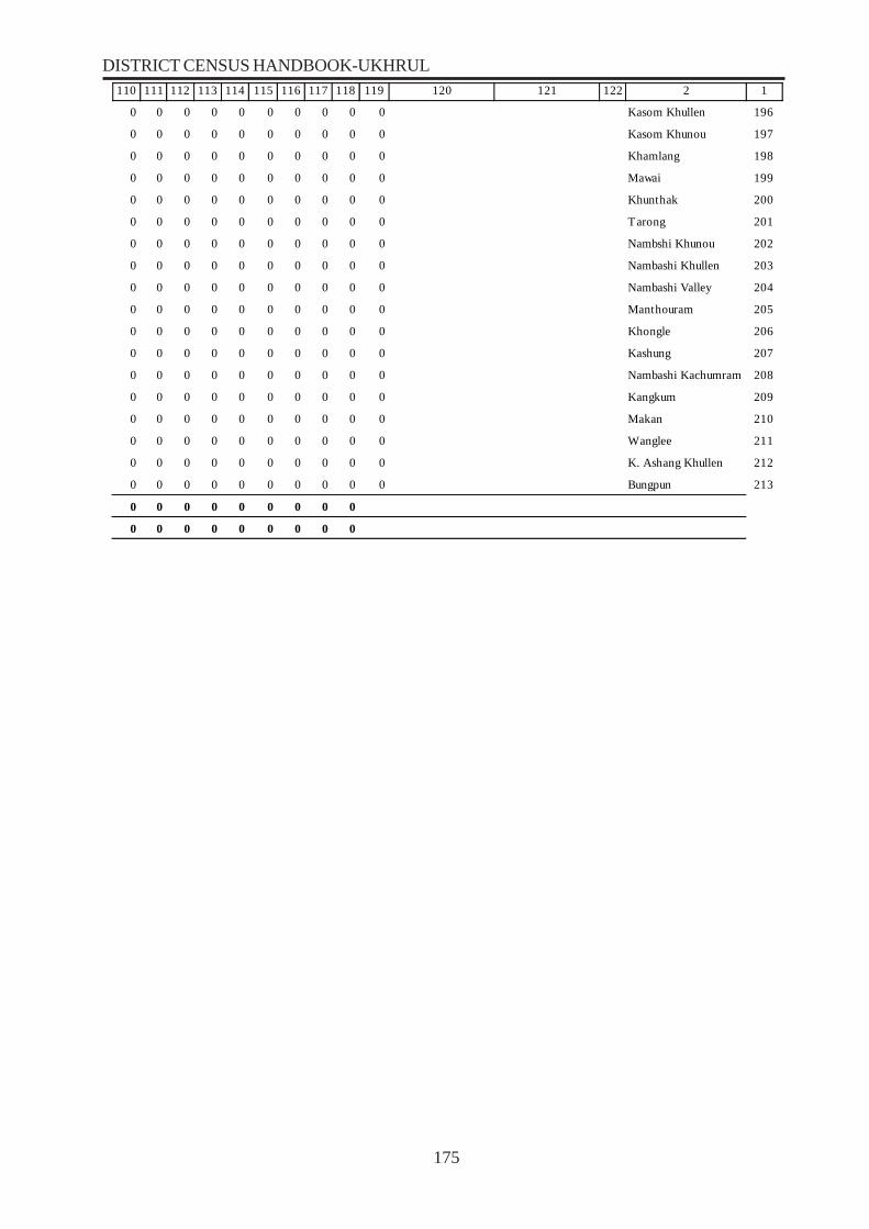
175
DISTRICT CENSUS HANDBOOK-UKHRUL110 111 112 113 114 115 116 117 118 119 120 121 122 2 1
0 0 0 0 0 0 0 0 0 0 Kasom Khullen 196
0 0 0 0 0 0 0 0 0 0 Kasom Khunou 197
0 0 0 0 0 0 0 0 0 0 Khamlang 198
0 0 0 0 0 0 0 0 0 0 Mawai 199
0 0 0 0 0 0 0 0 0 0 Khunthak 200
0 0 0 0 0 0 0 0 0 0 Tarong 201
0 0 0 0 0 0 0 0 0 0 Nambshi Khunou 202
0 0 0 0 0 0 0 0 0 0 Nambashi Khullen 203
0 0 0 0 0 0 0 0 0 0 Nambashi Valley 204
0 0 0 0 0 0 0 0 0 0 Manthouram 205
0 0 0 0 0 0 0 0 0 0 Khongle 206
0 0 0 0 0 0 0 0 0 0 Kashung 207
0 0 0 0 0 0 0 0 0 0 Nambashi Kachumram 208
0 0 0 0 0 0 0 0 0 0 Kangkum 209
0 0 0 0 0 0 0 0 0 0 Makan 210
0 0 0 0 0 0 0 0 0 0 Wanglee 211
0 0 0 0 0 0 0 0 0 0 K. Ashang Khullen 212
0 0 0 0 0 0 0 0 0 0 Bungpun 213
0 0 0 0 0 0 0 0 0
0 0 0 0 0 0 0 0 0
176
DISTRICT CENSUS HANDBOOK-UKHRUL
District: Ukhrul (279)
1 2 3 4 5 6 7 81 0031-Chingai 27 31004 23 24 8 4
2 0032-Ukhrul 40 44044 30 30 17 7
3 0033-Lungchong Meiphei 28 36147 25 25 20 8
4 0034-Kamjong 45 16717 35 35 8 3
5 0035-Phungyar 37 16539 34 35 10 3
6 0036-Kasom Khullen 36 12360 24 24 7 3
Total 213 156811 171 173 70 28
Appendix I - village directorySummary showing total number of villages having educational, medical and other amenities - TD Block
level
Pre-primary school
Primary school
Villages having educational institutions Sr.No. Name of TD block Total number of inhabited villages in the T. D. block
Total population of T.D. block
Middle school
Secondary school
9 10 11 12 13 14 15 160 0 0 0 0 0 0 0
1 0 0 0 0 0 0 0
1 0 0 0 0 0 0 0
0 0 0 0 0 0 0 0
1 0 0 0 0 0 0 0
0 0 0 0 0 0 0 0
3 0 0 0 0 0 0 0
Villages having educational institutions Villages having educational institutions (contd.)
Senior secondary school (SS)
Degree college of arts sceince & commerce
Degree college of engineering
Medical college
Management institute
Polytechnic Vocational training school /ITI
Non-formal training centre
17 18 19 20 21 22 23 24 250 0 3 0 1 7 0 0 0
0 0 10 0 2 4 0 0 0
0 0 3 0 1 9 0 0 0
0 0 10 1 0 9 0 0 0
0 0 2 0 1 7 0 0 0
0 0 12 0 1 4 0 0 0
0 0 40 1 6 40 0 0 0
Villages having educational institutions (contd.)
Villages having Medical institutions
Others (specify)
No educational facility
Community health centre
Primary health centre
Primary health sub centre
Maternity and child welfare centre
T.B. clinic
Hospital-allopathic
Special school for disabled
177
DISTRICT CENSUS HANDBOOK-UKHRUL
26 27 28 29 30 31 32 330 0 2 0 0 0 1 4
0 2 1 0 0 4 1 11
0 0 0 0 0 4 1 22
0 1 0 0 0 1 0 4
0 0 1 0 0 1 0 2
0 0 0 0 0 0 0 1
0 3 4 0 0 10 3 44
Villages having Medical institutions (contd.) …
Medicine shop
Veterinary hospital
Mobile health clinic
Medical practioner (with MBBS Degree)
Medical practioner (with other degree)
Family welfare centre
Hospital-alternative medicine
Dispensary
34 35 36 37 38 39 40 410 10 16 0 0 0 23 11
0 20 0 0 0 0 33 20
0 2 0 0 0 0 26 23
0 30 0 0 0 0 45 21
0 18 0 0 0 0 22 21
0 14 21 0 0 0 29 20
0 94 37 0 0 0 178 116
Villages having drinking water Villages having Medical institutions
(contd.) …Others No medical
facilityTap water (treated/untreated)
Well water (coverd/ uncovered well)
Hand pump
Tubewell/ borewell
Spring River/ canal
42 43 44 45 46 47 48 49 50 5119 0 0 0 12 0 1 0 27 0
32 0 0 0 8 0 0 0 36 0
24 0 0 0 7 0 0 0 28 0
26 0 0 0 3 0 0 0 45 0
34 0 0 0 5 0 1 0 34 0
27 0 0 0 0 0 0 0 36 0
162 0 0 0 35 0 2 0 206 0
Villages having drinking water Villages having Post & Telegraph
Tank/ pond/ lake
Mobile phone coverage
Internet cafes/ Common service centre
No drinking water facility
Post office Sub post office
Post & telegraph office
Phone (land lines)
Public call office
Others
178
DISTRICT CENSUS HANDBOOK-UKHRUL
Credit societies
52 53 54 55 56 57 58 59 60 6111 24 0 0 7 0 0 0 0 1
18 14 0 0 34 0 0 0 0 0
5 7 0 0 28 0 0 0 0 1
13 4 0 0 32 0 0 0 0 0
23 23 0 0 27 0 0 0 0 0
7 25 0 0 1 0 0 0 0 0
77 97 0 0 129 0 0 0 0 2
Villages having transport
Village roads-pucca road
Bus service (public/private)
Banks
Agricultural credit societies
Railway station
Auto/ modified autos
Taxi & vans
Tractors Navigable water ways (river/canal/sea ferry service)
Commercial & co-operative
ATM
62 63 64 65 66 67 68 69 70 710 0 0 2 6 23 15 8 27 0
0 0 0 0 0 37 28 4 40 0
0 0 0 0 0 24 24 10 28 0
0 0 0 1 2 43 27 9 45 0
0 0 0 1 1 26 35 8 37 0
0 0 0 1 0 36 15 4 36 0
0 0 0 5 9 189 144 43 213 0
Miscellaneous Villages having power supply
Villages having recreation facility
Cinema / video halls
Public library
Public reading rooms
Availability of news paper
Weekly haat
Asembly polling station
Birth & death registration office
Available Not availablePublic distri-bution system (PDS)
District: Ukhrul (279)
None One Two Three Four +
1 2 3 4 5 6 7 81 0031-Chingai 27 3 14 7 2 1
2 0032-Ukhrul 40 10 17 9 2 2
3 0033-Lungchong Meiphei 28 3 13 7 3 2
4 0034-Kamjong 45 10 28 5 2 0
5 0035-Phungyar 37 2 29 4 2 0
6 0036-Kasom Khullen 36 12 21 3 0 0
Total 213 40 122 35 11 5
Appendix IA - village directoryVillages by number of primary schools
Sr.No. Name of T.D.Block Total number of inhabited villages
Number of primary schools
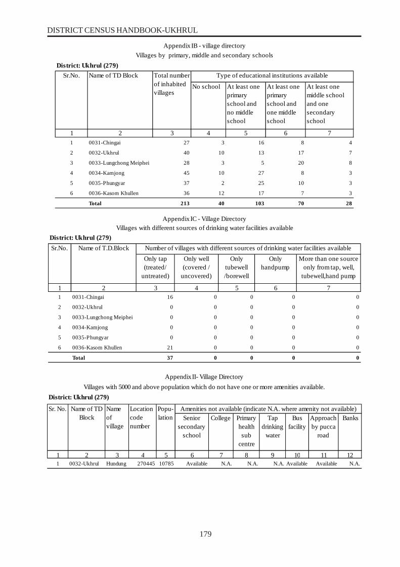
179
DISTRICT CENSUS HANDBOOK-UKHRUL
District: Ukhrul (279)
No school At least one primary school and no middle school
At least one primary school and one middle school
At least one middle school and one secondary school
1 2 3 4 5 6 71 0031-Chingai 27 3 16 8 4
2 0032-Ukhrul 40 10 13 17 7
3 0033-Lungchong Meiphei 28 3 5 20 8
4 0034-Kamjong 45 10 27 8 3
5 0035-Phungyar 37 2 25 10 3
6 0036-Kasom Khullen 36 12 17 7 3
Total 213 40 103 70 28
Appendix IB - village directoryVillages by primary, middle and secondary schools
Sr.No. Name of TD Block Total number of inhabited villages
Type of educational institutions available
District: Ukhrul (279)
Only tap (treated/
untreated)
Only well (covered /
uncovered)
Only tubewell /borewell
Only handpump
More than one source only from tap, well,
tubewell,hand pump
1 2 3 4 5 6 71 0031-Chingai 16 0 0 0 0
2 0032-Ukhrul 0 0 0 0 0
3 0033-Lungchong Meiphei 0 0 0 0 0
4 0034-Kamjong 0 0 0 0 0
5 0035-Phungyar 0 0 0 0 0
6 0036-Kasom Khullen 21 0 0 0 0
Total 37 0 0 0 0
Appendix IC - Village DirectoryVillages with different sources of drinking water facilities available
Sr.No. Name of T.D.Block Number of villages with different sources of drinking water facilities available
District: Ukhrul (279)
Senior secondary
school
College Primary health sub
centre
Tap drinking
water
Bus facility
Approach by pucca
road
Banks
1 2 3 4 5 6 7 8 9 10 11 121 0032-Ukhrul Hundung 270445 10785 Available N.A. N.A. N.A. Available Available N.A.
Appendix II- Village DirectoryVillages with 5000 and above population which do not have one or more amenities available.
Sr. No. Name of village
Location code number
Name of TD Block
Popu-lation
Amenities not available (indicate N.A. where amenity not available)
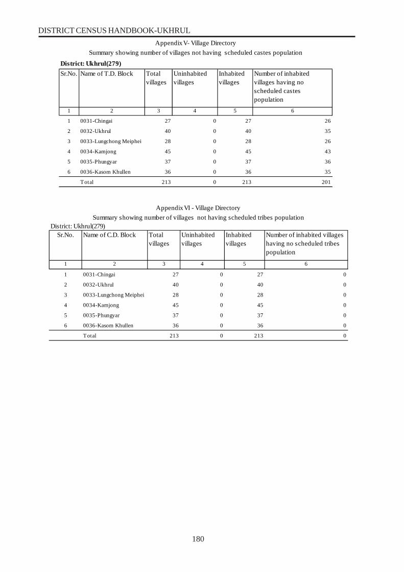
180
DISTRICT CENSUS HANDBOOK-UKHRUL
District: Ukhrul(279)Sr.No. Name of C.D. Block Total
villagesUninhabited villages
Inhabited villages
Number of inhabited villages having no scheduled tribes population
1 2 3 4 5 6
1 0031-Chingai 27 0 27 0
2 0032-Ukhrul 40 0 40 0
3 0033-Lungchong Meiphei 28 0 28 0
4 0034-Kamjong 45 0 45 0
5 0035-Phungyar 37 0 37 0
6 0036-Kasom Khullen 36 0 36 0
Total 213 0 213 0
Appendix VI - Village DirectorySummary showing number of villages not having scheduled tribes population
District: Ukhrul(279)Sr.No. Name of T.D. Block Total
villagesUninhabited villages
Inhabited villages
Number of inhabited villages having no scheduled castes population
1 2 3 4 5 6
1 0031-Chingai 27 0 27 26
2 0032-Ukhrul 40 0 40 35
3 0033-Lungchong Meiphei 28 0 28 26
4 0034-Kamjong 45 0 45 43
5 0035-Phungyar 37 0 37 36
6 0036-Kasom Khullen 36 0 36 35
Total 213 0 213 201
Appendix V- Village DirectorySummary showing number of villages not having scheduled castes population
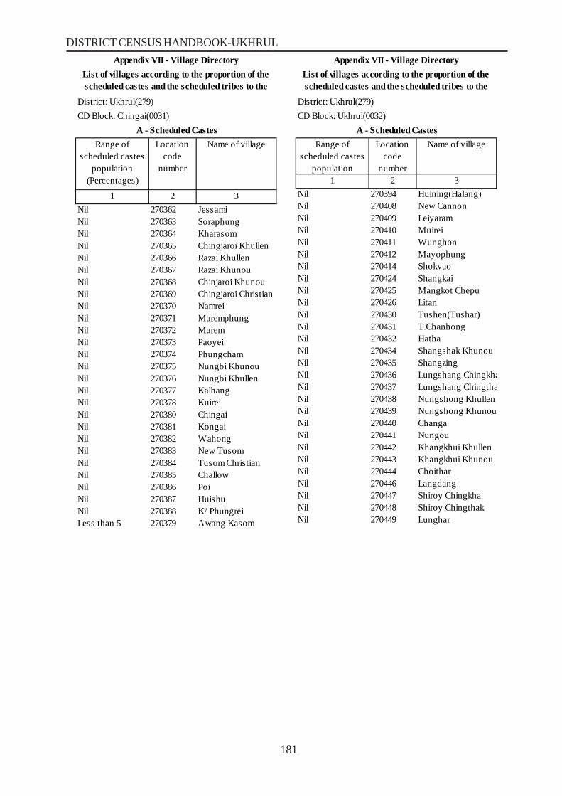
181
DISTRICT CENSUS HANDBOOK-UKHRUL
District: Ukhrul(279)CD Block: Chingai(0031)
Range of scheduled castes
population (Percentages)
Location code
number
Name of village
1 2 3Nil 270362 JessamiNil 270363 SoraphungNil 270364 KharasomNil 270365 Chingjaroi KhullenNil 270366 Razai KhullenNil 270367 Razai KhunouNil 270368 Chinjaroi KhunouNil 270369 Chingjaroi ChristianNil 270370 NamreiNil 270371 MaremphungNil 270372 MaremNil 270373 PaoyeiNil 270374 PhungchamNil 270375 Nungbi KhunouNil 270376 Nungbi KhullenNil 270377 KalhangNil 270378 KuireiNil 270380 ChingaiNil 270381 KongaiNil 270382 WahongNil 270383 New TusomNil 270384 Tusom ChristianNil 270385 ChallowNil 270386 PoiNil 270387 HuishuNil 270388 K/ PhungreiLess than 5 270379 Awang Kasom
Appendix VII - Village DirectoryList of villages according to the proportion of the scheduled castes and the scheduled tribes to the
i
A - Scheduled Castes
District: Ukhrul(279)CD Block: Ukhrul(0032)
Range of scheduled castes
population
Location code
number
Name of village
1 2 3Nil 270394 Huining(Halang)Nil 270408 New CannonNil 270409 LeiyaramNil 270410 MuireiNil 270411 WunghonNil 270412 MayophungNil 270414 ShokvaoNil 270424 ShangkaiNil 270425 Mangkot ChepuNil 270426 LitanNil 270430 Tushen(Tushar)Nil 270431 T.ChanhongNil 270432 HathaNil 270434 Shangshak KhunouNil 270435 ShangzingNil 270436 Lungshang ChingkhaNil 270437 Lungshang ChingthaNil 270438 Nungshong KhullenNil 270439 Nungshong KhunouNil 270440 ChangaNil 270441 NungouNil 270442 Khangkhui KhullenNil 270443 Khangkhui KhunouNil 270444 ChoitharNil 270446 LangdangNil 270447 Shiroy ChingkhaNil 270448 Shiroy ChingthakNil 270449 Lunghar
A - Scheduled Castes
Appendix VII - Village DirectoryList of villages according to the proportion of the scheduled castes and the scheduled tribes to the
i
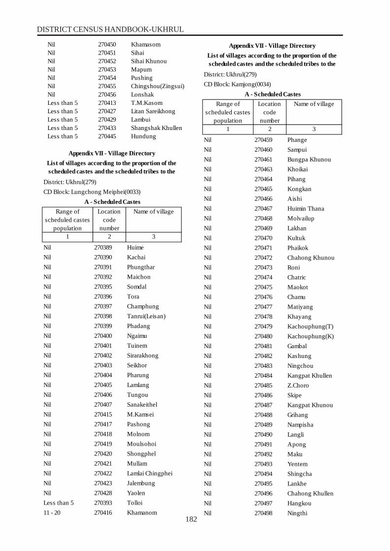
182
DISTRICT CENSUS HANDBOOK-UKHRUL
Nil 270450 KhamasomNil 270451 SihaiNil 270452 Sihai KhunouNil 270453 MapumNil 270454 PushingNil 270455 Chingshou(Zingsui)Nil 270456 LonshakLess than 5 270413 T.M.KasomLess than 5 270427 Litan SareikhongLess than 5 270429 LambuiLess than 5 270433 Shangshak KhullenLess than 5 270445 Hundung
District: Ukhrul(279)CD Block: Lungchong Meiphei(0033)
Range of scheduled castes
population
Location code
number
Name of village
1 2 3
Nil 270389 HuimeNil 270390 KachaiNil 270391 PhungtharNil 270392 MaichonNil 270395 SomdalNil 270396 ToraNil 270397 ChamphungNil 270398 Tanrui(Leisan)Nil 270399 PhadangNil 270400 NgaimuNil 270401 TuinemNil 270402 SirarakhongNil 270403 SeikhorNil 270404 PharungNil 270405 LamlangNil 270406 TungouNil 270407 SanakeithelNil 270415 M.KamseiNil 270417 PashongNil 270418 MolnomNil 270419 MoulsohoiNil 270420 ShongphelNil 270421 MullamNil 270422 Lamlai ChingpheiNil 270423 JalembungNil 270428 YaolenLess than 5 270393 Tolloi11 - 20 270416 Khamanom
Appendix VII - Village DirectoryList of villages according to the proportion of the scheduled castes and the scheduled tribes to the
i
A - Scheduled Castes
District: Ukhrul(279)CD Block: Kamjong(0034)
Range of scheduled castes
population
Location code
number
Name of village
1 2 3
Nil 270459 PhangeNil 270460 SampuiNil 270461 Bungpa KhunouNil 270463 KhoikaiNil 270464 PihangNil 270465 KongkanNil 270466 AishiNil 270467 Huimin ThanaNil 270468 MolvailupNil 270469 LakhanNil 270470 KultukNil 270471 PhaikokNil 270472 Chahong KhunouNil 270473 RoniNil 270474 ChatricNil 270475 MaokotNil 270476 ChamuNil 270477 MatiyangNil 270478 KhayangNil 270479 Kachouphung(T)Nil 270480 Kachouphung(K)Nil 270481 GambalNil 270482 KashungNil 270483 NingchouNil 270484 Kangpat KhullenNil 270485 Z.ChoroNil 270486 SkipeNil 270487 Kangpat KhunouNil 270488 GrihangNil 270489 NampishaNil 270490 LangliNil 270491 ApongNil 270492 MakuNil 270493 YentemNil 270494 ShingchaNil 270495 LankheNil 270496 Chahong KhullenNil 270497 HangkouNil 270498 Ningthi
Appendix VII - Village DirectoryList of villages according to the proportion of the scheduled castes and the scheduled tribes to the
i
A - Scheduled Castes
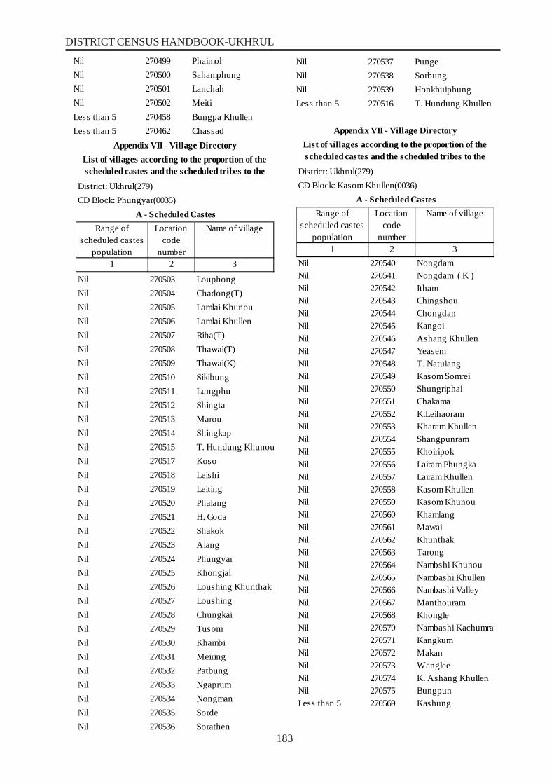
183
DISTRICT CENSUS HANDBOOK-UKHRUL
Nil 270499 PhaimolNil 270500 SahamphungNil 270501 LanchahNil 270502 MeitiLess than 5 270458 Bungpa KhullenLess than 5 270462 Chassad
District: Ukhrul(279)CD Block: Phungyar(0035)
Range of scheduled castes
population
Location code
number
Name of village
1 2 3
Nil 270503 LouphongNil 270504 Chadong(T)Nil 270505 Lamlai KhunouNil 270506 Lamlai KhullenNil 270507 Riha(T)Nil 270508 Thawai(T)Nil 270509 Thawai(K)Nil 270510 SikibungNil 270511 LungphuNil 270512 ShingtaNil 270513 MarouNil 270514 ShingkapNil 270515 T. Hundung KhunouNil 270517 KosoNil 270518 LeishiNil 270519 LeitingNil 270520 PhalangNil 270521 H. GodaNil 270522 ShakokNil 270523 AlangNil 270524 PhungyarNil 270525 KhongjalNil 270526 Loushing KhunthakNil 270527 LoushingNil 270528 ChungkaiNil 270529 TusomNil 270530 KhambiNil 270531 MeiringNil 270532 PatbungNil 270533 NgaprumNil 270534 NongmanNil 270535 SordeNil 270536 Sorathen
Appendix VII - Village DirectoryList of villages according to the proportion of the scheduled castes and the scheduled tribes to the
i
A - Scheduled Castes
Nil 270537 PungeNil 270538 SorbungNil 270539 HonkhuiphungLess than 5 270516 T. Hundung Khullen
District: Ukhrul(279)CD Block: Kasom Khullen(0036)
Range of scheduled castes
population
Location code
number
Name of village
1 2 3Nil 270540 NongdamNil 270541 Nongdam ( K )Nil 270542 IthamNil 270543 ChingshouNil 270544 ChongdanNil 270545 KangoiNil 270546 Ashang KhullenNil 270547 YeasemNil 270548 T. NatuiangNil 270549 Kasom SomreiNil 270550 ShungriphaiNil 270551 ChakamaNil 270552 K.LeihaoramNil 270553 Kharam KhullenNil 270554 ShangpunramNil 270555 KhoiripokNil 270556 Lairam PhungkaNil 270557 Lairam KhullenNil 270558 Kasom KhullenNil 270559 Kasom KhunouNil 270560 KhamlangNil 270561 MawaiNil 270562 KhunthakNil 270563 TarongNil 270564 Nambshi KhunouNil 270565 Nambashi KhullenNil 270566 Nambashi ValleyNil 270567 ManthouramNil 270568 KhongleNil 270570 Nambashi KachumramNil 270571 KangkumNil 270572 MakanNil 270573 WangleeNil 270574 K. Ashang KhullenNil 270575 BungpunLess than 5 270569 Kashung
Appendix VII - Village DirectoryList of villages according to the proportion of the scheduled castes and the scheduled tribes to the
i
A - Scheduled Castes
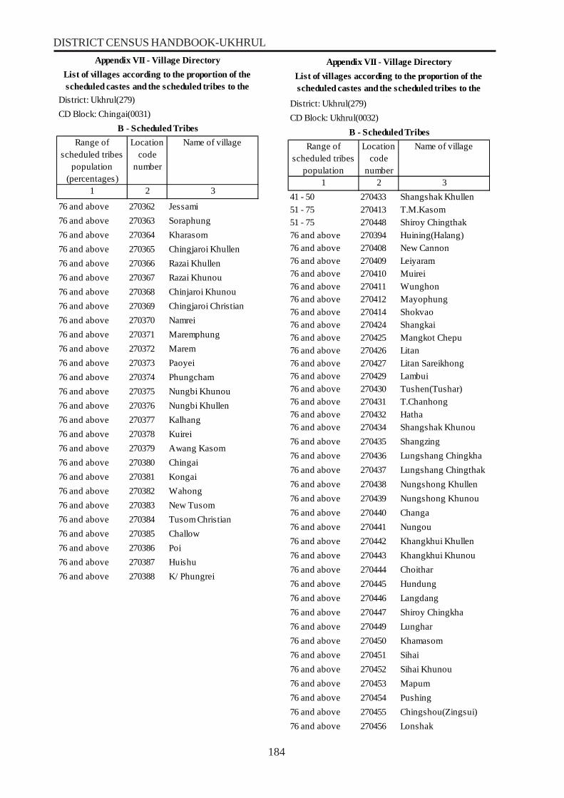
184
DISTRICT CENSUS HANDBOOK-UKHRUL
District: Ukhrul(279)CD Block: Chingai(0031)
Range of scheduled tribes
population (percentages)
Location code
number
Name of village
1 2 3
76 and above 270362 Jessami76 and above 270363 Soraphung76 and above 270364 Kharasom76 and above 270365 Chingjaroi Khullen76 and above 270366 Razai Khullen76 and above 270367 Razai Khunou76 and above 270368 Chinjaroi Khunou76 and above 270369 Chingjaroi Christian76 and above 270370 Namrei76 and above 270371 Maremphung76 and above 270372 Marem76 and above 270373 Paoyei76 and above 270374 Phungcham76 and above 270375 Nungbi Khunou76 and above 270376 Nungbi Khullen76 and above 270377 Kalhang76 and above 270378 Kuirei76 and above 270379 Awang Kasom76 and above 270380 Chingai76 and above 270381 Kongai76 and above 270382 Wahong76 and above 270383 New Tusom76 and above 270384 Tusom Christian76 and above 270385 Challow76 and above 270386 Poi76 and above 270387 Huishu76 and above 270388 K/ Phungrei
Appendix VII - Village DirectoryList of villages according to the proportion of the scheduled castes and the scheduled tribes to the
B - Scheduled Tribes
District: Ukhrul(279)CD Block: Ukhrul(0032)
Range of scheduled tribes
population
Location code
number
Name of village
1 2 341 - 50 270433 Shangshak Khullen51 - 75 270413 T.M.Kasom51 - 75 270448 Shiroy Chingthak76 and above 270394 Huining(Halang)76 and above 270408 New Cannon76 and above 270409 Leiyaram76 and above 270410 Muirei76 and above 270411 Wunghon76 and above 270412 Mayophung76 and above 270414 Shokvao76 and above 270424 Shangkai76 and above 270425 Mangkot Chepu76 and above 270426 Litan76 and above 270427 Litan Sareikhong76 and above 270429 Lambui76 and above 270430 Tushen(Tushar)76 and above 270431 T.Chanhong76 and above 270432 Hatha76 and above 270434 Shangshak Khunou76 and above 270435 Shangzing76 and above 270436 Lungshang Chingkha76 and above 270437 Lungshang Chingthak76 and above 270438 Nungshong Khullen76 and above 270439 Nungshong Khunou76 and above 270440 Changa76 and above 270441 Nungou76 and above 270442 Khangkhui Khullen76 and above 270443 Khangkhui Khunou76 and above 270444 Choithar76 and above 270445 Hundung76 and above 270446 Langdang76 and above 270447 Shiroy Chingkha76 and above 270449 Lunghar76 and above 270450 Khamasom76 and above 270451 Sihai76 and above 270452 Sihai Khunou76 and above 270453 Mapum76 and above 270454 Pushing76 and above 270455 Chingshou(Zingsui)76 and above 270456 Lonshak
B - Scheduled Tribes
Appendix VII - Village DirectoryList of villages according to the proportion of the scheduled castes and the scheduled tribes to the
i
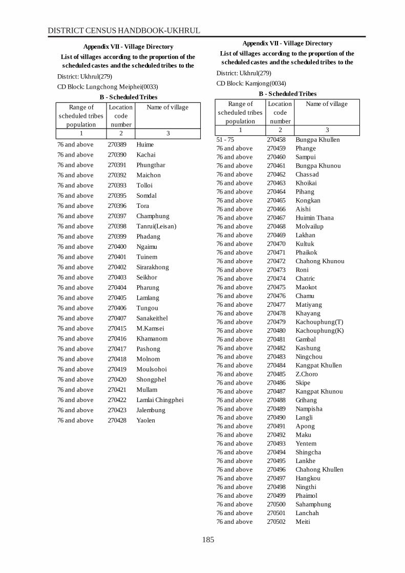
185
DISTRICT CENSUS HANDBOOK-UKHRUL
District: Ukhrul(279)CD Block: Lungchong Meiphei(0033)
Range of scheduled tribes
population
Location code
number
Name of village
1 2 3
76 and above 270389 Huime76 and above 270390 Kachai76 and above 270391 Phungthar76 and above 270392 Maichon76 and above 270393 Tolloi76 and above 270395 Somdal76 and above 270396 Tora76 and above 270397 Champhung76 and above 270398 Tanrui(Leisan)76 and above 270399 Phadang76 and above 270400 Ngaimu76 and above 270401 Tuinem76 and above 270402 Sirarakhong76 and above 270403 Seikhor76 and above 270404 Pharung76 and above 270405 Lamlang76 and above 270406 Tungou76 and above 270407 Sanakeithel76 and above 270415 M.Kamsei76 and above 270416 Khamanom76 and above 270417 Pashong76 and above 270418 Molnom76 and above 270419 Moulsohoi76 and above 270420 Shongphel76 and above 270421 Mullam76 and above 270422 Lamlai Chingphei76 and above 270423 Jalembung76 and above 270428 Yaolen
Appendix VII - Village DirectoryList of villages according to the proportion of the scheduled castes and the scheduled tribes to the
i
B - Scheduled Tribes
District: Ukhrul(279)CD Block: Kamjong(0034)
Range of scheduled tribes
population
Location code
number
Name of village
1 2 351 - 75 270458 Bungpa Khullen76 and above 270459 Phange76 and above 270460 Sampui76 and above 270461 Bungpa Khunou76 and above 270462 Chassad76 and above 270463 Khoikai76 and above 270464 Pihang76 and above 270465 Kongkan76 and above 270466 Aishi76 and above 270467 Huimin Thana76 and above 270468 Molvailup76 and above 270469 Lakhan76 and above 270470 Kultuk76 and above 270471 Phaikok76 and above 270472 Chahong Khunou76 and above 270473 Roni76 and above 270474 Chatric76 and above 270475 Maokot76 and above 270476 Chamu76 and above 270477 Matiyang76 and above 270478 Khayang76 and above 270479 Kachouphung(T)76 and above 270480 Kachouphung(K)76 and above 270481 Gambal76 and above 270482 Kashung76 and above 270483 Ningchou76 and above 270484 Kangpat Khullen76 and above 270485 Z.Choro76 and above 270486 Skipe76 and above 270487 Kangpat Khunou76 and above 270488 Grihang76 and above 270489 Nampisha76 and above 270490 Langli76 and above 270491 Apong76 and above 270492 Maku76 and above 270493 Yentem76 and above 270494 Shingcha76 and above 270495 Lankhe76 and above 270496 Chahong Khullen76 and above 270497 Hangkou76 and above 270498 Ningthi76 and above 270499 Phaimol76 and above 270500 Sahamphung76 and above 270501 Lanchah76 and above 270502 Meiti
Appendix VII - Village DirectoryList of villages according to the proportion of the scheduled castes and the scheduled tribes to the
i
B - Scheduled Tribes
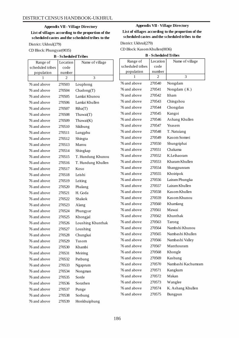
186
DISTRICT CENSUS HANDBOOK-UKHRUL
District: Ukhrul(279)CD Block: Phungyar(0035)
Range of scheduled tribes
population
Location code
number
Name of village
1 2 3
76 and above 270503 Louphong76 and above 270504 Chadong(T)76 and above 270505 Lamlai Khunou76 and above 270506 Lamlai Khullen76 and above 270507 Riha(T)76 and above 270508 Thawai(T)76 and above 270509 Thawai(K)76 and above 270510 Sikibung76 and above 270511 Lungphu76 and above 270512 Shingta76 and above 270513 Marou76 and above 270514 Shingkap76 and above 270515 T. Hundung Khunou76 and above 270516 T. Hundung Khullen76 and above 270517 Koso76 and above 270518 Leishi76 and above 270519 Leiting76 and above 270520 Phalang76 and above 270521 H. Goda76 and above 270522 Shakok76 and above 270523 Alang76 and above 270524 Phungyar76 and above 270525 Khongjal76 and above 270526 Loushing Khunthak76 and above 270527 Loushing76 and above 270528 Chungkai76 and above 270529 Tusom76 and above 270530 Khambi76 and above 270531 Meiring76 and above 270532 Patbung76 and above 270533 Ngaprum76 and above 270534 Nongman76 and above 270535 Sorde76 and above 270536 Sorathen76 and above 270537 Punge76 and above 270538 Sorbung76 and above 270539 Honkhuiphung
Appendix VII - Village DirectoryList of villages according to the proportion of the scheduled castes and the scheduled tribes to the
i
B - Scheduled Tribes
District: Ukhrul(279)CD Block: Kasom Khullen(0036)
Range of scheduled tribes
population
Location code
number
Name of village
1 2 3
76 and above 270540 Nongdam76 and above 270541 Nongdam ( K )76 and above 270542 Itham76 and above 270543 Chingshou76 and above 270544 Chongdan76 and above 270545 Kangoi76 and above 270546 Ashang Khullen76 and above 270547 Yeasem76 and above 270548 T. Natuiang76 and above 270549 Kasom Somrei76 and above 270550 Shungriphai76 and above 270551 Chakama76 and above 270552 K.Leihaoram76 and above 270553 Kharam Khullen76 and above 270554 Shangpunram76 and above 270555 Khoiripok76 and above 270556 Lairam Phungka76 and above 270557 Lairam Khullen76 and above 270558 Kasom Khullen76 and above 270559 Kasom Khunou76 and above 270560 Khamlang76 and above 270561 Mawai76 and above 270562 Khunthak76 and above 270563 Tarong76 and above 270564 Nambshi Khunou76 and above 270565 Nambashi Khullen76 and above 270566 Nambashi Valley76 and above 270567 Manthouram76 and above 270568 Khongle76 and above 270569 Kashung76 and above 270570 Nambashi Kachumram76 and above 270571 Kangkum76 and above 270572 Makan76 and above 270573 Wanglee76 and above 270574 K. Ashang Khullen76 and above 270575 Bungpun
Appendix VII - Village DirectoryList of villages according to the proportion of the scheduled castes and the scheduled tribes to the
i
B - Scheduled Tribes
187
DISTRICT CENSUS HANDBOOK-UKHRUL
Section II-Town Directory
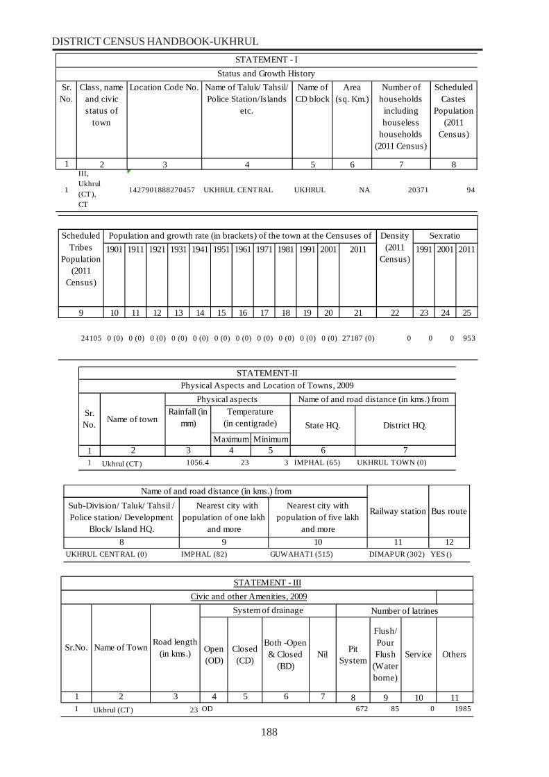
188
DISTRICT CENSUS HANDBOOK-UKHRUL
1 2 3 4 5 6 7 8
1
III,Ukhrul
(CT),CT
1427901888270457 UKHRUL CENTRAL UKHRUL NA 20371 94
Name of CD block
Area (sq. Km.)
Number of households
including houseless
households (2011 Census)
STATEMENT - IStatus and Growth History
Scheduled Castes
Population (2011
Census)
Sr. No.
Class, name and civic status of
town
Location Code No. Name of Taluk/ Tahsil/ Police Station/Islands
etc.
1901 1911 1921 1931 1941 1951 1961 1971 1981 1991 2001 2011 1991 2001 2011
9 10 11 12 13 14 15 16 17 18 19 20 21 22 23 24 25
24105 0 (0) 0 (0) 0 (0) 0 (0) 0 (0) 0 (0) 0 (0) 0 (0) 0 (0) 0 (0) 0 (0) 27187 (0) 0 0 0 953
Density (2011
Census)
Scheduled Tribes
Population (2011
Census)
Population and growth rate (in brackets) of the town at the Censuses of Sex ratio
Physical aspects
Maximum Minimum1 2 3 4 5 6 71 Ukhrul (CT) 1056.4 23 3 IMPHAL (65) UKHRUL TOWN (0)
District HQ.
STATEMENT-IIPhysical Aspects and Location of Towns, 2009
Name of and road distance (in kms.) fromSr. No. Name of town
Rainfall (in mm)
Temperature (in centigrade) State HQ.
8 9 10 11 12UKHRUL CENTRAL (0) IMPHAL (82) GUWAHATI (515) DIMAPUR (302) YES ()
Sub-Division/ Taluk/ Tahsil / Police station/ Development
Block/ Island HQ.
Nearest city with population of one lakh
and more
Nearest city with population of five lakh
and more
Name of and road distance (in kms.) from
Railway station Bus route
Open (OD)
Closed (CD)
Both -Open & Closed
(BD)Nil Pit
System
Flush/Pour Flush
(Water borne)
Service Others
1 2 3 4 5 6 7 8 9 10 111 Ukhrul (CT) 23 OD 672 85 0 1985
Civic and other Amenities, 2009STATEMENT - III
Sr.No. Name of Town Road length (in kms.)
System of drainage Number of latrines

189
DISTRICT CENSUS HANDBOOK-UKHRUL
Source of supply
(Codes) @
System of storage with capacity in kilo litres
(along with Codes) @
Domestic Industrial Commercial Road lighting (points)
Others
12 13 14 15 16 17 18 19TT,TU SR(8000) Yes 1875 32 580 70 250
Electrification (Number of connections)Protected water supply
Fire fighting service*
@Two major source only
Abbreviation
TT: Tap water from treated source
TU:Tap water from un-treated source
CW: Covered well
UW: Un-covered well
HP:Hand pump
TW/B:Tubewell /Borehole
RW:Rainwater
S:Spring
TK/P/L:Tank/Pond/Lake
O :Others
O HT:Over head Tank
SR:Service Reservoir
RIG:River Infiltration Gallery
BWP:Bore Well Pumping system
PT:Pressure Tank
N\A,NA,N.A.: Not Avialable
*In case this service is not available in the town, the name of the nearest place and its distance from the town where facility is available has been given
Hospitals (Allopathic & Others)
Dispensaries / Health Center
Family Welfare Center
Maternity and Child Welfare
Center1 2 3 4 5 61 Ukhrul (CT) 1(50) 1(4) 1(6) 82 Kms.
Medical Facilities, 2009
Sr.No. Name of Town
No. of Medical facilities* (with number of beds in brackets)
STATEMENT - IV
Maternity Homes
T.B.Hospital/ Clinic
Nursing Homes
Veterinary Hospital
Mobile Health Clinic
Others etc.
7 8 9 10 11 12 13 1482 Kms. 82 Kms. 82 Kms. N.A. N.A. N.A. 0 15
Charitable Hospital/Nursing Home (Numbers)
Medicine Shop
(Numbers)
No. of Medical facilities* (with number of beds in brackets)
*If a medical facility is not available in the town,nearest place distance from the town where facility is available has been given
*N.A.:Not Available
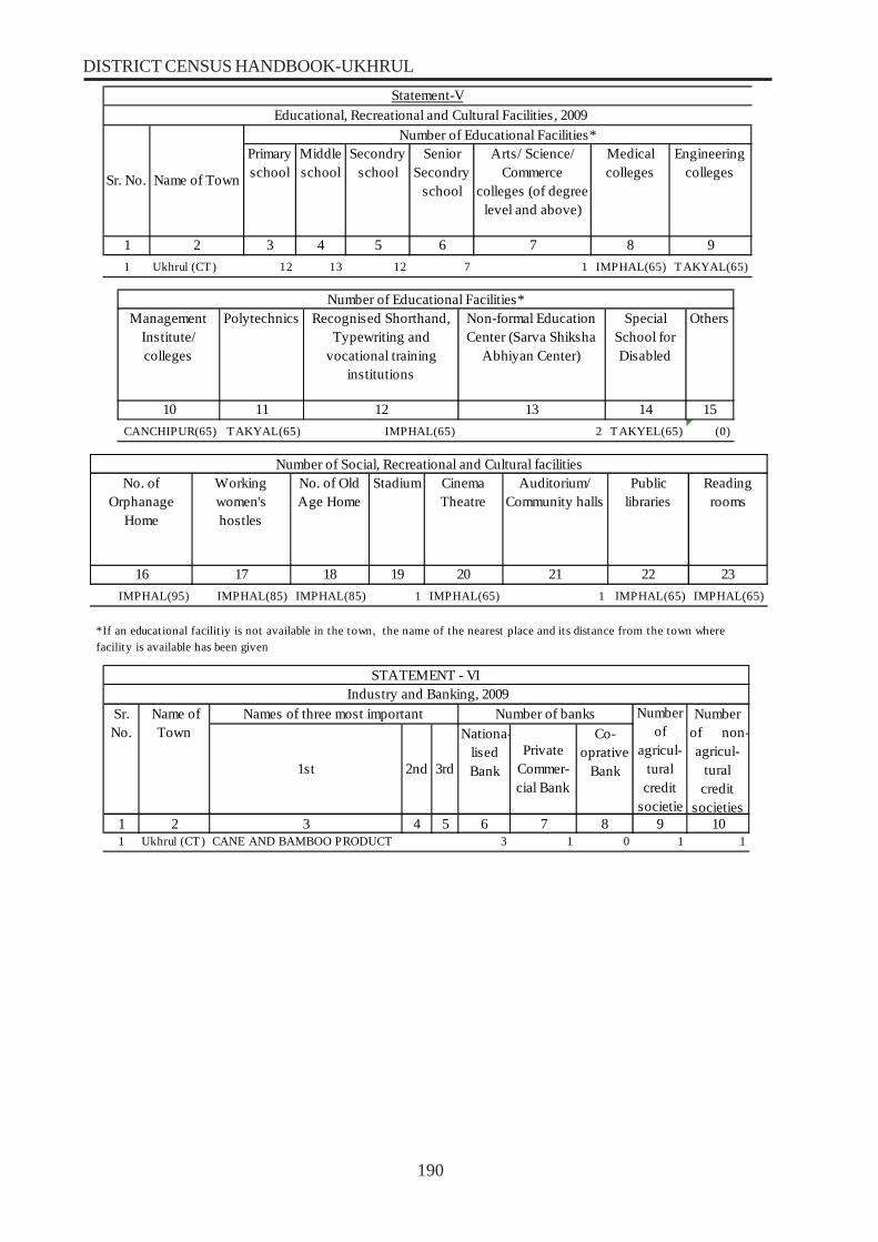
190
DISTRICT CENSUS HANDBOOK-UKHRUL
Primary school
Middle school
Secondry school
Senior Secondry
school
Arts/ Science/ Commerce
colleges (of degree level and above)
Medical colleges
Engineering colleges
1 2 3 4 5 6 7 8 91 Ukhrul (CT) 12 13 12 7 1 IMPHAL(65) TAKYAL(65)
Sr. No. Name of Town
Number of Educational Facilities*
Statement-V Educational, Recreational and Cultural Facilities, 2009
Management Institute/ colleges
Polytechnics Recognised Shorthand, Typewriting and
vocational training institutions
Non-formal Education Center (Sarva Shiksha
Abhiyan Center)
Special School for Disabled
Others
10 11 12 13 14 15CANCHIPUR(65) TAKYAL(65) IMPHAL(65) 2 TAKYEL(65) (0)
Number of Educational Facilities*
No. of Orphanage
Home
Working women's hostles
No. of Old Age Home
Stadium Cinema Theatre
Auditorium/ Community halls
Public libraries
Reading rooms
16 17 18 19 20 21 22 23IMPHAL(95) IMPHAL(85) IMPHAL(85) 1 IMPHAL(65) 1 IMPHAL(65) IMPHAL(65)
Number of Social, Recreational and Cultural facilities
*If an educational facilit iy is not available in the town, the name of the nearest place and its distance from the town where facility is available has been given
1st 2nd 3rd
Nationa-lised Bank
Private Commer-cial Bank
Co-oprative
Bank
1 2 3 4 5 6 7 8 9 101 Ukhrul (CT) CANE AND BAMBOO PRODUCT 3 1 0 1 1
STATEMENT - VI Industry and Banking, 2009
Sr. No.
Name of Town
Names of three most important Number of banks Number of
agricul-tural credit
societie
Number of non-agricul-
tural credit
societies
191
DISTRICT CENSUS HANDBOOK-UKHRUL

192
DISTRICT CENSUS HANDBOOK-UKHRUL