
District Disaster Management Plan (DDMP) Ganjam ... - 200 OK
189
-
Upload
khangminh22 -
Category
Documents
-
view
3 -
download
0
Transcript of District Disaster Management Plan (DDMP) Ganjam ... - 200 OK


District Disaster Management Plan (DDMP) Ganjam District, Odisha

1 | P a g e
CONTENTS
MESSAGE ................................................................................................................................. 2
INTRODUCTIOIN .................................................................................................................... 3
ABBREVATIONS .................................................................................................................... 4
HOW TO USE THIS PLAN ...................................................................................................... 5
1. NEED OF DISASTER MANAGEMENT PLAN .......................................................... 7
1.1. Disaster Profile in brief and Lessons learnt from past disasters: ................................... 7
1.2. Objective and Need of the DM Plan: ............................................................................. 7
1.3. Phailin & HudHud: ......................................................................................................... 8
2. OVERVIEW OF THE DISTRICT.. ………………………………………………… 9
2.1. District at a Glance: ......................................................................................... …….. 9
2.2. Area & Administrative Division: ................................................................................... 10
2.3. Climate and Rainfall ...................................................................................................... 11
2.4. River System .................................................................................................................. 12
2.5. River Carrying Capacity ................................................................................................ 12
2.6. Reservoir Details ............................................................................................................ 12
2.7. Demography: (2011 Census) ......................................................................................... 12
2.8. Occupation profile ......................................................................................................... 13
2.9. Agriculture ...................................................................................................................... 13
2.10. Type of Land & Paddy Area .......................................................................................... 13
2.11. Salient Physical Features & Land Use Patterns ............................................................. 13
2.12. Geology & Geomorphology ........................................................................................... 13
2.13. Drinking Water Sources ................................................................................................ 14
2.14. Irrigation Systems .......................................................................................................... 15
2.15. Minor Irrigation Project ................................................................................................. 15
2.16. Industries ....................................................................................................................... 16
2.17. Transport and Communication Network ....................................................................... 16
2.18. Railways & Water Ways ............................................................................................... 16
2.19. Heritage Sites, Fairs, Festivals and Crowd Management .............................................. 16
3. IMPLEMENTATION, MONITORING & UPDATION OF DDMP ........................... 19
3.1. Implementation............................................................................................................... 19
3.2. Monitoring and Evaluation............................................................................................. 19
3.2.1.Roles & Responsibilities of DEOC in Monitoring and Evaluation of DDMP .............. 20
3.3. Review and Update ........................................................................................................ 20
3.4 Schedule for updating the District Database ................................................................... 21

2 | P a g e
Sri Prem Chandra Chaudhary, I.A.S Collector & District Magistrate
Ganjam
M e s s a g e
I note with pleasure that in a departure from earlier days of relief operations in post disaster
situations, the present day administration is more familiar, more prepared, more equipped & more
efficient in dealing with disasters. In view of enactment of Disaster Management Act-2005, the
District Disaster Management Plan of Ganjam district has been prepared to help the District
administration for effective response during disasters in the Ganjam district. Ganjam is prone to
natural as well as man-made disasters. Cyclone and floods are the major Natural Hazards. Industrial,
chemical, fire, rail & road accidents are the major man-made disasters of the district. The present plan
consists of various facts which have been collected from various stakeholders including line
departments. This plan contains as many as 5 (five) sub plans and each sub plans has its own
importance. The plan consists of General plan, Hazard & Risk Assessment, Disaster Risk Reduction
Mechanism, Preparedness of Administration and Response Mechanism.
The lessons learnt from Very Severe Cyclonic Storm – Phailin occurred on October 12, 2013
and the mechanism was put in place during Cyclone-HudHud’2014 provides necessary impetus for
preparation of this year’s plan. It is hoped that the plan would provide concrete guidelines towards
preparedness and quick response in case of a disaster and help in realizing sustainable Disaster Risk
Reduction & mitigate/minimizes the losses in the district in the long run.
Natural Calamity touches almost every corner of earth. But it is the extend and quantum of
habitations and community, that makes a natural calamity more or less disastrous. Ganjam district is a
highly populated district in coastal Odisha which makes it more vulnerable to different types
calamities. Hence, complete awareness and preparedness among communities and long term disaster
risk reduction activities only, can deal with future disaster successfully. The present document is a
continuous process and it requires more & more refinement from time to time as per needs. All the
stakeholder Departments will keep on contributing their skills, resources, techniques & experiences in
enriching the DDMP.
(Prem Chandra Chaudhary)

3 | P a g e
Sri Sitansu Kumar Rout, O.A.S(S) Addl.District Magistrate,Ganjam
I n t r o d u c t i o n
GOI-UNDP project on “Enhancing Institutional and Community Resilience to Disasters and Climate
Change (2013-2017)” provides technical support for strengthening capacity of stakeholders including
communities and institutions to fast-track implementation of the planning frameworks on Disaster Risk
Reduction and Climate Change Adaptation. Under this of GoI-UNDP, initiative, DDMP of Ganjam is updated
with special focus to climate change adaptation.
DDMP of Ganjam is divided into five sub-plans. These sub-plans include General Plan, Hazard,
Vulnerability, Capacity Assessment (HVCA), Preparedness Plan, Risk Reduction Plan, and Response Plan.
The General Plan of Ganjam includes basic profile of Ganjam district. This includes rationale and objectives
behind preparation of DDMP. The basic profile of the plan is prepared by District Emergency Operation
Centre of Ganjam District. The plan also includes from time to time monitoring and evaluation mechanism to
implement and update DDMP.
Hazard, Vulnerability and Capacity Assessment (HVCA) of Ganjam District involves detailed risk
assessment of the district. The block wise hazard vulnerability analysis and hazard specific vulnerabilities are
included in the plan. The HVCA plan reveals the vulnerability of the district and available resources in terms
of capacity to tackle major disasters.
‘Preparedness Plan’ of Ganjam describes defined role of line departments, measures to be taken to
tackle disasters and standard operating procedures for all line departments. Most importantly, it contains ‘Early
Warning System’ and ‘Incident Response System’ of DDMP. Cyclone shelter Management guidelines is
included in preparedness plan. List of equipment provided to each Multipurpose cyclone and flood shelter is
also given.
‘Response Plan’ of Ganjam district describes standard response mechanism as directed in ‘Odisha
Relief Code’. It also describes standard operating procedures for line department in response and relief
operations. The resources to be used in response like boats, shelters, storage locations, medical institutions etc.
are given for ready reference.
‘Risk Reduction Plan’ of Ganjam district contains ongoing coping mechanisms to reduce the disaster
risk in long term with special focus on climate induced disasters. Government of Odisha with several other
agencies have initiated several risk reduction programs to tackle these disasters. The Risk Reduction Plan of
Ganjam district is prepared after consultation with key line departments. First section of the plan, ‘Climate
Change Action Plan’ describes the impacts and actions taken up by key line departments to minimize adverse
impact. The plan lists major developmental programs and schemes with relative DRR-CCA component. The
benefit of each scheme/program, its relevance to DRR-CCA and possible actions are listed in a table. This plan
gives us an idea on how to link disaster management plan with development.
(Sitansu Kumar Rout )

4 | P a g e
ABBREVATIONS
BDO : Block Development officer
BDMC : Block Disaster Management Committee
BDMP : Block Disaster Management Plan
BCP : Block Contingency Plan
BDM : Block Disaster Manager
BCR : Block Control Room
CCA : Climate Change Action Plan
DDMP : District Disaster Management Plan
DDM : District Disaster Manager
DCR : District Control Room
DRR : Disaster Risk Reduction
GPDMC : Gram Panchayat Disaster Management Committee
OIC : Officer In charge
CDPO : Child Development Project Officer
MO : Medical Officer
VSO : Veterinary Stock officer
VAS : Veterinary Assistance Surgeon
JAO : Junior Agriculture Officer
SI : School Inspector
AFO : Assistant Fishery Officer
JE-RWSS : Junior Engineer- Rural Water Supply & Sanitation
JE- R & B : Junior Engineer-Roads and Buildings
JE- PWD : Junior Engineer- Public Works Department
DRDA : District Rural Development Agency
IAY : Indira Aawas Yojana
CMRF : Chief Ministers Relief Fund
AWC : Anganwadi Centre
PMRF : Prime Ministers Relief Fund
PDS : Public Distribution System
CDMO : Chief District Medical Officer
CDVO : Chief District Veterinary Officer
DSWO : District Social Welfare Officer
W&CD : Women & Child Development
GP : Gram Panchayat
SC : Schedule Caste
ST : Schedule Tribe
GEN : General Caste
BPL : Below Poverty Line
APL : Above Poverty Line
PHC : Primary Health Centre
VHF : Very High Frequency
ADM : Additional District Magistrate
PD : Project Director
WEO : Welfare Extension Officer
SEO : Social Education Organizer
LSEO : Lady Social Education Organizer
FEO : Fishery Extension Officer

5 | P a g e
HOW TO USE THIS PLAN
1. Know how development is affected by climate induced disasters
2. Know how to link DRR-CCA with development
programs
Climate induced disasters are listed with department specific
impacts and exiting coping mechanisms.
Risk Reduction Plan: ‘Climate Change Action
Plan’
Risk Reduction Plan: ‘Schemes for
DRR & CCA’
Schemes from central and state government with DRR
linkages are mentioned. Possible actions under each
scheme are mentioned.
Action Remarks References
Know your Hazard Risks (Hazard, Vulnerability and Capacity)
Read this to understand disaster context of a district
District Profile & HVCA
Act per your specific plan
Refer Preparedness Plan Early Warning
System &
Incident Response System
For Early warning and Normal times, refer “Preparedness
Plan”;
For response; refer ‘Response Plan’
Standard operating Procedure for line
departments
Know resources available Read this to know about available resources to respond
to any disasters
Response Plan
Read this to know what to do and what not to do before, during and after disasters
General Plan (added as annexure)

6 | P a g e
Optimum Strategy
Geographical area of the district : 8205.48 Sq. Kms
No. of Blocks : 22
No. of Gram Panchayats : 475
No. of villages : 3250
No. of Municipal Corporation : 1
No. of NACs : 17
No. of Tahasils : 23
No. of Police Stations : 35
No. of Assembly Constituency : 13
No. of Parliamentary Constituency : 2
Population (Census 2011)
Total 3529031
Male 1779218
Female 1749813
Rural 2761030
Urban 768001
Whom to contact in case of
disaster ?
District Emergency Operation
Centre (DEOC), Ganjam
Phone No.: 06811-263978
Police : 100
Ambulance : 108
OSDMA : 0674- 2395398
Special Relief Commissioner,
Odisha : 0674-2534177
Before Disaster
Formation of District Disaster
Management Committee
Update DDMP
Hazard Analysis & Resource
Inventory
IEC programme planning
Key training & capacity building
Logistic arrangement- Cyclone/
Flood Shelter, communications,
allocate roles & responsibilities.
Arrange for food items like rice,
chuda & Guda, Drinking water ,
Medical facilities, clothing.
During Disaster Functioning of District Control Room & other Block /
Tahasil/ Line Deptt. Control Rooms
Dissemination of warning information
Coordination with officials at District Control Room at
12 Hrs.
Alert CDMO/ CDVO/CSO/ RTO/ Field Officers
( Revenue / Line Deptt.)
Immediate freezing of reasonable.
Rescue Operations/ Evacuation teams
Administration of Relief.
Preparation of daily situation report as per standard
format
Daily stock of the situation by Collector & DM ,
Addl.Dist. Magistrate
After Disaster Relief Activities & Post
Disaster Needs Assessment
Monitoring Relief operation
organized by outside
agencies.
Restoration of
Communication, Roads &
Railways
Ensuring transportation of
relief material to affected
pockets
Ensuring safeguard of
belongs of evacuees
Maintenance of Law & Order
Special care for children,
Lactating Mothers and
disabled.

7 | P a g e
1. NEED OF DISASTER MANAGEMENT PLAN _________________________________________________________________________________
1.1. Disaster Profile in brief and Lessons learnt from past disasters:
Ganjam District lies in the close proximity to the seashore; it is mostly affected by Cyclone,
Flood, Drought, & Heat Waves. The fear of Tsunami is rampant. Nevertheless, the peculiar
traditional Housing structures especially thatched ones in rural areas are more susceptible to fire
accident even in rainy season. So the disaster management planning of this district may be referred to
the inevitable plan, strong administration unit of linkup between the top & bottom of administrative
units and to the grass root level transmission link. It is no doubt that the formulation of disaster plan
is for preparedness and commitment for its positive implementation at the hour of crisis. Disaster
management and disaster operations in the district are consistent with the Disaster Management
Strategic Policy Framework. This is achieved by:
Ensuring a comprehensive, all hazards, all agencies approach by achieving the right balance
of prevention, preparedness, response and recovery;
Supporting the mainstreaming of disaster preparedness and mitigation into relevant areas of
activity of government, non-government, small business and corporations;
Aligning disaster risk reduction, disaster mitigation, disaster resilience and climate change
adaptation policy and actions with international and national reforms;
Promoting a transparent, systematic and consistent approach to disaster risk assessment and
management, based on the National Disaster Management Policy / Act.
Recognizing the commitment of stakeholders and the need for collaboration across all levels
of government, community, industry, commerce, government owned corporations, private and
volunteer organizations, and local communities in all aspects of disaster management;
Emphasizing building and maintaining sincere relationships, trust, teamwork, consultative
decision-making and shared responsibilities among stakeholders; and
Promoting community resilience and economic sustainability through disaster risk reduction.
1.2. Objective and Need of the DM Plan:
The Ganjam District Disaster Management Plan has been formulated with a view to create an
effective, authentic and accurate data base enabling one to communicate and react efficiently to
disaster crisis. It is a full proof document capable of organizing and rehearsal in the community in the
shortest possible time with minimum simple orders and procedures so that the people will get
maximum benefit. The plan document envisages and has ensured that the Community shall actively
participate in all levels with optimum utilization of men, materials available resources etc. with no
gaps or no overlaps to prevent loss of lives and minimize loss to property.

8 | P a g e
The purpose of the present document is also meant for ensuring speedy approach for rescue,
rehabilitation and to avert further miseries of the calamity stricken people. There is a gadget based on
the principle that a friend in need is a friend indeed. The DDMP will act as a true friend, which will,
guide the entire administration machinery & community as well at the time of disaster preparedness
and at the time of relief operation. It will not only provide guidance but also provide courage to the
community to face the eventuality bravely and boldly. This is an attempt towards evolving a
systematic, comprehensive and holistic approach to all disasters, natural as well as man-made. It was
felt that prevention is more cost-effective than post-disaster relief and rehabilitation.
1.3. Phailin & HudHud:
The current plan has been prepared as per the lessons learnt from Very Severe Cyclonic
Storm – Phailin and the flood aftermath which occurred in 12th
Oct’2013 and the mechanism
implemented during HudHud’2014. The successful combating of Phailin & preparedness during
HudHud attributes to the meticulous preparation of District Disaster Management Plan. The measures
taken for Phailin & HudHud have been discussed elaborately in subsequent chapters.

9 | P a g e
2. OVERVIEW OF THE DISTRICT
2.1. District at a Glance:
Ganjam district is broadly divided
into two divisions, the coastal plains in the
east and hill & tablelands in the west. The
Eastern Ghats run along the western side of
the district. The plain area lies between the
Eastern Ghats and the Bay of Bengal. Since
the hills are close to the sea, the rivers
flowing from hills are not very long and are
subject to sudden floods. The plains are
narrow because of the absence of big rivers.
The coastal plains in the east contain more
fertile and irrigated lands. Towards the
centre and south it is hilly interspersed with
beautiful well-watered valleys. The southeastern portion is fertile. A portion of the famous Chilika
Lake occupies the extreme northeast. The Bay of Bengal touches the eastern frontier of Ganjam
district and its coast extends over 60 Kms. It provides unique opportunity for fishing and port facility
at Gopalpur for international trade. The rivers like Rushikulya, Dhanei, Bahuda, and Ghodahada are
the prominent ones which govern the agriculture sector of the district. The vast river basin of
Rushikulya provides Grand potential for exploration of ground water. However the rivers are only
navigable during the rainy season only. The Chilika Lake, which attracts international tourist known
for its scenic beauty and a marvelous bird’s Sanctuary, is situated in the eastern part of district.
The district has alluvial soil in its eastern part (coastal region) and laterite Soil in the west
(hilly table land) with small patches of black cotton soil at the center and in the northeast close to
Chilika. The chief economic minerals found in the district are abrasives and grinding materials, lime
stone (kankar), manganese, monazite, sand and talc. Garnetiferous granitic gnashes and charanokites
are used for manufacture of grinding stones in the district. White clay deposits are also found in
different areas of the district. The forest of Ganjam district comes under the mix moist peninsular
high and low level Sal forests, tropical moist and dry deciduous and tropical deciduous forest types. It
provides a wide range of raw materials and quite famous for wild life diversity.

10 | P a g e
2.2. Area & Administrative Division:
The Ganjam District is constituted of 3 sub-divisions, 22 blocks, 23 Tahasils and 18 ULBs,
with a population of 35,29,031 (2011 census) extending from 19.4 degree north latitude to 20.17
degree north latitude and 84.7 degree east longitude to 85.12 degree east longitude spreading over the
geographical area 8205.48 Sq. Kms. It is 5th largest district in Odisha and 93th largest in India in
terms of total area. Ganjam is most populous district of in Odisha state and it is 83rd
most populous
district in India. The population density of Ganjam is 429 persons per square Km. It is 9th most
densely populated district of Odisha and 291th most densely populated district in India.
Fast Facts:-
Geographical Area 8205.48 Sq. Km (8,39,110 Hectare)
Sub-Divisions 03 (Chatrapur, Berhampur & Bhanjanagar)
Block 22
Tahasil 23
Municipal Corporation 1
Notified Area Council (NAC) 17
Gram Panchayat 475
No. of Villages 3250
No of R.I Circle 199
Medical College 1
No. of C.H.C 30
Primary Health Centre 7
PHC (N) 90
Primary Health Sub-Centre 460
No. of Homeopathic dispensary 38
No. of Ayurvedic dispensary 42
Details of Administrative set up:
Sub-
Division Tahasil
No. of
GPs
No. of
Village Tahasils Urban Local Bodies
CH
AT
RA
PU
R
1. Chatrapur 17 88 1. Chatrapur 1. Chatrapur NAC
2. Ganjam 14 113 2. Ganjam 2. Ganjam NAC
3. Rambha NAC
3 .Khalikote 26 238 3.Khalikote 4.Khalikote NAC
4. Kodala 22 175 4. Kodala 5. Kodala NAC
5. Purushottampur 26 100 5. Purusotampur 6. Purusotampur NAC
7. Polasara 25 126 6. Polosora 7. Polosora NAC
6. Kabisuryanagar 21 81 7.Kabisuryanagar 8. Kabisuryanagar
NAC
8. Hinjilcut 21 56 8. Hinjilicut 9.Hinjili NAC
Total 172 977

11 | P a g e
BE
RH
AM
PU
R
1. Konisi 24 88 1.Kanisi 1. Gopalpur NAC
2. Kukudakhandi 20 96 2. Kukudakhandi -
3. Digapahandi 24 239 3. Digapahandi 2. Digapahandi NAC
4. Sanakhemundi 21 162 4. Sanakhemundi -
5. Chikiti 17 142 5. Chikiti 3. Chikiti NAC
6. Patrapur 23 352 6. Patrapur -
7. Berhampur - 34 7.Berhampur 4.Berhampur MC
Total 129 1113
BH
AN
JA
NA
GA
R
1. Bhanjanagar 20 143 1. Bhanjanagar 1. Bhanjanagar NAC
2. Bellaguntha 18 93 2. Belaguntha 2. Belaguntha NAC
3. Jagannathprasad 24 148 3. Jagannathprasad -
4. Aska 27 109 4. Aska 3. Aska NAC
5. Dharakote 17 181 5. Dharakote -
6. Sorada 26 270 6. Sorada 4.Sorada NAC
7. Sheragada 22 114 7. Sheragada -
8. Buguda 20 102 8. Buguda 5.Buguda NAC
Total 174 1160
GRAND TOTAL 475 3250
2.3. Climate and Rainfall
Annual Normal Rainfall of district : 1276.20 mm.
No. of Rain Recording Station : 22
Rain Fall Records of last two decades:-
Sl. No. Year Average Rainfall (in mm)
1 1993 954.17
2 1994 1221.89
3 1995 1939.54
4 1996 869.43
5 1997 1215.69
6 1998 1374.25
7 1999 1230.08
8 2000 998.35
9 2001 1248.01
10 2002 804.69
11 2003 1421.70
12 2004 981.19
13 2005 1318.01
14 2006 1486.57
15 2007 1321.20
16 2008 1162.92
17 2009 1221.51
18 2010 1484.04
19 2011 914.37
20 2012 1224.44
21 2013 1972.17
22 2014 1400.38
23 2015 1169.78

12 | P a g e
2.4. River System
Major River Rushikulya , Badanadi
Minor River/Nala Bahuda, Harabhangi, Ghodahada, Dhanei, Loharkhandi & Baghua,
Kharkhari, Ghadaka Nala, Nuani Nalla.
2.5. River Carrying Capacity
2.6. Reservoir Details
Sl. No. NAME OF THE
RESERVOIR Frl. in Mtr.
Live Storage Capacity in
Ham.
1 Bhanjanagar 95.100 5108.00
2 Sorada 92.300 4975.000
3 Daha 118.600 2195.000
4 Ghodahada 117.800 3100.000
5 Dhanei 88.700 1313.000
6 Harabhangi 387.500 8625.000
7 Baghua 113.850 3100.000
8 Bhgahlati State-I 100.000 2109.000
9 Badanala 176.000 6714.000
10 Pilasalki 540.900 1411.000
2.7. Demography: (2011 Census)
Population 3529031
Male 1779218
Female 1749813
Density 429
Sex Ratio (Per 1000) 981
Child Sex Ratio (0-6 Age) 899
Average Literacy 71.88
Female Literacy 61.84
Sl.
No. Name of the River Gauge Station
Zero
level
in Mtr.
Danger
Level in
Mtr.
1 RUSHIKULYA
Sorada 79.250 81.990
Aska 32.45 34.750
Janivili 48.920 53.180
Hiradharabati 18.590 23.160
Purushottampur 12.000 16.840
2 BADANADI
Sorisamuli 98.600 102.11
Aska 32.060 35.420
Nuagam 68.030 70.930
Madha Borida 55.780 60.650
3 BAGHUA Kabisuryanagar road bridge 31.010 34.060
4 LOHARKHANDI Bhanjanagar 68.650 72.310

13 | P a g e
2.8. Occupation profile
Agriculture and agricultural labour the main occupation of the people of the district and
backbone of their economic background. However, prolonged frequent occurrence of natural calamity
since last one decade stagnated the economic progress of the people. The scope of public sector is
very limited to provide employment opportunity to a large section of unemployed persons in the
district. However various employment-generating programmes are implemented in the district to
generate self/wage/salary employment for the unemployed youths. The employment generating
programmes like PMRY, JRY, SGSY, SGSSY, PMGRY, NREGA etc. & beneficiaries’ oriented
programmes like IRDP provide employment to most of the people.
2.9. Agriculture
Main Crop: Paddy Non-Paddy (Vegetable, Sugar Cane, Oil Seeds & Pulses
Cultivators 2,61,069
Agriculture Labour 1,71,651
2.10. Type of Land & Paddy Area
Cultivated Area 406000 Hectare
Cultivated Area PADDY 223500 Hectare
High land Paddy 19400 Hectare
Medium Land Paddy 103300 Hectare
Low Land Paddy 100800 Hectare
Total Non-Paddy Area 182500 Hectare
High Land 170315 Hectare
Medium Land 10160 Hectare
Low Land 2025 Hectare
2.11. Salient Physical Features & Land Use Patterns
Cultivated Area 397000 Hectare
Cultivated Wasteland 11,000 Hectare
Forest Area 3,15,000 Hectare
Non-Cultivated Area 62,000 Hectare
Current Fallow 3,000 Hectare
Other Fallow 12,000 Hectare
Area under non-agriculture use 21,000 Hectare
2.12. Geology & Geomorphology
Mines Area 2877.76 Hectare
Forest Area 266504.75 Hectare
Reserved Forest 144385.70 Hectare
Protected Forest 121862.80 Hectare
Unclassified Forest 255.95 Hectare
Village Forest 173.00 Hectare
Percentage of Forest Area 38%
Forest area to State 542 Hectare
Natural Resources Kunebutem Silimite, Rutile, Garnet, Zircon minerals & Sand

14 | P a g e
2.13. Drinking Water Sources (Block wise availability of Drinking water sources)
a) Availability of Drinking water sources within ULBs:
Sl No Name of the ULB No. of
Wards
Population
( Aprox ) No. of Stand post Tube Wells
1 Chatrapur 14 22800 207 154
2 Ganjam 12 13600 57 64
3 Rambha 13 11700 62 --
4 Khalikote 12 11400 53 87
5 Aska 18 26300 120 116
6 Buguda 13 13500 52 87
7 Hinjilcut 21 25400 149 104
8 K.S Nagar 18 17200 88 126
9 Kodala 13 15600 43 67
10 Polosora 19 22100 67 119
11 Purushottampur 14 14800 84 84
12 Bhanjanagar 15 22300 202 99
13 Sorada 11 16400 100 65
14 Belaguntha 13 10800 75 67
15 BeMC 37 376700 1772 1158
16 Gopalpur NAC 11 8,500 47 85
17 Chikiti 12 13000 91 97
18 Digapahandi 11 12400 133 110
b) Availability of Drinking water sources within Block area
Sl
No Name of the Block Population
Drinking Water Sources
Open Wells Tube Wells No. of village with Tap water
1 Rangeilunda 133648 10 757 6
2 Kukudakhandi 120082 30 733 0
3 Chikiti 93786 18 678 3
4 Patrapur 122000 125 708 20
5 Hinjilcut 114418 22 687 07
6 Sheregada 114880 14 667 01
7 Digapahandi 140567 37 740 12
8 Sanakhemundi 146118 36 719 12
9 Chatrapur 124598 2 215 12
10 Ganjam 79520 1 405 14
11 Khalikote 136097 6 662 11
12 Aska 133387 4 911 08
13 Bhanjanagar 122449 17 1071 33
14 Belaguntha 103077 2 663 04
15 Buguda 106747 7 782 01
16 Dharakote 101533 20 724 34
17 J.N Prasad 117894 21 1156 22
18 Kabisuryanagar 102441 04 532 04
19 Beguniapada 112970 14 729 14
20 Polosora 117281 09 726 09
21 Purushottampur 129506 10 743 0
22 Sorada 126075 60 907 107
TOTAL: 2599074 469 15915 334

15 | P a g e
2.14. Irrigation Systems
Sl
No Irrigation System Block Covered Ayacut (Hectare)
1 Rushikulya Irrigation System 17 60122.742
2 Daha Irrigation System 2 4762.400
3 Dhanei Irrigation System 3 4508.390
4 Hiradharabati Irrigation System 2 6309.084
5 Jaimangal 4 7348.149
6 Ghodahada 2 7758.000
7 Ramanadi 1 1321.050
8 Bahuda Irrigation Project 3 8068.830
9 Baghua Irrigation Project 2 8567.000
10 Baghalati Irrigation Project 2 5488.000
11 Harabhangi 3 9150.000
12 Baghua Dhanei Doab 2 1890.000
2.15. Minor Irrigation Project
Sl
No Name of the Block
Total
Number of
MIPs
Total certified Ayacut Programme for Kharif
Kharif Rabi No. of
Projects Area in Ha.
1 Aska 36 2590.78 -- 35 2590.78
2 Chikiti 42 3949.74 -- 42 3949.74
3 Digapahandi 64 6835.65 -- 63 6835.65
4 Dharakote 45 3054.14 -- 43 3054.14
5 Hinjili 24 1501.76 -- 24 1501.76
6 Kukudakhandi 27 1725.67 -- 27 1725.67
7 Patrapur 68 7630.04 -- 67 7630.04
8 Rangeilunda 22 1136.04 -- 22 1136.04
9 Sanakhemundi 44 6701.43 -- 44 6701.43
10 Sheragada 43 3905.01 -- 42 3905.01
11 Sorada 60 6416.52 -- 57 6416.52
12 Beguniapada 65 9084.58 -- 65 9084.58
13 Belaguntha 28 2356.06 -- 28 2356.06
14 Bhanjanagar 23 2844.69 -- 23 2844.69
15 Buguda 56 4175.97 -- 56 4175.97
16 Chatrapur 36 2651.84 -- 36 2651.84
17 Ganjam 35 2672.12 -- 35 2672.12
18 Jagannathprassad 60 7410.07 -- 60 7410.07
19 K. S Nagar 40 2810.56 -- 40 2810.56
20 Khalikote 79 6976.20 -- 79 6976.20
21 Polosora 51 3328.37 -- 51 3328.37
22 Purushottampur 38 4104.34 -- 38 4104.34
23 MI - 1 475 45446.78 -- 466 45446.78
24 MI - 2 511 48414.80 -- 511 48414.80
TOTAL 986 93861.58 0 977 93861.58

16 | P a g e
2.16. Industries
No. of PSU 01
No. of S.S.I. Units 9065
Capital investment 551.15 lakh
Persons employed 4,5431
2.17. Transport and Communication Network
National Highway 87 Km.
State Highway 525 Km
Major District Roads 391.62 Km
Other District Roads 452 Km
Forest Road 480 Km
Classified Village Roads 192.60 Km
Panchayat Samity Roads 762.09 Km
Village Roads 1397 Km
R.L.E.G.P Road 156 Km
Urban Road 1100 Km
2.18. Railways & Water Ways
East Coast Railway covers a length of 86 Kms in the district having 11 No. of Railway
stations and major towns of the district are i.e. the District Headquarters Chatrapur (06811-263882/
131) & Berhampur (0680-2229632/ 131) which are linked with Railways.
The Gopalpur port (fair weather) is situated 4 Km from the District Headquarters for
waterways communication having one Cargo berth of 240 mts available.
2.19. Heritage Sites, Fairs, Festivals and Crowd Management
Ganjam District is full of tourist spots that are visited by a large number of tourists every year
like Arjyapalli, Athagadapatna, Balkumari, Brahmapur, Bhairabi (Mantridi), Bhetanai, Biranchi
Narayan, Budhakhol- Buguda, Chilika (Rambha), Girisola, Gopalpur sea beach, Tara Tarini etc.
Ganjam District is not only an ideal choice for monuments, Beaches, Waterfalls and scenic beauties,
but also for her colourful fairs and festivals.Ganjam District celebrates many festivals round the year.
Dola Yatra, Tara Tarini Mela, Thakurani Yatra, Durga Puja, Shiv Ratri, Ratha Yatra, Makar
Sankranti, Manabasa Gurubara and Danda Yatra are the famous festivals being celebrated in the
District with great enthusiasm.
Crowd management is very important aspect to avoid stampede like situations at these spots
and during festivals. The guidelines for crowd management are listed here1 :
1Issue no.107, soutasiadisasters.net

17 | P a g e
No degrading/critical remarks should be made during possession and after a possession
around heritage site or through any public news media.
No physical assaulting or showing gestures.
Restriction on visit on important areas of heritage sites.
The authority should have close circuit TV of the vulnerable areas, like the gate, stairs and
isolated areas for constant monitoring and record.
Spectators should not be allowed in the area where a contest, rituals or entertainment program
is being held.
Detail spotters in the crowd, to forewarn about any likely troubles brewing.
No alcohol or other mood altering substances to be allowed.
Use of bells, air horn, whistles, wooden blocks and other noise makers should be allowed
during in-door contests/concerts/programs. Bands may be allowed before the start, during the
breaks and after the contest is over.
Side-line barriers should be erected during all concerts or any sporting events.
Evacution map should be displayed at all heritage sites. Volunteers and management team
should be trained to conduct a mock drill ensure zero causality in case of emergency
evacuation.
Mass communication systems like mike, speakers, alarms etc. should be ready in working
condition during any religious possession.
In case of unexpected in-flows of visitors, Management options for restricting the number of
visitors to a site can include:
• restricting entry or closing an area;
• limiting group sizes;
• implementing a quota or permit system;
Options for dispersing or concentrating people to reduce use in a particular area can include:
• restricting the number of people who can enter the threatened area;
• limiting the permissible length of stay in the threatened area;
• raising the entrance fee for the threatened area only;
• not providing facilities in the threatened area;
• zoning an area for a particular activity and not permitting the activity in the threatened area;
• directing tourists to more resilient areas through zoning, visitor education and offering more
facilities or fewer facilities;
• charging different entrance fees on certain days of the week; and
• using a promotion and interpretation campaign to influence the use of one area over another.

18 | P a g e
Site managers may encourage visitors to practice particular activities by:
• raising or lowering prices for certain types of visitors;
• restricting opening hours, e.g. opening a site early for bird-watchers or closing it early to
discourage other clientele;
• offering or not offering infrastructure;
• prohibiting certain activities through regulation and enforcement.
A site's physical environment can be made more resistant to impacts by:
• using infrastructure to "harden" a site, e.g., hardening a trail with a wooden boardwalk or
installing permanent moorings;
• relocating infrastructure to more resilient areas, e.g., moving a mountain refuge to an area less
prone to erosion.

19 | P a g e
3. IMPLEMENTATION, MONITORING & UPDATION OF DDMP
This chapter talks about the monitoring, evaluation, updation and implementation of the
District Disaster Management Plan of the district. The District Emergency Operation Centre (DEOC)
will have to ensure the planning, coordination, monitoring and implementation of the DDMP. The
District Collector is the overall in charge of all the activities related to disaster management.
3.1. Implementation
The nodal authority for the task of implementation during and after disasters will be the
Emergency operation Centre, Ganjam. For the process of implementation, the most important
component of testing the DDMP is to conduct quarterly mock drill or simulation exercise in order to
identify the positive elements as well as gaps.
Mock drill exercise is required in order to verify the level of preparedness and improve the
coordination during emergencies. This has to be based on past experiences and lessons learnt.
Mock-drills help in evaluating response and improving coordination within the administration, with
various departments, non-government agencies, other stakeholders and communities. They help in
identifying the extent to which the plans are effective and also aid in revising these if required. These
drills enhance the ability to respond faster, better and in an organized manner during the response and
recovery phase.
DEOC, Ganjam must ensure the following:
1. Implementation of all policies and plans of state govt.
2. Implementation of all NDMA guidelines
3. Implementation of all instructions of Revenue & Disaster Management department
4. Department should ensure that all schemes based on the parameters of mitigation, relief and
rehabilitation to be identified and implemented
5. Implementation of all guidelines/ instructions related to disasters from GoI and State Govt.
6. All officers to be trained in Disaster Management.
7. Implementation of National bylaws
8. Implementation of Fire-safety bylaws
9. Implementation of all on-site plans of the respective industries
10. Functionality of Emergency operation Center (EOC),Ganjam
3.2. Monitoring and Evaluation
The DEOC Ganjam will be responsible for the proper monitoring and evaluation of the DDMP.
The purpose of monitoring and evaluation of DDMP is to determine
adequacy of resources
co-ordination between various departments/ agencies
community participation
partnership with NGOs
partnership with insurance companies

20 | P a g e
3.2.1. Roles & Responsibilities of DEOC in Monitoring and Evaluation of DDMP
1. Identify and ensure implementation of DRR into all developmental projects and schemes.
2. Monitor the functioning and adequacy of the resources present in the district every six
months.
3. Based on the analysis, the DEOC has to procure/purchase/borrow resources from the
concerned authorities and replace the dilapidated and non-functioning resources using the
developmental funds.
4. Ensure that all the departmental plans are operational and checked by the respective nodal
officers.
5. Monitor that all the officers of the frontline departments have to be trained as per their
requirement.
6. Monitor that all prevention, mitigation, preparedness and response measures are properly
implemented within the district.
7. All departmental heads at the district level must ensure to identify their suitable and relevant
schemes (centrally-sponsored or state-funded) which will be suitable to be used in disaster
management, keeping in view of their parameters of the central-sponsored schemes.
The monitoring and evaluation could be done through various audits such as:
Electrical Safety Audits of critical infrastructure
Fire-Safety Audits of critical infrastructure
Enforcement of National Building Code in construction of lifeline buildings
Audit reports of various departments such as environment, irrigation (regarding canals), labor
(Industrial Safety & Health)
All on-site emergency plans of the respective industries which fall within the district
Off-site emergency plan of the district
3.3. Review and Update
The DEOC will be responsible for the review of the DDMP. This needs constant review and
updation based on the following requirements:
Major change in the operational activities and location
Valuable inputs from actual disasters
Lessons learnt from training
Inputs from mock drills/ simulation exercises
Lessons learnt from near-miss incidents
Changes in disaster profile
Technological developments/ innovations in identifying potential hazards
Changes in regulatory requirements
Updation of databases using GIS
Change in demography of surrounding population
Changes in geo-political environment

21 | P a g e
DDMP is an effective document for the District. The District Collector along with the help of
the nodal officers of the frontline departments will update it on a biannual basis taking into
consideration:-
Inventory of equipment in the district (DDMRI),
Human Resources, their addresses and contact numbers (DDMRI),
Medicinal stock,
List of flood prone villages,
Technology to be used,
Coordination issues from the lessons learnt.
The District Emergency Officer, Ganjam in coordination with District Information Officer will
update DDMRI every three months.
A quarterly meeting for DDMP update will be organized by the DEOC, Ganjam under the
chairmanship of District Collector, Ganjam. District Collector should ensure for progress and gap
analysis.
All concerned departments and agencies have to participate and give recommendations on
specific issues and submit their updated reports on the above mentioned factors to the DRO quarterly.
The DEOC has to ensure the review of updation of the DDMP annually.
DC should make a report of DEOC/DDMA’s departmental activities for capacity building and
present in CM annual meeting.
SCHEDULE FOR UPDATING THE DISTRICT DATABASE;
District Database Scheduled Time
District Disaster Management Plan ½ Yearly (May & November)
Line Departments Disasters Management Plan ½ Yearly (May & November)
Updating Rainfall Database Daily
Updating NGOs/ Voluntary Database Monthly
Updating important Telephone Nos. Database Monthly
Updating Shelter Database Monthly
Updating Weak and Vulnerable points Database Monthly
Updating Agricultural Database ½ Yearly
Updating Zones & Sub Zones ½ Yearly
River system with Gauge Reading Database Daily in case of Emg./ Monthly
Relief Materials Storage Points Quarterly
Relief Materials Stock Position Monthly
List of Rescue Equipments Quarterly
List of Private Equipment Holders Quarterly
List of Task Forces Quarterly

22 | P a g e
List of Resources Personnel in Private Quarterly
Hazard Calendar Monthly
List of Chemical Hazard Prone Factories Quarterly
List of Mounds/ Helipads Quarterly
List of Blocks/ ULBs/ GPs/ Villages/ Population ½ Yearly
Alternate Route Charts ½ Yearly
Animal Population Yearly
Health/ Police/ Educational Institute Yearly
VHF Points ½ Yearly
Vehicle Lists ½ Yearly
List of Boat Points/ Boatmen ½ Yearly
List of Dry Stuffs/ Local Millers ½ Yearly
List of Warning Centers ½ Yearly

Hazard, Vulnerability and Capacity Assessment (HVCA) Ganjam District, Odisha

1 | P a g e
CONTENTS
INTRODUCTION ..................................................................................................................... 3
I. HAZARD ANALYSIS ...................................................................................................... 4
a) Major past disasters and Impact .................................................................................. 4
b) Hazards Overview ..................................................................................................... 11
c) Hazards timeline ........................................................................................................ 12
d) Block-wise hazards vulnerability .............................................................................. 13
e) Tsunami-Prone Villages in Ganjam………………………………………………… 15
II. VULNERABILITY ANALYSIS..................................................................................... 16
a) Social Vulnerability ..................................................................................................... 16
b) Structural and Economic Vulnerability ........................................................................ 16
c) Weak Vulnerable point of different river embankment……………………………....17
d) List of Drainage Channels……………………………………………………….....18
e) Vulnerable infrastructure ............................................................................................. 19
f) List of Vulnerability Hazard prone PHC/CHC……………………………………. 20
g) Sea Coast Erosion ........................................................................................................ 21
h) Vulnerability analysis .................................................................................................. 22
i) Drought………………………………………………………………………………28
Areas affected during 2015 Drought……………………………………....................28
j) Vulnerability………………………………………………………………………….30
III. CAPACITY ANALYSIS……………………………………………………………31
Storage facility with capacity ............................................................................................... 31
a) Availability of storage facility at blocks & district level: .......................................... 31
b) Voluntary Organizations ............................................................................................ 32
List of Voluntary Organizations ................................................................................ 32
c) NSS Units .................................................................................................................. 33
List of NSS Units/ Address of Principals & Programme Officers ........................... 33
d) Country Boats ............................................................................................................ 34
List of Country Boats available ................................................................................. 34
e) Communication Equipments in the District .............................................................. 35
f) Vehicle Position (Approx.) ........................................................................................ 35
g) Electricity Equipment (GRIDCO) ............................................................................. 35
ANNEXURE............................................................................................................................ 36
Annexure 1: List of the Villages Vulnerable to Tsunami .................................................... 36
Annexure 2: Line Department Resources Analysis ............................................................. 38
Annexure 3: Communication Facility .................................................................................. 39
Annexure 4: List Of The Police Stations Of Chatrapur District And Availability Of
Communication System ....................................................................................................... 40

2 | P a g e
Annexure 5: VHF Stations of Ganjam District .................................................................... 41
Annexure 6: Availability of Power Boats ............................................................................ 41
Annexure 7: Availability of the Cwds System .................................................................... 43
Annexure 8: Equipments available at District Emergency Cell .......................................... 43
Annexure 9: Equipments available at Multi Purpose Cyclone Shelter ................................ 44
a) Equipments Available At IRE, Ltd, Chatrapur .......................................................... 44
b) Equipments Available with ODRAF, Chatrapur ....................................................... 45
MAPS ....................................................................................................................................... 46
Map 1: Multipurpose Cyclone Shelters (OSDMA) ............................................................. 46
Map 2: Block Map ............................................................................................................... 47
Map 3: Health Institutions Map ........................................................................................... 48
Map 4: PDS Map ................................................................................................................. 49
Map 5: Other Cyclone Shelters Map .................................................................................. 50
Map 6: Vulnerability Map .................................................................................................. 51

3 | P a g e
INTRODUCTION ___________________________________________________________________________
Understanding the disaster risk faced by a region is of vital importance, as only then it will
be possible to take into account the local specificities and address the risk in a proper manner. The
priorities for action of the Sendai Framework for Disaster Risk Reduction 2015-2030 (SFDRR),
most important framework on the subject and agreed by all the United Nations Member States,
underline this point. The third priority says, “Investing in disaster risk reduction for resilience”.
The disaster risk is a product of hazard, vulnerability, and capacity. Thus the risk may be
quantified through the following formula: r = (h x v) / c, where r: risk, h: hazard, v: vulnerability,
and c: capacity. The Hazard, Vulnerability, and Capacity Analysis (HVCA) of Ganjam aims to help
to systematize disaster risk reduction as it provides an overview of each of these variables. Ganjam
is a district prone to floods and droughts, being a coastal district of Odisha, the risk of cyclone and
tsunami is also very high.
The first Sub Plan introduces the hazards to which Ganjam is prone to and it is followed by
the Sub Plan of vulnerability and capacity analysis, which touches upon the socio, economic, and
environmental characteristics of the district and available resources to tackle major disasters,
respectively. Drought, being a frequently visiting disaster for the district, specific analysis for
drought has been discussed in this Sub Plan.

4 | P a g e
I. HAZARD ANALYSIS
In simple words, a hazard is the probability of occurrence of an event that has the
potential to cause injury to life or damage to property or the environment. Ganjam has been
traditionally vulnerable to hazards such as floods, Droughts and cyclones, mainly because of its
unique geographical position in the coastal location in Odisha.
To help the local administration to work towards risk reduction and disaster resilience,
the first step is to prepare a hazard assessment for the district. Therefore, this Sub Plan provides
a detailed explanation of the hazards that Ganjam is prone to according to past disaster
experiences and geo-climatic characteristics of the district.
a) Major past disasters and Impact
Analyzing the major past disasters is important to evaluate the social, economical
and/or environmental disturbance created by them in the district. Therefore, besides helping to
understand the preparedness level of the district, it may also show certain patterns that allow the
administration to better handle a disaster-like situation.
Following is a table with major past disasters faced by Ganjam, the respective year of
their occurrence, and main impacts suffered, including the Super Cyclone in 1999. It is
interesting to note that the response to the cyclone Phailin was exemplar, as the early warning
was sounded days in advance and mass evacuations were conducted in Odisha and Andhra
Pradesh. Accordingly, Ganjam reports that precautionary steps in terms of
preparedness/evacuation were taken for the Hudhud cyclonic storm as per lessons from Phailin.
Past Disaster of Ganjam and Gross Impacts
Type of Disaster Year of
Occurrence Impacts
Flood 1990
Area damaged & lives lost.
Number of Tahasils affected-13
Number of GPs affected-222
Number villages in the affected GPs-1731
Areas Sand cast- 6601.44 Hectares
Number of persons died-73
Animals died -8329
Birds died -1452
Crop area damaged:
No. of GPs/NACs affected-408
No. of villages affected 2430
Total paddy area affected-1, 50.091 Hect.
Total No. of paddy area affected- 32,660 Hect.
Area sand castled- 14.320 Hect
Animals swept away-19, 391
Total birds washed away-9545
No. of projects damaged:
Works -5592

5 | P a g e
Panchayat Samity school buildings-985
GP., PS road- 2067
GP tanks/ MIP-1618
LI points affected – 740
Minor irrigation-660
Amount of loss different agencies( in lakhs)
Cooperative bodies-154.71
Cooperative societies-21.61
Ware house corporations-20.00
Aska cooperative sugar industry-78.00
Fishery (Inland)-85-03 Marine-2160, Brakish-58.03
Gopalpur port-138.50
OSRTC-84.00
Flood 1990
Electrical-11.00
Infrastructures damaged:
School buildings -945
No. of roads/ Kms 2067/3299
Number of community buildings-156
G.P. tanks/ MIPs-1618
G.P. wells-333
Block office quarter-216
House damaged:
Swept away-3526
Fully collapsed-8149
Partly collapsed-92467
Flood 1995
Abstract of damages due to flood, May’95.
Damage to Private properties:
Dwelling houses damaged -8146.40 lakhs
Swept away - 4
Fully collapsed- 8797
Partly collapsed-99153
Damage to food grain (Stored in Khanis)-9722.00 lakhs
Loss of crop – 3823.00 lakhs
Damage to cattle feed and fodder-
Paddy straw – 2500.00 lakhs
Rice bran - 1000.00 lakhs
Loss of domestic animals- 147 Nos. -20.00 lakhs
Loss of salt fields- 123.00 lakhs
Loss of boat and net fisherman-
Boats 110 No. s 8.00 lakhs
Nets 4625Kgs. 49.00 Lakhs
Loss of fish famrers-45.00 lakhs
Total: 25436.40 lakhs

6 | P a g e
Damage to public properties:
P.R.Department: No. Amount
School building 1427 430.25 Lakhs
P.S./ G.P roads 2477 807.35 lakhs
G.P/PSMIP/Tank 972 237.97 lakhs
Urban Local bodies:
Roads 340 375.00 lakhs
Buildings 35 67.00 lakhs
Works Department:
Executive Engineer, Ganjam R&B Division:
Roads 24 316.65 lakhs
Buildings 122 90.00 lakhs
Executive Engineer, Ganjam R&B Division
Roads 27 220.00 lakhs
Buildings 122 80.00 lakhs
Executive Engineer, Bhanjanagar R&B Division
Roads 12 184.85 lakhs
Buildings 39 45.00 lakhs
Rural works Department
Exe. Engineer, RW Div. No. I
Road 144 408.97 Lakh
Buildings 51 60.85 Lakh
Exe.Engineer, RW Div. No.II
Road 97 165.25 Lakh
Buildings 34 13.25 Lakh
Water Resource Department
Exe. Engineer, MI Div. No. I 208 582.00 Lakhs
Exe. Engineer, MI Div. No. II 384 1181.00 Lakhs
RD Departments
Exe.Engineer LI, Berhampur 407 84.95 Lakhs
Exe.Engineer LI, Bhanjanagar 384 90.43 Lakhs
Exe.Engineer RWS&S, Bhanjanagar 120 16.50 Lakhs
Exe.Engineer RWS&S, Berhampur 10 21.25 Lakhs
Exe.Engineer RPPH, Chatrapur 17 59.45 Lakhs
Irrigation Department Canal River
Embankment Loss
Bhanjanagar Irr. Div. 261 91 222.85 Lakh
Chikiti Irr. Div. 209 41 250.00 Lakh
Berhampur Irr. Div. 85 95 350.00 Lakh
Baghua Irr. Div. 13.08 Lakh
Baghalati Irr.Div. 25.00 Lakh
OSEB Properties 167.05 Lakh
Exe. Engineer, National Highway 1.40 Lakh
Soil Conservation Department 39.57 Lakh
Forest Department

7 | P a g e
Forest Roads 41 42.85 Lakh
Buildings 148 43.31 Lakh
Total Damage to Public Properties 6751.38 Lakh
Total Damage to Private Properties 25436.40 Lakh
Grand Total 32187.78 Lakh
Drought 1996
Total Cropped Area Affected - 72,330 Hects.
Total Population Affected - 10,02,395
Total Cattle Population Affected - 3,22,010
Value of Crop Loss (In Lakhs) - 6.67 Crore
No. of Blocks Affected - 22
No. of GPs Affected - 234
No. of Villages Affected - 1128
No. of Villages (Crop Loss between 50%-74%) – 855
No. of Villages (Crop Loss above 75%) – 273
Cyclone 1999
Maximum wind speed – 250 Kms./ Hr.
Rain fall received – 194.72 mm
Blocks affected – 22
GPs affected – 444
Villages affected – 3162
Urban Local Bodies affected – 18
Population Affected – 31.40 Lakh
Rural Area – 26.90 Lakh
Urban Area – 4.50 Lakh
Marginal Farmers affected – 99.720
Small Farmers Affected – 89.143
Semi-Medium farmers affected – 82.959
Agricultural Labours affected – 3,11,959
Devastation Statistics (Loss of Life)
Human life lost – 183
Severely injured in person – 402
Bovine life lost – 2,869
Goat & Sheep lost – 7,647
Poultry Birds lost – 6,79,440
Loss of dwelling houses
Fully Collapsed – 78,000
Partially Collapsed – 2,44,000
Total - 3,22,000
Value of Loss (in lakh rupees) – 30950.00
Loss of Livelihood Systems
Sector Value of loss (in Lakh)
Agriculture 17531.56
Horticulture 07769.50
Fishers (Inland & Marine) 01368.00
Animal Husbandry 07406.50
Textile & Handlooms 00230.00

8 | P a g e
Co-operative 00455.00
Small Scale Industries 00800.00
Total 35560.56
Loss to Infrastructure
Sector Value of loss (in Lakh)
PR Dept. properties 08991.00
Educational Institution 05950.00
Roads and Buildings 04613.00
Irrigation System 03454.00
Drinking water supply 00415.00
ULB Properties 00306.00
Co-operative 00828.00
Electrical Installations 10000.00
Agro Industries 00490.00
40149.30
Total Loss 106659.30
Drought 2002
Blocks Affected : 22
ULBs : 18
GPs affected : 419
Total No. of villages/ wards affected :2242/ 71
Total Population affected : 1646287
Total cattle population affected : 478703
Total Crop area affected : 203015 Hect.
Villages affected (Non Irrigated -50% - 74% ): 443/ 13
Villages affected (Non Irrigated -75% & above: 262/ 02
Villages affected (Irrigated -50% - 74%) : 1290/ 50
Villages affected (Irrigated -75% & above): 247/ 06
Value of crop loss (in lakhs): 7189.03
Flood 2003
Blocks Affected : 22
ULBs : 18
GPs affected : 475
Total No. of villages/ wards affected : 2972/ 158
Total Population affected : 2340810
Human Causality : 14
Total cattle causality : 378
Crop Loss in Lakhs (approximate) : 6519.64
Total Crop area affected 116906 He.
Sand Cast – 1288 Hect.
Loss of Private Properties : 105875
Crop area Paddy affected (up to50%) – 51553 Het
Crop area Paddy affected (51% - 75%) : 19938
Crop area Paddy affected (75% & above) : 13242
Crop area Non-Paddy affected (up to50%) – 16323 Hect
Crop area Non-Paddy affected (51% - 75%) : 9567
Crop area non-Paddy affected (75% & above): 6259

9 | P a g e
Flood 2006
Blocks Affected : 22
ULBs : 18
GPs affected : 470
Total No. of villages/ wards affected: 2060/108
Total Population affected: 85316
Human Causality: 1
Total cattle causality: 0
Crop Loss in Lakhs (approximate): 320
Total Crop area affected: 21110 Acre.
Sand Cast – :200 Acre.
Loss of Private Properties: 32050600
Crop area Paddy affected (up to50%) – : 6010 Acre
Crop area Paddy affected (51% - 75%): 11900 Acre
Crop area Paddy affected (75% & above):0
Crop area Non-Paddy affected (up to50%) – : 1200 Acre
Crop area Non-Paddy affected (51% - 75%): 2000 Acre
Crop area non-Paddy affected (75% & above) : 0
Flood 2007
Block affected : 22
GPs affected : 289
ULBs affected : 18
Village affected: 1203
Population affected :1100000
Total land area affected : 81485 Ha
Human causality : 1
Total Crop area affected : 10900 Acre
Area sand cast : 220 Acre
House damaged :208
Damage to public utilities : Rs.15124.59
Villages marooned : 8
Damage to Boat and Net : Rs. 127000
Flood 2008
Blocks affected :22
ULBs affected : 18
GPs affected : 85
Villages affected : 325
Population affected : 844325
Land area affected : 19485 Ha
House damaged : 26
Human causality : 2( wall collapsed )
Damage to public utilities: Rs. 9429.50 Lakh
Flood 2009
Blocks affected :05
ULBs affected : 02
GPs affected : 34
Villages affected : 108
Marooned villages: 34
Population affected : 182000

10 | P a g e
Land area affected : 210000 Ha
House damaged : 3475
Human causality : 9
Total crop land sand cast-1384.8 Ha
Damage to public utilities: Rs.20467.07 lakhs
Drought 2009
Nos of Blocks affected-4
Nos of GPs affected-7
Nos of villages affected-20
Crop area affected(in hectares)
Kharif:2009
a) 50% to 75%- 2026.1724
b) 75% & above- 202.9858
Population affected-13,835
Unseasonal
Cyclonic Rain 2010
Nos of Blocks affected- 22
Nos of GPs affected- 475
Nos of villages affected- 3114
Crop area affected(in hectares)
Population affected- 384000
Drought 2011
Nos of Blocks affected- 22
Nos of GPs affected- 474
Nos of villages affected- 3114
Crop loss value Rs.575 Cr
Farmers affected- 560632
Flash Flood 2012
Nos of Blocks affected- 8
Nos of GPs affected- 65
Nos of villages affected- 596
Crop loss value Rs.592 Cr
Sand cast 10.786 Acre
Very Severe
Cyclonic Storm-
Phailin
2013
Nos of Blocks affected- 22
Nos of GPs affected- 475
Nos of villages affected- 3212
Population affected- 35 Lakhs (Approx.)
Crop loss value-431.78 Cr
No of causalities- 21
No. of animals died-20181
No. of houses damaged- 389032
Crop loss area- 287818.6258 Ha.
Boat & Net damaged- 10830
Severe Cyclonic
Storm- Hudhud 2014
Precautionary steps were taken as per lessons learnt from
Cyclone-Phalin in terms of preparedness/evacuation etc.
Drought 2015
Nos of Blocks affected- 16
Nos of GPs affected- 144
Nos of villages affected- 664
Crop loss value Rs.26.27 Cr Farmers affected- 36468

11 | P a g e
b) Hazards Overview
An overview with the characteristics of the main hazards hitting Ganjam is provided below.
It contains the potential impact of each hazard, the vulnerable factors and areas of the district.
The potential impacts associated with these hazards are high and can assume devastating
proportions, either to life or the economy, or both.
Type of
Hazard Potential Impact Vulnerability
Vulnerable Areas
(Block)
Cyclone
Loss of crop, Human
& Bovine Life,
Infrastructure, houses,
livelihood system,
Pvt. Public property
etc.
# Road & Tele. Communication network
# Private & Public Infrastructures
Crop loss – Agriculture/ Horticulture
# Loss of Irrigation systems i.e. Private LI-
points, Govt. LI points, Electrical
Installations.
# Drinking Water Sources i.e. Tube wells,
Wells, PHD Stand Posts.
# Loss of Livestock & Vulnerable people.
# Other vulnerable assets i.e. Flood
embankments, Canal embankments .
# Irrigation projects Small Sale industries,
PMRY units, Handloom units, Fishing
Boats, Fishing nets, Textile Units, Cashew
plantations, Sericulture Units, Casuarinas
plantation trees/ orchards/ plantation.
Chatrapur
Ganjam
Khalikote
Beguniapada
Purushottampur
Kabisuryanagar
(Some portion)
Chikiti
Rangeilunda
Patrapur
Digapahandi
Sanakhemundi
(Some portion)
Flood
Loss of crop, Human
& Bovine Life,
Infrastructure, houses,
livelihood system,
Pvt. Public property
etc.
# Road & Tele. Communication network
# Private & Public Infrastructures
# Crop loss – Agriculture/ Horticulture
# Loss of Irrigation systems i.e. Private
LI- points, Govt. LI points, Electrical
Installations.
# Drinking Water Sources i.e. Tube wells,
Wells, PHD Stand Posts.
# Loss of Livestock & Vulnerable people.
# Other vulnerable assets i.e. Flood
embankments, Canal embankments,
Irrigation projects Small Sale industries,
PMRY units, Handloom units, Fishing
Boats, Fishing nets, Textile Units, Cashew
plantations, Sericulture Units, Casuarinas
plantation trees/ orchards/ plantation
Chatrapur
Ganjam
Khalikote
Beguniapada
Purushottampur
Kabisuryanagar
(Some portion)
Chikiti
Rangeilunda
Patrapur
Digapahandi
Sanakhemundi
(Some portion)
Heat Wave Human & bovine life. Loss of human & bovine life 22 Blocks & 18
ULBs
Village Fire Loss of property Loss of property & life 22 Blocks & 18
ULBs
Drought
Loss of crop
Loss of livelihood
Loss of wage
Loss of cattle fodder
Loss of livestock
Loss of other crops
Substantial Crop loss
Horticulture
Livestock
Wage employment
Agro based labour
Canal water irrigation system
Reservoir storage
22 Blocks &
18 ULBs

12 | P a g e
Chemical
Hazard
Loss of human and
bovine life
Loss of Human & bovine life.
(Map attached showing the probable area
that may come under its effect)
Ganjam, Chatrapur
Block & Ganjam
NAC
Tsunami
Loss of Human &
Bovine Life,
Infrastructure, houses,
livelihood system,
Pvt. Public property
etc.
Loss of property & life
Chikiti,
Rangailunda,
Chatrapur and
Ganjam Block.
Sea Coast
Erosion
Loss of Human &
Bovine Life,
Infrastructure, houses,
livelihood system,
Pvt. Public property
etc.
Loss of property & life Chatrapur , Ganjam,
Kanisi
c) Hazards timeline
Regarding the period of occurrence of the above mentioned hazards throughout the year,
following is a table containing the timeline observed in Ganjam. Floods are most likely to
happen between June and September, whereas cyclones usually happen in the months of
April/May and September to October. Some hazards, as earthquake and tsunami may occur at
anytime. It is important that the local administration plan accordingly - measures to mitigate the
risks related to these hazards have to be taken in advance, including community capacity-
building.
Probability Period / Seasonality of Hazards
Hazard Month of occurrence
Jan Feb Mar Apr May June July Aug Sept Oct Nov Dec
Flood
Cyclone
Drought
Heat wave
Village Fire
Earthquake
Industrial Disaster
Tsunami
Sea Coast Erosion

13 | P a g e
d) Block-wise hazards vulnerability
In order to have a block-wise understanding of the hazards to which Ganjam is prone
to, and thus help the local administration to better address them, a session was conducted with
representatives from line departments, as well as the Additional District Magistrate, Sub
Collector, and Deputy Collector (Emergency Officer) of Ganjam. The participants were asked
to rank the blocks in four categories against specific hazards, followed by a group discussion
and agreement. The categories of vulnerability set for the exercise were: very high, high,
medium, and low. The assessment and discussion were on the basis of four indicators:
frequency of hazard,
probability of occurrence,
area of impact, and
pattern of impact (i.e. intensity, severity).
The outcome is portrayed below, split in two parts:
Vulnerability
Sub-
Division Blocks Flood Tsunami Cyclone Earthquake
Heat
Waves Drought
Hail
storm
Chatrapur
Chatrapur M H VH L H M
Ganjam H H VH L H M
Khalikote L VH L H M
Beguniapada L H L H M
Purushottampur H H L H M
Kabi Surya Nagar H H L H M
Polasara H M L VH M
Hinjilcut VH H L H M
Berhampur
Rangeilunda L H VH L H M
Kukudakhandi M H L H M
Digapahandi L H L VH M
Sanakhemundi VH H L H M
Chikiti H H VH L H M
Patrapur M M L H M
Banjanagar
Bhanjanagar L M L VH M M
Belaguntha VH M L H M M
Jagannath Prasad L M L H H
Aska VH M L H M M
Dharakote VH M L H M
Sorada M M L VH M
Sheragada H M L VH M
Buguda M M L VH M

14 | P a g e
Vulnerability
Sub-
Division Blocks
Fire
accident Epidemic
Industrial
Disaster
Conflicts/
Riots
Road
Accident
Whirl
Wind
Sea
Erosion
Ch
atra
pu
r
Chatrapur M H H VH
Ganjam M H VH
Khalikote M
Beguniapada M
Purushottampur M VH
Kabi Surya Nagar L
Polasara H M H
Hinjilcut M
Ber
ham
pur
Rangeilunda M H VH
Kukudakhandi L
Digapahandi M
Sanakhemundi M H
Chikiti M H H VH
Patrapur
Ban
janag
ar
Bhanjanagar H L H
Belaguntha H M
Jagannath Prasad L H
Aska M VH
Dharakote M
Sorada M H
Sheragada M
Buguda H M H
From the tables above, it is important to give emphasis to the fact that five are the blocks
under high vulnerability of cyclone (Ganjam, Chatrapur, Chikiti, Rangeilunda, and Khallikote).
Apart from Khallikote, the four remaining blocks are also high vulnerable to tsunami (19 villages in
Ganjam, 13 in Chatrapur, 7 in Chikiti, and 16 in Rangeilunda). In other words, as per assessment in
Ganjam coast, there are 57 villages identified as tsunami-prone areas.
Tsunami is a series of waves with a long wavelength and period – one should not mistake it
with the daily ocean tides. Tsunamis are generated by any large, impulsive displacement of the sea
bed level. Earthquakes generate tsunamis by vertical movement of the sea floor. If the sea floor
movement is horizontal, a tsunami is not generated. Tsunamis are also triggered by landslides into
or under the water surface & can be generated by volcanic activity & meteorite impacts. Tsunamis
range in size from centimeters to over 30 m height. Most Tsunamis are less than 3m in height.

15 | P a g e
e) Tsunami-prone villages in Ganjam
A list of the villages prone to tsunami is provided in the Annexure 1 along with their respective
Gram Panchayats and Blocks.

16 | P a g e
II. VULNERABILITY ANALYSIS
Vulnerability is defined as the extent to which a community, structure, service, or geographic area
is likely to be damaged or disrupted by the impact of particular hazard, on account of their nature,
construction and proximity to hazardous terrain or a disaster prone area. In simple words,
vulnerability is the degree to which a hazard impacts a community or an area and it depends upon
socio, economic, and environmental factors within the district. For instance, Ganjam is identified as
a flood-prone area and the district is situated in the coastal area of Odisha. But besides being
naturally susceptible to flood, some factors may augment the risks imposed by this hazard. In view
of this, the social, structural and economic vulnerabilities of Ganjam are detailed.
a) Social Vulnerability
Ganjam has a population of more than 35 lakhs (35,29,031). It is the 1st district in terms of
population in Odisha, while being the 5th
in terms of size. In Ganjam, 21.76% of the population live
in urban areas against 16.69% of the state population living in these areas. Although the district has
a lower decadal population growth compared to the average in Odisha – from 2001 to 2011, it was
11.66% in Ganjam and 14.05% in the state –, the density of population is still higher there (430 in
the district compared to 270 in the state) 1
. The sex ratio (number of females per 1000 males) is of
983, leading Ganjam to the 14th
in the rank of the state. This figure is a little bit higher than the
average in Odisha (i.e. 979), but women literacy still needs improvement, as it is of only 61.13%
(2011). It shows a substantial gender gap in Ganjam, as the average women literacy in the state is
64.01% and the men literacy in the district is 80.99%.
b) Structural and Economic Vulnerability
The population classified as workers in Ganjam corresponds to 41.32% of the total
population. Out of which, 62.77% are main workers and 37.23% are marginal workers. Of the
household 51% occupies permanent houses, 10.6% semi-permanent and 38.3% temporary houses.
Safe drinking water is available in 97.37% of the villages and electric power supply is available in
77.41% villages. The district has moderate deposit of natural resources and has been developed as a
good industrial base in recent past, though the work participation rate still needs improvement
keeping in view the recent industrialization process2.
1 See District Census Handbook Ganjam, Primary Census Abstract (PCA), Directorate of Census Operations, Odisha, available at
<http://www.censusindia.gov.in/2011census/dchb/2119_PART_B_DCHB_GANJAM.pdf> 2 See Orissa Review (Census Special), Ganja, District, December-2010, available at <http://odisha.gov.in/e-
magazine/Orissareview/2010/December/engpdf/112-115.pdf>

17 | P a g e
c) Weak vulnerable points of different river embankments are given below.
Sl
No
Irrigation
Division
River Location Block
1
Bh
anja
nag
ar I
rrig
atio
n D
ivis
ion
Rushikulya Left Flood Bank near Aska Aska
2 Left Flood Bank near Kendupadar Aska
3 Rushikulya Right Flood Bank Near Kalasandhapur
4 Badanadi Right Flood Bank near Baladi Aska
5 Badanadi Right Flood Bank near Ratang Bhanjanagar
6 Badanadi Right Flood Bank near Patulisahi Bhanjanagar
7 Loharkhandi Right Flood Bank near Kusapalli Bhanjanagar
8 Baghua Right Flood Bank near Kumbari Bhanjanagar
9 Baghua Right Flood Bank near Hatitota Bhanjanagar
10 Badanadi Left Flood Bank near kurulei Bhanjanagar
11 Sananadi Left Flood Bank near Bhurudupali Bhanjanagar
12 Kokalaba Left Flood Bank near Barapalli JagannathPrasad
13 Right Flood Bank near Garudapathara JagannathPrasad
14 Left Flood Bank near Gadiapada JagannathPrasad
15 Nandini Left Flood Bank near Dengapadar Sheragada
16 Ghodahada Left Flood Bank near confluence with Nandini Sheragada
17
Ch
ikit
i Ir
rig
atio
n D
ivis
io
Bahuda Right Flood Bank near Badabaranga Patrapur
18 Bahuda Right Flood Bank near B.Nuagaon Patrapur
19 Bahuda Flood Bank at Narayanpur to Patrapur Patrapur
20 Bahuda Flood Bank at Nuapentha to Badabaranga Patrapur
21 Padmatolanala Flood Bank near Sabaradeipeta Patrapur
22 Padmatolanala Left Flood Bank from Railway line to NH 5 Patrapur
23 Padmatolanala Flood Bank on left D/S to NH 5 (0.31+3.33) Patrapur
24 Padmatolanala Right Flood Bank near Gudipadar Patrapur
25 Kanteijodi Nala Left Flood Bank near Lochapada to Jakara Chikiti
26 Kanteijodi Nala Right Flood Bank near Dhanarasi & Dabarsingi Digapahandi
27 Ghodahada Flood Bank near Nuagada Sanakhemundi
28 Ghodahada Flood Bank near Panada Digapahandi
29 Ghodahada Flood Bank near Kanteijodi Digapahandi
30 Ghodahada Flood Bank near Maulabhanja, Tileswar and Baladia Sanakhemundi
31
Ber
ham
pu
r Ir
rig
atio
n D
ivis
i
Rushikulya Right Flood Bank from Solaghara to Hindula Purushottampur
32 Baghua Left Flood Bank from Govindapur and RD 16.05 to
17.00 Km.
KS Nagar
33 Kharakhari Right Flood Bank near village Soma Purushottampur
34 Rushikulya Left Flood Bank near village Nandika Hinjilicut
35 Rushikulya Left Flood Bank from RD 700 mtr to 1000 mtr near
village Antarigaon
Purushottampur
36 Rushikulya Right Flood Bank near village Chanduli to Kanjiama Hinjilicutcut
37 Dhanei Right Flood Bank near village Jakar to Banapalli K.S nagar
38 Rushikulya Right Flood Bank from Badamadhapur to Potalampur Chatrapur
39 Rushikulya Right Flood Bank from Goba to Badamadhapur Chatrapur
40 Rushikulya Right Flood Bank from near village Ranajhali Purushottampur
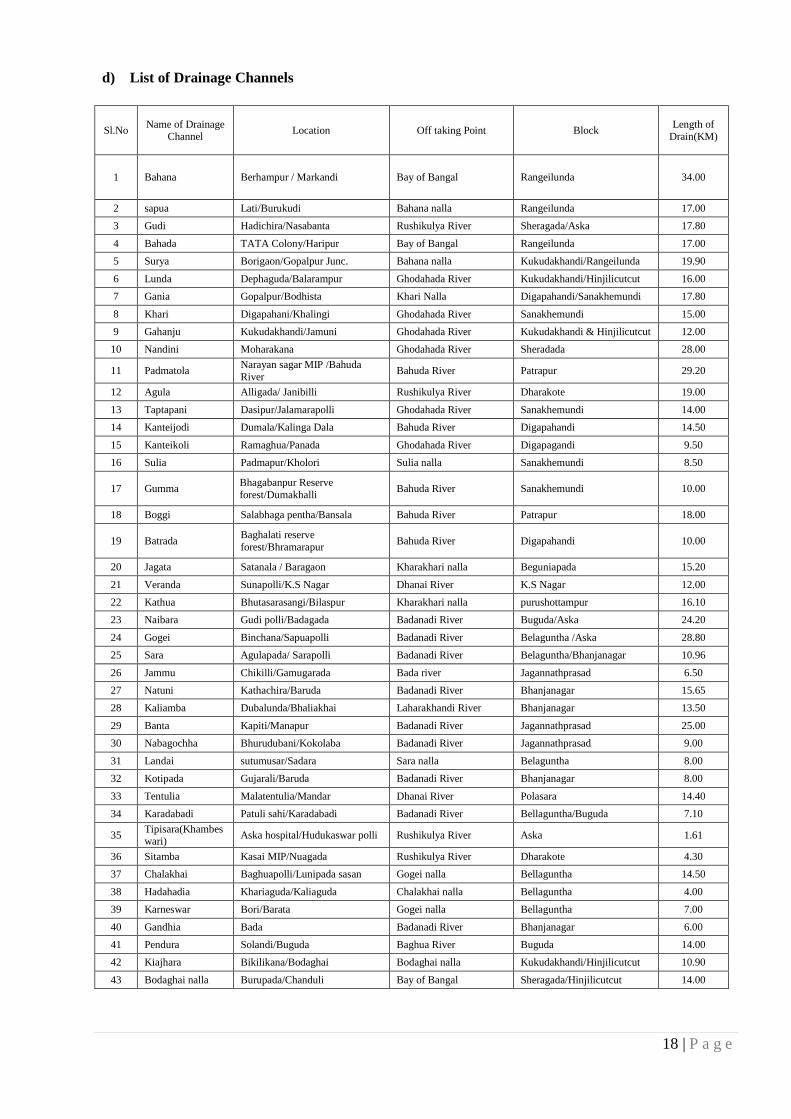
18 | P a g e
d) List of Drainage Channels
Sl.No Name of Drainage
Channel Location Off taking Point Block
Length of Drain(KM)
1 Bahana Berhampur / Markandi Bay of Bangal Rangeilunda 34.00
2 sapua Lati/Burukudi Bahana nalla Rangeilunda 17.00
3 Gudi Hadichira/Nasabanta Rushikulya River Sheragada/Aska 17.80
4 Bahada TATA Colony/Haripur Bay of Bangal Rangeilunda 17.00
5 Surya Borigaon/Gopalpur Junc. Bahana nalla Kukudakhandi/Rangeilunda 19.90
6 Lunda Dephaguda/Balarampur Ghodahada River Kukudakhandi/Hinjilicutcut 16.00
7 Gania Gopalpur/Bodhista Khari Nalla Digapahandi/Sanakhemundi 17.80
8 Khari Digapahani/Khalingi Ghodahada River Sanakhemundi 15.00
9 Gahanju Kukudakhandi/Jamuni Ghodahada River Kukudakhandi & Hinjilicutcut 12.00
10 Nandini Moharakana Ghodahada River Sheradada 28.00
11 Padmatola Narayan sagar MIP /Bahuda
River Bahuda River Patrapur 29.20
12 Agula Alligada/ Janibilli Rushikulya River Dharakote 19.00
13 Taptapani Dasipur/Jalamarapolli Ghodahada River Sanakhemundi 14.00
14 Kanteijodi Dumala/Kalinga Dala Bahuda River Digapahandi 14.50
15 Kanteikoli Ramaghua/Panada Ghodahada River Digapagandi 9.50
16 Sulia Padmapur/Kholori Sulia nalla Sanakhemundi 8.50
17 Gumma Bhagabanpur Reserve
forest/Dumakhalli Bahuda River Sanakhemundi 10.00
18 Boggi Salabhaga pentha/Bansala Bahuda River Patrapur 18.00
19 Batrada Baghalati reserve
forest/Bhramarapur Bahuda River Digapahandi 10.00
20 Jagata Satanala / Baragaon Kharakhari nalla Beguniapada 15.20
21 Veranda Sunapolli/K.S Nagar Dhanai River K.S Nagar 12.00
22 Kathua Bhutasarasangi/Bilaspur Kharakhari nalla purushottampur 16.10
23 Naibara Gudi polli/Badagada Badanadi River Buguda/Aska 24.20
24 Gogei Binchana/Sapuapolli Badanadi River Belaguntha /Aska 28.80
25 Sara Agulapada/ Sarapolli Badanadi River Belaguntha/Bhanjanagar 10.96
26 Jammu Chikilli/Gamugarada Bada river Jagannathprasad 6.50
27 Natuni Kathachira/Baruda Badanadi River Bhanjanagar 15.65
28 Kaliamba Dubalunda/Bhaliakhai Laharakhandi River Bhanjanagar 13.50
29 Banta Kapiti/Manapur Badanadi River Jagannathprasad 25.00
30 Nabagochha Bhurudubani/Kokolaba Badanadi River Jagannathprasad 9.00
31 Landai sutumusar/Sadara Sara nalla Belaguntha 8.00
32 Kotipada Gujarali/Baruda Badanadi River Bhanjanagar 8.00
33 Tentulia Malatentulia/Mandar Dhanai River Polasara 14.40
34 Karadabadi Patuli sahi/Karadabadi Badanadi River Bellaguntha/Buguda 7.10
35 Tipisara(Khambeswari)
Aska hospital/Hudukaswar polli Rushikulya River Aska 1.61
36 Sitamba Kasai MIP/Nuagada Rushikulya River Dharakote 4.30
37 Chalakhai Baghuapolli/Lunipada sasan Gogei nalla Bellaguntha 14.50
38 Hadahadia Khariaguda/Kaliaguda Chalakhai nalla Bellaguntha 4.00
39 Karneswar Bori/Barata Gogei nalla Bellaguntha 7.00
40 Gandhia Bada Badanadi River Bhanjanagar 6.00
41 Pendura Solandi/Buguda Baghua River Buguda 14.00
42 Kiajhara Bikilikana/Bodaghai Bodaghai nalla Kukudakhandi/Hinjilicutcut 10.90
43 Bodaghai nalla Burupada/Chanduli Bay of Bangal Sheragada/Hinjilicutcut 14.00
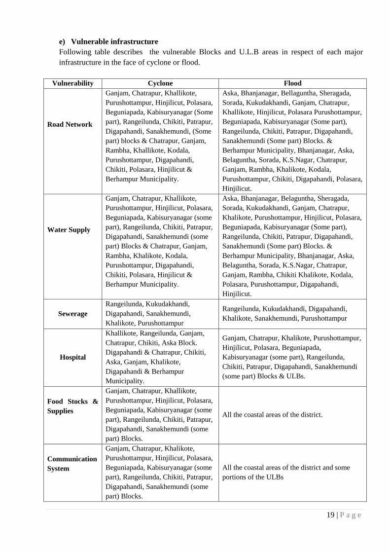
19 | P a g e
e) Vulnerable infrastructure
Following table describes the vulnerable Blocks and U.L.B areas in respect of each major
infrastructure in the face of cyclone or flood.
Vulnerability Cyclone Flood
Road Network
Ganjam, Chatrapur, Khallikote,
Purushottampur, Hinjilicut, Polasara,
Beguniapada, Kabisuryanagar (Some
part), Rangeilunda, Chikiti, Patrapur,
Digapahandi, Sanakhemundi, (Some
part) blocks & Chatrapur, Ganjam,
Rambha, Khallikote, Kodala,
Purushottampur, Digapahandi,
Chikiti, Polasara, Hinjilicut &
Berhampur Municipality.
Aska, Bhanjanagar, Bellaguntha, Sheragada,
Sorada, Kukudakhandi, Ganjam, Chatrapur,
Khallikote, Hinjilicut, Polasara Purushottampur,
Beguniapada, Kabisuryanagar (Some part),
Rangeilunda, Chikiti, Patrapur, Digapahandi,
Sanakhemundi (Some part) Blocks. &
Berhampur Municipality, Bhanjanagar, Aska,
Belaguntha, Sorada, K.S.Nagar, Chatrapur,
Ganjam, Rambha, Khalikote, Kodala,
Purushottampur, Chikiti, Digapahandi, Polasara,
Hinjilicut.
Water Supply
Ganjam, Chatrapur, Khallikote,
Purushottampur, Hinjilicut, Polasara,
Beguniapada, Kabisuryanagar (some
part), Rangeilunda, Chikiti, Patrapur,
Digapahandi, Sanakhemundi (some
part) Blocks & Chatrapur, Ganjam,
Rambha, Khalikote, Kodala,
Purushottampur, Digapahandi,
Chikiti, Polasara, Hinjilicut &
Berhampur Municipality.
Aska, Bhanjanagar, Belaguntha, Sheragada,
Sorada, Kukudakhandi, Ganjam, Chatrapur,
Khalikote, Purushottampur, Hinjilicut, Polasara,
Beguniapada, Kabisuryanagar (Some part),
Rangeilunda, Chikiti, Patrapur, Digapahandi,
Sanakhemundi (Some part) Blocks. &
Berhampur Municipality, Bhanjanagar, Aska,
Belaguntha, Sorada, K.S.Nagar, Chatrapur,
Ganjam, Rambha, Chikiti Khalikote, Kodala,
Polasara, Purushottampur, Digapahandi,
Hinjilicut.
Sewerage
Rangeilunda, Kukudakhandi,
Digapahandi, Sanakhemundi,
Khalikote, Purushottampur
Rangeilunda, Kukudakhandi, Digapahandi,
Khalikote, Sanakhemundi, Purushottampur
Hospital
Khallikote, Rangeilunda, Ganjam,
Chatrapur, Chikiti, Aska Block.
Digapahandi & Chatrapur, Chikiti,
Aska, Ganjam, Khalikote,
Digapahandi & Berhampur
Municipality.
Ganjam, Chatrapur, Khalikote, Purushottampur,
Hinjilicut, Polasara, Beguniapada,
Kabisuryanagar (some part), Rangeilunda,
Chikiti, Patrapur, Digapahandi, Sanakhemundi
(some part) Blocks & ULBs.
Food Stocks &
Supplies
Ganjam, Chatrapur, Khallikote,
Purushottampur, Hinjilicut, Polasara,
Beguniapada, Kabisuryanagar (some
part), Rangeilunda, Chikiti, Patrapur,
Digapahandi, Sanakhemundi (some
part) Blocks.
All the coastal areas of the district.
Communication
System
Ganjam, Chatrapur, Khalikote,
Purushottampur, Hinjilicut, Polasara,
Beguniapada, Kabisuryanagar (some
part), Rangeilunda, Chikiti, Patrapur,
Digapahandi, Sanakhemundi (some
part) Blocks.
All the coastal areas of the district and some
portions of the ULBs

20 | P a g e
Embankments
Ganjam, Chatrapur, Khalikote,
Purushottampur, Hinjilicut, Polasara,
Beguniapada, Kabisuryanagar (some
part), Rangeilunda, Chikiti, Patrapur,
Digapahandi, Sanakhemundi (some
part) Blocks.
All the coastal areas of the district.
Bridges
Aska, Digapahandi, Ganjam,
Kabisuryanagar, Chatrapur,
Hinjilicut, Purushottampur.
Aska, Digapahandi, Ganjam, Kabisuryanagar,
Hinjilicut, Purushottampur, Chatrapur.
f) List of vulnerable /hazard prone blocks/SCs, under PHC/CHC Flood prone areas have
been identified by concerned block level staff basing upon last flood which are listed
below-
SL No Name of the Block No of Flood
prone GP
Village
Population CHC PHC Sub-
center Fully
Marooned Partially
Marooned
Berhampur Zone
Digapahandi 5 6 52 61352 1 4 12
Sanakhemundi 12 32 10 76105 1 6 15
Hinjilicut 5 7 88 88151 1 3 17
Patrapur 10 38 - 62750 1 3 7
Chikiti 6 36 18 34148 1 6 7
Rangeilunda 5 26 98 98239 1 4 15
Kukudakhandi 15 59 - 17122 1 4 15
Khallikote 11 25 - 28268 1 2 7
Sheragada 3 7 7 20108 1 2 2
Chatrapur Zone
Purusottampur 22 45 - 82703 2 5 15
Polasara 14 23 58 82564 1 4 15
Beguniapada 5 11 - 14334 2 3 4
Chatrapur 7 21 - 35652 1 3 12
K.S nagar 14 6 54 92585 1 3 8
Ganjam 6 12 68 90254 1 4 15
Bhanjangar Zone
J.N.Prasad 2 2 88 52010 1 3 3
Bhanjangar 10 39 78 40073 1 5 11
Buguda 7 13 - 16861
Bellaguntha 4 11 59 43420 1 4 4
Aska Zone Aska 11 17 56 34290 1 3 4
Sorada 4 8 48 78357 1 4 14
Dharakote 9 15 8 36170 1 3 9
The estimated population affected in accordance to the information presented in the previous
table is as follow:
Cyclone Flood
Road Network 25,45,800 28,97,000
Water Supply 25,45,800 28,97,000
Hospital 11,65,000 8,58,000
Sewerage 8300
Food Stocks & Supplies 25,45,800

21 | P a g e
g) Sea Coast Erosion
Sea coast erosion is taking place since last 4-5 years and the erosion is taking place
mainly along the north coast line of existing Gopalpur port Near Arjyapalli of Chatrapur Block,
Ramayapatana Area of Rangeilunda Block and Podampetta area of Ganjam Block of the
District. The erosion is severe during monsoon period.
Villages and population to be affected:
Sl No Name Of the Block Name Of the Village Population Affected
1
Chatrapur
Bada Arjipalli 2250
2 Sana Arjipalli 2900
3 K. Arjipalli 500
4 Katuru 2136
5 Rangeilunda Ramayapatna 800
6 Konisi Podampetta 1000
Long Term Measures : To develop a more comprehensive and long term beach protection
mechanism, the cause of such unusual erosion along Odisha coast and particularly along
ArjyaPalli needs to be addressed. Premier coastal Organizations like, IITM, NIOT, NIO,
ICMAM etc may be assigned to study and ascertain the possible causes as well as long term
remedial measures to bring a permanent solution to this erosion problem. Local Organizations
like Berhampur University may be associated with them for temporal as well as local study
because of their proximity to the related situation.
ICZM Project, Odisha is planning a Regional Coastal Process Study along Odisha coast.
During such study this region may be specifically considered with other hot spots along Odisha
coast regarding coastal erosion to attribute specific reason for the same & subsequent
development of permanent remedial measures for them. GPL authority has been directed to
construct total 7 no of groynes along the south coast lines as per their plan. Action has already
been taken to evacuate the villagers of Podampetta to another place for their rehabilitation.

22 | P a g e
h) Vulnerability analysis
Following is a table indicating the social, physical and economic, and environmental vulnerabilities when it comes to the main hazards
faced by Ganjam. There is also a column describing the impact of climate change in this context and how it increases either the hazard probability
or its impacts in the region.
No Hazard
Vulnerabilities Impact of Climate
Change on
vulnerabilities Social Physical and Economic Environment
1 Cyclone Ganjam is the 5th district in terms of size and
1st in terms of population in Odisha making
the district vast and vulnerable to cyclones.
Population in 11 (50%) Blocks (including two
blocks partly) are highly vulnerable to
cyclone.
Particularly women (49.59% of the total
population) and children 0-6 years (11.91% of
the total population in the district)
Elderly and persons with disability
Ganjam, Chatrapur, Chikiti, Rangeilunda and
Khallikote Blocks are identified as most
vulnerable to cyclone risk
Population in coastal villages (60.85 KMs of
coastline which is 12.67% of total Coastline in
Odisha) are highly vulnerable
Households living Below poverty Line with
limited economic capacity (55% as per 1997
Census)
Roads and communication
network
Private & Public Infrastructures
Dwelling units (kutcha and semi-
pucca which are approximately
Crop – Agriculture/ Horticulture.
There are 2,34,066 cultivators
and 1,85,015 agricultural
laborers who are vulnerable3
Irrigation Sources:
o Canals (252 Nos)
o Tanks (258 Nos)
o Open Wells (1538 Nos)
o Bore wells (367 Nos)
o Lift irrigation schemes
(357Nos)
o Other Sources (5357
Nos)4
Forests
(266504.75
Hector which is
38% of the total
land in the
district)
Flora and Fauna
in forests
Local
Ecosystem
Roadside and
village
plantations
Air
Water
Saline
inundation
Soil
The increasing frequency
of Cyclones under the
influence of climate
change as witnessed over
the past few years and
projections for increasing
extreme cyclones with
higher wind speed with
increased frequency in
future poses higher threat.
3 Data Derived from Census Handbook of Ganjam District (2011) available at http://www.censusindia.gov.in/2011census/dchb/2119_PART_B_DCHB_GANJAM.pdf 4 Data taken from agricultural contingency plan of Ganjam (2011) available http://agricoop.nic.in/Agriculture%20Contingency%20Plan/Orissa/Orissa%2014-%20Ganjam%2031.05.2011.pdf

23 | P a g e
Households residing in kutcha and semi pucca
houses
Lack of awareness and unwillingness to
evacuate in emergency
Lack of complete awareness and sensitization
on understanding and adhering to warnings
among communities
In adequate health infrastructure in interior
areas.
Non-availability of youth (migrated) at the
time of emergency for community based
response
Livestock and animal resources.
Energy infrastructure like
electrical posts, lines, grids,
lamps, transformers etc.
Drinking Water Sources i.e. hand
pumps, Tube wells, Wells, PHD
Stand Posts.
Livestock & animal resources
Other vulnerable assets i.e. Flood
embankments, Canal
embankments, Small Sale
industries, PMRY units,
Handloom units, Fishing Boats,
Fishing nets, Textile Units,
Cashew plantations, Sericulture
Units, Casuarinas plantation
2 Tsunami Population Chikiti, Rangeilunda, Chatrapur
and Ganjam Blocks are identified as highly
vulnerable to Tsunami
It includes 55 villages and 2 NACs within 1.5
KMs of coastline
Fishermen, micro businesses etc at sea coast
are more vulnerable to life risk
Children, women, elderly and persons with
disabilities
Boats and assets of fisherman
Water transport system
Coastal dwellings
Crops (agricultural and
horticultural) in coastal villages
Roads and communication
network in coastal belt
Drinking water and sanitation
facilities in coastal belt
Schools, colleges, hospitals and
other private and public
infrastructures in coastal belt
Cultural heritage and monuments
in coastal belt
Contamination
of coastal
ecosystem
Contamination
of freshwater
sources
Saline intrusion
Tsunami has no direct
linkage with climate
change.
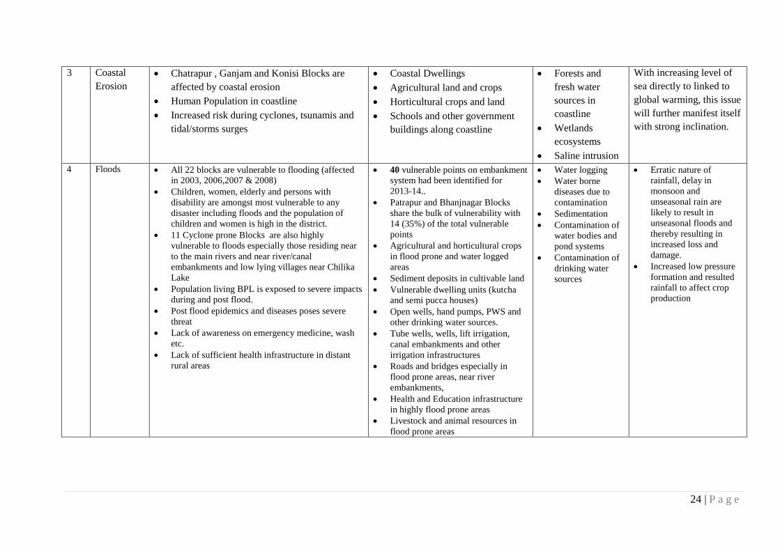
24 | P a g e
3 Coastal
Erosion
Chatrapur , Ganjam and Konisi Blocks are
affected by coastal erosion
Human Population in coastline
Increased risk during cyclones, tsunamis and
tidal/storms surges
Coastal Dwellings
Agricultural land and crops
Horticultural crops and land
Schools and other government
buildings along coastline
Forests and
fresh water
sources in
coastline
Wetlands
ecosystems
Saline intrusion
With increasing level of
sea directly to linked to
global warming, this issue
will further manifest itself
with strong inclination.
4 Floods All 22 blocks are vulnerable to flooding (affected
in 2003, 2006,2007 & 2008)
Children, women, elderly and persons with
disability are amongst most vulnerable to any
disaster including floods and the population of
children and women is high in the district.
11 Cyclone prone Blocks are also highly
vulnerable to floods especially those residing near
to the main rivers and near river/canal
embankments and low lying villages near Chilika
Lake
Population living BPL is exposed to severe impacts
during and post flood.
Post flood epidemics and diseases poses severe
threat
Lack of awareness on emergency medicine, wash
etc.
Lack of sufficient health infrastructure in distant
rural areas
40 vulnerable points on embankment
system had been identified for
2013-14..
Patrapur and Bhanjnagar Blocks
share the bulk of vulnerability with
14 (35%) of the total vulnerable
points
Agricultural and horticultural crops
in flood prone and water logged
areas
Sediment deposits in cultivable land
Vulnerable dwelling units (kutcha
and semi pucca houses)
Open wells, hand pumps, PWS and
other drinking water sources.
Tube wells, wells, lift irrigation,
canal embankments and other
irrigation infrastructures
Roads and bridges especially in
flood prone areas, near river
embankments,
Health and Education infrastructure
in highly flood prone areas
Livestock and animal resources in
flood prone areas
Water logging
Water borne
diseases due to
contamination
Sedimentation
Contamination of
water bodies and
pond systems
Contamination of
drinking water
sources
Erratic nature of
rainfall, delay in
monsoon and
unseasonal rain are
likely to result in
unseasonal floods and
thereby resulting in
increased loss and
damage.
Increased low pressure
formation and resulted
rainfall to affect crop
production

25 | P a g e
5 Village
Fire Households residing in thatched and mud
houses
Increased dry period with limited rainfall
Use of open fire-wood and open fire kitchen in
rural areas
Interior areas not under the reach of fire tender
Fire tenders not enough to cover total
population
Lack of complete awareness and sensitization
on fire prevention
Gradual erosion of traditional coping measures
Residential buildings
(particularly kucha and semi
pucca)
Public Infrastructure (Schools
with kitchen)
Micro and small business
infrastructures (especially road-
side dhabas, restaurants etc)
Crowded haats and markets in
towns and NACs
Other commercial establishments
Hospitals
Cultural heritage
Government offices and
infrastructure (electrical fire)
particularly old buildings district,
block and Panchayat level
Air pollution
Increased heat in
summers and
wind acting as
fuel to fire
accidents
With increase in global
temperature and increased
duration of dry season,
vulnerability to fire
accidents can be high
6 Drought Drinking water crisis in already hard hit areas
Limited access and availability of tapped
water supply as only 324 (10.04%) villages
have access to tapped water supply
Vulnerability to famine and diseases
Agriculture (as , 164,000 Ha
41.30% of cultivated land is
rain-fed5)
Horticulture crops
Drying up of water sources such
as open wells, tube-wells, hand
pumps etc
In-adequate health infrastructure
to deal with acute health
emergency/famine in distant
areas
Livestock diseases and deaths
and possible famine
Drying of trees
and shrubs
Impact upon
green fields
Contamination of
air and air borne
diseases
Projections confirm
further increase in
magnitude and
frequency of droughts
with uncertainties
associated with rainfall
Agriculture health,
water and sanitation
will be highly affected
with increased drought
spell
Increased pressure upon
water sources and
demand for external
water supply from
outside sources
5 Agricultural Contingency Plan of Ganjam (2011) available at http://agricoop.nic.in/Agriculture%20Contingency%20Plan/Orissa/Orissa%2014-%20Ganjam%2031.05.2011.pdf
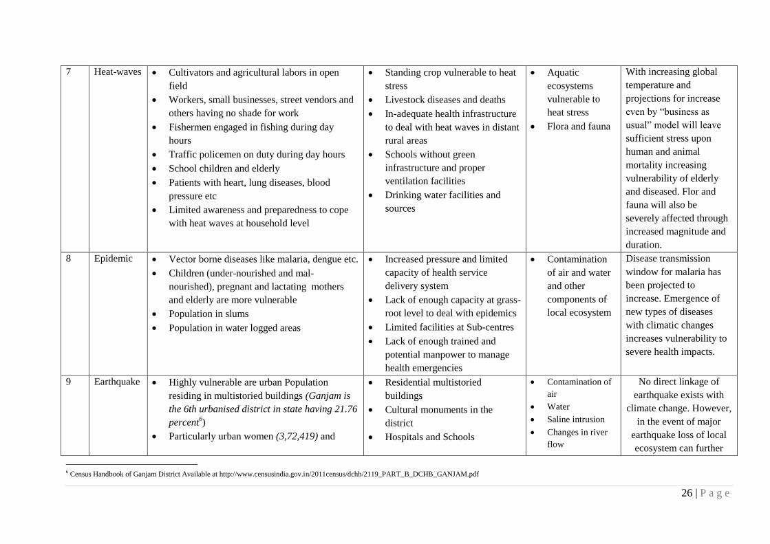
26 | P a g e
7 Heat-waves Cultivators and agricultural labors in open
field
Workers, small businesses, street vendors and
others having no shade for work
Fishermen engaged in fishing during day
hours
Traffic policemen on duty during day hours
School children and elderly
Patients with heart, lung diseases, blood
pressure etc
Limited awareness and preparedness to cope
with heat waves at household level
Standing crop vulnerable to heat
stress
Livestock diseases and deaths
In-adequate health infrastructure
to deal with heat waves in distant
rural areas
Schools without green
infrastructure and proper
ventilation facilities
Drinking water facilities and
sources
Aquatic
ecosystems
vulnerable to
heat stress
Flora and fauna
With increasing global
temperature and
projections for increase
even by “business as
usual” model will leave
sufficient stress upon
human and animal
mortality increasing
vulnerability of elderly
and diseased. Flor and
fauna will also be
severely affected through
increased magnitude and
duration.
8 Epidemic Vector borne diseases like malaria, dengue etc.
Children (under-nourished and mal-
nourished), pregnant and lactating mothers
and elderly are more vulnerable
Population in slums
Population in water logged areas
Increased pressure and limited
capacity of health service
delivery system
Lack of enough capacity at grass-
root level to deal with epidemics
Limited facilities at Sub-centres
Lack of enough trained and
potential manpower to manage
health emergencies
Contamination
of air and water
and other
components of
local ecosystem
Disease transmission
window for malaria has
been projected to
increase. Emergence of
new types of diseases
with climatic changes
increases vulnerability to
severe health impacts.
9 Earthquake Highly vulnerable are urban Population
residing in multistoried buildings (Ganjam is
the 6th urbanised district in state having 21.76
percent6)
Particularly urban women (3,72,419) and
Residential multistoried
buildings
Cultural monuments in the
district
Hospitals and Schools
Contamination of
air
Water
Saline intrusion
Changes in river
flow
No direct linkage of
earthquake exists with
climate change. However,
in the event of major
earthquake loss of local
ecosystem can further
6 Census Handbook of Ganjam District Available at http://www.censusindia.gov.in/2011census/dchb/2119_PART_B_DCHB_GANJAM.pdf

27 | P a g e
children (77,695)
Slum dwellers
Crowded areas of different towns and NACs
Risk of Tsunami
Population in distant areas
Risk of fire and chemical accidents
particularly in Ganjam and Chatrapur Blocks
and Ganjam NAC
Post Earthquake epidemics
Industrial infrastructure
Commercial establishemnts
Embankments (River and saline)
Drinking water supply (PWS)
Energy infrastructure (Lamps,
posts, pillers, grids etc)
Roads and bridges
Flora and fauna contribute to climatic
changes
10 Industrial
and
Chemical
Population in industrial areas of Ganjam and
Chatrapur Blocks
Entire population to health consequences
Possibility of epidemic
Diseases and deaths of livestock
Children and infant
Lactating and pregnant women
Elderly and disabled
Crop failure
Public and private property
around industrial area
Drinking water and sanitation
facilities
Hospital infrastructure
Contamination
of air and water
Flora and fauna
Local ecosystem
Nil

28 | P a g e
i) Drought
Drought conditions appear due to deficit rainfall over an extended period of a
season, year or even more/ failure of rains in season with those of normal rainfall of a region
/ natural scarcity of water and other climatic factor. If the rainfall deficit is between 26-50%,
the drought is classified as 'moderate', and if the deficit exceeds 50% it is ‘severe’. This
causes distress situation and water problem for people, animals and agriculture crop. Overall
degradation of forest cover, accelerated soil erosion, encroachment/extinction of traditional
water bodies / ponds/water harvesting structures are the factors leading to runoff of
rainwater and cited as cause of drought.
Not only the total quantum of rainfall, but also its equal distribution over all
regions matters for agricultural operations and crop production.
Ordinarily, declaration of drought in respect of a particular area is made by
Government, after taking into consideration of the weather & crop situation report and the
crop assessment as per crop cutting assessment done. It is recognition of distress, for the
alleviation of which the ameliorative measures and relief administration are adopted. To
address this situation, immediate drought relief in terms of Govt. grants and schemes are to
be put in place and apart from that there has to be efforts by various Govt. departments,
humanitarian agencies and the people themselves through long term initiatives which would
mitigate future possibilities.
Almost all the blocks have been affected by droughts in1996, 2002, 2011 and
4 Blocks in 2009 drought and 16 blocks in 2015 drought were affected. In the most recent
drought experienced in 2015, the below stated blocks, G.P and U.L.Bs were affected.
AREAS AFFECTED DURING 2015 DROUGHT
Sl.
No
Name of the
Blocks/ULBs
affected
Name of the GP/Ward affected
Total area of
land affected
(in Hectare)
Approximate value of
loss of crops ( in Rs.)
1 2 3 4 5
1 Chatrapur Narendrapur, Kanamana,
Bhikaripalli, Tanganapalli 469.2216 8085392
2 Ganjam
Palanga,Santoshpur, Ramagada,
Poirasi,Khandadeuli,Subalaya, Sana
Ramachandrapur, UDSPur, Mallada,
Palibandha, Kainchapur
Ganjam NAC (Ward No.5 with 8 &
Ward No. 10)
707.3698 12189043
3 Khallikote Pathara 62.0108 1068539
4 Beguniapada Barida, Sumandala,Chandanapur,
Burujhari, Sourachhachina 188.8864 3254796
5 Purushottampur
Badakharida, Tankachhai,
Bhutasarasingi, Ch. Nuagam,
Jhadabai, Antarigam
346.3724 5968516
6 Polasara Gochhabadi, Pandiripada 368.7900 6354805
7 Jagannathprasad
Jagannathprasad, Gayaganda,
Kokalaba, Rudhapadara, Tarasingi,
Khetamundali, Gereda, Gandadhara,
Jhadabhumi, B.D.Pur Panchababhuti,
Budugungu, Chhamunda, Kadua,
Alasuguma, Rauti, Pratapur,
Kudutei, Adheigaon
3456.5892
59562217
8 Bellaguntha Badapada, Udhura, Tanarada,

29 | P a g e
Mangalapur, Gangapur, Ambapua,
Khetribarapur, Badabarasingi,
Dhumuchai, Banka
329.8826 5684372
9 Bhanjanagar Domuhani, Tilisingi, Harigada 854.8830 14730916
10 Aska
Pandiapathara, Khandadeuli,
Kendupadar, Munigadi, Siddhanai
Gunthapada,Gangapur, Alipur,
Babanapur,Balisira,Kharia,Nimina,
Kamagada, Bhetanai, Balichhai
191.1003 3292945
11 Buguda
Antarapada,Arakhapur,Bhagabanpur,
G.Gobara, Golia,Karachuli,Manitara,
Motabadi, Sankuru,
Buguda NAC ( B.D.Pur Ward No.6 &
Harisasanapur Ward No.6)
1094.9157 18867127
12 Chikiti Girisola, Govinda Nagar, Subani,
Surala, Jhatipadar, Sunapur,Katuru,
Eksingi
3092.9470 53296116
13 Kukudakhandi Dengapadar,Kanika, Kukudakhandi,
Ankushpur 34.8181 599968
14 Patrapur
Patrapur,Badapur,Surangi, Turubudi,
Mandarada,Khariaguda, Ankuli
Ambapur, Gundra, Khambarigam,
Baranga, Samantiapalli,B.Nuagam,
Kesharipada,Jayantipur,Gudipadar,
Jarada,Samantarapur,Tumba,Buratala
3603.2338 62089123
15 Sanakhemundi S.Gopalpur,T.Govindapur,Podamari,
Pattiguda,Chhanameri,Moulabhanja,
Singipur
56.5500 974441
16 Digapahandi
S.Tikarapada, Bhismagiri,Phasiguda,
Chasanimakhandi,Kaithakhandi,
Padmanabhapur,Ankarada, Kusapada,
Gokarnapur,Basudevpur, Sidheswar,
Turubudi,Badadumula, Gada
Govindapur, Jakara, Karapada,
Bomakei, Khamarigam, B.L.N.Pur,
Ch. Tikarapada,
Digapahandi NAC (Nimapalli Ward
No.-2)
389.2397 6707184
Total 15246.8104 26,27,25,500/-
30 | P a g e
j) Vulnerability
Due to erratic rainfall, all the blocks of the district of Ganjam are taken as vulnerable
to Droughts.
River system is not enough to cater to the irrigational needs of large extent of
farming lands as those are only seasonal in nature.
Many acrage of agricultural lands lies on the hilly slopes/ terrains of Chikiti,
Patrapur, Sanakhemundi & Sorada Blocks.
The average annual rainfall of 127.62 cm is also not on a higher side. If all the
rainfall do not pour in the appropriate season, moisture stress is experienced and drought occurs
areas in many parts of the district. Such situation is going to be very common in upcoming years
due to climatic change.
As majority chunk of population is dependent upon agriculture & agricultural labour,
loss of crop has a cascaded effect in all concerns of life in the district. Apart from crop damage,
there is loss of livelihood, loss of cattle feed, loss of purchasing power, loss of business and so
on.
Hence, only disbursement of agricultural input to affected farmers will not improve
the situation. Long term measures by line departments such as creation of labour days,
restructuring /waving of agricultural loans, supply of agricultural kits, exploring water
harvesting structures, restructuring, restoration and improvement of irrigation and canal systems
etc. are issues to be taken up with all seriousness. S.O.P for all required line departments to
mitigate drought has been discussed in Response Sub Plan at 1.1.36.

31 | P a g e
III. CAPACITY ANALYSIS
________________________________________________________________________________
The capacity refers to the key resources that are available within a district to cope
with any emergency situation and minimize its impacts. These capacities may be physical
(infrastructure, equipment, vehicles, and machines) or human resources (officials, volunteers,
communities, and other stakeholders). Ganjam has got varieties of resources and capacities
which are useful in emergency as well as normal situations. Below, different key capacities
available in the district are explained.
In order to better capture the capacity of the district to handle with disasters and
prevent them from happening, it is important to analyse the preparedness level of line
departments within the local administration. In the Annexure (annexure 2), a table filled by the
head of each line department or the nodal contact for disaster management is provided. It
enables the department to point the resources available against the number required for efficient
service delivery during an emergency. Similarly communication devices availability has been
given in Annexure 4 & 5. Availability of power boats and equipments available at Multi
Purpose Cyclone Shelter are indicated in Annexure 6 & 9. Equipments available at District
Emergency Operation Centre and ODRAF are given at Annexure 8 & 9(b) respectively.
Storage facility with capacity
Storage of food in accessible pockets is as vital as building shelters. All the Block
headquarters and Gram Panchayat Offices are used as storage points when need arises. The
BDOs and CSO official in charge of the respective blocks are the contact person for the block
headquarters and the Panchayat Secretaries are the contact person for the G.P. offices. Adequate
quantity of rice has been kept with BDOs at each block headquarters for distribution to the
victims as immediate relief. These locations are used as storage locations for medicines,
blankets. It has been decided to keep adequate stock of rice in the following places for
distribution of emergent relief.
a) Availability of storage facility at blocks & district level:
Sl No Block
Govt.
Godowns
Available
Type of Storage
Structure
Private Godowns
available Remarks
1 Chatrapur R.C.C.
On
e G
ovt.
Rel
ief
Go
do
wn
at
the
Dis
tric
t H
ead
Qu
art
er N
ear
Dis
tric
t
Em
ergen
cy C
ell
(DC
R)
2 Ganjam R.C.C.
3 Rangeilunda R.C.C.
4 Kukudakhandi R.C.C.
5 Khalikote R.C.C.
6 Purushottampur R.C.C.
7 Hinjilcut R.C.C.
8 Digapahandi R.C.C.
9 Kabisurya Nagar R.C.C.
10 Chikiti R.C.C.
11 Beguniapada R.C.C.
12 Aska R.C.C.

32 | P a g e
13 Sanakhemundi R.C.C.
14 Sheragada R.C.C.
15 Patrapur R.C.C.
16 Dharakote R.C.C.
17 Polasara R.C.C.
18 Buguda R.C.C.
19 Bhanjanagar R.C.C.
20 Sorada R.C.C.
21 Belaguntha R.C.C.
22 Jagannath Prasad R.C.C.
b) Voluntary Organizations
List of Voluntary Organizations
NGO/ CBO Address Chief Functionaries Block Ph.No.
ISRD Berhampur Sudhir Sabata Ganjam District 9437064171
UAA Ganjam Mangaraj Panda Ganjam District 9437064314
Samata Khallikote Nilanchala Panda Khallikote 9439542939
AFRM Khallikote Rajib Kumar
Khadanga
Khallikote 06810256542
9337858371
ODISA Polasara Gopal Pattnaik Polasara 9861331557
Jagruti Hinjilicut Jaya Krushna Sahoo Hinjilicut 06811280758
9938961128
Shelter Ganjam Uma Sankar Dash Ganjam 9937184713/
9438661949
Nirmata Chatrapur Sarbeswar Mohapatra Ganjam District 06811227850
9861136790
AVS Purushottampur K.Gurumurty Purushottampur 06811275603
VIKASH Purushottampur Gokul ch. Das Purushottampur 9437258757
SMYSP Mathura
Polasara
Prabhat Ku Sasmal Polasara 9338090911
Bhautik Chikiti Prasanta Kumar
Mandal
Chikiti 9938609050
CURES G B nagar,
Chatrapur
Arun Kumar Satapathy Chatrapur 9861234438
Samparka Kukudakhandi Arun Kumar Pattnaik Kukudakhandi 9437423711
Woman Berhampur Pratima Suar Rangeilunda 9938556396
Pragati
Pathagara Digapahandi
Nalinikanta Kar Digapahandi 0681425569
9437956520
Nirdesh Jagannathprasad Giridhari Pattanaik JN Prasad 06818262101
9437622291
Kamdhenu Ganjam Tuna Maharana Ganjam 9861587344
NJYS Sheragada Surjya Narayan Dash Sheragada 9438464530
Bhanu Aska Pabitra Gouda Aska 9861874906
Sradha Chikiti Manoj Padhi Chikiti 9778188254
Samparka Chikiti Mahendra Patra Chikiti 9437261951
Pallipathagara Chikiti Mahendra Patra Chikiti 9437261951
VISAC Sheragada Arun Ku. Tripathy Sheragada 06822257034
9861121306

33 | P a g e
ICHRD Sheragada Dr. Durga Pr. Biswal Sheragada 06814251835
Aurobindo Club Ganjam Rasananda Behera Ganjam 9040821839
PAID S J Street Dhirua Panda Ganjam 9437203820
LWS Chatrapur P K Bhoi Chatrapur 06811263247
c) NSS Units
List of NSS Units/ Address of Principals & Programme Officers
Name of the College No. of programme
Officer
No. of Volunteer
Male Female
Anchalika Sc. College, Ganjam 5 4 1
Anchalika Mahavidyalaya, JNPrasad 3 3
Binayak Acharya College, Berhampur 2 1 1
B.S.College, Patapur, Ganjam 2 1 1
Chikiti Mahavidyalaya 4 3 1
Berhampur City College, Ambapua, Berhampur 3 2 1
Coop. Homeopathy Medical College, Ganjam 2 1 1
Art & Craft College, Khalikote 1 1
College of Pharmaceutical Science, Mohuda 1 1
DPIASE, Kanisi 1 1
Gopalpur College, Gopalpur 4 3 1
Ganjam College, Ganjam 2 2
Govt. College, Chatrapur 2 1 1
Ganjam Law College, Berhampur 2 2
KATS Ayurvedic College, Ankushpur 1 1
K.M.Science College, Narendrapur 3 2 1
B.B.V.Mahavidyalaya, K.S.Nagar 1 1
Khalikote (Autonomous) College, Berhampur 3 2 1
KSUB College, Bhanjanagar 5 4 1
Keshpur College, Keshpur 3 2 1
L.N.Mahavidyalaya, Kodala 3 2 1
Lingaraj Law College, Berhampur 2 2
MKCG Medical College 1 1
Mahamayee Mahila Mahavidyalay Berhampur 4 4
NPC College, Kendupadar 4 4 1
NR (Govt) Women’s College, Aska 1 1
NSB Mahavidyalaya, Nuavapada 2 2
Peoples College, Buguda 3 2 1
Science College, Polasara 4 4
PG Center for Management Studies, Ankushpur 3 2 1
PG Council, Berhampur University 3 2 1
R.N.College, Dura 3 3
Rushikulya College, Sorada 5 4 1
Ramjee Mahavidyalaya, Bhismagiri, Digapahandi 2 2
RCM Science College, Khalikote 14 13 1
Roland Institute of Pharmaceutical Science, Berhampur 3 2 1
Sri Jagannath Mahavidyalaya, Rambha 3 2 1

34 | P a g e
Savitri Women’s College, Bhanjanagar 2 2
SBS College, Khandadeuli 2 2
SBP Mahavidyalaya, Samunitapali 3 2 1
Science College, Aska 4 3 1
Science College, Hinjilicut 4 3 1
Science College, Kukudakhandi 1 1
Science College, Konkarada 2 2
Science College, Bellaguntha 2 1 1
SBR (Govt.) Women’s College, Berhampur 1 1
TSD College, BDPur, JN Prasad 4 3 1
Tara Tarini College, Purushottampur 2 2
University Higher Secondary School, BU 1 1
UP Science College, Sheragada 3 1 2
Women’s College, Chatrapur 1 1
DM Science Collage, Gallery 1 1
Each Unit consists of : 50 NSS Volunteers
Total No. of Male Units : 103 Units x 50 Volunteers per unit = 5150
Total No. of Female Units : 38 Units x 50 Volunteers per unit = 1900
Total Volunteers : 7050
d) Country Boats
List of Country Boats available
Sl. No. Block Villages No. of Boats
1
Ganjam
Prayagi 76
2 Kantiagada 122
3 Gokharkuda 56
4 Purunabandha 165
5
Chatrapur
Nolia Gaon 225
6 Sana Arjyapalli 170
7 Bada Arjyapalli 70
8 Katuru 25
9
Rangeilunda
Gopalpur 140
10 New Buxipalli 166
11 New Golabandha 142
12 Garampetta 73
13 Markandi 127
14 Pati Sonapur 95
15 Chikiti Sonapur 48
16 Rameyapatana 90
Total 1790
Taking stock of resources available with District Administration, Private, Individuals and
different Govt. officials and their deployment at the time of calamity for Relief/ Rescue Operation
is of vital importance.

35 | P a g e
Multipurpose Cyclone Shelter by OSDMA 35
Multipurpose Flood Shelter by OSDMA 13
Multipurpose Cyclone Shelter by Red Cross/LWS 3
School cum Cyclone Shelter (High School) 138
School cum Cyclone Shelter (Primary School) 104
e) Communication Equipments in the District
Telephone Connectivity( Land and Mobile) District Office, Sub-division, Block, Tahasil & other
Offices
Police VHF & Wireless All Police Stations and Out post
Civil VHF District Office, Sub-Division, Block, Tahasil & GP
Office
Cyclone Warning Dissemination System
(CWDS) DCR, Ambapua
f) Vehicle Position (Approx.)
Sub-Divison Truck Bus Tractor Trekker Jeep Excavator
Chatrapur 368 85 410 265 201 18
Berhampur 481 98 598 318 248 20
Bhanjanagar 418 55 385 207 178 22
District Total 1267 238 1393 790 627 60
g) Electricity Equipment (GRIDCO)
Sl. No. Equipment Quantity Available Location
1 Electric Drill 2 EHT maintaince Division, Berhampur
2 Cheeping Hammer 4 EHT maintaince Division, Berhampur
3 Jack with 5 ton 1 EHT maintaince Division, Berhampur
4 Slag Hammer 3 EHT maintaince Division, Berhampur
5 Single Sheave 3 EHT maintaince Division, Berhampur
6 Fire Extinguisher ABC type 12 EHT maintaince Division, Berhampur
7 Fire Extinguisher C02 type 10 EHT maintaince Division, Berhampur

36 | P a g e
ANNEXURE
Annexure 1: List of the Villages Vulnerable to Tsunami
Villages within 1.5 K.Ms of coastline
Sl No Block GP Tsunami village
1
Chatrapur
Agastinuagaon
Agastinuagaon
2 Bada Nolianuagaon
3 Sana Nolianuagaon
4
Karapalli
Badaputi
5 Upalapati
6 Bandar
7 Haripur
8 Reykatur
9 Basanaputi
10 Arjyapalli
Bada Arjyapalli
11 Sana Arjyapalli
12 Kanamana
Kanamana
13 Matikhala
14
Ganjam
Palibandha
Palibandha
15 Purunabandha
16 Binchanapalli
17 Kundaput
18 Suryanarayanpur
19 Laxmipur
20 Gokharkuda
21 Mayurpada
22 Niladripur
23 Kantiagada
24 Khatuakuda
25 Podampetta
26
Ramagada
Prayagi
27 Kalarabadi
28 Pallurgada
29 Gajapati Nagar
30 Hansapur
31 Arunpur
32 Madhusudanpur
33 NAC Ganjam Ganjam town Ganjam town
34
Chikiti
Katur
Aladpur
35 Chandanbada
36 Ramayapatana
37 Eksingh
Eksingh
38 Dankalpadu
39 Sunapur
Sunapur
40 Patisunapur

37 | P a g e
41
Rangeilunda
Kamalpur Haripada
42 Nuagolabandha
43
Buxipalli
Buxipalli
44 Nuabuxipalli
45 Venkatraipur
46 Digipur
47 Narayanpur Narayanpur
48 Indrakhi
Markandi
49 Indrakhi
50
Keluapalli
Lahudigaon
51 Garampetta
52 Kirtipur
53
Sasanpadar
Dhepanuapada
54 Nakarama
55 Phasinuapada
56 Golabandha Golabandha
57 Gopalpur NAC Gopalpur town Gopalpur town

38 | P a g e
Annexure 2: Line Department Resources Analysis S.
No Department Category Resource Current Quantity
Required
Quantity Gap Analysis
1 Agriculture
Agro-inputs &
technical persons
Seed 30000 Qtl 30000 Qtl -
Fertilizer 20000 MT 63000 MT 43000 MT
Pesticide 1200 ltr 3500 ltr 2300ltr
Technology KVK,Specialist, Extn
Officers - -
Implements 1100 nos 1500 nos 400
2
M.I.Divn,
Bhanjanagar
Infrastructure
Vehicle 2 4 2
Manpower 46 80 34
Shutter repair 376 420 44
3
R.W.Div-II,
Berhampur
Infrastructure
Machinery
Vehicle
Human Resource
MCS 27 More
Road Rollers 6 Nos 6 Nos -
Inspection vehicle
jeep/Bolero 5 Nos 5 Nos -
Technical person( Field
staff) 14 NOs 16 Nos 2 Nos
4
E.E. R& B Divn-II
Berhampur
Infrastructure
Machinery
Vehicle
Human Resource
Inspection Vehicle 2 Nos 4 Nos 2 Nos
JCB on hire 4 Nos 8 Nos 4 Nos
Trucks on hire 3 Nos 6 Nos 3 Nos
Empty Gunny Bags 600 Bags 1500Bags 900 Bags
Wooden Bullahas on hire
150 Nos 500 Nos 350 Nos
Mobile Phone 15 Nos 15 Nos -
Diesel Generator Set 1 Nos 4 Nos 3 No
5
E.E. R& B Divn-I
Berhampur
Infrastructure
Machinery
Vehicle
Inspection Vehicle 3 Nos 5 Nos 2 Nos
JCB on hire 8 Nos 8 Nos -
Trucks on hire 6 Nos 6 Nos -
Empty Gunny Bags 2000 Bags 2000 Bags -
Wooden Bullahas on hire
500 Nos 500 Nos -
Diesel Generator Set 4 Nos 4 Nos -
6
N.H. Divn.
Berhampur
Infrastructure
Machinery
Vehicle
Inspection Vehicle 4 nos. 4 nos. -
JCB on hire - 8 nos 8 nos
Trucks on hire - 6 6
Empty Gunny Bags
3000 3000
Wooden Bullahas
500 500
Mobile Phone 11 11 -
Diesel Generator Set - 4 4
7 L.I.Divn Vehicle Jeep/Car 2 (old) 5 3
8 DFO Ghumsur North
Divn. Bhanjangar Emergency Kit Power Saw 0 5 Nos
Hand Saw 05 5 Nos
Emergency Light 10 10 Nos
Plastic Rope 0 500 Mtr
Tent 0 5 Nos
Vehicle Bolero 1 Nos --
Meant for officers
use for protection
Jeep 1 Nos --
Meant for officers
use for protection
Camper Bolero 1 Nos --
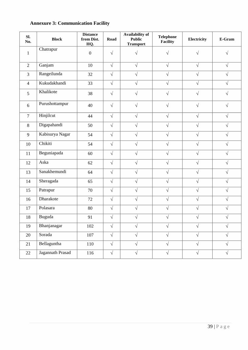
39 | P a g e
Annexure 3: Communication Facility
Sl.
No. Block
Distance
from Dist.
HQ.
Road
Availability of
Public
Transport
Telephone
Facility Electricity E-Gram
1 Chatrapur
0
2 Ganjam 10
3 Rangeilunda 32
4 Kukudakhandi 33
5 Khalikote 38
6 Purushottampur 40
7 Hinjilcut 44
8 Digapahandi 50
9 Kabisurya Nagar 54
10 Chikiti 54
11 Beguniapada 60
12 Aska 62
13 Sanakhemundi 64
14 Sheragada 65
15 Patrapur 70
16 Dharakote 72
17 Polasara 80
18 Buguda 91
19 Bhanjanagar 102
20 Sorada 107
21 Bellaguntha 110
22 Jagannath Prasad 116

40 | P a g e
Annexure 4: List of the Police Stations of Chatrapur District and Availability of
Communication System
Sl. No. Police Station/ Out Post Availability Communication System
1 Chatrapur VHF/ Telephone
2 Chatrapur Town Out Post VHF/ Telephone
3 Aryapally Out Post VHF
4 Rambha VHF/ Telephone
5 Humma Out Post VHF/ Telephone
6 Khalikote VHF/ Telephone
7 Bhejiput Out Post VHF/ Telephone
8 Kodala VHF/ Telephone
9 Purushottampur VHF/ Telephone
10 Balichai VHF 11 Polasara Out Post VHF/ Telephone 12 Kabisurya Nagar VHF/ Telephone
13 Beguniapada VHF/ Telephone
14 Chamakhandi VHF/ Telephone
15 Hinjilcut C.I. Office Telephone
16 Aska VHF/ Telephone
17 Aska Town Out Post VHF
18 Patrapur VHF/ Telephone
19 Hinjilcut VHF/ Telephone
20 Bhanjanagar VHF/ Telephone
21 Bhanjanagar Town Out Post –1 VHF/ Telephone
22 Bhanjanagar Town Out Post –2 VHF/ Telephone
23 Bellaguntha Out Post VHF/ Telephone
24 Gangapur VHF
25 Buguda VHF/ Telephone
26 Jagannath Prasad Out Post VHF/ Telephone
27 Adapada Out Post VHF/ Telephone
28 Sorada VHF/ Telephone
29 Badagada VHF/ Telephone
30 Kotinada VHF/ Telephone
31 SDPO, Bhanjanagar VHF/ Telephone
32 Bhanjanagar C.I.Office VHF/ Telephone
33 Tarasingi VHF/ Telephone
34 Gallery Out Post VHF/ Telephone

41 | P a g e
Annexure 5: VHF Stations of Ganjam District
Sl. No. Available VHF System Type
1 Ganjam Block Static
2 Polasara Block Static
3 Purushottampur Block Static
4 Karapada GP Office, Ganjam Static
5 Sub-Collector, Berhampur Static
6 Tahasil Office, Konisi Static
7 Sanakhemundi Block Static
8 Sonapur GP Office, Chikiti Static
9 Gopalpur NAC Static
10 Jagannath Prasad Block Static
11 Bellaguntha Block Static
12 Dharakote Block Static
13 Sheragada Block Static
14 Bhimpur GP Office, Patrapur Static
15 District Emergency Cell, Chatrapur Static
16 District Emergency Cell, Chatrapur Mobile
17 District Collector Mobile
18 Collector’s Vehicle Static
19 Chikiti Block Static
20 Khallikote Block Static
21 Beguniapada Static
22 Kabisuryanagar Block Static
23 Hinjilicut Block Static
24 Sub-Collector Office Chatrapur Static
25 Patrapur Block Static
26 Digapahandi Block Static
27 Kukudakhandi Block Static
28 Sorada Block Static
Annexure 6: Availability of Power Boats
Sl. No. Name of the boat owner Village H.P.of O.B.M.enginee
1 Pokal Sanyasi Sana Aryapally 9 H.P. ORM-GM-249/M
2 Bonti Areya Sana Aryapally 9 H.P.ORM-GM 13/M
3 Gaval Sateya Sana Aryapally 9 H.P.ORM-GM 42/M
4 Nanda Raghu Sana Aryapally 9.H.P ORM-GM 68/M
5 Upada Ardaraju Sana Aryapally 9 H.P. ORM-GM 69/M
6 Buguru laxmi Narayan Sana Aryapally 9.H.P ORM-GM 70/M
7 Upadu Areya Sana Aryapally 9 H.P. ORM-GM 94/M

42 | P a g e
8 Pokal Madheya Sana Aryapally 9H.P. ORM-GM 96/M
9 Lenka Gundicha Sana Aryapally 9 H.P. ORM-GM 97/M
10 Kanda Bairagi Sana Aryapally 9 H.P. ORM-GM 102/M
11 M.Betal Bada Aryapally 9 H.P. ORM-GM 829/M
12 Raiti papa Rao Bada Aryapally 9 H.P.OG 5248/M
13 G.Kameya Bada Aryapally 9 H.P.ORM-GM 830/M
14 Upadu Areya Sana Aryapally 9 H.P. ORM-GM 93/M
15 Buguru Simadri Sana Aryapally 9 H.P.OG-3838/M
16 Bunga Polleya Sana Aryapally 9 H.P.ORM-GM 40/M
17 N.Sippeya Sana Aryapally 9 H.P.ORM-GM 921/M
18 M.Tateya Sana Aryapally 9 H.P.OG- 5710/M
19 Badi Nayega Sana Aryapally 9 H.P. OG5049/M
20 Lenka Krushna Sana Aryapally 9 H.P. ORM-GM 116/M
21 Maidi Areya Sana Aryapally 9 H.P. OG 6853/M
22 Perimi Karadu Sana Aryapally 9 H.P.ORM-GM 597/M
23 Upadu Narasimulu Sana Aryapally 9 H.P. ORM-GM 108/M
24 Gaval Gureya Sana Aryapally 9 H.P. ORM-GM153/M
25 Nanda Ramulu Sana Aryapally 9 H.P. ORM-GM 917/M
26 Lenka Areya Sana Aryapally 9 H.P. ORM-GM98/M
27 Appili Jangali Sana Nolia Nuagaon 9 H.P. ORM-GM629/M
28 Ardu Ketari Sana Nolia Nuagaon 9 H.P. ORM-GM 626/M
29 Permi Jangali Sana Nolia Nuagaon 9 H.P. ORM-GM 489/M
30 Badi Kameya Sana Nolia Nuagaon 9 H.P. ORM-GM 485/M
31 P.Sureya Badanolianuagam 9 H.P. ORM-GM 1015/M
32 Pokal Jangali Badanolianuagam 9 H.P. ORM-GM 314/M
33 Pokal Sanyasi Badanolianuagam 9 H.P. ORM-GM 402/M
34 Bunga Narasinga Kantiagarh 9 H.P. ORM-GM 353/m
35 S.Sitaram Kantiagada 9 H.P. ORM-GM 161/m
36 N.Kamaraju Kantiagada 9 H.P. ORM-GM 59/m
37 Gaval Jangamaya Gokhar Kuda 9 H.P. ORM-GM 257/m
38 Wardi Kedar Gokhar Kuda 9 H.P. ORM-GM 352/m
39 Wardi Jangamaya Gokhar Kuda 9 H.P. ORM-GM 4073/m
40 Seuri Babaji Gokhar Kuda 9 H.P. ORM-GM 51/m
41 Poti Lokanath Gopalpur 9 H.P. OG 6037/m
42 Bade Korleya Gopalpur 9 H.P.OG 6352/M
43 Surendra Pandit Gopalpur 9 H.P. OG 6755/M
44 Ganti Ramamurti Gopalpur 9 H.P. OG 4438/M
45 Bada Narsimulu Gopalpur 9 H.P. ORM-GM 1123/m
46 Bade Faki Gopalpur 9 H.P. ORM-GM 199/m
47 Bade Sanyasi Gopalpur 9 H.P. OG 5430/m
48 K.masenu New Golabandha 9 H.P. ORM-GM 505/m
49 Kaviti kamaraju New Golabandha 9 H.P. ORM-GM 904/m
50 S.Narayana New boxipalli 9 H.P. ORM-GM 788/m
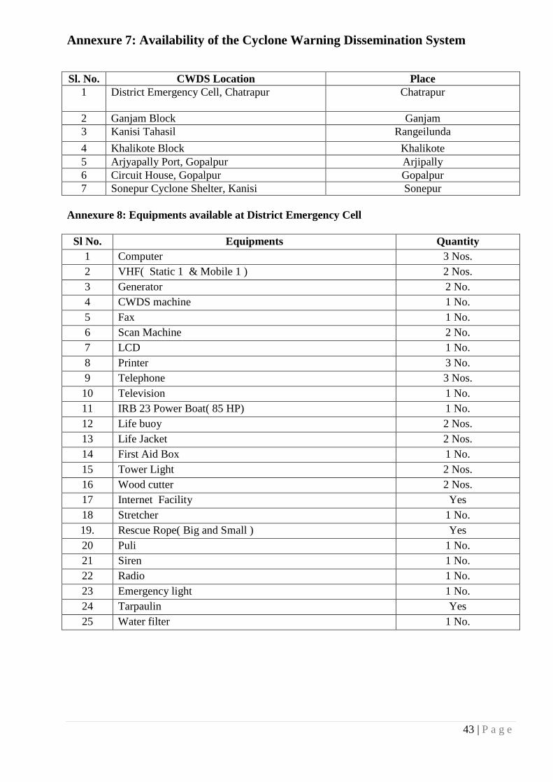
43 | P a g e
Annexure 7: Availability of the Cyclone Warning Dissemination System
Sl. No. CWDS Location Place
1 District Emergency Cell, Chatrapur
Chatrapur
2 Ganjam Block Ganjam
3 Kanisi Tahasil Rangeilunda
4 Khalikote Block Khalikote
5 Arjyapally Port, Gopalpur Arjipally
6 Circuit House, Gopalpur Gopalpur
7 Sonepur Cyclone Shelter, Kanisi Sonepur
Annexure 8: Equipments available at District Emergency Cell
Sl No. Equipments Quantity
1 Computer 3 Nos.
2 VHF( Static 1 & Mobile 1 ) 2 Nos.
3 Generator 2 No.
4 CWDS machine 1 No.
5 Fax 1 No.
6 Scan Machine 2 No.
7 LCD 1 No.
8 Printer 3 No.
9 Telephone 3 Nos.
10 Television 1 No.
11 IRB 23 Power Boat( 85 HP) 1 No.
12 Life buoy 2 Nos.
13 Life Jacket 2 Nos.
14 First Aid Box 1 No.
15 Tower Light 2 Nos.
16 Wood cutter 2 Nos.
17 Internet Facility Yes
18 Stretcher 1 No.
19. Rescue Rope( Big and Small ) Yes
20 Puli 1 No.
21 Siren 1 No.
22 Radio 1 No.
23 Emergency light 1 No.
24 Tarpaulin Yes
25 Water filter 1 No.

44 | P a g e
Annexure 9: Equipments available at Multi Purpose Cyclone Shelter(MCS)
The following equipments are available at MCS.
Sl No. Equipments Quantity
1 Generator 2 Nos.
2 Life buoy 2 Nos.
3 Life Jacket 2 No.
4 Foldable Stretcture 1 No.
5 Puli 1No.
6 Big rope 2Nos.
7 Middle rope 11 Nos.
8 Nylon rope 4 Nos.
9 Small rope 21 Nos.
10 Tower Light 2 Nos.
11 First Aid Box 1 No.
12 Wood Cutter 2 Nos.
13 Mat (Dari) 1 No.
14 Aluminum Ladder ( 30 ft) 1 No.
15 Water Filter 1 No.
16 Safety Spectacle 1 No.
17 Gum Boot 2 Pairs.
18 Notice board 1 No.
19 Black Board 1 No.
20 Gloves 2 Pair.
21 Plastic Chair 5 Nos.
22 Inflatable Emergency light 2 Nos.
23 Rain Protection Cover 2 Nos.
24 Wind support set 2 Nos.
25 Tool kit 2 Nos.
26 Lamp with Requisite Control gear 2 Nos.
27 Blower 2 Nos.
28 Trolley 2Nos.
29 Storage Box 2 Nos.
30 Water tank (200 ltr) 1 No.
31 Utensil Set 1 Set.
32 Mega Phone 1 Nos.
33 Siren 1 No.
34 GI Trunk 1 No.
a) Equipments Available At IRE, Ltd, Chatrapur
Sl. No. Equipment Quantity Available Location
1 Portable Generator 7 DWC, MSP, NTP, Boiler, Administrative
Building, Technical services
2 Mobile Pumps 5 MSP, NTP, Boiler, Civil, Workshop
3 Mobile PA system 3 Security, Fire, Colony
4 Petrol operated Saw 2 Civil Section
5 Life Buoy/ belts 6 DWC, Safety & Training
6 Walky talkies set 5 Control room, DWC, MSP, Utility
7 Rain coats and gun boats 20 All plants, sections & control room
8 Torch lights/ search lights 10 All plants & sections
9 PVC house and manila rope 100 meters each Control room & all plants

45 | P a g e
b) Equipments Available with ODRAF, Chatrapur
Sl. No. NAME OF THE EQUIPMENT / VEHICLE QTY REMARKS
1 OR-05- S7578 TATA TRIPPER 1 Ok
2 OR-05 P 0836 SIX TONNER TRUNK 1 Ok
3 OR 02 AE 8002 SA TATA 1212 TC TRUCK 1 Ok
4 OR 05 S 7528 TATA JD 315V BACK HOE LOADER-CUM-
EXCAVATOR
1 Ok
5 OR 05 T 9692 RECOVER VAN / WRECKAGE CRANE
ESCORT MODEL MAKE – 1214 (4WD)
1 Ok
6 OR 05 T 6982 / 83 HMT 3522 MODEL TRACTOR WITH
TRAILER
1 Ok
7 OR 02 AK 8704 TRUCK MOUNTED 125 KVA
GENERATOR TRUCK TATA 713 / 32 TC
1 Ok
8 OR 05 Z, 2609 2 STR, AMBULANCE 1 Ok
9 OR 05 P 0865 HYD, MOBILE CRANE 12 TON CAPACITY 1 Ok
10 FROCK LIFT 1 Ok
11 OUT BOARD MOTOR 40 HP 8 Ok
12 RUBBER DINGIES 8 Ok
13 STRING OUT BOARD MOTOR 40 HP 4 Ok
14 STRING RUBBER DINGIES 4 Ok
15 OUT BOARD MOTORS 10 HP FOR DIVING 2 Ok
16 RUBBER DINGIES 2 Ok
17 ALLUMINUM BOAT 4 Ok
18 OUT BOARD MOTORS 40 HP 4 Ok
19 HYDRAULIC COMBITOOL & CHAIN SET Ok
20 HYDRAULIC CUTTER WITH CURVED BLADE 1 Ok
21 HYDRAULIC SPREADER SET 1 Ok
22 HYDRAULIC TELESCOPIC RAM SET 1 Ok
23 HYDRAULIC RESCUE TOOL 4 Ok
24 BRANCH CUTTING CHAIN SAW OLEO MAKE 971 1 Ok
25 BRANCH CUTTING CHAIN SAW PRO MAKE 72 1 Ok
26 STIHL BRANCH CUTTER 10 Ok
27 PETROL DRIVEN CARBIDE TIPS BULLET CHAIN SAW 4 Ok
28 TREEPRUNNER-CUM-CHAIN SAW WODS CARE 2 Ok
29 TREEPRUNNER WITH CABLE SHARPEX 122CR NO.7173 3 Ok
30 TREEPRUNNER WITH CABLE KISHAN MODEL 84 1 Ok
31 R. G. C. CUTTER 1 Ok
32 HP AIRCOMPRESSOR 2 Ok
33 RECIPROCATING AIR COMPRESSOR 1 Ok
34 SINGLE STAGE RECIPROCATING PUMP-CUM-VEHICLE
WASHER
1 Ok
35 125 KVA GENERATOR 1 Ok
36 10 KVA AIR COOLED DIESEL GENERATOR 3 Ok
37 5 KVA AIR COOLED DIESEL GENERATOR 2 Ok
38 PORTABLE GENERATOR 3 KVA 1 Ok
39 HALMETRO IMPORTED POWER SHORE UNIT 1 Ok
40 SUBMERSSIBLE PUMP MODY LOW DISCHARGER 2 Ok
41 SUBMERSSIBLE PUMP MODY HIGH DISCHARGER 1 Ok
42 SEARCH LIGHT FIBRO GLASS 19 Ok
43 HI-BEAM RECHARHEABLE HAND HELD SEARCH
LIGHT
5 Ok
44 ASKA TOWER LIGHTS 18 Ok
45 BA SET COMPLETE ASSY. 5 Ok
46 H. F. TRANSIEVER (HAM RADIO) 1 Ok
47 MOTOROLA WALKIE TALKIE 10 Ok
48 MINI FIRE EXTINGUISHER 500 gm. 10 Ok
49 SQUEEXE TYPE FIRE EXTINGUISHER 4.5 KG 8 Ok
50 GARMIN GPS VISTA Hcx 5 Ok

46 | P a g e
MAPS
Map 1: Multipurpose Cyclone Shelters (OSDMA)

47 | P a g e
Map 2: Block Map

48 | P a g e
Map 3: Health Institutions Map

49 | P a g e
Map 4: PDS Map

50 | P a g e
Map 5: Other Cyclone Shelters Map

51 | P a g e
Map 6: Vulnerability Map


Preparedness Plan Ganjam District, Odisha

1 | P a g e
CONTENTS
About the Plan....................................................................................................... 2 Steps for preparedness plan…………………………………………………………….3
Incident Response System-Incident Response Team(Ganjam) ………………….. ..4
1.0 District Control Room …………………………………………… ………………….. 5 1.1 Local Level Measures .................................................................................. 10 1.2 Early Warning Dissemination ....................................................................................... 10
1.3 Search and Rescue ......................................................................................................... 11
1.4 Evacuation ..................................................................................................................... 12
1.5 Shelter Management ...................................................................................................... 12
1.6 Emergent Relief/ Free Kitchen Operation ..................................................................... 13
1.7 Medical Aid ................................................................................................................... 15
1.8 Health and Sanitation Response Structure .................................................................... 16
1.9 Infrastructure Operation ................................................................................................ 17
2.0 CAPACITY BUILDING .................................................................................. 18
2.1 Capacity Building Activities .......................................................................................... 18
2.2 Community Based Disaster Preparedness Plan & Mock Drill ............................... 20 2.3 Responsibilities of the Stakeholders: ............................................................... 22 NGOS & CBOS, Mahila Samitis, SHGS, Youth Club Etc. Religious Institution or Trust ..... 25

2 | P a g e
About the Plan
The ultimate goal for the DDMP with respect to various hazards is to have prepared
communities in a way that when the hazards strike, there is little or no loss of life; least number of
injuries and the losses to property and infrastructure are not critical.
Each element in this Sub-plan has a specific role and significant contribution towards the end
target of a safer District. All the elements attend to a distinct but interrelated with the area of concern.
The plan rests on the conviction that well defined strategies, goals and end targets with identified
players, roles and responsibilities are the precursors of successful implementation of any project. The
strategies for hazard loss reduction aim at reducing losses in the event of a future occurrence of a
hazard.
Preparedness focuses on plans to respond to a disaster threat or occurrence. It takes into
account an estimation of emergency needs and identifies the resources to meet these needs. It also
involves preparation of well-designed plans to structure the entire post-disaster response, and
familiarizes the stakeholders, particularly the communities through training and simulation exercises.
Preparedness has to be supported by the necessary legislation means a readiness to cope with
disasters or similar emergencies which cannot be avoided. The first objective of preparedness is to
reduce the disaster impact through appropriate actions and improve the capacity of those who are
likely to be affected most (that is, marginalized, poor and handicapped) to get maximum benefit out
of relief. The second is to ensure that ongoing development continues to improve the capacities and
the capabilities of the system to strengthen preparedness efforts at community level. Finally, it guides
the reconstruction in a manner so that there is reduction in vulnerability. The best examples of
preparedness activities are the development of local warning and community evacuation plans
through community education, evolving local response structures such as Community based Disaster
Management Teams (DMT) and administrative preparedness by way of stockpiling of supplies;
developing emergency plans for rescue and relief.
In the Disaster Management System, Actors from different fields such as Political,
Administrative, Government, Non-Governmental sectors and Civil Society Organizations have their
own role and responsibilities starting from IEC to Rehabilitation or in the resilient process. These
Disaster Managers are assigned with specific responsibilities to avoid overlapping of power &
confusion in discharging their duties at the time of crisis. The very purpose of this chapter is to
coordinate their services for smoother delivery of timely action and delivery of goods or services to
the people at the time of their worst suffering.

3 | P a g e
STEPS FOR PREPAREDNESS PLAN
The preparation of a Disaster Preparedness Plan involves the following steps:
Steps What is to
be done Who are to be involved How it is to be done
I Review and
Analysis
District Collector, ADM,
Emergency Officer,
BDOs, Gram Panchayat,
Village community,
NGOs/CBOs,
Community/Village level
workers
Past history of disasters to be discussed and
documented
Extent of severity and damage to be recorded
The nature of the Warning issued to be analyzed
The nature and extent of the rescue and restoration
done, to be revisited
II Situation
Analysis
Sub-Collector, BDOs,
Line Deptts, Gram
Panachayat ,Village
community, NGOs/CBOs,
Community/Village level
workers
Mapping the geography and topography of the risk
prone areas, block-wise, GP-wise and village-wise
Demographic details to be recorded
Mapping of the habitation in the concerned areas
The natural resources to be marked on the maps
Listing all the livelihoods and properties
The existing risk prone/ safe infrastructure to be
marked on the map
III Hazard
Analysis
Sub-Collector, BDOs,
Line Deptts, Gram
Panachayat ,Village
community, NGOs/CBOs,
Community/Village level
workers
Identification of all possible hazards in the area
based on past experience and available records
Identification of the most vulnerable areas with
relation to threat to life, livelihoods and property
IV Vulnerability
Assessment
Sub-Collector, BDOs,
Line Deptts, Gram
Panachayat ,Village
community, NGOs/CBOs,
Community/
Village level workers
Locations of the vulnerable areas are to be mapped
separately
Identification of the vulnerable people such as, the
elderly, the disabled, children and pregnant women,
families living in thatched houses, fishermen
(if any), ailing people, etc.
Identification of property or assets which are likely
to be affected, such as, cattle and other livestock’s,
kachcha houses, weak structures, pump sets, tube
wells and other installations, crops, horticulture and
plantations, boats, nets, etc.
Identification of weak points on embankments
Marking the drainage system in the concerned area
V Opportunity
Analysis
Sub-Collector, BDOs,
Line Deptts, Gram
Panachayat ,Village
community, NGOs/CBOs,
Community/Village level
workers
Identification of the existing resources which may
help to reduce risks to life and property
Identification of the raised platform, safe houses and
hillocks for shelter and storage
Listing the existing flood/cyclone shelters, if any
Identification of the elevated and up-lands which
can act as natural barriers to protect livestock
Listing of the existing health and sanitation facilities
Identification of safe routes for evacuation
Identification of the sources of funds to carry out the
preparedness activities

4 | P a g e
Preparedness Plan
INCIDENT RESPONSE SYSTEM-INCIDENT RESPONSE TEAM (GANJAM)
District Collector
Planning Department
(DRDA)
Logistics
(ADM-General)
Operations
(ADM-Revenue)
District Emergency
Officer
Resource Unit
(Shelter Centre)
Information &
Media (DIPRO)
Situation
(DEOC)
Documentation
(DEOC)
BDO
GP
EOVLB
Service Support Rescue
Supply
(CSO)
Medical
(CDMO)
Water
&
Sanitation
(Shelter
Centre)
Electrical
Transport
(RTO)
Communication
(DEOC)
CBOD
CDMO
Energy
NH-ULB
Road Clearance
(RD & PWA)
IACG
NGOs & VOs
Police
Fire
Department
NDRF &
ODRAF
Restoration

5 | P a g e
1. Control Room Operation
1.0 District Control Room (DCR)
This section is prepared to help the members of District Control Room to understand the
structure and functioning of District Control Room. Following the important Three C’s i.e.
Command, Control and Communication for effective response in an emergency, we will be able to
minimize the hardships of the community and improve the quality of the process of recovery. This
control room will be able to provide timely, supported and well thought interventions to the grass
root staff as well as volunteers as it will be the hub of three C’s.
Purpose of the DCR: The District Control Room / Emergency Operation Center under the
control of District Collector will operate round the clock and will be the nerve center to
Monitor
Co-ordinate
Implement the actions/activities for Disaster Management.
In a disaster time the District Control Room, Ganjam will operate under the central authority
of the District Collector, Ganjam exercising emergency power to issue directives to all departments to
provide emergency response service. He will also co-ordinate with the State Response Machinery like
Special Relief Commissioner, Odisha, Bhubaneswar and Odisha State Disaster Mitigation
Authority(OSDMA) for appropriate support and smooth flow of information. The Control Room
should be manned round the clock. The District Control Room will be placed in the Emergency
Section of the District Collectorate.
District Control Room & Linkages with Other Control Rooms
Period Co-ordination & Linkage
Preparedness Considering the gravity of situation the Collector shall convene the DDMA &
District Level Natural Calamity (DLNC) Meetings as situation warrants
Pre-Crisis After Warning
Meeting with District Level Officials/ Officials head quarter and chock out
emergency plan with vulnerable areas and resource list
Co-ordination meeting on NGOs/ PRIs
Assignment of duties
Pre-positioning of staff in the likely cut off areas
Arrange food and other basic requirement for emergency response
Collect information from different areas and to act accordingly
During Crisis
Co-ordination meeting with officials at HQ. by 12 hrs. Interval and 24 hrs.
Intervals with the field officials
Deployment of rescue team in the affected parts
Regular collection of situation report of the risk and vulnerable areas from
the officers assign for the purpose
Provision for administering emergent relief and the other basic needs
Contact with Special Relief Commissioner (SRC) for supply of Temporary
shelter materials

6 | P a g e
Keeping inform CSO for supply of food articles procuring from FCI/ Whole
sellers
Deputation of volunteers to different probable affected areas
Keep regular link with Revenue Control Room/ SRC/ RDC/ OSDMA etc.
Post Crisis
Helping the evacuees for returning to their houses
Immediate arrangement of free kitchen in the cut off and inaccessible areas
Relief distribution
Monitoring of relief distribution
Provision of safe drinking water
Provision of medical facilities
Repair and restoration of roads and breeches
Transportation of Relief and Human resources
Keep regular link with Revenue Control Room/ SRC/ RDC/ OSDMA etc
District Control Room Activity
Normal time activity
Organizing IEC activity through walling, Posters, Street Plays,
Village task force/ volunteers training emphasizing on insurance
coverage of livestock/ crops/ industry/ work shop etc.
Creating awareness among general public during normal time to
ensure human life
Strengthening of weak and vulnerable points in river/ canal
embankments
Updating of Disaster Management Plan on the basis of past
experience
Inventory of resources (currently resource inventory made on the f
IDRN- India Disaster Resource Network format)
Advance preparatory/ mock drills through NGOs/ CBOs on the
management of Disaster
Ensure proper functioning of electronic communication systems
available
Meeting of NGOs/ CBOs with specific assignment of responsibility
in particular sector
Updating District Disaster Management Plan with altered/ addition
data
Keeping direct tough with committees entrusted with management of
MCSs and other Cyclone Shelters
Updating Telephone numbers
Collection of list of eminent agencies for their involvement at the
time of Disaster
Updating of Maps displayed in DCR with up to date information
Review of advance preparation undertaken at field level
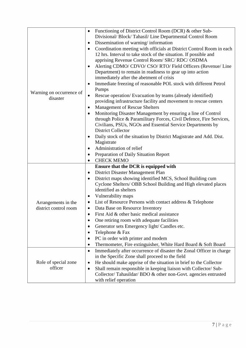
7 | P a g e
Warning on occurrence of
disaster
Functioning of District Control Room (DCR) & other Sub-
Divisional/ Block/ Tahasil/ Line Departmental Control Room
Dissemination of warning/ information
Coordination meeting with officials at District Control Room in each
12 hrs. Interval to take stock of the situation. If possible and
apprising Revenue Control Room/ SRC/ RDC/ OSDMA
Alerting CDMO/ CDVO/ CSO/ RTO/ Field Officers (Revenue/ Line
Department) to remain in readiness to gear up into action
immediately after the abetment of crisis
Immediate freezing of reasonable POL stock with different Petrol
Pumps
Rescue operation/ Evacuation by teams (already identified)
providing infrastructure facility and movement to rescue centers
Management of Rescue Shelters
Monitoring Disaster Management by ensuring a line of Control
through Police & Paramilitary Forces, Civil Defence, Fire Services,
Civilians, PSUs, NGOs and Essential Service Departments by
District Collector
Daily stock of the situation by District Magistrate and Add. Dist.
Magistrate
Administration of relief
Preparation of Daily Situation Report
CHECK MEMO
Arrangements in the
district control room
Ensure that the DCR is equipped with
District Disaster Management Plan
District maps showing identified MCS, School Building cum
Cyclone Shelters/ OBB School Building and High elevated places
identified as shelters
Vulnerability maps
List of Resource Persons with contact address & Telephone
Data Base on Resource Inventory
First Aid & other basic medical assistance
One retiring room with adequate facilities
Generator sets Emergency light/ Candles etc.
Telephone & Fax
PC in order with printer and modem
Thermometer, Fire extinguisher, White Hard Board & Soft Board
Role of special zone
officer
Immediately after occurrence of disaster the Zonal Officer in charge
in the Specific Zone shall proceed to the field
He should make apprise of the situation in brief to the Collector
Shall remain responsible in keeping liaison with Collector/ Sub-
Collector/ Tahasildar/ BDO & other non-Govt. agencies entrusted
with relief operation

8 | P a g e
Arrangements in District Control Room
The DCR is equipped with
Action Plans
Vulnerability maps
List of key contact persons during emergencies
Database on resources of the district
During disaster provision will be made in the Collectorate for
First aid and other basic medical relief for the staff
A rest room with adequate facilities and
A kitchen and lunch room
In addition, the following facilities / equipments are available in the DCR
Telephones
Fax
One PC with modem and printer
Typewriter
Generator
Fire Extinguisher
A soft board to display information
A hard board to note important information
Health and Hygiene
District Level Control Room (Health Institution)
District Level Control Room is functioning round the Clock. The ADMO (PH) is in charge of
the control Room
Tel No. of the Control Room - 0680 – 2224798/2225383
Mob. No. of the ADMO (PH) - 9439983956
The following District Level Officers will be in charge of the control room in three shifts
during the emergency situation along with paramedical staffs in duty. The roster duty is being fixed in
notice board, to be renewed every month.
Time Dist. Level Officer Para Medical Staff
08:00 AM – 02:00 PM DSMO/ Epidemiologist MPHS(M)
02:00 PM – 10:00 PM DMO MPHS(M)
10:00 PM - 08:00 AM ADMO(PH) MPHS(M)

9 | P a g e
Similarly Control Rooms will be function in the Sub Divisional Hospital / CHCs / PHCs &
City Hospital, Berhampur.
Block wise Health Institution Control rooms / Responsible persons
Sl.No Name of the CHC Control room Number Responsible Peron
1 CHC Adapada 9439985026 MO I/c
2 CHC Bomokei 9778527216 Pharmacist
3 CHC Chikiti 9658162076 Pharmacist
4 CHC Keluapalli 9439983032 MOI/c
5 CHC Patrapur 06802643287 MOI/c
6 CHC Kukudakhandi 06802485382 MOI/c / MPHS(M)
7 CHC Polosara 0680282222 MPHS(M)
8 CHC Khalikote 9439983871 BPM
9 CHC Kodala 06810268786 MOI/c
10 CHC Municipentha 9439983782 PHEO
11 CHC Khandadeulli 9439983156 MPHS(M) H.Q
12 CHC Bhatakumrada 9439958154 MPHS(M) H.Q
13 CHC Bellagam 06811245762 MPHS(M)
14 CHC K.S.Nagar 9861742168 Pharmacist
15 CHC Badagada 06819278617 MOI/c
16 CHC Sheragada 7873653134 Pharmacist
17 CHC Dharakote 06822268025 MOI/c
18 CHC Balisira 06822256022 MOI/c
19 CHC Buguda 9439984363 MPHS(M) H.Q.
20 CHC J.N.Prasad 9439983090,
068182622092
MOI/c /PHEO
21 CHC Gallery 9439984400 MOI/c
22 CHC Belaguntha 9439983758 MOI/c
23 SDH Chatrapur 9437324903 Pharmacist
24 SDH Bhanjanagar 9439983081 SDMO
25 City Hospital 0680 2224409 ADMO(Med)
26 CHC Aska 9439983957 MO I/c

10 | P a g e
1.1 Local Level Measures
BLOCK / GP AND VILLAGE LEVEL ACTIVITIES
Under the DRR Project in G.P level, the volunteers have been trained on Search & Rescue,
First Aid & Shelter Management etc. and Mock Drills on regular intervals has been organized in the
Multipurpose Cyclone Shelters in the Ganjam & Chatrapur Block.
The District level Community Mobilizer from OSDMA Sri Subrat Ku. Mohanty with Mobile
No.9124118819 will be contacted for community mobilization:
1.2 Early Warning Dissemination

11 | P a g e
1.3 Search and Rescue
PREPAREDNESS RESPONSIBILITY
Deployment of Police/ Fire brigade for search and rescue
Co-ordination with NCC/ NSS/ Civil Defence/ Rajya Sainik
Board etc. for rescue operation
Ensure availability of the rescue materials
Prepare inventory of shelter places and map indicating the shelter
centers
Provide and arrange Rescue Kit at risk areas
Police
Fire Brigade
Leading NGO
Tahasildars
Sub-Collectors
BDOs
co-coordinator of NSS/
NCC/ Defence Units

12 | P a g e
1.4 Evacuation
PREPAREDNESS RESPONSIBILITY
To warn people about the impending danger & to leave for safer places
To co-ordinate with Civil Defence – NGOS/ Secy Rajya Sainik Board/
Police for Support
Arrangement of boats/ vehicles etc. for evacuation
Evacuate people of marooned areas and administer emergent relief
Organize trained task force members
Deployment of police for maintaining law & order and peace keeping
during evacuation
Mobilize people to go to identified/ safer shelters
Deployment of Power boats/ Country boats (Govt./ Private) for evacuation
All Sub-
Collectors
All Tahasildars
All BDOs
DIPRO
Leading NGOs
Dist.Fisheries
Officer
Police
1.5 Shelter Management

13 | P a g e
PREPAREDNESS RESPONSIBILITY
Identification of shelters/ temporary shelters in high-elevated
places and arrangement of tents etc.
Arrangement of Flood/ Drinking water/ Medicine in the shelter
places
Persons allocation for each shelters
Arrangement of transportation
Arrangement of safe shelter for animals
Providing the lighting facilities for shelter places
Deployment of Police personnel
Temporary supply of safe drinking water
Sub-Collectors
Tahasildars
BDOs
Medical Officers
Paramilitary Forces
Police
RHD/ RWSS
RTO/ MVI
1.6 Emergent Relief/ Free Kitchen Operation

14 | P a g e
PREPAREDNESS RESPONSIBILITY
Deployment of Vehicles
Procurement and transportation of relief materials to affected
pockets/ areas
Arrangement of free kitchen in the shelter camps and affected
areas
Assigning responsibilities to officials for distribution of
emergent relief / running of free kitchen
Co-coordinating with the NGOs/ Other voluntary organizations
& PSU/ UNICEF/ UNDP/ REDCROSS/ OXFAM for
continuing Relief operation
Monitoring
Sub-Collectors
Tahasildars
BDOs
Medical Officers
Paramilitary Forces
Police
RHD/ RWSS
RTO/ MVI
Leading NGOs

15 | P a g e
1.7 Medical Aid
PREPAREDNESS RESPONSIBILITY
Deployment of Medical Staff
Stock piling of Life saving drugs/ ORS packets/ Halogen tablets
Treatment of the injured persons and Transportation of the
injured to Hospitals
Awareness messages to stop the outbreak of epidemics
Disease surveillances and transmission of reports to the higher
authorities on a daily basis.
Vaccination
Constitute mobile teams and visit the worst affected areas.
Dis-infection of drinking water sources
Identification of site operation camps
To obtain/ transmit information on natural calamities to District
Control Room
Advance inoculation programme in the flood/ cyclone prone
areas
Arrangement of fodder/ medicines for the animals
Vaccination, site operation camps, carcasses disposal
CDMO
CDVO
SDMO
SDVO
Medical Officers
of PHC/ CHCs
ICDS
Leading NGOs
Sarapanch

16 | P a g e
1.8 Health and Sanitation Response Structure
PREPAREDNESS RESPONSIBILITY
List of the Medical staff members with contact address and
telephone number
Stock position of medicines at District/ Sub-Division/ PHC/ CHC/
AWC and indent position of stock
Trained voluntary staffs/ task forces/ Anganwadi workers on use and
providing min. Health services to the community
Arrangement of mobile health unit for inaccessible pockets/ health
awareness campaign
Stock position for medicine of animals
Disinfectant water system and ensuring supply of safe drinking
water arrangement for supply of drinking water
Arrangement of mobile team and assigning specific operational
areas for supply of water
Involvement of volunteers
CDMO
CDVO
PHD
RWSS
Sub-Collectors
Tahasildars
BDOs
Medical Officers
Paramilitary Forces
Police
RHD/ RWSS
RTO/ MVI

17 | P a g e
1.9 Infrastructure Operation
PREPAREDNESS RESPONSIBILITY
Formation of task force with specific equipments
Assigning responsibilities for specific areas
Emergency cleaning of debris to enabled reconnaissance
Coordinate road cleaning activities to assist local relief work and
clearing roads, assemble causal labor provide a work team carrying
emergency tool kit.
Towing vehicles, earth moving equipments, cranes, construct
temporary roads
Keep National & other Highways clear from disaster effects and
monitoring the situation
NH authorities
R & B
Police
PHD/ RWSS
RTO/ MVI
All Line Dept.
All Tahasildars
All BDOs
Precautions to be taken for civil construction
All concerned line departments involved in executing development projects, field construction
will adhere to the natural/geographical gradients as per the drainage channels list submitted by
Executive Engineer, Drainage Division attached vide Annexure-d (Chapter-HVCA). This is to ensure
that unnecessary blockage of rainwater doesn’t take place due to faulty construction of road,
buildings etc.

18 | P a g e
2. CAPACITY BUILDING
Community awareness through DRR programme
Following action have been taken to make aware people about different disaster through DRR
project. In 3 sample villages following DRR activities have been taken:
i) Support Policies and Frameworks.
ii) Human resource development
iii) Build Linkages with Development Programme
iv) Develop broader partnerships
v) Promote Equity, Social Inclusion and Women Empowerment.
vi) Develop an enabling environment and mechanisms and support learning and knowledge
sharing.
Awareness Activities
Awareness activities have been conducted in coastal Villages in Ganjam & Chatrapur block
and also in the Block level, District level Advocacy workshop / sensitization of Officers has been
carried out in a vigorous way. School Safety is also another aspect wherein the Teachers &students
are being educated on the safety aspects in their schools and the students are being imparted trainings
on Search & Rescue, FA, etc.
Disaster preparedness activities being taken up by other organizations:
Name of the
Organization Area of Operation Contact Person Contact Number
CURES Chatrapur Arun Kumar Satpathy 9438866150/
9861234438
CAP Chatrapur Ajit Kumar Panigrahi 9937328017
KSS Ganjam Tuna Maharana 9861587344/
9658256882
LWS Chatrapur Pranab Kumar Bhoi 8895469198
SRADHA Chikiti Manoj Kumar Padhi 9937654984
Nirmata Rangeilunda Srveswara Mahapatra 9861136790
2.1 Capacity Building Activities
I. Odisha State Disaster Preparedness Day:
In every year, on 29th Oct, State, District as well as the blocks use to observe the Disaster
Preparedness day to remember the disaster of the decade i.e. Super Cyclone and the level of
devastation caused by it, and accordingly prepare the entire community and all the stakeholders to
minimize the losses if such type of incident occurs in future.

19 | P a g e
II. Mock Drill: On 19th of June every year OSDMA with the help of Cyclone Shelter Management
and Maintenance Committee (CSMMC) use to conduct the mock drill at the shelters constructed in
the coastal belt. In which the trained volunteers along with the village community used to participate
in the drill process to enhance their training skills. Also DMTs(Disaster Management Teams) use to
verify the functional status of the equipments supplied to the shelters in the drill.
III. Village and GP level preparedness activities: The VDMC(Village Disaster Management
Committee) and PRI members at village and GP level organize programmes on disaster preparedness
day through the help of NGO/CBO.
IV. Capacity building plan and activities: As a part of the training and capacity building component
attention will be focused on to provide training to the PRI members, school teachers, line department
officers.
V. Shelter level activities: Meeting of CSMMC every month to ensure the safety and security of
equipments supplied to the Shelter and maintenance of the building
Mock drills
Response Drills
DMT trainings at the shelter level
VI. Shelter level activities: On regular intervals shelter level activities on Disaster Preparedness like
Mock Drills being conducted and all the active Volunteers are being involved in the whole process
which raised the awareness level amongst the community.
Recently the NDRF Team visited all the Shelters in the Ganjam and Chatrapur region. Also
the ODRAF Battalion based at Chatrapur got involved in imparting Trainings to the Volunteers in the
region.

20 | P a g e
2.2 Community Based Disaster Preparedness Plan & Mock Drill
OBJECTIVE – CLARITY OF AIM
FLEXIBILE
COORDINATIING
REALISTIC
EASY TO USE
DEFINED ROLES & RESPONSIBILITIES
Disaster Risk Management (DRM) Programme
First & Prompt Response to Disaster Role & Responsibility of the Community
Disaster Preparedness initiatives
Formation of Block Disaster Management Committee
(BDMC)
Action – BDO
Mapping of Vulnerability Zones
Action – BDO, Nodal Officer & DPO
Training of PRI members
Action – BDO, Nodal Officers & DPO
Formation of Disaster Management Committee at GP
& village level
Action – Block/ GP Nodal Officers & NGOs
Preparation of GP Plan (GPDMP) and Community
Contingency Plan (CCP)
Action - GP Nodal Officers, Teachers, PRIs & NGOs
Mock Drill:Action – VDMC/ GPDMC/ NGOs
Dissemination of Other IEC Materials
MODE AGENCY RESPONSIBLE
Wall Painting, Street Play, Village Task Force/
Volunteers Training
CDMO – Through field agencies
BDOs - Through CBOs/ Village volunteers
NGOs – through Block level NGO network
Slide in Cinema Hall OIC Judicial, Collectorate
Hand Bills, Paper advertisement DIPRO & BDO
Media & Press release Information Officer/ DCR
Posters, Cartoons, Charts, Photographs, Folk song CBOs/ NGOs
Training Camps, Group discussion and special
lectures by Community Leaders
DIPRO, BDO, DCR
PREPAREDNESS PLAN

21 | P a g e
Training and Mock Drills
MODE AGENCY RESPONSIBLE
Training Programme for Rescue & Relief SP, Dist. Fire Officer, Civil Defence, NGOs, CBOs
Training for common people on Health Care,
Sanitation & First Aid
CDMO, BDOs & CBOs
Disaster Orientation Training of Police/ Fire
Personnel/ Medical Teams
OSDMA/ ODMA/ UNDP/ SRC
Setting up of Disaster Volunteer Force - Identification& Training
Warning Group- Warn the community of the
impending danger.
Rescue & Evacuation Group- To be put into task
immediately after abatement of calamity.
Water & Sanitation Group- Ensured safe drinking
water in the shelter camps, MCS
Shelter management Group- Shall remain overall
charge of managing the evacuees in shelter camps.
First Aid & Medical Group- Shall take care of the
minor elements in the rescue camp.
Patrolling and Liaison Group- Shall watch & Word
belongings of the inmates in the shelter camps & keep
liaison with Govt.
Block level Task Force G.P. Level Task Force
Village Level Task Force

22 | P a g e
2.3 Responsibilities of the Stakeholders:
Stakeholders Activities
COLLECTOR /
A.D.M/ D.E.O.
Assigning specific responsibilities to different agencies.
Coordination with all line departments & other agencies.
Liaison with Rev. Control Room / OSDMA / SRC/ RDC
And overall view on:
Ensure availability of Vulnerability map of the Block/ Tahasil
Heave a list of Resource inventory, Capacity analysis.
List of cut off areas with safe route map for communication.
List of storage facilities, dealers of food.
Control room setup / assignment of control room duty.
Pre-positioning of staff for site operation centers.
Arrangement of alternative communication / generator sets etc.
Arrangement of vehicles / Boasts for evacuation.
SUPERINTENDENT
OF POLICE
Communication establishment with District and Block / Tahasil Control
Rooms and departmental Offices within the division.
An officer to be appointed as nodal officer on his behalf
Overall traffic management and patrolling of all highways and other
access roads to disaster sites
Identification of antisocial elements
Provisions of security in transmit camps / feeding Centers / relief camps
/ Cattle camps/ Cooperative food stores and distribution centers.
Providing assistance to district authorities for taking necessary action
against hoarders, black marketers and those found manipulating relief
material.
Coordination with military service personnel in the area being carried
out under relief operation
Providing assistance to the community in organizing emergency
transport or injured.
Civil Supply Officer
Identification of inaccessible pockets at Blocks.
Keeping list of whole sell traders of local market.
List of storage agents with quantity of monthly allotment & uptake.
Detail data on beneficiary / Annapurna Scheme
List of Petrol pump dealer
List of Medical Shops.
List of traders dealing with temporary shelters materials.
Diversion of essential commodities to affected pockets as & when
requisition.
CDVO
Identification of inaccessible pockets at Blocks.
Keeping list of whole sell traders of local market.
List of storage agents with quantity of monthly allotment & uptake.
Detail data on beneficiary
List of Fodder dealer
List of Medical Shops.
List of traders dealing with temporary shelters materials.
Diversion of essential commodities to affected pockets as & when
requisition
Coordination.

23 | P a g e
BDOs and
Tahasildars
Vulnerability map of the Block/ Tahasil
List of cut off areas with safe/ alternative route map
Identification and management of shelter camps
List of storage facilities dealers of food
Control room setup/ assignment of control room duty
Propositioning of staff for site operation centers
Arrangement of alternative communication/ generator sets etc.
Dissemination of warning/ coordination with DCR
Ensuring coordination with GP/ RI/ village committee
SOUTHCO
Communication establishment with District and Block/ Tahasil control
room and departmental officers within the division
An officer to be appointed as nodal officer
Standby arrangements for temporary electric supply or generator
Inspection and repair of high-tension lines/ substations/ transformers/
poles etc.
Clearing of damaged poles/ salvaging of conductors and insulators
Identification of materials required for response operation
All staff informed about the disasters, likely damages and effects
Telecommunication /
Private Cellular
Service Operators
Communication establishment with District and Block/ Tahasil control
room and departmental officers within the division
An officer to be appointed as nodal officer
Standby arrangements for temporary electric supply or generators
Inspection and repair of poles etc.
Identification of materials required for response operations
All staff informed about the disasters, likely damages and effect
CDMO
Communication establishment with District and Block/ Tahasil Control
Rooms and departmental offices within the division
An officer to be appointed as Nodal Officer
Stockpiling of live saving, anti-diarrheal drugs, de-toxicants, anesthesia,
adequate drinking water
Arrangement of ambulance/ generators
In-house emergency medical teams to ensure the adequate staff available
at all times to handle emergency causalities
Listing of private health facilities
Strengthening of disease surveillance
Formation of mobile units and ensure communication with them
Identification of sites in probable disaster areas for site operation areas
Awareness generation by supportive strength.
All staff informed about the disasters, likely damages and effects

24 | P a g e
PHD, RWSS
Communication establishment with District and Block/ Tahasil Control Rooms
and departmental offices within the division
An officer to be appointed as Nodal Officer
Arrangement of water tankers and other temporary means of distribution and
storage water
Adequate arrangement to provide water to relief camps/ affected villages,
alternative water supply arranged in feeding centers/ cattle camp etc.
Disinfections of water bodies
Identification of appropriate portable water supply
All staff informed about the disasters, likely damages and effects
Irrigation
Communication establishment with District and Block/ Tahasil Control Rooms
and departmental offices within the division
An officer to be appointed as Nodal Officer
Activation of flood monitoring mechanism
Methods / communication arrangement of alerting officers on various sites
established.
Mechanism evolved for forewarning settlements in the down streams/
evacuation/ coordination with other dam authorities
Identification of materials required for response operations
Repair/ under construction activity are well secured
Water level gauges marked
In late and out late to tanks are cleared
Watch and ward of weak embankments and stock piling of repair material
Guarding of week embankments
All staff informed about the disasters, likely damages and effects
Agriculture
Communication establishment with District and Block/ Tahasil control
room and departmental officers within the division
An officer to be appointed as nodal officer
Information provided about the disaster and likely damages to crop and
plantation
Organized transport, storage and distribution of seeds/ fertilizers/
pesticides
Cleaning operation carried out to avoid water logging and salinity
Surveillance for pests and diseases being carried out
Establishment of public information centers requirements for salvage or
re-plantation assessed damage
Identification of different areas to be affected by different hazards
Listing of irrigation sources with status
All staff informed about the disasters, likely damages and effects
Public Works
Department
Communication establishment with District and Block/ Tahasil control room
and departmental officers within the division
An officer to be appointed as nodal officer
Arrangement of extra vehicles/ heavy equipments, such as front-end loaders/
towing vehicles/ earth moving equipments/ cranes etc.
Inspection and emergency repair for roads/ road bridges/ underwater
inspection/ piers/ concrete and steel work
Emergency inspection by mechanical engineer of all plant and equipments
Route strategy for evacuation and relief marked
Clearance of blocked roads
Community assistance mobilized for road clearing
All staff informed about the disasters, likely damages and effects

25 | P a g e
NGOS & CBOS, Mahila Samitis, SHGS, Youth Club etc. religious Institution or Trust
ODRAF
Handicap International:-
In partnership with HANDICAP INTERNATIONAL a project namely Integrating Disability
based community into Disaster Management is being implemented in six Multipurpose Cyclone
Shelter Centers of Chatrapur and Ganjam Block recently.
Sl No BLOCK VILLAGE MCS
1
CHATRAPUR
KANAMANA KANAMANA
2 MATIKHALO MATIKHALO
3 ARJIPALLI ARJIPALLI
4 AGASTI NUAGAON AGASTI NUAGAON
5
GANJAM
KANTIAGARH KANTIAGARH
6 PURUNABANDHA PURUNABANDHA
PREPAREDNESS REMARKS
IEC Campaign
Preparation of community Contingency Plan
Formation of Village Disaster Preparedness Community with
assigning their particular responsibilities
Generation of Community Contingency Fund
Mock Drill in different levels
Training to the NGO/ Village Volunteers on Rescue & First
Aid/ Ham/ VHF Etc.
Shall keep direct link with
Block administration
PREPAREDNESS REMARKS EQUIOPMENTS
IEC Campaign
Preparation of community Contingency Plan
Formation of Village Disaster Preparedness
Community with assigning their particular
responsibilities
Generation of Community Contingency Fund
Mock Drill in different levels
Training to the NGO/ Village Volunteers on
Rescue & First Aid/ Ham/ VHF Etc.
Shall keep direct link
with Block
administration
Stated before


Response Plan Ganjam District, Odisha

1 | P a g e
CONTENTS
INTRODUCTION……………………………………………………………………………..3
1 Response Mechanism…………………………………………………………………...4
1.1 DISTRICT DISASTER MANAGEMENT COMMITTEE (DDMC)………………… 4
DISTRICT CONTROL ROOM:……………………………………………………….6
RESPONSE MECHANISM, GANJAM……………………………………………………….7
1.1.1 to 1.1.34 Duty and functions of Govt. & Non Govt. organisation
Assembly in Control Room & others…………………………………… .8-12
1.1.35 Minimum Standards of Relief for Victims of Disasters ……………………….. .. 13
1.1.36 Standard operation procedure for response coping activity (Drought)……….…….14
1.1.37 LEAD AGENCIES (Govt and non Govt. Organization)…………………….…… 18
2. STANDARD OPERATION PROCUDURE FOR LINE DEPARTMENT………….…..19
2.1 Public Health Engineering………………………………………………………..….. 19
2.2 Water Resources Department…………………………………………………….… . 19
2.3 Public Work Department(Building)… …………………………………….……20
2.4 Public Works Department (Bridges and Roads)…………….. ……………………. ...21
2.5 Forest Department………………………………………………………………….…...21
2.6 Social Welfare Department………… ………………………………………………..22
2.7 Health Department………………………………………………………………… …22
2.8 Police Department …………………………………………………………….. …24
2.9 Electricity Department…………………………………………………………….….. .25
2.10 Agriculture Department…………………………………………………………… . …25
2.11 Animal Husbandry Department………………………………………………………..26
3.1 IMPORTANT TELEPHONE NUMBER OF ALL OFFICES/OFFICERS OF
GANJAM DISTRICT-2015………………………………………………… 27
3.2 BLOCK DEVELOPMENT OFFICERS & CONTROL ROOM… ……………. ………28
3.3 TAHASILDARS CONTROL ROOM…… …………………………………….… … .28
3.4 LINE DEPARTMENTS …………………………………… ………….……… .. .29
3.5 URBAN LOCAL BODIES…………………………………………………. …… ….30
3.6 COMMUNICATION FACILITY…………………………………………….…. 30
3.7 LIST OF MULTI PURPOSE CYCLONE SHELTERS HOMES (BY OSDMA) … ..31
3.8 PUBLIC DISTRIBUTION SYSTEM………… ………………………………….… 32
3.9 BLOCK/ULB WISE PRESENT STATUES UNDER NFSA OF GANJAM … … 33
3.10 ALTERNATIVE ENERGY SOURCES………………………………………… …33
3.11 LIST OF BLOCK LEVEL CHC/ UGPHC/ PHC……………………………… .......33
3.12 FORMATION ZONE WISE OFFICERS OF PHC/CHC……………………… ….36
3.13 CHC/ UGPHC/ PHC/ PHC PRONE TO CYCLONE AND FLOOD………… ……39
3.14 DISTANCE OF SUB DIVISIONAL/ BLOCK HEAD QUARTERS FROM
DISTRICT HEAD QUARTER……………………………………………………….42
4. Rapid Damage and Loss Assessment Format ………. …………………………… 43-49
5. Lessons Learnt………................................................................................................ .. 50
5.1. Response to Very Severe Cyclonic Storm-Phailin & Subsequent Flood 2013…… ….50
A. RECEIPT OF CYCLONIC WARNING AND PREPARATORY STEPS……… ….50

2 | P a g e
B. EVACUATION & RESCUE STRATEGY……………………………………… …50
C. FUNCTIONING OF CONTROL ROOMs……………………………………… …56
D. STEPS TAKEN BY VARIOUS DEPARTMENTs………………………………..…56
E. ACTION TAKEN ON 12.10.2013……………………………………………..…….57
F. RELIEF OPERATIONS……………………………………………………………..58
G. STATUS OF RELIEF OPERATION……………………………………………..59
H. RESTORATION……………………………………………………………………..60
I. RESTORATION OF WATER SUPPLY…………………………………………….60
J. RESTORATION OF ELECTRICITY……………………………………………….60
K. REHABILITATION…………………………………………………………………61
L. MEDIA COVERAGE ………………………………………………………… …..61
5.2. Response to Severe Cyclonic Storm - Hud Hud’2014………………………………..61
1. Tracking of Cyclone & Intensity……………………………………………………..61
2. Arrangement of food stuff & essential articles……………………………………….61
3. Evacuation & shelter Palnning………………………………………………………..61
4. Supervision, monitoring & coordination……………………………………………..62
5. Search & rescue operation……………………………………………………………62
6. Safety of school children & banking solution………………………………………..62
7. Functioning of Control Room ………………………………………………………..62
8. Conduct of Mock drills & publicity…………………………………………………..63
9. Health Care measures & Sanitation…………………………………………………..63
5.3. Response to Last Tsunami Occurrence………………………………………………..63
1. Impact of Tsunami warning..........................................................................................61
2. General observation…………………………………………………………………..64

3 | P a g e
INTRODUCTION
Response Plan includes systems and protocols in place to lead a coordinated response to
disasters that are effective and efficient with the available resources. The plan identifies the
stakeholders to be involved in the response, protocols for the involvement of external agencies and
their Roles and Responsibilities for the Response Mechanism.
The response plan also provides frame work for the standard operating procedures. At the
time of situations arising out of disasters and hazards, villages, GPs and Blocks are worst affected;
The first line of defence and response mechanism at this level will be developed. If the required
response exceeds available resources at the local levels, support will be sought in the order:-
Villages → GPs → Blocks → district → & districts with the state. Providing initial response in
the event of sudden disaster is not only difficult but challenging as well. Normally when a crisis
situation develops the picture is often unclear and chaotic and would become further complicated
when disaster happens during night time and collapse of communication & transport network takes
place. The first reaction is to act spontaneously. Immediate response to any disaster is to launch
rescue operations aimed at saving human lives and property in order of priority. The rescue
operations are to be carried out over a short period of time ranging from few hours to few days.
During this period depending upon intensity, mobilization of all possible resources is to be done.
As the rescue operations are made on, the process of providing relief such as food, clothing,
shelter, security, first aid, sanitation etc. also starts and this phase may last for few days.

4 | P a g e
1. Response Mechanism
------------------------------------------------------------------------------------------------
1.1 DISTRICT DISASTER MANAGEMENT COMMITTEE (DDMC)
DDMC has been formed under the Chairmanship of District Collector to evaluate the
Disaster Preparedness for different type of Calamities at different times over a year that may occur.
The Committee is the Pioneer Committee in the District to take stock of the situation, monitors
routine preparedness, suggests improving response mechanism and develops a document for
disaster management in the District. It sits at least twice in a year as per the Codal Provision of
Odisha Relief Code. The Committee members are as follows:
Sl No FUNCTIONARIES DESIGNATION
1. Collector & District Magistrate Chairman, ex-officio
2. Chairman , Zilla Parishad Co-Chairman, ex-officio
3. Additional District Magistrate,Ganjam in-charge of Emergency CEO, ex-officio
4. Superintendent of Police (Ganjam & Berhampur) Member, ex-officio
5. Executive Engineer in-charge of Embankment Member, ex-officio
6. District Emergency Officer Member Secretary
7. All MP & MLA of the District Member
8. Project Director, DRDA Member
9. Executive Engineers, RW Division Member
10. CDMO,Ganjam Member
11. CDVO,Ganjam Member
12. Dy. Director Agriculture,Ganjam Range Member
13. All Sub Collectors of the District Invitee
14. DFO,Bhanjanagar (North & South)& Berhampur Invitee
15. All Block Development Officers Invitee
16. All Tahasildars Invitee
17. Executive Engineers, Irrigation Invitee
18. Executive Engineers, Minor Irrigation Invitee
19. Executive Engineers, RWSS Invitee
20. Executive Engineers, PHED Invitee
21. CSO Invitee
22. RTO Invitee
23. DIPRO Invitee
24. District Fire Officer Invitee
25. District Level NGO Convener Invitee
26. Inspector of Factories Invitee
27. Representatives of Local Factories Invitee
28. GMTD Telephone Invitee
29. GM, SOUTHCO Invitee
30. Representative of Rajya Sainik Board/ NCC/ NYKS/ NSS Invitee
31. Dist. Education Officer, Berhampur Invitee
32. Municipal Commissioner, BeMC/all Executive Officers of NACs Invitee
33. Representative of Defence Unit Invitee

5 | P a g e
Different actors from District Administration, Public, NGO sector, Civil Defence, interest groups
are monitored to stand in interaction with a view to play a major role in disaster mitigation.
TABLE INDICATOR OF PRE/DURING/POST DISASTOR ACTIVITIES
Pre Disaster During Disaster Post Disaster
1. Formation of District
Disaster Management
Committee
2. Formulation of District
Disaster Management
Plan for the running year.
3. Hazard Analysis &
Resource inventory
4. Allocation of
responsibilities to the
individual actors/ Groups/
Institutions/
Organizations
5. Broadly defining the
responsibilities and
operational jurisdiction
6. IEC programme
7. Training and Capacity
building
8. Logistic arrangement –
Cyclone/ Flood shelters
(immediate/ permanent),
Food items like Rice,
Chuda & Guda, Drinking
water, Medical facilities,
Clothing, other essential
commodities,
Communication network,
like wireless system/
VHF, HAM-Radio, V-sat,
Vehicle and Boat, Power
Boat, Fire Brigades etc.
9. Check memo, Do’ &
Don’ts
10. Coordination and
1. Functioning of District
Control Room (DCR) &
other Sub-Divisional /
Block/ Tahasil/ Line
Departmental Control
Rooms.
2. Dissemination of
Warning/ Information
3. Coordination meeting
with officials at District
Control Room in each 12
hours interval to take
stock of the situation, if
possible and apprising
Revenue Control Room/
SRC/ OSDMA/ RDC
4. Alerting CDMO/ CSO/
RTO/ CDVO/ FIELD
OFFICERS (Revenue/
Line Dept.) to remain
readiness to gear up into
action immediately after
abetment of crisis.
5. Immediate freezing of
reasonable POL stock
with different Petrol
Pumps.
6. Rescue operation/
Evacuation by teams
(already identified)
providing infrastructural
facility and movement to
rescue centers.
7. Management of Rescue
Shelters
1. Assessment & enumeration of
damage
2. Distribution of Relief/ Emergent
Relief as per the provision of ORC
3. Monitoring Relief Operation
organized by outside agencies/ UN
agencies/ Red Cross/ NGOs/ PSUs/
other states etc. through District
Administration.
4. Restoration of Communication -
Road & Railways
5. Restoration of Electronic
communication system
6. Immediate arrangement of free
kitchen in the cutoff/ shelter camps
and inaccessible areas.
7. Ensuring transportation of Relief
Materials to affected pockets
8. Ensuring safeguarding of
belongings of the evacuees
9. Maintenance of Law & Order
10. Ensuring safe availability of
Drinking water
11. Provision of medical facilities and
minimum sanitation
12. Removal of debris and disposal of
carcasses.
13. Helping the evacuees to return to
their homes
14. Special care to Children, Lactating
Mothers, Old & infirm
15. Meeting Officers of both District
and Field level in every 24 hours to
take stock of the situation.

6 | P a g e
information.
8. Monitoring Disaster
Management by ensuring
a line of Control through
Police & Paramilitary
forces, Civil Defence,
Fire services, Civilians,
PSUs, NGOs and
Essential Service
Departments by District
Collector.
9. Administration of Relief
10. Preparation of Daily
Situation Report
11. Check memo
16. Collection information by a core
group of DCR headed by DEO and
submission of daily situation report
to Govt./ SRC/ OSDMA/ RDC
through District Collector
17. Keeping liaison with field and state
Govt. and interaction.
18. Documentation of the entire event –
Black & White/ Audio & Video
19. Check Memo
DISTRICT CONTROL ROOM:
The control Room will be functioning under the direct supervision of Collector, Ganjam. During
crisis, in the absence of Collector, ADM (Emergency), PD, DRDA, Emergency Officer or any other officers
(OIC) on duty at that point of time shall remain in overall charge of Control Room. The person in charge of
control room shall be personally responsible for implementing the SOP as indicated hereafter and sign on
behalf of the Collector on all reports & act on each point of SOP for effective management of the situation.

7 | P a g e
RESPONSE MECHANISM, GANJAM
NDRF and SDRF Control
Room
State Control Room
Technical &Support
Committee HODs and otherTechnical
Experts appointed
Water
(BDO)
Division
(BDO &Tehsildar)
Group Leader
(Single Resource
Task Force/Strike
Team of each
department)
Time & Cost Unit
Leader (DEOC)
Compensation Claim
Unit Leader (DEOC)
Procurement Unit
Leader (DEOC)
Communication
Unit Leader
(DEOC/Police)
Medical Unit
Leader (DCMO)
Resource
Provisioning Unit
Leader (DEOC)
Facilities Unit
Leader (DEOC)
Food Unit Leader (Civil Supplies
Officer) Ground Support
Unit Leader (Civil
Defence/GP)
Service Branch Support Branch Finance Branch Transportation
Branch Director
RTO
Response Branch
(DEOC)
Staging Area Manager
(Tehsildar of affected area)
Road
(RTO)
Rail
(Railway Supdt.)
Air
(OSDMA)
Incident Commander
(District Collector)
Safety Officer
(District Emergency Officer)
Liaison Officer
(Nodal Officer)
Information & Media Officer
(District Information & Public Relation
Officer)
District Emergency Operation Centre
Operation Section Chief
(ADM)
Planning Section Chief
(ADM) Logistics Section Chief
(DDC)
Resource Unit Leader
(Nodal Officer)
Situation Unit Leader
(DEOC &Tehsildar)
Documentation Unit
Leader
(DEOC)
Demobilization Unit
Leader (DEOC &
BDO/Tehsildar)

8 | P a g e
1.1.1 Assembly in Control Room
Following staff and officers shall assemble in the Control Room on getting any information
from any authentic source about any emergency. Apart from these, any other officer or staff, who
receives the information from any source, wills reach/inform the Control Room immediately for
further dissemination / follow up action.
Collector, both ADMs, PD, DRDA, DDO, Emergency Officer, Sub-Collector Chatrapur,
Spl. LAO (Gopalpur, steel plant), Spl. LAO (MI) Chatrapur, Nizarat Officer, Excise
Superintendent, Tahasildar & BDO, Chatrapur, DIPRO, CSO, RTO, District Planning Officer. All
staff of emergency section, Nazir of Nizarat section, Stenos to Collector & ADMs & other staff as
desired by the Collector/ ADM.
Following preparatory steps will be taken up for keeping the Control Room functional
during emergency.
Place satellite phone of Collector, Ganjam
Shift one more phone lines to Control Room
Keep the Radio with new batteries ready.
Watching of T.V. news on alertness
Regular listing & Recording of warning transmitted through CWDS and IMD
Hire 2 more Generator Sets.
Stock 2 barrels of kerosene and petrol for running the Generator Sets.
Charge the battery of VHF set.
Charge the battery of inverter
In case of Cyclone warning – arrange four extra batteries.
Charge the satellite phone and test it in every interval.
Keep 2 nos. of four wheelers ready
Ensure availability of the list of identified shelters with route chart list of NGO volunteers/
NCC/ NSS/ Other Youth Volunteers.
1.1.2 Alerting All Field Officers
Sub-Collectors, BDOs, Tahasildars, CDMO, CDVO, S.P, Industries, Telephone, Agriculture,
RWSS, RD, R&B, ICDS, Irrigation, District Fire Officer, SOUTHCO, NH, PHD, Municipality,
MLAs, MPs, Min. CI/ I/ Is, Station Director, All India Radio warning should be informed in the
following manner, DIPRO should inform the media.
Example:- EMERGEMCY WARNING MESSAGE NO. Dt.
To
SP/ All OICs of Police Station/ IICs/ BDOs/ Tahasildars/ Sub-Collectors/ CDMO/ SDMOs/ CDVO/ EE R&B
Div., Ganjam I&II Berhampur, Bhanjanagar/ EE Rural works, Ganjam I, Ganjam II/ GM DIC/ DIPRO, EE, Irrigation
Divn- Berhampur, Chikiti/ EE Ganjam North/ South Electrical Division/ Berhampur/ Bhanjanagar/ EOs of Berhampur
Municipality/ All Notified Area Councils/ CI of Schools/ DI schools/ DSWO/ EE RWSS- Berhampur, Bhanjanagar/
EENH, Berhampur/ EE PHD- Berhampur, Bhanjanagar/ AIR- Berhampur.
Info – Superintendent of Police. Ganjam, Chatrapur/ Berhampur
(Space for message)
(Priority)
CRASH
Collector, Ganjam

9 | P a g e
1.1.3 Call Up the Officers and ensure that they remain in the Headquarters until the
Situation is normalized.
1.1.4 Prepare a Logbook for recording chronological sequence of events time to time as per
requirement.
1.1.5 Food Stuff & and Kerosene Oil
Checkup availability of food (Rice, Chuda and Jaggery) and Kerosene at Block
Headquarters, with storage agents and other incapable pockets. BDOs shall contact all
Storage Agents. They shall personally visit the godowns and verify the stocks. The
agents shall remain present at the store round the clock. BDOs shall immediately
depute one officer to the place where the storage godowns are located.
The CSO should be informed to remain alert for procurement of dry foods/ essential
commodities on short notice.
Direct the Private stockiest/ whole seller and FCI to remain open on all days, including
Sundays and holidays, till situation is normalized.
Start movement of food stock and Kerosene Oil from block headquarters to areas that
are likely to be cut-off.
Place requisition to the RTO for deployment of vehicles.
Start movement of food stock with the help of CSO and K.Oil from District
Headquarters to Block Headquarters.
1.1.6 Message to Public over all India Radio should be specific. Apart from the Warning, it
should include the following three points.
Remain alert.
Take shelter in nearest pucca building / Cyclone shelters/ MCS/OBB School & other
high elevated places.
Keep cattle tied in open spaces/ let free.
Keep sufficient dry food.
REGULAR CONTACT at intervals with RDC, SRC, OSDMA, IMD, Home Secretary,
Revenue Secretary, PS/ Secretary/ Addl. Secretary to Chief Minister, Chief Secretary
and Health Secretary.
1.1.7 Written orders shall be issued for identifying places for starting free kitchens for at least 3 days.
1.1.8 Checkup other web Sites: www.npmoc.navy.mil
www.imd.gov.in
www.incois.gov.in
www.usno.navy.mil
1.1.9 Keep Spare copies of district maps. Jurisdiction maps of all irrigation divisions shall be
kept ready in good numbers.
1.1.10 Place requisition with S.P./OSDMA for supply of temporary VHF sets for CDMO,
CDVO, Sub-Collectors, SE-irrigation, DEO & neighboring BDOs and Tahasildars.

10 | P a g e
1.1.11 Contact Flood control room, CWC and Indian Meteorology Department (IMD),
Bhubaneswar.
1.1.12 Requisition all IB/ Rest sheds.
1.1.13 Requisition school / College for Army / Police forces.
1.1.14 Direct all field officers to hire generators and keep sufficient oil for running them.
1.1.15 Direct all police stations to keep spare batteries for VHF.
1.1.16 Looking at the onset of emergency and after making quick preparations, convene
Emergency meeting of important official and non-official agencies. Give them clear
instructions on the above manner.
1.1.17 Make a Duty Roster of Important Officials for uninterrupted functioning of DCR &
immediate implementation of the Relief/ Rescue Programme.
PROFORMA FOR ‘IN’ MESSAGE REGISTER:
Sl. No.
Date Time
of
receipt
In
Message
Sl. No.
Received
from Address
to
Message
transferred
to
Copies
to
Mode of
receipt (WL/
Tel/Message)
Instruction /
follow up to be
done
1
2
3
4
5
PROFORMA FOR ‘OUT’ MESSAGE REGISTER:
Sl.
No Date
Time of
despatch
Out
Message
Sl. No.
Related in
Message
No. If any
Address
from
Address
to
Copies
to
Modeof
receipt (WL/
Tel/Message)
Instruction
/ follow up
to be done
1
2
3
4
5

11 | P a g e
1.1.18 Check Availability of Sand Bags
Get sandbags from Aska Sugar Factory, Gopalpur Port & from Jayshree Chemicals.
Engineering Division (Irrigation) Sandbags
EE Berhampur 10,000
EE Chikiti 10,000
EE Bhanjanagar 10,000
EE Bhaghua 10,000
EE Baghalati 10,000
EE Harabahangi I & II Division 10,000
1.1.19 Health Sector: Make a rapid assessment of the following:
Opening of Health Control Room round the clock
Check up the stock of medicines, bleaching powder, and halogen tablets. If necessary, send
immediate requisition to CDMO.
Start movement of medicines, bleaching powder, etc. to PHCs/ CHCs
Ensure that medical officers are in place at the PHCs and CHCs through CEMO, SDMO, Police
Stations, Block and Tahasils.
CDMO shall decide that locations of camps.
All CDPOs shall be teamed up with the MO of PHC/ CHC/ AHC with their vehicles and
supervisors.
1.1.20 Vehicles: Requisition of 30 small and 30 big vehicles immediately. Further requisition will be
made as per need.
1.1.21 Empower Field Officials to requisition vehicles. Sub Collectors on behalf of Collector can
requisition vehicle (maximum 10) in case of emergency.
1.1.22 Boats: Requisition of boats within district. Requisition boats from Chilika/ Ganjam/ Board
of Revenue/ Fire Office/ Ports Authority of India.
1.1.23 Ask CSO & Collector Khurda to remain in readiness for supply of stocks of rice, chuda &
other essential commodities.
1.1.24 Close EDUCATIONAL INSTITUTIONS after making an assessment of the magnitude of
the emergency.
1.1.25 Veterinary Measures: Immediately contact Food mixing center, Bhanjanagar & Agro Industries
Cooperation, Berhampur and tie up the supply of cattle feed. CDVO shall make assessment of
vaccines and fodder availability.
1.1.26 Air Dropping Zones: Use the lat-long book for identifying the air dropping zones. Make an
advance list of villages where air dropping may be needed.
1.1.27 Wood cutting Teams:-Each JE of RD., R&B, NH & IRRIGATION shall keep ready at least a team
of 20 persons (severe Cyclone 40- person team) with axes and saw; They will also have one chain
–pulley system ready.
1.1.28 Move the Executive Engineers(R&B) and General Manager IRE Ltd & Chief Engineer Gopalpur
Port for supply of Road cleaners, JCBs mobile saw with trained operators.

12 | P a g e
1.1.29 Request to be made to the Commander in Chief of Army training Centre, Superintendent of Police,
Ganjam & Berhampur for deployment of army personnel / in rescue operation & maintenance of
law & order.
1.1.30 Requisition the services of officers who have been effective in the past. Allot area to them
with full powers of decision making on spot.
1.1.31 Make a thorough assessment of Relief items available in stock at different places of field as
well as District Headquarter.
1.1.32 Functional Distribution of Work: Following functional distribution of works shall be done. Each
team will have staff and resources. The team leader will have full powers to take individual
decisions.
1.1.33 Civil Society Organizations: Get in touch will civil society organizations. Allot them areas or
functions. Get them introduced to the field functionaries. Ask them to prepare a list of volunteers.
Make a quick inventory of their resources. Contact UNICEF, UNDP, WFP, CARE, OXFAM,
Action Aid and other international agencies. Make a quick assessment of district needs and
expectations from different agencies. Make a quick assessment of district needs and expectations
from different agencies.
1.1.34 Press Briefing: Press briefings play a very important role in disaster management. Daily
press briefs will be issued at 1600 hours. Written information will be issued. Following
format will be used at the time of disaster.
(Date:-…………….) District Ganjam [Press-Briefing Format]
Ganjam District Press Note No.
Sl No Total Affected Remarks
1 Blocks/ towns
2 Villages
3 Population
4 Severely affected areas
5
Rescue measures
Boats deployed
Army/ Navy/ Coast Guard
Police / Fire brigade
Other agencies
Exemplary events
6
Relief measures Qty/ Beneficiaries Villages covered Days covered
Free kitchens
Rice
Chuda
Other dry food
Kerosene Oil
Polythene sheets
Tents
7
Cattle feed
Halogen tablets
Medicines

13 | P a g e
8 Causalities
9 Missing reports
10 Bovine death
11 Civil Society Organizations
12
Damage to property Number Approx. value
I. Roads
II. Embankment breaches
III. Schools
IV. Other public buildings
V. House damage
VI. Electrical installations
VII. Others
13 Prospects in next 24 hours
14 Message for people
15 Other details
1.1.35 Minimum Standards of Relief for victims of disasters
In pursuance of the Disaster Management Act,2005, mandates are available for ensuring
Minimum Standards of Relief to be provided to persons affected by disaster on the following
06 (six) areas.
i. Minimum Standards in respect of Shelter in relief camps
ii. Minimum Standards in respect of Food in relief camps
iii. Minimum Standards in respect of Water in relief camps
iv. Minimum Standards in respect of Sanitation in relief camps
v. Minimum Standards in respect of Medical Cover in relief camps
vi. Minimum Standards of Relief for Widows and Orphans
Pre-identified locations/buildings like schools, Anganwadi centers/Cyclone shelters/Flood
shelters/ community centers / marriage halls etc. will be used as Relief shelters where people can be
accommodated in case of disaster in the area. In such centers, necessary facilities like sufficient
number of toilets, water supply, generator with fuel for power back up during disasters shall be
ensured. Temporary shelter materials like polythene/tents have been kept adequately with Tahasil
offices. Pre-contacts will be made with local private suppliers for materials and men power to cater
to the needs for setting large covered space (shelter) as and where safe building couldn’t be available
and for toilets/mobile toilets and urinals etc. which can be dismantled and taken back by the supplier
after the closure of the camp. Special care for safety and privacy of inmates, especially for women,
widows and children and special arrangements for differently-able persons, old and medically
serious patients will be ensured.
Arrangement of sufficient safe water, food assistance (free kitchen and packaged food
items) for the affected people and especially Milk and other dairy products for the children and
lactating mothers staying in relief shelters/ camps will be ensured. The food to be supplied would be
of appropriate Kcal level.

14 | P a g e
1 (one) toilet for every 30 persons (remaining in less than 50 meter away from the
relief camp) , separate toilet and bath area for women and children will be catered.
Setting up Helpline, contact number and details of which will be displayed at the shelters
and adequately publicized to inform the people.
Advance tie up will be made with Govt./private hospitals so that necessary
doctors/para-medical staff are available at short notice for attending cases at relief camps. Mobile
medical teams will visit relief camps to attend the affected people. The arrangements will include
special attention for pregnant women and steps to avoid spread of communicable diseases.
Hygiene and sanitation aspects will be observed in shelters/camps.
In each camp, a separate register will be maintained for entering the details of
women who are widowed and for children who are orphaned due to the disaster. The concerned
officials will ensure that complete details are entered and duly countersigned and this register is
kept as a permanent record. For widows, care will be taken to issue a certificate (within 15 days
of disaster) that she lost her husband in the disaster and the widow/family in consideration to
economically weak shall be provided an amount of Rs.3000/- in ULB/Rs.2000/- in case of rural
area for the funeral rite ( under Harischandra Sahayata Yojana).
The funds payable to children will be deposited in PSU Bank in a joint A/C where
the Collector/Dy. Collector shall be the first account holder of the Bank account and interest from
the fund will be given to the child/guardian every month for his/her proper upkeep. Education for
the child shall be ensured by District/local administration.
For immediate and timely provision of ex-gratia assistance on account of loss of life
/injury occurred due to disaster/damage of houses & other admissible assistances, Tahasildars will
take steps for sanction of assistance as per norms of assistance under NDRF/SDRF in force.
1.1.36 Standard Operation Procedures (SOP) for Drought
Sl.
No. Enforcing Departments/Units Response-cum-coping activity
1 DDMA(District Disaster
Management Authority) /
DLNCC (District Level
Committee on Natural
Calamities) & its
members/invitees
To convene meeting of DDMA/DLNCC to review
preparedness measures, ongoing activities and
streamlining required measures to mitigate drought
situation.
2
Deputy Director(P&S),
DPMU,Ganjam,Chatrapur
(keeping liaison with
DRDA/Hon’ble local MLA)
A separate master plan for drought prone area in which
durable, remunerative, productive and asset-creating
schemes and projects to be included for execution as
long term measures towards permanent solution of the
drought problems.

15 | P a g e
3
PD, DRDA,Ganjam
PD, DUDA,Ganjam
MC, BeMC, Berhampur
Blocks/NACs
To list drought resilience works /projects with proper
planning and same to be administratively approved duly
before execution.
To take renovation of tanks/dug wells, construction of farm
ponds/creation of water bodies/ chua/chahalas/ sand bundhs
over nallahs/streams to irrigate land/ water harvesting
structures/ plantations/new water channels/ raising green
fodder for livestock in village gochar land, forest floor,
village waste land/plantation.
Works are to be switched on to as and when drought
situation develops, or the situation worsens and even before
drought situation utilizing funds under Govt. grants/
Schemes/ Labour Intensive works under funds of
MGNREGS/ MP’s/MLA’s Local Area Development
programmes / convergence of Central Finance
Commission/State Finance Commission funds.
Aim at creation of maximum labour employment/creation of
water bodies for water harvesting/water conservation and for
water security in peak summer.
4 Executive Engineer, L.I. Divn,
Berhampur
Activating lift Irrigation Projects to cater Irrigation
Revival of defunct Lift Irrigation Points
Completion of projects within targeted time
Activating deep bore wells & its operational
5
Executive Engineer,M.I.Divn No.I/
Executive Engineer,M.I.Divn.No.II,
Berhampur
Executive Engineer, Bhanjanagar
M.I.Division
To attend necessary repair/ renovation work to standardize
MIPs and increasing their potentiality for water conservation,
adequacy of irrigation water for kharif/Rabi crops and for
water security in peak summer.
Funds provisioned under Govt. grants/ Schemes/Central
Finance Commission/ State Finance Commission funds to be
utilized and stipulated dateline for completion of project
work to be adhered.
Judicious discharge of water & proper maintenance of
sluice, channels & shutters.
6
PD, Watershed
Increase Plantation activities for forestation and growing
green fodder in waste land for animal resources.
Land development and construction of water harvesting
structure.
7
Executive Engineer, Drainage
Divisions, Berhampur
E.E Irrigation Divn.-Bhanjangar
E.E Irrigation Divn-Berhampur
E.E Irrigation Divn-Baghalati
E.E Irrigation Divn-Baghua
E.E Irrigation Divn-Chikiti
E.E Irrigation Divn- Khurda
E.E Irrigation Divn-
Harabhangi I & II
Maintenance of Medium irrigation source/reservoirs/canals
for adequacy of irrigation water for kharif/Rabi crops and
drinking water security in peak summer.
Funds provisioned under Govt. grants/ Schemes/Central
Finance Commission/ State Finance Commission funds to be
utilized adhering stipulated dateline for completion of
projects.
Reporting on water Availability in important reservoirs,
adequacy of water for Kharif through canals

16 | P a g e
8
Dy. Director of Agriculture
CDMO
CDVO
CSO
Dy. Director of Horticulture
Executive Engineers of Irrigation
Divisions.
To submit monthly reports/ in case of any disaster,
special reports to District Emergency Operation Center
from June to October to enable analyzing the weather
situation & its impact on Autumn/Kharif crops grown
by that point of time and livelihood of human and
animal resources.
Availability of seeds and progress of distribution, Crop
Contingency Plan and patterning of alternate crops, Pest
attack surveillance and advisory, agro-input support to
peasants.
Reporting every month on progress of agricultural
operations, character of weather & its influence on crop
prospectus, condition of standing crops, pest attack if
any.
Reporting every month on retail market price of
common rice,ragi and No.of fair price shops or retail
centers under PDS,stock of food grains & essential
commodities to meet the scarcity situation that may
arise; out-turn of the crops at the time of last harvest
and its impact.
Reporting on water availability in important reservoirs,
adequacy of water for kharif through
canals/M.I.Ps/L.I.Points
Reporting on general condition of health of the people.
Reporting on general condition of cattle health and
position about availability of fodder.
9
District Register, Co-Operative
Societies
Lead District Bank Manager
Progress of crop loan finance, crop insurance payment,
marketing and availability of agro-inputs
Motivation of farmers for coverage under central / state
Govt. sponsored crop insurance schemes.
Conversion of crop loan advanced during kharif
Suspension of collection of loans.
10
DDA
DDH
Tahasildar
Local IIC,Police Station
Local Cooperation and Water
Resource Deptt. & Cooperative
& Commercial Bank officials
Village Farmers’ Club
Watching over Money Lenders’ activities and reporting
debt related harassment of farmers to the police.
Conduct of Sensitization and Counselling Camps for
farmers
Organization of pro-farmer “ Krishi Samadhan Sibiras”

17 | P a g e
11
Tahasildars
DDA
DDH
Dist. Statistical Officer
Survey crop loss of individual farmers (actual
cultivators) through eye estimation where the crop loss
is 33% & above by Calamity/localized disasters like
hailstorm, whirlwind and tornado (field verification &
survey have to be completed within 2 days as
mandated), Visual records of loss will be kept for
record.
Payment of Agriculture Input subsidy where crop loss is
33% and above (Rs.6,800/-per Ha. for rainfed areas
crops sown, Rs.13,500/-per Ha for assured irrigated
areas crop sown subject to minimum assistance not less
than Rs.1000/-, Rs.18,000/- per Ha for all types of
perennial crops subject to minimum assistance not less
than Rs.2,000/- restricted to sown area). Subject to a
ceiling of 2 Ha. per farmer having more than 2 Ha. of
landholding.
Take up Crop Cutting Experiment when a major crop is
ready for harvest as per rule and procedure.
CCE will be undertaken in land area( grid)/patches of
land expected suffered crop loss 33% & above when a
major crop is ready for harvest, Visual records of loss
to be maintained, Rapid Assessment of crop loss &
preparation of list of affected farmers who sustained
crop loss of 33% & above and reporting for declaration
of drought.
To refer crop yield estimation of Statistical Wing.
12
CSO
DSWO
CDPO,ICDS
Food Security for worst affected community & special
care to the poor, Old, Infirm and socially disadvantaged.
Supplementary nutrition under ICDS/MDM.
13
BDOs
(keeping liaison with
Sarapanchs/ ZP Members)
Gratuitous relief for families whose livelihood is
seriously affected @ Rs.60/-per adult,Rs.45/- per child
not housed in relief camps.
Beneficiaries under the same have to be finalized
observing standard basis in a stricter way & approval of
authority
14
Executive Engineers of PHED
Mitigation of water problem in ULBs
Completion of ongoing water supply projects
Installation of tube wells/repair of tube wells
Rationing water through tankers in scarcity pockets.
15
Executive Engineers of RWSS
Mitigation of water problem in rural areas
Completion of ongoing water supply projects
Installation of tube wells/repair of tube wells

18 | P a g e
1.1.37 LEAD AGENCIES CONTACT DETAILS (Govt. & Non-Govt. Organization)
Activities especially during post disaster period by different agencies are of vital
importance in the sector of rehabilitation infrastructure development and in bringing normalcy of
livelihood system. At the time of emergency the following agencies shall be geared to avert any
major catastrophe.
Sl. DESIGNATION PHONE NUMBER RESIDENCE
1. MD,OSDMA 0674-2395531/2395398
2. UNDP Odisha 2558795/2558794(FAX)
3. UNICEF, Bhubaneswar 2397977/ 78/ 79/ 80
4. WFP 2558740/2558739
5. UNFPA 2558796/2559907
6. SRC (Bhubaneswar) 1070(Toll Free)/2534177/ 2534180/2536721
7. Revenue Control Room 0674 - 2322658 / 2539023/2390266
8. St. John Ambulance, BBSR 0674-2531485
9. IRCS, BBSR 2392389/2390647
10. Civil Defence 2394199 2340280
11. IMD, Bhubaneswar 0674-2596214 2534737
12. IMD. Gopalpur 06810-2242030
13. Action Aid India 2544224
14. BGVS, Odisha 2394290/295
15. CRS 2394388
16. CARE, Odisha 2544835/2547766
17. CASA 2555685/3970
18. Caritas India 2396689/2394378
19. CYSD 2300774/ 2301339
20. NYK 2555982
21. CONCERN 2538004/2394238
22. OVHA 2572849/2572842
23. LWS 2471064
24. OXFAM 2571531/ 2570915
25. ODMM 2302780
26. OVHA 2572849/257842
27. ODRAF 06811-254010(F)/2292471
28. District nodal NGO 9338587344
29. SP, Signal , Cuttack 0671-2300079 0671-2503818

19 | P a g e
2. STANDARD OPERATION PROCEDURES FOR LINE DEPARTMENTS (other than Drought)
2.1 Public Health Engineering
Actions to be Taken Action Taken:
Yes / No
Early Warning & Disaster Response
1. Activation of communication with the DEOC or the DPO, DDMA
2. To direct department staff at all levels across the district about the
possible impending disaster and actions to be taken to prepare for
response including arrangement of water supply tankers, as required.
3. Construction of required number of toilets, bathrooms and implanting
of hand pumps in shelter sites on the basis of demand received.
4. Providing halogen tablets in areas facing water contamination,
particularly during floods and bleaching of water sources such as
Ring Wells or Hand Pumps in rural areas by leveraging field staff.
5. Coordination with the health department especially to locate areas
that report good number of cases of waterborne diseases so as to
quality affected water sources, including surface water bodies such as
Ponds for undertaking their disinfection.
6. Coordination with the health department to provide safe drinking
water sources in affected health centres.
7. Arrangement of water tankers and other temporary means of
distribution and storage water.
8. Water quality testing of habitations that get affected by floods and
addition of these habitations among the priority beneficiaries of
projects like Rain Water Harvesting, Raised Hand Pumps and Raised
Toilets, thereby creating a database.
9. To deactivate the emergency response actions in consultation with
EOC and agencies.
2.2 Water Resources Department
Actions to be Taken Action Taken:
Yes / No
Early Warning & Disaster Response
1. Activation of communication with the DEOC or the DPO, DDMA as
with the responsibility of the appointed Nodal Officer and the
accountability of the Executive Engineer, WRD or the Assistant
Exec Engineer, if former is not placed in the district.
2. All personnel required for disaster management, shall work under the
overall super vision and guidance of the Responsible Officer (RO),
i.e., District Collector & the Incident Commander, i.e., ADC
(Disaster Management).

20 | P a g e
3. To direct department staff at all levels across the district about the
possible impending disaster, cancel leaves of all staff and prepare
actions to be taken to prepare for response. In case of a declared
emergency by the DEOC, communicate to staff at all levels.
4. To prepare situation reports of river water levels periodically and
share those with the DEOC and DDMA.
5. In locations where Sluice Gates have been installed, undertake
opening of gates to allow water to move across the side of
embankments that shall help reduce pressure on embankments and
improve irrigation for fields on the other side.
6. In a post-earthquake scenario, undertake embankment audit and
activate village embankment status checking teams to ensure any
vulnerable points can be identified by the department.
7. To deactivate the emergency response actions in consultation with
EOC and agencies.
2.3 Public Works Department (Building)
Actions to be Taken Action Taken:
Yes / No
Early Warning & Disaster Response
1. Activation of communication with the DEOC or the DPO, DDMA
with the responsibility of the appointed Nodal Officer and the
accountability of the Executive Engineer, PWD (Building) or
Assistant Executive Engineer, if former is not placed in the district.
2. To put all contractors and their equipments in ready to respond
mode in case of an early warning.
3. To push all contractors with their equipments into actions for
emergency response and giving them the required directions.
4. To undertake rapid visual screening and damage assessment to
buildings.
5. To direct department staff at all levels to take immediate retrofitting
or seismic strengthening / repairing of buildings on high priority that
are damaged by earthquake.
6. Controlled demolition of buildings which are beyond repair and
hazardous due to severe damage and dumping of debris in identified
dumping sites.
7. To undertake clearing of debris and trees from the roads that blocks
the communication by using the equipments such as JCBs and sharp
equipments such as saw.
8. To deactivate the emergency response actions in consultation with
EOC and agencies.

21 | P a g e
2.4 Public Works Department (Bridges & Roads)
Actions to be Taken Action Taken:
Yes / No
Early Warning & Disaster Response
1. Activation of communication with the DEOC or the DPO, DDMA
2. To put all contractors and their equipments in ready to respond
mode in case of an early warning.
3. To push all contractors with their equipments into actions for
emergency response and giving them the required directions.
4. Temporary roads shall be constructed to access transit relief camps
and medical facilities for disaster victims.
5. To undertake rapid visual screening and damage assessment of
bridges and roads.
6. To direct department staff at all levels to take immediate seismic
strengthening / repairing of bridges & roads on high priority that
are damaged by earthquake or floods.
7. Arrangement of extra vehicles/ heavy equipments, such as front-
end loaders/towing vehicles/earth moving equipments /cranes etc.
8. Controlled demolition of bridges which are beyond repair and
hazardous due to severe damage and dumping of debris in
identified dumping sites.
9. Apriority listing of roads to be opened first shall be established.
The most important roads are those leading to hospitals, main trunk
routes and highways.
10. To undertake clearing of debris and trees from the roads that blocks
the communication by using the equipments such as JCBs and
sharp equipments such as saw.
11. Community organizations shall be contacted to mobilise
community assistance for road clearing.
12. To deactivate the emergency response actions in consultation with
EOC.
2.5 Forest Department
Actions to be Taken Action Taken:
Yes / No
DISASTER RESPONSE
1. Activation of communication with the DEOC or the DPO, DDMA
as with the responsibility of the appointed Nodal Officer and the
accountability of the District Forest Officer for Search & Rescue
and Damage Assessment.
2. To undertake assessment of damage to plantation done due to
floods, storms, hailstorms or animal depredation.
3. Identification of forest areas affected by erosion from flooding and
placing plans of flood bank protection initiatives on priority.

22 | P a g e
4. To support district administration in Search & Rescue operations if
required to be done in forest areas with the involvement of the
Forest Protection Force.
5. Providing compensation in case of damage to ready to harvest
crops, injury or loss of lives of domestic animals or humans, or
otherwise any other damage to property.
6. To deactivate the emergency response actions in consultation with
EOC and agencies.
2.6 Social Welfare Department
Actions to be Taken Action Taken:
Yes / No
Disaster Response
1. Activation of communication with the DEOC or the DPO, DDMA
with the responsibility of the appointed Nodal Officer and the
accountability of the District Social Welfare Officer.
2. All personnel required for disaster management, shall work under
the overall super vision and guidance of the Responsible Officer
(RO), i.e., District Collector & the Incident Commander, i.e., ADC
(Disaster Management).
3. To direct department staff at all levels across the district about the
possible impending disaster, cancel leaves of all staff and prepare
actions to be taken to prepare for response. In case of a declared
emergency by the DEOC, communicate to staff at all levels.
4. To provide special care of children, women, old and disabled,
especially those separated from families.
5. To fetch records of households who lose life during disasters in
coordination with the health department to provide these
households life insurance support proactively.
6. To ensure continued access to food supplies to Anganwadis.
7. To deactivate the emergency response actions in consultation with
EOC and agencies.
2.7 Health Department
Actions to be Taken Action Taken:
Yes / No
DISASTER RESPONSE ACTIONS
1. Activation of communication with the DEOC or the DPO, DDMA
The responsibility for the same lies with the appointed Nodal
Officer and the accountability of the Joint Director of Health
Services or the CMO.
2. The Nodal Officer shall be responsible for coordination with DEOC
and Support agencies

23 | P a g e
3. All personnel required for disaster management, shall work under
the overall supervision and guidance of the Responsible Officer
(RO), i.e., District Collector & the Incident Commander, i.e., ADC
(Disaster Management).
4. To direct department personnel at all levels across the district about
the possible impending disaster, cancel leaves of all staff and
prepare actions to be taken to prepare for response. In case of a
declared emergency by the DEOC, communicate to staff at all
levels.
5. To coordinate and transport necessary medical supplies to disaster
affected areas.
6. The following emergency drugs & medical equipments are stocked
Drugs used in treatment of cuts and fractures, such as tetanus
toxoid, analgesics and antibiotics
Drugs used for the treatment of diarrhoea, water-borne
diseases and flu (including oral rehydrating supplies)
Drugs required to treat burns and fight infections
Drugs needed for detoxication including breathing equipments
7. To provide immediate first-aid and transport to the health centres
for the treatment of the patients injured or rescued.
8. To maintain records of the number of people injured and the
number of lives lost during the disaster and share the information
on the number of the dead with Social Welfare department so that
they can provide the life insurance sum proactively.
9. In-house emergency medical team to ensure that adequate staff
available at all times to handle emergency' causalities
10. Designating an area of the hospital for receiving large number of
casualties.
Emergency admissions
Procedures developed
Records maintained
Work schedules to ensure availability of adequate staff
11. Accommodation arrangement for medical personnel from outside
the area.
12. Continuing procedural management of all forms of waste from the
health centres.
13. Establishing of Public Information Center at the hospital
14. To deactivate the emergency response actions in consultation with
EOC and agencies.

24 | P a g e
2.8 Police Department
Actions to be Taken Action Taken:
Yes / No
DISASTER RESPONSE ACTIONS
1. Activation of communication with the DEOC or the DPO, DDMA
.The responsibility for the same lies with the appointed Nodal
Officer and the accountability of the Superintendent of Police.
2. The Nodal Officer shall be responsible for coordination with DEOC
3. Immediately after the disaster, it shall be ensured that all police
stations are functional with all appointed force at all the required
locations and law and order is maintained properly.
4. All personnel required for disaster management, shall work under
the overall supervision and guidance of the Responsible Officer
(RO), i.e., District Collector & the Incident Commander, i.e., ADC
(Disaster Management).
5. To direct department personnel at all levels across the district about
the possible impending disaster, cancel leaves of all staff and
prepare actions to be taken to prepare for response. In case of a
declared emergency by the DEOC, communicate to staff at all
levels.
6. Security shall be provided in transit and relief camps, affected
villages, hospitals, medical centres, and the identified areas should
cordoned off.
7. All department vehicles shall be refueled and parked in a
protected/safe area.
8. At the onset of the disaster, officers shall be dispatched to identify
and assist people and communities in life-threatening situations.
9. Seriously injured people shall be identified and the community
assisted in organizing emergency transport to medical treatment
centres.
10. The community shall be assisted and encouraged in road-clearing
operations.
11. Transport carrying transit passengers (i.e. passengers travelling
through trains, buses-passing through the district) shall be diverted
away from the disaster areas.
12. Public Information Centre shall be set-upto:
Latest status of effect of disaster in the affected area.
Respond to personal in queries about the safety of relatives
in the affected areas
Compile statistics about affected communities, deaths,
complaints and needs
Respond to the many specific needs that will be presented
Serve as a rumor control centre

25 | P a g e
13. Officers shall be made available to inquire and record deaths
normally there are neither time nor personnel available to carry out
the standard post-mortem procedures.
14. The police shall co-ordinate with the military service personnel in
the area.
15. District authorities shall be assisted in taking necessary action
against hoarders, black marketer and that manipulating relief
material in conjunction with other government offices.
16. To deactivate the emergency response actions in consultation with
EOC and agencies.
2.9 Electricity Department
Actions to be Taken Action Taken:
Yes / No
DISASTER RESPONSE ACTIONS
1. Activation of communication with the DEOC or the DPO, DDMA.
The responsibility for the same lies with the appointed Nodal
Officer and the accountability of the Exec Engineer.
2. The Nodal Officer shall be responsible for coordination with DEOC.
3. To cutoff power supply during storms, hailstorms, floods and in
inundated areas to prevent loss of lives to electrocution.
4. Standby arrangements for temporary electric supply or generators.
5. Procurement and storage of fuel for generator sets that may be
required to be installed.
6. Inspection and repair of high-tension lines / substations /
transformers / poles.
7. Clearing of damaged poles / salvaging of conductors and insulators
8. To deactivate the emergency response actions in consultation with
EOC and agencies
2.10 Agriculture Department
Actions to be Taken Action Taken:
Yes / No
DISASTER RESPONSE ACTIONS
1. Activation of communication with the DEOC or the DPO, DDMA.
The responsibility for the same lies with the appointed Nodal
Officer and the accountability of the District Agriculture Officer.
2. The Nodal Officer shall be responsible for coordination with DEOC.
3. To conduct damage assessments of the damage to agricultural
output and submit report to the DEOC.
4. To deactivate the emergency response actions in consultation with
EOC.
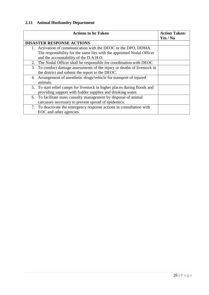
26 | P a g e
2.11 Animal Husbandry Department
Actions to be Taken Action Taken:
Yes / No
DISASTER RESPONSE ACTIONS
1. Activation of communication with the DEOC or the DPO, DDMA.
The responsibility for the same lies with the appointed Nodal Officer
and the accountability of the D.A.H.O.
2. The Nodal Officer shall be responsible for coordination with DEOC
3. To conduct damage assessments of the injury or deaths of livestock in
the district and submit the report to the DEOC.
4. Arrangement of anesthetic drugs/vehicle for transport of injured
animals.
5. To start relief camps for livestock in higher places during floods and
providing support with fodder supplies and drinking water.
6. To facilitate mass casualty management by disposal of animal
carcasses necessary to prevent spread of epidemics.
7. To deactivate the emergency response actions in consultation with
EOC and other agencies.

27 | P a g e
3.1 IMPORTANT TELEPHONE NUMBER OF ALL OFFICES/OFFICERS OF
GANJAM DISTRICT-2016-17
Sl.No. Name & designation Contact Numbers Mobile
1 Sri Bhaskar Jyoti Sharma, RDC(SD),
Berhampur
0680-2201756(O)
0680-2292755(R)
0680-2292750(Fax)
2 Sri P.C. Chaudhary, Collector &DM,
Ganjam
06811-263700(O)
06811-263800(R)
06811-263344(Fax)
9437559670
3 Sri Amitav Thakur, IG of Police,
Berhampur
0680 2292000 8280121299
4 Sri Asish Kumar Singh, Suptd. of Police
Ganjam
06811-263366 9437014466
5 Sri Asish Kumar Singh. Suptd. of Police
Berhampur (I/C)
0680 2292991 8280382804
6 Sri Soraj Kumar Mishra, A.D.M (General),
Ganjam
06811-263927 9438763133
7 Sri Sitansu Kumar Rout, A.D.M (Revenue),
Ganjam
06811-263948 9938619616
8 Sri Ashis Thakare, PD DRDA, Ganjam 06811-263965 9437063965
9 Sri Manoj Kumar Mohanty, MC, BeMC 0680-2206290 9437315326
10 Sri Laxmi Kanta Sethi, Sub-Collector,
Berhampur
0680-2200413(O)
0680-2202212(R) 9437488188
11 Sri Sudhakar Sabaro, Sub-Collector,
Chatrapur
06811-263923(O)
06811-263965(R) 9438686351
12 Sri Basanta Kumar Rout, Sub-Collector,
Bhanjanagar
06821-241002(O)
06821-241003(R) 9437239562
13 Sri Pramod Kumar Sahoo, Dy Collector,
Emergency, Collectorate, Ganjam
06811-263978
06811-260363(FAX)
1077(Toll Free)
9437337662
14 Dy Collector, Election, Collectorate,
Ganjam
06811-263859 9437337662
15 Dy. Collector, Revenue, Collectorate,
Ganjam
9437817485
16 Dy. Collector, Establishment,
Collectorate,Ganjam
9437563800
17 D.I.B. DSP, Ganjam 06811-236986 9437383732
18 D.I.B. DSP, Berhampur 0680-2292390 9437190671
19 Supdt. of Excise, Ganjam 06811-263949 8763300282
20 Supdt. of Excise, Berhampur 9437346948
21 R.T.O., Ganjam 06811-263974 9437166372
22 D.I.O, NIC, Ganjam 06811-263106 9437259587
23 DIPRO Ganjam 06811-263963 9439871179
24 DSWO Ganjam 06811-263968 9437517868
25 District Panchayat Officer, Ganjam 06811-263954 9437338677
26 CSO,Ganjam 06811-263931 9438200041
27 Supdt. MKCG Medical College,
Berhampur
0680-2203624 9437073624
28 CDMO, Ganjam 0680-2225383 9439985006

28 | P a g e
3.2 BLOCK DEVELOPMENT OFFICERS & CONTROL ROOM
Sl.No. Name of the BDO Contact Numbers Mobile
1 BDO, Chatrapur 06811-263912 9437684149
2 BDO, Ganjam 06810-254345 9437240669
3 BDO, Khalikote 06810-256331 9437923257
4 BDO, Beguniapada 06810-26440 9438685110
5 BDO, Polasara 06810-282227 9439875607
6 BDO, Purushottmapur 06811-275323 9937649215
7 BDO, Kabisurya Nagar 06810-270635 9437618068
8 BDO, Hinjilicut 06811-280032 9437254639
9 BDO, Buguda I/c Tahasildar 06818- 250123 9437207500
10 BDO, Sheragada 06822-255623 9437217955
11 BDO, Rangailunda 0680-2119380 8763319277
12 BDO, Kukudakhandi 0680-2485023 9437557078
13 BDO, Digapahandi 06814-247338 9437200793
14 BDO, Sanakhemundi 06814-253727 9437092240
15 BDO, Chikiti 0680-2487228 9437746890
16 BDO, Patrapur 0680-2642224 9437390634
17 BDO, Bhanjanagar 06821-241085 9937508788
18 BDO, Aska 06822-273619 9437465497
19 BDO, Dharakote 06822-268135 9438003524
20 BDO, Surada 06819-270135 8895755335
21 BDO Jagannathprasad 06818-262129 9437352459
22 BDO Belaguntha 06821-258029 8895005544
3.3 TAHASILDARS & CONTROL ROOM
Sl.No. Name of the Tahasildar Contact Numbers Mobile
1 Tahasildar , Berhampur 0680-2203824 9437117282
2 Tahasildar ,Chikiti 0680-2487281 9937444686
3 Tahasildar ,Digapahandi 06814-247328 9438435780
4 Tahasildar ,Konisi 0680-2248438 8763588944
5 Tahasildar ,Patrapur 0680-2112280 9437705419
6 Tahasildar ,Chatrapur 06811-263973 9938540575
7 Tahasildar ,Kodala 06810-268323 9438257340
8 Tahasildar ,Khallikote 06810-256332 9437318543
9 Tahasildar ,Purushottampur 06811-275345 9437828260
10 Tahasildar ,Hinjilicut 06811-280219 9437224528
11 Tahasildar ,Aska 06822-273620 9437206969
12 Tahasildar ,Bhanjanagar 06821-241013 9437247699
13 Tahasildar ,Surada (ATO I/C) 06819-270130 9437385348
14 Tahasildar ,Buguda 06818-250139 9439365504
15 Tahasildar, Sheragada 06822-255775 9438629092
16 Tahasildar, Ganjam 06811-254045 9437176860
17 Tahasildar, Kabisurya Nagar 06810-270212 9438329244
18 Tahasildar, Polosara 06810-282570 8895295978
19 Tahasildar, Dharakote 06822-268100 9437204713
20 Tahasildar, Sanakhemundi 06814-253744 9437122605
21 Tahasildar, Kukudakhandi 0680-2485551 9437258611
22 Tahasildar,Jaganathprasad 06818-262666 8895657370
23 Tahasildar, Bellaguntha 9861162102

29 | P a g e
3.4 LINE DEPARTMENTS
Office Phone No. FAX No. Code Mobile No.
EE, PHD, Berhampur 2200978 2202211 0680 9438719902
EE, PHD, Bhanjanagarat Chatrapur 262909 263914 06811 9437186393
SE,RWSS, Berhampur 2202390 0680 7681023541
EE, RWSS, Berhampur 2296344 2290654 0680 9438419985
EE, RWSS, Bhanjanagar 241026 241079 06821 9438629114
SE, R&B, Berhampur 2281582 0680 9437001992
EE, R&B-I, Berhampur 2233683 2202007 0680 9437262102/
9437164947
EE, R&B-II, Berhampur 2233996 226568 0680 9437022317
EE, R&B, Bhanjanagar 241133 241135 06821 9437356365
SE,RD, Berhampur 9437255314
EE,RD-I, Berhampur 2291405 2403369 0680 9437255319
EE,RD-II, Berhampur 2404096 2202171 0680 9437255320
EE,NH, Berhampur 2283435 2202136 0680 9438204244
SE,OLIC, Berhampur 2224110 0680 9437030600
EE,OLIC, Berhampur 2270663 2553731 0680 9437558811
SE, Irrigation, Berhampur 2281966 0680 9437134165
EE, Bhanjanagar Irrigation 241004 241005 06821 9437010978
EE, Berhampur Irrigation 2281983 2222264 0680 9438237340
EE, Chikiti, Irrigation 2281909 0680 9437548866
EE, Baghalati Irrigation 9437223174
SE,Minor Irrigation,Berhampur 2291121 0680 9437147113
EE,Minor Irrigation-I, Berhampur 2290896 2206853 0680 9438769659
EE,Minor Irrigation-II,Berhampur 2290475 2212184 0680 9437413327
Chief Engineer,RVN Basin 2221406 0680 9437281999
EE, Elect. GNED, Chatrapur 262190 06811 9437959788
Dy.Director of Agriculture, Ganjam
Range,Berhampur 9437579780
Project Director,
Watershed,Berhampur
2281903 0680 9437194835
DGM,SOUTHCO 9437959888
MD,OPTCL(SOUTHCO) 9438907014
EE,OPTCL,Berhampur 9438907371/
9438907860
EE, Drainage, Berhampur 9437885217
GM,TELCOM 2215500 0680 9437475475
Divisional Forest Officer,Berhampur 2281354 0680 9437003254
Divisional Forest Officer,
Bhanjanagar(North)
241008 06821 9437886924
Divisional Forest Officer,
Bhanjanagar(South)
241015 06821 9437060082
DGM,TELCOM,Berhampur 9437300011
Mining Officer,Berhampur 9439435667

30 | P a g e
3.5 URBAN LOCAL BODIES (ULB)
Sl. No.
Name of the ULB Contact Numbers Mobile
1 MC, BeMC, Berhampur 0680-2206290 9437315326
2 E.O.NAC, Chatrapur 06811-263975 8763537158
3 E.O.NAC, Ganjam 06810-254357 8895283338
4 E.O.NAC,Rambha 06810-278336 9438739972
5 E.O.NAC,Hinjilicut 06811-280025 9437224528
6 E.O.NAC,Kodola 06810-268335 9438685110
7 E.O.NAC,Khallikote 06810-256333 9040685780
8 E.O.NAC,Purushottampur 06811-275333 9938089399
9 E.O.NAC,Kabisuryanagar 06810-270623 8895772966
10 E.O.NAC,Polosara 06810-282235 9439539381
11 E.O.NAC, Buguda 06818-250135 9861167787
12 E.O.NAC,Digapahandi 06814-247330 9238636639
13 E.O.NAC,Chikiti 0680-2497222 9438342414
14 E.O.NAC,Gopalpur 9438342414 0680-2343029 9438510530
15 E.O.NAC,Aska 06822-273068 9337222025
16 E.O.NAC,Bhanjanagar 06821-241107 9439873232
17 E.O.NAC, Bellaguntha 06821-258044 9438604486
18 E.O.NAC, Surada 06819-270129 9437765362
3.6 COMMUNICATION FACILITY
Sl.
No. Block
Distance from
Dist. HQ. Road
Availability of
Public
Transport
Telephone
Facility Electricity E-Gram
1 Chatrapur
0
2 Ganjam 10
3 Rangeilunda 32
4 Kukudakhandi 33
5 Khalikote 38
6 Purushottampur 40
7 Hinjilcut 44
8 Digapahandi 50
9 Kabisurya Nagar 54
10 Chikiti 54
11 Kodala 60
12 Aska 62
13 Sanakhemundi 64
14 Sheragada 65
15 Patrapur 70
16 Dharakote 72
17 Polosora 80
18 Buguda 91
19 Bhanjanagar 102
20 Sorada 107
21 Belaguntha 110
22 Jagannath Prasad 116

31 | P a g e
3.7 LIST OF MULTIPURPOSE CYCLONE (MCS) & MULTIPURPOSE FLOOD
SHELTER (MFS) OF GANJAM DISTRICT
Sl.No Name of the Block Name of the G.P Name of the Village MFS/MCS
1 Khallikote
Sabulia Sabulia MCS
2 Kanaka Samalanasi MCS
3
Ganjam
Palibandha
Niladripur MCS
4 Binchanapalli MCS
5 Purunabandha MCS
6 Kantiagada MCS
7 Santoshpur Satuli MCS
8 Humma
Borigaon MCS
9 Gokharakuda MCS
10 Mallada Lunguri MCS
11
Ramagada
Sipakuda MCS
12 Arunapur MCS
13 Prayagi MCS
14 Podagada Jhatipadar MCS
15 New Podampeta MCS
16 Sana Ramachandrapur Madhurchua MCS
17 Karapada Karapada MCS
18 Rajapur Rajapur MCS
19
Chatrapur
Arjipalli Sana Arjipalli MCS
20 Bada Arjipalli MCS
21
Kalipalli
Upalapati MCS
22 Haripur MCS
23 Bandar MCS
24 Kanamana Kanamana MCS
25 Matikhalo MCS
26 Agastinuagaon
Agastinuagaon MCS
27 Nolianuagaon MCS
28
Rangeilunda
Baxipalli New Baxipalli MCS
29 Indrakhi
Tulu MCS
30 Markandi MCS
31
Chikiti
Katuru Chandanbada MCS
32 Ramayapatana MCS
33 Ekasingi Ekasingi MCS
34 Sonapur
Patisunapur MCS
35 Sonapur MCS
36 Kabisuryanagar Sunarijhola Bhetasingi MFS
37 Aska Gunthapada Jagadalapur MFS
38 Purshottampur
Raipur Govindapur MFS
39 Pratapur Pratapur MFS
40 Sheragada
Tanhara Tanhara MFS
41 Kanjiamma MFS
42 Pitala Santoshpur MFS
43 Digapahandi Bhismagiri Bhismagiri MFS
44
Hinjilicut
Chanduli Khandara MFS
45 Makarajhol Balarampur MFS
46 Ralaba
Alapur MFS
47 Ralaba MFS
48 Burupada Burupada MFS

32 | P a g e
3.8 PUBLIC DISTRIBUTION SYSTEM (PDS)
Sl.
No. Block & ULB
No. of Retail
Center
No. of APL Card
Holder
No. of BPL Card
Holders
1 Chatrapur 100 11683 12020
2 Ganjam 65 7642 8426
3 Rangeilunda 102 9503 13268
4 Kukudakhandi 91 9717 10783
5 Khalikote 85 10541 12191
6 Purushottampur 76 12753 10504
7 Hinjilcut 69 11741 7432
8 Digapahandi 87 11968 13094
9 Kabisuryanagar 70 10243 8032
10 Chikiti 70 7727 9964
11 Beguniapada 76 5671 12966
12 Aska 88 16159 8367
13 Sanakhemundi 89 11426 12611
14 Sheragada 71 9188 8416
15 Patrapur 68 9253 12305
16 Dharakote 56 5624 10534
17 Polosora 49 6554 12468
18 Buguda 76 7493 11163
19 Bhanjanagar 81 5667 12315
20 Sorada 70 1061 15975
21 Belaguntha 45 11125 6912
22 Jagannathprasad 63 6101 14938
23 BeMC 126 56004 13581
24 Gopalpur NAC 2 459 640
25 Digapahandi NAC 7 1445 729
26 Chikiti NAC 5 1368 964
27 Chatrapur NAC 15 6607 1734
28 Ganjam NAC 12 2025 862
29 Rambha NAC 9 2158 537
30 Khalikote NAC 12 1777 593
31 Kodala NAC 4 1953 917
32 Polosora NAC 12 3026 1167
33 Purushottampur NAC 8 1705 1161
34 Kabisuryanagar NAC 7 3429 827
35 Hinjili NAC 8 2221 1868
36 Bhanjanagar NAC 11 2620 2291
37 Belaguntha NAC 13 1200 899
38 Buguda NAC 7 1162 806
39 Aska NAC 17 2796 1728
40 Sorada 9 1791 1006

33 | P a g e
3.9 BLOCK/ULB WISE PRESENT STATUS IN FINAL PRIORITY LIST UNDER
NFSA AS ON 19.04.2016 OF GANJAM DISTRICT
Sl.No
22 Nos of
Blocks
and 18 nos
ULB
Total
population
as per 2011
census
Target
Beneficiaries covered
under AAY in final
priority list
Beneficiaries
covered under PHH
in final priority list
Beneficiaries covered
in final priority list
Family Family
members Family
Family
members
Total
Family
Total
Family
members
1
40 nos. of
Blocks &
ULB
3529031 2562200 40818 148090 592307 2275959 633125 2424049
3.10 ALTERNATIVE ENERGY SOURCES
Type of
Sources Contact Person Telephone No Remarks
Generator
District Control Room Emergency Section,
Chatrapur
06811 - 263978 2 set
Collector’s Court Hall 06811 – 263800 2 set
DRDA, Ganjam 06811 – 263920 1 set
Kalia Light & Sound, Main Road,
Chatrapur
06811 - 263643 10 set
Choudhury General Store, Main Road,
Chatrapur
06811-262273 1 set
3.11 LIST OF BLOCK LEVEL CHC/ UGPHC/ PHC (BLOCK WISE HEALTH INSTITUTIONS)
Sl.
No.
Name of the
Block
Name of the G.P.
/ NAC
Name of the Health
Institution
No of Sub
Centers
No. of
Beds
01 Berhampur
Municipal
Corporation
City Hospital Berhampur 137
Zonal Dispensary
02 Sanakhemundi Adapada CHC Adpada 23 16
Patapur PHC (N) Patapur 06
Podamari PHC (N) Pudamari 06
Kankarada PHC (N) Kankarada
Sahaspur PHC (N) Sahaspur
Dengausta PHC (N) Dengausta
Goutami PHC (N) Goutami
03 Digaphandi Bomokai CHC Bomokai 23 06
Digaphandi CHC Digaphandi 10
Padmanavpur PHC (N) P.N.Pur
Sidheswar PHC (N) Sidheswar
Bhimsmagiri PHC (N) Bhimsmagiri 06
Talasingi PHC (N) Talasingi
Gaoudagaon PHC (N) Gaoudagaon
Jharipadar PHC (N) Jharipadar

34 | P a g e
04 Chikiti Chikiti CHC, Chikiti 17 30
Girisola CHC Girisola 06
Nuapada PHC (N) Nuapada 10
Sorala PHC (N) Sorala
Sumandi PHC (N) Sumandi
Kutulingi PHC (N) Kutulingi
Karabalua PHC(N) Karabalua
05 Rangelunda Keluapalli CHC Keluapalli 20 06
Gopalpur PHC (N) Gopalpur 06
Bhanjabihar PHC (N) Bhanjabihar
Sunadai PHC (N) Sunadai
Mantridi PHC (N) Mantridi
06 Patrapur Patrapur CHC Patrapur 23 30
Jarada PHC (N) Jarada
Baranga PHC (N) Baranga
Surangi PHC (N) Surangi 06
Tumba PHC (N) Tumba
Khariaguda PHC (N) Khariaguda
Nuapentha PHC (N) Nuapentha
Turubudi PHC (N) Turubudi
07 Kukudakhandi Kukudakhandi CHC Kukudakhandi 19 06
Balipada PHC (N) Balipada 06
Banthapalli PHC (N) Banthapalli
Jagadalpur PHC (N) Jagadalpur
Lathi PHC(N), Lathi
08 Polosara Polosara CHC Polosara 21 80
Chirikipadasasna PHC (N) Chirikipadasasna
Hatiotta PHC (N) Hatiotta
Dhunkapada PHC (N) Dhunkapada
Pandiripada PHC (N) Pandiripada
09 Khalikote Khalikote CHC Khalikote 23 30
Kanheaipur PHC (N) Kanheaipur
B.N.Pur PHC (N) B.N.Pur
Patahar PHC (N) Patahar
Chikili Talapada PHC(N) C Talapada
10 Beguniapada Kodala CHC Kodala 21 30
Sumandala CHC Sumandala 06
Beguniapada PHC (N) Beguniapada
Rahada PHC (N) Rahada
11 Chatrapur Chatrapur SDH Chatrapur 20 76
Municipentha CHC Municipentha 16
Narendrapur PHC (N) Narendrapur
Sundarapur PHC (N) Sundarapur
S.Nolia Nua
Gaon
PHC (N) S.Nolia Nua
Gaon
12 Ganjam Khandadeulli CHC Khandadeulli 15 06
Rambha PHC (N) Rambha
Ganjam PHC (N) Ganjam 06
Humma PHC (N) Humma
Santospur PHC (N) U.D.S.Pur

35 | P a g e
13 Purusotampur Bhatakumarada CHC Bhatakumarada 24 16
Patrapur PHC (N) Patrapur
Purusotampur CHC Purusotampur 10
Somma PHC (N) Somma
Pandia PHC (N) Pandia
B.Kharida PHC (N) B.Kharida
14 Hinjili Bellagam CHC Bellagam 19 06
Hinjili CHC Hinjili 10
Kanchuru PHC (N) Kanchuru
J.D.Pur PHC (N) J.D.Pur
Saru PHC (N) Saru
15 K.S.Nagar K.S.Nagar CHC K.S.Nagar 17 16
Budaambo PHC (N) Budaambo
A.Patna PHC (N) A.Patna
16 Sorada Badagada CHC Badagada 19 30
Sorada CHC Sorada 10
Gajalabadi PHC (N) Gajalabadi
Badabadangi PHC (N) Badabadangi
Gouda gotha PHC (N) Gouda gotha
Gochha PHC (N) Gochha
Sidhipur PHC (N) Sidhipur
17 Sheragada Sheragada CHC Sheragada 19 16
Pitala PHC (N) Pitala 10
Kulagada PHC (N) Kulagada
Dengapadar PHC (N) Dengapadar
Karadakana PHC (N) Karadakana
Alarigada PHC (N) Alarigada
18 Dharakote Dharakote CHC Dharakote 17 16
Manikyapur PHC (N) Manikyapur
Jahada PHC (N) Jahada
Jagamohan PHC (N) Jagamohan
Mundamari PHC (N) Mundamari
19 Aska Aska CHC Aska 23 60
Balisira CHC Balisira 06
Bhetanai PHC (N) Bhetanai
Gahngu PHC (N) Gahngu
Jaypur PHC (N) Padhala Jaypur
20 Buguda Buguda CHC Buguda 18 16
Balipadara PHC (N) Balipadara 06
Karachuli PHC (N) Karachuli
Karadabadi PHC (N) Karadabadi
Manitara PHC (N) Manitara
21 J.N.Prasad J.N.Prasad CHC J.N.Prasad 22 16
Baragaon PHC (N) Baragaon
Tarasingi PHC (N) Tarasingi
Chamunda PHC (N) Chamunda
Alasu PHC (N) Alasu
22 Bhanjanagar Bhanjangar SDH Bhanjangar 22 80
Gallery CHC Gallery 30
Kulada PHC (N) Kulada
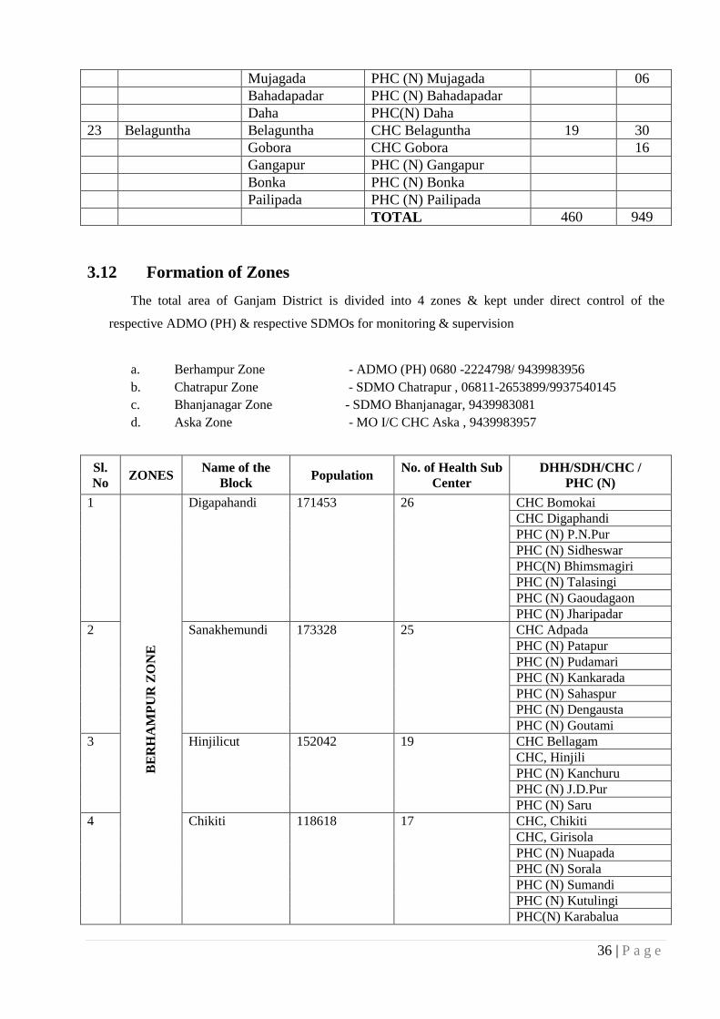
36 | P a g e
Mujagada PHC (N) Mujagada 06
Bahadapadar PHC (N) Bahadapadar
Daha PHC(N) Daha
23 Belaguntha Belaguntha CHC Belaguntha 19 30
Gobora CHC Gobora 16
Gangapur PHC (N) Gangapur
Bonka PHC (N) Bonka
Pailipada PHC (N) Pailipada
TOTAL 460 949
3.12 Formation of Zones
The total area of Ganjam District is divided into 4 zones & kept under direct control of the
respective ADMO (PH) & respective SDMOs for monitoring & supervision
a. Berhampur Zone - ADMO (PH) 0680 -2224798/ 9439983956
b. Chatrapur Zone - SDMO Chatrapur , 06811-2653899/9937540145
c. Bhanjanagar Zone - SDMO Bhanjanagar, 9439983081
d. Aska Zone - MO I/C CHC Aska , 9439983957
Sl.
No ZONES
Name of the
Block Population
No. of Health Sub
Center
DHH/SDH/CHC /
PHC (N)
1
BE
RH
AM
PU
R Z
ON
E
Digapahandi 171453 26 CHC Bomokai
CHC Digaphandi
PHC (N) P.N.Pur
PHC (N) Sidheswar
PHC(N) Bhimsmagiri
PHC (N) Talasingi
PHC (N) Gaoudagaon
PHC (N) Jharipadar
2 Sanakhemundi 173328 25 CHC Adpada
PHC (N) Patapur
PHC (N) Pudamari
PHC (N) Kankarada
PHC (N) Sahaspur
PHC (N) Dengausta
PHC (N) Goutami
3 Hinjilicut 152042 19 CHC Bellagam
CHC, Hinjili
PHC (N) Kanchuru
PHC (N) J.D.Pur
PHC (N) Saru
4 Chikiti 118618 17 CHC, Chikiti
CHC, Girisola
PHC (N) Nuapada
PHC (N) Sorala
PHC (N) Sumandi
PHC (N) Kutulingi
PHC(N) Karabalua

37 | P a g e
5 Kukudakhandi 147324 20 CHC, Kukudakhandi
PHC(N), Balipada
PHC (N) Banthopalli
PHC (N)Jagadalpur
PHC (N)Lathi
6 Patrapur 138213 23 CHC, Patrapur
PHC(N), Surangi
PHC (N) Turubudi
PHC (N)Baranga
PHC(N)Khariaguda
PHC(N) Nuapentha
PHC (N) Tumba
PHC(N) Jaradagada
7 Sheragada 131419 19 CHC, Sheragada
PHC(N) Dengapadar
PHC (N)Koradakona
PHC (N)JKulagada
PHC(N) Pitala
PHC(N) Alarigada
8 Rangeilunda 172374 21 CHC, Keluapalli
PHC(N) Bhanjavihar
PHC (N) Gopalpur
PHC (N) Mantridi
PHC(N) Sunadei
Sl.
No ZONES
Name of the
Block Population
No. of Health Sub
Center DHH/SDH/CHC/PHC(N)
1
CH
AT
RA
PU
R Z
ON
E
Purusotampur 174030 25 CHC Bhatakumarada
PHC (N) Patrapur
CHC Purusotampur
PHC (N) Somma
PHC (N) Pandia
PHC (N) B.Kharida
2 Polasara 175474 22 CHC Polosara
PHC(N) Chirkipadasasna
PHC (N) Hatiotta
PHC (N) Dhunkapada
PHC (N) Pandiripada
3 Chatrapur 168637 20 SDH Chatrapur
CHC Municipentha
PHC (N) Narendrapur
PHC (N) Sundarapur
PHC(N) S.Nolianuagaon
4 K. S. Nagar 148989 17 CHC K.S.Nagar
PHC (N) Budaambo
PHC (N) A.Patna
5 Ganjam 124960 15 CHC Khandadeulli
PHC (N) Rambha
PHC (N) Ganjam
PHC (N) Humma
PHC (N) U.D.S.Pur
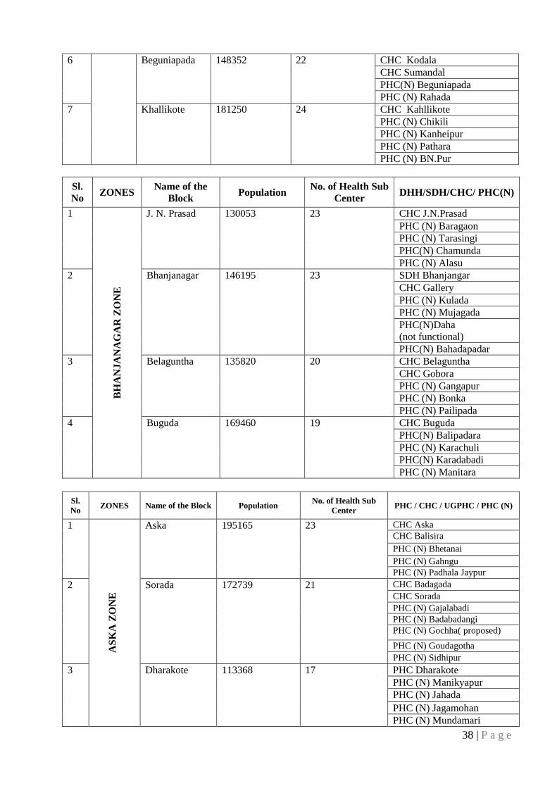
38 | P a g e
6 Beguniapada 148352 22 CHC Kodala
CHC Sumandal
PHC(N) Beguniapada
PHC (N) Rahada
7 Khallikote 181250 24 CHC Kahllikote
PHC (N) Chikili
PHC (N) Kanheipur
PHC (N) Pathara
PHC (N) BN.Pur
Sl.
No ZONES
Name of the
Block Population
No. of Health Sub
Center DHH/SDH/CHC/ PHC(N)
1
B
HA
NJA
NA
GA
R Z
ON
E
J. N. Prasad 130053 23 CHC J.N.Prasad
PHC (N) Baragaon
PHC (N) Tarasingi
PHC(N) Chamunda
PHC (N) Alasu
2 Bhanjanagar 146195 23 SDH Bhanjangar
CHC Gallery
PHC (N) Kulada
PHC (N) Mujagada
PHC(N)Daha
(not functional)
PHC(N) Bahadapadar
3 Belaguntha 135820 20 CHC Belaguntha
CHC Gobora
PHC (N) Gangapur
PHC (N) Bonka
PHC (N) Pailipada
4 Buguda 169460 19 CHC Buguda
PHC(N) Balipadara
PHC (N) Karachuli
PHC(N) Karadabadi
PHC (N) Manitara
Sl.
No ZONES Name of the Block Population
No. of Health Sub
Center PHC / CHC / UGPHC / PHC (N)
1
AS
KA
ZO
NE
Aska 195165 23 CHC Aska
CHC Balisira
PHC (N) Bhetanai
PHC (N) Gahngu
PHC (N) Padhala Jaypur
2 Sorada 172739 21 CHC Badagada
CHC Sorada
PHC (N) Gajalabadi
PHC (N) Badabadangi
PHC (N) Gochha( proposed)
PHC (N) Goudagotha
PHC (N) Sidhipur
3 Dharakote 113368 17 PHC Dharakote
PHC (N) Manikyapur
PHC (N) Jahada
PHC (N) Jagamohan
PHC (N) Mundamari

39 | P a g e
The CDMO, Ganjam will remain in overall charge of all the zones.
Contact Number: 9439985006 / 0680-22225383.
3.13 CHC/ UGPHC/ PHC/ PHC PRONE TO CYCLONE AND FLOOD
Sl. No.
Block/ ULBs Population No. of
Health
S.C.
CHC/ UGPHC/
PHC/ PHC (N)
Vulnerable GPs/ Villages &
Type of Health Institution
available
1 Khalikote 148877 23
UGPHC, Khalikote PHC(N), Kanheipur PHC(N), Pathara PHC(N), B.N.Pur
CHC & PHC (N) Hospital
2 Rangeilunda 143471 21
PHC, Kelupalli PHC(N), Gopalpur PHC(N), Bhanjanagar PHC(N), Sundae PHC(N), Mantridi
CHC & PHC (N) Hospital
3 Ganjam 102486 15
PHC, Khandadeuli PHC(N), Ganjam PHC(N), Humma PHC(N), Rambha PHC(N), D.S.Pur PHC(N), Umuri
CHC & PHC (N) Hospital
4 Chatrapur 148877 20
PHC, Municipentha PHC(N), Narendrapur PHC(N), Sundarpur PHC(N), B.Arjipalli PHC(N), N.Nuagaon
CHC & PHC (N) Hospital
5 Chikiti 105725 17
PHC, Girisola CHC, Chikiti PHC(N), Nuapada PHC(N), Surala PHC(N), Sumandi PHC(N), Kutulingi
CHC & PHC (N) Hospital
6 Aska 165060 23
PHC, Balisira PHC(N), P.Jayapur PHC(N), Gahangu PHC(N), Bhetanai
CHC & PHC (N) Hospital
7 BeMC 251366
CITY HOSPITAL ,
MKCG MEDICAL
OFFICER
1. CITY HOSPITAL
BERHAMPUR
2. MKCG MEDICAL
COLLEGE HOSPITAL,
BERHAMPUR

40 | P a g e
SUB-DIVISION – BHANJANAGAR
Sub-Divisional Hospital – Bhanjanagar, S.D.H, Bhanjanagar
Telephone No – 06821 – 241023
Sl. No. Block Name of the PHC/
CHC/ UGPHC PHC (N)
1 Sorada UGPHC, Badagada Sorada,Gajalabadi,Badadangi,
Goudagotha,Sidhipur
2 Sheragada PHC, Sherada Kulagada,Pittala,
Dengapadar,Karadakana
3 Dharakote PHC, Dharakote Manikyapur,Jahada
Jagamohan,Mundamarei
4 Aska PHC, Balisira Bhatanai,Gahangu,P.Jayapur
5 Buguda PHC, Buguda
Balipadra,Karachuli,
A.Karabadi,Manitara
6 Jagannathprasad PHC, J.N.Prasad Baragaon,Tarasingi,Chhamunda
Alasu
7 Bhanjanagar UGPHC, Gallery Kulada,Mujhagada
Bahadapadara
8 Belaguntha PHC, Gobara
CHC, Belaguntha
Gangapur,Banka,Pailipada
SUB-DIVISION – BERHAMPUR
Sub-Divisional Hospital – City Hospital, Zonal Dispensary
City Hospital, Berhampur
Telephone No – 0680– 204409
Sl. No. Block Name of the PHC/
CHC/ UGPHC PHC (N)
1 Sanakhemundi CHC, Adapada Patapur,Podamari,Kankarada
Sahaspur,Dengausta,Gautami
2 Digapahandi PHC, Bomokai
RHC Digapahandi,Padmanabhapur,
Sidheswar,Bhismagiri,Talasingi
Gaudagaon,Jharipadar
3 Chikiti PHC, Girisola
PHC, Chikiti Nuapada,Sorala,Sumandi,Kutulingi

41 | P a g e
4 Rangeilunda PHC, Kelupalli Gopalpur,Bhanjabihar,Sunadei
Mantridi
5 Patrapur UGPHC, Patrapur Jarada,Baranaga,Surangi,Tumba
Khariaguda,Nuapentha
6 Kukudakhandi UGPHC, Kukudakhandi Balipada,Banthapalli,Jagadalpur
7 Polosora UGPHC, Polosora Chrikipadasasan,Hatiota,Dhunkapada
Pandiripada
8 Khalikote UGPHC, Khalikote
Kanheipur,Pathara,B.N.Pur
9 Beguniapada PHC, Sumandala
CHC, Kodala Beguniapada, Rahada
SUB-DIVISION – CHATRAPUR
Sub-Divisional Hospital – Chatrapur, S.D.H, Chatrapur
Telephone No – 06811 – 263899
Sl. No Block Name of the PHC/
CHC/ UGPHC PHC (N)
1 Chatrapur Municipentha Narendrapur,Sundarpur,B.Arjipalli
Nolianuagaon
2 Ganjam PHC, Khandadeuli Rambha,Ganjam,Humma,Umuri
Dharamasaranpur
3 Purushottampur CHC, Bhatakomorada P.S.Pur,Pratapur,Somma,Pandia
Badakharida
4 Hinjilcut PHC, Bellgam Hinjilcut,Kanchuru,
Jamuni (Dayanidhipur)
5 Kabisuryanagar PHC, K.S.Nagar Budamba, Athagadapatana

42 | P a g e
3.14 DISTANCE OF SUB DIVISIONAL/ BLOCK HEAD QUARTERS FROM
DISTRICT HEAD QUARTER
Sl. No. Sub-Divisions/ Blocks Distance from District H.Q. (Km.) Public/ Private Bus
Service available
SUB-DIVISONS
1 CHATRPUR 0
2 BERHAMPUR 22
3 BHANJANAGAR 102
BLOCKS
1 Chatrapur 0
2 Ganjam 10
3 Rangeilunda 32
4 Kukudakhandi 33
5 Khalikote 38
6 Purushottampur 40
7 Hinjilcut 44
8 Digapahandi 50
9 Kabisurya Nagar 54
10 Chikiti 54
11 Beguniapada 60
12 Aska 62
13 Sanakhemundi 64
14 Sheragada 65
15 Patrapur 70
16 Dharakote 72
17 Polosora 80
18 Buguda 91
19 Bhanjanagar 102
20 Sorada 107
21 Belaguntha 110
22 Jagannathprasad 116

43 | P a g e
4. Rapid Damage and Loss Assessment Format _______________________________________________________________________________
Type of Disaster: Date of Assessment:
Name Name of the
Reporting Official(s) Designation Signature
Panchayat
Block
Damage Assessment
1. Affected areas and Estimated affected Population
Areas Villages Population affected
Worst Affected
Moderately Affected
Unaffected
2. Structural Damage
Condition Houses Private
Buildings
Public
Buildings Govt Buildings
Pucca Kutcha
Fully Damaged /
Severely
Inundated /
Washed Away
Severely
Damaged
Partial Damaged
3. Damage to Basic Infrastructure
Condition Roads Bridges Electricity Hand
Pumps Wells
Piped
Water Latrine
Functional
Damaged
Destroyed

44 | P a g e
4. Social Infrastructure
Condition Health
Centre
Primary
School
Middle
School
High
School College
Panchayat
Bhawan
Fair
Price
Shop
Shelter
(Community
Hall)
Total
Functional
Severely
Affected
Moderately
Affected
Used as
Relief
Centre
5. Status of Solid Waste Disposal
Status Very Poor Poor Good Very Good
Presence of sewage in
open
Drainage Systems
Quantity of Solid
Waste
Management of Solid
Waste available
6. Human Health (to be submitted by health centres)
Presence of
Vector Borne
diseases
Malaria Dengue Lymphatic
Filariasis Kala-azar
Number of cases
reported
Vector Control measure available at the health centre Yes No
What measures are available?
Number of people reported Dead
Number of Infants Dead
Cause(s) of Death (Name Diseases):

45 | P a g e
Number of Women Dead
Cause(s) of Death:
Number of Old Dead
Cause(s) of Death
Number of Men Dead
Cause(s) of Death
Number of Specially Challenged Dead
Cause(s) of Death
Number of people who lost eyes or limbs
Number of people with grievous injuries
requiring immediate hospitalisation
Number of Mobile Medical Units made
available to the Panchayat
Number of Doctors available
7. Animal Health (Domesticated Animals)
Are animals reported Sick/Dead? Yes No
Diseases Reported:
What control measures are available?
Name of the animals reported Dead
Name of the animals reported Sick

46 | P a g e
Map the name of the animal with number of
Dead
Animal Disease Dead
Cause(s) of Death (Name Diseases)
Map name of the animal with number of Sick Animal Disease Sick
Cause(s) of Sickness
8. Displacement and Relief Shelters
Humans
Number of Families Number
Total Displaced
Accommodated by Host Families /
Relatives
Staying back in Damaged Houses
Government Relief Shelters
No of families accommodated at
Schools
Religious
Places
Panchayat
Bhawan
Others
(Specify)

47 | P a g e
Domestic Animals
Number of animals displaced
Number of temporary shelters for
Livestock
9. Livelihoods
Type of
Livelihoods
What is the
Damage
Put a
Tick
Mark
No of people affected or area
Damage
(in acres, where applicable)
Extent of
Damage
Agriculture Silting
Inundation
Crop Failure
Agri. Labourer
Labourer
Fisheries Boats
Nets
Petty Shop
Rural Artisans Loom
Equipment
Accessories
Yarn, Dies,
Chemicals
Others
Animal
Husbandry
10. Agriculture
Area Number
Ongoing Season Kharif Rabi
Total Crop Area
Total Crop Area Damaged
(Silting of agricultural land)
Total Cropped Area
Total Crop Damaged
Cause(s) of Damage

48 | P a g e
11. Needs Assessment Format (RDNA)
Type of Disaster: Date of Assessment:
Name of Blocks and
GPs Assessed
Name of the
Reporting Official(s) Designation Signature
12. Affected areas and Estimated affected Population
Areas Villages Population affected
Worst Affected
Moderately Affected
Unaffected
13. Structural Damage
Condition Houses Private
Buildings
Public
Buildings Govt Buildings
Pucca Kutcha
Fully Damaged /
Severely
Inundated /
Washed Away
Severely
Damaged
Partial
Damaged
14. Damage to Basic Infrastructure
Condition Roads National
Highway
Bridges Electricity Hand
Pumps
Piped
Water
Latrine
Functional
Damaged
Destroyed
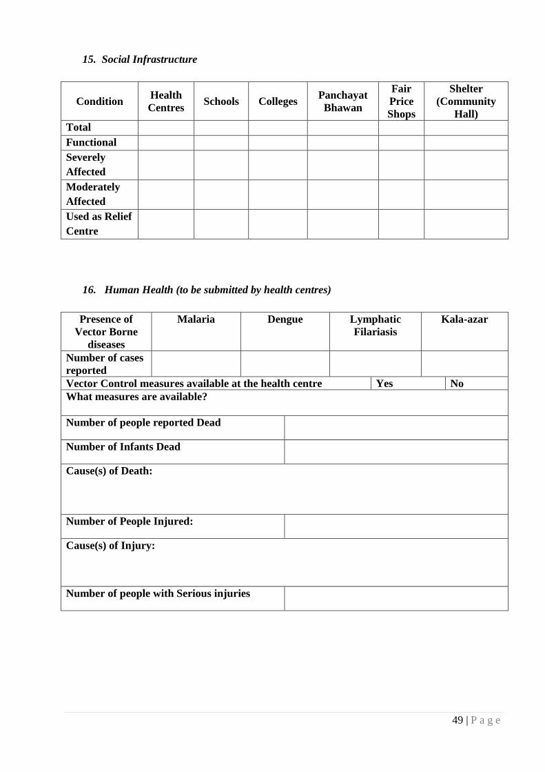
49 | P a g e
15. Social Infrastructure
Condition Health
Centres Schools Colleges
Panchayat
Bhawan
Fair
Price
Shops
Shelter
(Community
Hall)
Total
Functional
Severely
Affected
Moderately
Affected
Used as Relief
Centre
16. Human Health (to be submitted by health centres)
Presence of
Vector Borne
diseases
Malaria Dengue Lymphatic
Filariasis
Kala-azar
Number of cases
reported
Vector Control measures available at the health centre Yes No
What measures are available?
Number of people reported Dead
Number of Infants Dead
Cause(s) of Death:
Number of People Injured:
Cause(s) of Injury:
Number of people with Serious injuries

50 | P a g e
5. Lessons Learnt _______________________________________________________________________________
5.1 Response to Very Severe Cyclonic Storm-Phailin & Subsequent Flood 2013
A. RECEIPT OF CYCLONIC WARNING AND PREPARATORY STEPS
The information regarding impending Cyclone was received during the night of 08.10.2013
and the preparatory steps were immediately taken to convene a meeting of all District Level
Officers and the local field functionaries like B.D.Os, Tahasildars, and Executive Officers of NAC
etc. Accordingly the meeting was convened at DRDA Conference hall on 9.10.2013.
This preparatory meeting of District Disaster Management Authority (DDMA) was
convened on 9.10.2013 under the Chairmanship of the Collector & District Magistrate. Both the
Superintendent of Police, Additional District Magistrates, Project Director, DRDA & all Sub
Collectors of the District were present in the meeting.
Apart from them all District Level Officers like DWO, DSWO, DPO, heads of different
line departments like Deputy Director, Agriculture, C.D.M.O., District Education Officer, District
Project Coordinator, SSA, C.D.V.O., Dist. Fisheries Officer, Executive Engineers of different
department, Officers from ODRAF, ARMY, B.D.Os, Tahasildars, Municipal Commissioner,
BMC, all Executive Officer of NAC of this District etc. participated in the meeting.
In this meeting Collector & District Magistrate, described in detail regarding the threat
posed by the severe Cyclonic storm and advised all Officers to take necessary precautionary steps
for ensuring safety and security of life and property of the people. All the officers were advised to
prepare the Micro Plan at their level for evacuation of the people and taking proper care of them in
the temporary cyclone shelters. It was also decided to open a 24 hour control room in all the
Blocks and other offices for receiving appropriate information and monitoring the related works.
The officers were directed to immediately go back to their concerned headquarters and take
precautionary steps for the impending severe cyclone storm.
B. EVACUATION & RESCUE STRATEGY
1. Preparation of Evacuation Micro Plan:
For proper guidance of the Officers in the matter of evacuation, an Office Order was made
giving detail guidance for preparation of evacuation Micro Plan. In this order, the concerned
Officers were ordered to prepare a Micro Plan for evacuation of villagers from coast line to at least
10 Kms. inside (land ward side) by the concerned B.D.Os & Tahasildars, Senior Officers were
deployed to supervise the work for the purpose. A Micro Plan was prepared to identify location of

51 | P a g e
temporary cyclone shelters. For the purpose only RCC roof, Govt. building or private building
which are safe, accessible and are not located in the low lying area were identified. For this
purpose, a particular format was also prepared for guidance of the concerned officers. Besides, the
following instructions were given for preparation of Micro Plan.
Requirement is to be calculated for Free Kitchen & Dry ration (for seven days) and polythene
sheets, K.Oil and Diesel, Gen-set, Drinking Water, Medicines etc.
The evacuation is to be done after receiving instruction from DEOC.
Plan is to be made for mobilization of officers, so that evacuation can be done within half an hour
of issuance of orders.
Proper coordination with Police is essential to handle any law & order situation and for proper
distribution of relief materials.
B.D.Os and Senior Officers to remain in constant touch with District Emergency Operation Centre
(DEOC).
Plan should reach the District Office by 11.00 PM of 9th October, 2013 positively.
2. Deployment of Senior Officers to likely to be severely affected Blocks/ULBs:
After the preparatory meeting was over on 9.10.2013, some Senior Officers of this district
were given exclusive charge to remain in charge of Blocks and ULBs for overall supervision and
monitoring of preparedness, post cyclone relief matters to be undertaken in the area allotted to
them.
For this purpose, six Senior Officers of this District were assigned with duties. These
Officers were instructed to immediately move and camp at the headquarters of the concerned
Blocks w.e.f. 9.10.2013. They were directed to supervise all activities relating to preparedness and
post cyclone relief measures for the entire area allotted to them.
Coordinate with all the Line Departments of the concerned area for effective and timely
implementation of the pre and post cyclonic relief measure.
To supervise and ensure that cyclone warning is properly disseminated to all G.Ps,
Villages/Wards of ULBs under their charge.
To verify the macro level master plan of the Block & ULBs and micro level plan for each G.P,
Village and Wards for effective preparedness and management of relief work.
Ensure meeting with each Cyclone Management Committee involving PRIs, NGOs and to ensure
holding of mock drill at all the cyclone shelter centres of their allotted area on 10.10.2013
positively.

52 | P a g e
To identify safer shelter sites within 10 Kms. of the coastline and ensure evacuation of people
and live stocks to the identified cyclone shelter centres .
To ensure detail deployment of staff at each cyclone shelter centre and strategic shelter locations
and to chalk out detail evacuation plan involving local NGO, PRIs and Anganwadi Workers,
Ashakarmis.
Ensure sufficient stock of food stuff, generator, K.Oil Candles, Match Boxes, drinking water,
Life saving tablets, Halogen tablets at cyclone shelter centres and strategic shelter centres.
To prepare action plan for clearance of road by keeping liaison with line department, Volunteers,
N.G.Os, P.R.Is to facilitate movement of relief materials after cyclone.
To ensure sufficient stock of food grains, K.Oil, at G.P. Godowns for post cyclonic relief
operation.
To submit detail action taken report in this regard to District Emergency Operation Centre Office
by 5.00 PM on 10.10.2013 through E-mail in [email protected] /
To ensure functioning of 24 hours control room at Block & ULB offices with effect from
9.10.2013.
To conduct inventory of Boat and Boat man and vehicles to be used for evacuation at each G.P.
to be used during evacuation and relief operation.
To identify vulnerable sections of the society like pregnant women, small children, old and
infirm persons who are to be given priority at the time of evacuation.
To ensure safety of the domestic animals and make provision of fodder for the animals by ARD
Deptt. and disposal of animal caracases with the help of local NGOs, Volunteers after occurrence
of cyclone.
To ensure sufficient stock of life saving medicines, halogens tablets and presence of health
officials at the PHCs, CHCs of the Blocks and ULBs allotted to them.
To make liaison with RD Deptt., R&B Deptt. South Co. and other line Deptt. for restoration of
road, power and disinfection of tube wells on war footing basis after occurrence of the cyclone.
3. Assignment of Line Deptts. to Senior Officers for coordination:
Apart from this, three Senior Officers of this District viz. both the Additional District
Magistrates and the Project Director, DRDA were given the charge of different departments for
proper coordination and monitoring the steps taken by District Level Officials of the Department.

53 | P a g e
Sl.No. Name & designation of the
Senior Officers List of Department for coordination
1. Additional District Magistrate
(Gen)
1. Food Supplies & Consumer Welfare Deptt.
2. School & Mass Education Deptt.
3. ST & SC Development Deptt.
4. Sport & Youth Services Deptt.
5. Information & Public Relations Deptt.
6. Transport Deptt.
7. Tourism & Culture Deptt.
2. Additional District Magistrate
(Rev.)
1.Revenue & Disaster Management Deptt.
2. Women & Child Development Deptt.
3. Health & Family Welfare Deptt.
4. Animal Resources Development Deptt.
5. Water Resource Department
6. Agriculture, Cooperation Deptt.
3. Project Director, DRDA.
1. Panchayati Raj Deptt.
2. Works Department
3. Rural Development Department
4. Information & Technology Deptt.
(Communication & BSNL)
5. Home Department.
6. Forest Department
7. Housing & Urban Development Deptt.
The above 03 Senior Officers were entrusted with the following duties and
responsibilities.
Coordination with District Level Officials of Departments assigned for effective and timely
implementation of Pre & Post Cyclonic Management measures.
To ensure Control Room is functioning in the offices of District Heads of various departments.
To coordinate with District Emergency Operation Centre (DEOC).
To map detailed activities to be taken up by the concerned officials from 10th October, 2013 Fore
Noon onwards till 15th October 2013.
To keep close liaison with field official in various blocks and ensure full implementation of plans
prepared.

54 | P a g e
4. Instructions to Blocks/ULBs to form team for Pre & Post cyclonic relief
work:
As it was decided to open Temporary Cyclone Shelters at different safe places to evacuate
the people staying in kutchha houses and low lying areas, proper steps were also taken for their
food and other related requirements. Extra care was taken for the 5(five) coastal Blocks / NACs.
The Executive Officers of the concerned ULBs and the B.D.Os of the concerned Blocks were
directed to designate the Nodal Officers to be in charge of relief operations with some assisting
staff for receipt and despatch of relief materials to various cyclone shelter centres. The duty of the
Nodal Officer was fixed to maintain detail records of the relief materials to be received from
District Emergency Centre, Chatrapur and subsequently despatch of relief materials to various
cyclone shelter centres/ villages / Wards as per the requirement as chalked out in the micro plan
prepared by the concerned Block /ULB. The Nodal Officer was directed to be in readiness round
the clock at Block / ULB headquarters for receiving the relief materials and for proper
documentation of the same. The Nodal Officer was also requested to involve the local PRIs,
Volunteers for proper distribution of relief materials. They were also requested to make
preparation in advance to avoid dislocation in the post cyclone relief operation.
Apart from that, the B.D.Os of Five coastal (likely to be most affected) Blocks were
instructed to make detail arrangements at cyclone shelter centres (CSC). They were directed to
contact with local PRIs, Anganwadi Workers, ASHA Karmis, Village Leaders and Volunteers to
keep close liaison with them for proper evacuation, distribution of relief materials and road
clearance etc. They were directed to keep a stock of relief materials for five days including Rice,
Dal, Chuda, Gur and 20 Litres K.Oil / Diesel which can be used for the Generator, match boxes /
candles etc. by 12.10.2013 positively. Besides, they were also instructed to ensure availability of
adequate lifesaving drugs, ORS packets with Anganwadi Workers, ASHA Karmis, who are
available at village level and can give their service at the cyclone shelter centre (CSC). The B.D.Os
were also instructed to form a team of local volunteers with tree cutting equipments for immediate
clearance of roads which may be obstructed due to falling of trees in order to ensure smooth
movement of relief materials to cyclone shelter centres. He was also instructed to make inventory
of Boats and Boat man and other vehicles tagged to cyclone shelter centres for their use at the time
of need.
5. Advance arrangement for distribution of relief materials to Blocks/ULBs
Apart from the above, sufficient relief materials like Rice, Dal, Chuda, Gur, Biscuits and
Polythine sheets were also allotted to all the Blocks / ULBs of this District to be used by the people
in the cyclone shelter centres and for managing Pre & Post cyclone situation.
55 | P a g e
For the purpose, the following instructions were issued to be followed scrupulously in the
matter of distribution of relief materials.
The stock must reach designated Cyclone Shelters or Temporary Cyclone Shelters by tomorrow
morning at 1.00 AM.( i.e. 11.10.2013)
The stock will be kept in charge of Nodal Persons of the concerned Cyclone Shelter or Temporary
Cyclone Shelter which will be used for evacuated persons on 12th morning. The relief is to be given
for three days in 1st phase.
The dry ration to the most vulnerable families will be distributed at the rate of 5 Kgs Chuda and
1Ks Gur for a family. The same should be done on the evening of 11th or early morning of 12
th
October 2013 positively.
Fire Wood etc. to be kept ready in each free site for running of free kitchens.
One Barrel of Kerosene Oil i.e. 200 ltrs. in each centre is to be kept from the Retailer. Payment will
be made for the quantities used.
Requirement of Potatoes, Onion, Candles, Match Box etc. to be procured locally or with the help of
C.S.O., Ganjam as per request.
Stocks should start reaching to concerned Cyclone Shelters or Temporary Cyclone Shelters by
tomorrow i.e. 11.10.2013 early morning. District Teams will be deployed to check readiness of
block administration to provide relief and run free kitchens.
Any further requirement beyond the above allotted quantity to be communicated in advance to
District Emergency Officer and Civil Supply Officer.
In Block control Rooms, Kerosene Oil /Diesel should be stocked for running of the Generator for at
least seven days.
Good lighting arrangements, Gen-set, Candles or Lantern should be made available for each of the
Cyclone Shelter or Temporary Cyclone Shelter.
Sub-Collectors will ensure full implementation of above said instructions.
The Collector & District Magistrate authorized the Tahasildars-cum-Executive Magistrates
to requisition relief materials such as Chuda, Gur, Dal, Biscuits, Potatoes, Onion, Match Box etc
required for the purpose of smooth functioning of cyclone shelters from the stock available with
various wholesalers / retailers in their jurisdiction and despatch the same to cyclone shelters. The
stocks were to be requisitioned under proper acknowledgement and receipt.
6. Transmission cyclonic warning :
For ensuring effective transmission of information regarding the impending cyclone, the
B.D.Os of this District had also resorted to Mike announcement in distant and low laying areas. In
rural areas the people generally believe in mike announcement and this announcement made by the
B.D.Os also proved to be effective. Besides, the District Information & Public Relation Officer

56 | P a g e
had also taken recourse to mike announcement in low laying areas particularly the areas which are
nearer to Sea such as Arjyapalli, Kalipalli, Badaputi, Upalaputi etc. This also proved to be
effective and the people immediately responded by coming over to the nearby cyclone shelter
centres for their safety and security. An Office Order was also issued by the Collector to vacate
Hotel & Lodges likely to be hit by severe cyclone storm vide office order No. 1237 Dt. 10.10.2013
.
C. FUNCTIONING OF CONTROL ROOMs
Functioning of control room round the clock especially on 11.10.2013 and 12.10.2013
proved to be a very effective tool for exercising control over local administrative units of the
District as well as for redressal of the grievance of the people. It also helped in obtaining required
information from Blocks , Tahasils, ULBs and different Line Departments.
The District Office control room was functioning at 02 (two) places viz. at District
Emergency Section and District Gen. & Misc. Section under the supervision of Deputy Collector
(Emergency) and Deputy Collector ( Gen. & Misc.) respectively. The staff as well as Officers
remained present in both the control rooms which resulted in effective receipt and disposal of quite
large number of complaints / grievances. During 11.10.2013 and 12.10.2013 there was hardly a
gap of 4 to 5 minutes when either some call was not received or some call was not made in
connection with management of cyclone related activities.
Control rooms were opened in all the Blocks of the District for receiving as well as
transmitting information / instructions relating to the cyclone. Staff were deployed to keep them
operational round the clock.
D. STEPS TAKEN BY VARIOUS DEPARTMENTs
Apart from the steps taken by Revenue & Disaster Management Department headed by the
Collector & District Magistrate at District level, steps were taken by various other Departments for
effective management of Pre & Post cyclone activities.
1. PANCHAYATI RAJ DEPARTMENT :
In each Block, 24 hours control room was made operational. Nodal officers were
designated for the control room. A team of officials headed by respective B.D.O. remain prepared
for management of any eventuality.

57 | P a g e
2. HOME DEPARTMENT :
The control rooms were made operational at both the office of Superintendent of Police,
Ganjam & Berhampur. Officers were designated as Nodal Officers for the control rooms with team
of staff. Rescue and relief teams were formed to attend any rescue and relief related assignments.
3. R & B DEPARTMENT (WORKS DEPARTMENT) :
A Division of the Department prepared a contingency plan with J.C.B, Hydrolic tractor
with POL, Driver & other manpower for clearance of roads due to impending cyclone.
4. RURAL DEVELOPMENT DEPARTMENT :
A team of officers headed by one Asst. Engineer in each Sub Division was formed along
with required machinery to clear the road.
5. SOUTH CO.:
The cyclone room at targeted area was made functional and the Executive EngineerS of the
respective Division were made the Nodal Officer to monitor the situation. Mobile teams were
formed and stock of minimum material were kept ready to mitigate any emergency situation.
6. PUBLIC HEALTH DEPARTMENT :
24 hours control room was made operational at respective Divisional Office along with
Nodal Officers in-charge. Adequate number of water tankers, Diesel Gen-sets was kept ready and
special squad was formed to meet any exigency.
7. B.S.N.L.:
A special meeting was held between Collector and the DGM and other Officers of BSNL.
The issue of running of Engine Alternator minimum 72 hours was discussed to supply electricity to
important locations in case of power failure.
8. FOREST DEPARTMENT :
The Range level task force was constituted under Forest Divisions and teams were kept
ready for emergency services with all tree cutting and related materials.
E. ACTION TAKEN ON 12.10.2013
On the concerned day i.e. 12.10.2013 on which “Phailin” occurred, the administration both
at District Level and Block / Tahasil level remained totally active. Even though heavy rain started
from the morning hours, the Senior Officers of the District such as Additional District Magistrates,

58 | P a g e
Sub Collectors had personally visited different cyclone shelter centres and personally supervised
the arrangements regarding lodging and boarding arrangements of the people who had stayed
there. Besides, health care of the concerned people was also attended by providing medicines for
minor diseases like fever, cold and even for treatment of pregnant women. The District Office was
functioning in full fledged manner and the officers as well as staff worked round the clock and
they went to their residences on the next day morning i.e. 13.10.2013 for 3 to 4 hours only and
then came back for duty.
F. RELIEF OPERATIONS
For managing relief operations properly and equitably, guidelines were issued for
distribution of food relief to the victims of Phailin. In this letter it was instructed to provide relief
food to the affected families because of loss of property, wage loss and disruption of livelihood.
As per joint report received from B.D.O. and Tahasildar regarding identification of villages
which are very severely affected, it was found that extensive damage to public infrastructure,
damage to house, damage to agriculture crop, fruit bearing trees, damage to fisherman families
(Boat, Net etc.) has taken place and there is no village which escaped this. It was also found that
there has been disruption of livelihood and the same was continuing as restoration of power line
and other public utilities will take some time. Therefore, it was decided to distribute the relief
uniformly in all the villages and NACs of Ganjam District. Accordingly it was decided to provide
food (Rice) @ 50Kgs, free of cost and cash (relief assistance) @ Rs. 500/- per family for purchase
of Dal etc. as communicated by Special Relief Commissioner, Odisha for very severely affected
villages.
Apart from that, all the Tahasildars of this District were instructed to distribute Polythene
sheets to the victims of Phailin (very severe cyclone)., the detail guidelines for distribution of
Polythene through the Revenue field staff like Revenue Supervisor, Revenue Inspector and Amin
were spelt out .
For proper monitoring and supervision of distribution of relief materials at the Block / ULB
level, 10 (Ten) Senior Officers of this District were assigned with duties in respect of different
Blocks / ULBs and their headquarters was also fixed in that area to ensure proper supervision of
relief work.
Subsequently some modifications have been made in this order and some extra Officers
have been posted as District Nodal Officer for effective management of relief operations.

59 | P a g e
The following arrangements were made for the District Nodal Officers.
The District Nodal Officers will stay at Revenue I.B. and P.W.D. I.B located at respective
headquarters fixed for them. They will use the office of the local B.D.O / Tahasildar and send their
detail report to the District Office. The Senior Officers will supervise and monitor the operation of
relief and rehabilitation work in respect of Block / ULB allotted to them and submit detail report to
the District Office by 6.00 PM every day by FAX / E-Mail.
Apart from that, Nodal Officers and Senior Supervising Officers have been appointed for
taking up various works relating to relief and rehabilitation and to address various concerns of the
victims of Phailin (very severe cyclonic storm) which hit Ganjam District on 12.10.2013. In this
order different works like Law & Order coordination, Civil Suplies coordination( relief materials),
Line Department Coordination including restoration of Power, Roads, Drinking Water, Tele
Communication, Medical Aids etc., Grievance and complaints monitoring mechanism, vehicle and
POL management, submission of report & returns to Govt., assessment of damage, documentation,
management of Senior Officers visit etc. were divided among Two Additional District Magistrates
and Project Director, DRDA as Supervisory Officers and Four Deputy Collectors of the
Collectorate as Nodal Officer.
In order to quicken the process of distribution of relief to the cyclone victims, Government
of Odisha in Revenue & Disaster Management Deptt. have appointed 22 Nos. of OAS & ORS
Officers for this District. Out of them 21 Officers have already joined and they have been deputed
to different Blocks / ULBs for supervising distribution of relief materials. Even 02 I.A.S.
Probationers have also been sent by the Govt. to the District and they have been sent to different
Blocks (with fixed G.Ps) to supervise the relief distribution work. Apart from them 03 I.E.S.
Probationers have also been deputed to different Blocks.
G. STATUS OF RELIEF OPERATIONS
The following amounts of relief materials and Polythene sheets have been distributed
among the people covering all the Blocks/ ULBs on account of Cyclone-Phailin 2013.
No. of families
helped Quantity of rice
distributed (Kg.) Amount of relief assistance
disbursed (Rs.) No. of Polythene
sheets distributed. 2 3 4 5
973272 48663600 486636000 323234
In order to smoothen the relief and restoration work in the affected area of this District, the
Superintendent of Police, Ganjam and Superintendent of Police, Berhampur had constituted teams
of Police Officials to coordinate and assisted the District Administration. The detail information of
Police arrangements had been communicated to District Level Nodal Officers, all Sub-Collectors,
all Tahasildars, all B.D.Os of the District and all the Deputy Collectors of Collectorate to take help
of these teams as and when necessary.

60 | P a g e
H. RESTORATION
After occurrence of cyclone, taking up of restoration work was felt extremely necessary.
Immediate necessity was felt for road clearance so that Officers and staff alongwith relief materials
can move to different areas of the District. For the purpose, NDRAF and ODRAF teams were
present to discharge their duties. 08 NDRAF teams had also come to Ganjam District, they went to
out of the District after two days for performing their duties elsewhere.
ODRAF teams were stationed at various places of the District before occurrence of the
cyclone. The detailed deployment order of ODRAF team in respect of 06 most vulnerable places
of the District i.e. Gopalpur, Sorala (Chikiti), Ganjam, Berhampur, Chatrapur and Rambha was
made. All the B.D.Os., Sub-Collectors were instructed to use the ODRAF team for clearance of
road etc. The ODRAF team also performed duty for road clearance. Besides, Executive Engineer,
R&B and Executive Engineer, R.D. Department took up road clearance work sincerely in respect
of their jurisdictions.
In this connection the Fire Service has done an excellent job by providing cutters for road
clearance which proved very effective for cutting of trees. Besides, some B.D.Os, Forest Officers
have also contributed for road clearance by taking up the work on their own by using JCB.
Excellent coordination work has been done by Sub-Collectors at Sub Division level and the
District Nodal Officers at District Level. Almost all roads have been cleared in this District.
I. RESTORATION OF WATER SUPPLY
Immediately after the cyclone i.e. on 13.10.2013, water was supplied through tankers by
P.H.D./ ULBs in urban areas and by R.W.S.& S. Deptt. in rural areas. The water supply was
ensured by using Gen-set in town like Berhampur, Chatrapur and other U.L.Bs of this District. In
Rural area the water was provided to the needy people by the R.W.S. & S (RD) Deptt.
J. RESTORATION OF ELECTRICITY
All possible steps had been taken up South Co and OPTCL to restore the Electricity supply
throughout the District. Important places like M.K.C.G. Medical College and Hospital, Sub-
Divisional Hospital, Chatrapur and some other Govt. Hospitals had been provided with Electricity
and the District Office mainly Collectorate had been supplied Electricity w.e.f. the evening of
18.10.2013. The restoration work for other places is almost over.
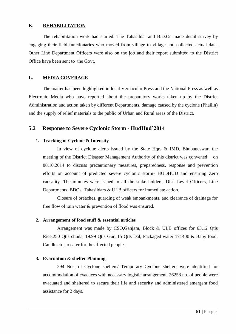
61 | P a g e
K. REHABILITATION
The rehabilitation work had started. The Tahasildar and B.D.Os made detail survey by
engaging their field functionaries who moved from village to village and collected actual data.
Other Line Department Officers were also on the job and their report submitted to the District
Office have been sent to the Govt.
L. MEDIA COVERAGE
The matter has been highlighted in local Vernacular Press and the National Press as well as
Electronic Media who have reported about the preparatory works taken up by the District
Administration and action taken by different Departments, damage caused by the cyclone (Phailin)
and the supply of relief materials to the public of Urban and Rural areas of the District.
5.2 Response to Severe Cyclonic Storm - HudHud’2014
1. Tracking of Cyclone & Intensity
In view of cyclone alerts issued by the State Hqrs & IMD, Bhubaneswar, the
meeting of the District Disaster Management Authority of this district was convened on
08.10.2014 to discuss precautionary measures, preparedness, response and prevention
efforts on account of predicted severe cyclonic storm- HUDHUD and ensuring Zero
causality. The minutes were issued to all the stake holders, Dist. Level Officers, Line
Departments, BDOs, Tahasildars & ULB officers for immediate action.
Closure of breaches, guarding of weak embankments, and clearance of drainage for
free flow of rain water & prevention of flood was ensured.
2. Arrangement of food stuff & essential articles
Arrangement was made by CSO,Ganjam, Block & ULB offices for 63.12 Qtls
Rice,250 Qtls chuda, 19.99 Qtls Gur, 15 Qtls Dal, Packaged water 171400 & Baby food,
Candle etc. to cater for the affected people.
3. Evacuation & shelter Planning
294 Nos. of Cyclone shelters/ Temporary Cyclone shelters were identified for
accommodation of evacuees with necessary logistic arrangement. 26258 no. of people were
evacuated and sheltered to secure their life and security and administered emergent food
assistance for 2 days.

62 | P a g e
4. Supervision, monitoring & coordination
6 nos. of Senior Officers of this district were assigned duty and were in-charge of
10 nos. of Blocks & 12 nos. of NACs highly prone to calamity to coordinate and supervise
response, relief, search & rescue, restoration activities for the areas.
3 nos. of district level officers were assigned duty to coordinate between various
departments to oversee pre and post cyclone management.
Manpower and machinery was kept in readiness by the line department officers for
immediate restoration of essential services like road, telecommunication and power supply
to be affected.
5. Search & rescue operation
To ensure above 6 NDRF Teams, 9 ODRAF Teams and 20 Fire Services Teams
were positioned in strategic places for search & rescue operation. 4 no. of relief power
boats of DEOC & Blocks, ODRAF boats were positioned in strategic locations for relief &
rescue operation.
6. Safety of school children & banking solution
Directives were issued for closure of schools from 11th to 13th to ensure safety and
security of school children.
Cancellation of holidays and full attendance of Govt. employees for the offices was
ordered.
Treasuries and Banks had similarly been instructed to attend financial solution
during holidays to deal with crisis arising out of calamity situation.
7. Functioning of Control Room
24x7 Hours Control Room had been operational in the DEOC under charge of
officers to oversee the receipt and dissemination of communication and redressed of
complaints received from individuals through proper department.
District Emergency Operation Centre functioned as Incident Command Centre
where key decisions were taken for preparedness, prevention, mitigation and evacuation
were issued from time to time for follow up.
2 nos. of Satellite phone sets supplied by OSDMA were kept ready for meeting
communication needs as and when required.

63 | P a g e
8. Conduct of Mock drills & publicity
On 10.10.2014 advance Mock drills were organized in 32 Cyclone shelter centres
for cyclone preparedness, response and prevention involving ODRAF, NDRF, Fire
Brigade, trained Volunteers and for sensitizing people in responding calamity.
Wide publicity for awareness of the people and not to stay in low lying area and
kutcha houses was ensured through Block machinery, ULB Officials, BeMC & DIPRO
and public address system was used.
Inter Agency Coordination Group meeting with various NGO bodies was held on
11.10.2014 to utilize their services on preparedness, response and relief as per needs.
9. Health Care measures & Sanitation
94 Medical Teams, 94 Medical Centres were positioned to attend exigency and
check the epidemic spread. 328900 ORS pkts, 1760000 nos. Halagen tablets, 247 Bags
bleaching powder utilized.
3728 Tube wells and 1125 wells were disinfected.
i) Stocking of polythene Rolls
11507 Rolls of Polythene were available in Tahasils to meet the requirement.
ii) Expenditure incurred
An amount of Rs.33,58,415/- was incurred expenditure towards the measures
undertaken i.e Preparedness, Evacuation & Emergent food assistance etc.
5.3 Response to Last Tsunami Occurrence:-
On 12.09.2007, after receiving Tsunami alert warning from SRC Odisha, district
administration (Emergency Cell) disseminated the same to the Sub- collectors, Coastal BDOs and
Tahasildars, SP Ganjam, Local police and fire office, CDMO, Local NGOs and Secretary of
Multipurpose cyclone shelters/ some of the villagers.
After 10.30 PM warning was given to the Line Department officers/NGOs/Police/fire
/villagers / medical team/media by District Emergency Officer and District project officer-DRM
over Phone, Mobile, and VHF etc.
1. Impact of Tsunami warning
Local Police of Gopalpur evacuated the people from Gopalpur sea beach / beach side
shops/houses.
Local NGO volunteers evacuated the coast fisherman community to a high land.
Cyclone Shelters were kept ready
Medical team was alert.
Sub- collector Chatrapur, APD DRDA, DEO and DPO- DRM were involved entirely in
this management process.

64 | P a g e
2. General observation
From electronic media, television people received first warning and then from district
administration.
Some of the coastline villagers time to time directly interacting with district emergency cell
regarding the same threat.
Nobody was there in Gopalpur NAC to receive the warning and we informed the local
police to inform the NAC and to evacuate the people from sea beach.
Coastal BDOs and Tahasildars were active in the process.
Collector Ganjam was specially looking after the overall warning dissemination and
evacuation process.

Disaster Risk Reduction Plan Ganjam District, Odisha

1 | P a g e
CONTENTS
INTRODUCTION ..................................................................................................................... 2
1. CLIMATE CHANGE ACTION PLAN ................................................................................ 4
1.1. Cyclone .......................................................................................................................... 4
1.2. Flood and Heavy Rains .................................................................................................. 5
1.3. Heat Wave ...................................................................................................................... 7
1.4. Drought .......................................................................................................................... 8
2. SCHEMES FOR DISASTER RISK REDUCTION AND CLIMATE CHANGE
ADAPTATION ..................................................................................................................... 9
2.1. State Schemes in Odisha .............................................................................................. 11
3. SUSTAINABLE LIVELIHOODS FRAMEWORK ........................................................... 17
3.1. Preventive/ Mitigation Measures to be Undertaken (Old & Infirm).......................... 18
3.2. Preventive/ Mitigation Measures to be Undertaken (Children) ................................... 18

2 | P a g e
INTRODUCTION
Disaster Risk Reduction plan of Ganjam districts contains ongoing coping mechanisms to
reduce the disaster risks with special focus on climate induced disasters like cyclones, floods and
heavy rains, heat waves and droughts. Government of Odisha with several other agencies has
initiated several risk reduction programs to tackle these disasters. The risk reduction plan of
Ganjam district is prepared after consultation with key line departments. First section of the plan,
‘Climate change action plan’ describes the impacts and actions taken up by key line departments to
minimize adverse impacts of disasters on risky elements. Rise in temperature, increase in
frequency of storms, flash floods and drought is observed every year in different part of the
district.
Further, the plan lists major developmental programs and schemes with relative DRR-CCA
component. The benefit of each scheme/program, its relevance to DRR-CCA and possible actions
are listed in a table. This plan gives us an idea on how to link disaster management plan with
development.

3 | P a g e
Climate Change Action Plan & DRR-CCA Integration

4 | P a g e
1. CLIMATE CHANGE ACTION PLAN
1.1. Cyclone
Department/Sector Elements at Risk Existing coping practices
Animal Husbandry Damage to the cattle shed
Injury of animals
Scarcity of fodders
Death of animals
Evacuating animals at higher place
First aid to the cattle
Keep a stock of fodders
Insurance claim is done
Public Works
Department
(Roads and
Buildings)
Damage to infrastructure
Increased debris of tree and
shrubs
Increased necessity of
manpower and equipment’s
for immediate restoration
Increased cost of maintenance
Cleaning of debris
Clearing of roads
Repairing of government
buildings, approaches to offices
etc.
Housing and Urban
Development
Disruption in communication
network (Telephone and
mobile networks)
Disruption in drinking water
supply due to power failure
Devastation of the street light
system due to
falling/uprooting of light poles
Adverse impact on health and
sanitation
Severe threat to slum pocket
habitat (collapse of slum
housing)
Blockage of road network due
to up-rooting/falling of trees
Awareness program among the
citizens/slum pockets before
cyclones for preparedness
Evacuation of vulnerable
population to cyclone shelters
Dissemination of warning print and
electronic media before the
cyclone and through VHF and
HAM radio during cyclones
Distribution of cooked food and
other relief materials to the victims
in coordination with district
administration
Contingency plans prepared and
immediate steps are taken for
bringing sanitation condition in
normalcy by removing garbage and
debris, clearing of up-rooted trees
from roads through the use of JCBs
and other machineries
NDRF and ODRAF teams are
pressed into service for restoration
of a communication network for
ensuring reach-out of relief
materials
High Power Generators are
provided to PHED and ASKA
lights deployed at different
important locations for
illumination

5 | P a g e
Soil Conservation
(Watershed
Department)
It is totally damaging the trees Plantation of cashew trees which
check the air blow in coastal region
also prevents the soil loss.
Public Health
Engineering
Department
(Urban Water
Supply)
Damage to infrastructure
Damage to syntax tank
Damage to electric post
Immediate restoration of hand
pump and tube well
Supply of water through movable
water tanker
Education Damage to infrastructure
Increased debris of tree and
shrubs
Increased necessity of
manpower and equipment for
immediate restoration
Increased cost of maintenance
Closing of schools
Shifting the students
Providing dry foods
Awareness generation through PRI
members
Providing Medicine and first aid
Agriculture Damages to crop
Pest attack
A forestation
Fisheries Damage to houses
Damage to nets and boats
Damage to embankments of
tank
Providing relief
Providing nets and boats at
subsidized rate
1.2. Flood and Heavy Rains
Department/Sector Elements at Risk Existing coping practices
Animal Husbandry Loss of lives of livestock
Outbreak of diseases
Shortage of fodder and
drinking water
Supplying fodders to the affected
cattle
Treatment of livestock
Public Works
Department
(Roads and
Buildings)
Damage to infrastructure
Increased debris of tree and
shrubs
Increased necessity of
manpower and equipments
for immediate restoration
Increased cost of
maintenance
Cleaning of debris
Clearing of roads
Repairing of government buildings,
approaches to offices etc
CIND 2-
Housing and Urban
Development
Impact upon the drinking water
supply
Impact upon sanitation
facilities in urban locations
Disinfection of Tube wells and wells
Detailed plan also being chalked out
involving NGOs, Health

6 | P a g e
Department, Sanitary Inspectors of
Municipal Corporations to maintain
the sanitation and bring to normalcy
Evacuation of low lying slum
pockets of temporary shelters and
distribution of relief materials
Soil Conservation
(Watershed
Department)
Due to flood water
embankments were washed
away, which damage the
entire agricultural land.
Increases the run off with soil
erosion.
Taking up several watershed
programmes in integrated approach
and treating of primary and secondary
steams so that run off of the soil
reduced and prevent soil loss.
Public Health
Engineering
Department
(Urban Water
Supply)
Submerge of tube wells and
hand pumps
Submergence of UGR
Using bleaching powder to
disinfectant the UGR
Forest Department Affects plantation
Affects wild life
Affects regeneration of
forest
Soil conservation measures are taken
Water Bores are created.
Steel and Mines
Department Tent gets damaged and
investigation cam suffers a
lot during cyclone
Distance of site of operation
is far from the camp, which
hampers the work time.
Logistic gets costlier
Shifting to semi-permanent
habitation and reorganize the
mineral exploration work from a
distance.
Agriculture More diseases/pest attack to
agricultural crops
Loss of standing crops
Decrease in production
Damage to irrigate plants,
canes and check dams
Huge stock of pesticides available at
GP level
Awareness through electronic media
Reviving irrigation source
Keeping liaison with Irrigation
department and district
administration
Health Increased Water borne
diseases
Increased Acute
respiratory infection
Rise in snake bites and
dog bites cases
District rapid response team
activated
Ambulance service available round
the hour
Common medicine available in
every PHC and CHCs

7 | P a g e
Education The building got damaged
Equipment’s such as books,
table, benches and kitchen
utensils such as rice etc get
damaged due to flood
Sources of drinking water in
school premises got
damaged or submerged
Reconstruction of fully or partially
damaged buildings
Restoration of drinking water points
1.3. Heat Wave
Department/ Sector Elements at Risk Existing coping practices
Education Children get fainted
Lack of concentration among
the children due to increased
heat
Children get tired.
Classes shifted to morning hours in
order to save the children from
scorching heat.
Housing and Urban
Development
Severe health problem,
casualty and loss of lives
Scarcity of drinking water
Awareness programme among the
people at community level through
electronic media for taking
precautionary measures to combat
heat waves
Sufficient numbers of shades are
being constructed at different public
places such as bus stand, market
place, railway station, hospitals etc.
More numbers of water tankers
provided to meet water scarcity both
in rural and urban areas.
Steel and Mines
Department Mapping, excavation and
drilling work affected
Low progress due to excess
heat
Started working early in the morning
and again work during late evening.
Agriculture Ground water depletion
Dysfunction of hand pumps
and tube wells etc
Installation of water storage tanks in
scarcity pockets
Health Due to power cut the
medicine got damaged in
high temperature
Alternative power source such as an
inverter or generator are arranged

8 | P a g e
1.4. Drought
Department/ Sector Elements at Risk Existing coping practices
Agriculture Loss of standing crops
Decrease in average yield in
every crop
Uncovered fallow land
Establishment of covered threshing
floods to thresh the output
Community godowns to store the
productions of farmers with
minimum rents
Sale of farmer produces at MSP in
collaboration with the civil supply
department in time.
Animal Husbandry
Department
Non availability of feed s and
fodders
Arranging feeds and fodders for
cattle immediately
Functions /Activity/Innovation for prosperity by Govt. / Non-Govt. agencies
1 PD,DRDA
Executive Engineers of
R.W.Division
Executive Engineers of R&B
Division
Executive Engineers of Irrigation
Executive Engineers of PHED
Executive Engineers of RWSS
BDO
Sarapanch
A separate master plan for drought prone area in which
durable, remunerative, productive and asset-creating
schemes and projects to be included for execution as
long term measures
Contingency plan of such works and projects to be
switched on to as and when drought situation develops,
or the situation worsens.
2 PD,DRDA
Blocks
Gram Panchayats
Water Resources Deptt.
Executive Engineers
Public Works Deptt. Executive
Engineers
Other Work executing agencies
Divisional Forest Officers
CSO
DDA
DDH
MARKFED
NGO
CSO
Long term measures for amelioration of possible
drought under Govt. grants/ Schemes/ Labour Intensive
works under fund of MGNREGS/MP’s/MLA’s Local
Area Development Programmes
Taking construction of farm ponds, water conservation
works and water harvesting structures
Funds available in other development Deptt.
( convergence basis) for drought resilience works/
activity
De-silting of tanks, plantation programme, command
area development works, construction of new water
channels for increasing drought resilience / long term
initiatives which would mitigate future possibilities
Attacking rural poverty under various initiatives taken
under National Skill Development Mission (NSDM)
/National Rural Livelihood Mission(NRLM)/State
Agriculture Policy
Adequacy of Cold storage facility for vegetable / fruits
Increasing potentiality for out-turn of the crops at the
time of harvest

9 | P a g e
2. SCHEMES FOR DISASTER RISK REDUCTION AND CLIMATE CHANGE
ADAPTATION
Sl Name of the
schemes Benefits DRR and CCA
Possible activities for
DRR and CCA
1. Member of
Parliament Local
Area Development
Scheme
(MPLADS)
- Each MP has the
choice to suggest
to the District
Collector for,
works to the tune
of Rs.5 Crores per
annum to be taken
up in his/her
constituency.
- The RajyaSabha
Member of
Parliament can
recommend works
in one or more
districts in the
State from where
he/she has been e-
lected.
- Mitigation and
prevention
through creation
of durable
community assets
based on the
locally felt needs
- As per Para 2.8
of the guidelines
on MPLADS,
Hon’ble MPs can
recommend up to
a maximum of
Rs. 1 crore for
rehabilitation
work for the
affected areas
anywhere in the
country in the
event of calamity
of severe nature.
- Construction of flood
control embankments
- Construction of common
shelters for cyclones,
Floods and handicapped
- Purchase of motor boats
for flood and cyclone
prone areas
- Fire tenders for
Government
organization
- Retrofitting of essential
lifeline buildings, viz
Govt. hospitals, Govt.
Schools and public
buildings to be used as
shelters in an
emergency.
- Early Warning Systems
for effective disaster
mitigation.
- Construction of roads,
approach roads, link
roads, Pathways.
- Drinking water facility
2. Indira
AwasYojana
(IAY)
- Provides financial
assistance to rural
poor for
constructing their
houses themselves
- Providing
disaster resilient
housing in areas
prone to natural
calamities
- To reducing risk
of vulnerable
population in
Pre-disaster
situation
- Construction of disaster-
resilient houses
3. Mahatma Gandhi
National Rural
Employment
Guarantee Scheme
(MGNREGS)
- Legal guarantee for
one hundred days of
employment in
every financial year
to adult members of
any rural household
willing to do public
work-related
unskilled manual
work
- To minimize
economic
vulnerability of the
people Pre-disaster
situation
- Useful for
livelihood
generation in
Post-disaster
situation
- Construction of river
embankments
- Construction of roads in
remote areas
- Construction of multi-
hazard shelters

10 | P a g e
4. National Rural
Livelihood
Mission
- Bring the assisted
poor families
above the poverty
line by organizing
them into Self
Help Groups
(SHGs) through
the process of
social
mobilization, their
training and
capacity building
and provision of
income generating
assets through a
mix of bank credit
and government
subsidy.
- To minimize
economic
vulnerability of
the people
Pre-disaster
situation
- Useful for
livelihood
generation in
Post-disaster
situation
- Creation of SHGs
5. Pradhan Mantri
Gram Sadak
Yojana (PMGSY)
- Good all-weather
road connectivity
to unconnected
villages
- Useful in pre as
well as post
disaster situation
for road
connectivity
- Construction of roads in
remote areas
6. National Health
Mission (NHM)
(NRHM and
NUHM)
- To provide
accessible,
affordable and
quality health
care to the urban
and rural
population,
especially the
vulnerable groups.
- One of the most
important
component in
Pre as well as
post disaster
situation to
provide universal
access to health
care facilities
- Rapid Action Force for
Emergency Medical
Response
- Emergency ambulances
- Preparedness for mobile
Field Hospitals
7. Scheme for
Animal Health
Care in the State
- Schemes under
Department of
Animal Husbandry
- To control
Animal
epidemics
- Vaccination drives
8. JNNURM - To improve the
quality of life and
infrastructure in
the cities
- To develop and
strengthen urban
infrastructure to
minimize urban
risk
- Development of river
embankments
- Construction of roads
- Storm water drainage
9. Rashtriya
Swasthya
BimaYojana
- To provide health
insurance
coverage for
Below Poverty
Line (BPL)
families.
- Insurance and
Risk Transfer
- Insurance (Disaster
Insurance)

11 | P a g e
10. Pradhan Mantri
AwasYojana
(PMAY)
- To enable better
living and drive
economic growth
stressing on the
need for people
centric urban
planning and
development.
- Minimizing risk
by constructing
Disaster Resistant
housing in Urban
areas
- Construction of disaster
resistant houses
11. Pradhan Mantri
Suraksha Bima
Yojana (PMSBY)
- An accidental
Death and
Disability
insurance scheme
- Insurance and
Risk Transfer
- Insurance
12. The Pradhan
Mantri Jeevan
Jyoti BimaYojana
(PMJJBY)
- A term life
insurance policy
and it will provide
life insurance
coverage on the
death of the
policyholder.
- Insurance and
Risk Transfer
- Insurance
13. Sarva Shiksha
Abhiyan
- The programme
seeks to open new
schools in those
habitations which
do not have
schooling facilities
and strengthen
existing school
infrastructure
through provision
of additional class
rooms, toilets,
drinking water,
maintenance grant
and school
improvement
grants
- Un-interrupted
education after
disasters and
extreme events
- Safety of people
infrastructure and
resources against
disasters
- Disaster resilient
construction of new
school buildings
- Retrofitting in existing
school buildings
- Essential response
preparedness and
planning at school level
2.1 State Schemes in Odisha
Sl Name of the
schemes Benefits DRR & CCA
Possible Activities for
DRR and CCA
1. Jalanidhi:
Harnessing
Ground and
Surface Water for
Agriculture
- The components of the
scheme include
installation of shallow
tube wells/bore
wells/dug wells and
river/surface lift to
accelerate irrigation
facilities.
- Creation of
disaster flood
and cyclone
resilient
infrastructure
for irrigation
- Prior assessment of
feasibility of ground water
level in future climate
scenario as well as
sustainability
- Installation of resilient
infrastructure based hazard

12 | P a g e
and vulnerability
assessment of the field
location
- Installation of structural
mitigation measures for
protecting the existing
infrastructure
- Agreement and
sensitization of
beneficiaries for efficient
and smart use of water for
sustainability
- Measures for ground water
recharge
2. Odisha Tribal
Livelihood
Programme Plus:
Empowerment &
Sustainable
Livelihood
Opportunity for
Tribals
- The goal of the
programme is to
enable the poor tribal
HHs to sustainably
ensure their
livelihoods and food
security by promoting
a more efficient,
equitable, self-
managed and optimum
use of natural
resources, off-
farm/non-farm
enterprise
development, and
accessing the rights
and entitlements due to
them
- Scope for
pre-disaster
preparedness
through
enhance
livelihood
activities
before
seasonal
hazards
- Post disaster
speedy
livelihood
recovery
options
- Creation of
disaster
resilient
social capital
- Base Line Survey can
include in climate and
disaster risk assessment as
part of PRA.
- The design of project
intervention must consider
present and future climate
scenario and projections
- Infrastructure to be created
must be DRR inclusive
analysing the risks
associated with disasters
and climate change
- Livelihood risk transfer
through appropriate risk
transfer mechanism should
be a core component based
on risk analysis.
- The program has the
potential to produce DRR-
CCA integrated model
practices for development
through integration of
DRR and CCA
3. Jeebika - Orissa
Rural Livelihood
Programme:
Watershed
Development – A
Means to a Better
Livelihood
- Its activity regime
broadly addresses the
following-
- Interventions to
address quality of life
such as preventive
health measures,
sanitation, drinking
water, and food
security
- Disaster
preparedness
focusing on
WASH
- Post disaster
livelihood
recovery
- Livelihood promotion
activities should be
selected based on local
level climate and disaster
risk assessment
- The component of climate
change and disaster
resilient capital creation
can be taken up. e.g.,

13 | P a g e
- Promotion of capacity-
building, community
mobilization,
community
development and
livelihood promotion
through deployment of
revolving funds and
grants.
- Capacity
building of
community
on resilient
livelihood
options
practices that can
withstand future climatic
extreme events such as
high speed cyclones,
extreme floods
- Improvement of WASH
through awareness,
resilient infrastructure like
raised toilets, hand pumps
can be focused during
design and implementation
of project activities
- Integrating livelihood and
weather index based
insurance with livelihood
options for greater
adaptation. e.g. if tailoring
is promoted as non-farm
based livelihood, the tool
such as the sewing
machine, the tailoring
centre (Infrastructure)
must be insured against
climatic extreme events
4. Biju Gram
JyotiYojana:
Illuminating
Villages – A State
Initiative
- Provision for
electrification in
villages/rural
habitations with a
population less than
100 which are not
scheduled to be
covered under the
RGGVY
- Disaster
resilient
Energy
Infrastructure
- The infrastructure installed
under the program must be
designed considering high
speed cyclones and floods
for adaptation and
sustenance.
- Building Energy
Conservation Standards
must be done and
beneficiaries must be
sensitized for energy
conservation
5. Biju Saharanchal
Vidyutikarana
Yojana:
Electricity for
Slums and
Habitation in
Urban Areas
- The Scheme aims at
providing access to
electricity to the
people living in
authorized
villages/slums/wards
having a population of
100 or less along with
BPL HHs residing in
the un-electrified areas
of ULBs.
- Same as
above
- Same as above

14 | P a g e
6. Capital
Expenditure
System
Improvement for
Reduction of
AT&C
Programme: loss
in Electricity
Distribution
Sector
- The CAPEX
Programme was
formulated with the
objective to improve
the Transmission and
Distribution
(T&D) infrastructure
by enabling the
distribution system
improvement,
establishment of a
reliable system,
reduction of Aggregate
Technical and
Commercial (AT&C)
loss to a sustainable
level and improvement
of quality of power
supply to the
consumers of the
State.
- Provisions for
retrofitting
existing
infrastructure
against HS
and Frequent
Cyclones
- New
Infrastructure
at all levels to
be disaster
resilient
- Strengthening existing
infrastructure with focus
on extreme events (current
and projected). The energy
infrastructure must be
structurally strong enough
to withstand cyclone speed
of 300 KMPH or more and
provision for rapid
recovery (strategies and
resources) should exist in
the scheme.
7. Gopabandhu
Gramin Yojana:
Bijli, Sadak and
Pani for Coastal
Districts
- The Scheme envisages
to provide essential
infrastructure like
road, electricity and
water for coastal areas
- Disaster
Resilient
Roads
- Portable
water for
emergencies
- Electricity
connection in
vulnerable
communities
- Speedy
recovery after
disaster
- The roads must be
assessed for future
climatic extremes and
should be location wise
designed to be resilient.
The same applies to the
other two sectors. The
integration can be done
from design to
implementation,
monitoring and evaluation
that the infrastructure is
created maintained
keeping in mind future
possibilities and rising
frequency and magnitude
of extremes.
- A life cycle analysis based
on (probable life of the
infrastructure and expected
future climatic extreme
events) history of extremes
and climatic projections
can ensure resilient design,
construction and

15 | P a g e
maintenance. For this
capacity building of
planners, contractors and
engineers on themes such
as, assessment of climate
and disaster risks, resilient
designs, monitoring and
evaluation will be required
8. Cement Concrete
Road: All
Weather Road
Connectivity in
Villages
- Provision of all-
weather roads for rural
areas
- Disaster
resilient roads
- Accessibility
during and
post disaster
for
evacuation,
relief and
rehabilitation
- Same as above
9. State Highways
Development
Programme:
Improvement of
State Highways
for Socio-
economic
Development
- The schemes has the
following objectives:
- Reduction in vehicle
operating cost on the
project corridor
- Increase in vehicle
speed to reduce travel
time
- Improvement in Road
User Satisfaction
Index
- Improvement in
Network Congestion
Indices
- Same as
Above
- This scheme can take
roadside plantation of
votive grass as one of the
adaptation strategy for
erosion protection in flood
prone/affected areas.
- Necessary changes in road
designs and construction
based on analysis disaster
history and climatic
projection for specified
project location
- Use of less polluting and
sustainable materials
10. Biju Setu Yojana:
Bridging
Connectivity
Gaps for Rural
People
- All projects
implemented under
BSY will bridge
nallahs/rivers that do
not have bridges over
them and provide
reasonable approach
roads for establishing
instant road
connectivity. The
scheme also provides
an opportunity for
construction of major
bridges on PS roads.
- Flood and
cyclone
resilient
construction
of bridges
- Ensuring
durability and
connectivity
- Bridges must take into
consideration projected
changes in water resources
due to changes in rainfall
pattern in the project
location
- The Designs must be made
based on analysis of past
and projected trends in
rainfall and behaviour of
water the particular water
in past and projected in
future. The design should
be reflective of worst case
scenario.

16 | P a g e
11. Mission Shakti:
Empowering
Women through
SHGs
- The various
components of
Mission Shakti
activities mainly focus
on capacity building,
livelihood promotion,
marketing,
consolidation through
strengthening
federation, micro
credit support,
convergence with
other departments
- and government
programmes,
communication and
advocacy
- Livelihood
diversification
for enhancing
resilience
- Education and
awareness of
women
- Increased
income and
capacity
- Capacity building of
women on adaptation and
risk reduction behaviors
and preparedness at
household level to face
climatic extremes\
- Linking livelihood
promotion with sustainable
natural resource
management (example of
work-Floating gardens
lead by women in Puri,
Odisha)
12. Mo Kudia:
Housing for the
Rural Poor and
Needy – A State
initiative
- The main objective of
the scheme is to
provide dwelling
houses to the
genuinely
- poor and needy rural
HHs, who need
immediate shelter for a
dignified existence
- Disaster
resilient
housing
construction
- It already has provision for
disaster resilient
construction, consideration
of heat wave adaptation in
design can be another area
of inclusion in this
scheme.

17 | P a g e
3. SUSTAINABLE LIVELIHOODS FRAMEWORK

18 | P a g e
3.1 Preventive/ Mitigation Measures to be Undertaken (Old & Infirm)
3.2 Preventive/ Mitigation Measures to be Undertaken (Children)
Activity Directly responsible Su-Division
Monitor
District
Monitor
ICDS Centers must run without fail CDPO Sub-Collector DSWO
NCP Schools, Orphanages must run
without fail
Project Director,
NCLP
Sub-Collector DDO/
DSWO
MDM must be given in designated
Schools must run without fall
SI of Schools/ BDO Sub-Collector DSWO
Block Education Officer Shall Remain Squarely Responsible For Uninterrupted MDM
MEASURES
Directly
responsible
Su-Division
Monitor
District
Monitor
BDO Sub-Collector ADM
Distribution of NFBS be done within 10 days of
death
SEO/ BDO of
the Block
Sub-Collector DSWO
Prompt delivery of assistance under NMDS SEO/BDO of
the Block
Sub-Collector DSWO
People not covered under National Old Age Pension/
Old Age Pension/ Odisha Disabled Pension but old
and infirm and in distress to be immediately
provided with Gratuitous Relief on Cards. Sub-
Collectors will presume the sanction of the Collector
and go ahead with distribution of GR in anticipation
VLW/ BDO Sub-Collector ADM
FOR ANY STARVATION DEATH, THE RESPONSIBILITY WOULD SQUARELY ON THE
BDO/ SUB-COLLECTOR