Packet - Glenpool, OK
271
Agenda AUGUST 28 AGENDA.PDF Comprehensive Plan AUGUST 28 COMPREHENSIVE PLAN.PDF Zoning Code AUGUST 28 ZONING CODE.PDF Subdivision Regulations AUGUST 28 SUBDIVISION REGULATIONS.PDF 1. Documents: 2. Documents: 3. Documents: 4. Documents:
-
Upload
khangminh22 -
Category
Documents
-
view
2 -
download
0
Transcript of Packet - Glenpool, OK

Agenda
AUGUST 28 AGENDA.PDF
Comprehensive Plan
AUGUST 28 COMPREHENSIVE PLAN.PDF
Zoning Code
AUGUST 28 ZONING CODE.PDF
Subdivision Regulations
AUGUST 28 SUBDIVISION REGULATIONS.PDF
1.
Documents:
2.
Documents:
3.
Documents:
4.
Documents:
Page 1 of 1
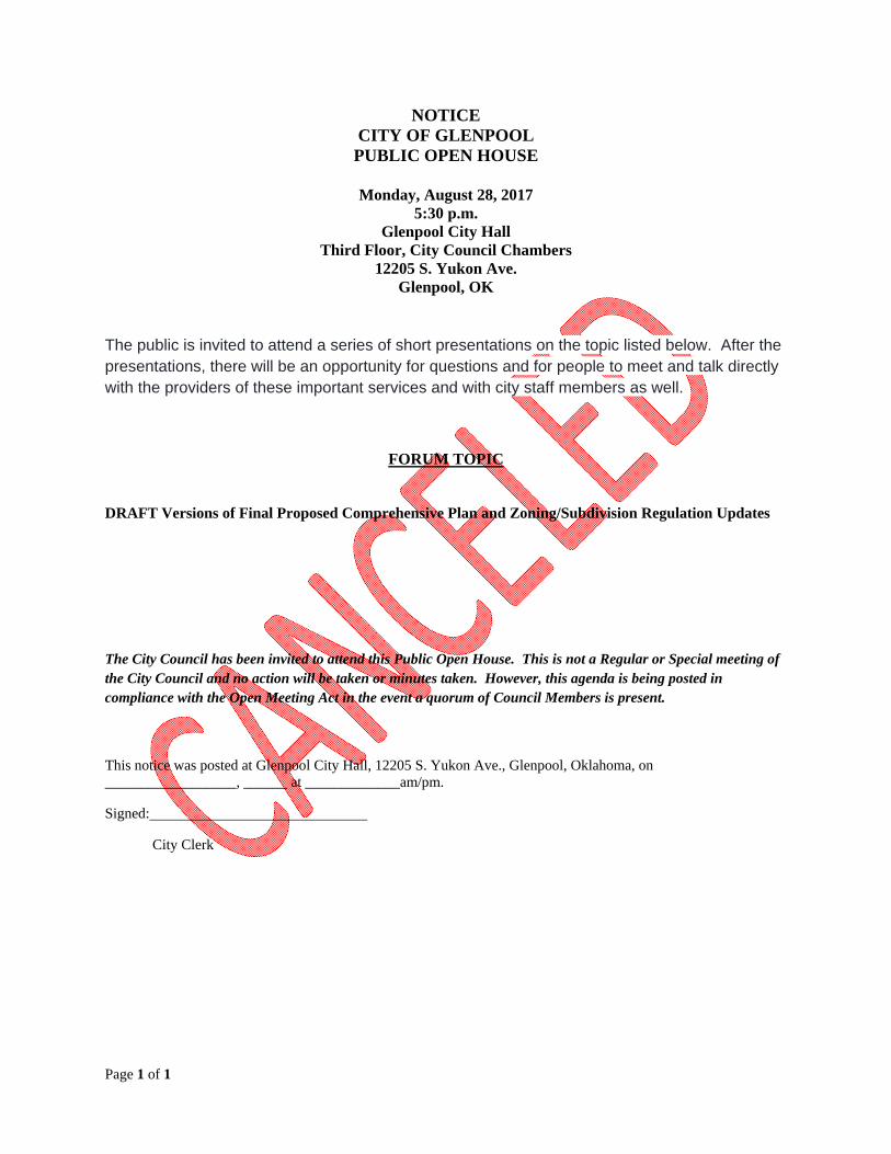
NOTICE CITY OF GLENPOOL PUBLIC OPEN HOUSE
Monday, August 28, 2017
5:30 p.m. Glenpool City Hall
Third Floor, City Council Chambers 12205 S. Yukon Ave.
Glenpool, OK
The public is invited to attend a series of short presentations on the topic listed below. After the presentations, there will be an opportunity for questions and for people to meet and talk directly with the providers of these important services and with city staff members as well.
FORUM TOPIC
DRAFT Versions of Final Proposed Comprehensive Plan and Zoning/Subdivision Regulation Updates
The City Council has been invited to attend this Public Open House. This is not a Regular or Special meeting of the City Council and no action will be taken or minutes taken. However, this agenda is being posted in compliance with the Open Meeting Act in the event a quorum of Council Members is present.
This notice was posted at Glenpool City Hall, 12205 S. Yukon Ave., Glenpool, Oklahoma, on __________________, ______ at _____________am/pm.
Signed:
City Clerk
nn
n
nn
")'
__
_
_
_Future
ES
Special District 3
Special District 6
Special District 2
Special District 5
Special District 1
S OKMULGEES B LINE EXPY
E 151 ST S
E 141 ST S
E 171 ST S
E 181 ST S
S ELM ST
S LEWIS AVE
W 201 ST S
S HARVARD AVE
W 171 ST S
W 181 ST S
E 201 ST S
S PEORIA AVE
W 126 ST S
W 191 ST S
W 161 ST S
S ELWOOD AVE
W 131 ST S
E 121 ST S
W 141 ST S
W 151 ST S
W 121 ST S
E 191 ST S
S FER
N ST
S 26 W AVE
S UNION AVE
S 7 ST
S 33 W AVE
S PO PL A RPL
E 146 ST S
S 9 W AVE
S 33 WEST AVE
E 175 ST S
E 167 ST SS1 1WAVE
S 27 E AVE
SZENITH
E 134 ST S
SUT ICA AVE
S 27 W AVE
E 163 PL S
SYUKON
SN YSSA PL
S 19 E
AVE
E 147 ST S
E 136 ST
S HICKORY
ARENA RD
SI DLEAWHILE
S FLORENCEAVE
S 32 W AVE
LONGHORN
SCOLUMBI A AV E
SBIR CH
E 165 ST S
S 25 W
W 206 ST S
SADDL EBACK
SGLE NC T
S ELGIN AVE
S KENDALWOOD
W 166 ST S
S 31 E AVE
S HARVARD AVE
E 201 ST S
S 27 E AVE
S HARVARD AVE
S PEORIA
S ELWOOD AVE
S LEWIS AVE
E 131 ST S
S 18 ST
S LEWIS AVE
E 161 ST S
E 128 ST S
S 20 ST
S GLENPOOL
S ELWOOD AVE
£¤75
E 156 ST
S PEORIA AVE
S TROOST AVE
Sapulpa
Kiefer
Jenks
Bixby
Mounds
Liberty
UV67 UV67
£¤75
£¤75
£¤75
_
City Hall/Conference
Center
Library
Twin Mounds Pioneer
Cemetery
Wastewater Treatment
Plant
PoliceFire
South County Recreation
Center
Glenpool ES
Glenpool HSGlenpool
MS
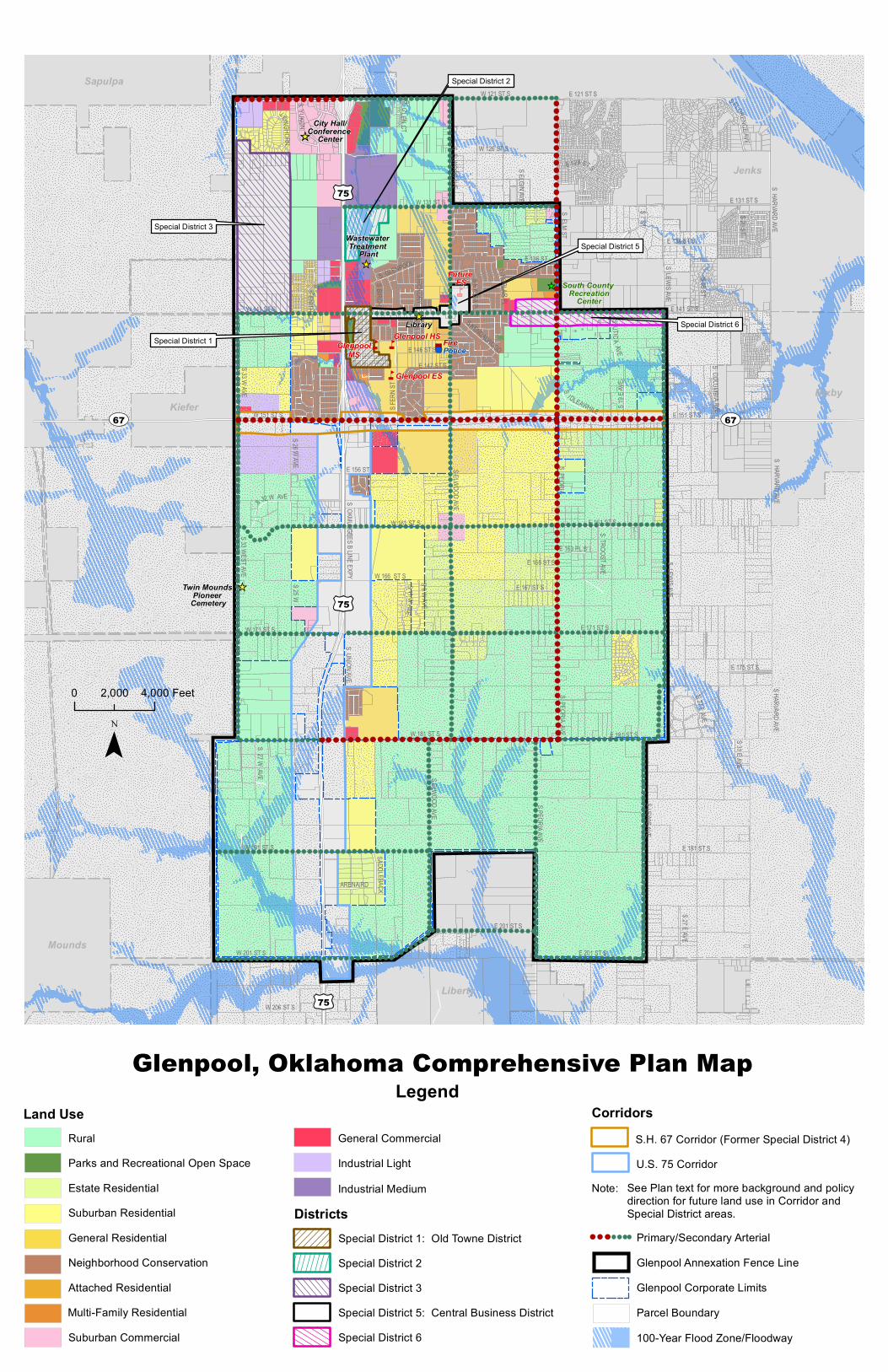
Glenpool, Oklahoma Comprehensive Plan Map
¯0 4,0002,000 Feet
LegendLand Use
Neighborhood Conservation
Multi-Family ResidentialAttached Residential
General Residential
RuralParks and Recreational Open SpaceEstate ResidentialSuburban Residential
Suburban Commercial
CorridorsS.H. 67 Corridor (Former Special District 4)U.S. 75 Corridor
DistrictsNote: See Plan text for more background and policy
direction for future land use in Corridor and Special District areas.
Primary/Secondary Arterial
Glenpool Corporate LimitsParcel Boundary
Glenpool Annexation Fence Line
100-Year Flood Zone/Floodway
General CommercialIndustrial LightIndustrial Medium
Special District 1: Old Towne DistrictSpecial District 2Special District 3Special District 5: Central Business DistrictSpecial District 6

nn
n
nn
")'
__
_
_
_Future
ES
Special District 3
Special District 6
Special District 2
Special District 5
Special District 1
S OKMULGEES B LINE EXPY
E 151 ST S
E 141 ST S
E 171 ST S
E 181 ST S
S ELM ST
S LEWIS AVE
W 201 ST S
S HARVARD AVE
W 171 ST S
W 181 ST S
E 201 ST S
S PEORIA AVE
W 126 ST S
W 191 ST S
W 161 ST S
S ELWOOD AVE
W 131 ST S
E 121 ST S
W 141 ST S
W 151 ST S
W 121 ST S
E 191 ST S
S FER
N ST
S 26 W AVE
S UNION AVE
S 7 ST
S 33 W AVE
S PO PL A RPL
E 146 ST S
S 9 W AVE
S 33 WEST AVE
E 175 ST S
E 167 ST SS1 1WAVE
S 27 E AVE
SZENITH
E 134 ST S
SUT ICA AVE
S 27 W AVE
E 163 PL S
SYUKON
SN YSSA PL
S 19 E
AVE
E 147 ST S
E 136 ST
S HICKORY
ARENA RD
SI DLEAWHILE
S FLORENCEAVE
S 32 W AVE
LONGHORN
SCOLUMBI A AV E
SBIR CH
E 165 ST S
S 25 W
W 206 ST S
SADDL EBACK
SGLE NC T
S ELGIN AVE
S KENDALWOOD
W 166 ST S
S 31 E AVE
S HARVARD AVE
E 201 ST S
S 27 E AVE
S HARVARD AVE
S PEORIA
S ELWOOD AVE
S LEWIS AVE
E 131 ST S
S 18 ST
S LEWIS AVE
E 161 ST S
E 128 ST S
S 20 ST
S GLENPOOL
S ELWOOD AVE
£¤75
E 156 ST
S PEORIA AVE
S TROOST AVE
Sapulpa
Kiefer
Jenks
Bixby
Mounds
Liberty
UV67 UV67
£¤75
£¤75
£¤75
_
City Hall/Conference
Center
Library
Twin Mounds Pioneer
Cemetery
Wastewater Treatment
Plant KendalwoodNorth ParkLambert
Park
BlackGoldPark
KendalwoodSourth Park
RollingMeadows
Park
PoliceFire
Morris Park
South County Recreation
Center
Glenpool ES
Glenpool HSGlenpool
MS
Glenpool, Oklahoma Comprehensive Plan Map
¯0 4,0002,000 Feet
LegendLand Use
Neighborhood Conservation
Multi-Family ResidentialAttached Residential
General Residential
RuralParks and Recreational Open SpaceEstate ResidentialSuburban Residential
Suburban Commercial
Districts
General CommercialIndustrial LightIndustrial Medium
Special District 1: Old Towne DistrictSpecial District 2Special District 3
Special District 6Special District 5: Central Business District
Corridors
Note: See Plan text for more background and policy direction for future land use in Corridor and Special District areas.
S.H. 67 Corridor (Former Special District 4)U.S. 75 Corridor
Glenpool Corporate LimitsUnincorporated Area
Glenpool Annexation Fence Line
Parcel Boundary

NOTE: This 08.11.17 DRAFT is still in a basic format while undergoing review/editing.
Glenpool Comprehensive Plan Supplemental Report from Interim Update 2017
TABLE OF CONTENTS
NOTE: Items with specific page numbers in the Table of Contents indicate pieces of the
2030 PLAN that were updated or added in 2017. All other plan content remains unchanged and is included in the Table of Contents to reflect the overall organization of the 2030 PLAN.
Introduction to Supplemental Report ....................................................................... 3 PART I: Introduction ......................................................................................... 3
The “2030 PLAN” Update The Original Planning Process Process for 2016-17 Interim Plan Review and Update ............................................. 3 Planning in Glenpool: A Local Perspective Areawide Planning
The Planning Area
PART II: Elements of the 2030 PLAN .................................................................. 5 General Authority and Jurisdiction Conformance to the Comprehensive Plan Public Facilities and Utilities: Relationship to the Comprehensive Plan Zoning: Relationship to the Comprehensive Plan ..................................................... 5 General Goals ............................................................................................................ 6 2030 PLAN Elements: Goals, Objectives and Policies ............................................... 8
Land Use ................................................................................................................ 8 Character of Land Use and Development ................................................................. 12 Land Use Intensity: General Goals, Objectives and Policies Land Use Intensity Categories Neighborhoods .......................................................................................................... 14 Activity Centers ......................................................................................................... 14 Special Districts Corridors ................................................................................................................... 14
PART III: Basis for the 2030 PLAN ...................................................................... 16 Introduction Physical Features Public Facilities
General Recreation and Open Space Educational Areas .................................................................................................. 16 Library Social Services/Health ........................................................................................... 16

SUPPLEMENTAL REPORT FROM 2017 INTERIM UPDATE (DRAFT 08.11.17) | Page 2 of 53
Public Safety: Police, Fire, Emergency Management and Emergency Medical Services Public Utilities Transportation Economic Development ............................................................................................. 17
PART IV: Description of the Elements of the Plan .............................................. 18 Introduction .............................................................................................................. 18 Land Use .................................................................................................................... 18 Future Land Use and Character Designations ........................................................... 21 Demography and Economy ....................................................................................... 32
TABLE 5.5: Glenpool Historical Population Growth Since 1970 ............................. 34 Glenpool Population Growth Scenarios Through 2040 .......................................... 35
Public and Quasi-Public Facilities .............................................................................. 37 Public Utilities ........................................................................................................... 37 Transportation .......................................................................................................... 42
Final Network Map (Glenpool) - Tulsa Regional Bicycle & Pedestrian Master Plan .... after 42 Economic Development ............................................................................................ 43 Special Districts ......................................................................................................... 43 The Glenpool 2030 PLAN .......................................................................................... 46
The Land Use Plan Matrix TABLE 21: Future Land Use Designations Relative to Zoning Classifications ......... 48 FIGURE 12: Comprehensive Plan Map ................................................................... after 48
PART V: Implementation of the Comprehensive Plan ........................................ 49
General ...................................................................................................................... 49 Capital Improvement Program (CIP) ......................................................................... 50 Zoning Regulations .................................................................................................... 50 Subdivision Regulations and Engineering and Design Criteria and Standards For Construction ............................ 51 Annexation Building and Housing Codes Additional Detailed Planning ..................................................................................... 51 Planning for the Annexation Fence Line Neighborhood Improvement Programs .................................................................... 51 Continued Citizen Involvement ................................................................................. 52 Regular Updates of the 2030 PLAN ........................................................................... 52
APPENDIX: Leadership and Community Engagement ........................................ 53 Meeting Highlights: Focus Group Sessions Meeting Highlights: Project Advisory Committee (Meeting 1)

SUPPLEMENTAL REPORT FROM 2017 INTERIM UPDATE (DRAFT 08.11.17) | Page 3 of 53
Glenpool Comprehensive Plan Supplemental Report from Interim Update 2017
During 2016, the City of Glenpool engaged a community planning consultant (Kendig Keast Collaborative of Sugar Land, Texas) to assist in reviewing, assessing and recommending interim updates to its Comprehensive Plan, as adopted in July 2010, given the pace of population growth and land development activity in recent years. As elaborated on later in this report, the City was also seeking a more effective plan framework to guide decision-making involving the future land use pattern in Glenpool. Local subconsultant Wallace Engineering provided project and meeting support, particularly for the utility infrastructure and transportation aspects of the report in coordination with key City staff.
This report serves as a supplement to the 2030 Comprehensive Plan, text and map, adopted on July 6, 2010 (“2030 PLAN”). The report identifies targeted plan updates based on the findings from the consultant evaluation, as well as the latest assessment of key community planning issues and needs in Glenpool through input from City officials and staff, residents and other local stakeholders during the initial phase of the update project. A project advisory committee also helped set priorities for the plan update effort, which were itemized in a memorandum to the City in December 2016, as presented and discussed during a joint workshop of City Council, Planning Commission and Advisory Committee members during the same timeframe.
It should be noted that another task assigned to the consultant team was to recommend updates to the City’s zoning and subdivision regulations (City staff is updating the City’s Engineering and Design Criteria and Standards For Construction of infrastructure improvements based on the updated 2030 PLAN and development regulations). Given the importance placed on the development regulations component of the project, the intent on the planning side was for the consultant to reference content in the 2030 PLAN that is still timely and on target and only add new or supplemental information where needed. Therefore, this supplemental report provides new information or adjustments to the 2030 PLAN content in the areas identified in the December memorandum cited above. In addition, City staff and the consultant team conferred on a better order and less redundant organization of content within the City’s Comprehensive Plan. This will need to be pursued through the next major update of the 2030 PLAN as reworking of the overall document was beyond the scope of the interim update effort.
PART I: Introduction
The “2030 PLAN” Update [No changes in this section]
The Original Planning Process [No changes in this section]
Process for 2016-17 Interim Plan Review and Update The 2016-17 plan evaluation and update process involved the steps and public/stakeholder engagement activities in the table below. The plan update effort was also informed by the results of the Glenpool – A Vision for the Future process that was conducted with participation from Glenpool leaders, various stakeholders and residents during late 2013 through early 2014. That process involved consideration of internal/external challenges and opportunities, and ideas and specific initiatives for building community in Glenpool in the years ahead.

SUPPLEMENTAL REPORT FROM 2017 INTERIM UPDATE (DRAFT 08.11.17) | Page 4 of 53
Meetings / Activities Outcomes
Existing City Phase › Joint Workshop 1 with City Council and Planning
Commission (October 25, 2016). › Small-Group Listening Sessions (October 26-27). › Advisory Committee Meeting 1 (October 27). › Town Hall Meeting on Glenpool’s Future
(November 28). › Advisory Committee Meeting 2 (November 29).
› Issues and Needs identification through Joint Workshop 1.
› Meeting Highlights compilation from small-group sessions (included in Appendix to this report).
› Meeting Highlights compilation from Advisory Committee Meeting 1 (in Appendix).
Meetings / Activities Outcomes
Plan Direction Phase › Joint Workshop 2 with City Council and Planning
Commission (December 15). › Existing City Overview and Plan
Outline and Direction Memorandum for Joint Workshop 2.
Future City Phase › Advisory Committee Meeting 3 (January 23, 2017). › Advisory Committee Meeting 4 (March 2).
[Plus informal public/stakeholder discussions in the hour before Advisory Committee Meetings 3 and 4.]
› Joint Workshop 3 with City Council and Planning Commission (June 1).
› Population Outlook handout (content incorporated into this report).
› Future Land Use and Character handout as framework for new Comprehensive Plan map (content incorporated into this report).
Public Hearing and Official Consideration Phase › Public Open House (August 28) › Joint Public Hearing of City Council and Planning
Commission regarding proposed Comprehensive Plan updates (August 28).
› Planning Commission discussion and consideration of recommendations to City Council (September 11).
› City Council discussion and consideration of adopting proposed Comprehensive Plan updates (September 18).
› Hearing Draft version of this Supplemental Report.
› Final Adopted Updates to the Comprehensive Plan.
Planning in Glenpool: A Local Perspective [No changes in this section]
Areawide Planning [No changes in this section] The Planning Area [No changes in this section]

SUPPLEMENTAL REPORT FROM 2017 INTERIM UPDATE (DRAFT 08.11.17) | Page 5 of 53
PART II: Elements of the 2030 PLAN
General [No changes in this section]
Authority and Jurisdiction [No changes in this section]
Conformance to the Comprehensive Plan [No changes in this section]
Public Facilities and Utilities: Relationship to the Comprehensive Plan [No changes in this section]
Zoning: Relationship to the Comprehensive Plan NOTE: The content of this section within the Comprehensive Plan is adjusted as indicated (existing text
in regular black font, and underscoring applied to new or revised text).
The primary purpose of zoning regulations is the implementation of the 2030 PLAN. Prior to adopting and amending zoning regulations and zoning and rezoning of land, the actions taken must be evaluated for consistency with the land use designations shown in the 2030 PLAN. Provisions of the Zoning Code must not contradict the intent and purpose of the 2030 PLAN and must not preclude the realization of the goals, objectives and policies of the 2030 PLAN.
This does not mean that zoning districts must duplicate the nomenclature of land use categories exactly, but they should be compatible with the goals, objectives, policies and principles that describe the intent of the various land use categories as designated in the 2030 PLAN. Part IV of this plan includes a new 2030 PLAN Map, as updated since 2010 through the 2016-17 interim update process, and associated descriptions of the land use categories depicted on the Map. Also in Part IV, with the Map, is Table 21, Future Land Use Designations Relative to Zoning Classifications.
This table should be consulted by development applicants, City staff, and Planning Commission and City Council members for guidance as to whether a potential zoning action would be appropriate given the location and vicinity of the subject property. Some proposed zoning actions may be found clearly in accordance with the future land use and character envisioned through the 2030 PLAN (e.g., proposed Single-Family Low Density, RS-1, zoning in an area designated on the Comprehensive Plan Map for Suburban Residential use and character), or clearly not in accordance (e.g., proposed Multi-Family Medium Density, RM-2, zoning in an area designated for Estate Residential use and character). Along with the table information, applicants and others should consider all relevant goals, objectives and policies in the 2030 PLAN, including those for particular land use types and for specified areas (e.g., development-sensitive areas, neighborhoods, special districts, and corridors). When a proposed zoning action is deemed to be clearly inconsistent with plan guidance, then approval of the proposal would require a concurrent amendment to the 2030 PLAN.
In some cases the plan consistency determination will depend on the circumstances of the particular site and its vicinity, and judgment will also be necessary as to whether a proposed zoning action should require a concurrent plan amendment. If an existing zoning district or a rezoning request is neither the land use shown for the area by the 2030 PLAN nor a use which facilitates achievement of the planned use, then it must be determined whether the proposed zoning, if approved, would lead to uses that would still be compatible with the intended character of the surrounding area as contemplated by the 2030 PLAN.

SUPPLEMENTAL REPORT FROM 2017 INTERIM UPDATE (DRAFT 08.11.17) | Page 6 of 53
The Official Zoning Map can properly vary from the 2030 PLAN in that the Zoning Map recognizes short-range on-the-ground conditions, whereas the 2030 PLAN recognizes long-range directions and aspirations. The Zoning Map is more detailed and specific than the 2030 PLAN. The 2030 PLAN is broad in its scope and is relatively static. The Zoning Map is designed to reflect how the 2030 PLAN is being implemented and to provide a basis for any change in actual conditions. Furthermore, at the time of adoption or amendment to the 2030 PLAN, there may be certain existing uses which are not in accordance with the 2030 PLAN, but may be of such small size, nature or location that their existence should not be recognized by zoning that is also not in accordance with the 2030 PLAN. If approved, such zoning should not be more extensive than is necessary to encompass said uses, these uses should not be expanded, and should be changed to be in accordance with the Plan as soon as feasible.
Changing conditions will make it necessary for the 2030 PLAN to be amended from time to time. The following general policy shall govern the consideration of and processing of amendments to this 2030 PLAN:
It needs to be policy of the Glenpool Planning Commission and Glenpool City Council that, whenever a zoning or rezoning application in excess of 40 acres is submitted that is not in accordance with the 2030 PLAN, a request for an amendment to the 2030 PLAN will be submitted simultaneously with the zoning or rezoning application together with sufficient data and information necessary to support the application for the amendment.
Upon approval of an application to amend the 2030 PLAN, the Glenpool Planning Commission shall consider the application for zoning or rezoning. A rezoning application will be considered by the Planning Commission regardless of the decision on the 2030 PLAN amendment.
Upon completion of public hearings, the Glenpool Planning Commission will then forward its recommendation on the application for the amendment to the 2030 PLAN and its recommendation on the application for rezoning to the Glenpool City Council for final action.
The Planning Commission and City Council recognize that there will be times when it may be desirable to take action that is not in accordance with the 2030 PLAN based on changes in development patterns and physical facts that have occurred since adoption and prior to its regular update. Every effort should be made to bring the 2030 PLAN and the desired action into conformance with one another if doing so may be accomplished while preserving the integrity of the 2030 PLAN as a whole.
In sum, it is generally expected that zoning designations will conform to the goals, objectives and policies of the 2030 PLAN. Amendments of the 2030 PLAN in order to accommodate a zoning application will be rare and allowed only when such amendments further such goals, objectives and policies.
General Goals NOTE: The content of this section within the Comprehensive Plan is adjusted as indicated (existing text
in regular black font, and underscoring applied to new or revised text).
The following general goals are officially adopted as a part of the 2030 PLAN and are presented without regard for priority. The goals of the 2030 PLAN shall be implemented and the Glenpool Planning Commission shall be involved in further detailed planning as necessary to achieve the goals, objectives and policies of the 2030 PLAN.
1. It is the overall goal of the 2030 PLAN that the City of Glenpool's physical development and revitalization of older areas occur only in accordance with this Comprehensive Plan and that the Plan be regularly updated to reflect the ever changing patterns of the growth and future development of the City of Glenpool.

SUPPLEMENTAL REPORT FROM 2017 INTERIM UPDATE (DRAFT 08.11.17) | Page 7 of 53
2. The City of Glenpool intends to develop as a “full service” community with a distinct identity in which private and public interests are encouraged to aim for high-quality outcomes that are in harmony with the physical environment.
3. Land in Glenpool will be put to the highest and best use for which it is suited based upon the criteria identified in this 2030 PLAN.
4. The highest possible quality of life should be attained for Glenpool residents, including through the design and amenities of the neighborhoods in which they live, and by fostering a greater sense of community through more focal points and places where residents can gather.
5. The best possible living, economic and environmental standards should be achieved for the benefit of all Glenpool residents.
6. A coordinated and compatible arrangement of living, working, leisure and recreation areas should be developed in Glenpool so that it evolves into a more complete and full-service city in the years ahead.
7. Glenpool will emphasize well-managed growth, to be served with the best possible public services and facilities, public utilities and transportation system.
8. The aesthetic and natural environment of Glenpool should be protected and enhanced.
9. The nature and character of existing developed areas shall be stable, protected and enhanced and any development or redevelopment shall proceed only in an orderly manner.
10. The transition in land use types and intensities will be done in a manner that assures compatibility of, and buffering from, more intense uses with existing or planned less intense uses.
11. Glenpool should maximize opportunities to attract higher and continuing education facilities, as well as additional medical and other complementary uses drawn by the new St. Francis Health Complex.
12. A variety of economic opportunities for employment and investment should be available to all Glenpool residents, with the related goal of boosting the City’s tax base to fund ongoing improvements and maintenance of all public investments.
13. A variety of living styles and housing options should be available for Glenpool residents, but the predominant living style of Glenpool should remain single-family residential.
14. The Glenpool Planning Commission should be involved in the development of mid-range and short-range plans and codes and regulations designed to achieve the purposes of the 2030 PLAN.
14. The goals of the 2030 PLAN shall be implemented and the Glenpool Planning Commission shall be involved in further detailed planning as necessary to achieve the goals, objectives and policies of the 2030 PLAN.
15. It is intended that Glenpool coordinate the implementation of the 2030 PLAN and other planning efforts with the efforts of other governmental jurisdictions.
16. The officially adopted Capital Improvement Program, an element of this 2030 PLAN, should be the policy guide for the development of infrastructure for the City, and should be updated and revised on an annual basis to reflect the progress and changing needs of the City.
17. The portion of US Highway 75, Beeline Expressway/Okmulgee Expressway (US-75) within Glenpool should be improved and upgraded to interstate highway standards, and development along this corridor should be highway commercial, tourist, office, industrial and high-profile

SUPPLEMENTAL REPORT FROM 2017 INTERIM UPDATE (DRAFT 08.11.17) | Page 8 of 53
medical/institutional uses in accordance with the 2030 PLAN. [The City recognizes the necessity and obstacles of cooperating with the Oklahoma Department of Transportation to achieve this goal.]
18. In order to address the changing conditions of land use and development, it is the goal of this 2030 PLAN that the Zoning Code and related development regulations be updated regularly to reflect the changing needs of land use and land development.
19. The north and south sides of 141st Street from US-75 east to the Elwood Avenue intersection shall be developed as the Central Business District (CBD) of Glenpool in accordance with the 2030 PLAN. In addition, portions of 141st Street further east to Lewis Avenue will be considered an extension of the CBD, as indicated on the 2030 PLAN Map by Special District 6.
20. Opportunities to improve the present drainage areas along US-75 shall be implemented in such a manner that they will become areas of natural beauty and enhance the appearance of this area to motorists traveling on the highway.
2030 PLAN Elements: Goals, Objectives and Policies NOTE: The content of this section within the Comprehensive Plan is adjusted as indicated (existing text
in regular black font, and underscoring applied to new or revised text).
The goals, objectives, policies and standards for specific elements of the 2030 PLAN are set forth below.
LAND USE
The 2030 PLAN designates desired development patterns for Glenpool and the environs within the planning area according to the use of the land and the intended character of areas in which particular land uses occur. Land use designations are initially categorized by basic type as follows:
Agricultural
Residential
Office
Commercial
Industrial
This section also addresses several other categories that help establish the physical framework of the community:
Recreation and Open Space Areas
Public and Quasi-Public Areas
Development-Sensitive Areas
Public parks, facilities and open spaces, along with privately-owned places of public assembly (i.e., “quasi-public” gathering places such as churches and theaters), sometimes provide separation and transitions between incompatible land use types and intensities. Development-sensitive areas may constrain nearly all land uses or certain types, and include delineated floodplains, wetlands and sensitive wildlife habitats, as well as areas with relatively steep slopes, past or ongoing oil/gas extraction, or soils not conducive for urban development.
The goals, objectives, policies and standards for each land use and community framework type are presented in this section. The next section, Character of Land Use and Development, places these basic

SUPPLEMENTAL REPORT FROM 2017 INTERIM UPDATE (DRAFT 08.11.17) | Page 9 of 53
land use considerations within the broader context of the “community character” spectrum. The character spectrum ranges from natural and largely rural settings to more suburban, auto-oriented and urban environments found within most cities. Land use identifies only the function that is placed on a piece of property, such as a retail store. The character perspective focuses on whether the retail store is located at a rural crossroads, in a suburban shopping center, or in a “Main Street” downtown setting, to ensure the land use is situated and designed to match—and not conflict with—the area character.
AGRICULTURAL AREA LAND USE. Significant portions of the land included within the existing corporate limits and particularly within the annexation fence line of Glenpool are presently devoted to agricultural uses. It is anticipated that much of this land may eventually be developed for urban purposes. However, it is important that these lands be protected from premature and unplanned development. It is the intent of the 2030 PLAN that these areas become developed at the point in time when a full range of public services and utilities becomes available. The goals, objectives and policies for agricultural land are as follows:
[NOTE: No change in Agricultural Area Goals or Objectives.]
Agricultural Area Policies
1. Assistance to the City in the development of the necessary public utilities and facilities to support urbanization of previous agricultural lands, where appropriate and desired, should be sought from various federal and state agencies.
[NOTE: No other change in Agricultural Area Policies.]
RESIDENTIAL AREA LAND USE.
Residential Area Goals
2. Provide a variety of dwelling unit types, sizes, densities and price points in the residential areas to meet the needs of all citizens.
[NOTE: No other change in Residential Area Goals or Objectives.]
Residential Area Policies
2. Residential areas should be designed and developed in such a manner as to be buffered from any incompatible or more intensive use types, including more intensive residential uses, by increased setbacks, open spaces and natural or man-made screening.
[NOTE: No other change in Residential Area Policies.]
OFFICE AREA LAND USE. Office areas and uses should generally be located along major streets and form acceptable buffers between other less intense land uses, typically residential, and more intense nonresidential uses, such as commercial and shopping areas. Special District 1, includes the soon to be vacated City Hall and Black Gold Park. Adjacent public uses include commercial, office, church and residential areas is of particular importance in the 2030 PLAN.
Office Area Goals
1. Conveniently distinguish office areas from residential and commercial areas and situate office areas in Special Districts, along Corridors, or at or near the intersection of arterial streets throughout the City.

SUPPLEMENTAL REPORT FROM 2017 INTERIM UPDATE (DRAFT 08.11.17) | Page 10 of 53
4. Design and locate office use areas to form buffers between primarily single-family residential areas and areas with mostly commercial and other nonresidential uses.
5. Continue to develop and improve Special District 1 (Old Towne Business District), as described above, and expand it in an orderly manner in accordance with the 2030 PLAN. No office uses shall be allowed to encroach into abutting residential areas along the perimeter of Special District 1 unless the office use is in an existing structure. The Board of Adjustment may approve the conversion of an existing structure as a qualified “use exception.”
[NOTE: No other change in Office Area Goals.]
Office Area Objectives
1. Continue to focus areas within Special District 1 near the US-75 and 141st Street intersection on uses appropriate to this relatively busy location of the city, including redevelopment for public, commercial, church, and office uses.
3. The relative scale and intensity of office uses should be consistent with that of nearby uses, with particular regard for any adjacent or proximate low intensity residential development.
4. Locate office uses at the periphery of nonresidential uses which are concentrated at the intersections of arterial streets within Activity Centers (page II-21) to increase the effectiveness of such areas becoming buffers and transitional areas as well as preventing such uses from stripping out along the City's major streets.
[NOTE: No other change in Office Area Objectives, and no change in Policies.]
COMMERCIAL AREA LAND USE.
Commercial Area Goals
1. Concentrate commercial activities near highway interchanges and key intersections along arterial roadways, preferably in planned integrated shopping centers, conveniently situated in appropriate parts of the Planning Area near adequate clusters of residential population that can support such commercial uses.
[NOTE: No other change in Commercial Area Goals.]
Commercial Area Objectives
2. Establish the area east of US-75 along 141st Street and west of Peoria and on the South side of 141st Street from Peoria to Lewis as the Central Business District (CBD) of the City, based on recent developments, and in particular the widening, landscaping and other improvements to 141st Street. This area is also referred to as Special Districts 5 and 6 in the 2030 PLAN.
[NOTE: No other change in Commercial Area Objectives, and no change in Policies.]
INDUSTRIAL AREA LAND USE.
Industrial Area Policies
3. When locating industrial uses adjacent to residential areas, and only when this is unavoidable, the industrial should be separated by appropriate transitional uses (e.g., light commercial or office) and buffers.
[NOTE: No change in Industrial Area Goals or Objectives, and no other change in Industrial Area Policies.]

SUPPLEMENTAL REPORT FROM 2017 INTERIM UPDATE (DRAFT 08.11.17) | Page 11 of 53
RECREATIONAL AND OPEN SPACE AREAS.
Recreational and Open Space Area Goals
8. Develop city owned 120 acres at 161st Street and Elwood into ball fields, cemetery and retail activities.
[NOTE: No other change in Recreational and Open Space Area Goals, and no change in Objectives or Policies.]
PUBLIC AND QUASI-PUBLIC AREAS.
[NOTE: No change in Public and Quasi-Public Area Goals or Objectives.]
Public and Quasi-Public Area Policies
3. Public uses serving residential areas and quasi-public uses should be located at or near the intersection of arterial streets or in other concentrations of mixed-use development within the city. In some instances, quasi-public uses should locate at intersections of arterial and collector streets.
4. Quasi-public lands should be located in Type-1 or Type-2 Activity Centers. In some instances, such uses should locate at intersections of arterial and collector streets.
6. Participate in the development of the Tulsa County Community Center on Peoria, north of 141st Street.
[NOTE: No other change in Public and Quasi-Public Area Policies.]
DEVELOPMENT-SENSITIVE AREAS. Locations within the existing corporate limits or within the annexation fence line of Glenpool may be recognized as Development-Sensitive Areas. Development-Sensitive Areas are those which, if proposed for development, deserve special attention, and may be characterized by one or more of the following:
Frequent flooding (as defined by the Federal Emergency Management Agency).
Erosive soils as determined from Natural Resource Conservation Service (NRCS) topographic maps and US Department of Agriculture Conservation Service data.
Unique environmental qualities such as wildlife habitat, forested areas or areas with special aesthetic qualities.
Areas where development involves special considerations of public safety such as areas of intense oil production, either past or present, airport approach zones, or sewage treatment facilities.
Development-Sensitive Area Goals
4. Use of a Planned Unit Development (PUD) overlay zoning classification for any development in Development-Sensitive Areas should be encouraged.
[NOTE: No other change in Development-Sensitive Area Goals, and no change in Objectives.]
Development-Sensitive Area Policies
3. Intensity within Development-Sensitive Areas will generally be one-half of the base intensity, unless the developer utilizes the PUD supplemental zoning district provisions. Upon review of a site plan, as a part of the PUD procedures, it may be determined that the full allocation of intensity is appropriate.

SUPPLEMENTAL REPORT FROM 2017 INTERIM UPDATE (DRAFT 08.11.17) | Page 12 of 53
[NOTE: No other change in Development-Sensitive Area Policies.]
CHARACTER OF LAND USE AND DEVELOPMENT
NOTE: This new section replaces, in their entirety, the previous sections titled: Land Use Intensity: Goals, Objectives and Policies; and Land Use Intensity Categories.
The version of the 2030 PLAN adopted in 2010, in the section titled Land Use Intensity: Goals, Objectives and Policies, correctly identified the intensity of land use as a central focus of community planning. The intensity of residential land use is stated in terms of housing density (dwelling units per acre). Nonresidential use intensity is quantified by “floor area ratio,” which is the amount of built area (square feet of floor space within buildings) placed on a site relative to the land area of the site. Varying levels of land use intensity have different implications for public services and street and utility infrastructure. The 2030 PLAN established a framework of High, Medium and Low Intensity areas, which were then displayed geographically on the 2030 PLAN Map.
Official and public discussions during the 2016-17 interim update effort indicated some concern that the 2030 PLAN Map and related plan narrative either were not specific enough to guide decision-making, or were too difficult to interpret due to uncertainty about the meaning—and implications—of the land use intensity discussion in the plan. For some, this was most concerning in that they saw Glenpool’s recent growth surge as leading to a proliferation of relatively dense subdivisions, with minimal open space set-asides or amenities for residents, and in close proximity to properties with less intensive residential use. A related concern was the need for Glenpool to begin drawing more residential development at higher price points and with varied housing sizes and types to accommodate new and “move-up” buyers seeking more than entry-level housing.
For example, the 2030 PLAN originally related the Residential Estate (RE) district and all of the Residential Single-Family (RS) districts in the City’s zoning regulations to areas designated on the 2030 PLAN Map as Low Intensity, even though the minimum required lot areas in these districts range from one acre (43,560 square feet) in RE to 9,000 square feet (approximately 1/5 of an acre) in RS-3. A new RS-4 district was later added to the regulations, with a 7,800 square foot minimum lot size, and was also applied to areas shown as Low Intensity on the 2030 PLAN Map.
The effects of land use intensity are expanded upon and categorized further, below, as this list captures many of the aspirations and concerns expressed during the 2016-17 plan evaluation and update process:
Infrastructure and Public Service Effects
Traffic generation. Water and wastewater service demands. Storm water management needs. Public safety service call volumes (and extended service areas to cover for police, fire and
emergency medical services). Parkland need relative to population size and location. Entire range of basic public services (e.g., trash collection/disposal, libraries, etc.). Public school enrollment. Physical and Ecological Effects
Altered drainage patterns and potential increases in the volume and velocity of storm water runoff, as well as water quality changes in receiving streams and water bodies.

SUPPLEMENTAL REPORT FROM 2017 INTERIM UPDATE (DRAFT 08.11.17) | Page 13 of 53
More land surfaces converted to building footprints and related circulation drives and parking areas for automobiles.
Reduction in undeveloped open space or land in rural use, which, along with the drainage effects above, can also contribute to the “heat island effect” experienced in urban and suburban areas.
Economic and Market Effects
Greater quantity and concentration of residential “rooftops” to support higher-level retail, restaurants and services.
Larger population base to support certain recreational programming (e.g., youth sports leagues), leisure/entertainment activities, cultural facilities and offerings, etc.—the components of “a more complete city” that leaders and residents in many communities (including Glenpool) hope to become over time.
Higher school enrollments that can move a school district to a higher classification and potentially lead to upgraded facilities and becoming more competitive in teacher and administrator recruiting and retention.
The cumulative effect from this extent and variety of change can be trepidation about how a community is already changing or is likely to change in the future—both benefitting from but also dealing with the side effects of population growth and urbanization. Beyond the physical and fiscal factors above, for some it comes down to witnessing the gradual transition from a largely rural context to more suburban and urban forms of land use, with the resulting sense of greater concentration of people, more paved surfaces, and a general loss of open space relative to developed land and managed landscapes.
Greater Emphasis on Community and Development Character Going Forward
This interim update of the 2030 PLAN shifts Glenpool’s approach to land use planning and growth guidance so that it builds more on the concept of community character, which treats development intensity as only one component of character. A character-based approach looks beyond the basic use of land (residential, commercial, industrial, public) to consider the placement and design of buildings and the associated planning of sites, as well as of entire neighborhoods, districts and roadway corridors. Whether new development or redevelopment, and whether private or public construction, the pattern of land use—including its intensity, appearance and physical arrangement on the landscape—determines the character and contributes to the image of the entire community over the long term. This approach allows the formulation of standards within the City’s development regulations to achieve the
Elevating Character in Land Use Planning A character focus highlights the range of settings in which land uses can occur within communities, from the most rural to the most urban. Community character accounts for the physical traits one can see in an area which contribute to its “look and feel.”
A character-based approach focuses on a broader conception of development “intensity,” which encompasses the density and layout of residential development; the scale and form of nonresidential development; and the amount of building and pavement coverage (impervious cover) relative to the extent of open space and natural vegetation or landscaping. How the automobile is accommodated is a key factor in distinguishing character types, including street design, parking, and the resulting arrangement of buildings on sites.
It is this combination of basic land use and the characteristics of the use that more accurately determines the real compatibility and quality of development, as opposed to land use alone. Aesthetic enhancements such as the design of buildings, landscaping and screening, sign control, and site amenities also contribute to enhanced community character.

SUPPLEMENTAL REPORT FROM 2017 INTERIM UPDATE (DRAFT 08.11.17) | Page 14 of 53
desired character in newly developing areas, redevelopment and infill areas, and areas where a more rural atmosphere is deemed most appropriate for the long term.
Part IV of this plan includes a new 2030 PLAN Map, as updated since 2010 through the 2016-17 interim update process, and associated descriptions of the land use and character categories depicted on the map. Included later in Part IV is Table 21, Future Land Use Designations Relative to Zoning Classifications. This table relates the land use and character designations to the zoning districts in the City’s zoning regulations. It also replaces the previous Land Use Plan Matrix in the 2010 plan that focused on linking the zoning districts to areas of Low, Medium and High Intensity land use on the previous 2030 PLAN Map.
Neighborhoods Neighborhoods Planning Policies
1. The AG, RE and RS zoning classifications may be included within the Neighborhood. In some instances RD and RM-1 may be allowed within the Neighborhood as a transitional residential zoning type to buffer primarily single-family residential areas from more intensive multi-family residential use or from commercial, office or other nonresidential activity, or where specific site constraints or unusual conditions warrant and RD or RM-1 zoning. Where RM-1 is not appropriate, OL may be allowed.
[NOTE: No other change in Neighborhoods section.]
Activity Centers Through the 2016-17 interim plan update process, the concept of “Activity Centers” as elaborated on in the 2030 PLAN was downplayed based on market and locational considerations, leading to removal of this designation from the 2030 PLAN Map as well. Instead, broader reliance on the Neighborhood Concept was emphasized for determining appropriate locations of higher-density housing types and nonresidential uses relative to core neighborhood areas, as illustrated by and consistent with the points itemized under Figure 3, Neighborhood Concept.
Special Districts [No changes in this section]
Corridors The basic characteristics of Corridors are as follows (see Figure 1):
4. Corridors should be recognized as primary contributors to the image and perception of Glenpool, especially for visitors who see the community and form their impressions mainly from the vantage point of a vehicle while passing through on an area highway or arterial roadway. Given the relative visibility of frontage properties, both public and private development projects along high-profile Corridors should emphasize quality design and positively reinforce Glenpool’s image.
When the 2030 PLAN was adopted in 2010, the majority of the Corridor areas were lacking in public water and sanitary sewer service required for development, and extensions of the City system are long and expensive. At the same time, pressures to develop in these areas for residential, commercial and even industrial development were already becoming great due to the availability of land, and with the price of such land making it even more attractive. Through the 2016-17 interim plan update, the Public Utilities section in Part IV of this amended plan now includes summary discussion of public

SUPPLEMENTAL REPORT FROM 2017 INTERIM UPDATE (DRAFT 08.11.17) | Page 15 of 53
infrastructure improvements already accomplished and ongoing since 2010 and plans for the years ahead that are overcoming some of the development constraints cited above.
[NOTE: No other change in Corridors section.]
SUPPLEMENTAL REPORT FROM 2017 INTERIM UPDATE (DRAFT 08.11.17) | Page 16 of 53
PART III: Basis for the 2030 PLAN
Introduction [No changes in this section]
Physical Features [No changes in this section]
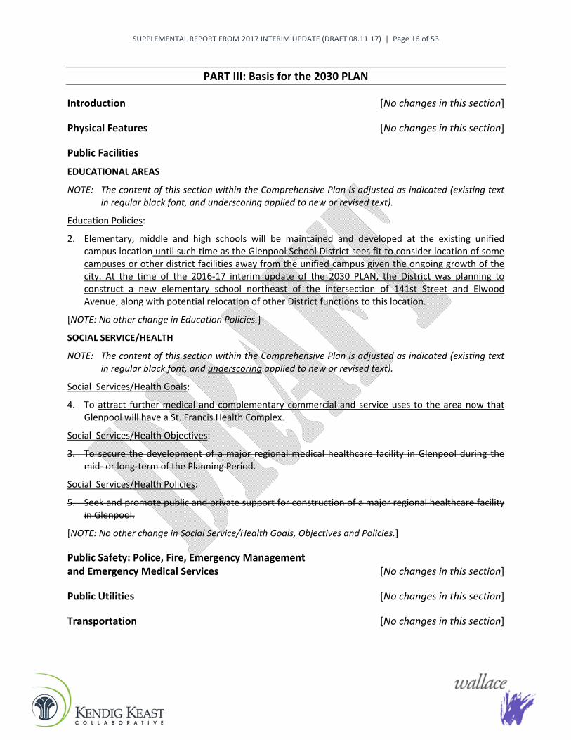
Public Facilities EDUCATIONAL AREAS
NOTE: The content of this section within the Comprehensive Plan is adjusted as indicated (existing text in regular black font, and underscoring applied to new or revised text).
Education Policies:
2. Elementary, middle and high schools will be maintained and developed at the existing unified campus location until such time as the Glenpool School District sees fit to consider location of some campuses or other district facilities away from the unified campus given the ongoing growth of the city. At the time of the 2016-17 interim update of the 2030 PLAN, the District was planning to construct a new elementary school northeast of the intersection of 141st Street and Elwood Avenue, along with potential relocation of other District functions to this location.
[NOTE: No other change in Education Policies.]
SOCIAL SERVICE/HEALTH
NOTE: The content of this section within the Comprehensive Plan is adjusted as indicated (existing text in regular black font, and underscoring applied to new or revised text).
Social Services/Health Goals:
4. To attract further medical and complementary commercial and service uses to the area now that Glenpool will have a St. Francis Health Complex.
Social Services/Health Objectives:
3. To secure the development of a major regional medical healthcare facility in Glenpool during the mid- or long-term of the Planning Period.
Social Services/Health Policies:
5. Seek and promote public and private support for construction of a major regional healthcare facility in Glenpool.
[NOTE: No other change in Social Service/Health Goals, Objectives and Policies.]
Public Safety: Police, Fire, Emergency Management and Emergency Medical Services [No changes in this section]
Public Utilities [No changes in this section]
Transportation [No changes in this section]

SUPPLEMENTAL REPORT FROM 2017 INTERIM UPDATE (DRAFT 08.11.17) | Page 17 of 53
Economic Development NOTE: The content of this section within the Comprehensive Plan is adjusted as indicated (existing text
in regular black font, and underscoring applied to new or revised text).
Economic Development Goals:
8. To seek the location of a major health center in this area to serve Glenpool and surrounding communities.
[NOTE: No other change in Economic Development Goals.]

SUPPLEMENTAL REPORT FROM 2017 INTERIM UPDATE (DRAFT 08.11.17) | Page 18 of 53
PART IV: Description of the Elements of the Plan
Introduction NOTE: The content of this section within the Comprehensive Plan is adjusted as indicated (existing text
in regular black font, and underscoring applied to new or revised text).
Glenpool and the larger Glenpool Planning Area (meaning those unincorporated areas outside the city limits but within the scope of anticipated future annexation, commonly termed as the “fence line”) constitute a substantial space for steady growth, exceptional opportunities and unique characteristics. Physically, the area has developed as an autonomous community and is situated so that its community image and identity can be maintained and enhanced in the future. To the south are Duck Creek and Okmulgee County, to the east and northeast of the Planning Area are the communities of Bixby and Jenks. On the west are Keifer and Sapulpa in Creek County. The area north of Glenpool toward Creek Turnpike (SH-364) and beyond to the Tulsa Hills area continues to transition to suburban development, especially along and near the US-75 frontage. The western City limit is generally 33rd West Avenue, which is the county line between Tulsa and Creek County. This western area is presently largely rural with some industrial development for oil-related uses. Major nonresidential development in Glenpool has taken place in recent years along SH-117 (121st Street), especially near the US-75 interchange, and is emerging along SH-67 (151st Street) with construction initiated on the St. Francis Health Complex, as well as US-75 frontage properties south of SH-67. Development of single-family residential subdivisions continues primarily in the northeast area of the community to the east of US-75. New multi-family residential projects were completed west of US-75, across from the new City Hall and Conference Center, and at 146th Street.
The urbanizing area of Glenpool is located basically between 121st Street on the north and 201st Street on the south and between US-75 and Elwood Avenue in the Coal Creek Drainage Basin, although more development is occurring and anticipated east of Elwood. The relatively underdeveloped US-75 corridor from SH-67 (151st Street) south to 201st Street is incrementally being recognized and utilized for its commercial and light industrial potential.
[NOTE: Skips past unchanged Introduction text at this point.]
Originally an oil “boomtown”, during the early 20th Century, Glenpool experienced essentially no growth, and even periods of negative growth, after the oil fields quit production. However, since the 1970s, Glenpool has seen a resurgence of growth, becoming a bedroom community or living area for major employment centers in the Tulsa metropolitan area. This pattern is expected to continue due to the existing concentration of industrial development and employment centers in Tulsa southwest of the Arkansas River and along the I-44/Turner Turnpike. Glenpool is also seeking to attract industrial growth and business, as well as highway-oriented commercial and potential office development, as a part of its economic development program.
[NOTE: No change to other narrative within this Introduction.]
Land Use NOTE: The content of this section within the Comprehensive Plan is adjusted as indicated (existing text
in regular black font, and underscoring applied to new or revised text).
The narrative in this section, as updated in places since adoption of the 2030 PLAN in 2010, follows from the overview of general types of land use in Part II and adds related policy considerations here:

SUPPLEMENTAL REPORT FROM 2017 INTERIM UPDATE (DRAFT 08.11.17) | Page 19 of 53
Agricultural
Agricultural land areas are located in the periphery of the Glenpool Planning Area and are to be used as agricultural, agri-business, and large lot residential areas. Agricultural lands can appropriately be incorporated into the recreational-open space lands and development-sensitive areas due to the minimal impact of these uses on the land when proper soil management practices are used. Much of the inventory of agricultural land is being held for development until urban scale public utilities and transportation facilities become available.
Residential
A major goal of the 2030 PLAN is to preserve a high quality of life necessary to support a single-family residential life style. The updated 2030 PLAN Map shows that the vast majority of newly-developed residential land in the years ahead is to be lower-intensity single family in nature, in the Suburban and Estate Residential categories. Multi-family residential development is preferred along major transportation corridors, around the Central Business District or other mixed-use areas, and at the intersection of arterial streets and near US-75 as a transitional use and buffer between commercial and lower-intensity residential uses.
The 2030 PLAN supports the infill of development between existing subdivisions continuing a pattern of orderly growth and planned extension of public utilities. The lands adjacent to existing residential areas in Glenpool are intended to develop in accordance with the goals, policies and objectives of the 2030 PLAN to foster the most efficient and economical provisions of public facilities, services, and utilities.
Existing residential subdivisions on the perimeter of the presently urbanized areas are being built and new subdivisions should be provided for by the orderly extension of stub streets and existing utilities. Some new development in many areas of the city and adjacent unincorporated areas is expected to be very low intensity residential estates due to the lack of public utilities (which equates to the Estate Residential designation on the 2030 PLAN Map). The density of these areas may increase in the future as utilities become available.
An ongoing program of high quality maintenance of public infrastructure and code enforcement should be undertaken to support and improve the maintenance and value of the existing residential housing stock (which equates to the Neighborhood Conservation designation on the 2030 PLAN Map). Programs for housing rehabilitation should be pursued for low- and moderate-income persons residing in Glenpool to further support and maintain the quality of the existing housing stock.
Office/Commercial
The proposed Central Business District (CBD) and Special District 5, along 141st Street, will continue to be the principal commercial, office, retail and service centers in Glenpool and is to be maintained and enhanced as a primary business activity area. Continued improvement of public and private properties along 141st Street, between US-75 and Lewis Avenue, will enhance the vitality of this area. Significant areas of commercial zoning exist at the northeast corner of US-75 and SH-67 (151st Street) to support sub-regional scale retail and commercial development, in close proximity to the new St. Francis health complex at the southeast corner. Type 1 and 2 Activity Centers have been designated on the 2030 Plan map throughout the Planning Area. Commercial uses have also been planned in the US-75 Corridor District and other Special Districts as discussed in this section and shown on the 2030 PLAN Map, along with potential commercial expansion south from the Southwest Crossroads area along US-75. It is an insistent policy of the 2030 PLAN that strip commercial and spot commercial zoning be discouraged to the extent feasible. Commercial, office, retail and service uses should be focused at and near

SUPPLEMENTAL REPORT FROM 2017 INTERIM UPDATE (DRAFT 08.11.17) | Page 20 of 53
intersections of arterial streets, with smaller-scale uses located convenient to nearby residential areas consistent with the Neighborhood Concept emphasized in this plan.
Special District 1, Old Towne, is a unique area wherein office and commercial uses will be combined. Careful and planned redevelopment, particularly along Broadway, will focus on the unique potential of this area in combining these office reuses in existing structures with an existing stable residential area in close proximity to the Glenpool School Campus.
The landscape and buffer chapter of the Zoning Code has been adopted to enforce compatibility between business and existing and planned residential uses, particularly along the periphery of Special District 5 and Special District 1.
Industrial
Industrial development provides the potential for local employment, which is a goal of the economic development element of the 2030 PLAN. The existing Glenpool Industrial Park is planned to remain, although it may be impacted by the realignment of US-75 between 131st and 141st Street. If that occurs, strong local actions should be taken to provide alternate industrial locations in accordance with the 2030 PLAN Map to relocate these industries within the Glenpool Planning Area. Industrial development is also planned and already occurring west of US-75 in the designated US-75 Corridor Plan. Areas around the western segment of US-67 (151st Street) are also now zoned for light industrial uses. The 2030 PLAN also envisioned potential industrial activity within Special District 2, but much of this district is in the floodplain around Coal Creek.
The development of a strong diversified industrial base for Glenpool is planned as a pre-requisite for the continued economic vitality of the community. Growth in the local industrial base will also ease the property tax burden of residential homeowners and provide local employment in close proximity to Glenpool residents.
Recreation and Open Space and Development-Sensitive Areas
Recreation and open space lands are depicted on the 2030 PLAN Map. Development-sensitive areas should be incorporated into the recreation-open space system. These areas can also be used in the development of pedestrianways and bikeway connections throughout individual neighborhoods and the community. In Special District 2, Coal Creek is planned to remain as a natural buffer between residential uses on the east and commercial/industrial development on the west. The recreation-open space system depicted on the 2030 PLAN Map incorporates neighborhood parks into the system. A system of linkages via trails is planned along drainageways to link parks and neighborhoods to business and community facilities. Development and maintenance of this system should be coordinated with the development and maintenance of the flood-storm drainage system for Coal Creek, as well as the other watersheds and drainage basins. As was reiterated and reinforced through leadership and public engagement activities for the 2016-17 interim update of this plan, the local trails system should also be linked with the system of regional trails shown on the INCOG Master Trails Plan. Also during 2017, construction began on sidewalk improvements to accommodate pedestrian circulation between the South County Recreation Center and the Glenpool School Campus, with funding from an Oklahoma Department of Transportation grant.
Through the interim update of the 2030 PLAN Map, properties southeast of the intersection of 161st Street and Elwood Avenue are no longer indicated for a potential major recreational facility investment by the City. However, while a multi-sports complex may not yet be a feasible option for Glenpool, the interim update process confirmed ongoing interest in this concept as part of making Glenpool a more complete city as residential and other growth continues in the years ahead. In the meantime, the
SUPPLEMENTAL REPORT FROM 2017 INTERIM UPDATE (DRAFT 08.11.17) | Page 21 of 53
community is gaining a new Soccer Complex, which was under construction at Tulsa County’s South County Recreation Center, on Peoria Avenue north of 141st Street, during the 2016-17 interim update of the 2030 PLAN.
Public and Quasi-Public
Major land areas are existing and designated for public and quasi-public use. The largest such area is presently dedicated to the Glenpool School Campus at the center of the Planning Area. Glenpool municipal facilities and the existing and proposed wastewater treatment facilities make up the balance of public land holdings. Quasi-public sites, such as for churches, public health facilities, etc., should be located within commercial and mixed-use areas or at the intersection of arterial and collector streets, which may be near the edges of residential areas consistent with the Neighborhood Concept. It is anticipated that the Glenpool School Campus will continue to expand south to 151st Street. Additionally, at the time of the 2016-17 interim update of the 2030 PLAN, the District was planning to construct a new elementary school northeast of the intersection of 141st Street and Elwood Avenue, along with potential relocation of other District functions to this location.
Along with Glenpool’s new City Hall and Conference Center and the new Police and Fire Complex, Tulsa County’s South County Recreation Center, on Peoria Avenue north of 141st Street, has added a new centerpiece of community activity and public space. Construction on the Soccer Complex addition to the Center was initiated during this interim plan update. New major public and quasi-public facilities, such as a health center, technology-vocational educational facility, community college and oil museum, are also included in the 2030 PLAN.
Long-awaited construction of the new St. Francis Health Complex, which began in 2017, marked a significant community accomplishment according to plan. However, funding challenges have limited hoped-for expansion of Tulsa Community College programs at its Glenpool campus, which remains a community priority along with the other future facility possibilities mentioned above.
Future Land Use and Character Designations While the previous section focuses primarily on land use considerations, this section expands on this to describe the future land use and character designations shown on the updated City of Glenpool Comprehensive Plan Map (2030 PLAN Map), which is included at the end of this Part IV of the plan. The descriptions indicate the development types anticipated in each category, as well as the intended character of the areas in which these land uses occur and, in some cases, intermingle or end up near one another. Specific dimensional requirements and design standards for land development based on these designations are articulated through the City’s implementing regulations (zoning and subdivision) as they currently exist and may be further amended over time based on this planning guidance. Table 21, at the end of Part IV of this plan, relates the land use and character designations on the updated 2030 PLAN Map to the zoning districts in the City’s zoning regulations

SUPPLEMENTAL REPORT FROM 2017 INTERIM UPDATE (DRAFT 08.11.17) | Page 22 of 53
Rural
This designation consists of lands that are sparsely developed, with mainly agricultural and very low-density residential as the primary uses. This category provides its residents with the choice of relative seclusion within the countryside, and away from a more developed setting. Glenpool has extensive rural lands within its City limits relative to cities that have this mostly beyond their jurisdiction, except in areas that have been annexed for eventual development, or to preserve rural character through the protections afforded by agricultural zoning. Floodplain areas may also retain their rural character over the long term given their unsuitability for any intensive land development.
Development Types Agricultural uses Residential homesteads Public/institutional uses Parks and public spaces, nature preserves, and passive recreation areas
Characteristics Rural character from wide open landscapes, with minimal sense of enclosure and views to the
horizon unbroken by buildings in most places. Scattered residential development on relatively large acreages, resulting in very high open space
ratios and very low site coverage, and providing greater detachment from neighboring dwellings than in estate areas.
Typically no centralized water or sanitary sewer service available. Also much greater reliance on natural drainage systems, except where altered significantly by agricultural operations or regional storm water management projects and/or infrastructure.
Potential for conservation developments that further concentrate the overall development footprint through cluster designs, with increased open space set-aside to maintain the overall rural character and buffer adjacent properties. May also make alternative community wastewater treatment methods feasible to eliminate the need for individual on-site septic systems.

SUPPLEMENTAL REPORT FROM 2017 INTERIM UPDATE (DRAFT 08.11.17) | Page 23 of 53
Parks and Recreational Open Space
The locations of government-owned and maintained public parks, designed for both active and passive recreational enjoyment, are indicated on the 2030 PLAN Map. Some sites are developed with a variety of facilities and amenities (e.g., Black Gold Park) while others have limited improvements and will be developed over time or remain in a more natural state.
Development Types Public parks and open space Public trails Joint City-school park areas Public recreation areas (e.g., public golf courses)
Characteristics Public parkland theoretically will remain so in perpetuity compared to other public property and
buildings that may transition to private ownership at some point. As with any public facility, park design, intensity of development, and planned uses/activities
should match area character (e.g., public squares/plazas in urban downtowns relative to recreational play and sports-focused parks in suburban areas and nature-oriented parks for passive recreation in estate and rural areas).
Estate Residential
This designation is for areas that, due to public service limitations or prevailing rural character, should have limited development activity other than large-lot residential. Such areas provide a transition between a city’s rural fringe and more urbanized in-city development patterns and intensities. Lots in this category typically range from one to three acres, which provides substantial openness and separation between individual dwellings.
Development Types Detached residential dwellings Subdivisions planned with an equestrian component (shared stable facilities and riding trails for
residents)

SUPPLEMENTAL REPORT FROM 2017 INTERIM UPDATE (DRAFT 08.11.17) | Page 24 of 53
Public/institutional uses Parks and public spaces
Characteristics Transition between
suburban and rural character areas, with further progression along the character spectrum toward rural environments where the landscape is visually dominant over structures.
Still in suburban range of character spectrum but with larger lots (typically one acre or larger), especially where required by public health regulations to allow for both individual water wells and on-site septic systems on properties w here centralized water and/or wastewater service is not available or feasible.
One-acre lots are usually adequate in wooded areas to achieve visual screening of homes from streets and adjacent dwellings. Three-to five-acre lots may be needed to achieve and maintain true estate character in more open areas with less vegetation.
Suburban Residential
This designation is for residential areas where suburban character is established and preserved by achieving a balance between buildings and other site improvements relative to the degree of open space maintained within the neighborhood. This distinguishes suburban character areas from more auto-oriented residential areas where site coverage predominates relative to undeveloped space.
SUPPLEMENTAL REPORT FROM 2017 INTERIM UPDATE (DRAFT 08.11.17) | Page 25 of 53
Development Types Detached residential dwellings Planned developments that integrate other housing types (e.g., attached residential), with
increased open space to preserve an overall suburban character Golf course subdivisions Public/institutional uses Parks and public spaces
Characteristics A larger baseline minimum lot size allows for deeper front yards and building setbacks and
greater side separation between homes. Less noticeable accommodation of the automobile compared to more intensive auto-oriented
residential areas, especially where driveways are on the side of homes rather than occupying a portion of the front yard space, and where garages are situated to the side or rear of the dwelling.
Either through permitted-by-right development options or a Planned Unit Development (PUD) approval process, can promote land planning approaches that discourage “cookie cutter” subdivision designs and allow for smaller lot sizes than the baseline in exchange for greater open space set-aside, with the additional open space devoted to maintaining the suburban character and buffering adjacent properties and roads.
May include a cluster development option that further concentrates the overall development footprint while providing the developer the same lot yield—or even a density bonus to incent conservation designs with an even higher open space ratio.
More opportunity for natural and/or swale drainage (and storm water retention/absorption) relative to concentrated storm water conveyance in auto-oriented areas.
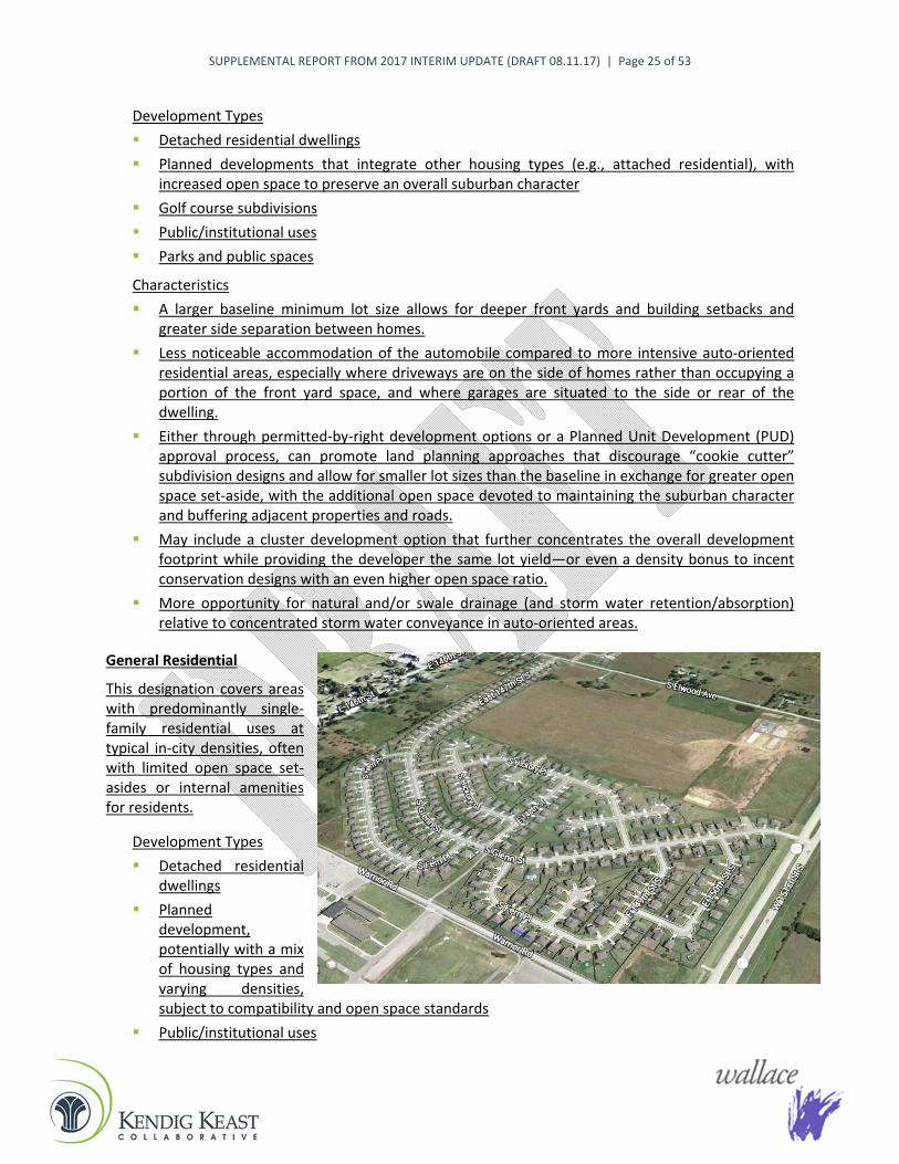
General Residential
This designation covers areas with predominantly single-family residential uses at typical in-city densities, often with limited open space set-asides or internal amenities for residents.
Development Types Detached residential
dwellings Planned
development, potentially with a mix of housing types and varying densities, subject to compatibility and open space standards
Public/institutional uses

SUPPLEMENTAL REPORT FROM 2017 INTERIM UPDATE (DRAFT 08.11.17) | Page 26 of 53
Parks and public spaces
Characteristics Residential neighborhoods with less openness and separation between dwellings compared to
Suburban Residential areas. Auto-oriented character, especially where driveways and front-loading garages dominate the
front yard and building facades of homes. This can be offset by landscaping, “anti-monotony” standards that require varied dwelling appearance and floor plans on adjacent and nearby lots, and limitations on “cookie cutter” subdivision layouts characterized by straight streets and uniform lot sizes and arrangement.
Neighborhood Conservation
This designation is applied to established neighborhoods that are largely built-out and stable and where no significant change in development type or pattern is expected or desired. To implement a conservation strategy, the current zoning districts for these areas may warrant repurposing, and their uses and standards may require recalibration, to maintain the desired neighborhood character. This zoning approach is designed to “lock in” standards that reflect and reinforce how a neighborhood originally developed or has evolved over time, to preserve its existing, prevailing character. In other cases, a customized Neighborhood Conservation zone may serve to manage a neighborhood in transition, such as where older homes fronting on a perimeter street with increasing traffic volumes could be allowed to convert to small-scale office uses over time while still maintaining a residential character and appearance.
Development Types Detached residential dwellings and some attached housing types in particular neighborhoods Public/institutional uses Parks and public spaces
Characteristics Integrity of older, intact neighborhoods protected through customized Neighborhood
Conservation zoning with standards that ensure no significant change in the development type or pattern and reinforce existing physical conditions (e.g., prevailing lot sizes, building setbacks, architectural elements such as front porches, etc.).
Designed to preserve existing housing stock (and avoid excessive nonconformities and variance requests), and also to govern periodic infill and/or redevelopment activity within a neighborhood to ensure compatibility.

SUPPLEMENTAL REPORT FROM 2017 INTERIM UPDATE (DRAFT 08.11.17) | Page 27 of 53
Depending on the particular neighborhood, the customized zoning may provide for small-scale office or retail uses on vacant sites at the edge of the neighborhood or other appropriate locations.
Attached Residential
This designation provides a transition between residential areas comprised entirely of single-family detached dwellings and larger-scale multi-family residential properties.
Development Types Duplexes (two-family
dwellings) Townhomes Patio homes and other small-
lot housing types with common walls, including “zero lot line” developments where a home is situated directly at one side lot line, attached to an adjacent home on the adjoining lot
Characteristics Minimum lot sizes, building setbacks, and other zoning standards account for the need to align
yard and open space requirements with relatively higher residential densities than found in most single-family detached residential areas.
Site and dwelling design, including building and garage placement and orientation, should match area character in terms of whether the vicinity is more toward the suburban or auto-oriented range of the community character spectrum.
Multi-Family Residential
This designation involves areas devoted primarily to structures with multiple residential units, at a greater intensity (i.e., units per building or acre) than found in the Attached Residential category. Site design and open space standards may be applied to offset the relative density of this residential type, to ensure adequate recreational space on the site for residents, and to provide buffering and screening between this and less intensive residential uses. This use category can also provide a transition from primarily residential to mainly nonresidential areas.

SUPPLEMENTAL REPORT FROM 2017 INTERIM UPDATE (DRAFT 08.11.17) | Page 28 of 53
Development Types Multi-unit attached residential in concentrated development, whether for rent (apartments) or
ownership (condominiums) Public/institutional uses Parks and public spaces
Characteristics Auto-oriented character typically due to the extent of off-street parking needed. However, the
auto-oriented appearance can be softened by perimeter and on-site landscaping, minimum spacing between buildings, site coverage limits, and on-site recreation or open space criteria.
Multi-family residential can achieve—and blend in with—a suburban character if such standards and associated buffering requirements are set appropriately within the context of attached residential and/or single-family detached residential uses in the vicinity.
May be limited to two or three stories outside of urban character areas, with setbacks and/or buffering also increased near less intensive residential uses for compatibility.
May locate near medical facilities, parks and public services, shopping and transit stops if designed primarily for senior residents.
Suburban Commercial
This designation involves commercial developments, whether at a neighborhood or community scale, that stand apart from most auto-oriented contemporary development through reduced site coverage and other design elements that move a site into the suburban range of the community character spectrum relative to sites where “gray” spaces predominate over “green” and open spaces.
Development Types Range of commercial
retail and service uses, at varying scales and intensities depending on the site
Office (involving large and/or multi-story buildings or only small-scale office uses depending on the site), which may involve a medical or technology/research focus
Planned development to accommodate custom site designs or mixing of uses in a suburban character setting
Public/institutional uses Parks and public spaces

SUPPLEMENTAL REPORT FROM 2017 INTERIM UPDATE (DRAFT 08.11.17) | Page 29 of 53
Characteristics Suburban character primarily from reduced site coverage relative to most auto-oriented
commercial development. Especially at key community entries and along high-profile roadway corridors, may also involve
other criteria to yield less intensive and more attractive development outcomes relative to auto-oriented areas, including higher standards for landscaping (along street frontages and within parking areas), signs, and building design.
May exclude some auto-oriented uses that, by their very nature, cannot achieve a suburban character (e.g., car washes).
Near residential properties and areas, the permitted scale and intensity of non-residential uses should be limited to ensure compatibility (including adequate buffering/screening, criteria for placement and orientation of buildings and parking areas, height limits, and residential-in-appearance architectural standards).
More opportunity for natural and/or swale drainage (and storm water retention/absorption) versus concentrated storm water conveyance in auto-oriented areas.
General Commercial
This designation is for properties in commercial retail, office and service uses, primarily along portions of major roadway corridors within the community for high visibility and accessibility, but also in other locations to accommodate neighborhood-focused businesses.
Development Types “Strip” commercial centers along major roadways, with a range of uses, including those on high-
profile “pad” sites along the roadway frontage “Big-box” commercial stores (e.g., groceries, appliances, clothing, etc.) Restaurant chains including various “fast food” and casual dining establishments Automobile service related enterprises (e.g., gas stations, automobile service/repair, car
washes) Offices Hotels and motels

SUPPLEMENTAL REPORT FROM 2017 INTERIM UPDATE (DRAFT 08.11.17) | Page 30 of 53
Mixed-use developments Public/institutional uses Parks and public spaces
Characteristics Commercial areas with an auto-oriented character that have significant portions of
development sites devoted to vehicular access drives, circulation routes, surface parking, and loading/delivery areas, making pavement the most prominent visual feature. This can be offset by enhanced building design, landscaping, reduced site coverage, well-designed signage, etc.
Buildings typically set back toward rear of site to accommodate expansive parking areas in front, closest to passing traffic, resulting in less emphasis on architectural design in many cases.
Development desire to maximize signage (number, size) to capitalize on site visibility to passing traffic.
Often not conducive for access or on-site circulation by pedestrians or cyclists.
Industrial - Light and Medium
These designations accommodate uses that are intensive in terms of how “light” industrial and especially “medium” industrial activities can affect other nearby properties. This can include factors such as noise, vibration, light/glare, odor, truck traffic, and hours of operation, as well as the sheer scale and intensity of some types of industrial land use. Depending on the standards applied through development regulations, an industrial area can allow for a wide range of uses, from office/warehouse to wholesale, product assembly, and manufacturing. Some communities aim for a more aesthetic business or industrial “park” environment, with specific standards for building arrangement and orientation, building materials and design, extensive landscaping, and especially full screening of loading and outdoor activity/storage areas, if such external activity is even permitted. A campus feel may be further reinforced by private or public streetscape and design enhancements, including special signage at industrial area entries and key intersections, unified lighting design, water features, etc.

SUPPLEMENTAL REPORT FROM 2017 INTERIM UPDATE (DRAFT 08.11.17) | Page 31 of 53
Light Industrial Development Types Warehousing Light manufacturing and/or processing/assembly Business parks Office use accessory to a primary industrial use Retail sales and services, including heavy commercial uses (e.g., RV sales, building supply) Public/institutional
Light Industrial Characteristics Typically auto-oriented character, although master-planned business or industrial park
developments may feature a campus-style setting with reduced site coverage and increased open space; extensive landscaping of the development perimeter, and special streetscaping and design treatments at entries, key intersections and internal focal points; and enhanced building design, signage and screening standards, all of which may be controlled by private covenants and restrictions that exceed City ordinances and development standards.
Potential for outdoor activity and storage, which should be screened where visible from public ways and residential areas.
May involve significant truck traffic or direct rail service. On-site large-scale moving equipment in some cases. Potential for environmental impacts that may affect the proximity and type of adjacent uses,
including particulate emissions, noise, vibrations, smells, etc., plus the risk of fire or explosion depending on the materials handled or processed.
Certain intensive publicly-owned uses are best located within industrial areas (e.g., public works facilities, fleet maintenance, treatment plants, fire training).
Medium Industrial Development Types Manufacturing Oil and gas operations Office use accessory to a primary industrial use Public/institutional The sole permissible location for sexually-oriented businesses under some local regulations

SUPPLEMENTAL REPORT FROM 2017 INTERIM UPDATE (DRAFT 08.11.17) | Page 32 of 53
Medium Industrial Characteristics Outdoor activity and larger visible structures and storage facilities, which are sometimes difficult
to screen from neighboring properties aside from fencing, landscaping and/or berms along site perimeters.
Higher volume of truck traffic, and sometimes direct rail service. On-site large scale moving and construction equipment in some cases. Environmental impacts expected that will affect the proximity and type of adjacent uses,
including particulate emissions, noise, vibrations, lighting/glare, smells, etc., plus the risk of fire or explosion depending on the materials handled or processed.
Often operate “24/7,” which also requires adequate separation and buffering from any nearby residential areas.
Demography and Economy NOTE: The content of this section within the Comprehensive Plan is adjusted as indicated (existing text
in regular black font, and underscoring applied to new or revised text).
This section of the 2030 PLAN provides the basic data and analysis of the demographic and economic climate of Glenpool. Demographic and economic data are presented on a comparative basis for the State of Oklahoma, Tulsa County, the Tulsa MSA, and Glenpool, and as comparisons of Glenpool with area cities for purposes of tracking trends of growth. Sources of data as far back as 1940 in this section are from US Decennial Census, the Oklahoma Department of Commerce (ODOC) and from INCOG estimates using computerized trend projections. Both tabular and graphic data in the forms of charts and graphs are used to present the information upon which the analysis is based. A “Service Area Summary” is available at www.glenpoolonline.com.
At the time of the 2016-17 interim update of this plan, the newest available U.S. Census Bureau estimates for Glenpool, through 2015, included the following for a variety of pertinent community indicators:
Median Age: 32.1 years
Population Under Age 18: 3,559 (29.7%)
Population Age 65 and Older: 935 persons (7.8%)
Housing Units: 4,281 (with 85.2% of housing stock in single-family detached units, and 30% of all housing units built since 2000)
Owner-Occupied Housing Units: 72.7% of all occupied housing units
Owners that Moved into their House since 2010: 34.1% of occupied housing units
Average Household Size: 2.85 persons in owner-occupied units, 3.26 in renter-occupied units
Median Home Value: $124,700 among all owner-occupied housing units
Housing Units Free of a Mortgage: 17.8% of all owner-occupied housing units
Median Rent: $918 among all renter-occupied housing units
Rental Units with 35% or More of Household Income toward Rent (affordability threshold): 32.6%
Labor Force Participation: 6,297 (or 72.2% of persons age 16 and over)
Employed Persons: 5,855 (or 93% of persons in labor force, for a 7% unemployment rate)
SUPPLEMENTAL REPORT FROM 2017 INTERIM UPDATE (DRAFT 08.11.17) | Page 33 of 53
Mean Travel Time to Work: 21.6 minutes for all workers age 16 and over (with 9% reported as carpooling, and 4% who reported working at home)
Persons Age 25 or Older with Bachelor’s Degree or Higher: 21.5% (with 90% having a high school diploma)
Median Household Income: $59,444
Median Earnings for Workers: $30,912
Persons with Annual Income Below Federal Poverty Level: 11.9% (15.8% among persons under age 18, and 4.9% for persons age 65 and older)
Ranges of differences and differing methods of projections as undertaken in this section are useful in the area of population and demographic analyses. However, such analyses are but one of the tools on which to base planning for the future needs of Glenpool in the year 2030. Data in this section should continually be analyzed with actual figures from the year 2000 US Decennial Census and upcoming 2010 Census as well as the most up to date annual projections as made available from ODOC and the US Commerce Department. As a general rule, a higher level of accuracy can be expected in the short term. Low and high ranges of population estimates are useful in displaying a range of projections for use in planning for services, such as water or wastewater needs, where a higher projection may be desired as opposed to projections on the financial side of municipal needs where a more conservative projection may be more appropriate.
Population Outlook
Population projections are an important component of a long-range planning process. They help determine and quantify the demands that will be placed on public facilities and services based on the potential pace and scale of the community’s physical growth. Projections reflect local, regional and even national and international trends and offer a basis to prepare for the future. However, forecasting population changes can be challenging, particularly for the long term, as it is impossible to account for all circumstances that may arise. Therefore, it will be important for the City to monitor population and economic growth continually to account for both short- and longer-term shifts that can influence development activity and growth trends in the community and larger region.
Alternative Growth Scenarios
Demographers caution that population projections become trickier as the geographic area gets smaller, making city-level population the most difficult to forecast. This is because local population change is strongly influenced by less predictable factors such as housing prices, individual location choices and commuting considerations, and availability of vacant land to develop. The extent and timing of annexation activity by the City must also be considered, especially when newly incorporated territory has existing residents and results in an instant increase in the citywide population total.
Adding to the forecasting challenge in Glenpool is the fact that the community has not added population at a steady pace over recent decades, as displayed in Table 5.5, Glenpool Historical Population Growth Since 1970. As some population projection methods extrapolate from past trends, Glenpool has no clear trend and, in recent years, has returned to a much higher population growth rate not seen since the 1980s.

SUPPLEMENTAL REPORT FROM 2017 INTERIM UPDATE (DRAFT 08.11.17) | Page 34 of 53
TABLE 5.5: Glenpool Historical Population Growth Since 1970
Year Population # Added CAGR*
1970 770 -- -- 1980 2,706 1,936 13.4% 1990 6,688 3,982 9.5% 2000 8,123 1,435 2.0% 2010 10,808 2,685 2.9% 2015 13,225* 2,417 4.1%
* Soon before adoption of the 2017 interim update to the 2030 PLAN, the Census Bureau released a 2016 population estimate for Glenpool of 13,479. SOURCE: U.S. Census Bureau. NOTE: Compound Annual Growth Rate (CAGR) indicates a steady
rate of growth at which a quantity (population in this case) grew or is projected to grow over a defined time period. The actual year-to-year growth in prior or future years may be more volatile, but the CAGR identifies a smoother average rate over the entire time period.
For historical perspective, the last comprehensive planning process for Glenpool in 2010 relied on alternative projections that showed the city could grow from 8,640 residents that year to a population in 2030 as low as 9,500 (Oklahoma Department of Commerce from 2002), or potentially in the 16,300 range (INCOG from 2003), or to as much as 21,256 based on Glenpool’s share of Tulsa metropolitan area projections for regional transportation planning purposes. All of these calculations were done before Census 2010 results were available. As it turned out, Glenpool’s growth pace had already accelerated, resulting in an actual Census count of 10,808 in 2010. As a result, the projections in the previous plan were based on assumed population trends for Glenpool that were already below the actual growth pace. Additionally, the lowest projections reflected more conservative assumptions about future growth rates.
Displayed in the chart below is a comparison of several potential scenarios for population change in Glenpool over the next 20+ years. The projections build on the Census 2010 baseline of 10,808 persons and identify potential population levels in five-year increments out to 2040.

SUPPLEMENTAL REPORT FROM 2017 INTERIM UPDATE (DRAFT 08.11.17) | Page 35 of 53
Glenpool Population Growth Scenarios Through 2040
Along with the numbers from the Glenpool 2030 PLAN for comparison, the other scenarios include, from lowest to highest potential growth:
Projection Based on Oklahoma Department of Commerce Regional Projection. The Department of Commerce generates very long-range projections through 2075 for counties statewide, as well as for key metropolitan areas including the Tulsa area. Such projections were last published in 2012. The Department projected that the Tulsa metropolitan area will grow from 937,478 residents in 2010 to just over 1.5 million in 2075. This means the area population will grow by 60 percent over the 65-year period, with the Tulsa area accounting for 27 percent of statewide population by 2075 relative to 25 percent in 2010. This yields a 0.7 percent Compound Annual Growth Rate (CAGR, see definition in footnote to Table 5.5 above). The projection line labeled Oklahoma Department of Commerce indicates, purely for comparison, the population increase that Glenpool would experience through 2040 if it grew at the same 0.7 percent CAGR assumed for the entire metropolitan area. This leads to a 2040 projection of 13,440 residents and would mean 24.4 percent growth over the 30 years from 2010 to 2040. As it turns out, the newest available U.S. Census Bureau population estimate for Glenpool is 13,479 residents in 2016, which already surpasses the 2040 projection above, underscoring the recent growth surge Glenpool has seen. (The Department of Commerce expects that the Tulsa area and all of Oklahoma will experience slower long-term population growth as is anticipated for the entire nation given declining birth rates and other factors.)
[NOTE: The Indian Nation Council of Governments (INCOG) is in the process of updating its Regional Transportation Plan (RTP) to extend the planning horizon by five more years through 2040. Population projections prepared for the 2035 RTP had a 2005 base year and are no longer relevant to Glenpool given its increased growth rate in recent years.]
Steady Numeric Growth. This projection line in the chart is also purely for comparison as it reflects a “straight-line projection” method in which the community adds the same number of new residents to

SUPPLEMENTAL REPORT FROM 2017 INTERIM UPDATE (DRAFT 08.11.17) | Page 36 of 53
its population each decade—4,834 persons—which is derived from recent growth since Census 2010. This type of linear growth projection results in a declining rate of growth over time as the same amount is being added to an ever-expanding base. The U.S. Census Bureau’s 2015 population estimate indicated that Glenpool had a CAGR of 4.1 percent from 2010 to 2015. Under this projection scenario, the CAGR would decrease to 3.4 percent for the entire 10 years from 2010 to 2020 and continue declining to 2.7 percent for 2020-2030 and 2.1 percent for 2030-2040. This leads to a 2040 projection of 25,310 residents and would mean 134 percent growth over the 30 years from 2010 to 2040. This is nearly double the outcome of the previous scenario tied to Oklahoma Department of Commerce projections for the Tulsa metropolitan area.
Steady Growth Rates. Rather than steady numerical growth, the two final scenarios involve an exponential growth method in which a constant rate of growth is assumed for projection purposes. This results in higher projections and is similar to the power of compound growth in a savings account over time; the interest (i.e., growth) rate may not change, but it is being applied to an ever-expanding balance, resulting in larger and larger interest earnings over time. The last projection line, labeled Steady Growth Rate (4.1% Glenpool 2010-15), indicates the population growth Glenpool would experience if it grew at the same CAGR of 4.1 percent that it did from 2010 to 2015. Other exponential growth scenarios can be considered simply by varying the CAGR assumption and plugging in a different growth rate than the 2010-15 rate. For comparison, the projection line labeled Steady Growth Rate (Assumed 3%) indicates the population growth that would result from a lower CAGR of three percent through 2040. The three percent scenario produces a 2040 projection of 26,234 residents and would mean 143 percent growth over the 30 years from 2010 to 2040. If Glenpool were to maintain the 4.1 percent CAGR of recent years, this would yield a 2040 projection of 36,278 residents and would represent 237 percent growth over the 30-year timeframe.
Bottom Line
It is wise for cities to think in terms of a range of potential growth rather than an absolute number given the uncertainty of any small-area forecast that extends beyond a few years. Given Glenpool’s location at the southern edge of the Tulsa urbanized area and its growth prospects as a next logical extension of regional housing development and population absorption, it will be wise for Glenpool to focus on the projection scenarios above that yield the highest potential growth over the next several decades. Whether this trends toward a 2040 population that is closer to the mid-30,000s versus the mid-20,000s will depend on actual year-over-year land development activity, the City’s ability to serve this pace of growth with adequate public infrastructure and services, and community values and preferences as to where growth occurs and at what intensity, which will ultimately translate into zoning policies and capital projects and public services planning.
Background Data from 2010 Comprehensive Plan Process
Table 6 shows population growth of cities in the Tulsa MSA from 1980 to 2000. Within that period, Glenpool did not only identify itself as one of the fastest growing cities in the Tulsa MSA, but demonstrated exceptional growth and stability compared to other cities with a population under 15,000. In 2000, the US Census reported a population of 8,123, a 21.46% change from 1990. Although the City has not grown as fast as it did in the 1980s (147.15%), its 2000 Census population and rate of growth still rank Glenpool in the top echelon of growing communities in both the County and the Tulsa MSA, and this steady growth is expected to continue into the near Planning Period.
Tables 7-9 reflect population trends and projections for Glenpool, Tulsa County, and the Tulsa MSA. ODOC’s 2002 projections show Glenpool rising steadily to 8,390 in 2005 and 8,640 in 2010, an overall 6% increase, which is comparatively on par with the County’s projected rate in the same period. However,

SUPPLEMENTAL REPORT FROM 2017 INTERIM UPDATE (DRAFT 08.11.17) | Page 37 of 53
INCOG’s estimates project a 36% overall change in City population and that Glenpool will reach 11,082 by 2010.
[NOTE: No other change in Demography and Economy section.]
Public and Quasi-Public Facilities NOTE: The content of this section within the Comprehensive Plan is adjusted as indicated (existing text
in regular black font, and underscoring applied to new or revised text).
City Hall
Since the adoption of the 2030 PLAN in 2010, City Hall has moved from its former location within Special District 1, at US-75 and 141st Street, to its new location along with the Conference Center southwest of the US-75 interchange at SH-117 (121st Street). Tulsa Community College continues to make use of the former City Hall building.
Recreation and Open Space [No changes in this section]
Education
Education facilities are generally planned to continue to be located in conjunction with the existing and possibly expanded Glenpool School Campus. However, at the time of the 2016-17 interim update of the 2030 PLAN, the District was planning to construct a new elementary school northeast of the intersection of 141st Street and Elwood Avenue, along with potential relocation of other District functions to this location.
Libraries [No changes in this section]
Social Services/Health
The Glenpool Senior Citizens Center, formerly located in the Community Center, was founded to serve the multi-purpose needs of the Glenpool community. Since its inception in 1979, the Center has been heavily used by all age groups and has become a regular meeting place for various public and private organizations.
The Center is also used for various health-related clinics. At the time of the 2016-17 interim update process for this plan, construction was initiated on the St. Francis Health Complex, fulfilling a priority objective from previous planning to achieve a modern health services facility in Glenpool to serve a growing as well as aging population. The facility should be centrally located with adequate parking and modern facilities to provide Glenpool the latest in modern health services and programs. It will also be necessary to expand the physical space for senior-related services now provided by the Community Center. However, the latest trends in development have shown a rise in free-standing private medical offices. The need for a stand-alone health center for the community should be considered as a need in the mid-term of the Planning Period.
Public Safety [No changes in this section]
Public Utilities NOTE: The content of this section within the Comprehensive Plan is adjusted as indicated (existing text
in regular black font, and underscoring applied to new or revised text).
This section discusses the following public utilities: water, sanitary sewer, flood-storm drainage, and solid waste. Since 2010, the general direction of land development in Glenpool has trended more southward, with new institutional, commercial and industrial development projects occurring south of

SUPPLEMENTAL REPORT FROM 2017 INTERIM UPDATE (DRAFT 08.11.17) | Page 38 of 53
151st Street and along the US-75 frontage. Generally, these new developments require extension of public infrastructure improvements into areas that either have no current facilities or where the existing public utilities are inadequate to provide service in an as-is or where-located condition.
Given Glenpool’s growth pace and trends, top priorities for the City include:
Starting in 2018, the design and construction of a third water storage facility and related infrastructure improvements.
Starting in 2019, the design and permitting for the construction and implementation of a mechanical wastewater treatment facility.
Additionally, based on the 2016-17 interim update of this Comprehensive Plan, the City is again updating and enhancing its Engineering and Design Criteria and Standards For Construction, as was previously done in 2012. Storm water management in a growing and developing community will continue to be a focus of these updates.
Water
The existing water system is owned and operated by the Glenpool Utilities Services Authority (GUSA) and is shown on the map from the Capital Improvement Program (Figure 9). The CIP also shows the size, material, condition of each line, and priority for repair or replacement. There is presently no outstanding indebtedness on the water system. At the time of the update of the 2030 PLAN, a new water distribution CIP has been completed. A wastewater update is also under way and will be part of a combined water and CIP update. At the time of the 2016-17 interim plan update, City staff provided the following statistics on the water system:
Approximately 4,500 total water meters including residential, commercial and industrial users.
85 gallons per day (GPD) of per capita water use, with no current users in Glenpool considered high water consumers.
800,000 GPD of average daily water use demand, covering all user types.
2 million GPD of peak daily water use demand, covering all user types.
Glenpool presently purchases treated water from the Regional Metropolitan Authority which also serves the City of Tulsa that is delivered from master meters located at 131st Street and Elwood Avenue, and 91st and Union. As long as the City of Tulsa is able to deliver treated water to Glenpool at reasonable rates, the purchase of treated water is the best and least costly option to secure water for Glenpool residents. Presently, improvements have been made to the Tulsa system which have increased the capacity of that system to where delivery to surrounding cities is likely to continue to be an option. Under a current 40-year agreement, Glenpool can receive up to nine million gallons of water per day.
The Glenpool system in 2010 included a one (1) million gallon storage tank located west of the southwest corner of Peoria and 141st Street. In 2016, the City commissioned an overall water distribution system study, which Cowan Group Engineers completed in 2016. One result of this study was a recommendation to install a new elevated water tower on 156th Street east of US-75. A new 500,000 gallon storage tower and related facilities were completed in 2016 at a total design and construction cost of approximately $2.8 million. The study also identified numerous weaknesses in the current city-wide distribution network and recommended future capital improvement projects to address them. It is anticipated that additional storage and distribution system improvements and upgrades will be necessary in areas both east and west of US-75 south of 161st Street.The need for an additional storage tank in the southwest and developing area along US-75 needs to be addressed during

SUPPLEMENTAL REPORT FROM 2017 INTERIM UPDATE (DRAFT 08.11.17) | Page 39 of 53
the Planning Period. Feasibility studies should be performed to identify a possible location and determine how such a storage tank would be connected to the system. The planned location of the storage tank is shown on the 2030 Plan Map.
Strategic plans for the Glenpool water system should include a “business plan” approach where water is purchased and sold at rates which also recognize the need to perform ongoing maintenance on the local system and extend lines as needed to support future growth. Major improvements to the system, such as large mains along section line roads will likely require issuance of revenue bonds and participation from private developers. The overall system should be a looped system with the cost related to private development paid for by the developers as the system is expanded.
At the time of the 2016-17 interim plan update, the City had recently initiated a second study of existing City-owned water system facilities in a more specific sub-area of Glenpool generally south of 161st Street on either side of US-75. This study will determine the need and appropriate location for a third elevated water storage tower and associated distribution system improvements as the southern area of the community develops in the near future.
Recommended standards for waterline sizes are as shown below and also must reflect the urban densities they are intended to serve:
1. Twelve (12) inch minimum diameter lines along section line roads and on both sides of US-75.
2. Eight (8) inch minimum diameter lines to cross-connect and loop the internal neighborhood and the section line grid system.
3. Six (6) inch minimum diameter line size for all other development.
All new multi-lot subdivision developments in Glenpool are generally required to extend public water and sanitary sewer services to serve the development, although on-site wastewater (“septic”) systems are necessary in some locations and with large-lot subdivisions.
Wastewater System
The existing wastewater treatment plant and collection system is owned and operated by GUSA and is shown on the map from the CIP (Figure 10). Revenue bonds were issued to construct the present wastewater treatment plant. The wastewater treatment system includes a lagoon located north and east of the intersection of US-75 and 141st Street. Major improvements to the physical plant have been made and the discharge of treated water has now been taken to the Arkansas River. At the time of the 2016-17 interim plan update, City staff provided the following statistics on the wastewater system:
Approximately 4,500 total customers for City wastewater service.
70 gallons per day (GPD) of per capita wastewater generation (based on when the Glenpool population had reached 12,500 persons).
850,000 GPD of average daily flow relative to 1.49 million GPD of permitted daily treatment capacity (not including any water inflow and infiltration, or “I & I,” to the system).
1.35 million GPD of peak daily flow relative to the permitted daily treatment capacity (not including any “I & I” to the system).
Current customers in Glenpool do not include any unique generators whose wastewater requires pretreatment prior to entering the City’s treatment process, although this could be a factor in the future depending on the types of industrial or heavy commercial development that might occur. Also, to this point, Glenpool has not been involved in any local efforts to re-use treated effluent for “graywater” applications, such as for irrigation of public or other lands.

SUPPLEMENTAL REPORT FROM 2017 INTERIM UPDATE (DRAFT 08.11.17) | Page 40 of 53
Capacity expansion and other improvements to Glenpool’s existing wastewater treatment facility may be on the horizon as the current daily peak flow of 1.35 million GPD has reached the 90 percent threshold of the existing facility’s permitted daily treatment capacity of 1.49 million GPD. The Move Glenpool Forward sales tax election, held and approved by Glenpool voters in 2016, included future funding for the design and permitting of a new mechanical wastewater treatment facility to be considered as a total replacement of the existing facility. Preliminary plans for a new facility indicate a tentative treatment capacity of approximately 2.5 million GPD, a likely cost in excess of $20 million, and start of construction in approximately the 2020 timeframe.
The current treatment facility was permitted and modified in 2012 to add a breakpoint chlorination system to the existing aerated lagoon type treatment process. This upgrade involved design and improvement costs of more than $3.7 million for the City. The modifications were necessary to address past Oklahoma Department of Environmental Quality (ODEQ) permit violations due to excessive ammonia content in the effluent discharged from the plant into the Arkansas River. Additional facility upgrades have been made more recently, involving the retrofitting of new forced air emitters to enable more efficient treatment and increase the amount of dissolved oxygen injected into the plant effluent prior to discharge.
Also in 2012, a new regional sanitary sewer lift station replacement project was completed with a pumping capacity of approximately 1,000 gallons per minute (GPM), at a total cost of approximately $850,000. A second regional lift station upgrade project was completed in 2015 that increased the existing facility’s pumping capacity to 600 GPM, at a total cost of approximately $325,000. Numerous smaller existing lift station upgrade projects have been completed since 2010 that deal with pumping, electrical control, and remote monitoring systems, at a total cost exceeding $300,000. At the time of this 2016-17 interim Comprehensive Plan update, the City was preparing to engage an engineering consultant to assist with planning and design of an expected total revamp and upgrade of another regional type lift station and an associated force main in anticipation of coming growth and land development in upstream areas of the community generally located south of 151st Street both east and west of US-75. It is anticipated that urbanization in the early part of the Planning Period will continue to occur in the Coal Creek Drainage Basin and begin to spread to the Posey Creek Basin as well. Presently, great interest is also being expressed in the far south areas of the City along or adjacent to US-75 which requires construction of lift stations and force mains – costly options for the public and private sector. According to the CIP, 11 lift stations should be replaced over the next 10 years.
Policies are recommended to be adopted by the City to assure that the increased cost of new development is borne by private developers and system users. It is recommended in the 2030 PLAN that the City utilize a “business plan” approach to operating the sanitary sewer system where rates and fees are reflective of the costs borne by the City associated with the operation, maintenance, and expansion of the system.
In rural and sparsely developed areas beyond the reach of current public wastewater service, ODEQ minimum lot size standards (generally one-half acre) must be met for use of on-site wastewater (“septic”) systems, along with standards for soil percolation and the design, installation and maintenance of the individual treatment facilities. If the property is within 500 feet of a public sanitary sewer main, then connection must be made to the main line versus use of an individual system. Additional standards apply in such areas for minimum spacing of on-site wastewater systems, lift stations and other waste-related facilities from public and private water wells and surface water supplies, depending on the type of technology and soil conditions.

SUPPLEMENTAL REPORT FROM 2017 INTERIM UPDATE (DRAFT 08.11.17) | Page 41 of 53
Flood-Storm Drainage
No major problem areas for flooding of developed properties were identified at the time the 2030 PLAN was adopted in 2010. Periodic updates to federal floodplain maps maintained by FEMA will illustrate how storm drainage patterns and management methods are evolving over time as Glenpool grows and urbanizes. Concern about avoiding more site-specific storm water runoff issues will factor into the pending update and enhancement of the City’s Engineering and Design Criteria and Standards For Construction of public infrastructure improvements. Necessary drainage projects should continue to be identified and included in the CIP along with ongoing programs for maintenance of drainage channels and facilities. Available state or federal assistance should be considered and utilized in conjunction with available local funds for such improvements. Assistance should also be sought from Tulsa County as would be available to improve any existing drainage problems in adjacent unincorporated areas that impact incorporated areas.
Proposals for improving the drainage and storm water management in Coal Creek and along US-75 should be developed and accomplished in a timely fashion. The construction of the interchange at US-75 and 151st Street has channeled the Creek tributary and made significant additional land available for development that is presently zoned commercial. The City has implemented an aggressive program of maintaining existing drainage channels to reduce problems with flooding and also to eliminate unsightly growth of vegetation. This program should be continued and expanded as development occurs.
Development upstream in both the Coal and Posey Creek watersheds has the potential to increase runoff downstream and existing facilities could become overloaded. Areas which have never experienced high water problems could incur drainage problems with full upstream development and existing problems magnified unless local regulations are applied in an effective and consistent manner during the development process.
The 1981 Master Drainage Plan, in conjunction with the Subdivision Regulations, must be applied and implemented to help assure that future drainage improvements will be constructed in a coordinated manner and be of sufficient capacity to meet current as well as future drainage needs. The 1981 Master Drainage Plan addressed only a portion of the Coal Creek Drainage Basin and should be updated as development and annexation occurs in the other three (3) drainage basins. The Master Drainage Plan is a necessary prerequisite for the proper development of the area for all watersheds. Potential problems can be avoided through the planned and staged development of area drainage improvements based on a drainage plan for the ultimate development of the watersheds in order to assure acquisition of necessary right-of-ways and to require that all such facilities meet the adopted standards of the City. The Coal Creek watershed has been reevaluated in 2003 and depicts changes in flood areas based on new and/or more reliable data.
The City is a participating municipality under the National Flood Insurance Program (NFIP) and has adopted all of the regulations associated with this federal program that deal with property located within or adjacent to floodplain areas regulated by the Federal Emergency Management Agency (FEMA) or by local jurisdictions. Floodplain regulations pertain to developing land and building in these areas and establish overall guidelines for construction and development in such circumstances.
Solid Waste [No changes in this section]
SUPPLEMENTAL REPORT FROM 2017 INTERIM UPDATE (DRAFT 08.11.17) | Page 42 of 53
Transportation NOTE: The content of this section within the Comprehensive Plan is adjusted as indicated (existing text
in regular black font, and underscoring applied to new or revised text).
In 2016, Glenpool voters approved the Move Glenpool Forward sales tax initiative, which enabled funding of the following specific arterial street and highway improvements as identified for the election:
Widening and lane additions on 121st Street, between US-75 and Elwood Avenue.
Widening and lane additions on Elwood Avenue, between 131st Street and 151st Street.
Intersection widening and lane improvements on Elwood Avenue at 141st Street.
Intersection widening and lane improvements on Elwood Avenue at 151st Street.
Intersection traffic signalization at:
› 151st Street and Elwood Avenue.
› 151st Street and US-75.
› 141st Street and Elwood Avenue.
› 121st Street and Elwood Avenue.
Following the successful election, each project has an individual financial account for earmarking of funds as sales tax revenue is collected. The City will prioritize the projects as the revenue accumulates.
Trafficways
The trafficways element of MSHP and the 2030 PLAN was first adopted in 1974. The MSHP is the ultimate plan for a fully developed urbanized area. Major roadways planned to be constructed by a specific time period are identified in Connections 2035, the Regional Transportation Plan (RTP)2030 Foresight: The Long Range Transportation Plan for the Tulsa Metropolitan Area (2030 LRTP) developed by INCOG and updated every five years. The MSHP provides further detail in the language of the Special Districts and designated US-75 Corridor so far as access and requirements for frontage roads.
Pedestrian-Ways and Bikeways
The development of pedestrian-ways and bikeways system should be coordinated with the recreational open space system shown on the 2030 PLAN. This system should include provisions for such use along streets as well as along open space and drainageways along creeks, and connect to existing and planned parks. Furthermore, a pedestrian-bike trails system should be incorporated into development proposals for future development. Pedestrian-ways should be provided in accordance with the requirements for sidewalk construction contained in the Subdivision Regulations. Local pedestrian-ways and bikeways should be coordinated with and connected to metropolitan-level projects advanced by the GO Plan, the Regional Bicycle/Pedestrian Master Plan adopted by INCOG in December 2015. The GO Plan includes a 10-page section specifically on community-level bicycle/pedestrian conditions and issues in Glenpool, and the Final Network map (next page) with recommended improvements. These potential bicycle/pedestrian improvements should be factored into the planning and design of public projects and private developments in the vicinity of each location on the GO Plan map.
Transit [No changes in this section]
Air [No changes in this section]
Rail [No changes in this section]

PLAN
141
Chap
ter 6
: Gle
npoo
l Com
mun
ity P
lan
s elm
st
e 161 st s
s peor
ia ave
s lewis
ave
s peor
ia ave
w 131 st s
T U L S A C O U N T Y
B i x b y
J e n k s
S a p u l p a
G l e n p o o lcoa
lcreek
trail
s elwo
od ave
e 146 st s
sferns
t
s elwo
od ave
w 141 st s
e 131 st s
e 141 st s
elm st
w 121 st s e 121 st s Final Network8/31/2015
0 0.4 0.8
Miles
RecommendationsTrailSidepathBike LaneShared Lane MarkingSigned Route
Exported: 8/31/2015
Pa th: O:\AC TIVE PROJECTS\5421 Tulsa Regio nal Bike & Ped Master Pla n\GIS\MX Ds\201508_Aug ust\Tulsa_Mapboo k_C ommunity_Focus_Areas.mxd U ser: g omerso
Glenpool
User: <bol><ita>gomerso</ita></bol> Path: <bol><ita>O:\ACTIVE PROJECTS\5421 Tulsa Regional Bike & Ped Master Plan\GIS\MXDs\201508_August\Tulsa_Mapbook_Community_Focus_Areas.mxd</ita></bol> Date: 8/31/2015
Tulsa Regional Bicycle & Pedestrian Master Plan
PLAN 141 Chapter 6: Glenpool Community Plan

SUPPLEMENTAL REPORT FROM 2017 INTERIM UPDATE (DRAFT 08.11.17) | Page 43 of 53
Economic Development NOTE: The content of this section within the Comprehensive Plan is adjusted as indicated (existing text
in regular black font, and underscoring applied to new or revised text).
A major goal established in the 2030 PLAN is to continue to grow, develop and diversify the economic base of the City during the Planning Period and beyond. Glenpool has had success in attracting new industry and business in the last five years in a major way. New banks, restaurants, and retail business have come to Glenpool, many of which have located along 141st Street east of US-75 in the area designated as the CBD (Special District 5). A new post office and library have also been located along this segment of 141st Street and an Old Towne “office-theme district” (Special District 1) is recommended to connect to the CBD from south of Broadway. To reinforce the character and identity of this area, 141st is recommended to be renamed “Black Gold Boulevard”Main Street and continued gateway and entrance improvements to the 141st Street entrance from US-75 are recommended. Extension of the three- lane improvement of 141st Street one mile further east to Peoria has also been completed since the 2010 update of the City’s Comprehensive Planis proceeding. The realignment of US-75 and a bridge over the expressway at 141st Street into the CBD will further enhance the potential of this area.
[NOTE: Skips past unchanged text at this point.]
The continued expansion and maintenance of the City’s housing stock is a vital part of the economic expansion and growth of the City as is the sound base provided by the Glenpool School Campus K-14 facility located in the heart of the Planning Area. Related goals in this area include advocating the location of a secondary educational facility and a companion vocational-technical facility, expansion of the public schools to a K-14 program with the Tulsa Community College, medical center and an oil museum in Glenpool. Continued improvement of the local infrastructure, particularly water and wastewater, plus assuring a capacity for expansion is a basic requirement and platform for future growth and major economic development.
To increase the industrial base and presence, Glenpool should also seek establishment of a business/industrial park, medical center, oil museum and competitive level local recreational and cultural events, such as a horse shoe competition. In conjunction with the goals for growth and expansion of new business, Glenpool should also seek and aggressively support the growth of existing businesses by providing a continuing level of high quality municipal services and infrastructure and up-to-date development codes and regulations.
Special Districts SPECIAL DISTRICT 1: OLD TOWNE - THE MAIN STREET OFFICE DISTRICT.
The Main Street Office District is sometimes referred to as the “Old Towne of Glenpool,” and is shown on the 2030 PLAN Map. The boundaries of Special District 1 extend along the northern edge of tracts abutting 141st from the north and includes all of the area along Broadway south of 141st Street to one-half block south of Main/146th and from east of US-75 along Main Street to College Street and to the Glenpool School Campus on the east. This area was previously the seat of the City government before the move to the new City Hall and Conference Center near US-75 south of SH 117 (121st Street), with the City leaving the prior City Hall to be taken over by Tulsa Community College. One of Glenpool’s largest churches is located at the northeast corner of Main and Broadway. The Glenpool School Campus is located on the east edge of Special District 1 with access from the west provided by Main, with 151st Street on the south. Primary access to the campus is from 141st being along Elm and Fern Street. Fern Street is presently signalized at 141st. The Campus currently includes Grades K-12 and all related administrative and support, sports and parking facilities. However, at the time of the 2016-17 interim

SUPPLEMENTAL REPORT FROM 2017 INTERIM UPDATE (DRAFT 08.11.17) | Page 44 of 53
update of the 2030 PLAN, the District was planning to construct a new elementary school northeast of the intersection of 141st Street and Elwood Avenue, along with potential relocation of other District functions to this location. 145th Street affords access to the Black Gold Park, one of Glenpool’s most used recreational areas on a year-round basis. Black Gold Park lies along the east-side of US-75 for one-half mile south of 141st Street. It is also visible from the entrance to Special District 1 from 146th Street and provides an attractive greenbelt impression of the City for commuters and tourists on US-75. A Veterans’ Flag and Memorial Plaza has been constructed at the intersection of Broadway and 145th Street, and the US Post Office is located just south of the southeast corner of Broadway and 141st.
[NOTE: No other change in Special District 1 section, and no change in Special District 2 section.]
SPECIAL DISTRICT 3. OIL AND GAS EXPLORATION AND LOW INTENSITY DEVELOPMENT – ONE-HALF MILE SOUTH OF 121ST TO 141ST STREET EAST OF SOUTH 33RD WEST AVENUE.
Residential development has taken place in Special District 3 along 126th Street on tracts ranging from 2.5 acres to 10 acres. Residential construction includes some manufactured homes and large conventionally built residences. Several large tracts of 40 or 80 acres remain undeveloped in Special District 3. Absent the extension of City utilities into the area, development on tracts of 2.5, 5 or even 10 acres can be expected and would represent an extension of the current trend. Development proposals in Special District 3 must account for past oil and gas exploration and remaining related facilities and pipelines, where such activity occurred on or affected the property in question, and the lack of public water and sewer needed to support urban scale development. Medium-Intensity development is planned to be a five (5) acre Type 1 Activity Center at the northeast and southeast corners of 141st Street with South 33rd West Avenue.
[NOTE: No other change in Special District 3 section.]
SPECIAL DISTRICT 4. 151ST STREET (SH-67) EXTENDING FROM 33RD W. AVE. TO AND CONTINUING EASTWARD TO LEWIS AVENUE. [HAS BEEN RE-DESIGNATED AS SH-67 CORRIDOR.]
The SH-67 Corridor District is recommended for those areas immediately north and south of 151st Street (SH-67) from just east of US-7533RD W. Ave. to Lewis Avenue in which Medium-Intensity land uses would be in accordance with the 2030 Plan. The configuration of SH-67 Corridor is shown on the 2030 PLAN Map. This particular area is prime for highway-oriented nonresidential or mixed-useMedium-Intensity development that can optimize use of high-profile frontage properties, but will require cooperation with the Oklahoma Department of Transportation to establish strict controls on access to and from the highway while consideration is given to the impact of such usesMedium-Intensity development upon adjacent and abutting lands. Shared access points between developments and frontage roads to restrict access from lands abutting SH-67 should also be required. Access across the median should continue to be restricted to only those median cuts that are presently constructed and that will likely be signalized in the future. The criteria for developing in accordance with the 2030 PLAN for Special District 4 are as follows:
A. PUDs will be encouraged for Medium-Intensitydevelopments of 40 acres or larger along the corridor to reduce the impact of potential commercial, office or light industrialsuch zoning and to properly regulate the location of high traffic generators. In no case shall Medium Intensity commercial, office or light industrial zoning exceed a depth of 300 feet from the property frontage along SH-67. Proposed PUDs shall include conceptual site plans that demonstrate the compatibility of internal land use relationships. Site plan, sign plan, and landscape plan review and approval by the Glenpool Planning Commission and City Council shall be required for PUDs prior to issuance of a building permit. Said plans shall be in substantial compliance with the approved provisions of the PUD and

SUPPLEMENTAL REPORT FROM 2017 INTERIM UPDATE (DRAFT 08.11.17) | Page 45 of 53
shall be in compliance with all other applicable ordinances and regulations of the City of Glenpool, including, but not necessarily limited to the following:
5. Through-traffic into adjacent Low-Intensity residential districts shall be discouraged by designing collector streets which will not function as direct avenues of neighborhood cut-through for nonresidential or other nonlocal traffic.
6. Parking within medium intensity developments along the SH-67 Corridor shall be screened or otherwise buffered from abutting residential areas and arterial streets by a combination of opaque fences and vegetative screening that will be a condition of approval of the PUD and shall be maintained as a continuing condition of occupancy and use of the land.
7. Setbacks, buffer areas and arrangement of land uses shall be used in combination with screening to improve compatibility with adjacent existing and planned residential uses and less intense nonresidential useslow intensity uses.
8. The granting of nonresidential zoning to an area 40 acres or larger within a PUD along the corridor shall be conditioned upon the area of each such request providing its own buffer with any adjacent existing or planned residential uses and less intense nonresidential useslow intensity uses. More specifically, requests for nonresidentialmedium intensity zoning involving 40 acres or more along the corridor shall include areas of more restrictive zoning and planned land uses on its periphery.
11. Areas of 40 acres or more that involve nonresidential or mixedMedium-Intensity uses and are along the corridor but not adjacent or in close proximity to an arterial street intersectionoutside the intersection Activity Center shall be limited to a maximum depth of 300 feet as measured from the property frontage along SH-67. Consideration may be given to proposals that exceed that depth only if it can be shown to the satisfaction of the City Council that any negative impact of such zoning will be mitigated by the controls included in the PUD and access to said development will be directly to or by frontage roads adjacent to SH-67.
12. The expansion or granting of new nonresidentialMedium-Intensity zoning to any area of 40 acres or more shall be done only in an orderly manner in accordance with the provisions of this Special District and the 2030 PLAN.
B. The integrity of the MSHP shall be preserved and traffic carrying capacity of SH-67 and the affected arterials in this Special District protected as follows:
5. Ingress and egress to nonresidential or mixed-use developments involving 40 acres or moreMedium-Intensity areas shall be planned in such a manner as to not mix or utilize those minor or local streets that provide access to abutting and adjacent low intensity areas of existing and planned residential uses and/or less intense nonresidential uses. Access to minor or local streets from such developmentsMedium-Intensity areas in this Special District is not considered to be in accordance with the provisions or intent of this Special District.
[NOTE: No other change in Special District 4 section.]
SPECIAL DISTRICT 5. THE CENTRAL BUSINESS DISTRICT (CBD)
The CBD, Special District 5, extends east from US-75 along 141st Street to the vicinity of Elwood Avenue. The configuration of Special District 5 is shown on the 2030 PLAN Map. The recent improvements of 141st Street from two (2) to three (3) lanes, with center turn lanes and sidewalks, support commercial/community serving business activity and development along this street. The County finished widening 141st Street to a three-lane facility from Elwood to Peoria since the time of the 2010 Plan update. The existing land use is a mix of office and commercial uses and undeveloped land. This area will
SUPPLEMENTAL REPORT FROM 2017 INTERIM UPDATE (DRAFT 08.11.17) | Page 46 of 53
continue to be one of the more importantthe most major shopping and commercial areas in Glenpool during the planning period, along with the Southwest Crossroads area at US-75 and 121st Street and other emerging development elsewhere along US-75. New banks, a regional library, post office and several restaurants have been developed in the CBD in just the last few years. Planned improvements to US-75 will continue to focus attention on this gateway and entrance to Glenpool. Due to the immediate proximity of any such development in this area with abutting residential development to the north and south, screening and setbacks, plus buffering must be included and PUDs are encouraged. It is planned that residential development which fronts 141st Street be redeveloped to convenience commercial or office uses, while properties which rear or side onto 141st Street shall remain residential.
In order to focus and maintain attention on the CBD, the City and other partners should continue with efforts to brand the 141st Street corridor as “Black Gold Boulevard” and the CBD and Old Towne area as the “Black Gold District.”consideration should be given to renaming of 141st as “Main Street” Further public and private improvements can build on streetscape enhancements already made along the corridor involving added landscaping, pedestrian-level period lighting, and winding pedestrian paths where room was available within the street right-of-wayor possibly a “theme” or “appearance district” for public and private improvements. Signage and a gateway/entrance from US-75 should also be considered to direct travelers to the retail and other services available in this area. Shared access points for ingress and egress along 141st Street should be required to reduce almost inevitable conflicts that can occur between linear commercial and office development and traffic on the roadway.
SPECIAL DISTRICT 6. 141ST STREET EAST
Special District 6 is a continuation of Special District 5 on 141st Street. The development criteria are the same as those for District 56.
The Glenpool 2030 PLAN NOTE: The content of this section within the Comprehensive Plan is entirely new as indicated by
underscoring.
The 2016-17 interim review and update of the Glenpool 2030 PLAN, out of necessity, required preparation of a new Comprehensive Plan Map as the City was not in possession of the computer files for the “Figure 12” map in the plan version adopted in 2010. The interim review process also provided an opportunity to update the 2030 PLAN Map to reflect: (1) actual on-the-ground development outcomes since 2010, and (2) where zoning designations have evolved in certain locations relative to the plan map.
A Comprehensive Plan Map is intended to show the general pattern of uses already existing, anticipated and/or desired in and around the community over the horizon of the plan, which is typically 20 years. The map indicates the type of residential or nonresidential use expected to predominate in an area based on what is already on the ground and will likely remain or possibly evolve over time, as well as projected new development. Additionally, it is recognized that other complementary uses will also remain or emerge in each area of the city along with the predominant use types (e.g., small-scale retail and services near residential neighborhoods).
Specific locations are not yet known in some cases, such as for some future public facilities (e.g., schools, fire stations, parks, etc.), as well as places of worship, that often locate in or near primarily residential areas. Some uses are highly market-driven, with their timing and particular location dictated by the extent and pace of other types of development. This includes the typical trend of retail uses following residential “rooftops”—and typically locating at key roadway intersections. Plus the eventual emergence of multi-family development, the location and extent of which can be difficult to predict ahead of

SUPPLEMENTAL REPORT FROM 2017 INTERIM UPDATE (DRAFT 08.11.17) | Page 47 of 53
housing market trends and cycles, and developer interest in whether, where and when to bring this product to market.
The new 2030 PLAN Map is presented in two views. The first view focuses on future land use in the City’s corporate limits and in unincorporated areas within Glenpool’s annexation fence line. This view also shows the locations of the Special Districts and Corridor areas described in the 2030 PLAN text, as well as City parks, public schools and other key public facilities in Glenpool. The second view adds more reference detail, including alignments of primary and second arterial roadways from the City’s Major Street and Highway Plan, and the generalized location and extent of 100-year floodplain areas as delineated by the Federal Emergency Management Agency (FEMA).
Table 21, below, relates the land use and character designations on the updated 2030 PLAN Map to the zoning districts in the City’s zoning regulations. It also replaces the previous Land Use Plan Matrix in the 2010 version of the plan that focused on linking the zoning districts to areas of Low, Medium and High Intensity land use on the previous Comprehensive Plan Map.
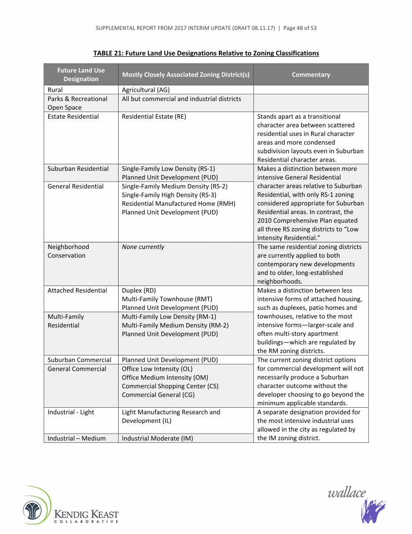
SUPPLEMENTAL REPORT FROM 2017 INTERIM UPDATE (DRAFT 08.11.17) | Page 48 of 53
TABLE 21: Future Land Use Designations Relative to Zoning Classifications
Future Land Use Designation Mostly Closely Associated Zoning District(s) Commentary
Rural Agricultural (AG) Parks & Recreational Open Space
All but commercial and industrial districts
Estate Residential Residential Estate (RE) Stands apart as a transitional character area between scattered residential uses in Rural character areas and more condensed subdivision layouts even in Suburban Residential character areas.
Suburban Residential Single-Family Low Density (RS-1) Planned Unit Development (PUD)
Makes a distinction between more intensive General Residential character areas relative to Suburban Residential, with only RS-1 zoning considered appropriate for Suburban Residential areas. In contrast, the 2010 Comprehensive Plan equated all three RS zoning districts to “Low Intensity Residential.”
General Residential Single-Family Medium Density (RS-2) Single-Family High Density (RS-3) Residential Manufactured Home (RMH) Planned Unit Development (PUD)
Neighborhood Conservation
None currently The same residential zoning districts are currently applied to both contemporary new developments and to older, long-established neighborhoods.
Attached Residential Duplex (RD) Multi-Family Townhouse (RMT) Planned Unit Development (PUD)
Makes a distinction between less intensive forms of attached housing, such as duplexes, patio homes and townhouses, relative to the most intensive forms—larger-scale and often multi-story apartment buildings—which are regulated by the RM zoning districts.
Multi-Family Residential
Multi-Family Low Density (RM-1) Multi-Family Medium Density (RM-2) Planned Unit Development (PUD)
Suburban Commercial Planned Unit Development (PUD) The current zoning district options for commercial development will not necessarily produce a Suburban character outcome without the developer choosing to go beyond the minimum applicable standards.
General Commercial Office Low Intensity (OL) Office Medium Intensity (OM) Commercial Shopping Center (CS) Commercial General (CG)
Industrial - Light Light Manufacturing Research and Development (IL)
A separate designation provided for the most intensive industrial uses allowed in the city as regulated by the IM zoning district. Industrial – Medium Industrial Moderate (IM)

nn
n
nn
")'
__
_
_
_Future
ES
Special District 3
Special District 6
Special District 2
Special District 5
Special District 1
S OKMULGEES B LINE EXPY
E 151 ST S
E 141 ST S
E 171 ST S
E 181 ST S
S ELM ST
S LEWIS AVE
W 201 ST S
S HARVARD AVE
W 171 ST S
W 181 ST S
E 201 ST S
S PEORIA AVE
W 126 ST S
W 191 ST S
W 161 ST S
S ELWOOD AVE
W 131 ST S
E 121 ST S
W 141 ST S
W 151 ST S
W 121 ST S
E 191 ST S
S FER
N ST
S 26 W AVE
S UNION AVE
S 7 ST
S 33 W AVE
S PO PL A RPL
E 146 ST S
S 9 W AVE
S 33 WEST AVE
E 175 ST S
E 167 ST SS1 1WAVE
S 27 E AVE
SZENITH
E 134 ST S
SUT ICA AVE
S 27 W AVE
E 163 PL S
SYUKON
SN YSSA PL
S 19 E
AVE
E 147 ST S
E 136 ST
S HICKORY
ARENA RD
SI DLEAWHILE
S FLORENCEAVE
S 32 W AVE
LONGHORN
SCOLUMBI A AV E
SBIR CH
E 165 ST S
S 25 W
W 206 ST S
SADDL EBACK
SGLE NC T
S ELGIN AVE
S KENDALWOOD
W 166 ST S
S 31 E AVE
S HARVARD AVE
E 201 ST S
S 27 E AVE
S HARVARD AVE
S PEORIA
S ELWOOD AVE
S LEWIS AVE
E 131 ST S
S 18 ST
S LEWIS AVE
E 161 ST S
E 128 ST S
S 20 ST
S GLENPOOL
S ELWOOD AVE
£¤75
E 156 ST
S PEORIA AVE
S TROOST AVE
Sapulpa
Kiefer
Jenks
Bixby
Mounds
Liberty
UV67 UV67
£¤75
£¤75
£¤75
_
City Hall/Conference
Center
Library
Twin Mounds Pioneer
Cemetery
Wastewater Treatment
Plant KendalwoodNorth ParkLambert
Park
BlackGoldPark
KendalwoodSourth Park
RollingMeadows
Park
PoliceFire
Morris Park
South County Recreation
Center
Glenpool ES
Glenpool HSGlenpool
MS
Glenpool, Oklahoma Comprehensive Plan Map
¯0 4,0002,000 Feet
LegendLand Use
Neighborhood Conservation
Multi-Family ResidentialAttached Residential
General Residential
RuralParks and Recreational Open SpaceEstate ResidentialSuburban Residential
Suburban Commercial
Districts
General CommercialIndustrial LightIndustrial Medium
Special District 1: Old Towne DistrictSpecial District 2Special District 3
Special District 6Special District 5: Central Business District
Corridors
Note: See Plan text for more background and policy direction for future land use in Corridor and Special District areas.
S.H. 67 Corridor (Former Special District 4)U.S. 75 Corridor
Glenpool Corporate LimitsUnincorporated Area
Glenpool Annexation Fence Line
Parcel Boundary

nn
n
nn
")'
__
_
_
_Future
ES
Special District 3
Special District 6
Special District 2
Special District 5
Special District 1
S OKMULGEES B LINE EXPY
E 151 ST S
E 141 ST S
E 171 ST S
E 181 ST S
S ELM ST
S LEWIS AVE
W 201 ST S
S HARVARD AVE
W 171 ST S
W 181 ST S
E 201 ST S
S PEORIA AVE
W 126 ST S
W 191 ST S
W 161 ST S
S ELWOOD AVE
W 131 ST S
E 121 ST S
W 141 ST S
W 151 ST S
W 121 ST S
E 191 ST S
S FER
N ST
S 26 W AVE
S UNION AVE
S 7 ST
S 33 W AVE
S PO PL A RPL
E 146 ST S
S 9 W AVE
S 33 WEST AVE
E 175 ST S
E 167 ST SS1 1WAVE
S 27 E AVE
SZENITH
E 134 ST S
SUT ICA AVE
S 27 W AVE
E 163 PL S
SYUKON
SN YSSA PL
S 19 E
AVE
E 147 ST S
E 136 ST
S HICKORY
ARENA RD
SI DLEAWHILE
S FLORENCEAVE
S 32 W AVE
LONGHORN
SCOLUMBI A AV E
SBIR CH
E 165 ST S
S 25 W
W 206 ST S
SADDL EBACK
SGLE NC T
S ELGIN AVE
S KENDALWOOD
W 166 ST S
S 31 E AVE
S HARVARD AVE
E 201 ST S
S 27 E AVE
S HARVARD AVE
S PEORIA
S ELWOOD AVE
S LEWIS AVE
E 131 ST S
S 18 ST
S LEWIS AVE
E 161 ST S
E 128 ST S
S 20 ST
S GLENPOOL
S ELWOOD AVE
£¤75
E 156 ST
S PEORIA AVE
S TROOST AVE
Sapulpa
Kiefer
Jenks
Bixby
Mounds
Liberty
UV67 UV67
£¤75
£¤75
£¤75
_
City Hall/Conference
Center
Library
Twin Mounds Pioneer
Cemetery
Wastewater Treatment
Plant
PoliceFire
South County Recreation
Center
Glenpool ES
Glenpool HSGlenpool
MS
Glenpool, Oklahoma Comprehensive Plan Map
¯0 4,0002,000 Feet
LegendLand Use
Neighborhood Conservation
Multi-Family ResidentialAttached Residential
General Residential
RuralParks and Recreational Open SpaceEstate ResidentialSuburban Residential
Suburban Commercial
CorridorsS.H. 67 Corridor (Former Special District 4)U.S. 75 Corridor
DistrictsNote: See Plan text for more background and policy
direction for future land use in Corridor and Special District areas.
Primary/Secondary Arterial
Glenpool Corporate LimitsParcel Boundary
Glenpool Annexation Fence Line
100-Year Flood Zone/Floodway
General CommercialIndustrial LightIndustrial Medium
Special District 1: Old Towne DistrictSpecial District 2Special District 3Special District 5: Central Business DistrictSpecial District 6

SUPPLEMENTAL REPORT FROM 2017 INTERIM UPDATE (DRAFT 08.11.17) | Page 49 of 53
PART V: Implementation of the Comprehensive Plan
NOTE: The content of Part V within the Comprehensive Plan is adjusted as indicated (existing text in regular black font, and underscoring applied to new or revised text).
General The final section of the Glenpool, Oklahoma Comprehensive Plan: 2025 presents the tools for plan implementation of the 2030 Plan. Each decision made by the local government has the potential to contribute to the implementation of the 2030 PLAN. The specific tools discussed in this section include the following:
Capital Improvement Program;
Zoning Regulations;
Subdivision Regulations and Engineering and Design Criteria and Standards For Construction;
Annexation;
Building and Housing Codes;
Additional Detailed Planning;
Planning for the Annexation Fence Line;
Neighborhood Improvement Programs;
Continued Citizen Participation; and
Regular Updates of the 2030 PLAN.
As part of the 2016-17 interim plan update, City staff also identified examples of financing mechanisms the City has used since 2010 to accomplish needed public improvements and other community enhancements, including:
Funds allocated to Glenpool projects from Tulsa County’s Vision 2025 sales tax initiative, which was originally approved by voters in 2003. As of mid-2017, all of the Vision 2025 funds allocated to Glenpool projects had been used or were being used for ongoing projects. Vision 2025 was the primary funding source for the South County Soccer Complex that was under construction adjacent to, and as a part of improvements associated with, the South County Recreation Center owned and operated by Tulsa County. Also, the design and construction of the new elevated water storage tower on 156th Street, completed in 2016, was largely funded through Vision 2025. The rehabilitation of a regional sanitary sewer lift station along 121st Street, west of US-75, was also partially funded through the Vision 2025 program.
A federal transportation grant awarded to the City that was partially funding an $800,000 local sidewalk construction project during 2017-18. The project will better accommodate pedestrian circulation generally along 141st Street between Elwood Avenue and Peoria Avenue, and providing connections with the South County Recreation Center on Peoria Avenue and the Glenpool School complex along Warrior Drive.
Funds that will be generated by the City’s creation, in January 2017, of Glenpool’s first Tax Increment Finance (TIF) district. The district encompasses several properties prime for commercial development in an area generally south of 161st Street and east of US-75. Up to $5 million of tax revenue to be generated within the district, over a base amount, is earmarked,
SUPPLEMENTAL REPORT FROM 2017 INTERIM UPDATE (DRAFT 08.11.17) | Page 50 of 53
through a TIF agreement, for reimbursement to the developer for public infrastructure improvements that will be completed in conjunction with the private development.
Capital Improvement Program (CIP) The importance of the CIP to the development of the City cannot be over-emphasized. In 1997, the City adopted a comprehensive CIP that addressed all areas of capital equipment, infrastructure and buildings owned by the City. The CIP is based on a program of priorities in the areas of general government, parks, public safety, transportation and utilities. Priorities range from needs that are of a mandatory basis that should be met immediately to those needs that are considered essential, desirable or deferrable. The CIP presents these needs on an annual basis for each of the first five (5) years and aggregates needs in years six (6) through ten (10). The basic element of the CIP is the inventory of the City’s capital assets that is available in a computerized format. The inventory also includes a comprehensive analysis of the utility and street systems that includes interrelated graphic single-line maps and a non-graphic database. This CIP presents a “business plan” for the City and should be maintained and utilized as a tool of capital construction as well as reference at the time of budget preparation. The City should continue to update and maintain the CIP on an annual “rolling” basis, to remove the previous Year 1 from the plan, add priority projects for a new Year 5, and adjust the out-years to incorporate a new Year 10A major update of the 1997 CIP should be completed in the short-term of the 2030 Planning Period.
Zoning Regulations Zoning is the most obvious and publicly recognized tool of implementation of the Comprehensive Plan. Table 21, at the end of Part IV of this plan, relates the land use and character designations on the updated 2030 PLAN Map to the zoning districts in the City’s zoning regulations.The relationship of the proposed land use categories in the 2030 Plan to zoning districts is shown on the Land Use Plan Matrix (Table 21). The 2030 Plan includes the Matrix of Intensity and Land Use Standards which is the basis for zoning decisions made by local officials. It is the policy of the City that zoning decisions will not be made in contradiction of the 2030 PLAN. It is also the policy of the City that the 2030 PLAN, as well as any changes in the physical facts of the subject area or the possibility of factors not considered or present at the time the 2030 PLAN was adopted, be considered as well. In those areas included within the annexation fence line of the City and in unincorporated Tulsa County, the City seeks to have the 2030 PLAN officially adopted by the Tulsa County Board of Commissioners in order that the decisions of the County contribute to growth in these areas in accordance with the policies, goals and objectives of the City of Glenpool. The use of the referral process for County planning and rezoning changes from the Tulsa Metropolitan Area Planning Commission should be continued to allow a partnership with Glenpool in zoning decisions recognizing that the County jurisdiction is final until said lands are annexed into the City.
Essential updates to the Zoning Regulations were adopted in 2017, in conjunction with the 2016-17 interim Comprehensive Plan update. As part of this update effort, a comprehensive re-organization of the regulations was also accomplished to improve user navigation and enable more efficient administration by City staff. A particular focus for the zoning update was to provide an enhanced policy framework for the consideration and approval of Planned Unit Developments (PUDs), especially for applications that propose relatively smaller lots for single-family residential development to ensure preservation of open space, resource protection, and adequate buffering and compatibility with adjacent land uses.

SUPPLEMENTAL REPORT FROM 2017 INTERIM UPDATE (DRAFT 08.11.17) | Page 51 of 53
Subdivision Regulations and Engineering and Design Criteria and Standards For Construction The exercise of subdivision control and engineering design standards is a fundamental part of development regulation and implementation of the 2030 PLAN. The Subdivision Regulations establish the process and minimum standards for development related improvements (streets, water, sewer, sidewalks, parks, open space, drainage, etc.) and the City’s Engineering and Design Criteria and Standards For Construction set the detailed design requirements for such improvements. These regulations should be revised and updated on a regular basis to keep pace with changing development techniques and the standards included therein should be enforced throughout the process, from plan review to construction, by knowledgeable professionals and enforced by a rigorous inspection program in the field.
Targeted updates to the Subdivision Regulations were adopted in 2017, in conjunction with the 2016-17 interim Comprehensive Plan update. These updates added essential provisions to spell out and clarify respective responsibilities of developers and the City related to public infrastructure improvements that are planned through the City’s platting and development approval processes, and later approved for dedication to the City for ongoing maintenance. Minor adjustments were also made to coincide with related amendments to the zoning regulations involving standards for and review and approval of Planned Unit Developments (PUDs). Additionally, based on the 2016-17 interim plan update and the amended zoning and subdivision regulations, the City is again updating and enhancing its Engineering and Design Criteria and Standards For Construction, as was previously done in 2012.
Annexation [No changes in this section]
Building and Housing Codes [No changes in this section]
Additional Detailed Planning The basis for the land use and transportation elements of the 2030 PLAN is the demographic and economic data available only from the decennial2000 US Census with estimates and forecasts on an annual or semiannual basis from INCOG, the Oklahoma Department of Commerce, and the US Department of Commerce. A new decennial census will be taken in the year 202010, which will contribute valuable new and detailed information about Glenpool, the Planning Area and this region overall. Every effort should be made to review the demographic and economic based data in the 2030 PLAN and later interim updates in light of the latest available information. These estimates and any projections should continue to be utilized now and after the data is available from one of the aforementioned sources to keep the City’s Comprehensive2030 Plan current. INCOG also has a process whereby the population of area cities and towns is estimated on an annual basis, which should also continue to be considered.
Planning for the Annexation Fence Line [No changes in this section]
Neighborhood Improvement Programs Housing is a basic staple of economic development and quality living in Glenpool and neighborhoods are basic residential elements of the 2030 PLAN. Neighborhoods should continue to be well planned in accordance with the policies in the 2030 PLAN and programs continued in areas of code enforcement, infrastructure maintenance, neighborhood associations, and community policing programs, to assure quiet, stable existing and new living areas throughout the City. The 2016-17 interim Comprehensive Plan

SUPPLEMENTAL REPORT FROM 2017 INTERIM UPDATE (DRAFT 08.11.17) | Page 52 of 53
update also introduced the concept of Neighborhood Conservation as a special land use designation on the 2030 PLAN Map and a potential zoning tool to consider for more targeted neighborhood protection and management of any infill or redevelopment activity in the City’s original and oldest established residential areas. Glenpool should also supplement these local efforts with aggressive programs seeking federal or other assistance to provide funds to rehabilitate existing housing and assure that affordable, safe, and standard housing is available for all persons in the community.
Continued Citizen Involvement A comprehensive plan is never the work of one individual, group or agency. It involves the collaboration and partnership between all persons interested in creating the best community possible. In 1999, the Mayor along with the City Council and Planning Commission/Board of Adjustment worked with members of the Glenpool business and residential communities in establishing a “Visioning Process,” which served as the foundation for the Glenpool, Oklahoma Comprehensive Plan: 1999-2020. A similar process, Glenpool – A Vision for the Future, was conducted with participation from Glenpool leaders, various stakeholders and residents during late 2013 through early 2014. That process involved consideration of internal/external challenges and opportunities, and ideas and specific initiatives for building community in Glenpool in the years ahead.
In order for the 2030 PLAN to remain effective, it is paramount that citizen participation play a vital role in the updating process. As the 2030 PLAN is updated, the City of Glenpool should encourage public involvement by posting public notices, holding public hearings, and issuing news releases. Such means have proven effective in assuring that the planning process is structured as a very public process and that all affected interests and needs are brought to the forefront, discussed and addressed. For future major 2030 PLAN updates, comprehensive citizen participation, similar to the previous visioning processes is recommended. The table in Part I of this supplemental report highlights leadership and community engagement activities that informed the 2016-17 interim Comprehensive Plan update, with summaries of several such activities included as an appendix to this report. Several informal presentations and question-and-answer sessions were also completed with development community representatives during the process of developing zoning/subdivision regulation updates that were drafted concurrently with the interim plan update.
Regular Updates of the 2030 PLAN It is especially important that the Comprehensive2030 Plan be updated on an annual basis for minor changes and given a major review and update every three (3) to five (5) years and not less than every ten (10) years. This is especially the case when new data from the latest US Decennial Census becomes available—which will next be in the early 2020s after Census 2020—and also in consideration of major updates in regional plans, such as the INCOG Regional Transportation Plan (RTP) that is updated every five years, with a next RTP update pending for 2020-2040 following INCOG’s adoption of Connections 2035. The results of periodic RTP updates bear heavily on near-term transportation funding allocations and subsequent construction of streets in Glenpool and throughout the region. Population and demographic estimates and projections should also be reviewed as they become available and the policies of the City’s Comprehensive2030 Plan reviewed in light of the most current information.
Planning is a process, ongoing and dynamic, that does not stop with the adoption and publication of a specific iteration of the Comprehensive2030 Plan. Comprehensive plans must truly be “living documents” to be used in daily decision-making by the public and private sectors to accomplish the purposes and plans set out for the community for the next several decades included in the Glenpool, Oklahoma Comprehensive Plan: 2030.

SUPPLEMENTAL REPORT FROM 2017 INTERIM UPDATE (DRAFT 08.11.17) | Page 53 of 53
APPENDIX: Leadership and Community Engagement
The leadership and community engagement activities conducted in support of the 2016-17 interim Comprehensive Plan update included a series of small-group sessions and the first meeting of the project Advisory Committee. These particular activities occurred in October 2016 and involved “big picture” discussions of Glenpool’s recent community accomplishments, current issues and needs, and priorities for the years ahead. The summaries that follow capture the highlights from these discussions.

MEETING HIGHLIGHTS: Focus Group Sessions Glenpool Comprehensive Plan and Zoning/Subdivision Updates
A series of four informal small-group discussion (or “focus group”) sessions were facilitated by the project consultant team on Wednesday, October 26, 2016 (with one-hour sessions conducted at 9:00 and 11:00 AM and 2:00 and 6:30 PM). Below are consolidated highlights from the four sessions, with approximately 30 total participants that included residents, local business owners/representatives, persons involved in land planning/development/building and real estate (and representatives of the Home Builders Association of Greater Tulsa and the Greater Tulsa Association of Realtors), a consultant to Glenpool Public Schools, and some City officials and staff.
Perceptions of Glenpool Had never heard of Glenpool before moving here—“was not on my radar (as a business owner
looking to relocate).”
Was just a town you passed through 10 years ago.
Seen as only a “sleepy” bedroom community (stigma)—great place to live and raise kids, but go elsewhere to work and shop.
A growing city—people in area more aware of the growth and speaking highly of Glenpool.
Next city that is growing on the (Tulsa) edge south of Jenks—the next “boom town,” the “next Owasso.”
Definitely growing, with more things to do to keep people here.
Clients tell us they came here because of the town and the schools. Schools growing but still a small system feel.
An up and coming town, a town moving forward—why we wanted to come here from a business standpoint.
Ready to break through, but infrastructure is behind.
Place to go for reasonable housing cost.
Still a friendly area.
Has traffic pattern to grow.
Always been the best place for business (great City staff and relationship).
A linear town. Not a sense that there is a true downtown core off the highway (similar to Bixby being linear along Memorial and with newer development along major roadways).
Misperceptions of Glenpool as a lower budget (“poorer,” “entry-level”) area—a place you move to get started and then move somewhere else. Mainly from what you see when just driving through on Highway 75 and not getting off the highway to see Glenpool. Beeline shopping center is the old perception. Had to correct comments about Glenpool made by other business people.
Stigma of a small town, no traditional downtown like Jenks, and Jenks at 6A level with school and championship -level football. We have a 5A school but the perception of a small, old school with inferior facilities and continual construction. We do not have the amenities other 5A schools have.

MEETING HIGHLIGHTS from Focus Group Sessions (Wednesday, 10.26.16)
Page 2 of 7
New perception is of Glenpool upgrading its image (e.g., commercial development, brick buildings, City Hall and Conference Center, etc.). The new hospital and other things coming will make a difference. It’s a mindset, having confidence in your community. We have an outstanding community here with good people.
Exciting things happening.
Glenpool is making a name for itself.
Growth Opportunities Glenpool growth is next step after what is happening in Tulsa Hills. Look what is happening here
with retail, banks, etc. Conference center sends a signal.
Glenpool has more growth opportunity than any place in area. Bixby is a “dead-end town” in terms of being land-locked while Glenpool has area to grow.
Growth, more rooftops and increased traffic count in city helps some businesses (retail, services), especially those located along highways and visible to pass-through traffic along with local residents.
Potential ODOT plan to shift US 75 to west, from 121st Street to 151st Street, with current highway becoming a frontage road.
More retail development on 141st and 151st streets.
Better restaurants.
Opportunity to create more of a “town center” feel along 141st Street versus what was lost by going to a four-lane street (could apply a “road diet” approach and devote more area to pedestrian circulation, on-street parking, and other amenities).
More local jobs as part of growth, which generates more growth. Need to keep more commuters here.
Potential for more senior population with lot and home sizes attractive to people who want to downsize (e.g., patio homes). Also need amenities for older people and not just a “millennial” focus. Look at developments where residents are able to get around in golf carts. Community needs to support a good senior center.
Increased sales tax revenue for City from Wal-Mart and other commercial development. Need to reduce retail leakage to Tulsa and elsewhere, increase sales tax dollars. Wal-Mart, Starbuck’s gas stations, pharmacy, other businesses now in Glenpool are a draw for people who live in nearby areas.
Glenpool is “coming of age.” Newer development will take on a different character.
Opportunity to step up expectations for landscaping and building design versus mostly developer-driven approach to this point. One business mentioned that the quality of their new office building was driven by the quality of new public buildings like the conference center and fire station. (Glenpool Public Schools would like to do the same with its facilities but, at this point, cannot afford to put up buildings and do superior design.)
Potential for a new school location away from current campus with all Glenpool public schools (would also spread out traffic impact away from current campus). Also want to make collection of buildings of different ages and styles at current campus look better and more unified.

MEETING HIGHLIGHTS from Focus Group Sessions (Wednesday, 10.26.16)
Page 3 of 7
If we want to be more of a destination, what can we have that is not around the area (e.g., sports complex with an arena and water park)?
Growth Challenges Still behind growth curve (e.g., with water distribution, storm water management, two-lane streets),
but catching up. A matter of budgets and bonding capacity.
Need to keep pace with results from economic development efforts.
Traffic congestion at US 75 and 141st Street (a lot of comments about this in online survey), also around schools.
Truck traffic and access to tank farm east of US 75 (closed 126th Street crossing of US 75).
Cost of mobility improvements, and attracting more Oklahoma Department of Transportation (ODOT) funding for area projects.
Glenpool somewhat divided with growth and new retail on north side but older businesses to south that feel forgotten. All need to help facilitate growth of city.
Spurring development of mid-range homes in Glenpool versus mostly starter homes (land value and potential sales price drives types of homes built, ability of home builders to make a profit). Owasso and others struggled with the same issue of how to retain people as they move up.
Housing affordability with rising price of starter homes ($150K+) and financing homebuyers are able to get (rural development financing for lower down payments will wind down as Glenpool urbanizes).
Need diverse housing, including lower-end housing for those who need it. But also concerned about what a smaller home neighborhood will look like 10 years later. Should have patio homes, zero lot line homes in “village developments.” Need quality multi-family for the future (e.g., by the hospital). “Smart development” is all inclusive.
Attracting corporate jobs and not just retail. Getting corporate business creates jobs, which creates revenue for the City.
Challenge for Glenpool Public Schools from lots of new houses with children. Trying to keep up but also build new facilities to a desired quality standard (have a 5A high school still operating in what was a 1A school building). Need tax base growth and sufficient bond funds to support better facilities (last bonds in 2008-09). Also need land if going to develop new campuses away from current cluster of schools—potential for land donation given rising land costs?
Maintaining some of the rural atmosphere—do not want to lose the way Glenpool was. Incorporate agriculture within subdivisions (“agrihoods”).
Potential Priorities for Years Ahead Anticipating growth with sanitary sewer extensions and water system improvements. Also will be
updating City’s engineering design criteria.
Update Capital Improvements Plan (from 2010) based on this planning process and to reflect how Glenpool’s growth has shifted.
Retail development on more frontage properties along US 75 and 141st and 151st streets.
Need to be ready for traffic to come with growth, plan for good roads.

MEETING HIGHLIGHTS from Focus Group Sessions (Wednesday, 10.26.16)
Page 4 of 7
Focus on section line arterial streets to accommodate traffic growth, and more street connections to help development activity.
Get ahead of traffic growth at US 75 and 151st Street (after St. Francis Hospital built) with eventual installation of traffic signals.
Extend Casper Street south from 126th Street to improve traffic flow and property access on east side of US 75.
Offset residential density with more open and green space in developments (greenbelts, natural areas, trails). Integrate into developments using areas that are low and not developable. The green areas and water features by City Hall create a gathering place, makes it a beautiful place.
Good schools with upgraded facilities. Quality of education is important to growth.
If Glenpool Public Schools starts developing satellite campuses, need to strategically place them and City use them as anchors for focusing residential development around them.
Focus on an area to develop as the core of the city (always heard 141st Street should be considered that area, near public schools area with 3,000 students all in one place, and with Black Gold Park as another community gathering place). There is a desire for that in the community (focal point, a walkable place relative to highway commercial areas).
141st Street is a potential “epicenter” and needs a tag and a story, adds panache, creates a niche—like “Cherry Street” versus just 15th Street in Tulsa, and Rose District versus just Main Street in Broken Arrow. Should embrace and build on Glenpool’s history and identity like Black Gold Days—where the oil industry started (“there would not be a Tulsa without Glenpool”).
Need to redevelop or improve appearance of “old stuff.” Older businesses along Highway 75 are not enticing or make you want to stop.
As Glenpool is in competition, could raise the bar some but need to remain “developer friendly” with City staff focused on making development successful for the benefit of the community. Tulsa is very adversarial, and other nearby cities becoming less friendly. Glenpool staff will walk you through the permitting process—but still hold you accountable.
Explore regulatory mechanisms that would set a uniform minimum quality (and compatibility) standard for new site and building design, and potentially with a higher bar for high-profile highways and corridors. But be careful not to be so stringent that developers do not want to come here. Let developers know what the expectations are.
Emphasize a life-cycle housing approach to address housing needs at all stages of life, including when people are ready to downsize but want to still be in same community (age in place).
Multi-family is needed to provide another housing option, including for young couples who are not ready to buy yet. Some people don’t want to own. But the market will determine it, demographics need to be right. Multi-family is another way to bring in more young people and workers, and to keep people who grew up here.
Continue efforts to shift image of Glenpool beyond just a bedroom community.
Work on the pieces that will get people to stay here (parks, etc.). People can go to Tulsa for regional attractions.

MEETING HIGHLIGHTS from Focus Group Sessions (Wednesday, 10.26.16)
Page 5 of 7
Potential to link Glenpool to regional trails through GO Plan of Tulsa Transportation Resource Center. Wonderful riverside trail system. Can get to it from Jenks, then all the way to Sand Springs, Broken Arrow and north of Tulsa all the way to Skiatook.
Focus on building and maintaining a sense of community. Glenpool will never be Tulsa, and does not want to be. Glenpool’s appeal is that it has this sense of community. It is a small town but a growing place. At Wal-Mart see neighbors and people you grew up with—what you lose in bigger cities. Co-workers who also live in Glenpool are close. It’s a “heart connection.” Spooktacular is an example of a great event to build community. Keeping that sense of community is key in the layout of the city with schools, parks and businesses.
Good communication with residents by City (no local newspaper, ways to get information out).
Also get the message out to quality homebuilders about opportunities and expectations in Glenpool.
Other Comments Growth is going to happen. Take it in steps (stage 1, 2). Planning is essential.
Focus on the US 75 corridor—other cities wish they had it. Capitalize on Glenpool strengths.
Concerned about use of RS-4 zoning for smaller lots and houses—not contemplated in Comprehensive Plan. Need to follow Comprehensive Plan to maintain community buy-in. Concerned about property values and revenue shortfall for schools, and adding more students to schools. When you continue to put smaller houses in the area, you continue to drive down the prices. But counterpoint by others that the tax revenue may be higher on a per-acre basis with more houses being built on the same land area—need to run the numbers.
Smaller and lower-priced housing is the current market demand. The hot thing now is entry-level homes up to $200,000. Builders would prefer to be selling above $200,000, but the market tends to be less.
Potential moratorium on small-lot development was a red flag for development community. Goes against everything seeing developing. Market is driving smaller lots, need to meet needs of entry-level market. Builders and realtors aware of need for “smart growth” and balancing other housing needs in community, but market is not supporting it right now (not enough demand for larger lots and homes).
Debate on whether people want larger homes and are looking for larger lots—“they do not want to be house poor.” Is local demand for smaller lots truly market driven or because Glenpool does not have the inventory of other options? But some of Glenpool’s larger lot subdivisions have lots that are not selling, so it is not an availability issue.
Market is driven by what people will pay. Lot sizes at 65- and 75-foot width are too expensive for “starter” homes.
Some younger people want a smaller house so they can use the housing cost savings for other purposes.
People move to Glenpool because houses are cheaper. Then they move somewhere else because they want to buy bigger and better. Value of resale homes (per square foot) is also inflated, another reasons people move elsewhere.

MEETING HIGHLIGHTS from Focus Group Sessions (Wednesday, 10.26.16)
Page 6 of 7
If there was a need for mid-range housing it would have been built already. “Starter” homes in Glenpool are more than they used to be given land costs and house prices. Developers are not doing small footprint homes.
Probably only 5-6 blocks from the wave of next-level housing. Starter housing occurs at the growing edge. Urbanization and ongoing growth in residential rooftops will eventually spur development of mid-range homes.
Greatest density yields the most profit for development.
Just like the retail market is being affected by people doing more shopping online, also seeing a change in what people want in housing since before the recession years. Realtors now seeing people staying in homes 8-9 years versus 4-5 years prior to 2008.
Decided to rent because I wanted to live where I work but did not like the housing options in Glenpool—“everything turned me off, kind of got depressed as I was moving here.” Want to live in a development with a variety of homes. Not live in “cracker box” things, in a house that looks like everyone else’s.
Multi-family not seen as a negative. Was excited about the upscale apartment complex right across from City Hall. It will never be a bad complex with what is nearby in that area.
Not going to have further retail growth without more rooftops. Businesses are opening for the future of Glenpool, not for what is here now.
Also recognize that online retail is affecting direct retail, more difficult for “mom and pops” to make it.
Everything is dependent on infrastructure. Need to get on top of it (new plus neglected aspects), drives everything else we are talking about. Developers will go where infrastructure is available or planned soon. Need to get infrastructure and public services to edges (City’s fence line)—then dealing with County beyond that.
Recognize that, as we grow, we will still be in catch-up mode in many areas (i.e., streets, water, wastewater, storm drainage). Need to prioritize capital project needs and not just respond to complaints.
Glenpool is full of traffic and is congested.
What traffic? Lived here 30+ years. It’s all relative (i.e., traffic in Tulsa, Tulsa Hills). Highway 75 at 81st Street on a Saturday is the real traffic issue!
Your perception of traffic “problems” depends on what time it is and if you are from the country.
Should have wider shoulders on roads for bikes.
As a developer, I used to look for sewer first, but now I look for areas the City has committed for growth and the demographics are there.
As a realtor, I sell quality of life. We work with but are different from developers. Realtors value the entire development package. We see the benefits from giving up some private space to have more community space—but not tennis courts and a “dinky” playground. Amenities have to be integrated into their surroundings. Having a community space is critical to quality of life. The green space is the new way and it is extremely important, a new way to think about community.
Selected Glenpool for our new office because of all the good things happening here—could have gotten cheaper land in south Tulsa (different from the past).

MEETING HIGHLIGHTS from Focus Group Sessions (Wednesday, 10.26.16)
Page 7 of 7
Ultimately chose Sand Springs for home purchase for other family reasons, but looked seriously at Glenpool. Favorable factors for Glenpool were schools, very competitive housing price per square foot, had multiple homes to choose from within target price range, proximity to Jenks. Also was thinking about things to do (on “date nights,” kids’ activities). Glenpool is definitely growing and improving.
Need guidelines for business appearance—can put up metal buildings all day long.
Need amenities for all ages (e.g., bike paths, public art, water features). Quality of life is important. Water and vegetation makes us all feel good.
Glenpool schools just trying to keep up with growth for years. Have not had a performing arts center all these years, when growing from 1A to 5A system (stage and band concerts in gym, vocal concerts at churches, no drama program). Should have these amenities like smaller cities/schools.
City and Schools need to mutually support one another and maintain improved relationship of recent years to ensure Glenpool grows wisely. Community has always been supportive (voters approved every bond election).
Explore more ways for City and Schools to cooperate and “share burdens” of growth (e.g., agreements for joint facility development/use).
Look at redevelopment that has worked elsewhere in area (e.g., Brady Arts District, Cherry Street evolution from just 15th Street). Those places have a history and story to them. Need a champion, then have to work collectively to create a district with an identity. Challenge businesses to help improve their area. Find a location on or near an important corridor. Should be near schools, churches, hospitals and have public transportation—all the services for residential and business. Talk to Downtown Tulsa group about lessons learned, acquiring property as it turns over, traffic calming, bringing people back.
As Glenpool continues to grow, will need to update the City budget to handle a growing city.
Need to attract good people to serve as elected officials and pay City staff well to retain them.
Look to Owasso and its growth boom. Had a concentrated group of leaders who worked together (Chamber, City Manager, school superintendent, key developers). Created excitement, and citizens bought into it. Example of Stone Canyon development and Owasso Land Trust (developer).
The updated Comprehensive Plan should have a glossary to clarify what is intended by terms like “density” and “intensity.” Also need a clearer description of how potential amendments to the plan are handled (“changing” versus “revising”), the meetings required, and how to deal with proposed zoning changes that go against the plan. But also be careful to keep procedures “developer friendly.”
If we are the next best thing, need to capitalize on that opportunity.
I’m not opposed to development. I’m opposed to irresponsible development.
Change is going to happen with or without you (businesses, families). Need to embrace it or get left behind. Not all change is good, but always need to be adapting to changes.
Impressed to get this invitation—the City wants us to be involved.

MEETING HIGHLIGHTS: Project Advisory Committee Glenpool Comprehensive Plan and Zoning/Subdivision Updates
The project Advisory Committee met for the first time on Thursday, October 27, 2016. Below are highlights from key discussion items.
Recent Community Accomplishments The group was presented with a list of such accomplishments from an earlier joint workshop with the City Council and Planning Commission. One item was added to the list through the committee discussion:
Built a new elevated water storage tower to support growth to the south, funded mostly through Vision 2025 tax dollars.
Top 10 Community Priorities The group was presented with a starter list of potential Top 10 priorities as compiled by the consultant team based on early leadership and public discussions to date. The consensus of the group was that the initial list appeared on target. The following points were raised in the associated discussion:
Growth effects on Glenpool school system (seeing it in size of lower grades relative to size of 2016 graduating class).
Jenks is landlocked while Glenpool has land to develop.
Need industry and rooftops—but limited industrial potential relative to other areas with mainly highway access but not rail, water, airport, etc.
Need more higher education opportunities with this much growth and young population (Tulsa Community College local presence a good start, higher education attracts other activity that enhances tax base).
Pros/cons of attracting more senior population, and aging-in-place options for current and future residents.
Outside perception of and opinions about Glenpool are more positive, especially with announcement of St. Francis Hospital project.
Individual Hopes and Priorities To conclude the meeting, each individual was asked to identify a particular community issue, need or aspiration high on their list:
Full freeway improvement of US 75, with frontage roads on both sides from 121st Street to 151st Street to ease congestion and improve business access—would help make Glenpool more of a stopping point for drivers and remove a constraint to growth.
Quality neighborhoods.
Quality, balanced growth with more local jobs (versus commuting), better restaurants, reversal of retail leakage through more people and dollars coming here.
More industry, and more second-tier new homes.

MEETING HIGHLIGHTS from Project Advisory Committee (Thursday, 10.27.16)
Page 2 of 2
Become more of a full-service community versus people going back to Tulsa after work for restaurants and entertainment—will create more tax base as well.
Growth so we can shop here, eat here and keep more of our money here—will benefit my [commercial] property value (next retail push after 121st Street will be 151st Street with hospital, need to build around anchors and attract even more people).
Sanitary sewer for more commercial and industrial development
Keep up with the infrastructure we have, catch up with growth, and address future needs, using a Capital Improvements Plan that is meaningful and specifies our needs.
Address potential “game changers” for Glenpool through the Comprehensive Plan (recent ones include Wal-Mart, hotel/conference center, pending hospital development).
Infrastructure planning versus killing businesses with after-the-fact road and infrastructure projects.
Quality neighborhoods with open spaces and playgrounds, and more diversity of homes and lot sizes than currently have in Glenpool—need areas to do something different (e.g., 151st Street area).
Long-term sustainability of the city through next-level homes for people to move into from starter homes so they don’t leave Glenpool entirely.
Balance.
Make Glenpool a better place to live—quality place to live, work and play.

>>> HEARING DRAFT (08.14.17) <<< Page 1 of 143
Title 11 ZONING REGULATIONS
Chapter 1: Title, Purposes, Interpretation, and Jurisdiction ................. Page 1 Chapter 2: Rules and Definitions .......................................................... Page 5 Chapter 3: Zoning Districts and Map .................................................... Page 22 Chapter 4: Development and Design Standards .................................. Page 46 Chapter 5: Accessory Use and Building Standards ............................. Page 63 Chapter 6: Site Development ................................................................ Page 65 Chapter 7: Signs ................................................................................... Page 84 Chapter 8: Code Administrators ...........................................................Page 103 Chapter 9: Permits and Procedures .....................................................Page 108 Chapter 10: Nonconformities ................................................................Page 132 Chapter 11: Enforcement and Remedies .............................................Page 137
Chapter 1 Title, Purposes, Interpretation, and Jurisdiction
Subchapter 1: General Provisions. 11-1-1: Short Title.
This Title shall be known and may be cited as the ZONING CODE OF THE CITY OF GLENPOOL, OKLAHOMA, and is referred to herein as “this Title”.
11-1-2: Authority.
This Ordinance is enacted pursuant to the provisions of Title 11, Oklahoma Statutes, Section 11-43-101 et seq. [11 O.S. § 43-101 et seq.]
11-1-3: Purposes.
This Title is enacted to:
A. Promote health, safety, comfort, convenience, prosperity, order, and general welfare;
B. Improve traffic safety, minimize congestion, and improve connectivity between uses;
C. Promote safety from fire, flooding, overcrowding, and other natural and man-made dangers;
D. Provide adequate light, air, and open space and development amenities to improve livability and population concentration;

>>> HEARING DRAFT (08.14.17) <<< Page 2 of 143
E. Provide adequate, safe and affordable housing opportunities for all segments of the population;
F. Provide opportunities for the economic development and expansion of the City in accordance with the Comprehensive Plan;
G. Streamline and simplify the development review process by clearly articulating the design and development expectations of the City and eliminating unnecessary process where prudent;
H. Provide code flexibility to allow the development community and City staff to adjust to evolving market conditions and trends for mixed housing neighborhoods and mixed-use development;
I. Enhance property values and improve community character by implementing minimum building and site design and buffering requirements; and
J. Implement the goals, policies, and recommendations of the Comprehensive Plan and other adopted City plans.
11-1-4: Jurisdiction.
A. Territorial Jurisdiction. This Title shall be in full force and effect and shall apply to all lands within the incorporated limits of the City.
B. Annexed Territory.
1. When any territory shall be brought into the zoning jurisdiction of the City, by annexation or otherwise, such territory shall be deemed to be in the Agriculture (AG) District; unless, after due consideration and upon specific recommendation to the City Council by the Planning Commission, the territory is assigned permanent zoning in accordance with the recommendations of the Comprehensive Plan.
2. No person shall begin construction of any building or structure or add to any building or structure or cause the same to be done in any newly annexed territory to the City without first applying for and obtaining a Zoning Clearance Permit and Building Permit from the City Planner and Building Official, respectively.
3. Permits shall only be issued to allow improvements permitted in the Agricultural (AG) district, unless and until such territory has been reclassified as a new zoning district as prescribed herein.
4. This Section shall not preclude subsequent zoning of the property by amendment in the manner set out in Chapter 9 of this Title.
C. Public Property. Property owned, leased or operated by the City or any other public or governmental body or agency shall be subject to the terms of this Title.
D. Pending Applications. An application for development approval, as well as the approval, conditional approval, or denial of an application shall be governed only by the duly adopted laws and regulations in effect at the time that an application was submitted to the City.

>>> HEARING DRAFT (08.14.17) <<< Page 3 of 143
11-1-5: Effective Date.
The effective date of this Title shall be ___________, 2017, on which date the City Council repealed Title 11, as adopted by Ordinance 665 on September 17, 2012, and replaced it with Title 11, with all regulations constituted herein, as adopted by Ordinance ____ on ____________, 2017.
11-1-6: Severability.
A. Severability, Excluding Signs.
1. If any court of competent jurisdiction invalidates any provision of this Title, then such judgment shall not affect the validity and continued enforcement of any other provision of this Title.
2. If any court of competent jurisdiction invalidates the application of any provision of this Title, then such judgment shall not affect the application of that provision to any other building, structure, or use not specifically included in that judgment.
3. If any court of competent jurisdiction judges invalid any condition attached to the approval of an application for development approval, then such judgment shall not affect any other conditions or requirements attached to the same approval that are not specifically included in that judgment.
B. Severability Regarding Signs.
1. Generally. If any Section, Subsection, paragraph, clause, provision, or portion of Title 11, Chapter 7, Signs, or any other provision of this Title related to signage, is declared unconstitutional by the valid judgment or decree of any court of competent jurisdiction, the declaration of such unconstitutionality shall not affect any other Section, Subsection, paragraph, clause, provision, or portion of Chapter 7, Signs, or any other part of this Title.
2. Severability Where Less Speech Results. Without diminishing or limiting in any way the declaration of intent with respect to severability set forth in Subsection B.1., above, if any Section, Subsection, paragraph, clause, or provision of Chapter 7, Signs, or any other provision of this Title related to signage, is declared unconstitutional by the valid judgment or decree of any court of competent jurisdiction, the declaration of such unconstitutionality shall not affect any other Chapter, Subchapter, Section, Subsection, paragraph, clause, provision, or portion thereof, of this Title, even if such severability would result in a situation where there could be less speech, whether by subjecting previously exempt signs to permitting or otherwise.
3. Severability of Provisions Pertaining to Prohibited Signs and Sign Elements. It is the intent of the City Council to ensure that the sign types and sign elements that may be constitutionally prohibited by this Title continue to be prohibited. Accordingly, without diminishing or limiting in any way the declarations of intent with respect to severability that are set forth in Subsections B.1. and B.2., above, if any Section, Subsection, paragraph, clause, provision, or portion of Chapter 7, Signs, or any other provision of this Title related to signage, is declared unconstitutional by the valid judgment or decree of any court of competent jurisdiction, the declaration of such unconstitutionality shall not affect any other Section, Subsection, paragraph, clause, provision, or portion of Chapter 7, Signs, pertaining to prohibited signs or sign

>>> HEARING DRAFT (08.14.17) <<< Page 4 of 143
elements, or any Chapter, Section, Subsection, paragraph, clause, provision, or portion thereof, of this Title.
4. Severability of Provisions if Adjudicated Stricken Due to a Content-Basis. It is the intent of the City Council to regulate signage in a manner that implements the purposes of Chapter 7, Signs, as expressed therein. The City finds that the purposes stated in Chapter 7, Signs, are legitimate, substantial, and compelling public interests and are not intended to suppress free expression, and that any incidental restriction on expression that may occur as a result of those regulations is no more than is essential to the furtherance of the public interests. However, if a court of competent jurisdiction finds any regulation therein to be based upon content and, further, declares such regulation unconstitutional, then: a. It is the intent of the City Council that all signs that would be subject to the stricken
provision will instead be subject to the next surviving provision for a sign of comparable geometry and character; that is more restrictive than the stricken provision in terms of sign area, and if the sign area is the same, sign height.
b. If it is not possible for the court to strike only the portion of the provision that is found to relate to content, only that portion of any provision that may be found to be unconstitutional related to content shall be severed from Title 11, Chapter 7, Signs.
Subchapter 2: Effect of Regulations. 11-1-7: Abrogation.
A. The provisions of this Title are the minimum standards necessary to accomplish the stated purposes of this Title. It is not the intent of this Title to interfere with, abrogate or annul any private easement, covenant, deed restriction, or other agreement between private parties. When the provisions of this Title impose a greater restriction than that imposed by such private agreements, the provisions of this Title shall control. When private agreements impose a greater restriction than imposed by this Title, such private agreements shall control. The City has no duty to search for the existence of private restrictions or to administer or enforce private restrictions.
B. The provisions of this Title shall not be construed to supersede any other ordinance, law, or regulation, or prevent the enforcement of any other ordinance, laws, or regulation which may prescribe more restrictive limitations.
C. The provisions of this Title shall not be construed to prevent the development of properties that were zoned RS-4 with a Planned Unit Development (PUD) overlay when RS-4 was among the zoning districts established by this Title, provided that the development of such properties fully complies with all the development requirements of this Title, as existed upon the adoption of Ordinance 665 on September 17, 2012, and any other development requirements that may have been imposed by City Council as conditions of the approval of RS-4 zoning with a PUD overlay.
D. The provisions of this Title shall not be construed to prevent the development of property in accordance with development approvals granted by City Council, the Planning Commission, or Board of Adjustment under the former provisions of this Title, as adopted by Ordinance 665 on September 17, 2012, provided that all terms, conditions, and regulations in effect or attached as conditions of approval are satisfied and that said

>>> HEARING DRAFT (08.14.17) <<< Page 5 of 143
approvals have not expired under terms of approval or any former provision of this Title.
11-1-8: Consistency with Plans.
The regulations of this Title are intended to implement and be consistent with the Comprehensive Plan, as such may be amended from time to time, and the Major Street and Highway Plan, as both are adopted by the City Council and are incorporated by reference in the administration of this Title. Furthermore, the regulations of this Title are intended to implement the principles and policies of all other planning documents and statements of development policy adopted by the City Council.
Chapter 2 Rules and Definitions
11-2-1: Rules of Construction.
A. Computation of Time. The time within which an act is to be completed will be computed by including the first and including the last day.
1. If the last day is a Saturday, Sunday or legal holiday declared by the City, that day will be excluded.
2. In the computation of time for public hearing notice, both the first day, the date of the advertisement, and the last day, the date of the hearing, will be excluded.
3. The following time-related words will have the meanings set out below: a. "Day" means a calendar day unless working day is expressly specified. b. "Week" means seven calendar days. c. "Month" means a calendar month. d. "Year" means a calendar year, unless a fiscal year is specifically indicated.
B. Word Usage. The rules of this Title will be observed and applied in the interpretation of this Title as set out below:
1. Unless the context clearly indicates otherwise, words used or defined in one tense or form shall include other tenses or forms.
2. Unless the context clearly indicates otherwise, words in the singular number shall include the plural number, and words in the plural number shall include the singular number.
3. The words "shall" and "will" are mandatory. 4. The words "may" and "should" are permissive. 5. The word "person" includes individuals, partnerships, firms, corporations, associations,
trusts, and any other similar entities or combination of individuals. Words of one gender shall apply to all persons, regardless of gender, as the context and application of this Title may reasonably suggest.

>>> HEARING DRAFT (08.14.17) <<< Page 6 of 143
C. Conjunctions. Unless the context clearly indicates to the contrary, conjunctions shall be interpreted as follows:
1. “And" indicates that all connected items, conditions, provisions or events shall apply; and
2. "Or" indicates that one or more connected items, conditions, provisions or events shall apply.
D. Delegation of Authority. Whenever a provision appears to require the head of a department or some other officer or employee to do some act or perform some duty, it is to be construed to authorize the head of the department or other officer to designate, delegate and authorize professional-level subordinates to perform the required act or duty unless the terms of the provision or Section specify otherwise.
E. Nontechnical and Technical Words. Words and phrases shall be construed according to the common and approved usage of the language, but technical words and phrases and such others as may have acquired a peculiar and appropriate meaning in law shall be construed and understood according to such meaning.
11-2-2 Definitions.
For the purpose of administering this Title, certain terms and words are to be used and interpreted as defined below:
ABUTTING: In the context of a screening or enclosure requirement, means contiguous or separated therefrom by only a non-arterial street. In all other instances, the term shall mean contiguous.
ACCESSORY DWELLING UNIT (ADU): A dwelling unit that may be incorporated within the living area of a home or detached from the primary residence on the same lot. An ADU will include permanent provisions for living, sleeping, eating, cooking and sanitation.
ACCESSORY STRUCTURE: A structure on the same lot with a principal structure, of a nature that is customarily incidental and subordinate to the principal structure.
ACCESSORY USE: A use on the same lot with a principal use, of a nature customarily incidental and subordinate to the principal use.
AGRICULTURAL USE: Agrarian use of property that includes farming, ranching, animal and poultry production, dairy farming, aquaculture, fishery, timber production, and riding stables.
ALCOHOLIC BEVERAGE SALES, OFF-SITE CONSUMPTION: A business with floor space devoted to the retail sale of beer, wine, or other alcoholic beverages for off-premises consumption and which requires a license under Oklahoma law. Such sales may constitute a primary or accessory use of an establishment.
ALCOHOLIC BEVERAGE SALES, ON-SITE CONSUMPTION: A business whose floor space is not primarily devoted to the sale of beer, wine, or other alcoholic beverages, but where on-premises consumption is permitted, subject to a license under Oklahoma regulations.

>>> HEARING DRAFT (08.14.17) <<< Page 7 of 143
ALL-WEATHER MATERIAL: A material capable, during ordinary use, of withstanding, without substantial deterioration, normal weather conditions.
ALLEY: A permanent public way providing a secondary means of access for service and emergency vehicles, and not intended for general traffic circulation.
ANCILLARY OUTDOOR RETAIL AND SEASONAL SALES: Retail merchandise display and sales that occur externally, relative to the principal retail activities conducted within an enclosed structure on the site, which may include outdoor sales conducted in a garden center that is attached to the principal building or limited seasonal sales conducted in a detached structure, on a sidewalk, or in a parking area where permitted.
ANTENNA: A transmitting or receiving device used in telecommunication that radiates, or captures, a signal. References to antennas in this Title shall also include antenna supporting structures.
ANTENNA SUPPORTING STRUCTURE: A telecommunications facility that consists of a stand-alone support structure which has as its principal use the support of an antenna(s) and associated equipment and improvements.
ARTERIAL STREET: A designation on the Glenpool Major Street and Highway Plan as a primary or secondary arterial street.
AUTOMOBILE, MINOR SERVICE: Any automobile repair work that does not require the removal of the engine head or pan, transmission, differential, body work, the rebuilding or reconditioning of engines, framework, welding, and major painting service, or uses of a similar nature, constitute Minor Services. Minor Services include the changing of fluids, tires, batteries, shock absorbers, mufflers, brakes, lights, wipers, tinting, and other uses of a similar nature.
AUTOMOBILE, MAJOR SERVICE: A building or place arranged, designed, and used for providing intensive repair and servicing of all types of motor vehicles. Such repairs or services may include engine overhauls, transmission overhaul, wrecker service, collision services, including body, frame or fender straightening or repair; painting, undercoating and dust proofing, upholstery, and similar services.
BALE AND PALLET STORAGE: A collection area for storing bundles of goods typically closely pressed and packaged into bales for disposal and portable platforms, or pallets, used for the handling, storing, or moving of materials and packages.
BED AND BREAKFAST HOME: A lodging service that provides overnight or short-term accommodations for not more than five guests, usually including provision of a meal, located in a large single-family residence owned and operated by the residential owner or a manager of the structure.
BED AND BREAKFAST INN: A residential structure that provides 12 or fewer guestrooms and meals for overnight guests who pay a fee for such services. Said structure may also be rented for special events.
BOARD OF ADJUSTMENT: The Board of Adjustment of the City of Glenpool.

>>> HEARING DRAFT (08.14.17) <<< Page 8 of 143
BUILDING: A structure permanently affixed to the land, with one or more floors and a roof, and is bounded by either another building with a common party wall, open air, or lot or lease lines.
BUILDING ENVELOPE: That area on a lot that encompasses all development, including but not limited to, excavation, fill, grading, structures, building height, decks, roof overhangs, porches, driveways, access ways and parking.
BUILDING HEIGHT: The vertical distance measured from the average ground elevation at the building wall to the highest horizontal point of the structure.
BUILDING OFFICIAL: The official charged with the responsibility of issuing permits and enforcing, on behalf of the City, all adopted city construction codes or building requirements adopted by the City.
BUILDING PERMIT: A permit issued by the Building Official, after issuance of a Zoning Clearance Permit, to allow an applicant to erect, construct, reconstruct, alter or change the use of a building or other structure or improvements of land.
BUILDING SETBACK: The horizontal distance from the point of measurement, such as the centerline of an abutting street or the boundary line of an abutting zoning district to the nearest building wall.
BUSINESS PARK: Any tract of land that has been planned, developed, and operated as an integrated facility for a number of separate buildings or for a mixture of land uses, with special attention paid to integrated circulation, parking, truck access, utilities, drainage, site and building character, aesthetics, and use compatibility.
CALIPER: The diameter of the tree trunk measured at six inches above ground level for a tree trunk having a diameter of four inches or less, and the diameter of the tree trunk measured at 12 inches above ground level for a tree trunk exceeding four inches.
CARE HOME: Premises used for the housing and caring for the aged or infirmed, and includes convalescent homes, homes for the aged, and nursing homes, as regulated by the State of Oklahoma.
CEMETERY: Land used or intended to be used for the interment of human remains and dedicated for cemetery purposes, including crematories, mausoleums and mortuaries when operated in conjunction with and within the boundary of a cemetery.
CERTIFICATE OF OCCUPANCY: An official certificate issued by the City through the enforcing official which indicates conformance with this Title and authorizes legal use of the premises for which it is issued.
CHILDCARE CENTER: Any place, home, or institution which cares for six or more children under the age of 16 years, apart from their parents, guardians, or custodians, for regular periods of time for compensation, as regulated by the State of Oklahoma. The term "childcare center" shall not include or apply to bona fide schools, custody fixed by a court, children related by blood or marriage within the third degree of the custodial person, or places of worship and other institutions caring for children within an institutional building.

>>> HEARING DRAFT (08.14.17) <<< Page 9 of 143
CITY COUNCIL: The governing and legislative body of the City of Glenpool.
CITY MANAGER: The Chief Administrative officer of the City of Glenpool.
CITY PLANNER: The administrative officer designated by the City Manager and charged with the primary responsibility of administering this Title.
CLUSTER HOUSING: A residential development containing attached or detached units on a limited portion of land with the remaining land areas consolidated into common open space areas.
COLLECTOR STREET: A street classification on the Glenpool Major Street and Highway Plan.
COLLEGE, TECHNICAL, OR VOCATIONAL SCHOOL: A place of higher learning, including technical and trade schools, colleges, universities, business schools, training centers, beauty schools, culinary schools, and comparable advanced or continuing education facilities.
COMPATIBLE: Consistent with, harmonious with, similar to and/or complimentary to the design and character of the surrounding uses, buildings and structures.
COMPREHENSIVE PLAN: The Comprehensive Plan of the City adopted by the City Council, including all revisions and amendments.
COMMUNITY GROUP HOME: A community based residential facility for independent living that provides room and board, personal care, and habilitation services in a family environment as a single housekeeping unit for six to 12 resident developmentally challenged and/or physically limited persons with at least one but not more than three resident staff persons, as regulated by the State of Oklahoma. Personal care and habilitation services exclude on-site institutional type educational training, medical services, and nursing care.
CURB LEVEL: The mean level of the established curb at the frontage of a lot. Where no curb has been established, the City Engineer shall establish the curb level or its equivalent for the purposes of this title.
DAYCARE CENTER: See “Childcare Center” definition.
DENSITY: The maximum number of dwelling units per gross acre of land permitted in a zoning district.
DETENTION/CORRECTIONAL FACILITY: A facility for the detention, containment, treatment or rehabilitation of persons arrested or convicted for the violation of civil or criminal law. Such facilities include adult detention centers, juvenile delinquency centers, prerelease centers, correctional community treatment centers, jails, and prisons.
DEVELOPED AREA: The area of a lot which, on the effective date hereof, is covered by a structure, off-street parking or loading areas or other areas paved with all-weather material.

>>> HEARING DRAFT (08.14.17) <<< Page 10 of 143
DRIP LINE: The periphery of the area underneath a tree which would be encompassed by perpendicular lines extending from the exterior edges of the crown of the tree.
DUMPSTER: A large trash receptacle designed to be hoisted and emptied into a truck.
DWELLING, APARTMENT: A building or suite of rooms which provides space for more than six dwelling units that are rented or leased for occupancy.
DWELLING, DUPLEX: A building containing two dwelling units designed for occupancy by not more than two families, separated by a shared wall with no penetrations from the ground to the roof, and each unit has a separate outside door. Included are all forms of industrial duplex dwellings, excluding manufactured and mobile homes.
DWELLING, LOT LINE HOME: A detached, single-family unit situated on one side lot line that orients outdoor activity within rear or side yard patio areas for better use of the site for outdoor living space. There are two types of lot-line homes:
A. Standard lot-line homes have a street-facing garage.
B. Patio lot-line homes have an alley-facing garage and a fenced or walled rear yard.
DWELLING, MANUFACTURED HOME: A factory-built single-family structure, which is manufactured or constructed under the authority of 42 U.S.C. Section 5403, National Manufactured Home Construction and Safety Standards Act of 1974, and is to be used exclusively as a place for human habitation, but which is not constructed with a permanent hitch or other device to allow it to be moved, other than for the purpose of moving the home to a permanent site. Manufactured homes do not have permanently attached wheels or axles, are transportable in one or more sections, which when erected on site, measure eight body feet or more in width and 40 body feet or more in length, or is 320 or more square feet in area. For the purpose of these regulations, a manufactured home shall be built after June 15, 1976, and shall bear a seal certifying that it is in compliance with the National Manufactured Home Construction and Safety Standards Act of 1974.
DWELLING, MOBILE HOME: A portable structure that may be similar in appearance to a Manufactured Home but was constructed prior to June 15, 1976, and does not bear a National Manufactured Home HUD seal.
DWELLING, MANUFACTURED: A structure designed and intended for human occupancy on a year round or temporary or seasonal basis which has undergone at least partial prefabrication or preassembly under indoor factory conditions, excluding dwellings utilizing only prefabricated or preassembled sub-elements such as roof trusses, floor trusses, plumbing trees, or wiring harnesses. Included are the following subclasses:
DWELLING, MULTIPLEX (3-5 DWELLING UNITS): A multiple-family residential building type that has many attributes of a townhome, except that the building is designed to resemble a large single-family home. Units in a multiplex are not necessarily separated by a wall that extends from the foundation to the roof. Units may have either private or shared access and may be arranged in a variety of configurations, including back-to-back, side-to-side, or over-under units.

>>> HEARING DRAFT (08.14.17) <<< Page 11 of 143
DWELLING, SINGLE-FAMILY DETACHED: A building, excluding manufactured homes and mobile homes, containing one dwelling unit designed for occupancy by not more than one family, and certified as complying with the building code of the City whether constructed on site or off site.
ELDERLY/RETIREMENT HOUSING: A residential complex containing multi-family dwellings designed for, and principally occupied by, senior citizens. Such facilities may include a congregate meals program in a common dining area, but exclude institutional care such as medical services and nursing care and is distinguished from life care retirement centers, as defined herein.
EMERGENCY AND PROTECTIVE SHELTER: A residential facility which provides room and board for a temporary period not to exceed 30 days, for protection, shelter, counseling, and preplacement screening for abused, displaced, or transient persons.
ENCROACHMENT: The unauthorized placement of a building or part of a building within a required regulatory setback, easement, right-of-way, or other regulatory boundary.
ESSENTIAL SERVICES: The development or maintenance of public services, police and fire stations, government facilities, utilities, and City-approved underground, surface, or overhead gas, electrical, telephone, steam, fuel or water transmission or distribution systems, including poles, wires, mains, drains, sewers, pipes, conduits, cables, fire alarm, police call box, traffic signals, hydrants and lift stations.
EXISTING BUILDINGS: A term used to determine the applicability of the regulations of this Title, relative to the time when buildings were originally started and completed and in existence prior to the effective date of this Title.
EXTRACTION: The enterprise of excavation and removal of minerals, stone, sand, gravel, soil, or similar materials from a site, whether the intent is to increase the utility and value of the site or to use the materials for landfilling on another site, and the processing of excavated materials. This includes surface and subsurface mining, borrow pits, storage, and the crushing, sifting, stock piling, sorting, processing, and storage of extracted materials.
FAMILY: Two or more persons occupying a single dwelling unit, provided that all members are related by blood, marriage, or other domestic bonds. Domestic staff may be housed on the premises without being designated as a family. Individuals not related by blood, marriage, or adoption occupying a single dwelling unit for on-site institutional education, training, supervision, medical service, or nursing care shall not be considered a family. A family does not include a "foster home" or a "neighborhood group home" as each is defined in this Section.
FAMILY DAYCARE HOME: A home which cares for no more than five children under the age of 16 years for regular periods of time for compensation, as regulated by the State of Oklahoma. The number of children includes preschool children of the family daycare parents under the age of two years living in the home.
FENCE: Any structure intended for the use of confinement, prevention of intrusion, boundary identification, or screening of an activity.

>>> HEARING DRAFT (08.14.17) <<< Page 12 of 143
FLOODPLAIN: The land area adjoining a watercourse or drainage-way which would be inundated by the floodwater of the 100-year frequency flood, based on full urbanization of the watershed, as designated on a FIRM map and as predicted by the U.S. Corps of Engineers and interpreted by the City Engineer.
FLOODWAY: The primary channel of a watercourse or drainage-way and those portions of the adjoining floodplain which are reasonably required to carry and discharge the floodwaters of the 100-year frequency flood, as designated by FIRM maps, and predicted by the U.S. Corps of Engineers and interpreted by the City Engineer.
FLOODWAY FRINGE: Those portions of the floodplain outside of the floodway but that are subject to inundation the 100-year frequency flood, as designated by FIRM maps, or as predicted by the U.S. Corps of Engineers and interpreted by the City Engineer.
FLOOR AREA, GROSS: The total floor space within the outside dimensions of a building including each floor level.
FLOOR AREA, NET: The area actually occupied, excluding accessory unoccupied areas such as corridors, stairs, closets, wall thickness, columns, toilet rooms, mechanical area or similar features.
FLOOR AREA RATIO: The floor area of a building(s) on a lot divided by the lot area.
FOSTER HOME: A dwelling used in whole or in part as living quarters for a household including one or more minor children placed by a licensed child placement agency who are not members of the family occupying said dwelling but are under their supervision, as regulated by the State of Oklahoma. A maximum of five children are allowed to reside in the home, including any natural children, if any children in the home are age two or younger. If no children are under two years, the maximum number of children residing in the home is six.
FRONTAGE: The linear measurement of a lot boundary which abuts a public street or the linear measurement of the building setback line when the boundary of the lot abuts a curbed non-arterial street or cul-de-sac.
HABITABLE FLOOR: Any floor usable for living purposes, which includes working, sleeping, heating, cooking or recreation, or a combination thereof.
HALFWAY HOUSE: A building used in whole or in part as a treatment center and dwelling quarters for persons unrelated by blood or marriage, who are undergoing care or rehabilitation for alcoholism or other forms of drug abuse.
HEAVY RETAIL (PERMANENT OUTDOOR STORAGE, SALES, AND USE): Retail and/or service activities that have regular outdoor service, storage, and display or partially enclosed structures, including, but not limited to, permanent retail or wholesale operations outside of an enclosed building, excluding enclosed and attached garden or home centers. Examples include building materials, recreational equipment, trailers, portable buildings, auto and truck sales, fleet storage, farm or construction equipment, and portable housing sales.
HEIGHT, BUILDING: See definition of Building Height.

>>> HEARING DRAFT (08.14.17) <<< Page 13 of 143
HOME OCCUPATION: Any occupation or activity conducted within a dwelling unit which is incidental and subordinate to the use of the premises for dwelling purposes.
HOSPITAL, CLINIC, MEDICAL LAB, MEDICAL OFFICE BUILDING, URGENT CARE CENTER: A medical services facility, including hospitals, medical laboratories, clinics, urgent care centers, general medical and surgical hospitals, specialty hospitals, nursing homes, extended care, convalescence homes, and medical office buildings, where patients are examined and may include in-house clinical laboratory services and x-ray facilities for surgery or obstetrical care or other definitive medical treatment of similar extent, including physician and dental offices, physical or massage therapists, pharmacies, medical laboratories, rehabilitation, and related uses.
ILLEGAL NONCONFORMING USE OR STRUCTURE: A use or structure that did not exist prior to the date of adoption of this Title and was created without the required approval of the City or Tulsa County or created in violation of the applicable codes in effect when the use or structure was established.
INDOOR RECREATION AND AMUSEMENT, COMMERCIAL INTENSIVE: Commercial amusement and recreation activities typically conducted indoors that generate a variety of impacts on adjoining properties by hours of operation, noise, traffic volume, and the intensity of the use. Examples of typical uses include, but are not limited to: billiard parlor, bowling alley, dance hall, indoor theater, arena, and indoor recreation amusement center. This use category expressly excludes sexually oriented businesses.
INDUSTRIAL, HEAVY: Refers to the following:
A. Any use classified as a "high hazard" occupancy.
B. Primary processing or manufacturing, or repair operations not specifically defined elsewhere in this Title, that involve:
1. Outdoor storage in an area greater than that of the first floor of buildings on the lot; 2. A material risk of environmental contamination, explosion, or fire; or 3. Perceptible ground vibration, excessive noise or dust, emission of objectionable
odors, or other environmental impacts.
C. Processing of minerals, ores, or fossil fuels, excluding precious and semi-precious stone cutting for jewelry, or precision instruments, such as watches.
D. Industries subject to New Source Review under the Federal Clean Air Act, or subject to Title V of the Federal Clean Air Act.
E. For illustrative purposes, heavy industrial uses include, but are not limited to:
1. Coal cleaning plants with thermal dryers, coke oven batteries, carbon black plants (furnace process), petroleum refineries, petroleum storage and transfer units, and bulk fuel dealers.
2. Facilities used for food processing, such as fat rendering and stockyards.

>>> HEARING DRAFT (08.14.17) <<< Page 14 of 143
3. Manufacturing and processing of glass, wood, plastics, other raw materials, and chemicals for their transformation into in new products or components.
4. Incinerators, foundries, smelting, fertilizer or ammunition manufacturing. 5. Fossil fuel combustion, such as boilers, electricity generation, or smelting. 6. Manufacturing and fabrication of building materials, such as countertops, drywall,
cut stone; vehicles, manufacturing equipment, durable goods, pre-fabricated homes, or home components; plasma arc welding, cutting, gouging, surfacing, or spraying; gas welding, arc welding with equipment rated at more than 200 amps, or TIG welding; and other heavy welding procedures, such as for structural steel, automotive body, or heavy equipment manufacture or repair.
7. Airport/heliport. 8. Dry cleaner processing plants that use PERC or comparable petrochemical
solvents. 9. Meat or seafood rendering and animal slaughter. 10. Fossil fuel, waste-to-energy, and biomass plants that produce power. 11. Recycling processing and collection.
F. Semi-Conductor related uses shall be considered to be a heavy industrial use when the use relates to weapons, nuclear energy, pharmaceutical and biotechnology applications. If the semi-conductor use relates to applications such as computers and software services, mobile telecommunications, and related technology and hardware equipment, the use may be considered to be light industrial if the operation of the use satisfies all other aspects of the definition of "Light Industrial, Flex Commercial/Light Industrial.”
INDUSTRIAL, LIGHT, FLEX COMMERCIAL: Refers to industrial, wholesale, and intensive commercial uses that may have limited outdoor use, storage, and operations, and have limited environmental impact or risk. Typical uses include, but are not limited to, the following:
A. Assembly of products, instruments, electronics, office machines, and items from pre-manufactured components;
B. Auto or marine body, paint, or upholstery services;
C. Building, development, and general contracting;
D. Communications facilities, except wireless telecommunications facilities;
E. Food production, other than restaurants and micro-breweries, and those food processing uses expressly cited as Industrial, Heavy;
F. Furniture making or refinishing;
G. Manufacture of textiles and apparel;
H. Printing and publishing, except copy centers;
>>> HEARING DRAFT (08.14.17) <<< Page 15 of 143
I. Special trade contractors, excluding outside storage of any equipment that is more than 12 feet in height;
J. Wholesale trade of durable and non-durable products, except farm products and combustible or hazardous materials;
K. Uses that involve outside storage of heavy vehicles, with limited environmental impacts or risks, such as truck rental, heavy equipment rental, recreational vehicle or manufactured home storage and sales, and transportation or warehouse services; and
L. Intensive commercial uses that provide services integral with the operation of an industrial center or that require the storage or warehousing of inventory and heavy equipment.
Heavy industrial uses that are small in scale and involve limited environmental impact or safety risk may be permitted in this category if:
The use is of high-tech nature involving small scale assembly, such as, but not limited to, computer components, data storage, and medical equipment, and where the use occupies less than 30,000 square feet and receives and ships via parcel courier service, not semi-trailers.
The use occupies less than 30,000 square feet of a masonry building, has no outdoor storage, processing, or operations, and receives and ships via parcel courier service, not semi-trailers.
The uses are in an industrial park setting and meet all light industrial criteria where the aggregate area of uses exceeds 30,000 square feet.
The use involves mini-warehouses with outside storage.
The use is a regional utility substation or distribution station.
The use involves research, a testing lab, or product development.
INTEGRATED: To combine things into a form so that they appear to become a whole. Where used architecturally, integrated requires screening elements to be adapted into the design of the building to create a unified building design for one, or a group, of buildings or uses. When used in conjunction with site development, integrated refers to parking, circulation, landscaping, and other site elements.
KENNEL: Any facility, excluding an authorized federal, state, or City facility, veterinary hospital, or research facility, that is operated commercially where four or more dogs beyond the age of six months are kept for the purpose of boarding, sheltering, grooming, breeding and/or training with the intent to sell or donate, for a period of more than 60 days. This definition does not include a private residence nor shall it be interpreted to allow a private residence to exceed the limitation on animal ownership set forth by City Code.
LAND AREA: The area of a lot or parcel, which for purposes of the minimum area requirements of this Title, is calculated as the area of the lot, plus one half, or 30 feet, whichever is less, of the right-of-way of any abutting street on which the lot has access.
LANDSCAPING: Trees, shrubs, ground cover, vines, unpaved walkways, ponds, fountains, sculpture, and other organic and inorganic materials used for creating an attractive appearance. Smooth concrete or asphalt surfaces are not landscaping.
>>> HEARING DRAFT (08.14.17) <<< Page 16 of 143
LANDSCAPED AREA: The unpaved area within a lot which contains grass, shrubs, flowers, ground cover, trees or native plant materials and which may include decorative fixtures such as rocks, pools and planters.
LEGAL NONCONFORMING USE OR STRUCTURE: A use or structure that was in existence prior to the date of adoption of this Title, or when established/constructed subsequent to that date, conformed to the applicable regulations in effect at that time and was rendered nonconforming by an amendment of the regulations, or was rendered nonconforming as a result of annexation into the City.
LIFE CARE RETIREMENT CENTER: A residential facility containing dwellings designed for and principally occupied by senior citizens in a planned retirement community, which includes a residential complex, an activity or community center, or a medical or nursing facility licensed by the State of Oklahoma as an intermediate care facility, or a skilled nursing center.
LIGHT TRESPASS: The shining of light produced by a luminaire beyond the boundaries of the property on which it is located.
LIMITED USE, AUTHORIZATION OF: A land use which is permitted upon City Planner determination that all Limited Use criteria and other applicable requirements of this Title, and any other relevant City codes and ordinances, have been satisfied.
LIVABILITY SPACE: The open space of a lot not allocated to or used for off-street parking, loading, or paved access, or buildings and the physical use of the property.
LOADING BERTH, OFF-STREET: A space designed and located on a lot for the temporary parking of commercial vehicles while loading or unloading merchandise or materials.
LOT: A lot of record on a plat which has been recorded in the office of the Tulsa County Clerk, or a parcel of land on a plat which was recorded in the office of the Tulsa County Clerk.
LOT AREA: The total horizontal area within the lot lines of a lot.
LOT LINE: Any property ownership boundary of a lot or parcel.
LOT LINE, EXTERIOR SIDE: The boundary of a corner lot that sides onto a second street.
LOT LINE, FRONT: The boundary of a lot which abuts a public street. Where the lot abuts more than one street, the plat shall be consulted as to which lot line is designated as a front or exterior side lot line. If not specified on the plat, the principal structure should be oriented in a manner appropriate with the orientation of the surrounding principal structures and other lots in the vicinity.
LOT LINE, REAR: The boundary of a lot which is distant from and most nearly parallel to the front lot line.
LOT LINE, SIDE: Any boundary of a lot which is not a front, rear, or exterior side lot line.

>>> HEARING DRAFT (08.14.17) <<< Page 17 of 143
LOT OF RECORD: A lot which is a part of a subdivision where a plat was recorded by the County Clerk of Tulsa County, or a parcel of land in which the deed was recorded by the County Clerk of Tulsa County.
LOT WIDTH: The average horizontal distance between the side lot lines.
MAJOR STREET AND HIGHWAY PLAN: The City of Glenpool Major Street and Highway Plan, as adopted by City Council, as may be amended.
MANUFACTURED HOME PARK: A tract of land designed or being used to accommodate two or more manufactured homes as dwelling units, as defined herein, for dwelling or sleeping purposes, with pads available on a rental or lease basis.
MANUFACTURED HOME SUBDIVISION: A tract of land subdivided into lots for manufactured homes, each of which will be served by separate utilities, have frontage on a dedicated public street, and be capable of being sold or rented.
MINI-STORAGE: A building containing small partitioned storage spaces, which are separately and individually rented or leased, for the storage of personal goods or merchandise, but excluding commercial warehousing.
MIXED USE: Development in which a combination of residential and commercial uses, such as residential uses as second story uses over ground level retail uses, or several classifications of commercial uses, such as office and retail, or a business park, are located on the same parcel proposed for development.
MOBILE HOME: See definition of “Dwelling, Mobile Home”.
MOBILE HOME PARK: An area zoned and established to provide one or more parking spaces intended for mobile home occupancy, usually providing utilities and public amenities.
NEIGHBORHOOD GROUP HOME: A home for independent living with support personnel that provides room and board, personal care and habilitation services in a family environment as a single housekeeping unit for not more than five resident developmentally disabled and/or physically limited persons with at least one but not more than two resident staff persons. Personal care and habilitation services exclude on site institutional type educational training or medical or nursing care.
NURSING HOME: A residential healthcare facility licensed and regulated by the State of Oklahoma which provides lodging, personal care and supervision for aged, chronically ill, physically infirm, or convalescent patients.
OFFICE, GENERAL: Uses performed in an office, or office-like setting, in which professional, outpatient medical, or financial services are provided. The term includes accounting, auditing and bookkeeping, graphic design, interior design, architecture, engineering, legal services, mortgage services, insurance and financial services, computer programming, counseling, medical/dental/chiropractic offices, real estate sales, and virtual office services.
100-YEAR FREQUENCY FLOOD: A flood having an average frequency of occurrence once in 100 years, although the flood may occur in any year, based on statistical analyses

>>> HEARING DRAFT (08.14.17) <<< Page 18 of 143
of stream flow records available for the watershed and analyses of rainfall and runoff characteristics in the general region of the watershed, as predicted by FEMA, as depicted on FIRM maps, or as predicted by the U.S. Corps of Engineers and interpreted by the City Engineer.
OPAQUE: Non-transparent and not able to be seen through on a year round basis.
OUTDOOR RECREATION, COMMERCIAL INTENSIVE: Commercial recreation activities typically conducted outdoors that generate a variety of impacts on adjoining properties by outdoor lighting, noise, traffic volume, and the intensity of the use. Examples of typical uses include, but are not limited to, commercial campground, recreation vehicle park, race track, drive-in theater, golf driving range, carnival, or fairgrounds.
OUTDOOR RECREATION, PUBLIC: Recreation sites or facilities such as public parks, Homeowner Association operated facilities, designated public or commonly shared open space, golf courses, swimming pools, and tennis courts, typically located in or near neighborhoods, but do not include shooting ranges, amusement parks, carnivals, or similar forms of recreation that are incompatible with residential and public uses.
OUTDOOR SALES AND DISPLAY: A principal use where products and inventory are displayed, stored, and sold outdoors because of their size, mass, or quantity. Examples include plant nurseries, automobile dealerships, recreational equipment dealerships, or agricultural implements. This definition does not pertain to seasonal sales, temporary sales, or any other short term or temporary outdoor use permitted in this Title.
OUT-PARCEL: A building lot subdivided from a larger "parent" principal parcel, the combination of which functions as an integrated development that shares access, driveways, signs, landscaping, and off-street parking. The term is synonymous with the term "out-lot" and is typical with large scale integrated commercial developments. Out-parcels vary in size, may be platted lots or lease areas, but are generally smaller than 10 acres and often used as a restaurant, bank, drug store, or small scale retail or service use. It is typical for integrated developments to have multiple out-parcels with a variety of sizes.
OVERLAY DISTRICT: Zoning, applied over one or more other districts, creates a second, mapped zone that is superimposed over the conventional zoning districts. Overlay districts, when used, typically provide a higher level of regulation than conventional zoning districts.
OVERSPEED CONTROL: A mechanism used to limit the speed of blade rotation to below the design limits of the Wind Energy Conversion System (WECS).
PARKING DURATION: The length of time an individual vehicle remains in a given parking space. Duration is a function of the driver's trip and purpose.
PARKING SPACE, OFF-STREET: A space on a lot intended and reserved for the parking of an automobile, together with a driveway connecting the space with a street or alley and permitting safe ingress or egress of an automobile.
PAWNSHOP / SHORT TERM FINANCING: An establishment that regularly engages in the short term loan of money on deposit of personal property or the possession of personal property on condition of selling the same back again to the pledger, or that loans or advances

>>> HEARING DRAFT (08.14.17) <<< Page 19 of 143
money on personal property by taking chattel mortgage security thereon. State and federally chartered banks and lending institutions are excluded.
PERSONAL SERVICE: Uses that generally offer indoor personal care services, including, but not limited to, spas, salons, dry cleaners, craft shops, travel bureaus, fitness centers, and customer personal services, but excluding services defined as a sexually oriented business.
PLACE OF ASSEMBLY: An indoor place where people gather for civic, religious or cultural purposes. The phrase "place of assembly" includes place of worship, meeting hall, lecture hall, or a place where a fraternal organization meets. The phrase "place of assembly" does not include the phrase "indoor recreation" or "indoor commercial amusement."
PLANNED NEIGHBORHOOD: A subdivision that includes a minimum of two housing types that may be clustered around a greater amount of open space that is used to protect site resources, preserve natural features, provide recreation area, and to buffer different housing types. A planned neighborhood provides for a mixture of housing types.
PLANNED UNIT DEVELOPMENT: A discretionary type of development for a tract of land under single ownership or control, based upon an approved development plan permitting flexibility of principal land uses, lot sizes and accessory uses not otherwise available under conventional development standards.
PLANNING COMMISSION: The City of Glenpool Planning Commission.
PRIVATE CLUB OR LODGE: An association of persons organized for some common purpose, including fraternal organizations, whether incorporated or not, but not including groups organized primarily to render a service that is customarily carried on as a business.
PUBLIC/PRIVATE SCHOOL (GRADES K-12): An institution that provides full-time instruction for students from kindergarten to 12th grade.
RECREATIONAL VEHICLE: A vehicular-type unit primarily designed as temporary living quarters for recreational, camping, or travel use, which either has its own motive power or is mounted on or drawn by another vehicle.
RECREATIONAL VEHICLE PARK: A plot of land upon which two or more recreational vehicle sites are located, established, or maintained for occupancy by recreational vehicles.
REFUSE CONTAINER: A collection facility for garbage, paper, cartons, boxes, metals, glass and similar materials. Dumpsters and trash compactors are examples of refuse containers.
RESEARCH AND DEVELOPMENT, RESEARCHING AND TESTING LABORATORIES. A business that engages in research and development of innovative ideas in technology-intensive fields, with product testing, scientific research, evaluation, and test marketing.
RESIDENTIAL CARE FACILITY: A facility that provides custodial care to persons who, because of physical, mental, or emotional disorders, are not able to live independently.
RESIDENTIAL TREATMENT CENTER: A community based residential facility providing diagnostic or therapeutic services and long term room and board in a highly structured

>>> HEARING DRAFT (08.14.17) <<< Page 20 of 143
environment for its residents for substance abuse, mental illness, or behavioral disorders, as regulated by the State of Oklahoma.
ROOMING AND BOARDING HOUSE: A facility wherein congregate meals and lodging are provided to residents exclusive of a supervised living or residential care facility and exclusive of a hotel or motel.
SALVAGE YARD: A yard, lot or place, covered or uncovered, outdoors or in an enclosed building, containing salvage or junk, upon which occurs one or more acts of buying, storing, dismantling, processing, recycling, selling, or offering for sale any such salvage, in units or in parts, for a business or a commercial purpose. Wrecking yards used for the dismantling of cars and other equipment constitute a potential public nuisance and will only be considered if an applicant demonstrates that such a facility can be operated in a manner that would not constitute a nuisance.
SATELLITE RECEIVING DISH: Any parabolic antenna positioned to receive a signal from a satellite in a geosynchronous orbit.
SCREEN: A fence, wall, or hedge designed to obstruct public view of a storage or other area.
SETBACK: A horizontal distance determining the location of a building with respect to a street, use district boundary line, or another use. Where the term "setback" is used in conjunction with a modifying word or words such as "parking area", the setback shall, in its application, include, but not be limited to, buildings.
SELF-STORAGE FACILITY, INTERIOR ACCESS: A structure containing separate storage spaces, which may be of various sizes, leased or rented on an individual basis, with all units being accessible from within the facility, with no access to outdoor roll up doors or storage lockers.
SELF-STORAGE FACILITY, EXTERIOR ACCESS: A structure containing separate storage spaces, which may be of various sizes, leased or rented on an individual basis, which may have interior and/or exterior access.
SHOPPING CENTER, NEIGHBORHOOD: A group of retail, service, or office uses managed as a single entity to serve residents primarily within the immediate area of the center.
SHOPPING CENTER; GENERAL: A group of retail, service, or office uses managed as a single entity to serve a broad region of the City and surrounding area.
SIGN: Any object or device or part thereof situated outdoors or indoors used to advertise, identify, display, direct, or attract attention to an object, person, institution, organization, business, product, service, event, or location by any means. Signs do not include official flags of governments or of fraternal, religious or civic organizations, window displays, time and temperature devices, murals or works of art, or scoreboards on athletic fields.
SPECIAL EXCEPTION: A use or a design element of a use which is not permitted by right in a particular district because of potential adverse effects, but which, if controlled in the particular instance as to its relationship to the neighborhood and to the general welfare, may be permitted by the Board of Adjustment, where specifically authorized by this Title, and in accordance with the substantive and procedural standards of this Title.

>>> HEARING DRAFT (08.14.17) <<< Page 21 of 143
SPECIAL USE PERMIT: A use or a design element which is not permitted by right in a particular district because of potential adverse effects, but which, if designed and operated in a manner that is sensitive to its relationship to surrounding uses, may be permitted by the City Council, following review and a recommendation from the Planning Commission where specifically authorized by this Title, and in accordance with the substantive and procedural standards of this Title.
STORAGE OR USE OF FLAMMABLE OR NOXIOUS MATERIALS OR SUBSTANCES: A use engaged in storage or manufacturing that uses flammable, noxious, or explosive materials. Typical uses include, but are not limited to, chemical manufacturing and warehousing, fat rendering, fertilizer manufacturing, the manufacture and warehousing of fireworks and other explosives, petroleum refineries, pulp processing and paper product manufacturing, processes using radioactive materials, steel works, slaughter houses, and tanneries.
STREET WALL: The wall or part of the building nearest to the street line.
STREET YARD: The minimum required yard abutting a public street or the area of a lot contained between the minimum required building setback line and an abutting public street.
STRUCTURE: Anything constructed or erected with a fixed location on the ground, or attached to something having a fixed location on the ground, and includes buildings, walks, fences, and signs.
SUBSTANTIAL IMPROVEMENT: The commencement of construction of initial permanent physical improvements necessary to construct an overall permitted development project, within the life of the permit that allowed such improvements. Examples of substantial improvements include the pouring of slabs or footings and the preparation of a building pad, followed by the continued progression of the project to its completion.
TAVERN, NIGHT CLUB: An establishment where the dispensing and consumption of alcoholic beverages is the principal use.
TEMPORARY CONSTRUCTION STRUCTURE: A temporary or portable structure used for a limited period of time as an administrative office for construction related activities occurring on the same lot under an active building permit. The structure will be removed at a time predetermined with the issuance of a Zoning Clearance Permit to allow the structure.
TOP PLATE: The horizontal timber directly carrying the trusses of a roof or the rafters.
TRANSITIONAL LIVING CENTER: A community based residential facility that provides short term residential (120 days or less) room and board in a supervised living environment utilizing counseling and rehabilitation services for persons with a history of juvenile delinquency, behavioral disorders, mental illness, alcoholism, or drug abuse, for a period not to exceed 120 days, as regulated by the State of Oklahoma.
TREE: A woody plant having one or more defined stems or trunks and having a defined crown and customarily attaining a mature height of eight feet or greater.
USABLE FLOOR AREA: All of the floor area in a building or buildings including hallways, but excluding areas of floor devoted to structural or partition walls, stair wells, elevator shafts, storage, boiler rooms, and mechanical service rooms.

>>> HEARING DRAFT (08.14.17) <<< Page 22 of 143
VARIANCE: A relaxation of a restriction of this Title, granted by the Board of Adjustment, where, by reason of extraordinary or exceptional situation, condition or circumstance of a particular property, the literal enforcement of the restriction of this Title would result in unnecessary hardship.
VETERINARIAN CLINIC: A building used exclusively for the care and treatment of animals, including incidental overnight boarding of animals within the enclosed building, but excluding outside animal runs or boarding services.
WIND ENERGY CONVERSION SYSTEM (WECS) (Wind Turbine, Wind Generator, Windmill, and Wind Machine): A machine that converts the kinetic energy of wind into a usable form of energy. WECS includes all parts of a system except the tower and transmission equipment.
YARD: An open, unoccupied space on a lot between a building and a lot line.
YARD, FRONT: A yard extending along the full length of the front lot line between the side lot lines.
YARD, EXTERIOR SIDE: A yard extending along the full length of a lot located at the corner of two streets.
YARD, REAR: A yard extending along the full length of the rear lot line between the side lot lines.
YARD, REQUIRED: The minimum permitted distance of open unoccupied space between a building and a lot line.
YARD, SIDE: A yard extending along a side lot line between the required front yard and the required rear yard.
ZONING CLEARANCE PERMIT: A permit issued by the Building Official upon the direction of the City Planner after all requirements of this Title have been satisfied.
Chapter 3 Zoning Districts and Map
Subchapter 1: Zoning Districts. 11-3-1: Purpose and Applicability.
A. Purpose. The purpose of Chapter 3 is to:
1. Establish zoning districts; 2. Itemize representative residential and nonresidential land uses; 3. Specify where each land use is Permitted or Prohibited in each district, and which uses
require Limited Use authorization or Specific Use Permit approval; 4. Show which land uses are allowed as a Temporary Use or as an Accessory Use; and

>>> HEARING DRAFT (08.14.17) <<< Page 23 of 143
5. Satisfy the following purposes for each land use classification: a. Agricultural:
Preserve and protect agricultural land; Discourage wasteful scattering of development in rural areas; and Obtain economy of public fund expenditures for improvements and services.
b. Residential:
Achieve the residential objectives of the Comprehensive Plan; Protect the character of residential areas by excluding inharmonious
commercial and industrial activities; Achieve a suitable environment for family by permitting in residential areas
appropriate neighborhood facilities, such as places of worship, schools, and certain cultural and recreational facilities;
Preserve openness of the living areas and avoid overcrowding by requiring minimum yards, open spaces, and lot areas, and by limiting the bulk of structures;
Permit a variety of dwelling types and densities to meet the varying needs of families; and
Control the density of residential development to facilitate the planning for an economical provision of streets, utilities, and other public facilities.
c. Office:
Preserve and promote the development of efficient office facilities and to maximize the compatibility with other land uses by establishing bulk and area controls; and
Establish districts necessary to provide a variety of office types. d. Commercial:
Achieve the commercial objectives of the Comprehensive Plan; Meet the needs for commercial services and goods of the trade area; Preserve and promote the development of efficient commercial facilities and
encourage a compatible relationship between commercial facilities and other land uses;
Differentiate the types and purposes of commercial activities; and Protect the character of commercial districts and their peculiar suitability for
commercial uses. e. Industrial:
Achieve the industrial objectives of the Comprehensive Plan; Meet the needs for industrial services and goods of the city trade area; Preserve and promote the development of efficient industrial areas; Minimize the adverse effects of industrial uses on other land uses and
thoroughfares by differentiating the types and purposes of industrial activities; and
Protect the character of industrial districts and their peculiar suitability for industrial uses.
B. Applicability. The regulations of this Title apply to all land within the corporate limits of the City. All land, buildings, structures or appurtenances within the City that are occupied,

>>> HEARING DRAFT (08.14.17) <<< Page 24 of 143
used, erected, altered, removed, placed, demolished or converted shall be occupied, used, erected, altered, removed, placed, demolished, or converted in conformance with the regulations prescribed for the zoning district in which such land or building is located, as provided in this Title.
11-3-2: Districts Established.
In order to implement the Comprehensive Plan and the other purposes of Chapter 1 of this Title, and other provisions of this Title, the City is divided into the zoning districts set out in Table 11-3-2, below. The regulations as set out herein are uniform throughout each district.
Table 11-3-2 Zoning Districts Established
District Type District Abbreviation District The purpose of this district is to:
Agricultural AG Agricultural Preserve agricultural and farmstead uses. Residential Districts
Residential Single Family
RE Residential Estate Allow the development and conservation of single-family detached homes in a suitable
environment for family life on large parcels of land at a low population density. RS-1 Single-Family
Low Density Allow conventional subdivisions of single-family detached dwellings. RS-2
Single-Family Medium Density
Allow conventional subdivisions of single-family detached dwellings.
RS-3 Single-Family High Density Allow conventional subdivisions of single-family detached dwellings.
PUD Planned Allow a variety of single-family detached dwellings on a variety of lot sizes subject to the approval of a PUD.
Residential Multi-Family
RD Duplex Allow duplex development on single lots. RM-1 Multi-Family
Low Density Allow the development and conservation of low density multi-family dwelling types, such as garden homes and townhouses, in suitable environments.
RM-2 Multi-Family
Medium Density
Allow the development and conservation of multi-family dwelling types, such as garden apartments, townhomes, and apartments, in suitable environments.
RM-3 Multi-Family High Density
Allow the development and conservation of higher intensity multi-family dwelling types, including apartments, in suitable environments.
RMT Multi-Family Townhouse
Allow the development of single-family attached townhouse dwellings, on separate lots, which are designed expressly for separate ownership.
PUD Planned Allow a variety of single- and/or multi-family dwelling types on a variety of lot sizes and lot widths, subject to the approval of a PUD.
Residential Manufactured
Home RMH
Mobile Home Park Allow mobile homes in a mobile home park.
Manufactured Home
Subdivision Allow HUD code manufactured homes on subdivided lots. Manufactured
Home Park Allow manufactured homes in a park layout.

>>> HEARING DRAFT (08.14.17) <<< Page 25 of 143
District Type District Abbreviation District The purpose of this district is to:
Nonresidential Districts
Office OL Office Low Intensity Allow the development and preservation of low intensity office development.
OM Office Medium Intensity
Allow area for offices, with certain community facilities normally compatible with primary office uses, to preserve existing medium intensity office development and to facilitate the development of new medium intensity office areas.
PUD Planned – Mixed Use
Allow a variety of office, multi-family residential, and light business uses to create mixed-use development, subject to the approval of a PUD.
Commercial CS Commercial Shopping
Center Allow a range of neighborhood convenience and regional shopping centers to provide a wide range of retail and personal service uses where all uses generally occur indoors.
CG Commercial General
Allow a broad range of more intensive commercial uses that may have outdoor use, display, or storage.
Industrial IL Light Manufacturing Research and Development Allow an office, research, and technology park with enhanced site and building
standards to create a high quality, campus-like employment center. IM Industrial,
Moderate Allow industrial and heavy commercial uses that may include manufacturing, fabrication, processing, and warehousing with outdoor operations.
IH Industrial, Heavy
Allow heavy industrial and commercial uses that may include manufacturing, fabrication, processing, and warehousing with large scale outdoor operations.
Special Districts Planned Unit Development PUD Planned –
Mixed Use Allow a variety of uses subject to the approval of a PUD. 11-3-3: Official Zoning Map.
A. Official Zoning Map. The locations and boundaries of the various districts as defined herein shall be established by ordinance and shall be shown and delineated on the Official Zoning Map. The Official Zoning Map shall be maintained by the City Planner and may be divided into parts, and such parts may be separately employed for identification purposes when adopting or amending the Official Zoning Map or for any reference to the Official Zoning Map.
B. Incorporation by Reference. The boundaries of the zoning districts set out in this Chapter are delineated upon the Official Zoning Map of the City, with such map being adopted as a part of this Title as fully as if the same were set forth herein in detail.
C. Zoning Map Amendment. No changes or amendments to the district boundaries shown on the Official Zoning Map shall be made except in compliance and conformity with all procedures set forth in Chapter 9 of this Title. If, in accordance with those procedures, changes or amendments are made to district boundaries, such changes or amendments shall be made promptly on the Official Zoning Map after official adoption of the change or amendment.
11-3-4: Interpretation of District Boundaries.
A. The district boundary lines shown on the Official Zoning Map are usually along streets, alleys, property lines or their extensions. Where uncertainty exists as to the precise
>>> HEARING DRAFT (08.14.17) <<< Page 26 of 143
boundaries of districts as shown on the Official Zoning Map, the following rules shall apply:
1. Boundaries indicated as approximately following streets, highways or alleys shall be construed to follow the centerline of such street, highway or alley.
2. Boundaries indicated as approximately following platted lot lines shall be construed as following such lines.
3. Boundaries indicated as approximately following the city limits shall be construed as following city limits.
4. Boundaries indicated as approximately following the centerline of drainage ways or creeks shall be construed to follow such centerline.
5. Boundaries indicated as parallel to or extensions of features indicated in this Section shall be so construed. Distances not specifically indicated on the Official Zoning Map shall be determined by the City Planner from the graphic scale on the map.
6. Whenever any street, alley or other public right-of-way is vacated by official action of the City Council, the zoning district line adjoining each side of such street, alley, or other public way shall automatically extend to the centerline of such vacated street, alley, public right-of-way, and all area so involved, and shall henceforth be subject to all regulations of the extended districts.
7. Where physical features on the ground are at variance with information shown on the Official Zoning Map, or when there arises a question as to how, or whether, a parcel of property is zoned, and such question cannot be resolved by the application of the preceding criteria of this Section, the property shall be considered to be zoned as Agricultural (AG) and shall be subject to the provisions of that zoning district.
B. Description. District boundary lines shall be described by legal description or by a map. When a legal description is used, the boundary line shall automatically extend to the centerline of abutting streets and shall be so designated on the Official Zoning Map. When a map is used, district boundary lines shall be established by dimensions, property lines, recorded lot lines, or the centerlines of abutting streets, alleys, or railroad rights-of-way, as the same were of record at the time of adoption.
C. Interpretation. In all cases where there is doubt as to the exact location of district boundary lines, the same shall be determined by the Board of Adjustment.
Subchapter 2: Land Uses. 11-3-5: Purpose.
Table 11-3-8, Residential Uses by Zoning District, and Table 11-3-9, Nonresidential Uses by Zoning District, hereafter referred to as the Zoning/Land Use Matrices, list zoning districts and representative land uses. Each table specifies permitted uses (uses allowed by right), limited uses (uses allowed subject to compliance with special standards), Specific Use Permit uses (uses allowed subject to compliance with special standards and the review and approval of the Planning Commission and City Council, respectively), and prohibited uses (uses not allowed), in each district.

>>> HEARING DRAFT (08.14.17) <<< Page 27 of 143
11-3-6: Uses Not Listed.
A. Authorization of Proposed Use. If a use is not specified in the Zoning/Land Use Matrices, the City Planner shall make a determination as to whether the proposed use is either a subcategory of a permitted, limited, specific, or prohibited use, or if the use is functionally similar to a permitted, limited, specific, or prohibited use. Upon making a determination, the City Planner shall either authorize the proposed use and apply all standards applicable to the similar use, or prohibit the proposed use if the use is deemed comparable to a prohibited use.
B. If Not Authorized, Then Prohibited. If the City Planner determines that a proposed use is not a subcategory of, or functionally similar to, a permitted, limited, or specific use, then the use shall be considered to be a prohibited use.
C. Decision Criteria. The following decision criteria shall be evaluated by the City Planner to decide whether a proposed use is a subcategory of, or is functionally similar to, a permitted, limited, or specific use. Upon any appeal from the decision of the City Planner, the Board of Adjustment shall make the same evaluation.
1. Application of Section 11-2-2, Definitions, when applicable; 2. Nature of the use, potential impacts on surrounding properties, hours of operation, or a
plan of operation describing the use; 3. Off-street parking and traffic generation characteristics of the use; and 4. Any other reasonable and pertinent criteria that the City Planner, or the Board of
Adjustment when deciding an appeal, determines necessary to make a determination.
D. Findings of Fact and Effect of Decision. The following conditions shall govern the City Planner, and the Board of Adjustment upon any appeal from the decision of the City Planner, upon issuance of an unlisted land use interpretation:
1. No unlisted use interpretation shall permit any use unless evidence is presented which demonstrates that it will comply with each use limitation established for the particular district;
2. No unlisted use interpretation shall permit any use unless such use is substantially similar to, and compatible with, other uses permitted in the district, and is more similar to such other uses than to permitted, limited, or specific uses in a more restrictive district;
3. If the proposed use is most similar to a use permitted only as a limited or specific use in the district in which it is proposed to be located, then any use interpretation permitting such use shall be conditioned on obtaining a limited use approval or a specific use permit approval, as applicable;
4. If the City Planner approves an application for a decision pursuant to this Section, then the use shall be allowed subject to the same standards and procedures of the zoning district to which it was compared for the purposes of the favorable decision; and
5. If the City Planner determines that a proposed use is not a subcategory of, or functionally similar to a use permitted in the district where the property is located, the proposed use shall be prohibited in that district, and findings of fact for such decision shall be prepared for the applicant and official City records.
>>> HEARING DRAFT (08.14.17) <<< Page 28 of 143
11-3-7: Legend for Zoning / Land Use Matrices.
A. Using the Tables. The tables in this Subchapter are divided into residential uses and nonresidential uses. Within each table, representative land uses are listed in rows in alphabetical order. Zoning districts are arranged in columns. Where rows and columns intersect, a letter indicates if the use is permitted, limited, special, or prohibited in the district, as set out below, and if allowed as an accessory use or for a temporary time period.
B. Symbols. The tables in this Subchapter use the following symbols:
1. "P", means that the land use is a Permitted Use, subject to all other provisions of this Title.
2. "L", means that the land use is a Limited Use, which is permitted and may be administratively approved by the City Planner subject to: a. All standards for permitted uses set out in this Title; b. Applicable Limited Use standards for the specified use set out in Chapter 3,
Subchapter 3, Specific and Limited Uses; and
c. All applicable processes and procedures set out in Chapters 8 and 9 of this Title. 3. "S", means that the land use is a Specific Use which is allowed once granted a
Specific Use Permit, which may be approved following a public hearing conducted by the Planning Commission and a subsequent public hearing conducted by the City Council, as set out in Section 11-9-12, Specific Use Permits, and subject to: a. All development standards set out in this Title; b. Applicable Specific Use Permit requirements set out in Subchapter 3, Specific and
Limited Uses; and
c. All applicable processes and procedures set out in Chapters 8 and 9 of this Title. 4. “E”, means that the land use is allowed only if granted a Special Exception, which may
be approved by the Board of Adjustment following a public hearing, as set out in Section 11-9-19, Special Exceptions.
4.5. "-", means that the land use is a Prohibited Use in the specified zoning district. 5.6. “T”, means that the land use is permitted on a Temporary basis, subject to all
provisions of this Title and the time limitations established by this Title, the Zoning Clearance Permit, and/or the Certificate of Occupancy.
6.7. “A”, means that the land use is permitted as an Accessory use, subject to all accessory use provisions of Chapter 5, Accessory Use and Building Standards.
7.8. Symbols may be combined where necessary, such as, but not limited to, “LA”, Limited Accessory Use, or “TS”, Temporary - Specific Use Permit.
8.9. Any use may be considered for inclusion in a Planned Unit Development (PUD). The Zoning/Land Use Matrices reflect those uses particularly suitable for most PUDs.

>>> HEARING DRAFT (08.14.17) <<< Page 29 of 143
11-3-8: Residential Uses by Zoning District.
TABLE 11-3-8 Residential Uses by Zoning District
Land Use Zoning Districts
Agricultural / Residential Nonresidential PUD
AG RE RS-1 RS-2 RS-3 RD RM-1 RM-2 RM-3 RMT RMH OL OM CS CG IL IM IH PUD Accessory Dwelling Unit L L L L L - - - - - - - - - - - - - - Bed and Breakfast Inn L L - - - - L L L L - L - - - - - - P Community Group Home P P P P P P P P P P - - - - - - - - - Dwelling, Apartment (7+ dwelling units) - - - - - - - - - - - - - - - - - - P
Dwelling, Duplex - - - - - P P P P P - - - - - - - - P Dwelling, Lot Line (Patio) - - - - - P P P P P - - - - - - - - P Dwelling, Modular P P P P P P P P P P - - - - - - - - P Dwelling, Multiplex (3-5 dwelling units) - - - - - P P P P P - - - - - - - - P
Dwelling, Single-Family P P P P P - - - - - - - - - - - - - P Dwelling, Townhome (3-6 dwelling units) - - - - - P P P P P - - - - - - - - P
Elderly / Retirement Home - - - - - P P P P P - - - - - - - - P
Family Day Care Home L L L L L L L L L L - - - - - - - - P Foster Home L L L L L L L L L L L - - - - - - - L Home Occupation P P P P P P P P P P P - - - - - - - P Life Care Retirement Center - - - - - - P P P P - P P - - - - - P
Manufactured Home Park or Subdivision, RV Park - - - - - - - - - - P - - - - - - - -
Neighborhood Group Home L L L L L L L L L - - - - - - - - - -
Protective Care, Emergency - - - - - - L L L - - - - P P - - - -
Residential Care Facility L L L L L L L L L L L - - - - - - - Rooming and Boarding House LA LA LA LA LA - - - - - - - - - - - - - -
Transitional Living Center - - - - - - - - - - - - - - - - - - -
11-3-9: Nonresidential Uses by Zoning District
TABLE 11-3-9 Nonresidential Uses by Zoning District
Land Use Zoning Districts
Agricultural / Residential Nonresidential PUD
AG RE RS-1 RS-2 RS-3 RD RM-1 RM-2 RM-3 RMT RMH OL OM CS CG IL IM IH PUD Adult Day Care, Care Home P P P P P P P P P P - P P - - - - - P
Alcohol Sales, On-Site Consumption - - - - - - - - - - - - LA P P - - - P

>>> HEARING DRAFT (08.14.17) <<< Page 30 of 143
TABLE 11-3-9 Nonresidential Uses by Zoning District
Land Use Zoning Districts
Agricultural / Residential Nonresidential PUD
AG RE RS-1 RS-2 RS-3 RD RM-1 RM-2 RM-3 RMT RMH OL OM CS CG IL IM IH PUD Alcohol Sales, Off-Site Consumption - - - - - - - - - - - - - P P - - - -
Assisted Living, Congregate Care - - - - - - P P P P - P P - - - - - P
Automobile, Major Service - - - - - - - - - - - - - - P P P P -
Automobile, Minor Service - - - - - - - - - - - - - P P P P P -
Automobile, Rental or Sale - - - - - - - - - - - - - - P - - - -
Bank, Financial Institution - - - - - - - - - - - P P P P P - - P Business Park - - - - - - - - - - - - - - P P P P P Child Care Center - - - - - - - - - - - P P P P P P P P College, Technical, or Vocation School - - - - - - - - - - - P P P P P P P P
Commercial Drive-In / Drive-Through Food - - - - - - - - - - - - - P P P - - P
Concrete, Asphalt Batching Temporary - - - - - - - - - - - - - - TS TS TP P -
Concrete, Asphalt Batching Permanent - - - - - - - - - - - - - - - - ES P -
Construction Services - - - - - - - - - - - - - - P - P P - Convenience Retail and Service - - - - - - - - - - - LA LA P P P P P P
Craft Brew / Restaurant, Wine Tasting - - - - - - - - - - - - - P P P P - P
Detention / Correctional Facility - - - - - - - - - - - - - - - - P P -
Essential Services P P P P P P P P P P - P P P P P P P P Extraction (Gas, Gravel, Minerals, Oil, Sand) S S S S S S S S S S S S S S S S S S S
Food Processing - - - - - - - - - - - - - - P P P P - Funeral Home, Mortuary - - - - - - - - - - - - - P P P - - - Farm, Agricultural P P - - - - - - - - - - - - - - P P - Gas Station - - - - - - - - - - - - - P P P P P P Grocery - - - - - - - - - - - - - P P - - - P Heavy Retail - - - - - - - - - - - - - - P P P P - Heliport, Accessory - - - - - - - - - - - A A A A A A A A Hospital, Clinic, Lab, Medical Office - - - - - - - - - - - P P P P - - - P
Hotel, Motel - - - - - - - - - - - P P P P - - - P Indoor Recreation and Amusement, Commercial Intensive
- - - - - - - - - - - - - P P P P P P
Indoor Recreation, Fitness, Health Club - - - - - - - - - - - P P P P - - - P
Industrial, Heavy - - - - - - - - - - - - - - - - EL P -

>>> HEARING DRAFT (08.14.17) <<< Page 31 of 143
TABLE 11-3-9 Nonresidential Uses by Zoning District
Land Use Zoning Districts
Agricultural / Residential Nonresidential PUD
AG RE RS-1 RS-2 RS-3 RD RM-1 RM-2 RM-3 RMT RMH OL OM CS CG IL IM IH PUD Industrial, Light, Flex Commercial - - - - - - - - - - - - - - - P P P -
Kennel - - - - - - - - - - - - - - P P P P - Landfill (Disposal) - - - - - - - - - - - - - - - E- S - Lumberyard - - - - - - - - - - - - - - P P P P - Nursing, Convalescent Home - - - - - - P P P - - P P P P - - - P
Office, General - - - - - - - - - - - P P P P P P P P Outdoor Recreation, Commercial Intensive - - - - - - - - - - - - - P P P P P -
Outdoor Recreation, Public P P P P P P P P P P P P P - - - - - P
Outdoor Sales and Display, Permanent - - - - - - - - - - - - - - P - P P -
Outdoor Sales and Display, Seasonal - - - - - - - - - - - - - L P - - - P
Pawnshop, Short Term Financing - - - - - - - - - - - - - - P - - - -
Personal Services - - - - - - - - - - - L L P P P P P P Place of Assembly P P P P P P P P P P P P P P P P P P P Private Club - - - - - - - - - - - P P P P - - - - Public / Private School1 P P P P P P P P P P P - - - - - - - - Research, Testing Lab, Product Development - - - - - - - - - - - - - - - P P P -
Restaurant - - - - - - - - - - - L L P P P P P P Retail Plant Nursery - - - - - - - - - - - - - P P - - - - Salvage Facility - - - - - - - - - - - - - - - - E- S - Self-Storage Facility, Exterior Access - - - - - - - - - - - - - - P P P P -
Self-Storage Facility, Interior Access - - - - - - - - - - - - - P P P P P -
Shopping Center: Neighborhood - - - - - - - - - - - - - P P - - - P
Shopping Center: General Retail - - - - - - - - - - - - - P P P P - P
Storage of Flammable or Noxious Substances - - - - - - - - - - - - - - - - ES S -
Tavern, Night Club - - - - - - - - - - - - - P P - - - - Telecommunication, Mounted Antenna L L L L L L L L L L L P P P P P P P P
Telecommunication, Wireless Tower S S S S S S S S S S S S S L L P P P -
Temporary Open Air Carnival, Circus, Event TS - - - - - - - - - - - - TS TS TS TS - -
Wind Energy Conversion System L L - - - - - - - - - - - - L L L L -
Vending Kiosk, ATM - - - - - - - - - - - - P P P P P P P

>>> HEARING DRAFT (08.14.17) <<< Page 32 of 143
TABLE 11-3-9 Nonresidential Uses by Zoning District
Land Use Zoning Districts
Agricultural / Residential Nonresidential PUD
AG RE RS-1 RS-2 RS-3 RD RM-1 RM-2 RM-3 RMT RMH OL OM CS CG IL IM IH PUD Veterinary Clinic - - - - - - - - - - - - - P P P P P P NOTE: 1 High Schools shall have their principal vehicular entrance and exit on an arterial street, as set out on the Major Street and Highway Plan.
Subchapter 3: Specific and Limited Uses. 11-3-10: Purpose and Applicability.
A. Purpose. The purpose of this Subchapter is to promote compatibility among land uses in the City by setting out specific standards for the establishment of the Limited Use and Specific Use Permit uses identified in the Zoning/Land Use Matrices.
B. Applicability.
1. Uses shown in the Zoning/Land Use Matrices as Limited Use “L” or Limited Accessory Use “LA” may be approved by the City Planner if they meet the general requirements set out in this Subchapter and all other applicable standards of this Title.
2. Uses shown in the Zoning/Land Use Matrices as Specific Use Permit “S” may be approved if they meet any applicable general requirements set out in this Subchapter and all other applicable standards of this Title, and subject to the granting of a Specific Use Permit, as set out in Section 11-9-12, Specific Use Permits.
3. Uses shown in the Zoning/Land Use Matrices as Specific Use Permit “S” that are not subject to any specific general requirements set out in this Subchapter are subject to conditions of approval, as set out in Subsection D below, as well as the requirements set out in Section 11-9-12, Specific Use Permits, and all other applicable standards of this Title.
C. General Standards for Limited Uses. A Limited Use may be approved by the City Planner if, in addition to meeting the standards for the use cited in this Subchapter, the applicant demonstrates that the use:
1. In its proposed location, will not conflict with the implementation of the Comprehensive Plan or any other plan adopted by the City; and
2. Is compatible with surrounding land uses and will not materially detract from the character of the immediate area or negatively affect anticipated development or redevelopment of the surrounding area.
The City Planner may refer any Limited Use application to the Planning Commission for a decision. Upon referral, the Commission may approve, approve subject to conditions, or deny the application. Such decision shall be final.

>>> HEARING DRAFT (08.14.17) <<< Page 33 of 143
D. General Standards for Specific Use Permits. An application for a Specific Use Permit may be approved, approved subject to conditions, or denied by the City Council upon receiving a recommendation from the Planning Commission based on the following criteria:
1. The ability of the use to comply with any applicable regulations that may be stipulated in this Subchapter;
2. Any conflict the use, in its proposed location, could create with the implementation of the Comprehensive Plan or any other plan adopted by the City;
3. The ability of the use to be compatible with surrounding land uses, blend into and not detract from the character of the immediate area, and not negatively affect anticipated development or redevelopment of the surrounding area; and
4. Any other criteria the Commission or Council determine to be reasonable and necessary to ensure the use is appropriate in the proposed location. Such decision by the City Council shall be final.
11-3-11: Residential Uses.
As indicated for each use, the following standards apply either to residential Limited Uses that are approved by the City Planner, subject to potential referral to the Planning Commission, or to residential uses that require Specific Use Permit approval by the City Council, upon recommendation of the Planning Commission, or to both. Specific uses are also subject to any other conditions of approval necessary to satisfy the criteria set out in Subsection D, General Standards for Specific Use Permits, above.
A. Institutional Residential Uses.
1. Community Group Home may be allowed as a limited or specific use, as specified in the Zoning/Land Use Matrices, if: a. A license is issued by the Oklahoma Health Department; b. The use complies with all contracting requirements of the State of Oklahoma
Department of Human Services for group homes for developmentally challenged persons;
c. No signs advertising the home are posted on the property; d. No exterior alterations to the dwelling or any accessory structures are made which
would detract from the residential character of the dwelling or structure; e. Fire escapes, if required, are located on the rear of the structure, if architecturally
feasible, or on the side of the structure and screened from the view of adjoining residential properties;
f. To avoid clustering, the community group home is not located on a lot within one quarter mile of any other lot containing a neighborhood group home, a community group home, a residential treatment center, a transitional living center, an emergency or protective shelter, or detention or correctional facility; and
g. A Zoning Clearance Permit is issued, which would automatically be revoked upon the revocation of any license or other approval issued by the State of Oklahoma.
2. Emergency Protective Shelter may be allowed as a limited or specific use, as specified in the Zoning/Land Use Matrices, if:

>>> HEARING DRAFT (08.14.17) <<< Page 34 of 143
a. To avoid clustering, the emergency protective shelter is not located on a lot within one quarter mile from any other lot containing a residential care center, transitional living center, emergency protective shelter or any lot containing a neighborhood group home, community group home, or detention/correctional facility; and
b. A Zoning Clearance Permit is issued, which would automatically be revoked upon revocation of any license or other approval issued by the State of Oklahoma.
3. Life Care Retirement Center may be allowed as a limited or specific use, as specified in the Zoning/Land Use Matrices, if the nursing facility or medical facility is licensed by the Oklahoma Health Department as an intermediate care facility or as a skilled nursing home.
4. Neighborhood Group Home may be allowed as a limited or specific use, as specified in the Zoning/Land Use Matrices, if: a. A license is issued by the Oklahoma Health Department; b. The use will comply with all contracting requirements of the Oklahoma Department
of Human Services for group homes for developmentally challenged persons; c. No signs advertising the home are posted on the property; d. No exterior alterations to the dwelling or any accessory structures are made which
would detract from the residential character of the dwelling or structure; e. Fire escapes, if required, are located on the rear of the structure, if architecturally
feasible, or on the side of the structure and screened from the view of adjoining residential properties;
f. To avoid clustering, the neighborhood group home is not located on a lot within one quarter mile of any other lot containing a neighborhood group home, a community group home, a residential treatment center, a transitional living center, an emergency or protective shelter, or detention/correctional facility; and
g. A Zoning Clearance Permit is issued, which would automatically be revoked upon the revocation of any license or other approval issued by the State of Oklahoma.
5. Residential Care Center may be allowed as a limited or specific use, as specified in the Zoning/Land Use Matrices, if: a. To avoid clustering, the residential care center is not located on a lot within one
quarter mile from any other lot containing a residential care center, transitional living center, emergency protective shelter or any lot containing a neighborhood group home, community group home, or detention/correctional facility; and
b. A Zoning Clearance Permit is issued, which would automatically be revoked upon the revocation of any license or other approval issued by the State of Oklahoma.
6. Transitional Living Center may be allowed as a limited or specific use, as specified in the Zoning/Land Use Matrices, if: a. To avoid clustering, a transitional living center is not located on a lot within one
quarter mile from any other lot containing a residential care center, transitional living center, emergency protective shelter or any lot containing a neighborhood group home, community group home, or detention/correctional facility; and
b. A Zoning Clearance Permit is issued, which would automatically be revoked upon the revocation of any license or other approval issued by the State of Oklahoma.

>>> HEARING DRAFT (08.14.17) <<< Page 35 of 143
B. Residential Uses.
1. Elderly/Retirement Housing may be allowed as a limited or specific use, as specified in the Zoning/Land Use Matrices, if: a. Elevators are provided for multi-family structures, with the exception of
townhouses, over one story in height; b. Emergency alarm systems are provided in every dwelling unit; c. Safety "grab bars" are provided in all bathing areas; and d. All Americans with Disabilities Act code requirements are met.
2. Rooming and Boarding House (Including Fraternity and Sorority Houses) may be allowed as a limited or specific use, as specified in the Zoning/Land Use Matrices, if: a. When determining the applicable bulk, area, setback and parking requirements, a
rooming and boarding house, including a fraternity or sorority house, shall be considered a multi-family dwelling; and
b. Each dwelling unit shall have a minimum floor area of 600 square feet, the equivalent of a one bedroom dwelling unit.
C. Commercial Use of the Home.
1. Bed and Breakfast Inn may be allowed as a specific use, as specified in the Zoning/Land Use Matrices, if all of the following requirements are met: a. The owner/operator shall maintain a register of guests and events for each
calendar year and shall make such register available to the City upon request. The maximum length of stay for any guest shall be limited to 30 days per calendar year.
b. The maximum number of guestrooms shall be limited to 12, provided that one off-street parking space is available per guestroom.
c. Cooking facilities are prohibited in guestrooms. d. The inn may not be used as a restaurant, for special dining events, or catering.
Meals may only be served to overnight guests. e. Signage shall not be internally illuminated or exceed six square feet in the RE and
RS zoning districts, or 32 square feet in all other districts. Sign height shall not exceed four feet unless the site fronts on a state or federal highway, in which case eight feet is permitted.
f. If the inn is not located in an RE or RS zoning district, applicants may request that the inn be allowed to be rented for special events, such as, but not limited to, weddings, anniversaries, or dinner parties. The request shall be evaluated on the ability of the site to accommodate anticipated off-street parking needs and the impact of such uses on adjoining properties. The City may stipulate the maximum number of special events per year and the maximum number of guests per event.
2. Family Day Care, Home may be allowed as a limited use, as specified in the Zoning/Land Use Matrices, if: a. Signs are limited to accessory signs for principal uses; and

>>> HEARING DRAFT (08.14.17) <<< Page 36 of 143
b. In the RE and RS districts, family day care homes shall be located on lots that comply with the following standards:
(1) Maximum Floor Area Ratio: 0.5;
(2) Minimum Lot Area: 10,000 square feet;
(3) Minimum Frontage: 100 feet; and
(4) Minimum Setback Abutting RE and RS Lot Lines: 25 feet. 3. Home Occupation may be allowed as a limited use in all residential zoning districts, as
specified in the Zoning/Land Use Matrices, and with all residential uses, if the home occupation is carried on by an occupant of the dwelling as a secondary use incidental to the principal use of the dwelling as a residence, and if all of the following requirements are met: a. Location: The home occupation shall be conducted entirely indoors within the
principal structure. b. Area: The maximum floor area utilized for home occupation purposes shall not
exceed 25 percent of the total floor area of the principal structure. c. Employees: The home occupation shall be engaged in only by the family or
person occupying the dwelling as a private residence. No person shall be employed in the home occupation other than a member of the immediate family residing on the premises.
d. Visibility of Merchandise: No merchandise shall be displayed in such a manner as to be visible outside the premises.
e. Outdoor Storage: Outdoor storage is prohibited. f. Maintenance of Residential Character: No alteration of the residential character of
the premises may be made in order to facilitate the home occupation. g. Signs: One identification sign shall be permitted per dwelling advertising the home
occupation. The sign shall be affixed to the principal building or customary accessory building and shall not exceed six square feet in surface area. Sign illumination is prohibited.
h. Disturbances: No mechanical or electrical equipment or other activities shall be allowed which create noise, dust, odor, or electrical disturbance.
i. Traffic and Parking: No home occupation shall generate more than 15 additional vehicle trips per day to and from the premises. All parking needs shall be accommodated by off-street parking, which includes the use of a driveway, provided that the residential character of the premises is not altered.
11-3-12: Nonresidential Uses.
As indicated for each use, the following standards apply either to nonresidential Limited Uses that are approved by the City Planner, subject to potential referral to the Planning Commission, or to nonresidential uses that require Specific Use Permit approval by the City Council, upon recommendation of the Planning Commission, or to both. Specific uses are also subject to any other conditions of approval necessary to satisfy the criteria set out in Subsection D, General Standards for Specific Use Permits, above.

>>> HEARING DRAFT (08.14.17) <<< Page 37 of 143
1. Antenna: Wireless Telecommunication may be allowed as a limited or specific use, and a primary or accessory use, as specified in the Zoning/Land Use Matrices, if: a. Antennas and antenna supporting structures shall not exceed 60 feet of aggregate
height, as measured at grade, unless approved by the City Council, after Planning Commission review and recommendation. However, in no case shall any antenna and/or antenna supporting structure exceed 150 feet in aggregate height as measured at grade.
b. Each request for an antenna and/or an antenna supporting structure shall be accompanied by a site plan application which shows all proposed improvements.
c. There shall be a minimum spacing of one-half mile between all existing and proposed antenna and antenna supporting structure sites excluding those structures which do not have as their principal purpose antenna placement or support. Written evidence shall be presented to the City by the applicant that the antenna and/or antenna supporting structure is no closer than one-half mile from any existing site or site for which an application is pending with the City. However, upon action of the City Council, after Planning Commission review and recommendation, the one-half mile separation requirement may be waived for sites located within industrial districts, provided that no antenna/antenna supporting structure shall be within 1,000 feet of an existing or approved antenna/antenna supporting structure site.
d. The antenna and/or antenna supporting structure shall be separated by 500 feet from any residential district boundary line and 300 feet from any office district boundary line. Within the agricultural district, no tower shall be located within 500 feet of a residential dwelling. The antenna and/or antenna supporting structure shall meet the setback requirements of the district in which it is located.
e. The antenna and/or antenna supporting structure shall be subject to initial and continuing compliance with all other applicable local, state and federal codes and standards for operation of that particular facility. These requirements shall include, but are not limited to, meeting the standards and requirements of the Federal Aviation Administration, Federal Communications Commission, and the Electronic Industries Association and American National Standards Institute.
f. The antenna and/or antenna supporting structure shall be buffered with landscaping and vegetative or other screening to mitigate the operation and visual impacts of such abutting and adjacent uses. A wall or chain-link fence not less than eight feet in height from finished grade shall be provided around any high voltage equipment, and access shall be through a locked gate.
g. Equipment, mobile or immobile, that is not necessary for direct support of the use shall not be stored or parked on the site unless repairs to the facility are being made.
h. If the operation and use of the antenna and/or antenna supporting structure ceases for a period of 180 days, unless City approval is given again within 60 days of the expiration of the 180 day period, it shall be removed by the owner at the owner's cost or subject to removal by the City at the expense of the owner.
i. The antenna and/or antenna supporting structure shall be designed and constructed in such a manner as to accommodate collocation of a minimum of two wireless telecommunications systems, personal communications systems, or other

>>> HEARING DRAFT (08.14.17) <<< Page 38 of 143
such technologies, unless it can be demonstrated by the applicant to the satisfaction of the City that such collocation was not technically feasible or that it would unreasonably impede or otherwise impair the operation of the initial or subsequently located facilities.
j. If collocation is determined by the City to unreasonably impede or impair the operation of the proposed facility, a minimum spacing of one-half mile from other such facilities shall be met, unless a waiver is granted, as set out in Item “c” for this use.
k. The antenna supporting structure shall be of monopole design unless the applicant can demonstrate that an alternative design is necessary due to technical considerations or would result in less visual impacts.
l. Certification from a Professional Engineer licensed to practice in the State of Oklahoma shall be submitted that the antenna and antenna supporting structure is designed and constructed in such a manner as to accommodate the collocation of a minimum of two wireless telecommunications system providers, and that it meets the standards of the American National Standards Institute and the Electronic Industries Association and would not result in disruption of any other wireless or other communication networks. Further, certification from such engineer shall be required upon completion of the construction and prior to commencement of operation that the antenna and antenna supporting structure has, in fact, been constructed in accordance with the plans approved by the City.
m. Operators of such facilities shall provide the City Planner with 30 day prior written notice of any changes or modification in the operation of the facility that would cause the facility to no longer be in compliance with all requirements listed above for this use and any conditions of City approval. Said notice shall include detailed information about the nature of all such changes. Minor changes may be approved administratively. Major changes shall require a new SUP application. Changes made without prior notice to the City that are determined to be major shall constitute cause for the City to summarily revoke the original SUP approval and become the basis for requiring submission of a new application to continue operation, or the basis for invoking the enforcement and remedy proceedings set out in Chapter 11.
n. If an antenna is installed on a structure other than a tower, the antenna and supporting electrical and mechanical equipment must be of a color that is identical to, or closely compatible with, the color of the supporting structure so as to make the antenna and related equipment as visually unobtrusive as possible.
o. If an antenna is installed on a structure other than a tower, the antenna shall not extend more than 20 feet above the highest point of the building structure, or if located on an architectural feature such as a steeple or bell tower, the antenna shall not protrude above the structure.
p. The following antennas may be permitted as a limited use:
(1) Antennas that are to be attached to existing support structures, provided that each new antenna does not exceed the initial approved aggregate height for the entire structure.
>>> HEARING DRAFT (08.14.17) <<< Page 39 of 143
(2) Antennas attached to an existing City owned building or structure, or a utility structure, provided that the antenna(s) comply with Subsections “n” and “o” above.
2. Nursing Home may be allowed as a limited or specific use, as specified in the Zoning/Land Use Matrices, if: a. The nursing home is licensed by the Oklahoma Health Department as an
intermediate care facility or as a skilled nursing home; and b. When located on a lot abutting any lot zoned RE, RS, or RD, a Type C bufferyard
shall be provided along the said abutting residential property line. 3. Office Accessory Use may be allowed as a limited accessory use within an office
building or office complex, on a property zoned OL or OM, as specified in the Zoning/Land Use Matrices, if: a. The use is necessary and appropriate for the convenience of the office occupants,
such as, but not limited to, hair care, bookstore, florist, gift, novelty, pharmacy, newsstand, shipping, stationery and office supplies, dine-in restaurant, café, or cafeteria;
b. The use is structurally integral within the principal building, is located entirely within the principal building, and has no direct exterior public access, excluding required fire exits;
c. Multiple such uses in one office building are collectively limited to an area no greater than 15 percent of the gross first floor area of the building;
d. Any individual restaurant occupies an area no greater than five percent of the gross first floor area of the building; and
e. Exterior signs, including window signs, identifying the use are prohibited. 4. Oil and Gas Well Drilling and Operation may be allowed as a specific use, as specified
in the Zoning/Land Use Matrices, subject to: a. The provisions of City Code, Title 3, Chapter 3, Section 3-7-1, Subsection B; and b. Applicable requirements of Title 12, Subdivision Regulations, Chapter 5, Section
12-5-12, Oil and Natural Gas Extraction. 5. Sexually Oriented Businesses are permitted as a specific use, as specified in the
Zoning/Land Use Matrices, subject to: a. Definitions. As used herein, the following terms shall have the meanings ascribed
to them below:
(1) SEXUAL CONDUCT includes the following meanings: (a) The fondling or other touching of human genitals, pubic region,
buttocks, or female breasts; (b) Ultimate sex acts, normal or perverted, actual or simulated, including
intercourse, oral copulation, and sodomy; (c) Masturbation; and (d) Excretory functions as part of or in connection with any of the activities
set forth in this definition.

>>> HEARING DRAFT (08.14.17) <<< Page 40 of 143
(2) SEXUALLY ORIENTED BUSINESSES include the following: (a) Adult Amusement Or Entertainment: Amusement or entertainment
which is distinguished or characterized by an emphasis on acts or material depicting, describing or relating to "sexual conduct" or "specified anatomical areas", as defined herein, including, but not limited to, topless or bottomless dancers, exotic dancers, strippers, male or female impersonators or similar entertainment.
(b) Adult Bookstore: An establishment having, as a significant portion of its stock in trade, books, films, magazines and other periodicals which are distinguished or characterized by an emphasis on depicting or describing sexual conduct or specified anatomical areas.
(c) Adult Mini-Motion Picture Theater: An enclosed building with a capacity of less than 50 persons used for presenting material distinguishing or characterized by an emphasis on depicting or describing sexual conduct or specified anatomical areas.
(d) Adult Motel: A motel wherein material is presented as part of the motel services via closed circuit TV or otherwise, which is distinguished or characterized by an emphasis on depicting or describing sexual conduct or specified anatomical areas.
(e) Adult Motion Picture Arcade: Any place to which the public is permitted or invited wherein coin or slug operated or electronically, electrically or mechanically controlled still or motion picture machines, projectors, or other image producing devices are maintained to show images to five or fewer persons per machine at any one time, and where the images so displayed are distinguished or characterized by an emphasis on depicting or describing sexual conduct or specified anatomical areas.
(f) Adult Motion Picture Theater: An enclosed building with a capacity of 50 or more persons used for presenting material distinguished or characterized by an emphasis on depicting or describing sexual conduct or specified anatomical areas.
(g) Massage Parlor: Any place where, for any form of consideration or gratuity, massage, alcohol rub, administration of fomentations, electric or magnetic treatments, or any other treatment or manipulation of the human body occurs as part of or in connection with sexual conduct or where any person providing such treatment, manipulation or service related thereto exposes specified anatomical areas.
(h) Model Studio: Any place, other than university or college art classes, where, for any form of consideration or gratuity, figure models who display specific anatomical areas are provided to be observed, sketched, drawn, painted, sculptured, photographed, or similarly depicted by persons paying such consideration or gratuity.
(i) Sexual Encounter Center: Any building or structure which contains or is used for commercial entertainment where the patron directly or indirectly is charged a fee to engage in personal contact with or to allow personal contact by employees, devices or equipment or by personnel provided by the establishment which appeals to the prurient interest of

>>> HEARING DRAFT (08.14.17) <<< Page 41 of 143
the patron, to include, but not to be limited to, bathhouses, massage parlors, and related or similar activities.
(3) SPECIFIED ANATOMICAL AREAS: as used in this Section, shall include the following: (a) Human genitals, pubic region, buttocks, and female breasts below a
point immediately above the top of the areola; and (b) Human male genitals in a discernibly turgid state, even if completely
and opaquely covered. b. Location.
(1) No person shall cause or permit the establishment of any of the "sexually oriented businesses", as defined in Subsection A above, in an area zoned other than CS and CG.
(2) No person shall cause or permit the establishment of any of the "sexually oriented businesses", as defined in Subsection A above, within: (a) 1,000 feet of any other sexually oriented business; (b) 500 feet of a place of worship; (c) 500 feet of a school which offers a compulsory education curriculum; (d) 500 feet of a public or private park; (e) 300 feet of any residential zoning district; or (f) 300 feet of a non-arterial street that provides access to a residentially
zoned area. c. Interpretation.
(1) The establishment of a sexually oriented business shall include the opening of such business as a new business, the relocation of such business, the enlargement of such business in either scope or area, or the conversion of an existing business location of any of the uses described in this Subsection.
(2) Nothing in this Section is intended to make legal any business or activity that is expressly declared illegal under the provisions of this Title or under any state or federal laws.
6. Temporary Open Air Facilities may be allowed as a specific use, as specified in the Zoning/Land Use Matrices, if the event does not exceed 60 days.
7. Wind Energy Conversion Systems (WECS) may be allowed as a limited or specific use, as specified in the Zoning/Land Use Matrices, if all of the following requirements are met: a. All WECS tower structures comply with the design and construction techniques in
the current City Codes, as set out in Title 10. Compliance with all code requirements shall be sealed and certified in writing by the manufacturer's engineer or a professionally registered structural engineer.
b. Towers have either tower climbing apparatus located not closer than 12 feet from the ground or have a locked anti-climb device installed on the tower.

>>> HEARING DRAFT (08.14.17) <<< Page 42 of 143
c. Safety wires are installed on the turnbuckles of the guywires for all guyed WECS towers.
d. The WECS is equipped with both manual and automatic controls to limit the rotational speed of the blade below the design limits of the rotor. The conformance of rotor and over-speed control design with good engineering practices shall be certified by the manufacturer's engineering staff or by a registered mechanical engineer. The compatibility of the tower and the rotor shall also be certified by the manufacturer or by a registered mechanical engineer.
e. If a WECS is within 300 feet of a structure or a tree, the lowest moving part is not more than 30 feet above the highest structure or potential tree height, whichever is higher, and does not exceed 60 feet.
f. No part of a WECS is located within, or over, a drainage, utility, or other established easements or located within, or over, any required minimum front, side, or rear yard setbacks or bufferyards.
Subchapter 4: Planned Unit Development (PUD). 11-3-13: General.
A. Purpose.
1. A PUD is a zoning classification that combines the zoning, subdivision, and site plan processes in a manner that benefits the City by creating community character and the developer by expanding development options and flexibility, and reducing uncertainty.
2. It is not the purpose of a PUD to maximize lot yield or to deviate from the standard zoning regulations without clear benefits to the City. The City will only consider a PUD when the warrants listed in Subsection C below will result from the development.
B. Goals.
1. Every PUD should achieve a development outcome that is superior to that possible through general zoning districts, addresses the needs of the development market for greater flexibility and certainty, and supports the desire of the City to achieve the goals and objectives of the Comprehensive Plan.
2. The following types of development can only be achieved by use of a PUD and are encouraged by the City:
Mixtures of residential types, densities, dwelling sizes and heights, lot sizes and widths, and design character in a single cohesive manner throughout the development;
Mixtures of residential types with specific nonresidential uses in appropriate locations relative to residential, and with standards to ensure the compatibility and design integration of all uses;
Mixtures of nonresidential development limited to specific uses, and the exclusion of other uses that may not be desirable in a given PUD; and
Clustered development in units that preserves meaningful open space, protects natural resources, provides corridors for linear parks and bikeways, buffers
>>> HEARING DRAFT (08.14.17) <<< Page 43 of 143
different use types, buffers streams, wetlands, and floodplains to improve water quality and minimize flood risk, and provides areas for active and passive recreation opportunities.
3. Creation of a development framework that provides both the developer and the City flexibility, within predetermined codified parameters, with appropriate Commission and Council oversight.
C. Warrants. To obtain approval of a PUD, the applicant must submit a site development plan, concept plan, plats, parks and recreation schematic plans, amenity plans, building design elevations, a written narrative describing the development standards proposed to govern the PUD, and other documents to demonstrate that the development, if approved, will be of a higher quality than a standard development, will yield a substantial community benefit, and will result in other benefits, such as:
1. An efficient provision of infrastructure that sustains the natural environment; 2. Continuity of the roadway system that effectively distributes and calms traffic both
within and through the development; 3. Pedestrian systems via on-street bicycle lanes or off-street bicycle trails and sidewalks
that improve pedestrian and bicycle circulation; 4. Good transitioning of housing types within the development and with development
adjacent to the PUD; 5. Protection and preservation of natural resources and valued or sensitive land features;
and 6. Improved development quality that includes landscape and other decorative
treatments along perimeter collector and arterial streets and the perimeter of the development.
The greater flexibility afforded to the developer to best utilize the physical features of the site must result in a commensurate exchange of greater public benefits than would otherwise be achieved through non-PUD development procedures under this Title.
D. Applicability.
1. A PUD application may be submitted for land located within any general zoning district or combination of general zoning districts. In every instance, the PUD is to be reviewed as to the proposed location and character of the uses and the unified treatment of the development of the tract.
2. A PUD approved prior to the effective date of this Title shall be carried forth in full force and effect, and all conditions, restrictions, regulations, and requirements that apply to the respective PUD shown on the Official Zoning Map at the date of adoption.
E. Effect of Approval.
1. Upon approval of a PUD, no modification of use or bulk and area requirements that would have applied under general zoning standards shall be effectuated by issuance of any building or zoning clearance permit until a subdivision plat incorporating the provisions and requirements of the PUD is approved by the City and duly filed of record in the office of the County Clerk of Tulsa County.

>>> HEARING DRAFT (08.14.17) <<< Page 44 of 143
2. Upon approval of a PUD, the existing zoning will cease to exist and the property shall be rezoned to “PUD”, subject to all of the requirements adopted by the City Council in the ordinance that establishes the PUD.
11-3-14: Standards.
A. Context. Each PUD proposed for the City’s consideration shall be unique. The development standards that are appropriate for each shall be derived by the following factors:
1. Context Sensitivity. It is essential to identify the existing uses and streets that adjoin the PUD or that are proposed to adjoin the PUD. The Future Land Use Map and Major Street and Highway Plan shall also be consulted for context. Each of these conceptual elements factor into the design of the PUD.
2. Site Sensitivities and Constraints. It is essential to identify development constraints on the property where the PUD is proposed, and on adjoining sites. Examples of constraints include uneven terrain, steep slopes, creeks and other water features, wetlands and floodplains, dense tree cover, and any pre-existing mineral extraction facilities. These features affect land development decisions, and some natural constraints can be treated as opportunities that, when preserved, will provide meaningful open space, greenbelts for linear parks and trails, and land use buffers, as well as focal points within a development.
3. Development Linkage. It is essential that developments are designed in a manner that will provide appropriate auto, pedestrian, bicycle and utility linkages between existing and future development. Site constraints that extend onto abutting properties could be combined into a larger park or open space area.
4. Site Visibility. To create community character, it is imperative that the perimeter of the development, particularly along highways and arterial and collector streets, be designed appropriately with greenbelts, decorative walls or fencing, and landscaping to create a positive appearance for community residents and those traveling through the City.
After analyzing the factors described above, a Contextual Plan shall be developed that depicts each factor as many critical PUD design decisions will be derived from this information.
B. Proposed Uses and Design. The developer may propose one or more uses, expressly prohibit certain uses, or itemize the list of uses proposed in the PUD. Uses shall be proposed in logical locations based on surrounding uses and roads and the ability to provide buffer areas to ensure that all uses in the PUD, and outside the PUD, are compatible.
1. Concept Plan. Proposed PUD uses shall next be illustrated on a PUD Concept Plan that shows where each use is proposed to be located, proposed acreage of each use, and proposed density of each residential use (gross units per acre) and proposed intensity of each nonresidential use (ratio of floor area to site area). Densities and intensities shall be indicated by pod within the PUD and by overall PUD calculations. The Concept Plan shall show how open space is proposed to be used as buffers, preserved as common open space, or used for recreational purposes. The Contextual Plan shall be referenced to ensure that the proposed PUD uses fit the context of the
>>> HEARING DRAFT (08.14.17) <<< Page 45 of 143
surrounding area and development. 2. Conceptual PUD Narrative. The developer shall propose, and describe in narrative
form, specific development standards to govern each proposed use type in the PUD. This shall be done either by referencing the development standards of specific zoning districts in this Title or by proposing a unique set of development standards for each use in the PUD, or different densities or intensities for particular use areas in the PUD. Along with basic use and dimensional standards, the development standards narrative shall outline an architectural design palette, sign program, and amenity program, and also specify how open spaces and other common areas will be designed and maintained.
3. Conceptual Utility and Drainage Plan. The developer shall prepare a conceptual plan for utilities and drainage to illustrate how these essential facilities and public safety will be addressed, but also as critical considerations for ensuring development linkage and depicting how drainage areas may be designed as usable recreation areas and amenities.
4. Design Elements. Following is a representative list of design elements that are encouraged by the City in general, and particularly within PUDs:
Aerated ponds surrounded by trails and other amenities, or dry detention with appropriate slopes to allow active recreation.
Wider sidewalks that can accommodate pedestrians and bicycles.
Linear parks or trails that can connect to other local and regional trail networks and adjoining development.
The use of unified and consistent design elements, such as materials, colors, and design, for perimeter walls or fencing, primary road frontage, entry signs, and amenities in the development.
Provision of common open space designated for trails, playgrounds, active or passive recreation, and as water quality buffer areas.
Preservation of trees and sensitive areas to enhance the appearance of the perimeter of the development, provide buffers between uses, and enhance livability.
5. Negotiation and Processing. With each of the plans and narratives complete, the City and developer shall begin to assess how the proposed PUD addresses the PUD purposes and standards expressed in this Subchapter and shall begin the processes set out in Sections 11-9-8, Conceptual PUD Development Plan, 11-9-9, Preliminary PUD Zoning Amendment, and 11-9-10, Final PUD Zoning Amendment, concurrent with the submittal of Preliminary and Final Plats, as set out in Title 12, Subdivision Regulations.
11-3-15: Administration.
A. Building Permits. Upon the recordation and filing of an approved PUD subdivision plat, the acceptance of any required public improvements, and the issuance of a Zoning Clearance Permit, a building permit may be issued for land in the PUD in accordance with the approved plat and PUD.

>>> HEARING DRAFT (08.14.17) <<< Page 46 of 143
B. Amendments. Minor and Major Amendments to the PUD may be considered in accordance with the processes set out in Section 11-9-4, PUD Site Plan Amendment, Minor, and Section 11-9-11, PUD Major Site Plan Amendment. Changes which would represent a significant departure from the original PUD shall be processed as set out in Section 11-9-9, Preliminary PUD Zoning Amendment.
C. Abandonment. Abandonment of a PUD is subject to City Council approval, upon receiving a recommendation by the Planning Commission, of an application for an amendment to the Official Zoning Map to repeal the PUD. If a PUD is repealed, the zoning of the subject property shall automatically revert to the conventional zoning district classification which existed prior to the establishment of the PUD and shall be so noted on the Official Zoning Map. Upon final action authorizing the abandonment of the PUD, no building permit shall be issued except in accordance with the restrictions and limitations of the prior conventional zoning of the property. Such a change to the Official Zoning Map shall be considered a Minor Map Amendment and may be completed administratively.
11-3-16: Subdivision Required
A. PUD subdivision plats shall be filed with the City concurrent with the Preliminary and Final PUD Zoning Amendment Plans. Plats shall be processed in accordance with the requirements of Title 12, Subdivision Regulations.
B. Covenants to provide for the ownership and maintenance of common open space to reasonably ensure its continuity and conservation shall be provided to the City for review as to form. Open space may be dedicated to a private association or to the public, subject to the approval of City Council.
Chapter 4 Development and Design Standards
Subchapter 1: Generally. 11-4-1: Purpose and Applicability.
A. Purpose. The purpose of this Chapter is to establish:
1. Minimum and maximum development standards for each zoning district; 2. Minimum and maximum standards for various types of subdivisions; and 3. Exceptions from minimum and maximum requirements, where appropriate.
B. Organization. Development standards are organized into the following Subchapters:
1. Residential Standards. Subchapter 2, Residential Development Standards, establishes development parameters for all standard residential uses and neighborhoods, which excludes residential uses and neighborhoods in PUDs.
2. Nonresidential Standards. Subchapter 3, Nonresidential Development Standards, applies to all nonresidential, mixed-use, public, and institutional development and establishes minimum and maximum site development standards, such as, but not
>>> HEARING DRAFT (08.14.17) <<< Page 47 of 143
limited to, building coverage, lot area and lot width. 3. Design Standards. Subchapter 4, Design Standards, establishes building design,
materials, and aesthetic standards for the design of all buildings in the City.
C. Applicability. The standards of this Chapter apply to the following:
1. Conforming Existing Buildings. All principal buildings and structures lawfully permitted and constructed, or that have an active building permit prior to the effective date of this Title, are deemed to be conforming with respect to the requirements set out in this Chapter. This Chapter, however, does not make the following buildings or structures conforming: a. Buildings or structures constructed without required permits; b. Buildings or structures constructed in violation of permit requirements; c. Buildings or structures that were razed and are proposed to be reconstructed in a
manner that will not conform to the standards of this Chapter; d. Buildings that were permitted and constructed as a single-family detached
dwelling and later converted to multi-family units without being permitted for such use; and
e. Accessory buildings constructed with or without permits that violate the standards of this Chapter.
2. Conforming Lots. All lots of record that lawfully existed prior to the effective date of this Title are deemed to be conforming with respect to the requirements of this Chapter relating to lot design. However, this Chapter does not make any originally platted conforming lot that was later split by a metes and bounds division a conforming lot.
3. New Development. All new development and new subdivisions shall be subject to all requirements of this Chapter on the effective date of this Title.
11-4-2: General Zoning Provisions.
A. Compliance with Provisions.
1. No land, lot or building shall be used or improvements made for any purpose except in accordance with the use, height, area, yard, space and all other applicable requirements established in the district in which such land, lot, building, or improvement is located, except as provided by Chapter 10, Nonconformities.
2. Nothing in this Chapter shall be deemed to require a change in the plans, construction, or designated use of any building, where a building permit was lawfully issued prior to the effective date of this Title, and pursuant to such permit, construction is diligently carried to completion. Upon completion, such building or use shall be deemed to be legally nonconforming and may continue, as regulated by Chapter 10, Nonconformities.
3. Within one year of the effective date of this Title, a building permit and Zoning Clearance Permit may be issued for any use of land commenced in accordance with all terms, conditions, and plans of any approval granted by the Board of Adjustment, Planning Commission, or City Council prior to the effective date of this Title.

>>> HEARING DRAFT (08.14.17) <<< Page 48 of 143
B. Division of Lots. A lot shall not hereafter be divided into two or more lots unless all resulting lots from such division conform to all the applicable regulations of the zoning district in which they are located and comply with all requirements of Title 12, Chapter 7, of the City Code.
C. Street Frontage Required. No lot shall contain any building used in whole or in part for residential purposes unless such lot has a minimum of 30 feet of frontage on a public street or dedicated right-of-way, except a nonconforming lot of record, a lot within an approved PUD, or a lot within an approved townhouse or condominium development.
D. One Single-Family Dwelling per Lot in Certain Districts. Not more than one residential structure may be located on a lot in an AG, RE, RS or RD district.
E. Height Limit Exceptions. The following structures shall not be subject to the height limitations of the district in which they are located:
1. Farm buildings and structures; 2. Belfries, chimneys, cupolas, domes, elevators, penthouses, flagpoles, monitors,
smokestacks, spires, cooling towers and ventilators, provided they are not intended for human occupancy; and
3. Ground and structure supported accessory antennas, aerials, and towers, including elevating structures of a non-habitable nature, which do not exceed a total aggregate height of 60 feet above the natural land grade and which meet the following requirements: a. No portion of the antenna or antenna supporting structure or any anchor or guy-
line may encroach upon the land area or airspace of any adjoining or abutting property;
b. In a residential district, no portion of the antenna or antenna supporting structure may extend beyond the front yard building setback line or extend into any established front yard or into any side yard, provided that:
(1) Height and location restrictions shall not be applicable to radio communication facilities owned, operated and maintained by any City, county, state or federal governmental entity.
(2) Non-guyed, omnidirectional, single-element vertical antennas not exceeding 112 inches in height and not exceeding a 1.75 inch outside diameter shall be permitted, in addition to the 60 foot aggregate height limitation.
The restrictions established by this Subsection may be modified by the approval of a Specific Use Permit, as set out in Section 11-9-12, Specific Use Permits, subject to the minimum requirements and such additional safeguards and conditions as may be determined to be appropriate and necessary.
F. Lot Area and Width Exceptions. The development standards of all zoning districts shall be applicable to all uses within such districts, with the exception of:
1. All Essential Services, including, but not limited to, fire, police and emergency medical services, utility services, public parks, drainage, and open space and amenity areas; and

>>> HEARING DRAFT (08.14.17) <<< Page 49 of 143
2. Integrated retail or other centers that have multiple lots and out-parcels and function as a single unified development. In such centers, development standards shall apply to the perimeter of the integrated development unless a plat specifies additional setbacks, such as for a mixed-use center.
G. Yards and Setbacks.
1. Required yards shall be open and unobstructed from the ground to the sky. Yards provided for the purpose of complying with the requirements of this Title shall not be considered to be a required yard for any other building or lot.
2. Obstructions are permitted in required yards as follows: a. Cornices, canopies, eaves, and similar architectural features may project not more
than two feet into a required yard; b. Fire escapes may project not more than four and one-half feet into a required
yard; c. Fences, hedges, plant materials and walls may be located in any yard, provided
that corner traffic visibility is maintained in accordance with City ordinances; and d. Signs permitted as accessory uses in residential districts may be located within
any yard which is bounded by a public street, provided that corner traffic visibility is maintained in accordance with City ordinances.
H. Accessory Buildings and Structures. In the RE and RS residential districts, a detached accessory building, or buildings, may be located in a required rear yard if:
1. The building or buildings do not cover more than 20 percent of the area of the minimum required rear yard;
2. The total gross floor area for any accessory building or buildings located in the rear yard, required rear yard, and/or both, does not exceed 600 square feet; and
3. Any swimming pools, tennis courts, patios, and fallout or other protective shelters, are located only in the rear half of a lot, with a minimum setback of 10 feet from any side or rear lot lines.
Customary residential accessory uses such as clotheslines, barbecue pits, and playground equipment shall not be included in the calculation of accessory structure area.
I. Vehicles in all Residential Districts.
1. No inoperative or unlicensed motor vehicles or vehicle bodies or vehicle parts shall be parked or stored within any yard in any residential zoning district; and
2. No vehicle shall be parked except on a hard surfaced area, constructed of a dust-free, all-weather material.
J. Lot Averaging Exceptions. Where existing buildings or structures on the same side of the street, and within the same block, encroach into a required front building setback as lawfully established nonconforming buildings, the required front building setback for new construction shall be established as follows:
>>> HEARING DRAFT (08.14.17) <<< Page 50 of 143
1. If the proposed building is to be located more than 200 feet from an encroaching building, the proposed building shall conform to the front building setback established for the district in which the proposed building is located.
2. If the proposed building is to be located between adjacent buildings which conform to the required front building setback, or between a conforming building and an intersecting street, the proposed building shall conform to the front building setback established for the district in which the proposed building is located.
3. If the proposed building is to be located within 200 feet of and between lawfully established nonconforming buildings that are encroaching, and there are no intervening buildings, the front building setback for the proposed building shall be the average of the front building setback of the two nearest front corners of the encroaching buildings.
4. If the proposed building is to be located within 200 feet of an encroaching building on one side, but not both sides, and there are no intervening buildings, the front building setback shall be the average of the required front setback and the setback of the nearest front corner of the encroaching building.
K. Platting Required. In order to implement the development standards of this Title and provide for the proper arrangement of streets, utilities, and emergency access commensurate with the intensity of zoning, no building permit or Zoning Clearance Permit shall be issued until that portion of the tract on which the permit is sought has been included within a subdivision plat, as required by Title 12. The City Council, pursuant to its exclusive jurisdiction over subdivision plats, may waive the platting requirement upon a determination that the purposes stated above have been achieved by a previous plat.
Subchapter 2: Residential Development Standards. 11-4-3: Purpose.
The purpose of this Subchapter is to set out development standards for all new residential uses and neighborhoods.
11-4-4: Development Types.
A. General. The requirements of this Section govern the development of all proposed standard residential uses and neighborhoods in the City, which excludes PUDs, and the former residential zoning districts set out in Subsection C., Exemptions, below.
B. Development Types. As set out in this Subchapter, there are two types of new residential development, including:
1. Standard Residential. Standard residential development is permitted in the Agriculture (AG), Residential Estate (RE), Residential Single-Family Low Density (RS-1), Residential Single-Family Medium Density (RS-2), Residential Single-Family High Density (RS-3), Residential Duplex (RD), Residential Multi-Family Townhouse (RMT), Residential Multi-Family Low Density (RM-1), Residential Multi-Family Medium Density (RM-2), Residential Multi-Family High Density (RM-3), and Residential Mobile Home Park (RMH) zoning districts.
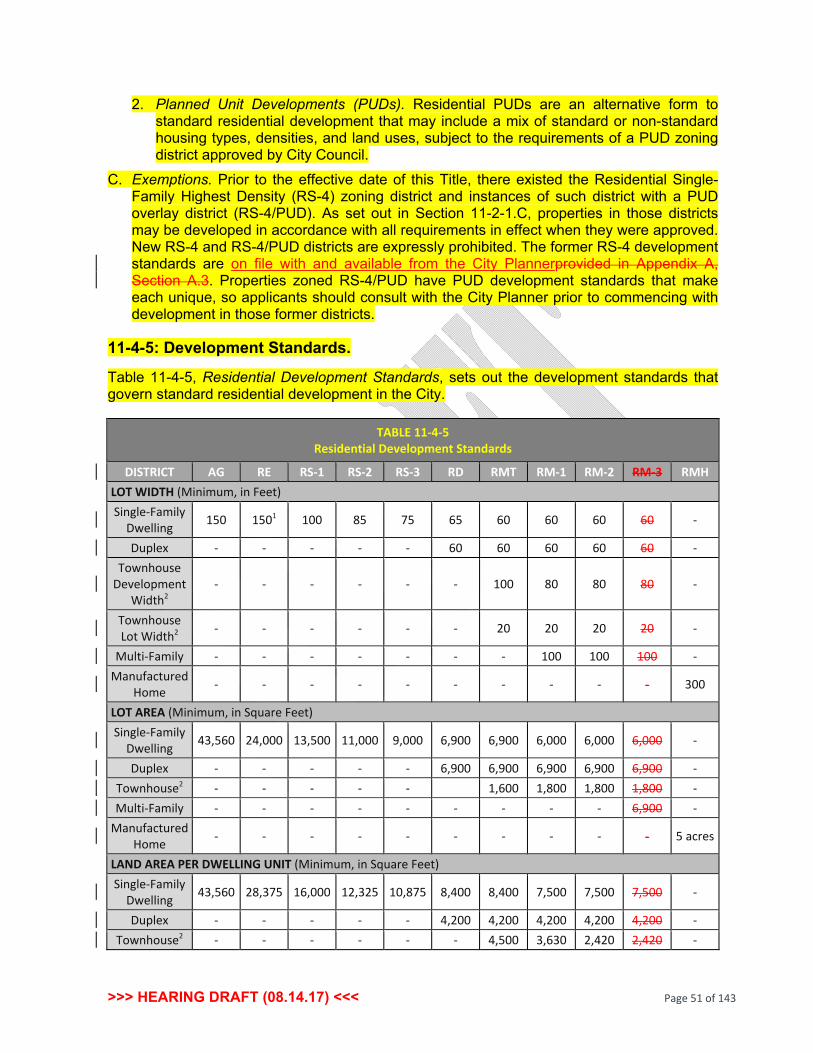
>>> HEARING DRAFT (08.14.17) <<< Page 51 of 143
2. Planned Unit Developments (PUDs). Residential PUDs are an alternative form to standard residential development that may include a mix of standard or non-standard housing types, densities, and land uses, subject to the requirements of a PUD zoning district approved by City Council.
C. Exemptions. Prior to the effective date of this Title, there existed the Residential Single-Family Highest Density (RS-4) zoning district and instances of such district with a PUD overlay district (RS-4/PUD). As set out in Section 11-2-1.C, properties in those districts may be developed in accordance with all requirements in effect when they were approved. New RS-4 and RS-4/PUD districts are expressly prohibited. The former RS-4 development standards are on file with and available from the City Plannerprovided in Appendix A, Section A.3. Properties zoned RS-4/PUD have PUD development standards that make each unique, so applicants should consult with the City Planner prior to commencing with development in those former districts.
11-4-5: Development Standards.
Table 11-4-5, Residential Development Standards, sets out the development standards that govern standard residential development in the City.
TABLE 11-4-5 Residential Development Standards
DISTRICT AG RE RS-1 RS-2 RS-3 RD RMT RM-1 RM-2 RM-3 RMH LOT WIDTH (Minimum, in Feet) Single-Family
Dwelling 150 1501 100 85 75 65 60 60 60 60 -
Duplex - - - - - 60 60 60 60 60 - Townhouse
Development Width2
- - - - - - 100 80 80 80 -
Townhouse Lot Width2 - - - - - - 20 20 20 20 -
Multi-Family - - - - - - - 100 100 100 - Manufactured
Home - - - - - - - - - - 300
LOT AREA (Minimum, in Square Feet) Single-Family
Dwelling 43,560 24,000 13,500 11,000 9,000 6,900 6,900 6,000 6,000 6,000 -
Duplex - - - - - 6,900 6,900 6,900 6,900 6,900 - Townhouse2 - - - - - 1,600 1,800 1,800 1,800 - Multi-Family - - - - - - - - - 6,900 -
Manufactured Home - - - - - - - - - - 5 acres
LAND AREA PER DWELLING UNIT (Minimum, in Square Feet) Single-Family
Dwelling 43,560 28,375 16,000 12,325 10,875 8,400 8,400 7,500 7,500 7,500 -
Duplex - - - - - 4,200 4,200 4,200 4,200 4,200 - Townhouse2 - - - - - - 4,500 3,630 2,420 2,420 -
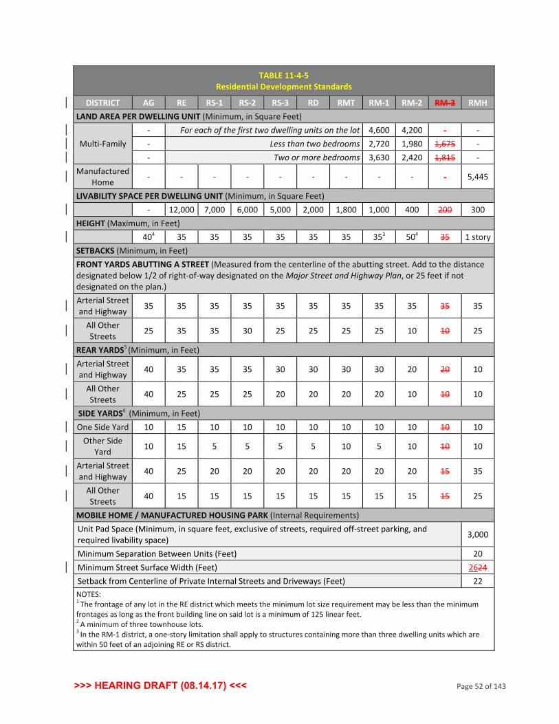
>>> HEARING DRAFT (08.14.17) <<< Page 52 of 143
TABLE 11-4-5 Residential Development Standards
DISTRICT AG RE RS-1 RS-2 RS-3 RD RMT RM-1 RM-2 RM-3 RMH LAND AREA PER DWELLING UNIT (Minimum, in Square Feet)
Multi-Family - For each of the first two dwelling units on the lot 4,600 4,200 - - - Less than two bedrooms 2,720 1,980 1,675 - - Two or more bedrooms 3,630 2,420 1,815 -
Manufactured Home - - - - - - - - - - 5,445
LIVABILITY SPACE PER DWELLING UNIT (Minimum, in Square Feet) - 12,000 7,000 6,000 5,000 2,000 1,800 1,000 400 200 300 HEIGHT (Maximum, in Feet) 404 35 35 35 35 35 35 353 504 35 1 story SETBACKS (Minimum, in Feet) FRONT YARDS ABUTTING A STREET (Measured from the centerline of the abutting street. Add to the distance designated below 1/2 of right-of-way designated on the Major Street and Highway Plan, or 25 feet if not designated on the plan.) Arterial Street and Highway 35 35 35 35 35 35 35 35 35 35 35
All Other Streets 25 35 35 30 25 25 25 25 10 10 25
REAR YARDS5 (Minimum, in Feet) Arterial Street and Highway 40 35 35 35 30 30 30 30 20 20 10
All Other Streets 40 25 25 25 20 20 20 20 10 10 10
SIDE YARDS6 (Minimum, in Feet) One Side Yard 10 15 10 10 10 10 10 10 10 10 10
Other Side Yard 10 15 5 5 5 5 10 5 10 10 10
Arterial Street and Highway 40 25 20 20 20 20 20 20 20 15 35
All Other Streets 40 15 15 15 15 15 15 15 15 15 25
MOBILE HOME / MANUFACTURED HOUSING PARK (Internal Requirements) Unit Pad Space (Minimum, in square feet, exclusive of streets, required off-street parking, and required livability space) 3,000
Minimum Separation Between Units (Feet) 20 Minimum Street Surface Width (Feet) 2624 Setback from Centerline of Private Internal Streets and Driveways (Feet) 22 NOTES: 1 The frontage of any lot in the RE district which meets the minimum lot size requirement may be less than the minimum frontages as long as the front building line on said lot is a minimum of 125 linear feet. 2 A minimum of three townhouse lots. 3 In the RM-1 district, a one-story limitation shall apply to structures containing more than three dwelling units which are within 50 feet of an adjoining RE or RS district.

>>> HEARING DRAFT (08.14.17) <<< Page 53 of 143
TABLE 11-4-5 Residential Development Standards
DISTRICT AG RE RS-1 RS-2 RS-3 RD RMT RM-1 RM-2 RM-3 RMH 4 If abutting an RS district, an additional two feet of setback from the property line in common with the RS districts shall be required for each one foot of building height exceeding 35 feet. 5 In the RM-2 district, a rear yard of 20 feet shall apply to all structures containing more than three dwelling units, when adjacent to an RE or RS district. 6 Does not apply to interior lot line of townhouse developments. Subchapter 3: Nonresidential Development Standards. 11-4-6: Purpose.
The purpose of this Subchapter is to set out development standards for all new nonresidential, public, institutional, and mixed-use development.
11-4-7: Development Types.
A. Standard Nonresidential. Standard nonresidential development is permitted in the Office Low Intensity (OL), Office Medium Intensity (OM), Commercial Shopping Center (CS), Commercial General (CG), Industrial Light Manufacturing and Research and Development (IL), and Industrial Moderate (IM), and Industrial Heavy (IH) zoning districts.
B. Planned Unit Developments. PUDs are an alternative development form to standard nonresidential development that may include a mix of standard or non-standard nonresidential use types, intensities, and mixed-use development, all of which are subject to the requirements of a PUD zoning district approved by City Council.
11-4-8: Development Standards.
Table 11-4-8, Nonresidential Development Standards, sets out the development standards that govern standard nonresidential development in the City.
TABLE 11-4-8 Nonresidential Development Standards
DISTRICTS/ USE OL OM CS CG IL IM IH
Scientific Research Facilities
and Institutions
LOT WIDTH (Minimum, in Feet) Arterial
Street and Highway
75 100 150 150 150 200 200 200
All Other Streets 50 50 50 50 50 50 50 200
LOT AREA (Minimum, in Square Feet) None None None None None None None None
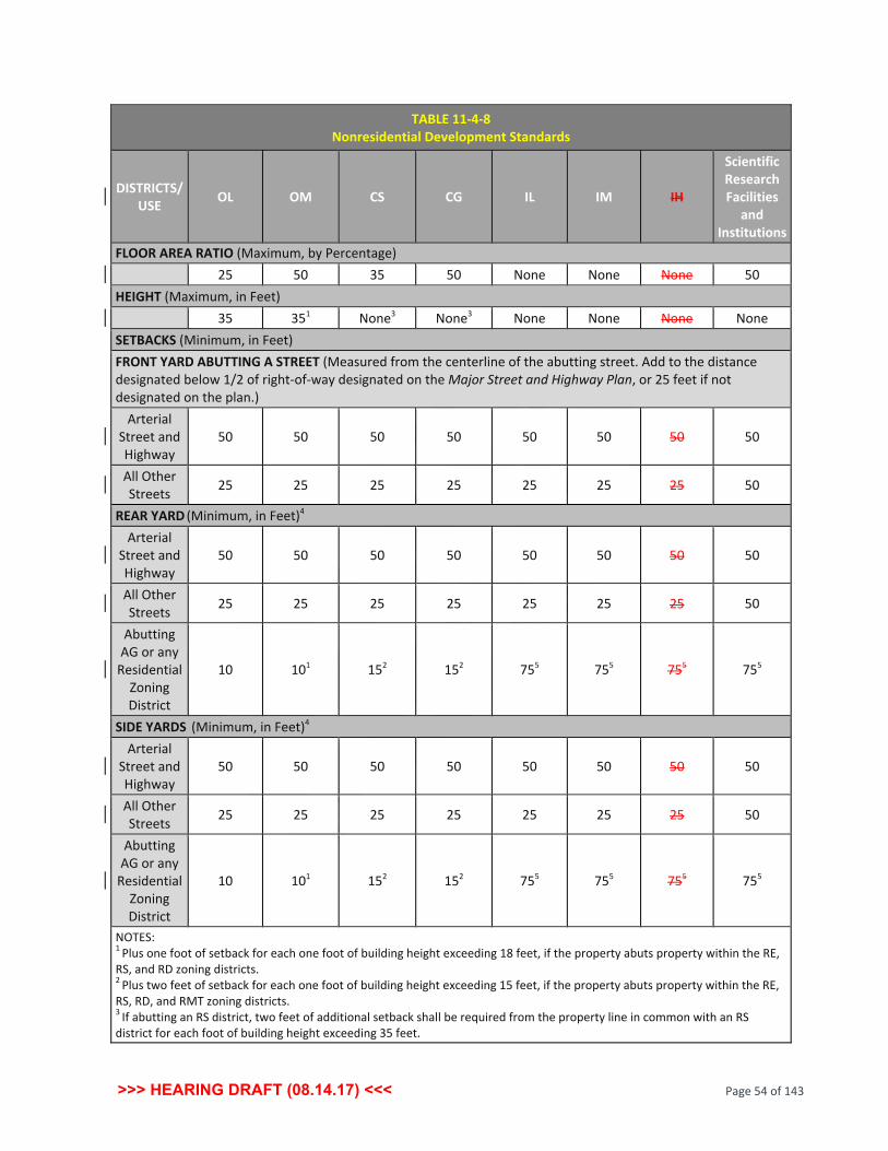
>>> HEARING DRAFT (08.14.17) <<< Page 54 of 143
TABLE 11-4-8 Nonresidential Development Standards
DISTRICTS/ USE OL OM CS CG IL IM IH
Scientific Research Facilities
and Institutions
FLOOR AREA RATIO (Maximum, by Percentage) 25 50 35 50 None None None 50 HEIGHT (Maximum, in Feet) 35 351 None3 None3 None None None None SETBACKS (Minimum, in Feet) FRONT YARD ABUTTING A STREET (Measured from the centerline of the abutting street. Add to the distance designated below 1/2 of right-of-way designated on the Major Street and Highway Plan, or 25 feet if not designated on the plan.)
Arterial Street and Highway
50 50 50 50 50 50 50 50
All Other Streets 25 25 25 25 25 25 25 50
REAR YARD (Minimum, in Feet)4 Arterial
Street and Highway
50 50 50 50 50 50 50 50
All Other Streets 25 25 25 25 25 25 25 50
Abutting AG or any
Residential Zoning District
10 101 152 152 755 755 755 755
SIDE YARDS (Minimum, in Feet)4 Arterial
Street and Highway
50 50 50 50 50 50 50 50
All Other Streets 25 25 25 25 25 25 25 50
Abutting AG or any
Residential Zoning District
10 101 152 152 755 755 755 755
NOTES: 1 Plus one foot of setback for each one foot of building height exceeding 18 feet, if the property abuts property within the RE, RS, and RD zoning districts. 2 Plus two feet of setback for each one foot of building height exceeding 15 feet, if the property abuts property within the RE, RS, RD, and RMT zoning districts. 3 If abutting an RS district, two feet of additional setback shall be required from the property line in common with an RS district for each foot of building height exceeding 35 feet.

>>> HEARING DRAFT (08.14.17) <<< Page 55 of 143
TABLE 11-4-8 Nonresidential Development Standards
DISTRICTS/ USE OL OM CS CG IL IM IH
Scientific Research Facilities
and Institutions
4 If rear or side property line does not abut a street right-of-way or a protected AG or Residential zoning district, setbacks from such rear or side property lines are not required. 5 Setback is also applicable when abutting a property zoned Office. 11-4-9: Special Spacing, Design and Operation Standards.
A. Gas Stations. Within the CS zoning district, there shall be no open air storage or display of merchandise offered for sale or rental within 300 feet of any property zoned Residential (all districts), except for the incidental open air display of tires, oil or other automobile accessories.
B. Auto, Truck, RV and Large Scale Equipment and Merchandise. Within the CS district, there shall be no open air storage or display of these types of equipment and merchandise offered for sale or rental within 300 feet of any property zoned Residential (all districts).
C. Mining and Mineral Operations. Subject to the requirements of an SUP granted by the City Council, the Planning Commission and Council shall have the power to consider potential environmental influences associated with mining and mineral operations, such as, but not limited to, dust, vibration, and noise, and may establish protective conditions, such as spacing, setbacks, screening and methods of operation to mitigate the adverse effect of such uses on surrounding properties.
D. Industrial Uses.
1. Scientific, Research, Testing and Development operations, when located in the Industrial Light Manufacturing and Research and Development (IL) zoning district, shall be entirely located within enclosed buildings.
2. All uses permitted in the Industrial Light Manufacturing and Research and Development (IL) zoning district located within 300 feet of any Residential zoning district shall be conducted within enclosed buildings.
3. All uses permitted in the Moderate Industrial (IM) zoning district located within 300 feet of any Residential zoning district shall be conducted within enclosed buildings and shall install Type D bufferyards along all property lines within 300 feet of any Residential zoning district.
4. All uses in the Heavy Industrial (IH) zoning district that require SUP approval shall be subject to Commission and Council conditions to mitigate potential environmental influences, such as, but not limited to, dust, vibration, heat, radiation and noise, or to mitigate the adverse effect of such uses on surrounding properties through protective conditions, such as spacing, setbacks, screening and methods of operation.

>>> HEARING DRAFT (08.14.17) <<< Page 56 of 143
Subchapter 4: Design Standards. 11-4-10: Purpose and Applicability.
A. Purpose. The purpose of this Subchapter is to improve public health and safety, promote resiliency to the hazards of wildfire, wind and other natural elements, and enhance the quality and longevity of the housing stock of the City and the visual character of the City. The standards seek to provide for buildings constructed of quality, durable materials and building sites and developments that are functional, safe, resilient, and create and enhance community character.
B. Applicability. The standards of this Subchapter apply to new development, redevelopment, substantial improvement, and expansion of all uses in all districts, with the exception of the Agriculture (AG) district. New homes constructed on existing lots platted prior to the effective date of this Title are exempt. The requirements of this Subchapter only apply to new lots platted after the effective date of this Title.
11-4-11: Single-Family Residential and Duplex Development.
A. Exterior Wall Construction. For the purpose of public health, safety and community resiliency, the exterior wall construction of homes in all Single-Family Residential (RS) zoning districts and the Residential Duplex (RD) zoning district, but expressly excluding the Agriculture (AG) district, shall conform to the requirements set out below:
1. Exterior wall construction on each story or floor of every single-family residential dwelling unit shall consist of at least 60 percent masonry construction, exclusive of the following: a. Windows, window trim, window box-outs, and bay windows that do not extend to
the foundation, exterior walls that do not bear on the foundation, doors, dormers and gables over the entrance of an extended garage.
b. Any rear wall area cantilevered 12 inches or more from the wood frame wall. c. Any side wall area cantilevered 12 inches or more from the wood frame wall,
provided, however, that such cantilevered side wall area shall not exceed 35 percent of the total exterior wall area of the side wall from which it is cantilevered.
d. Any rear multi-story straight wall with an exterior surface construction that is in excess of 70 percent glass or windows.
e. Any wall area above a first-floor roof where the exterior masonry veneer cannot directly bear upon the foundation.
The use of decorative metal as façade accents shall be counted toward fulfilling the masonry requirement.
2. The exterior area or sides of chimney flues on exterior walls that are visible from the street shall be enclosed in 100 percent masonry veneer construction, except that chimney flues not visible from the street may be enclosed by materials permitted by the building code for exterior exposure and in compliance with the flue manufacturer's recommendation.

>>> HEARING DRAFT (08.14.17) <<< Page 57 of 143
3. Notwithstanding the foregoing, any exterior wall of any residential dwelling unit facing a street, park or school shall consist of 100 percent masonry construction, exclusive only of windows, doors, dormers and gables over the entrance of an extended garage.
B. Approved and Prohibited Materials.
1. Masonry building materials include stone, brick and stucco. Also acceptable are cementitious fiberboard, fiber cement siding, painted or exposed aggregate concrete, split face or integral block architectural concrete masonry unit (CMU), Hardie plank siding, or any other concrete material that simulates wood, or any equivalent, permanent architecturally finished materials.
2. Approved materials for non-structural architectural details include cementitious fiberboard, seamless steel siding, stucco, Exterior Insulation and Finish Systems (EIFS), and decorative siding.
3. Prohibited materials for exterior wall construction include smooth face CMU, unfinished concrete, corrugated metal, vinyl, aluminum siding, wood siding, plywood, sheet pressboard, EIFS, wood, medium density fiberboard, particle board and Masonite.
11-4-12: Multi-Family Residential Development.
A. Applicability. The requirements of this Subsection apply to new development, redevelopment, substantial improvement, and expansion of multi-family residential development in the districts in which such uses are permitted.
B. Exterior Street-Facing Facades. On a building elevation that fronts on or most directly faces a public street right-of-way or that is adjacent to any single-family residential (RS) zoning district, at least 50 percent of the exterior wall construction shall consist of decorative materials as listed below. Building elevations that do not face a public street right-of-way or any single-family residential (RS) zoning district shall utilize at least 25 percent decorative materials.
1. Decorative materials include: a. Brick, including thin brick, faux brick and simulated CMU brick. b. Stone, including cast stone or faux decorative stone. c. Brick or stone veneer. d. Window glazing and fenestration materials. e. Decorative metals. f. Portland cement stucco. g. CMU, including split face, weathered face, and integral sandblasted face block.
2. The remainder of the building elevation(s) may be constructed of the following secondary building materials: a. EIFS if used a minimum of eight feet above grade. b. Fiber cement siding. c. Hardie plank siding, or any other concrete material that simulates wood. d. Finished and decorative accenting metals, including standing seam metal.

>>> HEARING DRAFT (08.14.17) <<< Page 58 of 143
e. Decorative siding. f. Wood materials, or combinations thereof.
3. Limited Materials. Materials that may be used in limited quantities for limited visibility exterior walls, siding, or cladding, with the approval of the Planning Commission, include: a. Metal wall siding or panels. b. Corrugated or ribbed metal panels. c. Smooth-faced or untextured, unfinished concrete block.
4. Prohibited Materials. Building materials prohibited on all multi-family residential buildings include plywood, plastic, wood fiberboard, under-fired or unfired clay, sand, or shale rock, and painted brick.
C. Building Articulation. Any building elevation that faces a public street right-of-way shall include articulation in the form of variable roof forms, roof lines, arrangement of doors and windows on the elevation, balconies, colors, materials, or other architectural design elements.
D. Garages. When a garage is located between a public street right-of-way and the façade of a primary building, a Type B bufferyard, as set out in Section 11-6-10, Screening and Bufferyards, shall be required. The materials and colors of garages shall be compatible with the primary buildings.
E. Mechanical Equipment. Ground and roof-mounted mechanical equipment shall be screened from all public views, as visible at all site property lines.
11-4-13: Manufactured Homes.
A. Appearance.
1. Removal of Manufactured Home Wheels. All wheels, axles, and running gear shall be removed from manufactured homes.
2. Skirting. The open space between the finished grade of the pad on which each manufactured home is located and the exterior edges of the finished floor of each unit shall be skirted as follows: a. Installation. Skirting is installed on a concrete footing so there is no visible gap
between the finished floor and the ground. b. Materials. The material used for skirting is rock, brick, manufactured vinyl, or
concrete masonry construction, compatible in appearance with the manufactured home, and allows for ventilation and drainage.
c. Design. Skirting consists of a continuous, complete, opaque, and rigid surface that lends permanency to the appearance of the unit and completely screens the crawl space under the unit.
3. Roofing. a. The roof shall be pitched, with a minimum vertical rise of four feet for every 12 feet
of horizontal run.

>>> HEARING DRAFT (08.14.17) <<< Page 59 of 143
b. Roofing material shall be comparable to that used on homes in standard residential construction, including, but not limited to, approved wood, asphalt composition shingles, or fiberglass. Corrugated aluminum, corrugated fiberglass, and metal roofs are prohibited.
4. Siding. Exterior siding shall consist predominantly of: a. Decorative vinyl or metal horizontal lap siding with a reflectivity that does not
exceed that of gloss white paint; b. Wood or hardboard; or c. Brick, stone, or stucco comparable in composition, appearance, and durability to
that used in standard residential construction.
B. Perimeter Buffering. When abutting any Residential Single-Family (RS) zoning district or a public street right-of-way, a manufactured home park shall:
1. Provide a Type B Bufferyard as set out in Section 11-6-10, Screening and Bufferyards; and
2. Construct an opaque fence or wall along all side and rear property lines adjacent to said districts and streets as set out in Section 11-6-10, Screening and Bufferyards.
11-4-14: Nonresidential and Mixed-Use Development.
A. Purpose. The purpose of this Section is to ensure that nonresidential, public, institutional, and mixed-use development have high-quality, well-designed buildings and sites that contribute to the unique character and aesthetics of the City.
B. Applicability. This Section sets out the standards for nonresidential, public, institutional, and mixed-use development as follows:
1. The standards in this Section are in addition to all other standards of this Title. 2. The standards in this Section apply to all new development, redevelopment,
substantial improvements, and expansion of nonresidential and mixed-use buildings in the Office Low Intensity (OL), Office Medium Intensity (OM), Commercial Shopping Center (CS), Commercial General (CG), and Industrial Light Manufacturing and Research and Development (IL) zoning districts.
3. The standards are organized by building size, and by use for self-storage centers. 4. In a mixed-use center, or a mixed-use PUD, the requirements of this Section shall be
the minimum design standards that will pertain to each specific land use. In the case of a mixed-use PUD, design in the PUD shall be governed by the additional requirements of the PUD and shall be expected to provide a unified design concept.
C. Utilities. If the development involves the extension or relocation of existing overhead utilities, all existing utility and electrical service lines (30,000 volts or less) located on or adjacent to the site shall be placed underground. If circumstances exist where the utility provider determines that the placement of utilities underground creates a safety hazard or is impractical by way of the reliability of the circuit, this requirement may be waived by the City Planner upon verification of such circumstances by the utility.

>>> HEARING DRAFT (08.14.17) <<< Page 60 of 143
D. Roof-Mounted Equipment. Roof-mounted equipment shall be fully screened from all ground-level views, as visible at all site property lines, by parapets, sloped roof systems, or other methods, in a form that is integrated into the building design.
E. Loading Docks, Trash Compactors, Dumpsters, and Bale and Pallet Storage. Loading, trash collection, and the collection of other waste products shall be fully screened and integrated into the building design as set out in Section 11-6-10, Screening and Bufferyards.
F. Exterior Building Finish Materials. The same standards for permitted materials shall apply in this Section as in Section 11-4-12, Multi-Family Residential Development.
G. Design Standards.
1. Building Design Integration. When buildings of any size are constructed as an out-parcel or as the primary building on a site that is part of a larger common development plan with integrated access, parking, and driveways, building designs of all sized buildings shall have a unified design theme in terms of materials, colors, and other design elements that unify the appearance of the center.
2. Buildings and Centers Less than 10,000 Square Feet (SF) of Gross Floor Area. Elevations of building walls that are within direct public view shall have certain percentages of decorative facade surfaces as follows: a. Front and Street-Facing Side Elevations. The building elevations shall be
constructed with a decorative material on 60 percent of each façade, excluding doors and windows, with the remainder faced with a secondary or limited material as described in Section 11-4-12.
b. Non-Street-Facing Side Elevations. A non-street-facing interior or side elevation shall be constructed with a decorative material on least 30 percent of the facade, measured from the front facade toward the rear of the building. The remainder may be faced with a secondary or limited material.
c. Rear Elevations. Rear elevations generally may be constructed with a secondary or limited material on 100 percent of the facade elevation. If a rear elevation is visible to a public right-of-way or residential zoning district, it shall be constructed with a decorative material on 60 percent of the facade, with the remainder faced with a secondary or limited material.
3. Buildings and Centers Larger than 10,000 SF of Gross Floor Area. Elevations of building walls that are within direct public view shall have certain percentages of decorative facade surfaces as follows: a. Front and Street-Facing Side Elevations. The building elevations shall be
constructed with a decorative material on 75 percent of each facade, excluding doors and windows, with the remainder faced with a secondary or limited material as described in Section 11-4-12.
b. Non-Street-Facing Side Elevations. A non-street facing interior or side elevation shall be constructed with a decorative material on at least 30 percent of the facade, measured from the front facade toward the rear of the building. The remainder may be faced with a secondary or limited material.

>>> HEARING DRAFT (08.14.17) <<< Page 61 of 143
c. Rear Elevations. Rear elevations generally may be constructed with a secondary or limited material on 100 percent of the facade elevation. If a rear elevation is visible to a public right-of-way or residential zoning district, it shall be constructed with a decorative material on 75 percent of the facade, with the remainder faced with a secondary or limited material.
d. Building Entries. Principal building entrances and vestibules shall be designed to be clearly identifiable.
e. Visual Interest and Anti-Monotony. Any facade that is visible to a public right-of-way or from any residential zoning district shall meet the following standards:
(1) Building Wall Offsets. The facade shall appear to be divided into modules that are not larger than 100 feet in width to break up the appearance of building mass and add visual appeal. (a) Modules shall be offset from each other by a horizontal recess or
projection of the facade that measures 10 percent or more of the building height.
(b) Individual modules shall be architecturally differentiated by two or more of the methods for avoidance of blank walls as listed in Subsection G.3.e.(3), below.
(2) Roofline Articulation. For flat roofs or facades with a horizontal eave, fascia or parapet, the roofline shall be varied in height by four feet or more so that no straight segment exceeds 50 feet in horizontal dimension. This standard may also be satisfied by incorporating design elements that meet the same height variation requirement, which may include, but are not limited to: (a) Functional or faux dormers. (b) Gables or other compound roof shape in which the highest ridge line and
the lowest ridge line have a height difference of four feet or more. (c) Towers. (d) Functional or faux chimneys. Any such design element shall be proportional to the building so that the element appears as a substantial, but not overwhelming, architectural feature.
(3) Avoidance of Blank Walls. Any building facade that is visible to a public right-of-way or from any residential zoning district shall not have an area of uninterrupted blank wall space that is larger than 15 feet tall by 25 feet wide. This standard may be satisfied by incorporating design features which include, but are not limited to, two or more of the following: (a) Windows or faux window openings. (b) Doors or faux door openings. (c) Recessed or projecting building entries. (d) Projecting oriel windows. (e) Window moldings. (f) Arcades.

>>> HEARING DRAFT (08.14.17) <<< Page 62 of 143
(g) Recessed or projecting porches. (h) Recessed or projecting balconies. (i) Functional or decorative canopies and awnings. (j) Cornices.
(k) String courses. (l) Columns.
(m) Wall sconces. (n) Brick patterning, including soldier courses, or other building material or
color variations. (o) Score lines. (p) Wall signs that comply with Chapter 7, Signs. (q) Other architectural detailing that serves to relieve the appearance of the
blank wall. H. Self-Storage Center Design.
1. Self-Contained Facilities.
a. If the facility is self-contained, with all access to storage units provided from interior corridors, the facility shall be designed in accordance with the design standards for nonresidential development set out in this Section, above.
b. Side and rear facades that face other commercial or industrial districts and are not visible from a public right-of-way are allowed a reduction in the minimum extent of decorative building material from 50 percent to 25 percent, with the remainder faced with a secondary or limited material.
c. Exterior fencing or a screening wall along a public right-of-way or visible from any residential zoning district shall be constructed with a decorative material. Chain link fencing is permitted only where it is not visible to the public or from any residential zoning district.
2. Exterior Entrance Facilities.
a. Facades of such facilities that face public rights-of-way or residential districts shall be designed in accordance with all design standards for nonresidential development set out in this Section, above.
b. The amount of secondary and limited materials that may be used on any facade that is not visible to a public right-of-way may be reduced from 50 percent to 25 percent if the façade is:
(1) Screened by other existing commercial or industrial buildings from public rights-of-way or residential zoning districts; or
(2) Screened year round by a 100 percent opaque buffer in the form of a wall, fence, berm, landscaping, or combination of such elements.
c. Exterior fencing or a screening wall along a public right-of-way or visible from any residential zoning district shall be constructed with a decorative material and shall be accompanied by a Type B bufferyard as set out in Section 11-6-10, Screening

>>> HEARING DRAFT (08.14.17) <<< Page 63 of 143
and Bufferyards, along with all other required landscaping. Chain link fencing is permitted only where it is not visible to the public or from any residential zoning district
d. Any open air exterior storage of oversized vehicles, recreation vehicles, or similar high-profile materials or equipment shall be placed on the site at a location where such vehicles, materials or equipment are not visible to a public right-of-way or from any residential zoning district.
Chapter 5 Accessory Use and Building Standards
Subchapter 1: Purpose and Application. 11-5-1: Purpose.
A. This Chapter establishes the regulations for certain accessory uses, structures, and buildings.
B. Permitted accessory uses, structures, and buildings are:
1. Limited to those customarily associated with the principal use of the property, or a primary building, and are incidental and subordinate to the principal use or primary structure; and
2. Located on the same lot or parcel as the associated principal use or principal building.
11-5-2: Application.
Standards for accessory uses, structures, and buildings apply as follows:
A. Residential uses, as set out in Chapter 5, Subchapter 2, Residential Uses.
B. Nonresidential and mixed uses, as set out in Chapter 5, Subchapter 3, Nonresidential and Mixed Uses.
Subchapter 2: Residential Uses. 11-5-3: Accessory Uses, Structures, and Buildings.
A. Accessory Uses, Structures and Buildings Permitted. Accessory uses, structures, and buildings customarily incidental to a principal residential use, or a principal residential building, in a residential district are permitted in such residential districts.
B. Conditions for Accessory Uses, Structures, and Buildings.
1. An accessory building erected as an integral part of the principal building shall be made structurally a part thereof, shall have a common wall therewith, and shall comply with the requirements applicable to the principal building.

>>> HEARING DRAFT (08.14.17) <<< Page 64 of 143
2. A detached accessory building shall not be located in the front or side yard or encroach upon a minimum building setback line, but this limitation shall not apply to carports, provided the minimum required front yard or side yard or setback line is provided and the structure complies with all building code requirements.
3. Within the rear yard, a detached accessory building shall be located at least five feet from any interior lot line.
4. One unoccupied recreational vehicle, a length of 30 feet or less, may be parked upon a lot as an accessory use.
Subchapter 3: Nonresidential and Mixed Uses. 11-5-4: Accessory Uses, Structures, and Buildings.
A. Accessory Uses, Structures, and Buildings Permitted. Accessory uses, structures, and buildings customarily incidental to a principal use, or a principal building, permitted in a nonresidential district are permitted in such nonresidential districts.
B. Conditions for Accessory Uses, Structures, and Buildings.
1. Accessory buildings shall meet the minimum building setback lines of the applicable district.
2. An accessory building erected as an integral part of the principal building shall be structurally a part thereof, shall have a common wall therewith, and shall comply with all requirements applicable to the principal building.
3. Accessory outdoor storage of materials, equipment, or products within 200 feet of any abutting R district shall be screened by the erection of a screening wall or fence along the lot line or lines in common with the abutting R district.
11-5-5: Outdoor Display of Merchandise.
The outdoor display and sale of merchandise, where permitted, is subject to the requirements of this Section. An outdoor display area shall involve items for sale by a business in a permanent structure, enclosure, or designated area on the same site from which the business is operated.
A. Seasonal Display Areas.
1. Temporary seasonal outdoor sales areas that are detached from the principal building may not exceed an area of 15 percent of the gross floor area of the principal building. The area must be: a. Contained within a clearly defined space, as depicted on an approved site plan;
and. b. Clearly demarcated in a temporary enclosure, as depicted on an approved site
plan. B. Permanent Display Areas.
1. A permanent outdoor display area, such as, but not limited to, a garden center, shall be attached to a principal building and be:

>>> HEARING DRAFT (08.14.17) <<< Page 65 of 143
a. Enclosed by a decorative fence or wall; b. Not larger than 25 percent of the gross floor area of the principal building; and c. Subject to the design requirements set out in Section 11-14-15, Nonresidential
and Mixed-Use Development. C. Sidewalk Display. Sidewalk displays on private sidewalks that abut a principal building
shall be permitted only if:
1. There is at least four feet of ADA accessible width for use by pedestrian traffic; 2. Merchandise does not impede access to or from any required building fire exit; and 3. Displays are located within 60 feet of an entrance to the principal use.
Chapter 6 Site Development
Subchapter 1: Parking, Loading, and Access. 11-6-1: Purpose and Applicability.
A. Purpose. It is the purpose of this Subchapter to ensure that adequate off-street parking and loading is provided with the construction, alteration, remodeling or a change in the use of any building or land.
B. Applicability. The off-street parking and off-street loading requirements, whether they apply to principal or accessory uses, are the minimum requirement for the initiation, enlargement, or change of use, and such parking and loading shall be provided as follows:
1. For all buildings and structures erected, and all uses of land, established after the effective date hereof, parking and loading facilities shall be provided as required by this Subchapter.
2. When the intensity of use of any use, building, structure, or premises is increased through the addition of dwelling units, floor area, seating capacity, or other units of measurement specified herein for required parking or loading facilities, additional off-street parking and loading facilities, as required herein, shall be provided for such increase in intensity of use.
3. When the existing use of a building or structure is changed to a new use, off-street parking and loading facilities shall be provided as required for such new use. If the building or structure was erected prior to the effective date hereof, additional parking and loading facilities that are mandatory shall only be provided for the amount by which the requirements for the new use would exceed those for the existing use.
4. Accessory off-street parking and loading facilities in existence on the effective date hereof and located on the same lot as the building or use served, shall not hereafter be reduced if they are currently less than the requirements of this Subchapter, and shall not be reduced below the requirements for the same use under the provisions of this Title.

>>> HEARING DRAFT (08.14.17) <<< Page 66 of 143
5. Any existing building or use that is enlarged, structurally altered, or remodeled to the extent of increasing, or changing the use, by more than 50 percent as it existed at the effective date hereof, shall provide adequate off-street parking and loading for the entire building and use in accordance with the requirements of this Subchapter. When the enlargement, structural alteration, or remodeling will not increase or change the area of the building by more than 50 percent, additional off-street parking and loading shall only be required for the new floor area and use.
11-6-2: Computing Parking.
A. Calculations. The number of required off-street parking spaces is calculated according to the formulas set out in this Subchapter, unless modified by one of the alternative methods of calculating off-street parking set out in in this Subchapter.
B. Variables for Calculating Required Parking. The variables used for off-street parking calculations are measured as follows:
1. Per Square Foot (sf) of Parking Floor Area (PFA). The phrase "per sf of PFA" means that the number of parking spaces is calculated at 85 percent of the gross floor area in a building for the particular use plus the total area of any parts of the parcel proposed for development that are delineated and used in a manner that is comparable in function and intensity of use to the use of the inside of the building (i.e., outdoor dining areas).
2. Per Dwelling Unit (du) or Per Bedroom (BR). The phrase "per '#' DU" means that the number of parking spaces is calculated based on the number of dwelling units. In some cases, the parking requirements are based on the number of bedrooms (“per ’#’ BR unit”).
3. Per Bed. The phrase "per bed" means that the number of parking spaces is based on the number of beds in the facility instead of the number of sleeping rooms or some other measure.
4. Per Employee. The phrase "per employee" means that the number of parking spaces is based on the shift in which the maximum number of employees are present.
5. Per Seat Capacity. The phrase "per seat" means that the number of parking spaces is based on the number of seats that are provided for guests (patrons, members, etc.), with benches or pews measured as one seat per each two feet of width.
6. Per Square Feet (sf) of Assembly Area. The phrase "per sf of assembly area" means that the number of parking spaces is based on the number of square feet in the largest room used for assembly (i.e., a school gymnasium, theater or lunch room).
7. Special Studies Required. There are certain uses, such as, but not limited to schools, parks, and hospitals, where the required number of parking spaces is dependent upon the specific details of the proposed use and how those uses are conducted, such that parking formulas are not appropriate for such uses. The applicant and the City each have an interest in providing the right amount of parking, but not an excessive amount of parking. For those uses where a special study is required, the applicant shall utilize the processes set out in Section 11-6-5, Special Studies.

>>> HEARING DRAFT (08.14.17) <<< Page 67 of 143
11-6-3: Off-Street Parking and Loading.
Off-street parking and loading shall be provided as set out in the following tables:
TABLE 11-6-3.1 Residential Use Parking Requirements
Use Required Off-Street Parking Spaces
Residential Uses (Housing Types) Single-Family Detached Single-Family Detached 2 spaces per du. Manufactured Home 2 spaces per du. Single-Family Attached Duplex 2 spaces per du. Multiplex 2 spaces per du. Townhouse 2 spaces per du. Multi-Family (8+ dwelling units) Apartment 1.5 spaces for efficiency unit and 1 BR; 2 spaces per du for 2 BR plus. Special Neighborhood Types
Manufactured Home Park or Subdivision Individual spaces as set out above + 2 visitor spaces per 5 manufactured homes.
Recreational Vehicle (RV) Park 1 space per RV pad + 2 visitor spaces per each 5 RV spaces. Commercial Uses of the Home
Child-Care, Family Home 1 space per each 3 children on the premises at any one time + 1 space per each provider, staff member, or employee on duty at any one time.
Child-Care Facility, Group Home Greater of: 1 space per 3 rooms or 1 space per BR.
TABLE 11-6-3.2 Institutional and Recreation Use Parking Requirements
Use Required Off-Street Parking Spaces
Institutional Uses
Assisted Living Facility 1 space per 3 dwelling units; 1 space per each employee + 1 space for each 4 beds.
Child Care Facility, Day-Care 1 space per 300 sf of PFA. Hospital Special Study. Medical Office / Clinic / Medical Lab 1 space per 250 sf of PFA. Nursing / Convalescent Home 1 space per 3 beds + 1 space per 2 employees on the largest shift. Place of Public Assembly (event facilities, meeting halls, fraternal organizations) 1 space per 200 sf of PFA.
School, Private / Public Special Study. Recreation and Amusement Uses Commercial Amusement, Indoor 6 spaces per 1,000 sf. Commercial Amusement, Outdoor Special Study. Recreation and Fitness, Indoor 1 space per 300 sf of PFA. Sexually-Oriented Business Greater of: 4 spaces per 5 seats; or 1 space per 250 sf of PFA.

>>> HEARING DRAFT (08.14.17) <<< Page 68 of 143
TABLE 11-6-3.3 Commercial Use Parking Requirements
Use Required Off-Street Parking Spaces
Commercial Uses
Alcohol Beverage Sales, Tavern On-site consumption: 1 space per 75 sf of PFA. Off-site consumption: 1 space per 300 sf of PFA.
Animal Grooming Facility 1 space per 400 sf of PFA. Animal Boarding or Veterinarian Services 1 space per 250 sf of PFA. Drive-In, Drive-Through Facility 1 space per 75 sf of PFA (pertains to uses where the drive-through / drive-in is the
primary use, such as a drug store store). Heavy Retail, General Retail, Home Center 1 space per 250 sf of PFA + 1 space per 1,000 sf outdoor sales and display area. Mixed-Use Based on use mix, or Special Study. Nursery / Greenhouse, Retail 1 space per 300 sf of PFA of office/sales area + 1 space per 5,000 sf of nursery
area. Office, General 1 space per 300 sf of PFA. Overnight Accommodations (hotel, motel) 1 space per guest room + 1 space per 300 sf of PFA of meeting rooms, ballrooms,
administrative offices, and areas used for self-service breakfast for guests only + 75% of parking requirements for integrated restaurants and bars open to the public.
Pawn Shop 1 space per 200 sf of PFA. Restaurant 1 space per each 200 sf of PFA; or 1 space per each 4 seats, whichever is greater. Vehicle Gas or Fueling Station 1 space per 250 sf of PFA (may count pump island stacking spaces). Vehicle Sales, Rental, and Service 1 space per employee on the largest shift + 3 spaces per service bay or fueling
stall + 1 space per 125 sf of PFA of convenience store floor area. Wholesale 1 space per employee + 1 space per business vehicle parked on-site + 2 spaces for
customer parking.
TABLE 11-6-3.4 Agriculture, Industrial and Utility Use Parking Requirements
Use Required Off-Street Parking Spaces
Agriculture, General Agriculture, General N/A Nursery / Wholesale 1 space per 300 sf of PFA of office / indoor sales area + 1 space per 5,000 sf of
outdoor sales area. Industrial Uses Heavy Industry Special Study. Light Industry 1 space per 400 sf of PFA or Special Study. Mining / Extraction 1 space per employee on the largest shift. Oil / Gas Operations 1 space per employee on the largest shift. Storage, Self 1 space per 25 storage units + 1 space per 300 sf of office space. Warehousing and Logistics 4 spaces per 5,000 sf of PFA + 1 space per each additional 5,000 sf of PFA. Waste Transfer Station / Recycling 1 space per 500 sf facility. Transportation Uses Airport Special Study.

>>> HEARING DRAFT (08.14.17) <<< Page 69 of 143
TABLE 11-6-3.4 Agriculture, Industrial and Utility Use Parking Requirements
Use Required Off-Street Parking Spaces
Helistop Special Study. Parking, Stand-Alone No minimum. Utility Uses Power Generation Special Study. Public Utilities Special Study. Wireless Telecommunication Tower (WTT) Uses WTT, Freestanding 2 spaces per tower.
TABLE 11-6-3.5
Required Loading Spaces Gross Floor Area (square feet) Minimum Loading Spaces
Less than 40,000 sf. 1 40,001 sf to 80,000 sf. 2 80,001 sf to 120,000 sf. 3 Each additional 40,000 sf over 120,000 sf. 1 additional
11-6-4: Design and Use of Parking and Loading Areas.
A. General.
1. Off-street parking and loading facilities shall not occupy required livability space. Space allocated to any required off-street loading berth shall not be used to satisfy the space requirements for any off-street parking facilities. Space allocated to any required off-street parking shall not be used to satisfy the space requirements of any off-street loading facilities.
2. Within front and exterior side yards in the RM districts, except the RMT district, not more than one vehicle shall be parked for each 600 square feet of area contained in front and exterior side yards.
3. Required off-street parking spaces and required off-street loading berths shall not be used for the storage, sale, display of merchandise, dismantling, or servicing of any vehicle, equipment, materials, or supplies, except where expressly permitted in Title 11 in a defined area designated on an approved site plan, such as, but not limited to, seasonal sales, for a limited time period.
4. Required off-street parking spaces shall be located on the same lot, tract, parcel, or premises as the use being served, or on other property of the same or greater intensity zoning classification, provided that the owner of the premises where shared parking is proposed consents to such sharing in writing, has excess parking exceeding the requirements of Title 11 for the use of that site, and will have a continuing right to use the spaces for parking. When the required off-street parking spaces are not located on the same lot, tract, parcel, or premises being served, the distance from the parking area to an entrance to the building or use shall not exceed 500 feet, measured along

>>> HEARING DRAFT (08.14.17) <<< Page 70 of 143
the shortest available pedestrian route with public access. 5. Required enclosed off-street parking and loading areas shall meet the development
standards of the district in which the facility is located. 6. The capacity of an off-street parking area shall be the number of parking spaces
having required dimensions as shown in Table 11-6-4, Parking Module Standards, and illustrated in Figures 11-6-4.1 and 11-6-4.2.
7. Required off-street parking shall be arranged so that no maneuvering incidental to parking movements takes place on any public street.
8. Where several different property uses will share a joint parking area, the parking requirements shall be computed based upon the overall development and the area of each use. For any use not listed, or where the listed regulations are not applicable, the parking requirements shall be determined by the City Planner.
9. Lighting used to illuminate an off-street parking area shall be by constant light and shall be so arranged as to direct the light away from properties zoned residential which do not contain uses for which the parking and lighting is being provided.
10. Unenclosed off-street parking areas shall be surfaced with a dust-free all-weather material. Surfacing shall be completed prior to the initiation of the use.
B. Setback and Screening Requirements for Off-Street Parking and Loading Areas.
1. Off-street loading areas shall not be located within 50 feet of any abutting property within any R district unless it is wholly within an enclosed building or screened on all sides abutting the R district by a screening wall or fence. The loading dock shall be screened from all public views and residential districts by either a 10-foot tall wing wall incorporated into the building design or an opaque decorative fence or year-round opaque landscape hedge, each with sufficient height to block the line-of-sight of the dock from the residential use or zoning district, an earthen berm, another building, or a combination of those elements.
2. Unenclosed off-street parking areas shall be screened by the installation of a three-foot tall opaque hedge to screen the parking area from all street rights-of-way. When an off-street parking area adjoins a residential district, a Type D bufferyard shall be required for parking less than 20 feet from a residential use or zoning district. If the off-street parking area is more than 20 feet from a residential use or district, a Type B bufferyard is required.
C. Off-Street Parking Areas.
1. Parking Module Design. Table 11-6-4.1, Parking Module Standards, sets out minimum standards for parking space depth, parking aisles, and combined parking aisle / stall modules. Figures 11-6-4.1 and 11-6-4.2 show single- and double-row parking modules that illustrate the standards in Table 11-6-4.1.

>>> HEARING DRAFT (08.14.17) <<< Page 71 of 143
TABLE 11-6-4.1 Parking Module Standards
Dimension One-Way Parallel Space Angle (degrees)
30 45 60 90 Single Row of Parking Stall depth 9' 18' 21' 22' 18' or 20' Parking aisle 12' 12' 13' 18' 24' Minimum width of module (stall depth and aisle) 21' 30' 34' 40' 40 ' or 44'
Two Rows of Parking Stall depth 18' 36' 42' 44' 40' or 44' Parking aisle 12' 12' 13' 18' 24' Minimum width of module (stall depth and aisle) 30' 48' 55' 62' 60' or 64'
FIGURE 11-6-4.1
Parking Module Standards: Single Parking Row and Aisle
Dimension One-Way Parallel Space Angle (degrees)
30 45 60 90 Stall depth 9' 18' 21' 22' 18' or 20' Parking aisle 12' 12' 13' 18' 24' Minimum width of module (stall depth and aisle) 21' 30' 34' 40' 40 ' or 44'

>>> HEARING DRAFT (08.14.17) <<< Page 72 of 143
FIGURE 11-6-4.2 Parking Module Standards: Double Parking Rows and Aisle
Dimension One-Way Parallel Space Angle (degrees)
30 45 60 90 Stall depth 18' 36' 42' 44' 40' or 44' Parking aisle 12' 12' 13' 18' 24' Minimum width of module (stall depth and aisle) 30' 48' 55' 62' 60' or 64'
2. Off-street parking spaces shall be clearly marked. 3. Parking spaces abutting an adjoining property line or street right-of-way shall be
provided with wheel guards or bumper guards so located that no part of a normally parked vehicle will extend beyond the property line. When wheel guards are used, they shall be centered at least 2.5 feet from the property line for 90 degree parking, 2.3 feet for 60 degree parking, and 2.0 feet for 45 degree parking.
4. Pedestrian access to buildings shall be provided from rights-of-way and parking areas by means of a pathway leading to at least one public entrance. Such pathway shall be cleared of all obstructions related to construction activity prior to the opening to the general public. Where curbs exist along such pathways, as between a parking area surface and sidewalk surface, inclined curb approaches or curb cuts having a gradient of not more than one foot in 12 feet and a width of not less than four feet shall be provided for access by wheelchairs.
5. Accessible pathways to each building entrance from parking areas shall have the number of level parking spaces set out in Table 11-6-4.2, Number of Accessible Parking Spaces. Each space shall be identified by above-grade signs as being reserved for persons with physical disabilities. A minimum of two spaces for persons with disabilities shall be required for industrial uses in industrial districts. All accessible parking spaces shall not be less than 12 feet in width.

>>> HEARING DRAFT (08.14.17) <<< Page 73 of 143
TABLE 11-6-4.2 Number of Accessible Parking Spaces2
Number of Parking Spaces Required by this Section1
Number of Accessible Spaces Number of Spaces
that Must be Van Accessible
1 to 25 1 1 26 to 50 2 1 51 to 75 3 1
76 to 100 4 1 101 to 150 5 1 151 to 200 6 1 201 to 300 7 1 301 to 400 8 1 401 to 500 9 2
501 to 1,000 2 percent of total number of parking spaces 1 out of 8 accessible
parking spaces, rounded up
1,001 and over 20, plus 1 for each 100 parking spaces in excess of 1,000 parking spaces 1 out of 8 accessible
parking spaces, rounded up
NOTES: 1 This number includes all applicable reductions in the number of required off-street parking spaces. However, on-street parking spaces that are credited to a proposed use shall be included in this number. 2 In all cases, the minimum required to comply with all ADA requirements shall be required and provided.
6. Parking spaces for persons with disabilities shall be hard surfaced and meet the
paving requirements of the City, regardless of the use or zoning of the property. Further, there shall be provided a paved, hard-surfaced area from the parking area to the primary use of the property. In all cases, all ADA requirements must be met.
7. Each parking space for persons with disabilities shall be marked with the standard international wheelchair symbol and with a sign not less than 12 inches by 18 inches posted at a height not less than three feet or more than eight feet. In all cases, markings must meet ADA requirements.
8. Parking spaces for persons with physical disabilities shall be located as close as possible to elevators, ramps, walkways and entrances. Parking spaces for persons with physical disabilities shall be located so that such persons are not compelled to wheel or to walk behind parked cars to reach entrances, ramps, walkways and elevators.
D. Off-Street Loading Areas.
1. Purpose. The purpose of this Subsection is to ensure that an adequate off-street loading area is provided with the construction, alteration, or change of use of any business building or structure, or with any change in land use.
2. Loading Areas Required. The owner and the occupier of any property upon which a business is located shall provide off-street area for loading and unloading.

>>> HEARING DRAFT (08.14.17) <<< Page 74 of 143
3. Site Plan Required. Any person desiring a building permit for the construction, alteration, or change in land use or change of use of any business building or structure with existing or proposed loading areas shall submit a site plan to the City Planner designating the number, dimensions and locations of all loading areas and all proposed avenues of ingress and egress to the property from adjacent public streets. The City Planner shall refer the application for TAC review, and shall not issue a Zoning Clearance Permit if it is determined that the proposed loading and unloading facilities will present a direct or indirect hazard to vehicular or pedestrian traffic or will not comply with the requirements of this Title, such as, but not limited to, screening, buffering, location, or proximity to a residential zoning district.
4. Minimum Required Design Criteria.
a. Unless otherwise specified, a required off-street loading berth shall be at least 10 feet in width and 30 feet in length, exclusive of aisles, and shall have a vertical clearance of at least 14 feet.
b. Required off-street loading berths shall be provided access to and from a public street or alley by an access drive of at least 15 feet in width designed to permit convenient off-street access and maneuverability to the berth by semitrailer trucks.
c. Unenclosed off-street loading areas shall be surfaced with a dust-free all-weather material.
d. Illumination of an off-street loading area, if any, shall be by constant light and shall be so arranged as to direct the light away from properties within an R district which do not contain uses for which the loading area is being provided.
11-6-5: Special Studies.
A. Generally. This Section sets out methodology to determine, modify, or reduce the number of off-street parking spaces as set out in Section 11-6-3, Off-Street Parking and Loading Spaces.
B. Special Studies. Some of the uses listed in the tables set out in Section 11-6-3, Off-Street Parking and Loading Spaces, have widely varying parking demand characteristics or can vary widely in their parking needs based on the specific site improvements proposed. Accordingly, the parking requirements for such uses are listed in the tables as "Special Study." Required parking for these uses shall be established by special study according to the standards of this Section. A special study shall also be required for any land use not listed in Section 11-6-3, Off-Street Parking and Loading Spaces.
1. Requirements: a. The special study shall be conducted by a qualified transportation planner or traffic
engineer at the applicant's expense; and b. The special study, when required, shall provide:
(1) A peak parking analysis of comparable uses or other facilities operated by the applicant where empirical evidence of parking demand may be scientifically quantified; and
(2) Documentation regarding the comparability of the referenced uses, including name, function, location, floor area, parking availability, access to transportation network (including vehicular or other if applicable), use

>>> HEARING DRAFT (08.14.17) <<< Page 75 of 143
restrictions, and other factors that could affect the parking demand. 2. Review and Consideration of Special Study. The City Planner shall forward a copy of
the study to the TAC, who will review it and provide comments to the applicant, for any revisions, and to the Planning Commission and City Council for review and approval.
11-6-6: General Access and Circulation.
A. Generally. For the purposes of this Section:
1. Arterial and collector streets refer to those existing and proposed streets identified on the Major Street and Highway Plan.
2. Access points include means of site ingress and egress located along highways, public and private streets, alleys, driveways, and marginal access streets.
B. Access and Circulation on Nonresidential and Mixed-Use Lots.
1. Parcels platted after the adoption of this Title that front on arterial and collector streets shall provide cross-access to abutting parcels unless cross-access is unfeasible.
2. Where connections to abutting parcels are possible, but not currently provided: a. The parcel proposed for development shall include a stub-out at a location that
allows for a reasonable connection to the abutting parcel (i.e., one that allows for reasonable development of both parcels) in the future; and
b. The applicant shall record a cross-access easement in a form acceptable to the City to allow for future connection of the stub-out to a comparable facility on the abutting parcel and ensure that shared access maintenance responsibilities are included. In general, the City may require cross-access easements to include one or more of the following:
(1) Sufficient width to accommodate a two-way access between properties;
(2) Stub-outs and other design features to allow abutting properties to be tied in to provide future cross access; or
(3) Linkage to other cross-access drives in the area. 3. All entrances and exits to a parking area and interior circulation patterns shall be
clearly delineated by appropriate signage and/or pavement markings. If signs are used as part of this delineation, the signs shall be in accordance with Chapter 7, Signs.
Subchapter 2: Landscaping, Screening, and Bufferyards. 11-6-7: Purpose and Applicability.
A. Purpose. The purpose of this Subchapter is to:
1. Promote the beautification and character of the City and enhance the quality of life; 2. Promote the reasonable preservation and replenishment of existing trees and
vegetation, especially to create greenbelts along transportation corridors, link linear parks or trails between neighborhoods and regional trail networks and waterways, and provide natural buffers between different uses;

>>> HEARING DRAFT (08.14.17) <<< Page 76 of 143
3. Maintain ecological balance by contributing to air purification, oxygen regeneration, groundwater recharge, and stormwater runoff quality and reduced quantity;
4. Maintain a meaningful urban forest in a manner that does not discourage urban development; and
5. Ensure that buffers are provided between different land use types, or intensities of use, to maintain property values, livability, and compatibility between uses.
B. Applicability and Exemptions. The landscape requirements of this Subchapter shall be applicable to all land for which a building permit is sought, except that the requirements shall not be applicable to the following:
1. Individual single-family or duplex lots where only one such structure is to be constructed on the lot.
2. Restoration of buildings constructed prior to the effective date hereof which are damaged by fire, flood or other catastrophe.
3. Interior remodeling. 4. Construction of a structure, other than a building, which does not increase the
developed area of a lot more than 30 square feet. 5. The developed area of a lot if all proposed new buildings, or additions to buildings,
contain less floor area than the floor area of existing buildings which remain on the lot after completion of the new construction.
11-6-8: Credit for Existing Trees.
A. Incentive Credits. To encourage preservation of existing mature trees and/or the planting of larger trees, each square foot of landscaped area which is permeable and within the drip line of a tree of at least six inches in caliper shall constitute one and one-half (1.5) square feet of landscaped area for the purpose of meeting the 15 percent street yard landscaping requirement. The following conditions shall apply:
1. Overlapping drip line areas shall be counted only once; 2. At least one-half of the drip line shall be permeable; 3. The original grade of the drip line shall not be changed; and 4. The one and one-half (1.5) square foot credit shall not constitute more than 25 percent
of the landscape requirement. The 25 percent credit limitation may be increased by the Planning Commission if the Commission determines such additional credit is warranted in that that the trees proposed to be preserved are of such substantial size or quantity, provide superior buffering, and/or create corridor character, and the applicant is taking considerable measures to ensure the life of the trees, such as prohibiting impermeable materials on more than 50 percent of the tree drip line.
B. Parking Credits. For all nonresidential development on lots of record prior to the effective date hereof which are one acre in area, or less, the required number of off-street parking spaces shall be reduced by one space for each 300 square feet of street yard required to be landscaped by this Subchapter.

>>> HEARING DRAFT (08.14.17) <<< Page 77 of 143
11-6-9: Development Landscaping.
A. Frontage and Perimeter.
1. Not less than 15 percent of the street yard shall be established and maintained as a landscaped area.
2. Within the lot, a landscaped area shall be established and maintained which is not less than seven and one-half (7.5) feet in width and which extends along the entirety of the abutting street right-of-way, except at vehicular access points. For lots abutting arterial streets, a landscaped area shall be established which is not less than 10 feet in width and which extends along the entirety of the abutting arterial right-of-way.
3. Within a lot used for office, commercial, industrial or multi-family residential purposes, off-street parking shall be separated from an abutting residential district or residential development area by a landscaped area not less than 10 feet in width. The tree planting requirements in this landscaped area shall be equal to those for a typical street yard as set out in Subsection C of this Section.
4. Required setbacks shall be landscaped in accordance with the street yard standards. 5. In computing the landscaped area required in Subsection A.1, above, the landscaped
areas required by Subsections A.2 and A.3, above, if located within the street yard, shall be included within the computation.
6. New single-family and duplex residential development abutting arterial and collector streets shall provide a landscaped buffer of not less than 10 feet in width along the entirety of the arterial and collector street frontage. Setbacks from the arterial and collector streets which are larger than 10 feet shall be provided at each side of the project entry drive at its intersection with an arterial or a collector street.
7. For lots abutting U.S. Highway 75 and 151st Street (State Highway 67), a landscaped area shall be established and maintained which is not less than 15 feet in width and which extends along the entirety of the abutting arterial, except at vehicular access points.
B. Parking Areas. Within surface off-street parking areas, landscaped areas shall be established and maintained as follows:
1. For lots two and one-half (2.5) acres or less in size, no parking space shall be located more than 50 feet from a landscaped area containing at least 30 square feet, with a minimum width or diameter of five feet. A landscaped area, by definition, must contain at least one tree.
2. For lots greater than two and one-half (2.5) acres in size, no parking space shall be located more than 75 feet from a landscaped area containing at least 100 square feet, with a minimum width or diameter of seven feet. A landscaped area, by definition, must contain at least one tree, with all areas of 200 square feet or more containing at least two trees.
C. Trees.
1. Within the street yard, trees shall be preserved, planted, maintained or replaced as follows:

>>> HEARING DRAFT (08.14.17) <<< Page 78 of 143
a. One tree for each 1,000 square feet, or fraction thereof, of street yard. b. Each existing tree which is in the required street yard and which is at least six
inches in caliper and which is removed by the development of the parking area shall be replaced at a two-to-one (2:1) ratio with trees sized as designated in Subsection C.7, below, and located within the required street yard. These two replacement trees shall be counted as one tree for purposes of compliance with street yard tree planting requirements.
2. For surface parking areas located outside the street yard, one tree for each 10 parking spaces, with at least one tree in each required landscaped area to be preserved or planted and maintained or replaced.
3. An existing or planted tree which is at least six inches in caliper shall be considered as two trees for the purpose of determining compliance with the requirements of this Subsection, provided that there is no alteration of the grade under existing tree drip lines.
4. For surface parking areas located on South Broadway Street which are designed for 10 or more spaces and which are located within 25 feet of a public street right-of-way, trees shall be planted as follows: a. One tree for each 35 linear feet of parking area which is located along and parallel
to the street boundary. b. Required trees shall be located within 10 feet of the public street right-of-way.
5. For surface parking areas designed for 10 or more spaces and located within 25 feet of U.S. Highway 75 or 151st Street (State Highway 67) rights-of-way, trees shall be planted, preserved and/or replaced as follows: a. One tree for each 50 linear feet of parking area which is located along and parallel
to the street boundary and which is within 25 feet of the public street right-of-way. b. Each existing tree which is located in the required street yard, and is removed by
the development of the parking area and which is at least six inches in caliper shall be replaced at a three-to-one (3:1) ratio with trees sized as designated in Subsection C.7, below, and located within the required street yard. These three trees shall count as one tree for the purposes of compliance with street yard planting requirements.
6. Planted trees shall be planted in a pervious area not less than three feet in diameter. 7. Minimum tree sizes at the time of planting shall be as follows:
a. Ornamental trees shall not be less than six feet in height and one inch in caliper. b. Conifers/evergreen trees, such as pine, spruce or cedar, shall not be less than five
feet in height. c. Canopy trees shall not be less than eight feet in height and two inches in caliper.
8. Landscaped buffers separating new single-family or duplex residential development from arterial and collector streets shall be treated as follows: a. A minimum of one tree shall be planted for each 50 feet of linear frontage. b. Tree sizes shall conform to the standards in Subsection C.7, above.

>>> HEARING DRAFT (08.14.17) <<< Page 79 of 143
c. Each existing tree removed by the developer during construction which is larger than six inches in caliper when measured at three feet above the ground shall be replaced at a two-to-one (2:1) ratio with trees sized as designated in Subsection C.7, above. The new trees shall be located within the 10-foot landscaped area adjacent to the arterial street or the expanded entry area setbacks. These two replacement trees count as one tree toward the satisfaction of the one per 50 linear foot requirement of Subsection C.8.a., above. To mitigate tree loss during construction, the developer may also propose to preserve existing trees less than six inches in caliper at other locations on the site.
d. Preservation or planting of trees within the required landscaped areas which are larger than six inches in caliper shall be considered as two trees for the purpose of determining compliance with the requirements of either Subsection C.8.a. or C.8.c., above, provided that there is no alteration of the soil under existing tree drip lines.
D. Miscellaneous Requirements.
1. Artificial vegetation of any type shall not satisfy the requirements of this Subchapter. 2. Required landscaping shall be irrigated by an underground sprinkler system, a drip
system or hose bibs located within 100 feet of all landscaped areas. 3. All landscaped areas which are adjacent to pavements shall be protected with curbs or
equivalent barriers. 4. Landscaping shall not obstruct traffic visibility at street intersections or at access points
to the street. 5. Required landscaping shall be maintained in a live and healthy condition and shall be
replaced as necessary to comply herewith. 6. Required landscaped areas shall be maintained free of debris and litter. 7. Required landscaping shall be installed in accordance with an approved landscape
plan as out in Section 11-6-11.
11-6-10: Screening and Bufferyards.
A. Purpose. For the purpose of maintaining a compatible relationship between different land uses, screening and buffering requirements are hereby established as set out below.
B. General Specifications of Walls and Fences. When the provisions of this Title require the construction of a screening wall or fence as a development standard or as a requirement of a specific or limited use, the screening wall or fence shall:
1. Be constructed, designed, and arranged to provide a visual and opaque separation between uses.
2. Generally not be more than six feet in height, except where an eight foot height is required. a. The City Planner has the discretion to allow, or require, a height up to eight feet to
improve use compatibility. b. Fence height shall be measured based on the prevailing natural grade, so fence
height may increase when a site has uneven or undulating slope.

>>> HEARING DRAFT (08.14.17) <<< Page 80 of 143
c. Ornamental columns, pilasters, column caps, trellises or similar features that enhance the character of a wall or fence are not subject to the height limitation.
3. Be constructed with all braces and supports on the interior side of a fence, except when both sides are of the same design and appearance.
4. Be constructed using a common material, color, and style on the perimeter of all residential developments, and along arterial and collector streets, as designated on the Major Street and Highway Plan, in all new developments.
5. Be installed prior to the occupancy of any building and prior to the initiation of the use. 6. Utilize materials that are compatible with the surrounding area and properties. 7. Be maintained by the owner of the lot containing the use required to install screening.
Failure to maintain required screening shall constitute an offense hereunder.
C. Bufferyards Generally. The bufferyards required by this Subchapter are based on the amount of screening they provide and are classified from the least screening (Type A) to the most screening (Type D), depending on the types and intensities of adjacent uses.
D. Bufferyard Types.
1. There are four types of bufferyards, each of which varies in the width of the bufferyard and the numbers and types of plants that are required per 100 linear feet, or portion thereof, and whether a wall or fence is also required.
2. The minimum planting requirements for each type and composition of bufferyard are set out in Table 11-6-11.1, Bufferyard Classifications, except where another requirement of Title 11 or a condition of the City Council, the Commission, or Board requires a greater bufferyard.
E. Composition of Bufferyards. Bufferyards are classified as:
1. Structural Bufferyards. Structural bufferyards include fences, walls or buildings to achieve the required level of screening.
2. Natural Bufferyards. Natural bufferyards include earthen berms, a geologic grade change or a higher density, or opacity, of plant materials to achieve the required level of screening.
Table 11-6-11.1 Bufferyard Classifications
Type Width Required Plantings per 100 Linear Feet (Structural / Natural) Height of
Berm, Wall or Fence1,2
Large Trees Evergreen Trees Small Trees Shrubs
Type A 5 ft. 1/2 1/2 1/3 10/15 - Type B 10 t. 2/3 2/3 2/6 20/30 - Type C 25 ft. 3/6 3/6 3/9 30/40 6 ft. Type D 35 ft. 4/8 4/8 4/12 40/55 8 ft.
NOTES: 1 An earthen berm, wall, or fence is not required for a natural bufferyard. 2 Per Chapter 3, Subchapter 3, Specific and Limited Uses, additional wall height may be required for some uses or as a condition of SUP approval.

>>> HEARING DRAFT (08.14.17) <<< Page 81 of 143
F. Bufferyard Locations. Bufferyards are required between different adjacent zoning districts
and between different levels of density (residential) and intensity (nonresidential and mixed use). Table 11-6-11.1, Bufferyard Classifications, and Table 11-6-11.2, District Bufferyard Standards, highlight how the bufferyard standards and adjacent land use are related and the degree of buffering required to improve compatibility between different land uses.
G. Composition of Bufferyards in Certain Locations.
1. Between Districts. Structural bufferyards are the preferred composition along a district boundary that is not a street, or where there is a specific privacy or security need that requires a wall or fence.
2. Between Mixed Housing Types and Uses. Structural or natural bufferyards may be used between mixed housing types and mixed uses within a development, depending on the use types and intensities and the desired degree of compatibility, privacy, and/or security.
3. Adjacent to Land Zoned Agriculture (AG), Residential Estate (RE), or Residential Single-Family Low Density (R-1). Natural bufferyards are the preferred composition in these locations to reinforce the rural or low density residential character of the adjacent district.
4. Along Resource Features and Recreation Uses. Natural bufferyards are required adjacent to recreation uses and along natural areas and resources to act as a riparian buffer and to protect and enhance water quality and stormwater management.
H. Exemptions. A parcel proposed for development, redevelopment, or substantial improvement shall be exempt from the requirement to provide a bufferyard under the following conditions:
1. When there is an elevation difference between two adjacent properties that is six feet or greater.
2. When a property is separated from the adjacent property by a natural or man-made area that meets or exceeds the level of screening required.
I. Credits for Existing Buffer Treatments.
1. Generally. Existing landscape, trees, fences, and retaining walls that meet, in part but not in whole, the bufferyard requirements set out herein, may be counted toward the bufferyard requirements, provided that: a. The trees and landscaping are in good health. b. The fences or walls are structurally sound and in good repair.
2. Existing Landscaping Credit. Credit shall be given for existing trees that are located within bufferyards as set out in Section 11-6-9, Credit for Existing Trees.
3. Existing Fences and Walls. If a fence or wall is the preferred or required bufferyard composition and there is already a fence or retaining wall on the property line, then the City Planner may waive the fence or wall requirement if:

>>> HEARING DRAFT (08.14.17) <<< Page 82 of 143
a. The City Planner verifies and documents that an existing fence or wall is structurally sound and in good repair; and
b. The height and level of existing screening meets the intent of this Subsection.
J. Bufferyard Standards.
1. Generally. Table 11-06-11.2, District Bufferyard Standards, sets out the classifications of bufferyards required between zoning districts not separated by a public street right-of-way.
2. Interpretation of the Table. a. The table is a matrix where all zoning districts are categorized into groups of
similar use intensity. b. The rows indicate the zoning of the parcel proposed for development and the
columns indicate the zoning of the adjacent property or properties. c. Where "-" is found there is no bufferyard required.
Table 11-6-11.2 District Bufferyard Standards
Zoning of Parcel Proposed for Development
Zoning of Adjoining Property
AG, RE, RS RD, RMH, RM-1 RM-2, OL, OM CS, CG IL, IH
AG, RE, RS - A B C D RD, RMH, RM-1 B A - C D RM-2, OL, OM C B A A C
CS, CG C C B - - IL, IH D C C B -
3. Relationship to Other Bufferyard Requirements.
a. Some limited uses or specific uses have different requirements for bufferyards, as specified in Chapter 3, Subchapter 3, Specific and Limited Uses.
b. If bufferyards are required by another Section of this Title along property lines that are also zoning district boundaries, then the greater bufferyard requirement shall apply.
4. Bufferyard Fencing. Where a fence is used to provide a buffer, the following requirements shall apply: a. The finished side of all fences shall face outward toward any adjacent public
rights-of-way or the property that is being buffered, with all braces and supports on the interior side of the fence.
b. All support posts and stringers shall face inward toward the property upon which the fence is located or the development that it screens.
K. Modification of Requirements. The Board of Adjustment may:
1. Consider modifications to or a waiver of the screening or bufferyard requirements when an existing physical feature provides the intended visual or physical separation of uses.

>>> HEARING DRAFT (08.14.17) <<< Page 83 of 143
2. Modify the screening or bufferyard requirements where an alternative screening or buffering solution will provide the intended visual or physical separation of uses.
11-6-11: Landscape Plan and Landscape Installation
A. Landscape Plan Required. An application for a building permit for uses requiring landscaping shall provide the information set out in Appendix A, Section A.1 of this Title.
B. Installation Schedule. The installation schedule of required landscaping and appurtenances shall specify installation of all improvements prior to the hookup of utilities. The Planning Commission may, upon recommendation of the City Planner, grant approval for hookup prior to the completion of tree installation, based upon a specific tree planting schedule, not to exceed 120 days from the date of Planning Commission approval.
C. Certification of Installation.
1. Prior to utility hookup, written certification shall be submitted to the City by an architect, landscape architect or engineer licensed in the State of Oklahoma that the installation of the landscaping and appurtenances has been accomplished in accordance with the approved landscaping plan.
2. If the Planning Commission grants preliminary approval for the hookup of utilities prior to the completion of tree planting, an architect, landscape architect or engineer licensed in the State of Oklahoma, shall provide written certification that all trees have been installed in accordance with the approved landscaping plan. Such certification shall be provided prior to or within the time frame approved in the specific tree planting schedule, and shall not exceed 120 days from utility hookup. If certification is not received within this time frame, it will be considered a violation of this Title, and the developer may be subject to daily fines until certification has been received.
D. Administrative Review.
1. After receipt of the landscaping plan, the City Planner shall: a. Approve the landscaping plan as complying with the requirements of this
Subchapter; b. Conditionally approve the plan; or c. Reject the plan if it fails to comply with the requirements of this Subchapter.
2. The City Planner may, at his or her discretion, refer the plan to the Planning Commission for review and approval. The Commission decision shall be final.
E. Alternative Compliance. If the City Planner rejects the landscape plan, the applicant may file an application requesting Planning Commission review of the plan to determine if the plan implements the intent of this Subchapter even if not meeting the technical requirements of this Subchapter. The Commission decision shall be final.
11-6-12: Landscaping, Bufferyard, and Screening Maintenance.
A. Maintenance.

>>> HEARING DRAFT (08.14.17) <<< Page 84 of 143
1. All landscaping, bufferyard and screening elements shall be maintained in good condition.
2. Ongoing maintenance, including the replacement of dead or unhealthy plantings, and irrigation, is required for areas that are landscaped pursuant to an approved landscaping plan.
3. Structural improvements, such as fences and walls, shall be maintained in good order and repaired or replaced when damaged to maintain the purpose of the structure.
B. Periodic Inspections. The City may inspect each site periodically after approval of a subdivision plat or issuance of the certificate of occupancy to ensure compliance with this Subchapter.
Chapter 7 Signs
11-7-1: Purpose and Authority.
A. Purpose. The purpose of this Chapter is to set out reasonable regulations for the design, location, installation, operation, repair, and maintenance of signs in a manner that advances the City’s important, substantial, and compelling interests as set out in Section 11-7-2, Findings and Objectives, while simultaneously safeguarding the constitutionally protected right of free expression.
B. Authority. The City has the authority to regulate signs under the United States Constitution, the Constitution of the State of Oklahoma, and the Glenpool City Charter.
11-7-2: Findings and Objectives.
A. Findings. The City Council finds as follows:
1. This Chapter advances important, substantial, and compelling governmental interests. 2. The regulations set out in this Chapter are unrelated to the suppression of
constitutionally-protected free expression and do not involve the content of protected messages which may be displayed on signs, nor do they involve the viewpoint of individual speakers.
3. The incidental restriction on the freedom of speech that may result from the regulation of signs hereunder is no greater than is essential to the furtherance of the important, substantial, and compelling interests that are advanced by this Chapter.
4. The City has a substantial and compelling interest in preventing traffic accidents. 5. The City has an important and substantial interest in preventing sign clutter that:
a. Creates visual distraction and obstructs views, potentially creating a public safety hazard for motorists, bicyclists, and pedestrians.
b. Degrades the aesthetic character of the City, making the City a less attractive place for residents, visitors, commerce, and private investment.

>>> HEARING DRAFT (08.14.17) <<< Page 85 of 143
c. Dilutes or obscures messages displayed along the City’s streets through the proliferation of distracting signs competing for attention.
6. Sign clutter can be reduced and prevented by reasonable sign regulations that: a. Do not relate to the content of the regulated signs. b. Balance the legitimate needs of individuals, entities, and organizations to convey
messages with the legitimate objectives of the City to promote public safety; sustain, protect, and enhance community character; and support and enhance private property values.
7. Signs may be degraded, damaged, moved, or destroyed by wind, rain, snow, ice, and sun, and after such degradation, damage, movement, or destruction, may harm the safety and aesthetics of the City’s streets and other public areas if they are not removed.
8. The City has a compelling interest in protecting minors from speech that is harmful to them as provided by state and federal law, and such speech may be prohibited in places accessible to minors.
9. Certain types of speech are not constitutionally protected due to the harm that they cause to individuals or the community.
B. Objectives. It is the intent of the City Council to provide a reasonable balance between the right of an individual to communicate through the use of signs and the right of the public to be protected against the visual discord resulting from the unrestricted proliferation of signs. The objective of the regulations in this Chapter is to provide a balanced and fair legal framework for design, construction, and placement of signs that:
1. Promotes the safety of persons and property by ensuring that signs do not create a hazard by: a. Collapsing, catching fire, or being windblown in natural events, or otherwise
decaying. b. Confusing or distracting motorists. c. Impairing drivers' ability to see pedestrians, obstacles, or other vehicles, or to read
traffic signs. 2. Promotes the efficient communication of messages, and ensures that persons
exposed to signs: a. Are not overwhelmed by the number of messages presented. b. Are able to exercise freedom of choice to observe or ignore said messages
according to the observer’s purpose. 3. Protects the public welfare and enhances community appearance and economic value
by reducing and preventing sign clutter. 4. Ensures that signs are compatible with their surroundings, and prevents the
construction of signs that are a nuisance to occupants of adjacent and contiguous property or to the use of public rights-of-way due to brightness, glare, reflectivity, bulk, or height.
5. Provides timely, fair, and consistent permitting and enforcement.

>>> HEARING DRAFT (08.14.17) <<< Page 86 of 143
11-7-3: Applicability and Definitions.
A. General. Regulations governing the use, size, type, design, and location of signs and outdoor advertising throughout the City are described in this Chapter.
B. Applicability. The regulations in this Chapter apply to business signs, neighborhood identification signs, public and institutional signs, permanent and temporary signs, outdoor advertising signs (billboards), and all other sign types, as are more particularly defined and described herein.
C. Sign Definitions. The following definitions strictly apply to the administration of the regulations contained in this Chapter:
ACCESSORY USE OR STRUCTURE: A use or structure on the same lot with, and of a nature customarily associated with, and incidental and subordinate to, the principal use or structure.
CANDELA: The international system unit of luminous intensity, that is, power emitted by a light source, in a particular direction, weighted by the luminosity function that is a standardized model of the sensitivity of the human eye to different wavelengths. A standard candle emits light with a luminous intensity of one candela. If emission in any direction is blocked by an opaque barrier, the emission would still be approximately one candela in the directions that are not obscured.
DWELL TIME: The duration or interval of time during which each individual advertisement or message is displayed on any sign that is capable of sequentially displaying more than one advertisement or message on its display surface.
FOOT-CANDLE: A unit of measure of the intensity of light falling on a surface, equal to one lumen per square foot and originally defined with reference to a standardized candle burning at one foot from a given surface.
INTERSECTION, SIGNALIZED: An area where motor vehicle traffic is regulated by an official traffic control signal or light that is encompassed within the prolongation or connection of the lateral curb lines or, if none, then the lateral boundary lines of the roadways of two streets that join one another at, or approximately at, right angles, or the area within which vehicles travel upon different streets joining at any other angle which may conflict, whether or not one such street or roadway crosses the other.
LED: A semiconducting light emitting diode (LED) that emits light when powered.
LUMEN: The international system unit of luminous flux, a measure of the power of light perceived by the human eye. A light source that uniformly radiates one candela in all directions radiates a total of 4tt lumens.
NIT/CANDELAS PER SQUARE METER: A unit of illuminative brightness equal to one candela per square meter, measured perpendicular to the rays of the source.
SIGN: Any fabricated display structure, including its support, consisting of any letter, figure, character, mark, poster pointer, marquee advertising, design, picture, stripe, trademark, reading matter, or illuminating device constructed, attached, erected, fastened or

>>> HEARING DRAFT (08.14.17) <<< Page 87 of 143
manufactured in any manner whatsoever so that the same shall be used for the attraction of the public to any business, commodity, service, industry, product, recreational or cultural activity, profession, performance or similar related concept or endeavor, whether for profit or not for profit, that is sold, offered or conducted for public use or consumption, and displayed in any manner for recognized advertising or publicity purposes.
SIGN, BANNER: A flexible sign, consisting of fabric, plastic, paper or other light pliable material on which copy or graphics may be displayed or overlaid, provided that a banner must be a commercially made, and not a homemade, sign. A banner is a temporary sign.
SIGN, BENCH: A sign that is imprinted on, or affixed to, a bench and having measurements that do not exceed the boundaries of such bench and conforming to such other terms and conditions as are set out in an agreement between the business or entity seeking to install such signs and the City.
SIGN, BULLETIN BOARD: A changeable message board used to announce on-site activities.
SIGN, BUSINESS: A sign that is designed to direct public attention to a business, commodity, service, recreational activity, or performance, or similar related concepts of activities conducted for public consumption, whether or not for profit, sold, offered or conducted on the premises.
SIGN, CANOPY: A sign wholly supported by a canopy projecting from a building or an extended roof or pitched roof and which does not extend above the mean height level of the roof of the building.
SIGN, CONSTRUCTION: A temporary sign, erected during the period of construction, advertising the construction of improvements on the premises.
SIGN, DIGITAL/LIGHTED: A sign that displays an advertisement or message which is generated electronically and commonly utilizes computerized or electronic digital technology, including, but not limited to, digital display boards, electronic variable message signs, electronic billboards, and LED signs.
SIGN, DIGITAL OUTDOOR ADVERTISING: An outdoor advertising sign that is also a digital sign.
SIGN, FLASHING: Any sign that incorporates in any manner apparent movement achieved by electrical pulsation, the use of intermittent lighting or by other means such as sequential light phasing.
SIGN, GROUND: A sign that is attached to or is a part of a self-supporting structure, other than a building or portion of a building.
SIGN, IDENTIFICATION: A sign that states only the name of a residential development, mobile home park, multi-family development or a nonresidential development.
SIGN, ILLUMINATED: Any sign that is designed to give forth any artificial light or to reflect such light deriving from another source.

>>> HEARING DRAFT (08.14.17) <<< Page 88 of 143
SIGN, OFF-SITE: A sign displaying information, or advertising or otherwise directing public attention to a business, commodity, service, industry, product, recreational or cultural activity, profession, performance or similar related concept or endeavor conducted for public use or consumption, whether for profit or not for profit, that is not located on, or sold, offered or conducted on, the premises where the sign is erected and/or displayed. Premises on which an off-site sign may be permitted include public rights-of-way and private property that is not owned, or otherwise occupied or currently utilized, by the person, business entity or profession conducting such business, commodity, service, industry, product, recreational or cultural activity, profession, performance or similar related concept or endeavor, provided that consent of the City and the private property owner, respectively, is obtained.
SIGN, ON-SITE: A sign displaying information, or advertising or otherwise directing public attention to a business, commodity, service, industry, product, recreational or cultural activity, profession, performance or similar related concept or endeavor conducted for public use or consumption, whether for profit or not for profit, that is located on, or sold, offered or conducted on the premises where the sign is erected and/or displayed and pertaining only to such business, commodity, service, industry, product, recreational or cultural activity, profession, performance or similar related concept or endeavor located on, or sold, offered or conducted on such premises, whether the sign is erected and/or displayed by the owner, a tenant, agent, invitee or permittee of the owner of such premises.
SIGN, OUTDOOR ADVERTISING: A sign that directs attention to a business, commodity, service, industry, product, recreational or cultural activity, profession, performance, or similar related concept or endeavor conducted for public use or consumption, whether for profit or not for profit, that is sold, offered or conducted either on or off the premises where the sign is erected or displayed.
SIGN, POLE: A freestanding sign that is supported by one or more column(s) or other structural member(s) that is/are permanently attached to the ground or a ground mounted structure and provides a minimum of eight feet of visible, vertical clearance, between any part of the sign and finished grade.
SIGN, PORTABLE: A sign that is not permanently affixed to the ground or a building.
SIGN, PROJECTING: A sign that is affixed to a building or wall in such a manner that its leading edge extends horizontally more than 12 inches beyond the surface of such building or wall supporting the sign and is perpendicular to such building or wall.
SIGN, PROMOTIONAL: A temporary on-site or off-site outdoor advertising sign that may be a banner sign or a feather sign, or other sign approved in accordance with this Chapter, provided that no promotional sign may be a snipe sign, and may be a ground sign or may be attached to a permanent structure, that is in all respects regulated by this Chapter, notwithstanding any provisions, limitations, conditions or prohibitions with respect to signage otherwise applicable in any district in the City, or set forth in this Chapter.
SIGN, REAL ESTATE: A temporary sign advertising the sale, rental or lease of the premises or related property.
SIGN, ROOF: Any sign that is erected and constructed on and over the roof, extended roof, pitched roof or canopy of a building, supported by the roof structure, and extends vertically above any portion of the roof. Roof signs shall not include signs located on a mansard roof if

>>> HEARING DRAFT (08.14.17) <<< Page 89 of 143
the sign is mounted vertically and integrated with the roof. For the purpose of this Chapter, architecturally integrated mansard signs and other architecturally integrated signs located below the principal roofline shall be classified as wall signs.
SIGN, SNIPE: A temporary sign that is made of any material, attached to a utility pole, tree, fencepost, stake, stick, mailbox or any similar object, whether in a public right-of-way, or not.
SIGN, TEMPORARY: Any sign that is intended to be used, affixed to a structure or to a building or building surface or installed in the ground for only a limited and designated maximum period of time, including signs that are designed to be mobile and moved from one location to another. Portable signs are temporary signs. Promotional signs are temporary signs. The permissible time for display of temporary signs will be limited by the intended use and as expressly set forth in this Chapter.
SIGN, WALL: A sign that is affixed to a building wall and does not project horizontally more than 12 inches from the wall nor extend above the height of the wall.
SIGN, WINDOW: Any sign that is painted, attached, glued, otherwise affixed to or situated in the proximity of a window for the purpose of being visible from the exterior of the building.
STATIC MESSAGE: An advertisement or message that, when displayed, contains no motion, flashing, changeable copy, running lights, variations in brightness or animation.
STORYBOARDING: The consecutive display of advertisements or messages on a sign used to provide a continuing or evolving message, theme or story.
TRANSITION TIME: The duration or interval of time between which each individual advertisement or message is displayed on any sign which is capable of sequentially displaying more than one advertisement or message on its display surface.
11-7-4: Permits Required.
A. Permits.
1. Any new sign or the installation of a new sign face on, or the rebuilding, enlarging, extending or relocation of an existing sign, requires a sign permit from the City.
2. In addition, the installation of a new sign face on, or the rebuilding, enlarging, extending or relocation of, an existing sign of which any portion is located in a public right-of-way shall require a sign permit and a memorandum or other written evidence of agreement with the City for the purpose of documenting, specifying and limiting permitted changes.
B. Permit Application. The permitted use of a sign by a business, on its own premises, shall not be altered to any other use without first applying for and receiving a permit for such sign use. Applications for sign permits must include:
1. Proof of ownership or written permission of the owner of the lot or tract upon which the proposed sign will be constructed.
2. A site plan drawn to scale of the property showing dimensions illustrating the distance of the proposed sign location from property lines, structures, easements, and driveways. If the sign is to be located on the face of a building, the proposed sign shall

>>> HEARING DRAFT (08.14.17) <<< Page 90 of 143
be drawn to scale on the building. 3. The proposed dimensions (display area and height) of the sign. 4. If the sign is freestanding, either on-premises or off-premises, the site plan must show
all existing signs within 1,200 feet (billboard only). 5. The plans are to be submitted in paper form as well as electronic format.
11-7-5: Development Standards.
A. Location Requirements.
1. Except as otherwise expressly set forth in Subsections J.5, K and L of this Section, pertaining, respectively, to the installation of bench signs, temporary election/political campaign signs and temporary promotional signs, and except for authorized traffic signals, hazard signs, or similar devices, no privately owned sign or portion of a privately owned sign or any of its supporting structure may be located on or within, extend into, encroach upon, or overhang any public property or right-of-way or be located within the existing or proposed right-of-way of any street or area designated in the Major Street And Highway Plan as a future street.
2. No sign shall be located less than 35 feet from the intersection of the pavement of two streets or from the intersection of street pavement and a railroad track. The point of intersection shall be measured from the edge of the paving of each street or railroad right-of-way and may be further restricted by Subsection A.5 of this Section or elsewhere in this Title.
3. No sign shall be located in such a manner as to obstruct, obscure, or in any manner interfere with any traffic signal light or public warning sign.
4. Signs located in such a manner so as to prevent any motorist, bicyclist, or pedestrian from obtaining a clear view of approaching vehicles for a distance of 500 feet along a public right-of-way are prohibited.
5. Except as otherwise expressly set forth in Subsection L of this Section pertaining to temporary promotional signs, and subject to review and approval by the City Planner, no business or outdoor advertising sign, including wall signs, shall be located within 150 feet of a residential district, if visible from such district. The 150 feet shall be measured in a straight line from the nearest point on a sign structure to the nearest point on the property of the residential district.
6. No business or outdoor advertising sign, including wall signs, using LED or other digital lighted sign shall be located within 500 feet of a residential district. The 500 feet shall be measured in a straight line from the nearest point on a sign structure to the nearest point on the property of the residential district.
7. Except as otherwise expressly set forth in Subsection L of this Section, pertaining to temporary promotional signs, and subject to review and approval by the City Planner, no business or outdoor advertising sign shall be located within 150 feet of a public park. The 150 feet shall be measured in a straight line from the nearest point on a sign structure to the nearest point on the property of the park.
8. All lighted signs shall maintain constant light. No flashing or intermittent type of lighted signs are allowed, provided, however, that electronic and/or LED lighted signs may be permitted by the granting of a Specific Use Permit, subject to the procedural and

>>> HEARING DRAFT (08.14.17) <<< Page 91 of 143
substantive requirements of this Title for an SUP, as set out in Section 11-9-13, Specific Use Permits. The following considerations shall be used in making a determination regarding the SUP application: a. Brightness/light intensity, with the following standards to be considered
reasonable:
(1) Not exceeding an illumination of 70 foot-candles, measured at a two foot distance.
(2) An illuminative brightness not exceeding 300 candelas per square meter (NITs) at any time between one-half hour after sunset until one-half hour before sunrise or 6,500 NITs between one-half hour before sunrise until one-half hour after sunset.
(3) Notwithstanding the above, such signs should not display an illuminative brightness of such intensity or brilliance that it impairs the vision or endangers the safety and welfare of any pedestrian, cyclist, or person operating a motor vehicle.
b. Flashing or intermittent lighting and a combination of colors such as red and blue such as could be confused with emergency vehicles or traffic control signals or cause a traffic safety hazard shall be prohibited.
c. Movement or flashing of light and/or images, or the speed of animation, shall be maintained with the standards of this Chapter.
d. Such signs, that are flashing, intermittent or include the movement or animation of lights and/or images, are required to be equipped with:
(1) A default mechanism that will freeze the sign in one position or static message if a malfunction occurs.
(2) A mechanism able to adjust the display's illuminative brightness automatically, according to ambient light conditions.
e. Such signs shall not be located within:
(1) 50 feet of the driving surface of a signalized intersection;
(2) 20 feet of the driving surface of a street;
(3) 200 feet of a residential district, other than street, highway or freeway right-of-way; or
(4) 2,400 feet of another outdoor advertising sign facing the same direction. 9. Except as otherwise expressly set forth in Subsection L of this Section, pertaining to
temporary promotional signs, and subject to review and approval by the City Planner, any on-site ground sign shall maintain a minimum separation of 50 feet from any other ground sign on the same frontage.
10. Off-premises billboard signs shall not be permitted except along the frontage of U.S. Highway 75, State Highway 117, and State Highway 67.
11. Any off-premises billboard sign shall maintain a minimum separation of 1,200 feet from any other off-premises billboard ground sign.

>>> HEARING DRAFT (08.14.17) <<< Page 92 of 143
12. Except as otherwise expressly set forth in Subsection L of this Section, pertaining to temporary promotional signs, and subject to review and approval by the City Planner, any off-site ground sign shall maintain a separation of 500 feet from any on-site ground sign on the same frontage, provided that the on-site ground sign was constructed first. However, if the off-site sign was constructed prior to the request for an on-site sign, the separation between the existing off-site sign and the proposed on-site sign must be a minimum of 50 feet.
B. General Use Conditions.
1. For the purpose of display surface area calculation of a ground mounted sign, where a lot abuts more than one public street, that street frontage which is the largest shall be used.
2. Only one side of a double faced sign shall be included in the computation of display surface area.
3. Roof signs are prohibited in all zoning districts. 4. Balloons or other inflatable devices used for the purpose of advertising or directing
attention to any location to which such devices are attached or to which public attention is directed are prohibited in all zoning districts.
5. Vehicles or trailers, whether motorized or not, parked upon public or private property within the City for the obvious purpose of advertising shall be prohibited in all zoning districts; provided that a commercial vehicle may be identified only by business name, type of business, business address, business telephone number and contractor's state/county/city license number, when required, except for temporary use during a special City event.
6. The following signs shall not be included in the regulated computation of display surface area: a. Nameplates attached to the face of the wall and not exceeding two square feet in
surface area. b. Temporary real estate and construction signs, subject to temporary limitations
defined in Subsection H of this Section. c. Signs that are not visible from a public street. d. Signs painted on glass surfaces of windows or doors and pertaining to the
business conducted therein when the display surface area of the sign does not cover more than 25 percent of the window or door.
e. Tablets built into the wall of a building or other structure and used for inscriptions or as memorial tablets or for similar purposes.
f. Signs of warning, directive, or instructional nature erected by a public agency, franchised transportation or utility company, or governmental agency.
g. Legal notices and street numbers. h. Election and political campaign signs governed by Subsection K of this Section. i. Signs located within buildings, unless the sign is mounted in the window or
standing inside the building within one foot of a window, having a display surface area covering no more than 25 percent of the window.
>>> HEARING DRAFT (08.14.17) <<< Page 93 of 143
j. Signs not exceeding three square feet of display surface area of a warning, directive or instructional nature, including entrance, exit, and restroom signs.
k. Signs attached as labels of a commodity for sale, rent or lease. 7. Every ground sign must be constructed and braced to withstand a horizontal wind
pressure of not less than 20 pounds for every square foot of surface exposed, and shall be supported and anchored in a manner approved by the Building Official. The building code recognized by the City shall be the engineering reference for computing supports and stress numbers of any sign structure.
8. No exterior sign visible to the public in the City shall be vulgar, obscene or otherwise offensive to prevailing community standards.
C. Prohibited Signs.
1. The following signs are expressly prohibited in all zoning districts within the City: a. Any sign constructed after the effective date hereof without a sign permit approved
by the City, except those signs expressly identified as signs authorized without a sign permit.
b. Signs located in such a manner to obstruct or otherwise interfere with an official traffic sign, signal or device, or obstruct or interfere with a driver's view of approaching, merging or intersecting traffic.
c. Signs which simulate or imitate the size, lettering, illumination, or design of any traffic control device in such a manner as to interfere with, mislead, or confuse the public.
d. Signs which blink, flash, or are animated by lighting in such a way as to have the appearance of traffic safety signs and/or lights, or municipal vehicle warnings from a distance.
e. Any sign attached to or placed on a vehicle or trailer parked on public or private property in a position visible to traffic on a public road, waterway, or parking area for a period longer than six days in a 60 day period, except for signs meeting the following conditions:
(1) The primary purpose of such vehicle or trailer is not the display of signs.
(2) The signs are magnetic, decals, or painted upon and are an integral part of the vehicle or equipment as originally designed by the manufacturer, and do not break the silhouette of the vehicle.
(3) The vehicle is in operating condition, currently registered and licensed to operate on public streets when applicable, and actively used or available for use in the daily function of the business to which signs relate.
f. Revolving signs. g. Any sign attached to any fence, utility pole, light standard, street sign pole, tree,
utility box or any other public facility located within, or outside of, the public right-of-way.
h. Any sign constructed that obstructs any fire escape or required exit, window, or door opening intended as a means of ingress or egress, or any sign located in

>>> HEARING DRAFT (08.14.17) <<< Page 94 of 143
such a manner as to interfere with any opening required for ventilation, whether on public or private property.
i. Any sign constructed or displayed that is deemed to be hazardous, a danger, a traffic hazard, causes a potential impediment to rescue personnel in the event of an emergency, or which constitutes a public nuisance.
2. No sign shall be erected or constructed in any zoning district within the City that states, "stop", "go", "slow", "danger" or any other similar term in a manner that could reasonably be confused with traffic signs. Furthermore, no sign shall be erected or constructed in any zoning district which would tend to be confused with or obstruct sight of traffic signs or traffic signals by motorists or pedestrians, or which would otherwise constitute a hazard to the safe and efficient operation of vehicles, or would create a condition which might endanger the safety of any person.
3. Except as otherwise expressly set forth in Subsections J.5, K and L of this Section, pertaining, respectively, to the installation of bench signs, temporary election or political campaign signs, temporary promotional signs, and except for authorized traffic signals, hazard signs, or similar devices, no privately owned sign or portion of a privately owned sign or any of its supporting structure may be located on or within, extend into, encroach upon, or overhang any public property or right-of-way or be located within the existing or proposed right-of-way of any street or area or area designated in the Major Street And Highway Plan as a future street.
4. No sign, except as set forth in Subsections J.5, K and L of this Section, shall be painted, pasted, posted, printed or nailed to or on any curb, sidewalk, tree, light standard, utility pole, hydrant or bridge, or in any manner displayed within the public property or public rights-of-way except officially designated street numbers, legal notices, and identification, informational or directional signs erected by a government agency in compliance with such agency's regulations.
D. Nonconforming Signs. Any sign legally existing at the effective date hereof that does not conform in use, location, height, or size with the regulations of the zoning district in which the sign is located shall be considered a legal nonconforming use or structure and shall be permitted to continue in such status only until such time as the sign is abandoned, removed, relocated or replaced, subject to the following restrictions:
1. The structure of the sign may not be altered in any way except toward compliance with this Chapter. Structural alterations which are necessary for the maintenance, repair or restoration of the nonconforming sign are permissible, provided said alterations do not increase the size, height, or degree of nonconformity, or exceed 50 percent of the replacement value of the sign.
2. The legal nonconforming sign may not be replaced except with a sign conforming to the requirements of this Chapter.
3. The legal nonconforming sign is subject to all requirements of this Section regarding safety, maintenance and repair. If, however, the sign suffers damage or deterioration in excess of 50 percent of its replacement value, it must be brought into compliance with this Chapter or removed within 30 days of notification to the owner by the City.
4. The changing of sign copy, business name, lettering, sign faces, colors, display, graphic matter, and/or the content of any sign copy shall not be deemed an alteration or replacement.

>>> HEARING DRAFT (08.14.17) <<< Page 95 of 143
E. Maintenance of Signs. All signs and sign structures shall be properly maintained in good condition and repair. Should any sign become structurally unsafe or a safety hazard, the owner, upon notification by the City, shall be required to return the sign to a safe condition or remove the sign.
F. Removal of Obsolete, Non-maintained or Abandoned Signs. All signs, including those painted on a building, which no longer serve the purpose for which they were intended, are not maintained, have been determined to present a hazard, or have otherwise been abandoned, shall be removed or restored by the business or property owner within 30 days of notification by the City.
G. AG District Requirements.
1. Principal Use Signs. Signs as principal uses are subject to the following conditions: a. Off-site and outdoor advertising on a lot abutting designated state or federal
highways must conform to all applicable state and federal regulations; b. The maximum display surface area for ground signs and outdoor advertising on a
lot abutting U.S. Highway 75, State Highway 117, State Highway 67, or frontage roads thereof, shall be limited to an aggregate of one and one-half (1.5) square feet of display area per each linear foot of street frontage, provided that no single sign shall exceed 300 square feet;
c. The maximum display surface area of ground signs and outdoor advertising on a lot not abutting U.S. Highway 75, State Highway 117, State Highway 67, or a frontage road thereof, shall be limited to one square foot of display area per linear foot of street frontage, provided that no single sign shall exceed 160 square feet; and
d. A ground sign shall not exceed 30 feet in height, measured from the mean curb level of the lot upon which it is erected, unless, in addition to the minimum setback prescribed in Subsection A.2 of this Chapter, the sign is set back one foot for each one foot of height exceeding 30 feet, provided the sign shall not exceed 50 feet in height regardless of the setback. Further provided, that on a lot abutting U.S. Highway 75, or a frontage road thereof, a sign shall not exceed 50 feet in height regardless of the setback. On a lot abutting State Highway 117 or State Highway 67, or a frontage road thereof, a sign shall not exceed 30 feet in height regardless of the setback.
2. Accessory Use Signs. Signs as accessory uses are subject to the following conditions: a. One bulletin board sign may be erected on each street frontage of an educational,
religious, institutional, or similar use which requires announcements of its activities. The bulletin board shall not exceed 12 square feet in area nor eight feet in height. Illumination, if any, shall be by constant light.
b. One identification sign may be erected on each arterial street frontage of a permitted nonresidential use. The sign shall not exceed 32 square feet in surface area nor eight feet in height. Illumination, if any, shall be by constant light.
c. One identification sign may be erected on each non-arterial street frontage of a permitted nonresidential use. The sign shall not exceed 16 square feet in surface area nor eight feet in height. Illumination, if any, shall be by constant light.

>>> HEARING DRAFT (08.14.17) <<< Page 96 of 143
d. A real estate sign advertising the sale, rental, or lease of the premises may be erected on each arterial street frontage of the premises. The sign shall not exceed 32 square feet in surface area nor eight feet in height. Illumination, if any, shall be by constant light.
e. A real estate sign advertising the sale, rental, or lease of the premises may be erected on each non-arterial street frontage of the premises. The sign shall not exceed 16 square feet in surface area nor eight feet in height. Illumination, if any, shall be by constant light.
f. Signs are permitted on private site light poles with a permit if included as part of an entire site sign package.
g. Signs shall not be allowed on state or federal highway rights-of-way or access roads to such highways.
h. Signs are not allowed on fences, utility poles, trees, rocks, etc. i. On-site and off-site temporary promotional signs may be permitted in agricultural
districts subject to the provisions of Subsection L of this Section, provided that a sign permit is obtained subject to review and zoning approval by the City Planner.
H. Residential District Requirements. Signs are permitted in residential districts as follows:
1. One bulletin board may be erected on each street frontage of an educational, religious, institutional, or similar use which requires announcements of its activities. The bulletin board shall not exceed 12 square feet in area nor eight feet in height, and illumination, if any, shall be by constant light.
2. One identification sign may be erected on each arterial street frontage of a permitted use. The sign shall not exceed 32 square feet in surface area nor eight feet in height. Illumination, if any, shall be by constant light.
3. One identification sign may be erected on each non-arterial street frontage of a permitted use. The sign shall not exceed 16 square feet in surface area nor eight feet in height. Illumination, if any, shall be by constant light.
4. During the period of development construction, a temporary sign advertising the construction and sale of improvements on the premises may be erected on each perimeter street frontage of the development. The sign shall not exceed one-half (0.5) square foot per each linear foot of arterial street frontage. Such temporary construction sign shall not exceed 32 square feet in surface area nor eight feet in height. Illumination, if any, shall be by constant light. All such signs must be removed prior to building permits being issued on more than 75 percent of the lots in the subdivision.
5. A temporary real estate sign advertising the sale, rental or lease of the premises may be erected on each street frontage of a lot. The sign shall not exceed eight square feet in surface area nor five feet in height. Illumination, if any, shall be by constant light in an RM or RD district. In an RS or RE district, the sign shall not exceed two square feet in surface area nor more than four feet in height and shall not be illuminated in any manner.
6. Off-site temporary residential subdivision banner signs are permitted, subject to the following requirements: a. A sign permit and permit fee are required. b. The sign is allowed at the entrance into a residential subdivision only.
>>> HEARING DRAFT (08.14.17) <<< Page 97 of 143
c. The sign must be secured inside of PVC pipe or a metal frame. d. The sign must be stretched tightly inside the frame. e. The sign height shall be four feet maximum. f. The maximum display area shall be 32 square feet. g. A site plan must be submitted with the sign permit showing the proposed sign
location. h. The time frame is 30 days, and is renewable. i. Signs are allowed on private property and City rights-of-way. j. Signs are not allowed on state or federal highway rights-of-way or access roads to
such highways. 7. Off-site temporary directional signs, such as real estate "open house" signs, are
permitted, subject to a sign permit and payment of a permit fee. a. Permittee may have a total of five signs per permit at any one time per "open
house", including a combination of entrance signs and directional signs, as defined in this Chapter.
b. All signs under this permit are required to have the name and phone number of the licensed real estate agent or applicant who filed for the sign permit permanently affixed to each sign.
c. Types of signs allowed for "open house" advertising with this permit include:
(1) Entrance Signs: Up to a maximum of five signs, including directional signs, are allowed at the entrance of a subdivision to advertise the "open house" inside that subdivision. The maximum display area per sign is four square feet per side. The hours the signs may be posted are 4:00 P.M. Thursday until 8:00 P.M. the immediately following Sunday.
(2) Directional Signs: Up to a maximum of five signs, including entrance signs, are allowed in the interior of a subdivision to direct the public to an "open house". The maximum display area per sign is four square feet per side. These signs are allowed to remain for the duration of the listing agreement for the "open house" property. Directional signs may be allowed on private property with the permission of the property owner, but do not abrogate any applicable subdivision covenants, conditions and restrictions or HOA approval. Signs are allowed on City rights-of-way provided that they do not impede or negatively affect the line-of-sight of drivers on public rights-of-way.
d. No paper, cardboard or homemade signs are allowed. e. Signs are not allowed on state or federal highway rights-of-way or access roads to
such highways. 8. Garage sale signs are permitted in all R districts, subject to the following requirements:
a. A garage sale sign permit and permit fee are required. b. Signs are limited to three and shall be supplied by the City. c. No paper, cardboard or homemade signs are allowed. d. Each sign shall contain the address, permit number and dates of sale.

>>> HEARING DRAFT (08.14.17) <<< Page 98 of 143
e. The hours the signs may be posted are 4:00 P.M. Thursday until 8:00 P.M. the immediately following Sunday.
f. A map showing the proposed locations of signs must be part of the permit application submitted.
g. There is a limit of four garage sale sign permits allowed per year, per address/owner.
h. Signs are allowed on private property and city rights-of-way. i. Signs are not allowed on state or federal highway rights-of-way or access roads to
such highways. 9. On-site and off-site temporary promotional signs may be permitted in residential
districts subject to the provisions of Section L of this Chapter, provided that a sign permit is obtained subject to review and approval by the City Planner.
I. Office District Requirements. Signs are permitted in office districts as follows:
1. In the OL and OM districts, one business sign not exceeding 32 square feet of surface area may be erected on each street frontage of a lot. Ground signs shall not exceed the height of the building in which the principal use is located or 15 feet, whichever is lower. No accessory use sign shall be located within 150 feet of a residential district. Illumination, if any, shall be by constant light.
2. Wall signs shall not exceed an aggregate display surface area of one square foot per linear foot of the building wall to which the sign or signs are affixed. The size of a wall sign located on a multi-tenant building will be determined by the linear feet of street frontage of any individual business.
3. During the period of development construction, a temporary sign advertising the construction of improvements on the premises may be erected on each arterial street frontage of the development. The sign shall not exceed one-half (0.5) square foot per each linear foot of arterial street frontage. Such temporary construction sign shall not exceed 32 square feet of surface area nor more than 15 feet in height. Illumination, if any, shall be by constant light. All such signs must be removed upon completion of construction or revocation of the building permit, except, if the temporary sign is for a subdivision under construction, then the sign must be removed prior to building permits being issued on more than 75 percent of the lots in the subdivision.
4. A temporary real estate sign advertising the sale, rental or lease of the premises may be erected on each street frontage of a lot. The sign shall not exceed 32 square feet in surface area nor more than 15 feet in height. Illumination, if any, shall be by constant light.
5. On-site permanent advertising banners are subject to the following requirements: a. A sign permit and permit fee are required. b. The sign must be secured inside of PVC pipe or a metal frame. c. The sign must be stretched tightly inside the frame. d. The maximum display area shall be 32 square feet. e. The sign height shall be four feet maximum. f. One sign is allowed per lot frontage on a public street.
>>> HEARING DRAFT (08.14.17) <<< Page 99 of 143
g. No homemade signs are allowed. h. Signs are not allowed on City rights-of-way or on state or federal highway rights-
of-way or access roads to such highways. i. A map must be submitted with the sign permit application showing the proposed
sign location. j. These signs may be included in the site signage program and may be changed
out with each new advertising item without a new sign permit. If included in the permanent site signage program, the four foot maximum sign height does not apply.
6. On-site and off-site temporary promotional signs may be permitted in office districts subject to the provisions of Subsection L of this Chapter, provided that a sign permit is obtained subject to review and approval by the City Planner.
J. Commercial and Industrial District Requirements. Signs are permitted in commercial and industrial districts as follows:
1. Height Requirements. A ground sign shall not exceed 30 feet in height, measured from the mean curb level of the lot or tract upon which it is erected, unless, in addition to the minimum intersection setback prescribed in Subsection A.2 of this Chapter, the sign is set back one foot for each foot of sign height exceeding 30 feet. If the lot or tract abuts U.S. Highway 75 or a frontage road to that highway, the sign may be 50 feet in height regardless of the setback from the right-of-way. However, no sign shall exceed 50 feet in height regardless of setback.
2. Display Surface Area Requirements. a. The maximum display surface area of a ground sign on a commercial or industrial
lot abutting a state or federal highway, or an access road to such a highway, shall be limited to an aggregate of one and one-half (1.5) square feet of display area per each linear foot of street frontage, provided that no single sign shall exceed 300 square feet of display area.
b. The maximum display surface area of a ground sign in a commercial or industrial district not abutting a state or federal highway, or an access road to such a highway, shall be limited to an aggregate of one square foot of display area per each linear foot of street frontage, provided that no single sign shall exceed 180 square feet.
c. Wall signs shall not exceed an aggregate display surface area of one and one-half (1.5) square feet per linear foot of the building wall to which the sign or signs are affixed. The size of a wall sign located on a multi-tenant building will be determined by the linear feet of street frontage of any individual store or business with a maximum size of 300 square feet.
d. Window signs are limited to an area of 25 percent of a window area or door with a maximum of 25 square feet.
3. On-site and Off-site Temporary Promotional Signs. On-site and off-site temporary promotional signs are permitted in commercial and industrial districts subject to the provisions of Section L of this Chapter, provided that a sign permit is obtained subject to review and approval by the City Planner.

>>> HEARING DRAFT (08.14.17) <<< Page 100 of 143
4. On-site Permanent Advertising Banners. a. A sign permit and permit free are required. b. The sign must be secured inside of PVC pipe or a metal frame. c. The sign must be stretched tightly inside the frame. d. The maximum display area shall be 32 square feet. e. The sign height shall be four feet maximum. f. One sign is allowed per lot frontage on a public street. g. No homemade signs are allowed. h. Signs are not allowed on City rights-of-way or on state or federal highway rights-of-
way or access roads to such highways. i. A map, or site plan, must be submitted with the sign permit application showing the
proposed sign location. j. These signs may be included in the site signage program and may be changed out
with each new advertising item without a new sign permit. If included in the permanent site signage program, the four foot maximum sign height does not apply.
5. Off-Site Bench Signs. a. Bench signs are a type of sign which, because of their potential location in a City
right-of-way, and the extent to which they could proliferate, if unregulated, shall require the consent of the property owner, the issuance of a Specific Use Permit, and a Specific Use Agreement.
b. Bench signs shall be subject to the terms and conditions of an SUP, which may be granted by the City Council upon receipt of a recommendation by the Planning Commission, subject to all submittal, notification, public hearing and procedural requirements for an SUP. The following information shall be submitted with an SUP application:
(1) Size and dimensions of each proposed bench sign, and a rendering of the same.
(2) Sign display surface area, and the maximum sign copy area proposed.
(3) A site plan, plat or map showing the location of each bench and the street setback in adequate detail to ensure that the benches will not impede or negatively affect the line of sight of drivers on public rights-of-way.
(4) Separation distances from other defined uses and buildings.
(5) Proposed bench maintenance plan.
(6) The maximum number of signs that are proposed. c. The Commission may recommend, and the Council may attach, terms and
conditions to an SUP approval as each body deems to be necessary and appropriate. Such conditions may include minimum liability and insurance requirements. For benches approved to be located in a street right-of-way, the City shall have the right to require that the applicant execute an indemnification and hold harmless agreement.
>>> HEARING DRAFT (08.14.17) <<< Page 101 of 143
K. Election/Political Campaign Sign Requirements. Election and political campaign signs may be erected no more than 45 days prior to an election. Such signs shall be removed by seven days following said election. Said signs may be erected on City street rights-of-way or private property. The display surface area of any political campaign sign shall not exceed 16 square feet. Political campaign signs located in a public right-of-way may not exceed six square feet of surface area regardless of zoning district. Only one side of a double-faced sign shall be included in the computation of display area.
L. Temporary Promotional Signs.
1. Temporary promotional signs shall be permitted in any zoning district, only as provided in this Subsection.
2. A site plan must be submitted with the sign permit application showing the proposed number, construction material, surface and structural dimensions, color, type of illumination, if any, and proof of ownership or written permission of the owner of any lot upon which a proposed sign is to be constructed or installed. A map showing the proposed location of each proposed promotional sign, and the orientation of all proposed promotional signs, including the spacing from other structures on the same lot as the proposed promotional sign and on the nearest adjacent lot, must be submitted with the sign permit application.
3. A permit fee shall be required for all promotional sign applications if a sign permitted thereby is to be displayed for up to 30 days. Additional fees shall be collected for all promotional sign applications if a sign permitted thereby is to be displayed for up to 60 days, or for up to 90 days.
4. The sign permit application, including site plan, shall be submitted to the City Planner for review and approval, denial or modification. The City Planner may consult with the applicant and other appropriate city officers as necessary during the review process. The City Planner shall render a decision no later than one week after the application submission. An applicant whose sign permit application is denied has the option of appealing the decision of the City Planner to the Board of Adjustment, as set out in Section 11-9-17, Appeals. Except as otherwise provided by law for appeals to the Tulsa County District Court, the decision of the Board of Adjustment shall be final.
5. The sign display term, measured in number of days of permissible display of any promotional sign, shall be determined by the City Planner as a part of the application review process. Factors to be considered shall include: a. A reasonable or necessary time period during which the sign may be displayed
prior to the event which it advertises. b. The duration of the event which it advertises. c. The nature of the event which it advertises, such as, without limitation, whether it is
a commercial or charitable event. d. Maximum number of days after the event by which the permittee shall have all
promotional signs removed and properly disposed, but in no case shall this be longer than 72 hours after the last day of the event.
In no case shall any promotional sign permit be valid for more than 90 days, at which time the permittee may apply for a new permit under the same terms and conditions as the original application.

>>> HEARING DRAFT (08.14.17) <<< Page 102 of 143
6. Promotional signs are allowed on private property and City rights-of-way, provided that the consent of the private property owner or the City, respectively, is obtained. Proof of ownership or written permission of the owner of any lot upon which a proposed sign is to be constructed or installed must be submitted with the site plan and application.
7. No paper, cardboard or homemade promotional signs, and no snipe signs, are permitted.
8. Promotional signs are not allowed on state or federal highway rights-of-way or access roads to such highways.
9. Neither the maximum height nor the maximum display area of a promotional sign shall exceed the height or display area of any ground sign or outdoor advertising sign permitted in the district where the proposed promotional sign is to be erected and displayed.
10. Any promotional advertising sign attached to fencing surrounding the sporting grounds at any public park may be of no larger dimensions than those of the fence to which it is attached and must be positioned so as to face inwardly toward users of the fenced-in sporting grounds unless otherwise allowed due to the unique nature of a particular event and subject to approval by the City Planner.
11. On-site inflatable devices may be used for the purpose of advertising in any zoning district subject to site plan review and approval. No off-site inflatable devices are permitted and no inflatable device may be installed on the roof of any building.
12. Promotional signs shall not be permitted on the roof of any building. 13. No promotional sign shall contain more than two sides, and only one side shall be
included in the computation of display surface area. The two sides shall face in opposite directions. Opposite shall, in addition to its ordinary meaning, include V-shaped signs when the angle of separation of the display surfaces does not exceed 30 degrees (30°).
14. Temporary promotional signs shall be oriented to be visible primarily from the adjacent roadway.
15. No promotional sign shall include: a. Illuminated digital signage. b. Flashing, blinking or scrolling signage. c. Signage that is illuminated from within. d. Signage that includes illumination from an external source that is either a flashing
light of any intensity or a constant spotlight or focused beam of light in excess of 70 foot-candles, measured at a two-foot distance.
e. Illuminated signage where the illumination extends beyond the surface of the sign in such a manner as to shine or reflect upon a street surface, vehicle, residence or business.
16. Promotional signs that include animation, revolving or rotating components, or any other kind of mechanical movement shall be permitted at the sole discretion of the City Planner, subject to the following limitations:

>>> HEARING DRAFT (08.14.17) <<< Page 103 of 143
a. No such sign shall be located within 50 feet of the driving surface of a signalized intersection. The 50 feet shall be measured in a straight line from the nearest point on a sign structure to the nearest point of the signalized intersection.
b. No such sign shall be located within 20 feet of the driving surface of a street. The 20 feet shall be measured in a straight line from the nearest point on a sign structure to the nearest point of the street curb or edge of the traveled roadway marked or understood as such.
c. No such sign shall be visible from a residential district except to the extent that it is visible when placed within 50 feet of the business, commodity, service, industry, product, recreational or cultural activity, profession, performance or similar related concept or endeavor for which the sign is installed and displayed.
17. No promotional sign shall be permitted to be located upon or constructed within a required parking space or loading berth, nor to otherwise obstruct vehicular or pedestrian access or circulation, or pose any other hazard to motor vehicle traffic exiting, entering or traveling within the site on which the sign is located.
18. Every promotional sign shall be maintained in good structural condition at all times including, as applicable, painted surfaces, metal parts, and such repairs or alterations as necessary to prevent dilapidation or unsightly damage.
19. All promotional signs that are ground signs shall be securely built, constructed and erected upon foundations, posts, standards, or supports designed adequately to support the sign. In no case shall "A-frame" signs be permitted.
20. Promotional signage of any description serving the purpose of advertising or otherwise directing public attention to any business, commodity, service, industry, product, recreational or cultural activity, profession, performance or similar related concept or endeavor, whether for profit or not for profit, may, at the discretion of the City Planner, be limited to such events as take place within or otherwise benefit the City.
21. Any reference in this Subsection to the City Planner shall include any designee of the City Planner.
M. Penalty. Any signs installed in violation of this Chapter shall be subject to the enforcement and remedies set out in Chapter 11, Enforcement and Remedies, of this Title.
Chapter 8 Code Administrators
Subchapter 1: Purpose and Application. 11-8-1: Purpose and Applicability.
A. Generally. The purpose of this Chapter is to:
Describe the role of City staff in the administration of this Title and the approvals issued hereunder;

>>> HEARING DRAFT (08.14.17) <<< Page 104 of 143
Establish and describe the roles and responsibilities of the Planning Commission and Board of Adjustment in the administration of this Title and for making recommendations and decisions; and
Describe the scope of authority retained by the City Council with respect to the implementation and amendment of this Title.
11-8-2: Code of Ethics.
A. Conflict of Interest. The Mayor or any member of the City Council, Planning Commission, or Board of Adjustment, to whom some private benefit, direct or indirect, financial or otherwise, may come as a result of a public action concerning this Title, shall not be a participant in that action. The possibility, not the actuality, of a conflict, shall govern. The individual experiencing a conflict of interest shall declare his or her interest, abstain from voting on the matter and refrain from any deliberations on the matter. The individual shall not discuss the matter with a fellow official for the purpose of influencing a decision thereon.
B. Ex Parte Contacts Prohibited.
1. For the purposes of this Chapter, ex parte contacts and communications are defined as the receipt, either directly or indirectly, of verbal, visual, or written communications outside a duly noticed, open hearing on the record, at which all parties and all Board, Commission or Council members have an opportunity to be present.
2. Members shall refrain from permitting ex parte contacts or communications with any person regarding any matter pending before or which may be reasonably expected to be pending before them.
3. Ex parte contacts shall not influence quasi-judicial proceedings. If a member of the Board, Commission or Council obtains information outside of the public hearing process, whether through inadvertent ex parte communications with interested parties or through specific personal knowledge of a case, he or she shall fully disclose the information or knowledge to the Board, Commission or Council during the public hearing, along with the source of the information.
4. Such ex parte communications or personal knowledge of a case shall not constitute a conflict of interest or other basis for excuse from participation in any case. Ex parte contacts shall also be prohibited for matters under reconsideration by the Board, Commission or Council.
5. The prohibition against ex parte contacts remains in effect as long as a matter may reasonably be expected to come before the Board, Commission or Council until after all appeal and remands for further consideration and reconsideration have concluded or the time for such proceedings has expired.
Subchapter 2: Code Administrators. 11-8-3: City Council.
The City Council shall have all powers conferred upon it by City Code, Title 1, Chapter 7, and those specific duties and responsibilities set out in this Title.

>>> HEARING DRAFT (08.14.17) <<< Page 105 of 143
11-8-4: Planning Commission.
A. Establishment, Membership.
The Planning Commission is hereby created, effective when all of the appointive members have been appointed as herein provided. The Commission shall consist of five appointive members, all of whom shall be residents of the City. The City Planners, the City Engineer, and City Attorney, shall be ex-officio members.
B. Appointments, Terms, Compensation, Vacancies, and Removals.
1. Appointments to the Planning Commission shall be made by the City Council upon proper motion and majority vote thereof;
2. Commissioners shall serve for terms of three years, with the term to end at six thirty o'clock p.m. on the second Monday in May;
3. Vacancies shall be filled by the City Council for any unexpired terms; 4. The members shall serve without compensation; and 5. The Council may remove members of the Commission for cause.
C. Organization and Proceedings.
1. Officers and Rules. The Planning Commission shall elect a Chair, a Vice Chair, and Secretary, who shall serve until six thirty o'clock p.m. on the second Monday of the subsequent May after their election. The Secretary need not be a member of the Commission. The Commission may adopt by-laws or any rules necessary to conduct its affairs.
2. Proceedings. The Commission shall determine the time and place of its regular meetings, and the Chair, the City Council, or any three Commissioners, may call a Special Meeting of the Commission.
D. Powers and Duties.
1. The Planning Commission shall have all the powers and duties prescribed therefor by Oklahoma Statutes Title 11, § 11-45-101 through § 11-45-104, and all other powers and duties now, or hereafter, prescribed therefor by any other provision of state law.
2. The Planning Commission is hereby designated as the Zoning Commission of the City, and shall have all powers of a Zoning Commission, as provided by state law, whether exercising the powers of the Planning Commission or the powers of a Zoning Commission.
3. In exercising the powers of a Zoning Commission, the Planning Commission shall recommend the boundaries of the various zones and appropriate zoning regulations to be enforced therein. It shall have all the powers conferred upon a zoning commission by Oklahoma Statutes Title 11, § 11-43-101 through § 11-43-109, and all powers which now or in the future may be granted by applicable state law to such authorities.
4. The Commission shall have those specific duties and responsibilities expressly set out in this Title.

>>> HEARING DRAFT (08.14.17) <<< Page 106 of 143
E. Advisors, Staff, and Expenses. The Planning Commission may employ engineers, attorneys, clerks, and other assistance deemed necessary, subject to City Council approval.
11-8-5: Board of Adjustment.
A. Establishment and Membership.
There is hereby established a Board of Adjustment with the powers and duties hereinafter set forth. The Board shall consist of five members who shall be residents of the City. The City Council may designate alternate members to serve as a Board member in the absence of any regular Board member, provided that the alternate members meet the criteria of this Section to serve on the Board.
B. Appointments, Terms, Compensation, and Vacancies.
1. All appointments of Board of Adjustment members shall be made by the City Council, upon majority vote thereof.
2. Board members, and any alternate members, shall serve without pay for a term of three years.
3. Vacancies shall be filled by City Council for any unexpired term.
C. Removals. A Board of Adjustment member, upon written cause and after a public hearing, may be removed from the Board by the City Council for any one of the following causes:
1. Failure to attend three consecutive regular or special meetings or failure to attend two-thirds (2/3) of the regular or special Board meetings held during any six month period.
2. Actions and conduct unbecoming a public official of the City. 3. Repeated acts and conduct detrimental to the peace, health, safety and welfare of the
City.
D. Organization and Proceedings.
1. Officers and Rules. The Board of Adjustment shall elect a Chair, Vice Chair, and Secretary. The City PlannerClerk may be designated as Secretary. The Board may adopt by-laws or any rules necessary to conduct its affairs.
2. Proceedings.
a. Meetings shall be held at the call of the Chair and at such other times as the Board may determine. The Chair, or in his absence, the Vice Chair or Acting Chair, may administer oaths and compel attendance of witnesses.
b. All meetings, deliberations, and voting of the Board shall be open to the public. c. The Board shall keep minutes of its proceedings, showing the vote of each
member upon each question, or if absent or failing to vote, indicating such fact, and shall keep records of its examinations and other official actions, in the Official Records of the City.
d. In all matters, the Board shall render a decision within 90 days after the filing of an application for Board consideration.

>>> HEARING DRAFT (08.14.17) <<< Page 107 of 143
e. The quorum, notice, filing and substantive requirements of the Board shall be as set forth in this Title concerning the Board's exercise of a particular power.
E. Powers and Duties.
1. The Board of Adjustment shall have the power to hear appeals from the determinations of the City Planner or Building Official in administering and enforcing this Title, grant special exceptions and variances, and make interpretations of the Official Zoning Map and text of this Title, in accordance with the substantive and procedural standards hereinafter set forth.
2. The Board shall have all the powers and duties prescribed therefor by Oklahoma Statutes Title 11, § 11-44-101 through § 11-44-110, and all other powers and duties now, or hereafter, prescribed therefor by any other provision of state law.
F. Notice of Public Hearing.
1. The Board of Adjustment shall give notice and conduct a public hearing before acting on any appeal from a determination of the City Planner or Building Official, and before granting any Special Exception or variance.
2. The Board may not conduct a public hearing or render a decision on any variance or Special Exception until public notice of the Board meeting is provided a minimum of 10 days prior to the public hearing and meeting in a newspaper of general circulation in the City and written notice has been provided to all owners of property within a 300 foot radius of the outer boundaries of the subject property. Appeals shall not require publication or written notice.
3. Required notice shall contain: a. The legal description of the property and the street address or approximate
location of the property. b. The present zoning of the property and the nature of the relief sought. c. The date, time and place of the hearing and the name and contact information of
the City Planner to obtain addition information regarding the request. 4. Through a registered bonded abstract company or a licensed title insurance company,
a list of property owners and their mailing addresses, within a 300 foot radius of the outer boundaries of the subject property, as well as addressed adhesive envelope labels for all such property owners. The costs of publication, mailing and related administrative expenses shall be billed to the applicant.
11-8-6: Technical Advisory Committee (TAC).
The Technical Advisory Committee, as established in Title 12 (Subdivision), Section 12-3-2, Technical Advisory Committee, may be convened by the City Planner, as necessary, to administrate any of the requirements of this Title. Section 12-3-2, in its entirety, is incorporated by reference into this Title.
11-8-7: City Planner.
A. Administration. It shall be the duty of the City Planner, or in consultation with the TAC and Building Official, to administer all requirements set out in this Title.

>>> HEARING DRAFT (08.14.17) <<< Page 108 of 143
B. Violations. If the City Planner finds that any provision of this Title is being violated, the City Planner shall notify in writing the person responsible for such violation, indicating the nature of the violation and ordering the action(s) necessary to correct the violation and to take any additional action to ensure compliance with, or prevent violation of, its provisions as set out in Chapter 11, Enforcement and Remedies, of this Title.
11-8-8: Other City Officials.
City officials vested with the authority to issue any permit, license, service connection, or other approval shall comply with the requirements of this Title and withhold the issuance of any permit, license, service connection, or other approval for any use, purpose, excavation, construction, driveway, structure, building, or sign in conflict with the provisions of this Title.
Chapter 9 Permits and Procedures
Chapter 9 is divided into Subchapter 1, Administrative Permits and Procedures, which only require administrative approval, and Subchapter 2, Public Meeting Permits and Procedures, which require action by the City Council, Planning Commission or Board of Adjustment. In all instances, approvals granted under both Subchapters are issued on the basis of approved plans and applications and only authorize the uses, arrangements and construction set forth in such approved plans and applications, and no other use, arrangement, or construction. Development at variance with the approved site plan, application or condition of approval shall be deemed a violation of this Title, subject to the remedies set out in Chapter 11, Enforcement and Remedies.
Subchapter 1: Administrative Permits and Procedures. 11-9-1: Zoning Clearance Permit.
A. Permit Required. It shall be unlawful for any person to erect, move, add to, or structurally alter any building or structure, or to use or change the use of any building or land, or to permit the aforementioned actions, until a Zoning Clearance Permit is issued by the Building Official, upon clearance by the City Planner.
B. Application for Permit. An application for a Zoning Clearance Permit shall be accompanied by a legal description of the lot, plans drawn to scale showing dimension of the lot; the location, size, and height of any existing building or structures; the location, size, and height of buildings or structures proposed to be erected or altered; existing and intended use of each building or structure; and other information necessary to determine compliance with this Title.
C. Action on Application. The Building Official, in consultation with the City Planner, shall act on the application for a Zoning Clearance Permit within three days after it is filed. The Building Official shall return one copy of the plans marked as “Approved” and issue a Zoning Clearance Permit or notify the applicant in writing why a permit cannot be issued and the reasons therefore.

>>> HEARING DRAFT (08.14.17) <<< Page 109 of 143
D. Permit Fees. A Zoning Clearance Permit shall not be issued until plans demonstrating compliance with the requirements of this Title are submitted, approved and a Zoning Permit Application fee paid. A group Zoning Clearance Permit may be issued covering five or more residential lots in the same subdivision, subject to the payment of applicable “per lot” application fees.
11-9-2: Site Plan.
A. Purpose. The purpose of the site plan process is to determine if a site plan complies with all requirements of this Title, all requirements of the City Code and other applicable ordinances, and the requirements of all utilities and referral agencies with jurisdiction.
B. Process. The site plan process shall generally be an administrative process managed by the City Planner and TAC. However, the site plan could be referred to the Planning Commission by reasons of:
1. Potential adverse effects on public services or the ability of the City or a referral agency to provide adequate services;
2. Potential adverse effects on surrounding properties or uses; 3. Failure of the developer to provide traffic mitigation improvements, on-site or off-site,
as set out in Title 12, Section 12-4-1, Responsibilities of the Subdivider or Developer; 4. City Planner or TAC referral due to questions or issues regarding the ability of the site
plan to comply with all applicable City or referral agency requirements; 5. An appeal by an applicant following the denial of a site plan by the City Planner; 6. A requirement for Commission approval as a condition of approval as stipulated in this
Title or by the Board of Adjustment, Planning Commission or City Council as a condition of approval for a development process in Subchapter 2, Public Meeting Permits and Procedures.
The Commission shall deny, approve, conditionally approve or refer the application to the City Council with a recommendation. If the application is denied by the Commission, the applicant may appeal that action to the City Council, whereby the Council shall approve, conditionally approve or deny the application.
C. Site Plan Contents. The site plan shall contain all information necessary to demonstrate compliance with this Title and all other codes, ordinances and referral agency requirements. Attached in Appendix A, Section A.2, Site Plan Requirements, is a site plan contents checklist. Additional information may be required by the City to determine if a proposed development will result in the need for public improvements, such as, but not limited to additional right-of-way, turn lanes, traffic signals or utilities, or if platting is required.
D. Site Plan Review of Mobile Home Parks and Multi-Family Complexes with Eight or More Dwelling Units. By reason of the potential adverse effects of these uses on public services and to neighboring land uses, the City shall assure that each development has proper emergency vehicle accessibility, safe circulation, proper functional relationships of uses, and is compatible with adjoining and nearby development in terms of dumpster placement, parking, building height, screening and buffering, and activity areas. No Zoning Clearance Permit or Building Permit shall be issued and no use shall be commenced until a site plan

>>> HEARING DRAFT (08.14.17) <<< Page 110 of 143
has been approved or a Certificate of Occupancy issued until the use complies with the site plan which was approved.
E. Prohibited Actions.
1. No site plan will be approved prior to the platting of the subject property. However: a. A plat may be submitted simultaneously with the proposed site plan upon approval
of the City Planner. b. In such cases, approval of the site plan application shall be conditional upon the
approval and recordation of the plat, and the City is not obligated to approve the plat unless it complies with all requirements of Title 12.
2. No Zoning Clearance Permit, Building Permit or approval to allow land clearing shall be issued for development prior to the approval of a site plan required by this Title.
3. No lot grading, drainage work, parking lot construction or other site improvements may commence without first obtaining approval of a site plan for the proposed improvements.
4. No Certificate of Occupancy may be issued until all improvements depicted as part of an approved site plan have been completed.
F. Enforcement. A Zoning Clearance Permit issued on the basis of an approved site plan shall authorize only the uses, arrangement and construction set forth in such approved plan and application, and no other use, arrangement, or construction. Use, arrangement, or construction at variance with the approved site plan shall be deemed a violation of this Title, subject to the actions provided by Chapter 11, Enforcement and Remedies.
11-9-3: Limited Use Authorization.
A. Generally. The authorization of a limited use is an administrative procedure where the City Planner determines if an application complies with the standards set out in Chapter 3, Subchapter 3, Specific and Limited Uses, and other applicable requirements of this Title.
B. Applicability.
1. Uses requiring limited use authorization are specified in Chapter 3, Subchapter 2, Sections 11-3-7, Residential Uses, and 11-3-8, Nonresidential Uses. Applications requiring limited use authorization shall be submitted to the City Planner for review. The City Planner may convene a TAC meeting to assess the application.
2. Until authorization of a limited use is given by the City Planner: a. No construction, reconstruction, or remodeling of any structure shall be
commenced which would result in the alteration of any exterior dimension of such structure, any structural alteration of such structure, or any alteration in the amount of off-street parking or loading required in conjunction with such structure.
b. No structure shall be moved. c. No alteration of land preliminary to any use of such land shall be commenced.

>>> HEARING DRAFT (08.14.17) <<< Page 111 of 143
d. No building or other permits pertaining to the construction, reconstruction, remodeling, or moving of any structure, or a change in the use of any land or structure shall be issued by the City.
C. Submittal Requirements. Every application for limited use authorization shall contain:
1. The name and contact information of the applicant and /or agent; 2. The address or location of the subject property; 3. The present use and zoning classification of the subject property; 4. A brief description of the construction or alteration of land, change of use, or proposed
use that requires the authorization of a limited use; and 5. A description of the use in adequate detail to determine if the proposed use will comply
with all applicable limited use requirements, along with a site plan, plan of operation and any supplemental information necessary to ascertain if the use will comply with this Title.
D. Process and Decision.
1. Applications for limited use authorization shall be approved or denied by the City Planner.
2. If the City Planner determines that an application does not comply with the applicable standards and requirements for the use, the request shall be denied. Upon denial, the applicant may appeal the decision to the Planning Commission.
3. If Planning Commission action is required: a. The City Planner shall file a written report detailing the specific issues warranting
denial of the application and measures taken by the applicant to address the issues.
b. The Commission shall deliberate and vote to approve, conditionally approve, or deny the application and make written findings stating how the application complies with, or failed to comply with, the applicable standards and requirements.
c. The Commission may impose any reasonable conditions of approval to mitigate any issues in order to approve the application.
d. Action by the Commission shall be final.
E. Enforcement. If an applicant fails to obtain authorization for a limited use or fails to abide by all applicable standards, requirements, and conditions of the authorization, the City may utilize any of the processes and procedures set out in Chapter 11, Enforcement and Remedies, including, but not limited to, the revocation of the administrative authorization.
11-9-4: Minor PUD Amendments.
A. Generally. Subject to the provisions of this Section, the City Planner is authorized to approve minor changes or modifications to Conceptual, Preliminary, and Final Development Plans for a PUD if the proposed changes will not result in substantial deviation from the original plan, as set out in Subsection C, Minor Amendment Determination Criteria, below.

>>> HEARING DRAFT (08.14.17) <<< Page 112 of 143
B. PUD Plans and Permitting.
1. Permits may not be issued for any improvements that would result in a major deviation from a Development Plan for a PUD, as set out in Section 11-9-12, Major PUD Amendments.
2. A Zoning Clearance Permit and building permit may be issued for minor deviations from a Development Plan for a PUD if: a. The Minor Amendment is approved by the City Planner, subject to TAC review;
and b. Is consistent with Subsection C, Minor Amendment Determination Criteria.
C. Minor Amendment Determination Criteria.
1. Determination of Major Amendments. In reaching a determination as to whether a change is minor and may be approved by the City Planner or is a major modification requiring Planning Commission review and recommendation and City Council approval, the following criteria shall be used: a. Any increase in intensity of use is a major amendment; b. Any increase in total usable floor area, the total number of dwelling or lodging
units, or the amount of outdoor area devoted to a use is a major amendment; c. Any change that necessitates an increase of 10 percent or more in the number of
parking spaces required is a major amendment; d. Any structural alteration that significantly affects the basic size, form, style, and
location of a building, particularly in relation to sensitive uses, is a major amendment;
e. Any reduction in the amount of open space or buffer yard, or any change in the location or characteristics of open space, is a major amendment; and
f. Any change in use from one use group to another is a major amendment. Changes in the density and intensity of the development shall be determined based on the entire PUD, and not only a portion of the PUD, unless the portion where a change is proposed borders on a sensitive land use or deviates from the purpose of the original PUD.
2. Determination of Minor Amendments. Minor amendments must demonstrate that: a. Development density or intensity will not materially change, in that:
(1) The number of buildings is not increased by more than 10 percent;
(2) The height of the buildings is the same or less; and
(3) The number of residential dwelling units is the same or fewer. Density or intensity (floor area ratio) may be transferred from one building to another or from one stage of development to another, provided that the total floor area is not changed and the above conditions are met.
b. Design will not materially change if:

>>> HEARING DRAFT (08.14.17) <<< Page 113 of 143
(1) Recreational facilities are added or are converted from one recreational use to another;
(2) The materials and architectural expressions for building elevations are substantially similar to those shown on the approved plans;
(3) Contemplated building footprints or envelopes are modified but the buildings are not located any closer to protected uses or exterior property lines than as shown on the approved plans;
(4) The proposed perimeter walls and/or fences are in the same general location and of a comparable type and design as shown on the approved plans;
(5) The open space is in the same general location, is the same or greater amount, and is configured in a manner that does not diminish a previously intended buffer;
(6) Building setbacks are the same, or a greater distance from perimeter property lines, except that those for lot line homes, townhomes, and cluster development may be decreased due to the nature of such development, provided that all building code requirements are satisfied;
(7) Parking areas are in the same general location and configuration as shown on the approved plans; and
(8) The roadway patterns, including ingress-egress points, are in the same general location and are no closer to the rear or interior side property lines than as shown on the approved plans.
c. The proposed changes will not have the effect of creating any noncompliance or nonconformity with the strict application of this Title that was not previously approved at a public hearing, or of expanding the scope of existing variances, minor modifications, or other approvals, such that they would differ to a greater degree from the strict application of this Title.
D. Administrative Approval Criteria. Subsequent to approval of a site plan, Minor PUD Amendments may only be authorized by the City Planner if a minor change will not cause any of the following circumstances to occur:
1. A change in the character of the development; 2. A change in the scale or impact of the existing use; 3. An increase in the residential density of the proposed development; 4. An increase in the gross floor area of nonresidential uses by more than five percent; 5. A reduction in the originally approved separations between buildings; 6. An increase in the external negative effects on adjacent property; 7. A reduction in the originally approved setbacks from property lines unless conditions
have changed on adjoining properties to warrant a reduction, such as a change in zoning or land use;
8. An increase in the demand for services that the City or utility provider cannot provide; 9. An increase of more than five percent in ground coverage by structures;

>>> HEARING DRAFT (08.14.17) <<< Page 114 of 143
10. Locations of open spaces, provided that the percentage of common open space and/or landscaped area is not diminished or open space or buffering around sensitive uses is not diminished; or
11. A change in the size, lighting or orientation of signs in relation to sensitive uses.
E. City Planner Evaluation.
1. The City Planner, in reviewing a proposed Amendment, shall: a. Compare the proposed amendment to the original approval; b. Determine if any other amendments have been approved since the original
approval; c. Consider the cumulative impact of any previously approved and proposed
amendments; and d. Determine if a proposed Amendment is Minor or Major, as set out in this Section.
2. Administrative approval or denial of a proposed Minor PUD Amendment shall be documented in a report for the official project file with adequate details to explain why the request was approved or denied and the rationale for the decision.
3. Any other proposed changes shall be treated as a new application, shall follow all procedures in this Subsection, and shall include evaluation of the cumulative impact with previous amendments that may have been approved.
F. Procedures. Applications for a Minor Amendment to a Development Plan for a PUD may be subject to TAC review and are processed in accordance with all procedures for Administrative Site Plan reviews. Minor Amendments that are approved shall be clearly notated in the official project file as to the nature of the amendment and the date of approval. The overall Development Plan governing the PUD shall be amended to show the amendment and shall clearly notate the changes that were approved.
G. Decisions.
1. The City Planner shall approve, approve with conditions, or deny applications for Minor PUD Amendments.
2. The City Planner, upon determining that a proposed amendment is a Major Amendment, shall reject the application.
3. The decision of the City Planner determining that the proposed amendment is “Major” may be appealed to the Planning Commission. Upon appeal, the Commission shall evaluate the request based on all of the requirements set out in this Section.
H. Construction Adjustments.
1. During the construction of an approved PUD, the City Planner and TAC are authorized to grant adjustments in the location of a principal or accessory building to any position within a construction site envelope consistent with the specified minimum distance between buildings when such adjustments are necessary in light of technical or engineering considerations first discovered during construction.
2. Such adjustments shall be subject to the following limitations:
>>> HEARING DRAFT (08.14.17) <<< Page 115 of 143
a. Parking and loading areas, access aisles, driveways, sidewalks, walkways and pathways, signs, landscaping, and fences and screening may be adjusted, as necessary, to accommodate changes in building location within the construction site envelope;
b. Curb cuts and street intersections along public rights-of-way serving the Planned Development shall not be adjusted, except as approved by the TAC;
c. The plan for the treatment of the perimeter of the Planned Development shall not be adjusted as to the type or quality of buffer yard elements; and
d. Surface drainage leaving the site shall not be altered, except as approved by the TAC.
11-9-5: Approved Site Plan Amendment, Minor.
A. Applicability. The City Planner may authorize minor modifications to a site plan approved by the City Council, Planning Commission or Board of Adjustment if the amendments do not deviate from the original purposes of the approved site plan and will comply with all requirements of this Title.
B. Procedures. All processes and procedures set out in Section 11-9-2, Site Plan, shall be applicable.
C. Approval Criteria. Decisions to approve or deny a minor amendment to an approved site plan shall be based on the following criteria:
1. The amendment would be in the public interest. 2. The amendment would not:
a. Negatively impact the adjoining property or neighborhood. b. Adversely impact the site on which the minor modification is requested or any
surrounding property. c. Endanger the public health or safety. d. Adversely affect the enjoyment, use, development or value of any property.
D. Decision. Within 10 business days of the application, the City Planner shall issue a written decision to approve or deny the minor modification, or determine that the amendment exceeds the criteria for a minor amendment to an approved site plan. Written findings shall be filed documenting the results of the review and the rationale for the decision.
E. Effect of Approval. Upon approval of a minor modification, the applicant may proceed with requests for other required approvals and permits.
F. Violations. Permits granted on the basis of an approved site plan for which a minor amendment was also approved shall only authorize those uses, arrangement, and construction set forth in such approved plans and applications and no other use, arrangement, or construction. Use, arrangement, or construction at variance with the approved site plan shall be deemed a violation of this Title, subject to the requirements set out in Chapter 11, Enforcement and Remedies.

>>> HEARING DRAFT (08.14.17) <<< Page 116 of 143
Subchapter 2: Public Meeting Permits and Procedures. 11-9-6: Approved Site Plan Amendment, Major.
A. Section 11-9-5, Approved Site Plan Amendment, Minor, sets out criteria to allow administrative approval of minor amendments to any site plan approved by the City Council, Planning Commission or Board of Adjustment. All other site plan amendments shall be considered to be Major Site Plan Amendments and may only be approved after filing a new application and completing all procedures applicable to the process through which the original site plan was approved. An example is a site plan approved with an SUP application. Major amendments to that site plan would require the filing of a new SUP application.
B. The requirements of this Section are not applicable to site plans associated with a PUD, major amendments to which are processed in accordance with Section 11-9-12, Major PUD Amendments.
C. Zoning Clearance Permits, variances, SUPs and Special Exceptions granted on the basis of approved plans and applications authorize only the uses, arrangement and construction set forth in such approved plans and applications, and no other use, arrangement, or construction. Development at variance with the approved site plan shall be deemed a violation of this Title, subject to the remedies set out in Chapter 11, Enforcement and Remedies.
11-9-7: Zoning Text Amendment.
A. City Policy. It shall be the policy of the City that, in the consideration of proposed amendments to this Title, amendments will be adopted to recognize changes in the Comprehensive Plan, to correct errors, and to recognize changed or changing conditions in a particular area or the City in general.
B. Applicability.
1. The provisions of this Section apply to any request for an amendment to the text of this Title but do not pertain to a specific piece of property.
2. The City Council may, from time to time, on its own motion, or at the request of the City staff, amend, supplement, change, modify or repeal the text of any portion of this Title to establish and maintain sound, stable and desirable development.
3. The regulations in this Section shall exclude amendments to any requirements of an outside agency or utility adopted by reference.
C. Application Requirements. Requests for amendments to the text of this Title may be initiated by the Planning Commission, City Council, City Planner or City Manager.
D. Processing of Application and Decision.
1. Submittal.
a. An application for an amendment to the text of this Title shall be submitted to the City Planner or his designee.

>>> HEARING DRAFT (08.14.17) <<< Page 117 of 143
b. The City Planner or his designee shall review the application and may direct the proposed amendment to any other City Departments or consultant for review and recommendation.
2. Notice of Public Hearings. a. The City shall:
(1) Publish notice of the public hearings in a newspaper of general circulation within the City at least 20 days prior to the first public hearing; and
(2) Describe the nature of the matters to be considered, the time, date, and place of the public hearings, and the City Planner contact information.
b. The City shall also post notice of the public hearings at City Hall. 3. Planning Commission Recommendation.
a. The City Planner shall forward a recommendation to the Planning Commission for review and consideration.
b. The Commission shall hold a public hearing prior to taking action on the proposed amendment to this Title.
c. The Commission shall make a written recommendation to the City Council regarding the proposed amendment.
4. Decision by City Council.
a. The City Council shall receive the written recommendations of the Commission and the City Planner regarding the proposed amendment.
b. The City Council shall hold a public hearing prior to taking action on the proposed amendment.
E. Criteria for Approval. The following criteria shall be considered by the City Planner, Planning Commission and City Council in consideration of a proposed amendment to this Title:
1. The amendment will promote the health, safety, or general welfare of the City and the safe, orderly and efficient development of the City;
2. The amendment is consistent with other goals and policies of this Title and the Comprehensive Plan;
3. The amendment is consistent with the purposes of this Title, as stated herein; and 4. The amendment is consistent with other criteria deemed to be relevant.
F. Non-Substantive Amendments.
1. Notwithstanding the other provisions of this Section, the City Council may, by resolution, correct spelling or punctuation errors, cross-reference errors or changes, mapping errors, and other matters herein determined by the City Attorney to be non-substantive without complying with the foregoing provisions of this Section.
2. The number of any such adopted resolution shall be noted on the Official City Records.

>>> HEARING DRAFT (08.14.17) <<< Page 118 of 143
11-9-8: Zoning Map Amendment (Rezoning).
A. Application Requirements.
1. Prior to submitting an application, the applicant shall meet with City staff and conduct one or more Technical Advisory Committee (TAC) conferences. Minutes of a TAC conference shall be taken by the City, provided to the applicant, and become a permanent part of the application, should an application be filed, or in the official records of the City Planner if an application is not filed.
2. An amendment to the Official Zoning Map shall be initiated by the filing of an application and application fee with the City Planner.
3. Through a registered bonded abstract company or a licensed title insurance company, the applicant shall submit to the City Planner a list of property owners and their mailing addresses, within a 300 foot radius of the outer boundaries of the subject property, as well as addressed adhesive envelope labels for all such property owners.
4. The administrative costs of mailed notice, publication and notification signs shall be paid by the applicant.
5. An application, once determined to be complete by the City Planner, shall be set for public hearing by the City Clerk or City Planner, as appropriate.
B. Notice Requirements.
1. The City shall use the list of property owners and address labels provided by the applicant to notify such property owners of the required public hearing, by mail, in the manner required by 11 Oklahoma Statutes Section 43-106, for public hearings requesting a zoning change. The applicant shall be responsible for all administrative costs associated with postage and the mailing of notice.
2. The City shall publish legal notice of the required public hearing in a newspaper of general circulation in the City not less than 20 days, nor more than 30 days, prior to the public hearing. Publication arrangements will be made by the City.
3. Rezoning notice signs shall be posted on the subject property by the City. The signs shall include the current and proposed zoning of the property, the identity of the property owner, the date of the public hearings, and the City Planner contact information, and shall be posted at least 20 days prior to the initial public hearing.
4. Written notice of the public hearings to consider the rezoning shall be mailed not less than 20 days prior to the initial public hearing to all owners of property within a 300 foot radius of the outer boundaries of the subject property. The notice shall contain: a. The date, time, and place of public hearing. b. The legal description of the property and the street address or approximate
location of the property. c. The present zoning district classification of the property and the proposed zoning
district classification. d. City Planner contact information.
>>> HEARING DRAFT (08.14.17) <<< Page 119 of 143
C. Procedural Requirements. In accordance with Title 11, Oklahoma Statutes, Sections 43-113, 43-114, 45-106 and 43-109.1, the requirements set out below govern the rezoning process:
1. Planning Commission Action. The Planning Commission, after conducting a public hearing, receiving the comments from TAC, if applicable, the recommendation of the City Planner, and any public comments, shall make a recommendation to the City Council to approve, conditionally approve, or deny the application.
2. City Council Action. The City Council, after conducting a public hearing, receiving the recommendation of the Commission and City Planner, TAC comments, if applicable, and public comments, shall take action to approve, conditionally approve, or deny the application.
3. Super Majority Required. In the event of a protest against the zoning change filed with the City Clerk at least three days prior to the public hearing by the owners of 20 percent or more of the area of the lots included in such proposed change, or by the owners of 50 percent or more of the area of the lots immediately abutting any side of the territory included in such proposed change, or separated therefrom only by an alley or street less than 300 feet wide, the rezoning application may not be approved except by the favorable vote of three-fifths (3/5) of all members of the City Council.
4. Application Amendment. During the course of the rezoning process, the applicant, or the Planning Commission or City Council, may determine the requested rezoning should be amended to a less intensive zoning classification. Following are the parameters for such a modification that will not automatically require new notice: a. Notice of a proposed RM-2 rezoning shall confer jurisdiction on the Planning
Commission and City Council to consider and act upon RM-1, RD, RS-3, RS-2, RS-1, and RE, or any combination thereof.
b. Notice of a proposed CG rezoning shall confer jurisdiction on the Planning Commission and City Council to consider and act upon CG, CS, OM, and OL or combination thereof, in the disposition of the application, and in like manner, notice of any proposed C rezoning shall confer jurisdiction to consider any less intensive C and O districts.
c. Notice of a proposed IH rezoning shall confer jurisdiction on the Planning Commission and City Council to consider and act upon IM, IL, or combination thereof, in the disposition of the application, and in like manner, notice of any proposed I rezoning shall confer jurisdiction to consider any less intensive I district.
d. Notice for proposed rezoning shall confer jurisdiction on the Planning Commission and City Council to consider less intensive alternatives in all use groups, those being single-family residential, multi-family residential, office, commercial, and industrial. Proposed rezoning to the RMH and PUD districts shall confer no latitude with respect to notice.
11-9-9: Conceptual Development Plan (CDP) for a PUD.
A. Purpose. The purpose of a CDP is to enable a prospective development applicant to demonstrate how a proposed PUD, at an initial conceptual stage, will comply with the requirements set out in Chapter 3, Subsection 3, Planned Unit Developments, and Chapter 4, Subchapter 4, Design Standards, and other relevant requirements of this Title.
>>> HEARING DRAFT (08.14.17) <<< Page 120 of 143
The City will determine if the substance of the PUD concept may result in the public deriving adequate benefits to justify an alternative approach to development design than possible under conventional zoning standards. City staff will provide the prospective applicant with feedback and direction should he choose to proceed with a Preliminary Development Plan (PDP). The CDP will not contain the level of detail required for Preliminary and Final Development Plans for a PUD and generally will not exceed the submittal requirements in this Section, although a prospective applicant may voluntarily submit more detailed information to convey the concept of a proposed PUD.
B. Applicability. A CDP shall be submitted prior to the submittal of any other application or plat in which PUD approval is requested.
C. Submittal Requirements. A CDP application shall provide the information set out in Chapter 3, Subchapter 4, Planned Unit Developments, and the following additional information:
1. Existing and proposed land uses, their relationship to each other, and to surrounding uses. This plan may take the form of a "bubble" map that shows proposed use types in an approximate fashion, including tentative circulation diagrams and anticipated buffers or screening.
2. A map depicting physiographic information for the subject property such as soil types, topography and any severe slopes, geology, vegetation, flood plain boundaries and the location and availability of water and sanitary sewer services.
3. A written narrative that includes: a. The approximate number of acres of each type of land use. b. The character, density, and intensity of dwellings, structures, and uses on each
section of the PUD. c. Justification for the proposed uses, density and/or intensity in relation to existing or
proposed surrounding uses. d. Proposed phasing of the development, if any, and a general indication of the
expected development schedule. e. General discussion of the anticipated impacts that build-out may have on
community facilities and the measures necessary to address those impacts.
D. Process. City staff reviews the CDP and prepares an informal report with comments and questions for the applicant. The purpose of the staff/applicant interaction is to identify strengths, weaknesses and potential issues with the prospective application at an early stage, and these may be discussed further through meetings between the applicant and staff.
1. The applicant may request to provide a preliminary presentation regarding the CDP during a regular Planning Commission meeting. Commissioners may ask questions of the applicant but should direct all comments to the City Planner involving issues that should be addressed, or additional information or details that should be provided, during the PDP process to facilitate Commission review and decision.
E. Review Criteria. The CDP application shall be reviewed based on the PUD rationale and purposes set out in Chapter 3, Subchapter 4, Planned Unit Developments, and the ability

>>> HEARING DRAFT (08.14.17) <<< Page 121 of 143
of the CDP to adhere to the following criteria at a conceptual level of review pending further details:
1. The CDP will further the objectives of the Comprehensive Plan and other City plans. 2. The CDP will be compatible with, or blend into, the development pattern and intensities
in the area, or will establish a more desirable pattern in terms of implementing City plans.
3. Adequate public services are available or may be extended to serve the PUD. 4. The PUD design and proposed amenities will provide a high quality environment. 5. Streets will have the capacity to serve the proposed development and are consistent
with the Major Street and Highway Plan. 6. Geologic hazard areas, steep slopes, open spaces, and natural resources will be
appropriately protected from the impacts of development. 7. Any off-site street or utility improvements necessary to adequately serve the
development are identified at a conceptual level, as set out in Title 12, Chapter 4, Developer and City Responsibilities.
F. Effect of CDP Process.
1. City staff will not approve or deny any CDP, but will offer comments and recommendations to address the review criteria in Subsection E above, to facilitate the preparation of a Preliminary Development Plan as set out in Section 11-9-10, below.
2. Completion of the CDP process shall not provide any vesting for the development or obligate the City to approve a Preliminary or Final Development Plan when each is submitted.
11-9-10: Preliminary Development Plan (PDP) for a PUD.
A. Purpose. The purpose of a PDP is to provide a detailed site layout for the proposed PUD. Like a Preliminary Plat prior to a Final Plat, PDP approval provides the basis for approval of a Final Development Plan.
B. Establishment of a Specific Density for Proposed Residential Development.
1. The PDP shall propose an overall density per gross acre for all portions of the site indicated for any form of residential use, consistent with the allowable densities (residential units per acre) set out for each type of residential use. This overall gross density, known as the specific density for the proposed development, shall be justified by the PDP, based on the quality of the design and the degree of its anticipated impacts and public benefits. Once the specific density is established through the PDP, it shall be included in the approved contract documents and plats to be submitted for approval with the Final Development Plan.
2. If the applicant proposes phased development of a PUD: a. The PDP shall assign a specific density to each phase that involves any form of
residential use.

>>> HEARING DRAFT (08.14.17) <<< Page 122 of 143
b. The proposed density at each preliminary phase shall be justified by a specific design.
c. Approved specific density from a phase which is not utilized when that phase is built out may be carried over to another phase, so long as the approved character of the overall PUD is not significantly altered and the overall specific density for all phases involving any form of residential use is not exceeded.
d. In no case shall the overall specific density established for the PUD as a whole be increased.
C. Submittal Requirements. A PDP application shall include the following information:
1. Proposed building envelopes, common open areas, public uses, amenities and common use facilities to be dedicated to the City or reserved in common ownership.
2. Approximate locations of all buildings, structures, and improvements, and open space around buildings and structures.
3. A written statement describing the proposed PUD character, to justify the creation of the PUD, and further narrative to elaborate on the overall design style, colors, materials, and sign program for the PUD, which may be accompanied by conceptual elevations or renderings.
4. Plans, reports and diagrams that include: a. Proposed off-street parking and loading areas. b. A circulation plan showing the proposed car, truck, bicycle, and pedestrian
networks and their relationship with existing or proposed streets. c. Any special engineering features, such as, but not limited to, stormwater detention
areas, drainage plan, utility plan and traffic control improvements. d. Designation of any improvements to be dedicated to, or accepted by, the City. e. Proposed open space, buffering, perimeter design treatments and amenity plans.
5. A development schedule indicating: a. The approximate date when construction of the project is expected to commence. b. The phases in which the project will be built and the approximate sequence and
timing of when the public improvements, landscaping, buffering, and amenities are proposed to begin and be completed in conjunction with the phasing schedule.
c. Anticipated development rates per year in terms of acres, number of residential units, square footage of nonresidential floor area, or similar quantitative measures.
d. The location and area of common open spaces that will be provided at each stage. 6. Legal agreements, provisions, and/or covenants and restrictions to govern the use and
maintenance of common areas. 7. The names and addresses of all property owners within 300 feet of the PUD boundary.
D. Process.
1. The PDP shall be processed as set out in Section 11-9-8, Zoning Map Amendment (Rezoning).
>>> HEARING DRAFT (08.14.17) <<< Page 123 of 143
2. A PDP shall require a public hearing and recommendation by the Planning Commission and a public hearing and action by the City Council.
3. The City Planner may recommend amendments to the PDP throughout the review process.
4. A Preliminary Plat may be filed and processed concurrently with the PDP, at risk to the developer, or following PDP approval. If the Preliminary Plat is filed with the PDP, the City may not take any action on the plat until first approving the PDP. Applicants proposing concurrent PDP and Preliminary Plat applications shall automatically consent to a waiver of all statutory subdivision plat review and approval deadlines to the degree necessary to allow the zoning approval of the PDP to occur prior to plat approval. Concurrent action on both applications may be taken by the Commission and Council in a single meeting, respectively for each body, provided that zoning action precedes platting action. If the PDP application is denied, the Preliminary Plat shall automatically be denied.
E. Review Criteria. The PDP shall comply with all applicable PUD standards and PUD purposes and criteria set out in Chapter 3, Subchapter 4, Planned Unit Developments.
F. Effect of PDP Decision.
1. Following the approval of a PDP, the applicant may submit an application for a Final Development Plan and for a Preliminary or a Final Plat.
2. An approved PDP may be finalized by more than one FDP and Final Plat. 3. If the PDP is denied, the applicant may submit an amended PDP addressing the
issues central to the denial of the PDP. Such a submittal will not be considered a substantially similar application.
11-9-11: Final Development Plan (FDP) for a PUD.
A. Purpose. The purpose of an FDP is to finalize the approval of the PUD and provide documentation for the recordation of a Final Plat(s) to be submitted to complete the development of the PUD.
B. Submittal Requirements. An FDP application shall include the following additional information:
1. All materials and information required for a Final Plat. 2. A list of all conditions of approval of the PDP and a statement of how each condition
was addressed on the FDP. 3. All of the items required for a site plan as set out in Appendix A, Site Plan Submittal
Requirements, and the following information pertinent to the PUD: a. The approved specific density, including the specific densities assigned to
individual phases in a phased PUD. b. Required setbacks along all street frontages and any build-to lines or other special
building setback or spacing provisions within the interior of the development.

>>> HEARING DRAFT (08.14.17) <<< Page 124 of 143
c. A list of all approved and specifically excluded uses, including the areas in which such uses are allowed or excluded. All uses shall be classified as provided in this Title, or, if alternative classifications are used, they shall be defined and justified.
d. A final narrative describing all aspects of the final PUD, to be incorporated by reference, along with the FDP, into the ordinance establishing the PUD district.
e. Proposed building footprints, or envelopes, for all buildings and major structures, excluding single-family dwellings.
f. Sidewalks, pedestrian ways, trails, and associated structures. g. Drainage facilities and stormwater best management practice improvements. h. Open space and other amenities. i. Major utility locations and easements. j. All other improvements that reflect significant aspects of the approval of the PUD.
4. A development schedule for all private and commonly-owned site improvements, including, but not limited to, circulation networks, curbs and gutters, signage and street and trail lighting.
C. Process.
1. The FDP shall be processed as set out in Section 11-9-8, Zoning Map Amendment (Rezoning).
2. Upon City Council approval of an FDP, the PUD shall be established by ordinance and all of the “Final Form” plans and narrative submitted with the FDP shall be incorporated by reference into the ordinance to govern the development of the PUD.
D. Effect of Approval.
1. Upon approval of the FDP, a Final Plat and all related agreements shall be executed and shall be recorded by the County Clerk of Tulsa County.
2. Applications involving site plans, Zoning Clearance Permits, and building permits, consistent with the FDP, may then be filed, approved, and permits issued to implement the FDP.
3. Any property owner association created to administer the common land in the PUD shall be incorporated.
11-9-12: Major PUD Amendments.
A. Applicability. Section 11-9-4, Minor PUD Amendments, sets out criteria for Minor PUD Amendments that may be approved administratively. Any amendment that does not meet the Minor PUD Amendment criteria is considered to be a Major PUD Amendment.
B. Process. The process for any Major Amendment shall be governed by whichever element of the PUD would be amended:
1. CDP, PDP and FDP Major Amendments. An applicant proposing to amend an approved CDP, PDP, or FDP shall file an application and plans that clearly depict the areas to be amended, both as they were originally approved and as they are proposed

>>> HEARING DRAFT (08.14.17) <<< Page 125 of 143
to be revised. Rationale for the revision shall be provided. If the narrative of the PUD is proposed to be amended, the original text that is affected shall be highlighted and the proposed changes noted. All of the normal processes and procedures for a CDP, PDP, or FDP shall be followed, as applicable, including notice and public hearings by the Planning Commission and City Council. The PUD process to which the amendment pertains shall be followed.
2. Amendments to an Approved PUD. When a PUD has completed the entire zoning and platting processes and is recorded, the amendment process will typically require a revised FDP and an amended Final Plat, provided that the spirit and intent of the revised PUD is similar to the original PUD. If the applicant proposes a new PUD direction, the applicant shall file a CDP to determine if the City is receptive to the new PUD direction and to allow the City an opportunity to determine if the change warrants PDP and FDP approvals or only FDP approval. The CDP also allows the City an opportunity to determine the subdivision plat approvals that are necessary.
C. Review Criteria. The review criteria for any Major PUD Amendment shall be the same as that used in the original review and approval of the PUD. The City is not obligated to amend the PUD but may consider an amendment if the original spirit and intent of the PUD is not adversely affected.
11-9-13: Specific Use Permit (SUP).
A. General. As used in this Title, Specific Use Permit (SUP) refers to a permit granted by the City Council within any zoning district of the City where a Specific Use Permit is required, as set out in Chapter 3, Zoning Districts and Map, and subject to any applicable conditions or requirements set out in Chapter 3, Subsection C, Specific Uses and Limited Uses. A Specific Use Permit may be granted only after due notice and a City Council public hearing, and following review and recommendations by the City Planner and a public hearing and recommendation to City Council by the Planning Commission.
B. Purpose. This Title requires a Specific Use Permit to authorize certain uses which, because of the nature and characteristics of those uses, may potentially have adverse impacts on surrounding properties. The SUP process allows the City to evaluate the merits of each proposed specific use on the basis of its particular location and context and a site plan, to ensure that the specific use, if authorized, will be operated in a manner that is compatible with the surrounding uses.
C. Application Requirements. The procedures required for application, review and consideration of an SUP application include the following:
1. Prior to submitting an application, the applicant shall meet with City staff and conduct a TAC conference. Minutes of the TAC shall be taken by the City, provided to the applicant, and shall become a permanent part of the application, should an application be filed, or filed in the official records of the City Planner if an application is not filed.
2. The applicant shall submit the following to the City Planner: a. An SUP application and application fee. b. A set of preliminary site plans, drawn to scale, showing the location of buildings,
parking and other pertinent data concerning operation of the proposed use, and
>>> HEARING DRAFT (08.14.17) <<< Page 126 of 143
other details, such as, but not limited to, a Plan of Operation, to demonstrate that the proposed use will be compatible with surrounding properties.
c. Through a registered bonded abstract company or a licensed title insurance company, a list of property owners and their mailing addresses, within a 300 foot radius of the outer boundaries of the subject property, as well as addressed adhesive envelope labels for all such property owners and administrative fees associated with the of mailing notice and posting signage.
D. Procedural Requirements. In accordance with Title 11, Oklahoma Statutes, Sections 43-113, 43-114, 45-106 and 43-109.1, the requirements set out below govern the SUP process:
1. The Planning Commission, after conducting a public hearing, and upon receipt of recommendations from the City Planner and TAC, and written public comments, shall make a recommendation to approve, conditionally approve or deny the SUP. Conditions of approval shall be applied as necessary, as set out in Subsection E, Conditions of Approval, below.
2. The City Council, after conducting a public hearing, and upon receipt of recommendations from the Planning Commission, City Planner, and TAC, and written public comments, shall take action to approve, conditionally approve or deny the SUP. Conditions of approval shall be applied as necessary, as set out in Subsection E, Conditions of Approval, below.
3. The Commission and Council may, in the interest of the public welfare and to ensure compliance with the intent of this Title and the Comprehensive Plan, require such conditions, development standards and operational conditions as necessary, as set out in Subsection E, Conditions of Approval, below.
E. Conditions of Approval. Development standards and operational conditions and safeguards may be required by the City as follows:
1. Conditions shall be reasonably related to the proposed use, including, but not limited to, other permitted uses, lot sizes, setback, height limits, required facilities, buffers, open space areas, lighting, signage, landscaping, parking and loading, compatibility, land use density, and such other development standards and operational conditions necessary for the protection of adjacent property and the community.
2. If determined to be appropriate, the City may require the platting of the property and/or require the dedication of easements, or a half right-of-way for a substandard street or a street designated on the Major Street and Highway Plan, to further the public good.
3. Conditions may be applied to ensure that the use is not detrimental to the health, safety and welfare of the City and based on the valid exercise of statutory police powers.
4. Conditions may relate to the standards and regulations established in this Title and other codes and ordinances of the City.
5. Findings used as the basis for imposing conditions to approve an SUP shall be stated in the written record of such actions. The City Clerk shall maintain a record of conditions and any subsequent amendments thereto.

>>> HEARING DRAFT (08.14.17) <<< Page 127 of 143
6. Such conditions need not be uniform with regard to each type of land use if equitable processes and procedures, and statutory requirements, recognizing due process principles and avoiding arbitrary decisions have been followed in making regulatory decisions.
F. Notice.
1. The City shall use the list of property owners and address labels provided by the applicant to notify such property owners of the required public hearing, by mail, in the manner required by 11 Oklahoma Statutes Section 43-106, for public hearings for proposed zoning changes. The applicant shall be responsible for all postage and administrative costs associated with notice.
2. The City shall publish legal notice of the required public hearing in a newspaper of general circulation in the City not less than 20 days, nor more than 30 days, prior to the public hearing. Publication arrangements will be made by the City, and the applicant shall be responsible for the expense of such publication.
3. SUP notice signs shall be posted on the subject property by the City and will include, as a minimum, the nature of the proposed specific use, the identity of the property owner, the dates of the public hearings, and City Planner contact information, at least 20 days prior to the initial public hearing.
G. Appeals. Any suit to challenge any action, decision, ruling or order of either the Planning Commission or City Council under provisions of this Section shall be filed with the Tulsa County District Court within 30 business days from the action, decision, ruling or order being challenged.
11-9-14: Limited Use and Site Plan Referrals.
A. General. A request proposing a limited use or a site plan may be referred to the Planning Commission when:
1. The City Planner determines that discretion is required as to the appropriateness and level of conformity of the site plan with the standards for a limited use or compliance with all applicable requirements of this Title.
2. An applicant requests an alternative method to comply with the spirit and intent of the regulations of this Title.
3. An applicant appeals the decision of the City Planner or TAC to deny a site plan. Requests referred to the Planning Commission shall be heard by the Commission within 45 days of the referral date. Notice and publication is not required, but rather general notice as an item of consideration on the Commission agenda.
B. Commission Action. Upon referral, the Planning Commission shall:
1. Review the request for its conformance with the standards and requirements of this Title and its consistency with the policies and objectives of this Title and the Comprehensive Plan.
2. Seek input and recommendations from the City Planner.

>>> HEARING DRAFT (08.14.17) <<< Page 128 of 143
3. Assess whether an alternative method of compliance is satisfactory to satisfy requirements of this Title.
4. Determine if the request satisfies all of the applicable limited use requirements and if any other conditions should be imposed to address issues to ensure that the use is compatible with surrounding properties.
5. Review the issues that were the basis for the denial, or referral of the site plan, and uphold or overturn the decision of the City Planner or TAC, or find a satisfactory alternative solution to the issue agreeable to all parties.
6. Render decisions in the interest of promoting the public health, safety, order, convenience, prosperity and general welfare, compatibility between different land uses, and the fair and equitable application of this Title.
The Commission may grant a continuance if, during the course of considering a request, the Commission finds that proper action cannot be made without additional information. The Commission is authorized to request that the applicant submit such reasonable additional information and withhold further action on the application. Decisions of the Planning Commission shall be final.
11-9-15: Comprehensive Plan Amendment.
A. Purpose. Amendments to the Comprehensive Plan or any element of the Comprehensive Plan shall only be made with the general purpose of guiding and accomplishing coordinated and harmonious development of the City.
B. Applicability. The Comprehensive Plan includes goal and objective statements and establishes policies and guidelines and land use and transportation recommendations that assist City staff, the Planning Commission, and City Council in administering, reviewing, and evaluating development proposals.
C. Plan Implementation. This Title is written to reflect the intent and purposes of the Comprehensive Plan and to implement the goals, objectives, policies, and guidelines set out therein.
D. Comprehensive Plan Amendments. Following are the two types of Comprehensive Plan Amendments for the purposes of this Title:
1. Amendment to a Plan Map. An amendment to any adopted Comprehensive Plan Map may be proposed by the City Council, Planning Commission, City staff, or property owners.
2. Amendment to Plan Text. Amendments to the text of the plan may be proposed by the City Council, Planning Commission, City staff, any resident of the City, or property owners.
E. Criteria for Review of Comprehensive Plan Amendments. The Planning Commission and City Council shall consider the criteria of this Subsection in determining if proposed amendments should be approved.
1. Amendment to a Plan Map. Sufficient evidence must be provided to demonstrate that the Plan Map amendment meets the following criteria:

>>> HEARING DRAFT (08.14.17) <<< Page 129 of 143
a. The amendment is compatible with existing or planned land uses on adjacent properties.
b. Adequate public utilities, facilities, and services are available, or proposed to be extended, to warrant an amendment.
c. An amendment is warranted by changing conditions in the area or corrects an error when the map was originally adopted.
d. Addresses a currently unaddressed need of the City. 2. Amendment to Plan Text. Sufficient evidence must be provided to demonstrate that a
text amendment will: a. Further the goals, objectives, and policies of the Comprehensive Plan. b. Advance a legitimate public need. c. Respond to changing conditions or a currently unaddressed need of the City.
F. Amendment Procedures. Any amendment to the Comprehensive Plan shall follow all statutory requirements and procedures governing the adoption of the Comprehensive Plan.
Subchapter 3: Board of Adjustment Actions. 11-9-16: Zoning Interpretations.
A. The Board of Adjustment shall interpret the text of this Title and the Official Zoning Map upon an appeal from a determination of the City Planner.
B. Where a question arises as to the zoning district classification of a particular use, the Board, upon written request of the City Planner, may find and determine the classification of the use in question and may, prior to such determination, order the requirement of notice and a public hearing, as prescribed for a variance application in this Subchapter.
11-9-17: Appeals.
A. Right to Appeal. An appeal to the Board of Adjustment may be filed by any person aggrieved or by an officer or Department of the City where it is alleged there is error in any order, requirement, decision or determination of the City Planner, Building Official or other official in the enforcement of this Title.
B. Time for Appeal; Investigation. An appeal shall be filed within 10 days from the determination that is the subject of the appeal by filing the appropriate application with the City Planner, Building Official or City Clerk and specifying the grounds for the appeal. The City Planner and Building Official, or other official, upon receipt of the application, shall transmit to the City Clerk certified copies of all the papers constituting the record of said matter. Upon receipt of the record, the City Clerk shall cause an investigation to be made and shall set the matter for public hearing.
C. Board Action.
1. The Board, after conducting a public hearing, may reverse or affirm, wholly or in part, or may modify the order, requirement, decision, or determination appealed from, and
>>> HEARING DRAFT (08.14.17) <<< Page 130 of 143
may make such order, requirement, decision, or determination as ought to be made, and to that end, shall have all the powers of the officer from whom the appeal is taken.
2. The Board shall make its decision within 30 days after the public hearing. The decision shall be in writing and filed in the Official Records of the City by the City Clerk. The concurring vote of three members of the Board shall be necessary to reverse any order, requirement, decision, or determination of the City Planner, Building Official or other official. A decision of the Board shall not become final until the expiration of 15 days from the date such decision is made, unless the Board shall find the immediate taking of said decision is necessary for the preservation of property or personal rights and shall so certify on the record.
D. Stay of Proceedings. An appeal stays all proceedings in furtherance of the action from which appealed, unless the City Planner, Building Official or other official from whom the appeal is taken certifies to the Board of Adjustment, after the notice of appeal was filed, that, by reason of facts stated in the certificate, a stay would cause imminent peril to life or property. In such case, proceedings shall not be stayed other than by a restraining order granted by the Board or by a Court of proper jurisdiction on due and sufficient cause shown.
E. Written Findings of Fact. The Board shall file with the City Clerk written findings of fact that were the basis for the approval or denial of the appeal.
11-9-18: Variances.
A. Authority; Restrictions.
1. The Board of Adjustment, upon application, statutory notice, and public hearing, and subject to the procedural and substantive standards hereinafter set forth, may grant a variance from the terms of this Title.
2. The applicant shall be responsible for all postage and administrative costs associated with the provision of statutory notice.
3. Variances shall not be detrimental to surrounding properties or the public good or be contrary to the spirit, purposes and intent of this Title or the Comprehensive Plan.
4. Variances shall be based on site specific factors unique to a lot or parcel that are atypical from other surrounding properties, such as, but not limited to, reasons of lot width, depth, shape, topography, or other extraordinary or exceptional situation, condition, or circumstance peculiar to a property and not created by any actions of the applicant.
5. The condition shall cause the literal enforcement of this Title to result in an unnecessary hardship.
6. The Board shall not take any action that effectively results in allowing a use not permitted in the zoning district.
B. Variance Application.
1. A request for a variance shall be initiated by the filing of an application with the City Planner and shall be set for public hearing by the City Clerk in accordance with all statutory requirements.

>>> HEARING DRAFT (08.14.17) <<< Page 131 of 143
2. The variance application shall include: a. A site plan, drawn to scale, showing location of buildings, parking and other
pertinent data concerning the variance. b. Findings of fact, as set out in Subsection C, Findings; Board Actions; Conditions,
demonstrating the hardship and factors that prevent the development of the property in accordance with this Title.
c. Through a registered bonded abstract company or a licensed title insurance company, a list of property owners and their mailing addresses, within a 300 foot radius of the outer boundaries of the subject property, as well as addressed adhesive envelope labels for all such property owners and administrative fees associated with the mailing of notice.
C. Findings; Board Action; Conditions. The Board shall hold the public hearing and, upon the concurring vote of three members, may grant a variance after finding:
1. That, by reasons of extraordinary or exceptional conditions or circumstances which are peculiar to the land, structure, or building involved, the literal enforcement of the terms of this Title would result in unnecessary hardship.
2. That such extraordinary or exceptional conditions or circumstances do not apply generally to other property in the same use district.
3. That the variance will not be detrimental to the public good or adversely affect the use or value of surrounding properties and will not impair the purposes, spirit and intent of this Title or the Comprehensive Plan.
4. The condition for which the variance is requested was not created by any actions of the applicant.
The Board, in granting a variance, may prescribe appropriate conditions and safeguards and may require such evidence and guarantee or bond as it may deem necessary to enforce compliance with the conditions attached.
D. Time Limit on Variances. A variance which has not been utilized within one year from the date of the order granting the variance shall thereafter be void. For the purpose of this Subsection, "utilization" shall mean actual use, the issuance of a building permit or a Certificate of Occupancy, or any other condition of time imposed by the Board, provided construction, or other improvements that were the subject of the variance, are diligently carried to completion.
E. Written Findings of Fact. The Board shall file with the City Clerk written findings of fact that were the basis for the approval or denial of the variance application.
11-9-19: Special Exceptions.
A. General. The Board of Adjustment, upon application, statutory notice, and a public hearing, may grant a Special Exception in the following circumstances, subject to the procedural and substantive standards set forth herein:
1. Special exception uses as designated and regulated within the Industrial Moderate (IM) zoning district, and subject to such uses conforming to the bulk and area requirements of the IM district, or as such requirements are made more restrictive by
>>> HEARING DRAFT (08.14.17) <<< Page 132 of 143
any conditions of approval imposed by the Board of Adjustment as set forth in Subsection C., below.
2. The change of a nonconforming use, as provided in Section 11-10-3, Nonconforming Uses.
3. The restoration of a partially destroyed structure containing a nonconforming use, as set out in Section 11-10-3, Nonconforming Uses.
4. The restoration of a partially destroyed nonconforming structure, as set out in Section 11-10-6, Structural Nonconformities.
B. Application for Special Exception.
1. A request for a Special Exception shall be initiated by the filing of an application with the City Planner and shall be set for public hearing by the City Clerk, in accordance with statutory requirements.
2. Through a registered bonded abstract company or a licensed title insurance company, a list of property owners and their mailing addresses, within a 300 foot radius of the outer boundaries of the subject property, as well as addressed adhesive envelope labels for all such property owners and administrative fees associated with the mailing of notice.
C. Board Action; Conditions. The Board of Adjustment, upon holding a public hearing, and, upon the concurring vote of three members, may grant a Special Exception after finding that the Special Exception will be in harmony with the spirit and intent of this Title and will not be injurious to surrounding properties or otherwise detrimental to the public welfare. The Board, in granting a Special Exception, may prescribe appropriate conditions and safeguards and may require such evidence and guarantee or bonds as it may deem necessary to enforce compliance with the conditions attached.
D. Time Limit on Special Exceptions. A Special Exception which has not been utilized within one year of the date on which it was granted shall thereafter be void. For the purpose of this Subsection, "utilization" shall mean actual use or the issuance of a building permit, or a Certificate of Occupancy, when applicable, or any other condition of time imposed by the Board, provided construction is diligently carried to completion.
E. Written Findings of Fact. The Board shall file with the City Clerk written findings of fact that were the basis for the approval or denial of the Special Exception application.
Chapter 10 Nonconformities
Subchapter 1: Purpose and Applicability. 11-10-1: Preamble.
Within the districts established by this Title, and by subsequent amendments, there exist uses, lots, structures, and signs that were lawfully established but that would not be permitted under this Title, or future amendment to this Title. These uses, lots, structures, and signs are
>>> HEARING DRAFT (08.14.17) <<< Page 133 of 143
referred to in this Chapter as legal nonconformities that are permitted to continue, as regulated by this Chapter.
11-10-2: Application.
A. Generally. This Chapter applies to uses, accessory uses, lots, buildings, structures, landscaping and buffering, signs, lighting, and parking that were lawfully created or constructed but that do not conform to the requirements of this Title.
B. Effect of Section. Nothing in this Chapter, or in this Title, shall be interpreted to require a change in plans, construction, or a designated use of any building for which a building permit was lawfully obtained prior to the effective date of this Title, or subsequent amendment, provided that construction:
1. Commences within the period of time authorized by Title 10, Building and Development; and
2. The work proceeds diligently toward completion.
C. Changes of Ownership. Nothing in this Chapter shall be construed to affect or restrict changes in ownership, nor shall changes in ownership affect the application of any of the requirements of this Chapter.
D. Destruction of a Legal Nonconforming Use, Building, or Structure. If a legally nonconforming building or structure, or a legally nonconforming use located in a legally conforming or nonconforming structure, is damaged or partially destroyed to the extent of more than 50 percent, but less than 75 percent, of its current replacement cost at the time of damage, the restoration of the building or structure, and the use, shall be subject to Board of Adjustment findings in consideration of a Special Exception, that restoration is necessary for the continuance of the nonconforming use, and will not result in any increase of incompatibility with the present and future use of proximate properties. Should the structure containing a nonconforming use be damaged or destroyed to the extent of more than 75 percent of its replacement cost at the time of damage, the nonconformity shall not thereafter be continued or resumed.
E. Evidence of Status. Evidence that a nonconforming situation is a legal nonconformity and not a violation of this Chapter shall be submitted by the owner of the property, or use, upon the request of the City.
F. Exceptions.
1. Unlawful Uses, Lots, Buildings, Structures, or Signs. This Section does not allow for the perpetuation of uses, lots, buildings, structures, or signs that were unlawfully established or constructed. Such improvements are not legally nonconforming, but instead are unlawful, and may be subject to Chapter 11, Enforcement and Remedies, or any other applicable law.
2. Natural Shifts of Zone Boundaries. If a zoning boundary changes as a result of a change in the location of a stream channel centerline, or other natural occurrences, such change of zoning district boundary does not render existing development as nonconforming.

>>> HEARING DRAFT (08.14.17) <<< Page 134 of 143
3. Nonconformities Created by Public Action. Any nonconforming land, building, structure, or sign expressly created, or caused, by the conveyance of privately owned land to a federal, state or local government to serve a public purpose, such as but not limited to right-of-way for highways, is conforming for the purposes of this Title, and is not subject to the limitations of this Chapter. This exemption applies only in cases where private land is obtained by a governmental entity for a public purpose, through condemnation, threat of condemnation, or otherwise, which creates a nonconformity for the remainder parcel in terms of lot size, setback, or other applicable standards of this Title. This exemption does not apply to right-of-way dedication or other public conveyances of land required by the City in the course of subdivision or other development approvals.
Subchapter 2: Classification of Nonconformities. 11-10-3: Nonconforming Uses.
A. Generally. A nonconforming use is a use of land lawfully established before the effective date of this Title, or amendments hereto, which is no longer allowed.
1. Any use lawfully established, but that is not a permitted, limited, specific, or temporary use, as set out in Chapter 3, is a legally nonconforming use.
2. Lawfully established uses that do not comply with parking, loading, screening, buffering, sign, or any other development regulation, which are otherwise lawful, shall not constitute a nonconforming use within the meanings established in this Chapter.
B. Standards.
1. Change in Use. a. A nonconforming use shall not be changed to another nonconforming use. b. A nonconforming use may be changed to a conforming use, thereby precluding
the resumption of the nonconforming use. c. If the use of a portion of a building or property is changed from a nonconforming
use to a conforming use, that portion of the building or property may not be changed back to the nonconforming use.
2. Discontinuance of Use. If a nonconforming use is discontinued for a period of one year, for any reason, it shall not be resumed.
3. Nonconforming Use of Unimproved Land (Aggregate Area No More than 10 Percent). Upon the effective date of this Title, if a lawful use of land exists which would not be permitted by this Title, and the only structures used in connection with such use are all accessory or incidental to such use and do not have an aggregate area that covers more than 10 percent of the lot area, such use shall be deemed a nonconforming use of unimproved land and shall be terminated as follows: a. If the replacement cost of the accessory structures, other than fences, is less than
$1,000.00, the nonconforming use shall terminate within five years of the effective date hereof, or of the date on which the use became nonconforming, whichever is later.

>>> HEARING DRAFT (08.14.17) <<< Page 135 of 143
b. If the replacement cost of the accessory structures, other than fences, is $1,000.00 or more, the nonconforming use shall be terminated on the basis of amortization of the replacement cost of the structures at an annual rate of $200.00, from the effective date hereof, or from the date on which the use became nonconforming, whichever is later.
c. Pending termination, the nonconforming use of land may be continued, provided that:
(1) The nonconforming use is not changed to another nonconforming use, enlarged, or extended to occupy a greater area of land than that which was occupied at the effective date hereof.
(2) The nonconforming use is not moved, in whole or in part, to any portion of the lot other than that occupied by such use at the effective date hereof.
(3) No additional structure, other than fences, shall be erected.
(4) If the nonconforming use ceases for any reason for a period of more than 90 days, except when government action impedes access to or use of the premises, any subsequent use of such land shall conform to this Title.
4. Nonconforming Use of Buildings and Improved Land (Aggregate Area 10 Percent or Less). Upon the effective date of this Title, if there exists a lawful use of a building, a principal building and land, or the use of land with accessory structures, and such use has an aggregate area that covers more than 10 percent of the lot area, and such use would not be permitted by this Title, such use shall be deemed nonconforming and may continue, provided that: a. No building devoted to a nonconforming use shall be enlarged or extended, except
to change the use of the building to a permitted use. b. The nonconforming use of a portion of a building may not be extended to the
remaining portions of the building, unless such portions were manifestly arranged and designed for such use. In no case shall the conformity be extended to occupy any land outside the building.
c. A former nonconforming use of a building, or building and land in combination, once superseded by a permitted use, shall not be changed back to the former nonconforming use.
d. A nonconforming use of a building, or building and land in combination, if discontinued for 12 consecutive months, or for 12 months during any 18 month period, except when governmental action impedes access to or the use of the premises, shall not thereafter be resumed.
e. Where nonconforming use status applies to a building and land used in combination, the termination of the use of the building shall eliminate the nonconforming status of the use of the land.
11-10-4: Nonconforming Lots.
A. Single Lots. In any district in which single-family dwellings are permitted, notwithstanding limitations imposed by other provisions of this Title, a single-family dwelling and customary accessory buildings may be erected on any single lot of record at the effective date hereof or amendment hereto. Such lot must be in separate ownership and not of continuous

>>> HEARING DRAFT (08.14.17) <<< Page 136 of 143
frontage with other lots in the same ownership. This Subsection shall apply, without regard for compliance with the requirements for lot area or width, or both, that are generally applicable in the district; provided that yard dimensions and other requirements not involving lot area or width, or both, shall conform to the regulations for the district in which the lot is located.
B. Adjoining Lots. If two or more adjoining lots with continuous frontage are in a single ownership after the effective date hereof, or amendment hereto, and such lots individually do not meet the applicable development standards of the district in which they are located, such groups of lots shall be considered as a single lot, or as multiple lots, of the minimum permitted size in compliance with applicable development standards of this Title and applicable permitting and platting requirements of Titles 10 and 12, respectively.
C. Uses Permitted By Right. In districts other than residential districts, any use permitted by right in the applicable district may be located on any lot of official record at the effective date hereof, irrespective of its area or width, provided that the use complies with all other requirements of the district.
11-10-5: Structural Nonconformities.
A lawfully established building or structure which is prohibited by the terms of this Title, by reason of restrictions on floor area, density, intensity, height, setbacks, location, or other development standards of this Title, shall be deemed to be legally nonconforming and may continue, subject to the following:
A. No such nonconforming building or structure may be enlarged or altered in any manner which increases its nonconformity, but may be altered to decrease its nonconformity, provided that the addition of a mezzanine or a similar alteration does not increase the cubic content of the structure and thereby cause an increase in nonconformity.
B. Should such a building or structure be damaged or partially destroyed by any means to the extent of more than 50 percent of its current replacement cost at the time of damage, the restoration of a nonconforming building or structure shall be subject to Board of Adjustment findings, in consideration of a Special Exception, that its restoration to a conforming structure cannot reasonably be made in view of the nature and extent of the nonconformity and the nature and extent of the damages. If the building or structure is damaged or destroyed to the extent of more than 75 percent of its replacement cost at the time of damage, the nonconformity shall not thereafter be continued or reconstructed.
C. Should such a building or structure be moved or relocated in the City, it shall be sited to conform to the regulations of the district in which it will be located.
D. Restrictions regulating nonconforming signs are set out in Chapter 7, Signs, Section 11-7-5.H, Nonconforming Signs.
11-10-6: Repairs and Maintenance.
A. Minor repairs to or maintenance of a legal nonconformity necessary to keep the use, lot, structure, building, or other legal nonconformities in a safe condition are permitted, provided that the minor repair or maintenance does not increase the extent of the nonconformity. For purposes of this section, minor repair or maintenance shall mean:

>>> HEARING DRAFT (08.14.17) <<< Page 137 of 143
1. Repairs necessary to correct any damage or deterioration to the structural soundness or interior appearance of a building or structure without expanding or altering the building or structure;
2. Maintenance of property and uses to protect against health and environmental hazards and promote the safety of surrounding land uses; and
3. Repairs that are required to remedy unsafe conditions that cause a threat to public safety.
B. If a nonconforming structure or a structure containing a nonconforming use becomes physically unsafe or unlawful due to lack of repairs and maintenance, and a final order of vacation or demolition is entered by the Building Official by reason of physical condition, it shall not thereafter be used, restored, repaired, or rebuilt except in conformity with the provisions of the district in which it is located.
Chapter 11 Enforcement and Remedies
Subchapter 1: Enforcement. 11-11-1: Purpose.
The purpose of this Chapter is to set out the general procedures for enforcing the requirements of this Title and outline the legal remedies that are generally available to the City when it initiates an enforcement action. Nothing in this Chapter is intended to limit the remedies that are available to the City to prevent and abate violations of this Title, or to prescribe any particular remedy. The City may take any lawful action to remedy violations of this Title, including seeking any remedy and/or imposing any penalty that is available under this Title, the City Code, state law or administrative rules promulgated thereunder, or federal law within the corporate boundary of the City, as appropriate.
11-11-2: Enforcement Procedures and Remedies.
A. Generally. The City may enforce the provisions of this Title as set out in this Chapter or as otherwise authorized by law.
B. Responsible Official. The Director of Community Development, or his designee, shall administer and enforce the provisions of this Title. The Director may consult with the Building Official, City Planner, City Manager, and City Attorney in the exercise of this duty.
C. Records. The City shall maintain a record of all complaints of violations of this Title, including how they were resolved.
D. Right to Enter. The City shall investigate and find as a matter of fact whether an alleged violation of this Title has occurred. Any person authorized by the City for such investigation shall have the right to enter any premises at any reasonable time for the purpose of making inspection of buildings, property, or premises necessary to carry out the duty to enforce this Title.

>>> HEARING DRAFT (08.14.17) <<< Page 138 of 143
E. Filing a Complaint. Any person may allege a violation of this Title by written and signed complaint filed with the City Planner or Building Official. Such complaint shall state the factual basis for the alleged violation along with the complainant's name, address, and telephone number.
F. Notice of Violation. Upon investigation, with or without a complaint, the City may issue a written Notice of Violation alleging the existence of a violation of this Title, including violations of conditions of approval established in connection with the granting of variances, special exceptions, specific use permits, zoning approvals, or any other aspect of the Title. At a minimum, the Notice of Violation shall:
1. Specify the address of the property where the violation is alleged. 2. Reference specific Sections of this Title and/or conditions of a development approval
which are alleged to have been violated. 3. State the actions that must be taken to bring the property or use into compliance with
this Title, including: a. Specifying a time frame, not to exceed 30 days, to bring the property or use into
compliance with this Title. An extension may be granted by the City if the property owner is diligently working toward a resolution. The City reserves the right to deny an extension to repeat violators.
b. Advising that a citation or summons may be issued if the property or use is not brought into compliance with this Title within the stated time frame.
c. Providing contact information for a person or department at the City that can answer questions about the notice.
4. Be served to the owner, occupant, operator, lessee, agent or other responsible party in person, provided that such Notice of Violation is also properly served to the responsible party by certified mail to the last known mailing address, residence, or place of business of the responsible party. The postmark date of the certified letter shall constitute the date on which Notice of Violation was served.
G. Informal Dispute Resolution.
1. Generally. Written warnings may be issued by the City to notify a property owner, or other relevant persons, of an alleged violation of this Title and the actions necessary to bring the property or use into compliance. Subject to the limitations of Subsection 2, below, and the discretion of the City, warnings are the preferred method of assuring compliance with this Title.
2. Limitations. Issuance of a written warning shall not be necessary if: a. During the previous 24 months, the property owner has been warned of, cited for,
or summoned to court for the same violation. b. The violation is likely to create an imminent hazard to life or property.
H. Correction of Violation.
1. For a first violation, the person responsible for the violation shall have a period of 30 days to correct the violation.

>>> HEARING DRAFT (08.14.17) <<< Page 139 of 143
2. For subsequent or continued violations, the person responsible for the violation shall correct the violation within 24 hours, unless the City prescribes additional time.
3. Any violation that creates an immediate danger to the public safety or health shall be corrected immediately, regardless of whether it is a first violation, a continuing violation, or a subsequent violation.
I. Further Enforcement. If the violation is not corrected in accordance with the requirements of Subsection H., above, the City may proceed with available means for enforcing this Title.
J. lmmediate Orders and Immediate Actions.
1. Generally. As provided in this Chapter, the City may issue immediate orders or take other immediate actions as necessary to halt violations of this Title, to prevent activities that cause violations or exacerbate violations of this Title, and to remedy violations of this Title. These orders and actions may be appealed as set out in Section 11-9-17, Appeals.
2. Removal of Temporary Signs. The City may immediately remove, or cause to be removed, temporary signs that are placed in violation of Chapter 7, Signs.
K. Relationship to Other Enforcement Procedures. The City may pursue any and all lawful remedies, separately or concurrently, to effect compliance with an issued Notice of Violation or warning, including issuance of immediate orders and prosecution of violations as criminal offenses. If a recipient of a Notice of Violation, warning, or immediate order does not take timely action as specified by the City and does not timely request administrative review pursuant to this Chapter, then the City may proceed with available means for enforcing this Title.
11-11-3: Violations and Penalties. A. Generally.
1. Any person, firm, or corporation that has been found to have violated any of the provisions of this Title, is: a. Guilty of a misdemeanor; and b. Subject to a fine and/or imprisonment, as allowed by applicable state statutes.
2. Each day that any violation or noncompliance with the provisions of this Title occurs shall constitute a separate and distinct offense and shall be subject to a fine, as allowed by applicable state statutes.
3. The penalties prescribed in this Chapter may be imposed upon: a. The owner of a building or premises in or upon which a violation of this Title was
committed. b. The lessee or tenant of an entire building or entire premises, in or upon which a
violation of the Title was committed. c. An agent, architect, building contractor, or any other person, firm, or corporation
that participated, facilitated, assisted, or took any part in any violation of this Title.

>>> HEARING DRAFT (08.14.17) <<< Page 140 of 143
d. Any person, firm, or corporation that maintained any building or premises in or upon which a violation of this Title was committed.
4. The penalties provided herein shall be cumulative of other remedies provided by state law.
5. The power of injunction may be exercised by the City in enforcing this Title.
B. Payment of Fines. Fines that are imposed shall be payable to the City not later than 30 days after the date on which action affirming the violation of this Title is concluded.
C. Collection of Fines. Assessed fines may be collected by the City by any means allowed by law.
Subchapter 2: Remedies. 11-11-4: Civil Liability.
A. Manner of Collection. The procedure for the issuance of Notices of Violation, collection of fines, and trial with respect to disputed or unsatisfied notices shall be that prescribed in state law.
B. Duty of Local Officials.
1. The City has the authority to issue an original Notice of Violation and deliver it to a person believed to be committing a civil violation, and the City’s designated personnel are hereby declared to be the officials with the duty of enforcing this Title for that purpose.
2. The City Planner and Building Official are jointly declared to be the officials with the duty of enforcing this Title with respect to: a. Receiving and filing a copy of each original Notice of Violation and any fines or
notices of intention to stand trial. b. Mailing formal notices of the violation to persons who do not give notice of
intention to stand trial or pay the established fine within the time set in the notice. c. Notifying the court of competent jurisdiction of any notice of intention to stand trial
or any request for adjudication when a fine is not paid after the City has given formal notice thereof.
C. Court Appearance. The person who issued the initial Notice of Violation and any other members of the City so directed by the City Manager or City Attorney shall appear and testify in any trial held with respect to the notice.
D. City Attorney. The City Attorney is authorized to prosecute any civil violation.
11-11-5: Criminal Penalty. A. Generally. The violation and/or failure to comply with any of the provisions of this Title
shall be and is hereby declared to be a misdemeanor. Upon conviction, any person in violation of, or showing failure to comply with, any of the provisions of this Title may be punished by a fine or imprisonment, or both, as prescribed by state law, for each week, or

>>> HEARING DRAFT (08.14.17) <<< Page 141 of 143
portion thereof, that the violation or noncompliance has continued.
B. Responsible Parties. Every person concerned in the violation of, or showing failure to comply with, this Title, whether the person directly commits the act or aids or abets the same and whether present or absent, shall be proceeded against and held as a principal.
APPENDIX A: A.1: Landscape Plan Requirements.
Landscape plans shall demonstrate compliance with all landscaping and buffering requirements of this Title by including the information set out below, unless the City Planner determines that any item(s) are unnecessary due to the type of development or site conditions. The City Planner may require additional information, if necessary.
1. Proposed topography of the site, shown at one-foot contours. 2. Dimensions and surfacing of all existing and proposed easements, pedestrian
walkways, and pedestrian-oriented areas. 3. Location of existing and proposed utilities and drainage facilities. 4. Location of all proposed site improvements, including curbs, gutters, sidewalks,
parking areas, driveways, landscape areas, buildings, and an indication of which existing trees will be retained or removed.
5. Dimensions, surface area, and type of planting area (e.g., bufferyard, parking area landscaping, etc.) for each planting area.
6. The location, spacing, and quantity of trees and shrubs to be installed, which shall be drawn at three-fourths of mature size and annotated with species, common name, and size at planting.
7. The location, spacing and extent of areas of ground cover, flower beds, raised or inset planters, and turf, seed, or inorganic materials to be installed or planted.
8. Dimensions of all landscape elements, including fences, walls, earthen berms, other landscape features, and amenities, as applicable.
9. Special landscape features for storm water management, such as rain gardens or bioswales.
10. Dimensions and locations of required sight distance triangles. 11. Any credits that are requested for preserving existing trees. 12. Calculations demonstrating that minimum landscaping requirements will be met. 13. If a phased development project is proposed, a landscaping phasing program. 14. A schematic drawing of the proposed location and type of irrigation system, or hose
bibs. 15. Identification of the method of reclamation for repair of cut and fill areas and other
landform disruptions caused by construction.

>>> HEARING DRAFT (08.14.17) <<< Page 142 of 143
16. A general note stating that "The owner, agent, or developer of the property shall replace any mandatory landscaping which dies within a one-year period from the time of planting, and thereafter."
17. The date the plan was prepared, scale, north arrow, project name, and owner name.
A.2: Site Plan Requirements.
1. Site plans shall be drawn to a scale not less than one inch = 50 feet, titled "Preliminary Site Plan", and include space for revision numbers and revision dates to track each update to the site plan.
2. The site plan scale drawing, or supporting plan sheets, shall contain, but not be limited to, the following minimum information, along with any other information necessary to demonstrate compliance with all applicable development requirements. This list is not intended to be inclusive of all details that are required to be submitted with the site plan application: a. Site Design:
(1) Driveways, streets, and rights-of-way.
(2) Clear sight visibility areas.
(3) Surfacing materials.
(4) All easements and name of the easement holder.
(5) Location and dimensions of structures and signs.
(6) Sidewalks, ramps, and accessibility improvements.
(7) Off-street parking spaces, accessible spaces, and driveway aisle dimensions.
(8) Tabulation of required / provided off-street parking spaces, landscaping, open space, etc.
(9) Fire lanes, fire hydrants, fire department connection locations, and a fire coverage plan.
(10) Loading and refuse areas.
(11) Exterior lighting and a lighting plan.
(12) Locations of any proposed outdoor uses.
(13) Required bufferyards and screening.
(14) Landscaping, both graphically as to size and location, and in tabular form showing the amount of landscaping required and the amount to be provided.
(15) Topography, including grading, drainage, and stormwater runoff prevention plan.
(16) Soils report and narrative.
(17) Adequate trip generation details to determine if the developer will be responsible for any traffic impact mitigation improvements, as set out in Title 12, Section 12-4-1, Responsibilities of the Subdivider or Developer.

>>> HEARING DRAFT (08.14.17) <<< Page 143 of 143
(18) Specific areas proposed for specific types of land uses.
(19) Existing and proposed utilities, utility meters, and utility connections.
(20) Lots and property lines.
(21) Areas proposed for dedication to the City. b. Building Design Standards:
(1) Illustrations and supporting detail to demonstrate how the standards of Chapter 4, Subchapter 4, Design Standards, will be satisfied, including with regard to: (a) Required exterior finish materials, and within minimum required and
maximum permitted amounts. (b) Appropriate location and required screening of mechanical and utility
equipment. (c) Required articulation of building walls and rooflines and use of
architectural design features to mitigate building mass, create visual interest, and avoid monotonous appearance.

>>> HEARING DRAFT (08.14.17) <<< Page 1 of 59
Title 12 SUBDIVISION REGULATIONS1
Footnotes - Click any footnote link to go back to its reference. Footnote 1: Fees referenced in this title are on file in the offices of the community development department.
Chapter 1: General Subdivision Provisions ....................................... Page 1 Chapter 2: Rules and Definitions ....................................................... Page 3 Chapter 3: Administration and Enforcement ..................................... Page 9 Chapter 4: Developer and City Responsibilities ................................ Page 11 Chapter 5: Subdivision Plats and Procedures ................................... Page 21 Chapter 6: Design Requirements ...................................................... Page 33 Chapter 7: Improvements .................................................................. Page 47 Chapter 8: Lot Splits .......................................................................... Page 50 Chapter 9: Figures ............................................................................. Page 54
Chapter 1
GENERAL SUBDIVISION PROVISIONS
1211: SHORT TITLE: This title shall hereafter be known as the SUBDIVISION REGULATIONS OF THE CITY OF GLENPOOL, OKLAHOMA, and referred to as "this title" herein. (Ord. 664, 9172012; amd. 2013 Code)
1212: PURPOSE AND INTENT: The purpose and intention of this title is generally as follows:
A. To provide for the physical development of the city in accordance with the comprehensive master plan and the major street and highway plan as officially adopted by the city and as amended from time to time.
B. To provide for the most beneficial relationship between the development of land and building structures, and the circulation of vehicular traffic throughout the city particularly regarding, but not limited to, the following: avoidance of congestion of streets and highways; providing for the movement of traffic and pedestrians appropriate to the various uses of land being subdivided; and providing for the proper location and configuration of lot and block lines, street rights of way, building setback lines, and utility easements, and other considerations.
C. To secure and provide for the proper arrangement and alignment of public or private streets or other types of trafficways in relation to existing or planned streets or to the comprehensive master plan as adopted by the city; for adequate and convenient vehicular traffic flow; utility extensions and associated service lines; adequate access for firefighting apparatus, police and other emergency vehicle operations; appropriate and adequately designed parking lots, parks and open spaces, light and air; and for the avoidance of congested population centers.
D. To establish a subdivision process that is as expeditious, efficient, and the most cost effective as possible, while providing for the health, safety, convenience, and general welfare of the public.

>>> HEARING DRAFT (08.14.17) <<< Page 2 of 59
E. To ensure that proper legal descriptions, survey monumentation of land, and adequate and accurate records of the platting of real property subdivisions are kept in conjunction with the subdivision process adopted by the city.
F. To ensure that public facilities and utilities are available that will have sufficient capacity to serve the proposed subdivision while providing for the orderly development of the community in general conformance with the comprehensive master plan adopted by the city.
G. To consider the natural beauty and topography of the city and to encourage appropriate development with regard to all natural features existing on a particular property.
H. To provide that the cost of improvements which primarily benefit the tract of land being subdivided and/or developed be borne by the owners and developers of the property without undue economic burden to the public. (Ord. 664, 9 172012)
1213: JURISDICTION: This title shall apply to the subdivision of all land within the corporate limits of the city as established by law now in effect or as may be amended from time to time. This title shall apply to the following forms of real property subdivision:
A. The division of tracts of land into two (2) or more tracts, lots, sites, parcels, units, or title interests for the purpose of sale, lease, or development.
B. The division of land previously subdivided or platted into tracts, lots, sites, parcels, units, plots, or title interests of five (5) acres or less in area.
C. The creation, delineation, and dedication of any public or private street or alley rights of way and other forms of easements and reserve areas on, through, or being a part of any tract of land. (Ord. 664, 9172012)
1214: APPLICATION AND INTERPRETATION:
A. Conflicting Provisions:
1. Public Provisions: This title is not intended to interfere with, abrogate, or annul any other ordinance, rule, regulation, statute, or other provision of law. Where any provision of this title imposes restrictions different from those imposed by any other ordinance, rule, regulation, or other provision of law, whichever provision is more restrictive shall control.
2. Private Provisions: This title is not intended to interfere with, abrogate, or annul any easement, covenant, or any
other private agreement or restriction; provided, that where this title is more restrictive, or imposes higher standards or regulations than any such easement, covenant, or other private agreement or restriction, the requirements of this title shall control.
B. Severability: If any part or provision of this title, or the application thereof, shall be held invalid or unconstitutional by any court of competent jurisdiction, such holding shall not affect any other part, section, clause, paragraph, portion, or provision of this title.
C. Saving Clause: This title shall not be construed as abating any action now or pending under, or by virtue of, prior existing regulations, or as discontinuing, abating, modifying, or altering any penalty accruing or about to accrue, or as affecting the liability of any person, firm, or corporation, or as waiving any right of the city under any section or provision existing at the effective date hereof. Additionally, this title shall not be construed as vacating or annulling any rights obtained by any person, firm, or corporation by lawful action of the city, except as expressly provided for herein. (Ord. 664, 9172012)
1215: COMPLIANCE REQUIRED: The regulation of the subdivision of land and the attachment of reasonable conditions of approval to any such subdivision of land is a valid exercise of the police power delegated to the city by the state of Oklahoma. The subdivider

>>> HEARING DRAFT (08.14.17) <<< Page 3 of 59
has the duty to comply with said reasonable conditions established by the planning commission regarding the design, public dedications, improvements, and restrictive uses of the land so as to conform to the physical and economic development of the city as contemplated by the comprehensive master plan adopted by the city, and to the safety and general welfare of future owners of realty within the subdivided lands and the city community as a whole. (Ord. 664, 9 172012)
Chapter 2 RULES AND DEFINITIONS
1221: RULES OF WORD CONSTRUCTION: A. For the purpose of this title, use of certain numbers, abbreviations, terms and words shall be interpreted and defined
as set forth in this chapter. (Ord. 664, 9172012)
B. Unless the context clearly indicates the contrary, words used in the present tense include the future tense; words in the singular include the plural and words in the plural include the singular except where the construction of the writing indicates otherwise; the word "herein" means in this title; the word "this title" means these subdivision regulations. (Ord. 664, 9172012; amd. 2013 Code)
C. A "person" includes a corporation, a partnership, and an incorporation association of persons such as a club; "shall" is mandatory and not directory; "may" and "should" are directory and not mandatory; the "building" includes a "structure"; a "building" or "structure" includes any part thereof; "used" or "occupied" as applied to any land or building shall be construed to include the words "intended, arranged, or designed to be used or occupied". (Ord. 664, 917 2012)
1222: DEFINITIONS: ABUTTING: In addition to the customary meaning, abutting, for the purposes of notice, shall mean contiguous or separated therefrom only by a nonarterial street.
ALLEY: A public or private right of way primarily designed to serve as a secondary access to the side or rear of those properties whose principal frontage is on some other street right of way.
APPLICANT: The owner of land proposed to be subdivided or his representative. Consent shall be required from the legal owner of the premises for the purposes of any application submitted to the city under this title if said owner is not the applicant.
AS BUILT PLANS: See definition of Record Drawings.
BLOCK: A tract of land bounded by streets, or by a combination of streets, public parks, cemeteries, railroad rights of way, shorelines of waterways, or boundary lines of municipalities.
BOARD OF ADJUSTMENT: The board of adjustment for the city of Glenpool, Oklahoma.
BOND: Any form of security including cash deposit, surety bond, collateral, property, or instrument of credit in the amount and form satisfactory to the city of Glenpool. All bonds shall be approved by the city of Glenpool wherever a bond is required by this title.
BUILDING: Any structure built for the support, shelter, or enclosure of persons, animals, chattels, or movable property of any kind.
CAPITAL IMPROVEMENTS PROGRAM: A proposed schedule of all future projects listed in order of construction priority, together with cost estimates and the anticipated means of financing each project. All major projects requiring the expenditure of public funds, over and above the annual local government's operating expenses, for the purchase,

>>> HEARING DRAFT (08.14.17) <<< Page 4 of 59
construction, major maintenance, or replacement of the physical assets of the community, are included in the capital improvements program.
CITY: The city of Glenpool, Tulsa County, Oklahoma.
CITY COUNCIL: The city council of the city of Glenpool, Oklahoma. See also definition of Governing Body.
COMPREHENSIVE MASTER PLAN: The master plan for the development of the city of Glenpool, prepared and adopted by the planning commission and approved by the city council of Glenpool, pursuant to Oklahoma state statutes, and submitted for review and approval of the applicable counties, including any part of such plan separately adopted and made a part thereof and any amendment to such plan or parts thereof.
CONSTRUCTION PLANS: The maps or drawings accompanying a preliminary and final subdivision plat and showing the specific location and design of public or private improvements to be installed in the subdivision in accordance with the requirements of the city of Glenpool as a condition of the approval of the final subdivision plat. See also definition of Record Drawings.
COUNTY: Tulsa County, Oklahoma.
CULDESAC: See definition of Street, CulDeSac Street.
DEVELOPER: The owner of land proposed to be subdivided or the owner's representative. Consent shall be required from the legal owner of the premises if the owner is not the actual developer for the purpose of any application submitted to the city under this title.
DOUBLE FRONTAGE LOT: A situation in which a lot or parcel has access to public or private street rights of way on two (2) different streets that do not intersect.
EASEMENT: Authorization by a property owner for a general or specific use by other identified parties covering all, or any designated part, of a tract of land.
ENGINEERING DESIGN CRITERIA: The engineering standards and design criteria used in the design and construction of public and private subdivision improvements as adopted and as may be amended by the city of Glenpool. A short form of reference to the entire document entitled "Engineering And Design Criteria And Standards For Construction".
ESCROW: A deposit of cash or appropriate letters of credit placed with the city of Glenpool in lieu of amounts required to be secured by performance and/or maintenance bonds required to be posted by a subdivider or contractor. Upon receipt by the city of Glenpool, any such cash escrow funds shall be deposited and held in a separate account.
FINAL SUBDIVISION PLAT: The map, plan, or record of a subdivision of land and any accompanying material, document, or information as described in this title.
FLOODPLAIN: Areas adjoining the channel or course of water flow of a river, creek, stream, watercourse, lake, or any other body of standing water or areas which may from time to time be covered by stormwater runoff. The floodplain areas regulated by the city of Glenpool shall be those as described and delineated on maps produced by the federal emergency management agency (FEMA) and adopted by the city along with any other similar maps from various other engineering sources as may be located and maintained in the office of the city engineer and/or the city of Glenpool floodplain administrator.
FRONTAGE: That part of a lot or tract abutting a public or private street right of way or other public or private way that is regarded as the front of the property. Corner lots located at the intersection of two (2) streets shall typically be considered to have a primary frontage on one street and secondary frontage on the other for various access and building setback purposes.
FULL URBANIZATION: The total development and improvement anticipated within a defined area in accordance with the comprehensive master plan and other land use regulations adopted by the city of Glenpool.

>>> HEARING DRAFT (08.14.17) <<< Page 5 of 59
GOVERNING BODY: The body of the local government having the power and authority to adopt ordinances (laws). Within the city of Glenpool, such governing body shall be the city council.
GRADE: The slope of natural ground surface or of a road, street, or public or private way specified in terms of feet/foot or percentage.
HEALTH DEPARTMENT: The agency designated by the city of Glenpool to administer the health regulations of the local and state governments and herein referred to as the Tulsa County health department or the Oklahoma department of environmental quality.
HIGHWAY, LIMITED ACCESS: A limited access highway shall be defined as a freeway or expressway providing a vehicular trafficway for through traffic. In respect such highways, owners or occupants of abutting property, as well as other persons, shall have no legal right to access to or from said highway except at such locations and in such a manner as may be determined by the public authority having jurisdiction over such trafficway.
IMPROVEMENTS: Clearing, disposal, grading, streets, sidewalks, water lines, sanitary sewer lines, stormwater management facilities, erosion control measures, and other utilities, structures, and features necessary to support any particular subdivision or development.
INDIVIDUAL SEWAGE DISPOSAL SYSTEMS: Shall include a septic tank and associated perforated lateral lines or any other sewerage treatment device or system that is an approved method of sewerage treatment and disposal for individual lots or tracts by the Tulsa County health department and the Oklahoma department of environmental quality (ODEQ).
JOINT OWNERSHIP: All owners of property, subdivisions, or developments and may be referred to as "constructive ownership" for the purposes of this title.
LOCAL GOVERNMENT: The city of Glenpool acting by and through its duly constituted boards, commissions, and bodies.
LOT: A tract, plot, parcel, or portion of a subdivision or other tract of land intended as a unit for the purpose, whether immediate or in the future, of ownership for building and similar development or improvement.
LOT AREA: The total area measured on a horizontal plane, included within the boundary of a lot, typically expressed in square feet or acres.
LOT, DOUBLE FRONTAGE: A double frontage lot shall mean a lot or tract that runs through a block from street to street and that abuts two (2) or more street rights of way that do not intersect; not including corner lots.
LOT, REVERSE FRONTAGE: A reverse frontage lot shall mean a lot that is designed to be developed with the rear yard abutting a major street, but with the primary means of ingress and egress provided on a minor street.
LOT SPLIT: A minor resubdivision of a previously subdivided property or tract of land. The planning commission may approve a lot split application that: creates not more than four (4) lots having frontage on an existing public or private street; does not involve the creation of any new street or roadway right of way or the extension of city facilities or the creation of any new public improvements; does not adversely affect the remainder of the parcel or adjoining property; and is not in conflict with any provision or portion of the Glenpool comprehensive master plan, the adopted major street and highway plan, city zoning ordinance, or this title.
MAJOR STREET AND HIGHWAY PLAN: A map and supporting documentation established and adopted by the city council illustrating and identifying all existing major streets and highways within the city along with the rights of way that will be required for future major street locations and alignments.
MAJOR SUBDIVISION: All subdivisions not classified as a minor subdivision including, but not limited to: a subdivision of four (4) or more lots; any size subdivision requiring any new street right of way or the extension of existing city or public

>>> HEARING DRAFT (08.14.17) <<< Page 6 of 59
facilities; any subdivision that requires the creation of any public improvements; subdivisions that do not adversely affect the remainder of the parcel or adjoining property; and any subdivision not in conflict with any provision or portion of the Glenpool comprehensive master plan, the adopted major street and highway plan, city zoning ordinance, or this title.
MONUMENT: A survey type marker properly located as required in this title for the established location and identification on the land of reference points on the boundary of the subdivision and certain points within the subdivision including, but not limited to, the corners of blocks, lots, and various points along the centerline of street rights of way as set forth and specified herein.
OFF SITE IMPROVEMENT: A utility, structure, or modification of topography located outside the boundary of the tract or parcel of land to be subdivided.
OWNER: Any person, group of persons, firm or firms, corporation or corporations, or any other legal entity having legal title to or sufficient propriety interest in any land sought to be subdivided under this title.
PLANNED UNIT DEVELOPMENT: A type of development that is subject to jurisdictional approval under the zoning ordinance of the city of Glenpool and this title; a tract of land under single ownership or control; is based upon an approved development concept and plan permitting certain flexibility as specified in this title and the city engineering design criteria not otherwise available pertaining to the development standards and requirements for conventionally zoned and subdivided properties.
PLANNING COMMISSION: The planning commission for the city of Glenpool, Oklahoma.
PRIVATE IMPROVEMENT: Any street, utility main or service extension, stormwater management structure or other facility not provided by the city and which may or may not be required as a condition of approval of a subdivision or development by the city council.
PUBLIC IMPROVEMENT: Any street, utility main or service extension, stormwater management structure, or other facility for which the city may ultimately accept ownership and maintenance responsibilities by formal acceptance of same by the city council.
RECORD DRAWINGS: Those construction plans and specifications covering completed street, drainage, water line, sanitary sewer line, stormwater management improvements, or other public or private facilities constructed to support any particular subdivision development.
REGISTERED LAND SURVEYOR: A land surveyor properly licensed to practice land surveying in the state of Oklahoma.
REGISTERED PROFESSIONAL ENGINEER: An engineer properly licensed to practice engineering in the state of Oklahoma.
REQUIRED IMPROVEMENT: Any supporting improvement required by the city as a condition of approval of a subdivision plat and/or development.
RESERVE AREA: A tract of land within a subdivision plat that is created and set aside from sale or settlement for a specific purpose and is to be either privately owned or dedicated to the public.
RESUBDIVISION: A change in a map or plat of an approved and officially recorded subdivision to be required should such change affect: any existing street alignment or the configuration of any areas reserved thereon for public use; any lot orientation, size, or configuration; or such other change that would affect any map or plan previously recorded legally and shall be regulated by all current regulations and requirements in effect controlling any such subdivision or resubdivision of property.
RIGHT OF WAY: A strip of land occupied, or intended to be occupied, by a street, sidewalk, railroad, roadway, electrical and communication services, oil or natural gas pipelines, water lines, sanitary sewer lines, storm sewer related improvements, shade trees, or other similar uses. The use of the term right of way, for the purpose of subdividing land,
>>> HEARING DRAFT (08.14.17) <<< Page 7 of 59
shall mean that every right of way hereafter established and illustrated on the final subdivision plat is to be separate and distinct from the lots or parcels adjoining such right of way and not intended within the dimensions or the areas of such lots, parcels, or blocks. Right of way intended for streets, sidewalks, water lines, sanitary sewer lines, storm sewer piping and structures, shade trees, or other similar uses involving construction and/or maintenance activities performed by a public agency shall be dedicated to the public ownership and use by the maker of the subdivision plat on which such right of way is established. All such dedications are subject to final approval and acceptance by the city of Glenpool as provided in this title.
ROADWAY CLASSIFICATIONS: A system established for the purpose of providing for the development of streets, highways, roadways, and rights of way within the city of Glenpool, and for the future improvement, reconstruction, realignment, and any necessary widening, including provisions for curbs and sidewalks, for each existing street, highway, roadway, and right of way as well as those rights of way located and dedicated on approved and recorded subdivision plats as designated on the major street and highway plan of the city of Glenpool and so classified herein. The classification of each street, highway, roadway, and right of way is based upon: its location in the respective zoning districts; its present and estimated future traffic volume; and its relative importance and function as specified in the comprehensive master plan of the city of Glenpool. The required right of way improvements shall be as set forth for each street classification designated on the major street and highway plan.
SALE OR LEASE: Any immediate or future transfer of ownership, or any possessory interest in land, including contract of sale, lease, devise, intestate succession, or transfer of interest in a subdivision of land or certain portion thereof, whether by metes and bounds description, warranty deed, contract, subdivision plat, survey, map, lease, devise, intestate succession, or other similar written document.
SETBACK: The minimum distance between a building structure and the street right of way line that is contiguous with the lot, tract, or parcel as specified in the zoning ordinance adopted by the city of Glenpool and this title and as illustrated on the final subdivision plat.
SKETCH PLAT: A sketch plan of a proposed subdivision prepared prior to the creation of the preliminary plat or that of a minor subdivision plat to enable the subdivider to gain insight from the city and other approving agencies as to the basic configuration of the subdivision and improvement requirements (both public and private) that will be expected to support proper development of the property.
STREET: A public or private right of way that provides the primary means of access to abutting property or serves as a thoroughfare for vehicular traffic, or both, but excludes alleyways. For the purpose of this title, the following definitions shall apply:
Arterial Street: A thoroughfare designated on the major street and highway plan which carries a significant portion of the interurban vehicular traffic at moderate speeds with limited traffic stops. Also see definitions of Primary Arterial Street and Secondary Arterial Street.
Border Street: A street located adjacent to a railroad, drainageway, park, open space area, or a limited access highway.
Commercial And/Or Industrial Collector Street: A trafficway that provides vehicular access to and circulation within commercial or industrial areas and also provides connections with major arterial streets or highways.
Commercial Business District Street: A trafficway that provides vehicular access to, and circulation within, the central business district of Glenpool.
Commercial/Industrial Street: A trafficway that provides vehicular access to, and circulation within, commercial and industrial developments.
CulDeSac Street: A minor street with only one outlet and having a terminus designed for the safe and convenient reversal of traffic movement, including all emergency and service vehicles.
Limited Access Street: Any existing street to which the parcel or tract of land being subdivided abuts only along

>>> HEARING DRAFT (08.14.17) <<< Page 8 of 59
one side. Limited access streets are to be designed to separate and limit driveway access to lots or tracts fronting on arterial type streets.
Major Street: A highway, arterial, or collector street as illustrated on the Glenpool major street and highway plan.
Minor Street: A trafficway of limited length and not classified as a major street, arterial street, or highway, but provides direct access to abutting lots or tracts of land and also provides access to more heavily traveled streets.
Primary Arterial Street: A thoroughfare designated on the major street and highway plan that carries a portion of both intraurban and interurban vehicular traffic at a moderate rate of speed and having a limited number of traffic stops.
Residential Collector Street: A thoroughfare designated on the major street and highway plan that is intended to move vehicular traffic from minor streets to arterial streets, including the principal entrance and circulation street, or streets, within a subdivision development.
Secondary Arterial Street: A thoroughfare designated on the major street and highway plan that carries a significant portion of the interurban vehicular traffic and having a limited number of traffic stops.
Service Road And/Or Street: A minor street that is parallel and adjacent to a major street, trafficway, highway, or railroad right of way that provides vehicular access to abutting properties and provides protection from high volume through traffic.
SUBDIVIDER: Any person or entity who:
A. Has a title interest in the land.
B. Causes the land, directly or indirectly, to be divided into a subdivision.
C. Directly or indirectly sells, leases, or develops, offers to sell, lease, or develop, advertises for sale, lease, or
development, any interest, lot, parcel, site, unit, or plot within a subdivision.
D. Engages directly, or through an agent in the business of selling, leasing, developing, or offering for sale, lease, or development any title interest, lot, parcel, site, unit, or plot within a subdivision.
E. Is directly or indirectly controlled by someone who is in direct or indirect common control of any of the foregoing.
SUBDIVISION: Any land, vacant or improved, that is divided, or proposed to be divided, into four (4) or more lots, parcels, sites, units, plots, or any other forms of title interest for the purpose of offer, sale, or lease, for a term of ten (10) or more years and whereon, there is constructed permanent structural improvements, or other development improvements financed either on an installment plan or upon any and all other types of plans, terms, and conditions of financing including any resubdivision. The term subdivision also includes the division or development of residential property on properly zoned tracts or parcels and sold with title interest transferred by warranty deed, metes and bounds legal description, devise, intestacy, lease, map, plat, or other similar recorded instrument.
SUBDIVISION AGENT: Any person who represents or acts for or on behalf of a subdivider or developer in selling, leasing, or developing property or that offers to sell, lease, or develop any title interest, lot, unit, site, or plot within a subdivision, except an attorney at law whose representation of another person consists solely of rendering professional legal services.
SUBDIVISION PLAT: The final map or survey drawing on which the subdivider's plan or subdivision is presented to the planning commission and the city council for approval and which, if approved, may be submitted to the Tulsa County clerk for recording purposes.
SUBDIVISION REGULATIONS: The subdivision regulations adopted by the city of Glenpool, Oklahoma.

>>> HEARING DRAFT (08.14.17) <<< Page 9 of 59
TECHNICAL ADVISORY COMMITTEE (TAC): A committee composed of public officials and private utility company representatives whose purpose is to review and study all subdivision plats, lot split proposals, and site plan applications and to make recommendations and findings to the planning commission and the city council concerning any proposed subdivision configurations, features, and provisions.
TEMPORARY IMPROVEMENTS: Those improvements constructed by the subdivider prior to or during construction of subdivision related public or private permanent improvements that may or may not be replaced or superseded by the permanent improvements.
ZONING ORDINANCE: The zoning ordinance adopted by the city of Glenpool, Oklahoma. (Ord. 664, 9172012)
Chapter 3 ADMINISTRATION AND ENFORCEMENT
1231: PLANNING COMMISSION AUTHORITY: The city planning commission (hereafter referred to as "planning commission"), pursuant to the powers vested through 11 Oklahoma Statutes article XLV, does hereby exercise the power and authority to review, approve and disapprove survey plats for the subdivision of real property within the corporate limits of the city. (Ord. 664, 9172012)
1232: TECHNICAL ADVISORY COMMITTEE:
A. Created; Purpose: There is hereby created a subdivision technical advisory committee (TAC). The TAC shall be responsible for collecting and coordinating review comments and requirements for application approvals, and shall make reports and recommendations to the planning commission pertaining to any particular application for the subdivision of land.
B. Membership: The TAC shall be composed of representatives from departments, agencies, and offices involved in the subdivision process including, but not limited to, the following: city community development department including planning, engineering, water and wastewater, parks, and streets department, city police department, city fire department, city/county or state health departments, Glenpool school board, and all private utility suppliers and pipeline companies. The city planner, or the city planner's appointee, shall serve as the chairperson of the TAC and be responsible for calling meetings, the preparation of meeting minutes, and creating and maintaining the record of all TAC related proceedings.
C. Meetings: The TAC shall schedule meetings prior to planning commission meetings and shall otherwise meet upon the call and notice issued by the chairperson. Schedules of all TAC regular meeting dates and cutoff dates for application submittals to be reviewed by the TAC will be posted and available in the offices of the city planning department and the city website (glenpoolonline.com).
D. Duties: It shall be the responsibility of the TAC to meet together, upon notice given by the city planner and/or the chairperson, to review and study all applications for approval regarding preliminary subdivision plats, final subdivision plats, and all lot splits and to submit its findings and recommendations to the planning commission for their consideration. (Ord. 664, 9172012)
1233: ANNEXED PROPERTY: For any land annexed within the corporate limits of the city which has been rezoned to a classification other than for agriculture (AG), no building permit shall be issued until that portion of the tract on which the permit is sought has been included within a subdivision plat or replat, as the case may be. Such subdivision plat shall have been submitted to, and approved by, the planning commission and city council and filed of record in the office of the Tulsa County clerk. The planning commission, upon a showing that the purposes of this title have already been achieved by a previously approved subdivision or would not be achieved by a subdivision plat or replat, may, at its discretion, waive the

>>> HEARING DRAFT (08.14.17) <<< Page 10 of 59
requirement for a subdivision plat or replat. (Ord. 664, 9172012)
1234: INFORMATION PROVIDED ELECTRONICALLY: All subdividers shall provide the city planning and engineering departments with electronic portable data files (PDF) regarding all drawings submitted for subdivision preliminary and final plat or lot split review along with PDFs depicting all public and private subdivision development improvement design documents which support any such subdivision plat or lot split application. (Ord. 664, 9172012)
1235: FEES: All applications for preliminary subdivision plat, final subdivision plat, and lot split reviews shall be charged a fee for any such review and processing by the city planning department. (Ord. 664, 9172012; amd. 2013 Code)
1236: MODIFICATIONS:
A. Authority; Restrictions: The design requirements set forth in this title may be modified by the planning commission where unusual topographic or other exceptional conditions exist that require such modifications, but only to the extent the planning commission determines that the purpose of this title may be better served by an alternate proposal or design. The planning commission shall not approve any modification to the procedural requirements of this title or other such modifications where the granting of such will be: detrimental to the safety, health, or general welfare of the public; injurious to other public or private property or improvements; or where the granting of such modification will diminish in any way the intent of this title, any governing underlying zoning requirements, or the comprehensive master plan adopted by the city.
B. Conditions: In approving modifications to this title, the planning commission may require such additional or specific conditions as will, in its judgment, maintain and substantially secure the intent, objectives, standards, and requirements of this title.
C. Request For Modification: A request for any such modification shall be submitted to the city planning staff at the time when the sketch or preliminary subdivision plat is submitted for consideration by the planning commission. The request for modification to this title shall state fully the desired modification and the grounds for such modification along with all supporting facts that may justify any such consideration by the planning commission.
D. Approval: Any such modification may be granted only by the affirmative vote of a majority of the members of the planning commission and shall be subject to the subsequent majority vote regarding the approval of the subdivision plat and the dedications specified thereon by the city council. (Ord. 664, 9172012)
1237: AMENDMENTS: For the purpose of providing for the health, safety, convenience, and general welfare of the public, the planning commission may, from time to time, recommend amendments to the provisions of this title. Public hearings on all such proposed amendments shall be held by the planning commission in a manner prescribed by law. The resulting recommendations of the planning commission regarding amendments to this title shall then be forwarded to the city council for consideration, final approval, and formal adoption by ordinance. (Ord. 664, 9172012)
1238: VIOLATION; PENALTIES: Any person, firm, or corporation who shall violate any of the provisions of this title, or shall fail to comply therewith, shall, upon conviction, be guilty of an offense punishable as provided in section 141 of this code and as set forth in the municipal bond schedule adopted by the governing body as provided in section 11119 of this code. Each day of such violation shall constitute a separate offense. In addition to the remedies provided herein, the city may institute any other action or proceedings at law to enforce this title. (Ord. 664, 9172012; amd. 2013 Code)

>>> HEARING DRAFT (08.14.17) <<< Page 11 of 59
Chapter 4 DEVELOPER AND CITY RESPONSIBILITIES
Subchapter 1: TRANSPORTATION RESPONSIBILITIES 1241: RESPONSIBILITIES OF THE SUBDIVIDER OR DEVELOPER: A. Responsibility for Transportation Improvements. The subdivider or developer is responsible for all design, engineering,
labor, and construction expenses for transportation related improvements required by:
1. Title 12, as a requirement of the subdivision process, including the City Engineering Design Criteria.
2. The recommendations of the major street and highway plan and any other regional transportation plans.
3. The need for transportation improvements resulting from a site plan or any other development process described in Title 11.
B. Limitation. The subdivider or developer is not responsible for improvements to the extent that this Subchapter specifically requires full or partial payment for transportation improvements by the City.
C. Transportation Improvements Required. Except where limited in this Subchapter, the subdivider or developer is responsible for:
1. Providing public streets, sidewalks, and, when applicable, trails, that comply with all City Engineering Design Criteria and requirements.
2. Extending and connecting existing public streets, sidewalks, and, where applicable, trails, with existing or proposed streets, sidewalks, and trails.
3. Providing all necessary property interests, including rightsofway, and where necessary, easements, for proposed public streets, sidewalks, and trails.
4. Providing reports and inspection results showing that proposed public streets, sidewalks, and trails will be, and were, constructed in accordance with all City Engineering Design Criteria and requirements.
5. Providing the expansion or extension of public streets, sidewalks, and trails, as shown on approved City plans, particularly the major street and highway plan, and regional transportation plans, to serve future development.
6. Providing for the initial operation, maintenance, and warranty of public streets, sidewalks, and trails.
7. Providing fiscal security required to warranty the construction of the public streets, sidewalks, and trails.
8. Complying with all requirements of the utility providers, including the City, with respect to utilities located adjacent to, or within, the public rightofway.
D. No Other Dedication or Construction Required. Nothing in this Subchapter is construed to require any dedication or construction that is not explicitly required by the standards of this Title or the City Engineering Design Criteria, the major street and highway plan, or any regional transportation plans.
E. Off-Site/Perimeter Road Improvements.
1. When a subdivision or development is proposed to be located adjacent to, or served by, a street that does not meet the minimum standards of the City for roadway construction, pavement design, pavement width, street drainage, or rightofway width:

>>> HEARING DRAFT (08.14.17) <<< Page 12 of 59
a. The subdivider or developer shall provide improvements to the substandard street or intersections, as necessary to mitigate traffic impacts generated by the subdivision or proposed development, as set out in Section 1243, Street Improvements Required. Required street improvements shall be established through the completion of a Traffic Impact Analysis (TIA) that meets the minimum standards specified in Section 1244, Traffic Impact Analysis (TIA).
b. The City may, at its discretion, participate in the costs to oversize improvements by executing a Privately Financed Public Improvements (PFPI) agreement with the subdivider or developer.
2. Where a subdivision is adjacent to or served by an Oklahoma Department of Transportation (ODOT) highway, the City, in collaboration with ODOT, shall make a determination whether developer participation in the "fair share" cost of any improvements, or if the dedication of rightofway or any other improvements, such as, but not limited to, drainage or utility relocation, is required.
1242: ESSENTIAL NEXUS: A. Support for New Development.
1. New development must be supported by adequate levels of transportation services, as required and defined in this Subchapter and as limited by Section 1246, Mitigation Limitations and Exemptions.
2. It is necessary and desirable to provide the dedication of rightsofway and easements for capital improvements, as limited by Section 1246, Mitigation Limitations and Exemptions, to support new development at the earliest stage of the development process.
B. Essential Nexus. There is an essential nexus between the demand on public facility systems generated by a new development and the requirement to dedicate rightsofway and easements and to construct capital improvements to offset such impacts.
C. Developer Obligations, Dedication, and Construction of Improvements. The subdivider or developer shall dedicate all rightsofway and easements necessary for public streets, sidewalks, and, where applicable, trails, to adequately serve a proposed development, consistent with the major street and highway plan, any regional transportation plans, and City Engineering Design Criteria, as limited by Section 1246, Mitigation Limitations and Exemptions.
D. Timing of Dedication and Construction.
1. Initial Provision for Dedication or Construction.
a. The City shall require the submittal of a preliminary Traffic Impact Analysis (TIA) demonstrating that a proposed development can be adequately served by existing public facilities and services at the time for approval of the first development application that portrays a specific plan of development, or if offsite improvements, such as, but not limited to, a traffic signal or turn lane, will be required to adequately serve the development at an acceptable Level of Service.
b. As a condition of approval, the City may require the dedication of rightsofway or easements and the construction of on or offsite capital improvements to serve the proposed development, consistent with the major street and highway plan, regional transportation plans, or the TIA recommendations.
2. Deferral of Obligations.
a. The obligations to dedicate rightsofway or to construct improvements to serve a new development may be deferred until approval of a subsequent phase of development or development on the opposite side of a rightofway, at the sole discretion of the City, upon written request of the subdivider or developer, or at the City's initiative.
b. As a condition of deferring the transportation obligations, the City may require that the subdivider or developer enter into a Privately Financed Public Improvements (PFPI) agreement in a form acceptable to the City Attorney.

>>> HEARING DRAFT (08.14.17) <<< Page 13 of 59
c. The City Council reserves the right to specify the timing and sequencing or any other aspect of the deferred improvement, as a condition of the deferral of obligation.
E. Relief from Obligations for Substandard Boundary Streets.
1. In order to achieve proportionality between the demands created by a proposed development on existing transportation facilities and the obligation of the developer to provide adequate transportation facilities, as limited by Section 1246, Mitigation Limitations and Exemptions, the City Council may elect to have the City participate in the cost of improving an existing substandard street.
2. At the discretion of City Council, the City may agree to relieve the developer of some portion of the obligations of improving the substandard boundary street in response to a petition for relief from a dedication or construction requirement by the subdivider or developer, as set out in Section 1243, Street Improvements Required.
3. Consideration for relief from the obligations of the subdivider or developer shall be assessed by the City in accordance with Section 1246, Mitigation Limitations and Exemptions.
F. Reimbursement Agreement. If public street improvements are designed and constructed by the initial subdivider or developer in accordance with the City Engineering Design Criteria, major street and highway plan or a regional transportation plan, the subdivider or developer may be eligible for reimbursement by adjoining property owners connecting to the public street improvements based on the ratio of the connector's linear front footage to the total linear footage of the public street improvements.
1. If the connecting property fronts on or is contiguous on only one side of the public street, the connecting property owner may be responsible for up to a 50 percent reimbursement of the construction cost for that frontage; or
2. If the connecting property fronts on or is contiguous on both sides of the public street, the connecting property owner may be responsible for up to a 100 percent reimbursement of the construction cost for that frontage.
In order to be eligible for reimbursement for transportation improvements, subdividers or developers must execute a Reimbursement Agreement in a form that is acceptable to the City Attorney and approved by the City Council.
G. Development and Public Improvement Agreements. The City Council, at its discretion, may approve a Privately Financed Public Improvements (PFPI) agreement or other form of agreement to share in the expense of essential public transportation improvements when the future needs of the public exceed the fair share requirements to provide public improvements to a specific development.
1243: STREET IMPROVEMENTS REQUIRED: A. Improvements Required. When a proposed plat abuts one side of an existing substandard street, or a future street
designated on the major street and highway plan, the subdivider or developer is required to:
1. Dedicate adequate rightsofway.
2. Improve streets, including appurtenant sidewalks, paths, bikeways, barrierfree ramps, stormwater drainage facilities, median openings, and left turn lanes, and ensure water quality by providing temporary (during construction) and permanent erosion control improvements and utilities to the City Engineering Design Criteria, and the criteria of the affected utility provider.
3. Construct or replace the street and appurtenant improvements to City Engineering Design Criteria, at no expense to the City.
B. Calculation of Cost.
1. The subdivider share for physical improvements to a substandard boundary street or a proposed street designated on the major street and highway plan is onehalf of the pavement and rightofway width of the street. The substandard street shall be designed in accordance with the City Engineering Design Criteria and the major street and highway plan requirements for the length of frontage adjoining the subdivision or development.

>>> HEARING DRAFT (08.14.17) <<< Page 14 of 59
2. The subdivider share for physical improvements to a substandard street or a proposed street designated on the major street and highway plan, where a subdivision or development will be on each side of a substandard or a future street, is the full pavement and rightofway width. The street shall be designed in accordance with the City Engineering Design Criteria where each side of the street adjoins both sides of the subdivision or development
3. The City may elect to participate in the cost of improving the substandard perimeter street or proposed street in excess of the developer’s fair share obligations where such costs are not borne by another public entity, and in cases where the application of the standards of this Subchapter may result in a disproportional burden on the subdivision or development, as determined by the City Engineer and approved by the City Council.
4. The City Council may defer the initiation of required improvements, as set out in Section 1242, Subsection D.2, Deferral of Obligations.
C. Improvements to Substandard Streets.
1. All substandard streets that border a subdivision or development shall be improved, or provisions shall be established for their eventual improvement to City standards.
2. If a subdivider or developer elects to widen the pavement of an existing street, the existing pavement shall be cut back a distance required by the City Engineer to assure adequate subbase and pavement joint before additional paving material is installed.
3. If a subdivider or developer elects to improve the pavement of an existing street to meet current standards, the subdivider or developer shall be required to submit construction plans for such improvements and provide evidence as deemed to be sufficient by the City Engineer to demonstrate that the street meets City standards, before the City will consider accepting the improvements.
4. When a proposed subdivision or development abuts both sides of an existing substandard street, or a future street designated on the major street and highway plan, the subdivider or developer is required to complete all of the requirements listed above for each side of the street.
D. Existing Boundary Street Minimum Requirements. For existing boundary streets, regardless of their existing condition, the following minimum standards shall apply:
1. The subdivider or developer shall dedicate additional rightsofway as necessary to complete the desired border street width from the desired street centerline to the final edge of rightofway. Dedication of more than half this additional increment may be required, in some instances, to maximize use of the existing roadway or to ensure a consistent street alignment with a minimum of undesirable curvature.
2. If a subdivision or development includes no more than four lots, the subdivider or developer is only required to dedicate an amount of rightofway necessary to improve the border street to City standards, but is not required to improve the street.
1244: TRAFFIC IMPACT ANALYSIS (TIA): A. Purpose. The purpose of a TIA is to:
1. Assess the effects of a proposed development on the existing and planned roadway systems.
2. Determine improvements necessary to mitigate negative traffic impacts from a proposed development.
3. Determine roughly proportionate responsibilities for the sharing of traffic mitigation expenses to be borne by the City and the subdivider or developer.
4. Ensure that the major street network for Glenpool is based on the operational values of Level of Service Category D, or better, as a minimum criterion for design purposes. Level of Service D is the industry standard for traffic operations that balances vehicle movement, impacts on neighborhoods, and expenses to developers and the public.

>>> HEARING DRAFT (08.14.17) <<< Page 15 of 59
B. Applicability. A TIA is required to be submitted at the time of platting or site plan review only for developments that exceed any threshold described below. The City reserves the right to require a TIA for land developments that do not meet the threshold requirements but may impact a sensitive area with traffic issues or may be a known public concern.
1. Development that generates more than 100 Peak Hour Trips (PHT).
2. Development that generates more than 5,000 vehicle trips per day (VTD).
3. Development where more than 4025 acres of property are involved and impacted by the development. Minor subdivisions or low intensity developments on larger parcels do not require a TIA.
4. Development that would result in an amendment to the major street and highway plan.
5. Land uses that have unusually high traffic generation, fleet vehicle characteristics, or involve special traffic design considerations, such as regularly occurring oversized, or slow moving, vehicles that require special traffic geometry designs.
C. Required Findings of a TIA. For purposes of enforcing the requirements in this Section, the TIA shall identify the following:
1. The existing, and known proposed, background traffic not created or associated with traffic generated by the proposed development.
2. The projected traffic volumes calculated to be present after a project is completed in the TIA study area.
3. Existing and anticipated traffic queues of vehicles stacking to make a traffic movement in the TIA study area.
4. Existing and anticipated trip distribution of the percentage estimates per turning movement from the proposed development.
5. A Trip Generation Summary, in tabular form, that summarizes existing and anticipated trip generation characteristics of a development for an entire day, including A.M. and P.M. peak periods, rates, units, and all assumptions used to calculate the number of anticipated trips.
D. TIA Responsibility. The primary responsibility for assessing the traffic impacts associated with a proposed development rests with the applicant. The City serves in a review capacity for this process. Both the City and subdivider or developer share responsibility to consider all reasonable solutions to mitigate transportation problems identified through the study process. The TIA must be prepared, signed, and sealed by a professional traffic operations engineer registered to practice in Oklahoma, with experience sufficient to assess traffic impacts.
E. TIA Scope Assessment.
1. Prior to the initiation of a TIA, the subdivider or developer and the representing engineer shall meet with the City Engineer to formally determine the scope of the TIA. The TIA scope will be sufficiently scaled to reflect the traffic impacts of the proposed use necessitating the TIA and shall include pedestrian and bicycle analysis.
2. Once the scope of the TIA is established, the City Engineer will formally stipulate the scope in writing.
3. The City Engineer reserves the right to expand or contract the TIA scope as additional details about the proposed use are ascertained, based on generally accepted traffic engineering practices.
4. If the TIA pertains to ODOT system highways, a representative from ODOT shall also be involved in the scope assessment and in the TIA approval process.
F. TIA Review. The TIA shall be reviewed by the City Engineer and any other necessary review authorities, including ODOT if the project is located on an ODOT system highway, and Tulsa County, when applicable. Review comments shall be provided to the applicant for response.

>>> HEARING DRAFT (08.14.17) <<< Page 16 of 59
G. City Assistance in Improvements. During the course of making required traffic improvements identified through the TIA, the City, at its discretion, may elect to partner with the subdivider or developer and use its governmental powers to assist in the timely and cost effective implementation of improvements. Specifically, the City may agree to provide any of the following forms of assistance:
1. Acquisition of necessary rightsofway and easements.
2. Relocation of utilities.
3. Obtaining approvals from Tulsa County or ODOT.
4. Entering into any legal agreement permitted by the statutes of the State of Oklahoma.
H. TIA Revisions. Periodic updates or revisions to the TIA may be required to address issues or identify changes to the Level of Service at study intersections and streets. These updates shall address modifications to the magnitude and timing of improvements recommended by the original TIA. Any TIA amendment must be acceptable to the City, and Tulsa County or ODOT, when applicable.
I. Off-Site Improvements.
1. Based on the TIA results and other instances where the City finds that public safety is at risk, the subdivider or developer may be required to make improvements to offsite streets and intersections to mitigate traffic impacts generated by the subdivision or development.
2. When offsite improvements are required, they shall be roughly proportional to the impact of the proposed subdivision or development.
3. The City may participate in the costs of oversizing public improvements with the subdivider or developer, subject to the City’s cost participation policies and procedures.
J. Construction Easements. Temporary construction easements, in addition to rightsofway, may be required when adequate width for street and/or utility construction staging is not available. The subdivider or developer is responsible for obtaining any required temporary construction easements.
1245: MITIGATION AND ROUGH PROPORTIONALITY: A. Purposes. One of the primary purposes of Section 1244, Traffic Impact Analysis (TIA), is to determine the roughly
proportionate responsibilities for the sharing of traffic mitigation expenses to be borne by the City and the subdivider or developer, to implement:
1. The major street and highway plan and any applicable regional transportation plans.
2. City Engineering Design Criteria and the requirements of Title 12.
3. The funding of the required transportation improvements identified in Section 1244, Traffic Impact Analysis (TIA).
B. Determination. Minimum areas to be addressed in roughly proportionate determination include:
1. Rightofway dedication for adjacent exterior streets.
2. Improvements to substandard transportation facilities.
3. Projecting and aligning streets to provide mobility and reduce traffic congestion.
4. Rightofway dedication and the construction of streets identified in the major street and highway plan and any applicable regional transportation plans.
5. Upgrading existing traffic signals and/or installing new traffic signals or other traffic control devices to accommodate the growth of the City and the impacts of new development.

>>> HEARING DRAFT (08.14.17) <<< Page 17 of 59
6. Adding acceleration, deceleration, or turn lanes where necessary to achieve the required Level of Service for new and existing development.
7. Any other improvements identified in the TIA.
8. Identifying the roughly proportionate costs of transportation improvements to be borne by the subdivider or developer and the City.
C. Phased Development. For phased development projects:
1. Implementation of the mitigation improvements must be completed no later than the completion of the project phase for which the TIA showed the improvements were required.
2. Plats for project phases subsequent to a phase for which a mitigation improvement is required may be approved only if the mitigation improvements are completed or bonded by the subdivider or developer.
D. TIA Recommendations. At the conclusion of the TIA, the report shall summarize all mitigation improvements identified in the TIA and the approximate cost of all such improvements including design, engineering, and construction. Mitigation improvements that serve only the proposed development, such as, but not limited to, turn lanes or a traffic signal that facilitates egress into and out of the subject subdivision or development, but provides minimal or no benefit to the study area roadway network, shall not be included in the cost of the mitigation improvements.
E. Methodology. The methodology to be utilized to complete the TIA, and to review the findings and recommendations of the TIA, shall be as follows:
1. The maximum amount of improvements attributable to a development is roughly proportional to the demand created by the development. This value is determined by multiplying the following values:
a. Intensity of the development, using the independent variable identified in the Institute of Transportation Engineers (ITE) Trip Generation Manual, such as, but not limited to, the number of dwelling units in large residential developments; the peak average trips generated per 1,000 square feet of leasable floor area for larger scale developments that collectively have high traffic generating characteristics, such as a shopping center or large scale retail business; or large scale industrial or heavy commercial developments that typically utilize oversized vehicles and/or semitractor trailers on a daily basis;
b. Number of vehicles, using the peak hour trip generation rate for the applicable peak hour from the most current version of the ITE Trip Generation Manual;
c. Anticipated trip length to and from the development on the City's major street network, with a minimum value of one mile and a maximum value of 1.5 miles being applicable;
d. Special traffic characteristics, such an operations that require a significant number of slowturning traffic movements by semitrucks or other oversized vehicles and therefore require special road geometry and traffic signal consideration, such as, but not limited to, oilfield service vehicles or fleet semitractor trailer service; and
e. Cost per vehiclemile, using the average cost per vehiclemile for the City to deliver a typical roadway capacity improvement project based on the current City Engineer estimates.
2. The Average Unit Price List and methodology shall be reviewed by the City Engineer annually to ensure that the Average Unit Price List and methodology are consistent with current costs and engineering assumptions.
F. Determining Value of Improvements. The TIA engineer for the subdivider or developer shall:
1. Utilize a methodology preapproved by the City Engineer to determine the maximum valuation of improvements that may be attributable to the proposed development.
2. Then compare the cost of the mitigation improvements to the maximum probable amount of improvements attributable to the development.

>>> HEARING DRAFT (08.14.17) <<< Page 18 of 59
G. Less Than or Equal. If the valuation of the mitigation improvements is less than or equal to the maximum amount of improvements attributable to the development, then the mitigation improvements identified in the TIA are considered to be roughly proportionate to the impact of the development.
H. Greater Than. If the valuation of the mitigation improvements is greater than the maximum amount of improvements attributable to the development, then the mitigation improvements identified in the TIA are limited to an amount roughly equal to the maximum valuation of the improvements attributable to the development.
1246: MITIGATION LIMITATIONS AND EXEMPTIONS: A. Limitations. Limitations on traffic impact mitigation requirements include improvements that have been identified by the
TIA and that are already planned and funded through a City or other public capital improvement project that exceeds the proposed traffic mitigation measures recommended in the TIA. In this case, such mitigation improvements are not required. To qualify for this exemption:
1. The capital improvement project must be planned to be awarded to a contractor for construction within one year following the completion of the development approval that required the improvement as a traffic mitigation improvement; and
2. Credit may only be provided for improvements that directly correlate to a proportionate percentage of the capital improvement.
B. Determination of Waivers. Traffic mitigation improvements may be waived if the City Council makes one of the following determinations:
1. A proposed development has an interconnected street system or is a mixeduse development and includes pedestrian facilities that will result in fewer trips than isolated, lowdensity subdivisions; or
2. A proposed development approved as a Planned Unit Development (PUD) will produce fewer and shorter trips than developments subject to conventional zoning.
Subchapter 2: UTILITY RESPONSIBILITIES 1247: UTILITY RESPONSIBILITIES: A. Roughly Proportionate Fair Share.
1. The roughly proportionate fair share utility obligations of the subdivider or developer are:
a. The full cost of all design, engineering, labor, and construction that is roughly proportional to the utility improvements required by the City Engineering Design Criteria, Title 12, and the criteria of each utility provider.
b. The provision of adequate levels of utility services to all developments, sites, subdivisions, and resubdivisions in compliance with all City Construction Codes.
2. Nothing in this Section shall be construed to require or to allow public improvements that are not explicitly required by the standards within this Code, City Engineering Design Criteria, applicable Building, Fire, and Life Safety Codes, and requirements of each utility.
3. The subdivider or developer is responsible for the roughly proportional cost of:
a. Phasing development improvements in order to ensure the provision of adequate utility services;
b. Extending public facilities, including any necessary on and offsite facilities, to connect to existing utility facilities;

>>> HEARING DRAFT (08.14.17) <<< Page 19 of 59
c. Providing and/or procuring all necessary property interests, including rightsofway and easements, for the utility facilities, whether on or offsite;
d. Providing proof to the City of adequate utility facilities;
e. Providing for the operation and maintenance of the utilities, or providing proof that a separate entity will be responsible for the operation and maintenance of the utilities;
f. Providing fiscal security required for the construction of the utility facilities;
g. Obtaining approvals from all applicable utility providers, including the City; and
h. Providing levels of utility services that meet all minimum utility standards that are roughly proportional to the demand generated by the development, as required by the City Engineering Design Criteria and all applicable Building, Fire, and Life Safety Codes.
B. Essential Nexus. There is an essential nexus between the demand on public facility systems created by a new development and the requirement to dedicate rightsofway and easements and to construct capital improvements to offset such impacts.
C. Timing of Dedication and Construction.
1. Initial Provision for Dedication or Construction.
a. The City shall require an initial demonstration that a proposed development shall be adequately served by public facilities and services at the time for approval of the first development application that portrays a specific plan of development.
b. As a condition of approval, the City may require provision for the dedication of easements or rightsofway for, and construction of, capital improvements to serve the proposed development, as required by the City Engineering Design Criteria and all applicable Building, Fire, and Life Safety Codes.
2. Deferral of Obligation.
a. The obligation to construct one or more capital improvements to serve a new development may be deferred until approval of a subsequent phase of development, at the sole discretion of the City, upon written request of the subdivider or developer, or at the City's initiative.
b. As a condition of approving a deferral, the City may require the subdivider or developer to enter into a deferral agreement in a form acceptable to the City Attorney.
c. The City Council reserves the right to specify the timing and sequencing or any other aspect of the deferred improvement, as a condition of the deferral of obligation.
D. Roughly Proportionate Fair Share Responsibility When Adjoining Substandard or Nonexistent Utility Facilities.
1. When a proposed development abuts property with existing substandard utilities or no utilities, the subdivider or developer is required to provide a roughly proportional share of the utility facilities to adequately serve the proposed development in accordance with the City Engineering Design Criteria and all applicable Building, Fire and Life Safety Codes, at no expense to the City.
2. If an adjoining property with substandard or nonexistent utilities is identified as a capital improvement project related to water or wastewater, the roughly proportionate responsibilities of the subdivider or developer may be affected, as set out in Subsection F, Relief from Obligations, below.
E. Calculation of Cost. The subdivider or developer’s responsibility to improve any substandard utilities or to extend utilities may include the complete cost of the required improvements, to achieve a Level of Service to adequately serve the proposed development to the standards and requirements of this Title and the City Engineering Design Criteria.

>>> HEARING DRAFT (08.14.17) <<< Page 20 of 59
F. Relief from Obligations. The City Council, at its discretion, may grant relief from the roughly proportionate fair share utility obligations and responsibilities of a subdivider or developer if the City Council finds that the required improvements:
1. Would complete, or facilitate the completion, of a capital improvement project that is under construction or that has been funded by the City.
2. Would result in the subdivider or developer paying more than a roughly proportional share of the cost of the improvements, as determined by the City Engineer and Community Development Director.
3. Are necessary to address a significant public health, safety, or economic development issue; or
4. Are specified in an approved utility plan or capital improvements program.
G. Privately Financed Public Improvements (PFPI) Agreement.
1. If water and/or sanitary sewer infrastructure will be constructed by the initial developer in accordance with the City Engineering Design Criteria, the subdivider or developer may be eligible for reimbursement by adjoining owners connecting to the public utilities based on the ratio of a connector's linear front footage to the total linear footage of the infrastructure.
a. If the connecting property fronts on or is contiguous on only one side of the subject infrastructure, the connecting property owner may be responsible for up to a 50 percent reimbursement of the construction cost for that frontage.
b. If the connecting property fronts on, or is contiguous on both sides of the subject infrastructure, the connecting property owner may be responsible for up to a 100 percent reimbursement of the construction cost for that frontage.
2. In the event that an adjoining property desires to connect to utility infrastructure that is not contiguous or does not front on rightofway or an easement where water and/or sanitary sewer infrastructure was constructed by the initial developer:
a. The City Engineer must determine if the subdivision plat for the initial developer would require less capacity than projected in the initial developer's PFPI Agreement.
b. If the City Engineer determines that less capacity is required, then the construction cost to be reimbursed to the initial developer shall be adjusted based on the projected capacity required by the connecting subdivision plats, excluding the property that did not connect to the utility. The reimbursement amount for the remaining properties not yet connected shall not be changed from the amounts shown in the PFPI Agreement as a result of this event.
3. In order to be eligible for reimbursement for connections to public water and/or sanitary sewer improvements, subdividers or developers must execute a PFPI Agreement in a form that is acceptable to the City Attorney and approved by the City Council.
H. Subdivider or Developer Extension of Utility Services. All utility services shall be extended by the subdivider or developer as set out below:
1. Extension of all utility lines shall be made along the entire frontage of the subdivision or development adjacent to a street or rightofway, per the City Engineering Design Criteria or the criteria of the affected utility.
2. If the subdivision or development is not adjacent, or natural or manmade constraints preclude the extension of utilities along public rightsofway, the subdivider or developer, in consultation with the City Engineer or an agent from the affected utility, may consider an alternative location for utilities, provided that the alternative method will facilitate the future extension of the utilities and development of all adjoining properties.
3. If natural or manmade constraints, or other engineering considerations, prevent the extension of utilities to adjoining properties, the City Manager, in consultation with the City Engineer or an agent from the affected utility, may waive

>>> HEARING DRAFT (08.14.17) <<< Page 21 of 59
the requirement to extend utilities to such a property, and may deadend a utility in accordance with generally accepted engineering and utility practices and all applicable Building, Fire, and Life Safety Codes.
I. City Utility Extension and Connection Responsibilities.
1. Except when expressly stipulated in conjunction with an annexation, the City is not obligated to extend water or sanitary sewer lines to provide services at the expense of the City.
2. The City may allow subdividers, developers, or property owners to tie onto existing City water and sanitary sewer mains when they bear the expense of extending the service line to their property. Any property within 500 feet of a City sanitary sewer main shall tie into such main at the sole expense of the subdivider, developer, or property owner so that the property will utilize a public sanitary sewer collection system rather than individual private sewerage treatment facilities.
3. Requests for a utility connection shall be made to the City Engineer. Requests that are denied may be appealed to the City Council.
4. The City shall not require any use, lot, or acreage, in existence prior to its annexation into the City, to connect to a public or private water system unless the City determines that a connection is necessary to:
a. Prevent destruction of property or injury to persons.
b. Remove or mitigate a public nuisance.
c. Satisfy applicable Building, Fire, or Life Safety Codes related to the storage or use of hazardous substances or processes.
5. If the City determines that a utility connection is necessary, the City shall:
a. Provide due notice to the affected property owner.
b. Allow the owner up to one year from the date of the City’s initial notice to make the required service connection.
J. Required Excess Capacity.
1. Where the size of water or sanitary sewer lines required to meet the ultimate requirements of the City is larger than the minimum size of line needed to comply with the obligations of the subdivider or developer, the City may enter into a Privately Financed Public Improvements (PFPI) agreement with the developer for excess capacity.
The City shall provide reimbursement to the subdivider or developer for required excess capacity based on the difference between the cost of the minimum line required to be installed and the cost of installing the line size requested by the City.
Chapter 5 SUBDIVISION PLATS AND PROCEDURES
1251: APPLICATION PROCEDURES GENERALLY: The procedure for processing a subdivision plat under this title is shown in section 1291, figure 1 of this title. A detailed written description of this process is included in this chapter. (Ord. 664, 9172012)
1252: SKETCH PLAT:
A. Before preparing the preliminary subdivision plat for a proposed subdivision, the subdivider is required to prepare a subdivision sketch plat following a preliminary project conference with city community development and planning staff members. During this preliminary meeting, the subdivider will be advised of or provided with the following items and

>>> HEARING DRAFT (08.14.17) <<< Page 22 of 59
information:
1. Identification of all required city approvals and the procedures for obtaining those required approvals related to the overall processing of a subdivision plat;
2. Relevant provisions of the city comprehensive master plan, city zoning regulations, this title, engineering design
criteria and standards, landscaping requirements, and other development related regulations that may apply;
3. Requirements as to the general layout of streets; the reservations of land for uses such as parks, floodplains, and open spaces; street improvement design issues; stormwater management considerations; public water and sewerage service requirements, fire protection, and other similar matters that may apply;
4. The determination of the availability and location of existing public and private utility services needed to provide
adequate service to the proposed subdivision;
5. Where appropriate, the proposed subdivision shall also be discussed with those other city officials and departmental staff that will be involved with the approval of the various aspects of the subdivision plat and related improvements pertaining to their jurisdiction.
B. The following procedures must be followed in the processing of a subdivision sketch plat:
1. A minimum of twofive (25) paper copies and an electronic copy (PDF) of any subdivision sketch plat; a fully completed subdivision plat review application as found on the city website (glenpoolonline.com); any required processing fee; and shall be submitted to the city community development or planning staff at least ten (10) working days prior to the next scheduled meeting of the technical advisory committee (TAC) in compliance with the submittal cutoff dates posted in the annual city planning department processing calendar as also found on the city website (glenpoolonline.com).
2. The city planning staff shall transmit the subdivision sketch plat documents as submitted by the developer
electronically to members of the TAC and the appropriate city officials or other governmental agencies for review. City staff shall also notify any city, town, or county within three (3) miles of the proposed subdivision of the intent to subdivide the subject property.
3. The TAC members shall review the submitted subdivision sketch plat and shall either meet in the form of an actual
TAC meeting at the city community development department in accordance with the published meeting dates or such members shall forward to the city community development and planning staff electronically any comments, considerations, or requirements they may have regarding the intent of the subdivider's plan to develop the subject property. At the discretion of the community development department staff, it shall be determined whether a formal meeting of the TAC is necessary as a result of the TAC review by individual members and the review of any other public or private entities having interest in the project.
The city community development department shall prepare a formal staff report for the project which shall include and list all comments, requirements, and recommendations resulting from city staff and TAC review and shall forward said report to the city planning commission (planning commission) to be presented by the subdivider and city planning staff at the next regularly scheduled public meeting.
4. Prior to the scheduled planning commission public meeting, the planning commission members shall
independently review the proposed subdivision sketch plat in consideration of all city community development and planning staff and TAC recommendations and requirements. Any additional considerations or recommendations arising from the subdivision sketch plat review by the planning commission members independently shall be discussed in detail at the planning commission meeting. After review and discussion of the subdivision sketch plat, along with the recommendations and reports of the city community development and planning staff and the TAC, the planning commission shall advise the subdivider of any specific changes or additions that will be required in the layout, character, and extent of required improvements, and any additional reservations and considerations that will be required as prerequisite to any preliminary and final approvals of the subdivision plat. The planning commission may also require additional changes to the proposed subdivision in later stages of the review and approval process as a result of further study and after the review of the elements of the proposed preliminary and final subdivision

>>> HEARING DRAFT (08.14.17) <<< Page 23 of 59
plats.
5. The planning commission shall formally approve or disapprove the subdivision sketch plat by open vote, taking into consideration the community development and planning staff requirements, TAC recommendations and requirements, any additional planning commission comments and requirements, and any other matters relevant to the proposed subdivision.
6. All city staff review comments and requirements, TAC review and comments, and any additional comments and
requirements arising from the planning commission approval shall be identified and listed in a final report prepared by city planning staff and issued to the subdivider. The subdivider shall be expected to address all listed comments, recommendations, and requirements in the preparation and development of any future preliminary and final subdivision plats required for the proposed project. (Ord. 664, 9172012)
1253: PRELIMINARY PLAT AND PRELIMINARY INFRASTRUCTURE CONSTRUCTION DOCUMENTS:
A. Application And Processing Procedures And Requirements: The following procedures must be followed in the
processing of a preliminary subdivision plat and preliminary infrastructure construction documents that are required to support the development of the project: The subdivider shall submit to the city community development and planning department a preliminary subdivision plat for approval. Such application submittal shall include a minimum of twofive (25) paper copies and one electronic (PDF) copy of the preliminary subdivision plat and the preliminary construction documents covering all infrastructure improvements required to support the project. The preliminary subdivision plat submittal shall:
1. Be accompanied by a fully completed application form obtained from the city website (glenpoolonline.com) and
shall include the associated processing fee; a list of all abutting property owners of record as listed in the office of the county clerk that has been compiled by a fully bonded abstract and title company; and a minimum of two (2) paper copies and one electronic (PDF) copy of the preliminary construction documents covering the public and private infrastructure improvements necessary to support the project;
2. Comply with, and have incorporated, all aspects and conditions of approval with regard to the subdivision sketch
plat previously submitted, reviewed, and approved for the project; 3. Be submitted to the community development department and planning staff at least ten (10) working days prior to
the next regularly scheduled TAC meeting. Such application shall be in compliance with the submittal cutoff dates posted in the annual city planning department processing calendar as found on the city website (glenpoolonline.com).
B. Review Of Plat And Documents:
1. Upon receipt of the preliminary subdivision plat and preliminary infrastructure construction documents, the community development department and planning staff shall:
a. Electronically transmit the preliminary subdivision plat and preliminary infrastructure construction documents to
members of the TAC and any other appropriate city departments, private utility supplier officials, or governmental agencies for review and comment.
b. Perform an onsite study of the area being platted and improved.
c. Review the preliminary subdivision plat for conformance with the comprehensive master plan, zoning ordinance
requirements, this title, any applicable planned unit development (PUD) conditions, any previous city board of adjustment actions, and the recommendations and conditions of approval of the subdivision sketch plat. Upon these reviews, the community development and planning staff shall prepare a preliminary staff report. This report shall include specific recommendations on any modifications to, or waivers from, this title as may be requested by the subdivider.

>>> HEARING DRAFT (08.14.17) <<< Page 24 of 59
d. Send written notice of the preliminary subdivision plat application to all abutting property owners, as supplied by the subdivider, at least tenseven (107) days prior to the planning commission meeting where the preliminary subdivision plat application is to be reviewed in a public hearing.
2. The preliminary infrastructure construction documents submitted at the time of application for approval of the
preliminary subdivision plat shall be forwarded to the following internal city departments and/or public and private utility suppliers and agencies as applicable:
a. The city community development, engineering, and water and wastewater departments shall review the
preliminary construction documents submitted covering public infrastructure improvements pertaining to overland drainage, storm sewers, stormwater management facilities, streets, sidewalks and pedestrianways, in accordance with the engineering design criteria adopted and enforced by the city.
b. The city community development, engineering, and water and wastewater departments shall also review the
preliminary water and sanitary sewer improvement plans necessary to provide public services to the project site in accordance with the engineering design criteria adopted and enforced by the city.
3. The TAC shall review the preliminary subdivision plat and any applicable portions of the preliminary public
infrastructure construction documents and shall identify any specific desired modifications and recommendations.
4. The planning staff shall develop and submit a staff report containing all recommendations and requirements resulting from city community development, planning, engineering, and water and wastewater department staff review, along with those resulting from the TAC review to the planning commission to be presented at the next regular scheduled public meeting.
C. Hearing And Approval:
1. Notice Of Hearing: The planning commission shall hold a public hearing regarding the approval of the preliminary subdivision plat. Notice of such hearing shall be given to all abutting property owners and to the subdivider by mailing a written notice to each at least tenseven (107) days prior to the planning commission hearing.
2. Approval Or Disapproval Of Plat:
a. After the planning commission has reviewed the preliminary subdivision plat document; the report and
recommendations of the community development, city planning and other city staff; the listed TAC comments; other municipal department recommendations; any public testimony; and other exhibits that may be presented by the subdivider at the hearing, the planning commission shall approve, conditionally approve, or disapprove the preliminary subdivision plat at such hearing or within thirty (30) days (including the hearing date) after the date the hearing was held and closed. If the preliminary subdivision plat is disapproved, the reasons for disapproval shall be recorded in the hearing proceedings and minutes.
b. Subsequent to the close of the hearing, the city planning staff shall advise the subdivider in writing of all
modifications and/or additions required as conditions of any approval that may have been granted by the planning commission or a listing of the reasons for disapproval. One copy of the proposed preliminary subdivision plat, as was acted upon by the planning commission, shall also be returned to the subdivider including the date of such approval, conditional approval, or disapproval.
c. If preliminary subdivision plat approval granted by the planning commission required a modification to any
requirements of this title, the reasons therefor shall be noted in the record of the planning commission hearing proceedings.
d. If the preliminary subdivision plat is approved with conditions, the planning commission may require the
subdivider to submit a revised preliminary plat reflecting and/or incorporating any or all such conditions of approval prior to proceeding with the development of a final subdivision plat.
e. One copy of the proposed preliminary subdivision plat, as acted upon by the planning commission, with the date
of approval, conditional approval, or disapproval, along with the reasons therefor, shall be retained in the files of

>>> HEARING DRAFT (08.14.17) <<< Page 25 of 59
the city planning staff for future city and public reference.
D. Approval Period: The approval of a preliminary subdivision plat shall be effective for a period of one year from the date of approval or conditional approval by the planning commission unless otherwise specifically applied for and approved by the planning commission. Any request for an extension of time received before the end of the one year approval period will require both planning commission and city council approval. Any preliminary subdivision plat not receiving final subdivision plat approval within the one year approval period or within any extensions of time that have been approved by the planning commission and city council shall become null and void.
E. Compliance With Provisions: All final subdivision plats shall conform to the existing regulations applicable at the time of approval of the preliminary subdivision plat unless modifications to, or deviations from, those regulations have been previously granted by the planning commission and city council. (Ord. 664, 9172012)
1254: FINAL CONSTRUCTION DOCUMENTS: The subdivider shall submit a minimum of three (3) copies of the final construction documents covering all proposed infrastructure improvements (public or private) that have been conditionally approved by all city and private utility supplier agencies to the city community development department prior to submitting an application for approval of the final subdivision plat. The construction documents shall be submitted in the form and content as required in article A of this chapter. (Ord. 664, 9172012)
1255: FINAL PLAT: A. Application For Approval: Following approval of the preliminary subdivision plat by the planning commission, the
subdivider shall file with the city community development and planning department staff an application for approval of the final subdivision plat. The application for approval of the final subdivision plat shall:
1. Be accompanied by: a fully completed application as found on the city website (glenpoolonline.com) including all
associated processing fees as established by the city; a list of all abutting property owners of record as listed in the office of the county clerk that has been compiled by a bonded abstract and title company; and a minimum of three (3) copies of the final infrastructure construction documents covering all required public and private infrastructure improvements to support the subdivision site as approved by the appropriate city community development departments.
2. Be accompanied by a minimum of fivefifteen (15) paper copies, one mylar film positive copy, of the final subdivision plat as described in this title.
3. Be submitted to the city community development and planning departments at least ten (10) working days prior to
the next TAC meeting in compliance with the submittal cutoff dates posted in the annual city planning department processing calendar found on the city website (glenpoolonline.com).
4. Comply in all respects with the preliminary subdivision plat and all associated conditions of approval as was
approved and stipulated by the planning commission.
B. Review And Recommendations:
1. The city planning staff shall transmit the final subdivision plat and final infrastructure construction documents to members of the TAC, all appropriate city departments, and any other public or private utility supplier officials or agencies for review.
2. The city planning staff shall review the final subdivision plat for compliance with the preliminary subdivision plat
and all associated conditions of approval as was approved and specified by the planning commission.
3. The TAC shall review the final subdivision plat and associated public infrastructure construction documents and make any final recommendations or requirements to the planning staff at the next regularly scheduled TAC meeting.
>>> HEARING DRAFT (08.14.17) <<< Page 26 of 59
4. As a result of city planning, engineering, and water and wastewater staff review and conditional approval of the submitted final subdivision plat and the conditional approval of final public infrastructure construction documents supporting the development site, the city planning staff shall make an approval recommendation to the planning commission listing any required final modifications resulting from said city staff and TAC review only if:
a. There has been compliance with all conditions, restrictions, and requirements of this title and all other applicable
regulations or laws.
b. All conditions attached to the approval of the preliminary subdivision plat have been addressed and/or complied with.
C. Planning Commission Review And Determination:
1. The city planning staff shall submit the final subdivision plat for final approval by the planning commission.
2. The planning commission shall, at the next regularly scheduled meeting or within thirty (30) days thereafter:
a. Review the final subdivision plat and the report of the community development and planning department staff.
b. Approve the final subdivision plat if the conditions of approval of the preliminary subdivision have been met; approve the final subdivision subject to any final conditions recommended as may be specified by the city planning staff; or disapprove the final subdivision plat and state, in detail in the record of the meeting, all reasons for disapproval.
3. The requirement for approval and certification as to the completion of the required public infrastructure
improvements in accordance with the approved final construction plans shall be received by the planning staff in the form of release letters from the applicable city departments or agencies as required in this title prior to approval of the final subdivision plat.
D. Endorsement Of Approval On Final Plat:
1. No final approval shall be endorsed by the city planning commission or the city council on the face of the final subdivision plat until all requirements of the final plat approval process have been met.
2. When the subdivider has chosen to install all public infrastructure improvements prior to endorsement of the final subdivision plat by the city planning commission and city council, such final plat approval shall not be endorsed on the final subdivision plat until such time as all required public infrastructure improvements have been satisfactorily completed, accepted by the city for ownership and maintenance purposes, and all required maintenance bonds have been submitted to and accepted by the city council.
3. When the subdivider has chosen to guarantee construction of all public infrastructure improvements by issuing
required performance bonds, letters of credit, or other securities satisfactory to the city prior to the actual construction of those improvements, the final subdivision plat may be endorsed by the city planning commission and city council after such time as said bonds, letters of credit, or other securities have been formally approved and accepted by the city council.
4. The parties responsible for endorsing city approval on the face of the final subdivision plat shall be as follows:
a. The city manager or the authorized designee of the city manager;
b. The city planning commission chairperson or vice chairperson so authorized to sign for such chairperson; and
c. The mayor of the city upon approval of the city council.
5. The format of the endorsements placed on the face of the final subdivision plat shall be as specified in section 12
92, figure 2 of this title.

>>> HEARING DRAFT (08.14.17) <<< Page 27 of 59
E. Filing Final Plat: The approved and fully executed original final subdivision plat shall, after being endorsed by all required officials as described in this title, be filed in the office of the Tulsa County clerk by the subdivider.
F. Distribution Of Final Plat: After the final subdivision plat has been endorsed by all the required city officials as described in this title and filed of record with the Tulsa County clerk's office, the city planning staff shall distribute certified copies, supplied by the subdivider, to the appropriate city officials, agencies or departments. The remaining signed and certified copies shall be returned to the subdivider. (Ord. 664, 9172012)
1256: PLANNED UNIT DEVELOPMENT (PUD): The subdivision platting of a Planned Unit Development (PUD) project shall proceed in accordance with this Title and the PUD requirements set out in Title 11, Chapter 3, Subchapter 4, Planned Unit Development (PUD), and the procedures set out in Title 11, Sections 1199, Conceptual Development Plan (CDP) for a PUD, 11910, Preliminary Development Plan (PDP) for a PUD, and, 11911, Final Development Plan (FDP) for a PUD. Subdivision plats may be filed concurrently with PDP and FDP applications but may not be approved until the PDP and FDP have been approved by City Council. Applicants filing plats concurrent with PDP and FDP applications automatically consent to the waiver of all statutory subdivision plat review and approval deadlines by virtue of the fact that zoning approval must precede plat approval. The approval of a PUD, as required by Title 11 and this title, shall be noted and documented on the face of the final subdivision plat and officially made a part thereof. Minor and Major PUD amendments, as set out in Title 11, shall require corresponding amendment to Preliminary and Final Plats to coincide with the PUD amendment.
ARTICLE A. DOCUMENT SPECIFICATIONS
125A1: PLATTING ACCURACY: Plat documents shall be prepared with the following accuracy standards:
A. Sketch Plats: Subdivision sketch plats shall be prepared electronically to the scale specified herein and made available in PDF format.
B. Preliminary Plats: Preliminary subdivision plats shall be prepared electronically to the scale specified herein and made available in PDF format. Graphic and dimensional accuracy shall be such that the location and boundary dimensions of lots, blocks, perimeter property boundary lines, utility, drainage, and access easements, building lines, and other facilities and features shall be determined to the nearest onehundredth foot (0.01').
C. Final Plats: Final subdivision plats shall be prepared electronically with a minimum linear boundary closure of one to twenty thousand (1:20,000) or in compliance with required accuracy of urban surveys as specified by the Oklahoma state board of licensure for professional engineers and land surveyors and shall be made available in PDF format. The following information shall be submitted and placed on the final subdivision plat:
1. Traverse and coordinate data used to determine the subdivision plat perimeter boundary along with notations
regarding all corner monumentation found or set.
2. The computation of all distances, angles, and courses that are shown on the final subdivision plat or those measured in the field and used for dimensional positioning instead of computed data.
3. The final subdivision plat shall reference all adjacent and internal section subdivision corners with distance and
bearing calls from the boundary monumentation to such section division reference corners on the face of the plat along with a basis of bearing used for the angular orientation of the boundary of the tract being subdivided.
4. All existing monuments or other boundary evidence found on the ground used to determine the boundaries of the
final subdivision plat shall be clearly shown and described. (Ord. 664, 9172012)

>>> HEARING DRAFT (08.14.17) <<< Page 28 of 59
125A2: SKETCH PLAT:
A. The subdivider is encouraged and, at the option of the city, may be required to submit a subdivision sketch plat (see section 1293, figure 3 of this title) and to receive comments and recommendations from the technical advisory committee (TAC), city planning staff, and in some instances the planning commission that will facilitate processing of the resulting preliminary subdivision plat.
B. The subdivision sketch plat shall be drawn electronically (CADD) and be made available in PDF format so as to be compatible with city equipment and shall be drawn to a minimum scale of one inch equals one hundred feet (1" = 100'), except where the size or amount of detail requires another scale. It is suggested that the subdivision sketch plat be superimposed over an aerial topographic map and/or aerial photograph for greater understanding of the development concepts being proposed as it relates to existing site conditions.
C. The subdivision sketch plat shall illustrate the following information:
1. The proposed layout of public or private streets, lots, blocks, and all public or private areas.
2. Outer boundary lines of the proposed subdivision.
3. Location and width of streets adjacent to and providing access to the subject property.
4. Existing utilities located on or adjacent to the property showing type, location, and size.
5. Existing on site and adjacent drainage patterns, watercourses, and the approximate boundary and alignment of all regulatory floodplains stating the source of such information.
6. A topographic map of the area proposed to be subdivided illustrating contour lines having a maximum two foot (2')
contour interval based on the United States coastal and geodetic (USGS) survey datum. The source of reference benchmark data shall be given and described. (Ord. 664, 9172012)
125A3: PRELIMINARY PLAT:
A. A preliminary subdivision plat (see section 1294, figure 4 of this title) submitted for city approval shall be prepared electronically by a registered professional land surveyor licensed in the state of Oklahoma and be made available in PDF format. The application shall include the names and addresses of all abutting property owners as researched and prepared by a bonded abstract or title company.
B. The preliminary subdivision plat shall be drawn to a scale of one inch equals one hundred feet (1" = 100'); provided, that if the property to be subdivided is less than two (2) acres in size, the scale may be one inch equals fifty feet (1" = 50') or some other acceptable scale if more detail is needed.
C. The preliminary subdivision plat shall illustrate, contain, or be accompanied by the following information:
1. The name(s) and address(es) of the owner or owners of the land to be subdivided;
2. The name, business address, Oklahoma state professional registration, and certificate of authorization number of the registered professional land surveyor preparing the proposed preliminary subdivision plat;
3. The date of preparation of the preliminary subdivision plat; a graphic true north arrow; and the horizontal drawing
scale. The drawing scale shall be both written and shown graphically;
4. A small scale (1 inch equals 2,000 feet minimum) key or location map showing the location and boundary of all existing subdivisions within the same one mile section as the subject subdivision along with the applicable section number, township, and range;
5. An accurate written boundary legal description conforming to the proposed subdivision plat and the description
found on the warranty deed covering the subject tract;
>>> HEARING DRAFT (08.14.17) <<< Page 29 of 59
6. The directional orientation (bearings) and horizontal dimensions of all perimeter boundary lines of the proposed
subdivision tract, accurate to the nearest one second and the nearest onehundredth foot (0.01');
7. The names of all adjacent subdivisions along with the names, locations, and widths of all existing and proposed street rights of way; utility, drainage, and access easements; drainageways or reserves; and any other public ways immediately adjacent to the property being subdivided;
8. The location and widths of all existing easements pertaining to oil, natural gas, and petroleum products pipelines
on, or immediately adjacent to, the subdivided property along with the location and widths of all easements pertaining to existing public or private infrastructure utilities on, or immediately adjacent to, the subdivided property;
9. The location of all oil and natural gas wells, either existing, active, inactive, plugged, unplugged, or abandoned, as
shown in the records of the Oklahoma state corporation commission and/or by any other oil and gas well drilling, logging, and servicing recordkeeping sources as may be required by the city. Any planned future oil or natural gas well sites shall also be identified and located within or on areas immediately adjacent to the subdivided property as provided in this title;
10. The location and description of all existing structures, bodies of water, watercourses, and other natural or
manmade features including, but not limited to, underground mines that are active or abandoned, caves, or similar structures located either on or adjacent to the property being subdivided;
11. All areas within a FEMA or city regulated floodplain having a one percent (1%) chance of occurrence in any one
year (100year frequency) shall be clearly delineated and dimensioned with the source of such information given and described. All such areas shall be contained within public or private drainage easements or reserve areas for public or private maintenance purposes as required by the city engineering design criteria;
12. The exact location and width of all proposed street rights of way appropriately named per the established city
street naming convention along with the location and dimension of all proposed and existing utility, drainage, and access easements within the subdivided property;
13. The exact location of all proposed overland drainageways, reserves, and associated easements, private or public
pedestrianways, bike/walking paths, recreational parks and playgrounds, other miscellaneous public ways, or other public or private easements or reservations;
14. All proposed lots consecutively numbered along with all lot line dimensions, angular bearings, and building setback lines properly dimensioned and clearly labeled;
15. All blocks numbered consecutively and clearly labeled;
16. A field survey determined or photogrammetric topographic map of the area proposed to be subdivided with
contour lines having two foot (2') contour intervals based on the most currently accepted United States coastal geodetic (USGS) survey elevation datum; and
17. Any other information as may be deemed by the planning staff as being reasonably necessary for the full and
proper consideration of the proposed preliminary subdivision plat and related site improvements required to support the development of the property. (Ord. 664, 9172012)
125A4: PRELIMINARY PUBLIC INFRASTRUCTURE CONSTRUCTION DOCUMENTS: Preliminary public infrastructure construction documents for required subdivision related improvements shall be prepared by a registered professional engineer licensed in the state of Oklahoma and shall be designed, detailed, and submitted to the city engineer in accordance with the engineering design criteria, requirements, and specifications of the city community development and engineering departments or other city, county, or state agency having jurisdiction over the proposed improvements and shall illustrate and include the following minimum information:
A. The location, alignments, and proposed width of each street or alley right of way and any sidewalk or pedestrianway or reserve.

>>> HEARING DRAFT (08.14.17) <<< Page 30 of 59
B. The location, alignment, and size of all proposed public and private sanitary sewer collection and water distribution system extensions necessary to adequately serve the project.
C. A master drainage plan indicating the location of proposed storm sewer lines, open natural or improved drainageways, and all other forms of stormwater management and conveyance facilities.
D. The proposed location, size, and configuration of all private or public reserve areas and/or easements necessary to adequately accommodate required stormwater detention facilities and any similar improvements necessary to support the development of the property. (Ord. 664, 9172012)
125A5: FINAL PUBLIC INFRASTRUCTURE CONSTRUCTION DOCUMENTS: Final public infrastructure construction documents for all such required improvements shall be prepared by a registered professional engineer licensed in the state of Oklahoma and shall be designed, detailed, and submitted in accordance with the requirements and specifications of the engineering design criteria and related technical specifications of the city community development and engineering departments or other city, county, or state agency having jurisdiction over the proposed improvements and shall illustrate and include the following minimum information:
A. Construction plan and profile sheets detailing horizontal alignment and existing and proposed elevations and grades along the centerline and curb lines of each proposed street.
B. Cross sections of each proposed street, pedestrianway, or sidewalk as may be necessary to adequately design and construct proposed improvements. Typical paving and right of way cross sections shall be included illustrating proposed paving width, subgrade, base, and surfacing type and thickness, including curbing materials and specifications.
C. An enlarged scale (1 inch equals 20 feet) plan of each street intersection showing dimensional information, curb radius, stormwater flow patterns, proposed public or private utility improvements, and sidewalks including ADA curb opening and ramp locations and configuration.
D. Construction plans and profiles illustrating the location, alignment, pipe size, grade, and all applicable construction details necessary for the installation of proposed sanitary sewer extensions and internal collection system.
E. Construction plans and profiles illustrating location, alignment, pipe size, valves, fire hydrants, and all applicable construction details necessary for the installation of proposed water main extensions and internal distribution system.
F. A master drainage plan illustrating all existing and proposed surface grades, storm sewer piping, manholes, junctions, inlets, stormwater management (detention) facilities, existing and proposed watercourses, culverts, and other drainage related structures within the tract, or adjacent thereto, with pipe sizes, grades, and overland surface drainage patterns. The drainage plan shall also illustrate the size and configuration of dedicated public or private easements or reservations necessary to accommodate all stormwater management facilities and drainageways and whether private or public maintenance is proposed.
G. A master erosion control plan designed and detailed per the Glenpool engineering design criteria and any other requirements as may be required by the city engineer, state of Oklahoma statutes, or federal regulatory agency guidelines. (Ord. 664, 9172012)
125A6: FINAL PLAT: A. The final subdivision plat shall be drawn at the same scale as the preliminary subdivision plat, and shall include all of
the information required as a condition of approval of the preliminary subdivision plat, and shall be prepared by a registered professional land surveyor licensed in the state of Oklahoma.
B. The final subdivision plat shall be developed and drawn in accordance with the requirements of Oklahoma state statutes and this title (see section 1295, figure 5 of this title). The Tulsa County clerk may accept variances to these requirements due to county reproduction capabilities and other limitations.
C. The following information shall be required on the final subdivision plat at a minimum:

>>> HEARING DRAFT (08.14.17) <<< Page 31 of 59
1. Name of the subdivision. Such name shall be unique to any other previously recorded subdivision plat as listed in
the Tulsa County clerk's office.
2. The legal name(s) and mailing address(es) of the owner or owners of the property to be subdivided; the legal name and mailing address of the subdivider, if other than the owner; and the legal name, mailing address, state registration and certificate of authorization numbers of the registered professional land surveyor who has prepared the final subdivision plat.
3. The date of preparation of the final subdivision plat; a graphic north arrow; and the applicable drawing scale in both written and graphic presentation format.
4. A small scale (1 inch equals 2,000 feet) key or location/vicinity map showing the location and names of all existing
subdivisions within the same one mile section.
5. A written metes and bounds type legal description of the subdivided property, accurate to an error of closure of no less than one to twenty thousand (1:20,000) as required for urban boundary surveys by Oklahoma state statute.
6. The total area within the boundary of the subdivided property, expressed in acres and square feet to the nearest
one square foot along with the total number of lots contained in the subdivision.
7. The names of all adjacent subdivisions along with the names, locations, and widths of all existing and proposed streets, easements, drainageways, and other public ways common with, or adjacent to, the property.
8. The boundary of the subdivided area, block boundaries, street and other rights of way illustrating all distances,
angles and/or bearings, and where these lines follow a curve, the central angle, radius, points of curvature, cord length, and length of the curve shall be clearly shown.
9. The accurate dimensions of all property to be offered for dedication for public use and all property for the common
use of the existing and future property owners within the subdivision. The purpose of such use shall be so stated and illustrated on the face of the final subdivision plat.
10. The perimeter dimensions, angles, and bearings of all interior block boundaries along with that of all lot boundary
lines.
11. All proposed and existing utility, drainage, or access easements shall be denoted by fine dashed lines, clearly identified and dimensioned. Any such existing easements shall also specify the recording information from the Tulsa County clerk's office. All existing or proposed easements shall illustrate the width of the easements with sufficient dimensional ties to accurately locate them with respect to the subdivision perimeter, internal block, and lot boundary lines.
12. The outer boundary lines of any FEMA or city regulated fully urbanized 100year event (1 percent per year)
floodplain shall be delineated on the face of the plat. The following certification shall also be placed on the face of the plat: "The outer limits of the fully urbanized 100year event (1 percent per year) floodplain are fully contained within the drainage easements and/or reserve areas as shown herein."
13. Any existing or proposed easements or rights of way located outside the boundaries of the subdivision plat that
are required for final subdivision plat approval.
14. A deed of dedication pertaining to the dedication of public rights of way and the grant of public easements as depicted on the final subdivision plat along with any deed or use restrictions established for, and applicable to, property within the subdivision.
15. The location of all oil and natural gas wells, either existing, active, inactive, plugged, unplugged, or abandoned,
as shown in the records of the Oklahoma state corporation commission and/or by any other oil and gas well drilling, well logging, and recordkeeping sources as may be required by the city. Any planned future oil or natural gas well sites shall also be identified and located within or on areas immediately adjacent to the subdivided property as provided in this title.

>>> HEARING DRAFT (08.14.17) <<< Page 32 of 59
16. The location of any mines (active or abandoned), caves or other similar manmade or natural geological features
on or adjacent to the subdivided property.
17. All blocks and lots consecutively numbered.
18. The basis of angular bearing orientation for all lines within the subdivision plat clearly specified and noted on the face of the subdivision plat, accurate to one second.
19. The size, location, description, and identification of all survey boundary, block, and lot corner monuments to be
set. The size, location, and description of all monuments found, accepted, retagged, recapped, or replaced in making the survey represented by the final subdivision plat shall be clearly shown to assure the perpetuation or reestablishment of any point or line on the subdivision boundary or internal points established by the subdivision plat as may be required in the future.
20. Local (project) grid coordinates for all block corners, points of intersection, points of curve, points of tangent, points of reverse curve, points of compound curve, center of the culdesac, and center of any eyebrow on the centerlines of all street rights of way within the subdivision plat provided in tabular format on the face of the final subdivision plat.
21. Street addressing on all created lots per the established addressing convention in effect for the city. On all corner
lots at street intersections where addressing for any future building structure that may be feasibly addressed from either street frontage, both street addressing options shall be shown. All such addressing shall be determined by the city planning staff and provided to the subdivider for inclusion on the face of the final subdivision plat.
22. Any other information as may be deemed by the city planning or engineering staff and/or the planning
commission as being necessary for the full and proper consideration of the proposed final subdivision plat.
23. The current city approval and signature certificate as supplied by the city planning staff placed on the face of the final subdivision plat.
24. The following notice placed on the face of the final subdivision plat: "The City of Glenpool, Oklahoma, has
approved the subdivision platting of the subject real property described herein. In so doing, the City makes no representation as to the geological or geometric suitability, nor any warranty for fitness of purpose pertaining to the resulting subdivided properties. The City is not a party to the private restrictive covenants contained herein, unless said covenants are included part of an approved 'Planned Unit Development' as may be stated and described herein."
D. The following written certifications will be required to be submitted to the city planning staff prior to any final subdivision plat approval granted by the planning commission and city council:
1. Certification by the registered professional land surveyor as to the degree of accuracy of the boundary survey and
of the geometric elements within the final subdivision plat and that all block and lot corner and centerline of street right of way monuments as illustrated are also within the minimum positional accuracy of one to twenty thousand (1:20,000) as specified for an urban survey per Oklahoma state statutes.
2. Certification by a registered professional engineer that the design and installation of all required public
infrastructure improvements was or will be in conformance with the adopted city engineering design criteria and any applicable standards, requirements, and provisions of any city, county, or state departments or agencies having jurisdiction.
3. Certification by the city engineer that the final subdivision plat conforms to all locally adopted standards,
specifications, this title, and the adopted city engineering design criteria.
4. Certification by the Oklahoma department of environmental quality (ODEQ) that all required subdivision infrastructure improvements concerning public water supply and distribution and sanitary sewer collection facilities conform to current applicable health regulations and construction standards as evidenced by fully approved construction documents and the issuance of a permit to construct from ODEQ.

>>> HEARING DRAFT (08.14.17) <<< Page 33 of 59
5. Certification by the city engineer or other appropriate authority that the public infrastructure improvements required
to support the subdivision conform to all applicable city regulations and standard specifications concerning water supply and distribution, sanitary sewer collection, stormwater management, paving, grading, and erosion control.
E. The following supplemental information shall be included with the submittal of the final subdivision plat to the city planning staff for approval processing:
1. Current certification by a bonded abstractor, attorney, registered professional land surveyor, or title insurance
company of the names of the last grantees of record owning the entire interest in the property being subdivided, plus all holders of mortgages and liens against the property that have been filed of record.
2. The written consent of all owners of the subject property to the subdivision platting of the subject property.
3. Certificates of notice that have been issued to all holders of mortgages and liens regarding the intent to subdivide
and plat the subject property. 4. Current certification from the Oklahoma state corporation commission setting forth the status of all oil and natural
gas drilling and related activity on the subject property and as otherwise required in this title. (Ord. 664, 9172012)
Chapter 6 DESIGN REQUIREMENTS
1261: GENERAL REQUIREMENTS: The design of each subdivision shall be in accordance with applicable city zoning regulations, the policies, goals, and objectives of the city comprehensive master plan, this title, and the city engineering design criteria. Each subdivision shall relate harmoniously to the existing and any planned development surrounding the subject property and to the community as a whole. The development of each subdivision shall proceed in an orderly, safe, efficient, and attractive manner once approved improvement construction is initiated. The following planning and design requirements shall be addressed in each subdivision project:
A. Neighborhood Concept: The neighborhood concept shall be recognized in the design and development of each subdivision as described in the city comprehensive master plan. This concept is shown graphically in section 1296, figure 6 of this title.
B. Site Characteristics: Each subdivision plat shall, to the extent practical, be designed to retain the natural topography and vegetation of the site, regarding the building locations, and especially in any public or private recreational areas or reserves created to serve the project. (Ord. 664, 9172012)
C. Parks And Open Spaces: Each subdivision shall contribute to the provision of parks and open spaces as required in this title and in accordance with the city comprehensive master plan. Areas purchased or otherwise set aside for public or private parks and open spaces shall include tracts of land on which unique natural features can be preserved, as well as those lands of suitable size and shape for development as either passive or active recreational areas. Environmentally sensitive areas such as steep slopes, timbered areas, streams, and floodplains may, only with the approval of the city, be designated and dedicated by the subdivider to the public as publicly owned park property and/or open space areas to be utilized as amenities to not only the subject development, but the community as a whole and to be maintained by the city. (Ord. 664, 9172012; amd. 2013 Code)
D. Circulation: The street, sidewalk, and pedestrianway systems within a proposed subdivision shall be appropriately designed related to the intended land use. The unit or lot density of the proposed development will determine the required size of street right of way and paving widths in keeping with the areas being served as well as in accordance with this title, the city engineering design criteria, the city comprehensive master plan, and the major street and highway plan as adopted by the city. Residential street patterns shall be established such that their use by through traffic will be discouraged. Roadways designated as arterial streets should serve as the boundaries between subdivisions, not as trafficways through interior neighborhoods. (Ord. 664, 9172012)
>>> HEARING DRAFT (08.14.17) <<< Page 34 of 59
1262: STREETS: A. General Requirements: The arrangement, character, extent, width, grade, and location of all public streets shall
conform to this title, the city engineering design criteria, the city comprehensive master plan, and the major street and highway plan as adopted by the city. Further, the relationship of existing and planned streets, topographic conditions, public convenience and safety, and the proposed uses of the land to be served shall be considered in determining the arrangement, character, extent, width, grade, and location of all proposed streets. Where streets are not shown on the city comprehensive master plan or the major street and highway plan, the arrangement of such streets in a proposed subdivision shall at a minimum:
1. Provide for the continuation or appropriate projection of existing streets in surrounding areas; or
2. Conform to a plan for the neighborhood as reviewed by the city planning staff and planning commission and as
approved by the city council to address a particular situation in which topographical or other conditions make continuance or conformance to existing street patterns impractical and/or undesirable.
B. Access:
1. Each lot in a proposed subdivision shall be provided with access to a public street, highway, or approved private street or accessway to assure the convenience of the lot owner, and including, but not limited to, access for the following public purposes: adequate and convenient open spaces for traffic, the installation of public and/or private utilities, solid waste collection, access to accommodate firefighting apparatus, police, and other emergency vehicles, for parking lots, for parks, and for the avoidance of traffic congestion.
2. Reserve strips designed for controlling or eliminating access to public or private streets shall be prohibited except
where the location of any such reserve strip is placed as approved by the city under conditions and provisions that have been reviewed by the city planning staff and planning commission and formally approved by the city council.
3. Where a subdivision abuts or contains an existing or planned arterial street:
a. Nonaccess provisions (limits of no access) controlling ingress and egress to such arterial streets may be
required by the city planning staff and/or planning commission in accordance with adopted design standards to assure traffic safety and to relieve congestion at intersections.
b. The city planning staff and/or planning commission may require reverse frontage lots be provided with limits of
no access boundaries or nonaccess reservations along the rear property line common with such arterial street or such other treatment as may be necessary for adequate protection of the residential properties by affording separation of arterial street traffic from ingress and egress to individual lots. (Ord. 664, 9172012)
C. Border Streets: Where a subdivision borders or contains a railroad right of way, drainageway, public or private park, open space area, or limited access highway, the city planning staff and/or planning commission may require a frontage type street approximately parallel to these features on each side of such right of way or areas at a suitable separation distance yet accommodating the appropriate use of the intervening land, such as for park or open space uses in residential districts, or for commercial or industrial purposes in the appropriate zoning districts. Such separation distances shall also be determined with due regard for the requirements of existing approach grade and future grade separations. (Ord. 664, 9172012; amd. 2013 Code)
D. Marginal Or Limited Access Streets: Where a residential development abuts or contains an existing or proposed arterial street and the subdivider proposes to design lots that front that arterial street, the city planning staff and/or planning commission may require marginal or specified limits of access or limits of no access to and from these streets to ensure adequate protection for abutting properties and to provide adequate separation of arterial and residential street traffic during ingress and egress to those individual residential lots.
E. Dedication Of Right Of Way: Whenever an existing major or arterial street is located adjacent to the outer boundary of a
subdivision, onehalf (1/2) of the full right of way width as shown on the city major street and highway plan shall be dedicated to the public at the time of subdivision platting. Onehalf (1/2) street right of way dedications on collector or minor streets are not permitted.

>>> HEARING DRAFT (08.14.17) <<< Page 35 of 59
F. Alignment: 1. The maximum design speed for public or private residential streets and the minimum allowable distance between
the centerlines of intersecting streets shall be in accordance with the city engineering design criteria.
2. The city planning staff and/or planning commission may require that streets be connected by a curve or diagonal in such a manner that hazardous turning movements will be minimized or eliminated. (Ord. 664, 9172012)
G. Right Of Way Widths: Dedicated street right of way widths of all proposed public streets shall be in accordance with the city major street and highway plan, and where not designated therein, the minimum width shall not be less than the following:
Type Of Street Right Of Way
Freeway/beltway/parkway As per ODOT and city engineering design criteria
Primary arterial 120 feet 1
Secondary arterial and secondary arterial alternate 100 feet 2
Commercial collector/industrial collector, commercial business district street
80 feet
>>> HEARING DRAFT (08.14.17) <<< Page 36 of 59
Residential collector, commercial/industrial street 60 feet
Residential or minor street 50 feet
Alleyways:
Commercial and industrial 30 feet
Residential 20 feet
Notes: 1. 130 foot minimum right of way is required for right turn lanes in both directions at the intersections of primary arterials to extend a distance of 388 feet paralleling the right side of each street. 2. 110 foot minimum right of way is required for a right turn lane at the intersections of all secondary arterials to extend a distance 388 feet paralleling the right side of each street.
(Ord. 664, 9172012; amd. 2013 Code)
1. If greenways or drainageways influenced by topographical features, streams, ponds, ravines, wooded areas,
regulatory floodplains, or other natural features are to be provided within the proposed subdivision plat, the width and location of the rights of way, easements, or reservations for these facilities shall be ultimately determined by the city planning or engineering staff and approved by the planning commission as may be deemed necessary to preserve and accommodate such features.
2. The pavement design section, width, depth, and composition; standard specifications for street surfacing, curb and
guttering; general surface drainage patterns, underground storm sewer piping, stormwater management facilities (detention) design or open channel drainage necessary to accommodate the proposed development shall be in accordance with the city engineering design criteria.
H. CulDeSacs: Culdesacs shall not exceed five hundred feet (500') in length, measured from the centerline of the connecting street to the center of the dead end turnaround, and shall have right of way for the turnaround of not less than fifty feet (50') in radius in residential areas and not less than sixty feet (60') in radius in commercial or industrial areas. When topography or other physically limiting factors and the needs of specific situations require modification to culdesac design standards necessary to incorporate a more appropriate overall design, a variance from this title by the planning commission, upon a recommendation from the technical advisory committee (TAC) and the city planning and engineering staff, may be allowed.
I. Intersections: Public street intersections shall be designed as follows:
1. Streets shall be designed to intersect at right angles as permitted by topography and other limiting factors.
2. Fourway intersections shall be prohibited.
3. Street intersections with centerline separations of less than one hundred twenty five feet (125') shall be prohibited.
4. Points of street right of way access to arterial streets shall be limited in number and location.
5. Intersections between arterial and minor streets shall be separated a minimum of six hundred feet (600') from centerline to centerline. (Ord. 664, 9172012)
6. Any conflict with these and other applicable design principles and standards should be avoided. Any desired
variance to this title shall be formally requested by the subdivider for city planning and engineering staff and planning commission consideration. (Ord. 664, 9172012; amd. 2013 Code)
J. Grades: Public street grades shall be designed as follows:

>>> HEARING DRAFT (08.14.17) <<< Page 37 of 59
1. The maximum centerline grade for nonarterial streets shall be in accordance with the city engineering design criteria.
2. All changes in grade shall be connected by vertical curves of sufficient lengths designed for safe stopping and
sightline distances and shall otherwise be in accordance with the city engineering design criteria.
3. The maximum centerline grade of a residential street when intersecting an arterial street shall be in accordance with the city engineering design criteria.
4. The maximum centerline grade of residential streets at intersections with other residential streets shall be in
accordance with the city engineering design criteria.
5. Street grades shall be established in such a manner as to avoid excessive grading or removal of existing tree growth whenever possible.
K. Curvature: The radius of curvature on the centerline of all streets shall be designed to reflect the associated design speed and be in accordance with the city engineering design criteria.
L. Street Names And Address Numbers:
1. No street names shall be used that are not in compliance with the street naming convention previously established by the city planning department and shall be in accordance with the adopted policy of the city. Where a street or avenue is an extension of an existing street or avenue, new names or address numbers may only be used with the approval of the city planning staff and/or planning commission and city council.
2. Street address numbering for lots shall be assigned by the city planning staff in accordance with subsection 125A
6C21 of this title. (Ord. 664, 9172012)
1263: SIDEWALKS: The relationship between existing and planned streets, topography, public convenience, public safety, and the proposed use of the land being subdivided shall be considered in determining the arrangement, character, extent, width, grade, and location of all sidewalks. Sidewalks shall be constructed in accordance with the city engineering design criteria and as follows: A. Sidewalks shall be constructed in accordance with the city engineering design criteria within dedicated public street
rights of way and shall be required throughout the subdivision in accordance with this title.
B. Sidewalk layout and design for primary and secondary arterial streets, the central business district, and other commercial and industrial areas shall be furnished by the subdivider's engineer and approved by the city engineer.
C. Sidewalks shall be required on either side of all primary and secondary arterial streets, commercial and industrial collector streets, and on both sides of minor and collector streets serving a residential subdivision, except where large lot residential estates (RE) zoning has been granted.
D. Sidewalks shall be provided for safe and convenient access for persons with physical disabilities, including those persons confined to a wheelchair. Curb ramps shall be constructed at all street intersections in accordance with standard details provided in the city engineering design standards. All sidewalks shall conform to and be in compliance with the Americans with disabilities act (ADA) requirements and standards.
E. In order to further facilitate pedestrian access to schools, parks, or playgrounds, the planning commission may require perpetual unobstructed mutual access easements of not more than ten feet (10') in width to provide adequate pedestrian circulation serving all or certain areas within a subdivision. Any such mutual access easement shall be shown and clearly dimensioned on the final subdivision plat. (Ord. 664, 9172012)
1264: ALLEYS: Alleys shall be designed and provided as follows:

>>> HEARING DRAFT (08.14.17) <<< Page 38 of 59
A. Alleys shall be provided for subdivisions and projects located in commercial and industrial zoning districts. However, the planning commission may waive this requirement where other definite and assured provisions are made for service access, such as off street loading and unloading and parking that is consistent with, and adequate for, the intended uses within the development.
B. The right of way width for alleys serving commercial and industrial areas shall not be less than thirty feet (30').
C. Alleys are not required for residential areas, but when provided, the right of way width for residential alleys shall not be less than twenty feet (20'). (Ord. 664, 9172012)
1265: BLOCKS: The length, width, and shape of blocks: shall be suited for the planned use of the land; shall be consistent with applicable zoning requirements; shall be compatible with the need for convenient access, control, and safety of street vehicular traffic; and shall consider the limitations of the existing and proposed topography. Block length and width shall be generally designed as follows: A. Length: Block lengths in residential areas shall not be greater than eight hundred feet (800'). In the event that
proposed block lengths are greater than eight hundred feet (800'), the city planning staff and/or planning commission may require public right of way mutual access easement dedication for intermediate pedestrianways through the block. Any such right of way or mutual access easement shall be a minimum of ten feet (10') in width and provide a paved sidewalk constructed in accordance with the city engineering design criteria and this title. Blocks intended for commercial or industrial uses should not exceed six hundred feet (600') unless specific approval is granted by the city planning staff and the planning commission.
B. Width: Blocks for residential areas shall have sufficient width to provide for two (2) tiers of back to back lots of appropriate depth except for blocks designed along the boundaries of the subdivision or as required to separate residential development from other types of land uses or from thoroughfare or arterial street traffic. Blocks intended for commercial or industrial uses should be of a width suitable for the intended use with allowances made for required off street parking and loading facilities. (Ord. 664, 9172012)
1266: LOTS: Lots shall be generally designed as follows:
A. Configuration: The size, shape, and orientation of lots shall be appropriate for the applicable zoning classification, the location and orientation of the subdivision, and the proposed type of development uses intended for the tract.
B. Access: Every lot shall have frontage on, and abut to, dedicated public street right of way, or shall bound on a private street that has been approved as a portion of a planned unit development, or have other forms of access as may be approved by the city planning staff and the planning commission.
C. Zoning Requirements: Lot dimensions, side yard setbacks, front building setback lines, and lot areas shall conform to the minimum requirements of the city zoning ordinance for the particular district covering the subject property unless varied by the city board of adjustment or superseded and specified to be otherwise a part of a planned unit development previously approved for development by the city.
D. Corner Lots: Lots at the intersections of streets shall exceed the minimum zoning ordinance lot area requirements by a minimum of twenty percent (20%) to provide adequate building areas and to accommodate minimum building setbacks from both intersecting streets as specified in the city zoning ordinance.
E. Lot Depth: Excessive lot depth in relation to lot width is discouraged. A proportion of between one to one (1:1) or three to one (3:1) (lot depth versus lot width) will normally be considered appropriate.
F. Lot Lines: Side lot lines should be approximately at right angles to straight street right of way lines or approximately radial to curved street right of way lines.

>>> HEARING DRAFT (08.14.17) <<< Page 39 of 59
G. Parking And Loading: Commercial and industrial lots should be of an appropriate size and shape to provide adequate off street parking and loading facilities as specified in the city zoning ordinance.
H. Double Frontage And Reverse Frontage: Double frontage and reverse frontage lots should be avoided except where necessary to provide separation of residential development from thoroughfare or arterial street traffic or to overcome disadvantages of terrain and other existing limitation of conventional lot orientation.
I. Large Lot Subdivisions: When residential, commercial, or industrial property is to be subdivided into one acre lots or greater, consideration should be given to the opening of future streets and further subdivision that may occur in the future. (Ord. 664, 9172012)
1267: UTILITY AND DRAINAGE EASEMENTS: All proposed subdivisions shall provide for the creation and dedication of public or private utility easements and street rights of way as follows: (Ord. 664, 9172012; amd. 2013 Code)
A. General Requirements: Utility easements shall be provided and dedicated in accordance with the city engineering design criteria and this title. Regarding the dedication of required easements, the subdivider shall stipulate that no building, structure, or other aboveground or belowground obstruction shall be placed, erected, installed, or permitted on such easement in a manner that will, in the judgment of the city, interfere with the installation, operation, maintenance, repairing, removing, or replacing of utilities within these areas.
B. Width: Utility easements, where necessary, shall be a minimum width of twenty two feet (22') or eleven feet (11') on each side of all rear lot lines where lots are proposed in a back to back configuration and seventeen and onehalf feet (171/2') in width for easements located along, and parallel to, the subdivision boundary or of a width and location as may be specified by the technical advisory committee. When deemed necessary, easements shall be provided along other lot or block boundary lines or in other locations as may be required for poles, wires, conduits, sanitary sewers, natural gas, water, power, communications, and other utility lines and related facilities.
C. Drainage Easements: Suitable restricted drainage easements, as required and specified by the city engineering design criteria, may be required within certain proposed subdivisions. In the event that overland drainage easements are required for the conveyance of stormwater, such easements shall not be combined with or be located within utility easements.
D. Technical Advisory Committee (TAC) Review: The locations, width, and alignment of all utility and drainage easements shall be subject to review and recommendation by the TAC, city planning and engineering staff, and the planning commission prior to final subdivision plat approval and acceptance by the city council. (Ord. 664, 9172012)
E. Standard Location Of Underground Utilities: The standard location for the installation of underground utilities within dedicated utility easements shall be in accordance with the current city engineering design criteria. (Ord. 664, 917 2012; amd. 2013 Code)
1268: FLOODPLAIN AREAS: Lands that are identified on the adopted FEMA flood insurance rate maps of areas within the city as being subject to flooding hazards and periodic inundation shall not be subdivided into lots, tracts, or parcels for any use which would be incompatible with such flooding hazards except as follows: All improvements located within or adjacent to identified and delineated floodplain areas shall meet the standards and requirements of the city flood damage prevention ordinance and shall not increase the base flood elevation, either upstream or downstream, beyond that amount allowable as specified therein. (Ord. 664, 9172012)
1269: STORMWATER MANAGEMENT AND DETENTION FACILITIES: Stormwater management and detention facilities shall be required in accordance with this title and the city engineering design criteria including general policies as follows:
>>> HEARING DRAFT (08.14.17) <<< Page 40 of 59
A. The stormwater drainage system within the proposed subdivision shall be designed and constructed in accordance with the standards and requirements of the city engineering design criteria and shall receive and convey the runoff from a 100year (1 percent) frequency rainstorm under conditions of full upstream urbanization including all anticipated improvements within the subject subdivision. "Full urbanization" is defined as the total anticipated subdivision development within the upstream and downstream watershed as may be described in the City’s adopted Comprehensive Plan or other City planning studies. The entire upstream and on site drainage flow shall be contained within the stormwater management system and shall be conveyed through the proposed subdivision with no adverse effects to any proposed improvements associated with the subject development or to areas downstream of the proposed development and shall be in compliance with said city engineering design criteria.
B. Stormwater detention facilities shall be designed and constructed in accordance with the city engineering design criteria such that stormwater runoff rates from the fully developed site shall not exceed the predeveloped rate and shall have no adverse impact on downstream properties. Excess runoff volumes and rates along with excessive conveyance velocities generated by the proposed subdivision shall be abated and/or mitigated in accordance with the requirements set forth in the city engineering design criteria. (Ord. 664, 9172012)
12610: PARK AND RECREATION DEVELOPMENT FEE OR DEDICATION OF LAND IN LIEU OF FEE:
A. Development Fee: As land is developed for residential use, the need for additional public park land and the
construction of improved recreational facilities to serve the community is created. In order to provide adequate funding to satisfy this need, a park and recreation development fee shall be imposed on each residential building permit issued by the city. However, solely at the discretion of the city, an option to require dedication of park land by the subdivider in lieu of payment of park and recreation fees may be allowed as specified in subsection B of this section. The park and recreation development fee shall be assessed as a part of individual building permits issued within a subdivision and shall be determined and paid as follows: (Ord. 664, 9172012)
1. Fee Established:
a. Before a residential building permit is issued to construct any residential dwelling unit on any lot or parcel within
the corporate limits of the city, a park and recreation fee shall be levied as part of any such building permit application.
b. Permit applications for building expansion, remodeling, and/or alteration of an existing dwelling unit where
additional bedrooms are designed shall be charged a fee. (Ord. 664, 9172012; amd. 2013 Code)
2. Determination Of Fee:
a. The number of bedrooms in each proposed dwelling unit shall be determined from the building plans filed with the building permit application and shall include as bedrooms, all rooms, however labeled on the plans (other than living rooms, dining rooms, dens, kitchens, and bathrooms), that are suitable to be used as a sleeping area, including those areas labeled as bedrooms, but may include any area in the dwelling unit that (because of its size, location, facilities, or relationship to other areas of the dwelling unit) is deemed divisible so as to potentially create one or more additional bedrooms. (Ord. 664, 9172012)
b. In the case of mobile homes, the fee shall be paid during the subdivision platting process of the development. The appropriate fee will be required to be paid before the approved final subdivision plat is released for recording purposes. (Ord. 664, 9172012; amd. 2013 Code)
c. The total amount of the park and recreation fee shall be determined by the chief building official of the city based
upon the construction plans submitted with the building permit application. If the applicant does not agree with the required park and recreation fee as determined by the chief building official, the decision of the building official may be appealed to the city board of adjustment.
3. Exemptions From Fee: The fees imposed by the above subsections shall not apply to the following types of
construction:

>>> HEARING DRAFT (08.14.17) <<< Page 41 of 59
a. Reconstruction of a dwelling unit or portion thereof that has been damaged or destroyed by fire, flood, or other
causes over which the owner has no control; or
b. Expansion, remodeling, and/or alteration of a dwelling unit where no additional bedrooms are designed.
4. Park And Recreation Fund: The proceeds of the park and recreation fee shall be collected and set aside in a fund entitled the "park and recreation fund" to be used exclusively for the acquisition of new park land and/or improvements thereon as follows:
a. At such time as the city council, based upon the recommendation of the city community development department
(as to the desirability of the tract) and the planning commission (as to the appropriateness of the intended land use), determines that sufficient funds have been accumulated in the park and recreation fund for the purchase of new park land and/or to make improvements thereon, the city council shall approve and initiate the necessary procedures for such expenditures to be made.
b. Expenditures from the park and recreation fund shall be made only to purchase new park land and/or to make
improvements thereon that will reasonably serve those areas that have, or will, pay such fees.
B. Dedication Of Park Land In Lieu Of Fee: As land is subdivided and developed for residential purposes, the need for public or private park and recreation areas is created. In order to provide for this need, there is hereby established a procedure whereby land may be donated and dedicated either to the public or to a properly created, administered, and managed property owner's association or similar entity provided by the subdivider as defined herein in lieu of the requirement to pay park and recreation fees as a part of individual building permits on lots or tracts within the subdivision as provided for and described in subsection A of this section. The administration of this optional procedure is hereby set forth as follows:
1. The determination of applicability and option to require and/or accept dedication of land for public or privately
owned park lands shall be as follows:
a. All residential subdivision plats, having a dwelling unit density greater than one dwelling unit per acre and greater in overall size than ten (10) acres in gross area shall adhere to the provisions set forth in this subsection, only if it is determined by the city council, based upon the recommendation and advice of the city community development department staff (as to the desirability of a particular tract or parcel) and the planning commission (as to the appropriateness of the intended land use) that the request by the subdivider to dedicate public or private park land shall be acceptable to the city in lieu of park and recreation fees paid on each building permit issued within the subject subdivision.
b. Upon approval by the city council, any person, firm, or corporation subdividing land under the provisions of this
title for residential purposes located within the corporate boundaries of the city wishing to so dedicate land for public parks shall provide for such dedication by subdivision deed of dedication, general warranty deed, or other methods acceptable to the city. Tracts, lots, parcels, or reserve areas approved to be used for public park or open space areas by the city and so dedicated to the public shall be considered an alternative to the payment of park and recreation fees on the initial building permit issued for residential structures constructed on each lot within the subject subdivision.
2. Standards for public and/or privately owned park land to be dedicated for recreational and open space uses shall
be as follows:
a. Any such dedication shall be of suitable size, dimension, topography, and general character and shall have adequate street/roadway and pedestrian access for typical park, recreational, and open space uses. The area to be dedicated shall be designated on the sketch plat, the preliminary plat, and the final subdivision plat as "public or private park", as the case may be. The method of dedication, along with the location and configuration of the land, tract, lot, parcel, or reserve area shall be approved by the planning commission and city council prior to the final release of the subdivision plat for recording.
>>> HEARING DRAFT (08.14.17) <<< Page 42 of 59
b. The amount of land to be dedicated as part of a singlefamily residential subdivision in lieu of park and recreation fees paid on individual building permits shall be determined on the basis of either one acre per one hundred (100) dwelling units or five percent (5%) of the area contained within the boundary of the subdivision plat, whichever is greater. All calculations of the area to be so dedicated shall be initially provided by the subdivider for review by city planning staff. The dedication requirements for a public or private park located within a subdivision created for a multifamily project shall be as follows: The minimum area required for the creation of a public or private park or reserve area to be used for recreational purposes and to be considered in lieu of the payment of park and recreation fees related to future building permits within a subdivision that is intended for a multifamily project shall be a minimum size of one acre on projects up to one hundred (100) dwelling units. Projects having more than one hundred (100) dwelling units shall be required to provide or dedicate a parcel with a minimum size of one acre plus an additional two hundred (200) square feet of land area for every dwelling unit exceeding the initial one hundred (100) units. The total land area of any such proposed tract to be dedicated and/or reserved for park and recreation purposes shall not be allowed to be included in the computation of minimum bulk and area, livability, or open space requirements for the project as set forth in the city zoning ordinance pertaining to multifamily projects.
c. If the proposed park parcel or tract is to be held under the ownership of the original subdivider or dedicated to a
property owner's association (properly created and registered with the state of Oklahoma), provided for in recorded covenants, conditions, and restrictions (CC&Rs) as recorded in the public records, the adequacy of which has been reviewed and approved by the city planning staff and the city council, shall list the city as a party at interest in the property so designated as park on the final subdivision plat. All associated improvement and maintenance costs of any such privately held park shall be the responsibility of the subdivider or his assigns in title and shall be enforceable by the city.
d. The use of any privately owned parcel or open space approved by the city is restricted to typical park and
recreational uses as set forth by the recorded CC&Rs for the subdivision which shall run with the land in favor of the current and future owners of property within the boundary of the subdivision and the city. Such CC&Rs shall be fashioned such that they cannot be modified or eliminated in any way without the consent of all such property owners within the subdivision and the city.
e. Upon application by the subdivider, it shall be determined by the city whether a proposed public or private park
tract or parcel adds value and overall livability quality to the owners of property within the subdivision and the city as a whole. Such determination shall take into account the following factors: location, size, configuration, topography, geology, access, tree cover, watercourses and flood prone areas, historical sites, ease of maintenance, and any other desirable natural assets.
f. As part of the consideration by the city, the subdivider shall provide detailed descriptions and plans for the
improvement of any tract or parcel desired to be dedicated to the public, or held privately, for the purposes of deferring city park and recreation fees. Such improvement plans shall be in accordance with the intent of the recreational elements found in the comprehensive master plan for the city as approved by the city council. All such proposed and approved improvements shall be installed to the satisfaction of the city and shall be so installed according to a mutually agreed upon schedule. Upon city approval of the proposed park and recreational improvements, the subdivider shall be required to post with the city a performance bond or some other similar type of security approved by the city equal to one hundred percent (100%) of the estimate of cost submitted to and approved by city community development staff. (Ord. 664, 9172012)
12611: EMERGENCY PUBLIC WARNING FACILITIES: As a portion of this title, the submittal of a proposed sketch, preliminary, or final subdivision plat, as described herein, may also be required to provide for the dedication to the public of a certain lot or reserve area to be utilized as a site for the installation of public emergency warning devices and associated equipment such as, but not limited to, severe weather or tornado outdoor sirens. The city emergency management staff has developed a citywide plan locating all existing warning devices and has determined appropriate locations of future facilities that will be necessary for adequate protection of the residents of Glenpool in times of emergency. The subdivider is required to determine whether an emergency warning facility is required for a location within the subdivision being proposed. If the need for this facility is so indicated, the subdivider shall be required to create a tract, lot, parcel, or reserve area sufficient in size and

>>> HEARING DRAFT (08.14.17) <<< Page 43 of 59
configuration and in an appropriate location to be dedicated to the city for the purpose of the installation and operation of such warning devices. The subdivider shall also be required to provide and install standardized warning equipment and control facilities as specified by the city emergency management staff as part of the required public and/or private infrastructure improvements constructed to support the subdivision. The following are the minimum requirements should the need for such dedication and equipment installation be required.
A. The location of any such dedication to the public of a lot, tract, parcel, or reserve area within a proposed subdivision shall be in compliance with an approximate location. Any proposed location shall be reviewed and approved by the city emergency management staff during the subdivision plat processing. (Ord. 664, 9172012; amd. 2013 Code)
B. The minimum size of any such dedicated lot, tract, parcel, or reserve area shall be thirty five feet by thirty five feet (35' x 35') or approximately one thousand two hundred twenty five (1,225) square feet in land area. Vehicular access to the dedicated property shall be achieved by the creation and dedication of public access easements or rights of way appropriately located and in widths sufficient to accommodate the installation and maintenance of such facilities. The subdivider shall be required to locate and create appropriate utility easements adequate to provide necessary utility and communication services to the dedicated property.
C. The location and configuration of the dedicated lot, tract, or reserve area along with the associated means of vehicular access shall be such that the construction, operation, and maintenance of any emergency warning equipment shall minimize the impact of such on surrounding properties.
D. The specification and installation of required emergency warning equipment shall be a standardized facility design based on current warning systems being required by the city emergency management staff. The installation of such equipment shall be: fully complete and operational; located within the boundary of the parcel, lot, tract, or reserve area being proposed; and approved for dedication and use by the city emergency management staff prior to final acceptance of the public infrastructure improvements serving the subdivision. (Ord. 664, 9172012)
12612: OIL AND NATURAL GAS EXTRACTION: All final subdivision plats within the city shall show and detail the following information as it pertains to oil and natural gas drilling and production operations:
A. Location Provided:
1. All existing operative and inoperative wells shall be shown on the face of the final subdivision plat.
2. The subdivider shall provide documentation to the city planning staff that clearly indicates that all abandoned or inactive oil and natural gas wells have been accurately located and properly and permanently plugged.
B. Setback Requirements: All residential structures within any proposed subdivision or those proposed on any other existing or proposed lot, tract, or parcel within the city shall be set back a minimum distance of one hundred fifty feet (150') from any existing oil or natural gas well unless the well has been properly abandoned and permanently plugged as evidenced by proper documentation and accurately located by survey. Additionally, all such proposed residences within a proposed subdivision or on any other lot, tract, or parcel within the city shall be set back a minimum distance of fifteen feet (15') from any oil or natural gas well that has been documented to have been properly abandoned, permanently plugged, and accurately located by survey.
C. Well Site Access: All direct ingress or egress to existing oil and natural gas drilling or production sites shall only be from section line roads. No direct access shall be granted by way of public streets within any proposed subdivision.
D. Certificates Of Nondevelopment: In any event, and at a minimum, a certificate of nondevelopment, or similar clearance, shall be obtained from the Oklahoma state corporation commission certifying to the existence or nonexistence of any abandoned and/or plugged oil or natural gas wells within the boundary of, or immediately adjacent to, the proposed subdivision as reflected in their records. Research of other oil and natural gas well logging or service company records may be required by the city to properly evaluate and document health, safety, and welfare issues during the subdivision platting of land under this title.
>>> HEARING DRAFT (08.14.17) <<< Page 44 of 59
E. Final Subdivision Plats: All final subdivision plats shall be prepared in accordance with the standards and requirements of the oil and gas drilling regulations of the city in effect at that time and shall otherwise be in compliance with this title, the city zoning ordinance, and all other applicable regulations and requirements of the state, county, and the city. (Ord. 664, 9172012)
12613: SEWAGE DISPOSAL AND PUBLIC WATER SUPPLY:
A. General Requirements:
1. All proposed subdivisions shall be required to utilize a public water supply and distribution system approved by the Oklahoma department of environmental quality (ODEQ), the city engineer, or other appropriate authority.
2. All such subdivisions shall be required to utilize a public sanitary sewer collection system approved by the ODEQ
and the city engineer. This requirement may be appealed or waived only by review and approval by the city engineer, city planning commission, and city council regarding the installation of individual private sewerage treatment facilities serving individual lots within a particular subdivision that are in compliance with ODEQ regulations and have been individually permitted by ODEQ for such use prior to the issuance of city building permits. The requirement may not be appealed or waived for a subdivision that is within 500 feet of a City sanitary sewer main, in which case the subdivision shall tie into such main so that the property will utilize a public sanitary sewer collection system rather than individual private sewerage treatment facilities.
3. All construction documents detailing the installation of improvements and/or the extension of existing distribution,
collection, and/or treatment facilities pertaining to public drinking water and sanitary sewer systems must be approved and permitted by ODEQ and the city engineer, or other appropriate authority, prior to the construction of any such improvement.
B. Sanitary Sewage Collection Systems: The subdivider shall provide an internal sanitary sewer collection system that is available to each lot within the subdivision. The system shall be designed and constructed as approved and permitted by the ODEQ and in accordance with this title, the city engineering design criteria, and all other applicable regulations of the city. (Ord. 664, 9172012)
12614: HILLSIDE DEVELOPMENTS: The development of hillside areas or any areas with natural slopes greater than eight percent (8%) shall be designed to minimize grading and filling and in such a manner as to retain the maximum feasible amount of natural ground cover. Areas with natural slopes in excess of twenty percent (20%) shall be utilized in accordance with the applicable provisions of the city zoning ordinance, city engineering design criteria, and this title in regards to maximum finished grades and other related considerations. (Ord. 664, 9172012)
12615: PLANNED UNIT DEVELOPMENTS (PUD):
A. When a subdivision is to be developed as a PUD, in accordance with all applicable requirements set out in Title 11 and this title, the planning commission and the city council may vary the requirements of this title in order to allow the subdivider the ability to achieve those PUD purposes and goals set out in Title 11, Chapter 3, Subchapter 4, Planned Unit Development (PUD). However, all such development shall be done in a manner that protects the public health, safety, and general welfare of existing and future residents of the area and consistent with the spirit and intent of this title and the city comprehensive master plan. (Ord. 664, 9172012; amd. 2013 Code)
B. Privately owned and maintained streets and other related subdivision infrastructure improvements proposed to be located within mutual access easements or common reserve areas may be allowed in planned unit developments. All such private streets and any other associated private infrastructure improvements constructed within private easements or reserve areas shall be designed, reviewed, inspected, and constructed to the same standards as public streets and public infrastructure improvements and shall be maintained by the owners of land within such subdivision. All such private streets and associated mutual access easements, and/or common area reserves shall
>>> HEARING DRAFT (08.14.17) <<< Page 45 of 59
remain open, or appropriate and adequate provisions made, for access by police, fire, emergency, and other official vehicles of all municipal, county, state, and federal agencies at all times. The following additional requirements shall apply:
1. Prior to the sale of any land within subdivisions where private streets, mutual access easements, and/or common
area reserves have been approved, the subdivider shall erect private street signs and otherwise assure the maintenance of such signs at all entrances to the subdivision and along all private drives, street rights of way, mutual access easements, and common area reserves indicating that any such street is privately owned. The location and manner in which the sign is constructed and installed shall be subject to approval by the city engineer.
2. No deed of conveyance shall be filed of public record for any land within a planned unit development subdivision
plat unless such deed clearly states that all property owners within said subdivision automatically become members of a homeowners' association that has been properly created and duly registered with the state of Oklahoma and which, therefore, has the responsibility to install, maintain, and replace all private street and associated private common area infrastructure improvements within the planned unit development.
3. In order to assure that private street and private common area improvements are properly designed, installed, and
inspected, no building permit shall be issued on any lot within the subdivision until all improvements, public and private, have been designed and installed in compliance with the construction documents submitted to and approved by the city engineer and until the approval and acceptance of any public infrastructure type improvements have been obtained from the city council. (Ord. 664, 9172012)
12616: SURVEY MONUMENTS: Permanent survey monumentation markers shall be set in all subdivisions in sufficient number, be in appropriate locations, and be of such durability so as to not be readily disturbed, repositioned, or destroyed. Survey monuments shall be set to also assure that, together with monuments already existing, the perpetuation or reestablishment of any line or point in the subdivision boundary or any lot or block corner within the subdivision can be easily achieved or recovered. Survey monuments shall be constructed of material capable of being detected with conventional survey instruments or those used to locate ferrous or magnetic objects. Survey monuments shall further be in accordance with the following standards and criteria:
A. Shall be placed at each turning point in the boundary of the subdivision; be a minimum of eighteen inches (18") long; have a minimum diameter of onehalf inch (1/2"); be made of iron pipe or bar; or be made of such other materials or size as approved by the city engineer.
B. Shall be placed at the corner of each lot in the subdivision; be a minimum of eighteen inches (18") long; have a minimum diameter of onehalf inch (1/2"); and be made of iron pipe or bar; or of such other materials and size as approved by the city engineer.
C. Shall be located along the centerline of each street right of way and placed at all street intersections, points of curve, points of tangency, points of compound curve, points of reverse curve, center of culdesacs, and center of any eyebrow.
D. In such cases where the placement of a required survey monument is impractical as determined by the city engineer, a witness corner or reference monument must be placed, preferably on a survey line within the boundary of the subdivision, with reference data given to show its location on the ground in relation to the official subdivision boundary, block, or lot corner. Any such reference monument set and its supporting location information shall be provided to the city engineer for public record purposes.
E. Benchmarks for vertical survey control shall be established within the subdivision and be in accordance with the provisions of the city engineering design criteria. All such vertical control monuments shall be: placed at convenient locations; placed at intervals of one brass cap per twenty (20) acres or part thereof; and be spaced proportionately throughout the subdivision. Field determined information regarding description, locations, and established elevations of all benchmark monuments set shall be submitted to the city engineer for the purpose of public information prior to any building permits being issued on lots within the subdivision. (Ord. 664, 9172012)

>>> HEARING DRAFT (08.14.17) <<< Page 46 of 59
12617: MODIFICATION TO LIMITS OF ACCESS OR NO ACCESS:
A. Intent: When land has been subdivided and platted under this title, or under other applicable law, and the owner of any land affected by limits of access or limits of no access created in compliance with this title shall have the ability to: add limits of access or limits of no access to areas or lots within the subdivision plat; remove existing limits of access; or otherwise alter the limits of access or the limits of no access on the subdivision plat. Any such action to add to or modify established limits of access or limits of no access shall not require replatting nor shall it require vacation of the existing subdivision plat. However, any such modification shall require the approval by the city planning and engineering staff, city planning commission, and the city council.
B. Application: The property owner, or the owner's agent, with written permission from the property owner, shall submit an application to the city planning staff to add or modify certain limits of access or limits of no access. Any such application shall include, at a minimum, the following information:
1. Drawings: Ten (10) paper copies and one electronic copy (PDF) of a scaled survey drawing which should not be
greater in size than eleven inches by seventeen inches (11" x 17"), shall be submitted with the application.
2. Specifications: The survey drawing submitted with the application shall include the existing limits of access or limits of no access along with proposed access modifications clearly identified. The survey drawing shall also illustrate all existing curb cuts, drives, parking areas, easements, buildings, and other relevant information with distances and dimensions shown from lot lines and adjacent street rights of way.
C. Processing:
1. Planning Staff Review: The city planning and engineering staff shall review and evaluate the impact of the proposed access modifications on traffic flow, utility easements, and the implementation of various traffic and/or infrastructure improvement plans as may have been previously adopted by the city. The city planning and engineering staff shall also access the impact of any requested access modifications on the flow of traffic on private streets and to adjacent or abutting property owned by persons other than the applicant. City staff comments shall be forwarded to the technical advisory committee (TAC) to be reviewed for any impact on other public and private utility provider facilities or their future needs.
2. Technical Advisory Committee (TAC) Review: The city planning staff shall forward copies of the application, along
with the supporting survey drawing, to the technical advisory committee for review and comment. The recommendation of the TAC shall be compiled with that of the city planning and engineering staff and transmitted to the planning commission for consideration.
3. Planning Commission Review: The planning commission shall review the proposed access modifications along
with all review comments compiled by the planning and engineering staff and those other comments expressed by the TAC and shall either recommend approval, approval with conditions, or denial of the requested modifications. Any recommendation of approval or approval with conditions determined by the planning commission shall be forwarded to the city council for final review and consideration.
4. City Council Review And Decision: The city council shall review the proposed access modifications along with all
review comments by city staff, the TAC, and the planning commission and shall either approve, approve with conditions, or disapprove the application.
5. Filing Final Document: The owner or the owner's agent, upon satisfaction of any conditions of approval, or upon
receiving an unconditional approval from the city council, shall file a survey document accurately illustrating the approved modification to existing limits of access or limits of no access with the Tulsa County clerk and return a certified copy of the recorded document to the city clerk. (Ord. 664, 9172012)

>>> HEARING DRAFT (08.14.17) <<< Page 47 of 59
Chapter 7 IMPROVEMENTS
1271: REQUIRED IMPROVEMENTS: A. Public And/Or Private Street Improvements: The subdivider shall design, grade, oversee, install, test, and otherwise
improve all public and/or private streets which are so designated on the approved final subdivision plat or which directly serve and provide access to the subdivision from adjacent areas in accordance with the city engineering design criteria and as approved by the city engineer.
B. Street Signs And Names: The city planning staff shall establish the initial street identification names to be placed on the final subdivision plat per the street naming system adopted by the city. Selected street names shall be subject to the approval of the final subdivision plat by the city council after the review and resulting recommendation from the planning commission. The subdivider shall provide all materials and labor necessary for the installation of city standard street identification signs and poles in locations approved by the city and shall also provide and install all traffic control devices and signage as specified by the city engineer.
C. Streetlights: The subdivider shall provide adequate street lighting along street rights of way, street intersections, and culdesacs within the subdivision and at all street entries into the subdivision from adjacent areas in accordance with the specifications of the city engineering design criteria.
D. Monuments And Markers: Permanent survey reference markers shall be placed according to the specifications in the city engineering design criteria and as specified in this title. The location of all permanent subdivision boundary corner monuments and required center of street rights of way marker caps shall be shown and referenced on the face of the final subdivision plat. (Ord. 664, 9172012)
E. Public Water Supply Extensions: The subdivider shall fully design, permit, and install public potable water line extensions throughout the subdivision connecting with approved public potable water sources sufficient to provide water service and fire protection capability to each lot within the subdivision. The installation of required public water line extensions shall not receive city council approval and acceptance for maintenance until the city engineer and the county health department certify that such installation is in compliance with the regulations of the Oklahoma department of environmental quality (ODEQ) and the city engineering design criteria. (Ord. 664, 9172012; amd. 2013 Code)
F. Stormwater Management And Detention Facilities: The subdivider shall design and fully install a stormwater drainage collection, conveyance, and detention system that has been designed and constructed in accordance with the city engineering design criteria and as approved by the city engineer.
G. Sanitary Sewer Collection System Extensions: The subdivision as a whole and each lot within the subdivision shall be provided with service connections to a public sanitary sewer main constructed in such a manner as to provide service to each individual property within the subdivision. All service connections shall be subject to the approval of the city public works and engineering department and shall be in accordance with the regulations of the Oklahoma department of environmental quality (ODEQ) and the city engineering design criteria. (Ord. 664, 9172012)
H. Utilities: All such privately owned utilities and associated facilities shall be installed within the public easements, public or private street rights of way, or certain reserve areas identified, illustrated, and specified on the final subdivision plat. (Ord. 664, 9172012; amd. 2013 Code)
1272: CONSTRUCTION DOCUMENTS; GENERAL REQUIREMENTS:
A. Two (2) sets of paper prints and one electronic (PDF) copy of the final construction documents and associated specifications for the installation of all improvements required by this title and the city engineering design criteria shall be prepared by a registered professional engineer licensed in the state of Oklahoma and submitted to the city engineer for review. Per the requirements set forth in the city engineering design criteria and this title, the city engineer shall either approve or require modifications to those construction documents prior to granting final approval.

>>> HEARING DRAFT (08.14.17) <<< Page 48 of 59
Improvement construction documents shall include, but not be limited to: general area clearing, grubbing, and debris disposal; excavation, filling, and site and street grading; potable water main extensions and associated service taps; sanitary sewer collection main extensions and associated service taps; street paving; stormwater collection, conveyance, and detention facilities; and temporary and permanent erosion control measures.
B. The subdivider and the various contractors retained for the installation of subdivision improvements shall be required to participate in various preconstruction meetings with the appropriate city staff prior to the actual installation of either public or private subdivision improvements.
C. Following the approval of the final subdivision infrastructure construction documents by the city engineer and other appropriate permitting agencies, the subdivider shall install all required improvements in a manner satisfactory to the city engineer and in compliance with other permitting agencies as applicable. Upon completion, any public improvements constructed shall be free and clear of all liens, claims, and encumbrances, as required by the city engineering design criteria. Public improvements installed and bonded for maintenance purposes and as approved by the city engineer shall then be submitted to and approved by the city council for public ownership and maintenance purposes.
D. The final subdivision plat may then be submitted to the city council for final approval. Upon obtaining such city council approval, the city planning staff shall release the fully executed final subdivision plat to the subdivider for filing in the office of the Tulsa County clerk. (Ord. 664, 9172012)
1273: INSTALLATION OF IMPROVEMENTS; PERFORMANCE BOND OR LETTER OF CREDIT IN LIEU:
A. Following the approval by the city planning and engineering staff of the final public infrastructure construction
documents, which is prerequisite to the approval of the final subdivision plat by the city council, the subdivider shall complete the installation of said public infrastructure improvements in a manner satisfactory to the city engineer. All such completed public infrastructure improvements shall be free and clear of all liens, claims, and encumbrances.
B. The full installation of the public infrastructure improvements supporting and servicing the subject subdivision is required to be fully complete and accepted by the city for maintenance purposes prior to final subdivision plat approval by the city council. In lieu of said prior installation and acceptance of required infrastructure improvements by the city, the subdivider shall be allowed to submit to the city engineer certified performance bonds or a letter of credit issued to the city by a banking institution acceptable to the city. Any such performance bonds or letters of credit shall guarantee such installation of improvements in amounts equal to one hundred percent (100%) of the engineer's estimate of cost. Any such submittal of performance bonds or letters of credit and the supporting engineer's estimate of costs shall be submitted to and reviewed and approved by the city engineer, city attorney, and city council.
C. Any official vacation of the final subdivision plat, as provided by state statute, shall remove the obligation to construct improvements by the subdivider or any applicable bonding company or banking institution that has issued performance sureties. (Ord. 664, 9172012)
1274: TIME LIMIT FOR COMPLETION: Upon granting approval of performance bonds or letters of credit submitted by the subdivider in lieu of the actual installation of required public infrastructure improvements, the subdivider and the city council shall agree upon a deadline for the completion and city acceptance of such required improvements. The maximum period within which required public infrastructure improvements must be completed and accepted shall be specified by the city council in the action approving the final subdivision plat and shall not exceed two (2) years from the date of such final subdivision plat approval, unless formally extended by the city council. Any such extension shall only be granted by the city council for good cause as may be determined by the city council upon written request submitted by the subdivider. Building permits will not be accepted or approved within the subdivision until such time as all infrastructure improvements have been completed and approved by the city. (Ord. 664, 9172012)

>>> HEARING DRAFT (08.14.17) <<< Page 49 of 59
1275: INSPECTIONS AND CERTIFICATIONS: The city public works department, city inspections department, and/or the city engineer shall inspect the construction of any required public infrastructure improvements associated with the subdivision for conformance with the approved construction documents and related specifications. Upon completion of required public infrastructure improvements, the city engineer shall file with the city council a statement either certifying that the public infrastructure improvements have been completed in accordance with this title and the city engineering design criteria or that the improvements are defective, listing the defects and appropriate corrective measures necessary to bring any such defective work into compliance with city or other permitting agency requirements. (Ord. 664, 9172012)
1276: RECORD DRAWINGS: Upon completion of all required public and private infrastructure improvements, the subdivider and his or her engineering consultant shall file with the city engineer one set of record drawings printed on mylar film, certified to and signed by the engineer of record responsible for the design of the required public or private infrastructure improvements along with one electronic copy (PDF) of all subdivision improvements (public or private) including the recorded final subdivision plat. The record or as built drawings shall be issued to the city engineer prior to the issuance of any building permit on property within the platted area. All record drawings shall certify:
A. That all required public improvements are fully complete.
B. That the completed public improvements serving the subdivision are in compliance with this title, the city engineering design criteria, and the plans and specifications approved by the city engineer and any other applicable permitting agency. (Ord. 664, 9172012)
1277: ACCEPTANCE OR FORFEITURE OF IMPROVEMENTS: At the request of the subdivider, the city council shall accept by formal recorded action any or all public infrastructure improvements for ownership and maintenance purposes; provided, that all statements and agreements specified above have been received and that record or as built construction documents have been submitted to and approved by the city engineer, including a certification that all such public infrastructure improvements are free from any liens or similar financial encumbrances. All required maintenance bonds covering public infrastructure improvements shall begin with the date of formal acceptance by the city council. No building construction shall be permitted on any lot to or on which improvements have not been completed, or the completion guaranteed in accordance with the provisions of this title and the city engineering design criteria. No municipal utility service will be furnished to such lot until the approved record drawings have been received and approved by the city engineer. (Ord. 664, 9172012)
1278: MAINTENANCE BOND OR IRREVOCABLE LETTER OF CREDIT: Prior to final acceptance of public infrastructure improvements by the city council, the subdivider shall obtain a maintenance bond or irrevocable letter of credit from a surety, bonding company, or lending institution authorized to do business in the state of Oklahoma. The bond or irrevocable letter of credit shall be filed with the city clerk and shall be payable to the city upon demand. The amount of the bond or irrevocable letter of credit shall be equal to one hundred percent (100%) of the entire cost of public improvements installed including all water line extensions, sanitary sewer collection lines, streets, and grading, drainage, and stormwater management improvements. The duration of the maintenance bond or letter of credit for street grading, surfacing, curbs, and associated drainage structures (curb inlets) shall be two (2) years from the date of formal acceptance of these public improvements for ownership and maintenance purposes by the city council. The duration of maintenance bonds or letters of credit for all other public improvements shall be one year from the date of formal acceptance of those improvements for ownership and maintenance purposes by the city council. (Ord. 664, 9172012)

>>> HEARING DRAFT (08.14.17) <<< Page 50 of 59
Chapter 8 LOT SPLITS
1281: AUTHORITY: The city planning commission (planning commission), pursuant to the powers and jurisdiction vested through 11 Oklahoma Statutes article XLV, does hereby exercise the power and authority to review, approve, and disapprove transfers of land ownership, hereinafter referred to as lot splits. (Ord. 664, 9172012)
1282: INTENT: The provisions contained in this chapter are intended to establish minimum procedures and standards for lot split applications, processing, and associated approvals in order to accomplish the policy and purposes set forth in this title. (Ord. 664, 9172012)
1283: PROCEDURES: The following procedures shall be followed in processing lot split applications:
A. A standard city lot split application shall be filed with the city planning staff, along with the appropriate fees paid, in accordance with the following requirements:
1. TwoEight (28) copies of an accurate scalable survey drawing along with an electronic drawing file (PDF)
shall accompany all lot split applications.
2. Any such survey drawing shall include and illustrate the following at a minimum: all existing and proposed lot or property lines; all existing easements; all existing buildings, structures, and pertinent site improvements; dimensional information locating these features from lot or property lines; adjacent street and street rights of way widths; existing and proposed access provisions and/or limitations; current ownership of the property being considered for lot split; a graphic north arrow; and applicable plan scale.
3. The lot split applicant is encouraged to limit the drawing to a maximum size of eleven inches by seventeen inches
(11" x 17").
B. As a part of the lot split review process, the city planning staff shall:
1. Distribute copies of the application form and supporting drawing to the technical advisory committee (TAC) and any other appropriate officials, agencies, or departments that may have input on the lot split application;
2. Perform a field check of the area being lot split;
3. Review the application for conformance with the city comprehensive master plan, city zoning ordinances, any
applicable planned unit development approval conditions, any previous city board of adjustment actions, and this title; and
4. Prepare recommendations including comments received from other officials, agencies, or departments contacted
including those of the TAC.
C. For lot splits that involve acquiring access or utility easements or, in the city planning staff's opinion, require review by additional companies or agencies, but yet do not involve a waiver of zoning or subdivision regulation requirements, the following processing procedure shall be followed:
1. A copy of the lot split application and associated survey drawing(s) shall be sent to the applicable utility suppliers
and the city engineering and public works department by the planning staff.

>>> HEARING DRAFT (08.14.17) <<< Page 51 of 59
2. After each utility supplier or agency to which the lot split application was referred has notified the planning staff of all requirements and/or suggested modification, the planning staff shall in turn notify the lot split applicant in writing of any requirements or modifications requested or suggested.
3. If the proposed lot split involves a tract that is currently utilizing or will utilize a private sewage disposal system, a
copy of the application form, associated drawings, and resulting permit received from the Oklahoma state department of environmental quality (ODEQ) and the Tulsa County health department permitting the construction and operation of any such facility shall be provided to the planning staff prior to final planning commission consideration and approval of the requested lot split.
4. When approvals from all applicable utility suppliers and/or other agencies involved have been received, the city
planning staff shall place the lot split application on the agenda of the next regularly scheduled planning commission meeting for review and consideration.
D. For lot split applications that involve or require a waiver of any provision of this title, the following processing procedure shall apply:
1. The official lot split application cutoff date shall be observed. Such cutoff date shall coincide with that of subdivision
plat review applications.
2. The applicant shall describe on the lot split application the exact nature of the requested waiver and shall describe why strict compliance with this title is not possible or feasible.
3. A copy of the lot split application and supporting documentation shall be sent to the applicable utility suppliers, the
city engineering and public works department, and to the ODEQ and/or the Tulsa County health department, if required. The planning staff shall inform the applicant of the date of the technical advisory committee (TAC) meeting at which the application shall be reviewed along with the details of the request for a waiver of this title.
4. The planning staff shall present the lot split application at a scheduled TAC meeting for comments, requirements,
and recommendations from the members of the committee.
5. The findings, comments, recommendations, and requirements of the TAC shall be compiled along with those of the planning and engineering department staff and forwarded to the next scheduled board of adjustment meeting for review and consideration regarding any request for waiver from this title.
6. The board of adjustment shall review the lot split application and any requested waiver of this title and either approve
or disapprove the application for waiver or variance. If the lot split application variance is disapproved by the board of adjustment, the applicant may appeal the decision of the board of adjustment to the Tulsa County district court. If the requested variance is approved by the board of adjustment, the lot split application is forwarded to the planning commission for final review and consideration at the next regularly scheduled meeting.
E. The planning commission shall review the requested lot split application, consider all comments from the planning staff, the TAC, the board of adjustment, and those of any other applicable agency and shall either approve, approve with conditions, or disapprove the application. If the planning commission denies a lot split application, the denial may be appealed to the city council within ten (10) calendar days of the planning commission meeting. The action of the city council shall be deemed final except as otherwise subject to applicable state statutes. (Ord. 664, 9172012)
1284: APPROVAL OR DISAPPROVAL OF SPLIT:
A. Guidelines: Approval or disapproval of a lot split shall be based upon the following guidelines:
1. Lots:
a. The resulting lot configuration, boundary dimensions, and land area shall conform to the city zoning ordinance and this title.

>>> HEARING DRAFT (08.14.17) <<< Page 52 of 59
b. In the case of lots not served by public sanitary sewers and/or public water, such lots shall exceed the requirements set forth above with sufficient additional area to properly accommodate a suitable private sewage disposal system in accordance with the design standards set forth by the Oklahoma department of environmental quality (ODEQ). Appropriate soil percolation tests shall be made accordingly, with an adequacy determination to be made by ODEQ as evidenced by the issuance of a permit to construct. A copy of the issuance of a permit to construct by ODEQ shall subsequently be submitted to the city planning staff for consideration during the review of the lot split application and prior to any final planning commission approval.
c. Corner lots should have such extra width and area beyond the minimum requirements for other lots as may be
necessary to permit appropriate setbacks from both streets ensuring adequate buildable space and any areas required for the installation and operation of a private sewage disposal system as applicable.
2. Utility Easements: Where a lot split will result in a lot having inadequate access to utility easements, the dedication
of additional easements to the public shall be required in accordance with the requirements of the applicable utility supplier or suppliers, this title, and the city engineering design criteria.
3. Access And Streets:
a. Where a tract to be lot split is controlled by a nonaccess provision, no lot split shall be approved where such
provision will preclude access to public right of way for the resulting lots.
b. The splitting of land shall provide each resulting lot with access to a public street or highway such that the convenience of the lot owner or user is assured. Any such lot split shall be accomplished in such a manner that the resulting lots shall: provide adequate access to all private and public utilities that may currently be available; and provide for adequate garbage and waste removal services, emergency police and fire protection, and other forms of public health and safety.
c. Where land to be lot split contains areas within its boundaries designated for future street rights of way as
illustrated on the major street and highway plan adopted by the city, the lot split shall not be approved where the resulting lot configurations fail to conform to such street plan regarding the need for future arterial street rights of way, except upon a finding by the city planning staff that:
(1) All public and private utilities are in place and additional right of way is not required for future utility
placement.
(2) The public has, by virtue of statutory easement or suitable existing roadway right of way dedication, sufficient area to allow the placement of pavement and related drainage facilities for the type of streets and sidewalks illustrated on the major street and highway plan and in accordance with the city engineering design criteria.
(3) Development made possible by the lot split will not measurably increase the burden of traffic on an adjacent
street to such an extent that it would adversely affect the public health, safety, and welfare requiring the dedication of additional right of way.
(4) Existing structures or natural obstacles lie in the right of way alignment proposed by the major street and
highway plan that preclude the feasible extension of rights of way and street related improvements.
4. Sewage Disposal: Where a public sanitary sewer is reasonably accessible, as determined by the city planning and engineering staff, and in all instances where a proposed subdivision is within 500 feet of a City sanitary sewer main, the subdivider shall connect with such existing sanitary sewer and provide adequate sewer service to each resulting lot. Where no public sewers are accessible and no plans for the same have been prepared, the subdivider shall: design and install a gravity flow sewer line extension connecting to and extending from an existing public sewer collection system of appropriate capacity; install a sanitary sewer lift station and supporting force main discharging into an existing public sanitary sewer collection system of appropriate capacity; or provide a public or private sewerage treatment/disposal system for the development of the resulting properties in accordance with the city engineering design criteria. Any option chosen by the developer involving the design and installation of facilities necessary for the collection and discharging of sanitary sewerage shall be submitted to and permitted by the Oklahoma department of environmental quality.

>>> HEARING DRAFT (08.14.17) <<< Page 53 of 59
5. Water Service: All resulting lots shall be served by an approved public water supply.
B. Certificate Of Approval:
1. Lot split approval shall be shown by certification on the resulting instruments of ownership transfer (deeds) as required by state statute. The certification shall be signed and dated by the chairperson of the planning commission.
2. The lot split applicant may then file the ownership transfer instruments (deeds) with the Tulsa County clerk with
one certified copy of each recorded transfer instrument returned to the city planning department. The recorded transfer instruments shall be an official document that will be contained in the abstract of title of each resulting lot split property. (Ord. 664, 9172012)

>>> HEARING DRAFT (08.14.17) <<< Page 54 of 59
Chapter 9 FIGURES
1291: FIGURE 1, SUBDIVISION PROCEDURES FOR NONPLANNED UNIT DEVELOPMENTS:
(Ord. 664, 9172012)
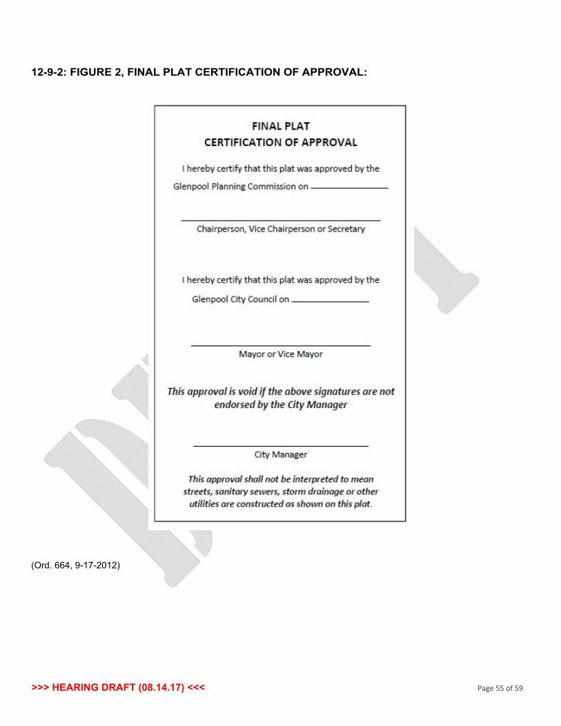
>>> HEARING DRAFT (08.14.17) <<< Page 55 of 59
1292: FIGURE 2, FINAL PLAT CERTIFICATION OF APPROVAL:
(Ord. 664, 9172012)
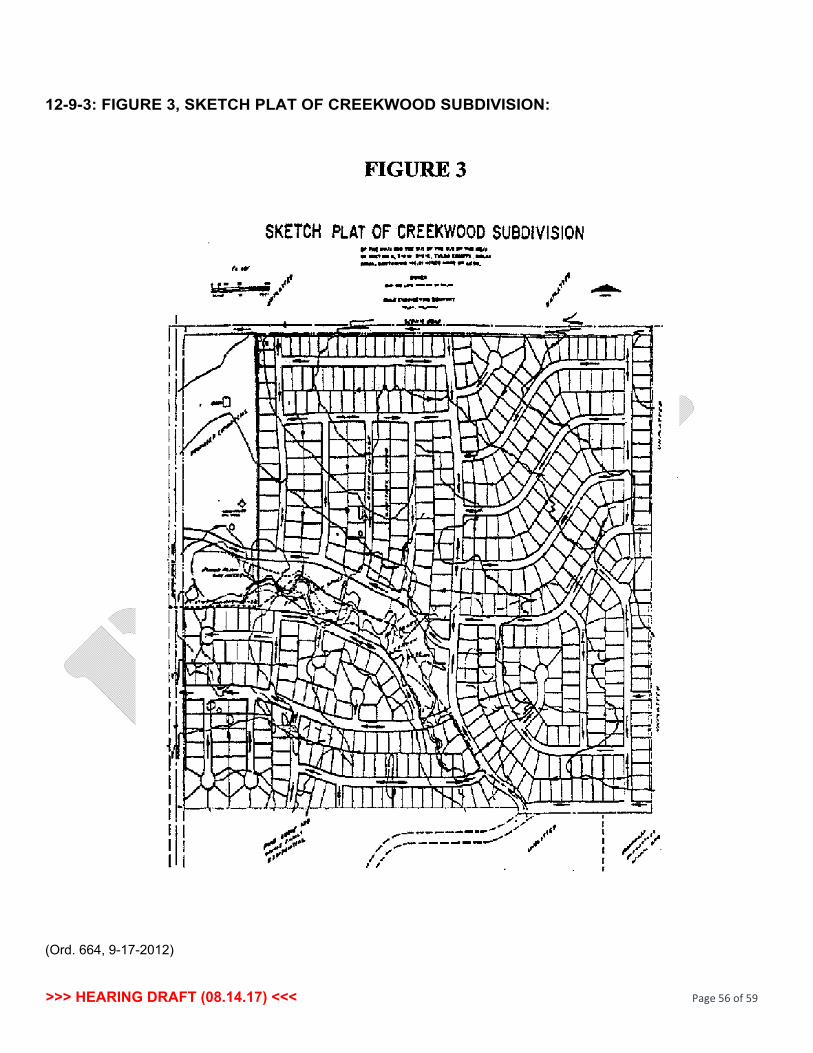
>>> HEARING DRAFT (08.14.17) <<< Page 56 of 59
1293: FIGURE 3, SKETCH PLAT OF CREEKWOOD SUBDIVISION:
(Ord. 664, 9172012)

>>> HEARING DRAFT (08.14.17) <<< Page 57 of 59
1294: FIGURE 4, PRELIMINARY PLAT OF CREEKWOOD SUBDIVISION:
(Ord. 664, 9172012)
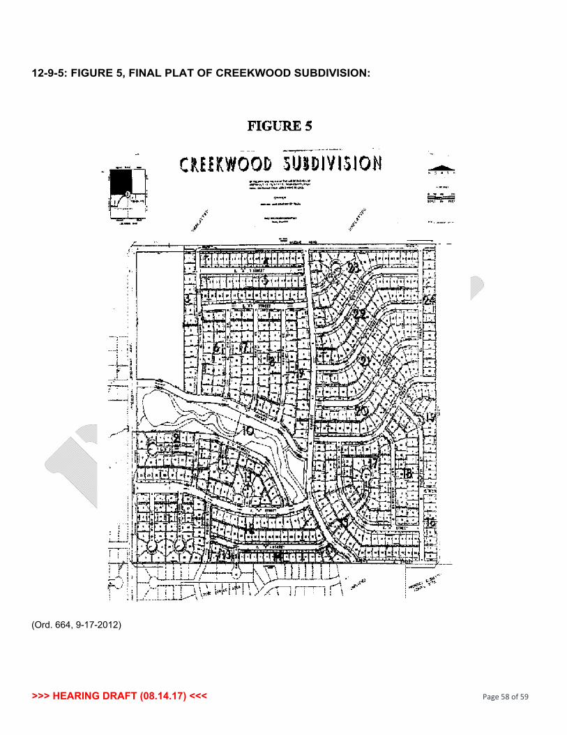
>>> HEARING DRAFT (08.14.17) <<< Page 58 of 59
1295: FIGURE 5, FINAL PLAT OF CREEKWOOD SUBDIVISION:
(Ord. 664, 9172012)

>>> HEARING DRAFT (08.14.17) <<< Page 59 of 59
1296: FIGURE 6, NEIGHBORHOOD CONCEPT:
(Ord. 664, 9172012)