
245764.pdf - UCL Discovery
428
CITIES IN THE SAHARA: SPATIAL STRUCTURE AND GENERATIVE PROCESSES IN PARTIAL THE A DISSERTATION FULFILLMENT OF DEGREE OF DOCTOR SUBMITTED THE REQUIREMENTS OF PHILOSOPHY FOR FATIHA SALAH-SALAH BARTLETT SCHOOL OF ARCHITECTURE AND TOWN PLANNING UNIVERSITY COLLEGE LONDON APRIL 1987
-
Upload
khangminh22 -
Category
Documents
-
view
1 -
download
0
Transcript of 245764.pdf - UCL Discovery

CITIES IN THE SAHARA: SPATIAL STRUCTURE AND GENERATIVE PROCESSES
IN PARTIAL THE
A DISSERTATION FULFILLMENT OF
DEGREE OF DOCTOR
SUBMITTED THE REQUIREMENTS
OF PHILOSOPHY FOR
FATIHA SALAH-SALAH
BARTLETT SCHOOL OF ARCHITECTURE AND TOWN PLANNING UNIVERSITY COLLEGE LONDON
APRIL 1987

To the memory of my uncle "Houari Boumedienne"
the late President of Algeria

-1-
ABSTRACT
The present thesis examines some aspects of the struc- ture of urban space found in particular towns in the Sahara, and the peculiarities in their dual organisa- tion of the circulation systems: the streets and the roof terraces of the houses inter-connected by another system of walkways, which are exclusively reserved for the circulation of women across the settlements or parts of the settlements. The terrace morphology is developed in different forms and at various degrees of elaboration in these urban systems, which are usually seen as the result of some external determinant factor, such as religion, with the public being wholly male and women confined to the domestic sphere. Since there are no differences in religious terms between these sys- tems, this view cannot be adopted to account for the pronounced differences in their spatial configurations.
The study argues that: i- the terrace morphology is only one instance of the spatial mechanisms which enter in the separation and integration of the sexes, the global organisation of the street system is another; ii- these mechanisms, to include the terrace system, are intimately bound up with the nature of the urban fabric of these towns, which can be characterized as poorly connected and highly segregated, with a distinc- tive organisation of the main streets with regard to the settlement as a whole. The dense fabric of these towns with large urban blocks creates both, the high level of segregation of the street system and larger roof surfaces; iii- both, the nature of the urban fabric and the global organisation of these systems are strongly related to the generative processes of urban formation, and the underlying rules followed in the aggregation of buildings on the ground. These rules are seen as expressions to social restrictions on relations between and within male and female groups. The computer simulations of the urban growth show that the highly segregated nature of the spatial fabric and its dis- tinctive global organisation are the by-product of a more localized process of building aggregation. The study concludes that the dualistic structure of these towns and its variation lies in the greater emphasis on male-female relations and the greater localization in the structuring of space. It demonstrates then that the relation between the terrace morphology and the urban form of these towns is shown to exist at the deepest level of space organisation, at the level of the generative rules of settlement formation. By this, the study uses an architectural approach to broach the question of relationship between the social and spatial aspects of these towns.

-
TABLE OF CONTENTS
PAGE ---------------------------------------------------------
ABSTRACT 1
ACKNOWLEDGMENTS
TABLE OF CONTENTS
INTRODUCTION 12
PART ONE
CHAPTER ONE: PRESENTATION OF THE TOWNS 25
CASE STUDY ONE: GHADAMES 26
- The geographical context 26 - Historical and economic background 28 - Social structures 32 - Source material and data gathering 34 - The built environment 37 - Description of the houses 54 - Description of the terraces 59
CASE STUDY TWO AND THREE: GHARDAIA AND 65 BENI ISGUEN
- The geographical context 65
- Historical and economic background 65
- Social and political structures 70
- Data gathering and source material 76
- The built environment 82
- Description of the ground plan of Ghardaia 83
- Phases of growth of Ghardaia 92
- Description of the ground plan of Beni Isguen 94
- Phases of development of Beni Isguen 99
- General description of houses 101
- Description of the terraces 105
CASE STUDY FOUR: EL OUED 115
The geographical context 115 Historical and economic background 116 Source material 119 The built environment 119 Description of houses 121
Summary to Chapter One 123

-
CHAPTER TWO: THE SOCIAL USE OF SPACE IN THE 124 MZAB TOWNS AND GHADAMES
Introduction 124 Description of men's and women's worlds 128 Pattern of space use of the houses 130 Men's and women's use of the streets 131 in Ghadames Women's use of the terraces in Ghadames 132 Female society in the local street 137 Male society beyond the "zenka" 139 Women's use of space beyond the "zenka" 141 Women's use of the terraces in Ghardaia 142 and Beni Isguen
Summary to Chapter Two 144
CHAPTER THREE: OVERALL REVIEW OF THE SOCIO- 146 DESCRIPTIVE MATERIAL
Morphological differences 150 - At the level of the town fabric 150 - At the house's level 151 - At the terrace's level 153
Differences in space uses 154
Summary to Chapter Three 160
PART TWO: SPATIAL ANALYSIS
CHAPTER FOUR: THE SPATIAL ANALYSIS OF THE TOWNS 161
INTRODUCTION 161
PRESENTATION OF THE ANALYTICAL METHOD 161 AND MEASURES
THE SPATIAL DESCRIPTION OF THE TOWNS' FABRIC 163
Case One: Ghadames 186 - Pattern of the integration in Ghadames 191 - Analysis of simulated movements in 194
Ghadames
Case Two: Ghardaia 199
- Ghardaia and its phases of expansion 201 - The pattern of integration in Ghardaia (Gl) 206 - The pattern of integration in Ghardaia (G2) 208 - The pattern of integration in Ghardaia (G3) 212 - Spatial analysis of simulated movements in 215

-
Ghardaia
Case Three: Beni Isguen 225 - Beni Isguen and its phases of expansion 227 - The pattern of integration in Beni Isguen (BID 231 - The pattern of integration in Beni Isguen (B12) 232 - The pattern of integration in Beni Isguen (B13) 234 - Spatial analysi s of simulated movements in 241
Beni Isguen
Case Four: El Oued 247
The pattern of integration in El Oued 248 Spatial analysis of simulated movements in 250 El Oued
SPATIAL ANALYSIS OF THE ROOF TERRACES 253
- The pattern of integration of the terraces 258
OVERALL REVIEW OF THE ANALYSIS AND SOME 264 THEORETICAL SUGGESTIONS
SUMMARY TO CHAPTER FOUR 279

-
PART THREE: A GENERATIVE MODEL
CHAPTER FIVE: A MODEL OF SETTLEMENT GROWTH 282
INTRODUCTION 282
HISTORICAL BACKGROUND 285
GENERAL FORMAL CHARACTERISTICS 295
INTRODUCTORY NOTES TO THE MODEL 297
PRESENTATION OF THE MODEL 299
THE GENERATIVE PARAMETERS 302
- The x clustering - The y joining
- The x overlap - The y sliding
RULES OF CELL ALLOCATION 307
-X cell allocation -Y cell allocation
PROGRAM DESCRIPTION 310
INPUT DATA 311
OUTPUT DATA 312
LIMITATIONS OF THE MODEL 312
DESCRIPTION OF THE GENERATED SYSTEMS 313
SPATIAL ANALYSIS AND COMPARISON 326
- Introduction 326
- Generative parameters and analytic 329
measures i- The effect of x clustering 330 ii-The effect of y joining 331 iii-The effect of y sliding 334
- Block formation and generative rules 335
- Comparison of the generated morphologies 343
and the real examples - The pattern of integration and the 350
generative rules
- Conclusions 369
SOCIAL IMPLICATIONS AND THE GENERATIVE RULES 374
SUMMARY TO CHAPTER FIVE 379
CHAPTER SIX AND CONCLUSIONS 381
BIBLIOGRAPHY 391

-
APPENDIX 1 397
APPENDIX 2 400
LIST OF FIGURES AND ILLUSTRATIONS:
PART ONE
Title Page No.
2.1: LOCATION MAP FOR THE TOWNS 27 2.2: GHADAMES, AERIAL PHOTOGRAPHY 40 2.3: GHADAMES, GROUND PLAN 41 2.4: GHADAMES, GROUND PLAN OF DARRAR 43 2.5: GHADAMES, GROUND PLAN OF WAZIT 48 2.6: GHADAMES, GROUND PLAN OF MAZIGH 48 2.7: GHADAMES, GROUND PLAN OF BELLIL 53 2.8: GHADAMES, HOUSE PLAN OF BELLIL 53 2.9: GHADAMES: HOUSE PLAN 55 2.10: GHADAMES, ROOF PLAN 60 2.11: GHADAMES, ROOF PLAN FOR A SEPARATE HOUSE 63 2.12: THE PHYSICAL LAYOUT OF THE VALLEY 85 2.13: GHARDAIA, AERIAL PHOTOGRAPHY 86 2.14: GHARDAIA, GROUND PLAN 87 2.15: GHARDAIA, PHASES OF EXPANSION 94 2.16: BENI ISGUEN, AERIAL PHOTOGRAPHY 96 2.17: BENI ISGUEN, GROUND PLAN 97 2.18: BENI ISGUEN, PHASES OF EXPANSION 101 2.19: GHARDAIA, HOUSE PLAN 103 2.20: GHARDAIA, ROOF PLANS FOR SEPARATE HOUSES 108 2.21: BENI ISGUEN, GENERAL VIEW OF TERRACES ill 2.22: BENI ISGUEN, ROOF PLANS FOR SEPARATE HOUSES 112 2.23: BENI ISGUEN, VIEWS OF TERRACES OF TWO BLOCKS 113 2.24: BENI ISGUEN, ROOF PLAN 115 2.25: EL OUED, AERIAL PHOTOGRAPHY 121 2.26: EL OUED, GROUND PLAN 123 2.27: EL OUED, HOUSE PLAN 123

-
Title Page No. ---------------------------------------------------------
1: GHADAMES, GENERAL VIEW OF THE TOWN 41 2: GHADAMES, A STREET AT GROUND LEVEL 41 3: GHADAMES, VIEW SHOWING LIGHT SHAFT AT ROOF LEVEL 41 4, 5: GHADAMES, COVERED SQUARE IN DARRAR 47 6, 7,8: GHADAMES, VIEWS OF STREETS AND SQUARE 49 9: GHADAMES, A STREET IN MAZIGH 51 10, 11,12: GHADAMES, WALKWAYS 61
AT ROOF LEVEL 13, 14,15: GHADAMES, WALKWAYS AT ROOF LEVEL 62 16: GHADAMES, A SMALL "STREET" AT ROOFTOP 63 17: GHADAMES, VIEW OF TERRACES 51 18: GHARDAIA, GENERAL VIEW 88 19: GHARDAIA, STEEP STREET 88 20, 21: GHARDAIA, THE MARKET SQUARE AND ARCADE 91 22: GHARDAIA, COMMERCIAL STREET 92 23: BENI ISGUEN, A STREET IN THE OLDER PART 92 24: BENI ISGUEN, PRAYING AREA 99 25: BENI ISGUEN, THE MARKET PLACE 99 26,27: GHARDAIA, VIEWS OF TERRACES 107

-
PART TWO
Title Page
4.1: GHADAMES, AXIAL MAP 177 4.2: G HARDAIA, AXIAL MAP 178 4.3: B ENI ISGUEN, AXIAL MAP 179 4.4: E L OUED, AXIAL MAP 180 4.5: G HADAMESF INTEGRATION CORE OF DARRAR 189 4.6: G HADAMES, INTEGRATION CORE OF WAZIT 189 4.7: G HADAMES, INTEGRATION CORE OF MAZIGH 189 4.8: G HADAMES, INTEGRATION CORE OF BELLIL 189 4.9: G HADAMES, INTEGRATOIN CORE(GHAD1) 192 4.10: GHADAMES, INTEGRATION CORE(GHAD2) 195 4.11: GHADAMES, RADIUS-3 INTEGRATION CORE 196 4.12: GHADAMES, CHOICE STRUCTURE 197 4.13: GHARDAIA, INTEGRATION CORE (GHARDAIAl) 204 4.14: GHARDAIA, INTEGRATION CORE (GHARDAIA2) 204 4.15: GHARDAIA, INTEGRATION CORE (Gl) 207 4.16: GHARDAIA, INTEGRATION CORE (G2) 210 4.17: GHARDAIA, INTEGRATION CORE (G3) 214 4.18: GHARDAIAr RADIUS-3 INTEGRATION CORE 217 4.18a: GHARDAIA, RADIUS-3 INTEGRATION CORE 216
(FOR THE SMALL SYSTEMS) 4.18b: GHARDAIA, RADIUS-3 INGTEGRATION CORE 218 4.19: GHARDAIA, CHOICE STRUCTURE (Gl) 219 4.20: GHARDAIA, CHOICE STRUCTURE (G2) 221 4.21: GRAPHIC DISTRIBUTION OF CORRELATION 224
BETWEEN CHOICE AND JOURNEYS (Gl) 4.21a: GRAPHIC DISTRIBUTION OF CORRELATION 224
BETWEEN CHOICE AND JOURNEYS (G2) 4.22: BENI ISGUEN, INTEGRATION CORE 230
(BENI ISGUEN1) 4.23: BENI ISGUEN, INTEGRATION CORE 230
(BENI ISGUEN2) 4.24: BENI ISGUEN, INTEGRATION CORE (BID 232 4.25: BENI ISGUEN, INTEGRATION CORE (B12) 234 4.26: BENI ISGUEN, INTEGRATION CORE (B13) 237 4.27: BENI ISGUENI RADIUS=3 INTEGRATION CORES 239
(FOR THE SMALL SYSTEMS) 4.27a: BENI ISGUEN, RADIUS-3 INTEGRATION CORE 240
(BIl) 4.27b: BENI ISGUEN, RADIUS-3 INTEGRATION CORE 240
(B12) 4.28: BENI ISGUEN, CHOICE STRUCTURE (BID 242 4.29: BENI ISGUEN, CHOICE STRUCTURE (B12) 243 4.30: GRAPHIC DISTRIBUTION OF CORRELATION 245
BETWEEN CHOICE AND JOURNEY (BID 4.31: GRAPHIC DISTRIBUTION OF CORRELATION 245
BETWEEN CHOICE AND JOURNEY (B12) 4.32: EL OUED, INTEGRATION CORE (EL01) 249
4.33: EL OUED, INTEGRATION CORE (EL02) 249 4.34: EL OUEDr RADIUS-3 INTEGRATION CORE 251
4.35: EL OUEDj CHOICE STRUCTURE 251 4.36: GHADAMES, INTEGRATION CORE OF TERRACES 261
4.37: BENI ISGUEN, INTEGRATION CORE OF TERRACES 262

-
PART THREE
Title Page No.
5.1,5.2: EXAMPLES OF GENERATED MORPHOLOGIES 301 BEFORE AMENDMENTS
5.3: F LOW CHART 306 5.4: P ICTURE OF MORPHOLOGY GENERATED MANUALLY 308 5.5,5. 6: EXAMPLES OF GENERATED MORPHOLOGIES 316
BY VARYING X CLUSTERING, Y RANDOM 318 5.7: E XAMPLES OF GENERATED MORPHOLOGIES 319
B Y VARYING Y JOINING, X RANDOM 5.8: EXAMPLES OF GENERATED MORPHOLOGIES 320 5.9: EXAMPLES OF GENERATED MORPHOLOGIES 321 5.10: EXAMPLES OF GENERATED MORPHOLOGIES 322 5.11: EXAMPLES OF GENERATED MORPHOLOGIES 324
AT THREE SIZES OF THE FRAME 325 5.12: BLOCK FORMATION, WHEN INSISTING ON 341
X CLUSTERING 5.13: BLOCK FORMATIONt WHEN INSISTING ON 341
Y JOINING 5.14: BLOCK FORMATION WHEN INSISTING ON BOTH 342
X CLUSTERING AND Y JOINING 5.15: INTEGRATION STRUCTURES OF REAL EXAMPLES 351 5.15a: INTEGRATION STRUCTURES OF REAL EXAMPLES 352 5.16: INTEGRATION CORESF PATTERN ONE 356 5.16a: INTEGRATION CORES, PATTERN ONE 357 5.16b: INTEGRATION CORES, PATTERN ONE 358 5.16c: INTEGRATION CORESF PATTERN ONE 365 5.17: INTEGRATION CORES, PATTERN TWO 359 5.17a: INTEGRATION CORESF PATTERN TWO 360 5.17b: INTEGRATION CORES, PATTERN TWO 361 5.17c: INTEGRATION CORESF PATTERN TWO 362 5.18: INTEGRATION CORES, PATTERN THREE 363 5.18a: INTEGRATION CORES, PATTERN THREE 364 5.18b: INTEGRATION CORES, PATTERN THREE 365 5.19: INTEGRATION CORES, PATTERN FOUR 366

- 10 -
LIST OF TABLES
PART TWO
Title Page ---------------------------------------------------------
4.1: Measures for the 12 cases and the 75 181 urban systems, and correla tions with size
4.2: Second order measures for the 12 cases 183 and for the 75 systems
4.3: Synoptic correlations for the towns 184 under study
4.4: Ghadames, measures for the two versions 186 4.5: Ghadames, Measures for the different 187
parts 4.6: Ghardaia, Measures for the three versions 194 4.7: Ghardaia, Measures for the three phases 202
of expansion 4.8: Beni Isguen, Measures for the three 225
versions 4.9: Beni Isguen, Measures for the three 229
phases of expansion 4.10: El Oued, Measures of the two versions 247 4.11: Measures for the streets and terrace 256
system for Ghadames and B eni Isguen 4.12: General data table for al l cases 264
PART THREE
5.1: Relations between measures 330 and x clustering
5.2: Relations between measures 332
and y joining 5.3: Relations between measures 334
and y sliding 5.4: Block size and generative parameters 336 5.5: Correlation of block size 338
and generative parameters 5.6: Measures for the 70 generated systems 343 5.7: Measures for the real towns 345 5.8: Synoptic correlations for the 347
70 generated systems 5.9: Classification of integration cores 355
of generated systems, according to
generative parameters

- 11 -
ACKNOWLEDGMENTS
It is a pleasure to be able to record the advice,
cooperation and support received from several people
during the preparation of this thesis.
I am greatly indebted to B. Hillier, my supervisor. He
has provided invaluable guidance and advice throughout
this research project. In the preparation of this
study, he has been a continuous source of inspiration.
His assistance in this dissertation is greatly appreci-
ated.
I also wish to express my thanks to the Unit of Archi-
tectural Studies, University College London, in partic-
ular A. Penn. Special thanks are also due to P. Coates
for his assistance in the preparation of the software
for the computer modelf and Y. Hamuth, system Manager,
from the computer Unit of Bartlett School.
also wish to extend my thanks to the Algerian Minis-
try of Housing and Construction, to the "Atelier du
Mzab" and the Municipality of Ghadames for their
cooperation.
I would like also to express my gratitude to my mother,
Mr and Mrs Mohamed Salah-Salah and Colonnel M. Zerguini
for their encouragement and moral support. Last but
not the least, my special thanks are due to A. Loumi
for his constant willingness in discussing various
questions encountered during this research project.

- 12 -
INTRODUCTION:
The present thesis is concerned with an investigation
into the towns of the Mzab region of Southern Algeria,
and Ghadames, a saharan oasis in South-western Libya.
This concern has been prompted by the existence of a
particular morphological feature, "the terrace system",
which consists of the rooftops of houses interconnected
to one another to form an exclusive domain, used by
women for their circulation across the settlement or
parts of the settlement. The terrace system seems to
allow the women freedom of movement and opportunities
to meet each other, without contravening the separation
of the sexes which appears to be a main organisational
principle in these societies.
Recent studies of the physical and social structure of
these towns in particular and of the towns in the Arab
world in general, have exploded the myth of the single
Arab city type, in which the public sphere is seen as
wholly male and women kept out of sight in confinement
to the domestic sphere (i. e., Duveyrier H., 1864, p.
257; Gulick J., 1963, pp. 179-198; Delaval B., 1974, p.
254; Wheatly P., 1976t pp. 335-359; Raymond A., 1985F
p. 172). The significance of this abstraction implies
an enormous importance of Islam as a framework for
understanding spatial structures. These studies have
therefore concentrated chiefly on the separ'ation of the
living space into male and female spheres, seen mainly
- 13 -
as the result of religion.
But other studies of a more descriptive character, sug-
gest a certain variation in the way in which the urban
space is structured to separate or integrate the sexes
(i. e., Donnadieu and Didillon, 1977, p. 69). For exam-
ple, Etherton comments that
"in the Arab world, the courtyard house ensures
that women may be seen only by their husbands and
children ... Most courtyards are interconnected so
that women can pass from one to another without
having to walk in the streets. Where there is
more than one storey, these connections often
cross the streets transforming the ksar [the town]
into a private upper level town for women, and a
lower-level commercial town for the men. " (Eth-
erton D., 1971, p. 174).
The puzzle then is that the terrace system is developed
to a high degree in some settlements and hardly at all
in others, while in one case there are substantial
differences from one part of the town to the other. The
very fact that within the same geographical, social and
religious context, the terrace morphology exists in
different forms and at different degrees of elabora-
tion, already raises doubts about the way in which
these spatial systems have been interpreted, as being
wholly the result of some external determinant factor,
the religion (i. e. r Delaval B., 1974, pp. 253-). Since

- 14 -
there do not seem to be substantial differences between
these towns in terms of religion, it seems difficult to
accept that this factor can account for the pronounced
differences in the development of the terrace system.
The dual settlement form with men in the streets and
women in the "upper town" seems therefore to develop in
different ways and to different degrees. It is not one
phenomenon, any more than the so-called Arab city is.
It is a phenomenon whose appearance and nature is as
much in need of description and explanation as any
other.
In this thesis, it is suggested that the terrace system
and its variations can best be understood in the con-
text of the global form of the settlement and its rela-
tion to the overall patterns of relations between and
within the sexes. The reasons underlying this sugges-
tion are
first, the variations of the terrace system seems to be
intimately related to the physical and spatial nature
of the settlement itself. The terrace system in its
full sense, for example, seems to be possible only if
there is a continuous expansion of the roofs across
the streets which, as a result become entirely covered.
On the other hand, the terrace system appears to facil-
itate social contacts between women in a society where
women are said to be isolated and confined to the
domestic spherer in contrast to men. The structure and
the nature of these contacts seem to vary from one

- 15 -
settlement to another. This variation suggests a rela-
tion between the settlement form and the way in which
contacts between and within the sexes are generated and
controlled. Whatever explains this morphology, it
clearly permits a dual use of the settlement by the
sexes, more or less independently, and as such might
play some part in defining and modulating their modes
of communications. Moreover, the system as a whole
might be held to be geared towards the generation and
control of encounters between and within the sexes.
Second, the physical and spatial arrangement in these
towns is clearly not the result of an overall and pre-
conceived plan, but has evolved from the cumulative
building acts of individuals governed by rules and
regulations. In other words, the question of the
nature of the spatial fabric of the towns seems to be
intimately bound up with the question of the process of
growth and the nature of the rules governing the aggre-
gation of buildings on the ground.
In view of this twin emphasis in defining the problem,
the recent work in the Unit of Architectural Studies,
University College London, on settlement forms in gen-
eral, appears quite suggestive. This work has sug-
gested firstlyr empirically, that settlements by virtue
of the arrangements of buildings on the ground and the
resulting patterns of open space, create and restrict
encounter fields, and that the structure of these
fields relates to the types of social network that is

- 16 -
to be reproduced (SERC Report, 1986, pp. 42-44); and
secondly, theoretically, that the study of space in
general has to take account of different patterns of
structuring and using space for different groups,
especially men and women (Hillier B., Hanson J., 1984,
pp. 223-240). It is what Hillier and Hanson call the
theory of differential solidarities, in which they sug-
gest two fundamentally different principles in the
pathway to social formations and cohesion: the spatial
and transpatial forms (Ibid, pp. 144-145). The main
argument can be briefly stated: a society is not only
based on deterministic, more rule-governed relations
between its members; the probabilistic, more informal
encounter events are also important to make a society
what it is. The stability of a social system, that is
a set of stable relations which reproduce themselves,
is seen in terms of this dichotomyr that is according
to whether the system of relations is more determinis-
tic more transpatial, or more probabilistic more spa-
tial. Defining solidarity as a membership of a social
group, this distinction leads to a general theory of
society based on the differential patterns in the
encounter fields. The more contacts and encounters
within a group tend to rely on location and spatial
proximity to take place, the more the group is seen as
spatially organised. The group cohesion is then more
likely to be achieved on the basis of loose and dif-
fused control, creating more informal encounter events.
Whilst, the more a group tends to maintain its cohesion
- 17 -
despite spatial separation, the more that group is seen
as transpatially organised. The group cohesion is then
more likely to be achieved on the basis of strong rules
and structured control, creating more formal and regu-
lated encounter events. The distinction of spatial and
transpatial principles of social cohesion appears of
fundamental importance because, according to space syn-
tax theory, space is likely to be structured in the
image of the relations between solidarities, especially
the relation between male and female solidarities which
appears to be the dominant force shaping space (Hillier
B.,, Hanson J., 1984, p. 240).
Both of these aspects, as outlined above, seem to be
present in the towns under study, but in quite a dif-
ferent way to for example, the European town. Under-
standing the relation between these aspects might
therefore be a key factor to understanding the distinc-
tive form of these cities, and moving decisively away
from the too simplistic views which stress privacy,
uniformity and religion, and which have dominated the
studies of the Arab city until recently.
The present thesis aims to throw some light on these
issues not by carrying out an anthropological study of
the social structures of the towns, but by conducting
an investigation aimed at the settlement form itself in
four towns in which the terrace system is developed in
different forms and to different degrees. These are
Ghadames where, in some quarters, the terrace system

- 18 -
expands over entire quarters and takes the form of a
continuous network of pathways, clearly defined by phy-
sical boundaries, while in another quarter the terrace
links are non-existent; Ghardaia and Beni Isguen where
the terrace system is only developed at the level of
the building blocks, and the links seem accidental, and 11ýý dependent on the configuration of the roo-Ves; and El
Oued where the terrace system does not take place at
all. By this, the study aims
first,, to try to highlight the spatial aspects of the
terrace morphology and enquire how far there is any
relationship between the terrace system and its varia-
tions and the global form of the towns as a whole, and
through this to try to render explicit the "genotypi-
cal" properties underlying the organisation of space in
these settlements.
Second, to look at the organisation of space at the
level of the rules that govern the spatial combination
of buildings in a formal sense, as shown in the way in
which buildings are aggregated and the external spaces
that are formed at the level of both the ground floor
and the rooftops. By this, the study aims to give a
description of the type of processes of building
development which is potentially inclined to accommo-
date the terrace morphology.
, Third, to offer in the light of the available histori-
cal data, some theoretical interpretations of the
social implications of the morphological and generative

- 19 -
rules. If the spatial form of the city is in some
sense a product of the society that creates it, then it
ought to be possible to detect in the structure of the
settlement itself at least some of the evidence for
this relation.
The study has therefore a methodological intent as well
as a substantive one. The substantive aim is to try to
arrive at a better understanding of how the structure
of these cities is related to the relations within and
between the sexes. The methodological aim is to try to
show that such studies can benefit from an architec-
tural approach, that is one which is aimed in the first
instance at describing, analysing and understanding the
distinctive features of the settlement form itself.
The study is divided in three major parts, reflecting
these aims. The first part is descriptive. It takes
each of the four towns in turns, first introducing it
briefly through what is known of its history and what
can be seen through the inspection of the plan and from
a visual knowledge of the streets. It then, describes
the form of the houses and the domestic space structure
before presenting a detailed description of the upper
level terraces. This description is based on first
hand data resulting from the author's own field sur-
veys, amplified by a review of relevant published
material. Published material is sparse, largely
because of the restrictions on access to terraces

- 20 -
imposed on male investigators.
This section presents also a description of the social
use of space in the streets of the towns in question
and at the terraces, using in the first instance the
author's own descriptive data, but elaborating this
wherever possible with accounts drawn from the much
more extensive and useful literature. This section
ends up by drawing these threads together into a
theoretical account of what it is about these towns,
seen spatially and socially, that might be better
understood through a deeper understanding of the spa-
tial form of the settlement and how this latter could
be seen as the product of a social process.
The second part of this study is analytic. It aims to
analyse the spatial structure of the towns against the
background of the studies of a cross cultural sample of
towns and urban areas undertaken at the research unit
(*), in order to establish what, if anything, is dis-
tinctive about these towns as a group, and how they
differ from each other. This section will be purely
spatial in its aims. It is concerned only to arrive at
a precise characterisation of the spatial structure of
the townsr and establish what is about them that might
be explainable by a socio-spatial theory. This section
uses the space syntax methodology for settlement
* Unit for Architectural Studies at University College Lon- don under the direction of B. Hillier.

- 21 -
description and analysis developed at University Col-
lege London; but uses it in a new way in an attempt to
capture the distinctive features of the towns under
study.
The analytic section is divided into two parts. The
first part provides a comparative analysis of the
street structure in these towns, while the second part
focusses on the spatial analysis of the terrace confi-
guration itself, so that comparisons can be carried out
on the one hand, between the street structure and the
terrace system within the context of the same settle-
ment; and on the other, between the terrace configura-
tions within the different settlements. The spatial
analysis includes the analysis of the town's structure
and its "dynamics". It will be done in two ways, the
analysis of space structure and simulation of move-
ments. In other words, it aims to look at how the set-
tlement is structured in purely spatial terms and how
it is likely to be used as a system of choice for some
moving fictitious individuals that have been superim-
posed on it (SERC Report, 1986, pp. 3-4). Real obser-
vations of movements were not possible, mainly because
of the difficulties encountered by strangers to the
towns,, women in particular, and the restrictions
imposed on them. The analytic section ends by formulat-
ing the problem to be broached in Part Three, which
aims to look at the extent to which the existing struc-
tures of the towns can be seen as a product of socio-
spatial rules.

- 22 -
The third section of the study is then generative, in
that it asks the above question by computer modelling
of processes of spatial growth. It uses computer simu-
lation in an attempt to answer the question: what kind
of rules must the spatial process that produced these
distinctive forms have followed, and what might then be
the social rationale of those rules. In other words,
it seeks to give a social dimension to the analysis of
space by enquiring into the social nature of the gen-
erative processes which could give rise to it. This
section uses the computer in a generative mode, on the
basis of the "space syntax" conception of order in
space, which is defined as an outcome of restrictions
on an otherwise random process of cell-growth (Hillier
B., Hanson J., 1984, pp. 34-38). This section is
therefore concerned with the presentation of the gen-
erative model which is developed and implemented on the
BBC Basic computer and in which the output is two-
dimensional plans, and also with the assessment and
analysis of the outcome morphologies on the basis of
the same analytical tools used in the study of the real
towns.
Seventy cases of the computer generated morphologies
have been looked at and the results obtained are com-
pared with the empirical evidence derived from the spa-
tial analysis of the towns, and the similarities and
differences are then discussed. The model is intended
as a means of explaining how a particular morphological
outcome may be seen as, at least partly, originating

- 23 -
from the nature of the processes of spatial growth and
the internal rules of spatial combination. This type of
generative process raises a number of intprpstina
theoretical issues, and introduces a new dimension into
the questions about the "causes" of settlement forms.
The inference is drawn that the understanding of the
building patterns in these settlements requires in
fact, two kinds of knowledge:
First, it is necessary to look at the historical events
and the economic and social processes in which these
settlements were embedded. This kind of knowledge is
valuable in establishing the context in which the phy-
sical forms have arisen; it contributes in the under-
standing and the social interpretation of the formal
properties of the settlements, but it would never pro-
vide a proper account of the special morphological
invariants that have been observed in these settlements
(i. e. Hillier B., Hanson J., 1984, pp. 10-13).
Second, it is necessary to look at the relation of
implication between the local rules of building aggre-
gation and the global form (Ibid, pp. 60-61). The
question of settlement form is thus strongly related to
two types of laws, those governing the lawful possibil-
ities of spatial combination and those by which social
relations give meaning to formal variables (Ibid, pp.
11-16) .
It is therefore essential to look in two directions; at
the internal rules and processes which govern the

- 24 -
spatial combination of buildings in a formal sense, and
at the particular social and ecological environment
which generate the rules. The understanding of
"an architectural style or type requires more than
simply pointing to a few important examples of it
and describing their essential properties. One
can claim full understanding only when one can
give rules to construct new instances of the style
or type" (Stiny G., & Mitchell W. J., 1980, P.
211).
The three types of information generated by the study
are then reviewed in a discussion of the bearing they
have on the theoretical questions of the study: the
"genotypical" characteristics of this class of towns,
and the relations between the sexes as reflected in
these characteristics.
The conclusions of such a study
lative, not only because the
background information sparse,
prime aim of the study is to
the "causes" of Arab settlement
a way in which they might,
solved.
are necessarily specu-
sample is small and the
but also because the
open up questions about
forms in a new way, in
perhaps, eventually be

- 25 -
CHAPTER ONE: PRESENTATION OF THE TOWNS
Part One consists
presentation of
includes material
religious aspect
the built forms.
body of data is:
of the descriptive and historical
the towns selected for the study. It
on socio-economic, historical and
s. as well as descriptive material on
The aim of the introduction of such a
i- To provide sufficient background information to the
spatial analysis.
ii- To establish a basis for the interpretation and
understanding of the social dimensions of the spatial
structure. This information will be used as a back-
ground to interpret the results of the spatial analysis
and give an idea on the social potentials of the sys-
tems.
Part One is subdivided into three sections. The first
section contains the material mainly dealing with the
historical aspects of the towns and their built
environment. The second contains the material dealing
with the social data and space uses by men and women
within these towns; and the third consists of a review
of some issues raised by past studies in their attempt
to understand the relation between the built forms and
the social structures in the towns in question, against
the background of the socio-descriptive material in

- 26 -
Chapter one and Two.
The material used in this section derives from two
sources: documentary and site surveys undertaken by the
author.
CASE STUDY ONE: GHADAMES
THE GEOGRAPHICAL CONTEXT:
Ghadames is a Saharan oasis situated at the meeting
point of the Libyan, Tunisian and Algerian borders (see
Location Map in fig. 2.1) at about 450 kilometres from
Tripoli. It is a mud-brick town with a total popula-
tion of approximately 8000 inhabitants, all of whom are
mus 1 im. It occupies a total area of about 400 ha,
including palm groves and gardens. The town of Gha-
dames was the most important of the Libyan oases due to
the availability of water and the strategic position at
the trade routes used by the caravans across the Sahara
(i. e. Etherton D., 1971, p. 174; Yushea B. Q., 1973, p.
91). The climate of Ghadames is extreme with tempera-
ture ranging from 8 to about 58 degrees centigrade.
The climate of Ghadames is further characterised by low
humidityy low rainfall and relatively frequent sand
storms (Eldblom L., 1968, p. 27).

27
moditorranean soa
9 Alg, ers Constantine: Tunes
0 Oran
[at 0
e -.. ! -- - A.
t'EL OUED A
u
I *, -% - 0". -*N ."
GHAPDAIA Hasii Messamw
Western El Gahm
-; HADAMES
ý6
in Salah
- 0-..
- Taman rasset
0 s» bin
FIG. 2.1 : LOCATION MAP FOR THE TOWNS

- 28 -
HISTORICAL AND ECONOMIC BACKGROUND OF GHADAMES:
Not much has been written about Ghadames of a reliable
nature, and even less about its urban morphology seen
from a historical point of view. For the earlier
period, the introduction of Motylinski's "le dialecte
berbere de R'edames (De Motylinski, 1904), gives a good
summary of the history of the town as it is known from
the Latin, Arabic and European sources. Most of the
scholars (i. e., Duveyrier H., 1861, p. 250; Motylinski,
1884, p. 10) who visited Ghadames have attempted to
resolve the dif f icult problem of its origin. All that
they had as guidances were local tales and legends.
It does seem, however, that the centre of Ghadames goes
back to the remote antiquity. Ibn Khaldun states that
this station in the desert was built during the Islamic
era, but this was already raised as an error by De
Slane (Ibn Khaldun, Trans. De Slane, 1934, p. 303) who
noted that the author must be referring to the recon-
struction of the town. There are some vague indica-
tions concerning the successive transformations of Gha-
dames in the "Chronicle" published as an appendix in
the work of Motylinski (Motylinski, 1884, pp. 217-249),
in addition to some interesting information about the
origin and lineage of the different factions that
helped to populate the oasis. The evidence of the
antiquity of Ghadames is the strange vestiges that
still stand today and that are reported by many
travellers and visitors to the town, and of which

- Z2 -
Duveyrier and Largeau give a detailed description
(Duveyrier, 1864, p. 250; Largeau, 1881, p. 124).
Ghadames was for the f irst time reported by "Tke
c1cier Pliny" under the name of Cydamus as part of the
towns that Cornelius Balbus had annexed to the Roman
Empire, around year 19 of the christian era (Motylin-
ski, 1884, p. 12; Duveyrier, pp. 462; Vivien de Saint-
Martin, 1863, pp. 112-122). It is then clearly esta-
blished by a reliable historical document that Ghadames
was under the Roman domination from the beginning of
the christian era.
The Romans knew the commercial importance of the
Saharan routes to the Sudan via Ghadames. After the
re-conquest of Africa by the "Vandals" under the
leadership of Justinian, the inhabitants of Ghadames
were converted to christianity and were officially
annexed to the Byzantine domination. Cydamus was then
in the Byzantine Africa, the headquarter of a bishopric
(B. Q. Yushea, 1973, p. 16).
During the 7th century, Africa entered a new phase of
its history: the Arabs already masters of Egypt since
640, started moving westwards. " Okba Ibn Naf e", a
lieutenant delegated by the governor of Egypt "Amr Ibn
Al Aas", headed and occupied Ghadames in 46 of the
Hegira (Fournel, vol. 1,1875, pp. 147-148; B. Q. Yushea,
p. 20). As a consequence, the inhabitants of Ghadames
adopted the Wahbite doctrine of Islam, the same reli-
gious sect practisfný now in the Mzab. Duveyrier has

- 30 -
raised this historical point without giving more
detailed evidence (Duveyrier, 1864, p. 250). But, it
must be noted that some interesting items of informa-
tion were cited in the "Abadhit Chronicles"r which
despite their lack of precision, provide support to
these presumptions (De Motylinski, 1884, p. 18).
Motylinski makes a proposition concerning the reasons
relative to the division of the population of Ghadames
into two main social groups, Walid and Wazit. He
relates the facts to some differences in the religion
such that only one group adopted the Wahbite doctrine.
J. Aymo comments on this by stating that:
"The Ghadamsi want to ignore their past adherence
to the Kharijism, and sustain that the real cause
of the conflict between Walid and Wazit originated
from the distribution of the water of Ain Farras. "
(Aymo J., 1957, p. 16).
There was no reference to Ghadames by the Arab authors
until the epoch of Almohades. But, during the 14th
century, Ghadames enjoyed its independence and its
inhabitants lived in similar manners to the Berber com-
munities of the Mzab, under the government of the local
Djemaas directed by the Sheikhs of the different Fac-
tions (Motylinski, 1884, p. 20; Duveyrier H., 1864, p.
264).
After the definitive establishment of the Turks in
Tunis, the Bey Derouich headed an army in the direction
of Ghadames and imposed a tax to be annually paid by

- 31 -
the inhabitants (1592-1593). Until the middle of the
18th century, Ghadames remained under the regency of
Tunis. In 1845, James Richardson, a British official,
was sent to Ghadames in an attempt to assess the com-
mercial advantages that Britain might benefit from by
taking control over the caravan routes from Tripoli to
Sudan via Ghadames (Yushea B. Q., 1973, p. 106). The
French, on their side, after the complete occupation of
southern Algeria, were trying to annex Ghadames. It
was only in 1943 Eha. ý Ghadames became part of the
French colony to North Africa (Ibid, p. 130).
According to the "Chronicle" of Ghadames translated by
Motylinski, the first who settled in Ghadames were "Ibn
Mani" and "Ibn Mazir", who were originally from the
Fezara. This town was several times destroyed and re-
built. The "Ibn Mani" were divided into three sec-
tions, one constituted the quarter of "Beni Darrar",
the second the quarter of "Beni Fadhl", and the third
"Ournoura". The leader of the latter had a son Ouad-
jellid who gave birth to Walid and Wazýt.
The two brothers were in' continual war for power.
Walid settled on the northern side, while Wazit occu-
pied the south. The conflict grew deeper between them
and was even transmitted to younger generations. This
historical fact seems to provide some information as to
the pattern of growth of the different quarters of Gha-
dames - It gives some evidence oF the simultaneous
growth of the separate quarters of the settlement.

- 32 -
In the light of the historical data, it can be con-
cluded that Ghadames played a considerable role as a
major trans-saharan caravan centre. It was highly
integrated into the Saharan commercial network, espe-
cially in the caravan route to Sudan, and was a major
link with the Tuareg territory. Trading was the most
important economic activity carried out by the inhabi-
tants of Ghadames (Eldblom L., 1968, pp. 39-42). The
slave market from the Sudan constituted a cheap labour
for agriculture, which provided the basic products of
life (i. e. dates, crops, vegetables) . meat was provided
by the Nomadic Tuareg. The abundance of water in the
town helped agriculture to flourish, which is practised
in three levels as it is the case in most of the
Saharan oases.
The local industry mainly consisted of subsistence pro-
duction, but the town was very famous for its tanned
leather which was exported to different parts of North
Africa and Sudan (Ibid, p. 40). Today, Ghadames bene-
fits as the rest of Libya, from the petroleum revenues
and many new developments and local industries are tak-
ing place within the city.
THE SOCIAL STRUCTURES:
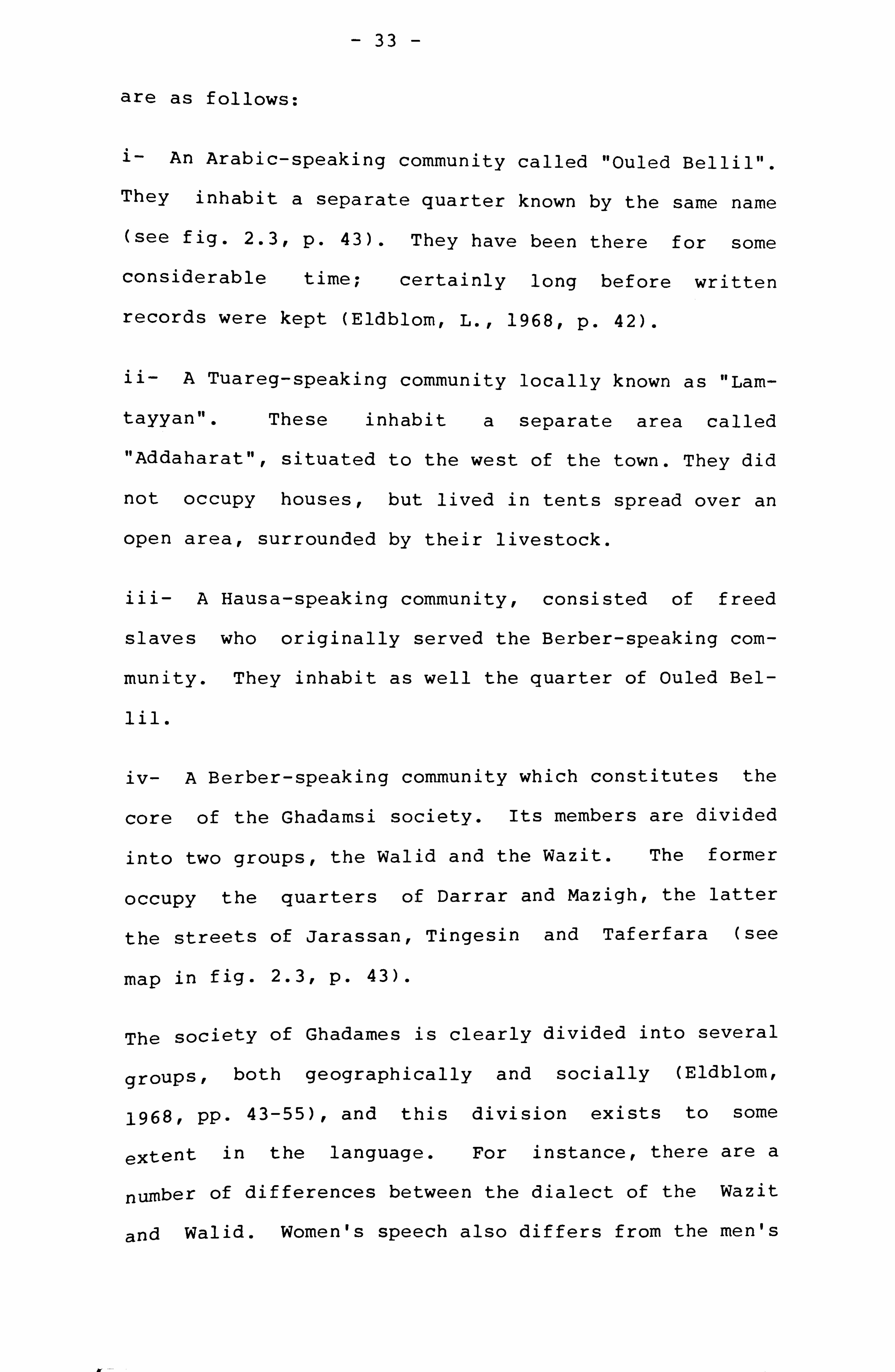
In Ghadames, there are four distinct "communities"
which, although separated by language, appear also to
be highly integrated and consolidated (Eldblom L.,
1968, pp. 42-55; Yushea B. Q. F 1973, p. 54-73). These
- 33 -
are as follows:
i- An Arabic-speaking community called "Ouled Bellil".
They inhabit a separate quarter known by the same name
(see fig. 2.31 p. 43). They have been there for some
considerable time; certainly long before written
records were kept (Eldblom, L., 1968, p. 42).
ii- A Tuareg-speaking community locally known as "Lam-
tayyan". These inhabit a separate area called
"Addaharat" . situated to the west of the town. They did
not occupy houses, but lived in tents spread over an
open area, surrounded by their livestock.
iii- A Hausa-speaking community, consisted of freed
slaves who originally served the Berber-speaking com-
munity. They inhabit as well the quarter of Ouled Bel-
lil.
iv- A Berber-speaking community which constitutes the
core of the Ghadamsi society. Its members are divided
into two groups, the Walid and the Wazit. The former
occupy the quarters of Darrar and Mazigh, the latter
the streets of Jarassan, Tingesin and Taferfara (see
map in fig. 2.3, p. 43).
The society of Ghadames is clearly divided into several
groups, both geographically and socially (Eldblom,
1968, pp. 43-55), and this division exists to some
extent in the language. For instance, there are a
number of differences between the dialect of the Wazit
and Walid. Women's speech also differs from the men's

- 34 -
and in particular some items of lexicon are only used
by the women (Motylinski, Paris, 1904, p. 67). The
division of the resident population into social groups
is mainly apparent through water ownership, land tenure
and palm trees ownerships. Eldblom gives a detailed
description of the formation of the different social
groups on the basis of the translation of the "water
book", kept in the oasis for many centuries. He also
establishes a land tenure map (Eldblom L., 1968, p. 50)
and notes that the land, water and palm trees are col-
lectively owned by the groups (Ibid, p. 114).
The terrace system, which consists of the rooftops of
the houses interconnected by a system of walkways,
exists only in the last quarters, the Walid and the
Wazit. The Ouled Bellil quarter, although densely
built as Walid and Wazit, does not present any physical
characteristics reminiscent of the terrace system: the
houses are only one storey high, the streets are wider
and not covered up, and the rooftops are not intercon-
nected.
SOURCE MATERIAL AND DATA GATHERING:
Several problems and difficulties have been encountered
in collecting data about Ghadamesr one of which is the
scarcity if not the total lack of existing useful
material about this town. The only published document
is the plan of the town produced by Eldblom in 1962.
This is an updated map of an earlier plan of the town

- 35 -
drawn in 1862 by a French expedition (Eldblom L., 1968,
p. 40).
The primary source material for Ghadames has been:
- the ground plan of the town at a scale of 1: 1000,
prepared by the Municipality of Ghadames on the basis
of Eldblom's plan, and only available locally.
-a fairly recent aerial photograph- of the town (July
1979), provided by the Ministry of Agriculture, Tri-
poli, at a scale of 1: 6000 (see fig. 2.2, p. 40).
The field survey was carried out at three levels:
i- At the level of the town: The updating of the ground
plan of the whole town which has involved the checking
of the accuracy of the map itself and adding several
missing streets and cul-de-sacs; the mapping of all
entranceways of the individual buildings and houses and
all entrance gates to the separate quarters; the
recording of building uses other than residential, and
adding street furniture, especially the built-in
masonry benches used by men.
ii- At the domestic level: Many houses have been
visited, at least five in each quarter. Plans and
elevations for ten of these houses have been measured
up and mapped. The drawings of the house plans have
been prepared locally in Ghadames, so that missing
information could be added on site.

- 36 -
iii- At the terrace level: The survey of the terraces
has posed great difficulties. No roof plan of the town
has been drawn or published so far. Inspite of these
technical difficulties, it was possible to make a full
survey of one roof area in the Wazit quarter (*).
The most difficult task in the terrace survey was to
identify a reference point, a kind of "landmark" so
that a roof area can be demarcated on the aerial pho-
tograph . Two reference points have been used, one is
the "dog-leg" passageway which is clearly visible on
the aerial photograph and the other is "Aicha's
house" , which is one of the mapped houses already
located on the ground plan and which is in close prox-
imity to the "dog-leg" passageway. From these reference
points,, an area covering approximately 30 houses has
been marked on the enlarged copy of the aerial photog-
raph , and from which an approximate plan has been
drawn. This plan forms the basis for the production of
the final map used for the analysis of the terraces.
The survey of the terrace area was carried out on three
stages. The first stage consisted of identifying the
selected area on site by walking around several times,
starting from the "dog-leg" pathway, in order to become
more familiar with its structure. The second stage was
* The reason for choosing Wazit quarter for the survey of the terraces is that the girls who were my local guides, lived in this area; so I had much easier access to the
x-ooves at any time of the day or night.
yr

- 37 - foomw
to record and mark all the parts that cannot be used
for walking, such as the voids of the upper courtyards,
light shafts and partition walls. The final stage of
the mapping was to walk around again several times, and
check where access is possible, without taking into
account detailed information such as steps to separate
houses, difference in levels, doorways to the houses,
upper front door decorations and so on. The final map
is presented in figure 2.10, p. 60.
THE BUILT ENVIRONMENT:
Very little material has been written about Ghadames.
Apart from some travellers' accounts at the beginning
of the century already referred to, such as Duveyrier,
Largeau, Motylinski, Dr Amat and the more recent work
by Eldblom, Yushea and Yedder, knowledge concerning
this town from documentary sources remains very scarce.
However, the distinctive form of housing in Ghadames
has caused some comments by visitors from the early
explorers to the present day. Duveyrier who visited
the town in 1864 described the houses as being large
and well ventilated, whitewashed to protect them from
the heat and of several storeys. He also noted that
the streets were completely covered to maintain the
temperatureascool as possible (Duveyrier H., 1884, p.
262). Davis, describing Ghadames with no reference to
the terrace system writes:
"The houses are built like those of Tozar and

- 38 -
Nefta of bricks baked in the sun, mud and palm
tree wood. The public buildings offer nothing
remarkable. The streets which are narrow scarely
admitting two camels to walk abreast, are all
covered in to keep them cool" (Davis N., 1954, p.
197).
Aymo writes that
"The form of construction is limited to the range
of building material available in the surrounding
area -mud, lime, palm trunks... -. It is a unique
architecture which has developed such a comprehen-
sive response to the climate" (Aymo J., 1958, p.
119).
Elsewhere describing the terraces of Ghadames, he com-
ments:
"The roof level reached by stairs and contains the
kitchen and a store for bedding is the domain of
women; they are the only ones who have access to
it during the day" (Aymo J.,, 1958, pp. 187-188).
Yushea on his part adds that the inhabitants of Gha-
dames have developed a house plan and a grouping of
dwelling ideally adapted to provide protection from the
inhospitable climate (Yushea B. Q. F 1973, p. 82).
These descriptions are sketchy and incomplete, and for
this researchr their value remains limited, and a more
detailed description is necessary. This will form the
main concern of the ensuing sections.

- 39 -
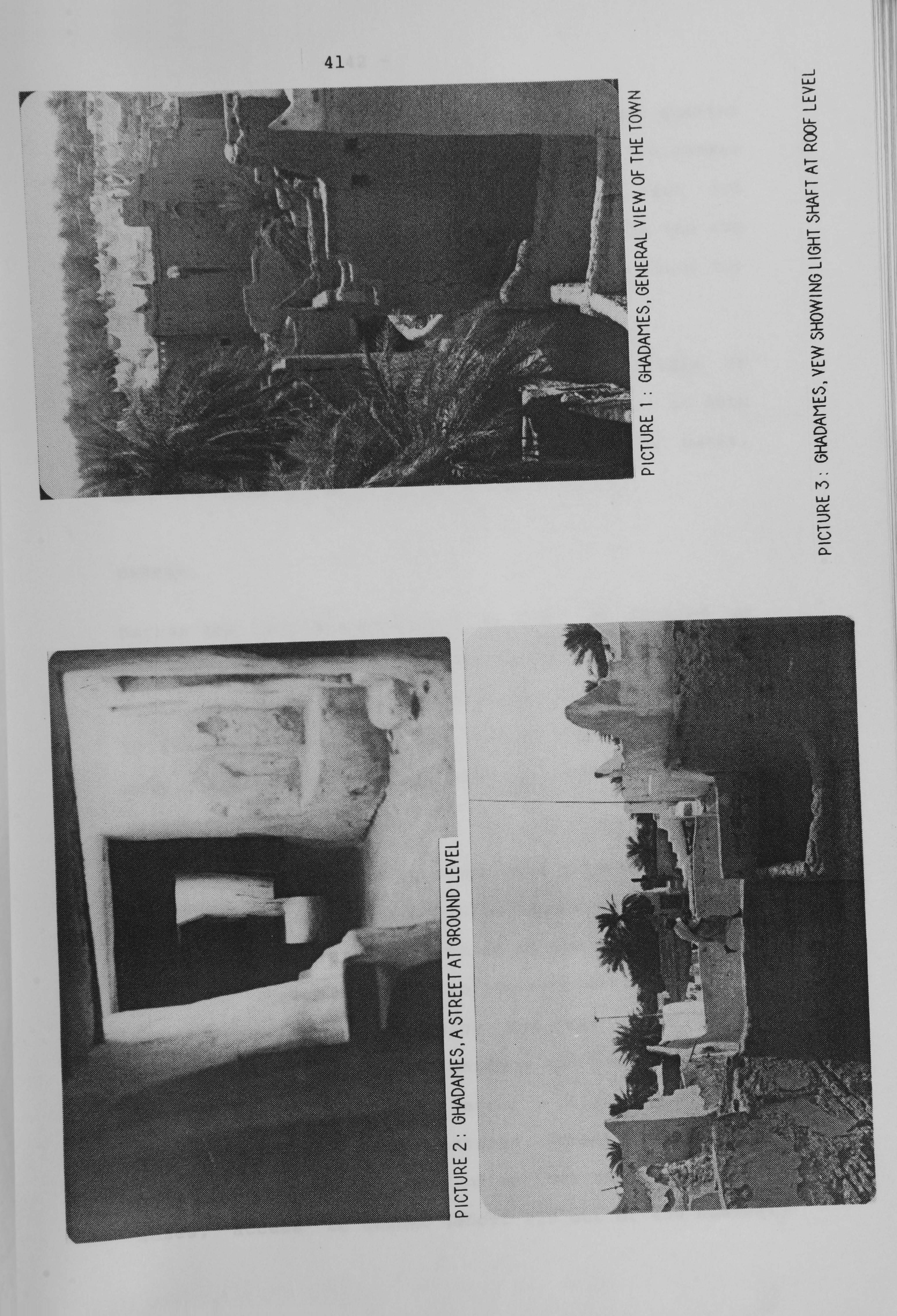
In Ghadames, the houses are grouped together to form a
very homogeneous aggregate, in which the main com-
ponent is constituted by the quarters of Darrar, Wazit
and two smaller quarters, Mazigh and Ouled-Bellil. The
first is located at the north-western side of the main
core and the second at the south (see Aerial Photo in
fig. 2.2). At about 200 metres east of Darrar, there
is another small hamlet Amaenish, which is administra-
tively annexed to the quarter of Wazit.
Ghadames presents certain characteristics that are par-
ticular to this oasis. Most of the streets in Wazit,
Darrar and Mazigh are entirely covered up and form ver-
itable tunnels, running under the houses that are in
most cases three to four storeys high (see Picture No.
1). These streets open out occasionally into covered
squares and are lit by small light wells (Tenawt) in
the roof overhead (see Pictures Nos 2.3). The major
streets are usually two to three metres wide and are
furnished with built-in masonry benches (Tasquimott)
along the external walls of the houses. These are used
by the male population for their meetings (Yushea B.
Q., 1973, p. 75).
The location of the settlement seems to
by the proximity of the main water sourc
of Ain Al Farras, which is only at 100 m
geographical centre, occupied by the
known as Suq El Gaddous. This latter
limits of the Walid and Wazit quarters,
be influenced
e, the fountain
away from the
market square
indicates the
which are con-

4 --
&mW
. 11,
Lt I
F "f -- -. -
ilk
ob
FIG. 2.2: GHADAMES AERIAL PHOTOGRAPHY ,
41
JLJ
2L
Li
D
3. - -Li
z LJ
LLJ
LAJ cc :D
U-
LLJ

- 42 -
nected only by means of a single gate from each quarter
that used to be kept locked at night. The market
square (10 x 15 metres) is bounded up at the east and
the west by the two main mosques attributed to the two
quarters, jamaa Atikh for the Walid and Jamaa Yunes for
the Wazit (see Town Map in fig. 2.3).
The Tuareg settlement is situated outside the walls of
the town, at the western part of Ghadames, and on both
side of the road that leads to Tounin, a small oasis,
at 2.5 kilometres west of Ghadames.
DARRAR:
Darrar the largest quarter of the town, is located at
the northern part, and joins to Mazigh and Wazit at the
south (see Ground Plan in fig. 2.4). It is constituted
by 450 houses approximately, grouped together to form a
very compact aggregate occupying an area of approxi-
mately 4.5 hectares.
The access to Darrar is through five gateways, one of
which is from the main public square of the town and
links the quarter to the outside of the town. It is
therefore the only access to the visitors. The second
gateway links Darrar to Mazigh and the three others
link the quarter to the gardens and the agricultural
fields. The ground plan of Darrar in figure 2.4, shows
a very irregular and tortuous street network which
demarcates blocks of houses of various sizes. In many
cases, access to houses (about 230 out of 450 houses)

FIG. 2,3: GHADAMES, GROUND PLAN
t zigh -o Mat
44
to gard, ýfis , 7%
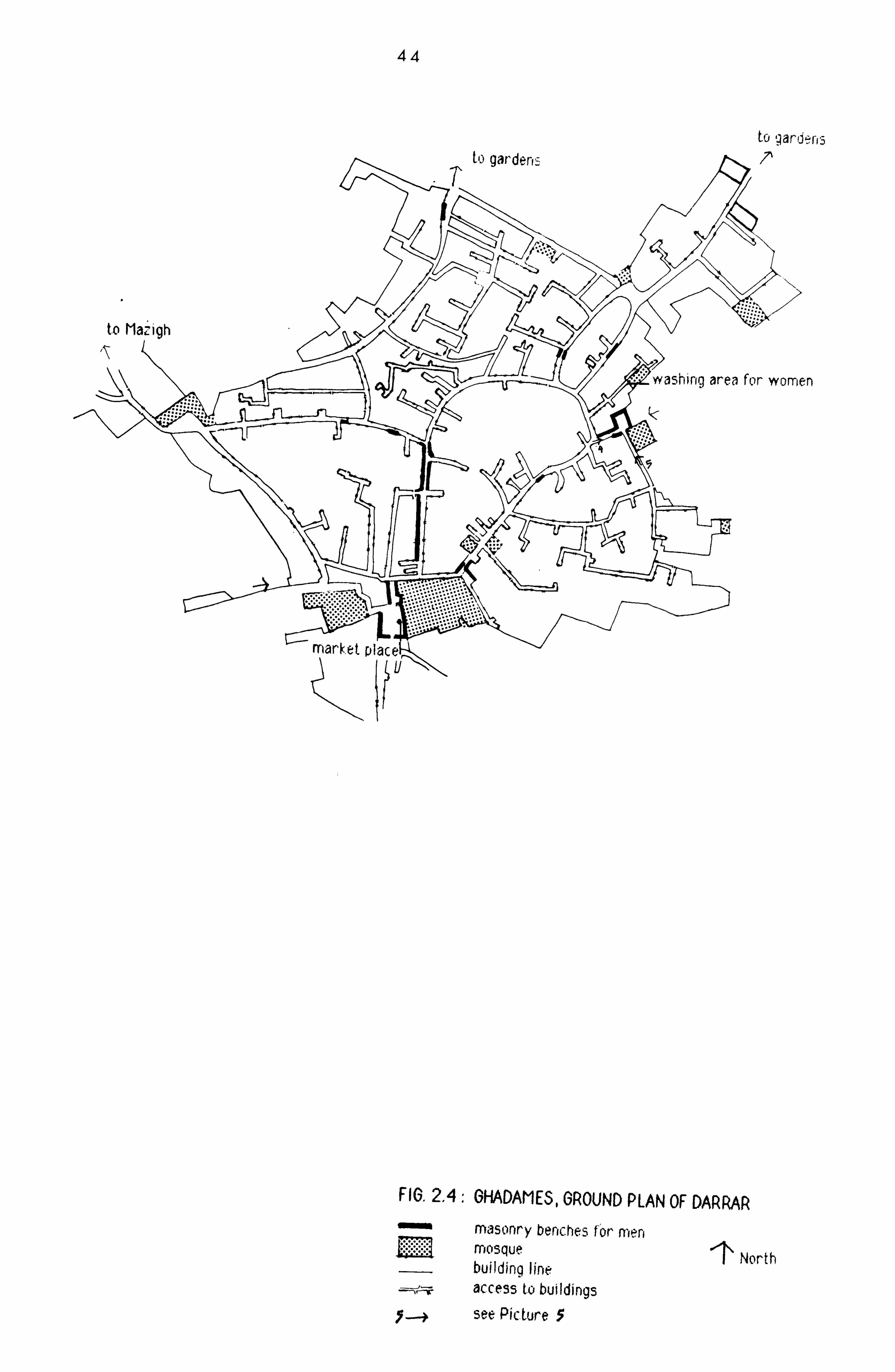
wa--shing area for women
(K
to gardens
FIG. 2.4: GHADAMES, GROUND PLAN OF DARRAR masonry benches for, men
North mosque building line access to buildings
Y--+ see Picture 5
mark. et piaceý
- 45 -
is gained by narrow and very dark cul-de-sacs, forming
a rather labyrinthine pattern. The ground plan shows
also the limited number of the public buildings and
spaces, including mosques, washing areas for clothes
and kitchen utensils, public baths, and several commu-
nal sheds mainly to house goats. Most of these facili-
ties are located at the periphery of the quarter. The
main mosque at the southern edge of the quarter is
adjacent to the main public square of the town, but has
its entrance on the adjoining street of the quarter
rather than on the square itself. Four smaller mosques
used also as men's houses are distributed around
the periphery of the quarter. The female washing area
is located at the joining point of Darrar to Mazigh,
together with by a small mosque reserved f or women's use
from both quarters.
The plan also indicates the street furniture, or more
precisely the built-in masonry benches locally termed
"tasquimott", where men sit and even have their siesta
during the hottest hours of the day (Yushea B. Q., 1973,
p. 75). These are mainly on the streets which run from
the main mosque towards the interior of the quarter,
and along the street which runs in the direction of the
joining point of Mazigh and Darrar. Other benches are
built close to the entrance gates of the quarter. In
addition to the main public square, two other smaller
squares are built at the eastern and western periphery
of Darrar. Pictures 4 and 5 show views of the square
which is totally covered up by an arcade, and on which

- 46 -
gives a small mosque. The masonry benches are con-
structed all around the perimeter of the square. The
other square is also covered up and is bordered by a
mosque.
WAZIT:
Wazit is the second largest quarter in Ghadames (see
fig. 2.5). It comprises about 350 houses, 136 of which
are serviced by cul-de-sacs, and occupies an area of
approximately 2.5 hectares. This quarter expands
linearly southwards of the main town square, and has
six entranceways, one of which is from the main public
square. The second main entrance point is at the meet-
ing point of Bellil quarter to the south. All the
other gateways link the quarter to the gardens and
fields. The main characteristic of this quarter is the
long street (about 400 metres) known as "Jarassan
street" which forms a sort of a "dorsal spine" running
north-south across the quarter and from which branch
all the other streets. Picture No. 6 shows a view of
this street, along which masonry benches are built.
These are wide enough and are used as sleeping area
during the day by old men. on this street are two
squares entirely covered up. Picture No. 7 shows a
view of these squares with built-in benches which are
used as meeting places for men of this quarter.
The ground plan shows in addition to the main mosque,
three smaller mosques located at the periphery of the

47
PICTURES 4,5: GHADAMES, COVERED SQUARE IN DARRAR FITTED WITH MASONRY BENCHES

-1\ T3"ket Place
Jarasen street I-
FIG. 2.6,6HADAMES, GROUND PLAN OF MAZIGH masonry benches for men mosque N buildina line access to buildings see Picture 9
48
Yva5hing area for womer,
FIG. 2,5: GFIADAMES, GROUND PLAN OF WAZIT see Picturp 6-
to gardens V--
irveyed house
washing area for women
to Darrar

Q
entrance to washing place on the left for women
PICTURES 6,7,8, GHADAME5, VI EW5 OF STREETS AND SQUARE IN WAZI T

- 50 -
quarter. A washing place for women is also provided
(see Picture No. 8), and the goats house is located at
the eastern edge of the quarter.
MAZIGH:
It is a very small quarter, constituted only by 178
houses. The quarter expands linearly towards the north
and is linked to the outside by means of five gateways,
one of which links this quarter to Darrar (see fig.
2.6, p. 48). The other gateways connect Mazigh to the
palm grove gardens. The main streets in this quarter
form one large ring, on which are attached several
cul-de-sacs. The street which runs from Darrar through
Mazigh is fairly regular and is furnished with several
masonry benches built at different intervals from each
other. Picture No. 9 shows a view of this street with
dark atmosphere prevailing in it. The pictures are
taken from the sections of the street that are lit by
means of shafts in the terraces overhead, giving occa-
sional light and ventilation. The public facilities in
this quarter consist only of one mosque with the wash-
ing area, a communal wood storage and the communal
stable, all located at the eastern periphery of the
quarter.
BELLIL:
Bellil is the only quarter of the town where the ter-
race system is not developed. Unlike the other areas,

PICTURE 9- GHADAMES, A STREET IN MAZIOH
,E 17: 1(3HAL)AI-I t 3, YIr YY VI
PICTUP

- 52 -
the streets in Bellil are not covered up and are not
furnished with masonry benches. The quarter takes a linear development with the largest street located at
the periphery (see fig. 2.7). Part of this street is
constituted on one side by the remains - of the town
walls. It links on one extremity to Wazit on "Jarassan
street". At the linking point, a mosque and a public
square are situated. Two other smaller mosques are
built on the peripheral street.
The quarter contains about 195 houses, all of which are
one storey high and are built around a courtyard.
According to Etherton, in Arab towns, when the houses
are only a single storey high, the courtyards of the
individual houses interconnect to each other "so that
women can pass from one to another without having to
walk in the streets" (Etherton D., 1971, p. 174). This
is not the case in Bellil. The mapping of all existing
entranceways to houses shown on the ground plan in fig-
ure 2.7, as well as the visits to their interiors dis-
closed no internal links between houses. The plan of
one house in this quarter and inserted in figure 2.8
shows an almost random disposition of the rooms around
an interior open space, with a yard used as a stable at
the rear of the house. The kitchen, the living room
and bedroom have their access from the central open
space. A staircase links the ground floor to the roof
terrace used in summer for sleeping. The terrace is
surrounded by a parapet of about 2 metres high, and no
link with other terraces exist. However and unlike the
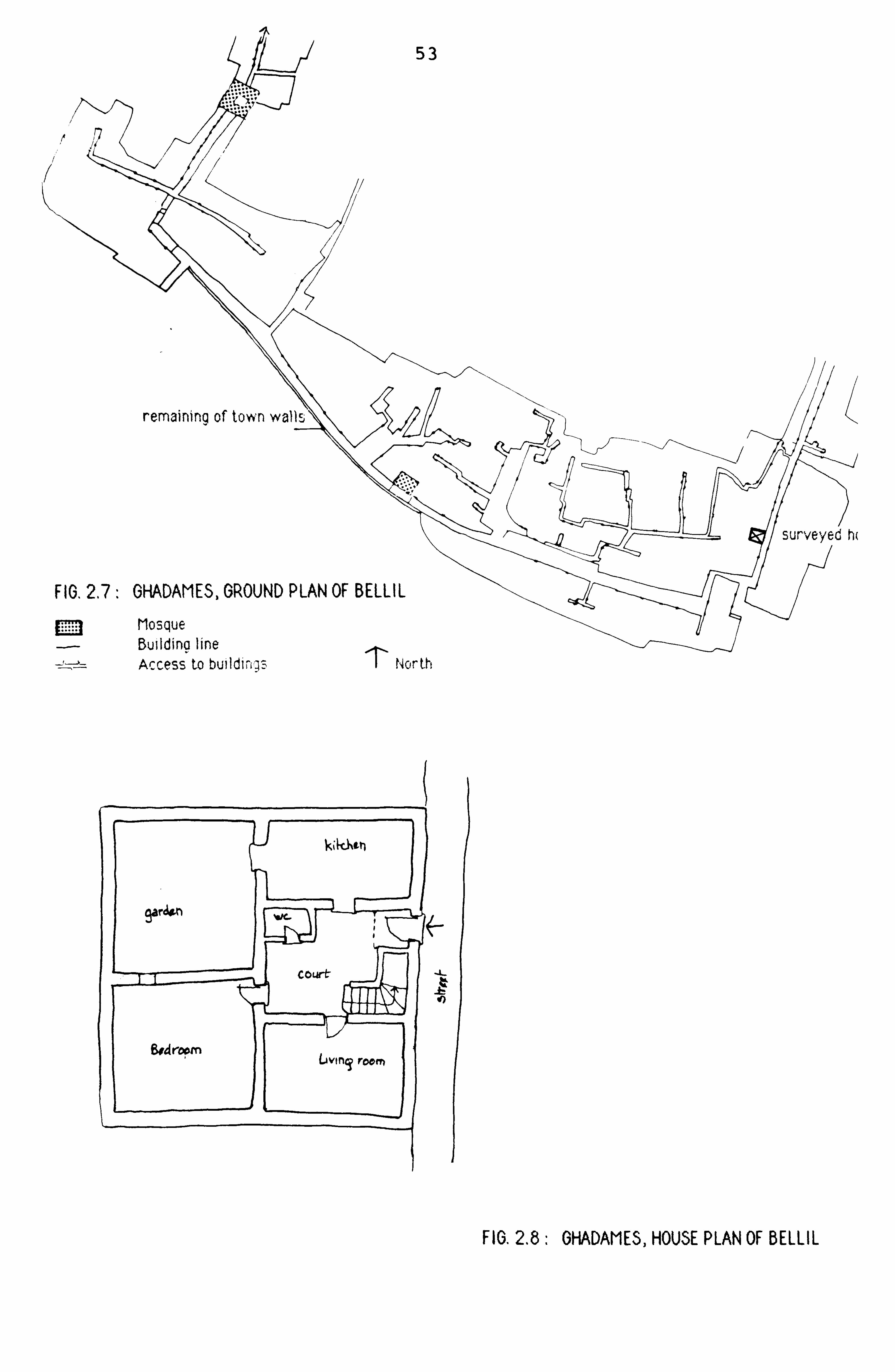
4z qf)
FIG. 2.8: GHADAMES, HOUSE PLAN OF BELLIL
Access to buildiings I Nor th

- 54 -
three other quarters, it is the only area where women
gather on the streets outside their homes unveiled (*).
DESCRIPTION OF THE HOUSES IN GHADAMES:
The following description is based on visits to
numerous houses and on the visual inspection of 10
house plans taken from the different parts of the
separate quarters. The location of these houses is
marked on the ground plan of the town. This section is
concerned only with the description of the houses in
the quarters where the terrace system occurs.
With the exception of Bellil quarter, the houses in
Ghadames consist of three to four storey buildings.
These are invariably built around a central living
room, acting like a courtyard. On entering the house
(see House Plan in fig. 2.9) from the street, one finds
oneself in a small hall (locally termed ajard). On one
side or on both of this, is situated one or more store
rooms (taddart) fitted with doors, where agricultural
implements, tools, charcoal, wood are stored. Sometimes
one of these rooms is used as reception room for the
male guests. At the far end of the entrance hall is
situated a staircase which leads to a door giving in
* During the site survey, in the streets of Bellil
came out of their homes to
unveiled. one of the wo:
measuring tape, when I was
plan for this area.
I was greeted by a group of women area. Several women and children meet me and gathered outside, all
men has even helped me holding the checking and updating the ground

55
Mew Itoom I. I
OWAMeJ tint L-A Wat
CYJ',,. "Li FL00P
ECOND FLOOP
'o-f u? at, poy- -
t_i
THIPD FLOOP
FIG, 2.9: GHADAMES, HOUSE PLAN

- 56 -
the central living room (tamanalt). There is always a
bend in these stairs so that, even if the main door and
the door of the central living room were both open, one
could not look into the central living room from the
ground level streets. At the top of the stairs, there
is a small landing and off this there is another
smaller door leading to the toilet. In most of the
visited houses, on this landing there is a recess in
the wall which is richly decorated with wall paintings
and containing water jars. The toilet is usually a
small low ceiling room with a toilet hole in the floor
linked to the cess-pool. This is emptied once a year
by breaking through one of its walls from the storeroom
or directly from the street.
The large central living room constitutes the heart of
the house. It is lit by means of a large unglazed
skylight situated in the centre of the ceiling (see top
floor of House Plan), its walls are richly decorated
with painted designs and its floor thickly covered with
mats and rugs. Set into the walls are numerous small
cupboards closed by means of sculptured and painted
wooden doors. The main wall of this room, usually
opposite the entrance door from the street, is
decorated with suspended ornaments (mirrors, brass
trays, brass vases, woven dish covers). Giving off
this central living room are two or three other rooms,
the most important one from the point of view of the
marriage ceremony is called "Alkubba" (see House Plan
in fig. 2.9). It is a small room with no windows and

- 57 -
its arched entrance is closed simply by means of cur-
tains. It is here that the consummation of the mar-
riage takes place, and it is also here where the wife
will mourn her dead husband for three months without
setting foot outside the room (Yushea B. Q., 1973, p.
77). In this situation, food and other services (such
as bringing the grieving woman water and soap for wash-
ing) are provided by her female relatives or neighbours
via the roof terraces (Ibid, p. 78). Either on the
same side or opposite the "Alkubba" is another room,
sometimes windowless but sometimes lit by means of one
or more small light-hole giving onto the central room,
or into the street by means of a small window giving
onto the light-well of the streets at ground level. It
is used for sleeping and storage. Along another wall,
running for about half its length, is a raised masonry
platform, of 1 to 1.5 metres and perhaps 1 metre deep
(see House Plan, fig. 2.9). reached by means of several
steps at one end. Sometimes, this platform also gives
access to another room where all the most precious
household belongings are stored. On the other side of
the central room to the entrance door from the raised
platform, is another staircase leading up to the upper
roof terrace. A short distance up this staircase,
there is a small door which leads into a fourth room.
This is where all the basic food stores are kept, such
as wheat, barley, dates and olive oil. This room usu-
ally has a small window giving onto the central living
room.

- 58 -
Further up the staircase, which winds its way towards
1. ý. -) XF ýS
the r-oc>'ves is situated another storeroom, where a
hand-quern (see House Plan, fig. 2.9) is often
installed at easy reach to female neighbours who do not
have one. Continuing upwards, one reaches another door
which obstructs the stairs. These continue beyond the
door, now open to the sky, for a short distance until
one reaches a small landing, from which one gains
access to the kitchen and opposite the kitchen door is
the way onto the courtyard roof terrace. The kitchen
is fitted with two or three open hearths, several
built-in bread ovens, racks for utensils and a smoke-
hole in the ceiling.
In the centre of the courtyard roof terrace is the open
skylight, protected by an iron grille, which lights the
central living room below (see House Plan, fig. 2.9).
Giving onto this courtyard terrace are one or two small
rooms used for storage and in particular for putting
the bedding during the daytime when the entire family
(men and women) sleep in the courtyard terrace during
the hot summer nights. If there is another room, this
is usually very small, and used for keeping chickens
and pigeons (tarfu). On the courtyard roof terrace,
there is usually a wooden frame consisted of four
uprights with a lattice on top, on which vegetables and
meat may be placed for drying, or food may be kept cool
during the night out of the reach of cats.
A small staircase leads up from the courtyard roof ter-

- 59 -
race to the upper terraces exclusively used by women.
DESCRIPTION OF THE TERRACES:
Figure 2.10 shows the roof plan for the selected arear
in which all spaces used for circulation are
represented in solid black, and the courtyard roof ter-
races left in white. The upper terraces are at about 3
metres higher than the level of the upper courtyards,
and their access is gained by means of steps. In some
cases, the steps and as Picture 11 shows, take the form
of veritable staircases. The terraces are made up of
narrow pathways, which run along the tops of the parti-
tion walls separating the different houses. They are
not wide enough to allow two people to pass abreast
(see Pictures Nos 10 to 15), but every few metres they
widen out onto the upper terraces, which may be either
on the roof of the kitchen or on one of the other small
rooms that are situated around the perimeter of the
courtyard roof terrace or on both. The plan in figure
2.11 shows the complexity of the terraces' configura-
tion. From the surveyed house, one gains access to the
roof which is bound by a wall of 0.40 metre high. This
roof is connected on two sides by the narrow footpaths,
one of which takes the form of a small street (see Pic-
ture No. 16), 6 metres long and only 0.65 metre wide.
In some cases, a house can be fully surrounded by walk-
ways. These spaces, the narrow pathways and the wider
upper roof terraces, link together to form a very com-

60
IL
-I
Walkway at terraces Limits, of houses Skylight Light shaft for streets below at ground floor
0
FIG. 2.10: GHADAMES, ROOF PLAN

7: 7
P ICTURE5 10 TO 12: GHADANE5, WALKWAYS AT ROOFTOP LEVEL

62 I
LLJ
LLJ I
Cl- C)
L. A-
L. Lj cr-

63
FIG. 2.11 : GHADAMES, ROOF PLAN FOR A SEPARATE HOUSE mm Roof area for women's circulation 16 --- see Picture 16
PICTURE 16: A 5NALL "5TREET "AT ROOFTOP

- 64 -
plex structure (*).
All these terraces play an important role in the every-
day life of women as well as in special occasions such
as we ings, birth announcements (Yushea B. Q., 1973,
pp. 186-196). only the women have access during the
day,, to the upper terraces and their footpaths, and
here they can sit singly or in groups, doing their
domestic chores (i. e., wool spinning, sewing and
embroidery, cleaning the corn before grinding it, etc. )
or simply talking as shown in Picture No. 10.
Men may go there only once a year, on the morning of
the feast of "Aid Al-Adha" in order to look at each
other's sacrificial animals, which are slaughtered on
the courtyard roof terrace, and to check whether any
repairs need to be carried out to the roofs and the
pathways. During this whole morning, the women will
remain below in the houses (Yushea B. Q., 1973, p. 83).
The women can of course also use the ground level
streets, but then they must be veiled and in practice,
it is mainly the old women, who are frail and can no
longer safely use the narrow paths who do this.
it is extremely difficult to know where one is on the
rooves. I asked one of the girls if she can indicate where her house is from the rocfs-- -,. She pointed to the irregular
pattern of the rooves and walls, and said: "Mabruka lives in
front there, Um El Kheir lives in that house beyond that
large roof area, and further on, where that curved wall is
in the direction of the mosque, that is where I live".

- 65 -
CASE STUDY TWO AND THREE: THE MZAB TOWNS, GHARDAIA AND
BENI ISGUEN
THE GEOGRAPHICAL CONTEXT:
Chebka, the Arabic word for net, is used to describe
the Mzab region of the Sahara at 600 km south of
Algiers, capital of Algeria. The hostile "chebka" is
sited on an eroded plateau called "Hamada" (see Loca-
tion Map in fig. 2.1, p. 27). In the heart of this
region, the Mzab river traces a dry course through its
valley, rising once in about two or three years after
exceptional rainfall. Rain falls on an average of ten
days a year and in the hottest months, temperatures
reach a maximum of about 46 degrees centigrade. The
minimum temperature registered is about 2 degrees cen-
tigrade (Station de Meteorologie de Ghardaia).
HISTORICAL AND ECONOMIC BACKGROUND:
A thousand years ago this valley, avoided even by
nomadic tribes, because of its lifelessness, was chosen
by the Ibadhites as the site for their new settlements
(Etherton D. r 1971, p. 186).
The "Ibadhites" belong to an Islamic sect similar to
the "Kharijism" (in Arabic kharij means dissenter).
This schism emerged in the 7th century and had as ori-
gin the Prophet's succession (i. e., Addoun A. D., 1977,
p. 85). Ali, the Prophet's cousin and son-in-law was
proclaimed as the fourth Khalif. During this
- 66 -
succession, Mouawia, governor of Syria, pretending also
to Khalifat, declared war against Ali. During the bat-
tle of Ciffin in 657, in order to avoid bloodshed, Ali
accepted Mouawia's proposition which consisted of the
submission of the case of succession to some chosen
judges (Ibid, p. 87). Here, some of Ali's partisans
refused this proposition in the name of the orthodoxy
of the Qoranic law which states that "The judgement
belongs only to God... " (Ibid, p. 87). These partisans
formed therefore the "Kharijit" sect.
Many versions exist in the historic literature on the
origin of this dissension, but the most popular is
linked with the Prophet's succession. For example,
some historians argue that the Ibadhite sect existed
well before the conflict between Ali and Mouawia, and
assign its origin to the death of the Prophet. At that
period twenty one main tendencies arose; some of the
Muslims proclaimed that the "Khalifat" (the Prophet's
succession) should legitimately belong and remain in
the hands of his lineage - Ali for example. Others
sustained a democratic tendency, which considers that
every Manmay be elected Khalif by
the community (i. e. Addoun A. D., 1977, pp. 85-88).
This may have resulted in the first split of the
Ibadhites from the other Muslims. However, this diver-
gence may not be the real reason for the emergence of
this specific sect, largely because, according to Ibn
Khaldun, the "Immamat in the Rostomid state", which was
Ibadhite, lasted through many generations in the hands

- 67 -
of one lineage: Ibn Rustom' affiliation (Ibn Khaldun,
trans. De Slane, 1856 and 1934, pp. 126-140).
Whatever the nature of the conflict, it ended by a
dissension and constitution of the Ibadhite sect.
Since then, the Ibadhites suffered from a long persecu-
tion by other Muslims (Addoun A. D., 1977, p. 87). They
were first expelled during the 8th century from Iraq.
Ibn Rustom, their leader, founded the kingdom of
Tahert, the first Ibadhite settlement in Algeria. This
Rustomide state flourished quickly and lasted for more
than a century and a half. Tahert, the capital was
destroyed after the Chiit Fatemide aggression in 909,
and the Ibadhites fled to Wargla (i. e. Donnadieu and
Didillon, 1977, p. 29). Sedrata was built nearby as
the first new Ibadhite town in the Sahara. It was well
sited for trade and quickly attracted other persecu-
tors. Sedrata was destroyed in 1075 (Ibid, p. 32).
Hence, the doctrine ceased to play a historical role in
Algeria and is only represented by a few communities in
the Mzab valley (Ibid, p. 33).
Until 1878, no stranger had set foot in a Mzab town,
and even today, visitors to Beni Isguen must leave
before sunset (Donnadieu and Didillon, 1977, p. 56;
Etherton D. F 1971, p. 187).
The survival of the Mzab cities and the expensive
upkeep of the oases is mainly dependent upon temporary
and regular emigration to the north of the male popula-
tion, working there mainly as shopkeepers (i. e.

- 68 -
Etherton D., 1971, p. 187). The migrants sent money
home where it was invested in land, palm groves and
houses. As the capital and chief market, Ghardaia pro-
gressively enlarged its horizons and became integrated
into the saharan commercial network and eventually
established itself as a major transit centre. The Mzab
has recently benefited from the exploitation of
petroleum resources in the neighbouring areas, which
were opened up to development just when there was a
serious crisis in nomadism. In addition to income
brought back through emigration, numerous local commer-
cial activities have recently prospered. In Ghardaia
only, around four hundred business entreprises may be
counted, and over seven hundred in the whole valley.
This figure represents approximately one for every
fifty inhabitants. With its 1500 businesses employing
6000 heads of families, this society has maintained a
preponderant place in the commerce of the Sahara.
Moreover, 5000 of the commercial establishments located
throughout the whole country and employing about 20.000
persons are owned by these people (National Census,
1976).
For a long time the Mzab valley remained stable but now
it is facing demographic growth, economic modernization
and changing way of life. The population of the five
towns continue to increase. They now total more than
60.000 inhabitants of which about 35.000 live in Ghar-
daia and 12.000 in Beni Isguen (National Census, 1976).

- 69 -
The whole valley has about 200.000 palm trees grouped
in separate plantations near each town. Within each
palm grove, less dense residential districts were
built. At the hottest time of the year, it is the cus-
tom for most of the population to leave the towns and
move to the summer residences. Shaded with apricot,
pomegranate and palm trees, the streets and houses of
the summer quarters are cool and provide accommodation
for about five months. In the plantations, agriculture
is practised at three levels. on the ground, the soil
is reserved for crops and vegetables. The second level
is the fruit trees and the third level is the date palm
tree.
Nearby each town, vast spaces are occupied by or
reserved for cemeteries. For religious reasons, these
spaces are inalienable; and this fact has prevented the
growth of the towns in the direction of these sacred
areas. 6
Availability of water is a prime determining factor for
settlement since agriculture and human beings require
sufficient supplies of fresh water. In areas where the
average annual rainfall is regularly less than 100mm,
water must be obtained below the surface of the ground.
The most important water table of the Sahara, the
Albien, is located in the permeable sandstone of the
continental intercalcaire.
The water from this underground water table supplies

- 70 -
more than 3000 wells. It is distributed among the
oases and the individual gardens by a network of irri-
gation channels, the width of each channel being appor-
tioned to the size of the family and garden. The dis-
tribution of water to the individual houses was under-
taken by professional porters (Donnadieu and Didillon,
1977, p. 45).
THE SOCIO-POLITICAL AND RELIGIOUS STRUCTURES IN THE
MZAB:
Much of the ensuing was derived from the work of Bour-
dieu "Sociologie de l'Algerie", and Addoun's "Sociolo-
gie et Histoire des Ibadhites" (Bourdieu P., 1958, pp.
43-58; Addoun A. D., 1977, pp. 19-56). These social
structures refer mainly to the traditional ones, and
the question of their importance in everyday lifestyle
and social relations remains open. At the present
time, the Mzab towns are integrated within the National
administrative and institutional system.
The extended family: The basic indivisible component is
a group of persons of the same name, descended to the
fourth or fifth generation from a common male ancestor.
The extended family is a kin-based unit of production
and consumption. Men generally practice the same trade
and work together. The goods of the extended family
are joint possessions and are intended for individual
use but not for individual ownership (Bourdieu P.,
- 71 -
1958o, P. 48).
The Clan: Such institution groups together several male
members of the extended families. Generally a clan has
its own cemetery named after the ancestor, worshipped
every year by a ceremony grouping the whole members of
the clan. one member (a man) of each extended family
represents his "unit" at the council of the clan, which
takes care of the common interests such as collective
work, drawing water, destiny of widows and adoption of
orphans, protection of the old and organisation of fes-
tivities, inflicting of punishment or penalties. For
instance, in Ghardaia there are two clans: the Ouled
Ammi Aissa and the Ouled Ba Sliman. Beni Isguen has
three clans, one of them is named Ouled Anan (Ibid, p.
48). There is no evidence that the clans have any spa-
tial reference points.
The Soff: Within the towns of the Mzab, the different
clans are grouped into two soffs: the soff Chergui, the
Eastern soff and the soff Gherbi, the Western soff
(Donnadieu and Didillon, 1977, p. 56). These soffs are
not kin-based nor spatially defined units and may be
compared to political parties. Each family could
adhere to the one or the other soff according to its
options with the possibility of change. But in any
case there is no individual adhesion. Each soff strug-
gles for supremacy. Frequently, these fights have pro-
voked civil war, which sometimes ended by a complete

- 72 -
exclusion of a soff. It might be so that Berriane and
Guerrara, two other Ibadhite towns at 10 kilometres
away from Ghardaia, came into existence (Bourdieu P.,
1958, pp. 47-48).
The Djemaa: Each "clan" elects its own "Mokkadem" to
represent it, and these men together form the "djemaa"
of the city. The city council for Ghardaia, "the
djemaa", would formally meet at the "haouita", an open
area situated at the market place and whose boundaries
are demarcated by twenty-six stones collected from
specific tombs (Mercier M., 1923, p. 87). This council
designates among its members a chief called the "hakem"
and his "naib", the "vice-hakem" (Bourdieu P., 1958,
pp. 48-49) . Normally the Naib is chosen from the soff
opposite to the one to which the "Hakem" belongs. The
Djemaa takes care of the problems of the whole commun-
itY, such as the construction and maintenance of public
facilities (i. e. irrigation systems, the mosque, the
school etc. ), penalties, town festivities. The D3emaa
has a police, town guards under its orders (Ibid, p.
49).
In parallel to this secular organisation, a re igious
one exists as well. The clergy or "tolba" represent
the spiritual elite of the town; they are divided into
two groups: the major clergy, the "sheikh", and the
minor clergy (Ibid. p. 48; Morand M., 1910, pp. 419-
453). The minors take care of teaching the Qoran to
the young pupils. They can accede to the rank of sheikh

- 73 -
and even to "Azzab" which is the highest person in this
religious hierarchy.
For all questions of importance, the "secular" and the
"religious" meet at the mosque in the presence of the
"Halqua", a council constituted of twelve representa-
tives of the major clergymen, directed by the sheikh
Baba, chosen among them to be the local religious
leader. Each member of the "Halqua" is attributed a
particular responsibility. The "Muedden" calls for
prayer, the "Imam" directs it, some of them are in
charge with the education of the children, others with
burial rites. The "Qadi" has the task of judgment,
which is based both on the Qoran and the Ittifaqatt,
the written book of the Mzabite customs and laws (Bour-
dieu P., 1958, pp. 48-49). The "Halqua" is granted the
power of excommunication, "ettebria" , the supreme pun-
ishment equivalent to a social death of the guilty per-
son (Ibid, p. 49).
This predominantly male organisation, especially the
religious one, can be characterised as hierarchical.
Only one female group is attached to these institu-
tions. This is called the "Timsiridine" or the "Azza-
bat". which groups the "matrons" of the town (Addoun
A. D.,, 1977F p. 54). These women are appointed by the
town council and their duties are to collect informa-
tion from women when required, to check their behaviour
and pregnancy, and are also in charge of the ritual
"bathing" of women corpes, which is considered as the

- 74 -
last blessing before burial.
THE STATUS OF WOMEN IN THE MZAB:
The women of the Mzabites are reported to lead a
strictly regulated life (Ibid, pp. 35-39).
It is said that the man has complete authority over the
women, and the father can force his daughter to marry
unless she has previously been divorced (Gordon A. C.,
1968, p. 17). Provided a man lodges his wife comfort-
ably and devotes a certain amount of time to her, it is
claimed that he can keep her bound to the house. Mono-
gamy is the general rule, although the husband can
repudiate a wife and then remarry. Goichon tells a
story of a Mzabite leading woman who, taking advantage
of the tradition that requires a corpseto be ritually
washed by specially designated women, the "Timsiri-
dine", before the body can be considered consecrated,
organised the women "washers" into a kind of inquisi-
tion (Goichon A. M., 1927, p. 67). Masqueray reports
that:
"It must be recognised that the women are in a
real state of inferiority. Islam is the reason.
it is the Islam which has put down the African
woman. Todayr in the Mzab, the clergymen force
them to never leave their homes" (Masqueray E.,
1879, P. 80).
Donnadieu and Didillon write that the Mzabite society

- 75 -
is amongst the strictest concerning the wearing of the
veil (*) and the seclusion of the woman (Donnadieu and
Didillon, 1977, p. 70).
From these accounts, it becomes clear that the relation
between the sexes and the social status of women in
these societies is described most consistently and is
explained most explicitly within the realm of religion.
When the question of male-female relationship is
evoked, it is mainly expressed in terms of the "male-
superior and female-inferior" paradigm. Islam is seen
as male in its most public, most formal organisational
aspects.
Islamic laws and traditions are frequently evoked to
account for behaviour among Muslims, particularly the
behaviour of the sexes (The Qoranr Surah IV, "Annisa",
Women). This may have promoted a far too
simplistic but widespread opinion, namely that Muslim
women occupy a position of absolute subjugation; that
they are completely under the omination of men, con-
trolled within the family by their fathers, brothers,
and later in marriage by their husbands. Furthermore,
it is believed by many that they have but little
knowledge of and no influence on the wider working of
their society (i. e., Cromer Lord, 1928, p. 65). They
* The Mzabite women do not remove their veil in a male presence, not even to take identity photograph for official documents. In fact, they are the only women in Algeria al- lowed by governmental decree to keep the veil for their
passport photographs.

- 76 -
appear to be without a say in public matters, unable to
take action in politics, and prevented from doing so in
the religious fields, as women cannot hold religious
offices. Muslim women are thought of as almost non-
existent within the public sphere, kept out of sight in
confinement within the protective walls of their homes
or "invisible" when heavily veiled, they move outside
these.
In most studies on social structures of these towns,
emphasis has been mainly placed upon the normative sys-
tems,, and very little reference has been made to every-
day life, nor to the differential uses of the settle-
ment space by the sexes.
DATA GATHERING AND SOURCE MATERIAL:
Several techniques were used in gathering the data for
this study. They included an extensive field research
conducted in the two towns, Ghardaia and Beni Isguen,
as well as a library research. National archives and
cartographic institutes in Algiers were consulted for
historical records. Several interviews and discussions
were held with different persons, men and women.
The primary source material for the Mzab towns has been
all the maps drawn at a scale of 1: 1000 by "l'Atelier
du Mzab" in 1976. These are complemented by the latest
aerial photographs of the towns provided by the
National Institute of Cartography in Algiers. These

- 77 -
documents formed the basis for the site surveys which
involved the updating and checking of the ground plans
for Ghardaia and Beni Isguen, and a recording of the
public buildings and street furniture. Visits to
houses were also undertaken, and about 30 house plans
at a scale of 1: 50 were also provided by the "Atelier
du Mzab" in addition to plans of some public buildings
such as mosques, market places.
The survey for the terraces was focussed on one area
located in the old part of Beni Isguen. A roof plan at
a scale of 1: 1000 of this area was available at the
"Atelier du Mzab" and visits to terraces were possible
in Beni Isguen because the author had a local contact
in this town. Similar contacts were not possible to
establish in Ghardaia, though occasional visits to the
rooves were also permitted. The survey consisted
mainly at checking the roof plan and recording accesses
between separate terraces.
THE MZAB TOWNS: A PERSPECTIVE INTO PAST STUDIES
A review of the existing literature on the Mzab settle-
ments shows the existence of a large amount of material
which covers a considerable time span, from 1830 to the
present time and ranges from travellers' accounts to
more specific studies. But a great deal of these con-
tributions were mainly in the form of broad surveys on
historical and social aspects in these settlements
(i. e. Huguet Dr, 1906; Bourdieu P., 1958; Merghoub B.,

- 78 -
1964; Addoun A. D., 1977). Past studies on these towns
have focussed on specific problems ranging from geolog-
ical explorations (i. e., Ville, 1872) to religious con-
cern of the Ibadhite schism (i. e., Duveyrier H.,
1878), to more extensive linguistic and historical
issues (i. e., Masqueray E., 1878; Motylinski, 1904;
Basset A., 1959; Manouz S., 1968; Aymo J., 1959), to
studies on the legislative and jurisdiction structures
(i. e., Merghoub B., 1970).
In spite of the considerable knowledge gained over the
years on particular aspects of these settlements as the
above studies demonstrate, only limited knowledge
exists by way of documentation on the specific question
concerning the relation between the social and spatial
structures of these towns. The understanding of the
nature of this relation is greatly limited by the
dearth of the literature in this field of research.
Most of the writings on the morphology of the Mzab set-
tlements focussed on descriptive, picturesque and
aesthetic aspects. Extensive photographic compendia
have been published (i. e. Roche M., 1970; Pavard C.,
1980), praising "The moving and many-faceted beauty of
these miracle towns which human determination has
caused to rise from the desert" (Pavard C., 1980, p.
116).
other studies regarded these urban forms as unique and
extraordinary examples in the history of Architecture,

- 79 -
as flune lecon d'architecture" of a planned response to
severe climatic conditions and clearly defined social
requirements (i. e. Ravereau and Deluz, 1964; Etherton
D. j, 1971, p. 188). on this particular point, M. de
Maisonseul suggests that Le Corbusier's work was deeply
affected by visits he made to the Mzab in 1935. He
points out similarities in the forms of several build-
ings in Ghardaia and the Chapel of Ronchamp, and
observes that Le Corbusier's concern wft curved shapes
dates from the time of these visits (i. e., Etherton D.,
1971, p. 188).
As such this architecture is then seen as a basis from
which knowledge can be gained in the aim to improve-the
design of future buildings and environments. On this
matter, N. Saada writes:
"Knowledge and experience are there for anyone to
share and to learn from, standing the local archi-
tecture and pattern. " (N. Saada, 1977, p. 36)
In the face of this interest, "l'Atelier du Mzab" a
development corporation, has been established as a
measure to study and safeguard the Valley. Most of the
work of the Atelier consisted of extensive site and
building surveys in which the output have been a large
amount of data (ground plans for the five settlements,
listing of the public buildings, house plans ... ), and
much of which has been used in the present research
work (*).

- 80 -
Other studies implied a relationship between cultural
values, societal regulations and the built environment
(i. e. Etherton D., 1971F p. 187; Delaval B., 1974, pp.
252-258). This relationship is described in terms of
an almost mechanical effect of some functional factors
such as the climate and religion. The main line of
thought of these studies has therefore been the belief
in prime movers, simple functional determinants of the
internal structure of these towns (i. e. Schacht J.,
1954, P. 27). Within this framework, religious
requirements are for example, seen as the main deter-
minant in dictating and the moulding of space. From
religion come the ideals and the norms of social
behaviours which is reflected in the structure of the
settlements (N. Saada, 1977, p. 36; Donnadieu and
Didillon, 1977, p. 43). The lack of decoration, the
introverted house structure, the absence of large
fenestrations and openings, the street configurations
(i. e., the dead-end structure), all these formal
characteristics have been interpreted as a result of
Islam. In none of these studies however, is any
attempt made to explicate the precise mechanism of this
alleged cause and effect relation between social order
and architecture.
For instancer Burckhart commenting on some functional
aspects of this type of Architecture writes:
* Most of the work of the "Atelier du Mzab" has been pub- lished by Donnadieu & Didillon, though the project was a team work, financed by the Algerian Ministry of Housing and Construction.

- 81 -
"It is the Islamic concept of the family, which
has more than anything else, determined the form
of the dwelling. " (Burckhardt T., 1976, p. 169).
But nothing more is said either of the distinctive
feature of the Islamic towns or the dualistic feature
of the architecture, nor of why one implies the other.
A characteristic set of claims has therefore emerged
which refers to a relationship between privacy and spa-
tial fabric of these towns. Delaval describes the Mzab
towns as
"extremely well planned buildings with hierarchies
of public space from market place to entryways and
regulated privacy that amplifies the life in the
towns" (Delaval B., 1974, p. 254).
According to Delaval, circulation is handled through,
first a system of main access ways which lead to the
mosque, marketplace, -and gates of the town,, next the
secondary which handle small shops and access to some
houses, and finally the "impasse" on which most of the
entrances to houses are located. Moreover, each
entrance to a house is always a "chicane" which makes
entering a private matter and a ritual. This value of
privacy can be extended, according to Delaval, to the
forms of dress (Ibid, p. 255). To Delaval, the physical
structure of the city is organised according to a
tree-pattern, which is an image of the social structure
(Ibid,, 1974l p. 252). Etherton on his part states that
one of the most interesting aspects of the Mzab towns
- 82 -
is that a common solution has been found to building
for climate and for privacy, anticipating modern
theories of how to tailor buildings and urban space
(Etherton D., 1971, pp. 187-188).
In fact, the same argument has been extended either
explicitly or tacitly, to the description of the roof
terrace system that is present in Ghadames and the Mzab
settlements. For instance, Donnadieu and Didillon in
their description of the roof terraces in the Mzab
write:
"The roof terraces are the most private spaces ...
Their access is strictly reserved for women ...
There, they can sit, talk and carry out various
domestic chores in complete privacy" (Donnadieu
and Didillon, 1977, p. 84).
Within this framework, the terraces appear as a higher
instance of the privacy scale.
In principle, what this literature review shows is that
many studies imply a relation between the social struc-
tures and the settlement form, without really describ-
ing it.
THE BUILT ENVIRONMENT:
The physical layout of the valley follows a quite con-
sistent pattern. Five distinct settlements - Ghardaia,
Beni Isguen, Bounoura, Melika and El Ateuf- are
deployed on high ground. Each of the five towns is

- 83 -
made up of similar elements: a "ksar" or the winter
settlement, a date-palm plantation with the summer
residences, and cemeteries (see fig. 2.12). The five
towns are linked together by an elaborate hydraulic
system that follows the course of the river. But they
are separated and isolated from each other by large,
rugged open spaces of the desert. The hydraulic system
was the only physical link that existed between the
towns. Otherwise, until 1962 (*), they were completely
independent of each other (Donnadieu and Didillon,
1977, p. 27; Bousquet G. H. F 1982, p. 12).
The limits of each of the five settlements are demar-
cated by a fortified wall. The close texture of
streets, ramps and steps is broken only by an open
market place. There is no vegetation within the towns.
Their location on high ground deliberately leaves the
flat area, close to the river for cultivation.
DESCRIPTION OF THE GROUND PLAN OF GHARDAIA:
Ghardaia is the largest and the most important settle-
ment in the valley (see Town Plan in fig. 2.14 and fig.
2.13). It is made up of approximately 5000 houses. It
is organised around a hill, the summit of which is
occupied by the main mosque (see Picture No. 18). The
town was fully surrounded by high walls that are now
* In 1962, Algeria gained independence from France, and the Mzab towns became then incorporated in the National adminis- trative system.
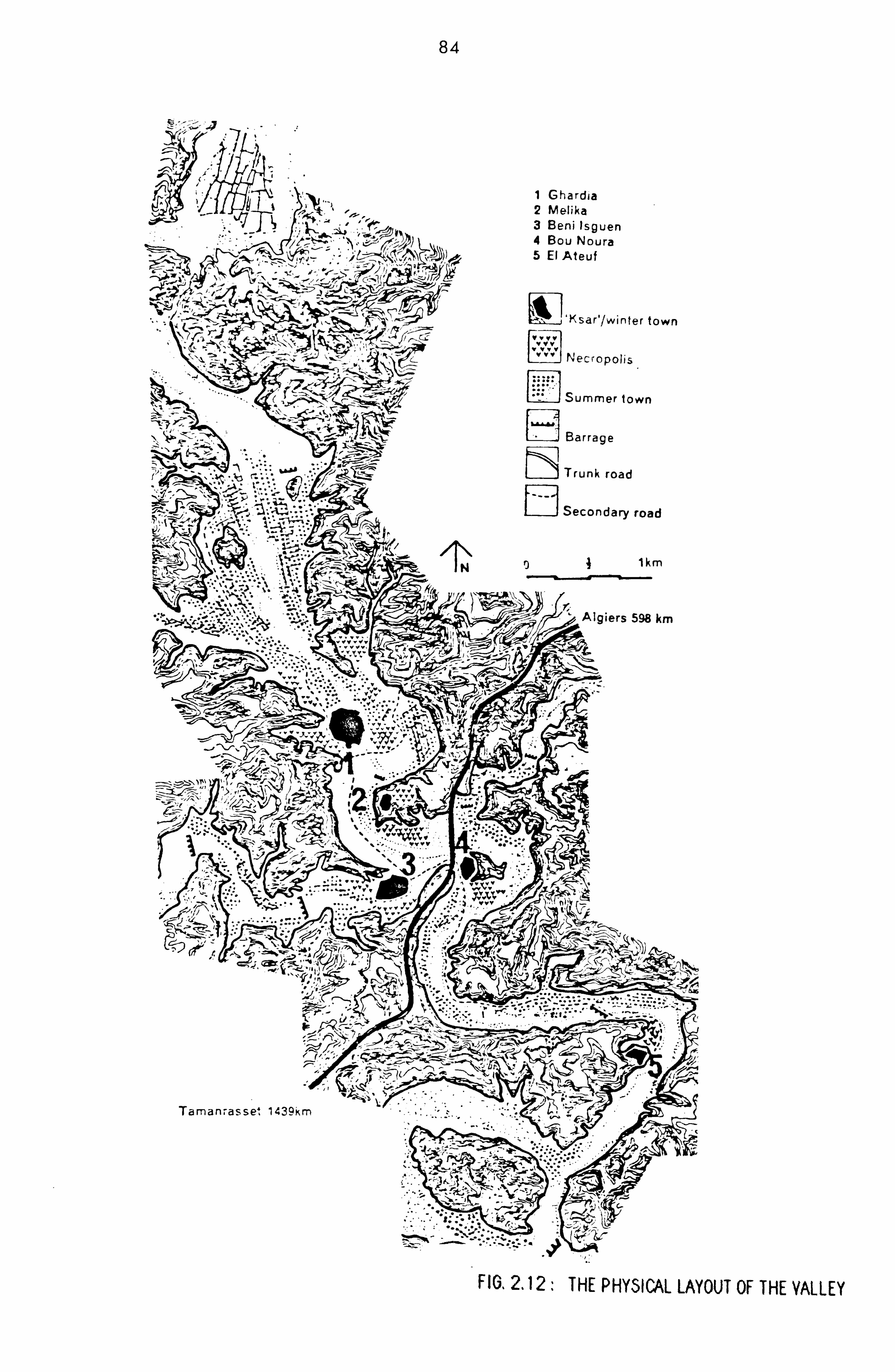
84
V7 1 Ghardja 2 Melika 3 Beni Isguen 4 Bou Noura 5 El Ateuf
'Ksar'/wi*nter town
im
jv
Necropolis
Summer lown
Barrage
Trunk road
Secondary road
1km
Algiers 598 km
:\ I -
¶ J4 :;
"� rkA1: - c4 .'. ):
_ -: - ... '
.; -___ .. -�- -V. -
II-
I-
I;
Taman-. asse4 1439km
" -"� "" "�-J. 4. l "I"-. - -_7
: i2! "'t-r
3. i" "': ".
.zý,.
FIGý 2.12: THE PHY51CAL LAYOUT OF THE VALLEY

85
F16.2.13: "RDAIA, AERIAL PHOTOORAPHY

86
\
mosque
U
mosque jai
market Place or
-7
41
17
\A I/ ý11; ý 'Fý
Streets, alley, -, 0 Cul-de-sac ------- M_
so
-6-6-4
Run Cemetery
H2 Surveyed houses FIG. 2.14: GHARDAIA, GROUND PLAN k4 see picture 20

87
PICTURE 18. GHARDAIA, GENERAL VIEW
PICTURE 19 : GHARDAIA, STEEP STREET

- 88 -
partly demolished and replaced by a ring road, and the
access to it was through seven gateways, four of which
from the north-west border. Two gateways link the
market square to the outside.
From the aerial view, the townscape appears to be made
up of concentric bands of courtyard houses falling away
from the central mosque. 'The urban fabric is made up
of large blocks of houses of two to three storey high,
densely packed together and separated by narrow and
winding alleyways which become more regular in the
vicinity of the large market square. These alleys can
be less than 2 metres wide and in places, they are true
tunnels where an eternal darkness prevails. Owing to
the fact that the course of the alley is not marked out
before hand and to the great distortion of the contour
lines of buildings from the an orthogonal geometry, an
erratic network of alleys grows, many of them cul-de-
sacs. In some places, the alleys take the form of very
steep ramps and in others they become veritable "stair-
ways" continuously built without landings (see Picture
19) .
The ground plan of the town shows the location of the
public facilities, which are mainly religious and com-
mercial in nature. The market of Ghardaia located at
the south-west periphery of the town is the most impor-
tant in the valley, and until the beginning of the cen-
tury, the caravans brought their products to sell in
the weekly market of Friday. Arriving on Thursday, the

- 89 -
nomads used to be locked during the night inside the
market square (Donnadieu and Didillon, 1977, p. 51).
The market place, which has a rectangular shape, is
entirely surrounded by an arcade on which give many
shops and boutiques (see Pictures Nos 20,21). On one
side, the auction market takes place. The auctioneers
walk around with the goods that are presented to the
people seated on the ground. This market square is the
site for other minor markets such as the meat market,
the vegetable market, clothes, house contents. It is
as well the converging point of the commercial streets
(see Picture No. 22). These streets especially the
"Suq street" which links the market place to the gate-
way "Bab Djedid", is furnished with masonry benches
where men sit in front of their shops. These seats are
also built all along the market arcade. outside this
commercial nucleus, very few businesses and shops exist
inside the town, except for three boutiques that are
located at the "rahbat" place, east of the central
mosque, annexed by a medersa which is a school for
learning the Qoran (see Ground Plan in fig. 2.14).
A fairly regular street runs uphill from the market
square (see Picture No. 19) towards a smaller mosque
which marks the original border of the settlement. This
mosque was, according to Donnadieu and Didillon,
reserved for the Ibadhites of Wargla during their pas-
sage in Ghardaia (Donnadieu and Didillon, 1977, p. 50).
From this point, the street structure becomes more con-

Q()
pICTURE520,21: GHARDAIA, THE MARKET SQUARE AND ARCADE

PICTURE 23: BENI ISGUEN, A STREET IN THE OLDER PART
PICTURE 22: GHARDAIA, COMMERCIAL STREET

- 92 -
centric, forming two rings around the summit of the
hill. Because of the sharp slope, sections of these
streets, particularly those adjoining the central
mosque, are made up of two platforms at different level
of height and linked to each other through staircases.
other mosques are built nearby the graveyards outside
the town walls with large whitewashed areas left open
for prayer meetings.
The date-palm plantation and gardens of Ghardaia are
situated north-west of the town at about 2 kilometres.
In these gardens, summer residences are established
together with mosques, shops and schools in order to
allow a longer and more comfortable stay during the hot
season.
PHASES OF GROWTH OF GHARDAIA:
The plan in figure 2.15, indicates the three different
phases of development of Ghardaia. These can be easily
identified by the remainings of the walls that once
surrounded the initial settlement as well as from the
examination of the aerial photography which clearly
shows two internal concentric rings (see fig. 2.13).
The first nucleus started to grow around the mosque and
on a very high ground (Donnadieu and Didillon, 1977, p.
50). However, there is no evidence for thinking that
the structure of the oldest parts of the town has or
has not changed over time. The location of the origi-
nal market is unknown, but the market place at the

93
rr-1 GHARDAIA AT PHASE %IE Li
GHARDAIA AT PHASE TWO
GHARDAIA AT PHASE THREE
. l. .0 D 10 2 CO t
77
market place
FIGý 2.15: GHARDAIA, PHASES OF EXPANSION

- 94 -
second phase of development called "rahbat" is situated
away from the main mosque as indicated in the map
(Ibid, p. 50).
BENI ISGUEN:
Beni Isguen, the second largest citY is also built on a
high ground and located at about 2.5 kilometres east of
Ghardaia, at the meeting point of the two rivers Ntissa
and Mzab. The town is constituted by about 1485
houses, 273 of which give onto cul-de-sacs, occupying
an area of approximately 16 hectares. If Ghardaia is
known as the commercial city, Beni Isguen is the spiri-
tual or the holy city for the entire valley. The
access of the town is through four gateways, which con-
stitute the only entrance points to the town; one to
the north called "B ab Chergui", one to the east called
"Al Kharajja" (*) and two to the south one of which is
called "Bab Gherbill (see Town Map in fig. 2.17). The
town walls or ramparts are accompanied by several
watchtowers, the most dominant one being the tower of
"Sheikh Ba El Hajj", The streets in the upper part of
Beni Isguen are steep and very winding (see Picture No.
23, p. 91), but in the more recent and lower part of
the town, the street network becomes more regular (see
Aerial Photo in fig. 2.16, and Town Plan in fig. 2.17).
The main mosque, in this case as well, occupies the top
The gateway called "Al Kharajja" or the "exit gate", is
used for the funeral procession. A dead person is "taken
out,, of the town through this gateway to the burial ground.

95
FIG. 2.16: BENI 15GUEN, AERIAL PHOTOGRAPHY

96
(
4
Streets, alleY5 Cul -de-5ac
IEEFR Ramp YY It - Y y C, emeter Y Y ý H2 Surveyed houses AP Prayer area
see picture 24
Area covered by rnnf survev
�
.
). Ih �- II:
>.: 7/,;
/
/ :1>
FIG. 2.17: BENI ISGUEN, GROUND PLAN
>k-
)- /)-
(

- 97 -
of the hill, not far away from the north-eastern border
of the walls (see Town Plan in fig. 2.17).
In addition to the main mosque and its adjacent Qoranic
schools and zaouia (religious lodges), two other reli-
gious buildings exist in this town. These are the
ancient mosque "Tafilalt" which is mainly reserved for
womenýuse (Donnadieu and Didillon, 1977, pp. 56-58),
and the praying area "Boudjira" located near the gate-
way "Bab Chergui" and close to the Timsiridine's house
(the "clergywomen"; see Picture No. 24). This area is
mainly used by men who come to read the "Fatiha", the
first verse of the Qoran, during the departure of a
member of the family for immigration or pilgrimage to
Makkah. one part of this area with a separate entrance
is reserved for women meeting.
The market place of a triangular shape is partially
surrounded by shops and boutiques. The market is quite
famous for its daily auctions, which usually take place
between the afternoon and the evening prayers. The
market place is furnished with masonry benches built
around it (see Picture No. 25) and in its centre is
located a well. Everyday, the same people occupy the
same seats and any absence or change of seating place
has a meaning, i. e. anger towards a person can be
expressed by not sitting near that person (Donnadieu
and Didillon, 1977, p. 59). The market is not only a
place where transactions and exchanges take place, but
also the centre for information, a meeting place for

PICTURE 25:
t
PICTURE 24: BENI 15GUEN, PRAYINGAREA (BOUDJIRA)
BENI 156ULN, I HE MARKET PLACE

- 99 -
friends and relatives. As in Ghardaia and as shown in
the Ground Plan (see fig. 2.17), very few shops exist
outside the market, but some houses are used as shops
exclusively serviced by and reserved for women (Ibid,
p. 61). The location of these house-shops is not known.
The cemeteries are numerous and located outside the
walls, in particular at the western and south-eastern
sides of the town. Mosques and open prayer areas are
numerous in these burial grounds. The palm tree plan-
tations of Beni Isguen expand linearly along the river
bed of Ntissa and comprise many hydraulic constructions
(barrages), notably a large water dam built to collect
the storm water. Summer residences are scattered
inside the plantations.
PHASES OF DEVELOPMENT OF BENI ISGUEN:
Two phases of development prior to the existing town,
are reported in the literature (Donnadieu and Didil-
lon, 1977, p. 55; Bousquet G. H., 1982, p. 11). As indi-
cated in the map in figure 2.18, the first settlement
named "Tafilalt" was built on the upper part of the
hill. A mosque, the market site as well as the old
gateways are still reminiscent of the old city. During
the first stager the mosque and the market directly
connected to each other by a more or less straight
street, occupied the central position of the old town.
But during the second phase, the market has been
shifted to the northern side of the city, and in 1860,

100
// 7 /4
lswUl 14, pýgsý
ALLCý
7Dý
I- LrJ/'
-
ri/I II
1ii ( I I
//�
': 1
VIC),

- 101 -
the last town walls were completed (Ibid, p. 55 and p.
11). These are four to five meters high and are regu-
larly maintained by the local population. In this case
also, there is no evidence on how far the structure of
the old parts of the town has been preserved unchanged
over time.
GENERAL DESCRIPTION OF HOUSES IN THE MZAB:
The description of houses is based on the examination
of about 20 houses taken from different parts of Ghar-
daia and Beni Isguen as indicated in the ground plans.
These houses have been also analysed syntactically but
the results of the analysis have not been included in
the present report. only a small sample of plans have
been inserted in this report.
The houses in Ghardaia and Beni Isguen are usually two
to three storey buildingsr and are invariably built
around a courtyard (see House Plans in fig. 2.19). The
access from the street to the houses is always through
a "dog-leg" passage, locally named "skiffa", which
plays an important role in the functioning of the
house. The location of the openings in this hall is
such that even if the main door of the house is left
ajar, one could not look into the central courtyard j
from the street. On one side of this entrance hall,
there is a room used for keeping the domestic animals
(i. e. goats, donkey). Sometimes in this chicane, there
is a recess in the wall in which a hand-quern is usu-
S

102
GROUND FLOOP GHARDAIA
T-
terrace
1 entrance hall (SHM) 2 fiving coom for rnen 3 court
4 living room for, women 5 kitchen 6 bedr oo m/ -5torer, oom 7 basement
first floor
6 Li
5 ------
r22
wc w cl
GROUND FLOOR
_-_-E
13ENI ISGUEN
FIG. 2.19: HOUSE PLANS

- 103 -
ally kept at easy access to the female neighbours who
do not have one (Donnadieu and Didillon, 1977, p. 75).
Also, water jars used to be kept in this space so that
the professional water porters coulddeliver water to the
individual houses without exposing the women to their
presence -. On most of the visited houses, two separate
pathways exist to the interiors. The first, or the
family path, leads to a courtyard which consists of a
large living space surrounded by small rooms. It is
there where the main female activities take place. A
staircase links the ground floor to the first floor,
consisting of bedrooms, arcades and store rooms.
Another staircase links the last floor to the rooftops.
The second staircase leads up from the chicane to the
separate quarter reserved for the male visitors. These
consist of one large room used as the male reception
room, with usually a small window giving onto the
street. Sometimes, this male reception room which is
very richly furnished and decorated is annexed by a
bedroom.
The central courtyard is the largest space in the
house. It is lit by means of a large skylight situated
in the centre of the ceiling and protected by an iron
grille. No window gives onto the outside. In summer,
this only source of light is covered during the day as
a. measure of protection against the burning hot sun.
No furniture exists in the central courtyard, except
for the loom and the built-in shelves for the cooking

- 104 -
utensils and an oven which occupies one side of it. In
most houses, another kitchen exists at the terraces.
The "Tisefrill or the womenýsliving room gives onto the
central court. It is used for female visitors and it
is in this room where the women move after giving
birth. In one corner of this room, there is a raised
masonry bench of about 2x2 metres, for womenýs prayer.
The other rooms that give onto the courtyard do not
have a specific usage. They are used sometimes as bed-
rooms, storage or changing room. The toilet is usually
located in a remote corner of the central court. It is
dark and a very low-ceiling room with a hole in the
floor, connected to the cesspool accessible from the
outside by breaking through the exterior wall. The
house is equipped as well with a traditional bathroom.
From the central courtyard, a staircase leads to the
upper floor which consists of the upper courtyard sur-
rounded by small rooms for various usest and an arcade
used by the whole family for sleeping during summer.
It is here where the women do their washing, sometimes
cooking or take their afternoon coffee alone or with
their female visitors (Donnadieu and Didillon, 1977,
pp. 83-84). Donnadieu and Didillon write:
" of eminent importance in a house is the roof
terrace, the domain par excellence of women (Ibid,
p. 84).
Another staircase leads up from the upper court to the
rooftops which access is exclusively reserved for

- 105 -
women. Exceptionally, a man may have access to it,
(i. e. to repair a leaking roof), in this case, he must
notify the women of his presence by repeating three
times a specific "scream", so that the women retreat to
the inside (Ibid, p. 84).
DESCRIPTION OF TERRACES IN GHARDAIA AND BENI ISGUEN:
i- GHARDAIA
A bird5'ejeyiewof the town (see Pictures 26,27), gives
the impression of a massive building, constituted by
several storeys with terraces sloping down from the
central and dominating minaret of the mosque.
No overall roof plan exists and visits to the terraces
were restricted. Therefore, the following description,
which is mainly derived from the examination of photo-
graphs, roof plans of individual houses and a few
visits, remains limited and the information drawn from
it insufficient for establishing a viable basis for an
analysis.
The examination of the roof plans for separate houses
(about 10 houses) in figure 2.20 suggests a consistent
structure underlying the terraces configuration. The
first floor of the 10 houses is constituted by small
rooms (i. e. kitchen, toilet, storeroom) and an arcade
used by the whole family for sleeping during summer.
The proportion of the arcade space with respect to the
rooms seems to vary from one house to another, and so

106
PICTURE526,27. GHARDAIA, YIEWSOF ROOF
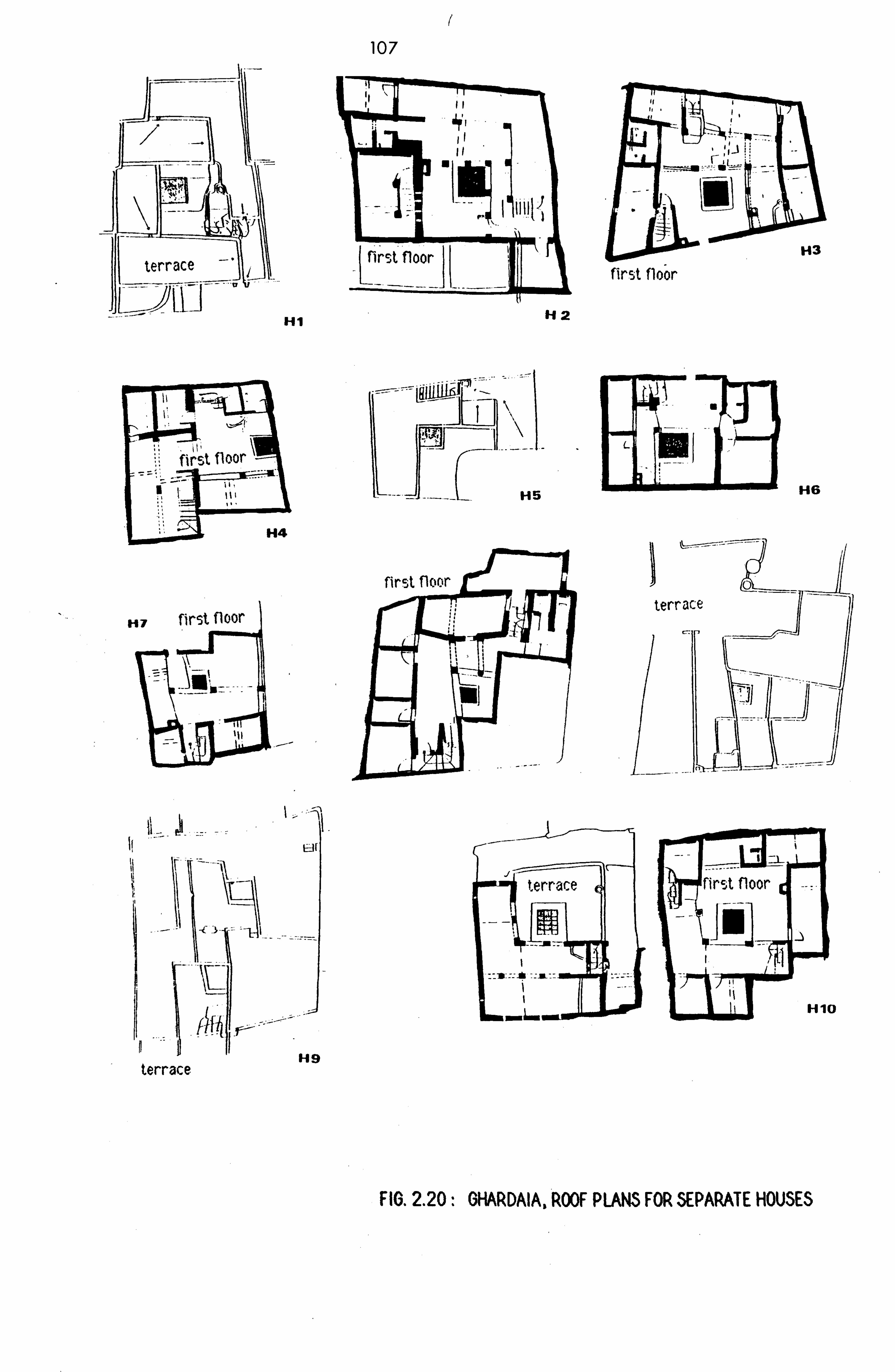
I,
Hi
107
jjý first floor
142
LEI-- ID
first floor H5
H4
H7 first floor
-, C --l
H9 terrace
terrace
I am WR
I --
. LJ -- --:
i *tIJ"-
LOJI;;, first floor
terr
H3
H6
"10
FIG. 2.20: GHARDAIA, ROOF PLANS FOR SEPARATE HOUSES
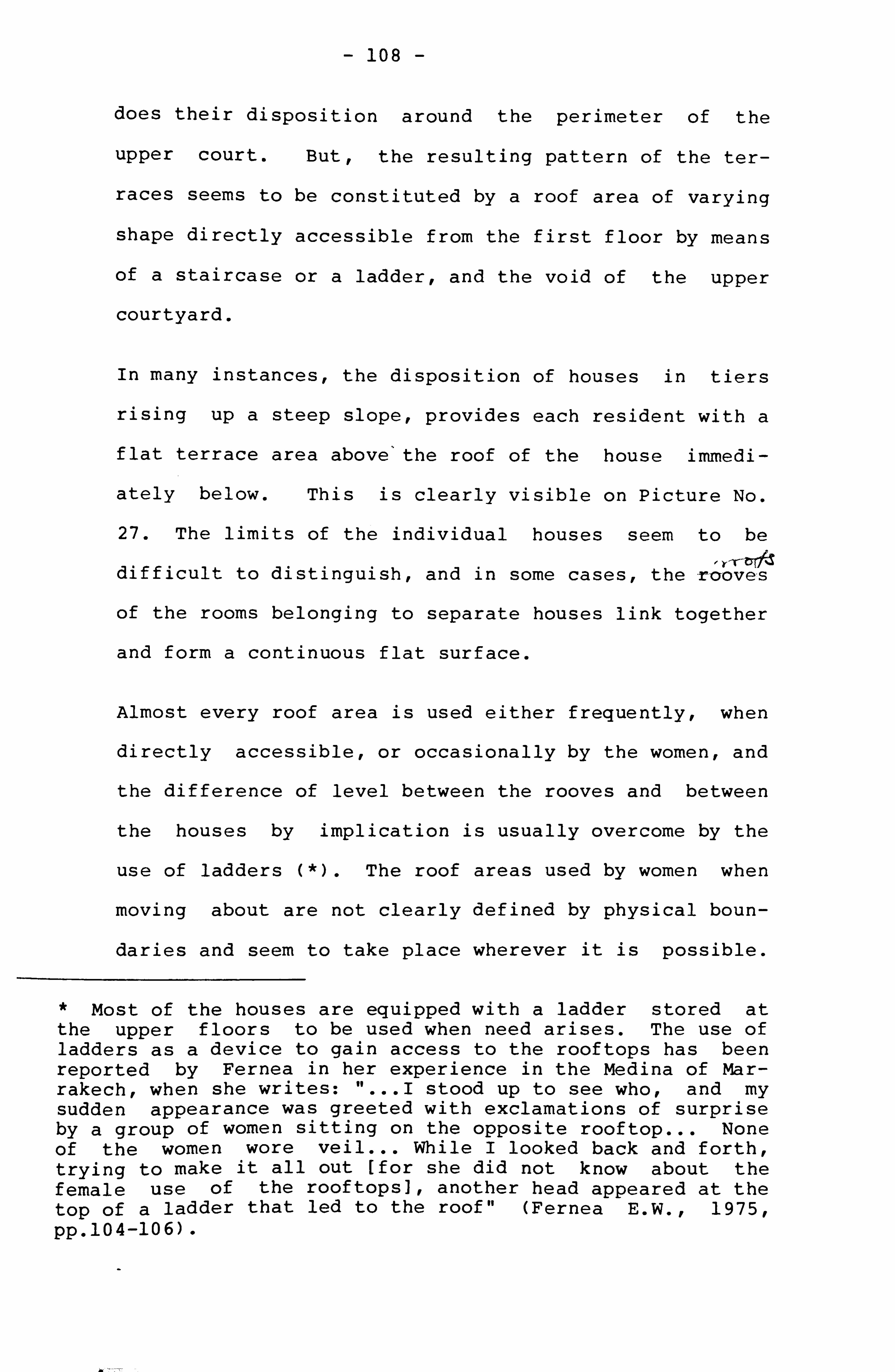
- 108 -
does their disposition around the perimeter of the
upper court. But, the resulting pattern of the ter-
races seems to be constituted by a roof area of varying
shape directly accessible from the first floor by means
of a staircase or a ladder, and the void of the upper
courtyard.
In many instances, the disposition of houses in tiers
rising up a steep slope, provides each resident with a
flat terrace area above'the roof of the house immedi-
ately below. This is clearly visible on Picture No.
27. The limits of the individual houses seem to be
" Yr-bT/d difficult to distinguish, and in some cases, the -rcrove, s
of the rooms belonging to separate houses link together
and form a continuous flat surface.
Almost every roof area is used either frequently, when
directly accessible, or occasionally by the women, and
the difference of level between the rooves and between
the houses by implication is usually overcome by the
use of ladders (*). The roof areas used by women when
moving about are not clearly defined by physical boun-
daries and seem to take place wherever it is possible.
* Most of the houses are equipped with a ladder stored at the upper floors to be used when need arises. The use of ladders as a device to gain access to the rooftops has been reported by Fernea in her experience in the Medina of Mar- rakech, when she writes: "... I stood up to see who, and my sudden appearance was greeted with exclamations of surprise by a group of women sitting on the opposite rooftop... None of the women wore veil ... While I looked back and forth, trying to make it all out [for she did not know about the female use of the rooftops], another head appeared at the top of a ladder that led to the roof" (Fernea E. W.,, 1975, pp. 104-106) -
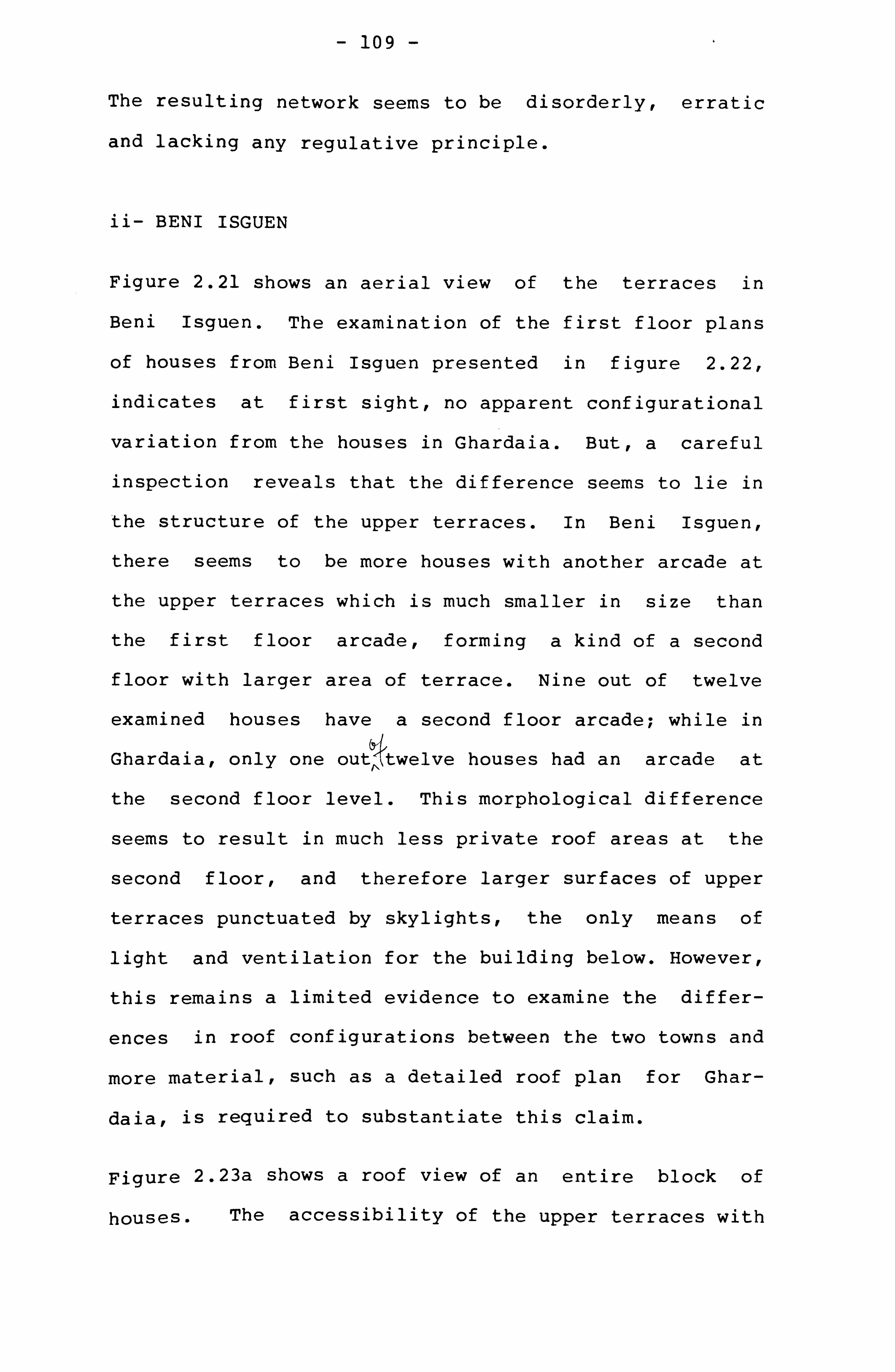
- 109
The resulting network seems to be disorderly, erratic
and lacking any regulative principle.
ii- BENI ISGUEN
Figure 2.21 shows an aerial view of the terraces in
Beni Isguen. The examination of the first floor plans
of houses from Beni Isguen presented in figure 2.22,
indicates at first sight, no apparent configurational
variation from the houses in Ghardaia. But, a careful
inspection reveals that the difference seems to lie in
the structure of the upper terraces. In Beni Isguen,
there seems to be more houses with another arcade at
the upper terraces which is much smaller in size than
the first floor arcade, forming a kind of a second
floor with larger area of terrace. Nine out of twelve
examined houses have a second floor arcade; while in
Ghardaia, only one outý. twelve houses had an arcade at /11
the second floor level. This morphological difference
seems to result in much less private roof areas at the
second floor, and therefore larger surfaces of upper
terraces punctuated by skylights, the only means of
light and ventilation for the building below. However,
this remains a limited evidence to examine the differ-
ences in roof configurations between the two towns and
more material, such as a detailed roof plan for Ghar-
daia, is required to substantiate this claim.
Figure 2.23a shows a roof view of an entire block of
houses. The accessibility of the upper terraces with

110
FIO. 2.21 : BENI 15OUEN, GENERAL VIEW OF TERRACES
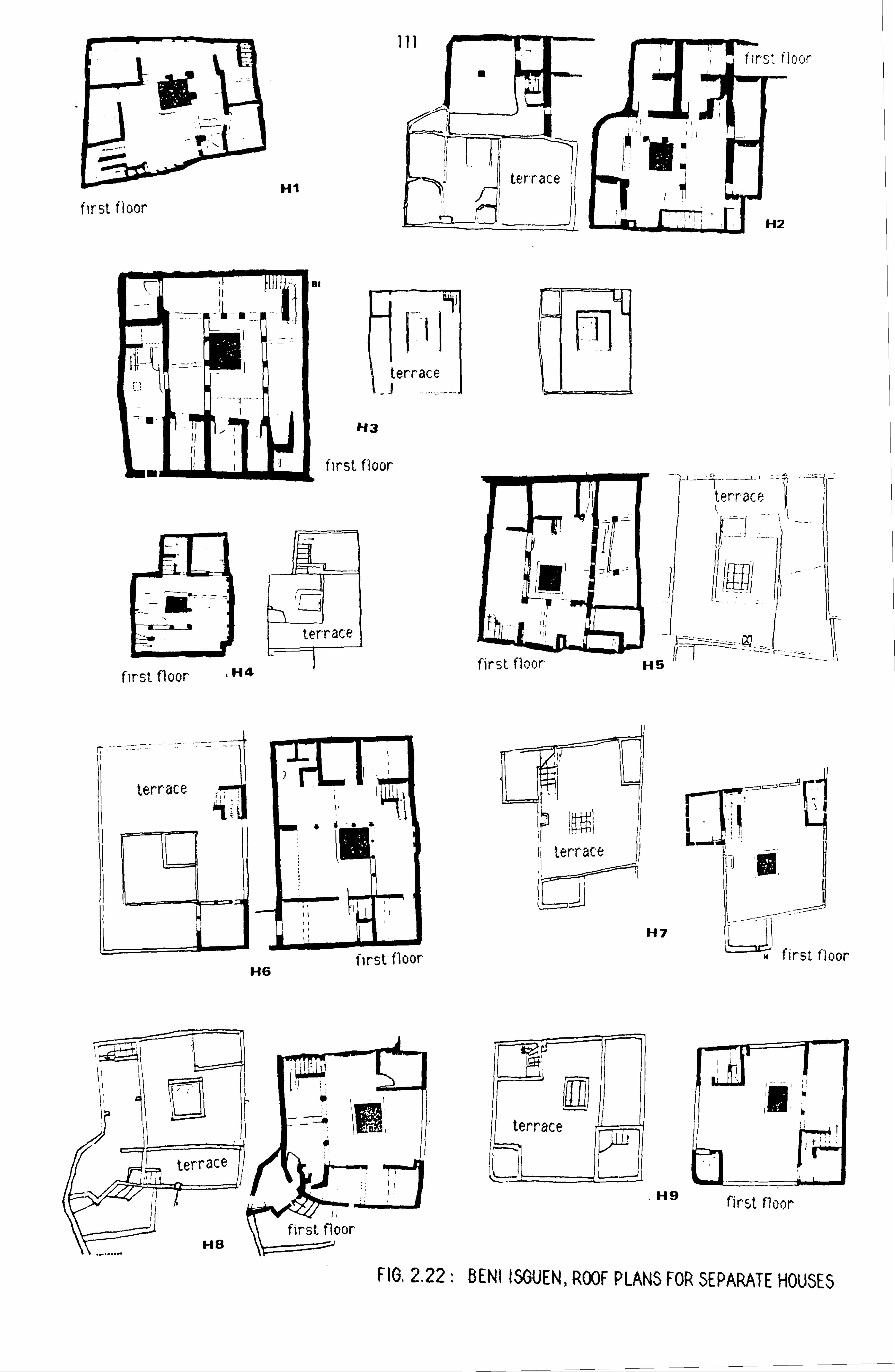
L:: 3zs first floor
terrace
H3
first floor
ML t terrace
first floor H4
H6
terrace
H8
Hi
terrace
H7
maw
first floor
- ýi :I H9 first floor
first floor
FIG. 2.22: BENI ISGUEN, ROOF PLANS FOR SEPARATE HOUSES
III' firý, * floor
poll ter-race
H2
ril
I- irst floor
first floor

27,1, ý'El ,, F Tý C3 tJEViF "N 'ý) 0FTERA C" '0 jL 4 F;
_OC. ti): HOEE.

- 113 -
respect to each other seems to be restrained onlybythe
voids of the upper courtyards. occasionally, parts of
the roof area are isolated by high partition walls.
Access doors to these areas can be also seen from the
picture.
The examination of an aerial view of another block of
houses in figure 2.23b, shows a different organisation
of the roof area. For this block, the partition walls
of the individual houses are high, but delineate a
smaller roof area than the terrace surface of the
houses, leaving therefore a common open area to which
access to individual houses is directly gained by means
of doorways.
From this description, a preliminary conclusion can be
drawn: the system of accessibility between the terraces
of the individual houses varies from one block to
another, and sometimes even within the same block.
The roof plan presented in figure 2.24 covers two
blocks of houses situated in the older part of the
town, east of the main mosque (see Ground plan in fig.
2.17). The streets and courtyards are represented in
solid blackr and the-double fine lines represent the
sections of the partition walls at the terrace level.
The spaces left in white represent the upper terraces
of the houses within the blocks. Small differences (up
to 0.50 metre) in the level of terraces are ignored and
not shown on the roof plan. No clear structure seems

114
Idd
H1
-71
SK YL IGHT
WALL`ý HPARATING TERRACES
POOF APEA'-ý: JSED BY WOMEN
014
FIG, 2.24: BENI ISOUEN, ROOF PLAN
- 115 -
to emerge from the resulting pattern of the terraces
and links seem to take place haphazardly. Sometimes,
terraces cross over the streets and cul-de-sacs,
increasing therefore roof links between houses that are
separated at ground level.
Some morphological differences are already noticeable
between Ghadames and the Mzab towns, such that the
overall urban structure of Ghadames is more fragmentary
than the Mzab towns.
CASE STUDY FOUR: EL OUED
GEOGRAPHICAL CONTEXT:
The Souf region is geographically located north of the
"grand oriental erg", which is a vast territory mainly
constituted by sand dunes (see Location Map in fig.
2.1, p. 27). It is at the south-eastern part of
Algeria at about 12 kilometres from the Tunisian
border. The wind is the most important physical con-
straint. The "Bahri", the prevailing wind from the
east, is the most violent and destructive factor feared
in this region of the Sahara.
The characterisation of the Oued Souf as a Saharan
oasis does not do justice to the particular features of
the region. The landscape as well as the conditions of
life seem to be closely related to the special tech-
niques of cultivation. This particularity lies in the

- 116 -
plantation method. The technical problem is naturally
in the usage of water resources; here the water table
is quite shallow from the surface which is made of very
fine and moving sand. The solution adopted is, not to
bring up water to the ground level (i. e. by digging
wells) and then use it to irrigate the fields, but to
lower the ground level by digging a large hole and
planting it with palm trees, so that the roots of the
trees will be as close to water as possible.
This system has resulted in a technical and agricul-
tural cell necessarily linked to the plantation tech-
nique, characteristic of the Souf region: the "ghout"
(see Aerial Photo in fig. 2.25).
HISTORICAL AND ECONOMIC BACKGROUND:
The Souf has always been a refuge for several popula-
tions coming from different origins ("Kitab El
Adouani",, translated By Ferauld, C., Constantine,
Arnolet, 1868, p. 173). The Souf is highly isolated
region. According to Bataillon, this isolation had a
consequence on the morphology of the settlements which
unlike the other Saharan settlements are not surrounded
by outer walls (Bataillon C., 1955, p. 20). The whole
region is protected against the aggressors by its
topography. This particular location made the Souf
unknown in the history of the Sahara.
The creation of the palm tree plantations in the Souf
and the establishment of about twenty settlements in

- 117 -
this isolated region is not the result of haphazard
act. Like the Mzabites (*), but for different reasonsr
the site had been imposed on the inhabitants of the
Souf by historical events.
According the "Kitab El Adouan", the population of the
Souf is mainly constituted of two groups: the Troud and
the Adouan (Ferauld C., Constantine, Arnolet, 1868,
p. 31). Ferauld has given a percentage of the two
groups, which is according to him the 2/3 of the popu-
lation are Troud, while the remaining third are of
Adouan. Most of the settlements of the Souf are con-
stituted either completely or partially of Adouan,
except for El Oued where most of the population are
Troud (Ibid, p. 70). It is very difficult to refer to
this genealogical history, since most of the tribal
relations between people are of ten based on a -rn)(thical
raVýer than real kinship.
The Troud belong to the tribe "Ouled Zein" which had
fled from Syria in the direction of Gabes, south Tun-
isia, through Egypt and the Tripolitaine. After their
expulsion from Gabes, they went to Qairawan, where once
more they were not allowed to stay and settle; then to
Mohdia in which they spent three years. During this
time, the tribe leader was an old wise man called "Trad
Ben Dabes", and from which derives the name of Troud
(Ibid, p. 33). After heavy taxesimposed by the local
* The inhabitants of the Mzab region.

- 118 -
authorities of the town, the Troud decided to leave
Tunisia.
They started moving west in search of a new site,
crossed the region of Oued Souf, and decided it was too
arid for the huge stretches of sand. They then contin-
ued west until they reached the region of Oued Rhig.
There, the water was very abundant, but they quickly
realized that the place was infested by'malaria. On
their way back to Tunisia, they noticed that despite
the arid appearance of the Souf, water was in fact at
easy reach (ETAU, 1979, p. 34).
Most of these events took place at the end of the 14th
century. However, the "Kitab El Adouani" explains that
the Troud are not the very first occupants of the Souf
(Ferauld C., Constantine, Arnolet, 1868, p. 66).
A refuge land, the Souf was part, according to Brun-
schvig (Brunschvig, R., 1942 and 1947), of the kharijit
block of South Tunisia, and this conversion to the
Orthodox sect dated from the 12th century (Ibid, p.
330). The population is Muslim orthodox and one impor-
tant aspect of the religion is that each group, so
small was it and every hamlet, is provided with a
mosque, which is sometimes only a praying room built
close to a well.
SOURCE MATERIAL:
The region of the Souf is made up of about 20 settle-

- 119 -
ments,, the most important one is El Oued. Only one
town in the vicinity of El Oued is used in this study
as a reference case.
The ground plan of the settlement and several house
plans were provided by the ETAU (*). In addition to
this material, an aerial view of the settlement has
been produced by the "Institut de Cartographie, Alger".
No detailed field research has been carried out, but
several visits to this settlement and others in the
region have been made.
THE BUILT ENVIRONMENT:
A visitor to the region of the Souf is usually
surprised by the uniformity of its architecture. All
buildings are dome-roofed. El Oued is known as the
city of one thousand domes (see Aerial Photo in fig.
2.25). Similarly to the inhabitants of the Mzab, the
Soufis have developed two forms of habitat: the winter
settlement, the settlement with its relatively dense
form of housing, and the summer residences implemented
in the gardens for the surveillance and maintenance of
the cultivated lan6(Bataillon C. , 1955, p. 15) .
Most of the Souf settlements, by contrast to the other
Saharan settlements, are not fortified and protected by
a surrounding outer wall. The other most characteris-
* ETAU stands for "Entreprise des Travaux D'Architecture et d'Urbanisme" .

120
FIG. 2- 215 1,
EL OUED, AERIAL PHOTOGRAPHY

- 121 -
tic physical property of the settlement spatial organi-
sation, is the regularity of the street network. The
aerial photography and the ground plan of the settle-
ment (see fig. 2.26) show an aggregate of courtyard
houses connected together by an orthogonal grid-like
street system. The streets are completely covered with
sand which is prevented from settling on the domed-
rooves of the buildings. In proximity of the "ghout",
the buildings tend to follow the curved shape that ori-
ginated from the circular agricultural cell. The
mosque is located at the southern part of the settle-
ment. It is not a free-standing building and its roof
is constituted by the same modular dome element.
THE DESCRIPTION OF HOUSES IN EL OUED:
The internal structure of the houses denotes a specific
pattern of life which seems to have hardly change since
the Soufis first settled (Bataillon C., 1955, p. 50).
The architectural characteristics, i. e. the dimensions
of the rooms, seem to be closely related to the con-
struction techniques. The dome constitutes the building
module i (see House Plans in fig. 2.27). The houses
are invariably one-storey building and built around
large and sandy courtyards that do not connect to each
other. The access to the house is always protected
against visual corridors from the outside. It is
always through a chicane that one gains access to the
interiors. This chicane varies in size, and is in most
of the cases, directly connected to a reception room

122
-1
-E: lp
FIG. 2.26: EL OUED, GROUND PLAN
0
FIG. 2.27: EL OUED, HOUSE PLANS

- 123 -
for the male guests. All rooms are distributed around
the courtyard. An arcade (porch) runs on one side of
the courtyard in front of the individual rooms. In
some cases, the arcade is built all around the court-
yard, forming therefore an inner ring of covered but
open spaces. On one side of the courtyard, there is a
series of small rooms used as utility rooms, such as
toilet, "water room", and stable for the domestic
animals.
El Oued, in contrast to the other towns, has displayed
a visible regularity in the street pattern as well as a
distinct house form. The presentation of the towns has
clearly shown the presence of different cases of the
so-called "Arab town".
SUMMARY TO CHAPTER ONE:
The first chapter of Part One of this study has been
mainly concerned with the presentation of historical,
social and descriptive material of the towns in ques-
tion. The description of the built environment, espe-
cially the section concerning the upper terraces, is
based on first hand data resulting from the author's
field surveysr but also elaborating this whenever pos-
sible with accounts drawn from relevant published
material. This chapter has clearly shown the existence
of morphological differences and similarities between
the individual cases.

- 124 -
CHAPTER TWO: THE SOCIAL USE OF SPACE IN THE MZAB TOWNS
AND GHADAMES
INTRODUCTION
In the section that follows, some aspects of the social
and cultural systems in the towns under study will be
outlined, in particular, the system of relationships of
men and women, and its effects on the way space is used
by the two social groups. The section aims then to
present a description of the social use of space in the
streets and at the terraces, on the basis of the
author's own data which is elaborated whenever possible
with accounts drawn from literature. This description
concerns chiefly Ghadames and the Mzab towns, Ghardaia
and Beni Isguen. El Oued is used mainly as a reference
case in the present study and no detailed ethnographic
data on space use has been collected.
.ý Since this thesis, among many questions, deals with the
structuring of the urban space and the way it is used
by the different groups and particularly by women, the
examination of the society from a female perspective
seems to be a particularly appropriate topic of study.
Such a description should provide the proper setting
and a suitable background for analysing the systems of
relations within and between the sexes.
Studies on social life in these towns have stressed one
aspect of life, that is the separation of men and women

- 125 -
(i. e., Lamphere, 1974, p. 97; Springer-Verlag, 1967, p.
120; Parveen S. A., 1976, pp. 127-130), and the restric-
tions on women in terms of mobilityr that is the limi-
tations that are imposed upon them in a physical sense.
The separation of social life into men's and women's
domains has been seen as a primary characteristic of
life in the towns under study and Arab towns in general
(i. e., Addoun A. D., 1977, p. 36; Burckhart T., 1980, p.
166). This is mainly supported by observations made on
public life, such that women walk veiled in the streets
alone or with other women; boys and girls attend
separate schools; markets and cafes only frequented by
men, and the main worship areas of mosques reserved
only for men and for women smaller areas are separately
established (i. e., Gordon D. C., 1968, p. 17).
Indeed, the division of social life along sexual lines
is most apparent within the public, the more "visible"
domain, but also in more private settings. For exam-
ple, in everyday socializing, women tend to gather with
women friends and neighbours, while men typically
congregate with their male friends and fellow-workers. -r'xT-Q-- h Women tend to meet in their houses and on the rooves,
while men more often gather separately in stores,
mosques and in the market, outside the houses. On
ceremonial occasions, the two groups are also strictly
kept apart. Women congregate separately from the men
who have been invited to the same celebration.
The separation of the sexes is maintained most

- 126 -
consistently and is explained most explicitly within
the realm of religion (i. e. Addoun A. D., 1977, pp. 36-
38; Gordon D. C., 1968, p. 12). Men pray in the mosque,
make up the membership, and are the religious leaders.
The women are generally excluded from these roles and
from the more visible devotions. Such separation is
believed to be sanctioned by God in order to limit sex-
ual temptation and involvement. The separation of the
social spheres along sexual lines is based upon the
principle of modesty and honour. A woman, it is felt,
must be protected from those men who might seduce her.
This is necessary in order to preserve her own modesty
and her family's honour (Ibid, pp. 33-34).
However, what seems to be the case is that men and
women in these societies, do not really lead mutually
exclusive lives. On the contrary, there are complex
rules which ensure the interaction of men and women,
and govern the way in which it occurs. For instance,
spouses traditionally take meals together, and in most
families, they provide advice to one another. They
frequently exchange gossip and town news. Fathers and
brothers show active concern and interest in their
daughters' and sisters' welfare, and on family occa-
sions, men congregate in the presence of their kins-
women.
While it is true that husbands do interact with their
wives in the way described above, it is also accepted
in the Mzab and Ghadames societies that men should

- 127 -
leave their wives each day, for the home is considered
per excellence as an area of women (Donnadieu and
Didillon, 1977, p. 71; Addoun A. D., 1977, p. 47).
In the economic sphere, and for all towns considered,
men invariably engage in trading, farming and crafts ;
while women work at such jobs as curing, midwifery,
wool spinning and rug weaving, sewing, cooking (for
ceremonial gatherings) and laundering. In most (if not
all) cases, women constitute women's main clients, and
in almost all cases male-female interactions within the
economic realm are almost non-existent. In the Mzab
towns, some clergymen are given the task to sell and
buy products for women, since these cannot contribute
in the auctions taking place at the market place
(Addoun A. D., 1977, p. 58).
In political sphere, men fill most offices. In the
Mzab towns, one female group is attached to the politi-
cal or judiciary system: the "Timesridines or Azzabat",
a sort of a female council. Appointed by the town
council, the "Timesridines" collect information from
women. They protect them, check pregnancy, provide the
last blessings (Ibid, p. 54). Because male officials
are prohibited from entering into such exchanges with
women, the "Timesridines" emerge then as an essential
liaison between the sexes. None of these female asso-
ciations has been reported to exist in either Ghadames
or El Oued.

- 128 -
Clearly, the importance of the principle of separation
seems to be significant only if one looks at the "more
visible" aspects of social life as outlined above.
While it is true that the sexes are segregated from
each other, it is also true that the mechanisms by
which this separation is realized vary, both socially
and spatially from one case to another. The puzzle is
that there exist different practices of space use by
men and women in the different towns. The considera-
tion of these facts suggests a much more complex situa-
tion, in which there seems to be rules about how men
relate to each other, rules about how women relate to
each other, and rules about how the two "domains"
created by the rules interact. The effects of these
rules on space use by men and women seem to vary from
one town to another. Therefore, the id6a of separation
as the primary principle of order seems to be limiting
and an inadequate description of social life in these
towns, including the social use of space. The follow-
ing section will concentrate mainly on the social use
of the streets, the houses and the terraces in Gha-
dames, and the Mzab towns considered together.
THE DESCRIPTION OF MEN'S AND WOMEN'S WORLDS:
Most of the following information is based on personal
experiences and observation made on site during the
several visits to the towns at different times of the
day; as well as the numerous interviews and discussions
f

- 129 -
with both men and women (*).
In the Mzab, the author was forbidden to photograph
women. All of the pictures, both for the Mzab and Gha-
dames, were taken with the permission of the inhabi-
tants. In many cases (especially in the Mzab) this
permission was not granted.
Kept separate, although to varying degrees, the women
in these towns have tended to develop their own world
within limited boundaries, a world which is relatively
insulated from men. Men, for their part, have
developed a man's world into which women only rarely
enter. These worlds exist as forced outgrowths of the
sex segregation, while also serving as strategically
defined spheres, which present a refuge for both sexes
from the tensions of male-female relations.
The complex separation and Joining of the two "worlds"
reveals itself in the physical and temporal division of
life space. The household, for example, is a joint
living unit for men and women, but during certain hours
of the day, it becomes more of a female domain.
*I was invited to several parties EaLking place - during my
visit to the towns. In Beni Isguen, for instance, I have attended a religious ceremony celebrated to commemorate the death of an old woman. In Ghadames; I was first invited to a birth celebration and the second time to the preparation of a wedding ceremony. Apart from that, every day I was in- vited to different houses for lunch, coffee ...

- 130 -
PATTERN OF SPACE USES OF THE HOUSES:
The pattern of use and labelling of space does not seem
to differ in Ghadames, Ghardaia and Beni Isguen. It is
complex, and changes with the absence of men. During
the day, however, when only women and small children
are present, the domestic space is used much more in
common. Women of the household follow the same work
timetable and share the courtyard, kitchen and the roof
terrace, and may also share provisions and utensils.
Relations between women members are normally close and
informal, though when household fission occurs, it is
usually due to a breakdown in the women's relationships
(i. e., Addoun A. D., 1977, p. 56). The roof serves as
an extension of the workplace, for laundry, for drying
foods of various kinds, for processing raw wool.
When the men of the household are present, the use of
the domestic space alters. One or two rooms are
reserved for receiving male visitors and the women
avoid them; these rooms are segregated from those used
by the women. In Ghadames, this room when it exists, is
usually at ground floor, in Ghardaia and Beni Isguen,
it is at the first floor with a separate staircase
linking it directly to the outside, and in El Oued, the
separate room gives directly onto the street. (see
House Plans in figures 2.9,2.20,2.27).
A woman's life is largely centred in the area around
her home as will be described in the following. Men
play little part in the running of the home, and spend

- 131 -
much of their time elsewhere. In the Mzab, most of the
young men emigrate to the north for work, and have most
of their social contacts away from the house (i. e. Eth-
erton D., 1971, p. 187). Despite these separate pat-
terns of activity, the family is prized as the unit on
which society rests (i. e. Addoun A. D., 1977, p. 51).
MEN'S AND WOMEN'S USE OF THE STREETS IN GHADAMES:
Some streets in the separate quarters of Ghadames
except for Bellil, have been shown to be furnished with
masonry benches intended for men's uses (see fig. 2.4,
2.5 and 2.6). When not at work, men of the quarter
congregate in these streets where they sit, chat and
drink tea prepared in sjýLL.. During the hot hours of
the day, these streets are preferred for their fresh-
ness for sleeping (siesta). Yushea tells a story about
a governor during the Turkish administration who used
to block two ends of a street and put a bed for sleep-
ing (Yushea Q. B. r 1973, p. 94). On ceremonial occasions
(i. e., wedding), these streets are sometimes used as a
reception area for male guests. The street's floor is
then cleaned up and covered with woollen rugs (Ibid, p.
195) .
Women use the streets at ground level mainly to go to
the fountain to fetch water, to go to the mosque, laun-
dry house or for visits beyond the quarter. Visits to
the local fountain are usually programmed in time (late
afternoon prayer) during which men avoid wandering in

- 132 -
the streets (Ibid, p. 84).
WOMEN'S USE OF THE TERRACES IN GHADAMES:
In Ghadames, various uses are linked with the roof ter-
races, ranging from everyday activities such as cook-
ing, food drying, wool processing; to more formal
ceremonies, such as wedding and birthday parties. Sel-
ling and buying of goods such as sweets, perfumes, hair
dye, material for dresses, also takes place at the
rooftops. De Motylinski has referred to the existence
of a kind of a market for women at the terraces (De
Motylinski, pp. 55-56; Yushea Q. B., 1973, p. 84). Tea
and coffee parties are also held at the rooftops, and
most of the female visits to relatives and female
friends, even at night, are accomplished via the roof
terraces.
One case has been included in this chapter in an
attempt to show the extent to which the roof terraces
are used by the women, and their role in the female
society.
Pattern of uses of the terraces in the performance of
wedding ceremonies
The information used in the following description comes
from two sources. First, is the personal attendance of
the author of the wedding preparations. The second
source is Yushea's book in which he gives a very
detailed description of all ceremonies that take place

- 133 -
during the preparations for a wedding (Yushea Q. B.,
1973r pp. 204-242).
In order to fix a day for the wedding, the female
members of the bridegroom's family discuss with their
counterparts in the bride's family and both parties
then settle on a convenient Friday to start the
preparations (Yushea B. Q., 1973, p. 205). When a date
has been agreed upon, early in the morning of that day,
the groom's female "servant" (designated lady of
honour) goes up onto the upper roof terrace of the
groom's house and starts ululating. All women friends
and relatives of both families when hearing the "ulula-
tions" come to the groom's house via the roof terraces,
singing special songs. This represents the formal
announcement of the beginning of the wedding festivi-
ties which will last for two weeks of preparations and
an endless stream of events and ceremonies to and from
the bride's and groom's houses.
The first event which takes place in both the bride's
and the groom's houses, is the cleaning up and distri-
bution of grain, wheat among female friends for grind-
ing. Any woman who wishes to express her feeling of
friendship towards the groom and his family shows this
by the amount of grain she takes for pounding. Other
women receive the flour brought back from the women who
have ground it, sift it and put it into bags. This
flour will constitute the provisions for the wedding
meals. on the same evening, a ceremony which involves

- 134 -
only the "unmarried girls" starts. The young girls
come by way of the roof terraces to the upper courtyard
of the bride's house to amuse themselves, sing and
dance together on the rooves. This is a sign that the
festivities have begun, and the girls will do this
every night until the following Friday. This is brought
to an end by holding a party at the terraces of the
bride's house, called "the tea of the girls".
The next ceremony which also takes place at the roof
terraces, is the "seed roasting" (i. e., flax seed,
wheat, melon seed... ). These are put in cloth bags and
kept until the day called "the mixing" to be distri-
buted among the guests. Meanwhile, another activity is
taking place at the courtyard roof terrace; this is
called "the dying of the woollen threads", which will
later be plaited into the bride's hair. All women
relatives and friends are informed and can have some of
their woollen headwears dyed along with those of the
bride.
In the following day, the couple's new house is
entirely whitewhashed from top to bottom, by women
relatives. When the whitewashing is dry, the decora-
tion of the house is carried out by specialized women.
The evening of the "whitewashing day" is called the
night of congratulations (Ibarak). A group of women
from the groom's house get to the roof terraces and
start calling and shouting "listen all you women,
tonight is the congratulations of "so and so" son of

- 135 -
"so and so". They shout this as they make their way
along the pathways of the roofs towards the bride's
house. On hearing this, all the women friends and
relatives come to the groom's house via the roofs
(Yushea Q. B. r 1973, p. 206).
On the day of the writing of the wedding's contract,
the women come to the groom's house by way of the roof
terraces, one by one or sometimes two at a time, walk-
ing very slowly and escorted by their "servants" who
ululate all the way to the house. For the writing of
the contract, men go to the mosque to witness the mar-
riage; two female "servants", one of the groom and one
of the bride who were standing outside the mosque, as
soon as they hear the exchange of congratulations
between the two parties, start ululating and continue
to do so all the way back to the house, where the women
are waiting to be informed that the writing has taken
place. At the house, the two female servants continue
ululating and go up onto the roof terraces; there they
will be followed by other women, singing, playing the
drums and all dancing. Then they form a procession,
walking very slowly in a single file to carry the news
of the writing to the bride's house (Ibid, p. 218).
Endless ceremonies take place all accompanied by music
and dances; in one the bride is seated at the courtyard
roof terrace which is all covered with carpets, and the
women come and go via the roofs to look at her and
congratulate her. Several meals are distributed and on

- 136 -
a particular day, food is given to all relatives and
neighbours who do not cook meals on this day. The dis-
tribution of food is done by women relatives of the
groom by way of the terraces (Ibid, p. 238).
on the wedding day, the bride is taken up to the court-
yard roof terrace for all her hair to be made into
small thin plaits by specialist female hairdressers.
There, the women are already waiting seated to see the
bride, under the sound of music, songs and ululations.
After this, the bride is taken down to the house to be
dressed up into her nuptial dress (Ibid, p. 236). She
is taken once again up to the roof terrace, where the
women are waiting to see her before she is taken to her
new house.
Thirty days later after the marriage, the bride visits
her parents' house. Her sister or one of her female
relatives comes to accompany her td the house by way of
the roof terraces. The bride takes with her all her
jewellery and a new dress. After the late afternoon
prayer, she puts on the new dress and jewellery, she is
then seated in the courtyard roof terrace where the
women friends and neighbours come via the roofs to
see her and take tea with her. After the evening
prayer, women from the groom's side come to take her
back home. On their way back, by way of the roof ter-
races, she pretends she does not know the way to her
new house and must be constantly guided by the women
(Ibid, p. 239).
- 137 -
FEMALE SOCIETY AT THE "ZENKA" IN THE MZAB TOWNS:
A clear demarcation of the public world and the predom-
inantly female world within the dwelling is then the
arrangement which prevails when strangers or men are
present. But just as the pattern of use of the house
itself changes in the absence of men as seen in the
preceding section, so does the distinction of the house
and the street, which becomes less rigid. The inter-
face of the house and the street allows at all times a
"surveillance" by women (Donnadieu and Didillon, 1977,
p. 71). This discrete contact between the two worlds
becomes more visible when men are away at work. Simi-
lar observations have been reported in other towns.
For instance, Fernea, in her accounts on Marrakech com-
ments:
"I began to notice that the women did talk
together informally, not across the rooftops only
but also from the open doorways of their houses,
always keeping one foot on the sill, so that they
could quickly step inside if a man appeared in the
street. " (Fernea E. W., 1975, p. 157).
The "local" street provides a highly complex interac-
tional world for women in the Mzab. In local language,
the local street is called "zenka". The "zenka
society" exists only for women and children. Its boun-
daries are indistinct and may vary over time. Women
undertake a variety of activities within the "zenka":
social, religious and economic. The fact that there is

- 138 -
a local name for this type of social entity is in
itself of a great interest.
During the hours that men are at work, women move about
rather informally; they go from house to house and from
woman friend to another with comparative ease. In some
streets, women even gather in passageways to work or to
chat (Ibid, p. 156) .
The "zenka society" exists in gossip,, on regular visits
to the public bath (locally termed Hammam), to do laun-
dry, and in a variety of small exchanges when men are
away from the house. Friendship is expressed through
exchange of gifts and visits, the giving of help on
ceremonial occasions, the open possibility of lending
and borrowing, and frequent opportunities for chatting
and gossip. Proximity facilitates these activities,
while distance, such as is occasioned by a move out of
the area, severs even long standing female friendships
(i. e., Fernea E. W., 1975, p. 135). With regard to
privileges and obligations, the role of the neighbour
seems to be much more important for women than for men.
The "zenka society" exists as well in more formal
visits, on social occasions to each other's houses for
women's parties. Distinctions of economic status are
relatively insignificant in the "zenka" society (Fernea
E. W. 1,1975, pp. 108-109). Consciousness of social
standing is strong, but social interaction does not
seem to be governed by it.

- 139 -
The "zenka" is therefore a multifunctional female unit.
It has social functions which women zealously carry
through: the women of a "zenka" unite on certain occa-
sions; for example to take a bride to the public bath
on the day of her wedding (*), or to prepare wool
(combing, spinning ... ) for rug weaving. This grouping
for "giving a hand" is called "tuisa" (Addoun A. D.,
1977, p. 36). They are invited to any and all family
celebrations within the locale (Yushea. B. Q., 1973, p.
189). Men of a street do not seem to develop compar-
able social networks. They occasionally meet with
neighbours, but they typically do not involve them-
selves in festivities and the social life of the
"zenka". For example, male neighbours do not help with
the preparations for the festivities, and do not attend
the ensuing celebrations, nor do they invite a substan-
tial number of male neighbours to family ceremonies
(Ibid, pp. 220-223). Instead, there is a relative lack
of social involvement which tends to reflect some
friendliness but also a reserve.
MALE SOCIETY BEYOND THE "ZENKA":
Whereas women most often interact in the household, the
"zenka" or the terrace, men generally range more widely
as they establish and maintain social ties. They keep
relations with near and far kinsmen and friends, and
they do this in diverse localities (Donnadieu and
* This event is called "Hamman El-Khalý4a".

- 140 -
Didillon, 1977, p. 34). For all men, however, the
workplace (in the valley of the Mzab or as emigrants),
the garden, the market place appropriately insulated
from women, provide primary setting for socializing,
where they sit in small groups, chat and drink tea.
occasionally, men invite their male guests to their
houses in order to entertain them.
Male society is not dependent on spatial proximity.
outside his house, a man can choose on an individual
basis, those with whom he wants to interact within his
Mzabite community. Men move freely, both to work or
for social contacts. of far more signif icance for
social interactions than the mosque or th e market is
the "zaouia", a lodge of religious scholars. Religious
lodges are numerous and usually consist of one room
with a separate entran ce from the street, annexed to
mosques; they serve as the meeting place for men (i. e.,
Yushea Q. B., 1973, pp. 268-270).
In these terms, male contacts seem then to be rela-
tively less constrained spatially. The individual man
is mobile across the whole town in pursuit of his con-
tacts. This mobility extends beyond the town (i. e. the
male emigration to the north of the country). The male
social structure unlike that of the women in the
locale, is not destroyed by moving residence even away
from the town, as it is the case for the male emi-
grants, since their grouping and social ties do not
seem to be dependent on space.

- 141 -
WOMEN'S USE OF SPACE BEYOND THE "ZENKA":
Women, when they leave the "locale", travel only to
certain designated places for designated purposes (to
go to the cemetery or to the gardens., visit a relative
living in other parts of the town... ). The presence of
a woman in the public places confers no rights of use.
Veiled and usually accompanied by another woman, she
tr av : _1 1-7 across the public space without using it anO'15'
effectively invisible. Even familiar individuals are
ignored. Women's destinations are often female
preserves, where interaction with other women is possi-
ble. A different range of contacts between women from
the local "zenka" exists (i. e., Visits to female kin
living outside the "zenka").
From this description, a clear model of male-female
space use starts to emerge. Some local streets in the
Mzab towns form a stage for interactions between women.
This female community depends upon spatial proximity,
and while the individual woman's membership is transi-
tory, the community itself persists. The "zenka" as a
social entity, is therefore a space and time-based
unit. The essence of these social activities is that
they are permitted not claimed and recognized as a
right, and take place only during the absence of the
male residents from the "zenka".
The configuration of the local streets seems to contri-
bute in promoting this kind of interactions among

- 142 -
women. By and large, the streets where the "zenka"
units have been observed, appear to be highly isolated
in terms of the whole town, a property which provides a
congenial environment for women given the separation of
the sexes. Strangers do not enter into these areas, or
pass through them to more distant areas. Non-residents
have little reason to frequent these streets, for few
stores exist inside these areas. Because the "local
street" does not draw attention of outsiders, women's
behaviour becomes markedly freed within it (i. e., Fer-
nea, 1975, pp. 156-157).
Clearly, the "zenka" unit occurs only in some towns
(Ghardaia and Beni Isguen) and is to be found only in
some streets. A question follows from this is that the
physical form of the street system in these towns may
be the key factor in contributing to the proliferation
of contacts and social activities among women at the
11zenka", in the sense that the spatial structure of the
urban space might contribute in keeping male strangers
and outsiders away from these areas. Time is also a
crucial element as it all happens when men residents
are absent.
WOMEN'S USE OF THE TERRACES IN GHARDAIA AND BENI
ISGUEN:
In Beni Isguen and Ghardaia, the terrace plays a impor-
tant role in the functioning of the house and in every-

- 143 -
day life of its occupants. As in Ghadames, several
domestic activities take place at the terraces. It is
the place for cleaning grains, dates, for drying foods
and meat for storage, dying wool for rug weaving which
is a major preoccupation of the Mzabite women. It is
the playground for the young children, and tea and cof-
fee place for the female neighbours. The existence of
a small cooking area facilitates the usage of the roof
terraces for organising tea and coffee parties.
On ceremonial occasions, food for the party is prepared
and cooked at the roof terraces, and neighbours' roof
areas are usually used for extra-space. but the party
itself is held downstairs at the courtyard which is now
entirely covered up with carpets and woollen rugs. The
men's party is usually held separately, at a
neighbour's house. During these occasions, the rooves
become then more of a service area and all functions
which normally take place at the courtyard at the
ground floor are now performed at the roof terrace;
that is cooking, washing up, food storage.
All close female relatives and friends are at this
floor helping with the preparation and distribution of
food and drinks. If something is missing (i. e., shor-
tage of utensils, rugs or a particular ingredient for
cooking ... ), a woman is sent via the roof, to the
neighbour's house to borrow it.
Only one formal event which takes place at the roof
terraces has been reported. This is the ceremony which

- 144 -
marks the end of a mourning period. Fourty days after
the death of a husband or a close relative, the griev-
ing woman (or women) goes up to the upper roof terraces
and washes, brushes her hair and puts on a new dress.
Women neighbours when seeing her, come via the terraces
and gather around her and wish her well. The ceremony
is ended by a tea party, with tea and sweets being
prepared and brought in by the neighbours (Addoun A. D.,
1977, p. 56).
The description of uses of the terraces shows clear
differences between the Mzab towns and Ghadames. In
this latter, the use and activities in relation to the
terraces are much more elaborate. For example, the way
in which the wedding ceremonies are conducted seems to
depend very much on the extent to which the system
offers more distant connections, so that a wider net-
work of interactions could take place involving the
entire female population of the quarter. By contrast,
the use of the terraces in the Mzab towns seems to be
more incidental. The lack of connections at a wider
scale in Beni Isguen, seems to introduce extra restric-
tion and control upon women.
SUMMARY TO CHAPTER TWO:
The second chapter dealt with the "ethnographic"
accounts on the towns. It has presented a description
of the social use of space in the streets and the ter-

- 145 -
races of the towns in question, and has shown the
existence of different patterns of use of the urban
space in relation to the different social categories
and more specifically with respect to male-female
members of the society.

- 146 -
CHAPTER THREE: OVERALL REVIEW OF THE SOCIO-DESCRIPTIVE
MATERIAL
This chapter opens up a discussion about the relation
between spatial structures and their social dimensions
by examining the main issues and claims put forward by
past studies, in the light of the socio-descriptive
material presented in the preceding chapters. By this,
the present section aims to show the theoretical limi-
tations of the concepts used to describe these urban
systems, and demonstrate therefore that important ques-
tions remain open. I
A discussion of issues stressing privacy, uniformity
and -religion, is first presented by referring to the
literature specific to the towns under study, but also
drawing on other more general material when is neces-
sary. Then, the section confronts the main claims of
these studies against the available evidence, by
presenting an overall review of the socio-descriptive
material. This chapter ends up by raising the question
of what it is about these towns, seen spatially and
socially, that might be better explained through a much
more elaborate study of the spatial structures.
Towns in the Arab world attracted attention and became
a. particular focus for speculation for the apparent
correlation between their spatial patterns and the sys-
tem of social relations. As due to the strong separa-
tion of men and women, the relationship between the

- 147 -
concept of "privacy" and the spatial organisation
became the main claim in this vast f ield of studies.
The idea of an urban space distinctly divided into two
domains, the public wholly male as opposed to private
which is a predominantly female world, is derived
mainly from a casual examination of the town plans and
the distribution of uses within them. For instance,
the position of the market square in the town fabric,
has been often acknowledged as an evidence of this
division by many writers to support their argument con-
cerning the organisation of space on the basis of the
concept of "public v private" (i. e,, Donnadieu and
Didillon, 1977, p. 63; Raymond A., 1985, p. 172; Burck-
hart T., 1980, p. 166). Delaval for instance, explains
that the Islamic concern for privacy and the clear
separation of public from private life by a hierarchi-
cal sequence of progressively more private spaces, was
the dominant force in shaping the buildings and inter-
connecting spaces in the Mzab (Delaval B., 1974t pp.
252-255). The body of literature using the concept of
"privacy" is paramount; but only a few references have
been drawn upon in an attempt to show the widespread of
this notion, whether the spatial description concerns
the domestic space or the street network.
The main reason for this focus seems to be the presence
of the distinctive forms of space configuration (i. e.,
the dead-end alleyways, chicane entranceways to
houses), interpreted as physical boundaries, separating

- 148 -
domains of different social activities. From this, it
follows that the importance of privacy as an explana-
tion to spatial patterns is seen in terms of the con-
trol over the access to an area (i. e., Delaval B.,
1974, pp. 252-258). In this sense, privacy may be seen
as the establishment of physical barriers against the
outside world. Therefore, the idea of spatially
discrete domains appears to be regarded as a fundamen-
tal spatial dimension to spontaneous control of
interaction between social groups in general, and
between men and women in particular. The significance
of this point is that if privacy is the ability to con-
trol interaction between social groups, then privacy
mechanisms appear to be socially, not individually
sanctioned. In this case, if the notion of control is
at the social level, then space is not required to
maintain such order, since it already exists well above
space organisation.
In this context, the privacy concept may obscure the
possibility to elucidate the real nature of the rela-
tionship between social and spatial order which is
believed to exist in these towns. Moreover, what is
recognised as the relating factor between the spatial
structures and the patterns of social relations might
not be an external projection of the normative reli-
gious beliefs. Even if one accepts "public v private"
as a general aspect of social and spatial structures,
the concern is not with the universal causality of the
logic of these phenomena but with their relevance in

- 149 -
explaining differences between spatial systems.
Therefore, the danger inherent in the privacy approach
is that only characteristic features (social, i. e. the
segregation of the sexes, or spatial, i. e. the court-
yýLrd house or the cul-de-sac street configuration) that
can be conveniently classified within the imposed
abstract model are considered relevant. For example
and within this framework, the spatial forms in the
Mzab towns, Ghadames and El Oued are described as
strongly exhibiting similar characteristics at all lev-
els of organisations, mainly originating from the basic
religious need for privacy, and this can miss out the
equally distinctive global configurations of these
towns. There is no doubt that religion is a common
denominator to these towns, but there is no doubt also
that the housing type in El Oued presents substantial
variations from the housing type in the Mzab towns or
in Ghadames. For example, the large open court, the
absence of the terrace system and its presence in Gha-
dames is certainly a fundamental morphological differ-
ence in the organisation of these towns. The con-
sideration of these facts makes it impossible to follow
the common practice when faced with an individual case
of assuming the spatial form to be only determined by
some external factors such as religion. The real prob-
lem with this conceptual model is that it is based upon
similarities, and the most pertinent question would be:
how could one explain differences in the configurations
of these towns when the basic concepts used in their

- 150 -
description are assumed to be similar and invariant?
This fact by itself raises doubts as to the interpreta-
tions placed upon the spatial organisation of the towns
in question.
Clearly, the description of the towns has shown some
similarities in terms of climate, religion and economy.
From the geographical point of view, all four towns are
located in the Sahara, that is within the same general
climatic and environmental conditions. All of the
towns are inhabited by a Muslim population which,
according to some historical sources, belong to the
same broad religious sect, the "Ibadhite" school? From
the economic point of view, trade and agriculture are
the main economic activities for all towns. Although
in varying degrees, all of these factors, seem then to
be invariant for the towns under study.
However, from a morphological point of view, these
towns present fundamental differences at various levels
of their spatial organisation. These can be summarized
as follows:
At the level of the town fabric:
- Unlike the more compact morphology of Ghardaia and
Beni Isguen, Ghadames is made up of distinct individual
quarters with, except for one quarter, all streets and
alleyways entirely covered up by buildings spanning
over them. Some of these streets are furnished with

- 151 -
masonry benches. In Ghardaia and Beni Isguen, streets
are only occasionally built over; while in El Oued, the
streets are not at all covered up. These distinctive
characteristics may be the result of technological
differences between the towns.
- The town fabric of the separate quarters of Ghadames
presents an irregular and dense morphology, composed
chiefly by three storey buildings, except for Bellil
quarter where the buildings are only one storey high.
The streets and alleys of Ghardaia and Beni Isguen
divide the urban fabric into distinct blocks which vary
considerably in shape and in size. These blocks and
the surrounding streets tend to become more regular in
the more recent parts of the towns. Close packing of
buildings is the norm and buildings are two to three
storeys high. For El Oued, the overall urban fabric
presents by contrast to the other towns, much more
regularity in the street structure with a clear lack of
deformation of the grid as observed in the other cases.
The buildings are one-storey high with non-accessible
roof terraces.
At the house level:
Important differences exist between the internal organ-
isation of the houses in Ghadames (excluding Bellil
quarter) and the Mzab towns, and this seems to have
some bearing on the terrace configuration and use. In
Ghadames, the location of the kitchen and the other

- 152 -
spaces that are mostly used by women at the upper
courtyard, provides a continuity within the female spa-
tial domain, a continuity between the roof terraces and
the female spaces within the house. By this, it puts
women in close proximity to each other and consequently
may facilitate their contacts. Conversely, in Beni
Isguen and Ghardaia, the kitchen, the women's sitting
room and the courtyard, are all located at the ground
level of the house (see House Plans in figures 2.9 and
2.19). This seems to be a key point in the question
about the degree of development of the terrace system,
and requires more research. This morphological feature
opens up fundamental questions about the relationship
between the spatial structure of the settlement as a
whole and the internal organisation of the building.
Moreover, these morphological differences suggest a
relation between the structuring of space and the sys-
tem of social relations. It suggests a relation of a
particular kind between the settlement form and the way
in which contacts between and within the sexes are gen-
erated and controlled.
- The houses in El Oued have much larger open court-
yards than the houses in the Mzab towns or Ghadames;
and in some cases, the courtyard is only partly consti-
tuted by the rooms (see House Plans in fig. 2.27).
The examination of the ground plans of the houses in
El Oued. and their comparison to the houses of Ghardaia,
Beni Isguen and Ghadames, suggests a different process

- 153 -
of house development. Buildings in El Oued seem to
have been generated through an in-fill process. The
house must have not been conceived and built as a
whole, but rather progressively: first, by delimiting
an area by a wall and building few rooms on one side of
it; when need arises, a new room is added inside the
already bounded area. While in Ghardaia, Beni Isguen
or Ghadames, the internal structure of the house and
the definite distribution of the different rooms, sug-
gests that the house must have been conceived and built
as one complete entity. For example, in Ghadames, the
location of the large living room at the first floor
and the kitchen at the top floor makes it difficult to
believe that the house might have been built following
an in-fill or an incremental process (i. e. one floor is
built first and later another floor is added and so on
until the house reaches its final form).
iii- At the terrace level:
- There is no terrace system in Bellil quarter of Gha-
dames and in El Oued. In the former, houses have indi-
vidual terraces used for sleeping during the summer;
but these terraces do not connect to one another. In
El Oued, the roof of the individual rooms surrounding
the courtyards is made up of plaster domes, and there-
fore totally inaccessible.
- In Beni Isguen and Ghardaia, the connections between
the houses at the rooftops take place only at the level

- 154 -
of the blocks,
built over the
links between
level. For
use the street
veiled.
although in some casesr passerelles are
streets, providing therefore upper floor
blocks that are separated at ground
movements beyond the block, women have to
system and in this case, they go about
- In Ghadames with the exception of Bellil quarter,
the pathways at the roofs are systematically built
into the system and take the form of a continuous net-
work in the proper sense of the term, in that the areas
used for circulation are clearly demarcated by physical
boundaries, with "front doors" giving onto them (see
Pictures 10 to 17). The spaces used for circulation at
rooftops in Beni Isguen and Ghardaia are not explicitly
demarcated, but seem to take place haphazardly and
wherever possible.
Fundamental differences also exist between these towns
from the point of view of space use by men and women.
In Ghadames, women use the terraces much more exten-
sively, for everyday socializing and on more formal
occasions. Men on their part, use the streets not only
for their movements across the town, but also as a
meeting place. Men of the quarter congregate outside
their working hours, or during the hottest hours of the
day in the streets furnished with masonry benches.
Some of them go even to the extent to take their siesta
on these benches (Yushea B. Q. f 1973, p. 94). Women use
also the streets at ground level, but they go about

- 155 -
veiled and their use is not effective, but only to go
to designated destinations. In Bellil quarter where
there is no terrace system, women gather outside their
homes during the time when men are away at work.
In Ghardaia and Beni Isguen, the use of the terraces is
mainly informal. But, the local street (termed locally
the "zenka") forms a second stage for contacts between
women. The "zenka society" is a space and time-based
unit; it depends on both the spatial proximity and the
absence of the male-residents from the "zenka". Men,
when not emigrants, move out of the local streets and
gather at specific areas such as the market, stores,
mosques and gardens.
In El Oued, women's space us
tic domain. The street is
men, where they congregate
appears to be no spatial
female contacts above the
household.
is limited to the domes-
the main meeting place for
in small groups. There
mechanisms for specifying
level of the individual
Clearly, the socio-descriptive material shows important
morphological differences between the towns, as well as
differences in the way in which the settlement space is
used by men and women to establish their contacts. The
fact that morphological differences are associated with
differences in space use suggests a relation between
the settlement form and the way in which contacts
between and within the sexes are generated and con-

- 156 -
trolled, that is the system of might be loosely called
"social solidarities". The understanding of how this is
realized through is the main concern of this study. The
descriptive material on the social use of space sug-
gests that men and women in these towns may be dif-
ferently organised in space, and this may have a rela-
tion -whether antecedent or consequent is unknown- with
the form of the settlement.
The consideration of these differences opens up ques-
tions about the relation between spatial order and
social relations. The theory of space syntax suggests
a conceptual and methodological framework, in which
settlements, by virtue of the arrangement and aggrega-
tion of the buildings on the ground and the resulting
pattern of open space, are seen to engender different
patterns of movements and encounter fields with respect
to the different social groups (Hillier B., Hanson J.,
1984, p. 223-240). Within this framework and in the
light of studies on both space structures and move-
ments, a relation has then been established between the
spatial configurations of urban forms and their dynam-
ics, such that the structuring of space has been found
to relate to the way space is used (SERC Report, 1986,
p. 42). on the other hand, spatial order is defined as
restrictions on a random process of building aggrega-
tion with tacit and intrinsically social rules; while
social relations are defined as restrictions on random
encounter fields (Hillier B., Hanson J., 1984, p. 33-
34). The advantage of this conceptualization is that

- 157 -
social and spatial order are seen as intrinsically
bound up with each other, but to exist within a life-
like framework of more random aspects.
The consideration of the first and second point sug-
gests then a relation between the generative processes
of urban forms, the general form they take and the dif-
ferent patterns of space uses. The implication of
these suggestions are far reaching, both theoretically
and methodologically. Viewed theoretically, the urban
systems of interest seem to relate to the social sys-
tems of solidarities in three different ways.
First, by establishing strong differentiation between
the spaces used by men and women, by means of control-
ling their degree of accessibility, that is their
degree of separation and integration with respect to
each other and with respect to the outside. For exam-
ple, the condition required for the proliferation of
the female social activities at the level of the local
street, seems to be the relative absence of movements
of both, the male- residents and strangers through
these streets. Therefore, the distinction of isolated
areas from the main activity areas (i. e., the market
place) seems to be a key factor and raises the question
of spatial differentiation between spaces in terms of
their degree of accessibility with respect to the
overall f abric.
Second, by imposing restrictions on movements by means
of controlling the amount of choice and reducing the

- 158 -
potential routes and thereby controlling the degree of
interference of one group with another. This particu-
lar point addresses itself to the ability of the set-
tlement to allow the female group to meet independently
from the male group or prevent this by virtue of the
overall arrangement of circulation and movements within
the system.
Third, by reducing the "interface potential" between
men and women and eliminating the problem of overlap of
space uses, by means of providing an exclusive and
effective spatial basis for men and women interactions.
From a methodological point of view, the task of the
research becomes then two-fold: first, to isolate and
describe spatial properties pertaining to the towns;
and second, to try to identify the underlying genera-
tors in purely formal sense, and describe their related
implications on social relations within and between men
and women. Two approaches have been adopted for this
purpose, one analytical and the other generative.
In the first instance, the study has adopted the theory
of space syntax and methodology of settlement descrip-
tion and, that is for a number of reasons. The first
advantage of the syntax theory in the present context,
is it deals with entities or objects and the relations
between them. It addresses itself therefore to archi-
tectural and urban problems where the main concern is
to represent relations between elements rather than

- 159 -
concentrate on the external and geometrical properties
of the elements themselves. In other words, it deals
with relational properties characterising a pattern as
a whole. The second most important reason is that the
syntax theory is based on a model of urban systems in
which the properties of space have an inherent social
logic. Finally, this method permits systematic and
quantitative comparison which is very crucial for a
research project in which the main task is not only to
capture and express common similarities and regulari-
ties between separate cases but also to identify indi-
vidual differences.
4
For the detailed explanation and the fundamentals of
the syntax theory, the reader is referred to Hillier's
and Hanson's "The social logic of space" (Hillier B.,
Hanson J., 1984). The analytical aspects of the model
used here will be presented in the appropriate places.
The aim of the ensuing chapters becomes then to try to
throw light on the system of "differential solidari-
ties" through the analysis of the physical and spatial
form of the towns, locally and globally. It is sug-
gested that this will be done in two ways: first,
through the analysis of space and simulation of move-
ment (*), that is by looking at the structure and
dynamics of these urban systems; and second, through
Real observational studies for these towns were not feasible mainly because of difficulties encountered locally. But the study includes impressionist data, data on where men sit, and notes on some zenkas' locations.

- 160 -
the generation of such patterns. The relationship
between the two might be that the dualistic structure
of these towns and its variation might lie in the
greater emphasis on male-female differential solidari-
ties, and in the greater localization of the processes
of urban formation.
SUMMARY TO CHAPTER THREE:
This chapter has looked at the central issue implied by
past studies, that is the principle of separation of
the sexes and the privacy concept associated with reli-
gious caus, ý. _, 0 The idea of "separation" is inade-
quate to explicate the different systems in the dif-
ferent towns for men and women, and the rules of
interaction between them, which have both social and
spatial realizations. The consideration of the differ-
ences observed between the cases in terms of their phy-
sical configurations and their associated social uses
by men and women, has led to the formulation of a dual
hypothesis: that there may be a relation between the
structuring of space and the relations between the
sexes; and that the structuring of space itself might
be seen as a product of a set of spatial rules of
buildings aggregation, and these rules might be seen as
spatial manifestations of social rules.

PART TWO: SPATIAL ANALYSIS
"I-, '
- 161 -
CHAPTER FOUR: THE SPATIAL ANALYSIS OF THE TOWNS
INTRODUCTION:
Part one of this study has revealed morphological
differences between the towns as well as different
practices in space use, particularly by men and women.
For example, the "zenka society" appears in the towns
or town areas where the terrace system is only par-
tially developed, but not where it is either fully
developed or absent. This has raised the suggestion
that the "zenka" might be related with the spatial
nature of the towns. The use of some parts of the
street system in Ghardaia and Beni Isguen seems to be
possible only if these areas are relatively isolated
with respect to the system as a whole from the move-
ments of men. In other words, there could be spatial
characteristics inherent in the configurations of the
towns which might be related to these differential pat-
terns of space use.
The main question that arises then is to see on the one
hand, whether there is a relation between the differen-
tial development and appearance of the terrace system,
and the spatial structuring of the towns; and on the
other, whether there is a relation between the dif-
ferential space uses observed in these towns and their
spatial structure.

- 162 -
The main concern of this chapter is therefore to try to
identify spatial characteristics that might relate to
the differential space uses, and by this, perhaps show
a spatial way of understanding social phenomena that
have been presented descriptively. Evidently, this can
only be achieved by a full analysis of the town forms.
Two major tasks have been assigned to this chapter.
The first task is to analyse the spatial structure of
these towns at the local and global level of organisa-
tion, against the background of the study of the 75
urban systems WAS, SERC Report, 1986), in order to
establish and identify the distinctive properties of
these towns as a group and see the extent to which they
differ from each other. The spatial analysis will be
carried out at two levels, the analysis of the urban
fabric and the simulation of movements within these
towns.
The second task of this chapter is to try to look at
the relevance of the social potential and implications
of the spatial structure suggested by the analysis, in
explaining the different social uses of space in these
towns by the three social groups, men-residents,
women-residents and strangers. By this, this chapter
aims to identify the spatial differences that might
have critical implications on the way in which the set-
tlement space might be used by these social groups, and
particularly by women.

- 163 -
PRESENTATION OF THE ANALYTICAL METHOD AND MEASURES:
The analytical section uses a set of techniques and
measures linked together into a theoretical model for
the analysis and description of spatial configurations
in urban areas. A full report of the model and the
results of its application on 75 urban areas and towns
has recently become available under the title of "Spa-
tial configuration and use density at the urban level:
towards a predictive model" WAS, SERC Report, 1986).
The method of space syntax employs a graphic technique
for representing the spatial pattern of a settlement
and a numerical analysis for the evaluation of its syn-
tactic properties. The settlement is viewed as a bi-
polar system with the area surrounding the settlement
defined as the carrier. This is in the case of Ghar-
daia, Beni Isguen and Ghadames, the area outside the
fortification walls that surround the towns. The other
pole comprises the all the buildings that make up the
settlement. Space is conceived as being arranged
between these two poles.
For the purpose of the analysis, it is the open -space
of settlementst which is of fundamental importance. It
is considered from two points of view and is described
in terms of its axial representation. From a theoreti-
cal point of view, the open space system is seen as the
forum where the inhabitants of the settlement, inter-
face with the strangers. That is the open space system
is the interface basis not only between different

- 164 -
groups of inhabitants but also between the inhabitants
and the strangers. In other words, the open space of
the settlement can be seen from the point of view of
either the inhabitants or the strangers.
An axial representation considers the open system in
terms of its one-dimensional organisation; it refers to
the maximum global extension of a space and therefore
may be seen to relate to the global organisation of the
system. An axial representation of the system will be
then the fewest and longest lines that can be drawn in
order to cover all of the open surface of the settle-
ment (Hillier B., Hanson J., 1984, pp. 90-91).
The syntax model for the description of settlements
uses two types of measures. The first describes the
urban systems in purely "static" terms, in the sense
that only properties relating to the structuring of
space are described; while the second type of measures
describes the urban systems in terms of their "dynam-
ics", that is the way in which this spatial fabric is
likely to be used as a system of choice for theoretical
"moving individuals". Each of these measures can be
briefly explained in the following. For full mathemat-
ical definitions, the reader is referred to Appendix 2
of the SERC report (SERC Report, 1986) and to "The
social logic of space" (Hillier B, Hanson J., 1984,
pp. 104-113).

- 165 -
STATIC MEASURES:
The connec (CN) measures the degree of connec-
tions of axial lines in the settlement, that is the
number of other lines to which a given line is con-
nected. The connectivity measure indicates therefore,
the degree to which a given line controls access to its
immediate neighbours. For the 75 urban systems (*),
the mean connectivity is 3.596; and the (mean) maximum
is 14.28 (SERC Report, 1986, p. 9).
The real relative asymmetry (RRA) or the integration
measure expresses the number of axial steps a given
space is away from every other space in the system.
radius-3 integration measures then the distance a space
is away from all spaces that are up to three axial
steps away, and expresses therefore the importance of
spaces at the local level of organisation. When the
average RRA values are computed for all spaces of a
system, the system is then characterized in terms of
the average degree of integration or segregration it
engenders. This measure of integration is a two-level
relativization of the mean depth values (*); it meas-
ures how integrated or segregated a system is from a
particular space with how integrated or segregated it
could theoretically be, and it relativizes also the
* The mean depth (MD) of a space gives the average distance (in terms of intervening spaces) from every space to every other space in the network.
The relative asymmetry is given by: RA = 2(MD -1)/K-2; where K is the number of spaces (axial lines) in the system.

- 166 -
degree of integration with respect to size. The
integration values for the 75 urban systems vary
between 1.532 and 0.563 with a mean of 0.934 (Ibid, p.
9). The most integrated spaces, representing the 10%
of the total number of spaces, form the integration
core of the system. The importance of the integration
core is that it relates the degree to which the "core
area" is linked to the surrounding spaces and thus
expresses the degree of accessibility of the system
especially regarding the easiness or the difficulty of
accessing strangers with little knowledge of the sys-
tem, having only space as reference.
The analysis of the structure of the core will be done
in the light of the "deformed-wheel" type, in which the
core links a group of spaces in the centre of the sys-
tem (i. e. "hub") with spaces on the edges (i. e. "rim"),
by means of lines connecting in several directions
(i. e. "spokes"). A core in which the interior spaces
are connected to the outside by means of several lines
oriented in several directions is called a "covering
core", in the sense that the core covers and expands
across the system rather than being confined to a part
of it (i. e. SERC Report, 1986, p. 23).
THE DYNAMIC MEASURE OF CHOICE:
The choice (CH) measure expresses the degree of choice
that a space represents on all shortest routes from all

- 167 -
spaces to all other spaces in the system. It expresses
the amount of choice that each space contributes to the
system as a whole. This measure (*) predicts the
amount of theoretical traffic that passes through each
node from every node to every other node in the net-
workr but only for those with a perfect knowledge of
the system, such that it is more likely to refer to
inhabitants' than strangers' movements.
This simulation exercise provides a basis to discern
the potential movement routes and the theoretical
traffic inside the towns, regardless for instance, the
effect of the attraction of major public facilities
such as the market or the mosque.
The connectivity, integration and choice constitute the
basic measures of the model. A set of higher order
measures have been computed by looking at the relation-
ships between these measures. For instance, the degree
of agreement between CN and RRA measures is called the
"intelligibility" of the system, and is mathematically
measured through the Pearson's product moment correla-
tion. It is suggested that this higher order measure
refers to the degree to which the global properties of
*A space (a) is said to be a choice space for nodes X and Y, if it lies on a shortest path from X to Y, or from Y to X. The choice value of (a) with respect to X and Y is given by: CH (a) =N (X, Y)a /N (X, Y)i; where N (X, Y)a is the number of shortest paths from X to Y or from Y to X which pass through (a); and N (X, Y)i is the number of shortest paths from X to Y or from Y to X which pass through any node i, in either case for D (X, Y) > 1, D being the distance between X and Y (SERC Report, Appendix 2,1986).

- 168 -
a system can be inferred from its local properties. In
other words, it expresses the degree to which the local
properties of spaces can be seen as a guide to their
properties in terms of the system as a whole. For the
75 urban systems, the average "intelligibility" is
about 0.74 (*).
Whereas the degree of agreement between RRA and CH.
expressed by the correlation of 1: RA and 4'-C-H, is termed
"qlobal predict;, bility" of the system, and expresses
the degree to which the potential use of a space for
movement can be predicted or captured from its position
in the overall network. It expresses the degree of
agreement between the accessibility of a space as a
destination from all other spaces in the system and its
attractiveness for through-movements to more remote
spaces. The correlation between connectivity and
choice indicates the degree to which the global move-
ments in the system as a whole could be predicted from
the levels of connectivity of a space. This is referred
to as "local predicti-,, bility".
The results of the application of this model suggest
certain consistencies in the way in which these meas-
ures relate to social factors. The dimension of
integration is likely to be more connected with the
The intelligibility is expressed by the correlation of 1: RA and CN. This measure is strongly affected by the size of the systems, and a relativised version has be computed using the regression line.

- 169 -
movements and access of strangers in the system.
This measure expressing the depth of spaces in a system
can be considered as an intuitive property, in the
sense that the only knowledge required to be remembered
when moving is how many steps spaces are distant from
each other. In other words, an intuitive picture of the
system may be built fairly easily by moving about the
system (SERC Report, 1986, pp. 6-7). on the other
hand, the measure of choice is more likely to be linked
with the movements of the inhabitants of the system.
The importance of a space in terms of the degree of
choice it represents on all shortest routes from all
, spaces to all other spaces in the system, is a "much
more difficult property to intuit", but depends on more
knowledge of the system not simply in terms of the
number of steps separating spaces from each other, but
also of all the possible routes between spaces (Ibid,
pp. 6-7). Such a knowledge of the spatial configura-
tion can only be acquired by the inhabitants who live
in the system, and are "aware" of all the shortest
routes, when moving towards particular destinations.
In the present context, because of the difference in
the degree of mobility between men and women, the
dimension of choice may be seen to represent a more
lifelike picture of the movements of the male-
inhabitants.
The synoptic studies of the SERC report have shown that
the spatial structure of urban systems from different
parts of the world are characterized by great

- 170 -
variations not only in terms of the basic measures but
also in terms of their statistical interrelations.
These variations are of a great magnitude to the point
IN L Inr sugges,, ngýthat they may be a product of different
types of social constraints imposed on the way the
urban systems have been generated. This particular
point will in fact make the main concern of Part Three
of this report.
However, some general conclusions have been derived
from the synoptic studies of the SERC report. These
can be summarized in the following. The measure of
integration has proved to be the best predictor for
real movements of people (SERC Report, 1986, pp. 39-40).
In other words, the results of the field studies have
shown that the encounter rate and real movements are
governed by the integration of the system; and that the
real predictibility of the system is governed by the
level of intelligibility. Therefore, a relation has
been shown to exist between the spatial structuring of
urban systems and their dynamics.
The spatial analysis of Ghardaia and Beni Isguen is
carried out on three different versions of the ground
plans. First, the towns will be looked at as closed
systems with the defensive internal walls and the
adjoining peripheral spaces. Second, the towns will be
analysed without taking into account these peripheral
streets; and finally, the towns will be looked at with

- 171 -
the connections of the gatelines (*) to the outside
considered as a single entity. The idea underlying the
various states of representation of the towns is that
the fortification walls and the resulting peripheral
streets with the town gates are built for defence pur-
poses; in other words, their main function is to con-
trol access of strangers to the town. For this reason,
it is suggested that if the system is to be understood
as a forum for interfacing the inhabitants and the
strangers, then the analysis which takes into con-
sideration the town walls with the spaces inside them
and the connections of the gatelines to the outside
would be more relevant. Whilst, if the system is to be
understood as an interface between the local population
only, the inhabitants, then the analysis of the system
without the effect of the peripheral streets would be
more appropria e.
For Ghadames and El Oued, only two versions are con-
sidered, since for El Oued, the fortification walls are*
non-existent; and for Ghadames, although the town is
also protected by defensive walls, these surround the
whole oasis, gardens and palm groves included. The
walls are not therefore a town feature that enters
directly in the constitution of the street system.
For notational simplification, some abbreviations will
*A gateline refers to the axial line that runs through the gateway of the town towards the outside of the fortification walls, and directly links the outside to the interior of the town.

- 172 -
be adopted in reference to the different analyses. Gl
will refer to the system of Ghardaia as analysed with
the peripheral spaces that are inside the town walls;
G2 will refer to the system analysed after the removal
of these peripheral spaces and G3 to the system
analysed with the connections of the gatelines of the
town to the outside.
Similarly, BI1 will refer to Beni Isguen as analysed
with the defensive walls and the adjoining peripheral
spaces, B12 will refer to the system analysed after the
removal of the peripheral spaces and B13 to the system
looked at with the connections of the gatelines to the
outside. Ghadl and E01 will refer to Ghadames and El
Oued respectively analysed as closed systems, that is
without the connections of the towns to the outside;
and Ghad2 and E02 will refer to the systems with their
links to the outside.
Only the distributed system (*) of the spatial confi-
gurations of the towns in terms of their axial
representations, are used in the following analysis.
Analytic measures have also been computed using both
the distributed and non-distributed structures of the
street systems and the results suggested no substantial
differences from the systems analysed only on the basis
*A relation between two spaces A and B is said to be dis- tributed, if there is more than one independent route from A to B. Conversely, it is non-distributed if there is only one route from A to B, i. e. a dead-end (Hillier B., Hanson J., 1984, p. 94). A distributed system is then a system where all spaces are linked at least to two other spaces.

- 173 -
of the distributed structure.
The analytical procedure adopted for the spatial
analysis can be summarized as follows:
i- a numerical analysis of the towns taken as a group
is carried out. This aims at the examination of the
means and distribution of the spatial measures, as well
as their statistical derivatives for the whole sample
and to see how far the spatial measures correlate with
each other and with the size of the systems given by
the number of the axial spaces.
The sample consists of the four towns (Ghardaia, Beni
Isguen, Ghadames and El Oued), the systems at different
stages of growth for Ghardaia and Beni Isguen, and four
different parts of Ghadames. This makes a total of 12
systems, with size varying between 12 and 320 spaces.
In addition to this, a detailed examination of the
numerical properties of each case study is undertaken,
using as a basis for the analysis the ground plans of
the towns at different phases of expansion and accord-
ing to the three versions of representation. The
analysis of the pattern of growth of the towns or the
analysis of their parts, concerns only Ghadames, Ghar-
daia and Beni Isguen. For El Oued, this section has
been omitted for two reasons. First, the settlement is
already very small and seems to be at its earliest
phase of development; and second, no information or
reference has been found concerning its historical

- 174 -
development. However, from the descriptive material
presented in Part One, the development of the entire
region of the Souf, seems to follow a consistent pat-
tern which takes the form of numerous but small settle-
ments scattered all over the region. The availability
of agricultural land and water, and the method employed
in the cultivation of palm trees, seem to have contri-
buted in limiting the size of these villages (Bataillon
C. 1 1955, p. 48).
ii- A detailed analysis of the integration core and the
segregated spaces for each case considered locally and
globally, and for each of the different states as
specified above, is undertaken.
iii- A spatial analysis of simulated movements for each
case study will be carried out. This includes the
analysis of the internal movements given by the choice
and the analysis of the interface between the movements
generated internally and those originating from the
outside, which are given by the correlation of the
quantities of choice and the random simulated journeys
from the gatelines. By this, it is aimed to explore
the pattern of random journeys from the outside and see
how far they correlate with choice and perhaps, conjec-
ture about the type of interface that is likely to take
place between the movements generated internally, that
is the movements of the inhabitants, and the movements
originating from the outside, that is the movements of

- 175 -
the strangers.
iv- The analysis of the terraces will be then under-
taken in an attempt to see how far the syntactic pro-
perties can amplify the morphological differences
observed in their configurations as described in Part
One.
v- The last section of this chapter opens up a discus-
sion about the possible consequences of these spatial
systems as described syntactically, on the way in which
the town fabric and its global organisation might be
used by the three social groups, and perhaps show a
spatial way of explaining the differential patterns of
use that have been presented descriptively. By this,
this section aims to look at the possible social impli-
cations of the spatial properties.
The chapter ends up by raising the question to be
broached in the last part of the study which asks in
what precise way can the spatial structure of the towns
as described syntactically, 'be seen as a product of
socio-spatial rules?
THE SPATIAL DESCRIPTION OF THE TOWNS FABRIC:
The primary task of this section is then to carry out a
numerical analysis of the towns taken as a group,
- 176 -
against the background of the studies at the Unit for
Architectural Studies, University College London.
The analytical measures are generated on the basis of
the plans of the towns represented in terms of their
axial relationships, that is the least set of lines
which cover all of the open surface. Each line is
assigned a number and a matrix of the connections
between the lines is prepared. The information on con-
nectedness will serve as the input data for the com-
puter analysis. The axial maps for the four settle-
ments are presented in figures 4.1 to 4.4 (4.1 Gha-
dames, 4.2 Ghardaia, 4.3 Beni Isguen, 4.4 El Oued).
Some differences and similarities can be seen from this
graphic representation. For example, the position of
the longest line varies in the four settlements. In
Ghardaia, the longest lines (numbered 199 in fig. 4.2)
links directly the market place to the outside. In
Beni Isguen, the longest line (numbered 260) is located
away from the market place and forms an edge at the
periphery of the settlement. In Ghadames, there is no
strong line which is markedly distinguishable in terms
of length from the other lines of the system. In El
Oued, the two longest lines (numbered 3,8) criss-cross
at the centre of the settlement.

177
1ý4
ýS/
FI& 4.1 . GHADAMES, AXIAL MAP
- the plan of the town at a scale of 1: 1000),
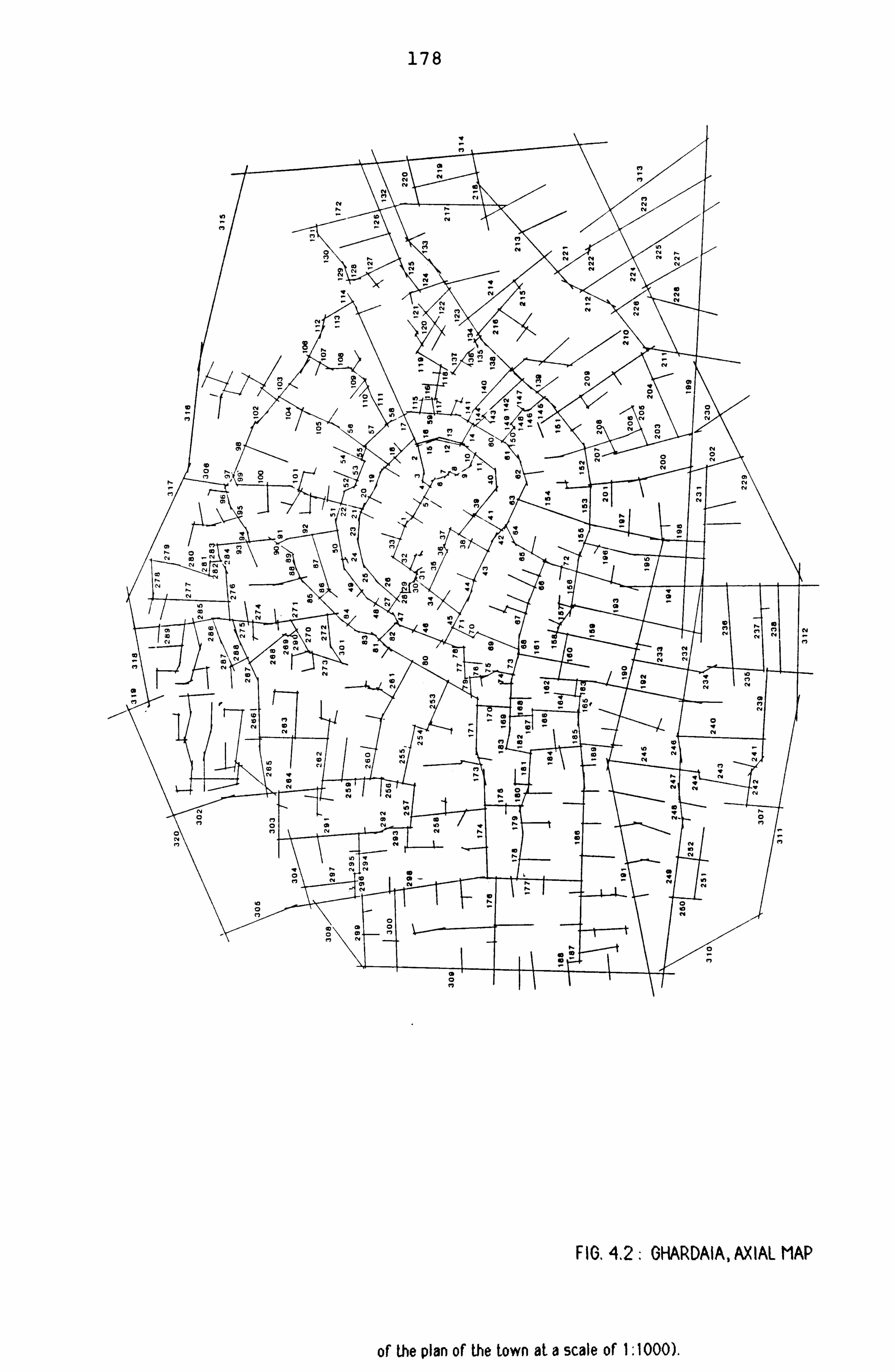
178
FIG. 4.2. GHARDAIA, AXIAL MAP
of the plan of the town at a scale of I: 1000) -

179
v
I
FIG. 4.3: BENI ISGUEN, AXIAL MAP
3ý Tha Pnwiml man .. -"ziu., of the ground plan of the town at a scale of I -, 1000).

180
FIG. 4.4 - EL OUED, AXIAL MAP

- 181 -
-------------------------------------------- MEASURES FOR SAMPLE MEASURES FOR 75 URBAN
--------- OF CASE
----- - STUDIES SYSTEMS(*)
---- - CN
---------- RRA
--------- CN
--------------- RRA
--------- MEAN
----------- 2.619
---------- 1.599
--------- 3.596
--------------- 0.934
(K)
---------
(-0.017)
-- - (0.424) (0.197) (-0.053)
MAX. ------- -
6.000 ----------
2.362 ---------
14.280 ---------------
1.532 M (0.763) (0.272) (0.765) (0.027)
-------- MIN.
------------ 1.889
---------- 1.155
--------- 1.133
--------------- 0.563
(K) (-0.590) (0.517) (-. 153) (-. 059)
-------- ST. DEV. --------
----------- 0.916
-----------
----------- 0.273
-----------
--------- 2.208
---------
--------------- 0.203
---------------
TABLE 4.1: MEASURES FOR THE 12 CASES TAKEN AS A GROUP AND THE 75 URBAN SYSTEMS, AND CORRELATIONS WITH SIZE.
Table 4.1 gives the means for the basic measures and
their correlations with size for both the whole sample
and the 75 urban systems. (SERC Report, 1986, p. 9). It
shows markedly different characteristics:
- The mean connectivity of the sample (2.619) is much
lower than the average for the 75 urban systems
(3.596), and does not correlate with size (as in the 75
cases) .
- The maximum connectivity for the whole sample, which
is the mean of all maximum values, is only 6.00 com-
*K refers to size and St. Dev. to standard deviation of the RRA measures. The figures in brackets represent the correlation coefficients of K with the other measures. The average K of the systems is 112.
* Source: SERC Report, 1986, p. 9.

- 182 -
pared to 14.28 for the 75 urban systems, and positively
correlates with size as in the 75 urban systems.
- The mean integration of the sample (1.599) is much
lower (*) than average (0.934 for the 75 urban sys-
tems); and does correlate but only weakly with size
(0.424), in contrast to the 75 urban systems where
there is no correlation (-0.053). This means that the
systems under examination tend to become more segre-
gated as they grow larger.
- The maximum integration (2.362) does correlate with
size, but only very weakly (0.272), compared to the 75
urban centres in which there is no correlation (0.027).
The maximum integration for the 75 urban systems is in
fact equal to the mean of the towns under study.
- The minimum integration (1.155) which remains much
lower than the mean for the 75 urban systems, behaves
in the same way as the mean integration.
*A low value of RRA measure indicates a strong level of integration (see Appendix2 of SERC Report, 1986).

- 183 -
----- ------------------------- MEASURES FOR THE
----------- MEASURES
------------ FOR THE 75
WHOLE SAMPLE URBAN SYSTEMS (*) -----
-----
--------- 1: RA/CN
---------
--------- 1: RA/RCH ---------
------- CN/CH -------
----------- 1: RA/CN 1:
-----------
------- RA/RCH -------
----- CN/C14 -----
MAX. 0.577 0.792 0.740 0.949 0.924 0.928
MEAN 0.289 0.496 0.379 0.686 0.740 0.768
MIN. 0.078 0.219 0.256 0.356 0.316 0.122
r: K -----
-. 641
--------- -. 695
-------- -. 410
-------- -. 552
----------- -. 587
------- -. 132
-----
TABLE 4.2: SECOND ORDER MEASURES FOR THE 12 CASES AND FOR THE 75 URBAN SYSTEMS.
The second order measures for the sample and for the 75
urban systems are set out in Table 4.2 which shows
striking differences between the two sets of measures.
The key results are:
- The average intelligibility for the whole sample
(0.289) is by far much lower compared to the 75 urban
systems (0.686), and strongly correlated but negatively
with size. This means that the intelligibility of the
systems weakens with regard to size, as the 75 systems.
- The global predictability is again of a lower range
(0.496) when compared to the 75 urban systems (0.740),
and strongly correlates with size (-0.695); and indi-
cates that these systems when considered as a group,
become less predictable as they grow bigger.
* Source: SERC Report, 1986, p. 11.

- 184 -
- The local predict-ýbility for the sample (0.379) is
also much lower than it is for the 75 urban areas
(0.768), and does correlate but only weakly with size.
Clearly, these measures of the towns considered as a
group already indicate distinctive properties of the
spatial fabric of the towns under study. They indicate
a highly segregated fabric which is less intelligible
and less predictable than the 75 urban systems, and
which is strongly affected by size.
----- ---- --- -------- K
---------- 1: RA/CN
---------- 1: RA/RCH
----------- CN: CH
----- MEAN
---- CN
--- -------- -0.017
---------- 0.435
---------- 0.139
----------- 0.004
MAX. CN 0.763 0.151 -0.384 -0.218 -- -----
MEAN ---- RRA
--- -------- 0.424
---------- -0.751
---------- -0.626
--------- -0.591
(cont log K) - (-0.563) (-. 348) (-0.435) MAX. RRA 0.272 -0.473 -0.566 -0.495 (cont log K) - (-0.256) (-. 416) (-0.370) MIN. RRA 0.517 -0.898 -0.570 -0.546 (cont -----
log
---- K)
--- -
--------
(-0.802) ----------
(-. 218)
----------
(-0.348) -----------
----- 1: RA/
---- CN
--- -------- -0.641
---------- ---------- 0.543
----------- 0.560
(cont log K) - (-. 018) (0.347) (cont RRAMEAN) - - (0.143) (0.218)
1: RA/ RCH -0.695 0.543 0.695 (cont log K) - (-. 018) (0.579) (cont
----- RRAMEAN) -
---------------
(0.143)
---------- ----------
(0.517)
-----------
TABLE 4.3: SYNOPTIC CORRELATIONS FOR THE TOWNS UNDER STUDY (12 CASES).
Table 4.3 summarizes the degree to which the analytic
* (cont log K) refers to the partial correlation between two measures when controlling for size given by log K.

- 185 -
measures relate to each other, controlling for log K or
for integration. The results are:
- There is no strong correlation between the connec-
tivity and the second order measures.
- The integration correlates strongly with intelligi-
bility (-0.751), weakening to (-0.563) when log K is
controlled for, which is the opposite way round to the
75 urban areas (-0.527 becoming -0.714 when log K is
controlled).
- -The integration does correlates with global predic-
tability (-0.626). but strongly falls when size is con-
trolled for (-0.348), another different result from the
75 urban systems where there is no correlation (0.0024
becoming 0.034 when log K is controlled for).
- The integration also correlates with local predicta-
bility (-0.591) but not to the same degree as in the 75
systems (-0.716 improving to -0.743 when log K con-
trolled for), and falls when log K is controlled
0.435) .
Table 4.3 shows also that there is a positive correla-
tion between intelligibility and predictability (0.543)
which disintegrates entirely in both when log K and
mean RRA are controlled, contrarily to the 75 systems
where the correlation between the two measures improves
strongly when mean RRA is controlled, and suggests that
this change may denote a key property of the systems
under study and the way they grow.

- 186 -
But, the idea of settlement type implies the existence
of a set of properties that remains constant across the
sample of different cases and the above measures do not
show that, but were merely derived by calculating the
means of the specific values for each case, indicating
only that without any information concerning the varia-
tions and the differences between the cases.
For this purpose, the following sections set up a
detailed examination of the measures for each town at
different stages of development, and for each version
of the settlement.
CASE ONE: GHADAMES
----------------- -------------- GHAD1
------------- GHAD2
----------------- NBER OF SPACES
-------------- 160
------------- 161
----------------- MEAN CN
-------------- 2.50
------------- 2.54
MAX. CN 5.00 5.00
------------------ MEAN RRA
------------- 2.29
------------- 1.47
MAX. RRA 4.37 3.05 MIN. RRA 1.36 0.80 ST. DEV. (RRA) 0.65
---------
0.41
------------ ------------------ 1: RA/CN(1*)
---- 0.46
- 0.49
R INTEL(2*) -0.19 -0.16 1: RA/RCH 0.46 0.52 R. PRED. -0.24 -0.18 CN/CH ------------------
0.46
-------------
0.56
-------------
TABLE-4.4: GHADAMESO, MEASURES FOR THE TWO VERSIONS

- 187 -
The above table shows no variation in the mean and the
maximum connectivity, but a clear improvement in the
integration of the system when connected to the out-
side. These remain however well below average. The
intelligibility is very low for both versions. The
level of global and local predictibility is also low
and improves a little in Ghad2.
---------
- -
-------- MAZIGH
---------- BELLIL
--------- WAZIT
--------- DARRAR
--------- WHOLE
-- ----- NBER OF
-------- 12
---------- 20
--------- 50
--------- 67
--------- 160
SPACES --------- MEAN CN
-------- 2.17
---------- 2.15
--------- 2.60
--------- 2.57
--------- 2.50
MAX. CN 3.00 3.00 5.00 5.00 5.00
--------- MEAN RRA
-------- 1.37
---------- 1.93
--------- 1.32
--------- 1.45
--------- 2.29
MAX. RRA 1.85 2.68 2.52 2.05 4.37 MIN. RRA 1.21 1.42 0.80 1.02 1.36 ST. DEV. 0.18 0.29 0.33 0.24 0.65
---- -- --------- 1: RA/CN
-------- 0.76
---------- 0.67
--------- 0.61
--------- 0.55
--- 0.46
R. INTEL. -0.10 -0.15 -0.15 -0.17 -0.19 1: RA/RCH 0.87 0.89 0.71 0.79 0.46 R. PRED. -0.04 +0.01 -0.09 +0.01 -0.24 CN/CH ---------
0.69
--------
0.86
----------
0.71
---------
0.70
---------
0.46 ---------
TABLE 4.5: GHADAMES, MEASURES FOR THE DIFFERENT PARTS.
Table 4.5 sets up the analytic measures for the four
1* It must be noted that the mean for correlation coeffi- cients (i. e. l: RA/CN) for the whole sample have been derived from the squared values of the variances, in order to over- come the problem of negative coefficients. This is why the means for the towns taken as a group are much lower than the values computed for each case separately.
2* In the tables, R INTEL. refers to the relative intelli-
gibility which expresses of the intelligibility of the sys- tem in question against the value predicted by the synoptic studies of the 75 areas for a system of a similar size. Similarlyr R PRED. refers to the relative predictibility.

- 188 -
quarters of the town. The results show that:
- The mean connectivity of the small areas varies but
not strongly (from 2.15 to 2.60) and takes the lowest
value in Bellil, the quarter without the terrace sys-
tem, but remains in general well below average.
- The maximum connectivity is also very low in the
smallest areas (3.00 in Mazigh and Bellil), and
increases in the larger quarters; but in all cases it
remains by far below average.
- In all areas, the mean integration remains very low;
it is the lowest in Bellil quarter (1.93).
- The intelligibility is below average in all quarters
and strongly falls when the areas are put together.
- The predictability given by the integration is in
general, about average in the four small systems
(although in Wazit, it is below average, -0.09), and
strongly falls when these are combined into the larger
system.
- The predictability given by the connectivity is
about average in the small systems, but becomes much
weaker in the system seen as a whole.
- The integration cores for each of the small areas
are presented in figures 4.5 to 4.8.
In Darrar, the three best lines in terms of integration
form a linear sequence running from the southern peri-

189
FIG. 4.7: OHADAMES, INTEGRATION CORE FIG. 4.5: GHADAMES, INTEGRATION CORE OF DARRAR OF MAZIGH
FIG. 4,8: GHADAMES, INTEGRATION CORE FIG. 4.6: CHADAMES, INTEGRATION CORE OF WAZIT OF BELLIL

- 190 -
phery towards the north, and linking the market square
and the main mosque to the rest of the area. The
integration core tends to form a continuous structure
expanding in several directions across the quarter. An
increase in the percentage (15%) of the most integrated
spaces that constitute the core reveals a structure
which approaches the covering core type, that is a core
with a group of linked spaces at the interior of the
area, connected to the outside by means of several
other lines. The best lines in terms of integration
run also along the streets that are furnished with
masonry benches. The most segregated spaces form four
clusters around the integration core.
For Wazit, the integration core concentrates in the
area near the mosque and expands into two directions,
one southerly along the "Tingesin" street and the other
easterly and penetrates deep into the area (see
Integration Map, fig. 4.6). The core presents as well
a structure which tends to cover the whole quarter, and
links to the outside in three main directions. It also
develops along the streets that are equipped with
masonry seats. The most segregated spaces form two
main clusters on the edges of the area.
For Mazigh, the integration core takes a linear shape
running along the main road of the quarter which is
also equipped with built-in seats for men.
For Bellil, the integration core constituted only by
two lines runs along the peripheral street. The

- 191 -
quarter's mosque is located on the core.
Only Darrar and Wazit contribute strongly to the con-
stitution of the integration core of the whole system.
When the cores of these two areas are combined
together, the resulting structure bears strong resem-
blance to the integration core given by the analysis of
the system taken as a whole (see fig. 4.9). A detailed
analysis of the system as a whole will follow.
The above results show a clear tendency towards the
isolation and localisation of the smaller areas through
the way in which the system distributes its connec-
tivity, which creates an overall strong SE! gregation.
The whole spatial structure seems to be geared towards
the emphasis of the local areas. The fact that both
the mean and the maximum connectivity remain constant
throughout the growth process suggests that the system
when expanding, does not introduce more order by adding
more connections to some spaces, while for example,
retaining the overall degree of connectivity constant,
as observed in the 75 urban systems study (SERC Report,
1986, pp. 9-10).
PATTERN OF THE INTEGRATION IN GHADAMES:
The spatial analysis of Ghadames in terms of integra-
tion reveals some interesting properties. Figure 4.9
shows the order of integration of the 10% most
integrated lines. The first integrator runs on the

192
FIGý 4.9: GHADAMES, INTEGRATION CORE (GHADO
INTEGRATION CORE 509 SEGREGATED SPACES

- 193 -
Walid side of the town, along the main mosque. The
second integrator traverses the market square and links
together the two parts of the settlement; the third and
the fourth most integrated lines are located in Darrar
and Wazit quarters respectively. The three most
integrated lines intersect at the market square.
The most integrated spaces are carefully located on the
edge of the town, though the linear form of the settle-
ment disguises this position. They form a continuous
structure, running north-south across Darrar and Wazit.
This integration core traverses the market square, Suq
El Gaddus, where the two main mosques are located,
Jama'a El Atik for the Walid and Jama'a Yunes for the
Wazit. These town facilities are located at one extrem-
ity of each quarter, and constitute the only common
ground between them. The integration core penetrates
only a little into the quarters, but without traversing
them. The most integrated spaces form also, two rings
on either side of the market square.
The most segregated spaces, on the other hand, form
four separate clusters, in each of the four distinct
parts of the town. Most of the lines (if not all) of
the axial systems of the areas Mazigh and Bellil, form
part of the segregated spaces. These are as well in
geographical terms, rather remote from the market
square and the two main mosques. The most segregated
spaces in Darrar are located on the north-eastern peri-
phery of the quarter. In Wazit, they are on the

- 194 -
eastern periphery.
From this analysis, it appears that in Ghadames, the
market square and the area around the two main mosques
form the major elements in terms of integration for the
whole system. Figure 4.10 shows the integration core
resulting from the analysis of the system connected to
the outside, which consists of all the gatelines of the
town, mainly because the "outside" is now the most
integrated element. The core presents then a discon-
tinuous structure which is located away from the town
facilities.
On the other hand, the radius-3 integration core shown
in figure 4.11, includes most of the spaces of radius-n
integration core (GHADD, and also some of the spaces
of the integration cores of Darrar and Wazit.
THE ANALYSIS OF SIMULATED MOVEMENTS IN GHADAMES:
The choice structure:
The mapping of the strong choice lines shown in figure
4.12, reveals a linear structure running north-south
through the two quarters, Darrar and Wazit. The best
three lines in terms of choice intersect at the market
square and link together the two quarters, while the
fifth and the sixth run from the central area where the
two mosques are located, and penetrate into the two
quarters. None of the spaces of Bellil and Mazigh,
form part of the strong choice structure.

195
ýw
/ FIG. 4.10: GHADAMES, INTEGRATION CORE (GHAD2)
INTEGRATION CORE
-41 gateway

196 \ýj
FIG. 4.11 : GHADAMES, RADIUS-3 INTEGRATION CORE

N
197
FIG. 4.12: GHADAMES, THE CHOICE STRUCTURE
CHOICE STRUCTURE RANDOM JOURNEYS FROM OUTSIDE
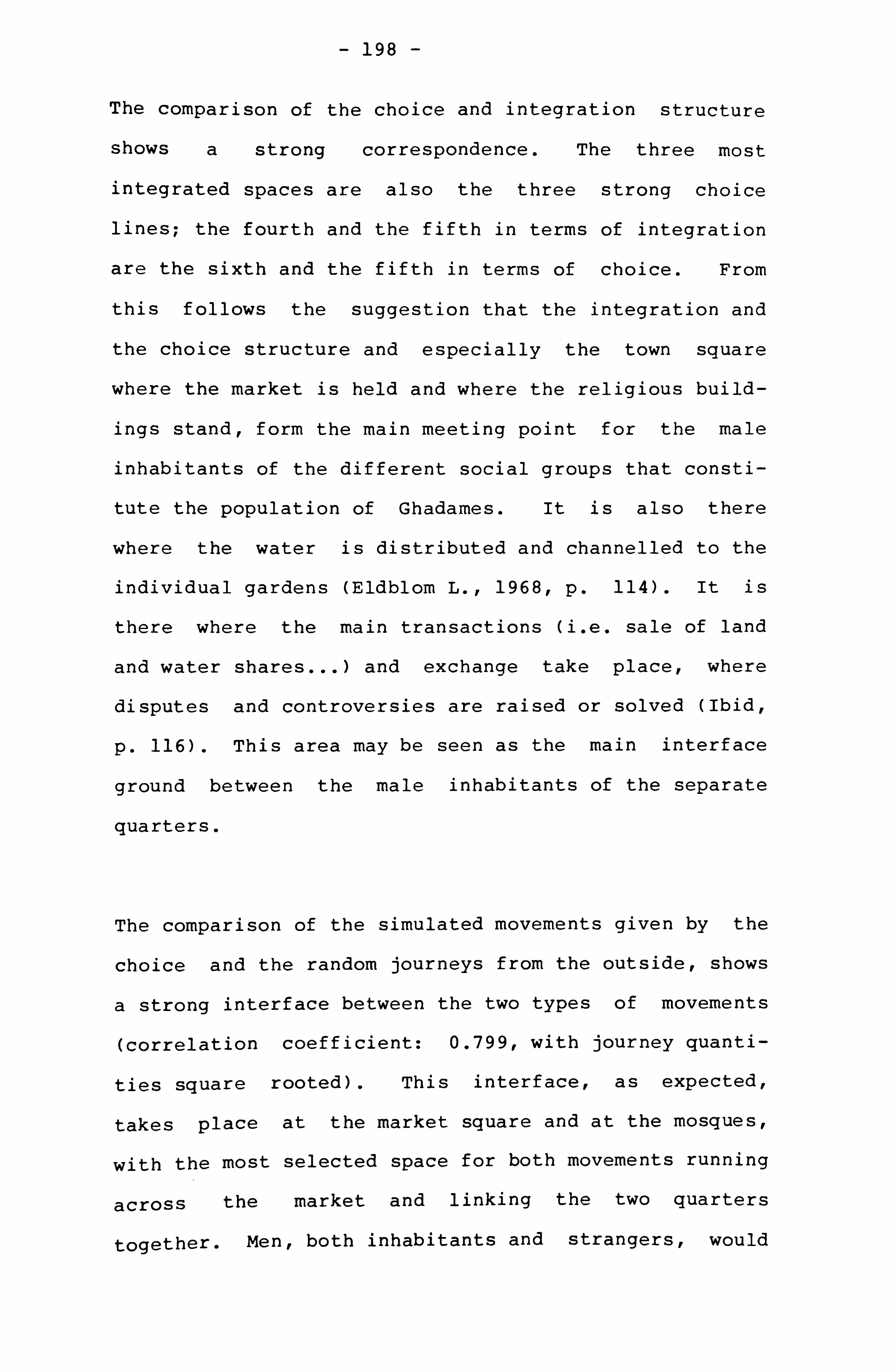
- 198 -
The comparison of the choice and integration structure
shows a strong correspondence. The three most
integrated spaces are also the three strong choice
lines; the fourth and the fifth in terms of integration
are the sixth and the fifth in terms of choice. From
this follows the suggestion that the integration and
the choice structure and especially the town square
where the market is held and where the religious build-
ings stand, form the main meeting point for the male
inhabitants of the different social groups that consti-
tute the population of Ghadames. It is also there
where the water is distributed and channelled to the
individual gardens (Eldblom L., 1968, p. 114). It is
there where the main transactions (i. e. sale of land
and water shares ... ) and exchange take place, where
disputes and controversies are raised or solved (Ibid,
p. 116). This area may be seen as the main interface
ground between the male inhabitants of the separate
quarters.
The comparison of the simulated movements given by the
choice and the random journeys from the outside, shows
a strong interface between the two types of movements
(correlation coefficient: 0.799, with journey quanti-
ties square rooted). This interface, as expected,
takes place at the market square and at the mosques,
with the most selected space for both movements running
across the market and linking the two quarters
together. Ment both inhabitants and strangers, would

- 199 -
most probably meet at this area of the town.
CASE TWO: GHARDAIA
----------------- ------------ Gl
------------ G2
------------ G3
----------------- NBER OF SPACES
------------ 320
------------ 307
------------ 308
- ---- ----------------- MEAN CN
------------ 2.782
------------ 2.710
------ - 2.747
MAX. CN 13.000 12.000 12.000 ----- -----------------
MEAN RRA ------------
1.571 ------------
1.764 -------
1.435 MAX. RRA 2.260 2.719 2.124 MIN. RRA 1.129 1.230 0.884 ST. DEV. (RRA) 0.227 0.301 0.242
---------- ---------------- 1: RA/CN
------------ 0.460
------------- 0.420
-- 0.520
R INTEL. -0.114 -0.158 -0.058 1: RA/RCH 0.470 0.500 0.520 R. PRED. -0.160 -0.133 -0.113 CN/CH ----------------
0.580 ------------
0.550 -------------
0.690 ------------
TABLE 4.6: GHARDAIA, MEASURES FOR THE THREE VERSIONS
Table 4.6 sets up the measures for the systems of Ghar-
daia analysed according to the three different versions
of representation. G1 refers to the system with the
peripheral streets inside the town walls; G2 refers to
the system without these spaces, and G3 refers to the
system with the gatelines connected to the outside seen
as a single entity. The results are:
- The maximum connectivity remains constant for the
three versions and is about average. The fact that the
mean and the maximum connectivity do not vary consider-
ably when the peripheral spaces are removed suggests

- 200 -
that the connectivity of the system is not invested in
the peripheral streets.
- In all the versions of analysis, the level of
integration is well below average, but the removal of
the connections to the peripheral streets has resulted
in a loss in the integration of the system through
these lines. The connections of the town to the outside
has resulted in a slight improvement in the level of
integration. The mean integration is now 1.475 com-
pared to 1.571 in Gl. The depth of the system (*)
measured from the gatelines takes a value of 5.203 com-
pared to 5.227. This means that the integration of the
system from the edge is less affected by the removal of
the peripheral lines than the internal integration, and
suggests that the first idea concerning the relation-
ship between the peripheral spaces and the control of
the strangers is not obvious.
- The intelligibility of Gl and G2 is far below the
value predicted by the synoptic studies of the 75 sys-
tems for systems of similar size. It is about average
in G3. In other words, the system of Ghardaia appears
to be more intelligible from the outside.
* Depth from the outside is defined as the minimum number of spaces (in terms of spatial transition) which must be crossed to reach a space from the nearest entrance point into the settlement. The mean depth from the outside gives the average distance in terms of axial steps, for all spaces in the system from the outside. For detailed information,
see Hillier and Hanson, 1984, p. 106.

- 201 -
- In all cases, the global predictability is below
average, and improves, although only weakly, when the
system is looked at without the peripheral spaces (G2)
and when it is connected to the outside (G3).
- The local predictability of the system is also low
in all the versions, weakening to 0.55 with the removal
of the peripheral spaces, and improving to 0.69 when
the system is connected to the outside.
Ghardaia and its phases of expansion
Two stages of expansion prior to the present town are
known in the process of development of Ghardaia (Donna-
dieu & Didillon, 1977, p. 50). The first nucleus started
to grow around the main mosque on the top of the hill
(Ibid, p. 50). The initial town, and the second stage
town, will be referred to as Ghardaia 1 and Ghardaia 2
respectively; Ghardaia 3 will refer to the present town
as in Gl.

- 202 -
----------- ------------- GHARDAIA 1
-------------- GHARDAIA 2
-------------- GHARDAIA 3
----------- - - - (Gl)
NBER OF ------------
63 --- - --------
171 --------------
320 SPACES ------ ----- MEAN CN
------------- 2.50
-------------- 2.50
-------------- 2.80
MAX. CN 5.00 6.00 13.00 ----------- MEAN RRA
------------- 1.51
-------------- 1.76
-------------- 1.57
MAX. RRA 1.79 2.85 2.26 MIN. RRA 1.18 1.22 1.13 ST. DEV. 0.15 0.33 0.23 ----------- 1: RA/CN
------------- 0.52
-------------- 0.48
-------------- 0.46
REL. INTEL. -0.21 -0.16 -0.11 1: RA/RCH 0.65 0.65 0.47 R. PRED. -0.13 -0.04 -0.16 CN: CH -----------
0.62
-------------
0.70
--------------
0.58
--------------
TABLE 4.7: GHARDAIA, MEASURES FOR THE THREE PHASES OF EXPANSION.
The results show that:
- the mean integration remains consistently low as the
system grows bigger, and is much lower than the average
for the 75 urban areas (0.934), but varies considerably
from one stage to another.
- the mean connectivity remains also consistently low
and well below average, though with some differences
between the first two phases and the present system.
- the maximum connectivity increased dramatically when
the system has increased in size, especially from the
second to the third phase of expansion.
- the intelligibility is low at all phases compared to
the values predicted for systems of the same size by
the studies of the 75 urban systems, and improves but

- 203 -
only weakly as the system becomes larger.
- the predictability given by the integration is poor
in the small system (-0.195), and remains so in the
larger ones, although there is a marked improvement in
the second stage of growth.
- In Ghardaia 1, the integration core is confined to
the periphery of the original settlement, penetrating
only in one place (see fig. 4.13). It forms a cross-
like structure and links directly the mosque to the
outside. The three best lines in terms of integration
intersect at the mosque and incorporate the spaces that
are adjacent to it. The most segregated lines tend, on
the other hand, to form as well a relatively continuous
structure mainly located on the northern edge of the
small settlement. Little information exists concerning
the location of the market during this phase.
In Ghardaia 2, the integration core (see fig. 4.14)
takes the shape of a crescent linearly expanding east-
west across the settlement and following the southern
previous town boundaries. This structure includes both
the mosque and the small market square, and links but
not strongly, the inner parts to the outside. The
mosque becomes less spatially integrated, but the
market is now the second best integrator. The com-
parison of the integration core in both, Ghardaia 1 and
Ghardaia 2 shows no strong shift in the location of the
core. It suggests that the system grows by adding more
elements to the old structure rather than by

FIO. 4,13: GHARDAIA, INTEGRATION CORE (OHARDAIAO
FIG. 4.14: GHARDAIA, INTEGRATION CORE (GHARDAIA2) INTEGRATION CORE 50F* SEGREGATED SPACES

- 205 -
restructuring the whole system. Yet, a clear change
has taken place in the internal structure of the core;
for instance, the mosque is no longer a strong spatial
element and the linkage to the outside is maintained,
though it is much weaker. At this stage, the market was
an unimportant element in the Saharan trading network.
When the town develops again into a more self-contained
structure, it adds, it seems, more elements and more
order without again restructuring the older parts. The
segregated lines on the other hand, clearly form two
clusters of spaces, developing on the periphery of the
system and around the integration core.
Some preliminary conclusions can be drawn from this
analysis; that is as the system grew larger, it has
consistently maintained some spatial properties low.
Despite important variations in the levels of integra-
tion, these remain very low, and so does the mean con-
nectivity. The intelligibility and global predictibil-
ity are also kept low through the growth process.
The second result is that the system, as it grows
larger, retains the same level of the overall connec-
tivity, but it considerably increases the maximum
values which vary from 5 to 6 to 13. This is possible
only if the system, when growing larger, it discrim-
inated few streets and town features from the rest of
the system by increasing their connections. These town
elements are in fact the market, the commercial streets
as could be seen from the axial map in figure 4.2.

- 206 -
THE PATTERN OF INTEGRATION IN GHARDAIA AS A WHOLE (Gl):
The spatial analysis of Ghardaia showed striking pro-
perties regarding the structure of the integration core
and the distribution of the most segregated spaces. The
best integrator is located close to the southern edge
of the settlement and traverses the market square (see
fig. 4.15). The second best integrator intersects with
the first at the market square. The third and the
fourth best lines in terms of integration form a linear
sequence pointing to the north-eastern direction where
the main mosque is located, and linking to the old
core. The sixth and the nineth directly link the
market square to the outside. The map shows that the
market square and the streets that lead to it integrate
even though they are on the edge of the town. In fact,
all of the thirty-two most integrated spaces are
located on the southern part of the settlement. They
form a continuous structure that links three of the
town. gateways to specific areas of the town. Figure
4.15 shows two distinct area that are almost diametri-
cally opposed to each other in the town fabric as a
whole.
The segregation map constituted by the 25% of the least
integrated spaces shows a well defined segregated zone.
These spaces are almost all located on the northern
part of the town, despite the fact that many of the
town gateways are located on that side. These spaces
include one dominant continuous structure, which takes

207
Ir
-l/ . 11
FIG. 4.15: GHARDAIA, INTEGRATION CORE (01)
I NT EORAT I ON COR, E
. 25507 5EGRELOATED SPACES
101k SEGRE16 'AT, ED PAC E'-

- 208 -
the shape of a crescent expanding from the northern
periphery towards the geographical centre of the town.
Many of the spaces that surround the main mosque form
part of the most segregated spaces. A higher percen-
tage (50%) of the most segregated spaces strongly con-
firms the picture already outlined above; the division
into two zones is more firmly established (see fig.
4.15). This phenomenon did not occur in the passage
from the first to the second stage, although the town
has as well doubled in size.
This analysis has shown one dominant characteristic:
the location of the integration structure in specific
region of the town, leaving therefore a large part not
easily accessible. This particular location suggests a
potentiality of the spatial structure to accommodate
two distinctly separated zones at least in terms of
accessibility.
THE PATTERN OF INTEGRATION OF GHARDAIA WITHOUT THE
PERIPHERAL SPACES (G2):
The two-sidedness and the non-covering core in the glo-
bal organisation of this town appears to be a distinc-
tive property. In order to find out more about this
point, further analysis is required to investigate the
real nature of the integration core. This is aimed to
see whether this overall distribution of the most
integrated spaces is resulting from the effect of the

- 209 -
peripheral streets of the walled city. The question
originating from the above analysis is that there may
be a relationship between these outer streets and the
peripheral and non-covering nature of the integration
core. In other words, the existence of the fortifica-
tion walls and the resulting outer streets may have
influenced the peripheral and the non-covering struc-
ture of the core. In this exercise, the linkages to the
outer spaces that are constituted by the town walls and
the peripheral buildings, are then ignored in the input
data (lines numbered from 308 to 320 in the axial map,
fig. 4.2).
The mapping of the most integrated spaces resulting
from the analysis of this revised version of the map
shows a clear shift in the internal structure of the
core (see fig. 4.16). The best line in terms of
integration moves from the market square to the area on
the original boundary of the first phase of the town
development (see Phases of Development in fig. 2.15).
A small mosque lies on it which was according to Donna-
dieu and Didillon, reserved for the Ibadhite of Wargla
during their visits to Ghardaia (Donnadieu and Didil-
lon, 1977, p. 50). This historical evidence makes
sense regarding the distribution of the public facili-
ties in relation to the outside users. In fact, this
mosque was once on the edge of the old settlement which
would have facilitated its access to the visitors from
Wargla.

210
'I
FIG. 4.16: GHARDAIA, INTEGRATION CORE (62)
mmmmý INTEGRATION CORE 25% SEGREGATED SPACES 50% SEGREGATED SPACES

- 211 -
The best three lines in terms of integration form a
linear sequence running from the area near the main
mosque in the direction of the market and their order
is also reversed. These three lines link directly the
area adjoining the mosque to the market square. The
lines of the market become in this case, less
integrated than in the previous analysis (Gl). What
this result shows is that the dominance of the market
square in G1 is to some extent dependent on its links
to the periphery. A purely "internal" view of the town
showed then a rather different story.
The comparison of figures 4.15 and 4.16 however shows
no strong variations with regard to the overall shape
and location of the integration core in the town
fabric. In both cases, the core remains occupying the
southern part of the town. But, the main difference
between the two cores resides in the order of the
lines, especially those in the vicinity of the market
square, which becomes less accessible from the outside:
the street that links the market square to the outside
forms part of the integration core but is classified
13th in G2. compared to 6th in Gl. The integration
core has now strongly moved towards the mosque.
The spaces around the mosque become also less segre-
gated in G2 than they are in Gl. This suggests that
the relatively greater segregation of the spaces that
are immediately adjacent to the mosque in Gl is also a
result Of the links of the settlement to the periphery.

- 212 -
In consequence and despite these variations in the
internal structure of the cores, the results regarding
the overall pattern of distribution of the most
integrated and the most segregated spaces are strik-
ingly similar in both cases: Gl and G2. They form two
separate clusters of spaces on either side of the geo-
graphical centre of the town, where the town mosque is
located. Both the most integrated and segregated
spaces tend to constitute a continuous structure, which
penetrates close to the geometric centre without how-
ever, traversing the town fabric.
In conclusion, the removal of the peripheral spaces has
an important effect on the internal structure of the
integration core, but the overall shape of the core and
its location in the whole fabric remains similar. By
removing the effect of the peripheral spaces, a clear
shift in the integration structure takes place: the
first integrator is no longer directly connected with
the market. The core runs more from the mosque to the
market than from the market to the mosque and to the
outside, as seen in Gl.
THE PATTERN OF INTEGRATION IN GHARDAIA WITH GATELINES
LINKED TO THE OUTSIDE (G3):
The integration maps shown in figures 4.15 and 4.16,
were derived from the analysis of the settlements con-
sidered as closed systems; that is the connections of
the settlement to the outside are not taken into

- 213 -
account, and the degree of integration of spaces in
this context, refers to the distancing of spaces from
every other space, excluding the outside. In the next
analysis, these links to the outside will be added and
the effect of these connections on the internal struc-
ture of the integration core will be also tested. There
are seven gateways; most of which are located in the
northern part of the town (see Town map in fig. 2.14).
In this exercise, all of the gateways are connected to
the outside represented as a single entity.
Figure 4.17 sets out the integration core and the most
segregated spaces and shows some remarkable results.
These can be summarized as follows:
i- The street that links the outside to the market
square becomes the first integrator. This demonstrates
that the market is strongly dependent on the connec-
tions of the town to the outside. It is the strongest
integrator with respect to the outside and therefore
might be expected to be mainly oriented towards the
strangers' use, and in interfacing them with the inha-
bitants. This shows also the greater relative segrega-
tion of the inside of the town.
ii- There is a strong concentration of the most segre-
gated spaces around the mosque.
iii- The overall shape of the core and its location in
the whole system remains similar to Gi and G2. The
system exhibits the two-sidedness effect, that is a

214
[I-
l/
FIG. 4.17, GHARDAIA, INTEGRATION CORE (03)
4==ý 1 NT EGRAT I ON COR E 25 % S' :. GATED SPACE 50'7'1ý' 5EGREGATED SPACE...,
gateyvay

- 215 -
strong concentration of the most integrated spaces on
one side of the settlement, with only few lines on the
opposite edge (see fig. 4.17). These are in fact the
four gatelines that are located on the northern part of
the town. This is so, because the outside is now the
second best integrating element.
The analysis of radius-3 integration for the small sys-
tems and for G1 and G2, indicates that in most cases
the radius-3 cores include most of the spaces that con-
stitute radius-n cores (see figures 4.18,4.18a,
4.18b), and suggests that in the system of Ghardaia,
the strong local integrators are also strong global
integrators. But, radius-3 cores of Ghardaia as a
whole, in both G1 and G2 shifts the core more
decisively towards the outside in a similar way to G3.
SPATIAL ANALYSIS OF SIMULATED MOVEMENTS IN GHARDAIA:
The choice structure:
The choice structure in Ghardaia (Gl) is graphically
presented in figure 4.19 which shows the 17 most
crossed spaces (*) in the simulation of movements. This
map reveals a relatively continuous structure of spaces
with strong choice, linking the market square to the
area surrounding the town mosque, and to the outside.
The most selected space in the simulated movements
This represents 25% of the total choice quantities, i. e. the quarter of all theoretical movements.

216
y
FIG, 4.18a: GHARDAIA, RADIU5-3 INTEGRATION CORE (FOR THE 5MALL 5YSTEM5),

4ý*
FIG. 4.18, GHARDAIA, RADIUS-3 INTEGRATION CORE 01
4 gatewaý'

218
--1-3 INTEGRATION CORE (62) FIG. 4.15bý, GHARDAIA, RADIU' 4 qateway

219
FIG. 4.19: OFLARDAIA, CHOICE STRUCTURE (61)
ý CHOICE LINES RANDOM JOURNEYS FROM OUTSIDE

- 220 -
intersects and includes the market square, and the
second most popular passes in the vicinity of the main
mosque (only one axial step distant from it). The
third most selected space passes near a small mosque,
and the fourth includes the original and much smaller
market place, which still accommodates three small
boutiques and shops. But the town entranceways are not
very strong choice lines, and the length of the lines
does not seem to be a substantial parameter in deter-
mining the "choice route" inside the settlement. The
outcome of the analysis shows indeed, that the set of
the strong choice lines is made up of very long as well
as very short lines.
The analysis of choice has been also carried out on the
system without the peripheral streets (G2) and the
results are not markedly different from the above
analysis (see fig. 4.20). The three most selected
lines in the simulated movements, remain the same
whether the system is looked at with or without the
peripheral spaces.
The results of the simulated movements within the set-
tlement consistently points to the overall conclusions
given by the analysis of the integration, in which a
large part of the town has been described as not easily
accessible with respect to the system as a whole. A
clear route has emerged, strongly connecting the market
square to the area near the mosque.
But a detailed comparison of internal structure of the

221
/, C, -
ly
FIG, 4,20 - GHARDAIA, CHOICE STRUCTURE (02)
CHOICE LINES ca)
-4wý. -0 RANDOM JOURNEYS FROM OUTSIDE gateway

- 222 -
the integration core and the choice structure, shows
important differences. These reside in the position of
the mosque: from the point of view of the integration
core, the mosque appeared as strongly segregated,
whereas in terms of the choice structure, the mosque
has emerged as the second most popular element. This
result seems to lend support to the idea that the
integration core in G1 may be seen as geared towards
the movements of the strangers, and the choice struc-
ture representing the popular routes for the inhabi-
tants. Viewed from this point of view, the mosque
appears then as a more exclusive building, mainly
reserved for the men of the town.
One might speculate that the segregation of the mosque
from the integration core and by implication from the
movements of strangers may be explained by reference to
the history of these people. In Part One, it became
clear that the main reason for the past persecution of
these communities has been their religious orthodoxy.
The fact that the mosque is highly segregated with
respect to the outside, but also a strong choice space,
could be seen to express its importance in consolidat-
ing and preserving the identity of these people, as an
inhibitative measure against outsiders. The mosque is
required to integrate the inhabitants, but also to be
kept away from strangers.
The next section will look at the degree of correlation
between the movements generated internally and given by

- 223 -
the choice measure, and the movements originating from
the outside given by the simulation of random journeys
from the outside, in the belief that this may indicate
something like the degree of interface between the two
types of movements.
The results show that the two movements correlate but
not strongly (0.558 with journey quantities square
rooted). The distribution of the choice and journey
quantities presented by the scattergram in figure 4.21,
shows a certain split between the strong spaces. This
suggests that there is an interface which only takes
place in specific areas of the town.
Figure 4.19 sets out the resulting routes given by the
choice and the random journeys from the outside. It
shows that the market square emerges as the most impor-
tant urban element in interfacing the two types of
movements. The most selected spaces in the random jour-
neys from the outside constitute a route which strongly
connects the market square to the outside, and this may
signify that the strangers would be quickly drawn into
and out of the system.
When the same exercise is repeated on G2, the correla-
tion becomes then 0.497 (see Scattergram in fig.
4.21a). This is another indication that this town does
not seem to depend very strongly on its connections to
the periphery for the arrangement of the simulated
movements in the town. However, Figure 4.20 shows a
weaker version when the peripheral lines are omitted.

v
224
2250
2000
1750
1500
1250
1000.
750
5ee
2501
0.090
FIG. 4.21 : GRAPHIC DISTRIBUTION OF CORRELATION BETWEEN CHOI CE AND JOURNEY QUANT ITI ES (G I (CORRELATION = 0,595),
+
'22 ++++
+ 4- +
+
+++
++
+
+t +
4-
++
201 +
0 '09--, 2.005 e. e, e C. 015 0.02e 0.025 Root Journ
FIG. 4.21a: GRAPHIC DISTRIBUTION OF CORRELATION BETWEEN CHOICE AND JOURNEYS QUANTITIES (02) ( COR RE LAT I ON = 0,437).
0.005 0.010 0,015 0.020 0.025 Root Jowrn

- 225 -
CASE THREE: BENI ISGUEN
----------------
----------------
-----------
BI 1 - -- -
------------- BI 2
---- -
-------------
BI 3
NBER OF SPACES ----------------
----- - - 264
-----------
-- - ----- 249
---- -
------------- 250
MEAN CN 2.930 - ------- 2.630
------------- 2.660
MAX. CN 13.000 7.000 7.000 ---------------- MEAN RRA
----------- 1.285
------------- 1.919
------------- 1.790
MAX. RRA 1.826 2.958 2.840 MIN. RRA 0.804 1.363 1.290 ST. DEV. (RRA) 0.190 0.340 0.270 ---------------- 1: RA/CN
----------- 0.380
------------- 0.370
------------- 0.400
R. INTEL. -0.214 -0.230 -0.200 1: RA/RCH 0.530 0.620 0.680 R. PRED. -0.119 -0.035 +0.025 CN/CH ----------------
0.660 -----------
0.450 ------------
0.450 --------------
TABLE 4.8: BENI ISGUEN, MEASURES FOR THE THREE VERSIONS
Table 4.8 summarizes the results of the spatial
analysis of the three versions of representation of
Beni Isguen, with BIl referring to the town as a whole;
B12 to the town without the peripheral spaces; and B13
to the town with the gatelines connected to the out-
side. The results show that:
- The mean and the maximum connectivity are about
average (compared to the 75 systems) for BI1, but fall
dramatically when the peripheral streets are
discounted.
- The mean integration is low in BIl (1.285), and
falls substantially when the peripheral streets are
removed (1.919), and remains so when the system is
linked to the outside as a single space (1.790). The

- 226 -
removal of the peripheral spaces has strongly affected
the level of integration of the system. In other
words, these results suggest that the town depends on
the peripheral streets for its integration.
- The intelligibility is very low for the three ver-
sions compared to the level of intelligibility expected
for systems of the same size. The intelligibility
remains more or less constant in the three versions of
Beni Isguen.
- The global predictability is below average for BIl
(-0.119),, but improves markedly in both cases, when the
peripheral lines are removed (B12, -0.035) and when the
system is connected to the outside (B13, +0.02).
- Table 4.8 shows also a clear loss in the local
predictability when the peripheral streets are removed
or when the system is connected to the outside. This
means that the local predictability of Beni Isguen
depends also on the connections of the system to the
outside, and that the relatively higher level of local
predict bility in BIl is only created by the peripheral
spaces.
Clearly and unlike Ghardaia, the system of Beni Isguen
improves markedly the correlation between integration
and choice when the peripheral lines are removed or
when it is connected to the outside, while at the same
time maintaining the same level of intelligibility.

- 227 -
Beni Isguen and its three phases of expansion:
For Beni Isguen, two main phases of expansion prior to
the present town (*) are reported in the literature
(Donnadieu & Didillon, 1977, p. 55; Bousquet G. H.,
1982, p. 9). These are discernible by the remainings of
the previous walls and by the location of the old
market squares as well as the old gateways (see fig.
2.18). In the text, the original and the second phase
settlement will be referred to as Beni Isguen 1 and
Beni Isguen 2; Beni Isguen 3 will refer to the present
town, as considered in BIl. that is with the peripheral
streets inside the walls.
I
* The actual expansion was achieved in 1860, the date in
which the new fortification walls were built.

- 228 -
-------------------------------------------- BENI ISGUEN 1 BENI ISGUEN 2 BENI ISGUEN 3
---------- -
(BIl)
NBER OF ------------
79 ----------------
123 ---------------
264 SPACES
- --- ------ MEAN CN
------------- 2.58
---------------- 2.73
--------------- 2.93
MAX. CN 5.00 5.00 13.00 ---------- MEAN RRA
------------- 1.46
---------------- 1.61
--------------- 1.29
MAX. RRA 2.12 2.22 1.83 MIN. RRA 0.92 1.15 0.80 ST. DEV. 0.27 0.24 0.19
- ---------- 1: RA/CN
------------- 0.59
---------------- 0.35
- ------------- 0.38
R. INTEL. -0.12 -0.32 -0.21 1: RA/RCH 0.74 0.62 0.53 R. PRED. -0.02 -0.10 -0.16 CN: CH ----------
0.66 ------------
0.56 ----------------
0.66 ----------------
TABLE 4.9: BENI ISGUEN, MEASURES FOR THE THREE PHASES OF EXPANSION.
Table 4.9 summarizes the results of the spatial
analysis for the different phases of expansion of Beni
Isguen. These are:
- The mean integration does vary but not so strongly,
and remains very low as the system increases in size.
It becomes markedly more integrating in the third
phase.
- The mean connectivity does improve as the system
expands, but remains below average.
- The maximum connectivity remains constant in the
first two phases but increases substantially in the
last phase of expansion. The consideration of the ana-
lytic results of B12 suggests that the increase in the
I<, -

- 229 -
maximum connectivity is not internal but only confined
to the peripheral streets, since the removal of these
latter results in a dramatic drop in the maximum con-
nectivity of the system (from 13 to 7).
- The intelligibility is below average in all phases
and falls as the system grows larger.
- The predict bility given by the integration is about
average in the small system, and strongly falls in the
larger ones
- The predictability given by the connectivity remains
constant as the town grows, but is below average in all
systems.
- In Beni Isguen 1. the integration core takes a linear
form expanding internally length-wise across the spa-
tial fabric and strongly connecting the mosque to the
market place (see fig. 4.22). The first, third and
forth line in terms of integration meet at the mosque
and the second best line links the market to the
mosque. The most segregated spaces tend to form also a
continuous structure on the periphery of the original
town. As the system grows, it adds to this pattern of
integration (see fig. 4.23) and maintains the mosque
and the initial market as the best integrators. At
this stage as well, the integration structure does not
link to the outside, and the most segregated lines
still constitute a continuous structure at the peri-
phery of Beni Isguen 2. The remarkable finding is that

230
FIGý 4.22: BENI ISOUEN, INTEGRATION CORE (BENI ISGUEN 1)
FIG. 4.23: BENI ISGUEN, INTEGRATION CORE (BENI ISOUEN2) INTEGPATION CORE 50% SEGREGATED SPACES

- 231 -
Within this apparent disorder, the two most integrated
lines intersect at the mosque, and the third line links
the mosque to the initial market place. These are also
very strong in terms of choice. When the town grows
again (Beni Isguen 3). the integration core becomes
more complex as will be seen in the following sections,
and excludes the spaces adjoining the mosque.
THE PATTERN OF INTEGRATION IN BENI ISGUEN AS A WHOLE
(BIl):
Figure 4.24 shows the 10% most integrated spaces and
both the 25% and 50% most segregated elements of the
system. This map reveals that the best integrator runs
along the peripheral street where there are no public
facilities. It is also the longest line in the whole
street axial structure. The second and the third join
to the first integrator and remain as well on the edge
of the town. The fourth and the sixth lines link the
periphery to the inner part of the town. All of the
components of the integration core consist of a series
of penetrating parallel lines joined together only by
means of the open spaces that are constituted by the
fortification walls and the peripheral buildings. Most
of these lines are at most two axial steps from the
outside. Unlike Ghardaia, the integration core in Beni
Isguen, passes away from both the market square and the
main mosque.
This particular location of the integration core on the
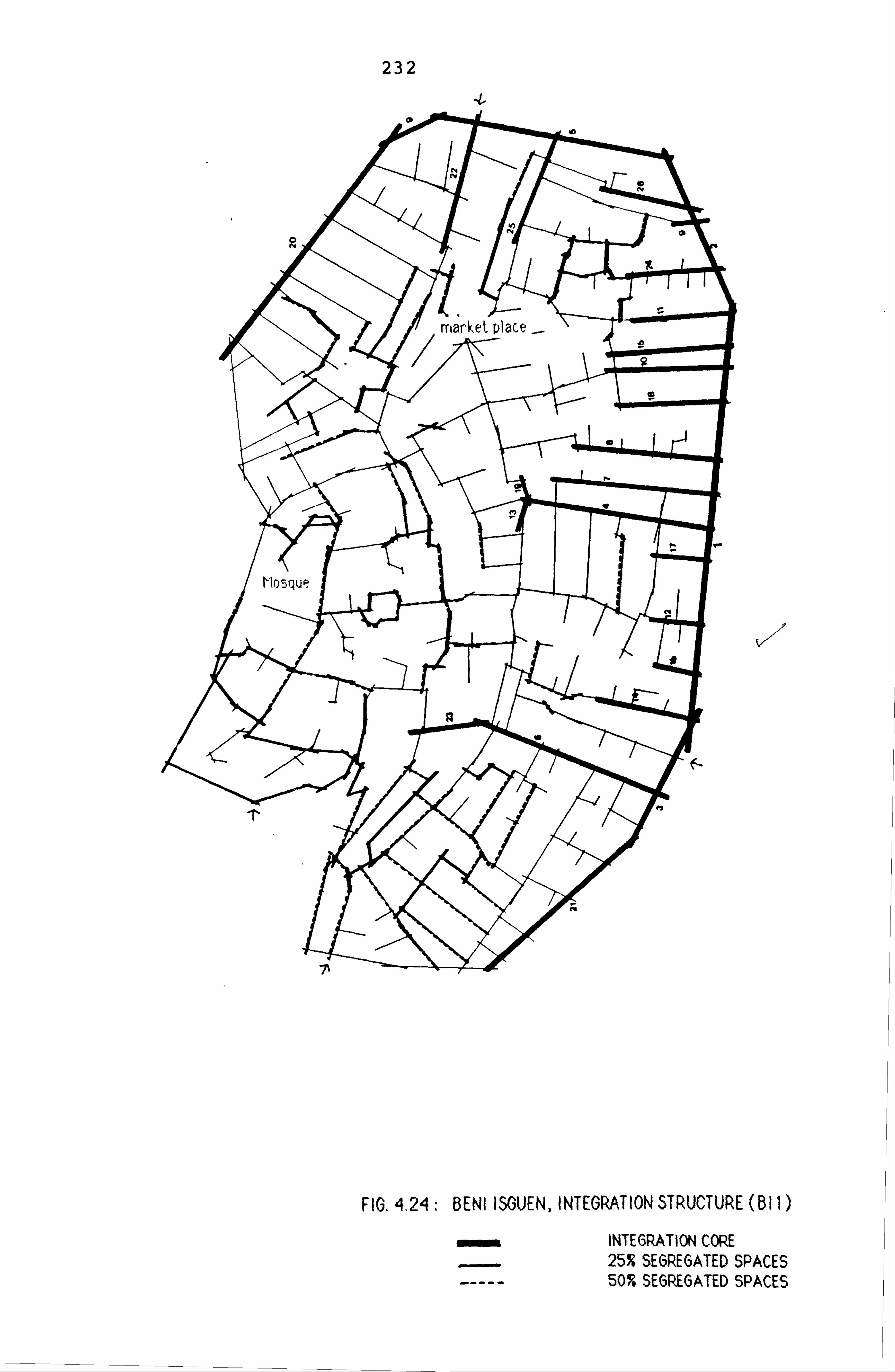
232
-t
V-Z
FIG. 4,24: BENI ISGUEN, INTEGRATION STRUCTURE (B I I)
INTEGRATION CORE 25% SEGREGATED SPACES 50% SEGREGATED SPACES

- 233 -
edge leaves by its very nature, a large part of the
town highly isolated and not easily accessible. The
25% most segregated lines tend to form clusters which
concentrate mainly on the side opposite the area in
which the integration core is located. The mapping of
the 50% most segregated spaces present a slightly dif-
ferent picture. These tend to form a continuous and
more circuitous structure. The spaces around the town
mosque form part of the segregated spaces. Thus, the
integration core and especially the fact that it passes
away from the main activity areas (i. e. the market
square) suggests some underlying differences in the way
in which the two towns, Ghardaia and Beni Isguen, work.
THE PATTERN OF INTEGRATION OF BENI ISGUEN WITHOUT THE
PERIPHERAL SPACES (B12):
Next, Beni Isguen will, 'analysed
by omitting the connec-
tions of the peripheral streets to the adjoining spaces
within the settlement. This exercise yields dramatic
results. Unlike the peripheral core of BI1 (see fig-
ures 4.24 and 4.25), the integration core in B12. con-
sists of a continuous pattern which develops across the
town, and passes through both the old and present
market square, linking the periphery, but not the gate-
ways, to the market square. The four best lines in
terms of integration run along the old town boundaries
as shown in figure 4.25. These lines are on the whole
very short and form a distinct structure with respect

- 234 -
to the overall shape of the integration core, and to
which several other highly integrated lines (indexed 7,
8F 21 and 25 in fig. 4.25) join to make a tree-like
pattern. The most segregated spaces, on the other
hand, tend to form three distinct clusters located on
the periphery of the town. These clusters include a
large number of the spaces that connect to the peri-
pheral streets. But the superposition of figures 4.24
and 4.25 shows that the area to the southern periphery
remains strongly segregated in both, BIl and B12.
This is completely the reverse situation of the
analysis conducted on the settlement as it presents
itself, that is with the remparts and the peripheral
streets forming a ring around the town. The integra-
tion core (in B12) passes as well in the vicinity of
the main mosque without however, including it.
With respect to the system of integration, the peri-
pheral streets constituted by the town walls, have a
major effect on the distribution of both the highly
integrated and segregated spaces on the town fabric. In
fact, the structure of the core is similar to
Ghardaials, in one sense, in that it has a non-covering
pattern, and is confined to one zone of the town.
SPATIAL ANALYSIS OF INTEGRATION OF BENI ISGUEN WITH
GATELINES LINKED TO THE OUTSIDE (B13):
In the case of Beni Isguen, there are four gateways

235
FIG. 4.25: BENI ISGUEN, INTEGRATION STRUCTURE (B12)
INTEGRATION CORE 259 SEGREGATED SPACES 50% SEGREGATED SPACES

- 236 -
which constitute the only entrance points to the town
(see Town Map in fig. 2.17). In this exercise, the out-
side has been connected to all four gatelines and the
resulting patterns of the most integrated and segre-
gated spaces are set out in figure 4.26 which shows
that:
i- The market becomes by far the most integrating ele-
ment: the three best lines in terms of integration all
traverse and intersect at the market square. In other
words, the market might be seen to be highly oriented
towards the strangers' use who have been admitted into
the system, though it remains not directly connected to
the outside as it is the case in Ghardaia (G3). This
difference between the two towns might be explained by
the fact that the market in Ghardaia is the most impor-
tant in the whole valley. It was also an important
caravan centre in the trans-saharan commerce. For this
reason, its links to the outside are crucial to fulfill
this assigned task. For Beni Isguen, the town is more
of a spiritual, religious and exclusive centre; its
links to the outside are carefully guarded. Access to
the strangers is not made obvious, and when admitted
into the "interior" of the town, their movements tend
to be spatially directed towards the market, the only
place in which they do not need any explanation for
their presence.
ii- The area in the vicinity of the mosque becomes
relatively more segregated with respect to the outside,

237
FIG. 4.26: BENI ISGUEN, INTEGRATION STRUCTURE (B13)
wmmý INTEORATION COPE 25T SEGREGATED SPACE'ýý' 50% SEGREGATI EDSPA '-:,

- 238 -
a similar result to Ghardaia (G3).
iii- The overall shape of the integration core and its
geographical position in the whole fabric, remain simi-
lar to B12.
The above analysis suggests that Beni Isguen has in
consequence two integration cores: one peripheral and
passes away from the town's facilities; the other more
internal and includes the area around the market, which
has emerged as the main integrator with respect to the
outside.
As in Ghardaia, radius-3 integration cores of the small
systems of Beni Isguen overlap to a great extent with
their radius-n cores (see fig. 4.27). But, radius-3
core of the town as a whole shows a different picture
from radius-n integration cores (see figures 4.27a,
4.27b). For BIl (the town with peripheral spaces,
radius-3 core includes many spaces of the integration
core (radius-n), and also some of the most segregated
spaces. When the peripheral spaces are removed (B12),
radius-3 core hardly overlaps at all with the integra-
tion core of B12. Moreover, it consists of many spaces
that are strongly segregated with respect to the whole.
This suggests then that Beni Isguen as it grew, seems
to have developed such features as spaces that are
strongly locally connected in parts of the system, but
that are not globally integrating. This seems an
important principle in Beni Isguen which appears to

239
FIG, 427' BENI 15OUEN, RADIU5-3 INTEGRATION COPE5 (FOR THE SMALL SYSTEMS).

FIG. 4,27a: BENI ISGUEN, RADIUS-3 INTEGRATION CORE (BI I)
FIO. 4.27b: BENI 15GUEN, RADIUS-3 INTEGRATION CORE (1312)

- 241 -
develop much more localized structure than Ghardaia.
THE ANALYSIS OF SIMULATED MOVEMENTS IN BENI ISGUEN:
The choice structure:
Figure 4.28 shows the route resulting from the mapping
of the strong choice lines in BIl. which consists
almost entirely of the streets surrounding the system.
In other words, the choice structure does not penetrate
the town but only surrounds it, and therefore passes
away from the main town facilities. Apart from Line 4
which links the inner areas of the town to the peri-
pheral streets, all of the other strong choice lines
remain on the edge, inside the town walls.
When the peripheral streets are discounted, the choice
structure consists then of a group of linked spaces in
the market area, inside the system. Figure 4.29
reveals that the market square emerges from the simula-
tion as the most popular space. The second most
selected space goes from the periphery towards the
interior of the town without however, linking to the
gatelines. The mosque remains isolated with respect to
this route. In other words, the results of the simula-
tion of movements in BI1 and B12, suggest that the town
might depend on the peripheral streets, not on its
links to the outside, for structuring the movements
inside the system.
The simulation of random journeys originating from the

�I
/1
242
v
llý
FIG. 4.28., BENI ISGUEN, CHOICE STRUCTURE (BI I) CHOICE STRUCTURE RANDOM JOURNEYS FROM OUTSIDE

243
FIG. 4,29: BENI ISGUEN, CHOICE STRUCTURE (1312)
CHOICE STRUCTURE
-AL RANDOM JOURNEYS FROM OUTSIDE

- 244 -
outside on BI1 map of Beni Isguen and its comparison to
the choice quantities, shows a significant correlation
(0.748), but the graph in figure 4.30 illustrating the
distribution of these quantities reveals that the best
spaces for the two simulations remain on the edge of
the town. On the other hand, when the same exercise is
repeated on the system without the peripheral spaces,
the correlation between the choice and random journeys
from the outside sharply falls to 0.236. The scatter-
gram in figure 4.31 shows a clear bifurcation between
the best spaces in terms of both choice and random
journeys quantities, and figure 4.29 locates these
spaces on the town map. The market square does not
form part of the random journeys spaces, and is more
"internal". in contrast to Ghardaia's which is more
important in the Saharan trade. Therefore, the inter-
face of the internal movements and the movements ori-
ginating from the outside seems also to be dependent
very much on the peripheral streets, with the market
square clearly kept away from the random journeys from
the outside.
The results given by the analysis of the integration
structure in the different versions of the town map-
ping, have shown two types of cores, one peripheral and
the other internal but not covering, with the predomi-
nance of the market square when the links of the system
to the outside are considered. On the other handr the
consideration of the theoretical definitions which
associate the integration core with the movements of
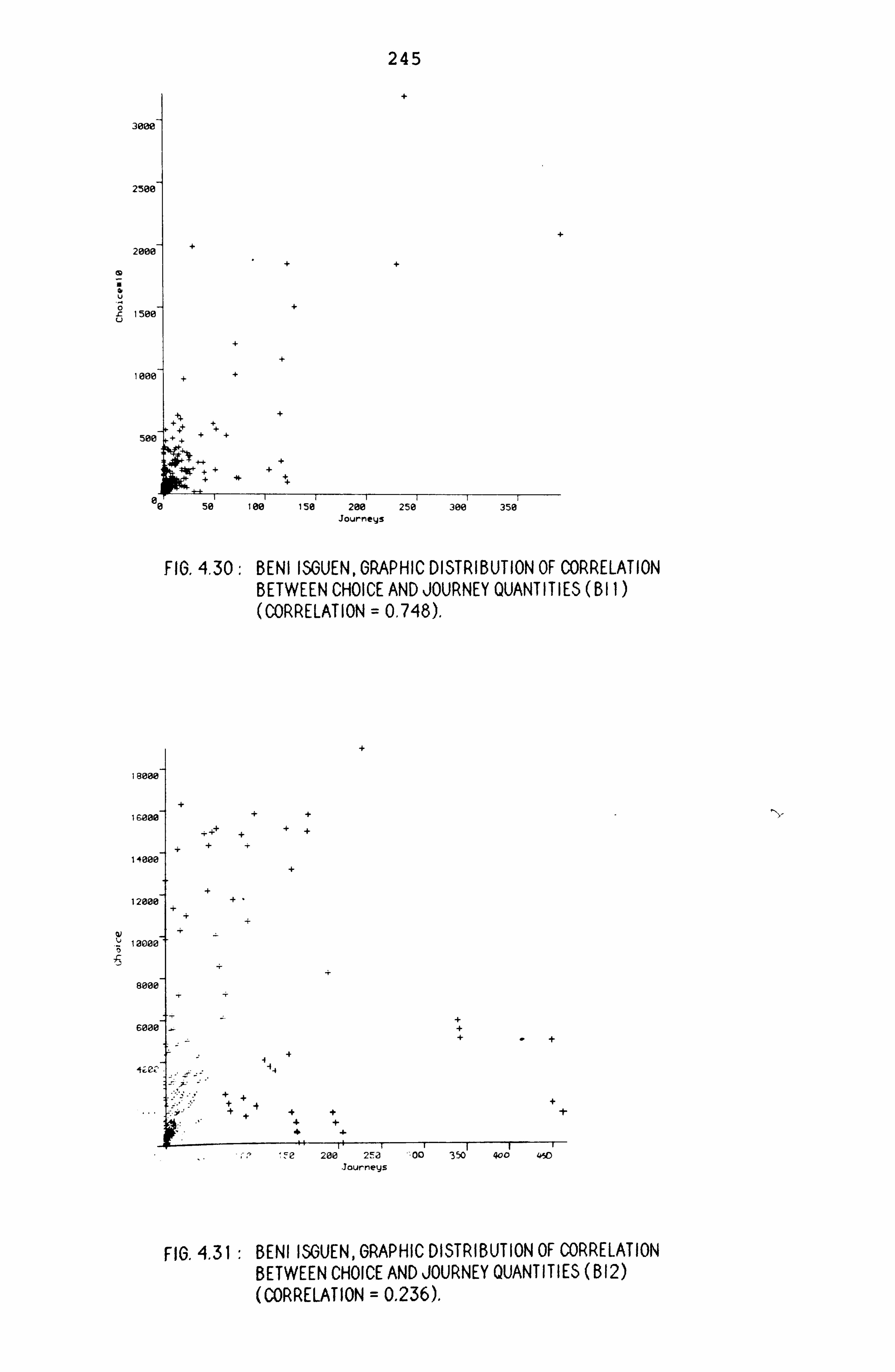
245
3000
2500
2000
a U
0 -C 1500 u
I ooe
50e
FIG. 4,30: BENI ISGUEN, GRAPHIC DISTRIBUTION OF CORRELATION BETWEEN CHOICE AND JOURNEY QUANTITIES (BI I (CORRELATION = 0,748).
I Book
I salm
1400E
1200E
000C
BOOE
SOOE
+Ze.
FIG. 4.31 : BENI ISGUEN, GRAPHIC DISTRIBUTION OF CORRELATION BETWEEN CHOICE AND JOURNEY QUANTITIES (B12) (CORRELATION = 0.236).
50' 100' 150' 200' 250' 300' 350 Journeys
200 2Fa -. 00 350 400 450 lourneys
- 246 -
strangers and the choice structure with the movements
of the inhabitants, and the results given by the simu-
lations of movements, both internal and random from the
outside, suggests that for Beni Isguen, there may be
two types of interfaces between the two groups:
- The first being more probabilistic and incidental,
takes place on the periphery; and the second more
deterministic, requiring more knowledge of the system
and takes place in the market place. This suggestion
is supported by the common practice that when strangers
are admitted into the town, they are usually led by a
guide to the market place, the only area in which a
justification for their presence is not required (*).
*A strangerlin order to visist Beni Isguen must be "escorted" by a guide; he must get in from specific gateways and at a specific time, or no stranger is allowed after sun- set.

- 247 -
CASE FOUR: EL OUED
-----------------
-----------------
-------------
ELO 1 --------------
ELO 2
NBER OF SPACES ---------------
------------- 44
-------------- 45
-- MEAN CN
------------- 3.55
-------------- 3.57
MAX. CN -----------------
9.00 -
9.00
MEAN RRA ------------
0.85 --------------
0.79 MAX. RRA 1.28 1.26 MIN. RRA 0.47 0.41 ST. DEV. (RRA) -----------------
0.21 -
0.20
1: RA/CN ------------
0.73 --------------
0.73 R INTEL. -0.03 -0.03 1: RA/RCH 0.74 0.78 R. PRED. -0.07 -0.03 CN/CH -----------------
0.76 -------------
0.66 --------------
TABLE 4.10: EL OUED, MEASURES FOR THE TWO VERSIONS
Table 4.10 sets up the measures for the two versions of
the analysis of El Oued (EL01: the town as a closed
system; EL02: the town connected to the outside). it
shows that:
- The mean connectivity for the two versions is aver-
age (compared to the 75 systems) and does not vary when
the system is linked to the outside.
- The maximum connectivity remains also constant in
the two versions, and is below average.
- The mean integration in E101 is higher than average
(0.83) , improving to 0.79 when the system is connected
to the outside.

- 248 -
- The intelligibility of El Oued is about average in
both versions, and does not vary according to whether
the system is linked to the outside or not.
- The global predictability of E101 is also about
average (-0.07), improving slightly in E102 (-0.03);
while the local predictability is average in EL01
(0.76). worsening to 0.66 when the connections of the
system to the outside are considered.
The results of the two analyses of El Oued show no
strong variations in the numerical properties of the
urban fabric. In both cases, the system has shown to
be highly integrated and intelligible, with a good
level of prediction for simulated movements by both the
integration and the connectivity.
THE PATTERN OF INTEGRATION IN EL OUED (EL01):
The mapping of the most integrated spaces presented in
figure 4.32, reveals fundamental differences between
the integration core of El Oued and the other three
cases. The most integrated spaces form a core which
occupies the centre of the settlement and takes the
shape of a double cross, completely traversing the spa-
tial fabric in several directions. The first and the
second line in terms of integration run parallel to
each other; and the third, the fourth and the fifth
intersect the two former lines in a perpendicular
manner, forming therefore an orthogonal grid-like pat-

249
HU. 4.62: ELOULI), INILURATlON5TRUCTURE(EL01)
FIG. 4.33: EL OUED, INTEGRATION STRUCTURE (EL02)
qmmlý INTEGRATION CORE 50% SEGREGATED SPACES

- 250 -
tern. The mosque and the few adjoining shops lie on
the second best line in terms of integration.
The most segregated spaces, on the other hand, form
three separate groups distributed around the integra-
tion core. The integration core of El Oued may be held
to make the system more easily accessible. Most of the
lines of the street system are not more than one or two
axial steps away from the integration core.
Figure 4.33 shows the integration core of the system
linked to the outside, which does not present important
variations from the previous version. In both ver-
sions, the integration cores are constituted by the
same lines. The first integrator remains the same,
while the second and the third best line in EL01 become
fourth and second in EL02. while radius-3 core (see
fig. 4.34) consists of most spaces of radius-n core.
In conclusion, this settlement does not depend on the
exterior for its integration, nor for its intelligibil-
ity and predictibility.
THE ANALYSIS OF SIMULATED MOVEMENTS IN EL OUED:
The choice structure:
Figure 4.35 shows the lines with strong choice quanti-
ties. These form a continuous structure in the centre
of the settlementr with the mdst important line
directly linking the area of the mosque and the local

FIG. 4.34: EL OUED, RADIU5-3 INTEGRATION CORE
FIG. 4.35, EL OUED, CHOICE STRUCTURE
CHOICE STRUCTURE RANDOM JOURNEYS FROM OUTSIDE

- 252 -
shops to the outside. This line has therefore emerged
as the most accessible with respect to the settlement
as a whole, the most permeable and also the most impor-
tant in terms of simulated movements inside the system.
The first, second and fourth lines in terms of choice
intersect at the mosque.
Figure 4.35 shows also the best lines in terms of ran-
dom journeys from the outside. The correlation between
the choice quantities and the random journeys logged
from the outside, amounts to 0.718 (with the journey
quantities square rooted). Again, the mosque and the
commercial street emerge as the most important elements
for both simulated movements. This result points to the
conclusion that for El Oued, there is a strong inter-
face between the two types of simulated movements.

- 253 -
THE SPATIAL ANALYSIS OF THE ROOF TERRACES:
In Part One, it has been shown on the basis of the
examination of the roof plans and other descriptive
material that morphological differences existed between
the roof terraces of the Mzab towns and Ghadames. It
has also shown that there are important differences in
the way in which women use the rooftops in these towns.
The aim of this section is therefore to see the extent
to which syntactic differences (if any) in the spatial
configurations of the rooves might amplify these
descriptive differences. It is suggested that the spa-
tial differences that may exist between the terrace
configurations may define the extent to which the ter-
race system might be held to be geared more towards
facilitating than only permitting contacts between
women.
This conjecture will be tested through the spatial
analysis of the terraces in the two settlements: Gha-
dames where the system is developed to a high degree
and Beni Isguen where the system exists only in a par-
tial form. By this, it is intended to show that it is
the way in which the terraces are spatially structured,
which defines to a certain extent, the means and modes
of communications among the women, such that a well
connected terrace system creates more spatial relations
and would therefore be seen to facilitate contacts. The
degree of elaboration of the terrace system is there-
fore, not only described and measured in terms of the

- 254 -
scale to which it exists, but also in terms of its
internal structure, such as the degree of connectivity
to immediate and more distant neighbours, and the
structure of the integration core.
For this purpose, three roof areas have been selected,
one in Ghadames in Wazit quarter, and two in the older
part of Beni Isguen.
The results of the analysis of the street systems in
Ghadames and Beni Isguen will constitute a background
against which the spatial properties of the terraces
will be contrasted, so that different levels of com-
parison can be achieved; that is on the one hand, a
comparison between the spatial structure of the roof
terraces and the streets within the context of the same
settlement; and on the other, a comparison of the ter-
race system in the two settlements.
Several problems and difficulties have been encountered
in the attempt to analyse the roof terrace system, one
of which concerns the definition of space at rooftop
level. Unlike the street system which consists of a
continuous structure of open space clearly delimited by
the building walls, the spaces used for circulation at
the rooves already form part of the buildings. These
are rooftops and sections of party walls separating the
upper courtyards of the different houses. The spatial
relation of "inside-outside" defined by a clear boun-
dary between a building and a segment of a street is no
longer appropriate, and acquires a totally different

- 255 -
meaning when applied to the roof terraces. In Gha-
dames, the wall which is used to separate individual
households at roof level, is also the very means of
relating the different households. When a woman is
"outside" the upper courtyard, she is still in direct
visual contact with anything happening "inside" the
upper courtyard. There is always a visual continuity
in the rooves.
Figure 2.10 inserted in Part One, shows a roof plan of
an area taken from the quarter of Wazit in Ghadames.
This plan formed the basis for the drawing of the axial
map. Difference in levels (usually 2 to 3 steps high at
most, see Pictures in Part One) between segments of
spaces used for circulation has been disregarded in the
graphic representation of these pathways: all spaces
have been considered as being at one level.
The production of the axial maps has been carried out
in two stages. First, all spaces used for circulation
have been identified. These are all roof areas that
are not skylights or bounded by high party walls.
Second, using the resulting roof plan as a basis, an
axial map is drawn. The examination of the axial maps
of the roof areas in figures 4.36 and 4.37, shows a
more fragmented axial organisation of the terrace sys-
tem in Beni Isguen than in Ghadames.
The degree of elaboration of the terraces and the spa-
tial restrictions existing in them will be mainly

- 256 -
expressed in terms of the degree
the degree of integration.
of connectivity and
------------------------------------------------------- GHADAMES(1*) BENI ISGUEN
DARAR WAZIT TERR BIl B12 TER1 TER2 TER3 -------------------------------------------------------
NBER OF 67 50 98 264 249 39 75 123 SPACES ---------
MEAN CN ----- 2.57
------ 2.60
------ 2.96
------ 2.93
------ 2.63
------ 2.46
------ 2.51
----- 2.52
MAX. CN 5.00 5.00 6.00 13.0 7.00 4.00 6.00 6.00 --------- MEAN RRA
----- 1.45
------ 1.32
------ 1.37
------ 1.28
------ 1.92
------ 1.72
------ 1.69
----- 3.46
MAX RRA 2.05 2.52 2.34 1.83 2.96 2.52 2.52 6.63 MIN RRA 1.02 0.80 0.99 0.80 1.36 1.12 0.99 2.34 ST. DEV. 0.24 0.33 0.36 0.19 0.34 0.34 0.36 0.99 --------- 1: RA/CN
----- 0.55
------ 0.61
------ 0.55
------ 0.38
------ 0.37
------ 0.25
------ 0.41
----- 0.20
RI(2*) -. 17 -. 14 -. 14 -. 21 -. 23 -. 52 -. 31 -. 47 1: RA/RCH 0.79 0.71 0.64 0.53 0.62 0.87 0.77 0.31 R. PRED. +. Ol -. 09 -. 10 -. 12 -. 04 +. 05 +. Ol -. 41 CN/CH --------
0.70 ------
0.71 ------
0.69 ------
0.66 ------
0.45 ------
0.24 ------
0.65 ------
0.21 -----
TABLE 4.11: MEASURES FOR THE STREET AND THE TERRACE SYSTEM, GHADAMES AND BENI ISGUEN
Table 4.11 presents the analytical measures for the
terraces and for the street systems in Darrar, Wazit
and Beni Isguen (BIl and B12).
The results are:
1* TER1 and TER2 to the two roof areas analysed separately in Beni Isguen, and TERR refers to the terrace area in Gha- dames; BIl and B12 to the street system in Beni Isguen and TER1 and TER2 refer to the two roof areas of Beni Isguen, and when combined together they give TER3.
2* RI refers to the relative intelligibility of the systems calculated on the basis of the predicted value for systems of similar size. and R. PRED. refers to the relative predic- tibility of the systems calculated on the basis of the ex- pected value for systems of similar size. R. PRED. refers to the relative predictibility given by the integration.

- 257 -
- the mean connectivity of the terraces in Ghadames is
much higher (2.96) compared to both, the mean connec-
tivity of the street system (2.57 in Darrar and 2.60 in
Wazit), and the mean connectivity of the terraces in
Beni Isguen (2.46 in Roof Area 1.2.51 in Roof Area 2).
- for Ghadames, the maximum connectivity of the ter-
races is higher than for the streets.
- in Beni Isguen, the maximum connectivity of the ter-
races varies for the two areas; but in all casest it
remains below the maximum connectivity for the streets.
- The mean integration for the terraces (1.37) in Gha-
dames remains within the range of the level of integra-
tion of the streets (1.45 in Darrar and 1.32 in Wazit).
But it is relatively better than the mean integration
for the terraces in Beni Isguen (1.72 in Roof Area
1.69 in Roof Area 2).
- The intelligibility of the terraces in Ghadames
(0.55,, -0.14) is of the same order as the intelligibil-
ity of the streets, but is much better than the ter-
races in Beni Isguen. The intelligibility of the ter-
race areas in Beni Isguen is very poor compared to the
value predicted for a street system of the same size.
In Roof Area 1, it only reaches 0.25 (-0.519), while in
Roof Area 2, it is 0.41 (-0.304).
- The predictability given by the integration is below
average for the terraces of Ghadames, when compared to
the value expected for a street system of similar size;

- 258 -
but it is about average for the two terrace areas of
Beni Isguen. Whilst, the predictability given by the
connectivity is better for the terraces of Ghadames,
but varies significantly for the terraces of Beni
Isguen (0.24 in Roof Area 1,0.65 in Roof Area 2).
Clearly, from a syntactical point of view, the terrace
system in Ghadames can be described as more axially
connected, less segregating and more intelligible than
the terraces in Beni Isguen.
THE PATTERN OF INTEGRATION OF THE TERRACES:
The integration cores of the roof areas are shown in
figures 4.36 and 4.37. In Ghadames, the integration
core is constituted by a group of lines concentrated in
the centre of the area, connected to the edges by
several other lines. The core presents a structure
which tends to cover and traverse the whole roof area
in several directions. The integration core is made up
of both types of spaces, the more elongated and the
more square-shaped ones corresponding to the narrow
paths and the wider kitchen rooftops. The most segre-
gated spaces form three distinct clusters on the peri-
phery of the surveyed roof area, and surround the
integration core (see fig. 4.36).
For Beni Isguen, in Area 1. the integration core tends
to form a linear structure across the system. An
increase in the percentage of the most integrated

259
FIG. 4.36: GHADAMES, ROOF TERRACES
I NT EGRAT I ON COR E 10 T- I NT E (; 'PAT ION CO RE 15 % HORECATED 5PACEIS

260
ROOF AREA I
ROOF AREA 2
FIO. 4.37: BENI ISOUEN, ROOF TERRACES INTEORATION CORE.
T INTEORATION CORE SEGREOATED SPACE, )

- 261 -
spaces reinforces this linearity. In Area 2, the core
consists of a concentration of the most integrated
spaces in the middle, with two long lines pointing to
opposite directions towards the edges of the roof
area. This structure can be also seen as expanding
linearly. The cores for the two roof areas of Beni
Isguen present then a structure which differs from the
core of the rooves in Ghadames, in the sense that
despite the linear development, the core forms a cen-
tral axis without however covering the whole area. In
both roof areas of Beni Isguen, the segregated spaces
cluster around the integration cores, and at the edges
of the islands.
The patterns of integration cores of the terraces in
Ghadames and Beni Isguen, can then be seen to display
relevant differences which may have some bearings on
the way the terraces are used. The integration core in
Ghadames tends to approach the covering type structure.
The overall location and structure of the integration
core in Ghadames shows in these respects, some similar-
ities with the patterns found in the street organisa-
tion of this town. In Beni Isguen, although the cores
tend to traverse the roof areas, they remain confined
to the central zone.
In the light of the analytical results, it seems rea-
sonable to suggest then that the morphological differ-
ences observed between the two terrace systems are to
some extent, amplified by the syntactic differences.
- 262 -
The terrace system of Ghadames has shown to be axially
better connected at the local level and at the larger
scale: every axial line in the system is in average
connected to about three other lines, and in morpholog-
ical terms, every individual house is adjacent to at
least two other houses (see Roof Plan in fig. 2.10).
This makes every house or in social terms, every occu-
pant (woman) is at least in direct spatial proximity to
at least six other women. This is a simple indication
of the potentiality of the terraces in Ghadames in per-
mitting interactions between women, using only the spa-
tial proximity of the terraces to establish such con-
tacts.
In Ghadames, with the exception of Bellil area in which
the core is peripheral, the analysis of the street sys-
tem of the other three quarters has shown that the
integration cores in these areas tend to approach the
covering type. On the other hand, the analysis of the
street system of Beni Isguen considered at different
stages of growth or according to the three versions of
mapping, has revealed linear and non-covering core
type. The consideration of these results suggests a
relation between the spatial structure of the street
system and the terraces, such that the more the core
covers the street fabric, the better the level of
integration and intelligibility of the terraces and the
more their core is also covering.
An inference can therefore been drawn in the light of

- 263 -
the descriptive material and the results of the spatial
analysis, that is the terrace system of Ghadames can be
seen as geared more towards the increase of spatial
proximity between women, and perhaps can be also held
to be geared towards the generation and facilitating
the contacts between them. In Beni Isguen, the poor
level of axial connectivity, and the highly segregating
structure of the terrace fabric, in addition to the
restriction of the accessibility to the level of the
block and the location of the kitchen and other female
spaces at the ground floor of the house, all of these
characteristics point to the suggestion that the ter-
races in Beni Isguen may be seen as only a "permissive"
system,, in the sense that it makes contacts between
women across the rooves possible but not "natural". For
example, the fact that the terrace links are restricted
to the level of the island and are more limited inside
the island, suggests a certain difficulty in generating
more casual and "non-sought" encounters between women.
OVERALL REVIEW OF ANALYSIS AND SOME THEORETICAL SUGGES-
TIONS:
An overall review of the analytical section will be
carried out by looking first at the underlying similar-
ities between the cases and second, their fundamental
differences.

- 264, -
NBER MEAN MAX MEAN MAX MIN 1: RA/ RI 1: RA/ RPRE CN/ SPACE CN CN RRA RRA RRA CN RCH CH
------------------------------------------------------------------ GHADAMES
MAZIGH 12 2.17 3 1.37 1.85 1.21 . 76 -. 10 . 87 -. 04 . 69 BELLIL 20 2.15 3 1.93 2.68 1.42 . 67 -. 15 . 89 +-Ol . 86 WAZIT 50 2.60 5 1.32 2.52 0.80 . 60 -. 15 . 71 -. 09 . 71 DARRAR 67 2.57 5 1.45 2.05 1.02 . 55 -. 17 . 79 +. Ol . 70 GHAD1 160 2.50 5 2.29 4.37 1.36 . 46 -. 19 . 46 -. 24 . 46 GHAD2 161 2.54 5 1.47 3.05 0.80 . 49 -. 16 . 52 -. 18 . 56 TERR 98 2.96 6 1.37 2.34 0.99 . 55 -. 14 . 64 -. 10 . 69
GHARDAIA
GHARD1 63 2.50 5 1.51 1.79 1.18 . 52 -. 21 . 65 -. 14 . 62 GHARD2 171 2.50 6 1.76 2.85 1.22 . 48 -. 16 . 65 +. Ol . 70 Gl 320 2.78 13 1.57 2.26 1.13 . 46 -. 11 . 47 -. 16 . 58 G2 307 2.71 12 1.76 2.72 1.23 . 42 -. 16 . 50 -. 13 . 55 G3 308 2.75 12 1.44 2.12 0.88 . 52 -. 06 . 52 -. 11 . 69
BENI ISGUEN
BENIS1 79 2.58 5 1.46 2.12 0.92 . 59 -. 12 . 74 -. 02 . 66 BENIS2 123 2.73 5 1.61 2.22 1.15 . 35 -. 32 . 62 -. 10 . 56 BIl 264 2.93 13 1.29 1.82 0.80 . 38 -. 21 . 53 -. 12 . 66 B12 249 2.63 7 1.92 2.96 1.36 . 37 -. 23 . 62 -. 04 . 45 B13 250 2.66 7 1.79 2.84 1.29 . 40 -. 20 . 68 +. 02 . 45 TER1 39 2.46 4 1.72 2.52 1.12 . 25 -. 52 . 87 +. 05 . 24 TER2 75 2.51 6 1.69 2.52 0.99 . 41 -. 31 . 77 0.00 . 65
ELOUED
EL01 44 3.55 9 0.85 1.28 0.47 . 73 -. 03 . 74 -. 07 . 76 EL02 45 3.57 9 0.79 1.26 0.41 . 73 -. 03 . 78 -. 03 . 66
TABLE 4.12: GENERAL DATA TABLE FOR ALL CASES
GHAD1 refers to the system of Ghadames as a whole without the connections to the outside, GHAD2 refers to Ghadames connected to the outside. TERR: Roof Area in Ghadames. GHARD1: Ghardaia at the first stage of growth, GHARD2: Ghar- daia at the second stage of growth, Gl: Ghardaia as a whole with the peripheral spaces inside the walls, G2: Ghardaia without the peripheral spaces, G3: Ghardaia with the connec- tions to the outside. BENIS1: Beni Isguen at the first stage of growth, BENIS2: Beni Isguen at the second stage of growth, BIl: Beni Isguen as a whole with the peripheral streets, B12: Beni Isguen without the peripheral streets, B13: Beni Isguen with the connections to the outside, TERl: Roof Area 1 in Beni Isguen, TER2: Roof Area 2 in Beni Is-

- 265 -
Table 4.12 gives a summary of the numerical properties
for all towns at their different stages of growth,
their different states of representation as well as the
roof areas. It shows underlying similarities between
the cases, but also strong variations.
Clearly, the basic measures and their statistical
derivatives indicate that the towns with the terrace
system, either fully or partially developed, when con-
sidered as a group present distinctive properties.
Their spatial fabric can be characterized as highly
segregating in all versions of representation and at
all stages of growth, with a poor level of intelligi-
bility. El Oued on the other hand, presents the oppo-
site properties; it is a much more integrating and
intelligible system. Conversely, Bellil, the other
system where the terraces do not occur, has the lowest
integration of all small areas, a weak intelligibility
but an average predictibility. These variations suggest
that the degree of integration and intelligibility of
the systems does not relate in a single way to the
existence or the differential appearance of the terrace
system.
The analytic results have also shown strong variations
between the different cases. These can be summarized
as follows:
For Ghadamesy the connectivity (mean and maximum) does
guen. El : El Oued without the connections to the outside, EL02: El Oued with the connections to the outside.

- 266 -
not vary markedly with size, and is not affected by the
connections of the system to the outside. The level of
integration of the small systems is by far better than
for the town as a whole. This mirrors the physiognomy
of the town which is made up of four areas almost
entirely isolated from each other. The system of Gha-
dames seems to have evolved by adding more elements
without adding more structure in order to control the
effect of growth.
This is not the case for Ghardaia, where the system
tends to improve the connectivity (mean and maximum) as
it grows, while retaining the integration constant.
Therefore, in Ghardaia the effect of growth seems to be
controlled for through the increase of the maximum con-
nectivity of some spaces, which creates and maintains a
certain level of integration. The removal of the peri-
pheral spaces and the connections of the system to the
outside has led to the conclusion that the increase in
the connectivity is not assigned to the periphery of
the town, but is more internal.
For Beni Isguenr the mean and maximum connectivity also
improve as the system grows larger, but unlike Ghar-
daia, the increase in the connectivity is only invested
in the periphery, in which case the removal of the
peripheral streets affects strongly both the mean and
the maximum connectivity. The system depends also on
the peripheryr but not on the connections to the out-
side, for its integration. Therefore, the system of

- 267 -
Beni Isguen seems to overcome the effect of growth by
increasing its connections to the periphery.
The spatial analysis has also shown fundamental differ-
ences between the towns in terms of the structure of
their integration cores.
The integration core of Ghadames seen as a whole does
not cover the whole fabric, but is confined to the area
of the market square and the main mosques. Therefore
from the point of view of the town as a whole, the
market and the mosques are the dominant elements in the
integration system, and the core can be characterized
as a non-covering and peripheral type. But, the
integration cores of the small systems with the excep-
tion of Bellil quarter, present a structure which
approaches the covering core type, and includes in all
three cases, the streets where men sit. For Bellil,
the core remains at one edge of the quarter and
includes the quarter's mosque. For the terrace area of
Ghadames, the core takes a much more covering form,
linking the edges to the centre of the area in several
directions.
For the small systems of Ghardaia, the core remains
non-covering and the spatial structure exhibits the
two-sidedness effect in the overall organisation. At
the first stage of growth of Ghardaia, the mosque comes
out as the most important element in terms of integra-
tion. In the second stage, the core links the small

- 268 -
market square to the mosque and the market becomes then
the dominant feature. In the large system, the two-
sidedness effect is firmly established; the core is
more peripheral and non-covering. The analysis of the
town according to the different states, has shown the
strong dependence of the market on the connections of
the town to the outside. The mosque on the other hand,
remains highly segregated with respect to the outside.
The removal of the peripheral streets (G2) affected
strongly the internal structure of the core, the mosque
becomes much less segregated and the core runs more
from the mosque towards the market area than from the
market to the mosque and to the outside (as seen in
GD. Radius-3 integration has shown that the system of
Ghardaia tends to emphasize its global structure as it
grows bigger with the market area remaining a strong
integrator at both levels of organisation, local and
global. The simulation of the movements inside the
town (Choice) has shown the predominance of both the
market and the mosque, but only the market has emerged
as the strong interface space for the internal move-
ments and the movements originating from the outside.
For Beni Isguen, the cores of the small systems remain
internal and non-covering, with the mosque and the
market as the dominant elements strongly connected to
each other, but not to the outside. In the larger sys-
tem, the spatial structure becomes more complex and
presents two types of cores: one peripheral and located
away from the town public facilities (BIl); the other

- 269 -
internal and also non-covering which intersects the
market square and runs in the direction of the mosque
(B12). The market of Beni Isguen is also highly depen-
dent on the connections of the town to the outside, but
unlike Ghardaia and Ghadames, it remains not directly
connected to the outside. Similarly to Ghardaia, the
mosque in Beni Isguen is strongly segregated with
respect to the outside (B13). The town exhibits also
strong local structures that are highly segregated with
respect to the whole system. This is a distinctive
feature to this town which suggests that Beni Isguen
and contrarily to Ghardaia, tends to take on a much
more localized emphasis as it grows larger. The simula-
tion of movements inside the system (choice) has shown
two potential routes, one peripheral (BID and the
other more internal (B12) with the predominance of the
market. In this case and contrarily to Ghardaia, the
mosque remains isolated from these routes, and only the
peripheral streets have emerged as the interfacing ele-
ments for the internal movements and the random move-
ments from the outside. The cores for both roof areas
of Beni Isguen tend to be more confined to the central
part, and therefore much less covering than the core of
the roof area in Ghadames.
For El Oued, the situation is completely reversed. The
system presents a grid-core type, which traverses
entirely the fabric in several directions, and does not
create relatively more segregated areas. Instead, most
spaces are only few steps away from the core. The

- 270 -
mosque and the shopping street are strongly connected
to the outside and form the dominant structure in terms
of integration.
Despite the limited number of cases looked at in this
study, the above analyses have demonstrated three dis-
tinct types of spatial organisation on the basis of the
structure of the integration core: i- the covering
core; ii- the non-covering core which may be either
peripheral or internal; iii- the grid-core type. These
seem to have possible relevance in understanding the
way in which these urban forms may relate to the social
use of space by men, women and strangers, as described
in Part One of this report.
In the small systems of Ghadames, the spatial structure
of the quarters mirrors the space uses by men-residents
and women. The core of each quarter, except for Bel-
lil, traverses the fabric and passes through the areas
where men sit and gather, and near the buildings (i. e.
mosques) mainly intended for men's uses. The core can
be seen therefore to be oriented more towards the men
of the quarter. The local cores (radius-3 integration
cores) include also many of the streets intended for
men Is meetings. By doing this, the spatial structure of
the street system can be seen to contribute by its very
nature in keeping the women away from the streets. On
the other hand, the terraces provide a highly integrat-
ing system for women; the terrace core has the tendency
to facilitate the movements of women across the quar-

- 271 -
ter, by directly linking the edges to the centre. For
Bellil, the spatial structure seems also to relate to
the differential space uses by men and women. The
peripheral core incorporates the mosque of the quarter
where men mainly congregate. The streets used by women
are carefully segregated from these areas. For Gha-
dames as a whole, the core intersects the market area
with the two most important mosques of the town. This
is a male-oriented space per excellence, where men from
the different quarters and strangers meet, and where
transactions take place (selling and buying goods,
meeting place for the Friday prayer ... ). The spatial
structure of Ghadames may then be seen to emphasize
more the local level of organisation than the global,
by integrating much more strongly the men of the
separate quarters.
In the case of Ghardaia, the analysis (G1 and G3) has
shown that the market square and its adjoining area are
the main integrating elements with respect to the out-
side. The descriptive section on space uses has shown
that the male inhabitants meet with the strangers in
the business and commercial area. Its direct link to
the outside makes then the access of the strangers much
easier. The spatial structure of the town appears
therefore to allow the strangers into the system, but
restricts them to specific areas, to the area where the
integration core is located; that is away from the main
mosque which has emerged in spatial terms as strongly
segregated with respect to the outside (G2), but as the

- 272 -
second most popular area from the simulation of inter-
nal movements. Therefore, the mosque can be regarded
as more oriented towards the use of the male-
inhabitants. This result is consistent with the ethno-
graphic material, in which it has been reported that
the main domains of interactions and activities for the
male-residents were mainly concentrated around the
mosque and the market place. On the other hand, the
comparison of the analytic evidence with the ethno-
graphic data suggests a possible relation between the
two-sidedness characterizing the global organisation of
this town and the use of women of some streets, that is
the development of the "zenka unit". The peripheral
location of the integration core and its non-covering
nature would leave, by its very nature a large "zone"
of the town entirely segregated with regard to the
movements of strangers. This associated with the local
custom which requires the men-residents to leave their
home area during certain hours of the day can be seen,
using the spatial evidence alone, to contribute in
reducing the male movements through the segregated
"zone", and may explain the simultaneous and separate
use of space by the two sexes observed in this town.
For Beni Isguen, the situation is rather different from
Ghardaia. The spatial structure presents in global
terms two integration cores, the first located on the
periphery, and might be expected from the spatial evi-
dence only to be mainly used by the strangers and also
by the inhabitants moving to remote destinations. In

- 273 -
other words, the settlement by virtue of its overall
spatial organisation, appears in these terms to contri-
bute in controlling the strangers by keeping them away
on the edge of the town. The second core, more internal
and requiring much more knowledge of the spatial struc-
ture, develops across the market area, which is accord-
ing to the ethnographic data more used by the male-
inhabitants and the strangers who have been admitted
into the town. The market square may therefore be
regarded as the second stage for interfacing the male-
inhabitants and the strangers; that is not only the
strangers may meet with the inhabitants on the edge but
also at the market place, though this latter remains
not strongly linked to the outside to facilitate its
accessibility. In this case also, the spatial evidence
mirrors the social uses of space observed in this town.
The structure of the core of Beni Isguen leaves also
clusters of spaces strongly isolated with respect to
the town as a whole, but which are highly integrated
locally. The simulations of internal movements and
movements from the outside point to the same conclu-
sion; that is large parts of the town are left
uncovered by the resulting patterns of movements. The
non-covering core types, the local strong areas and the
particular arrangement of simulated movements, all of
these properties point to the conclusion that the sys-
tem of Beni Isguen can be seen to reflect the space
uses by the sexes in this town, and perhaps even
explain the development of the "zenka" system, in the

- 274 -
sense that men -residents and strangers- would tend to
move along the cores, and women would tend to use more
the globally-segregated and locally-integrated parts of
the town. This is so mainly because large areas of the
urban fabric appeared from the spatial evidence alone,
to be kept away from the movements of men, residents
and strangers, reducing therefore the potential
interference and overlap of space uses by the sexes.
The spatial structure of the terraces may also be held
to contribute to the social use of streets by women.
The central position and the non-covering core of the
roof areas of Beni Isguen can be seen to be geared more
towards the controlling than the generation of spatial
relations between women; and by this, these terraces
may be seen to complement the "zenka uses", mainly
because this female domain can be theoretically charac-
terized from the spatial evidence, as an insufficient
basis for women to develop denser encounter patterns.
This remains only a conjecture and more research is
needed to substantiate this hypothesis, especially with
regard to the degree of development of the "zenka" sys-
tem in Ghardaia and Beni Isguen and its location in the
urban fabric.
The spatial structure of El Oued on the other hand, may
be seen as geared more towards facilitating the move-
ments of men through the system and their interface
with strangers. All spaces are very close to the core
and therefore can be seen as oriented more towards the
public and male uses.

- 275 -
From the analytical evidencer a clear picture starts to
emerge regarding the nature of the possible relation-
ship between the social uses of space and the spatial
structure of the towns, especially the way in which
these construct and control spatial relationships
between men-women and inhabitants-strangers. In this
respect, the spatial accessibility and the amount of
choice appeared to be the key properties in introducing
differentiation between the categories of users and
controlling their interface. The spatial structure of
the towns can be seen to allow the differential forms
of space uses only because,
- it establishes strong differentiation between the
spaces used by men-women and inhabitants-strangers, by
means of controlling their degree of accessibility,
that is their degree of separation and integration with
respect to each other and with respect to the outside;
and
- it imposes restrictions on movements by means of con-
trolling the amount of choice and reducing the poten-
tial routes and thereby controlling the degree of
interference of one group with another.
The spatial analysis has shown that there is a control
of the overall degree of accessibility; the integration
measures are well below average. It has also a definite
distinction in the global organisation of the towns;
the structure of the integration cores of the systems

- 276 -
seen as a whole, is always realized in such a way that
it leaves large areas which are mainly residential, not
easily accessible. By locating the integration core in
a particular area, the settlement can be seen to intro-
duce differentiation between the categories of users.
By doing this, the settlement defines and ma ps the
categories of spaces assigned to the male resident
population which are mainly the areas around the market
square and the mosque, and controls the accessing of
the strangers by restricting them to the area where the
core is located, i. e. the market place and its sur-
rounding area.
A logical implication of such a global organisation is
that, the integration core by its very naturer creates
highly segregated areas. The underuse of these spaces
by men, might explain the "zenka" uses by the female
population which is more bound to the areas around
their homes. Therefore, the global structure of these
towns can be described as potentially inclined to
engender a clear spatial differentiation between the
user categories, not only by a rigid spatial classifi-
cation of spaces, but also by the control of the
overall degree of accessibility.
But,, the differential use of space by men and women may
be also related to the degree of interference and over-
lap of space uses of one group with another. The simu-
lation of the males' movements, whether it concerns the
inhabitants or the strangers, has revealed consistent

- 277 -
patterns of the overall arrangement of the "traffic"
within the towns. For the extreme case of most parts
of Ghadames, the problem of interference does not rise;
the settlement offers a strongly connected and fully
developed terrace system completely insulated from the
movements of men.
In the case of El Oued, there seems to be a clear lack
of such a property: the lines on which both the inhabi-
tants and the strangers are likely to move, traverse
strongly the system and pass close to most parts of the
spatial fabric.
For Ghardaia, the movements of the male inhabitants
have shown a tendency to concentrate on the southern
part of the town, at the market place and around the
main mosque. The movements of the strangers also tend
to concentrate at the market square and near the south-
ern edge. This particular arrangement would leave on
the basis of these results, an entire zone relatively
free from the movements of the men.
Finally, in the case of Beni Isguen, although the way
in which the settlement space is reported to be used by
the sexes remain similar to Ghardaia, the means by
which this is realized in space seem to be substan-
tially different. The simulated movements of the
male-inhabitants tend to concentrate. on the peripheral
streets inside the fortification walls and at the
market place. The movements (given by simulation) of
the strangers tend also to cluster on the edge and at
- 278 -
the market in the way described above. The spatial
analysis of the hypothetical movements in Beni Isguen
has then shown that this particular arrangement of the
potential routes for the men would also leave large
areas isolated from their movements.
By this, the spatial structure of these towns can be
seen to contribute in the structuring of the social
groups, by permitting a spatial separation of their
domain of interactions, and also the possibility for
the two groups to meet independently.
A general socio-spatial model begins to emerge on the
basis of the evidence provided by the ethnographic
material and the analytic studies, such that the more
the integration core is peripheral and non-covering,
the more the men-residents would be restricted to par-
ticular parts of the town, and the more their interface
with strangers would be controlled and located at a
specific area (usually the market place), and the more
women would tend to develop the "zenka" system and the
more the terraces become a "complementary" spatial
basis. Conversely, the more the integration core
approaches the form of a covering type, the more the
system would be geared towards male's uses and the
accessing of strangers, and the less there would be
highly segregated parts, and therefore the more the
terraces become a necessary spatial basis for women, or
they would be more confined to their homes in the case
of an absence of the terrace system.

- 279 -
Therefore, it can be concluded that the analytic
results have lent suggestive supports to the hypothesis
concerning the possible relationship between the dif-
ferential uses of the settlement space and the spatial
structure of the towns, and the question that arises
from this is to see the extent to which these observed
properties can be seen to result from the way these
towns may have grown and the nature of the spatial
rules and constraints that may have been followed dur-
ing the growth process. The reason underlying this
suggestion is that the spatial rules of building combi-
nation can be seen to some extent to express social
constraints, in the sense that they may be spatial
analogues to social rules; and if so, it suggests a
spatial way to look at the nature of the relationship
between spatial forms and social structures. This par-
ticular question will make the main concern of the next
chapter.
SUMMARY TO CHAPTER FOUR:
The concentration of this chapter on the structuring of
urban space and its possible relationship with the
observed social uses of space, has revealed a number of
spatial characteristics that held constant for the
towns with the terrace system, either fully or par-
tially developed; but also strong spatial variations
between the cases.
The first property is the low levels of integration

- 280 -
which seems to be created by the fragmentation of the
axial organisation of the systems and the poor level of
connectivity.
The second property is the weak correlation between
connectivity and integration measures. With the excep-
tion of El Oued, all systems looked at locally or glo-
bally or according to different versions of mapping
presented to a varying degree, a poor level of intelli-
gibility, which has been found to be strongly dependent
on the integration.
The third property is the consistent relation between
the terrace development and the spatial structure of
the towns, such that variations in the structure of the
integration core was accompanied by variations in the
degree of elaboration of the terraces and variations in
the uses by men and women, suggesting therefore a pos-
sible relation between the structure of the integration
core and its location on the overall urban fabric and
the differential space uses by the men-residents, women
and strangers.
The fourth property is the characteristic pattern of
growth of these towns, which, while showing individual
features, these systems consistently maintain the above
characteristics constant as they grow larger.
This chapter has therefore demonstrated the existence
of distinctive spatial features, which are, it is sug-
gested, related to the ability of the settlement in

- 281 -
accommodating differential forms of space uses, in the
context of a clearly defined set of social rules.

PART THREE: A GENERATIVE MODEL
- 282 -
CHAPTER FIVE: A MODEL OF SETTLEMENT GROWTH
INTRODUCTION:
This chapter addresses itself
the nature of the spatial fab
global organisation that have
tinctive to these systems,
the form generative processes
underlying generative rules.
to the questions about
ric of the towns and their
been identified as dis-
and their relationship to
and the nature of the
The spatial analysis of the towns has shown a precise
way in which these system differ from other urban forms
(i. e. the 75 urban areas). The towns in question are
characterized, first, by a highly segregating fabric
which is less intelligible and in general less predict-
able, and which is also affected by size, though only
marginally; and second, by a clear regionalization in
the global organisation and the lack of covering
integration core.
The morphological characteristicst (such as the winding
streets, the inconsistency in block sizes and shape,
the irregularity of the town layouts and the lack of
formal and geometrical properties that are normally
associated with conscious planning and design), indi-
cate that the systems of interest are likely to have
evolved more additively. Moreover, the numerical pro-
perties and in particular the segregating nature of the

- 283 -
town fabric seem to result from the fragmentation of
the axial organisation of the systems and a more
locally-based distribution of the connectivity. It is
suggested that these distinctive properties may be the
result of the way in which the towns grew.
On the other hand, the pattern of integration and the
non-covering cores, seems to be another effect of this
localized pattern of distribution of connectivity. The
reason underlying this suggestion is that a covering
core seems to result from more globalizing rules
imposed on the growing systems. The fact that the max-
imum connectivity of the systems that produce the cov-
ering core type, correlate strongly with size, while
the mean connectivity and the mean integration are held
constant, suggests that a super-order may have been
introduced and imposed on the evolving systems (SERC
Report, 1986, pp. 9-10). If this is the case, then and
by reasonable inference, a non-covering core type is
likely to be the result of a more locally based process
of form generation.
Therefore, the main hypothesis that can be formulated
is that the form generative process of this family of
settlements may lack the kind of global rules that are
conjectured for the 75 systems, and may be based on
more localized rules within an otherwise random con-
text. it is conjectured that it is this more localized
generative process, which may create the low level of
integration, the poor intelligibility observed in the

- 284 -
settlements under study. Moreover, the fragmentation
of the street structure and its poor connectivity, may
be also created by this form generating process. This
is intrinsically related to the block formation and
possi ly to the terrace morphology.
The main concern of this chapter is to test the extent
to which the properties observed in the towns in ques-
tion and summarized above, can be seen as a result of
the generative processes. This will be investigated
through the development of a cell-growth model which
allows variation in the local rules restricting an oth-
erwise random aggregation, but specifies no global
rules. Local rules are rules governing the relation of
a cell with its immediate neighbours, and global rules
are rules operating above that level.
The aim of this part of the research is therefore to
offer, through the development of a model, some
insights into the type of generative spatial princi-
ples, that can lead to this settlement type and the way
in which they acquire their general form, and therefore
throw some light on the prevalent spatial characteris-
tics and perhaps on the peculiarities of the terrace
system. It aims to represent the town morphology in
its simplest, its most "stripped-down" form. This sec-
tion is mainly based on an analytical approach, using
the idea of generative syntax to establish the descrip-
tion of the spatial order, and concepts dealing with
the type and quantity of space invested in particular

- 285 -
tYpes of spatial relations.
The chapter is divided into three main parts. First,
the question of the process of growth is located within
a historical context, in an attempt to identify the
kind of rules and building constraints, in purely for-
mal terms, that may have been followed in the building
activity of the towns. The historical material used in
this section goes back to the medieval times, and
includes a compendium of case studies of conflicts and
disputes between neighbours about building activity
during the 14th century. From this historical data, it
is hoped to extract spatial information concerning the
scope and the nature of the rules for growth and build-
ing development.
The second part of the chapter will deal with the
presentation of the computer model itself and the rules
that are embedded in it, as well as a range of varia-
tion on these rules, followed by a descriptive discus-
sion of the morphologies generated by these rules. The
third part will be concerned with the analysis of these
computer generated systems and their comparison with
the real examples.
HISTORICAL BACKGROUND:
The goal set out for this section is to try to use his-
torical material as a basis to explore the building and
planning principles which shaped this class of settle-

- 286 -
ments. This kind of information would, it is hoped,
help to define the rules that will be implemented in
the model.
Very little material exists on this question, but the
historical data which follows is based on one primary
key source. This is the manuscript written by a
master-mason, Ibn Arrami , during the 14th century about
t he building activity in the Medina of Tunis and
Qairawan (Ibn Arrami, 1913). The manuscript is a com-
pendium of a series of case studies of disputes between
neighbours on the subject of problems caused by build-
ing development (*). It also includes solutions he
brought to the problems under the guidance of the Qadi
of the town. But the difficulty of acquiring a copy of
this document, has forced the use of other studies in
which the key reference document has been Ibn Arramils
manuscript. These secondary sources are:
i- A key article written by R. Brunschvig in 1947,
entitled "Urbanisme medieval et Droit Musulman", with
special emphasis on the rights and obligations of adja-
cent neighbours (Brunschvig R., 1947, pp. 127-155).
ii- A recent publication by B. S. Hakim, in which most
of the information concerning building development con-
trol was derived from the above manuscript (Hakim B.
s. , 1986).
There is one copy in Rabat, Dar Al-Khizanah Al-Ammah, No. A802834, Morocco; which has been borrowed by Harvard Univer- sity.
- 287 -
iii- Finally, a Ph. D thesis by Al-Hathloul, dealing
with the legal and normative (legislative aspects) sys-
tem as the truly legitimate basis for the understanding
of the process of formation and change of the "Arab-
Muslim city". He also heavily relies on the same his-
torical document as the two previous authors (Al-
Hathloul S. A., Ph. D Thesis, 1981).
A thorough search has been undertaken in an attempt to
see if similar documents existed about other towns in
the region. B. Hakim proclaims remarkable similarities
between cases in other towns of the Maghreb region
taken from other sources (*). which he has checked
(Hakim B.,, 1986, p. 23). However, many of these
sources are originals and only very few copies are
available for consultation.
These references are especially valuable sources for
the reason that they provide a unique record of the
building activity in a "Medina" type of settlement,,
during mediaeval times. They are very informative
about the process of growth, and offer a useful basis
from which to examine the building process and
A search was undertaken by the author to trace the sources referred to by Hakim, but without success. These are Sahnun's compilation (854) entitled "Al-Mudawwanah", 16 vols, Cairo 1905; Al-Wansharisi (1508) entitled "Al-Miyar Al-Mu'arab wa Al-jami' Al-Maghreb an Fatawi ahl Ifrikiyah", 12 vols printed lithographically in Fez in 1896; and Ibn Al-Imam (996). only one reference has been located and checked. This is the manuscript written by Isa Ibn Musa called Ibn Imam, which was translated from Arabic into French by Barbier De Meynard in 1900. A copy of the manuscript itself exists at the National Library of Algiers, No. 1292.

- 288 -
development, and try to identify the regulations fol-
lowed by the individuals in their building acts.
The morphological information intended to be extracted
from the review of these sources relates mainly to
issues dealing with the urban fabric, such as follows:
i- Building contiguity or relationship between contigu-
ous buildings; (i. e., what are the conditions and con-
straints imposed when attaching to an already existing
building? Is it a right or a privilege to use the
neighbours' wall to build one's house? ). This, it is
hoped, will provide the basic information concerning
the aggregation of contiguous buildings.
ii- The street system and more precisely the relation-
ship between the building and its immediately adjacent
exterior space (i. e., what are the regulations concern-
ing the extension of a building into a street? Is it
permissible or a forbidden act to build on spaces
designated for public circulation? What is the minimum
right of way of streets and pathways? And does the
exterior space belong by right to the building which
abuts on it?.. ).
iii- The relationship between buildings on opposite
sides of the street (i. e., What are the regulations and
constraints of the positioning of a building on the
opposite side of an already existing building? Are
there particular practices as to the position of open-
ings facing another existing building? ).

- 289 -
The multitude of cases of legal disputes due to con-
flicts between neighbours centred primarily around
housing and accessibility, and these disputes had to be
resolved expeditiously. According to the above
authors, Islamic law constituted a framework for adju-
dicating related conflicts. These disputes related
mainly to problems concerning:
i- the street system, the right of way and its related
elements.
ii- the use of the party walls in terms of right and
obligations.
iii- the problem of overlooking
Other problem issues were related to the norms of com-
fort and locational restrictions of some uses causing
harm due for example, to smoke, offensive odours, eva-
cuation of waste water.
i- THE STREET SYSTEM:
Brunschvig notes that the question of the streets and
pathwayst in the context of the "neighbourhood regula-
tions" (Droit de voisinage), whatever their nature, is
much more related to the study of the private property
rather than to the public right (R. Brunschvig, 1947,
p. 131). By this, he refers to the notion of "fina"
pointed out in the compiled manuscript, which is the
exterior space immediately adjacent to the exterior

- 290 -
wall of a house. The right of usage of the "fina"
belongs to the owner of the house or the building which
abuts on it. This space is allocated (by right accord-
ing to both#, Brunschvig and Hakim) for the daily use of
the inhabitants without allowing the construction of
building on it (*). The allowed uses of the "fina" by
the inhabitants are the loading and unloading of beasts
of burden and the temporary parking of such animals
(Hakim B., p. 27; Brunschvig R.,, p. 131). This particu-
lar notion of an exterior open space always allocated
and attached to a house (or a building) is of an impor-
tant relevance to the definition of the rule of acces-
sibility in the ensuing sections.
According to the historical documents, the width and
height of streets are clearly determined by the mode of
transport used during the mediaeval times. The size of
streets must allow the passage of a fully loaded camel
with a rider (Hakim B., 1986, p. 21). The building
over the street is determined, according to the histor-
ical document, by the need for extra space of building,
particularly housing which created the "sabat", which
is a room spanning the street (Ibid, p. 66). However,
in some cases it becomes a succession of rooms creating
continuous coverage and a tunnel effect of a street.
The covering of the street is also referred to as a
* There is a case study in the compiled manuscript where the extension of a building into a street was forbidden: Sahnun, the Qairowan judge strictly forbade any encroachment upon the streets; Brunschvig R., 1947, pp. 131-132).

- 291 -
means to provide shade and protection against the sun
for street users (Ibid, p. 66). Many cases were
reported regarding the extension of houses over the
street and conflicts arising from the use of the oppo-
site wall to implement it (Ibid, p. 29).
ii- THE PARTY WALL:
The wall separating private households is either
privately or collectively owned. The usage of an
already existing wall is not a right as it is in the
Roman legal system, but a very well established prac-
tice (Brunschvig R., 1947, pp. 137-138). Brunschvig
has particularly compared the Roman to the mediaeval
Muslim legal system and states clearly that in Rome, a
building owner cannot legally prevent the neighbour to
use his wall for expansion (Ibid, pp. 137-138).
In case of a dispute about a wall ownership, various
solutions have been adopted, most of the time requiring
joint agreement between the neighbours (Hakim B., 1986,
PP. 39-45). This is a clear indication of the
existence of a strong interdependence between neigh-
bours with regard to the use and rights of party walls.
This interdependence is an inevitable consequence of
two factors: first, the organisational principle of the
domestic space: the courtyard house type; and second,
the shortage of land for construction, another inevit-
able consequence of settlements walled for defensive
purposes. As a result of this configuration, a

- 292 -
shortage of land is bound to take place as the settle-
ment grows larger.
iii- OVERLOOKING AND "VISUAL CORRIDORS":
one of the main problem issues for disputes between
neighbours during the mediaeval time, was the position-
ing of openings which create visual corridors into the
neighbour's house. The separation of the sexes was
highly regarded, and in the context of housing, the
family and particularly the female members are the main
concern in visual privacy. Accordingly, a building
situation that facilitates visual overlooking is con-
sidered harmful, and is therefore an offence for the
neighbour and must be avoided. Both Brunschvig and
Hakim give extensive examples of complaints generated
by the opening of a new door, which is not allowed if
it faces directly the opposite neighbour's door (Hakim
B., 1986, p. 39; Brunschvig R., 1947, pp. 138-139).
Both writers relate the above building guidelines to
the Islamic social and ethical requirements (i. e. the
seclusion of women).
These spatial notions open up questions concerning the
nature and type of spatial rules to be implemented in
the model. Clearlyr the main problem issues that gen-
erated conflicts centred around issues dealing with i-
the right of usage of the exterior open space of a
building; ii- the minimum right-of-way of streets and
pathways in three-dimensional terms, (i. e., the minimum
- 293 -
width to be allowed between buildings on either side of
a street, minimum height); iii- the ownership and the
usage rights of walls between neighbouring houses; iv-
the positioning of the building on either sides of a
street.
The questions that arise from these morphological
issues are clearly related to
i- the type of spaces and the nature of their relation-
ships, in the sense that the notion of a "fina" which
is an exterior space always attachedr by right, to a
building, suggests two categories of spaces: one open
-the "fina"- and one closed, the building. Once a
space is designated as open (or a "fina" space), it
cannot be built over or converted into a building.
ii- the quantity of open space (or the size of the
"fina" space), which is not determined in relation to
the size of the building.
iii- the building type. The significance of ownership
and usage rights and privileges of walls between neigh-
bouring houses is clearly an outcome of the organisa-
tional nature of the courtyard house type.
iv- the relations of buildings facing each other.
Clearly, most of the raised issues concerned only the
building and the way in which it relates to its immedi-
ate setting (its "entourage"). That is to say, the
control of building development may have been mainly

- 294 -
centred at and linked with the local level of the town
f abric.
However, it must be noted that there are some decisions
which are taken at the level of the settlement as a
whole. For example, the position and the construction
of the town remparts or the location of the main
mosque, the market or the burial grounds seem to be
decided globally. These factors are mainly about the
overall town structure as defined by the location of
the main buildings and the distribution of land uses.
This is not the main concern of this study which aims
to focus on the urban fabric itself.
The analysis of the historical evidence suggests then
that the concern with building development control, did
not rely on prescriptive standards (*). The impact of
such a process on the settlement form seems to be dis-
tinctly different from a mechanism based on numerical
standards, as with contemporary zoning and planning
regulations.
In the light of the information drawn from the histori-
cal material, some criteria and guidelines can be for-
mulated for the identification and the definition of
the rules and constraints to be implemented in the
model. These can be summarized as follows:
The decisions concerning a problem, i. e. overlooking, are taken by the Qadi of the town with the collaboration of his master mason to carry out the orders and implement the solu- tions provided by the Qadi.

- 295 -
- The rules are of a local scope, defining the rights
and obligations of immediate neighbours.
- Each building is attributed its own "fina", the exte-
rior open space.
- Forbiddance of protrusion into the "fina" space.
- Buildings on either sides of the street are set back
from each other in order to avoid the problem of over-
looking.
- The adoption of the courtyard house type and the
usage of the neighbours' walls between contiguous
houses.
GENERAL FORMAL CHARACTERISTICS:
Before getting into the description of the model
itself, it seems important to review and underline some
of the physical characteristics that are prevailing in
the settlements under study. This is so, because the
aim of this chapter remains to generate systems with
the descriptive characteristics as well as the numeri-
cal properties as observed in the real case studies.
The streets and alleys of the Mzab towns and Ghadames
divide the urban fabric into distinct, bounded areas
called islands or blocks. These vary considerably in
shape and in size. For instance, in area, they range
from 240 m2 to up approximately 5500 m2.

- 296 -
The general impression that may be gained by a casual
examination of the ground plans of these settlements
(see figures 2.3,2.14,2.17) is of an extremely dense
morphology, composed chiefly of small buildings (their
size varying between 60 m2 to 150 m2), haphazardly
arranged. Historically, families of varied incomes
lived next to each other. This integration of dif-
ferent income categories was reflected in the aggrega-
tion of houses of different sizes. The size of the
dwelling units was related to income and social class;
the rich family would have the largest house and the
modest or poor family the smallest (i. e. Hakim B.,
1986, p. 168). The dense packing of buildings is only
occasionally punctuated by a few open squares. This
intensive development of land is clearly demonstrated
by the measurement of the percentage of land invested
in the circulation system. In Beni Isguen, for exam-
ple, the calculation of the area used by streets was
carried out on the settlement within the second stage
boundaries. The area used for streets and alleys is,
in this case, only 0.85 ha (8525 m2) and the total land
area is approximately 4.9 ha (49000 m2). This
represents only 17% of the total land used for circula-
tion which means a very high ground coverage of 83%
(i. e. the built-up land area over the total land area).
For Ghardaia, the ground coverage is about 84.5%.
The other general feature about these towns is that the
vast majority of buildings, regardless of their loca-

- 297 -
tion,, have plans which tend to approach an orthogonal
geometry (see Aerial Photographs in figures 2.2,2.13
and 2.16). It is perhaps more precise to speak of dis-
tortions of rectangles and squares, since the contour
lines of buildings show a great deal of deviation from
the orthogonal geometry.
These general characteristics together with the spatial
information derived from the historical material, form
a useful basis for the design of the model. The main
task of the model is then to try to generate systems
with the following properties, in addition to the
numerical properties as presented at the beginning of
this chapter:
- an irregular street structure
-a small amount of space reserved for streets
-a very dense fabric with many cul-de-sacs
- variation in the size of the houses
- buildings based on orthogonal geometry
INTRODUCTORY NOTES TO THE MODEL:
The basic requirements for a model to address the ques-
tions outlined above are then:
i- the model should be based on a recursive procedure
to simulate the incremental development.

- 298 -
ii- It should be based on simple local rules.
iii- It should be at least partly "non-deterministic"
to allow for variation on the theme provided by the
rules.
The most promising candidate for such requirements is
the "syntax generative model" developed by Hillier and
Hanson (Hillier B., Hanson J., 1984, pp. 56-60),
designed to account for a particular spatial arrange-
ment observed in a set of settlements in the region of
Vaucluse in Southern France. This model has provided a
general base for the study of a particular type of
urban forms, referred to as "the deformed-grid" (Ibid,
p. 56-60).
The "space syntax" model operates repeatedly on simple
local rules that are applied on a random background, to
the growing morphology. It defines two types of cells
of the same size and shape; the closed cell, referred
to as x cell, representing the building, attached on a
full facewise to an open cell, referred to as y cell,
which is the means by which access is gained to the
closed cell. The introduction of the notion of an open
cell is of fundamental importance for a model which
seeks to follow simple local rules for its operations.
For example, the initial model developed by Coates,
"the court model", had only one cell type, and this has
required a global rule for accessibility (Coates P.,
1983, pp. 40-42). By defining two cell types that are

- 299 -
automatically attached to each other, a local link has
then been established between the accessibility rule
and the building, since both can be expressed in terms
of x-y relations. These pair cells are then aggre-
gated, always by joining the open cell onto at least
another open cell, but randomising the location of the
closed cells, and not allowing vertex joining of these
latter.
The resulting pattern of the aggregated open cells
presented distinctive properties. These define con-
tinuous rings of open space, marked by frequent varia-
tions in width. This spatial arrangement exhibited
strong resemblance to the configurations observed in
the French villages. It is what Hillier and Hanson
call "the beady ring structure" (Hillier B.,, Hanson J.,,
1984, pp. 56-60).
PRESENTATION OF THE MODEL:
The following model is an adaptation of the "syntax
model", although it is designed to account for com-
pletely different morphological and spatial charac-
teristics. It draws heavily on the ideas developed in
the generative syntax section of the "Social logic of
space" (Ibid, pp. 52-60), and also on the research pro-
ject undertaken by Coates (Coates P., 1983).
Similarly to the syntax model, the present model is a
cell-growth type which uses basically two types of

- 300 -
cells, the x cell representing the building and the y
cell, the adjacent segment of the streetr representing
the threshold of the building. In addition to these
two cell types, a further two cell types exist, the
"unallocated cell" which constitutes the unallocated
space; and the "backwall" cell. A description of each
type is presented in the following.
- The x cell is a 3x3 unit block, while the y cell is a
lx3 unit block, so that a full facewise joining between
x and y cell is made possible. The difference in size
between the x and y cells is a departure from the syn-
tax model in which the two cell types are of the same
size. This difference was introduced as a means to
account for the "narrowness" of the streets and the
limited amount of land used for circulation as observed
in the towns under consideration. Initially, the y
cell was defined as a 2x2 block. The reason behind
this amendment is that the main feature which con-
sistently fails to emerge from the generated morpholo-
gies is the formation of complete rings that do not
include too much of the "unallocated" space. In fig-
ures 5.1 and 5.2 are examples of these morphologies
which are characterized with some rings and many cul-
de-sacs; but the large blocks of x cells remain
elusive, with the y structure broken up into isolated
segments. The rules used to generate these morpholo-
gies are not different from the rules applied in the
final form of the model. These will be presented in
the ensuing sections.

st9rIn0.80 starIn0.60 ap &11 owed 0.00
El X CELL OR CUDSED EB Y CELL
X CLUSTERING 0.60 Y CLUSTERING 0,00 OVERLAP ALLOWED 5.00
FIGURES5.1,5.2: EXAMPLES OF GENERATED MORPHOLOGIES BEFORE AMENDMENTS.

- 302 -
The backwall cell: is a lx3 unit block which is
attached to the x cells, always on the opposite side to
which the y cell is attached, as illustrated by the
diagram.
... I-LF BACKWALL CELL
This is designed as a measure to prevent an x cell hav-
ing two y cells on two opposite sides. A backwall cell
once allocated can only be overwritten by an x cell.
The unallocated cell consists of all "unused" cells
that are not defined as x, y or backwall cells. There
is no restriction on this type of cell becoming a cell
of another type.
THE GENERATIVE PARAMETERS:
The generative model operates only on the basis of
local rules, applied on a random background. The mean-
ing of the rule being local is that only the conditions
immediately surrounding a new cell are considered when
deciding whether to add the new cell to the system.
The model depends on four parameters. These are:
- The x clustering which varies between 0 and 1. An x
clustering of 1 ensures that the morphology will grow
always by joining the closed cell onto at least another
closed cell; whilst an x clustering of 0 ensures a ran-
dom allocation of x cells, that is there is no restric-
tion on x cells to join onto another x cell.

- 303 -
- The y join parameter which also varies between 0
and 1. Similarly to the x clustering, ay joining of 1
will ensure that the morphology will grow always by
joining the open cells onto at least another open cell.
Conversely, ay joining of 0 ensures a random location
of the open cells with respect to the other open cells
already placed.
The variations of the joining probabilities of x clus-
tering and y joining parameters have been syntactically
explored by Coates, using only 0 and 1 probabilities,
and in which he has concluded that the ring formation
is mainly determined by the joining rule and the con-
tinuity in the aggregation of either type of cells is
created by the clustering rule (Coates P., 1983t pp.
57-60) .
According to the value given to the parameters, the
mode of allocation can therefore be either x-led or y-
led, in the sense that an x-led mode will operate by
attaching first the cl6sed cell to an existing x cell
when adding new elements to the growing morphology, and
then place its y cell. Conversely, a y-led mode
operates by adding first ay cell to an existing y cell
and then places randomly its attendant x cell.
- The x overlap parameter which determines the amount
of an existing x cell a new one is allowed to
overwrite. This parameter varies between 0 and 9. An
overlap of 0 ensures that all x cells are square (3x3
unit blocks); with an overlap greater than 0, x cells

- 304 -
can be rectangular, L-shaped etc... (see diagrams
below). In fact, the relation between the numerical
value of the overlap and the resulting shape of the x
cell is random. This parameter is introduced in order
to allow for a variation of sizes of x cells as was
often found to be the case in the towns under study.
OVERLAP =1 OVERLAP '13' OVERLAP =4
- The y sliding parameter which determines the way in
which a new y cell is positioned when joining onto an
existing y cell. It varies between 0 and 1. Ay slid-
ing of 0 ensures a random y to y cell joining such as
illustrated by the following diagrams.
xi Y1 xi
X2 X2 Y2
X2
4ll1 IU ___
xl
While ay sliding of 1 ensures hat y cells join such
that the outcome "string" of y cells is always longer
than the single y cell, as shown by the diagrams; but
the actual amount of sliding is randomized. This
parameter has a sort of a "globalizing rule effect", in

- 305 -
the sense that it biasses the allocation of y cells in
such a way that they prefer to extend linearly rather
than f orm clumps.
The mode of cell allocation is then determined on the
basis of the joining probability values assigned to the
different parameters and compared against a random
number provided by the computer. If there are various
possibilities satisfying the rules and constraints, the
location is then again randomly selected.
In addition to these parameters, the size of the mor-
phology constitutes another varying parameter. It is
in fact the size of the frame which defines the site
for the growing morphology. The relevance of the size
of the "frame" means that no new "seed" (or cell) is to
be placed outside the specified site, during the gen-
eration of the morphology. But the morphology can
still grow outside the frame boundaries until the list
of coordinates is full (1000 cells). In this case, the
morphology will continue to grow but only by attaching
the new cells to the existing ones, x or y as specified
by the set of joining probabilities in the input data.
The model was first explored manually, using a lego
board and "modulex" elements of different sizes and of
two colours to distinguish between the two cell types.
These manual experiments constituted a major feed-back
in defining the rules and in the writing of the algo-
rithm shown in the f low chart in figure 5.3, which

PULE 1 No y cell should be attached to x's on more than 3 sides. RULE 2 No y cell should be attached to an existing x that has already
ay on the opposite side.
306
FIG. 5.3: FLOWCHART

- 307 -
summarizes the rules of allocation, and which has been
used to implement the model on the computer. The pro-
cess is quite simple. It begins by placing an x cell
and its attendant y cell, randomly on the board, and
aggregates similar cell pairs, following the rules
specified by the syntax and the joining probabilities
given to the parameters. This process appears to gen-
erate a morphology with large blocks, many cul-de-sacs
and narrow and irregular structure of the open cells.
Figure 5.4 shows examples of morphologies generated
manually, in which the y cells tend to form narrow but
consistent pathways through the system, and define
large blocks of x cells penetrated by some cul-de-sacs.
When the exercise is repeated by insisting on x join-
ing, the outcome pattern of the y cells becomes more
fragmented and constituted by a series of isolated seg-
ments of y cells. This seems to generate morphologies
with some rings and many cul-de-sacs with the blocks
becoming much larger.
RULES FOR CELL ALLOCATION:
For the computer model, the rules for cell allocation
were set up as follows:

308
FIG. 5.4: PICTURE OF MORPHOLOGIES GENERATED MANUALLY.

- 309 -
X CELL ALLOCATION:
1. A new x cell may overlap an existing x by as much as is
given in the overlap parameter.
No x cell should have ay cell on two opposite sides of
itself .
No x cell may overlap ay cell.
4. No x cell should be only joined to another x cell by a
vertex.
5. No new x cell can be placed unless it is also possible
to place its attendant y cell.
Y CELL ALLOCATION:
1. A new y cell may overlap an existing y cell by as much
amount as is allowed by the sliding parameter.
2. No y cell may overwrite an existing x cell.
No y cell may have more than three sides fully adjacent
to x cells. This is to avoid having open cell fully
surrounded by closed cells.
4. No y cell may be placed next to an x cell such that it
violates rule (2) in the allocation of x cells.
5. No y cell can be placed unless it is also possible to
place its attendant x cell.

- 310 -
Each x cell has 4 possible sites for ay cell next to
it, and each y cell has also 4. At the start of an
attempt of allocation next to an existing cell, these 4
positions are "shuffled" and then worked through in
order. If after this exhaustive but random search the
allocation fails, then the whole attempt must be aban-
doned.
PROGRAM DESCRIPTION:
The program is written in BBC Basic and implemented on
a BBC B series micro-computer with a 6502 second pro-
cessor (*). The video memory is used to display the
evolving morphology and as the data for all operations
requiring spatial information about the relationships
between the cells.
The computer model is a cellular automaton with the
array of available cells being provided by the "pixel
map" (*) of the screen memory. It was decided to res-
trict this array to a square of side n, such as O> n
>250, with the actual size for a given run input as a
value in this range. In addition to the "pixel map",
* The software has been prepared by P. Coates, who without his contributions, this part of the research would have not been possible.
* The screen of the computer is divided up "dots or bits", each of which is called a "pixel" and the entire pattern is called "pixel map", which is then a "dot representation" of the screen. Any figure to be drawn on the screen is a mul- tiple of pixels. For example, an x cell is a block of 3x3 pixels.

- 311 -
two lists of x and y cell coordinate pairs are main-
tained and stored in the computer memory, for fast
access when searching for an x or ay cell to join to
the new element. The computer memory limitations res-
trict these lists to 1000 coordinates, giving therefore
an optimum size of the square of the growing morphology
in the range of 100>n>150 in order to achieve a dense
pattern with 1000 cells.
The principle of a cellular automaton is that, starting
from a known state T, a set of cell allocations is made
following the rules specified by the syntax and the
joining probabilities; the counter is then increased to
T+l. Given the state at T+l, new allocations are made,
and so on until some arbitrary state Tn is reached.
This is represented in the program by a single loop.
Each pass through the loop generates two random
numbers, using the Basic's Function RND.
If the initial parameters for joining are Px and Py
then at any state T, ix and Jy are the two random
numbers to be compared with Px and Py in order to
decide on the mode of allocation. For detailed
description about the workings of the program the
reader is referred to Appendix 1 of this report.
INPUT DATA:
The data input consists of giving values to five param-
eters:

- 312 -
i- x clustering parameter
ii- joining parameter
iii- x overlap
iv- y sliding parameter
v- the size of the frame for the growing morphology.
OUTPUT DATA:
The program results are two-dimensional plans which are
stored on the screen, and optionally on a A3 format 6
pen plotter. At the end of a run, the screen memory
can be stored in a disc for later viewing.
A casual examination of the simulated morphologies as
illustrated by the following figures, shows certain
resemblance with the real examples. especially in terms
of density and the degree of grid deformation of the y
structure. These results appear quite promising to
undertake the next stage of the research which aims
mainly at the assessment of these computer generated
systems and their comparison to the towns under con-
sideration.
LIMITATIONS OF THE MODEL:
This model is severely limited in its power to fully
reproduce the real examples by its cellular nature. It

- 313 -
is possible that some features of the model are not
effects of the rules and the process, but may be
artefacts of the rigid geometrical constraints imposed
by the cellular system. But, in the geometry-free mor-
phological model developed by Coates, it was also pos-
sible to observe the effects of determining other allo-
cation geometries apart from the orthogonal one used in
a cellular system (Coates P., 1983, pp. 64-69).
PRESENTATION AND DESCRIPTION OF THE GENERATED SYSTEMS:
Many runs of the final program have been produced by
testing the effect of varying the parameters on the
growing morphologies. These systems are inserted at
the end of this report in Appendix 2.
The procedure adopted in the simulation has been as
f ol lows:
i- to generate morphologies by varying the x clustering
(Px) at intervals of 0.2 from a random (Px=O) towards a
determinate situation (Px=l), while randomizing the
location of y cells, and keeping the y sliding con-
stant.
ii- to generate morphologies by varying the y joining
parameter (Py) at intervals of 0.2 from a random to a
definite situation (Py=l), while keeping the allocation
of closed cells random and the y sliding constant.
iii- to generate morphologies by varying one of the two

- 314 -
parameters (Px or Py) and keeping the other constant
but set to a value greater than zero, and also keeping
the y sliding constant.
iv- to generate morphologies by varying the y sliding
parameter (PS) at intervals of 0.2, from a random
towards a finite situation, and keeping the x cluster-
ing and y joining constant.
In all cases, the overlap was set to 5, in order to
allow for a mixture of different building sizes. Exam-
ples have been generated by varying this parameter (see
Appendix 2), which does not seem to have great effect
on the outcome morphologies. This remains a conjecture
which has not been tested analytically. However, the
introduction of the overlap was only an attempt to re-
construct one of the many characteristics of the urban
surface, which is in reality constituted by buildings
of various sizes. This parameter is merely a "given"
factor rather than a rule capable of articulation;
because in the model, the overlap is checked for only
after the decision of joining the closed cells is
taken.
For the purpose of the presentation and the preliminary
description of the computer generated systems, these
have been grouped into three main sets.
Set one includes the morphologies in which the closed
cells allocation varies from a randomized to a deter-
minate situation; that is x clustering takes the values

- 315 -
of 0,0.4,0.6,0.8,1.
Set Two includes the morphologies generated by varying
the y joining parameter from 0,0.2,0.6,0.7,0.8,1.
Set Three comprises morphologies generated by varying
one of the two parameters (Px or Py) while the other is
set constant at a value greater than zero; i. e. O<Px<l
with Py=0.6 or O<Py<l with Px=0.4.
The general impression that may be obtained from a
casual examination of the generated systems in figures
5.5 to 5.9. is that they present a dense packing of
cells without any apparent distinctive global struc-
ture. The cross examination of the systems generated
"randomly", that is the x clustering and y joining
parameters are set to 0 (overlap=5; y sliding=0.8) and
those generated by a gradual increase of the probabili-
ties value for x clustering, and keeping the location
of the y cells random (Px=0.2; Px=0.4; Px=0.6; Px=o. 8;
Px=l; with Py=O for all cases) shows that the x clus-
tering rule seems to produce morphologies with:
- larger blocks of x cells (the size of blocks refers
to the number of x cells that are grouped together).
- more fragmented structure of y cells which tend to
form more "clumps" of open cells (see fig. 5.5,5.6).
In the extreme case of x clustering set to 1, the pro-
gram will always generate morphologies which present a

316
X bluster-ing 1.00 Y cluster-ing 0., 00 0, ýer-lap allowed IS. 00 Y sliding 0.80
0.90
0.11--1 0
3ver 1 op a 11 owecA S. 00 7s1i cl i -19 0. E30
FIG. 5,5: EXAMPLE50F GENERATED MORPHOLOC31E5 BY VARY I NO X CL U5T ERI NO, Y RAN DOM, X CELL OR. CLOSED F-1 Y ""ELL OR (X-IEN 0

317
u. s e r- mc .j0.60 u. s e r- -n. 9 0.00 lop cillowed S. 00
iJi -1,9 0.80
X olu-stering 0.40 Y clus+-erin. g 0.00 Overlap allowed S. 00 Y sliding 0.80
FIG, 5,6: EXAMPLES OF GENERATED MORPHOLOGIES BY VARYING X CLUSTERING, Y RANDOM, X CELL OR CLOSED El Y CELL OR OPEN 0

- 318 -
continuous surface of closed cells, perforated by
enclosed "courts" of open and unallocated space.
on the other hand, the examination of the systems gen-
erated by increasing the probabilities value assigned
to y joining parameter (see figures 5.7,5.8, Py=O;
Py=0.2; Py=0.4; Py=0.6; Py=0.8; Py=l; with Px=O for all
cases), shows that this rule seems to produce rather
"rigid" morphologies with a more linear extension of
the y cells, which form narrow and straight lines
indiscriminately spread over the surface of the mor-
phology. It also produces more elongated blocks of x
cells. In the extreme case of y joining set to 1, the
program produces a central string of y cells reminis-
cent of a street-terrace structure with a linear
arrangement of closed cells on both sides of it.
Finally, the joint effect of the two rules, x cluster-
ing and y joining (i. e., Px=0.4 and Py=0.6 or Px=0.6
and Py=0.6, as shown in figures 5.9,5.10) seems to
create dense fabric with relatively smaller blocks of x
cells and with the y cells forming more rings and many
cul-de-sacs. The definition of the ring is strictly
confined to a continuous circuit of actual y cells with
fewer unallocated cells.
Figure 5.11 shows three examples of systems generated
at 3 different sizes of the square and following the
set of values: Px=0.4; Py=0.6; Overlap=5; Sy=0.8; with
the resulting y structure blackened to facilitate the
reading of the drawing. The difference in the size of

ýD 0 CD C) ý, ' LD CD CO
c; Lý cý -0
0) M
D
0 Qj bl
IL
0000 ooom
319 0 000 0 N0 CD 6 6 1ý
-u
U) U) 0
L LU 0) 0) 41 1
+) +) CL -
D ýL
0 0 ol W
I
071 Z LLJ
00 CD 0
mmo LAJ w 0 00 CD OD
E [-" C; X -I - r-4 --i
LL0M c El
4) 4) (1-1-1
LaM D D--4 wc 4ý 4)
L IA 1A 7)
00w Ul D
>
X>-CD>- x CD
17-1
r- II-_941
77-77TTFý
FIGý 5,7: EXAMPLES OF GENERATED MORPHOLOGIES BY VARY I NO Y JOIN I NO, X RANDOM. (These are reduced versions of the original copies),

320
7 rF - T- F IT T F ,,
l
I_j 7 TTT, 7nl T
7LJ.
-V
Lff
Y01 Us +- t- r- i mg 0.00 Y clu! ýtf-rinq 0. GO Ov erI ap ci 11 owx cl 5.00 Y sliding 0.90
X cluster-ing 0.00 Y cluster-ing 0.60 ov. --r-lap allowecj 5.00 Y Sliding 0.30
U: -3ter- 1 ng C). A () ti (1. '7
S. Oo
cl -19 0. RO
FIOý 5,8 .
EXAMPLES OF GENERATED MORPHOLOGIES (These are reduced versions of the original copies).
X CELL OR CLOSED D Y CELL %', OPEN 0

321
X 0.40
Y clýjs-ter-ln_q 0. eo Over-lap cliowe, ý 5.00 Y slicýirns o. eo
X cluster-in-9 0.40 Y cluster-ing 0.80 Over-lap allc)wed 5.00 Y Iicjing 0.90
ED X CELL OP CLO"JEU
13 Y CELL (ýP OPEN
FIG, 5.9: EXAMPLES OF GENERATED MORPHOLOGIES (These are reduced versions of the original copies).
The open cells have been blackened to facilitate the reading of the drawing.
X cluster-in_q Y cluster-inG Over- I ap c 11 owecJ Y sl iding
Li-s+-er- i r-19 0.80 ister-i-19 0.60 lop allo-wecj S. 00 i CJ i -1.9 0.80
9E i
X clustering 0.40
Y clustering 0.00
Overlap allowed 5.00
Y sliding 0.80
322
0.60 0.40 6.00 o. eo
0 uster- i rig
0 uster- i mg
ver-lop allowed sliding
FIG, 5.10: EXAMPLES OF GENERATED MORPHOLOGIES
X CELL OP CLOSED El Y CELL CP OPEN 9
0.60 0.60 S. 00 0.80
- 323 -
the square does not seem to introduce new spatial feature to the outcome morphologies. Only a substan-
tial increase in either the x clustering or the y join-
ing probabilities, seems to bias the morphology towards
either an x or a y-led systems. For example, when Px
is set to 0.8 and Py to 0.6, the outcome of this combi-
nation presents very large blocks of x cells with the y
cells forming clusters, which are in some cases
entirely surrounded by closed cells, as it is the case
of morphologies produced by insisting only on x clus-
tering and randomizing the y joining as shown above in
figures 5.5,5.6.
On the other hand and as shown in figures 5.9 and 5.10,
when Py is set to 0.8 and Px to 0.4 (or Px=0.6), the
outcome morphologies are similar to the ones produced
by insisting only on y joining and randomizing the
position of x cells, with the difference that these
present denser fabric, in the sense that there are less
of the unallocated spaces as observed in the morpholo-
gies generated by Py=0.8 and Px=O.
A casual examination of some of the simulated morpholo-
gies as illustrated by figure 5.11, suggests certain
resemblance with the real examples, especially in terms
of the dense fabric of the blocks and the highly
deformed grid of the resulting y structure.

LL CTI
tlý 77
324
c. : 1k.
c r- LJr
c
C:. ýD
LL77 v Z) c
X C-ELL OP CLOSED El FIG. 5.11 : EXAMPLES OF GENERATED MORPHOLOGIES Y (ELL OP OPEN AT THREE SIZES OF THE FRAME.
(These are reduced versions of the original copies),
The open cells have been blackened to facilitate the reading of the drawing.
LLU.

325
1 -1 Cý -1 - " ýj C, sI 7c ID, ., E
ýs 1
2. cj 1 0,
t--) 9 0.40 ng 0ý60
Ve t- I Cl P0 .1 -')'W Eý! CJ
5-00
sl ICJ21-1 9 0,90
FIO, S. II (CONTINUED)

- 326 -
SPATIAL ANALYSIS AND COMPARISON:
INTRODUCTION:
only a limited number of the computer-generated morpho-
logies will be analysed, 70 systems altogether. These
are the ones which present some apparent similarities
to visual inspection with the real examples; that is
morphologies with large "clusters" of closed cells, and
many cul-de-sacs, as well as a fairly continuous struc-
ture of the open cells (see figures 5.9 to 5.11).
Therefore, the criteria for the selection are: i- con-
tinuity of the y structure ii- density of the x struc-
ture; iii- reasonable range of variation in the param-
eters.
However, it must be noted that these examples represent
only a small range of the possibilities in morphologi-
cal terms, that are open to the model. As already
pointed out, three parameters (X clustering, Y joining
and Y sliding) are built into the model which are all
to be applied probabilistically on a range from 0 to 1,
giving therefore a large number of possible combina-
tions of 1331. The fourth parameter is the overlap
rule for the x cells which ranges from 0 to 9. But
only 7 values are in fact feasible, and this gives a
total number of possible combinations of 9317. This is
so without taking into account the effect of the random
numbers (*).
The effect of the random series has not been tested in the present study.

- 327 -
Eight different sets of values of the X clustering
(Px), Y joining (Py) and Y sliding (Ps) have been gen-
erated, always by varying one parameter at a time and keeping the other two constant. These are a follows:
Set 1: Px=O, Py=0.6, Overlap=5, Ps=0.8.
Set 2: Px=0.4, PY=0.6, overlap=5, Ps=0.8.
Set 3: Px=0.6, py=0.6, overlap=5, Ps=0.8.
Set 4: Px=0.4, Py=O, overlap=5, Ps=0.8.
Set 5: Px=0.4, Py=0.7, overlap=5, Ps=0.8.
Set 6: Px=0.4, Py=0.8. overlap=5, Ps=0.8.
Set 7: Px=0.4, Py=0.6, overlap=5, Ps=0.2.
Set 8: Px=0.4, py=0.6, overlap=5, Ps=0.4.
Each set of values has been generated in three dif-
ferent sizes of the square (50x5O, 80x8O, 100xlOO), and
for each size, three simulations have been produced.
This makes a total of 9 runs for each set of values
given to the three variables (x clustering, y joining
and y sliding), in order to reduce the contingent fac-
tor.
The spatial analysis of the morphologies generated by
the computer is based on the same analytical tools used
in the analysis of the real examples. To avoid tauto-
logies, the analytical variables must describe the pro-
perties of the simulated morphologies that are not

- 328 -
built into the
independent from
program, since
the morphologies
the model oper,
rules for growth
model. These variables are in fact
the rules embedded in the generative
they describe the global properties of
(i. e. their axial organisation), while
ates on a recursive basis by applying
which are local.
For each selected morphology, an axial map has been
drawn, and the resulting network is labelled with each
segment of the open cells assigned a number and the
information on connectedness is used as the data for
the analysis. These variables are used first, to
describe and evaluate the morphological differences (if
any) that occur when varying the values of the parame-
ters; and second, to compare these simulated morpholo-
gies with the real examples.
The analytical results for the 70 generated systems
have been compiled into a "synoptic" data file which
gives the means, maxima and minima for all measures as
well as statistical information about the relationships
between the variances. The objectives of the numerical
analysis of the output of the model are:
i- to examine how far the x clustering (Px), the y
joining (Py) and the y sliding (Ps) correlate with the
analytical measures, in each case controlling for the
effect of size M.
ii- to examine the extent to which the generative
parameters (Pxy Py, Ps) correlate with the size of the

- 329 -
blocks of x cells.
iii- to carry out a three-way comparison of the ana-
lytic measures, and examine their means and distribu-
tion and see the extent to which they correlate with
each other and with the size of the systems; using the
70 simulated morphologies as one group, the 75 urban
systems of the SERC report as a second group and the
real cases of the towns under study as a third group.
iv- to examine the relation between the generative
parameters and the structure of the integration core.
RELATION BETWEEN GENERATIVE PARAMETERS AND ANALYTIC
MEASURES:
In the following sections, an attempt will be made to
look at the effect of the generative principles on the
spatial structure of the outcome morphologies. This
will be done by varying one parameter at a time, con-
trolling for the effect of size.

- 330 -
THE EFFECT OF X CLUSTERING:
VARIABLE X CLUST X CLUST
----------- control for K
- K ---------
------------- 0.294
-----------------
--- Mean CN
------------- -0.107
----------------- -0.118
Max. CN 0.126 0.008
------------ Mean RRA
------------- 0.589
----------------- 0.616
Max. RRA 0.550 0.500 Min. RRA 0.590 0.584
------------ 1: RA/CN
------------- -0.512
----------------- -0.439
1: RA/RCH -0.337 -0.264 CN/CH ------------
-0.385 -------------
-0.311 -----------------
TABLE 5.1: RELATIONS BETWEEN THE ANALYTICAL MEASURES AND THE X CLUSTERING.
Table 5.1 gives a summary of the correlations between
the analytical measures and the x clustering parame-
ters,, controlling for the effect of size (expressed by
log K). The results show:
-a weak correlation between the x clustering and size
(K),, which means that the number of axial lines
increases very little when the x clustering is raised.
- the mean integration correlates positively with x
clustering (0.589), and rises to 0.616 when the size is
controlled for.
- the maximum integration also correlates significantly
with x clustering and does not improve when the size is
controlled for.
- the mean connectivity remains constant with the
- 331 -
increase in x clustering, and so does the maximum con-
nectivity.
- the degree of agreement between connectivity and
integration falls substantially with the increase of x
clustering (-0.512) and decreases (-0.439) when the
effect of size is discounted.
- the global "predictability" (1: RA/RCH) decays,, though
only marginally, with the increase in x clustering.
The correlation between the two parameters becomes
almost random (non-existent) when the size is con-
trolled for.
- the local "predictability" (CN/CH) also drops with
the increase of x clustering, but only very weakly; the
correlation between the two parameters being only
-0.385 and remains constant when the size is controlled
or.
The above results point to the general conclusion that
the x clustering has a strong effect on the level of
integration, and to a much lesser extent on the "intel-
ligibility" of the systems, which worsen regardless of
the size of the systems. It has also been shown that
the mean and the maximum connectivity are not affected
by the variation of this generative parameter.
THE EFFECT OF THE Y JOINING RULE:
The key results of the relations between the y joining

- 332 -
rule and the syntactic measures are shown in Table 5.2.
VARIABLE Y JOINING Y JOINING
---------- control for K
-- K
--------------- -0.115
----------------
------------ Mean CN
--------------- 0.783
---------------- 0.803
Max. CN 0.593 0.724
------------ Mean RRA
--------------- -0.756
---------------- -0.868
Max. RRA -0.744 -0.815 Min. RRA -0.679 -0.764 ------------ 1: RA/CN
-------------- 0.463
----------------- 0.512
1: RA/RCH 0.343 0.325 CN/CH -----------
0.486
---------------
0.552
-----------------
TABLE 5.2: RELATIONS BETWEEN THE ANALYTICAL MEASURES AND THE Y JOINING.
These can be summarized as follows:
- the y joining does not correlate with the size of the
morphologies, which is given by the number of axial
lines representing the systems.
- the mean integration improves very strongly with the
increase of y joining; the correlation being -0.756
rising to -0.868 when the effect of size is removed.
- the maximum integration also strongly correlates, but
negatively, with y joining and improves dramatically
when the size is controlled for.
- the mean connectivity increases very substantially
with the increase in y joining; the correlation being
0.783 improving to 0.803 when the size is controlled
for.

- 333 -
- the maximum connectivity correlates with the y join-
ing but not so strongly (0.593), but improves signifi-
cantly to (0.724) when the effect of size is controlled
or.
- the "intelligibility" correlates positively with y joining but not strongly (0.463), and rises to 0.512
when K is controlled for.
- the predictability given by the integration corre-
lates very weakly with the y joining and is not
affected by the removal of the effect of K.
- the predictability given by the connectivity improves
with the y joining, but not so strongly (0.486 rising
to 0.552 when K is controlled for).
These results clearly show that the y joining rule has
considerable effects on the output morphologies. These
can be summarized as follows:
i- there is no correlation between the size of the mor-
phologies given by the number of axial lines, and the y
joining parameter; but there is a clear increase in the
axiality of the systems as the y joining is increased.
ii- for the generated cases and regardless of the size
of the morphology, there is a marked improvement in the
level of integration as the y joining is increased.
iii- the mean and the maximum connectivity are strongly
affected by the y joining and that is regardless of

- 334 -
size.
iv- the "intelligibility" and the "predictability"
given by the connectivity also improve with the y join-
ing, although not considerably.
THE EFFECT OF THE Y SLIDING RULE:
The results of the variation of the y sliding rule
shown in Table 5.3.
VARIABLE Y SLIDE Y SLIDE
------------ -- control for K
K ----
----------- -0.090
------------------
-------- Mean CN
------------- 0.283
------------------ 0.278
Max. CN ---
-0.025 -0.019 ---------
Mean RRA --------------
-0.383 -----------------
-0.417 Max. RRA -0.475 -0.525 Min. RRA -0.348 -0.370 ------------ 1: RA/CN
-------------- 0.239
----------------- 0.233
1: RA/RCH 0.342 0.344 CN/CH ------------
0.154
--------------
0.144
-----------------
TABLE 5.3: RELATIONS BETWEEN THE ANALYTICAL MEASURES AND THE Y SLIDING
The table shows that:
are
- the size of the system does not correlate with the y
sliding rule (-0.09).
- there is a slight improvement in the level of
integration as the y sliding increases. The correla-
tion between the mean RRA and the y sliding is -0.388,
rising to -0.417 when the size is controlled for; and

- 335 -
the correlation between the maximum RRA and the y slid-
ing is -0.475, improving to -0.525 with size controlled
for.
- the mean connectivity remains constant when the y
sliding is increased (0.283) and so does the maximum
connectivity.
- there is very weak correlation between the "intelli-
gibility" and the y sliding.
- the predictability given by the integration does not
correlate with the y sliding (0.344 with K controlled
for).
- the predictability given by the connectivity does not
correlate with the sliding (0.144 when K is controlled
for). The relation between the two parameters seems to
be random.
The above results point to the conclusion that the y
sliding rule does affect, but only marginally, the
level of integration of the systems. The mean and max-
imum integration have shown to improve, although only
very weakly, as the y sliding is increased; whilst the
other measures tend to vary randomly.
THE BLOCK FORMATION AND THE GENERATIVE RULES:
The size of the blocks is given by the number of closed
cells it contains. Table 5.4 sets out the average, max-
imum and minimum block size in relation to the

- 336 -
generative parameters, x clustering, y joining and y
sliding. The number of blocks considered in this exer-
cise totals to 1375, taken from 50 different morpholo-
gies (see Appendix 2).
VARIABLE NUMBER OF MEAN MAX MIN
---------- BLOCKS
- -- - SIZE SIZE SIZE
x0yo - - --
82 -------------
3.063 ----- 14.00
-------- 1
X4YO 177 13.534 44.38 2.88 X6YO
- - 39 22.34 56.50 5.75
- - ------ x0yo
-------- 82
------------- 3.06
----- 14.00
-------- 1
XOY4 133 11.52 31 2.75 XOY8 103 8.15 32.33 2.00 ---------- X4YO
------- 177
-------------- 13.534
----- 44.38
-------- 2.88
X4Y2 135 8.96 32.33 2.33 X4Y6 135 13,54 45.00 3.20 X4Y7 137 10.29 42.33 2.00 X4Y8 148 10.93 43.83 1.67 ---------- XOY6
------- 133
-------------- 11.52
----- 31.00
-------- 2.75
X4Y6 135 13.54 45.00 3.20 X6Y6 180 14.03 47.00 3.57 X8Y6 ----------
106 -------
16.26 --------------
47.33 -----
4.33 --------
TABLE 5.4: RELATIONS OF BLOCK SIZE WITH THE GENERATIVE PARAMETERSt U SING 50 CASES OF THE GENERATED SYSTEMS, (1375 BLOCKS).
X and Y in the table refers to x clustering and y join-
ing respectively. XO, X4, X6, X8 refer to the dif-
ferent probability values given to x clustering. YO,,
Y2, Y4, Y6, Y8 also refer to the probability values
given to the y joining parameter. In fact 2 refers to
0.2,4 to 0.4 ...
The procedure adopted to look at the relationship
between the block formation and the generative parame-
ters is:

- 337 -
i- to examine the relation of the block size (mean and
distribution) and x clustering, while randomizing the y
joining and keeping y sliding constant.
ii- to examine the relation of the block size and y
joining, while randomizing the x clustering.
iii- to examine the relation of the block size and the
x clustering, while the y joining is not random but set
to a constant value; i. e. varying x clustering from
Px=O to Px=0.8, while y joining for all the runs is set
to
iv- to examine the relation of the block size and the y
joining, while x clustering is not randomized but set
to a constant value.
The aim of this section is not only to isolate the
individual effect of the generative parameters taken
separately but also to look at the dual effect of the x
clustering and y joining as this seems to have some
bearing on the size and shape (square-like or more
elongated) of the blocks.
Table 5.5 gives the statistical correlations between
the size of the blocks and the generative parameters.

- 338 -
VARIABLE ---------
MEAN(*) MAX MIN - -
ST DEV. -- -
X CLUST, ----------
0.755 --------
0.490 ---- - -
0.750 -------- 0.587
Y RANDOM -- - - ------ Y JOIN,
---------- 0.757
------- 0.715
-------- 0.724
---------- 0.730
X RANDOM ------ -- - - X CLUSTj
---------- 0.577
------- 0.560
-------- 0.629
---------- 0.628
Py=0.6 ---------- ---------- ------- -------- ---------- Y JOIN, 0.196 0.033 0.053 0.122 Px=0.4 ---------- ---------- ------- -------- ----------
TABLE 5.5: CORRELATIONS BETWEEN THE GENERATIVE PARAMETERS AND THE SIZE OF BLOCKS.
Tables 5.4 and 5.5 show that:
- the blocks vary considerably in size, in most cases,
ranging from blocks of 1 to 106 closed cells.
- the increase in x clustering, as expected, has a
powerful effect on the size of the blocks. When x
clustering is increased from random to a probability of
0.6, while y joining is randomized, the average block
contains from 3 to 22 closed cells, while the largest
blocks contain from 14 to 106 cells. The increase in x
clustering correlates strongly with the block size
(0.755). There is a clear tendency to increase the
average block size as the x clustering is increased
while maintaining y joining random.
- the increase in the joining probabilities of the open
* MEAN,, MAXj, MIN refer to the means of the mean block
sizes, the means of the maximum block size and the means of the minimum block sizes.

- 339 -
cells, results also in an increase in the size of the
blocks of closed cells, but not to the same extent as
for the x clustering. When the y joining probabilities
are increased from a random to a value of 0.8, the
average size of the blocks increases from approximately
3 to 11 and then drops to 8 cells. In other words,
there is no systematic variation between the two param-
eters.
- the increase of the y joining, while x clustering is
not randomized but set to a probability of 0.4, does
not seem to affect strongly the block size. The rela-
tion between the two tends to be random, with a corre-
lation coefficient of only 0.196.
- the increase of x clustering, while y joining is not
randomized but set to a constant value of 0.6, results
in an increase in the block size. The correlation
between the x clustering and the average block size is
0.577.
- the sliding rule does not seem to have any strong
effect on the size of the blocks. The relation of the
sliding rule with the size of the blocks tends to be
random.
The examination of the systems used in this section
from the point of view of the overall shape of the
blocks suggests that:
i- the increase in the x clustering seems to generate

- 340 -
blocks which tend to expand much more in two direc-
tions, resulting in very irregular shapes (see fig.
5.12).
ii- the increase of the y joining tends to produce
blocks of more elongated shape (see fig. 5.13).
iii- the increase in
Px=0.6, Py=0.6) seems
in terms of size and
square in shape and
cells (see fig. 5.14).
tendency f or the xc
"strings".
both x and y joining (i. e.,
to result in more regular blocks
shape. These are in general
contain between 11 to 16 closed
In this case there is a clear
lls to form "clumps" rather than
The above results suggest that the insistence on the
clustering of the closed cells generate much lower lev-
els of integration and also larger blocks. This is
only possible if the morphology grows by adding more
closed cells in two directions, that is by increasing
the size of the blocks not linearly but more squarely,
creating therefore a more fragmented structure of the
open cells, since every closed cell is attached to its
attendant y cell. The importance of this result can be
better seen in the context of the terrace system forma-
tion.
The fact that the increase of the x clustering results
not only in an increase in the degree of segregation of
the spatial fabrict but also in an increase of the size
of the blocks suggests a relationship between the

341 X clustering 0.40 Y clustering 0.00 Overlap allowed S. 00 Y sliding 0.90,
ustenims 0.60 ustaring 0.00 lop allowed S. 00 Iding 0.80
X cluster-ing 0.90 Y Clustering 0.60
J; Ir Over-lap al lowecJ- 5.00 S y. I ci 0.80
TT It
-
F-I
ý-P FIG. 5.12: BLOCK FORMATION, WHEN INS15TING ON X CLU5TERING (These are reduced versions of the original copies).
X cluster-ing 0.40 Y oluster-iri_q 0.80 Over- I ap a11 owted S. 00 Y
s; liding o. eo
X clustering 0.00
Y clustering 0.70
Overlap allowed 5.00
Y --Iicjinq
0.80
X oluster-ing 0.00
Y cluster-ing 0.60
Over, lop czlloweJ S. 00
Y slijing 0.80
FIG. S. 13: BLOCK FORMATION, WHEN INSISTING ON Y JOINING (These are reduced ver5ions of the original copies), X CELL OPI. CL OSE Y CELL OP. OPEN

342
rç
X CLUSTERING 0.60 Y CLUSTERING 0,60 OVERLAP ALLOWED 5.00 Y SLIDING 0.80
FIG, 5.14: BLOCK FORMATION WHEN INSISTING ON BOTH, X CLUSTERING ANDY JOININGý
X CELL CP 'Y CELý- CP OPEN

- 343 -
degree of segregation in the town fabric and its poten-
tiality to develop the terrace system. The ground plan
of Ghardaia and Beni Isguen in particular show clearly
that the blocks become more linear; and the terrace
system becomes also much less developed in the more
recent part of the town. On the other hand, the
analysis (BID has shown an improvement in the level of
integration of the spatial fabric, as the town grows.
This suggests then, that Beni Isguen, as it grows, may
have followed a more y-led process which explains
perhaps, why the terraces occur to a much lesser extent
in the newer part of the town.
COMPARISON OF THE GENERATED MORPHOLOGIES AND THE REAL
CASES:
---------- MEANS OF -----
--------- CN
--------- RRA
---------- 1: RA/CN
---------- 1: RA/RCH
------- CNICN
----- MEAN
--------- 2.646
--------- 1.509
---------- 0.202
---------- 0.527
------- 0.450
(r: K) ----
(0.043) (0.623) - - - ------
MAX. ---------
5.971 ---------
2.014 ----------
0.513 ----------
0.763 -------
0.712 (r: K) (0.388) (0.560)
---------- MIN.
--------- 1.943
--------- 1.107
---------- 0.044
---------- 0.336
------- 0.226
--- ---------- r: K(*) ----------
---------
---------
---------
---------
---------- -0.630
----------
---------- -0.340
----------
---- -0.507
-------
TABLE 5.6: MEASURES FOR THE 70 COMPUTER GENERATED SYSTEMS.
Table 5.6 sets out the means of means for the measures
(*) for the 70 computer generated systems, and shows

- 344 -
their behaviour with the size of the systems (K) given
by the number of axial lines, and which varies between
33 and 246.
The results show that:
- the mean connectivity for the generated morphologies
is 2.646 compared to 3.596 (for the 75 urban systems),
and does not correlate significantly with the size
(0.043). The computer generated systems do not
increase their mean connectivity as they grow.
- unlike the 75 urban systems, the maximum connectivity
does not increase in a significant manner with size
(0.388 as opposed to 0.765).
- the mean integration for the 70 runs of the model is
well below the average for the 75 urban systems (1.509
compared to 0.934), and strongly falls with size (0.623
as opposed to 0.053 for the 75 urban systems).
- the average level of correlation between connectivity
and integration (i. e. intelligibility for the real sys-
tems) is very low (0.202 as opposed to 0.686) and
strongly decreases with size.
* The mean for the correlation coefficients (i. e. l: RA/CN) for the whole sample have been derived from the squared values of the variances in order to overcome the problem of negative correlations. This is why the means are much lower than the original values computed for each case separately, (0.4 x 0.4 = 0.16). Any comparison must take into account this fact, and must make sure that the systems to be com- pared to have been submitted to the same mathematical transf ormation.
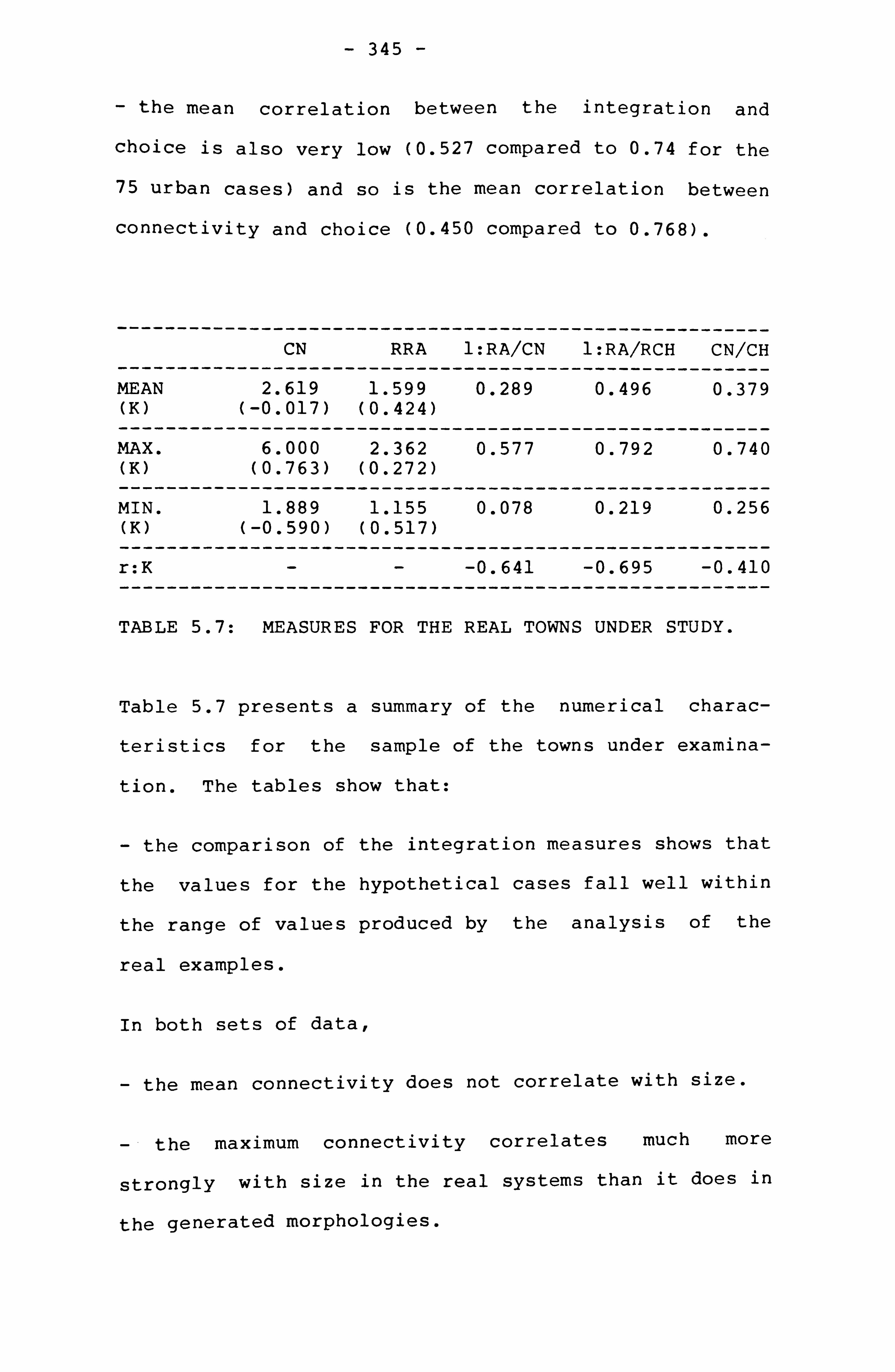
- 345 -
- the mean correlation between the integration and
choice is also very low (0.527 compared to 0.74 for the
75 urban cases) and so is the mean correlation between
connectivity and choice (0.450 compared to 0.768).
------- ------------ CN
--------- RRA
---------- 1: RA/CN
---------- 1: RA/RCH
------- CN/CH
------- MEAN
------------ 2.619
--------- 1.599
---------- 0.289
---------- 0.496
------- 0.379
(K) (-0.017) (0.424)
------- MAX.
------------ 6.000
--------- 2.362
---------- 0.577
---------- 0.792
------- 0.740
(K) -- ----
(0.763) -- -
(0.272)
- MIN.
----- ---- 1.889
--------- 1.155
---------- 0.078
---------- 0.219
------- 0.256
(K) (-0.590) (0.517) -- -------
r: K -------
------------
------------
---------
---------
---------- -0.641
----------
---------- -0.695
----------
----- -0.410
-------
TABLE 5.7: MEASURES FOR THE REAL TOWNS UNDER STUDY.
Table 5.7 presents a summary of the numerical charac-
teristics for the sample of the towns under examina-
tion. The tables show that:
- the comparison of the integration measures shows that
the values for the hypothetical cases fall well within
the range of values produced by the analysis of the
real examples.
In both sets of data,
the mean connectivity does not correlate with size.
the maximum connectivity correlates much more
strongly with size in the real systems than it does in
the generated morphologies.

- 346 -
- The correlation between the mean integration and size is much stronger in the simulated systems (0.623) than
it is in the real cases (0.424). The level of integra-
tion is created by the connectivity. In the real
cases, there is an increase in the connectivity of only
few spaces (i. e. the market area in Ghardaia) which
will produce a certain pattern of integration; but this
increase is not assigned to so many spaces as would
improve the level of connectivity and integration or
would create the "super-grid" effect as observed in
some urban systems (i. e. SERC Report, 1986, pp. 9-10).
This is an indication that in real situations, there
seems to be a change of the rules and discrimination
between certain parts of the town in order to control
the morphological effects of growth, i. e. to control
the increase of the level of segregation. This change
in the rules does not take place in the generated mor-
phologies, because the rules embedded in the model are
equally applied all over the surface.
- For all three sets of data (*), the intelligibility
correlates significantly with size; it falls when the
systems become larger.
* The three sets of data refer to the 75 urban systems, the 70 computer g--nerated systems and the towns under study.
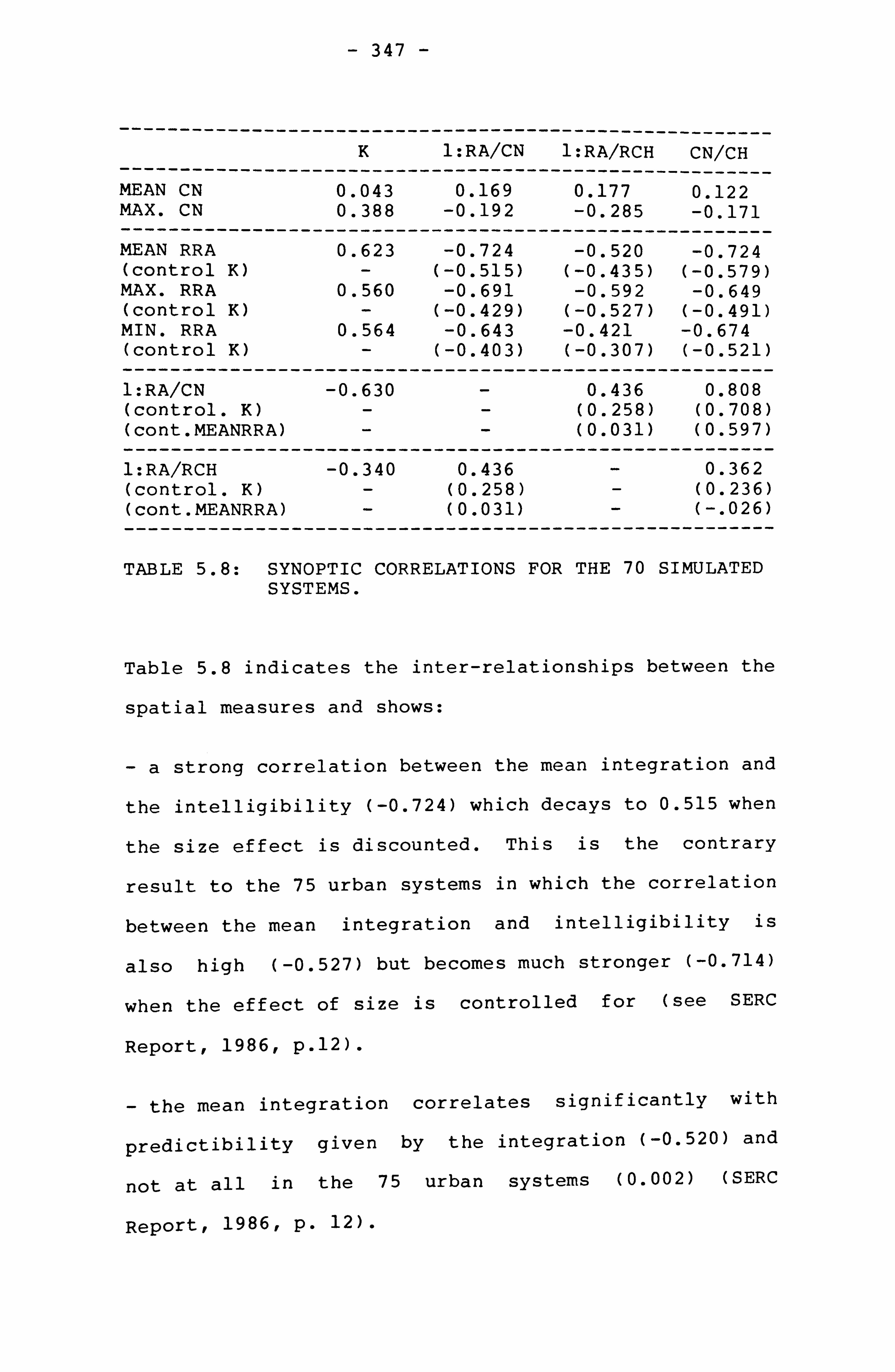
- 347 -
---------
---------
-------
---
--------- K
----------- 1: RA/CN
------
---------- 1: RA/RCH
--------- CN/CH
MEAN CN ---- ---------
0.043 ---- -
0.169 ----------
0.177 ---------
0.122 MAX. CN --------- -------
0.388
--------- -0.192
----------- -0.285
------- -0.171
MEAN RRA 0.623 -0.724 ---
-0.520 ---------
-0.724 (control K) - (-0.515) (-0.435) (-0.579) MAX. RRA 0.560 -0.691 -0.592 -0.649 (control K) - (-0.429) (-0.527) (-0.491) MIN. RRA 0.564 -0.643 -0.421 -0.674 (control K) - (-0.403) (-0.307) (-0.521) --------- 1: RA/CN
------ --------- -0.630
----------- ----------- 0.436
--------- 0.808
(control. K) - (0.258) (0.708) (cont. MEANRRA) (0.031) (0.597)
--------- 1: RA/RCH
------ --------- -0.340
----------- 0.436
----------- --------- 0.362
(control. K) - (0.258) (0.236) (cont. MEANRRA) --------------- ---------
(0.031) ----------- -----------
(-. 026)
---------
TABLE 5.8: SYNOPTIC CORRELATIONS FOR THE 70 SIMULATED SYSTEMS.
Table 5.8 indicates the inter-relationships between the
spatial measures and shows:
-a strong correlation between the mean integration and
the intelligibility (-0.724) which decays to 0.515 when
the size effect is discounted. This is the contrary
result to the 75 urban systems in which the correlation
between the mean integration and intelligibility is
also high (-0.527) but becomes much stronger (-0.714)
when the effect of size is controlled for (see SERC
Report, 1986, p. 12).
- the mean integration correlates significantly with
predictibility given by the integration (-0.520) and
not at all in the 75 urban systems (0.002) (SERC
Report, 1986r p. 12).

- 348 -
- mean integration strongly correlates with predicti-
bility given by the connectivity in both the 70 com-
puter generated systems (-0.724) and the 75 urban areas
(-0.716).
- for the 70 simulated systems, the correlation between
intelligibility (1: RA/CN) and predictability (1: RA/RCH)
is very weak, 0.436 compared to 0.787 for the 75 urban
systems (SERC Report, 1986, pp. 12-13), which decays to
0.543 when the size is controlled for.
The comparison of these results to the towns under
study (see Table 4.3) shows that:
- in both systems (real towns under study and hypothet-
ical), the mean integration correlates strongly with
intelligibility (-0.751 for the real systems, which
becomes -0.563 when K is controlled for).
- in both systems, the mean integration does correlate
with the global predictability (for the real towns,
-0.626 decreasing to -0.348 when K is controlled for).
- While, the mean integration correlates much more
strongly with local predictability than in the real
towns and also falls when K is controlled for (-0.591
for the real towns, decaying to -0.435 when K is con-
trolled for);
- for the simulated systems, intelligibility correlates
with the global predictability almost to the same
degree as in the real towns, decaying when K is con-

- 349 -
trolled but much more strongly when mean RRA is con-
trolled for (0.543 for the real towns).
The above results point to the conclusion that the gen-
erated morphologies present in spatial terms and in
many respectr fundamental differences to the 75 urban
systems. In fact, the comparison of the two samples
show exactly the contrary properties. Most of the key
properties and relations found in the real cases of the
75 urban areas are not reproduced in the 70 simulated
systems. This can only lead to the suggestion that the
distinctive spatial properties of the 75 urban areas
may be the result of more globalizing rules imposed on
the systems in order to govern the effects of growth,
as conjectured in the SERC report (SERC Report, 1986,
p. 14).
But, the above tables show also that the measures given
by the generated systems fall well within the range of
values produced by the towns under study (towns with
the terrace system), suggesting that from the point of
view of the numerical properties describing the spatial
fabric, the generative model has led to a well-defined
pattern that bore some resemblance to the patterns
found in the settlements under study. These latter
have been spatially characterised to present highly
segregating structure which lacked intelligibility and
predictability, and these properties are also prevalent
in the computer generated morphologies. In other
words, the degree of segregation, the lack of

- 350 -
intelligibility and predictability may then be
accounted for in terms of the generative rules and
processes. Moreover, the results have shown that in
both, the towns under study and the generated systems,
the integration and intelligibility are affected by
size, although to a varying degree; and that the rela-
tion between intelligibility and global predictability
is not as strong as in the 75 urban systems and is
equally affected by size and integration.
THE PATTERN OF INTEGRATION AND THE GENERATIVE RULES:
The next question raised here is to see whether there
is a relationship between the generative rules and the
internal structure of the integration core itself.
The pattern of integration cores found in the real case
studies, with the exception of the small systems of
Ghadames (*), consisted of non-covering cores with
internal spaces connected to peripheral streets. That
is, in no instance did of the integration cores of the
large systems presented any structure reminiscent of
for example, a covering or a deformed-wheel pattern
(see fig. 5.15).
In these cases, the integration core does not traverse
the spatial fabric, leaving therefore large areas
* This refers only to the three quarters with the terrace
system, not to Bellil.

F10.5,15: INTEGRATION STRUCTURE50F THE REAL EXAMPLES.

352
FIG. S. 15 a INTEGRATION STRUCTURES OF
THE REAL EXAMPLES.

- 353 -
unpenetrated and highly segregated. It is conjectured
that this specific distribution of the most integrated
spaces on the townscape surface may originate to a
great extent, from a process of growth which is based
on more localized rules. Moreover, what seems impor-
tant is to pinpoint the nature of these rules, and find
out for example, what rule may be held more responsible
for producing the peripheral and the non-covering pat-
tern of the integration core.
The raised questions are investigated by looking at the
structure of the integration cores produced by the
model by varying the generative rules, one parameter at
a time. The integration maps for each generated system
showing the 10% of the most integrated axial lines,
were prepared. The integration structure of the simu-
lated systems will be described in terms of two main
criteria which are:
First, the location of the integration core with
respect to the overall morphology and with respect to
the outside. Three possible locations of the core are
envisaged:
i- the internal core
ii- the covering core
iii- the peripheral core
_In addition to this, the connection of the core to the
outside is"also considered, giving therefore five pos-

- 354 -
sible types of cores:
- an internal core which is connected to the outside;
- an internal core with no connection to the the out-
side;
-a peripheral core which is in all cases linked to the
outside;
-a covering core which is linked to the outside;
-a covering core which is not directly linked to the
outside;
Second, the continuity of the integration structure,
giving two possibilities of continuous or discontinuous
core.
In the light of these criteria, the integration cores
for the simulated morphologies display striking dif-
ferentiation with respect to the generative rules. A
casual examination of the cores indicates that none of
the generated systems has produced a core which
approaches the form of a covering core or a deformed
wheel. Four dominant patterns have emerged from the
sample.
- Pattern one includes continuous cores that are con-
stituted by many internal lines compactly arranged,
linked only by fewer lines to the outside of the mor-
phology (see fig. 5.16,5.16a, 5.16b)

- 355 -
- Pattern Two consists of "inward-looking" and continu-
ous integration core, not connected to the outside of
the system (see fig. 5.17,5.17a, 5.17b).
- Pattern Three includes systems with integration cores
that are mainly constituted by peripheral lines con-
nected to some internal lines forming a tree-like pat-
tern on the edge of the morphology (see fig. 5.18,
5.18a, 5.18b) .
- Pattern Four includes systems with integration cores
of a fragmented nature with lines dispersed all over
the surface (see fig. 5.19).
---------- ----------- PATTERN 1
------------ PATTERN 2
------------ PATTERN 3
---------- PATTERN 4
--------- PX =0
------------ 4
------------ 2
------------ 3
---------- 0
PX = 0.4 5 4 0 0 PX = 0.6 1 7 1 0
--------- Py =0
------------ 1
------------ 5
------------ 1
---------- 2
PY = 0.6 5 4 0 0 PY = 0.7 2 2 5 0 PY = 0.8 3 1 5
- -
0
---------- --------- PS = 0.2
------------ 1
------------ 1
- --------- 1 5
PS = 0.4 3 4 0 1 PS = 0.8 5 4 0
---
0
---------- --------- % FOR
------------ 28.57
------------ 37.14
--------- 22.86 11.43
SAMPLE --------- ------------ ------------ ------------ ----------
TABLE 5.9: CLASSIFICATION OF PATTERNS OF INTEGRATION CORES, ACCORDING TO THE GENERATIVE RULES.
Table 5.9 gives a summary of the four different pat-
terns of integration found in the simulated systems and
in relation to the three generative rules: the x clus-

X *Y705S8
X0605S8
X4Y805S6
356
X4605'136
X0705Sc-,
X4Y60 5-7-'r'5
FIG. S. 16. INTEGRATION CORES PATTERN ONE

7
, 4YEOSSE)
xOY605S6
XOY605S6
X4Y6 05S P-,
xoyc, o5s8
XOY605S8
FIG, S. l6a. INTEGRATION CORES PATTERN ONE

X6Y605'--), P,
X46055S4
X4YOO'l '56
X4605'S. 21
x4Y605S4
FIG. 5.16b: INTEGRATION CORES PATTERN ONE

X4Y70558
X4Y8O5
359
X4Y605S8
X4Y70')SC
x4y6o5,, )8
FIG, 5.17. INTEGRATION CORES PATTERN TWO

XOY6051-58
MY6050sa
30
X6YE; 0555
MY60658
x0y6 or5, Q, a
X6Y60558 FIG. 5.17a, INTEGRATION CORE5
PATTERN TWO

361
X4YO05S8
X4Y0 05'50 8
X4YO05', '-. 5
X4YOCFjSB
MY6,055S5
FIG. 5ý l7b: INTEGRATION CORE5 PATTERN TWO
XE, Y605S8 X6Y605S8

X4Y605S4
X4Y6%54
X4Y605S4
X4Y6 05S. '2
F10.5.17c: INTEGRATION CORES PATTERN TWO

363
X4Y8O. -
X4Y805M
FIG, 5.18. INTEORATIONCORE5 PATTERN THREE
X4Y7 055 SUE'
X4Y7 CF5 S5
X4yEiO5! 5FJ

364
X4YSO',, S8
X4Y-9,0SSklj
-j
v
XOY605'-: )B
x6yt XOY6CFj. '.. Z
INTEGRATION CORES PATTERN THREE
X0Y6 05'15 8

365
X0005S, 18
X06752
.j
x4Y605-, "-
F10.5.18b, INTEGRATION CORE5 PT Ai TERN THREE
FIG, S. 16c: INTEGRATION CORES PATTERN ONE

X4YO05S6
X4Y605
X4Y605S'X. '
X4YO05, cj5
FIG. S. 19, INTEGRATION CORES PATTERN FOUR

- 367 -
tering (Px), the y joining (Py) and the y sliding (Ps).
From the table, it can be stated that:
- There is a clear increase in Pattern Two when x clus-
tering probability is increased. When there is no insistence on x clustering, that is x clustering is
randomized (Px = 0), Pattern One and Three are predom-
inant. On the other hand, when the situation is
reversed with Py randomized (Py =0& Px = 0.4), a
clear increase in Pattern Two takes place.
In the light of these results, it can be concluded that
the x clustering rule is more likely to produce more
internal cores that are completely isolated from the
outside.
-A clear increase in the cases of Pattern Three, and a
fall in the cases of Pattern Two when the y joining
probabilities are increased. When Py is randomized,
there is a net predominance of Pattern Two. When the
open spaces or the y cells are forced to join to each
other by the increase of the probability of y joining,
a clear predominance in Pattern Three and One is
noticed. This leads to the conclusion that the links of
the integration core to the outside is likely to be
manufactured by the y joining rule.
-A clear decrease in the number of Pattern Four when
the y sliding is increased. When the sliding probabil-
ity is very low (Ps = 0.2), 5 out of 8 cases have pro-

- 368 -
duced discontinuous cores. On the basis of this
result, it is concluded that the continuity in the
structure of the cores is more likely to be created by
the rule of y sliding.
Variations in the patterns of the integration cores can
also be observed within the different runs of the same
set of values given to the parameters, and may perhaps
be attributed to the random factor built into the
model. As pointed out in the introduction of preceding
sections of this chapter, the model developed here is
non-deterministic, in the sense that the outcome mor-
phologies cannot be fully predicted from the rules, but
depend on some factors which are independent of the
model. This is provided by the random numbers which
are considered as a means for unpredictibility. With
intermediated probability values of the parameters
(i. e. Px = 0.4, Py = 0.6) and the random factor, their
dual effects will be working sometimes together and
sometimes against each other, and the results will be
to a certain extent, unpredictable as far as the
overall structure is concerned, though the spatial pro-
perties can be fluctuating about some norms.
The comparison of the diagrams in figures 5.16 to 5.19
with the integration cores of the real examples in fig-
ure 5.15 shows a resemblance in terms of location and
structure between the real and the hypothetical cases.
For example, cases of Pattern One are similar in that
respect, to the integration structure of Ghardaia,

- 369 -
while cases of Pattern Three bore resemblance to the
integration structure of Beni Isguent and cases of Pat-
tern Two are similar to Beni Isguen at the first and
the second stage of growth.
CONCLUSIONS TO CHAPTER FIVE:
In the light of these results, some fundamental conclu-
sions can be drawn at a series of levels:
First,, the generative model of settlement growth has
provided convincing evidence that the numerical proper-
ties of the towns under consideration could have ori-
ginated from a process of growth of a more localized
character. The variation in the generative rules
introduces variation in the global properties of the
town fabric. For example, it has been demonstrated
that an x-led process leads to a more segregating
fabric. However, an important difference is observed
between the real and the simulated systems in terms of
the relationship between the integration and size. In
the towns in question considered as a group, the
integration does not correlate strongly with size, that
is the towns under study do not become much more segre-
gated as they grow larger, and suggests that there is a
change of a particular kind in the growth process. . The
results of the analysis of the towns and the generative
model point to two possible ways regarding the nature
of this change: a change in the process from an x-led
to a y-led mode of aggregation; or an introduction of

- 370 -
some extra rules with more globalizing effect on the
growing systems. In the case of Ghadames, the analysis
has shown no increase in the maximum connectivity and a
clear decay in the integration of the town as a whole,
suggesting therefore a more x-led process. For Beni
Isguen and as the system becomes larger, there is a
considerable increase in the maximum connectivity,
although not internally; a clear improvement in the
integration and an increase in the linearity of the
blocks. These characteristics point to the conclusion
that the system of Beni Isguen, as it evolves, becomes
more y-led and also increases particularly its connec-
tions to the periphery.
The system of Ghardaia on the other hand, increases the
maximum connectivity and also maintains the level of
integration constant throughout its growth. The lack of
improvement in the level of integration suggests that
in this case, the system may have followed a more x-led
process, but may have also increased using a more glo-
balizing rule, the connectivity of the market area. A
suggestion about the kind of globalizing rule that may
have been used is advanced. This is related, as sug-
gested earlier, to the possible effect of the town
walls that contain the evolving settlements on their
global organisation. The decision concerning the con-
struction and the position of the fortification walls
is certainly taken at global level by the town council
(Donnadieu and Didillonr 1977, p. 55). When the walls
are built, a ring of open space is usually left between

- 371 -
the walls and the rest of the urban tissui that space
becomes part of the street system, in the sense that
many buildings begin to be built along side it and have
their entrances giving onto it. The walls are demol-
ished during the course of growth to be built further
away; but the ring of open space would preserve its
structure mainly because of the buildings giving onto
it. The examination of the location of the integration
cores (see fig. 5.15 and 5.15a) for Ghardaia and Beni
Isguen at the different stages of expansion, in rela-
tion to the limits of the towns during these phases,
lends support to the above suggestion.
Second, the regionalization of the town structure and
the lack of covering core is not the result of the
location of the major town facilities (i. e., the main
mosque and the market square), but can be attributable
to the nature of the fabric of the towns, and the way
they grow.
Third, the "covering-type" of integration core is not
produced at all by the variation in the local rules
embedded in the model. It can therefore be concluded
with more confidence, that such structure results from
more globalizing rules imposed on the growing systems.
Finally, another interesting result is that the model
has shown how the global structure of the settlements
can be a by-product of the form generative process and
not a mere reflection of one prime factor such as reli-
gion (i. e. the argument relating to the privacy model).
9

- 372 -
This suggests that the social hypotheses of the settle-
ment forms could be more usefully formulated in terms
of the underlying generative rules. This particular
point will make the main concern of the next section.
Moreover, the consideration of the above points sug-
gests that the local rules embedded in the model have
produced a kind of "spatial global effect" which is
partly random. By building very densely, that is by
insisting on x clustering, the overall effect of the
application of this purely local rule will be more
likely characterized by the increase of the size of the
blocks of buildings; which is a fundamental formal
requirement for the potential development of the ter-
race system. The more there is insistence on x clus-
tering, the more likely the size of the block becomes
larger, and the more the settlement has the physical
potential to develop the terrace system. On the other
hand, the regionalization and the non-covering nature
of the integration cores is another spatial global out-
come of the local rules. It is clear that the access
structure in the settlements of interest was essen-
tially unplanned; it is not the result of a planned
"master plan", but was the cumulative result of
numerous decisions and actions, individual or collec-
tive, over the centuries. The opportunities for access
to any building were only constrained by the layout and
access points of the already existing buildings. Such
actions were not subject to global control. Therefore,
the non-covering pattern of the integration structure

- 373 -
can only be a global result of the combined effect of
the local rules. So, the more the integration core is
non-covering, the more the regionalization of the town
is accentuated and the more the accessing of strangers
is controlled and limited to a specific zone of the
town. Therefore, the notion of spatial control can be
related to the very nature of the form generative pro-
cess of towns.
A conclusion that can be drawn is that the most essen-
tial imperative principle that has shaped the urban
fabric is the localized form of growth process. It has
been the prevalent force in the shaping of the built
orm.
The close correspondence between the spatial properties
of the real and the hypothetical morphologies , and the
"life-like" appearance of the latter both corroborate
the process description advanced here. The basic prin-
ciples of growth have held good for most experiments.
They represent the morphology in its simplest form.
The generative procedure has helped to define much more
precisely what spatial forms were possible. That is to
say, it helped to describe the limits of what could
actually have occurred within the social context of the
settlements of interest.
The above findings suggest then that many of the mor-
phological characteristics observed in the towns under
study, could be accounted for by the spatial logic of
the system. The visually complex, but nevertheless

- 374 -
very ordered, spatial patterns of this settlement type
arose from the consistent application of rather few
local rules within the context of a rather narrow and
consistent set of constraints. Thus, while far from
deterministic, the pattern of building and open space
may be seen as probabilistically dependent on the sys-
tem of relations between the basic principles of
growth.
THE SOCIAL IMPLICATIONS OF THE GENERATIVE RULES:
In the following section, an attempt will be made to
look at the social implications of the generative
rules. The present section aims, using historical evi-
dence, at the comparison of the explicit intentions and
purposes for which the building principles have been
introduced, with the spatial consequences and the logi-
cal social implications that the rules may entail.
The analysis of the outputs of the generative model has
shown the effects of the embedded local rules on the
global structure of the systems. It has shown that the
y joining rule combined with the y sliding, increases
the axiality of the systems, which become more
integrated and more directly accessible from the out-
side. The integration structure tends to increase its
links to the outside of the morphology. On the other
hand, the axial dimension of the system represents, by
definition, its most global organisation, since axial
lines can only extend farther away. Therefore, the
- 375 - bring
axial organisation may be seen toL local parts closer
together and facilitate access of the settlement from
the outside (Hillier B., Hanson J., 1984, p. 95). Con-
sequently, the y joining rule produces morphologies in
which the generative logic is more oriented towards the
global level of organisation, that is towards facili-
tating the accessing of strangers to particular areas
and their interfacing with the inhabitants.
The x clustering rule has, however, produced the oppo-
site effect. It introduces more fragmentation in the
axial organisation of the systems by increasing the
size of the blocks, and as such the systems become more
segregated and less accessible from the outside. The
integration core tends to concentrate in the middle of
the system, creating a highly isolated structure with
respect to the outside. In other words, the insistence
on x clustering rule is more likely to create morpholo-
gies with the tendency to localize the form as the sys-
tem grows, and in which the generative logic is more
oriented towards the local level of organisation, that
is towards the female members and their children which
are constantly present at the local streets and at
their homes.
Explicit intentions underlying the generative rules and
their spatial and social implications:
The investigation into historical facts concerning the process of building and urban development has esta-
blished a framework to (d"ffpý an-a

- 376 -
the explicit reasons underlying the building princi-
ples. For instance, the intention behind the high den-
sities of land developmentr expressed in the rule x
clustering are environmental, economic and defensive.
i- environmental: the hard climatic conditions of the
Sahara imposed a dense packing of buildings which
reduces the surfaces directly exposed to the sun and
therefore provide more shade and creates more comfort-
able environment (i. e. Hakim B., 1986, p. 66).
ii- Economic and Defensive: The shortage of land for
building, as a consequence of walled settlements for
defensive purposes, imposed high densities of develop-
ment, that is the use of the whole plot of land for the
building. The pressure of growth and the need for
extra space for construction led to the building of
rooms spanning the streets.
The investigation into historical facts has also shown
that the reasons behind the sliding rule of the y
cells, is to avoid the creation of visual corridors
between opposite buildings. This rule, it has been
shown, increases the axiality of the system (see
diagram p. 304. In other words, the mechanism by which
privacy is obtained is not through clustering and
thereby investing in the more localized spatial rela-
tions as believed by many scholars (*), but mainly by
contributing in the more globalizing dimension of the
* The reader is referred to Part One of this report.

- 377 -
spatial arrangement, that is in contributing in the
linear development and extension of the open system.
The fact that the x clustering rule produces more
segregated structures and larger blocks indicate the
potentiality of the settlement to create extra spatial
relations between the main category of users, i. e. the
female members. No social justification relating to
the spatial need of the women is attributed to this
rule in the Mzab towns.
By clustering the closed units:
It firstly increases the roof C' %4. --_ r1_5 and therefore
increases spatial contiguity between the female
members. The only constraint related with the roof
usage in the Mzab towns, is that no man is allowed into
it during day time, and it is intended for drying food,
cloth landering and for sleeping during the hot nights
of summer. The social rules, that are global in scope,
do not specify that in ractice the women in the Mzab
towns should use the roový_s or the segregated parts of
the street system for their socializing. In other
words, there is a certain level of indeterminacy and
un-specification about the impact of the building prin-
ciples of aggregation.
And secondly, it increases the inaccessibility of the
streets from the outside; the integration core tends to
become more internal and isolated, creating therefore
highly isolated areas which can be used by the more
restricted category in mobility terms: the women.

- 378 -
The negotiative relationship between the two generative
rules, y joining and the x clustering, seems to have
profound and strategic implications on the system of
relations between the categories of users, and espe-
cially between men and women. The more there is
insistence on y joining, the more the overall spatial
structure is likely to be geared towards the global
organisation, that is towards facilitating the accessi-
bility of strangers and therefore encouraging their
interface with the male population, and the more the
women will be likely restricted and confined to the
interiors, and the more they would'be spatially iso-
lated from each other. In this case other means than
space would be required if they have to exist as a
cohesive group. But, the more there is insistence on x
clustering, the more the overall spatial structure is
likely to be geared towards the local level of organi-
sation, that is discouraging the accessibility of the
strangers and therefore restricting and controlling
their interface with the male members to particular
areas of the system, the more there will be highly
segregated parts, and the more the women are spatially
brought together by the increase in spatial proximity
(i. e. the continuity of the roof areas), encouraging
therefore their contacts, without contravening the
separation of the sexes which is the most important
global social rule, which is religious in origin.
In Part One, it has been shown that as the separation
of the sexes prevails as a social rule, so does the

- 379 -
fact that the men should leave the
"neighbourhood" during the day and
specific hours. The combination of
rules, in addition to the spatial
settlement, seems to provide the basis
space uses by men and women.
house and the
return only on
the two social
properties of the
for differential
What this chapter has established is the fact that
social hypotheses can be better formulated in terms of
the generative rules, which also seem to have strategic
implications and consequences on the systems of rela-
tions within and between the sexes.
This generative approach has opened up a more general
question concerning the interpretations often associ-
ated with this particular type of settlement: the
Arab-Muslim city as referred to in the literature.
SUMMARY TO CHAPTER FIVE:
This chapter has examined the possible relationship
between the spatial properties of the towns under study
and the underlying spatial rules and processes of urban
growth, as well as the social rationale of these rules.
By this, this chapter has promoted a spatial way to
investigate into the social dimensions of spatial forms
by enquiring into the social nature of the generative
processes and rules, using a generative approach and
also some historical evidence about the nature of
development control in these towns. It has been con-

- 380 -
cluded that many syntactic properties observed in the
towns in question, may be to a great extent, the pro-
duct of a greater localization of space structuring,
which may be seen to express a means of control of
relations between and within the sexes.

- 381 -
CHAPTER SIX AND CONCLUSIONS: THE GENOTYPICAL CHARAC- TERISTICS OF ARAB TOWNS AND THE RELATIONS BETWEEN THE SEXES
This chapter opens up a discussion by reviewing the
research project as a whole in the light of the three
types of information generated by the study -descrip-
tive, analytic and generative; in an attempt to see the
relevance these have on the theoretical questions of
the study, that is the "genotypical" characteristics of
Arab towns and the relations between the sexes as
reflected in these characteristics. By this, the
present chapter aims to draw the final conclusions,
using the ethnographic and morphological material
presented in Part One of the report together with the
analytical and generative evidence in Chapter Four and
Five.
The descriptive section of the study has established
morphological differences between the towns at three
levels of space organisation; at the level of the town
fabric, the house and the terraces. At the level of
the urban fabric, the differences between the towns can
be summarized in terms of the compactness of the
overall form, the regularity of the street network and
the street coverage by buildings. In these terms, Gha-
dames differs from the other towns; its fabric is
divided up into distinct small entities, and the

- 382 -
streets with the exception of one quarter, are entirely
covered up forming irregular "tunnels" underneath the
four-storey buildings. In each of these quarters,
masonry benches are built along the main streets.
Ghardaia and Beni Isguen present a much more compact
and massive form, and the streets which are occasion-
ally covered up, divide the urban fabric into irregular
blocks of various shape and size. Only the streets in
the vicinity of the market and the market place itself
are furnished with built-in masonry seats for men.
Conversely, the streets of El Oued form a much more
regular grid and lack any street furniture.
From the point of view of house layout, the main
difference between the towns resided in the distribu-
tion of male-female spaces with respect to the outside
and to the terraces. In Ghadames, except Bellil, the
female's spaces are located at the upper floor, and
11_ý have a direct access from the rooýess. In the houses of
Ghardaia and Beni Isguen, the kitchen and the women's
living room are located at ground level, away from the
terraces. The male quarters on the other hand, are
directly connected to the streets. The houses of El
Oued showed no specifically designated spaces for
female's use except for the kitchen; and the men's sit-
ting room has also a direct access from the streets.
From the point of view of the terrace configuration,
the major differences observed between Ghadames and the
Mzab towns are that in these latter, the links at roof

- 383 -
level are restricted only to the level of the block;
while in Ghadames the links are systematically built
throughout the quarters and the spaces for circulation
in the terraces are clearly demarcated by physical
boundaries.
Part One has also identified the different practices in
these towns in terms of space use by men and women. In
Ghadames, street uses are mainly associated with men.
This is a significant difference from the Mzab towns
where men are more associated with the areas around the
mosques and the market place. Differences in the way
the terrace system is used in the Mzab towns and Gha-
dames have been also reported. In the former, the
usage of the rooftops is more incidental and restricted
to smaller areas; while in the latter, the terraces are
used at a more regular basis and much more extensively;
in El Oued, neither the street nor the roof social
activities of women have been noted.
The consideration of these descriptive facts has led to
the suggestions that there may be a relationship
between the spatial structure of the towns and these
differential uses, and also between the spatial struc-
ture of the towns and the differential form of the ter-
race system.
Part Two has shown the presence of regularities in the
spatial organisation of the three towns with the ter-
race system in the full sense or only partially.
Throughout the cases, whether looked at from the point

- 384 -
of view of the organisation of their parts or as a
whole or according to the different versions of
representation, the high level of segregation in the
street structure prevails. The other consistent result
and characteristic invariant to these spatial forms is
the way in which the spatial parameters correlate with
each other. All cases have exhibited a weak relation-
ship between integration and connectivity.
Part Two has also demonstrated strong variations
between these systems, and these can be summarized in
terms of both the pattern of growth and the global
organisation. The analysis of the local and global
systems of Ghadames has shown that this town grows by
keeping the mean and maximum connectivity constant, and
increasing its level of segregation, suggesting there-
fore that the system of Ghadames seems to grow addi-
tively without restructuring the whole. But, Ghardaia
grows by improving the maximum connectivity, while
keeping constant its level of segregation; and Beni
Isguen grows by improving both its maximum connectivity
and its level of integration. These variations in the
measures as the systems increase in size, denote under-
lying variations in the processes of growth for these
towns.
The morphological differences observed in these towns
have been amplyfied by spatial differences in terms of
global organisation, and the arrangement of the main
circulation lines. In the small systems of Ghadames

- 385 -
where the terrace system is in a full form, the
integration cores take a much more covering pattern.
For Ghardaia and Beni Isguen where the terrace system
is only in a partial form, there is a clear regionali-
zation in the global structuring of space, and the
cores are much more non-covering; while in El Oued
where there are no terraces, the system presents a
grid-core type. Therefore, these results suggest a pos-
sible relation between the differential forms of the
terrace system and the spatial structure of the towns.
on the other hand, a close correspondence has been
noticed between the social uses of space by men as
described in Part One, and the spaces covered by the
integration cores and the main circulation lines given
by the simulation. In most cases, and according to the
different versions of representation or the different
stages of growth, the integration cores intersected the
spaces and areas mainly used by men. The only excep-
tion is the mosque in the large system of Beni Isguen,
which remained segregated from the integration core and
did not figure on the popular route resulting from the
simulation. These results suggest then a possible
relation between the observed space uses and the spa-
tial structure of the towns.
The analysis of the generated systems based on local
rules of aggregation has shown that most of the numeri-
cal properties and their interrelationships identified
in the towns with the terrace system have been repro-

- 386 -
duced, although to a varying degree, in the simulated
systems. Similarly to the real townst the generated
systems have showed to be highly segregated with a poor
level of intelligibility, suggesting then that the spa-
tial fabric as described by the numerical properties
can be seen to a certain extent, as the result of a
more localized process of growth. The variation of the
generative parameters has introduced variation in the
numerical properties of the systems, and the results
have shown that the x clustering rules (or an x-led
mode of cell aggregation) increases the level of segre-
gation and the size of the blocks; while the y joining
parameter improves the level of integration of the sys-
tems. These results may explain the variations
observed in the pattern of growth of the towns under
study, and suggest also a possible relation between an
x-led mode of aggregation and the development of the
terrace system.
Moreover, the analysis has shown that the regionaliza-
tion of the urban structure and the non-covering core
type observed in the global organisation of the Mzab
towns, has been consistently reproduced by the simu-
lated systems. Therefore, the non-covering core type
and the regionalization of the town structure can be
seen to originate from the localization in the struc-
turing of space.
The first qeneral conclusion of the present research is
that the global properties of the spatial configura-

- 387 -
tions can be seen as the by-product of the nature of
the spatial fabric. Therefore, a strong relation has
been established between the nature of the spatial
fabric of urban systems and their global organisation.
Chapter Five has demonstrated how such regularities as
described above, can arise purely and simply from a
more localized process of building aggregation. It has
been shown that both, the distinctive properties of the
urban fabric and the regionalization in the global
organisation, depend to a large extent, on the urban
development process that operates on local rules of
building aggregation, applied as restrictions on an
otherwise random process. This result is far from
obvious and leads to the second general conclusion
which is: the global structuring of space in these
urban systems is governed, to some extent, by the
development process and the nature of the rules fol-
lowed in the building activity. Therefore, a strong
relationship has been established between the global
level of spatial organisation of urban systems and
their underlying generative rules.
The consideration of the socio-descriptive material
together with the results of the analytic and genera-
tive studies, has led to the formulation of a provi-
sional thesis regarding the spatial structuring of
these towns and the way it relates to the spatial uses
by different social groups, and especially by men and
women. The regionalization observed in the global

- 388 -
organisation of these towns may be associated with the
controlling of movements of strangers in the systems
and their interface with the male-inhabitants. This
regionalization has been shown to derive from a more
localized process of growth. Therefore, the emphasis
on the control of local spatial relations in space
structuring may be seen as a spatial device in intro-
ducing control on strangers. By the same token, the
regionalization in the structure of the town creates by
definition highly inaccessible zones especially from
the point of view of the strangers. The development of
the "zenka society" for the women as described in
Chapter Two, can be then attributed to this charac-
teristic global organisation, only because these social
activities at the "zenka" are first, not recognized as
a right by the social system and therefore cannot be
seen to result from some social rules of space classif-
ication; and second, they depend to a great extent, on
spatial proximity and the absence of men. The male
residents are kept out of these areas through the
social ritual which requires the men to leave their
homes during particular hours of the day; and the
strangers are kept away from these areas by the very
nature of the spatial organisation of the town. This
argument remains, of course, only hypothetical at this
stage, and further research is required to substantiate
this claim. But,, if this turns out to be the key
determinant in the absence of the strangers and the
development of the "zenka society" then a relation

- 389 -
would have been established between social factors and
the generative process of urban formation and the
underlying rules; and in these terms, space in these
towns appeared then to be structured in the image of
the relations between male and female solidarities.
What this means is that two kinds of knowledge were in
fact, required to offer a more plausible explanation
regarding the morphological invariants observed in the
towns under consideration:
- the common knowledge of historical events and social
processes in which these forms have arisen. This type
of knowledge would never truly explain the particular
morphological features as described earlier.
- and the knowledge that included the idea that the
process of urban formation in purely spatial terms, and
the underlying local rules would lead to the generation
of spatial systems which present resemblance to the
towns under consideration, that is systems with large
blocks of buildings and many cul-de-sacs, that are
highly segregated, poorly intelligible and un-
predictable, and present a regionalization in their
global organisation. This particular kind of knowledge
of the relation of implication between local rules and
the properties of the spatial forms is necessary to a
proper explanation and a full understanding of the set-
tlement morphology.
It follows from this, that if the way in which the

- 390 -
towns grow is understood through the identification of
the underlying generative process and spatial rules,
their social potentials become then more distinct and
conspicuous.
What seems to be a useful contribution of the present
study is that it has suggested a new basis to open up
questions about settlement forms and their relation to
social factors, using mainly an architectural approach.
- 391 -
SPECIFIC BIBLIOGRAPHY:
Abou Zakaria: "Kitab essira wa akhbar ala'imma"; Trad. Masqueray E., Aillaud, Alger, 1879.
Addoun D. A.: "Sociologie et Ibadites"; Ghardaia, 1977.
Histoire des Algeriens
Al-Hathloul S. A.: "Tradition, continuity and change in the physical environment: The Arab-Muslim city"; Ph. D tfi-esis, MIT, 1981.
Amat D. "Le Mzab et les Beni Mzab"; Challamel, Paris, 1888.
Aymo J.: "Les clans d1une cite berbere saharienne: Gha- dames"; Centre de Hautes Etudes Administratives sur- l'Afrique et l'Asie modernes, Paris, 1957.
Aymo J.: "La maison Ghadamsie"; in 'Travaux de l'Institut J-e Recherches Sahariennes de l'Universite d'Alger', vol. XVII, 1958.
Aymo J.: "Notes de sociologie et de linguistique sur Ghadames"; in 'Bulletin de Liaison Sahariennel, No. 34, June 19ýý9.
Basset A.: "Articles de dialectologie berbere"; Klinck- sieck, Paris, 1959.
Bataillon C.: "Le Souf: Etude de Geographie humaine"i-, Alger, 1955.
Beck L. and Keddie N.: "Women in the Muslim world"; Harvard University Press, CamE-rid-ge, Massachusets and London, 1978.
Bernard A.: "Afrique septentrionale et occidentale"; Colin, Paris, 1939.
Blanguernon C.: "La vallee du Mzab"; in 'Revue AtlaslF Paris, 1975.
Bonete Y.: "Notes sur llarchitecture religieuse au Mzab"; in 'Cahiers des Arts et Techniques d'Afrique du
Nord', No. V, Paris, 1956.
Bourdieu P.: "Sociologie de l'Alqerie"; P. U. F. � Que
Sais-Jet Parist 1958.

- 392 -
Bousquet G. H.: "Perennite du centre ancien au Mzab: Le cas de Beni Isguen"; in 'Fascicule de Rec'ý-erches Nos 10-11', de '1'Equipe de Recherches associee au CNRS, No. 706, pp. 9-22, Tours, 1982.
Brunschvig R.: "La berberie orientale sous les Haf- sides, des origines a la f in du XV siecle"; 2 vols; Paris, 1ý-42 and 1947,
Bruschvig R.: "Urbanisme medieval et droit musulman"; in 'Revue des Etudes Islamiques', pp. 127-155,1947.
Burckhart T.: "Fez"; in 'The Islamic City'. R. B. Ser- jant ed., pp. 166-176, Unesco, 1980.
Chavallier D.: "LlEspace social de la ville Arabe"; G. P. Maisonneuve e: E -fa-rose, Paris, 1979.
Chevrillon A.: "Les puritains au desert sud-algerien"; Le Livre Contemporain, Paris, 1944.
Coates P. S.: "A physical description of the vernacu- lar"; unpublislied Ph. D thesis, Liverpool Polytechnic, 1983.
Cromer, Earl of: "Modern Egypt"; 2 vols., London, 1928.
Delaval B.: "Urban communities of the Algerian Sahara"; in Ekistics, vol. 38, pp. 252-258,1974.
Davis N.: "Wanderinqs in Balad Ejjareed"; The African Sahara, London, 1954.
De Motylinski: "Le dialecte berbere de Ghadames"; Leroux E. , Paris .
1-904a
De Motylinski: "Notes historiques sur the Mzab, Guer- rara depuis sa fondation"; in 'Revue Africainel, p- 372, Jourdan et Alger, 1884.
Diehl: "L'Afrique byzantine"; Paris,, 1896.
Donnadieu P. and Didillon J-M.: "Habiter le desert: Les maisons mozabites"; Architecture + Recherches, Mardaga. P., Brussels, 1977.
Duveyrier H.: "Mission a Ghadames"; Paris, 1864. Also,, "Les Touareg du Nord"; Paris, 1864.
Duveyrier H.: "Notice sur le schisme Ibadhite, le Mzab"; in 'Bulletin de la Societe de Geographiell Aug. 1878.
Duveyrier H.: "Exploration du Sahara. Les Touareg du
Nord#'; Paris, 1864.
Eldblom L.: ", Structure fonciere: Organisation et struc- ture sociale"; Uniskol-Lund,, 1968.

- 393 -
ETAU: "Recueil des textes sur Phabitat traditionnel"; Alger, 1979.
Etherton D.: ''The valley of the Mzab''; Riba Journal, London, Nov. 1969.
Etherton D.: ''Algerian oases''; in 'Shelter in Africa', Oliver P. ed., pp. 172-189,1971.
Farrag A.: "Social control among the Mzabite women of Beni 11; in 'Middle Eastern Studies', Vol. 7, pp. 317-327,1971.
Ferauld C. F Constantine, Arnolet: "Kitab El Adouani"; Paris, 1868.
Fernea E. W.: "A street in Marrakech"; New York, 1975.
Fournel: "Les berberes"; vol. 1, Paris, 1875.
Gaudio A.: "Les civilisations du Sahara"; Vervier: Gerard, Marab; -ut U'niversite, 1967.
Gautier E. F.: "Les siecles obscurs du Maghreb"; Payot, Paris, 1927.
Genton and Ravereau A.: "Le Mzab, une lecon d'architecturell; in 'Techniques et Architecture', No. 7, Jly 1951.
Gibb H. A. R.: "Modern trends in Islam"; Chicago, 1945.
Goichon A. C.: "La vie feminime au Mzab"; Editions du Seuil, 1966.
Gordon A. C.: "Women of Algeria: An essay on change"; Middle Eastern Monograph Series XIX, Harvard University Press, 1968.
Gouvion M.: "Le Kharediisme, monographie du Mzab"; Paris, 1926.
Hakim B. S.: "Arabic-Islamic cities: Buildinq and plan- ning principles"; KPI,, 1986.
Hilal J.: "The management of male dominance in tradi- tional AraE; culture: a tentative model"; in 'Civilisa- tions', vol. XXI, pp. 85-95,1951.
Hillier B. and Hanson J.: "The Social logic of space"; Cambridge University Press, 1984, pp. 33-34.
Hillier B. and Leaman A.: "The man-environment paradigm and its paradoxes"; in Archl-tectural Design; 'Aug. 1973;
pp. 507-511.
Huguet Dr.: florigines et migrations des tribus ber- T beres, part iculierement les Beni Mzýiý; in 'Revue de

- 394 -
llEcole d'Anthropologie', Nov. 1906, and Jan. 1906.
Huguet Dr.: "Recherches sur les habitants du Mzab"; in 'Revue de llEcole d'Anthropologie', Jan. 1906.
Huguet Dr.: "Les Soffs"; in 'Revue de 1'Ecole d'Anthropologiel, Paris, 1 1903.
Ibn Arrami: "Kitab al illam b-ahkam al-bunyan"; Date of work: 1334. ManuSCrip: E, printed lithographically in Fez, 1913.
Ibn Khaldun: "The Muqqaddima: An introduction to his- tory"; Dawood N. J. ed., Princeton University Press, 1970.
Ibn Khaldoun: "Histoire des berberes"; Trad. de Slane, Alger 1856, Paris 1934.
Lamphere A. Muslim women in the Middle East", 1974, p. 97.
Lanfry J. et Laperrousaz A.: "Chronique de Ghadames"; in 'Revue de l'Institut des Belles Lettre-sArabes',, No. 36, pp. 343-369, Tunis, 1946.
Largeau V.: "Le pays de Rirha-Ouargla. Voyage a Gha- dames"; Hachette, Paris, 1879.
Lavas tics,
G. P.: "Settlements in ancient Greece"; in Ekis- vol. 38, pp. 330-344, Nov. 1974.
Letourneau R.: "Le Mzab, Geographie economique"; in 'Les Cahiers de Tunisie, Serie de monographie, Sept. 1955. Also,, "Le Mzab, organisation administrative"; Aug. 1955.
Maher V.: "Women and property in Morocco"; Cambridge University Press, 1974.
Manouz S.: "Grammaire berbere: La langue, les origines du peuple berbere"; Klincksieck, Paris, 1968.
Masqueray E.: "Exploration historique et linguistique chez les Beni-Mzab"; in B. S. G. P., July 1878.
Masqueray E.: "Les Beni Mzab"; in 'Bulletin de la Societe Normande de Geographie', 1880.
Mercier M.: "Etudes sur le waqf abadhite et ses appli- cations au Mzab"; Carbonnelf Alger, 1927.
Merghoub B.: "Le Mzab et la notion de developpement
economique"; Paris, 1970.
Merghoub B.: "Le Mzab: aspects economiques, sociaux et politiques"; Fondation Nationale des Sciences Poli- tiques, Paris, 1964.

- 395 -
Milliot L.: "Recueil des deliberations des Ejýýmals du Mzab"; in 'Revue des Etudes IslamiquesIr GeutEner, Paris, 1930.
Morand M.: "Les Kanouns du Mzab"; in 'Les Etudes du Droit Musulman Algerien'p pp. 419-453, Jourdan, 1910.
Nait Saada M.: "Urban growth: The Mzab valley"; unpub- lished thesis, Leeds Polytechnic, 1977.
Pavard C.: "Lumieres du Mzab"; Delroisse, Paris, 1980.
Parveen S. A.: "Status of women in the Muslim world"; 1976.
Peters E. L.: "Some structural aspects of the feud among the camel-herding bedouin of Cyrenaica"; in 'Africa', No. 37, pp. 262-282,1967.
Pignal: "Le Kharedjisme ibadhite algerien"; in 'Terre d'Islaml, 1933-34.
Popper K.: "On the theory of the Objective mind", in 'Objective Kno;; -l-ed'ge: An Evolutionary Approach'; p. 154, oxford, 1972.
Ravereau A.: ''Le Mzab, une lecon d'A Biblioteque Arabe, Paris,, 1985.
Ravereau A. and Deluz: ''Le Mzab, ]ýn plaire''; in 'Revolution Africainel, 1964. Also,, ''Il faut sauver le Mzab''; 1964.
rchitecture"; La
urbanisme exem- No. "60-, Alger,
No. 61, Alger,
Raymond A.: "Grandes villes Arabes a Vepoque ottomane"; La Biblioteque Arabe Sindbad, Paris, -1985.
Richardson J.: "Travels in the great desert of Sahara"; 2 vols., London, 1848.
Roche M.: "Le Mzab"; Arthaud, Paris, 1970.
SERC Report, UAS: ", Spatial configuration and use den- sity at the urban level: towards a predictive model"; Unit for Architectural Studies, University College Lon- don, 1986.
Springer-Verlag: York, 1967.
"Geomedical Monograph Series"; New
Stiny G. and Mitchell W. J.: "The grammar of paradise: on the generation of Mughul gardens"; in 'Environment and Planning BI. vol. 7, pp. 209-226,1980.
Strothman: "Les Abadhites nord-africains"; in 'Revue de l'Islam', 1928.
Schacht J.: "The spread of Moslem architectural forms

- 396 -
tl! ýuýh the Sahara"; in 'Travaux de l'Institut de Recherches Sahariennes', XI II, p. 27,1954.
Tillion G.: "Le harem et les cousins"; Editions du Seuil, 1966. '
UTAS: "Women in Islamic societies";
Stockholm, 1983.
Vigourous Cl.: "L'emigration mozabite dans les villes go, du Tell algerien , in 'Cahier de 1'IiistitýHt de
Recherches SThariennes', 1945.
Ville: "Exploration geologique du Beni Mzab,, du Sahara et de la region des steppes de la province d'Alger"; Imprimerie Nationale, Paris, 1872.
Vivien de Saint-Martin: "Le Nord de l'Afrique dans l. 'antiquite"; Paris, 1863.
Watin: "Les Tolba du Mzab, origines"; Paris, 1912.
White E. H.: "Women's status in an Islamic society: The problem of purdah"; Ph. D thesis, Yale Universityr 1975.
Yushea B. Q.: "Ghadames"; Text in Arabic, Beirut, 1973.
Zeys: "Legislation Mozabite: Origine, source - s, present
et avenir"; Jourdan, Alger, 1886. Also,, 'Troit Moza- bite"; Jourdan, Alger, 1891.

- 397 -
APPENDIX 1: DESCRIPTION OF THE COMPUTER PROGRAM ----------------------------------------------------
THE MAIN PROGRAM:
The principle of a cellular automaton is that, starting
from a known state T, a set of cell allocations is made
and the counter increased to T+l. Given the state at
T+l, new allocations are made and so on until some
arbitrary state Tn is reached. This is represented in
the program by a single loop. Each pass through the
loop generates two random numbers (using Basic's func-
tion RND).
If the initial parameters for joining are PX and PY
then at any state T, JX, the first random number is to
be compared with PX and JY, the second random number to
be compared with PY.
XJOIN and YJOIN are the two boolean variables which
take the following values:
If JX <= PX then XJOIN is set to TRUE
If JY <= PY then YJOIN is set to TRUE
Otherwise they are set to FALSE.
The program then uses the two variables XJOIN and YJOIN
to determine which mode of allocations to choose as
described in the following:
SEED (x) REPEAT (for each T)
IF NOT xJOIN AND NOT YJOIN then:

- 398 -
(that means if x-x and y-y joining are set to FALSE)
Place a new x cell randomly on the screen, followed by
a new y cell next to it.
IF NOT XJOIN AND YJOIN then:
(that is if x-x joining relation is set to FALSE and
y-y joining is set to true)
Choose an existing y cell to place a new y cell next
to, and then a new x cell next to this new y cell.
IF XJOIN AND NOT YJOIN then:
(that is x-x joining takes the value TRUE, and y-y
joining takes the value FALSE
Choose an existing x cell and place a new x cell next
to it (if possible maximising the number of x-x adja-
cencies with existing cells). Then place a new y cell
next to this new x cell.
IF XJOIN AND YJOIN then:
Choose an existing x-y pair and place a new x-y pair
such that both new cells are adjacent to the old ones
of the same type.
UNTIL the coordinate list is full.
Clearly only one of these four logical relations can
hold at any one state Ty and it is not automatic that
any particular allocation attempt will succeed. If a

- 399 -
chosen allocation is unsuccessful then no allocation
takes place for that iteration.
NOTE:
The interpretation of the outcome morphologies into axial representation uses both the open spaces created by the rules and unallocated cells, since in real situations the continuous structure of open space includes parts that are not constituted by building entrances. However, this is only the case in so 0 far as the rules of allocation are first checked against; such as the rule which prevents closed cells having open cells on opposite sides (see p. 302). This rule is implemented in the
computer programme by the introduction of the backwall cells (see example below), which are shown only on the computer screen but not on the print-outs. These backwall cells, which are Ix3 blocks, are not taken as part of the. ppen space, since they
have already been excluded by the rule. This only applies to the layer of backwall cells, not to any spaces which may be
adjacent to them. In cases where there is more than one layer
of cells as shown in A, the unallocated layer is included. On
the periphery, axial lines are drawn by joining segments of
constituted open spaces.
The procedure of interpretation is admittedly rather tortuous,
and ambiguities can occur -for example, in deciding visually CD if a line strikes a vertex or passes it by. However, experience has shown that minor differences in the axial interpretation of layout will make a relatively small impact on the essentially
statistical properties of layouts under investigation here.
all cells

- 400 -
APPENDIX 2: COMPUTER GENERATED MORPHOLOGIES

401
L
El X CELL OR CLOSED EH Y CELL OP OPEN
X clustering 0.00 Y clustering 0.00 Overlap allowea 0.00
X clusterLng 0.00 Y clustarLng 1.00 Overlap allowed 9.00

402
tF, - . -,
Pj iý-4: -F t,,
z
: f1til I
1: 1 X CELL OR CLOSED EB Y CELL OR OPEN
CD Vl C-ý
at9rIn90.80 storing 0.60
ap allowed 0.00
0. U-, () 0, ()ý
' -i
cD -00

403
9
X clumt-w-Irts. t 0.4D Y oluater-InG 0.00 Ove^l ap CLI 1 owed S. 00 Y IwIldlrLG 0.130
-': -is ter- -, * -1.9 ! Lis +-er-. -n. 9
Cý ,J er c; p 11 C), Vecj vS
-I cj
«
0.40 0.00 S. 00 0.80
ýnp w'e- ýLl

404 (
ci. c: b. c:: CLc4U
-T-1 clustar-Ing Y cluster-ing Over-lop allowed T
F T-- "LI3 Y sliding
r=
rT7-1
0.40 0.00 S. 00 0.130
im
X 0.40 Y OILJ--tar-! n.! 4 0.00 0,, Ic, p S-00 Y -- 2 _4 J! 0.90

405
cluster-ins 0.40 cluster-ing 0.20
verlap allowed 5.00
sliding 0.80
X olustetr-irtq 0.40 Y olý. Jsste-r-ima 0.20 Ove--Icap allowaa 5.00 Y slicýin-q 0.80
X olustering 0.40"'
Y clustering 0.20
Overlap-allowed 5.00
Y sliding . 0.80
luster-ing 0.40
lustering 0.20
r1op allowed S. 00 I idi -IS 0.80

k,
C. 40 O. E2 6.00
o. ac
x H-
0. AO
0. C-0
Z: ý
00
I; cj 0. eo
c 1,.. i s -t e r- in90.40 I ýJster-. lnq Oý 60
Ver-lap allCDWeCJ 5.00 s1i cl i r-)_q 0ý 80
406 ý1U. Vter- 1 r-tg 0.4-0 n1u --+- e. - 1 rig 0.60
a. r- 1 r-p -u1 10 W. --C3 ýý. 00
s71 1 Jing
-
0.80

9-.
407
u. vt-4--r- I mg 0-4,0
us-týemr- I rLg. 0.60
cap C1.1 1 owe-r4 S. 00
cl I r-L, 4 0-4.0
Cl. AO 0. ED
0. Pi
X0i -19 0.160 1 Iv. 01i --ig 0.60
0 v, --r- 1 cip c2 110w ca cl ý; -
00 y -- 1i cj i -19 0.80
F] 'U. --lý Ei
I
ELi
Li

408
_______ 4-
ý-Jster- i r-19 0. AO
us+-er-; rig 0.70
r-lop allowed 5.00
Ii cl i -1.9 0.80
X
ly,
over-lcap a! l3w, ýCý vs1ý cj; -1 9
6ý
0.40
0.7C)
S. Oo
D. CKý
ly,
rj 7: 3
u-ster- i -,. 9 i rIq
! --icip allowed Ii CJ in
_q
rz-, 7-
0.40 0.70 5.00
o. eo
7D

409
-ig 0.4C)
--ý 9 0, '7C)
1 or Cal lc, wc-cJ- S. 00
i Ji -19 0. E30
2 2.1
9
Ve r- r- 1e rj s1 C-1
IL
0.40
0.70
5.00
0.80

410
F1 :4
Tj
f7j 177! F-I
ýEE
=7 -- --
1
LL ±1
Jt
LiJ4
Ilia,
'77
H-EI_. "-+ Jill1-
-
- ___
- ZI1T
K -, 5, -t-7--; -i .
-I "'. AO U-1
X cluster-in_q ycI us ter- I n_q Over- 1 ap aII owed Y slicjir-)-g
0.40 0.80 L: 1.00 0.80

411
"< :: -. L
- .. ------t : '. -: -.; .1:
:1-; s-let-irig 0. AO
e f- 1 r-I 9 0.20
allowecj S. 00 0.20
--ti T
X010.40
01J.. s fa 0.20 52c 12 O'd e cl S-C ly, 0.20

412
Elý tifi
X clustering 0.00 Y clustering 0.60 Over-lop alloweJ S. 00 Y Sliding 0.80
X oluster-ing 0.00 Y cluster-ing 0.60 Overlcp alloweC4 S. 00 Y Sliding 0.80
X olu-stse-r-ing 0.00 Y 0.60 ov. --r-lap Q11ow'--d S-00 Y sslijinq 0.30
OD
X cluster-ing 0.00 Y cluster-ing 0.60 Ovor-lop allowed 5.00 Y sliding 0.80

413
-71
TIT
71 IL
I z" I
F-F iL
Y cl-)ster-ing 0.00 Y clý, jster-inq 0.60 ova: -lap C21 1. . -erj S-80 *Y* sIi cl i -s 0.8
X clustering 0.00 Y clustering 0.60 Overlap ollowed S. 00 Y sliding 0.80

414
X01 .0 -S +- e r- a, -icj 0.60 0.00
01 11 0 4, -Cj ýý. 00
Vs1i cj ý, --IQ 0.80
b
X cluster-ing 0.60 Y clu-ste-r-Ins 0.00 Ovc---r- I op a 11 ow, --d 5.00 Y
-S Iij in.. 9 0.80
r
Ef a,
-I tn II1 .1,
rl
IT., Ell
t --j
2D if-
IT
. 4ý F4-,
X cluster-ing 0.60
Y cluster, 4nq 0.00
Over'lap allowed S. 00
,Y0.80 ,. --. S IaJi n_q
-Lý -Z, 77-1
q, - ýý4i J-2
. 17 Fl. -
El fo -
E-T-E p
X clustering 0.60
Y clustering 0.00
Overlap allcwecý S. 00
Y slijins 0.80
X cluster-ing 0.60 Y clustýer-inq 0.00 Overlap allcwýed S. 00
Y s2idinq 0.80

ri
t3 -1 i
q_ Lp fin:
-Ir
415
0.00
5.00
X cluster-ing 0.40 Y oluster-ing 0.00 Overlap allowed S. 00 Y sl iding 0.80
X olu-ste-r-im. 9 0.40 Y clustoar-Ing 0.00 ovanlop allowf--j 5-00 Y slijimq 0.80
X clusteri-ig 0.00
0ve r- 1, ý: -. p cl .1 -ý 0 ", e -j S. 0-

416 <01 Lj. ý: -V r- - -, , -; -4 ý). !-0
0. ýj) D0 -P
L. - LJ
L.
1111
=I-- -Li
. Ll- _: f7
-Jo I uster- i -19 0.60
--Icl us +-er- i ng 0.60 ý3 ýer- I ap a 11 Owed 5.00
sl i ding 0.80
E-1 C-) C,
0. p0
K C;
1 ýj --
t 4a r-
_ý -1
_q
u --t er 0. F'! 1"Ped5. C0
0-
i

Fllý
-
-i" 1L-'
ii i-
Eli
nn -ZZI"
-Zý- :7 -_r
417 X oluster-ir-1-9 C. elo 4
lip I uster- i -19 0.60 1- H-i F-ver- I op aII owed 5.00
; y, 7 s1ia4. -n 9 0.80
0.60
s te! - i --I .90.50
0. -3 2
0.60 0.00 S. 00 0.30
1ý c-, I : -) Lý t- -- ý . -, j GO
0. ýa
cluste7-inq U. bU
cI us tet-i r-iq 0.60
ver-lop allowed S. 00
sl iding 0.80

418 us ter-i mg lop allowed i CJ i ng
K cluster-ing 0.80 Y cluster-ing 0.60
Dverlnp allowed S. 00 Y sl iding 0. E30
clu-ster-ing 0. Ro 0.60 5.00 0.130

419 X cluster-ing 0.60 Y cluster-ing 0.40 Over-lop ollowed 6.00 Y sliding o. eo I
-_I-]
X cl ýjstEýt-iý-Iq 0. 60 y c1 1-1 -s t (R- -1 -1 -9
0. 40 0 -, / e r- I '-I p cl 1
-1 0We CJ 5. 00 y
-s 1 .1 CJ I r-I 9 o. eo
uster- i rn_g uster-. 1 r-)g
? r- 1 ap a 11 owed 31idi rig
1
_FI 1
0.50 0.50 5.00 O. So

420
.I r-19 0.40
-Ing 0.60 31lowed S. 00
3 0.20
X alust-ar-lmq 0.40 Y01 uwtex- I ms 0. eo 0%ýftr-lctp mllowe-d 5.00 Y ArIldims 0.20
7
rt cu- 1 r-tg 0.40
rtar- i rig 0.60
ap ollow-ad S. 00 11 ri, 9 0.20

421
-1
lustering 1 uster- I mg rlop allow&J II ding
ustering u at 4--r- i rig
-lop allow4itcl
I iding
0.40 0.60 S. 00 0.20
0.40 0.60 5.00 0.20
K- 'cr: - C.
-i
c 1-
1'
--.
q

422
Pm
Oluster-Ing
Olustor-ing
'or-lop allowed fflidim! 3
DI
F -7
0.40 0.60 S. 00 0.40
4i
---4L L7"
- -ý: - r--L - -j
6-1
LLLJ-L-Li 0
X cluster-ing Y cluster-Ing bver-lop
allowed Y slijing
0.40 0.60 5.00 0.40
x clustarning Y cluster-ins Over-lop allowed Y sliding
0.40 0.60 S. 00 0.40

423
DFIIII
1 .1 -- i -19 0.60
! --1, mp mi ý;. 00 1i d-, -19 0.4 (31
istar-Ing 0.40
. sstar- I r-t. 9 0.60 [op 0110WGLCI 5.00 ýdlmq 0.40

424 X clustering 0.00
Y clustering 0.00
Overlap Qllowe8 0.00
Y sliding 0.00
X Cluster-in-9 YoI Li -- +- e r- i n. 9 Overlap allowed Y sl idins
71,
X cluster-ing 0.40 Y cluster-ing 0.60 oveanlap allowed S. 00 Y sliding 1.00
er- i n. 9 0.40
er- i mg 0.60
a 11 ow, --J 0.00
-12 0. E30