The Sant'Agata Feltria landslide (Marche Region, central Italy): a case of recurrent earthflow...
11
Received 3 I May 1994; revised 26 January 1995; accepted 7 March 1995 Among these many mass movements, the one affecting the historical village of Sant’Agata Feltria has been chosen, also because its evolution has been recorded in chronicles star?ii;g from ;~nric=nt tinzez, In fact, reactivations of the 5.4 km long earthflow crossing the village have heen quoted at least I2 times startin g from the 16th century, even though more ancient activations have been inferred. Historic researches and geomorphologic analyses allowed the detailed reconstruction of the evolution and the mechanism of the phenomenon, outlining its causes and delineating risk zonation. In pilrticular, a deep-seated gravitational movement (lateral spreading) marked by trenches and ponds has been recognised at the top of the landslide. The earthflow has been interpreted as a more surficial side-eff.;ct of the deep-seated phenomenon, which constitutes its source area. It has also been highlighted thai re;ntitiva;io;:ls coincided with long-lasting and intense rainfalls whilst no direct connection seems to exist with earthquakes, even though the area is seismically rather active and seismic shocks could have been among the major triggering factors for the deep-seated deformation. The oldest (and probably most catastrophic) recorded event itself (I561 A-D.), took place during the first stages of a period of severe climate that involved the whole of Europe. 1. Foreword The landslidc described in this. paper has been studied within the ‘frameworks of the CNR-SCAI (National Research Counci: - Study of Urxtabfe ?? Corresponding author. Built-up Areas) and EEC-EPOCH (European Eco- nomic Community - European Programme on Cai- matoiogy and Natura! Hazard). The research carried out, aimed to give a wider knowledge on distribution and evolutionary trends over long periods of mass movements in a study area corresponding to the Marche region (Adriatic side of central Italy). 0169~555X/96/S15.00 0 1996 Eisevier Science B.V. ,‘Ul rights reserved SSDI 0169-555X(95)00080- 1
-
Upload
independent -
Category
Documents
-
view
4 -
download
0
Transcript of The Sant'Agata Feltria landslide (Marche Region, central Italy): a case of recurrent earthflow...

Received 3 I May 1994; revised 26 January 1995; accepted 7 March 1995
Among these many mass movements, the one affecting the historical village of Sant’Agata Feltria has been chosen, also because its evolution has been recorded in chronicles star?ii;g from ;~nric=nt tinzez, In fact, reactivations of the 5.4 km long earthflow crossing the village have heen quoted at least I2 times startin g from the 16th century, even though more ancient activations have been inferred.
Historic researches and geomorphologic analyses allowed the detailed reconstruction of the evolution and the mechanism of the phenomenon, outlining its causes and delineating risk zonation. In pilrticular, a deep-seated gravitational movement (lateral spreading) marked by trenches and ponds has been recognised at the top of the landslide. The earthflow has been interpreted as a more surficial side-eff.;ct of the deep-seated phenomenon, which constitutes its source area.
It has also been highlighted thai re;ntitiva;io;:ls coincided with long-lasting and intense rainfalls whilst no direct connection seems to exist with earthquakes, even though the area is seismically rather active and seismic shocks could have been among the major triggering factors for the deep-seated deformation.
The oldest (and probably most catastrophic) recorded event itself (I561 A-D.), took place during the first stages of a period of severe climate that involved the whole of Europe.
1. Foreword
The landslidc described in this. paper has been studied within the ‘frameworks of the CNR-SCAI (National Research Counci: - Study of Urxtabfe
?? Corresponding author.
Built-up Areas) and EEC-EPOCH (European Eco- nomic Community - European Programme on Cai- matoiogy and Natura! Hazard). The research carried out, aimed to give a wider knowledge on distribution and evolutionary trends over long periods of mass movements in a study area corresponding to the Marche region (Adriatic side of central Italy).
0169~555X/96/S15.00 0 1996 Eisevier Science B.V. ,‘Ul rights reserved SSDI 0169-555X(95)00080- 1

Among the main reasons which prompted us to take into consideration landslides belonging to the Marche region, were the abundance of mass move- ments of different type and dimensions, and the fact that geology, geomorphology and climatic conditions are representative of a much wider area.
Systematic investigations were carried out by means of photo interpretation an:3 field survey, de- tecting and describing slope instability phenomena all over the region. These surveys were accompanied by researches directed to find oui as much as possi- ble about the past activity of the investigated phe- nomena. Integrating the above information with ex- isting data on geology, geomorphelogy, climate and seismicity of the area, it was possible to delineate a scheme of landslide distribution for the study area, also pointing out the influence of the many predis- posing and triggering factors.
2. Introduction
All over the world both scientists and managers are devoting increasing attention to the evolutionary history of both landforms and climate. This rndinly derives from the fact that, as has been clearly demonstrated, without a good knowledge of the past changes it is virtually impossible to delineate evolu- tionary trends of landforms and processes, and there- fore to hypothesise their future behaviour. These consideratians are particularly true when mass move- ment phenomena are taken into account.
This paper constitutes an attempt to merge infor- matiorr deriving from archives with field observa- tions, aiming to reach a more complete knowledge of a particularly interesting large-scale earthflow, whose origin and reactivations are related to the evolution of a deep-seated grasitational deformation located at its top.
The past behaviour of this mass movement as well as its predisposing and triggering factors are briefly analysed, also aiming to highlighr its possible evolutionary trend.
3. Deep-seated gravitational movements and land- slides
Deep-seated gravitational deformations are com- plex phenomena whose genesis and evolution are
controlled by several factors, among which structure, relief, tectonics and seismic activity have a particular importance (Terzaghi, 1962; Radbruch-Hall et al., 1976; Nemcok, 1972; Solonenko, 1977; Radbruch- Hall, 1978; CartiJn et al., 1987; Savage and Vames, 1987).
It is possible to recognise them in the field basing upon direct observation of their particular features (Radbruch-Hall et al., 1976; Radbruch-Hall, 1978; Dramis et al., 1983; Dramis and Sorriso-Valvo, 1994). In particular, they are characterised by large extent, high thickne! s and reduced displacements with respect to the volume. Moreover, they may have no continuous shear surface, deforming very slowly (with a step-like activity) by means of contin- uous creep.
The most recurrent deformational typologies are Sackung, lateral spreading and deep-seated block slide (Jahn, 1964; Zischinsky, 1969; Vames, 1978; Dramis and Sorriso-Valvo, 1994).
After a generally very long evolution, deep-seated gravitational deformations may evolve into huge landslides of different types (Nemcok, 1972; Guer- ricchio and Melido::o, 1973; Radbruch-Hall, 1978; Hutchinson, 1958; Dramis et al., 1995).
Deep-seated gravitational movements and related landslides are particularly frequent in the Marche region, where their occurrence has been favoured by the recent uplift, the remarkable relief, the complex geologic structure, the tectonic and seismic activity, and the frequency o(i extreme rainfall (Dramis et al., 1995).
4. Environmental ciharacteristics of the study area
The village of Sant’Agata Feltria is located in the northwestern end of tie Marche region, at its bound- ary with the Emil&Romagna region. The area is typically hilly, with altitudes ranging from about 200 m up to more then 900 m a.s.l., and divides the basin of the Savio River from that of the Marecchia River.
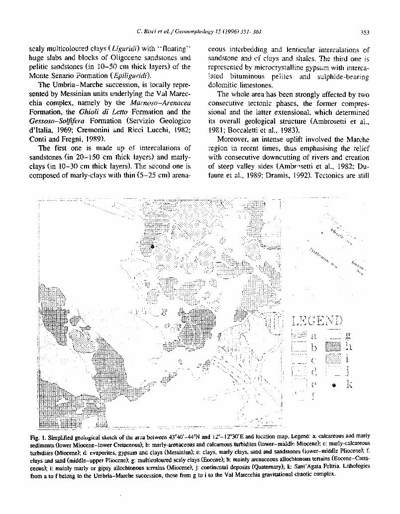
In the study area, which is about 14 sq. km wide, terrains belonging both to the Val Marecchia com- plex and the Umbria-Marche Sequence crop out (Fig. 1).
The Val Marecchia sequence, which has been emplaced by gravity during lower Pliocene, is made up of a chaotic sequence of allochtonous Paleogene
moss-Arenacea
Gessoso-Soljifera Formation (Servizio Geologico d’Italia, 1969; Cremonini and Ricci Lucchi, 1982; Conti and Fregni, 1989).
The first one is made up of intercalations of sandstones (in 20- 150 cm thick layers) an clays (in lo-30 cm thick layers). The second one is composed of marly-clays with thin (5-25 cm) arena-
oreover, an intense uplift involved
Fig. I. Simplified geoiogical sketch of tie atza bzitieen 43”4Q’-44% and 12”- 12’30’E and location map. Legend: a: cakareous and marly sediments (lower Miocene-lower Cretaceousj; b: marly-arenaceous and calcareous turbidites (lower-middk Miocene); C: marly-calc=eous
turbtdites (Miocene); d: evaporites, gypsum and clays (Messinian); e: clays, marly clays, sand and sandstones (iower-middle Pliocene); f: clays and sand (middle-upper P’iioeenej; g: multicoloured scaly clays (Eocene); h: mainly arenaceous allochtonous terrains (Eocene-Creta- ceous); i: mainly mariy or gipsy alloehtonous terrains (Miocene); j: continental deposits (Quaternaryj; k: Smt’Agata Felts-k LifiologieS from a to f belong to the Umbria-Marche succe:;sion, those from g to i to the Val Marecchia gravitational chaotic complex-
C. Bisci et ul. / Gecsrnorpkolc~,gy 15 f 1996) 35 l-361
active in the area, as is clearly shown by the frequent and rather strong earthquakes recorded there (Post- pischl, 1985).
354
Differential erosion following the regional uplift exposed the “floating” sandstone blocks, now con- stituting the top of most of the reliefs in the Val Marecchia.
Climate is characterised by warm summers and moderately cold winters. Precipitation is concen- trated mainly in autumn and spring, and subordi- nately in winter (when snowfalls in the mountain areas are not rare). Long-lasting and intense precipi- tation may occur throughout the year and may acti- vate mass movements (sometimes on a large scale) along the slopes, mostly where less resistant rocks crop out:
In historical times, human activities (deforesta- tion, agricultural practices, dam construction, gravel quarrying along river beds, hydraulic works, road cuts) very often caused a worsening of the above situation, triggering new landslides or (more often) favouring reactivations of existing phenomena (Dramis et al., 1987, 1992; Canuti et al., 1988).
5. Deep-seated gravitationa slope deformations d landslide phenomena in the Sant’Agata
tria area
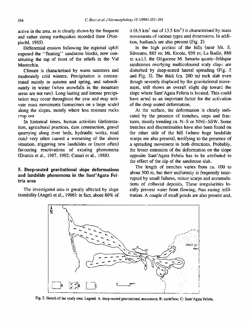
‘The investigated area is greatly affected by slope instability (Angeli et al,, 1996): in fact, about 60% of
it (8.5 km’ out of 13.5 km’) is characterised by mass movements of various types and imensions. In addi- tion, badlands are also present (Fig. 2).
In the high portion of *he hills (near Silvestro, 885 m; Mt. Ercole, 939 m; La Badia, 880 m a.s.l.), the Oligocene M. Senario quartz-feldspar sandstones overlying multicoloured scaly clays are disturbed by deep-seated lateral spreading (Fig. 2 and Fig. 3). The thick (ca. 200 m) rock slab even though severely displaced by the gravitational move- ment, still shows an overall slight dip toward the slope where Sant’Agata Feltria is located. This could have acted as an important factor for the activation of the deep seated deformation.
At the surface, the deformation is clearly indi- cated by the presence of trenches, steps and frac- tures, mostly trending ca. N-S or NNE-SSW. Some trenches and discontinuities have also been found on the other side of the hill (where huge landslide scarps are also present), testifying to the presence of a spreading movement in both directions. Probably, the lesser extension of the deformation on the slope opposite Sant’Agata Fe!tria has to be a:ttributed to the effect of the dip of the sandstone slab.
The length of trenches varies from ca. 100 to about 500 m, but their uniformity is frequently inter- rupted by small failures, minor scarps and accumula- tions of colluvial deposits. These irregularities lo- cally prevent water from flowing, thus easing infil- tration. A couple of small ponds are also present and,
A N
Fig. 2. Sketch of the study area. Legend: A: deep-seated gravitational movement; B: earthflow; C: Sant’Agata Feltria.
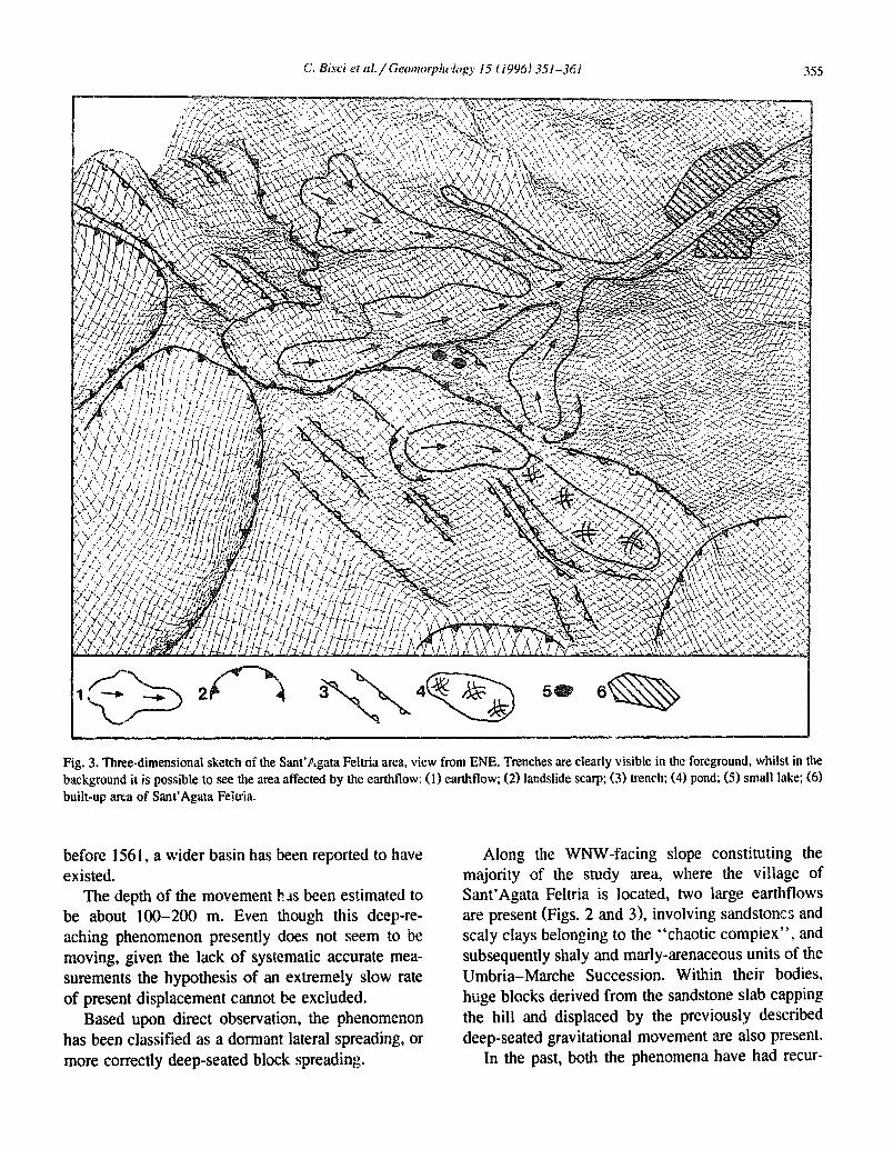
Fig. 3. Three-dimensional sketch of the Sant’hgata Feltria area, view from ENE. Trenches are clearly visible in the foreground, whilst in the background it is possible to see the area affected by the earthflow: (1) earthflow; (2) landslide scarp; (3) trench; (4) pond; (5) small lake; (6) built-up area of Sant’Agata Feltria.
before 156 1, a wider basin has been reported to have existed.
The depth of the movement h..ts been estimated to be about 100-200 m. Even though this deep-re- aching phenomenon presently does not seem to be moving, given the lack of systematic accurate mea- surements the hypothesis of an extremely slow rate of present displacement cannot be excluded.
Based upon direct observation, the phenomenon has been classified as a dormant lateral spreading, or more correctly deep-seated block spreading.
Along the WNW-facing sIope constituting the majority of the study area, where the village of Sant’Agata Feltria is located, two large earthflows are present (Figs. 2 and 31, involving sandstoncs and scaly clays belonging to the “chaotic compiex”, and subsequently shaly and marly-arenaceous units of the Umbria-Marche Succession. Within their bodies, huge blocks derived from the sandstone slab capping the hill and displaced by the previously described deep-seated gravitational movement are also present.
In the past, both the phenomena have had recur-

356 C. Bid et cd. / Geomwpholo~y 15 (1996) 351-361
rent phases of activity, but no precise date exists for their first activation. The sou&emmost and smallest one is quite old and is presently hanging at about 50 m above the T. Marecchiola; its middle-upper por- tion has been almost completely built up 6. Giro- lamo) since the late ’50s.
The northernmost mass movement involves part of the village of Sant’Agata Feitria, dividing it into two parts. This second mass movement (Figs. 2 and 3) is 5.4 km long and has about 665 m of vertical descent (from ca. 930 m down to 265 m a.s.l.), with an average slope angle of about 12%. It is up to 1.6 km wide and involves ca. 1,700,OOO cubic m of terrain. Because of its large size and having involved the village, this second phenomenon has been the subject of more detailed investigations.
Historical research and geomorphological analysis have allowed a detailed reconstruction of both evolu- tion and mechanism of the phenomenon which has been reported to have reactivated several times since the 16th century (Dall’Ara, 1986; Persi et al., 1993).
Particularly important is to point out that during the last centuries the landslide changed its dimen- sions and direction of movement: in fact, it has been found that the ancient landslide body was moving from Monte Ercole toward West, whereas the period- ical filling of the valley bottom caused the diversion of the flow toward WNW.
The first clearly reported activity period dates back to March 25th 1561 (Persi et al., 1993), when the movement (described as three miles long and 150 “J~cP~” wide) had already assumed its present shape and direction.
The mass movement was also active previously, as demonstrated by a notarial deed dated 1485 (re- porting about a “ruined area” in the neighbouring of the castle) and by Filippo Maffei, a local monk who in 1462 prophesied a divine punishment by means of a huge landslide (probably basing his forecast upon traditions of similar phenomena). Moreover, d notarial deed dated 1555 reports a land- slide which took place ’ ’ SONW decades before’ ’ .
The huge landslide of 1561 took plc?ce in a period characterised by very severe climate, with deposition of thick snow and intense rainfalls, coinciding with the first stages of the Little Ice Age (Lamb, 1969). As previously stated, chronicles report about pres- ence of a large pond “ntountuinwrd” of the village
(very likely in the area affected by the deep-seated gravitational movement), w ich was destroyed dur- ing this strong activity phase of the landslide.
Also the second reported activity phase (1604) coincided with a year characterised by particularly severe weather. In a chronicle written during the 17th century (Zucchi Travagli, 1604) it has also been reported that this severe mass movement was fol- lowed by further minor ones.
Among these less important movements, two are clearly reported, having happened during 1644 and 1647 (the latter was a reactivation of the former), when the climate, even though progressively getting better, was still character&d by intense precipita- tion. Because of the better climatic conditions, no landslides have been reported in the area during the second half of 17th century. Rather good indicators of past climatic conditions have proved to be the recordings of the dates stated for vintage.
Starting from the beginning of 18th century, local archive data begin again to report about landslides and floods, testifying to climate shifts towards more humid conditions. In particular, testimonies have been found for reactivations of the mass movement in 1714, 1723, 1743, 1748, 175G, 1753, 1754, 1756, 1758, 1772, 1773, 1781 and 1785.
In 1782, a strong earthquake affected the area damaging some buildings, but no report exists of remobilisation of the landslide. During the final por- tion of 18th century climate got better and, in fact, no further information of landslide movement exists until winter 180 I- 1802.
The landslide reactivated once more in 1803; unfortunately, no information on the landslide move- ment is available for the period 1804- 18 14, even though severe climatic conditions occurred at that time which should have favoured the instability pro- cesses. Then, in 1814- 18 15, a partial remobilisation took place; successive huge reactivations of the movement happened in 1834, 1839, 1840, 1844, 1845 and 1846.
Starting from 1848, climate got better again, and therefore for several decades no large landslides took place. Successively, in 1916 and 1933, small local reactivations have been reported; it has to be high- lighted that the strong earthquake in 1929 did not trigger any mass movement.
At the end of winter 1934, the earthflow reacti-
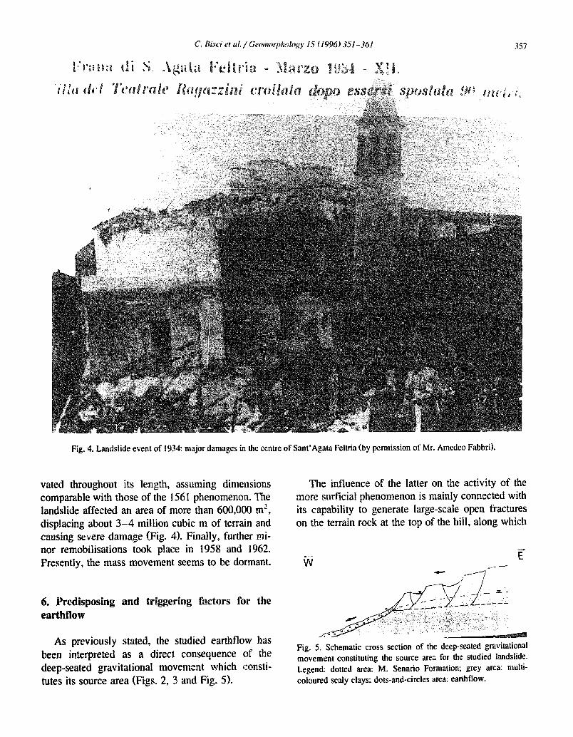
Fig. 4. Landslide event of 19X major damages in the centre of Sant’Agata Feltria (by permission of Mr. Amedeo Fabbri).
vated throughout its length, assuming dimensions comparable with those of the 156 1 phenomenon. The landslide affected an area of more than 600,000 ma, displacing about 3-4 million cubic m of terrain and causing severe damage (Fig. 4). Finally, further mi- nor remobilisations took place in 1958 and 1962. Presently, the mass movement seems to be dormant.
6. Predisposing and triggering factors for the earthflow
As previously stated, the studied earthflow has been interpreted as a direct consequence of the deep-seated gravitational movement which aonsti- tutes its source area (Figs. 2, 3 and Fig. 5).
The influence of the latter on the activity of the more surficial phenomenon is mainly connected with its capability to generate large-scale open fractures on the terrain rock at the top of the hill, along which
.-- w
Fig. 5. Schematic cross section of the deep-seated gravitational movement constituting the source area for the studied landslide. Legend: dotted area: M. Senario Fomlation; grey arca: multi- coloured scaly clays; dots-and-circles area: earth flow.
358 C. Bisci et al. / ~~t~omorplrolc,Ry 15 ( 19961 3.5 i-36 I
water can easily percolate, in this way reaching the underlying clays and saturating part of them,
Meanwhile, the presence of the thick and rigid sandstone slab capping the hill allowed the develop- ment of rather steep slopes in the underlying weaker terrains. Moreover, as a consequence of the gravita- tional displacement of the .more resistant rocks lo- cated at the top of thk hill, considerable stress was generated in the underlying softer clays.
The combined effects of the three actions de- scribed above, significantly enhanced the potential instability of the materials constituting the slope. already characterised by poor mechanical properties (particularly the chaotic clays).
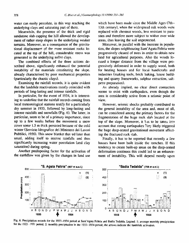
Examining the rainfall records, it is quite evident that the landslide reactivations mostly coincided with periods of long-lasting and intense rainfalls.
In particular, for the event of 1934, it is interest- ing to underline that the rainfali records coming from local meteorological stations testify for a particularly dry summer in 1933, followed by long-lasting and intense rainfalls and snowfalls (Fig. 6). The latter, in particular, seem to be of a primary importance, since up to a few weeks before the movement a snow cover some 1.5 m thick persisted because of the cold winter (Servizio Idrografico de1 Minister0 dei Lavori Pubblici, 1956). This snow blanket tha\ led later than usual, adding itself to intense rainfalls and thus significantly increasing water percolation (and clay saturation) during spring.
Another predisposing factor for the activation of the earthflow was given by the changes in land use
“S. Agata Feltria” (907 m a.s.1.) 500 j-
E- 400
5
ASONDJ FMAMJ J ASOND
1933 1934
which have been made since the Middle Ages (Tth- 13th century), when the widespread oak woods were replaced with chestnut woods, less resistant to para- sites and therefore more subject to wither over wide areas, thus leaving the soil unprotected.
Moreover, in parallel with the increase in popula- tion, the slopes neighbouring Sant’Agata Feltria were progressively cleared of trees in order to obtain new land for agricultural purposes. Also the woods lo- cated a longer distance from the village were pro- gressively deforested in order to supply wood, both for heating houses and for local handicrafts and industries (making tools, brick baking, house build- ing and quarry frameworks, sulphur extraction. salt- petre preparation).
As already implied, no clear direct connection seems to exist with earthquakes, even though the area is considerably active from a seismic point of view.
However, seismic shocks probably contributed to the general instability of the area and, most of all. can be considered among the primary factors for the fragmentation of the huge rock slab located at the top of the slope. Moreover, it $3~ to be take11 ir.!c, account that strong earthquakes ?ery likely triggered the huge deep-seated gravitational movement affect- inp the fractured rock slab.
Finally, it has to be reported that recently a few houses have been built inside the trenches. If this tendency to create built-up areas on the deep-seated deformation continues this could led to an enhance- ment of instability. This will depend mostly upon
“Badia Tedalda” (7% m ~I.s.I.) 5oo , -I-
/ / 0
400 i
(1) d : .. : .’ (21 /
ASONDJ FMAMJ J ASOND
1933 1934
Fig. 6. Precipitation records for the 1933- 1934 period at Sant’Agata Feltria ad Badia Tedalda. Legend: I: average monthly precipitation for the 1921- 1951 period; 2: monthly precipitation in the 1933- i934 period; the arrows indicate the landslide activation.
7. Ire S
As already explained, the inwzstigated phenomena can be interpreted as a deep-seated block spreading. affecting the arenaceous of a clayey hill and evolving into a huge ea ow along its western slope.
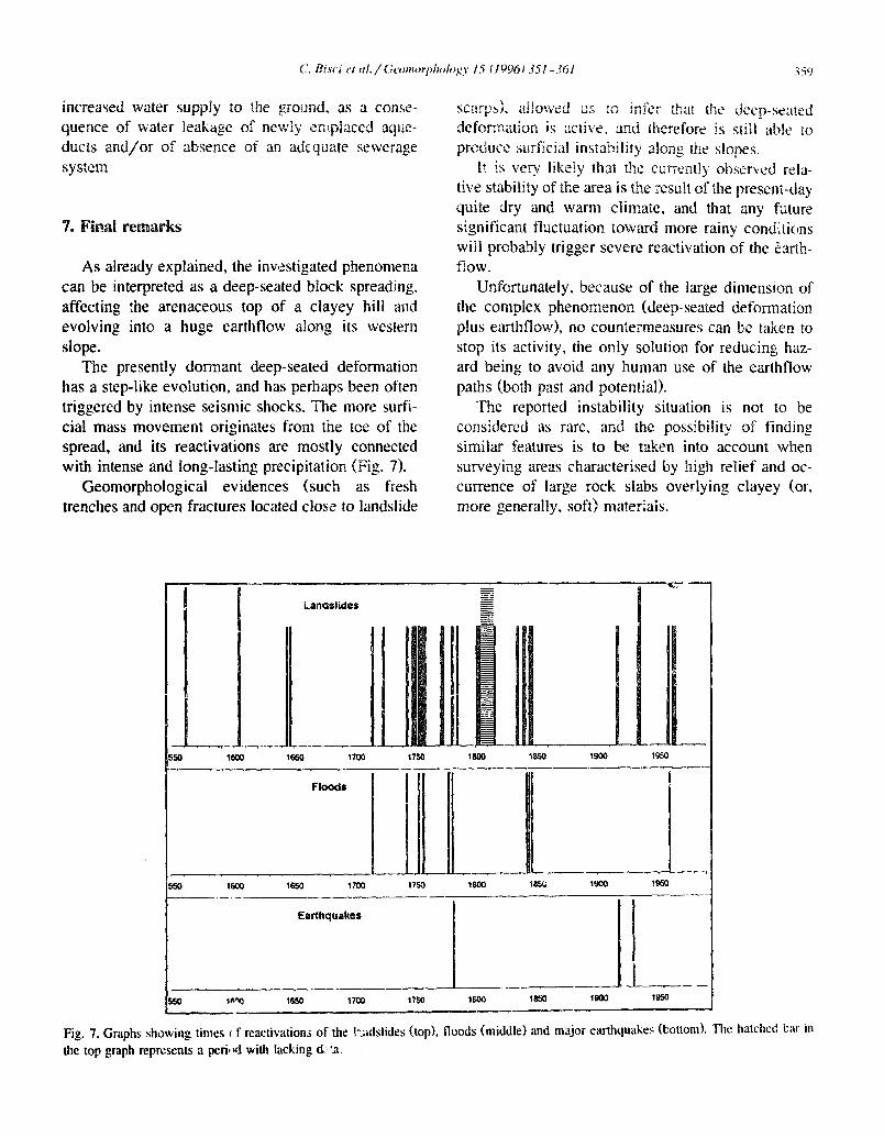
The presently dormant deep-seated deformation has a step-like evolution, and has perhaps been often triggered by intense seismic shocks. The more surfi- cial mass movement originates from the toe of the spread, and its reactivations are mostly connected with intense and long-lasting precipitation (Fig. ‘7).
Geomorphological evidences (such as fresh trenches and open fractures located close to landslide
will probably trigger severe reactivation of the earth- f-low.
Unfortunately, because of the large dimension of x phenomenon (deep-seated deformation ow), no countermeas res can be taken to
stop its activity, the only solution for reducing haz- ard being to avoid any human use of the earthflow paths (both past and potential).
The reported instability situation is not to be considered as rare, and the possibility of finding similar features is to be taken into account when surveying areas characterised by igh relief and oc- currence of large rock slabs overlying clayey (or, more generally, soft) matekais.
Landslides
Fig. 7. Graphs showing times I f reastivations of the kidslides (top), floods (middle) and major earthquake; (bottom). Thr: hat&c:! l:x ii1 the top graph represents a peril Ed with lacking d, ‘.a.
Acknowledgements
The authors are grateful to Mr. M. Flen#i, for the valuable lxtorical information given on the Sant’Agata Felt. ia village.
This paper is part of the EC Climatology and Narural Hazartir; project EPOCH (CT 90.0025 CERG) “Temporal occurrence and forecasting of landslides in the European Community”, Publication No. 26.
References
Ambrosetti, P.. Centamore. E., Deiana, G.. Dramis. F. and Pieruc- cini. U,, 1981. Schema di evoluzione neotettonica dell’area umbro-marchigiana tra il ‘I‘ronto c il Metauro. Rend. Sot. Geol. Ital., 4: 47 I-475.
Ambrosetti, P., Carraro, F., Deiana, G. and Dramis, F.. 1982. II sollevamento dell’ltalia centrale tra il Pleistocene inferiore e il Pleistocene medio. Consiglio Nazionale delle Ricer&e - Progetto Finalizzato “Geodinamica”: Contributi sonclusivi per la realizzazione della Carta Neotettonica d’halia, Vol. 2, pp. 2 19-223.
Angeli, M.G.. Bisc;, C., Burattini. F., Dramis, F.. Leoperdi, S., Pontoni, F. and Pontoni, F., 1996. Evolution and triggering factors of large-scale landslides affecting built-up areas in the Marche Region (Central Italy). Quad. Geol. Appl., in press.
Boccalctti, M , Calamita, F., Centamore, E., Dciana. G. and Dramis, F.. 1983. The Umb,kt-Marche Apenninc: an tixnmpte of thrusts and wrenching tectonics in a model of ensialic neogenic-quatemary deformation. Boll. Sot. Geol. Ital., 102: 58 I-592.
Canuti, P,, Cascini L., Dramis, F., Pellegrino, A. and Picarelli, L., 1988. Landslides in Italy: occurrence, analysis and control. Selected Papers of the International Workshop on Natural Hazards, Perugia (Italy), 1988, pp. 16% 184.
Carton, A., Dramis, F. and Sorriso-Valvo, M.. 1987. Earthquake landforms: Observations after recent Italian and Algerian seis- mic events. 2. Geomorphol., N.F., Suppl., 63: 149-158.
Conk S. and Frcgni, P., 1989. Geologia dell’appennino marchi- giano-romagnolo tra le valli de1 Savio e del Foglia (Note ilhtstrativc alla car0 geolcgk a stala !:50.000). Boll. SOC. Geol. Ital., 108: 453-390.
Cremonini, G. and Ricci Lucchi, F., 1982. Guida alla geologia del margine Appenninico-Padano. Guide Geologiche Region& Supplement0 alle Memorie della Societh Geologica Itali,ana, 247 pp.
Dall’Ara, G., 1986. Da Solona a Sant’Agata. Antologia di storia santagatese. In: M. Flenghi (Editor), Clima, Frane e Carestie da1 1596 al 1656, pp. 95- I 12.
Dramis, F., 1992. II ruolo dei sollevamenti tettonici a largo raggio
neh genest dei reiievo appenninioo. Studi Geolugici Camcrti, Volume Speciale 1992. pp. 9- 15.
Dramis, F. and Sorriso-Valvo, M.. 1994. Deep-seated gravitational
slope deformations. related landslides, and tcrtonics. Eng. Geol., 38(3/4): 23 l-243.
Dramis, F., Maifredi, P. and Sorriso-Valve, M.. 1983. Defor- ma;lioni gray’itative profonde di versante. Aspetti geomorfo- logici e lorc~ diffusione in Italia. Geol. Appl. Idrogeol., 18(3): 355-368.
Dramis, F.. Garzonio, C.A., Nanni, T. and Principi, L., 1987. Fraiosit’a e dissesti dei centri abitati delle Marchc: primi risu itati del censimento e dello studio delle siturtzioni a rischio. Mer.-t. Sot. Geol. Ital., 37(l): 105-l 16.
Dramis, F., Garzonio, C.A. and Gentili, B., 1992. Deepening of hydrographic pattern and slope stability: some sliding phenom- era In the Mio-Pliocene terrain of central southern Marche (Central Italy). Geo3ko Plus, l3( I ): 63-78.
Dramis, F., Farabollini, P., Gentili. B. and Pambinnchi, G., 1995. Neotectonics and large-scale gravitational phenomena. In: 0. Slymaker (Editor), Steepland Geomorphology. Wiley, Chich- ester, pp. 199-218.
Dufaure, J.J.. Bossuyt, D. and Rasse. M., 1989. Critsres gEx~orphologiques de neotectonique verticale dans I’Apennin Central adriatique. Bull. Assoc. Fr. Etude Quat.. 1989(3): 151-160.
Guerricchio, A. and Melidoro, G., 1973. Segni premonitori e coliassi delle grandi frane nelle metamortiti delle Valle della Fiumara Buonamico. Geol. Appl. Idrogeol., 8: 3 15-346.
Hutchinson, J.N., 1988. General report: Morphological and geotechnical parameters in relation to geology and hydrogeol- ogy. Proceedings of the 5th International Symposium on Land- slides, Lausanne, Vol. I, pp. 3-36.
Jahn, A., 1964. Slope morphological features resulting from gravi- tatiotj. 2. Geomorphol. Suppl., 5: 59-72.
Lamb, H.H.. 1969. Climatic fluctuations. In: H. Fl&n (Editor), World Survey of Climatology, 2, General Climatology. Else- vier, Amsterdam, pp. 17’4-249.
Nemcok, A., 1972. Gravitational slope deformations in high mountains. Proceedings of the 24th International Geological Cc#ngress, Montreal, Section 13, pp. 132- 141.
Persi, P., Veggiani, A., Lombardi, F.V., Battistclli, M., Renzi, G. and Ailegretti, G., 1993. Le frane nella storia della Valmarec- chia. Cornunit?? Montana Alta Valmarecchia, I i0 pp.
Postpischl, D. (Editor), 1985. Catalog0 dei terremoti italiani dall’anno 1000 al 1980. Consiglio Nazionale delle Riceerche - Progetto Finalizzato “Geodinamica”, 239 pp.
Kadbruch-Hall. D.H., 1978. Gravitatiolrsl creep of r(ocR masses on slopes. In: 3. Voight (Editor), Rockslides and Avalanches - Natural Phenomena. Developments in Geotechnical Engineer- ing, I4 A., pp- 693-705.
Rndhruch-Hail, D.H., Vamer, D.J. and Savage, W.Z., 1976. Grav- * Mona! sprca~li~g UP steep-sided ridges (“sackung”) in West-
ern United Sta:es. Bull. Int. Assoc. Eng. Geol., 14: 25-35. Savage, W.Z. and Vames, D.J., 1987. Mechanics of gravitational
spreading of steep-sided ridges (“sackung”). Bull. Int. Assoc. Eng. Geol., 35: 31-36. 8 L a senizio Idrografico dzi Xoi;rero dci Lavori Pubblici, l95ti. Precioitazioni medie mensili ed annue Der il trentennio 1921-

1950. Bacini con face al Morale adriatico dal Reno al Tronto. lstituto PoligrGco dello Stato. 2~,%rte II. pp. 166- 170.
Servizio Geologic0 d’ltalia, 1969. Foglio 108 “Mercato Sara- ceno’” della Carta Geologica d’kalia alla Scala 1: 100.000. Litografta Arti__: ,a Cartogratica, Fi.-rnze. U., 1969. tJber Sa n. Rock Mechanics, 1:30-52.
Solonenko, VP., 1977. Landslides and collapses in seismic zones vagli, A.M., 1604. to istorico ovvero Annali del and their prediction. Buh. Int. Assoc. Eng. Geol., 15: 4-8. Montefcltro. Manuscript in Municipality’s Archives,
Terzaghi, K., 1962. Stability of steep slopes on hard unweathered Pennabilli, VI, c.9. rock. GCotcchnique, 12: 25 l-263, 269-270.