NEWTON COMPREHENSIVE PLAN
229
NEWTON COMPREHENSIVE PLAN Prepared by the Mayor's Comprehensive Plan Advisory Committee Recommended by the Planning and Development Board Adopted by the Newton Board of Aldermen November 19, 2007 Mixed-Use Centers added November 7, 2011
-
Upload
khangminh22 -
Category
Documents
-
view
0 -
download
0
Transcript of NEWTON COMPREHENSIVE PLAN

NEWTON COMPREHENSIVE PLAN
Prepared by the Mayor's Comprehensive Plan Advisory Committee
Recommended by the Planning and Development Board
Adopted by the Newton Board of Aldermen November 19, 2007
Mixed-Use Centers added November 7, 2011


Introduction November 19, 2007 Page i
PREFACE
Newton’s City Charter and Massachusetts General Laws Chapter 41, Section 81D, provide for the City to have a comprehensive master plan. In 1980 the City began that process by adopting three elements of a master plan. To update and expand that Plan, Mayor David B. Cohen appointed a Comprehensive Plan Advisory Committee (CPAC) in the spring of 2002, chaired by Newton resident and planner Philip B. Herr. Over the next few years, the Committee worked with many Newton residents and with help from staff members in the Newton Planning Department prepared a Draft Comprehensive Plan which was submitted to the Mayor in October, 2006. Mayor Cohen then transmitted the Draft Plan to the Newton Planning and Development Board for its review and adoption. Pursuant to the City Charter, the Planning and Development Board then sent the Draft Plan to the Newton Board of Aldermen, where a public hearing on the Plan occurred before the aldermanic Zoning and Planning Committee on September 10, 2007. After review and amendment by the Zoning and Planning Committee, and further amendment by the full Board, the Board of Aldermen voted to adopt the amended Plan by resolution passed by the Board on November 19, 2007, and became effective 20 days later on December 9, 2007. Members of CPAC, the Planning and Development Board, the Board of Aldermen, and their staff advisors, who contributed to the writing, revision and adoption of this revised Comprehensive Plan are listed on the following pages together with the relevant provisions of the City Charter and the Board Order containing the Resolution adopting the Comprehensive Plan.

Introduction November 19, 2007 Page ii
Newton Comprehensive Planning Advisory Committee
Members active in the preparation of this document:
Philip B. Herr, Chair
F. Gerard Adams
James Broderick
Deborah Crossley
Jeremiah Eck
Charles Eisenberg
Edward J. Dailey
Adel Foz
Alan Green
Candace Havens
Doris Hyman
Alice Ingerson, Ph.D
Peter Kastner
Ald. Stephen Linsky
Ald. George Mansfield
Josephine McNeil
James Miller
Glenn Morris
Joyce Moss
Srdjan S. Nedeljkovic
James O’Connell, Ph.D
Ald. Christine Samuelson
Carol Ann Shea
Peter Smith
Myra Tattenbaum
Ted Tye
Victor Vitols
John Wilson
Ald. Brian Yates
Newton Planning and Development Board Christian Dame, Chair
David M. Banash
Carol Beard
Tabetha McCartney
Joyce G. Moss
Lorraine Salvucci
Alternate members
Joseph DiDuca
Mary Jo Peterson
Ronald Clark Turner
Scott I. Wolf

Introduction November 19, 2007 Page iii
Newton Board of Aldermen 2006-2007 Aldermen- at-Large Aldermen-at-Large Ward Aldermen Ward 1 Ben Weisbuch Carleton P. Merrill Scott Lennon Ward 2 Susan S. Albright Marcia T. Johnson Stephen M. Linsky Ward 3 Leslie Burg Ted Hess-Mahan Anthony J. Salvucci Ward 4 Amy Mah Sangiolo, Leonard J. Gentile John W. Harney Vice President Ward 5 Paul E. Coletti Brian E. Yates Christine Samuelson Chair, Zoning and Planning Ward 6 Victoria Danberg Kenneth R.L. Parker George E. Mansfield Ward 7 Sydra Schnipper Verne W. Vance R. Lisle Baker, President Emeritus President Ward 8 Mitchell L. Fischman Richard A. Lipof Cheryl Lappin
City of Newton staff that provided support and assistance: Juris Alksnitis, Chief Zoning Code Official ................................................ Planning Department Stephen Gartrell, Director of Community Development ............................. Planning Department Trisha Kenyon Guditz, Housing Development Coordinator ...................... Planning Department Lara Kritzer, Senior Preservation Planner .................................................. Planning Department David Koses, Transportation Planning Coordinator ................................... Planning Department Michael Kruse, Director .............................................................................. Planning Department Theresa Park, Economic Development & Telecommunications Specialist Planning Department Nancy Radzevich, Chief Planner ................................................................ Planning Department Norine Silton, Executive Assistant ............................................................. Planning Department Candace Havens, Chief Planner .................................................................. Planning Department Dan Funk, City Solicitor ...................................................................................... Law Department Marie Lawlor, Associate City Solicitor .............................................................. Law Department Linda Finucane, Clerk of the Zoning and Planning Committee ..................... Board of Aldermen
Mapping and spatial analytics: Douglas Greenfield, GIS Administrator ......................... Department of Information Technology

Introduction November 19, 2007 Page iv
The Newton City Charter requires the creation and adoption of a Comprehensive Plan for the City. Below are the relevant sections of the Charter of the City of Newton. Sec. 7-2. Comprehensive Plan. (a) Content—There shall be a Comprehensive Plan setting forth in graphic and textual form policies to govern the future physical development of the entire City. Such plan shall cover the entire City and all of its functions and services, or shall consist of a combination of plans governing specific functions and services or specific geographic areas. (b) Adoption—Upon receipt from the Mayor of a proposed Comprehensive Plan or a proposed modification of the existing plan, the Board of Aldermen shall refer such proposal to the Planning and Development Board, which shall within a time specified by the Board of Aldermen report its recommendations thereon. After receipt of the recommendations of the Planning and Development Board, the Board of Aldermen shall hold a public hearing on the proposed Comprehensive Plan or the proposed modification thereof and shall by resolution adopt the same with or without amendment. The Board of Aldermen may thereafter from time to time modify the Comprehensive Plan. (c) Effect—The Comprehensive Plan shall serve as a guide to all future action by the Board of Aldermen concerning land use and development regulations, urban renewal programs, and expenditures for capital improvements. Sec. 7-3. Implementation of the Comprehensive Plan. (a) Land Use and Development Regulations—In accordance with applicable provisions of the General Laws, the Board of Aldermen may by ordinance adopt land use and development regulations, including but not limited to an official map and zoning regulations. (b) Urban Renewal—In accordance with applicable provisions of the General Laws, the Board of Aldermen may by ordinance provide for redevelopment, rehabilitation, conservation, and renewal programs for the alleviation or prevention of slums, obsolescence, blight, or other conditions or deterioration. (c) Action by the Board of Aldermen—Before acting on any proposed ordinance concerning land use and development regulations, urban renewal, or expenditures for capital improvements, where such ordinance involves a matter covered by the Comprehensive Plan, the Board of Aldermen shall refer the proposal to the Planning and Development Board, which shall within a time specified by the Board of Aldermen and prior to the public hearing on the proposed ordinance, report in writing its recommendations thereon. Upon adopting any such ordinance, the Board of Aldermen shall make findings and report on the relationship between the ordinance and the Comprehensive Plan, and the Comprehensive Plan shall be deemed to be amended in accordance with such findings and report.

Introduction November 19, 2007 Page v
#351-06 CITY OF NEWTON
IN BOARD OF ALDERMEN
November 19, 2007
BE IT RESOLVED: WHEREAS the Board of Aldermen has received a proposed Comprehensive Plan from the Mayor of the City of Newton; WHEREAS the Board of Aldermen has received a report and recommendations concerning said plan from the Planning and Development Board, and has held a public hearing on the proposed plan; WHEREAS the purpose of the Comprehensive Plan is to set forth policies to govern the future physical development of the City; WHEREAS the effect of the Comprehensive Plan’s policies are to serve as a guide to all future action by the Board of Aldermen concerning land use and development regulations, urban renewal programs, and expenditures for capital improvements; WHEREAS the Board of Aldermen recognizes that specific recommendations for zoning change in the Plan are guidelines or suggestions for improvement, not mandates; WHEREAS the Board of Aldermen has considered said proposed plan and made modifications and amendments thereto; NOW, THEREFORE, BE IT RESOLVED that The Newton Comprehensive Plan, as amended, is hereby adopted. Under Suspension of Rules Readings Waived and Adopted 20 yeas, 1 nay (Ald. Coletti), 3 absent (Ald. Gentile, Harney, Vance) (SGD) DAVID A. OLSON City Clerk

Introduction November 19, 2007 Page vi

Introduction November 19, 2007 Page vii
TABLE OF CONTENTS
i. Introduction 1. The Newton That We Want 2. Excellence in Place-Making 3. Land Use 3A. Mixed-Use Centers 4. Transportation and Mobility 5. Housing 6. Economic Development 7. Open Space and Recreation 8. Natural Resources 9. Planning for and with History 10. Facilities and Services 11. Implementation 12. Taxonomy of Places 13. Glossary 14. Related CPAC documents

Introduction November 19, 2007 Page viii
TABLES Page
1-1 CPAC Housing, Population and Job Figures Update ................... 1-5 1-2 Recent Fiscal Trends .................................................................... 1-7 3-1 CPAC Housing, Population and Jobs .......................................... 3-5 3-2 Types of Residential Development ........................................... 3-20 3-3 Commercial Growth Locations .................................................. 3-24 4-1 Newton Jobs, Housing, and Auto Trips, 1990-2000 .................... 4-4 4-2 Newton Jobs, Housing, and Auto Trips, 1990 to Build-out ......... 4-4 5-1 Newton’s Housing Growth ........................................................... 5-2 6-1 Median Household Income ........................................................ 6-10 6-2 Occupation of Employed Newton Residents .............................. 6-10 6-3 Worker Destinations ................................................................... 6-11 6-4 Employment and Wages in Newton .......................................... 6-12 6-5 Newton’s Largest Employers .................................................... 6-13 6-6 Labor Force, Employment & Unemployment ........................... 6-14 6-7 House Values & Rents in MA Communities 2000 ................... 6-15 6-8 Home Ownership in MA Communities 2000 ........................... 6-15 6-9 FY ’04 Tax Rates in MA Communities ................................... 6-16 6-10 Building Permits Issued ............................................................. 6-16 9-1 Residential Structures Subject to Demolition Delay .................. 9-5 CHARTS Page 3-1 Build-out choice: # of units ....................................................... 3-21 3-2 Build-out choice: % of units ...................................................... 3-21 3-3 Newton History & CPAC Projections ....................................... 3-27 4-1 Registered Motor Vehicles .......................................................... 4-3 4-2 Autos Owned, 2000 ...................................................................... 4-3 4-3 Serving Land Access V. Traffic Mobility .................................... 4-6 4-4 Workshop Votes: Most Critical Transportation Issues .............. 4-14 5-1 Incomes: “New Homebuyers & “Old” Households ..................... 5-5 9-1 Requests for Waiver of Demolition Delay ................................. 9-6 10-1 Tax Bills & Rates ..................................................................... 10-6 10-2 Non-Residential % of Tax Levy ............................................... 10-8 10-3 Burdens and Benefits ................................................................. 10-9 10-4 Single-Family Tax Bills as % of Family Income .................... 10-10

Introduction November 19, 2007 Page ix
MAPS Page 3-1 Additional Dwelling Units at Build-out ...................................... 3-2 3-2 Additional Commercial Floor Area at Build-out ........................ 3-3 3-3 Land Use ...................................................................................... 3-4 3-4 Business Centers ......................................................................... 3-26 3-5 Residential Characteristics ......................................................... 3-34 3-6 Transit Proximity ........................................................................ 3-35 3-7 Commercial and Major Employer Proximity ............................. 3-36 3-8 School Proximity ....................................................................... 3-37 4-1 Functional Road Classification .................................................... 4-7 4-2 Road Classification – Design Type ............................................. 4-9 4-3 Public Transportation – Possible Expansions ........................... 4-15 5-1 Affordable Housing, 2005 ............................................................ 5-3 6-1 Potential Business Area Development ......................................... 6-5 7-1 Conservation Plan, 2003 .............................................................. 7-9 7-2 Passive Recreation Plan, 2003 .................................................. 7-10 7-3 Active Recreation Plan ............................................................. 7-11 9-1 Historic Properties ....................................................................... 9-3 9-2 Residential Structures by Date of Construction ......................... 9-4 10-1 Public Facilities ........................................................................ 10-5 Needham Street Zoning ............................................................. 11-9 Additional Dwelling Units at Build-out (marked) ................... 11-10 Scenic Roads ........................................................................... 11-15

Introduction November 19, 2007 Page x

1. The Newton We Want November 19, 2007 Page 1-1
THE NEWTON THAT WE WANT
“No place is perfect. We’ve got high taxes, clogged streets, a high school in need of repair or razing (North), rampant political correctness (Tug of Peace in place of Tug of War in elementary school), and too many stressed-out parents and kids. But on the whole, I’d rather be in Newton. If you don’t live there, you’re just camping out.”
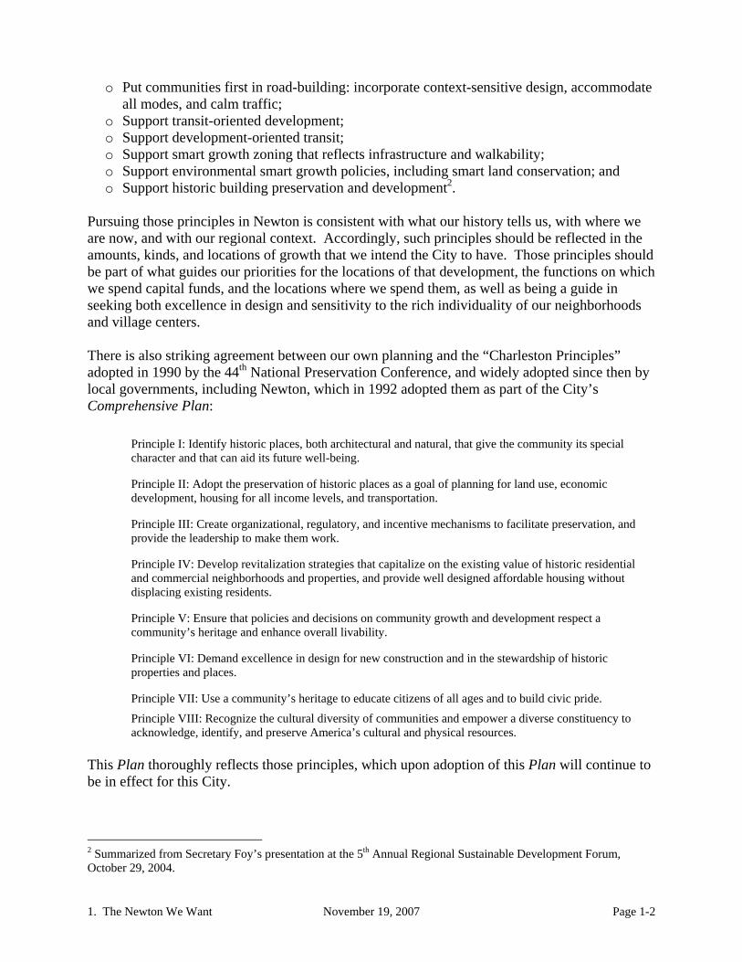
-Dan Shaughnessy Newton is a great place in which to live and work. Sportswriter Dan Shaughnessy aptly summed it up in the above extract from his March 9, 2003 Boston Globe column. Consistent with that spirit, the future Newton that we who make up this community seek through our Plan closely resembles the current city. However, that doesn’t mean that we can passively stand still, for two reasons. First, reaching for further excellence has marked the City in the past and should continue to do so in the future. Second, changes outside of our control threaten to erode much of what we like about our community and to worsen the things about it that we regret. The burden of taxes, especially on those with low or fixed incomes, is too high now, and might well be made worse by the regional economy and tax structure. Street clogging might well get worse, as could other public facility concerns. The diversity, feeling of open space, and the benefits of this location that we value so highly could all be seriously damaged unless we make concerted and visionary efforts at improvement. Importantly, our City is part of a larger community. We need to work with our neighbors to preserve and enhance the quality of land use, natural resources, social services, and transportation that span invisible political boundaries. We are crossed and bounded by major urban elements, including the Charles River, the Mass Turnpike, Route 9, rail lines, the MBTA and the MWRA. Through them we are joined to and have access to the region, while at the same time those elements create barriers within and between our neighborhoods and those of neighboring communities. We need to transform the power of those elements to connect rather than to divide us. There is a striking agreement on basic planning principles between our own planning and that going on at other levels of government. At the regional level, the Metropolitan Area Planning Council (MAPC) has begun planning “MetroFuture,” and it appears that our own planning will easily dovetail with it. The Office of Commonwealth Development (OCD) together with other state agencies is pursuing what they variously call “Smart Growth,” “Livable Communities,” and “Sustainable Development,” terms widely found in planning efforts across the United States1. Massachusetts’ state-level efforts, however named, are pursuing intentions with which our Newton planning is solidly consistent. Douglas Foy, Secretary of OCD, recently noted these as being among the key steps towards the Commonwealth’s vision for livable communities. They could equally well serve Newton:
o Repair existing infrastructure before building anew: “Fix it First;”
1 Those terms are commonly used synonymously, but planning professionals see differences among them. Those interested should see David R. Godschalk, “Land Use Planning Challenges: Coping with Conflicts in Visions of Sustainable Development and Livable Communities,” Journal of the American Planning Association, Winter 2004.
1. The Newton We Want November 19, 2007 Page 1-2
o Put communities first in road-building: incorporate context-sensitive design, accommodate all modes, and calm traffic;
o Support transit-oriented development; o Support development-oriented transit; o Support smart growth zoning that reflects infrastructure and walkability; o Support environmental smart growth policies, including smart land conservation; and o Support historic building preservation and development2.
Pursuing those principles in Newton is consistent with what our history tells us, with where we are now, and with our regional context. Accordingly, such principles should be reflected in the amounts, kinds, and locations of growth that we intend the City to have. Those principles should be part of what guides our priorities for the locations of that development, the functions on which we spend capital funds, and the locations where we spend them, as well as being a guide in seeking both excellence in design and sensitivity to the rich individuality of our neighborhoods and village centers. There is also striking agreement between our own planning and the “Charleston Principles” adopted in 1990 by the 44th National Preservation Conference, and widely adopted since then by local governments, including Newton, which in 1992 adopted them as part of the City’s Comprehensive Plan:
Principle I: Identify historic places, both architectural and natural, that give the community its special character and that can aid its future well-being.
Principle II: Adopt the preservation of historic places as a goal of planning for land use, economic development, housing for all income levels, and transportation.
Principle III: Create organizational, regulatory, and incentive mechanisms to facilitate preservation, and provide the leadership to make them work.
Principle IV: Develop revitalization strategies that capitalize on the existing value of historic residential and commercial neighborhoods and properties, and provide well designed affordable housing without displacing existing residents.
Principle V: Ensure that policies and decisions on community growth and development respect a community’s heritage and enhance overall livability.
Principle VI: Demand excellence in design for new construction and in the stewardship of historic properties and places.
Principle VII: Use a community’s heritage to educate citizens of all ages and to build civic pride.
Principle VIII: Recognize the cultural diversity of communities and empower a diverse constituency to acknowledge, identify, and preserve America’s cultural and physical resources.
This Plan thoroughly reflects those principles, which upon adoption of this Plan will continue to be in effect for this City.
2 Summarized from Secretary Foy’s presentation at the 5th Annual Regional Sustainable Development Forum, October 29, 2004.

1. The Newton We Want November 19, 2007 Page 1-3
HOW MUCH WE PLAN TO GROW Careful analysis of our land and regulatory system indicates that when the City is fully developed we can expect only about 10% more housing units than the year 2000 total, given strict consistency with current rules. That much housing growth, coupled with shrinking household size, would likely mean about a 6% population decline between now and build-out. History suggests that exceptions to the rules through rezoning, Chapter 40B projects, and unpredicted exceptions are normal. If that pattern of exceptions were continued it might result in a 15% growth in housing units, which is probably just about enough to maintain our population at the year 2000 level. Our planning for housing, economic development, transportation, and other capital facilities indicate that a 15% growth in housing can reasonably be serviced consistent with the City we want. Importantly, that amount of growth would facilitate efforts to meet affordable housing needs, mitigating the threatened loss of diversity in this City. Similarly careful analysis of business development indicates that the City’s land and regulations can reasonably be expected to allow up to 70% more business floor area and jobs than the year 2000 total, but there is little likelihood that there will be a market for that much job growth, and equally little likelihood that the City would welcome that large a jobs increase and its impacts on City quality of life. Our planning calls for a build-out total of jobs somewhere between a small decline and stability, with jobs just about paralleling population change. It is important to be selective in our business development in order to have the kind of place that we want. We can do so and still maintain roughly the current level of jobs in Newton, meet our fiscal objectives, and work towards matching housing and jobs for Newton residents. PRIORITIES FOR WHERE DEVELOPMENT OCCURS The Office of Commonwealth Development has described “Smart Growth” as being:
“…about growing where it makes most sense: in and around central business districts or traditional city or town centers, near transit stations, or in [areas previously developed non-residentially]. It is about growing where there is existing infrastructure and utilities, with greater pedestrian access to schools, civic facilities, retail and employment centers, and other destinations3.”
That classic set of planning preferences, newly having gained popular recognition, is applicable for Newton, joined with a few additional considerations that stem from this being a fully developed community having a valued structure of neighborhood character and cohesion. “Growing smart” in Newton must give important consideration to neighborhood as well as Citywide impacts. Consistent with that, we seek to protect the rich choice among the City’s neighborhoods, some highly diverse and others not, some quite compact, others more open. We seek to assure development densities well related to both neighborhood character and infrastructure capacity. We seek to assure promotion of a range of housing opportunities. Sometimes those intentions
3 From “Draft Transit Oriented Development (TOD) Program Guidelines,” OCD, January 5, 2005.

1. The Newton We Want November 19, 2007 Page 1-4
will be in conflict, so we need a management system able to resolve conflicts while making decisions in ways that are predictable, fair, and cost-effective. INVESTING CAPITAL FUNDS Consistent with all of the above, investments in capital facilities should give priority to building onto what we have, fixing first, and supporting the amounts and locations of growth that are in our adopted plans. Just as with development permitting, capital facility priority-setting decisions should follow procedures which assure their predictability and fairness. EXCELLENCE IN DESIGN We know that we want excellence in the design of our village centers and neighborhoods, of the places within them, and of the individual buildings and streets which make them up. However, at this point we are not yet of one mind with regard to the nuances of design in development most suitable for Newton. We need to develop a reflective process so that we can provide guidance which across the City’s neighborhoods and village centers is as diverse in both administrative arrangement and design preferences as are those neighborhoods. The trace of history, professional designer’s insights, and the sensitivities of our citizens can be joined in different ways producing different outcomes in different neighborhoods and village centers: What is right for one is not right for all, and our approach should reflect that. Accordingly, the guidance for design excellence should be chiefly based upon planning efforts centered on those neighborhoods, village centers, and other places individually, building a sense of place for each, but with some reliance on guidance regarding what constitutes Newton-wide “excellence.” PROMOTING THE CITY’S RICH DIVERSITY OF PLACES Design excellence is just one of the ways in which guidance for Newton’s future development should reflect neighborhood and village-level planning. Implementing land use, housing, transportation, and other intentions of this Plan needs to be done with sensitivity to the variations in places across the City, as well as to how they are related and joined. We therefore intend there to be a framework within which place-centered planning can take place. As that area-level planning enriches our understanding over a period of years, it is intended that the City-wide plan should from time to time be revised in response. HOW TO MOVE FORWARD The Plan elements which follow spell out more fully the intentions of this planning effort. Plan implementation began with the dialog that the process has produced, and with the agreements among parties that have preceded completion of this document. The framework now articulated next needs translation into concrete actions being taken. Throughout this document the terms “we,” “our,” and “intention” are used repeatedly with specific purpose. This Plan is meant to be a statement of intentions, not recommendations, made on behalf of the community of people who make up this City, not just by a committee or a board. In that way, this is a plan which belongs to the community, reflecting that community’s

1. The Newton We Want November 19, 2007 Page 1-5
intentions for itself, not recommendations to others for what they should do. That way of framing a plan is basic to it becoming a vital and effective creation. BACKGROUND Change in Housing, Population and Jobs Expectations regarding trends in housing development, population change, and employment are basic for many parts of the Plan. There is a brief summary of those expectations in a table and text on page 3-5, and are they are expanded upon at a variety of other locations in the Plan and in its supporting studies. Some annual data is available to check for recent departures, including building permit data from which housing unit counts can be estimated, US Census annual population estimates, and MA DET annual employment tabulations. In each of those cases, the current (2006) data contain no departures from expectations. Projections of municipal-level households, population, and employment by the MAPC have been an important input to our own forecasts, and have been revised a number of times during our work. The most recent revision came this summer when the basis for the MAPC figures shifted from expectations assuming continuation of past policies and directions to expectations based upon implementation of that agency’s MetroFuture Plan, which was affirmed this Spring. The CPAC Plan’s “High Scenario” figures are very consistent with the MAPC’s resulting MetroFuture figures. That provides comforting assurance that the future intended by the draft Comprehensive Plan is in those respects consistent with the regional future sought by the MAPC. Housing Costs Hardship and community stratification resulting from the loss of housing affordability in Newton is central to the Housing element. The widely publicized “bursting of the housing bubble” has in some locations significantly contributed to mitigating affordability problems, and some have
Table 1-1. CPAC HOUSING, POPULATION, AND JOB FIGURES UPDATE
BASE PROJECTION HIGH SCENARIOYear Housing un Hholds Population Local jobs Housing un Hholds Population Local jobs
2000 31,300 31,200 83,829 48,090 31,300 31,200 83,829 48,090 2005 31,800 31,700 83,371 45,500 31,800 31,700 83,371 45,500 2006 31,850 31,750 82,810 45,913 31,850 31,750 82,810 45,913 2007 32,050 31,950 46,731 32,050 31,950 - 46,731 2010 32,240 32,140 83,920 46,750 32,240 32,140 83,920 46,750
2000 and 2005 figures are from baseline sources.2010 are the foecasts from the August, 2006 draft Newton Comprehensive Plan.2006 and 2007 are based upon: Housing units: building permit data. Households: permit data modified. Population: US Census estimate Jobs: MA DET count.

1. The Newton We Want November 19, 2007 Page 1-6
suggested that the same may be true in Newton. However, the most reliable available indicator of housing price change by municipality, the Warren Group, indicates that not to be the case here. The median sales price for single-family homes in Newton through September of this year was $753,000, higher than any prior annual median. The median for Newton condos was $449,000, 8% below the highest median ever, but the all-sales median of $449,000 through September, like the single-family figure, is higher than any prior annual median. It is clear that the needs and intentions of the Plan regarding housing need no reconsideration as a result of recent market change. School Facilities The draft Plan speaks of the new Newton North as going through initial design studies, while now it is under construction, as was anticipated. The Plan’s demographics anticipate that after some growth in the near term school enrollments are likely to ease in the longer run. The reason is the combination of modest growth in the total population and a declining share of that population being of school age, consistent with forecasts at national, state, and regional levels, as indicated at page 10-2 of the Plan. Newton’s near-term enrollment growth projections by the School Department have been consistent with those expectations until last year, when they departed from previous projections to less slowly head upward. However, this year’s October 1 Newton school enrollment count was far lower than projected, which is leading the Department to reexamine its projection methods. That will likely remove any need for reconsideration of the Plan’s general expectations regarding facility enrollment capacity needs. In all other respects, there is no inconsistency between the Plan and the findings of the Space Needs Assessment by HMFH Architects, Inc., completed this year for the School Department. Fiscal Background Starting at page 10-6 of the Plan is a great deal of fiscal analysis based on annually available data. Upon review of more recent figures than those in the Plan, we find that without exception they continue the trends of the past. For that reason, no change in future expectations or intentions is needed on the basis of that review. Two illustrations are in the following table.

1. The Newton We Want November 19, 2007 Page 1-7
ACTIONS A substantial number of actions of relevance to the Plan have been taken over the time since its contents were shaped. Some are gratifying implementation of actions called for in the Plan, some but not all of which having resulted from the Plan’s initiative. At page 3-11 the Land Use element calls for preparation of a municipal facilities plan. Three steps in that direction have been taken since those words were first circulated: a School Department Space Needs Assessment, which is leading to formulation of a plan; a fire facilities plan; and a forthcoming study for remaining municipal buildings as called for in the Mayor’s 2008-2012 Capital Improvement Plan. The need for a functional classification system for streets in Newton is noted at pages 2-2 and 2-3 of the Plan. Preparation of that system was called for in the Transportation element at page 4-10 and again at page 11-6, and has now been adopted by the Board of Aldermen. At page 4-16 the Transportation element calls for extension of the T’s Route 60 bus on Boylston Street. A small extension has been implemented, but it is far short of what is called for in the Plan. At page 4-21 the Transportation element calls for innovative transit-oriented development at Woodland Station, and such a development is now existing and partially occupied there, having gained wide recognition as an exemplar. An intention expressed in the Natural Resources element at page 8-9 (and noted also at page 2-6) for adding energy and sustainability zoning criteria for special permit and site plan decisions was
Table 1-2. RECENT FISCAL TRENDS
YearResidential
% of tax levy Net state aid $
1990 72.3 8,050,002$ 1991 72.6 7,267,753$ 1992 72.7 4,209,487$ 1993 74.9 5,152,715$ 1994 75.0 5,796,032$ 1995 75.7 6,173,929$ 1996 76.9 7,175,372$ 1997 77.7 8,358,814$ 1998 78.4 9,536,968$ 1999 78.8 10,943,961$ 2000 79.8 13,740,614$ 2001 80.5 18,228,743$ 2002 81.1 18,661,543$ 2003 80.9 18,638,086$ 2004 82.2 15,288,000$ 2005 83.2 15,655,462$ 2006 83.9 14,089,484$ 2007 84.0 13,944,645$

1. The Newton We Want November 19, 2007 Page 1-8
adopted this Spring by the Board of Aldermen. Two energy actions from the City’s Energy Action Plan and contained in the CPAC Plan are the designation of a City Energy Officer (page 8-7) and the upgrading of street lighting (page 8-8) to save energy and money. Both have been implemented. Special State legislation to enhance the framework within which the Newton Community Development Authority operates was enacted this year (Chapter 75 of the Acts of 2007), just as is called for in the Housing Element at page 5-17.
2. Excellence in Place-Making November 19, 2007 Page 2-1
EXCELLENCE IN PLACE-MAKING
“If places are indeed a fundamental aspect of man’s existence in the world, and if they are sources of security and identity for individuals and for groups of people, then it is important that the means of experiencing, creating and maintaining significant places are not lost … without such knowledge it will not be possible to create and preserve the places that are the significant contexts of our lives1”
Newton has a rich array of varied and wonderful places. Some of them are dominantly natural, for example:
Hemlock Gorge; The Charles River’s “lakes district” near Norumbega Park.
Some are compactly developed for a diversity of uses:
Newton Highlands village center; Nonantum at Adams and Watertown Streets.
Some are dominantly single-use, compact or not: Wells Avenue office park; Oak Hill Park; The Chestnut Hill residential area.
Some are linear rather than nodal, but still are coherent as “places:”
Commonwealth Avenue; The Sudbury Aqueduct; The Nahanton corridor.
In each of these and in many other areas of the City there is a clear and distinct sense of place. What distinguishes good places involves many elements. In almost every case both public and private actions were involved in their creation. Both natural and man-made components are critical, as are both physical form and human activity, all mutually interdependent and supportive to at least some degree. Those good places illustrate the excellence in place-making that has gone on at many (but not all) places in this City over many decades. This Plan seeks to assure that such excellence will continue to characterize change as it takes place in the future. “Place excellence” is easier to describe than to prescribe, but if we can’t make clear in advance the kind of place excellence that we seek then we aren’t likely to attain or even maintain it. The City actions which are involved in place-making include our investments in buildings, open space, streets, and utilities, and the standards and procedures through which we guide the design of our community facilities. Critical City actions also include how we regulate private development, most prominently through zoning and historic districts, less obviously but just as importantly through myriad other regulatory imperatives. We also powerfully influence place-
1 Ralph, Edward, Place and Placelessness, London: Pion Limited, 1976, p.6., cited in Rebecca Mattson, Sense-of-Place Ideals in Small Town Planning, MIT MCP thesis, 1992.

2. Excellence in Place-Making November 19, 2007 Page 2-2
making outcomes through our non-codified and often misunderstood understanding of and advocacy for what will be publicly supported or opposed. Nowhere, however, has guidance been developed to connect all of those public actions – investment, regulation, and persuasion – with our intentions for the kind of places we want, nor have we a clear process for bringing together all of those strands of place-making into a coherent strategy for implementing our intent. That is one of the things that this comprehensive planning process is centrally about. Beyond building agreement on a comprehensive plan, four steps can importantly contribute to guiding place-making in the City.
1. DOCUMENTING A CLEAR VISION. We need to document and make clear and vivid what we seek as a City with regard to place-making, going beyond what is possible in any single plan at any single point in time. The elements of excellence, except in the most abstract sense, aren’t going to be the same for Hemlock Gorge and for nearby Newton Upper Falls, and they aren’t going to be the same for energy management and for land use management, although in that case they will have a great deal in common. All of those perspectives can be complementary in adding up to the City and places that we want. We need many plans, some for places, prepared by people from those places mindfully integrating across topical interests, and some for topics, prepared by people well-versed in the topical area involved but mindful of the value of place diversity.
Some of the necessary plans and documentation exist, such as the 2003-07 Recreation and Open Space Plan. Others, such as well-documented architectural design guidance, don’t. Our need is not only to make sure that we are effectively communicating what we want for all of the relevant topics in all of the places, but also to make sure that a way is in place for continually updating that vision as our current actions mature into relevant history. The Planning with & for History element forcefully makes the case for such efforts, both reflective of the past and prescriptive about the future, both City-wide and place-centered. This task is made more demanding at the many key locations where the “place” of greatest coherence includes elements in another community. In our initial listing of place examples, Hemlock Gorge, the Lakes portion of the Charles, Chestnut Hill, Commonwealth Avenue, and the Sudbury Aqueduct all include areas within other municipalities, and there are many more such shared places. We need to develop ways of working efficiently and effectively with our neighboring communities.
2. CONNECTING PUBLIC INVESTMENT TO THAT VISION. We need to have a process for
connecting our shared vision to the investments that the City makes in the infrastructure which is a key part of all of our places. Some relatively modest changes in the present system for consideration and decision-making about public facility investments are outlined in the FACILITIES AND SERVICES ELEMENT of this Plan. It calls for making consistency with City-adopted plans an important consideration in capital funding prioritization. The existence of a comprehensive plan approved by both the Mayor and the Board of Aldermen, coupled with those system changes, would help assure that there is a well-considered connection between place-making intent and the City’s facility

2. Excellence in Place-Making November 19, 2007 Page 2-3
expenditures, not only in project-by-project decision-making, but also in the topical plans and policies which shape spending proposals. For example, existing City materials regarding the standards which should apply to various street classifications still reflect an earlier context and understanding than currently exists, although the classifications have recently been modernized. As a result those standards have little ability to guide current investments and gain concurrence on their design. The refinement of those materials in the ways discussed in developing this Plan and outlined in the TRANSPORTATION AND
MOBILITY ELEMENT can importantly contribute to making transportation change a powerful tool for building place excellence. The same is true in many other topical areas.
3. CONNECTING REGULATION TO THAT VISION. There is no structure in place to assure that
our regulatory actions are similarly given consistent guidance. The Board of Aldermen has a powerful role, being that body which creates much of the regulatory code which shapes City decisions and also being the permit granting authority for many of the most important actions, such as zoning’s special permits. However, a great deal of the City’s regulatory decision-making goes on outside of that body’s direct control. As outlined in an early CPAC memo2, the Historical Commission reviews and acts on a large and growing share of building alteration or construction proposals in the City. Within their areas of jurisdiction, the City’s four historic district commissions act on virtually all such proposals. The Zoning Board of Appeals is increasingly the venue of choice for those seeking to do residential development, acting through either variances or comprehensive permits under Chapter 40B, rather than Newton’s adopted zoning rules. The Conservation Commission, Housing Partnership, DPW, Fire Department, and many others have potent impact on development outcomes through their regulatory actions under rules often framed at the State level but subject to much local interpretation.
The regulatory proposals contained in the elements of this Plan, further developed in the place-centered planning that is intended to follow it, can provide the means of assuring that the variety of regulatory efforts which the City makes will be more fully supportive of the Citywide and place outcomes being sought.
4. THINKING AND ACTING FROM A COMPREHENSIVE PERSPECTIVE. Many residents supported adoption of the Community Preservation Act (CPA) in major part in the belief that it would lead to partnerships across the four topical areas it supports – open space, preservation, housing, and recreation – and that belief has been rewarded. Leaders in those topical areas forged new ties in the process of advocating adoption. An important share of the proposals supported under CPA truly reflect multiple interests, most visibly at Kesseler Woods (open space and housing), but also at the Forte property at Webster Park (open space, recreation, and housing) and Linden Green on Elliot Street (preservation and housing). We are getting past “we/they” divisions between public and private and between topical interests within the public realm, and can begin to make partnerships a usual way of getting to excellent outcomes, not only when CPA funds are involved, but more generally.
2 CPAC, “Development Review Procedural Inventory,” September 23, 2002.

2. Excellence in Place-Making November 19, 2007 Page 2-4
5. PROVIDING AN EXCELLENT SYSTEM FOR PROJECT REVIEW. The excellence we seek in our places should be matched by the excellence of our system for project review, chiefly but not exclusively dealing with public review of private development. The remainder of this chapter addresses what that excellence might entail, summarized as:
Clarity About What The Community Wants; Reconciling Individuality and Place; Sound Process Mechanics.
CLARITY ABOUT WHAT THE COMMUNITY WANTS Guiding intentions and goals. We should provide a clear statement of intentions and goals
both for the City as a whole and, with careful relationship to those citywide statements, for each of our neighborhoods, village centers, and other places so that proposals and actions can be measured against them. The process of articulating those statements should critically involve those who live, work, or have other stakes in those places. That can result in guidance for which they feel real proprietorship and responsibility, not something imposed on them (although ultimately subject to City-level approval or adoption, assuring consistency with City-wide planning). The process of developing that kind of guidance can be an important element in building a sense of community relating to those places. That spirit of responsibility can help to energize supportive community response when a proposal for change is happily consistent with the planning that has gone on, as well as helping to moderate the “not in my back yard” syndrome.
A process of neighborhood or other place-centered planning is anticipated as the follow-through to this Comprehensive Plan. Such planning would be a good process though which to develop guidance materials for those places, and in the future might well serve as the usual basis for action on such matters as establishment of historic districts, adoption of on-street parking regulations, or investments in neighborhood park improvements3. It would provide a means of informing those choices through a broad-based dialogue that is part of a comprehensive effort to create and protect particular places. Just as importantly, such a process should be the means through which over the course of time the impacts of those initial plans and guidance are reflectively evaluated for how well they have been working, and are revised as needed in light of that evaluation.
Clear Rules. Intentions and goals should be reflected in zoning and other development
regulations and in guidance for public investments. That guidance should be clear, readable and unambiguous in both letter and intent. Periodically it should be thoughtfully evaluated and revised as discussed earlier. Development standards should be predictable and understandable. If we know what we want, we should let those who are planning development know what that is4. The guidance documents by their design and distribution
3 One of the groups developing alternative plans for Newton Centre went so far as to advocate (at a September 9, 2006 workshop) that 10% of the annual capital budget for certain improvements should be reserved for neighborhood-selected investments. 4 Exactly as stated at page 18 of A Framework for Newton’s Planning, April, 2001.

2. Excellence in Place-Making November 19, 2007 Page 2-5
should be easily accessible not only to officials but also to both citizens and prospective developers.
Helpful interpretation. We should have procedures and supportive written materials that
provide non-confrontational interpretation of intent for both those making proposals and those affected by them, especially in the inevitable cases that have unusual aspects of context or design.
RECONCILING INDIVIDUALITY AND PLACE Excellence in both process and outcomes. The excellence that is sought in development
should be matched with excellence in the conduct and content of review. The process should facilitate achieving the spirit of working together to build better places. When well designed, such process makes efficient use of both applicant and City resources. Achieving this level of excellence in process requires skilled professionals including municipal staff, board members, and an applicant’s design/consultant team. Where internal expertise is required but not available, outside consultants should be utilized to provide the best possible resources for the review process. The City is moving in this direction: our intention is to do more.
Sensitivity to place and openness to creativity. Both rules and practices should assure that
the special characteristics of locations are respected in development without stifling creativity and individual choice. At the very least, new development should not damage the valued qualities of that which exists in the vicinity. Guidance materials and practices must protect these special characteristics while also respecting both the rights of property owners and the diversity of the community.
Structured opportunities for exchange. The breadth and timing of opportunities for public
voice should be related to the scale of a proposal’s impact, enabling early and adequate input without overburdening either public agency resources or public attentiveness. It should be recognized that projects of major impact require a corresponding level of review, where minor projects may not require the same process. Communication with the public should be clear, open, encouraged, and well-informed. For the project review process to be well-informed, it needs to involve a public whose understanding of what the community wants has been built through its involvement with earlier planning and community education.
SOUND PROCESS MECHANICS A clear decision process map. Procedures and applicability of regulations should be clearly
documented and relevant materials should be easily available. Steps in this direction have recently been accomplished. More remains to be done.
Early predictability and reasonable timeframes. Both those seeking to build or change
uses and affected community interests are best served by learning early in the process what is or is not going to be allowed, rather than experiencing lengthy procedures which come to much the same conclusions. Again, recent efforts have made improvements.

2. Excellence in Place-Making November 19, 2007 Page 2-6
IMPLEMENTING THE VISION The following are among the potential actions for improving Newton’s ability to guide change towards greater excellence in place-making, and through that towards building a stronger sense of community in the City and in those places. Clarify guidance appropriate for the various place types across Newton, such as for
neighborhoods, village centers, scenic road corridors, or uniformly single-family residential areas, to provide a City-wide framework for more local guidance to particularize for individual places. That guidance should be vividly communicated using photos, drawings, and diagrams in documents conveying to the public, to those proposing development, and to City agencies and officials what excellent building in Newton entails, using non-regulatory but concrete terms.
Support the place-centered planning efforts alluded to above and in a number of this
Plan’s elements. Newton Centre, given the planning studies already under way there, might well be the first to begin such efforts, but others need not await the conclusion of that process, but could parallel it, even if a few months behind. At the City level decisions need to be made about how best to organize and provide technical support to those area efforts, the basis for review and approval of their outcomes, and the relationship between those approved outcomes and City implementation activities within the areas covered.
Enhance Zoning’s special permit criteria. Most developments larger than a single-family
house (and some of those) require Aldermanic approval of one or more special permits under Section 30-24 of the Zoning Ordinance based on the criteria in that section. Well-crafted criteria, and easier access to information about previous projects as models or examples, could greatly help designers anticipate what the City is qualitatively seeking, and could produce more predictable decisions, more quickly.
Enhance Zoning’s site plan review criteria. The site plan review criteria (Section 30-23 of the Zoning Ordinance) deal not with whether a proposal is or is not allowed at a given location, but rather with how it must be designed. Its seven listed criteria are only a little more concrete than those for special permits (although the procedures and required submittals are spelled out in great detail). Add Zoning performance standards. Either as a part of the above options or
independently of them explicit performance standards to be met by all large-scale development should be developed, making measurable and testable what is required regarding topics of concern. Such guidance now exists for some topics: lighting, noise, and tree removal. Even more powerful might be performance rules regarding such diverse topics as land use and traffic, as discussed in the Transportation and Mobility element, or landscaping and screening beyond the parking lot-related rules now included in zoning. Such rules can replace lengthy dialogue with a technical basis for determining if certain aspects of a proposal really are “excellent,” as defined by this City.

2. Excellence in Place-Making November 19, 2007 Page 2-7
KNOWING WHEN WE ARE SUCCEEDING In the course of our considerations on this topic, some have suggested that a key to improving the excellence of place-making in Newton would be to wholly replace the Zoning Ordinance with an entirely new one5. Others stop short of that, but suggest changes in the role of the Board of Aldermen in acting under Zoning on specific development proposals, reserving involvement of that Board only for the most consequential level of individual project decisions, if any. Making the entire City an historic district has been suggested6, as has establishing a city-level design review board with powers much like those of an historic district commission, perhaps having hegemony everywhere that there is no historic district. The steps outlined in this chapter would be valuable whether or not major changes such as those in the paragraph above were to occur. Until having given the more modest steps outlined here a chance to demonstrate how well they might achieve what is sought, more aggressive actions will lack a sufficient basis for serious consideration. At some later point, then, how will the City know if more change is necessary? If, following approval of this Plan, the proposals of this chapter (however it then is written) remain un-acted upon for two or three years and prominent voices continue calling for change, then pleas for greater departures from what exists will have greater legitimacy. If, however, the kind of place-centered planning being called for really takes place, and is fruitful; if the Zoning Ordinance is given greater clarity in its key decision-making criteria and those criteria have the beneficial effects they promise to have; and if the underlying intention of having development make places better, not worse, is being achieved, then larger change would be viewed in a very different and better-informed light.
5 Morris Robinson, Esq., “Is Newton open for business?” Newton Tab, March 9, 2005. 6 Anatol Zukerman, “Make the entire city a historic district,” Newton Tab, August 21, 2002.

2. Excellence in Place-Making November 19, 2007 Page 2-8

3. Land Use November 19, 2007 Page 3-1
LAND USE
“At the heart of the struggle to determine the direction any city will take is the question of how its land is to be used. It can either be treated primarily as a source of profit, to be packaged, bought and sold, or else, as the holistic perspective teaches, as a resource that in an interrelated manner serves the spiritual as well as the material needs of the people who live upon it1.”
- John Guinther “This land is your land and this land is my land, sure, but the world is run by those that never listen to music anyway.”
– Bob Dylan BACKGROUND Newton’s land area of almost 18 square miles is all but fully built out, with less than 3% of the City’s land area being in parcels not already developed or permanently preserved from development. However, land use change continues. Infill occurs on parcels already developed, existing structures are replaced with new ones, or more subtly the activities within existing structures change, often with major impacts, even without major changes to the structure. All of that constitutes land use change, and it is one of the major on-going concerns in the City. The structure and pattern of Newton’s early land use was shaped by water and land qualities, while later development reflected transportation change more than anything else. We now have an enviable pattern of well-established and largely healthy village centers, commonly surrounded with a mix of single- and multi-family dwellings, with a generous interweaving of protected open space contributing to the “Garden City” character of the community. Municipal zoning, together with land availability, essentially caps the amount of future development which could be added to the City without bypassing or amending those rules. City staff working with CPAC volunteers produced detailed build-out analyses to illustrate the remaining capacity for growth and where it might occur. Whereas in 2002 about 31,700 housing units existed in the City, under current zoning rules and expectations of special permit approvals, no more than 35,200 housing units could reasonably be expected at “build-out,” an 11% increase. Variances, zoning changes, open space acquisition, and development exempt from zoning such as “Chapter 40B” development, might be expected to increase that somewhat over time, but probably not resulting in any increase above about a 15% growth above the 2002 figure. Whereas in 2002 the City had about 10.8 million square feet of commercial and industrial floor area in the City, under realistic assumptions about building allowable under current rules that could grow to 18.6 million square feet, far more than is reasonably expectable under the regional economy as currently understood. Maps illustrating the potential location of those amounts of growth and existing land use are on the following three pages. They show vividly the structure of growth potential which continues to follow major transportation facilities and to reflect the City’s existing and preferred structure of multiple village centers. 1 Guinther, John, The Direction of Cities, New York, Penguin Books, 1996. Cited in Gene Bunnell, Making Places Special, Planners Press, Chicago, 2002.

3. Land Use November 19, 2007 Page 3-2
Map 3-1

3. Land Use November 19, 2007 Page 3-3
Map 3-2

3. Land Use November 19, 2007 Page 3-4
Map 3-3
3. Land Use November 19, 2007 Page 3-5
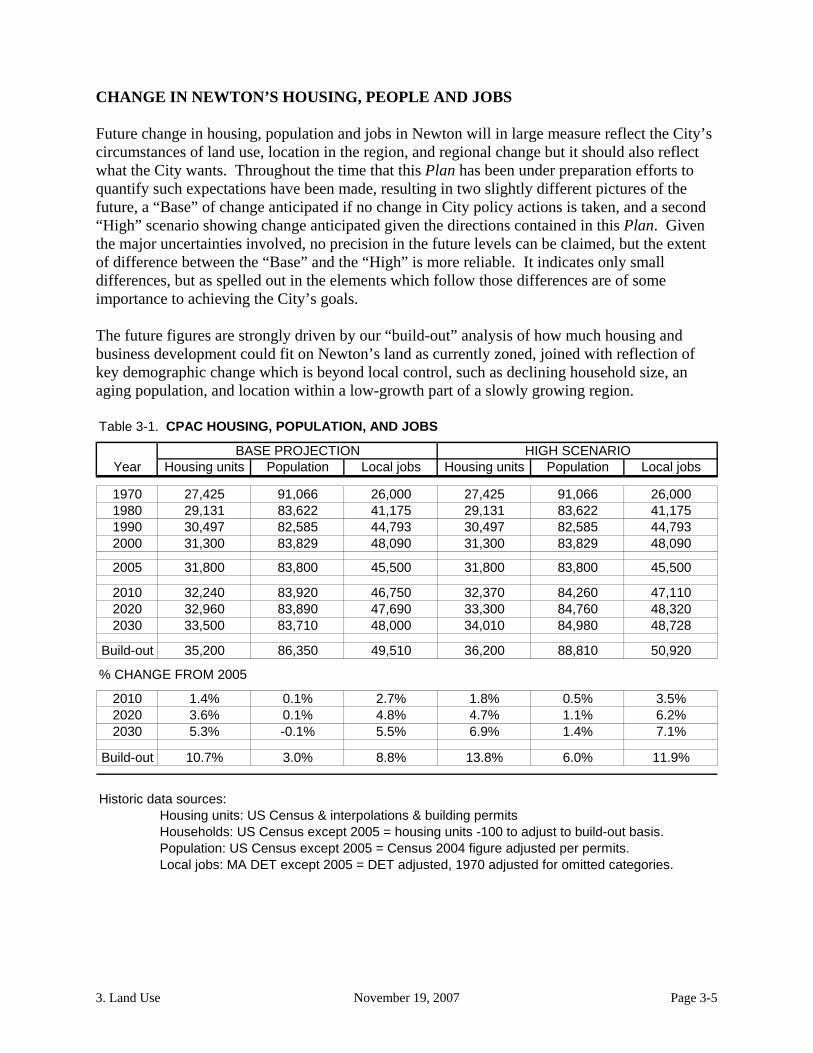
CHANGE IN NEWTON’S HOUSING, PEOPLE AND JOBS Future change in housing, population and jobs in Newton will in large measure reflect the City’s circumstances of land use, location in the region, and regional change but it should also reflect what the City wants. Throughout the time that this Plan has been under preparation efforts to quantify such expectations have been made, resulting in two slightly different pictures of the future, a “Base” of change anticipated if no change in City policy actions is taken, and a second “High” scenario showing change anticipated given the directions contained in this Plan. Given the major uncertainties involved, no precision in the future levels can be claimed, but the extent of difference between the “Base” and the “High” is more reliable. It indicates only small differences, but as spelled out in the elements which follow those differences are of some importance to achieving the City’s goals. The future figures are strongly driven by our “build-out” analysis of how much housing and business development could fit on Newton’s land as currently zoned, joined with reflection of key demographic change which is beyond local control, such as declining household size, an aging population, and location within a low-growth part of a slowly growing region. Table 3-1. CPAC HOUSING, POPULATION, AND JOBS
BASE PROJECTION HIGH SCENARIOYear Housing units Population Local jobs Housing units Population Local jobs
1970 27,425 91,066 26,000 27,425 91,066 26,0001980 29,131 83,622 41,175 29,131 83,622 41,1751990 30,497 82,585 44,793 30,497 82,585 44,7932000 31,300 83,829 48,090 31,300 83,829 48,090
2005 31,800 83,800 45,500 31,800 83,800 45,500
2010 32,240 83,920 46,750 32,370 84,260 47,1102020 32,960 83,890 47,690 33,300 84,760 48,3202030 33,500 83,710 48,000 34,010 84,980 48,728
Build-out 35,200 86,350 49,510 36,200 88,810 50,920
% CHANGE FROM 2005
2010 1.4% 0.1% 2.7% 1.8% 0.5% 3.5%2020 3.6% 0.1% 4.8% 4.7% 1.1% 6.2%2030 5.3% -0.1% 5.5% 6.9% 1.4% 7.1%
Build-out 10.7% 3.0% 8.8% 13.8% 6.0% 11.9%
Historic data sources:Housing units: US Census & interpolations & building permitsHouseholds: US Census except 2005 = housing units -100 to adjust to build-out basis.Population: US Census except 2005 = Census 2004 figure adjusted per permits.Local jobs: MA DET except 2005 = DET adjusted, 1970 adjusted for omitted categories.

3. Land Use November 19, 2007 Page 3-6
LAND USE – AN OVERVIEW Newton, being a mature community, has a powerful commitment to its existing pattern, and our vision and goals for future land use reflect that. Our intention is to guide change so that it reinforces what we have, building on our assets. Land use is to be guided with the intention of enhancing village centers, supporting their
vitality, with special emphasis on the role of those centers in:
providing services to nearby neighborhoods, restoring that function where it may have been eroded, while also
reflecting how those centers interrelate to each other in often complementary ways in serving the entire City, and
providing a housing alternative - that of living in a mixed-use environment - otherwise largely missing in the City, and
providing focal areas around which the sense of place and of community that we seek can be effectively shaped.
Development is to be guided to reflect the character held or sought by existing residential
neighborhoods, protecting the qualities of that which exists. That often but not always means minimizing changes: well-designed change can strengthen existing qualities. Sometimes residents feel that the opportunity to make change is a valuable part of the character of their part of the City2, while in other areas even small departures from what exists are viewed with dismay. In all of the places in the City, the well-considered views of that place should be given great respect in land management policies and decisions.
Intensive, well planned corridor development is anticipated and welcomed on Needham
Street and Chestnut Hill, as long as it is integrated with and helps produce transportation and other enhancements to make the impact of that development a positive one.
Consistent with those objectives, land use change is intended to accommodate sufficient
housing development to meet our housing goals, and sufficient and appropriate development to meet our fiscal needs. The scale of development on which this Plan is based, if well-conceived and carried out, can both accommodate those objectives and protect the community values which make Newton such a special place.
In the course of accomplishing the above development intentions, both natural and cultural resource objectives are to be served, as indicated in those Plan elements.
To achieve our intentions, we need to have a land use management process that provides an
important role for community planning at the village center, neighborhood, and corridor level, as well as enhancing the process at the City level, and we need a process that gives consideration to regional as well as to local considerations. The basic attitude of the City
2 Oak Hill Park residents some years ago made clear their preference to allow departures from a once homogenous neighborhood to continue occurring in that dynamically changing area.

3. Land Use November 19, 2007 Page 3-7
should increasingly be that of seeking partnerships among affected parties in the pursuit of achieving shared land use goals.
CATEGORIES OF NEWTON LAND USE The Plan uses several categories to define, evaluate and plan for land use within the City:
1. Institutional 2. Open and Recreational 3. Residential 4. Business 5. Nodes and Corridors
Each category is important to the overall fabric of the City and comes with its own unique planning challenges. In this section, each of the five categories is presented with a discussion of background, vision and goals, strategic plan, and implementing actions. INSTITUTIONAL LAND USE Almost 20% of the City’s land area is owned by educational, religious, non-profit and governmental institutions. These land areas vary from the large campuses of educational institutions and Newton Wellesley Hospital to individual buildings in village centers and neighborhoods. Those institutions can be most usefully considered in four main groups: Governmental, Educational, Religious, and Other Non-Profit. The city, state and federal government control 14% of the City’s land area (1,250 acres), educational institutions control about 3% (309 acres), religious institutions control less than 2% (194 acres) and other non-profit institutions control approximately 1% (152 acres).
Institutional Background
a. Governmental Institutions
The Commonwealth owns some 335 acres in Newton, much of it along the Charles. The MBTA has small, scattered locations, and the MWRA holds aqueduct properties. Of the 1,250 acres controlled by the City, 1,100 acres are administered or maintained by the Parks and Recreation Department, while the Department of Public Works, the School Department, and the Newton Housing Authority have responsibility for the remainder. The departments have not been directed or funded to develop long-range plans. The City has largely relied on annual requests for Capital Improvement Program funds as indicators of future intentions.
b. Educational Institutions
Recent Changes in Size and Mission - Newton’s educational institutions (on more than 300 acres) have changed their missions and developed their holdings in the last half of the 20th century. They now have a different presence in their neighborhoods. Boston College has absorbed the campus of Newton College of the Sacred Heart,

3. Land Use November 19, 2007 Page 3-8
enrolled more students and become a major force in education and collegiate sports. It now holds over 140 acres in Newton. Much smaller at 28 acres, Lasell College has become a four-year, coed vocational college, built a retirement community on its campus, increased its enrollment, and is nearing its build-out capacity.
Whether as small as the All Newton Music School (1 acre), the Chestnut Hill School (less than 5 acres), the Carroll Center for the Blind (5 acres), Brimmer & May (less than 6 acres), or the Andover Newton Theological School (now reduced to 36 acres), all these are vital to their neighborhoods. Larger landholders such as the Fessenden School (over 41 acres) and Mt. Ida College (over 70 acres) influence more than one neighborhood and have the ability to expand on land that has yet to be developed.
Contributions Toward Municipal Costs - In the middle of the nineteenth century when the educational benefits of small institutions were manifest in their communities (service to local schools, free tuition for residents, shared holiday celebrations, etc.), states codified the exemption of educational institutions from real estate taxes. Only a few of Newton’s educational institutions participate in a PILOT (payment in lieu of taxes) program to help the City defray the costs of providing fire and police protection, of street maintenance and plowing, etc. Even where such programs exist their participation has been incomplete. However, these agreements are not as comprehensive as those negotiated by other area communities and may not fully recognize the benefits provided by the host community.
Institutional Rights - By state law all of these institutions can by right purchase property that will then be tax exempt unless used for a proprietary purpose. When they decide to build or modify existing buildings, a State zoning provision known as the “Dover Amendment,” part of Section 3 of Chapter 40A, MGL, dating to the mid-20th century but with meaning still evolving through litigation, allows non-profit educational and religious institutions to bypass, if they choose, the City’s specific development requirements that other non-eligible developers must address.
As a result, many interpret that at present none of these institutions (except in Boston, which has different state legislation than other Massachusetts communities) can be required to submit long range plans to the City as a condition of receiving development approval. Such plans are common in other states, and can provide vital information about projected growth in the student body and faculty, the consequent need for housing and other buildings, increases and changes in vehicular and pedestrian traffic, parking, and lighting – all of which will have an impact on the municipality and its neighborhoods.
c. Religious Institutions
Newton has some 50 houses of worship on nearly 200 acres. In addition to their religious and social value, these institutions offer architectural variety and in many cases open space in their neighborhoods. A few of their larger parcels include considerable unused land. For example, the Archbishop of Boston owns almost 16 acres on North St., Combined Jewish Philanthropies has 28 acres on Nahanton St., the

3. Land Use November 19, 2007 Page 3-9
Franciscan Sisters have 27 acres off Centre St. and Temple Beth Avodah has almost 12 acres off Puddingstone Lane. Once thought of as highly stable anchors for community structure and land use, in recent years that has not been the case with Newton’s institutions, as new ones have arrived and grown, and others have disappeared, leaving remarkable structures at key locations. As the closing of churches in Nonantum, Newtonville, Newton Corner and Newton Centre and the proposed closing of other Roman Catholic parishes have shown, neighborhoods can no longer take for granted the continued presence of local synagogues and churches. Further, the impact of a new religious institution in a neighborhood can also become controversial, as the case of a proposed house of worship on Dedham Street in 2005 has shown.
d. Other Non-Profit Institutions
Newton is home to dozens of non-profit organizations such as the Eating Disorder Association, the Walker Home for Ecumenical Exchange, and Nonantum Post #440. Few control much property. The exception is Newton Cemetery with 100 of the 150 acres these forty institutions own. Newton-Wellesley Hospital, apart from a garage and several condominiums on which it pays real estate taxes, owns less than 5 tax-exempt acres, and the West Suburban YMCA has just over 6 acres. Any future expansion by these institutions may bring important changes to their neighborhoods.
Institutional Vision & Goals
The large share of the City’s land that is held by institutions is reflective of the major role they play in the community, contributing in many ways to the City’s vitality and quality of life, just as the City contributes to the functioning and character of the institutions within it. Accordingly, the vision and goals for institutional land use are clear and simple. The vision calls for:
Future land use reflecting a shared understanding of the community of interests that
exists among the City’s institutions and the City itself;
Shared exchange of planning information and intentions for the future, seeking ways of meeting the shared opportunities, hazards and costs of their coexistence.
Accommodating the inevitable changes over time in the role of various institutions
and their spatial needs, achieving that accommodation in a way that is responsive both to the interests of the institutions and to the communities within which they exist.
Given the dynamic growth of the City’s largest private institutions (BC, Lasell, and Newton Wellesley Hospital) concern is sometimes expressed regarding the excesses of institutional expansion, and its impact on neighborhoods, open space, and land for other forms of development, including housing. As noted earlier, about one-fifth of the City’s land area is owned by public or private institutions, including the City. While from time to time land also leaves institutional use and ownership (land of Andover-Newton, Fessenden School, First

3. Land Use November 19, 2007 Page 3-10
Church of Christ, Scientist to cite a few), the total amount of institutional land is nearly as high as it ever has been. The growth and decline of individual institutions is impossible to forecast with any precision. It also is impossible to forecast institutional land demands as is done for residential or commercial land use. Therefore, it would be inappropriate to attempt to set quantitative guidelines for institutional land use. Rather, the focus should be on the quality of institutional development that occurs, not on its quantity. Institutional Strategic Plan and Approach
Given the important interdependencies of the City and the institutions within it, it is important that there be a strong climate of cooperation among them, in contrast with the sometimes bitter controversy that has too often marred the City’s more general context of cordiality. Accordingly, the institutional land use strategy should be built upon an expectation of cooperation, not confrontation. Central to the strategy is the building of means for promoting that spirit of cooperation.
At the same time, it is important that the City be able to enter those efforts from a position of having in place an adequate framework for such relationships.
The institutional use strategy, then, is to be one of both building an improved framework for City and institutional cooperation and seeking common ground so that the processes that accompany and should help facilitate and guide the inevitable pattern of a mix of institutional growth and decline can become more constructive. Institutional Implementing Actions
a) Refine Newton’s zoning provisions concerning review of “exempt” institutions. Working together with institutional parties, develop a set of provisions within the Newton Zoning Ordinance (Section 30-22) to provide an agreed-upon framework for review of those institutional developments that are given special standing by Section 3 of Chapter 40A MGL, the MA Zoning Act, often called “the Dover Amendment.” Such local “Section 3” provisions are increasingly common among Massachusetts communities, setting out as Newton has done what aspects of such development are to be reviewed, and what the considerations are to be used in making decisions. In some cases, “performance criteria” regarding traffic and other impacts are used as one key element in the system, applied equally to both exempt and non-exempt development. Such rules give predictability to all parties, and their preparation can provide a valuable opportunity for developing the spirit of cooperation that is being sought. In this effort, the City would be inviting institutions to join in framing an improved process that gives those institutions something they have not had to date, which is a good beginning for a spirit of cooperation.
b) Prepare and follow a detailed Municipal Facilities Plan. Developing a plan for its
own properties and community spaces as indicated in The Framework for Newton’s

3. Land Use November 19, 2007 Page 3-11
Planning3 would serve as an exemplar for what the City seeks from others. The “Open Space and Recreation” and “Community Facilities and Services” elements of this Plan are a valuable beginning, but a much more intensive process of inventory, analysis, and most importantly creative consideration of future activity and facility configurations is needed.
c) Seek agreement on institutional fiscal relationship and long-term plans. Building
upon a strengthened sense of cooperation from the first two steps, a cooperative effort might be convened to explore two other topics of concern. The first concern is how best for equity to be assured in the financial relationships over time between the hard-pressed City and the hard-pressed institutions, whether through negotiated Payment In Lieu of Taxes (PILOT) agreements or other means. The second is to develop a process through which the long-term intentions of private institutions can be planned and communicated with those affected by them, both the City at large and the local areas most impacted. For example, the preparation of comprehensive neighborhood or village area plans, as laid out elsewhere in this Plan, can become the medium for such exchange. Again, planning can be a means of building multi-dimensional community.
d) Structure a process for monitoring and alerts regarding state actions.
Attentiveness to change in the massive holdings of the state and federal governments within Newton is critically important. Too often such changes are a surprise to the City, and occur with too little City input. A recent example was the initiative of the Massachusetts Historical Commission to place Nonantum Road and the Hammond Pond Parkway on the National Register of Historic Places, quietly moving forward without noticeable public comment within Newton, but having profound consequence for the City. An agency of City government, probably the Planning Department, and a designated position within that agency, should be charged with developing systematic means of monitoring and providing alerts with regard to actions by higher levels of government that impinge on our City.
2. OPEN SPACE AND RECREATIONAL LAND USE
The amount, qualities of, and location of land for recreation and conservation is intertwined with other issues within the Open Space and Recreation element of this Plan. Newton has approximately 985 acres of municipally owned open space, 268 acres owned by the Metropolitan District Commission, and 1035 acres of privately owned open space (of which about half is located in three golf courses). Open Space Background
3 Framework for Newton’s Planning, pages 8, 9 and 15.

3. Land Use November 19, 2007 Page 3-12
“Open space” broadly defined includes all land that is free of structures, whether publicly or privately owned. This includes land used for recreation, playgrounds, parks, conservation and vacant or unused land. As Newton faces future pressures toward build out, only 2,300 of its over 11,000 acres remain as open space. Some 1,000 acres of that open space are privately owned, more than half of that by private golf courses. The remainder is publicly owned, primarily in parks and playgrounds. Open Space Vision and Goals Our open space and recreation vision is of being a metropolitan community able to maintain and preserve its natural assets and resources and able to meet both the passive and active recreational needs of its citizens. In such a vision, the well being of Newton residents is promoted by policies that safeguard Newton’s land, air and water. Our parks, conservation areas and playgrounds can continue to provide opportunities for active and passive recreation through cooperative efforts -- all ingredients of a vital community. As the open discussion of expenditures for the Community Preservation Act (CPA) has demonstrated, Newton benefits from having a shared forum for competing interests so often sidetracked in the past. In such a forum, recreation and open space interests can both benefit.
The plan for Open Space incorporates the following goals:
a. To recognize, preserve and maintain the City’s important natural assets and resources including:
Water resources - the Charles River and the City’s streams, brooks, ponds and
their banks; Newton’s aquifers and ground water recharge areas; wetlands and other environmentally sensitive areas such as vernal pools.
Special natural features - unique bedrock outcrops, drumlins, and woodlands and
unique vegetation and habitats, land containing trees of historic character (age, size or species); and biodiversity of flora and fauna, especially large open green spaces.
Distinctive landscapes - land with scenic character and land that affords vistas and
panoramic views.
b. To protect and preserve remaining large open spaces, including golf courses and parcels owned by institutions and private entities by:
Ably use existing mechanisms - betterment assessments, deed restrictions, and
scenic easements. Linking open space to development - options such as tax incentives or other
innovative procedures linking land development with preservation/creation of open space as part of the permitting process.

3. Land Use November 19, 2007 Page 3-13
Memoranda of understanding – agreements with property owners and non-profit institutions to define long term plans for open space preservation.
c. To ensure an adequate amount, variety, and distribution of open space for both public benefit and biodiversity.
Distribution – opportunities to enhance and expand active and passive recreation
sites in northern parts of the city. More access - more playing fields to meet increased demand, particularly from
girls’ and women’s teams, and more access to facilities for seniors and people with disabilities.
Protection for major visual corridors - special site-planning standards and reviews
such as those already adopted to protect the Nahanton Street frontage. Linkage and/or enlargement - such as along the Sudbury and Cochituate
Aqueducts and wherever appropriate among existing sites.
d. To integrate compatible recreation and conservation uses.
Passive recreation - sensitively manage the increased demand for playing fields with the increased popularity of passive activities (walking, bird-watching, cross-country skiing etc.) and interests (plant identification, scenic effects, etc.).
Shared usage - for appropriate kinds of active/ passive recreation activities in
suitable areas. Green-space linkage - between recreation and conservation areas.
Open Space Strategic Plan and Approach
As the number of potential acquisitions of land decline and the cost rises, there must be a new emphasis on trying, city-wide, to integrate efforts to meet the needs of passive and active recreation, schools, affordable housing, economic development, and transportation. As exemplified by some actions taken using CPA funding – Kesseler Woods, Dolan’s Pond, and the Angino farm - open space or recreation can be a suitable partner in such joint efforts.
Open Space Implementing Actions
From the larger set of implementing actions contained in the Open Space and Recreation Element of this Plan, the following are of particular relevance for land use. a) Preservation and Conservation of Natural and Scenic Resources:

3. Land Use November 19, 2007 Page 3-14
Balance conservation and development needs through procedures linking development with open space considerations as part of the permitting process. For example, allow increased density (whether dwelling units per acre or commercial floor area ratio) in exchange for open space provided in excess of required minimums.
In the planning and permitting process encourage the use of natural and
permeable ground cover to minimize runoff in developed areas, rather than structural solutions.
Develop design criteria and review procedures for the following identified visual
corridors, and explore the extension of the set of locations that are included.
Commonwealth Avenue Nahanton Street/Country Club Brook Valley Watertown Street Washington Street/Massachusetts Turnpike Corridor, Beacon Street Boylston Street.
b) Location, Linkage and Supply of Open Space and Recreational Sites:
Acquire parcels and easements to connect areas for conservation, passive use and wildlife corridors.
Restrict use of municipally owned open space for building or parking except as accessory to conservation or recreation use or if such use is essential, provide compensatory open space.
Review Newton’s guidelines for Open Space Preservation Development (“Cluster
Zoning”) in addition to its guidelines for traditional subdivisions to better conform them to these intentions.
Develop aqueduct trails, loop pathways and new paths and nature trails to connect
to the Charles River Pathway. Where feasible, require that open space for active or passive recreation be created
in new developments, especially in the underserved portions of the City. Identify and acquire suitable vacant parcels as they become available for use as
pocket parks in densely populated neighborhoods.
c) For The Improvement Of Public Open Space And Recreation Sites:

3. Land Use November 19, 2007 Page 3-15
Improve effective access to existing and future sites through improved entry signage and adequate accommodation for parking, except where resource fragility mandates otherwise.
Identify and map Newton’s hilltop and scenic vistas and secure visual scenic
easements or provide other development controls. Develop strategies to more efficiently use recreational spaces, preserve and
protect environmental resources, and limit the need for new areas such as through the development of synthetic turf fields and sensitive use of field lighting.
3. RESIDENTIAL LAND USE Residential use occupies nearly half of the City’s land area, and involves perhaps the most critical land use choices to be made in this Plan. The City includes approximately 31,000 housing units which range from single and multi-family homes to large multi-family developments. Preservation of residential neighborhoods, protection of historic resources, and creation of economically diverse housing for City residents have been long-held community values. Residential Background
The most extensive land use in the City of Newton is single residences, followed by mixed single and two family residences. Multi-family residences vary from three to four family homes to large-scale multi-story residential buildings, dispersed throughout village centers and the Chestnut Hill portion of the Route 9 corridor. As more fully described in the Planning for and with History Element, the character of Newton’s development changed following the beginning of the 20th century, as dependence on rail and trolleys gave way to auto accessibility. The growth of commercial development with its compact nearby housing located along railroad lines, the Charles River and some village centers was joined by more continuous single family residential subdivision development. Much of the City’s development proceeded without a cohesive plan or zoning regulations. Newton eventually emerged as “The Garden City” – an attractive name for a middle- and upper-income bedroom suburb. By the year 1990 the City of Newton had become a mature community, with almost nonexistent available developable land. The demand for housing here has resulted in gradual subdivision of larger lots for additional residences and replacement of modest-scaled existing residences or their enlargement with major additions. Newton’s development to date has resulted in residential use in four distinctly different kinds of areas in the City:
a. Those areas in which single-family homes predominate, often the newer areas of the City, but found in every precinct. 17,500 of the 31,700 housing units in the City in

3. Land Use November 19, 2007 Page 3-16
2002 were in districts zoned for single-family residences, with a reasonable build-out expectation of an additional 800 +/- dwelling units.
b. Those areas in which a mix of single-family and two-family dwellings predominate,
with a scattering of three or four-unit structures, chiefly found in the older areas of the City. In 2002, the City had about 9,000 housing units in structures having more than one but fewer than ten housing units, most of them being in districts zoned for multi-family housing. The lower-density multi-family districts (MR1 and MR2) contain about 10,900 housing units in all, and have a reasonable build-out expectation of another 1,800 dwelling units.
c. Areas comprising high density (often single structure) multifamily units, found at
widely scattered locations. In 2002 the City had 3,000 housing units in structures having ten or more dwelling units, many but not most in the two highest density multi-family district types, MR3 and MR4, which between them contain about 1,700 housing units, with the remainder of the large structures being in various commercial and other multi-family districts. The build-out expectation for the MR3 and MR4 districts as presently mapped is small, fewer than 300 units, since those districts are essentially fully built out.
d. Mixed-use areas, primarily village centers plus the Needham Street and Boylston
Street/Chestnut Hill corridor, where residential use, often multi-family, is intermixed with business and institutional uses, often at a pedestrian scale. The intermixture contributes importantly to character and vitality. The City’s business and mixed use districts contained about 1,600 dwelling units in 2002, some of which can reasonably be expected to be displaced by business development over the years. That, taken together with zoning that is very restrictive of residential development, results in a reasonable expectation of a net addition at build-out of only about 300 additional dwelling units within the Business districts and another 300 housing units expectable under current zoning in Mixed-Use districts.
Residential Vision and Goals There are several overarching principles within which intentions for the future of various categories of residential area are framed.
a. Maintaining Diversity of Housing Types - The diversity of kinds of residential neighborhoods existing across the City is one of its great strengths, and maintaining that diversity is of special importance. Those living in predominantly single-family areas generally wish them to stay that way. They wish those areas neither to be marginally blurred into resembling the mixed single and two family areas nor to be compromised by large-scale multifamily developments being plopped into their midst. Those living in mixed single and two-family areas similarly value the diversity such areas afford, and wish not to see them blurred into a monoculture of look-alike development. Those living in large-scale multifamily areas chose that context and similarly value it and seek to protect it from excessive extension or change.

3. Land Use November 19, 2007 Page 3-17
b. Maintaining Economic Diversity of Housing - An economically diverse City, rather
than one made up of only either wealthy or subsidized households, is the vision that we seek. The real estate market in recent decades has been transforming that aspect of the character of Newton and threatens to produce even more profound change in the future, as documented in the Housing Element. That process of market-driven change is imposing hardships on many and is damaging the kind of City most residents would prefer. It is damaging from both equity and diversity perspectives. Maintaining access to Newton housing for a broad range of households is a long-held basic community value.
c. Protection of Property Rights - The protection of property rights is an often-expressed
and legitimate concern. That includes the rights of home owners to protect the financial investments and quality of life commitments they have made, and also the rights of larger land owners to see the investments they have made treated predictably and fairly. The principle of private property is fundamental in our society and deserves full respect.
These three concerns must be addressed in conjunction: protecting the character of each of the four types of area within which the City’s housing is found, protecting diversity and access to housing across the City, and protecting property rights. Accomplishing that reconciliation will require excellence that goes beyond routine plan-making. Surely it will entail some level of growth. “No-growth” is neither tenable nor desirable. The challenges are in defining how much to grow, where, and with what qualities. Accomplishing that reconciliation will require both fiscal and regulatory change. The challenge is to shape that so that each of the principles is observed. The question of “how much growth” is not entirely a matter of local choice, and in Newton’s case, public choice is rather narrowly bounded. Demographic projections by both CPAC and the Metropolitan Area Planning Council (MAPC) show a 7% growth in Newton households over the 30 years 2000-2030, reaching 33,400 in 20304. That would mean growth adding 70 households or dwelling units per year, similar to Newton’s growth rate of recent years. Our CPAC build-out projections indicate that current land and zoning can accommodate 35,200 housing units at the point at which all land and zoning capacity would be exhausted. At the recent net growth rate of about 100 housing units per year, every scrap of remaining capacity under zoning would be exhausted in about a generation. It is apparent that unless something changes demand for sites for development, growth will increasingly bid up their prices, exacerbating housing concerns over the coming decades unless there is an effective program to avoid that. Adding 7% to the number of dwelling units in the City to accommodate a 7% increase in households doesn’t mean commensurate growth in population. Both CPAC and MAPC population projections for Newton 2000-2030 show zero population growth, reflecting
4 Released January 31, 2006, replacing several earlier versions. The MAPC figures are based upon US Census data, so for 2000 show roughly 800 more housing units than do the CPAC figures, which are derived from Assessor’s and building permit data.

3. Land Use November 19, 2007 Page 3-18
the expected continuation of declining household size. Were the rate of housing production to be significantly lower than forecast, the City would be facing a declining population, as was experienced following 1960, when the population peaked at 92,400 residents, 10% higher than in 2002 and as projected for 2030. The challenge is to develop a design for the residential land use in City that enables housing demand to be met while incorporating the principles stated herein. The structure that we have inherited can make that possible.
Residential Implementing Actions
a. Predominantly Single-Family Areas
Maintain the dominance of single-family homes in such areas, including careful management of accessory uses such as home occupations and accessory dwellings.
Development within those areas should be limited to that which is consistent with
the existing fabric and is supportable by local infrastructure and the environment, achieved through creative management approaches, rather than bluntly over-regulating “to be safe.”
The current capacity allows single-family areas to grow from about 17,500
housing units to not more than 18,300 housing units. That is consistent with Plan intentions, and should on balance be maintained, neither allowing substantial net increases through rezoning, “loosening” rules, 40B development, or other public actions, nor imposing substantial net decreases through rezoning, public land acquisition, or other public actions.
b. Mixed Single And Two-Family Areas
Structural and social diversity should be maintained by assuring that a substantial
share of single-family dwellings remain within such areas. Opportunities should be provided within these areas for serving small households
through adaptation of and expansions onto existing structures, coupled with limited infill development.
The present projected capacity of such areas to grow from about 10,900 housing units
to not more than 12,700 housing units is consistent with Plan intentions, and should be maintained over time through the balancing of the impacts of public actions such as rezoning and land transactions.
c. High Density Multi-Family Areas
Additional areas of this kind are expected and, in appropriate cases, welcomed. They provide an important means though which creation of housing choice and
3. Land Use November 19, 2007 Page 3-19
affordability has been served in the past and can be served in the future. However, their number and scale must not be allowed to distort the character of the community. Therefore, only rarely should existing areas of this type be expanded or new ones created.
Locations for creation of future areas of this category should each be considered
individually in response to proposals, rather than being rigidly mapped in advance, in order to reflect the location and performance criteria of this plan together with the dynamics of community change, assuring appropriateness to context given “live” proposals, not abstract map exercises.
Future areas of this kind are to be designed with compatible transitions into the
community context, becoming more a part of it than an intrusion into it. That is an important departure from the historical pattern, in which most developments of this kind have been introverted in their design, often virtually hidden as if an unwanted anomaly.
Current zoning limits capacity for future developments of this kind to no more than
300 units. However, such developments have proven to be a key part of achieving housing goals in the past, and adherence to such a limitation would effectively preclude that in the future. It should be anticipated that over the next generation a greater number than 300 units might be developed, all in addition to the units anticipated in the other area types being described.
d. Mixed-Use Areas
Current zoning limits expectations for future residential development in the City’s
Business and Mixed Use Zoning Districts to no more than 600 net additional housing units. However, such developments have proven to be a key part of achieving housing goals in the past, and adherence to such a limitation would effectively preclude extending such achievements in the future. Development of housing in mixed use areas can lead to maintaining strong, vibrant village centers and mixed use corridors that further the goals in this Plan. It should be anticipated that over the next generation rather than remaining within current zoning limitations as many as 1,000 housing units of such kinds might be developed, all in addition to the units anticipated in the other area types being described.

3. Land Use November 19, 2007 Page 3-20
f. Residential Change Summary Table 3-2. Types of Residential Development
Type of area
Housing units
2002 Base High
Predominantly single-family1 17,500 18,300 18,300
Mixed single-two-small multi-family2 10,900 12,700 12,700
Large-scale multi-family3 1,700 2,000 2,600
Village centers, mixed use4 1,600 2,200 2,600
Total 31,700 35,200 36,200
1. SR1, SR2 and SR3 districts used as an approximation. 2. MR1 and MR2 districts used as an approximation. 3. MR3 and MR4 districts used as an approximation. 4. BU1, BU2, MAN, MU1, and MU2 used as an approximation.
The above summarizes quantitatively what has been discussed above. The build-out data from our projections shows an expected overall amount of growth that is barely enough to avoid absolute declines in population. More importantly it indicates that the least growth potential under the current scheme of things is in the very places where as a matter of sound planning it would be most appropriate, that is, in village centers, other mixed use areas, and in occasional well-planned and carefully controlled large scale developments. The column “Build-out choice” indicates a future that we would prefer, one in which new vitality is brought to our village centers and other mixed-use areas, and in which occasional projects at other locations contribute to accommodating our community’s needs and preferences.

3. Land Use November 19, 2007 Page 3-21
Chart 3-1
Build-Out Choice: # of units
-
2,000
4,000
6,000
8,000
10,000
12,000
14,000
16,000
18,000
20,000
Predominantlysingle-family
Mixed single-two-small multi-family
Large-scale multi-family
Village centers,mixed use
Area types
# o
f H
ou
sin
g u
nit
s
Existing 2002 Added to build-out
Chart 3-2
Build-out Choice: % of new units
0.0%
10.0%
20.0%
30.0%
40.0%
50.0%
60.0%
70.0%
Predominantlysingle-family
Mixed single-two-small multi-family
Large-scale multi-family
Village centers,mixed use
Area types
Ho
us
ing
un
it g
row
th %
Added to build-out

3. Land Use November 19, 2007 Page 3-22
Residential Strategic Plan and Approach Central to implementing residential land use intentions is the process outlined elsewhere in the Plan for developing a series of individual area plans for the village centers, neighborhoods, and other special areas that make up the City, recognizing both the similarities and unique identities of each area of the City. Those area plans should be assessed for consistency with the “Build-out choice” illustrated above, or comparable measures later developed for providing policy guidance so that neighborhoods each take an appropriate share of the potential for growth that is to be accommodated City-wide. We need to encourage retention of existing housing and development of new housing that supports village centers, that is focused on public transportation, that increases the City’s affordable housing stock, or that further enhances the existing character and diversity of housing types. The build-out has made vivid the reality that the displacement of housing by other uses is a concern commensurate with the production of new housing. The build-out has also made clear that our current land and zoning will not adequately accommodate the growth in households which regional forecasts have made. A key strategy is to enable the citizens and public officials of Newton to set Newton’s residential land use agenda—and not have it determined by state mandates and agency fiat. To that end, our intention is to encourage the preservation and expansion of the city’s stock of affordable housing units and its management through “friendly” Chapter 40B projects, specific plans for retention and creation of affordable housing, and incentive-based zoning policies. Another key strategy, given our legacy and circumstances, is to work in conjunction with preservation interests to serve shared interests in using housing resources to advance preservation and preservation resources to advance housing. Consistent with the oft-repeated characterization of Newton as a “residential community,” housing development should be enabled to keep pace with any substantial increases in jobs located within the City. This element is consistent with guidance of “Guiding Land Use,” Chapter 2 from the 2001 “A Framework for Newton’s Planning.” Its intentions would be supported by adherence to that guidance, whose principles are not repeated here but are part of our intentions. Residential Implementing Actions
a. Institute changes in use, dimensional, and other requirements of the Zoning Ordinance consistent with the housing priorities noted herein.
b. Where appropriate pursue refinement of accessory dwelling unit rules and procedures
with the objective of enabling more use to be made of that form of accommodation in those circumstances where it would not be disruptive of the neighborhood fabric.
c. In light of the importance of enabling scattered-site housing development, limit
rezoning from Multi-family to Single-family district only to unusual cases where not only current land use but neighborhood context or limitations of infrastructure,

3. Land Use November 19, 2007 Page 3-23
topography, or unusually important historic considerations make that change appropriate.
d. Creatively evaluate and act on the potential of publicly-owned properties to again site residential development, as it has done in the past.
e. Revise the zoning rules that presently impose restrictions on residential uses in village centers and other business areas, at the same time assuring that concerns with regard to traffic, parking, affordability and livability are carefully addressed.
f. Develop and publish graphical informational materials which can assist all parties in assessing locational suitability for residential development of various types.
4. BUSINESS LAND USE Business Background Newton has long been a community that includes a mix of business uses. Historically, Newton provided industrial and manufacturing jobs through its mills and plants located throughout the city. As the economy and demographics of the area have changed, so has the commercial base of the City. Employment trends have led to more office, retail and service jobs in the City and fewer industrial and manufacturing positions. This trend is reflected in the land use of areas and buildings throughout the City that have historically been used for other industrial use. Industrial firms typically seek efficient, single story buildings that are available in outlying communities. Many of the City’s older industrial structures have been recycled for housing, office or small business use. A traditional industrial area such as Needham Street has been transformed into a mixed use area that includes industrial, retail, housing and office use. The City’s only true business park development on Wells Avenue is a mix of offices and business uses. In order to try to understand the nature of the City’s current business properties and the potential for future growth, Table 3-1 Commercial Growth Locations was created. It demonstrates that almost half of the City’s existing commercial floor area is concentrated in the Regional Business Areas of Needham Street, Chestnut Hill and Wells Avenue. Approximately three quarters of the City’s existing commercial floor area is within the Regional Business Areas and the Major Centers.

3. Land Use November 19, 2007 Page 3-24
Table 3-3. COMMERIAL GROWTH LOCATIONS
Commercial floor area (sq. ft.) Potential % of potentialExisting Potential* Total % increase increase
Regional business areasNeedham Street 2,515,542 2,978,437 5,493,979 118% 38.5%Chestnut Hill 947,058 448,929 1,395,987 47% 5.8%Wells Avenue 1,078,152 - 1,078,152 0% 0.0%Riverside 579,500 100,000 679,500 0% 1.3%
Subtotal 5,120,252 3,527,366 8,647,618 69% 45.6%
Major CentersNewton Corner 713,343 325,565 1,038,908 46% 4.2%Newtonville 684,905 277,873 962,778 41% 3.6%Newton Centre 649,324 131,198 780,522 20% 1.7%West Newton 565,848 265,824 831,672 47% 3.4%
Subtotal 2,613,420 1,000,460 3,613,880 38% 12.9%
Local CentersUpper Falls Oak Street 280,248 75,021 355,269 27% 1.0%Upper Falls Echo Br 143,593 125,148 268,741 87% 1.6%Nonantum 269,018 196,344 465,362 73% 2.5%Auburndale 207,562 126,784 334,346 61% 1.6%Hammond/Boylston 154,740 58,854 213,594 38% 0.8%Newton Highlands 148,888 60,799 209,687 41% 0.8%Four Corners 117,949 220,618 338,567 187% 2.9%Newton Lower Falls 88,885 166,748 255,633 188% 2.2%
Subtotal 1,410,883 1,030,316 2,441,199 73% 13.3%
Neighborhood CentersThompsonville 85,924 44,973 130,897 52% 0.6%Waban 48,658 42,159 90,817 87% 0.5%Lexington/River 38,608 60,305 98,913 156% 0.8%Oak Hill Park - 58,590 58,590 n/a 0.8%
Subtotal 173,190 206,027 379,217 119% 2.7%
All other locations 1,532,255 1,975,831 3,508,086 129% 25.5%
Citywide total 10,850,000 7,740,000 18,590,000 71% 100.0%
* Net added commercial floor area at build-out including special permits under "reasonable" assumptions.
30-Aug-06
Village Commercial
LOCATIONS

3. Land Use November 19, 2007 Page 3-25
Category choices reflect not only what exists but what is intended to exist in the future.
REGIONAL BUSINESS AREAS are those now containing or intended in the future to contain 1 million or more square feet of commercial floor area. At that scale, they are chiefly supported by a regional market.
Needham Street Wells Avenue Chestnut Hill Riverside
MAJOR CENTERS are those now containing or intended in the future to contain at least 500,000 square feet, but not more than 1 million square feet of floor area. They too are supported in part by regional markets, but that generally accounts for a smaller share in these compared with the Regional Business Areas.
Newton Corner Newtonville Newton Center West Newton.
LOCAL CENTERS are those containing or expected to contain 100,000 or more square feet but not as much as 500,000 square feet of commercial floor area. With some exceptions, such areas typically are chiefly supported by a primary market area that is a sub-area of the City.
Upper Falls at Oak Street (Pettee Square) Upper Falls at Echo Bridge Nonantum Auburndale Hammond/Boylston Newton Highlands Four Corners Newton Lower Falls Elliot/Woodward
NEIGBORHOOD CENTERS are those whose locational constraints suggest their continuing to have less than 100,000 square feet of commercial floor area, dominantly serving the immediate vicinity.
Thompsonville Waban Lexington/River (Nightcaps Corner) Oak Hill Park Commonwealth/Irving.
Map 3-4 indicates the classification and location of those centers. The “Economic Development” element of this Plan contains a map graphically indicating the current amount of commercial floor area in these centers and their potential total commercial build-out.

3. Land Use November 19, 2007 Page 3-26
Map 3-4

3. Land Use November 19, 2007 Page 3-27
Projections by both CPAC and MAPC indicate a 4% growth in jobs located in Newton between 2000 and 20305, while the build-out analysis indicates that land and zoning could reasonably accommodate more than a 50% growth in local employment if, in fact, the economy would support such change. The City seems to have ample opportunities to create more commercial space as existing uses are redeveloped with potentially more intensive ones. However, there seems little likelihood that the local economy would in fact be anywhere near that robust. The projected level of jobs growth is greater than projected population growth but slower than projected growth in households, and is consistent with analysis of regional change and rates of change in the industrial sectors upon which Newton jobs depend.
5 MAPC January 31, 2006 final projections.
Chart 3-3
NEWTON HISTORY & CPAC PROJECTIONS
0
10,000
20,000
30,000
40,000
50,000
60,000
70,000
80,000
90,000
100,000
1970 1975 1980 1985 1990 1995 2000 2005 2010 2015 2020 2025 2030
Nu
mb
er o
f h
ou
seh
old
s, r
esid
ents
, em
plo
yees
Housing units Population Employment Build-out limit
ProjectionHistory
Population
Employment
Housing units
Build-out limit

3. Land Use November 19, 2007 Page 3-28
Business Vision and Goals
Newton has never been and does not seek to become a bedroom community. It has steadily had about the same number of jobs within the City as there are employed residents of the City, epitomizing jobs/housing balance. In planning for land use, it therefore is essential to maintain ample land and buildings for business use to meet the following goals:
a. Maintain a significant commercial real estate tax base, b. Maintain a significant employment base, c. Encourage business (including retail) growth that furthers other goals in the Plan,
provides essential services, and contributes to the vibrancy of the community, d. Maintain current land and building inventory zoned and utilized for commercial uses
without major shifts to exclusively non-commercial uses, e. Discourage expansion of commercial uses in land and buildings currently zoned and
utilized for non-commercial uses, f. Encourage retail uses providing essentially a mix of neighborhood and regional
services appropriate for the specific area of the City, and g. Encourage mixed uses in business areas and village commercial centers, particularly
where public transportation is available. Business Strategic Plan and Approach Newton’s success in maintaining a strong business environment is directly tied to zoning and land use. Because of the mature build out of the City, it is unlikely that much new land area will be available for business growth over the next twenty five years. The key for the City will be to maintain the current land area used for business use and to ensure that land needed for business use is not lost as land becomes redeveloped in the future. As mixed use development that often includes residential or institutional use alongside business use becomes more popular, it should be encouraged as a means of strengthening the viability of business uses over the long term. This approach can be applied consistently across different areas of the city. For example, the Wells Avenue area provides a substantial contribution to the City’s tax base. The area is dominated by office and business uses (with the notable exception of a private school). Zoning should continue to encourage office and business uses (perhaps more intensively) in this location and exclude other uses as a means of maintaining the City’s employment and tax base. On Needham Street which historically was an industrial area, the City has seen unplanned growth that has included office, retail, and residential uses join the existing industrial uses. While the residential use provided by the Avalon Bay project can provide a useful anchor for future mixed use development, the Needham Street area lacks a vision for the future. Many industrial properties (and the jobs that go with them) are currently in transition on Needham Street. The City has important decisions to make as to whether to let these properties go from industrial to retail or residential use. The character of a major area of the City as well as the loss of a significant portion of the City’s business base is at stake.

3. Land Use November 19, 2007 Page 3-29
The same approach is relevant to properties in Nonantum, Auburndale, West Newton and other areas of the City. Whether it be a large office building in Newton Corner, a retail store in Newton Centre, or a small machine shop in Newtonville, it is essential that the City’s zoning and economic development strategies recognize the importance of maintaining such business uses and not diminishing them over time. Business Implementing Actions
a. Undertake a review of current zoning in Regional Business areas to ensure that business potential will not be lost by the “encroachment” of other land uses over time.
b. Encourage a system of public transportation that helps employees and customers from both within and outside the City reach Newton’s businesses.
c. Provide for business-friendly resources in City government both to encourage existing businesses to stay in the City as well as to facilitate new businesses coming to the City.
d. While recognizing the importance of maintaining the City’s historic buildings used by businesses, provide zoning support for the redevelopment of obsolete properties for uses that will maintain or increase the City’s tax and employment base.
e. Implement zoning changes that encourage well-designed mixed use as an alternative to incrementally haphazard business sprawl, particularly for areas of the City having retail use, public transportation and good pedestrian access, strengthening both business and residential uses over time, and facilitating designs which assure compatibility between commercial and residential uses where such uses adjoin.
5. NODES AND CORRIDORS The City of Newton includes village centers, smaller neighborhood centers and major corridors. These areas vary in size, scale, mix of land uses, development potential and orientation to local or regional users.
Centers and Corridors Background
Transportation has shaped land use in Newton as in most large communities such that the most intensive uses are located either at centers, usually related to transportation nodes, or along corridors, usually defined by transportation routes. In Newton, commercial and compact mixed use typically takes place along transportation corridors and within village centers. Sound land use policy and actions need to reflect that structuring.
For purposes of this land use element, the Corridors are classified as either Regional or Local. Regional Corridors carry both local and through traffic, have more than two lanes, limited access and carry a relatively high volume of traffic. They tend to be the focal point of activity and determinant of a significant area of development. Local corridors are primarily used by residents, have two lanes, many points of access and moderate volume. These corridors influence land use only along its edges but not more than two blocks deep. In Newton, the Regional Corridors occur at Newton Corner, Needham Street, Chestnut Hill, Mass. Pike/Washington Street, Route 9 west of Langley Road, and Route 95 (128). Local Corridors occur alongportions

3. Land Use November 19, 2007 Page 3-30
of Commonwealth Avenue, Beacon Street, Centre Street, Watertown Street, Brookline/Dedham Streets, Kendrick/Nahanton Streets, Walnut Street, Chestnut Street and Lexington/Grove Streets.
A village center is not a neighborhood. For the purposes of this Plan, a village center is a predominantly commercial cluster or concentration of uses. With few exceptions they are found at the confluence of several corridors. The significant distinguishing characteristics of Newton’s village centers are size (measured by square footage of space), radius of utilization, and method of circulation (vehicular versus pedestrian). From some perspectives, these factors tend to coincide, making it possible to sometimes distinguish only two categories of village center, the larger, being (using the earlier-defined categories) the regional centers, major centers, and half of the local centers, and the smaller, being the other half of the local centers plus the neighborhood centers.
Nodes and Corridors Vision and Goals For Newton’s commercial and mixed use areas, a “no growth” policy is neither realistic nor desirable. It is unrealistic because the City cannot predict, let alone control, market forces. In fact, more often than not we have become victims of the law of unintended consequences. “No growth” is not desirable because older commercial uses become physically or economically obsolete and need to be replaced, because a City which strives to provide a high level of public services requires a growing source of revenue, and because residents desire convenient access to goods and services.
The vision that this Plan presents for the various nodes and corridors is one of moderate, controlled and responsible growth, as discussed in the Economic Development element.
There is very little vacant land in Newton. Therefore, even in the most appropriate location, development is usually redevelopment. It is neither realistic nor desirable to anticipate development activity along the local corridors except in the village centers (or unless the golf courses become available.) The one possible exception is Kendrick/Nahanton where the addition of an Interstate. 95 (Route 128) interchange is likely to create development pressure. The western end of this corridor still has the capacity for additional office buildings and multi-family residential complexes.
Any significant development will take place along the regional corridors. Chestnut Hill still has several underutilized parcels which are too valuable and too desirable to remain as they are. These parcels are primarily on the south side of Route 9 and they should be targeted for major mixed use development at a scale and design consistent with the area, following a careful review process.
Newton Corner has two locations where office or multi-family residential development should be encouraged. These are the air rights west of the hotel and the car dealerships. The former can and should accommodate high rise structures, while the latter is more appropriate for mid-rise.
Needham Street is a more complicated issue because of the traffic constraints imposed by the Charles River bridge and the Winchester Street intersection. Notwithstanding the current

3. Land Use November 19, 2007 Page 3-31
multifamily development, the marketplace seems to be pushing for more retail development while current industrial users are slowly leaving. With infrastructure changes, (particularly the elimination of a significant number of curb cuts and the addition of more sidewalks), and careful planning, Needham Street could be enhanced by the addition of appropriately scaled development, including retail.
Route 9 West suffers from two poorly designed intersections at Langley Road and Elliot Street. Reconfiguration of these two intersections would enhance traffic flow and encourage development. The Route 9 spine is currently underdeveloped from a quality if not from a quantity standpoint. It is already dominated by multi-family and commercial uses, but they are not of consistent quality and the corridor generally is a model of a laissez faire attitude towards planning and design. It is not clear that Route 9 west should be significantly more dense than it is, but it should certainly be lined by residential and commercial developments of much higher quality and value.
A discussion of Route 95 is primarily a discussion about Riverside. It is clear that Riverside represents a significant development opportunity which the City can ill afford to ignore. Riverside has the capacity, access to highways, public transportation and location to attract several million square feet of high quality mixed use development. In fact, it is important to develop a dense enough project on this site to help pay to solve the access issues. The notion that a major parcel of land at the intersection of the Massachusetts Turnpike and Route 95 should remain undeveloped (and untaxed) is fiscally irresponsible and physically illogical.
That leaves the Massachusetts Turnpike/ Washington Street spine. The time is near (but not yet here) to seriously consider additional air rights projects over the Turnpike. In addition to Newton Corner, it would be feasible and appropriate to study high rise air rights developments in Newtonville and possibly in West Newton. These developments could not only be physically connected to Washington Street but also be part of a larger development plan so that the connection of the new to the existing is relatively seamless, the uses are complementary, and a reuniting of north and south portions of those areas is achieved.
While each of the village centers is different, certain general policies should be observed. The smaller village centers should be left to their own devices. Their current land use seems appropriate both as to scale and type, and any significant expansion would significantly alter their character.
The larger centers are another matter. A strong case can be made for moderate growth in some of them and a change in the balance of uses in others. Providing incentives for the creation of more multifamily housing in the larger centers deserves serious consideration. So does the application of a more proactive approach to planning. It is appropriate for the City to encourage the uses and design criteria it deems preferable while discouraging those which are not. This is different from a no-growth strategy. On the contrary, many of the larger centers could and should be expanded at a moderate pace.
The City needs to look at each of the larger centers and develop a plan to enhance it. One size does not fit all; but certain facts are clear. Existing parking patterns and locations are not optimal.

3. Land Use November 19, 2007 Page 3-32
Parking in those locations should be shared or otherwise consolidated. The elimination of on street parking in selected locations would also do much to improve traffic flow.
One-story buildings are often inefficient and a waste of expensive land so should generally be discouraged in the village centers. Where overriding historic or scale considerations are not present, density incentives might be provided to owners or developers who are willing to develop multi-story buildings. There are vacant second and third floors in buildings in the village centers, but not because of a lack of demand. This space is often physically and economically obsolete. In towns such as Needham, Concord, and Wellesley new buildings are being built and old ones renovated in the town centers, and they are full. The reason it does not happen in Newton is because it is too difficult to develop new space.
Nodes and Corridors Strategic Plan and Approach
For Newton’s regional corridors and village centers, strategic planning means being more proactive and less reactive. It means identifying areas that can be developed or rehabilitated, identifying preferred uses and establishing realistic parameters for determining scale.
For our regional corridors and larger centers, strategic planning would involve the following:
a. Identify preferred uses, particularly ones which are not already present b. Determine appropriate scale and massing of structures c. Provide access to adequate, well conceived parking to support existing and new
businesses d. Assure that there is a viable circulation plan e. Consider the relation to public transportation f. Identify the proper organization of public spaces and there integration into the general
built environment g. Where appropriate encourage a contribution to the satisfaction of the City’s housing
objectives h. Be cognizant of the need for open space i. Be sensitive and responsive to the perception of the character of the neighborhood and
sense of place j. Where logical (e.g., as on Route 9 East with Brookline or Needham Street with
Needham), engage abutting communities in a cooperative planning process k. Encourage design excellence.
Nodes and Corridors Implementing Actions
There is no reason why our village centers can not be vibrant, exciting, attractive places; why our major corridors cannot expand and change without chaos and panic. But that will not happen unless we revise our policies and our rhetoric. The City needs to develop a new vision for our village centers and corridors and then change our laws and codes to encourage the realization of that vision. This Plan is the first step.

3. Land Use November 19, 2007 Page 3-33
As described in the Place Excellence element, our intention is that completion of this Plan will be followed with more detailed neighborhood or place-centered planning. That planning should identify acceptable uses and locations in the context of the elements of the Strategic Planning objectives discussed above.
During this local process, there should be a conscious effort to identify legal and regulatory changes which should be made to facilitate the realization of the plans. These changes should be implemented both as a means of control and protection but also to encourage desired outcomes and eliminate inconsistencies and frustration. In the end, our codes and laws should complement and codify the goals of the strategic planning process both for each neighborhood or other place-centered planning area and for the City as a whole.
REFLECTING “SMART GROWTH” PROXIMITIES As has been indicated in many ways above, in Newton the fabric of already developed neighborhoods and other areas has to be a primary consideration in acting on either change in development regulations or specific developments, even more so than in less fully developed communities. One key aspect of locations within that fabric is their residential character, whether uniformly single-family, uniformly multi-family, or some mixture of both, as discussed earlier under “Residential Land Use.” Current zoning districts, whether single-family or multi-family, give some indication of that pattern. Computer-generated map 3-5 Residential Characteristics provides another. For each point within the City the computer calculated the percentage of housing within a quarter mile which is single family, shading darkest the locations where nearby housing is the most consistently multi-family, leaving white the locations where nearby housing is the most consistently single-family. Development considerations should also give weight to the classic “smart growth” principles of guiding growth to where it is best served by public transport, where it is closest to businesses which provide services or to the largest employers, and for family housing, where it has safe and close access to public schools. Maps 3-6 through 3-8 show the results of computer analyses of those considerations. Such mapping provides one, but certainly not the only, source for objective information bearing on land use decision-making. As those maps gain further refinement over time they can provide increasingly useful information about proximities and land use that can then be used together with other considerations in decisions about rezoning, special permits, 40B applications, where housing funds go, and other topics. It is not intended for these maps to be determinative of place-specific decisions, but rather that their information should be widely available to be weighed along with many other factors, importantly including the existing character of residential development, and other important but hard-to-define considerations of neighborhood values.

3. Land Use November 19, 2007 Page 3-34
Map 3-5

3. Land Use November 19, 2007 Page 3-35
Map 3-6

3. Land Use November 19, 2007 Page 3-36
Map 3-7

3. Land Use November 19, 2007 Page 3-37
Map 3-8

3. Land Use November 19, 2007 Page 3-38
LAND USE – ZONING, REGULATIONS AND PUBLIC PROCESS Newton’s Zoning Ordinance is found by many City officials, citizens and others who use it to be complicated, difficult to use and would benefit from enhanced clarity and revision in light of many of the objectives and ideas set out in this Plan. For those reasons, these are important steps for the implementation of the intentions of this Plan: 1. Improve the development review and approval process to include clear rules, helpful
interpretation, excellence in process, sensitivity to place, openness to creativity, structured opportunities for exchange, a clear regulatory map, early predictability, reasonable time frames, and a single point of focus.
2. Adopt explicit Site Plan Review standards and criteria, providing those preparing proposals
with clarity regarding what is being sought, and assuring uniform implementation. 3. Continue the development of a hierarchical review process whereby projects exceeding
certain thresholds are subject to a different process than those that could be administratively reviewed.
4. Create overlay districts or other innovative zoning techniques to implement village center,
corridor and neighborhood master plans. 5. Undertake a comprehensive effort to revise the City’s Zoning Ordinances which would
benefit from further clarification, updating, and reflection of City policies, including ones contained in this Plan, for the Board’s subsequent review and adoption.
LAND USE – SUMMARY This element of the Comprehensive Plan respects the City’s rich history by aggressively planning for its future. Newton has a rich blend of village centers, residential neighborhoods, open spaces, institutional uses, commercial areas and regional corridors. As a mature city, Newton provides opportunities for preservation and challenges for new limited in-fill developments and redevelopment of existing properties. The Plan attempts to:
Facilitate understanding of current land use patterns in the city, Recognize the desirable balance among such uses, Promote excellence in land use, Incorporate community values into land use planning, Provide a set of tools to help the City plan for future development and evaluate
proposed new developments, and Implement a process and structure that ensures timely and sound implementation of
the plan over a period of years.

3. Land Use November 19, 2007 Page 3-39
As the City plans for its next twenty-five years, there will be many economic, social, transportation, demographic and other forces that will shape land use. Planning, zoning and regulatory changes need to be implemented to ensure that we shape the future of Newton in a way that reflects a shared vision of the community we seek.

3. Land Use November 19, 2007 Page 3-40

3A. Mixed-Use Centers November 7, 2011 Page 3A- i
MIXED-USE CENTERS AMENDMENT
Approved by the Board of Aldermen on November 7, 2011 Formatted to be Comprehensive Plan Element 3A:
3A. MIXED-USE CENTERS

3A. Mixed-Use Centers November 7, 2011 Page 3A-ii
Mayor’s Mixed Use Task Force
Members appointed by the Mayor:
Philip B. Herr, Chair F. Gerard Adams (deceased) Ald. Victoria Danberg Charles Eisenberg Ald. Mitchell Fischman Adel Foz Steven Gans Andrea Kelley Brooke Lipsitt George Mansfield
William McLaughlin Josephine McNeil Joyce Moss Srdjan S. Nedeljkovic Scott Oran Bill Renke Ald. Amy Sangiolo Ted Tye John Wilson
Newton Planning and Development Board
Joyce G. Moss, Chair David M. Banash Leslie Burg Tabetha McCartney Doug Sweet Scott Wolf
Alternate members Howard Haywood (resigned) Eunice Kim

3A. Mixed-Use Centers November 7, 2011 Page 3A-iii
Newton Board of Aldermen 2010-2011 Aldermen-at-Large Aldermen-at-Large Ward Aldermen Ward 1 Allan Ciccone, Jr. Carleton P. Merrill Scott F. Lennon President Ward 2 Susan S. Albright Marcia T. Johnson Stephen M. Linsky Chair, Zoning & Planning Ward 3 Ted Hess-Mahan Greer Tan Swiston Anthony J. Salvucci Ward 4 Amy Mah Sangiolo Leonard J. Gentile John W. Harney Ward 5 Deborah Crossley Brian E. Yates John B. Rice Ward 6 Victoria Danberg Charlie N. Shapiro Richard B. Blazar Ward 7 Sydra Schnipper Ruthanne Fuller R. Lisle Baker President Emeritus Ward 8 Mitchell L. Fischman John D. Freedman Cheryl Lappin Vice President
City of Newton staff that provided support and assistance: Candace Havens, Director of Planning & Development ............................. Planning Department
Jennifer Molinsky, Chief Planner for Long Term Planning ........................ Planning Department
Seth Zeren, Chief Zoning Code Official ...................................................... Planning Department
Eve Tapper, Chief Planner of Current Planning .......................................... Planning Department
Ben Solomon-Schwartz, Senior Planner ...................................................... Planning Department
Amy Yuhasz, Assoc. Director of Housing & Community Development .... Planning Department
Marie Lawlor, Assistant City Solicitor ................................................................ Law Department
Rebecca Smith, Clerk of the Zoning & Planning Committee ......................... Board of Aldermen

3A. Mixed-Use Centers November 7, 2011 Page 3A-iv

3A. Mixed-Use Centers November 7, 2011 Page 3A-v
#26-11(2) (#351-06)
CITY OF NEWTON
IN BOARD OF ALDERMEN
November 7, 2011
BE IT RESOLVED: WHEREAS the Board of Aldermen has received from His Honor the Mayor a proposal to amend the Comprehensive Plan by creating a new Mixed Use Centers; WHEREAS the Board of Aldermen has received a report and recommendations concerning said amendment from the Planning and Development Board, and held a public hearing on the proposed amendment on September 26, 2011; WHEREAS the purpose of the Comprehensive Plan is to set forth policies to govern the future physical development of the City; WHEREAS the effect of the Comprehensive Plan’s policies are to serve as a guide to all future action by the Board of Aldermen concerning land use and development regulations, urban renewal programs, and expenditures for capital improvements; WHEREAS the Board of Aldermen recognizes that specific recommendations in the Plan for zoning change are guidelines or suggestions for improvement, not mandates; WHEREAS the Board of Aldermen has considered said proposed amendment to create a new Mixed Use Centers Element thereto; NOW, THEREFORE, BE IT RESOLVED that the creation of a Mixed Use Centers Element to the Newton Comprehensive Plan, as amended, is hereby adopted. Under Suspension of Rules Readings Waived and Approved 23yeas 0 nays 1 absent (Alderman Albright) (SGD) DAVID A. OLSON, City Clerk

3A. Mixed-Use Centers November 7, 2011 Page 3A-vi

3A. Mixed-Use Centers November 7, 2011 Page 3A-1
MIXED-USE CENTERS
“Plans are nothing – planning is everything.” Dwight Eisenhower
VISION The livability of Newton has been greatly enhanced by its traditional mixed-use village centers. The future livability of the City can be further enhanced through the creation of a number of well-located and well-designed new mixed-use centers. As used in this Element, “mixed use” refers to two or more distinctly different uses, such as a commercial and a residential use, on the same parcel or located on one or more adjacent parcels in a business or mixed-use zone. New mixed-use centers should be exemplars of excellence in place-making, being great places in which to work, live, shop, recreate, or just visit and be within. They can accommodate a share of the modest amount of commercial and residential growth that is anticipated and planned for by the City, as outlined elsewhere in this Comprehensive Plan. They can further benefit the City by adding both jobs and fiscal support. Because such mixed uses are, however, departures from the general model of Newton zoning that calls for a separation of uses to minimize their impacts on each other, careful guidance should ensure that the interests of the communities within which they are sited are given thoughtful consideration regarding the location, programming, and design of these new centers. Applicability “Mixed-use centers” are newly developed or redeveloped complexes of substantial size, perhaps a quarter-million square feet of floor area or more, preferably but not necessarily, incorporating both residential and commercial uses. Mixed-use centers could be built on single parcels or adjacent parcels, either under common ownership or under separate but coordinated ownership. These new mixed-use centers are intended to complement rather than replace existing residential neighborhoods. This Element provides broad guidance for new mixed-use centers on topics such as design, housing, and transportation, as well as guidance regarding how the City, community, and property owners might work together towards sound project decisions. The processes outlined in this Element are designed with large mixed-use centers in mind. However, most of the principles and goals of mixed-use development discussed below could apply well to smaller mixed-use developments, and can be helpful in later crafting of guidance for those smaller areas. In a city as fully developed as Newton, new mixed-use centers will be appropriate only when located where: The general category of nonresidential use proposed (such as retail, office, or research) is
also present and/or permitted within the zone at which the mixed-use project is to be sited. Access by both auto and public transport can be accommodated without damage to the
character and functioning of the vicinity.

3A. Mixed-Use Centers November 7, 2011 Page 3A-2
STRATEGY To achieve the vision of integrated, vibrant new mixed-use centers, the City needs an approach that makes their creation not only possible, but also attractive to developers and community members. For it to occur, development of mixed-use centers on appropriate sites needs to be more appealing to developers than the alternative of single-use proposals. Since no wholly vacant site for large-scale mixed use appears to exist anywhere in the City, for mixed-use projects to occur such redevelopment also has to be more attractive than continuing the existing use. The initiative for large-scale mixed-use centers commonly comes from a proposal prepared by a developer who controls the subject property. Where multiple properties and ownership are involved, an initial vision could be prepared through a joint effort of City, the community and those having interests in those properties. In either case, that proposal eventually needs to be sufficiently detailed to allow evaluation of its nature and impacts relative to the City’s Plan and regulations. While that can be done today, improvements in three areas could make the whole mixed-use center review process work better for both developer and community: Zoning provisions could be better tailored for developments of the scale and kind proposed;
A developed set of impact models and complementary measures to aid in understanding and
evaluating the kind and degree of future project impacts; and
A process for assessing the fit between the proposal and its location, which might involve collaboration among the interested parties, e.g., redeveloper, neighbors, and the City.
Note that even with these modifications, these processes may still not produce outcomes as smoothly as hoped unless project siting is carefully chosen initially. Newton’s experience shows that the farther from residential areas a mixed-use project is located the clearer it will be that the project’s community benefits are not being gained at the expense of the neighborhood, and the easier it will be to successfully achieve a broadly supported outcome.
Together, in appropriate cases, those improvements should facilitate early understanding by developers if a proposed project is likely to gain approval before significant resources are committed to specific designs. For people in nearby neighborhoods, this approach should provide predictability about the limits to potential impacts of development and a well-defined role in the process of managing the impacts of new development, going beyond the minimum requirements that would otherwise occur. In other words, in return for having the chance to mix uses on a site, a developer should get early information about its likely success. For the affected neighbors, they should be able to have an early voice in shaping the proposal and be assured that their concerns will be seriously addressed.

3A. Mixed-Use Centers November 7, 2011 Page 3A-3
DESIGNING MIXED-USE CENTERS Background Unlike new mixed-use centers, Newton’s villages grew incrementally over several centuries of profound change at the hands of many actors. Despite those and other differences between then and now, we would do well to learn from our existing village centers in the locating, programming, and designing of new mixed-use centers. One lesson learned is, while the full set of villages serves us well, those centers are highly individual. No tight template governing their development would have produced as good an outcome as has some invisible hand that has allowed broad variations. However, the set of village places does have some powerful consistencies, and those are critical to their success. In guiding development of new mixed use, we shouldn’t be overly prescriptive about the details of how development should be shaped, but we should be firm about assuring consistency with those qualities that have historically proven critical to success in Newton’s development. Lessons learned from village centers include: Each village center is made up of a mix of uses, not simply one dominant one.
The uses are not separated from each other but, rather, are mixed at fine grain.
Those uses are easy to move within and among on foot.
To a greater or lesser extent, the uses are often interrelated, to some degree serving or
depending on each other, so that the adjacencies and integration are not just symbolic; they are functional and complementary.
It is usually hard to define where the village center ends; the zoning map came too late to dictate otherwise. To successfully replicate that kind of “soft” transition from center to surroundings is challenging, but critically important in the long term.
Vision New mixed-use centers should create positive, integrated relationships with the surrounding neighborhoods. Sites should be visually and functionally integrated to increase their vitality. Shared spaces and streets are critical to that goal, which suggests new buildings should be oriented toward rather than turning their backs on them. A mixture of dwellings, shops, offices, restaurants, and other uses can create activity at all hours of the day and on the weekends. This activity creates a vibrant pedestrian-scale place that is safe and desirable. By having some businesses, which provide nearby residents with jobs or services or other benefits the mixed-use area is integrated with the community. Connections by both street and pedestrian pathways are critical to accomplishing that. There should be both precedent and flexibility regarding the categories of use that are part of the mix, and there should be flexibility for the location of those uses within the center in order to achieve the overall design intent.

3A. Mixed-Use Centers November 7, 2011 Page 3A-4
Truly vibrant mixed-use centers typically involve not only a mix of commercial and residential uses, but also include a significant public amenity that helps in the creation of a sense of place. Those uses are typically co-located at an accessible public transportation node. It is valuable both functionally and symbolically for the pathway from residences to public transportation to be an easy and pleasurable one. While it is possible to develop new mixed-use centers that lack one or more of the above qualities, such development is less likely to achieve the vision that Newton seeks. Such developments should only be supported if they offer some alternative benefit through programming, design, or location. The design of buildings and sites should place priority on achieving harmony and integration with their context, rather than just consistency with complex tables and numerical rules; ideally, zoning should enable that. The following goals should be primary in the shaping of building form and density: The shaping of buildings and spaces should be respectful of and compatible with the context
within which the development is to be located, ideally having an organic consistency with its environs without mimicry or preclusion of well-designed differences in massing and scale.
o Buildings that are taller than the surrounding urban fabric might be acceptable after
considering such things as whether that height would cause adverse impacts from shadows or the blocking of views.
o More building bulk may be acceptable where skillful design of building forms,
rooflines, and architectural features lower the visual impact of the bulk.
o More density or bulk than might be more acceptable than otherwise where the mix and integration of uses within a site lowers the impacts (e.g. traffic) on the surrounding neighborhood.
The configuration of buildings and landscaping should create positive outdoor spaces,
contributing to the quality of the experience of visiting the place, and not just be vegetated (open space) leftovers between buildings.
Respect for the environment that goes beyond minimally satisfying land use and
environmental requirements should be expected as a part of achieving contextual integration. Roofscapes should be made into positive assets through their design and forms of usage,
providing functional benefits (e.g. solar energy conversion, recreation) as well as visual interest and attractiveness as seen from buildings within and neighboring the development.
Creative use should be made of the potential of vertically-mixed uses in considering the distribution of uses within and beyond the development.

3A. Mixed-Use Centers November 7, 2011 Page 3A-5
Good-faith efforts should be made both during and subsequent to development to enhance the extent to which the entire center benefits Newton residents through targeted employee recruitment efforts, training or apprenticeship opportunities, or similar initiatives.
Actions Make efforts to develop guidance that is more concrete about the design of mixed-use
centers. Guidance should be relevant to Newton’s existing character and acknowledge that a cherished quality of the City is that “appropriateness” varies sharply among the villages and other sub-areas of the City. The outcome might be not just one, but rather, a set of design guidelines such as are commonly developed for communities or neighborhoods. Even better, the guidance might include models that use measures for determining early if a proposal, after considering its location, site size, building size, and mix of uses and design is likely to be appropriate. Having such measurements can reduce arbitrariness and increase predictability, much as is done with great complexity by LEED, which dares to be prescriptive and measurable about this topic for the whole of the United States.1,2
ACCESS AND TRANSPORTATION Background The Transportation and Mobility Element of the Comprehensive Plan makes clear a planning intention that is important to planning for mixed-use development centers since they are inherently well suited to help in meeting the cited objective.
“We want to assure that the design of new development is well-related to the transportation system that the City intends, rather than development dictating what that system must be, just as fully as we want the design of the transportation system to be well-related to the development that the City intends, rather than serving only the City as it exists or as predicted rather than intended.”
In other words, transportation infrastructure and adjacent land uses should be complementary and conjunctive such that new development need not dictate changes in the desired road infrastructure.
1 Much the same was done with great simplicity by the point system in the Santa Fe Architectural Design Review Handbook (1988) prepared by Santa Fe architects and planners for a community thought to be visually homogenous only by those who don’t know it well. Less exceptional descendants of such work also exist (e.g. “Workbook for Successful Redevelopment,” Naperville, IL, 2002.). 2 Where the above guidance also appears useful for development other than large-scale mixed-use centers, that guidance might be considered for incorporation into the Newton Zoning Ordinance through adoption of appropriate amendments by the Board of Aldermen.

3A. Mixed-Use Centers November 7, 2011 Page 3A-6
Vision By locating a mix of uses within a compact area, some trips that otherwise would be made in autos can be made on foot. By concentrating a substantial amount of development, mixed-use centers also concentrate potential trip ends, improving the feasibility of alternatives to single-occupant auto trips, ranging anywhere from carpooling to rail transit, and enhancing the feasibility of shuttle bus connections. Bicycle access and pedestrian access both between uses within the development and between those uses and ones in the off-site areas around them can substantially reduce the share of trips made by auto if alternative means of access are made easy, safe and pleasant. No mixed-use center should fail to make those efforts. Within limits, the mix of uses within the development can be managed to reduce the amount of traffic generated. Trip generation in relation to building floor area varies widely between residential on the low end to retail on the high end. Including more housing and less retailing means fewer trips from the same amount of floor area. Further efforts at trip and parking demand management become feasible where mixed-use centers have an over-arching management structure. Carpooling, company parking protocols and vans, and incentives for employees and others to use public transportation can all contribute to auto trip reduction. Finally, mixed-use center developments can create enough value to enable mitigation of the traffic impacts that it causes. Neighbors will welcome that mitigation when it helps provide and enhance public transportation, removal of existing safety concerns or traffic flow impediments. Skillful traffic engineering at intersections can often greatly improve traffic movement with little physical change. However, choices get harder when given the proposed scale and mix of uses, no feasible alternative mode and demand management efforts are adequate to offset trip volumes projected from the development unless supplemented with undesirable roadway change. The way the City addresses those hard choices should be no different for mixed-use development than for single-use development. The location, programming, design, and management of all major developments should not negatively impact the ease of travel by all persons, regardless of mode. The design and placement of access points and transportation mitigations related to the development should essentially “cause no harm” to community or environmental values. Quiet residential streets should not have to be turned into major arteries, even if doing so allows traffic to flow more easily than before. Accessibility for pedestrians or bicyclists should not be damaged in order to facilitate auto travel. New concrete sound barriers should not be needed to block traffic noise in order to accommodate a major new development. In order to identify when the impacts of a potential project would be unacceptable, the City, community, and developer should collaborate on modeling potential impacts early in the development process, prior to too much expensive design work. These models should be developed in advance and might include “yellow flag” thresholds indicating levels of impacts that deserve special attention. For example, an increase in traffic volume above some percentage might justify a “yellow flag alert” since accommodating that increase might require street alterations or traffic engineering changes that could be damaging to the nearby quality of life. Special attention is warranted when the impact models cross “yellow-flag” thresholds of concern. At that point, the community, developer and City should collaborate, possibly requiring

3A. Mixed-Use Centers November 7, 2011 Page 3A-7
revisions to the project’s programming, scale, transportation management efforts, street design so that, on balance, they are acceptable. “Yellow flags” should be seen as an opportunity for creative design, rather than hard barriers to development. Testing for such flags can be done simply and inexpensively early in the design process, saving missteps. Certain access efforts are particularly critical for large-scale mixed-use developments because of their potential traffic impacts, mix of uses, and the need for integration with their surroundings: Mixed-use centers should have excellent pedestrian and bicycle connections both among
different uses within the site and between those uses and the surrounding environs. The new developments should be permeable through interconnections to adjacent developments wherever possible, both by foot and by auto. Visible and adequate bicycle storage areas and appropriate changing locations with showers for office users will help support the use of bicycles for commuting.
The visual and environmental impacts of surface parking should be mitigated and pedestrian
accessibility enhanced through locating and designing parking facilities with that in mind, not obliging pedestrians to cross open parking lots in order to reach their destinations.
Where feasible, parking should be accommodated in structures, but surface parking should be allowed where it is serves to protect pedestrians, improve the commercial experience, and not impede the flow of traffic.
Wherever possible, the visual impact of parking facilities should be mitigated with intervening retail or other uses, unless those facilities are of rare design quality themselves.
Actions Adopt a street design classification system and adopt guidelines for both that system and the
street functional classification system, as called for in the Transportation and Mobility Element of this Plan. These classification systems should include design guidelines such as measurements of road width and configuration, lane placement, and pedestrian and bicycle features, making them responsive to changes in the urban fabric (e.g. village center or residential neighborhood) adjacent to the road. A more concrete, better developed street classification system will make the City’s intentions for roadway design clear and provide guidance in assessing the appropriateness of street modifications that might be proposed in relation to large-scale mixed-use center development.
Develop an in-City capacity for early collaborative concept-level estimation of the access and traffic impacts of major developments, better than back-of-the-envelope, but quicker and less demanding than the sophisticated studies that would continue to be the basis for final design and approval actions. That capacity would enable an important aspect of the collaborative input and review approach described in the Vision above, engaging City officials and staff, the applicants, and community residents.
Develop an initial version of the “yellow flag” system suggested above to provide guidance to both those designing developments and those reviewing them regarding when traffic

3A. Mixed-Use Centers November 7, 2011 Page 3A-8
impacts threaten to result in unacceptable impacts as a consequence of either excessive congestion and disturbance or community and environmental damage. This would draw upon the above impact estimation. After some experience that system might be further refined and made an integral part of the City’s decision-making system.
Explore the creation of a transportation mitigation fund, which could allow traffic mitigation
resources to be used for a broad range of mitigating actions, not just specific traffic engineering alterations, to the extent allowed by law.3
HOUSING IN MIXED-USE CENTERS
Background The inclusion of residences in mixed-use developments has at least three important benefits for Newton. First, if well located, programmed, and designed, such a mix of uses can enable new development to enhance our existing community, rather than needing to be buffered from it. Such real mixed use can provide wonderfully vital places in which to shop, work, live, or all three, and can help make the development a welcome asset for the neighborhood. Second, the increasing success of the mixed-use model makes it a valuable means of serving part of the housing needs of the City and the region. The housing in mixed-use centers is intended to chiefly serve young households and senior citizens, neither of which is well served by Newton’s existing dominantly large-dwelling housing stock. Incentives can be used to encourage affordable housing in new mixed-use centers, potentially going beyond the inclusion mandated by Newton’s zoning to support Newton’s socio-economic diversity. Third, incorporation of dwellings in a mixed-use center can make the spatial transitions between the development and any nearby residential uses a less disruptive one than otherwise, enabling the new uses at those edges to be as compatible as possible with the existing neighborhood. The benefits of including housing in large-scale centers is widely understood, but so too are the challenges to achieving that. Among them is the complex volatility of real estate markets, with housing, shopping, workplace, and entertainment markets seldom moving in smooth unison. As a result, market forces may at times make it nearly impossible to simultaneously develop both residential and commercial uses at the same time, presenting a challenge to achieving the sought-after vibrancy. Vision Housing, either within or adjacent to and integrated with mixed-use centers, can provide a kind of vitality and fruitful contributions to the creation of wonderful places and an improved quality of life that centers without such housing may not be able to achieve. The presence of housing within the development affects considerations for location and design. The collaborative process 3 Currently Massachusetts General Laws do not allow local municipalities to create general development impact fees.

3A. Mixed-Use Centers November 7, 2011 Page 3A-9
and zoning revisions suggested by this Element should support the inclusion of housing and, where appropriate, integration with the surrounding neighborhood. By incorporating housing, a mixed-use center can enhance the quality of life of our existing neighborhoods. To achieve vitality in the public space, the residential component of a mixed-use center must be of an adequate scale. Housing in mixed-use centers should be an important and integrated element, not an after-thought or rule-satisfier. Likewise, housing should not be located in an isolated residential fragment in an unsupportive, non-residential context. The developer should work together with City staff and the community to determine what would be an appropriate housing component. Where appropriate, explicit guidance on the desired residential component could be created through an area planning process or within zoning regulations, so long as it is recognized that the evolving real estate market may favor specific uses (i.e., retail, office, housing, and hotel) in different market cycles. Housing that already exists nearby can importantly contribute to the vitality and exchange that is sought, but achieving that would require skillful design of how the new buildings and uses relate to the existing ones as well as program efforts. Those might include enabling nearby residents to have easy access to the services being provided on-site, assuring that those services are appropriate to the neighbors, as well as to others, and if programmatically provided for, enabling neighbors to gain benefits from both open space and parking. Given such measures, neighboring off-site units might be considered to be part of the development in determining the allowable scale of nonresidential presence as discussed above. It is important that housing commitments be firmly guided regarding type, location, design and timing of construction in order to produce the kind of vitality and great places being sought. Housing provisions should reflect both the populations appropriately served at that place and time and the amenities in that environment, chosen following discussion with related City officials and housing-related organizations. Residential parking demand created by mixed-use centers will reflect the mix of activities, proximity to public transportation, and project-wide demand management efforts. Those considerations may substantially change parking demand, thereby justifying departure from the usual rules of Newton’s parking standards when substantiated by, among other things, recent experience in this and surrounding communities with similar developments. Welcoming and publicly accessible open space is essential as is some amount of reasonably located open space for use exclusively by residents and their guests. Innovative ways of providing open space such as green terraces and roofs should be encouraged in meeting this need. It is important that the type of housing included in mixed-use centers helps to address needs not being well-served by the existing stock of housing. A current example is the need for housing suitable for seniors at most income levels who are seeking to downsize or, sometimes, upsize their accommodations.

3A. Mixed-Use Centers November 7, 2011 Page 3A-10
Actions Develop modeling and procedures to facilitate early collaborative City/developer/
community projections of the impacts of the housing upon the adequacy of each of the affected school facilities that are likely to accommodate its enrollment impacts.
Shape mixed-use center zoning to serve the City’s housing needs regarding such
considerations as dwelling types, size, accessibility and affordability, as appropriate in that context. Zoning should also encourage integration between mixed-use centers and residential areas, and be sensitively designed to protect those areas.
FINANCE AND MIXED-USE CENTERS Background New mixed-use centers clearly can bring substantial amounts of new revenue and new jobs to the City, but too commonly what is claimed and discussed are gross impacts on revenue and jobs, not the net impact after taking into consideration second-order impacts. Those second-order impacts are more difficult to estimate than the gross impacts, but they deserve attention, since they are often very large, and considering them may substantially change perceptions about development proposal benefits, for better or worse. Taxes perhaps best illustrate the point. New development brings new tax revenues, but it also brings new service demands. Those costs in some cases can turn what seemed to be a fiscal asset into a fiscal liability. If a new retail development chiefly serves Newton, then it may compete with existing businesses so that its net impact on revenue may be substantially lower than its gross impact. On the other hand, more business development could strengthen existing businesses. For example, some businesses attract other related businesses or support existing ones with their purchases, creating a larger than expected increase in revenues. Similar second order impacts deserve attention when considering jobs, traffic, and other impacts. The benefits of fiscal gain are readily understood, in part because they are so clearly local. Property taxes generated in Newton go to the City of Newton and benefit its residents. The benefits of gaining jobs are less self-evident, in part because in a metropolitan area they are seen as regional. Nonresidents will generally hold new jobs located in Newton, and a large percentage of workers residing in Newton hold jobs not in Newton, but elsewhere within the metropolitan area. However, there are a number of good reasons for caring about bringing jobs to Newton, aside from the tax support they bring with them. First, bringing jobs to Newton to some extent means more jobs for the region and for Massachusetts, and that is good for everyone. Second, the City is expected to grow somewhat in population over the years, and there will be benefits if the current balance of the number of jobs held by Newton residents and the number of Newton residents who hold jobs can be maintained. Such “balance” is a widely sought goal. Newton has it, and has had it, more or less, for decades. Losing that balance would mean more commuter traffic and more dependence on other places.

3A. Mixed-Use Centers November 7, 2011 Page 3A-11
Vision Business development plays an important role in supporting services for Newton residents. Commercial property taxes and fees help offset the costs of education, public safety, and infrastructure. The types of residential uses that this Plan suggests for mixed-use centers will have a lower impact on City services per dwelling unit than Newton’s average single-family residence. The market for housing in mixed-use centers will be largely at opposite ends of the adult life cycle: young couples and empty nesters. Data from the Newton School Department make clear that the ratio of enrolled pupils to dwelling units is far lower in multi-family dwellings than in single-family ones. In most cases this may mean that the tax revenue from smaller dwelling units balances out the costs of the school children they would house. Site-specific enrollment and fiscal impact studies should be made for any substantial mixed-use development proposal. In most cases, such studies are likely to document that the housing in mixed-use developments provides a modest net revenue contribution to the City.4 Creating new housing in mixed-use centers serves important City goals including creating vibrant places and increasing the availability of housing for households of all types and incomes. Fiscal benefits or impacts must be balanced with these and other City goals. Housing must be considered in balance with the potential revenue benefits of commercial development. The fiscal impact of housing should be considered on a site-by-site basis, taking into account the types of units proposed, the capacity of area schools, and expected taxable value. Actions By paying taxes, new development supports City costs, including those associated with the
facilities and services for which it creates need. When that need is quite location-specific, it is common to have the development causing the cost bear at least part of it through absorbing public improvement costs, monetary contribution, or some other form of participation. Newton’s current practices in that regard result in quite substantial efforts by developers to, in effect, restore net capacity of certain infrastructure to what it was without that development. Quite apart from what the City does or does not do about mixed-use development, the City, if possible, should set out clear and reasonable expectations about the type of fiscal mitigation it expects before it considers large developments. What share of the costs of mitigating various off-site impacts will developers be expected to carry, and what share will they not?
Develop modeling and procedures to facilitate early collaborative City/developer/ community projections of the fiscal impacts of the proposed development upon the City. This step would serve to integrate other collaborative efforts that have been called for above, including traffic analyses, school impact analyses, and others.
4 Page 10-9 of this Comprehensive Plan contains a one-page summary of the basis for that expectation, which also is supported by evidence from impact assessments done for past proposals and in some cases the careful monitoring of the accuracy of those analyses.

3A. Mixed-Use Centers November 7, 2011 Page 3A-12
Fiscal consequences are properly a significant consideration regarding major development, whether mixed-use or not. It is standard practice to model fiscal impacts for large developments. However, such projections typically lack credibility among those who oppose the project unless community members are themselves involved in creating the projections. Newton should create a system that gives all parties a hand in the analysis, sharing the effort, and hopefully sharing confidence in the outcome. The City should specify the scoping requirements, prepare the mathematical/metric models to be used and assist, but not dominate, the execution. The developers and interested community members would help in utilization of the modeling by gathering information and critiquing its use.
The scale and diversity of uses within large mixed-use developments make their developers singularly likely to be interested in connecting their development and its interests with potentially beneficial community interests. For that reason, a mixed-use project could be viewed not only as a business opportunity for the developer, but as a correlative societal opportunity, broadly defined, for the City.
Developers could be asked not only to mitigate expected harm; but also to provide service and skills which, for example, might improve the opportunities for Newton’s low- to moderate-income population. One means where that might occur could involve “community benefit agreements,” which should be explored in the mixed-use context. Community benefit agreements are a means through which a developer, the City, and community organizations or others can join efforts to satisfy any of a number of interests, such as potential worker job training and placement, arrangement for facilities such as child care centers, matching housing needs and housing produced, and improving access to recreation facilities.
MIXED-USE GUIDANCE PROCESS Background Mixed-use centers can already be created under the City’s existing zoning, and there is every reason to expect that upon their completion, such developments will be of benefit for the City. This amendment to the Newton Comprehensive Plan is intended to make the City’s intentions about such developments clearer, to encourage the creation of such developments, and to guide both applicants and those responding to their proposals. However, resting on existing rules and the Comprehensive Plan alone for mixed-use developments would fall short of what can be accomplished using the process refinements suggested in this Element of the Plan. The likelihood of developers choosing mixed-use development and the City gaining its benefits will be greatly enhanced by the City taking actions to improve both the regulatory framework for such development and the context for how City agencies and staff, those doing development, affected neighborhoods and other affected interests relate to each other in the consideration and approval of such proposals.

3A. Mixed-Use Centers November 7, 2011 Page 3A-13
Vision Future mixed-use development should have specific guidance either from a participatory planning process organized by the City and a neighborhood group or from a collaboration among the City, the community, and the developer in response to a specific initial proposal by the developer. Newton City government is rich in data, both historic and current. The City is rich among its population as well as among its (busy) staff in expertise on how to utilize those data resources to produce helpful estimates and projections. So, too, are the developers of major projects and their consultants. It would be helpful to organize a way of using all of those resources in a well-structured way early in the evolution of development proposals. That could support informed understanding of what can be agreed upon regarding the range within which impacts of development are likely to lie, not only for traffic but also for a range of equally important topics in other areas of concern, such as design, schools, and taxes; and not only agreement among technicians, but also including members of the public. In the past, well-informed dialog about impacts has largely focused on traffic impacts and involved consultants to the developer, City staff, consultants to the City, and MassDOT engineers. The results of these discussions have often not been persuasive for many of the parties that have been concerned about such developments. As a result, for example, there may be no public agreement on the likely scale of traffic impacts or even a range of impacts, let alone agreement on appropriate mitigations. The need for project-specific relief is no surprise, given the large scale of the developments proposed and the history of the City’s regulatory processes in which zoning rules and action on special permits relying on such change are often taken in tandem. It is perfectly reasonable for Aldermen to want to have a specific example of what a regulatory change would entail before adopting it. That is how the B-4 district and many other provisions have been created or revised. Actions Develop modeling and procedures to facilitate early collaborative City/developer/
community efforts to create objective projections of the likely impacts of large-scale development upon the vicinity and the City at large. The preceding sections describe several areas for the creation of impact measurements and “yellow-flag” thresholds.
Develop a way to organize the data that the City carefully collects, and employ this data to reduce conflict in the shaping of new development, ultimately reducing costs for all parties and reducing the time needed to reach decisions.
Adopt amendments to the existing zoning that will improve the process for approval of such developments so that they can work better for applicants, for the affected vicinities and interests, and for the City. In crafting this zoning, recognize that different zoning strategies may be necessary for different sites. Revisions to our Planned Mixed Business Development (PMBD) provisions would build on what already exists, enabling relatively prompt adoption

3A. Mixed-Use Centers November 7, 2011 Page 3A-14
of change. Other alternatives would include a wholly new “planned development” approach or revisions to existing Business and Mixed-Use district zoning.
It is critically important that the chosen approach separates the provisions that are intended to apply to all mixed use center proposals from those provisions that quite reasonably should differ from location to location, thus assuring uniformity in the process of review and approval and in certain substantive rules, such as basic locational ones, while allowing there to be differences in the other substantive requirements in response to differences in location and project nature. Site-specific rules regarding an approved concept plan and a set of unique use, dimensional, and parking requirements would be recorded in the aldermen’s approval documents, not in the text of the Ordinance.
That approach reflects the reality of how these decisions really get made, and it facilitates shaping unique solutions for these rare but widely consequential proposals to the context of unique sites, and not limiting solutions to zoning rules created for a different location.
Consider the potential applicability of much of the guidance of this Element for developments that are smaller in scale than the very large ones for which this material has been developed, and for our existing village centers in which the mix of uses is on separate lots developed not at once, but rather, over many decades. Good regulation for large-scale mixed-residential/commercial developments will contain a number of provisions that would be inappropriate in those other contexts, most obviously the insistence upon integration of a residential presence, as well as a number of other provisions that flow from that.

4. Transportation & Mobility November 19, 2007 Page 4-1
TRANSPORTATION AND MOBILITY
“We are coming to the realization that making the traffic work well is one of the prime contributors to much of what we now see and don’t like in our new suburban growth; namely, loss of community, absence of walking atmosphere, boredom, bleakness…1
- Walter Kulash BACKGROUND The citizens of Newton frequently rank traffic as one of their chief concerns when rating quality of life issues. Although employment and population have been fairly stable over the past generation, there is a perception that traffic and congestion continue to increase. In addition to the frustration of not being able to get from place to place efficiently, Newton’s residents are increasingly exposed to other undesirable effects of large traffic volumes, including safety hazards, air pollution, increased noise levels, and an overall diminution of the quality of life. From the early 19th century Newton has been the beneficiary of a history of transportation improvements essentially unparalleled in Boston’s suburbs. The Boston and Worcester railroad in 1834 linked those two major cities while also supporting creation of what now are Auburndale, West Newton, Newtonville and Newton Corner. The Charles River Railroad, running through Chestnut Hill, Newton Center, Newton Highland, and Newton Upper Falls stimulated further growth in that corridor. The Highland Branch connecting Newton Highlands to Auburndale, was later electrified as the Riverside line, and a variety of other rail and trolley lines followed. With the advent of the auto in the early 20th century major high capacity auto routes crossed Newton. In the 1930’s, as part of Roosevelt’s Works Progress Administration, the historic Boston-Worcester turnpike, now known as Route 9, Boylston Street in Newton, was widened to four lanes with many grade separations. In the early 1950’s, Route 128 (now Interstate 95) created a circumferential expressway just outside of Boston and on Newton’s western border. In the 1960’s, the Massachusetts Turnpike extension was built along the original right-of-way of the Boston and Worcester Railroad, accommodating express buses as well as streams of commuters traveling between Boston and Newton and other western suburbs. In the years since the Turnpike extension, however, no comparably major transportation improvements have been made in Newton. While Newton benefits indirectly as do all Boston suburbs as a result of the Central Artery/Tunnel (“Big Dig”) project, the outer circumferential Route 495, Routes 3 and 93 north and Route 95 north and south, the T’s Red line and Orange line investments, and the growth of commuter rail provision to the South Shore and elsewhere, none of which serves Newton as directly as did the many improvements for more than a century before them. Relative to many other parts of the region, service for Newton has deteriorated. In a few cases, the deterioration isn’t only “relative:” buses have replaced light rail (trolleys) between Watertown Square and Boston, and other bus routes have been lost or service reduced. Current regional transportation plans and programs are consistent in indicating a pattern of no more than modest regional improvements directly benefiting Newton. That is a result of scarce
1 W. Kulash, “Neotraditional Town Design – Will the Traffic Work?,” Session Notes, AICP Workshop, Washington, DC 1991.

4. Transportation & Mobility November 19, 2007 Page 4-2
resources and more powerfully supported options in other areas either more central or more outlying than Newton2. For those and other reasons, travel and transit is becoming more difficult in Newton. On many of Newton’s roads, off-peak traffic volumes of today are the same as “rush-hour” traffic volumes were about 20 years ago. In many cases, automobile travel on Saturday afternoons has become as congested as work-related traffic during weekdays. Increasing car travel, mainly from Boston’s western suburbs, has resulted in traffic volumes of approximately 150,000 vehicles per day along Route 128/95, 100,000 vehicles per day on the Massachusetts Turnpike, and 50,000 vehicles per day along Route 9. On Route 9, large regional developments, including the Chestnut Hill Mall and the Atrium Mall, have stimulated travel demand. Needham Street carries at least 30,000 cars per day. Its multiple curb cuts create safety conflicts as through-traffic interacts with traffic from the many businesses which have become established along the corridor. One of the most difficult and unsafe intersections in the Commonwealth exists at the exit and entrance ramps to the Massachusetts Turnpike in Newton Corner. Meanwhile, the major north-south routes through Newton, such as Chestnut, Walnut, and Centre Streets, have become increasingly clogged with traffic, with backups at many key intersections. The City has responded as best it could, given the circumstances. It has advocated for improvements to the regional auto and transit networks that would directly benefit Newton, but faster growing or more urban parts of the region have had priority at the State and regional level. The City created its own local bus system, “Nexus,” but shortly after federal funding for it expired it was no longer operated. As a result of the lack of a fine-grained network of public transport, many locations in Newton are not accommodating for persons without automobiles. Annual allocation of State funds under Chapter 90 assists in minor street improvements, but is not of a scale commensurate with need. Gaining other state and federal aid assigned for larger projects is increasingly competitive, and their usage in Newton is constrained by the difficulty of making change consistent with an old network of rights-of-way, essentially complete land development, and community values which are rightly protective of the existing fabric. Finally, there is a perceived lack of parking to provide access to retail establishments in village centers, and commuter parking has spilled into Newton’s residential neighborhoods. Overall, there has been an increased reliance on motorized transportation over walking or using transit. Many of Newton’s village centers that once had neighborhood schools, hardware stores, grocers, and other useful amenities no longer have such services. Instead, Newton’s residents must drive outside of their neighborhood to access these amenities. Car ownership has increased to the point where in some families, cars outnumber drivers. Between 1990 and 2000, auto registrations in Newton grew by about 14%, while population grew only 1.5%. Because of increased traffic, it becomes increasingly unpleasant and unsafe to walk in some areas of Newton. For example, there is little pedestrian access to most of the businesses along either Route 9 or Needham Street. In other areas of the city, such as Newton Corner and more recently Newton Centre, roadway widening and “improvements” have made the environment less hospitable to pedestrians, who now must face larger expanses of asphalt and faster traffic when negotiating their travel. A major source of early morning and afternoon traffic is the activities
2 See, for example, see Plan Update: Boston MPO Transportation Plan, 2000-2025, CTPS, Boston, 2002, and MBTA Capital Investment Program, FY2005-FY2010, November, 2004.

4. Transportation & Mobility November 19, 2007 Page 4-3
related to taking children to school and after-school activities. Whereas these were once pedestrian functions, most children now rely on a system of being chauffeured by auto. While transportation change over the past several decades has moved in troubling directions, there is reason to anticipate which the same pattern need not be extended into the future. The number of autos registered in Newton has increased by nearly 15% since 1990, but that is less than half the rate of increase for Massachusetts as a whole, and in recent years there has been virtually no local growth in vehicle registrations (see Chart 4-1). It is believable that in Newton auto ownership potential has been virtually saturated. By 2000, three-quarters of our households already had two or more cars available to them, and only 7% had none (see Chart 4-2). Growth in two-job households appears to have reached a plateau. The share of Newton workers commuting by car dropped from 81% in the 1990 Census to 75% in the 2000 Census, while the number working at home or walking to work doubled from 6% to 12% of those reporting.
Chart 4-1 REGISTERED MOTOR VEHICLES1990 - 2003
-5%
0%
5%
10%
15%
20%
25%
30%
35%
1990 1991 1992 1993 1994 1995 1996 1997 1998 1999 2000 2001 2002 2003
YEAR (January)
% G
RO
WT
H F
RO
M 1
99
0
MASSACHUSETTS
NEWTON
Chart 4-2 AUTOS OWNED, 2000
14.5%6.7%
37.6%
34.0%
36.2%46.3%
11.7% 13.0%
0%
10%
20%
30%
40%
50%
60%
70%
80%
90%
100%
Boston Region Newton
Per
cen
t o
f h
ou
seh
old
s
3 or more
2
1
None

4. Transportation & Mobility November 19, 2007 Page 4-4
Expectations of travel demand are largely a function of changes in the underlying number of households and jobs in the City. Based on analysis of that data, it appears that over the past decade auto trips beginning or ending within Newton probably grew by about 7% (see Table 1), which is consistent with the fragments of traffic data that we able to find. Nearby communities have been changing similarly to Newton in those same key variables of households and jobs, and regional studies by the MAPC and the Central Transportation Planning Staff (CTPS) project the same to be true in the future. Build-out projections for Newton’s growth from now until all land is fully developed suggest an increase above 2000 of about 12% in housing units and about 3% in jobs as “Base” projections, as shown in the table above. CPAC studies have framed a second possibility, a “High” scenario, in which as a result of regulatory and other changes, housing units grow by 15% and jobs grow
Table 4-1. NEWTON JOBS, HOUSING, AND AUTO TRIPS, 1990 - 2000
Change 1990 - 2000 1990 trip ends 2000 trip ends1990 2000 # % Per unit Total Per unit Total
Local jobs Government 2,679 3,118 439 16% 4.0 10,716 4.1 12,846 Manufacturing 4,920 3,389 (1,531) -31% 3.0 14,760 3.1 10,472 Whol, Retail trade 11,379 10,606 (773) -7% 20.0 227,580 20.6 218,484 Fin, Insur, Real Est 2,544 2,479 (65) -3% 4.0 10,176 4.1 10,213 Other Services 19,292 24,832 5,540 29% 4.0 77,168 4.1 102,308 Construction 2,036 2,301 265 13% 3.0 6,108 3.1 7,110 Other 1,943 1,365 (578) -30% 4.0 7,772 4.1 5,624 Total jobs 44,793 48,090 3,297 7% 350,000 370,000
Housing units Single-family detached 17,435 17,808 373 2% 10.0 170,000 10.3 180,000 Other 13,062 14,304 1,242 10% 7.0 90,000 7.2 100,000 Total units 30,497 32,112 1,615 5% 260,000 280,000
Total trips 610,000 650,000
Source: Jobs - MA DET; Housing - US Census; Trip ends/unit CPAC estimates.. Trip-end data
Table 4-2. NEWTON JOBS, HOUSING, AND AUTO TRIPS, 2000 to BUILD-OUT
Build-out Resulting trip ends2000 Base High 2000 Base High
Local jobs 48,100 49,500 50,920 370,000 380,000 390,000
Housing units Single-family detached 17,808 18,800 19,000 180,000 190,000 190,000 Other 14,304 17,200 18,000 100,000 120,000 130,000 Total units 32,112 36,000 37,000 280,000 310,000 320,000
Total trips 680,000 690,000 710,000 % increase over 2000 1.5% 4.4%
Source:CPAC projections (Census, not build-out, counting basis). Trip-end data

4. Transportation & Mobility November 19, 2007 Page 4-5
by 5%3. In Table 4-2, those future socio-economic changes have been translated into projections of traffic generation change, assuming no change in the number of daily trips per job or household by the time of build-out, which is consistent with regional projections and expected growth in reliance on modes other than driving alone to work. That analysis shows an overall increase of 1.5% in locally-generated trips in the Base projection, and a 4.4% increase in the High scenario. Those results are consistent with those of regional studies4. Those regional studies anticipate greater growth in travel demand in both more central and more outlying parts of the region than in the inner suburbs like Newton, and a growing though still modest share of trip-making by transit in the region. Limited growth expectations for trip-making both in Newton and in nearby communities doesn’t mean that there will be no exacerbation of existing traffic concerns or even no creation of new ones. Large-scale growth could occur at locations where it can’t be well-served. Parking issues around commuter rail stations and in village centers will grow unless addressed. Mobility deficiencies for those who don’t drive may worsen unless efforts are made to mitigate that. However, unlike the situation in many communities, the anticipated amounts of change in transportation demand are of a scale which can likely be addressed in ways that are consistent with making our transportation facilities a positive element in the City’s quality of life, and not intrusive disruptions to it. That will be especially true if we can act in ways that are supportive of trends already beginning, such as marginal decrease in auto reliance for commuting, perhaps extended to reduced reliance on autos for other trips, as well, and careful management of the locations and qualities of development that does occur. THE TRANSPORTATION NETWORK All forms of transportation in Newton almost exclusively follow the pattern of the City’s streets, with the major exception of the Riverside T line. Commuter rail and the Turnpike parallel one another, and other public transport uses the streets. Even pedestrian routes are dominantly within street rights-of-way, with the Charles River pathways and the pathways linking through Oak Hill Park being the major exceptions. Newton’s 1,500 streets totaling 310 miles serve a variety of functions in a variety of contexts, and those functions and contexts provide the basis for their classification. Classification can help guide decisions about design and priorities for street reconstruction, alteration, and maintenance, for traffic and parking regulations, use of traffic calming techniques, bicycle accommodation, public transportation routes, and provisions for pedestrians. Street classification might also have a role in choices about how land development might best be guided in relation to streets of different classifications. For purposes of this Plan all streets are placed into one of six “Functional Classification” categories compatible with state/federal classification systems but adapted to fit Newton, and are also placed into one of seven “Design Type” categories. 3 See CPAC memo “Socio-Economic Projections,” April 13, 2006. 4 Boston Metropolitan Planning Organization, Boston MPO Transportation Plan, 2000-2025, CTPS, 2002.

4. Transportation & Mobility November 19, 2007 Page 4-6
FUNCTIONAL CLASSIFICATIONS (see Map 4-1) Streets serve two major functions, one being to give people access to abutting properties, the other being to provide mobility among locations, in some cases nearby, in other cases more distant (see Chart 4-3). Local streets chiefly provide access to abutting land, and secondarily provide nearby access, while at the other end of the functional classification spectrum the laws creating the interstate highway system mandated that they would provide no access at all to abutting land in order not to compromise their primary function of providing auto linkage from state to state. That continuum of functional emphases is diagrammatically shown above. The set of categories used here, and displayed in the map “Functional Road Classifications,” is that contained in a newly adopted set of roadway design guidelines prepared by the MA Highway Department, a major modernization of those which it replaces5. Freeways: Freeways are intended to primarily serve regional and interregional trips, and
allow access at major streets only, so provide no access to abutting land. Newton is crossed by two Freeways: the Massachusetts Turnpike (Route I-90) and Route 128 (Route I-95).
Major Arterials: Major Arterials are intended to provide for major local and inter-
municipal movements, with service to abutting land only a subordinate function. We have placed only a single Newton road in this category, Route 9/Boylston Street.
5 MA Highway Department, Project Development & Design Guide, January 31, 2006.
Chart 4-3 SERVING LAND ACCESS V. TRAFFIC MOBILITY
Local street
Minor collector
Major arterial
Freeway
LAND ACCESS TRAFFIC MOBILITY
Major collector
Minor arterial

4. Transportation & Mobility November 19, 2007 Page 4-7
Map 4-1

4. Transportation & Mobility November 19, 2007 Page 4-8
Minor Arterials: Minor arterials interconnect with and augment freeways and major
arterials, distributing travel to geographic areas smaller than those served by major arterials, combining that function with serving abutting land uses. The 20 streets or street segments that have been placed in this category typically carry between 10,000 and 20,000 trips per day, except Needham Street and Washington Street, which carry up to about 30,000 vehicle trips per day.
Major Collectors: Major and minor collectors provide both access to abutting land and
traffic circulation within both residential and commercial or industrial areas. They carry traffic from local streets and that generated along the collector itself, connecting it with streets of a higher classification order, such as arterials. Collectors typically have trip volumes ranging from 1,000 to 10,000 vehicles per day and are subdivided into major collectors and minor collectors, depending on traffic volume and patterns. Twenty-four streets or street segments in Newton have been classified as major collectors. They have trip volumes ranging between 5,000 and 10,000 vehicles per day.
Minor Collectors: Minor collectors are similar to major collectors, but, in general, have a
lower volume, generally ranging between 1,000 and 5,000 vehicles per day. 36 Newton streets or street segments have been categorized as minor collectors.
Local Streets: The local street system’s primary function is to provide access to the land
activities that front upon them. All streets in Newton that are not placed in one of the categories above and are not private streets are classified as local streets.
Private Streets: Private streets are those streets that are not public ways. All or parts of at
least 367 streets in Newton are private streets. DESIGN TYPE CLASSIFICATIONS (see Map 4-2) Each street in Newton has an additional classification based upon these seven design types. Boulevards: Boulevards are streets that include a lengthy landscaped center island median.
Newton has three of them: Albemarle Road, Commonwealth Avenue, and Waban Avenue.6 Parkways: “Parkways” are roads that are within or abut a park. The land areas involved are
dedicated to both recreation and the movement of vehicles, designed with an emphasis on providing a special driving experience. Newton has three established parkways: Hammond Pond Parkway, Nonantum Road, and Quinobequin Road.
Scenic Roads: Newton has designated 17 roads or road segments as “Scenic Roads,”
meaning that any repair, maintenance, reconstruction, or paving work involving the cutting
6 A number of other streets in Newton have smaller areas of green space within their right of way, including Elmwood Park, Islington Park, Kenrick Park, Kingswood Road, Park Avenue, Saw Mill Parkway, Waban Park, Walnut Park, Washington Park, and Wolcott Park.

4. Transportation & Mobility November 19, 2007 Page 4-9
or removal of trees or stone walls requires the approval of the Planning and Development Board.
Map 4-2

4. Transportation & Mobility November 19, 2007 Page 4-10
Village Center Roads: About twelve or more Village Centers in Newton are intended to be
strongly pedestrian-oriented areas, including those listed below. Within them, roadway and other infrastructure improvements and regulations are to be designed to maintain and improve the pedestrian experience.
Auburndale Echo Bridge Four Corners Newton Centre Newton Corner Newton Highlands Newton Lower Falls Newton Upper Falls Newtonville Nonantum Waban West Newton
Major Business Area Roads: Two areas in Newton each contain more than a million
square feet of retail service floor area oriented to a regional market as well as serving a more local population, while straddling a major thoroughfare. They are in a class by themselves in the challenge of reconciling pedestrian interconnections with enormous traffic demands: the Chestnut Hill portion of Boylston Street, and Needham Street.
Business Park Roads: Newton has only a single example of a road serving business uses in
a park-like setting, Wells Avenue, but there might be more in the future. Standard Roads: all other roads in the City fall into this category. Next Steps Re Classification For these classifications to become operationally useful, three actions are required. The classification system and the placing of individual streets into the various classes has to
be formally adopted by whatever bodies are to be guided by it, beginning with the Mayor and the Aldermen, beyond the system simply having been approved as a part of the Comprehensive Plan.
The design and usage guidance for each functional and design category has to be specified
and similarly adopted. Since in Newton virtually all of the streets which will ever exist already do so the guidance is chiefly for marginal physical alterations to existing streets and for their regulation and utilization, rather than for new construction. Rather than just rigidly specifying the common simple things such as layout and traveled way widths, this approach to guidance needs to be realistic with regard to making trade-offs among competing interests
4. Transportation & Mobility November 19, 2007 Page 4-11
within existing conditions and constraints. Models for such systems are not common, but should be sought out before settling on a system ill-suited to this demanding context.
The Newton classification system needs to be coordinated with the classification system
now being finalized by the MA Highway Department. That State system reflects federal guidance, and is used both for design standards and as a guide to funding. The new MA system promises to be a great improvement over that which it replaces. Ideally Newton can craft a single classification system that will both satisfy MA Highway requirements and also reflect local values and choices. If not then a dual system may be necessary, with one applicable to actions governed by State rules and another for those that are not.
Those three actions are interdependent. The choices of category to assign to a given street will depend in part upon what the related guidance standards are for the various categories, just as the standards may be shaped by consideration of which streets are to potentially to be placed within them. That suggests an iterative process in which the next step after this memo is the interim adoption of the classification system without those specifications. That can serve in the near-term during the period when, informed by adoption of that system, the task of designing the details of the guidance can be carried out. Following that a possibly somewhat modified classification system could then replace the interim one, along with the explicit guidance for design and utilization. TRANSPORTATION AND MOBILITY VISION AND GOALS The vision of the city we seek includes pedestrian-friendly streets that connect neighborhoods and that work to enhance public transit, that in turn connects clusters of activity. In that vision, traffic calming and streetscape improvements encourage pedestrian-friendly, vital urban and residential environments. Mobility for all is enhanced for both auto and non-auto modes, and that is accomplished through changes that are consistent with community character and historic resources. A full range of travel modes is supported, including walking, cycling, carpooling and taking transit, among them reducing reliance on auto driving. Safety is protected on all roads and in all neighborhoods. Land development is designed with sensitivity to transportation needs, and transportation development is sensitive to building good environments. Achieving that vision requires creative efforts that are well coordinated both among the City’s municipal departments and varied public interests and between City, regional, and state agencies. In pursuing that vision we have two major goals for Newton: To Enhance and Promote Equity in Mobility
Our intention is to promote accessibility for all residents of Newton in all parts of the City, including the 30% of the population that does not drive.
To Maintain City Character and Quality of Life
Our intention is to assure that transportation change promotes rather than degrades the kind of City that is being sought, enhancing Newton’s village centers, neighborhoods, and other areas.

4. Transportation & Mobility November 19, 2007 Page 4-12
By fostering and maintaining pleasant walkable neighborhoods, and by designing new development so that it is more in keeping with the traditional character of Newton, we expect to see benefits in the form of increases in effective mobility, less traffic congestion, and an improved environment. Simple design elements can be implemented to allow more errands to be done on foot, by bicycle, or by using public transit. These elements include providing better pedestrian accommodations, having streets and developments that conveniently interconnect rather than being dead-ends and “stand-alones,” promoting street-level retail in the form of neighborhood stores, and supplying convenient and pleasant transit stops. Our basic expectation and intention is that the need for future road-system alterations to increase capacity will be small. Increasing roadway capacity tends to encourage more people to drive, which could in turn create more traffic jams on existing roadways and choke points. A general strategy of “roadway widening avoidance” will not result in substantive changes in the amount of growth that Newton can accommodate, but it will have an impact on the form that future growth takes by directing development towards areas where it will have the best access to transit while having the least impact on traffic. The typical pattern of scattered development has had a cumulative impact of causing worsening congestion on our roadways, even though each individual project may have seemed to have little traffic impact on its own. Future development patterns will need to better respect the relationships among land use, design, and transportation planning. STRATEGIES AND ACTIONS Over the past two decades the notions of “neo-traditional design” have attracted growing support, recently including Massachusetts’ policies as articulated by the Governor and the Office of Commonwealth Development. That set of design ideas is hardly radical, in fact they sound a lot like Newton as it has been. Newton Centre has sometimes been cited nationally as an exemplar of a neo-traditional neighborhood7. Here is how some of the key principles of neo-traditional design have been shaped for this plan from an Institute of Transportation Engineers publication8.
o There is a neighborhood commercial center within [roughly ¼ mile radius] for the majority of residents in the neighborhood;
o The streets are laid out in well-connected patterns, at a pedestrian-friendly scale, so that there are alternate automobile and pedestrian routes to every location; wherever possible.
o The streets are relatively narrow, and the streetscapes are well-defined by the
buildings and trees along them;
7 “UnSprawl Case Study: Newton Centre, Massachusetts,” Terrain.org, A Journal of the Built and Natural. Issue 2, December 1999. 8 Eva Lerner-Lam et all, “Neo-Traditional Neighborhood Design and Its Implications for Traffic Engineering,” ITE Journal, January, 1992.

4. Transportation & Mobility November 19, 2007 Page 4-13
o Bicycles are considered an integral part of the transportation mode mix, and the design of the streets and sidewalks includes appropriate facilities for them.
Much of Newton reflects those principles, and continuing to do so is an important part of our strategy. Achieving that is made easier by the good framework from which we begin, and the relatively small amounts of development change that are anticipated. More importantly, there is clear evidence in our workshops and other observations of community support for keeping or even strengthening Newton as being that kind of place. The Background review indicates that the amount of continuing growth in trip-making demand originating in Newton or nearby communities is likely to be quite small. However, even that modest growth in traffic would not be mitigated by regional service improvements if recent patterns continue, with the likely result being increases in congestion and traffic impacts on Newton’s residential neighborhoods and village centers. However, successful pursuit of four basic strategies can, instead, lead to achieving the City’s transportation and mobility goals: Strengthening alternative forms of transportation with help from state and federal sources.
The more we do to give people attractive alternatives to automobile use, the further we will go toward preserving Newton’s quality of life and character.
Implementing transport-sensitive design guidelines for new development. This means
assuring that there is a fit between the location, scale, intensity and design of development and it is consistent with the transportation system that we want, rather than development dictating what the transportation system must be.
Adopting context-sensitive design approaches for our roads and other transportation
accommodations, so that they serve to enhance locations rather than damaging them. Building transportation planning and administration capacity, so that our transport-related
decisions can be well-informed and well coordinated. STRENGTHENING ALTERNATIVES TO DRIVE-ALONE AUTO TRANSPORT We intend to increase the capacity of our transportation infrastructure to both mitigate current congestion concerns and to accommodate growth in demand. Given that the needed increase is relatively small, strengthening public transport, pedestrian access, bicycling accommodations, and other alternatives to drive-alone auto transport can offset a substantial share of it. Doing so can also improve the mobility of those in the City who don’t drive, including those too young or too old to do so, those having handicaps that preclude their doing so, and those whose budgets won’t allow doing so. It can reduce demands on energy resources and reduce harmful impacts on air quality, safety, and noise. In short, strengthened alternatives can improve the quality of life for Newton residents. Over the past decade, public policy and programs at all levels of government have given increased emphasis to promoting modes of transportation that are an alternative to single-use automobile trips. Federal funding for transit and non-auto enhancements such as bike and pedestrian pathways has gained a larger share of the total, and aside from the Central Artery and

4. Transportation & Mobility November 19, 2007 Page 4-14
Tunnel project, the same has been true for Massachusetts’ spending. As a result of a legislative mandate, Massachusetts Highway Department standards now require attention to bicycle access as a part of most roadway improvement projects. In this region as well as nationally there have been major infrastructure improvements in rail and bus corridors so as to promote the use of transit. Interestingly, about half of the participant votes recorded at our June, 2004 workshop on transportation concerns were given to support alternatives to driving (see Chart 4-4). Chart 4-4 Workshop Votes: Most Critical Transportation Issues Facing Newton CPAC workshop, June 26, 2004 Consistent with those policy directions, this Plan strives to balance the need for sensible roadway improvements with a major focus on promoting alternate modes of transportation, which can have the further benefit of strengthening the economic and community vitality found in our village centers. Newton is fortunate in that it contains village centers which are nodes of dense mixed-use development, usually oriented around transit. The focal pattern provided by Newton’s village centers provides a prime opportunity for wise and efficient transit and pedestrian improvements that are the key alternatives to drive-alone travel. Map 4-3 (next page) displays the MBTA transit services that currently operate in Newton, along with some expansion concepts. Three Commuter Rail stations, seven Light Rail stations, and about 10 bus routes serve the City. MBTA bus service covers many of Newton’s neighborhoods, but leaves some areas with limited, inconvenient, or no bus service at all. The MBTA route system is based on demand and other factors. Each route operates with varying headway and service days and hours. For example, several express routes provide a direct connection between
26 26
12 12
7 7 76
54
0
5
10
15
20
25
30
Imp
rove
tra
nsi
t
Imp
rove
bik
efa
cili
ties
/ro
ute
s
To
o m
uc
h t
raff
ic
No
t en
ou
gh
com
mu
ter
par
kin
g
Dev
elo
pm
ent
Sid
ewal
ks/c
ros
swal
ks
Saf
ety
aro
un
dsc
ho
ols
To
o m
any
pa
rkin
gre
stri
cti
on
s
Par
kin
g i
n v
illa
ge
cen
ters
No
t en
ou
gh
par
kin
gre
stri
cti
on
s
Transportation Issue
Vo
tes

4. Transportation & Mobility November 19, 2007 Page 4-15
parts of Newton and Downtown Boston via the Massachusetts Turnpike, which operate frequently during weekday peak periods, but with much more limited (or no service) on weekends. While Route 57 operates every 10 minutes or less during weekdays, and provides frequent Saturday and Sunday service, other non-express routes operate much less service. In addition to MBTA service, some additional limited shuttle service is provided by private employers and the 128 Business Council. The City operated the Nexus transit service, which was discontinued in 2003 due to low ridership and funding concerns.
Map 4-3

4. Transportation & Mobility November 19, 2007 Page 4-16
In addition to illustrating existing services, Map 4-3 includes possible concepts for improved transit services in Newton including the following: An extension of Route 60 bus line The extension of trackless trolley services from Watertown into Newton Corner The restoration of bus service along Watertown Street and Washington Street A new Green Line branch, connecting the Town of Needham with Newton Highlands
Station, located near Needham Street, which would provide two new Green Line stations in Newton
A new Commuter Rail station at Newton Corner, and a new Commuter Rail branch with a new station located at Riverside.
Other possible improvements not mapped include improving commuter rail frequency and parking accommodations, improving bus routing and scheduling, and restoring an intra-Newton bus system.
The following list summarizes the recommendations for how to strengthen alternatives to drive-alone transportation within and through Newton:
A. Advocate for Newton’s transportation and mobility interests at state and regional levels.
Transportation infrastructure resources and authority are dominantly at state and federal levels, often administered with substantial regional guidance. For that reason, working with State and regional agencies is a priority in order to effectively advocate for and assist in implementation of State and regional transportation efforts that serve Newton’s goals. Examples of what could potentially be gained include the following (1) Newton would be well served by the capacity of the major highway and transit elements
of the sub-regional transportation system being kept consistent with demand in order to avoid through traffic increasingly clogging our neighborhood streets as an alternative to congested highways. Similarly, it is crucial for the City to press for public transportation enhancements to stimulate increased use of systems, including regional public transportation, which will deflect pass-through traffic from Newton’s streets.
(2) Improvement of off-street parking options at selected rail stations and express bus stops
is important both in order to improve transit patronage and to protect Newton’s residential neighborhood streets from becoming virtual commuter parking lots.
(3) Commuter rail could be enhanced by improving service frequency, improving access to
stations, and possibly adding stations at Newton Corner and Riverside. (4) An existing but unused rail right-of-way paralleling Needham Street could possibly be
utilized to extend light rail from Newton Highlands to Needham Heights, cost-effectively making possible innovative transit-oriented development near new stations. Implementation of this possibility would provide a rare opportunity to integrate the design of the public transportation facility and the design of land development that both

4. Transportation & Mobility November 19, 2007 Page 4-17
helps to support it and benefits from it, the classic intention of “smart growth” and transit oriented development9.
(5) Other public transport route actions: restore the bus route from Watertown Square to
Wellesley via Watertown Street and Washington Street; extend the #60 bus that travels Boylston Street, relocating its terminal point westward from its present Hammond Pond Parkway at least to Langley Road, ideally into Wellesley; extend the Harvard Square to Watertown Square electric trackless trolleybus into Newton Corner.
(6) A major multi-community Route 9 Corridor Study is a major need, aiming to decrease
traffic congestion and reduce “overspill” consequences of Route 9 traffic into Newton’s neighborhoods, and improve understanding of the relationship between how the road functions and the land use along it. Brookline has also recognized the need for such a study, and is advocating for it to be undertaken.
(7) A multi-agency comprehensive study at the Massachusetts Turnpike Newton Corner
interchange is needed, as indicated at C below. B. Build connections between alternative modes through their convergence at village centers or
other relatively high density locations, making each of them more effective, and adding to village vitality. Whether simple (pedestrian or bicycle pathways leading to transit stops) or more complex (feeder bus routes to rail transit) such connections can be gained through advocacy at both State and regional levels and in local efforts.
C. Newton Corner, with its convergence of both auto and public transport routes, has the
unrealized potential to be a model of inter-modal coordination and transit-oriented development. Instead it is recognized as one of the region’s most congested and accident-prone locations, split by, rather than supported by, transportation facilities. Neither the City nor the Turnpike Authority have the necessary breadth of authority to achieve what needs to be done, but together they can and should make it a model of land use and transportation integration. State/federal funding for a study of this area has recently been approved.
D. Both development and transportation guidelines need to give priority to facilitating non-auto
access. This includes easy access to transit, excellent pedestrian and bicycle accommodations, and incentives for trip management efforts by enterprises to support transit use, car and van pools, and off-peak travel.
E. In contrast with our auto network, which faces only modest demand increases, our
pedestrian, bicycle, and public transport provisions are in need of substantial enhancements, suggesting a redirection of emphasis in funding and advocacy efforts.
F. Work with both business and institutional employers to encourage employee incentive
programs to increase their utilization of transit, including such measures as subsidizing T passes and supporting shuttle services.
9 See CPAC memo “Rail Service to Newton Upper Falls and Needham,” August, 2005.

4. Transportation & Mobility November 19, 2007 Page 4-18
G. New roadway improvements should avoid degrading existing pedestrian or bicyclist accommodations, but rather should wherever possible give them comparable priority to vehicular accommodations.
H. Adopt and implement a bicycle plan that reflects Newton’s special circumstances. Although
it is recognized that bicycle travel will only constitute a small number of trips in Newton, the use of bicycles constitutes a valuable functional alternative for those too young to drive, for some who use transit but don’t live near a stop, and for many others. The State mandates that street improvements involving State funds must accommodate bicycle travel unless there is such accommodation available over an alternative route. With fixed rights-of way finding the space to accommodate bicycling as well as pedestrians, parked cars, and moving cars is challenging, giving added importance of having a plan in place to guide satisfying that rule.
The City’s Bicycle and Pedestrian Task Force, together with City staff, has been building on earlier consultant studies to produce such a plan, and is close to having one. It has categorized existing streets as to what would be involved in adequately accommodating bicycling both north-south and east-west, and accessing major bicycle destinations. The Task Force is now developing an implementation plan chiefly involving simple striping and signage within existing street traveled ways, coupled with more substantial structural change or off-street routes in a limited number of cases. Consistent with other aspects of this Comprehensive Plan, that work gives promise of reflecting and respecting the special circumstances of village centers, where space for all travel functions is especially constrained.
I. Re-examine implementation of a locally-supported public transportation system,
complementing hopefully enhanced service by the T (as advocated at item A (1) above, and reflecting the learning from our experience with such a system in the past. Subsequent to the Nexus experience, a number of communities facing hurdles to success as daunting as Newton’s have been succeeding with local bus systems.
J. Reduce school area congestion through improved options for walking or bicycling to school
and using public transportation or ride-sharing as alternatives to car use. School area congestion and threats to safety have become one of the City’s largest transportation concerns.
K. Facilitate promising innovations, such as Zip-cars, employer and business shuttle programs,
and vans servicing shopping centers and senior citizen complexes. ESTABLISH TRANSPORT-SENSITIVE DESIGN GUIDANCE FOR DEVELOPMENT Given the City’s modest growth expectations, there is no traffic-based need to broadly impose more restrictive limits on development in Newton than those presently applied, but much remains to be done to improve how well land use decisions relate to the transportation networks that service it. We want to assure that the design of new development is well-related to the transportation system that the City intends, rather than development dictating what that system must be, just as

4. Transportation & Mobility November 19, 2007 Page 4-19
fully as we want the design of the transportation system to be well-related to the development that the City intends, rather than serving only the City as it exists or as predicted rather than as intended. Too often, development planning and control decisions take the transportation context as a “given,” and simply do some combination of shaping development for that given context or presuming that the context will change to accommodate what is being proposed. We intend to move beyond that, integrating land use and transportation considerations so that there is a creative process for more comprehensive considerations as a part of design. While much of that depends upon development project sponsors, the City can do much to foster that more comprehensive perspective, to the benefit of both land development and transportation and mobility concerns. This strategy looks at that from the perspective of land development. The next looks at it from the perspective of transportation system development. A. Make ease of access and proximity to major employers, public transport, and schools and
other services an explicit consideration in acting on proposals for new development. A clear intention of this Plan is to strengthen the nodal character of our mixed-use village centers, while aiming to limit further dispersion of growth, that is suitable only for auto-oriented uses. Directing compact development towards village centers and other mixed-use areas would support a mix of uses and promote a lively pedestrian environment that is conducive to transit use.
At the same time, make maintaining the existing broad patterns of residential land use in our neighborhoods an explicit criterion for shaping development, whether those neighborhoods are richly diverse in housing types and densities or essentially homogenous in such respects. The net result of those two locational priorities would be a strengthened nodal pattern for Newton, marked by lively mixed-use pedestrian and transit-friendly centers, supporting economic growth while creating significant benefit for residents, businesses, property owners, employers, and employees. To help in implementing those intentions, clear graphic documentation is to be provided to both public and private decision-makers to indicate objectively how well any location is served regarding proximity to transit, schools, major employers, and village center services10.
B. Adopt land use regulations facilitating and encouraging well-integrated mixing of land use in
new development and in re-use of existing centers (i.e. apartments over stores) as a method of auto-trip reduction, as further discussed in the Land Use element..
C. Systematic limits on traffic impacts onto nearby streets need to be made as much a part of the
usual rules of development as lot area and floor area controls are now Accordingly, pursue land use controls assuring that development intensity will be consistent with the capacity and characteristics of the transportation infrastructure as it is planned to be. For example:
10 See CPAC memo “Mapping Land Use Proximities,” November 3, 2004.

4. Transportation & Mobility November 19, 2007 Page 4-20
(1) Consider making rezoning or permit approval subject to meeting explicit transportation performance standards based upon, among other things, roadway capacity and public transportation service as proposed in this Plan11.
(2) Above some trip-generation threshold, consider requiring that project approvals are to
be based on an approved Transportation Access Plan, supported by thorough technical analysis. Approval of such plans would require some level of achievement in reducing peak hour trip generation through employer-managed efforts such as reduced-charge MBTA passes, preferential parking for multi-occupant vehicles, and other well-documented methods.
(3) Consider allowing new development to contribute payments to help fund the City’s
transportation and related planning efforts as mitigation when certain agreed development related traffic impact thresholds are not met.
D. Modernize zoning’s parking rules. For example:
(1) In village commercial centers, consider revising policy to allow parking to be a shared resource, including considering the potential for an appropriate access fee, where legal, to help offset or shape parking demand, as well as clarifying when the “phantom” parking shortfalls on older properties can be used by new development which may have different needs.
(2) Consider complementing minimum standards for parking with carefully designed limits
on allowable parking spaces at limited and appropriate locations where a viable split in transportation modes enables such limits to provide helpful incentives to alternatives to automobile travel as other cities have done.
(3) Require shared parking between developments where feasible. (4) Keep parking from worsening pedestrian access by being placed between sidewalks and
residential buildings. (5) Require that in the usual case the ground-level use of any parking structure at the street
frontage is to be an active one such as retail or office, in order to maintain activity continuity.
E. Site design guidance needs to assure that vehicular access between abutting land uses and
major arterials is better managed than at the present. As one part of that, curb cuts in commercial zones should be reduced by requiring shared access between adjacent premises.
F. Encourage mixed-use development, compact building design, a range of housing choices,
and provision of trees, benches, and other amenities in high pedestrian zones. G. Encourage excellent pedestrian access to transit and to other nearby destinations.
11 See CPAC memo “Performance Zoning for Trip Generation Limits,” June 30, 2004.

4. Transportation & Mobility November 19, 2007 Page 4-21
H. Encourage opportunities for innovative transit-oriented development. I. Recent years have seen mobility gains for those having disabilities, including improvements
in sidewalks and crosswalks. To assure continuing accessibility improvements, make arrangements to have centralized staff responsibility for oversight of accessibility provisions, and a single point of contact for those having accessibility concerns, rather than dispersal of that responsibility among agencies as at present.
ESTABLISH CONTEXT-SENSITIVE DESIGN APPROACHES FOR TRANSPORTATION Just as the above listed items are designed to gain greater transportation sensitivity in land use and development decision-making, those that immediately follow are designed to gain greater sensitivity to community context, including land use and development, in transportation and mobility decision-making. A. Assure that the design of arterial roadway capacity improvements avoid to the extent feasible
the inducement of more auto traffic passing over Newton’s local streets. That is easy to articulate as an intention, but requires sensitivity to local nuances of habits and contexts that goes beyond that of the usual traffic engineering trip allocation models. That is one important reason for seeking the creation of a transportation advisory group within Newton which can provide such nuanced understanding to design considerations at regional and state level, as suggested below.
B. Avoid increases in congestion on major roads so as to avoid displacement of through traffic
onto minor residential streets. Chiefly, that means fine-tuning of intersection configurations, signage, signalization, parking controls, and other traffic engineering elements to enhance overall capacity. Road widening should be considered only as a last resort. .
C. To the extent feasible consistent with A and B above, minimize widening of existing roads
and addition of traffic signals in order to maintain an infrastructure consistent with the existing character of Newton’s village centers and neighborhoods.
D. Where despite A, B and C above cut-through traffic still seriously impacts residential streets,
make wider usage of traffic calming devices as a means of slowing traffic and/or diverting its path. Such practices as speed humps, traffic circles, center island narrowing, median barriers, half-street closures, and forced turn islands are already in use in Newton. Many other newer devices, such as raised crosswalks, are in use in nearby communities, but in this City the use of calming techniques has been sparing. Requests for traffic calming efforts are a common item docketed for action by the Aldermen. Support for traffic calming appears to be strong among both residents and their officials. What is needed is a focused effort (which has begun) to clarify City policy, update ordinances as necessary, and to then move forward on specific actions in a newly comprehensive way12.
12 See [successor to] CPAC memo “Traffic Calming Measures,” December 13, 2004.

4. Transportation & Mobility November 19, 2007 Page 4-22
E. Design Newton roadways for relatively low vehicle speeds. Higher design speeds require more displacement of bordering vegetation, greater impediments to pedestrian movement and safety, and higher construction costs for only minimal travel time gains.
F. Where appropriate, avoid dead ends and encourage interconnections between streets, G. Address the concerns over inadequate parking for access to rail, light rail (trolley), and
express bus transit. That inadequacy has damaging impacts on residential neighborhoods, on transit patronage, and on some village centers. Addressing that will require undertaking a major City-wide study of parking needs and actions. A discussion of such a study has been prepared as part of this CPAC effort13. Such a parking study would:
a. Explore means of reducing parking demand through creative efforts towards
improving alternatives to drive-alone access to either destinations or transit-serving parking areas.
b. Identify opportunities, policies, and actions regarding village center parking
needs. Business and commuter parking must be better woven into the existing village patterns so that it is more adequate and less disruptive for the businesses and neighborhoods. A key change would be to make village parking a potentially shared resource, as discussed earlier in the plan.
c. Identify how to achieve adequate parking for transit commuters without
destructive parking on residential streets.
d. Give recognition to the value of on-street parking as a buffer between pedestrians on sidewalks and moving traffic, as well as a valuable asset for adding to convenience parking, while also recognizing the trade-offs involving auto capacity and bike safety.
e. Give consideration to expanded use of resident permit parking restrictions as one
component of an integrated approach to managing access. BUILD TRANSPORTATION PLANNING AND MANAGEMENT CAPACITY Transportation is thought about and acted upon in a variety ways at a variety of locations across Newton’s city government. The Planning Department has a Transportation Planning Coordinator; the Public Works Department has a City Traffic Engineer; the Public Safety and Transportation committee of the Board of Aldermen handles transportation-related matters. Traffic and parking regulations are handled through the Traffic Council, whose members comprise the Transportation Planning Coordinator, the City Traffic Engineer, a Police Department member, the Chair of the Public Safety and Transportation Committee, and a Chair appointed by the Mayor.
13 See [the successor to Candace Haven’s “Parking Overview,” November 17, 2004].

4. Transportation & Mobility November 19, 2007 Page 4-23
A. Create a transportation advisory committee (analogous to the Housing Partnership) possibly to help complement the work of the Traffic Council, informal bodies like the Pedestrian Bicycle Task Force, and regular Aldermanic or Executive Department agencies in overall transportation and mobility planning. Transportation is one of the City functions which are most widely a topic of concern among residents, rivaled only by schools. Unlike most other functions, transportation has no structured organizational vehicle for citizen input other than for those special cases where task forces are created, such as on Needham Street design, or where public hearings are involved, or more problematically in reaction after choices have been made. Schools, housing, conservation, recreation, and myriad other concerns have a City-created mechanism for providing proactive community input, in some but not all cases speaking with some authority. Transportation has no such mechanism, but would benefit from having one.
Where appropriate the advisory group would be charged with providing advice to the Mayor, to the Aldermen, and to various involved staff agencies regarding capital investment proposals for street reconstruction, traffic calming, making advocacy efforts before regional and state agencies, and designing creative initiatives towards enhancing alternatives to sole driver auto transport. To accomplish that, the group would draw on citizens able to bring professional skills into service, as well as others who bring familiarity with Newton’s users of transportation and the needs of various groups importantly affected by transportation decisions, including persons with disabilities and retail businesses. The group might well organize itself into sub-groups focused on topics such as parking, bicycle accommodation, regional transit advocacy, or traffic calming. The Traffic Council in name is appropriate for the role described, but its scope as defined by the Ordinance that created it14 would have to be expanded to play that role, as would its membership. Asking its members to both deal with the huge load of detailed consideration of parking and traffic regulation and these further tasks might overtax their time. What may be called for is a complementary organization, perhaps created simply by Mayoral action rather than an ordinance, as was the case with the Newton Housing Partnership, which bears some functional similarities to what a Transportation Advisory Committee might be.
B. Seek funding for investment in professional preparation of an integrated set of tools with
which various City agencies can ably manage a range of transportation-related concerns including support for traffic engineering decisions. For example, developing and calibrating tools for the evaluation of impacts of development proposals could enable the City to use impact fees where authorized to systematically assure that new development supports the costs it imposes on the transportation system not just where the driveway meets the road but more diffusely across the City. The Land Use element speaks of managing development to assure that impacts are consistent with network capacities. Tools exist that, when calibrated for Newton, can enable that to be done with accuracy and equity at modest cost, once the baseline studies and software are in place. The technology of transportation analytics has made great strides in recent years. This City should share in the benefits of those capacities.
14 Chapter 19, Article 2, Sections 19-25 through 19-31.

4. Transportation & Mobility November 19, 2007 Page 4-24

5. Housing November 19, 2007 Page 5-1
HOUSING
“We are committed to providing housing which matches the economic and social diversity of our City and responds to under-served citizens.” Framework Plan, August 2000
HOUSING BACKGROUND Newton has long played a leading role in the Boston region’s housing efforts. Facilitated by the advent of railroads, Newton was the region’s first residential suburb. The acquisition and development of Oak Hill Park to provide affordable housing for returning World War II veteran’s was an exemplar for its era. Newton’s inclusionary zoning which mandates housing affordability in much development was the first of its kind in the Commonwealth. Today the City needs to undertake efforts in all of those ways, taking advantage of infrastructure, acting proactively in the real estate market, and skillfully using regulatory authority if it is to address the profound but unwanted change that the current regional housing circumstance threatens to bring to the City. The following provides background and then an outlining of intended strategies and actions for again acting in a precedent-setting way. PLANNING CONTEXT There is a large and important body of housing planning efforts and guidance that have been or are being created, both locally and at the State level. This plan is being prepared with careful consideration of them. Local planning efforts
The “Newton Consolidated Strategy and Plan” is a five-year plan most recently submitted
to HUD1 in 20052, as one part of the submittal by a multi-community consortium for which Newton is the lead entity3. Consolidated Plans have a HUD-mandated scope similar to that of this element, but unlike this one, focus heavily on use of federal assistance, and are not formally acted upon by the Board of Aldermen.
Newton’s annual EO-418 Housing Certification submittals to DHCD qualify or gain
advantage for the City in competing for state housing and other discretionary grants. These submittals outline both planned efforts and recent achievements.
The “Community Housing” section of the Community Preservation Committee’s
Community Preservation Plan, annually updated, provides a concise overview of
1 “HUD,” the acronym for the federal Department of Housing and Urban Development, is one of myriad acronyms used in relation to housing. A listing of those and other possibly obscure references is found in “Glossary” at the end of the Comprehensive Plan. 2 City of Newton, Consolidated Plan for Housing and Community Development July 1, 2005 – June 30, 2010. 3 The Consortium comprises Newton, Bedford, Belmont, Brookline, Needham, Waltham and Watertown,

5. Housing November 19, 2007 Page 5-2
Newton’s housing background and needs, and articulates the Committee’s Goals for use of CPA funds in addressing them.
The “Housing a Diverse Community” section of A Framework for Newton’s Planning,
2001, was prepared by CPAC’s predecessor committee and accepted in 2001 by vote of the Board of Aldermen as well as by the Mayor and City staff.
State and regional efforts
The MA Office for Commonwealth Development, charged by the governor with
coordinating transportation, housing, and economic development, has prepared documents specifying priorities for the State’s discretionary grants. That provides a concise outline of the housing efforts and qualities that the State is seeking in their new Commonwealth Capital process of awarding communities with eligibility or advantage for a wide range of State discretionary funding.
Chapter 40B (the “Comprehensive Permit” law allowing subsidized housing to depart
from local zoning) and its regulations have become de facto housing policy for the Commonwealth even where, as in Newton, Chapter 40B is seen more as a helpful facilitator than as an intrusive override.
This element has drawn heavily upon all of those sources. The intention is to assure compatibility with the guidance which they provide, given the standing which each of them enjoys, and to depart from that guidance only knowingly and for strong reasons.
Table 5-1. NEWTON’S HOUSING GROWTH
Year Housing units Average annual % growth this period
1990 29,800
2005 31,800 0.5%
2030 33,500 0.2%
Build-out (2060) 35,200 0.2%
Sources: Newton Assessor’s records and CPAC build-out analyses, which differ from US Census figures.

5. Housing November 19, 2007 Page 5-3
Map 5-1

5. Housing November 19, 2007 Page 5-4
NEWTON’S CURRENT HOUSING Newton’s existing housing stock has many enviable qualities. Investments made on housing within the City are being rewarded with the high and rapidly escalating values which such housing now commands. The physical condition of Newton’s housing stock is, with relatively few exceptions, sound, so substandard housing is not a priority concern4. Growth expectations are comfortingly low, as shown in the table above. The City has been adding housing units at a rate of about ½% per year (Table 5-1). Even in the long run, new housing is likely to add no more than about 11% to the number of units existing in 2005, based on a detailed parcel-by-parcel “build-out” analysis of the number of housing units that could be accommodated given Newton’s land and zoning constraints. Newton’s housing is richly diverse in vintage, size, design, and type. About half of Newton’s housing units are detached single-family homes. Almost half of the rest are in two-family homes, with the remainder in multi-family buildings of three or more units. The multi-family housing is contained in developments ranging from several hundred units to only a handful. Location of new housing ranges from village centers to outlying park-like settings. A substantial number of housing units have been created by adaptive reuse of schools and other non-residential buildings. More than half of the housing in the City is owner-occupied, with nearly 40% of the units being rental, close to the national average. About 2,400 of the nearly 33,000 housing units in the City (per US Census count) in 2005 are “counted” in the state’s Low-Moderate Income inventory of units credited towards the Chapter 40B 10% threshold for applicability of that law for overriding local zoning, involving about 900 units “counted” but not really affordable. Newton housing serves a rich array of households ranging from young starter couples to traditional families to seniors living alone, as well as individuals living in group, congregate, or institutional accommodations. Less apparent than the enviable qualities of Newton’s housing are the serious concerns about the loss of affordability and the impact of that on community diversity While over the years, housing values have risen faster than housing property taxes, those taxes together with other cost escalations are still a burden for many Newton householders, especially those with fixed incomes. Across the country the great majority of households spend less than 30% of their income on housing and spending more is widely viewed as being burdensome. On that basis, in 2000 about one out of every three renter households in the City was burdened by excessive housing costs, as was one out of five owner households5. Such costs have hidden consequences. For example, many of those who would otherwise live independently “double-up” with relatives or others to split housing costs. In too many cases, housing costs result in residents selling their Newton homes and moving elsewhere.
4 See “FY 2005 EO418 Application for Housing Certification & Summary of the City of Newton’s Housing Strategy,” January 6, 2005 page 5 for housing conditions data. 5 US Census of Housing, 2000.

5. Housing November 19, 2007 Page 5-5
Those who move into the homes of those who are leaving are most commonly far more affluent than those who are leaving. Since so many long-time residents couldn’t now afford to buy the homes they currently live in, when they move out they are replaced by a wealthier household. That quiet housing turn-over process results in economic stratification, threatening to turn the City into a place in which almost all households either are very affluent or are living in subsidized housing6. For example, chart 4-1 compares the income distribution of resident households in Newton in 2000 against the distribution of estimated incomes for those who purchased homes in Newton in the same year. At that time, 30% of Newton households had incomes below 80% of the regional median, which is the maximum income that qualifies for housing considered to be “affordable” under Chapter 40B or most subsidy programs. However, only 3% of the Newton units sold in that year were affordable at that income level. About half of the units sold required triple that income to support typical mortgage and other housing costs. Chapter 40B and other signals from the State suggest that any community having fewer than 10% of its housing units subsidized isn’t doing its share in addressing the region-wide problem of unaffordable housing. Even under the generous “counting” rules used by the State, Newton’s subsidized housing units are only 7% of the 2000 Census count of year-round units, leaving a
6 See CPAC memorandum “Houses and Incomes in Newton,” December 9, 2004 for an analysis of these figures.
Chart 5-1
INCOMES: "NEW" HOMEBUYERS & "OLD" HOUSEHOLDSNewton 2000
0.0%
10.0%
20.0%
30.0%
40.0%
50.0%
60.0%
70.0%
80.0%
90.0%
Under 50% 50-80% 80-100% 100-120% Over 120%
Income % of area median
% o
f h
ou
se
ho
lds
Current households Year 2000 buyers
Based on 2000 Assessor's records and US Census 1999 incomes

5. Housing November 19, 2007 Page 5-6
“shortfall” of almost 800 subsidized units to meet the state threshold of 10% affordability as of 20057. Based upon our build-out analyses, Newton’s land and zoning have capacity for another 3,400 housing units before Newton is “filled,” adding 340 more units to the “shortfall.” The result is that about a third of all of the added units possible within the remaining capacity would have to be counted as “affordable” in order to meet the 10% threshold. That could be done, but not by continuing as we have been. Using “truly” affordable as the measure, rather than the State’s generous way of “counting” non-affordable units in rental projects, makes filling the “gap” even more daunting: more than half of all of the added units would have to be truly affordable, not simply “counted” as being affordable. If we wish to retain a balanced and vital community that includes teachers and firemen and store clerks and starter couples and non-wealthy senior households, then a major effort and a skillful strategy will be required. The very qualities that cause our housing to be, in many ways, enviable will impose challenges to our addressing the very real problems of meeting the housing needs of many living in Newton. The diversity which we value is not only economic, but also extends to diversity of backgrounds, ethnicity, and abilities. However, the comfortable perception of Newton as a model of a welcoming and accommodating community has been questioned by the findings of recent audits conducted for the City’s Fair Housing Task Force, revealing that unequal treatment based upon such things as race, familial status, and holding of Section 8 vouchers is troublingly common, no more so than is common across the region, but not demonstrably lower8. Addressing that concern is a further challenge in our achieving the Newton we want. RESOURCES FOR MEETING NEEDS The resources that Newton has for meeting housing needs are of four types:
Real estate: existing land and buildings; Financial: both private and public; Institutional: the organizations and people that can produce housing and affordability. Regulatory: the rules that help or hinder housing production and affordability.
Land and building resources9
Newton has essentially no vacant land waiting for development, other than a portion of Kesseler Woods that was recently acquired by the City for both open space protection and limited (about 40 units) housing development. Still, housing is being developed, with annual
7 That figure and the following analysis are based upon Chapter 40B as written in January, 2006. Major changes which could significantly alter these figures are being seriously considered in the General Court for action this year. 8 Fair Housing Center of Greater Boston, “Housing Discrimination Audit Report,” prepared for the City of Newton, April 10, 2006. 9 Tabular data showing the derivation of these estimates is contained in CPAC memo “Sisyphus and Meeting Housing Goals,” January 10, 2004.

5. Housing November 19, 2007 Page 5-7
building averaging a little over 100 units per year for the past two decades, a share of those being units simply replacing existing buildings recently torn down, rather than net additions to the City’s housing stock. Sites for the largest developments such as the two Avalon Bay projects now inevitably involve redevelopment of previously “underdeveloped” properties, as is also true for much of the other housing being built. Adaptive reuse of existing properties usually adds to the City’s estimated residential build-out potential10, that is, the number of housing units that can reasonably be expected to be accommodated in light of the City’s land and zoning rules. Based on detailed computer-based build-out analysis, about a third of the 3,400 potentially added housing units at build-out are projected to be scattered single-family dwellings, which are almost impossible to make affordable in Newton. That means that nearly half of the anticipated new two-family and multi-family dwelling units would have to be counted as subsidized in order to meet the 10% Chapter 40B threshold. Since the inception of Chapter 40B the share of multi-family units developed in Newton that are “counted” under Chapter 40B has been higher than that, but in recent years given shrinking state and federal resources and a widening of the gap between market prices and affordable price limits the typical share has plummeted, now commonly 20%-25%. If the zoning envelope for build-out were raised by just 1,000 units so that build-out occurs at 36,200 units rather than the 35,200 units as currently attainable, the share of new multi-unit building needed to be counted as affordable drops to about a third, which is more realistically achievable. Even so, achieving that would require pressing for as large an affordable share as possible in each project, which often means committing public funds for private projects to help them achieve feasibility. Virtually all housing development in Newton that includes affordable units now receives at least one and commonly several forms of public assistance. The level of assistance needed, all things being equal, goes up as the affordable share of the development goes up, even for projects aided through tailored zoning revisions or Chapter 40B. Promptly satisfying the 10% threshold of Chapter 40B is a worthwhile objective, but even more important is the objective of providing true affordability to a reasonable share of the City’s households. Truly affordable units don’t include the unaffordable ones in rental developments that because of a court decision some years ago get “counted” towards the 40B quota. True affordability includes only those units actually providing housing affordable at 80% of the area median income. About 30% of the City’s households in 2000 had incomes below that level, so assuring 10% of our future housing to serve that income group does not seem unreasonably high. About 1,500 of the 2,410 Newton units “counted” under Chapter 40B in mid-2005 are in fact truly affordable, based upon City data11, or less than two thirds of the 40B-counted total. Even with the build-out moderately increased as above to 36,200
10 For example, the Avalon Bay at Upper Falls added 294 housing units within a Mixed Use District which, because of its highly restrictive rules for housing, was estimated to be wholly developed for business, not housing, in the build-out analysis. The 40B approval thus increased the build-out estimate by 294 units. 11 Newton Planning and Development Department, “Chapter 40B Subsidized Housing Inventory,” updated November, 2004, plus addition of more recent large projects.

5. Housing November 19, 2007 Page 5-8
units, about 60% of them would have to be made truly affordable for 10% of the City-wide housing to be truly affordable. Achieving that high a true inclusion rate would be an impressive achievement. What this analysis shows is that the City’s limited land resources are a serious barrier to achieving housing affordability. That suggests reexamination of the premise underlying the build-out analysis, namely that there would be no change in zoning. It also suggests the importance of bringing affordability to existing housing as one of the means of attaining housing goals, rather than wholly relying upon new construction, for which we have limited opportunities. Village centers have been identified as having vital potential for both adaptive reuse of existing structures and for compact redevelopment, including housing on under-utilized sites. Under current zoning, however, it is likely that there would be a net reduction of housing in the business-zoned portions of village centers over time as dwellings get displaced by business uses. Under current zoning, that is likely to be only partially offset by housing development in the adjacent residential zones. Regulatory change could alter that expectation, and effectively expand the land and building resources available for housing. Newton has experienced a substantial amount of business reuse of building space once used for dwellings, such as on upper floors of many commercial buildings. It has experienced substantially less adaptation of non-residential buildings for residential use, except for the reuse of surplus school buildings. Regulatory change could expand opportunities. Abstract discussion of “raising the build-out total” has value only if there are sites where that abstraction can be made a reality. Below are four sketches out of a larger set prepared to explore hypothetical possibilities for housing and mixed use development across the City12. In each case, the computer-based build-out assumptions resulted in no expectation of residential use at all, so any of these hypothetical schemes, were they to become realities, would increase the City’s build-out expectations, just as did Avalon Bay on Needham Street’s business-zoned land, but not The Terraces on residentially zoned Langley Road.
12 Initial reconnaissance and sketches by CPAC member John Wilson, refined sketches contributed by staff of Payette Associates, Architects.

5. Housing November 19, 2007 Page 5-9
Newton Corner: Richardson Street parking lot Newtonville: Crafts St Education Center parking lot Newtonville: Austin Street parking lot Newton Centre: Lyman Street parking lots Financial resources
By far the largest provider and manager of affordable housing in the City is the Newton Housing Authority, which operates 481 housing units and administers 442 Section 8 housing vouchers which subsidize rental costs for income-eligible households. Regrettably, Section 8 is being gradually scaled back, and funding of the kind that created the Authority’s major housing developments is now virtually non-existent. For developing future affordable housing, both the Authority and others will have to rely upon different types of funding. Newton is fortunate in having a relatively strong array of financial resources with which to address housing development. These are among them.
The Community Preservation Act (CPA). Under this Massachusetts statute, Newton
assesses a 1% real estate tax surcharge which is matched with State funds, and is committed to being used only for community housing (affordable at no more than 100% of the regional median income), open space, historic preservation, or recreation. Through fiscal year 2005, about 45% of the CPA funds distributed by the City, or $5.7 million, went for community housing.

5. Housing November 19, 2007 Page 5-10
HUD Community Development Block Grant (CDBG) and HOME funds come to the City
annually for local usage, based on and subject to complex formulas and requirements. In FY06, Newton received about $1.2 million in CDBG funds for housing development. Newton is fortunate in being one of relatively few cities of its affluence to be entitled to those annual funds. Regrettably, these funds continue to be shrinking while the need has been expanding.
Other State and federal aid programs. Although funding levels for housing programs
have been declining, a broad range of them remains. Many of them have played an important role in Newton, including the federal 202 Elder Housing and Low Income Housing Tax Credit programs, MassHousing’s 80/20 Elder and Rental programs, DHCD’s Affordable Housing Trust, and many others. Unfortunately, the unusually high cost of property in Newton impedes the ability of developments here to be competitive in seeking to gain access to those funds.
HUD Section 8 money is perhaps the best-known of all housing support funding. It differs from the others noted here in that it is targeted to assist households to afford private housing, rather than more directly assisting in the development of housing. It is clearly a declining resource. About 440 households currently have vouchers administered by the Newton Housing Authority. The scale of subsidy provided by all these other State and federal programs is hard to quantify, but based on informal review of recent projects in Newton it is probably somewhere between $1 million and $2 million per year, exclusive of repayable loan principal.
Contributions of funds or real estate. For years Newton generously supported affordable
housing development through its rezoning and sale of City properties that provided sites at a bargain land cost per allowable unit, tied to an obligation for inclusion of housing affordability. Much of the affordable housing created in Newton in recent years has been developed by non-profit organizations, each of which to some degree is dependent upon charitable contributions. JCHE, NCDF, and CAN-DO are local examples, and Habitat for Humanity is a national organization with a recent presence in this City. Below-market sale of real estate to such organizations is a further potential source of financial support for housing affordability.
Prospectively larger in impact than all of the above sources of aid is the financial support that can be gained through special permits approved under Newton Zoning’s “inclusionary zoning13” or Comprehensive Permits granted under Massachusetts’ Chapter 40B. Each of those can provide site-specific relief from otherwise restrictive regulations, thus authorizing more housing on the sites involved than would otherwise be allowed. That permission increases site value, especially in light of Newton’s extraordinary real estate demand, and then requires that some part of the housing authorized be made affordable in return. With the extraordinary land value per unit of additional housing that is permitted to be built, the gains from authorizing those extra units can be very substantial. In that sense, the strong real estate
13 See Newton Zoning Section 30-24(f).

5. Housing November 19, 2007 Page 5-11
market of the City is a resource that helps in addressing housing needs as well as being a major impediment to resolution of housing problems.
Institutional Resources As indicated above, the Newton Housing Authority is responsible for the management of almost 1,000 housing units and Section 8 vouchers. It also administers usage of certain funds provided through the City’s Inclusionary Zoning provisions cited earlier. The City’s Planning and Development Department also receives certain of those inclusionary zoning funds, and its Housing and Community Development staff administers the CDBG and HOME funds that come to the City, as well as being the lead agency for the regional WestMetro HOME Consortium. As well as administration, the staff provide helpful technical assistance to those moving through the complex financial and regulatory maze that housing efforts entail. Between them, the Housing Authority and Planning and Development staffs provide this City with housing capacity that is rarely found in communities of its size. Equally important, an array of non-profit housing-related organizations play key roles in Newton’s housing efforts, including Advocates, Inc., NCDF, CAN-DO, JCHE, CLN, NWW, The Second Step, Riverside Community Care, and U-CHAN. Among them, there are housing developers, housing managers, providers of housing-related services, and advocates for housing. Just as the depth of City staff is unusual, so, too, is the depth of such non-profit organizations.
Regulatory resources
Newton’s zoning and other regulations tightly manage housing development in the City. Under current zoning and without a special permit from the Board of Aldermen, only about 800 housing units could be added to the 31,800 units existing in 2005 before reaching complete land build-out. However, another 2,600 units could be expected to be added under such special permits acted on project-by-project by the Board of Aldermen. Such permits are required for all development involving three or more dwelling units and for some two-family and even single-family units. That coupling of widely requiring special permits and having the legislative body act upon them is an unusual arrangement, but not unique in Massachusetts. Newton pioneered the requirement that affordable units must be included within special permit developments. The City currently requires that 15% of the units in nearly all special permit developments must be made permanently affordable. That rule assures that new special permit development will not cause Newton to fall still further behind the 10% affordability threshold sought under Chapter 40B. However, with only 2,600 units of special permit development possible within the current build-out limit of 35,200 units, minimal compliance with that 15% rule would produce only another 375 affordable units. As discussed above under Land and building resources, only a much higher-than-minimum share of affordability can produce the housing balance that the City seeks.

5. Housing November 19, 2007 Page 5-12
Newton residents are highly protective of the status quo in their neighborhoods. The City’s regulatory system serves that intention well, given that the majority of all housing developments require favorable action on permits acted upon by a Board of Aldermen which is structured so as to be responsive to neighborhood concerns. The tension between serving City-wide housing needs and serving neighborhood concerns over development is challenging for all of us. Finding means for resolution is a key part of the housing strategy and actions which follow.
HOUSING GOALS PROTECTING THE CITY’S DIVERSITY. Supporting Newton’s cherished diversity is a fundamental goal. To accomplish that, we need to undertake a program of positive actions that will assure fair and equal housing opportunities for a population that is at least as diverse as at present in age, race, household type, life-style, cultural heritage and economic status. That diversity should not only be welcomed but should also be actively sought. For that seeking to be effective, that diverse population must be able to find and maintain suitable housing at affordable costs. We want our own children and persons like them to be able to live here, and for all those who
now live here to be able to choose to continue to do so as they age. We want our stock of housing to match the social and economic diversity of our population.
That requires increasing both rental and home ownership opportunities for the entire range of low, moderate, and middle income families, for starter households as well as for senior citizens.
We intend that the share of Newton’s housing that is affordable by regional norms will grow
no less than it does statewide. At minimum, we intend to make timely efforts towards reaching the 10% affordable level as set by and counted by the State as a “norm” for municipalities.
BROADLY DEFINING DIVERSITY We seek diversity both between and within the City’s neighborhoods so that among them
they afford real choices in living environment. Some neighborhoods are highly diverse with a mix of housing types and densities, some almost purely homogenous; some are compact, some are more open. It is important to maintain all of those dimensions of choice and diversity.
While addressing broad affordability needs, we seek to also address the needs of special
populations, including our large and growing elderly population, those with disabilities, and those who need supportive services as well as housing. That means such things as increasing the permanent availability of housing for local families now housed in emergency and

5. Housing November 19, 2007 Page 5-13
transitional shelters, and access to services for frail elderly and other persons having special needs.
Housing affordability in Newton is a problem not only for low-income residents, but also for
many others as well, including those of moderate and middle income, and housing efforts must recognize that. We need to reduce the loss of moderate-income housing that is occurring through the
actions of the market, through expiration of earlier secured price constraints, and through physical change in existing properties.
In particular, we need to minimize the displacement of existing relatively low-priced housing except when at least balanced by creation of new units that are no less affordable.
We need affordability in all the forms of housing being created in the City, not just in
relatively large multi-family developments. We need to end the decline in the amount of rental housing available in the City to serve
those for whom renting is appropriate, with no net loss of rental housing as a target.
We need to accommodate lifestyle diversity: supporting co-housing and cooperative housing can help to achieve that.
Supporting a full diversity of ethnicities, family types, and abilities is also a problem in
Newton. That is true in significant part because there is so little recognition that achieving equality across dimensions beyond economic is truly a problem in this City. Substantial and well-designed efforts are needed in order to improve equality of access, treatment, and social diversity in this community.
SERVING NEIGHBORHOODS, THE CITY, AND THE REGION Neighborhoods are understandably concerned that housing actions within them might adversely impact their character, traffic, or adequacy of services. Citywide those topics are joined with concerns over fiscal consequences and preserving the citywide diversity that is vital to the kind of community in which we want to live, and by a sense of regional responsibility to participate in addressing a housing crisis that is regional in its origin and scope.
Newton’s housing concerns can’t be wholly resolved until the region’s housing crisis is mitigated, which more than anything else requires additional housing production. Our intention is to accommodate a responsible share of the region’s overall housing need without overdevelopment. The growth we project based upon the potential of our current land and zoning, if that potential is not diminished, could match the region’s rate of growth, and if that capacity is not expanded unduly and development is well guided, the resulting growth will not produce overdevelopment.

5. Housing November 19, 2007 Page 5-14
As plans are made for neighborhoods, village centers and other sub-areas of the City, each of those plans should include accommodating a responsible share of the City’s overall housing growth expectation.
We intend full support for efforts working in concert with other communities,
exemplified by Newton’s leadership in the WestMetro HOME Consortium and the Brookline-Newton-Watertown Homelessness Consortium, and its participation in the MAPC Inner Core Committee.
STRATEGIC APPROACHES The Background review effectively frames the shape of an appropriate strategy for housing in Newton. The realities that shape what is possible include a very limited prospect for new growth as a means of expanding affordability, a highly protective regulatory environment, and serious fiscal constraints, but broad policy support for addressing housing needs, with special support for actions that join housing and village center efforts. The strategic directions which follow are designed with that background in mind. ACTING IN CONCERT WITH THE CITY’S OTHER GOALS AND WITH CONVERGENT EFFORTS OF
OTHERS.
Actions that serve not only housing but also other goals can be doubly and triply effective. These are examples of doing so. Residential development that is well located in relationship to transportation, schools,
commercial services, large employers, and existing patterns of residential type and character benefit the City in multiple ways. Mapping has been developed to assist in evaluating housing-related proposals for regulatory change or permit approval.
In particular, joining housing development and public transportation improvements can bring
great benefit to both: proximity to public transport can lower a household’s transportation costs, and nearby housing boosts transit patronage.
Mutual benefits can come from planning for housing and economic development in concert.
Housing retained or developed in or near village centers supports village businesses, and having a broad array of village services within walking distance benefits residents. That linkage strengthens the vitality and quality of life for the area.
Preservation of housing stock, especially smaller homes, can help to maintain the scale,
character, and distinctiveness of our neighborhoods. That serves both to protect our cultural heritage and to meet housing goals.
Design that shows careful respect for neighborhood context by avoiding potentially
disruptive impacts, can make such development a more welcome addition to the vicinity, thus serving both design and housing objectives.

5. Housing November 19, 2007 Page 5-15
Sustainable design can lessen negative environmental impacts of new development, reduce
energy demand, and keep ongoing operating and maintenance costs down, thus serving interests in housing affordability as well as natural resource protection.
Creating housing opportunities for those such as teachers, public safety workers, and other
City employees helps to build community and promotes the quality of community services. Commonly and systematically linking housing development and human services provision
for families at risk can help the effectiveness of investments in each. Housing action is critically important to achieving the City’s goals across the full set of
topical areas being addressed by this Plan. Improving community understanding of that through education, demonstration, and joint efforts is of primary importance.
Pursuit of the City’s housing (and other) objectives should be undertaken with consideration
of the opportunities for mutual benefit that may arise from working together with religious and educational institutions facing dynamic change, and with other public entities, such as the Turnpike Authority (with Crescent Field housing as a recent example) and the MBTA (with Woodland Station a current example).
UTILIZING EXISTING HOUSING Retaining the physical, aesthetic and economic diversity of the existing housing stock is a key means of accomplishing our intentions since the City’s development potential is so limited that the future housing stock will largely be housing which already exists.
We need to encourage and assist the maintenance, upgrading, and restoration of existing
housing units, and to address such issues as lead paint risks, wheelchair accessibility, and energy efficiency.
We need to encourage, promote, and assist with the preservation and continued residential
use of existing housing units that, although still having a useful potential as housing, are threatened with demolition or conversion to non-residential use.
We need to reverse the gradual decline in housing use on the upper floors of existing
commercial buildings and elsewhere in village centers. We need to provide assistance to homeowners for improving conditions not meeting building
and health code requirements.
We need to facilitate modifications to existing housing that can serve housing goals, such as creating accessory apartments, where appropriate.
We need to assure that affordability restrictions attached to housing units because of subsidy
or other programs remains in place as long as legally feasible.

5. Housing November 19, 2007 Page 5-16
We should act on the potential of existing housing to serve as a small-unit housing resource
for single individuals (“SRO housing”). STRENGTHENING FINANCIAL RESOURCES. Accomplishing housing objectives in an era of shrinking federal and state housing funding resources will require creative approaches.
In meeting housing costs, we need to seek the financial support of a broad range of local
sources of funding in addition to federal and state programs. We need to leverage our limited local resources with as much federal and state assistance as
possible. We need to join others as policy advocates in urging state and federal government support for
the housing needs facing Newton and virtually all other communities. We need to create a spirit of community stewardship that is supportive of voluntary
contributions to serving housing needs. REFINING ZONING Zoning should be designed (and revised as necessary) to both protect existing housing stock and to facilitate needed housing development at affordable costs. Much of that is achievable through simply removing existing barriers. We should encourage inclusion of a larger share of below-market units in mixed-income
development than is often provided. That can be done, for example, by allowing greater density for developments that go beyond making just the mandatory 15% of units affordable.
Any changes in zoning density rules should be carefully designed to avoid inviting
displacement of existing housing in favor of newer and more costly units and to avoid needlessly constraining context-responsive infill development.
At the same time, we should allow higher density for specific locations, such as village
centers and commercial districts, and should explore allowing multifamily at some locations where otherwise not allowed. Such steps can be a means for serving housing goals where such changes in development intensity are consistent with the land use principles outlined in this Comprehensive Plan.
We should revise zoning to actively support a mix of uses within a building, a parcel, or an
area. Such mixed use can promote housing affordability and a broader variety of living circumstances. Facilitating provision of housing together with retailing can promote a more active environment.

5. Housing November 19, 2007 Page 5-17
Further zoning actions are suggested in the Land Use element, fully consistent with and
supportive of housing goals. COPING WITH A DYNAMIC MARKET To achieve housing objectives in a market requiring quick response for effectiveness, the City’s housing-related procedures need to be as refined as possible. Permitting processes for new housing proposals need to be expedited wherever possible, not
by compromising City review responsibilities, but by continuing to pursue streamlining procedures.
Except in unusual circumstances, the disposition of publicly owned property should always be preceded by a process of public review and evaluated for, among other uses, affordable housing before being committed for any specific purpose.
Individual project review by the Housing Partnership and the Planning and Development
Board should be expedited or eliminated for small low-impact projects meeting pre-approved criteria, such as limits on subsidy per unit and consistency with programmatic objectives. Current examples include the City’s Purchase/Rehab Program, First Time Homebuyer Program, and the Newton Connection program.
We need means for acting in the market more rapidly than now in light of that market’s
volatility. We intend to continue to pursue gaining legislation to allow the Newton Community Development Authority to acquire interests in property without prior Aldermanic approval, subject to appropriate procedural oversight. We also intend to pursue creation of a municipal Affordable Housing Trust Fund under newly adopted Section 55C of Chapter 44, MGL. Trusts created under that legislation have the ability to acquire, hold, and dispose of property.
Efforts to improve the capacity of the City’s network of small non-profit housing providers
should be continued. Those organizations have a demonstrated capacity to quickly respond to opportunities that open.
Explore ways that construction related permit fees for small qualified non-profit
organizations producing affordable housing might be reduced where the revenue lost is modest in terms of the affordable housing gain provided.

5. Housing November 19, 2007 Page 5-18
HOUSING ACTIONS REGULATION Most new affordable housing is developed through multifamily units, and in recent years most multifamily development has bypassed Newton zoning, instead choosing to utilize the processes of Chapter 40B Comprehensive Permits. Newton’s handling of Chapter 40B proposals has been exemplary: with rare exceptions, the resulting development has in time been well-received. Chapter 40B should continue to be one of the major tools utilized by the City in addressing housing, but it would be beneficial if affordable housing also had a viable avenue for approval through our own regulations. Accordingly, improvements to Newton’s zoning and other development regulations deserve critical attention. These are the kinds of actions that deserve exploration. 1. Given our very limited land resources, we need to assure that regulation creates
numerous well-located compact development opportunities, such as by doing the following.
A. Explore revisions to Newton’s inclusionary zoning so that it rewards developments that
provide more than the minimal 15% affordable inclusion that is categorically required. Currently, a development committing the majority or even all of its units to affordable occupancy must meet the same density and other standards as one providing only the minimum15% of units being affordable. Commonly, inclusionary zoning in other communities provides density incentives scaled to the share of affordable units included. Doing the same in Newton would encourage more developments to follow Newton zoning rather than using Chapter 40B, would favor those really trying to produce affordability versus those minimally complying, and would encourage a larger share of affordability in new development, which is critically needed if housing goals are to be met without overbuilding the City.
B. Explore means of giving explicit support in the Zoning Ordinance for the broad
locational principles of Smart Growth, encouraging compact development where well-located in relation to transportation, schools, commercial services, large employers, and existing patterns of land use and neighborhood character.
C. Facilitate residential uses in non-residential districts.
Specifically allow mixed uses on a single lot. Modify dimensional standards to be “residential-friendly” for new development. Establish standards specifically designed to facilitate adaptive reuse of existing
structures.
D. Explicitly allow a broad variety of types of residential use, including SROs, live/work arrangements, congregate housing, and others.
E. Where appropriate reconsider the regulations on accessory dwelling units. Among the
changes worth considering are a system that might be more transparent and more highly

5. Housing November 19, 2007 Page 5-19
differentiated among sub-areas of the City than the present provisions, perhaps resulting in more such units being built in most neighborhoods, without increases in others, and with fewer resorting to extra-legal creation of such units.
F. Increase the proportion of residential development applications that can be approved by
right rather than through special permit, variance, or comprehensive permit, utilizing clear objective standards and administrative review processes that can obviate the necessity of case-by-case review by the Aldermen.
2. We need to have reasonable dimensional and parking standards for residential
development. A. Reflect proximity to commercial centers, schools, and services as a major consideration
in establishing or altering density controls.
B. Use performance-based density rules (e.g. traffic) to control impacts rather than using any further proliferation of districts having varying density specifications.
C. Explore to see if there are opportunities to zone select locations for small-lot small-house
development. D. Reconsider density requirements for multi-family uses in light of current circumstances,
most importantly in the Mixed Use districts. E. Assure that lot area per unit, FAR, yards, maximum height, and building coverage rules
work together reasonably, which again is clearly not the case in the Mixed Use districts.
F. Clarify and ease by-right parking requirements to reflect special residential uses and access circumstances, for example location in transit-served village centers.
G. Move towards parking as a shared resource in village centers, allowing fees in lieu of on-
site parking. 3. Street and utility requirements need refinement.
A. Limit street width requirements, construction standards, and stormwater management rules in order to reflect contemporary Low Impact Development approaches.
B. Work with the Fire Department to assure that public safety needs are met without
inhibiting residential potentials. FINANCE AND DEVELOPMENT

5. Housing November 19, 2007 Page 5-20
Potential actions include all of the following.
A. Assure that the City’s approval of the Community Preservation Act (CPA) at minimum stays intact. That Act has proven to be the largest local source of financial help for housing, including some efforts for which no other public funds are generally available, such as for units affordable at 80-100% of the area median income.
B. Provide loans and grants for mixed use and commercial-to-residential conversions in
village centers, using federal CDAG funds, CPA support, or other available funds. C. Create a program for home-donation to NHA or non-profit organizations, offering life
tenancy, tax write-off, NHRF rehab support, and maintenance support over the donor’s lifetime.
D. Provide assistance to Newton-connected renters: first/last months rent, some partial rent
subsidy, training, refund of tax-related portion of rent, eviction-prevention fund. E. Create an emergency housing assistance fund to enable service and housing providers to
assist renters threatened with eviction for financial reasons. F. Continue existing programs: Newton Connection homeowner assistance program, first
time homebuyer program, NHRF programs.
G. Create a Reverse Mortgage Technical Assistance Program to assist homeowners to stay in Newton.
H. Take advantage of infrastructure support made possible under District Improvements
Financing (DIF) or Tax Increment Financing (TIF) if they prove suitable in comprehensive revitalization efforts, for example, in village centers.
I. Explore means of providing support enabling seniors to remain in their homes, such as a
City-funded reverse-mortgage program, or a City-funded Real Estate Tax Credit program to provide a tax increase “circuit-breaker.”
J. Consider Chapters 40R and 40S of the Massachusetts General Laws linking finance and
development by offering financial rewards to municipalities that adopt “smart growth” regulations allowing relatively high density housing at well-located sites. We should explore meeting the requirements of that legislation, especially if, as anticipated, the “rewards” are made more attractive in the future than they are at present.
K. Systematically review the inventory of real estate owned by the City or other public
bodies to identify possible opportunities to provide opportunities for housing development or adaptive reuse. The sale of public-owned real estate with provisions assuring housing affordability has been a powerful tool in the past, certainly more limited in opportunities now, but perhaps possibilities still exist.

5. Housing November 19, 2007 Page 5-21
OTHER POTENTIAL FACILITATION EFFORTS
A. Have hierarchical review processes, with more demanding processes reserved for larger and more complex projects, expedited processes for smaller or simpler ones, especially if involving affordable units, continuing recently adopted changes.
B. Where feasible provide waiver of review fees in proportion to the share of units made
affordable.
C. Assure that review and decision processes are as clear and transparent as possible.
D. Where feasible provide an all-inclusive one-stop permit for certain by-right and/or affordable housing developments.
E. Where feasible formalize the single-contact in each department (including the Law
Department) to handle project permitting.
F. Establish a pre-review permitting group to facilitate coordinated project handling.
G. Create an Affordable Housing Clearinghouse and a City-wide housing/services information clearinghouse.
H. Open discussion with large employers (e.g. Boston College, Newton-Wellesley Hospital)
re their role and stake in housing.
I. Explore creating home-sharing services for elders and for single mothers.
J. Make and support ongoing efforts at “putting a face on the housing issue” and in other ways give visibility to housing as a vital concern in this City, coordinating the City’s efforts with those of private non-profits.
K. Strengthen the City’s capacities for promoting fair housing, including a variety of
education and outreach efforts, an improved complaint receiving and response system, and periodic monitoring of the equality of access to housing actually being achieved, as being developed through the Newton Fair Housing Task Force.

5. Housing November 19, 2007 Page 5-22

6. Economic Development November 19, 2007 Page 6-1
ECONOMIC DEVELOPMENT
True growth is the ability of a society to transfer increasing amounts of energy and attention from the material side of life to the nonmaterial side and thereby to advance its culture, capacity for compassion, sense of community, and strength of democracy1.
- Arnold Toynbee I. BACKGROUND I.1 Introduction Economic prosperity and an attractive living environment are the objectives of Newton’s economic development. For our economic development strategy to succeed, it must capitalize on Newton’s strength as a desirable residential community and as a top-notch business location. Newton thrives when it optimizes the interaction between its residential and commercial constituents. In addition to high quality of the living environment and excellent public services, a community’s livability is enhanced by convenient access to shopping, restaurants, work places, entertainment, and cultural activities. Successful businesses serving the local community in the village centers and the growth of more broadly based organizations contributing tax revenues and jobs in commercial corridors and transportation hubs are equally important targets for assuring Newton’s future prosperity. With its 13 distinct villages, Newton has inherited a unique living environment, one that combines predominantly single family houses or low-density multiple dwellings with low-rise commercial centers serving the local communities. Newton has gained strength by offering its residents convenient shopping areas, good access to highways and public transportation, high quality education, and houses of worship. Businesses are attracted to Newton’s village centers and commercial corridors for access to a desirable customer base, an educated and able workforce, good transportation linkages, and proximity to other major commercial centers. The attributes that have attracted new residents to the City have also brought changes to the socio-economic landscape of the City. There is a growing gap between income and housing affordability; long time residents can less afford to live, work and retire in the same community. The income diversity of Newton’s population is diminishing. The character of the village centers has changed as rising rents have made it increasingly difficult for small locally oriented businesses to prosper. The lack of available space, high taxes, and the difficulties of the permit process have discouraged some large scale business and office operations from seeking sites along Newton’s commercial corridors. An important challenge for planning Newton’s economic future is the need to adapt to change. Newton’s economy is closely linked to that of the Greater Boston area and to its neighboring western communities. A shift in the regional economy will inevitably have local impacts – on commuting patterns, housing demand, and the job market. Economic development planning for Newton must recognize the likely changes that will occur and the City must guide these changes to benefit the community.
1 Quoted in Eben Fodor, Better Not Bigger, New Society Publishers, Gabriola Island, B.C., 1999, page 104.

6. Economic Development November 19, 2007 Page 6-2
A “build out” analysis as described in the Land Use element suggests that little land for new residential development remains in Newton. There is still substantial potential in the commercial corridors, at some transportation nodes, and in the air rights over the Massachusetts Turnpike. That research informs our discussion. An important focus of the discussions about Newton’s development strategy is to better understand the changes that have affected Newton, their ties to economic development, and their impact on the quality of life. What kinds of economic stimulus are most appropriate for a community like Newton? I.2. Newton Profile Newton Population. Newton’s population has been growing slowly, from 82,600 in 1990 to 83,800 in 2000. During that same time period, median annual household income increased by over 40 percent, from $60,000 to $86,000. In the past four years, the growth of household income in Newton appears to have increased further. Of the 351 communities in the state, Newton has the 33rd highest median household income. Between 1990 and 2000, income appears to have increased substantially. When compared to other neighboring communities (Table 6-1), the increase is reflective of a regional trend. Growth in income is mitigated by increase in the cost of goods and services. The consumer price index (CPI) in the Boston-Brockton-Nashua, MA-NH MSA rose from 138.9 in 1990 to 183.6 in 2000 and to 206.5 in November 2003. The 40 percent increase in Newton’s median household income in the ‘90s more than offset the 32 percent increase in the CPI. Employment and Workforce. Newton has a highly educated and professional resident workforce of 47,000 people. Sixty three percent of Newton’s adult residents have an associate’s degree or higher. Eighty-six percent of Newton’s employed residents are in the management/professional and sales/office categories (Table 6-2). Many of them work in neighboring communities. More than one in four employed Newton residents work in Newton (Table 6-3). More than 1,000 of them work at home based upon City Clerk’s records, a larger number than commute to Brookline, for example. Most resident workers are employed in neighboring communities (almost 30 percent in Boston). In 2004 there were about 45,400 jobs located in Newton2. The Metropolitan Area Planning Council (MAPC) and CPAC currently project a 4% rise in jobs located in Newton between 2000 and 20303. Jobs in Newton are heavily weighted toward services and trade (Table 6-4). The three largest employers, with over 1,000 employees each, are in the institutional sector. They are Boston College, the City of Newton, and the Newton-Wellesley Hospital (Table 6-5). Manufacturing accounts for less than 5 percent of Newton’s employment. There are nearly 3,600 businesses in Newton. According to the City Clerk’s office, 1,000 of them are home-based businesses. The unemployment rate in Newton has been low, a low 3.4
2 Based upon MA DUA data. Other sources differ significantly. 3 MAPC figures are from January 31, 2006 release of projections. See the Land Use Element for further discussion of projections.

6. Economic Development November 19, 2007 Page 6-3
percent in 2003 versus 5.8 percent for the State (Table 6-6). As a consequence, there is not much pressure for attracting more jobs to the community. Real Estate. Housing in Newton is expensive. The Boston Globe (6/22/03) reported a 64.3 percent increase in median sales price for single family houses from $350,000 in 1997 to $575,000 in 2002, growing more rapidly than the income of families living in Newton. Since 2002, house prices have continued to increase rapidly. According to the 2000 U.S. Census, median house value in Newton of $416,600 is almost twice that of Boston (Table 6-7). Newton’s rental per unit of $1,095 a month is higher than that in all of its neighboring communities with the exception of Brookline and Watertown, as well as exceeding the State average. Seventy percent of Newton’s homes are owner occupied (Table 6-8); only Needham, Wellesley and Weston among neighboring communities have a higher owner occupancy rate. Newton’s assessed valuation of $14.7 billion is 90 percent residential. Residential real estate tax receipts in FY’03 accounted for approximately 80 percent of total property tax. Newton’s FY’04 residential tax rate ($10.20) is higher than other neighboring cities except Boston, Brookline and Watertown (Table 6-9). According to the City’s Assessing Department, four percent of the approximately 18 square miles of Newton land is classified for commercial use. Commercial tax rates are compared to neighboring communities in Table 6-9. Newton’s commercial tax rate of $19.37 is significantly lower than Boston’s $33.08. Among other abutting communities, Brookline, Needham, Wellesley and Weston all had higher rates, while only Waltham and Watertown among abutting communities have lower ones. Apart from commercial areas, development is largely taking the form of upgrading or replacing existing residential buildings (Table 6-10). Commercial construction activity, as noted by the types and number of building permits issued, has focused on additions and renovations, rather than new bare ground development. As is the case with older cities, land for new development is limited. The “build-out” analysis suggests, however, as we have noted, that there are still substantial options for commercial property development in Newton’s commercial areas. The attractiveness of Newton is documented by high and rapidly increasing real estate values. The commercial real estate sales transactions in the past few years have averaged about $1.2 million per acre. But high prices, relatively high tax rates, and high rentals have also served to discourage prospective commercial developments. Land Use and Transportation. Newton’s commercial developments are located along east to west corridors of Boylston Street/Route 9, Washington Street, and Needham Street. Additionally, there are commercial clusters in village centers, most noticeably in Newton Centre, Newton Corner, Newtonville, West Newton, Auburndale, Nonantum, and the Highlands. Given the limited developable land, the air rights over the Mass Pike offer an alternative solution – through the potential for air rights development. However, the examples illustrating this potential include the Star Market in Newtonville and the Sheraton Hotel in Newton Corner, date back many years. The City is well served by road infrastructure including the Mass Pike and Route 128, and public transportation including three commuter rail stops and six green line “T” stops. There is public

6. Economic Development November 19, 2007 Page 6-4
concern with the service level of some primary arterial routes, such as Beacon Street in Newton Centre and Needham Street, and the impact of future growth to aggravate the traffic problem. I.3. Stakeholders Planning the economic development of a residential city like Newton raises some challenging questions about the stakeholders in the community and their priorities. In view of Newton’s strength as a residential community, we must keep our eye clearly on the priorities related to the qualities of Newton’s living environment. Homeowners in Newton have paid premium prices for their homes and pay high real estate taxes in order to take advantage of Newton’s qualities as a residential location. They are concerned with preserving Newton as a prime residential community, maximizing the “garden city” aspects, and other urban amenities. They seek a high level of urban and educational services. They are concerned with traffic and parking and may oppose dense residential and commercial developments. In a suburban city like Newton, acceptance of economic development initiatives is likely only if they are not perceived to impact adversely on the residential quality of the community. Newton’s commercial property owners and business operators are also important stakeholders. Much of Newton’s business serves the local market. The objectives of local business owners and residential citizens are closely aligned. The better the residential situation in Newton, the more the attraction of high income residents to Newton, the more money will be spent in local village business centers. In turn, the better the quality, diversity, and appearance of businesses in the village centers, the greater the attractiveness of Newton as a residential community. The commercial corridors offer different development opportunities than village centers and different objectives may be sought for these areas. Expanding Newton’s commercial base would increase contributions toward taxes somewhat more than the cost in additional community services that commercial enterprises require. Any increase in the city’s financial resources makes it easier to support current needs and to offset any potential shortfall in the capital budget, as well as to support promising new projects, although as outlined in the Facilities and Services Element4, the ability of new development to overcome the City’s basic fiscal circumstances is limited. Ultimately, potential development opportunities along the commercial corridors, if well-conceived and shaped, can increase the tax base and provide job and housing opportunities without detracting from the residential communities which they surround.
4 See pages 10-8 and 10-9.

6. Economic Development November 19, 2007 Page 6-5
Map 6-1

6. Economic Development November 19, 2007 Page 6-6
II. ECONOMIC DEVELOPMENT VISIONS, GOALS, AND OBJECTIVES Great value is placed on the residential quality of life in Newton. With appropriate care, economic development need not endanger it. In fact, vibrant business activity in the village centers would enrich the unique quality of life in Newton’s communities and selected development along Newton’s commercial corridors can augment its income and tax base. Newton should seek economic growth that best utilizes its educated, able labor pool, a solid extensive infrastructure network, and a high-income consumer market base. This could mean growth of commercial developments and research office parks, and of new low environmental impact industries, such as informatics, biotechnology and health-care and the establishment of increased international business links. It might also suggest expansion toward mid-density residential complexes, typical of large regional village centers. Newton's economic development prospects are influenced by the increasing concern of citizens over the impact of development on the residential nature of the city and the quality of life it offers. Newton residents are sensitive to potentially adverse impacts of development, particularly traffic--either to local destinations or passing through Newton to other destinations—and, of course, parking. The scarcity and consequent cost of land relative to other similarly located suburbs can also be a limiting factor in the expansion of the city's economic base, especially for larger business operations. In this context, what do we mean by economic development? A “Rapid Urban Growth” scenario may undermine the unique residential characteristics of the Newton community. A “No Growth” scenario, seeking only the preservation and enhancement of high quality residential environment is likely to be inconsistent with pressures for change, the result of changing population and urban expansion, and the desire to obtain additional tax revenues. The objectives of the Newton community call for flexibility and moderate growth, a “Flexible, Moderate Growth” scenario. Such an approach must take into account the existing trends in Newton’s development, seeking growth where it is advantageous, and seeking change where it benefits the community. III. STRATEGY “Flexible Moderate Growth” for Newton means a continuing focus on residential and village centers. It means that we seek to enhance the urban amenities that make Newton such a favorable place to live. It means adapting the community to the needs of its changing population. It calls for single family or low-rise multiple housing development in residential areas, a mixture of housing and commercial development in the village centers, and more dense development, that may reflect urban trends and that may reduce tax burdens, in the commercial corridors. Such a pattern would build flexibly on the existing framework, maximizing its benefit for its stakeholders and minimizing the adverse impacts of increasing urbanization.

6. Economic Development November 19, 2007 Page 6-7
IV. WHAT TO DO ABOUT ECONOMIC DEVELOPMENT: AN ACTION PROGRAM A “Flexible Moderate Growth” economic development program for Newton involves preservation of Newton’s residential amenities, strengthening of business in Newton’s village centers, and promotion of commercial development along Newton’s commercial corridors. The classification and identity of these areas is discussed in the “Land Use” element. IV.1. Village Center Development Plan the renewal of village centers, aiming to provide vibrant attractive village centers
serving the adjacent residential communities. Improve parking in the village centers. Explore conducting focused or comprehensive
parking studies to assess the need for parking spaces in particular locations as may be appropriate.
Consider the designation of overlay districts to regulate land use in village centers. Encourage mixed use in the village centers by promoting housing above retail. Increasing
density allowing mixed-use development in the village centers would increase the population within walking distance and as a result would likely expand the available range of goods and services offered there. It would also increase the stock of affordable housing located close to employment centers and public transportation.
Attract people into the village centers at off hours by developing cultural facilities focused on
the local community—small theaters, art galleries, etc.—and maintaining local parks with improved facilities such as public gardens, outdoor cafes, band stands, tennis courts etc.
Partner between commercial property owners and the City’s various departments to promote
a mix of businesses responsive to the needs of the residents. Work closely with the Chamber of Commerce and encourage the establishment of
neighborhood business associations to address broader business concerns and to organize and promote local events and festivals.
IV.2. Commercial Corridor and Business Node Development Encourage appropriate development of presently underdeveloped areas such as Riverside and
the Massachusetts Turnpike air rights, when such development appears to be feasible. Provide incentives for development of office centers and low impact research, publishing,
financial, and management operations along commercial corridors and nodes. Review zoning regulations to encourage appropriate mixed, residential and commercial uses
in the commercial corridors. Mid-density residential construction—including for seniors or assisted living facilities—may offer economic and social advantages so long as its siting can

6. Economic Development November 19, 2007 Page 6-8
effectively integrate commercial and residential uses. The mixed-use approach will call for cooperation between potential builders, property owners and urban planners.
Provide incentives for businesses which relate well to the kind of city we seek to be in terms
of scale, markets served, and jobs offered as well as not exacerbating traffic concerns. Seek construction of large retail businesses drawing from a wide market area only when there
is a positive balance of fiscal, environmental and economic benefits given the location involved.
Develop cultural facilities, likely to operate at other than peak business hours, that focus on a
broader local community—theaters, concert halls, etc. IV.3. Business Development Assistance Provide incentives for small business development in the village centers. A program seeking
to develop a variety of high quality retail businesses to meet the needs of the local community would be optimal. (Participation in the State of Massachusetts’ DIF program could provide the funding to build appropriate infrastructure and parking facilities.)
As more businesses utilize the Internet as part of their business plan, support the
development of advanced broadband communication throughout Newton. This may include WiFi technology in village centers.
Facilitate the provision of technical assistance to businesses through collaboration with other
economic development organizations. In line with the goals of the City’s community development programs, encourage
employment opportunities for Newton residents of low-moderate income. Undertake planning and improve working relationships in collaboration with local non-for-
profits including colleges, universities, health care, and religious institutions. Maintain Newton’s academic and specialized secondary school educational programs to train
workers for local business. IV.4. Residential Development and Improvements Review residential zoning with a view to optimizing residential land use, smoothing the
transitional areas between residential and commercial areas, and providing additional opportunities for affordable housing, as discussed in the “Housing” element.
Improve urban amenities, i.e. sidewalks, parks, and related public services. Where
appropriate create paths to provide a pedestrian link between the residences and the village centers.

6. Economic Development November 19, 2007 Page 6-9
Encourage the expansion of facilities suited to meet the needs of Newton’s changing population.
IV.5. General Planning With the advice and assistance of the Economic Development Commission, consider
appointing a supplementary committee on economic priorities and performance to help make proposals for change as may be appropriate.
Engage in an ongoing planning process, considering the layout of Newton as a whole and
visualizing broad plans for the optimal urban structure of its centers and commercial corridors, as outlined in the “Excellence in Place-Making” element of this Plan.
Make a citywide effort to explore and raise funds from outside sources (federal, state, and
private) for redevelopment planning and construction. In addition to enhanced funding from regular sources, explore means through which more
adequate funding for the city’s Planning Department can be obtained through fees, grants, or other supplements to the tax levy.
Further streamline the process of applying for and receiving building permits and other city
approvals for construction, going beyond the start which has been made, as outlined in the “Excellence in Place-Making” element of this Plan.
Examine the possibility of having materials and computer modeling prepared that would
facilitate efforts of the City staff to provide estimates of the fiscal and economic impacts of development decisions.
V. CONCLUSION Newton’s planners and decision makers must put heavy emphasis on Newton’s residential character but most not lose sight of the important role of business in serving the community and in providing helpful job opportunities and tax revenues. Smaller scale commercial and residential development at moderate densities should be encouraged in the village centers to provide a focus for the local communities. Promotion of economic development should also focus on large-scale operations that can contribute to jobs, services, and the tax base, so long as they do not impinge on the high quality residential character of the community.

6. Economic Development November 19, 2007 Page 6-10
Table 6-1
Median Household Income
Community 1990 Median
HH Income
2000 Median
HH Income
% Change 1990
to 2000
Newton $59,719 $86,052 +44.09%
Boston $29,180 $39,629 +35.81%
Brookline $45,598 $66,711 +46.30%
Cambridge $33,140 $47,979 +44.78%
Needham $60,357 $88,079 +45.93%
Waltham $38,514 $54,010 +40.23%
Watertown $43,490 $59,764 +37.42%
Wellesley $79,111 $113,686 +43.70%
Weston $95,134 $153,918 +61.79%
Massachusetts $36,952 $50,502 +36.67%
Source: 2000 U.S. Census
Table 6-2 Occupation of Employed Newton Residents* (*defined as 16 years and over) Occupation No. of Residents Percent
Management, Professional & Related 29,419 65.3%
Service 3,531 7.8%
Sales & Office 9,468 21.0%
Farming, Fishing & Forestry 24 0.1%
Construction, Extraction & Maintenance 1,111 2.5%
Production, Transportation, & Material Moving 1,465 3.3%
Total 45,018 100.0%
Source: U.S. Census, 2000

6. Economic Development November 19, 2007 Page 6-11
Table 6-3
Worker Destinations
Residence Top 15 Destinations Count % of Total
Newton Boston 12,917 29.7%
Newton 11,925 27.4%
Cambridge 2,984 6.9%
Waltham 2,011 4.6%
Brookline 1,075 2.5%
Wellesley 903 2.1%
Framingham 803 1.8%
Needham 801 1.8%
Watertown 630 1.5%
Burlington 523 1.2%
Natick 486 1.1%
Quincy 440 1.0%
Bedford 338 0.8%
Marlborough 323 0.7%
Malden 291 0.7%
Source: 2000 U.S. Census

6. Economic Development November 19, 2007 Page 6-12
Table 6-4 Employment and Wages in Newton
Year Total Annual Payroll
Avg Annual Wage
Establish-ments
Total Agr/ For/ Fish
Govt Const Manuf TCPU Trade FIRE Services
1985 955,261,500 19,241 3,033 49,647 307 2,894 2,624 7,174 1,354 13,968 2,390 18,936
1986 1,028,411,000 21,231 3,241 48,439 345 3,062 2,800 6,748 1,432 12,863 2,364 18,802
1987 1,137,596,375 23,921 3,356 47,555 487 3,091 2,971 7,025 1,583 12,901 2,558 16,940
1988 1,271,435,625 26,166 3,411 48,591 520 3,016 3,164 7,012 1,675 12,717 2,875 17,612
1989 1,307,515,704 26,763 3,380 48,855 554 2,824 2,457 6,800 1,648 12,948 2,496 19,126
1990 1,254,736,828 28,012 3,366 44,793 489 2,679 2,036 4,920 1,453 11,379 2,544 19,292
1991 1,220,387,315 29,310 3,277 41,637 427 2,553 1,588 4,223 1,397 10,566 2,155 18,727
1992 1,275,168,116 30,752 3,167 41,466 338 2,539 1,462 3,973 1,280 10,311 2,182 19,380
1993 1,311,881,823 31,762 3,353 41,304 356 2,552 1,867 3,866 733 10,289 2,229 19,411
1994 1,392,397,141 33,194 3,489 41,947 270 2,606 1,793 3,819 838 10,281 2,358 19,981
1995 1,441,229,208 34,520 3,592 41,750 259 2,804 1,667 2,986 771 10,074 2,262 20,926
1996 1,561,123,796 35,555 3,656 43,907 260 3,045 1,840 2,762 745 10,548 2,278 22,427
1997 1,658,863,829 36,925 3,538 44,925 Conf 3,116 1,983 2,853 804 10,521 2,384 22,971
1998 1,923,515,393 40,787 3,668 47,160 323 3,166 1,865 3,085 1,009 10,494 2,547 24,669
1999 2,039,435,391 42,711 3,666 47,750 337 2,952 2,072 3,692 969 10,596 2,501 24,629
2000 2,185,408,582 45,430 3,608 48,105 410 3,118 2,301 3,392 954 10,610 2,480 24,838
2001 2,311,521,792 48,095 3,583 48,062 434 3,247 2,000 3,113 859 10,635 2,567 25,205
Source: Massachusetts Division of Unemployment Assistance

6. Economic Development November 19, 2007 Page 6-13
Table 6-5 Newton’s Largest Employers
1000+ employees
Boston College City of Newton Newton Wellesley Hospital
250-999 employees
Wholefoods Education Development Center H. C. Starck Inc. Marriott Corporation Reed Business Information
100-249 employees
Aspect Medical Systems CCS Companies Bertucci's Brick Oven Pizzeria Bloomingdale's Mt. Ida College Clarks Companies N.A. EMC Corporation Fessenden School Fraser Engineering Co. Harmon Law Office HRPT Properties Trust Intra Net Inc. ITT Industries Cannon-CNK Switch Products Jewish Community Center Lasell College Learning Prep School Medsource Technologies M.J. Flaherty Company New England Cable News Newton Healthcare Center Novacel Shaw's Supermarket Solomon Schecter Day School Stone Institute
Source: City of Newton Planning and Development Department (2003)

6. Economic Development November 19, 2007 Page 6-14
Table 6-6 Labor Force, Employment & Unemployment
Year Laborforce Employ. Unemploy. Unemploy. Rate
Statewide Rate
1983 46,293 44,363 1,930 4.2% 6.9%
1984 47,945 46,553 1,392 2.9% 4.8%
1985 48,030 46,877 1,153 2.4% 3.9%
1986 48,488 47,365 1,124 2.3% 3.8%
1987 48,641 47,695 945 1.9% 3.2%
1988 48,094 47,230 864 1.8% 3.3%
1989 48,237 47,214 1,023 2.1% 4.0%
1990 47,976 46,393 1,583 3.3% 6.0%
1991 46,651 44,421 2,230 4.8% 9.1%
1992 47,017 44,732 2,285 4.9% 8.6%
1993 47,586 45,841 1,745 3.7% 6.9%
1994 48,274 46,743 1,531 3.2% 6.0%
1995 45,408 43,956 1,452 3.2% 5.4%
1996 45,476 44,495 981 2.2% 4.3%
1997 46,955 45,889 1,066 2.3% 4.0%
1998 47,016 46,219 797 1.7% 3.3%
1999 46,905 46,124 781 1.7% 3.2%
2000 46,460 45,834 626 1.3% 2.6%
2001 48,628 47,484 1,144 2.4% 3.7%
2002 49,367 47,637 1,730 3.5% 5.3%
2003 47,938
46,307 1,631 3.4% 5.8%
Source: Massachusetts Division of Unemployment Assistance

6. Economic Development November 19, 2007 Page 6-15
Table 6-7
House Values and Rents in Massachusetts Communities (Year 2000)
Community Median House Value (owner occupied units)
Median Rent Asked
Difference from Newton
Newton $416,600 $1,095 $0/$0
Boston $210,100 $725 -$206,500 / -$370
Brookline $395,300 $1,256 -$21,300 / +$161
Cambridge $331,600 $1,084 -$85,000 / -$11
Needham $380,700 $825 -$35,900 / -$270
Waltham $246,400 $957 -$170,200 / -$138
Watertown $270,600 $1,261 -$146,000 / +$166
Wellesley $548,100 $923 +$131,500 / -$172
Weston $739,200 $780 +$322,600 / -$315
Massachusetts $182,800 $578 -$233,800 /-$517
Source: 2000 U.S. Census
Table 6-8
Home Ownership in Massachusetts Communities (Year 2000)
Community Total # of
Housing Units
# Owner
Occupied
% Owner
Occupied
Newton 31,201 21,703 70% Boston 239,528 77,209 32% Brookline 25,573 11,553 45% Cambridge 42,615 13,735 32% Needham 10,612 8,584 81% Waltham 23,207 10,670 46% Watertown 14,629 6,886 47% Wellesley 8,594 7,140 83% Weston 3,825 3,203 84% Source: 2000 U.S. Census

6. Economic Development November 19, 2007 Page 6-16
Table 6-9
FY ’04 Tax Rates in Massachusetts Communities
Community Comm. Tax Rate Resid. Tax Rate Diff. From Newton
Newton $19.37 $10.20 $0.00 / $0.00
Boston $33.08 $10.15 +$13.71 / -$0.05
Brookline $17.26 $10.63 -$2.11 / +$0.43
Cambridge $19.08 $7.63 -$0.29 / -$2.57
Needham $18.56 $9.45 -$0.81 / -$0.75
Waltham $26.31 $9.20 +$6.94 / -$1.00
Watertown $19.90 $10.35 +$0.53 / +$0.15
Wellesley $8.56 $8.56 -$10.81 / -$1.64
Weston $9.67 $9.67 -$9.70 / -$0.53
Source: City of Newton Planning and Development Department (2004)
Table 6-10
Building Permits Issued
Year
Residential Commercial
Total New
Construction
Addition/
Renovation
New
Construction
Addition/
Renovation
2002 61 1673 5 277 2016
2001 48 1524 1 273 1846
2000 42 1656 3 296 1997
1999 75 1717 5 280 2077
1998 58 1349 8 282 1697
Source: City of Newton Inspectional Services Department

7. Open Space and Recreation November 19, 2007 Page 7-1
OPEN SPACE AND RECREATION
“While almost any municipal official will agree to the general principle that open space should be preserved rather than needlessly destroyed, the translation of sentiment into official action is another matter1.”
- Charles E. Little BACKGROUND For a community which prides itself in being “The Garden City,” the subject of open space and recreation is clearly of singular importance and merits in-depth consideration. In 2003, the City prepared a plan based on just that kind of consideration2, successfully following the mandates of the Massachusetts EOEA for such plans to qualify the City for related state and federal grants. Less than two years later, preparation of this element of the Comprehensive Plan started from that Plan, reconsidering its content from the significantly changed perspective of today and, importantly, with the benefit of insights from the perspectives of the other elements of the Comprehensive Plan, providing context in a way previously unavailable. The reconsideration, including pointed discussion of subject matter overlapping into areas of other elements, resulted in no need for substantive departure from the 2003 Plan. Rather, there now are some new emphases, some new elaborations, and some new particulars of implementation added to those in the 2003 Plan, each consistent with the earlier-stated policies. Accordingly, the 2003 Plan can stand without revision and be perfectly consistent with this element of the 2006 Comprehensive Plan. The emergence of the Community Preservation Act (CPA) as an available resource for both open space and recreation has made an important difference in just the short time since 2002 when the major development of the Recreation and Open Space Plan took place. The differences are two-fold. First, those funds have already made a reality of such things as protection of key parts of Kesseler Woods which without CPA were only hopes. Second, the emphasis of the Act and, even more, the approach of Newton’s Community Preservation Committee and the Board of Aldermen, has given salience to efforts that serve multiple purposes, making powerful use of still-scarce funding and also promoting joint dialogue and planning across topical interests, such as both housing and open space in the cases of Kesseler Woods and Dolan Pond. Improved dialogue and understanding across interests has been an important benefit. “Open space” broadly defined includes all land that is free of structures, whether publicly or privately owned. This includes land used for recreation, playgrounds, parks, conservation,
1 Little, Charles E., Challenge of the Land, Open Space Action Institute, NY, 1968. 2 City of Newton Recreation and Open Space Plan Update, 2003 – 2007, prepared with the guidance and assistance of the Open Space Advisory Committee, supported by the Department of Planning and Development and the Park and Recreation Department. That Plan notes that the CPAC will later offer a “further refinement.” What follows is an update and reformatted short version of Sections 6-9 of the Plan: Community Vision, Analysis of Needs, Goals, Policies and Objectives and Five-Year Action Plan. Similarly, in the preparation of the Natural Resources and Environment element of this Comprehensive Plan the substance of the Environmental Inventory and Analysis is to be reconsidered and incorporated. Certain crucial, long sections of the 2003 Plan are not directly included here, since they are conclusive, notably the Inventory of Lands of Conservation and Recreation Interest, resist abridgement, and need little updating.

7. Open Space and Recreation November 19, 2007 Page 7-2
cemeteries, and vacant or unused land. As Newton faces future pressures toward buildout, only 2,300 of its over 11,000 acres remain in parcels that can be considered as open space. Some 1,000 acres of that open space are privately owned, more than half of that by private golf courses. The remainder is publicly owned, primarily in parks and playgrounds. Most Newton residents generally care about the “garden-city” character of our community and respond favorably to a program of land acquisition for various purposes. Some land, because of physical characteristics, warrants preservation in its natural state; other sites are better suited to meet the active and passive recreation needs of the city; and some land is well located for affordable housing and other uses. As the number of potential acquisitions of land decline and the cost rises, both this Plan and the 2003 Newton Recreation and Open Space Plan call for a new emphasis on trying, city-wide, to integrate efforts to meet the needs of passive and active recreation, schools, affordable housing, economic development, and transportation. VISION Newton’s over-riding vision is of a metropolitan community able to maintain and preserve its natural assets and resources and able to meet both the passive and active recreational needs of its citizens. In such a vision the well being of Newton residents is promoted by policies that safeguard Newton’s land, air and water. Our parks, conservation areas and playgrounds can continue to provide opportunities for refreshment and relaxation, exercise and cooperative efforts -- all ingredients of a vital community. As the open discussion of expenditures for CPA has demonstrated, Newton benefits from having a shared forum for competing interests so often sidetracked in the past. In such a forum recreation and open space interests can both benefit. GOALS, POLICIES AND OBJECTIVES Goal # 1: To recognize, preserve and maintain the City’s important natural assets and resources. Newton is fortunate in having a wide range of natural resources including 12 miles bordering the Charles River, 14 lakes and ponds, 22 streams and brooks, and wetlands as well as hills, woods and scenic vistas. Land in a relatively natural state comprises 20% of the city’s total area, providing a pleasant variety for residents and a range of wildlife habitats. Policy: to ensure the preservation and enhancement of the City’s natural environment Objectives: ---PROTECT:
Water resources: the Charles River and the City’s streams, brooks, ponds and their banks; Newton’s aquifers and ground water recharge areas; wetlands and other environmentally sensitive areas such as vernal pools.
Special natural features: unique bedrock outcrops, drumlins, and woodlands and unique
vegetation and habitats, land containing trees of historic character (age, size or species); and biodiversity of flora and fauna, especially large open green-spaces.

7. Open Space and Recreation November 19, 2007 Page 7-3
Distinctive landscapes: land with scenic character and land that affords vistas and
panoramic views. Goal #2; to ensure an adequate amount, variety, and distribution of open space for both public benefit and biodiversity. Increased efforts can identify appropriate sites for various uses, explore potential connections among sites and encourage ways to create more public open space, especially for the major portion of the population residing in the northern part of the city. Policy: to ensure a variety and distribution of open space: Objectives: -- PROVIDE:
City-wide locations: judged by standards for adequate green space for neighborhoods, the city has a paucity of active and passive recreation sites in northern parts of the city. Both small sites suitable for pocket parks and large parcels can help correct this imbalance.
Plans for improved signage and increased parking space currently in preparation for some
sites should be extended to all sites open to the public.
More access: more playing fields can meet increased demand, particularly from girls’ and women’s teams, and more access-facilities for seniors and people with disabilities such as those at Dolan Pond and Houghton Gardens are possible.
Protection for Scenic Roads: enforce the existing Scenic Roads Ordinance which protects
trees and walls along these City streets, and consider possible additions to the protected list.
Protection for major visual corridors: Apply to other identified corridors special site-
planning standards and reviews such as those already adopted to protect the Nahanton Street frontage.
Linkage and/or enlargement: these changes are possible along the Sudbury and
Cochituate Aqueducts and wherever appropriate among existing sites. At selected conservation areas they can provide greater wildlife habitat and biodiversity. Cooperative efforts with Brookline, Waltham and the MDC can also provide other sources of linkage.
Goal #3: To integrate compatible recreation and conservation uses. The interest in passive recreation has increased, and land originally acquired for other purposes can frequently accommodate hiking, bicycling and jogging. Cross-country skiing and bird- watching can be enjoyed even in non-sensitive conservation areas. Multiple uses need not be confined to public open space, and can also be encouraged on private land where suitable. Policy: to ensure that compatible uses are given full consideration in the planning and development of open space and recreation sites.

7. Open Space and Recreation November 19, 2007 Page 7-4
Objectives: ACCOMMODATE:
Passive recreation: increased popularity of passive activities (walking, bird-watching, cross-country skiing etc.) and interests (plant identification, scenic effects, etc.).
Shared usage: for appropriate kinds of active/ passive recreation activities in suitable
areas. Recreation areas need more than single-focus improvements to continue to serve the public. Some cooperative arrangements with owners of private lands already allow this kind of sharing and can be replicated.
Green-space linkage: between recreation and conservation areas.
Goal #4: To pursue courses of action necessary to protect and preserve remaining large open spaces, including golf courses and parcels owned by institutions and private entities. The cost of land is so high that even with CPA help the city needs to prepare to compete with developers before a large tract comes on the market. Preliminary negotiations and both local and statewide political efforts can increase the city’s influence in the disposal of many of these tracts. Some methods such as local betterment assessments, conservation or deed restrictions as part of the permitting process and memoranda of understanding have been successful elsewhere. Policy: to pursue development of mechanisms suitable for protection of large parcels Objectives: -- INVESTIGATE:
Use of existing mechanisms: betterment assessments, deed restrictions, and scenic easements.
Use of new mechanisms: options such as tax incentives; mechanisms used in other
jurisdictions and procedures linking land development with open space goals as part of the permitting process.
Use of memoranda of understanding with property owners and non-profit institutions.
Goal #5. to assure a well-informed and well-coordinated stewardship for the open space and recreation resources for which the City of Newton is privileged to be custodian. Policy: to provide a strong information and policy base for ongoing decision-making about acquisition, development, and management of City recreation and open space areas. Objectives: DEVELOP:
A master plan for the coordinated improvement of recreational facilities in parks and playgrounds. An evaluation of the existing conditions for recreation in the City’s parks has begun and when completed can be the basis for assessing the disparate distribution of active recreational facilities within Newton, the maintenance of currently over-used sites, and the need to install special facilities for the disabled.

7. Open Space and Recreation November 19, 2007 Page 7-5
A master plan for the natural landscape of Newton’s parks. Newton’s first parks in
Newton Centre and Auburndale were playgrounds. For a century active recreation has been the major focus for park use, but our parks are also landscaped areas of refreshment and scenic pleasure. Needed is mapping of existing space, resources, and conditions in each of our park areas and an assessment of the appropriateness of those conditions for the intended use of various portions of those resources. Building on that, plans could then be shaped for the renewal and an improved maintenance of the trees, shrubs, paths, and groundcover of our parks.
A periodic review of jurisdictional assignments of public lands to DPW, Parks &
Recreation, and the School Department to ensure that the assignments continue to be the most effective possible for control and maintenance.
STRATEGY AND APPROACH A New Emphasis on Preliminary Planning to meet Multiple Goals. The city’s recent efforts in the Framework for Planning, the adoption of the CPA, the 2003 Recreation and Open Space Plan, and this Comprehensive Plan indicate a new emphasis in Newton on considering individual projects in a larger context to avoid the threats of urban sprawl, buildout, and homogenization. The Goals and Policies for Open Space and Recreational facilities discussed earlier in this Element put a greater premium on preliminary negotiations with diverse agencies and constituencies, and on established guidelines, as in master plans. Specific open space and recreation proposals can then be judged as to 1) whether they protect the public’s interest in the supply, quality, and availability of land and water resources in Newton, 2) whether they are appropriately located in the city and offer appropriate use or improvement of open space lands and facilities, 3) whether they abet the management and maintenance of open space resources, and 4) whether they can be more fully integrated with proposals dealing with traffic, housing and commerce. As clear as any example of this emphasis is the potential of coordinated planning for open space, recreation, schools, and other cultural facilities. The intentions of all four overlap, and often the land or facilities provided for one of those functions can well serve others of them, though with some important differences in emphasis. Our funding systems should reward that kind of integration, as does the Community Preservation Act, and other funding could do the same, as suggested in the Facilities and Services element. IMPLEMENTING ACTIONS The following actions, described here in general terms, would implement a five-year Action Plan for the Preservation and Conservation of Natural Resources and for the Development and Maintenance of Parks and Recreation sites in Newton. For a specific, tabular list of specific sites

7. Open Space and Recreation November 19, 2007 Page 7-6
and facilities of conservation and recreation interest see the 2003 Recreation and Open Space Plan. FOR THE PRESERVATION AND CONSERVATION OF NATURAL AND SCENIC RESOURCES:
1. Protect selected remaining unprotected, environmentally sensitive areas of both local and regional significance.
2. Identify and protect land of special conservation and/or educational interest, such as a
distinctive bedrock outcrop or an area of unique vegetation.
3. Integrate conservation and passive recreation uses of open land where possible.
4. Balance conservation and development needs through procedures linking development with open space considerations as part of the permitting process. Consider allowing, for example, increased density (whether dwelling units per acre or commercial floor area ratio) in exchange for open space provided in excess of required minimums.
5. Continue to support and seek to enhance regional, state, and adjacent-community efforts
for water conservation and pollution abatement (see also the Natural Resources and Environment Element).
6. Strictly administer Newton’s Floodplain/Watershed Ordinance (Art. II, Sec.22-22) to
continue our participation on the National Flood Insurance Program.
7. In the planning and permitting process encourage the use of natural and permeable ground cover to minimize runoff in developed areas, rather than structural solutions.
8. Develop regulations, procedures, and guidelines for administering the City’s designated
scenic roads (which are portions of the streets listed below), and explore the further extension of the set of designated roads.
Brookside Ave Chestnut Street Concord Street Dudley Road Fuller Street Grove Street
Hammond Street Hancock Street Highland Street Hobart Road Lake Avenue Mill Street
Sumner Street Valentine Street Waban Avenue Woodcliff Road Woodland Road
9. Develop design criteria and review procedures for the following identified visual
corridors, and explore the extension of the set of locations that are included. Commonwealth Avenue Nahanton Street/Country Club Brook Valley Watertown Street Washington Street/Massachusetts Turnpike Corridor,

7. Open Space and Recreation November 19, 2007 Page 7-7
Beacon Street Boylston Street. FOR THE LOCATION, LINKAGE AND SUPPLY OF OPEN SPACE AND RECREATIONAL SITES:
10. Acquire parcels and easements to connect areas for conservation, passive use and wildlife corridors.
11. Restrict use of municipally owned open space for building or parking except as accessory
to conservation or recreation use or if such use is essential, provide compensatory open space.
12. Critically review Newton’s guidelines for Cluster Zoning in addition to its guidelines for
traditional subdivisions to better conform them to these intentions.
13. Develop aqueduct trails, loop pathways and new paths and nature trails to connect to the Charles River Pathway.
14. Where feasible, require that open space for active or passive recreation be created in new
developments, especially in the underserved portions of the City.
15. Identify and acquire suitable vacant parcels as they become available for use as vest pocket parks in densely populated neighborhoods.
16. Explore an array of techniques for the protection of large parcels and the acquisition of
small parcels, including:
Use of betterment assessments. Use of conservation restrictions, deed restrictions, and scenic easements. Use of zoning mechanisms. Use of tax incentives. Use of cooperative agreements with property owners and non-profit conservation
entities. Use of procedures linking land development with open space plan considerations as a
part of the permitting process. Other mechanisms successfully used in other jurisdictions to help protect large
parcels. FOR THE IMPROVEMENT OF PUBLIC OPEN SPACE AND RECREATION SITES:
17. Improve effective access to existing and future sites through improved entry signage and adequate accommodation for parking where appropriate, except where resource fragility mandates otherwise.

7. Open Space and Recreation November 19, 2007 Page 7-8
18. Enact the Recommendations of the Mayor’s Committee for People with Disabilities and of the Parks & Recreation Accessibility Task Force to remove or modify existing barriers to existing facilities.
19. Complete the survey of Existing Conditions of all Recreational Sites and develop a
Master plan for their renewal and maintenance.
20. Develop a master plan for the natural landscape of all of Newton’s parks.
21. Periodically reassess the jurisdictional assignments of public lands to agencies for control and maintenance.
22. Identify and map Newton’s hilltop and scenic vistas and secure visual scenic easements
or provide other development controls. ILLUSTRATIVE MAPS On the following pages are reproduced three maps from the City of Newton Recreation and Open Space Plan 2003-2007. Updating to reflect actions taken since 2003 has not been completed.

7. Open Space and Recreation November 19, 2007 Page 7-9
Map 7-1

7. Open Space and Recreation November 19, 2007 Page 7-10
Map 7-2

7. Open Space and Recreation November 19, 2007 Page 7-11
Map 7-3

7. Open Space and Recreation November 19, 2007 Page 7-12

8. Natural Resources November 19, 2007 Page 8-1
NATURAL RESOURCES
New England landscape is about as natural as the terraria we made as children. Bullough’s Pond was created by a seventeenth-century gristmiller; its present size and shape were determined by a nineteenth-century real estate developer; and a twentieth-century department of public works decision nearly turned it back into a marsh1.
- Diana Muir BACKGROUND Newton’s natural resources lie within and above fewer than 12,000 acres, of which only a little more than 2,000 acres is land remaining in a largely natural state, about 300 acres is open water, and the rest is land substantially shaped to serve human habitation2. The natural resources upon which Newton relies are drawn from a vastly larger area: almost all of the food and water that we consume come from other places, as do almost all of the energy resources and raw materials upon which we rely. It is vital that Newton be a good steward for the resources that lie within its borders, and increasingly it has been. It is equally vital for the Newton community to exercise care with regard to both its consumption of resources from elsewhere and the impacts of its actions upon those shared resources. In those ways, too, Newton’s record in recent times has been a creditable one. The City of Newton has been recognized for environmental leadership - most prominently in its recycling and waste management programs, and more recently in its pursuit of high performance design standards for new public facilities. The Newton Public Buildings Department has actively pursued energy saving retrofits in public facilities. Many Newton citizens, through several thriving organizations, are committed to environmentally sound and fiscally and socially sustainable community development. But how do we assure sound policies that can guide us to use most efficiently only what we need? INSTITUTIONAL RESOURCES FOR ADDRESSING CONCERNS Newton has an impressive array of citizen organizations, City departments, boards and commissions which work in numerous ways toward a more healthful, environmentally friendly and sustainable community. Those efforts are complemented by those of the many independent environmental action groups that are based in Newton. Department of Public Works Recycling. The Department provides curbside pick up of residential recycling on regular
trash day. A Recycling Committee, meeting monthly, provides both program guidance and outreach, with a resulting 47% of locally generated waste being recycled, a high figure, but just short of our 50% goal.
1 Diana Muir, Reflections in Bullough’s Pond; Economy and Ecosystem in New England, University Press of New England, Hanover, 2000, page 236. 2 City of Newton Recreation and Open Space Plan Update 2003-2007, February, 2003. Page 28.

8. Natural Resources November 19, 2007 Page 8-2
Yard Waste. A curbside pick up of residential yard waste takes place seasonally on the regular trash day, and is brought to compost at the Rumford Avenue depot or to a farm in Norton, MA.
Household Hazardous Waste. Residents are encouraged to drop-off a variety of hazardous
waste products at the Rumford Ave Resource Recovery Center & Recycling Depot. A Household Hazardous Waste Committee, meeting monthly, provides program guidance and outreach.
Storm Water Management. Over the past several years, Newton has been systematically
uncovering and addressing crossovers between storm water and sewer systems. The City interest in getting storm water out of the sewer is to reduce MWRA processing costs. Further, both limiting storm water runoff and keeping it separate from sewer infiltration, prevents contaminations of water bodies such as the Charles River. A Sewer Storm water Task Force meets on a monthly basis to assess proposed retrofits.
Source Reduction. A new city program encourages municipal and school employees,
residents, and businesses to reduce the amount and toxicity of materials that go into the waste stream by avoiding or minimizing their usage in the first place.
Parks and Recreation Committee and Department Newton has a Parks and Recreation Commission comprising the Commissioner plus one member from each ward which works together with the Department in managing over 1,000 acres of land and a large range of programs. A creditable job of resource protection is being carried out by them, including integrated pest management (see below). However, those efforts are handicapped by lack of a master park development, management and maintenance plan for the City¹s vast network of parks and gardens, as well as written policy to guide development and maintenance of park lands. There has been much discussion over many years of the need for a citywide needs assessment and prioritization of park projects in response to that need. This has become increasingly critical as a way to evaluate and recommend for CPA funds those park projects that would expand access to recreational opportunities within and accessibility throughout existing parkland. In response, there is to date a priority listing of parks proposals for such improvements, but not yet a master plan in response to a citywide needs assessment. Planning & Development Department and the Conservation Commission Among its several functions, the Planning Department staffs the City’s Conservation Commission. The Commission administers the MA Wetlands Protection Act and Regulations and Newton’s Floodplain Ordinance. Further, the Commission promotes acquisition of properties for the preservation of open space and wildlife protection according to an Open Space Plan (most recently revised in 2003), maintains all Conservation Areas, makes the areas accessible to the public, and educates the public about open space issues. There are seven Commissioners and three Alternates.

8. Natural Resources November 19, 2007 Page 8-3
Public Buildings Department This Department is responsible for the repair, maintenance, renovation and construction of some 70 municipal and school facilities. In relation to that role, it has taken on a mission to develop and implement a citywide energy plan, and to provide ongoing assessment and advice on the city’s purchasing, delivery and use of energy. It administers Newton’s SUNERGY program (see below). Newton Public Schools Committee and Department District and school-based Environmental Management Teams of teachers, parents, custodians, and nurses have been created to assess environmental concerns and problems, and to provide on-going education and oversight regarding those concerns. A consultant study of long range facilities performance and a needs assessment has been funded and will shortly be undertaken. The quality of indoor air in public and private buildings is increasingly a public health concern. Controlling indoor air quality is getting a great deal of attention by the Newton Schools Department to address numerous problems identified throughout the school buildings by each school’s Environmental Management Team (EMT) and as the City begins to design a new high school to replace one whose poorly designed heating and ventilation systems have persistently failed to provide adequate clean, well ventilated air in a balanced way thorughout that facility. The EMTs, which are groups of parents, teachers and staff, report on condition of the school facility from proper storage of chemicals needed for cleaning and science labs, to maintenance of bathrooms, the management of recycling program, evidence of mold or fumes, and the condtion and management of the HVAC system. This kind of attention to detail on an ongoing basis, might serve to better manage and assure healthy indoor air. City Advisory Committees Integrated Pest Management (IPM) Advisory Committee. Newton has been widely
recognized for its pioneering program that uses natural and safe methods to control pests on City properties. Concern has been expressed that due to lack of institutionalized policy and training in operations, enforcement relies too heavily upon field supervision by citizen volunteers in the field.
The Newton Citizens’ Commission on Energy. This Commission was originally
established by local ordinance in the 1970’s, and was reinvigorated several years ago by the City administration. In partial fulfillment of its mission, the Commission has recently completed an Energy Action Plan (EAP). One action recommended in that Plan is the development of policy guidelines to assure that new development is built to a higher performance standard. The Public Buildings Department is already promoting certain high performance measures on a case by case basis

8. Natural Resources November 19, 2007 Page 8-4
and has committed to high performance design for the new Newton North High School project.
Sunergy. Newton Sunergy is a partnership among Newton’s Planning & Development,
Public Buildings, and School departments, together with the Newton Green Decade Coalition and the Newton/Needham Chamber of Commerce. Sunergy is promoting use of solar technologies within Newton, including technical and financial aid for installation of solar facilities under the DOE’s “Million Solar Roof’s Project,” and facilitating the purchase of green electricity as an alternative to the standard offer.
Sustainable Newton Committee. Created by the Mayor, this Committee is charged with
developing policy recommendations on environmental stewardship generally, and more particularly on sustainability. Members are recommending ways of integrating and coordinating efforts such as those in this Plan Element, and recommending ways to promote environmental improvement by evaluating the impacts of actions by government, business, and residents on the environment.
Others. Other advisory committees include the Landscape Advisory Council, and the Urban
Tree Commission. Civic Environmental Organizations serving Newton Green Decade Coalition. Dedicated to promoting the wise use of natural resources in
Newton by municipal, business, institutional and residential consumers; the Coalition seeks to achieve, through research, education and action, measurable results in reducing energy and water consumption, and improving reuse, recycling and waste disposal practices. Among many other things, it created the Green Cap Committee, which promotes safe, sustainable and ecological approaches to landscaping and pest control.
Newton Conservators, Inc. A private non-profit land trust and advocate for Newton’s open
space and recreation resources, the Conservators played a key role in the City’s enactment of the Community Preservation Act, and has a hand in the City’s protection of some 350 acres of land (including the Angino Farm) and its enactment of wetlands protection, energy conservation, road salt, and tree preservation ordinances.
League of Women Voters of Newton. A multi-issue organization whose mission is to
encourage the informed and active participation of citizens in government and to influence public policy through education and advocacy. The LWV/Newton continues to advocate in support of programs, policy and practices that are environmentally safe and use resources most wisely, and with the Green Decade Coalition has many times cosponsored educational forums on such topics.
Site-Specific Conservation Organizations Bullough's Pond Association. Dedicated to the preservation of Bullough's Pond, which
provides recreational outlets including birding, walking, jogging and skating.

8. Natural Resources November 19, 2007 Page 8-5
Charles River Watershed Association. Promotes the improvement and protection of the
Charles River and provides for safe and environmentally responsible recreational use of the river.
Friends of Hemlock Gorge. Dedicated to the preservation of Hemlock Gorge/Echo Bridge, a 23-acre wild area along the banks of the Charles River.
Friends of Nahanton Park. Dedicated to the care, preservation and enhancement of
Nahanton Park. Others. Other site-specific organizations include the Chestnut Hill Garden Club, the Friends
of Cabot Woods, the Friends of Dolan Pond, and the Friends of Hammond Pond.
OTHER RESOURCES FOR ADDRESSING CONCERNS The Municipality of Newton itself is an impressively powerful resource for addressing concerns regarding natural resources and this City. The Municipality is the largest landowner and the largest employer in the City. It annually invests about $10 million from its general fund for capital facilities, typically leveraged with state or federal funds to an even larger amount, exceeding any other organization’s expenditures on the facilities and vehicles whose impacts are critical to our natural resources. Furthermore, the facility investments by others, excepting only those made by higher levels of government, are subject to review and approval by the City, which is broadly authorized to make sustainability a key consideration in those approvals. Many of the daily activities of residents and businesses within the City are subject to regulation, ranging from tree protection to sonic impacts. The City has acted well in utilizing those resources to protect the natural environment, but there is much more that could be done. Many programs which are piloted by the city on its own buildings and grounds, such as the IPM policy, could be exported to commercial, residential and institutional sectors. This can be done through code, ordinance, incentives, partnerships, and citizen education and advocacy campaigns. THE ENERGY ACTION PLAN Detailed planning for energy actions has recently been undertaken by the City. That planning and its outcomes are therefore presented below as an illustration of how in other areas of natural resource concern the City might use its enormous potential for effective action. In 2005 the Newton Citizen’s Commission on Energy, working with the Public Buildings Department and the Planning & Development Department, completed its Energy Action Plan. That document is a guide to action we must take if we are to further reduce energy consumption and associated greenhouse gas (GHG) emissions. It targets the large financial, environmental and health benefits inherent in such actions, including large financial savings in City operations, reduced local air pollution, and improved quality of life in Newton. By adopting and

8. Natural Resources November 19, 2007 Page 8-6
implementing the plan, Newton, as a member of the National Cities for Climate Protection Campaign, will also make a positive contribution to the international battle against global climate change. We could then take some comfort in knowing we are part of a larger campaign, and that our combined efforts will also contribute to lessening U.S. dependence on foreign oil. VISION, GOALS, OBJECTIVES Two specific goals for energy actions are articulated in the Energy Action Plan, to be measured in terms of reducing unwanted greenhouse gas (GHG) emissions (heat trapping gasses) by the year 2010: To reduce energy consumption and associated GHG emissions in Newton overall to 7%
below the base year 1998 (the first year for which we have comprehensive data on energy consumption). This would be a reduction of about 11% below current emissions.
To reduce energy consumption and GHG emissions within the municipal sector alone to 20%
below the base year 1998. This goal results in an annual reduction of about 15% below current annual emissions from public facilities.
Those goals are ambitious, but they can be achieved with strong leadership, a well-coordinated and persistent centralized effort, and by forging partnerships among the municipal, commercial, institutional and residential sectors. The Energy Plan stresses that key to its success and its basic strategy is for the City to take a strong lead and aggressively pursue its goal, and to then use its success in the municipal sector to mobilize the commercial, residential and institutional sectors toward active pursuit of the goals and objectives set out in the Plan. STRATEGIC APPROACHES These are the five strategies intended to reduce total greenhouse gases by 7% or 141,500 tons by 2010 for the community as a whole, and by 20% or 5,860 tons for the municipal sector:

8. Natural Resources November 19, 2007 Page 8-7
STRATEGIES AND GREENHOUSE GAS REDUCTIONS
Strategy
Community-wide Municipal
Tons GHG reduced
% of overall reduction
Tons GHG reduced
% of overall reduction
Increase energy efficiency and sustainable practices in buildings and infrastructure
68,000 48% 4,310 74%
Increase use of fuel efficient vehicles and increase in alternative modes of transportation
36,000 25% 350 6%
Increase use of distributed and renewable energy
20,450 14% 200 3%
Purchase electricity from renewable sources
16,100 11% 1,000 17%
Reduce volume of solid waste 1,000 1% - -
Total 141,550 100% 5,860 100%
In order to effectively carry out the strategies and actions outlined below, the Energy Commission has identified three critical steps regarding personnel, financing, and regulatory role. 1. Redefine the current position of Senior Electrical Engineer to become Energy Officer. The primary function of the Energy Officer will be to implement the Energy Action Plan. The Energy Officer will evaluate technologies and assess trends in renewable energy; identify project opportunities, set priorities, develop and oversee implementation strategies; identify and realize funding opportunities; help to establish partnerships with the commercial and institutional sectors; and educate and mobilize Newton residents. The responsibilities of the City Senior Electrical Engineer have changed in recent years from planning and implementing electrical systems and repair in public buildings to implementing energy efficiency and conservation projects. Electrical engineering services can more easily and cost effectively be provided by outside vendors as is now done for mechanical and structural engineering services. Formalizing the Energy Officer position will also be consistent with the intention of the City ordinance which established the Citizens’ Commission on Energy and its mission to develop a viable energy plan for the city. 2. Establish an Energy Investment Fund to provide capital for energy efficiency projects in public facilities. A fund would allow for swift implementation of specific retrofits and enable

8. Natural Resources November 19, 2007 Page 8-8
the City, rather than private contractors, to be the sole beneficiary of future savings from such projects. Careful analysis indicates that an investment of about three million dollars will yield continuous operating savings of approximately $600,000 per year. An additional investment of $900,000 into street lamp replacement will yield additional savings of about $400,000 per year. 3. Expand the Role of the Energy Commission. Participation in an advisory capacity in the site plan approval process will enable the Commission to take a pro-active role in guiding new development in Newton toward high performance building standards. To this end, the present ordinance which established the commission is proposed to be revised to provide for expanding its relationship with the Executive Department, the Board of Aldermen and the Planning and Development Board. All of the following strategies and most of the actions are taken from the Energy Action Plan. The actions in italics go beyond those to include additional or more explicit actions reflecting the directions of the Comprehensive Plan or other more recent sources, including the Energy Commission’s more recent considerations. Increase energy efficiency and sustainable practices in buildings and infrastructure
(48% of the overall reduction). In the short term, this would involve encouraging owners to retrofit existing buildings to upgrade their energy using elements and systems. In the longer run, use of high performance building standards for renovations and new construction is necessary, which can be encouraged by means of various incentives and as a condition of obtaining special permits and variances. The figures for the municipality are based upon a 20% reduction in emissions from both buildings and street lighting.
IMPLEMENTING ACTIONS o As noted above, create an “Energy Investment Fund” to support energy efficiency and
cleaner energy projects for all of the City’s buildings, possibly providing it with $3 million in funding availability, which is projected to earn a 20% annual return on investment through the savings achieved.
o Consider amending the Energy Commission or related ordinances to provide it with an
appropriate advisory role in the site plan approval process for new city or private buildings where such advice may be of aid to the Board of Aldermen or the Design Review Committee in clarifying or elaborating some of the conservation of energy and natural resources requirements recently added to Newton’s zoning special permit and public building site plan review criteria.
o Create a “Change-A-Light” campaign to encourage households and businesses to replace
conventional lighting with more efficient bulbs.
o Continue to upgrade the City’s street lights for increased energy efficiency as the technology advances.
o Include life-cycle costing in construction on all municipal construction.

8. Natural Resources November 19, 2007 Page 8-9
o Use outreach and education to promote efficiency and sustainability, such as through a
“Green Homes” program, and a “neighborhood solar challenge.” o It is noteworthy that one of the first actions stemming from the preparation of this plan
was adoption by the Board of Aldermen of two amendments to City ordinances making energy efficiency and sustainability considerations for certain special permits, site plan reviews, and new public building reviews.
o When possible, explore ways to make energy efficiency and sustainable practices
considerations in the criteria for funding specific City grants such as the Community Preservation Act or Community Development Block Grant programs, so long as such additional criteria are consistent with the applicable law relating to such programs.
o Employ creative financing mechanisms for energy efficiency investments, such as
mechanisms currently being proposed by the Energy Commission to implement municipal facilities improvements. These include “performance contracting,” through which private entities make the investment and in return get a major share but not all of the savings from energy-related improvements. With another model the city buys back ownership of the facilities it has invested in, using the savings generated over a long term lease
Increase use of fuel efficient vehicles and increase in alternative modes of
transportation (25% of the overall reduction). The Energy Action Plan projects that this emissions reduction will be achieved simply by turn-over in vehicles resulting in a more efficient fleet., In the longer term, greater use of alternative modes of transportation and trip reduction through transportation and land use planning is projected to play a larger role. The steps to achieve such transportation and land use-related reductions are much the same as those contained in the Land Use and Transportation and Mobility Elements of this Comprehensive Plan.
IMPLEMENTING ACTIONS o Work with the School Department to develop and implement “Walk to School
Programs.” o Expand the purchase fuel-efficient vehicles for City use.
o As proposed throughout this Comprehensive Plan, revise development controls to
encourage development to locate in mixed-use contexts in commercial corridors or at transportation nodes. In particular, this may involve adopting dimensional controls to facilitate mixed use, revising off-street parking regulations to make parking a shared rather than parcel-by-parcel requirement, and reflecting transit proximity in parking requirements, allowed floor area, and overall balancing of benefits and costs.

8. Natural Resources November 19, 2007 Page 8-10
o Again as proposed throughout this Comprehensive Plan, encourage increased usage of public transit by advocating for improved and expanded MBTA services such as a possible light rail extension between Newton Highlands and Needham Heights, with improved parking facilities and access to commuter rail stops.
Increase use of distributed and renewable energy (14% of the overall reduction).
Distributed generation at the point of use reduces losses in transmission and, depending on the technology chosen, may increase efficiency in power generation and encourages the use of renewable sources. Combining heating as well as power generation (sometimes called “CHP”) through use of hybrid generators is now being promoted even for home usage, and can already be cost-effective as well as energy efficient for large buildings, such as Newton’s high schools. Solar collectors are distributed sources that are users of a renewable resource, a double benefit being supported by Sunergy and Newton’s participation in the “Million Solar Roofs” national program.
IMPLEMENTING ACTIONS o Continue the exemplary programs already initiated: Sunergy, Million Solar Roofs. o Work with owners of larger buildings to promote combined heat and power (CHP)
installations.
Purchase electricity generated from renewable sources in place of fossil fuels (48% of the overall reduction). New regulations will help, such as the MA state requirement that energy originated from renewable sources must equal at least 4% of that sold by 2009 and to increase by 1% per year thereafter. Newton residents are being encouraged to participate through participating in New England Wind or other aspects of the Clean Energy Choice program of the Massachusetts Technology Collaborative.
IMPLEMENTING ACTIONS o Continue the City’s participation in the purchase of renewable electricity, and consider
increasing that to 10% of its total purchases. o Work with the Massachusetts Renewable Energy Trust and others to develop outreach
and marketing to increase purchase of renewable energy by residents, businesses, and other organizations in Newton.
Reduce the volume of solid waste (1% of the overall reduction). This would further reduce
the total volume of waste transported to an incinerator, therefore reducing emissions and generating additional savings. Although we may realize only a small share of our emissions reduction goal by increasing recycling participation and pursuing source reduction, doing so would significantly reduce the cost of city waste management operations.
IMPLEMENTING ACTIONS

8. Natural Resources November 19, 2007 Page 8-11
o Expand current efforts to promote waste reduction at its sources and to increase the share of wastes that are set aside for recycling.
o Adopt programs and possible regulatory provisions encouraging the reuse of existing
structures in preference to their being demolished, thus not only reducing waste but also protecting community character and promoting relatively affordable housing.
WATER RESOURCES For most of us in this region, water resources are not a topic of routine concern. In the late 19th century a regional approach was initiated to provide public water and sewerage services for metropolitan Boston. As a result, ample drinking water has been supplied without interruption from sources which are “away,” and wastewater is transported, treated, and discharged by the same regional body, now the MWRA, which provides us with drinking water. The well-managed Charles River provides us with recreation and amenity as it circles the City, constituting more than half of the municipal boundary. The river accepts almost all of our storm water, whether in streams, piped, or running over land, along with all of the things which are carried with that water. The smaller surface waters within our City all eventually connect to the Charles, sometimes via another municipality, but almost no storm water from any other municipality runs through Newton to reach the Charles; our streams are our own from start to finish. When contaminants are detected within our reach of the Charles, as they do from time to time, it is clear where the source lies. The amenity, safety, and health of our City depends in significant part upon the Charles and the water it carries, and our development and day-to-day practices impact that vital waterway just as significantly as do the practices further upstream where that connection to the Charles is commonly much more visible. Our management of smaller waterbodies and of the groundwater resources related to all of them are similarly important, but not a prominent element of the public agenda of concerns. However, it should be. The hydrology of those water systems is impacted by our actions, exacerbating the fluctuations in stream flows from trickles to torrents, which can be damaging to both natural and built resources at both ends of that fluctuation, whether flood or drought. The water quality of those systems is also impacted by our actions, reducing their amenity value and their ability to sustain habitats. Through impacts on hydrology and water quality we impact habitat sustainability, and we more directly impact habitats by our construction activities which displace or damage them. For all of those reasons, we owe it to ourselves, our region, and those who will later follow us to be mindful of those impacts, avoid or mitigate them, and restore damage done in the past to the degree which is possible. As noted above under Background, Newton has a wide array of institutions working towards those ends. Additionally, there is a broad array of federal and state requirements mandating that our practices be improved over those of the past. To our credit, in some cases this City is going beyond those mandates in an effort to be caring about our cultural footprint on our natural water

8. Natural Resources November 19, 2007 Page 8-12
resource environment. The following describes some of that. WATER BODIES Protecting natural bodies of water in a city environment presents a range of challenges, from preventing stormwater pollution via roadways to the added maintenance requirements of a largely engineered system to the natural process of eutrification. We need to carefully monitor the water quality all of Newton’s water bodies, keep them clean and free of debris, check invasive species, while making them accessible to wildlife and public view - and safe. The Charles River Newton has twelve miles of riverfront property along the Charles, more than any other neighboring community. We have municipal and collective responsibility to protect the river from both point source contamination and sudden inflows of storm water that carry pollutants. A vast majority of Newton's stormwater drains to the Charles. For that reason, maintaining roads, waterways and the integrity of the storm water drainage system, limiting direct runoff and the application of lawn and garden chemicals all have a major impact the health of the river. As well, encouraging natural recharge systems such as rain gardens, rainwater collection, reuse systems, and buffer gardens near roadways would help to stabilize the river ecosystem. Other Natural Waterways Many Newton residents are unaware of the full extent of Newton’s waterways. Indeed, many sections of them are buried in culverts, or constrained to narrow constructed channels only to become evident during heavy rains where such channels can no longer hold the water. For instance, the Newton Free Library parking lot, Newton North High School fields, neighborhoods near Kesseler Woods, Countryside school and Albermarle Brook are areas that experience flooding during heavy rainfalls (rates of 1-2 inches per hour, or more than 4 inches in 24 hours). Engineered waterways, including buried culverts, catch basins and drainage systems, are mapped in great detail in the Engineering Department. Maps depicting above-ground bodies of water, flood plains, and topographic and aerial photos are all available on the City's Geographic Information System (GIS). The GIS staff is now combining the information it has into a single map tracing waterways from above ground through its various engineered portions to its ultimate destination. With this planning tool, Newton is in a better position to plan for upgrades and restoration projects, as well as take advantage of opportunities for reconstruction that may mitigate flooding, such as the pending redesign of North High School and its fields. Stormwater and Wastewater Management Limiting and controlling storm water runoff is an important concern in any developed community. The more we cover the ground with buildings and pavements, as well as hard packed lawns, the more severe the impact of heavy rains on city infrastructure. In more heavily developed communities such as Newton, increasing impervious surfaces precludes the natural recharging of groundwater, resulting in greater quantities of stormwater collected in the existing

8. Natural Resources November 19, 2007 Page 8-13
piping and during peak flows, challenging the capacity of that infrastructure. The problems associated with this trend are: Additional water quantity may exceed capacity of infrastructure resulting in flooding and
damage to properties and the natural environment. Contaminants on the hardscape are suspended or dissolved in the stormwater and carried
to natural bodies of water where they can adversely affect the biota or settle in the sediments.
Depletion of the normal groundwater, thereby impacting existing vegetation and natural
Wetlands. The network of smaller waterways that once criss-crossed the Newton landscape, have been largely reconfigured to make way for development. Over time, many brooks and streams have been channeled or directed through underground culverts. In one case, an entire body of water, known as Silver Lake (in Nonantum, a community now referred to as "The Lake"), was filled to make way for house lots. While there is a movement statewide to "daylight" culverted streams and brooks which is now being explored by City officials, it is apparent that the development above the infrastructure poses a significant challenge to our ability to reverse these civil engineering efforts of 50-150 years ago. The long term impact of burying the streams has been loss of an ecosystem and a limit on capacity which is extremely difficult to repair or expand. As a result, due to repair needs or capacity demands, periodic flooding of some areas of the city currently occurs and may well increase. A related and perhaps more problematic concern is that although sewer and storm water are currently separate systems in Newton, at the time of design, they were considered interchangeable to carry flows. That is, if drainage flows exceeded capacity it was allowed to flow into the sewers and vice versa. This system in Newton is known as the underdrain system which allowed some crossover, by design. The apparent problems associated with this are both that our stormwater is contaminated with fecal coliform bacteria or our sewage treatment plants are treating perfectly clean stormwater at a premium cost. Newton’s Stormwater Plan Managing storm water has become a city priority over the past several years. The Newton Public Works Department has been systematically identifying and disconnecting crossovers between stormwater and sewer systems to reduce potential contamination sources. In the early 1990's, a study was commissioned and mapping begun to identify the drainage and sewer systems and where known problems existed. In 2003, Newton submitted a stormwater control and management plan for state and national approval, in conformance with the EPA NPDES (National Pollution Discharge Elimination System) permit standards. In 2005, Newton's Comprehensive Stormwater Plan was submitted to the Environmental Protection Agency. It provides a road map for monitoring the 106 known outfalls into the Charles River for water quality, specifically, for unacceptable levels of fecal coliform. Where

8. Natural Resources November 19, 2007 Page 8-14
samples are found to be below federal clean water standards, identification of the drainage systems for possible cross-connections or infrastructure failures are pursued. Additional problems arise when private properties dispense of unwanted stormwater on their site through connections into the City sewer system. Detection of this practice can be difficult, involving methodology such as smoke and dye testing, chemical testing for surfactants, and visual inspection. With approximately half of the City surveyed, over 100 sites have been identified as contributing stormwater into the sewer system. In addition, a Stormwater and Sewer Task Force comprised of technical experts, elected officials, and residents has been formed and meets monthly to discuss findings and policy as they may affect the quantity and quality of the water discharged through the sewerage infrastructure. Limiting Run Off: Containment versus Bioretention To prevent additional pressure on city storm drain infrastructure, current policy in Newton's Engineering Division is that applicants for new development must present a plan to contain or manage stormwater on site in the event of a “100- year storm.” Continued development of this policy in conjunction with the permitting agencies in the City may further define the requirements in terms of total square footage added or developed with consideration of the total lot size. To meet this requirement, many new developments design large detention basins underground to contain the water. Another approach, possible on some sites, is to create a “rain garden,” or bio-retention area, that collects water above ground in extreme weather conditions, in a naturalized area containing indigenous, water-loving plants. Water can also be collected and stored for reuse when needed for irrigation and other purposes. NATURAL RESOURCES AND THE COMPREHENSIVE PLAN This element is not the only place in this Plan where concerns about natural resources are addressed. The Open Space and Recreation element and more expansively the City’s Recreation and Open Space Plan examine and prescribe actions for protection of water resources, water bodies, habitats, natural vegetation, geologic features, and other aspects of the environment. The Land Use element and the Transportation and Mobility element both carefully explore how we can better arrange activity locations and densities and the arteries that provide us with mobility so that they serve rather than damage air, land, water, and community character. The Services and Facilities element lays out a process for joining how the City invests its money with the objectives of the City’s planning, including not only the Comprehensive Plan but the Energy Action Plan and others, as well, making a critical link between intentions and actions. The City’s natural resource stewardship accomplishments in this area of concern are worthy of great pride, but far more is intended to be done in the future.
The question of what we can and cannot do without threatening the viability of this planet’s biosphere rests on a series of calculations trading numbers against impact. There were only about ten million human beings alive before the Neolithic Revolution3. With ten million people on the planet, even if every housewife in the world had driven a Range Rover on her daily round of
3 Paul R. and Anne H. Ehrlich, The Population Explosion, NY, Simon & Schuster, 1990, page 13.

8. Natural Resources November 19, 2007 Page 8-15
gathering wild wheat and peanuts, the impact on the atmosphere would have been slight. If there were a mere ten million human beings on earth today, we could all eat steak and drive Chevy Suburbans with impunity. Five billion of us cannot all ride mopeds without destroying the stability of our climate. Five billion of us could, however, live comfortably in a billion homes powered by solar electricity and located within walking distance of school, work, and the grocery store4.
- Diana Muir
4 Diana Muir, Reflections in Bullough’s Pond; Economy and Ecosystem in New England, University Press of New England, Hanover, 2000, page 247.

8. Natural Resources November 19, 2007 Page 8-16

9. Cultural Element November 19, 2007 Page 9-1
PLANNING FOR & WITH HISTORY
“These old buildings do not belong to us only, they belong to our forefathers and they will belong to our descendants unless we play them false. They are not in any sense our own property to do as we like with them. We are only trustees for those that come after us.”
- William Morris
VISION In 2015, Newton, Massachusetts is nationally recognized for its innovative, community-based approach to “planning with history.” The historic resources that benefit from these programs represent all periods of Newton's history, from prehistory to the present, as well as contributions to that history by people from many different walks of life and points of view:
The City uses historical images and examples in presentations and meetings about all planning and development issues, to help residents understand and make choices about change over time, evaluate interactions between what otherwise seem like unrelated or competing issues, and see their neighborhoods in a citywide context.
A program of annual awards recognizes significant achievements throughout the City in historic preservation, adaptive reuse, and historically sensitive new design. Associated public programs promote neighborhood- and citywide discussions about the qualities of Newton as a community that residents most value, and what it takes to sustain these qualities over time.
New local landmarks and local historic or neighborhood conservation districts are often proposed and adopted as a result of neighborhood-initiated research and education, to protect special places even when those places are not facing an immediate prospect of redevelopment.
Residential and commercial realtors market Newton's history as one of the community's major assets, in part by distributing the City's growing collection of history brochures and promoting history walks and talks to their clients.
Planners, architects, contractors, and property owners use the City's online "history index" to find documents, maps, and photographs that can inform their conversations with neighbors about new projects. Often, they use and pay for research assistance by Newton's "history corps" of high school and college students.
Newton provides incentives for "planning with history" by: coordinating financial and technical support, and by promoting partnerships between public agencies and private organizations, for projects that address any combination of affordable housing, open space conservation, and historic preservation goals. Support includes regularly updated guidelines for the purchase and donation of easements; a revolving loan fund; and making information about model or award-winning projects accessible through the City's GIS database.
Educators teaching in the Newton Public Schools, community service learning, afterschool programs, and summer camps use local historical resources and sites to help students explore broader issues and develop both analytical and communications skills.

9. Cultural Element November 19, 2007 Page 9-2
Newton's GIS database displays data about change over time, to help policymakers, City staff, property owners, and residents evaluate land use policies, and plan for neighborhoods in the context of the City as a whole.
BACKGROUND NEWTON'S WEALTH & DIVERSITY OF HISTORIC RESOURCES Newton faces a practical challenge in setting priorities for preservation and adaptive reuse, because its historic resources are so extensive and diverse. As a Certified Local Government recognized by the National Register of Historic Places/National Park Service, Newton is eligible for and has made extensive use of state and federal grants to document a broad range of its historic resources. As a result, when the 2002 Preliminary Preservation Plan was prepared, Newton had:
inventoried and documented over 6,000 historic buildings, districts, structures, objects, landscapes, and burial grounds, distributed throughout the city
listed nearly 1,600 properties, 35 districts, and 155 individual buildings on the National Register of Historic Places (most of these properties, including many of the 155 properties listed individually, were within the boundaries of listed districts)
When the 2002 Preliminary Preservation Plan was prepared, Newton had:
9 local landmarks, and 8 properties for which landmark reports were completed but not then acted upon; subsequently a tenth has been designated.
2 local historic districts (in Newton Upper Falls and Chestnut Hill); subsequently, a 3rd district was created in Newtonville and a 4th district was created in Auburndale.
a citywide demolition delay ordinance These surveys, registers, landmarks, and local districts single out certain places within the City for special attention. Map 9-1 shows all of the resources that have been recognized or designated as "historic" in Newton, using these tools. Surveyed and listed properties are eligible for specific federal and state grants and tax incentives; and development or transportation projects must be reviewed for their potential impact on these properties, if these projects use state or federal funds (most private remodeling or development projects obviously do not). Contrary to common assumption, however, inclusion in historic resource surveys or listing on the State and National Registers of Historic Places has no effect on the rights of owners to modify or demolish these properties. Local landmarks and historic districts are more powerful regulatory tools: a wide range of proposed changes to these properties is subject to local review and approval. Each local district's initial ordinance establishes the scope of its reviews, which therefore varies slightly from one district to the next. Contrary to another common assumption, however, that scope almost never includes easily reversible changes, such as paint color.

9. Cultural Element November 19, 2007 Page 9-3
In addition to these special designations, Newton has one historic preservation tool that applies throughout the City: its demolition delay ordinance. This ordinance allows Newton's citywide Historical Commission to impose a delay of one year on permits for partial or full demolition, for any structure at least 50 years old that the commission also considers "preferably preserved."
Map 9-1

9. Cultural Element November 19, 2007 Page 9-4
Map by Lara Kritzer, Newton Planning Department
Map 9-2

9. Cultural Element November 19, 2007 Page 9-5
The difference between Map 9-1 of the City's “designated historic resources,” and Map 9-2 of all the residential structures in the City is striking. As of 2004, about 84 percent of the Newton's approximately 26,200 residential structures were at least 50 years old. The City is changing only slowly, and through this Plan, is choosing to keep changing slowly. As the economic development element of this Plan points out, for 1998-2002 in Newton, only about 3 percent of all building permits, and 4 percent of residential permits, were for new construction; the rest were for additions and renovations. If there were no demolition and rebuilding, over 94 percent of the City's residential properties could be subject to the demolition delay by 2014:1
Table 9-1. Residential Structures Subject to the Demolition Delay Ordinance
Newton, Massachusetts
as of Residential structures at least 50 years old
Maximum number maximum percentage (%)
2004 18,464 86
2009 19,854 92
2014 20,221 94
It is important not to exaggerate the impact of the demolition delay. The total number of residential structures subject to the delay will never be as large as the table above suggests, because some houses that are 50 years old in 2004 will no longer exist in 2009, or 2014. Their replacements will not be subject to the ordinance until another 50 years have passed. In addition, some property owners or developers simply choose to wait out the 12-month delay. Their projects are shaped more by market forces and the City's normal development and planning tools than by the demolition delay ordinance. Definitive statistics on how often this happens, or on the number of waivers granted (on the grounds that some buildings are not "preferably preserved") are not currently available; Newton's GIS, like most municipal GIS databases, does not record building changes or permitting decisions, but only current conditions and structures. Nevertheless, Newton's relatively slow pace of rebuilding means that a large proportion of the City's residential structures will be subject to the demolition delay ordinance for the foreseeable future. As Newton's post–World War II housing boom reaches the threshold age of 50 years, there has been a corresponding boom in requests for waivers of the demolition delay:
1 Based upon the rate of development projected as CPAC Base Projections in Table 2 of “Socio-Economic Forecasts,” CPAC, December 22, 2004.

9. Cultural Element November 19, 2007 Page 9-6
Chart 9-1. Requests for Waiver of the Demolition Delay in Newton, Massachusetts
0
20
40
60
80
100
120
140
1990 1992 1994 1996 1998 2000 2002 2004
for fiscal year ending in June
num
ber o
f req
uests
The demolition delay ordinance thus gives the Historical Commission a potential role in shaping, not just the future of a few exceptional buildings or neighborhoods, but the pace and direction of change throughout Newton. By definition, traditional preservation tools such as such as surveys, registers, landmarks, and districts require setting priorities: deciding which resources to survey, which buildings or landscapes to declare as landmarks, which blocks to include in a local historic district. The demolition delay throws the challenge of setting priorities into high relief for the City as a whole. Some critics have suggested meeting this challenge simply by shrinking it: either by increasing the threshold age for the demolition delay, or by fixing the threshold permanently in a particular year. The first proposal would simply postpone the demolition delay boom; the second proposal would eliminate it, by declaring that anything built after the threshold year can never become "historic." Newton's Historical Commission opposed both of these suggestions, and neither was adopted. However, a third and closely related argument continues to influence preservation and land use discussions in Newton: that preservation tools such as local landmarks or local historic districts should apply only to especially old, rare, or impressive buildings. Seeing only a few places in Newton as "historic" has a certain practical appeal: if we have more history than we quite know what to do with, perhaps we should simply decide to "have less history." A better solution, however, is to "do more with history": to make the ways in which Newton uses its historic resources match the depth and breadth of the resources themselves. "Doing more with history" requires active community engagement and participation. It is also more constructive, and more fun, than "having less history."
NATIONAL TRENDS: PRESERVATION ISN'T JUST ABOUT "THE OLDEST" OR "THE BEST"
ANYMORE, AND HISTORY ISN'T JUST FOR PRESERVATION "Doing more with history" will align Newton with recent trends in the broader practice of historic preservation. Nationally, historic preservation is moving rapidly from a focus on a few

9. Cultural Element November 19, 2007 Page 9-7
exceptional places toward seeing history everywhere, and integrating historic resources into everyday life.2 We often assume that the National Register of Historic Places is an exclusive list of "the best" historic structures and sites. Yet the National Register, and state registers based on it, are actually more inclusive than exclusive. Structures and landscapes are eligible for listing on the National Register if they meet at least one of the following criteria:
they are associated with events that have made significant contribution to the broad patterns of our history
they are associated with the lives of persons significant in our past they embody the distinctive characteristics of a type, period, or method of construction,
represent the work of a master, possess high artistic values, or represent a significant and distinguishable entity whose components may lack individual distinction
they have yielded, or are likely to yield, information important in prehistory or history. These qualifications are broad to begin with, but they also allow for discovering new kinds of historic significance over time. A few decades ago, for example, few historians thought of New England's red-brick mills or triple-deckers as having made "a significant contribution to the broad patterns of our history"; and few archaeologists saw old farm fields or urban dumps as "likely to yield information important in prehistory or history." Yet today, all of these resources are considered historically significant and worthy of preservation (or at least of thorough research before they are rehabilitated for new uses, in the case of most dumps). The National Register of Historic Places clearly encourages "doing more with history," rather than "having less history." Preservationists everywhere are also focusing more and more on identifying and protecting locally special places. A recently published Massachusetts state guide, Reading the Land/Massachusetts Heritage Landscapes: A Guide to Identification and Protection, added a fifth type of significance to the four recognized by the National Register:
places that generate a strong positive reaction from the community for reasons of the heart
The 2001 landmark designation of a modest, 125-year-old, 2 -family dwelling on Elmwood Street in Newton Corner illustrates that preserving special places, or places of the heart, as one way of "doing more with history." Architecturally, the landmarked building was described as “a rather unspectacular home." Yet the Newton Historical Commission agreed with neighborhood residents that this building played “an important role in preserving the neighborhood.” The Massachusetts Appeals Court in 2005 sustained this rationale for the landmark designation. Clearly, community participation is critical for identifying special places, or places of the heart. Community research and education can also make places special to residents. Learning the story behind a place, from the natural systems that run through it, to the people and institutions that built it, to the multiple generations who have used and sustained it, can turn a location, with only
2 Memo 3, “National Trends & Precedents” in CPAC “History and Preservation Memoranda,” June 15, 2005 includes supporting evidence of these trends, from national publications and websites.

9. Cultural Element November 19, 2007 Page 9-8
immediate or short-term value, into a place, valued for the many roles it has played over time, and seen by more people as worthy of renewal and reinvestment. Nationally and internationally, preservationists are also increasingly stressing connections between their work and sustainability or smart growth. As Preservation Rhode Island puts it:
Why should historic preservation matter? What is it?
Is it a social movement? Is it an environmental movement?
The answer is yes, to all. Historic preservation isn't a lofty ideal for wealthy communities. It isn't a theme-park way to dress up your community for tourists.
It involves … simple and basic common sense. If you recycle existing buildings and reuse a community's existing infrastructure of water and sewer and services, you will protect the natural environment and open spaces; you will improve property values; and you will return life to neighborhoods, making them safe and stable places to live and work.
Recycling buildings, or historic preservation, is an alternative to suburban sprawl, choked landfills, and environmental damage3.
Recycling "used buildings" and "used land" is critical for achieving the sustainability and smart growth goals articulated for Newton in this Plan. Historic buildings and landscapes are already used throughout the City for affordable housing, economic development, and recreation. Ironically, many of these uses are not recognized as historic preservation or adaptive reuse, perhaps because these projects depend less on preservation regulations and review than on proactive planning and voluntary actions by property owners, buyers, tenants, developers, and nonprofit organizations, who have quietly chosen to treat history as a valuable economic and environmental asset. An easy first way to "do more with history" in Newton is simply to recognize and publicize all the things we are already doing with it! Sustainability requires asking long-term questions, and treating plans less as permanent or finished designs than as ongoing experiments. History is critical both for designing and for learning from our collective experiments. For achieving many of Newton's long-term goals, the best thing to do with the City's history will sometimes be to learn from and improve on it, or even restore what we have lost, rather than simply preserving what we still have.4 Finally, using history as a tool for sustainability, and seeking out new kinds of historical significance, are mutually reinforcing trends. Historians increasingly see the historical significance of many places less in their associations with a single event, person, or time period than in the ways these places have been shaped and reshaped, through many different periods, for many different purposes. This perspective recognizes the old New England strategy of "use it up, wear it out, make it do" as a way both to preserve and to create historical significance. In exactly that spirit, the current State administration has adopted “Fix It First” as a major principle 3 www.preserveri.org/index.cfm/ID/3/Page/Profile/ 4 The case study in Memo 5, “Learning from & improving on the Past” in CPAC “History and Preservation Memoranda,” June 15, 2005 suggests some ways in which history might be used in this way to plan for the intersection of land use, planning, and transportation in Newton.

9. Cultural Element November 19, 2007 Page 9-9
in allocating capital resources. At the same time, preservationists have begun to move beyond identifying a single "period of significance," or preserving only the "original" features of historic buildings and landscapes, to reveal and interpret the history of change, and to allow for sustainable future change. All these new approaches support "doing more with history" rather than "having less history" in Newton. GOALS: USING HISTORY TO BUILD A SENSE OF PLACE & A SENSE OF COMMUNITY
BUILDING A SENSE OF PLACE A sense of place involves understanding
What kind of place do we live in? How (and how well) does it work? How did our predecessors, and our own previous decisions, create this place?
In background interviews for this element of the Plan, one Newton preservationist commented that:
Historic preservation is not about preserving every last board: it’s about changes in the social fabric, the evolution of the city, its development patterns.
Understanding and responding to changes in the City's social fabric and development patterns clearly requires recognizing both that every part of Newton has a history, and that not every part of Newton has the same history. The City can be seen as a series of historical layers, superimposed on one another.5 Each layer was shaped by its own characteristic transportation technology, economic activities, and public policies. Each layer is closer to the surface in some Newton neighborhoods than in others. Particular neighborhoods therefore attract residents who might find their aspirations harder to realize in other neighborhoods. For example, many Newton villages were developed by subdividing farmland around railroad stations, starting in the 1830s along what became the Boston and Albany line (paralleled by parts of Route 16 and the Massachusetts Turnpike), or starting in the 1870s along the Boston and Worcester line (paralleled by part of Route 9). These neighborhoods contain some large, architect-designed homes, built for professionals and business people who commuted to and from Boston by rail. Yet the same railroads and neighborhoods also housed blue-collar workers and contractors, who designed, built and occupied much more modest houses. Until the early twentieth century, all these residents obtained daily or weekly goods and services from businesses within walking distance of home. These areas are full of what traditional zoning would consider "nonconforming uses"; on the surface, they present a confusing jumble of lot and house sizes, setbacks, and architectural styles. Yet homogenizing that jumble would undercut rather than preserve the historic significance of these places: their "historic character" lies precisely in their mixture of periods, styles, uses, and stories.
5 The maps and case study in the “Learning from…” memo cited above illustrate this well.

9. Cultural Element November 19, 2007 Page 9-10
Other parts of Newton display a much narrower range of house and lot sizes, setbacks, and architecture. Some of these neighborhoods were planned and built as single subdivisions, over a very short period. Others have a consistent appearance simply because they developed after the early 1920s, when access to private automobiles allowed for the separation of land uses, and zoning began imposing that separation by law. Some Newton residents are attracted to some of these neighborhoods—often dominated by essentially similar, modest houses on small lots—precisely because these places seem to express a sense of relative equality and shared expectations rather than aesthetic or economic competition and hierarchy. Some residents worry that lot-by-lot redevelopment will undermine the qualities they most value about these neighborhoods, even if individual new houses are better-built and, to some eyes, more attractive than those they replace. Trying to rank these different kinds of places and historical significance on a single list of priorities is extremely difficult, because they are not directly comparable. Yet making preservation and land use decisions strictly building by building, or neighborhood by neighborhood, may not preserve the significance of Newton's overall history, which has revolved around attracting and accommodating many different people, activities, and architectural styles. Doing more with history in Newton requires recognizing and sustaining both the connections and the contrasts among different parts of the City.
BUILDING A SENSE OF COMMUNITY In relation to a sense of place, a sense of community is the capacity of people with contrasting backgrounds and points of view to work together, to decide:
What kind of place do we all want to live in? How can we create that place, over time?
During the background interviews conducted for this element of Newton's Comprehensive Plan, one Newton preservationist commented that community education was both an alternative to and a prerequisite for regulatory preservation. He meant that, although the community as a whole has the right and obligation to regulate the behavior of its individual members to protect public welfare, regulations are often more effective in helping preserve things which individuals do care about than at making them preserve things they do not care about. Every regulatory decision that launches a protracted, polarized political debate imposes considerable costs, in both time and goodwill, on Newton's professional staff, elected officials, dedicated volunteers, and overall public life. The time to prevent these costs is not during public hearings, but long before hearings are even contemplated. Historic preservation usually begins with a focus on things: "historic resources" such as buildings and, more recently, landscapes. Communication with people often seems to come second. On the one hand, this order seems logical: we cannot educate people about historic resources unless we have preserved something to educate them about. On the other hand, the sheer wealth and diversity of Newton's historic resources, and the diversity of economic circumstances and political opinions within Newton's population, suggest that Newton can only

9. Cultural Element November 19, 2007 Page 9-11
manage its historic physical resources more effectively by first strengthening its historic human resources6. In Newton and elsewhere, historic preservation cannot be justified or sustained, either economically or politically, if it is seen as competing with other land use and planning goals. Fortunately, Newton's historic resources can and already do serve the full range of goals identified in this Plan: economic development, affordable housing, attractive land use patterns, efficient transportation systems, and sustainably managed natural resources. It is important not to equate a sense of community with consensus. In a diverse, evolving city consensus will never be easy to achieve, and it will seldom be permanent. History can, however, help us understand why the same physical places in Newton mean different things to different groups; and why what one person sees as improving and upgrading a place may feel to someone else like devaluing and discarding the same place. A deeper, more historical understanding of these differences can help us work together more constructively, even without consensus. Finally, the experiences of the working group that prepared this element of the Plan illustrate that "doing more with history" can build a sense of community in part simply because doing history is fun. When we talked about surveys and regulations, the level of positive energy in the room always dropped a notch. When we "did history"—debating why the City looks and works the way it does now, how it got that way, whether or why or how we could or should keep some things we have inherited from the past, while changing others—the level of positive energy bounced back up. Many people have had the same experience on the Newton History Museum's recently revived neighborhood walking tours. These walks, some of which have been cosponsored by the Newton Conservators, have routinely attracted groups of 30, 40, or even 50 people on Saturday mornings and Sunday afternoons. Informal conversations among the walkers have often included both pointed and funny comparisons between Newton's past and present. Like good historical research, most of these conversations have not assumed automatically that everything we did in the past was either better, or worse, than what we are doing now. Instead, people have used these walks to reflect together on how Newton happened and on where it is going, and why. "Planning for and with history" is about sustaining, expanding, and using such reflections to build Newton's future.
STRATEGIES Put community education first, instead of last.
Wherever and whenever possible, use incentives and partnerships to encourage preservation and adaptive reuse.
6 Memos 1 “Interview Excerpts” and 2 “Supporting recommendations from Recent Preservation Reports” in CPAC “History and Preservation Memoranda,” June 15, 2005 include supporting material for this emphasis on education and community engagement, drawn from two sources: background interviews conducted for this element of the Plan; and three recent consultants' preservation surveys and reports for Newton.

9. Cultural Element November 19, 2007 Page 9-12
Keep existing regulatory tools and options, but use them to complement and reinforce education and incentives.
Putting Community Education First
Education is often treated as the final step in preservation or planning: after specialists determine the best course of action, they educate the broader community to support those actions. In Newton, we need to reverse this traditional sequence, by using history to build a stronger sense of place and sense of community among residents and property owners in general, which can then guide the work of specialists or city agencies. As this Plan goes to press, the city's Planning and Development Department is doing just this, by working with a consultant to survey the community as a whole about preservation priorities. Surveys, however, are only as useful as the underlying knowledge they sample: the more Newton residents understand about the full range of the city's historic resources, the more capable they will be of identifying shared, long-term priorities, and the more likely they will be to support concrete actions guided by those priorities. Education can also help nonprofit advocates and City agencies see "both/and" connections with history and preservation, where they may otherwise see "either/or" choices. Incentives and Partnerships
Information and technical assistance encourage preservation and adaptive reuse by ensuring that property owners know in advance both what they can do, and how they can do it. If information about demolition and rebuilding is far more readily available (from realtors, contractors, and developers if not from city agencies or nonprofit organizations), those options will seem more practical than preservation or reuse. Yet information and technical assistance (and even education) can also be economic incentives: by reducing the time required for private owners and public agencies to make mutually acceptable decisions about preservation and reuse, getting the right information to the right people at the right time can reduce the cost of those decisions. In high-priced real estate markets such as Newton's, it makes financial sense to invest in information and technical assistance that can expand preservation and reuse far beyond the impacts that the City can afford to achieve through direct, financial incentives. Financial incentives can range from simpler, faster permitting or approval processes for projects that achieve previously identified community priorities, to tax reductions or phasing, to direct loans or subsidies. Such incentives are critical both for persuading some property owners to preserve or reuse pieces of the City's historic fabric, and for enabling owners or potential purchasers who have already been persuaded of the merits of preservation or reuse, but cannot afford to undertake a particular project without additional financial resources. Linking Regulation to Education and Incentives
Regulation is an important tool, and preservation is a legitimate community interest. We must be prepared to use regulation when education and incentives are not enough to maintain or create the kind of place we want to live in. But achieving preservation and planning goals through proactive education and incentives is often less expensive, both financially and politically, than achieving the same goals through reactive regulation. At the same time, a baseline of strong,

9. Cultural Element November 19, 2007 Page 9-13
consistently enforced is often a prerequisite for effective incentives. As human beings, we are more likely to take advantage of incentives, or do something voluntarily, if we know that we might otherwise be required to do it.
ACTIONS Education, incentives, and regulation constitute a strategic circle, rather than a pyramid or a list. Each strategy both benefits from the others and makes the others easier to implement. In the same way, the following actions also constitute a circle: each both benefits from and makes the others easier to achieve. They are listed here in plausible but still arbitrary order, from immediate or short-term to long-term or more difficult: 1. Create an awards program to recognize projects in preservation, adaptive reuse, and new
designs that complement or enhance Newton's historic fabric.
2. Initiate neighborhood-level implementation of this Plan through history presentations/ discussions that cover all the issues and goals covered in the plan, rather just preservation and adaptive reuse.
3. Continue using and supporting Newton's existing regulatory tools for preservation, but invest more resources in education and incentives that can make regulatory decisions more predictable or transparent, and less controversial.
4. Appoint a broad-based taskforce to identify and recommend a coordinated approach to financial incentives and public-private partnerships across the full spectrum of community preservation issues: from affordable housing to open space and historic preservation.
5. Develop new tools and training to encourage the broader use of historical information by all City staff, nonprofit, and for-profit organizations involved in planning and development.
6. Support more systematic use of local historic sites and resources in Newton Public Schools.
7. Explore options for using Newton's Geographic Information System (GIS) to track and evaluate change over time; in short, to support using historical information to manage change, rather than simply oppose it.
1. Preservation & Design Awards
In the initial interviews conducted for this element of the Plan, one commissioner commented on the burden of "giving all that free advice" to applicants; but other interviewees commented that "the great thing about the commission is that it gives out all that free advice" (!). An awards program can
present preservation as something to celebrate, rather than something to impose
recognize achievements in using preservation and adaptive reuse for a broad range of purposes, such as multifamily housing, nonresidential development, "not so big" (and therefore relatively affordable) houses, or projects with limited budgets

9. Cultural Element November 19, 2007 Page 9-14
help property owners and developers to identify and adapt ideas from previous projects that have won strong community approval or support, in particular neighborhoods
provide an annual opportunity for the community as a whole to reflect on the City's full range of historic resources and uses for those resources.
Resources & models Who will do it? What will it cost?
How will we fund it?
project review & technical assistance by Historical Commission & local district commissions * discussions of design review & place excellence for this Plan * Historical Society annual House Tour * data gathered by Assessing and Inspectional Services
* Newton Historical Commission * local historic district commissions * local realtors * architects, contractors, designers active in Newton * Newton History Museum/Newton Historical Society * affordable housing nonprofits * neighborhood associations * Newton businesses * many City depts., including: * Assessing * Information Technology * Planning & Development * Inspectional Services * Parks & Recreation
mostly staff & volunteer time + modest costs for certificates, plaques
public-private partnerships * sponsorships
2. Using History Presentations to Begin Implementation of this Plan
Such presentations can provide:
a level playing field, by ensuring that residents, property owners, City staff, and developers all understand how past private and public decisions produced current conditions
by extension, practice in thinking about the long-term (future) effects of present decisions
clear evidence of the need to integrate planning for issues that interact strongly "on the ground," and for neighborhoods that interact and depend upon one another
As several previous preservation consultants' reports for Newton have pointed out, the lack of such integration across planning issues has sometimes had serious consequences. In recent years, developers have often simply built into their projects the cost of either waiting out, or negotiating a waiver of, the demolition delay. This has exacerbated Newton's loss of economic diversity and affordability, by producing even larger, more expensive replacement homes than might otherwise be constructed, which then increase the pressure for tear-downs on neighboring lots.

9. Cultural Element November 19, 2007 Page 9-15
Resources & models Who will do it? What will it cost?
How will we fund it?
historical information used in drafts and presentations on economic development, housing, land use, and transportation for this Plan * Planning Dept. survey of community preservation priorities (funded by Massachusetts Historical Commission) * "History: It's Not Just for Preservation Anymore" slide presentation created during preparation of this Plan * 2005-2007 new public programming initiative by the Newton History Museum (funded by federal Institute of Museum & Library Services) * History Curriculum Review Committee community survey (funded by Newton Public Schools)
* Newton Historical Commission * local historic district commissions * local realtors * architects, contractors, designers active in Newton * Newton History Museum/Newton Historical Society * affordable housing nonprofits * neighborhood associations * Newton businesses * many City depts., including: * Assessing * Information Technology * Planning & Development * Inspectional Services * Parks & Recreation
mostly staff & volunteer time + modest costs for image scanning (laptops, projectors available for loan through Newton's information technology dept., web space potentially available through Newton History Museum)
public-private partnerships * sponsorships * grants
3. Linking Regulation to Education & Incentives
Newton has already used local landmarks, local historic districts, and its demolition delay to preserve historic structures and, more often than most Newton residents may realize, to encourage historically sensitive redevelopment and new development. Expanding these achievements depends partly on creating a "virtuous circle" of feedback from education to regulation and back again. To the extent that education and incentives can reduce the staff and time costs of arriving at mutually acceptable decisions about renovation, preservation and reuse, commissions and staff can devote more time to education and incentives.
Resources & models Who will do it? What will it cost?
How will we fund it?
past projects by the Newton Historical Commission (primarily in the 1970s and early 1980s)
* Newton Historical Commission * local historic district commissions * Planning & Development * Inspectional Services * Board of Aldermen
mostly staff & policymaker time
City budget for regulation* grants and public-private partnerships education & incentives
4. Incentives & Partnerships Taskforce
Such a taskforce is a complex undertaking. Yet the three major community preservation issues--open space, community housing, and historic preservation--interact so strongly that it makes

9. Cultural Element November 19, 2007 Page 9-16
sense to follow the example set by Newton's Community Preservation Committee in taking a coordinated approach. For example, policies may achieve more than one of these goals simultaneously: by removing development rights (and therefore speculative value) from land, for example, a conservation restriction may also achieve historic preservation or affordable housing goals.
The taskforce's challenges will include:
acquiring current, comprehensive information about existing incentives and partnerships (for example, there is currently no up-to-date, comprehensive list of easements and easement holders in Newton, regardless of their purpose)
informing itself of rapidly evolving laws, regulations and practices at the state and national levels (as this Plan goes to press, for example, the U.S. Congress is debating fundamental changes in the federal tax treatment of easements that are donated or sold below full market cost, both for open space protection and historic preservation)
in the national and state context, determining which kinds of actions to encourage in Newton, and how best to encourage them (for example, whether and how to create a revolving fund, promote the donation of easements, or phase in for property tax purposes the assessment of increases in value created by preservation/rehabilitation)
identifying appropriate organizations to raise, hold, and administer funds or easements, if it is difficult or legally inadvisable for the City itself to combine all these functions
identifying, preserving, and securing sources of funding, including but not limited to Newton's Community Preservation Fund, which combines state and local tax funding; and the Newton Housing Rehabilitation Fund, which relies on funding from the federal Department of Housing and Urban Development
Resources & models
Who should be consulted? What will it cost?
How will we fund it?
currently controversial at the national level; current models and guidelines may need to be updated
* Mayor * Board of Aldermen * Newton Historical Commission * Newton Conservation Commission * local historic district commissions * realtors * Newton History Museum/Newton Historical Society * Newton Conservators * affordable housing nonprofits * neighborhood associations * businesses * many City depts., including: Assessing * Information Technology * Planning & Development * Inspectional Services * Law * Parks & Recreation *
staff & volunteer time * capitalization of revolving loan fund
City budget * public-private partnerships
5. Promoting the Broader Use of History in Planning & Development
"Planning with and for history" requires making history a useful and usable tool for all City departments, as well as all nonprofit and for-profit organizations, involved in planning and development. History must be "not just for preservation anymore." This requires providing

9. Cultural Element November 19, 2007 Page 9-17
these departments and organizations with either the training they need to find and apply historic resources to their own work, or options for paying others to do this for them.
Resources & models
Who will do it? What will it cost?
How will we fund it?
process of creating this Plan * Newton History Museum (public-private partnership between the City and the Newton Historical Society)
Newton high school and college interns (as a "history corps") * Newton Historical Commission * local historic district commissions * Newton History Museum/Newton Historical Society * Newton Conservators * affordable housing nonprofits * neighborhood associations * businesses * City depts. including: Assessing * Information Technology * Planning & Development * Inspectional Services * Law * Parks & Recreation
mostly staff, policymaker & volunteer time
fee-for-service programs (Newton students as a "history corps) * public-private partnerships * grants
6. Promoting Local History in Newton Public Schools The Massachusetts state curriculum frameworks provide little incentive for teachers to focus on local or regional history. Beyond the formal curriculum, however, options for involving Newton educators and students in "planning with history" include:
a database of Newton speakers available at little or no cost to Newton teachers
teaching materials that use Newton sites or sources to illustrate national and global events/processes emphasized in the state curriculum frameworks
afterschool, summer, internship, or service-learning opportunities for students to do useful research (for State and National Register nominations) and help to develop or deliver tours, exhibits, or websites on the history of particular planning & development issues
Resources & models Who will do it? What will it cost?
How will we fund it?
national and regional models of "place-based education" * Newton History Museum * Newton Community Service Learning
Newton History Museum/Newton Historical Society * Newton Conservators * Newton Public Schools * afterschool programs * Newton Community Education * local and regional curriculum consultants
Staff & volunteer time
fee-for-service programs, public-private partnerships, grants
7. Using GIS to Track Change
In an economically dynamic community like Newton, historic resource surveys become outdated as buildings are demolished, expanded, or replaced. Rather than struggle to fund comprehensive
9. Cultural Element November 19, 2007 Page 9-18
new surveys and updates every few years, it would be more efficient and effective for Newton's GIS to capture and archive information as the City collects it for other purposes.7 The Assessing and Inspectional Services departments are, in a sense, Newton's "eyes on the street," collecting data continuously about change in the City's built environment.
If awards and education programs are proactive "outreach," the City's GIS is a powerful tool for responsive "inreach." It provides free, online, 24-hour-a-day access to information about parcel boundaries, owners' names, physical features, style, and age, and the past 10 years of assessed values for all properties in the City. Although this information is not valid for many legal purposes (such as deed searches), it is "good enough for planning" (and education). By linking assessment data and maps to other sources of data, such as the database of building applications and permits that is currently under development for the Inspectional Services department, or the database of Historical Commission decisions, and by retaining these data to document change over time, a dynamic GIS would support all the other actions listed above:
by documenting the cumulative effects of land use policies, it could raise the level of debate about whether, why, and how particular policies need to be revised
by revealing places in the City with a significant level of voluntary preservation, it could guide the creation of new local historic districts or landmarks, and prove that such designations can be more than NIMBY—"not in my back yard"—reactions to change
by capturing and publicizing the results of an awards program, it could reinforce other City incentive and partnerships programs for preservation and adaptive reuse
by producing maps that illustrate Newton's "history in the making," it could support more effective educational presentations and publications for property owners, residents, and developers
Resources & models
Who will do it? What will it cost?
How will we fund it?
Few if any national models
Newton Information Technology and Planning & Development depts. * interns or graduate students from Boston-area geography and information technology programs * GIS vendors
staff, intern, + consultant time
public-private partnerships, grants
7 Appendix 5 outlines the rationale and some resources that could be tapped for this effort.

9. Cultural Element November 19, 2007 Page 9-19
REFERENCES
References cited inn this element have generally been assembled into a separate document titled “History and Preservation Memoranda,” June 15, 2005. The items comprise the following:
1. Doing More with History and Preservation in Newton: Interview Excerpts
2. Doing More with History and Preservation in Newton: Supporting Recommendations from Recent Preservation Reports
3. Doing More with History and Preservation: National Trends & Precedents
4. Creating a "Living Map" of Newton: Rationale and Resources
5. Learning from & Improving on the Past: A Case Study of Land Use and Transportation in Newton

9. Cultural Element November 19, 2007 Page 9-20

10. Facilities and Services November 19, 2007 Page 10-1
FACILITIES AND SERVICES
“I have never met a planner who actually built something. It is the political process that causes things to be built.1”
Donald L. Spaid THE DEMAND FOR SERVICES AND FACILITIES Three basic considerations shape Newton’s planning for facilities and services. First, for generations this City has provided an unusually high level of public services, although never quite high enough to fully meet the expectations of some of those whom it serves. Second, the size of Newton’s population and the number of local jobs has changed little in recent years and is projected to not change much in the future. Third, what IS changing is the make-up of the local population. In important part because of the City’s high level of services, Newton attracts residents who value a high quality of public services enough to pay a premium in housing and tax costs to enjoy it, driving both service demands and housing costs still further upwards2. That impairs the ability of any but the wealthy to move here, and it threatens the ability of some moderate income residents to continue to live here. That process is eroding the rich heterogeneity that has traditionally distinguished this City from less diverse suburbs. Change in the number of households, residents, and jobs in Newton has been analyzed for this Plan, drawing on both the City’s studies of the build-out capacity of Newton land and zoning to accommodate future development, and region-wide studies by the MAPC3. Other CPAC studies have shown that addressing both fiscal and housing concerns in Newton would be easier if there were somewhat more future development than is likely under the status quo4. In light of that, two alternative futures have been analyzed. One is a Base projection of expected change given no change from current zoning and other regulations, and the second a High scenario resulting in higher levels of households, population and jobs than the Base scenario. Reaching the High levels would involve only modest change, and would enable the City to better balance how well it serves its comprehensive housing, transportation, open space, land use, and fiscal goals. 1 Donald L. Spaid, Planning Coordinator, St. Paul, MN, quoted in Getzels and Thurow, Local Capital Improvements and Development Management, APA for HUD, 1980. 2 This phenomenon is widely discussed in land use and economics literature. See William A. Fischel, “Municipal Corporations, Homeowners, and the Benefit View of the Property Tax,” Lincoln Institute for Land Policy, 2001. Documentation of how such change is occurring in Newton is provided in CPAC “Housing and Incomes in Newton,” December 9, 2004. 3 CPAC, “Socio-Economic Forecasts,” February 22, 2006 details methods for projecting the change. 4 For example, the Housing Element details the housing benefits of the HIGH scenario

10. Facilities and Services November 19, 2007 Page 10-2
NEWTON BASE AND HIGH DEVELOPMENT LEVELS
Households Population Jobs
Year 2005 31,700 83,800 45,500
Build-out: Base 35,100 86,350 49,500
Build-out: High 36,200 88,810 50,920
Accordingly, the following discussions of services and, especially, facilities are based upon expectation of future demands that are in scale with household, population, and jobs levels that fall within the ranges projected as shown above for the Base and High projections. FACILITIES BACKGROUND The City of Newton offers more than forty public services throughout the city. Those efforts are aimed at meeting not only the basic needs of the general population (i.e. police, education, trash collection, street lighting), but also the more tailored requirements of specific sectors of the community, such as the elderly, children and adolescents (i.e. senior center, outdoor recreation facilities, elderly health services). Both the quality and the breadth of public services and facilities in Newton are high. Some, as diverse as schools and recycling, have received wide recognition for their excellence and innovation. Maintaining those standards over time requires continuing adjustment and progress. This element addresses what that entails in light of the other elements of this Plan. EDUCATION AND SCHOOLS Newton’s rich history in education is one of its social and cultural assets. In the 19th century, the City became a national center of progressive education and innovation. Since before Horace Mann, the “father of American public school education,” opened his teachers’ training program in Newton in 1844, Newton residents have made education a strong social value and a community priority. Sixty-percent of the City’s budget is committed to providing a high standard of excellence in public education. More than 11,000 pupils are currently served through twenty-one public schools. There are also approximately 17 private and parochial schools in Newton serving approximately 16% of Newton’s school-aged population. Newton hosts about 400 Boston students enrolled in the Newton schools through the METCO program. Newton is also home to a number of institutions of higher education, with Boston College being the largest. Seventy-two per cent of the adult Newton population has some education beyond a high school diploma. Currently, more than eighty percent of students graduating from Newton schools go on to college. A cornerstone of Newton’s public facilities roster is the City’s school system, which is served by 15 elementary schools, 4 middle schools and 2 high schools.

10. Facilities and Services November 19, 2007 Page 10-3
By far the largest municipal infrastructure concern facing the City in recent and forthcoming years is that for investments in the two high schools. Currently, school facility needs are primarily driven by condition, obsolescence, and program needs, not by enrollment growth. In the 20 years following the late 1960’s school enrollments in Newton declined by 9,000 pupils, half the earlier total. Beginning in 1989, enrollments recovered to the 2005 figure of 11,268 pupils. The School Department and the New England School Development Council (NESDC) have made independent but nearly identical projections of declining enrollments over the next five years, ending with 2009-10 enrollments of about 10,800 pupils5. Those projections are strikingly consistent with longer-range demographic projections made both by CPAC and by the MAPC. The enrollment studies project forward the experience of the past five years, during which the impact of falling birth rates exceeded that of the City’s modest growth in housing. Only an unanticipated reversal in birth rates would result in growing enrollments for the City as a whole at any point in the foreseeable future, given housing growth projected to be slower in the next few decades than in the past under even the HIGH growth scenarios being considered in the Comprehensive Plan. The MAPC has made projections of population by age cohort, and projects a declining percentage of the City’s population being of school age in 2030, which if correct again means that even in that “High Scenario” overall City enrollment would be significantly lower than at the present. PUBLIC WORKS The Public Works Department has responsibilities related to Newton’s 310 miles of streets, 306 miles of water mains, 264 miles of sewer mains, 1671 parking meters, stormwater management (drainage) systems, and an assortment of related buildings and facilities. The Department does that work utilizing about 270 trucks and pieces of heavy equipment. As with schools, the public works issues are less those of keeping up with growth (although there is significant growth in trip-making) than those of dealing with extensive and largely quite old systems, needing maintenance, repair and rehabilitation, and upgrading to meet contemporary requirements, such as Phase II under NPDES, the National Pollutant Discharge Elimination System, which obliges increasingly stringent efforts to eliminate pollution via stormwater discharges, or state-administered federal obligations to remove copper and lead from drinking water. Growth in demand is also experienced, as three-car garages commonly replace two-car ones, and water usage and resultant sewage flows gradually increase. One service for which reduction in activity levels is sought is waste collection and disposal. Newton has operated an exemplary recycling and waste reduction program for many years, with the result that the City consistently earns high marks from MassPIRG and others. Consistently more than 40% of the waste generated in the City is recycled (47% currently), with 50% recycling an important target, along with the harder-to-measure objective of reducing the generation of waste before it needs recycling or disposal. This community’s hazardous waste collection efforts are similarly outstanding.
5 Newton School Department, “Enrollment Analysis Report,” December, 2004.

10. Facilities and Services November 19, 2007 Page 10-4
The largest Public Works expenditures are covered through grants, fees (sewer and water charges are intended to cover all costs for those systems), or betterments against benefited properties. Major street reconstruction is either wholly state or federal funded or substantially covered under the Chapter 90 state aid formula or other non-local sources. PARKS, RECREATION AND CONSERVATION The City’s extensive holdings and activities around these functions are covered in the Open Space and Recreation element of this Plan so they are not elaborated on here. Anticipated capital needs include major renovation and maintenance efforts and vehicles and equipment replacements, supplemented with more substantial facility development projected for Cold Springs, Edmands, and Nahanton Parks development, anticipated to gain funding support under the Community Preservation Act (CPA). PUBLIC SAFETY Newton was ranked the “Safest City in America” in 2004 for cities of its size, as it has been in the past. The City’s Fire Department has an A-2 Insurance Service Organization rating, which results in the lowest attainable property insurance rates. The Fire Department offers enhanced emergency medical support services 24 hours per day, seven days per week. The Fire Department has six fire stations, 10 active and five backup fire engines and ladder trucks, while the Police Department has a main station, an adjacent Annex, and 64 vehicles. Vehicle replacement, communications upgrading, and buildings repair and improvements constitute the bulk of projected Public Safety capital needs over the next five years. OTHER PUBLIC BUILDINGS The City’s inventory of buildings not already cited above is very long. It includes the Newton Main Library on Homer Street, which is widely acclaimed and is extraordinarily active. Four branch libraries serve Auburndale, Newton Corner, Nonantum, and Waban. Other buildings include the Walnut Street Senior Center; the History Museum/Jackson Homestead; (former) Carr School; DPW Operations Centers at Elliot Street and Crafts Street; Public Buildings Department building at Elliot Street; Health Department Building at Newton Centre; the Education Center building; Newton Highlands community center (Brigham House); the New Hyde School (Community Center, NewTV, housing); 100 Walnut Street (accommodating a variety of housing and community development activities); Crescent Street Parks and Recreation building; and about 15 recreational field houses, huts, and other buildings. Many of these facilities reflect a City policy of making adaptive reuse of older buildings. The City’s Public Buildings Preservation Task Force is charged with “developing policies for maintaining the character of existing public buildings and landscapes.” CPA funding has proven valuable in those efforts. It is notable that the locations of public buildings in the City no longer reflect any discernable spatial policy such as using the functions they could accommodate to anchor village centers, rather than selecting locations for building abandonment or development based on simple site opportunism or single-function optimization.

10. Facilities and Services November 19, 2007 Page 10-5
Capital expenditures on these buildings has been and is projected to continue to primarily deal with modernization, improvements, and repairs to what exists, rather than expansions or addition of new facilities, not surprising in a community of stable population. A possible departure from that pattern might be a new Art Center, sought by advocates for many years, and recently given highly visible political support6
6 Sarah Andrews, “Art center on the city’s wish list,” Newton Tab, October 6, 2004.
Map 10-1

10. Facilities and Services November 19, 2007 Page 10-6
FISCAL BACKGROUND7 In considering public services and facilities there are two dominant fiscal concerns. First, does the City have the fiscal capacity to support the level of services and facilities that it seeks? Second, given the constraints of law and political reality, is the burden of paying for services and facilities fairly distributed? The following provides background to allow consideration of those concerns. The analysis was largely done in mid-2004, so is already not fully current, and by the time this Plan has been finally approved it will be even less current, but the impacts of change in one or two years really can’t alter what have been very stable trends over long periods of time. SUFFICIENCY CONCERN In Massachusetts property taxes are the major source of revenue for meeting municipal costs, totaling about 70% of the total receipts with which Newton pays its bills. Since 1992 that share has fluctuated, declining a few percentage points overall, offset by small increases in the share carried by State aid and various fees and miscellaneous revenues. Tax rates have been stable over that period, even going down a bit, while residential tax bills (measured in constant 2005 dollars) have gone up a little less than 2½% per year (see Chart 10-1).
7 Where not otherwise cited, sources for all data in this section are CPAC “Fiscal Background,” March 20, 2006.
Chart 10-1. TAX BILLS AND RATESNewton 1988 - 2005 (constant 2005 $)
$0
$1,000
$2,000
$3,000
$4,000
$5,000
$6,000
$7,000
$8,000
1988 1990 1992 1994 1996 1998 2000 2002 2004
Fiscal Year
Ave
rag
e si
ng
le-f
amil
y ta
x b
ill
(co
nst
ant
2003
$)
$0.00
$2.00
$4.00
$6.00
$8.00
$10.00
$12.00
$14.00
$16.00
Res
iden
tial
tax
rat
e
Tax bill Tax rate

10. Facilities and Services November 19, 2007 Page 10-7
Massachusetts’ “Proposition 2½” constrains the extent to which municipalities may raise taxes. It limits tax rates to being no more than 2½% of property valuation and, more importantly, basically limits the annual increase in taxes raised (the tax levy) to no more than 2½%, adjusted upwards for “new growth” development put in place during the preceding year. Municipalities have three options for increasing their annual tax levy above that limit: overriding that constraint, excluding certain capital costs from it, or accepting the Community Preservation Act (CPA). Each requires voter approval. Newton approved a tax override for $11.5 million in 2002, after previously defeating override proposals in 1980 and 1990 and defeating a debt exclusion proposal in 1983. Newton’s acceptance of the Community Preservation Act enabled a 1% surcharge on whatever real estate taxes would otherwise be raised, committing those funds to housing, preservation, open space, and recreation. The 2½% annual growth in tax levy allowed without “new growth” is commonly more than offset by inflation in expenses, effectively obliging reductions in services unless other revenues such as State aid offset that, which in recent years they have not. “New growth,” helps to mitigate that as long as the new growth imposes less in new service costs than it pays in taxes. The “New Growth” component of the tax levy is cumulatively of increasing importance. Since 1992, “new growth” in Newton has added by about half to the annual tax levy increase otherwise allowed under Prop 2½. Projected “new growth” has been central to planning for how to finance the new Newton North High School, focusing greater public attention to it. About a third of the New Growth addition to the allowable tax levy since 1992 has come from non-residential development. That share reflects both the relative amounts of residential and non-residential development in the City and the City’s use of a split tax rate, which increases the non-residential share of the levy. That almost doubles the tax revenue impact of non-residential New Growth. On average over those years, the New Growth figures have fluctuated greatly from year to year, especially the non-residential component. For that reason, non-residential New Growth is a closely watched phenomenon. Fiscal change is closely linked to changes in jobs and population. As noted earlier, CPAC’s “Base” projections show about an 11% increase in households from now to the point when all land is developed as fully as zoning allows and, therefore, similar growth in housing from now to build-out. It also shows a 3% growth in population and a 9% growth in jobs. The “High” scenario shows population growing 6%, jobs growing 12%, and a 14% growth in households and housing. Our analyses also indicate a trend towards ever-more expensive housing, resulting in residential tax contributions increasing more rapidly than their demands on public services. The continuing decline in the non-residential component of the tax base is a matter of concern regarding who pays our taxes, but the shift between components is nowhere near large enough to raise concern over the ability of the community to raise sufficient funds to meet its needs, given how modest the likely rate of growth will be. Newton is one of only 13 of the 351 Massachusetts municipalities currently having a AAA Moody’s rating, the highest that is given. That indicates confidence in the financial community that the City’s finances are exceptionally sound. Some of the bases for that strength are geographic: Newton’s per capita income is the 16th highest in the State, its equalized assessed valuation per capita is the 40th highest. Long term debt can be of special concern because it often

10. Facilities and Services November 19, 2007 Page 10-8
limits flexibility to adapt to change. However, in FY04, the most recent for which comparative data is available, Newton spent only $74.43 per capita in long term debt, or 2.8% of its General Fund expenditures, compared with $184.10 and 7.83%, respectively, for the average municipality in the State. Some people express concern over contingencies in state aid that might hurt this community relative to others, but there is relatively little room left for such change. Only 6.6% of Newton’s 2006 budget was supported by State aid, less than in the past and far less than the State-wide average. Springfield, with 60% of its budget reliant on State aid, is far more at risk to major change in State aid, either for better or for worse. While much of Newton’s favorable fiscal standing is attributable to fortuitous circumstances, it also reflects careful planning and management, just as it will take careful planning and management to retain that standing in light of a future not certain to be equally kind to the City. The conclusion of this examination, however, is that with that care and, no doubt, with the controversy from time to time that is the norm in Massachusetts municipalities, socio-economic change and development within the intended range outlined in this Plan are likely to result in fiscal capacity sufficient at a level comparable to that of the past decade or more. DISTRIBUTIONAL CONCERN Beyond having sufficient resources with which to meet fiscal needs, there is a concern that the burden of meeting those needs should be appropriately distributed. For example, the share of property taxes that is supported by non-residential property has steadily declined over the past 15 years, dropping from 27% of the total in 1989 to 16% in 2006 (Chart 10-2). The reason for the decline is that residential valuations have grown far more rapidly over that period than have business valuations.
Chart 10-2. NON-RESIDENTIAL % OF TAX LEVYNewton 1986 - 2006
0.00
5.00
10.00
15.00
20.00
25.00
30.00
1986
1987
1988
1989
1990
1991
1992
1993
1994
1995
1996
1997
1998
1999
2000
2001
2002
2003
2004
2005
2006
Fiscal Year
No
n-r
es
ide
nti
al %
of
tax
lev
y

10. Facilities and Services November 19, 2007 Page 10-9
Massachusetts law limits the extent to which municipalities may shift the tax levy burden between residential and non-residential assessment categories. Newton pushes about as far as law allows in reducing the residential share, as is common in communities having a substantial non-residential tax base. No significant further reduction in the residential share would be allowed under current law. Our studies have found that as is generally true in similar communities, in Newton residential development pays less in taxes than it costs to service, with the difference being made up by non-residential uses. However, in Newton, that margin is small (see Chart 10-3)8. The residential share of tax revenues in 2003 was 78%, while its share of the tax levy cost of education was 100% and of non-school levy-supported costs was about 65%. Overall, residential development occasioned about 83% of tax levy-supported costs compared with providing 78% of revenues, a difference of only 5%. Because costs and revenues differ so little between residential and non-residential development in Newton, easy generalizations about costs versus revenues are not supportable here. Business uses that are expensive to service in relation to value (e.g. fast food restaurants) are probably fiscal losers, while new homes, if either very expensive or unlikely to house many children, are almost certainly fiscally beneficial for the City. In short, either business development or residential development could assist the City’s fiscal health, and either of them could hurt it, depending upon the particulars of that development. Further, since the burdens of costs in relation to revenue are so nearly equal between categories of development, there seems little cause for arguing the inequity of the burden between those broad categories of property and activity. More fundamentally, it suggests that in the usual case fiscal impacts are probably less important in judging the appropriateness of development in one category versus another than are many other considerations, since those impacts are likely to be small. The overall observation is clear: while development makes an important contribution to the community’s economic health, this City can’t rely on building as a primary means of resolving fiscal strains. 8 For description of the methods and sources relied upon, see CPAC memo “Fiscal Background,” January 14, 2005.
Chart 10-3. BURDENS AND BENEFITSNewton FY 2003
0% 10% 20% 30% 40% 50% 60% 70% 80% 90% 100%
Cost share
Tax share
Residential Non-residential

10. Facilities and Services November 19, 2007 Page 10-10
Despite all of the City’s efforts to mitigate change, residential single-family tax bills in Newton have risen more rapidly in recent years than has family income. Such tax bills represented 4.2% of family income in 1989, while in 1999 the figure had risen to 4.8% of family income. That level is similar to that in two comparison communities studied, Needham and Wellesley, although the percentages are higher and have risen more in Newton than in the others. Exact data is not available, but it is clear that the real estate tax burden for families having relatively small or fixed incomes is high compared with the burden for others. Census data for 2000 indicates that almost half of Newton’s home-owning families which had incomes below 80% of the Boston area median had housing costs exceeding half of their income. Only 3% of Newton families having incomes above 80% of area median had housing costs that high relative to income9. A large share of the lower-income households had small or no mortgage costs, since clearly they had not purchased homes here recently, given market values. Taxes, then, comprised a large share of their housing costs, making increases in taxes disproportionately burdensome to them. The uneven social impact of residential taxes relative to income is certainly a major concern in planning for services and facilities. 9 Derived from US Bureau of the Census SOCDS CHAS data tabulations for Newton.
Chart 10-4. Single Family Tax Bills as % of Family Income 1989 & 1999
4.2%
3.6%3.4%
4.8%
3.6% 3.6%
0.0%
1.0%
2.0%
3.0%
4.0%
5.0%
6.0%
Newton Wellesley Needham
1989 1999

10. Facilities and Services November 19, 2007 Page 10-11
CAPITAL FACILITY FUNDING The funding of capital facilities and equipment is a critical aspect of the services and facilities background. For years the City has followed a carefully designed set of funding guidelines, articulated by the City administration each year in the Supplemental Capital Budget and Five-Year Capital Improvement Program. The definition of “capital projects” in that document is “a physical public betterment or improvement involving facilities, land, or equipment, with a substantial useful life and a cost of $10,000 or more.” Twenty years ago Newton’s cost threshold for defining a capital project was $20,000 (in 1985 dollars), and Brookline’s current threshold is $25,000. These are among Newton’s guidelines for the Capital Program and Budget:
1. Total expenditures from the City’s General Fund (largely property taxes) for capital projects are intended to be approximately 5% of those annual revenues: 3% for interest and principal payments on debt, and 2% for capital projects not relying on borrowing. Excluded from that guideline are capital expenditures supported through dedicated revenue sources, such as water/sewer funds or parking meter revenue, CPA funds, and grants or similar intergovernmental revenues. Newton’s expenditure guidelines are conservatively low by the norms of Massachusetts municipalities. In 2004, for example, the average Massachusetts community spent 7.8% of its General Fund budget on debt service, 2 ½ times the Newton intended rate. The City has consistently stayed close to that guideline.
2. Newton has aimed to use “free cash” to cover the costs of capital improvements not
involving borrowing. “Free cash” is unrestricted funds from the previous fiscal year, as certified by the Massachusetts DOR to be available for appropriation. Since 1994 the available free cash from prior years has fluctuated from a high of 3.4% of the 1996 total budget to a low of 1.7% of the 2005 total budget10. Free cash supports other purposes as well as capital expenditures, importantly including making up contingent shortfalls in the current year budget, notoriously those caused by unusual snow removal costs. As a result of fluctuations in the free cash level and in the contingencies that draw upon it, funding for capital improvements not covered by borrowing or other committed revenue sources is subject to significant year-by-year variation, commonly falling below the guideline of 2% of the General Fund budget.
Funding for capital improvements also routinely falls well below departmental requests for important school and municipal projects. For example, free cash was able to potentially support only about $2.0 million in projects under the FY05 Supplemental Capital Budget, while $3.5 million dollars in capital expenditure requests were listed in the initial priority listing but excluded from the proposed budget, and still other proposals were not even included in the initial listing. If the snow in any year is heavy, some of the items included in the Mayor’s proposed budget will not be submitted to the Aldermen for actual appropriation, since the funds on which they depend will be gone. Capital
10 Calculated from data on the DOR web Municipal DataBank.

10. Facilities and Services November 19, 2007 Page 10-12
improvements, been dependent upon current funding from the General Fund, have been at the mercy of the weather.
3. Long term debt is intended to be used for only those expenditures too large to be financed
from current funds. Length of borrowing is intended to be short. The guidelines are that borrowing should be for no longer than the expected lifetime of the capital facility, and that overall at least 50% of outstanding principal should be maturing within 10 years. Massachusetts law and common practices allow far longer (but more expensive) terms.
The annual Supplemental Capital Budget and Five-Year Capital Improvement Program lists six criteria, one or more of which must be met by all capital improvements to qualify for funding:
Enhance protection of public health and/or safety; Ensure compliance with state and/or federal law or administrative regulations; Reduce and/or stabilize operating budget costs; Prolong the life of a capital asset of the City by 10 years or more; Encourage expansion of the City’s real estate tax base, employment or housing; Improve the ability of the City to provide services.
Impact on the annual operating budget is also cited as a consideration, as is maintaining existing capital investments to minimize maintenance and replacement costs. Unlike similar documents in many other communities, however, there is no explicit articulation of how priorities are to be set for selecting and scheduling investments. Capital items are proposed by the City’s various departments. The choices of which among those project proposals will be included in the budget or five-year program inclusion are made by the Mayor and administrative staff, following which the items are acted on individually by the Board of Aldermen.
Approval of the Community Preservation Act (CPA) in 2001 has added a new source of support for capital investments in public facilities for recreation, open space, and historic preservation purposes. Newton’s CPA funding comes from a 1% surcharge on the real estate tax levy, matched equally (to date, though not guaranteed for the future) by State funding. At least 10% of the funds must be expended on open space and 10% of historic preservation, with another 10% committed by that Act to community housing. The impact of that funding has already made a substantial difference in the City’s ability to serve those concerns. A substantial rise on the estimated cost of a new Newton North High School has resulting in the Mayor proposing a number of changes in how the above framework applies, while basically staying within it. The details of that have been well-articulated in an available PowerPoint presentation given to the Board of Aldermen11. It involves a stipulated amount of free cash to annually be made available for the operating budget and an amount to be dedicated to financing for the new school, attempting not only to provide adequate funding regardless of contingencies in budget and State reimbursement, but also to reduce budgetary uncertainties of the past.
11 January 11, 2006.

10. Facilities and Services November 19, 2007 Page 10-13
PUBLIC SERVICES AND FACILITIES GOALS Our primary goal for public services and facilities is to maintain the City’s tradition of providing a high level of services across a broad range of functions, equitably serving all areas of the City and the full diversity of the City’s population. Two further goals guide how best to accomplish that. To fund the desired level of services without either resorting to damaging overdevelopment
as a means of fiscal gain or placing heavy reliance on regressive fees or other potentially regressive financial devices that would prove harmful to the City’s diversity;
To use the development and maintenance of public facilities as an exemplar of that which is
sought from all development, including:
Use of “green” or “sustainable” design, construction, and operations that are both resource-sensitive and cost-effective over time, using land, water, materials and energy efficiently, as noted in the Natural Resource element.
Creativity in making continuing use of existing structures and systems, where possible
reusing rather than replacing them. Using the locational choices for facilities as a means of adding to village center vitality
and in other ways serving the locational policies and preferences of the Land Use, Transportation, and other elements of this Plan.
Achieving excellence in design so that public facilities are visually appropriate to their
community context.
Being equitable in balancing benefits and burdens across neighborhoods, age groups, and economic levels.
PUBLIC FACILITIES STRATEGIES AND ACTIONS GROWTH AND CHANGE In light of the review of facility and fiscal background earlier in this element, it appears that services and facilities consistent with the goals for quality of service and concern for impacts on different income groups can be provided for any amount of growth falling within the range anticipated between the “Base” and “High” scenarios of growth as earlier projected12. Growth more substantial than that of the High Scenario should be avoided, since the scale of its capacity demands might force compromise between service and fiscal goals. Less growth in population and employment than that indicated in the Base scenario should also be avoided since it might
12 CPAC, “Socio-Economic Forecasts,” December 22, 2004.

10. Facilities and Services November 19, 2007 Page 10-14
well provide so little fiscal growth that even though facility capacity would not be an issue, meeting service and capital needs at the level of this City’s quality intentions would be a challenge. A basic Plan strategy, therefore, is to assure that change in Newton is guided to remain within the “Base” to “High” range earlier projected. Since the extent of future development opportunities in Newton is going to be modest, both by community choice and by circumstance of land and location, we should seek the very best possible outcomes from that limited amount of growth. “The best” involves many things, including “green” design, reuse of what exists, supporting village vitality, visual contribution, and social equity, as cited above, plus more. One additional quality which deserves consideration is the balance of fiscal impacts likely to result from development, as discussed earlier under “Distributional Concerns.” Clearly, all else being equal, development that promises to be helpful to the City in pursuing its fiscal goals is better than development that is not likely to be helpful. That doesn’t mean that there is or should be preference given to massively expensive new homes over more modest ones that better serve the City’s social objectives, nor does it mean that priority for location on a too-rare village center development site should go to a tax-lucrative business use that provides little other local benefit. We seek, among other uses, ones that are fiscally beneficial and also meet the community’s other preferences, since they can be of substantial help in meeting the challenge of a constrained tax levy, uncertain but recently declining State aid, and escalating public costs. CAPITAL PLANNING AND COMPREHENSIVE PLANNING The 1965 Planning Department report, “Capital Improvements Program 1965-1970,” underscored the critical link between programming capital facilities investments and the community’s comprehensive planning, an observation long recognized but difficult to implement. At that time, the practice was for the City’s Planning Department to annually prepare a six-year outline of future capital outlay proposals and their impacts on things such as annual expenditures on debt and the ratio of debt to assessed valuation in the City. Those reports carefully noted that they represented no commitment by any agency or official, and in part for that reason, their impacts on actual facility outlays was apparently quite modest. A 1975 revision to the City’s charter moved responsibility for such fiscal planning to the Mayor, greatly strengthening the ability of such planning to influence outcomes, but making the linkage of fiscal and comprehensive planning efforts more difficult. It may now be possible to assure that capital facilities planning is both influential on facility outcomes and is explicitly influenced by the City’s planning efforts not only in this Plan but in the City’s topical plans, as well. For example, since it is the City’s intention that development energies should in certain cases be directed towards village centers, then it is appropriate to systematically consider, among other things, whether capital projects seeking funding would actually by themselves: Achieve that intention (unlikely); or Help to further it (as we hope will often be true); or Are unrelated to it (commonly expected); or Make achieving it more difficult (too often likely to be the case without direction); or

10. Facilities and Services November 19, 2007 Page 10-15
Would categorically thwart it (hopefully rare in any event). The same considerations would apply for many other of the City’s planning intentions, whether encouraging non-auto mobility or mitigating housing stratification or saving some but not all kinds of open space or achieving some measure of sustainability. Building that link between the plans the City makes and the actions in which it invests would involve at least three steps.
1. The first step would be to assure that in fact making that linkage in some way is supported among those who would be most affected by it, starting with the Mayor’s office but going beyond that to the officials in those agencies for whom the prioritization of capital requests is of vital importance to their ability to carry out their missions. A group of those officials should therefore be involved in the development of the approach. They could provide a means of communication among the departments most affected by this step. Informing their discussion would be helped by substantial prior review of historical capital planning experience in Newton, experience in other communities, and further clarity regarding what is proposed.
2. Given support for moving towards building the plan/project linkage, the currently stated
guidance regarding project eligibility for funding would be supplemented with a statement regarding the value of proposed capital outlays being consistent with formally approved plans and policies. Carefully crafted, that simple statement could become a powerful incentive for those generating capital outlay proposals to assure that those proposals really are supportive of the directions that the City is seeking to follow, and in turn, would make the preparation and approval of plans a more important process than at present, enhancing their likely quality.
3. With such a statement in place, the third step would be to construct a procedure which
would assure City departments that observing it really would result in enhanced priority in the funding of their requests. It might be as simple as circulating a well-designed outline to be completed by applicant agencies in seeking capital funding, which would walk applicants through identifying the ways in which that which is proposed is related (or not) to an existing set of adopted plans. On the other hand, the process might be more extensive, involving some level of interagency exchange and public involvement in the process. The process probably should not involve point-scoring, and would certainly not foreclose the ability of decision-makers to recognize possibly preemptive priorities not previously made a part of the system. The priority choices would still be the Mayor’s to propose, and the Aldermen’s to decide. This step would simply give them an additional consideration upon which to base decisions.
An important benefit of closely linking capital spending to adopted plans is that doing so makes those plans more consequential, and making plans more consequential consistently means that those plans receive more critical scrutiny from more parties, which in turn results in better plans.

10. Facilities and Services November 19, 2007 Page 10-16
There is an instructive initiative currently taking place at the State level to similarly influence capital outlays and grants. The Office of Commonwealth Development (OCD), with little except the Governor’s policy support, has well articulated a set of ten principles for guiding agency and municipal efforts, and has particularized those principles into more operational detail for agency and community “self-scoring.” Various agencies have subsequently done a notable job of further reducing those concerns which are applicable within their jurisdiction to a set of very explicit criteria, giving weight to some concerns for which that agency has in the past not been viewed as a good performer. That initiative illustrates the intent of this approach: to provide a supportive framework for agencies to help in achieving the community’s agreed-upon goals. Such integration of fiscal and other dimensions of planning is rare, but it is growing among states, and it is not uncommon at the local level. It is worth pursuing here.
“Capital improvement planning is the vital bridge between the comprehensive plan and the actual construction of public improvements. Because of the great influence that the provision, nature and location of public facilities have on the pattern of urban growth, [capital improvements] programming is probably the most important tool at the planner’s disposal.13”
- Frank S. So
13 Frank So, “Capital Improvement Programming,” ASPO Information Report No. 151, 1961.
11. Implementation November 19, 2007 Page 11-1
IMPLEMENTATION: LINKING PLANNING AND ACTION
“… those who are serious about the future have the obligation to direct those energies and talents toward concrete objectives consistent with the ideals they profess. From those of you who take that course will come the fresh ideas and leadership, which are the compelling needs of America.”
Robert F. Kennedy October 22, 1966
Commonly, when a plan is near completion the question is raised, “Now that the Plan is done, how will we get it implemented?” That comes from the concept of a plan as a static product in relation to which future actions should later be shaped. A much better question at that point is “How can we build on this plan to both guide future actions and to use the experience gained to improve the Plan over time?” That comes from the concept of a plan as a dynamic tool for guiding community actions and also being continuously informed and reshaped by the outcomes of those ongoing planning efforts. That is the concept which the experience of this planning process strongly suggests. An example of how planning and implementing can become an integrated ongoing process is nicely illustrated in the “Planning for and with History” element of this Plan. Its implementation is already well underway, only in part the result of some fortuitous relationships, such as a CPAC member having become a consultant to the Newton History Museum (though that helps). Less vividly, some but not all of the other elements also reflect such a process rather than an end-state orientation, illustrating that success with such a process is certainly possible in Newton, but is not always easy. From its beginnings in the preparation of the Framework for Newton’s Planning and continuing to the present, CPAC planning participants have carefully observed and sometimes participated in the flow of plan-related actions being taken in the City. To a limited but growing degree, they and the products of their work have played an active role in those actions. That has been a modest beginning for what is hoped to become a truly dynamic process of integrating planning and action. What is needed now is to strengthen and more permanently structure that process so that its effectiveness can be increased without dependence upon a set of volunteers who have served long beyond their expectations, replacing that dependence with an alternative structure. Exactly how best to do that can’t be prescribed in advance of at least initial consideration of this draft of the Plan by the Board of Aldermen and by various City agencies. The material which follows doesn’t prescribe how best to proceed, but rather offers observations to help in making that resolution at the appropriate time. “EARLY ACTIONS” AS AN ILLUMINATING EXPERIMENT A proposal for implementation of seven “Early Actions” was launched by CPAC in early November, 2005, in part as a means of experiencing just how Plan implementation might take place. Building on opportunities, three additional “Early Actions” were later added to the set1. The actions were selected from a larger array of possibilities NOT because they are the most
1 See summaries at page 11-6 and the CPAC memo “Early Actions,” revised September 21, 2006.

11. Implementation November 19, 2007 Page 11-2
important of the Plan proposals, or the most urgent, but simply because they best serve this initial set of intentions: Each action should be able to be considered independently of the others, and without having
to await adoption of the whole Comprehensive Plan. Each action should appear likely to proceed relatively quickly, truly being “early” not only
in initiation but also in reaching implementation or not. Each action should appear to have a good likelihood of being favorably acted upon, or at
least spurring some alternative action. Action urgency and timeliness were given some weight. For example, several of the items
“piggyback” on initiatives that were then already under way. Ten months later, one of the actions has been favorably acted upon by the Board of Aldermen, although not yet applied. All three of the added “opportunistic” actions have had substantial efforts put into their advancement, and are clearly moving forward. Two of the remaining six initial early actions have had some very preliminary discussions by relevant appointed boards, but so far nothing further. The remaining four actions have not moved at all: the necessary initial staff efforts to get them into form suitable for real consideration have not yet been undertaken. Each of the four actions having the most promising outcomes to date had at least one active advocate. In two cases advocates were Planning & Development staff members, and in the other two cases they were CPAC citizen members. Each of the most promising actions “piggy-backed” on other ongoing or emerging initiatives:
Before the idea of Early Actions was discussed by CPAC, a request for developing a street classification system had already been docketed by an Alderman member of CPAC. Having both an Alderman/CPAC member and a Planning Department staff member as advocates, the necessary staff work had been done as part of crafting the Plan. It is the sole “Early Action” which is now substantially implemented (although there is much more to be done in expanding upon that initial step).
A Planning & Development Board Task Force, working with a CPAC member, was in
the process of working on improvements to Newton’s home business zoning before the Early Actions were launched. Over time through the involvement of the CPAC member, the product of the Task Force effort evolved into an example of an approach to regulatory reform suggested by the Plan. The effort gradually morphed into an early action explicitly testing implementation of a CPAC-identified approach. That action is close to being docketed for the Board of Aldermen, following a pause in the Law Department.
Preparation of some refinements to the City’s inclusionary zoning was initiated by and
substantially developed by a Planning and Development staff member. Several CPAC members, learning of that, are working together with him on a much broadened set of proposed changes to that zoning in order to address policy concerns raised in the Plan.

11. Implementation November 19, 2007 Page 11-3
Together with him they are providing the “staff” work needed to make it a viable proposal. The draft is under consideration by the Newton Housing Partnership and the Newton Fair Housing Task Force, with strong prospects for advancing.
Noting that the Newton Citizen’s Commission on Energy was shaping an agenda for
actions over the coming year, two CPAC members suggested that, although a zoning amendment was not high in that group’s implementation strategy, their interests might be served by taking advantage of CPAC’s interest in making environmental performance a zoning consideration, and give it supportive effort. Again, the needed “staff” work to date has been citizen-provided, and the work is now progressing though efforts of some Energy Commission and CPAC members, a Public Facilities staff person, and an interested Alderman. Following review in the Law Department it is being further developed prior to being docketed for action by the Board of Aldermen.
MOVING FORWARD Those experiences, joined with experience with the earlier comprehensive planning efforts of the City, most recently the Framework for Newton Planning, and joined with the much broader experience of similar communities having similar types of plans, suggest the following thoughts about implementation.
o Initiators and developers. The Plan document itself will have some influence on implementing actions just by its existence, much as it has done already, serving as a reference for information, statements of policy, or original ideas. However, more basically no such plan is ever self-implementing. Far more often than being defeated after having been proposed, potential actions in comprehensive plans commonly simply wither from inattention.
To achieve more substantial utilization, ideas from within comprehensive plans need initiators – persons who will make the first efforts to produce explicit consideration for a specific Plan proposal – and they need developers – persons who will do the work involved in moving from a stated concept or idea to a proposal on which action can be taken. Citizens, civic organizations, City staff, or aldermen are all candidates for either or both of those roles, as made vivid by experience with the Early Actions. THE
APPROACH TO IMPLEMENTATION SHOULD NURTURE ALL OF THE POTENTIAL SOURCES OF
ENERGY FOR ACTION, RATHER THAN ASSIGNING THE IMPLEMENTATION ROLE TO A SINGLE
GROUP OR ORGANIZATION, AS IS OFTEN DONE.
o Keeping current. It is often noted by planners that the half-life of a comprehensive plan is on the order of five years. Comprehensive plan updates each five years are mandated by many states, and has been proposed by those seeking reform of Massachusetts planning law. The legislation for the Cape Cod Commission’s highly effective Regional Policy Plan requires five-year updates, which each time have produced thoughtful and consequential dialog and revision building on experience. The American Planning Association’s landmark model for state planning legislation calls for a five-year major

11. Implementation November 19, 2007 Page 11-4
review of comprehensive plans and their complete replacement after ten years2. Five-year updates are required for two of the foundation documents for the CPAC Plan. Five-year updating of the Consolidated Plan3 for housing and community development is both required and funded by HUD. Five-year updating of the Recreation and Open Space Plan4 is a requirement for grant eligibility through MA EOEA.
Considering the gestation period for the CPAC Plan, arguably the City is overdue to begin work on an update even before the original is complete. Implementation should reflect the reality that to be relevant and effective comprehensive plans need to be current. Updating elements serially, land use this year, transportation next year, is sometimes used as a way of addressing that concern, and sometimes is appropriate. However, doing so comes at the expense of real comprehensiveness, the essence of which is the ability to act on, for example, land use and transportation conjunctively. THE
APPROACH TO IMPLEMENTATION SHOULD REFLECT THE IMPORTANCE OF KEEPING THE PLAN
CURRENT, PERHAPS BEST WITH A FIVE-YEAR CYCLE FOR MAJOR UPDATING, BUT
ACCOMMODATING PARTIAL UPDATING WHENEVER SUGGESTED BY CIRCUMSTANCES
INCLUDING LEARNING FROM EARLIER IMPLEMENTATION EFFORTS.
A concrete way of encouraging implementation of that approach in the absence of state legislation obliging periodic updates would be for the action of the Board of Aldermen in adopting this Plan to prominently call for a cycle of Plan review and revision, perhaps even including a “sunset date” for the Plan in its then-present form.
o Staff resources for long-range planning. Understandably, dealing with pressing current
concerns commonly gains higher priority for scarce staff or consultant resources than does long-range planning unless the long-range planning effort in question has a powerful mandate. Newton unfailingly undertakes preparing a massive Consolidated Plan every five years because it is required by HUD if the City is to continue receiving several million dollars per year in CBDG and other HUD funding (which in turn supports the preparation of that plan). Similarly, on a five-year cycle the City finds resources to update its Recreation and Open Space Plan because that is required for the City to be eligible for federal open space and recreation grants. In contrast, this is the first comprehensive planning effort in City history to cover the full range of topics called for under state law, and comes a generation after the last previous (but much narrower) effort towards comprehensive planning in Newton. There is no state or federal mandate for such planning to be done, although Massachusetts now provides a small incentive for such planning in its system for prioritizing discretionary grants, and Massachusetts courts have begun giving some weight in decisions to the community’s planning documents.
The experience of the “Early Action” efforts has made clear that gaining meaningful implementation of the directions called for in this or any comprehensive plan requires
2 Stuart Meck, FAICP, editor, Growing Smart Legislative Guidebook, APA, Chicago, 2002. 3 City of Newton Consolidated Plan: Five Year Plan for Housing and Community Development, July 1, 2005 – June 30, 2010. 4 City of Newton Recreation and Open Space Plan 2003-07.

11. Implementation November 19, 2007 Page 11-5
substantial ongoing efforts to initiate work on specific actions and to carry them to the level of development where they can be implemented. Much of the potential value of this planning effort will be lost unless the necessary resources for keeping the Plan current and for implementing it are made available. FINDING RESOURCES FOR LONG RANGE AND
COMPREHENSIVE PLANNING IS AN UNAVOIDABLE REQUISITE FOR COMPREHNSIVE PLANNING
EFFORTS TO PROVE EFFECTIVE OVER TIME.
o A partnership for planning. No lesson from the Early Actions is clearer than that the likelihood of success in gaining positive movement on actions is greatly improved through early partnering among even a few individuals from City staff, Aldermen, and relevant citizen officials. While that lesson is simple, carrying it out is often difficult and time-consuming. An important element in the City’s planning system should be a structure which would facilitate that kind of collaboration, making it almost routine.
How best to do that is challenging in Newton, as it always is. There is a broad range of agencies, organizations, and interests who are and will be doing planning which is relevant to any comprehensive effort, and whose views need to be part of ongoing planning. The nine topical elements of the Plan will importantly involve at least twelve different appointed City boards and commissions in their implementation, which underscores both the Plan’s comprehensiveness and the richness of citizen involvement in the City’s operations. Nine of the ten Aldermanic standing committees are likely to be similarly involved. Staffing for almost all of the initiatives, however, comes from a single department, Planning and Development, either alone or acting together with Public Works, Parks and Recreation, Public Facilities, or the Newton History Museum. Accordingly, it is reasonable to anticipate that the Planning and Development Department will play a central role in Plan implementation, just as it was central in providing support for the Plan’s preparation. The more difficult question is how to create an organizational structure and process which can effectively achieve the integration of planning and acting which is being called for. These are some initial thoughts. There should be an identified group which would provide planning guidance on an
ongoing basis. Included in that group should be representation from the City’s administrative staff, Board of Aldermen, appointed officials, and other citizens. To be effective that group should either have many fewer members than CPAC had, or be organized with an hierarchical structure which allows a smaller number of members to carry out the guidance function except under special circumstances. The relationship of such a group with the existing Planning Department and Planning Board must be clarified and carefully worked out.
That group should have identified staff resources sufficient to make it operationally
effective.
At least initially, and perhaps permanently, the group’s effectiveness should rely upon the value it adds to the process, rather than upon mandates upon others to work with

11. Implementation November 19, 2007 Page 11-6
them. If the partnering which is implicit in this approach proves to be helpful, as is likely, then mandates for its involvement should not be needed.
In his 2002 letters inviting individuals to become members of CPAC Mayor Cohen indicated that their role would begin with “preparing Land use and Transportation elements [because] in Newton, as in other cities and towns across the country, those two topics are inextricably linked.” What has been found is that not only those two but many other topics are also inextricably linked, and so too are effective planning and effective implementation. The next steps taken towards assuring an ongoing process which reflects those interdependencies will be critical in determining the degree to which CPAC’s work will prove to have been fruitful. SUMMARY: EARLY ACTION EFFORTS ORIGINAL SEVEN ACTIONS (selected November, 2005) Area Planning. Request the Planning Department to organize a structure, procedures, and
resources for neighborhood comprehensive planning. Newton Centre is the initial example, though not CPAC-initiated. Needed staff work on approach for others not begun.
Street Classification. Support action on a revised system of street classification.
New functional classifications adopted by the Board of Aldermen, design classifications docketed and referred to PS&T Committee.
Mixed Use District Lot Area. Request revision to Section 30-15 reducing required lot area
per dwelling unit in the Mixed Use district. Needed staff work not begun.
Scenic Roads Regulations. Develop regulations, procedures, & guidelines for administering
the Scenic Roads Ordinance. Planning & Development Board has agreed to take lead, but first steps await completion of P&D Board’s work on Home Business zoning.
Citizen Input on Transportation. Docket request to create a Transportation Advisory
Committee to advise Mayor, Aldermen, staff, and various boards & agencies regarding transport actions & policies.
Has been under discussion by Public Safety & Transportation Committee, Traffic Council, and staff.
Linking Adopted Plans & Capital Planning. Docket request for creation of a process for
linking capital facility priorities to plans adopted or approved by the Mayor and relevant agencies.
Needed staff work not yet begun.

11. Implementation November 19, 2007 Page 11-7
Reviewing Public Land. Docket a request for undertaking a multi-agency systematic review of potential uses for publicly-owned real estate.
Needed staff work not yet begun. ITEMS ADDED MORE RECENTLY Home Business Zoning Improvement. Modernize and refine current rules, rely on
performance-based controls. Close to having a proposal to be docketed.
Green Building Special Permit Criterion. Add a decision criterion for special permits
addressing “green building” efforts. Close to having a proposal to be docketed.
Inclusionary Zoning revisions. Revise “15% Ordinance” to better serve emerging housing
priorities. Substantial work under way by staff, Housing Partnership, and Fair Housing Task Force.
Expanded discussion of each item is contained in the memo “Early Action Actions,” September 21, 2006.

11. Implementation November 19, 2007 Page 11-8

12. Taxonomy November 19, 2007 Page 12-1
TAXONOMY OF PLACES
“The building blocks of towns are places and links, not zones – neighborhoods, districts, corridors, centers, and open-space systems1.”
Peter Calthorpe and William Fulton
Newton is commonly known as “a city of thirteen (or twelve or fourteen) villages,” and that configuration is an important part of what makes Newton distinctive. However, the term “village” is no longer apt for many of the sub-areas of the City, and in some cases it never was. The preparers of this Plan have learned at some pain that distinctions among terms for types of location are important in setting policy and in being clear about what is intended for where, even though the categories aren’t perfectly distinct. Here is how names for place types are used in this document, with as much consistency as can be achieved in the product of a large committee. Village – A rather general term out of the past used historically to describe a community, usually rural and always of small size, having some common focus for services or employment or worship, usually in a village center (see below). Some but not all of the areas which Newton calls “villages” meet this description. In Massachusetts unlike many states, villages are never incorporated as such. Village center – a relatively compact area which importantly provides services and/or employment for a surrounding residential (once rural) area of lower density. The classic village center also contains civic facilities and compact residential development. In varying degrees, the areas called “villages” in Newton generally contain village centers, ranging from a tiny one in Oak Hill Park to a classic one in West Newton. Business or commercial areas – a location within which there is a major concentration of businesses. “Village centers” are one kind of business or commercial area. Other kinds of business area, such as the Wells Avenue office park, differ fundamentally in that they have little or no service importance to the immediately surrounding residential area. The three major malls whose sales dominate the Chestnut Hill and Oak Hill portion of Route 9 have only modest service relationship to their nearby residential neighbors. That makes most or possibly all of that vicinity a commercial area but not a village center. One could (and this Plan sometimes does) separate the eastern end of that complex of businesses in both Newton and Brookline and consider that portion of the business area as a village center, with its supermarket, branch banks, gas stations, and other more local services. For this Plan, business area subcategories have been defined by total business floor area: Regional business areas contain or are intended in the future to contain 1 million or more
square feet of commercial floor area; Major business areas similarly range from 500,000 to 1,000,000 square feet of floor area; Local business areas contain from 100,000 square feet to 500,000 square feet of floor area; Neighborhood business areas contain and are intended to contain less than 100,000 square
feet of floor area.
1 Calthorpe and Fulton, The Regional City, Island Press, 2001.

12. Taxonomy November 19, 2007 Page 12-2
Neighborhood – an area of a community having characteristics which distinguish it from other areas of the community, including at least some sense of shared interests among those who occupy it. A neighborhood can but need not include a village center within it, but other forms of business center such as an office park probably are not functionally a part of that neighborhood, even if within its “turf.” The areas loosely called “villages” in Newton are probably more descriptively termed “neighborhoods.” Node – planner-speak for both village centers and most business or commercial centers, characterized by having higher density than anything around it, even greater than the density of a linear corridor on which the node may represent a swelling of business activity. As with business or commercial centers, nodes do not necessarily importantly provide services for or gain market benefits from the immediately nearby areas. Transportation planners use the term more narrowly to refer to the junction of route links. Place – a clearly perceived location, as opposed to somewhere which seems indistinguishable from anywhere else. A strong sense of place is commonly sought-after by planners and other designers, as well as by this Plan. The Newton Highlands village center has a powerful sense of place, attributable to design, mix of uses, history, and social institutions. Four Corners, not far away, is a place almost only in name. Ward – a political sub-area of a city, in Newton’s case created for purposes of representation on the Board of Aldermen. Law obliges that wards contain approximately equal numbers of voters and not be configured in ways which are discriminatory, but obliges little else about their configuration. With only eight wards and anywhere from a dozen to twenty-four neighborhoods in the City, depending upon who is counting, it is clear that many wards will inevitably contain several neighborhoods.

13. Glossary November 19, 2007 Page 13-1
GLOSSARY
“An impenetrable barrier of language or letter-symbols shuts off most of the world from the vast vistas of planning thought.1”
Richard Hedman and Fred Bair, Jr.
The following are names and acronyms frequently used in the current dialog around planning in Newton and sometimes used without explanation in this Plan. When in doubt, check here: the term may be explained. Angino Farm – a once and future farm at the intersection of Nahanton and Winchester Streets, acquired by the City using Community Preservation Act funding. Avalon Bay – a large housing development organization which developed a 294-unit project on Needham Street and a 204 unit project on Boylston Street. CAN-DO – Citizens for Affordable Housing in Newton Development Organization, a non-profit housing development organization. CDBG – the federal Community Development Block Grant program which provides funding to localities for housing and community development. Newton receives CDBG funds as an “entitlement community.” Chapter 40A – the Act of the MA General Laws, known as “The Zoning Act,” which provides the framework under which local zoning operates. Chapter 40B, sometimes just 40B – an Act of the MA legislature which authorizes subsidized housing development to seek comprehensive permits from local zoning boards of appeals in lieu of submitting under locally adopted regulations, with appeals from denials or unreasonable restrictions made to the state Housing Appeals Committee. Chapter 90 – an Act of the MA legislature which governs a variety of transportation-related topics, importantly including state assistance to municipalities for street improvements. CPA – the Massachusetts Community Preservation Act authorizing municipalities to add a surcharge to real estate taxes to be matched with State funds, earmarked exclusively for housing, historic preservation, open space, and recreation. Newton has accepted that act. CPAC – the Mayor’s Comprehensive Planning Advisory Committee, appointed by him in 2002. CTPS – the Central Transportation Planning Staff, a Boston regional interagency organization that performs transportation planning studies. DHCD – the Massachusetts Department of Housing and Community Development.
1 Bair and Hedman, And on the Eighth Day…, Falcon Press, Philadelphia, 1961.

13. Glossary November 19, 2007 Page 13-2
DIF – District Improvements Financing, authorized under Chapter 40Q of the MA General Laws, allowing the commitment of tax revenue increases resulting from a project to support for the infrastructure supporting the project. DPW – Department of Public Works. As uses in this Plan, unless modified it refers to the Newton DPW. EO-418 – Executive order 418 proclaimed by Governor Cellucci in 2000, seeking to address the housing shortage through providing financial support for local community development planning (in which Newton did not participate) and by giving priority in discretionary funding to communities acting positively towards the same housing production goal, for which Newton regularly gains certification. FAR- the ratio of total floor area of buildings on a site to the land area of the site. FAR is commonly restricted by zoning, including Newton’s. GHG – greenhouse gases, being air pollutants which in the atmosphere result in heat trapping. GIS – geographic information system, essentially a computer-based system for handling and displaying spatial data and maps. HOME – a major but declining federal program providing funding to states and other participating jurisdictions (including consortia of municipalities) for rental housing production, tenant-based rental assistance, existing home rehabilitation, and first-time homebuyers. Newton benefits from such funds through a consortium which it leads. HUD – the federal Department of Housing and Urban Development, which provides an important but declining flow of funding for housing and community development efforts. JCHE – Jewish Community Housing for the Elderly, a non-profit housing organization, with extensive housing in Newton. Kesseler Woods – a tract of land acquired by the City in 2003 for open space protection and housing development, using CPA funds. LEED – “Leadership in Energy and Design,” a system of green building standards advanced by the U.S. Green Building Council. MAPC – Metropolitan Area Planning Council, a regional planning organization. Newton is an active member, usually with membership on the Executive Committee. MBTA – Metropolitan Boston Transportation Authority. METCO – Metropolitan Council for Educational Opportunity, state-supported program for busing Boston pupils to suburban schools.

13. Glossary November 19, 2007 Page 13-3
MSA – Metropolitan Statistical Area, one of a number of regional designations used by the U.S. Census and other governmental agencies. NCDF – Newton Community Development Foundation, a local non-profit housing development organization which develops and manages housing in Newton. MWRA – Massachusetts Water Resources Authority. NHRF – the Newton Housing Rehabilitation Fund, supported by CDBG funds, providing technical assistance, loans and grants to income-qualified parties. OCD – Office of Commonwealth Development, a MA state cabinet-level organization charged with integrating transportation, housing, energy and environmental agencies. PILOT – Payment in lieu of (local) taxes, as may be authorized under Massachusetts laws. Section 8 – a section of the federal Housing Act under which assistance is provided to qualified renters of private housing. Administered locally by the Newton Housing Authority. TOD – transit oriented development. U-CHAN – Uniting Citizens for Housing Affordability in Newton, a housing advocacy organization. Zoning – locally adopted regulations on the development and use of land, adopted by the Board of Aldermen, who also perform important permitting activities under its provisions.

13. Glossary November 19, 2007 Page 13-4

14. Related CPAC Documents November 19, 2007 Page 14-1
RELATED CPAC DOCUMENTS The following are memoranda produced during preparation of the Comprehensive Plan but not formally acted upon or made a part of it.
DOCUMENT CATEGORY/NAME DATE
BACKGROUND
Socio-Economic Projections ................................................. 4/13/06
Newton’s Development Build-Out ....................................... 4/15/06
LAND USE
Managing Trip Generation Through Zoning ........................ 4/15/06
Mapping Land use Proximities ............................................. 4/13/06
HOUSING
Housing and Incomes in Newton .......................................... 4/14/06
Sisyphus and Meeting Housing Goals .................................. 2/24/06
TRANSPORTATION
Traffic Calming Measures ...................................................... 2/2/05
Street Classification ................................................................ 9/2/07
Light Rail Extension in the Needham Street Corridor ...... May 2005
Parking in Newton ............................................................... 9/26/06
CULTURAL RESOURCES
History and Preservation Memoranda .................................. 6/15/05
FACILITIES AND SERVICES
Fiscal Background ................................................................ 7/30/07
IMPLEMENTATION
Early Action Actions ........................................................... 10/19/07