The Town of Indian Trail Comprehensive Plan
102
IMAGINE Adopted by the Town of Indian Trail Town Council November 12, 2013 The Town of Indian Trail Comprehensive Plan
-
Upload
khangminh22 -
Category
Documents
-
view
1 -
download
0
Transcript of The Town of Indian Trail Comprehensive Plan

IMAGINE
Adopted by the Town of Indian Trail Town Council November 12, 2013
The Town of Indian Trail Comprehensive Plan

ii
This page intentionally left blank

iii
The Town of Indian Trail will be a vibrant, unique, and self-
sufficient town where people can live, work and play in a safe
environment. It will provide a variety of transportation options
with opportunities for walking, biking, transit, and automobile
by connecting all of its villages, downtown, and commercial
corridors.
The Town will be known for its strong economic development
focus, great parks and recreational amenities, and will have a
variety of uses that create opportunities to effectively manage
metropolitan growth pressures while at the same time
preserving its small town character.

iv
ACKNOWLEDGEMENTS IMAGINE IT, The Town of Indian Trail Comprehensive Plan, adopted by the Town Council on November 12, 2013, is a major update of the first comprehensive plan for the Town of Indian Trail, North Carolina, which was adopted in November, 2005. Its preparation would not have been possible without the work, dedication and commitment of many people who contributed to its preparation and adoption. In addition to the many citizens of Indian Trail who attended public meetings and provided input to the planning process, the Town would especially like to acknowledge: Town of Indian Trail
Town Council: Michael Alvarez, Mayor David Cohn, Mayor Pro Tem Christopher King David Waddell Robert Allen Darlene Luther Planning Board: Patricia Cowan, Chair Larry Miller, Vice Chair Jan Brown Cathi Higgins Robert Rollins Kelly D’Onofrio Alan Rosenberg Cheryl Mimy, Alternate #1 Steve (Chip) Long, Alternate #2 Sidney Sandy, Alternate #3
Comprehensive Plan Advisory Committee: Ashe Minor Branden Chopelas David Cohn Alan Rosenberg Cathi Higgins Roger Fish Patricia Laws Dean Harrell/Daren Sutton/Mike Kissell Scott Kaufold Kelly Barnhardt
Town Manager: Joseph A. Fivas Planning Staff: Rox Burhans, Senior Planner, Project Manager Shelley R. DeHart, AICP, Director of Planning Thanks to all of the Town Staff who contributed to the development of this plan. Consultants HNTB North Carolina, P.C. Planners, Engineers, Architects Greg Boulanger, P.E., P.T.O.E., Principal-in-Charge Padam Singh, AICP, Phase 1 Project Director Kevin Walsh Paige Hunter Craig Scheffler, P.E. Daniel Syrus, ASLA Eric Seckinger, P.E. Donal Simpson FAIA AICP Community Planning and Design Donal Simpson, FAIA, AICP, Phase 2 Project Director Kimley-Horn and Associates Real Estate Market Analysis Frank Warren Jessica Rossi

v
CONTENTS Section Page Vision Statement iii Acknowledgements iv Table of Contents v List of Plates List of Figures 1. COMPREHENSIVE PLAN AUDIT
1.1 Audit Outline 1-1 1.2 Stakeholder Interviews 1-2 1.3 Review of Vision and Goals 1-4 1.4 Recommendations and Achievements of the 2005 Comprehensive Plan 1-8
1.4.1 Monitoring the Plan 1-8 1.4.2 Amending the Plan 1-8 1.4.3 Updating the Plan 1-8 1.4.4 Small Area Implementation Plans 1-8 1.4.5 Zoning 1-9 1.4.6 Levels of Service 1-9 1.4.7 Funding 1-9
2. EXISTING CONDITIONS REVIEW
2.1 Introduction 2-1 2.2 Vision 2-2 2.3 Goals 2-3
2.3.1 Quality of Life 2-3 2.3.2 Land Use and Housing 2-3 2.3.3 Parks and Recreation, Open Space and Natural Environment 2-3 2.3.4 Mobility and Transportation 2-4 2.3.5 Downtown Revitalization 2-4 2.3.6 Economic Development 2-4 2.3.7 Infrastructure 2-4
2.4 Context 2-5 2.4.1 Regional Context 2-5 2.4.2 Town Limits and Planning Area 2-7 2.4.3 Adjacent Community and County Plans 2-8
2.5 Existing Land Use 2-13 2.5.1 Residential Development 2-13 2.5.2 Commercial Development 2-13 2.5.3 Parks, Recreation and Open Space 2-14 2.5.4 Agricultural and Forested Land 2-14
2.6 Existing Zoning 2-15 2.6.1 Town of Indian Trail Zoning 2-15 2.6.2 Union County Zoning 2-17
2.7 Natural Systems 2-19

vi
2.7.1 Topography 2-19 2.7.2 Soils 2-19 2.7.3 Hydrology 2-20
2.8 Transportation Systems 2-22 2.8.1 Roads 2-22 2.8.2 Current Traffic 2-22 2.8.3 Planned Improvements 2-22 2.8.4 Bicycles 2-23 2.8.5 Pedestrians 2-24 2.8.6 Greenways/Trails 2-24 2.8.7 Transit 2-24 2.8.8 Railroad 2-24
2.9 Public Utilities 2-25 2.9.1 Water System 2-25 2.9.2 Wastewater System 2-26
3. FRAMEWORK PLAN 3.1 Framework Plan 3-1
3.1.1 West Indian Trail 3-1 3.1.2 Downtown Indian Trail 3-2 3.1.3 US-74 Corridor 3-2 3.1.4 Monroe Bypass Corridor 3-2 3.1.5 East Indian Trail 3-3
3.2 Villages and Corridors 3-4 3.2.1 Suburban Mix Village 3-9 3.2.2 Suburban Residential Village 3-13 3.2.3 Rural Mix Village 3-14 3.2.4 Interchange Mix Village 3-17 3.2.5 Traditional Neighborhood Development Village 3-20 3.2.6 US-74 Mixed Use Corridor 3-23 3.2.7 Old Hickory Business Corridor 3-27 3.2.8 Downtown Indian Trail 3-30 3.2.9 Village Center Overlay 3-33 3.2.10 Neighborhood Center Overlay 3-37 3.2.11 Sub-regional Center Overlay 3-40
3.3 Parks and Greenways 3-44 3.4 Urban Design Elements 3-51
3.4.1 Wayfinding and Gateway Signage 3-51 3.4.2 Monroe Bypass Gateways 3-52 3.4.3 Gateway Corridors 3-53 3.4.4 Buffers 3-54
4. MARKET AND ECONOMIC ANALYSIS 4.1. Introduction 4-1 4.2. Demographics Analysis 4-2
4.2.1 Population 4-2 4.2.2 Households 4-6
4.3. Housing Analysis 4-9

vii
4.3.1 Housing Units by Type 4-9 4.3.2 Housing Tenure 4-10 4.3.3 For-Sale Housing 4-12 4.3.4 Rental Housing 4-16 4.3.5 Approved Residential Developments 4-16
4.4 Population and Residential Unit Forecast 4-18 4.4.1 2010-2030 Population Forecast 4-18 4.4.2 Housing Unit Forecast 4-19 4.4.3 Residential Unit Land Demand 4-21
4.5. Retail Forecast 4-22
4.5.1 Household and Income Forecasts 4-22 4.5.2 Retail Demand 4-23 4.5.3 Retail Land Demand 4-24
4.6. Employment Analysis 4-26 4.6.1 Major Employers 4-26 4.6.2 At-Place Employment by Industry 4-26 4.6.3 Indian Trail Planning Area At-Place Employment 4-28 4.6.4 Jobs per Housing Unit 4-30
4.7. Office Forecast 4-31 4.7.1 Union County Employment Forecast 4-31 4.7.2 Office-Occupying Employment Forecast 4-32 4.7.3 Office Demand Forecast 4-32 4.7.4 Office Land Demand 4-33
4.8. Industrial Forecast 4-35 4.8.1 Industrial-Occupying Employment Forecast 4-35 4.8.2 Industrial Demand Forecast 4-36 4.8.3 Industrial Land Demand 4-37
5. VILLAGE AND CORRIDOR PLANS 5.1 Village Plans 5-1
5.1.1 Antioch Village Plan 5-3 5.1.2 Austin Village Plan 5-9 5.1.3 Crooked Creek Village Plan 5-15 5.1.4 Goose Creek Village Plan 5-22 5.1.5 Idlewild Village Plan 5-28 5.1.6 Moore Farm Village Plan 5-34 5.1.7 North Fork Village Plan 5-40 5.1.8 Old Monroe Village Plan 5-46 5.1.9 Porter Ridge Village Plan 5-52 5.1.10 Rocky River Village Plan 5-58 5.1.11 Rogers Village Plan 5-64 5.1.12 Secrest Village Plan 5-71 5.1.13 Sun Valley Village Plan 5-77
5.2 Corridor Plans 5-84 5.2.1 Old Hickory Corridor Plan 5-85 5.2.2 US-74 Corridor Plan 5-92
5.2.2.1 US-74 West Corridor Plan 5-93

viii
5.2.2.2 US-74 East Corridor Plan 5-101 5.2.2.3 US-74 Far East Corridor Plan 5-108
5.3 Downtown Indian Trail Plan 5-113
6. TRANSPORTATION 6.1 Transportation 6-1 6.2 Anticipated Roadway Travel Demand 6-3
6.2.1 Roadways 6-4 6.2.2 Pedestrians 6-6 6.2.3 Bicycles 6-11 6.2.4 Transit 6-18 6.2.5 Street Typologies 6-20
6.7.1 Two Lane Thoroughfare 6-20 6.7.2 Two Lane Boulevard 6-21 6.7.3 Two Lane Main Street 6-22 6.7.4 Four Lane Boulevard 6-23 6.7.5 Four Lane Village Center Boulevard 6-23 6.7.6 Four Lane Thoroughfare 6-24 6.7.7 Six Lane Boulevard 6-25 6.7.8 Four Lane Freeway 6-27
7. TAX BASE ANALYSIS
7.1 Current Tax Base Shares 7-1 7.2 Potential New Tax Base (2012-2032) 7-1
7.2.1 Residential 7-1 7.2.2 Non-Residential 7-2 7.2.3 Vacant Land 7-2
7.3 Potential Future Tax Base Shares 7-3 8. IMPLEMENTATION
8.1 User’s Guide to the Comprehensive Plan 8-1 8.1.1 The Purpose of the Comprehensive Plan 8-1 8.1.2 Planning for Indian Trail 8-1 8.1.3 The Village idea 8-2 8.1.4 Living and Working in Indian Trail 8-3 8.1.5 A Sense of Place 8-4 8.1.6 Livability 8-4 8.1.7 Updating the Plan 8-5 8.1.8 Implementing the Plan 8-5
8.2 Implementing the Plan 8-6 8.2.1 Quality of Life
8.2.2 Community Engagement and Communication 8.2.3 Land Use and Housing 8.2.4 Parks and Recreation, Open Space and Natural Environment 8.2.5 Mobility and Transportation 8.2.6 Downtown Revitalization 8.2.7 Economic Development 8.2.8 Infrastructure

ix
APPENDIX 1
Planning Area Retail Demand Forecasts
Existing Conditions Review Appendix 1: Meeting Minutes
Stakeholder Group Interview Participants APPENDIX 2
Plates
LIST OF FIGURES Fig. No. Page CHAPTER 2 EXISTING CONDITIONS REVIEW 2.4.1 Adjacent Communities and unincorporated Union County 2-8 2.9.1 Union County Comprehensive Water & Wastewater Master Plan Water Service Area Map 2-26 2.9.2 Union County Comprehensive Water & Wastewater Master Plan Wastewater 2030 Services
Envelope 2-27 CHAPTER 3 FRAMEWORK PLAN 3.2.1 Example of Low Density Single Family Neighborhood 3-8 3.2.2 Example of Medium Density Single Family Neighborhood 3-8 3.2.3 Example of High Density Single Family Neighborhood 3-8 3.2.4 Example of Village Center Multi-Family Neighborhood 3-8 3.2.5 Typical Suburban Mix neighborhood aerial photograph: Brandon Oaks, Indian Trail, NC 3-9 3.2.6 Typical Suburban Mix neighborhood: Brandon Oaks, Indian Trail, NC 3-9 3.2.7 Typical suburban neighborhood park: Brandon Oaks, Indian Trail, NC 3-11 3.2.8 Typical Suburban Residential neighborhood aerial photograph: Brookhaven, Indian Trail, NC 3-13 3.2.9 Typical Suburban Residential neighborhood: Brookhaven, Indian Trail, NC 3-13 3.2.10 Typical Rural Mix neighborhood: Indian Brook Forest, Indian Trail, NC 3-14 3.2.11 Typical Rural Mix neighborhood: Indian Brook Forest, Indian Trail, NC 3-14 3.2.12 Example of agricultural use in a Rural Mix Village: Apex, NC 3-15 3.2.13 Typical Interchange Mix neighborhood aerial: Braefield and Arbor Glen, Indian Trail, NC 3-17 3.2.14 Typical Interchange Mix neighborhood: Arbor Glen, Indian Trail, NC 3-17 3.2.15 Example of single family detached residences on small-sized lots: Braefield, Indian Trail, NC 3-18 3.2.16 Typical TND neighborhood aerial photograph: Bonterra, Indian Trail, NC 3-20 3.2.17 Typical TND neighborhood: Bonterra, Indian Trail, NC 3-20 3.2.18 Open space in a TND neighborhood: Bonterra, Indian Trail, NC 3-21 3.2.19 Typical Mixed-use Corridor aerial photograph: West W. T. Harris Boulevard, Charlotte, NC 3-23 3.2.20 Typical Mixed-use Corridor: West W. T. Harris Boulevard, Charlotte, NC 3-23 3.2.21 Landscaped pedestrian walkways in a Mixed-use Corridor: Galleria at the Dallas North Tollway, Dallas, TX 3-25 3.2.22 Typical Business Corridor aerial photograph: Ballantyne Business Park, Charlotte, NC 3-27 3.2.23 Typical Business Corridor: Ballantyne Business Park, Charlotte, NC 3-27

x
3.2.24 Typical Regional Employment Center office buildings: Ballantyne Business Park, Charlotte 3-28 3.2.25 Urban style residential buildings example: First Ward, Charlotte, NC 3-29 3.2.26 Garden style residential buildings: Fourth Ward, Charlotte, NC 3-29 3.2.27 Downtown Indian Trail Master Plan: Concept Plan 3-30 3.2.28 Typical Town Center: Downtown Matthews, NC 3-30 3.2.29 Downtown Indian Trail Master Plan: Concept Design 3-30 3.2.30 Town Center context sensitive development: Matthews Station, Matthews, NC 3-31 3.2.31 Town Center as a family destination: Matthews Alive, Downtown Matthews, NC 3-32 3.2.32 Typical Village Center aerial photograph: Colony Place, Charlotte, NC 3-33 3.2.33 Typical Village Center: Colony Place, Charlotte, NC 3-33 3.2.34 Residential uses in a Village Center setting: Olde Providence South, Charlotte, NC 3-35 3.2.35 Typical Neighborhood Center aerial photograph: Strawberry Hill, Charlotte, NC 3-37 3.2.36 Typical Neighborhood Center: Strawberry Hill, Charlotte, NC 3-37 3.2.37 Pedestrian connection to a Neighborhood Center: Strawberry Hill, Charlotte, NC 3-39 3.2.38 Typical Sub-regional Center aerial photograph: Promenade on Providence/Providence
Commons, Charlotte, NC 3-40 3.2.39 Typical Sub-regional Center: Promenade on Providence, Charlotte, NC 3-40 3.2.40 Natural feature in a Sub-regional Center: The Arboretum, Charlotte, NC 3-42 3.2.41 Sub-regional Center: Birkdale Village, an approximately 350,000 square foot new urbanist
mixed-use center in Huntersville, NC 3-43 3.4.1 Wayfinding sign locations 3-51 3.4.2 Town Gateway Monument 3-51 3.4.3 Town Gateway Marker 3-51 3.4.4 Village Identity Marker 3-52 3.4.5 Civic Identity Marker 3-52 3.4.6 Bypass over local road 3-52 3.4.7 Local Road (Faith Church Road) under Bypass 3-52 3.4.8 Ornamental planting in median 3-53 3.4.9 Banners integrated with street lighting 3-53 3.4.10 Examples of street furnishings 3-54 3.4.11 Brick noise wall buffer example 3-55 3.4.12 Concrete tilt wall noise buffer example 3-55 3.4.13 Landscaped berm buffer example 3-55 3.4.14 Natural wooded buffer example 3-55 CHAPTER 4 MARKET AND ECONOMIC ANALYSIS 4.2.1 Indian Trail Planning Area for Demographic Analysis, 2013 4-3 4.3.1 Vance Township, 2013 4-13 4.6.1 Employee Inflow/Outflow, Town of Indian Trail, 2012 4-29 CHAPTER 5 VILLAGE AND CORRIDOR PLANS 5.1.1 Village Plan Legend 5-2 5.1.2 Antioch Village Existing Land Use 5-4 5.1.3 Antioch Village Future Land Use 5.5 5.1.4 Antioch Village Transportation 5-6 5.1.5 Antioch Village Urban Design 5-7

xi
5.1.6 Antioch Village Plan 5-8 5.1.7 Austin Village Existing Land Use 5-10 5.1.8 Austin Village Future Land Use 5-11 5.1.9 Austin Village Transportation 5-12 5.1.10 Austin Village Urban Design 5-13 5.1.11 Austin Village Plan 5-14 5.1.12 Crooked Creek Village Existing Land Use 5-17 5.1.13 Crooked Creek Village Future Land Use 5-18 5.1.14 Crooked Creek Village Transportation 5-19 5.1.15 Crooked Creek Village Urban Design 5-20 5.1.16 Crooked Creek Village Plan 5-21 5.1.17 Goose Creek Village Existing Land Use 5-23 5.1.18 Goose Creek Village Future Land Use 5-24 5.1.19 Goose Creek Village Transportation 5-25 5.1.20 Goose Creek Village Urban Design 5-26 5.1.21 Goose Creek Village Plan 5-27 5.1.22 Idlewild Village Existing Land Use 5-29 5.1.23 Idlewild Village Future Land Use 5-30 5.1.24 Idlewild Village Transportation 5-31 5.1.25 Idlewild Village Urban Design 5-32 5.1.26 Idlewild Village Plan 5-33 5.1.27 Moore Farm Village Existing Land Use 5-35 5.1.28 Moore Farm Village Future Land Use 5-36 5.1.29 Moore Farm Village Transportation 5-37 5.1.30 Moore Farm Village Urban Design 5-38 5.1.31 Moore Farm Village Plan 5-39 5.1.32 North Fork Village Existing Land Use 5-41 5.1.33 North Fork Village Future Land Use 5-42 5.1.34 North Fork Village Transportation 5-43 5.1.35 North Fork Village Urban Design 5-44 5.1.36 North Fork Village Plan 5-45 5.1.37 North Fork Village Existing Land Use 5-47 5.1.38 North Fork Village Future Land Use 5-48 5.1.39 North Fork Village Transportation 5-49 5.1.40 North Fork Village Urban Design 5-50 5.1.41 North Fork Village Plan 5-51 5.1.42 Porter Ridge Village Existing Land Use 5-53 5.1.43 Porter Ridge Village Future Land Use 5-54 5.1.44 Porter Ridge Village Transportation 5-55 5.1.45 Porter Ridge Village Urban Design 5-56 5.1.46 Porter Ridge Village Plan 5-57 5.1.47 Rocky River Village Existing Land Use 5-59 5.1.48 Rocky River Village Future Land Use 5-60 5.1.49 Rocky River Village Transportation 5-61 5.1.50 Rocky River Village Urban Design 5-62 5.1.51 Rocky River Village Plan 5-63 5.1.52 Rogers Village Existing Land Use 5-66 5.1.53 Rogers Village Future Land Use 5-67

xii
5.1.54 Rogers Village Transportation 5-68 5.1.55 Rogers Village Urban Design 5-69 5.1.56 Rogers Village Plan 5-70 5.1.57 Secrest Village Existing Land Use 5-72 5.1.58 Secrest Village Future Land Use 5-73 5.1.59 Secrest Village Transportation 5-74 5.1.60 Secrest Village Urban Design 5-75 5.1.61 Secrest Village Plan 5-76 5.1.62 Sun Valley Village Existing Land Use 5-79 5.1.63 Sun Valley Village Future Land Use 5-80 5.1.64 Sun Valley Village Transportation 5-81 5.1.65 Sun Valley Village Urban Design 5-82 5.1.66 Sun Valley Village Plan 5-83 5.2.1 Corridor Plan Legend 5-84 5.2.2 Old Hickory Corridor Existing Land Use 5-87 5.2.3 Old Hickory Corridor Future Land Use 5-88 5.2.4 Old Hickory Corridor Transportation 5-89 5.2.5 Old Hickory Corridor Urban Design 5-90 5.2.6 Old Hickory Corridor Plan 5-91 5.2.7 US-74 Corridor in Indian Trail – Overall Land Use Plan 5-92 5.2.8 Coordinated Superstreet and Michigan Left intersections at Chestnut Parkway and Indian Trail
Road 5-94 5.2.9 Future district revitalization area bounded by Chestnut Parkway, Stinson Hartis Road, Younts
Road and Matthews-Indian Trail Road 5-94 5.2.10 Coordinated Superstreet and Michigan Left intersections at Unionville-Indian Trail Road and
Plyler Road 5-95 5.2.11 US-74 Corridor West Existing Land Use 5-96 5.2.12 US-74 Corridor West Future Land Use 5-97 5.2.13 US-74 Corridor West Transportation 5-98 5.2.14 US-74 Corridor West Urban Design 5-99 5.2.15 US-74 Corridor West Plan 5-100 5.2.16 US-74 Corridor East Existing Land Use 5-103 5.2.17 US-74 Corridor East Future Land Use 5-104 5.2.18 US-74 Corridor East Transportation 5-105 5.2.19 US-74 Corridor East Urban Design 5-106 5.2.20 US-74 Corridor East Plan 5-107 5.2.21 US-74 Corridor Far East Existing Land Use 5-109 5.2.22 US-74 Corridor Far East Future Land Use 5-110 5.2.23 US-74 Corridor Far East Transportation 5-111 5.2.24 US-74 Corridor Far East Urban Design 5-112 5.2.25 US-74 Corridor Far East Plan 5-113 5.3.1 Downtown Indian Trail Existing Land Use 5-117 5.3.2 Downtown Indian Trail Future Land Use 5-118 5.3.3 Downtown Indian Trail Transportation 5-119 5.3.4 Downtown Indian Trail Urban Design as depicted in the adopted Downtown Indian Trail Master
Plan. 5-121

xiii
CHAPTER 6 TRANSPORTATION 6.4.1 Carolina Thread Trail Concept Map 6-10 6.7.1 Two Lane Thoroughfare Cross-section 6-20 6.7.2 Two Lane Boulevard Cross-section 6-21 6.7.3 Two Lane Main Street Cross-section 6-22 6.7.4 Four Lane Boulevard Cross-section 6-23 6.7.5 Four Lane Village Center Boulevard Cross-section 6-24 6.7.6 Four Lane Thoroughfare Cross-section 6-25 6.7.7 Six Lane Boulevard Cross-section 6-25 6.7.8 Coordinated Superstreet and Michigan Left intersections at Chestnut Parkway and Indian Trail
Road 6-26 6.7.9 Future district revitalization area bounded by Chestnut parkway, Stinson Hartis Road, Younts
Road and Matthews-Indian Trail Road 6-26 6.7.10 Coordinated Superstreet and Michigan Left intersections at Unionville-Indian Trail Road and
Plyler Road 6-27 6.7.11 Local road bridge over Monroe Bypass 6-27 6.7.12 Monroe Bypass bridge over local road 6-27 CHAPTER 8 IMPLEMENTATION 8.1.1 In 2009, Family Circle magazine named Indian Trail as one of its “10 Best Towns for Families” 8-1 8.1.2 Indian Trail Comprehensive Pedestrian Plan 8-2 8.1.3 Future Villages and Corridors 8-3 8.1.4 Ballantyne Regional Business Park 8-3 8.1.5 Typical Village Center: Colony Place, Charlotte, NC 8-4 8.1.6 Identity sign for Chestnut Square at Indian Trail 8-4
LIST OF PLATES Plate No. Page CHAPTER 2 EXISTING CONDITIONS 2.1 Regional Context 2-6 2.2 Town Limits and Planning Area 2-8 2.3 Combined Town of Indian Trail and union County Existing Zoning 2-17 2.4 Slopes 2-18 2.5 Soils Suitable for Development 2-19 2.6 Water Resources 2-20 2.7 Existing and Planned Transportation System 2-22 CHAPTER 3 FRAMEWORK PLAN 3.1 Indian Trail Framework Plan 3-1 3.2 Future Villages and Corridors 3-5

xiv
3.3 Park and Greenway Master Plan 3-47 3.4 Proposed Greenway Trail System 3-48 CHAPTER 6 TRANSPORTATION 6.1 Proposed Roadway Network 6-5 6.2 Pedestrian System Plan 6-8 6.3 Bicycle System Plan 6-15 6.4 Proposed Transit System 6-19 APPENDIX 2 PLATES 2.1 Regional Context A2-1 2.2 Town Limits and Planning Area A2-2 2.3 Combined Town of Indian Trail and union County Existing Zoning A2-3 2.4 Slopes A2-4 2.5 Soils Suitable for Development A2-5 2.6 Water Resources A2-6 2.7 Existing and Planned Transportation System A2-7 3.1 Indian Trail Framework Plan A2-8 3.2 Future Villages and Corridors A2-9 3.3 Park and Greenway Master Plan A2-10 3.4 Proposed Greenway Trail System A2-11 6.1 Proposed Roadway Network A2-12 6.2 Pedestrian System Plan A2-13 6.3 Bicycle System Plan A2-14 6.4 Proposed Transit System A2-15
LIST OF TABLES Table No. Page CHAPTER 2 EXISTING CONDITIONS 2.5.1 Planning Area Existing Land Use 2-13 2.6.1 Planning Area Zoning 2-15 2.6.2 Indian Trail Zoning Districts 2-16 2.6.3 Union County Zoning Districts 2-17 2.8.1 Current Traffic 2-22 CHAPTER 3 FRAMEWORK PLAN 3.2.1 Base Residential Land Use Densities 3-7

xv
CHAPTER 4 MARKET AND ECONOMIC ANALYSIS 4.2.1 Comparison of Population Trends, 2000-2012 4-2 4.2.2 Population by Age Cohort, Planning Area, 2000-2012 4-4 4.2.3 Share of Population by Ethnicity, Planning Area, 2000-2012 4-5 4.2.4 Comparison of Household Trends, 2000-2012 4-6 4.2.5 Households by Income Cohort, Planning Area, 2000-2012 4-7 4.3.1 Comparison of Housing Unit Trends 4-9 4.3.2 Housing Units by Type, Planning Area, 2011 4-9 4.3.3 Annual Detached Unit Closings, Union County, 2006-2012 4-12 4.3.4 Annual Detached Unit Closings, Vance Township, 2006-2012 4-12 4.3.5 Annual Attached Unit Closings, Union County, 2006-2012 4-14 4.3.6 Annual Attached unit Closings, Vance Township, 2006-2012 4-15 4.3.7 Active Residential Developments, Planning Area, 2013 4-17 4.4.1 Population Forecast Comparison, Planning Area, 2012-2032 4-19 4.4.2 Residential Forecast, Planning Area, 2012-2032 4-20 4.4.3 Housing Unit Delivery Forecast, Planning Area, 2012-2032 4-20 4.4.4 Share of Residential Units by Type, Planning Area, 2000-2032 4-20 4.4.5 Residential Land Demand, Planning Area, 2012-2032 4-21 4.5.1 Residential Forecast, Planning Area, 2012-2032 4-22 4.5.2 Supportable Retail Square Feet, Planning Area, 2012-2032 4-24 4.5.3 Retail Land Demand, Planning Area, 2012-2032 4-24 4.6.1 Major Employers, Union County, 2012 4-26 4.6.2 Annualized At-Place Employment by Industry, Union County, 2006-2011 4-27 4.6.3 Annual Employment by Industry, Indian Trail Planning Area, 2012 4-29 4.6.4 Employment Inflow/Outflow, Planning Area, 2012 4-30 4.6.5 Jobs/Housing Unit Ratio, Planning Area, 2012 4-30 4.7.1 At-Place Employment Forecast, Union County, 2012-2032 4-31 4.7.2 Office-Occupying Employment Forecast, Union County, 2012-2032 4-32 4.7.3 Office Demand Forecast, Union County, 2012-2032 4-33 4.7.4 Office Demand Forecast, Planning Area, 2012-2032 4-33 4.7.5 Office Land Demand, Planning Area, 2012-2032 4-34 4.8.1 Industrial-Occupying Employment Forecast, Union County, 2012-2032 4-35 4.8.2 Industrial Demand Forecast, Union County, 2012-2032 4-36 4.8.3 Industrial Demand Forecast, Planning Area, 2012-2032 4-37 4.8.4 Industrial Land Demand, Planning Area, 2012-2032 4-37 CHAPTER 7 TAX BASE ANALYSIS 7.1.1 Current Real Property Tax Base by Type, Planning Area, 2013 7-1 7.2.1 Potential Residential Tax Base by Type, Planning Area, 2012 – 2032 7-2 7.2.2 Potential Non-Residential Tax Base by Type, Planning Area, 2012-2032 7-2 7.2.3 Potential Tax Value of Vacant Residential Land, Planning Area, 2012-2032 7-3 7.2.4 Potential Tax Value of Vacant Non-Residential Land, Planning Area, 2012-2032 7-3 7.3.1 Potential Real Property Tax Base by Type, Planning Area, 2032 7-3

xvi
LIST OF GRAPHS Graph No. Page
CHAPTER 4 MARKET AND ECONOMIC ANALYSIS 4.2.1 Comparison of Shares of Population by Age Cohort, 2012 4-5 4.2.2 Comparison of Shares of Households by Income Cohort, 2012 4-7 4.2.3 Comparison of Median Household Income, 2012 4-8 4.3.1 Comparison of Housing Unit Types, 2011 4-10 4.3.2 National Homeownership Rate Trend and Projection, 2085-2015 4-10 4.3.3 Housing Unit Tenure, Planning Area, 2000-2012 4-11 4.3.4 Comparison of Housing Unit Tenure, 2012 4-11 4.3.5 Comparison of Average New Closing Prices for Detached Units, 2006-2012 4-14 4.3.6 Comparison of Average New Closing Prices for Attached Units, 2006-2012 4-15 4.3.7 Comparison of Vacancy rate Trends, 2008-2012 4-16 4.4.1 Population Forecast Scenario Comparison, 2012-2032 4-18 4.4.2 Population forecast Scenario Comparison, 2012-2032 4-19 4.5.1 Forecasted Households, Planning Area, 2012-2032 4-23 4.5.2 Forecasted Average Income, Planning Area, 2012-2032 4-23 4.6.1 Annualized At-Place Employment by Industry, Union County, 2006-2011 4-28 4.6.2 Union County Shares of Charlotte MSA Employment, 2006-2011 4-28
Chapter 1
Comprehensive Plan Audit
IMAGINE The Town of Indian Trail Comprehensive Plan

C H A P T E R 1 COMPREHENSIVE PLAN AUDIT
1-1
1.1 AUDIT OUTLINE
Summary of themes of the 2005 Comprehensive Plan
Recommendations and achievements of the 2005 Comprehensive Plan
Summary of major issues and opportunities currently faced by the Town, as identified by stakeholder groups and the advisory committee
Summary of major accomplishments and shortcomings of the 2005 Comprehensive Plan, as identified by stakeholder groups and the advisory committee
Review of 2005 Vision Statement
Revised Vision Statement (Draft)
Review of 2005 Goals
Revised Goals (Draft) Summary of Themes of the 2005 Comprehensive Plan The Villages of Indian Trail, A Plan for Managed Growth and Livability, was adopted by the Town Council in November, 2005. The plan was based on four major themes: 17 Residential Villages of 3,000 to 4,000 households, each with a geographic definition and sized to support an elementary school, a “village center”, and a grocery store 14 Village Centers will provide neighborhood shopping, civic activities, schools and compact neighborhoods within a 10 minute walk. The goal of the Villages and Village Centers was that the eventual “build-out” population of 80,000 to 90,000 people would be within a 10 minute walk or a 5 minute drive of a Village Center, to help maintain a “small town” feeling even as the Town grows. Downtown Indian Trail was envisioned as a community gathering place and regional destination with unique pedestrian friendly urban design and a focus on economic development. Three economic development corridors, structured around a predominant use of office, retail or industrial will were to provide tax base balance, eventually resulting in 50,000 jobs for 35,000 households. The eventual road network was planned around the “Four C’s”: Capacity, Connectivity, Choice, and Complete Streets. A system of Parks, Boulevards and Greenways provides Mini Parks, Neighborhood Parks and Community Parks throughout the town, linked together by a Greenway and Trails network that would be integrated with a Boulevard network that will give the Town a landscaped image throughout. A minor technical update of the Comprehensive Plan in 2008 made some adjustments:
Defined a new Village typology: Conservation Development Village;
C H A P T E R 1 COMPREHENSIVE PLAN AUDIT
1-2
Re-wrote the Village Center Description for Clarification with the Town’s new Unified Development Ordinance (UDO) Zoning Categories;
Developed language to address concerns that the flexible land use typology descriptions might create a “First Come First Served” scenario for property owners; and
Redefined the Village Center commercial areas.
1.2. STAKEHOLDER INTERVIEWS Stakeholder Interviews Summary
Met with over 70 Stakeholders during Oct 17-18 and Oct 30
Over 20 residents filled out survey forms at the Town event
Met with the Advisory Committee on Oct 30
So, we have met and talked to around 100 stakeholders and citizens so far. What people said they like about the Town –
1. Small town feel with proximity to a big metropolitan area 2. Great family atmosphere 3. Nice suburban life 4. Relatively lower cost of living 5. Proximity to I-485 6. Great school system 7. Many programmed activities 8. Town has a plan and is managing growth proactively 9. Town’s services (Trash pickup etc) 10. New development such as theatre and entertainment uses
What major issues were brought up –
1. Traffic, traffic, traffic 2. Not seeing the results 3. Lack of diversity in tax base 4. Lack of sidewalks, greenways, trails etc 5. Lack of alternative modes of transportation 6. Not meeting the needs of all ages (young and older adults) 7. Too many regulations and lack of clarity 8. Perception of being difficult to work with (although many agreed that it is improving)
What they said the Town needs –
1. Diversification of tax base 2. More jobs and employment within Town 3. More choices for shopping – other retail stores, high end restaurants, destination uses etc 4. More service oriented uses such as Hotels and lodging facilities 5. More recreational uses – parks, greenways and trails 6. More sidewalks and bike lanes

C H A P T E R 1 COMPREHENSIVE PLAN AUDIT
1-3
7. More choices in housing 8. Better signage on key corridors (US-74 in particular) 9. Better aesthetics 10. New Town Hall and Community Center campus 11. More vibrant downtown
What Stakeholders saw as the accomplishments of 2005 Plan
Set the clear benchmark for the Plan update
Managed the growth well while providing flexibility for the development
Many liked the Village concept of the 2005 plan
Some liked the plan and its layout in its current format since they have gotten used to it. They find what they are looking for easily
Although village concept has been widely accepted and many see that as an appropriate vision for the Town, it has only been 7 years since first plan was adopted. Many recognized that it will take some time for villages to fully develop
Set the stage for other plans to be developed What Stakeholders saw as the shortcomings of 2005 Plan
Many reiterated the need for employment in the villages and more intense development at the village centers
Some suggested a closer look at the mix of uses in some villages. Some village centers could be combined (Sun Valley and Faith Church for example)
Incorporate other recently completed plans and studies into the update of the Comprehensive Plan
Update the growth and demographic projections
Expand the Goals from the original Comp Plan
Include goals related to environmental, economic development, parks and recreation, bike and pedestrian, etc.
Expand the recommendations portion of the plan to include more detailed implementation ideas with short / mid / long term strategies
Format and layout of the Comprehensive Plan needs to be changed to make it easier for the reader

C H A P T E R 1 COMPREHENSIVE PLAN AUDIT
1-4
1.3 REVIEW OF VISION AND GOALS Review of Vision Statement Stakeholders were asked whether the 2005 Vision from the Comprehensive Plan is still relevant. The Town of Indian Trail VISION Statement from the 2005 Comprehensive Plan is:
Indian Trail should be a vibrant and self sufficient town with a unique identity. With a focus on downtown and its connections to surrounding neighborhoods and commercial areas, Indian Trail can be a place where people live, work and play in a safe environment. Diverse land uses served by an expansive transportation network create the opportunity for Indian Trail to effectively manage metropolitan growth pressures while at the same time preserve its small town character and rural amenities.
The Stakeholders developed this Revised Town of Indian Trail VISION Statement:
The Town of Indian Trail will be a vibrant, unique, and self-sufficient town where people can live, work and play in a safe environment. It will provide a variety of transportation options with opportunities for walking, biking, transit, and automobile by connecting all of its villages, downtown, and commercial corridors. The Town will be known for its strong economic development focus, great parks and recreational amenities, and will have a variety of uses that will create opportunities to effectively manage metropolitan growth pressures while at the same time preserving its small town character.
Review of Goals Stakeholders were asked whether the 2005 Goals from the Comprehensive Plan are still relevant. The Existing Comprehensive Plan Goals Themes are:
Quality of Life
Land Use
Transportation
Downtown Revitalization
Public Utilities
The Stakeholders developed these DRAFT Revised Goals Themes:
Parks and Recreation
Land Use and Housing
Natural Environment & Open Space
Transportation / Mobility
Downtown Revitalization
Economic Development
Infrastructure

C H A P T E R 1 COMPREHENSIVE PLAN AUDIT
1-5
Existing Comprehensive Plan Goals Based on the revised themes for the Comprehensive Goals, the Stakeholders developed the following new Goals for the Comprehensive Plan Update: Quality of Life
Provide a unique identity for Indian Trail with common community design and other identity elements implemented throughout the town
Provide and support cultural amenities that preserve and expand the town’s heritage
Support education providers to ensure continued excellence in public and private instruction. Create partnerships with educational providers to incorporate town planning/civics into the local school curriculum
Provide opportunities for use of local agricultural products within the town
Ensure the provision of effective public safety services and facilities within Indian Trail
Community Engagement and Communication
Communicate effectively with residents, businesses owners, and other stakeholders to ensure a well-informed and inclusive community
Promote inter-governmental cooperation and inclusive public engagement to encourage collaboration with neighboring jurisdictions and residents
Land Use and Housing
Promote a mix of different types of land uses within each village, and avoid potential land use conflicts between neighboring properties and surrounding municipalities
Provide a diverse range of housing options, including varying densities of single family, multi-family, traditional neighborhood development (TND), and mixed-use communities in order to provide affordable living opportunities for a wide range of residents
Improve existing Indian Trail neighborhoods to create strong and vibrant communities
Coordinate land use and transportation planning to ensure sustainable community development
Emphasize high quality design to ensure attractive land development and redevelopment
Coordinate with land development stakeholders to help create efficient and predictable land development process that will encourage investment in the community
Mobility and Transportation
Relieve congestion throughout Indian Trail through an improved thoroughfare plan and multi-
modal transportation options including automobiles, pedestrians, bicycles, and mass transit
Improve bicycle and pedestrian connectivity between existing and future uses and to
surrounding communities in a safe way
Incorporate bicycle and pedestrian amenities into existing and future Indian Trail destination
environments. Educate residents and visitors within Indian Trail on available bicycle and
pedestrian facilities within the community and their benefits

C H A P T E R 1 COMPREHENSIVE PLAN AUDIT
1-6
Identify various funding opportunities through partnerships with other agencies such as NCDOT
and MUMPO to build the transportation system that meets current and future needs of the
town’s residents and businesses
Integrate the land use and transportation recommendations from the US-74 Corridor
Revitalization Study into town planning initiatives and support other means to implementation
the study
Implement the Town of Indian Trail Bicycle Master Plan and the Comprehensive Pedestrian Plan
Downtown Revitalization
The downtown should become a focal point that provides Indian Trail a gathering place for
community events, while at the same time serving as a destination for the local and regional
population. Arts, culture, local heritage, and commerce should be prominent elements within
the downtown
Support development of a unique architectural character within the downtown that is
pedestrian oriented and incorporates local design elements. Beautify the downtown to create
an attractive environment to live, visit, and invest in
Create a network of public and private urban open spaces within the downtown that are
interconnected with sidewalks and other pedestrian and bicycle facilities
Implement the Town of Indian Trail Downtown Master Plan
Economic Development
Create a more balanced tax base by promoting the development of office parks, businesses,
retail centers, and industrial parks. Promote a diverse local economy that will support varied
employment opportunities
Support existing businesses within the town through effective communication and community
outreach
Foster public-private partnerships as a means to encourage business development and
investment within the town
Promote economic development collaboration and coordination with other state, regional, and
local governments and organizations
Coordinate economic development initiatives with land use and transportation plans and
programs
Implement the Town of Indian Trail Economic Development Strategic Plan
Infrastructure
Expand and improve public and private utilities such as water, sewer, storm water, electric,
natural gas, and communications infrastructure throughout the community
Coordinate land use and transportation planning with infrastructure investment to ensure
sustainable growth

C H A P T E R 1 COMPREHENSIVE PLAN AUDIT
1-7
Parks and Recreation, Open Space, and Natural Environment
Expand the park and recreation system in a way that is attractive, accessible and safe for all users and reinforces a sense of community for Indian Trail residents. Create diverse active and passive recreational opportunities that meet the needs of all Indian Trail residents
Use parks, trails, and greenways to interconnect Indian Trail’s villages and other destinations
Seek partnerships to help facilitate development of local parks and recreational facilities and
programs
Preserve and protect the natural environment in a way that preserves and enhances Indian Trail’s image, environmental features, and tree canopy while providing for responsible growth. Integrate the town’s natural environmental amenities with parks, open space, and recreational opportunities
Encourage open space conservation in a way that preserves Indian Trail’s agricultural heritage
Implement the Town of Indian Trail Park and Greenway Master Plan and support the
implementation of the Carolina Thread Trail Master Plan for Union County
1.4 RECOMMENDATIONS AND ACHIEVEMENTS OF THE 2005 COMPREHENSIVE PLAN The following identifies recommendations from the 2005 with a corresponding list of achievements the Town has undertaken to implement these recommendations. Recommendations Achievements 1.4.1. Monitoring the Plan An annual progress review should be undertaken Tracking of land development permits and
posting on Town website Quantitative measurements should be tracked Updated pending development map 1.4.2. Amending the Plan Amendments to the plan over the life of the plan Eight amendments have been made to the plan
since its adoption in 2005. These include the adoptions of the following sub-plans supporting various elements of the Plan:
Sub-plan Element Support
Downtown Master Plan
Land Use
Pedestrian Plan Transportation
Park & Greenway Master Plan
Parks, Boulevards & Greenways
Bicycle Master Plan
Transportation, and Parks, Boulevards & Greenways
Union County Parks, Boulevards

C H A P T E R 1 COMPREHENSIVE PLAN AUDIT
1-8
Additionally, further amendments were made
as a minor Comprehensive Plan Update in 2008
1.4.3. Updating the Plan 1. When Monroe Connector final alignment determined Update begun in 2012 2. Five years after the Plan’s initial adoption Update begun in 2012 3. Or when population of Planning Area reaches 30,000 Update begun in 2012
1.4.4. Small Area Implementation Plans Areas which could be considered for Small Area Plans: Indian Trail Road business park corridor Part of US-74 Corridor Plan, begun in 2012 Charlotte Highway commercial corridor, and Part of US-74 Corridor Plan, begun in 2012 Railroad industrial corridor Part of US-74 Corridor Plan, begun in 2012 Complete and adopt Downtown Indian Trail plan Completed and adopted in 2006 Indian Trail Economic Development Strategic Plan adopted in January 2012 provides support to all planned economic corridors in the Town 1.4.5. Zoning Existing development ordinances to be amended Unified Development Ordinance adopted in
2008, updated continuously; all Zoning Amendments are found to be consistent with the adopted Comprehensive Plan pursuant to State law
1.4.6. Levels of Service New Departments: The Town should consider establishing these departments when warranted by ongoing growth of the community Parks department Park and Greenway Master Plan adopted 2010;
Establishing a Park & Recreation Department may be considered with construction of future parks
Police department The Town has continued its law enforcement relationship with UCSO, expanding contract services as needed
Fire department Not yet established Schools: Coordinate closely with Union County Public Schools
Carolina Thread Trail
& Greenways

C H A P T E R 1 COMPREHENSIVE PLAN AUDIT
1-9
Keep school capacity abreast of population growth The Town includes UCPS Facility Department in its long range development plan processes
Location of the schools. The Town participates as requested by UCPS including the development and adoption of Unified Development Standards for new schools within the town’s Unified Development Ordinance
Water and Wastewater Union County water and wastewater supply Coordination in land development permitting Coordination 1.4.7. Funding Public Private Partnerships The Town has established a Community
Development Department that assists in the development of public private partnerships
Developer Contributions The Town has adopted various ordinances in
the UDO that require and have resulted in developer contributions in the various areas below:
Road improvements Standard Requirement proportional to development in coordination with NCDOT consistent with the cross-sections found in the Comprehensive Plan Transportation Element
Donations of rights-of-way Donations of rights-of-way have occurred throughout the Town tied to new development consistent the cross-sections found in the Comprehensive Plan Transportation Element
Trails Donations of areas tied to developments Dedication of park land The Town received 15 acres of dedicated
parkland as a result of the Village of Sage Croft Development
Bonds Self Financing Bonds (Tax Increment Financing) - No applicable Indian Trail projects General Obligation Bonds – Road bond package passed in 2011; parks bond
package passed in 2012 Installment financing contracts (and COPs) – No applicable Indian Trail projects Revenue bonds – No applicable Indian Trail projects Special obligation bonds – No applicable Indian Trail projects

C H A P T E R 1 COMPREHENSIVE PLAN AUDIT
1-10
Transportation Funding Powell Bill Funds – Over 48 miles of roads have been accepted into
the Town road maintenance system since the development of the Plan
NCDOT Transportation Improvement Program TIP funding approved for: Old Monroe Road NC Turnpike Authority Toll Roads Monroe Bypass & Connector final alignment set
in 2011; right of way acquisition underway; finalization of environmental documents underway
Grants Pursue grant opportunities such as: Congestion Mitigation for Air Quality (CMAQ) The Town has received two grants for sidewalk
projects NCDOT Bicycle and Pedestrian Planning Grants NCDOT Bicycle and Pedestrian Grant used to
fund 2011 Bicycle Master Plan HUD Community Development Block Grants EPA Brownfields Program SAFTEA-LU:
o Transportation Enhancements o Safe Routes to Schools Initiative o Recreational Trails Program
National Park Service Land and Water Conservation Fund NC State Parks Recreational Trail Program Trust for Public Land Parks and Recreation Trust Grants

Chapter 2
Existing Conditions Review
IMAGINE The Town of Indian Trail Comprehensive Plan

C H A P T E R 2 EXISTING CONDITIONS REVIEW
2-1
2.1 INTRODUCTION The Town of Indian Trail Comprehensive Plan was first created in 2005. As of late 2012, the Town reached a population of approximately 35,000 and the Planning Area reached a population of approximately 38,000, which exceeds the population suggested by the original Comprehensive Plan to trigger an update. Population estimates have trended down since the start of the recession of 2008-2010, but the Town of Indian Trail has not seen a significant drop in its population as many other growing areas have. Many still view the Town as an attractive place to live due to its proximity to the growing Charlotte Metropolitan area; excellent schools; relatively affordable housing; proximity to major highways; and overall quality of life. Another criterion recommended in the original Comprehensive Plan, which would trigger an update, was the decision on a final alignment for the Monroe Bypass, which was made in 2011. The goal of this Comprehensive Plan Update is to review and revise the Vision and Goals set during the development of the original plan; revise the growth estimate based on current economic conditions; expand the implementation recommendations to make the plan more robust; and make the plan more readable through a better layout. This chapter, Existing Conditions Review, is an overview of key local and regional trends and forces affecting the future of the Town. It includes economics, land use and development, infrastructure, environment, and other aspects that have local importance, or should be addressed for a growing town such as Indian Trail. Some of these forces and trends can be influenced by the Town’s collective actions, while others are trends beyond the Town’s control but which will require Town’s response. The primary purpose of the Existing Conditions Review is to briefly catalogue these influences and elevate the public’s awareness of the local patterns of change that will have direct bearing on the Town residents’ quality of life in the future. Thanks are offered to the many agencies, groups, and individuals who provided information to assemble this resource. Stakeholder interviews were conducted over a three day period in which the consultant team discussed the challenges and issues the Town is facing. Feedback was also solicited from the Town residents during the public meeting and town events. An Advisory Committee appointed at the beginning of the project guided the process from the beginning. And an online survey was created to reach out to the residents who could not participate in person. Over 150 residents, stakeholders, town employees, and elected officials provided their input and feedback. This will continue to grow as the Plan update process evolves. All meeting minute notes are included in Appendix 1.

C H A P T E R 2 EXISTING CONDITIONS REVIEW
2-2
2.2 VISION One of the first steps during the Plan update process was to review and revise the Vision Statement from the Original Comprehensive Plan. After discussions with the Advisory Committee, the following Vision Statement was agreed upon:
The Town of Indian Trail will be a vibrant, unique, and self-sufficient town where people can live, work and play in a safe environment. It will provide a variety of transportation options with opportunities for walking, biking, transit and automobile by connecting all of its villages, downtown, and commercial corridors. The Town will be known for its strong economic development focus, great parks and recreational amenities, and will have variety of uses that create opportunities to effectively manage metropolitan growth pressures while at the same time preserving its small town character.

C H A P T E R 2 EXISTING CONDITIONS REVIEW
2-3
2.3 GOALS During a series of meetings with the Advisory Committee and Town staff, and after discussing with the Town residents during the first public meeting, following set of goals were finalized for the Comprehensive Plan update: 2.3.1 Quality of Life
Provide a unique identity for Indian Trail with common community design and other identity elements implemented throughout the town
Provide and support cultural amenities that preserve and expand the town’s heritage
Support education providers to ensure continued excellence in public and private instruction. Create partnerships with educational providers to incorporate town planning/civics into the local school curriculum. Support schools, other educational institutions, and other cultural amenities.
Provide opportunities for use of local agricultural products within the town
Ensure the provision of effective public safety services and facilities within Indian Trail 2.3.2 Community Engagement
Communicate effectively with residents, businesses owners, and other stakeholders to ensure a well-informed and inclusive community
Promote inter-governmental cooperation and inclusive public engagement to encourage collaboration with neighboring jurisdictions and residents
2.3.3 Land Use and Housing
Promote a mix of different types of land uses within each village, and avoid potential land use conflicts between neighboring properties and surrounding municipalities
Provide a diverse range of housing options, including varying densities of single family, multi-family, traditional neighborhood development (TND), and mixed-use communities in order to provide affordable living opportunities for a wide range of residents
Improve existing Indian Trail neighborhoods to create strong and vibrant communities
Coordinate land use and transportation planning to ensure sustainable community development
Emphasize high quality design to ensure attractive land development and redevelopment
Coordinate with land development stakeholders to help create an efficient and predictable land development process that will encourage investment in the community
2.3.4 Parks and Recreation, Open Space, and Natural Environment
Expand the park and recreation system in a way that is attractive, accessible and safe for all users and reinforces a sense of community for Indian Trail residents. Create diverse active and passive recreational opportunities that meet the needs of all Indian Trail residents
Use parks, trails, and greenways to interconnect Indian Trail’s villages and other destinations
Seek partnerships to help facilitate development of local parks and recreational facilities and programs
Preserve and protect the natural environment in a way that preserves and enhances Indian Trail’s image, environmental features, and tree canopy while providing for responsible growth. Integrate the town’s natural environmental amenities with parks, open space, and recreational opportunities
Encourage open space conservation in a way that preserves Indian Trail’s agricultural heritage

C H A P T E R 2 EXISTING CONDITIONS REVIEW
2-4
Implement the Town of Indian Trail Park and Greenway Master Plan and support the implementation of the Carolina Thread Trail Master Plan for Union County
2.3.5 Mobility and Transportation
Relieve congestion throughout Indian Trail through an improved thoroughfare plan and multi-modal transportation options including automobiles, pedestrians, bicycles, and mass transit
Improve bicycle and pedestrian connectivity between existing and future uses and to surrounding communities in a safe way
Incorporate bicycle and pedestrian amenities into existing and future Indian Trail destination environments. Educate residents and visitors within Indian Trail on available bicycle and pedestrian facilities within the community and their benefits
Identify various funding opportunities through partnerships with other agencies such as NCDOT and CRTPO to build the transportation system that meets current and future needs of the town’s residents and businesses
Integrate the land use and transportation recommendations from the US-74 Corridor Revitalization Study into town planning initiatives and support other means to implementation the study
Implement the Town of Indian Trail Bicycle Master Plan and the Comprehensive Pedestrian Plan 2.3.6 Downtown Revitalization
The downtown should become a focal point that provides Indian Trail a gathering place for community events, while at the same time serving as a destination for the local and regional population. Arts, culture, local heritage, and commerce should be prominent elements within the downtown
Support development of a unique architectural character within the downtown that is pedestrian oriented and incorporates local design elements. Beautify the downtown to create an attractive environment to live, visit, and invest in
Create a network of public and private urban open spaces within the downtown that are interconnected with sidewalks and other pedestrian and bicycle facilities
Implement the Town of Indian Trail Downtown Master Plan 2.3.7 Economic Development
Create a more balanced tax base by promoting the development of office parks, businesses, retail centers, and industrial parks. Promote a diverse local economy that will support varied employment opportunities
Support existing businesses within the town through effective communication and community outreach
Foster public-private partnerships as a means to encourage business development and investment within the town
Promote economic development collaboration and coordination with other state, regional, and local governments and organizations
Coordinate economic development initiatives with land use and transportation plans and programs
Implement the Town of Indian Trail Economic Development Strategic Plan

C H A P T E R 2 EXISTING CONDITIONS REVIEW
2-5
2.3.8 Infrastructure
Expand and improve public and private utilities such as water, sewer, storm water, electric, natural gas, and communications infrastructure throughout the community
Coordinate land use and transportation planning with infrastructure investment to ensure sustainable growth

C H A P T E R 2 EXISTING CONDITIONS REVIEW
2-6
2.4 CONTEXT 2.4.1 Regional Context Indian Trail is located within the Charlotte Metropolitan Statistical Area (MSA). The current town limits for Indian Trail encompasses nearly 20 square miles, larger than Matthews and about the same size as Mint Hill. US 74, which is a major regional roadway from the Western North Carolina mountains to the Eastern North Carolina coast, traverses through the heart of Indian Trail (Plate. 2.1).
Plate 2.1 Regional Context Indian Trail’s growth and development over the last two decades is in large part due to the historical growth and development of the entire Charlotte region. Located at the intersection of two important trading paths, Tuckaseegee and Nations Ford, which crossed at the current corner of Trade and Tryon Streets, Charlotte became a prime commerce location, a fact that aided in the discovery of gold in 1799. However, after the Civil War and Reconstruction, Charlotte faced the reality that a more stable economy had to be built. James Buchanan Duke’s and W.S. Lee’s innovative idea of generating hydroelectric power from dams on the Catawba River to lure the textile industry away from its traditional New England home resulted in the creation of Duke Energy in 1904. While the textile industry was taking off, another industry was emerging.

C H A P T E R 2 EXISTING CONDITIONS REVIEW
2-7
Liberal North Carolina laws regarding branch banking allowed for banks to grow by merger, acquisition, and consolidation. The Charlotte National Bank was established in 1897, which, through a series of mergers and acquisitions, came to be the eastern headquarters of Wells Fargo, the nation’s 4th largest bank. In 1901, the Southern States Trust bank was formed, which, through a series of mergers, became Bank of America, the nation’s 2nd largest bank today. What began as a fledgling industry has bolstered Charlotte’s economy and reputation, helping it become the 2nd largest financial center in the United States, trailing only New York. The Charlotte Region consists of about 2 million people living in sixteen counties in two different states, 12 counties in North Carolina and 4 in South Carolina. It is strategically located in the center of the East Coast, and the importance of this Eastern time zone location cannot be overestimated. For example, within 2 hours’ flight time or one days’ delivery by motor freight, businesses in the Charlotte region can reach almost 60% of the population of the United States and more than 60% of the nation’s industrial base. The Charlotte region is very well connected to the global economy. More than 1,800 foreign-owned companies employ more than 350,000 people in the two Carolinas, and more than one-third of these are located in the Charlotte region. As a result of direct flights to Frankfurt, London, and Munich, the Charlotte region is at most one plane change away from any important business destination in the world. Today, the region’s 16 counties have a population of 2.3 million and cover an area roughly the size of Massachusetts. The current regional economy is diversified and interdependent. The region embraces today’s global economy and works as a unit to reinforce and emphasize regional assets as a means to recruit new businesses as well as foster relationships with companies currently located here. Home to nine Fortune 500 companies, a flourishing film industry, and the Charlotte/Douglas International Airport, the region is a model of business strength and accessibility. Established in 1842, Union County, just south of Charlotte and Mecklenburg County, is one of the fastest growing counties in the State of North Carolina. It provides a unique blend of rural and suburban lifestyles. While having vast areas of nature untouched by development, it also has areas flourishing in suburban and industrial growth. The primary factors contributing to Union's economic growth are agriculture, business and industry. Situated in the south central piedmont area of North Carolina, the population is estimated at 205,000 with approximately 643 square miles of land. Union County is now the fastest growing County in the Charlotte Region. Its location adjacent to Charlotte, combined with a reasonable cost of living, business opportunities, housing choices, and excellent public education define Union County's reputation as a great place to live, work and raise a family. The County and the Chamber of Commerce promote "a wonderful small town identity and quality of life." North Carolina is perhaps a prototype state for the twenty-first century, with its few large cities and dispersed population and industry. North Carolina is the eighth largest manufacturing state in the United States, yet only a bare majority of its citizenry lives in an urban place. Charlotte, the largest city, had a population of nearly 800,000 by 2013, giving North Carolina the distinction among all of the fifty

C H A P T E R 2 EXISTING CONDITIONS REVIEW
2-8
states of having one of the smallest percentages of the state's total population residing in its largest city. This phenomenon has been described as North Carolina's "urban anomaly." 2.4.2 Town Limits and Planning Area Development of the Comprehensive Plan for Indian Trail included consideration of potential annexation areas. Therefore, the current town limits of Indian Trail and these potential annexation areas were combined to create the Planning Area, which serves as the extent, or “container”, of all base mapping, demographic/economic analyses, growth scenario evaluations, and preferred scenario identification related to the Comprehensive Plan. In terms of actual size, the Planning Area is approximately 30 square miles, much larger than the current town limits of Indian Trail (Plate 2.2). It contains approximately 19,000 acres and about 38,500 people in 2012, compared to about 12,000 acres and 35,000 people in the Town of Indian Trail.
Plate 2.2 Town Limits and Planning Area

C H A P T E R 2 EXISTING CONDITIONS REVIEW
2-9
2.4.3 Adjacent Community and County Plans The long range land use and comprehensive plans of Union County and municipalities adjacent to Indian Trail’s Planning Area were taken into consideration as Indian Trail’s Comprehensive Plan was being prepared, in order that this plan would be as compatible as possible with future development on the Town’s borders. In addition to unincorporated Union County, the municipalities that border Indian Trail’s Planning Area are shown in Fig. 2.1 and are listed below. It is important to recognize that the Town of Indian Trail does not have Extra Territorial Jurisdiction (ETJ) within Union County or an Interlocal Agreement with any of the adjacent municipalities that would provide the basis for more formal, joint planning. In some instances there may be overlapping, unincorporated planning areas and different future visions for these areas.
Town of Stallings
Town of Hemby Bridge
Village of Lake Park
Town of Fairview
Town of Unionville
City of Monroe
Village of Wesley Chapel
Town of Weddington
Fig. 2.4.1 Adjacent Communities and Unincorporated Union County

C H A P T E R 2 EXISTING CONDITIONS REVIEW
2-10
Town of Stallings The Town of Stallings’ Land Use Map was created by the Town in 2007. Stallings’ Land Use Map indicates future land uses in Antioch Village that, in some instances, conflict with Indian Trail’s Planning Area. The area between Callonwood South and Chestnut is indicated as “Traditional Residential”, which would be compatible with Antioch Village’s Medium Density Residential designation. The area bounded by Chestnut Lane, Weddington Road and Antioch Elementary School is indicated as “Mixed Use Class 2 (Light Retail/Office/Residential)”, which is similar to Antioch Village’s Mixed Use designation as part of a Neighborhood Center overlay. This area is anticipated to develop as a neighborhood shopping center on the west side of Weddington Road, which is also compatible with Antioch Village’s designated Mixed Use area as part of a Neighborhood Center overlay. Adjacent to Austin Village, most of Stallings is already developed as “Traditional Residential” or “Mixed Residential”. These are compatible with Austin Village’s Medium Density Residential and Low Density Residential existing and future land uses. Future land use includes “Mixed Use Class 2 (Light Retail/Office/Residential)” at the northeast corner of Chestnut Lane and Potter Road. This is part of the ongoing Austin Village Center, and is compatible with Austin Village’s designation as Mixed Use, as part of a Village Center Overlay. Most of Stallings adjacent to Old Monroe Village is “Traditional Residential”, which is consistent with Old Monroe Village’s existing Medium Density subdivisions. A small section of Indian Trail that is an existing mobile home development off of Stallings is adjacent to land in Stallings designated as “Office/Light Retail” or “Traditional Residential”. Areas in Stallings along Gribble Road and the CSX Railroad are designated as “Industry Class 1”, which is consistent with Downtown Indian Trail’s existing land use of Industrial. The area along US-74 is designated as “Business Center”. This area has been reconsidered as part of the US-74 Corridor Revitalization Plan following construction of the Monroe Bypass, but not yet adopted by the Town of Stallings. Indian Trail’s US-74 West Corridor Plan designates US-74 adjacent to Stallings as Mixed Use. Most of the Stallings area between US-74 and Idlewild Road is buffered from Indian Trail by a greenway preservation belt and the future Monroe Bypass. Stallings does indicate an area along Stinson-Hartis Road as “Business Center”. This is included in Indian Trail’s Old Hickory Corridor as Employment Center. All of Stallings east of Idlewild Road is designated as “Traditional Residential”, which is compatible with the existing and future Medium Density Residential in Idlewild Village. The area along Mill Grove Road is shown in Stallings’ Land Use Plan as “Traditional Residential”. This area is also included in the Idlewild Village Plan, but because of the presence of Goose Creek and its required stream buffers, is designated as either Low Density Residential or Open Space.

C H A P T E R 2 EXISTING CONDITIONS REVIEW
2-11
Town of Hemby Bridge The Town of Hemby Bridge is under Union County zoning, and does not have a long range land use plan. Village of Lake Park Lake Park was developed as a master planned community based on traditional neighborhood development (TND) principles. It was incorporated as the Village of Lake Park in 1994. All of the Lake Park areas abutting Indian Trail’s Old Hickory Corridor and Crooked Creek Village are existing or platted single family residential areas, except along Faith Church Road, where there are a day care/school, a park and a nursing & rehabilitation center, along with a concrete plant, and lawn and landscaping company. The Crooked Creek Villages subdivisions abutting this area already exist. Indian Trail’s North Fork Village and Rocky River Village will be separated from Lake Park by the future Monroe Bypass. Town of Fairview The Town of Fairview’s Future Land Use Map was last updated in 2010. The portion of Fairview that is adjacent to Indian Trail’s Planning Area along Howey Bottoms Road and Lawyers Road is all designated as “0-1 DU per Acre”. Goose Creek Village is designated as Conservation Development and Porter Ridge Village is designated as Low Density Residential. These are both compatible with Fairview’s Future Land Use Map. Town of Unionville The Town of Unionville’s Land Use Plan was adopted in 2006. Most of Unionville is designated as “Agricultural/Low Density”, which is compatible with the portions of Indian Trail’s Planning area in Porter Ridge Village adjacent to Unionville, which are designated as Low Density Residential. City of Monroe The City of Monroe Land Development Plan was adopted in 2008. The western edge of Monroe and its planning area are adjacent to Indian Trail’s Porter Ridge Village, Rocky River Village, Secrest Village, US-74 Far East Corridor, and Rogers Village. The northernmost section of Monroe’s Land Development Plan is indicated as “Future Planning Areas”. There are significant conflicts with Indian Trail’s Planning Area at Porter Ridge Village and Rocky River Village. Monroe’s “Future Planning Areas” encompasses all of Porter Ridge Village, and nearly all of Rocky River Village east of Poplin Road. There is a “Neighborhood Retail Node” indicated at the intersection of Rocky River Road and Poplin Road, where Indian Trail has recently approved a similar development, and another at the intersection of Unionville-Indian Trail Road and Rocky River Road at the edge of Rocky River Village. A portion of Indian Trail’s Porter Ridge Village, between Rocky River Road, Poplin Road and the South Fork of Crooked Creek is indicated as “Current Development Areas.”

C H A P T E R 2 EXISTING CONDITIONS REVIEW
2-12
Rocky River Road from the CSX Railroad to Unionville-Indian Trail Road is shown as the “Rocky River Road Land Use Corridor”. This includes a “Neighborhood Retail Node” with surrounding “Traditional Neighborhood Development” (TND) at the intersection of Rocky River Road and Secrest Shortcut Road. This “Neighborhood Retail Node” would function as a Neighborhood Center for Secrest Village. Land adjacent to Monroe’s designated TND between the Monroe Bypass and Secrest Shortcut Road in Secrest Village has also been designated as Traditional Neighborhood Development. Monroe’s Land Development Plan indicates the US-74 Corridor as “General Commercial”, and the area between US-74 and the CSX Railroad as “Light Industrial”. Although there is some overlap with Indian Trail’s US-74 Far East Corridor, these areas have been coordinated as part of the US-74 Corridor Revitalization Plan. All of the area of Monroe west of the CSX Railroad is designated as “Light Industrial”. The adjacent Rogers Village is mostly developed as Industrial, Medium Density Residential or High Density Residential. A portion of Rogers Village designated as Medium Density Residential is separated from existing airport-related light industrial development along Airport Road in Monroe by a creek and its associated greenway preservation. The far southeastern portion of the Indian Trail Planning Area (formerly the Winchester and Poplin Villages) was removed in recognition that this area will likely have more a relationship to the City of Monroe in light of their recent annexations activity within this area of Union County. Village of Wesley Chapel The Village of Wesley Chapel Land Use Plan was adopted in 2003. Wesley Chapel’s Village Limits and Planning Area abut Moore Farm Village, Sun Valley Village and Rogers Village in Indian Trail. Wesley Chapel’s Future Land Use Map designates the area adjacent to Goose Creek Village as Low Density Residential, which is approximately one house per acre. This is compatible with most of Moore Farm Village, which is also designated as Low Density Residential. A small portion of Moore Farm Village is designated as Medium Density Residential as part of a subdivision that is mostly in Sun Valley Village. All of Moore Farm Village is separated from Wesley Chapel by Davis Mine Creek, which is designated as greenbelt preservation. Adjacent to Sun Valley Village, the section of Wesley Chapel between Price Mill Creek and Wesley Chapel Road is designated Low Density Residential. Sun Valley Village’s subdivisions in this area are already developed as Medium Density Residential, except for one new Medium Density Residential subdivision currently in the planning stage that crosses Price Mill Creek into Moore Farm Village. Wesley Chapel’s area between Wesley Chapel Road and the southern edge of Rogers Village is designated at Medium Density Residential (lot sizes of less than 40,000 square feet). These are existing subdivisions, and are adjacent to existing Low Density Residential and High Density Residential subdivisions in Sun Valley Village. Rogers Village land adjacent to this portion of Wesley Chapel is open space that is part of Meriwether and Wincrest and a Union County Public Works property.

C H A P T E R 2 EXISTING CONDITIONS REVIEW
2-13
Town of Weddington The Town of Weddington Land Use Plan was approved by the Weddington Town Council in 2013. Weddington is adjacent to portions of Moore Farm Village, Austin Village and Antioch Village. The area of Weddington adjacent to Moore Farm Village is designated as Traditional Residential, or one-acre lots. This is similar to Moore Farm Village’s designation as Low Density Residential. Moore Farm Village is separated from Weddington by Davis Mine Creek, which is designated for greenway preservation. Weddington areas adjacent to Antioch Village are designated as either Traditional Residential or Conservation Residential. Conservation Residential also is one-acre lots, but may be developed as smaller lots with a corresponding amount of open space conservation. These designations are comparable with the Low Density Residential existing subdivisions and future land use in Austin Village. Antioch Villages existing land uses are the Medium Density Residential Brookhaven subdivision and Antioch Elementary School along Antioch Church Road. Union County Most of the unincorporated Union County land in and around Indian Trail is designated as “Medium Density Residential (1 – 2.5 DU/Acre)”, which is largely consistent with Indian Trail’s Village Plans. The areas that encompass Porter Ridge Village and Goose Creek Village are designated as “Low Density Residential (0 – 1 DU/Acre)”, which is consistent with the Low Density Residential and Conservation Development designations in those two Villages. Union County is currently undergoing an update of their Land Use and Transportation Plans to better manage future growth within the County.

C H A P T E R 2 EXISTING CONDITIONS REVIEW
2-14
2.6 EXISTING ZONING Residential zoning designations include the vast majority of land within the Planning Area, with roughly 60% of the 24,000 plus acres currently zoned for residential use. Most of those uses are for single-family subdivisions, however, recently there has been a propensity toward traditional neighborhood developments, planned urban developments, and planned residential developments. Areas east and west of US 74 are primarily zoned Single Family Residential – Low Density, with pockets of Moderate and High Density spread throughout. A few larger areas that are zoned for moderate density residential exist on both sides. Commercial and industrial zoning includes several categories: Central, Neighborhood, General, and Regional Business Districts, Light and Heavy Industrial. These uses are focused along US 74, near the Monroe Regional Airport, in Old Hickory Business Park, and within downtown Indian Trail and around the major intersections throughout the Planning Area.
Indian Trail Comprehensive Plan - Planning Area Zoning
Zoning Acres % of Total
Rural Single Family Residential 5,847 27.75%
Single Family Residential - Low Density 6,662 31.61%
Single Family Residential - Moderate Density 236 1.12%
Neighborhood Business District 64 0.30%
General Business District 297 1.41%
Regional Business District 1,201 5.70%
Light Industrial 1,190 5.65%
Heavy Industrial 45 0.21%
2.7.1 Town of Indian Trail Zoning Zoning classifications within the existing Town limits of Indian Trail were originally adopted in 1996 and updated in 2004 before the Town rewrote their zoning ordinance. In 2008, the Town adopted a Unified Development Ordinance. Many of the zoning districts were renamed and in some cases eliminated. The following is list of the new zoning districts by category.

C H A P T E R 2 EXISTING CONDITIONS REVIEW
2-15
Residential Zoning Districts
RSF RSF – Rural Single-Family
SF-1 SF-1 – Single-Family, Low Density
SF-2 SF-2 – Single-Family, Low/Medium Density
SF-3 Single Family, Medium Density
SF-4 Single-Family, Medium/High Density
SF-5 Single-Family, High Density
MFR Multi-Family Residential
O-MHP Mobile Home Park Overlay
Commercial Zoning Districts
CBD Central Business District
NBD Neighborhood Business District
GBD General Business District
RBD Regional Business District
O-VCD Village Center Overlay
O-DD Downtown Overlay
Industrial Zoning Districts
LI Light Industrial
HI Heavy Industrial
O-PID Planned Industrial Overlay
Other Zoning Districts
O-GCD Goose Creek Overlay
OP/A Open Space/ Agricultural
I Institutional
CZ Conditional Zoning (PD,TND,PUD, MXD, CD, OSD)
O-PED Pre-existing Development Overlay
O-MD Mining District

C H A P T E R 2 EXISTING CONDITIONS REVIEW
2-16
2.7.2 Union County Zoning The Union County Land Use Ordinance includes very similar zoning districts
Residential Districts
RC-80 Resource Conservation
RA-40 Agricultural/Residential
R-40, R-20 Residential
RA-20 Residential
R-15, R-10 Residential
R-8, R-6 Residential
Commercial Districts
B-1 Central Business
B-2 Community Business
B-3 Office/Residential
B-4 General
HC Highway Corridor Mixed Use
B-6 College Campus
Manufacturing Districts
LI, HI Light Industrial, Heavy Industrial
PID Planned Industrial Development
Combined Town of Indian Trail and Union County existing zoning is shown in Plate 2.3.

C H A P T E R 2 EXISTING CONDITIONS REVIEW
2-17
Plate 2.3 Combined Town of Indian Trail and Union County Existing Zoning

C H A P T E R 2 EXISTING CONDITIONS REVIEW
2-18
2.8 NATURAL SYSTEMS 2.8.1 Topography Slope values in four categories (ranging from 0 to 45% slope) for the Indian Trail Planning Area are derived from Union County Geographic Information System (GIS) data. In general, US 74 acts as a delineation line between the relatively flat (predominantly 0-5% slopes) land found to the east of the highway, and the slightly rolling topography (0-5% and 5-8% slopes) to the west of the highway. The most dramatic slopes (8-15% and 15-45%) are located in the extreme western and eastern portions of the Planning Area along creeks. Existing slopes are shown in Plate 2.4.
Plate 2.4 Slopes 2.8.2 Soils Soils data are derived from Union County GIS data, supplemented by the Union County Soil Survey assembled by the U.S. Department of Agriculture. Most soils within the Planning Area are moderately suitable for development, but are generally considered unsuitable for septic tanks due to poor percolation. The soil conditions, therefore, affect the intensity of development in certain areas, depending on the availability of public sewer services. Some severe soil suitability is located on both

C H A P T E R 2 EXISTING CONDITIONS REVIEW
2-19
sides of US-74, but is generally located along streams and creeks. Soils suitable for development are shown in Plate 2.5.
Plate 2.5 Soils Suitable for Development 2.8.3 Hydrology The Planning Area contains portions of five creek basins and one water supply watershed. A small portion of the Lake Twitty water supply watershed is included in the southeastern corner of the Planning Area. This watershed has associated regulatory restrictions that aim to limit the intensity of development to acceptable standards. Planning Area floodplains, which are based upon the 100-year flood event, are delineated from the Federal Emergency Management Agency (FEMA) Flood Insurance Rate Maps (FIRM). A little over 3,000 acres of floodplains exist within the Planning Area of Indian Trail, comprising nearly 13% of the total land area. Wetlands are predominantly confined within the floodplains. Existing water resources are shown in Plate 2.6.

C H A P T E R 2 EXISTING CONDITIONS REVIEW
2-20
Plate 2.6 Water Resources
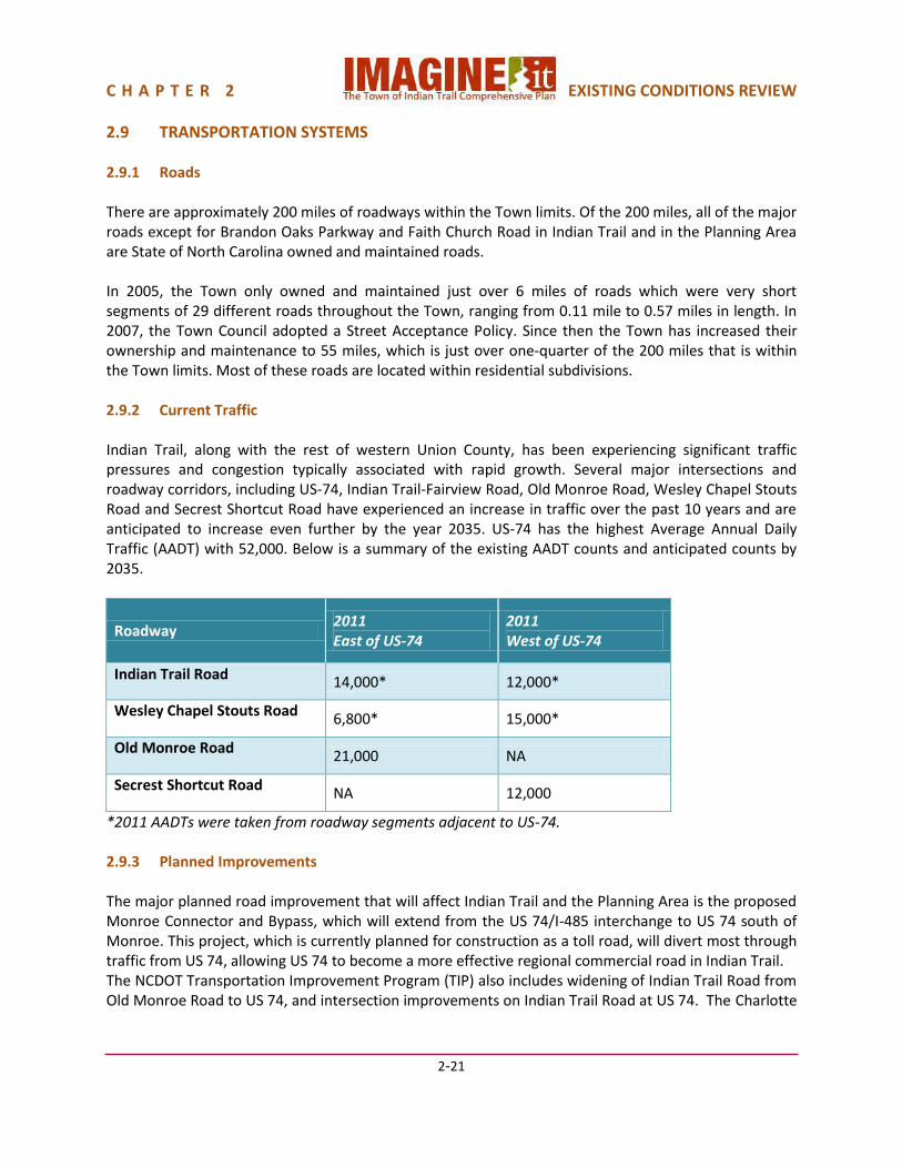
C H A P T E R 2 EXISTING CONDITIONS REVIEW
2-21
2.9 TRANSPORTATION SYSTEMS 2.9.1 Roads There are approximately 200 miles of roadways within the Town limits. Of the 200 miles, all of the major roads except for Brandon Oaks Parkway and Faith Church Road in Indian Trail and in the Planning Area are State of North Carolina owned and maintained roads. In 2005, the Town only owned and maintained just over 6 miles of roads which were very short segments of 29 different roads throughout the Town, ranging from 0.11 mile to 0.57 miles in length. In 2007, the Town Council adopted a Street Acceptance Policy. Since then the Town has increased their ownership and maintenance to 55 miles, which is just over one-quarter of the 200 miles that is within the Town limits. Most of these roads are located within residential subdivisions. 2.9.2 Current Traffic Indian Trail, along with the rest of western Union County, has been experiencing significant traffic pressures and congestion typically associated with rapid growth. Several major intersections and roadway corridors, including US-74, Indian Trail-Fairview Road, Old Monroe Road, Wesley Chapel Stouts Road and Secrest Shortcut Road have experienced an increase in traffic over the past 10 years and are anticipated to increase even further by the year 2035. US-74 has the highest Average Annual Daily Traffic (AADT) with 52,000. Below is a summary of the existing AADT counts and anticipated counts by 2035.
Roadway 2011 East of US-74
2011 West of US-74
Indian Trail Road 14,000* 12,000*
Wesley Chapel Stouts Road 6,800* 15,000*
Old Monroe Road 21,000 NA
Secrest Shortcut Road NA 12,000
*2011 AADTs were taken from roadway segments adjacent to US-74. 2.9.3 Planned Improvements The major planned road improvement that will affect Indian Trail and the Planning Area is the proposed Monroe Connector and Bypass, which will extend from the US 74/I-485 interchange to US 74 south of Monroe. This project, which is currently planned for construction as a toll road, will divert most through traffic from US 74, allowing US 74 to become a more effective regional commercial road in Indian Trail. The NCDOT Transportation Improvement Program (TIP) also includes widening of Indian Trail Road from Old Monroe Road to US 74, and intersection improvements on Indian Trail Road at US 74. The Charlotte

C H A P T E R 2 EXISTING CONDITIONS REVIEW
2-22
Regional Transportation Planning Organization (CRTPO) Transportation Plan indicates several other long-range, unfunded roadway improvements. Plate 2.7 shows the existing and currently planned road network within the Planning Area.
Plate 2.7 Existing & Planned Transportation System 2.9.4 Bicycles Currently the Town of Indian Trail does not have any defined bicycle routes within the town. However, there are small segments of a multi-use path along US 74. These segments have been built as part of the new requirements in the Town’s UDO. As of 2011, there were approximately 2600 linear feet (almost a ½-mile) of existing multi-use path along US 74 within Indian Trail. The requirement is intended to create a continuous multi-use path along US 74 to allow pedestrians and bicyclists to access destinations and travel safely along the highway. The Town also requires new development to provide parking for bicyclists, and because of this requirement, the Town now has its first bicycle rack. The Town adopted a Bicycle Plan in June, 2011, in conjunction with the Division of Bicycle & Pedestrian Transportation of the North Carolina Department of Transportation. This plan calls for an extensive network of bicycle lanes and trails throughout the Planning Area. A summary of the Bicycle Plan is included as Chapter 6.1.4.
C H A P T E R 2 EXISTING CONDITIONS REVIEW
2-23
2.9.5 Pedestrians The majority of the existing sidewalks within the town are located in newer residential subdivisions. Many of the town’s older neighborhoods were developed before sidewalks were required, therefore most of these neighborhoods don’t have any sidewalks. Major roadways, such as Wesley Chapel Stouts Road and Unionville Indian Trail Road that connect older subdivisions with newer subdivisions lack continuous sidewalks, which make walking along these roads very difficult. Most of the intersections within the town do not meet minimum state and federal standards. Signalized intersections do not have striped crosswalks, curb ramps, pedestrian signals or signage. Intersections such as Old Monroe Road and Indian Trail Road contain some elements, but are still unacceptable by today’s standards. The Town adopted a Pedestrian Plan in January, 2009, in conjunction with the Division of Bicycle & Pedestrian Transportation of the North Carolina Department of Transportation. This plan calls for an extensive network of pedestrian facilities throughout the Planning Area. A summary of the Pedestrian Plan is included as Chapter 6.1.3. 2.9.6 Greenways/Trails Currently neither the Town of Indian Trail nor Union County maintains and operates any greenways or trails within the Town limits. However, some subdivisions have been built that contain trails that interconnect the subdivision. These types of facilities are typically used by the residents who live in the subdivision and are not open to the general public. Even though the Town does not currently maintain or operate any greenways, many opportunities exist to utilize creeks, streams and sewer easements for future development of a greenway system. The Town adopted a Park and Greenway Master Plan in 2010. The plan calls for an extensive network of greenways and trails. A summary of the Park and Greenway Master Plan is included as Chapter 3.3. 2.9.7 Transit The Charlotte Area Transit System (CATS) provides service to residents traveling to and from Union County. Currently, CATS operates the 74x express bus route which travels along US-74 and stops at three park and ride lots, two of which are located in Union County. The first park and ride lot in Union County is located in Indian Trail at Union Towne Center. There are 50 parking spaces that are leased and have been dedicated for the park and ride lot. The second is located in the K-Mart parking lot in Monroe near Dickerson Boulevard. According to CATS, there are 50 parking spaces at this location and they are donated by K-Mart. Based on the ridership numbers provided by CATS, there were 3,884 riders in January of 2012. This is a slight increase from January of 2011, when there were 3,340. 2.9.8 Railroad The CSX Railroad owns, operates and maintains an active single track freight line through Indian Trail, paralleling US-74 about one mile east of the highway.

C H A P T E R 2 EXISTING CONDITIONS REVIEW
2-24
2.10 PUBLIC UTILITIES This section was excerpted from Union County’s Comprehensive Water & wastewater Master Plan, prepared by Black & Veatch International Company in December 2011. The full Master Plan can be seen at: www.co.union.nc.us/Portals/0/PublicWorks/Documents/UCComprehensiveWWMasterPlan.pdf 2.10.1 Water System The Union County water distribution system is supplied from two water treatment/supply facilities: the Catawba River Water Treatment Plant and the Anson County Water Treatment Plant. Water from the Catawba River Water Treatment Plant serves about 75% of the system (in the Catawba and Yadkin Basins) and Anson Water Treatment Plant serves the remaining 25% of the system (in the Yadkin Basin only). Based on the demand projections for the existing pressure zones in the Catawba and Yadkin Basins supplied by the Catawba River Water Treatment Plant, the capacity of the Catawba River Water Treatment Plant will be exceeded in 2014 thus requiring an expansion of that facility. To help defer the timeline for the expansion, Union County is currently pursuing the purchase or lease of 2 million gallons per day of treatment capacity from Lancaster County’s capacity allocation in the Catawba River Water Treatment Plant and continuing the demand management strategies, as needed, to limit maximum day systems demands until the Catawba River Water Treatment Plant is expanded. Based the demand projections for the existing pressure zones in the Yadkin Basin supplied from Anson County, the contracted amount of 6 million gallons per day from Anson County will be exceeded in 2016. The County plans to pursue required steps to increase its IBT permit to at least 10 million gallons per day by 2017. The Union County Comprehensive Water & Wastewater Master Plan projects that the 2030 Water Service Area will include nearly all of Indian Trail and its Planning Area, except for a small area on the southeast side, as shown in Fig. 2.2, the Master Plan’s Water Service Area Map:

C H A P T E R 2 EXISTING CONDITIONS REVIEW
2-25
Fig. 2.10.1 Union County Comprehensive Water & Wastewater Master Plan Water Service Area Map 2.10.2 Wastewater System Wastewater service in Crismark and Beacon Hills subdivisions is provided by a private system operated by Unitilies, Inc. Other wastewater service is provided by Union County. Union County owned and operated treatment plants include Twelve Mile Water Reclamation Facility (6.0 million gallons per day), Crooked Creek Water Reclamation Facility (1.9 million gallons per day), Olde Sycamore Wastewater Treatment Plant (0.15 million gallons per day), Tallwood Estates Wastewater Treatment Plant (0.05 million gallons per day), and Grassy Branch Wastewater Treatment Plant (0.05 million gallons per day). Capacity has also been purchased from Charlotte-Mecklenburg Utilities at the McAlpine Wastewater Treatment Plant (1.0 million gallons per day presently, 3.0 million gallons per day by agreement) which serves the Six Mile basin in the County and from the City of Monroe Wastewater Treatment Plant (2.65 million gallons per day) which serves the eastside including Marshville and Wingate. All capacities are presented as maximum month treatment capacities. Sewer service area boundaries were developed to ensure the scenario planning could quantify future wastewater conveyed from specific geographic areas and project which treatment plant and basin would receive the discharge. These service area boundaries were shaped and influenced by a number of factors including;
Indian Trail Planning Area

C H A P T E R 2 EXISTING CONDITIONS REVIEW
2-26
Land-use Considerations - spatially allocating future growth around existing development centers or projected development drivers and preserving the rural character of the eastern and southern portions of the County.
Environmental Factors- the Carolina Heelsplitter is an endangered species and one local population has been identified in Goose Creek and Duck Creek in the northeast corner of the County. Environmental regulations in these basins require extraordinary measures to provide public sewer and these areas will not be included in the future public sewer service area.
Monroe Bypass- the new by-pass is expected to generate commercial development at proposed interchanges and residential development along the major feeder routes. Wastewater flows are planned to discharge at key points to the existing Monroe collection system for treatment at the Monroe’s Wastewater Treatment Plant. The future projected flow of the extended Monroe service area is twice the current maximum month purchased capacity of 2.65 million gallons per day from Monroe which will require negotiations with the City.
Inter-Basin Transfer- the IBT issue places a premium on maximizing Catawba River discharges for treated wastewater effluent. The Master Plan continues that wastewater conveyance philosophy and leverages increases in the future wastewater flow transfers through the Poplin WWPS pump-over to contribute positively to any future IBT limitations, regardless of the scenario.
All of Indian Trail’s Planning Area except the Goose Creek basin is included in the 2030 Wastewater Service Envelope, as shown in Fig. 2.3, the Master Plan’s Wastewater 2030 Service Envelope Map:
Fig. 2.10.2 Union County Comprehensive Water & Wastewater Master Plan Wastewater 2030 Services
Envelope
Indian Trail Planning Area

Chapter 3
Framework Plan
IMAGINE The Town of Indian Trail Comprehensive Plan

C H A P T E R 3 F R A M E W O R K P L A N
3-1
3.1 FRAMEWORK PLAN. Indian Trail's Planning Area consists of different sub-areas, each in a different stage of development, and each with its own character, issues and potential. These sub-areas provide a framework on which the Comprehensive Plan is structured. This enables the Town to address current issues appropriately for each part of the Planning Area, and to guide future growth and development in a manner that is also appropriate for each sub-area. The Framework Plan sub-areas (Plate 3.1), along with their specific issues and challenges include:
Plate 3.1 Indian Trail Framework Plan 3.1.1 West Indian Trail The area southwest of Old Monroe Road is nearly all built-out or committed as single family detached residential subdivisions with supporting services and schools. Its future needs are resulting from the pressures created by rapid growth and the need for creating more community identity. Its dominant characteristics are:
Predominantly built-out with low- and medium-density residential with one growing sub-regional commercial center, two emerging Village Centers, and one developing Neighborhood Center
Roads operating at over capacity traffic levels
Public infrastructure (State roads, County schools) and services (police, fire, EMS) keeping up with residential growth
West Indian Trail East Indian Trail
East Indian Trail
East Indian Trail
East Indian Trail
East Indian Trail East Indian Trail
East Indian Trail
East Indian Trail
East Indian Trail
US-74 Corridor
East Indian Trail
East Indian Trail
East Indian Trail
East Indian Trail
Monroe Bypass Corridor
East Indian Trail
East Indian Trail
East Indian Trail
East Indian Trail
Downtown Indian Trail
East Indian Trail
East Indian Trail
East Indian Trail
East Indian Trail

C H A P T E R 3 F R A M E W O R K P L A N
3-2
Need for multi-modal connectivity connecting vehicular, pedestrian and bicycle connectivity, improving traffic flow along existing roadway facilities, and providing additional public facilities as well as continuing development of retail services
Ongoing development of parks, open space and greenways is important for supporting quality of life
Urban and suburban design elements are important for creating community identity and cohesion
Continued expansion and development of basic retail and commercial goods and services to the area for residents
Cultivation of the entertainment district, through a sub-regional center small area plan
Maintain rural character in outlying areas 3.1.2 Downtown Indian Trail Indian Trail's downtown has the potential to be the primary identity center of the town, and a central location that will serve all of the neighborhoods and sub-areas as the Town grows to a community of 60 - 70,000 people. A 2006 Downtown Master Plan established a strong vision. Since its adoption, Town government services and facilities have expanded in this area, including a 1 acre event park and beginning of the future 51 acre Chestnut Square at Indian Trail park. Its major planning needs are:
Urban design is very important to attract new residents and businesses
Create a community gathering place and regional destination, with emphasis on becoming the arts and cultural center of Indian Trail
Economic development is vital
Needs to become more pedestrian friendly
Public facilities such as parks/open space, civic uses, etc. are needed 3.1.3 US-74 Corridor When the Monroe Bypass is built, it is anticipated that much of the through traffic and heavy truck traffic will be directed away from US-74. A US-74 Corridor Revitalization Study in 2013-14 established an overall vision for the corridor through Stallings, Indian Trail and Monroe, and helped establish a vision for this corridor to become a community-oriented boulevard where:
Land use and transportation coordination is very important to maintain safe and efficient mobility in the corridor while allowing an increase in commercial and retail services
Urban design is very important, including an opportunity for gateways at Indian Trail Road, Wesley Chapel–Stouts Road, Unionville Indian Trail Road, and Laurel Creek, to create a sense of identity for Indian Trail that is separate from other communities in this corridor
Coordination with adjacent communities, Union County, NCDOT and CRTPO will help to achieve a higher quality corridor over time
NCDOT’s potential superstreet intersection concept will be a major change for this corridor

C H A P T E R 3 F R A M E W O R K P L A N
3-3
3.1.4 Monroe Bypass Corridor The area around the alignment of the Monroe Bypass has seen growth pressures since adoption of the 2005 Comprehensive Plan, in particular traditional neighborhood development in Rocky River Village and several medium density single family subdivisions in Crooked Creek Village. The Town is in the process of developing a major Crooked Creek Park and greenways in this area, including part of the Carolina Thread Trail. Nevertheless, there is available land remaining for further development. The important considerations for this corridor are:
Concentrate more intense developments where the Bypass and arterial roadways can support increased traffic
Buffer new and existing residential development from the noise and visual effects of the Bypass
Focus plans for regional economic development toward the northern part of the Bypass, to take advantage of the regional proximity to I-485
Focus Village Center non-residential development and higher density residential development near the Bypass interchanges
3.1.5 East Indian Trail The Villages in this area will be less directly affected by regional access from the Monroe Bypass and US-74 so should continue to be lower density, environmentally respectful development. Idlewild Village is largely built out. Two major environmental factors will limit future development densities in the Goose Creek sub-area:
Prior development, built before this area was part of Indian Trail, did not provide adequate stormwater management, subjecting many of the neighborhoods to flooding problems
The Carolina Heelsplitter mussel, a federally-endangered species present in Goose Creek, has led the U.S. Fish and Wildlife Service to propose density and stream buffer restrictions in this watershed, which have been adopted by the Town to protect Goose Creek water quality.
While this area might experience development pressure from the proximity to I-485, as well as spillover growth pressures from Mecklenburg County along Secrest Shortcut Road and Lawyers Road, the sub-area’s environmental issues require that future development be low density, and that as much preservation of open space and working farms as possible be encouraged. This sub-area offers the most potential for high quality, well-planned new development that also preserves natural areas. It also offers much opportunity to meet the Vision Statement goal of preserving Indian Trail’s rural amenities.

C H A P T E R 3 F R A M E W O R K P L A N
3-4
3.2 VILLAGES AND CORRIDORS
In order to provide a more flexible and implementable land use plan, the Planning Area has been divided into various land use Villages and Corridors. The composition of these Villages and Corridors was based on the community preferences identified in the 2005 Comprehensive Plan process, issues and opportunities identified as part of the Framework Plan, and market feasibility. The pattern of land uses established as “Villages and Corridors” is intended to lead to the type of community described in the Vision Statement:
The Town of Indian Trail will be a vibrant, unique, and self-sufficient town where people can live, work and play in a safe environment. It will provide a variety of transportation options with opportunities for walking and biking, while also having opportunities for transit and automobile by connecting all of its villages, downtown, and commercial corridors. The Town will be known for its strong economic development focus, great parks and recreational amenities, and will have a variety of uses that create opportunities to effectively manage metropolitan growth pressures while at the same time preserving its small town character.
The future land use Villages and Corridors plan divides the Town’s Planning Area into nineteen planning sub-areas (Plate 3.2). Because of the emphasis on unique identity and neighborhood, these are envisioned as Villages or Corridors. Each Village or Corridor is characterized by one of eight dominant or primary land use types. As part of the 2012-2013 update process, the overall Planning Area and Village and Corridor boundaries were refined to reflect development that has occurred in the years since 2005 and the final alignment selection for the Monroe Bypass. Within each Village or Corridor, a variety of land uses are allowed based on its recommended land use mix and compatibility with existing land uses. Potential greenways, which preserve creeks, flood plains and wooded areas, in many cases serve as boundaries between villages.

C H A P T E R 3 F R A M E W O R K P L A N
3-5
Plate 3.2 Future Land Use Villages and Corridors The nine primary land use types are:
Suburban Mix Villages
Suburban Residential Villages
Rural Mix Villages
Interchange Mix Villages
Traditional Neighborhood Development Village
US-74 Mixed Use Corridor
Old Hickory Business Corridor
Downtown Indian Trail The boundaries of the Villages and Corridors were determined by natural and manmade features such as creeks, roadways, and existing land uses. The size of the Villages are generally based on a population of 3,000 - 4,000 people, with the ability to support an elementary school and a neighborhood center. The size of the Corridors was determined by the amount of commercial development foreseen by the Town’s Economic Development Plan and Pathways to Progress Plan, and as envisioned in the US-74 Corridor Revitalization Plan.

C H A P T E R 3 F R A M E W O R K P L A N
3-6
Some areas, generally on the edge of the Planning Area adjacent to a neighboring community, were too small to support an elementary school and/or a neighborhood center. While these are referred to as “Villages” in the Indian Trail plan, they typically are simply suburban or rural residential areas. In addition to the Villages and Corridors, an integral part of the plan is the:
Village Centers,
Neighborhood Centers; and a
Sub-regional Center. The Village Centers, which are overlays on the Villages, are located at the intersections of boulevards and thoroughfares, where they can be commercially viable. Their size is based on a 10 minute walk. Roughly half of the build-out population of Indian Trail will be within a 10 minute walk or 5 minute drive of Downtown Indian Trail or a Village Center/Neighborhood Center/Sub-regional Center. Neighborhood Centers, also overlays on the Villages or in areas that are mostly built-out, are also located at the intersections of boulevards and thoroughfares, where they can be commercially viable. Their size is smaller than a Village Center, since their location serves a smaller population. The Sub-regional Center is a larger version of a Village Center. Because of its location and the amount of regionally oriented uses, such as a movie theater complex, it has a larger service area than a Village Center, but still fulfills the Village Center purpose for its surrounding Villages. The only Sub-regional Center included in the plan is in the Sun Valley Village. Its development has been ongoing since the adoption of the 2005 Comprehensive Plan. It is envisioned as a shopping and entertainment district for the Town. A small area plan would help to further define its development mix and character. The objective of the land use Village and Corridor plan is to provide guidance when determining whether or not a future development proposal is consistent with community goals and objectives. It serves as a means to articulate the community’s goals for future growth and community development. Within this framework, it is important to recognize that the Indian Trail Comprehensive Plan is a long range, 20-year guide for the community. The plan’s land use recommendations are intended to be phased in over the course of this 20-year period and may not necessarily be appropriate to implement immediately. This is why land use and/or zoning map amendments are undertaken on a case-by-case basis so that each request may be thoroughly examined for its merits and appropriateness in the community. The 2005 Comprehensive Plan and the 2008 update avoided setting specific details, such as the size and location of commercial properties. Instead, a flexible range of acceptable options was suggested, so that when a specific development was proposed, the market conditions present at that time could be considered, and the best option within that range could be chosen. It is also important to recognize that these ranges are broad, planning level approximations of the appropriate land use mix for each village type. Some limited variation (above and below) is anticipated in the actual land use build out based on the above market conditions and other factors. Development proposals/rezonings contemplating major variations to these ranges should also undergo a Comprehensive Plan Amendment to enable the broader village analysis and to otherwise effect the change to the land use ranges. As the plan is put to use, regular variation to a village’s land use mix likely indicates the need to more closely examine the village type and potentially amend the plan.

C H A P T E R 3 F R A M E W O R K P L A N
3-7
Since adoption of the 2005 Plan, Indian Trail has continued to grow, to the extent that the land use character of many of the Villages has been essentially set, with relatively small areas left to be developed or planned. Additionally, other plans, such as “Pathways to Progress”, the US-74 Corridor Revitalization Plan, and the Downtown Plan have established more specific land use goals for several of the Corridors and Villages. For those Villages and Corridors, a recommended land use mix is more appropriate. A recommended land use mix with a flexibility factor is incorporated into the village and corridor types which still have relatively large amounts of undeveloped land. This flexibility factor allows for the exact land use mix to be market sensitive, while still adhering to overall land use goals, thus avoiding the need to amend the plan in response to market fluctuations. While flexibility factors are based on generalized planning standards, Village Center and Neighborhood Center developments should be able to demonstrate market support for their proposed size and mix of uses, and demonstrate that their proposed size and mix will not preclude development of other Village or Neighborhood Centers, particularly for Centers whose anticipated market support area extends beyond the Planning Area. In order to designate more identifiable land use Villages and Corridors, name designations were suggested to fit the area within which the Village or Corridor is located. Therefore, although the description of each Village or Corridor’s components and character is still categorized by land use, Plate 3.2 has these areas defined by their community locales with the colors representing the predominant land use. As a further refinement to the more general Framework Plan, some adjustments were made in the 2008 Comprehensive Plan Update to the Villages and Corridors Plan that reflect issues and opportunities identified as part of the framework plan and market conditions. These modifications are retained in this Comprehensive Plan, and are listed below:
The preservation of land for agriculture and forest land in appropriate locations
The addition of an “Interchange Mix” land use category that promotes higher density development along the Sardis Church Road/Unionville Indian Trail Road corridor
The addition of a multi-family land use category in order to distinguish between detached and attached housing inventory
Based on market feasibility and Urban Land Institute ratios/ trends, a reduction in the amount of commercial and institutional development for build-out
Lodging was combined with the retail category
Public Facilities was separated into two categories: Parks/Open Space and Institutional; in most cases, parks/open space was combined with agriculture/forest
Residential densities in all land use types are based on the gross density approximations shown below. For proposed developments with a density on the periphery of a residential land use category, the final determination of its appropriate category will be based on site/proposal specific elements such as the overall community layout, housing type and architectural design, open space layout and programming, and other similar elements.

C H A P T E R 3 F R A M E W O R K P L A N
3-8
Table 3.2.1 Base Residential Land Use Densities
Approximate Base Residential Land Use Densities
Land Use Residential Density (du/ac)
Low Density Single Family Less than 2
Medium Density Single Family 2 to 4
High Density Single Family 4 to 6
Village Center/Multifamily Residential 12 to 15
Fig. 3.2.1 Example of Low Density Singe Family Neighborhood (Red Barn Trail, Indian Trail, NC)
Fig. 3.2.2 Example of Medium Density Single Family Neighborhood (Callonwood, Indian Trail, NC)
Fig. 3.2.3 Example of High Density Single Family (Blakeney Greens, Charlotte, NC)
Fig. 3.2.4 Example of Village Center Multifamily (Hawfield Farms, Charlotte, NC)

C H A P T E R 3 F R A M E W O R K P L A N
3-9
3.2.1 Suburban Mix Village Suburban Mix Villages are generally found in the more established areas of Indian Trial where there is room for additional single family subdivisions and supporting development. The Suburban Mix Villages are: Austin Village, Old Monroe Village, Sun Valley Village, Rogers Village, North Fork Village, and Secrest Village. They consist of land uses that promote a neighborhood setting with single family detached houses as its primary development type. The single family residential component characterizes this village, with retail development (predominantly within the proposed village centers) providing convenient access to daily goods and services. The amount of residential development within each of these villages hinges on the premise that an elementary school and neighborhood retail center could be supported within the village boundaries. The general village size is based on the population to ac-commodate the target number of students of an elementary school. Furthermore, the amount of retail square footage and parks/recreation acreage allocated within these villages is based on the amount that could be supported by that village’s population. The boundaries for these villages are mostly defined by major roads as well as floodplains and other natural features along many of the area’s creeks and streams.
Fig. 3.2.5 Typical Suburban Mix neighborhood aerial photograph: Brandon Oaks, Indian Trail, NC Fig 3.2.6 Typical Suburban Mix neighborhood: Brandon Oaks, Indian Trail, NC
Community Open Space Community Center Community Recreation Facility Single Family Detached Residences

C H A P T E R 3 F R A M E W O R K P L A N
3-10
Suburban Mix Village Land Use Medium density residential dominates the suburban mix village with a recommended percent allocation of 55% to 60% of the total acreage. A certain amount of low density residential (7% to 9%) is also recommended in areas that are further removed from major intersections and activity centers, while some high density residential (6% to 10%) is encouraged for land within 1/2 mile of a Village Center. A limited amount of multifamily residential (2% to 4%) may be appropriate within a Suburban Mix Village Center. Parks and recreational amenities as well as institutional uses (schools, churches, government, etc.) need to be incorporated into the mix in order to limit the amount of distance that needs to be traveled by community’s residents to access these types of facilities. Suburban Mix Village Community Form The form of a Suburban Mix Village is centered on the suburban-style home and traditional neighborhood unit. This traditional neighborhood unit can have commercial land uses (retail and office) located in a Village Center near neighborhoods at the intersections of boulevards and thoroughfares for convenience of access and market exposure. Pedestrian connections such as sidewalks and trails are important to provide access from the residential to the commercial uses. Community form for medium density residential uses, which are the primary use type in the Suburban Mix Village, is best described as enclaves. It can be either urban or garden style in layout. Urban style medium density buildings have common setbacks and parallel public streets. Garden style housing sites have buildings in clusters away from public streets. Commercial uses should have unified architecture, well planned pedestrian connections linking buildings, parking, and amenities, buildings sited to create pedestrian spaces, parking fields broken into smaller sizes with the use of landscape, and pedestrian connections to adjacent neighborhoods. Community facilities should be sited to act as a transition between land uses that are not directly compatible. Neighborhood parks and open space intended to serve the village’s residents should be sited more internally, and pedestrian connections to them from neighborhoods are desirable. Floodplains, heavily-wooded areas, and other land not best-suited for development can be used to provide greenways, open space, hike & bike trails, or pedestrian connections. While Indian Trail features areas for lower-density housing (e.g. Rural Mix and Rural Residential) and higher-density housing (e.g. Downtown, Traditional Neighborhood Development), the Suburban Mix Villages provide housing for the majority of citizens, and does so at typical suburban densities. The Suburban Mix Village provides significant opportunities for primarily owner-occupied housing on medium-sized lots, with convenient access to the most frequently needed retail uses. Suburban Mix Village Siting Criteria (SC) Each village land use type includes a set of siting criteria for the components that comprise that set of land uses. The siting criteria are recommendations for siting these specific land uses together. The goal of the siting criteria is to achieve high-quality residential neighborhoods, commercial villages, employment areas, and civic centers while responding sensitively to the natural environment.

C H A P T E R 3 F R A M E W O R K P L A N
3-11
The following siting criteria are applicable for the Suburban Mix Village: SC1. Retail and office uses are to be located nearest the intersection of two boulevards or thoroughfares in a Village Center. SC2. Retail and office uses should not be organized in a linear form, avoiding multiple curb cuts; instead, they should be focused within the half-mile Village Center overlays as depicted on the Future Land Use Villages and Corridors Map (Plate 3.2), and providing better organized access management. SC3. Non-residential low impact development may be located in certain situations at boulevard-thoroughfare intersections. This low impact development includes uses such as veterinary clinics, professional office, and day-care facilities. This type of development could be located at the periphery, providing a buffer between more intense uses and residential uses. SC4. Parks and open space should be located in areas to preserve existing trees, wetlands, or natural habitat. Parks should also work in conjunction with the adopted Parks and Greenways Master Plan, school sites and be accessible by pedestrians, bicycles, and public streets, as described in Section 3.7. SC5. Open space should be used as an amenity for surrounding development. Many times the open space takes the form of a floodplain, wetlands, or stands of existing trees. Integrating the natural environment with the built environment can occur in many ways - a common method is to have a road front the open space providing a public view, access or “front-door” to the amenity. SC6. High density single-family and multi-family residential should be located in a Village Center. This land use can be sited between lower intensity (e. g. parks) uses and higher intensity (e. g. commercial) uses. SC7. Each of these villages should be able to support about 100 acres of park land and neighborhood amenities, as well as greenways. Parks can and should also relate to the quantity and quality of the natural environment in the Village.
Fig. 3.2.7 Typical Suburban neighborhood park: Brandon Oaks, Indian Trail, NC

C H A P T E R 3 F R A M E W O R K P L A N
3-12
SC8. A residential neighborhood needs to have a street layout that provides primary linkages to community facilities and amenities. SC9. Streets in single family residential areas should be designed primarily to connect the homes to boulevards or thoroughfares and other compatible developments, and not be designed to encourage “cut-through” traffic. There should be street connectivity throughout the Village, avoiding cul-de-sacs. Residential areas with only one connection to a boulevard or thoroughfare are strongly discouraged. SC10. Sidewalks should be provided to accommodate pedestrians on both sides of public streets within a development and trails should be provided, supporting a multi-modal transportation system.
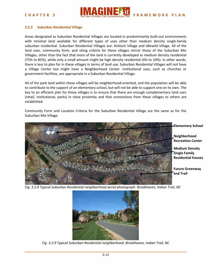
C H A P T E R 3 F R A M E W O R K P L A N
3-13
3.2.2 Suburban Residential Village Areas designated as Suburban Residential Villages are located in predominantly built-out environments with minimal land available for different types of uses other than medium density single-family suburban residential. Suburban Residential Villages are: Antioch Village and Idlewild Village. All of the land uses, community form, and siting criteria for these villages mirror those of the Suburban Mix Villages, other than the fact that more of the land is currently developed as medium density residential (75% to 85%), while only a small amount might be high density residential (4% to 10%). In other words, there is less to plan for in these villages in terms of land use. Suburban Residential Villages will not have a Village Center but might have a Neighborhood Center. Institutional uses, such as churches or government facilities, are appropriate in a Suburban Residential Village. All of the park land within these villages will be neighborhood-oriented, and the population will be able to contribute to the support of an elementary school, but will not be able to support one on its own. The key to an efficient plan for these villages is to ensure that there are enough complementary land uses (retail, institutional, parks) in close proximity and that connections from these villages to others are established. Community Form and Location Criteria for the Suburban Residential Village are the same as for the Suburban Mix Village.
Fig. 3.2.8 Typical Suburban Residential neighborhood aerial photograph: Brookhaven, Indian Trail, NC
Fig. 3.2.9 Typical Suburban Residential neighborhood: Brookhaven, Indian Trail, NC
Medium Density Single Family Residential houses
Future Greenway and Trail
Neighborhood Recreation Center
Elementary School

C H A P T E R 3 F R A M E W O R K P L A N
3-14
3.2.3 Rural Mix Village The Rural Mix Village is focused primarily around low-density residential uses that reflect a rural setting. In addition to land use that might be dedicated to parks and open space, some of the rural mix village land is preferred to remain in the agriculture/forest land use category. This is an effort to promote estate type residential development that preserves open space and maintains the rural character of this particular part of the community. Medium density residential uses are less frequent and should be placed within Village or Neighborhood Centers whenever possible. There are two Rural Mix Villages within the Planning Area: Goose Creek Village and Moore Farm Village. Goose Creek Village is located in the northeast section of the Planning Area on land that is predominantly governed by unincorporated Union County. This situation could potentially make it easier to transition from the current Union County zoning of predominantly 1-acre lots once these areas are annexed into Indian Trail. Moore Farm Village is located in the extreme western periphery of the Planning Area, adjacent to the existing rural density area of Weddington.
Fig. 3.2.10 Typical Rural Mix neighborhood: Indian Brook Forest, Indian Trail, NC
Fig. 3.2.11 Typical Rural Mix neighborhood Indian Brook Forest, Indian Trail, NC
Church
Single Family Medium and Low Density Single Family Residential houses
Future Greenway and Trail

C H A P T E R 3 F R A M E W O R K P L A N
3-15
Rural Mix Village Land Use Low density residential uses comprise 65% to 75% of a Rural Mix Village, depending on the location and market factors. Medium density residential uses should not exceed 8% to 13% of the Village’s land, while retail uses should occupy no more than 1% of the Village. Public facilities and institutional uses, such as parks, schools, and places of worship, should not exceed 3% to 7% of the land area. The remaining land should be left undeveloped in order to preserve the rural character of the area. Rural Mix Village Community Form The form of the built environment in the Rural Mix Village should complement and encourage the low density residential and rural commercial uses. The village should concentrate non-residential uses in Village Centers locating them within close proximity of the intersection to prevent a sprawling appearance along the boulevards or thoroughfares. Agricultural uses that are not permitted elsewhere in the Town are permitted within the Rural Mix Village, but performance standards should limit them to activities that do not conflict with the enjoyment of residential properties.
Fig. 3.2.12 Example of agricultural use in a Rural Mix Village: Apex, NC However, residents should expect the agricultural uses to provide a different character to the area and a different quality of life than other villages. These uses should not be so intense as to be incompatible with residential uses. Uses allowed in the Rural Mix Village are intended for rural areas, and are not typical of what would be planned for in a suburban setting. The low density residential land use is characterized by single family residential homes. Auxiliary structures, such as barns and sheds, and limited livestock are permitted on large residential lots. There is potential for non-residential uses to be located adjacent to the “estate” lots due to the agricultural activities common in the Village and the large nature of the residential lots. The form of the built environment in single family residential developments in the Rural Mix Village is similar to but more rural in nature than that found in the Suburban Mix Village. The medium density single family development should be located in close proximity to intersections of boulevards or thoroughfares and adjacent to natural features that would serve as buffers between the residential units and the rural/agricultural uses that are typical in the Rural Mix Village.
C H A P T E R 3 F R A M E W O R K P L A N
3-16
Single family developments are also intended to be dispersed throughout the village and much smaller than developments found in the Suburban Mix Village. Commercial uses should be well planned with parking fields broken into smaller sizes with the use of landscaping. Fewer neighborhood parks will be provided in the Rural Mix Village due to the dispersed nature of the residential units and the rural feel of the village. Floodplains, heavily-wooded areas, and other land not best-suited for development can be used to provide open space, hike and bike trails, or pedestrian connections, as described in Section 3.7 Rural Mix Village Siting Criteria The following siting criteria are applicable for the Rural Mix Village: SC1. Commercial uses, if any in this rural village, are to be located at the intersection of two boulevards or thoroughfares. Rural village supporting business could include a tack shop or agricultural feed store, produce stand or farmers market, similar rural/agricultural supporting businesses. SC2. Non-residential low impact development may be located in certain situations mid-block along boulevards or thoroughfares. This low impact development includes uses such as veterinary clinics, professional offices, and day-care facilities. SC3. Parks should be developed in areas to preserve existing trees, wetlands, or natural habitat. Parks should also work in conjunction with the adopted Parks and Greenway Master Plan and school sites, as described in Section 3.7. SC4. The combination of a Rural Mix Village and a Rural Residential Village are anticipated to be able to support one elementary school. SC5. Medium density residential uses should be located adjacent to existing medium density residential uses at the periphery of the village if appropriate. New medium density residential developments should be small in size, generally no more than 50 units and located in close proximity to boulevard or thoroughfare intersections.

C H A P T E R 3 F R A M E W O R K P L A N
3-17
3.2.4 Interchange Mix Village The land use composition of the Interchange Mix Village is based on its location between two major highways, with a few major boulevards or thoroughfares feeding into it. The future Monroe Bypass bounds the northeast side of this village and the US-74 Corridor bounds the southeast side. Sardis Church Road, Unionville-Indian Trail Road, and Secrest Shortcut Road all feed into the Interchange Mix Village. Furthermore, one of the two Monroe Bypass interchanges that will be located within Indian Trail’s boundaries is partially located within this village. All of these factors contribute to the ability of this village to attract a mix of higher density development that can take advantage of the convenient regional transportation access.
Fig. 3.2.13 Typical Interchange Mix neighborhood: Braefield and Arbor Glen, Indian Trail, NC Fig. 3.2.14 Typical Interchange Mix neighborhood: Arbor Glen, Indian Trail, NC
Single Family Medium Density Single Family Residential houses
Future Greenway and Trail
Elementary School
Church

C H A P T E R 3 F R A M E W O R K P L A N
3-18
Interchange Mix Village Land Use The largest land use category within the Interchange Mix Village, 35% to 45%, is dedicated to Medium Density Residential. Additionally there are two “high density” housing categories: High Density Residential and Multi-Family Residential, which are appropriate within a Village Center. Each of these land use categories is limited to 10% to 15% of the Village total, in case the market is unable to support that much high density residential. Not all of the land use is reserved for residential uses. A substantial amount of commercial space is also indicated, taking advantage of the close proximity to the future Monroe Bypass Interchange and US-74. The same percentages of parks/open space (5%) and institutional (3% to 7%) uses are recommended for this village as in the commercial-oriented corridors. Light industrial uses (up to 5%) such as office warehouse and flex space are appropriate within the Crooked Creek Village Center near the proposed Monroe Bypass intersection if the bypass were to be constructed. Interchange Mix Village Community Form The form of the built environment in the Interchange Mix Village is centered on well-designed commercial uses fronting major boulevards with complementary, higher density residential development scattered throughout. This high density village can have commercial land uses (retail and office) located in the Village Centers near neighborhoods at the intersections of boulevards (particularly Unionville-Indian Trail Road/Sardis Church Road and surrounding the future Monroe Bypass interchange). Pedestrian connections such as sidewalks and trails are important to provide access from the residential areas to these commercial uses. Community form for medium density residential and high density residential uses is best described as enclaves. It can be either urban or garden style in layout. Urban style medium density buildings have common setbacks and parallel public streets. Garden style housing sites buildings in clusters away from public streets. Commercial uses should have unified architecture, well planned pedestrian connections linking buildings, parking, and amenities, buildings sited to create pedestrian spaces, parking fields broken into smaller sizes with the use of landscape, and pedestrian linkages to adjacent neighborhoods. Community facilities should be sited to act as a transition between land uses that are not directly compatible. Neighborhood parks and open space intended to serve the Village’s residents should be sited more internally, and pedestrian connections to them from neighborhoods are desirable. Floodplains, heavily-wooded areas, and other land not best-suited for development can be used to provide greenways, open space, hike & bike trails, or pedestrian connections. Similar to the Suburban Mix Village, the Interchange Mix Village provides housing for a large percentage of citizens, yet does so with slightly higher densities. The village provides significant opportunities for primarily owner-occupied housing on small-sized lots, with convenient access to the most frequently needed retail uses.

C H A P T E R 3 F R A M E W O R K P L A N
3-19
Fig. 3.2.15 Example of single family detached residences on small-sized lots:
Braefield, Indian Trail, NC Interchange Mix Village Siting Criteria The following siting criteria are applicable for the Interchange Mix Village: SC1. Unlike the Suburban Mix Village, commercial uses, including limited light industrial use, can be located in a linear form within the Interchange Mix Village (along major boulevards); however, the mix of commercial and residential uses should be focused within the half-mile Village Center overlays as depicted on the Future Land Use Villages and Corridors Map (Plate 3.2). SC2. Non-residential low impact development may be located in certain situations at boulevard/thoroughfare intersections. This low impact development includes veterinary clinics, professional office, day-care facilities and similar uses. SC3. Parks should be developed in areas to preserve existing trees, wetlands, or natural habitat. Parks should also work in conjunction with school sites and be accessible by pedestrians, bicycles, and public streets, as described in Section 3.7. SC4. Open space should be used as an amenity for surrounding development. Many times the open space takes the form of a floodplain, wetlands, or stands of existing trees. This integration can occur in many ways - a common method is to have a road front the open space providing a public view, access or “front-door” to the amenity. SC5. High density single family and multifamily residential uses should be located near the intersection of two boulevards preferably in a Village Center. This land use can be sited between lower density residential uses and higher density commercial uses. SC6. A residential neighborhood needs to have a street layout that provides primary linkages to community facilities and amenities.

C H A P T E R 3 F R A M E W O R K P L A N
3-20
SC7. Streets in medium density residential areas should be designed primarily to connect the homes to arterials, and not be designed to encourage “cut-through” traffic. Developments with only one connection to a boulevard or thoroughfare are strongly discouraged. SC8. Sidewalks should be provided to accommodate pedestrians on both sides of public streets within developments.

C H A P T E R 3 F R A M E W O R K P L A N
3-21
3.2.5 Traditional Neighborhood Development Village A Traditional Neighborhood Development (TND) is a human scale, walkable community with moderate to high residential densities and a mixed use core. Rocky River Village is the only Traditional Neighborhood Development Village in Indian Trail, but TND developments would be appropriate in other Villages as well. A TND is served by a network of paths, streets and lanes suitable for pedestrians as well as vehicles. This provides residents the option of walking, biking or driving to places within their neighborhood. Present and future modes of transit are also considered during the planning stages. Public and private spaces have equal importance, creating a balanced community that serves a wide range of home and business owners. The inclusion of civic buildings and civic space -- in the form of plazas, greens, parks and squares -- enhances community identity and value.
Fig. 3.2.16 Typical TND neighborhood: Bonterra, Indian Trail, NC
Fig. 3.2.17 Typical TND neighborhood: Bonterra, Indian Trail, NC
Single Family Medium Density Single Family Residential houses
Community Open Space
Community Recreation Center
Future commercial

C H A P T E R 3 F R A M E W O R K P L A N
3-22
Traditional Neighborhood Development Land Use The Traditional Neighborhood Development (TND) Village is unique in terms of its recommended land use mix. A maximum of 75% of land within this village is designated for TND use. A typical breakdown of land uses within TNDs is about 70-75% residential at an average gross density of 3.5 to 4 units per acre, 20-25% parks/open space, and 2-3% for commercial (retail/office) use. The remaining 25% of land has been allocated to supporting uses, with parks/open space leading this category at about 9% of total land area. Another 4% is allocated to commercial (retail, office) uses, while 5% to 9% is dedicated to institutional uses such as schools, churches, etc. According to market trends, the amount of commercial space allocated to this village would need to be supported by not only the residents within the TND communities, but also from residents of other areas either within Indian Trail or elsewhere, With a proposed freeway interchange partially located within this village, there is a good opportunity for some commercial development to be supported by through and destination traffic traveling along the Monroe Bypass. In addition, based on this recommended land use mix, the average residential density for all residential uses within the village equates to about 2.8 units per gross acres. Should the market for TND subdivisions not be able to support 75% of the total land area, there is a significant flexibility factor designated for each residential use (based on the suburban mix land use base percentage). Traditional Neighborhood Development Community Form Based on research and case studies regarding how TND development should be designed, the following attributes should be used as a guide to good TND planning: Buildings within TNDs should be aligned and close to the street. Buildings should form the space of the street, as well as form and protect private open space. Whether a yard, garden or courtyard, private open space is an important complement to the neighborhood’s public space. Buildings should also have front porches or balconies. This overview of the street contributes to healthful streets and safe neighborhoods, while serving as a buffer between the house interior and street activity.
Fig. 3.18 Open space in a TND neighborhood: Bonterra, Indian Trail, NC
C H A P T E R 3 F R A M E W O R K P L A N
3-23
The design model for TND is the traditional small town with sidewalks, front porches and compact yards. Rather than being simply pushed closer together, buildings must be designed for the proximity while retaining privacy and individuality. Views from inside of houses and other buildings should be directed to the street and the backyard, not toward the neighbors, and windows on the side of houses should not be directly opposite windows on adjacent houses. Property lines should be physically defined by fences, hedges or garden walls. Land should be clearly identifiable as public or private—in public view for surveillance or private and protected. Vehicle storage, garbage and mechanical equipment should be located away from the street. Access to garages should be from an alley. Where garages must be front-loaded, they should be set behind the front plane of the house. There should be a variety of dwelling types within the neighborhood. These usually take the form of detached houses, town houses, and apartments or condominiums, so that younger and older people, singles and families, the poor and the wealthy, may find places to live. The streets within the neighborhood should form a connected network. This provides a variety of itineraries and disperses traffic congestion. They should also be relatively narrow and shaded by rows of trees. This slows down the traffic, creating an environment for pedestrians and bicyclists. Traditional Neighborhood Development Siting Criteria The following siting criteria are applicable for the Traditional Neighborhood Development Village: SC1. The neighborhood has a discernible center. This is often a square or green, and sometimes a busy or memorable street intersection. SC2. Most of the dwellings are within a five-minute walk of the center. This distance averages one-quarter of a mile. SC3. There are shops and offices at the edge of the neighborhood. The shops should be sufficiently varied to supply the weekly needs of a household. A neighborhood center is the most important among them. Consideration should be made to provide shops with visibility to adjacent boulevards or thoroughfare roadways to help expand the number of potential customers and ensure the viability of the commercial areas. SC4. A small ancillary building is permitted within the backyard of each house. If appropriately planned, it may be used as an accessory dwelling or “mother-in-law suite”, or as a place to work for home-based occupations. SC5. There are small playgrounds quite near every dwelling. This distance should not be more than one-eighth of a mile. SC6. Buildings at the neighborhood center are placed close to the street. This creates a strong sense of place. SC7. Parking lots and garage doors rarely front the streets. Parking is relegated to the rear of the buildings, usually accessed by alleys.

C H A P T E R 3 F R A M E W O R K P L A N
3-24
SC8. Certain prominent sites are reserved for civic buildings. Buildings for meeting, education, religion, or culture are located at the termination of the street vistas or at the neighborhood center. 3.2.6 US-74 Mixed Use Corridor The US-74 Mixed Use Corridor runs the length of Indian Trail from the Stallings town line to the Monroe City Limits, extending roughly one-quarter mile on either side of the highway. The US-74 Mixed Use Corridor provides a significant amount of the shopping opportunities within not only the Town of Indian Trail, but also this part of Union County. This corridor provides land for intense commercial uses and larger structures along US-74 that are not appropriate for residential areas. It also provides opportunities for high-traffic generators, such as entertainment and lodging uses. The US-74 Mixed Use Corridor is a critical element to the Town of Indian Trail, providing the fiscal benefit of sales and property tax revenue to the town and school districts and the quality of life benefit with major shopping opportunities convenient to businesses and visitors.
Fig. 3.19 Mixed-use corridor: West W. T. Harris Boulevard, Charlotte, NC
Fig. 3.2.20 Mixed-use corridor: West W. T. Harris Boulevard, Charlotte, NC
Multi-family Residential apartments
Corporate offices

C H A P T E R 3 F R A M E W O R K P L A N
3-25
US-74 Mixed Use Corridor Land Use The 74 Mixed Use Corridor is dependent upon high traffic volumes as it serves both customers from within the town and beyond it. Consequently, this corridor is located along a regional connector that connects the Charlotte area to Monroe and eastern Union County. The corridor should provide a variety of services including retail, office, industrial, entertainment, and lodging opportunities. Typically, these commercial uses have a positive fiscal impact on municipalities, as the cost of the public services they demand is less than the tax revenue they generate. Similarly for the school districts, they bring in revenue without directly generating more students to be served. Also, the shopping opportunities gives local consumers more choices and options, and provides convenient access to goods and services that otherwise would require a trip outside of Indian Trail. This provides a quality of life benefit to residents, helps attract large employers, and brings in customers from outside of the town limits. In light of the US-74 Corridor being primarily intended for retail, service, and employment generating uses, residential land uses should consist of medium to high density single-family residential and high density multifamily residential uses. Residential uses should be limited to 10% for single-family residential and 5% for multifamily residential providing a totaling potential residential use of 15%. Despite the overwhelming presence of retail uses, residential uses currently exist and are able to expand into the future within this corridor. This corridor may be appropriate for the highest densities of residential development due to the proximity to transportation infrastructure and commercial services. It is vital that these residential areas provide pedestrian linkages to the commercial uses along US-74. US-74 Mixed Use Corridor Community Form The built environment in the US-74 Mixed Use Corridor is oriented around the automobile. Customers arrive and depart by car and the buildings, sites, signage, and infrastructure should be designed for significant levels of traffic. Buildings should be oriented towards the adjacent regional connectors, and are typically large, with a deep setback from the road. Sites should be designed to facilitate ingress from US-74 and its intersecting boulevards without causing excessive friction and reducing their efficiency. Signage should be large enough to be noticeable to passing drivers without creating a cluttered, discordant streetscape. The Indian Trail Wayfinding Program identifies locations for gateway and informational direction signage. Many of the developments will require extensive lighting across the site, but lighting levels should not be so high as to pollute the night sky or disrupt the enjoyment of nearby residential areas. Retail uses dominate the US-74 Mixed Use Corridor, but only in combination with other commercial uses does the Corridor function at its best. Light industrial business parks also can take advantage of the regional access provided by US-74, and office uses broaden the options for consumers. Entertainment uses and lodging opportunities enhance the quality of life of residents and attract consumers from outside Indian Trail. Office uses often locate within districts such as this Corridor, but zoning districts for just office uses are also appropriate.

C H A P T E R 3 F R A M E W O R K P L A N
3-26
Entertainment and lodging uses can greatly contribute to the success of a regional commercial corridor such as US-74, but because they have very specific siting criteria, some corridors may not be suitable for them. For that reason, they have been incorporated into the general retail land use category. US-74 Mixed Use Corridor Siting Criteria The following siting criteria are applicable for the US-74 Mixed Use Corridor: SC1. Development within the US-74 Corridor should emphasize centers and avoid linear or “strip” development, in order to enact the effective access management plan proposed by the US-74 Corridor Revitalization Plan and to minimize traffic conflicts and congestion on US-74 itself. SC2. Screens and buffers are needed along the back of many of these commercial land uses, when the adjoining land use is not another commercial use. SC3. Parking areas need to be connected with the building with pedestrian walkways. These walkways should be landscaped and signed.
Fig. 3.2.21 Landscaped pedestrian walkways in a mixed-use corridor: Galleria at the Dallas North Tollway, Dallas, TX
SC4. Buildings should be planned in a manner that provides visual sight lines connecting pedestrian access and building front doors. This provides quality site design organization. SC5. Pedestrian connections need to be provided between adjacent commercial buildings. These walkways provide pedestrians the linkage between buildings. SC6. Public facilities can be planned as an amenity for this corridor. These areas can be the focus for planning and site organization. This planning will allow pedestrian linkages to and from public facilities and the adjacent development.

C H A P T E R 3 F R A M E W O R K P L A N
3-27
SC7. Intensity of uses should be considered when located on the periphery of the US-74 Mixed Use Corridor to minimize the negative impacts on adjacent land uses. SC8. Interconnecting driveways between adjoining parking lots are highly desirable, for US-74 access management. SC9. Light industrial uses should be located where they have rail service from the CSX railroad or within existing industrial parks. US-74 Corridor Revitalization Plan The US-74 Corridor Revitalization Plan, to be completed in 2014, provides more detailed guidance for transportation, access management, land use and aesthetics strategies for this Corridor. The imminent construction of the Monroe Bypass will bring a rare opportunity for Union County, the City of Monroe, and the Towns of Indian Trail and Stallings. While the Monroe Bypass will address some of the issues of pass-through traffic on existing US-74, it will not address all of the issues that this important corridor currently faces. Even though much traffic will shift to the planned Bypass, many regional residents and business owners will continue to use the existing corridor for their daily use. The Town of Indian Trail, along with Union County, the City of Monroe and the Town of Stallings, undertook development of the US-74 Corridor Revitalization Plan to address land use, market opportunities, aesthetics, and overall mobility of this corridor in a comprehensive fashion. The Corridor Revitalization Plan addresses land use and mobility as integrated concerns, with a vision for land uses that supports the surrounding communities rather than passing motorists, and solutions for more local, shorter trips than through trips. It also addresses aesthetic treatments within the corridor, so that US-74 will become an asset to the communities it passes through.

C H A P T E R 3 F R A M E W O R K P L A N
3-28
3.2.7 Old Hickory Business Corridor The Old Hickory Corridor is the area along Indian Trail-Fairview Road from the US-74 Corridor to Idlewild Road. The Monroe Bypass will be along the northwestern edge of the corridor and will have an interchange with Indian Trail-Fairview Road. Portions of the corridor are bordered by the Town of Hemby Bridge and the Village of Lake Park. The Old Hickory Business Corridor provides significant employment opportunities within the community, housing major employers that need convenient transportation, high quality public services, and a worker friendly environment. In addition to office uses, the Corridor provides for the supporting uses, such as retail and lodging opportunities. The Corridor also provides for the amenities that employees desire, such as lakes, plazas, and fountains, which make for a more aesthetically-pleasing employment environment.
Fig. 3.2.22 Typical business corridor: Ballantyne Business Park, Charlotte, NC
Fig. 3.2.23 Typical business corridor: Ballantyne Business Park, Charlotte, NC
Old Hickory Business Corridor Land Use Office and industrial uses comprise 50% to 75% of the Old Hickory Business Corridor, for each use depending upon what the market dictates in the future. Retail uses predominantly serve a supporting role for the employment cluster, and generally should not exceed 4% to 6% of the total land area.
Multi-family Residential apartments
Single family Residential houses
Retail and entertainment center
Resort hotel and golf course
Corporate offices
Interstate freeway

C H A P T E R 3 F R A M E W O R K P L A N
3-29
Restaurants should be located in the corridor to minimize the need for employees to drive to lunch. Residential land uses should consist of low, medium, and high density single-family residential and high density multifamily residential uses. Residential uses should be limited to 10% for single-family residential and 5% for multifamily residential (integrated within a business park and/or Village Center) providing a totaling potential residential use of 15%. Supporting public facilities such as parks, churches, government uses, etc. should not exceed 10% of the acreage within the Old Hickory Business Corridor. Old Hickory Business Corridor Community Form The form of the built environment of the Old Hickory Business Corridor will feature mostly moderate sized buildings, though some areas may have buildings of significant height and volume with surface or structured parking. Office areas are often built in campus settings with focus on providing an attractive environment with employee and community amenities such as enhanced landscaping, lakes, fountains, trails and open spaces, urban forests, and public art. Office uses provide some of the most significant employment opportunities within the community and regionally. This provides a quality of life benefit to residents, giving them a larger and broader range of job options, and a fiscal benefit to the community, providing tax revenue to Indian Trail and school districts and only moderate demands on public services. The corridor also helps provide the Town of Indian Trail with a daytime population that shop at local businesses convenient to their place of employment. Commercial uses should have unified architecture, well planned pedestrian connections linking buildings, parking, and amenities; buildings sited to create pedestrian spaces; and parking fields broken into smaller sizes with the use of landscaping.
Fig. 3.2.24 Typical regional employment center office buildings: Ballantyne Business Park, Charlotte, NC
Community form for residential uses is best described as enclaves. It can either be urban or garden style in layout. Urban style residential buildings have common setbacks and parallel public streets, such as that found in Charlotte’s First Ward (Fig. 3.2.25). Garden style housing sites buildings in clusters away from public streets, such as are found in some of Charlotte’s Fourth Ward (Fig. 3.2.26). There is enough land to support an apartment complex or possibly two within the corridor, which is ideal because of the proximity to employment, a regional transportation network, and shopping. On edges of the Old Hickory Business Corridor, there might be suburban residential or rural mix residential development for compatibility with adjacent villages or other municipalities.

C H A P T E R 3 F R A M E W O R K P L A N
3-30
Fig. 3.2.25 Urban style residential buildings example: Fig. 3.2.26 Garden style residential buildings: First Ward, Charlotte, NC. Fourth Ward, Charlotte, NC Public facilities should be sited to act as a transition between land uses that are not directly compatible. Parks within the Corridor should serve as open space for leisure and recreational activities for both the residents and employees in the district. Floodplains, heavily-wooded areas, and other land not suited for development can be used to provide open space, hike & bike trails, or pedestrian connections. Old Hickory Business Corridor Siting Criteria The following siting criteria are applicable for the Old Hickory Business Corridor: SC1. Intensity of uses should be considered when located on the periphery of the Business Corridor to minimize any negative impacts on adjacent property and to provide adequate transition of land uses. SC2. Parking areas need to be connected to the building with pedestrian walkways. These walkways should be landscaped and signed. SC3. Structured parking facilities must have a façade treatment that is similar and compatible with the façade of the office or light industrial building. SC4. Buildings should be planned in a manner that provides visual sight lines connecting pedestrian access and front doors. SC5. Public facilities can be planned as an amenity that can be the focus for planning and site organization. This will allow pedestrian linkages between public facilities and the adjacent development. SC6. Parks should be developed in areas to preserve existing trees, wetlands, or natural habitat. Parks should be accessible by pedestrians, bicycles, and public streets. SC7. Public streets should be sensitive to the natural slope of the land in order to maximize views and provide ease of drainage. This is best demonstrated with proposed streets paralleling contours. SC8. Residential developments should be buffered visually from non-residential buildings and parking areas. They should have convenient pedestrian connections to office and industrial buildings to provide the opportunity of living within walking distance of work. They also should, as much as possible, be adjacent to greenways or other natural amenities.

C H A P T E R 3 F R A M E W O R K P L A N
3-31
3.2.8 Downtown Indian Trail Downtown Indian Trail is the historic center of the Town, located at the junction of Indian Trail Road and Matthews-Indian Trail Road/Unionville-Indian Trail Road. The CSX Railroad runs through the center of Downtown. Because this area is so different from any other part of the Indian Trail community, a unique Village has been created to enhance its assets and address the future. Indian Trail’s goal of creating an identity for itself begins here. Although much of the development opportunities are in-fill or redevelopment in nature, unlike many downtowns there is significant amount of available land for development.
Fig. 3.2.27 Downtown Indian Trail Master Plan: Concept Plan
Fig. 3.2.28 Typical Town Center: Downtown Matthews, NC
Fig. 3.2.29 Downtown Indian Trail Master Plan: Concept Design

C H A P T E R 3 F R A M E W O R K P L A N
3-32
Fig. 3.2.29 Town Center context sensitive development: Matthews Station, Matthews, NC
The following are some general principles applicable to the Downtown Village:
Mixed Land Use
Provide a variety of uses that enhance the quality of life and meet the needs of current and future residents
Establish a set of guidelines for the development of the downtown area
Take advantage of compact building design
Create a range of housing opportunities and choices including mixed-use, town houses, apartments/condominiums, and detached single family
Create walkable communities, providing sidewalks throughout downtown making connections to adjacent neighborhoods
Foster distinctive, attractive communities with a strong sense of place
Preserve open space, natural beauty, and critical environmental areas
Connect schools, parks, downtown existing open spaces and outdoor recreational areas
Strengthen and direct development toward existing communities
Provide a variety of transportation choices
Encourage community and stakeholder collaboration in development decisions
Form a Downtown Redevelopment task force to establish a downtown business district Downtown Indian Trail Land Use Given that the Downtown Village is mostly developed and includes a wide variety of land uses, the percentage of the land area devoted to each use is not as important as the compatibility with existing uses. There are, however, opportunities for new growth within downtown Indian Trail, particularly along the new Chestnut Parkway alignment and southeast of the potential mixed-use center. An even mix of high density and medium density residential development will be the predominant land use within this village, medium density occupying 22% to 25% of the total area and high density 22% to 28%. Another 14% to 20% is dedicated to multi-family residential development at a density of 12 to 15 units per acre. The Downtown Village also has the highest percentage of parks/open space acreage of all

C H A P T E R 3 F R A M E W O R K P L A N
3-33
the land use villages, mainly because of the need for community gathering facilities and public plazas in a centrally located geography. There is room for some market flexibility with respect to these land use percentages, particularly with the three residential categories. Much of the development that takes place within this village should be in pedestrian-oriented, mixed-use developments, thereby reducing the amount of land area needed to support the build-out population and employment. The average residential density equates to about 4 units per gross acre. The Downtown Village should support limited light industrial land uses at appropriate locations based on their proximity to CSX railroad, adjoining land uses, and property location within the village. Existing Heavy Industrial land uses are located north of the future Chestnut Connector.
Downtown Indian Trail Community Form
Because the village features a wide variety of land uses in close proximity to each other, the relationship and interaction between them is critical to its function. The variety of land uses function well in the Downtown Village due to several factors. A grid street pattern allows for land uses to easily front and/or back each other and therefore limits negative impacts. Appropriate edges and buffers are also important in the placement of these varying land uses.
All development within this village needs to use a grid street pattern. Pedestrian sidewalks need to be included on both sides of streets for all land uses in this village. Wider sidewalks should be provided along major streets to serve commercial and residential uses. Much of the future development in this village occurs as infill. This infill development is typically at a smaller scale than green field development. The infill pattern should be compatible with and complimentary to existing land uses.
Fig. 3.2.31 Town Center as a family destination: Matthews Alive, Downtown Matthews, NC
Downtown Indian Trail Siting Criteria
The following siting criteria are applicable for the Downtown Village: SC1. Infill development should be compatible with and complementary to adjacent existing land uses.
SC2. Development should pay special attention to infrastructure capacity. The Town Center Village has aging infrastructure that in many cases is over capacity, and new development should not reduce the level of utility services for neighboring land uses.

C H A P T E R 3 F R A M E W O R K P L A N
3-34
SC3. Infill development in this village should be designed to accommodate a grid street pattern.
SC4. Land use transitions need to occur at the rear of property, not at the street in the front of development. Land uses across the street from each other should be the same, in most occurrences.
SC5. Mixed use development should generally be located within the downtown commercial district. SC6.Special care in selecting appropriate sites for industrial uses is paramount within this village. Industrial sites are prohibited within the Downtown Village Core adjacent to Indian Trail Road.
A much more detailed description of urban design principles, building configuration recommendations, and transportation linkages within the Downtown Village is included in the Indian Trail Downtown Master Plan, which was adopted by the Town Council in 2006. 3.2.9 Village Center Overlay The Town of Indian Trail comprehensive plan is organized around a concept of residential Villages and commercial Corridors. A key to the residential Villages is the goal of having more than half of the build-put population of the town being within a 10 minute walk or a 5 minute drive of regular services, such as stores, restaurants, professional offices, churches, libraries and other services. The Village Center, along with Neighborhood Centers and the Sub-regional Center, is a core building block of the residential Village.
Fig. 3.2.32 Typical Village Center: Colony Place, Charlotte, NC
Medium Density Single Family Residential houses
High Density Single Family Residential houses
Townhouse condominiums
Retail Center
2 Lane Boulevard
4 Lane Thoroughfare
4 Lane Boulevard
Church

C H A P T E R 3 F R A M E W O R K P L A N
3-35
Fig. 3.2.33 Typical Village Center: Colony Place, Charlotte, NC The Village Center Overlay is intended to concentrate higher-intensity commercial uses and higher-density residential around intersections of boulevards and thoroughfares in residential Villages or surrounding one of the three proposed Monroe Bypass interchanges within or partially within the Planning Area. Creating a Village Center Overlay benefits both residential and commercial uses. The co-location of more intense uses creates opportunities for a sense of place not possible in a more sprawling pattern of commercial uses along an arterial roadway. The center also provides for both fiscal and quality of life benefits to the community. The boundaries for each Village Center should be within a half-mile radius of its center, or approximately a 10-minute walk for the average person. Village Center Overlay Land Use Village Centers should be predominantly focused on retail and professional office services for the surrounding population. Other than the US-74 Business Corridor, Old Hickory Corridor, and Downtown Indian Trail, most of the retail uses that have been designated for each of the Villages and Corridors within this plan should be located within the Village Center boundaries. Residential uses should only consist of approximately 25% to 40% of a Village Center, depending upon location and market support. The intent of the Village Center is to create a sustainable community by locating commercial and retail uses that would be supported by approximately 3,000-4,000 residents within close proximity to residential uses. The Village Center size is based on the estimated number of people needed to support an elementary school and neighborhood stores. The Village Centers will also be the most suitable locations for higher density and multi-family residential uses, so that their residents can be within walking distance of the commercial and civic uses. While the Village Center size ranges are based on generalized planning standards, Village Center developments should be able to demonstrate market support for their proposed size and mix of uses, and demonstrate that their proposed size and mix will not preclude development of other Village Centers, particularly for Village Centers whose anticipated market support area extends beyond the Indian Trail Planning Area.

C H A P T E R 3 F R A M E W O R K P L A N
3-36
The Village Center that is located in the Crooked Creek Village could support light industrial uses such as office warehouse or flex space uses. The location of this Village Center at a future Monroe Bypass interchange combined with the availability of land makes this Village Center potentially conducive for light industrial uses. Village Center Overlay Community Form The recommended form for commercial uses is a non-residential walkable center with civic, retail, restaurant and professional uses, surrounded by higher density residential uses with excellent pedestrian connections to the non-residential core. This Village Center concept is necessary to soften the impacts of the allowed uses. The Village Center concept is defined through unified architecture; well-planned pedestrian connections linking buildings, parking, and amenities. Buildings should be sited to create pedestrian spaces and parking fields need to be broken into smaller sizes with the use of landscaping. Ground floor space should respond to the pedestrian sidewalks with display windows and entrances. Intense commercial buildings may be multistory. Residential uses also may be in multi-story buildings. The additional height should be respectful of the adjacent uses and may be limited if there is the potential to negatively impact them. At the periphery of the Village Center will be the residential uses and public facilities. These uses will serve to transition the more intensive uses in the commercial to the less intensive residential uses outside the Village Center. Higher density residential uses in appropriately scaled buildings will buffer the commercial uses in the core of the Village Center, while lower density uses will be located at the outer edges.
Fig. 3.2.34 Residential uses in a Village Center setting: Olde Providence South, Charlotte, NC
Parking will be necessary for residents who do not walk or bike to the center. However, pedestrian connectivity should be incorporated for those living or working in closer proximity. Pedestrian enhancements should be provided to add emphasis and ensure safety along pedestrian corridors. Facilities for public transit stops and pedestrian access to these facilities are also strongly encouraged, as are bicycle racks.

C H A P T E R 3 F R A M E W O R K P L A N
3-37
Village Center Overlay Siting Criteria The following siting criteria, in addition to those mentioned under Community Form, are applicable within the Village Center Overlay: SC1. Building heights, where appropriate, should be stepped away from the more intensive commercial and civic uses in the core down to the less intensive residential uses in the periphery. SC2. Natural features such as streams, wetlands, and groves of trees within the Village Center should be incorporated into the urban fabric, and should incorporate and allow access to any adjacent greenways, along with encouraging pedestrian connectivity. SC3. Within the commercial core of the Village Center, there should be interior roadways channeling traffic to the major boulevards and thoroughfares but not into the Village Center’s periphery residential areas. SC4. Pedestrian-enhanced cut-through walkways and interior courtyards are desirable to link the Village Center’s commercial core to the residential periphery. SC5. There will be a minimum of two major boulevards or thoroughfares that cross within the Village Center or that are immediately adjacent to the Village Center. SC6. Higher density single-family residential and multifamily residential uses should be located within a 5-10 minute walk of the core of the Village Center. SC7. A slightly less dense residential classification should be located closer to the outside periphery of the Village Center. SC8. Non-residential uses that are appropriate to be located within the Village Center are listed in the Village Center Overlay zoning district classification. While most of the uses are appropriate, some of the uses discourage walkability. It is strongly encouraged that only non-residential uses that support walking, biking and less dependency on motor vehicles be considered for the Village Center. SC9. Light Industrial uses that are suitable within the Village Center located at intersection of the Monroe Bypass and Unionville-Indian Trail Road should be located on the internal periphery of the Village Center. These uses may be suitable, provided that such uses and their associated activities do not conflict with the enjoyment of residential properties in the area and are sited in a business park environment.

C H A P T E R 3 F R A M E W O R K P L A N
3-38
3.2.10 Neighborhood Center Overlay The Town of Indian Trail comprehensive plan is organized around a concept of residential Villages and commercial Corridors. A key to the residential Villages is the goal of having more than half of the build-put population of the town being within a 10 minute walk or a 5 minute drive of regular services, such as stores, restaurants, professional offices, churches, libraries and other services. The Neighborhood Center, along with Village Centers and the Sub-regional Center, is a core building block of the residential Village. The Neighborhood Center Overlay is similar to the Village Center Overlay for civic and commercial uses, but is intended to concentrate smaller commercial uses and higher-density residential uses around intersections of thoroughfares in smaller residential Villages within the Planning Area.
Fig. 3.2.35 Typical Neighborhood Center: Strawberry Hill, Charlotte, NC
Fig. 3.2.36 Typical Neighborhood Center: Strawberry Hill, Charlotte, NC
Creating a Neighborhood Center Overlay benefits both residential and commercial uses. The co-location of more intense uses creates opportunities for a sense of place not possible in a more sprawling pattern of commercial uses along an arterial.
Medium Density Single Family Residential houses
Multi-Family apartments
Townhouse apartments
Retail center

C H A P T E R 3 F R A M E W O R K P L A N
3-39
The center provides for both fiscal and quality of life benefits to the community. The boundaries for each Neighborhood Center should be within a quarter-mile radius of its center, or approximately a 5- minute walk. Neighborhood Center Overlay Land Use The Neighborhood Centers should be predominantly focused on retail and professional office services for the surrounding population with higher density residential integrated within it. A Neighborhood Center is planned within the Rocky River Village. An existing Neighborhood Center is also located in the Idlewild Village. The intent of the Neighborhood Center is to create a sustainable community by locating commercial and retail uses that would be supported by approximately 1,500-3,000 residents within close proximity to residential uses. The Neighborhood Center size is based on the estimated number of people needed to support a smaller grocery store. While the Neighborhood Center size ranges are based on generalized planning standards, Neighborhood Center developments should be able to demonstrate market support for their proposed size and mix of uses, and demonstrate that their proposed size and mix will not preclude development of other Neighborhood Centers, particularly for Neighborhood Centers whose anticipated market support area extends beyond the Indian Trail Planning Area. Neighborhood Center Overlay Community Form The recommended form for commercial uses is non-residential walkable center with civic, retail, restaurant and professional uses, surrounded by higher density residential uses with excellent pedestrian connections to the non-residential core. The form is similar to the Village Center concept, but smaller. This Neighborhood Center concept is necessary to soften the impacts of the allowed uses. The Neighborhood Center concept is defined through unified architecture; well-planned pedestrian connections linking buildings, parking, and amenities. Buildings should be sited to create pedestrian spaces and parking fields need to be broken into smaller sizes with the use of landscaping. Ground floor space should respond to the pedestrian sidewalks with display windows and entrances. Intense commercial buildings may be no greater than two-stories. Residential uses also may be in multi-story buildings. The additional height should be respectful of the adjacent uses and may be limited if there is the potential to negatively impact them. Parking will be necessary for residents who do not walk or bike to the center. However, pedestrian connectivity should be incorporated for those living or working in closer proximity. Pedestrian enhancements should be provided to add emphasis and ensure safety along pedestrian corridors. Facilities for public transit stops and pedestrian access to these facilities are also strongly encouraged, as are bicycle racks.

C H A P T E R 3 F R A M E W O R K P L A N
3-40
Fig. 3.2.37 Pedestrian connection to a neighborhood center: Strawberry Hill, Charlotte, NC
Neighborhood Center Overlay Siting Criteria The following siting criteria, in addition to those mentioned under Community Form, are applicable within the Neighborhood Center Overlay: SC1. Natural features such as streams, wetlands, and groves of trees within the Neighborhood Center should be incorporated into the urban fabric, and should incorporate and allow access to any adjacent greenways, along with encouraging pedestrian connectivity. SC2. Pedestrian-enhanced cut-through walkways and interior courtyards are desirable to link the Neighborhood Center’s commercial core to the surrounding residential Village. SC3. There will be a minimum of two thoroughfares that cross within the Neighborhood Center or that are immediately adjacent to the Neighborhood Center. SC4. Non-residential uses that are appropriate to be located within the Neighborhood Center are listed in the Town’s Village Center Overlay zoning classification. While most of the uses are appropriate, some of the uses discourage walkability. It is strongly encouraged that only non-residential uses that support walking, biking and less dependency on motor vehicles be considered for the Neighborhood Center. SC5. Higher density single-family residential and multifamily residential uses may be located within a 5-10 minute walk of the core of the Neighborhood Center, however, residential densities and intensities of development should be less than a conventional Village Center.
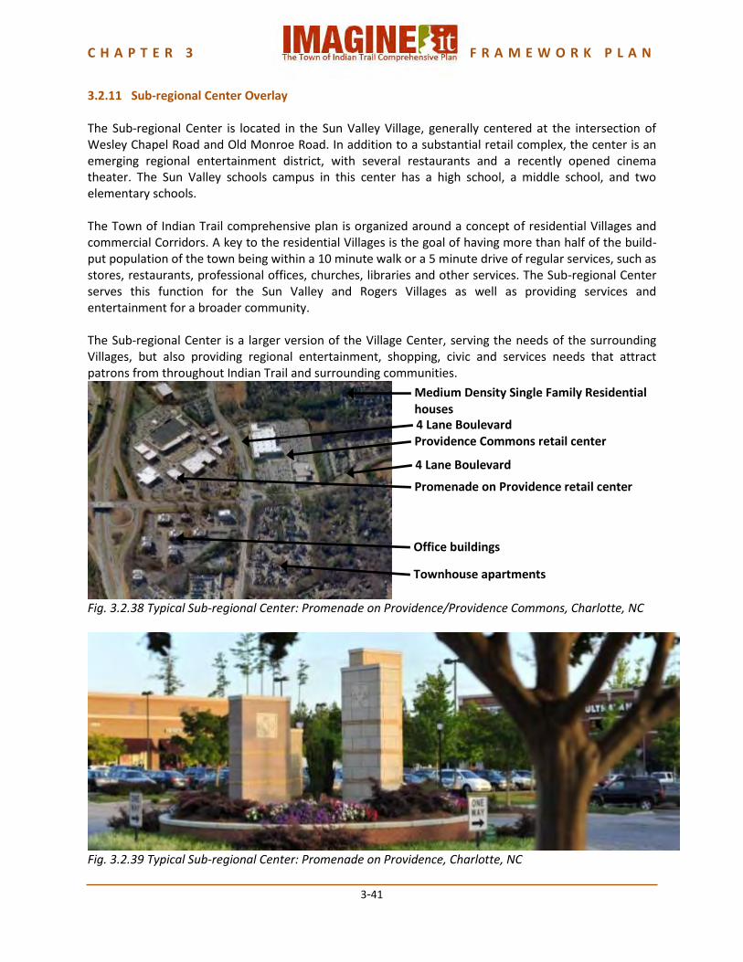
C H A P T E R 3 F R A M E W O R K P L A N
3-41
3.2.11 Sub-regional Center Overlay The Sub-regional Center is located in the Sun Valley Village, generally centered at the intersection of Wesley Chapel Road and Old Monroe Road. In addition to a substantial retail complex, the center is an emerging regional entertainment district, with several restaurants and a recently opened cinema theater. The Sun Valley schools campus in this center has a high school, a middle school, and two elementary schools. The Town of Indian Trail comprehensive plan is organized around a concept of residential Villages and commercial Corridors. A key to the residential Villages is the goal of having more than half of the build-put population of the town being within a 10 minute walk or a 5 minute drive of regular services, such as stores, restaurants, professional offices, churches, libraries and other services. The Sub-regional Center serves this function for the Sun Valley and Rogers Villages as well as providing services and entertainment for a broader community. The Sub-regional Center is a larger version of the Village Center, serving the needs of the surrounding Villages, but also providing regional entertainment, shopping, civic and services needs that attract patrons from throughout Indian Trail and surrounding communities.
Fig. 3.2.38 Typical Sub-regional Center: Promenade on Providence/Providence Commons, Charlotte, NC
Fig. 3.2.39 Typical Sub-regional Center: Promenade on Providence, Charlotte, NC
Townhouse apartments
Office buildings
Promenade on Providence retail center
Providence Commons retail center
Medium Density Single Family Residential houses
4 Lane Boulevard
4 Lane Boulevard

C H A P T E R 3 F R A M E W O R K P L A N
3-42
The Sub-regional Center Overlay is intended to concentrate higher-intensity commercial uses that serve a broader market area and higher-density residential around intersections of boulevards and thoroughfares within or partially within the Planning Area. Creating a Sub-regional Center Overlay benefits both residential and commercial uses. The co-location of more intense uses creates opportunities for a sense of place not possible in a more sprawling pattern of commercial uses along an arterial. The center provides for both fiscal and quality of life benefits to the community. The boundaries for each Sub-regional Center should be within a half-mile radius of its center, or approximately a 10- minute walk. Sub-regional Center Overlay Land Use The Sub-regional Center should be predominantly focused on retail and professional office services for the town-wide population, as well as serving as a Village Center for the adjacent Villages. Other than the US-74 Business Corridor and Downtown Indian Trail, most of the regional retail uses that have been designated for each of the Villages and Corridors within this plan should be located within the Sub-regional Center boundaries. Residential uses should only consist of approximately 25% - 40% of a Sub-regional Center, depending upon location and market support. The intent of the Sub-regional Center is to create a sustainable community by locating commercial and retail uses that would be supported by town-wide residents. Sub-regional Center developments should be able to demonstrate market support for their proposed size and mix of uses, and demonstrate that their proposed size and mix will not preclude development of other Village Centers. Sub-regional Center Overlay Community Form The recommended form for commercial uses is a non-residential walkable center with civic, retail, restaurant and professional uses, surrounded by higher density residential uses with excellent pedestrian connections to the non-residential core. The form is similar to the Village Center, but larger. This Sub-regional Center concept is necessary to soften the impacts of the allowed uses. The Sub-regional Center concept is defined through unified architecture; well-planned pedestrian connections linking buildings, parking, and amenities. Buildings should be sited to create pedestrian spaces and parking fields need to be broken into smaller sizes with the use of landscaping. Ground floor space should respond to the pedestrian sidewalks with display windows and entrances. Intense commercial buildings may be multi-story (greater than two-stories). Residential uses also may be in multi-story buildings. The additional height should be respectful of the adjacent uses and may be limited if there is the potential to negatively impact them. At the periphery of the Sub-regional Center will be the residential uses and public facilities. These uses will serve to transition the more intensive uses in the commercial to the less intensive residential uses outside the Sub-regional Center. Higher density residential uses in appropriately scaled buildings will buffer the commercial uses in the core of the Sub-regional Center, while lower intensity uses will be located at the outer edges.

C H A P T E R 3 F R A M E W O R K P L A N
3-43
Parking will be necessary for residents who do not walk or bike to the center. However, pedestrian connectivity should be incorporated for those living or working in closer proximity. Pedestrian enhancements should be provided to add emphasis and ensure safety along pedestrian corridors. Facilities for public transit stops and pedestrian access to these facilities are also strongly encouraged, as are bicycle racks. Sub-regional Center Overlay Siting Criteria The following siting criteria, in addition to those mentioned under Community Form, are applicable within the Sub-regional Center Overlay: SC1. Building heights, where appropriate, should be stepped away from the more intensive commercial uses in the core down to the less intensive residential uses in the periphery. SC2. Natural features such as streams, wetlands, and groves of trees within the Sub-regional Center should be incorporated into the urban fabric, and should incorporate and allow access to any adjacent greenways, along with encouraging pedestrian connectivity.
Fig. 3.2.40 Natural feature in a sub-regional center: The Arboretum, Charlotte, NC
SC3. Within the commercial core of the Sub-regional Center, there should be interior roadways channeling traffic to the major boulevards and thoroughfares but not into the Sub-regional Center’s periphery residential areas. SC4. Pedestrian-enhanced cut-through walkways and interior courtyards are desirable to link the Sub-regional Center’s commercial core to the residential periphery. SC5. There will be a minimum of two major boulevards that cross within the Sub-regional Center or that are immediately adjacent to the Sub-regional Center. SC6. Higher density single family residential and multifamily residential uses should be located within a 5-10 minute walk of the core of the Sub-regional Center. SC7. A slightly less dense residential classification should be located closer to the outside periphery of the Sub-regional Center.

C H A P T E R 3 F R A M E W O R K P L A N
3-44
SC8. Non-residential uses that are appropriate to be located within the Sub-regional Center are listed in the Town’s Village Center Overlay zoning classification. While most of the uses are appropriate, some of the uses discourage walkability. It is strongly encouraged that only non-residential uses that support walking, biking and less dependency on motor vehicles be considered for the Sub-regional Center.
Fig. 3.2.41 Sub-regional Center: Birkdale Village, an approximately 350,000 new urbanist mixed-use center in Huntersville, NC.

C H A P T E R 3 F R A M E W O R K P L A N
3-45
3.3 PARKS AND GREENWAYS The Town of Indian Trail adopted its first Park and Greenway Master Plan in February 2010. This comprehensive plan sets forth recommendations and implementation strategies for recreational facilities within Town and provides a proposed Park and Greenway system for development. Since adoption of the Park and Greenway Master Plan, the Town has begun implementation of a park system. A bond issue referendum in 2012 approved issuing bonds for park and greenway development. Crossing Paths Park opened in 2012. Construction of Chestnut Place at Indian Trail began in 2013. Land for Crooked Creek Park was acquired in 2013. The following is the Executive Summary of the Park and Greenway Master Plan. The full plan is available on the Town’s website at : http://www.indiantrail.org/boardsandcommittees.php?cat=252. ------------------------------------------------------------------------------------------------------------------------------------------
CHAPTER 1: EXECUTIVE SUMMARY The Town of Indian Trail has undergone significant changes in recent years, as residents, businesses, and developers have been drawn to its small-town charm and convenient location near the burgeoning Charlotte Metropolitan area. This recent rapid growth has put tremendous pressure on the Town’s ability to provide Park and Recreational services for its current and future residents. In spite of this pressure, the Town started to address this important aspect of its quality of life with the initiation of the Comprehensive Plan in 2005. The Comprehensive Plan provided a broad framework for park and greenway facilities. In an effort to begin implementing the recommendations in the Comprehensive Plan, the Town took two major steps in 2008. First, the Town Council established a ½ cent park allocation fund, which is to be used for the development of a park and recreation system. Secondly, the Town developed a Comprehensive Pedestrian Plan, which expanded upon the greenway system that was established in the Comprehensive Plan. The Pedestrian Master Plan established a comprehensive pedestrian network that links all the major destinations and the Village Centers that were defined in the Comprehensive Plan. This plan, like the Pedestrian Master Plan, is a continuation of the implementation of the Comprehensive Plan. BENEFITS A comprehensive park and greenway system can provide numerous benefits to a community that can positively affect the health, social, environmental, and economic sustainability of the people that live there. One of the largest benefits heard repeatedly during the development of the Comprehensive Plan and Pedestrian Plan is the over-arching theme of Quality of Life. The Park and Greenway Master Plan complements and supplements the previous planning efforts by recommendations that will improve the

C H A P T E R 3 F R A M E W O R K P L A N
3-46
overall quality of life of the residents that live in Indian Trail. Other benefits of a comprehensive park and recreation system are:
Economic Benefits
Health Benefits
Environmental Benefits
Transportation Benefits
Preservation of Local History and Culture THE PROCESS Adopting the Town of Indian Trail Park and Greenway Master Plan was not only an important step in ensuring the implementation of the Vision set forth in the Comprehensive Plan, but also meeting (and exceeding) the current and future park and recreation needs of this growing community. Park and greenway master plans are the means to establish a vision over the next 10 years, but they need to be updated on a regular basis to address changing needs of an evolving community. Such constant review will also allow the Town of Indian Trail to capitalize on unforeseen opportunities as they present themselves in upcoming years. The Town of Indian Trail Park and Greenway Master Plan seeks to identify who will be the primary users of the Town’s park and recreation facilities, what will be their needs, and how those needs can be best served. The Plan was developed during an eight month process through a series of public involvement initiatives that included – Steering Committee meetings, Stakeholder Workshops, an online Attitude and Perceptions survey, newsletters, and a series of Public Workshops. The planning process engaged a wide cross-section of its citizens and leaders to garner support and lay a strong foundation for the capital improvement in its park and recreation facilities through this plan. The Plan provides a framework of future parks and greenways locations based on the desires of its citizens and leaders, and presents recommendations and implementation strategies for reaching that vision. The approach for the creation of the Park and Greenway Master Plan consisted of the following key components: 1. Creating a comprehensive public involvement process, 2. Defining a relevant park and greenway classification system for the Town of Indian Trail, 3. Inventory and analysis of current conditions, creation of a park and greenway system, and 4. Recommendations and implementation strategies to execute the plan. A series of goals, established in the beginning of this project, guided this approach.
Promote Indian Trail’s small town heritage by incorporating arts and cultural activities with the development of recreational programs and facilities.
Preserve wetlands and other environmentally sensitive areas.
Develop facilities and programs that are accessible by all users.
Encourage physical and environmental education opportunities for all age groups.
Enhance the safety of parks, greenways and other recreational facilities by providing adequate lighting and signage.
Ensure that all recreational facilities are kept attractive through the development of a comprehensive maintenance program.
Promote facilities and programs that are inviting to all users and are integrated into the context of the community.

C H A P T E R 3 F R A M E W O R K P L A N
3-47
EXISTING PARK AND GREENWAY FACILITIES The Town of Indian Trail has been rapidly growing over the past 10-15 years. According to the North Carolina Office of State Budget and Management, the Town of Indian Trail has grown 121% between April 2000 and July 2006. Due to this phenomenal growth, the building of park and recreation facilities has not kept pace with the development. At the time of adoption of the Park and Greenway Master Plan, the Town did not own or operate any parks or greenways. So how were the recreational needs of the community met? Residents were served by a variety of private and not-for-profit facilities. The role of private facilities is important because they reduce demand for public resources, but do not eliminate the need for such facilities. Town residents also use recreational facilities provided by Union County and other neighboring jurisdictions.
EXISTING PROGRAMS, PLANS AND POLICIES Over the past several years the Town has developed a combination of programs, plans and policies to help connect existing and future destinations, provide better connectivity for all users, protect and preserve the natural assets of the community and develop a framework for future growth. The Town’s Unified Development Ordinance has several provisions that require the dedication of open space for new residential developments, the protection of existing trees and vegetation, and buffer requirements to protect the water quality of creeks and streams. THE PARK AND GREENWAY PLAN The current and future needs of the Town of Indian Trail were assessed by using a variety of indicators, which are discussed in detail in Chapter 5. These indicators included an online survey of attitudes and perceptions, the National Recreation and Park Association (NRPA) standards, evaluation of population projections, and an assessment of the surrounding municipalities.