78-20 Comprehensive Plan Amendment 2.pdf - Town Of ...
200
Resolution #78-20 RESOLUTION OF THE TOWN PLANNING COMMISSION OF THE TOWN OF GREENVILLE AMENDING ITS 2040 COMPREHENSIVE PLAN: AMENDMENT #2 WHEREAS, Wisconsin's comprehensive planning law, set forth in Section 66.1001 of the Wisconsin Statutes, requires County and local governments that enforce general zoning. shoreland zoning, subdivision, or official mapping ordinances to adopt a comprehensive plan by January 1,2010,and; WHEREAS, The Town of Greenville has developed a comprehensive plan that meets or exceeds the requirements set forth in Section 66.1001 of the Wisconsin Statutes, and; WHEREAS, the Town of Greenville Comprehensive Plan contains all nine elements required by State Statute and addresses all 14 of the State of Wisconsin Comprehensive Planning Goals, and; WHEREAS, the Town of Greenville Town Board adopted the 2040 Comprehensive Plan and enacted Ordinance 05-19 on July 22,2019,and; WHEREAS, the Town of Greenville has developed an amendment to the 2040 Comprehensive Plan to update Framing Concept 4b: A District Approach and Map 2-1 as shown on Exhibit A and adopt the Sub-Area Plan by including it as Appendix I as shown on Exhibit B, and; WHEREAS, The Town of Greenville has duly noticed a public hearing on the Town of Greenville 2040 Comprehensive Plan Amendment and the Planning Commission will hold said public hearing, in accordance with Section 66.1001 (4)(d) of the Statutes. NOW, THEREFORE BE IT RESOLVED, that pursuant to section 66.1001 (4)(b) of the Wisconsin Statutes, the Town of Greenville Planning Commission hereby recommends approval of the 2040 Comprehensive Plan Amendment #2 to the Town ofGreenville Town Board. Adopted this the 26th day of October, 2020 Jack ^rfd<y/son, Planning Commission Chairperson endy Helgeson, Town Cl'ert
-
Upload
khangminh22 -
Category
Documents
-
view
2 -
download
0
Transcript of 78-20 Comprehensive Plan Amendment 2.pdf - Town Of ...

Resolution #78-20
RESOLUTION OF THE TOWN PLANNING COMMISSION OF THE TOWN OFGREENVILLE
AMENDING ITS 2040 COMPREHENSIVE PLAN: AMENDMENT #2
WHEREAS, Wisconsin's comprehensive planning law, set forth in Section 66.1001 of
the Wisconsin Statutes, requires County and local governments that enforce general zoning.
shoreland zoning, subdivision, or official mapping ordinances to adopt a comprehensive plan byJanuary 1,2010,and;
WHEREAS, The Town of Greenville has developed a comprehensive plan that meets or
exceeds the requirements set forth in Section 66.1001 of the Wisconsin Statutes, and;
WHEREAS, the Town of Greenville Comprehensive Plan contains all nine elements
required by State Statute and addresses all 14 of the State of Wisconsin Comprehensive Planning
Goals, and;
WHEREAS, the Town of Greenville Town Board adopted the 2040 Comprehensive Plan
and enacted Ordinance 05-19 on July 22,2019,and;
WHEREAS, the Town of Greenville has developed an amendment to the 2040
Comprehensive Plan to update Framing Concept 4b: A District Approach and Map 2-1 as shown
on Exhibit A and adopt the Sub-Area Plan by including it as Appendix I as shown on Exhibit B,
and;
WHEREAS, The Town of Greenville has duly noticed a public hearing on the Town ofGreenville 2040 Comprehensive Plan Amendment and the Planning Commission will hold said
public hearing, in accordance with Section 66.1001 (4)(d) of the Statutes.
NOW, THEREFORE BE IT RESOLVED, that pursuant to section 66.1001 (4)(b) ofthe Wisconsin Statutes, the Town of Greenville Planning Commission hereby recommends
approval of the 2040 Comprehensive Plan Amendment #2 to the Town ofGreenville TownBoard.
Adopted this the 26th day of October, 2020
Jack ^rfd<y/son, Planning Commission Chairperson
endy Helgeson, Town Cl'ert

Motion to Approve Resolution No. #78-20
Votes:
W\ILCUL b^ :^J^CUA. V E C^^
TitleChairperson
Commissioner
Commissioner
Commissioner
Commissioner
Commissioner
Commissioner
Name
Anderson
Cotter
Ecker
KippenhanMeidam-
Wincentsen
Ryan
Watson
Aye ^
^z^T"v^^
Nay Other
F^UUSJL^--
Posted: Q)CiO^ ^ ^^

TOWN OF GREENVILLEORDINANCE NO. 08-20
AN ORDINANCE AMENDING THE TOWN OF GREENVILLE2040 COMPREHENSIVE PLAN: AMENDMENT #2
The Town Board of Supervisors of the Town ofGreenville, Outagamie County, Wisconsin, do ordain as follows:
SECTION 1. The Town ol'Greenville, Wisconsin, adopted the Town ofGreenville Year 2040 Comprehensive Plan on July 22,
2019 by ordinance 05-19, in compliance with Wise. Stats. s 66.1001 (1 )(a) and 66.1001 (2).
SECTION 2. Town of Greenville staff, working under the direction of the Plan Commission have prepared a proposed
Comprehensive Plan Amendment #2 as shown on Exhibit A.
SECTION 3. The Town published the required Class i, 30 day-notice on September 23, 2020.
SECTION 4. The Town of'Greenville Planning Commission conducted a public hearing on October 26, 2020, in compliance
with Wise. Stats. s.66.1001(4)(d), regarding the proposed Comprehensive Plan Amendment.
SECTION 5. The Plan Commission has adopted a Resolution recommending that the Town Board approve an Ordinance
adopting the proposed 2040 Comprehensive Plan Amendment #2.
SECTION 6. The proposed amendment is consistent with State Statute.
SECTION 7. The Town Board hereby adopts the Town of Greenville 2040 Comprehensive Plan Amendment #2 by updating
Framing Concept 4b: A District Approach and Map 2-1 as shown on Exhibit A and by adopting the Sub-Area Plan by
including it as Appendix I as shown on Exhibit B.
SECTION 8. The Town Community and Economic Development Director shall send a copy of this ordinance to the following
along with a cover letter:
(1) Clerks for the Towns of Grand Chute, Ellington, Dale, Hortonia, Clayton and the Villages ofHortonville and Fox
Crossings;(2) Clerks for the Counties ofOutagamie and Winnebago;(3) Administrators for Hortonville and New London School Districts, Town of Greenville Sanitary District; Fox
Valley Technical College President and the Outagamie Waupaca Library System Director;
(4) Wisconsin Land Council c/of Wisconsin Department of Administration, Comprehensive Planning Program.
(5) Wisconsin Department of Administration Comprehensive Planning Program;(6) East Central Wisconsin Regional Planning Commission
This Ordinance shall take effect upon passage and publication.
Adopted this 26th day of October 2020.
TOWNOFGREENVIL
^Anderson
'wn Chairperson
Wendy Hel^eson
Town Clerk

Exhibit A Resolution 78-20 & Ordinance 08-20
CHAPTER 2s FRAMEWORK PLAN
'W^jf^f •^ -•• (LSM<°/ fy'15[%1 •/ (iS^.ii! ^ v'^) mifi^wifs iMSy^y Sffl'if'ff'^ iol^f»^of>Mf/yf' -jf.y'o/ ilawvS if@i^
'^W^Srp^fv ^W 'il iJij'i^ilWiiW WvlinjiJfes]:Mfft»'^!«KFff '?"' ij.hl^ 'yW'^MHil Wi'Zii'yW ^W i'ffifj:: w^ilSAIi.wWvW^y'.
•^RAMJIStiSiCONCEPT^ ,^•8 /A •
In addition to the broad Development Tier system which generally dictates the location, amountand intensity of development in different portions of the community, the use of a District Approachis applied to further define the general "land use", "character" and "form" for specific areas.
STRATEGIES
Strategy 4b-1: Utilize a set of seven (7) "land use districts",and three (3) overlay districts to manage future land use.
Many of the districts cover a single contiguous area, othersare covered by overlay districts which may have specialconditions as required to accommodate the future needsand desires of the community. The short descriptionsbelow, coupled with the information on Table 2-1 whichcorrelates each District with existing or new zoning districts,gives a feel for each District and provides basic policydirection as well as a framework for future zoning actionsand infrastructure investments. Table 2-2 outlines more
details of the general land uses, character, and form foreach of these districts:
Growth management
means specific regulatory
policies aimed at
influencing how growth
occurs, mainly within a
locality. These affect
density, availability of
land, mixtures of uses, and
timing of development.
a) Open Space & Natural Resource District - Based primarily on the results of the 2004 Greenprint
Plan, this District encompasses many of the remaining natural features which provide an important
natural function or contributes to Greenville's rural landscape. This District can be found within all
three development Tiers.
b) Agricultural District (Greenbelt) - Based mainly on the extent of the current 50-Year Sewer ServiceArea Planning Area Boundary as well as the existing Agricultural Enterprise Area, lands within this
District are to be preserved for future agricultural business use. These lands lie within Tier III and are
referred to collectively as the Greenbelt.
c) Limited Service Residential District - This District is comprised primarily of existing clusters of rural
development located within Tier II, not connected to public sewer orwater.
d) Suburban Residential District - Characterized by residential uses on larger lot sizes (lower
development densities) with municipal services having a lower level of amenities and less streetconnectivity. This District is located within Tier I.
e) Mobile Home District - This district is comprised of mobile homes near CTH BB and CTH CB.
f) Industrial / Employment District - An area characterized by a wide diversity of jobs including:
manufacturing, warehousing and distribution, office, sen/ice, and limited destination oriented and
specialized retail. This district carries a wide range of impacts including noise, odors, and heaviertraffic.
East Central WI Regional Planning CommissionGreenville Comprehensive Plan
2-10 Chapter 2: Framework PlanJuly 2019

Exhibit A Resolution 78-20 & Ordinance 08-20
g) Airport District - This district recognizes the location of the Appleton International Airport as a unique
land use within Greenville.
h) Urban Core Overlay District - Contains the highest density of development, often in a mixed-use form.
Higher levels of amenities, incorporation of institutional uses, and high street or bike/pedestrian activity
are commonplace in this District with a focus on high quality design of architecture. Further sub-area
planning will be required to better define details and it is recommended to only approve rezoning for
development projects after the planning and subsequent zoning updates have been completed. Afocus on high quality design is given for architecture within this District. See Appendix I.
i) Heritage Overlay District - This district recognizes important heritage and history in areas
encompassing a mix of residential and small-scale commercial uses in the oldest developed portion ofthe community, including several buildings of historic interest. It is the intent of this district to maintain
the character and streetscape of this unique area. Further sub-area planning will be required to better
define details and it is recommended to only approve rezoning for development projects after the
planning and subsequent zoning updates have been made. See Appendix I.
j) Gateway Overlay District aims to preserve a diverse character at entrances to Greenville. This district
recognizes the need to accommodate commercial uses, but emphasizes a form and pattern whichenhances image, identity, traffic flow and walkability. Further sub-area planning will be required to
better define these parameters. See Appendix I.
Table 2-1: Land Use Districts & Zoning District Comparison
Future Land Use District Applicable Zoning Districts
Open Space & Natural ResourceDistrict
Agricultural District
Limited Service ResidentialDistrict
Suburban Residential District
Mobile Home DistrictIndustrial / Employment District
Airport District
Urban Core Overlay District
Heritage Overlay District
Gateway Overlay District
INST, OS, AGD, AGD-FP when consistent with County
Farmland Preservation Plan.
AGD, AGD-FP when consistent with County FarmlandPreservation Plan, INST, OS, RR.
RR, INST, OS, AGD when existing zoning is inconsistent with
agricultural land use, AGD-FP when consistent with County
Farmland Preservation Plan.
R-1, R-2, R-3, R-4 (see Strategy 6b-3), NC, AGD when existingzoning is inconsistent with agricultural land use, AGD-FP whenconsistent with County Farmland Preservation Plan, INST, OS.MH.
R-3, R-4, Limited GC when adjacent/close proximity toarterial/collector streets, IND, INST, OS, AGD when existingzoning is inconsistent with agricultural land use, AGD-FP whenconsistent with County Farmland Preservation Plan.AD, AGD, AGD-FP when consistent with County FarmlandPreservation Plan, OS.R-3, R-4 GC, OS, INST, and underlying Zoning Districtsapplicable to the underlying Future Land Use District.
R-1, R-2, R-3, R-4, GC, and underlying Zoning Districts
applicable to the underlying Future Land Use District.Underlying Zoning Districts applicable to the underlying FutureLand Use District.
East Central WI Regional Planning CommissionGreenville Comprehensive Plan
2-11 Chapter 2: Framework Plan
July 2019

Exhibit A Resolution 78-20 & Ordinance 08-20
CHAPTER 2: FRAMEWORK PLAN
Table 2-2 - Future Land Use District Descriptions.
OPEN SPACE LAND USES
Open Space & NaturalResource District - Based
primarily on the results of
the 2004 Green Print Plan,this District encompasses
many of the remaining
natural features which
provide an important natural
function or contributes to
Greenville's rural landscape
and suburban lifestyle.
Agricultural District -
Lands within this District areto be preserved for future
agricultural business use.
• Wetlands.
• Woodlands.
• Open land /
fallow land.
• Unique natural
features.
• Parks.
• Stormwater
Facilities
• VacanVUn
developed
land
• Active
agricultural
fields.
• Active and
converted
farmsteads and
outbuildings.
• Agricultural
related
businesses.
• Very limitedindividual singlefamilyresidential.
• Very limitedinstitutionaluses when
necessary.
• This District can be
found within allthree Development
Tiers.
• Along waterway
corridors and
floodplains.
• Lower traffic areas.
• Western and
southern 1/3 ofGreenville (Tier III -
Greenbelt).
• Outside of the 40-
50 year Sewer
Service AreaPlanning Area
Boundary.
• Some lands
encompassed by
AgriculturalEnterprise Area.
• Undeveloped land.
• Natural environment.
• Active and fallow agricultural
fields.
• Traditional farmsteads and
outbuildings.
• Natural environment.
• Limited, well-designed single
family uses.
East Central WI Regional Planning CommissionGreenville Comprehensive Plan
2-12 Chapter 2: Framework Plan
July 2019

Exhibit A Resolution 78-20 & Ordinance 08-20
CHAPTER 2: FRAMEWORK PLAN
Table 2-2 - Future Land Use District Descriptions, continued.
HOUSING RELATED LAND USES (see also Urban Core, Heritage and Gateway Overlay Districts)
Suburban Residential
District - Characterized by
residential uses on larger lot
sizes (lower development
densities) with municipalservices having a lower level
of amenities, but moderate
street connectivity.
Limited ServiceResidential District - This
District is comprisedprimarily of existing clusters
of rural development located
within Tier II, not connected
to public sewer or water.
Mobile Home District
• Single familyhousing
• Very limitedtwo-family,townhome &
condo uses.
• Parks.
• Institutional.
• Connector trails.
• Very limitedneighborhoodcommercial.
• Single familyhousing.
• Parks.
• Institutional.
• Mobile Homes.
• This District islocated only withinDevelopment Tier I.
• Lands within
Sanitary District arepriority.
• Medium to low
volume traffic areas.
• Developments are in
larger tracts of land.
• Commercial uses
should be located on
arterial or collector
roads.
• Medium to low
volume traffic areas.
• Typically locatedoutside of Sanitary
District.
• Bounded by CTH JJ,
Julius Drive, STH 96
and N Road.
• Developments are
on larger tracts of
land.
• NW Comer of CTHCB and CTH BB.
• Low density land use.
• Gridded street pattern with
few cul-de-sacs.
• Mostly single and two-story
building heights.• Standard housing
setbacks.
• Larger garages.
• Significant open/green
space within private lots.
• On street parking is not
common.
• On or Off-Street bicycle
and pedestrian facilities.
• Commercial uses should
be local-serving and not
destinations which
generate traffic.
• Building footprintsapproximately 1,000-2,000
sq. ft. Building design
should be residential incharacter.
• Low density land uses.
• Mostly single and two-story
building heights.• Larger setbacks.
• Larger garages.
• Significant open/green
space within private lots.
• On street parking is not
common.
• Mobile Homes.
East Central WI Regional Planning CommissionGreenville Comprehensive Plan
2-13 Chapter 2: Framework PlanJuly 2019

Exhibit A Resolution 78-20 & Ordinance 08-20
CHAPTER 2: FRAMEWORK PLAN
Table 2-2 - Future Land Use District Descriptions, continued.
EMPLOYMENT RELATED LAND USES
Industrial / EmploymentDistrict is an area
characterized by a wide
diversity of jobs including:manufacturing, warehousing
and distribution, office,
service, and limiteddestination
oriented/specialized retail.
These districts carry a wide
range of impacts including
noise, odors, and heavier
traffic.
Airport District - This districtrecognizes the unique land
uses and opportunities
associated with the AppletonInternational Airport.
Urban Core Overlay District
- Contains the highest density
of development, often in a
mixed-use form. Higher
levels of amenities,
incorporation of institutional
uses, and high street or
bike/pedestrian activity arecommonplace in this District.
This district features adiversity of attractive housing
options and local amenities
within a more compact
residential neighborhooddefined by a street grid with ahigher degree of connectivity.See Appendix I.
^^'V ^3^:\
• Industrial.
• Services.
• Commercial.
• Institutional.
• Limited moderate
density, compact
residentialdevelopment.
• Runways.
• Hangars.
• Airport
infrastructure.
• Aviation
businesses.
• Commercial.
• Retail.
• Office.
• Limited moderate
density, compactresidential
development.
• Trails.
• Institutional.
y;
• Limited to Tier I.
• Within SanitaryDistrict.
• High volume traffic
areas.
• Along highwaysand major corridors.
• Near airport.
• Connecting bike
and pedestrian
facilities.
• Higher densityresidential should
generally belocated on the
fringe of the districtto provide buffers
between other
residential land
uses and non-
residential landuses.
• High and low trafficconditions.
• Higher volume
traffic areas.
• Portions of County
and State highwaycorridors (15, 76,
96, CB, CA, and
GV).
• Development
boundary depths offof the roadway
corridors should be
based on market
demand/conditions.
m
• High to Low density landuse.
• Variety of building heights.• Multiple tenant buildings.
• Medium to large buildingsetbacks.
• Park/trail/recreation areas
should be considered for
employees.
• Outdoor uses/storage
should be properlyscreened and oriented on
site to minimize visual
impacts to residential land
uses and visibility from
public roads.
• Mix of structures.
• Mix of heights.
• Medium to high densityland use.
• Gridded street pattern.
• Varied building heights.• Small to medium building
setbacks.
• Multiple tenants.
• Emphasizes a form and
pattern which enhances
image, identity, traffic flowand walkability.
• Additional sub-area
planning will furtherdefine.
East Central WI Regional Planning CommissionGreenville Comprehensive Plan
2-14 Chapter 2: Framework Plan
July 2019

Exhibit A Resolution 78-20 & Ordinance 08-20
CHAPTER 2: FRAMEWORK PLAN
Table 2-2 - Future Land Use District Descriptions, continued.
EMPLOYMENT RELATED LAND USES
Land Use:
Heritage Overlay District -
This district recognizesimportant heritage andhistory in areas
encompassing a mix of
residential and small-scale
commercial uses in the
oldest developed portion ofthe community, including
several buildings of historicinterest. It is the intent of
this district to maintain thecharacter and streetscape of
this unique area. See
Appendix I.
Core Uses;
• Single and two-
familyresidential.
• Higher densityresidential;preference
should be givento residentialabove ground
floor non-
residentialuses.
• Commercial.
• Retail.
• Parks.
• Institutional.
Location Characteristics:
• Within Tier .1
• Within Sanitary District.• Along STH 76,
between USH 15 andthe CN Railroad trackextending just south ofUSH 15 as well asslightly east and westalong USH 15.
Visual Characteristics:
• Denser, more urban land
uses. Compact
residential uses: reduced
lot sizes and setbacks.
• Gridded street pattern.
• Variety of building sizesand heights.
• Short street setbacks.
• High degree ofamenities.
• High degree ofwalkability.
• Additional sub-area
planning will furtherdefine.
OTHER OVERLAY DISTRICTS
Land Use:
Gateway Overlay District -
This district aims to preservea diverse character, this
district recognizes the need
to accommodate commercial
uses, as well as some
limited amounts ofaffordable workforce
housing designed in awalkable manner. See
Appendix I.
Core Uses:
• UnderlyingDistrictCore Uses.
Location Characteristics:
• Intersections/entrances
to Greenville toinclude:
• USH15&Mayflower.• CTH GV & Mayflower.
• USH 96 & Mayflower.• CTH CA & Mayflower.• CTHCB&CTHBB.• USH 76 & CTH BB.• USH76&CTHJJ.• USH 96 & Greendale.
• USH15&CTHJJ.
Visual Characteristics:
• Further sub-area
planning is necessary to
define.
East Central WI Regional Planning CommissionGreenville Comprehensive Plan
2-15 Chapter 2: Framework PlanJuly 2019

Exhibit A Resolution 78-20 & Ordinance 08-20
CHAPTER 2: FRAMEWORK PLAN
MAKING IT HAPPEN!
4b-1: Develop more detailed guideline documents and where
necessary, ordinance language, to address Architectural
Design, Energy Efficiency and Renewable Energy, UniversalDesign and Landscaping Standards for all new development.
Responsibility Timeframe
Plan Commission,Community
Development
1 year
4b-2: Develop the following Sub-Area Plans to facilitate land
use planning with a focus on the following components: land
use/transportation planning, market study/demand drivenanalysis and architectural design.
• Heritage District.
• Gateway District.
• Urban Core District.
Plan Commission,Community
Development
1 -2 years
4b-3: Implement the sub-area plans from Action Item 4b-2
once complete by amending the current zoning ordinance.
Plan Commission,Community
Development
2-5 years
4b-4: Work with Outagamie County on possible modificationsto the Airport Overlay Zone which would assist Greenville in
achieving its overall development goals. Particularly, areas ofthe ordinance regarding density and specific allowed uses
should be reviewed.
Plan Commission,Community
Development
1 year
4b-5: Amend current zoning ordinance to include new districts
as follows: open space, institutional/governmental,rural/conservation residential for limited service residential
land use district.
Plan Commission,
CommunityDevelopment
1 year
4b-6: Amend current zoning ordinance and map to Plan Commission,remove/delete existing districts as follows: Business Park (just Community
have Industrial), Planned Commercial (just have General DevelopmentCommercial and Neighborhood Commercial).
1 year
4b-7: Actively re-zone properties having conflicting zoning andland use to appropriate district.
4b-8: Develop market studies to support developmentdecisions based on market demand.
Plan Commission,Community
Development
Plan Commission,CommunityDevelopment
2-5 years
Ongoing
East Central WI Regional Planning CommissionGreenville Comprehensive Plan
2-16 Chapter 2: Framework PlanJuly 2019

1-Villag lution 78-20 & Ordinance 08-20
Town of Center
\1
J_WINNEBAGO COUNTT Village of Fox .Crossing'
I 1\
Map 2-1Year 2040 Land Use
Future Land Use District (see Table 2-1 for
applicable zoning)
Suburban Residential - Tier 1
aED
*•
Q-•iirnrL
<..—.„•?r--"i i
Limited Service Residential - Tier II
Agricultural - Tier III
Open Space & Natural Resource
Industrial/Employment
Airport
Mobile Home
Urban Core Overlay
Heritage Overlay
Gateway
Potential Roundabout
Private Road
Local Road
County Highway
State Highway
Officially Mapped Road
Future Road
Airport Boundary
Greenville Boundary
Municipality
See Framing Concept 4b:A District Approach for detailed
description of each DistrictSource: Transportation, Boundaries, - Outagamie County. 2018; Natural Resource Areas -ECWRPC, 2010: Otfielatly Mappad & Future Roads, Future Land Use Districts, Overlay &
Districts.GreBmiHe.2019Prepared May 3, 2019 By:Grccnvlle - Gl£ Department
Pariwiiw Or.map pnwUes data containingiwlte. The data was obtained (rom muttiplnouicesctet. Greemrito prwkfw (hlE intormation with the &eenvile,WI MM!
(920)757-72;(9;D)7S7-6312 fav ~ —-Website: www.tuwnofgrsenvile.cDmEmail: [email protected]

Exhibit A Resolution 78-20 and Ordinance 08-20
,6^ENV".<.C.
,^rf^"\<"'" -^^-. ~\
SEPTEMBER 2020

Exhibit A Resolution 78-20 and Ordinance 08-20
0 ACKNOWLEDGMENTSTOWN BOARD
• Dean Culbertson, Supervisor
• Andy Peters, Supervisor• Mark Strobel, Supervisor
• Joe Ryan, Supervisor• Jack Anderson, Chairperson
PLANNING & ZONING COMMISSION• Jim Cotter, Commissioner
• Jim Ecker, Commissioner
• Greg Kippenhan, Commissioner• Leanne Meidam-Wincentsen, Commissioner
• Dayna Watson, Commissioner
ii GREENVILLE, Wl SUB AREA PLAN

Exhibit A Resolution 78-20 and Ordinance 08-20
Q CONTENTS
01 INTRODUCTION,.............,,....,.,...., .5
Project Introduction..............................5
Greenville,WI..............................................5
Why Plan?,.............................................7
Purpose of the Master Plan......................... 7
Project Purpose, Goals, and Desired
Outcomes..................................................7
Planning Process...................................8
Engagement Process and Overview............10
Implementation and Next Steps.................26
02 BACKGROUND INFORMATION &PROJECT INFLUENCES.................... 29
Comprehensive Plan and ZoningDirections 29
Comprehensive Plan.................................29
Zoning.....................................................29
Focus Area Context 30
Heritage District...................................... 30
East Industrial Park...................................30
Lions Park and Sports & Splash Park District31
Gateways and Corridors.............................31
Issues and Opportunities...................32
03 SUB AREA PLANS.,,,,,,.......................... 34
The Heritage District.....................................35
Introduction......................................................35
Land Use..........................................................36
Heritage District-Illustrative Master Plan..............38
Urban Design Directions.................................... 39
Park, Trails, & Open Space.................................. 40
Stormwater Treatment........................................41
Street & Road Improvements..............................^
Implementation Steps........................................44
Catalyst Projects.................................................44
Design Guidelines........................................46
• Architecture Design Guidelines:,........................46
• SffeDesfg.nGu/afe//nes;......................................48
East Industrial Area 51
Introduction..................................................... 51
Land Use......................................................... 52
Urban Design Directions.....................................53
East Industrial Area - Illustrative Master Plan.........54
Park, Trails, & Open Space. ...................................55
Stormwater Treatment.......................................56
Streets; Road Improvements...............................57
Implementation Steps........................................58
Catalyst Projects.........................................58
Design Guidelines................................ 59
• Architectural Design Guidelines...................59
• Site Design Guidelines,............................. 62
04 SPORTS + SPLASH & LIONS PARK, 63
Introduction.............................................. 63
Land Use..................................................64
Sprots + Splash & Lions Park - Illustrative
Master Plan................................................64
Implementation Steps.................................65
Catalyst Projects.........................................65
Agricultural Heritage & Tourism....................66
05 GATEWAYS & CORRIDORS,,....,,,..,67
Introduction...............................................67
Gateway Types.......................................... 67
Corridors...................................................^
Gateways & Corridors Diagram.....................68
Implementation Steps................................69
Catalyst Projects..........................................69
Design Guidelines.................................70
• Architecture Design Guidelines^................ ..70
• 5;feDe5;gnGu/de/;nes:.............................. 73

Exhibit A Resolution 78-20 and Ordinance 08-20
This page Intentionally Left Blank
iv GREENVILLE, W! SUB
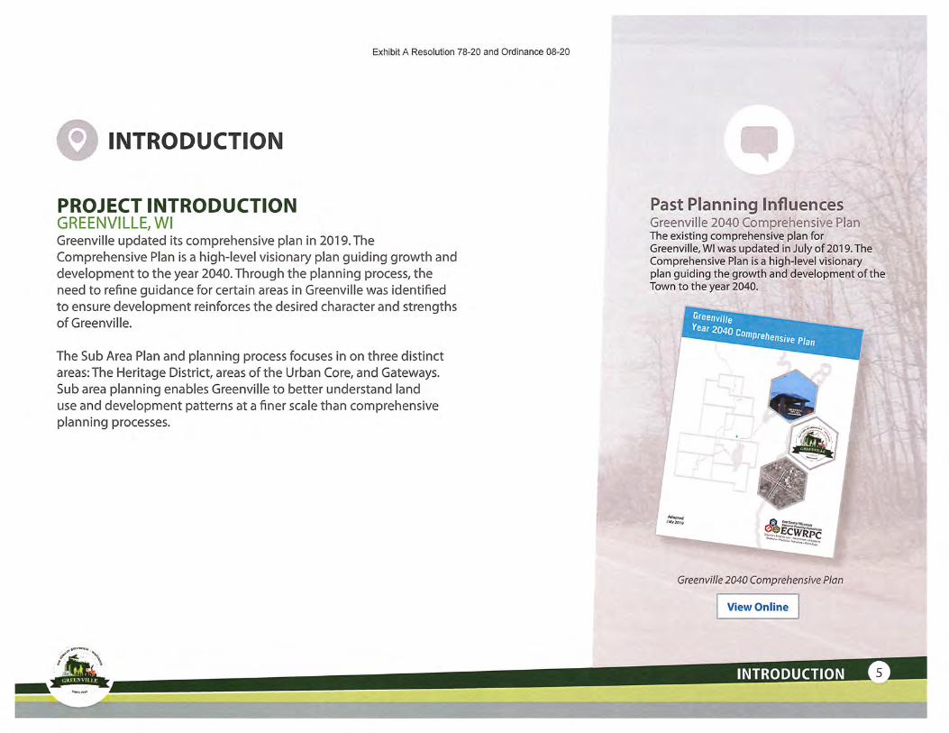
Exhibit A Resolution 78-20 and Ordinance 08-20
INTRODUCTION
PROJECT INTRODUCTIONGREENVILLE,WIGreenville updated its comprehensive plan in 2019. TheComprehensive Plan is a high-level visionary plan guiding growth and
development to the year 2040. Through the planning process, theneed to refine guidance for certain areas in Greenville was identified
to ensure development reinforces the desired character and strengths
ofGreenville.
The Sub Area Plan and planning process focuses in on three distinct
areas: The Heritage District, areas of the Urban Core, and Gateways.Sub area planning enables Greenville to better understand land
use and development patterns at a finer scale than comprehensive
planning processes.
Past Planning InfluencesGreenville 2040 Comprehensive PlanThe existing comprehensive plan forGreenville,WI was updated in July of 2019. TheComprehensive Plan is a high-level visionaryplan guiding the growth and development of theTown to the year 2040.
SreenvUie
.^240c^e^
^II^C
Greenville 2040 Comprehensive Plan
View Online

Exhibit A Resolution 78-20 and Ordinance 08-20
Map 2-1Year 2040 Land Use
Future Land Use District (applicable zoning)
Suburban Residential - Tier 1(R-1,R-2,R-3,NC,INST,OS)
Limited Service Residential -Tier II(R-1/Rural/Consereation, INST, OS)
Agricultural-Tier 111(AED, AGD, INST, OS)Open Space & Natural Resource(INST, OS)Industrial/Employment(R-3, BP, IND, INST, OS)
Airport(Airport)Mobile Home(MH)Heritage Overlay(R-1, R-2, R-3, GO, Heritage)
Urban Overlay(R-3, GC, CP, INST, UCO)
Gateway
^ potential Roundabout
-—-— Private Road
Local Road
County Highway
State Highway
Officially Mapped Road
—•—— Future Road
Airport Boundary•iniuri,
I • Greenvllle Boundary<nrnrr:
I Municipality
See Framing Concept 4b:A District Approach for detailed
description of each DistrictSource: Transportation, Boundaries. - Outagamie County, 2018; Natural ResDureaAreas -ECVURPC, 2010; Officially Mapped t Future Roads. Future Land Use Districts, Overlay &
Datriets-GreenvalB,2019hlp.rcdM.y3. 2019 By;
map pwUf data containing Beographk: Wamiatton about V WG8EOinvite, me data was o bo Intd flora'muUpleinufcoi and A F'°''
enctes. Gieern'ilB pttNkli-i thH Infiirraatlon w? On W-ff<3>fc- E ?!
WINNEBAGO COUNTl'.X
Figure 1.1 Greenville 2040 Land Use Plan
6 GREENVILLE, Wl SUB AREA PLAN

Exhibit A Resolution 78-20 and Ordinance 08-20
WHY PLAN?S PURPOSE OF THE MASTER PLAN
Without a plan, development is left simply to market forces and to chance. This often results in underutilized land and development or missed
opportunities that a planning process would otherwise envision. Development entitlements can also be more cumbersome end costly whensimply relying on a high-level comprehensive plan and zoning regulations designed with a one size fits all approach. The master planning
process enables the community to explore development opportunities, patterns, and trends applicable to Greenville.
The master plan process enables opportunities for the community to engage in the generation of ideas. It creates opportunities to interpret andarticulate the broader vision of the Comprehensive Plan and to apply those ideas at the district or neighborhood level.
PROJECT PURPOSE, GOALS, AND DESIRED OUTCOMES
^ *Ensure sustainable andresilient land use and
dcve/opmenf patternsin areas where growthancf change is eitherexpected or desired.
Coordinate marketdriven land use
and developmentwith needed public
street, park, trail, andinfrastructure (storm
water, sanitary sewer,
potable waf-er, utilities)
investments.
Provide Guidance
and direction on thedesired character andform of developmentbased on the specific
district or place f'o
better inform policiesand regulations.
Provide a vision andp/an to facilitate the
type of growth desiredby Greenville and is
value added.
INTRODUCTION
Exhibit A Resolution 78-20 and Ordinance 08-20
Market AssessmentIdentifying Key Market PressuresA high level market assessment was prepared to understand the role Greenvilleplays in the Fox Valley region and to identify the key market pressures andopportunities with the potential to shape or influence growth in Greenville overthe next 5 to 10 years. The planning process recognizes the impact that theCOVID 19 pandemic has on development and the uncertainties created by thisunique circumstance. The plan also recognizes the heightened importance ofplanning in order to be resilient in the face of uncertain times.
*Full presentation available through theplanning department*
PLANNING PROCESSThe master plan process enables opportunities for
the community to engage with planning and community
development experts in the generation of ideas. It createsopportunities to interpret and articulate the broader vision
of the Comprehensive Plan and to apply those ideas at thedistrict or neighborhood level. The planning process for the
Greenville Sub Area Plans included three key phases:
^,"9"°"sinastoclt
'===?'"'.;nn^-"9'efami*y
.s^—r"*;55i^
Office - Existing
0
There is a little over 40k SF
of vacant space
- N434 Greenville Center
Last year absorbed 15.5k SF
1-1 II I.J !1.
UNDERSTAND:This phase of the process focused on
understanding the physical and socio/economic context ofGreenville.This
includes:
• The natural environment (wetlands,
topography, streams/waterways,habitat areas);
• The built environment (roads, buildings,
land uses and overall development
patterns);• Community and cultural systems
(utilities, stormwater management,parks/recreation, and history);
• Demographic patterns and trends; and
• Economic forces and opportunities.
8 GREENVILLE,WI SUB AREA PLAN

Exhibit A Resolution 78-20 and Ordinance 08-20
,.lf^'
EXPLORE:Building off of a strong understanding of the community and
a foundation established through the comprehensive plan and
early stakeholder engagement, the consulting team exploreda number of ideas and concepts addressing the barriers,
challenges, and opportunities of each planning area. Theseconcepts explored land use and development patterns, park
and open space systems, roadway and trail connections, and
community development opportunities. A second round ofcommunity engagement was used to vet and critique the ideas
offering opinions and suggestions on preferred elements of
each idea and concept.
r^-^-
c^-^—-^ t,. ,^"^<^'^_:^-te£^
£~T) -
, ; iy\
r; ^<] K".-^.~-\^ }\ \
-\ (^^.-<-. L-f^'''
! ^"-.
\ ^
\.-
?,,. ^^ \ ?
^-^SjK^•'^':^\^''^:i^'ii ^.r'"- -. '. ^^^ ^^T'
^i^"';^''f "'»;-'* '
'. ^•.'.^
\^^.*• f'-^'.."
'• t^<~',
'. ^"^..,<•*"
^ "•' ,^
g I CONVERGE AND PREPARE PLAN:The concepts and ideas were then brought together into a
preferred plan direction and the master plan was prepared.
> .^y^'~"-:
.ifrrf?'!?S'SS
~>{ -./»»]"A-;
ir7W'5^(jiu^^l^tt^. ._„ __i— ^
Design Process Graphics
INTRODUCTION

Exhibit A Resolution 78-20 and Ordinance 08-20
Project Summary
TttcHcritBgtDiaO'iCt ''•1;-;; •:".^
fhfjilrfwnC'owDiBtnrT •-.'f,,-t-, .1
\—-,- • • - .: ..-•::-- •
fial-rwnp.' -T(. .-r,;f .••; -r- --•- •• .-.
>® •
provided to show commundy context only
ENGAGEMENT PROCESS AND OVERVIEW
The following pages include a general overview of feedback received during
phase one of the community engagement process. A full list of all comments receivedcan be found in a separate document that is available by contacting the Greenville
Planning Commission. The summary data for phase 2 is comprehensive and includes all
map comments and feedback received from stakeholders.
PHASE I COMMUNITY ENGAGEMENTFor the first phase of the community engagement process, an online virtual projectlanding page was created that provided visitors with a project overview, background
documents, and future dates and links to other engagement opportunities.Two ways that stakeholders could participate and leave feedback included an interactive
map that asked guests to drop pins to identify areas they enjoyed in Greenville, or areas
that could use work. A survey option was also offered with open-ended questions for
more detailed comments and to collect demographic information.
PHASE 2 COMMUNITY ENGAGEMENTThe second phase of community engagement featured an innovative virtual openhouse with step-by-step video guidance from the staff and consulting team telling the
story behind the designs and planning decisions. An interactive map feature with built-
in surveys where stakeholders could leave feedback on the draft concepts for each of
the three sub area plans as well as accompanying precedent imagery was linked to the
landing page. Open house boards, draft concept materials, and market snapshot reportsere available to download to help guests follow along with presentations.
Virtual open house content
10 GREENVILLE, Wl SUB AREA PLAN
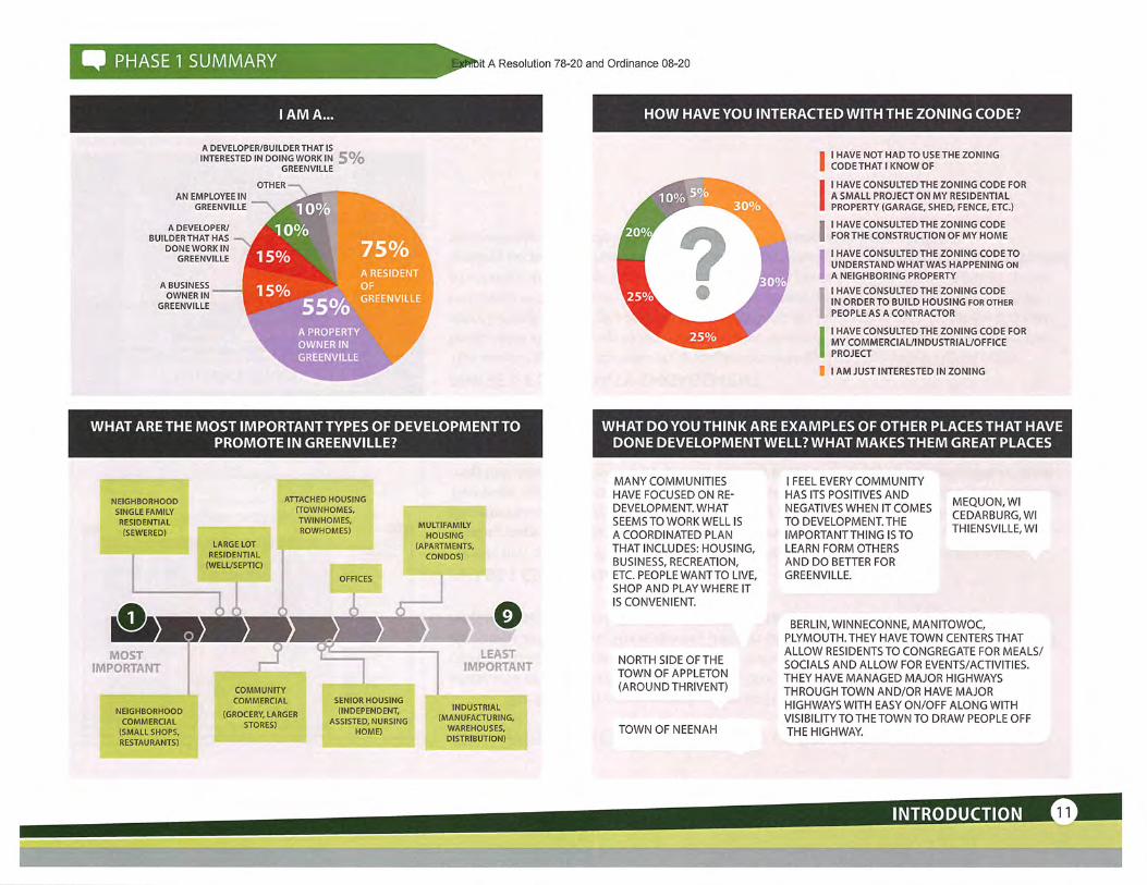
PHASE 1 SUMMARY Sit A Resolution 78-20 and Ordinance 08-20
A DEVELOPER/BUILDER THAT ISINTERESTED IN DOING WORK IN 5%
GREENVILLE
OTHER —AN EMPLOYEE IN
GREENVILLE
A DEVELOPER/BUILDER THAT HAS —
DONE WORK INGREENVILLE
A BUSINESSOWNER IN
GREENVILLE
'10°^
10%75^A RESIDENT'OF:".-' ••'.<,":
GRfiENVILLE'
HOW HAVE YOU INTERACTED WITH THE ZONING CODE?
I HAVE NOT HAD TO USE THE ZONINGCODE THAT I KNOW OF
I HAVE CONSULTED THE ZONING CODE FORA SMALL PROJECT ON MY RESIDENTIALPROPERTY (GARAGE, SHED, FENCE, ETC.)
I HAVE CONSULTED THE ZONING CODEFOR THE CONSTRUCTION OF MY HOME
I HAVE CONSULTED THE ZONING CODE TOUNDERSTAND WHATWAS HAPPENING ONA NEIGHBORING PROPERTYI HAVE CONSULTED THE ZONING CODEIN ORDER TO BUILD HOUSING FOR OTHERPEOPLE AS A CONTRACTOR
I HAVE CONSULTED THE ZONING CODE FORMY COMMERCIAL/INDUSTRIAL/OFFICEPROJECT
B I AM JUST INTERESTED IN ZONING
WHAT ARE THE MOST IMPORTANT TYPES OF DEVELOPMENT TOPROMOTE IN GREENVILLE?
WHAT DO YOU THINK ARE EXAMPLES OF OTHER PLACES THAT HAVEDONE DEVELOPMENT WELL? WHAT MAKES THEM GREAT PLACES
NEIGHBORHOODSINGLE FAMILY
RESIDENTIAL(SEWERED)
LARGE LOTRESIDENTIAL
(WELL/SEPTIC)
ATTACHED HOUSING(TOWNHOMES,TWINHOMES,ROWHOMES)
OFFICES
MULTIFAMILYHOUSING
(APARTMENTS,CONDOS)
0
NEIGHBORHOODCOMMERCIAL
(SMALL SHOPS,RESTAURANTS)
COMMUNITYCOMMERCIAL
(GROCERY, LARGERSTORES)
SENIOR HOUSING(INDEPENDENT,
ASSISTED, NURSINGHOME)
INDUSTRIAL(MANUFACTURING,
WAREHOUSES,DISTRIBUTION)
MANY COMMUNITIESHAVE FOCUSED ON RE-DEVELOPMENT. WHATSEEMS TO WORK WELL ISA COORDINATED PLANTHAT INCLUDES: HOUSING,BUSINESS, RECREATION,ETC. PEOPLE WANTTO LIVE,SHOP AND PLAY WHERE ITIS CONVENIENT.
NORTH SIDE OF THETOWN OF APPLETON(AROUNDTHRIVENT)
TOWNOFNEENAH
I FEEL EVERY COMMUNITYHAS ITS POSITIVES ANDNEGCTVESWHEN'ITCOMES MpES;^\TODEVELOPMENT.'THi'"" $ED,A,RBURG'WI,IMPORTANTTHING IS TO THIENSVILLE, WlLEARN FORM OTHERSAND DO BETTER FORGREENVILLE.
BERLIN, WINNECONNE, MANITOWOC,PLYMOUTH.THEY HAVE TOWN CENTERS THATALLOW RESIDENTS TO CONGREGATE FOR MEALS/SOCIALS AND ALLOW FOR EVENTS/ACTIVITIES.THEY HAVE MANAGED MAJOR HIGHWAYSTHROUGH TOWN AND/OR HAVE MAJORHIGHWAYS WITH EASY ON/OFF ALONG WITHVISIBILITYTOTHETOWN TO DRAW PEOPLE OFFTHE HIGHWAY.
INTRODUCTION

Exhibit A Resolution 78-20 and Ordinance 08-20
GREENVILLE'S HERITAGE OVERLAY AREA CONSISTS OF THEPROPERTY AROUND THE INTERSECTION OF HIGHWAYS 15 AND
76. IT IS CONSIDERED THE"TOWN CENTER"OF GREENVILLE.WHATSHOULD THIS AREA LOOK LIKE IN THE FUTURE?
ITWOULD BE LOOKED ATASTHE"HUB"OF THE COMMUNITY. THERE IS ALREADYTHAT FEEL WITH THE PARKS, MUNICIPALSERVICES AND SOME BUSINESSES.THERE IS NEED FOR MORE BUSINESSESWITH A VARIETY OF OFFERINGS.
MIXED USE DEVELOPMENT WITHMASONRY FRONT BUILDINGS.NEIGHBORHOOD COMMERCIALDEVELOPMENTTHAT OFFERS AVARIETY OF REASONS TO COME TOOR BE IN GREENVILLE.
ITWOULDBENICETOSEETHIS AREA KEPT WITH ASMALL TOWN FEEL. NOTOVERCROWDED OR OVERCOMMERCIAL, A NICE SMALLTOWN MIX LOCAL BUSINESSESSINGLE FAMILY HOMES
MORE SMALL SHOPSWOULD BE EXCELLENTTHERE. ITWOULDALSO BE AWESOMEIF WE HAD OUR OWNLIBRARY IN THAT AREA.
NEW ORREFURBISHEDBUILDING.SIDEWALKS.RESTAURANTSAND OTHERRETAIL.
GREENVILLE'SURBAN CORE OVERLAY AREA CONSISTS OF THE MAINCORRIDORS IN TOWN. WHAT SHOULD THESE CORRIDORS LOOK
LIKE IN THE FUTURE?
A BALANCED MIX OF USES ANDDEVELOPMENTTHAT IS VISUALLYSIGNIFICANT. I'M NOT SUREWHATTHEVISUAL SHOULD BE, BUT SOMETHINGTHAT PEOPLE CAN IDENTIFY ISGREENVILLE AND IS CONSISTENTTHROUGHOUTTHE CORRIDORS WHETHERIT BE IN THE FORM OF ARCHITECTURE,SIGNAGE,LANDSCAPING/STREETSCAPINGTO NAME A FEW.
EAST OF 76 SHOULD BEMAINLY BUSINESS, INDUSTRIAL,COMMERCIAL, OFFICE, SMALLSHOPS, AND RESTAURANT BARS.TRAFFIC, AIRPORT OVERLAY,EXISTING DEVELOPMENTWOULDMAKE MUCH A POOR CHOICE FORRESIDENTIAL.
BICYCLE TRAILS ALONGSIDE ALLOF THE WOULD BE BENEFICIALAND BE SAFER FOR WALKERSAND BICYCLISTS.
SAFETY IS KEY TO MAKESURE VEHICLE ANDPEDESTRIAN AND BIKETRAFFIC CAN COEXIST.
GREENVILLE'S GATEWAY AREAS CONSIST OF THE MAIN ENTRANCESINTO TOWN. THEY ARE THE FIRSTTHING TO WELCOME PEOPLE INTOTHE COMMUNITY. WHAT SHOULD THESE AREAS LOOK LIKE IN THE
FUTURE?
WHAT IS YOUR BEST IDEA FORTHE FUTURE DEVELOPMENT OFGREENVILLE?
THIS IS A CHALLENGE FOR ME. ITHINKTHESEENTRIES NEEDTO GIVE THE CHARACTER OF THETOWN-ISTHE GREEN BELT A KEY EMPHASIS?THEN HAVE THAT AS AN ENTRYTHEME ONTHE CLOSEST GATEWAY ROAD. IS THERE KEYHERITAGETO EMPHASIZE, MAYBETHAT ISTHEDESIGN TO THE CLOSEST GATEWAY NEAR THOSEFEATURES. ARETHERE KEY ACCOMPLISHMENTS(SPORTS, FAMOUS RESIDENTS, KEY HISTORICALEVENTS)? MAYBE THAT IS DESIGNED INTOANOTHER OF THE GATEWAYS.
COMMERCIAL BUSINESSPARKS THAT BROADCASTTHE ENTRANCE POINTS OFGREENVILLE. PEOPLE NEEDTO KNOW JUST BY LOOKINGATTHE BUILDINGS THEY AREENTERING GREENVILLE.
MORE PROMINENT SIGNSWITH NICE LANDSCAPING-FLOWERS AROUND THE BASEOFTHE SIGNS WOULD BE MYPREFERENCE.
I THINK GREEN SPACE AND AGRICULTURE MUST BEPRESERVED AND CULTIVATED. ITHINKTHERE NEEDSTO BE A DOWNTOWN TARGET DEFINED AND THANFOCUSED PLANNING AND ACTION TO ACHIEVE. WEALSO NEED TO UNDERSTAND THE GROWTH PLANSOF BOUNDARY NEIGHBORS SO THERE IS SYNERGYALONG WITH UNIQUENESS FOR EACH.
KEEP A RURAL FEEL -ESPECIALLY IN THE FACE OFURBAN SPRAWL AND LOSINGFARMLAND.
CONTINUE TO PRESERVE THEHERITAGE WHILE BUILDINGFORTHEFUTURE.
FOCUS ON AREASTHAT HAVETHE GREATESTPOTENTIAL FORDEVELOPMENT/REDEVELOPMENT.
BIKE/WALKING PATHSCONNECTING ALLNEIGHBORHOODS. MAKEGREENVILLEAPLACEWHERE OUTDOORPHYSICAL ACTIVITY ISREVERED.
EMPHASIS ONSAFETY ESPECIALLYON ROADWAYS ANDCONTINUATIONOF PROVIDINGOPPORTUNITIES TOWALK/BIKE THROUGHOUTTHE COMMUNITY.
12 GREENVILLE,WI SUB AREA PLAN

Exhibit A Resolution 78-20 and Ordinance 08-20
KEY WORDS USED
familiesg recreational
dreams stretch S: g (0
"^property water intersection |' 5 spee g
Iin
currently
,-s u-f
EH; in (0
n»
<:0
ft
^ ^Hft cross
ln¥ilie|i±g jspeed
ffl <? board
•5
3 Ijulius(D school
3(p6
corridor
w
IB'
INVOLVEMENT SUMMARY
8.5%-
SPOTS YOU ENTER GREENVILLE(GATEWAYS)
8.5%SOMETHING I LIKE!
COMMENTS, IDEAS,AND SUGGESTIONS
43541363
BHma
^^^^^^iwWi^»^i»^»[^^^"^^*^«™"a™™""B^""™™""
If^^?^'?;.:^ ';^ ••: •i.i.ytejfi.K;";...;,;!^'..:^ ;^, ..-^, . '
a]3J2i^g|gg®f!Sj^^^^!^^V^.'^-^^^ '•» ^t"^'?; -''"* ^.I '''•^^^^iSSS^^^^M^^^^^^"jfg^;^^^'^^^^;"- ^
^;B^?15^2Ji&A^J?^:^ •-• ^ ^•:
SOMETHINGILIKE!
SPOTS IN NEEDOF HELP!
SPOTS YOU ENTERGREENVILLE(GATEWAYS)
COMMENTS, IDEAS,AND SUGGESTIONS
VISIT THE SOCMt. PINPOINT WEBSITE70 EXPLORE MORE COMMENTS
lA "THE HERITAGE AREA'REALLY HAS A LOTOF POTENTIAL FORDEVELOPMENT/REDEVELOPMENT. I SEE THISAS A GREAT PLACETO BRINGPEOPLE TOGFTHER. YOUHAVE CIVIC, COMMERCEAND RECREATIONAL USESALL IN THE SAME PLACE,LET'S:MAKETHEM WORKTOGETHER!"
"THE SOUTH GREENVILLE GRANGEHALL IS ON THE NATIONAL REGISTEROF HISTORIC PLACES AND IS AGREAT PLACETO HOLD SPECIALEVENTS".
"GREAT PARK AREA WITH A VARIETY OFTHINGS TO DO AND GOOD LINKAGETOOTHER RECREATIONAL AREAS. AGREATCORETO WORK FROM IN TERMS OF NONMOTORIZED MOBILITY."
"BETWEEN SCHOOL RD &WISCONSIN AVE ON JULIUSRD THEY NEED A BIKE LANEAND THE SPEED LIMITSHOULD BE DROPPED TO35 MPH OR LOWER. THEAMOUNTOF CARS THAT GO.OVER 55MPH EACH DAY ISA DANGER WITH A SCHOOL:NEARBY AND CYCLIST/RUNNERS HAVE NO PLACETOACGESS THIS SECTIONSAFETY."
"DEVELOP WESTERN STH 15
URBAN CORRIDORCOMMERCIAL DISTRICT.REQUEST EXTENSION OFWATER/SEWER SERVICEAREA TO AID IN PROMOTIONOF DEVELOPMENT".
"FIX THE BUMPS FROM THERAISED DRAINAGETUBESBEFORE IT RUINED ALLOF OUR VEHICLES, ANDTHE.POT HOLES! BETTERYET, PUT IN CURB & SEWERTHEN REPAVE!PLEASE &THANKYOU".
"WE.REAU.Y NEEDTO HAVEALOCATIONTOBEGINSTORING BITS AND PIECESOF GREENVILLE'S HISTORY.I WISHTHETOWN BOARD'COULD DESIGNATE A
•BUILDING ORSPACEWHEREA HISTORY MUSEUM.COULD BE SET UP. IDEALLY,IT WOULD HAVE MAYBEBEENAGOODIDEATOSUGGESTTHATA SPECIALAREA/ROOMWITHINTHENEW FIRE STATION BEBUILT".
INTRODUCTION

PHASE 2 SUMMARY lit A Resolution 78-20 and Ordinance 08-20
WHICH OFTHE ABOVE IMAGES BEST REPRESENT THE GENERALDEVELOPMENT CHARACTER YOU WOULD LIKE TO SEE IN THE
HERITAGE DISTRICT? SELECT ALL THAT APPLY.
IMAGE 5
IMAGE 4
IMAGES
K"I;*i;iSi''';'?Rl IMAGE 2
IMAGE 1
WHICH OFTHE ABOVE IMAGES BEST REPRESENT THE MIXED-USECHARACTER YOU WOULD LIKE TO SEE IN THE HERITAGE DISTRICT?
SELECT ALL THAT APPLY.
IMAGES
IMAGES
IMAGE 4
IMAGES
IMAGE 2
IMAGE 1
14 GREENVILLE,WI SUB AREA PLAN
iffii

Exhibit A Resolution 78-20 and Ordinance 08-20
WHICH OF THE ABOVE IMAGES BEST REPRESENTTHE RETAIL/COIVIMERCIAL CHARACTER YOU WOULD LIKE TO SEE IN THE HERITAGE
DISTRICT? SELECT ALL THAT APPLY.
IMAGES
IMAGE 4
IMAGES
IMAGE 2
IMAGE 1
WHICH OFTHE ABOVE IMAGES BEST REPRESENT THE RESIDENTIALCHARACTER YOU WOULD LIKE TO SEE IN THE HERITAGE DISTRICT?
SELECT ALL THAT APPLY.
IMAGE 7
IMAGE 6
IMAGE 5
IMAGE 4
IMAGES
IMAGE 2
IMAGE 1
HfGH DENSITY RESfDENTfAL
MEDIUM DENSITY RESIDENTIAL - TOWNHOME,ROWHOUSE
VILLAS/DUPLEXES
INTRODUCTION

Exhibit A Resolution 78-20 and Ordinance 08-20
WHICH OF THE ABOVE IMAGES BEST REPRESENTTHE GATEWAYCHARACTERISTICS YOU WOULD LIKE TO SEE IN THE HERITAGE
DISTRICT? SELECT ALL THAT APPLY.
IMAGES
IMAGE 4
IMAGE 3
IMAGE 2
IMAGE 1
"I THINK THE WAGESOVERALL DEPICTS A MICEAESTHEHC 7-BOUGH iTHWKWHATEVER 15 CHOSENSHOULD HAVE SOMECHARACTERISTICS TMATPROWDE CONmHUlTY;
Planted Medians
Landscape Boulevards/Screening Landscape Boulevards/Screenings
"Bridge" Elements - Bear Creek Plazas + Lighting Features
16 GREENVILLE,WI SUB AREA PLAN

Exhibit A Resolution 78-20 and Ordinance 08-20
WHICH OF THE ABOVE IMAGES BEST REPRESENT THE BUSINESSPARK CHARACTER YOU WOULD LIKE TO SEE IN THE EAST INDUSTRIAL
AREA? SELECT ALL THAT APPLY.
IMAGE 6
IMAGES
IMAGE 4
IMAGES
IMAGE 2
IMAGE 1
WHICH OFTHE ABOVE IMAGES BEST REPRESENT THE CHARACTERFOR SUPPORTING SERVICES THATYOU WOULD LIKE TO SEE IN THE
EAST INDUSTRIAL AREA? SELECT ALL THAT APPLY.
IMAGES
IMAGE 2
IMAGE 1
WAREHOUSE / DISTRIBUTfON
12;
SMALL OFFICEHEADQUARTERSTECH/FLEX ; LIGHT INDUSTRIAL
OFFICE CONDOS SUPPORTING RETAIL
INTRODUCTION

Exhibit A Resolution 78-20 and Ordinance 08-20
WHICH OF THE ABOVE IMAGES BEST REPRESENTS THE AMENITIESAND STREETSCAPE CHARACTERYOU WOULD LIKE TO SEE IN THE
EAST INDUSTRIAL AREA? SELECT ALL THAT APPLY.
IMAGE 4
IMAGE 3
IMAGE 2
IMAGE 1
"/ AM CONCERNED ABOUT THE AMOUNT OFPONDS. BEING CLOSE TO THE AIRPORT ANDTHE REQUIREMENTS NEEDED, NETTINGETC. ARE MANY SMALL PONDS CHEAPERTHAN A LARGER REG/ONAL POND?WHO MA/NTA/NS THE POND? TOWN ORPROPERTY OWNER? "
I NORTHWOODPINES
18 GREENVILLE,WI SUB AREA PLAN

Exhibit A Resolution 78-20 and Ordinance 08-20
INVOLVEMENT SUMMARY
I LIKE THIS
I DON'TLIKE THIS
HOWABOUTTHIS IDEA?
THISCONCERNSME
SURVEY RESPONSESilSSeS
AGRICULTURE HERITAGE &TOURISM SURVEY RESULTSWHAT IDEAS DO YOU HAVE TO HELP GREENVILLE CELEBRATE /TSAGRICULTURAL HER/TAGE?
This seems like it would be a good area to develop some kind ofmuseum or other historical use, just not sure where it would go.
^ HERITAGE MUSEUM
^ WINERY^BREWERY,AND DISTILLERYTOURS/TASTING
^f U-PICK OPERATIONS
RURAL BED ANDBREAKFASTS ANDFARM-STAYS
AGRICULTURALMUSEUMS
BREAKFAST/DINNER® ON'THEFARM
DEMONSTRATION^i FARMS
EVENT VENUES (BARNa WEDDINGS)
GARDEN AND BARNm TOURS
^ HAY RIDES
HOW DO YOU TH/NK GREENVfLLE SHOULD PURSUE IMPLEMENTINGANY OF THE fDEAS ABOVE?
Work with the existing farmers to come up with a plan. Seems
like there are a lot of opportunities to preserve the farmingheritage while continuing to farm the land.
INTRODUCTIONK^^

SOUTH OFHIGHWAY 15
Develop/ redevelopland south of High-
way 15 and north ofSpring Road with amix of a
and residential
Redevelop SpecialMfmories Zoo withexpanded park use
focusing on outdoor•nvir&nmenlal educa-
ion - potential nature'.(project partner
Refresh CcPark(based
• Reconfigure fields• Add a community
building. Add splash pad• ft&confignre parfc-
ing, bring it closertoitwfipMs
Exhibit A Resolution 78-20 and Ordinance 08-20
HERITAGE DISTRICT CONCEPT 1
I LIKE THIS I DISLIKE THIS HOWABOUTTHISIDEA? 9 THIS CONCERNS ME
."' •i^-lL • " ?Aa- ri r*1 ' ••' '± . ;»
-• '^^..^
^^».-^,v
s^/
Sit;-^:^>^
"^ ^ \^ J^^ Expliitered&velopment/JMensifi-y>* y cation on The west side of Highwa:
\, ')^,-< ^ 76 with mixed use, creating awalkable district focused nrou»d
;;/:j ^ [ ';'C<^^ the intersection of Parkview DriveU . T| and Highway 15
- -'\>?<*'."*'. •>'
lrf^^n_- .C^i^i
-^re- !vi^^-v~\ -" ' "', fi'si^
)i Develop a new Town Hail adjato the Fire Station .-'•;.
§833365^:mmi
Develop a mix of housing and t-i \ ^^." . , l,'^^-^retail on the public works site ...... - '<'Y/^
including small central green / '•1<^^ '"si^.,S":lplsza space oriented to Bear Creek ' /<Thk,- "^ /'natural amenity
NORTH OFHIGHWAY 15
Utilize conservationsubdiviiion designprincipfcsfonnfillresidential aroundBear Creek
development betweeiHighway 15 andParkview Drive
Create an open space/'nity neiwoft; devel-
oped along BMrCreck
Explore redevelopmentof three residentialproperties fronting onHighway 15, poTen-tialty integrating wilhShepherd of the HillsLutheran Church
# Votes
+1
Figure 13 Title
Comment
This sounds great. I love the idea of using natureto develop around, especially in an urban setting.This will be a unique opportunity for Greenvilleand create a lot of further economic development
opportunities.
Moving the Town Hall and redeveloping theexisting site is a great idea. With the new firestation, it only makes sense to consolidate
municipal services when possible. I also like theredevelopment concepts for the Public Workssite. Not sure where that should go, but it seemslike a much better use of the area.
Never thought about redeveloping this area, butif the site across the street is redeveloped, it onlymakes sense to have it match.
I like the teams idea about how this space couldbe used. It's a nice way to preserve green space
and provide some usability/recreation
It would be nice to have town buildings/facilitiesnear one another
I like that both sides of the hwy would providesimilar purpose and continuity and it would giveus a sense of a town center
Love the idea of making Special Memories intoan environmental education area. Return the
property to more of a natural state and promotenatural wildlife habitat.
Keeping green space here would be great.
# Votes
+1
Comment
Is the work that is being done on Greenwood Rd part of this planning process?I have concerns on the work being done on Greenwood Rd and would like toprovide my input. Where do I do that?
Why is a splash pad needed here if the plan is to put one in the field of dreams? Ithink one is sufficient.
# Votes Comment
Instead of more housing, is it possible this spacecould be used as permanent outdoor gatheringarea? Maybe a bandshell, location for markets/craft fairs/ smaller events and performances.
20 GREENVILLE,WI SUB AREA PLAN
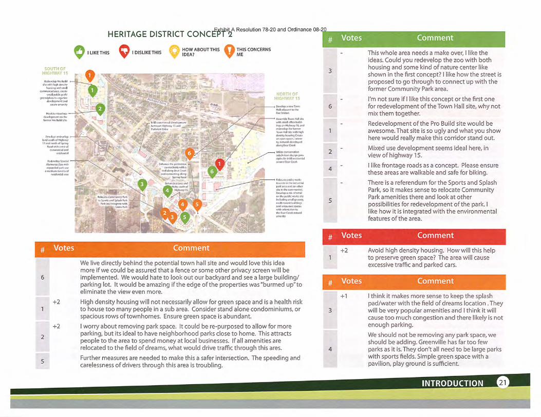
HERITAGE DISTRICT coNC^WResolution78-20andordinanceo8i
Q I UKETHIS Q 1 DISLIKETHIS ^ ^ABOUTTHIS Q ;THIS CONCERNSME
•^ .'•^^i.
'•^fW-
'•'•VKi
"•^fO-w/- '^^-^.--•^^:.^;
Develop n new Town
Hall adiacfint to theFltf Station
AswinhleTown Hall sireiffice buiid-
Ings on Highway 76, and
redevelop the tormcr
Town Halt site with highderxity ho us Ing Create
an open spncc/-imon-
ity nfttwptk diivftlnppd
along Re.ir Creek
v-m^^ff^y^'-/. ^'> .''^^^^ _W'
^^^•^^^^ ^^f^t: A '•'^.<v .-..-4 tnfill cDmmerciat dcvelopm
Redevelop SpecialMemories Zoo wilhevpanded park use
a medium density of
rMldentlfll uw.
Votes
+2
+2
Comment
We live directly behind the potential town hall site and would love this ideamore if we could be assured that a fence or some other privacy screen will be
implemented. We would hate to look out our backyard and see a large building/parking lot. It would be amazing if the edge of the properties was"burmed up"toeliminate the view even more.
High density housing will not necessarily allow for green space and is a health riskto house too many people in a sub area. Consider stand alone condominiums, or
spacious rows oftownhomes. Ensure green space is abundant.
I worry about removing park space. It could be re-purposed to allow for moreparking, but its ideal to have neighborhood parks close to home. This attractspeople to the area to spend money at local businesses. If all amenities are
relocated to the field of dreams, what would drive traffic through this ares.
Further measures are needed to make this a safer intersection. The speeding andcarelessness of drivers through this area is troubling.
"f^iwi^ y\,'
# Votes
2
4
# Votes
+2
Votes
+1
Comment
This whole area needs a make over, I like theideas. Could you redevelop the zoo with bothhousing and some kind of nature center likeshown in the first concept? I like how the street isproposed to go through to connect up with theformer Community Park area.
I'm not sure if I like this concept or the first onefor redevelopment of the Town Hall site, why notmix them together.
Redevelopment of the Pro Build site would beawesome. That site is so ugly and what you showhere would really make this corridor stand out.
Mixed use development seems ideal here, inview of highway 15.
I like frontage roads as a concept. Please ensure
these areas are walkable and safe for hiking.
There is a referendum for the Sports and SplashPark, so it makes sense to relocate CommunityPark amenities there and look at otherpossibilities for redevelopment of the park. Ilike how it is integrated with the environmentalfeatures of the area.
Comment
Avoid high density housing. How will this helpto preserve green space? The area will causeexcessive traffic and parked cars.
Comment
I think it makes more sense to keep the splashpad/water with the field ofdreams location .Theywill be very popular amenities and I think it willcause too much congestion and there likely is notenough parking.
We should not be removing any park space, weshould be adding. Greenville has far too fewparks as it is. They don't all need to be large parkswith sports fields. Simple green space with apavilion, play ground is sufficient.
INTRODUCTIONte-;^
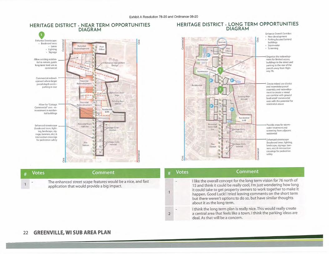
Exhibit A Resolution 78-20 and Ordinance 08-20
HERITAGE DISTRICT - NEAR TERM OPPORTUNITIESDIAGRAM
HERITAGE DISTRICT - LONG TERM OPPORTUNITIESDIAGRAM
Enhance Streetscape:Boulevard trees
Lanes• Lighting• Signage
Allow existing residen-tial to remain, guide
long-term land use ascommercial
Commercial redevel- hopment where larger
parcel depth exists -parking in rear
Allow for"CottageCommercial" uses - re-
investment in residen-
tial buildings
Enhanced streetscape(boulevard trees, light-
ing, landscape, sig-nage, banners, etc.) &
intersection crossingsfor pedestrian safety
ROL^I^•^',2^Stormwater
r1 ~^£Stormwater ,.;;
tage Cam-
mercla]
Enhance Overall Corridor:• New development• Parking located behind
buildingsStormwater
* Screening
-i Organize the redevelop-mentfor limited access,buildings to the street andparking to the rear of theparcels away from High-way 76.
"< Create mixed use districtand incentivise parcelassembly and redevelop-mentto create a mixeduse corridor with groundlevel retail/commercialuses with the potential forresidential above
Provide areas for storm-water treatment andscreening from adjacentresidential
Enhanced streetscape(boulevard trees, lighting,landscape, signage, ban-ners, etc.) & intersection
crossings for pedestriansafety
# Votes Comment
The enhanced street scape features would be a nice, and fastapplication that would provide a big impact.
Votes Comment
I like the overall concept for the long term vision for 76 north of15 and think it could be really cool, I'm just wondering how longit could take to get property owners to work together to make ithappen. Good Luck! I tried leaving comments on the short termbut there weren't options to do so, but have similar thoughtsabout it as the long term.
I think the long term plan is really nice. This would really createa central area that feels like a town. I think the parking ideas aredeal. As that will be a concern.
22 GREENVILLE,WI SUB AREA PLAN

Exhibit A Resolution 78-20 and Ordinance 08-20
SPORTS & SPLASH AND LIONSPARK SUMMARY
I LIKE THIS I DISLIKE THIS
HOW ABOUT THISIDEA? 9 THIS CONCERNS
ME
WITHOUT COMIV1UNITYPARK RELOCATED
• Option 1: Stay the course with previous plan(ittustrated on graphic)
^ Option 2: Integrate rural heritage museumwith working agriculture.
• Interpretive themes coufd include agtechniques, water quality, soil conser-vation
• Collaboration with local school district foroutdoor agricultural-related classrooms -work with Agri Business to utilize site fortest plots or other R&D
WITH COIV1MUNITYPARK RELOCATED
• Integrate program from Community Park-4little league fields, community center, splashpad, outdoor gathering area, skate park, bas-ketbatl courts, etc.
,,...<... -E^.^-"
,'" 'ii^E''''---fs- --..
# Votes Comment # Votes Comment
+1 There seems to be a disconnect with the farm in between the parksand potential development of this corridor. How does the farmplay a role here? I like the ideas of history and farming heritage butwhere would it go?
How about some restaurants, hotels and other typesof businesses at the corners of 76 & 96 that willcompliment Lions Park and the Sports Park?
INTRODUCTION

Exhibit A Resolution 78-20 and Ordinance 08-20
EAST INDUSTRIAL AREA CONCEPT 1
I LIKE THIS I DISLIKE THISHOWABOUTTHISIDEA? 9 THIS CONCERNS ME
ESS'GHD^iVETO*-!!':"'A'AYCT6
Extend and realign SchoolRoad east and connect with
Levi Drive for enhancedaccess and circulation to
desired commercial districtsouth of Highway 15
1:^Ip -1;—^
^yc.iS >r»j;n),!!,,' •
^^:.
/efop supponive commercfal&retail uses near round-s'bouts southof Highway 15 near round-a-bouts ,andCTH-CB
. j. Balance access management,desired light industrial site
^_ sizes (2ac to 5ac, with a smallpercentage up to 10acl and site
f drainage patterns lo shape land^» ^ ^_ development pattefns Tree pres-
^ {W ervafion for
c's."'""
^i-^H^I^.^IT='5''i?!B::-'7"':iT»i.*:;'~"T' ,&;,mm,?;.t^AK.-~i'^^j „ '1*_J.L.^'-- tfeatment-,'OT
exlsilng Indus-rriaFparh
:!t~?l<^iCreale on expanded storm-
, —>- water treatment irain system\"4tT integrating Mud Creek Hood
control, stormwater treatmentfor development, and creatingand celebrating an Identifiable
brand for the overall deve!-opment with expand&d trails,native pl anti ngs, stormwater
treatment and sustainability atthe forefront
.At;
»""••'*-•—-.'* --. Mud Creek
^s» «/"i/-
.y ^•dOrganize site development TO
push loading and service to the .:rear of the site and high quality ._-L—~architecture to front of The lot, . «^\
1 rk ing needs
!f-
'^
• K--
# Votes Comment
-1
'•IKHWF^' ''5 TO
DR3;<3MDRSVE
Explore long-term redevelop-ment and assemfafe of corn-mercial property at southwestquadrant of Highway 15 andMayflower Road
Oeate a dislrict stormwatertreatment amenity LO maximu?development and bring valueto adjacent commercial/ retail/restaurant development
UTilize large landtracts for largerfootprint users(warehouse/ dis-itlbulion/fulfill.
ment centers)
Extend DesignDrive east to May-flower Road fc^sed
on preferredalignment
-^GH'ifVAYS'?"0 COLSLS-3E
AVENUEtnfill industrial devel-opment between Com-munication Drive andMayflower Road
Votes
+1
# Votes
Some type of reconfiguration ofthe existing roads in that areashould be looked at. once schoolroad access was closed when
15 was built and developmentoccurred, existing configurationis outdated.
Connecting School Rd to Leviwould be great.
I like the proposed trailsystem and how the industrialdevelopment area looks moreorganic in design.
Comment
School has enough vehicle traffic.No need to extend for moretraffic.
School Rd is residential - Have thecommercial vehicles enter in from
HWY96.
Comment
Location of pond area shows
it fronting GV which is the onlyaccess area to this property. couldpond area be moved more to
the north and west along 15 toallow for potential developmentoffrontage. area has navigablestream and some wetlands any
uses may be somewhat tricky.
24 GREENVILLE, Wl SUB AREA PLAN
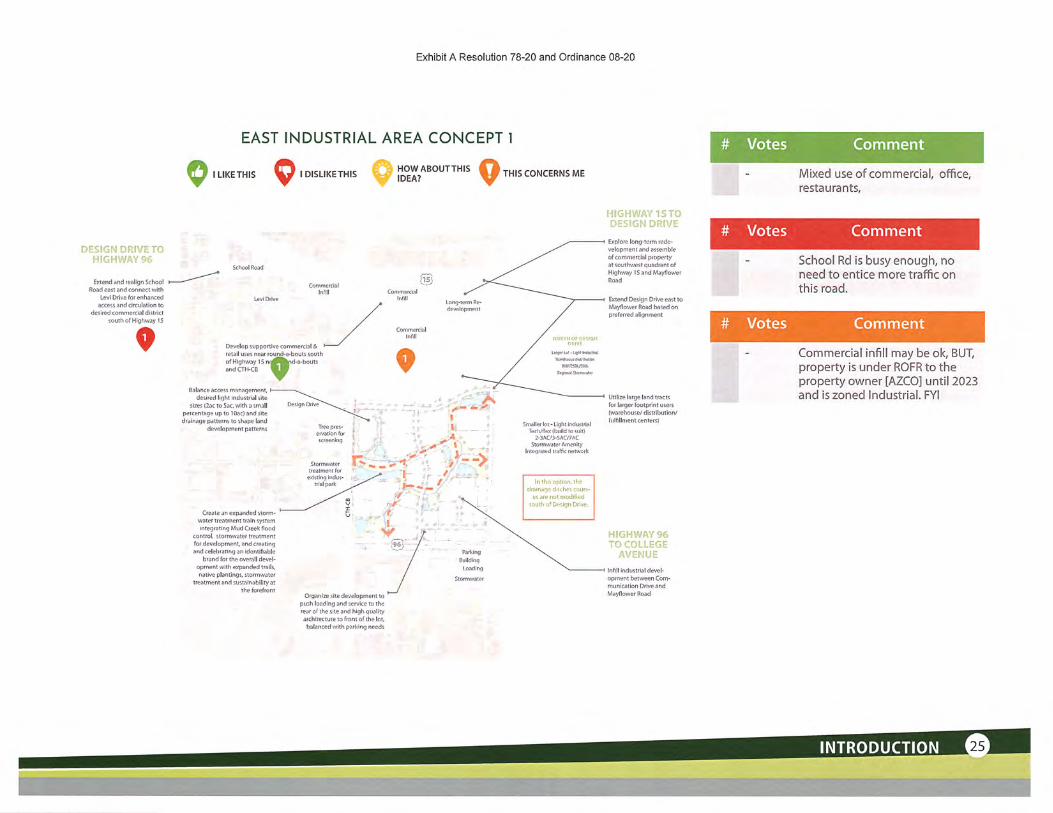
Exhibit A Resolution 78-20 and Ordinance 08-20
EAST INDUSTRIAL AREA CONCEPT 1 # Votes
I LIKE THIS I DISLIKE THIS HOWABOUTTHISIDEA? 9 THIS CONCERNS ME
Comment
Mixed use of commercial, office,
restaurants,
# Votes
Extend and reaiign SchoolRoad east and connect with
Levi Drive for enhancedaccess and circulation to
desired commerdai districtsouth ofHighway IS
levelop supportive commerdsl &etail uses near round-a-bouts southif Highway 15 n^a1d-a-bout5id CTH-CB
Balance access management,desired light industrial site
sizes l-ioc TO 5ac, with a smallpercentage up to lOac) and sitedrainage patTerns to shape land
dRvelopmeni parrerns
Create an expanded storm-water ueatmenT train systemintegraTing Mud Creek flood
control, stormwater treatmentfor development, and creatingand celebraTing an Identifiable
brand for the overall devel-opment with expanded trails,native planting;, stormwat&r
treatment and sustainabi!ity artheforefrum
Organize site development topush loading and service tu therear of the site and high qualityarchitecture to front of the lot,balanced with parking needs
Explore long-term rede-wlopment and assembleof commercial propertyat southwest quadrant ofHighway 15 and Mayflower
Road
Extend Design Drive east toMayflower Ftoad based onpreferred alignment
# Votes
Utilize large land tracts
for larger footprint users(warehouse/ distribution/fLilfillment centers)
Comment
School Rd is busy enough, noneed to entice more traffic onthis road.
Comment
Commercial infill may be ok, BUT,property is under ROFR to theproperty owner [AZCO] until 2023and is zoned Industrial. FYI
Inftll industrial devel-opment between Com-munication Drive andMayflower Road
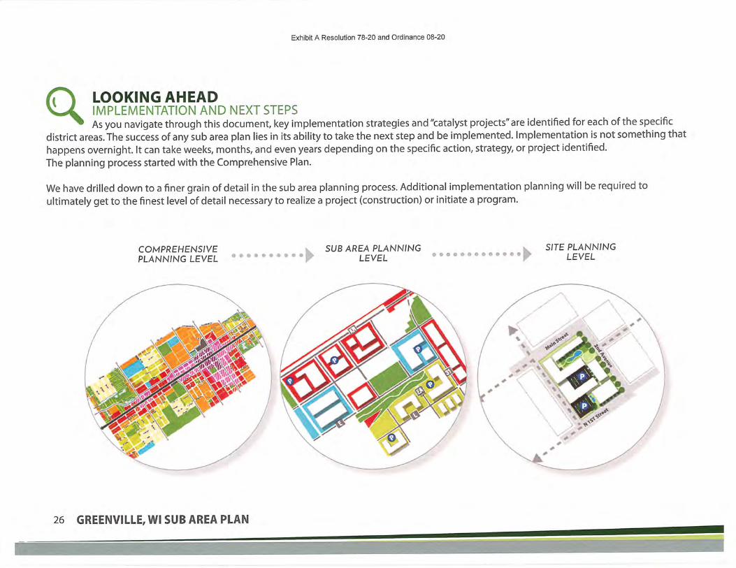
Exhibit A Resolution 78-20 and Ordinance 08-20
LOOKING AHEADIMPLEMENTATION AND NEXT STEPSAs you navigate through this document, key implementation strategies and "catalyst projects"are identified for each of the specific
district areas. The success of any sub area plan lies in its ability to take the next step and be implemented. Implementation is not something that
happens overnight. It can take weeks, months, and even years depending on the specific action, strategy, or project identified.
The planning process started with the Comprehensive Plan.
We have drilled down to a finer grain of detail in the sub area planning process. Additional implementation planning will be required to
ultimately get to the finest level of detail necessary to realize a project (construction) or initiate a program.
COMPREHENSJVE r\ SUB AREA PLANNINGPLANNING LEVEL "''^"^ooooo | > LEVEL oo"ooooooo<-oo I> SITE PLANNING
LEVEL
26 GREENVILLE/WI SUB AREA PLAN

IN GENERAL, PLAN IMPLEMENTATION WILL INCLUDE THE FOLLOWING:
Develop a strategy for assembling properties within targeted
redevelopment areas.
• Public acquisition and assembly - identify a funding source
and agree on an interim strategy as properties are acquiredand await willing sellers in order to assemble enough lands
to facilitate a project.• Broker / facilitate the process by finding a developer best
qualified and capable of assembling parcels for a longer-
term project. They become the master developer and
Greenville simply plays the role of facilitator.
Explore and understand all the financial tools available to
Greenvilleto implement redevelopment:
create the financial toolbox
Prepare a district identity'brand'to officially name the
Heritage District area by establishing a unifying brand.
Coordinate and promote development opportunities toprospective developers who have the qualifications andcapacity to do the kind of development envisioned in the sub
area plan.
Develop a regional stormwater management strategy.
Prepare design sets for key street improvements as outlined in
sub area plans:• Highway 15 and Parkview Drive - complete street design
concept - access management - street furniture
• East Industrial Park internal street network, School Roadconnection
Update Greenville Community Park concept and integrate
with potential zoo redevelopment.
Design and install gateway monument signs and district
3 identifier signs and form a partnership with WDOT to explore
options for installing enhanced community gateway signage
at key entrances to the community (along Highways 15 and
76).
Historical Society/AgriHistory museum. The idea of having
^ a more substantial presence and location to tell the
story of how Greenville has evolved has been a common
theme expressed through the planning process. Thiscould take multiple forms including a museum in its own
dedicated building or in a space within an existing building.It could be expressed through historical monuments or
plaques strategically located throughout the community
or integrated into development. Such a strategy could be
used to emphasize the historical importance of agriculture
and educate the community on the importance of landpreservation and agriculture in the future.
• More information on this strategy can be found in the
Heritage District Plan and the Lions Park/Sports & SplashPad Park District Plan.
INTRODUCTION

Exhibit A Resolution 78-20 and Ordinance 08-20
This page Intentionally Left Blank
28 GREENVILLE,WI SUB AREA PLAN

Exhibit A Resolution 78-20 and Ordinance 08-20
BACKGROUND INFORMATION& PROJECT INFLUENCES
COMPREHENSIVE PLAN AND ZONINGDIRECTIONSCOMPREHENSIVE PLANGreenville prepared the 2040 Comprehensive Plan (adopted July of 2019) toguide future growth within the community for the next 20 years. The plan
provides the approaches for land use, economic development, housing,
transportation, utilities, community facilities, agricultural resources, naturaland cultural resources, and intergovernmental cooperation. Within the plan's
framework, there are 28 framing concepts, ranging from sustainability toaddressing the housing/jobs mismatch.
The sub area plans in this report are an outcome of the findings from the
Comprehensive Plan. They also reflect the directions laid out in the plan for a
stronger, more resilient, and better Greenville.
ZONINGZoning is the tool by which cities manage the land uses and development
that occurs in a community. Greenville uses this ordinance to guide the way
land is used in order to protect the public safety, health, and general welfare
ofGreenville and its residents. The zoning code is in the process of beingupdated concurrently with these sub area plans so the directions in the plans
and the code align.
The zoning code identifies areas for different land uses and what is allowed to
occur in specific locations. The code specifies additional standards for certain
areas in Greenville, particularly along the major corridors, and in the "HeritageDistrict" at the intersection of Highways 15 and 76.
JEBAGO COUNTS
Suburban Resl(R-1,R-2,R^,Limited Setvlce I(R-l/RuralCons
Agricullural-Tii(AED, AGD, INSOpen Space S, I[INST. OS)
(applicable zoning)
inual-Tien:, INST, OS)
ervation. INST. OS)'IllT. OS)
TownofClaytan
hdustriaffimpbyment(R-3, BP. )ND, INST, 05)Alfpart(Airport)
CZlK;""""Heritage Overlay(R-1,R-2,R-3,GC. Heritage)Urban Overlay(R-3, GC. CP, IN5T, UCO)
•A-
• Potential Roundabout
Prh/ate Road
Local Road
County HighwayQi_!C::3.
ofFox.Crossing-I'--,
Stale Highway
Officially Mapped Road .
Future Road
Aiiport Boundary
Greenvttle Boundary
Municipality
Greenville 2040 Future Land Use Plan
BACKGROUND INFORMATION
;'\"-^'7^^r^^;'"^^u3!^^'^^sa^~"K^^• :.;S;;^,^^^^^B^^.:g^3^^/S;?;^;'::^^^.;^;.^:kl*^

p FOCUS AREA CONTEXT Exhibit A Resolution 78-20 and Ordinance 08-20
HERITAGE DISTRICTThe Heritage District encompasses the area centered around Highway 15 and Highway 76. This is the major crossroads in
Greenville and is the traditional center of Greenville. While Greenville does not have a typical "downtown" setting, this area
has a collection of some of the oldest homes and businesses in the community.
The area currently consists of a mix of uses, from single family residential to office, service, and retail. It is also the site of a
number of civic buildings, including Town Hall, the Public Safety Building, the new Fire Hall, and Greenville's main Public Works site.
Greenville Community Park and Jennerjohn Park provide greenspace and recreation opportunities on both the north and southsides of Highway 15.
Greenville has grown, and Highway 76 now handles significantly more traffic volume than it has historically. The developmentpattern of single family homes with driveways on to Highway 76 may be in conflict with the speeds and/or volumes on the road
today. Looking to the future, opportunities remain for development and redevelopment within the Heritage District. Smaller sites
along Highway 76 and along Parkview Drive provide openings for infill. The Special Memories Zoo next to Greenville CommunityPark has recently become available for redevelopment as well. As the civic uses shuffle additional opportunities may also become
apparent.
lUUl!
EAST INDUSTRIAL PARKThe East Industrial Park is the major employment center in Greenville. The park hosts nearly 4,000 jobs and most ofGreenville's 2 million square feet of industrial buildings. The Fox Valley isa strong industrial region as a whole, and Greenville
is a particularly strong industrial area within that region. The East Industrial Park benefits from easy access to Interstate 41 via
Highway 15 and proximity to the Appleton International Airport.
The typical development pattern is industrial buildings, mostly between 1 0-20,000 square feet, and typically built-to-suit and owneroccupied. There are a handful of larger buildings in sizes up to 300,000 square feet. As the industrial park to the west of County
Road CB has filled up, new development is starting to occur on the east side of the road, including a newly constructed Amazon
distribution center. The strength of the industrial sector in the region suggests that the area will continue to see new development.
30 GREENVILLE,WI SUB AREA PLAN

Exhibit A Resolution 78-20 and Ordinance 08-20
ALIONS PARK AND SPORTS & SPLASH PARK DISTRICTIn the northwest corner of Highways 76 and 96, Greenville owns twosubstantial pieces of land: Greenville Lions Park and Greenville Sports and
Splash Park. The development of both facilities is in process. As the parks are
further developed, additional development is likely to follow. Greenville Lions
Park is a 57 acre park for family recreation with a Wisconsin Agriculture theme.
The park hosts events such as a concert series and large family gatherings, as wellas providing individual recreation options such as a playground and open play
areas. There is a wooded area, restored prairie, and a marsh pond for people whodesire a natural outdoor experience.
Greenville Sports and Splash Park is an emerging facility, following a master
plan for a regional scale facility that will serve both the residents of Greenville,
as well as guests playing in tournaments. The facility will have rectangle fields(soccer, football, lacrosse) and diamond ballfields (softball, baseball). Water-
based recreation facilities such as a man-made swimming pond, splash pad,and
bathhouse will create a unique destination within the Fox Valley region. Parking,
trails, and restored prairie will add to the park user experience.
^'>!l"ev
^!|<eijitag<^i®^i^i\'y^-IJs-;;£^^'
LioftsParhfalttiSports ^Rtagr '^../-
Gateways^"•»• °'^R"in»
Focus Area Locations
GATEWAYS AND CORRIDORSWhen people travel to and through Greenville, the entries to the community and the major corridors shape the
perceptions and understanding of Greenville. Today, the corridors are a mix of uses, ranging from developed residential
and industrial districts to farmland. Development is primarily focused on the eastern half of the community. As one movesto the west and northwest, the corridors become much more rural in character. These corridors offer the visibility that is
necessary for retail and the highway access that is vital for industry. The access on and off of these roads is carefully managedto improve safety and efficiency of travel.
Gateways into Greenville are also varied. Some locations have the regional signs that mirror Greenville's neighboring communities,
other locations do not have any signage. Many people traveling across Greenville's eastern border identify the roundabout at
Highway 15 and County Road CB as the "gateway" experience, even if the actual boundary sits half a mile to the east.
BACKGROUND INFORMATION

Exhibit A Resolution 78-20 and Ordinance 08-20
»• /^.^fc.^
L- ISSUES AND OPPORTUNITIES
HuialStntdlWKoffmfliawi taMwfriteni/fymmmcn'jtaf
(dealerships lambcape, stcfoge. ttcf-tW<) IWttpfVHlMftlWtOitflWMtet-
£y""-\si«!
Fwmland fmnrittwfrig ft»rtciv homing devvtapment
"w8»
AtfftOH and fupfwting usaf.nmeMusvlatWlK,
"nSt
^1. Esrbllshed Gateway
^PofntlalGat»way
Q DirtinguishHl Land Use A
Agriculture is an important part of the history and characterof the Greenville community.
Figure 2.1 Issues and opportunities diagramExisting residential character
32 GREENVILLE, Wl SUB AREA PLAN

Exhibit A Resolution 78-20 and Ordinance 08-20

Exhibit A Resolution 78-20 and Ordinance 08-20
SUB AREA PLANS
INTRODUCTIONThese sub area plans adopt and advance elements from the recently completed 2040
comprehensive plan and are designed to enhance and strengthen the unique characterin Greenville. These concepts have been created using feedback from two phases of
public input and provide guidance on design, market research, development, publicimprovements, and land controls such as zoning. The concepts focus on the following
areas:
JJ Heritage District: The area around the intersection of highways 15 and 76.
The Heritage District is often ,^;i ^ , iconsidered the "Center" of .-g. ^ ,-_,
Greenville. I ;-; . i
^2) East Industrial Area: The area —
surrounded by highways 15 and : ' (A^
96,just east of CTH-CB.
[3J Sports + Splash and Lions Park:Two large land areas owned by
Greenville, a great opportunity | r \^to look at infill development and s
future connections. (A) " -<
^4J Gateways: Main entries into the ^~
community or individual districts
within Greenville.
Figure 3.1 Focus Area Locations
34 GREENVILLE^WI SUB AREA PLAN

Exhibit A Resolution 78-20 and Ordinal
>>r''WlNSURflNCE
onn NEHonv cumc
I Mfe 1„:: ^•ul — -i
IW*,
PERFECT
Bl-r^
INTRODUCTIONThe Heritage District could be considered the"Center" of Greenville. The preferred concept
focuses on multi-function land use, providing
a variety of retail/commercial, business, andresidential experiences. Carefully plannedroadways will focus on the pedestrian
environment, walkability, and connectivity
while promoting a quaint feel.
Elements of the concept include:
Highlighted viewsheds and vistas
Enhanced gateways.Mixed land uses.
Identified opportunities for infilldevelopment and redevelopment.Enhanced pedestrian and bicycle
network.
Natural resource preservation and
enhancement.
111111 IIIIII
n ir r 11
SUB AREA PLANS
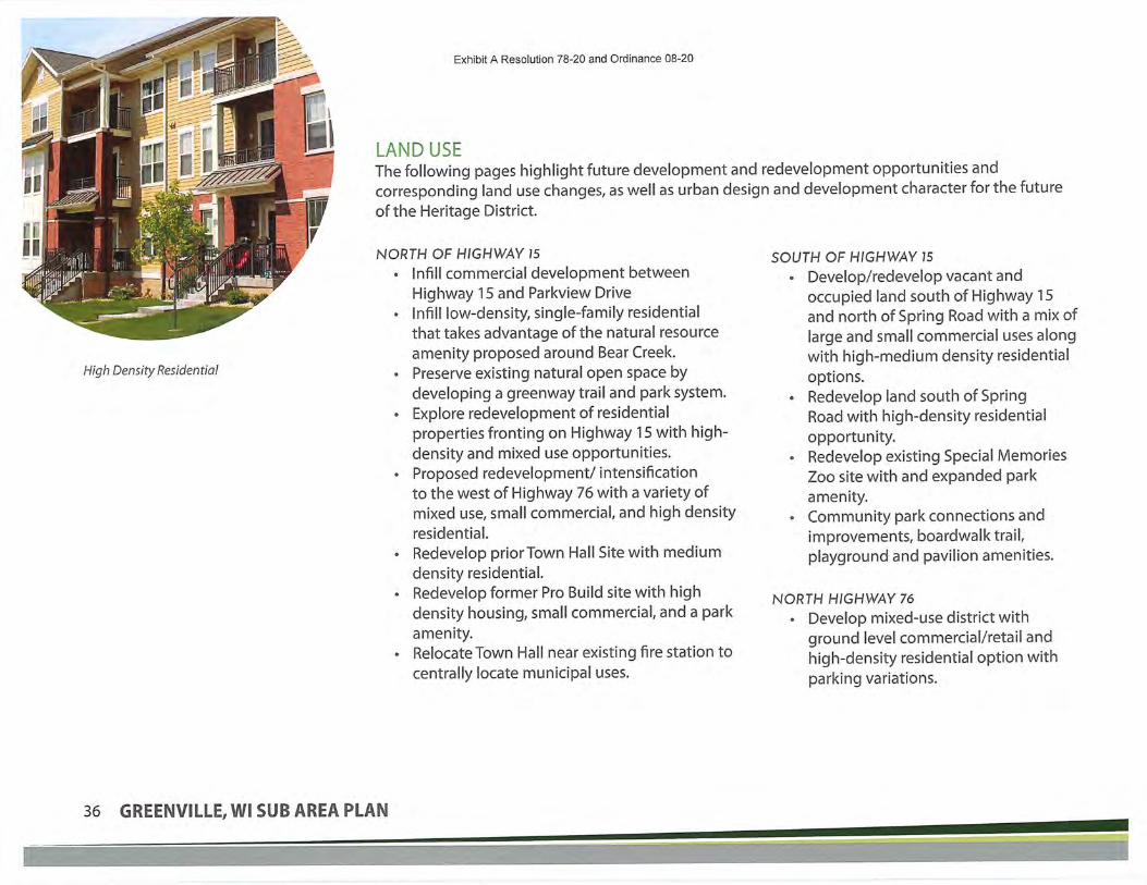
Exhibit A Resolution 78-20 and Ordinance 08-20
LAND USEThe following pages highlight future development and redevelopment opportunities andcorresponding land use changes, as well as urban design and development character for the futureof the Heritage District.
High Density Residential
NORTH OF HIGHWAY 15• Infill commercial development between
Highway 15 and Parkview Drive• Infill low-density, single-family residential
that takes advantage of the natural resource
amenity proposed around Bear Creek.
• Preserve existing natural open space by
developing a greenway trail and park system.
• Explore redevelopment of residential
properties fronting on Highway 1 5 with high-density and mixed use opportunities.
• Proposed redevelopment/ intensifkation
to the west of Highway 76 with a variety ofmixed use, small commercial, and high densityresidential.
• Redevelop prior Town Hall Site with medium
density residential.• Redevelop former Pro Build site with high
density housing, small commercial, and a park
amenity.
• Relocate Town Hall near existing fire station to
centrally locate municipal uses.
SOUTH OF HIGHWAY 15• Develop/redevelop vacant and
occupied land south of Highway 15and north of Spring Road with a mix of
large and small commercial uses alongwith high-medium density residential
options.
• Redevelop land south of SpringRoad with high-density residential
opportunity.• Redevelop existing Special Memories
Zoo site with and expanded park
amenity.
• Community park connections and
improvements, boardwa Ik trail,
playground and pavilion amenities.
NORTH HfGHV/AY 76• Develop mixed-use district with
ground level commercial/retail andhigh-density residential option with
parking variations.
36 GREENVILLE,WI SUB AREA PLAN
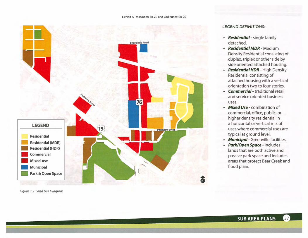
Exhibit A Resolution 78-20 and Ordinance 08-20
Everglade Road
^fir.
LEGEND
Residential
Residential (MDR)
Residential (HDR)
Commercial
Mixed-use
Municipal
Park & Open Space
Figure 3.2 Land Use Diagram
LEGEND DERNfTfONS:
• Residential - single family
detached.• Residential MDR - Medi u m
Density Residential consisting ofduplex, triplex or other side by
side oriented attached housing.
• Residential HDR - High DensityResidential consisting of
attached housing with a vertical
orientation two to four stories.• Commercial- traditional retail
and service oriented business
uses.
• Mixed Use - combination of
commercial, office, public, orhigher density residential ina horizontal or vertical mix of
uses where commercial uses are
typical at ground level.• Municipal - Greenville facilities.
• Park/Open Space - i nd udeslands that are both active and
passive park space and includes
areas that protect Bear Creek and
flood plain.
SUB AREA PLANS

Exhibit A Resolution 7MOHTN'cH16UMUWHERITAGE DISTRICT- ILLUSTRATIVE MASTER PlAN 'TicOR'mDOR'
r '^^5.^ 'w"..- Long-term redevelopment 3- Cottage Commercial uses
^ center development and create an amenity. J^^^jl^l' -Stormwater 3St»'^j-e'^^A^''^ ''-&"gladeR°ad~" ^s^^-Screening, j^^^^
^r^- ^~--' ^ ^ --~ ^ ^ ' ' '^j^-u;^,,a^-—-':^w^?''l^--^-*i^:'&l''''<~-"'-'
~-'»S^^f_ Organize the redevelopment h-§->
^^.^^?" for limited access, buildings |^y'^i:, to the street and parking to ^":s%%T the rearofthe parcels away T^i^B^JI"' ^B.€S^~-^'^
^* '"^--
l,^wlfc:£'i '^^f^.^''f^y^'the fearoft[}e parcels away ^j
^s^' '^ffSKiSi. .'.?-• from Hishway 76-
^?&.i. "^ Create mixed use district and incentivlse parcel^ .. * assemblyand redevelopment to create a mixed
,-^ ^t / '/&:.. use corridor with ground level retail/ commercial^« '•^&/'' uses wrth the potential for residential above '^-^^ ^ "~'^:^^r';-::'":' "T |
LEGEND
II Residential
• Residential (MDR)B Residential (HDR)|^| Commercial^B Mixed-use
Municipal
St® Park/Open Space
BB Greenway
^ 1J Stormwater•—1 Roads
Trails
Q Parking
rI!fr'ft
SOUTH OFHIGHWAY 15 i£'--,'• ^Z-'W. 'fSBSPIk^
Develop/ redevelop landwith a mix of small and large
commercial uses. Explore '/ .s.,1
patterns for residential ./^^;
opportunities !i ^
-^f^ ^..: -••-- • •-• ^
?-'. .^^ .!*•¥,' ' •.'•^S S&. ^eveloP a new Town Hall adjacent>^"
/ilh^i?^-^^i^the^station -i-l^^'^.'^^^-;-^----.^—-- iifc,
Sy Create a newwalkable district
focused around the intersectionf, of Parkview Drive and Highway |j'15 by exploring redevelopment
,'/Intensification on the westside of Highway 76
I?'
^' Combine entry drives to^ Community Park and Nature
Center.-<\T;;)!tBW . • :..' •- -^.'7
Remove one parking bay,connect to park space and
g add a picnic pavilion and small
S playground.
i^w":'"syv^^ "."wffl
Wetland restorationopportunity/ trail loop••~":^. ^ 'zs
Redevelop Special MemoriesZoo with expanded parkuse focusing on outdoor
environmental education -potential nature center project
? partner'^ <^1^''
-1rr
''v'Nils?^^'^ ^. _Enhanceacces"nd "^ ^'^
i connectivity south of ^ Rrt StationHighway 15 '"
Provide areas forstormwater treatment
and screening fromadjacent residential § NORTH OF HIGHWAY 15
U^»" - i, -- - -
Utilize conservation subdivisiondesign principles for residentialaround Bear Creek
^^^*^S('?^r"v~*-l'-'-»iyn - •»r-f / • '<
Redevelop the former Town Hallsite with medium density housing
':w!:^svvss^Greenway and Open Space/Park AreaAlong Bear Creek.
'Drive
^-J? Develop a mix of street-orientedKB^. housing and retail on the public works
iy." ~:i'i^; site including small central green /
^•1' I; :^c-^' ! :7^ plaza SPace °riented to Bear Creek'-."'l'^ ^^Sf^'J' natural amenity
?a'H?'''i?it7ra"lffi3S-S~E7'?i.l
Potential redevelopment ofresidential properties frontingon Highway 15, potentially
^^" integrating with Shepherd of
^a^^<Si^f]i^v: the Hills Lutheran Church^^^^ttwff^..- ———." "—gy^
Enhance the pedestrian connectivity with a trail along ^r-,(f5gj•Explore underpass ^ Bear Creek and connecting along Spring Road . ,^,-,^.iu.(».-S
^.,,'ji opportunity to extend ; 'ay5iA-'3ffi',ff'3? f'i"ff2£-''<s'Sis:..- 'i.^St'.m1.' -r^ K-I^'.i;!,!] , Greenway trail •-
..s^asnuMvH,
Figure 3.3 Heritage District Illustrative Plan (Illustrated at Possible Full Build Out)
38 GREENVILLE,WI SUB AREA PLAN

URBAN DESIGN DIRECTIONS
RESIDENTIAL CHARACTER
High Density Residential
Exhibit A Resolution 78-20 and Ordinance 08-20
GENERAL DEVELOPMENT CHARACTER
Medium Density Residential - Townhome, Rowhouse
i<-— .Villas / Duplexes
MIXED-USE CHARACTER
RETAIL/COMMERCIAL CHARACTER
Walkable Retail Environment Cottage Commercial
SUB AREA PLANS

Exhibit A Resolution 78-20 and Ordinance 08-20
PARK, TRAILS, & OPEN SPACEPreserve existing open space and enhance natural resources surrounding Bear Creek.
Develop a greenway and park system that takes advantage of natural amenities.
Explore opportunities for a public plaza that takes in views of natural resources.
Plan for a trail system that enhances the pedestrian experience (vegetative buffers/
screening, lighting, wayfmding, etc.) and creates greater connectivity throughout theHeritage District. Link back to existing sidewalks and the trails within Jennerjohn Park that
extend south of Highway 1 5.
Picnicpavilion
NeighborhoodPark
Everglade RoadExplore continuedGreenway Corridor
i>
Greenway Underpass
LEGEND
Existing Park
BB Park/Open Space
|U Greenway
• WetlandRestoration
<=> Trails
Stomwater(Amenity Opportunity)
%...
%."^
Picnic pavilion/small playground
Explore continuedGreenway Corridor
Trail connection toexisting Jennerjohn Park and trails
Explore trail underpass opportunity
Community Park with restrooms/concessions/
playground/splash pad $Figure 3.4 Parks, Trails, and Open Space Diagram
40 GREENVILLE,WI SUB AREA PLAN
-y^.-^-iwr.s-i-qi.:.:

Exhibit A Resolution 78-20 and Ordinance 08-20
STORMWATER TREATMENT• Provide and plan for the necessary amount of stormwater treatment for all land uses,
taking impermeable surfaces into consideration.* Explore BMP options such as rainwater gardens, swales, or curb cuts in both commercial
and residential areas to maximize environmental efforts.
• Consider the ways in which stormwater elements can be used as an amenity, placing
trails, parks, and greenways along stormwater ponds, or using native plantings as naturalscreens and noise buffers.
^Y
r\^
LEGEND
Stormwater(Amenity Opportunity)
Creek
Potential RaingardenLocations
WetlandRestoration
"^
Everglade Road
I
$
Naturalized Landscape for Stormwater Treatment
Ra'mwater Garden
Figure 3.5 Stormwater Treatment Diagram
SUB AREA PLANS

Exhibit A Resolution 78-20 and Ordinance 08-20
This plan explored streetimprovements such
as parking, sidewalks,
landscaping, and publicoutdoor plaza spaces.
STREET & ROAD IMPROVEMENTS• Prioritize creating a safe, walkable environment with an enhanced pedestrian
experience.
• Consider viewsheds into activity areas and natural amenities.
• Provide character-enhancing vegetative buffers, pavement patterns, human-scalelighting and signage, and other amenities such as benches to elevate the public
realm between the street and building.
• Explore mixed-use retail options that face the street, with efficient parking strategies
(parallel/offstreet/alleys/behind buildings/parking structures) along core roads.• Reduce the speed and limit the number of traffic lanes in mixed use districts where
pedestrian activity is likely to be high.• Increase the safety of intersections with clear signage and high-visibility crossings.
• Consider traffic calming measures in high-density and residential areas.
• Explore strategies to increase traffic flow efficiency with features like roundabouts,
passing lanes, or carpool lanes.• Create route options with different levels of roads, increasing connectivity with added
intersections and turn options.
• Explore Highway 15 underpass opportunity for expanded greenway/trail connection.
"Bridge" Elements - Bear Creek Gateway Heritage District Example Street Design (Source: Smartgrowthamerica.org)
42 GREENVILLE,WI SUB AREA PLAN

Exhibit A Resolution 78-20 and Ordinance 08-20
Everglade Road
Figure 3.6 Street & Road Improvements Diagram
LEGEND
Proposed TrailConnections
Primary StreetImprovements
SecondaryImprovements
Gateways
Gateway near the ProBuild sitemarks a main entry into theHeritage District, offering viewsinto the downtown Commercialarea and grain elevator along thescenic hillside.Grain Elevator Gateway to theNorth welcome visitors from
Highway 76 traveling south,offering views of the civiccampus, municipal uses, andmixed-use commercial district
with high density residentialopportunities.Bear Creek Gateway offers scenic
viewsheds of the creek, theproposed park and greenwaysystem, and Jennerjohn Parktrails and underpass.
Secondary gateways at SpringLake Road and the intersectionof Highway 15 and 76 offerviews and clear access to largecommercial infill and the mixed-use village.
SUB AREA PLANS

Exhibit A Resolution 78-20 and Ordinance 08-20
IMPLEMENTATION STEPSImplementation within the Heritage District will fall into a series
of broad categories:
• Private development and/or redevelopment: Projects
initiated and led by private development interests are
encouraged to proceed following the master plan'sguidance. The master plan can be used as a way to
encourage property improvements through marketing ordemonstrating coordinated public and private investment
projects.
• Public led projects: Key public improvements in theHeritage District include park improvements (see catalyst
projects), street and streetscape improvements alongprimary streets (Highway 76 and Parkview Drive), and
regional stormwater improvement projects to protect
against flooding and improve water quality.• Public Private Partnerships (PPP): A number of projects
within the Heritage District would benefit by some form ofpublic/private partnership. Projects involving the divestingofGreenville held lands or the re-purposing ofGreenville
facilities into more productive tax paying uses require adeveloper and end user. District identity and branding
benefits all property owners within the district. A district
wide entity or partnership should share in the cost to
create a brand/identity.
CATALYST PROJECTSIdentification of "catalyst" projects serves as a "jump start" to
implementation of the districts vision and plan. The following are key
catalyst projects for the Heritage District:
(l)Redevelopment of the public works site and area: This projectis a great example of a PPP opportunity. With a concept in mindand control of a significant amount of the land, Greenville should
work to find a development team with the capacity and ability
to help assemble remaining parcels of land and redevelop thesite. This will require Greenville finding an alternative location for
public works. The site is a good opportunity to take advantage of
Bear Creek amenities and create a signature piece at the heart of
the Heritage District. Key
steps include planningfor relocation of public
works, determining
a developmentpartner through aRFQ or selection
process, agreeing
on a land transfer,
acquiring remaining
parcels not owned
byGreenvilleanddeveloping a detailed
redevelopment plan.
44 GREENVILLE,WI SUB AREA PLAN

Exhibit A Resolution 78-20 and Ordinance 08-20
^
*w
Reconfiguring the Community Park: Greenville has been working on planning for
improvements to the community park. With the closing of the Special Memories Zoo, Greenville
has an opportunity to reposition the park with the idea of a special use that leverages
the natural resources that connect through the site and creates additional developmentopportunity that fronts on the park. Prioritizing development of this area keeps conservation as
a focus and catalysts the development of surrounding commercial and high-density residential
opportunities. This catalyst project would also provide an opportunity to connect to BearCreek. This is an example of a Public led project.
l Redevelopment of the ProBuild site: The ProBuild site iscurrently vacant and for sale. It is an opportunity because
it is a large parcel of land with high visibility and oneowner. This should be a private led project. Greenville
could help with promotion and facilitation of linkinginterested parties to the redevelopment opportunity.
iRelocation of Town Hall to north of Fire Station: An additional
public private partnership opportunity to relocate Town Hall
is a more longer term strategy. This provides an opportunityto right size Town Hall space, plan for longer term growth, and
realize a more efficient development pattern of the existing
Town Hall site. A PPP with a potential developer/ end user may
also present sustainable options for long term growth planningby providing sublease options to enable more efficient build
outs.
<^t^ffi- !aft^©iiT%
l&te.^:Heritage District Catalyst Projects
SUB AREA PLANS

Exhibit A Resolution 78-20 and Ordinance 08-20
DESIGN GUIDELINESThe Heritage District is the centerof Greenville. While not a traditional
historic downtown, it is recognized
as the spot in Greenville that has that"sense of place." Rather than a primarily
automobile focus and scale, the design
of this area needs to reflect the diverse
set of users, including pedestrians,cyclists, and automobiles. This area
will continue to improve if the focus
for new commercial, multi-family/ and
office development is designing to the
human scale. Creating and reinforcingthe human scale through architecture
means designing spaces that arecomfortable to an individual. Buildings
should neither overpower a person,nor should they leave them feeling
exposed. They should be interesting
from a walking pace, providing varied
experiences regularly. This greatlyenhances the willingness of people to
spend time enjoying a place.
HERITAGE DISTRICT | ARCHITECTURE DESIGN GUIDELINES:
1. The experience of a pedestrian walking along a building is improved if there are new
experiences to keep the person's interest with strong architecture:
a. Buildings should be designed with a rhythm to the facade with significant variation
every 60 feet and minor variations at least every 20 feet. Variation can be achievedwith articulation, color, texture, materials, doors, and windows.
b. Building entries should be oriented to the street.
c. Awnings, canopies, and slightly recessed entries create enclosure and bring downthe scale of a building while creating a sense of shelter from rain, snow, and sun and
are encouraged.
d. Windows should make up at least 2/3 of the front face of the building at theground floor. Windows should allow interaction both directions, and should not besignificantly obscured or mirrored. In residential buildings with living space on the
ground floor, windows may be slightly elevated to signify private space.
e. Signs can provide branding as well as architectural interest.f. Architectural design should be continued around the entirety of the buildings, not
just the "front" face.
Articulation breaks up a building into smaller piecesvisually Canopies help reinforce the human scale
46 GREENVILLE,WI SUB AREA PLAN

Exhibit A Resolution 78-20 and Ordinance 08-20
i
Building stepbacksVariation in the building massing helpscreate interesting spaces
K MM
Ifiaini m
Details help create visual interest and
show craftsmanship in construction
Newer buildings can have a "cleaner"
appearance and still incorporate
interesting details
2. The massing of buildings has the ability to enhance or
detract from the experience of people in the district. A well
proportioned building can greatly improve the feel of an
area:
a. Buildings should not present as one flat plane, ratherarticulation should be used to introduce variation in the
face of the structure.
b. If buildings are greater than three stories, their mass canbegin to overpower an individual. Buildings over 3 storiesshould incorporate step-backs after the 2nd story to reduce
the impact of the building's massing.
c Buildings do not have to be set immediately to the edge of
the property, but should be close enough that their massingcreates a sense of enclosure across the street section. If
buildings are set back from the street, windows should
remain visible from the public right-of-way.
3. Details are more noticeable when a person is walking next
to a building rather than driving by from the road. The
design of buildings should incorporate details that helpcreate interest:
a. Encourage the use of architectural details such as
window sills, lintels, columns, cornices, transoms, and/or
other elements as appropriateb. Buildings should use details consistent with the
architectural style of the building
c. Details should be functional and not arbitrary.
SUB AREA PLANS

Exhibit A Resolution 78-20 and Ordinance 08-20
HERITAGE DISTRICT | SITE DESIGN GUIDELINES:
Rooftop screening should match buildingmaterials Trash enclosures should be fully screened Side loaded parking Side and rear loaded parking
1. Buildings will likely require some "back of house" elements in
order to better function. This could include heating and air
conditioning units, trash and recycling containers, and utility
boxes or meters. While important, these elements should beminimized visually:
a. If feasible, incorporate trash and recycling facilities into thebuilding. When not feasible, locate these facilities in the rear of
the building and screen them from all sides.
b. When possible, locate elements such as HVAC units on the roofof buildings. Screen these with materials consistent with the rest
of the building, rather than fencing.
2. Parking is an important component to making retail andoffice uses work. The scale of automobiles may be at conflict
with creating a comfortable human environment. To improve
this condition:a. There should not be parking between the building and the
right-of-way.
b. Parking should be located at the back of buildings wherepossible
c. If parking in the rear of buildings is not feasible, parkingshould be located to the sides of buildings. If parking islocated on the sides of buildings, decorative fencing should
be used to help set an edge against the public street and
sidewalk to reinforce the human scale.
48 GREENVILLE, Wl SUB AREA PLAN

Exhibit A Resolution 78-20 and Ordinance 08-20
Patio spaces are highly desired amenities Maintain clear pathways with outdoorfor restaurants seating
3. Outdoor public and semi-public spaces can greatly enhance the
vibrance of an area. These should be encouraged:a. Sidewalk patio seating should be coordinated to ensure a dear
pathway is maintained without tables, chairs, or umbrellas
protruding into an accessible pedestrian route
b. On-property patios can be a highly desired amenity forrestaurants and multi-family residential projects
c. Public art incorporated into public or semi-public space helps
add to the identity of an area
SUB AREA PLANS

Exhibit A Resolution 78-20 and Ordinance 08-20
This page Intentionally Left Blank
50 GREENVILLE, Wl SUB PLAN

f
^Exhibit A Resolution 78-20 and Ordin)
SWl ^.iMl I!'1
-.^^^
W^ •• Jr
INTRODUCTIONThe East Industrial Area is located by
highways 15 and 96, just east of CTH-
CB. This design concept portrays ideasfor a warehouse and business district that
puts sustainable practices, high-qualityarchitecture, strategic lot arrangements,
and employee welfare at the forefront of the
design.
The concept shown functions as a futureland use diagram, allowing for flexibility
in building type and plot sizes to helpsteer redevelopment. This approach
provides ample configurations for largewarehouse operations, offices and business
condominiums, tech-flex, and supportingservices.
Rerouted street patterns and an enhancedtrail and stormwater management network
works with the existing natural resources,streets, and built environment to create more
connectivity for the area.
SUB AREA PLANS
^^'^yS<S^^'y^^^.yy'^^^^^:'''v "^•-^*n..:-'_'.r ••<•-*-•-•.-
'^:-'^"/';'**y".

LAND USEHIGHWAY 15 TO DESIGN DRIVE
• Explore long-term redevelopment of
commercial property at southwestquadrant of Highway 15 and MayflowerRoad.
• Develop a desired commercial district
south of Highway 15.• Utilize large land tracts for larger footprint
users (warehouse/ distribution/fulfillmentcenters) Warehouse and Industrial use.
• Develop supportive commercial & retail
uses near round-a-bouts south of Highway15nearCTH-CB.
NORTH OF DES/GN DRIVE:• Larger Warehouse Lots - Light Industrial
(warehouse distribution)(1 OOK/250k/500k)• Smaller Warehouse lots - Light industrial
(tech/flex)(2-3AC/3-5AC/7AQ
HIGHWAY 96 TO COLLEGE AVE• Industrial development infill
DESIGN DRIVE TO HIGHWAY 96• Desired light industrial site sizes (2ac to
5ac, with a small percentage up to 10ac).• Expanded stormwater treatment train
system, stormwater treatment for
development.
Exhibit A Resolution 78-20 and Ordinance 08-20
School Road
Levi Drive
LEGEND
Commercial
Industrial
Park & Open Space
Design Drive
Figure 3.7 Land Use Diagram
52 GREENVILLE,WI SUB AREA PLAN

Exhibit A Resolution 78-20 and Ordinance 08-20
URBAN DESIGN DIRECTIONS
BUSINESS PARK CHARACTER SUPPORTING SERVICES CHARACTER
Small Office ] Headquarters
Warehouse / Distribution
®Nm;'~
Office Condos
Tech/Flex \ Light Industrial Supporting Retail
SUB AREA PLANS

EAST INDUSTRIAL AREA - ILLUSTRATIVE MAMWNWs-zo and ordinance 03-20- ^ ^-^^-^^yy^^,^^-^y^.- ^,;g|^;-
^ •i-V:Jji^ii]ilS,,&If"./ ^C3^;y^ s]i?'!^:^
Develop supportivecommercial & retail
^L. .H!GHWAY?6 - J^"c^^^^Ese^^^a^: ^Sf'S^^Q^ ^ „ ^-- _._^ ^.-. _ _-^. „._ . ^ . -._- —^
Extend and realign School Road ^east and connect with Levi Drive for H|liii',(enhanced access and circulation to i"'"—,-;;--. Levi Drive
I desired commercial district south of ^i;t3;%.i>-"j; ''y^~ "^f["Highway 15 ^S'^JHj,
^.1^^'^K^ '^^j^^i^,vw"' "^'"~"""?'"''1'"
f ^4g '-~^ Balance access management, desired light Industrial site sizesTl t y
and site drainage patterns to shape land development patterns
Create an expanded stormwater treatment train system integratingMud Creek flood control, stormwater treatment for development,
and creating and celebrating an identifiable brand for the^ overall development with expanded trails, native plantings, and
sustainability at the forefront
Design Drivecould act as a
or land use
separationALTERNATIVE CONCEPT
preservation
for screeningStormwater
treatment differs
per conceptly- 'y.-^-j^-
wMT-~-.-»;i. i— Stormwater-
K^ I! treatment for
k^l f'"'"^T^1
J^-..^C
i;?iiS^~;i'l"^.-'' "' ^CSfS'*^1,
1 I Industrial
|^| Commercial
Roads
Park/Open . :• Stormwater
Space ^ -Trails
Wetland Areas Q Parking
HIGHWAY 15 TO DESIGNDRIVE
Explore long-term redevelopment of
commercial property
Larger footprint users (warehouse/distribution/fulfillment centers)
Extend Design Drive east toMayflower Road based onpreferred alignment
NORTH OF DESIGN DRIVE
Larger Lot - Light Industrial
Warehouse distribution
WDK/250k/500kRegional Stormwater
Smaller lot-Light industrial
Tech/flex (build to suit)2.3AC/3-5AC/7AC
Stormwater Amenity
Integrated traffic network
In this option, the drainageditches courses are not modified
south of Design Drive.
HIGHWAY 96 TOCOLLEGE AVE
Infill industrial developmentbetween Communication Drive andMayflower Road
Organize site development to pushloading and service to the rear of thesite and high quality architectureto front of the lot, balanced with
parking needs
Figure 3.8 East Industrial Area Illustrative Master Plan Concept
54 GREENVILLE, Wl SUB AREA PLAN

Exhibit A Resolution 78-20 and Ordinance 08-20
PARK, TRAILS, & OPEN SPACEAs with the Heritage District, this sub area plan focuses on
creating a unique pedestrian experience in a set of land usesthat are traditionally vehicle-focused.
• Integrating the natural path and flood patternsof Mud Creek into the center of the development
through a series ofstormwater ponds and semi-
maintained natural open space, crossed with a seriesof foot bridges that can exude the character and
identity of Greenville.• Enhancing connectivity for the employee base
with a safe and secure trails that connect back to
employment and supporting retail services.
• Preserving trees and other existing high-qualitynatural elements where possible.
School Road
Levi Drive
Stormwater
treatment as an
amenity
Design Drive
r *!^B Pa rk& Open Space
<=> Trails
Pedestrian
Connections
Stormwater(Amenity Opportunity)
Figure 3.9 Parks, Trails, and Open Space Diagram
Trail amenities
SUB AREA PLANS
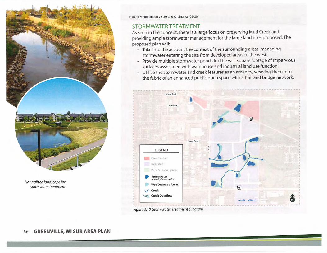
Naturalized landscape forstormwater treatment
Exhibit A Resolution 78-20 and Ordinance 08-20
STORMWATER TREATMENTAs seen in the concept, there is a large focus on preserving Mud Creek and
providing ample stormwater management for the large land uses proposed. The
proposed plan will:• Take into the account the context of the surrounding areas, managing
stormwater entering the site from developed areas to the west.
• Provide multiple stormwater ponds for the vast square footage of impervioussurfaces associated with warehouse and industrial land use function.
• Utilize the stormwater and creek features as an amenity, weaving them into
the fabric of an enhanced public open space with a trail and bridge network.
•^
Design Drive
r
^.
LEGEND
oar:;ac"!e" S-ia"?
Stormwater(Amensty Opportunity)
Wet/Drainage Areas
Creek
Creek Overflow
Figure 3.10 Stormwater Treatment Diagram
56 GREENVILLE, Wl SUB AREA PLAN

Exhibit A Resolution 78-20 and Ordinance 08-20
STREET & ROAD IMPROVEMENTS• Create connections to existing road infrastructure, roundabouts, and trail networks with sidewalk and trail extensions. Focus on how both
vehicle and pedestrians access and utilize the site.• Consider design elements that can help celebrate Greenville's unique character and heritage to create a sens of place within the East
industrial area. Native plantings, wayfinding, light posts, and landscape furnishings that may line the streets.• Plan for the implementation of BMP features such as rain gardens, curb cuts, and vegetative swales or buffers to balance the environmental
impact of new roadways.
• Extend and connect new streets to existing road patterns and the surrounding context to improve efficiency and access.
• Plan for the necessary land use, parking, loading docks, and other features associated with business and warehouse uses.
• Orient plantings and high-quality architecture to face the street and increase businessvisibility from the roadways, screening loading and areas and other site amenities from
sight.
School Road
Levi Drive
'•^c'-X
•*•<*•»
-<".-.-_««»
n
i't
Design Drive
\\
'^T^^
«•»• <*•*
(—)
LEGEND
I
Primary StreetImprovements
NORTHWOODFINES
District/ Development Identity Through Streetscape &Entry
Figure 3.11 Street and Road Improvements Diagram*...• Gateways
SUB AREA PLANS
"W7-S-" :r"^'^'^'^SS^^S!!SWS ^W^Sii5::r^^~^??:^3'^} ^-IK^.^ ^^^"^sfe^isS •sSE-'M-*^^'" ^^u^-r %n^%®S^BS^^I%iii^!^^?N^^^^ ;.«uS%l;ss;^:; --.',•-,-.':

Exhibit A Resolution 78-20 and Ordinance 08-20
IMPLEMENTATION STEPSImplementation within the East Industrial District will fall into
two categories:• Private development and/or redevelopment: Projects
initiated and led by private development interests are
encouraged to proceed following the master plan's
guidance. The master plan can be used as a way to
encourage property improvements through marketing ordemonstrating coordinated public and private investment
projects.
• Public led projects: Key public improvements in the EastIndustrial District include coordinated regional stormwater
improvements enhancing water quality and mitigatingpotential flooding issues. Planning for this is currently
underway. A coordinated stormwater plan helps maximizeefficiency of initial infrastructure capital investment and
ongoing, long term maintenance. A second public led
project could be design of a key street network throughthe park and an enhanced streetscape improvement alongprimary streets that include enhanced pedestrian systems.This could be coordinated with the regional stormwater
improvement project to allow for a value enhancing trail
network serving the industrial park.
CATALYST PROJECTSIdentification of "catalyst" projects serves as a "jump start" to
implementation of the district's vision and plan. The key catalyst
project for the East Industrial Park is to design and implementa coordinated greenway network integrating stormwater
infrastructure with value added and connected trails and
greenspace.
Expanded Greenway Network
58 GREENVILLE, Wl SUB AREA PLAN

Exhibit A Resolution 78-20 and Ordinance 08-20
DESIGN GUIDELINESWithin the East Industrial district, there
are a number of working buildings.
Structures must accommodate
large trucks, manufacturing, and
warehousing, typically in a very largefootprint. Typically the function of thesebuildings and sites will dictate the form.That doesn't mean development can't
be both attractive and practical. Indeed,
many successful properties in thedistrict are able to combine the realities
of industrial needs with a high-quality
appearance.
EAST INDUSTRIAL AREA I ARCHITECTURAL DESIGN GUIDELINES
^^^-y,:
Repeated vertical elements and windows help bring thebuilding to a more human scale
Articulation and color changes help to visually break up amuch larger building into smaller pieces
1. Due to the large scale of thebuildings, unbroken, blank wallscan quickly overwhelm the human
scale. To counter this, buildings
can incorporate:
a. Articulation of walls
b. Changes in color or material at
articulation points
c. Projecting and recessed
elements
d. Rhythm and patterns expressed
at a human scale
e. Varied roof lines through the
use of parapets and cornice
detailing
Entrance is celebrated
with additional windowsand unique architectural
features
The building puts a focus on theprimary entry with an overhangand floor to ceiling windows
2. Particular attention should be paid to the entrances of buildings. These are the
client facing areas, and set the tone for the rest of the building. Entrances should becelebrated architecturally:
a. Differentiate the entrance area from the rest of the building's wall plane by bringing it
forward, or recessing it from the rest of the building massing
b. Architectural elements such as a columns, entry courts, vestibules, projectingoverhangs/porte cocheres, taller features, and special lighting help signify the elevated
importance of the entrywayc. Use of color and high-quality materials to distinguish the entryd. Windows should make up the majority of the facade in entry areas
e. Locate entrances in a place of prominence on the building and in relationship to thestreet.
SUB AREA PLANS
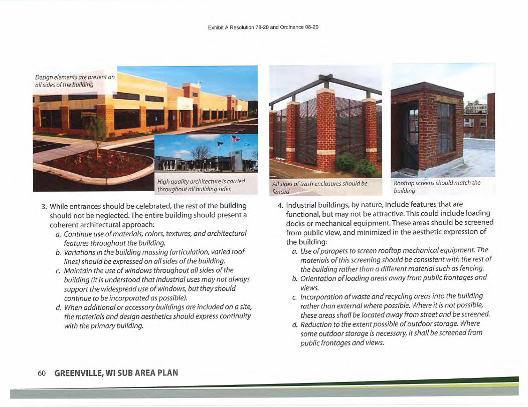
Exhibit A Resolution 78-20 and Ordinance 08-20
Design elements are present on
all sides of the building
High quality architecture is carriedthroughout all building sides
3. While entrances should be celebrated, the rest of the building
should not be neglected.The entire building should present a
coherent architectural approach:
a. Continue use of materials, colors, textures, and architectural
features throughout the building.
b. Variations in the building massing (articulation, varied rooflines) should be expressed on all sides of the building.
c. Maintain the use of windows throughout all sides of the
building (it is understood that industrial uses may not always
support the widespread use of windows, but they should
continue to be incorporated as possible).d. When additional or accessory buildings are included on a site,
the materials and design aesthetics should express continuitywith the primary building.
All sides of trash enclosures should befenced
Rooftop screens should match the
building
4. Industrial buildings, by nature, include features that are
functional, but may not be attractive. Th is could include loading
docks or mechanical equipment. These areas should be screened
from public view, and minimized in the aesthetic expression of
the building:a. Use of parapets to screen rooftop mechanical equipment. The
materials of this screening should be consistent with the rest ofthe building rather than a different material such as fencing.
b. Orientation of loading areas away from public frontages and
views.
c. Incorporation of waste and recycling areas into the buildingrather than external where possible. Where it is not possible,
these areas shall be located away from street and be screened.
d. Reduction to the extent possible of outdoor storage. Where
some outdoor storage is necessary, it shall be screened from
public frontages and views.
60 GREENVILLE,WI SUB AREA PLAN

Exhibit A Resolution 78-20 and Ordinance 08-20
Windows and thoughtful material choices add interest and should remain in goodcondition A mix of quality materials convey a sense of permanence
5. The buildings in the East Industrial Park should convey permanence and an elevated quality. This should be done through material choices,thoughtful detailing, and craftsmanship of construction:
a. Materials should be high quality and long lasting, including clay or finished masonry brick, finished concrete, or stone
b. Materials such as steel/cormgated/sheet metal walls, unfinished concrete masonry block, and exposed plywood/pressboard shall not be used.
fF/S should be minimized and not be used along the bottom of the building.c. Details should be architectu rally valid, rather than tacked on, arbitrary, or merely decorative.d. Construction should demonstrate a high level ofaaftsmanship and quality.e. Materials and design elements should be considered for their lifespan, rather than just the day they are installed.
SUB AREA PLANS

Exhibit A Resolution 78-20 and Ordinance 08-20
EAST INDUSTRIAL AREA I SITE DESIGN GUIDELINES
Wayfinding signage can helpguide users to the appropriatedestinations
Use quality signage at the streetto identify businesses
1. Entry into the site should start the experience thatstrengthens the identity of the user and improves
safety and ease of circulation:
a. Incorporate of logo and wayfinding signage
into the entry from public streets.
b. Ensure entry signage, gateways, andlandscaping do not obscure visibility into and
out of the property, particularly with regards
to vehicular circulation and intersection sight
triangles.c. Separate automobile and truck entries to the
extent possible.
-<
Create separated walkways from buildingsto public right-of-way and through largerparking areas
Introduce planted areas in parking lots to improveappearance, shade, stormwater management, and
reduce the urban heat island effect
2. Parking & Circulation are the first set of experiences that an employee or client
has with the site. It should encourage safe and easy movement and parking.
It is worth remembering that even though most people may show up invehicles, the moment they shut the driver's door, they become pedestrians
and need safe ways to get to the building. Site design of parking and
circulation should:
a. Align driveways with existing or planned driveways on the opposite side of
the street
b. Provide sufficient spacing (at least 20') between entries and the first parking
stall to allow for queuing as cars leaving the sitec. Ensure pedestrian connections (trail or sidewalk) exist between the public
right-of-way and the buildings. Large parking areas should also have
pedestrian connections to building entries. To the extent possible, pedestriancirculation should be separated from vehicular circulation
d. Parking areas should have internal landscaping with trees and plantings in
islands. Islands should be at least 6 feet wide and occur no less than every 20
parking stalls.e. Bicycle parking should be located next to and visible from buildings to
minimize vandalism and/or theft. Avoid hidden and dark locations.
62 GREENVILLE,WI SUB AREA PLAN

Exhibit A Resolution 78-20 and Ordinj
ie Source: Rattler
INTRODUCTIONThe existing Lions Park and Sports and SplashPark land areas are municipal-owned plots
along highway 76 and 96. Both sites are
currently under redevelopment, which is a
great time to consider land use patterns for
the surrounding context, as well as plan fortrail and pedestrian connections between the
two parks.
A small series of existing trails surround the
site, but connection across busy roadwaysand between the facilities is non-existent.
Primarily farmland today, these sites hold
potential for selective commercial and retail
uses that can support this area as a family
gathering place.
Greenville's Lions Park is designed to
celebrate Agriculture, and exploration of apotential Agricultural Heritage Museum isencouraged to further celebrate Greenville's
unique history.
f-^^^^?^'-7yvl^^?'y
SUB AREA PLANS
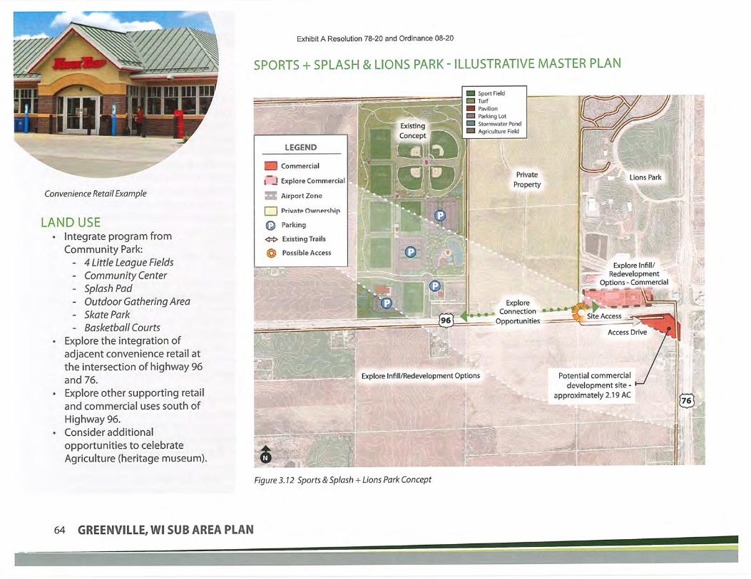
Convenience Retail Example
LAND USE• I nteg rate prog ra m from
Community Park:
- 4 Little League Fields
- Community Center- Splash Pad
- Outdoor Gathering AreaSkate ParkBasketball Courts
• Explore the integration of
adjacent convenience retail at
the intersection of highway 96and 76.
• Explore other supporting retail
and commercial uses south of
Highway 96.• Consider additional
opportunities to celebrate
Agriculture (heritage museum).
Exhibit A Resolution 78-20 and Ordinance 08-20
SPORTS + SPLASH & LIONS PARK - ILLUSTRATIVE MASTER PLAN
'^^: il
I J
aG<=>
0
LEGEND
Commercial
Explore Commercial
Airport Zone
Privstp Ouunpr-ihip
Parking
Existing Trails
Possible Access
Sport FieldTurfPavilionParking LotStormwater Pond
Agriculture Field
Private
Property
:tli'"—rZ^1!!^.^lg§g^* ''J-..-...y»*^^'^^'' ^
ExploreConnection
Opportunities
te*; Explore Infill/Redevelopment Options
!^^0"^^4^^^^^.;;.r^S^<i^'.^:'' ''• '- '' "• ' 1;11' ' ''"'-
'^y^sss^ • - '•k^N^^^'.3^211i_.._..:.._.^.^;.
Figure 3.12 Sports & Splash + Lions Park Concept
7?^" "v-i-rfK'"' '•^:1^ '-F-'
in'^" ••^^. Lions Park %,
ys^ '_;.
^ Explore Infill/Redevelopment
—;-- Options - Commercial
^?^(-3li(^Ni^fi
Site Access
Potential commercialdevelopment site -
approximately 2.19 AC
64 GREENVILLE, Wl SUB AREA PLAN
Exhibit A Resolution 78-20 and Ordinance 08-20
IMPLEMENTATION STEPSImplementation within the Sports + Splash and Lions Park area will fall into
three categories:• Private development and/or redevelopment: Projects initiated and led
by private development interests are encouraged to proceed followingthe master plan and the Comprehensive Plan guidance. The master plan
can be used as a way to encourage property improvements throughmarketing or demonstrating coordinated public and private investment
projects.
• Public led projects: Greenville is currently in the process of exploring
development of the Sports + Splash Park. Additional work could be doneto explore ways that link up the Sports + Splash Park with Lions Park via
trail corridors. A trail corridor on the north end and one on along Highway
96 could serve this purpose. A second public project could be explorationof a comprehensive plan amendment evaluating additional critical mass
for supporting commercial uses south of Highway 96. This would alsoneed to take into consideration implications from the Airport overlay
district.
• Public Private Partnerships (PPP): A key project within the Sports + Splashand Lions Park district would benefit by some form of public/private
partnership. As the location of this district is nearest Tier 3 lands from
the comprehensive plan and the "Agriculture Green Belt" an opportunityexists to build off the park amenities in the area with an agriculture
themed community attraction. This could include commercial uses thathave an agriculture emphasis, historical/cultural attractions that tell the
story of agriculture in the regional, educational institutions that offertraining or vocational schools. This could be a partnership with the Land
Stewardship Committee, Greenville, Outagamie County, private land
owners, philanthropy groups, State of Wisconsin, private businesses, orother museum/history center operations.
CATALYST PROJECTSIdentification of "catalyst" projects serves as a "jump
start" to implementation of the district's vision
and plan. The key catalyst projects for the Sports +
Splash and Lions Park area include:• Exploration of trail connections between
the two parks.• Consideration of a comprehensive plan
amendment for commercial uses south of
Highway 96.
• Exploration of an Agricultural Heritagedistrict and program
SUB AREA PLANS

AGRICULTURAL HERITAGE &TOURISMExhibit A Resolution 78-20 and Ordinance 08-20
AGRICULTURAL TOURISMSimilar places have helped strengthen their agricultural identity
through agricultural tourism. Agricultural tourism is the business ofestablishing farms as destinations for educational experiences and
entertainment uses, while helping increase the farm income.
Pumpkin patch Agricultural Heritage Museum, Boerne TX'
K&' '•^&^C':H3^-;;-^.=='r ~-_
-»»-^«^?Farm to table restaurants Luna Valley Farm, Decorah IA
AGRICULTURAL HERITAGEA large part ofGreenville's identity is tied to agrarian lifestyles
and values. Strengthening this identity over time may have itschallenges as farming operations change throughout Greenville.
Farming operations and home businesses may be subject to zoningrestrictions, building codes, compliance with the Americans with
Disabilities Act, taxation, and other regulations. Producers who
provide food products, food stands, or restaurants must consider
local and state food safety and public health laws that may apply, inaddition to laws governing liquor licenses. Businesses located in theagricultural areas of Greenville should follow the Comprehensive
Plan's Future Land Use Districts to minimize conflicts with adjacentland uses and natural resources.
Examples of Agricultural Tourism include:
• Agricultural Museums
• Breakfast/Dinner on the Farm• Corn Mazes
• Cut-your-own Christmas Tree
Farms
• Demonstration Farms
• Event Venues(Barn
Weddings)• Garden & Barn Tours
• Hay Rides
'S»JR»
.ir.'r ^.
IILJ^s^-
Living History FarmsOn-farm Farmers'Markets
Petting and Feeding zoos
Pumpkin Picking PatchesRural Bed & Breakfasts and
Farm-stays
U-Pick Operations
Winery, Brewery, andDistilleryTours/TastingHeritage Museum
Redhead Creameryin Brooten, MN Bad Habit Brewing in St. Joseph, MN
66 GREENVILLE,WI SUB AREA PLAN
^^^J'^r^^^^^^l^^^^F^r^^S^^^^'r;i'^^^.^;^-;;^:Mj^jy;f-i^;^^^
-k-^— "- :f' / - "-^. " - ' -.' - .-*^. - ---' -~'; "„ t^f-J^. L- ~"t- ^..t^r. 3.\ »v ^J,'.
"p "'""" w ^T?'^.y.^^^t?nw;*iTT-'"^.^''':.,w\+^.^r;*-;.~'^w'.n:'^"^ ^'T;?':^^^Tr^'^'"^J-r^:2*!^-T^^^^T^^^;~'?y'^*^?ri°^^
..rf'^::tt.":r-'^"'^Sw^?P;'^^^S^;:%

Exhibit A R<
INTRODUCTIONGATEWAY TYPESGateways are identified as primary points of entrance into
Greenville. Gateways can be used as a strategy to encourage
and enhance the community identity and sense of place,setting it apart from the surrounding Fox Valley region. The
sub area planning process used the 2040 Future Land UsePlan's identification of existing gateways along the Greenville's
border to guide the placement of potential secondary gatewayopportunities within individual districts, as can be seen in figure
3.13. Elements such as streetscape layout, landscaping, and
wayfinding signage are design features that help celebrate the
Greenville's unique heritage, or the character of smaller districts
within. Examples of these features are illustrated throughout this
chapter by use of precedent imagery.
CORRIDORSCorridors often lie along major roadways, connected on either end
of a boundary by gateways. Land use decisions made along thesecorridors have an important impact on creating the way peopleexperience Greenville, and contribute greatly to the area's identityand sense of place. The figure identifies how the future land use
plan identifies districts along these corridors to help transition
rural and agricultural uses, an important identifying element ofGreenville's heritage, into more developed areas with commercial
and residential footprints. The diagram helps to explore andidentify future land use patterns and opportunities in more detail
as Greenville continues to grow, helping to steer future economic
development.
SUB AREA PLANS

Planted Medians
Exhibit A Resolution 78-20 and Ordinance 08-20
GATEWAYS & CORRIDORS DIAGRAM
Rural StretchMMoffarw'^d, iw/pr wpwyc.w^fnfrcia!
f(^;?(<?t*;/;/p.\ /fi/)ri-it~.:^e, irwuy", ec^l.'JrKjWfnpwvtVfnwiof'.fr.ifWKf' Ss'o^'tt,':s^
,s^<•^":by,t"»,l
Opportunity)J//i(7f;s the best us? o-f ihi'i kioh^/ fiffssif? M':xfd Lw.' Dewty
ResMwitial E(tg»rf;ro'wt.ic?."ing;c'
luslness Parkirf);<frtfli'/^re/lf?CT
."WTiVAW/ODCt1F<rtur<R»gtenalTf»t)
Airpart AieaTfjt^rr inrt i^ipo' tffi;? L'se?;, f 'T1
wine-^wrh^'ofhci' i. ''
^ Established Gateway
^ Potential Gateway
Distinguished Land Use Areas
Figure 3.13 Gateway and Corridor Locations Diagram
68 GREENVILLE,WI SUB AREA PLAN

Exhibit A Resolution 78-20 and Ordinance 08-20
IMPLEMENTATION STEPSImplementation within the Gateways and Corridors District will
fall into a series of broad categories:
• Private development and/or redevelopment: Projectsinitiated and led by private development interests are
encouraged to proceed following the master plan'sguidance. The master plan can be used as a way to
encourage property improvements through marketing ordemonstrating coordinated public and private investment
projects. Private development should take cues from the
design guidelines to create high quality developments
• Public led projects: Key public improvements in the
Gateways and Corridors District include a development
and implementation ofasignage and wayfinding plan
(see catalyst projects), coordination with WisconsinDOT and Outagamie County for street and streetscape
improvements along primary streets and at entries into the
community, and provision of utilities to newly developing
areas.
• Public Private Partnerships (PPP): A number of projects
within the Gateways and Corridors District would benefit
by some form of public/private partnership. Projects withhigher design standards that improve the public characterof the district may be eligible for community support
through tools like Tax Increment Financing (TIF) or tax
abatement.
CATALYST PROJECTSIdentification of "catalyst" projects serves as a "jump start" to
implementation of the district's vision and plan. For the gateways
and corridors, these projects include:• Development of a signage and wayfinding plan for Greenville:
A plan will help create continuity across public signage within
the community. It can identify size, scale, and appearance ofsigns, along with associated costs and direction on prioritiesand schedule. The plan should include different sign types from
monument/gateway signs to smaller directional signage.
• Enhanced round-a-bout design: Even though it is a half mile
into Greenville, many people perceive the round-a-boutat Highway 15 and County Road CB to be a gateway intoGreenville. As the area grows to the north and south, the
round-a-bout will only gain more significance. Work with theWisconsin DOT to develop a stronger gateway using the round-
a-bout.This could include signage, art, and/or landscaping.
• Use signage to promote the Tier 3 Greenbelt: Develop signageto notify road users they are passing through the GreenvilleGreenbelt
• Use wayfmding signage to direct visitors to the Heritage Districtand the Lions/Sports and Splash Park District: These are key
destinations in Greenville. Signage should steer visitors to these
areas.
SUB AREA PLANS

Exhibit A Resolution 78-20 and Ordinance 08-20
DESIGN GUIDELINESThe gateways and corridors ofGreenville are the front door of the
community. A drive along County Road
CB or Highway 15 is often the firstimpression someone has ofGreenville
and this will shape perceptions ofGreenville. Likewise these corridors
are the main travel routes for people
living and working in Greenville.Thearchitecture and design should offer a"welcome home"that residents can be
proud of.
These corridors also represent a diverse
set of land uses, from agriculture to
industrial, from parks and homes toretail centers. Each of these uses puts
unique demands on their buildings and
circulation network.
GATEWAYS & CORRIDORS I ARCHITECTURE DESIGN GUIDELINES:
Changes in roof line, materials, and articulation
help create interest
Material changes and variation in building massingreinforce a more human scale
1. Commercial and industrial buildings are often built with visibility from the road in
mind. Signs and buildings need to be quickly recognizable to a driver hundreds of feet
away, moving at highway speeds. This can create buildings that are out of a humanscale when encountered up close. To visually break the buildings up, incorporate:
a. Articulation of walls and roof lines.
b. Addition of projecting and recessed elements.
c. Variation in pattern, color, and/or materials.
70 GREENVILLE,WI SUB AREA PLAN

Exhibit A Resolution 78-20 and Ordinance 08-20
Windows allow for views into the building at the entry
2. Many of the buildings along the corridors are visible from highways, butaccessed via frontage or back roads. This means the buildings are visiblefrom many angles and may have multiple "front" faces. It is important
that buildings display a high level of design across the entire structure,
not just one side.a. Materials and colors should be continued on all sides of a building.
b. Architectural details and features need to be considered and included
throughout the building.c. Avoid large blank walls on the sides of buildings. Sides should
incorporate windows and articulation of building massing.
d. It is understood that some utilitarian elements (loading, storage) mayoccur on the sides of buildings. These should be screened from public
right-of-ways and separated from other internal circulation routes.
e. When a site includes multiple buildings, or requires accessory buildings,the architecture of these buildings should match or compliment the
design of the primary building.
Entry is given a place of prominence, reinforced with architectural details
SUB AREA PLANS

Exhibit A Resolution 78-20 and Ordinance 08-20
^.
Use of quality materials in a more classic brick building
3. While the entirety of a building must not be ignored, the
entrance should be especially celebrated architecturally:
a. Entries areas should allow people to see what is going on insideas they approach. Windows should represent at least 50% ofthe facade in entry areas.
b. Use articulation to extend/recess and raise/lower the entry todistinguish it from the rest of the building.
c. Vary building heights at the entry location to incorporate
architectural details and elements such as awnings, lighting,
porte cocheres/overhangs that help strengthen the human
scale and accentuate the entry.d. Orient buildings so that entries are visible and facing the public
street.
Use of quality materials in a sleeker modern building
4. Buildings in the gateways and corridors are highly visible and reflect
on the character of the community. Design and construction of
these buildings should be of a high standard, not only when theyare new, but also as they age.
a. High quality materials should be used, including day or finished
masonry brick, finished concrete, or stone.
b. Avoid materials that suggest a temporary nature, substandard
design, or low quality such as corrugated metal walls, unfinished
concrete masonry, and exposed wood that is not expressly suitedfor high-ftnish outdoor use. EIFS should be minimized and not used
along the base of buildings.c. Construction and maintenance of buildings and landscapes
should reflect a high level ofcraftsmanship and professionalism.
d. Architectural details and features should be functional, not simply
decorative or arbitrary.
e. The entire lifespan of a material should be considered before it is
used on a building. This includes how materials age, patina, hold
up against weather, and retain their integrity. Materials that areprone to undesirable fading, rusting, or otherwise degrade should
not be used.
72 GREENVILLE,WI SUB AREA PLAN

Exhibit A Resolution 78-20 and Ordinance 08-20
Fully enclose trash areas
Use appropriate building materials toscreen rooftop mechanicals
GATEWAYS & CORRIDORS I SITE DESIGN GUIDELINES:t RECEIVING^ THUCK/RV
PflRKING'
4- EMPLOYEEPftRKING
^ EXECUTIVEOFFICES
Use wayfinding to help filter users toappropriate locations
Do not allow signage to block views ofstreets, sidewalks, and trails
5. Industrial and commercial uses often require loading docks,
mechanical equipment, and trash/recycling areas. Theseutilitarian elements are necessary to the functioning of a
building and business, but are not aesthetically attractive. These
elements should be screened from public view and minimizedarchitecturally:
a. Orient loading, trash facilities, and building mechanicals awayfrom all public right-of-way to the extent possible.
b. If feasible, incorporate waste and recycling areas into thebuilding. If these areas must be outside, they should be screened
on all sides and located away from public view.
c. Outdoor storage is discouraged. When it is required, outdoor
storage shall be screened and located away from public view.
d. Ifmechanicals are located on roofs, utilize parapets orenclosures to screen them. These screening elements should
be consistent with the design and materials of the rest of the
building.
1. Entry
a. Follow spacing standards, especially when entering/exiting
from busier streets and highways.
b. If possible, provide alternate access instead of directly from
Highway 15 and Highway 76.c. When possible align driveways across streets.d. Provide dear sight lines between entries/exits and the
public right of way. Do not block these areas with signs or
landscaping.e. Provide dear directional signage for different users (loading,
customers, employees, etc).
SUB AREA PLANS

' .'-".
Exhibit A Resolution 78-20 and Ordinance 08-20
Provide dedicated walkways through large parking lots
Incorporate planting areas into parking lots
2. Parking and Circulation
a. Separate circulation for trucks and loading from circulation for
personal vehicles, pedestrians, and bicycles.b. Parking shall be designed not to conflict with queuing at
entrances/exits.
c. Provide pedestrian/bicyde connections between the building
and the public right of way. If a site has a large parking lot,
provide separated pedestrian connections through the parking
lot as well.
d. Locate bicycle parking in well lit, high visibility areas, includingfrom the building to minimize the potential for theft and/orvandalism.
e. Parking areas should incorporate landscaping and trees inislands. Landscape areas should be at least 6 feet wide to allow
for trees to grow and occur no less than every 20 parking stalls.
74 GREENVILLE,WI SUB AREA PLAN
'•WKBH^^SWKfSiSiSlti^Kxai^^

Exhibit A Resolution 78-20 and Ordinance 08-20
This page Intentionally Left Blank
SUB AREA PLANS

^WNV^^Exhibit A Resolution 78-20 and Ordinai
ince 08-20


Exhibit A Resolution 78-20 and Ordinance 08-20
STAKEHOLDER ENGAGEMENTEVENTS
Date Type of Engagment
3/23/2020
3/24/2020
4/1/2020
4/1/2020
4/1/2020
4/1/2020
4/1/2020
4/1/2020
4/1/2020
4/6/2020
4/6/2020
4/8/2020
4/8/2020
4/14/2020
4/14/2020
4/17/2020
4/17/2020
4/17/2020
4/20/2020
5/5/2020
5/5/2020
5/5/2020
6/15/2020
Week of 6/15/2020
6/16/2020
6/16/2020
6/16/2020
6/22/2020
6/22/2020
6/22/2020
6/22/2020
6/29/2020
6/29/2020
6/29/2020
6/30/2020
6/30/2020
7/3/2020
7/3/2020
6/29/2020-7/3/2020
Stakeholder Interviews
Stakeholder Interviews
Project Website went live w/SocialPinPoint Map and Survey
Notified public of Project Website,SocialPinPoint Map and Survey via Blog
Notified public of Project Website, SocialPinPoint Map and Survey via Facebook
Notified public of Project Website, SocialPinPoint Map and Survey via Twitter
Notified public of Project Website, SocialPinPoint Map and Survey via Town website on Homepageand Zoning Ord/Sub-Area Plan project page
Notified public of Project Website,SocialPinPoint Map and Survey via Stakeholder email
Notified public of Project Website, SocialPinPoint Map and Survey via Stakeholder papernewsletter mailed out last week in March
Notified public of Project Website, SocialPinPoint Map and Survey via e-newsletter
Notified staff of Project Website, SocialPinPoint Map and Survey via email
Follow up email to Stakeholders
Notified businesses of Project Website,SocialPinPoint Map and Survey via Fox West Chambere-newsletter
Follow up notification of Project Website,SocialPinPoint Map and Survey via blog
Follow up notification of Project Website, SocialPinPoint Map and Survey via facebook
Follow up notification of Project Website,SocialPinPoint Map and Survey via facebook
Follow up notification of Project Website, SodalPinPoint Map and Survey via blog
Follow up notification of Project Website,SocialPinPoint Map and Survey via twitter
Follow up notification of Project Website, SocialPinPoint Map and Survey via e-newsletter
Follow up email to Stakeholders
Follow up notification of Project Website, SocialPinPoint Map and Survey via facebook
Follow up notification of Project Website, SocialPinPoint Map and Survey via twitter
Public Workshop
Mailed Post Card to Greenville property owners about Virtual Open House
Blog post about Virtual Open House
Facebook post about Virtual Open House
Twitter post about Virtual Open House
E-Newsletter about Virtual Open House
Blog post about Virtual Open House
Facebook post about Virtual Open House
Twitter post about Virtual Open House
E-Newsletter about Virtual Open House
Facebook post about Virtual Open House
Twitter post about Virtual Open House
Facebook post about Virtual Open House
Twitter post about Virtual Open House
Facebook post about Virtual Open House
Twitter post about Virtual Open House
Virtual Open House

Exhibit A Resolution 78-20 and Ordinance 08-20
6/30/2020
6/29/2020-7/3/2020
7/20/2020
8/17/2020
8/31/2020
September
October
10/26/2020
2 Virutal Open House Live Sessions -19 attended live virtual sessions.
Update on the project via paper newsletter
Public Workshop
Public Workshop
Public Meeting
Facebook/Twitter/Electronic Newsletter/Blog posts to seek public comment on the plan
Update on the project via paper newsletter
Public Hearing and approval of the plan
STAKEHOLDERSStakeholder Project Stakeholder Contact Name Phase 1 Engagement Meeting Meeting
Area Group Strategy Date Time
Tour and Zoning StaffMeeting
Brokers/developers/investors
WEDC
Fox West Chamber ofCommerce
Fox Cities Chamber ofCommerce
Fox Cities RegionalPartnership
Hortonville Area SchoolDistrict
Fox Valley TechnicalCollege
Small BusinessDevelopment Center atUW-Oshkosh
Fox West RegionalSewerage Commission
East Central WisconsinRPC
Outagamie County -
Land Development
Outagamie County -
Highway
Outagamie County -
Airport
ADRC (Outagamie)
WisDOT
WisDOT
WiDNR
WiDNR
DATCP
Fox Cities Conventionand Visitors Bureau
Fown
Developers
Economic
Development
Economic
Development
EconomicDevelopment
Economic
Development
Education
Education
Education
Regional
Regional
Regional
Regional
Regional
Regional
Regional
Regional
Regional
Regional
Regional
Regional
Jan Bartz
Scott
JaymeSellen
Jayme Sellen
ToddTim
DaveWuestenberg
Tom McDermott
Jim Kirk
Tom Baron
Kara Homan
DeanSteingraber
Abe Weber
David Nielsen
MattHalada
AmyMinser
RobertRosenberger
Katy Smith
Pam Seidl
Kickoff-Extended StaffMtg
Kickoff-Roundtablet
Kickoff- Regional Mtg
Kickoff- Regional Mtg &Online Survey
Kickoff-Regional Mtg&Online Survey
Kickoff-Regional Mtg&Online Survey
Kickoff-Regional Mtg
Kickoff-Regional Mtg
Kickoff-Regional Mtg
Kickoff- Regional Mtg
Kickoff- Regional Mtg
Kickoff-Regional Mtg
Kickoff- Regional Mtg
Kickoff- Regional Mtg
Kickoff- Regional Mtg
Kickoff- Regional Mtg
Kickoff- Regional Mtg
Kickoff- Regional Mtg
Kickoff- Regional Mtg
Kickoff- Regional Mtg
Kickoff- Regional Mtg
3/23/2020
3/23/2020
3/23/2020
3/23/2020
3/23/2020
3/23/2020
3/23/2020
3/23/2020
3/23/2020
3/23/2020
3/23/2020
3/23/2020
3/23/2020
3/23/2020
3/23/2020
3/23/2020
3/23/2020
3/23/2020
3/23/2020
3/23/2020
3/23/2020
3:00 a.m.
11:00a.m.
1:15p.m.
1:15p.m.
1:15p.m.
1:15 p.m.
1:15p.m.
1:15p.m.
1:15p.m.
1:15p.m.
1:15 p.m.
1:15p.m.
1:15 p.m.
1:15p.m.
1:15p.m.
1:15p.m.
1:15p.m.
1:15p.m.
1:15 p.m.
1:15p.m.
1:15p.m.

Exhibit A Resolution 78-20 and Ordinance 08-20
Northeast WisconsinInternational BusinessDevelopmentProgramNEWREP
Fox Valley WorkforceDevelopment Board
Northeast WisconsinEducational Resource
Alliance
New North
Greenville Lions
Greenville Lioness
GreenvilleYMCA
Greenville Youth Sports
Fox Cities United SoccerClub
Farmers Market
Sustain Greenville
Civic Club
Town Board
Planning Commission
Land Stewardship Group-ad hoc
Town Staff
Key businesses in projectarea
Large landowners in
project area
Key businesses in projectarea
Large landowners in
project area
Urban Core
(excludingHeritage) &Gateway
Urban Core
(excludingHeritage) &Gateway
Heritage& UrbanCore withinHeritage
Heritage
Regional
Regional
Regional
Regional
CommunityGroup
CommunityGroup
CommunityGroup
CommunityGroup
Community
Group
Community
Group
CommunityGroup
CommunityGroup
Town
Town
Town
Town
Business
Public
Business
Public
MaryKohrell
Bobbi Miller
Linda Bartlet
Connie Loden
Ryan Pashke
Bonnie Peters
Brian Rammer
DarinTriplett
Jan Breitbach
LeanneMeidamWincentsen
John Conrad
Gerry Skalla
Kickoff- Regional Mtg
Kickoff- Regional Mtg
Kickoff- Regional Mtg
Kickoff- Regional Mtg
Kickoff- Community
Mtg
Kickoff- CommunityMtg
Kickoff- CommunityMtg
Kickoff- Community
Mtg
Kickoff- CommunityMtg
Kickoff- Community
Mtg
Kickoff- Community
Mtg
Kickoff- Community
Mtg
Kickoff-Joint Meeting
Kickoff- Joint Meeting
Kickoff- attend meeting
Kickoff- Extended StaffMtg
Kickoff- Gateway Mtg/Individual
Kickoff- Gateway Mtg/Individual
Kickoff-Heritage Mtg/Individual
Kickoff-Heritage Mtg/Individual
3/23/2020
3/23/2020
3/23/2020
3/23/2020
3/23/2020
3/23/2020
3/23/2020
3/23/2020
3/23/2020
3/23/2020
3/23/2020
3/23/2020
3/23/2020
3/23/2020
3/23/2020
3/24/2020
3/24/2020
3/24/2020
3/24/2020
3/24/2020
1:15p.m.
1:15p.m.
1:15p.m.
1:15p.m.
3:00 p.m.
3:00 p.m.
3:00 p.m.
3:00 p.m.
3:00 p.m.
3:00 p.m.
3:00 p.m.
3:00 p.m.
4:30 p.m.
4:30 p.m.
5:00 p.m.
8:00 a.m.
10:00a.m.
10:00a.m.
1:00 p.m.
1:00 p.m.

LANDOWNERS BUSINESSExhibit A Resolution 78-20 and Ordinance 08-20
PIN TIER/Future Landowner/ DistrictLand Use Business
Contact Name MAIL ADD1 CITY_ST_ZI
Air WisconsinAirlines
AstenJohnson
GulfstreamAerospace
Jansportlnc
M J Electric
Miller Electric
OshkoshCorporation
Plexus Corp
School Specialty
Valley Bakers
All World Ford
airport
\irport
110089201
110087200
110019701
-ierV
ndustrial/employment/\irport
nert/ndustrial/Employment/airport
ncr 1,ndustrial/Employment/Mrport
Her 1/Industrial/Employment/airport
tier 1,Industrial/Employment/Airport
nert/Industrial/Employment/Airport
Tier 1,Industrial/Employment/Airport
Tier 1,Industrial/Employment/Airport
Tier I/Industrial/Employment/Airport
Tier 1,Industrial/Employment/Airport
Tier II & III
iusiness
business
Business
business
Business
Business
Business
Business
Business
Business
Business
Jrban:ore
Jrbanlore
Jrban;ore
JrbanCore
UrbanCore
UrbanCore
UrbanCore
UrbanCore
UrbanCore
UrbanCore
UrbanCore/Gateway
iarah Spaulding--luman Resources 2437
^yan Mielke-FacilityEngineer
:!andySahotsky-Facilities Manager
Dave Lease-Plant
Manager
Ryan Meyers
Sara Egan - HR Manager
Bryce Frank-Director
of Grounds andMaintenance
Jeremy Smith -
Controller
StuWinarski
AZUREENTERPRISES LLC
BERGMANN,STEPHEN L
110035300
110062100
Tier 1,Industrial/Employment/Airport
Tier 1,Industrial/Employment/Airport
Landowner
Landowner
Heritage
Heritage
AZURE ENTERPRISES LLC
BERGMANN, STEPHEN L
N1786HYACINTH LA
W7692COUNTY RDJJ
GREENVILLE,Wl 54942
HORTONVILLE,Wl 54944

Exhibit A Resolution 78-20 and Ordinance 08-20
BOSIN, GORDONL
CHARLES SR/DONNA REIMERRVLV
GREENVILLECOOP GAS CO
GREENVILLEGROUP LLC
IMMEL (LE),DONNAM
IMMEL, RANDALLR
LN REAL ESTATELLC
OBERMEIER,BARRY
Patricia Heeg
PEPPER, THOMASA
Warren Hanson
WHEELER REVTRST, GENE
WHEELER, GENE
110040507
110039200
110038600
110239500
110038500
110037903
110030700
110040700
110063001
110062300
110062800
110061600
110061900
Tier I/Industrial/Employment/Airport
Tier I/Industrial/Employment/Airport
Tier 1,Industrial/Employment/Airport
Tier 1,Industrial/Employment/Airport
Tier 1,Industrial/Employment/Airport
Tier 1,Industrial/Employment/Airport
Tier 1,Industrial/Employment/Airport
Tier I/Industrial/Employment/Airport
Tier I/Suburban
Tier 1,Industrial/Employment/Airport
Tier 1,Suburban
Tier 1,Industrial/Employment/Airport
Tier VIndustrial/Employment/Airport
Landowner
Landowner
Landowner
Landowner
Landowner
Landowner
Landowner
Landowner
Landowner
Landowner
Landowner
Landowner
Landowner
Heritage
Heritage
Heritage
Heritage
Heritage
Heritage
Heritage
Heritage
Heritage
Heritage
Heritage
Heritage
Heritage
BOSIN, GORDON L
CHARLES SR/DONNAREIMERRVLV
GREENVILLE COOP GASco
GREENVILLE GROUP LLC
IMMEL(LE), DONNA M
IMMEL, RANDALL R
LN REAL ESTATE LLC
OBERMEIER, BARRY
Patricia Heeg
PEPPER, THOMAS A
Warren Hanson
WHEELER REV TRST,GENE
WHEELER, GENE
W5030WASHINGTONLAKE DR
N1782 MAPLETERRACE RD
PO BOX 168
1555 SPARKAV
N1798MUNICIPAL DR
N1876 DONNADR
PO BOX460069
W9489AFFELDT RD
N1502JuliusDr
W7111 SPRINGRD
E11374Hanson Rd
N1426MIDWAY RD
N1426MIDWAY RD
SHAWANO,WI54166
GREENVILLE,Wl 54942
GREENVILLE,Wl 54942
NEENAH,WI54956
GREENVILLE,Wl 54942
GREENVILLE,Wl 54942
HOUSTON, TX77056
NEW LONDON,Wl 54961
GreenvilleWI54942
GREENVILLE,Wl 54942
ClintonvilleWI54929
HORTONVILLE,Wl 54944
HORTONVILLE,Wl 54944
Azco
BENNETT, BRUCES (Katherine)
110086204
110013304
Tier 1,Industrial/Employment/Airport
Tier2/LimitedService
Residential
Landowner
Landowner
UrbanCore
UrbanCore
Patrick Choudoir
BENNETT, BRUCE S(Katherine)
N2115BENNETTCI
GreenvilleWI54942

Exhibit A Resolution 78-20 and Ordinance 08-20
Breyer Property
BURNS &MCDONNELL INCA KANSAS CORP
CALUMETVILLAGEPARTNERS LLC
Cheryl Zaug
Coenen Trust
Ermers Property
Ermers Property
Ermers Property
GLLB PROPERTIESLLC
IMMEL LANDINVESTMENTSLLC
JACK, PATRICIA
Jennerjohn Trust
Julius Trust
KAUR, RAVINDER
KIPPENHANREVOCABLETRUST
KORTH, JOHNS
110083600,33500
110086204
110087200
110081900
110086300
110088300&110088400
110088300&110088400
110088300&110088400
110027400
110027500
110016800
110094100,94102
110082300
110019900
110027700
110014211
nerl/ndustrial/Employment/airport
Fiert/Industrial/Employment/Airport
Tier 1,Industrial/Employment/Airport
Tier I/Industrial/Employment/Airport
Tier I/Industrial/Employment/Airport
Tier 1,Industrial/Employment/Airport
Tier 1,Industrial/Employment/Airport
Tier 1,Industrial/Employment/Airport
Tier2/LimitedServiceResidential
Tier II & III
Tier II & III
Tier 1,Industrial/Employment/Airport
Tier 1,Industrial/Employment/Airport
Tier II & III
Tier 2/LimitedService
Residential
Tier II & III
Landowner
Landowner
Landowner
Landowner
Landowner
Landowner
Landowner
Landowner
Landowner
Landowner
Landowner
Landowner
Landowner
Landowner
Landowner
Landowner
UrbanCore
UrbanCore
UrbanCore
UrbanCore
UrbanCore
UrbanCore
UrbanCore
UrbanCore
UrbanCore
UrbanCore
UrbanCore
UrbanCore
UrbanCore
UrbanCore
UrbanCore
UrbanCore
Vlichael Breyer
BURNS &MCDONNELLINC A KANSAS CORP
CALUMET VILLAGEPARTNERS LLC
Cheryl Zaug
Steve Frassetto -
Attorney
Scott Ermers
Tom Ermers
GaryErmers
GLLB PROPERTIES LLC
IMMELLANDINVESTMENTS LLC
JACK, PATRICIA
LauriVanden Boogaard
John Julius
KAUR, RAVINDER
KIPPENHAN REVOCABLETRUST
KORTH, JOHNS
9400 WardPkwy
3305 NBALLARD RDUNITC
10700 SUNNYCT
W7618MISTYSPRING CT
PO BOX 135
N2415MANLEY RD
N1786HYACINTH LA
W7557HILLVIEWRD
W6732SUNNYVALELA
Kansas CityMO 64114
AppletonWI54911
SISTER BAY, Wl54234-9165
GreenvilleWI54942
GREENVILLE,Wl 54942
HORTONVILLE,Wl54944
GREENVILLE,Wl 54942
HortonvilleWI54944
GREENVILLE,Wl 54942

Exhibit A Resolution 78-20 and Ordinance 08-20
Un Family LLC
ORT, MICHAEL(Tanner, et al)
PaulSchroth
REI LAN D, RANDY
Schroeder Trust
Schroth Trust
STEINACKERFARMS INC
VANDERKINTER,LOREN
CHRISTUSLUTHERANCHURCH OF AP
KEYDEVELOPMENTGROUP LLC
PAPER VALLEYCORP
David Buss Trust
GreenvilleProperties LLC
NWMoonshadow&CB
NW STH 15 & CB
Schlimm Trust
Mobile HomePark
110080600,700
110015400,110015600,110026800
110088600,088500,088800,089006
110017700
110086702
110088600,088500,088800,089006
110094801
110018900
110027502
110124200
110091900,110092600,110092700
110085604
110045400
110047600
TIF/15/CB
110124200
Tier 1,Industrial/Employment/Airport
Tier2/LimitedService
Residential
Tier 1,Industrial/Employment/Airport
Tier 3/Agricultural
Tier 1,Industrial/Employment/Airport
Tier I/Industrial/Employment/Airport
Tier 3,Agricultural
Tier II & III
Tier 2/LimitedServiceResidential
Tier 1/MobileHome
Tier 1/OpenSpace
Tier 1,Industrial/Employment/Airport
Tier 1,Industrial/Employment/Airport
Tier 1,Industrial/Employment/Airport
Tier 1,Industrial/Employment/Airport
Tier 1,Industrial/Employment/Airport
Tier 1,Industrial/Employment/Airport
Landowner
Landowner
Landowner
Landowner
Landowner
Landowner
Landowner
Landowner
Landowner
Landowner
Landowner
Landowner
Landowner
Landowner
Landowner
Landowner
Landowner
UrbanCore
UrbanCore
UrbanCore
UrbanCore
UrbanCore
UrbanCore
UrbanCore
UrbanCore
UrbanCore
UrbanCore
UrbanCore
UrbanCore/Gateway
UrbanCore/Gateway
UrbanCore/Gateway
UrbanCore/Gateway
UrbanCore/Gateway
Gateway
Lin Family LLC
ORT, MICHAEL (Tanner,etal)
PaulSchroth
REILAND, RANDY
Richard & PatriciaSchroeder
CLARENCE R SCHROTHFAM TRUST
STEINACKER FARMS INC
VANDERKINTER, LOREN
CHRISTUS LUTHERANCHURCH OF AP
ATTN:COMMERCIALTAXSERV#1873
PAPER VALLEY CORP
David Buss
Greenville PropertiesLLC
Kip Golden -Representative w/CRStructures
Michael J. Lokensgard -
Attorney Rep
David Schlimm
Melissa Pollom
2845CREEKWOODCl
E9618PINETREELANE
W6750FAIRLANE DR
N2248MANLEY RD
N4959COUNTY RD Q
N993MAYFLOWERRD
W8144SCHOOL RD
5777RIDGEVIEW RD
N1915JULIUSDR
PO BOX170872
PO BOX 415
W6166GREENVILLEDR
N216 STATERD 55
GREEN BAY, Wl54311-4617
New London
Wl 54961
GREENVILLE,Wl 54942
HortonvilleWI54944
WAUPACA,WI54981
APPLETON,WI54913
HortonvilleWI54944
DEPERE,WI54115
GreenvilleWI54942
Milwaukee Wl53217
AppletonWI54912
GREENVILLE,Wl54942
KAUKAUNA,WI54130

Exhibit A Resolution 78-20 and Ordinance 08-20
Schroeder 110119300 Tier I/Industrial/Employment/Airport
Landowner Gateway Michael& CarolSchroeder
W6854COUNTY RDBB
APPLETON,WI54914
DEVELOPERS
Developer Organization
Keller
J.ROSS& Associates
NAI Pfefferle
NAI Pfefferle
Remax
Rollie Winters & Associates
Utschig
DaveWinkel
Dercks DeWitt
Forward Development Group
Ogden Development
Ryan Companies
Van's Realty & Construction
Davel Engineering
JSD Professional Services
Martenson & Eisele
Omni Associates
Robert Mach
McMahon Associates
Esler Commercial
Realtors Association
Romenesko Developments
Boldt
Miron
Cypress Homes
Keystone Homes of the FoxValley
Schmidt Brothers CustomHomes INC
Virtue Homes LLC
Developer Type
architects
Brokers
Brokers
Brokers
Brokers
Brokers
Builder
Developer
Developer
Developer
Developer
Developer
Developer
Engineer
Engineer
Engineer
Engineer
Engineer
Engineer/Architect
Brokers
Developer
Contractor
Contractor
Builder
Builder
Builder
Builder
Areas of Expertise
:om/lnd
:om/lnd
:om/lnd
^orn/lnd
^orn/lnd
^om/lnd
Commercial/lndustrial
Residential
Residential
Residential
Industrial
Industrial
Residential
Res/Com/lnd
Residential
Residential
Res/Com/lnd
Com/lnd
Res/Com/lnd
Com/lnd
Residential
Residential
Residential
Residential
Residential
Contact Name
iamWinterfeldt
<imJohnson
3atrick Connor
3reg Landwehr
)im Fletcher
^hris Winters
U. Utschig
DaveWinkel
Tom Dercks & Scott DeWitt
Dennis Steinkraus
MaxOgden
Ryan Marks
Jason Haen
John Davel
PaulPhillips
Chris Cleary
Bob Givens
Robert Mach
NickVande Hey
Jim Esler
Jennifer Sunstrom
Phil Romenesko
Tom Boldt
TimKippenhan
Michael Blank/Cassie Dodd
Scott Nieuwenhuis
Ed Schmidt/Lisa Schmidt
Gerald Helf
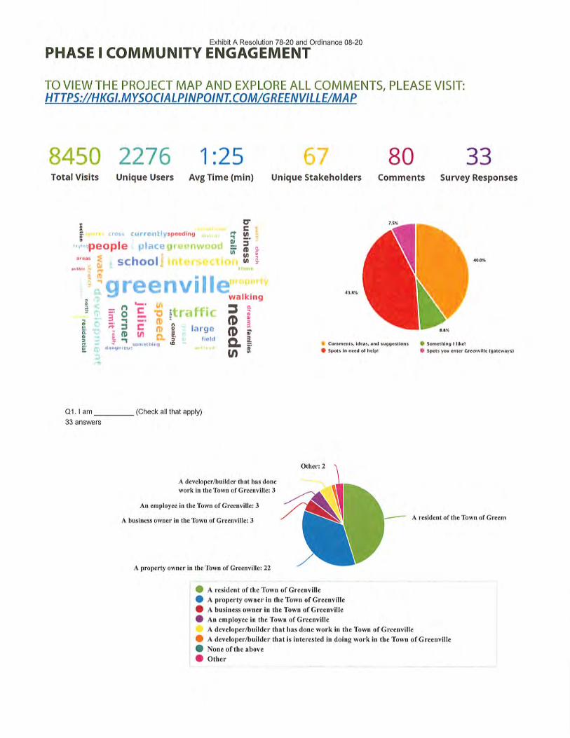
Exhibit A Resolution 78-20 and Ordinance 08-20
PHASE I COMMUNITY ENGAGEMENT
TO VIEW THE PROJECT MAP AND EXPLORE ALL COMMENTS, PLEASE VISIT:HTTPS://HKGLMYSOCIALPINPOINT.COM/GREENVILLE/MAP
8450 2276 1:25 67 80 33Total Visits Unique Users AvgTime(min) Unique Stakeholders Comments Survey Responses
people 1.1?, ;
' S schoolI'.
;l"un•r
n
1§^ 3.: (DI ^
^^•.
*?• ^E. •o
a'c "'l/t r>
»*.
.•,omr-thii)Cf
speeding
• ill
k ^
1^0
3ID
" 11 >.'. •'_)-'
V J J I f••-» I1 )' ll". '-
t •itl{ 1<
largefield
ft-1ai
U)
,\
crc 'in .
3(D ?w sU) £
walking
3(D$dw
&R>w
1/t
?3
st CommentSf ideas, and suggestions • Something I like!• Spots in need of help! • Spots you enter GrccnviUc fgatcways)
Q1.1 am
33 answers
(Check all that apply)
Other: 2
A developer/builder that has done
work in the Town of Greenville: 3
An employee in the Town of Greenville: 3
A business owner in the Town of Greenville: 3
A property owner in the Town of Greenville: 22
A resident of the Town of Greem
A resident of the Town ofGraenville
A property owner in the Town of Greenville
A business owner in the Town of Greenville
An employee in the Town of Greenville
A developer/builder that has done work in the Town ofGreenviIle
A developer/builder that is interested in doing work in the Town of Greenville
None of the above
Other

Exhibit A Resolution 78-20 and Ordinance 08-20
Q2. What are the most important types of development to promote in Greenville? Drag and drop the uses in the order of priority.
27 answers
Neighborhood Commercial (small sliops, restaurants)
Neighborhood single family residential (sewered)
Large lot residential (well/septic)
Community Commercial (grocery, larger stores)
Attached housing (townhomes, hvinhomes, rowhomes)
Senior housing (independent, assisted, nursing home)
Industrial (manufacluring, warehouses, distribution)
Multitamily housing (apartments, condos)
Offices
0.5 1.5 2.5 3,5
Neighborhood Commercial (small shops, restaurants)
Large lot residential (well/septic)
Attached housing (townhomes, twinhomes, rowhomes)
Industrial (manufacturing, warehouses, distribution)
Offices
Neighborhood single family residential (sewere
Community Commercial (grocery, larger store'
Senior housing (independent, assisted, nursing
Multifamily housing (apartments, condos)
Q3. What do you think are examples of other places that have done development well? What makes them great places?
24 answers
Word Cloud ] | Response List
Responses
Berlin, Winneconne, Manitowoc, Plymouth. They have town centers that allow residents to congregate for meals/socials and allow for
events/activities. They have managed major highways through town and/or have major highways with easy on/off along with visibility to the
town to draw people off the highway.
Cedarburg and Grafton areas come to mind keep the apartments and duplexes out keep local shops and local stores keep big boxes out
they are close enough in appleton / grand chute. Keep lots large and keep moving forward on trails and more recreation opportunities.
city of neenah . good mixed use development at affordable costs
Clayton/Town of Menasha, Town of Neenah. Big businesses move out there. Retail, hotels and restaurants are there...all tastefully done. Not
crowded/city feeling. They also have police force. Maybe it's boredom due to Covid, but it certainly seems like there is a lot more petty crime
in this area, and home break ins and other thefts.
Connectivity make them great. The ability to get from point A to B to C without crossing unmarked pedestrian intersections.
DePere was beautiful gateways and a wonderful "historic" downtown on both sides of the river.
Downtown Neenah has done well but they are supported by the City and Community Leaders. Appleton Industrial Parks. SE Appleton Office
Building along Highway 41.
Elkhart Lake Key West, Florida
Greenfield, Wl; Park Fairfax, VA; Oak Park, IL. What makes them great is not the condos - its that they have retained their original identity,
and not allowed themselves to be overdeveloped. ]f you look at Pentagon City, VA near Park Fairfax, it has completely morphed into a
replicated mini-Washington, D.C. over the last 20 years, with high-rises, and an overdeveloped commercia] district, with drugs and crime
from Washington D.C. In Greenfield, the commercial district was limited to small neighborhood shops in the historic district, similar with Oak
Park, IL, which is a 12 block enclave surrounded by ugly urban sprawl. People live in places like Greenville for generations because it is a
nice, quiet place to live with low taxes. Recent housing development has shrunk lot sizes, increasing density, decreasing property values,
and results in an overflow of traffic in what used to be a nice, quiet, safe community.
Having a mixture of businesses and cultural spaces would be key. Having a way for it to be a destination.
Hilton Head, SC. It is a development where small commercial and businesses are mixed in with the residential areas all within a wooded
surroundings. This has been done so successfully that when driving down a major roadway within the development it is difficult for one to
identify where the local businesses are located without the provided identifying signage along the roadway.
I can't think of an example of a specific place, but communities that create a sense of place and are vibrant. I realize there isn't a one size fits
all and Greenville has to find create its own identity. There has to be a balance of uses and development to be sustainable, just like a
balanced financial portfolio.

Exhibit A Resolution 78-20 and Ordinance 08-20
I can't think of a place that has done development well, but I can think of where development was NOT done well. I moved here 5-6 yrs ago
from Northern IL, where they sold farms and jam-packed as many houses as the could with no thought on the traffic impact. After 20 yrs of
this, the roads are congested and people are rudely living their lives in an over-populated area. PLEASE do not do this to Greenville. What
we fell in love with in Greenville is the fact that people are so friendly and considerate (which I contribute to a more relaxed way of life); we
enjoy the country atmosphere while having access to the great "little city" of Appleton so nearby.
I feel every community has its positives and negatives when it comes to development. The important thing is to learn form others and do
better for Greenville.
If we knew places that did it well... we would just copy them and this question wouldn't be on here. I ask: What other places is Greenville
observing and modeling after?
Many communities have focused on re-development. What seems to work well is a coordinated plan that includes: housing, business,
recreation, etc. People want to live, shop and play where it is convenient.
Mequon, Wi Cedarburg, Wi Thiensville, Wl Steady growth, clean, modern yet have a quaint feel. These places promote small businesses.
Also limit multi-low income housing.
Mt Pleasant, SC. Maple Grove ,MN
Neenah has done a good job of preserving their downtown while adding new businesses. Only drawback is lack of parking.
Neighbors with walking/biking paths to get around without having to interfere with traffic.
Not familiar with any.
Not sure. I will need to look into this more.
Sports complex / outdoor recreational activities, both give more of a community feel and they bring people together
The north side of the City of Appleton (around Thrivent) was master planned for development which led to a very nice finished community.
Q4. Greenville's Heritage Overlay Area consists of the property around the intersection of Highways 15 and 76. It is considered the "Town
Center" of Greenville. What should this area look like in the future?
28 answers
Word Cloud Response List
Responses
Americana-shops, businesses. This is a high traffic area. Give the business owners a chance at success and have it be tastefully done, with
in and out access.
A police department. Small businesses. I don't think Greenville needs any big stores as nearby Grand Chute and Appleton serve that
purpose plentiful. Greenville should cater to its "quaintness" and not become another overcrowded development trying to duplicate what
Appleton already has.
Areas with cute downtown areas. It can be new but make it inviting. Make it something people want to come and walk down the street and
go from business to business. Have some shops to draw people not from Greenville in.
Build on the base of the park and ball fields and develop with small shops and restaurants. Walking access.
Historic! - Walking path connecting buildings. - Benches to sit at, flower beds - Lower level business with upper level condos. - Small local
businesses only, no big realtors
It could use a grocery store, along with an area of small retail shops on Hwy. 15.
It is difficult for me to envision a functional Town Center with such major highways and large volumes of traffic. It is already a major challenge
to make left turns, to enter from side roads, residents to leave/enter driveways, pedestrians to cross, and town events to be held. I think a
significant, enforced speed reduction is necessary or a significant re-design of'turn-out" lanes or "frontage" lanes that are not for through-
traffic travel, but for residents and pedestrians. Other than that, the center needs attractions to events (e.g. enhance Community Park as a
draw), work to save the zoo as an attraction, small shops, restaurants, and a plaza for events (e.g. Houdini Plaza in Appleton as an
example).
It should be pedestrian and bike friendly.
It should be preserved as much as possible to continue to look like it always has.
It should maintain the character of the town, more outdoor seating at restaurants.
It would be looked at as the "hub" of the community. There is already that feel with the parks, municipal services and some businesses.
There is need for more businesses with a variety of offerings. The Town already has done a great job with the trail systems to allow people to
access the area by walking/biking. The one concern is safety especially along 76 and 15, That needs to be addressed if area is developed
further.
It would be nice to see this area kept with a small town feel. Not overcrowded or over commercial, a nice small town mix local businesses
single family homes
I would like to hear your ideas.
Mixed use and commercial.
Mixed use development with masonry front buildings, neighborhood commercial development that offers a variety of reasons to come to or
be in Greenville.
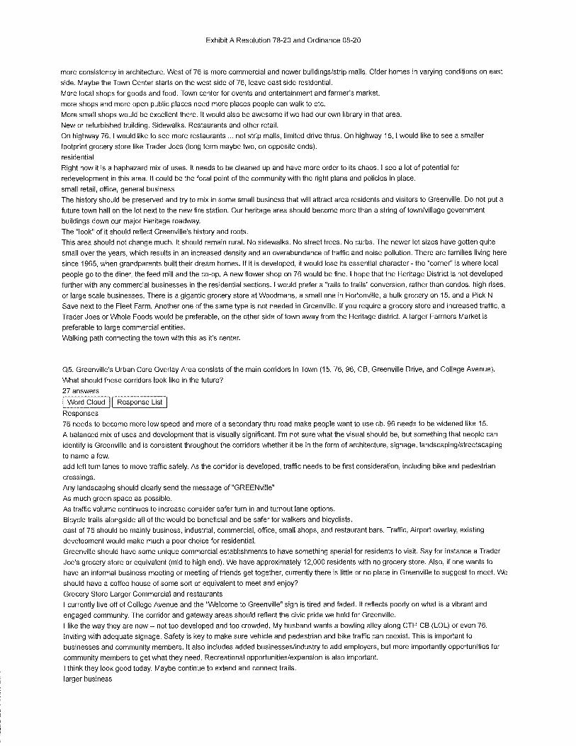
Exhibit A Resolution 78-20 and Ordinance 08-20
more consistency in architecture. West of 76 is more commercial and newer buildings/strip mails. Older homes in varying conditions on east
side. Maybe the Town Center starts on the west side of 76, leave east side residential.
More local shops for goods and food. Town center for events and entertainment and farmer's market.
more shops and more open public places need more places people can walk to etc.
More small shops would be excellent there. It would also be awesome if we had our own library in that area.
New or refurbished building. Sidewalks. Restaurants and other retail.
On highway 76.1 would like to see more restaurants ... not strip malls, limited drive thrus. On highway 15, I would like to see a smaller
footprint grocery store like Trader Joes (long term maybe two, on opposite ends).
residential
Right now it is a haphazard mix of uses. It needs to be cleaned up and have more order to its chaos.I see a lot of potential for
redevelopment in this area. It could be the focal point of the community with the right plans and policies in place.
small retail, office, general business
The history should be preserved and try to mix in some small business that will attract area residents and visitors to Greenville. Do not put a
future town hall on the lot next to the new fire station. Our heritage area should become more than a string of town/village government
buildings down our major Heritage roadway.
The "look" of it should reflect Greenville's history and roots.
This area should not change much. It should remain rural. No sidewalks. No street trees. No curbs. The newer lot sizes have gotten quite
small over the years, which results in an increased density and an overabundance of traffic and noise pollution. There are families living here
since 1965, when grandparents built their dream homes. If it is developed, it would lose its essential character - the "corner" is where local
people go to the diner, the feed mill and the co-op. A new flower shop on 76 would be fine. I hope that the Heritage District is not developed
further with any commercial businesses in the residential sections. I would prefer a "rails to trails" conversion, rather than condos, high rises,
or large scale businesses. There is a gigantic grocery store at Woodmans, a small one in Hortonville, a bulk grocery on 15, and a Pick N
Save next to the Fleet Farm. Another one of the same type is not needed in Greenville. [f you require a grocery store and increased traffic, a
Trader Joes or Whole Foods would be preferable, on the other side of town away from the Heritage district. A larger Farmers Market is
preferable to large commercial entities.
Walking path connecting the town with this as it's center.
Q5. Greenville's Urban Core Overlay Area consists of the main corridors in Town (15, 76, 96, CB, Greenville Drive, and College Avenue).
What should these corridors look like in the future?
27 answers
Word Cloud 11 Response List
Responses
76 needs to become more low speed and more of a secondary thru road make people want to use cb. 96 needs to be widened like 15.
A balanced mix of uses and development that is visually significant. I'm not sure what the visual should be, but something that people can
identify is Greenville and is consistent throughout the corridors whether it be in the form of architecture, signage, landscaping/streetscaping
to name a few.
add left turn lanes to move traffic safely. As the corridor is developed, traffic needs to be first consideration, including bike and pedestrian
crossings.
Any landscaping should clearly send the message of "GREENville"
As much green space as possible.
As traffic volume continues to increase consider safer turn in and turnout lane options.
Bicycle frails alongside all of the would be beneficial and be safer for walkers and bicyclists.
east of 76 should be mainly business, industrial, commercial, office, small shops, and restaurant bars. Traffic, Airport overlay, existing
development would make much a poor choice for residential.
Greenville should have some unique commercial establishments to have something special for residents to visit. Say for instance a Trader
Joe's grocery store or equivalent (mid to high end). We have approximately 12,000 residents with no grocery store. Also, if one wants to
have an informal business meeting or meeting of friends get together, currently there is little or no place in Greenville to suggest to meet. We
should have a coffee house of some sort or equivalent to meet and enjoy?
Grocery Store Larger Commercial and restaurants
I currently live off of College Avenue and the "Welcome to Greenville" sign is tired and faded. It reflects poorly on what is a vibrant and
engaged community. The corridor and gateway areas should reflect the civic pride we hold for Greenville.
I like the way they are now - not too developed and too crowded. My husband wants a bowling alley along CTH CB (LOL) or even 76.
Inviting with adequate signage. Safety is key to make sure vehicle and pedestrian and bike traffic can coexist. This is important to
businesses and community members. It also includes added businesses/industry to add employers, but more importantly opportunities for
community members to get what they need. Recreational opportunities/expansion is also important.
I think they look good today. Maybe continue to extend and connect trails.
larger business

Exhibit A Resolution 78-20 and Ordinance 08-20
Maybe each provides a theme that attracts and welcomes people-and arts corridor of sculptures, lamp post scarecrows, planters; another is
athletics which has access to park, a "fitness square," easy access & information on school competitions; another is a relaxation lane that
emphasizes walking, trails, hanging planters, outdoor cafes/winery courtyards. Currently I feel the traffic and design of these corridors
effectively divide the community from interaction & gathering, and invite traffic to "move quickly through and onto your destination."
Mixed use, commercial and light industrial.
Not sure
Not sure.
Park Fairfax used to give away bulbs to residents in spring to plant on the property. I think you could do some nice landscaping along the
medians. Some of it is already fairly developed.
Pedestrian and bike friendly.
Residential with business south of 96
The Highway 15 area should be worked on the most. Attract new businesses and home offices. Use TIF dollars.
Thriving business and well maintained roads
Unless you're going to reduce the speed limits, they should primarily be businesses.
Well planned frontage roadways offering access to business on both sides of the frontage road. Also like to see extensions to recreational
trails access making mobility options available.
What elements are you planning to focus on? Landscape, buildings, ??? What ideas are already being considered?
Q6. Greenville's Gateway Areas consist of the main entrances into town. They are the first thing to welcome people into the community.
What should these areas look like in the future?
24 answers
Word Cloud 11 Response List
Responses
A balanced mix of uses and development that is visually significant. I'm not sure what the visual should be, but something that people can
identify is Greenville and is consistent throughout the corridors whether it be in the form of architecture, signage, landscaping/streetscaping
to name a few. There should be consistency as your enter the community but should consider the scale based on higher priority entrances to
secondary entrances and the context of the surrounding and planned land uses.
Attractive buildings and abundant green space.
Beautiful iron archway , flower beds , proper lighting Gateways must be accessible via car, bike and foot.
Big sign welcoming people to Greenville. Maybe lots of pretty flowers too.
Commercial business parks that broadcast the entrance points of Greenville. People need to know just by looking at the buildings they are
entering Greenville.
Decent looking plants and maintained trees
Have some Ithing bigger/grandeur to welcome to town
I can't think of any example of a great main entrance to any town other than some fancy elaborate sign.
I currently live off of College Avenue and the "Welcome to Greenville" sign is tired and faded. It reflects poorly on what is a vibrant and
engaged community. The corridor and gateway areas should reflect the civic pride we hold for Greenville.
Inviting. Again, safety is key along with well-maintained roadways. Having a consistent look is also important. Many communities have put
requirements in place to ensure that there is a certain look and feel with development.
i prefer a small, quaint wooden sign as an entrance into town, vs. something ugly and ostentatious, like the new Community First Credit
Union building in Fox Crossing.
More prominent signs with nice landscaping-flowers around the base of the signs would be my preference.
Not monstrous statues like Neenah! Native plantings in round abouts, signage to identify the town and direct visitors to airport, park, town
hall. Similar to what we have now but larger. Don't rely on the standard green highway signs.
Not sure.
Same as above.
Showcase projects that enhance our way of life such as solar, wind, prairie/wetland restorations, trails, etc.
signs that are kept clean and clear of brush, debris
This is a challenge for me. I think these entries need to give the character of the town-is the green belt a key emphasis? Then have that as
an entry theme on the closest gateway road. Is there key heritage to emphasize, maybe that is the design to the closest gateway near those
features. Are there key accomplishments (sports, famous residents, key historical events)? Maybe that is designed into another of the
gateways.
Tree-lined streets
Use unique signage that informs visitors of Greenville and its history.
Welcoming, residential. Slow the speed limit so people know they're in a town.
Welcoming sign. Well groomed green space with trees, bushes, flowers.
Well kept signage.
What elements are you planning to focus on? Landscape, buildings, ??? What ideas are already being considered?

Exhibit A Resolution 78-20 and Ordinance 08-20
Q7. What is your best idea for the future development of Greenville?
31 answers
Word Cloud Response List
Responses
Adding another tunnel under 76 closer to Lion's Park. You risk your life crossing that road with children to get to the park. If the rumored
tunnel isn't going happen, at least put a push button with flashing lights to have traffic slow to a stop in order to cross safely.
Bike lanes that allow residents to bike to and from the center of town safely.
Bike /walking paths connecting all neighborhoods. Make Greenville a place where outdoor physical activity is revered. Currently hiking and
walking on many town roads is dangerous as people are unwilling to share the road.
Connecting Towering Pines, Savannah Heights, and Field of Dreams neighborhood developments to Lions park / West side of 76 via a
tunnel or robust pedestrian crosswalk.
Continued population of the business park, multi-family development near business park, continued expansion of recreational trails, turn
Everglade wetlands into a nature perserve with a vast trail system, commercial development in the corridor regions.
Continue to incorporate parks and green spaces. Expand bike paths to provide access to new commercial spaces.Continue to control
housing development, both in numbers and density.
Continue to preserve the heritage while building for the future. The town has done an excellent job of balancing expansion while holding to
it's values of preserving our resources.
Emphasis on safety especially on roadways and continuation of providing opportunities to walk/bike throughout the community.
Focus on areas that have the greatest potential for development/redevelopment. For those areas that may not have the potential now,
determine what it will take to focus on those areas. I think the Heritage area has a lot of potential to develop/redevelop by creating a central
location of localized commerce, entertainment and sense of place/community.
Grocery store and a high school
I believe the creation the TIF district was a huge accomplishment for the Town of Greenville. As a real estate broker, I know from experience
TID incentives are mandatory to attract the development opportunities the Town will want. I suggest continued support of the TID and
possibly even expanding it.
Keep a rural feel - especially in the face of urban sprawl and losing farmland.
Keep it in the sanitary district and don't enlarge the sanitary district. Do whatever you can to promote farming in Greenville. Remember,
farmland pays it way. New homes cost all of us money. If you think about it, why not limit new construction. When the current area is full, then
construction stops. Don't be swayed by developers. They are here to make their money and then leave. They don't love and respect the land
and the environment. They love money, money, money. By putting a stop to new construction, Greenville will become the most desirable
place to live in the Fox Valley because of the open space/farm land that exists.
Keep it quaint and unique with an agricultural flavor.
Keep single, dwellings and multi dwelling units separate. Don't devalue single, family homes with apartments and duplexes. Large grocery
(Festival) retail shopping area- small shops, restaraunts, coffee shops. Keep Induatriali an Industrial area. Include a beach and swimming
area like Plamann Park or Kjmberly's swimming beach with the splash pad
LOW TAXES. KEEP RURAL IDENTIT/. LARGE LOT SIZES. LIBRARY before Sportspark. Bike lanes and reduced speeds along many
roads. Perhaps a pollinator program where residents grow milkweed and other natives along street lines. Organic gardening methods. Small
mom and pop shops are preferable to large commercial entities. Senior housing would be nice.
Maintain the nature areas.... stop ripping down all the nature and find uses to enhance it; like a park area.
Many people moved to Greenville because they want to live in a small town ... a more rural area. While they may appreciate the proximity to
the Appleton area and all that it offers, they do not want Greenville to become more urban. I would like to see Greenville keep its small town
character as much as possible.
More of the same but add trails, keep apartments and duplex rows out and add local shops and keep industrial out of heritage area. Zoo
property will need major attention soon.
Preserve green space. Preserve and celebrate the heritage. Fix the roads. Don't put sidewalks and walking paths on the same narrow roads
that are more than 100 years old.....making them suddenly so wide the walks are in people's front yards and you're killing trees to boot. Use
some common sense. Don't hide behind a DOT grant that gives you $200k and makes you spend $800k to use it. When simply spending
$500k would make things so much better. That's $300k you can use elsewhere vs being dazzled by the "free" money. Greenwood road has
been here for more than 100 years old. Preserve it, don't commercialize it. All the people crying for sidewalks don't LIVE on the road, they
use it. Who will pay for it? Those that LIVE on the road.
Preserve the farms left in Greenville.
Previously I said the current highways divide the community; I think this is a key issue to resolve. The speed of traffic and lack of
enforcement contributes (there are communities that successfully gain adherence to speeds). I don't see a logical layout to the town currently
that lends itself to congregating and holding community events/activities. I think green space and agriculture must be preserved and
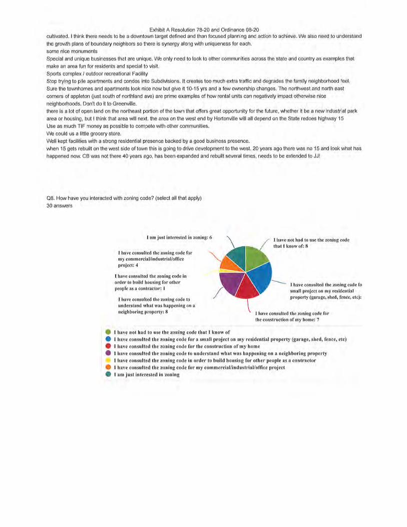
Exhibit A Resolution 78-20 and Ordinance 08-20cultivated. I think there needs to be a downtown target defined and than focused planning and action to achieve. We also need to understand
the growth plans of boundary neighbors so there is synergy along with uniqueness for each.
some nice monuments
Special and unique businesses that are unique. We only need to look to other communities across the state and country as examples that
make an area fun for residents and special to visit.
Sports complex / outdoor recreational Facility
Stop trying to pile apartments and condos into Subdivisions. It creates too much extra traffic and degrades the family neighborhood feel.
Sure the townhomes and apartments look nice now but give it 10-15 yrs and a few ownership changes. The northwest and north east
corners of appleton (just south of northland ave) are prime examples of how rental units can negatively impact otherwise nice
neighborhoods. Don't do it to Greenville.
there is a lot of open land on the northeast portion of the town that offers great opportunity for the future, whether it be a new industrial park
area or housing, but I think that area will next. the area on the west end by Hortonville will all depend on the State redoes highway 15
Use as much TIF money as possible to compete with other communities.
We could us a little grocery store.
Well kept facilities with a strong residential presence backed by a good business presence.
when 15 gets rebuilt on the west side of town this is going to drive development to the west. 20 years ago there was no 15 and look what has
happened now. CB was not there 40 years ago, has been expanded and rebuilt several times, needs to be extended to JJ!
Q8. How have you interacted with zoning code? (select all that apply)
30 answers
I am just interested in zoning: 6
I have consulted the zoning code formy commerciaVindustrial/office
project: 4
I have consulted the zoning code in
order to build housing for other
people as a contractor: 1
I have consulted the zoning code to
understand what was happening on a
neighboring property; 8
I have not had to use the zoning code
that I know of: 8
I have consulted the zoning code fosmall project on my residential
property (garage, shed, fence, etc):
I have consulted the zoning code for
the construction of my home: 7
I have not had to use the zoning code that I know of
I have consulted the zoning code for a small project on my residential property (garage, shed, fence, etc)
I have consulted the zoning code for the construction of my home
I have consulted the zoning code to understand what was happening on a neighboring property
I have consulted the zoning code in order to build housing for other people as a contractor
I have consulted the zoning code for my commercial/industrial/office project
I am just interested in zoning

Exhibit A Resolution 78-20 and Ordinance 08-20
Q9. Do you have any other comments related to zoning or the planning process?
18 answers
Word Cloud Response List
Responses
Appreciate what the Town is doing to be proactive and meet the needs of the community.
Chickens should be allowed to be kept in the town of Greenville. Town roads should also be opened as Atv/Utv routes.
consider traffic patterns and safety for residents when adding housing. Lots of subdivisions are beingbuild adding significant traffic with no
adjustment to roads or sidewalks. .. Consider the loss of nature space when building so many homes. Take time to plan large lots to
preserve what once what farm and forrest in Greenville. Much of the natural habitat is gone and the close piled houses are getting too close
to the swamp area and wildlife habitat is being taken away. The Greenville I grew up in was full of nature, farms fields and forrest. Now it is
one house on top of another in yards too small for kids to play. One park for every one to walk to but not enough sidewalk to get there and
increasing traffic with no safety for people out walking/biking and enjoying the nature we have.
Definitely will need more business to help support this transition. Nice to see Greenville looking to the future
Do what is needed to protect our Greenbelt from development so Greenville will remain special among regional communities with open
spaces and farmland to enjoy and provide for future generations of area residents.
Greenville has some unique geological features-wetlands, watersheds, karst (incorrect spelling??). These need to be preserved and not be
overrun or destroyed by zoning and/or development-once gone, they and all the wildlife/plant life associated with them can never be
regained. Thanks for the opportunity for input. John Conrad.
I am concerned that a small group of individuals will change the identity and character of Greenville into a North Appleton or have another
hidden agenda, like when the karst was illegally drained. I would like to know what Environmental Impact Studies have been done with this
development plan.
Industry and offices play an important part in rounding out a community, but i have not considered how they should be incorporated in
Greenville.
In the past, we seemed to have gotten beaten down by developers. Why can't we say "no" to them? Why can't we say "no" to those who own
land and now want to develop? The town can have so much more control if we only had some sort of PDR program or a farmland trust. You
could then say "no" to development of any piece of property. Remember, people like it in Greenville because of the rural areas that still exist.
I think Greenville needs to be open to changes in zoning to accomodate projects that fit.
It often feels like zoning decisions are made without informing the public. The bare minimum of notification is followed. When residents find
out about new development, it is already too late to protest or voice concerns because the zoning has changed. Zoning decisions are THE
most important decisions our board makes. They need to be discussed in the town newsletter, easier to find on the website (featured on
home page?) and with press releases to Post Crescent
Keep up the great work Greenville. It's nice to see a community being proactive with its future.
Make your due process simpler for your residents, those that pay the bills. Don't have complex titles and funky names for the projects. Say
"Hey, Julius road residents, we are discussing the future of your road on this day at this time" Log the project names in your minutes with
whatever vernacular or sequence works for the town government. The residents are your customers.
Michael Brown is very knowledgeable of the zoning code and was able to successfully help secure two projects I was involved with by
assisting with the rezoning of the property to meet the buyer's requirement.
No
The future of our town is in your hands, a large task that I am glad to say you are doing a great job at
the way it is now some of the planning commission do not understand it. May need to be simplified, or clarified as it goes thru the process of
being changed.
To reiterate, do not overcrowd with housing or business.

Exhibit A Resolution 78-20 and Ordinance 08-20
PHASE II COMMUNITY ENGAGEMENT
TO VIEW THE PROJECT MAP AND EXPLORE ALL COMMENTS, PLEASE VISIT:HTTPS://HKGI.MYSOCIALPINPOINT.COM/GREENVILLE-WI/MAP
1163 259 1:38Total Visits Unique Avg Time
Users (min)
11 36 7Unique
StakeholdersComments Survey
Responses
comdo, gi-eenspace p^^ic 5 -a 2 3 I• "• l>ln''- restaurants ,.—-.-.„ Q g ^'|
' S" SS « ^I ^.ih.vi.-.i itmi.-'tli _..:_^:.
existing w
I I ^ space ai
-s S,f^v^opmen'treally'"*' '"*" - - m S'r
r; ^ -' '-7 sense S 3 'k^ - S o fl< =?"S .^ S. :£ ^.houyiitii ^ § f'°"s"aes- ^
S' '"" . ft allow? ^ rt Q.ll-o y n'1c r-r
'.I I 'LS1.1X
How about this idea? • t dislike this • I like this • This concerns me
HERITAGE DISTRICT CHARACTER SURVEY
Q1. Which of the above images best represent the general development character you would like to see in the Heritage District? Select all
that apply.
3 answers
Image 5: 1
Image 4: 3
Image I: 2
Image 2: 1
Image 1 Image 2
Image 3: 2
Image 3 9 Image 4 Image 5

Exhibit A Resolution 78-20 and Ordinance 08-20
Q2. Which of the above images best represent the mixed-use character you would like to see in the Heritage District? Select all that apply.
3 answers
Image 6: 2 Image 1: 2
Image 5: 2
Image 2: 1
Image 3:1
Image 4:1
• Image 1 • Image 2 • Image 3 • Image 4 Image 5 • Image 6
Q3. Which of the above images best represent the retail/commercial character you would like to see in the Heritage District? Select all that
apply.3 answers
Image 1:1
Image 5: 2 Image 2: 0
Image 3:1
Image 4: 3
Image 1 • Image 2 • Image 3 • Image 4 Image 5

Exhibit A Resolution 78-20 and Ordinance 08-20
Q4. Which of the above images best represent the residential character you would like to see in the Heritage District? Select all that apply.
3 answers
Image 1: 0
Image 7: 2 Image 2; 1
Image 6: 2
Image 3:1
Image 4: 2
Image 3: 2
9 Image 1 ® Image 2 ® Image 3 ® Image 4 Image 5 ® Image 6 ® Im
Q5. Which of the above images best represent the gateway characteristics you would like to see in the Heritage District? Select all that
apply.
3 answers
Image 5: 2 Image 1: 2
Image 4: 2 Image 2: 2
Image 1
Image 3: 2
Image 2 9 Image 3 Image 4 Image 5
Q6. Do you have any other thoughts to share?
1 answers
Word Cloud 11 Response List
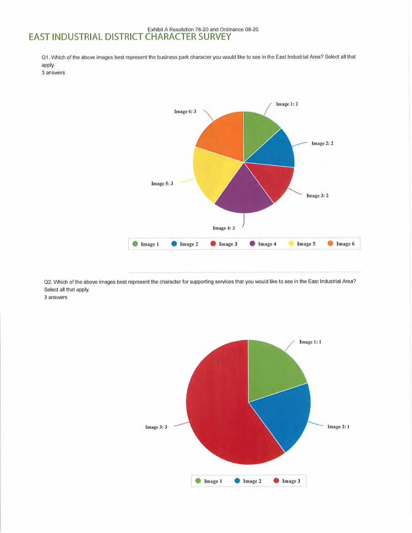
Exhibit A Resolution 78-20 and Ordinance 08-20
EAST INDUSTRIAL DISTRICT CHARACTER SURVEY
Q1. Which of the above images best represent the business park character you would like to see in the East Industrial Area? Select all that
apply.
3 answers
Image 1: 2
Image 6: 3
Image 5: 3
Image 2: 2
Image 3: 2
Image 4: 3
Image 1 • Image 2 • Image 3 • Image 4 Image 5 • Image 6
Q2. Which of the above images best represent the character for supporting services that you would like to see in the East Industrial Area?
Select all that apply.
3 answers
Image 1:1
Image 3: 3 Image 2:1
Image 1 • Image 2 • Image 3

Exhibit A Resolution 78-20 and Ordinance 08-20
Q3. Which of the above images best represents the amenities and streetscape character you would like to see in the East Industrial Area?
Select all that apply.
3 answers
Image 4: 1 Image 1: 1
Image 3: 1
Image 2: 3
Image 1 Image 2 Image 3 Image 4

Exhibit A Resolution 78-20 and Ordinance 08-20
SPORTS + SPLASH AND LIONS PARK SURVEY
Q1. What ideas do you have to help Greenville celebrate its Agricultural Heritage?
1 answers
This seems like it would be a good area to develop some kind of museum or other historical use, just not sure
where it would go.
Q2. Which Ideas for Agricultural Tourism do you like the best?
1 answers
Heritage Museum: 1
Winery, Brewery, and Distillery Tours/Tasting: 1
U-Pick Operations: 1
Rural Bed & Breakfasts and Farm-stays: 1
Petting and Feeding zoos: 0
On-farm Farmers' Markets: 1
Living History Farms: 1
• Agricultural Museums
• Corn Mazes
Demonstration Farms
• Garden & Barn Tours
0 Living History Farms
9 Petting and Feeding zoos
® Rural Bed & Breakfasts and Farm-stays
• Winery, Brewery, and Distillery Tours/Tasting
Agricultural Museums: 1
Breakfast/Dinner on the Farm: 1
Corn Mazes: 0
Demonstration Farms; 1
Event Venues (Barn Weddings): 1
Garden & Barn Tours: 1
Hay Rides: 1
Breakfast/Dinner on the Farm
Cut-your-owu Christmas Tree Farms
Event Venues (Barn Weddings)
Hay RidesOn-farm Farmers' Markets
Pumpkin Picking Patches
U-Pick Operations
Heritage Museum
Q3. How do you think the Town of Greenville should pursue implementing any of the ideas above?
1 answers
Work with the existing farmers to come up with a plan. Seems like there are a lot of opportunities to preserve the
farming heritage while continuing to farm the land.

^
§D-
>?)(Dc"0.cff.03•~J
00f00m3Q.
d.
3
M0

Exhibit A Resolution 78-20 and Ordinance 08-20

Exhibit A Resolution 78-20 and Ordinance 08-20
Overview
1 Key Findings
2 COVID19 Discussion
3 Greenville's role in the region
4 Housing Outlook
5 Commercial/lndustrial/Office Outlook
6 Additional Data & Research
Sub Area Plan & Marketing Study

Exhibit A Resolution 78-20 and Ordinance 08-20
Project Purpose
The small area planning project is an outcome of the
Comprehensive Plan. Greenville recognized the need to
provide additional guidance for key spots in the community,
including the area around the intersection of 15 & 76, as
well as gateways and major corridors.
This market research is intended to provide planning staff
with direction regarding the types and scale of future
development that may be anticipated and supported.
Sub Area Plan & Marketing Study


Exhibit A Resolution 78-20 and Ordinance 08-20
Key Findings
• Greenville is a great place to bring a family, and the
housing market reflects that
• Single family has been, and will continue to be the main
driver of population growth
• Multi-family and attached housing products are becoming
more popular, and represent a naturally more affordable
opportunity to join the community
Sub Area Plan & Marketing Study

Exhibit A Resolution 78-20 and Ordinance 08-20
Key Findings
• Density proximate to retail/jobs will strengthen residential
and retail
• Commute patterns and proximity to Grand Chute make
retail challenging, but Greenville's demographics are strong
• Industrial (especially good industrial) should continue to do
well in Greenville
Sub Area Plan & Marketing Study

Exhibit A Resolution 78-20 and Ordinance 08-20
Impacts of COVID-19
• A Black Swan Event
• Dire outlook in the short: term
- Over 25% unemployment in Wisconsin
- -1/3 of businesses closed
- Commercial rent collections down significantly
- Gradual reopening of economy
- Recovery will be a slow climb out of a quickly dug hole
Possible periodic regressions with COVID-19 flare ups
Sub Area Plan & Marketing Study

Exhibit A Resolution 78-20 and Ordinance 08-20
Impacts of COVID-19
• Mixed recovery in the long term
- Hospitality: Long road ahead, numbers way down, new
technology may reduce business travel
- Retail: Consumers spending less, new development likely to be
stymied by surplus of space in proven locations
- Office: General consensus is that office will likely come back ok,
but with changes to design. Large restructuring likely in medical.
- Industrial: Increased demand likely as e-commerce rises further,
US moves away (slowly) from foreign relianceSub Area Plan & Marketing Study

Exhibit A Resolution 78-20 and Ordinance 08-20
Impacts of COVID-19
Mixed recovery in the long term
- For Sale Housing: Some bumps, but pent up demand and low
mortgage rates should help for sale housing weather storm
well, especially at entry-level. Fed support of housing market to
help households/economy.
- Rental Housing: SFR, TH, and most apartments will be within
reach for many hurt by downturn. Affordable housing remains
an area of high need (and getting higher).
Sub Area Plan & Marketing Study

Exhibit A Resolution 78-20 and Ordinance 08-20
Impacts of COVID-19
• Financing
- To this point, the financial structures that make development work
(rent, lending, etc.) have been averse to forgiving payments,
choosing forbearance, deferments, extensions.
- This may constrain the ability of renters (business & residential)
to bounce back quickly as the economy reopens.
Sub Area Plan & Marketing Study


Exhibit A Resolution 78-20 and Ordinance 08-20Money "cort
Fox Valley Region
• A great place to live
• Growing
- Outagamie, Calumet, Winnebago Counties
up almost 100,000 since 1990 (30%)
• Built on manufacturing, remains strong
• Some overlap with Green Bay
24. Appleton, Wise.
00^
2019 Tnp ino Best Place'; In Live
Appleton, WlPopulation- /G,/28
yy BOG
Sub Area Plan & Marketing Study

Exhibit A Resolution 78-20 and Ordinance 08-20
Greenville + Fox Valley Region
Housing
• Growing Edge, new homes
• Open Space/Larger Lots
• Move-up housing
- A great place to bring your
family
• New appeal for boomers
Commercial
• Airport
• Strong industrial in a
strong industrial region
• Retail - specific
destinations (Bulk Foods, Meat Block)
• Office - Small and local
Sub Area Plan & Marketing Study


Exhibit A Resolution 78-20 and Ordinance 08-20
Existing Housing Stock
Largely owner occupied (85%)
Mostly single family homes (85%)
Primarily single familysubdivisions
Some precedent for other multi-
family, manufactured
Some farm, large lot rural (30%)
Housing By Type
1 Single Family Detached
1 Attached (up to 4 units)
Attached (5-9 units)
1 Attached/Multifamily (10+ units)
1 Mobile Home
Sub Area Plan & Marketing Study

Exhibit A Resolution 78-20 and Ordinance 08-20
Housing - Demand
• Greenville is anticipated to addabout 800 new residents in thenext 5 years
• This translates to approximately300 additional households
• Driven by families, move up
housing
• Smaller but growing empty nester"right sizing" demographic
1970s
1980s
1990s
2000s
2010s
New Housing Units perYear
•
0 20 40 60 80 100 120 140 160
Sub Area Plan & Marketing Study

Exhibit A Resolution 78-20 and Ordinance 08-20
Single Family Housing
Greenville is a desired
location for families with
kids due to newer
housing stock, schools
63% of the community's
homes were built
between 1990-2010-600 -400
2019 Age Demographics
-200 200 400 600
Seriesl •SeriesZ
Sub Area Plan & Marketing Study

Exhibit A Resolution 78-20 and Ordinance 08-20
Attached Housing
• Existing attached is primarily school adjacent
• Attached housing provides a more affordable option for
families looking to move into the area or searching for a
starter home, especially as single family prices rise..»*E

Exhibit A Resolution 78-20 and Ordinance 08-20
Multi-Family Housing
• Primarily Rental
• Very low vacancy
• Existing stock is largely stand
alone. New product would
benefit from amenitization.
Development Features
- Neighborhood
Overall & Stabilized Vacancy
Ri recast
4%
3%
2%
1%
0% h;+"+:;+ -+::+"+:;10 12 ' ' 14 ' '16
• Overall Vacancy
+;.+-+„+-+.+"+»+Stabilized Vacancy
Sub Area Plan & Marketing Study

Exhibit A Resolution 78-20 and Ordinance 08-20
Senior Housing
• Current demographics
show that Greenville is
still a younger
community
• Not much built in
demand for senior
housing
2019 Age Demographics
-600 -400 -200 200 400 600
Series! • Series?
Sub Area Plan & Marketing Study

Exhibit A Resolution 78-20 and Ordinance 08-20
Senior Housing
• Growing Boomer/
Empty nester
demographics
• Desires
-single level living
- smaller homes
- amenities (trails, shops)
-family
2019 Age Demographics
-600 -400 -200 0 200
Seriesl • Series2
400 600
Sub Area Plan & Marketing Study

Exhibit A Resolution 78-20 and Ordinance 08-20
Missing Middle Housing
• Missing Middle housing refers to a series of housing types
that for a number of reasons (zoning, financing, off-site
management) have been underbuilt
• Middle density products that can help create more options,
afford ability, rooftops, and walkable commumtje^^^^
DETACHED&INOLE-FAMILT
HOMES
FOURPLEX _ ^SSlHfi MWLE H^&'NS OFTK05
Sub Area Plan & Marketing Study
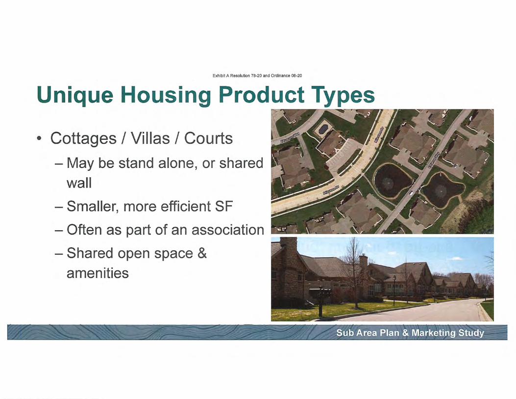
Exhibit A Resolution 78-20 and Ordinance 08-20
Unique Housing Product Types
Cottages / Villas / Courts
- May be stand alone, or shared
wall
- Smaller, more efficient SF
- Often as part of an association
- Shared open space &
amenities
Sub Area Plan & Marketing Study
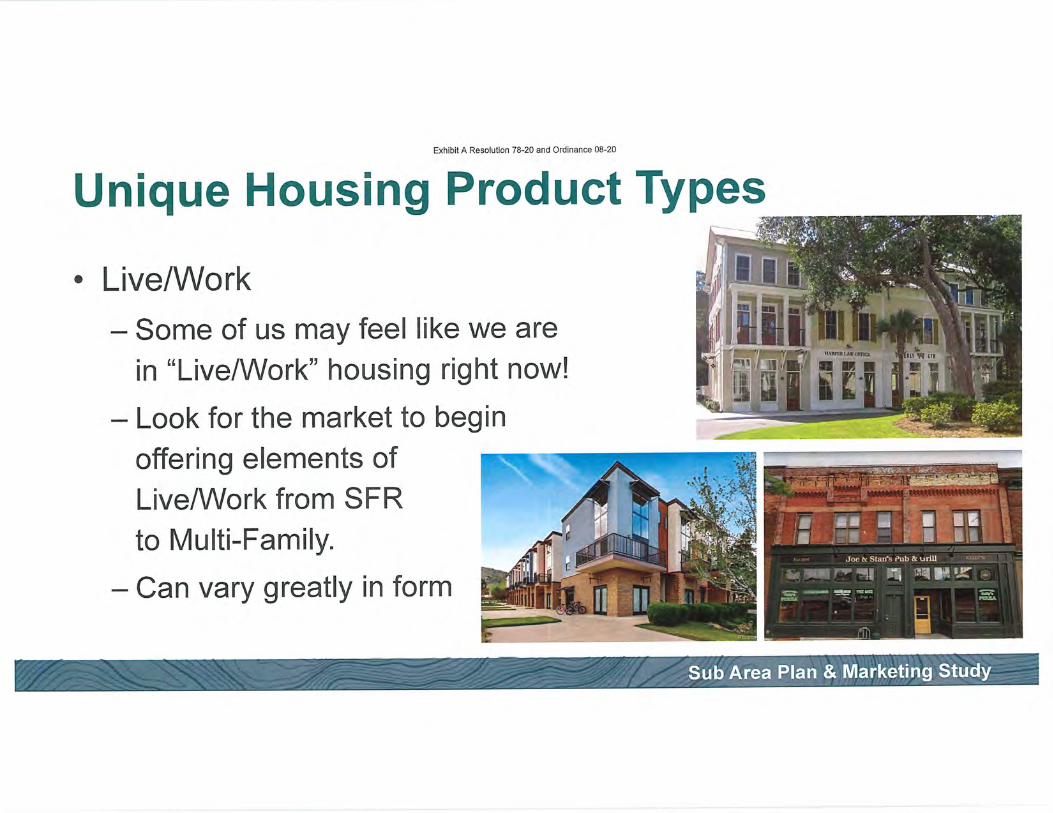
Exhibit A Resolution 78-20 and Ordinance 08-20
Unique Housing Product Types
Live/Work
- Some of us may feel like we are
in "Live/Work" housing right now!
- Look for the market to begin
offering elements of
Live/Work from SFRto Multi-Family.
- Can vary greatly in form
Sub Area Plan & Marketing Study

Exhibit A Resolution 78-20 and Ordinance 08-20
Unique Housing Product Types
• Accessory Dwelling Units
- "a secondary housing unit on a
single-family residential lot"
- Dubbed "Gentle Density"
- May be detached (carriage
house, backyard cottages, etc.)
- May be attached (basement
conversion, over-garage, add-on)
nisis,; umi.rot*\TW> I MVH I It
nnmixnt
h. i
Sub Area Plan & Marketing Study

Exhibit A Resolution 78-20 and Ordinance 08-20
Unique Housing Product Types
Conservation Subdivision
- Presen/e natural features
- Consider views and access to
nature with neighborhood layout
- Trails!
- Same principles can be applied to
higher density development
Sub Area Plan & Marketing Study

Exhibit A Resolution 78-20 and Ordinance 08-20
Considerations for Implementation
• Discourage "Leapfrog" development
• Encourage the preservation of natural features
- Forests, creeks, wetlands, open space
Sub Area Plan & Marketing Study


Exhibit A Resolution 78-20 and Ordinance 08-20
Industrial - Existing
There is a strong existing industrial presence in Greenville
Benefits from Airport proximity and Industrial cluster
2M SF of space in Greenville
Quality product moves very
well ,^Ai.
Not a lot of flex space
- Usually under 10% office
Sub Area Plan & Marketing Study

Exhibit A Resolution 78-20 and Ordinance 08-20
Industrial - ExistingVACANCY RATE
Very low vacancies in
Appleton Metro
Even lower in Greenville
<1%
Most new product is BTS
and quickly absorbed
2014 2015 2016 2017 2018 2019 2020 2021 2022 2023
Soecialized industr^l • Lmistics • Flex Aopieton J"ted S-a-ea
Sub Area Plan & Marketing Study

Exhibit A Resolution 78-20 and Ordinance 08-20
Industrial - Potential
• Demand for quality product
- Bigger clear heights, more aprons, desired layouts
• Willingness to pay for higher fit & finish, especially in
client facing areas
• Many users in 10-20k SF range
• Typically single tenant, but could use multi-tenant
adaptability
Sub Area Plan & Marketing Study
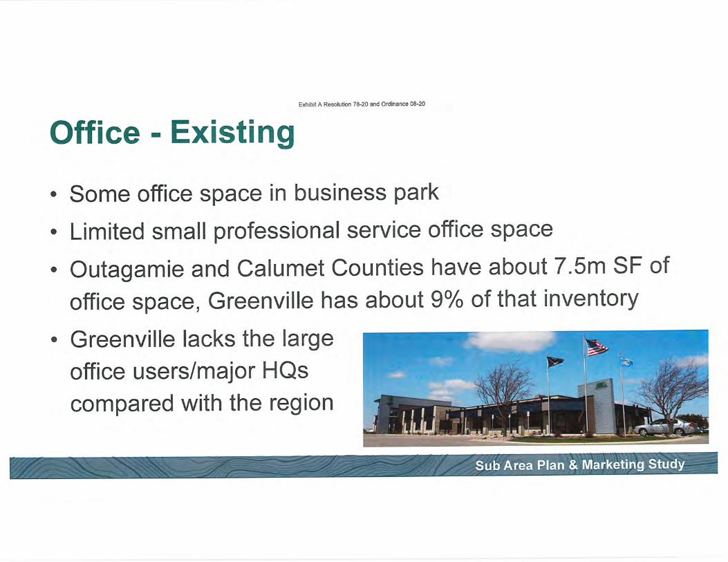
Exhibit A Resolution 78-20 and Ordinance 08-20
Office - Existing
Some office space in business park
Limited small professional service office space
Outagamie and Calumet Counties have about 7.5m SF of
office space, Greenville has about 9% of that inventory
Greenville lacks the large
office users/major HQs
compared with the region
Sub Area Plan & Marketing Study

Deliveries & DemolitionsExhibit A Resolution 78-20 and Ordinance 08-20
Office - Existing
• There is a little over 40k SF
of vacant space
- N434 Greenville Center
• Last year absorbed 15.5k SF
•s
a
25K
20K
15K
10K
5K
Forecast
"IJ.IJ IJ. I,. I 1,.J IJ I.• Deliveries • Demolished • Net Deliveries
Market Sale Price Per SF By Location Type
I U L.l
S130
S1SO
sna
Forecast
$80
$7° I.-1 I.. I10 ' '12 IJJJ l,.l IJ IJ 1»
Suburban
Sub Area Plan & Marketing Study

ouagane comy
outaganfe Couray
Outagarte Cotrty
OutagaiTfe coirty
Outagamte Courty
Outagarrfe Coiray
drtagarrfe Courty
Outagante coirty
Outagane caurty
Cutagarte Comy
outagane cnny
Outagame cotxay
Otrtagante Couny
ouagane cnuray
is.saci
H.24S!
9.776:
MU6;»0
6,000 i
ws\.1.108
1.000!
3.960!
a.ffffl;
3.506;
unousi»'\
0119;
0419- _.^01 201 PtS
Q3 191-
0419
W19\
premnuEMeacacare
tooetieSoiusons
Q41»i-
co 19 Twat sans cuunns
0319; nman Sam suunns
Q12D'-
0319 -
0120!-
0219 Fannay
CK 111mraTecnu.c
Exhibit A Resolution 78-20 and OrcHnancS)(?SB'CE LEASES PAST 12 MONTHS
BunanigNamauanw iunmnut unuaSF air Tenurtnann
Office - Potential6l9NL»nnaaleDr
capaoi cout Office compteic
Kauaaira IMussw Pan
ssiNpeninssi
^ • • rf ^^ ^^ ^». ^^ ^^. ^— Gieenvse Buelnew Part
• With a typical user at 2,000 SF, iiE=E138-isa ENamana Aw
it will be tough to move the lil^EEntapflEeoaire
321-333 SNIeUet TO" ! OUBganle Camy 2.732I QSHiPCSLLC
vrasocnaiengerDr- ;outaganrecamy 2.709 Q2i9|'naisputaonStam»A-..
-^^--— —- -^^^y —MBi-Q4i»iwMene»p—"-222 Building I Outagamte GNXty 2,500 031?-
NofitafeCoirmroe Center ; Outagarnte Couty 2.400 0315;-
• Most development will likely be :i^=?^i=:3|j^"~E.109EmSt Cutagane Comy I.SOC Qt 201 panl Gypey
iiEN^UEUnsi loutaganecomy i.—c 0319'-
EdBonCenler ' Outagane Cany 1.7S7! QIISiUnmaeCBanlngumted
pmlBBBiaPait loutagamcomy IA34| <ai9|-
2Zlo.22HEB«jreenDT iomaganteoxny l.eial vais\-
PtoneworaE Part i outagame couray 1.600 0120-
• < I • , , 1930CraokEA? ICutaganeCoiny 1.500 Q3t> -
• VVOFK wnn growing ousinesses ^^:=::is^=^|^|^mr130EF»anmSl [OutaganeCoxty 1^75! Q419.
ESONMoniamSt i ouiagaite couny 1..167 mis ReiBOgeDesyienpna
to ensure they have the spaceSTW.STSOWGranaeuatetDr iouBgameCowty iso cun -
^wasu»A^___^aQ?neca^^__!-!^Q2^^EtliKMCener | Outagawe County 1.US 01 23 Reaaert capdn. L^c
5601 w Grans uataw loutagaimcomy 1.0111 Q120 -
10-25k
5-1 Ok
3-5k
2-3k
1-2k
Sub Area Plan & Marketing Study

Exhibit A Resolution 78-20 and Ordinance 08-20
Office - Potential
• Heritage District:
Likely driven by more professional
service, possibly municipal
• Gateways/Corridors:
Tied to business park uses
• How can businesses use space to
bolster talent attraction and retention?
Sub Area Plan & Marketing Study

Exhibit A Resolution 78-20 and Ordinance 08-20
Retail - Existing
Challenging to get national retailers
- Proximity to Grand Chute
- Limited market along 15 (compared with US-10 or 1-41)
Limited options
Growing market in Greenville
with good demographics
Rural-focused/Space eaters
Sub Area Plan & Marketing Study
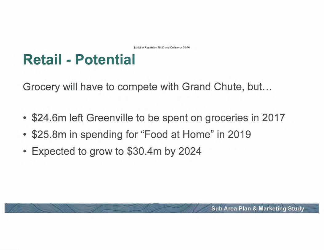
Exhibit A Resolution 78-20 and Ordinance 08-20
Retail - Potential
Grocery will have to compete with Grand Chute, but...
• $24.6m left Greenville to be spent on groceries in 2017
• $25.8m in spending for "Food at Home" in 2019
• Expected to grow to $30.4m by 2024
Sub Area Plan & Marketing Study
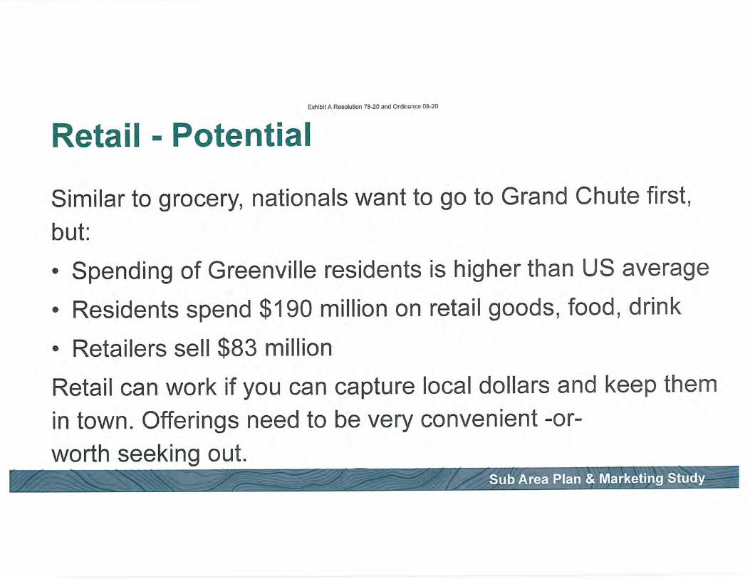
Exhibit A Resolution 78-20 and Ordinance 08-20
Retail - Potential
Similar to grocery, nationals want to go to Grand Chute first,
but:
• Spending ofGreenville residents is higher than US average
• Residents spend $190 million on retail goods, food, drink
• Retailers sell $83 million
Retail can work if you can capture local dollars and keep them
in town. Offerings need to be very convenient -or-
worth seeking out.Sub Area Plan & Marketing Study

Exhibit A Resolution 78-20 and Ordinance 08-20
Retail - Potential
• It is likely a lot of existing space will be available in the
next few years regionally
• Greenville retail will likely be driven by "homegrown"
retailers and local demand
• Opportunity to build on retail "destinations"
• Potential for centrally located grocery serving Greenville,
Hortonville populations, especially as the town grows
Sub Area Plan & Marketing Study

0)
•5
0
pro0w0±•oc<0<003Q
• •
co<p0&—
0co
0
Nir^
>.
CT3c<c/)0)
(/)3
OQ
ar0)UJ^-'
CT3-I—*
0)000)0<0)30)c(D0
I
<p-^pJ2
-»—•• ^^™
^enc0o?0)
(/)m a—
Qc0
-1—'
03
00)^<(^
Qco(D±c(/)
Qen
• ^^™
cocoQ(D
>c(D<B
0<4—
0cI£-0cco
0• ^^«
c/)• —N
<D• a^—
0)

Age
-600
Exhibit A Resolution 78-20 and Ordinance 08-20
2010 Age Demographics
200 400 600
3 Seriesl • Series;
Sub Area Plan & Marketing Study
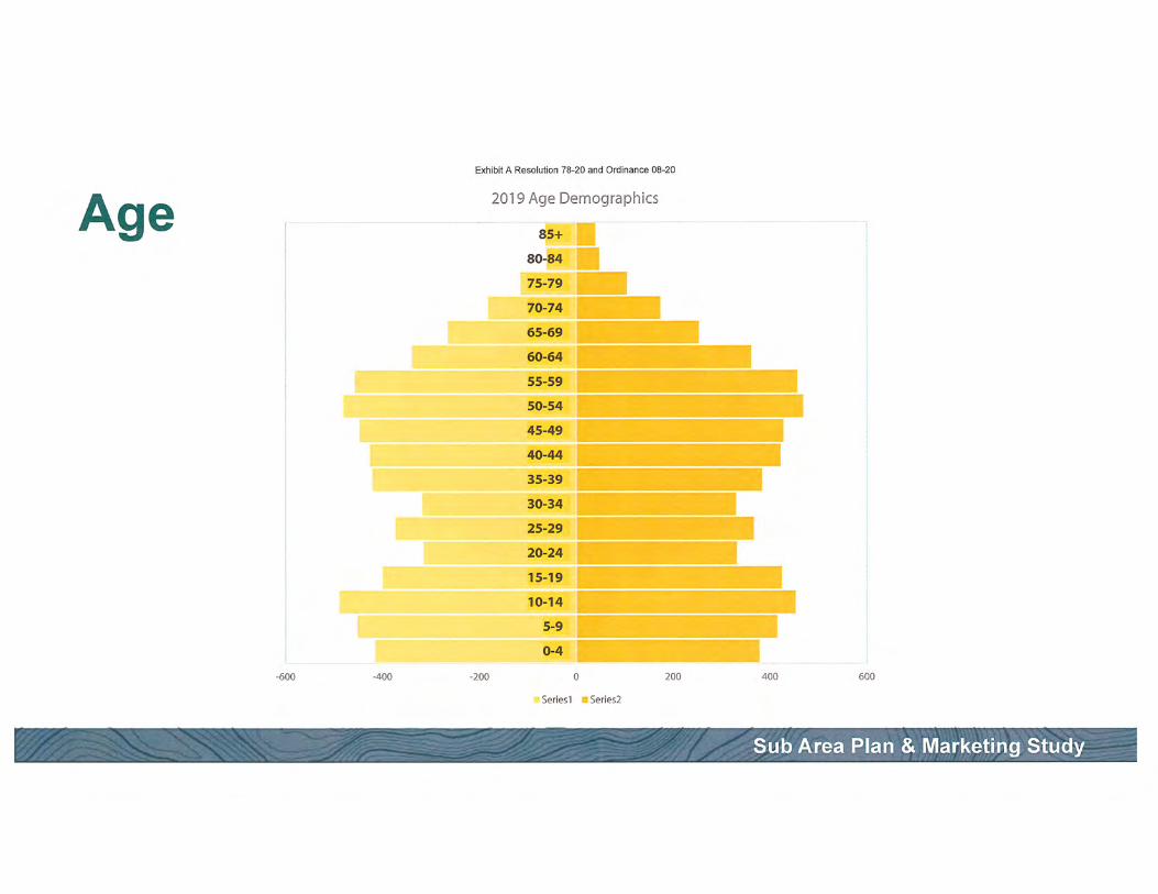
Age
-600
Exhibit A Resolution 78-20 and Ordinance 08-20
2019 Age Demographics
^/^*-T^-^ir.-y^iyt-—rt 'T~ti^:\-vyysy^'
-400 -200 200 400 600
"Seriesl •Series2
Sub Area Plan & Marketing Study
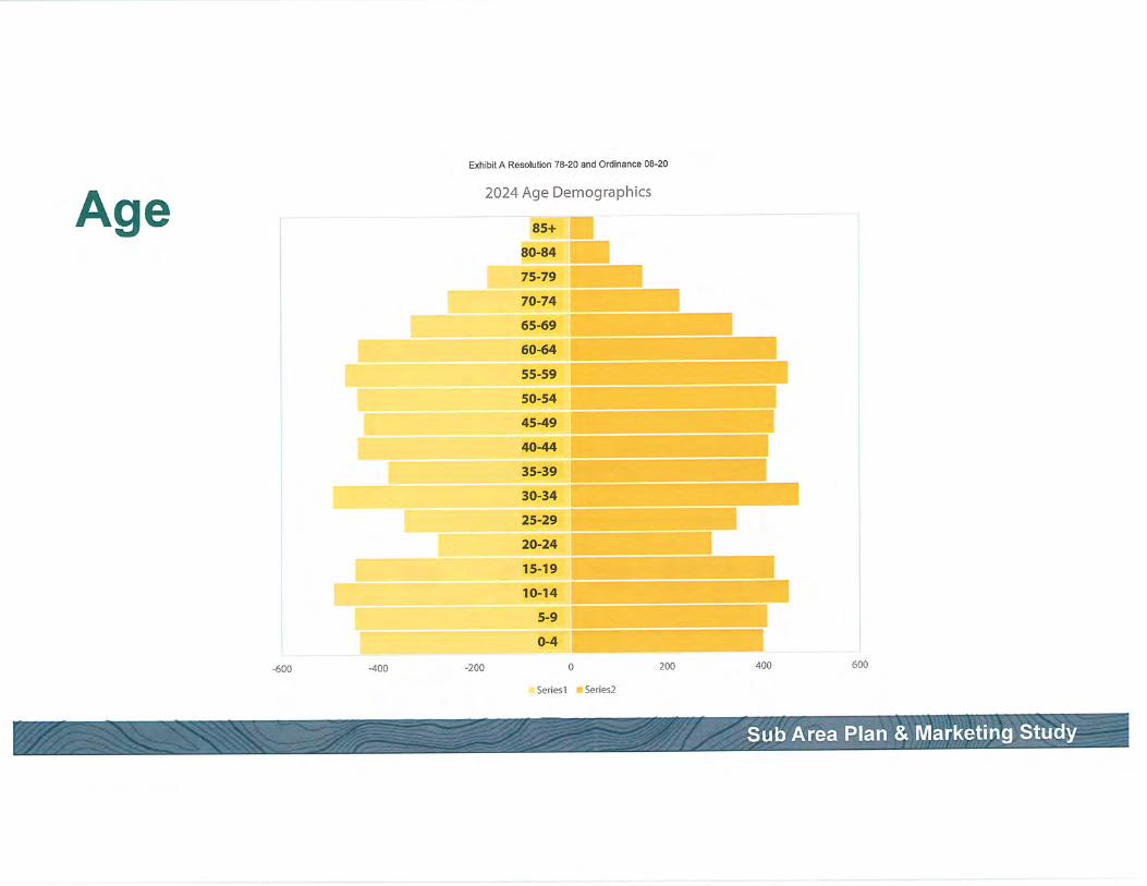
AgeExhibit A Resolution 78-20 and Ordinance 08-20
2024 Age Demographics
-600 -400 -200 200 400 600
aSeriesl •Series2
Sub Area Plan & Marketing Study

Exhibit A Resolution 78-20 and Ordinance 08-20
Greenville Industrial'tM 'r-^r'"? Li»^:xi:i:;i-tf,tn'.<:.i^j..i i ;•>•••; r-c i .•x'^_« in r^-j ^••cw^' vi\'i M.'.J"-.! i'anr,'-.;! t.'A;'ji;>.Mfii.^'-,s WK'I : •:-/>i"iVii:
2M an o 16K 0.9% m $5.37 BB $42 BB 10.2%
Availability
Vacant SF
Sublet SF
Availability Rate
Available SF
Available Asking Rent/SF
Occupancy Rate
Percent Leased Rate
17.5K^
0(0.4% +
7.5K1
$5.92 +
99.1%+
99.6% ^
Sub Area Plan & Marketing Study
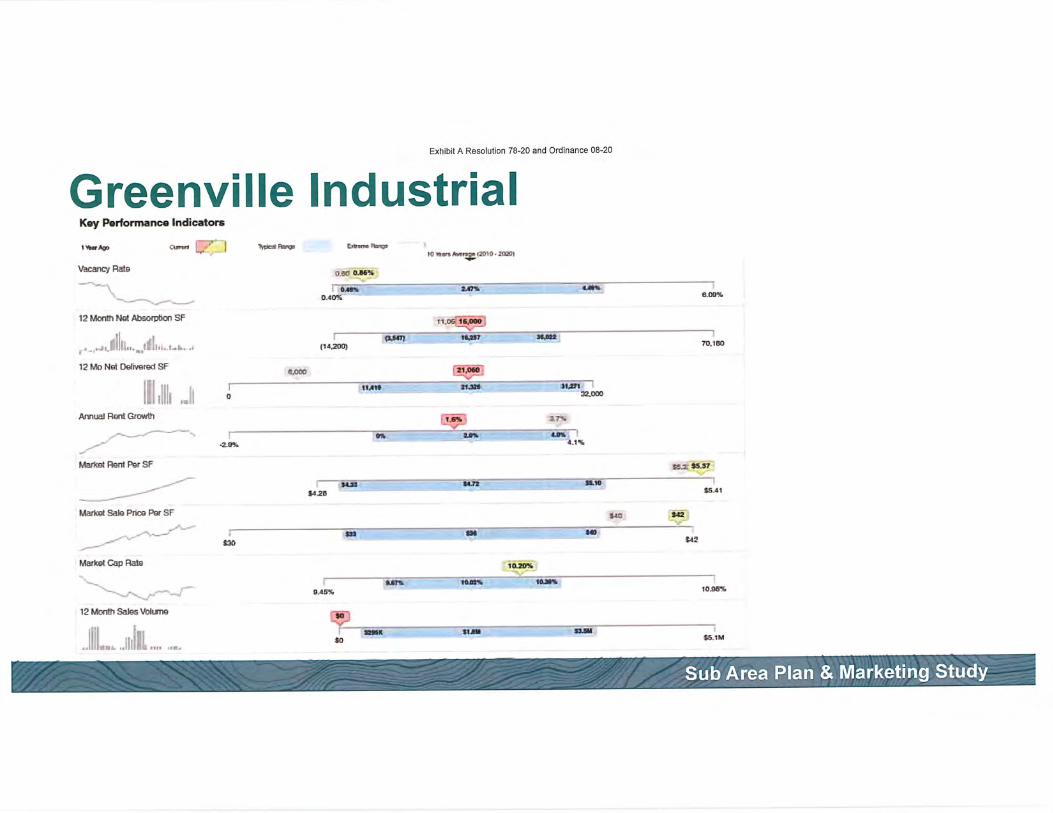
Exhibit A Resolution 78-20 and Ordinance 08-20
Greenville IndustrialKiy Pwformanca Indicator*
l»««ff> CunH !_•' | T^BkdFhny
OMOMHt
10 m *KW»D« izxo. afflOi
Vacancy Rate
i fc—o-«nt
12 Month Nat AteciptkmSF
12 Month Sates Vohme
1^».. J? ..„....
niln ..<' .^r—^OniB"Bri*iis~. . ,<i.!!'!ll.i...'in.,..!-!.. ., (14.200) 70.180
12 Mo Nat Delivered SF•.ooo isy—j
W .?!i? IE), '. 1 tun* vs»^ ^ •un.iliiilll .J ° """ "-"az^x,
Annual toitGrowft g^ ^
-2.?)i> <.<»
Martte< Rent Per SFsex'tesr
-acjt- i»<-2B
Markst Sate Price Par SFt*a
t» US
MatKst Cap Rate ._
•D t6.1M
Sub Area Plan & Marketing Study

Exhibit A Resolution 78-20 and Ordinance 08-20
Greenville Office
ISVLVTO^ 3-
668K-VX;1 COFISmUCTIC', 3F -:VO^C"*i3SO-"lPTIO\5T V^^Ar.C" qATr
0 15.5K 6.0%•.tA.T»-rr-ii:'.*/sr VAn*r- 3AJ: wcL'sr WF» r^ c«,r rwTr
$18.77 m $122 9.8%
Availability
Vacant SF
Subiet SF
Avail ability Rate
Available SF
Available Asking RenVSF
Occupancy Rate
Percent Leased Rate
40M0^
13.2% t
88.3K +
$18.764
940%+
94 0% 4
Sub Area Plan & Marketing Study

Exhibit A Resolution 78-20 and Ordinance 08-20
Greenville OfficeKey Parformarw Indicaton
Vacancy Rate
12 Month Nat Absorption SF
Tmwnmr
..il!.!.BB. _...^i.^,l!!i,......-a'" -.„.— ,y
12 Mo Net Delivered SF
1;1! »- lilii!!Annual Rant Growth
(3R3571
(4S.BZB)
^._
<0'««r»A>my^(8010-2B201
MO» (Lan
UMT
1i4*61
~<w MM WRTW.S70
1MW
Marttst Rent Par SF
Marks* SetoPnce Per SF
Market Cap Rate
12 Month SaleaVUuns
a!,..,^
V73»
tto
»1»J7
-jnB- -«H- —Ul
tii ana
tia-az
<m
1 K8.06%
tlTSH.
Ito
tiza
B I •-7*»
fn.iiT
tBME HUHt18-2M
Sub Area Plan & Marketing Study

Exhibit A Resolution 78-20 and Ordinance 08-20
Retail Leakage-2017
Total Retail Trade and Food & Drink
Motor Vehicle & Parts Dealers
General Merchandise Stores
Food & Beverage Stores
Gasoline Stations
Food Services & Drinking Places
Bldg Matl, Garden & Supply Stores
Clothing & Clothing Accessories Stores
Furniture & Home Furnishings Stores
Electronics & Appliance Stores
Others
Demand (Spending)
$190,278,347
$36,626752
$30,680,237
$26,102,089
$19,627,702
$18,911,028
$12,350,754
$7,629,912
$5,863,452
$5,782,283
$26,704,138
>
>
>
>
>
>
<
>
>
>
<
Supply (Sales)
$83,787,043
$3,544,208
$7,190,641
$2,748,737
$9,273,931
$9,041,237
$16,401,598
$639,670
$953,444
$0$33,993,577
Gap
$106,491/304
$33,082,544
$23,489,596
$23,353,352
$10,353,771
$9,869,791
-$4,050,844
$6,990,242
$4,910,008
$5,782,283
-$7,289,439
Sub Area Plan & Marketing Study

1992

Sub Area Plan & Marketing Study

C-^l^;t^;4. A D^n^l.,4:nn -70 QA /,n/J r\..^;>-mnnn FlO -^rt
Community Trends and Futures
PlacemakingDevelopment
Parks, Trails, & Recreation

Presentation Purpose:Get you thinking about some new or innovative
approaches to place making. We're going tomove fast and stay at a high level. If you want a
deeper dive, ask questions, and we're happy toanswer.
^Ideas shown may be outside the purview of the market study, traditional
zoning codes, or the way things have always been done. They might exist
already, or they may need to be stretched, modified, re-thought, or adapted.
Covid Related: A lot has changed in the last3 months - when applicable, notes on these
changes will appear in blue boxes on the slides
k:l^;+ A D^nnl.,4.;/tn -70 DA /,n^l r\^^:nnnnn no'-irkPlacemaking:
What is Placemaking?Placemaking is the introduction of programmingand design in order to strengthen the identity ofa place, community attachment, and make it a
more enjoyable spot to be.
While permanent large scale design likearchitecture can contribute to "sense of place"
many placemaking efforts are small, incremental,
temporary, and informal.
Placemaking: r^^^^^n^n^Z^.
Events
Regular - Concerts in the Park, Car Shows
One off - Open Streets, National Night Out

Placemaking:
Public MarketsFarmers Markets
Art FairsWinter/Holiday MarketsFlea Markets
r-*/^:^:* A (~>^n/si..+:^n -70 /tn nn/j r^^^iinnnn.^ fto Qpi

Placemaking:
Pop Up Spaces"Meanwhile" Use of Underutilized Space
• Temporary Retail
•Short Term Dining
Covid Related: Higher vacancy rates in retailspaces may offer more opportunities

Placemaking:
Temporary Art
May be performancebased (music, theater)-or-
Short term visual art
(projections, murals)
-»/H,!1-.:4. A Ctnn/^1. .*;/^n ~70 On .^n^Q^.U^n.-.^^ no nn
Covid Related: Some music venues are offeringdrive-in concerts as an alternative

Placemaking: ^^^^^^^nZ^.
Parklets
Seasonal space that can create or expand a
seating area either for the public or a restaurant
Similar concept: Better Bus Stop

Placemaking: C-.i/K:^;* A ri/^^1..4.:^-. -70 /^A nn/J ^k^/4!nnnnn AO Ort
Outdoor DiningPatio/Deck spaces help restaurants curate a
memorable dining experienceParticularly in climates where year-round outdoor dining is not possible!
'^•n^'ssFXV w.
=3*' IL
Covid Related: Safety concerns about indoor
space are leading to increased demand for patios

• —_......_ —~. —^~~- ~~~I • ^,^^^^,^^a^^^^,l^^dAitA^aAdiMri&^n nnri nrriinnnnn n» in
Food Trucks
Support local foodVaried offeringsProvides unique experienceLower entry costs for food vendors

•^^:t^;4. A D,Placemaking:
Photo-Ops
What are peoplesharing?What would someoner
show off?
•70 r>n nn^L&—J:.-^^.^ no crt
•9*
i

Development: r^^^^^^^^Z
A focus on the built environment
The look and feel of any community is shaped bythe buildings that are built there.
Buildings are shaped by• Ability to function for their given purpose• Aesthetic design
• Cost Considerations
• Regulations
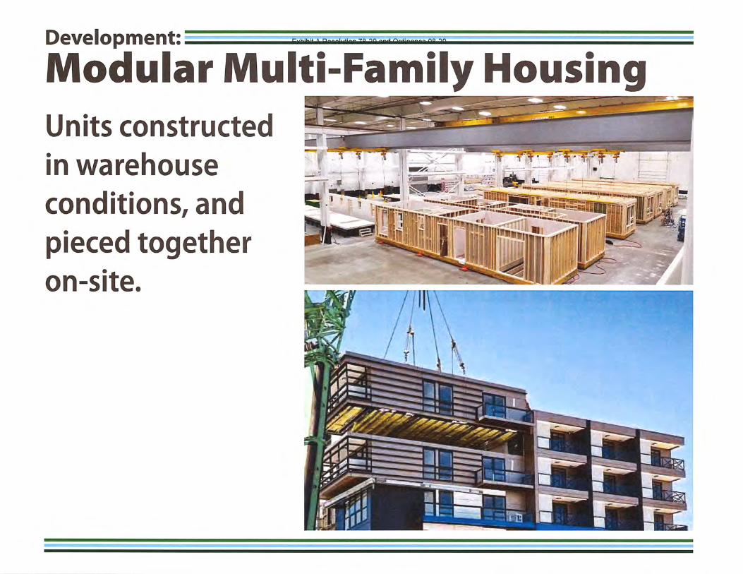
Development: Cv/i^;^;* A D^n,nJu4.!~- TO nn /.x/Ji r\^:^^^^.^ no nr>
Modular Multi-Family Housing
Units constructed
in warehouse
conditions, and
pieced togetheron-site.
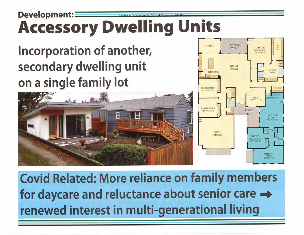
Development:
Accessory Dwelling Units
Incorporation of another,
secondary dwelling uniton a single family lot
rnvuiinMTtO
•L -
^ ••-
Mr Hi \
*f7 ?1>^—<1^>(
<;*;! vrKCXIM
E^Ht I'M;—'
; tl Wi.'.ku.t
1" J>M t''.( 1 I *—~,1,-...^-
_J. 1^-1
\nsiman im x >'i
t+'^-otr'it"
troRdi
ll-u't-
1^1*MV,M1'
lUillfUtOM-'n'-*r\iy r'1
'.]'.'.;11
?.sm
^
1.-3
nuv.vn:i.n-iNt;
ii*'-»>y~
-s'y>-^
iniyvniI.BAV
C..WW;1:
Covid Related: More reliance on family membersfor daycare and reluctance about senior carerenewed interest in multi-generational living

Development: t-^n^n. A^n^>Aai..ii— -70 'tn /.n/J r\^:^^^^^ r\o ort
Community Land Trusts (CLTs)CLT owns the land beneath the home
House is owned by income qualifiedperson(s)
When house is re-sold, it can only be
sold at a price that is still affordable.Owner recoups capital put into home
Can also be done with commercial
buildings

Development:
Creative Re-Use/Low Road Bldgs
For start ups andcreative businesses:
Lower rents
More flexibility
Covid Related: Increased vacancies may offeropportunity to reposition & reimagine buildings

Development:
Affordable Artist SpaceLiving & working space
Help define and addidentity to a district

Development: r^^n^^^^^
Live/WorkCome in many forms, but
can provide the space for
small entrepreneurs to own
their home and office/shopFor Example:
Barber, bike shop, law
office, art/photo studio,
acupuncture, accountant
Covid Related: Feel like your house has beenconverted into a live/work building? There is arenewed focus on work spaces in/next to homes.

F-./^:l^:* A D^n^l. .*;nn -70 OH nn^ <^i^^:n^nn^ no oriDevelopment::
3rd Spaces
As traditional retail struggles, spaces that attractpeople to hang out (cafes, breweries, restaurants)
help adjacent commercial as well
Covid Related: Some of these spaces will taketime to recover from stay-at-home efforts

Development:
A Focus on Experiences
Emphasis on uses in
traditional retail spotsto dostuffMS. buy stuff

Development:
Food HallsThe next step up fromfood trucks:
Fixed location
Shared seating areas
Options for everyone
t< ^ .t^^'KQ •^'^^ ^-' ' ' n
Covid Related: Some restaurants already headedin this direction as food halls feel "more open"

Development::
CoWorkingShared office space-,
l»Learn and help others
Short term leases
^n nn/4_Qj
Typically aimed at smallbusinesses, start ups,
growing businesses
Covid Related: The decline ofWeWork and rise ofsocial distancing necessitates redesign of spaces

Development:
Local Entrepreneurship
Focus on "Economic Gardening" or supporting
homegrown businesses rather than chasing
established, outside businesses
Incubator spaces/classes
Spaces and regulations
to support growthIdentify local clustersand connections
Covid Related: The last recession was the impetus
for new businesses. What will this one bring?

Development:
Integrated Stormwater
Stormwater treatment
can be designed as a
marketable amenity.

_'1tQ_^n/t_/"ViDevelopment: I^^^^^S^;
The Public Sector as Catalyst
Consider how publicbuildings or usescan support thedevelopment of
desired buildings
For Example:
Libraries, Town Hall,
public safety, offices,
shared parking

Development:
Park Focused Development
Proximity to parkland has been repeatedly shownto add value to homes. Developments next to
parks and trails add a marketable amenity.

Parks and Recreation: r^^n^^^^^^^.
Parks Drive IdentityParks can be considered a community's "front
yard" and help define the curb appeal of a place.
Well used and unique recreation offerings are
often what outsiders will remember about a place,
and what community members will identify with.
As public infrastructure, the Town is uniquely
positioned to implement changes in parks and rec.

Parks and Recreation: F-^.I^:!^!* A n^n^l..4.;n.n -?o nn n^-i /^^^l;-~^^^ no '^n
Trails
Typically one of the most desired amenities incommunities across the country
Provides activity for people of all ages

Parks and Recreation: n^^^^^n^^^^^
Active Living
Incorporating physical activity into everyday life(hiking to work, walking to school, yard work)
Requires public infrastructure that allows peopleto undertake these activities safely

Parks and Recreation:
Pedestrian Focused Design
Safety & scale help make places enjoyable to walk.
Even if you drove there, you're a pedestrian once you
step out of your car

Parks and Recreation: r^^^^^n^^^Z.
Nature Play
Nature playgrounds introduce new types of
learning, decision making, imagination, and fun
Vary from highly structured to highly unstructured
^^^1CHSii£i!tl't^L^r"^ 7'fi^SlfefaA*'^^

Parks and Recreation: w
Splash PadFun water activity
for younger kids andfamilies
Can vary from more
fountain-like to more
playground-like
Less maintenance and
liability than pools

no onParks and Recreation: nrhi
Interpretation
Including signage or other ways to "tell the story77
of a park or place helps users learn and associatewith a location.

Parks and Recreation:
Public/Private Partnerships
Many different approaches:
• Private Management of
Specific Offerings
• Dining in parks
• Sponsorships
• Partner on events
• Commercial use fees
Covid Related: Parks may offer an outdoor venue
for activities that were previously indoors

Parks and Recreation: C-..^:l^:* A D^n/>1..4.!^n -70 On nn/J /^i>./J;nnn^n AO QFl
Stormwater Management
For areas that flood, parks can be a way to mitigatedamage that would occur to other development,
and provide recreation value when dry
Exhibit A Resolution 78-20 and Ordinance 08-20
^^fwvlLI-^>/^^ —<-<c•^^$^^ -afca— W APPENDIX
Market & Trends
SINCE i8<»e