liberty bell trail feasibility study - Perkasie Borough
94
LIBERTY BELL TRAIL FEASIBILITY STUDY IN ASSOCIATION WITH: Land Concepts Group Orth-Rodgers & Assoc., Inc. EDM Consultants, Inc. Robert Wise Consulting Liberty Bell Trail Feasibility Study PREPARED BY: The Waetzman Planning Group 1230 County Line Road Bryn Mawr, PA 19010
-
Upload
khangminh22 -
Category
Documents
-
view
0 -
download
0
Transcript of liberty bell trail feasibility study - Perkasie Borough

LIBERTY BELL TRAIL FEASIBILITY STUDY
IN ASSOCIATION WITH:
Land Concepts GroupOrth-Rodgers & Assoc., Inc.EDM Consultants, Inc.Robert Wise Consulting
Liberty Bell Trail Feasibility Study
PREPARED BY:
The Waetzman Planning Group1230 County Line RoadBryn Mawr, PA 19010

MONTGOMERY COUNTY COMMISSIONERSJames R. Matthews, Chairman
Thomas Jay Ellis, Esq.
Ruth S. Damsker
BUCKS COUNTY COMMISSIONERSCharles H. Martin, Chairman
James F. Cawley, Esq.
Sandra A. Miller

I
Liberty Bell Trail Feasibility Study
LIBERTY BELL TRAIL FEASIBILITY STUDY
This project was financed in part by a grant from the Keystone Recreation, Park and Conservation Fund,under the administration of the PA Department of Conservation and Natural Resources,
Bureau of Recreation and Conservation.
Prepared by:
The Waetzman Planning Group1230 County Line RoadBryn Mawr, PA 19010
In Association with:
Land Concepts GroupOrth-Rodgers & Assoc., Inc.
EDM Consultants, Inc.Robert Wise Consulting
Reformatted and Printed by Montgomery County Planning Commission
August 2005


III
Liberty Bell Trail Feasibility Study
TABLE OF CONTENT
Study Participants VSection 1 – Purpose of the Study 1
Mission Statement 1Scope of Study and Process 1
Section 2 – Historic Context 3Section 3 – Study Goals, Objectives, and Planning Principles 5
A. Public Participation 5Public Awareness 5Public Involvement 5Stakeholder Coordination 5
B. Feasibility Assessment 5Study Area Definition 5Potential Trail Users 5Alternative Alignment Evaluation 5Accessibility 6Determination of Feasibility 6
C. Concept Planning 6Trail Concept Plan 6Financial Feasibility 6
Section 4 – Study Area Definition and Inventory 7Maps and Study Area 7Composite Map 7
Segment Maps 7Physical Inventory 7Ownership 7Land Use 9Proposed Trails 9
Section 5 – Trail Concept 11Minimum Trail Design Standards 11Overview of Trail Concept 11Segment Descriptions 12
Segment 1: East Norriton Township 12Segment 2: Whitpain Township 14Segment 3: Upper Gwynedd Township and North Wales Borough 16Segment 4: Lansdale Borough 18Segment 5: Hatfield Township & Hatfield Borough 20
Segment 6: Franconia Township 22Segment 7: Souderton Borough 24Segment 8: Telford Borough 26Segment 9: Hilltown Township & West Rockhill Township (south) 28Segment 10: Sellersville Borough & Perkasie Borough 30Segment 11: East Rockhill Township & West Rockhill Township (north) 32Segment 12: Quakertown Borough & Richland Township 34
Section 6 – Conclusions and Recommendations 37The Trail Concept and Implementation 37County and Municipal Responsibilities 38Expected Trail Costs 39Trail Amenities and Costs 39Funding 39Conclusion 40
APPENDICES
Appendix A - Historic Preservation Element 43Appendix B - Existing Land Use Maps (all 12 segments) 53Appendix C - Ownership Maps (all 12 segments) 65Appendix D - Sources of Trail Literature, Case Studies 77Appendix E - Potential Open Space Funding Sources 81
LIST OF FIGURES
Section 4 – Study Area Definition and InventoryFigure 1 Liberty Bell Trolley Proposed Trail Alignment (Composite Map) 8
Section 5 – Trail ConceptFigure 2 Main Trail Lenghts by Municipality 11Figure 3 Lenght of Main Trail by Trail Types 12Figure 4 East Norriton Physical Inventory 13Figure 5 Whitpain Physical Inventory 15Figure 6 Upper Gwynedd & North Wales Physical Inventory 17Figure 7 Lansdale Physical Inventory 19
TABLE OF CONTENT

IV
Liberty Bell Trail Feasibility Study
TABLE OF CONTENT
Figure 8 Hatfield Township & Borough Physical Inventory 21Figure 9 Franconia Physical Inventory 23Figure 10 Souderton Physical Inventory 25Figure 11 Telford Physical Inventory 27Figure 12 Hilltown & West Rockhill (south) Physical Inventory 29Figure 13 Sellersville & Perkasie Physical Inventory 31Figure 14 East & West Rockhill (north) Physical Inventory 33Figure 15 Quakertown & Richland Physical Inventory 35
Appendix A - Historic Preservation ElementFigure 16 The Route of the Liberty Bell Trolley (1950) 48
Appendix B - Existing Land UseFigure 17 East Norriton Existing Land Use 53Figure 18 Whitpain Existing Land Use 54Figure 19 Upper Gwynedd & North Wales Existing Land Use 55Figure 20 Lansdale Existing Land Use 56Figure 21 Hatfield Township & Borough Existing Land Use 57Figure 22 Franconia Existing Land Use 58Figure 23 Souderton Existing Land Use 59Figure 24 Telford Existing Land Use 60Figure 25 Hilltown & West Rockhill (south) Existing Land Use 61Figure 26 Sellersville & Perkasie Existing Land Use 62Figure 27 East & West Rockhill (north) Existing Land Use 63Figure 28 Quakertown & Richland Existing Land Use 64
Appendix C - OwnershipFigure 29 East Norriton Ownership 65Figure 30 Whitpain Ownership 66Figure 31 Upper Gwynedd & North Wales Ownership 67Figure 32 Lansdale Ownership 68Figure 33 Hatfield Township & Borough Ownership 69Figure 34 Franconia Ownership 70Figure 35 Souderton Ownership 71Figure 36 Telford Ownership 72Figure 37 Hilltown & West Rockhill (south) Ownership 73Figure 38 Sellersville & Perkasie Ownership 74Figure 39 East & West Rockhill (north) Ownership 75Figure 40 Quakertown & Richland Ownership 76

V
Liberty Bell Trail Feasibility Study
STUDY PARTICIPANTS
CORE STUDY GROUPCurtis Bish, AICP* Montgomery County Planning Commission
David Clifford Montgomery County Planning Commission
John Wood Montgomery County Planning Commission
Richard Brahler Bucks County Planning Commission
Pamela Learned Regional Improvement Consortium
Ken Edmonds East Coast Greenway Alliance
Charles Guttenplan, AICP The Waetzman Planning Group
Richard Collier, AICP LandConcepts Group
STUDY COMMITTEEThe following municipalities actively participated throughout the Study. Individuals representing
some municipalities changed during the course of the Study; to avoid inadvertently omitting a participant,only the municipal names are being listed. We wish to thank all of the municipal representatives whoworked diligently over the course of the Study.
East Norriton Twp. (Montgomery Co.)
East Rockhill Twp. (Bucks Co.)
Franconia Twp. (Montgomery Co.)
Hatfield Borough (Montgomery Co.)
Hatfield Township (Montgomery Co.)
Lansdale Borough (Montgomery Co.)
North Wales Borough (Montgomery Co.)
Perkasie Borough (Bucks Co.)
Quakertown Borough (Bucks Co.)
Richland Township (Bucks Co.)
Sellersville Borough (Bucks Co.)
Souderton Borough (Montgomery Co.)
Telford Borough (Montgomery Co.)
Upper Gwynedd Twp. (Montgomery Co.)
West Rockhill Twp. (Bucks Co.)
Whitpain Twp. (Montgomery Co.)
CONSULTANT TEAMCharles Guttenplan, AICP The Waetzman Planning Group
Richard Collier, AICP LandConcepts Group
Susan Blickstein* Orth-Rodgers & Associates, Inc.
Dan Kueper Orth-Rodgers & Associates, Inc.
William Dingman, P.E. EDM Consultants, Inc.
Robert Wise Robert Wise Consulting
* Resigned during course of the Study
STUDY PARTICIPANTS


1
Liberty Bell Trail Feasibility Study
PURPOSE OF THE STUDY
This study is an inter-governmental planning project to evaluate the feasibility of developinga trail along the former Liberty Bell Trolley route. During its years of operation from 1900 to1951, this historic trolley line linked Norristown in Montgomery County to Quakertown in BucksCounty. The new trail, when completed, will link 16 municipalities, plus one by spur trails inboth Counties and will cover a distance of over 25 continuous miles. The 17 municipalities includedin this study are listed in Section 4 (Study Area Definition and Inventory) of this report.
The proposed Liberty Bell Trail has been identified and supported in many prior planningdocuments and plans including:
• County Open Space Plan, Montgomery County (1996) – 1 of 13 recommended trails
• County Comprehensive Plan, Shaping Our Future, Montgomery County (draft 2004)
• Southeast Pennsylvania Bicycle Mobility Study, Delaware Valley RegionalPlanning Commission
• Open Space and Environmental Resources Protections Plan (ongoing plan updates inaccordance with the Montgomery County Green Fields/Green Towns initiative)
• Municipal Open Space and Recreation Plans, Bucks and Montgomery Counties
Mission Statement (Adopted by Study Committee October 24, 2002)The Liberty Bell Trail Feasibility Study is being undertaken to evaluate the feasibility of
creating a continuous trail from East Norriton to Quakertown, following the former trolleyalignment wherever possible, and linking all 16 municipalities through which it will run to providea safe, interesting, and pleasant corridor for non-motorized vehicle users and pedestrians.
(It is noted that during the study the number of municipalities was expanded from 16 to17, permitting a neighboring borough to be linked by the use of spur trails.)
Scope of Study and ProcessThe analysis developed in this feasibility study and described in this document has primarily
addressed these tasks:
• Inventory of existing conditions along the former trolley route
• Determination of how conducive the corridor is to trail development
• Delineation of an area (corridor) for further trail analysis
• Assessment of alignment alternatives that address problem areas
• Examination of obstacles to the continuous trail
• Recommendation of the most practical alignment
• Preparation of a trail concept plan with a recommended alignment
The Plan developed for this feasibility study is the result of focused leadership and extensivecollaboration among the 17 participating municipalities. Leadership was provided by theMontgomery County Planning Commission and Bucks County Planning Commissionprofessionals, Rails-To-Trails Conservancy (RTC) members, and the Regional ImprovementConsortium (RIC - former North Penn Regional Improvement Authority or NRPA) ExecutiveDirector. This group, together with the two planning consultants on the team, The WaetzmanPlanning Group and LandConcepts, constituted the Core Study Group that met routinelythroughout the planning process.
Guidance and coordination among the various stakeholder communities was provided bydesignated representatives (one or two) for each municipality. Together they formed a StudyCommittee that met on multiple occasions with the consultant team over the course of this two-year study. They assumed a critical role of reviewing, supplementing, and correcting data,critiquing the study corridor and various alignment options, and reporting findings and optionsto their individual communities and elected officials. Given the many diverse conditions, physicaland political obstacles, and length of this corridor, this regional planning task could not havebeen achieved without a dedicated and collaborative commitment.
The culmination of the Plan process was a public Open House held in November, 2004. Itwas well-publicized through websites, the press, and through announcements posted in themunicipal offices of the participating municipalities. The comments that were received weresubsequently considered by the Core Study Group and some minor adjustments to thePlan resulted.
The Liberty Bell Trail is envisioned as a contemporary interpretation of the historic trolleyroute. The intent from the outset of the study was to follow the historic alignment as closely aspossible and to connect and interpret historic remnants and other current points of interest. SeeLiberty Bell Trolley Proposed Alignment Map (hereafter referred to as the ‘Composite Map’) inSection 4 of this report.
The analysis of alternative alignments was extensive and essential to the feasibilitydetermination and the process leading to identifying a workable alignment for the trail.Alternatives were considered to weave the trail through each community but also to connect ateach municipal border. By design, all of the alternatives considered: physical conditions; accessto special features; obstacles and conflicts; previous plans and planning; land ownership; landuses; existing and proposed trails; and anticipated user experiences. Each iteration of alternativealignments was reviewed by the Study Committee in a public forum and brought back to the“home” community for further review and support. As the preferred alignment emerged, eachcommunity was asked from their governing body for a written endorsement in the form of letterof support or formal resolution. The goal was to receive support from each participatingcommunity to ensure that the trail could become a regional asset and would be supported bylocal plans and actions.
SECTION 1

2
Liberty Bell Trail Feasibility Study
It was assumed that this trail will supplement the regional transportation network. Theoverall goal is that it will serve as a transportation alternative for pedestrian and bicyclists, inaddition to it being a recreation resource. The trail will link all land uses including residentialareas, employment centers, offices, shopping districts, historic sites and cultural features, publicopen spaces (parks, natural areas), schools, and many local existing and proposed trails. Thesystem will serve individual communities and by the continuous connections create a greatercommunity with diminished dependence on motorized vehicles.
The type of trail and use experience will vary greatly among the many segments. It willrange from share-the-road in congested areas and sidewalks systems in urban and suburbanareas to farmland and woodland trails with nearly every experience in between. It will requireuse of a variety of land ownership options such as remaining trolley rights-of-way, public lands,utility easements, private land easements, road rights-of-way, and potential land acquisitions.Diversity of user experience and continuity are among the most important initiatives of the trail.Improvements will be needed throughout the corridor to make it safe and continuous. Suchimprovements will be done over many years and in phases as detailed design work is completedand funds are available. It is anticipated that individual segments will be implemented by themunicipalities through which the trail passes, and through the land development process.
Financial resources for this feasibility study, the first phase towards completion, wereprovided through a combination of a Keystone Recreation, Park and Conservation Fund grantfrom the Pennsylvania Department of Conservation and Natural Resources, Bucks andMontgomery Counties, and contributions from each of the participating municipalities.
SECTION 1
3
Liberty Bell Trail Feasibility Study
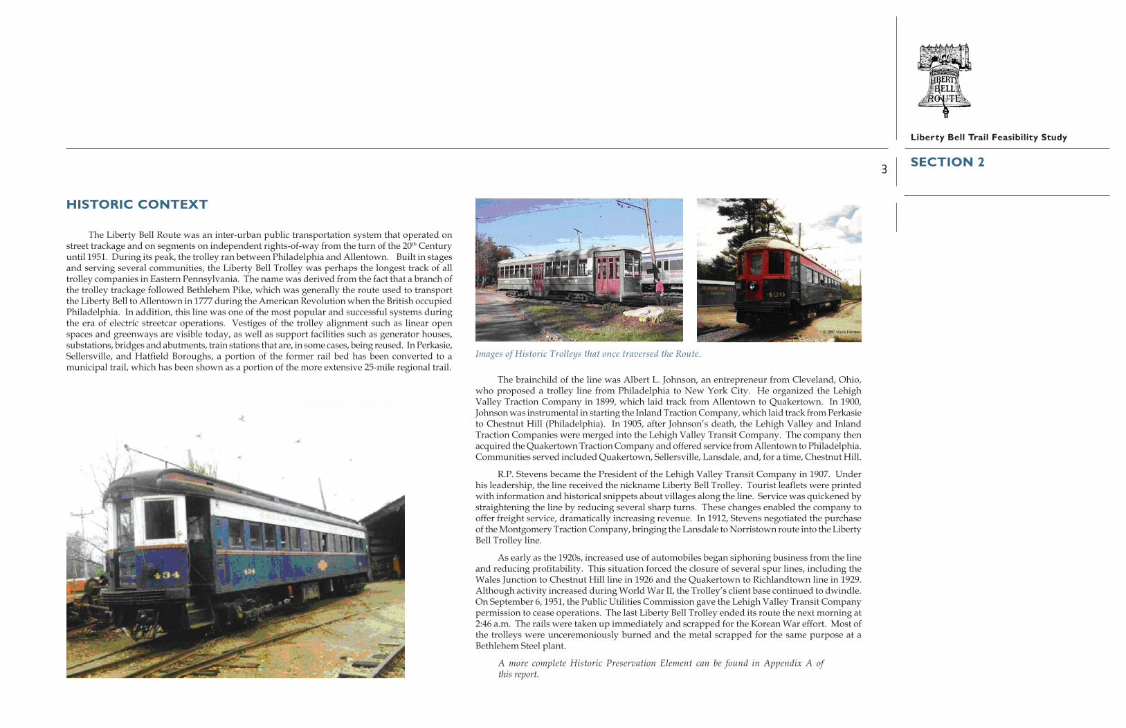
HISTORIC CONTEXT
The Liberty Bell Route was an inter-urban public transportation system that operated onstreet trackage and on segments on independent rights-of-way from the turn of the 20th Centuryuntil 1951. During its peak, the trolley ran between Philadelphia and Allentown. Built in stagesand serving several communities, the Liberty Bell Trolley was perhaps the longest track of alltrolley companies in Eastern Pennsylvania. The name was derived from the fact that a branch ofthe trolley trackage followed Bethlehem Pike, which was generally the route used to transportthe Liberty Bell to Allentown in 1777 during the American Revolution when the British occupiedPhiladelphia. In addition, this line was one of the most popular and successful systems duringthe era of electric streetcar operations. Vestiges of the trolley alignment such as linear openspaces and greenways are visible today, as well as support facilities such as generator houses,substations, bridges and abutments, train stations that are, in some cases, being reused. In Perkasie,Sellersville, and Hatfield Boroughs, a portion of the former rail bed has been converted to amunicipal trail, which has been shown as a portion of the more extensive 25-mile regional trail.
The brainchild of the line was Albert L. Johnson, an entrepreneur from Cleveland, Ohio,who proposed a trolley line from Philadelphia to New York City. He organized the LehighValley Traction Company in 1899, which laid track from Allentown to Quakertown. In 1900,Johnson was instrumental in starting the Inland Traction Company, which laid track from Perkasieto Chestnut Hill (Philadelphia). In 1905, after Johnson’s death, the Lehigh Valley and InlandTraction Companies were merged into the Lehigh Valley Transit Company. The company thenacquired the Quakertown Traction Company and offered service from Allentown to Philadelphia.Communities served included Quakertown, Sellersville, Lansdale, and, for a time, Chestnut Hill.
R.P. Stevens became the President of the Lehigh Valley Transit Company in 1907. Underhis leadership, the line received the nickname Liberty Bell Trolley. Tourist leaflets were printedwith information and historical snippets about villages along the line. Service was quickened bystraightening the line by reducing several sharp turns. These changes enabled the company tooffer freight service, dramatically increasing revenue. In 1912, Stevens negotiated the purchaseof the Montgomery Traction Company, bringing the Lansdale to Norristown route into the LibertyBell Trolley line.
As early as the 1920s, increased use of automobiles began siphoning business from the lineand reducing profitability. This situation forced the closure of several spur lines, including theWales Junction to Chestnut Hill line in 1926 and the Quakertown to Richlandtown line in 1929.Although activity increased during World War II, the Trolley’s client base continued to dwindle.On September 6, 1951, the Public Utilities Commission gave the Lehigh Valley Transit Companypermission to cease operations. The last Liberty Bell Trolley ended its route the next morning at2:46 a.m. The rails were taken up immediately and scrapped for the Korean War effort. Most ofthe trolleys were unceremoniously burned and the metal scrapped for the same purpose at aBethlehem Steel plant.
A more complete Historic Preservation Element can be found in Appendix A ofthis report.
SECTION 2
Images of Historic Trolleys that once traversed the Route.


5
Liberty Bell Trail Feasibility Study
STUDY GOALS, OBJECTIVES, ANDPLANNING PRINCIPLES
The following goals, objectives and planning principles were adopted by the StudyCommittee to guide the study process:
A. Public Participation1. Public Awareness – Ensure that the potential users and stakeholders of the Liberty Bell
Trail are aware of the process to determine the feasibility (location, financial, etc.) ofthe trail.
• Initiate contact between Study Committees and landowners and operators of potentialadjacent land uses.
• Publish meeting notices and findings/information frequently fromprevious meetings.
2. Public Involvement – Involve stakeholders, potential trail users, municipalities, countygovernments, state agencies, non-government organizations, and property owners inthe process of determining the feasibility of the Trail.
• Provide numerous and varied methods of public involvement, including both largeand small-scale direct contact (i.e., public meetings, stakeholder interviews, etc.) andindirect contact (i.e., press releases, website, website feedbackforms, etc.).
• Provide geographically dispersed opportunities for public interaction with the StudyCommittee and consultants throughout the study process.
3. Stakeholder Coordination – Consider the needs of all potential stakeholders and trailusers in determining trail feasibility.
• Review previously prepared planning documents germane to the development ofthe trail (i.e., County Open Space/Bike Mobility Plans, Municipal Comprehensive/Open Space Plans, Route 202 widening plans, etc.)
• Coordinate the existing goals of property owners, municipalities, potential users,and government and non-government organizations to arrive at the best possiblecompromise for a potential trail alignment.
• Consider present and long-term plans of large landowners and institutions withinand surrounding the study area.
• Solicit the cooperation of utility companies operating in the general area to beconsidered in the Study.
B. Feasibility Assessment4. Study Area Definition – Develop an area that maintains historic integrity, accessibility,
aesthetically pleasing environmental conditions, and connections to neighboringmunicipalities, while narrowing the study focus to a manageable level.
• Balance existing land uses with the historic integrity of the Liberty Bell Route.• Identify those areas, with or without historic significance, that will attract and detract
from future trail use.• Delineate a study area that is both fiscally and physically manageable.• Develop a consensus as to potential alignments to be studied, with the input of the
Study Committee and County Sub-committees.• Seek linkages to other uses such as residential neighborhoods, commercial zones,
parks, schools, and centers of employment.
5. Potential Trail Users – Ensure that all potential users are identified and needs of thoseusers are clarified.
• Identify potential user groups through state, county and municipal organizations.• Provide outreach through a variety of media and methods to identify potential users/
user groups.• Review user characteristics from similar trail facilities in the region (e.g., Valley Forge
Bikeway, The Perkiomen Trail, The Schuylkill River Trail).• Provide signage that is consistent and distinctive in image, informative, and highlights
the trail’s presence and value as an alternative means of travel.• Initiate efforts such as special events and programs to encourage regular use and
new users.• Seek the alignment that maximizes positive user experiences.
6. Alternative Alignment Evaluation – Assure that all potential segments are thoroughlyinvestigated for practicability in developing the final trail alignment.
• Identify existing site-specific manmade and natural features, and areas ofenvironmental concern (vegetation, soil, wetland, wildlife, etc.) that will impact thedevelopment of the trail.
• Review public safety concerns of each potential segment (including topographicissues, vehicular conflict points, dangerous adjacent land uses).
• Review opportunities for potential connections to other existing and planned trails.• Consider the locations of user generators and points of interest, which may be accesses
by the various alternatives (including recreation sites, schools, commercial nodes,transit stops, employment centers, etc.).
SECTION 3

6
Liberty Bell Trail Feasibility Study
• Determine the importance of historic connections that are germane to the context ofthe Liberty Bell Trail, and the extent of portions of the former right-of-way that aresuitable/unsuitable for trail use.
• Consider any legal constraints in implementing the trail on the various segments tobe considered.
• Consider the extent to which the integrity of the former trolley route would bemaintained in assessing the various alternatives.
• Develop a full understanding of the potential impacts of each proposedalternative alignment.
7. Accessibility – Ensure that any potential trail alignment allows users of any physicalability a chance to experience the trail and associated points of interest.
• Analyze access to historic sites and existing sections of right-of-way to determine themost accessible connections.
• Ensure compliance of all potential trail alignments with the Americans WithDisabilities Act (ADA).
8. Determination of Feasibility – Determine overall project feasibility based upon anevaluation of all factors studied and consensus of public input.
• Assess the potential user demand for various alignments.• Inventory the positive and negative implications of each alternative alignment
or segment.• Develop an objective system for ranking the alternatives studied.
C. Concept Planning9. Trail Concept Plan – Develop a conceptual plan that seeks compatibility with the
surrounding land uses, while maximizing the experience for the user, provides ampleopportunity for recreation and allows for understanding of the historic context thetrail symbolizes.
• Follow the alignment of the former trolley wherever possible.• Where it is not possible to follow the original alignment, utilize alternative segments
that result in an uninterrupted trail primarily on or within public property, easements,and road rights-of-way.
• Limit recommendations to acquire land and easements.• Select alternative segments beyond the original trolley alignment according to criteria
established and accepted Study Committee (e.g., distance, safety, ownership, length).• Select a preferred alignment for the trail based on the most practical options and a
consensus of stakeholders, trail users, and community members.
• Seek a route that has safety as a primary criterion with the least number of interfacesbetween heavily traveled road segments/intersections and the trail.
• Connect important points of interest, including natural and cultural features.• Foster connections with other existing/planned trails and trail networks.
10. Financial Feasibility – Develop concise and defendable method for determining thefinancial feasibility for the final trail concept plan.
SECTION 3
7
Liberty Bell Trail Feasibility Study
STUDY AREA DEFINITION AND INVENTORY
Maps and Study AreaThe study corridor was defined by compiling an inventory of physical and cultural
characteristics for a large enough area in which the trail could potentially be located. The initialstep required preparation of an electronic base map for each municipality covering the land areain the general vicinity of the historic Liberty Bell Trolley line. This area included a portion of 17townships and boroughs and some 25 miles. Using map resources of both Montgomery andBucks County Planning Commissions, the study base map depicts local and regional roads, majorroad names, streams, creeks and water bodies, railroad lines, bridges, utility corridors, propertylines, and municipal borders.
Inventory information was added to these maps based on published sources, fieldobservations, consultant research, and Study Committee members’ local knowledge. The initialstep required adding the alignment of the historic trolley route to the base map, a complicatedtask given the loss of much of the original right-of-way, a very different pattern of land use andownership than existed in 1951 when the trolley ceased operation, and old maps indicatingdifferent alignments through some sections. Based on an historic alignment, a corridor was selectedto map other information for use in defining a modern day trail that followed as closely as possiblethe historic route. Initially defined as approximately one-half mile either side of the route, thestudy corridor was subsequently revised to allow for greater divergence from the historic line toaccommodate current conditions and obstacles. The study corridor ranged in width from one-half mile to just over two miles.
The maps developed for the study were prepared in two formats and scales – CompositeMap and Segment Maps.
Composite MapThe Composite Map (on the following page) shows the entire study corridor with the historic
trolley line and the proposed trail alignment. Though the map on the following page is a reducedversion for inclusion in this report, a full-sized one is available, at an approximate scale of1"= 0.60 mile. Its primary use is to view the regional context of the line.
Segment MapsThe Segment Maps (1 of 12 through 12 of 12) were developed to present detailed information
for each of the communities through which the trail will pass. Twelve Segment Maps in reportformat (11" x 17", not to scale) cover 17 municipalities as listed below.
Segment 1: East Norriton Township
Segment 2: Whitpain Township
SECTION 4
Segment 3: Upper Gwynedd Township & North Wales Borough (North Wales was addedduring the planning process through the extension of Points of InterestSpur Trails)
Segment 4: Lansdale Borough
Segment 5: Hatfield Township & Hatfield Borough
Segment 6: Franconia Township
Segment 7: Souderton Borough
Segment 8: Telford Borough
Segment 9: Hilltown Township & West Rockhill Township (south)
Segment 10: Sellersville Borough & Perkasie Borough
Segment 11: East Rockhill Township & West Rockhill Township (north)
Segment 12: Quakertown Borough & Richland Township
(Note: Segments 1 through 7 are located in Montgomery County; Segment 8, Telford, islocated partially in both Montgomery and Bucks Counties, and the remaining segmentsare located in Bucks County.)
Segment Maps are used in the study to present detailed information for the study corridorand to depict both the historic route and proposed Liberty Bell Trail. Information is recorded incolor on three sets of Segment Maps according to the following three categories: Physical Inventory,Ownership, and Land Use. These sets of Segment Maps are the basis for describing the proposedtrail concept in subsequent sections of this report. Physical Inventory maps and trails are includedin Section 5 of this report; and Ownership and Land Use maps are part of the report Appendix.
Physical Inventory Maps show features along the length of the corridor and engineering concerns related to
implementation. The historic route and proposed trail are shown on each.
Physical Features (e.g., trolley substation, bridge abutments, parks, municipalcomplexes, libraries)
Environmental Features (e.g., floodplain, wetlands)
Historic Features (e.g., historic homes, districts, sites)
Engineering Concerns (e.g., high volume street crossing, stream crossing)
OwnershipMaps show ownership based on tax assessment records and in the following categories.
The historic route and proposed trail are shown on each.

8
Liberty Bell Trail Feasibility Study
�������������� ����������
�����
����
����
�����
���
�����
����
�����
����
������
����
������
�����
�!"��
�#�$
" �%&�
�'���
������������
�����
������ �
���
�����
��
������
����������������
����
����
��� ���!���
!��"��
���
���
����
�����
���
���
����
���������
����
��
����
������
�����
�����
�����������
�
����������
����� �������
�#$��%�����#�&��#����!��'&��
��'�%
����#�(���)�#�*�������#�����
��
�#$��%��#����!��'&��
����+����#�����$ #��#���
���������
��������
��������
�
��������
����
���
���
��
��������!��
����
"#�
���� ���
�����
��
" ���#�
$��%
%��
���
��
!���
%�!�
����
"#�
���&��!%
�����
��
���&��!%
����
"#�
&���
�����
�����
��
��"%
����
���
��"#
�
��!!��
��
�����
��
�������
�'��!!
�����
��
��!&��
%��
��"#
�
��!!��
�(�!!�
����
"#�
��'
����
����
"#�
�������
�'��!!
�����
��
��������
'��!!
�����
��
����
!��%
�����
��
)"�'
����
��
����
"#�
����
��������
���
�����
��������
�����
�����
�����
� ��������
�������
���������
��������
�����
�� ��
������
�����
�!�
SECTION 4
Figure 1Liberty Bell Trolley Proposed Trail Alignment
(Composite map)

9
Liberty Bell Trail Feasibility Study
Private
Public
Quasi Public/Private
SEPTA
Utility (e.g., PECO, PP&L)
Land UseMaps indicate general land use based on tax assessment data. Fourteen categories have
been consolidated from the assessment records and include the following. The historic routeand proposed trail are shown on each.
Single-Family Detached Residential
Multi-Family & Single-Family Attached Residential
Mobile Home Park
Retail
Office
Industrial
Institutional
Mixed Use
Utilities
Undeveloped
Public Open Space
Private Open Space
Agriculture
Water
Proposed TrailsFor each of the three sets of Segment Maps, the historic Liberty Bell Trolley route is shown
by a solid red line. The proposed Liberty Bell Trail is shown as a solid green line. In Hatfieldand Franconia Townships, there is an interim trail alignment, shown as a dotted green line; itspurpose will be described in Section 5. Numerous points of interest exist along or in the generalvicinity of the proposed line. In a number of segments, they are shown linked to the proposedtrail by a Point of Interest Spur Trail shown as a solid gold line. Points of interest includehistoric or culturally significant buildings or sites, historic districts, park areas, schools, other
public buildings and sites, and similar facilities. Local trails and trail networks, proposed andexisting, are also shown on the Segment Maps, connecting to the proposed Liberty Bell Trail bysolid or dashed purple lines.
The proposed trail alignment or trail concept is described in Section 5.
SECTION 4


11
Liberty Bell Trail Feasibility Study
TRAIL CONCEPT
The explicit intent of this feasibility study was to follow the historic route of the Liberty BellTrolley as closely as possible. The proposed Trail Concept achieves this goal wherever possiblerecognizing that obstacles exist that prevent this goal from being completely realized. Landownership and land uses have changed dramatically in more than 50 years since the trolley lineceased use. Consequently, the proposed alignment deviates somewhat from the historic route,but achieves the overall intent as stated at the outset of this study. In some areas, greaterconsistency with the historic alignment would have been possible, relying heavily upon SEPTArights-of-way (in which no service or very limited service, currently exists). However, both Bucksand Montgomery Counties’ policies support possible future passenger service in some of theserights-of-way and alternatives were found for any trail segments that might otherwise have beenlocated within them (with very minor exception; see Segment #5 description).
In summary, the proposed Liberty Bell Trail seeks compatibility with the surrounding landuses, maximizes the trail user’s experience, provides opportunities for recreation and non-motorized transportation, and offers an understanding of the historic aspects and context of theformer trolley line. An extensive alternatives analysis (Section 1) was completed to select apreferred alignment as presented in this plan. Essential factors in the route selection were diverseand positive user experiences both on-road and off-road, and a critical and realistic assessmentof the potential to complete the trail.
The proposed Liberty Bell Trail is described in this section of the report by segmentprogressing from south to north - East Norriton (Segment 1 of 12) to Quakertown (Segment 12 of12). A description of the alignment for each of the segments is organized utilizing a similarformat and topic headings, thereby providing consistent information for each segment. Additionaldetails are available from the three sets of Segment Maps - Physical Features (incorporated withthe text of this section), Ownership, and Land Use (in report appendix). Where applicable, thelast heading (Bicycle Compatibility) in the descriptions of the segments was developed from siteobservations and evaluations based on the Pennsylvania Department of Transportation’s StatewideBicycle & Pedestrian Master Plan: Bicycle and Pedestrian Guidelines (April 1996).
In general terms, the proposed segment alignments are conceptual and have been shown inapproximate locations given the conditions at the time of the study and much community input.Some change is to be expected as each municipality moves from the concept to detailed designand implementation. Important goals for the trail are achieving, wherever possible, a level ofdesign consistency with certain elements (e.g., signage, construction standards, street furnishings)among the segments and striving for inter-municipal coordination recognizing differentimplementation timetables. In addition to the proposed trail alignment shown on the PhysicalInventory maps in this section, are potential parking lots for trailhead parking. These are existingpublic parking lots which could be made available for this use once sections of the trail areimplemented; decisions about individual lots will be up to the jurisdiction which owns ormaintains them.
Minimum Trail Design StandardsMunicipalities in Montgomery County should conform to the County’s minimum standards
found in the resource document entitled, ‘Guidelines for Trail Development within MontgomeryCounty’. This will be a requirement for all municipalities utilizing County Open Space funds todesign and construct trail projects.
Bucks County municipalities may choose to reference and apply Montgomery County trailstandards if local and regional standards do not exist within Bucks County.
Overview of Trail Concept
Figure 2Main Trail Lengths by Municipality
Shared Municipal BordersMunicipality Feet Miles Municipality Feet MilesEast Norriton 12,225 2.32Whitpain* 21,375 4.05 Worcester 9,582 1.81Upper Gwynedd 17,458 3.31Lansdale 14,367 2.72 Hatfield 3,846 0.73Hatfield Twp** 11,004 2.08Hatfield Boro 4,433 0.84Franconia 3,879 0.73 Souderton 430 0.08Souderton 8,313 1.57 Telford 1,351 0.26Telford*** 8,484 1.61West Rockhill (south) 11,647 2.21Sellersville 5,634 1.07Perkasie 8,185 1.55East Rockhill 13,203 2.50 West Rockhill 11,000 2.08Richland 10,719 2.03 Quakertown 712 0.13Quakertown 5,161 0.98Total 156,087 29.56 26,921 5.10
* Whitpain’s total includes a 670 foot section that goes through Worcester.** 2 Segments (5,228 north, 5,756 south)*** Telford’s total includes a 687 foot section that goes through Hilltown Twp
Note: Shared borders are not double counted.
SECTION 5
12
Liberty Bell Trail Feasibility Study
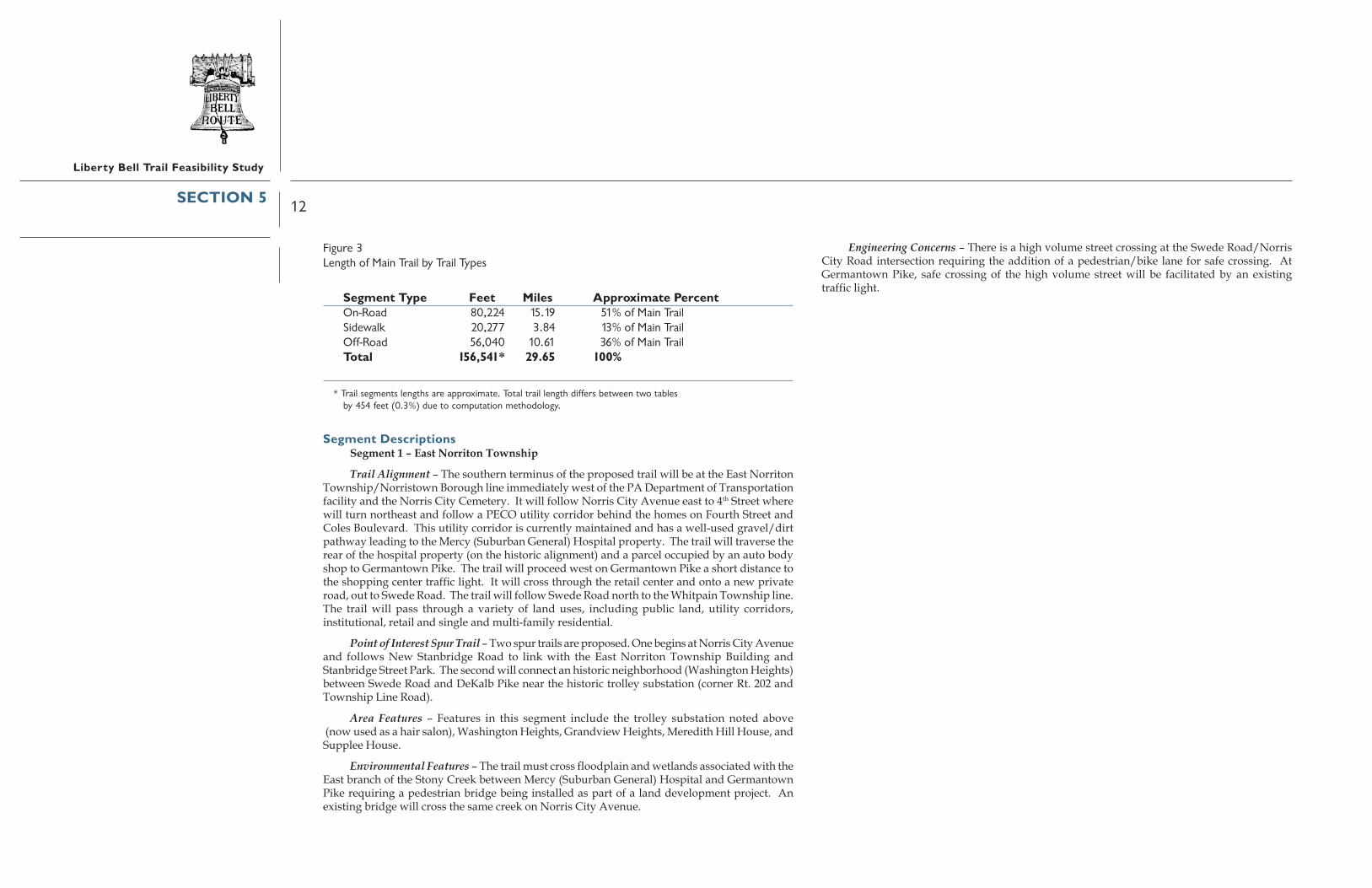
Figure 3Length of Main Trail by Trail Types
Segment Type Feet Miles Approximate PercentOn-Road 80,224 15.19 51% of Main TrailSidewalk 20,277 3.84 13% of Main TrailOff-Road 56,040 10.61 36% of Main TrailTotal 156,541* 29.65 100%
* Trail segments lengths are approximate. Total trail length differs between two tablesby 454 feet (0.3%) due to computation methodology.
Segment DescriptionsSegment 1 – East Norriton Township
Trail Alignment – The southern terminus of the proposed trail will be at the East NorritonTownship/Norristown Borough line immediately west of the PA Department of Transportationfacility and the Norris City Cemetery. It will follow Norris City Avenue east to 4th Street wherewill turn northeast and follow a PECO utility corridor behind the homes on Fourth Street andColes Boulevard. This utility corridor is currently maintained and has a well-used gravel/dirtpathway leading to the Mercy (Suburban General) Hospital property. The trail will traverse therear of the hospital property (on the historic alignment) and a parcel occupied by an auto bodyshop to Germantown Pike. The trail will proceed west on Germantown Pike a short distance tothe shopping center traffic light. It will cross through the retail center and onto a new privateroad, out to Swede Road. The trail will follow Swede Road north to the Whitpain Township line.The trail will pass through a variety of land uses, including public land, utility corridors,institutional, retail and single and multi-family residential.
Point of Interest Spur Trail – Two spur trails are proposed. One begins at Norris City Avenueand follows New Stanbridge Road to link with the East Norriton Township Building andStanbridge Street Park. The second will connect an historic neighborhood (Washington Heights)between Swede Road and DeKalb Pike near the historic trolley substation (corner Rt. 202 andTownship Line Road).
Area Features – Features in this segment include the trolley substation noted above (now used as a hair salon), Washington Heights, Grandview Heights, Meredith Hill House, andSupplee House.
Environmental Features – The trail must cross floodplain and wetlands associated with theEast branch of the Stony Creek between Mercy (Suburban General) Hospital and GermantownPike requiring a pedestrian bridge being installed as part of a land development project. Anexisting bridge will cross the same creek on Norris City Avenue.
Engineering Concerns – There is a high volume street crossing at the Swede Road/NorrisCity Road intersection requiring the addition of a pedestrian/bike lane for safe crossing. AtGermantown Pike, safe crossing of the high volume street will be facilitated by an existingtraffic light.
SECTION 5

13
Liberty Bell Trail Feasibility Study
Figure 4East Norriton Physical Inventory
�����������������
�����
����
�������
������� �
��������
����������� �� ��
�����!��
�������"#� #! $%&#�
��'#������
�%�'' �$
��$#���()#��
�*%����������#�� ����#���
� !���+������!��!
������������
#����*%��� #�%�� *� %)�*%��,�� �)�����#�
!)������#�-
#�"����.,
�&�����()#���%�'' �$� �����
! ��*�������#/#
%)�*%� 0����#'� ��
��&�� ��
����
�%�'' �$
���� �
�����
�()#������
��$ ��� �,���� ���
��� %� �� %)�*%
�� "����� ���
�������
�#��� ��'#��
%)�*%�)�%��#�
��,��#)���
�������"#� #��� *#�
�������
��,��#�� *-��
#����*%��� %)�*%
%#�%�� *��,��#)���
�%�'' �$� �����
!��' �#�
�����#�
�)0)�0#�
����%��&�����#/#
���� �����()#��
��,
��1����
.���1
������
�� �
� �
������
�������1��
,
���
����
����
���,
�� ��,
�����
����
� !���
��,��!
��,
� �
!����
������
����
��,
����
����������
��� �
!
��,
���� .�,
��,
��,
����
� !���
��������,
.�� ���
����
���!
� !�����
��,
�����
����!����
�������!
��,
��,
��,
���
��
�!�
��
�!����
��
��
�,
����
�,
��
� �
��,��,��
,
�,
����
������
��,
��,
.�,
�!�
�����1 ����
!���
���
�
�������
���������
� ��
����
�! �
���
!� � �
��� ��
��
����1.�, ��,
����
�
�!��
�
+�!����
��,��
,
.�,
!������
������� ��1
�,
�,
��,
��
��,
.�,
!��.��
�,
�.��!���
��,
�.�������
��,
����
��.��
�
��.�
,
��,
�� !��
���������
��1��
����
���
��
��������
� ���
������
��,
��,
��,
��,
���� ����
��,.��
��������
��,
��,
���
��,���������
���� ��� ����,
���
���
����
1 ��
� ���
�������
��,
��,
��,
�,
��,
��� �
��2�
��
�,
����
��.���
�,
�,
��,
�����1�.�,
��,
.�,
���
��,
��,
��������
�������
!����������,
�1 ���
����� !����
��,
��,
��,
��,
����
��,
��,
��
����1� ����
��,
����
��
,
��,
��,
��,
�, ��� ��,
��� !�������,
�,
�����!�������
�,
��,
���
�� �
!���
���
���
�!� �
�
���
���,
�������
����!3�����
.�,
�!����
��� !���� ��,
���
!���
�
.�,
��,
���
� �
+����!
����
�.�,
.�,
��,
�!�1.
�,1
���
������� ����� ��,
���
��, �����
.�,
��,
��,
�����
.���
.���
.� �
�1
�� ,
��,
��,
��,
���
� !
��,
�,
���
������,
�,
��, �����
!��!�1 ��1���!
��,
��,
��,
��,
��
���
���
�,
�,
������
�,
��
��
�, ���.�����,
!��
!��� �
����
�����
�����
��
.�,
.�,
.�,+��������
��.�,
���
!���
�,
+�������
�������
�,
���1
�� ,
���
� �
���
��� 1
��,
!���
1���
�,
� !
��,
��,
��,
����
���
�4����
��,
!��
� �
!��!�� ��,
��,
��
����
��
�����
��,
��!������
., ��
,
��,
��,
�����!��
�����!��
����������
�����������
�����!�� �!�����
�����!��
���
��!�
�
���
��!�
�
���,
���,
��1
� �� !
���
��� �
��� �
�����!��
��
���
��
��
�
��
��
��
����
5
6
7
8
�)���! $%&#� �����)*��� -�9������� #���#���
����#������%#���! $%&#�
�� ����&���� ��������!#���#������#�
������)��' -�
�: �� �$���#"��9� ����#�%���������������������# �
��#� �$���() ����������&��# ��**���������#�
���#-����0���*�����;��)��&#�������#����
�������������������������������� ����� ����������������������
����1�����������
�������������!1�� ����.�����1
��������*#�� ����%
6��68
��������������������� ����������������� ������������������������������� ������������ ����!���"�#������������ �$$�
����������� ������������)0��#� ���
<7=����� �%�! ���!�)���<8=���#��" �&�!� $%���
� <6=��#�% �$����!� $%��
� <5=��)�'����!�)��
! $%�.��)���������� ���� �$�����������������
��������# ��>�����#������������ ����� ���
! ���� *�� 0������������# ����)��
�� �������������� ��� �������'�������# ��� $������� ����������������')����# ���*#����# ������������'������*#����# ����������: �� �$
�#������� ���??�%�� *#����"������
��&�� ��&#�-����0��%�� ����&������#�
���'������"#�*���)��������������#����������# ���� �$�
��"@�+)���7A>�8AAB
��# �0� �$����������#�-�� ���������������� �!"#�$%����$��%$��� %���#&&���' ����''�����(")**�+���,�-*(!.�/)/0*&#(1��2,�-*(!.�/("0"&3(
������ #����# �%�#���#�- �$��
SECTION 5
14
Liberty Bell Trail Feasibility Study
Segment 2 – Whitpain Township
Trail Alignment – The proposed trail will continue on-road along Swede Road and enterthe adjacent residential neighborhood. The route will turn west on Erbs Road to Lafayette Roadwhere it will turn north to Yost Road just west of St. Helena Church. The trail will continue norththrough the Whitpain Township parkland via an alignment to be determined based on futurepark development. Near the Pennsylvania Turnpike right-of way, the trail will turn west throughpublic utility land that runs north of Stony Creek Elementary School to North Wales Road. Thetrail will turn north and follow North Wales Road to the Upper Gwynedd Township line withon-road and off-road options depending on road shoulder conditions and sidewalks. Most ofthis alignment for this section of trail crosses through areas that are residential and dedicatedpublic open space.
It is noted that a portion of the trail along North Wales Road may be located on the westside and in Worcester Township. Much of this stretch of North Wales Road (west side) hassidewalks and footpaths along the street or within the front portion of the residential developments.The traffic light at Morris Road will make the crossing safe with additional bike/pedestrian lanes,crosswalks, and signage. It is further noted that the trail deviates from the historic trail in thissegment because of the need to cross the Pennsylvania Turnpike with few crossing options, regionalroads that are heavily traveled and intensely developed, and a major gated community (Blue BellCountry Club). A longer range alternative to North Wales Road to be explored further, is thefuture use of the Stony Creek rail line corridor; this would require an easement or other permissionto pass through the Blue Bell Country Club property.
Area Features – The features along the preferred route include St. Helena’s Church andSchool, Whitpain Park (to be developed), Stony Creek Elementary School, and the Stony CreekSports Park. The section of trail in the south part of the township will have the WashingtonSquare Historic District, McGlathery House, and Gormly House reachable by short on-road sidetrips on residential streets.
Environmental Features – The only identified environmental features are the crossing oftwo small tributaries to the Stony Creek. Existing crossings along North Wales Road will beused, except in the undeveloped Whitpain Park where a new bridge will be required.
Engineering Concerns – The Morris Road/North Wales Road is a high volume street crossingand will require improvements as noted above.
SECTION 5

15
Liberty Bell Trail Feasibility Study
Figure 5Whitpain Physical Inventory
������ ���
��� � � � �� �������
����
���
� ����
��
������
����������
����
����
����
�
����
�
���
�
�
��
����
�� �
�����
������
�
���������
�
�������
�� �
����
���
����
����
���
�
����
�
���
��
���
������
������
��
�����
��
������
�����
��
���
���������
�����
�
��
�
�
�
����
���
�
�����
��
�����
����
���
�
����
����
�����
����
����
���
�
�
����
���
�
�
���
���
�
�����
���
��������
���
�
���� �
��� ���
����� ��
��� �
�� �� � �
�������
�
�
�������
��
��
���������
����� � �
����
���
��
�������
��� �
����
� ���
�
�
�
�����������
�������
�
���
�
�������
����
����
��
���
�
�������
�
�
����
��
������
��������
��� ��
�
�
���
�
��
����
����
�
����
�
��
�
����
����
���
��
��������
���
���
���� ��
�
�
�
�� ��������
��
�����
�����
��
����
�
�����
��
��
�
����������
�������
�
�����
�
�����
�����
���
�
�������
�����
�������
�
���������
���
����
���
����
������������
��
���� �
��
����������
��
��
�
��������
��
�
����
�
��
���
�
����
����
�
��
����
���
�
����
��������
�������
� �
�����
��
��
����
����������
� ����
���
���
�
�
����
��
�
����
��
��� �
� ��
�
�
�
�����
���
����
�
���
��
���
���
�
�
����
����
��
�
�
���������
������������
��������������
��
�����
��
� � �
���������
�
�
�
�
�������
�������
���
�� ��
�� �
� ���
��
��� �
�� �
���
����
����
�
��������
���
���
����
��������
���
���
����
���
���
�� ����
��
�
����
����
����
���
���
�
�
����
��
���
���
�����
�
�������
��
�����
����
����
��
����
��������
�
�������
��
��������
���
���
����
���
����
���
����
��� ��
���
��
��������
�
��
��
���������
��������
������
�
���
����
��������
�
��
���
����
����
����
��
������
�������� �����
�
�����
�����
�������
�������
��
����
����
�� ��
����
���
��� �
��
����
���
�����
��� �
����������
����
� ���
�
��������
��
�
�
���
���
�
���
����
���
��
�������
�
�
�
�
�������
���
��
�
���
��
����
��
������
��
�������
����
���
�
�
����
���
��
����
���
��
����
�
����
��
�
������
�����
�
����
����
�����
����
���
���
���
����
��
���
���
��
��
����
����
��
������
�����
����
�
����
���
�����
�����
��
���
����
���
�������
����
�
���
����
�
�� �
� �
���������
����
��
��
�
���� �
�
����
�
��
��
�
��� �� ���
�
�������
�
����
����
����
�
������
��
������
��
���
��������
�
������
��
�
�����
������
�
�
����
����
��
�
�
�������
�
����
�����
��
����
����
���
��
�
�����
�����
��
�
���
�������
����
���
�����
���
��
��
�����
�����
�� �� �
�
�
����
����
�
��
�����
��
��
������
����
���
��
��������
�
���
������ �
����
��� �
�
�� ��� �
������
�����
�������
��
������
�
�
����
������
��
��
��� ���� ���
� ��
����
�������
�
����
������
�
��������
��������
�
�������
����
�
�
�������
����������
��������
�� ��
��
���
�� �
�
�
����������
��� �
�� �
�
�
�� ��
��������
���
������������
�����������
�����
��
������
��
��
���
��
�
��
�������
�
������
�����������
��
��
��
�
�������������
��������
���������
��
�����
����
�������
��
���� ���
��
����
����
�
��������
���
���
���
����
����
�
�
�
��������
���
����
�
����
��� �� �
�
����
���
��
����
��
��
�
���� ��� �
��
���
��
��
����
����
� ��
��
��
����
���
�
������
���
��������
���
���
���
��
������
��
�
����
�
�
����
����
�
���
��
���
��
��������
��
��
�����
���
�� �
����
�����
����
���
����
�
������ �
���
����
��������
�����
������
����
�
��
�������
����
�
�
��
�����
��
��
�������
���
��
��
�����
�
�� �
���
���
����
����
�
����
�
����
���
��
��
���
�����
�
� ��
��
��������
��
�����
�����
������
���
�����
������
���
���
����
����
���
������
����
������
���
�
����
����
����
���
����� �
�������
��
���
�
��
�����
����
����
� ��
��
���
���
��������
��������
��
����
�
�����
���
����������
���������������� ��������
����
�����
���
�����
���
���������������
��������
���� �������
��������
�����������
���
���
��
��� �
��
��
��
��
��
������������� ������������������������������� ������������ ����!���"�#������������ �$$�
��������������������� �������� ��������!"#$
������������������������
����������������
�������������� ��������������
��������������������������������
%��&'%
'(
)
*
+
�,-.��/0 1".22��3-��,!���/4$5�$6$-��/"3���-"&$#.�- "�$� /0 1".
�$3!$��3!��"! 7$3�
8
� $6��3!��"! 7$3�
9
��/:$1".��3!��"! 7$3�
�/4$5�$6$-��/"3��"3$-
�/-!,--��;�/�3-�1/� �"/#��"6���7;"3.
�#6����##$.���/60$!#$"���&�<,/#6/30-
�/4$5�$6$-��/"3��"3$-
��#&���,�-$���/0 ��#,7$����$$�����--/30�����$"7����--/30�
������������������
��"34#/3��! ��#���,-$��� ������������
=8>��$3�$���?,"�$��/-� ��/-��/!�����7"36.��"�7-�
� =9>���"3�@���,-$
� =*>����7#.���,-$
� =)>��!�#"� $�.���,-$
� =+>�$/&&���,-$�=���,!�,�"##.��36"30$�$6>
� ='(>��"- /30��3��?,"�$��/-� ��/-��/!�
�#��6��#"/3-A��$�#"36-������������������������
�/-���/!��/<$��.��$##���"/#��,�$
��������������������������������;�-$6���"/#��#/037$3���/3���&��3�$�$-���;,����"/#��!"#���"/#��.-�$7����;�-$6��!"#���"/#��.-�$7��B/-�/30
� /�;"/322� .-/!"#��3:$3���.
$:C��,3$�D(A�%((8
����/�3-��&���"/#�7".�<$�#�!"�$6��3�� $����!$-�$���13- /;�-/6$��&����� ��"#$-��"6
� /�;"/3��"�4��
���3.���$$4��#$7$3�"�.�
�! ��#
���������������� �!"#��$%����$��%$���� %���#&&��' ���''�����(")**�+���,�-*(!.�/)/0*&#(1���2,�-*(!.�/("0"&3(
���$3�/"#���"/# $"6��"�4/30��
SECTION 5

16
Liberty Bell Trail Feasibility Study
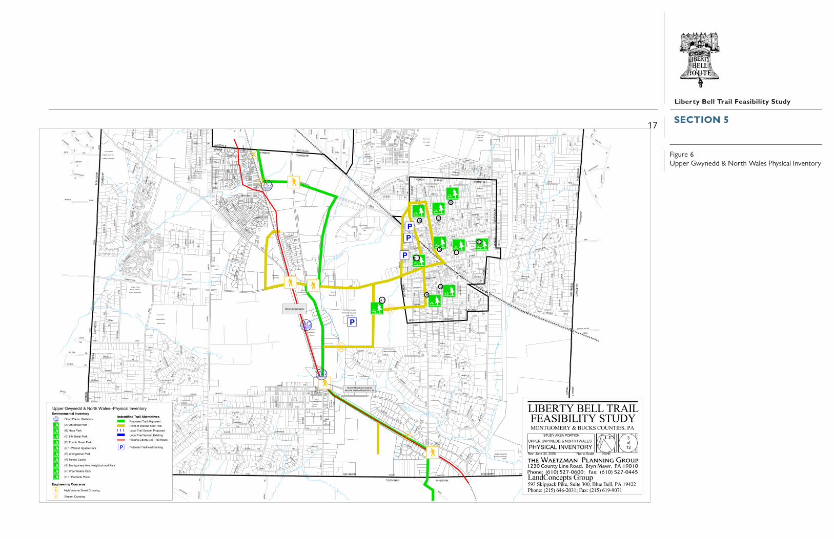
Segment 3 – Upper Gwynedd Township & North Wales Borough
Trail Alignment – From the Whitpain Township border, the proposed trail will continuenortheast on North Wales Road to the Stony Creek rail corridor just north of Acorn Lane. It willproceed north to the intersection of Moyer Boulevard and West Point Pike. The route will followWest Point Pike on-road to its intersection with Sumneytown Pike. The trail will jog southeast onSumneytown Pike and northeast to a PECO right-of-way that follows the Wissahickon Creekthrough the Pennbrooke Industrial Center to Wissahickon Avenue. The utility right-of-way willprovide an off-road experience for the trail users. At Wissahickon Avenue, the trail will turnwest (along a portion of the road already scheduled for improvement), cross Church Road, andproceed through the new Transportation Oriented Development (TOD) between Church Roadand the rail line. The trail will continue north and cross into Lansdale Borough. This section ofthe proposed trail will cross through a variety of land uses, including residential, utility corridors(rail and electric), office complex, industrial, and undeveloped land.
Point of Interest Spur Trail – Spur trails are numerous in this segment connecting manymunicipal facilities and retail areas, especially in North Wales Borough. The spur trail in thesouthern part of this segment will connect the main trail to a new age-restricted communityunder construction along Morris Road. In the center of the map is depicted a network of spurtrails serving the Upper Gwynedd Township Building, police station, Parkside Place Park, andeight parks in North Wales Borough (4th, 8th, 9th Streets Parks, Hess Park, Walnut Square Park,Weingarten Park, Montgomery Avenue Park, Wee Walers Park), tennis courts, Borough Hall,police station, post office, and SEPTA train station; those spurs also take the trail user throughthe North Wales Historic District. The proposed trail will provide direct access to Merck &Company, a major employer in the region whose employees will be able to easily access the trail.
Area Features – In addition to the features noted above, the trail will also link directly to theWissahickon Valley Watershed Association Green Ribbon Trail adjacent to the Upper GwyneddTownship Building that follows the creek north and south for many miles. It is principally forpedestrian use.
Environmental Features - The trail will need to cross the Wissahickon Creek and tributariesto the Towamencin Creek and associated wetlands with pedestrian bridges.
Engineering Concerns – There are several high volume street crossings at North Wales Road/Stony Creek railroad line, West Point Road/Moyer Boulevard, West Point Pike/SumneytownPike (traffic light), Sumneytown Pike/PECO Right-of-Way, Church Road/Wissahickon Avenue.
SECTION 5
17
Liberty Bell Trail Feasibility Study
Figure 6Upper Gwynedd & North Wales Physical Inventory
���
����������� ��
��������
������� ������������ ���������
������������
����� �����
��������������
������
�����
��� �������
������� ��������
��!����
������"�� #�������� �����
��� ����������� �#���
$����%& �'�%���" ��() &� ��
)��'����*�'��
+�����,���
��-
����
�����) ������
%����
������'�� ���������� �
��!������
'�����
�'�$�'�� ��%�$&�%��"��$&'�
�&$��
����� ���
%�������� +�
���� ������
� !��-
������
.� ���"�#�
�&$���'�$�'�� ��%�$&
)��'����*�'��
��-������
'�� ������������
��������������� �����
�$�� �$&
����" '$� '�
�%��"
�%��
%%�
�'���*&,$� $
� /�"
���''�
' �"�"
�%$�
�%���" �
�" ��'*
.$�0�%�
���'
'�
�%�'
�%��
���
�)�0'�
�)�
�*$�1�
�$�� %�
�'�'�$&
.$�01�
" &&��'��
���
,$&&'*�
$ *
, '�
" &&")��'�
���
$��"'�
&$�
$��'��
" &&� �'
���
���
,$& &
'*
.$�01�
� ��
+%� �
'
��*�'� �%$�
���
�%%�&$��
&$�
�$&�)�
�� �&*�
�$&
'�
�%��
$�'
�" �
�
+%)�
�"
�%$��$�0���
�)��
&''
',$
�� �& ��
���
'/�'�� %�
(&)'�%�� �
�%��"'$��
�'���*&,$� $
�)��� 0'
�� �%��
�%��'�"%��
+& ��&%�0
��� �$*�� ��%�"
&$+$*'��'
����)&$�0
�)"&'�()��
��%���$*
���
���
���
���
'$�&'
$���
��%�
�
��")
&�2
���
�%$�
('�0
���
�
�%&& ��
/%+
"$��&'*
�&�
"$��&'*
�&�
���
�$/�'&&
�&�
(�%$
�
$&�� ��&�
�)� &'$, *���
���
$,'�
�� ��%�
���
�"'�$��
���
��$�
3) &
�*&$
�
$,'�
�'"$,'�
&$�
&$�
(%��$�
���
�" ��$0'�
�'�%
��
�&�
%$0
�'�
�
���
���
���
�% �
�
$ �*
�%�� �
���
�%�& ��
�%��
"
$�%��
&$�
�$&&
$��
�&�
(&,��
�)��'*�%��
�%��$*
��$& &�% %�
���
�$�"
�$�+ '&�
���
$��'��
��'�����
���
� ++
& �
��)(
'�
���
�$��'��%�
�&�
�)&& ,$�
3) ��
&$�
")�� ���%�
�& �
&$�'
���
�&'$
�, '
�
�&'$
�(�%
%0 ���
�'*'�
�%$�
�%$�
0� �
� �
�$�+ '&�$,'�)'
���
���
���
���'
'�
� � �
+)&�%�
.$� ,
��& $
�
��% (
''��
� �
� ����%�'�$�'
��*�'�
$&'
,$&&'*��� �$*
&$�
%/+%
'���
��
(�''
2'�
%%�
���"
&&
� ��"
�"�%
��
�$��
'� �
(�%$
�
���
%$0�
�"$�
�'�
$,'� �%$�
�$��
'�()
�*
�'��%��
���
&$�
�$*
���
� �$��$,'�
��''0��
''�
��%�*
��$�'
$,'�
$&&'�
(�$�+%��
0' �"
(� $� &$�
&$�
&$�
�$*
���('�"
$,'�
�&�
���
���
$,'����
���
.%�'�
���
$,'�
$,'�
���
�"'�
��)�
�%*'�
���.%�'�
� 0'
� 0'
�%$�
�"'$
�'�
�&%,'�
�&%,'�
���
���
���
�$�'
�"'$�'�%&�
&$�
� ��
�%�&*
���
$,'�
�'��
�� �
�'��'�
��$��&'*
'&�
�$ &�) �
&%)
�'
�")�� "
('�0 '�����
�%$ �
0�''�&'�
���
� �0
'��%
�
� ��$" �0%�
���
� &&
%�
&$�
���
��)��� $&
�" ��
��"%
%&('$,
'�
�$ �
�'�%��
���
+%)��"���
� /�"
�$&�)�
+ +�"
��� $,'�
���
���
�)&&
�$�
�'��"$�
$,'�)'
��$� %�
���'$�
���
�%$�
� &&
�%�� �%�' �*
�'��"
�%��
'�
' �"�"
�','��"
���
���
���
� ��"
���'
'�
���
���
��%��
�$�"
�)��*&'$
(%*�
��$��&'*
$,'�
���
���
��% &
' �� $
,'�
�%$� $&&'��%��
�%�
$ �'�
� � "$� &�%�
�$�0
���'
'�
$,'�
)'
$,�$,�
���
�''�
�'�$
����
��*
���)
�'
�'(��'��$�
' �*��
'��
�'��
(�% %
0$,'�
$,'��&$*
$,'�
&'�$�'
�%%�
���
�%$�
�%��
"
$,'�
�'$�
%�&$
�0
� �'
, '�
& �'
��%�
�'��
�$*
$)�)
(%�
���
��'+$�
���
�'��
�$*
�%$�
"$2&'�%%�
��'�
'�+%
��
�& �
���
"$ �'�
���
�$��%�0
���
','���''�$,'�
�'$�
%�(�
%%0
���
.'�0 ��
�%$�
"'�&%�0���
&$�
� � �
�")��"
� ��
���)�'
�%%�+%��
&$�
"$��'�
&$�
� ��
��%�
�'��
$,'�
���
$,'�
$,'�
���
�$��
�"$
'&
���
�$�" ��� %�
�%�� �%� '�*
� �
��%�
�$*
$,'�
)'
&$�
(�%%
0�% %
�
�%$��(�%%0%�'$�
&$�
%$0&
$ ��
�"
� '� %
$ 0
��"%%&�"%)�'
�%$�
��*�'��
('��
�$�%�
&'� � $
&%�'�
��%+
�
,$&&
'*
%$0
���)
�'
�)�� �
���''�
+$ �, '�
���''�
���'' �
���''�
���''�
" � "&$ ��
$,'�
���''�
���
+%)��"
���''�
���
��% �
� '� �
�%*$
&
)��'
�
���''�
���''�
���''�
&$�
�")��"
��� )
� '
�','��"
���
���
�%%������
��*�'��
�'��
*
"$�,
' ��
��''
� "'$
��
&$�
+$��
&$�
�%$�
�%$�
$,'�
)'
���
.+0
���
&$�
" (
��*�
'��,$
&&'*
%$0&$��
�)��'*�%��
�%$�
�%$�
�%$ �
�&$ �
'
�&�
('��
��' �
��� ���
($�('� �*
� 0'
���
4�"
�%$�
�%$�
&$�
$,'�
5�"
�%$�
(� ��
�%$ �
���
� 0'
�$��&'�%%�
�'0$&(
�)��
()�*
���
$,'�
)'
$� � *
&$�
+%�'
��
�%$�
& ��
&$�
"$��%�0���
&$�
�$*
�$&'�
�" ��$ �
�%���" �
��*�
'��
�%�
� �"
�
�%�
$�'�
� �
)�� '
�
)��'�
�%��'��'���*�'��
�%���" �
�%�
� �"
�
�%��"
(%�%) �"�
$&'�
�%��"
�%��"
��*�'��)��'�&$���$&'
(%�%)�"
�%���" ��%���" �
��*�
' ��
��* �
' ��
(%�%)�"
�$&'�
)�� '
�
&%�
'�
(%�%
)�"
�%��
"
�$&
'�
(%�%)�"
�%�
��"
��%
���
" �
���
��
��
��
��
��
��
���� ��
�� �� ��
����
���
�
�
�
��
��
��
������
6��78
�������������������������������� ����� ����������������������
��)�*�$�'$��%�� %�
�"*� �$&� �,'��%�*����������� ����
��������������������� ����������������� ������������������������������� ������������ ����!���"�#������������ �$$�
)��'����*�'���9��%��"��$&'�
"�#��,�������������� #������������ #�
������������������
+��������� �:����� �������������� �������� ���
;$<�=���������-;(<�"�����-
;�<�>���������-
;��7<���� ����������-;'<��� #�� ���-;+<�� ��������
;�<��� �#����$�����#�!��������-;"<����������-;"�7<���-��������
"�������&�!���(������������
����� �������������� ���� ���������������$��# � ���� ����� ������������&����������������������&����������������'?���� #
)������ ���9����������@@��������� � ���
$
�(
+
'�
�
"
��7
"�7
��-�9������ �
��������� ������� ��������������������%���
��A�.� �6B:�8BBC
������
������������
�� ;�<�+�����������-
���������������� �!"#�$%����$��%$��� %���#&&���' ����''�����(")**�+���,�-*(!.�/)/0*&#(1��2,�-*(!.�/("0"&3(
��� ���������������-� #��
SECTION 5

18
Liberty Bell Trail Feasibility Study
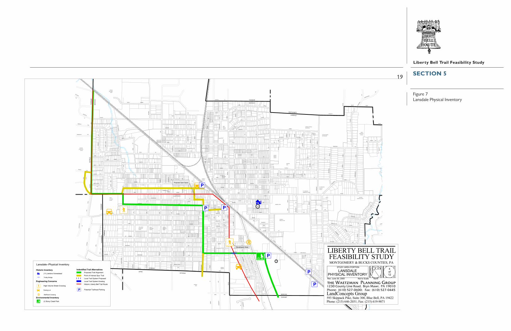
Segment 4 – Lansdale Borough
Trail Alignment – This section of the trail will traverse the established urban communityofLansdale Borough. From the border with Upper Gwynedd, the proposed trail will enter StonyCreek Park following an existing trail. It will turn west and follow Hancock Road, crossinghighly traveled Broad Street at a signalized intersection, and continue to Susquehanna Avenuewhere it will turn northwest. At Derstine Avenue (two blocks from Main Street, the majorcommercial street), it will turn northwest to Valley Forge Road (Rt. 363). Signage will be used todirect trail users to the nearby commercial areas using any of the crossing side streets. The trailwill proceed north one block on Valley Forge Road to Main Street and will turn west to SquirrelLane. At this traffic-signalized intersection, the proposed trail will turn northeast and followSquirrel Lane along the Hatfield Township border to the SEPTA rail line at Koffel Road.
Point of Interest Spur Trail – Several spur trails are indicated that will connect the primarytrail to: Lansdale Park (at the boundary in Upper Gwynedd) via Susquehanna Avenue; BoroughHall, police station, and post office via Vine Street; the SEPTA Station and parking lot viaSusquehanna Avenue/Courtland Street/Wood Street. A spur trail proposed for Mill Street, a20-foot alleyway, will provide an alternate means of access to the retail uses along Main Street.The spur trail at Squirrel Lane that will follow Oak Boulevard is significant, as it will provideaccess to Oak Park, a documented trolley-era residential neighborhood with historic andarchitectural interest.
Area Features – In addition to those mentioned under spur trails, the primary features nearor on the route are the many retail establishments, churches, an historic trolley bridge over HancockRoad where the historic Liberty Bell Trolley line crossed, and Stony Creek Park.
Environmental Features – Given the developed nature of the Borough, there are fewenvironmental features, and all of the proposed trail will share the roads and sidewalks.
Engineering Concerns – A high volume street crossings at Valley Forge Road is a concernfor pedestrian and bicycle crossing.
Bicycle Compatibility – Squirrel Lane is not sufficiently wide to meet the bicyclecompatibility guidelines, but the roadway was evaluated as safe for bicyclists. The Valley ForgeRoad/West Main Street intersection is not considered unusually unsafe, but some adjustmentsin lanes and parking will likely improve the safety. The width and condition of Mill Street limitits use as a secondary route or spur trail only.
SECTION 5
19
Liberty Bell Trail Feasibility Study
Figure 7Lansdale Physical Inventory
�����
��������
���
� �
���
��� � ��
����
��
���
���
�������
�����
���� �
�� �
� �
��
��� ���� �
�����
��������
�������
����
����
����
���
����
�
���������� ������� �����
��������������������
�����������������������
����������� ������
� � �
�������������
������������
���������������
������
����������� ���������
�� �
� ��
������
��
� �����
�� ��
�� ��
��
���������
������������ ������������ ��
������������������
������
�����������
���������� �
���� �������
����� � �
�������� �����
���� �������
� �����������������
�������������
���� �������
����� ���
������
������� �� ������
�������������������� �����
��� � �����
����������
������
��������������� �� ��
�� �� ���� � ��
� ������� ����
� �������������������� �
���� ��������� ��������������
�������������
�����
������������������������
� ���
���
���
��
����
���
��� � ���
� �
����
��
� ��
���
���
�� ��
����
��
��
����
��
�������
� �
���
���
�� �
� �� ��
����
�����
��
��
����
��
���
��
����� �
���� ���
�����
��������
��
���
��
���
���
���
���
����
��� ��
��
����
��
�������
���
���
���
��
���
���� �
��� �
� �� �
� ��� ����
� ��
���� ��
�� �
��
�����
�������
���
��
� ��
����
��
��
�
�
���������� �
���
��� �
����
����
���
�� ���� �
���
���
���
��
��
���
����
����
�
���
���
��
����
������
�
��� ������
�
�
��� �� �
� ��
�
�� �� ��
���
�
���
� ���
���
�
���
���
�
���
������
������
���
��� ��
��
��
���
������
�
������
� ����
�
� ��
������
�
�
�
���
�����
� �� ��
�
�
���
�
��
���
����
���
���
��� �
� ���
���
�
��
�
�
���
�
�
� �� �
����
�����
���
�� � ��
���� ��
�� �
�
����
� ��
������ ��
� ��
� ��
������� �
���
����
������
��
���
��� ���
�����
���
�
�
����
���
���
����
��
����
�
����
���
���
���
��� � �
�����
���
� ��
�
�
� ���
���
�
���
�
�
��� � �
�����
�
���
��
���
�� ��
��
� ��
����
����
��
�
�
� ��
���� �
���
���
� ��
�
�������
� ������
��� ��
��
� ��
��������
� ���
���
�
����
���
��
�����������
��
�
�
�
���
����� ��
��
���
�
���
������
� ��
����
������
���
�
��� ���
�
�
�
���
��
�
���
���
���
�
���
�
��� �
���
���
� ��
�
�
���
� ��
��� ���
� ��
�
�
�
��
� �� ����
�� ��
� �
�
���
�� ��
� �� ����
����
��
�����
�
����
��
�
����
����
��
����
��
����
��
������
��
������
�������
����� �����
���
����
�
���
����
����
������
������
����
���
��� �
������
����� ���
� ���
���
�������
����
��
�����
������
����
�������
������
���
���
� ���� ���
���
������
������
��
������
��
��
����
���
��
����
��� �
���
��
���
����
����
� ������
���
���
� � � �
�
� �
�
������ ��
��� ��
��
�
��
�
��
� ���
��
����
��
����
���
��
����
�� ��
��������
�����
����
��
�����
�����
��
��
���
�������
��
���
���
��
���
�
��
�� ��
��
��
������
�������������������������������� ����� ����������������������
������������ ���������
���� ���� ��������!�!���"#$% ��&!'
��������������������� ����������������� ������������������������������� ������������ ����!���"�#������������ �$$�
�()'���$*+%��!&%%!��&�,,(-)��������������������
���������� �������� ���. /��!�-0��&%%1��#&1��
�(,!�&("��(2%&!0��%$$�&#($���*!%
����� �������������� ���� ����&�3�,%4�&#($��$()-+%-!��(-!���� -!%&%,!��3*&�&#($��"#$�&#($��0,!%+��&�3�,%4��"#$�&#($��0,!%+��5(,!(-)
�#-,4#$%66�'0,("#$� -7%-!�&0
.��/��%-1(-,���+%,!%#4�
�#&1(-)���!��#($��#4��&�,,(-)�
&�$$%0��&(4)%��� ��������� ���
�%7%$�3%4��&%#
�&�3�,%4�3%-��3#"%
�%78��*-%�9:;� ::<
��
���������������� �!"#�$%����$��%$��� %���#&&���' ����''�����(")**�+���,�-*(!.�/)/0*&#(1��2,�-*(!.�/("0"&3(
��!%-!(#$�&#($'%#4��#&1(-)��
SECTION 5

20
Liberty Bell Trail Feasibility Study
Segment 5 – Hatfield Township & Hatfield Borough
Trail Alignment – This section of the proposed trail will pass into Hatfield Township at theLansdale Borough boundary at Koffel Road and proceeds within the rail right-of-way into HatfieldBorough, except one short deviation north of Werner Road to avoid an electric substation. [Thisone area in which the SEPTA right-of-way is used, is the exception to the policy discussed in theintroduction to this section. This was done at the directive of the Township and recognizes thata short portion of existing trail has been constructed and opened in the right-of-way within theBorough.] The route will continue in Hatfield Borough within the rail right-of-way and willinclude a segment of trail already constructed and used. Just east of Lincoln Avenue, the trailwill leave the right-of-way, turn west to near Cherry Street, and proceed within the former trolleycorridor behind the homes on Diamond Street. The trail will leave the Borough and re-enterHatfield Township within the former trolley right-of-way, cross Bergey Road and proceed to theFranconia Township border just northwest and parallel to Souderton Pike. The route throughthese municipalities will cross through a variety of land use, including industrial, single-familyand multi-family residential, mobile home park, retail, and farmland.
Due to current conflicts, this section of trail includes a proposed interim alignment thatfollows Bergey Road southwest to Derstine Road and then off-road through agricultural landand a utility corridor to Cowpath Road. In the future, the intent is to utilize the primary trailalternative outlined above.
Point of Interest Spur Trail – A major spur trail is indicated through Hatfield Boroughconnecting the Hatfield Elementary School, Pennfield Middle School, Heritage Park, HatfieldTownship Arboretum, and other points of interest (e.g., churches).
Area Features – The proposed trail will follow the former trolley line entirely through thesemunicipalities (except the interim trail alignment). In addition to the features linked by the spurtrail, other features near the trail will include the existing Borough trail, former trolley station,downtown Hatfield, greenhouse, Electrical Plant Park, Hatfield Township Nature Area, and JacobReed House.
Environmental Features – The proposed trail will require crossing of several tributariesand floodplains of the West Branch of Neshaminy Creek.
Engineering Concerns – The proposed route will encounter high volume street crossings atOrvilla Road and Schwab Road and at Bergey Roads near Diamond Street. There are also gradingissues where the trail crosses Bergey Road, a culvert at Overbrook Road, and railroad/trolleyabutments at the Franconia Township border (also a trolley line feature). It should be noted thatthe proposed Route 309 Connector is proposed to follow Township Line Road in this area; a non-grade crossing is being explored with PennDOT.
Bicycle Compatibility – Some improvements may be warranted at the high volumeintersection of Orvilla Road and Schwab Road.
SECTION 5
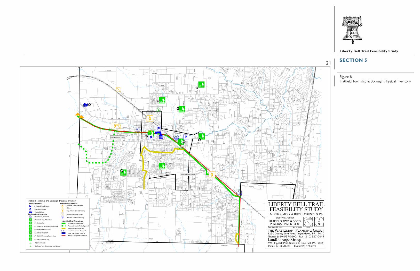
21
Liberty Bell Trail Feasibility Study
Figure 8Hatfield Township & Borough Physical Inventory
���������
���������
��� ��������� ������� ����� ������
������������
��������������������
������ ������������ �����
������������
������
������������� ����
���
������� ��������������
����
�!!"�����#
��!"��
�$�� ����
��%$����$&#
���
�$&�'$�� ��%$��
���������
��������
#��$#��&# ��$&#
� �����(����� ����
������)���
�������������$� �� *���
���"�� �'�� +
#,��������
#%��
��� ���)#,�� %��
������� ����������������������
��������!������
�������&�� ����
!"�����
�!!"�����#
"���%��'
$-� �"&'�&
�$
�"$�.
�'
��'�
�%��
'
$-�
���
�/
�#� �
* #�&
'�
'���
# "&�
��$'
$���&#�%&
�"��
%$�
��'
�'
�'
��$'
�"&"&� �
�
����/
%$#��!�
�'
��%�$#�
��$'
#�%&�
�"�
����$�
$-�%��'�"'�!��#/
!$"�� �
�(& '
�
%$/
*$#���"&�
*"� ���/
%$/
!(&*�
%����
��$'
$-�
��-"��$
�'
�#
���$�-
"�%
��-
"��$
�$�*�$* �-'
!�$&��
&"$
����.
���(�#
%��'
$-�
���
$-�
�$*
��$'
$-�
�$�*
�-'
$-�
!����#
�$*
�$�*
�0("� �
��
$-�
�"&�
'�
�'���
�&# $-�
%��#
�&'
#�"�' �#
����$�
"���
�# �#
�# $-�
�$���
%$/'"'
��"1"�
$-�
�&#%��'
!$�-"�%
�$"&#���
#�%$��&�"&
���-"' �&�
�
��$'
�"�
%�&'/
%$��"&�#�&
$'$��
�$
'���
�$
�'
!"�����#�(�$&
$-�!��'
�'
'�
*����$&
�'
��$&#
$��2$&'��
0($"�
����/
'�
&�
�"�
'$�#��(#�
'�-$
� �$ �
'�
��"&��
#�&
��
�(�����
'�
�'
!��'
#�%$��&�"&
3�$& '�
!��#
��$�#�(�
�"�
'$-"�
'�
��&!"��'
��$'
���#!�
�'
*�!!��
�2!��'
�#
$-� '�
!$�-"�% $-�
$-�
��� ��"& �
$-�
�'
�-��
���*
��$'
�����$�"���$ '
���
�/
'�& �"��
%$/
�/&����
�"�
�$
'�
��$ '
��&&
�'
�"*�
�-��
���*
�'�$*
����
'"$��&'
�#
�#
�'
�#
����$�
$-�
�#���$&"
�
�#
'�3(& �
'�
��$'
3$'�
� �$"&
%$/&�
�"�
%��$#!"��'
�'��$-�
���(� "$
'�
%��' �'
�#
�$"& �
�"&�
� �&
$-�
$-�
$-�
�$� ��#
(#���
$-��#
$-�
�"&���&
(&"�&
'"$��&'
�����/
���
�$�'
�# %$/
����
�� �$
!����#
�#
�#
�#
�#
�$����#���#
�#
�����-��#
�$�*�#
�"�$�' $-�
����#&(#�#
&
�'#"� ��
���%$
��( �%� �'
'�
��$
��-"&�
�"�� #�&
���&
'�
'�
'�
�"&�#���
������
$����
'�*&" ��# � �"' ��
��-�&#�/ �$
'�
'�
%��# �$
%��&��
�#�(�
��$'
%
%"&�#�&
����
���
�$
-"&�
�#
�#
�$'�
�%��'
�$(��&
*�!!��
�$
�'
�"��#��$
�"&����-�
����$�'
$-�
$-�
����&"$�
��$'
�$
�$&'"�
'�
�$&�
��$��!(�
!�$&��&" $
�#
$-�
#����&#
��$'
�����"$
�'
�$
$&'�-��
%�'��%��''� '�
�#
��$'
�$
�(&
%$/
��-
"��$
��%�$#�
�#
��$'
'���
�$ "&
�-"&�
$-�&(�
�$
��$'
��$�
�$
�$#��
��-
"��$
��2"&�
#�&
�$�*
�'��
��*
�$*
�'
�'
��$'
'�
�#
#�&&"�
%"� ��'�&
!����# �"���
�'
�#�%$�#
��&#%��'
!��#� �
#�$#����
�$
��$����&#
'�
'�
'�
%$/
��&���'
��$'
�"*���('��#�&
��('��#�&�"&�
��$'
�"����&'
�$��(� '�
%��
'�#�
� $�
��$'�%
�$� �
"'��
%� ��"&�
#�&
(&"�&-
"���
�$�!"��'
�"�
%$ /
��$'
������
�#��
��# &(#
�$ '�
&��#� ��&& �$&'
�#�&
�
��/�#$�
'�
'� '�
'�%&"&�
�����
�#�"&�
�$%#���&�
$�� �&
�#��
�#
'�
�$
�$#��
�##$ ��
�$ #�
'�
��$��#���
�(��
�' �
$� ��
'��"��
��& �
�$
�����%
'��"��
��
�$
�$�/
'�
��$'
�#���"&�
��& 1�
'� '�
%��'�
����/
����$�
'�
�����
��/���
'�
�'
�'
"'$
�$
��2"& �
#�&
�'
�'
� �&#
�#
'�
& �&#
'�
%��
'-" �%
-$���/ �'
�#
'�
%
����
&��
�$�'�&
��"�"� ���' '�
���
�$*
$-�
$-�
4#�
�$&&
�&$-
�
*�&"� %
��#�
#�%$ �
�&�"&
�#
��/��
$-�
�$���
$-�
��$%
�#
5#� �#
6#� �#
%$�& (
#
&
���$&
��$'
$-�
�$&�"&�
�#
!���
�#
��� �#&(#
4#� �"'�
�
'�
�# �#
'�
�"&�
�#���#
��&�
$�#
�����-��#
�"&�
!��#(&$ '�
$-�
%$/
!�"�&'
��"�
#���$�
�$���&#�� �$
��&&
�"& �
�#
��#����&
��$'
%$/
�#��
�#
'�
�'
�� ���
$
%$/
�"����
�#
�#
&���$&
'�
%/&&�
%$/
$-�
%$�& (
#
�����$�
& �
�$'
$&#��&/�$�(
�3�' "�#��%
"�#�%&
'�
��$��&
�'*$���
�"�
�#���#'�
���&
�(��"#
'�
����$�
!���
#��$ '
�'
3�&*"&�
$-�
�$
$'-$&��
'"���-��/
'�
�&#����"���$
�#� �
�#
�"*�
%$�&(
#
�$#!"��'
!�$&
� �& "$
�$&�
'$��
�$#!"��'
#�%$��&�"&
#�%&��"�
#�%&��"�
#�%&��"� ���(��
�$#!"��' #�%&��"�
�$#!"��'
���(��
�$#!"��'�$#!"��'
�� �
( ��
#�%&
#�%&
�$&�'$��
���(��
�$# !"�� '
��
��
���
��
�����
��
��
��
��
������
�
�
�����
�
��
������
�
�
*
�������� ��)������ �������
7�89
�������������������������������� ����� ����������������������
�#('/ $��$ ���#"�&
�$#!"��' #%�� + �����/�"�$� "&-�&#��/
&� � ����� &��
��������������������� ����������������� ������������������������������� ������������ ����!���"�#������������ �$$�
��� -���� ������ ���������
������������������
���������� �������� ���
:3; �������� #,�� $�)�������
������� ��)���� ��� #���� ����
����� �������������� ���� ��������� #���� $��������
���� � "������� ���� #�������� #���� ������ ���������� #���� ������ �<������
�������� #,���� ��� ���..������� "�=�����
:89; 3��) ���� ������� ��������� ���
!�� ������> %���������
���=����',��,� ����������������> ���=���� "������
#����� �������
�������> #����� $)������
�� :*; �������� ����
:�; ���������� ��� ����� ������ �������� :�; ������� �������� !����
:�; ��� ��� ������:�; �������� #,���� &����� $�����:0; ���������� ����� ������
� :�; ���������
:�; ���� #��� �������� ��� &�������
0�
�
3
�
�
&
�<������ ���=��� 7?� %���
89
��=@ 3��� A?> 9??7������ "������ #���� $��������
���������������� �!"#�$%����$��%$��� %���#&&���' ����''�����(")**�+���,�-*(!.�/)/0*&#(1��2,�-*(!.�/("0"&3(
�������� #������� ���������
SECTION 5

22
Liberty Bell Trail Feasibility Study
Segment 6 – Franconia Township
Trail Alignment – The proposed trail crosses through a short section of Franconia Townshipbefore entering Souderton Borough. It will follow the historic trolley line from Hatfield Townshipand traverse farmland, utility corridor, and single-family residential uses. The trail is proposedto be off-road through this section. (A small portion of the interim trail from Hatfield Townshipwill extend into Franconia as well, where it will be off of the historic alignment.)
Area Features – The Immanuel Leidys United Church of Christ and cemetery are a shortdistance to the west.
Environmental Features – The route will require crossing of a small tributary and floodplainof the Skippack Creek.
Engineering Concerns – None were noted.
SECTION 5

23
Liberty Bell Trail Feasibility Study
Figure 9Franconia Physical Inventory
����������
���
��
���
��
�
�� �
��
� ���
���
��� �
���
���
���
����
��
����
�
������
�������
������
����
����
�����
����
��
������
�
�
�
��
�����
����
���
� �
�
����
�
�� ��
������
���� ����
�����
���
� �������
����������
���
�������
���
������������
����
��
����
�������
��
�
����
��������
����
����
�����
��
���
� ��
��������
������������
��
���
��
���
����
������
����
���
����
��
��
� ����
�� �
��
�������
�
��
�� �����
���
����
����
����
���
����
�������������
����
����
��
����
��
��
���������
����
�
���
��
�� �
���
����
�
����
����
�
����
�����
����
���
�����
���
����
����
����������
����
���
����
���
���
���
���� ����
���
����
��
��
�����
�� ��
�����
���
���
�����
���
��
��� �� �
�������
���
����
����
� ����
���
�������� �
��� �
�����������
��������
�������
������������
�
���
����
���
�� ���
�������
�
���
���
��� ��� �
�������
���
��
��� � ���
���
��
���� ��
��� �
����
����
��
��������
��������
��
����� �
���������
�����������
����
�
���
� ����������
�������
����
���������
���������
��
����
���
�� �
�
��
���
���
����
���
�
� ��
��
��
����
�
��
������
�����
��
����
�
��� ��� �
����
����
�
����
���
����
����
���
�����
����
��
��������
����
��������
��
��� �����
���
� ��
����
���
�
����
���
���� �� �
��
���
���
�������
���
���
�
���
����
��
���
���
��
����
���
��� �
�
���
�����
��
�
���
���
���
����
����
����
�� ���
�
���
���
���
�
�������
����
���
������
�� ��������
���
�����
���
�����
���
���
� ��
����
� ���
�� ��
���
���
����
���
����
�
���
���� �����
���
� ���
�����
�
����
�
����
� ���
��
�
����
����
����
����
���
���
� ���������������
������
�������������
����
��
���
������
�� ���
���������
��������
��
����
����
��
�
��
� �
����
����
����
��
������
�����
����
���
���������
������
���� ��
����
��
����
��
������
� �
���
�
���
���
�
������ ���� ��
������� ������
����
�����
���� ��
� �����
� �����
�� ������ ��
���
���
���
���
���
���
���� ��
�� ��
�� ! "#$%&'!!(#�#�
)*��+%(,#�+'%-+�% .
� ! # %&
"(# /�"/($"
�� ! "#$%&�%$"-)"($
-+))�
� ! # %&
�()"� "")"(#
� ""��( 0�+%(,#($"-+))�
+ ��1 /�)! ��)%� "")"(# �$,# %"
� ! # %&#���$'�,
�)��(%
�$%. �*)%/
2'"()%��(1+�-+))��"/($"��% ,#
�$%.-+))�
��������
�**(- �),#
�+� �+�
� ! # %&%("(#&
-+))�
�*)%/�� ! "#$%&
�)%�+
�'#+ %$"
�1 /
�)!
� ! # %&
�� ! "#$%&�-+))�
� ,#��%)$/�#% #
�+��$"/�� !�� "")"(#
)*��+%(,#�+'%-+ "(# /
�!!$"' �
� ! # %&
� (/&3,
-+))� "()%��(1+)'/ %#)"
� ! # %&
)*��+%(,#�+'%-+�0("1�(
�������
)'/ %#)"
�+�
��������
�**(- �),#
�+'%-+� #+)/(,#
�()"
������%)'#+$! ��� ! "#$%&
-+))�
��
��
����
��
������������� ������������������������������� ������������ ����!���"�#������������ �$$�
��������������������� �����)%#+�)#�#)�-$�
�������������� ��������������
��������������������������������
��������������������
�(,#)%(-��(4 %#&�� ���%$(���)'#
���������������������������%)5), /�%$(����(1"! "#
�)("#�)*��"# % ,#�5'%�%$(��)-$��%$(��&,# !��%)5), /�)-$��%$(��&,# !��6(,#("1
�%$"-)"($���+&,(-$���"7 "#)%&
��))/���$(",8�� #�$"/,��
�������������������������
�������������� 9)*��
� 7:�2'" �;<8��<<=
�%)5), /��"# %(!�%$(����(1"! "#
���������������� �!"#��$%����$��%$���� %���#&&��' ���''�����(")**�+���,�-*(!.�/)/0*&#(1���2,�-*(!.�/("0"&3(
�)# "#($��%$(�+ $/��$%.("1��
SECTION 5

24
Liberty Bell Trail Feasibility Study
Segment 7 – Souderton Borough
Trail Alignment – At the Souderton Borough line, the proposed trail will turn northeastonto Cherry Lane for two blocks before turning north onto Washington Avenue to Broad Street.The alignment will follow West Broad Street two blocks to Main Street where it will turn northand continue to Reliance Road; West Broad and Main Streets represent most of the Borough’scentral business district. At the Main Street/Reliance Road intersection, it will turn north andproceed to the Telford Borough line at School Lane. The route is all on-road and through a well-developed urban area of single-family and multi-family residential, retail, mixed, officeinstitutional and industrial uses. The alignment follows the historic trolley line along Main Streetuntil East Summit Street where the trolley turned.
Point of Interest Spur Trail – A spur trail is proposed from the Reliance Road/Main Streetintersection southwest to link Summit Street Elementary School, a Borough park, Borough Hall,and several churches.
Area Features – Area features include the former SEPTA train station (restaurant use), postoffice, downtown Souderton, and the J.M. Landid & Company.
Environmental Features – Given the developed character of the Borough, there are noenvironmental features affected by the proposed on-road trail.
Engineering Concerns – The primary concern is a high volume street crossing at Main andWest Broad Streets (signalized).
SECTION 5

25
Liberty Bell Trail Feasibility Study
Figure 10Souderton Physical Inventory
����
����
����
��� ��
� �
����
����� �
�����
����
������
���������
����
�����
�������
���������
���������
������
�����
��
����
���� ���� ��
����
�
����
� ������
����
��
����
������
����
���� ��
���
����
�
����
���
���
� �� �� �
�
��
����
����
����
�����
���
���
���
���
���
���
����
���
���
�������
���
��
��
����
���
���
����
����
��� �� �
���
�������
����
��
����
���
� �
�
�������
�����
�������
��� ������
����
���
���� ���
���
��� ��
�
���
����
����
����
����
��
�����
� ��
��������
���
���
��
���
� ��
����
���� ���
���
�������
����
�������
���������
����
�
����
���
���
���
���
�
���
����������
���
�����
���
�
���
����
���� ����
�� ���
�������
��� � ����
����
����
��
����
����
���
��
��
����
����
��� �
��� �
���
�������
����
���
���
���
���
���
����
����
����
� �
���
����
������������
����
��� ������
��
���
����
���
���
����
����
���
����
����
��
����
���
���
���
���
��
������ ��
��������
���� �
��
���
� ����
�����
������������� !
�� ������ ��" #
��$� �%
���&
� � � �'
���
���# ���%� %%�%(�
�����%#�� ��
����)�
� %%�%(�
�*����($�
�)���!
����(������! � %���'
+,(%"!(
�(� ���
���
���
����������
���# ���%� %(��� ("�
�)���!
+(�%� ���#($�����)�
�)���!�! � %���'
�
�
����
������������� ������������������������������� ������������ ����!���"�#������������ �$$�
��������������������� �����������������)�!
��������� �������������
���������������
�������������� ��������������
��������������������������������
-�*./
����(����� ����(#" 0��1�,��!#�% #����2 �)�%$���)� #������"��345��*�$�!(#���)&��6 �'� 71 %$(6
� 6 !�1 #��� ��8 ��$ $9:�����%��1�(�%
("����!�� ���� �����$$(%"��������������������
������� ��������
($���()��(2 ��'�� !!����(!����
�������������������������������1�$ #����(!��!("%� %���(%���*��%� � $���1������(!��)�!����(!��'$� �����1�$ #��)�!����(!��'$� ���7($�(%"
���# ���%����'$()�!��%6 %���'
��,%��,%����# ���%����(%�����(�%�8�����9�;������%#(#�<����
6:�;�% �=4>�/44?
���������������� �!"#��$%����$��%$���� %���#&&��' ���''�����(")**�+���,�-*(!.�/)/0*&#(1���2,�-*(!.�/("0"&3(
��� %�(�!����(!� �#����&(%"��
SECTION 5

26
Liberty Bell Trail Feasibility Study
Segment 8 – Telford Borough (Montgomery County and Bucks County)
Trail Alignment – The proposed trail will follow School Lane northwest to Penn Avenuewhere it will turn and proceed northeast to Main Street. At this point, the trail will turn northweston Main Street (County line) a short distance to the railroad line right-of-way. The trail will turnnortheast and follow the rail right-of-way to Washington Street. It will continue on WashingtonStreet to Reliance Road where it will turn northeast. The trail will continue until it reachesCentennial Road where it will jog and join Township Line Road and leave the Borough. Thissection of the trail is on-road, and the portion proposed for Reliance Road closely follows thehistoric route, except at the jog where there are homes where the trolley passed. The route selectedthrough Telford specifically will allow direct access to many Borough features (noted below).
Area Features – The alignment provided access to Borough Hall, former SEPTA train station(farmers market), post office, Telford Crossing Park, and several churches.
Environmental Features – None noted along the selected alignment.
Engineering Concerns – None noted along the selected alignment.
SECTION 5

27
Liberty Bell Trail Feasibility Study
Figure 11Telford Physical Inventory
���
����
���
�����
������
���
�� ��
�������
����
����
���
��
����
����
���
�
����
�����
����� ��� ���
���� ������ ���
�� ���
���
���
���
��
��
�������
���
���
��
���
���
��
���
����
����
�
��
���
����
���
� ����
���
���
����
���� ���
��
���
��
�����
������
�����
��
����� ��
����
�
����
�
���
����
���� ����
����
����
�
�����
�������
���� ��� �
���
���
����
��
�������
��
���
������
����
����
������
����
��
����
�������
���� ��
��������
�������
��
�������
�����
��
��
���
��
����
���
��
�����
���
���
����
��� ����
��
����
����
�� �
����
���
��
����
����
���
����
���
��� �
� �
���
��
���
���
���
����
��
��
����
���
��� �� ��
���������
�����
��
��
������������
���� �����
����
����
������
���
���
��
�� ��
���
���
��
���
����� ���
������
����
������
����
����
����
���
���
����
������
����� ��������� ������� �������
������
������
������
���
���
���
���
������������
������������
������������
������
�������
�� ��!�!�"�#$%�&
��!'��(
��"�
�)�(
�*$ ��%#
��� � �
���#�$&��"�$��&
�������
��"�$��&
����������
�������
� � � �
��
���
��
��
��
��
�� ��
�*$ ��%# ��""*#�$& %$ ��!'��(
�#(�%# �%!!�& �*+!�� ��+�%�&
������������� ������������������������������� ������������ ����!���"�#������������ �$$�
��������������������� ������$ �$ $� ��%!�
�������������� ������
����� ��� �����
�������������� ������������
��������������������������������
,�'-.
�
�
�
�
���/ ��%�! %!�#) ��0#1 �/ ��#� �%(�2�1$�#) �*1�1 ��#'!��$ 0�$ �1$���� !��%$��#
��3�!�/�( ���% 4��*1�15�$ %# �/$��#
���������������
��1$���� ��+��$& ��!! ��%�! �*$�
� ������ ��������������������/�1�( ��%�! �!�)#"�#$���#$ �' �#$���1$ �/*� ��%�!���%! ��%�! �&1$�" ���/�1�(���%! ��%�! �&1$�" �2�1$�#)
��!'��(66� &1��%! �#3�#$��&
��0#$�0# ��!'��(���%�# �$%$��# 4�����5�
4�5 7%��+ %#( �%�& �$�3�� �%�8��
���!!�& �$%$��#�����������������
�� 4�5 ��%#��#�% �3�#*� �%�8
�� 4�5 �*""�$ �3�#*� �%�8
4�5 ��!'��( ���11�#) �%�8��
4�5 ��!'��( �*#���/%! �%�8��
�39 7*#� :;< .;;=
�
���������������� �!"#��$%����$��%$���� %���#&&��' ���''�����(")**�+���,�-*(!.�/)/0*&#(1���2,�-*(!.�/("0"&3(��$�#$�%! ��%�! ��%( �%�8�#)��
SECTION 5

28
Liberty Bell Trail Feasibility Study
Segment 9 – Hilltown Township & West Rockhill Township (south)
Trail Alignment – The alignment in these townships will follow Township Line Road (borderbetween the townships) to a proposed new local trail that will run northwest along MeetinghouseRoad. The trail must turn onto Meetinghouse Road at this location due to the conflict with(elevated) Route 309. It will follow Meetinghouse Road crossing the SEPTA rail corridor at-grade to State Road (Route 152). It will follow State Road crossing under Route 309 and over therail line to State Road/Keystone Drive. The trail will turn north on Keystone Drive, and thenrejoin the historic trolley line along a current utility right-of-way. The trail will continue to followthe historic route into Sellersville Borough at Clymer Avenue. The trail is to be on- and off-roadin this segment and will largely traverse farmland and undeveloped land.
Area Features – The trail will pass near Highland Park Camp Meeting, Rockhill Cemetery,Sellersville Elementary School, and an intact trolley bridge.
Environmental Features – The trail will cross a small tributary to Mill Creek alongOld State Road.
Engineering Concerns – The trail will need to cross the stream noted above several timesand the at-grade railroad crossing on Meetinghouse Road.
Bicycle Compatibility – Meetinghouse Road was reviewed among the alternatives. As aresult of low traffic volumes, it can be safely used for the on-road trail, although it is not bicycleor pedestrian compatible according to the State criteria. State Road is considered compatiblebecause of adequate shoulders, especially through the Route 309 interchange. It is noted that theshoulders vary in terms of condition (loose gravel and grass) and require improvements, as wellas markings and signage, especially at the entrance and exit ramps to Route 309. Crossing ofState Road should be directed to one location with concentrated warning signage. It is advisableto cross it at Meetinghouse Road since the roadway has only two lanes at this location. Nosidewalks are available along these routes.
SECTION 5

29
Liberty Bell Trail Feasibility Study
Figure 12Hilltown & West Rockhill (south) Physical Inventory
��
��
����
��
��
�����
��
�
��
��
����� �����
��
��������� �
��
����������
������
�� �� �� ��
��
�������
��
��� ��
���
����
�
��
�����
��
��
���
�� ���
���
���������
��
�
���
��
��
���
�
��
���
�������� ��!��"��#!����� �!$���%&
&�$��!� �$'�� (
���������������
��� ���)� �*$� +��$,,���%�,���- $
� ������ �����������������������$&���%�,��,�.!/$! ���! ��"�! $�$� ���-����%�, �)%,���%�,��+� $/�������$& �)%,���%�,��+� $/��'�� �!.
��,, �#!�0��$� ���)1��,,�2��- �344��+��)%,�!5$! ��+
2�3���.�,%!&��%�1��%/���$$ �!.������������������
6,��&��,%�!�7��$ ,%!&���� �$%/�������!.��%�,��%&�������!.��
! %) ����,,$+����&.$�
���������������
�
������������� ������������������������������� ������������ ����!���"�#������������ �$$�
��������������������� ������ �� � ���)%,$
������ �������
������������������������������ ��������������
��������������������������������
��"89
��������� ������
� ���������
�� �!&����$)%� ��/�%!+
�� �!&����$)%� ��/�%!+
� �.�%&$�%�,��%&�������!.
� ����0����������� �2��- �3
�$5:�;-!$���7�9��<
�$,,$��5�,,$�,$/$! %�+
�)���,
��)1��,,��$/$ %�+
� ����������(
�����
���
�� �� $! �%,���%�,�$%&��%�1�!.
���������������� �!"#��$%����$��%$���� %���#&&��' ���''�����(")**�+���,�-*(!.�/)/0*&#(1���2,�-*(!.�/("0"&3(
SECTION 5

30
Liberty Bell Trail Feasibility Study
Segment 10 – Sellersville Borough & Perkasie Borough
Trail Alignment – The trail will enter Sellersville Borough along the historic route at ClymerAvenue and will proceed on West Park Avenue to Diamond Street. The trail diverges from thehistoric route on these two streets as the decking for the former trolley line between the bridgeabutments is no longer present. The trail will proceed northwest on Diamond Street crossing theEast Branch of the Perkiomen Creek and joining an existing gravel/dirt/paved trail throughLake Lenape Park and Menlo Park to Walnut Street in Perkasie Borough. The trail will turnnorthwest on Walnut Street and will proceed to South Seventh Street, through an existing tunneland to the intersection of Park Avenue and Ridge Road. It will join with Bethlehem Pike enteringEast Rockhill Township. The trail will pass through a variety of land uses, including parkland,single-family and multi-family residential, retail, and industrial.
Area Features – The proposed trail follows portions of the historic trolley route throughthese two boroughs and several area features. Among them are Lake Lenape Park, Menlo Park,trolley and railroad bridge abutments, intact trolley bridge, trolley station (Perkasie HistoricalSociety office), Eisenlohr Cigar Factory, Borough Hall, police station, and nearby SellersvilleTavern/Washington House.
Environmental Features – The alignment will pass over the East Branch of the PerkiomenCreek on existing bridges.
Engineering Concerns – The former trolley bridge is 6 feet wide with a 45-foot span and willneed to be widened to accommodate the trail. The old trolley route bridge abutments may beusable for a future trail crossing.
SECTION 5

31
Liberty Bell Trail Feasibility Study
Figure 13Sellersville & Perkasie Physical Inventory
����������
�����
����
���
� ���
��
� �����
��
��
����
��
��
�����
��
����
�����
���
����
����
���
�� �
��
�� ���
��
�� ��
�
��
������
���
���
��
��� �
���
���������
���
�����
��
������
�
��
����
�
��
����
�
��
�������
�
��
����
�������
����
��
�� ���
��
������
�
��
����
�
��
������
�
��
����
�
��
������
���
��
����
��
��
�� ���
����
��
�� ���
��
�����
����
��
����
��
����
�
�
��
�
�
�
�
����
��������������� ���!�"���#� $�% &
'()�*++,��-.%
��������������
������������� ������������������������������� ������������ ����!���"�#������������ �$$�
��������������������� ������� /�� � ���0.��
������ ���������
�����������������
�������������� ��������������
��������������������������������
1+�213
�� ���� ��4��������
�51
���������������
�!& ��!0� !#�� ���������.!����� �
� ������ ��������������������-�&�����.!����!"%$�% ��!% ��2�% ���& ��-�����.!� �0.����.!����& �$����-�&�� �0.����.!����& �$��6!& !%"
������&7!����4����8.&!�))�/�&!0.��%7�% ���
9�51:��%����.�8������������������
���������������
�!&�%��/���!".���.0 ���
��%%���
������&7!�����.7��%(�.&/!%" �%����&��
����#� $�%
���������#� $�% &�
����������!�"�))% .0 �
��������� . !�%�
�� ���� ��������
�6!& !%"�;,�<!�����.7��(�!� ���.!�=�-.7��=�
.8�� �%.-���.�8
�6!& !%"���!�"�>,�<!��=�?@,�&-.%
����&� ��#��<!��%��
��7A���%��*+=�3++@
�!& ��!0� �������& . !�%���8.&!���!& ��!0���0!� �
�53
�� 9�53:� .8�� �%.-���.�8
��� /����8.&!���7�������!�"�
�����"/��.��.%�����!0��� . !�%�
�� �% !.����.!�/�.���.�8!%"�� ���������������� �!"#��$%����$��%$���� %���#&&��' ���''�����(")**�+���,�-*(!.�/)/0*&#(1���2,�-*(!.�/("0"&3(
SECTION 5

32
Liberty Bell Trail Feasibility Study
Segment 11 – East Rockhill Township & West Rockhill Township (north)
Trail Alignment – The proposed alignment from the Perkasie Borough line to the RichlandTownship line will be on-road and will follow Old Bethlehem Pike, which is also the historictrolley route. This road separates East and West Rockhill Townships. The route will pass primarilythrough single-family residential and undeveloped land, plus a small amount of utility andindustrial land.
Area Features – The main features are the open spaces that flank much of this section of theproposed trail.
Environmental Features - A stream crossing and wetlands associated with Threemile Run(tributary to Lake Nockamixon) will need to be crossed using an existing crossing of Old BethlehemPike. The trail will also need to cross a small tributary to the Tohickon Creek on Old BethlehemPike near the Richland Township boundary.
Engineering Concerns – The trail will cross Rich Hill Road, which is a high volumestreet crossing.
SECTION 5

33
Liberty Bell Trail Feasibility Study
Figure 14East and West Rockhill (north) Physical Inventory
����
���
��������
���
��
��
��� �
���
�����
���
��������
��
��
���
����������
������
����
��
��������
����
�����
��
���
���
���������
���
���
����
��
�����
�����������������
����������� ��!�" ##���$�#���%�
����������������������� �����&�� '���$�#��#�()* )����)���+��)� � ����&%����$�#���$#���$�#��!�� *����&�� '���$#���$�#��!�� *��,����)(
�$���-� ������./�##�0)���/122�/!���$#��)3 )���!�� ����������� �����
�#��'��#$�)�4� �#$)'���������������������
�(/�5�#%* ���� ��������)(��
������������� ������������������������������� ������������ ����!���"�#������������ �$$�
��������������������� ��������/���������$#
����������5������
������������������
�������������� ��������������
��������������������������������
66�+67
�����-�������������0)���/1
������������������
� 38�9%) ���4�7��:
���������������� �!"#��$%����$��%$���� %���#&&��' ���''�����(")**�+���,�-*(!.�/)/0*&#(1���2,�-*(!.�/("0"&3(
SECTION 5

34
Liberty Bell Trail Feasibility Study
Segment 12 – Quakertown Borough & Richland Township
Trail Alignment – The proposed trail will enter Richland Township on Old Bethlehem Pikefollowing the historic trolley route. It will proceed into Quakertown Borough where the roadbecomes South Main Street and will terminate at Broad Street. At one location, it is proposedthat the trail deviate from Old Bethlehem Pike to connect a new development near Tollgate Road.It will also intersect with numerous proposed local trails in the southern part of Richland Township.The proposed route will traverse a variety of land uses ranging from rural landscape dominatedby undeveloped land and single-family homes to multi-family residential, institutional and retail.
Point of Interest Spur Trail – A spur trail is proposed from the northern terminus (BroadStreet) east on Mill Street to Quakertown Memorial Park and the Borough line. This spur trailwill link the park, as well as numerous other existing and proposed trails to the north inRichland Township.
Area Features – This segment of trail passes numerous features among which are: PenroseHouse, Richland Friends Meeting and School, Richard Moore House, Friends Meeting, and RichardE. Strayer Middle School. A short distance from the route are: Main Street Park, Cedar GrovePark, Parkland, Quakertown Memorial Park, and a future YMCA site. At the terminus areadditional features - the Green Tree Inn, Enouch Roberts House, William Green Store and House,Liberty Hall, Burgess Folke House, Red Lion Inn, trolley station, post office, and theMain Street Theatre.
Environmental Features – The trail will need to cross Threemile Run and a small tributaryto the Tohickon Creek.
Engineering Concerns – The trail will need to cross a high volume street at Main and MillStreets in Quakertown Borough.
Bicycle Compatibility – Due to the current width and narrow shoulders, Old BethlehemPike along most of its length is incompatible for bicyclists. A sidewalk with a separating grassstrip would be ideal, although a 4-foot wide (minimum) shoulder would be acceptable. Initialreview of the road suggested that environmental constraints would have little impact on wideningfor shoulders. Narrow sidewalks within Quakertown Borough are also a concern for bicycle/pedestrian safety.
SECTION 5

35
Liberty Bell Trail Feasibility Study
Figure 15Quakertown and Richland Physical Inventory
��
����� �
������
����
�����
��
��������
��
����
����
����� ��� �
����
������
��
����
�����
��
�������
�
��
��
���
���
���
���
��� ��
���
��� ��
���
��
���
�����
��
��
����
��
���
���
�����
��
���
��
���
��
����
���
���
��
��������
������ ���������
���
��
����
��
����
������� �
������������
��
��
����
���
�����
�
��
�
����
�
����
�
����
�
��������
����
� �� �
�
��!�
�
��"�
�
�
��� �����
���������
�����
�
������
��
�����
�
����� ���
��
���
��
�����
���� ���
��
��
����
��
��������
��� �
���
� ���
���
���
�
��
��
��
�
����������
����� � �
��
����
���������������
�#$%&'#(��#)*'%+� *,,��'-#,��&.%*
� ������ ������������������'&/&$*0��'-#,�,#123*2%�%�&4��2%*'*$%��/.'��'-#,�&(-,��'-#,��+$%*3��'&/&$*0�&(-,��'-#,��+$%*3�5#$%#21
�.-6*'%&72�-20��#(8,-2099�8+$#(-,��2:*2%&'+
�'&,,*+��%-%#&2�
�-3*,-20;��'*$*':*0��
����������������
�� <=>��-#2��%'**%��-'6
�� < >��.-6*'%&72��*3&'#-,��-'6
<>��*0-'��'&:*��-'6��
<��>��-'6,-20��
�#18��&,.3*��%'**%��'&$$#21��
<�!>��*2'&$*��&.$*�
�-$$*21*'�-20��'*#18%��%-%#&2��-#2��%'**%��8*-%'*�
�'#*20$��**%#21��&.$*�
�#)*'%+��-,,��&$%��44#(*�
���������������
�'&,,*+��-'� -'2��'&,,*+�).%3*2%$�
� <� >��#(8,-20��'#*20$��**%#21���������&.$*�-20��(8&&,� <��>��#(8-'0��&&'*��&.$*<��>��'**2��'**��22���! �
� <��>�2&.(8��&)*'%$��&.$*
<��>��*0��#&2��22�� <��>��#,,#-3��'**2��%&'*�-20��&.$*
<"�>� .'1*$$��&,6*��&.$*�
�&2$%'.(%� #6*?�*0*$%'#-2�,-2*$�-,&21��,0 *%8,*8*3��#6*�-20��&.%8��-#2��%'**%�-+��*@.#'*�-00#%#&2-,��#18%9&49�-+
������������� ������������������������������� ������������ ����!���"�#������������ �$$���������������������� ����
�&'%8�&%�%&��(-,*����������������
���������������
�������������� ��������������
��������������������������������
�"&4�"
���������A��������
�.%.'*����
�!
�
��
=
��
���
����� �
��
�����
"�
��
��
��
��
�*:B��.2*�!�;�"���
�#(8-'0�C��%'-+*'�#00,*��(8&&,
�� �&%*2%#-,��'-#,8*-0��-'6#21
���������������� �!"#��$%����$��%$���� %���#&&��' ���''�����(")**�+���,�-*(!.�/)/0*&#(1���2,�-*(!.�/("0"&3(
SECTION 5


37
Liberty Bell Trail Feasibility Study
CONCLUSIONS AND RECOMMENDATIONS
At the outset of this study, the Study Committee, Core Group, and consultants were askedto test whether it would be feasible to create a regional trail linking East Norriton Township andQuakertown Borough, plus the intervening communities, and to follow the historic Liberty BellTrolley line. Based on developing an understanding of current conditions within the possibletrail corridor and exploring alignment options, the study was organized to reach a pivotal decisionpoint of “Go” or “No Go”. Specifically, the question would be posed whether obstacles pertainingto a permanently lost trolley right-of-way, the existing land use pattern, and current landownership would allow such as trail to be accomplished and in a way consistent with the statedtrail goals.
In fact, as the study evolved and as the Study Committee that represented the 17 affectedmunicipalities learned of the potential for this trail, the focus of the work shifted. It was reorientedto a new critical question – “How can this trail be achieved?” With this attitude, efforts wereconcentrated on exploring a myriad of trail alignment alternatives derived to specifically surmountthe types of obstacles noted above. In brief, the “No Go” prospect was eliminated.
In evaluating alternatives, fundamental guidance was provided mid-course by Bucks Countyand Montgomery County representatives regarding very limited use and dependence on thecurrently unused SEPTA rail rights-of-way. The result is an interesting mix of on-road and off-road trail options. In some cases, the decisions regarding alternatives benefited individualcommunities by allowing the route to be woven into areas offering more diverse experiences andbetter access to sites of interest, as well as local goods and services. With the use of Point ofInterest Spur Trails and intentional connections to other existing and proposed trails, the endresult will be a 25+ mile trail and an interconnected trail network. This network is intended toprovide an alternate means of transportation with less automobile dependence to move aboutand between communities and a recreational resource for residents and visitors. Based on theanalysis and community input, this study concluded that the Liberty Bell Trail is feasible.
The Trail Concept and ImplementationAn important element of this work and feasibility study is a clear understanding of what
the Trail Concept is, and what it is not. It is a concept plan and should be used as a beginningpoint for the next level of detailed planning and design. There are portions of the proposed trailthat are used today as a trail (e.g., Hatfield Borough Park, Sellersville Borough Lake LenapePark) and others that could be used now with little or no modification. Many more sections,however, are not safe or usable as a pedestrian path or bicycle trail and will require improvements.The initiative to implement this trail plan will now be taken at the municipal level.
The tasks and next steps vary broadly depending on the proposed trail location and existingconditions. On-road trail sections will require improvements to allow a share-the-road solutionto be safe and viable. Among the improvements are enlarged and paved/repaved shoulders,
SECTION 6
Examples of on-road trails.
pavement painting and striping, crosswalks, signage, parking reconfigurations, and traffic signaladditions or modification. The primary work in these cases will be design, engineering, andconstruction. In these cases, such changes are likely to be within the road right-of-way and willnot require substantial land acquisition or easements; however, as design proceeds for varioussections, the need for some minor right-of-way expansions may be identified.
Off-road trail sections are expected to be more complex. The simplest case will be use ofsidewalks or pathways that will be within the public domain. Improvements to surfaces, extensions,and signage are the most common changes required for use. The other more complicated situationswill be where acquisition of land or easements are necessary to secure public access and use as atrail. The easier cases are most likely to be within utility or abandoned rail corridors. These corridorswere targeted in the trail concept where they appeared feasible (e.g., Sumneytown Pike toWissahickon Avenue, Upper Gwynedd Township). The more difficult cases will be crossingprivately held land, especially where privacy and security are issues for landowners. There isconsiderable trail literature and case experiences that demonstrate the value and impact of trails onproperty values and use. (A list of sources is provided in Appendix D.)
The Trail Concept and this report are tools for each municipality through which it will runor to which it will link and to the two Counties, especially the Planning Commissions. As municipalopen space plans are prepared or updated, the concept for the Liberty Bell Trail should be part ofthose documents. One good example is the Shaping Our Future: A Comprehensive Plan forMontgomery County, which is being drafted as this study is concluded. The Liberty Bell Trail isincluded in one of the Comprehensive Plan elements (Open Space, Natural Features, and CulturalResources Plan, Draft September 2004, pp.124-125). Most Montgomery County municipalitiesare currently updating their open space plans through the County’s Green Fields/Green TownsProgram; the timing to include the Liberty Bell Trail in these plans, is therefore ideal.

38
Liberty Bell Trail Feasibility Study
Another municipal application is where proposed local trails are coincident with theproposed Liberty Bell Trail. A number of municipal open space and trail plans have anticipatedthe Liberty Bell Trail or have proposed local trails in the location of and intersecting with thehistoric Liberty Bell Trolley line. In such cases, the local initiatives are ahead of the regional trailplanning work and will enhance the likelihood for implementation of a continuous trail in thefuture. Hatfield and Perkasie Boroughs already have sections of the trail in place that follow thehistoric alignment. Sellersville Borough has completed sections of a trail system that are coincidentwith or in close proximity to the proposed trail and historic alignment. Richland Township hasproposed a network of trails that intersect the proposed trail and historic line at several locationsalong Old Bethlehem Pike. The Richland Township network also extends the proposed trailnorth of the Liberty Bell Trail terminus in Quakertown Borough.
In addition, in reviewing proposed development plans, each community and the CountyPlanning Commissions should use this plan as a means of finding ways that the trail can beimplemented as part of development approvals. The options will range from dedication of land
and easements to accommodate the trail to installation of a trail section. The Trail Conceptincorporates these ideas where they are currently known (e.g., Old Bethlehem Pike, RichlandTownship). Once finalized and printed, the Liberty Bell Trail Feasibility Study should bedistributed to each participating municipality, including their governing body, respective PlanningCommissions, and public libraries, and the report (or an Executive Summary) should be postedon their municipal websites.
County and Municipal ResponsibilitiesThe Liberty Bell Trail Feasibility Study has experienced considerable fluctuation in the
direction of the overall study, due to the fact of a complete realignment which created complexand unique situations for each municipality. The proposed initial alignment was along existingrail corridors; the new alignment follows roads, sidewalks, utility, rail and stream corridors creatinga hybrid multi-surface trail element. With so many new factors for each municipality to address,it was established that each Montgomery County municipality would design and construct theirsegment of trail utilizing County funds from the Montgomery County open space bond initiativealong with other funding sources. Each municipality is aware of their responsibility towards thedevelopment of the trail. Responsibilities consist of: hiring a design consultant; right-of-way andland acquisition; applying for County and other related trail development funds; construction;and maintenance of individual trail segments.
Once constructed, Montgomery County municipalities are responsible for maintainingtheir segment of trail until two or more adjoining municipalities establish a connection to oneanother with formal end point trailhead facilities. Montgomery County and municipalitieswill then determine the feasibility of a County takeover of the newly established regionalsegment of the Liberty Bell Trail at that point in time. To date, the Liberty Bell Trail is notidentified on Montgomery County’s 4 Year Trail Plan (2004-2007) and proportioned funds andCounty staff are not in place to construct or maintain any portions of the Liberty Bell Trail atthe County level.
All municipalities are encouraged to proceed with the development of their segmentsof trail as funds and staff resources become available at the local, county, state and federallevel while coordinating with the appropriate county body and neighboring municipalitiesthroughout the design and construction phases to complete the much anticipated LibertyBell Trail.
Examples of off-road trails, including a portion of the Liberty Bell Trail in Hatfield Borough.
SECTION 6

39
Liberty Bell Trail Feasibility Study
Expected Trail Costs
Table 3Baseline Estimates for Constructing Trail Type Surfaces*
12' Multiuse Wide Trail - Cost Range Per Linear FootMacadam Concrete Cinder Road Improvements (Macadam)$43.00 $77.00 $21.00 Variable dependent on scope
and design of improvements.$26.00 $53.00 $11.00
6' Multiuse Wide Trail - Cost Range Per Linear FootMacadam Concrete Cinder Road Improvements (Macadam)
$21.50 $38.50 $10.50 Variable dependent on scopeand design of improvements.
$13.00 $26.50 $5.50
*The above stated estimates were derived from Montgomery County’s experience indeveloping the Schuylkill River and Perkiomen Trails using force account labor (materials,trucks and equipment rentals included), utilizing regional and local engineering costestimates, and a national trail estimate. The estimated cost ranges calculated in the tableabove, represent a high and low cost construction scenario for municipalities to considerwhen planning future trails.
NOTE: The above stated cost estimates do not include preliminary and/or final engineeringdesign costs. Only after a careful review on a case-by-case basis of each project, can a reliable andaccurate cost be calculated. The above-stated cost estimates within this trail guideline documentcould increase due to many variables and unforeseen factors in the construction phase.
The cost of constructing a paved, concrete or cinder (gravel-surfaced) trail varies depending onwhether the trail is built where there already exists a suitable base. For example, trail constructionalong an abandoned railroad corridor or a former roadway typically requires less site preparationwork because a base already exists upon which the trail surface can be applied. If, however, a newtrail is being blazed through virgin territory or where a dirt footpath is being upgraded to a moreformalized trail, then the trail route must also be cleared, excavated and provided with an adequatesubbase prior to application of the actual trail surface. This extra work adds time and expense tothe overall project cost.
The expense of design engineering (i.e., the preparation of line and grade drawings; details/specifications; erosion and sedimentation control plans; applications to regulatory agencies forenvironmental clearance and approvals; etc.) must also be factored into a trail’s overall development
cost. Other qualifiers that could fluctuate the overall cost are: base thickness; surface thickness;motorized vehicle weight consideration; direction of alignment; curb cuts; access/driveway aprons;signage/signals; landscaping; and other amenities related to trail development. This componentof cost is perhaps most difficult to accurately build into a typical cost estimate because each trailproject is unique and will have its own set of design and engineering requirements. Generally,design costs will be higher for a trail that is being built through virgin territory because it willlikely involve a greater degree of environmental impact versus a trail that takes advantage of anexisting man-made corridor.
Another variable that will affect typical trail development costs is the labor. If an outsidecontractor is used, then local prevailing rates for construction crews can make the project moreexpensive than if public employees were to be used to perform the construction work. Forexample, a government-sponsored trail project can often be implemented using its force accountlabor (i.e., crews from its parks department, public works, or roads and bridges departments) tocut down on expenses since its employees’ salaries are already paid for in the agency’s regularpayroll system. This approach assumes that departmental employees have time available tospend on the trail project without sacrificing other essential duties of their positions. It alsoassumes that the governing body has reviewed and approved of the approach to devote staffresources to the construction effort.
Trail Amenities and CostsIt is anticipated that trail amenities will be installed throughout the trail. The following will
be among the amenities anticipated for this trail: signage, information kiosks, bike racks, benches,fencing, and trail maps. The need for such amenities will vary among segments. While the LibertyBell Trail will be readily accessible from many neighborhoods, trailheads will be another keyfeature and amenity for this trail. It is expected that trailhead parking will available from manypublic parking lots and most probably at specified times from some private commercial lots atthe discretion of the owner. (As noted in Section 5, for this reason, some potential public parkinglots for use as trailhead parking, are shown on the maps in that Section.) It is estimated thatcompletion of the trail will require expenditures up to $100,000 for such amenities (excludingimprovements to or addition of trailhead parking areas).
FundingInherent with implementation is funding so more detailed planning and design, trail
improvements, land and easement acquisitions can be done. As noted previously,communities should look for opportunities to work within the land development process toimplement portions of the Trail Plan. Communities should also look to partner withcorporations, citizens, and organizations to provide funding or land outside of the landdevelopment process. Advantages of trails to provide recreation, health and fitness activity,and alternative transportation modes may offer sufficient incentives and benefits to garnertangible and financial support.
Much of the implementation will result from availability of public funds. These funds willinclude local dollars provided by the municipalities, which in some cases, may occur throughannual budgeting or special funding. However, it can be expected that local dollars will besupplemented significantly by State, Federal, and County funds. A listing appears below withmore detailed information on many of these sources, provided in Appendix E. Potential fundingsources (listed according to their administering agencies) are:
SECTION 6

40
Liberty Bell Trail Feasibility Study
PA Department of Conservation and Natural Resources (DCNR)
1. Community Grant Program
2. Rails-to-Trails Grant Program
3. River Conservation Grant Program
4. Heritage Parks Grant Program
5. Pennsylvania Recreational Trails Program
6. Land Trust Grant Program
PA Department of Transportation (PennDOT)
1. Transportation Equity Act for the 21st Century (TEA-21)
2. Surface Transportation (Transportation Enhancement) Program
3. Congestion Mitigation and Air Quality (CMAQ) Improvement Program
4. Home Towns Streets (HTS) Program
5. Safe Routes to School (SRS) Program
National Park Service (NPS)
1. Rivers, Trails, and Conservation Assistance Program
Delaware Valley Regional Planning Commission (DVRPC)
1. Transportation and Community Development Initiative (TCDI)
PECO Energy
1. Green Region Grant Program (administered by Natural Lands Trust)
Montgomery County
The County Open Space bond issue that was passed in November 2003 has providedplanning money through the previously mentioned Green Fields/Green Towns Program for eachof the County’s 62 municipalities to update their Open Space and Environmental ResourceProtection Plan. With completion of the updated Plan, each municipality has access toimplementation dollars with specials emphasis on trails and inter-municipal trail linkages. Round1 implementation of this program provides specific allocations for each municipality to be usedfor various activities, including trail design and development; Round 2 implementation isanticipated to be a competitive process to secure funding.
SECTION 6
ConclusionThe Liberty Bell Trail Feasibility Study has been an extraordinary example for regional
planning and inter-governmental coordination. It has provided guidance for locating andimplementing a trail system that will better link people and communities along a corridorextending more than 25 miles and spanning two counties. It will provide healthy and enjoyablealternatives to motorized travel and will consequently benefit our environment.
For reasons discussed in this Plan, the proposed trail has deviated from the historic alignmentmore than originally anticipated, in a few locations. This has not compromised the end result northe value of the potential trail. Reasonable alternative alignments have been found in theseareas, and in most cases, spur trails will allow the trail user to appreciate the historic and culturalvestiges of the original trail, which still exist.
An ambitious plan such as this one will be implemented in phases and over many yearsdepending on funds, community commitment and inspiration, and simple and complex obstacles.Ultimately connecting to other local and regional trails, the Liberty Bell Trail will be a modelfrom which others will learn and will be a legacy for future generations.

41
Liberty Bell Trail Feasibility Study
APPENDICES


43
Liberty Bell Trail Feasibility Study
CONTENTIntroduction
I. Task C.1.a.Historical Background of the Liberty Bell Route
II. Task C.1.b.The Route of the Liberty Bell Trolleyfrom Quakertown to Norristown
III. Task D.2.a.6Landmarks on the Route of the Liberty Bell Trolleyfrom Quakertown to Norristown
INTRODUCTION
The Liberty Bell Trail Feasibility Study was initiated toconsider the possibility of creating a multi-purpose trail alongthe route of the historic Liberty Bell Trolley. The project wasundertaken by Waetzman Planning Group of Bryn Mawr, Pa.,in conjunction with Wise Preservation Planning, of Paoli, Pa.
The project involved an investigation of the feasibility ofcreating a continuous trail following the route of the historicLiberty Bell Trolley from East Norriton, Montgomery County,to Quakertown, Bucks County.
Waetzman Planning Group was the team leader. It wasresponsible for an assessment of the physical evaluation of thetrail, including the impact of changes during the fifty years sincethe trolley ceased to function. In addition, Waetzman wasresponsible for coordinating the interests of all stakeholders inorder to produce a consensus-based plan. Among thestakeholders are the Bucks and Montgomery County PlanningDepartments, the twelve municipalities in the project area, andlocal historical societies. Waetzman was responsible forproviding information on the status of the trolley rights-of-way.
The project team consisted of four supplementalorganizations, each being deliberately chosen as “leaders intheir respective specialty areas.” Land Concepts, a landplanning firm based in Blue Bell, Pa., was responsible for someplanning tasks and the public participation element of the study.Orth-Rodgers, a transportation planning firm based inPhiladelphia, Pa., was responsible for reviewing roadcharacteristics where the trail corridor will have to follow publicroads and providing expertise on bikeway planning andpedestrian mobility. EDM, a professional engineering firmbased in Lansdale, Pa., was responsible for evaluating existingutilities and structures and assisting in capital cost estimates.Wise Preservation Planning, of Paoli, Pa., was responsible forthe historic preservation components of the plan.
HISTORIC PRESERVATION ELEMENTWise Preservation Planning, Paoli, PA03.07.2003
Quakertown Car Barn
APPENDIX AHISTORIC PRESERVATION ELEMENT
Prepared by
Wise Preservation Planning, Paoli, PA03.07.2003

44
Liberty Bell Trail Feasibility Study
APPENDIX AHISTORIC PRESERVATION ELEMENT
Prepared by
Wise Preservation Planning, Paoli, PA03.07.2003
I. TASK C.1.a. HISTORICALBACKGROUND OF THE LIBERTYBELL ROUTE
The following history of the Liberty Bell Route has beenadapted from “The Vanishing Cultural Landscape of the LibertyBell Limited,” written by David Kimmerly (Internship Projectin the Historic Preservation Certificate Program, Bucks CountyCommunity College, 2001).
The Lehigh Valley Transit Company[The electric trolley was introduced in Chicago in 1882. It
replaced earlier horse-drawn carriages (or “horse cars”) whichran on rails to provide transportation for workers living in thesuburbs of cities.] Electric trolley lines were first introduced tothe Allentown area in 1891 by the Allentown and BethlehemRapid Transit Company. The company had a monopoly on thestreet railway system in the Lehigh Valley until 1893 when anentrepreneur from Cleveland, Ohio, named Albert L. Johnsoncame to Allentown. His vision was to break the monopoly heldby the Allentown and Bethlehem Rapid Transit Company,extend his trolley lines throughout the Lehigh Valley region,and introduce interurban transit lines that would connectAllentown to Philadelphia and Philadelphia to New York. TheAllentown to Philadelphia line would become the Liberty BellRoute, but the Philadelphia to New York trolley line would bean unfulfilled dream.
Lehigh Valley Traction Company formedJohnson was successful in breaking the monopoly held
by the Allentown and Bethlehem Rapid Transit Company byobtaining or building trolley lines in the Lehigh Valley and evenextending his lines to the foothills of the Poconos. In 1899Johnson organized his holdings into a single trolley companycalled the Lehigh Valley Traction Company. His dream toextend a trolley line to Philadelphia from Allentown wasblocked by a small trolley company in Bucks County withlimited trackage, but lots of ambition. The company was theQuakertown Traction Company. In 1898, it built a short trolleyline that began at Main and Broad Streets in Quakertown andserved nearby Richlandtown and Perkasie. QuakertownTraction Company proposed lines to Doylestown and
Trumbauersville, and planned to extend its line north toAllentown and south to Philadelphia.
Inland Traction Company formedIn order for the Lehigh Valley Traction Company to build
a trolley to Philadelphia, the Quakertown Traction Companywould have to be blocked or eliminated. To do this Johnsonhad a business associate named Hugh Crilly form the InlandTraction Company. The Inland Traction Company proposed atrolley line that would connect Perkasie to Chestnut Hill(Philadelphia). In 1900, the Inland Traction Company beganproviding trolley service from Perkasie to Lansdale. Thismaneuver successfully thwarted the ambition of theQuakertown Traction Company. It could no longer build a linesouth towards Philadelphia without major competition.
Trolley competition with railroadsAnother difficulty faced by the Lehigh Valley Traction
Company was the lack of cooperation from railroad companies.The Philadelphia and Reading Railroad’s North Penn line inparticular provided passenger and freight service betweenBethlehem and Philadelphia. Trolley lines which operated carsthat were smaller, considerably cleaner, less noisy, and moremaneuverable than railroad cars represented a serious threatto the passenger service and light freight services offered bythe railroads. As a result when the Lehigh Valley TractionCompany would have to cross the right of way of the railroadcompany, major conflicts ensued. Many of these incidents ledto lawsuits and sometimes heated, nearly violent,confrontations. Newspapers had numerous accounts of thetrolley line “stealing” a crossing from a railroad company inthe middle of the night, confrontations over trolley constructionin and around railroad property, and controversies over tunnelingunder or bridging over a rail line by the trolley company.
New Ownership of Lehigh ValleyTraction Company
Another setback to the expansion of the Lehigh ValleyTraction Company came in July of 1901 when Albert Johnsondied suddenly. His successor Robert Wright immediately beganlooking at the holdings of the Lehigh Valley Traction Companyand decided to eliminate the Philadelphia to New York plans.Wright, however, spearheaded the effort to connect Allentownand Philadelphia. Wright successfully negotiated a lease and
acquired all of the cars of the Quakertown Traction Company.Since the Inland Traction Company was friendly to the LehighTraction Company, obtaining it was a relatively simple process.Between 1901 and 1903 Wright built the line from Allentownto Chestnut Hill where passengers could then transfer to thetrolleys of the Philadelphia Rapid Transit Company andcomplete their journey to center city Philadelphia. Financialproblems related to construction costs and other expenses ofthe Allentown to Philadelphia route resulted in financialdifficulties for the Lehigh Valley Traction Company. In 1905the company was bankrupt and it was auctioned. WilliamHarrity purchased the company, all of its holdings, andrenamed it the Lehigh Valley Transit Company.
The Liberty Bell RouteR.P. Stevens was elected president of the Lehigh Valley
Transit Company in 1907. Stevens’s goal was to make the trolleyline among the best in the United States. In December of 1907,the Allentown to Philadelphia line was first advertised as theLiberty Bell Route. Prior to this the route was known simply asthe Philadelphia Division. The naming of the line was directlyrelated to the fact that it paralleled the Bethlehem Pike, whichwas the route the Liberty Bell took when it was evacuated toAllentown from Philadelphia in 1777. The Lehigh Valley TransitCompany promoted the Liberty Bell Route in 1910 bypublishing a booklet entitled A Little Journey Through History.It contained a map of the line as it existed at that time. Thebooklet was given to passengers who traveled on the LibertyBell Route from Philadelphia to Allentown and also made anextended trip to the Delaware Water Gap from Allentown.Delaware Water Gap was a popular destination and a majorresort in the early 1900s. A section of the booklet entitled AFamous Highway (page 3) directly correlates the trolley linewith the Bethlehem Pike:
Along this road (Bethlehem Pike) now run the cars ofthe Lehigh Valley Transit Company. Here, where ourforefathers plodded painfully afoot beside the cordedwain and the pack-horse, rifle in hand, the ‘Liberty BellRoute’ carries in luxurious ease the interested touristthrough scenes that for historic charm are surpassed bynone in America.
The booklet also gives a fascinating account of themethods used to promote the line and the reasons forestablishing the Liberty Bell Route. Short histories and

45
Liberty Bell Trail Feasibility Study
APPENDIX AHISTORIC PRESERVATION ELEMENT
Prepared by
Wise Preservation Planning, Paoli, PA03.07.2003
information about the commerce of the many towns and villagesin Bucks and Montgomery Counties through which the LibertyBell line passed are contained in the booklet. As the riderspassed through a town or village, they could read the historicalaccount and learn about the commerce and industry of theplace. Today we call this heritage tourism. The Lehigh ValleyTransit Company used heritage tourism to sell passengers onthe idea of using the route. In addition, at this time in the UnitedStates automobile travel was beginning to become popular.Touring the countryside by car was only attainable howeverby the very rich. Trolleys offered the opportunity for the lesswell off to tour the countryside as well. The Lehigh ValleyTransit Company appealed directly to this sentiment (page 4):
As the population of the United States increases, itshistorical features are becoming more and more objectsof intense interest to all who are able to travel. The trolleynow places these educational pleasure trips within thereach of even people of the smallest means, whileaffording all the comforts of the most luxurious modesof travel.
Consolidation of the Liberty Bell RouteBetween the years of 1907 and 1913 the Lehigh Valley
Transit Company under the direction of R.P. Stevens began amassive improvement project. The goal was to streamline thesystem by eliminating sharp curves and acquiring as much rightof way off of public roads as possible. This would allow forhigher speeds. However, Liberty Bell trolleys continued to usepublic streets in towns, and trolleys ran on the Old BethlehemPike from Quakertown to a point just north of Perkasie. LibertyBell trolleys also ran on Sumneytown Pike from North Walesto Springhouse and on Old Bethlehem Pike from Springhouseto Chestnut Hill. Trolley freight service was introduced on theline and became a lucrative part of the Liberty Bell’s business.In 1911, the Lehigh Valley Transit Company threatened theQuakertown Traction Company with termination of its leaseand construction of a new line parallel, and in competition,with its lines. In fear, the Quakertown Traction Company solda majority of its shares to the Lehigh Valley Transit Company.By 1915 the Lehigh Valley Transit Company had purchasedthe remaining stock and took complete control of theQuakertown Traction Company. In 1912, the Lehigh ValleyTransit Company purchased Montgomery Traction Company,a route that ran from Lansdale to Norristown in Montgomery
County. The intention was to connect to the recently constructedPhiladelphia and Western Railway which was a high speedtrolley line that ran from 69th Street in Upper Darby toNorristown. By connecting to the Philadelphia and Western,the Lehigh Valley Transit Company could more easily accessdowntown Philadelphia. The travel time from Allentown toPhiladelphia via Chestnut Hill was approximately three hours.Connecting to the Philadelphia and Western reduced the traveltime from Allentown to Philadelphia to one hour and 58minutes. Trolleys could reach speeds of over 100 miles per hour,and speeds of 80 miles per hour were routine.
The new branch line to Norristown was constructed froma point just south of Lansdale, called Wales Junction. LehighValley Transit Company continued to operate trolleys from theWales Junction to Chestnut Hill. The entire system, includingthe new branch line to Norristown, retained the Liberty BellRoute name. However, the shorter travel time to Philadelphiaresulted in decreasing use of the Chestnut Hill branch, and by1926 the route was replaced by bus service. Beginning in 1926the Liberty Bell line consisted exclusively of the Allentown toNorristown route.
Declining profitability of the Liberty Bell trolleysIn the 1920s Lehigh Valley Transit Company faced
increasing competition from automobiles. Ownership ofautomobiles was rapidly becoming accessible to everyone. In1929, the branch line from Quakertown to Richlandtown,originally owned by the Quakertown Traction Company, wasreplaced with bus service. The 1930s and the Great Depressionrepresented hard times for the nation, and the trolley linesuffered as well. World War II however, resulted in gasrationing and the trolley line briefly became popular again.In the post-World War II era, automobiles flourished and theLiberty Bell line suffered immensely. By the late 1940s,however, the Liberty Bell Route was still operating with asteady stream of loyal riders. It was the longest operatingtrolley system in both Bucks and Montgomery Counties. Allother trolley systems operating in those counties had longsince been abandoned.
Service Ends, 1951The end of operation of the trolleys on the Liberty Bell
Route came suddenly. One of the best accounts of the demise
of the Liberty Bell Route is told by Randolph L. Kulp in Historyof the Lehigh Valley Transit Company: Railway Operations(1966, page 77):
Lehigh Valley Transit Company on Thursday, September6, 1951, at 6:00 p.m. suddenly announced conversion ofLiberty Bell Route railway service to autobus operationeffective with commencement of schedules on September7, 1951. During the remaining hours of September 6th,the company’s operators quickly moved all rolling stockfrom Liberty Bell route trackage into storage at AllentownDivision’s Fairview Carbarn until disposition had beenarranged. At 11:06 p.m. car number 1006 departed fromAllentown on the last scheduled passenger car trip overthe Liberty Bell Route and returned to Norristown at 2:46a.m., Friday, September 7, 1951. UnceremoniouslyLiberty Bell Route’s railway service passed into history.Track crews commenced the removal of Liberty BellRoute track at 8:00 a.m. Friday, September 7th.
On September 7th, 1951, many passengers waited fortrolleys that never came. One reason given for the suddenremoval of the Liberty Bell tracks was provided by O.P. Youngin an article in the Quakertown Free Press published onSeptember 13, 1951. He states that the tracks were removed sosuddenly due to the Korean War and the desire to help withthe war effort by scrapping and reusing the tracks. Young alsoexplained that the trolley company applied to the Public UtilityCommission many months ago to terminate Liberty Belltrolleys. On September 6th the approval was given. Between1951 and 1953 the overhead wires, bridges, signals, and crossinglights were scrapped.
End of the Lehigh Valley Transit TrolleysIn 1953 Lehigh Valley Transit Company ceased all trolley
operations in the Allentown area. A trolley line was built to theBethlehem Steel plant on which most of the trolleys, operatingunder their own power, traveled to be set on fire and laterscrapped at the plant. Two trolley cars survived the scrappingoperation. One was sold to the Seashore Electric Railway’strolley museum in Kennebunkport, Maine, and is still ondisplay. The other was sold to the Philadelphia TransportationCompany and operated as a subway car on the Broad Streetline. Its fate is unknown.
46
Liberty Bell Trail Feasibility Study
APPENDIX AHISTORIC PRESERVATION ELEMENT
Prepared by
Wise Preservation Planning, Paoli, PA03.07.2003
II. TASK C.1.b. THE ROUTE OF THELIBERTY BELL TROLLEY FROMQUAKERTOWN TO NORRISTOWN
Task C.1.b. is to identify the route of the Liberty Bell line.The following report outlines the route with information onspurs and substantial track changes. Included in the descriptionare some of the historic resources; a fuller account of historicresources will be completed as a part of Task D.2.a.
The route of the Liberty Bell Trolley from Quakertownto Norristown is well-documented. A detailed map showingits course through Montgomery County is given in Trolleysof Montgomery County, Pennsylvania. This map includesinformation on the original route and later alternations.Information for the Bucks County portion of the studywas derived from maps included in “The VanishingCultural Landscape of the Liberty Bell Limited” by DavidKimmerly (2001).
The trolley line has generally withstood developmentpressures. Large sections of the route ran along public roads,which though still in place, present challenges in terms ofrecreation and interpretation. Some of these roads havesidewalks providing the opportunity for walking the route.Automobiles shared the roads with the trolleys from an earlydate. Around 1910 the Lehigh Valley Transit Company beganstraightening the track to allow for high speed service. Thisinvolved relocating the track off streets, abandoning some sharpturns, and laying new track through open terrain. Some of theoff-road sections of the line have been converted to walkingand biking trails, including the sections in Perkasie and inHatfield. In some other cases, the right-of-way for the trolleysis intact, often used for power lines. Other sections have beendeveloped. One large tract in Whitpain Township betweenRoute 73 and Township Line Road has been developed into agated community and golf course. Lot lines within thecommunity border the line’s right-of-way, possibly indicatingthat the right-of-way has not been vacated or destroyed. Thepresence of the earlier trolley route along the roads east of thedevelopment may provide an acceptable – and interpretable –alternate route if passing through this area is not possible.
Aside from the line itself, there are remaining historicelements that help interpret its history. These includeinfrastructure improvements, such as bridges, stations, “streetcar suburbs” such as Oak Park, associated buildings such asNorristown’s old shirt factory building, and, of course, thesurrounding small towns and villages whose development wasinfluenced by, or its citizens relied on, the trolley.
The following paragraphs detail the route of the LibertyBell trolleys from Quakertown south to Norristown. Note: forthe purposes of this description, the Liberty Bell line is calleda trolley, while the Philadelphia and Reading Line is calledthe railroad.
Quakertown to PerkasieThe line ran along the east side of Old Bethlehem Pike,
through the small towns of Rich Hill, Smoketown, and RockyRidge. It left Old Bethlehem Pike near Ridge Road and continuedacross fields to Perkasie. A spur ran from Quakertown toRichlandtown. This section of the line has not faced thetremendous development pressures found further south.
Historic resources in Quakertown include the trolleystation at the corner of Main and Broad Streets, a stone bridgeabutment, and a stone car barn.
PerkasieThe trolleys entered the Borough of Perkasie across fields,
headed southwest along South Fifth Street, and followed ArthurStreet south towards Telford.
Historic resources in Perkasie include the trolley station,bridge abutments, and a tunnel under the railroad bridge.Bungalows near the line were constructed as housing forworkers who used the trolley for transportation.
Perkasie to TelfordThe line ran southwest from Arthur Street along the north
bank of the East Branch of the Perkiomen Creek. This portionof the line has been converted into a biking and hiking trail,leading past the old Sellersville Station. From there, the linecrossed the East Branch over a bridge (abutments survive), justeast of the extant railroad bridge. The trail continuing southfrom this point is being used as the electrical transmission lineroute running south just east of the railway (crossing over an
intact bridge). The line picks up Keystone Drive near Derstines,following it 2000 feet before turning southwest onto RelianceRoad. The line followed Reliance Road 7000 feet towardsTelford, leaving the road 600 feet northeast of the MontgomeryCounty line.
Historic resources include the Sellersville station, twobridges (one in Sellersville and one north of Telford), and abridge abutment in the southern part of Sellersville.
TelfordThe trolley originally ran through Telford; the route
bypassed Telford after 1904, with a spur running north to thecenter of Telford. The three following paragraphs detail theroute in and around Telford:
• The original route entered Telford along Lincoln Street,turned northwest onto Main Street briefly, then turnedsouthwest onto Penn Street to pass the railroad station.This portion of the line was abandoned in 1904 whenthe bypass was laid out.
• The Telford spur began at the railroad station on PennStreet, turned southeast onto Third Street, thensouthwest onto Reliance Road, and ran across countryto Summit Street. At this point, the Telford spur metthe main route of the trolley. The spur was abandonedin 1925.
• The 1904 bypass route crossed over open terrain fromthe point 600 feet inside Bucks County, continuingstraight to the point where the Telford spur reachedSummit Street.
• A service spur ran southeast along Second Street fromthe junction with the spur to a carbarn in Souderton.
Historic resources include a collection of bungalowsalong Reliance Road south of Telford, constructed to serve asworkers’ housing.
SoudertonThe trolleys ran southwest along Summit Street, turning
southeast onto Main Street for 2500 feet. At Broad Street, theline ran briefly southwest, then followed Penn Street to CherryLane. The line was changed in 1910 at this point.

47
Liberty Bell Trail Feasibility Study
APPENDIX AHISTORIC PRESERVATION ELEMENT
Prepared by
Wise Preservation Planning, Paoli, PA03.07.2003
• The original line followed Souderton Road southeastfrom Cherry Lane, running along the east side of PennRoad to Hatfield.
• In 1910 a new line continued southeast from Penn Streetin Souderton across country rather than followingSouderton Road. This line crossed a bridge at Gehman’sTrestle and continued southeast across fieldsto Hatfield.
Historic resources include Gehman’s Trestle abutments.
HatfieldThe line through Hatfield was re-routed in 1910, giving
two historic lines for interpretative purposes:
• The original line zigzagged along public roads,following Penn Road southeast, then Lincoln south,then briefly on Main Street, before crossing a fieldbriefly before turning southwest onto Vine Street. Theline then followed Franconia Pike to Orvilla.
• This line was changed in 1910 to a new overland route,a continuation of the Souderton route mentioned above.The new route continues southwest from Penn Road,crossing a small concrete bridge over a tributary of theWest Branch of Neshaminy Creek, and follows thepower line right of way into Hatfield Borough. Theroute has been converted into a walking trail in HatfieldBorough, running along the west side of the NeshaminyCreek before turning south parallel to the Philadelphiaand Reading Railroad line.
Historic resources include a concrete bridge north of theborough, two concrete bridges in the borough, and the Hatfieldtrolley station. Oak Park, located west of Hatfield, is atrolley suburb.
Orvilla to LansdaleThe line from Orvilla to Lansdale was substantially re-
routed in 1912.
• The original line departed from Franconia Pike and ranacross a field, turning southwest onto Franconia Roadand southeast onto Krupps Road. It then turnedsouthwest onto Clifton Road and southeast onto MainStreet in Lansdale. The 1912 line entered into the
original track at this point. The line continued southeastalong Main Street to the old trolley station, turningsouth and then southwest onto Broad Street. Thetrolleys turned south onto Allentown Road towardsWales Junction.
• Much of the line between Orvilla and Lansdale wasre-routed in 1912. Trolleys left Orvilla along the westside of the railroad line (as mentioned above), thencurved southwest to run along the north side of SquirrelLane to a substation at the intersection of Squirrel Laneand Main Street in Lansdale. The trolleys continuedsoutheast along Main Street to the Lansdale station.The 1912 line used just under a mile of the originaltrack, following Broad Street southwest from thestation. Then the new line departed from Broad Streetat the intersection with Hancock Street and ran southacross fields, crossing under the Stony Creek Branchof the Philadelphia & Reading Railroad and ran alongthe east side of the railroad to Wales Junction.
Wales JunctionThis was an important depot on the railway. The original
and 1912 routes intersected here, with the option of proceedingto either Chestnut Hill or Norristown.
• The original route continued southeast from WalesJunction along Sumneytown Pike to Chestnut Hill.
• With the purchase of the Montgomery TractionCompany in 1912, a second route led southwest fromWales Junction to Norristown. This line ran along theeast side of the Stony Creek Branch line to TownshipLine Road; upon entering Whitpain Township the lineran south across fields to a point on DeKalb Pike.
• A two-mile section of the line running across aformerly open field in Whitpain Township hasbeen developed, although the right of way is stillreflected in the tax maps. One means of continuingthe trail through this developed section (if it is notpossible to use the right-of-way through the gatedcommunity) would be to follow the original trackof the Montgomery Traction Company, whichprimarily followed these roads from Lansdale toCenter Square: Susquehanna Avenue, Whites
Road, Green Street, Allentown Road, Broad Street,Garfield Street, West Point Road, Morris Road,DeKalb Pike.
Center Square to NorristownThe trolley line continued 8000 feet along the west side of
DeKalb Pike through Washington Square (location of an extantsubstation) to a point 350 feet northeast of the intersection withGermantown Avenue. A portion of the trolley line southwestof Washington Square remains as a side street. At the pointwhere the trolleys left DeKalb Pike, they turned west, crossedGermantown Avenue, and followed along an extant walkingpath 6000 feet to Swede Street. Trolleys ran southwestalong Swede / Markley Street past factories before turningsouthwest, running to Airy Street, then turning at the courthouse south on Swede Street. The line ended at the train stationin Norristown.
Historic resources include the Washington Squaresubstation, a bridge east of Norristown, the shirt factory onMarkley Street, and the Norristown station. Two housingdevelopments between Washington Square and Norristown(Grand View and Washington Heights) appear to be trolleysuburbs. A trolley bridge on Markley Street partially collapsedin the mid-1990s and was repaired; it has not been determinedhow much of the original trolley bridge survives.

48
Liberty Bell Trail Feasibility Study
APPENDIX AHISTORIC PRESERVATION ELEMENT
Prepared by
Wise Preservation Planning, Paoli, PA03.07.2003
Figure 16The route of the Liberty Bell Trolley (1950)

49
Liberty Bell Trail Feasibility Study
APPENDIX AHISTORIC PRESERVATION ELEMENT
Prepared by
Wise Preservation Planning, Paoli, PA03.07.2003
III. TASK D.2.a.6 LANDMARKS ONTHE ROUTE OF THE LIBERTY BELLTROLLEY FROM QUAKERTOWN TONORRISTOWN
The following element has been divided into three parts.Part I outlines historic resources either directly associated withthe Liberty Bell Line or located nearby. This discussion followsthe route from Quakertown to Norristown (north to south).In Part II, each resource was evaluated for its structuralcondition, integrity, its ability to convey its historic function,and whether it needs to be rehabilitated. An attached tablesummarizes this information. Part III offers suggestions forinterpretation options.
PART I. LIST OF HISTORIC RESOURCES
Quakertown.Quakertown originally grew as two clusters of historic
resources. The eastern cluster grew up around the train stationand is called the Train Downtown. This is the larger of the twoclusters and is the center of town. The Trolley Downtown islocated west of the Train Downtown. A Liberty Bell spur ranwest from the Train Downtown to the Trolley Downtown.
• Trolley Downtown. A cluster of resources at theintersection of Main and Broad Streets forms the heartof the Trolley Downtown, which is located west of theTrain Downtown. The neighborhood consists of two-story residences from the eighteenth and earlynineteenth century and is highly walkable, withsidewalks. Historic resources are remarkably intact,especially on the façades facing the roads.
• Trolley Station. This two-story, five-bay residencewas converted in the early twentieth century foruse as the Trolley Station. It stands on thenorthwest corner of the intersection of Main andBroad Streets. The building was originallyconstructed to serve as a bank. Alterations to thehouse during the latter half of the twentieth centuryappear to be limited to the removal of twosegmental-arched headed dormers and theremoval of the porch on the south façade.
• Red Lion Inn. This building is located south of theTrolley Station on the southwest corner of theintersection. The three-story, six-bay inn is inexcellent condition and is an appropriate place forbicyclists to stop for a meal during their tour ofthe trolley line.
• Main Street Theatre. This building is locatedimmediately west of the Red Lion Inn. The theatrewas started by an investor from New York City.
• Richland Library. The library was one of the firstten public library buildings constructed inPennsylvania.
• Liberty Hall. This two-story, two-bay building islocated near the northeast corner of theintersection. The building is one of the locationswhere the Liberty Bell stopped during its travelsout of Philadelphia.
• Burgess Foulke House. This house, owned by theQuakertown Historical Society, was constructedin 1812. It was constructed at the intersection of309 and Mill Road and was moved to its currentlocation when its original location was developedinto a shopping center.
• Friends Meeting House. This stone building wasconstructed in 1862 to replace an earlier buildingconstructed in 1795. It appears to be in its originalstate. A schoolhouse on the property dates to 1860.
• Train Downtown. The Train Downtown, as mentionedearlier, is the center of Quakertown today. A line ofbuildings on the north side of Broad Street dates to thenineteenth century. Other historic resources of note are:
• The Train Station. The one-and-a-half story stonetrain station is undergoing restoration in early 2003.The building partially burned several years ago. Itis located in an area of Queen Anne buildings.
• The Trolley Car Barn. South of the train station isthe car barn. Originally constructed by theQuakertown Traction Company in 1897, thebuilding has a stone main façade facing the streetand a brick rear façade with large doors for trolleys
to enter. This is a quite remarkable building whichhas been rehabilitated for use for antique shops.
• An intact abutment is located west of the car barn.The vertical stone column was part of a bridge thatcarried the trolley over the railroad tracks.
Quakertown to PerkasieThe Liberty Bell line ran along the east side of Old
Bethlehem Pike, through the small towns of Rich Hill,Smoketown, and Rocky Ridge. It left Old Bethlehem Pike nearRidge Road and continued across fields to Perkasie.
• Richard Moore House. This building is located southof the Friends Meeting House. Moore was a local potterand a stationmaster on the Underground Railroad.
• Rich Hill is a small settlement with several historicresources, including the Penrose House (below). Otherhistoric resources line Old Bethlehem Pike along itsroute. This section of Old Bethlehem Pike was a routeon the Underground Railroad, and several of thehouses have extant tunnels.
• Penrose House. This house, located at the intersectionwith Station Road, is a two-story, five-bay stone housewith large end chimneys. The first Quaker meetingswere held there.
PerkasieThe trolleys entered the Borough of Perkasie across fields,
headed southwest along South Fifth Street, and followed ArthurStreet south towards Telford. As with Quakertown, Perkasiehad two nodes of development: one associated with the trolleystation and one with the train station.
• Abutments on Ninth Street. The trolley line ran overNinth Street and has two large concrete abutmentsdating to c. 1915.
• Perkasie Park Camp Meeting. This is a highly intactMethodist camp meeting located west of the abutmentson Ninth Street. The camp meeting consists of a seriesof two-story frame buildings arranged on a grid patternand facing a centrally located tabernacle. It was startedin 1882.

50
Liberty Bell Trail Feasibility Study
APPENDIX AHISTORIC PRESERVATION ELEMENT
Prepared by
Wise Preservation Planning, Paoli, PA03.07.2003
• Trolley Tunnel. The trolley passed underneath theNorth Penn Railroad near Seventh and Walnut Streets.The tunnel is intact.
• Train Downtown. Much of the Train Downtown inPerkasie burned in the twentieth century and wasrebuilt. The train station is a one-story brick buildingwith widely overhanging eaves. A fake train engineappears to be driving through a Richardsonian archon the south façade of the building.
• Trolley Downtown. The Trolley Downtown consistsof several late nineteenth century buildings, severalwith decorative cornices. Nearby are severalbungalows dating to the trolley era.
• Perkasie Trolley Station. Now owned by the PerkasieHistorical Society, the Perkasie Trolley Station islocated on Walnut Street in the Trolley Downtown. Itis highly intact.
• Perkasie Carousel. This was one of the touristattractions associated with the trolley line. The Carouselis a large frame building with a hipped roof which looksmuch as it did during the trolley era.
Sellersville to TelfordThe line ran southwest from Arthur Street along the north
bank of the East Branch of the Perkiomen Creek. This portionof the line has been converted into a biking and hiking trail,leading past the old Sellersville Station. From there, the linecrossed the East Branch over a bridge, just east of the extantrailroad bridge. The trail continuing south from this point isused as the electrical transmission line route running south justeast of the railway (crossing over an intact bridge). The linepicks up Keystone Drive near Derstines, then turns southwestonto Reliance Road before leaving public streets to cross countrysouth of Telford.
• Sellersville Trolley Station. Located in downtownSellersville, the station has been renovated to serve asa dentist’s office.
• Downtown Sellersville. The center of town is located oneblock west of the trolley station. Several large brick andstone buildings from the latter quarter of the nineteenthcentury comprise the picturesque village of Sellersville.
• Eisenlohr Cigar Factory. This building is the largest ofseveral cigar factories located in Sellersville from1914—1927. The building was later rehabilitated foruse by Industrial Safety Specialties Company, whichmanufactured industrial safety clothing.
• Railroad Bridge and Trolley Abutments. West of theSellersville Fire Department is a pair of abutmentswhich formerly carried the trolley over the East Branchof the Perkiomen Creek. The arcaded railroad bridgeis intact.
• Bridge on Old State Road. This is an intact trolleybridge west of the main road.
• Highland Park Camp Meeting. A second intactMethodist camp meeting which used the trolley line islocated near Highland Park off Old State Road.
TelfordThe trolley originally ran through Telford; the route
bypassed Telford after 1904, with a spur running north to thecenter of town.
• Telford Train Station. This one-story brick buildinghas been renovated and now is the home of the “DepotGreenery” store.
• Telford’s downtown consists of several two- and three-story brick buildings dating to the latter half of thenineteenth century.
• Telford Freight Station. This one-story, two-bay brickbuilding appears to be in its original state, south of thetrain tracks.
• Downtown Telford. Among the historic buildings indowntown Telford are the Towne Restaurant and theTelford Inn.
• South Main Street Trolley Station. This highly-alteredbuilding is aligned with the old trolley line, althoughit is located on South Main Street.
SoudertonThe trolleys ran southwest along Summit Street, turning
southeast onto Main Street for 2500 feet. At Broad Street, the
line ran briefly southwest, then followed Penn Street to CherryLane. The line was changed in 1910 at this point, crossing acrossopen fields towards Hatfield.
• The Summit Street Bridge used by trolleys is still inuse for automobiles.
• Downtown. Souderton has many buildings ofarchitectural interest, including its Broad StreetTheatre, located at a trolley turn. Trolley-relatedbungalows along Franklin Street form one of the streetcar suburbs.
• Train Station. An intact one-and-a-half story stuccoedbuilding located at the intersection of Main and BroadStreets.
• Gehman’s Trestle is located on Township Line Roadbetween Souderton and Hatfield. These two largeabutments on either side of the road formerly carriedthe trolleys high above grade.
• Jacob Reed House. Reed was appointed to muster introops during the American Revolution; his house islocated near the Gehman’s Trestle. The house has beenenlarged several times.
HatfieldThe line through Hatfield originally zigzagged along
public roads and was re-routed overland in 1910. The latterroute has been converted into a walking and biking trail throughthe town.
• Downtown Hatfield. Hatfield is a small and relativelyunaltered town, with several one- and two-storybuildings, including the Main Hotel (1867).
• The Trolley Stop. This store along the trolley route islocated in a two-story building which formerly servedas the trolley stop. Associated with the shop is a servicetrailer painted like a trolley car.
LansdaleThe original trolley line ran across fields into Lansdale,
then followed public streets through town and toward Wales

51
Liberty Bell Trail Feasibility Study
APPENDIX AHISTORIC PRESERVATION ELEMENT
Prepared by
Wise Preservation Planning, Paoli, PA03.07.2003
Junction. In 1912, the line was altered coming into town in bothdirections to cross open fields.
• Oak Park is a trolley, or streetcar, suburb. Threegateposts lead into the subdivision, two having aMercer tile mosaic. Residences vary widely, includingsome bungalows and larger two-story houses.
• Downtown Lansdale was drastically altered in the latetwentieth century. Some fabric remains from the latenineteenth century.
• Jenkins Homestead. A c. 1795 house in downtownLansdale was the center of a large eighteenth centuryfarm; it is the oldest building in town.
• The Train Station is a stone Beaux-Arts building witha tile roof in the center of town.
• An Intact Trolley Bridge over Hancock Road has largestone abutments.
Wales Junction / KneedlerThis was an important depot on the railway. The trolley
track divided at this point, with some trolleys heading towardsChestnut Hill and others toward Norristown. The track toNorristown ran roughly parallel to the railroad. Much of thetrolley route is intact, although it runs through corporate centerssuch as Merck.
Upper Gwynedd TownshipThe trolley ran through the west corner of Upper
Gwynedd Township.
• Milling Community. A two-and-a-half story stonemill, an arcaded stone bridge, and several historichouses form a cluster of historic resources northeastthe township line. The mill is owned by theWissahickon Valley Water Association.
Whitpain TownshipThe trolley ran across fields towards Center Square, then
followed along the west side of Route 202 to Washington Square.
• A stuccoed schoolhouse dated 1858 is located at 1701Morris Road near the route of the trolley. It is ownedby the Whitpain Historical Society.
• Normandy Farms is undergoing development in 2003.It has a series of historic buildings, including an intactbarn. It is reached by expressive gateways.
• Center Square is a crossroads community with severalbuildings of interest. It has several Second Empireresidences along Skippack Pike and Reed’s CountryStore at the intersection with DeKalb Pike.
Norriton TownshipThe trolley ran along a right-of-way on the west side of
DeKalb Pike from Washington Square and ran across countryfrom Germantown Pike to Swede Street.
• A substation at Washington Square was the first stopin Norriton Township. This one-story brick buildinghas been rehabilitated for a hair salon.
• Washington Heights is a streetcar suburb west of thesubstation. The original trolley track runs parallel toDeKalb Pike and serves as one of the roads formingthe southern boundary of the development. Housesinclude American Foursquares and Dutch ColonialRevivals, mostly of stone.
• Grandview Heights is a streetcar suburb on thewestern border of Norriton Township. The residentialsubdivision dates to the middle of the twentieth centuryand reaches south from the extant trolley path.Residences are generally stone and include severalexamples of residences in a zigzag shape.
• A small building which may have served as a trolleystop is located near Norristown on Swede Street. Thisbuilding is oriented parallel to the trolley line ratherthan to Swede Street. The one-story building has beengreatly altered for commercial use.
NorristownTrolleys ran southwest along Swede / Markley Street past
factories before turning southwest, running to Airy Street, thenturning at the court house south on Swede Street. The line endedat the train station in Norristown.
• Tyson Shirt Company is located just off Markley Streetin Norristown. This is one of several businesses servedby the trolley. The five-story brick factory building is
in disrepair, although another factory nearby has beenrehabilitated.
• The Adam Scheidt Brewing Company is located onAiry Street. It is located in a Beaux-Arts building witha corner entry marked by a cone supporting a lantern.
• The Montgomery County Court House is located onSwede Street. The trolley formerly turned here to runalong Swede Street to the station. The courthouse is alarge Classical Revival Style building with a prominentdome and dressed stone walls.
• The Trolley Station is located at the intersection ofDeKalb and Swede Streets. The trolley station is anarrow three-story building which is planned forpartial incorporation into a larger building complex.The trolley historically ascended a ramp to the secondfloor of the building, and passengers disembarked andwalked downstairs for shopping or to switch tothe trains.
• The Norristown Train Station is a brick Georgian-Revival Style building still in use by SEPTA.
PART II. ASSESSMENT OF HISTORIC RESOURCESAll historic resources were entered into an Excel
spreadsheet with columns to indicate the four criteria listed inthe scope of work: its structural condition, its integrity, its abilityto convey its historic function, and whether it needs to berehabilitated. This assessment is preliminary only, in that noresources were physically inspected nor surveyed by astructural engineer. The integrity of each resource wasevaluated according to the National Register criteria. In thiscase, the period of significance is 1901—1953. The thirdassessment, ability to convey its historic function, considers thefunction of the building during the period of significance only.Rehabilitation was only considered for portions of the routewhich would be critical to the re-establishment of a hiking /biking route.
PART III. INTERPRETATION OPTIONSDue to the wide variety of historic resources available on
the Liberty Bell Trolley route, different types of interpretationmay be necessary.

52
Liberty Bell Trail Feasibility Study
1. Local historical markers are one of the most commonlyencountered types of interpretation. The Borough ofHatfield has already posted small markers on thewalking trail to identify it as the former route of thetrolley. Additional markers should be posted ifadditional sections of the historic route are added tothe multi-purpose trail.
2. A historical brochure should be prepared containingboth a short history of the trolley and a short paragraphon each of the more significant historic resourcesassociated with the trolley route. The brochure wouldinclude a section on each village providing alternateroutes for those interested in architecture or localbusinesses (restaurants, gift shops, drug stores, etc.).
3. Other interpretation options as they become available.
APPENDIX AHISTORIC PRESERVATION ELEMENT
Prepared by
Wise Preservation Planning, Paoli, PA03.07.2003

53
Liberty Bell Trail Feasibility Study
APPENDIX BEXISTING LAND USE MAPS
Figure 17East Norriton
�����������������
�����
����
�������
������� �
��������
����������� �� ��
�����!��
�������"#� #! $%&#�
��'#������
�%�'' �$
��$#���()#��
�*%����������#�� ����#���
� !���+������!��!
������������
#����*%��� #�%�� *� %)�*%��,�� �)�����#�
!)������#�-
#�"����.,
�&�����()#���%�'' �$� �����
! ��*�������#/#
%)�*%� 0����#'� ��
��&�� ��
����
�%�'' �$
���� �
�����
�()#������
��$ ��� �,���� ���
��� %� �� %)�*%
�� "����� ���
#�%�� *
�������
�#��� ��'#��
���� *-
%)�*%�)�%��#�
��,��#)���
�������"#� #��� *#�
�������
��,��#�� *-��
#����*%��� %)�*%
%#�%�� *��,��#)���
�%�'' �$� �����
!��' �#�
�����#�
�)0)�0#�
����%��&�����#/#
���� �����()#��
���
��,
��1����
.���1
������
�� �
��
������
�������1
��,
���
����
����
���,
�� ��,
�����
����
� !��
�
��,��!
��,
� �
!����
������
����
����
����������
��� �
!
��,
���� .�,
��,
��,
����
� !���
��������,
.�� ���
����
���!
� !�����
��,
�����
����!����
�������!
��,
��,
��,
�� �
��
�!�
��
�!������
��
�,
����
�,
��
� �
��,��,��,
�,
����
������
��,
��,
.�,
�!������1 ����
!���
���
�
�������
���������
� ��
����
�! �
���
!� � �
��� ��
���
��
����1��. �
, �� ,
����
�
�!��
�
+�!����
��
��,��
,
.�,
!������
������� ��1
�,
�,
��,
��
��,
.�,
!��.��
�,
�.��!���
��,
�.���������,
�����
�.���
��.�
,
��,
�� !��
���������
��1��
����
�� �
��
��������
� ���
������
��,
��,
��,
��,
���� ����
��,.��
��������
��,
��,
���
��,���������
����� ��� ���,
���
���
����
1 ��
����
�������
��,
��,
��,
�,
��,
��� �
��2�
��
�,
����
��.���
�,
�,
��,
�����1�.�,
��,
.�,
���
��,
��,
��������
�������
!����������,
�1 ���
����� !����
��,
��,
��,
��,
����
��,
��,
��
����1� ����
��,
����
��
,
��,
��,
��,
�, ��� ��,
��� !�������,
�,
�����!�������
�,
��,
���
� ��
!���
���
���
�!� �
�
���
���,
�������
����!3�����
.�,
�!����
��� !���� ��,
���
!����
.�,
��,
���
��
+����!
���
�
�, ��
����
�
.�,
.�,
��,
�!�1
�,� !
�
.�,
�1
���
������� ����� ��,
���
��, �����
.�,
��,
��,
�����
.���
.���
.� �
� 1
��,
��,
��,
��,
���
� !
��,
�,
���
������,
�,
��,
�����
��������
!��!�1
��
��1���!
��,
��,
��,
��,
��
���
���
�,
�,
������
�,
��
��
�, ���.�����,
!��
!����
����
�����
���� �
��
.�,
.�,
.�,+��������
��.�,
���
!���
�,
+�������
�������
�,
���1
�� ,
���
� �
��
� ���
1
��,
!���
1���
�,
� !
��,
��,
��,
����
���
�4����
��,
!�
�� �
!��!�� ��,
��,
��
����
��
�����
��,
��!������
., ��
,
��,
��,
�����!��
�����!��
����������
�����������
�����!�� �!�����
�����!��
���
��! �
�
���
� �! �
�
���,
���,
��1
� �� !
�� �
����
� �� �
�����!��
.#*#��5��-��&���� ���� #�)�� ���� �����* #�5���# ����� �)� ��#�)� * '#�5��%�����"��������� � ��
�������������� ���#������� ���66�#������
������������� ������������������������������� ������������ ����!���"�#������������ �$$�
��������������������� ����
7��78
����%��������*#��
�������������������
����1�����������
�������������� ��������������
��������������������������������
��"9���*��0���7:;�8<<=
! ���� *�� 0������������# ����)��
����� � ������ �������� ������'�������# ��� $������� ����������������')����# ���*#����# ������������'������*#����# ����������> �� �$
���������������� �!"#��$%����$��%$���� %���#&&��' ���''�����(")**�+���,�-*(!.�/)/0*&#(1���2,�-*(!.�/("0"&3(

54
Liberty Bell Trail Feasibility Study
��� ��� �� �
��� � � � �� �������
����
�� �
� ����
��
������
����������
����
����
����
�
�����
���
�
�
��
����
��
�����
������
�
���������
�
�������
���
����
���
����
�������
�
����
�
���
��
���
������ ������
��
�����
��
������
�����
��
���
���������
�����
�
��
�
�
�
����
���
�
�����
��
�����
����
���
�
����
����
�����
����
�
���
���
�
�
����
���
�
�
���
���
�
�����
���
��������
���
�
���� �
��� ���
����� ��
��� �
�� �� ��
�������
�
�
�������
��
��
���������
����� � �
����
���
��
�������
����
����
� ���
�
�
�
�����������
�������
�
���
�
�������
�����
���
��
���
�
�������
�
�
������
������
��������
��� ��
�
�
���
�
��
����
����
�
����
�
��
�
����
�����
��
��
��������
���
���
����
��
�
�
�
����������
��
�����
�����
��
����
�
�����
��
��
�����������
�������
�
�����
�
�����
�����
���
�
�������
�����
�������
�
���������
���
����
���
����
������������
��
���� �
�
����������
��
��
�
��������
��
�
����
�
��
���
�
����
����
�
��
����
���
�
����
��������
�������
�
�
�����
��
��
����
����������
� ����
� ��
���
�
�
����
��
�
����
��
��� �
� ��
�
�
�
�����
���
����
�
���
��
���
���
�
�
����
����
��
�
�
���������
������������
��������������
��
�����
��
� � �
���������
�
�
�
�
�������
�������
���
����
���
��
��
��
��� �
���
���
����
�����
��������
���
���
���
�
��������
���
���
����
���
���
������
��
�
����
����
����
���
���
��
����
��
���
���
�����
�
�������
��
�����
��
��
����
��
����
��������
�
�������
��
��������
���
���
����
���
����
���
����
��� ��
���
��
��������
�
��
��
���������
��������
�������
���
��
����������
�
��
�������
����
����
��
������
��������
�����
�
�����
�����
�������
�������
��
����
����
�� ��
����
���
��� �
��
����
���
�����
��� �
����������
����
����
�
��������
��
�
�
���
���
�
���
����
���
��
�������
�
�
�
�
�������
���
��
�
���
��
����
��
������
��
�������
����
���
�
�
����
���
��
����
��
�
��
�����
����
��
�
������
�����
�
����
����
�����
����
���
���
���
����
��
���
���
��
��
����
����
��
������
�����
����
�
���
����
�����
�����
��
���
�������
�������
����
�
���
����
�
�� �
��
���������
����
��
��
�
���� �
�
����
�
��
��
�
��� ��
���
�
�������
�
����
����
����
�
������
��
������
��
���
��������
�
������
��
�
�����
������
�
�
����
����
��
�
�
�������
�
����
�����
��
����
����
���
��
�
�����
�����
��
�
���
�������
����
���
�����
���
��
��
�����
�����
�� �� �
�
�
��������
�
��
�����
��
��
������
����
���
� �
��������
�
���
������ �
����
�����
���� ��
������
�����
�������
��
������
�
�
����
��������
��
���� ���� ��
�� �
����
�������
�
����
������
�
��������
��������
�
�������
����
�
�
�������
����������
��������
�� ��
��
���
���
�
�
����������
����
���
�
�
�� ��
��������
���
������������
�����������
����
���
������
��
��
���
��
�
��
�������
�
������
�����������
��
��
��
�
�������������
��������
���������
��
�����
����
�������
��
���� ���
��
�����
���
�
��������
���
���
���
����
����
�
�
�
��������
�����
��
�
����
��� �� �
�
����
���
��
����
��
��
�
���� �� ��
��
���
��
��
����
����
� ��� ��
��
����
���
�
������
���
��������
���
�� �
���
� �
������
��
�
����
�
�
����
� ������
����
��
���
��
��������
��
��
����
����
�� �
����
�����
����
���
����
�
������ �
���
����
��������
�����
������
����
�
��
�������
����
�
�
��
�����
��
��
�������
��
��
�����
�
���
���
���
����
����
�
����
�
����
���
��
��
���
�����
�
� ���
�
��������
��
�����
���
�����
������
���
���
����
����
���
������
����
������
���
�
����
����
����
���
������
�������
��
���
��
����
����
�
��
��������
��������
��
����
�
�����
���
����������
���������������� ��������
����
�����
���
�����
���
���������������
��������
���� �������
��������
��������
������������� ������������������������������� ������������ ����!���"�#������������ �$$�
��������������������� ����
��� �
��!"#��"�"���$%&'
����������������
����������������
�������������� ��������������
��������������������������������
%$%(")�(*(�+(',-.'("-%&�/&"-��,'��00'!$-%&)'"%-&�(,"-"/"-�(%&�/(-$-1%&)�"#'!���2'!(0'("�"-&-"3
�������������� ���#-"1%-(44�%(.��,' '25��$"�6'!� 78��99:
�-,"�!-$��-6'!"3��'&&��!%-&��/"'
����� � ������ �������� ����!�1�,'.��!%-&��&-;(0'("��-("�����("'!',"��1/!��!%-&��$%&��!%-&��3,"'0��!�1�,'.��$%&��!%-&��3,"'0��<-,"-(;
���������������������� ���!!��"����""�����#�$%%�&'(�)�*%#�+�,$,-%!�#.���/)�*%#�+�,#�-�!0#
��(1�'(��� 2��3'��
APPENDIX BEXISTING LAND USE MAPS
Figure 18Whitpain

55
Liberty Bell Trail Feasibility Study
���
����������� ��
��������
������� ������������ ���������
������������
����� �����
��������������
������
�����
��� �������
������� ��������
��!����
������"�� #�������� �����
��� ����������� �#���
$����%& �'�%���" ��() &� ��
)��'����*�'��
+�����,���
��-
����
�����) ������
%����
������'�� ���������� �
��!������
'�����
�'�$�'�� ��%�$&�%��"��$&'�
�&$��
����� ���
%�������� +�
���� ������
� !��-
������
.� ���"�#�
�&$���'�$�'�� ��%�$&
)��'����*�'��
��-������
'�� ������������
��������������� �����
�$�� �$&
�� ��"' $�' �
�%��"
�%��
%%�
�'���*&,$� $
� /�"
���''�
' �"�"
�%$�
�%���" �
�" ��'*
.$�0�%�
���'
'�
�%�'
� %��
���
�)�0'�
�)�
�*$�1�
�$�� %�
�'�'�$&
.$�01�
" &&��'��
���
,$&&'*�
*
, '�
" &&")��'�
���
$��"'�
&$�
$��'��
" &&� �'
���
���
,$& &
' *
.$�01�
� ��
+%��
'
��*�'� �%$�
���
�%%�&$��
&$�
�$&�)�
�� �&*�
�$&
'�
�%��
$�'
�" �
�
+%)�
�"
�%$��$�0���
�)��
& ''
',$
�� �& ��
���
'/�'�� %�
(&)'�%�� �
�%��"'$��
�'���*&,$� $
�)��� 0'
�� �%��
�%��'�"%��
+& ��&%�0
��� �$*�� ��%�"
&$+$*'��'
����)&$�0
�)"&'�()��
��%���$
*
���
���
���
���
'$�&'
$���
��%�
�
��")
&�2
���
�%$�
('�0
���
�
�%&& ��
/%+
"$��&'*
�&�
"$��&'*
�&�
���
�$/�'&&
�&�
(�%$
�
$&�� ��&�
�)� &'$, *���
���
$,'�
�� ��%�
���
�"'�$��
���
��$�
3) &
�*&$
�
$,'�
�'"$,'�
&$�
&$�
(%��$�
���
�" ��$0'�
�'�%
��
�&�
%$0
�'�
�
���
���
���
�% �
�
$ �*
�%�� �
���
�%�& ��
�%��
"
$�%��
&$�
�$&&
$��
�&�
(&,��
�)��'*�%��
�%��$*
��$& &�% % �
���
�$�"
�$�+ '&�
���
$��'��
��'�����
���
� ++
& �
��)(
'�
���
�$��'��%�
�&�
�)&& ,$�
3) ��
&$�
")�� ���%�
�& �
&$�'
���
�&'$
�, '
�
�&'$
�(�%
%0 ���
�'*'�
�%$�
�%$�
0� �
� �
�$�+ '&�$,'�)'
���
���
���
���'
'�
� � �
+)&�%�
.$� ,
��& $
�
��% (
''��
� �
� ����%�'�$�'
��*�'�
$&'
,$&&'*����$*
&$�
%/+%
'���
��
(�''
2'�
%%�
���"
&&
� ��"
�"�%
��
�$��
'� �
(�%$
�
���
%$0�
�"$�
�'�
$,'� �%$�
�$��
'�()
�*
�'��%��
���
&$�
�$*
���
� �$��$,'�
��''0
��' '
���%�*
��$�'
$,'�
$&&'�
(�$�+%��
0' �"
(� $� &$�
&$�
&$�
�$*
���('�"
$,'�
�&�
���
���
$,'����
���
.%�'�
���
$,'�
$,'�
���
�"'�
��)�
�%*'�
���.%�'�
� 0'
� 0'
�%$�
�"'$
�'�
�&%,'�
�&%,'�
���
���
���
�$�'
�"'$�'�%&�
&$�
� ��
�%�&*
���
$,' �
�'��
���
�'��'�
��$��&'*
'&�
�$&� )�
&%)
�'
�")�� "
('�0'�����
�%$�
0�''�&'�
���
� �0
'��%
�
� ��$" �0%�
���
� &&
%�
&$�
���
��)��� $&
�" ��
��"%
%&('$,
'�
�$ �
�'�%��
���
+%)��"���
� /�"
�$&�)�
+ +�"
��� $,'�
���
���
�)&&
�$�
�'��"$�
$,'�)'
��$� %�
���'$�
���
�%$�
� &&
�%�� �%�' �*
�'��"
�%��
'�
' �"�"
�','��"
���
���
���
� ��"
���'
'�
���
$
���
��%��
�$�"
�)��*&'$
(%*�
��$��&'*
$,'�
���
���
�����
%&'�
�$,'
�
�%$� $&&'��%��
�%�
$�' �
� � "$� &�%�
�$�0
���'
'�
$,'�
)'
$,�$,�
���
���''�
�'�$
����
"'��*
�
���)
�'
$�$��
�'(��'��$�
' �*��
'��
�'��
(�% %
0$,'�
$,'��&$*
$,'�
&'�$�'
�%%�
���
�%$�
�%��
"
$,'�
�'$�
%�&$
�0
� �'
, '�
& �'��
%��'
��
�$*
$)�)
(%�
���
��'+$�
���
�'��
�$*
�%$�
"$2&'�%%�
��'�
'�+%
��
�&�
���
"$ �'�
���
�$��%�0
���
','���''�$,'�
�'$�
%�(�
%%0
���
.'�0 ��
�%$�
"'�&%�0���
&$�
� ��
�")��"
� ��
���)�'
�%%�+%��
&$�
"$��'�
&$�
� ��
��%�
�'��
$,'�
���
$,'�
$,' �
���
�$��
�"$
'&
���
�$�" ��� %�
�%� ��% �' �*
� �
��%�
�$*
$,'�
)'
&$�
(�%%
0�% %
�
�%$��(�%%0%�'$�
&$�
%$0&
$ ��
�"
� '� %
$ 0
��"%%&�"%)�'
�%$�
��*�'��
('��
�$�%�
&'� � $
&%�'�
��%+
�
,$&&
'*
%$0
���)
�'
�) �� �
���''�
+$ �, '�
���''�
���''�
���''�
���''�
" � "&$ ��
$,'�
���''�
���
+%)��"
���''�
���
��%�
�'��
�%*$
&
)��'
�
���''�
���''�
���''�
&$�
�")��"
���)
�'
�','��"
���
���
�%%������
��*�'��
�'��
*
"$�,
' ��
��' '
�"'$
��
&$�
+$��
&$�
�%$�
�%$�
$,'�
)'
���
.+0
���
&$�
" (
��*�
'��,$
&&'*
%$0&$� �
�)��'*�%��
�%$�
�%$�
�%$ �
�&$�
'
�&�
('��
��' �
��� ���
($�( '�� *
� 0'
���
4�"
�%$�
�%$ �
&$�
$,'�
5�"
�%$�
(� ��
�%$ �
���
� 0'
�$��&'�%%�
�'0$&(
�)��
()�*
���
$,'�
)'
$� � *
&$�
+%�'
��
�%$�
& ��
&$�
"$��%�0���
&$�
�$*
�$&'�
�" ��$ �
�%���" �
��*�
'��
�%�
� �"
�
�%�
$�'�
� �
)�� '
�
)��'�
�%��'��'���*�'��
�%���" �
�%�
� �"
�
�%��"
(%�%) �"�
$&'�
�%��"
�%��"
��*�'��)��'�&$���$&'
(%�%)�"
�%���" ��%���" �
��*�
'��
��*�
'��
(%�%)�"
�$&'�
)�� '
�
&%�
' �
(%�%
)�"
�%��
"
�$&
'�
(%�%)�"
�%�
��"
��%
���
" �
,��� �6) - �� ���� ����������)���������6����� �������� ���� ������6%������ � �)������
�������������� ��)������ ���7����������88&� ��)�
������������� ������������������������������� ������������ ����!���"�#������������ �$$�
��������������������� ����
9��:;
���������������&$���)�'
��)�*�$�'$��%�� %�
�������������� ��������������
��������������������������������
)��'����*�'���7��%��"��$&'�
��<�+!����=>�;??@
"�������&�!���(������������
����� � ������ �������� ���������������$��# � ���� ����� ������������&����������������������&����������������'A���� # ���������������� �
!"#��$%����$��%$���� %���#&&��' ���''�����(")**�+���,�-*(!.�/)/0*&#(1���2,�-*(!.�/("0"&3(
APPENDIX BEXISTING LAND USE MAPS
Figure 19Upper Gwynedd & North Wales

56
Liberty Bell Trail Feasibility Study
�����
��������
�
���
�
���
���
� ����
����
���
���
�������
�����
���� �
�
���
�
��
��� ���� �
�����
��������
�������
����
����
����
���
����
�
���������� ������� �����
�������������
�������
�����������������������
����������� ������
� � �
�������������
������������
���������������
������
����������� ���������
�� �
� ��
������
��
� �����
�� ��
�� ��
��
���������
������������ ������������ ��
������������������
������
�����������
���������� �
���� �������
����� � �
�������� �����
���� �������
� �����������������
�������������
���� �������
����� ���
������
������� �� ������
�������������������� �����
��� � �����
����������
������
��������������� �� ��
�� �� ���� � ��
� ������� ����
� �������������������� �
���� ��������� ��������������
�������������
�����
������������������������
� �
����
�
���
��
���
�
�
����
� � �
���
�
����
��
�
����
�
���
�� ��
����
��
�
�� �
��
��
�������
� �
���
���
�� �
� �� ��
����
����
��
�
��
����
��
���
��
����� �
���� ���
�����
��������
��
���
��
���
���
���
���
����
���
����
����
� �
�������
���
���
���
�
�
���
���� �
��� �
� �� �
� ��� ����
� ��
���� ��
�� �
��
�����
�������
���
��
� ��
����
��
�
�
�
�
���������� �
�
����
� �
����
����
���
�� ���� �
���
���
���
��
��
��
�
����
�
����
���
���
��
��
��
��� ���
�
��� ������
�
�
���� ��
� �
��
�� �� ��
���
�
���
� �
����
��
���
���
�
���
������
������
���
��� ��
��
��
���
������
�
������
� ����
�
� ��
����
��� �
�
���
�����
� �
� ��
�
�
���
�
��
���
����
���
�
����
� �
� �
����
��
�
�
�
�
�
���
�
� �� �
��
��
�����
���
�� � ��
���� ��
�� �
�
����
� ��
�����
� ��
� ��
� ��
������ ��
���
����
������
��
���
��� ���
�����
���
�
�
����
���
���
���
�
�
���
��
�
����
���
���
��
�
���
� �
�����
���
� ��
�
�
� �
��
���
�
���
�
�
���
� �
���
��
�
���
��
���
��
��
��
� ��
����
����
��
�
�
� ��
�����
���
���
� ��
�
�������
� ������
��� ��
��
� ��
��������
� ���
���
�
����
���
��
��� � �� � ����
��
�
�
�
���
����� ��
��
���
�
���
������
� ��
����
������
���
�
���
��
�
�
�
�
���
��
�
���
���
���
�
���
�
��� �
���
���
� ��
�
�
���
� ��
��� ���
� ��
�
�
�
��
� �� ����
�� ��
� �
�
���
�� ��
� �� ����
����
��
���
��
�
����
��
�
����
����
��
����
��
����
��
������
��
������
���� ���
����� �����
���
����
�
���
����
����
������
������
����
���
����
���� ��
����� ���
� ���
���
�������
����
��
�����
������
����
�������
������
���
���
� ���� ���
���
������
������
��
������
��
��
����
�����
��
����
���
��
�������� ��
��� �
��� �
���
��
���
���
�
����
� ������
���
���
� �
��
�
� �
�
������ ��
���
���
��
��
�
��
��
���
����
� �
�� �
�
����
��
�����
��
��
��
���
� ��
��������
�����
����
��
�����
�����
��
��
��
����
�
���
�������
��
������ ��!�"#��$%&'$��&�(�)(�&��%$�"**$+�&�( �$��&( �%�&�)�&"��(�)�&�&,�( �-$+��".$+�*$����&(&�/
�������������� �����%'�($00���'��%$
������������� ������������������������������� ������������ ����!���"�#������������ �$$�
��������������������� ����
1"234
�"+�-�"���"����($
����������������
������������ �
�������������� ��������������
��������������������������������
�$.5��)6)%��789�4881
�&%�"+&���&:$+�/��$((�+�&(��")�$
����� � ������ �������� ����+","%$'�+�&(��(&6�*$���"&���"2� ��$+$%���,)+�+�&(�"��(�+�&(��/%�$*��+","%$'�"��(�+�&(��/%�$*��;&%�&�6 ���������������� �
!"#��$%����$��%$���� %���#&&��' ���''�����(")**�+���,�-*(!.�/)/0*&#(1���2,�-*(!.�/("0"&3(
APPENDIX BEXISTING LAND USE MAPS
Figure 20Lansdale

57
Liberty Bell Trail Feasibility Study
���������
���������
��� ��������� ������� ����� ������
������������
��������������������
������ ������������ �����
������������
������
������������� ����
���
������� ��������������
����
�!!"�����#
��!"��
�$�� ����
��%$����$&#
���
�$&�'$�� ��%$��
���������
��������
#��$#��&# ��$&#
� �����(����� ����
������)���
�������������$� �� *���
���"�� �'�� +
#,��������
#%��
��� ���)#,�� %��
������� ����������������������
��������!������
�������&�� ����
!"�����
�!!"�����#
"���%��'
$-� �"&'�&
�$
�"$�.
�'
��'�
�%��
'
$-�
���
�/
�#��
*#�&
'�
'�� �
#"& �
��$'
$���&#�%&
�"��
%$�
��'
�'
�'
��$'
�"&"&� �
�
����/
%$#
��!�
�'
��%�$#�
��$'
#�%&�
�"�
����$�
$-�%��'�"'�!��#/
!$"�� �
�(& '
�
%$/
*$#���"&�
*"� ���/
%$/
!(&*�
%����
��$'
$-�
��-"��$
�'
�#
���$�-
"�%
��-
"��$
�$�*
�$* �-'
!�$&� �
&"$
����.
���(�#
%��'
$-�
���
$-�
�$*
��$'
$-�
�$�*
�-'
$-�
!����#
�$*
�$�*
�0("� �
��
$-�
�"&�
'�
�'���
�&# $-�
%��#
�&'
#�"�' �#
����$�
"���
�# �#
�# $-�
�$���
%$/'"'
��"1"�
$-�
�&#%��'
!$�-"�%
�$"&#���
#�%$��&�"&
���- "'�& �
�
��$'
�"�
%�&'/
%$��"&�#�&
$'$��
�$
'���
�$
�'
!"�����#�(�$&
$-�!��'
�'
'�
*����$&
�'
��$&#
$��2$&'��
0($"�
����/
'�
&�
�"�
'$�#��(#�
'�-$
� �$ �
'�
��"&� �
# �&
��
�(�����
'�
�'
!��'
#�%$��&�"&
3�$& '�
!��#
��$�#�(�
�"�
'$-"�
'�
��&!
"��'
��$'
���#
!��'
*�!!��
�2!��'
�#
$-� '�
!$�-"�% $-�
$-�
����� "&�
$-�
�'
�-��
���*
��$'
�����$�"���$'
���
�/
'�& �"��
%$/
�/&����
�"�
�$
'�
��$'
��&&
�'
�"*�
�-��
���*
�'�$*
����
'"$��&'
�#
�#
�'
�#
����$�
$- �
�#���$&"�
�#
'�3(&�
'�
��$'
3$'�
� �$"&
%$/&�
�"�
%��$#!"��'
�'��$-�
���(� "$
'�
%��' �'
�#
�$"& �
�"&�
��&
$-�$-
�
$-�
�$� ��#
(#���
$-��#
$-�
�"&��� &
(&"�&
'"$��&'
�����/
���
�$�'
�# %$/��
���� �$
!����#
�#
�#
�#
�#
�$����#���#
�#
�����-��#
�$�*�#
�"�$�' $-�
����#&(#�#
&
�'#"� ��
���%$
��( �%� �'
'�
��$
��-"&�
�"�� #�&
���&
'�
'�
'�
�"&�#���
������
$����
'�
*&" ��# � �"' ��
��-�&#�/ �$
'�
'�
%��# �$
%��&��
�#�(�
��$'
%
%"&�#�&
����
���
�$
-"&�
�#
�#
�$'�
�%��'
�$(��&
*�!!��
�$
�'
�"��#��$
�"&����-�
����$�'
$-�
$-�
����&"$�
��$'
�$
�$&'"�
'�
�$&�
��$��!(�
!�$&��&" $
�#
$-�
#����&#
��$'
�����"$
�'
�$
$&'�-��
%�'��%��''� '�
�#
��$'
�$
�(&
%$/
��-
"��$
��%�$#�
�#
��$'
'���
�$ "&
�-"&�
$-�&(�
�$
��$'
��$�
�$
�$#��
��-
"��$
��2"&�
#�&
�$�*
�'��
��*
�$*
�'
�'
��$'
'�
�#
#�&&"�
%"� �� '�&
!����# �"���
�'
�#�%$�#
��&#%��'
!��#� �
#�$#����
�$
�� $�� ��&#
'�
'�
'�
%$/
��&���'
��$'
�"*���('��#�&
��('��#�&�"&�
��$'
�"����&'
�$��(� '�
%��
'�#�
�$�
��$'�%
�$� �
"'��
%� ��"&�
#�&
(&"�&-
"���
�$�!"��'
�"�
%$/
��$'
������
�#��
��# &(#
�$ '�
&��#� ��&& �$&'
�#�&
�
��/�#$�
'�
'� '�
'�%&"&�
�����
�#�"&�
�$%#���&�
$�� �&
�#��
�#
'�
�$
�$#��
�##$ ��
�$ #�
'�
��$��#���
�(��
�' �
$� ��
'��"��
��& �
�$
�����%
'��"��
��
�$
�$�/
'�
��$'
�#���"&�
��& 1�
'� '�
%��'�
����/
����$�
'�
�����
��/���
'�
�'
�'
"'$
�$
��2 "&�
#�&
�'
�'
� �&#
�#
'�
& �&#
'�
%��
'-" �%
-$���/
�'
�#
'�
%��'
����
&��
�$�'�&
��"�"� ���' '�
���
�$*
$-�
$-�
4#�
�$&&
�&$-
�
*�&"� %
��#�
#�%$ �
�&�"&
�#
��/��
$-�
�$���
$-�
��$%
�#
5#� �#
6#� �#
%$�& (
#
&
���$&
��$'
$-�
�$&�"&�
�#
!���
�#
��� �#&
(#
4#� �"'�
�
'�
�# �#
'�
�"&�
�#
�#��� #
��&�
$�#
�����-��#
�"&�
!��#(&$ '�
$-�
%$/
!�"�&'
��"�
#���$�
�$���&#�� �$
��&&
�"&�
�#
��#����&
��$'
%$/
�#��
�#
'�
�'
�� ���
$
%$/
�"����
�#
�#
&���$&
'�
%/&&�
%$/
$-�
%$�& (
#
����%��'
�#��
�#
�����$�
&
'�
��$'
�&&"�
�"'���$#�
��$
'
�"&�
�$%&
$-�
���
�& �
"$�
$&#��&/�$�(
�3�' "�#��%
"�#�%&
'�
��$��&
�'*$���
�"�
�#���#
'�
���&
�(��"#
'�
����$�
!���
#��$'
�'
3�&*"&�
$-�
�$
$'-$&��
'"���-��/
'�
�&#����"���$
�#� �
�#
�#��
�#
�"*�
$-����
��&$��
�$���
%$�&(
#
�$#!"��'
!�$&
��&"$
�$&�
'$��
�$#!"��'
#�%$��&�"&
#�%&��"�
#�%&��"�
#�%&��"� ���(��
�$#!"��' #�%&��"�
�$#!"��'
���(��
�$#!"��'�$#!"��'
���
(��
#�%&
#�%&
�$&�'$��
���(��
��&
# ���
��/
�$# !"�� '
#�%&�
� "�
#�%& �
�"�
-�����7(���,����������������� (�����������7������"��������������������7���� �8�������(������
�������������� ���������� #,���� + ���..���� (��
������������� ������������������������������� ������������ ����!���"�#������������ �$$���������������������� ����
9�:;
&��&� � �����
�$#!"��' #%�� + ����$&' (��
�#('/ $��$ ���#"�&
�������������� ��������������
��������������������������������
��8< !�)����� 4= ;>>9
������� ��)���� ��� #���� ����
����� � ������ �������� ��������� #���� $��������
���� � "������� ���� #�������� #���� ������ ���������� #���� ������ �?������
������ "������ #���� $��������
���������������� �!"#��$%����$��%$���� %���#&&��' ���''�����(")**�+���,�-*(!.�/)/0*&#(1���2,�-*(!.�/("0"&3(
APPENDIX BEXISTING LAND USE MAPS
Figure 21Hatfield Township & Borough
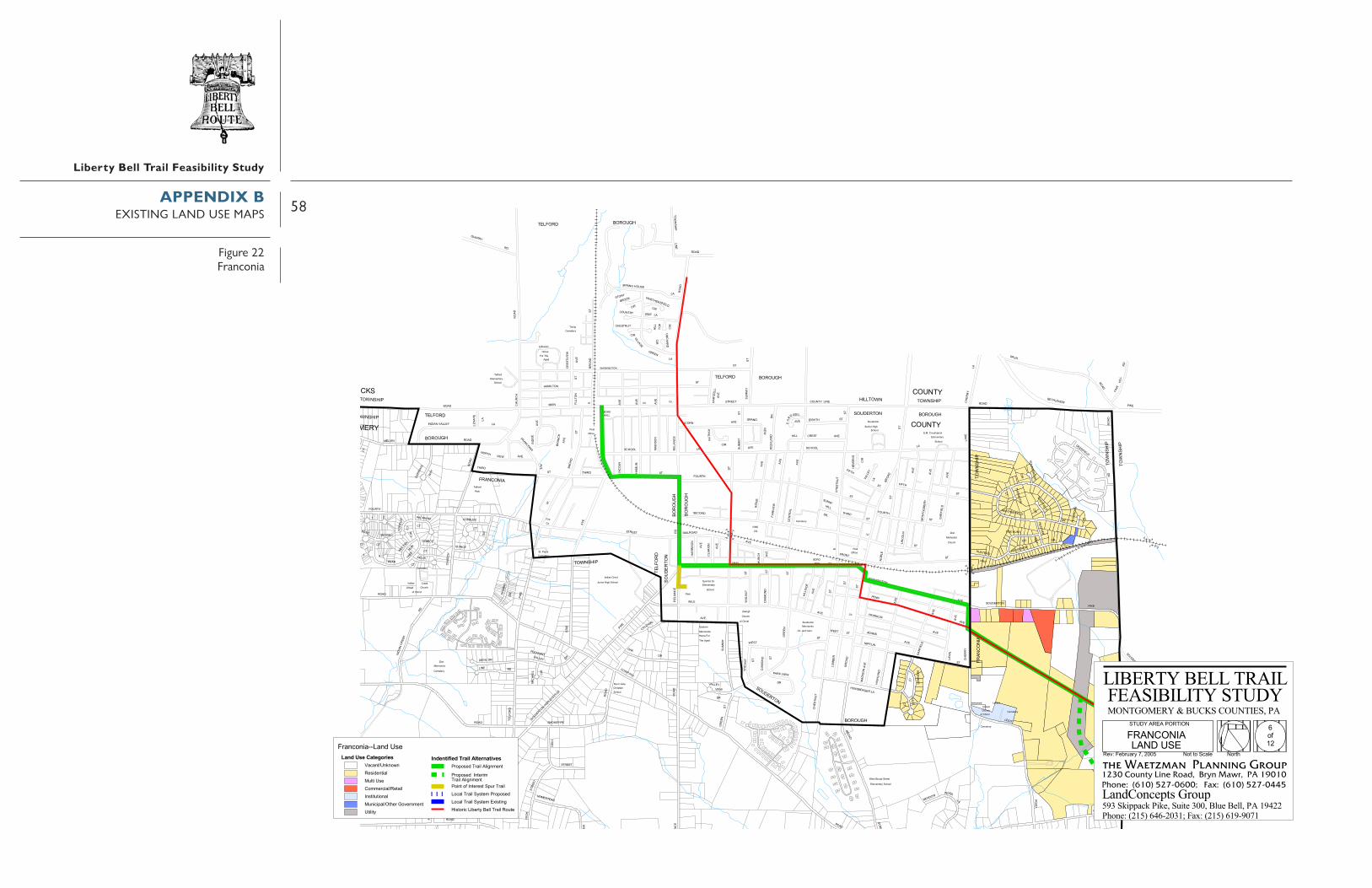
58
Liberty Bell Trail Feasibility Study
����������
���
��
���
��
�
�� �
��
� �
��
���
��� �
���
���
���
����
��
����
�
������
�������
����
����
����
����
� ��
�
����
��
������
�
�
�
�
���
��
�����
����
���� �
�
���
�
�
�� ��
������
�
�
���� ����
��������
� �����������������
���
����
���
���
������������
����
��
��� �
�������
��
�
����
��������
����
����
����
� ��
�� �
���
��������
������������
��
���
��
���
����
������
����
���
����
��
��
� ����
�� �
��
�������
�
��
�� �����
���
����
����
����
���
����
�������������
����
����
��
����
��
��
���������
����
�
���
��
�� �
���
����
�
����
����
�
����
�����
����
���
�����
���
����
����
����������
����
���
����
���
���
���
���� ����
���
����
��
��
�����
�� ��
�����
����
��
�����
���
��
��� �� �
�������
���
���
�
����
� ����
���
�������� �
����
�����������
��������
�������
������������
�
���
����
���
�� ���
��������
���
���
�� �� �� �
�������
���
��
���� ���
���
��
��� � ��
��� �
����
����
��
��������
��������
��
����� �
���������
�����������
����
�
���
� ����������
�������
����
�����
����
���������
��
����
���
���
�
��
����
���
���
���
�
� ��
��
��
����
�
��
������
���
��
��
���
�
�
��� ��� �����
����
�
��� �
���
����
����
���
�����
����
��
��������
����
��������
��
��� �
����
���
���
����
���
�
����
���
���� �� �
��
���
���
����
���
���
���
�
���
����
��
���
���
��
����
���
��� �
�
���
�����
��
�
���
���
���
����
����
����
�� ����
���
���
���
�
�������
����
���
����
��
�� ��������
���
�����
���
�����
���
����
� �
��� �
� ���
�� ��
���
���
�����
��
��� �
�
���
���� �����
���
� ���
�����
�
����
�
����
� ���
��
�
����
����
����
��� �
��
���
�
� ���������������
����
��� ����
��������
����
��
���
������
�� ���
���������
��� �����
��
����
����
��
�
��
� �
����
����
����
��
������
��������
������
�����
���������
������
���� ��
����
��
����
��
������
� �
���
�
���
���
� ��
������ ���� ��
������� ������
����
����
�
���� ��
� �����
� �����
�� ������ ��
��
���
�
��
���
�
��
���
�
���� ��
�� ��
� !"!#$%&'("")$�$�
*+��,&)-$�,(&.,�&!!/
�!"!$!&'
#)$!0�#0)%#
� !"!#$%&'�&%#.*#)%
.,**
�!"!$!&'
�)*#�!##*#)$!
�!##��)!1�,&)-$)%#.,**
,!��2!0�*"!��*&�!##*#)$!�%-$!&#
�!"!$!&'$���%( -
�*��)&!
�%&/! +*&0
3(#)*&��)2,�.,** �#0)%#��&!-$
�%&/.,**
��������
�++).!�*-$
�,� �,�
�!"!$!&'&)#)$'
.,**
! +*&0� !"!#$%&'
�*&�,!
�($,!&%#
�2!0
�*"!
�!"!$!&'
� !"!#$%&'�.,** �!-$��&*%0�$&!!$
�,��%#0��!"��!##*#)$!
*+��,&)-$�,(&., #)$!0
�""%#(!
�!"!$!&'
�!)0'4-
.,** !#)*&��)2,
*(0!&$*#
�!"!$!&'
*+��,&)-$�,(&.,�1)#2 )
�������
*(0!&$*#
�,�
��������
�++).!�*-$
�,(&.,�!$,*0)-$
�)*#
������&*($,%"! � !"!#$%&'
.,**
�%.%#$5 #/#*1#�!-)0!#$)% �( $)� -!�*""!&.)% 5�!$%) �#-$)$($)*#% �(#).)6% 5�$,!&��*7!&#"!#$ $) )$'
�������������� ���&%#.*#)%���%#0� -!
������������� ������������������������������� ������������ ����!���"�#������������ �$$�
��������������������� ����
8*+��
�*&$,�*$�$*�.% !
�������������� �
��������������
�������������� ��������������
��������������������������������
�!79��!:&(%&'�;<��==>
�)-$*&).��):!&$'��! �&%) ��*($!
����� � ������ �������� ����&*6*-!0�&%) �� )2#"!#$
�*)#$�*+��#$!&!-$�6(&�&%) �*.% �&%) �'-$!"��&*6*-!0�*.% �&%) �'-$!"��?)-$)#2
�&*6*-!0���#$!&)"&%) �� )2#"!#$
���������������� �!"#��$%����$��%$���� %���#&&��' ���''�����(")**�+���,�-*(!.�/)/0*&#(1���2,�-*(!.�/("0"&3(
APPENDIX BEXISTING LAND USE MAPS
Figure 22Franconia

59
Liberty Bell Trail Feasibility Study
����
����
����
��� ��
��
����
����� �
�����
����
������
���������
����
�����
�������
���������
���������
������
�����
��
����
���� ���� ��
����
�
����
� ������
����
��
����
������
����
����� �
���
����
�
����
���
���
� �� �� �
�
��
����
����
����
�����
���
���
���
���
���
���
����
���
���
�������
���
��
��
����
���
���
����
����
��� �� �
���
�������
����
��
����
���
� �
�
�������
�����
�������
��� ������
����
���
���� ���
���
��� ��
�
���
����
����
����
����
��
�����
� ��
��������
���
���
��
���
� ��
����
���� ���
���
�������
����
�������
���������
����
�
����
���
���
���
���
�
���
����������
���
�����
���
�
���
����
���� ����
�� ���
�������
��� � ����
����
����
��
����
����
���
��
��
����
����
��� �
����
���
�������
����
���
���
���
���
���
����
����
����
� �
���
����
������������
����
��� ������
��
���
����
���
���
����
����
���
����
����
��
����
���
���
���
���
��
�
��������
��������
���� �
��
���
� ����
�����
������������� !
�� ������ ��" #
��$� �%
���&
� � � �'
���
���# ���%� %%�%(�
�����%#�� ��
����)�
� %%�%(�
�*����($�
�)���!
����(������! � %���'
+,(%"!(
�(� ���
���
���
����������
���# ���%� %(��� ("�
�)���!
+(�%� ���#($�����)�
�)���!�! � %���'
��)�%�-�%&%�,% $(# %�(�!��!�(��$ ���� �)(�!- ��(!�%$�(���(�%�!��%()(.�!-��� ����/ �%� %���(!(�'
�������������� �����# ���%����%#��$
������������� ������������������������������� ������������ ����!���"�#������������ �$$�
��������������������� ����
0�*12
�������������)�!
����������������
���������������
�������������� ��������������
��������������������������������
/3���"�$��456�2557
($���()��(8 ��'�� !!����(!����
����� � ������ �������� ������.�$ #����(!��!("%� %���(%���*��%� � $���.������(!��)�!����(!��'$� �����.�$ #��)�!����(!��'$� ���9($�(%" ���������������� �
!"#��$%����$��%$���� %���#&&��' ���''�����(")**�+���,�-*(!.�/)/0*&#(1���2,�-*(!.�/("0"&3(
APPENDIX BEXISTING LAND USE MAPS
Figure 23Souderton

60
Liberty Bell Trail Feasibility Study
���
����
���
�����
������
���
�� ��
�������
����
����
�����
����
����
���
�
����
�����
����� ��� ���
���� ������ ���
�� ���
���
���
���
��
��
�������
���
���
��
���
���
��
���
����
����
�
��
���
����
���
�����
���
���
����
���� ���
��
���
��
�����
������
�����
��
����� ��
����
�
����
�
���
���
���� ����
����
����
�
�����
�������
���� ��� �
���
���
����
��
�������
��
���
������
����
����
������
����
��
����
�������
���� ��
��������
�������
��
�������
�����
����
���
��
����
� ��
��
�����
���
���
����
��� ����
��
����
��� �
�� �
����
���
��
����
����
���
����
���
���� ��
���
��
���
���
���
����
��
��
����
���
��� �� ��
���������
�����
��
��
������������
���� �����
�������
�
������
���
���
��
�� ��
���
���
��
���
����� ���
������
����
������
����
����
����
���
���
����
������
����� ��������� ������� �������
������
������
������
���
���
���
���
������������
������������
������������
������
�������
�� ��!�!�"�#$%�&
��!'��(
��"�
�)�(
�*$ ��%#
��� � �
���#�$&��"�$��&
�������
��"�$��&
����������
�������
� � � �
�%�%#$+�#,#�-#�.�(�#$�%!�*!$� �.���""����%!+�$%�!�#.$�$*$��#%!�*#���/%!+�$ �� ��0��#"�#$�$�!�$&
�������������� ����!'��(11�%#( �.�
������������� ������������������������������� ������������ ����!���"�#������������ �$$�
��������������������� ����
2�'34
��$ �$ $� ��%!�
��������� ���
����� ��� �����
�������������� ��������������
��������������������������������
�05 ��$�6�� 378 4997
��.$���� ��6��$& ��!! ��%�! �*$�
����� � ������ �������� ������/�.�( ��%�! �!�)#"�#$���#$ �' �#$���.$ �/*� ��%�!���%! ��%�! �&.$�" ���/�.�(���%! ��%�! �&.$�" �:�.$�#) ���������������� �
!"#��$%����$��%$���� %���#&&��' ���''�����(")**�+���,�-*(!.�/)/0*&#(1���2,�-*(!.�/("0"&3(
APPENDIX BEXISTING LAND USE MAPS
Figure 24Telford

61
Liberty Bell Trail Feasibility Study
��
��
����
��
��
���
����
�
��
��
�����
�����
��
��������� �
��
����������
������
��� � � �� �
��
�����
��
��
��� ��
���
����
�
��
����
���
� ����
����
���
��
� ��������
��
��
����
����
���
�� ��
�
���
���������
��
�
���
����������� !��"#$%"��$�&�'&�$��#"� ((")�$�&��"��$&�#�$�'�$ ��&�'�$�$*�&���+")�� ,")�("����$&$�-
�������������� ���$&&� !��.��"#��� ��+$&&�/# '�+011 ��%��#"
��������� ������
� ���������
������������� ������������������������������� ������������ ����!���"�#������������ �$$�
��������������������� ����
� 234
)�+ ��� ����&" ������
����������������
�������������� ��������������
��������������������������������
� ����.����������� �/# '�+0
�",5� ,"(6")�78�4��7
�$#� )$�� $6")�-��"&&��)�$&�� '�"
����� � ������ �������� ����) * #"%��)�$&��&$9�("��� $��� 2���")"#���*')��)�$& ��&��)�$&��-#�"(��) * #"% ��&��)�$&��-#�"(��:$#�$�9
���������������� �!"#��$%����$��%$���� %���#&&��' ���''�����(")**�+���,�-*(!.�/)/0*&#(1���2,�-*(!.�/("0"&3(
APPENDIX BEXISTING LAND USE MAPS
Figure 25Hilltown & West Rockhill (south)
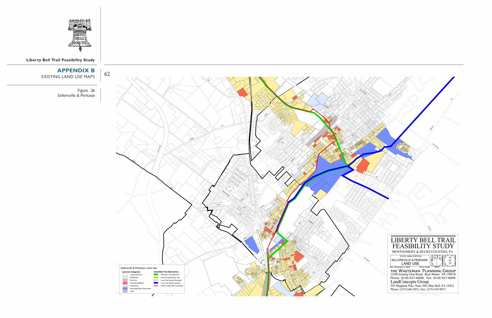
62
Liberty Bell Trail Feasibility Study
����������
���
����
�
�
����
���
������
��
��
��������
�
���
��� ��
�
����� �
�
��������
���
����
���
���
��
����
���
�����
�
��� ��
�
���
���
������
���
���
�
����
���
���� �� ���
�����
�
������
�
�����
�
����
�
��� ��
�
� ��
���������
�
��� ��
�
��� �
�
�����
�
������
�
�����
�
���� ��
��
���
��
����������
�
�����
�
����������
�
������
���
��
����
��
����
����
����
�
���
���
��
������ ��!�"#��$%&'$��&�(�)(�&��%$�"**$+�&�( �$��&(��%�&�)�&"��(�)�&�&,�( ��-$+�".$+�*$����&(&�/
�������������� ��$(($+%.&(($�0��$+!�%&$11���'��%$
�����������0�������� 2�"324
�������������������������������� ����� ���������������������
����������������
"���"���($ "+�-
��������������������� ����������������� ������������������������������� ������������ ����!���"�#������������ �$$�������������� ������������������������������� ������������ ����!���"�#������������ �$$�
��������������������� ����
2�"324
"+�- "���"���($�� ����
����������������
����� ����������������������
��������������������������������
�����������0��������
�$.5� ".$*6$+�78�4��7
�&%�"+&���&6$+�/��$((��+�&(��")�$
����� � ������ �������� ����+","%$'��+�&(��(&9�*$���"&���"3����$+$%��,)+��+�&(�"��(��+�&(�/%�$*��+","%$'�"��(��+�&(�/%�$*��:&%�&�9 ���������������� �
!"#�$%����$��%$��� %���#&&���' ����''�����(")**�+���,�-*(!.�/)/0*&#(1��2,�-*(!.�/("0"&3(
APPENDIX BEXISTING LAND USE MAPS
Figure 26Sellersville & Perkasie

63
Liberty Bell Trail Feasibility Study
�������
�����
��
�����
���
��� ���
��
��
���
�����
��
���� ��
��
��
� ��
����� �����
����� �����
��
���������
���������
��
� ��
� ��
�������
� ��
������������ ��!"#$!��#�%&%�#��"!��''!(�#�%��!��#% �"�#�&�#���%&�#�#)�%���*!(���+!(�'!����#%#�,
�������������� ����"��-�!"������*#%%�.��(�*/00���$��"!
������������� ������������������������������� ������������ ����!���"�#������������ �$$�
��������������������� ����
11�213
��(�*����������%!
��������������� ��
�������������� ��������������
�������������������������������������-���������� ���.��(�*/
��������
�#"��(#���#4!(�,�5!%%��(�#%���&�!
����� � ������ �������� ����(�)�"!$��(�#%��%#6�'!����#����2� ��!(!"���)&(��(�#%����%��(�#%��,"�!'��(�)�"!$����%��(�#%��,"�!'��7#"�#�6 ���������������� �
!"#��$%����$��%$���� %���#&&��' ���''�����(")**�+���,�-*(!.�/)/0*&#(1���2,�-*(!.�/("0"&3(
�!+8�9&�!���:�3��;
APPENDIX BEXISTING LAND USE MAPS
Figure 27East & West Rockhill (North)

64
Liberty Bell Trail Feasibility Study
��
������������
����
��
����
�
��������
��
����
����
��� �� ��� �
����
��� ���
��
����
�����
��
�������
�
��
��
������
���
���
�� ���
���
�����
���
��
���
�����
��
��
����
��
���
���
�����
��
���
��
���
��
����
���
���
��
��������
������ ���������
���
��
����
��
����
��
��
����
���
������
��
�
����
�
����
�
����
�
��������
����
� ����
�
�� �
�
��!�
�
�
���� ����
��"������
�����
�
"�����
��
�����
�
����� ���
��
���
��
�����
�������
��
��
����
�#$#%&'�%(%)*%�+,-.+%&-#/�0/&-��,+�)11+2$-#/'�+&#-/�%,&-&0&-)%#/�0%-$-3#/'�&4+2��)5+2%1+%&�&-/-&6
�������������� ���0#(+2&)*%�7��-$4/#%.88�#%.��,+
������������� ������������������������������� ������������ ����!���"�#������������ �$$�
��������������������� �����)2&4�)&�&)��$#/+
���������������
�������������� ��������������
�����������������������������������������7�������� �!
)9�!������
�+5:��)5+1;+2��<�!���
�-,&)2-$��-;+2&6� +//��2#-/��)0&+
����� � ������ �������� ����2)3),+.��2#-/�/-=%1+%&�)-%&�)9��%&+2+,&��302��2#-/�)$#/��2#-/��6,&+1��2)3),+.�)$#/��2#-/��6,&+1�>-,&-%= ���������������� �
!"#��$%����$��%$���� %���#&&��' ���''�����(")**�+���,�-*(!.�/)/0*&#(1���2,�-*(!.�/("0"&3(
APPENDIX BEXISTING LAND USE MAPS
Figure 28Quakertown & Richland

65
Liberty Bell Trail Feasibility Study
�����������������
�����
����
�������
������� �
��������
����������� �� ��
�����!��
�������"#� #! $%&#�
��'#������
�%�'' �$
��$#���()#��
�*%����������#�� ����#���
� !���+������!��!
������������
#����*%��� #�%�� *� %)�*%��,�� �)�����#�
!)������#�-
#�"����.,
�&�����()#���%�'' �$� �����
! ��*�������#/#
%)�*%� 0����#'� ��
��&�� ��
����
�%�'' �$
���� �
�����
�()#������
��$ ��� �,���� ���
��� %� �� %)�*%
�� "����� ���
#�%�� *
�������
�#��� ��'#��
���� *-
%)�*%�)�%��#�
��,��#)���
�������"#� #��� *#�
�������
��,��#�� *-��
#����*%��� %)�*%
%#�%�� *��,��#)���
�%�'' �$� �����
!��' �#�
�����#�
�)0)�0#�
����%��&�����#/#
���� �����()#��
���
��,
��1����
.���1
������
�� �
��
������
�������1
��,
���
����
����
���,�� ��,
�����
����
� !��
�
��,��!
��,
� �
!����
������
����
����
����������
��� �
!
��,
���� .�,
��,
��,
����
� !���
��������,
.�� ���
����
���!
� !�����
��,
�����
����!����
�������!
��,
��,
��,
���
� �
�!�
��
�!������
��
�,
����
�,
��
� �
��,��,��,
�,
����
������
��,
��,
.�,
�!������1 ����
!���
���
�
�������
���������
� ��
����
�! �
���
!� � �
��� ��
���
� �
����1
��. �
, �� ,
����
�
�!��
�
+�!����
��
��,��
,
.�,
!������
������� ��1
�,
�,
��,
��
��,
.�,
!��.��
�,
�.��!���
��,
�.�������
��,
�����
�.���
��.�,
��,
�� !��
���������
��1��
����
���
��
��������
� ���
������
��,
��,
��,
��,
���� ����
��,.��
��������
��,
��,
���
�� ,���������
����� ��� ���,
���
���
����
1 ��
��� �
�������
��,
��,
��,
�,
��,
��� �
��2�
��
�,
����
��.���
�,
�,
��,
�����1�.�,
��,
.�,
���
��,
��,
��������
�������
!����������,
�1 ���
����� !����
��,
��,
��,
��,
����
��,
��,
��
����1� ����
��,
����
��
,
��,
��,
��,
�, ��� ��,
��� !�������,
�,
�����!�������
�,
��,
���
���
!���
���
���
�!� �
�
���
���,
�������
����!3�����
.�,
�!����
��� !���� ��,
���
!���
�
.�,
��,
���
� �
+����!
���
�
�, ��
����
�
.�,
.�,
��,
�!�1
��,
� !
�
.�,
�1
���
������� ����� ��,
���
��, �����
.�,
��,
��,
�����
.���
.���
.� �
� 1
��,
��,
��,
��,
���
� !
��,
�,
���
������,
�,
��, �����
��������
!��!�1
��,
��1���!
��,
��,
��,
��,
��
���
���
�,
�,
������
�,
��
��
�, ���.�����,
!��
!����
����
���� �
���� �
��
.�,
.�,
.�,+��������
��.�,
���
!���
�,
+�������
�������
�,
���1
��,
���
� �
��
����
1
��,
!���
1���
�,
� !
��,
��,
��,
����
���
�4����
��,
!�
�� �
!��!�� ��,
��,
��
����
��
�����
��,
��!������
., ��
,
��,
��,
�����!��
�����!��
����������
�����������
�����!�� �!�����
�����!��
���
��! �
�
���
� �! �
�
���,
���,
��1
� �� !
�� �
��� �
� �� �
�����!��
������������� ������������������������������� ������������ ����!���"�#������������ �$$�
��������������������� ����
5��56
����%��������*#��
������������������!��
����1�����������
�������������� ��������������
��������������������������������
�� "#����&����% '�)0� *��&����% '2)#� ��)0� *7�� "#�������� � �������������� ���
��������������#������� ���88�&����% ' ��"9���*��0���5:;�6<<=
! ���� *�� 0������������# ����)��
�������� ����� ��������������'�������# ��� $������� ����������������')����# ���*#����# ������������'������*#����# ����������> �� �$ ���������������� �
!"#��$%����$��%$���� %���#&&��' ���''�����(")**�+���,�-*(!.�/)/0*&#(1���2,�-*(!.�/("0"&3(
APPENDIX COWNERSHIP MAPS
Figure 29East Norriton

66
Liberty Bell Trail Feasibility Study
���� �� ���
��� � � � �� �������
����
�� �
� ������
������
����������
����
����
����
�
���
��
����
�
��
����
����
��
�����
�������
���������
�
�������
�� �
���
����
����
����
���
�
����
�
��
���
��
�������
������
��
������
�
������
�����
��
���
���������
�����
�
��
�
� �
���
����
�
�����
��
�����
����
���
�
�����
��� �����
����
�
���
���
�
�
���
�
���
�
�
��
����
�
�����
���
��������
��
��
���� �
�����
�
����� ��
�� � �
��� ���
�������
�
�
�������
��
��
���������
��� �� � �
����
���
��
�������
��� �
����
� ���
�
�
�
�����������
���
�����
��
�
�
�������
�����
���
��
���
�
�������
�
�
����
��
������
��������
��� ��
�
�
����
��
���
�
���
��
����
�
��
�
�����
����
��
��
��������
���
���
���� ��
�
�
�
�������� ��
��
�����
�����
��
����
�
�����
��
��
�����������
�������
�
�����
�
�����
�����
���
�
�������
�����
������
��
���������
���
����
���
���
���
����������
��
���� �
��
����������
��
��
�
��������
��
�
����
�
��
���
�
����
����
�
��
����
���
�
����
��������
�������
� �
���
���
�
��
�����
���������
� ���
����
����
�
����
��
�
����
��
��� �
���
�
�
�
�����
���
�����
���
��
���
����
�
����
����
��
�
�
���������
������������
��������������
��
�����
��
� � �
���������
�
�
�
�
�������
�������
���
�� ��
���
� ���
��
���
����
���
����
�����
��������
���
���
����
��������
��
����
�����
��
���
����� �
��
�
����
����
���
����
���
�
�
���
���
���
���
�����
�
�������
��
�����
��
��
����
��
����
��������
�
�������
��
��������
���
���
����
���
���
����
����
��� ���
��
��
���� ����
�
��
��
���������
��������
������
�
���
��
����������
�
��
�������
����
����
��
������
�������� �����
�
�����
�����
�������
�������
��
����
�����
� ��
����
���
��� �
��
����
��
������
����
����������
�� �
�� ���
�
��������
��
�
�
����
���
���
����
���
��
�������
�
�
�
�
�������
���
��
�
��
���
��
��
��
������
��
�������
���
���
�
�
�
���
� ���
��
����
��
�
��
�����
����
��
�
������
���
��
�
����
�����
����
�����
���
��
���
����
��
��
����
��
��
����
����
��
������
�����
����
�
���
����
�����
�����
��
���
�������
�������
���
��
���
����
�
��
� ��
���������
����
��
��
�
���� �
�
����
�
��
��
�
�� �� � ���
�
�������
�
����
����
����
�
������
��
������
��
��
�
��������
�
������
��
�
�����
������
�
�
����
���
���
�
�
�������
�
���
���
����
�
����
�����
��
��
�
�����
�����
��
�
���
�������
�������
�����
���
��
��
�����
�����
�� ���
�
�
�����
���
�
��
�����
��
��
�
�����
����
���
��
��������
�
���
������ �
����
��� �
�
��� ���
������
�����
�������
��
������
�
�
����
������
��
��
�� ������ ��
���
����
�������
�
����
������
�
��������
�������
�
�
�������
����
�
�
�������
����������
��������
��
��
��
���
���
�
�
����������
����
���
�
�
�� ��
��������
��
�
������������
�����������
�����
��
������
��
��
���
��
�
��
�������
�
������
�����������
��
��
��
�
�������������
��������
���������
��
�����
����
�������
��
���� ���
��
��� �
����
�
��������
���
��
�
���
����
����
�
�
�
��������
������
�
�
����
��� �� �
�
���
���
�
��
����
��
��
�
���� ��� �
��
���
��
��
����
����
���
��
��
����
���
�
������
��
�
��� �����
���
�� �
���
��
������
��
�
�
����
�
����
��������
���
��
���
��
��������
��
��
���
�����
�� �
����
�����
����
��
����
��
������ �
��
����
�
��������
�����
������
����
�
��
�������
����
�
�
��
�����
��
��
�������
��
��
���
���
�� �
���
���
���
�
����
�
����
�
���
����
�� �
� ��
�
�����
�
� ��
��
��������
��
�����
����
����
������
���
���
����
����
���
����
��
���
�
������
����
����
����
����
���
������
�������
��
��
�
��
����
����
�
��
��������
��������
��
����
�
�����
���
����������
���������������� ��������
����
�����
���
�����
���
���������������
��������
���� �������
��������
��������
���� !"��#$"�%&�'�()*�+��#$"�%&�'�( %���()*�+,���� !"������!�*�!-�.��"��"!"�/�$"0
��������������&�!' �$11�#$"�%&�'
������������� ������������������������������� ������������ ����!���"�#������������ �$$�
��������������������� ����
2.342
�.�!&�.!�!.��+ *"
����������������
����������������
�������������� ��������������
��������������������������������
"�5��+!.)"��467�2889
��%!.��+���)"�!-��"**��� �*�.(!"
�������� ����� �������������.'.%"0��� �*��*�:$/"$!�.�$!�.3��$!"�"%!��'(���� �*�.+ *��� �*��-%!"/���.'.%"0�.+ *��� �*��-%!"/��;�%!�$: ���������������� �
!"#��$%����$��%$���� %���#&&��' ���''�����(")**�+���,�-*(!.�/)/0*&#(1���2,�-*(!.�/("0"&3(
APPENDIX COWNERSHIP MAPS
Figure 30Whitpain

67
Liberty Bell Trail Feasibility Study
���
����������� ��
��������
������� ������������ ���������
������������
����� �����
��������������
������
�����
��� �������
������� ��������
��!����
������"�� #�������� �����
��� ����������� �#���
$����%& �'�%���" ��() &� ��
)��'����*�'��
+�����,���
��-
����
�����) ������
%����
������'�� ���������� �
��!������
'�����
�'�$�'�� ��%�$&�%��"��$&'�
�&$��
����� ���
%�������� +�
���� ������
� !��-
������
.� ���"�#�
�&$���'�$�'�� ��%�$&
)��'����*�'��
��-������
'�� ������������
��������������� �����
�$�� �$&
�� ��"' $�' �
�%��"
�%��
%%�
�'���*&,$� $
� /�"
���''�
' �"�"
�%$�
�%���" �
�" ��'*
.$�0�%�
���'
'�
�%�'
� %��
���
�)�0'�
�)�
�*$�1�
�$�� %�
�'�'�$&
.$�01�
" &&��'��
���
,$&&'*�
$ *
, '�
" &&")��'�
���
$��"'�
&$�
$��'��
" &&� �'
���
���
,$& &
' *
.$�01�
� ��
+%� �
'
��*�'� �%$�
���
�%%�&$��
&$�
�$&�)�
�� �&*�
�$&
'�
�%��
$�'
�" �
�
+%)�
�"
�%$��$�0���
�)��
& ''
',$
�� �& ��
���
'/�'�� %�
(&)'�%�� �
�%��"'$��
�'���*&,$� $
�)��� 0'
�� �%��
�%��'�"%��
+& ��&%�0
��� �$*�� ��%�"
&$+$*'��'
����)&$�0
�)"&'�()��
��%���$*
���
���
���
���
'$�&'
$���
��%�
�
��")
&�2
���
�%$�
('�0
���
�
�%&& ��
/%+
"$��&'*
�&�
"$��&'*
�&�
���
�$/�'&&
�&�
(�%$
�
$&�� ��&�
�)� &'$, *���
���
$,'�
�� ��%�
���
�"'�$��
���
��$�
3) &
�*&$
�
$,'�
�'"$,'�
&$�
&$�
(%��$�
���
�" ��$0'�
�'�%
��
�&�
%$0
�'�
�
���
���
���
�% �
�
$ �*
�%�� �
���
�%�& ��
�%��
"
$�%��
&$�
�$&&
$��
�&�
(&,��
�)��'*�%��
�%��$*
��$& &�% % �
���
�$�"
�$�+ '&�
���
$��'��
��'�����
���
� ++
& �
��)(
'�
���
�$��'��%�
�&�
�)&& ,$�
3) ��
&$�
")�� ���%�
�& �
&$�'
���
�&'$
�, '
�
�&'$
�(�%
%0 ���
�'*'�
�%$�
�%$�
0� �
� �
�$�+ '&�$,'�)'
���
���
���
���'
'�
� � �
+)&�%�
.$� ,
��&$
�
��%(
''��
� �
� ����%�'�$�'
��*�'�
$&'
,$&&'*����$*
&$�
%/+%
'���
��
(�''
2'�
%%�
���"
&&
� ��"
�"�%
��
�$��
'� �
(�%$
�
���
%$0�
�"$�
�'�
$,'� �%$�
�$��
'�()
�*
�'��%��
���
&$�
�$*
���
� �$��$,'�
��''0��
''�
��%�*
��$�'
$,'�
$&&'�
(�$�+%��
0' �"
(� $� &$�
&$�
&$�
�$*
���('�"
$,'�
�&�
���
���
$,'����
���
.%�'�
���
$,'�
$,'�
���
�"'�
��)�
�%*'�
���.%�'�
� 0'
� 0'
�%$�
�"'$
�'�
�&%,'�
�&%,'�
���
���
���
�$�'
�"'$�'�%&�
&$�
� ��
�%�&*
���
$,' �
�'��
���
�'��'�
��$��&'*
'&�
�$&� )�
&%)
�'
�")��"
('�0 '�����
�%$�
0�''�&'�
���
� �0
'��%
�
� ��$" �0%�
���
� &&
%�
&$�
���
��)��� $&
�" ��
��"%
%&('$,
'�
�$ �
�'�%��
���
+%)��"���
� /�"
�$&�)�
+ +�"
��� $,'�
���
���
�)&&
� $�
�'��"$�
$,'�)'
��$� %�
���'$�
���
�%$�
� &&
�%�� �%�' �*
�'��"
�%��
'�
' �"�"
�','��"
���
���
���
� ��"
���'
'�
���
���
��%��
�$�"
�)��*&'$
(%*�
��$��&'*
$,'�
���
���
��% &
' �� $
,'�
�%$� $&&'��%��
�%�
$�' �
� � "$� &�%�
�$�0
���'
'�
$,'�
)'
$,�$,�
���
�''�
�'�$
����
��*
���)
�'
�'(��'��$�
' �*��
'��
�'��
(�%%
0$,'�
$,'��&$*
$,'�
&'�$�'
�%%�
���
�%$�
�%��
"
$,'�
�'$�
%�&$
�0
� �'
, '�
& �'
��%�
�'��
�$*
$)�)
(%�
���
��'+$�
���
�'��
�$*
�%$�
"$2&'�%%�
��'�
'�+%
��
�& �
���
"$ �'�
���
�$��%�0
���
','���''�$,'�
�'$�
%�(�
%%0
���
.'�0 ��
�%$�
"'�&%�0���
&$�
� ��
�")��"
� ��
���)�'
�%%�+%��
&$�
"$��'�
&$�
� ��
��%�
�'��
$,'�
���
$,'�
$,'�
���
�$��
�"$
'&
���
�$�" ��� %�
�%� ��% �' �*
� �
��%�
�$*
$,'�
)'
&$�
(�%%
0�%%
�
�%$��(�%%0%�'$�
&$�
%$0&
$ ��
�"
� '� %
$ 0
��"%%&�"%)�'
�%$�
��*�'��
('��
�$�%�
&'� � $
&%�'�
��%+
�
,$&&
'*
%$0
���)
�'
�)�� �
���''�
+$ �, '�
���''�
���''�
���''�
���''�
" � "&$ ��
$,'�
���''�
���
+%)��"
���''�
���
��% �
� '� �
�%*$
&
)��'
�
���''�
���''�
���''�
&$�
�")��"
��� )
� '
�','��"
���
���
�%%������
��*�'��
�'��
*
"$�,
' ��
��''
� "'$
��
&$�
+$��
&$�
�%$�
�%$�
$,'�
)'
���
.+0
���
&$�
" (
��*�
'��,$
&&'*
%$0&$��
�)��'*�%��
�%$�
�%$�
�%$ �
�&$�
'
�&�
('��
��' �
��� ���
($�( '�� *
� 0'
���
4�"
�%$�
�%$�
&$�
$,'�
5�"
�%$�
(� ��
�%$ �
���
� 0'
�$��&'�%%�
�'0$&(
�)��
()�*
���
$,'�
)'
$� � *
&$�
+%�'
��
�%$�
& ��
&$�
"$��%�0���
&$�
�$*
�$&'�
�" ��$ �
�%���" �
��*�
'��
�%�
� �"
�
�%�
$�'�
� �
)�� '
�
)��'�
�%��'��'���*�'��
�%���" �
�%�
� �"
�
�%��"
(%�%) �"�
$&'�
�%��"
�%��"
��*�'��)��'�&$���$&'
(%�%)�"
�%���" ��%���" �
��*�
' ��
��*�
'��
(%�%)�"
�$&'�
)�� '
�
&%�
' �
(%�%
)�"
�%��
"
�$&
'�
(%�%)�"
�%�
��"
��%
���
" �
������%� ������!����%� ����3�������!���6������'��$)���������(����� �
�������������)������ ���� �����������77%� ����
������������� ������������������������������� ������������ ����!���"�#������������ �$$�
��������������������� ����
8��9:
���������������%��'��" �
��)�*�$�'$��%�� %�
�������������� ��������������
��������������������������������
)��'����*�'���;��%��"��$&'�
��<�+!����=>�:??@
"�������&�!���(������������
�������� ����� �����������������������$��# � ���� ����� ������������&����������������������&����������������'A���� # ���������������� �
!"#��$%����$��%$���� %���#&&��' ���''�����(")**�+���,�-*(!.�/)/0*&#(1���2,�-*(!.�/("0"&3(
APPENDIX COWNERSHIP MAPS
Figure 31Upper Gwynedd & North Wales
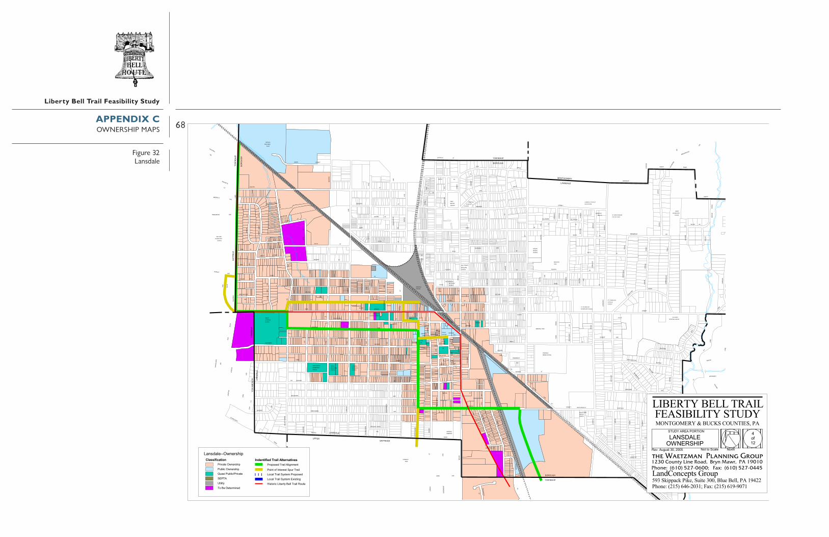
68
Liberty Bell Trail Feasibility Study
�����
��������
�
���
�
���
���
� ����
����
���
���
�������
�����
���� �
�
� ��
�
��
��� ���� �
�����
��������
�������
����
����
����
���
����
�
���������� ������� �����
�������������
�������
�����������������������
����������� ������
� � �
�������������
������������
���������������
������
����������� ���������
�� �
� ��
������
��
� �����
�� ��
�� ��
��
���������
������������ ������������ ��
������������������
������
�����������
���������� �
���� �������
����� � �
�������� �����
���� �������
� �����������������
�������������
���� �������
����� ���
������
������� �� ������
�������������������� �����
��� � �����
����������
������
��������������� �� ��
�� �� ���� � ��
� ������� ����
� �������������������� �
���� ��������� ��������������
�������������
�����
������������������������
� �
����
�
���
��
���
�
�
����
� � �
���
�
����
��
�
����
�
���
�� ��
����
��
�
�� �
��
��
�������
� �
���
���
�� �
� �� ��
����
����
��
�
��
����
��
���
��
����� �
���� ���
�����
��������
��
���
��
���
���
���
���
����
���
����
����
��
�������
���
���
���
�
�
���
���� �
��� �
� �� �
� ��� ����
� ��
���� ��
�� �
��
�����
�������
���
��
� ��
����
��
�
�
�
�
���������� �
�
����
� �
����
����
���
�� ���� �
���
���
���
��
��
��
�
����
�
���
�
���
���
��
��
��
������
�
��� ������
�
�
��� �� �
� �
��
�� �� ��
���
�
���
� �
����
��
���
���
�
���
������
������
���
��� ��
��
��
���
������
�
������
� ����
�
� ��
����
���
�
�
���
�����
� �
� ��
�
�
���
�
��
���
����
���
�
����
� �
� �
����
��
�
�
�
�
�
���
�
� �� �
��
��
�����
���
�� � ��
���� ��
�� �
�
����
� ��
�����
� ��
� ��
� ��
������� �
���
����
������
��
���
��� ���
�����
���
�
�
����
���
���
���
�
�
���
��
�
����
���
���
��
�
���
� �
�����
���
� ��
�
�
� �
��
���
�
���
�
�
���
� �
���
��
�
���
��
���
��
��
��
� ��
����
����
��
�
�
� ��
�����
���
���
� ��
�
�������
� ������
��� ��
��
� ��
��������
� ���
���
�
����
���
��
��� � �� � ����
��
�
�
�
���
����� ��
��
���
�
���
������
� ��
����
������
���
�
���
��
�
�
�
�
���
��
�
���
���
���
�
���
�
��� �
���
���
� ��
�
�
���
� ��
��� ���
� ��
�
�
�
��
� �� ����
�� ��
� �
�
���
�� ��
� �� ����
����
��
���
��
�
����
��
�
����
����
��
����
��
����
��
����� �
��
������
���� ���
����� �����
���
����
�
���
����
����
������
������
����
���
����
������
����� ���
� ���
���
�������
��� �
� �
�����
������
����
�������
������
���
���
� ���� ���
���
������
������
��
������
��
��
����
�����
�
����
���
��
�������� ��
����
��� �
���
��
���
� ��
�
����
� ���������
���
� �
��
�
� �
�
������ ��
���
���
��
� �
�
��
��
���
����
� �
�� �
�
����
��
�����
��
��
��
���
� ��
��������
�����
����
��
�����
�����
��
��
��
����
�
���
�������
��
����� !�"#!�$%�&�'()�*�"#!�$%�&�'�$���'()�*+����� !����� �)� ,-��!��! !�.�#!/
���������������#$/�)!00"#!�$%�&
������������� ������������������������������� ������������ ����!���"�#������������ �$$�
��������������������� ����
1-234
�-� %�- � -��*�)!
�������������� �
������������ �
�������������� ��������������
��������������������������������
�!�5��'6'$ �789�488:
��$ -��*���(!� ,��!))����)��-' !
�������� ����� �������������-&-$!/����)��)�6#.!# �-�# �-2� # !�!$ ��&'�����)�-*�)����)��,$ !.���-&-$!/�-*�)����)��,$ !.��;�$ �#6
���������������� �!"#��$%����$��%$���� %���#&&��' ���''�����(")**�+���,�-*(!.�/)/0*&#(1���2,�-*(!.�/("0"&3(
APPENDIX COWNERSHIP MAPS
Figure 32Lansdale
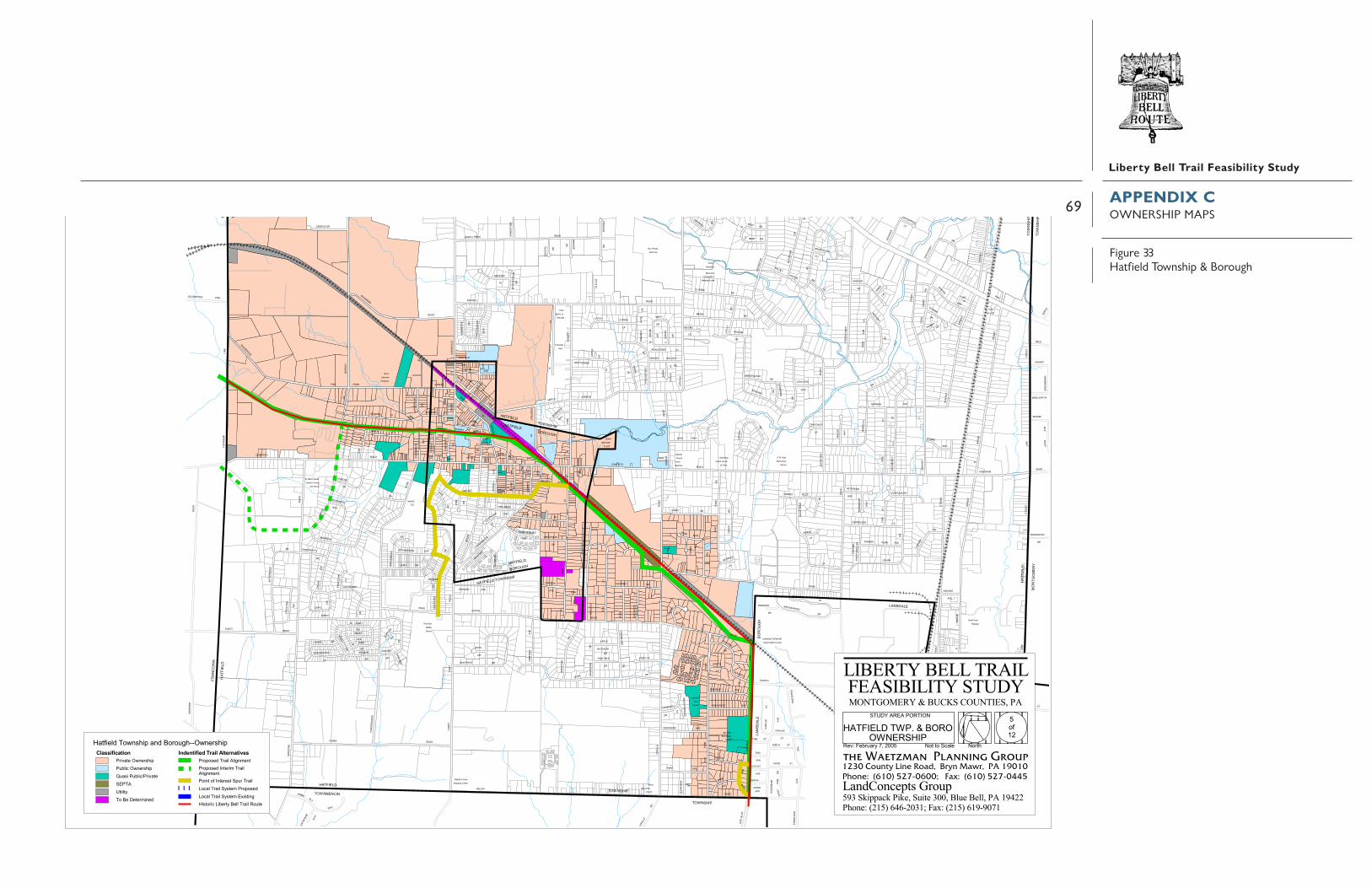
69
Liberty Bell Trail Feasibility Study
���������
���������
��� ��������� ������� ����� ������
������������
��������������������
������ ������������ �����
������������
������
������������� ����
���
������� ��������������
����
�!!"�����#
��!"��
�$�� ����
��%$����$&#
���
�$&�'$�� ��%$��
���������
��������
#��$#��&# ��$&#
� �����(����� ����
������)���
�������������$� �� *���
���"�� �'�� +
#,��������
#%��
��� ���)#,�� %��
������� ����������������������
��������!������
�������&�� ����
!"�����
�!!"�����#
"���%��'
$-� �"&'�&
�$
�"$�.
�'
��'�
�%��
'
$-�
���
�/
�#��
*#�&
'�
'�� �
#"& �
��$'
$���&#�%&
�"��
%$�
��'
�'
�'
��$'
�"&"&� �
�
����/
%$#
��!�
�'
��%�$#�
��$'
#�%&�
�"�
����$�
$-�%��'�"'�!��#
/
!$"�� �
� (&'
�
%$/
*$#���"&�
*"� ���/
%$/
!(&*�
%����
��$'
$-�
��-"��$
�'
�#
���$
�-"�%
��-
"��$
�$�*
�$*
�-'
!�$&
��&"$
����.
���(�#
%��'
$-�
���
$-�
�$*
��$'
$-�
�$�*
�-'
$-�
!����#
�$*
�$�*
�0("� �
��
$-�
�"&�
'�
�'���
�&# $-�
%��
#�&
'
#�"�' �#
����$�
"���
�# �#
�# $-�
�$���
%$/'"'
��"1"�
$-�
�&#%��'
!$�-"�%
�$"&#���
#�%$��&�"&
���-"' �
&��
��$'
�"�
%�&'/
%$��"&�#�&
$'$��
�$
'���
�$
�'
!"�����#�(�$&
$-�!��'
�'
'�
*����$&
�'
��$&#
$��2$&'��
0($"�
����/
'�
&�
�"�
'$�#��(#�
'�-$
� �$ �
'�
��"&��
#�&
��
�(�����
'�
�'
!��'
#�%$��&�"&
3�$& '�
!��#
��$�#�(�
�"�
'$-"�
'�
��&!
"��'
��$'
���#
!��'
*�!!��
�2!��'
�#
$-� '�
!$�-"�% $-�
$-�
����� "&�
$-�
�'
�-�
� ��
�*
��$'
�����$�"���$'
���
�/
'�& �"��
%$/
�/&����
�"�
�$
'�
��$'
��&&
�'
�"*�
�-�
� ��
�*
�'�$*
����
'"$��&'
�#
�#
�'
�#
����$�
$- �
�#���$&"
�
�#
'�3(& �
'�
��$
'
3$'�
� �$"&
%$/&�
�"�
%��$#!"��'
�'��$-�
���(� "$
'�
%��' �'
�#
�$"&�
�"&�
��&
$-�$-
�
$-�
�$� �
�#
(#���
$-��#
$-�
�"&���&
(&"�&
'"$��&'
�����/
���
�$�'
�# %$/��
���� �$
!����#
�#
�#
�#
�#
�$����#���#
�#
�����-��#
�$�*�#
�"�$�' $-�
����#&(#�#
&
�'#"� �
�
���%$
��( �%� �'
'�
��$
��-"&�
�"�� #
�&
���&
'�
'�
'�
�"&�#���
������
$����
'�
*&" ��# � �"' ��
��-�&#�/ �$
'�
'�
%��# �$
%��&��
�#�(�
��$'
%
%"&�#�&
����
���
�$
-"&�
�#
�#
�$'�
�%��'
�$(�
�&
*�!!��
�$
�'
�"��#��$
�"&����-�
����$�'
$-�
$-�
����&"$�
��$'
�$
�$&'"�
'�
�$&�
��$��!(�
!�$&��&" $
�#
$-�
#����&#
��$'
�����"$
�'
�$
$&'�-��
%�'��%��''� '�
�#
��$'
�$
�(&
%$/
��-
"��$
��%�$#�
�#
��$'
'���
�$ "&
�-"&�
$-�&(�
�$
��$'
��$�
�$
�$#�
�
��-
"��$
��2"&�
#�&
�$�*
�'��
��*
�$*
�'
�'
��$'
'�
�##�&&"�
%"� �� '�&
!����# �"���
�'
�#�%$�#
��&#%��'
!��#
��
#�$#����
�$
��$����&#
'�
'�
'�
%$/
��&���'
��$'
�"*���('��#�&
��('��#�&�"&�
��$'
�"����&'
�$��(� '�
%��
'�#�
� $�
��$'�%
�$� �
"'��
%� ��"&�
#�&
(&"�&-
"���
�$�!"��'
�"�
%$/
��$'
������
�#��
��# &
(#
�$ '�
&��#� ��&& �$&'
�#�&
�
��/�
#$�
'�
'�%&"&�
�����
�#�"&�
�$%#���&�
$�� �
&
�#��
�#
'�
�$
�$#��
�##$ ��
�$#�
'�
��$��#���
�(��
�' �
$� ��
'��"��
��& �
�$
�����%
'��"��
��
�$
�$�/
'�
��$'
�#���"&�
��& 1�
'� '�
%��'�
��� �/
����$�
'�
�����
��/���
'�
�'
�'
"'$
�$
��2 "&�
#�&
�'
�'
� �&#
'�
& �&#
'�
%��
'-" �%
-$���/ �'
�#
'�
����
&��
�$�'�&
��"�"� ���
' '�
���
�$*
$-�
$-�
4#�
�$&&
�&$-
�
*�&"� %
��#�
#�%$ �
�&�"&
�#
��/ �
�
$-�
�$�
��$-
�
��$%
�#
5#� �#
6#� �#
%$�&(
#
&
���$&
��$'
$-�
�$&�"&�
�#
!���
�#
��� �
#&(#
4#� �"'�
�
'�
�# �#
'�
�"& �
�#
�#��
� #
��&�
$�#
�����
-��#
�"&�
!��#(&$ '�
$-�
%$/
!�"�&'
��"�
#���$�
�$���&#�� �$
��&&
�"&�
�#
��#����&
��$'
%$/
�#��
�#
'�
�'
�� �
��$
%$/
�"����
�#
�#
&���$&
'�
%/&&�
%$/
$-�
%$�& (
#
����%��'
�#��
�#
�����$�
&
'�
��$'
�&&"�
�"'���$#�
��$
'
�"&�
�$%&
$-�
���
�& �
"$�
$&#��&/�$�(
�3�
' "�#��%
"�#�
%&
'�
��$��&
�'*$���
�"�
�#��
�#
'�
���&
�(��"#
'�
����$�
!���
#��$ '
�'
3�&*"&�
$-�
�$
$'-$&�
�
'"���-
��/
'�
�&#����"���$
�#��
�#
�#��
�#
�"*�
$-����
��&$��
�$���
%$�&(
#
�$#!"��'
!�$&
� �& "$
�$&�
'$��
�$#!"��'
#�%$��&�"&
#�%&��"�
#�%&��"�
#�%&��"� ���(��
�$#!"��' #�%&��"�
�$#!"��'
���(��
�$#!"��'�$#!"��'
���
(��
#�%
#�%
�$&�'$��
���(��
��&
#���
� �/
�$# !"�� '
#�%& �
�"�
#�%&�
� "�
���7��� �,��������)��� �,������0���� ��)���8���7������#$(������# � '���������
��������������������� #,���� ��� ���..�,������
������������� ������������������������������� ������������ ����!���"�#������������ �$$�
��������������������� ����
9�:;
&��&� � �����
�$#!"��' #%�� + ����%&����"�
�#('/ $��$ ���#"�&
�������������� ��������������
��������������������������������
��7< !�)����� 4= ;>>9
������� ��)���� ��� #���� ����
�������� ����� ����������������� #���� $��������
���� � "������� ���� #�������� #���� ������ ���������� #���� ������ �?������
������ "������ #���� $��������
���������������� �!"#��$%����$��%$���� %���#&&��' ���''�����(")**�+���,�-*(!.�/)/0*&#(1���2,�-*(!.�/("0"&3(
APPENDIX COWNERSHIP MAPS
Figure 33Hatfield Township & Borough

70
Liberty Bell Trail Feasibility Study
����������
���
��
���
��
�
�� �
��
� �
��
���
��� �
���
���
���
����
��
����
�
������
�������
����
��� �
����
����
���
�
����
��
������
�
�
�
�
���
��
�����
����
���� �
�
���
�
�
�� ��
������
�
�
���� ����
��������
� �����������������
���
����
���
���
������������
����
��
��� �
�������
��
�
����
��������
����
����
����
� ��
���
� ��
��������
������������
��
���
��
��� ����
������
����
���
����
��
��
� ����
�� �
��
�������
�
��
�� �����
���
����
����
����
���
����
�������������
����
������
����
��
��
���������
����
�
���
��
���
���
����
�
����
����
�
����
�����
����
���
�����
���
����
����
����������
����
���
����
���
���
���
���� ����
���
����
��
��
�����
�� ��
�����
����
��
�����
���
��
�� �� ��
�������
���
���
�
����
� ����
���
�������� �
����
�����������
��������
�������
������������
�
���
����
���
�� ���
��������
���
���
��� �� ��
�������
���
��
���� ���
���
��
���� ��
��� �
����
����
��
��������
��������
��
����� �
���������
�����������
����
�
���
� ����������
�������
����
�����
����
���������
��
����
���
�� �
�
��
����
���
���
���
�
� ��
��
��
��� �
�
��
������
���
��
��
���
�
�
��� �� ������
� ���
�
��� �
���
����
����
���
�����
����
��
��������
����
��������
��
��� �
����
���
���
����
���
�
����
� ��
���� �� �
��
���
���
����
���
���
���
�
���
����
��
���
���
��
����
���
��� �
�
���
�����
��
�
���
���
���
����
����
����
�� ����
���
���
���
�
�������
����
���
����
��
�� ��������
���
�����
���
�����
���
����
��
��� �
� ���
�� ��
���
���
�����
��
��� �
�
���
���� �����
���
� ���
�����
�
����
�
����� ��
�
��
�
����
����
����
����
��
���
�
� ���������������
����
��� ����
��������
����
��
���
������
�� ���
���������
��� �����
��
����
����
��
�
��
� �
����
����
����
��
������
��������
������
�����
���������
������
���� ��
����
��
����
��
������
� �
���
�
���
���
� ��
������ ���� ��
������� ������
����
����
�
���� ��
� �����
� �����
�� ������ ��
��
���
�
��
���
�
��
���
�
���� ��
�� ��
� !"!#$%&'("")$�$�
*+��,&)-$�,(&.,�&!!/
�!"!$!&'
#)$!0�#0)%#
� !"!#$%&'�&%#.*#)%
.,**
�!"!$!&'
�)*#�!##*#)$!
�!##��)!1�,&)-$)%#.,**
,!��2!0�*"!��*&�!##*#)$!�%-$!&#
�!"!$!&'$���%( -
�*��)&!
�%&/! +*&0
3(#)*&��)2,�.,** �#0)%#��&!-$
�%&/.,**
��������
�++).!�*-$
�,� �,�
�!"!$!&'&)#)$'
.,**
! +*&0� !"!#$%&'
�*&�,!
�($,!&%#
�2!0
�*"!
�!"!$!&'
� !"!#$%&'�.,** �!-$��&*%0�$&!!$
�,��%#0��!"��!##*#)$!
*+��,&)-$�,(&., #)$!0
�""%#(!
�!"!$!&'
�!)0'4-
.,** !#)*&��)2,
*(0!&$*#
�!"!$!&'
*+��,&)-$�,(&.,�1)#2 )
�������
*(0!&$*#
�,�
��������
�++).!�*-$
�,(&.,�!$,*0)-$
�)*#
������&*($,%"! � !"!#$%&'
.,**
�&)5%$!��1#!&-,)6�(7 ).��1#!&-,)6�(%-)��(7 ).8�&)5%$!��� $) )$'*��!��!$!&")#!0
��������������&%#.*#)%���1#!&-,)6
������������� ������������������������������� ������������ ����!���"�#������������ �$$�
��������������������� ����
9*+��
�*&$,�*$�$*�.% !
�����������������
��������������
�������������� ��������������
��������������������������������
�!5:��!7&(%&'�;<��==>
�)-$*&).��)7!&$'��! �&%) ��*($!
�������� ����� ������������&*6*-!0�&%) �� )2#"!#$
�*)#$�*+��#$!&!-$�6(&�&%) �*.% �&%) �'-$!"��&*6*-!0�*.% �&%) �'-$!"��?)-$)#2
�&*6*-!0��#$!&)"�&%) �� )2#"!#$
���������������� �!"#��$%����$��%$���� %���#&&��' ���''�����(")**�+���,�-*(!.�/)/0*&#(1���2,�-*(!.�/("0"&3(
APPENDIX COWNERSHIP MAPS
Figure 34franconia

71
Liberty Bell Trail Feasibility Study
����
����
����
��� ��
��
����
����� �
����
�����
������
���������
����
������
����
������
����
���
����
���� ��
����
�
����
� ������
����
��������
�
����
���
����
�
����
���
���
������
�
����
����
����
����
���
�
���
���
���
���
���
��� �
� ��
���
���
����
���
��
��
����
���
���
����
����
������
���
�������
����
��
����
���
� �
�
�������
�����
�������
��� ������
����
���
���� ���
���
��� ��
�
���
����
����
����
����
��
�����
� ��
��������
���
���
��
���
� ��
����
���� ���
���
�������
����
�������
���������
����
�
�����
��
���
���
���
�
���
����������
����
���
����
���
�� ���
��������
����
��
���� ��
����
����
�
����
����
���
���
����
���
�
����
� �
���
����
��������
��� ������
��
���
����
���
���
����
����
���
����
����
��
����
���
���
���
���
��
����������
�� �
��
���
� ����
���������������
�� !��"
���#
����!��$
���
��%���!�"��""�"&!�
�����"������
��%�'�
��""�"&!�
�(����& !
�'���)
�%��&!��!��)���"!��$
*+&"�)&
�&�����
���
���
����������
*&�"��!���& !��%�'�
�'���)�)���"!��$
��&,�!���+"�� �&-�%.)&'��+"�� �&-/%� &��%.)&'0��&,�!�������!&)&!$��������!���&"��
���������������%���!�"11�+"�� �&-
������������� ������������������������������� ������������ ����!���"�#������������ �$$�
��������������������� ����
2�(34
���!�
������������� ��
���������������
�������������� ��������������
��������������������������������
�,5��%�% !�678�4779
& !��&'��&.��!$���))����&)��%!�
�������� ����� ��������������-� ������&)��)&�"��"!��&"!��(��"!��� !��-%�����&)��'�)����&)��$ !������-� ����'�)����&)��$ !����:& !&"�
��!�!���'�)�
���������������� �!"#��$%����$��%$���� %���#&&��' ���''�����(")**�+���,�-*(!.�/)/0*&#(1���2,�-*(!.�/("0"&3(
APPENDIX COWNERSHIP MAPS
Figure 35Souderton

72
Liberty Bell Trail Feasibility Study
���
����
���
���������������
� ���
����
����
���
����
���
���
���
����
�
�������
����
���
�
�� �
���
��
���
����
����
�
��
��
����
���
� ����
�� �
��
�
�������������
� �
���
��
����
��
���
��� ��
�� ����
����
��
������
��
���
���
����
����
�� ��
�
�����
��
����
�������
�� ������
���������
�������
��
�������
����
����
�����
��
����
� �
��
������
���
���
������
��� ����
��
����
����
����
��� �
���
��
��� �
����
����
����
���
����
��
����
���
���
���
��
��
� ���
��
��
�
�������
����������
�����
�
��
������������
�����������
����
���
�����
���
��
��
�� ��
����
���
���
���
����������
������
����
���
����
����
����
���
��
����
�����
�����������
����������
�����������
�����
����������� !"#$
���%�#&
����
�'�&
�(!��#"
��#����
�#) )!$���!�#$
�������
������
�� ��
������������� ������������������������������� ������������ ����!���"�#������������ �$$�
��������������������� ����
*�%+,
��#!���!�!����"��
����� ��������
��� ������������
�������������� ��������������
��������������������������������
�#)-"!��. �#/�)0�(1�)��. �#/�)02("/)��(1�)�3�#)-"!�������!)�)!$������ �!�#�) �&
����������������%�#&44. �#/�)0 ��-5��!�1�#�+67�,886
�)/!�#)���)1�#!$�������#")����(!�
�������� ����� ������������#�0�/�&��#")����)' �� !��) !��%�� !�#�/!��0(#��#")����"���#")���$/!����#�0�/�&���"���#")���$/!����9)/!) ' ���������������� �
!"#��$%����$��%$���� %���#&&��' ���''�����(")**�+���,�-*(!.�/)/0*&#(1���2,�-*(!.�/("0"&3(
APPENDIX COWNERSHIP MAPS
Figure 36Telford

73
Liberty Bell Trail Feasibility Study
�������������� ������������� �����������������������������������������������
�������������������� �!����"��#�����$�����%&&������
������������� ������������������������������� ������������ ����!���"�#������������ �$$�
��������������������� ����
'�()*
+����+������������!+�"��,�
����-��"�����"�,�+
�������������� ��������������
��������������������������������
�,..��!+� �!����"�/0�,..�$�����%
"�
��
/��"/�
"�
��!+
��,��.,+�
!���,+1��+���
"�
"�.,�+/�
����22,����
�3�
"���� �45'
"�
�����"��
+
"�
�/���.��
���
"�
0�-���+��,0 �
"�
2���,+1�����
���""-
���� .�� �2
"�
�"/��
"�
�"
�,1�.�+�
�3�
",�1�
�
��
��2�,+
�3�
/.-2�"
��
�,�2�+�
�"/��"�
"�
"�
�,../"���
2�,+
�"�+/�
��
�,�2�+�
�3�
��"0
!���
�3�
/-.2�"
�3�
/.-2�"
"�����45'
"�
�,..
/��
��
�,..��!+��!+��,�
!���"�/0�,..��!+��,�
"��6���7����458�*559
���������.������������������"����
�������� ����� �������������� ��������������7���������(�,�������� ��������.��������������������� ����.�������������������:����7 ���������������� �
!"#��$%����$��%$���� %���#&&��' ���''�����(")**�+���,�-*(!.�/)/0*&#(1���2,�-*(!.�/("0"&3(
APPENDIX COWNERSHIP MAPS
Figure 37Hilltown & West Rockhill (South)

74
Liberty Bell Trail Feasibility Study
����������
���
����
�
�
����
���
������
��
��
��������
�
���
���
��
�
����� �
�
�����
���
���
����
���
���
��
����
���
�����
�
��� ��
�
���
���
������
���
���
�
����
���
���� ��
���
�����
�
������
�
�����
�
����
�
��� ��
�
� ��
�������
��
�
��� ��
�
��� �
�
�����
�
������
�
�����
�
���� ��
��
��� �
�
��
����������
�
�����
�
����������
�
������
���
��
����
��
������
����
���
���
��
����� !��"#!�$%�&�'()�*��"#!�$%�&+'�$���'()�*,����� !����� �)� -�.��!��! !�/�#!0
�������������!))!�$��))!�1��!�2�$�!33�"#!�$%�&
�����������1�������� 4�.546
�������������������������������� ����� ���������������������
����������������
. � .�*�)! .� %
��������������������� ����������������� ������������������������������� ������������ ����!���"�#������������ �$$�������������� ������������������������������� ������������ ����!���"�#������������ �$$�
��������������������� ����
4�.546
.� % . � .�*�)!�� �����
����������������
����� ����������������������
��������������������������������
�����������1��������
�!�7� .�!/(!��89�6��8
��$ .��*���(!� -��!))�����)��.' !
�������� ����� �������������.&.$!0�����)��)�:#/!# �.�# �.5��# !�!$ �&'������)�.*�)�����)�-$ !/���.&.$!0�.*�)�����)�-$ !/��;�$ �#: ���������������� �
!"#�$%����$��%$��� %���#&&���' ����''�����(")**�+���,�-*(!.�/)/0*&#(1��2,�-*(!.�/("0"&3(
APPENDIX COWNERSHIP MAPS
Figure 38Sellersville & Perkasie

75
Liberty Bell Trail Feasibility Study
����
���
��
��������
��
��� ��
���
��
�����
��
��
�����
���
����
����
��������
��
��
���
��� ������
��� ��
����
��
���������
����
�����
��
���
���
���������
���
���
�
���������� ��!"�#�$%&�'��� ��!"�#�$�!���$%&�'(���������������&��)�*�+�������,� �-
���������������!��.��!���*'/"�&&�0 *��"122�� ��!"�#
������������� ������������������������������� ������������ ����!���"�#������������ �$$�
��������������������� ����
33*435
�*��"�*���*��'�&�
������������������
�������������� ��������������
�������������������������������������.�������� ����0 *��"1
����������6��$7$!����8�5��9
�!�*��'���%���)�+�&&�����&��*$��
�������� ����� �������������*#*!�-�����&��&�7 ,� ��*� ��*4�� ����!���#$������&�*'�&�����&��)!��,���*#*!�-�*'�&�����&��)!��,��:�!�� 7 ���������������� �
!"#��$%����$��%$���� %���#&&��' ���''�����(")**�+���,�-*(!.�/)/0*&#(1���2,�-*(!.�/("0"&3(
APPENDIX COWNERSHIP MAPS
Figure 39East & West Rockhill (north)

76
Liberty Bell Trail Feasibility Study
��
������������
����
��
����
�
��
��������
��
����
����
��� �� ��� �
����
������
��
����
�����
��
�������
�
��
��
������
���
���
��� ��
���
�� ���
���
��
���
�����
��
��
����
��
���
���
�����
��
���
��
���
��
����
���
���
��
��������
������ ���������
���
��
����
��
����
���� ����
���
��
��
����
���
������
��
�
����
�
����
�
����
�
��������
����
� �� �
�
��!�
�
��"�
�
�
������ ��
���������
�����
�
������
��
�����
�
����� �����
���
��
�����
��� ����
��
��
����
��������
��� �
�
������������� ������������������������������� ������������ ����!���"�#������������ �$$���������������������� ����
�#$%&�#%�%#��'()*
���������������
�������������� ��������������
�����������������������������������������+�������� �"
#,�"��������
�$-.(%*��/0*$1&-2�34)-'��/0*$1&-2�3(1-��34)-'5�$-.(%*����%-)-%6�#� *��*%*$7-0*8
��������������3(9*$%#/0�+��-'&)(08::�/0*$1&-2 �*.;��#.*74*$� <�"��
�-1%#$-'��-4*$%6� *))��$(-)��#3%*
�������� ����� ������������$#2#1*8��$(-)�)-=07*0%�#-0%�#,��0%*$*1%��23$��$(-)�#'()��$(-)��61%*7��$#2#1*8�#'()��$(-)��61%*7�>-1%-0= ���������������� �
!"#��$%����$��%$���� %���#&&��' ���''�����(")**�+���,�-*(!.�/)/0*&#(1���2,�-*(!.�/("0"&3(
APPENDIX COWNERSHIP MAPS
Figure 40Quakertown & richland

77
Liberty Bell Trail Feasibility Study
SOURCES OF TRAIL LITERATURE,CASE STUDIES
RESOURCES
Pennsylvania Greenwayshttp://www.pagreenways.org/http://www.pagreenways.org/funding.htm
The goal of the Pennsylvania Greenways Program is toestablish an interconnected network of greenways “on-the-ground.” This network will connect Pennsylvania’s natural,historic, and scenic landscapes, as well as our cultural andrecreational sites. Greenways can be a tool for conservingnatural resources, extending opportunities for outdoorrecreation, and even providing the means to walk and bike tocommunity destinations.
This network will come about by planning for greenwaysin our municipalities, counties, and state. The PA GreenwaysProgram has identified a network of “Major Greenways” andencourages counties and municipalities to plan for greenways.Find out more about the network—including greenway typesand examples—and how we’re planning to make it happen.
Heritage ConservancyUsing Conservation Easements to Preserve Open Space.
http://www.heritageconservancy.org/news/publications/This guide is designed to provide Pennsylvania’s
municipalities and their advisory groups, such as environmentaladvisory councils and open space committees, with an overviewof conservation easements. Conservation easements are a land-saving tool that stretches the open space dollar.
Department of Environmental ProtectionPennsylvania Stream Releaf: Forest Buffer Toolkit.
http://www.dep.state.pa.us/dep/deputate/watermgt/wc/Subjects/StreamReleaf/Forestbufftool/default.htm
The purpose of this toolkit is to provide individuals, localorganizations and government agencies with the latestinformation on how to plan for, design, establish and maintainstreamside forest buffers.
Rails to Trailshttp://railtrails.org/
The Clearinghouse, a project of Rails-to-TrailsConservancy (RTC), provides technical assistance, informationresources and referrals to trail and greenway advocates anddevelopers across the nation. Services are free and available toindividuals, government agencies, communities, grassrootsorganizations and anyone else who is seeking to create ormanage trails and greenways.
http://trailsandgreenways.org/resources/highlights/default.aspProvides numerous resources for the:
Resources on the Benefits of Trails and Greenways.
Resources on Trail and Greenway Development.
List of Highlights -
Technical Assistance ServicesRTC Online Manuals, Reports and Fact SheetsResource DatabaseFunding DatabaseTrails Glossary and AcronymsConference PapersNational Trail Training Partnership (NTTP)
Rails-with-Trails: Lessons LearnedLiterature Review, Current Practices, Conclusions.
http://www. fhwa.dot.gov/environment/rectrails/rwt/toc.htm
Department of Conservation andNatural Resources
The conversion of former railroad corridors into publicuse trails is a Pennsylvania success story. Each year, millionsof outdoor enthusiasts now enjoy a growing network ofRail-Trails.
Through a dynamic partnership with DCNR, local Rail-Trail organizations, counties, townships, and municipalitieshave acquired, designed, constructed, and are managing andmaintaining Rail-Trails in every region of the Commonwealth.
From small villages in rural areas to larger cities in highlyurbanized centers, volunteers have come together to make thePennsylvania Rail-Trail Program a national leader.
Contained in this web site is information on Rails-Trailsopen to the public, under construction, and proposed. DCNRwill periodically update this site as information comes into usfrom our many trail partners.
AmericanTrailshttp://americantrails.org/
Numerous resources.
CASE STUDIES
Pennsylvania Examples from PA Greenways• Appalachian National Scenic Trail / Kittatinny Ridge
The Appalachian Trail (AT) is a continuous, markedfootpath extending along the Appalachian Mountain...Status: Under design / construction / development
• Baker TrailThe Baker Trail was established in 1950 and namedfor the late Pittsburgh attorney, Horace Forbes...Status: Existing
• Chuck Keiper TrailThe Chuck Keiper trail is a state forest hiking trail thatruns through the southern part of the Sproul...Status: Under design / construction / development
• Clarion River Water TrailThe Clarion River is one of the major tributaries of theAllegheny River and is located in the Ohio...Status: Under design / construction / development
• Conestoga River Water TrailThe Conestoga River Water Trail is a designated PennsylvaniaWater Trail that is located in the Susquehanna...Status: Existing
• Delaware and Lehigh (D&L) TrailOnce complete, the Delaware and Lehigh Trail will bea 165-mile linear trail from Wilkes Barre to...Status: Under design / construction / development
APPENDIX DSOURCES OF TRAIL LITERATURE, CASE STUDIES

78
Liberty Bell Trail Feasibility Study
• Delaware River Water TrailThe Water Trail is one of the six designated inPennsylvania and extends from Hanock, New York to...Status: Existing
• Donut Hole TrailThe Donut Hole Trail heads north from Bucktail StatePark through Kettle Creek State Park towards...Status: Existing
• East Coast GreenwayA combination of trails from Maine to Florida (2600miles). This has been designated a national millennium...Status: Under design / construction / development
• Great Allegheny PassageThe Great Allegheny Passage is a 152-mile bicycle andwalking trail connecting Cumberland, MD, with...Status: Under design / construction / development
• Horse-Shoe TrailThe Horse-Shoe Trail is a 140 mile multi use trail whichoriginates in Valley Forge National Park...Status: Existing
• Laurel Highlands National Scenic TrailThe Laurel Highlands Trail extends for 70 miles fromthe 1000 foot deep Conemaugh Gorge near Johnstown...Status: Existing
• Lehigh River Water TrailA designated Pennsylvania Water Trails located in theDelaware River Basin. The trail runs 75 miles...Status: Under design / construction / development
• Link TrailThe Link Trail is a 72 mile hiking path which connectsthe Mid-State Trail to the Tuscarora Trail....Status: Under design / construction / development
• Lower Susquehanna River Water TrailAn official Pennsylvania Water Trail that runs 52 milesfrom Harrisburg to the Mason-Dixon Line. ...Status: Existing
• Loyalsock TrailThe Loyalsock Trail follows mountain ridges and
streams through the Loyalsock watershed as it travels...Status: Existing
• Mason Dixon TrailThe Mason Dixon is a hiking trail. The Mason-Dixonstarts at Chadd’s Ford, crosses the Susquehanna...Status: Existing
• Mid State TrailThe Mid State Trail System (MST) is a long distancehiking trail and its side trails in central Pennsylvania....Status: Existing
• Middle Allegheny River Water TrailAn official Pennsylvania Water Trail, the MiddleAllegheny River Water Trail runs from Kinzua Dam...Status: Existing
• Middle Susquehanna River Water TrailDesignated as an official Pennsylvania Water Trail, the51-mile trail extends from Sunbury to Harrisburg,...Status: Existing
• North Branch Susquehanna Water TrailAn official Pennsylvania water trail. The trail issponsored by: The Pennsylvania Environmental...Status: Under design / construction / development
• North Country National Scenic TrailThe North Country National Scenic Trail is a premierfootpath that one day will stretch more than...Status: Existing
• Pine Creek TrailUSA Today rated Pine Creek Rail Trail as one of the 10great places to take a bike tour in their July...Status: Under design / construction / development
• Pittsburgh to Harrisburg Mainline Canal GreenwayIntroduced in 1998, the Pittsburgh to HarrisburgMainline Canal Greenway is located in Pennsylvania’s...Status: Part of future plan, not under development
• Quehanna TrailThe Quehanna Trail is a 73-mile loop trail in theMoshannon and Elk State Forests. The Trail passes...Status: Existing
• Raystown Branch Juniata River Water TrailThe Raystown Branch is the Juniata River’s longest andlargest tributary. It is classified as a high-quality...Status: Existing
• Schuylkill River TrailThis greenway is located within the Schuykill RiverNational and State Heritage Area and Schuykill...Status: Existing
• Schuylkill River Water TrailThe Schuykill River Water Trail is one ofPennsylvania’s official water trail. Three and a halfcenturies...Status: Existing
• Susquehanna GreenwayThe Susquehanna Greenway will be developed along500 miles of the Susquehanna River in Pennsylvania,...Status: Part of future plan, not under development
• Tuscarora TrailClosed for several years due to heavy briar growth andneglect, the Tuscarora Trail in Pennsylvania...Status: Existing
• Upper Monongahela Water TrailThis official Pennsylvania Water Trail runs 60 milesfrom Fairmont, West Virginia, to Rice’s Landing...Status: Existing
• Warrior TrailThe Trail runs from Greensboro, PA on theMonongahela River in the east to the Ohio River inWest...Status: Existing
• West Branch Susquehanna River Water TrailThis Official Pennsylvania Water Trail runs 240 milesfrom Cherry Tree to Sunbury. The Trail sponsor...Status: Existing
• York Heritage TrailThe Rail Trail is a 10-foot wide compacted stone traildesigned for bicycling, hiking, and horseback...Status: Existing
APPENDIX DSOURCES OF TRAIL LITERATURE, CASE STUDIES

79
Liberty Bell Trail Feasibility Study
FROM AMERICANTRAILS
Greenways and Community TrailsAbington Trails Project is working toward a system of
trails in Abington to provide a safe place, close to home, for avariety of trail activities: www.abingtontrails.org/
Friends of the Carantouan Greenway work in the Penn-York Valley: http://home.cqservices.com/greenway/
The Delaware River Greenway Partnership works topromote and protect a continuous corridor of natural andcultural resources along the Delaware: www.drgp.org/
Lancaster County Parks Department offers informationon hiking, biking, and horseback riding in the area:www.LancasterOutdoors.com/
Friends of the Wissahickon help preserve and protectFairmont Park in Philadelphia, including 50 miles of NationalRecreation Trails: www.fow.org
The North Delaware Riverfront is creating newrecreation, riverfront neighborhoods, and a public greenwayalong the river’s edge: http://www.northdelariverfront.org/
Pittsburgh Trail is a circular 50 mile itinerary within thecity exploring its rich natural geography, urban setting, andarchitectural features: www.geocities.com/pittsburghtrail/
Greenways in Pittsburgh and Allegheny County:http://slaggarden.cfa.cmu.edu/dialogues/pittgreen.html
The Swatara Greenway is a planned corridor of protectedland along the Swatara Creek which runs 71 miles fromSchuylkill Co. to Middletown: http://www.manada.org/swatara/swgreen.htm
The Three Rivers Heritage Trail is a major greenwayproject in Pittsburgh: http://trfn.clpgh.org/fotr/
Hiking TrailsKeystone Trails Association promotes hiking
opportunities in Pennsylvania and neighboring states:http://www.kta-hike.org/
Appalachian Mountain Club, Delaware Valley Chapter,has a variety of News & Activities for Pennsylvania, Middle &Southern NJ, and Northern Delaware: http://www.amcdv.org/
The Alpine Club of Williamsport maintains theLoyalsock Trail which runs 60 miles thru the Tiadaghtonand Wyoming State Forests:http://www.lycoming.org/alpine/MidAtlanticHikes.com has mapsand trail descriptions for hikes in MD, PA,VA and WV.
For Volkssport and Walking Events in Pennslyvania:http://www.ava.org/walk/pa.htm
Keystone State Volkssport Association providescontacts for many local clubs: http://www.ava.org/clubs/ksva/PAclubs.htm
Long-Distance TrailsThe East Coast Greenway is a project underway to
link seabord states with a largely off-road route:http://www.greenway.org/
The Great Allegheny Passage is the main line of a trailsystem running from the C&O Canal Towpath at Cumberland,Maryland, to the Forks of the Ohio River at Pittsburgh on anear-level rail-trail through the Allegheny Mountains:http://www.atatrail.org
The North Country Trail is being developed with agoal of 4,400 miles from New York to North Dakota;for information on the trail in Pennsylvania:http://northcountrytrail.org/explore/ex_pa/pa.htm
Another site is the North Country Trail inPennsylvania: http://northcountrytrail.org/pa/
Rail Trails and Canal TrailsThe Allegheny Trail Alliance is working to link up a
multi-purpose trail from Pittsburgh, PA to Cumberland, MD,where the trail will join the C&O Canal Towpath Trail toWashington, DC: http://www.atatrail.org/ata-info/aboutata.htm
Contact information, maps, and contacts for most ofPennsylvania’s rail trails can be found at:http://www.dcnr.state.pa.us/railtrails/default.asp
Penn State is leading a community partnership todevelop a 1.3 mile section of the former Bellefonte Centralrailroad right-of-way into a multi-use recreational trail:http://www.arboretum.psu.edu/planning/rail.html
The Butler-Freeport Community Trail is a 20-mileabandoned railroad corridor owned by Buffalo, Winfield, andJefferson Townships north of Pittsburgh, in Butler County:http://www.butlerfreeporttrail.org/
The Friends of Chester Creek are building a Hiking.Walking, Riding, Rail Trail in Delaware County, PA:http://members.tripod.com/~ctrail/index.htm
The Five Star Trail will traverse Westmoreland County
The Ghost Town National Recreation Trail is a 19.5mile rail trail in the Blacklick Creek Valley of Pennsylvania fromNanty Glo in Cambria County to Dilltown in Indiana County:http://mysite.verizon.net/warholic/trail.html
Allegheny Trail Alliance is building the GreatAllegheny Passage, a 152 mile bicycle and walking trailconnecting Cumberland, MD with Pittsburgh, PA:http://www.atatrail.org/ata-home.htm
Rail Trails in Lancaster County with maps, mileages,and photos: http://www.LancasterOutdoors.com/railtrail/main.htm
The Lebanon Valley Rail Trail will run 15 miles fromthe Lancaster/Lebanon County line to the City of Lebanon:http://www.lvrailtrail.com/index.asp
The Montour Trail Council works to convert theabandoned Montour Railroad in Allegheny and WashingtonCounties, Pennsylvania, into a 54-mile trail:http://www.montourtrail.org/
The Steel Heritage Trail is a rail trail project that willrun along the Monongahela River through Pittsburgh and souththrough Glassport to Clairton: www.steelvalleytrail.org/
Treasures Along the Trail is dedicated to the use,development and support of hike-n-bike trails across theEastern USA. Emphasis on rail trails and Pennsylvania.http://www.westol.com:80/tat/
The Youghiogheny River Trail runs 43-miles betweenMcKeesport and Connellsville: http://www.YoughRiverTrail.com/Also see the Pennsylvania state trail site
York County Heritage Rail Trail map, mileage, and trailaccess points: www.yorkcountytrails.org
APPENDIX DSOURCES OF TRAIL LITERATURE, CASE STUDIES

80
Liberty Bell Trail Feasibility Study
For a locator map and detailed descriptions of rail trailsin the Washington, D.C., area and a few others inPennsylvania, VIrginia, Maryland, and West Virginia:http://bikewashington.org/trails/
Waterway and Boating TrailsWater trails in the Chesapeake Bay Gateways Network
offer a wide variety of paddling opportunities:http://www.baygateways.net/paddling.cfm
The Delaware River Greenway Partnership isworking on the Delaware River Water Trail:http://www.drgp.org/drwt.html
Schuylkill River Water Trail is a National RecreationTrail: http://www.schuylkillriver.org/maps/water_trails.asp
The Upper Mon Water Trail is a 65-mile section of theMonongahela River from Fairmont, WV north to Rice’sLanding, PA: http://www.uppermon.org/
APPENDIX DSOURCES OF TRAIL LITERATURE, CASE STUDIES

81
Liberty Bell Trail Feasibility Study
POTENTIAL OPEN SPACEFUNDING SOURCES
POTENTIAL FUNDING SOURCES FROM DCNR {Contact Info. Source– DCNR:www.dcnr.state.pa.us/brc/grants }
Six grant programs are administered by the PADepartment of Conservation and Natural Resources, Bureauof Recreation and Conservation:
1. Community Grant ProgramGrants require a 50 percent match except for SmallCommunity Development type projects and certaintechnical assistance projects. Grants are awarded tomunicipalities for recreation, park and conservationprojects. Projects types funded under the CommunityGrant Program include:
• Rehabilitation and Development Projects - Theseprojects involve the rehabilitation anddevelopment of public indoor and outdoor park,recreation and conservation areas and facilities;and renovation of existing parks and indoor/outdoor recreation facilities to improve safety andaccessibility to individuals with disabilities andspecial populations such as minorities, low incomeand the elderly.
• Acquisition Projects - These projects involve theacquisition of real property for park, recreation,conservation and open space purposes by feesimple title or other lesser interest that will insurethe desired pubic benefit. Acquisition projects maybe for the purchase of new park and recreationareas or expansion of existing sites.
• The Small Community Development Projects -These projects provide a municipal applicant witha population of 5,000 or less with an alternativemethod of funding for rehabilitation anddevelopment of minor indoor and basic outdoorpark, recreation and conservation areas andfacilities. The maximum grant under this projecttype is $40,000.
• Planning and Technical Assistance Projects -These projects involve studies completed byprofessional consultants to help develop planningstrategies and courses of action to address localpark, recreation, and open space and conservationconcerns. Long-range recreation plans, greenwaystudies, feasibility studies, and master site plansare eligible project types.
2. Rails-to-Trails Grant ProgramThis program provides 50/50 matching grantsto municipalities and nonprofit organizations forthe planning, acquisition and development ofrail-trail corridors.
Eligible corridors include abandoned railroad rights-of-way or lands available for trail purposes underrailbanking. Lands abutting rights-of-way whichprovide opportunities to form trail linkages and createtrailheads and related support facilities are also eligible:
• Rehabilitation and Development Projects -Eligible projects include the construction of trailsand associated structures as well as supportfacilities.
• Acquisition Projects - Land may be purchasedthrough fee simple or a less than fee interest suchas an easement.
• Planning and Technical Assistance Projects - Rail-trail feasibility studies, rail-trail master plans andspecial purpose studies are eligible project types.
3. River Conservation Grant ProgramThis program provides grants on a 50 percent matchingbasis to municipalities, counties, municipal andintermunicipal authorities, and river support groupsto foster the conservation, restoration and enhancementof river resources:
• Planning Projects - These projects involve thepreparation of a river conservation plan whichinventories the environmental, cultural andrecreational values of a waterway or watershed;identifies potential threats or opportunities to the
water resource; and defines the policies andactions necessary to conserve, restore, or enhancethe resource. Once a plan is approved by DCNR,the waterway can be listed on the PA RiversConservation Registry to enable it to be eligiblefor implementation, acquisition anddevelopment funds.
• Implementation Projects - These projects involveimplementation of a non-development and non-acquisition type projects defined in a riverconservation plan for a waterway that has beenlisted on the registry. Examples of eligible projectsinclude investigations into river access, waterquality monitoring and preparation of ordinancesand zoning documents.
• Development Projects - Grants are limited to amaximum of $40,000 for development projectsrecommended in a river conservation plan for aregistered waterway. Projects which involve riverbank stabilization, riparian land improvement,stream improvement, and the provision of riveraccess and recreation facility development (i.e.,parking areas, restrooms, utilities, landscaping,etc.) are eligible.
• Acquisition Projects - Grants are limited to amaximum of $40,000 for the acquisition of landrecommended in a river conservation plan for aregistered waterway. Fee simple title or a lessthan fee interest such as an easement are eligiblefor purchase.
4. Heritage Parks Grant ProgramIn April 1995, Governor Ridge designated theSchuylkill River Heritage Corridor a State HeritagePark. Grants require a 25-50 percent match, dependingon project type.
Grants are available to municipalities, nonprofitorganizations or federally designated commissionsacting on behalf of the municipalities in a heritage parkarea. This designation allows grants to be awarded tofurther the objectives of the approved ManagementAction Plan for the heritage park area:
APPENDIX EPOTENTIAL OPEN SPACE FUNDING SOURCES

82
Liberty Bell Trail Feasibility Study
• Special Purpose Study Projects - Grants awardedmay be used to conduct feasibility studies, developmanagement action plans for heritage park areas,carry out specialized studies and the possiblehiring of state heritage park managers.
• Implementation Projects - Projects primarilyinclude those related to acquisition, preservation,rehabilitation and development of sites andbuildings and interpretive/educational exhibitsand materials.
5. Pennsylvania Recreational Trails ProgramGrants (range: $2,500 to $100,000) may range up to an80/20 percent match except acquisition projects requirea 50/50 match from the applicant. Eligible applicantsinclude federal and state agencies, local governmentsand private organizations.
The grants provide funds to develop and maintainrecreational trails and trail related facilities formotorized and nonmotorized trial use. The wide arrayof projects eligible for funding include:
• redesigning, reconstructing, nonroutinemaintenance, and relocating trails in order tomitigate and minimize the impact to the naturalenvironment;
• developing urban trail linkages near homes andworkplaces;
• maintaining existing recreational trails, includingthe grooming and maintenance of trailsacross snow;
• restoring areas damaged by usage of recreationaltrails and backcountry terrain;
• developing trail side and trail head facilities thatmeet goals identified by the National RecreationalTrails Advisory Committee;
• providing features, which facilitate the access anduse of trails by persons with disabilities;
• acquiring easements for trails, or for trail corridorsidentified in the state trail plan;
• acquiring fee simple title to property from a willing
seller, when the objective of the acquisition cannotbe accomplished by acquisition of an easement orby other means;
• constructing new trails on state, county, municipalor private lands, where a recreational need for suchconstruction is shown; and
• only as otherwise permissible while abiding to allrestrictions and regulations, construction of newtrails on federally owned land.
6. Land Trust Grant ProgramThis program is a source of funding for non-profitconservation or preservation organizations,conservancies and land trusts.
Grants provide 50 percent funding for acquisition andplanning of open space and natural areas, which faceimminent loss. Lands must be open to public use andpriority is given to habitat for threatened species.
• Acquisition Grants - Acquisition of lands whichserve as critical habitat for rare, threatened orendangered plant or animal species orcommunities which are at risk of destruction orsubstantial degradation receive funding priorityover other natural area acquisitions.
• Planning Grants – Grants may be utilized for thepreparation of documents useful in planning,developing, operating, protecting and managingnatural areas and programs. Examples of eligibleprojects include: preservation and managementplans for critical habitat, open space and naturalareas; natural area inventories and studies;greenway and open space plans andfeasibility studies.
POTENTIAL FUNDING SOURCES FROM DOT{Contact Info. Sources – DVRPC/PA DOT:www.dvrpc.org/transportation/capital / www.dot.state.pa.us }
Funds made available from the PennsylvaniaDepartment of Transportation (DOT) are moniesapportioned to the state from the federal government as aresult of the Transportation Equity Act for the 21st Century
(TEA-21). TEA-21 is the successor to the 1991 federaltransportation bill commonly referred to as ISTEA. Projectswhich adhere to the following requirements are eligible forfunding assistance on an 80/20 cost share basis, with 20%being the local share:
• Facilities must be located and designed pursuant toand incorporated within long range plans for themetropolitan planning area and the state.
• In general, no motorized vehicles shall be permitted tomake use of the trails and pedestrian walkways.
• A bicycle project may only be carried out if it isdetermined that the project will be primarily fortransportation purposes.
Below are three programs that relate to providingcorridors for pedestrian and bicycle travel through surfacetransportation improvements:
1. Surface Transportation (TransportationEnhancements: TE) ProgramThe TE Program funds ‘non-traditional’ projects thatenhance the transportation experience, mitigate theimpacts of transportation facilities on communities andthe environment, and enhance community characterthrough transportation-related improvements.Funding can be either 80/20 if the project entails design,engineering and construction or 100% for construction-only projects. Eligible applicants include any federalor state agency and county of municipal governments.Types of improvements eligible for funding include:
• provision of facilities for pedestrians and bicyclists;familiar
• provision of safety and educational activities forpedestrians and bicyclists;
• acquisition of scenic easements and scenic orhistoric sites;
• scenic or historic highway programs;• landscaping or other scenic beautification;• historic preservation;
APPENDIX EPOTENTIAL OPEN SPACE FUNDING SOURCES

83
Liberty Bell Trail Feasibility Study
• rehabilitation and operation of historictransportation buildings, structures or facilities;
• preservation of abandoned railway corridors,including the conversion and use thereof for trails;
• control and removal of outdoor advertising;• archeological planning and research;• mitigation of water pollution due to highway
runoff, or reduction of vehicle-caused wildlifemortality; and
• establishment of transportation museums.
2. Congestion Mitigation and Air Quality(CMAQ) Improvement ProgramProjects providing facilities for pedestrians and bicyclesmay be funded under CMAQ if it is either determinedto contribute to the attainment of a national ambientair quality standard or included in the statesimplementation plan designed to comply with theClear Air Act.Projects are selected for there ability to cost effectivelyreduce emissions from highway sources. CMAQ is an80/20 reimbursement program open to public agencies,incorporated private firms and non-profit entities.
3. Home Town Streets and Safe Routes toSchool (HTS & SRS) ProgramThe overall program has two primary objectives: a)enhancing and improving streets that run through thecenters of cities and towns to promote pedestriancirculation and safety; b) establishing safe pedestrian(student) routes and connections to and from schools.HTS and SRS is an 80/20 reimbursement program opento any federal or state agency, county or municipalgovernment, school district and non-profitorganization. Improvements under the followingprograms may include:
HTSBenches;Sidewalk improvements;
Street Lighting;Transit bus shelter;Traffic calming;
SRSSidewalk construction;Crosswalks;Bike lanes;Trails;Traffic diversion improvements; Crosswalks;Planter;Kiosks;Signage; andBicycle amenitiesCurb extensions;Traffic circles; andRaised median islands
POTENTIAL FUNDING SOURCE FROM THE
NATIONAL PARK SERVICE (NPS){Contact Info. Source – NPS: www.nps.gov/ncrc/programs/rtca}
Rivers, Trails, and ConservationAssistance ProgramThe program offers technical assistance only tononprofit organizations, community groups, and localor state government agencies. Rivers and Trailstechnical staff offers the following types of assistancefor recreation and conservation projects:
• Building partnerships to achieve community-setgoals;
• Assessing resources;• Developing concept plans;• Engaging public participation;• Identifying potential sources of funding;
• Creating public outreach;• Organizational development; and• Providing conservation and recreation
information.
Examples of Rivers and Trails assisted communityprojects include trail and greenway planning, openspace protection, river conservation, watershedplanning, rail-trail conversions and urban greening.National Park Service staff for the Rivers and Trailsprogram are based in 30 field locations to make themmore accessible to local governments and nonprofitorganizations throughout the country.
APPENDIX EPOTENTIAL OPEN SPACE FUNDING SOURCES


Prepared by The Waetzman Planning Group
in association with LandConcepts Group,Orth-Rodgers & Assoc., Inc.
EDM Consultants, Inc.Robert Wise Consulting
Published 2005