AOT.pdf - Ancient Ohio Trail
122
THE ANCIENT OHIO TRAIL PRINT/PDF GUIDES REVISED: NOVEMBER 2016 PRIMARY AUTHORS: JOHN E. HANCOCK AND CATHRYN J. LONG THE ANCIENT OHIO TRAIL RESOURCES HAVE BEEN BUILT BY CERHAS AT THE UNIVERSITY OF CINCINNATI, IN COLLABORATION WITH VIRTUAL GROUNDS INTERACTIVE LLC, AND WITH FUNDING FROM THE NATIONAL ENDOWMENT FOR THE HUMANITIES. COLLABORATIVE PARTNERS (ALSO FOR THE INTERACTIVE VIDEO EXHIBITS AT THE MAJOR EARTHWORK SITES) HAVE BEEN: THE NEWARK EARTHWORKS CENTER AT THE OHIO STATE UNIVERSITY, NEWARK; THE OHIO HISTORY CONNECTION, COLUMBUS; HOPEWELL CULTURE NATIONAL HISTORICAL PARK, CHILLICOTHE; THE ARC OF APPALACHIA PRESERVE SYSTEM, BAINBRIDGE; THE DAYTON SOCIETY OF NATURAL HISTORY AND WRIGHT STATE UNIVERSITY, DAYTON; THE EASTERN SHAWNEE TRIBE OF OKLAHOMA; AND THE CONVENTION AND VISITORS BUREAUS OF ADAMS, LICKING, ROSS, AND WARREN COUNTIES. * THE CENTER FOR THE ELECTRONIC RECONSTRUCTION OF HISTORICAL AND ARCHAEOLOGICAL SITES, AT THE UNIVERSITY OF CINCINNATI
-
Upload
khangminh22 -
Category
Documents
-
view
0 -
download
0
Transcript of AOT.pdf - Ancient Ohio Trail

THE ANCIENT OHIO TRAILPRINT/PDF GUIDES
REVISED: NOVEMBER 2016 PRIMARY AUTHORS: JOHN E. HANCOCK AND CATHRYN J. LONG
THE ANCIENT OHIO TRAIL RESOURCES HAVE BEEN BUILT BY
CERHAS AT THE UNIVERSITY OF CINCINNATI, IN COLLABORATION WITH VIRTUAL GROUNDS INTERACTIVE LLC,
AND WITH FUNDING FROM THE NATIONAL ENDOWMENT FOR THE HUMANITIES.
COLLABORATIVE PARTNERS (ALSO FOR THE INTERACTIVE VIDEO EXHIBITS AT THE MAJOR EARTHWORK SITES) HAVE BEEN:
THE NEWARK EARTHWORKS CENTER AT THE OHIO STATE UNIVERSITY, NEWARK; THE OHIO HISTORY CONNECTION, COLUMBUS; HOPEWELL CULTURE NATIONAL HISTORICAL PARK, CHILLICOTHE; THE ARC OF APPALACHIA PRESERVE SYSTEM, BAINBRIDGE; THE DAYTON
SOCIETY OF NATURAL HISTORY AND WRIGHT STATE UNIVERSITY, DAYTON; THE EASTERN SHAWNEE TRIBE OF OKLAHOMA; AND THE CONVENTION AND VISITORS BUREAUS OF
ADAMS, LICKING, ROSS, AND WARREN COUNTIES.
* THE CENTER FOR THE ELECTRONIC RECONSTRUCTION OF HISTORICAL AND ARCHAEOLOGICAL SITES, AT THE UNIVERSITY OF CINCINNATI

Table of ConTenTs
INTRODUCTION 3CINCINNATI 4THE GREAT MIAMI VALLEY 9DAYTON 16LEBANON TO POLLOCK 22FORT ANCIENT EARTHWORKS 26THE GREAT SERPENT MOUND 33FORT HILL AND PAINT VALLEY 38CHILLICOTHE 51MOUND CITY 58THE LOWER SCIOTO VALLEY 66TARLTON AND THE ROAD 72NEWARK AND ITS EARTHWORKS 78FLINT RIDGE 93GRANVILLE AND COLUMBUS 97ATHENS 102MARIETTA 109OHIO EARTHWORKS TIMELINE 118SAMPLE ITINERARIES 121

INTRODUCTION | 3
The anCienT ohio Trail
inTroduCTion
WELCOME The Ancient Ohio Trail is your comprehensive guide to visiting the spectacular Native American earthworks of Ohio. Immerse yourself in “The Heartland of Ancient Ameri-ca,” where spectacular cultures created the larg-est concentration of geometric earthen architec-ture in the world. Explore their vast and precise enclosures, effigies, embankments, and walled hilltops. See their dazzling art works preserved in area museums. Discover why Ohio was the cultural epicenter of North America two thou-sand years ago! A complete travel experience awaits you along the Ancient Ohio Trail. Our resources will help you to discover the distinguished Native American heritage in the Midwest, to trace early settlement in the region, to gain many reward-ing insights from your visits to the ancient earth-works, and to enjoy yourself among Ohio’s his-toric towns, scenic roads, and many distinctive cultural, artistic, and tourist amenities. The “AOT” was built by CERHAS at the University of Cincinnati, in collaboration with Virtual Grounds Interactive LLC, and with funding from National Endowment for the Humanities, and close cooperation with all of the sites’ owners, managers, and interpreters. This can be your one-source authority for a complete, curated visitor experience across the region.
A WORLD HERITAGE STORY Four of our featured earthworks (Newark, Fort Ancient, Mound City, and Serpent Mound) are in preparation to join the UNESCO World Heritage List in the coming years – the pre-eminent measure of their “outstanding univer-sal value” to humanity. The first three of these, together with the other earthworks that are part of Hopewell Culture National Historical Park in Chillicothe, are going forward first, as
“The Hopewell Ceremonial Earthworks.” Learn more about that effort at: www.worldheritageo-hio.org.
USING OUR GUIDES This 18-chapter printed guide includes comprehensive, illustrat-ed tour itineraries for all these earthwork sites, plus many, many more along twelve other route segments. Altogether we take you to over sixty mounds, earthworks, and other sites evoking the Adena, Hopewell, and Fort Ancient cultures in the region. These have all been curated to help you find the best places, and penetrate into the most fascinating stories. Route segments can be customized for use in any direction, combination, sequence, or depth. You can prioritize your travels and plan a customized adventure throughout Ohio Valley Antiquity – a rewarding journey lasting from one to twenty days, or more. Use this printed guide in combination with our website www.ancientohiotrail.org, and its mobile version, which links via interactive maps and menus to a huge archive of videos (our YouTube channel) featuring animated site tours, interviews, and more.
ARRIVING IN THE REGION From the region’s three international airports (Columbus CMH, Dayton DAY, and Greater Cincinnati CVG), or its main interstate highways (I-70, I-71, and I-75), you’ll connect quickly and easily to our Ancient Ohio Trail routes and destina-tions. Along with our full narrative itinerar-ies, a helpful companion is the comprehensive, multi-page DeLorme Ohio Atlas and Gazet-teer, available at online or regional booksellers. Many of our route descriptions depend on its detailed maps for successful navigation. Most sites are also searchable on map and navigation software, though not always reliably.

CINCINNATI | 4
CINCINNATI Begin your exploration of southwest Ohio from downtown Cincinnati, where the art-deco masterpiece Netherland Hotel stands at the corner of Fifth and Race Streets. Its sumptuous 1930s Arcade and Palm Court, and the newly renovated Fountain Square across the street, occupy the position of the huge, elliptical earthwork that once domi-nated this high Ohio River terrace, as recorded on Dr. Daniel Drake’s 1815 map. Indeed, Fountain Square is the symbolic heart of Cincinnati. This city grew and pros-pered in the early 1800s, on its large level ter-race, above the confluence of three rivers. Two thousand years earlier, other people were here, and also built monuments on this spot. William Henry Harrison remarked that when he first saw this level plain, in 1791: …it was literally covered in low lines of embank-ments… The number and variety of figures in which these lines were drawn was almost endless. Today, mounds still occupy prominent sites in several Cincinnati neighborhoods. The most dramatic is the Norwood Mound, about a 25 minute drive up US Route 22 (Gilbert Ave-nue then Montgomery Road). At about 6 miles, climb the hill and turn right (at the Mound Café) onto Indian Mound Avenue, where a small alley on the right between two houses encircles the tall, oval mound. The nearby water tank empha-sizes the prominence of this spot, overlooking an ancient, pre-glacial course of the Ohio River. The Cincinnati Museum Center, housed in the architecturally-spectacular train station of 1931, presents excellent history and archae-ology exhibits, including an interactive media program on all of the Little Miami Valley sites. Other area museums tell important stories of the history and culture of the area, especially The National Underground Railroad and Free-dom Center, the Taft Museum and the Cincin-nati Art Museum. The University of Cincinnati
and The liTTle MiaMi Valley
CinCinnaTi
5Most of the Cincinnati earthworks had been destroyed by the early pioneers even before Daniel Drake made his map.
6The Cincinnati Tablet was found in a large mound just west of downtown; its abstract forms may suggest figures climb-ing the “tree of life.”

CINCINNATI | 5
Campus (two miles north of downtown on the hill) displays its avant-garde, “earthworks-inspired” landscapes and recent buildings by world-famous architects. West of the city in Shawnee Lookout Park is the well-preserved Miami Fort, a Hopewell era earthwork crowning a steep, isolated prom-ontory overlooking the confluence of the Great Miami and Ohio Rivers. [For detail, see the Great Miami Valley itinerary.]
MARIEMONT East from downtown Cin-cinnati (follow US 50, Columbia Parkway), a series of picturesque suburbs conceal many important ancient sites. The valley of the Lit-tle Miami River once held the Hopewell era’s second-largest concentration of earthworks, including the spectacular Turner site. Mariemont’s English ambience is com-plete with a Tudor Inn and a Gothic parish church. But street names like “Cachepit Way” and “Flintpoint Drive” hint at a much longer history. Mariemont’s southern residential dis-trict ends at Miami Bluff Drive paralleling the ancient earthwork. The walls still stand among the trees, above the river. Cincinnati archaeolo-gist Bob Genheimer: At the edge of the bluff, they’re sitting right there, similar to works at Fort Ancient or Miami Fort where they’re at the edge of these really pre-cipitous drops. We know that they’re real because Charles Metz, who’s normally considered the father of Cincinnati archaeology, noted them, recorded them in the 19th Century way before the village of Mariemont was ever developed.
3A small lane next to 2409 Indian Mound Avenue leads to the enigmatic, elliptical Norwood Mound.
6The Mariemont Earthwork follows the edge of the bluff, along Miami Bluff Drive.
66The beautiful village of Mariemont was carefully planned in the 1930s to resemble a picturesque English village.

CINCINNATI | 6
At the end of the street a historical mark-er commemorates the “Madisonville Site” and the importance of this high terrace location in antiquity, and in the early development of American archaeological knowledge.
MILFORD AND NEWTOWN A bit far-ther out along US 50 lies Milford, on the banks of the Little Miami. This location was once surrounded by Hopewell era geometric earth-works. Long before the growth of this eastern Cincinnati suburb, Squier and Davis described one of the Milford Works: Diverging lines extend to the south-west, terminating in a maze of walls unlike any oth-ers which have yet fallen under notice. A portion of the parallels and the diverging lines just men-
tioned are much reduced, and when the crops are on the ground, are hardly traceable. From the hill an extensive prospect is afforded, bringing in view the sites of several large groups of works in the vicinity. The “diverging lines” once topped the small hill above the historic Main Street. Faint ghosts of walls appear on old aerial photographs of a nearby cemetery. Yet if taken together with near-by Turner, these figures comprised one of the most extensive geometric complexes anywhere in the Ohio Valley region. Just southeast of Milford, in the village of Newtown, two mounds lie inside Flagg Spring Cemetery (along Round Bottom Road, and also called “Flagstone Cemetery” on Google maps, and formerly known as “Odd Fellows Cem-etery”). Only one of the mounds is prominent and stands at the center. Nearby in the vil-lage, during excavations at the fire house, two spectacular shell gorgets were discovered, with detailed incised animal figures, created by a later culture that flourished here. An interactive video and artifact exhibit is open to the public in the remodeled fire house, now the Newtown Municipal Building.
TURNER EARTHWORKS Head out Round Bottom Road to the east from New-town, to where a railroad overpass appears on the right. Up behind the rail line, contemplate the overgrown gravel quarries that were once the spectacular Turner Earthworks. From here came some of the Hopewell culture’s most spectacular artistry, including clay figurines, the mica serpent, and an effigy of a strange horned creature. Here, two enclosures, one high, one low, were connected by a graded way. A long form trailed to the southwest. There were several mounds, but most unusual was a symmetri-
cal cluster laced together by rings of stone. Doctor Charles Metz, of Madisonville, and Frederick Ward Putnam of Harvard University, investigated at Turner in the 1880s, and found some of the Hopewell Culture’s most spectacular artist-ry. Plowing of the earthworks had begun as early as 1825; and eventu-ally it was all destroyed by a gravel-ing operation. Two mounds in this clus-ter contained remarkable secrets: In one, fires were lit in complex,
6Squier and Davis’s 1848 drawing of the Milford Earthworks, with the unique “diverging lines” to the left.
66Gravel pits outside of Newtown, near Round Bottom and Mt. Carmel Roads, destroyed the Turner Earthworks.

CINCINNATI | 7
clay-lined pits and chambers. Intense heat and smoke could rise through narrow flues. In an adjoining mound, a magnificent mica snake lay atop ritual deposits. Mica often cloaked such deposits, but here, as a serpent, it may have car-ried special meanings still known in the Wood-land Indian tradition. Beneath the mica serpent were painted pottery statues, showing how the people dressed and arranged their hair.
FOSTERS EARTHWORKS Little is visible of the spectacular Milford-Newtown-Turner earthwork cluster today because of 19th centu-ry destruction. A little farther up river, and still intact (though on private land), is the decidedly strange hilltop enclosure at Fosters. A riverside gazebo (behind an unusual stone tavern build-ing, beneath the high US 22 bridge) offers views of the wooded hilltop site across the river. In 1890, archaeologist Putnam investigat-ed here. He called it “a singular ancient work” because he found that the walls were loaded with heavily burned stone, earth, and clay. Archae-ologist Bob Genheimer explains: What’s unique about Fosters really is the use
of this burned clay, and burning really doesn’t do it justice: it’s heavily vitrified clay. So if you pull back the leaf litter, and some of the debris, what you see is bright orange. They have capped these walls with this highly vitrified soil, burned clay. It seems this soil was fired in ovens at the site. Archaeologists found flues that could have controlled the flow of air, permitting very hot temperatures. Similar forms have been found at other sites, including Turner.
STUBBS EARTHWORKS Farther upstream, just west of the village of Morrow, the new Little Miami High School marks the site of the Stubbs Earthworks, once one of southwest Ohio’s grandest geometric earthwork complex-es, and one of the earliest to be destroyed. An irregular mound remains in the school’s cir-cular driveway, covering the remains of a com-plex, multi-chambered building. In 1998, Dr. Frank Cowan and his team from the Cincin-nati Museum Center discovered, about where the school’s grandstand is now, post molds from a giant, 271-foot diameter Woodhenge, the first large timber construction of its kind known from the Hopewell era. It coincided with a circle on an early 19thcentury plan of the earthworks, suggesting the idea that many earthworks may be have been built as markers or memorials to earlier timber constructions. From Morrow, take back roads towards Fort Ancient [See the Fort Ancient itinerary], or head south and east toward Hillsboro, enroute toward Serpent Mound.
HILLSBORO AND VICINITY From either Cincinnati or Fort Ancient to points east (The Paint Valley, Fort Hill, or Serpent Mound) almost all roads pass through Hillsboro. The very early Greek Revival Courthouse stands in the center of town; East Main Street (US 50) presents a beautiful array of historic houses. East
of Hillsboro, watch for the sharply rising edge of the Appalachian Pla-teau, and the fundamental geo-logical and ecological changes that accompany it. Many of Ancient Ohio’s greatest earthwork monu-ments are clustered along this natu-ral seam, where multiple resources and landscapes could be combined and celebrated.
FORT SALEM EARTHWORKS Between Cincinnati and Hills-
5The Murphin Ridge Inn offers gour-met dining, modern rooms, and luxurious cabins, near Serpent Mound in northern Adams County.
6At its discovery in 1998, the Stubbs Woodhenge was the largest timber struc-ture known to have been built in the Hopewell era.
CINCINNATI | 8
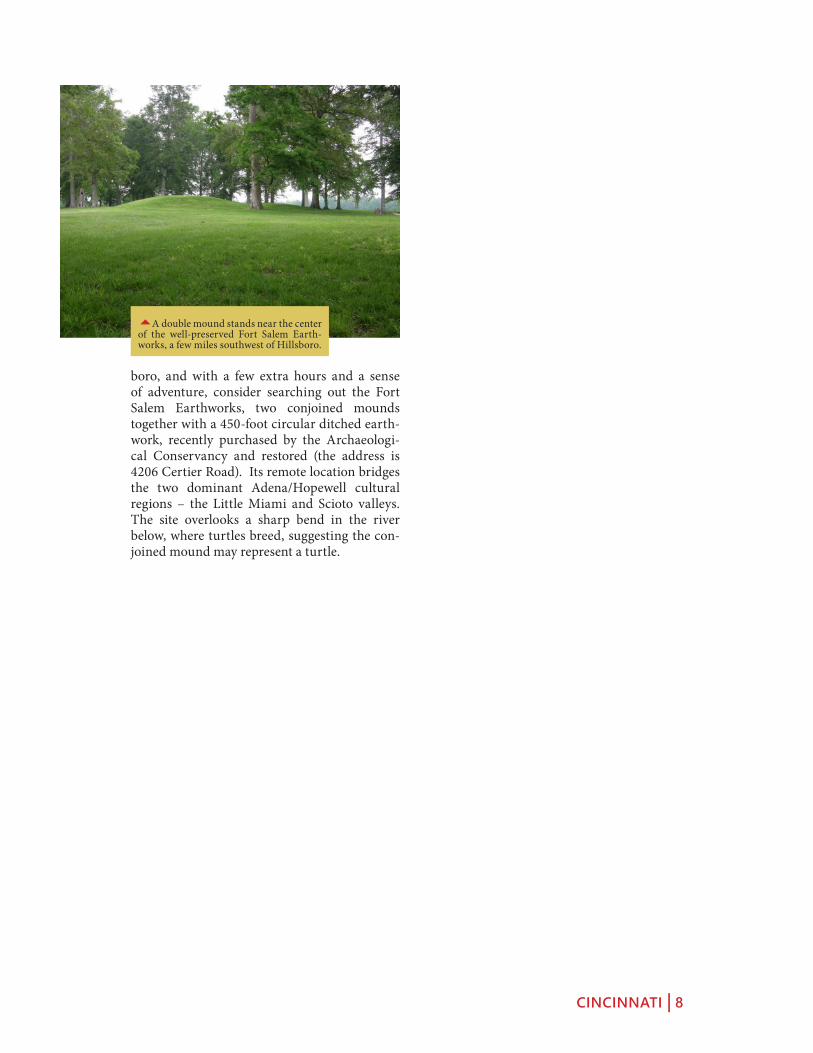
boro, and with a few extra hours and a sense of adventure, consider searching out the Fort Salem Earthworks, two conjoined mounds together with a 450-foot circular ditched earth-work, recently purchased by the Archaeologi-cal Conservancy and restored (the address is 4206 Certier Road). Its remote location bridges the two dominant Adena/Hopewell cultural regions – the Little Miami and Scioto valleys. The site overlooks a sharp bend in the river below, where turtles breed, suggesting the con-joined mound may represent a turtle.
5A double mound stands near the center of the well-preserved Fort Salem Earth-works, a few miles southwest of Hillsboro.

THE GREAT MIAMI VALLEY | 9
froM MiaMi forT To The MiaMisburg Mound
The greaT MiaMi Valley
THE GREAT MIAMI VALLEY Accord-ing to the early surveys, the Great Miami Valley was home to a very dense concentra-tion of mounds and earthworks. Squier and Davis’s Ancient Monuments of the Missis-sippi Valley illustrated multiple earthworks, especially between Colerain and Hamilton. None of those remain visible today, although the strangely gated “Fortified Hill” of Butler County survives on a privately owned wooded hilltop. Our recommended route spans from Miami Fort, one of the region’s best preserved hilltop enclosures, to the Miamisburg Mound, the second largest and most spectacularly sited of the Midwest’s large burial mounds.
SAYLER PARK AND CLEVES Take US 50 (River Road) east from downtown Cincinnati, and after several miles reach the pleasant old suburb of Sayler Park. Turn right on Wilkins Short Road for three blocks, then right on Fern-bank Avenue until, across the golf course on
8
7
6
54
3
2
1
greaT MiaMi Valley Map
1 Short Woods Park Mound
2 Harrison Tomb
3 Shawnee Lookout
4 Fernald Preserve
5 White Water Shaker Village
6 Rentschler Preserve
7 Carlisle Fort
8 Miamisburg Mound
THE GREAT MIAMI VALLEY | 10
the left will appear the large, elliptical Short Woods Park Mound. (The much larger Say-ler Park Mound was nearby, but excavated and destroyed in the 1950s.) Continue eastward on US 50 to the village of Cleves, where remains of one of the few canal tunnels in America can be seen. It was built in the early 1840s for a canal connecting downtown Cincinnati with Indiana’s Whitewater River. A historical marker near Miami and Wamsley Avenues in Cleves marks access to the partially exposed, eastern entrance of the tunnel, built
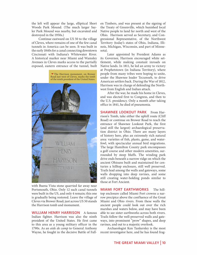
with Buena Vista stone quarried far away near Portsmouth, Ohio. Only 12 such canal tunnels were built in the US, and only 4 remain; this one is gradually being restored. Leave the village of Cleves via Brower Road; just across US 50 stands the Harrison tomb and monument.
WILLIAM HENRY HARRISON A famous Indian fighter. Harrison was also the ninth president of the United States. He first came to this area as a young military officer in the 1790s. As an aide de camp to General Anthony Wayne, he fought in the decisive Battle of Fall-
en Timbers, and was present at the signing of the Treaty of Greenville, which banished local Native people to land far north and west of the Ohio. Harrison served as Secretary, and Con-gressional Representative, of the Northwest Territory (today’s states of Ohio, Indiana, Illi-nois, Michigan, Wisconsin, and part of Minne-sota). Later appointed by President Adams as its Governor, Harrison encouraged white set-tlement, while making constant inroads on Native lands. In 1811, he led an army to victory at Prophetstown (in Indiana Territory), where people from many tribes were hoping to unite, under the Shawnee leader Tecumseh, to drive American settlers back. During the War of 1812, Harrison was in charge of defending the North-west from English and Indian attack. After the war, he made his home in Cleves, and was elected first to Congress, and then to the U.S. presidency. Only a month after taking office in 1841, he died of pneumonia.
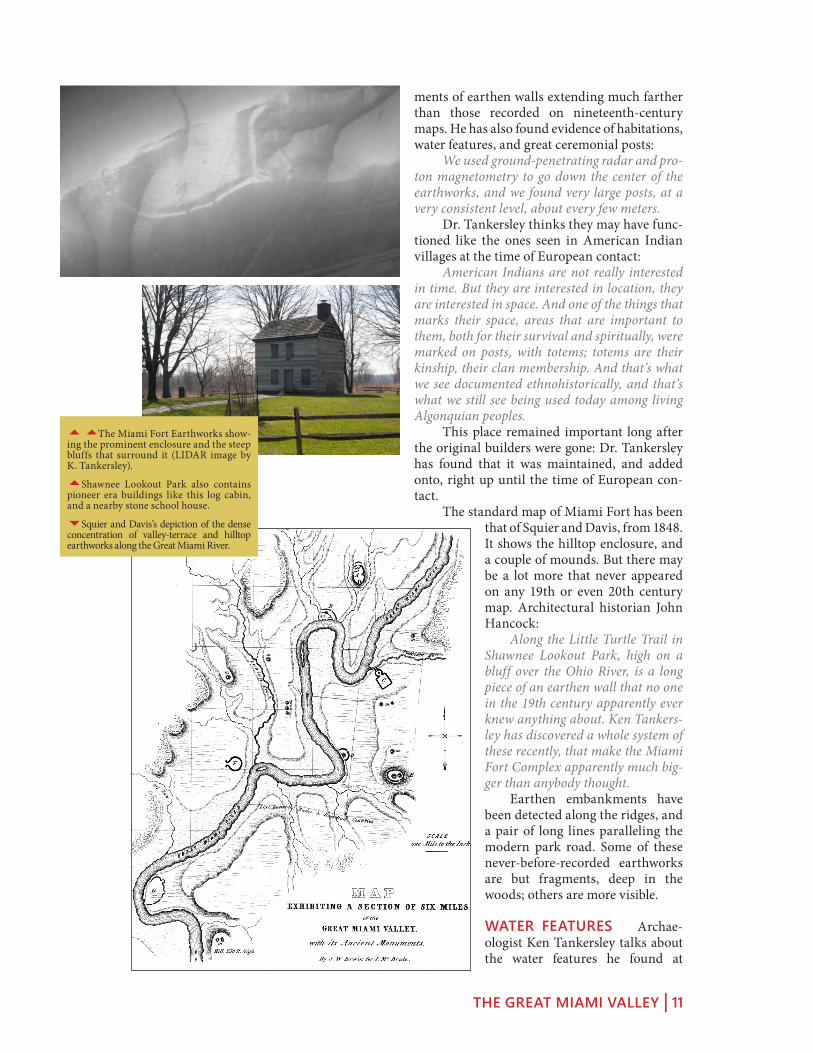
SHAWNEE LOOKOUT PARK From Har-rison’s Tomb, take either the uphill route (Cliff Road) or continue on Brower Road to reach the entrance of Shawnee Lookout Park, the first (and still the largest) archaeological preserva-tion district in Ohio. There are many layers of history here, plus an extremely rich natural area: varieties of fish, plants, game, and water-fowl, with spectacular annual bird migrations. The large Hamilton County park encompasses a golf course and other modern amenities, sur-rounded by steep bluffs. The winding park drive ends beneath a narrow ridge on which the ancient Ohioans built and maintained for cen-turies a hilltop enclosure, still well preserved. Trails lead among the walls and gateways, some walls dropping into deep ravines, and some still creating water-holding ponds similar to those at Fort Ancient.
MIAMI FORT EARTHWORKS The hill-top enclosure called Miami Fort crowns a nar-row precipice above the confluence of the Great Miami and Ohio rivers. From these walls the ancient people could look out over the rich marshes and waters below, and may have been able to see sister earthworks across both rivers. Trails follow the well-preserved walls and gate-ways, into prominent “prow” shapes, and deep ravines, and out to a majestic overlook. Archaeologist Ken Tankersley is the most recent investigator here, and he has found frag-
6The Harrison monument, on Brower Road just west of Cleves, marks the tomb of the ninth president of the United States.
THE GREAT MIAMI VALLEY | 11
ments of earthen walls extending much farther than those recorded on nineteenth-century maps. He has also found evidence of habitations, water features, and great ceremonial posts: We used ground-penetrating radar and pro-ton magnetometry to go down the center of the earthworks, and we found very large posts, at a very consistent level, about every few meters. Dr. Tankersley thinks they may have func-tioned like the ones seen in American Indian villages at the time of European contact: American Indians are not really interested in time. But they are interested in location, they are interested in space. And one of the things that marks their space, areas that are important to them, both for their survival and spiritually, were marked on posts, with totems; totems are their kinship, their clan membership. And that’s what we see documented ethnohistorically, and that’s what we still see being used today among living Algonquian peoples. This place remained important long after the original builders were gone: Dr. Tankersley has found that it was maintained, and added onto, right up until the time of European con-tact. The standard map of Miami Fort has been
that of Squier and Davis, from 1848. It shows the hilltop enclosure, and a couple of mounds. But there may be a lot more that never appeared on any 19th or even 20th century map. Architectural historian John Hancock: Along the Little Turtle Trail in Shawnee Lookout Park, high on a bluff over the Ohio River, is a long piece of an earthen wall that no one in the 19th century apparently ever knew anything about. Ken Tankers-ley has discovered a whole system of these recently, that make the Miami Fort Complex apparently much big-ger than anybody thought. Earthen embankments have been detected along the ridges, and a pair of long lines paralleling the modern park road. Some of these never-before-recorded earthworks are but fragments, deep in the woods; others are more visible.
WATER FEATURES Archae-ologist Ken Tankersley talks about the water features he found at
55The Miami Fort Earthworks show-ing the prominent enclosure and the steep bluffs that surround it (LIDAR image by K. Tankersley).
5Shawnee Lookout Park also contains pioneer era buildings like this log cabin, and a nearby stone school house.
6Squier and Davis’s depiction of the dense concentration of valley-terrace and hilltop earthworks along the Great Miami River.

THE GREAT MIAMI VALLEY | 12
Miami Fort: These earthworks were built on top of sand and gravel terraces, and on top of loess-capped hills: these are what we call “xeric environments,” and they are drought-prone. There’s also no nat-ural water on these features. So if they’re living there, and also growing crops there, they had to have a source of water. And what we found at Shawnee Lookout, and Miami Fort, was a series of step dams and ditches which carried runoff and channeled it into these dams, which were essentially built by the Hopewell about 2,000 years ago, but then continued to be maintained all the way to historic contact. Dr. Tankersley has also taken his investiga-tions to Fort Ancient’s string of ponds, and to Newark’s Great Circle, where he has confirmed that the ditches and pools were purposely lined with limestone, and capped with clay, to retain water.
FORT FINNEY The ancient earthwork at Miami Fort overlooks the site of Fort Finney, built (like Fort Harmar at Marietta) in 1775. Named after the military captain in command, the fort was to provide a place where Shawnee and Miami chiefs could meet and sign a treaty giving up all their land north of the Ohio to the new nation of the United States. The tribes far-ther east had already been pressured to give up their land, but the Shawnee and Miami here in the west had not. Ohio Indian Commissioner Richard Butler set a time for a meeting, but most Shawnee and Miami leaders stayed away. Those who showed up at the fort were simply hungry, but when they discovered the agenda, they too rejected it. Here
5Walls of the southeastern prow of Miami Fort, near the large, level, perhaps-human-made plateau inside the main enclosure.
6The scene of the Treaty of Fort Finney, with Butler trying to persuade the Indians to give up their lands (painting by Hal Sherman)
66One of the most dramatic features at Miami Fort is a set of stepped ponds along the western enclosure wall, near a steep ravine.

THE GREAT MIAMI VALLEY | 13
ley Road) the Fernald Preserve covers a large, flat terrace above the river. The tiny village of Fernald gave its name to the massive, and for a while infamous, uranium refinery built in the early 1950s. Some of the Cold War’s finest ura-nium was produced here, by workers proud to serve their country’s efforts, willing to keep its secrets, and happy for the prosperity it brought to their community. But after a couple of acci-dents, rising health concerns, and a national media scandal, a 4.3 billion dollar clean-up was begun in the 1980s. Today the land is a restored prairie, more or less as it may have been encountered by the first white settlers in 1806, except that the eerie, rectangular ponds echo the contaminated foot-prints of the manufacturing plants and waste stockpiles. Much of the radioactive debris was shipped across the country, but much was also sealed in the giant, surreal mound (the “On Site Disposal Facility” or “OSDF” in official Depart-ment of Energy parlance) that dominates the eastern horizon here. Earth architecture again speaks of eternity, as the Department of Ener-gy’s Office of Legacy Management will be moni-toring the aquifer beneath the mound forever. The address is 10995 Hamilton Cleves Hwy.
DUNLAP’S STATION Across the river from Fernald is the historic cem-etery for Dunlap’s Station, the site of particularly barbaric clashes, on both sides, during the struggle over southwest Ohio lands. Cross to the east shore of the river on US 27 north of Ross, then head south-west on East Miami River Road for
just under 2 miles; the cemetery entrance will be on the right just before Heritage Park. In the late 1700s, settlers ventured far-ther and farther north of the Ohio River along the tributary valleys, building cabins, plant-ing crops, grazing cattle, and creating fort-like settlements called “stations.” Dunlap’s was the most northerly along the Great Miami, and was also called “Coleraine.” It was located next to an enormous, 95-acre D-shaped Hopewell era enclosure, with walls nine feet high. Yet the set-tlers became victims of a “most severe attack by Indians” in 1791, who, besides killing and burn-ing, also tortured a captive man to death by set-ting a fire on his abdomen. In a similarly savage vein, though, the army lieutenant in charge of defending the station boasted of a set of Indi-an scalps his men had taken. Today both the
are Shawnee Chief Tame Hawk’s words: As to the land, it is all ours. You say you have goods for our women and children; you may keep your goods and give them to other nations, we will have none of them. The Indians gave Butler a belt of black wampum, symbolizing disagreement. But But-ler ground it under his heel, and otherwise con-vinced the Indians of his power. At last they gave in and signed. The commissioner got his treaty, but since the vast majority of Shawnee and Miami were not there, it turned out to be meaningless.
THE FERNALD PRESERVE Follow the Great Miami River route (SR 128) north. Between Miamitown and Ross (left on Wil-
5The beautifully re-purposed ware-house that is now the Fernald Preserve Visitor Center contains exhibits telling the many complex histories of the site.
6The ancient earthen enclosure adjacent to the site of Dunlap’s Station, near Ross in Hamilton County (Squier and Davis, 1848, Plate XIII No. 2).

THE GREAT MIAMI VALLEY | 14
Meeting House built of brick, and next door, the large North Family dwelling. These Shak-ers, like their brethren in the east and in Ken-tucky, thrived through careful farming methods and successful sales of brooms, seeds, and other products, including silk from their own silk-worms. The Hamilton County Park District has stabilized 23 Shaker buildings, on view but not yet open to the public. A mound survives in the New Haven Cem-etery, on Oxford Road just south of the South Family buildings.
RENTSCHLER PRESERVE The Fairfield Township Earthworks survive in this park, about 4 miles northeast of the city of Hamil-ton’s downtown waterfront, along SR 4. Enter via Reigart Road for the picturesque canal remnants along the riverbank, from which trails explore the two flat-topped, wooded ter-races; the eastern one is the earthwork site. For shorter access to the earthwork, continue along Route 4 to the next intersection (Rentschler Estates Drive) where there’s a parking lot beside an old barn. From here, the “Earthwork Trail” skirts a large meadow before entering the for-est, where a small ravine appears on the left. Just beyond, a large section of the earthwork appears among the trees on the right. This is the southern wall of the enclosure, and its most distinctive feature remains intact: a 100-foot earthen ring embraced by two arcs, forming an elaborate entranceway; a bench and small sign provide orientation.
CARLISLE FORT EARTHWORKS Off of SR 4, about 2 miles south of Germantown, the Twin Rivers Metro Park covers bluff land overlooking Twin Creek. A trail from the south parking lot off Chamberlain Road leads to the Carlisle Fort Earthworks, a 3- to 4-foot high, roughly triangular enclosure built in the
ancient Indian enclosure and the fort are long gone, though the cemetery remains.
WHITE WATER SHAKER VILLAGE Three miles west of Fernald, along Oxford Road above New Haven, are several surviving buildings from the Central and North Fami-lies of the White Water Shaker Village, one of thirteen settlements across New England and the Midwest planned by this industrious nine-teenth-century sect. The site is preserved with-in Miami Whitewater Forest, a county park. A lovely approach is along the park’s Shaker Trace Hike-and-Bike trail. The “Shaker” movement, or “The Believers in the Second Appearance of Christ,” was founded in 1824. The celibate group, known for its shaking religious dances, lived communally here at White Water in three groups called “families.” Some North Family buildings remain along New Haven Road, notably the only Shaker
5Computer restoration of four buildings at the White Water Shaker Village (CER-HAS University of Cincinnati).
6The distinctive “parentheses and circle” gateway of the Fairfield Township Earthworks (Squier and Davis, 1848, Plate VIII, No. 1).

THE GREAT MIAMI VALLEY | 15
Hopewell era around a wooded hilltop. The trail climbs toward an open meadow, then turns right along a well-preserved earthen wall that seems to glide through the woods atop steep, razor-back ridges. Carlisle Fort is little known today, partly because it was not included in Squier and Davis’s Ancient Monuments of the Mississippi Valley, though it was mapped in the 1830s by a physician named Samuel Binkley. An especially impressive prow points to the south-east, down a long ridge. Dr. Jarrod Burks has compared Binkley’s early map with a modern topographic map, and has identified the rem-nants that are currently visible. Out in the open meadow, remote-sensing surveys have revealed the details of two circles, possibly gateways into the walled promontory. Today the site is at risk of some severe erosion damage. Dr. Burks: One unfortunate aspect of Carlisle Fort is, once you see those embankment walls, and you walk them, you notice that they seem to cut across deep ravines. Well, according to Binkley those ravines didn’t used to be there. It was much more continuous back in his day. So this is a site that really exemplifies the amount of erosion that has occurred, even since Europeans first started
occupying the land. There are lots of gateways now, natural gateways, so to speak.
MIAMISBURG MOUND Crowning a hill-top park southeast of Miamisburg’s quaint, his-toric downtown, is one of the largest Adena era burial mounds in North America, and certain-ly the most spectacularly situated. It contains 54,000 cubic yards of earth. There were two burial vaults: one was eight feet from the top and contained a bark-cov-ered grave; another was found 36 feet down, a chamber built of logs but containing no skeletal remains. Climbing the 116 steps to the top of the earthwork affords a splendid, clear view of the surrounding 36-acre park, and the Great Miami Valley almost in its entirety from the hills west of Cincinnati to the tops of downtown Dayton’s skyscrapers. The sweeping views suggest why this high, prominent hilltop was important to the builders, and perhaps why they went to all this effort to make it even higher. (The only larger Adena burial mound in existence is the Grave Creek Mound, in Moundsville, West Virginia, on the Ohio River 15 miles south of Wheeling.)
3A composite of the Binkley map of Car-lisle Fort with modern field and remote sensing data (image by Dr. Jarrod Burks).
6The perfect conical form of the Miam-isburg Mound stands atop a high bluff, offering views of the Great Miami valley.

DAYTON | 16
and sun WaTCh Village
dayTon
DAYTON, OHIO may be best known for aviation (as the home of the Wright Broth-ers, and of the National Air Force Museum), but this broad valley of the Great Miami River also has important ancient places. From Miam-isburg, enter Dayton via SR 741 and Carillon Park, or cross to the opposite bank of the river to take in SunWatch Village enroute. Dayton is easily reached by Interstate highways from Columbus or Cincinnati, or by state routes from Cedarville, Lebanon, or nearby Yellow Springs.
CALVARY CEMETERY EARTHWORKS The large Catholic cemetery off of South Pat-terson Boulevard, about three miles south of downtown Dayton, occupies the site of a hilltop earthwork shown in Squier and Davis. From among the beautiful rolling drives and monu-ments in the northern section, along St. Joseph Drive, overgrown openings into the woods lead to remnants of the northern walls along the steeply rolling bluff. Intrepid exploration (behind the Nash Obelisk, past a huge Burr Oak) is possible, though not recommended. Instead, inquire about hiking trails developed by Carillon Historical Park, which owns the hillside.
dayTon area Map
1 Carillon Historical Park
2 SunWatch Village
3 Wright Cycle Shop and Museum
4 Oregon Historic District
5 Wright Memorial (Mounds)
6 Huffman Prairie 6
5
4
3
2
1

DAYTON | 17
CARILLON HISTORICAL PARK Below Calvary Cemetery to the north, and reachable by car, is the Carillon Historical Park (1000 Carillon Boulevard, 937-293-2841). Behind the tall modern carillon tower, an outdoor museum of Dayton history has been developed: a large visitors center and museum leads to a fine col-lection of early settlement structures and exhib-its including Newcom’s Tavern (Dayton’s oldest, from 1796), and a variety of early houses and industrial buildings. A transportation theme is developed in many of the remaining structures: a steam engine from the National Cash Register Company, a canal lock, two bridges, a railway station, and commuter cars. Most significant of course is the amazing, original Wright Flyer III of 1905. Trails up the steep, wooded hill-side reach the surviving sections of the Calvary Cemetery Earthworks.
SUNWATCH VILLAGE Leaving Interstate 75 at exit 51, go west on Edwin C. Moses Bou-levard, which becomes Nicholas Road after crossing the Dryden Road/South Broadway Street intersection. Cross South Broadway and turn left onto West River Road and continue one mile south to the site (2301 West River Road, 937-268-8199). The Archaeological Park at SunWatch is a National Historic Landmark, and through house reconstructions and museum exhibits a visit to the site gives an excellent idea of Indian town life in the last centuries before European contact.
55The earthwork apparently encir-cled much of modern Calvary Cemetery; remnants survive on the wooded bluff to the north.
5Carillon Historical Park preserves several of Dayton’s oldest buildings, plus other historical displays, many with a transportation theme.
4A hilltop enclosure once encircled the steep moraine just above I-75 near down-town Dayton (Squier and Davis, 1848, Plate VIII, No. 4).
DAYTON | 18
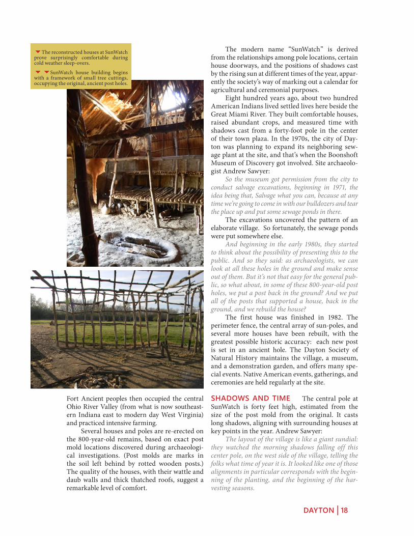
The modern name “SunWatch” is derived from the relationships among pole locations, certain house doorways, and the positions of shadows cast by the rising sun at different times of the year, appar-ently the society’s way of marking out a calendar for agricultural and ceremonial purposes. Eight hundred years ago, about two hundred American Indians lived settled lives here beside the Great Miami River. They built comfortable houses, raised abundant crops, and measured time with shadows cast from a forty-foot pole in the center of their town plaza. In the 1970s, the city of Day-ton was planning to expand its neighboring sew-age plant at the site, and that’s when the Boonshoft Museum of Discovery got involved. Site archaeolo-gist Andrew Sawyer: So the museum got permission from the city to conduct salvage excavations, beginning in 1971, the idea being that, Salvage what you can, because at any time we’re going to come in with our bulldozers and tear the place up and put some sewage ponds in there. The excavations uncovered the pattern of an elaborate village. So fortunately, the sewage ponds were put somewhere else. And beginning in the early 1980s, they started to think about the possibility of presenting this to the public. And so they said: as archaeologists, we can look at all these holes in the ground and make sense out of them. But it’s not that easy for the general pub-lic, so what about, in some of these 800-year-old post holes, we put a post back in the ground? And we put all of the posts that supported a house, back in the ground, and we rebuild the house? The first house was finished in 1982. The perimeter fence, the central array of sun-poles, and several more houses have been rebuilt, with the greatest possible historic accuracy: each new post is set in an ancient hole. The Dayton Society of Natural History maintains the village, a museum, and a demonstration garden, and offers many spe-cial events. Native American events, gatherings, and ceremonies are held regularly at the site.
SHADOWS AND TIME The central pole at SunWatch is forty feet high, estimated from the size of the post mold from the original. It casts long shadows, aligning with surrounding houses at key points in the year. Andrew Sawyer: The layout of the village is like a giant sundial: they watched the morning shadows falling off this center pole, on the west side of the village, telling the folks what time of year it is. It looked like one of those alignments in particular corresponds with the begin-ning of the planting, and the beginning of the har-vesting seasons.
Fort Ancient peoples then occupied the central Ohio River Valley (from what is now southeast-ern Indiana east to modern day West Virginia) and practiced intensive farming. Several houses and poles are re-erected on the 800-year-old remains, based on exact post mold locations discovered during archaeologi-cal investigations. (Post molds are marks in the soil left behind by rotted wooden posts.) The quality of the houses, with their wattle and daub walls and thick thatched roofs, suggest a remarkable level of comfort.
6The reconstructed houses at SunWatch prove surprisingly comfortable during cold weather sleep-overs.
66SunWatch house building begins with a framework of small tree cuttings, occupying the original, ancient post holes.

DAYTON | 19
by day, as the pole shadow moved toward the most important days of the year.
FARMING AND FOOD By about AD 1000, corn had become the most important food for native people in this region. Andrew Sawyer: Corn played a big role in the community here, in fact, probably the main reason they decided to settle down into rather permanent villages, was to take care of the corn crop. And based on the analysis of the remains here at SunWatch, it looks like corn alone took up 50% of their diet. So, this was a very impor-
tant crop to the people, they wanted to make sure that they got enough in, year in, year out. When the village’s center pole shadow said it was time to plant, the people set to work, their methods probably much like later ones that have been recorded: Historically, the way American Indians in this region grew their crops, was they would make little mounds in their gardens, about a foot or so high, 2 or 3 feet around, and at the top center of the mound they would plant the corn. And, once the corn sprouted, they would plant the beans. They would grow up together, and the corn stalk provides a trellis for the beans. Around the base were added squash or pumpkins; their large leaves helped retain mois-ture and control weeds. Because these plants all worked so well together, they were called “the three sisters.” When the center pole shadow announced harvest time, the crops were collect-ed. The corn especially was set aside for winter: It stores well. They would dig subterranean storage pits about three feet deep, line them with grasses or bark to insulate them, and in the fall at the harvest, they’d bring all their corn and put it in the pits, and that’d get them through the next year. Dried corn from the storage pits was ground in mortars to make corn bread, or added to soups or stews. The demonstration garden at SunWatch has been developed with help from Native American communities. Some of the corn might even be descended from the original corn grown here: A couple of years ago, we were lucky enough to grow some Myaamia corn from the Miami Tribe of Oklahoma, which was their corn that
On these two dates, in April and August, the center pole shadow falls through the door-way of the Big House, striking a post, and cross-ing the central hearth. On the winter solstice, December 21, the center pole shadow enters another house: We recognize the winter solstice on our cal-endars, it’s the shortest day of the year, and what happens on that day is the sun is rising the far-thest south in the eastern sky and so the shadow it creates falls on the northwestern corner of the vil-lage, again, through a doorway, hits a post, and across the hearth and the floor of the house. Everyone in the village could watch, day
5Sunlight enters the doorways of certain houses at precise angles that mark the time of the year, important to an agricultural society.
6A model in the SunWatch museum portrays the concentric planning of the village around its central sun-poles.

DAYTON | 20
through the mother’s side, and in matrilocal societies, young couples settle near the mother of the bride. So life at SunWatch was probably organized in four family-based social divisions or clans.
THE BIG HOUSE SunWatch houses were built on a frame of upright poles set in the ground, in a rectangular pattern. The walls were woven twigs, plastered with mud – a method called “wattle and daub.” The steep, thatched roofs had big overhangs to keep rain away from the walls. Inside were built-in benches for sitting and sleeping; the central fireplace was vented through the roof. The Big House, reconstructed here, has other features. The times of planting and har-vesting were marked here by the morning shad-ow of the village’s central pole. Archaeologist Andy Sawyer: It’s one of the biggest houses in the village, but also it has more seating capacity, and we think that relates to its use as a communal structure, where folks, village elders, village leaders from this com-munity, maybe even others, would come together at various times throughout the year. The Big House also has a special, interior wall. This interior wall looks like it divides off a smaller non-public space from the larger public space. And it could have been used for shamans, or other community or religious leaders, to store religious material, paraphernalia. On the morn-ings of the events such as the planting alignment, it may be their duty to prepare everything in the back, as everyone gathers in the house, and then to step through the doorway to begin the ceremo-ny.
THE SITE TODAY SunWatch Village today is a place of ongoing learning and heritage. Scholars can experiment to find out more about everyday life in ancient Ohio: for example, how did people keep warm here in winter? We had an experiment where the tempera-tures outside were hovering in the mid-20s, and we stayed in the house for about a week. We found we could raise the interior temperature of the house about 15 degrees or so, up to about 40 degrees, which isn’t exactly the barefoot comfort we’re used to today, but significantly warmer than it was outside. But in order to do that, we were burning between 150 and 200 pounds of firewood every day. Many hearths, burning this much wood
they took with them from this area when they were removed, back in the 1830s. This was the corn they traditionally planted here in Ohio.
TOWN AND FAMILY LIFE Village life at SunWatch probably went on for about twenty years, a long time compared to the tiny hamlets of earlier Ohio cultures. When local resources like firewood and fertile soil were used up, it made sense to go build another village else-where. A model in the museum shows the vil-lage’s concentric rings: the fence, houses, stor-age pits, burials, and central plaza. The fence might have been meant for defense, but just as likely for keeping children or certain animals in, or other animals out. Just inside the fence, 25 to 30 houses origi-nally stood. A few of them had special uses: the Big House was a kind of community center;
another was a men’s lodge. The rest were dwell-ings, and similar artifacts were found in them – except for the pottery, which provides a clue to the village social organization. Andy Sawyer: We’re finding different ceramic design pat-terns clustered in different quadrants of the site. And with the historic American Indian groups in the region, ceramic design and production was what the women would take care of, and those design elements tended to be used by specific families and lineages. What that suggests to us, if we’re seeing those designs only in certain parts of the site, is that all the women who are related to each other lived in the same part of the village, which suggests a matrilineal, or even a matrilocal society. Matrilineal societies trace ancestry
5The interior of the Big House is cen-tered on its hearth; an interior wall may define a zone of ritual preparations.

DAYTON | 21
every winter day, would have depleted nearby woodlands quickly, and would have required long-distance travel to maintain wood supplies, within just a few years. Today SunWatch affords many chances for first-hand experiences: it’s possible to stay overnight in a village house, to learn 800-year old American Indian crafts, to attend a pow-wow with day-long drumming, dance, and food. Tribes and native groups play important roles at SunWatch, as advisors and as participants in celebrations that echo the ones held here by the ancestors, hundreds of years ago.
DAYTON AVIATION HERITAGE Using the Dayton Aviation Heritage National His-torical Park (16 South Williams Street, 937-
225-7705) as a point of orientation, it is possible to visit five important sites commemorating the legacy of local bicycle makers and flight pioneers Orville and Wilbur Wright. These include the Wright Cycle Company com-plex and the adjacent museum (at the Wil-liams Street location); the home of Paul Lau-rence Dunbar, the Wrights’ friend and famous African American poet, in the neighborhood nearby; the Wright Brothers Aviation Center at Carillon Park, also mentioned above; and the Huffman Prairie Flying Field and Interpretive Center on Wright-Patterson Air Force Base. At the Interpretive Center and Wright Memo-rial there is a rare cluster of Adena era burial mounds. Finally, don’t miss the huge National Museum of the United States Air Force. For a detailed guide and driving directions to all of this, follow the Dayton, Ohio “Aviation Trail” at http://www.aviationtrailinc.org/ and consult the National Park Service’s materials.
THE ENON MOUND Three miles north-east from the intersection of I 270 with either I 70 or Dayton Springfield Road, is the town of Enon. A small subdivision just a few blocks east of the town center is built around a very large mound (encircled by a roundabout), and aptly named Indian Mound Estates. The mound, almost certainly of the Adena era, is 28 feet high and only partly tree covered; its fine pro-file is visible from many angles.
5In the Huffman Prairie Flying Field just outside Dayton stands a replica of the Wright Brothers’ 1904 hangar.
4Six mounds of various sizes line the edge of a peaceful park adjacent to the Wright Brothers Memorial Interpretive Center.

LEBANON TO POLLOCK | 22
and The upper liTTle MiaMi
lebanon To polloCk
HISTORIC LEBANON For an authentic experience of early Ohio, make Lebanon your base for the upper Little Miami watershed or even all of southwest Ohio. The legendary Golden Lamb Inn downtown is Ohio’s oldest continuously operating business; its 18 guest rooms have many stories to tell, having host-ed many presidents and other distinguished guests. Along well-preserved, tree-lined down-town streets are many cafés, antique and spe-cialty shops, and other amenities. On week-ends, a scenic railroad tour embarks from the
nearby station for Mason and Monroe. Two blocks from the Golden Lamb is one of Ohio’s finest Greek Revival mansions, open as a muse-um: “Glendower” was built in 1840 for one of the framers of the state’s constitution, and has exceptional architectural details.
WAYNESVILLE TO YELLOW SPRINGS Northeast of Lebanon (9 miles along US 42) is the town of Waynesville, and clustered along its well-preserved Main Street are many antique and specialty shops. This is a major destination for antique and furniture buyers, with more than fifty dealers including some with various
specialties. Continue on US 42 for 15 miles to downtown Xenia, then take US 68 north for 11 miles to Yellow Springs, a picturesque college town and former spa, and home to the recent-ly-revived Antioch University. Near Yellow Springs, Glen Helen Park and John Bryan State Park offer excellent recreational opportunities including hiking and bike trails, waterfalls, a covered bridge, and a mound.
CLIFTON GORGE This spectacular natu-ral formation is reached from South Jackson Street in the tiny village of Clifton (4 miles east of Yellow Springs via SR 343). A narrow canyon of the Little Miami River with its 110-foot, ver-
lebanon To polloCk Map
1 Lebanon
2 Waynesville
3 Enon Mound
4 Wilberforce
5 Yellow Springs
6 Clifton Gorge
7 Pollock Earthworks
1
2
3
4
7
5
6

LEBANON TO POLLOCK | 23
tical limestone cliffs is surrounded by towering 300-year-old trees. This crevice seems especial-ly surprising in an otherwise only slightly-roll-ing agricultural landscape; its microclimates shelter rare plants and wildflowers. Trails lead along the rim and down to the bottom where they wander among huge boulders. Rushing waterfalls display the concentrated power of the river here, harnessed in the early 1800s by sev-eral industrial operations. Clifton Gorge was once named by National Geographic as one of the nation’s 50 most beautiful places.
POLLOCK EARTHWORKS Leave Clif-ton village by SR 72 going south 4 miles to Cedarville. Turn right on US 42 and in about 1.4 miles, a log cabin will appear on the right, at the parking area for Indian Mound Park. A walking trail leads across Massie’s Creek, then along the stream and up the hill to the left to reach the large, conical, Adena era Williamson Mound at the peak of the hill. Also from the parking area, a marked trail heads east to the Hopewell-era earth-works, where a series of earthen walls and gate-ways enclose the western end of a prominent limestone plateau. In about 600 feet, the walls appear: though densely covered with growth, it is clear when the path rises that you are passing through one of the site’s three major gateways. On its other three sides, the Pollock plateau is surrounded by often dramatic, sheer stone cliffs. Wooded trails lead past rock shelters where many ancient remains have been found, alongside evidence of early 20th century quar-rying and abandoned industrial waterworks. The plateau and earthworks overlook the gorge of Massie’s Creek, here just outside Cedarville, Ohio. Here, archaeologist Robert Riordan, of
Wright State University, has unearthed the story of a hilltop, gated with stone and earth, briefly protected by a high wooden stockade, which was then burned by its builders in a great crescent of fire. By cutting several trenches through the wall, Dr. Riordan and his students have been able to uncover the phases of construction that went on here. Around the first century AD, a low embankment was laid across between the creek bluff and the start of the limestone cliff. It was about 300 feet long, with a gateway in the center. Then, over about a hundred years, they made two separate additions to the wall, mak-ing it higher and leaving two more gateways. The most remarkable phase was the building of a huge timber fence, or stockade, along the earthen wall, and way out along the northern bluff. The Big Fire that consumed the stockade was part of a pattern of Hopewell people burn-ing things: returning them to ash and smoke, to the earth and sky. Dr. Riordan found evidence for this fire in one of his excavation trenches, showing how they had also buried the charred remains, extending a small embankment out along the northern bluff. As often with the Hopewell, burying followed burning. This returned the site to its original architectural treatment, with only earthen walls. The earthen walls stand only at the end of the plateau that’s not already surrounded by high cliffs. Like other hilltops, the theme here
3A “lamb” graces the lobby of The Golden Lamb Inn, which dates from 1803 and anchors Lebanon’s historic downtown district.
4Nearly anything that’s old is available among Waynesville’s many furniture, antique, and specialty shops.

LEBANON TO POLLOCK | 24
is “enclosure,” either to keep something out, or something in. The walls were carefully built. Before anything was done, a thin layer of clay was laid down, to prepare the surface. The out-side surface contained a lot of stone, and the gateway passages were also paved and lined with limestone blocks. Walking the site today, the walls seem quite large, yet they stood even higher in antiquity: Erosion has filled in the area behind them by about three feet.
THE SITE TODAY On the hilltop today, the trees are small, reminding us this was farmland up here until the 1960s. An old paper mill used the stream, and built big holding ponds down below to try to reduce their pollution. Just out-side the ancient gateways there was a limestone quarry. Blasting marks are still visible along the southern cliff. Quarrying is probably what destroyed the crescents. For decades now it has been a Greene County Park; and Wright State University’s archaeology field school began reg-ular investigations here in 1981.
ARCHAEOLOGICAL RESEARCH Dr. Riordan has made some very exciting discover-ies here at the Pollock Works, but it took nearly twenty years of work. Modern archaeology is a very meticulous process. Deciding where to dig is done with great care, since it is rare that an entire site can ever be excavated. Trenches are laid out on an exact grid. Layers of soil are removed very carefully, and everything that’s found is recorded: drawn, photographed, num-bered, tagged, stored, and dated. Archaeologists don’t always get the chance
to do the detailed work that makes their dis-coveries meaningful and reliable. Many sites in Ohio still have private owners who can refuse to give archaeologists access, or who let the ancient places deteriorate, or get bulldozed. Luckily, the Pollock Works became a Greene County park, helping to make Dr. Riordan’s careful, sustained efforts possible.
THE CRESCENTS The four crescents on Squier and Davis’ plan are now only a mystery. Architectural historian John Hancock: Often in making our computer models, we found we couldn’t match the old drawings with what we knew was out there, or what we could see on aerial photographs. In the case of these four crescents, for example, the one that Squier and Davis drew over farthest to the north, would have been floating out above the river! But Samuel Owens, the county surveyor, had only shown two crescents in 1842; and Davis him-self, though he described four, had located one in front of another on his field notes. With these surveyors, I think it was some-times a question of what they remembered when they got back to the hotel room, or what their engraver thought would look nice on the map! In any case, the crescents were small, under three feet high. And like the little stone mounds between them, they disappeared long ago.
WILBERFORCE Nearby (3 ½ miles south-west along SR 42) is Wilberforce, home to Wilberforce University, founded in 1856 and the first institution of higher learning to be owned and operated by African Americans,
3The Pollock Earthworks enclosed the western end of an otherwise sheer-rock plateau (image by CERHAS University of Cincinnati).
4Still standing above scenic Clifton Gorge is one of America’s oldest and larg-est surviving water-powered grist mills.

LEBANON TO POLLOCK | 25
whose faculty and alumni have included many distinguished leaders and scholars. Half a mile west of SR 42 is the National Afro-American Museum and Cultural Center (1350 Brush Row Road, 800-BLK-HIST), a state-sponsored muse-um in a striking new building.
5Several rock shelters, with evidence of ancient habitation, are located under the cliffs of the Pollock plateau.

FORT ANCIENT EARTHWORKS | 26
hillTop enClosure
forT anCienT earThWorks
FORT ANCIENT This is the most spectac-ular and well-preserved of the Hopewell-era hilltop enclosures. It surrounds over 100 acres, high above a narrow gorge of the Little Miami River. Here, Hopewell era builders moved mas-sive amounts of earth to create complex and monumental spatial effects. The southern plateau was ringed first, then connected by a passage to a larger area, to the north. In addition to creating a continuous perimeter ditch-and-wall design, the builders moved soil to bridge across even the steepest ravines. When constructing the huge causeway across from the South Fort to the North Fort, for example, they filled up three gullies, using an amount of soil equal to all of the site’s earthen walls combined.
Early settlers, astonished by the place, decided it must be a fort. Yet no fort ever had 67 gateway openings or a moat on the inside. Today, Fort Ancient and other hilltop enclo-sures like it are thought to have been places of special ceremony, their elevation perhaps sig-naling their relation to the sky. To reach Fort Ancient, take Exit 32 on Interstate 71 and head south, turning immedi-ately left on State Route 350. (From the north, or with any vehicle that can’t make a tight hair-pin turn, use Exit 36, and follow the signs.) In less than 3 miles, the road drops into the steep wooded gorge of the Little Miami River, passes an old schoolhouse structure on the right, and crosses the river. At the top of the bluff on the other side, the road passes directly through one
of Fort Ancient’s 67 gateways and enters the broad, open North Fort. A small crescent, and the undulat-ing walls, are visible on the left. The excellent Museum and Visitors Center (513-932-4421) pro-vides an overview of the site and Ohio’s Indian cultures through the time of European contact. A garden and reconstructed Hopewell era house help visitors envision every-day life for the earthwork builders. A complete walking tour of the site,
including many of its outstanding features, will take three to four hours.
forT anCienT Map
1 Museum2 North Gate3 Foursquare Mounds4 Moorehead Circle Site5 Great Gate6 North Overlook7 South Overlook8 South Gate9 Kern Serpents
GPS coordinates: 39.4078383 N, 84.0902117 W. Summer Hours: Tuesday – Saturday, 10:00 a.m. – 5:00 p.m., Sunday, noon-5:00 p.m. (Closed on Mondays) Museum admission: $6.00 Adults, $5.00 Seniors (60+), $4.00 Students (6–12), children under 6 and Ohio Historical Society members are free. Outdoor admission (no Museum access): $8.00/Carload
3
1
2
4
56
7
8
9

FORT ANCIENT EARTHWORKS | 27
NORTH GATE, TWIN MOUNDS From the parking lot, walk on the lane (blocked to cars) that passes through the east walls to gain a good view of the large Twin Mounds which frame the ancient North Gate, where today’s State Route 350 runs. These mounds are markers only, and seem to be a variation on the earthwork’s older gates which fea-ture mound-like rises of the walls on either side. From here, parallel walls once headed out to the northeast, for about a quarter of a mile. They fol-lowed the highest elevation of the plateau, to where a small mound once stood, just beyond Middle-boro Road. Dr. Patricia Essenpreis discovered in 1990 that from each of the Twin Mounds, the Ancients dug deep trenches out toward the nearby streams: filling with spring water, they completed a “water boundary” for the entire earth-work. Just outside the parallel walls that once led away from the North Gate, buried caches of materi-als suggest artisans were crafting objects from obsidian, flint, and copper for use in the ceremonies.
FORT ANCIENT’S MOUNDS Although designed mainly with earthen walls, gate-ways, and ponds, Fort Ancient has a variety of mounds as well. Archaeologist Robert Connol-ly explains their roles in the design: Very few of the mounds at Fort Ancient contained burials. They may have been used for signal fires as in the North Fort: Moorehead in the 1890’s reported that these were basically large piles of limestone that were very heavily burnt. We also know that mounds marked the entry-ways of primary gateways into the enclosure, and really were sort of a signaling device: people would see the large Twin Mounds (for example) and say, ‘Oh that’s the appropriate place to enter the earthwork complex.’ So the function of the mounds here at Fort Ancient was much beyond that of simply burying the deceased kin.
5This map of Fort Ancient appeared in Squier and Davis’ Ancient Monuments of the Mississippi Valley in 1848.
6The Twin Mounds and parallel walls framed the start of a long, stone-paved roadway toward the northeast.

FORT ANCIENT EARTHWORKS | 28
THE FOURSQUARE Four low, limestone-covered mounds form a perfect square inside the North Fort, 512 feet on each side. Look for one near the ticket booth, one across Route 350, another south of the North Gate, and a fourth near the Museum’s parking lot. Their original limestone coverings had been heavily burned: it was oxidized, red, and crumbly; and the fos-sils in it had turned white. Huge fires had been set atop these stone-surfaced mounds, obvi-ously for some dramatic, ritual purpose. This perfectly-defined, fire-demarcated square space seems to have been kept absolutely clean and free of buildings, suggesting it was sacred. Trees would have been cleared to allow open views from the western stone mound to the three, key astronomical alignments, through the gateways and out to the northeastern hori-zon. Today, the solstice gateway opening (just north of the highway) is kept clear, to allow for a special sunrise celebration held here every June 21. Site archaeologist Jack Blosser talks about Native participation in these solar calendar events: We’ve had some people of Native descent come to the grounds, and they perform their own specific ceremony they’ve been taught through their traditions. One year we had a winter sol-stice, and we had an elder with two helpers: the sun was obviously not going to come out, and he said, “Be quiet and listen.” He proceeded to get
his equipment out. The helpers twisted the leath-er between their staffs and the elder had another staff and at the right time he began his prayers. And you knew it was the right time, because if you looked, you could see a very light shadow from the staff to the leather.
HABITATIONS Evidence suggests that many people lived at or near Fort Ancient over many centuries. Inside the enclosure, houses were found from the same period of time that the walls were being built. Everyday dwellings apparently existed within the sacred enclosure, but never crossed the line into the Foursquare area. These people also lived outside the enclo-sure, out to the northeast where the craft shops have been discovered. The western arm of the South Fort was the primary occupation area for the later societies who lived here. At least off and on, between 1100 and 1550, there was a village here with a wooden stockade around it. These later people also had settlements down in the valley. But they had gone before the first pioneers arrived.
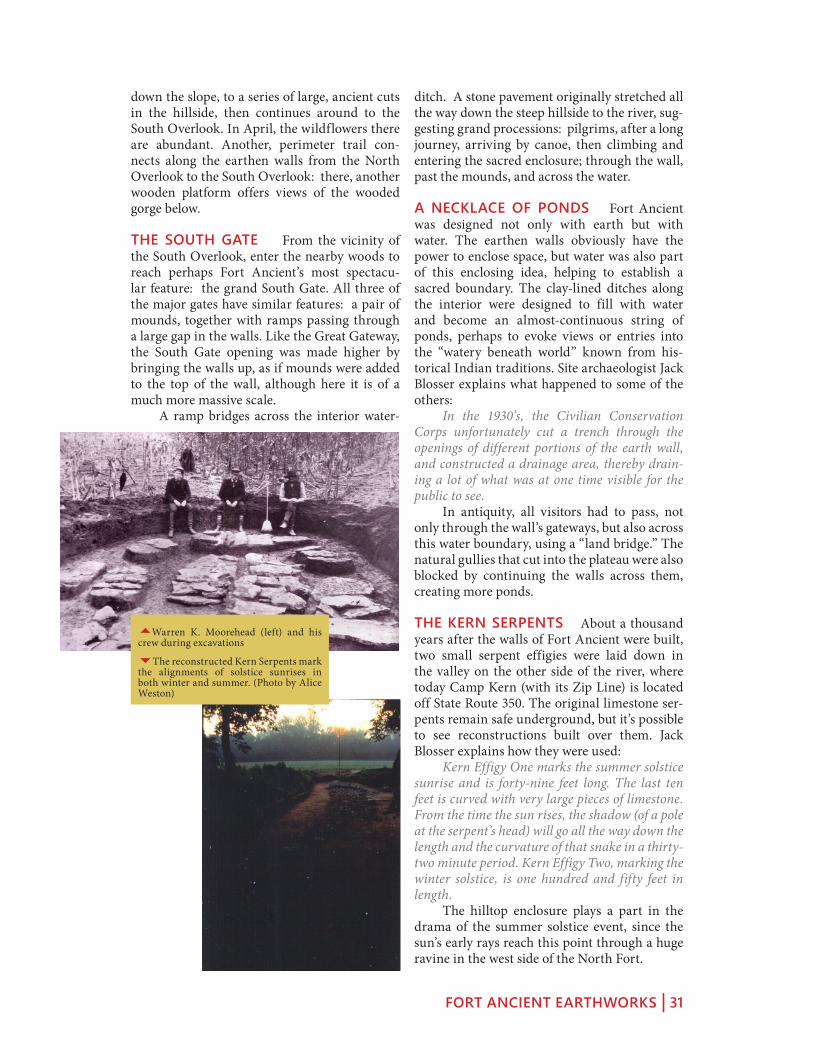
THE MOOREHEAD CIRCLE The biggest discovery at Fort Ancient in recent memory is a giant “woodhenge” in the North Fort, now called The Moorehead Circle. In summer, you may see members of a field school continuing the dig, across the road west of the museum.
3The reconstructed Hopewell-era house (resembling these computer models) in the museum’s garden is based on a post hole pattern discovered while the new museum was being built.
FORT ANCIENT EARTHWORKS | 29
Jack Blosser explains how this ancient stone and timber work was first discovered: We received a Save America’s Treasures grant in 2005: they were able to pick out stains in the soil that picked up a two-hundred foot in diameter circle. Archaeologist Bob Riordan has been excavating here with his students every summer since then. He describes what was found, beginning with the ring of timber posts: Very substantial posts set as deep as a meter in the ground, actu-ally more than a meter because that’s a meter below the subsoil that we’ve started from. Some of them were set in place using ramps, so
there would be shallow ramps. They would have to go out, cut trees, trim them, carry them in, set them in the ramps, and walk them upright. And then they filled the ramps with limestones, and chinked the posts with limestones as well. At the center of the circle of timber posts, Dr. Riordan found a shallow pit containing a mound of astonishingly bright red-orange, ster-ile, burned soil, perhaps the pulsing heartbeat of Fort Ancient: So there’s this shallow pit, and in the middle of the shallow pit, a deeper pit, to the extent of about 70 centimeters below the surface: a red soil fills that pit. We’ve been presuming that this is a burned soil that was burned somewhere else; we’re not seeing lots of charcoal around it, under it, in it. It’s very, very clean, sterile, red soil. So other people are thinking that it may be a more ancient soil that is naturally red that’s been brought in. A set of parallel, stone-faced walks and grav-el-filled trenches gather around this central fea-ture, evoking some ancient theater. We know of nothing else like it in the Hopewell world. More mysteries are uncovered every year.
EARTH AND STONE Walk or drive south along the central road of the North Fort and notice the flat surface of the hilltop, with the walls on either side winding and narrowing toward the passageway approaching the Great Gate. To create Fort Ancient, generations of people must have worked toward a common goal. The first step would have been clear-ing the forests, a huge undertaking in itself.
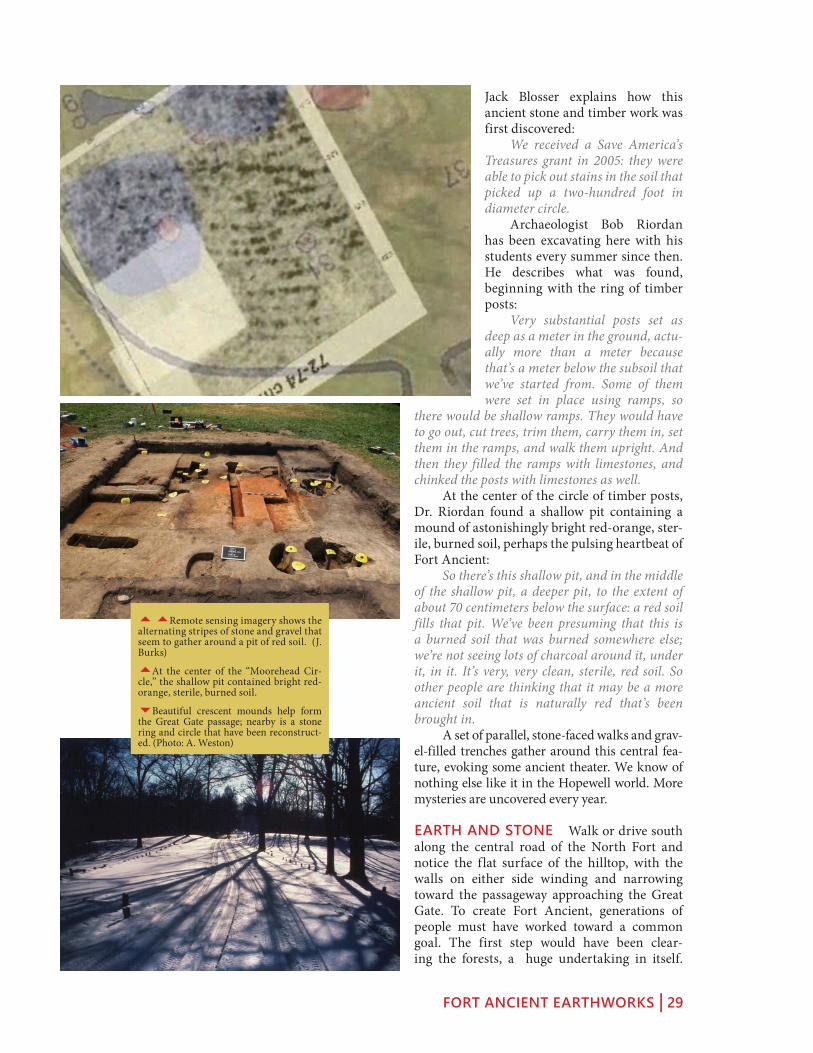
55Remote sensing imagery shows the alternating stripes of stone and gravel that seem to gather around a pit of red soil. (J. Burks)
5At the center of the “Moorehead Cir-cle,” the shallow pit contained bright red-orange, sterile, burned soil.
6Beautiful crescent mounds help form the Great Gate passage; nearby is a stone ring and circle that have been reconstruct-ed. (Photo: A. Weston)

FORT ANCIENT EARTHWORKS | 30
Then, they scraped soil off the surface, filled in ravines, and constructed 67 walls and gate-ways, and dug 131 ponds. Finally they brought up limestone from the river valley below to reinforce the walls and gateways, to create stone rings and circles, to build long runs of pave-ments, and to surface much of the outsides of the walls.
THE GREAT GATE The most elaborate of the site’s three major passages is called the “Great Gateway.” The road rises to a narrow ridge, the original north entrance to the oldest part of the enclosure. Passing in and out along the ridge took the ancient visitors past mounds, crescents, and limestone pavements; as if to remember the first generations of ancient ancestors, perhaps the first who made this hill-top a sacred place, and a shared monument. The paired Crescent Mounds, one on each side of the road north of the Gate, help form this passage.
THE OVERLOOKS The central road ends in a large parking lot past the picnic area. Turn right down the lane to reach the North Over-look, where a wooden platform offers views of the Little Miami River and its gorge. From here we can sense the special prominence of this location, and can appreciate the importance of creating an elevated sacred place, with such a strong visual tie the river below. From here, a path with many stairs leads all the way down to the river and the hike-bike trail alongside it today. Or, the terrace trail descends partway
55A reconstruction of the South Gate with the leader looking out over the stone-paved Sacred Way from the river below.
5Historical image of the road as it approaches the Great Gate; the walls swell into the form of two mounds.
6Despite the efforts to drain them, many of Fort Ancient’s ponds still hold water, especially this one near the site’s northwestern corner.
FORT ANCIENT EARTHWORKS | 31
ditch. A stone pavement originally stretched all the way down the steep hillside to the river, sug-gesting grand processions: pilgrims, after a long journey, arriving by canoe, then climbing and entering the sacred enclosure; through the wall, past the mounds, and across the water.
A NECKLACE OF PONDS Fort Ancient was designed not only with earth but with water. The earthen walls obviously have the power to enclose space, but water was also part of this enclosing idea, helping to establish a sacred boundary. The clay-lined ditches along the interior were designed to fill with water and become an almost-continuous string of ponds, perhaps to evoke views or entries into the “watery beneath world” known from his-torical Indian traditions. Site archaeologist Jack Blosser explains what happened to some of the others: In the 1930’s, the Civilian Conservation Corps unfortunately cut a trench through the openings of different portions of the earth wall, and constructed a drainage area, thereby drain-ing a lot of what was at one time visible for the public to see. In antiquity, all visitors had to pass, not only through the wall’s gateways, but also across this water boundary, using a “land bridge.” The natural gullies that cut into the plateau were also blocked by continuing the walls across them, creating more ponds.
THE KERN SERPENTS About a thousand years after the walls of Fort Ancient were built, two small serpent effigies were laid down in the valley on the other side of the river, where today Camp Kern (with its Zip Line) is located off State Route 350. The original limestone ser-pents remain safe underground, but it’s possible to see reconstructions built over them. Jack Blosser explains how they were used: Kern Effigy One marks the summer solstice sunrise and is forty-nine feet long. The last ten feet is curved with very large pieces of limestone. From the time the sun rises, the shadow (of a pole at the serpent’s head) will go all the way down the length and the curvature of that snake in a thirty-two minute period. Kern Effigy Two, marking the winter solstice, is one hundred and fifty feet in length. The hilltop enclosure plays a part in the drama of the summer solstice event, since the sun’s early rays reach this point through a huge ravine in the west side of the North Fort.
down the slope, to a series of large, ancient cuts in the hillside, then continues around to the South Overlook. In April, the wildflowers there are abundant. Another, perimeter trail con-nects along the earthen walls from the North Overlook to the South Overlook: there, another wooden platform offers views of the wooded gorge below.
THE SOUTH GATE From the vicinity of the South Overlook, enter the nearby woods to reach perhaps Fort Ancient’s most spectacu-lar feature: the grand South Gate. All three of the major gates have similar features: a pair of mounds, together with ramps passing through a large gap in the walls. Like the Great Gateway, the South Gate opening was made higher by bringing the walls up, as if mounds were added to the top of the wall, although here it is of a much more massive scale. A ramp bridges across the interior water-
5Warren K. Moorehead (left) and his crew during excavations
6The reconstructed Kern Serpents mark the alignments of solstice sunrises in both winter and summer. (Photo by Alice Weston)

FORT ANCIENT EARTHWORKS | 32
Today, in the valley below, a canoe livery and bike trail help attract visitors to this spot on the Little Miami. In 2009, the Ohio History Con-nection entered a partnership with the Dayton Society of Natural History to manage the site.
THE FORT ANCIENT CELEBRATION Annually during the second week of June, “The Gathering of Four Directions” brings Native people and others together for crafts, ceremo-nies, music, dancing, and food. Typically, there are over forty vendors, over one hundred danc-ers in full regalia, drums, storytelling, and flute music. Jack Blosser talks about the importance of the site to Native American groups, and its place in their traditions: Fort Ancient is still used by Native commu-nities. It is indeed a gathering of four directions and it’s growing each year. When we talk to the Native community, it’s mixed: In one oral tradi-tion, they call this site Moon City suggesting that something happened here at night; they would come here for observances at night time. Others say it is a spiritual place. Others talk about the high energy they feel here. It is basically a very religious complex for the Native communities to gather.
FORT ANCIENT HISTORIES The Hopewell era earthen monument that rings the hilltop is only one phase of the uses and histo-ries of this site. Archaeologist Bob Connolly explains the long Native heritage here: This plateau was actually used long before the construction of the Fort Ancient site, and after as well. We find artifacts here that date to as early as 5000 years B.C. In addition, the later, so-called “Fort Ancient Culture” occupied the South Fort around A. D. 1000 to 1200. What this points to is that this plateau was an extremely impor-tant part of the built environment of the Native American cultures for a five to seven thousand year period. Around 1800, the first settlers quickly turned Fort Ancient into a tourist attraction. An early description was published back in Phil-adelphia in 1809. Caleb Atwater described it in his 1820 publication on Ohio Antiquities, earn-ing praise from President Thomas Jefferson. An early highway cut through the northern section (State Route 350 today); and by the later 1800s, there was a railway stop and hotel at the bottom of the hill, beside the river. The preservation of Fort Ancient was assured after archaeologist Warren Moorehead convinced the Ohio legislature to make it a State Memorial in 1891. But it has seen many uses: while it was a World War I training camp, the troops practiced “storming the walls.” That’s probably the nearest it ever came to being a real fort!
3Members of many tribes and groups take part in the grand entry, dancing, and other events during Fort Ancient’s “Gath-ering of the Four Directions.”

THE GREAT SERPENT MOUND | 33
The World’s MosT faMous effigy
The greaT serpenT Mound
A CHANGING LANDSCAPE Approach-ing Serpent Mound from the west, the lead-ing edge of the Appalachian Plateau will be prominent, bringing fundamental changes in the geology, ecology, flora, and fauna. Many of Ancient Ohio’s greatest earthen monuments seem to cluster along this ecological seam (prominent from here, through Chillicothe, to Newark), where the abundance of multiple landscapes could be combined and celebrated. The change in scenery is most welcome, and the rolling hills and narrow valleys offer won-derful vistas.
SERPENT MOUND Ohio’s famous serpent effigy is best visited early or late in the day, when shadows are deep. Site interpretation is much enhanced by the small museum, and by the old iron tower allowing visitors to get an overhead view of the sprawling creature. Most beautiful are the snake’s spiraling tail, the 3 main coils (which some claim offer astronomi-cal alignments), and the head (or egg, or eye, or the sun) which faces the summer solstice sun-set during celebrations every June 21. The quarter-mile-long snake occupies the saddle of a ridge, near a set of ancient burial
mounds. Its earthen form seems to slither westward, its head abruptly overhanging the edge of an enor-mous crater. This snake has rested here for 1,000 years, with its sum-mer solstice sunset suggestsing that one of the effigy’s purposes was to mark the turning of the year so that planting and gathering and hunt-ing could be planned.
SITE HISTORY AND DATING In 1883, Frederick Ward Putnam of Harvard University first visited the Serpent, and began a success-ful campaign to buy and restore it. Harvard gave the Serpent Mound to the State of Ohio in 1900, and today it remains a State Memo-rial open to the public, and man-aged on behalf of the Ohio History Connection by staff and volunteers of the Arc of Appalachia Preserve System.
The effigy has been connected to the wide-spread “Mississippian” cultural world. Some carbon dates have indicated the Great Serpent was built by people of the “Fort Ancient” tradi-
The greaT serpenT Mound Map
1 Adena Mounds
2 Museum
3 The Beauty of the Effigy
4 Crypto-Explosion
5 River Trail
6 Mysteries of the Serpent
7 December Luminaria
8 Serpent of Eden
1
2
34
5
6
7
8
Serpent Mound: 39 1’33.09”N 83 25’49.60”W. Serpent Mound is located at 3850 SR-73, Peebles, OH 45660 (937-587-2796). Parking fees for vehicles: $7 per carload, motor-cycles $2, RVs, $9, school buses $35, commercial buses $70. Ohio His-tory Connection members are free.

THE GREAT SERPENT MOUND | 34
tion, who followed centuries after the Hopewell. And parts of the creature’s head can be com-pared to drawings of rattlesnakes incised on shells by related Mississippian peoples: the great eye, the poison glands, the heat-sensing organ. We still respect and fear poisonous snakes, but to the builders of this effigy, the serpent had more meanings, probably connected with the sun’s control over the growth of crops, and the cycle of the seasons. The Adena-era mound nearby indicates this site was important for centuries before, and recent research has raised new questions and possibilities that the effigy itself dates back to Adena-Hopewell times. Indeed, long before humans were here at all, the vicinity of Serpent Mound was a geological anomaly, a crater likely the result of a collision or explosion. The ser-pent’s head looks out over the western rim of this 4-mile wide formation. Walk the serpent’s elegant length from the spiraling tail (overlooking a steep section of the Brush Creek cliffs), along the 3 main coils and down past the head.
THE BEAUTY OF THE EFFIGY Nobody is indifferent to snakes. Whether it was ven-eration or trepidation that inspired its builders, this creature’s beauty and power are obvious. Like all great art, it appeals to us by blending the recognizable with the abstract: its stylized precision speaks to us of “all serpents,” and more generally of “the serpentine” as an aes-thetic quality. The three coils seem perfectly uniform from above, and yet as they unwind
across the saddle of the hill, they gently undulate, giving the creature’s body a slith-ering, lifelike energy. The tail is a perfect spiral, angled gently outwards toward the cliff and valley below.
The head is so beautifully abstracted that it has baffled its archaeological interpreters for decades: is it an egg, a frog, or the sun? Is it the snake’s open mouth, its giant never-blinking eye, or its poison glands? Squier and Davis described how the builders modified the ground considerably in order to create symmetrical, ten-foot-wide surfaces along both sides of this
5Mississippian depictions of rattle-snakes use the same representational tech-niques and abstractions as the effigy.
3Squier and Davis recorded the Serpent in 1848, but by 1860 it was already being reduced by farming and treasure hunters.
6The uniform coils of the body undulate across the saddle of the ridge; the head and tail hang above sheer cliffs.

THE GREAT SERPENT MOUND | 35
oval figure. The refined geometry has attracted, yet baffled, all interpreters: typical analyses can get close to finding rational, or numerical formu-lae, including the oft-cited solar alignments, but everything is just a little bit off – perhaps too subtle for our methods today. We know that the design was laid out all at once, with a layer of clay and ash, and rein-forced with stones. The genius of its designers remains apparent: this blend of beauty, familiar-ity, abstraction, power, precision, and mystery, make Ohio’s Serpent Mound one of the great, iconic images for all of human antiquity.
THE RIVER TRAIL The ser-pent lies across a dramatic bluff. Both the head and the tail stand atop steep cliffs. Below winds Ohio Brush Creek, through the wide bottom of the ancient crater. On either side of the snake’s body, trails lead down through the forest to the riverbank. From down here, especially in the winter, the undu-
lating shape of the bluff is visible: most promi-nent is a sharp, head-like formation, directly beneath the serpent’s head. The serpent’s builders may have under-stood, from generations of their ancestors, that this unusual formation was already charged with the spiritual powers of serpents: that a giant snake was already embodied in the cliff forms, or slithering out of them.
THE CRYPTO-EXPLOSION CRATER The valley beneath the effigy is really the west-ern rim of a mysterious, four-mile-wide, cir-cular crater – the eroded remains of a huge, catastrophic event geologists call “The Serpent Mound Disturbance.” About three-hundred million years ago, either an asteroid collision or an underground explosion blew apart more than seven cubic miles of rock. The central area was uplifted more than one thousand feet, while an outer rim dropped more than four-hundred feet. What we see today results from eons of erosion, although the shattered fragments of the “Central Uplift” remain among the hills above Serpent Mound. The distant ridge tops, visible from the overlooks, stand high today because they are the much harder Ordovician bedrock that was offset by the event. The strange geology of this spot was first noticed in modern times by Dr. John Locke of
5A trail accessible from both sides of the body leads to the bank of Brush Creek, and views of the cliffs beneath the head and tail.
6A model in the museum shows how the body of the serpent was constructed over a stone-reinforced clay surface.
66The stone “head” is a jutting frag-ment from the “crypto-explosion” – the most cataclysmic event that ever happened in Ohio.

THE GREAT SERPENT MOUND | 36
Cincinnati, who named it “Sunken Mountain” in 1838. Yet, it’s not hard to imagine that the ancient effigy builders could have recognized the unusual land forms. The serpent looks out from the edge of the Central Uplift zone.
THE SERPENT’S MYSTERIES From the diversity of its modern visitors, it is clear that Serpent Mound means many things to many people, yet it remains little understood by archaeologists today. Questions persist about its date, its builders, and its meanings. Indian stories also vary widely: some even consider it an evil place! Arc of Appalachia Director Nancy Stranahan ponders this sense of mys-tery: Serpent Mound is truly a pow-erful sacred site. I actually feel very humble trying to give voice to it, but I can tell you how it affects me. A serpent is the symbol of mystery, we don’t understand it, we know almost nothing about it. When we inter-pret it, we mostly tell what we don’t know. In that, I think, lies its power. We feel we know so much, and yet we mostly live in an unknown uni-verse, and I think Serpent Mound is that gateway to remembering that, we don’t really know anything. What we know is a particle or grain of sand on a beach. Even for scholars of the site, its meanings are uncertain: It may be the “Horned Serpent” of Native American legend, perhaps in the act of swallowing the sun, as in an
eclipse. If built around 1066, it may be related to the “blazing serpent in the sky” that we call “Halley’s Comet” – its brightest known appear-ance was that year. The iconography resembles Mississippian serpents from the same time peri-od, found on artworks from among the urban cultures farther west. The Great Serpent, through its fame, has been opened up to many interpretations, for many people, groups, and traditions. A visit during the sunset celebrations on any June 21 tells the story: Indians from many tribes and groups, new-age mystics, earthworks enthusi-asts, among others, together have many ideas
about what makes this place sacred, or somehow spiritually-loaded.
DECEMBER LUMINARIA New rituals are adding contemporary
meanings to the mix: Each year on the winter solstice, the volunteer group “Friends of Serpent Mound” organizes a luminaria festival here. Through the late afternoon, dozens of people walk the serpent’s quarter-mile length, patiently outlining its coils, head, and tail, with these tiny points of light. By nightfall, the ritual is com-plete, and the giant creature comes to life, more vividly than at any other time. In 2010, the snake’s body was blanketed by a beautiful, recent snowfall. And as night fell, the colors changed slowly to deep blue, then black. The aura of reverence and wonder cre-ated by this modern ritual seems to echo the connections, and the respect, felt by the effigy’s builders long ago. The mid-winter celebrations
5The undulating body of the serpent is presented in its greatest clarity during the annual winter solstice luminaria.
5Native Americans and others, with many interpretations of the site’s mean-ing, gather for the annual summer sol-stice sunset.

THE GREAT SERPENT MOUND | 37
continue with a bonfire, fellowship, warm cider, and drumming.
THE SERPENT OF EDEN So recogniz-able was the figure of the snake, that some early visitors “knew instantly” that they could explain exactly what the Serpent Mound was about, conforming it to their own specific cul-tural traditions. Dr. Brad Lepper offers a prime example: The epitome of that is the Reverend Landen West, who right around the turn of the century, right around 1900, saw the serpent, this mag-nificent serpent, with what he thought was some-thing in the serpent’s jaws, and he said, “This isn’t just any serpent. This is the serpent of the Garden of Eden with the apple in its mouth, and this was built by God to mark the location of Eden.” Now Adams County is a beautiful, beautiful natural area, natural environment, but I think the notion that it’s the Garden of Eden is telling us a lot more of what was on the Reverend West’s mind, than what was in the mind of the people who built it originally.
THE SERPENT PATH Various native tra-ditions and stories are associated with Serpent Mound. Mekoce Shawnee Chief Frank Wilson tells one that connects the mound with a ritual of spiritual cleansing: If you count the curves in the Serpent, there’s seven of them, you know, there’s seven curves before it gets to the head. And seven, the way I was taught, for the Shawano people, is the seven gates that one must go through to reach spiritual-ity, or enlightenment, as people call it. To become a dawan, a medicine person. So each curve, a per-son walked the snake. They walked the serpent. And there were certain things they had to accom-plish on each curve of the snake’s back. And as they accomplished this they moved on, and when they reached the head, they reached a point where everything was completely stripped away except their spirit.
5Modern scholars have tried to identify the geometrical and astronomical order-ing of the serpent’s complex forms.

FORT HILL | 38
and The painT Valley
forT hill
FORT HILL EARTHWORKS Between Ser-pent Mound and the Paint Creek Valley is one of the region’s most spectacular natural and archi-tectural treasures, Fort Hill. Owned by the Ohio History Connection and operated by the Arc of Appalachia Preserve System, this 33-acre, walled plateau stands exactly where an amazing variety of geological and ecological zones converge. The massive, sandstone-paved, Hopewell-era earth-work (ca. AD 200) stands today within a huge nature preserve, amidst one of the largest old-growth forests in the Midwest.
The park is a remarkable convergence of ecosystems; rare plant and animal life thrives in conditions which seem, amazingly, to vary from one side of the hill to another. Micro-climates, plus soil and bedrock conditions around the hilltop and in the surrounding ravines, produce a startling variety: most spectacular are the spring wildflowers, and surviving pre-glacial species like the Canadian White Cedar. The steep hillsides, the earthworks, streams, gorges, and dense old-growth forest can be explored along 11 miles of hiking trails, of varying length and difficulty, all diverging from the peaceful picnic area, just above the museum.
THE FORT HILL MUSEUM A small museum presents the geolo-gy, zoology, and archaeology of the site. Exhibits portray the remark-able fact that four of Ohio’s five major geological zones converge here: the Till Plains, the Glaciated Hills, the Unglaciated Appalachian Plateau, and the Lexington (or Bluegrass) plains coming up out of Kentucky. Other displays explain the diverse flora (especially flowers and exotic plants) and the conditions that support them, plus the fauna (especially birds) of the area. Model reconstructions depict the ancient “arbor” underneath the earthen ring, and the large ceremonial build-ing, both discovered in the 1950s in a meadow just south of the site.
THE PINIC AREA Home base for Fort Hill hiking is the beauti-ful picnic area, with its tree-shad-ed parking lot, small stream, and
forT hill Map
1 Fort Hill Museum
2 Picnic Area
3 North Gate
4 Pond
5 East Gate
6 South Wall
7 Circular Earthwork
8 Baker Fork Gorge
The site’s GPS coordinates are: 39.122193 N, 83.396375 W; the address is 13614 Fort Hill Road, Hill-sboro, OH 45133 (937-588-3221). Contact the Arc of Appalachia or visit their website (www.arcofappa-lachia.org) for opening times.
1
23
4
5
6
7
8
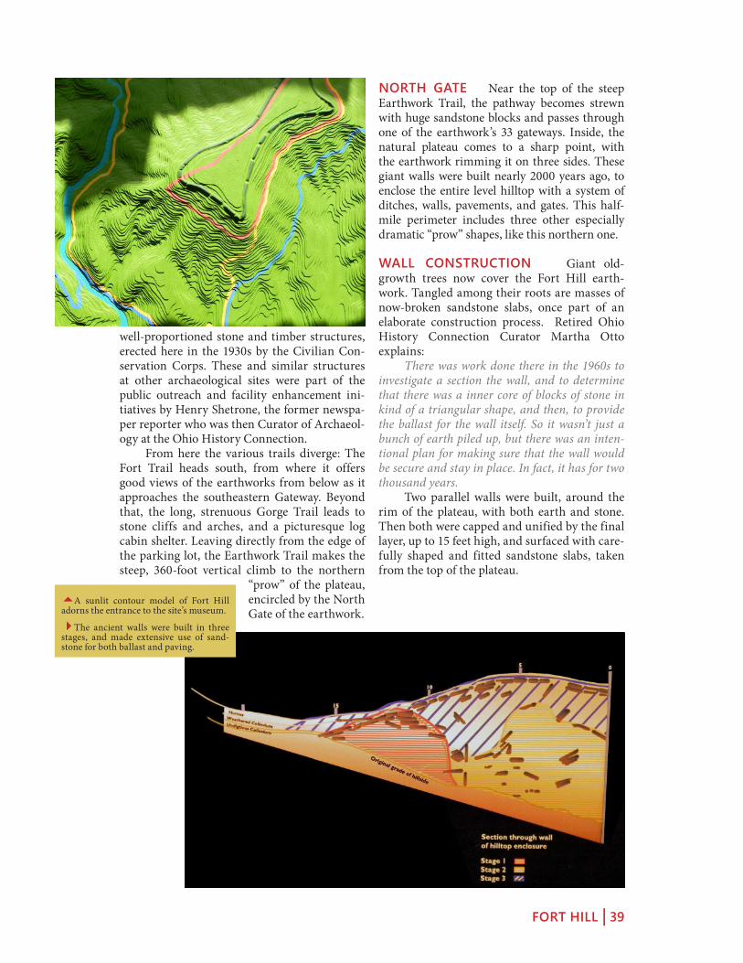
FORT HILL | 39
well-proportioned stone and timber structures, erected here in the 1930s by the Civilian Con-servation Corps. These and similar structures at other archaeological sites were part of the public outreach and facility enhancement ini-tiatives by Henry Shetrone, the former newspa-per reporter who was then Curator of Archaeol-ogy at the Ohio History Connection. From here the various trails diverge: The Fort Trail heads south, from where it offers good views of the earthworks from below as it approaches the southeastern Gateway. Beyond that, the long, strenuous Gorge Trail leads to stone cliffs and arches, and a picturesque log cabin shelter. Leaving directly from the edge of the parking lot, the Earthwork Trail makes the steep, 360-foot vertical climb to the northern
“prow” of the plateau, encircled by the North Gate of the earthwork.
NORTH GATE Near the top of the steep Earthwork Trail, the pathway becomes strewn with huge sandstone blocks and passes through one of the earthwork’s 33 gateways. Inside, the natural plateau comes to a sharp point, with the earthwork rimming it on three sides. These giant walls were built nearly 2000 years ago, to enclose the entire level hilltop with a system of ditches, walls, pavements, and gates. This half-mile perimeter includes three other especially dramatic “prow” shapes, like this northern one.
WALL CONSTRUCTION Giant old-growth trees now cover the Fort Hill earth-work. Tangled among their roots are masses of now-broken sandstone slabs, once part of an elaborate construction process. Retired Ohio History Connection Curator Martha Otto explains: There was work done there in the 1960s to investigate a section the wall, and to determine that there was a inner core of blocks of stone in kind of a triangular shape, and then, to provide the ballast for the wall itself. So it wasn’t just a bunch of earth piled up, but there was an inten-tional plan for making sure that the wall would be secure and stay in place. In fact, it has for two thousand years. Two parallel walls were built, around the rim of the plateau, with both earth and stone. Then both were capped and unified by the final layer, up to 15 feet high, and surfaced with care-fully shaped and fitted sandstone slabs, taken from the top of the plateau.
5A sunlit contour model of Fort Hill adorns the entrance to the site’s museum.
4The ancient walls were built in three stages, and made extensive use of sand-stone for both ballast and paving.

FORT HILL | 40
drops through here to descend and meet the Gorge Trail). The especially monumental south-ern flank of the earthwork overlooks the trails below, and culminates in another projecting “prow” to the southeast, aiming out towards the park’s southern meadow, where ancient ceremo-nies and workshops were located. Like other Hopewell-era hilltop enclosures, there is no evidence of warfare, or defensive requirements. Instead, this artificially-encircled hilltop was about some other purpose.
CIRCULAR EARTHWORK Below the southern prow of the earthwork, the park’s trails diverge. A piece of Ohio’s Buckeye Trail (a system that criss-crosses much of the state) heads south and opens out into a meadow, with a large barn. To the right lies one of the ghostliest treasures in all of Ohio – visible on Google-Earth, and still here, at the edge of the meadow. It is a beautifully preserved, ancient earthen ring. This is probably the best kept of the several hundred that were recorded during the 19th century. It was partially excavated by Ohio History Connection archaeologist Ray Baby in 1953. His exploratory trenches revealed a double ring of posts, 174 feet in diameter – he called it an arbor. A possible reconstruction, as well as details of Baby’s excavation work, is presented in the site’s Museum. With its posts in place, such a cere-monial courtyard would resemble the circular “dancing floors” used in contemporary Indian rituals. A few hundred feet to the southeast from the ring (though not visible today) is where Baby also found evidence of a large rectangular building, 120 feet long with rounded corners. It suggests other known Hopewell-era Ceremo-nial Halls, like those at Liberty and Seip. The prepared, two-thousand-year-old floor was lit-tered with broken pottery, stone tools, and flint chips; pits were filled with the debris from flint-knapping. The museum’s reconstruction model shows a structural framework of buttressed tree-trunks, set in the ground, and covered with sheets of bark or skins.
BAKER FORK GORGE The Gorge Trail branches off the Fort Trail beneath the south-eastern prow of the earthwork, and winds down into the deep, limestone crevice created by Baker Fork. The plant life changes to those favoring these sheer rock cliffs. The trail climbs and descends several promontories, offering views of the river and rock formations from
POND AND EAST GATE A rugged trail follows the eastern flank of the earthwork and approaches near a large pond, often brimming with frogs and distinctive plant life. Beyond, the eastern prow of the earthwork is marked by a cascade of worked, sandstone slabs, one of the best spots to appreciate the extensive role of stone in this architectural design. To appreciate the scope of this achieve-ment, stand at the edge of the natural plateau and look down the slope into the ditch: imagine that surface continuing down the hill. Every-thing standing before you is a massive construc-tion of earth and stone.
SOUTH WALL The Earthwork Trail follows the long western flank of the hilltop, with sev-eral especially prominent gateways, before the sharp turn at the southwestern corner (the trail
5April is the time for wildflowers at Fort Hill; over 800 plant species have been recorded within the 1200 acre nature pre-serve.
6Near the eastern gateway a cascade of ancient, worked paving stones is especially prominent.

FORT HILL | 41
both above and below. Tree-roots cling to cliff-faces high above stone arches and waterfalls. The trail follows the river all the way around the base of the earthwork’s hilltop. At points the steep, human-made rim of the hilltop is vis-ible high above. The trail passes through the shell of a preserved log cabin, before returning to the museum and parking lot from the north-west. Meanwhile, the Deer Trail cuts additional loops farther into the forests, across Baker Fork, and among the nearby ridges and ravines.
HIKING FORT HILL Fort Hill is an amaz-ing experience, and a well-kept secret. The combination of adventurous hiking, glorious scenery, and ancient earthen architecture is unparalleled. Both the architecture and the dis-tinctive ecosystem are exceptionally well pre-served. Arc of Appalachia Director Nancy Stra-nahan explains: The trees are magnificent, large; the ravines are true primeval in quality. I’m careful to throw out the word “sacred site”… but I will tell you this, when I walk up into Fort Hill, I feel a living pres-ence. But I am not alone, there are many, many
people who trek those trails and they come back and they just go, “I don’t know, but wow.” And when you look out over those hills from the look-outs, and you just see curve after curve of hill intersecting in the blue, something happens. When you get up to the top of the Fort itself and you look out of the lookout and you see the immense, immense, incomprehensible work that it took to create these earthen walls, on top of a ridge, you kind of go into a state of disbelief, and you
move into awe and wonder.
THE ARC OF APPALACHIA Between Fort Hill and Bainbridge, you will be among various land holdings that comprise the Arc of Appalachia Preserve region: protected forest lands filled with springs, caves, rare plants, and surprising rock cliff formations. Their head-quarters is at the Highlands Nature Sanctuary and the Appalachian Forest Museum (7660 Cave Road, Bainbridge, 937-365-1935). Since 1995, the Arc has been acquiring and reuniting south-central Ohio forest lands for preservation – with the help of many dedicated supporters, donors, and volunteers. The efforts have steadily grown. Arc Director Stranahan: The miracle is how many people rose to the vision. I would say probably about 1000 house-holds are what have put the sanctuary on the map. And we have about 2000 acres here, and about five years ago the Highlands Nature Sanc-tuary idea spread to thirteen other preserves. We now have fourteen preserves in a five county area in southern Ohio, helping to keep green in Ohio’s future for our children’s children’s children. We either do it now, or it’s not going to happen.
THE FOREST MUSEUM A new museum at the Arc’s headquarters was completed in 2010. Its mission is to tell the story of the eastern broadleaf forests of the US, now torn into tiny shreds by settlement, agriculture, and develop-ment. That huge single forest is an idea people need help to understand, to identify with, and to help preserve. Stranahan explains: This is one forest. The Temperate Broadleaf Forest covers the eastern third of our continent. That biome is the most disturbed of the earth’s fourteen biomes: more in peril than the tropical rainforests, even the Boreal forest, even the prai-ries. So this incredibly disturbed system world-
5Far along on the Gorge Trail, the foot-path passes through the shell of a pre-served log cabin.
6In the park’s southern meadow stands the best preserved of Ohio’s small, ancient earthen rings.

FORT HILL | 42
wide is one we want to bring citizen awareness too. The Appalachian Forest Museum is a place where in fifteen minutes we’re going to get this concept across to people: that they belong to something, that it is special beyond measure, that much has been lost, and it is our job to restore, connect, and reunite.
ROCKY FORK GORGE From its museum and headquarters on the rim of Rocky Fork Gorge, The Arc of Appalachia Preserve System runs educational programs, rents out historic lodgings, and encourages land stewardship and preservation. Its scenic hiking trails are a popu-lar destination: The Rocky Fork Gorge is a 100-foot deep vertical walled limestone gorge, with a very clear river running through it, and it has phenomenal rock formations. It’s the second densest cave system in Ohio. And then there are all kinds of rock formations: big boulders midstream, tipping
boulders that you’re walking underneath, so it’s a labyrinth of rocks that’s really beautiful. But in the summer you’re getting tremendous bird life, animal life. For avid hikers there’s back coun-try trails that also go out to other sections of the Rocky Fork Chasm – we actually have fourteen miles altogether.
THE ANCIENT FOREST These preserved nature sanctuaries sit among spectacular ancient earthworks: not only Serpent Mound and Fort Hill, but also the huge geometrics of the Paint Creek Valley. Stranahan talks about how the ancient earthworks and their build-ers add meaning to this spectacular landscape legacy: We know their presence. We feel the honor and the obligation to take care of the land and maintain the landscape. For these people it wasn’t a postcard, it wasn’t a nature preserve, it wasn’t wilderness, it was their home. It was their community. They were part of that tapestry. Our organization is partly here because of the inspira-tion of the people that came before us. We want to not only maintain the memory of those people, and the history of those people, and the specula-tions of what they might be able to teach us if they were here today, but we also want to maintain their landscape. Here where we live, in the Paint Creek Val-ley, we really feel like we live in the Valley of the Kings. Everywhere we go, we’re walking in their footsteps.
5Giant old-growth trees make for beau-tiful hiking and wildlife habitat all seasons of the year.
6Murals in the Arc of Appalachia’s For-est Museum depict the temperate forest and its ecosystems.

FORT HILL | 43
THE PAINT CREEK VALLEY Bainbridge marks the western end of the beautiful Paint Valley, which in antiquity held an especially close concentration of geometric earthworks, including Seip, Baum, and along its northern fork, the spectacular Hopewell Mound Group. At the valley’s eastern end, a tight passage (at Slate’s Mills) leads into the historic city of Chillicothe. The town of Bainbridge may be best known as the birthplace of modern American dentistry: the story is told in a small, white house, the Den-tal Museum, on Main Street.
SEIP EARTHWORKS Just outside of Bain-bridge to the east lies Seip Earthworks, where the large mound is a faithful reconstruction after extensive excavations. Beneath the mound lay the post mold pattern of a huge, multi-chambered timber building, with a precise, perfectly symmetrical, temple-like floor plan almost identical to another at the nearby Lib-erty Earthworks south of Chillicothe. Elaborate, pearl-drenched burials and beautiful oversized effigy smoking pipes were found. Today visitors pass between two small segments of the surrounding geometric wall, which originally consisted of two large circular segments and a perfect square. From the top of the mound, thanks to new landscape work by the National Park Service, one can well imagine the surrounding earthen walls, and their spa-tial relationships with the long, enclosing valley, which forms a natural amphitheater around the
earthworks. A community of perhaps two hundred people used this site over several generations as a civic and ceremonial center. Over time they erected two great halls, several specialized buildings, and the huge enclosure. The square may have been used to monitor the movements of the sun. And this three-part pattern suggests a relation between the community at Seip and the people at four similar sites in the region. In this case it is not disrespectful to climb the mound and enjoy the view, since it is a com-plete reconstruction and the graves have all been removed. The view opens up to the whole val-ley including the location of Baum Earthworks, Seip’s sister “tripartite” monument, on to the precipitous alum cliff where ancients would have gathered this valuable substance, and the flat hilltop of Spruce Hill Fort.
THE M’SIKAMEKWI The Shawnee peo-ple, like other Eastern Woodland tribes, have a special name for a building or ground used for ceremonies: “M’sikamekwi,” Big House Frame-work. The word suits the great hall built here, 113 feet long, precise and symmetrical in its layout, and nearly identical to another at the Liberty Earthworks, nearby in the Scioto Val-ley. Each of its three sections was apparently used by a different social group within the soci-ety. There were probably many activities and ceremonies that took place in here; we know that ritual burning and burial were among them.
The painT Creek Valley Map
1 Fort Hill
2 The Forest Museum
3 Bainbridge
4 Seip Earthworks
5 Baum (site of)
6 Bourneville
7 Spruce Hill Fort
8 Hopewell Mound Group
1
2 3
4
5
6 7
8

FORT HILL | 44
and about 250 feet long. SEIP AND BAUM A few miles east of Seip Earthworks, along Paint Creek, stood a similar earthwork site, also of “tripartite” design, called Baum. Archaeologist N’omi Greber: One of the remarkable things about Seip, this huge circle, medium sized circle, and big square, is that within practically eyesight there’s another very large earthwork that has a very similar design, and they are in a sense mates; but the land within and around them was used somewhat differently. However, they
look as if they had been designed by the same architect, and possibly made by the same engi-neering crew. It’s remarkable to have two such huge, it’s like having two great cathedrals next to each other, but perhaps one being St. Joseph, and one being St. John.
BAUM EARTHWORKS Baum lies exactly where the valley seems to close up, 4 miles to the east from Seip. The Baum earthworks were across the river from the village of Bournev-ille, and traceable on aerial photos as late as the 1980s. Today they are invisible from ground level, and yet it is still possible to admire the Hopewell genius at marking out monumen-tal geometric figures within the space of these lovely hills, and to wonder at their placement of two such similar complexes literally within sight of each other along the river.
THE TRIPARTITES The Seip Earthworks, and nearby Baum, are two of five so-called “tripartite” designs in the vicinity: together with Liberty, Frankfort, and Works East, they make a remarkable series. Huge, precise circles and squares are used throughout the Hopewell World, but this set shows the ancient architects at their most advanced. Each one has a large circle, a larger circle, and a large square, though in a different arrange-ment. All the smaller circles were eleven acres. All the squares were twenty-seven acres. All the big circles were forty acres. These repeated dimensions tell us that the ancient architects had precise, well-refined techniques of design, measurement, and execution. The different units of enclosure may have been for specific clans, or ceremonies. Align-
THE GREAT TOMB Most people bur-ied on the floor in Seip’s hall were cremated first. Among the few to be laid out unburned were four young adults and two infants, placed together in a large common tomb and sur-rounded by thousands of freshwater pearls. One theory suggests that one among them was a vital leader, whose death required that the others be sent to their deaths, too. This grand burial may have been the last at the M’sikamekwi, for the tomb was marked twice after the build-ing was dismantled and mounding began. On three feet of clay, five oversized pipes (brought from far away) were offered, perhaps as guard-ians. Many feet higher, on the primary stage of mounding, a printed fabric canopy was pegged down over the tomb’s location. More earth was added to create the final memorial, 32 feet high
5View from the top of the large, recon-structed mound at the Seip Earthworks, toward Baum and Spruce Hill.
6Seip Mound, with part of the enclosing circular wall in the foreground.

FORT HILL | 45
binations, suggest new social patterns. Because of their precise correspondences, they may be the latest of all the Hopewell-era geometric enclosures.
SPRUCE HILL FORT Atop the steep, prom-inent hill just east of the Baum site lies Spruce Hill Fort, a stone-walled hilltop enclosure even larger than Fort Ancient, and just recently acquired and placed under the management of the Hopewell Culture National Historical Park. Access is via a steep climb from its east-ern flank, along Black Run Road, which may be arranged by contacting the Arc of Appalachia Preserve for a permit (937-365-1935), or check-ing in at the National Park’s headquarters at Mound City (or its web site) for the times and dates of periodic ranger-escorted tours. The arrowhead-shaped hilltop juts promi-nently out to the north, 360 feet above the Paint Valley. It was named in the nineteenth century for a prominent stand of hemlock trees, along its rim. The 140-acre, level hilltop was ringed, between the years AD 1 and 400, with a low, stone-covered wall. Magnificent views of the valley extend in all directions. In antiquity, this would encompass the string of magnificent geometric earthworks: Bourneville, Baum, Seip, and more – their fresh-ly-cleared geometric outlines punctuating the
length of this beautiful valley to the west and north.
FLAMING SPECTACLES Most intriguing at Spruce Hill is the evidence of intense, super-hot fires, a kind that can only be cre-ated in enclosed chambers. Park Service Ranger Bruce Lombardo explains: We find chunks of soil where they were heated so hot the sand crystals melted and re-crystalized, and made things that look like clin-kers you’d pull out of your coal fur-nace. To get those temperatures, to melt quartz, to melt sand, is about 1100 degrees Celsius, and that’s far beyond what can be achieved in a typical open fire. So, how did it happen? Well, in the 1930s, Emerson Greenman, Ohio Historical Society archaeolo-gist, did an excavation up at Spruce Hill. He mentions finding chunks of
ments and gateway positions were likely related to sun- and moon-rises on the calendar. Archaeologist Warren De Boer speculates that these exactly duplicated shapes correspond to traditions of “winter” and “summer” houses, which in historic Indian times are round and square respectively. And the three-part compo-sition corresponds to the Big Houses. One new feature here is the openings in the walls of the bigger circles: this, and the more complex com-
3Spruce Hill Fort, Squier and Davis Drawing, with detail (below) of its gate-way.
6Four of the five “Tripartite” earthwork designs, including Seip (lower left) and Baum (upper left).

FORT HILL | 46
Hopewell did a lot of intense burning, at many of their sites. But the early fame of Spruce Hill was based on other theories: legends about “Vikings” or other Iron Age Europeans, forging implements here. Bruce Lombardo: When the first settlers came to this area, in the late 1700s and early 1800s, they found this plateau with evidence of intense fires on top, and things that looked like clinker, or slag, that would have come out of a blacksmith’s furnace. And so they naturally started to think: Well, these were iron forges up here. And then, a particular author named Arlington Mallory, in the 1940s, heard about this. He had been looking for evidence of Iron Age European intrusion into North America. And he actually predicted the Viking settlements that were later found along the coast of Nova Scotia and Labrador. But he predicted they came all the way into Ohio. And he wrote a book called “Lost America,” claiming to have found evidence of Viking forges on Spruce Hill. And there’s no evi-dence at all of Iron Age Europeans anywhere in Ohio, let alone Spruce Hill. Park Service Archaeologist Bret Ruby con-tinues the story: Mallory was a really interesting character. He was a metallurgist, a bridge builder, an iron engineer, a Naval officer; he had a wide-ranging career. He came here with the express purpose of trying to demonstrate a connection to the Vikings here in the Ohio Valley. He created quite a stir, and there was a whole spate of newspaper arti-
cles about these claims that he had found Viking iron furnaces, and Viking graves, atop Spruce Hill, and it really caught fire in the local com-munity. And so those legends still are out there today.
BOURNEVILLE, THE MANSIONS Along the valley near Bourneville stand several very grand old mansions, some built of brick and some in the local Waverly sandstone. Their architectural features and proportions derive from 18th century Virginia, reflecting the architectural tastes as well as the agricultural practices of their builders. These wealthy, post-Revolutionary War landowners in the new “Virginia Military District” ran vast estates, often with indentured servants, and sent their abundant crops and livestock to market in the nearby economic hub of Chillicothe.
baked clay that have the impressions of logs on them, and where those log impressions are in the clay, the surface of the clay has been vitrified, has been melted and glazed. The log impressions show a criss-cross-ing pattern, meaning there was some kind of a stacking system: giant pyres made of wood, and rock, and clay. And as the wood burned out, open cavities would form. Well you’re up on top of a drafty ridge, a very good wind, and these open spaces now may have acted as flues, as drafts. And inside those pyres, you may have reached temperatures where you melted sandstone and quartz. Massive bonfires atop this prominent pla-teau would have made for an impressive specta-cle, visible from all the major ceremonial centers in the Paint Valley and its tributaries.
VIKING FORGES? We now know that the
5Baked clay from Spruce Hill imprinted with a criss-crossing log pattern.
6A Virginia-style mansion stands at the edge of the village of Bourneville, once anchoring a huge estate.

FORT HILL | 47
est mounds. The most spectacular burials were found here, and the most astonishing deposits of precious objects.
THE RED SQUARE Some time after the huge yet irregular enclosure was built, the Hopewell laid out a huge, perfect square, to the northeast. As at other sites nearby, the soil of the quare was noticeably red. Dr. Edwin Davis, in 1845: The wall of the square is wholly of clay, and its outlines may be easily traced by the eye, from a distance, by its color… That [the walls] have been subjected to the action of fire, is too obvious to admit of doubt.
THE CEREMONIAL CENTER In the open, level center of the site, the builders planned their largest ceremonial space. First, they scraped away grass and earth to reach a clay layer. They mixed clay and water to cre-ate a very hard floor surface – it’s been called “Hopewell concrete!” No one yet knows what features were built here first, but over several generations, people were performing ceremo-nial rituals here. They dug pits and built fires. They covered certain areas with stones or multi-colored clay. Buildings large and small were erected here, to shelter or enclose the cer-emonies. They brought many precious things to the site, often breaking and burning them before placing them in ritual deposits. Two of these were so large they are called “The Great Depos-
its.” And, people were buried here: 102 in all, just within this single, ceremonial space.
BURIALS, SOCIAL STRUC-TURE The people buried at the Hopewell Site’s ceremonial cen-ter were attended with the fullest ritual and care. The early archae-ologists’ records, and the artifacts, tell us much about the people, and their ways of life and death. Some of the burials were first burned in another location, then the remain-ing ash and bone swept togeth-er and re-deposited here. Most were buried unburned, though, stretched out in log tombs. Inside buildings, some of the tombs were covered with mounds. It’s possible that burying, mound-
HOPEWELL MOUND GROUP About 3½ miles west of downtown Chillicothe, turn northwest on Anderson Station Road where, after 2½ miles, a large open field on the right is the site of the brilliant Hopewell Mound Group. For its astonishing complexity and spectacular artifacts, this became the “type site” of the entire culture, as defined by archae-ologists. Walls and ditches enclose 127 acres. Though subtle today, the wide profile of the large, 3-lobed mound (re-arranged after excava-tions) can be detected in the open field; a new trail leads to the surviving walls and ditches still intact across the hilltop to the north. These still retain water as was likely intended by their mak-ers, an effect similar to Fort Ancient. To the east, near the parking lot, is a perfect square. This was probably the Ancient Ohioans’ most revered sanctuary. The huge enclosure contained many rings and mounds, some prob-ably of earlier Adena origin, and some still being discovered by the National Park staff ’s remote-sensing methods. Although this is the Hopewell “type site” (that’s why a brilliant culture was named after Mordecai Hopewell’s 1890s farm), it is anything but typical: It is the largest of the geometric enclosures. It contains the smallest, and the larg-
hopeWell Mound group Map
1 Parking Area
2 Red Square
3 The Ceremonial Center
4 Western Trailhead
5 Northern Walls and Ditches
12
3
4
5
Hopewell Mound Group: 39 21’38.32”N, 83 05’08.65”W. Open daylight hours; trails from the park-ing area and at the extreme west edge of the site. For information contact Hopewell Culture National Historical Park (740-774-1126).

FORT HILL | 48
ing, burning, and depositing precious objects were all going on at once: a concentrated mix of human effort and vision with the elements of earth and fire. About eighty of the graves under the Great Mound at Hopewell were in three large groups. These may have been kin groups, or clans, each with a respected place in the community. The nonperishable metals, stones, bone, and shells that survive were distributed widely, suggest-ing that there was not just one single, important person here.
Each of the three groups included a few leaders, a larg-er number of people with some importance or special duties, and others without any particular pres-tige. And, with plain graves right next to elaborate ones, it seems that there were not strong class divi-sions. In many societies, only the most powerful would be buried within such an important ceremo-nial center.
DAZZLING ARTISTRY Flat hammered copper shapes were found piled on top of one low mound in the ceremonial center. People may have worn them here
as part of their costumes, or carried them on poles or banners, and then laid them down in tribute: maybe a memorial ceremony for the ones already buried beneath. The variety is extraordinary. There are copper spools for the
ears, and bracelets; also natural forms, like fish, bear claws, bear teeth, a deer antler. And, there are abstract forms that may have many meanings. A man buried in the Great Mound at Hopewell wore a fab-ric robe with a colored design, on which were sewn many shell beads and fresh water pearls – and bear teeth, some pearl-studded and incised. This necklace of bear claws, with a fur piece, resembles the ones still worn by certain tribes’ Bear Clan members. Teeth and claws may symbolize bravery in hunting, or a connection to rebirth or healing (since a hibernating bear re-awakens every Spring). The man’s antler headdress, like others
throughout native history, shows him taking on the spirit of an animal. On his chest, abdomen, and back were copper plates. The Hopewell seem to have liked surfaces that played with light: translucent, pearly, or reflective. The shiny copper plaques (sometimes called chest plates) were perforated, so they could be hung with sinew, or decorated with shell beads. They might have been meant to associate light or power with certain individu-als, or certain parts of the body. For the burial, though, each plaque was apparently wrapped in
5Hopewell Mound Group reconstruc-tion, showing its composite design: part geometric, part hilltop, part irregular, and with many mounds and interior enclosures.
6Abstract shapes were made of ham-mered copper, brought here from north-ern Michigan.

FORT HILL | 49
cloth, as if to contain or protect its power. Then they were carefully laid out: on the chest, on the abdomen, and behind the hips. After many cen-turies, though, it is the plaques that have pro-tected their wrappings: the corroding copper has preserved the fine design of the fabrics.
SPECTACULAR DEPOSITS On the floor of the Great Mound, the people placed two “great deposits” of objects, many of them ritu-ally broken and burned. Even after two thou-sand years underground, their beauty and astonishing variety are still clear today. There are some sharp contrasts, or dualities, here: All the obsidian, for instance, was in the eastern deposit; all the pearls in the western one.
Two deposits, left under a small mound near the bluff, were also deliberately different from each other: all the mica was in one, on a square tablet; while all the copper was in the other, on a round disc. To those who left them, the dual deposits probably seemed like two parts of a whole. These signs of unity were placed among the burials, but not connected with any particular ones. They suggest the variety of cer-emonies that took place in the buildings, later memorialized by mounds. Sometimes, mounds covered extraor-dinary deposits of unworked materials. (At Mound City, for instance, Mound Five was built over a fire basin filled only with thirty pounds of galena – lead sulfide, which they left in its shiny,
crystalline form.) At the Hopewell site, there were mounds dedicated to mica slabs, and to obsidian piec-es. Another mound held over 8,000 flint discs, laid down carefully in two layers, and set in fine gravel. They were in little bundles, each about as many as one person could carry. Why were these materials left like this? Were they reserves, for use in another world? Offerings made to people, or spirits? Or some form of thanks to the earth, for its gifts? Whatever their meaning, these deposits show how much the
people valued the rare materials from which they shaped their most precious objects. Today, you can view the discs in Columbus at the Ohio Historical Center, where many
beautiful objects from this culture are on display.
THE NEW CIRCLE In 2001, a National Park Service team was using their new remote-sensing equipment out near the center of the Hopewell enclosure. One after-noon, a startling image appeared: it was the trace of a long-lost earthen ring and ditch, completely invisible to the naked eye. It was 100 feet across, and perfectly cir-cular, with a gateway pointing east. It is typical of earlier, Adena-
5Details of a Burial Robe from the Cer-emonial Center, studded with copper, pearls, and bear teeth.
6This magnetometry image is typical of how remote sensing instruments can detect ancient earthworks now invisible on the surface.

FORT HILL | 50
era earthen rings, so it may have already been here before the larger, enclosing earthwork was built. Excavations carried out recently have shown that the earthen ring traced the out-line of a huge, dismantled Woodhenge (a ring of timber poles) similar to the one found at the Stubbs Earthworks in Warren County in 1998.
NORTHERN WALLS, DITCHES The huge Hopewell Mound Group was a compos-ite design, and encompassed a portion of the undulating hilltop to the north. A path from the parking lot (or along the western rim) climbs to overlooks and trails, among deep for-ests, where intact earthwork walls and ditches
dip in and out of small ravines, fram-ing glimpses out over the vast enclo-sure, and the Great Central Mound. In antiquity, we would have seen from here the whole, composite design, centered on the magnificent, triple-lobed “Mound 25 ” and its dis-tinctive, D-shaped enclosure. Other mounds, with their rich deposits, were scattered around. The perfect square aligns toward the northeast, toward Mound City, and Hopeton beyond. Today, this spectac-ular, sacred site lies in ruins, stretch-ing our imaginations to their limit.
5Digital reconstruction of the Hopewell flint disc collection, in its original building.

CHILLICOTHE | 51
The delphi of norTh aMeriCa
ChilliCoThe
Historian Roger Kennedy has aptly called Ohio’s first capital the “Delphi of North Amer-ica” no less for its remarkable concentration of Greek Revival architecture than for its status as the heartland of the brilliant Hopewell culture, whose influence was spread across much of the continent seventeen centuries ago (see: Mound City). The downtown historic district includes restored bed-and-breakfasts from which to plan several days’ excursions here in the “Heartland of Ancient America.” The Chillicothe/Ross County Convention and Visitors Bureau has offices downtown at 45 Main Street (800-413-4118 http://www.vis-itchillicotheohio.com) and can provide further information on where to stay and eat, and what else to do in the area.
HISTORIC DOWNTOWN Arriving in Chillicothe by US Route 50 (from Bainbridge), brings you directly into downtown on Main Street. Its intersection with Paint Street marks the center of 16+ blocks of remarkable historic architecture, much dating from the time when Chillicothe newspaper editor Ephraim Squier and local physician Edwin Davis collaborated on their Ancient Monuments of the Mississippi Valley, the first publication of the new Smithso-nian Institution, in 1848. The name “Chillicothe” means “principal town” in Shawnee, and old Ohio maps show several Shawnee-era “chillicothes.” But it was this one that, long before, was a major center of Ohio’s earthwork building culture, and that in 1803 became Ohio’s first state capital. Prosper-
ity came early to this village on the banks of the Scioto, a gateway to the large “Virginia Military District” between here and the Little Miami River to the west. Early culture and commerce were influenced by wealthy Virginia land-owners, whose huge estates produced cattle, pigs, and corn in abundance. Today, historic districts pre-serve some of America’s best nine-teenth-century commercial urban fabric, especially along Paint, Sec-ond, and Water Streets. Superb specimens of historic house styles, churches, and public buildings line the nearby streets. Especially impressive are the many Greek Revival examples, dating from the grand days of the canal era: the 1830s through 50s.
1
2
34
5
ChilliCoThe Map
1 Historic Downtown
2 Water Street
3 Ross County Museum
4 Belleview Avenue
5 Story Mound

CHILLICOTHE | 52
EARLY COMMERCIAL BUILDINGS In 1831, the new Ohio and Erie Canal came to Chillicothe, creating decades of prosperity as a commercial hub for the great agricultural lands to the west. Local historian Kevin Coleman explains the result: It’s very much a quintessential American town. I like to call it the Williamsburg of the West, because Williamsburg in Virginia has been restored to its colonial condition; so it represents America at the time of the American Revolution. But Chillicothe here, beyond the Appalachian Mountains in the New West, represents America very much in the 19th century. We have a lot of antebellum, pre-Civil War commercial buildings that survived. It’s probably because of a disas-trous fire in 1852: the town rebuilt quickly after-wards but it slowed down the economy, so those buildings weren’t replaced later on. So in a lot of towns where you have high Victorian buildings, we have pre-Civil War buildings still standing. Quaint old storefronts line Water Street, once the canal route. James Emmitt’s giant, canal-side warehouse (from the 1850s) still stands on Mulberry Street. Paint Street pres-ents a whole “museum” of both early and late 19th century commercial architecture, plus the unusual, exuberant 1850s courthouse.
ROSS COUNTY HERITAGE CENTER At Fifth and Paint Streets in Chillicothe, a col-lection of historic structures house the Ross County Heritage Center, a combination of the county Historical Society Museum and the McKell Library. Both are valuable destinations for learning more about the ancient earthwork-building cultures and the local history of the Chillicothe area.
THE STORY MOUND About halfway between downtown Chillicothe and the Adena Estate stands the Story Mound, preserved by the Ohio History Connection near the cor-ner of Allen and Delano Avenues. It closely resembles in size and shape the now-lost Adena Mound: originally 25 feet high and 95 feet in diameter. From the same period, it probably matches its more famous former neighbor in function as well: Excavations at the Adena Mound in 1897 (described further below) uncovered the burial of a young man, plus a set of postmolds forming a ring, the first evi-dence of the round funerary structures, that lie under Adena mounds. This building (or fence) was about fifteen feet across, and was ritually
55The Victorian Ross County Court-house features a tall portico and tower, and separate entrances to the various departments.
5A collection of historical structures house the Ross County Heritage Center, presenting both early settler and ancient topics.
6The most exquisitely detailed Greek Revival examples are near Fifth and Paint Streets and along West Second Street.

CHILLICOTHE | 53
dismantled or burned after its use, and buried under the mound.
BELLEVIEW AVENUE From the corner of Fifth and Walnut, Belleview Avenue angles up the hill to the southwest. Once a piece of Zane’s Trace, on its way from Wheeling (now in West Virginia) to Maysville, Kentucky (then called “Limestone”), it passes mansions like the idyl-lic, 1826 “Tanglewood” with its exquisite Greek Revival portico. Belleview leads to the entrance of Grandview Cemetery, where Renick, Worthington, and other prominent founders are buried; and from which there are fine views of the town, the nearby Great Seal Range, and the huge, Teays-age valley of the Scioto River.
THE TEAYS VALLEY The wide river val-leys south of Chillicothe, and also around Cin-cinnati, are part of an ancient, pre-glacial river system. These huge rivers flowed northward out of West Virginia and Kentucky, before turning west and entering the Mississippi basin. The biggest traces are here at Chilli-cothe, and south of here at Piketon. Historian Kevin Coleman explains: The Teays River was the mother of all rivers in this area. It was actually the head waters of the Mississippi, but it bent around though Illinois and Indiana and Ohio, and its head waters were in western North Carolina. The New River Gorge is the head waters of the Teays, but because of three or four glacier advances, the whole area in Ohio, and a little farther south, has been completely re-plumbed. So where the Teays created what is now the Scioto Valley, and it flowed northward, now we have the Scioto, which is a smaller river flow-ing southward. These ancient rivers left behind superb, wide, flat, well-drained terraces, standing safely above the newer, smaller rivers. They became perfect building sites for the giant geometric earthworks, two millennia ago.
TECUMSEH The story of the Shawnee leader Tecumseh is retold in an outdoor drama every sum-mer near Chillicothe. “Tecum-seh” in Shawnee means “shooting star” – suggesting the spectacular but brief career of this legendary Indian leader. Born in 1768 near present-day Piqua, Ohio, he gained a reputation for bravery and lead-ership in battles against the U.S.
55This plate from Squier and Davis shows the dense concentration of ancient geometric earthworks in the vicinity.
5The Story Mound is preserved in a resi-dential district, and closely resembles the now lost Adena Mound.
4Grandview Cemetery affords views of Chillicothe and the Great Seal Range, a prominent geographic focus since antiquity.
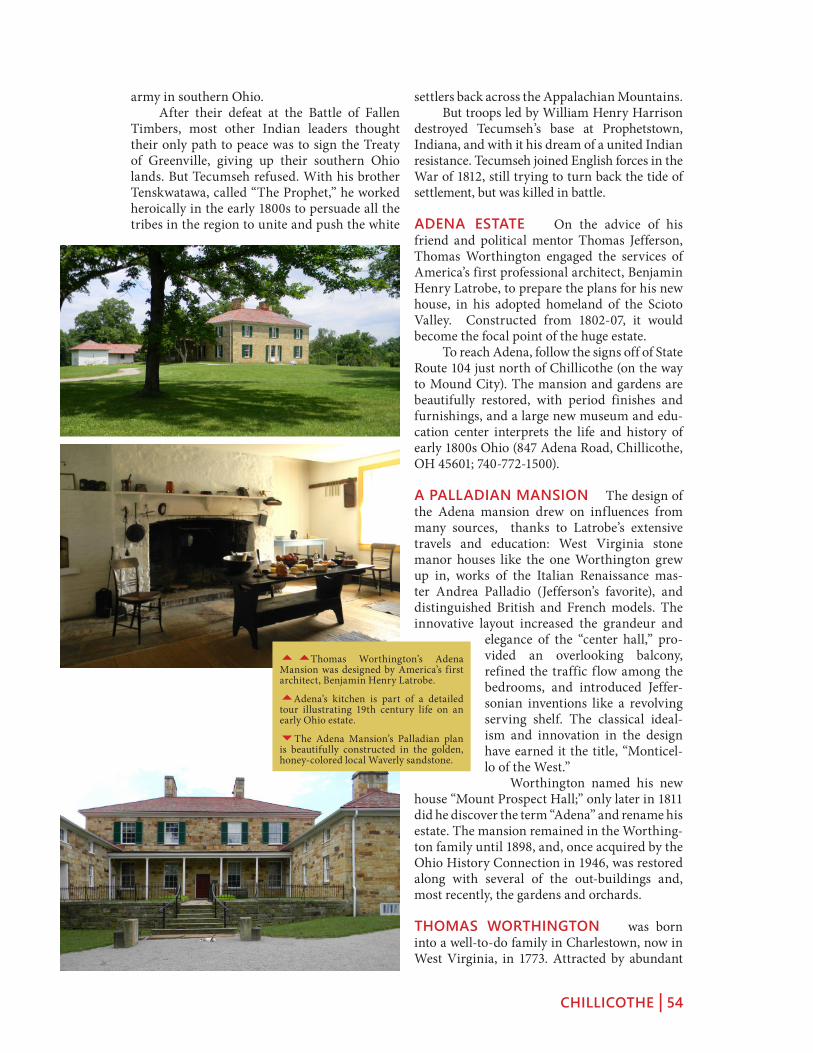
CHILLICOTHE | 54
settlers back across the Appalachian Mountains. But troops led by William Henry Harrison destroyed Tecumseh’s base at Prophetstown, Indiana, and with it his dream of a united Indian resistance. Tecumseh joined English forces in the War of 1812, still trying to turn back the tide of settlement, but was killed in battle.
ADENA ESTATE On the advice of his friend and political mentor Thomas Jefferson, Thomas Worthington engaged the services of America’s first professional architect, Benjamin Henry Latrobe, to prepare the plans for his new house, in his adopted homeland of the Scioto Valley. Constructed from 1802-07, it would become the focal point of the huge estate. To reach Adena, follow the signs off of State Route 104 just north of Chillicothe (on the way to Mound City). The mansion and gardens are beautifully restored, with period finishes and furnishings, and a large new museum and edu-cation center interprets the life and history of early 1800s Ohio (847 Adena Road, Chillicothe, OH 45601; 740-772-1500).
A PALLADIAN MANSION The design of the Adena mansion drew on influences from many sources, thanks to Latrobe’s extensive travels and education: West Virginia stone manor houses like the one Worthington grew up in, works of the Italian Renaissance mas-ter Andrea Palladio (Jefferson’s favorite), and distinguished British and French models. The innovative layout increased the grandeur and
elegance of the “center hall,” pro-vided an overlooking balcony, refined the traffic flow among the bedrooms, and introduced Jeffer-sonian inventions like a revolving serving shelf. The classical ideal-ism and innovation in the design have earned it the title, “Monticel-lo of the West.” Worthington named his new
house “Mount Prospect Hall;” only later in 1811 did he discover the term “Adena” and rename his estate. The mansion remained in the Worthing-ton family until 1898, and, once acquired by the Ohio History Connection in 1946, was restored along with several of the out-buildings and, most recently, the gardens and orchards.
THOMAS WORTHINGTON was born into a well-to-do family in Charlestown, now in West Virginia, in 1773. Attracted by abundant
army in southern Ohio. After their defeat at the Battle of Fallen Timbers, most other Indian leaders thought their only path to peace was to sign the Treaty of Greenville, giving up their southern Ohio lands. But Tecumseh refused. With his brother Tenskwatawa, called “The Prophet,” he worked heroically in the early 1800s to persuade all the tribes in the region to unite and push the white
55Thomas Worthington’s Adena Mansion was designed by America’s first architect, Benjamin Henry Latrobe.
5Adena’s kitchen is part of a detailed tour illustrating 19th century life on an early Ohio estate.
6The Adena Mansion’s Palladian plan is beautifully constructed in the golden, honey-colored local Waverly sandstone.

CHILLICOTHE | 55
farmland and new social and political opportu-nities in “the West,” he moved to the Scioto Val-ley in 1798, with his new wife, and their friends and relatives. He soon became a leading citizen in the new village of Chillicothe, and one of the early advocates for Ohio statehood, both locally and in Washington. He was a key author of the Ohio Constitution, one of the new state’s first senators, and its sixth governor. Later he was elected to the state legislature, where he strong-ly advocated building the canal system. The lands of his beloved “Adena” grew to twenty-five-thousand acres, and produced cattle, pigs, and fine Merino sheep, as well as a diversified mix of crops. His idealism for what the new lands in “the West” could become is reflected in his ambitious choice to model his estate on the most distinguished European classical models, and to hire America’s leading architect to draw the plans.
COFFEE CUPS AND CAKES In the Drawing Room at Adena, just after it was completed, Worthington held a meeting with Tecumseh and other Indian leaders. It was an effort to secure peace and respect between the races, and much was at stake. Historian Roger Kennedy tells the story: All the ironies of the relationship between the founders and the Indians came together in this room in 1807. Equals were dealing with equals, and in fact, so conscious of their equal-ness that the Indians made jokes about the coffee being distributed to them, pretending that they were savages, which they were not. They in fact spent a whole week around here, living with the Worthingtons, and celebrating their common presence in the midst of a deep antiquity – to which the Worthingtons were visitors, and the Indians were not. For his interests in Ohio antiquity, and enlightened race relations, Worthington was unusual among his former Virginia compatri-ots. Roger Kennedy continues: He was a truly remarkable man. Not only did he set his slaves free as he came across the Ohio River, but he lived all his life in a respectful relationship with the Native Americans who were living here, and who had built those great earth-works. He had a strong sense from the outset that he was a newcomer in a very ancient land. He was not only interested in politics, he was inter-ested in antiquity and architecture as well. Worthington’s friend Albert Gallatin, whose glass-factory in Pennsylvania supplied
55Worthington’s writing desk is dis-played in his office, restored in one of the wings of the house.
5In the drawing room at Adena, the Worthingtons entertained a variety of guests, including Tecumseh and Blue Jacket.
4The Shawnee hero Tecumseh, like Thomas Worthington, initially hoped for peaceful co-existence between the races.

CHILLICOTHE | 56
“Smithsonian” was Ancient monuments of the Mississippi Valley, by two men from right here in Chillicothe, Ephraim Squier and Dr. Edwin H. Davis, and its pages and plates were filled pre-dominantly with Ohio’s spectacular antiquities.
THE DELPHI OF NORTH AMERICA The State of Ohio’s Great Seal was famously designed here at Adena, where a view from the grounds opens onto a wide panorama of the Scioto Valley. That range of hills is now the “Great Seal State Park.” Roger Kennedy talks about the significance of this landscape: One fine morning after a night spent playing cards, Thomas Worthington and a young painter were looking around for the place to immortalize for the Great Seal of Ohio. And when they came to this place they said essentially, “it’s a take.” The sun rises over Karnak, and Stonehenge, and Delphi; and this is the Delphi of America, a place surrounded by an immense array of ancient architecture, telling us that people have been doing their best to make great work around here for at least a couple of thousand years. The “Delphi” comparison suggests that, like the Greek site of that name, this was a place the whole civilization understood as the center of their sacred world, and a natural goal of pil-grimage.
THE ADENA MOUND When Worthing-ton established his estate here, a 27-foot mound, inside an earth ring, stood at the foot of the hill. Finds from this mound are the rea-son archaeologists applied the name “Adena” to the culture which thrived in this region from about 1000 BC to AD 100. The excava-tions destroyed the mound; its location now lies beneath the streets and houses near the small Lake Ellensmere. Excavations by William Mills revealed spectacular pottery pipe with the main burial: an eight-inch figure of a man wears a loincloth and feather bustle; his knees are bent as if he’s dancing. Retired Ohio History Connection Curator Martha Otto: This pipe is unique in that we’ve never found another one like it, carved in this form of a human – a full figured man standing with his hands at his sides, and so forth. And over the years that particular pipe, which we call the Adena Pipe, named after the site, has become kind of emblematic of the Historical Society, and of the Adena culture. The mound itself was typical of Adena
the windows for Adena, also had high respect for Native America: Like Worthington, Gallatin was an aboli-tionist and devoted to a respectful relationship to the Native Americans of their own time, and of the memory of the achievements to Native Americans of American antiquity. Gallatin spent the next forty years after this house was created founding and providing to the Bureau of Ethnol-ogy, which became the Smithsonian Institution. The first publication of Gallatin’s new
5American historian and former National Park Service Director Roger Kennedy, at the Adena Estate.
6The Hopeton Earthworks would have been visible from the Adena grounds (Squier and Davis’s map published in 1848).

CHILLICOTHE | 57
architecture: the free-standing conical mounds, sometimes with surrounding rings and ditches, that are found throughout Ohio. Martha Otto continues: You do get situations like in Athens County, around the Plains, where there was quite a group-ing of conical mounds; the same around Charles-ton, West Virginia. But I think by and large, if a mound is located that it is separate from any other, usually we classify it as Adena. The most spectacular of the Adena mounds are at Miamisburg, Ohio, and Moundsville, West Virginia, plus the beautiful Conus Mound
at Marietta with its well preserved surrounding ring.
55The Great Seal of the State of Ohio features the sun rising over the hills above Chillicothe, as seen from the Adena Estate.
5William Mills excavated the Adena Mound in 1901, and the spectacular finds came to define the “Adena” culture.
3The Adena Pipe has become one of the most iconic objects in the collections of the Ohio History Connection in Colum-bus.

MOUND CITY | 58
hopeWell CulTure naTional hisToriCal park
Mound CiTy
Excursions among the monumental antiquities of south central Ohio should begin at Mound City, and the Visitors Center at Hopewell Cul-ture National Historical Park, with its fine arti-fact collection and orientation programs. To reach Mound City, take Chillicothe’s Main Street two blocks west of Paint Street, then go north on State Route 104 for 3 miles. After passing between two large prisons, enter the Park headquarters on the right. The interactive media program at Mound City provides intro-ductions to the other sites in the region, includ-ing those not open to the public.
Outside, walk among the 23 mounds and their low enclosing wall; each covers the remains of a funerary building. Some held spec-tacular collections such as effigy smoking pipes or shimmering blankets of mica. This place is unique among surviving Hopewell era sites, and may reflect a period of time when mound building was beginning to be augmented by big-ger, grander ideas about geometric form and embracing enclosure. Here the people created a collective cultural monument on a much larger scale, a possible prototype for the more precise and complex geometric figures to come.
SITE HISTORY Mound City was first granted to a white owner in 1798; and in less than forty years the busy Ohio and Erie Canal passed nearby. When Squi-er and Davis surveyed the site in 1846, the forest still preserved most of the mounds. But soon the land was cleared for farming. Plows passed right over the walls, and most of the mounds, year after year. In 1917, the land was bought by the Federal Government for Camp Sherman, a World War I training camp. The army was shaving off all the mounds to build barracks when Henry Shetrone of the Ohio Historical Society stepped in and asked that the central mound be spared. In 1923, the site became a National Monument, and three years later the Ohio History Con-nection restored the mounds. Since 1992, Mound City has been the center of the Hopewell Culture National Historical Park.
12
3
4
5
6
7
Mound CiTy Map
1 Visitor’s Center
2 An Ancient Necropolis
3 Paired Mounds
4 Pipes Mound
5 Central Mound
6 Buildings
7 Scioto Riverbank
GPS Coordinates at Mound City Group are: 3922’26.62”N 8300’26.14”W. The Visitors’ Center (16062 State Route 104, tel. (740) 774-1126) is open extended hours from Memorial Day to Labor Day: 8:30 a.m. to 6:00 p.m. seven days a week.

MOUND CITY | 59
AN ANCIENT NECROPOLIS To its builders, this elaborate necropolis must have been a place of reverent memory, like Britain’s Westminster Abbey, or the memo-rials along the Mall in Washing-ton, D.C. All these mounds cover the floors and post holes of cer-emonial buildings. The patterns show a variety of designs, though most often a rectangle with round-ed corners. Inside, fires burned in shallow clay basins. The ceremonies includ-ed the cremation of the dead, and objects were ritually killed (broken or burned) to be left with them. The ash and remains were swept up, and placed carefully on the building floor, or on low earthen platforms. In a final ceremony, each building was taken down or burned, and a
mound was built over its remains and contents. While Mound City was in use, visitors would have seen functioning buildings here, and also those already memorialized under mounds.
BUILDINGS Discoveries under the walls suggest that people lived and held rituals here well before most of these mounds were built. During the first century A. D., a few ceremo-nial houses were put up; their fire-basins and doorways had a variety of orientations. Some of these were probably mounded over by the time the second phase began, at the start of the second century. Three central buildings were erected, creating a new ritual focus. At least seven other buildings were built, pointing towards this focus. And the low wall was added to enclose things, strengthening the formality of the site, and its sense of common purpose. It resembles the shape of an individual build-ing; and its two gates define an axis. This cen-tralization and enclosure of the whole site may reflect an increasing organization and social ranking among the people. By the early third century, mounding was complete.
THE CENTRAL MOUND The tallest of the mounds was 19 feet high when first measured in the 1840s. The building beneath was com-plex: A sunken room was entered along a ramp. Some time later, the builders, leaving behind only a shallow basin, its clay lining baked red by many fires. and a set of wall posts. They filled this room, and built a new clay fire basin
5The first Euro-American pioneers named the site “Mound City.” Squier and Davis investigated in detail in the 1840s.
6Typical building post pattern from beneath a Mound City mound; the shape resembles that of the earthwork wall.
66This diagram of Mound City shows the axial orientations of the sub-mound buildings.

MOUND CITY | 60
exactly above the old one. Upon a new floor, of puddled clay and sand, they erected a building, and laid out ten cremated burials on log-supported earthen platforms, roofed with bark. Three elaborate burials in the Central Mound were probably respected leaders or elders. The objects left with them probably meant many things, including a person’s special work in life, their status, and their connections to the community and to powerful forces in nature. The amanita mushroom, for example, is known for its poi-sonous and hallucinogenic quali-ties, and is represented here as a copper effigy – this may suggest how a priest could make a dream journey to commune with the spir-its of the dead.
PIPES MOUND Under anoth-er mound, a large bag had been placed next to a clay basin, filled with ashes, beads, some copper items, and about 200 carved effi-gy smoking pipes, all purposely broken. The pipe bowls portray a variety of animals, carved with accuracy and great artistry. Several showed human heads. Another deposit of almost identical pipes was found at the Tremper Mound, forty miles south of Mound City along the Scioto River. The animals shown on the Mound City pipes are tradition-al figures in Eastern Woodland stories, creatures with their own will and power, such as the turtle. Lenape storyteller Annette Ket-chum: The story I want to tell you is about why the turtle is so important to the Lenape people. And that’s because, a long time ago, they lived by the ocean, by the big water. And one day, the water started to rise. And it was a large, large flood, it came higher and higher, pretty soon the people were just up to their neck, they just believed they were going to drown for sure. And they didn’t
55The huge Camp Sherman covered Mound City and much of the surrounding land in the early 20th century.
5Reconstruction of the bark covered tombs and open shelters assembled on the prepared floor of the Central Mound.
6This copper effigy of an amanita mushroom suggests a priest’s hallucino-genic journey to the spirit world.

MOUND CITY | 61
gallery. There were several pits and clay basins inside, suggesting it may have been the place of preparation for the more formal rituals and deposits next door. The larger building held elaborate burials. On one low platform, four people were laid to rest in what William Mills called “a splendor of mica,” along with many precious objects. Four other platform burials were similarly marked by precious objects, now in the Visitors Center: double-headed vulture plates, an unusual cop-per animal headdress with movable ears, cop-per deer antlers, and a mica human torso – per-haps the paraphernalia of ritual performances, mythic re-enactments. This “double building” may have been a model for other, larger versions at the Seip and Liberty earthworks.
ACTIVITIES AND AGRICULTURE In its day, Mound City was much more than just a silent “necropolis” or “city of the dead.” There was a lot going on here, including vari-ous building projects right up until the final, enclosing wall was built. And maybe a lot of parties and festivals: the lowest layers of soil deposited in the wall contain large amounts of charcoal and deer bone. National Park archae-ologist Bret Ruby: It was a much more active place; it was used for a whole variety of functions including feast-ing. Another point this shows about Mound City is that the embankment wall was probably one of the last things constructed. What you see out there today is its final form, essentially after its abandonment. So it’s important to think of this as a place that grew over time – maybe as much as four centuries, which is an incredibly long time span, many generations. Hopewell society benefited from the fertil-ity of the region’s ecosystems, but also practiced a well-developed agriculture. Archaeologist Ruby explains: Hopewell people were farmers, they were participating in the transition between a hunt-ing and gathering lifestyle into a farming lifestyle, including the domestication of starchy, oily plants. They were clearing ground, planting and harvest-ing crops – fully committed agriculturists. There would have been significant openings in the forest, caused by clearing ground for agriculture. They’re moving, clearing plots, using them for a period of years, and then clearing other plots. So it’s a shift-ing movement across the landscape. New plots are being opened, old plots abandoned and reclaimed by nature.
know what to do. And they cried to the Creator. And about that time, a large turtle came up out of the ocean; he says, ‘Get on my back, and I will save you.’ So all the people got on the turtle’s back. And they swam around until the water went down, and then came back up to the shore and let them off. And they said, “Oh, thank you, Turtle. From now on, we will call ourselves Turtle people. And we will be known as the Turtle clan. And to this day, we are still known as the Turtle Clan. And I’m Turtle Clan, so I especially like that story.
PAIRED MOUNDS Near the western gate-way stood two mounds, unusually close togeth-er. Two buildings once stood here: an older one, and a newer, smaller one, connected by a
5Among the most beautiful objects from Mound City is a collection of animal effigy smoking pipes; all had been ritually bro-ken.
6Turtles are portrayed on these small copper rattles, found with a burial in the Central Mound.

MOUND CITY | 62
made look to the nineteenth century mapper to be circles, because that’s what they were expect-ing. That’s significant because especially Mound City seems to appear out of nowhere, when in fact that’s not true: there seem to be a lot of other earthworks with these shapes, these squares with rounded corners.
THE EASTERN HORIZON Mound City stands amidst dramatic topography, especially the sharply-defined Appalachian Profile to the east, stretching from Sugarloaf to Mount Logan. Investigators Ray Hively and Robert Horn have discovered that this range encodes astronomical knowledge, related to the loca-tion of Mound City itself: The two peaks mark the minimum extreme rise-points of the moon, as it swings across the eastern horizon during its complex, 18.6-year cycle. Aligned with the base of these same mountains, symmetrically, are the extreme rise-points of the sun, on the annual summer and winter solstices. It is from the Central Mound, the site’s larg-est, that these alignments are the most precise. In antiquity, the view was likely treeless, due to all the agriculture going on, so sightings would have been much easier than they are today. Related alignments occurred at the nearby Shriver Circle: from its central mound, the max-imum lunar rise-points were visible through gaps in the earthen ring. This suggests that Mound City and Shriver were ritually paired with the complex rhythms of the moon: The square enclosure for the lunar minimum festi-val, the round one for the lunar maximum, nine years later.
THE BORROW PITS Huge pits flank the surrounding wall at Mound City: Squier and Davis reported them to be as deep at eighteen feet, in the mid-1800s. An easy assumption has been that they were just excavated for soil to build the mounds. But there’s now a more likely, and far more interesting, explanation. Archaeologist Bret Ruby: Excavations by Mark Lynott recently in one of the borrow pits found that there’s actually a clay lining at the base of the pit that would have helped it hold water. The basic geology out here is there’s maybe a meter of soil, and then its sand and gravel, glacial sands and gravels, all the way down. It’s only just the surface that’s actual soil that could have been used to build those mounds. And below it is this very permeable sand and gravel. So it seems that that clay lining was inten-
SQUARES WITH ROUNDED CORNERS Mound City’s overall shape is a square with rounded corners, resembling the house remains under its mounds. Until recently it seemed unique among earthworks. But archaeolo-gist Jarrod Burks has discovered several now-invisible earthworks that were drawn as circles by nineteenth century explorers, but have been proven by modern remote sensing to be squares with rounded corners: Perhaps on these old maps, say Squier and Davis, or the other publications that show a cir-cle, it seems that a significant number of these circles aren’t circles. They’re actually squares with rounded corners, that time and erosion had
5Among several spectacular burials under the Paired Mounds was a group covered in what William Mills called “a spendor of mica.”
6A section of Dr. Jarrod Burks’ new data from the Junction Group near Chillicothe, with its “squircle” (square with rounded corners) shaped earthwork.

MOUND CITY | 63
THE SHRIVER CIRCLE Squier and Davis’s map of Mound City also shows a huge circle, just to the south. Its remnants lie in the fields along Route 104. Now much degraded, its ghostly remnants are still visible in old aer-ial photos. When the highway was widened recently, archaeologists investigated: The exte-rior ditch was originally twelve feet deep, and carefully lined with a foot-thick layer of clay – to hold the slopes, and water. Associated buri-als in the central mound suggest this monu-mental work was here before Mound City itself. It’s probable that Shriver (a circle) and Mound City (a square) became prototypes for a new hybrid design of these same-sized elements at the Hopeton Earthworks just across the river, and in turn led to all the geometrical experi-mentation and perfection found in the Paint Valley and at Newark and elsewhere throughout the Hopewell era. Shriver Circle is almost completely plowed flat today, and invisible on the ground. Yet former Park Superintendent Jennifer Peder-son-Weinberger describes one day when it “appeared”: I was actually driving past the site in August of one year when it was really dry, and it had just rained the day before, and you could actually make out the circle from the precipitation going onto the dry soil. And that’s the only time I could actually ever see it, in person.
HIGH BANK EARTHWORK Hopeton and High Bank are two major geometric earth-works that remain (though degraded) in the immediate Chillicothe area, now under the protection of Hopewell Culture National His-torical Park (contact the park for possible visit-ing arrangements). The linked circle and octagon at High Bank look remarkably similar to another pair at Newark, Ohio. Archaeologists are still investi-gating, but it seems the shapes are similarly con-nected to astronomical events. The cross-axis of the octagon points to the northernmost rising of the moon. And one of the octagon walls points to the summer solstice sunrise. Between them, these two alignments determine the orientation, and the shape, of the octagon. More mysteri-ous are the walls and circles that trail off to the southwest. While Newark and High Bank are about sixty miles apart, they were designed using similar principles. Their circles share the same diameter, and each harmonizes with its octa-
tional in order to keep it from draining. The positions of these water features seem also to have been designed: Beneath the large central mound, Mound Seven, the biggest mound at Mound City, there’s a burial feature on the floor of that structure, that was basically a clay, flat, platform, maybe six or eight inches tall, and probably six or eight feet square, and the shape of that clay platform mimics the shape of the enclosure itself – a square with rounded corners. On this clay platform sur-rounding this human burial was a set of seven or eight large marine shells, welks, and the pattern that they were arranged in very much mimics the pattern of the borrow pits outside the enclosure wall. And so it’s as if that burial platform is a model of the earthwork itself. And so by anal-ogy, maybe we can think about those borrow pits being vessels, rather than simply sources of earth. Surviving water features at Fort Ancient show us how the builders might have wanted to “reflect” their architecture, or maybe visualize the “watery underworld” of Native tradition.
5The Hopeton Earthworks are part of Hopewell Culture National Historic Park, recently opened to the public.

MOUND CITY | 64
and Liberty four miles to the south. Some vast scheme of landscape visualization, and connec-tion, was at work.
HOPETON EARTHWORKS Directly across the Scioto River from Mound City are the Hopeton earthworks: a large, slightly-irreg-ular square, with a circle slightly overlapping it. Two smaller circles mark gateways to the square in different ways, and long parallel walls lead to the bank of an old channel of the river. The ancient walls once stood twelve feet high, but farmers have plowed, and even bulldozed them, so only faint traces remain. Yet on old aerial photographs, or with new magnetic sen-sors, the ancient lines still leap to life. Archaeologist Mark Lynott explains his discoveries inside the wall at Hopeton, during the summer of 2002: We’re near the center of the wall here, and this shows very clearly a section of how the wall is constructed. At the base we have a yellow sub-soil where the topsoil had been stripped off. And then the Hopewell came in and put this black section of sterile clay in here. It has a little bit of burned material but no artifacts. And then above it they’ve added this red, somewhat loamier, clay; and this is highly magnetic, and that’s what’s worked so well with our magnetometers. Mark Lynott continues: This is, in its own way, by the organiza-tion of the Hopewell people, as spectacular as the Mayan Pyramids, as the Egyptian Pyramids, because these folks are not agricultural societies; they’re not organized that way. They’re much more of an egalitarian group of people; they’re much more mobile, and yet they still managed to build some spectacular earthen monuments here. And what’s incredible is that doesn’t fit with the traditional anthropological models of social orga-nization and accomplishments. After the 1930s, mechanized agriculture rapidly accelerated the destruction of many of the giant geometric earthworks like Hopeton. We can trace this process by comparing aerial photographs: In 1938, the walls still showed up clearly, even the long parallels going down toward the river. By 1985 though, the walls have been flattened to low, wide shapes that are bare-ly visible at all from either the air or eye-level.
gon: at High Bank, points at the center of all eight sides of the octagon can be joined to form a circle of equal diameter. Ray Hively and Robert Horn have shown that High Bank, like Newark, encodes all eight lunar standstills, plus the four solstices, while the axes of the two designs are exactly 90 degrees apart. The builders could not simply replicate Newark’s design, due to the dif-ference in latitude, so here they had to figure out another equally complex and subtle instrument. The only alignment of the long axis here at High Bank is with its neighboring geometric enclosures: Works East four miles to the north,
5Squier and Davis’s drawing of Mound City and the huge Shriver Circle in 1848, also showing the canal and the future State Route 104.
6High Bank Earthworks centers on an axial line that also connects two other giant earthworks over a distance of several miles.

MOUND CITY | 65
5Dr. Mark Lynott discovered the well-preserved construction profile of the earthen wall at Hopeton.
3An aerial photo from 1938 shows the clear outlines of Hopeton’s circle and square, similar in size to Shriver Circle and Mound City, respectively.

THE LOWER SCIOTO VALLEY | 66
froM ChilliCoThe To porTsMouTh
The loWer sCioTo Valley
Follow the beautiful Scioto Valley south out of Chillicothe to Waverly, with its historic district and Emmitt House Restaurant, and to a string of mounds, geometric remains, and historic houses along Wakefield Mound Road south of Piketon. On the opposite side of the Scioto River, a few miles before Portsmouth, the irregular Tremper Mound lies on private land beneath the western bluff. The city of Portsmouth, with remains of a huge complex of earthworks, stands at the most dramatic river confluence in the region. Going south out of Chillicothe, either take Route 23/104 through the hills, or follow Three Locks Road along the Scioto River as it flows south between the huge, steep bluffs of its Teays-Age (pre-glacial) valley. This route along the base of the western river bluffs is also following the old canal bed, visible in aerial photos as lines of trees, and occasionally on the ground as an extra-large ditch, most of the way to the Ohio River.
MOUND CEMETERY Take US 23 south out of Piketon and turn left onto State Route 32, then immediately left again into a dead end spur that reaches Mound Cemetery in Wakefield, where a large, Adena-era con-joined mound stands in the center, topped by a flag and surrounded by graves both old and new. Early white settlers typically recognized the ancient mounds as sacred sites of burial, and one way of attempting respect, and ensur-ing preservation, was to plan new cemeteries around them. The large mound is linked to smaller segments by a large, unusual, undulat-ing “apron” form. One million years ago, the giant river val-leys around this spot belonged to the pre-glacial Teays River. North America’s largest river sys-tem used to flow northward here, before being gradually dammed up by the glaciers and then
loWer sCioTo Valley Map
1 Three Locks Road
2 Waverly
3 Piketon Cemetery
4 Barnes House
5 Tremper Mound
6 Portsmouth
7 Old Fort Earthworks
1
2
3
4
5
6
7
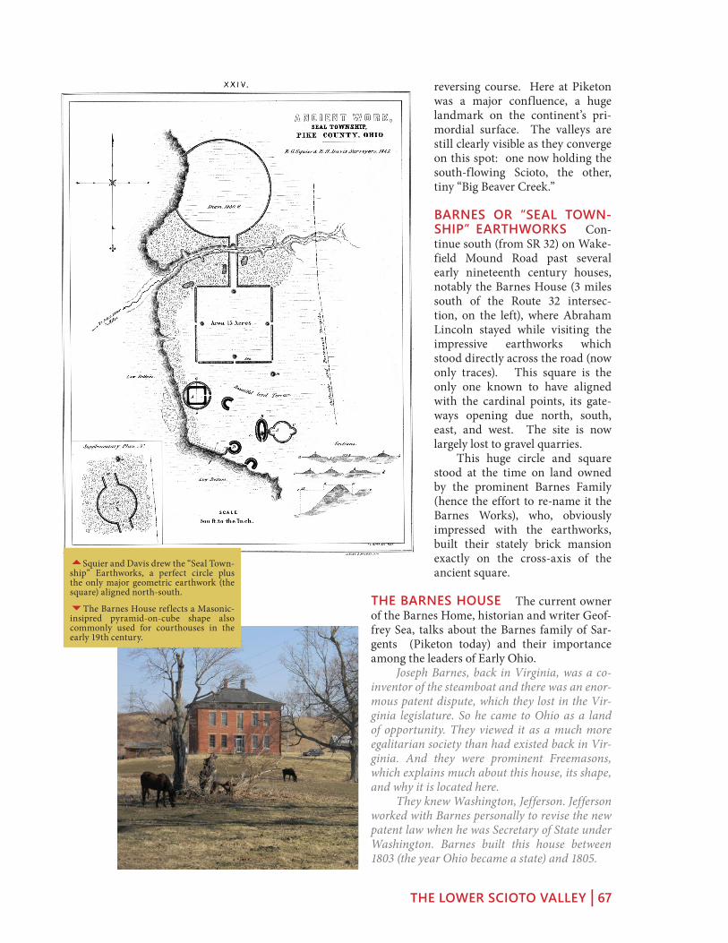
THE LOWER SCIOTO VALLEY | 67
reversing course. Here at Piketon was a major confluence, a huge landmark on the continent’s pri-mordial surface. The valleys are still clearly visible as they converge on this spot: one now holding the south-flowing Scioto, the other, tiny “Big Beaver Creek.”
BARNES OR “SEAL TOWN-SHIP” EARTHWORKS Con-tinue south (from SR 32) on Wake-field Mound Road past several early nineteenth century houses, notably the Barnes House (3 miles south of the Route 32 intersec-tion, on the left), where Abraham Lincoln stayed while visiting the impressive earthworks which stood directly across the road (now only traces). This square is the only one known to have aligned with the cardinal points, its gate-ways opening due north, south, east, and west. The site is now largely lost to gravel quarries. This huge circle and square stood at the time on land owned by the prominent Barnes Family (hence the effort to re-name it the Barnes Works), who, obviously impressed with the earthworks, built their stately brick mansion exactly on the cross-axis of the ancient square.
THE BARNES HOUSE The current owner of the Barnes Home, historian and writer Geof-frey Sea, talks about the Barnes family of Sar-gents (Piketon today) and their importance among the leaders of Early Ohio. Joseph Barnes, back in Virginia, was a co-inventor of the steamboat and there was an enor-mous patent dispute, which they lost in the Vir-ginia legislature. So he came to Ohio as a land of opportunity. They viewed it as a much more egalitarian society than had existed back in Vir-ginia. And they were prominent Freemasons, which explains much about this house, its shape, and why it is located here. They knew Washington, Jefferson. Jefferson worked with Barnes personally to revise the new patent law when he was Secretary of State under Washington. Barnes built this house between 1803 (the year Ohio became a state) and 1805.
5Squier and Davis drew the “Seal Town-ship” Earthworks, a perfect circle plus the only major geometric earthwork (the square) aligned north-south.
6The Barnes House reflects a Masonic-insipred pyramid-on-cube shape also commonly used for courthouses in the early 19th century.

THE LOWER SCIOTO VALLEY | 68
ed. He brought the bird to this house and Blanche Barnes, the woman of the household at the time, was also a taxidermist. The bird was stuffed, and was then displayed in the Barnes Home for many years, and eventually donated to the Ohio History Con-nection in Columbus. Passenger pigeons were very important to the ecology of Ancient North America, and were numerous beyond imagi-nation. Flocks were counted up to two billion birds in a single flock flying together. There’s no other bird that congregates in those kind of num-bers. It’s almost unimaginable – the pre-eminent natural phenomenon of this region. They would blot out the sun; it was like experiencing an eclipse. It would have been one of
those great markers of the seasons when the birds returned and left. Sea even has a theory that there were con-nections among these sky-darkening throngs of pigeons, traditional Native American beliefs, and the building of the geometric earthworks: I believe that the big geometric earthworks were essentially built as a guide path for the pigeons. I have found a reference by Francis Park-man quoting one of the Jesuit missionaries in the early seventeenth century, saying that the Hurons and affiliated tribes including the Ojibway, and also the Shawnee, believe that when we die we resurrect as passenger pigeons. They anticipated that they would have to travel to a place in the sky, and in order to get there would need guide paths. So they built these giant earthworks as symbols to guide them on that path.
THE TREMPER MOUND Continue south from Sargents, cross the river above Lucasville and follow SR 104 toward Portsmouth. Just past the intersection with SR 73, the Trem-per Mound will appear in a slightly-rising field on the right (private land). Excavations beneath its irregular shape uncovered remains of a complex Hopewell-era mortuary build-ing. Twelve basins were probably used for cre-mation. Remains from about 300 people were accumulated here. Tremper is best known for its buried col-lection of 60 effigy smoking pipes, their bowls elegantly carved into the figures of Woodland
ABRAHAM LINCOLN’S VISIT When he bought this house, Sea had heard of a visit there by Abraham Lincoln, but had to discover on his own the reason the then-congressman would have gone out of his way to come here: In 1848, when he was ending his last term in congress, when he returned from Illinois to Washington, instead of taking the train, he took a steamboat up the Ohio River from St. Louis. It became very clear that the reason was that Squier and Davis had just published “Ancient Monuments of the Mississippi Valley,” which he read, and became fascinated with the different sites that they described. And if you look at his route, he would have had the opportunity to visit many of the sites described by Squier and Davis, including the Portsmouth works, and the works that were in front of this house. It was a little earthworks tour!
THE PIGEONS OF PIKETON Geoffrey Sea recounts another historical event at this house: the famous “Sargents Pigeon”, and what it was like to see the huge, sky-darkening clouds of these birds in pre-modern times, as they gath-ered and migrated along these huge Teays-age river valleys. The very last passenger pigeon seen in the wild was seen by a young boy half a mile south of this house. He didn’t know it was a passenger pigeon, they’d become very rare by the 1890s. He went and got a shotgun and shot the bird. It turns out that was the last passenger pigeon ever sight-
5Stuffed passenger pigeons still on dis-play in their original case in the Barnes Home.

THE LOWER SCIOTO VALLEY | 69
animals, birds, and humans. Many of these pipes exactly match the collection found at Mound City, 40 miles upstream along the Scioto. In the form of the pipes we can recognize the faces and paws, the bills and wings of crea-tures common in Ohio Valley woods and mead-ows. Their stone bodies were beautifully formed and meticulously incised. But they were all ritu-ally broken before being buried, to release or to cut their spiritual power.
PORTSMOUTH The city of Ports-mouth occupies a spectacular setting, an understandable site for the elaborate earth-works now best depicted on the floodwall murals along its riverfront. This was also the site of a large Indian settlement at the time of European contact, called Lower Shawnee Town. Evidence from here suggests the continuous Native habitation and cultural practices from antiquity up until contact in the seventeenth and eighteenth centuries. In Portsmouth, also visit the Southern Ohio Museum, (825 Gallia Street, 740-354-5629, www.somacc.com), with extensive ancient and historic collections plus changing exhibits and performing arts. The ancient artifacts are pre-sented in a voluminous yet compact display on a mezzanine level. In the adjacent downtown and Boneyfiddle historic districts are many shops and cafés, and along the riverfront don’t miss the exceptional series of murals depicting the history of the town, starting with a beautiful sunrise over the earthworks at the far left. The earthwork complex here once stretched for miles, across terraces on both sides of the Ohio River. Now only fragments remain. To reach the best preserved sections, in Horseshoe Mounds Park, go north out of downtown about one mile on US 23, then right on Kinney’s Lane
5Tremper Mound (largely reconstruct-ed) lies in the middle of a field, visible from SR 104. (photo by Scenic Scioto Heritage)
6The Tremper pipes are one of the great-est treasures left by these ancient people.
66The Southern Ohio Museum pres-ents its antiquities in huge sets of similar object types, revealing subtle variations.

THE LOWER SCIOTO VALLEY | 70
region, where the Ohio is joined by the Scioto from the north, flowing down through the Hopewell heart-land. At this major crossroads, settlement seems to have been con-tinuous: Early European traders found a thriving Shawnee Indian town here.
THE “OLD FORT” EARTH-WORKS Across the river in South Portsmouth, Kentucky, the
Old Fort Earthworks have recently been pre-served with help from the Archaeological Con-servancy. On private land (permission is avail-able, inquire locally), they lie about 1½ miles west of the Route 23 Ohio River bridge, down a narrow lane on the right. The beautiful square enclosure is well preserved among a handful of small houses, its ancient orientation perfectly diagonal to the cardinal points. Archaeologist Gwynn Henderson: One thing I found interesting is that the square is oriented north-south, so that one of the points is totally north. The folks who built this earthwork were going to put it there, irrespec-tive of what kind of topography was on that spot. They filled in ditches, and they cut away certain topographic features, to ensure that the square
for ¾ mile, then south on Hutchins Avenue for 2 blocks. Here in this park, a single, large, horse-shoe-shaped earthwork opens to the south and hints at one of the region’s most elaborate com-plexes. The 1848 drawing shows how, from these two encircled horseshoe-shapes, earthen lines extended in every direction, and even across the Ohio River. About ten miles of wide, walled roadways connected several remarkable fea-tures. The Complex extended over onto the Ken-tucky side, where the Biggs Mound survives today, ringed by its moat. Another mound, sur-rounded by multiple walls, was mapped, but never found by modern archaeologists. This is the most dramatic river confluence in the
3The Squier and Davis map shows how the horseshoes (upper center) relate to the miles of earthworks in the overall com-plex.
6This depiction of Ancient Portsmouth at sunrise begins the riverfront’s historical mural series.

THE LOWER SCIOTO VALLEY | 71
was oriented the way they wanted it to orient. Processions to the square for ceremonies probably followed the wide passageways. Even centuries after the earthwork building culture faded, the square’s interior remained clean, with no debris from either settlements or workshops. I think we might infer that the reason why there are not materials from subsequent peo-ples living right there is that they appreciated, understood, respected, feared, what had gone on. Or maybe there had been stories passed down through the generations, across the centuries, such that they knew sort of generally, what it had been used for, what its purpose was, the kinds of things that went on there, and so, out of respect for the folks who had been long ago, they didn’t live there in a domestic situation. Today the square is still impressive, pre-served by caring landowners and the privately funded Archaeological Conservancy.
5Well preserved walls of the Old Fort Earthworks, on the edge of South Ports-mouth, Kentucky.
6Shops, cafés, a brewery, and historic storefronts line the Boneyfiddle district, near Portsmouth’s riverfront.

TARLTON CROSS | 72
and The “greaT hopeWell road”TarlTon Cross
The diagonal route between Chillicothe and Newark approxi-mates the possible “Great Hopewell Road,” an ancient route suggested by recorded remains near its north-ern end. About midway is the Tarl-ton Cross Mound, in the village of the same name, a unique plus-sign-shaped mound crowning a small wooded ridge at the end of a scenic trail. Nearby Circleville was planned with concentric streets inside a huge ancient earthen ring (originally with an adjoin-ing square). The road northward through Lancaster skirts the scenic Appalachian Plateau; at Buckeye Lake (lined with limestone slabs from a huge stone mound) are the remains of an early 20th century amusement park and resort village.
OHIO AND ERIE CANAL Leave Chillicothe going north on State Route 104. About 12 miles above Mound City, turn right in the village of Westfall onto Canal Road, which parallels beautiful remnants of the old canal and tow-path. This route, and Canal Park outside Circleville, showcase some of the best remains of early Ohio’s ambitious canal system. This is a piece of the Ohio and Erie Canal, one of two systems created in the 1830’s to carry goods between the Great Lakes and the Ohio River. The canals were a huge under-taking, built largely by poor Irish laborers. The cost nearly bank-
TarlTon Cross Map
1 Granville
2 Newark
3 Buckeye Lake
4 Millersport
5 Lancaster
6 Stonewall Cemetery
7 Tarlton Cross
8 Circleville
9 Logan Elm
10 Westfall (Canal)
1 2
3
4
5
6
7
8
9
10

TARLTON CROSS | 73
rupted the state, but as the backers had hoped, they could carry prod-ucts from Ohio’s farms, mills, and mines to eastern markets much more easily than wagons, and at one-fifth the cost. Because both the canals and the ancient earthworks were built near Ohio’s rivers, they can often be found near each other. The Ohio and Erie, for example, is evident near Newark, and in Chillicothe. The canals gradually lost out to the railroads, and closed for good in 1913. In aptly-named towns like “Lockington” and “Lockbourne,” we can still see remnants of the canals: great stone hulks of elabo-rate locks, gates, and channels. But here, between Circleville and the
village of Westfall, is a rare section with both waterway and tow-path intact.
SQUARING CIRCLEVILLE Turn east onto US 22 and cross the river into downtown Cir-cleville, where the road becomes Main Street, the axis line that bisected the ancient earth-works here, a giant circle (from which the town took its name) and an attached square. Circlev-ille was the home of Caleb Atwater, postmaster and eccentric surveyor of Ohio antiquities in the 1820s. Circleville was laid out in 1810, carefully designed within its 22 acre, double-walled, ancient earthen ring. In building their cen-tral octagonal courthouse, the townspeople destroyed the original central burial mound and semi-circular pavement; but the founders had preservation ideals, like their predecessors in Marietta, and envisioned a novel blend of ancient and modern. Within 20 years, though, complaints arose. The yard around the courthouse attracted swine. The circular plan of the streets was inef-ficient, especially in view of added business coming to town via the Ohio and Erie Canal. By 1837, the complainers had won: the state-chartered “Circleville Squaring Compa-ny” began the job of destroying the unique town plan, though it took 15 years because of protests. Today only the central axis survives, as Main Street.
HISTORIC CIRCLEVILLE Circleville feels like the center of Ohio every October, when
5The remnants of massive stone canal locks are often found along the former routes, often buried in the woods as here near Baltimore, Ohio.
6Among those most horrified by the “squaring” of Circleville was the local postmaster, Caleb Atwater, author of the first scholarly survey of Ohio valley antiq-uity.
66Squier and Davis showed the dou-ble ring and adjoining square at Circlev-ille, with its axis that later became Main Street.

TARLTON CROSS | 74
throngs of visitors arrive for the annual Pump-kin Festival. Two county historical museums, both in historic houses, help tell the region’s history. The Clarke-May House (162 West Union Street, open April to October, Tuesdays to Fridays from 1:00 to 4:00 p.m.) is stuffed with materials from every historical period. Go upstairs to see the model of the Circleville Earthworks executed by a local dentist using dental plaster. Nearby in the Moore House (304 South Court Street), the Genealogical Library also has historical displays; ask to see the original colored drawings of the circular Circleville made by confectioner George Wit-tich. Though Circleville’s original octagonal courthouse is gone, today’s local citizens (the “Roundtown Conservancy”) have preserved an excellent example of a private octagonal house, the Gregg-Cites House of 1856, which they moved in 2004 from a Walmart building site to a safe location on Cites Road, off South Court Street.
THE PICKAWAY PLAINS AND LOGAN ELM An excursion south of Circleville along US 23 leads to a group of distinctive rolling hills of great fertility, which once formed a natural open prairie several miles across. In the 1600s, people from the Shawnee and other tribes, driven westward by settlement, began to establish villages and farms here. Despite early decrees that no settlers could live west of the Appalachians, new colonists kept arriving and clashing with the Indians. It was at a peace conference here that the Shawnee agreed to give up their lands east and south of the Ohio River – the first concession of land by Indians
5Circleville has an excellent collection of elaborately ornamented nineteenth cen-tury commercial buildings and impressive period houses.
6George Wittich’s historic drawing still adorns the metal candy boxes sold at Wit-tich’s Candy Shop (117 West High Street) downtown.
66The distinctive rolling prairie lands of the Pickaway Plains remain one of Ohio’s richest agricultural regions.
3Mingo Chief Logan refused to attend the Pickaway Plains peace council, but his famous speech was read here.

TARLTON CROSS | 75
attacked his village, killing his mother and sis-ter. Then Logan led the Mingo on raids of revenge against the whites, prompting Lord Dunmore of Virginia to bring an army westward against the Indians. After a battle at Point Pleas-ant (in today’s West Virginia), the other Indian leaders finally sued for peace, in 1775. That peace council was held here, on the vast and fertile “Pickaway Plains.” Logan refused to attend, but sent a speech to be read, expressing his feelings of betrayal and despair. His eloquent words were spoken under a great elm tree here: I appeal to any white man to say that he ever entered Logan’s cabin, but I gave him meat; that he ever came naked, but I clothed him... He will not turn his heel to save his life. Who is there to mourn for Logan? No one. The great elm survived until the 1960s, when it was replaced.
TARLTON CROSS Leave downtown Cir-cleville by SR 56, heading southeast, and in 9 miles go left on SR 159 for 4 miles into the village of Tarlton. Turn left immediately onto Reading Road for about ¾ mile to a shaded parking area on the left. In this Fairfield County Park, the Tarlton Cross Mound is reached by a picturesque CCC-era concrete suspension bridge and pathway. The mound is shaped like a 90-foot plus-sign. A depression in its center may be original to the design, or an early modern intrusion. Archaeo-logical explorations have not yielded any arti-facts, or any definitive evidence of the date and cultural origins of the figure. The site is a nar-row, slightly sloping ridge, and the Cross seems to have been shaped in a most unusual way: by the subtraction as well as the addition of soil. Archaeologist Brad Lepper explains: It’s not simply a built up cross. The shape of the cross is partly determined by excavating the ground, the down slope part, and then taking that earth and piling it up to make the upslope part of the cross. So down slope when you do a soil pro-file, there is nothing; the mound isn’t constructed at all. The outer part of it was excavated away to define the cross. The upper part was built up. Just to the southwest of the cross stand four earthen mounds, now obscured among the trees. These mounds have recently been discovered to form a perfect square, 260 feet on its diagonals – one quarter of the hypothetical “Hopewell Unit of Measure.”
actually living in the Ohio country. A small, tranquil park (five miles south of Circleville and one mile east of US 23 on SR 361) honors Chief Logan, and his world-famous speech on Indian / White relations. Logan was born a Cayuga in Pennsylvania, where he grew up with many white friends. In 1770, he mar-ried a Shawnee woman and moved to the Ohio Country, to live among the Mingo – a group originally from Iroquois roots, like himself. He urged peace with settlers until some of them
5The words of “Logan’s Lament” are inscribed on a monument in this park near the newly-replanted “Logan Elm” tree.
6Tarlton Cross Mound is reached via a 1930s era concrete suspension bridge over a rushing creek.

TARLTON CROSS | 76
LANCASTER Continue north on Read-ing Road (which changes its name in the next county) for about two miles, then go right to meet northbound SR 156 towards Lancaster. SR 156 joins US 22 before heading into the historic town and the seat of Fairfield County. About halfway between the US 33 bypass and downtown, watch for Stonewall Cemetery Road on the right. A mile south stands one of Ohio’s most remarkable octagonal structures: an early 1800s private cemetery, where a hand-ful of graves are surrounded by an exquisitely crafted, eight-sided, sandstone wall. The huge blocks are perfectly fitted. In the center grows a Lebanese Cedar tree (inquire locally for access). The city of Lancaster has a pleasant down-town district with many shops, several impor-tant museums and historic houses, and very impressive public buildings. The city was one of the Zane’s Trace settlements and like Somer-set was laid out in the distinctive Pennsylvania manner: the town square is formed by leaving open the corners of four adjacent city blocks. Downtown Lancaster has an unusually rich collection of fine museums, all within easy walking distance of each other and the square: the Georgian Museum (a spectacular, period-furnished mansion at 105 East Wheeling Street, 740-654-9923), the Decorative Arts Center of Central Ohio (an impressive arts museum in the historic Reese-Peters House, 145 East Main Street, 740-681-1423), the Sherman House Museum (home of the Sherman Family and their famous Civil War General son, William
Tecumseh, 137 East Main Street, 740-687-5891), and the Ohio Glass Museum (with a glass-blowing stu-dio, at 124 West Main Street, 740-687-0101). The surrounding country roads in Fairfield County lead to many golf courses, historical and scenic parks, and covered bridges. Take SR 37 north out of Lancast-er towards Granville. This route skirts the edge of the Appalachian Plateau, and also approximates the route of the possible “Great Hopewell Road,” an arrow-straight, sixty-mile ancient thoroughfare which may have connected Newark and Chillicothe, the Hopewell era’s two greatest ceremonial centers (see Newark). Tantalizing evidence
55Squier and Davis illustrated the Cross Mound in 1848, showing some of the out-lying mounds later discovered to be in a perfect square.
5Stonewall Cemetery just outside Lan-caster is one of Ohio’s most unusual, and beautifully crafted, octagonal structures.
6The Decorative Arts Center, one of sev-eral grand mansions recalling Lancaster’s early wealth, is also a fine museum.

TARLTON CROSS | 77
discovered on old aerial photographs and draw-ings by Dr. Bradley Lepper of the Ohio History Connection, has yet to be proven by on-the-ground surveys.
BUCKEYE LAKE About 10 miles above Lancaster (just after Bickel Church Road) turn right on Deep Cut Road, angling northeast along the former canal bed toward Millersport. Just when the road climbs a small hill, one of early Ohio’s most impressive engineering feats comes into view: the Deep Cut, a 2-mile-long, straight, 60-foot-deep channel created to bring the canal out of its source at nearby Buckeye Lake. After Millersport, follow the small roads through the oddly picturesque old resort villag-es along the northern embankment of the lake. The long history of Buckeye Lake dates back to the construction of this reservoir in the early 1800s as a feeder for the state’s new canal system. The lake was lined partially with huge limestone slabs from a nearby mound. By 1900, the canals had been long abandoned, but there were lively amusement parks along the shore. There is now a state park, where a historical museum tells the stories, and boat tours of the Cranberry Bogs are available (inquire locally). Return to SR 37 to head north into Gran-ville, or continue via SR 79 into Heath and New-ark.
6The new, the old, and the odd charac-terize the settlements along the construct-ed northern embankment of Buckeye Lake, the headwaters of southern Ohio’s canals.

NEWARK AND ITS EARTHWORKS | 78
The largesT geoMeTriC earThWork CoMplex in The World
neWark and iTs earThWorks
and Great Circle – helping visitors grasp the lit-erally unbelievable scope, beauty, and precision of this unique architecture. Awestruck settlers discovered, described, and began to measure these earthworks in the early 1800s. The impact of these monuments on the visitor today is still stunning, creating an architectural experience like no other on earth. Begin your tour of Newark at the well-preserved Courthouse Square. The history of the town and its industrial heritage is well told at the nearby Works Museum, where there are also shops and artists’ studios (55 S. First St., 740 349-9277). From downtown Newark, take Main Street
west, then turn south on Route 79 for 1½ miles to the Great Circle Earthworks on the right. The small museum and visitors center, a short walk from the parking lot, will pro-vide an orientation to the whole complex and its history: a bronze tabletop model stands out front; an interactive exhibit program, inter-pretive materials from the Ohio History Connection, and the staff of the Licking County Convention and Visitors Bureau are available inside.
THE GREAT CIRCLE The Museum’s entrance directly faces the monumental gateway of the Great Circle enclosure. This may be the best preserved of the geo-metric earthworks not just in Newark, but anywhere in Ohio. It’s a gigantic circular enclosure, 1200 feet from crest to crest. Four foot-ball fields would fit across it end to end. The walls vary in height from
Seventeen centuries ago, Newark, Ohio, was a major center for the remarkable ancient culture. Here, American Indians built the larg-est geometric earthwork complex in the world. Enormous enclosures connected by walled road-ways were spread across more than four square miles. This was the most spectacular of many such earthworks, concentrated along the tribu-taries of the Ohio River, marking the people’s beliefs, rituals, and sense of community. Today only fragments remain, although here at New-ark we can still walk among these vast shapes, and feel how they direct our eyes and footsteps. Two of the most impressive features from ancient Newark remain today – the Octagon
neWark greaT CirCle Map
1 Museum
2 Gateway
3 Ditch
4 Eagle Mound
5 Processional Way
Newark Great Circle GPS: 40.04161111 N 82.42908333 W. Visitors Center open weekdays all year 8:30 to 5:00 pm; Memorial Day to Labor Day 10 – 4 Saturdays, 12 – 4 Sundays; Memorial Day Monday, July 4, & Labor Day Weekend are all 12 – 4 pm. 455 Hebron Road (State Route 79), Heath, OH 43056; 800-589-8224.
12
3
4
5

NEWARK AND ITS EARTHWORKS | 79
four feet up to fourteen at this monumental gateway. The design is typical of many earlier, Adena earthworks: a ring, with an interior ditch and a gate-way opening to the east. But here, people coming from other parts of the complex would enter the most dramatic portal anywhere in their
cultural world: a sign preparing them for the ceremonies at the circle’s heart. Follow the inner ditch and notice the subtle gradations in the height and steepness of the wall.
BUILDING THE GREAT CIRCLE An excavation through the Great Circle wall has shown how the construction was done. First a set of point mounds were placed around in a circle. Then a ditch was dug, and that soil was used to make a ring. Finally, yellow gravelly clay was brought up from deep pits nearby to cover the inside. Building techniques probably had both spiritual and practical meaning: The yellow clay smoothed and supported the inner wall, but the color also made for a more dramatic ritual space. The ditch provided earth for the wall, but it also may have filled with water in wet seasons, pre-senting a second, magical circle. Building the Newark complex 2000 years ago, they had to move more than 7 million cubic feet of earth. It would have taken many gen-erations, or an enormous number of workers. Archaeologist Brad Lepper: They were built with pointed digging sticks and perhaps hoes or picks made with a deer shoulder blade, and hafted onto a stick – simple tools. The Hopewell people used these to dig pits in the ground and then fill the earth… in baskets and carry those baskets one at a time to mound them, one after another.
THE WATER-FILLED DITCH New evi-dence suggests that the Great Circle’s ditch was designed to hold water; ancient ditches and ponds at some other earthworks still do. Brad
5The Great Circle Gateway, seen from the Museum; Eagle Mound is in the center distance (photo by Tim Black).
6Shops and cafés (and a rare Louis Sul-livan bank building of 1914) surround the Licking County Courthouse, in down-town Newark.
66The Great Circle’s inner ditch was originally constructed to hold water, forming a continuous reflecting pool or “spirit barrier.”

NEWARK AND ITS EARTHWORKS | 80
Lepper suggests what this may have meant: I think it was intended to evoke in some way, or presence in some way, that watery under-world of Native American traditions: the Beneath World. And whether it’s in the form of a spirit barrier, or whether it’s just simply to have that presence of water surrounding the ceremonies, that’s probably as close as we can come to under-standing the purpose now. The ancient clay and limestone lining of the ditch probably held water for centuries, but in the long run would have required mainte-nance. This explains why we don’t see water in it today: Over the centuries, as roots penetrate that, the seal is penetrated. And the Newark Earth-works are built on hundreds of feet of glacial sand and gravel. So you could be pouring water into that all day, and unless it was sealed that water
would just vanish.
EAGLE MOUND At the cen-ter of the circle is an elegantly undulating earthen memorial built over the remains of a long, timber-framed building with two “wings.” This mound was nick-named “Eagle Mound” by the first pioneers. When it was excavated in 1928, a pattern of postmolds showed a long building, with screen-walls extending from it like two wings. Inside, a rectangular clay basin held fires, a sign of ritual activity. Scraps of shiny mica littered one end of the floor. When they were finished using the building, the people filled the fire basin with
white sand and left little behind except a pair of copper shapes. They dismantled the wood-en structure or burned it and covered its floor with earth. As often in this culture, such ritual mounding created a final, sacred memorial to the structure’s meaning.
THE “OLD FORT” From its first discov-ery by Europeans, and its initial naming as the “Old Fort,” the Great Circle has been preserved, and renamed, through uses both recreational and military. Historian Jeff Gill explains: We also have the early pioneer history inter-acting with the structure, calling it the “Old Fort.” (But around 1820) Caleb Atwater comes along and he starts to notice: Wait a minute, the moat’s
5The Eagle Mound Building had a cen-tral hearth, and two symmetrical wings, perhaps to hide the ceremonies from pub-lic view.
6The best-preserved examples of Hopewell-era water architecture are the ponds inside the walls of Fort Ancient, in Warren County.
66Low earthen walls like this one originally encircled the entire complex, and seem to channel movement from one figure to the next.

NEWARK AND ITS EARTHWORKS | 81
from Ohio in the Union Army: President Hayes was a guest. Future Presi-dent General James Garfield was there. William Tecumseh Sherman was there. And a speaker’s platform was erected across from the big grand-stand where the people would watch the race. Partway through the program it began to col-lapse, and the paper says that President Hayes, and General Sherman, and Garfield, only saved themselves by throwing themselves forward out of their chairs, while the chairs fell backward into the collapsing ruins. So Newark almost became famous for losing a president.
PROCESSIONAL WAYS Outside the Great Circle gateway and to the north and east are well-preserved remains of the low embank-ment walls that once encircled the entire New-ark complex with a continuous outline. There seem to be only three entry points, all of them suggesting ceremonial approaches from water. Once inside, the people were channeled from one specialized enclosure to another. Archae-ologist Brad Lepper: I think you could almost view the elements, the different functionally specialized yet inte-grated elements of this site as components of a gigantic ritual machine. And movement through that site, would have been a way of power flow-
on the inside of the wall, maybe it’s not a fort. But the name changes largely because, shortly after that, it becomes the County Fairground – and it becomes known as the Fairgrounds Circle. Later, local area soldiers gathered and trained here on their way to fight in the Civil War: And the “76” fights all the way down to Atlanta, and to Savannah, and then up for the grand review in Washington at the end of the war, and back home. And of the 900 men who left, less than half make it back home.
PUBLIC SPECTACLES Spectacles and Encampments continued in the later nine-teenth century, and into the twentieth, includ-ing Buffalo Bill’s Wild West Show (complete with Indians). Jeff Gill: Can you imagine, thousands of Licking Countians sitting on those walls, and Buffalo Bill himself and his whole crew coming in and out of that gateway? Buffalo Bill said it was the most amazing place he ever did the show – as compared to your standard fairgrounds or arena. What a sight! Brad Lepper tells the story of another grand spectacle at the “Fairgrounds Circle” that almost ended in disaster! It was the 1874 Grand Reunion of the soldiers and sailors that served
3The Newark Earthworks covered an area of four square miles; its most monu-mental features are still intact (drawing by Squier and Davis).

NEWARK AND ITS EARTHWORKS | 82
Aztec dances in costume. We went to the Great Circle. And the Aztec dancers led us into that circle and preformed a dance in the middle of it. We think there were roughly 500 of us there when it began to rain. And perhaps a hundred of us stayed through the rain; we got absolutely drenched. But it stopped raining, and the sun came out, and the danc-ing went on, and we dried off, and it was wonderful. And when it was done the dancers told me: “It was a rain dance.”
NEWARK’S WATERWAYS If we follow the logic of these low walls enclosing the entire complex, we’re left with only three “entranc-
es” where people could have entered without climbing over them – all from waterways. It seems the builders chose a site surrounded by waterways, and centered on a pond, and then made its only entrances via water. Yet boats could not go anywhere on at least one of the creeks. Probably, water meant more than just a way to travel. Brad Lepper: In the cosmology of many Eastern Wood-land tribes, the universe is conceived as three-layered: a sky world, called the above-world; our middle earth on which we live, and a below-world, an underworld, that’s mostly water. And each of these has its spirit powers associated with it. The thunderbirds live in the above-world. The Great Serpent and the Underwater Panther live in the underworld, the watery world. And I think the sources of water are places where the under-world makes contact with this world. If this cosmology that we’ve defined from historic Native Americans can be projected back 2000 years, or at least elements of it, then the watery underworld, the beneath-world, forms a very important source of spiritual power that generates some if not all of the power behind this site.
A SACRED REGION The whole region around the Newark Earthworks was appar-ently sacred: other earthworks, plus various alignment points are spread throughout the surrounding hills. Across the Licking River, an earthen square 740 feet on a side was attached to a ring and ditch (now lost). Atop a steep wooded hill (visible from the Great Circle park-ing lot), a big ring with a central mound still
ing through; the people moving through it, the pil-grims, the priests, the shamans, moving through that site, would in some ways be re-enacting some fundamental, cosmological cycles. Dance and procession on specialized cer-emonial grounds remain important features of American Indian rituals today.
MODERN RITUALS Thanks to the efforts of the Newark Earthworks Center the Great Circle is seeing a return of Native rituals and events. As part of Newark Earthworks Day 2008, after scholars compared the site with Stonehenge and with Teotihuacan in Mexico, the crowds adjourned to a ceremonial dance here. Historian Dick Shiels tells the story: We brought ten people from Mexico who are Aztec descendents, and who as a part of their own personal spirituality dance and perform
5The view out across the Newark Earth-works from (high) above the Heath Hill-top enclosure, as it may have appeared in antiquity.
6The Great Circle Earthwork site while it was known as “Idlewilde Park,” a favor-ite getaway for central Ohioans.

NEWARK AND ITS EARTHWORKS | 83
There was a well-developed prairie soil beneath what most people think was the earli-est element of the Newark Earthworks, the Great Circle. I believe the prairie had been there for hundreds of years, perhaps thousands of years prior to the Hopewell building it. Hunting and gathering peoples all over the world burn off sections of forest and maintain them artificially as prairies. In a fully mature oak-hickory forest there aren’t very many deer, so they would burn off sections of forest and keep them burned off to maintain it as a prairie, to cultivate the ground for the purposes of keeping high densities of game.
THE CHERRY VALLEY When the first pioneers came to the area around the New-ark Earthworks, they found huge numbers of mature cherry trees. Within a few generations they were all harvested and sent to Cincinnati to be turned into furniture. But Brad Lepper speculates on how this “cherry valley” came to be here: I think it’s entirely likely that cherry trees may have been artificially planted and grown for the people coming to the earthworks for festivals, because they liked cherries, and maybe that was part of the foods that were consumed here. The profusion of cherry trees in the historic times may be the remnants of those groves that were here indigenously.
THE SALISBURY BROTHERS Two broth-ers named Salisbury made the most precise and detailed map of the Newark Earthworks. That map, along with its detailed descriptions, became the basis for the computer visualiza-tions in all our Ancient Ohio Trail materials. Brad Lepper explains who the brothers were: James and Charles Salisbury were interest-ing. Dr. James Salisbury was a physician, who practiced in Newark. He was wildly famous and popular for having a fad diet called the Salisbury Diet: many of his patients were former veter-ans of the Civil War who’d subsisted on a steady diet of hard-tack and coffee, and their digestive systems had been ravaged. And so he invented Salisbury Steak as sort of a easily digestible form of diet for them. But (he was) a dedicated anti-quarian, and many of the dedicated antiquar-ians were physicians, for one reason or another. And the Salisbury map is quite accurate: you can overlay the Salisbury map over the aerial photo-graphs we have and it matches precisely.
stands. Brad Lepper: There are other mounds and earthworks on many hilltops that surround this area. I think they all somehow relate to a continuous pattern of land use that felt the land was sacred, that added these architectural fixtures to it, that in their minds perhaps only increased the sacred-ness of it, and channeled it, and put it into these earthen vessels and channeled it down these par-allel corridors.
A PRARIE LANDSCAPE Most of Ohio was covered by mature oak-hickory forests in antiquity, and up to the time of settlement. But we know that vast prairie openings were also here: either naturally or maintained by humans. They were probably an essential fea-ture of earthwork sites. Brad Lepper explains:
5The name “Cherry Valley” is all over this area, on malls, roads, and businesses; though it may originate in deep antiquity.
6Flag of the 76th Ohio Contingent that fought for the Union in the Civil War, whose 1874 Grand Reunion almost ended in disaster.

NEWARK AND ITS EARTHWORKS | 84
THE BURIAL ELLIPSE From the Square, the view across the highway to the northeast will help in grasping the scale of the earth-work complex as a whole: the center of the giant Ellipse was half a mile away. Each piece of the Newark complex seems to have had a special use and meaning, and this Ellipse was the cem-etery of the earthwork’s builders – a necropo-lis probably as grand as Mound City in Chilli-cothe. Eleven conical mounds surrounded a large, irregular one at the center. One set of burials here was covered in sheets of gleam-ing mica. Some of these mounds were prob-ably already very old before being surrounded by the elliptical wall: perhaps adding this new order was another way to honor the ancestors. The ellipse and its mounded tombs were destroyed very early by the construction of the canal and the railroads, and the growth of the town. Old records prove that builders and loot-ers came across objects made of copper and other precious materials. Yet today, the only thing we know came from this area is the extraordinary “Shaman of Newark.”
THE SHAMAN OF NEWARK The Sha-man of Newark is a fist-sized stone figurine depicts a man in a bearskin, holding a human head in his lap. He may be preparing it for burning or burial, or using it for divination. Archaeologist Brad Lepper: He’s dressed as a bear, a bear’s head on his head, bear claws on his hands, he’s wearing ear spools, and in his lap he’s holding what appears to be a decapitated human head wearing the same
THE SQUARE A few blocks away lies a fragment of Newark’s ancient earthen square, the Wright Earthworks, at Grant Street near James, viewable from James Street (accessible via 21st Street; drive around the Great Circle and head north). The Square was originally about the size of nine city blocks. Eight small mounds inside its gateways emphasized its geometric precision. Much of the square and the surrounding lines were destroyed, some as early as the 1820s, when the Ohio Canal was cut through here. Less than 20 years later, Squi-er and Davis reported: The ancient lines can now be traced only at intervals, among gardens and outhouses... A few years hence, the residents upon this spot will be compelled to resort to this map, to ascertain the character of the works which occupied the very ground upon which they stand.
3The Salisbury Map was discovered by Dr. Bradley Lepper in the American Anti-quarian Society’s archives in Worcester, Massachusetts.
6Aztec-descended dancers from Mexico visited the Great Circle during Newark Earthworks Day in 2008 (photo by Tim Black).

NEWARK AND ITS EARTHWORKS | 85
style of ear spools. One of the most fascinating things about this is the depiction of a shaman apparently in the very act of transforming into an animal spirit: the hand on the head appears to be either in the act of lowering the mask on his face or perhaps raising it above his face. In fact if you’re talking about the sha-man’s transformation, and simply tilt it, the shaman transforms before your very eyes! The bear has traditionally meant many things to native peo-ple, including awakening after a long hibernation. Sending someone to their burial with such a symbol of rebirth would link them to the renewing circle of life. Today, the
Shaman of Newark is on display at the Ohio History Center (see the Granville/Columbus Route).
THE OCTAGON EARTHWORKS Across town from the Great Circle (once linked by ancient walled roadways, now by 21st Street, Main Street, and 33rd Street) the precise Octa-gon Earthworks present their perfectly level artificial horizons, used in antiquity to mark the complex movements of the moon. A giant circle connects via a parallel-walled avenue with the even larger octagon, with cleverly designed corner gateways. Small earthen walls nearby were the beginning of a long straight roadway to the southwest. Arriving at the parking lot of the Mound-builders Country Club, you are at the heart of the Octagon Earthworks. A small wooden plat-form has been built here to offer an orientation, and views into the Avenue connecting the giant Observatory Circle (on the left) with the open-cornered Octagon (on the right). This octagon and its adjoining circle are the most precise of all the remaining earthworks. They’re a half-mile across, perfectly formed, and exactly level. The circle’s diameter is 1,054 feet, an interval that also perfectly constructs the Octagon (defining a diagonal square that perfectly touches 4 gate-ways). Throughout the site, the walls are just at eye-level, keeping us enclosed, and forming an artificial horizon. Even the gateways are visual-ly blocked by smaller mounds. Inside this huge, perfect work of geometry, our eyes are drawn across from one point to another, and on to the
Raccoon CreekStat
e Route
161
Main Street
4Today, the Shaman of Newark, from the Great Ellipse Necropolis, is featured at the Ohio Historical Center in Columbus.
1
2
3
4
5
6
7
The oCTagon Map
1 Viewing Platform
2 Observatory Mound
3 Observatory Circle
4 River Terraces
5 Octagon Gateways
6 Small Circle
7 Great Hopewell Road

NEWARK AND ITS EARTHWORKS | 86
philosopher: So we surveyed the major sym-metry axes, we surveyed the lines along the earthen walls, the lines between vertices and mounds, and thought, well, we’ll get a bunch of alignments to the solstice points from this. And the first shocking fact was that, in spite of some claims to the contrary, there were NO solar alignments at Newark. And that’s when we were shocked to find that the major symmetry axes of the cir-cle-octagon combination, as well as four of the eight walls, all align very precisely with extreme rise and set points of the moon, which illustrat-ed very nicely the 18.6 year cycle in the motion of those extreme rise and
set points. Ray Hively reflects on the significance of the fact that people living here so long ago could create such huge monuments with such precise links to the movements of the heavens: I think that the accomplishment at Newark is great for a number of reasons. Of course, the physical scale and precision of it is a great accom-plishment, but the fact that this structure simul-taneously encodes geometrical and astronomical information is an astounding and highly moti-vating discovery for any society that makes it. Even today, modern physicists are motivat-ed in a sense by the same kind of dual desire: that is, the desire, the passion in fact, to find a cor-respondence between mathematical symmetry and natural phenomena. That is a very power-ful discovery, and I think that we’re dealing with something like that here. The precise geometry of Newark’s Circle-Octagon centers on its axial center line, begin-ning at the center of the Observatory Mound and pointing 38 degrees north of east. It’s a long line of sight which, if the site were cleared of trees, would lead the eye to a precise point on distant horizon. From here, as a result of gen-erations of careful measurements and design-ing, the ancients could predict, and bear witness to, the return of the moon to its northernmost position – just once in every generation. The movements of the moon are complex. Nowadays, we notice that the moon has differ-ent phases over about 29 days. But the builders of the earthworks noticed much more complicated lunar patterns: first, about every four weeks its rising point swings back and forth between the
real horizon beyond. Poles and banners proba-bly marked the gateways. We can imagine grand processions along the wide roadways, moving among the various parts of the complex. If golfers are not present (there are several “golf-free days” each year), walk the grounds thoroughly; it will take between one and two hours. Follow the giant circle to the left, as far as the Observatory Mound. From the top of this feature, ancient priests or shamans could observe the perfect alignment of the moon at its northernmost rising: it appeared along the axis of the Avenue and across the center-point and distant gateway of the Octagon, about six-tenths of a mile away.
A LUNAR CALENDAR The lunar align-ments at Newark were just discovered a few decades ago. Two professors from Earlham College went looking for solar alignments at the Octagon, initially with skepticism. Ray Hively is an astronomer, and Bob Horn is a
5Precision of one of the walls of the Octagon, viewed toward the edge of the terrace above Raccoon Creek.
6Reconstruction of the axial moonrise experience, every 18.6 years, as seen from (far) above the Observatory Mound.

NEWARK AND ITS EARTHWORKS | 87
gon’s alignments were first pub-lished in the 1980s. Brad Lepper and Jeff Gill were soon calculating when the 18.6-year cycle would bring the moonrise back to its per-fect axial position. Historian Gill explains: We were looking at getting to be the first people in 1500 years to go and watch something happen in a place and in a way that it was origi-nally intended to do. And so there we stood, on the central alignment, and looking along where those walls said to us, whispered across the cen-turies: “There it will happen.” And when it did, it was just one of the most memorable moments of my
life. And, you know, that’s the kind of stuff that you get involved in archaeology to do, which is to just reach across the centuries and have that human contact. Now that the moonrise alignments have been re-discovered here, there have been increasing numbers of celebrations. A group of Native Americans came for the 2005 maximum moonrise, and went out into the Octagon. Dick Shiels recalls: We got to the site and there was this mist: you couldn’t see the walls of the earthworks, let alone the moon. But we had brought a Lakota spiritual leader from South Dakota, who led us in. We had brought Native singers from around the state who led us in. We walked into the cen-ter of the octagon. The Native leader sang and prayed, we stood there in the mist unable to see anything at all for about a half an hour, and as we walked back I saw 50-year-old college profes-sors with tears running down their faces. It was a tremendously moving experience. Those of us who have been planning these things have learned a great deal, we’ve learned to appreciate how fully these sites are Native sites, and so we have included more Native speakers, and more of a Native perspective…
OBSRVATORY MOUND AND CIRCLE The once-in-a-generation moonrise alignment explains the position of Observatory Mound, at the end of the main axis. Yet it sits atop a most unusual and elegant detail. The sides of the large circle don’t quite meet, instead the curve gently inward and underneath the mound; they emerge on the outside as two small twin tails (today’s exact configuration is a 19th century
southeast and the northeast; and second, the width of this angle expands very slowly over a period of 9.3 years, and then contracts again at the same rate. The moon’s setting positions converge and expand the same way across the western horizon. So there are eight points where the moon appears to reverse direction along the horizon during this long, complex cycle. Remarkably, all eight are marked precisely by these earthen walls and gateways. The architecture here tells us which one mattered the most: the extreme northernmost moonrise perfectly aligns along the central axis of the Octagon. This happened only once in 18.6 years. It must have been their grandest and most sacred festival.
MODERN MOONRISE CELEBRATIONS Hively and Horn’s discoveries about the Octa-
5Time lapse image of the moon rising over the central axis of the Avenue and Octagon, 2005 (photo by Tim Black).
6The moon’s rising and setting positions on the horizon oscilate between 8 different positions during its 18.6 year cycle.

NEWARK AND ITS EARTHWORKS | 88
that entrance off by building what we call now “Observatory Mound” across that entrance. Continuing around or through the northern half of the circle towards the far, left flank of the Octagon, there are views across the circle’s interior that emphasize its remarkable precision as an “artifi-cial horizon” and sighting instru-ment. Its 1,054-foot diameter is so great, and its form so subtle, that it’s possible to nearly lose the feel-ing of being within such a precisely enclosed space.
RIVER TERRACES From the far, northernmost sides of the Octagon, there are clear views of the natural terraces down to Raccoon Creek. The geometric earthworks of the Ohio Valley region were always built on these high, second terraces above the rivers, where there were perfectly level surfaces plus deep, gravelly soils for good drainage. Brad Lepper: The earthwork is up on this very, very high terrace, and it’s very, very near the edge. And there are some borrow pits of earth located near-by. There’s one over by the Country Club build-ing. But it seems to me a very obvious and easy place to have gotten the earth was from that cliff face: rather than trying to dig a hole with a dig-ging stick or a clamshell hoe, simply putting your stick into the ground and carving off the side of the bluff into the baskets, may have been one of the most important sources of earth for con-structing the earthworks.
THE OCTAGON GATEWAYS The dis-tance across the Octagon is even greater than that of the Observatory Circle: views from one gateway to its opposite are nearly lost, especial-ly when the air is hazy. Yet sighting along these walls, and point to point across the geometric figure, and on to the horizons beyond, was a major function of this place. At the Octagon’s cleverly-designed gateways, the precision of this monumental architecture is at its most appar-ent: perfect, flat-topped mounds block the vis-tas out of the Octagon’s open corners. We are both contained and released, with subtle shifts in these effects as we move around inside. An early, 1816 map of the earthworks hints at another possible feature of these eight gate-ways. A black dot next to each gateway mound
partial reconstruction). Brad Lepper explains: It appears as if there used to be an entrance that went into the circle, so just like the entrance to the Great Circle it ends in sort of these gate-way forms of two tails. An entrance way just like that, I think, originally existed outside of the cir-cle, and at some point the builders chose to block
5Two views of the Octagon’s gate-way mounds, which stand near the gaps between the figure’s eight enclosing walls.
6The Observatory Mound appears to have been built over what was previously designed as a gateway to the circular earthwork.
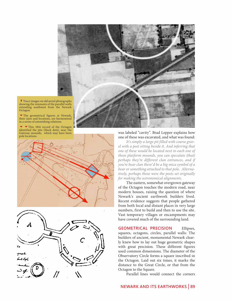
NEWARK AND ITS EARTHWORKS | 89
was labeled “cavity”. Brad Lepper explains how one of these was excavated, and what was found: It’s simply a large pit filled with coarse grav-el with a post sitting beside it. And inferring that one of these would be located next to each one of those platform mounds, you can speculate (that) perhaps they’re different clan entrances, and if you’re bear clan there’d be a big mica symbol of a bear or something attached to that pole. Alterna-tively, perhaps those were the posts set originally for making the astronomical alignments. The eastern, somewhat overgrown gateway of the Octagon touches the modern road, near modern houses, raising the question of where Newark’s ancient earthwork builders lived. Recent evidence suggests that people gathered from both local and distant places in very large numbers, first to build and then to use the site. Vast temporary villages or encampments may have covered much of the surrounding land.
GEOMETRICAL PRECISION Ellipses, squares, octagons, circles, parallel walls: The builders of ancient, monumental Newark clear-ly knew how to lay out huge geometric shapes with great precision. These different figures used common dimensions. The diameter of the Observatory Circle forms a square inscribed in the Octagon. Laid out six times, it marks the distance to the Great Circle, or that from the Octagon to the Square. Parallel lines would connect the corners
4Trace images on old aerial photographs showing the remnants of the parallel walls extending southwest from the Newark Octagon.
6The geometrical figures at Newark, their sizes and locations, are harmonized in a series of astonishing relations.
66This 1816 record of the Octagon identified the pits (black dots), near the Gateway mounds, which may have been pole locations.

NEWARK AND ITS EARTHWORKS | 90
circular enclosure. This is one of many that accompanied the New-ark Earthworks as recorded on 19th century plans. The remnants of low embank-ments just past the small circle are the beginnings of a long straight roadway that took off to the south-west. Early maps show it as con-sisting of perfectly straight paral-lel lines, about 180 feet apart and about 3 feet high, extending for at least six miles. If it continued at this angle for sixty miles, as Brad Lep-per has suggested is possible, this monumental highway (now termed the “Great Hopewell Road”) would have arrived at Chillicothe, where
we find more earthwork complexes with similar features, including the only other circle-octagon, High Bank Earthworks. Southwest of Newark, the lines that the early pioneers could trace through the forests and over the streams were plowed under or bull-dozed away long ago. Perhaps this was a road of pilgrimage, carrying great processions, between two of the greatest Hopewell ritual centers. Brad Lepper had studied the long straight roads of the ancient American Southwest, before coming to Newark, so he was especially intrigued when he found this remarkable fea-ture on the unpolished map of the Newark Earthworks, drawn by James and Charles Salis-bury in 1862. They certainly did a very comprehensive survey of everything that was extant. They show the outer wall around the Octagon, which nobody else but Wyrick showed. And also they pointed out that the parallel walls that came out of the Octagon went much farther than Squier and Davis had said. Caleb Atwater thought those walls might go 30 miles. The Salisburys say that they followed those walls two and a half miles and came to Ramp Creek. But they crossed Ramp Creek, (and) said that the walls continued for six miles, through tangled swamps and over hills, still “keeping their undeviating course.” So that’s where my work on the Great Hopewell Road really began. Since Lepper’s discoveries in the 1990s, the “Great Hopewell Road” idea has captured the public imagination. But whether it really exist-ed, as we want to imagine it, can now probably never be confirmed. It depends on how we define the “Great
of the square with those of the Octagon, more than a mile away. Another set would connect the main axis points of the two large circles. Incredibly, these two sets of imaginary parallels mark the minimum and maximum southern moonrises. There are also matched circumfer-ences, and areas. These startling relationships show that somehow, there’s a larger, unifying idea – it’s not just a haphazard or incremental arrangement.
THE GREAT HOPEWELL ROAD The southern gateway of the Octagon opens to a small stretch of grass and an exquisite small
5In this reconstruction, clusters of hous-es are shown outside the Newark Octagon, for use by the builders or celebrants.
6The Salisbury brothers’ plan and description of Newark’s ancient remains suggested the long parallel lines extending to the southwest.
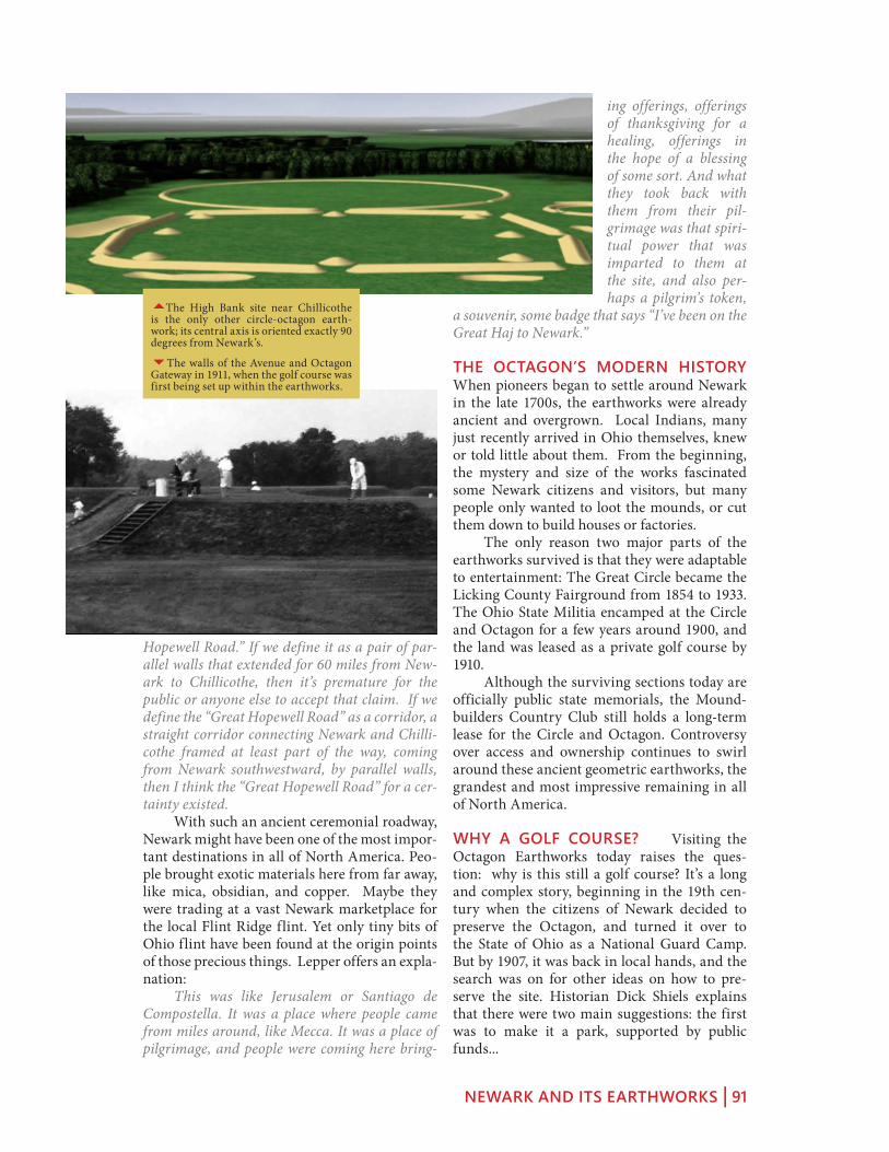
NEWARK AND ITS EARTHWORKS | 91
ing offerings, offerings of thanksgiving for a healing, offerings in the hope of a blessing of some sort. And what they took back with them from their pil-grimage was that spiri-tual power that was imparted to them at the site, and also per-haps a pilgrim’s token,
a souvenir, some badge that says “I’ve been on the Great Haj to Newark.”
THE OCTAGON’S MODERN HISTORY When pioneers began to settle around Newark in the late 1700s, the earthworks were already ancient and overgrown. Local Indians, many just recently arrived in Ohio themselves, knew or told little about them. From the beginning, the mystery and size of the works fascinated some Newark citizens and visitors, but many people only wanted to loot the mounds, or cut them down to build houses or factories. The only reason two major parts of the earthworks survived is that they were adaptable to entertainment: The Great Circle became the Licking County Fairground from 1854 to 1933. The Ohio State Militia encamped at the Circle and Octagon for a few years around 1900, and the land was leased as a private golf course by 1910. Although the surviving sections today are officially public state memorials, the Mound-builders Country Club still holds a long-term lease for the Circle and Octagon. Controversy over access and ownership continues to swirl around these ancient geometric earthworks, the grandest and most impressive remaining in all of North America.
WHY A GOLF COURSE? Visiting the Octagon Earthworks today raises the ques-tion: why is this still a golf course? It’s a long and complex story, beginning in the 19th cen-tury when the citizens of Newark decided to preserve the Octagon, and turned it over to the State of Ohio as a National Guard Camp. But by 1907, it was back in local hands, and the search was on for other ideas on how to pre-serve the site. Historian Dick Shiels explains that there were two main suggestions: the first was to make it a park, supported by public funds...
Hopewell Road.” If we define it as a pair of par-allel walls that extended for 60 miles from New-ark to Chillicothe, then it’s premature for the public or anyone else to accept that claim. If we define the “Great Hopewell Road” as a corridor, a straight corridor connecting Newark and Chilli-cothe framed at least part of the way, coming from Newark southwestward, by parallel walls, then I think the “Great Hopewell Road” for a cer-tainty existed. With such an ancient ceremonial roadway, Newark might have been one of the most impor-tant destinations in all of North America. Peo-ple brought exotic materials here from far away, like mica, obsidian, and copper. Maybe they were trading at a vast Newark marketplace for the local Flint Ridge flint. Yet only tiny bits of Ohio flint have been found at the origin points of those precious things. Lepper offers an expla-nation: This was like Jerusalem or Santiago de Compostella. It was a place where people came from miles around, like Mecca. It was a place of pilgrimage, and people were coming here bring-
5The High Bank site near Chillicothe is the only other circle-octagon earth-work; its central axis is oriented exactly 90 degrees from Newark’s.
6The walls of the Avenue and Octagon Gateway in 1911, when the golf course was first being set up within the earthworks.

NEWARK AND ITS EARTHWORKS | 92
But the second proposal came from a group of men who said, “If you’ll let us build a golf course there, we will (this is what they said in the paper) keep it open to the public at all times.” The edito-rial in the Newark Advocate said, “Let’s make it a park.” The mayor said as loudly as he could, “Let’s make it a park.” But the vote went the other way. And beginning then the next summer, the summer of 1911, there was a country club, or golf course at any rate, that quickly became the Moundbuilders Country Club. It’s been just 100 years that the country club has occupied that site.
GOLF AND PRAYER Because the Ohio Historical Society has continued to lease the land to the Moundbuilders Country Club, pub-lic access is restricted while golf is being played. The Club claims that it has maintained the land with care, and that without the golf course, development would probably have destroyed the earthworks long ago. But pressure has grown to open the earthworks more fully to the public. Barbara Crandell, a woman of Cherokee heritage, was arrested in 2002 when she went to pray at the Observatory Mound during golf play. She explains why she was willing to risk arrest, the ancestral connection she feels to the earth-works: They built these things so we would remem-ber who we are. Don’t lose track of who you are! When I go to the mounds, I feel a great welling up of pride and love for my people. I love my ancestors. I love their bones. That’s the way I was brought up. I have great reverence for them. And every one of those mounds, I know their hands lovingly gathered the dirt, and put it there. And I can feel their hands patting me, when I go there. So that’s why I think it was left as a trail for
Native people to follow. Go there and connect with your ancestors, so you can walk a good path. It is terrible that people are not allowed to go to these places. They’re not just for Indian people. I mean, I connect with them maybe in a different way. but all people should be able to go there. They should be able to go there and see this wonderful sight. And I’d like to have it open for everybody.
3Barbara Crandell, of Cherokee heri-tage, was arrested in 2002 for going to the Octagon Earthworks to pray.

FLINT RIDGE | 93
WiTh blaCkhand, CoshoCTon, and soMerseT
flinT ridge
BLACKHAND GORGE Leaving Newark on Route 16 east will take you past a newer architectural “wonder:” the bizarre, giant Longaberger Basket, probably one of the best-executed examples of literally iconic architec-ture in the US. Continuing on Route 16 for a total of 11 miles, exit at State Route 146, and then immediately right on Toboso Road for two miles to Blackhand Gorge Nature Preserve. Here, the Licking River has cut a narrow gorge through a high sandstone ridge. This unusual chasm is named after a “black hand” petroglyph, left on the cliff face here long ago,
that has inspired many Native leg-ends: one proclaimed this was the boundary of long-sacred lands, where no man could raise his “hand” against another. The river here would have been a route for Flint Ridge flint, on its way down to the earthworks at Newark, and beyond. In 1828, this section of the river became part of the Ohio and Erie Canal. The “black hand” was destroyed when the stone tow-path was constructed along the riverbank. Besides the Central Ohio Steam Railroad, the elec-tric inter-urban trolley car also came through a tunnel here on its way from Zanesville to Newark, Columbus, and Indianapolis. Leaving the Gorge, continue right on Toboso Road, then south on County Road 278 for 3 miles, then jog to the right for ¼ mile along Brushy Fork Creek. Take Mulberry Road to the left across the creek and continue southward 2 ½ more miles before turning
East from Newark, travel via the Black-hand Gorge Nature Preserve (where an Indian petroglyph of a black hand has been destroyed, but remnants of canal towpaths, locks, and a quarry remain), to Flint Ridge – for 10,000 years the source of Ancient Ohio’s most valuable resource. Further to the northeast is Coshocton, where the Johnson-Humrickhouse Museum displays the inauthentic but historically interest-ing “Newark Holy Stones;” to the south lies the Glenford Fort earthwork, and the well-preserved Zane’s Trace settlement of Somerset.
flinT ridge
1 Black Hand Gorge
2 Coshocton (Roscoe Village)
3 Flint Ridge
4 Somerset (Zane’s Trace)
5 Glenford Fort
1
2
3
4
5

FLINT RIDGE | 94
right onto Flint Ridge Road, which will bring you to Flint Ridge State Memorial.
FLINT RIDGE Here a deposit of beautiful, hard, sharp, rainbow-colored flint lies close to the sur-face, where Native peoples have been mining it for thousands of years. The forested ridge-top is strewn with the water-filled pits where extraction has been taking place for millennia. A museum interprets the site, exhibits sam-ples, and organizes public events where it is possible to watch mod-ern expert “flintknappers” demon-strating the ancient techniques of fashioning the stone into beautiful
shapes. Flint Ridge was less than a day’s walk from Newark, and one of ancient North America’s great-est treasure sources. From its many pits, genera-tions of Natives obtained beautiful, multicolored flint for shaping into weapons and tools, as early as 10,000 years before the nearby earthworks were built. They broke out chunks using heavy boulders and levers, then with care and skill chipped them into beautiful shapes. An unusual building here was in use for a long time, perhaps a temple to enshrine the spirit of the place. Its thick walls surrounded visitors with precious flint. Eventually, two people were entombed in here, and the walls mounded with earth, carefully dotted with sets of flint blades. The Newark earthworks were built on the closest flat river terrace to Flint Ridge. It may be that the earthworks were planned as a place of gathering and ceremony in connection with this natural source. Over time, visitors and trade spread Flint Ridge flint all over ancient North America.
COSHOCTON AND ROSCOE VILLAGE Return to SR 16 and continue another 29 miles northeast along the Muskingum River to Coshocton, a capital of the Delaware (Lenape) Indians and site of early Moravian missions. Just across the river from downtown is Ros-coe Village, a well preserved early 1800s canal settlement with many shops and cafés, and an interesting visitor center. Near the south end of the street is the Johnson-Humrickhouse Museum, featuring a spectacular collection of Chinese lacquer ware, dioramas of early Ohio
55The Central Ohio Steam Railroad cut a deep crevice through the Black Hand Ridge, now the park’s “Blackhand Trail,” stained by soot from locomotives.
5A trail at Black Hand Gorge (across the river from the parking lot) leads to a near-ly-intact canal lock hidden in the woods.
6The hiking trails at Flint Ridge display beautiful outcrops of the rainbow-colored rock, prized here for thousands of years.

FLINT RIDGE | 95
at least interesting! In fact, if we ask why Wyrick and the oth-ers would have done this, a compelling answer emerges, that may lie in a 19th century contro-versy over human origins. It was the time of the Civil War, and some were arguing that the peo-ples of Africa and the Americas were of a differ-ent species than Europeans. This view was still being used to justify slavery and the taking of land from the Indians. The “discovered” stones were probably meant to support the opposing idea that all people, whatever their color, were of the same species and originated in Eden. Despite the laudable goal of showing that the Indians were indeed human, turning them into descendants of Israelites unfortunately fed into racist myths that were popular at the time,
with claims that the sophisticated earthworks could not have been made by a non-white race.
SOMERSET AND ZANE’S TRACE From Flint Ridge, go south via Brownsville Road and SR 668 to Somerset. Of all the towns that developed along Zane’s Trace,
tiny Somerset retains the feeling and the urban fabric of its origins as an early 19th century agricultural market town. While others like Zanesville, Lancaster, and Chillicothe became more economically diversified, Somerset keeps the “Jeffersonian” ideal of an agrarian west, probably because it is situated on a high ridge far from river transportation or water power. Settlers came here from the new United States and from Europe, especially German Rheinlanders after the Napoleonic wars. They were commercial agriculturalists, open to inno-vations and larger-scale operations, growing and selling crops to make money. At the turn of 1800, the fact that Ohio was “free country” also gave opportunities to poor American whites to become farm workers, which was not possible in the pre-Civil-War South because of slavery. The land was cheap, the soil was superb, people came pouring in along Zane’s Trace, and Som-erset thrived. Somerset probably contains more than thirty log structures, recognizable even through modern cladding because of their proportions and sometimes their subtle tilt. Somerset’s courthouse, on its “Pennsylvania” style town square, is one of only two surviving in the state from the once-common, first generation, pyr-amid-on-cube design. A second square, a cou-
settlement life, and also home of the still con-troversial “Newark Holy Stones.”
THE NEWARK “HOLY STONES” In 1860, one of the most famous scientific frauds in American history. Newark surveyor David Wyrick “found” the first stone buried shallow-ly near the Octagon. The wedge-shaped stone was polished, and inscribed with some Hebrew characters. Five months later, he “found” another Hebrew-inscribed stone this one encased in a stone box, in the remains of a large stone mound south of Newark. Wyrick and others declared the stones must be evidence of Israelite ancestry for the mound builders. But the first stone was soon identified as a “key stone” used in the Masonic society’s rituals. Scholars pointed out that the Hebrew written on the second stone featured errors that only 19th century translators could have made. Scientific archaeologists have now decisively proven that the “holy stones” are fraudulent. But this does not mean they are not historically important, or
5Roscoe Village’s Whitewoman Street is lined with historic structures, and with crowds and food stalls during the annual (October) Apple Butter Festival.
3The “Newark Holy Stones:” The Key-stone (left) and Decalogue Stone (right) “found” by David Wyrick in the New-ark earthworks (photos from Wikipedia Commons).

FLINT RIDGE | 96
ple of blocks west along the early highway and now called “Pigsfoot,” was for markets. South of town on SR 383, take the last right before the fence and pond to see the Catholic Priory of Saint Joseph, the oldest Roman Catholic church in the state.
GLENFORD FORT Six miles north of Som-erset lies one of Ohio’s best preserved hilltop enclosures. Although still on private land, it can be visited (inquire locally). The steep, quar-ter-mile climb through beautiful, old-growth forest is rewarded with views of an intact, mile-long, all-stone embankment wall surround-ing the level hilltop, with a stone ceremonial mound in the center. Glenford Fort is one of the best examples of a walled hilltop enclosure in the region. In the words of Norman Muller: Glenford Fort owes its remarkable state of preservation to having been in the hands of one family for close to two hundred years. The wall is probably much the same as it looked when Caleb Atwater first laid eyes on it in 1818.
55Somerset’s Main Street (along Zane’s Trace), with the famous Clay Haus Restaurant and other early structures on the right.
5Whittlesey’s 1800s map of Glenford Fort shows the stone encircled plateau and central mound.
6The stone enclosure walls of the Hopewell era Glenford Fort stand atop a plateau in old-growth forests. (Photo by tom Johnson)

GRANVILLE | 97
and The ohio hisToriCal CenTer in ColuMbus
granVille
Arrive in Granville from I 70 via the SR 37 exit (SR 37 is coming up from Lancaster), or from Columbus via Broad Street (SR 16) or the new, four-lane SR 161 through New Albany. With its picturesque and walkable town center and superb historic inns, Granville makes an ideal base for exploring the northern sections of the Ancient Ohio Trail.
GRANVILLE This exquisite town was founded by New Englanders eager to create an environment that would help them feel at home. Broadway has fine architecture, perhaps most notably the Greek Revival masterpiece Avery-Downer House (open to the public), and a charming small-town ambience, plus good shops and cafés. There are beautiful churches, including at least one in a proper “New Eng-land” mode. Granville is also the home of Denison University: meandering drives and imposing academic architecture occupy the prominent hilltop above the village. The town has its own earthwork (the distinctive, so-called “Alligator”), and is also directly adjacent to the great earthworks at Newark.
THE “ALLIGATOR” EFFIGY Just out-side town to the east is the “Alligator” Effigy, the greatest animal effigy in Ohio after Ser-pent Mound. Now preserved by the Ohio His-tory Connection, it is accessible from the old Newark-Granville road: take Broadway head-ing east, and after about a mile enter the sub-division called “Bryn du Woods” on the left and follow the street as it curves to the left and climbs to the hilltop. The effigy lies atop the cul-de-sac at the end, and is best seen in very early or very late sunlight when the shadows are deep. The beautiful views (now between large houses) from this hilltop extend west-ward to the open plains beyond the village and eastward into the defined valley terraces across which the Newark Earthworks were laid out. The builders of the effigy no doubt appreciated these relationships, the prominence of this spot in encompassing the dual ecologies, and espe-cially the nearby geometric earthworks which were already 800 years old when this effigy was begun. The earthen creature with four rounded feet and a long, curling tail became known to early
granVille and ColuMbus Map
1 Granville
2 “Alligator” Effigy
3 Ohio History Center
4 Ohio State Capitol
5 Ohio State University
6 Shrum Mound
7 High Banks Metro Park
12
3
4
56
7
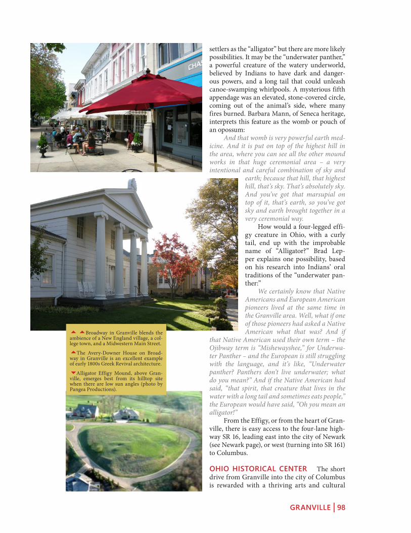
GRANVILLE | 98
settlers as the “alligator” but there are more likely possibilities. It may be the “underwater panther,” a powerful creature of the watery underworld, believed by Indians to have dark and danger-ous powers, and a long tail that could unleash canoe-swamping whirlpools. A mysterious fifth appendage was an elevated, stone-covered circle, coming out of the animal’s side, where many fires burned. Barbara Mann, of Seneca heritage, interprets this feature as the womb or pouch of an opossum: And that womb is very powerful earth med-icine. And it is put on top of the highest hill in the area, where you can see all the other mound works in that huge ceremonial area – a very intentional and careful combination of sky and
earth; because that hill, that highest hill, that’s sky. That’s absolutely sky. And you’ve got that marsupial on top of it, that’s earth, so you’ve got sky and earth brought together in a very ceremonial way. How would a four-legged effi-gy creature in Ohio, with a curly tail, end up with the improbable name of “Alligator?” Brad Lep-per explains one possibility, based on his research into Indians’ oral traditions of the “underwater pan-ther:” We certainly know that Native Americans and European American pioneers lived at the same time in the Granville area. Well, what if one of those pioneers had asked a Native American what that was? And if
that Native American used their own term – the Ojibway term is “Mishewayshee,” for Underwa-ter Panther – and the European is still struggling with the language, and it’s like, “Underwater panther? Panthers don’t live underwater; what do you mean?” And if the Native American had said, “that spirit, that creature that lives in the water with a long tail and sometimes eats people,” the European would have said, “Oh you mean an alligator!” From the Effigy, or from the heart of Gran-ville, there is easy access to the four-lane high-way SR 16, leading east into the city of Newark (see Newark page), or west (turning into SR 161) to Columbus.
OHIO HISTORICAL CENTER The short drive from Granville into the city of Columbus is rewarded with a thriving arts and cultural
55Broadway in Granville blends the ambience of a New England village, a col-lege town, and a Midwestern Main Street.
5The Avery-Downer House on Broad-way in Granville is an excellent example of early 1800s Greek Revival architecture.
6Alligator Effigy Mound, above Gran-ville, emerges best from its hilltop site when there are low sun angles (photo by Pangea Productions).
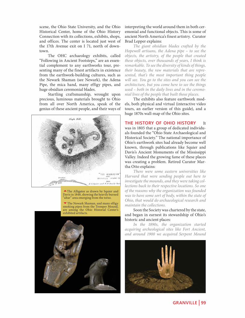
GRANVILLE | 99
interpreting the world around them in both cer-emonial and functional objects. This is some of ancient North America’s finest artistry. Curator Brad Lepper explains: The giant obsidian blades crafted by the Hopewell artisans, the Adena pipe – to see the objects, the artistry, of the people that created these objects, over thousands of years, I think is remarkable. To see the diversity of kinds of things, their beauty, the raw materials that are repre-sented, that’s the most important thing people will see. You go to the sites and you can see the architecture, but you come here to see the things used – both in the daily lives and in the ceremo-nial lives of the people that built those places. The exhibits also feature earthwork mod-els, both physical and virtual (interactive video tours, an earlier version of this guide), and a huge 1870s wall-map of the Ohio sites.
THE HISTORY OF OHIO HISTORY It was in 1805 that a group of dedicated individu-als founded the “Ohio State Archaeological and Historical Society.” The national importance of Ohio’s earthwork sites had already become well known, through publications like Squier and Davis’s Ancient Monuments of the Mississippi Valley. Indeed the growing fame of these places was creating a problem. Retired Curator Mar-tha Otto explains: There were some eastern universities like Harvard that were sending people out here to investigate the mounds, and they were taking col-lections back to their respective locations. So one of the reasons why the organization was founded was to have some sort of body, within the state of Ohio, that would do archaeological research and maintain the collections. Soon the Society was chartered by the state, and began in earnest its stewardship of Ohio’s historic and ancient places: In the 1890s, the organization started acquiring archeological sites like Fort Ancient, and around 1900 we acquired Serpent Mound
scene, the Ohio State University, and the Ohio Historical Center, home of the Ohio History Connection with its collections, exhibits, shops, and offices. The center is located just west of the 17th Avenue exit on I 71, north of down-town. The OHC archaeology exhibits, called “Following in Ancient Footsteps,” are an essen-tial complement to any earthworks tour, pre-senting many of the finest artifacts in existence from the earthwork-building cultures, such as the Newark Shaman (see Newark), the Adena Pipe, the mica hand, many effigy pipes, and huge obsidian ceremonial blades. Startling craftsmanship, wrought upon precious, luminous materials brought to Ohio from all over North America, speak of the genius of these ancient people, and their ways of
5The Alligator as drawn by Squier and Davis in 1848, showing the heavily burned “altar” area emerging from the torso.
6The Newark Shaman, and many effigy smoking pipes from the Tremper Mound, are among the Ohio Historial Center’s exhibited artifacts.

GRANVILLE | 100
from the Peabody Museum. And from then on it was a matter of acquiring various archaeological and historical and natural sites throughout the state that were deemed to be particularly signifi-cant. In the 1950s, the word “archaeological” was dropped from the name; and in the 1970s, the massive new museum was put up. Today, re-named again recently as the “Ohio History Con-nection,” the agency partners with other groups around the state to maintain, administer, and interpret the earthwork sites that it owns.
OHIO STATE CAPITOL In the heart of downtown Columbus, on Capitol Square, the Statehouse was begun in 1839. Its cupola was modeled on the circular Tholos of Delphi, then recently discovered in Greece. It preserves in its lower level (the walls downstairs, around the gift shop) the visible rubble foundation stones that were taken from the Mound Street Mound, as was the clay to make many of the bricks in its inner walls. A huge mural in the rotunda depicts the Treaty of Greeneville, which forced Indians to give up their claims to much of what is now Ohio.
THE OHIO STATE UNIVER-SITY Lively urban districts and historic residential neighborhoods now stretch continuously from downtown Columbus (along High Street) both southward (to the pic-turesque, all-brick German Vil-lage) and northward to the huge campus of The Ohio State Uni-versity, Ohio’s premiere flagship research university with renowned
departments in many disciplines, including Ohio archaeology. The campus is also home to the world-famous Wexner Arts Center (with changing exhibits) designed by Peter Eisenman in the 1980s.
THE SHRUM MOUND In Campbell Park (5 miles northwest of downtown Colum-bus, about ½ mile south of the intersection of McKinley Avenue and Trabue Road) is a well-preserved, 20-foot tall, conical mound. It is one of the last ancient mounds left in the Colum-bus area, named after the family that donated it to the Ohio History Connection. Its conical form and isolated position suggest an Adena era burial mound, although there have been no archaeological investigations. This tranquil park, named for former Ohio
55The Ohio History exhibits are in a massive, 1970s “brutalist” structure; the interiors have been recently renovated.
5The “Ancient Footsteps” exhibit at OHC includes an interactive video pro-gram for which many of the Ancient Ohio Trail media segments were originally cre-ated.
6The Ohio Statehouse is a good example of Greek Revival monumental architec-ture, reflecting the democratic idealism of the time.

GRANVILLE | 101
on North High Street, US 23, 2½ miles north of Interstate 270), two mounds associated with the Adena culture and a semi-circular earthen enclosure lie atop a 100 foot cliff overlooking the Olentangy River. The enclosure, also called the Orange Township Works, can be reached by trails from the Nature Center (with interpre-tive exhibits) at the park. The “High Banks” name comes not from the ancient Indian earthwork, but from the 110-foot, exposed shale precipice rising above the
Olentangy River. The cliff and the earthwork are reached by the 2.3-mile Overlook Trail through dense woods, across steep ravines, and past a preserved cemetery plot. The trail passes through the ancient earthwork, together with its watery outer ditch (where sala-manders breed). It was designed to encircle the promontory, and a long extension of the wall is visible to the north and west. It diminishes on both sides, along the steep-sided ravines. This 1500-foot earthwork probably marked a village bound-ary, between 8 and 14 centuries ago.
governor James E. Campbell, is surrounded by a gigantic old limestone quarry on one side, and rushing road traffic on the other, suggesting how close the mound came to being destroyed. Yet it remains, in this improbable spot, a direct link to the distant past. Climbing the steep path to the 20-foot summit, you can feel, as one visi-tor wrote, that it is “still a haunting place.”
HIGH BANKS METRO PARK In this nature preserve just north of the city (entrance
5The Shrum Mound sits in the center of a tiny park, rimmed with a low symmetri-cal stone wall, at the edge of an immense quarry.
3Near the spot in High Banks Metro Park where the trail passes through them, the earthen walls and ditch are especially prominent.
6A small cemetery along the Overlook Trail in High Banks Metro Park preserves exquisitely carved headstones.

ATHENS | 102
and The hoCking Valley
aThens
From Cincinnati, Chillicothe, Columbus, or Newark, there are several routes into south-eastern Ohio, leading to Athens or Marietta. Most are quite scenic; many are a bit slow-going, offering plenty of time to take in the sights along the way. The many natural beauties and tourist amenities of the “Hocking Hills” region, cen-tered on the historic towns of Logan and Nel-
sonville, are highly recommended; in addition we feature here the Leo Petroglyphs, Buckeye Furnace, and the beautiful Zaleski Mound.
LEO PETROGLYPHS Leave Chillicothe via US 35 through the villages of Richmond Dale and Savageville, then turn left for about 4 miles to the village of Leo. The road to the site (signposted) heads northwest for about a half-mile. On an exposed dome of sandstone, surrounded by a walk-way, the centuries-old petroglyphs (rock-writings) are inscribed. There are 37 figures of birds, fish, feet, hands, and human and com-posite creatures, visible as the dif-fused daylight washes across the surface. Their subtlety is revealed, as one visitor has suggested, by staring for a few moments until they begin to show, like the stars at night. Most likely they had a mean-ing when taken together, rather than being hieroglyphs standing for individual words. Archaeologist Brad Lepper: I think there’s a story there to be read, but we don’t have the key any-more, so I don’t think we can read it
1
2
3
4
5
6
7
aThens and The hoCking Valley Map
1 Leo Petroglyphs
2 Buckeye Furnace
3 Zaleski Mound
4 Logan
5 Nelsonville
6 The Plains
7 Athens

ATHENS | 103
now. But there are elements like the human face with the antlers: I think in many rock art tradi-tions in America, that seems to reflect spiritual power. So it may not be a photographic represen-tation of a creature with antlers, but it may just represent a Shaman, a Medicine Man or Woman, and the antlers are an indication of the spiritual power that that person had. So there are aspects of it that I think we can tease out, but… I think the meaning of the entirety of it is lost to us. At one point recently the recessed lines were traced in dark material to make them more visible, though that is mostly faded now. From the weathering of the rock and the
nature of the symbols, experts think the petroglyphs are less than a thousand years old, probably done in the “Fort Ancient” era, or by historic Indians. Living among these hills, probably in villages, they would have been drawn to the nearby Scioto Salt Licks in Jackson, and the Zaleski Flint deposits to the north in what is now Vinton Coun-ty. The park is called the Leo Petroglyphs State Memorial, and the inscribed outcrop stands at the edge of a beautiful ravine. Trails explore both in and around the 60-foot sandstone cliffs. There is a small bridge, and abundant birds and wildflowers. In 1780, the Moravian mis-sionary David Zeisberger observed that the Indians along the Musk-ingum River often recorded their stories with paint on forest trees. He wrote: If a party of Indians have spent a night in the woods, it may be easily known... by their marks on the trees, to what tribe they belong. For they always leave a mark behind made either with red pigment or char-coal. Such marks are understood by
55A timber structure built by the WPA in the 1930s shelters both a picnic area and the Leo Petroglyphs.
5The Leo Petroglyphs are thought to date from the so-called Fort Ancient cul-ture, between AD 900 and 1650.
3The incised image of the human face with antlers probably represents a leader with spiritual powers.

ATHENS | 104
the Indians who know how to read their mean-ing. Some markings point out the places where a company of Indians have been hunting, showing the number of nights they spent there, the num-ber of deer, bears and other game killed during the hunt. The warriors sometimes paint their own deeds and adventures, the number of pris-oners or scalps taken, the number of troops they commanded and how many fell in battle... These drawings in red by the warriors may be legible for fifty years… The Leo Petroglyphs are the closest thing we have indicating how such inscriptions may have been part of a visual language with specific meanings, although those meanings now elude us.
BUCKEYE FURNACE This beautifully reconstructed charcoal-fired blast furnace is typical of those serving Ohio’s Hanging Rock Iron Region from the mid-1800s. Leave Leo
to the southeast, through the vil-lages of Coalton and Glen Roy. At Wellston, take SR 327 south, across SR 32, to make a left turn onto SR 124 at Berlin Crossroads. At 3.8 miles, go right on Buckeye Furnace Road; the site is well signposted. (123 Buckeye Park Road, Wellston, OH 45692, 740-384-3537). The approach road passes through watery lowlands sur-rounded by forested hills. Soon the massive, reconstructed, stone blast furnace complex appears beside the road. Through the open-air casting shed, the mouth of the charcoal-fired oven is visible. To the left is
the engine house, where steam heat from the furnace would drive air compressors to increase the heat of the fire. A timber superstructure above the chimney, reachable by a separate trail, is the charging shed where the ingredients (iron ore, limestone) were measured in from above. Nearby atop the bluff is also the huge, open-air storage shed, for the vast quantities of materials needed to keep the furnace running continu-ously. Visitors can see the casting shed, charg-ing loft, and steam-engine house, as well as the company store serving as an orientation area. The Hanging Rock Iron Region of Ohio prospered during and just after the Civil War, as many small company towns of 300-400 resi-dents operated the furnaces, and produced the iron for America’s early industry. All the key
55Tree markings like Zeisberger may have seen in the late 1700s, suggesting an Indian visual language (image from an early children’s book).
5The restored iron-smelting complex at Buckeye Furnace State Memorial illus-trates mid-nineteenth century industrial techniques.
6The Buckeye Furnace charging shed, with its giant scoop, was used to feed the smelting fires from above.

ATHENS | 105
ZALESKI MOUND Another route between Chillicothe and Athens is US 50, passing through the picturesque small town of McAr-thur, the seat of Vinton County (historic build-ings, cafés). Go north out of McArthur and then head east on a county road, across a high, treeless ridge with long views of farmland and forested hills, to the tiny, remote village of Zaleski. At the edge of the village, on the grounds of a State Forest Headquarters, stands one of Ohio’s most beautiful mounds. Its elegant profile is gracefully ringed by a gravel path and a circle
of young trees; adjacent is a small memorial to veterans. While in the Zaleski area, inquire about the Moonville Tun-nel (a bit northeast from the village, on a remote trail), built for a now-abandoned nineteenth-century railroad line. It is one of many in the region, but is now unique both for its accessibility and the appeal of its associated local legends. To reach Athens, return to US 50 and head east via Albany.
THE HOCKING HILLS REGION The main route into southeastern Ohio from Columbus
or Lancaster (US 33) passes through the Hock-ing Hills tourism region. Logan is the main headquarters for exploring among the many scenic and recreational opportunities of the greater Hocking River valley. Nine state parks encompass a variety of natural wonders includ-ing large overhanging cliffs and waterfalls, caves, and nature preserves. A bit farther south along US 33 is Nelson-ville, whose well-preserved town square is the setting for many festival and arts events. The nearby train station is headquarters for the Hocking Valley Scenic Railroad, run by vol-unteer railroaders and a main attraction of the county. Hocking College nearby operates Rob-bins Crossing, a collected village of 1850s log cabins that gives the flavor of 19th Century life in the region. Along US 33 between Nelsonville and Ath-ens is the headquarters of the Wayne National Forest, an excellent resource for learning about the history and ecology of the region, and for getting oriented to miles of hiking trails. The Forest is divided between Athens and Marietta sections, and superb maps are available at the Visitors Center.
raw ingredients were locally plentiful: wood for fires, limestone for flux, and the iron ore itself. Vast tracts of forest were depleted in the process, and families were conscripted in ser-vitude in these isolated, self-contained com-munities, which were structured around their own schools, churches, and even commerce and currencies wholly controlled by the “Company Store.” A restored company store and ironmas-ter’s house, as well as a covered bridge, are vis-ible at Buckeye Furnace. To reach Athens, return to SR 32 at Berlin Crossroads and head northeast.
5The shape and isolated hilltop loca-tion of the Zaleski Mound identify it as an Adena era structure.
6Ash Cave is one of the more beautiful of several natural wonders in the Hocking Hills tourism region.

ATHENS | 106
ATHENS AND OHIO UNIVERSITY The New Englanders who came to settle southeast Ohio in 1788 believed in education. Their Ohio Company of Associates (see Marietta) set aside two whole townships for the “American West-ern University,” which was to be modeled on the ones back home: Yale and Harvard. It was the first college west of the Alleghenies, and in 1804, the year after statehood, the new Ohio legislature renamed it “Ohio University.” Though far from the Ohio River, the site was fed by the Hocking, which promised easy transportation to the Ohio. Reflecting their high ideals, the founders named their univer-sity town “Athens” after the Greek birthplace of Western Civilization. Picturesque, small-scaled commerce stretches northward down Court Street in Ath-ens, much of it oriented to the thousands of uni-versity students who have made Ohio U one of the nation’s top-rated “party” schools. In the 1970s, university students and faculty here also made Athens an early center of what is now known as the “locavore” movement. Today many restaurants follow the lead of the original, the Casa Nueva (still operating at 4 W State Street), in buying locally grown meat the produce and listing the sources in their menus. From near the “roundabout” down by the Hocking River, take Dairy Lane to reach The Ridges and the Dairy Barn, two of Athens’ out-standing arts venues. At the sharp bend, turn right and up the hill to explore The Ridges, fas-cinating remnants of a huge, nineteenth-century asylum, with sprawling and ominous Victorian buildings now largely converted into university uses and the Kennedy Museum of Art, with a stunning collection of weaving and jewelry by Southwest Indians. Edwin and Ruth Kennedy collected both historic and contemporary exam-ples, beginning in the 1950s, and it is possible to trace a continuity of themes and techniques. The Dairy Barn Art Center (8000 Dairy Lane, nearby) is home to the most significant art quilt show in the nation: the National, held every two years. The town of Athens has long been known as a hub for craftspeople, with galleries and pottery showcases scattered through the uptown area, and in nearby Nelsonville. From the Dairy Barn, a walking path leads to Athens’ (and the old asylum’s) historic cemeteries. Athens originated the “quilt barn” idea, based on the old quilting art: owners paint a quilt square on their barn, about eight feet
55The Visitors Center of the Wayne National Forest presents many resources on the ecology and history of southeast Ohio.
5Several of Ohio University’s earli-est buildings survive around the campus green, including Cutler Hall, erected in 1816.
6This lively university town centers on Court Street, with its shops and bars, and pioneering “locavore” restaurant scene.

ATHENS | 107
square. There are several barn quilt trails in the area, for cars or bicycles (inquire locally).
THE PLAINS In a village immediately to the northwest of Athens lie the remnants of the Wolfes Plains Mounds and Earthworks, a major Adena era complex. Reach The Plains via SR-33, or hike or bike there on the Hocking Adena Bike Trail, which also extends northward all the way to Nelsonville. The Plains occupies an unusual, flat plat-form above the Hocking River, among abruptly-rising hills. Once called “Wolfes Plains,” this distinctive land form has been, since about 300 BC, a spectacular sacred place. Squier and Davis recorded as many as 30 earthen circles and mounds covering the terrace. There is no
evidence of ancient dwelling sites, suggesting the people lived in the surrounding hills (where there are more mounds), and descended to the plain for ceremonies and rituals among these earthen forms. Today, two large mounds remain to be seen in the town, named Hartman and Woodruff-Connett. More low mounds and circles can be detected in the area, though barely, in fields, or beneath buildings. The old Indian trail that bisected the terrace has become SR 682, around which the town clus-ters.
TWO LARGE MOUNDS The largest of the remaining mounds in The Plains, the Hartman Mound, stands 40 feet high and 140 feet in diameter. Going north on SR 682, turn left on Mound Street for about one quarter mile. It has never been excavated, although probably contains graves similar to the one found, during the nineteenth century, in a smaller mound nearby, where a log tomb held the deceased, surrounded by five hundred rolled copper beads and a tubular pipe. Although there is an implied pathway, climbing is not encour-aged, out of respect for both the ancient graves and the private land-owner. Follow Mound Street or the Adena Drive loop to reach the
5The Dairy Barn hosts the famous Quilt National competition in odd-numbered years, featuring art quilts on display all summer.
6The Plains offers a prime example of the earth-building and settlement tradi-tions that archaeologists call “Adena” (Squier and Davis).
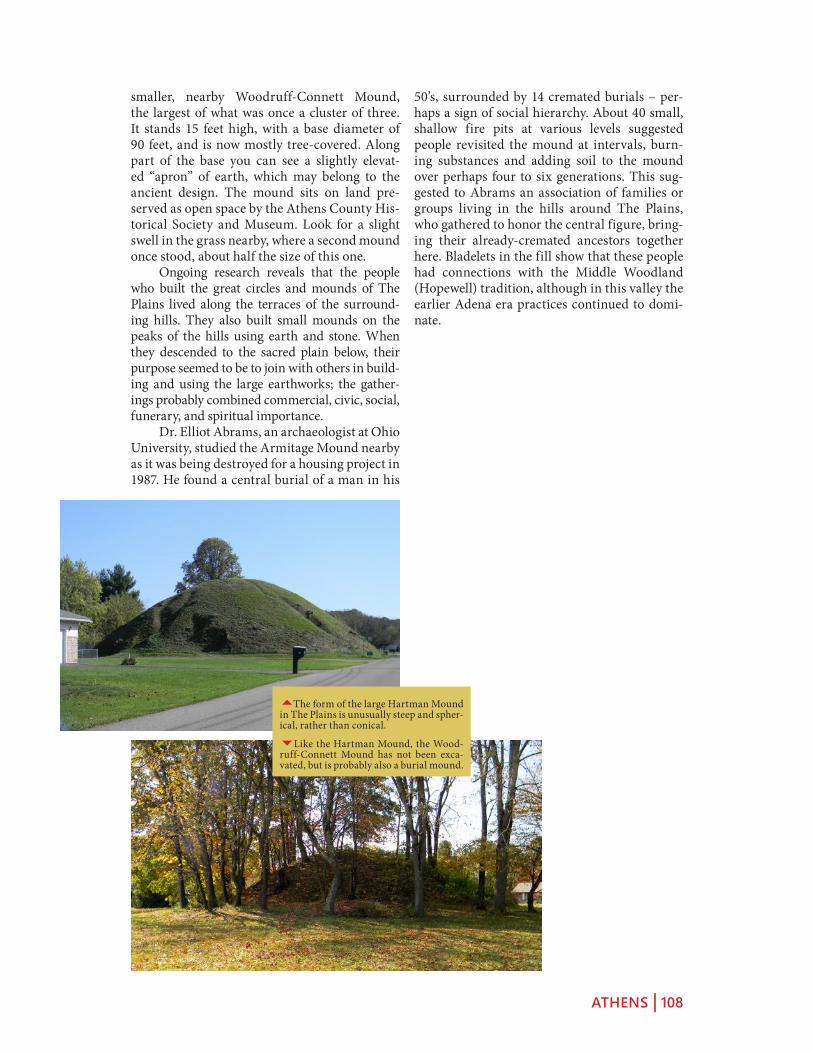
ATHENS | 108
50’s, surrounded by 14 cremated burials – per-haps a sign of social hierarchy. About 40 small, shallow fire pits at various levels suggested people revisited the mound at intervals, burn-ing substances and adding soil to the mound over perhaps four to six generations. This sug-gested to Abrams an association of families or groups living in the hills around The Plains, who gathered to honor the central figure, bring-ing their already-cremated ancestors together here. Bladelets in the fill show that these people had connections with the Middle Woodland (Hopewell) tradition, although in this valley the earlier Adena era practices continued to domi-nate.
smaller, nearby Woodruff-Connett Mound, the largest of what was once a cluster of three. It stands 15 feet high, with a base diameter of 90 feet, and is now mostly tree-covered. Along part of the base you can see a slightly elevat-ed “apron” of earth, which may belong to the ancient design. The mound sits on land pre-served as open space by the Athens County His-torical Society and Museum. Look for a slight swell in the grass nearby, where a second mound once stood, about half the size of this one. Ongoing research reveals that the people who built the great circles and mounds of The Plains lived along the terraces of the surround-ing hills. They also built small mounds on the peaks of the hills using earth and stone. When they descended to the sacred plain below, their purpose seemed to be to join with others in build-ing and using the large earthworks; the gather-ings probably combined commercial, civic, social, funerary, and spiritual importance. Dr. Elliot Abrams, an archaeologist at Ohio University, studied the Armitage Mound nearby as it was being destroyed for a housing project in 1987. He found a central burial of a man in his
5The form of the large Hartman Mound in The Plains is unusually steep and spher-ical, rather than conical.
6Like the Hartman Mound, the Wood-ruff-Connett Mound has not been exca-vated, but is probably also a burial mound.

MARIETTA | 109
and The MuskinguM riVer Valley
MarieTTa
Veterans of the American Revolution laid out the town of Marietta, respecting grand Adena and Hopewell remains: the cem-etery centers on a beautiful mound and ring; the town’s library sits on one of three distinctive rectangular platform mounds. A broad avenue, now a park, follows an ancient graded way to the riverbank. A thriving downtown, plus beauti-ful residential and historic districts and some fine restaurants, make this a rewarding destination. The surrounding area is full of natural beauty and history. Several attractive routes from Cincinnati, Chillicothe, or Colum-bus, lead through Athens to Mari-etta (see the Athens and Hocking Valley itinerary). From Athens, use US 50, or the somewhat more sce-nic State Route 550 farther north, to reach Marietta. Marietta is a well-preserved river town, with many layers of history. When the veterans of the “Ohio Company” arrived with their families in 1788, the huge geomet-ric earthworks were already 1500 or more years old. Several are still well preserved, and it is possible to take them all in via a leisurely walk or drive among beautiful houses,
churches, and public buildings. Two excellent museums (Campus Martius and Ohio River) tell the stories of the town’s origins and settlers, and river transport. Trolley and steamboat tours, and a huge festival every September, highlight Marietta’s distinguished history and architec-ture.
Muskingum River
Ohio River
Greene Street To
I. 77
Putnam Street
Washington Street
State Route 60
Third Street
Fifth Street
State Route 7
1
23
7
4
56
MarieTTa Map
1 Conus Mound (Cemetery)
2 Capitolium Mound (Library}
3 Quadranaou Mound
4 Sacra Via
5 Campus Martius Museum
6 Ohio River Museum
7 Harmar Historic District

MARIETTA | 110
HISTORY OF THE EARTHWORKS AND THE TOWN Here, where the Muskingum River joins the Ohio, stood the easternmost of Ohio’s monumental ancient earthwork com-plexes. Its unusual plan included a ringed buri-al mound, two large rectangular enclosures, a set of platform mounds, and a wide graded way down to the river. After the Revolutionary War, the new American Congress was in financial straits, and unable to pay all the soldiers. A few enterpris-ing New Englanders suggested that cheap land in the West would be a good substitute for cash, and they persuaded Congress to let them form “The Ohio Company of Associates” to broker the deal. Led by Rufus Putnam and Benjamin Tupper, two Brigadier Generals from Massa-chusetts, and the Reverend Manasseh Cutler,
the Company bought a huge tract of land along the Ohio River at a bargain price, then advertised the lots. Enthusiasm for the project ran high among veteran offi-cers; even George Washington, though
unable to go, wrote, “No colony in America was ever settled under such favorable auspices.” In 1788, Putnam himself led the first 48 men down the Ohio River to its confluence with the Muskingum, where U.S. Fort Harmar already stood. The local Delaware and Wyan-dot Indians were eager to trade, but incursions on their homelands suggested conflict to come. Putnam and the others quickly built the Cam-pus Martius, just outside the ancient enclosure walls, to provide safety for all residents in case of attack. In a nod to their Revolutionary War allies, they named their town “Marietta” in honor of the French queen, Marie Antoinette. Putnam and his colleagues planned the settlement carefully in relation to the earth-works, and gave them respectful Latinate names: the mound and ring they named “Conus” and around it they developed their own cemetery. One rectangular platform mound became the “Capitolium” and a second, larger one, the “Quadranaou.” The broad ramp down to the river they called the “Sacra Via” – this Sacred Way still suggests solemn processions. Today, a brick monument at the head of the Sacra Via remembers the descendants of those first deed holders, some still in Marietta.
5Rufus Putnam was tireless in shep-herding the idea of land grants for veter-ans through Congress, then in leading the Marietta settlers himself.
3Besides the town’s name, another French connection was the visit here by General Lafayette during his tour of the new nation he had helped to liberate.
6A park frames views of the Ohio and Muskingum River confluence, in down-town Marietta.

MARIETTA | 111
founders, wrote this about his early attempt: An opening being made at the summit of the great mound, there were found the bones of an adult in a horizontal position, covered with a flat stone. Beneath this skeleton were three stones placed vertically at small and different distances, but no bones were discovered. That this venerable monument might not be
defaced, the opening was closed without further search. Cutler’s respectful closing of the mound was typical of the Marietta attitude. By 1837, the town had fenced the cemetery, sewn the monu-ment with grass, and built a stone staircase to the top. All around they had buried their own dead, many of them honored veterans of the American Revolution. The Conus stands 30 feet tall; its surround-ing ditch and ring accent its height and lovely profile. Toward the northwest, the wall and ditch level out to an earth “bridge” – an obvi-ous entryway. A swell in the ground extending from this point once led out to the neighboring square enclosure. Nearby in the cemetery are memori-als to soldiers of the Revolution, and later graves, including that of Benjamin Tupper who once mustered troops for the Civil War at the Quadranaou.
CAPITOLIUM MOUND The large enclosure at Marietta contained four flat-topped, rectangular platform mounds -- an unusual shape for this culture: the so-called Quadranaou Mound with four ramps, the Cap-itolium Mound with three ramps, another with two ramps, and a final un-ramped mound. The Capitolium still stands on Fifth Street near Washington, near a gateway to the now-lost large enclosure. In 1918, the Capitolium was co-opted as the foundation of the new, Carne-gie-funded Washington County Public Library,
The Marietta settlers established the earliest pres-ervation law west of the Appalachians. To ensure that the earthworks would be kept for public benefit, they appoint-ed a committee to determine, in their words, “the mode of improvement for ornament, and in what manner the ancient works shall be preserved.” While inroads were made on the earthworks over the years, the town’s vigilance has kept some of its main features as stars in its historic crown.
CONUS MOUND Marietta’s Mound Cemetery is cen-tered on the ancient Conus Mound, with its beautiful ditch and ring. The Conus is a burial structure, probably the best surviving example of the Adena tradition’s large, conical, ringed mounds. It has not been investigated by archaeolo-gists, but the Reverend Manasseh Cutler, one of the town’s
3Squier and Davis featured Marietta’s earthworks and early settlement as the frontispiece of their Ancient Monuments of the Mississippi Valley, in 1848. This broad terrace above the river confluence was equally attractive 17 centuries later, when Marietta became the first perma-nent U.S. settlement in the Ohio Country.
6View of the Conus standing among the graves of Marietta’s founders, including many Revolutionary War veterans.

MARIETTA | 112
ing. On the left side, the ancients designed only a kind of hollow between two lobes of earth – archaeologist Bill Pickard calls it an “anti-ramp.” In 1990, when the library was adding an elevator in the “anti-ramp,” archaeologists were able to confirm that the mound was indeed from the Hopewell era. They also found a hearth, with charcoal from many different kinds of trees – most likely suggesting world-renewal rituals.
QUADRANAOU MOUND The largest and grandest of Marietta’s earthworks is the well-preserved Quadranaou. Its vast, rectangu-lar form stands 10 feet tall, and nearly 200 feet long. Elegant, broad ramps climb to the centers of its four sides. Grand gatherings, dances, and games are easily imagined on its level surface. In Civil War times, the Union army used it for mustering recruits. It was also here (or nearby) where one of Marietta’s founders tried a novel method of dating the earthworks. The Rever-end Manasseh Cutler recalled: When I arrived, the ground was in part cleared, but many large trees remained on the walls and mounds. The only possible data for forming any possible conjecture respecting the antiquity of these works, I conceived must be derived from the growth upon them. By the concentric circles, each of which denotes the annual growth, the age of the trees might be ascertained. Reverend Cutler counted 463 rings on one old stump, but then noticed it was coming out of another, older ancestor – so he doubled the number. It was a good, early effort to use a scientific method – what we now call “dendro-chronology.” Little did he know he would have needed to double his number again. His “900 year” figure, though, still appears on some city plaques, instead of reflecting the correct age of 2000 years.
whose founders insisted this met the criterion of “public benefit,” as specified in the original earthworks preservation ordinance. One if its three ramps carries the library’s front steps to the sidewalk. Another swells in the narrow yard behind. The best preserved ramp slopes to the alley, on the right side of the build-
5Computer reconstruction of the Mari-etta Earthworks showing the 4 rectangu-lar platform mounds and the two large squares.
6The ancient, ramped platform of the Capitolium Mound is clearly visible beneath Marietta’s public library.
66The large Quadranaou stands with its 4 symmetrical ramps in a large park, at the head of the ancient Sacra Via.

MARIETTA | 113
cial resolution to preserve the Sacra Via, in their words, “as common ground…never to be disturbed or defaced.” But by 1882, when J.P. MacLean visited, the walls were gone. He wrote: On inquiring what had become of these walls I was informed that the material had been moulded into bricks; that a brick-maker had been elected a member of the town council, and he had persuaded the other members to vote to sell him the walls. The bricks ended up in a Uni-tarian Church, down the street. Yet even with only hints of its origi-nal walls, this ancient roadway is impressive, and the best preserved
example of a Hopewell-era “graded way.”
HISTORIC HOUSES Today the town of Marietta is a charming, historic place. The downtown is large, quaint, and thriving; near the riverfront stands a proud old hotel named after General Lafayette, who visited the tiny settlement in 1825, on his grand U.S. Tour. Up where the ancient earthen walls once stood, wide brick streets are now lined with huge trees, beautiful houses in many nineteenth-cen-tury styles, and monumental churches. The oldest houses in Marietta are in the New England style familiar to the town’s found-ers, featuring wide fronts, deep sides with chim-neys, and sometimes dormers. Several of the oldest houses, like that of David Putnam, are on the “Fort Harmar” side of the Muskingum, reached today by a re-purposed railroad bridge.
FORT HARMAR After the Revolutionary War, Colonel Josiah Harmar was put in mili-tary charge of the Ohio Country for the newly formed nation. One of his first jobs was to keep illegal settlers out while Congress tried to mea-sure and sell off the land. But “squatters” came anyhow, and were aggravating Indian tribes, who had agreed to an earlier peace treaty. Colonel Harmar ordered a pentagonal stockade fort to be built at the mouth of the Muskingum in 1785, and the officer in charge named it after his commander: Fort Harmar. It may be the only American fort built to protect the Indians from the settlers! Soon afterward though, it actually encouraged white settle-ment: the new founders of Marietta felt safe in
THE SACRA VIA Old maps show the Sacra Via as a long, broad ramp with high earthen walls on both sides, leading up from the Musk-ingum River to Marietta’s large rectangular enclosure. Its monumental scale survives today as a park, a hundred and fifty feet wide. Such grand “graded ways” were often part of Ohio earthwork complexes. The ramp was carefully engineered: its width crested in the center like a modern high-way, its twenty-foot-high walls were lined with clay. This grand thoroughfare would have weathered floods well, and certainly would have impressed visitors arriving at the earthworks by boat. Its central axis is aligned with the winter solstice sunset; a mound probably marked the spot on the cliff top across the river. Marietta’s first town council made a spe-
5Only tiny fragments of the Sacra Via’s tall defining walls remain, in one or two front yards.
6This early illustration of the Sacra Via by Charles Sullivan suggests the grandeur of the walls as they approach the river bank.

MARIETTA | 114
its shadow. The fort is gone, but the old “Har-mar” district across the Muskingum retains the name.
TWO MUSEUMS Marietta has two fine historical museums, within 2 blocks of each other. The Campus Martius Museum tells the story of the Ohio Company, and the town’s early settlement and history. It preserves the Land Office where the deeds were signed as new settlers claimed their piece of the “West.” The museum stands on the site of the original “Campus Martius” fortification, and contains one of the original corner houses of that struc-ture, with its sawn and numbered boards, and meticulous pegged joints. Rufus Putnam’s own house also provides a glimpse into the lives of those first settlers. Nearby on the bank of the Muskingum, the Ohio River Museum is a series of pavilions and bridges, where exhibits tell the story of all kinds of boats and river transport, from dug-out canoes to the largest and finest of the steam-powered riverboats, including their mechani-cal operation, their pilots, and even their steam whistles. Outside on the water, the W. P. Snyder is also open for visits. In connection with the museum, the annual Sternwheeler Festival reg-ularly draws 100,000 people to Marietta.
THE MUSKINGUM RIVER VALLEY From Marietta, a scenic route follows the valley of the Muskingum River through the pictur-esque historic towns of Stockport and McCon-nelsville, and on to Zanesville, enroute to New-ark or Columbus. (A long but even more scenic
55Most spectacular of Marietta’s grand houses is “The Castle” – a large, turreted, Gothic Revival mansion, built in 1838 and now open to the public.
5David Putnam’s stone house was built in 1805, only 16 years after the first crude settlement, in the typical New England style.
4Painting of Fort Harmar, which stood on the bank of the Muskingum conflu-ence, opposite the town of Marietta.

MARIETTA | 115
tioning. Boats are able to navigate the river today using this same infrastruc-ture, still visible along the riverfronts in Beverly, McConnelsville, and other riverside towns and villages. In 1896, archaeologist Warren Moorehead and a few aides left the town of Coshocton to survey mounds and earthworks in the Muskingum valley. His notes describe Native sites now lost: pictographs on a large boul-der depicting bird tracks and other figures, plus a great face carved in a rock. It’s possible that many mark-ers and symbols once greeted people moving down this river. He investi-gated the large Sprague Mound then standing, as he noted, “directly in the heart of McConnelsville,” and gave a lecture on his work in the Opera House.
Moorehead’s report suggests the valley had at least 60 mounds, some on the river terraces, some with rings, some high above on bluffs. The locals told him that most of the mounds were places of observation rather than burial, prob-ably much like the grouping at The Plains near Athens, also from the Adena era.
MCCONNELSVILLE TO STOCKPORT Far from the major highways, the villages of the Muskingum Valley preserve their early ambience, small local commerce, and fine vernacular architecture. McConnelsville’s diagonal town square is a gem of preservation, surrounded by fine period commercial build-ings and houses. The smaller, nearby village of Stockport contains many well-preserved, wood-framed, vernacular houses, as well as the massive, restored Stockport Mill, now an inn with fine dining and lodging overlooking one of the river’s largest waterfalls. Along a peaceful stretch of riverbank near Stockport, a park and historical marker com-memorate the Big Bottom Massacre, where a small band of settlers were killed by Indians. The incident, indicative of the tragic circum-stances of the early settlement and displacement process, sparked a wave of military actions against the Native inhabitants of the region.
NORTH TOWARDS NEWARK Follow the river northward from Stockport to the his-toric city of Zanesville, named for Ebenezer Zane who laid out the famous roadway from
alternative is to follow the Ohio River westward to Cincinnati by way of Gallipolis, Portsmouth, and Ripley with its famous Underground Rail-road sites, and not missing the beautiful Ken-tucky towns of Maysville, Washington, and Augusta.) As part of Ohio’s canal building project in the early 1800s, the Muskingum River was “canalized” by the addition of a series of chan-nels, locks, and dams. The lock mechanisms, designed to be operated by hand, are still func-
5The first map of the Marietta earth-works was made by Capt. Jonathan Heart of Fort Harmar in 1787.
6Interior of founder Rufus Putnam’s House, originally part of the Campus Martius fortification, and now open to visitors as part of the Museum.

MARIETTA | 116
Wheeling, Virginia (now West Virginia), to Limestone (now Maysville), Kentucky. The towns of “Zane’s Trace” reflect their early importance along the busy route, and preserve their early character (Lancaster and Chilli-cothe, for example, besides Zanesville itself). The most authentic of these early Zane’s Trace settlements is undoubtedly Somerset: the village retains its small, Jeffersonian agrarian scale, and its early courthouse, which faces its Pennsylvania-style town square. Somerset also provides access to the remarkable Glenford Fort Earthwork (see the Flint Ridge, Coshocton, and Somerset itinerary).
55Details of the Devola Locks, just above Marietta, part of the still-function-ing, hand-operated lock system along the Muskingum River.
5The W. P. Snyder is the last surviving steam-powered, stern-wheel tugboat.
4Lobby of the Lafayette House Hotel, convenient to fine dining and lovely river views.

MARIETTA | 117
5The Opera House where Moorehead spoke is still in use, dominating McCon-nelsville’s well-preserved, diagonally-ori-ented town square.
6The main street of Stockport, head-ing down toward the riverbank and the remodeled Stockport Mill Inn.
66The town square and courthouse at Somerset reflect the early settlement patterns of the “Pennsylvania Dutch,” pre-dominantly German immigrants.

OHIO EARTHWORKS TIMELINE | 118
ohio earThWorks TiMeline
THE GEOLOGICAL FORMATION OF THE OHIO VALLEY (2 MILLION TO 9000 BC)Enormous glaciers helped reshape the Ohio Val-ley many thousands of years ago. The edge of the flat, glaciated region is prominent along a line just west of Serpent Mound, Chillicothe, and Newark. After the last glacier retreated north-ward, the new tributaries of the Ohio River, such as the Scioto or the Great Miami, often followed wide valleys created by the earlier, larger rivers. These valleys have rich soil, laid over the sand and gravel till left behind by the glaciers, and wide terraces at different levels that later became prime locations for earthworks.
PALEOINDIANS IN THE GREAT VALLEY (13000 TO 8000 BC) While glaciers still covered much of North America, people first arrived from Asia by the ancient land bridge to Alaska or by boat. Over many generations they spread across the continent. People we call “Paleoindians” were in the Ohio Valley as early as 13,000 years ago, living in wandering bands, gathering plants, and hunting. Their distinc-tive spear points have been found in the bones of long extinct ice age animals like the wooly mammoth. They were skilled stone workers, and discovered the beautiful rainbow-colored stone from Ohio’s Flint Ridge, used by their descendants for centuries and still prized by flintknappers today.
ARCHAIC INDIANS (8000 TO 1500 BC) When the glaciers melted, the tundra and pine forests of eastern North America were replaced by the “eastern woodland” ecology we know today: hardwood forests threaded by many rivers and streams. The large ice age animals became extinct or moved northward, replaced gradually by deer and other woodland animals. This new environment also presented a wealth
of nuts, fruits, plants and edible roots. The “Archaic” people began to plant seeds and tend gardens, making eastern North America one of only a handful of places on earth where agricul-ture began without outside influence.
THE ADENA CULTURE (1500 BC TO AD 100) The first burial mounds in the Ohio Val-ley mark new beliefs and customs. People still moved periodically, but they began to make pottery and erect thousands of great earthen burial structures around the Ohio and its trib-utaries, showing a strong sense of community. Archaeologists named this culture “Adena” after Thomas Worthington’s Chillicothe estate, where a mound excavation in 1906 revealed its typical practices. The Adena produced beautiful artifacts, and developed elaborations on mound architecture, including circular ditches, pave-ments, and walls. The later Hopewell culture overlaps with the Adena, both in years and in territory. The Hopewell built enclosures near or even around Adena earthworks. The Adena and the Hopewell may have been the same people whose practices changed, or neighbors with dif-ferent views but mutual respect.
THE HOPEWELL CULTURE (100 BC TO AD 400) Great new inspirations marked the coming of Ancient Ohio’s “Golden Age.” People began to assemble over many generations, creat-ing complex earthworks, enormous in scale, pre-cise in geometry, and often aligned with celestial events. And beneath carefully mounded layers of earth they left elaborate burials and beauti-fully crafted objects, evidence of their artistic skill and the great reach of their trade networks. This culture is called “Hopewell” because its richest ceremonial site was part of Mordecai Hopewell’s farm, just west of Chillicothe, at the end of the 19th century. From its southern Ohio

OHIO EARTHWORKS TIMELINE | 119
heartland, Hopewell practices and interactions spread across much of North America.By about AD 400, forests were reclaiming the geometric earthworks, and the communities’ focus shifted from these vast ceremonial centers to growing villages, and new ways of life.
THE FORT ANCIENT CULTURE (1000 TO 1650) By the year one thousand, the large-scale cultivation of corn was transforming life in ever-larger villages. These ideas were shared with groups along the Mississippi River (notably at Cahokia and other large cities). These practic-es in the central Ohio Valley have been named “Fort Ancient Culture” because one of their vil-lages was built near the much older (Hopewell era) walls of Fort Ancient. Unlike some of their contemporaries to the south, the Fort Ancient Indians did not build large pyramid mounds, or live in large cities; but they did create small flat-topped mounds and effigy mounds, including the continent’s most famous, the Great Serpent.
THE GREAT DYING (1492 TO 1650) The most tragic event in the history of American Indians, and of all North America, is the Great Dying. Probably more than 80% of all native peoples died from European diseases within the span of a few decades. New infectious diseases swept across the continent much faster than the new people did; so when Europeans final-ly arrived in the Great Valley of the Ohio, the damage had already been done. With the death of elders in particular, memories and knowledge were often lost. These huge plagues also under-mined ancient beliefs: people watched desper-ately as the old cures failed against the new dis-eases. All this sudden death may help explain why so little is known today of the ways and beliefs of the ancient earthwork builders.
TRIBES IN THE OHIO VALLEY (1700 TO 1843) By 1650, the ancient earth-building traditions had faded. The Iroquois were mov-ing through the Ohio country, scattering other tribes and trying to control the fur trade. Soon afterward, other tribes came in from the north and east. The first French and British traders encountered Miami, Wyandot, Ottawa, Shaw-nee and Delaware (Lenape) people, among oth-ers. None of these groups had proven, direct connections with the earthwork builders. But it is clear that all Eastern Woodland Indians share a common heritage, and that the earlier Adena, Hopewell, and Fort Ancient people are among
its ancestral sources.
EUROPEANS ENCOUNTER THE EARTH-WORKS (1750 TO 1850) The first Euro-peans in the Ohio Valley were impressed by the earthworks, but quick to classify them accord-ing to their own ideas. Many sites were named “forts” due to a superficial (though later dis-proven) resemblance. More importantly, most settlers, and even scholars at the time, could not accept the possibility they were built by the ancestors of the Indians they were meeting in the area. Racism and ignorance led many Euro-Americans to concoct bizarre theories that they were built by transplanted Egyptians, or Israel-ites, or a Welsh tribe, or the Vikings! This confu-sion persisted until the early twentieth century.
EARLY APPRECIATION FOR THE EARTH-WORKS (1750 TO 1850) The founders of the United States knew and admired the earth-works along the Ohio. George Washington and Thomas Jefferson both argued for their preserva-tion. Jefferson’s Secretary of the Treasury Albert Gallatin was another eager scholar of ancient America, and expressed disgust for people who belittled the achievements of the Indians. Pub-lic interest in the mounds was at its peak by the mid-1800s, when two citizens of Chillicothe, Ephraim Squier and Doctor Edwin Davis, set out to survey the earthworks of the entire Mississippi and Ohio river system. With support from Galla-tin, their work became the first publication of the new Smithsonian Institution.
DESTRUCTION AND PRESERVATION (1750 TO THE PRESENT) Ohio Valley tribes did not live on the old earthwork sites, but they sometimes added their own burials. The settlers, though, were quick to build among the earthworks: they were often in ideal spots for water access or for farming. Many were destroyed and many more were cut down by treasure hunters. By the late-1800s, scientific archaeology began to study them. Frederic Ward Putnam, “the father of American archaeology,” traveled from Harvard University to investigate the Great Serpent Mound, and saved it from destruction. Often the processes of archaeology found and saved valuable artifacts, yet destroyed the earthworks. Modern farming, graveling, and urban sprawl are still taking a toll on the ancient sites, despite strong efforts by the Ohio Historical Society, the National Park Service, the Archaeological Conservancy, and others.

OHIO EARTHWORKS TIMELINE | 120
EARTH, ART, AND CULTURE (PRESENT AND FUTURE) The idea that earth shapes space and can be designed to reflect the deep meanings in a culture, is still with us. Con-sider the great gardens of Europe, or China, or our own massive interstate highway embank-ments! The ancient earthworks can remind us how the manipulation of the landscape always carries important meanings as well as aesthetic power. Artists and landscape architects under-stand fully that blending nature and artistry, especially at a vast scale, is always intriguing. On the new University of Cincinnati campus, sinuous earthen embankments (by world-renowned designer George Hargreaves) weave the campus together, enclosing space, directing movement, and marking distant vistas; students walk among a series of winding earthworks and massive mounds (explicitly inspired by Ancient Ohio) as they go from class to class.

SAMPLE ITINERARIES | 121
saMple iTineraries
PLANNING YOUR TRIP Explore the routes in advance by using the Ancient Ohio Trail’s “map” function: you can find all the detailed content embedded in vivid aerial visualiza-tions of the towns and earthworks mentioned here, giving you a complete sense of orientation before leaving home.
Of course, these plans can easily be adapted for arrival from any direction, or through any of the region’s major airports: Columbus CMH, Day-ton DAY, or Greater Cincinnati CVG.
Note: Confirm availability in advance for any recommended accommodations. Check daily and seasonal opening times at any recommend-ed sites. Consult local county tourism bureau websites for additional options and information.
WEEKEND HIGHLIGHTS (2 DAYS, 3 NIGHTS) FRIDAY EVENING Check in at the Golden Lamb (Ohio’s oldest Inn) in histor-ic downtown Lebanon and enjoy dinner in its famous restaurant.
SATURDAY Early morning, drive over to the Fort Ancient Earthworks and Nature Preserve to tour the site and the museum; being sure to get as far as the South Gate. Head east on any of a number of routes, most of which pass through Hillsboro; find a spot for lunch. East of Hills-boro, watch for the sudden rising of the Appala-chian foothills, and off SR-73 just before Sinking Spring, visit the Great Serpent Mound. Don’t miss the lower trail down by Brush Creek.
From Sinking Spring, follow SR-41 north to US-50. Just east of Bainbridge visit the Seip Earthworks, a focal point of the beautiful Paint Valley. Entering Chillicothe, check in at one of the fine Bed and Breakfast Inns in the well-
preserved historic district, such as the Atwood House. Several restaurants including the Old Canal Smoke House are within walking dis-tance.
SUNDAY Early morning, tour the ancient necropolis of Mound City, headquarters of Hopewell Culture National Historical Park, then continue north on SR-104 (just below Cir-cleville along the west bank of the Scioto River are beautiful canal remnants). In Lancaster, if time permits, take in one of the excellent, large, historic house museums.
Arrive in Newark by late afternoon to take in the Great Circle Earthworks with its interior ditch and central “Eagle Mound” (and its small muse-um). Finally, across town, explore the spectacu-lar precision of Newark’s Octagon Earthworks.
Celebrate your astonishment at the achievement of the Ancient Ohioans with a fine meal (and overnight) at one of nearby Granville’s fine res-taurants and historic inns, the Granville or the Buxton.
If time remains the following day, take in the spectacular archaeology exhibits at the Ohio History Connection’s museum in Columbus.
BEST OF ANCIENT OHIO (7 DAYS, 8 NIGHTS) FRIDAY EVENING Check in at one of downtown Cincinnati’s fine hotels such as the Art Deco masterpiece Netherland Hilton, from where it is easy to sample the city’s vibrant res-taurant and cultural scene.
SATURDAY Early morning, drive up I-71 to the Fort Ancient Earthworks and Nature Pre-serve to tour the site and the museum; being sure to get as far as the South Gate. Head east on

SAMPLE ITINERARIES | 122
any of a number of routes, most of which pass through Hillsboro; find a spot for lunch. East of Hillsboro, watch for the sudden rising of the Appalachian foothills, and off SR-73 just before Sinking Spring, visit Serpent Mound. Be sure to follow the lower trail down by Brush Creek. Check in at the nearby Murphin Ridge Inn, and dine at its gourmet restaurant.
SUNDAY A bit north on SR-41, tackle the spec-tacular, earthwork-ringed, old-growth forested hilltop at Fort Hill before continuing on via Bainbridge (on US-50, find lunch) to visit the Seip Earthworks, a focal point of the beautiful Paint Valley. On the way into Chillicothe, also take the short detour to the Hopewell Mound Group, where the walls and ponds along the northern hilltop are particularly impressive. Entering Chillicothe, check in for 2 nights at one of the fine Bed and Breakfast Inns in the well-preserved historic district, such as the Atwood House. Several restaurants including the Old Canal Smoke House are within walking dis-tance.
MONDAY Early morning, tour the ancient necropolis of Mound City, headquarters of Hopewell Culture National Historical Park, then continue north on SR-104 (where, just below Circleville on the west bank of the Scioto River are beautiful canal remnants). Downtown Circleville has several lunch options.
An optional afternoon excursion south from Chillicothe can include Piketon (Mound Ceme-tery, historic houses) and Portsmouth, where the “Old Fort” earthworks are well preserved across the Ohio River in Kentucky. A visit to the Adena Mansion and Gardens (the palladian villa of Ohio’s first senator), high above the town, is also worthwhile. Spend a second night in historic Chillicothe.
TUESDAY Head east out of Chillicothe via US-50, taking a short detour to see the beautiful Zaleski Mound, before arriving in Athens, home of Ohio University, in time for lunch at one of its pioneering “locavore” restaurants. Two impres-sive mounds stand in the neighboring village of The Plains.
After lunch, continue on to historic Marietta for a night at the Lafayette Hotel, and dinner at the famed Levee House on the riverfront. That evening or the next morning, explore the town’s
beautiful streets to discover the ringed Conus Mound (in its Revolutionary War cemetery set-ting), two surviving platform mounds, and the Sacra Via. There are also two fine museums presenting town and river history, and superb period houses.
WEDNESDAY Follow SR-60 up the Musk-ingum River, with its interesting system of navi-gation locks, through historic McConnelsville, Stockport, and Zanesville (find lunch), to visit the ancient quarries at Flint Ridge. Continue on through Newark to picturesque Granville, checking in for a fine meal and lodging (2 nights) at one of the town’s fine historic inns, the Granville or the Buxton.
THURSDAY The spectacular Newark Earth-works are best visited early or late in the day. Begin at the Great Circle Earthworks with its interior ditch and central “Eagle Mound” (and a small museum). Across town, allow plenty of time to ponder the spectacular Octagon Earth-works – if golfers are not present walk to obser-vatory mound as well as among the octagon’s monumental gateways.
Other nearby excursions could include the Granville “alligator” effigy on a hilltop just east of the village, or, by way of SR-79 through Buck-eye Lake (the early canal system reservoir), on to Lancaster, a beautiful town with several signifi-cant historic house museums.
FRIDAY Take the short drive into Columbus for a tour of the archaeology exhibits at the Ohio History Connection’s museum, of I-71 at 17th Avenue. It is a stunning presentation of the art-istry of the earthwork builders, in exotic materi-als from far across the continent. The trip back to Cincinnati can easily be extended via Day-ton, for a stop at SunWatch Village, where sev-eral reconstructed houses typical of the Ancient Ohioans (here from the later “Fort Ancient” cul-ture) can be explored.
Return for a final overnight in Cincinnati. If time remains the following day, head out west of the city to Shawnee Lookout Park, with the well-preserved Miami Fort Earthworks and views of the Great Miami River confluence.