The Mormon Trail - DigitalCommons@USU
240
Utah State University Utah State University DigitalCommons@USU DigitalCommons@USU All USU Press Publications USU Press 2006 The Mormon Trail The Mormon Trail William E. Hill Follow this and additional works at: https://digitalcommons.usu.edu/usupress_pubs Part of the United States History Commons Recommended Citation Recommended Citation Hill, W. E. (1996). The Mormon Trail: Yesterday and today. Logan, Utah: Utah State University Press. This Book is brought to you for free and open access by the USU Press at DigitalCommons@USU. It has been accepted for inclusion in All USU Press Publications by an authorized administrator of DigitalCommons@USU. For more information, please contact [email protected].
-
Upload
khangminh22 -
Category
Documents
-
view
0 -
download
0
Transcript of The Mormon Trail - DigitalCommons@USU
Utah State University Utah State University
DigitalCommons@USU DigitalCommons@USU
All USU Press Publications USU Press
2006
The Mormon Trail The Mormon Trail
William E. Hill
Follow this and additional works at: https://digitalcommons.usu.edu/usupress_pubs
Part of the United States History Commons
Recommended Citation Recommended Citation Hill, W. E. (1996). The Mormon Trail: Yesterday and today. Logan, Utah: Utah State University Press.
This Book is brought to you for free and open access by the USU Press at DigitalCommons@USU. It has been accepted for inclusion in All USU Press Publications by an authorized administrator of DigitalCommons@USU. For more information, please contact [email protected].


T H E M O R M O N T R A I L
Yesterday and Today

Number: 223Orig: 26.5 x 38.5Crop: 26.5 x 36Scale: 100%Final: 26.5 x 36
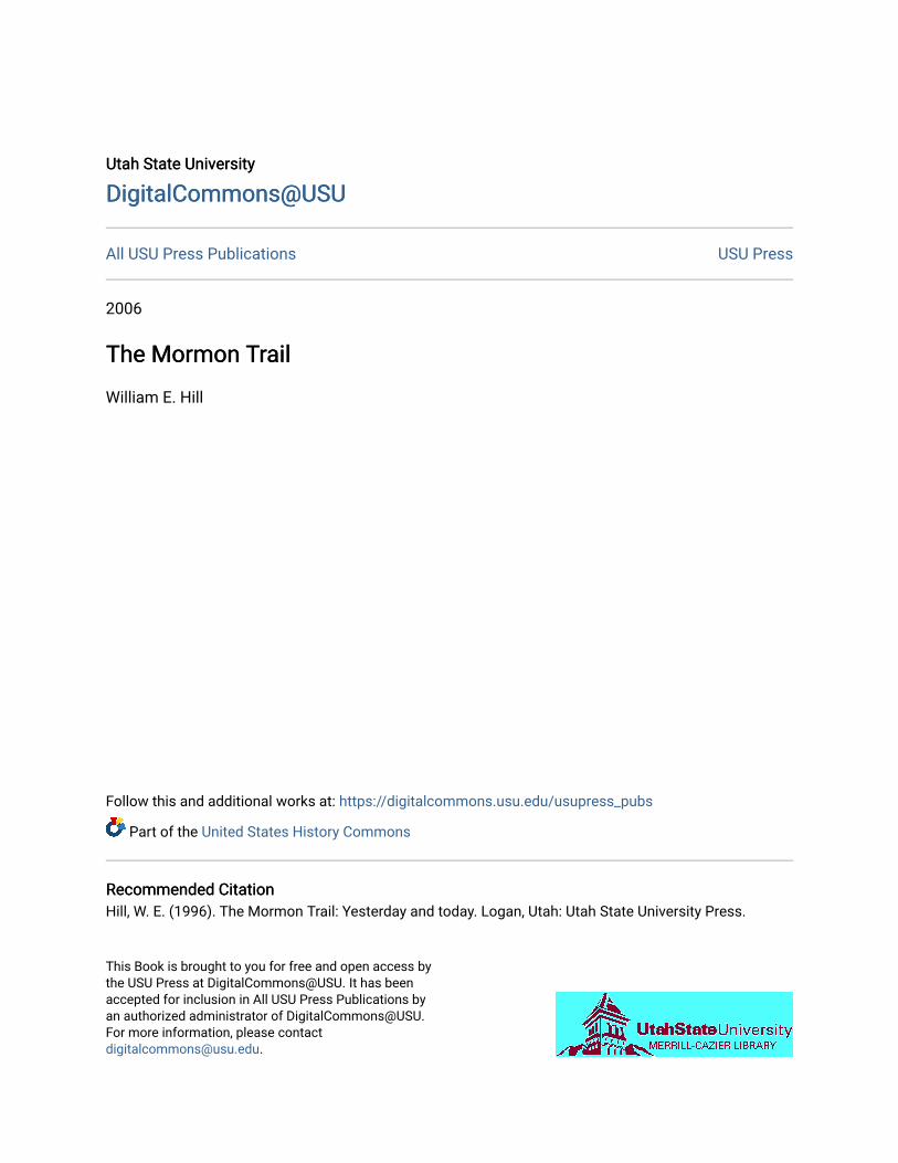
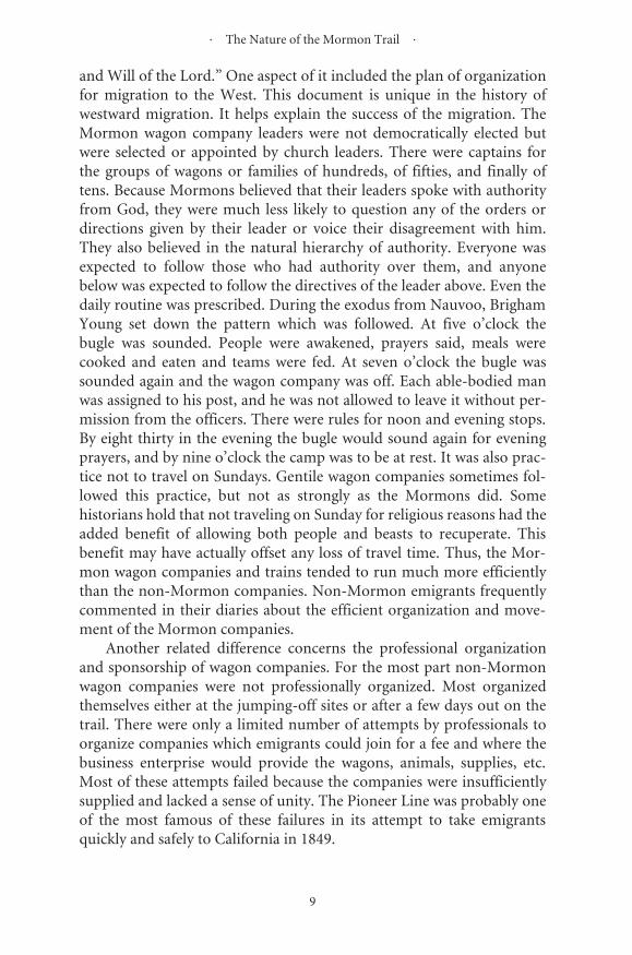
BRIGHAM YOUNG—From Piercy’s Route from Liverpool to Great Salt Lake Valley
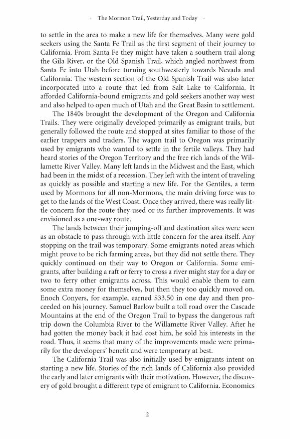
Brigham Young was one of the early converts toMormonism who joined in 1832. He moved toKirtland, was a member of Zion’s Camp in1834, and became a member of the first Quo-rum of Twelve Apostles in 1835. He served as amissionary to England. After the death ofJoseph Smith in 1844, he was the senior apostleand became leader of the Mormon Church. He
helped to organize the exodus from Nauvoo in1846, led the first Mormon pioneers from Win-ter Quarters to Salt Lake in 1847, and again ledthe 1848 migration. He was sustained as the sec-ond president of the Mormon Church in 1847,became the territorial governor of Utah in 1850,and continued to lead the Mormon Churchuntil he died in 1877.
� � � � � � � � � � � � � � � �
�������������������
���������������
��������������������������������������
����

Copyright © 1996 Utah State University PressAll rights reserved
Typography by WolfPackCover design by Michelle Sellers
Library of Congress Cataloging-in-Publication Data
Hill, William E. The Mormon Trail : yesterday and today / William E. Hill.
p. cm. Includes bibliographical references and index. ISBN 0-87421-202-2 1. Mormon Trail. 2. Mormons—West (U.S.)—History. 3. West (U.S.)—
History. I. Title. F593.H553 1996 978—dc20 95-50223
CIP
ToGeorge, Jenille, and
their grandson Matthew,good friends met along the way

v
Contents
Illustrations viiPreface xv
The Nature of the Mormon Trail 1
Early History 15The Mormon Church, the Development of the Mormon Trail, and Mormon Migrations: 1803–1869 17
Maps, Guidebooks, and Diaries 33Maps 35Guidebooks 49Diaries 57
Pictorial Journey 75Artists 77Pictorial Journey 81Illinois 87Iowa 97Nebraska 105Kansas 110Nebraska 111Wyoming 126Utah 162
Historic Sites 183Museums and Displays 185
Readings and Sources 199Recommended Readings 201Bibliography 205

vii
Illustrations
BRIGHAM YOUNG FrontisMORMON TRAIL MAP xiiJAMES & MARGARET REED 14JOSEPH SMITH 16HASTINGS’S THE EMIGRANTS’ GUIDE TO OREGON AND CALIFORNIA 24STONE WALLS 27MORMON CAMP AT WYOMING, NEBRASKA—Savage 311,000 MILE TREE—Jackson 31LANSFORD HASTINGS 34FRÉMONT-PREUSS MAP OF 1843 36FRÉMONT STRIP MAPS 40FRÉMONT MAP OF GREAT SALT LAKE 42MITCHELL MAP 44HASTINGS-BULLOCK MAP 45T. H. JEFFERSON MAP 46WILLIAM CLAYTON 48BILL OF PARTICULARS 53CLAYTON’S GUIDE 54PATTY BARTLET SESSIONS 80WAGON 82HANDCART 82EMIGRANT & HIS WAGON 83AUTHOR AND CAR 83ROADOMETER 84REBECCA WINTERS’S GRAVE 84PRAIRIE STORM—Jackson 85DUST ON THE TRAIL 85PAWNEE CAMP—Jackson 86SHOSHONE CAMP—Jackson 86ILLINOISNAUVOO WELCOME CENTER (LDS) 87JOSEPH SMITH HISTORIC CENTER (RLDS) 87NAUVOO—Piercy 88

� ������������������������������������� �
����
������ ������������ ���������������� ���������������������������� ����������������������� ��������������������������� ���������������� �������������������������������� ��������������� ������������������������� �������������������������������� ������������������������� ������������������������������������������������������������������������������������������������������������������������������������������������������� ��������������� ��������������������������� ��������������� ��������������������������� �������� ������������������������������������������������������������������������������������������������������������������������������������ ����������������������������� ��������������� ����������������� ��������������� �������������������������������������� ����������������� ������������������������ ����������������� �������������������������������� ������������������������������ ���������������������������������� ���������������������������������������� �������������������������������� ������������������������������������������������������������������������������������������������������������������������������������������ ������������������������������ ������������������������ �������������� ���������������������������������������� �������������������������������������������������� ������������������������ ��������������������������������� ������������������� �������������������������������� ���

· Illustrations ·
ix
ELK HORN SITE 111ELK HORN FERRY—Simons 112ELK HORN FERRY—Piercy 112HANDCART COMPANY—Simons 113HANDCART COMPANY—Christensen 113LOUP FERRY—Piercy 114LOUP RIVER 114PAWNEE INDIAN CAMP—Jackson 115PAWNEE VILLAGE—Simons 115BUFFALO STAMPEDE—Jackson 116BUFFALO 116LASSOING THE STEERS—Simons 117LASSOING THE OXEN 117LONE TREE MARKER 118LONE TREE SITE 118CAMP AT WOOD RIVER—Piercy 119WOOD RIVER AREA 119ASH HOLLOW—Jagger 120ASH HOLLOW OUTLET 120TRAIL REMAINS 121ANCIENT BLUFF RUINS 121COURTHOUSE AND JAIL ROCKS—Bruff 122COURTHOUSE AND JAIL ROCKS 122CHIMNEY ROCK—Piercy 123CHIMNEY ROCK 123SCOTTS BLUFF—Piercy 124SCOTTS BLUFF 124SCOTTS BLUFF—Simons 125SCOTTS BLUFF 125WYOMINGCROSSING THE NORTH PLATTE—Christensen 126CROSSING THE PLATTE RIVER—Savage 126FORT LARAMIE—Piercy 127FORT LARAMIE 127LARAMIE PEAK—Piercy 128LARAMIE PEAK 128MEXICAN HILL 129REGISTER CLIFF 129DEEP RUT HILL 130WARM SPRINGS 130BLACK HILLS—Wilkins 131SIDLEY PEAK 131RED HILLS—Wilkins 132RED EARTH COUNTRY 132VIEW NEAR LABONTE—Quesenbury 133BLACK HILLS 133MORMON FERRY REPLICA 134FORT CASPAR—Jackson 135FORT CASPAR 135

� ������������������������������������� �
�
���������������������������������� �������������� ����������������������������������� �������������������������������� ��������������������������� �������������������� ���������������������������� �������������������� ������������������������������������������� ������������������� ����������������������� ��������������� ���������������������� ��������������� ��������������������� ������������� ������������������������ ������������������ ���������������������� �������������� ����������������������������������� ���������������� �������������� ��������������������� ������������� ������������������� ����������������������������� �������������������� ����������������������� ������������������������������� ��������������������� �������������������� ���������������� ����������������������� ��������������� ����������������������� ��������������� ����������������������� ��������������� �������������������������� ���������������������������� �������������� ���������������������� ��������������������� ��������������������� �������������� ����������������� ������������������������ ���
� ������������� �
��
����������� �������������� ��������������������������������� ������������������� ���������������������� �������������� ���������������������� ������������������������������������ ���������������� ���������������������� ������������������������������� ������������ ���������������������� ����������������������� ���������������� ���������������������� ���
������������� �����������������������������������������������������������������������������������������������������������������������������������
��������������������������������� �������������������� ���
����������������������������� �������������������� ������������������������������� �������������� ������������������������� ������������������������������������������� ����������������������� ������������ �������������������������� ������������������� ���������������������������������������� ����������������� ������������������������ ��������������� ���

THE MORMON NATIONAL HISTORIC TRAIL MAP SITES
1. Carthage2. Nauvoo3. Keokuk4. Garden Grove5. Mt. Pisgah6. Coralville7. Fort Des Moines8. Council Bluffs (Kanes-
ville) area9. Winter Quarters/
Omaha Area
10. Fort Leavenworth11. Elkhorn Ferry12. Loup Ferry13. Lone Tree14. Pawnee Village15. Wood River16. Fort Kearny17. Ash Hollow18. Indian Lookout19. Ancient Bluff Ruins20. Courthouse Rock
21. Chimney Rock22. Scotts Bluff23. Fort Laramie24. Mexican Hill25. Register Cliffs & Trail
Ruts26. Laramie Peak27. Sidley Peak28. Red Hills29. Black Hills
xii
Old Spa nishTrail
Snake Rive r
Oregon Trail
California
Trail
Salt Lake City
Bea
r Riv
er
UTAH
ARIZONANEW MEXICO
IDAHOWYOMING
COLORADO
TEXA
O
North Platte Ri v er
1819
3132333537
42
434647
53
5249
342426
17202122
23
3638
39
4445
5051
5556 4854
4041
2527
282930S ub lette Cutoff
Salt Lake Cutoff
Hasti ngs Cutoff
Gre
en
Riv
er
Sweetwater

30. Fort Casper & Mormon Ferry
31. Rock Avenue32. Prospect Hill33. Independence Rock34. Rattlesnake Pass &
Devil’s Gate35. Split Rock36. Old Castle37. Rocky Ridge
38. Oregon Buttes/Table Rocks
39. South Pass40. Big Sandy41. Green River & Lom-
bard Ferry42. Church Butte43. Fort Bridger & Fort
Supply44. The Needles45. Cache Cave
46. Echo Canyon47. Monument Rock48. Pulpit Rock Camp49. Witches Rock50. Kanyon-Dixie Hollow51. Big Mountain Pass52. Emigration Canyon53. Donner Hill54. Coalville55. Parley’s Canyon56. Great Salt Lake
xiii
Nauvoo
Iowa City
St. Joseph
Independence
Council Bluffs
Nebraska City
Ft. Leavenworth
Carthage
891112
16
14
1513
6
7
54
10
2
13
TEXAS
KANSAS
NEBRASKA
SOUTH DAKOTA
OKLAHOMA
Missouri River
MISSOURI
IOWA
MINNESOTA
ILLINOIS
ARKANSAS
SANTA FE TRAIL
SANTA FE TRAIL
OREGON TRAIL
Platte River
Loup
Elkhorn
Misso uri River


xv
Preface
My other books about the Oregon, California, and Santa FeTrails were primarily concerned with the historical development of thephysical route of the trails and their condition today. This book on theMormon Trail, however, must be expanded to include not only that typeof information but also material about the development of the Mormonfaith and church. The reader must have some general knowledge of thehistory of the Mormon Church, officially known as the Church of JesusChrist of Latter-day Saints, in order to understand the development ofthe Mormon Trail since the history of the two are intertwined. This bookis not an in-depth explanation of the major tenets of the Mormon faithand its different branches. It is, however, a book that is meant to serve asan introduction and overview of the Mormon Trail experience and tospark an interest in further research and study of its different aspects andinfluences on the development of the United States. Some of the prac-tices and beliefs associated with the early Mormon Church and its soci-ety will be identified later in order to give the reader a clearerunderstanding of the development of the Mormon Trail.
Today the use of the term “Mormon Trail” is usually synonymouswith the route designated by the National Park Service as the MormonPioneer National Historic Trail. There are also other trails with NationalHistoric Trail status: the Oregon National Historic Trail, the CaliforniaNational Historic Trail, the Santa Fe National Historic Trail, and thePony Express National Historic Trail. In 1978 the Oregon Trail was thefirst to receive this designation during the resurgence of interest in west-ern migration. By the mid-1980s the National Park Service had con-ducted its historic resource study, identifying and mapping the OregonTrail route. The Mormon Trail was also designated a National HistoricTrail then, but it has only been in the last few years that its historic

· The Mormon Trail, Yesterday and Today ·
xvi
resource study was completed and detailed mapping commenced. Theother three trails have received their national historic trail designation inrecent years. Other historic routes, such as the Mormon Battalion route,are also being considered for this status.
By necessity the specific routes of these National Historic Trails havebeen narrowed down from all the actual routes used by all the differentemigrants. The particular route of the respective emigrants often variedfrom one year to another or even from month to month. Sometimesthese trail variations consisted of only a few feet, at other times parallelroutes miles apart developed, and short cuts which were heavily usedone year might be all but forgotten in subsequent years. To haveincluded every twist and turn, every parallel route and camp road, everyshort cut developed or ever used by emigrants during the period of west-ward migration would have been an impossible task for the NationalPark Service to have accomplished.
Emigrants also used a variety of locations for outfitting and jumpingoff. For the Mormons during 1846, it was Nauvoo, Illinois, and the nextyear, Winter Quarters, Nebraska. For the next twenty years it could havebeen one or more of a variety of additional cities or towns such as Kanes-ville, Iowa; Westport, Missouri; Iowa City, Iowa; or Wyoming,Nebraska. The route that has been designated the Mormon PioneerNational Historic Trail itself was also used extensively by many emi-grants going to Oregon and California. Merrill Mattes and other promi-nent western historians note that the trail on the north side of the Platte,although presently designated the Mormon Trail, was known by othernames, such as the Council Bluffs Road, and it was used by many moreemigrants going to Oregon and California than by those Mormons goingto Utah during the period of westward migration. This does not, how-ever, diminish the concept of a Mormon Trail and its significance, butonly helps to better explain the concept of National Historic Trails.
Depending on the year, emigrants of all kinds, with different desti-nations as their goal, could be found traveling together along parts of thesame route. This was especially true of the eastern portions of the trail.Traders and emigrants to Santa Fe, to California, to Oregon, or to SaltLake City used the Independence, Missouri, area as their outfitting andjumping-off site. St. Joseph, Missouri, was used heavily by travelers toCalifornia and Oregon and only briefly by the Mormons and the PonyExpress. Council Bluffs, Iowa—the Kanesville area then—was heavilyused by early trappers, and by California-, Oregon-, and Salt Lake- andGreat Basin area-bound emigrants. The central Platte River Valley inNebraska and parts of the trails in Wyoming were used by all those going
· Preface ·
xvii
to Oregon, California, or Salt Lake City, and with the opening of theBozeman Trail even those going to Montana could be found sharing thesame route, traveling side by side. The reality of the trails was that therereally was no one single route that was exclusively used all the way by anyone category of emigrants. Some segments of the trails may have beenused predominantly by travelers to one destination, especially towardsthe end of the trails. However, through the years all the trails overlapped,and the travelers intermingled with one another.
In this book the term Mormon Trail will refer to the 1,300 mileroute designated the Mormon Pioneer National Historic Trail. Theroute starts from Nauvoo, Illinois, and goes west across Iowa throughCouncil Bluffs, Iowa, to Winter Quarters in Omaha, Nebraska. The trailthen follows along the north side of the Platte River, crossing the NorthPlatte River to the south side near Fort Laramie.
There appear to be three factors that influenced the original decisionof the Mormons to use the trail on the north side of the Platte River. Thefact that Winter Quarters was established on the north side of the Plattemade it most likely that the Mormons would travel on that side. In addi-tion, since the south side was more heavily traveled, there was the conten-tion that they would be less likely to suffer persecution. Also, grasses weremore plentiful since fewer people and animals were using the north side.
Near Fort Laramie the Mormon Trail crosses the North Platte River.Then it generally follows the south side of the North Platte until it againcrosses the river near present-day Casper, Wyoming. There the trail cutsacross to meet and follow the Sweetwater River to the South Pass area.Turning southwest, the trail heads down the Big Sandy, across the GreenRiver, and over to Fort Bridger. This major section coincides with theOregon National Historic Trail and parts of the California National His-toric Trail. From Fort Bridger the Mormon Trail continues in a south-westerly direction down into Echo Canyon to the Weber River and overthe Wasatch Mountains into the Valley of the Great Salt Lake. Themajority of the route west of Fort Bridger had been first used by thoseemigrants following the Hastings Cutoff going to California in 1846. Itwas the Donner-Reed Party that cut the wagon route over the WasatchMountains. This whole route represents the one used by the Mormonpioneers in 1846-48. As mentioned earlier, many of the Mormons whocame in later years often followed portions of other routes, which varieddepending on the year they traveled. This fact will become evident whenyou read some of the diaries listed in the bibliography as they describedifferent areas and the specific routes they took. The map included inthis book shows the Mormon Pioneer National Historic Trail route

· The Mormon Trail, Yesterday and Today ·
xviii
along with some of the other National Historic Trails and many of theother cutoffs and feeder trails.
In recent years there have been several trail organizations that havebecome heavily involved in preserving these great emigrant trails. TheOregon-California Trails Association (OCTA) was founded in 1982when some historians and trail buffs came together to see what theycould do to save the Oregon Trail. It quickly developed into an organiza-tion dedicated to not only the Oregon and California Trails but to all themajor emigrant trails. Its headquarters are located in Independence,Missouri, at the National Frontier Trails Center. OCTA has succeeded,and today it is the largest of all the national historic trail preservationgroups. In addition to the national organization, it has local chapters inall the western trail states. Members, however, can be found as far awayas Japan in the Far East and Germany in Europe. It has actively sup-ported the National Historic Trails status of the Oregon, Santa Fe, Mor-mon, California, and Pony Express Trails. OCTA is also supporting thedesignation and addition of other trails into the National Historic Trailsystem. It has worked on its own and with the assistance of the NationalParks Service (NPS) and the Bureau of Land Management (BLM) tomap and mark the trails on both private and public lands.
Another group that has worked extensively to have the MormonTrail designated as a National Historic Trail is the Mormon Trails Asso-ciation. This organization was founded in 1992. Its headquarters are inSalt Lake City. It has been working extensively with the National ParksService on the Mormon Trail survey. The organization also has a num-ber of state and local chapters. It has been very active in recent yearsresearching and developing the sites with historical significance in Mor-mon history. Many of these sites seem to have been long forgotten, butnow they are getting the attention they have long deserved.
The two major branches of the Mormon Church, the Church ofJesus Christ of Latter-day Saints, with its headquarters in Salt Lake City,Utah, and the Reorganized Church of Jesus Christ of Latter Day Saints,with its headquarters in Independence, Missouri, have been active inobtaining and restoring sites of historical significance to the Mormonfaith for many years. Historic Nauvoo, Illinois, is a prime example oftheir longtime and continuing work, but there are also many other sitesthat have been saved by either or both churches. The “This is the Place”state park along with its “Old Deseret” village is another area undergoingextensive expansion by the state of Utah through the Utah StatehoodCentennial Commission.

· Preface ·
xix
Just as the history of the Mormon Trail is intertwined with the otheremigrant trails, the history of the Mormons and Utah are also inter-woven. The committees responsible for the celebrations of both the ses-quicentennial of the Mormon Trail and the centennial of Utah’sstatehood have brought about a flurry of activities, too many to mentionall. Some projects are presently in the planning stage, others are well ontheir way to completion, and many have been recently finished.
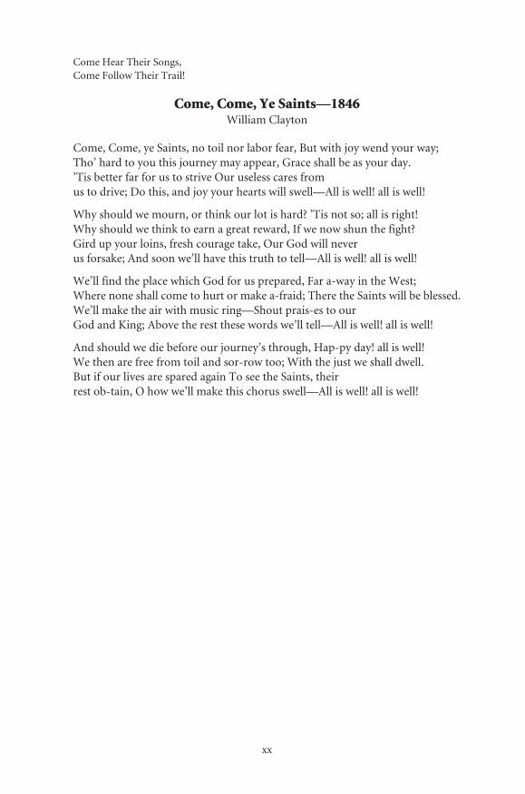
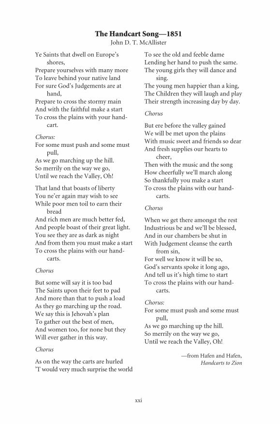
All of these organizations have made it much easier for the moderntraveler to experience the Mormon Trail. Yet two other significant piecesof Mormon history must be mentioned again. They are the songs“Come, Come, Ye Saints” and “The Handcart Song.” The verses of thesetwo songs tell us more about the Mormon Trail experience than perhapsmany of the diaries that were kept by the Mormon emigrants. In thesongs are the stories of their hopes, their pain and suffering, and the finalfulfillment of their dreams. “Come, Come, Ye Saints” was written byWilliam Clayton on April 16, 1846 while camped at Locust Creek, Iowa,during the Mormon exodus from Nauvoo, Illinois. “The HandcartSong” reflects a later period in their history when thousands of Mor-mons were determined to reach Zion/Salt Lake City.
Read their words again, and then start your journey west along theMormon Trail.
xx
Come Hear Their Songs,Come Follow Their Trail!
Come, Come, Ye Saints—1846William Clayton
Come, Come, ye Saints, no toil nor labor fear, But with joy wend your way;Tho’ hard to you this journey may appear, Grace shall be as your day.’Tis better far for us to strive Our useless cares fromus to drive; Do this, and joy your hearts will swell—All is well! all is well!
Why should we mourn, or think our lot is hard? ’Tis not so; all is right!Why should we think to earn a great reward, If we now shun the fight?Gird up your loins, fresh courage take, Our God will neverus forsake; And soon we’ll have this truth to tell—All is well! all is well!
We’ll find the place which God for us prepared, Far a-way in the West;Where none shall come to hurt or make a-fraid; There the Saints will be blessed.We’ll make the air with music ring—Shout prais-es to ourGod and King; Above the rest these words we’ll tell—All is well! all is well!
And should we die before our journey’s through, Hap-py day! all is well!We then are free from toil and sor-row too; With the just we shall dwell.But if our lives are spared again To see the Saints, theirrest ob-tain, O how we’ll make this chorus swell—All is well! all is well!
xxi
The Handcart Song—1851John D. T. McAllister
Ye Saints that dwell on Europe’s shores,
Prepare yourselves with many moreTo leave behind your native landFor sure God’s Judgements are at
hand,Prepare to cross the stormy mainAnd with the faithful make a startTo cross the plains with your hand-
cart.
Chorus:For some must push and some must
pull,As we go marching up the hill.So merrily on the way we go,Until we reach the Valley, Oh!
That land that boasts of libertyYou ne’er again may wish to seeWhile poor men toil to earn their
breadAnd rich men are much better fed,And people boast of their great light.You see they are as dark as nightAnd from them you must make a startTo cross the plains with our hand-
carts.
Chorus
But some will say it is too badThe Saints upon their feet to padAnd more than that to push a loadAs they go marching up the road.We say this is Jehovah’s planTo gather out the best of men,And women too, for none but theyWill ever gather in this way.
Chorus
As on the way the carts are hurled’T would very much surprise the world
To see the old and feeble dameLending her hand to push the same.The young girls they will dance and
sing.The young men happier than a king, The Children they will laugh and playTheir strength increasing day by day.
Chorus
But ere before the valley gainedWe will be met upon the plainsWith music sweet and friends so dearAnd fresh supplies our hearts to
cheer,Then with the music and the songHow cheerfully we’ll march alongSo thankfully you make a startTo cross the plains with our hand-
carts.
Chorus
When we get there amongst the restIndustrious be and we’ll be blessed,And in our chambers be shut inWith Judgement cleanse the earth
from sin,For well we know it will be so,God’s servants spoke it long ago,And tell us it’s high time to startTo cross the plains with our hand-
carts.
Chorus:For some must push and some must
pull,As we go marching up the hill.So merrily on the way we go,Until we reach the Valley, Oh!
—from Hafen and Hafen,Handcarts to Zion

xxii
Roster of the Pioneer Company to Utah, 1847
They are given as divided into companies of “Tens”:
First Ten—Wilford Woodruff, captain; John S. Fowler, Jacob D. Burnham, Orson Pratt,Joseph Egbert, John Freeman, Marcus B. Thorpe, George A. Smith, George Wardle
Second Ten—Ezra T. Benson, captain; Thomas B. Grover, Barbaras (Barnabas) L.Adams, Roswell Stevens, Amasa M. Lyman, Starling (Sterling) G. Driggs, AlbertCarrington, Thomas Bullock, George Brown,Willard Richards, Jesse C. Little
Third Ten—Phineas H. Young, captain; John Y. Green, Thomas Tanner, BrighamYoung, Addison Everett, Truman O. Angel(l), Lorenzo D. Young, Bryant String-ham, Joseph Scofield, Albert P. Rockford
Fourth Ten—Luke S. Johnson, captain; John Holman, Edmond Ellsworth (Elsworth),Alvarnus Hanks, George R. Grant, Millen Atwood, Samuel B. Fox, Tunis Rappleyee,Harry Pierce, William Kykes (Dykes), Jacob Weiler
Fifth Ten—Stephen H. Goddard, captain; Tarlton Lewis, Henry G. Sherwood, ZebedeeColtrin, Sylvester H. Earl, John Dixon, Samuel H. Marble, George Scholes, WilliamHenrie, William. A. Empey
Sixth Ten—Charles Shumway, captain; Andrew Schumway, Thomas Woolsey,Chauncey Loveland, Erastus Snow, James Craig, William Wordsworth, WilliamVance, Simeon Howd, Seeley Owen
Seventh Ten—James Case, captain; Artemas Johnson, William C. A. Smoot, Franklin B.Dewey, William Carter, Franklin G. Losee, Burr Frost, Datus Ensign, Franklin Stew-art, Monroe Frink, Eric Glines, Ozro Eastman
Eighth Ten—Seth Taft, captain; Horace Thorton, Stephen Kelsey, John S. Eldredge,Charles D. Barnum, Alma Williams, Rufus Allen, Robert T. Thomas, James W.Stewart, Elijah Newman, Levi N. Kendall, Francis Boggs, David Grant
Ninth Ten—Howard Egan, captain; Heber C. Kimball, William A. King, Thomas Clo-ward, Hosea Cushing, Robert Byard, George Billings, Edison Whipple, PhiloJohnson, William Clayton
Tenth Ten—Appleton M. Harmon, captain; Carlos Murray, Horace K. Whitney, OrsonK. Whitney, Orrin P.(Porter) Rockwell, Nathaniel T. (Thomas) Brown, R. JacksonRedding, John Pack, Francis Pomeroy, Aaron Farr, Nathaniel Fairbanks
Eleventh Ten—John S. Higbee, captain; John Wheeler, Solomon Chamberlain, ConradKlineman, Joseph Rooker, Perry Fitzgerald, John H. Tippetts, James Davenport,Henson Walker, Benjamin Rolfe
Twelfth Ten—Norton Jacobs, captain; Charles A. Harper, George Woodward, StephenMarkham, Lewis Barney, George Mills, Andrew Gibbons, Joseph Hancock, John W.Norton
Thirteenth Ten—John Brown, captain; Shadrach Roundy, Levi Jackman, Lyman Curtis,Hans C. Hansen (Hanson), Mathew Ivory, David Powers, Hark Lay (African Amer-ican), Oscar Crosby (African American)
Fourteenth Ten—Joseph Mathews, captain; Gilbroid Summe, John Gleason, CharlesBurke, Alexander P. Chessley (Chesley), Rodney Badger, Norman Taylor, GreenFlake (African American), Ellis Eames
Three women and two children also accompanied the camp. They were the wife ofLorenzo Young, Harriet, and their two children, Isaac and Sabisky; Clarissa DeckerYoung, one of Brigham's wives; and Ellen Sanders Kimball, one of Heber’s wives.
Ellis Eames returned to Winter Quarters from the Pioneer camp the day after theyleft on account of sickness.
1
I N T RODUC T I ON
The Nature of the Mormon Trail
The Mormon Trail experience is unique when compared with theexperiences of the other major trails of westward migration. Some of thecharacteristics associated with the Mormon Trail are similar to those ofthe other trails. When those characteristics are compared or discussedindividually, it would seem to lead one to the conclusion that the trailexperiences are the same, but it is the combination of those individualcharacteristics, along with other factors, that lead one to conclude thatthe nature of the Mormon Trail experience is unique. By examining themotivations, demographic characteristics, practices of the Mormons,planning and organization of the wagon companies, and the methods oftransportation, this fact will become evident.
The reasons for the development of the Santa Fe, Oregon, and Cali-fornia Trails and the motivations of many of the emigrants were largelyeconomic. The Santa Fe Trail, the earliest of the major westward trails,was developed in the 1820s primarily as a two-way trail of commerce,which was later used by emigrants. The traders were concerned withbringing needed trade goods from the United States and the Indepen-dence, Missouri, area to Santa Fe in Mexico. They knew that goods werescarce in Santa Fe and that large profits were possible. After trading therethey would then return to the United States with cash and additionalproducts to sell at a profit. For the first quarter century this was themajor use of the Santa Fe Trail. The travelers were almost exclusivelymen, traders and their hired teamsters and, later, professional wagon-masters with their teamsters.
The emigrants who later began to use the Santa Fe Trail also did itfor economic reasons. Some were emigrants traveling to the Southwest
· The Mormon Trail, Yesterday and Today ·
2
to settle in the area to make a new life for themselves. Many were goldseekers using the Santa Fe Trail as the first segment of their journey toCalifornia. From Santa Fe they might have taken a southern trail alongthe Gila River, or the Old Spanish Trail, which angled northwest fromSanta Fe into Utah before turning southwesterly towards Nevada andCalifornia. The western section of the Old Spanish Trail was also laterincorporated into a route that led from Salt Lake to California. Itafforded California-bound emigrants and gold seekers another way westand also helped to open much of Utah and the Great Basin to settlement.
The 1840s brought the development of the Oregon and CaliforniaTrails. They were originally developed primarily as emigrant trails, butgenerally followed the route and stopped at sites familiar to those of theearlier trappers and traders. The wagon trail to Oregon was primarilyused by emigrants who wanted to settle in the fertile valleys. They hadheard stories of the Oregon Territory and the free rich lands of the Wil-lamette River Valley. Many left lands in the Midwest and the East, whichhad been in the midst of a recession. They left with the intent of travelingas quickly as possible and starting a new life. For the Gentiles, a termused by Mormons for all non-Mormons, the main driving force was toget to the lands of the West Coast. Once they arrived, there was really lit-tle concern for the route they used or its further improvements. It wasenvisioned as a one-way route.
The lands between their jumping-off and destination sites were seenas an obstacle to pass through with little concern for the area itself. Anystopping on the trail was temporary. Some emigrants noted areas whichmight prove to be rich farming areas, but they did not settle there. Theyquickly continued on their way to Oregon or California. Some emi-grants, after building a raft or ferry to cross a river might stay for a day ortwo to ferry other emigrants across. This would enable them to earnsome extra money for themselves, but then they too quickly moved on.Enoch Conyers, for example, earned $33.50 in one day and then pro-ceeded on his journey. Samuel Barlow built a toll road over the CascadeMountains at the end of the Oregon Trail to bypass the dangerous rafttrip down the Columbia River to the Willamette River Valley. After hehad gotten the money back it had cost him, he sold his interests in theroad. Thus, it seems that many of the improvements made were prima-rily for the developers’ benefit and were temporary at best.
The California Trail was also initially used by emigrants intent onstarting a new life. Stories of the rich lands of California also providedthe early and later emigrants with their motivation. However, the discov-ery of gold brought a different type of emigrant to California. Economics

· The Nature of the Mormon Trail ·
3
was still the motivation, but it was a short-term motive rather than along-term one. They hoped to find gold, get rich, and return home totheir families back east. However, the discovery of gold also broughttradesmen, shop owners, and farmers. These were the ones who really“struck it rich” by selling their products to the gold seekers. With theexception of some of the 49ers who hoped to strike it rich quickly andreturn to their families back east, the California Trail was mainly devel-oped for one-way travel. Only after California became a territory andthen a state did the trail develop into a two-way route with its expandeduse by the military and the traders and professional teamsters haulinggoods and supplies across the continent.
The gold fever of 1849 and the early 1850s also resulted in a notice-able change in the make-up of the trail travelers. Whereas some of theearlier emigrants included families, the majority of the travelers were nowmen. Many of the wagon companies, such as J. Goldsborough Bruff’sWashington City and California Mining Association, and the pack trainswere exclusively composed of men. The travelers to Oregon, however,remained largely composed of families. Rarely were single women foundon the trails unless they were traveling with their parents. Respectablewomen, both single or married, it seems, did not travel alone.
Thus, for the major trails that existed prior to the Mormon Trail, theeconomic factor played the central role in their development. Onlybecause of the repeated use and the two-way traffic on the Santa Fe Traildid the traders have a vested interest in making improvements, that is,any improvements that could reduce the time it took to travel back andforth. Also any reduction in travel time could translate into higher prof-its for the traders. Most of the emigrants, however, were primarily inter-ested in getting to their destination. Any improvements on the trail wereseen as a way of making their trip shorter. They were not concerned withimproving the route to make it easier for strangers yet to come unlessthey could make some financial gain from it. The delay caused by build-ing a raft to ferry others across for profit could be tolerated for a fewdays. Many of the improvements built along the Oregon and CaliforniaTrails were later further improved or reconstructed by the military orgovernment. They sometimes even surveyed and constructed new cut-offs or routes such as the Lander Road in 1859 and Captain Simpson’sroute across central Nevada.
By the mid-1840s the Santa Fe Trail was a well-established and well-known route. The main Oregon and California Trails had been devel-oped and used by more than eight thousand emigrants. By 1846California-bound emigrants had already pioneered a trail into the Great
· The Mormon Trail, Yesterday and Today ·
4
Salt Lake Valley, crossed the Salt Lake Desert, and gone on to California.All this had happened before the Mormons entered the valley.
The years 1846 and 1847 saw the establishment of what is now calledthe Mormon Trail. The first segment of the Mormon Trail from Nau-voo, Illinois, to the Omaha, Nebraska, area was used in 1846. It was notover one of the other major established emigrant trails, but it did gener-ally follow territorial roads and trading trails in Iowa. However, the sec-ond and major segment of the Mormon Trail, from the Winter Quartersin the Omaha area to the Valley of the Great Salt Lake was over much ofthe established route on the north side of the Platte River. It was previ-ously used by many of the early trappers and emigrants to Oregon andCalifornia. As some historians have noted, with the exception of lessthan a mile at the mouth of Emigration Canyon in Utah, all of the mainMormon Trail was over the established routes of parts of the Oregon andCalifornia Trails.
While economic factors were largely responsible for the migration ofemigrants over the Santa Fe, Oregon, and California Trails, religion wasthe primary reason for the migration of the Mormons along the trail.Many of the beliefs and ideas developed during the early years of theMormon faith and church were different from the predominant reli-gious views of citizens of that time. These differences led to strained rela-tions with their non-Mormon, or Gentile, neighbors.
Not only do Mormons consider themselves to be Christians, theybelieve they are the “true” Christian Church, the original church estab-lished by Jesus Christ when he lived on the earth—“restored” to its right-ful position—and that all present members are saints, “latter-day saints”as distinguished from the earlier saints. Because of this, they are oftenreferred to as “the Saints.” They believe that revelations from God con-tinue in the present time. They hold that Joseph Smith, their founder,was a prophet who spoke with the inspiration and power of God as didthe apostles and prophets of the Bible and as do their living prophetstoday. The Quorum of Twelve Apostles, the main governing body, hadits basis in professed revelation, and its first members, includingBrigham Young, were chosen for their steadfastness during the ZionCamp’s March from Kirtland, Ohio, to Independence, Missouri, in1834. The Quorum also has the power to speak with authority fromGod. In addition to the Bible, the Mormon scriptures include the Bookof Mormon, which is claimed to be an ancient record of the early Amer-icas; the Doctrine and Covenants, a collection of contemporary revela-tions, mostly to Joseph Smith; and the Pearl of Great Price, a collectionof other writings and translations of Joseph Smith. These combined
· The Nature of the Mormon Trail ·
5
scriptures provide the basis for their faith and the guides for their behav-ior. Mormons also hold that they themselves are the children of Israel,the “chosen people.”
Their organization, starting at the family level and continuing throughto the highest positions in the church’s organization is patriarchal. Thefather’s authority over the family is considered supreme. All males twelveyears and older who are considered worthy “hold the priesthood.” Inaddition, there is a history of a strict giving, known as tithes and offerings,to the church and the belief that the commandments from God come first.However, the legitimate needs of the family, the basic unit of church orga-nization, receive highest priority. Mormons feel that God did not preventtheir suffering and persecution in order to test and refine them.
During much of the 19th century, they practiced polygamy as arevealed tenet of their faith. Many of these ideas and beliefs served tostrengthen the church and build a strong Mormon discipline, but theyalso served to separate the Mormons from most other Americans. Thetheocratic nature of their political organization also conflicted withmuch of the popular political thinking at the time. All of these ideas andpractices tended to separate the Mormons from others, and thus madethem more susceptible to persecution. As religious persecutionincreased, the Mormons were forced to move from one place to anotherthroughout the United States looking for a place to establish their Zionand live in peace.
The Mormons were first centered in New York, then they moved toOhio and a variety of places in Missouri, and then to Nauvoo, Illinois.The Nauvoo site was selected by Joseph Smith in 1839. Originally it wasonly the tiny hamlet of Commerce. Much of the land surrounding it wasmiasmic marshlands that nobody wanted or thought could be used. HereSmith hoped that they could finally live in peace. Temporary structuresmay have been of logs, but the Mormons planned to stay. Nauvoo wasbuilt as a permanent center. The area was drained and the city was laidout in a grid pattern. Permanent structures were built. Homes and shopswere constructed of brick. Education was considered important and auniversity was planned. A charter was obtained for the first city universityin the country. The large temple structure of stone was built high on thehill overlooking the city and the Mississippi River. Nauvoo soon rivaledChicago, Illinois, as the largest city in the state and became one of thetwenty largest cities in the United States. But, as had happened in all theother places Mormons settled, persecution was soon to follow. Followingthe murder of Joseph Smith the Mormons were again driven out andforced to look for a new place to live and to practice their faith freely.

· The Mormon Trail, Yesterday and Today ·
6
Thus, the reason for the Mormon migration was religious in motivation,and the migration itself was unlike most of the migrations of other emi-grants traveling to Oregon and California. The Mormons had theirmigration forced upon them. For nearly two decades after their founding,the Mormons were forced from areas in which they lived. Later, manysought voluntarily to emigrate to Salt Lake City to live in their new Zionor Promised Land.
Another related facet of the Mormon migration that distinguished itfrom that of the other trails was the composition of the emigrants andtheir organization. It was noted earlier that most of the early Americantravelers on the Santa Fe Trail were males and relatively few women andchildren traveled on the trail. During the gold rush years those en routeto California were also almost exclusively males. Even during the earlieryears relatively few women traveled on that route. However, women,married and single, and children were more commonly found as mem-bers of companies on the Mormon Trail. Women and children oftencomprised the majority of the members of Mormon wagon companies.Only in the first Pioneer Company of 1847 was the population almostexclusively males. It was composed of 143 men (including three AfricanAmericans), 3 women, and 2 young boys. In addition, it should be notedthat about 500 men had entered into military service and had formed theMormon Battalion, which was sent south over the Santa Fe Trail to Cali-fornia during the Mexican War. The impact of both the Pioneer Com-pany and the formation of the Mormon Battalion could explain whymany of the later 1847 Mormon companies were composed mainly ofwomen and children. However, an exodus of mostly women and chil-dren continued in later years.
Many of the non-Mormon, or Gentile, wagon companies were com-posed of a variety of people, including families, their relatives, andfriends. Often members came from a particular area of the country.However, frequently there were also strangers who joined the company.Most companies were organized with both democratic and military ele-ments. Leaders were chosen by the male members of the wagon com-pany. All the members of the company were then expected to follow theorders of the captain. However, it seems that very few companies stayedtogether for the whole length of their journey or ended with the sameofficers as when they began. Records indicate that some companiesstarted to break up within a few weeks. Emigrants frequently recorded intheir diaries information about individual families that would drop out.Other diarists recorded how they picked up another wagon or family thathad dropped out of a nearby company. Sometimes it was recorded that a

· The Nature of the Mormon Trail ·
7
lone wagon or family had been passed on the trail. It seems that the pres-sures of trail travel, the changes in their destination, or just the individu-alistic desires of these independent-minded emigrants brought a constantebb and flow to wagon company membership. Sometimes harsh realitiesof disease or breakdowns forced members to fall behind and necessitateda change. The pressures of travel and the experience on the trail alsocaused companies to change their leadership. One of the rare companiesthat did not experience all this turmoil was the 1849 Washington Cityand California Mining Association company under the leadership of J.Goldsborough Bruff. Not until they were already in California and a fewdays from their goal did the company leave someone on the trail. It wastheir leader himself, J. Goldsborough Bruff, who had become too sick.
Mormon wagon companies, on the other hand, were much betterorganized. They often included large family groups and whole commu-nities and generally remained together under the same leadership for theentire journey, helping each other all along the route. There were a num-ber of factors that contributed to this. Within a few years after the devel-opment of the Mormon faith, its members tended to “gather” and to livein communities. However, as persecution increased, they tended tomove into relatively unsettled areas where they established their own,separate communities. Because of increased persecutions, whole com-munities were forced to move. This was reflected in the main movementof Mormons from Kirtland, Ohio, to Jackson County, Missouri, in 1836,then to Far West, Missouri, in 1838, then in the Exodus from Nauvoo toWinter Quarters in 1846, and finally in 1847 when they moved fromWinter Quarters to Salt Lake City.
Organization was not only a characteristic of travel in the UnitedStates. The Mormon immigrants from Europe usually came as an orga-nized group on a chartered ship, then traveled together by train or river-boat to the jumping-off sites, and then finally migrated together inwagon or handcart companies to Salt Lake. Thus the Mormons traveledtogether in common groups with members who were well known to eachother. Since there was a large number of people involved it was some-times necessary to divide them into more than one wagon company, buteven then the companies remained in close contact with one another.They were not a group of strangers who got together only for conve-nience, but rather they traveled with and remained together because theywere organized to do so in order to help and support each other.
Some aspects of Mormon belief tended to result in much betterorganized companies. In January of 1847, Brigham Young, who was thenhead of the Mormon Church, received a revelation known as “The Word
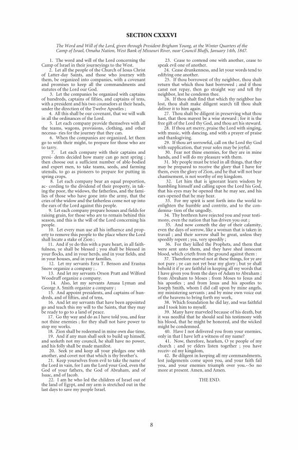
8
SECTION CXXXVI
The Word and Will of the Lord, given through President Brigham Young, at the Winter Quarters of the Camp of Israel, Omaha Nation, West Bank of Missouri River, near Council Bluffs, January 14th, 1847.
1. The word and will of the Lord concerning theCamp of Israel in their journeyings to the West.
2. Let all the people of the Church of Jesus Christof Latter-day Saints, and those who journey withthem, be organized into companies, with a covenantand promises to keep all the commandments andstatutes of the Lord our God.
3. Let the companies be organized with captainsof hundreds, captains of fifties, and captains of tens,with a president and his two counselors at their heads,under the direction of the Twelve Apostles ;
4. All this shall be our covenant, that we will walkin all the ordinances of the Lord.
5. Let each company provide themselves with allthe teams, wagons, provisions, clothing, and othernecessa- ries for the journey that they can.
6. When the companies are organized, let themgo to with their might, to prepare for those who areto tarry.
7. Let each company with their captains andpresi- dents decided how many can go next spring ;then choose out a sufficient number of able-bodiedand expert men, to take teams, seeds, and farmingutensils, to go as pioneers to prepare for putting inspring crops.
8. Let each company bear an equal proportion,ac- cording to the dividend of their property, in tak-ing the poor, the widows, the fatherless, and the fami-lies of those who have gone into the army, that thecries of the widow and the fatherless come not up intothe ears of the Lord against this people.
9. Let each company prepare houses and fields forraising grain, for those who are to remain behind thisseason, and this is the will of the Lord concerning hispeople.
10. Let every man use all his influence and prop-erty to remove this people to the place where the Lordshall locate a stake of Zion ;
11. And if ye do this with a pure heart, in all faith-fulness, ye shall be blessed ; you shall be blessed inyour flocks, and in your herds, and in your fields, andin your houses, and in your families.
12. Let my servants Ezra T. Benson and ErastusSnow organize a company ; .
13. And let my servants Orson Pratt and WilfordWoodruff organize a company.
14. Also, let my servants Amasa Lyman andGeorge A. Smith organize a company ;
15. And appoint presidents, and captains of hun-dreds, and of fifties, and of tens,
16. And let my servants that have been appointedgo and teach this my will to the Saints, that they maybe ready to go to a land of peace.
17. Go thy way and do as I have told you, and fearnot thine enemies ; for they shall not have power tostop my works.
18. Zion shall be redeemed in mine own due time, 19. And if any man shall seek to build up himself,
and seeketh not my council, he shall have no power,and his folly shall be made manifest.
20. Seek ye and keep all your pledges one withanother, and covet not that which is thy brother's.
21. Keep yourselves from evil to take the name ofthe Lord in vain, for I am the Lord your God, even theGod of your fathers, the God of Abraham, and ofIsaac, and of Jacob.
22. I am he who led the children of Israel out ofthe land of Egypt, and my arm is stretched out in thelast days to save my people Israel.
23. Cease to contend one with another, cease tospeak evil one of another.
24. Cease drunkenness, and let your words tend toedifying one another.
25. If thou borrowest of thy neighbor, thou shaltreturn that which thou hast borrowed ; and if thoucanst not repay, then go straight way and tell thyneighbor, lest he condemn thee.
26. If thou shalt find that which thy neighbor haslost, thou shalt make diligent search till thou shaltdeliver it to him again.
27. Thou shalt be diligent in preserving what thouhast, that thou mayest be a wise steward ; for it is thefree gift of the Lord thy God, and thou art his steward.
28. If thou art merry, praise the Lord with singing,with music, with dancing, and with a prayer of praiseand thanksgiving.
29. If thou art sorrowful, call on the Lord thy Godwith supplication, that your soles may be joyful.
30. Fear not thine enemies, for they are in minehands, and I will do my pleasure with them.
31. My people must be tried in all things, that theymay be prepared to receive the glory that I have forthem, even the glory of Zion, and he that will not bearchastisement, is not worthy of my kingdom.
32. Let him that is ignorant learn wisdom byhumbling himself and calling upon the Lord his God,that his eyes may be opened that he may see, and hisears opened that he may hear.
33. For my spirit is sent forth into the world toenlighten the humble and contrite, and to the con-demna- tion of the ungodly.
34. Thy brethren have rejected you and your testi-mony, even the nation that has driven you out ;
35. And now cometh the day of their calamity,even the days of sorrow, like a woman that is taken intravail ; and their sorrow shall be great, unless theyspeedily repent ; yea, very speedily ;
36. For they killed the Prophets, and them thatwere sent unto them, and they have shed innocentblood, which crieth from the ground against them :
37. Therefore marvel not at these things, for ye arenot pure ; ye can not yet bear my glory ; but ye shallbehold it if ye are faithful in keeping all my words thatI have given you from the days of Adam to Abraham ;from Abraham to Moses ; from Moses to Jesus andhis apostles ; and from Jesus and his apostles toJoseph Smith, whom I did call upon by mine angels,my ministering servants ; and by mine own voice outof the heavens to bring forth my work,
38. Which foundation he did lay, and was faithfuland I took him to myself.
39. Many have marveled because of his death, butit was needful that he should seal his testimony withhis blood, that he might be honored, and the wickedmight be condemned.
40. Have I not delivered you from your enemies,only in that I have left a witness of my name?
41. Now, therefore, hearken, O ye people of mychurch ; and ye elders listen together ; you havereceiv- ed my kingdom,
42. Be diligent in keeping all my commandments,lest judgements come upon you, and your faith failyou, and your enemies triumph over you.--So nomore at present. Amen, and Amen.
THE END.
· The Nature of the Mormon Trail ·
9
and Will of the Lord.” One aspect of it included the plan of organizationfor migration to the West. This document is unique in the history ofwestward migration. It helps explain the success of the migration. TheMormon wagon company leaders were not democratically elected butwere selected or appointed by church leaders. There were captains forthe groups of wagons or families of hundreds, of fifties, and finally oftens. Because Mormons believed that their leaders spoke with authorityfrom God, they were much less likely to question any of the orders ordirections given by their leader or voice their disagreement with him.They also believed in the natural hierarchy of authority. Everyone wasexpected to follow those who had authority over them, and anyonebelow was expected to follow the directives of the leader above. Even thedaily routine was prescribed. During the exodus from Nauvoo, BrighamYoung set down the pattern which was followed. At five o’clock thebugle was sounded. People were awakened, prayers said, meals werecooked and eaten and teams were fed. At seven o’clock the bugle wassounded again and the wagon company was off. Each able-bodied manwas assigned to his post, and he was not allowed to leave it without per-mission from the officers. There were rules for noon and evening stops.By eight thirty in the evening the bugle would sound again for eveningprayers, and by nine o’clock the camp was to be at rest. It was also prac-tice not to travel on Sundays. Gentile wagon companies sometimes fol-lowed this practice, but not as strongly as the Mormons did. Somehistorians hold that not traveling on Sunday for religious reasons had theadded benefit of allowing both people and beasts to recuperate. Thisbenefit may have actually offset any loss of travel time. Thus, the Mor-mon wagon companies and trains tended to run much more efficientlythan the non-Mormon companies. Non-Mormon emigrants frequentlycommented in their diaries about the efficient organization and move-ment of the Mormon companies.
Another related difference concerns the professional organizationand sponsorship of wagon companies. For the most part non-Mormonwagon companies were not professionally organized. Most organizedthemselves either at the jumping-off sites or after a few days out on thetrail. There were only a limited number of attempts by professionals toorganize companies which emigrants could join for a fee and where thebusiness enterprise would provide the wagons, animals, supplies, etc.Most of these attempts failed because the companies were insufficientlysupplied and lacked a sense of unity. The Pioneer Line was probably oneof the most famous of these failures in its attempt to take emigrantsquickly and safely to California in 1849.

· The Mormon Trail, Yesterday and Today ·
10
As the number of Mormons wanting or needing to go to Salt LakeCity grew, the Mormon Church became more involved in the develop-ment of the transportation systems to bring them to Salt Lake City. Fromthe 1850s into the late 1860s the church sponsored three different sys-tems to help Mormons migrate to Salt Lake. First was the establishmentof the Perpetual Emigration Fund system. It was to help finance themigrations for those who could not afford it. Those emigrants who usedthe funds were expected to repay the system. Two systems were specifi-cally developed to provide transportation for the emigrants to Salt LakeCity. One was the “handcart system” developed in the mid-1850s, andthe other involved the use of “down-and-back” wagon trains in the1860s. Individual Mormons also provided considerable assistance inbuilding the transcontinental railroad through Utah. The Golden Spike,which symbolized the completion of the transcontinental railroad byjoining the tracks of the Union Pacific and Central Pacific railroads, wasdriven at Promontory Point, Utah, on May 10, 1869.
At the same time that the Mormons were converting new membersin the United States, missionaries were sent across the seas to converteven more people. Another source of Mormon emigrants were the Mor-mon converts from Europe. As early as 1842 church leaders such asBrigham Young were sent to Europe as missionaries. By the mid-1850sthousands of converts came to the United States from a variety of Euro-pean countries. The British Isles and the Scandinavian countries pro-vided the largest number of converts, but others came from France,Germany, Switzerland, Spain, and Italy. The Mormons were also activein South America, South Africa, and the South Seas. After the convertsarrived, those going west migrated along the Mormon Trail to the Valleyof the Great Salt Lake, while those from the Pacific coast traveled eastinto the valley. From there they spread throughout Utah, Arizona,Idaho, Nevada, and even into California.
Thousands had been converted in Europe, and this resulted in aproblem of transporting them safely across the sea and then to Salt LakeCity. The establishment of the Perpetual Emigration Fund in 1850helped to solve this problem. It was established “to promote, facilitate,and accomplish the Emigration of the Poor.” In typical Mormon fash-ion, much planning and organization went into the program. Once thefund was established, it was intended to be self-sustaining. Emigrantscould borrow from the fund to help pay for passage to the United Statesand then for their journey to Salt Lake itself. It was expected that theemigrants making use of the fund would repay it after they becameestablished. As is often the case with programs such as this, the monies
· The Nature of the Mormon Trail ·
11
were not always repaid. However, the Church continued to support theprogram with funds raised by the tithes of all Mormons. Mormon agentswould contract for the use of a ship, provide for food on the journey, andthen arrange transportation by rail or ship to the jumping-off sites of theMormon Trail. By 1887, when the program ceased, perhaps as many as100,000 Mormons had been assisted on their journey to Zion. Later con-verts arrived in Salt Lake on the transcontinental railroad.
One of the truly unique features of the Mormon Trail was the devel-opment and use of handcart companies, which, for a few years, supple-mented the use of wagons. The wagon was the usual method oftransportation employed by both Mormons and non-Mormons alike onthe trails. The emigrant wagon was not the large Conestoga wagon usedback east on the National Road or similar wagons sometimes employedby traders on the Santa Fe Trail, but was typically a small farm wagonabout eight to ten feet long and usually between thirty-eight to forty-twoinches wide. It might be pulled by oxen, mules, or horses. Emigrants oftenargued amongst themselves about the advantages of each type of team.Oxen were usually stronger, slower, cheaper, and could eat a wider varietyof vegetation and, thus, could subsist better along the trail. They were alsoa little less likely to be stolen. Mules were less expensive than horses butmore expensive than oxen, but they could travel faster than oxen. Horseswere the fastest, the most expensive, and had feed requirements that werethe hardest to provide for during the early years of trail travel. They werealso the most likely to be stolen by the Indians. Although all draft animalswere used by Mormons, it seems that oxen were employed most often.
There are a few examples of the use of carts by non-Mormons on theemigrant trails. At first people did not even think that wagons could betaken west over the Oregon and California Trails. Some of the early trad-ing companies used carts and wagons to bring supplies out to the earlymountain men rendezvous in the Rocky Mountains. But none of thesewere handcarts and none had ever taken them all the way over themountains. One of the first attempts to bring an emigrant wagon westactually ended with the wagon being cut in two and being used as a cartto finally complete the journey to Oregon. This was the case in 1836when the missionaries Marcus and Narcissa Whitman went west. At FortHall they were forced to cut their wagon and to continue to Oregon withit as a cart. Carts were associated with two other areas. One area was inthe Red River Valley of the Dakotas and Minnesota. Carts were also usedin the Southwest by the native Mexicans. However, it was the Mormonswho perfected the system of handcart companies for the mass movementof people and goods west.

· The Mormon Trail, Yesterday and Today ·
12
In the 1850s Iowa City, Iowa, was located near the western terminusof the eastern railroad. Mormons from Europe and the East came west toIowa by train. The handcart companies were developed to bring theMormons from the end of the railroad to Salt Lake City. The MormonChurch financed the construction of the handcarts and their use. Whilethere seem to have been different sizes of handcarts, the typical cart had abed approximately three feet wide, four feet long, and nine inches deep.The wheels were four feet in diameter with ten spokes. They were muchcheaper to build than wagons, but they also only carried about 500 lbs,much less than wagons. This necessitated re-supply locations, or way-stations, along the trail. The carts were harder on the emigrants becausedraft animals were usually not used to pull them. The emigrants them-selves provided the power to pull or push them. From 1856 until 1860ten handcart companies carried about three thousand Mormons to SaltLake City. Generally they traveled faster than wagon companies andwere considered to be a success. Many people, however, only rememberthe stories of the Martin and Willie Handcart Companies that got caughtin blizzards in Wyoming in 1856. They suffered great loss of life andbecame the worst recorded disasters on the emigrant trails during theperiod of westward migration. It should also be noted that when individ-ual Mormons were given a chance to select their method of transporta-tion and could afford it, the wagon was preferred over the handcart.
From 1860 until 1868 the church was involved in providing thephysical wagons, stock, and supplies necessary for emigration to SaltLake City. These could be considered to be professional companies. Theywere known as “down-and-back” companies or wagon trains. They wereorganized in Salt Lake City to go back and forth between Salt Lake Cityand the jumping-off cities. Geographically, the church was subdividedinto stakes and wards, each with their own officers. In its early period,the local level of organization, or ward, usually consisted of between 200to 1,200 people. Approximately ten wards were combined to form astake. Under the leadership of Brigham Young and the church, all Mor-mon wards were required to provide wagons, draft animals, supplies,drivers, and other equipment necessary for a possible six-month trip.Thus, the wagon train only had to pick up the emigrants at the jumping-off sites. The emigrants did not have to purchase their wagons, etc. Allthe “down-and-back” wagon companies successfully made the journeyto Salt Lake City. The first four church companies of 1861 included 203wagons, 235 teamsters and guards, and 1,699 oxen with 136,000 poundsof flour. During this whole period more than 2,000 wagons with 2,500teamsters brought over 20,000 emigrants to Salt Lake City. With the

· The Nature of the Mormon Trail ·
13
completion of the railroad in 1869 the church no longer had to organizewagon companies to bring Mormon emigrants into Utah.
Another way in which the Mormon’s highly organized nature wasreflected was in their desire to make the trip for subsequent Mormonseasier. They established communities and made improvements alongtheir route. This was first done during their exodus from Nauvoo. Theyknew that it would not be possible to evacuate everyone at once. In Iowa,three centers, or way stations, were established along the route to theirWinter Quarters area. They were Garden Grove, Mount Pisgah, and theKanesville camp, which became present-day Council Bluffs. Thesecamps, located in Iowa, were not temporary camps. At Mount Pisgah,shelters were built, fields were cleared and fenced, crops were planted, amill was built, and a tabernacle was constructed. Similar locations wereestablished along the trail to Salt Lake City. Fort Supply was built nearFort Bridger in Wyoming. One of its functions was to aid the Mormonemigrants by providing supplies to those coming across the plains. In1861 four camps were established by the “down-and-back” wagon com-panies. Three were in Wyoming at Rocky Ridge, North Platte Bridge,and Deer Creek, and one was located in Nebraska at Wood River. Thispractice was continued in other parts of the United States as the Mor-mons spread out from Salt Lake City to surrounding areas.
Crossing rivers was a major obstacle for all emigrants. For the riversthat were too deep to ford, ferries were used. The Mormons built a num-ber of ferries along their route. They established three ferries over theMissouri River in the Kanesville or Omaha area. Perhaps the mostfamous of the ferries was the Mormon Ferry at present-day Casper,Wyoming. Another important ferry was established further southweston the Green River. The ferries served two purposes. One was to ensuresafe passage for the Mormon emigrants, and the second, by charging afee, was to provide additional funds to the Mormon Church in an areawhere cash was hard to come by. All along the route to Salt Lake City,Mormons made improvements on the established trails by building fer-ries, clearing the trails, putting up mileage signs, and establishing com-munities to provide shelter and supplies for the later migratingMormons.
Thus, one can see how a variety of factors combined with the prac-tices of the Mormon faith and church made the Mormon Trail unique inthe history of westward migrations.
14
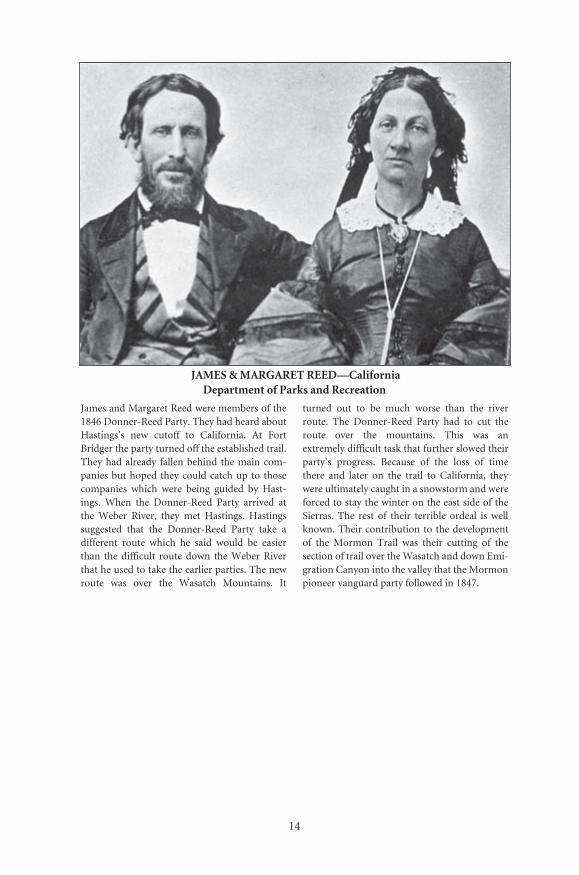
JAMES & MARGARET REED—California Department of Parks and Recreation
James and Margaret Reed were members of the1846 Donner-Reed Party. They had heard aboutHastings’s new cutoff to California. At FortBridger the party turned off the established trail.They had already fallen behind the main com-panies but hoped they could catch up to thosecompanies which were being guided by Hast-ings. When the Donner-Reed Party arrived atthe Weber River, they met Hastings. Hastingssuggested that the Donner-Reed Party take adifferent route which he said would be easierthan the difficult route down the Weber Riverthat he used to take the earlier parties. The newroute was over the Wasatch Mountains. It
turned out to be much worse than the riverroute. The Donner-Reed Party had to cut theroute over the mountains. This was anextremely difficult task that further slowed theirparty’s progress. Because of the loss of timethere and later on the trail to California, theywere ultimately caught in a snowstorm and wereforced to stay the winter on the east side of theSierras. The rest of their terrible ordeal is wellknown. Their contribution to the developmentof the Mormon Trail was their cutting of thesection of trail over the Wasatch and down Emi-gration Canyon into the valley that the Mormonpioneer vanguard party followed in 1847.
Number: 230Orig: 38.5 x 25.5Crop:Scale: 69%Final: 26.5 x 18.5

P A R T I
Early History

16
JOSEPH SMITH—Library of Congress
Joseph Smith was the prophet and organizer ofthe Church of Jesus Christ of Latter-day Saints,or Mormon Church. When Joseph Smith was ayoung boy he had a religious vision. That visionand others ultimately led to the discovery andtranslation of the golden plates into the Book ofMormon. Within a short time he formed theMormon Church. The early years of the Churchbrought increasing persecution of himself andof other Mormons. Moving from New York to
Ohio, to Missouri, and then to Illinois, he wasconstantly trying to find a safe place for the“Saints.” In 1839, he moved the center of Mor-monism to Nauvoo, Illinois, but within a shorttime, persecution occurred even there. ForJoseph Smith, finding a peaceful spot for theMormons to live proved to be elusive. In 1844,Joseph Smith and his brother Hyrum Smithwere killed by an angry mob.
Number: 222Orig: 38 x 42Crop:Scale: 70%Final: 26.5 x 29

17
The Mormon Church, the Development of the Mormon Trail,
and Mormon Migrations: 1803–1869
Unlike the history of the Oregon, California, and Santa FeTrails, the history and development of the Mormon Trail is a story ofboth the usage and improvement of previously identified routes and ofthe religious events that influenced the migration of Mormons west toUtah and the Great Basin.
1 8 0 3
President Thomas Jefferson purchased a vast tract of land west of theMississippi River from the French government. This was the singlelargest peaceful expansion of the United States in its history. The landsincluded in the Louisiana Purchase contained most of the areathrough which the Mormons would later pass. However, the territoryof Utah and the Valley of the Great Salt Lake, the future site of theirnew Zion, were not included in the purchase. They were located inMexican territory.
1 8 0 4 – 1 8 0 6
The exploration of the newly purchased Louisiana Territory was con-ducted by Meriwether Lewis and William Clark. The route they used intheir westward journey of exploration was centered in the northern partof the territory along the Missouri River Valley and into the area alongthe Pacific Coast west of the Rocky Mountains jointly claimed by theUnited States and Great Britain and commonly known as Oregon. It wasthe interest in the Oregon Territory and the fantastic stories of those
· The Mormon Trail, Yesterday and Today ·
18
areas that ultimately resulted in the development of trapper and emi-grant routes that the Mormons would later follow and improve.
1 8 0 5
The Prophet Joseph Smith was born on December 23 near Sharon, Ver-mont. He spent the first ten years of his life in a variety of places in ornear the Green Mountains of New England. In 1816 his family moved toNew York. Two other individuals, Brigham Young and Heber Kimball,were born in New England in 1801. All these men later played crucialleadership roles in the Mormon religion.
1 8 1 2 – 1 3
John Jacob Astor tried to expand his fur trading empire into the OregonTerritory. Although this attempt did not succeed, knowledge about theroute west grew. A returning party of his “Astorians,” led by Robert Stu-art, learned of the South Pass. However, because of Indians in the area atthat time, the pass was not used. It took another twelve years before itwas.
1 8 2 0
According to the accepted account, at age fourteen, Joseph had his FirstVision of the Father and the Son in a grove of trees by his home nearManchester, New York. This was the beginning of his religious awaken-ing and what, within the Mormon Church, is also considered to be thebeginning of the restoration of the original Church of Jesus Christ, whichhe established when he lived upon the earth. Later, the angel Moroni vis-ited Joseph and showed him where the golden plates were buried.
1 8 2 0 s
During the next two decades the importance of fur trapping grew in theRocky Mountains. Trappers and traders increased their knowledge of thelands in the Rockies and of the route from the Mississippi/Missouri riv-ers along the Platte River Valley. By the 1830s traffic increased along theriver systems and general routes west were established.
1 8 2 4
William Henry Ashley began the practice of conducting a rendezvous.Most of the well-known mountain men were getting their start in the furbusiness. Men such as Jim Bridger, James Clyman, Joseph ReddefordWalker, Jedediah Smith, Thomas Fitzpatrick, and others were developingsurvival skills and learning about the area from the Mississippi/Missouri
· Early History ·
19
Valley to the Rockies. Most of these mountain men later became associ-ated with the development of the Santa Fe, Oregon, and California Trails.Some of them also came to be associated with sites and events on theMormon Trail.
South Pass was rediscovered by trappers, and it became the regularroute through the Rocky Mountains. Jedediah Smith, William Sublette,and James Clyman are believed to be some of the first to actually use theroute.
Independence Rock was given its name as a result of visiting trap-pers, including Tom Fitzpatrick, who camped and celebrated Indepen-dence Day there. Some historians believe William Sublette named therock in 1830. In 1841 Pierre DeSmet gave Independence Rock its nameas the “Register of the Desert” because of the practice of passing emi-grants and trappers who wrote or carved their names on the rock.
Jim Bridger was reported to have discovered the Great Salt Lake as aresult of a bet with other trappers about the course of the Bear River. Hesupposedly floated down the river in a “bull boat” made of buffalo skinsand entered the Great Salt Lake.
1 8 2 7
Joseph Smith began the translation of the golden plates into the Book ofMormon. It was finally finished in 1830. The Book of Mormon, calledanother testament of Jesus Christ, purports to be the history of God’sdealings with the inhabitants of the Western Hemisphere who weredescendants of Joseph of the Bible.
Independence, Missouri, was established. The area soon became themajor outfitting area for the Santa Fe Trail and by the 1840s was a majorjumping-off site for the Oregon-and California-bound emigrants. Latersome Mormon wagon companies also used the area.
1 8 2 8
Hiram Scott, a trapper, was left for dead by his companions. In 1829William Sublette found a skeleton believed to be Scott’s. The large bluffsnear where the bones were found were named after him. Scotts Bluffthen served as a landmark along the Platte River and the emigrant trailsin the area.
1 8 3 0
On April 6, Joseph Smith, along with five others, and (as they testified)under the direction of Jesus Christ, organized the Church of Christ,which, eight years later, became the Church of Jesus Christ of Latter-day
· The Mormon Trail, Yesterday and Today ·
20
Saints (Mormon), in Fayette/Colesville, New York. This is also the site ofhis first arrest and persecution for his religious beliefs.
1 8 3 1
In January Joseph Smith received a revelation to move the church to Kirt-land, Ohio. Smith started an extensive building program. Laying outbroad streets on strict compass settings with large city lots, he transformedthe small city to a center of Mormonism with its own temple. Later, inJuly, while visiting Independence, Missouri, he also received another reve-lation that Independence, Missouri, be designated as “the land of promise,and the place for the city of Zion.” Both areas served as centers for theMormon Church from 1831–1837. Today, Independence is the headquar-ters of the Reorganized Church of Jesus Christ of Latter Day Saints.
1 8 3 2 – 3 5
Captain Benjamin L. E. Bonneville, on a leave of absence from the mili-tary, led an expedition west to the Rocky Mountains. He hired JosephReddeford Walker, who explored a route to California and the regionaround the Great Salt Lake. In 1837 Washington Irving published Bon-neville’s journals and maps, The Adventures of Captain Bonneville in theRocky Mountains and the Far West. The book was very popular andsparked interest in the area.
1 8 3 3 – 3 8
In Missouri relations with non-Mormons deteriorated, forcing the Mor-mons to move around from place to place. The problem culminated whenthe Missouri government set forth its infamous “Extermination Order,”which stated that the Mormons must be expelled or exterminated.
1 8 3 4
Fort William was built near the mouth of the Laramie River where itmeets the Platte River. Robert Campbell built the log fort. It was namedfor his partner, William Sublette, but the fort is commonly called FortLaramie. This wooden structure was immortalized by Alfred J. Miller in1837, when Sir William Drummond Stewart brought him along on histour of the west to record in paintings his trip. The fort changed hands anumber of times and was replaced with an adobe fort in 1841.
1 8 3 6
The Mormon settlement of Far West was established in northern Mis-souri. It briefly served as a major center for the Mormons.

· Early History ·
21
1 8 3 7 – 4 1
Father Pierre Jean DeSmet helped establish a mission in the area knownas Council Bluffs. Father DeSmet became one of the most famous,knowledgeable, and influential people of the West. He traveled back andforth from the Council Bluffs area to the west along what became a well-established route. His counsel was sought by emigrants and the govern-ment when dealing with Indians. Council Bluffs became one of thejumping-off places for the migrations west and was also known asKanesville when the Mormons occupied the area (1846–1852).
1 8 3 8
In Ohio, relations with non-Mormons also worsened. On July 6, JosephSmith was finally forced to move his followers in 58 wagons with 515people west out of Ohio to the town/site of Far West, Missouri.
Missouri Governor Lilburn W. Boggs issued the infamous orderwhich called for the Mormons to be “exterminated or driven from thestate if necessary for public peace.”
As conditions in Missouri continued to deteriorate, rumors spreadand conflict erupted into fighting at the Battle of Crooked River in Octo-ber, and then again at Haun’s Mill. Shortly thereafter, Joseph and hisbrother Hyrum Smith and several other Mormon leaders who did notparticipate in the battle surrendered to the authorities and were impris-oned at Liberty Jail. The rest of the Mormons were able to escape to FarWest. Joseph and Hyrum Smith later escaped, too. They were forcedonce again to look for a new home, this time in Illinois.
1 8 3 9
Joseph Smith selected the site of a small, nearly forgotten hamlet ofCommerce for the city of Zion, which he called “Nauvoo.” Nauvoo(claimed by Smith to come from a Hebrew word meaning “a beautifulplantation or place”) became the center of the Mormon Church. Withinfive years it had a population of nearly 20,000 and was one of the largestcities in the United States. The city and the Mormons received a specialcharter from the state legislature. Nauvoo was granted autonomy over anumber of governmental functions, including taxes and courts, and itwas even given the right to maintain its own independent militia, knownas the Nauvoo Legion. It was here that the Nauvoo Temple was built.After the murder of Joseph and Hyrum Smith, and increased religiouspersecution, the Mormon exodus from Nauvoo began in 1846. Nauvoois considered to be the beginning site of the Mormon Pioneer Trail.
· The Mormon Trail, Yesterday and Today ·
22
1 8 4 1
The old wooden Fort William on the Laramie River was replaced by theadobe fort called Fort John. However, like its predecessor, Fort John wasalso commonly called Fort Laramie. It is this Fort Laramie that was vis-ited by the Mormon pioneers. The fort marks the place in the trail wherethe Mormons and other emigrants traveling on the north side of thePlatte River forded to the south side and picked up the main OregonTrail and followed it to Fort Bridger. It is also located at what is consid-ered to be the western edge of the plains where the climb into the moun-tains commences.
The Bidwell-Bartleson Party, the first emigrant wagon company,left the Independence, Missouri, area for Oregon and California. Theyfollowed the main Oregon Trail until the party split into two groups atSheep Rock near Soda Springs, Idaho. Father DeSmet, Thomas Fitz-patrick, and Joseph Meek served as their guides for part of the journey.One group headed for California and the other continued on to Ore-gon. The California-bound emigrants, the Bidwell-Bartleson Party, fol-lowed the Bear River south until it reached the Great Salt Lake, thenthey headed west around the north side of the lake, and finally south.They were forced to abandon some wagons in Utah and their remainingones in Nevada, then continue by horseback into California. They werethe first wagon company to traverse the area that later became the stateof Utah.
1 8 4 2 – 4 5
Captain John Charles Frémont left from Independence to explore theregion to the South Pass and the Rocky (Wind River) Mountains.Charles Preuss served as his cartographer. Their work during this expe-dition and subsequent expeditions resulted in the publication of Fré-mont’s reports to Congress and the publication of his large map showingthe areas he explored. In 1843 Frémont explored the Great Salt Lakeregion. The areas shown on his maps include the land from Indepen-dence to Oregon and parts of California and back through Salt Lake Val-ley. It was these maps that Brigham Young and other Mormons had withthem in 1847 when they left their Winter Quarters. (See also the mapsection for reproductions of some of the Frémont maps.)
1 8 4 2
Emigrant wagon companies continued to head for Oregon. The generalwagon route was becoming established. With the subsequent publication
· Early History ·
23
of Frémont’s first map showing the route to the South Pass, emigrantswere more confident about their journey west.
Dr. Elijah White led a wagon company to Oregon. Lansford Hast-ings was a member of this group. He later wrote his infamous guidebookto Oregon and California, in which he proposed his cutoff route to Cali-fornia by heading southwest from Fort Bridger and across the Great SaltLake Desert.
1 8 4 2 – 4 3
Jim Bridger and his partner Louis Vasquez built a trading post near theBlack’s Fork of the Green River. This site is where the Hastings Cutoffleft the established Oregon-California Trail and headed southwest overthe Wasatch Mountains to enter the Valley of the Great Salt Lake. TheMormons later purchased Fort Bridger and strengthened its fortificationby building a stone fort.
1 8 4 4
Relations between the Mormons and non-Mormons continued toworsen in Missouri and Illinois. On June 27 Joseph Smith and hisbrother Hyrum were killed. They were in the Carthage Jail awaiting trialwhen a mob stormed the jail and shot them.
Brigham Young, as President of the Quorum of Twelve Apostles,was sustained as leader of the Mormon Church.
1 8 4 5
Under increasing pressure from the Gentiles and concern for the safetyof the Mormons, Brigham Young agreed to leave Illinois “as soon as thegrass grows and the water runs.”
Lansford Hastings’s guidebook, The Emigrants’ Guide to Oregon andCalifornia, was published. It extolled the virtues of his cutoff to Califor-nia. Mormon leaders read John Frémont’s reports of his 1842 and 1843–44 explorations, Hastings’s guide, and the earlier reports of CharlesWilkes and Benjamin Bonneville giving them much of the most recentinformation available about the West.
1 8 4 6
Increases in persecution forced an early exodus from Nauvoo. On Febru-ary 4, the first Mormons were ferried across the Mississippi River to Mon-trose, Iowa, from where they traveled to Sugar Creek. Then, for a shorttime, the river froze over completely, making the passage out of Nauvooeasier. The exodus from Nauvoo across Iowa to Council Bluffs and across

24
THE COVER OF HASTINGS’S THE EMIGRANTS’ GUIDE TO OREGON AND CALIFORNIA
Number: 231Orig: 35.5 x 53.5Crop:Scale: 75%Final: 26.5 x 40

� ������������� �
��
��������������������������������������������������������������������� ������������ ��������� ���������� ��� ������ ���� ������ ���� ������ ������ ��������������������������������������������������������������������������������������������������������������������������������������������������������������������������������������������������������������������������������������������������������������������������������������������������������������������������������������������������������������������������������� ����� �������� ��� �������� ������� ���������� ������ ���� �������� �������� ���� ��������� ����� ������� ��� ���� ������ ���������� ��� ���� �������������� ��� ����� ������� ��������� ����� ����� ������ ��� ������������������������������������������������������������������������������������� ���� �������������� ���� ������ ��������� �������� ������ ���������������������������������������������������������������������������
���������������������� ���� ���������������������������������� ��������� ����� ����� ����������� ����� ���� ��������� ���������� �������������������
����������������������������������� ����������������� ���������������������������������������������������������������������������������������� ��� ����� ��������� ������� ��� ����� ��� ���� ���������� �� ������� ��������� ������ ������� ����� ������� ���� ������� ����� ��� ���� ������������������������������������������������������������������������������������������������������������������������������������������������������������������������������������������������������������������������������������
������������������������������������ ���������������������������������������������������������������������������������� ���������������������������������
��������� ���������� ��� ������ ��� �������� ���� ����� ������ ������ ��������������������������������������
���� ������� ���������� ���� ������� ��� �������� ������� ��� ���������������������������������������������������������������������������������������������������������������������������������������������������������������������������������������������������������������������������������������������������������������������������������������������������������������������������������������������������������������������������������������������������������������������������������������������������������������������������������������������������������������������������������������������������������������������������������������������������������������� ���� ��� ��������������������������������������������������������������������������������������������������������������������������������������������������

· The Mormon Trail, Yesterday and Today ·
26
The Donner-Reed party following Hastings’s guidebook and adviceheaded southwest from Fort Bridger over the Hastings Cutoff. The routethey used to cut over the Wasatch Mountains was later used by the Mor-mons’ Pioneer Company in 1847. Their route became the last segment ofthe Mormon Trail to Salt Lake. Partially because of the delays caused incutting the wagon route over the Wasatch, the Donner-Reed Partyreached the Sierra Nevada late in the fall and were snowed in on the eastside of the mountains. The story of that terrible winter and the death anddevastation they faced is well documented in other books.
1 8 4 7
The second phase in the development of the Mormon Trail began. Therewere to be two groups: first, a small exploring party, and then, the largerbody of the Saints. On April 5, the vanguard party of the Mormons’ Pio-neer Company moved out of Winter Quarters. On June 21, east of FortBridger, Brigham Young and Jim Bridger discussed the nature of the areasurrounding the Great Salt Lake. Brigham Young’s journal records thatBridger stated that he would give one thousand dollars for the firstbushel of corn grown in the Salt Lake Valley. On July 22, the exploringparty of the Mormon Pioneers broke through the last major obstacle inEmigration Canyon and entered the Valley of the Great Salt Lake. On the24th, Young’s company came in full view of the Great Salt Lake. Accord-ing to tradition, Brigham Young is reported to have declared, “This is theright place, move on!” and the second stage of the Mormon exodus fromNauvoo was completed. Thereafter, July 24 was celebrated by the Mor-mons as Pioneer Day. To this day, it is a state holiday in Utah.
The Mormons laid out Great Salt Lake City under Brigham Young’sdirection. Streets were built along a north-south grid and were wideenough for a wagon and team to turn around. New arrivals needingwork were assigned to help build walls in and around the city. Campingareas in the city were set aside for newly arrived emigrants. Within a fewyears Salt Lake City, which had been the end of the Mormon Trail, devel-oped into the hub, or crossroads, for the Great Basin. Major trails to Cal-ifornia and throughout the Great Basin passed through or originated inSalt Lake City. The Hastings Cutoff continued west; Hensley’s, or theSalt Lake, Cutoff headed north, and a connecting trail led southwest tojoin the Old Spanish Trail which went to southern California. Thesehelped Salt Lake City to develop into an economic and social center inthe West. Later, Benjamin Ferris, secretary of Utah Territory, called SaltLake City the “half-way house between the eastern and western portionsof the continent.”

� ������������� �
��
� � � �
���������������������������������������������������������������������� �������� ����� ���� ��� ������� ����� ��� ������� ���� ���� ����� ��� �����������������
�������������������������������������������������������������������������� ����� ����� ��� ����� ��� ������ ��� ������������ ��������� ������� ��������������������������������������������������������������������������������������������������������������������
� � � �
���� ����������� ����� ����� ��������� ���������� ��� ����� �������� ������������������������������������������������������������������������������������������������� ��������������������������������������������������������� ����� ���������� �������� ���� ������� ��� ���� ����������� ��� ����
�����������������
�����������������������������������������������������������������������������������������������
������� �������� �������������������� �������� �����������
Seagulls saved the crops by descending upon the fields near Salt Lake City and consuming the grasshoppers, or Mormon locusts, that had been eating the plants.
build. These old walls have been incorporated into a new wall in a park in downtown Salt Lake City.
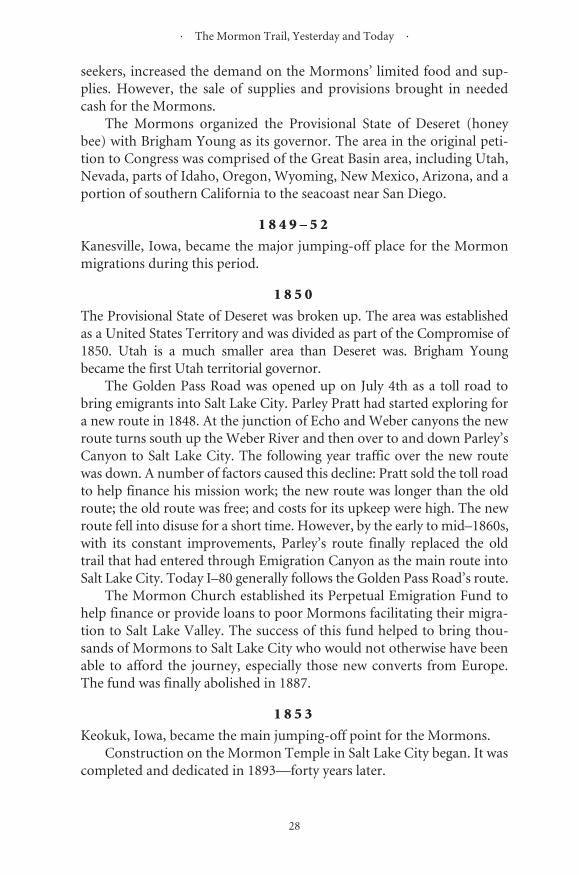
· The Mormon Trail, Yesterday and Today ·
28
seekers, increased the demand on the Mormons’ limited food and sup-plies. However, the sale of supplies and provisions brought in neededcash for the Mormons.
The Mormons organized the Provisional State of Deseret (honeybee) with Brigham Young as its governor. The area in the original peti-tion to Congress was comprised of the Great Basin area, including Utah,Nevada, parts of Idaho, Oregon, Wyoming, New Mexico, Arizona, and aportion of southern California to the seacoast near San Diego.
1 8 4 9 – 5 2
Kanesville, Iowa, became the major jumping-off place for the Mormonmigrations during this period.
1 8 5 0
The Provisional State of Deseret was broken up. The area was establishedas a United States Territory and was divided as part of the Compromise of1850. Utah is a much smaller area than Deseret was. Brigham Youngbecame the first Utah territorial governor.
The Golden Pass Road was opened up on July 4th as a toll road tobring emigrants into Salt Lake City. Parley Pratt had started exploring fora new route in 1848. At the junction of Echo and Weber canyons the newroute turns south up the Weber River and then over to and down Parley’sCanyon to Salt Lake City. The following year traffic over the new routewas down. A number of factors caused this decline: Pratt sold the toll roadto help finance his mission work; the new route was longer than the oldroute; the old route was free; and costs for its upkeep were high. The newroute fell into disuse for a short time. However, by the early to mid–1860s,with its constant improvements, Parley’s route finally replaced the oldtrail that had entered through Emigration Canyon as the main route intoSalt Lake City. Today I–80 generally follows the Golden Pass Road’s route.
The Mormon Church established its Perpetual Emigration Fund tohelp finance or provide loans to poor Mormons facilitating their migra-tion to Salt Lake Valley. The success of this fund helped to bring thou-sands of Mormons to Salt Lake City who would not otherwise have beenable to afford the journey, especially those new converts from Europe.The fund was finally abolished in 1887.
1 8 5 3
Keokuk, Iowa, became the main jumping-off point for the Mormons.Construction on the Mormon Temple in Salt Lake City began. It was
completed and dedicated in 1893—forty years later.
· Early History ·
29
Fort Supply was established for a variety of reasons by the Mormonsa few miles southwest of Fort Bridger: It helped to extend Mormoninfluence into the Green River area; it provided a base for missionaryfunctions to the Indians; and it was a means to control the ferries in theGreen River area. Fort Supply served as another Mormon colony to growfood and to provide help and protection for the Mormon emigrants.This was evident during the time of the two handcart disasters of 1856. Itcould also serve as a first line of defense for Salt Lake City against futurepersecutors. In order to consolidate forces Brigham Young later orderedFort Supply and Fort Bridger burned when fear grew about hostilitieswith the United States that had developed during the Utah War.
1 8 5 4
Westport, Missouri, near Independence, served as the main outfittingsite for Mormons who would follow the route often considered to be theOregon Trail.
1 8 5 5
Mormon Grove, near Atchinson, Kansas, became the jumping-off areafor Mormon departures. Mormons purchased Fort Bridger andstrengthened its defenses by constructing stone walls.
1 8 5 6 – 5 8
Iowa City, Iowa, became the major outfitting point for Mormon emi-grants bound for Salt Lake City. Iowa City was across the river from thewestern end of the railroad.
1 8 5 6 – 6 0
A new method of transporting Mormon immigrants to Salt Lake City wasdeveloped. Handcarts were built and provided for newly arriving immi-grants to use on their journey to Salt Lake City. During this period, tenhandcart companies took about 3,000 Saints to Salt Lake City. Iowa Cityserved as the starting point of the Mormon Trail. Most of the Mormonconverts traveled by rail to Iowa City. The handcart journey began there.
Two major handcart disasters happened in 1856. Both companiesgot late starts, and both were hit by early and constantly stormy winterweather. Late in October, Captain James G. Willie’s company was caughtin a blizzard east of the South Pass. Seventy-seven members out of 404died. Then, in November, 576 members of Handcart Company No. 4, ledby Captain Edward Martin, were trapped by a blizzard a few miles west ofDevil’s Gate. By the time they were rescued, 145 members had died.
· The Mormon Trail, Yesterday and Today ·
30
These were the worst disasters during the migration of 1841–69. Thetotal loss of life experienced because of these two disasters was muchworse than that experienced by the members of the Donner Party wholost 40 members after they were caught in the snow in the Sierras in 1846.
1 8 5 7 – 5 9
The so-called Mormon or Utah War caused tremendous strain betweenthe Mormons and the Gentiles. President Buchanan replaced BrighamYoung with Alfred Cumming as territorial governor and sent the U.S.Army, under command of Colonel Albert Sidney Johnston, into Utah toput down the so-called Mormon rebellion. With minor exceptions ofharrassment (driving off horses and cattle, burning feed, grass, and wag-ons, etc.) there was no major fighting between the Mormons and theU.S. Army. It was during this time that the Mormons burned Fort Sup-ply and Fort Bridger. The U.S. Army took over Fort Bridger and rebuiltit. Later the army established Camp Floyd 40 miles south of Salt LakeCity. Thomas Kane, a man respected by the Mormons and the U.S. gov-ernment helped to bring about a peaceful resolution of the problems.
1 8 5 9 – 6 3
Florence, Nebraska, site of the 1846 Winter Quarters, once again becamethe main outfitting area for Mormon emigrant companies.
1 8 6 0 – 6 1
The Pony Express was established. Part of its route was along portions ofthe Mormon, Oregon, and California Trails.
1 8 6 1
The Church established the use of “down-and-back” wagon trains totransport Mormons from the jumping-off towns along the Missouri Riverto Salt Lake City. Each ward of the Mormon Church was given theresponsibility of providing wagons, teams, supplies, and/or drivers. Fourwagon companies started east on April 23 to pick up the first Mormons atFlorence, Nebraska. The first church sponsored wagon company departedFlorence on May 29 and arrived in Salt Lake on August 16. For the nextfew years this church supported endeavor helped to bring thousands ofMormons to Utah who might not have been able to do so on their own.
1 8 6 4 – 6 6
The village of Wyoming, Nebraska, on the west bank of the MissouriRiver, northwest of Nebraska City, became the jumping-off place for the

31
MORMON CAMP AT WYOMING, NEBRASKA—Savage, Nebraska State Historical Society
This picture by Charles Savage shows a Mor-mon encampment at Wyoming, Nebraska, in
1866. This was one jumping-off site used by theMormons during the years 1864–66.
1,000 MILE TREE—Jackson, National Park Service
Jackson photographed the construction of therailroad west during 1869. Here is a later paint-ing showing the railroad through Weber Can-yon, 1,000 miles west of Omaha. Once the
transcontinental railroad was completed, emi-grants could travel west much faster and moreeasily. Subsequently, all the western trails fellinto disuse.
Number: 232Orig: 56 x 32.5Crop:Scale: 48%Final: 26.5 x 15
Number: 234Orig: 38.5 x 25.5Crop: 37.5 x 24Scale: 71%Final: 26.5 x 17

· The Mormon Trail, Yesterday and Today ·
32
Mormon migrations. The “down-and-back” wagon companies pickedup the emigrants and brought them to Salt Lake City.
1 8 6 7
The Mormon Tabernacle in Salt Lake City, with its huge elliptical dome,was completed.
By then the Union Pacific Railroad had already crossed the MissouriRiver. The terminus was North Platte, Nebraska. Mormons took the rail-road to there and then started their wagon trips west. By 1868 the rail-road was in Laramie, Wyoming, and later that summer in Benton. Bothtowns briefly served as wagon outfitting areas.
1 8 6 9
The Union Pacific Railroad completed laying track and joined the Cen-tral Pacific at Promontory Summit on May 10. Mormons could nowtravel by rail to Utah. The railroad replaced the Mormon Trail, whichhad served them so faithfully.

P A R T I I
Maps, Guidebooks, and Diaries
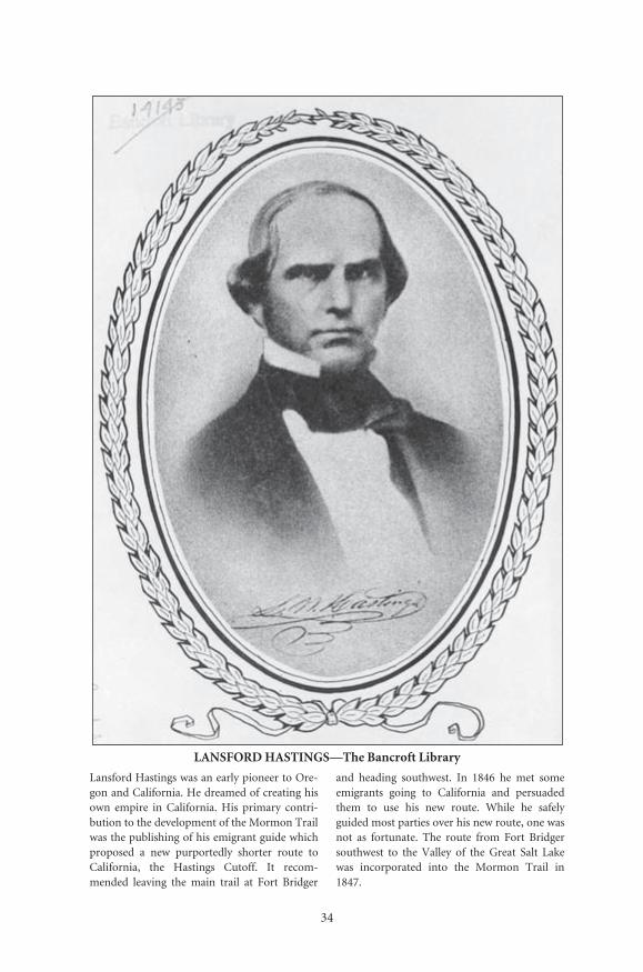
34
LANSFORD HASTINGS—The Bancroft Library
Lansford Hastings was an early pioneer to Ore-gon and California. He dreamed of creating hisown empire in California. His primary contri-bution to the development of the Mormon Trailwas the publishing of his emigrant guide whichproposed a new purportedly shorter route toCalifornia, the Hastings Cutoff. It recom-mended leaving the main trail at Fort Bridger
and heading southwest. In 1846 he met someemigrants going to California and persuadedthem to use his new route. While he safelyguided most parties over his new route, one wasnot as fortunate. The route from Fort Bridgersouthwest to the Valley of the Great Salt Lakewas incorporated into the Mormon Trail in1847.
Number: 229Orig: 27.5 x 39Crop: 23 x 32.5Scale: 97%Final: 26.5 x 37.5
35
Maps
By 1845 it had been determined that the Mormons could nolonger safely remain in the Illinois area. However, their leadership,under Brigham Young, had yet to determine where they would establishtheir new Zion. The decision had been made to move west, but not to aspecific location. Earlier some had talked of Texas, Oregon, California,or the isolated area of the Great Basin. It seems that, before his death,Prophet Joseph Smith had even prophesied that their Zion would befound in the Rocky Mountains. Two major problems faced by BrighamYoung and the other leaders involved the determination of the exactlocation where they would finally settle and the route to be used to safelybring the Mormons to their “promised land.”
To a certain degree the solution was made for them. The main routewest was the route used by the Oregon and California emigrants, whichfollowed the Platte River and North Platte. Therefore, that route was themost likely choice. The emigrants and the traders before them had used avariety of jumping-off sites from the Independence, Missouri, area, northto the Council Bluffs, Iowa, area. By establishing the Mormon camp called“Winter Quarters” in the Indian lands on the west side of the Missouriand the north side of the Platte, not only were the Mormons temporarilyproviding themselves with some degree of safety from further persecutionfrom the Gentiles, but it also became more likely that they would use theroute along the north side of the Platte River. Research indicates that asearly as June of 1846 Brigham Young was already seriously consideringthe Valley of the Great Salt Lake or the Bear River Valley in the GreatBasin area. By mid-1847 California was ruled out in favor of the more iso-lated Great Basin area, and the final decision was made to settle the Valleyof the Great Salt Lake. Still, in 1846, the specifics of the actual route to fol-low and exact location of their new Zion had yet to be determined.
36
FRÉMONT-PREUSS MAP OF 1843—National Archives
Number: 238Orig: 80 x 35Crop:Scale: 82%Final: 66 x 29 (gutter bleed)
37
· The Mormon Trail, Yesterday and Today ·
38
These problems were also in part solved by the use of existing mapsand guides available to the Mormons. The Mormons discussed develop-ing their own guidebook and set of trail maps. While they did publishtheir own guidebook, they never developed their own set of maps. Therewere, however, a number of maps that played a significant role in thedevelopment of the Mormon route west during their first year of migra-tion in 1847. The maps by John Charles Frémont and Charles Preuss, S.Augustus Mitchell, and Lansford Hastings all helped to show them theway. Even though the T. H. Jefferson map was not available until 1849, itis also included in this section because it shows nearly the whole routeand was available to later emigrating Mormons.
The first significant map was the Frémont–Preuss Map of 1843.Lieutenant, and later Captain, John Charles Frémont’s exploration expe-ditions of 1842 and then 1843–44 resulted in the trail to Oregon beingrecorded and mapped from Independence, Missouri, to Oregon. CharlesPreuss served as his cartographer and deserves much of the credit for thehigh quality of their maps. Their information was incorporated intomost of the maps that were produced by other cartographers. After eachexpedition the results were made public. The 1845 report included amap of the Valley of the Great Salt Lake. In 1846 a seven-section “Topo-graphical Map of the Road from Missouri to Oregon” was produced andavailable. Its scale was ten miles to an inch. Originally it was part of Fré-mont’s reports to Congress. More than 10,000 copies were printed anddevoured by Congress and the public. Reproductions of these seven-sec-tion strip maps may still be purchased today and you can use them asyou follow along the route. The 1843 map was a single large map. JosephSmith had a copy of it in Nauvoo, and William Clayton and BrighamYoung had seen it. They were also in the possession of Frémont’s seven-section maps when they left from Winter Quarters in 1847 for their newpromised land. While the Frémont–Preuss maps traced the route on thesouth side of the Platte and the Mormons largely followed the northbank of the river, the maps served as useful references once the MormonPioneers reached Grand Island, where Frémont’s route joined the PlatteRiver. At Fort Laramie the Mormons crossed the Platte to the south side.There they joined the established “Oregon Trail,” mapped by Frémont,and generally followed it to Fort Bridger. At that point the Oregon Trailturned northwest to head for Fort Hall and then on to Oregon. TheMormons, however, headed southwest to follow the route proposed byHastings and taken in 1846 by some California-bound companies whichincluded emigrants George Donner, James Reed, Heinrich Lienhard, andEdwin Bryant.
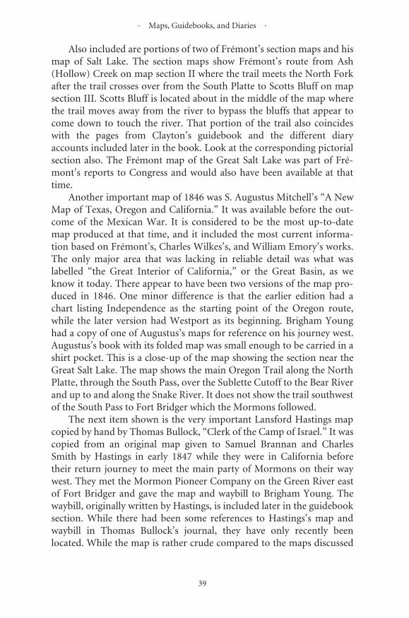
· Maps, Guidebooks, and Diaries ·
39
Also included are portions of two of Frémont’s section maps and hismap of Salt Lake. The section maps show Frémont’s route from Ash(Hollow) Creek on map section II where the trail meets the North Forkafter the trail crosses over from the South Platte to Scotts Bluff on mapsection III. Scotts Bluff is located about in the middle of the map wherethe trail moves away from the river to bypass the bluffs that appear tocome down to touch the river. That portion of the trail also coincideswith the pages from Clayton’s guidebook and the different diaryaccounts included later in the book. Look at the corresponding pictorialsection also. The Frémont map of the Great Salt Lake was part of Fré-mont’s reports to Congress and would also have been available at thattime.
Another important map of 1846 was S. Augustus Mitchell’s “A NewMap of Texas, Oregon and California.” It was available before the out-come of the Mexican War. It is considered to be the most up-to-datemap produced at that time, and it included the most current informa-tion based on Frémont’s, Charles Wilkes’s, and William Emory’s works.The only major area that was lacking in reliable detail was what waslabelled “the Great Interior of California,” or the Great Basin, as weknow it today. There appear to have been two versions of the map pro-duced in 1846. One minor difference is that the earlier edition had achart listing Independence as the starting point of the Oregon route,while the later version had Westport as its beginning. Brigham Younghad a copy of one of Augustus’s maps for reference on his journey west.Augustus’s book with its folded map was small enough to be carried in ashirt pocket. This is a close-up of the map showing the section near theGreat Salt Lake. The map shows the main Oregon Trail along the NorthPlatte, through the South Pass, over the Sublette Cutoff to the Bear Riverand up to and along the Snake River. It does not show the trail southwestof the South Pass to Fort Bridger which the Mormons followed.
The next item shown is the very important Lansford Hastings mapcopied by hand by Thomas Bullock, “Clerk of the Camp of Israel.” It wascopied from an original map given to Samuel Brannan and CharlesSmith by Hastings in early 1847 while they were in California beforetheir return journey to meet the main party of Mormons on their waywest. They met the Mormon Pioneer Company on the Green River eastof Fort Bridger and gave the map and waybill to Brigham Young. Thewaybill, originally written by Hastings, is included later in the guidebooksection. While there had been some references to Hastings’s map andwaybill in Thomas Bullock’s journal, they have only recently beenlocated. While the map is rather crude compared to the maps discussed
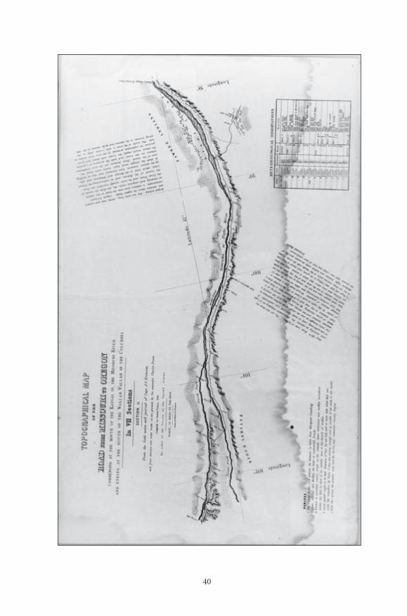
40
Number: 235Orig: 79 x 48.5Crop: evenlyScale: 55%Final: 44 x 27

41
FR
ÉM
ON
T S
TR
IP M
AP
S—N
atio
nal
Arc
hiv
es
Number: 236Orig: 79 x 48.5Crop: evenlyScale: 55%Final: 44 x 27

42
FRÉMONT MAP OF GREAT SALT LAKE—National Archives
Number: 237Orig: 41.5 x 55.5Crop: 38 x 55.5Scale: 70%Final: 26.5 x 39

· Maps, Guidebooks, and Diaries ·
43
above, it is the first copy of a map that showed the route from FortBridger to the Salt Lake Valley or what we now know as the end of theMormon Trail. In recent times this last section of the Mormon Trail hasalso been called the Pioneer Trail.
The last map is the T. H. Jefferson map. Jefferson had gone west toCalifornia in 1846 and then returned east in 1849. He produced a four-section map of the route to California called “Map of the Emigrant Roadfrom Independence, Mo. to St. Francisco, California.” It included theroute to the Great Salt Lake Valley. Only the third section of his mapseries is reproduced here. His first two sections are very similar to Fré-mont’s first four sections. (All four sections of the T. H. Jefferson mapsare reduced and included in my California Trail book, and the reducedcopies of Frémont’s seven-section maps are in my Oregon Trail book.)Jefferson had been in one of the companies that listened to Hastings’sadvice and took his cutoff southwest from Fort Bridger to the Valley ofthe Great Salt Lake and then finally farther west to meet the main Cali-fornia Trail. From Fort Bridger the early emigrant parties followed aroute southwest to Echo Canyon down to the Weber River and Canyon.The Donner Party followed Hastings’s advice to cut over the WasatchMountains instead of going down the very difficult Weber River Can-yon. The Mormon companies followed the tracks left by the Donnerwagons. Jefferson’s map was not available to the first Mormon parties in1847 and 1848, but it was available to the migrants in 1849.

44
MIT
CH
EL
L M
AP
—S.
Au
gust
us
Mit
chel
l, A
New
Map
of T
exas
, Ore
gon
, an
d C
alif
orn
ia
Number: 241Orig: 81 x 50Crop: 55 x 37.5Scale: 71%Final: 39 x 26.5
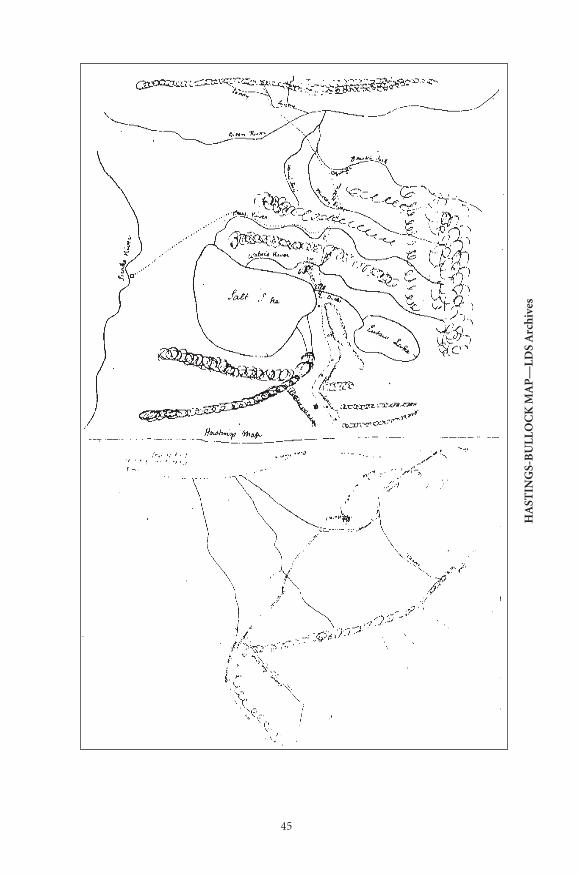
45
HA
STIN
GS-
BU
LL
OC
K M
AP
—L
DS
Arc
hiv
es
Number: 240Orig: 81 x 50Crop: 54 x 32.5Scale: 79.5%Final: 43 x 26
46
T. H. JEFFERSON MAP—Library of Congress
Number: 239Orig: 80 x 60Crop:Scale: 75%Final: 60 x 45 gutter bleed, adjust as necessary for gutter
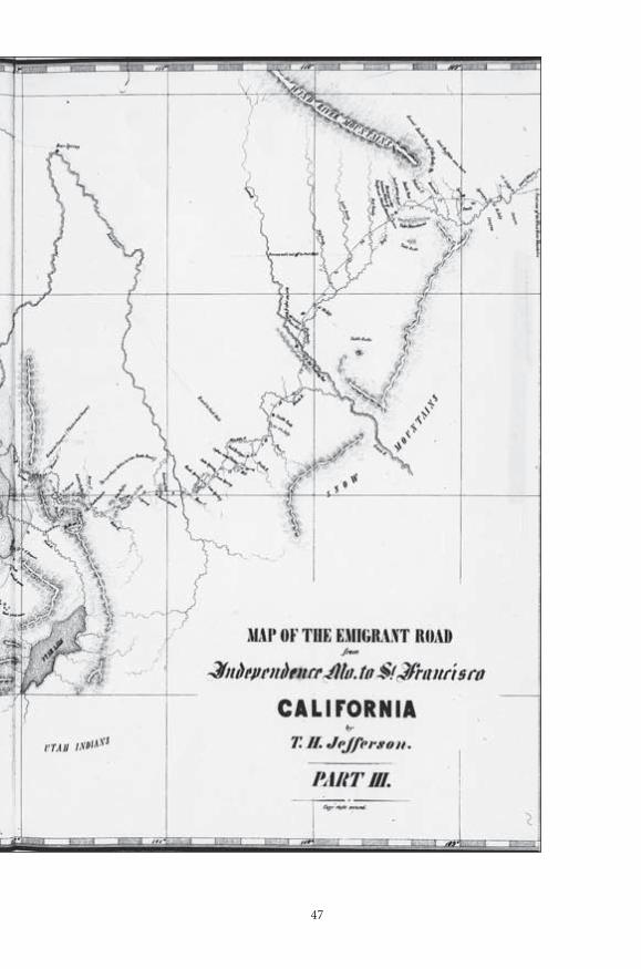
47
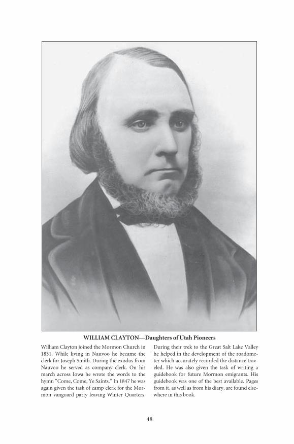
48
WILLIAM CLAYTON—Daughters of Utah Pioneers
William Clayton joined the Mormon Church in1831. While living in Nauvoo he became theclerk for Joseph Smith. During the exodus fromNauvoo he served as company clerk. On hismarch across Iowa he wrote the words to thehymn “Come, Come, Ye Saints.” In 1847 he wasagain given the task of camp clerk for the Mor-mon vanguard party leaving Winter Quarters.
During their trek to the Great Salt Lake Valleyhe helped in the development of the roadome-ter which accurately recorded the distance trav-eled. He was also given the task of writing aguidebook for future Mormon emigrants. Hisguidebook was one of the best available. Pagesfrom it, as well as from his diary, are found else-where in this book.
Number: 224Orig:Crop:Scale:Final: 26.5 x 36.5
49
Guidebooks
By 1847, when the Mormons were ready to embark on their jour-ney west from Winter Quarters to establish their promised land, over8,000 other emigrants had already moved west. Established trails alreadyexisted in many areas that would be followed by the emigrating Mor-mons. In addition to the earlier emigrants, numerous military explor-atory expeditions had gone west and hundreds of trappers had beentraveling back and forth along the Platte River from the mountains tothe Missouri since the early 1800s. Routes had already been establishedto Oregon and to California with their jumping-off places located alongthe Missouri River in places such as the Independence-Westport area,Weston, Fort Leavenworth, St. Joseph, Nebraska City, and the CouncilBluffs-Kanesville area. Thus, for most of the way, the emigrating Mor-mons would not be traveling through uncharted lands. However, this isnot to say that guidebooks would not be useful. It seems most emigrantcompanies had copies of guidebooks once they became available. Thebetter books provided the emigrants with useful information not onlyabout the number of miles between sites, but also about the availabilityof grass, water, and wood. Many also provided lists of equipment andprovisions that should be packed. Some even described the areasthrough which the emigrants would be traveling.
Among the most important sources of information about the Westwere Captain John Charles Frémont’s reports. While Frémont’s reportsto Congress about his exploration expeditions to the Rocky Mountains,Oregon, and California were not published as an emigrant guide, theyserved the same purpose. They were the most informative and most fre-quently cited of the trail material available to the Mormons. In 1844 Fré-mont’s early map and report had already been brought to the attentionof Joseph Smith. After Smith’s death, copies of Frémont’s later maps and
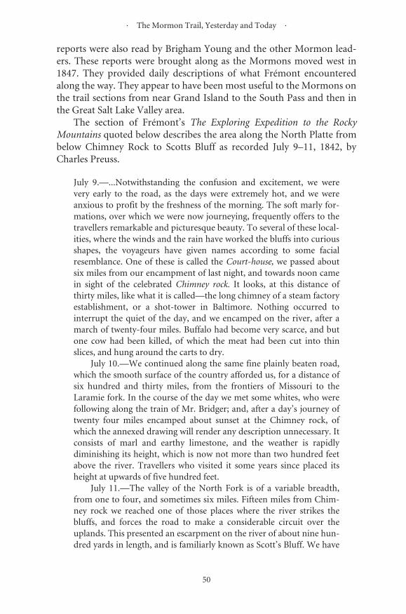
· The Mormon Trail, Yesterday and Today ·
50
reports were also read by Brigham Young and the other Mormon lead-ers. These reports were brought along as the Mormons moved west in1847. They provided daily descriptions of what Frémont encounteredalong the way. They appear to have been most useful to the Mormons onthe trail sections from near Grand Island to the South Pass and then inthe Great Salt Lake Valley area.
The section of Frémont’s The Exploring Expedition to the RockyMountains quoted below describes the area along the North Platte frombelow Chimney Rock to Scotts Bluff as recorded July 9–11, 1842, byCharles Preuss.
July 9.—...Notwithstanding the confusion and excitement, we werevery early to the road, as the days were extremely hot, and we wereanxious to profit by the freshness of the morning. The soft marly for-mations, over which we were now journeying, frequently offers to thetravellers remarkable and picturesque beauty. To several of these local-ities, where the winds and the rain have worked the bluffs into curiousshapes, the voyageurs have given names according to some facialresemblance. One of these is called the Court-house, we passed aboutsix miles from our encampment of last night, and towards noon camein sight of the celebrated Chimney rock. It looks, at this distance ofthirty miles, like what it is called—the long chimney of a steam factoryestablishment, or a shot-tower in Baltimore. Nothing occurred tointerrupt the quiet of the day, and we encamped on the river, after amarch of twenty-four miles. Buffalo had become very scarce, and butone cow had been killed, of which the meat had been cut into thinslices, and hung around the carts to dry.
July 10.—We continued along the same fine plainly beaten road,which the smooth surface of the country afforded us, for a distance ofsix hundred and thirty miles, from the frontiers of Missouri to theLaramie fork. In the course of the day we met some whites, who werefollowing along the train of Mr. Bridger; and, after a day’s journey oftwenty four miles encamped about sunset at the Chimney rock, ofwhich the annexed drawing will render any description unnecessary. Itconsists of marl and earthy limestone, and the weather is rapidlydiminishing its height, which is now not more than two hundred feetabove the river. Travellers who visited it some years since placed itsheight at upwards of five hundred feet.
July 11.—The valley of the North Fork is of a variable breadth,from one to four, and sometimes six miles. Fifteen miles from Chim-ney rock we reached one of those places where the river strikes thebluffs, and forces the road to make a considerable circuit over theuplands. This presented an escarpment on the river of about nine hun-dred yards in length, and is familiarly known as Scott’s Bluff. We have
· Maps, Guidebooks, and Diaries ·
51
made a journey of thirty miles before we again struck the river, at aplace where some scanty grass afforded insufficient pasturage to ouranimals. About twenty miles from Chimney rock we had found a verybeautiful spring of excellent and cold water; but it was in such a deepravine and, so small, that the animals could not profit by it, and wetherefore halted only a few minutes, and found a resting-place tenmiles further on. The plain between Scott’s bluffs and Chimney rockalmost entirely covered with drift-wood, consisting principally ofcedar, which, we were informed, had been supplied from the Blackhills, in a flood of five or six years since.
Perhaps the most famous of the guidebooks available to the Mor-mons and other emigrants was Lansford Hastings’s The Emigrants’ Guideto Oregon and California, which was written in 1844 and published inOhio in 1845. Hastings had originally gone to Oregon, became dissatis-fied and then decided his fortune could best be made in California. Itwas in his guidebook that his infamous cutoff—the short cut to Califor-nia by turning southwest from Fort Bridger to California—was recom-mended. The guide, like Frémont’s reports, had been reprinted in manyof the newspapers available to the Mormon and non-Mormon emigrantsstarting in 1845. It was also brought along and referred to on the journeyto Salt Lake. Unlike Frémont’s report, Hastings’s guide provided onlyvery general information about specific sections of the trail. However, awaybill handwritten by Hastings specifically for the Mormons was moreuseful. The waybill described the route east from Johnson’s settlement inCalifornia back along the cutoff to Fort Bridger. It was sent along withthe hand-drawn map of the general route from Fort Bridger across theWasatch Mountains and Salt Lake Desert which Hastings appears tohave considered the most difficult portion of his new cutoff to Califor-nia. This map was the one included earlier. Here is Hastings’s waybill(Korns and Morgan, West From Fort Bridger).
HASTINGS’S WAYBILLROUTE FROM MR. JOHNSON’S SETTLEMENT—CALIFORNIA TO BRIDGER’S FORT, AS PER MR.
HASTINGS ACCOUNT
From Johnson’s to Bear River Valley, 60 miles—thence to Trucker’sLake, on the other side of the mountains 40—thence down TruckyRiver 60—thence to the sink of Mary’s River 40—thence up and alongMary’s River, 250—to the forks of the Road—thence taking the righthand road, up the South Fork of Mary’s River 15—Thence up a branchof the South Fork 8—thence to a sink of a small creek 7—thence upthe said creek to the point where the road leaves it 5 miles—thence

· The Mormon Trail, Yesterday and Today ·
52
through a pass in the mountain 12—thence along the foot of themountain passing numerous springs 30, to a point where the roadleaves the foot of the mountain—thence 20 miles over the plain andhills to a Spring—thence 10 miles to a Spring—thence 9 miles to aSpring—thence 12 miles to a Spring—thence 25 miles to a Spring—thence 4 or 5 miles along the foot of the mountain, passing severalSprings to a Spring, and a large encampment, at the west side of a SaltPlain—thence over the Salt Plain 55 miles to a Spring—thence 6 milesto a Spring—thence along and around the foot of the mountain pass-ing numerous Springs on the West side 20 miles to a Spring on the Eastside—Thence keeping to the right hand road, along the foot of themountain passing several Springs. Then bearing to the left, across theplain 20 miles, to the point of the mountain at the Salt Lake. Thencepassing several Springs, and keeping [to] the right hand road, 12 milesto the Eutaw Outlet—Thence over the mountains 12 miles. Thencedown a small Creek, and bearing to the right over the hills 15 miles toWeber’s River—Thence up Weber River 7 miles—Thence up the RedFork 40 miles—Thence keeping to the left hand road 25 miles to BearRiver—Thence 25 miles to Bridger’s Fort, on Black’s Fork of GreenRiver.
Hastings’s guide, like many of the other guidebooks produced,included a list of items emigrants needed in order to outfit properly fortheir journey west. By 1845, a year after Joseph Smith’s death, the Mor-mons were already preparing to leave Nauvoo because of deterioratingrelations with the non-Mormons in the area. Included here is the Bill ofParticulars, which was originally published in 1845 in preparation forthe Mormon migration which was to leave Nauvoo in 1846. Initially, theMormons hoped to complete their journey west in one year. However,as it turned out, the Mormon migration from Nauvoo advanced only asfar as the Indian territory across the Missouri River from the CouncilBluffs area. Their journey across Iowa was much more difficult than theyhad expected. They were forced to halt and to establish what becameknown as Winter Quarters on the west bank of the Missouri River andmake preparations for the coming winter. This listing of items that theMormons were recommended to pack for their journey appeared in theOctober 29, 1845 Nauvoo Neighbor.
While the Mormons did not have one guidebook for their 1847 jour-ney, a decision was made to carefully record their progress and prepare adetailed guidebook for the Mormons who were to follow later. The taskof keeping accurate records and preparing a guidebook was given to Wil-liam Clayton. He served as “Clerk of the Camp of Israel” when the firstMormons left Nauvoo and traveled to their Winter Quarters. When the

53
BILL OF PARTICULARS—LDS Archives(Note: On the listing, “do” means “ditto.”)
Number: 244Orig: 14.5 x 33Crop:Scale: 110%Final: 16 x 36.5

54
CLAYTON’S GUIDE
Number: 242Orig: 33 x 56.5Crop: 30.5 x 49.5Scale: 87%Final: 26.5 x 43
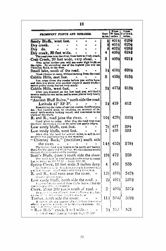
55
Number: 243Orig: 33 x 56Crop: 30.5 x 49.5Scale: 87%Final: 26.5 x 43
· The Mormon Trail, Yesterday and Today ·
56
vanguard company of Mormons left their Winter Quarters on April 15,1847, he was appointed to assist Thomas Bullock, the official clerk, inkeeping a detailed record of their journey and daily progress. Within afew days it became evident that they needed a precise method for mea-suring the distance traveled. First, he tried estimation; then he triedcounting wheel revolutions; and finally he used a “roadometer,” amechanical device that counted wheel revolutions to measure distance.It was jointly developed by Clayton, Orson Pratt, and Appleton Harmon.The device was installed on May 12 and from then on his records wereextremely accurate. After he arrived in Salt Lake Valley, he was assignedto prepare a table of distances between Salt Lake and Winter Quartersand a map to complement it. He started on his return trip and againmeasured and recorded information which he used in his guidebook.Five thousand copies of his guide, The Latter-Day Saints Emigrants’Guide, were initially printed. It was an instant success. Not only was it indemand by Mormons, but non-Mormons also used it, and even otherauthors of guidebooks “freely” copied sections of his book and incorpo-rated them into their own guidebooks. Two pages of Clayton’s guide areincluded here. Note the milepost approach and detail. There is no evi-dence, however, that he prepared a corresponding map.
These two pages from Clayton’s guide correspond to the section ofthe journey described in the diary section and also shown on the Fré-mont Section Maps. Ash Hollow is at mile 380 3/4 from Winter Quartersand Scotts Bluff is at mile 472.
In later years Mormon wagon companies did not always follow thesame route. As a result they often relied on other guidebooks besidesClayton’s. Hosea Horn’s guide was used by Frederick Piercy in 1853.Horn’s guide started at Council Bluffs, followed the north side of theriver until reaching Fort Laramie, where it crossed over to the south side.Piercy, however, followed the north side of the Platte River all the way tocentral Wyoming, never crossing to the south side near Fort Laramie.This route has often been called Chiles’s Route. On his way back, how-ever, Piercy did travel on the south side.

��
�������
������������������������������������������������������������������������������������������������������������������������������������������������������������������������������������������������������������������������������������������������������������������������������������������������ �������������������������������������� ��������������� �������������������������������������������������������������������������������������������������������������������������������������������������������� �� ������� ��� ������� ��� ������ �������� ����� �� ���� ���� ������ �����������������������������������������������������������������������������������������������������������������������������������������������������������������������������������������������������������������������������������
�������������������������������������������������������������������������������������������������������������������������������������������������������������������������������������������������������� �������� ���� ���������� ��� ��������� ������������ ��� ��������� ������������������������������������������������������������������������������������������������������������������������������������������������������������������������������������������������������������������������������������������������������������������������������������������������������������������������������������������������������������������������������������������������������������������
�����������������������������������������������������������������������������������������������������������������������������������������������������������������������������������������������������������������������������������������������������������������������������������������������������������������������������������������������������������������������������������������������������������������������

· The Mormon Trail, Yesterday and Today ·
58
William Clayton served as the clerk of the camp that left Nauvoo in1846. In 1847 he was assigned to assist Thomas Bullock, camp clerk, inrecording the events of the Mormon Pioneer Company that led thedeparture from the Winter Quarters and first entered and settled in theGreat Salt Lake Valley. He was also asked to serve as scribe for churchleader Heber Kimball by keeping Kimball’s diary along with his own. Hispersonal diary, quoted here (Clayton, William Clayton’s Journal), is themost comprehensive of the three and one of the best of the whole Mor-mon Trail period. He left Winter Quarters on April 14 and arrived in theGreat Salt Lake Valley on July 22.
D i a r y E n t r i e s : T h u r s d a y , [ M a y ] 2 0 t h –Thursday, [May] 27th [1847]
THURSDAY, 20TH. The morning fair, but cloudy, light wind fromnorthwest and cold. At 7:45 we started out again but had not traveledover a quarter of a mile before the roadometer gave way on account ofthe rain yesterday having caused the wood to swell and stick fast. Oneof the cogs in the small wheel broke. We stopped about a half an hourand Appleton Harmon took it to pieces and put it up again without thesmall wheel. I had to count each mile after this. Three quarters of amile from where we camped, we crossed a creek eight feet wide andtwo and a half feet deep. We then changed our course to about south-west a mile or so following the banks of the river, as the ground waswet and swampy nearer the bluffs. The river then winds around aboutthree miles in a bend and then strikes a little north of west. The bluffson the north appear to be about two miles from the river. We traveledtill 11:15 and then halted to feed, having traveled seven and three quar-ters miles over tolerably good road, though at the commencementsomewhat soft. On the opposite side the river, the bluffs project nearits banks. They are rocky and almost perpendicular, beautified formiles by groves of cedar. Opposite to where we are halted, we can see aravine running up the bluffs and at the foot, a flat bottom of about fif-teen acres. At the farther side of this bottom is a grove of trees not yetin leaf. Brother Brown thinks they are ash and that the place is what iscalled Ash Hollow and on Fremont’s map, Ash Creek. We all felt anx-ious to ascertain the fact whether this is Ash Hollow or not, for if it is,the Oregon Trail strikes the river at this place, and if it can be ascer-tained that such is the fact, we then have a better privilege of testingFremont’s distances to Laramie. We have already discovered that hismap is not altogether correct in several respects, and particularly inshowing the windings of the river and the distance of the bluffs from it.I suggested the propriety of some persons going over in the boat andBrother John Brown suggested it to President Young. The boat was
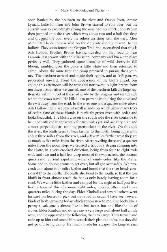
· Maps, Guidebooks, and Diaries ·
59
soon hauled by the brethren to the river and Orson Pratt, AmasaLyman, Luke Johnson and John Brown started to row over, but thecurrent was so exceedingly strong the oars had no effect. John Brownthen jumped into the river which was about two and a half feet deepand dragged the boat over, the others assisting with the oars. Aftersome hard labor they arrived on the opposite shore and went to thehollow. They soon found the Oregon Trail and ascertained that this isAsh Hollow, Brother Brown having traveled on that road to nearLaramie last season with the Mississippi company and knew the placeperfectly well. They gathered some branches of wild cherry in fullbloom, rambled over the place a little while and then returned tocamp. About the same time the camp prepared to pursue their jour-ney. The brethren arrived and made their report, and at 1:45 p.m. weproceeded onward. From the appearance of the bluffs ahead, ourcourse this afternoon will be west and northwest. A light breeze fromnorthwest. Soon after we started, one of the brethren killed a large rat-tlesnake within a rod of the road made by the wagons and on the sidewhere the cows travel. He killed it to prevent its injuring the cows andthrew it away from the road. In the river one and a quarter miles aboveAsh Hollow, there are several small islands on which grow many treesof cedar. One of these islands is perfectly green over with cedar andlooks beautiful. The bluffs also on the south side the river continue tobe lined with cedar apparently for two miles yet and are very high andalmost perpendicular, running pretty close to the river. On this sidethe river, the bluffs seem to bear farther to the north, being apparentlyabout three miles from the river, and a few miles farther west they areas much as five miles from the river. After traveling three and a quartermiles from the noon stop, we crossed a tributary stream running intothe Platte, in a very crooked direction, being from four to eight rodswide and two and a half feet deep most of the way across, the bottomquick sand, current rapid and water of sandy color, like the Platte.Some had to double teams to get over, but all got over safely. We pro-ceeded on about four miles farther and found that the river bends con-siderably to the north. The bluffs also bend to the south, so that the lowbluffs in front almost reach the banks only barely leaving room for aroad. We went a little farther and camped for the night at half past five,having traveled this afternoon eight miles, making fifteen and threequarters miles during the day. Elder Kimball and several others wentforward on horses to pick out our road as usual. I have seen severalkinds of herbs growing today which appear new to me. One looks like apenny royal, smells almost like it, but tastes hot and like the oil ofcloves. Elder Kimball and others saw a very large wolf about half a milewest, and he appeared to be following them to camp. They turned androde up to him and round him, struck their pistols at him, but they didnot go off, being damp. He finally made his escape. The large stream
· The Mormon Trail, Yesterday and Today ·
60
we crossed this afternoon is named Castle Creek from the bluffs on theopposite side which much resemble the rock on which Lancaster Castleis built. The bluffs are named Castle Bluffs. We had a light shower thisafternoon, but the evening is fine though very cool.
FRIDAY, 21ST. The morning very fine and pleasant though toler-ably cold. I put up a guide board at this place with the followinginscriptions on it: ‘From Winter Quarters 409 miles. From the junc-tion of the North and South Forks, 93 1/4 miles. From Cedar Bluffs,south side the river, 36 1/2 miles. Ash Hollow, south side the river, 8miles. Camp of the Pioneers May 21, 1847. According to Fremont, thisplace is 132 miles from Laramie. N.B. The bluffs opposite are namedCastle Bluffs.’ At 7:35 we continued our journey. We found the prairietolerably wet, many ponds of water standing which must have beencaused by a heavy fall of rain, much more heavy than we had back.However, it was not very bad traveling. We made a pretty straight roadthis morning at about the distance of a mile from the river. The bluffson the north appear to be five miles or over from our road. At 11:15 wehalted for dinner, having traveled nearly seven and three quartersmiles, course north of northwest, very warm and no wind. PresidentsYoung and Kimball rode forward to pick the road, and near this placethey saw a nest of wolves, caught and killed two with sticks. Four orfive others escaped to their hole. At half past one we proceeded onwardand found the prairie wet, and grass high of last year’s growth. Aftertraveling four and three quarters miles we arrived at a range of lowbluffs projecting to the river, which at this place bends to the north.There is, however, a bottom of about a rod wide between the bluffs andthe river, but as it is wet and soft, it was preferred to cross over thebluffs by bending a little more to the north. We traveled on the bluffs alittle over a quarter of a mile and then turned on the bottom again. Thebluffs are low and almost as level as the bottom. After we crossed thebluffs we found the road better. We saw about a mile this side of thefoot of the bluffs, a very large bone almost petrified into stone. Most ofthe brethren believe it to be the shoulder bone of a mammoth, and isvery large indeed. About this time a badger was brought to the wagonswhich Brother Woodruff had killed. As I was walking along and look-ing over the river, I heard a rattlesnake, and looking down saw that Ihad stepped within a foot of it. It rattled hard but seemed to make way.We threw it away from the track without killing it. At five o’clock ElderKimball rode up and stopped the forward teams till the last ones gotnearer saying that some Indians had come down from the bluffs to thebrethren ahead. When the rest of the wagons came up we moved on aquarter of a mile farther and at half past five formed our encampmentin a circle with the wagons close together as possible, having traveledseven and three quarters miles this afternoon, making fifteen and a halfthrough the day. As the camp was forming two Indians came nearer,
· Maps, Guidebooks, and Diaries ·
61
being a man and his squaw. They represented by signs that they wereSioux and that a party of them are now on the bluffs north of us andnot far distant. By the aid of glasses we could see several on the bluffswith their ponies, evidently watching our movements. This man washunting when first seen and appeared afraid when he saw the brethren.The squaw fled for the bluffs as fast as her horse could go, but by thesigns made to them they gathered courage and came up. PresidentYoung gave orders not to bring them into camp, and they soon rodeoff to the bluffs. The man has got a good cloth coat on and appears welldressed. The horses they rode are said to be work horses which makesus suspect they have stolen them from travelers. The day has been verywarm and some of the teams gave out. We can see some timber on thebluffs on the other side of the river some miles ahead which is the firsttimber we have seen for more than a week, except some small cedarand timber in Ash Hollow, all on the south side of the river. We arenearly a mile from water and the brethren have to dig wells to obtain asupply for cooking. The feed here is very poor, not much but old grass.Our course this afternoon has been a little north of west. LorenzoYoung shot two very large ducks with one ball and brought them tocamp. Elder Kimball proposed tonight that I should leave a number ofpages for so much of his journal as I am behind in copying and startfrom the present and keep it up daily. He furnished me a candle and Iwrote the journal of this day’s travel by candle light in his journal, leav-ing fifty-six pages blank. The evening was very fine and pleasant. Thelatitude at noon halt 41º 24’ 5”.
SATURDAY, 22ND. Morning beautiful, no wind and warm. Wehave not been disturbed by the Indians; all is peace in the camp. Ateight o’clock we continued our journey, making a more crooked roadthan usual, having to bend south to near the banks of the river. Theprairie somewhat soft and a little uneven. After traveling five and a halfmiles we crossed a very shoal creek about twenty feet wide. The bluffsand river about a mile apart, but on the other side, the bluffs recedetwo miles back from the river and have lost their craggy and steepappearance, the ascent being gradual, while on this side they begin tobe rocky, cragged and almost perpendicular though not very high. Wetraveled till half past eleven and then halted for noon, having traveledseven and a quarter miles, the road on this side the creek being better.Our course about west of northwest with a light breeze from the east.Elder Kimball and others ahead as usual. The creek above mentionedwas named Crab Creek because some of the brethren saw a very largecrab in it. A mile east of this creek is a dry creek, down which, fromappearances, a heavy stream runs at some seasons of the year, perhapsduring heavy storms. The water running from the bluffs swells it to aconsiderable height and it is certain there are tremendous storms here.A while after we halted, Porter Rockwell came in and said he had been
· The Mormon Trail, Yesterday and Today ·
62
on the high bluff about a mile northwest of us and had seen the rockcalled Chimney Rock which appeared a long distance off. We havebeen in hopes to come in sight of it today and feel anxious in order toascertain more certainly the correctness of Fremont’s distance. Inorder to satisfy myself, although my feet were blistered and very sore, Idetermined to take my telescope and go on the bluff to ascertain formyself whether the noted rock could be seen or not. At half past twelveI started out alone. I found the distance to the foot of the bluff a goodmile, the ascent gradual. From the foot the bluff looks very high andrough, many huge rocks having broken from the summit from time totime and rolled down a long distance. I found the ascent very steep andlengthy in comparison to its appearance from camp. When I arrivedon the top I found a nice slightly arched surface of about a quarter ofan acre in extent, but barren and very little grass on it. Huge compara-tively smooth rocks peeped through the surface on one of which Iwrote with red chalk: ‘Wm. Clayton, May 22, 1847.’ On the highestpoint I sat down and took a view of the surrounding country which ismagnificent indeed. On the south side at a distance of two miles fromthe river, there is a range of cedar trees on the bluffs which very muchresemble some of the parks and seats of gentry in England. East I couldsee where we camped last night, the high grass still burning. Northeast,north, and northwest, alternately, appeared high swelling bluffs andvalleys as far as the eye could see or the glass magnify. West, the courseof the Platte for ten or fifteen miles and at about four or five miles dis-tance, a large bend to the north brings it in contact with the bluffs onthis side. At the distance, I should judge of about twenty miles, I couldsee Chimney Rock very plainly with the naked eye, which from herevery much resembles the large factory chimneys in England, although Icould not see the form of its base. The rock lay about due west fromhere. After gratifying my curiosity, and seeing the men collecting theirteams for a march, I descended on the west side of the bluff. Thedescent at this point looks more alarming than on the other. The sidebeing very steep and all along huge rocks standing so critically, that toall appearance, a waft of wind would precipitate them to the prairiebelow with tremendous force. In one place in particular, a ponderousmass of rock appears to hang from the edge of the bluff without anyvisible means of being retained in its position, and by grazing at it a lit-tle while, it is easy to imagine you can see it move and ready to over-whelm you instantly. At a little distance from the base of the bluff, Iturned to gaze on the romantic scenery above and was struck at theappearance of a large rock projecting from one corner, which verymuch resembled a frog’s head of immense size with its mouth partopen. The thought was, those bluffs ought to be named and what namemore appropriate than Frog’s Head Bluffs. After this reflection, Iwalked on to where I thought the wagons would come which started

· Maps, Guidebooks, and Diaries ·
63
out at half past one. After traveling three and a quarter miles wecrossed a dry creek about six rods wide, and a quarter of a mile farther,another about five feet wide and a half a mile farther, still anotherabout six rods wide on an average. These all appear to be the sources ofheavy streams of water at some seasons of the year. Soon as we crossedthis last one, I saw Elder Kimball wave his hat for the wagons to turnoff to the north in order to cross the bluffs which struck the river a lit-tle farther. But a little to the west was a very high ridge and I concludedto walk on to it. Found it to be a perfect ridge of gravel, very high androunding on the top, not more than four or five feet wide and fromnorth to south about 150 feet long. Elder Pratt names this Cobble Hills,the gravel or cobbles varying in size of from fifty pounds in weight tothe smallest pebble. At the north foot of this hill is what might benamed a clay bank, being composed of a light colored kind of sandyclay and forms a kind of large table. A little distance farther, we crossedanother dry creek about eight rods wide and then ascended the bluffs.The ascent is pretty steep for nearly half a mile, but hard and not diffi-cult to travel. The wagon had to wind about some to keep around thefoot of the bluffs, crossing the dry creek three times before we emergedfrom the bluffs to the banks of the river. We crossed another dry creekpretty steep on each side and then found ourselves once more on theprairie bottom. The bluffs are two and a quarter miles from the east tothe west foot following our trail. The wind has blown from the south-east all day until lately, when a dead calm has succeeded. In the west aheavy thunder cloud has been gathering for two hours and vividstreaks of lightning observed in the distance. At twenty minutes to fivethe wind struck suddenly from the northwest, the blackest part of thecloud then lying in that direction. We had a few drops of rain only.Then it seemed to turn off to the east. The scenery after this was indeedsublime, the sun peering out from under the heavy clouds reflectinglong rays upwards which were imitated in the east. The romantic bluffson the north and the lightning playing in the southeast all tended to fillmy mind with pleasant reflections, on the goodness and majesty of theCreator and Governor of the universe, and the beauty of the works ofhis hands. At 5:45 we formed our encampment in a circle within aquarter of a mile of the banks of the river, having traveled this after-noon, eight and a quarter miles and through the day fifteen and a half,making the distance from Winter Quarters 440 miles in five weeks andthree and a half days. The feed on the lower bench of the prairie is tol-erably good, while the higher land is quite bare. We have noticed todaya great many petrified bones, some very large. All are turned into asolid, hard, stone, which proves that the atmosphere is pure and thecountry would doubtless be healthy, but is not adapted for farmingpurposes on account of the poor sandy soil and no timber at all on thisside of the river. I have noticed a variety of shrubs, plants and flowers
· The Mormon Trail, Yesterday and Today ·
64
all new to me today, many of which have a pleasant smell and in someplaces the air appears impregnated with the rich odors arising fromthem. Among the rest are numerous beds of the southern wood. Thereare also vast beds of flinty pebbles of various colors, some as white asalabaster. About 6:30 I observed a group of brethren standing togetherinside the camp. I went up and saw a young eagle which had beentaken out of its nest on one of these high bluffs by George R. Grant andOrson Whitney. Although it is very young and its feathers havescarcely commenced growing, it measures from the tips of its wingswhen stretched, forty-six inches. Its head is nearly the size of my fistand looks ferocious. After this I went with John Pack and HoraceWhitney to the bluffs. On our way we saw a large wolf about as large asthe largest dog in camp. He was within a quarter of a mile from camp.After traveling about a mile we arrived at the foot of a stupendous massof rocks almost perpendicular, with only one place where it was possi-ble to ascend. We went up with difficulty and by using our hands andknees, gained the top. We had to walk over a little space which wasonly about three feet wide and on the east side a perpendicular fall ofabout sixty feet. Although from the camp this peak looks only largeenough for a man to stand upon we found it large enough to seat com-fortably about twenty persons. The top is composed of large rocks andvery uneven. The prairie below looks a long distance under foot fromthis peak. Descending we viewed the surrounding scenery which looksmore like the ruins of an ancient city with its castles, towers, fortifica-tions, etc., on all sides, and a dry stream coming through the center.We proceeded to the next high rock and found it very difficult ofascent. The top is nearly level and very pleasant. We discovered severalother varieties of shrubbery, all smelling pleasant and strong. We sawthat a horse has sometimes stood on the top, but how he got there, wecould not easily determine. At the east end there is a cedar tree flat onthe top and on the underside almost like an umbrella. We made a cal-culation of the height of this bluff as well as we could and concluded itmust be at least 200 feet higher than the river. The surrounding coun-try can be seen for many miles from its summit, and Chimney Rockshows very plainly. We descended at the east end and arrived in campat dark well satisfied with our journey. Some of the brethren have dis-covered a cave in one of these bluffs, and one went into it a little dis-tance, but it being very dark and having no torch, he did not venturefar. Elder Pratt reports that he saw on the top of one of the bluffs, ahole in a rock 15 inches in diameter and a foot deep with five inches ofvery cold good water in it. He supposed it to be a spring. Between thebluffs they also discovered a spring of pure cold water of a very goodtaste. Dr. Richards names these bluffs “Bluff Ruins” from their appear-ance being that of the ruins of castles, cities, etc. A little to the left is asmall perpendicular rock much resembling Chimney Rock but smaller.

· Maps, Guidebooks, and Diaries ·
65
The whole of the scenery around is one of romantic beauty which can-not be described with either pen or tongue. Last night a large blackdog, half wolf, supposed to belong to the Indians, came to camp. Hehas kept within two hundred yards of the wagons all day, and has fol-lowed us to this place. There have been many rattlesnakes seen todayand six or seven killed. In fact, this place seems to abound with them.The evening was spent very joyfully by most of the brethren, it beingvery pleasant and moonlight. A number danced till the bugle soundedfor bed time at nine o’clock. A mock trial was also prosecuted in thecase of the camp vs. James Davenport for blockading the highway andturning ladies out of their course. Jackson Redding acted as the presid-ing judge. Elder Whipple attorney for defendant and Luke Johnsonattorney for the people. We have many such trials in the camp whichare amusing enough and tend among other things to pass away thetime cheerfully during leisure moments. It was remarked this eveningthat we have one man in camp who is entitled to the credit of beingmore even tempered than any of the others, and that is Father Cham-berlain. He is invariably cross and quarrelsome, but the brethren alltake it as a joke and he makes considerable amusement for the camp.Opposite the encampment there are quite a number of small islands,but no timber on any of them.
SUNDAY, 23RD. The morning very fine and pleasant. BrotherEgan commenced washing very early on the banks of the river. Hekindly volunteered to wash my dirty clothing which I accepted as afavor. After breakfast President Young, Elders Kimball, Richards, Pratt,Woodruff, Smith and Benson and Lyman walked out to view BluffRuins and returned at half past eleven. A while ago I went out a littledistance to view an adder which George Billings had discovered. It wasa dark brown color about 18 inches long and three quarters of an inchthick through the body. They are represented as very poisonous. Abouteleven o’clock Nathaniel Fairbanks came into camp having been bittenin the leg by a rattlesnake. He went on the bluffs with Aaron Farr andBrother Rolf and as they jumped off from the bluff, the snake bit him,the others having jumped over him farther. He said that in two min-utes after he was bitten his tongue began to prick and feel numb. Whenhe got to camp his tongue and hands pricked and felt numb as a personfeels their feet sometimes when they are said to be asleep. The brethrenimmediately applied some tobacco juice and leaves, also turpentine,and bound tobacco on his leg which was considerably swollen. We laidhands on him and Luke Johnson administered a dose of lobelia innumber six after he had taken a strong drink of alcohol and water. Thelobelia soon vomitted him powerfully. He complains much of sicknessat his stomach and dimness in his eyes. He appears to be in much pain.While the brethren of the quorum of the twelve were on one of thehigh detached bluffs they found the skeleton of a buffalo’s head.
· The Mormon Trail, Yesterday and Today ·
66
Brother Woodruff wrote the names of all the quorum of the twelvepresent and set it upon the southwest corner of the bluff. John Brownalso wrote his name on it. Elder Pratt took the altitude of the bluff andfound it to be 235 feet above the surface of the river. He did not calcu-late the height above the sea, owing to the state of the atmosphere. He,however, predicted wind from the same cause. At twelve o’clock thecamp was called together for meeting, and after singing and praying wewere addressed by Elder Snow, followed by President Young. The lattersaid there were many items of doctrine which he often felt like teachingto the brethren, but as to administering sealing ordinances, etc., this isno time or place for them, they belong to the house of God and whenwe get located we shall have an opportunity to build a house, etc. Heexpressed himself satisfied with the conduct of the camp in general. Heis pleased to see so much union and disposition to obey council amongthe brethren and hoped and prayed that it may continue and increase.He wants the brethren to seek after knowledge and be faithful toacknowledge God in all things but never take his name in vain nor useprofane language. If all the knowledge in this camp were put togetherand brother Joseph were here in our midst, he could comprehend thewhole of it and wind it around his little finger. And then think of theknowledge of angels, and above that, the knowledge of the Lord. Thereis much for us to learn and a faithful man who desires eternal glory willseek after knowledge all the time and his ideas never suffered to rustbut are always bright. He will not throw away the knowledge of smallthings because they are familiar, but grasp all he can and keep doing soand by retaining many small things he will thus gain a large pile, etc.He expressed his feelings warmly towards all the brethren and prayedthem to be faithful, diligent and upright, for we are now sowing seed,the fruit of which will be plucked in after days whether good or bad.G.A. Smith made a few remarks, also several others of the brethren.The president then stated that on Sunday next he wants the brethren tounderstand that there will be meeting at eleven o’clock and the sacra-ment administered, and he wants the brethren to attend, all that can,and not ramble off and fatigue themselves but use the Sabbath as a dayof rest. He enjoined it upon Bishops T. Lewis, S. Roundy, J.S. Higbeeand A. Everett to see that the proper necessities were prepared for thesacrament. The meeting was then dismissed. A while after meeting Iwalked out with Elder Kimball a piece from the camp. We sat downand I read to him, my journal of the last four days with which heseemed well pleased. We then knelt down together and poured out oursouls to God for ourselves, the camp and our dear families in WinterQuarters. While we were engaging in prayer the wind rose suddenlyfrom the northwest, a heavy cloud having been gathering from the westall the afternoon. A sudden gust struck Elder Kimball’s hat and carriedit off. After we got through, his hat was nowhere in sight, but following

· Maps, Guidebooks, and Diaries ·
67
the direction of the wind we soon saw it at a distance on the bottom ofthe prairie still flying swiftly. We both ran and chased it about threequarters of a mile and caught it a little from the river. While we wereout together I remarked that the buffalo gnat had bitten us veryseverely. Elder Kimball said they bit him very badly last evening. Theirbite is very poisonous, and although they are extremely small, theypunish a person very much with an itching, aching pain like a mosqui-toe bite. About five o’clock the wind blew a perfect gale and continuedtill seven when it commenced to rain very heavily, large drops descend-ing, accompanied with hail, which however, did not continue very longbut the wind continued nearly all night. The lightning and thundercontinued some time but not very severe. We saw the necessity of hav-ing good stout bows to our wagons, and the covers well fastened down,for the very stoutest seemed in danger of being torn to pieces and thewagons blown over. When the wind commenced blowing so strongly itturned very cold and long before dark I went to bed to keep warm.Brother Fairbanks seems considerably better. This evening PresidentYoung, Kimball and Benson laid hands on him and he seemed muchbetter afterwards.
MONDAY, 24TH. The morning very cold indeed, strong windfrom northwest. At 8:25 we continued our journey and traveled overlevel prairie ten miles, then halted to feed at 12:45. The bluffs on thenorth about two miles from us and the river one mile. About noon theweather began to moderate and grow warmer. While we were restingtwo Indians came to camp, their object evidently being to get the dogwhich has followed us to this place. They tarried a little while and thenwent away taking the dog with them. At 3:00 p.m. we again proceededand traveled till 6:00 p.m., distance six and a half miles, during the day16 1/2. Several of the horse teams gave out and they are evidently fail-ing but the oxen are gaining daily. The mules stand the journey welland in fact, all the teams considering the scarcity of grass. About 5:30we discovered a party of Indians on the opposite side of the river mov-ing west. When we formed our encampment they crossed over theriver. Some of the brethren went to meet them carrying a white flagwith them. When the Indians saw the flag, some of them began to sing,and their chief held up a U.S. flag. It was soon ascertained that theirobject was to obtain something to eat. A number of them came to thecamp and were conducted around by Colonels Markham and Rock-wood. They were shown a six and fifteen shooter also the cannon andthe gunners went through the evolutions a number of times whichseemed to please them much. They are all well dressed and very noblelooking, some having good clean blankets, others nice robes artfullyornamented with beads and paintings. All had many ornaments ontheir clothing and ears, some had nice painted shells suspended fromthe ear. All appeared to be well armed with muskets. Their moccasins
· The Mormon Trail, Yesterday and Today ·
68
were indeed clean and beautiful. One had a pair of moccasins of a clearwhite, ornamented with beads, etc. They fit very tight to the foot. Forcleanness and neatness, they will vie with the most tasteful whites.They are thirty-five in number, about half squaws and children. Theyare Sioux and have two recommends certifying as to their friendship,etc. The brethren contributed something to eat which was sent tothem. Our course today has been nearly west, with a cool wind. Theevening fine but cold enough to freeze clothing stiff when laid on thegrass to dry. Elder Kimball has been quite unwell all day and mostlykept to his wagon. Opposite the camp on the south side the river is avery large rock very much resembling a castle of four stories high, butin a state of ruin. A little to the east a rock stands which looks like afragment of a very thick wall. A few miles to the west Chimney Rockappears in full view. The scenery around is pleasant and romantic.After the Indians had viewed the camp, they returned to their horsesand the rest of the party who have camped on the banks of the riverabout a quarter of a mile west of us. Elder Sherwood returned withthem and soon after came back accompanied by the chief and hissquaw who signified a wish to abide with our camp tonight. The breth-ren fixed up a tent for them to sleep under; Porter Rockwell madethem some coffee, and they were furnished with some victuals. The oldchief amused himself very much by looking at the moon through atelescope for as much as twenty minutes. Brother Fairbanks is muchbetter this evening. Last night Luke Johnson discovered a very largepetrified bone in the neighborhood of the bluffs as much as two feetwide, but he could not ascertain the length of it. After laboring some-time ineffectually to dig it up, he broke off two pieces and broughtthem to camp. They are very white and hard. It is now eleven o’clock. Ihave been writing in Elder Kimball’s journal since dark, and have butlittle chance to write as much as I want in my own and his both, but Ifeel determined to do all I can to keep a journal of this expeditionwhich will be interesting to my children in after days, and perhaps tomany of the Saints. The evening is very fine but cool and I retire to restwith the feeling: ‘God bless my dear family.’
TUESDAY, 25TH. The morning fine and very pleasant. Most ofthe Indians, men, women and children came early to camp on theirponies and marched around mostly trying to obtain something to eat.Several little barters were made with them for moccasins, skins, etc.John S. Higbee traded ponies with one of them. They have some goodponies and some inferior ones, but both males and females are neatlydressed and very tidy. They look cheerful and pleased to witness thecamp, etc. At 8:20 we proceeded onward. After we started, the Indiansleft us and went over the river. One mile from where we started, webegan to ascend a low range of bluffs to avoid a large, high sandy ridgewhich projects to the river. We traveled three quarters of a mile and
· Maps, Guidebooks, and Diaries ·
69
descended again to the level prairie. At 9:40 we halted to let the cattleand teams graze, the feed being good and plentiful, having traveled twoand a half miles, mostly northwest around a bend of the river. The sunis very hot, the roads sandy and hard teaming. The river is probablythree quarters of a mile wide here and on this side there are many smallislands. At 11:15 continued our journey and traveled till half past one,distance four and three quarters miles over a very soft, wet, level prai-rie. We then halted to feed and rest our teams, as they have been harddrawn nearly all day. We have seen no game for several days except fora few antelope and hares. The buffalo appear to have left this regionand in fact there are little signs of many having been here. The feed ispoor, mostly last year’s growth and very short. One of the hunterskilled an antelope, which was brought to camp and divided to the cap-tains of tens. At 3:00 p.m. we started again and traveled till a quarter tosix, distance four and three quarters miles, and during the day twelvemiles. For three miles of the first of this afternoon we had a good road,but the last part has been very wet and soft, numerous ponds of waterstanding all around caused by heavy rains. We have camped on a verywet spot, but feed being poor where it was drier, it was decided to stayfor the benefit of the teams. Our course has been about northwest, verylittle wind and the day very warm. Chimney Rock shows very plain andappears not more than two miles distance but is no doubt five milesdistance or over. Another antelope has been killed and brought in bythe hunters. Elder Orson Pratt is taking an observation to ascertain theheight of Chimney Rock. The evening was very pleasant and the breth-ren passed away their time till after nine o’clock dancing. Porter Rock-well shot the two antelope spoken of above. He also shot two wolves.Latitude six and a quarter miles back, 41º 41’ 46”.
WEDNESDAY, 26TH. The morning very fine and pleasant. I havespent the morning working on Dr. Richards’ map. At eight o’clockcontinued on our journey. Elder Pratt taking observations to tell thedistance our road lies from Chimney Rock. Yesterday morningStephen Markham traded a mule which was foundered and unable towork to one of the Indians for a pony. They put him in the harness alittle towards evening and again this morning. When crossing a verysoft place the whipple tree unhitched and struck against his heels. Heran full gallop towards the head teams and twice through the line ofwagons causing several teams, horses and oxen both, to spring fromthe road and run some distance before the men could stop them. Afterrunning nearly a mile some of the brethren caught the pony broughthim back and put him to the wagon again without any accident, excepta little injury to the harness. After traveling four and five-eights miles,we arrived at a point directly north of Chimney Rock which we ascer-tained by the compass, having traveled since it was first discovered 411/2 miles. We proceeded till twelve o’clock and halted to feed, having

· The Mormon Trail, Yesterday and Today ·
70
traveled seven and a quarter miles, a northwest course, the road verystraight and hard excepting a few spots where the water stands causedby late heavy rains. We turned south a little to get grass as the higherprairie is barren, and scarcely any grass on it. Porter Rockwell haskilled two antelope and John Brown one which were brought intocamp and are being divided amongst the companies as usual. ElderPratt found that Chimney Rock is 260 feet high from its base to itssummit and the distance from our road at the nearest point threemiles. The latitude at noon halt 41º 45’ 58”. At 2:25 resumed our jour-ney making our road nearer the river than this morning. The roadsomewhat crooked but good traveling. After traveling five miles, turn-ing directly south to avoid a bad slough and went a quarter of a mileand then formed our encampment at five o’clock on the banks of theriver. The last quarter of a mile was not reckoned in the day’s travelwhich exclusive of that is 12 1/4 miles, course north of northwest. Thefeed here is good and sufficient to fill our teams well. Joseph Hancockkilled an antelope which was brought into camp and distributed. Soonafter we camped, walked out to the bank of the river with PresidentsYoung and Kimball to read to them some of the minutes of the oldcouncil. We were joined by Dr. Richards and tarried till seven o’clock,at which time a heavy black cloud was fast approaching from the westand was soon followed by a strong wind and a little rain which lastedonly a short time. The evening afterwards warm and pleasant thoughsomewhat cloudy. Carloss Murray has been trying to rear the youngeagle caught on Saturday. After stopping tonight, he put it under awagon and a while afterwards the men ran the wagon back, one of thewheels ran over its head and killed it. I wrote in Heber’s journal till halfpast ten and then went to rest.
THURSDAY, 27TH. The morning very fine. We have seen a num-ber of romantic spots on our journey, but I consider our view thismorning more sublime than any other. Chimney Rock lies southeast,opposite detached bluffs of various shapes and sizes. To the southwest,Scott’s Bluffs look majestic and sublime. The prairie over which ourroute lies is very level and green as far as we can see. The bluffs on thenorth low, and about three miles distant. The scenery is truly delightfulbeyond imagination. I have finished making Dr. Richards’ map toChimney Rock. Elder Pratt has measured the width of the river at thisplace by the sextant and found it to be exactly 792 yards. At ten min-utes to eight we continued our journey and traveled near the banks ofthe river till 11:45, being eight miles. The route very good, hard andgood traveling, although a little crooked. Porter Rockwell has killedtwo antelope and Amasa Lyman one, which were brought to the wag-ons and distributed. There are some heavy thunder clouds in the southand west and a nice breeze from northeast. At two o’clock we contin-ued our journey over the same kind of dry level prairie, keeping not far

· Maps, Guidebooks, and Diaries ·
71
distant from the banks of the river and making a straight road. At thedistance of four and an eighth miles passed the meridian of the north-ernmost peak of Scott’s Bluffs being 19 3/4 miles from the meridian ofChimney Rock. These bluffs are very high, steep, and broken like manyothers, resembling ancient ruins. They are probably two miles fromnorth to south extremity, but not very wide. We traveled till 4:45 andformed our encampment in a circle near the banks of the river whichfrom this place seems to bend for some distance to the north, havingtraveled this afternoon five and three quarters miles and during the daythirteen and three quarters, mostly northwest. Elders Kimball andWoodruff pointed out the road this forenoon. Afternoon Elder Kim-ball rode with me in Johnson’s wagon while I read some of his journalto him. The evening is very cold, wind northeast, and raining some.Feed is good and the camp generally well. Another antelope wasbrought in by the hunters. The latitude of the northernmost peak ofScott’s Bluff 41º 50’ 52”.
Patty Bartlett Sessions’s brief entries record the events of the secondcompany that left Winter Quarters on June 5, 1847 and arrived in SaltLake on September 24. She is well known as the “Mother of MormonMidwifery.” One of the nearly four thousand births she assisted withduring her life is recorded in this diary excerpt.
Diary Entries : Monday, [July] 26–Sunday, August 1[ , 1847]
Monday 26 start 7 oclock go 20 miles at noon water and bait [feedingthe animals during a break] a grove of ceder on the other side sawthe Indians on the other side they stoped unloaded their ponys in thecedars we pased over the hardest sand hill we have found I drove myteam was not well went a foot untill I could scarce stand crosedmany small creeks camp on large one two rods wide. Br Spencer is ahead he started last night went five miles Br Rich came up
Tuesday 27 start 7 oclock go 18 miles in the forenoon Indi-ans came some we have not seen before a big chief amongthem when we stoped to bait they came like bees their loges wereacross the river I drove into a mudhole got stuck put on moreteam came out camp near the river kill a ratlesnake close to thewaggon thunders and lightens hard rains some
Wednesday 28 go 18 miles cross many waterplaces mudy holes pased over ground that was over flowed by therain last night but litle rain where we were at noon baited on thelast grass we found till night in the afternoon came up a dreadfulwind thunder lightning a very litle rain where we were on theother side of the river the ground was all aflood we pased over sand

· The Mormon Trail, Yesterday and Today ·
72
bluffs in the wind the sand and gravel flew in our eyes so we couldnot see at times we had to hold our waggon covers to keep them frombloing off this is ruin bluffs we camp on the Pioneers camp ground
Thursday 29 go 20 miles at noon bait and water at the rivergood feed we are in sight of chimney rock bluff of sand looking likea tower on the other side the river or an old courthouse go over theblufs camp on the river go and lay hands on Mary JaneTomson we have traveled to day behind Br Spencer we came upwith him last night
Friday 30 go 20 miles pass the chimney rock many placesthat looked like ancient buildings camp on the river find goodfeed kill a ratle snake save the gall and greace
Saturday 31 - go 15 miles camp on the river no wood andpoor feed the bluff on the other side looks like the temple last nightBrown & others went over the river on to the bluff kiled 3antalopes a very curious looking place the bluffs look like ancientedifices some have gone over to night we met Br Devenport thismorning from the Pioneers it gladened my heart to see him he wasin co with men that had been to Oregon two women with them
Sunday August 1 I was caled to sister Covington I went back5 miles she came back with me I put her to bed this evening with adaughter P G Mary & Martha went over on the Bluffs got 6 quartsof black curant two catle died to day by eating a unfit substance thatlay on the ground
Frederick Piercy was hired as an artist by the Mormons in Englandto record his journey to Salt Lake City. Today his work would probablybe considered to be part of a media or publicity campaign. His journaland art work with extensive notes by James Linforth, made his book,Route from Liverpool to Great Salt Lake Valley, an instant success forMormons seeking their Zion. Much of his art work is used in the follow-ing pictorial section. He left Liverpool, England, on February 5, 1853,but his journey across the plains did not start until Thursday, June 9,from near the Winter Quarters. He arrived in Salt Lake City on August 9.
Diary Entries : Wednesday, July the 13th to Friday, July 22
Wednesday, the 13th.—In the guides there is a notice of a “Lone Tree.”All through the journey the lone tree had been in my imagination untilat last I had associated an interest, a sort of romantic idea, with it,which became quite exciting. I pictured to myself an old, weather-beaten, time-worn tree, standing in mournful solitude on a wide-spreading prairie, having to encounter alone the attacks of the ele-ments, with no companion to share the storm, or help to break its fury.

· Maps, Guidebooks, and Diaries ·
73
I could imagine it on a cold winter’s night with its arms bare of foliage,tossing them in sorrow in the wind, being desolate and alone. Evensunshine and refreshing showers must be melancholy pleasures to alone tree, for do not they prolong its dreary isolation! I started offahead of the company with the intention of making a complimentaryand therefore careful sketch of this tree, but I could not find it. Someunpoetical and ruthless hand had cut it down, so my hopes wereblighted and my occupation was gone. We passed Ash Hollow, whichis on the south side of the Platte, where we could see an immense herdof buffalo, which good judges said could not number less than 10,000.Travelled about 18 miles and camped near Calm Creek.
Thursday, the 14th.—Travelled along the Platte bottom, over aheavy road, then by the edge of bluffs to Crab Creek, a distance of 17miles. Camped amongst arrow grass, bad for sheep, and very disagree-able to every body having sensation.
Friday, the 15th.—Travelled over a pretty good road to AncientBluff Ruins, which are curious natural formations, resembling ruins, astheir name implies. They are fit abodes for Indian ghosts and goblins.Camped where the road joins the river, about 20 miles from Crab Creek.
Saturday, the 16th.—Travelled 13 miles and camped on the Platte.Chimney Rock in sight all day, and Scott’s Bluffs in the evening. Chim-ney Rock is on the south side of the Platte, and on my journey home Imade the accompanying sketch of it, engraved on steel, which is a viewtaken nearer by three miles than could be obtained from the northside. During the day I made a sketch of it from the west, represented bythe wood-cut below. To the right of the rock the wagons are in corrall,which is the order in which they are arranged while camping. Whendanger is suddenly apprehended from Indians, the cattle are driveninside the corrall, but as the slightest noise from a dog, a wolf, and attimes unaccountable circumstances, often cause a stampede, in whichthe cattle break down the wagons and rush madly from the camp,endangering the lives of the emigrants, frequently running until theyare lost to their owners or fall dead, it is much the best way to tie themup to the wagons outside the corrall and picket them. In the lattermethod the cattle are safely guarded, and should Indians approach todrive them off or cause a stampede, they would be within range of arifle shot all round.
Sunday, the 17th.—Travelled 6 miles, and camped on the bank ofthe Platte. Rain in the afternoon.
Monday, the 18th.—In the morning met 27 Elders from G.S.L.Val-ley on missions. They informed us that they had had a quick and anagreeable trip so far. We spent half an hour with them, and then sepa-rated, they to the rising and we to the setting of the sun. Scott’s Bluffswere in view all day. They were certainly the most remarkable sight Ihad seen since I left England. Viewed from the distance at which I
· The Mormon Trail, Yesterday and Today ·
74
sketched them the shadows were of an intense blue, while the rock illu-minated by the setting sun partook of its gold, making a beautiful har-mony of colour. They present a very singular appearance, resemblingruined palaces, castellated towers, temples and monuments. In the fore-ground of the engraving are seen some emigrants hunting the buffalo.
Tuesday, the 19th.—Stopped to noon at Scott’s Bluffs, and trav-elled about 4 miles to Spring Creek, making about 46 miles during thelast 4 days.
Wednesday, the 20th.—Travelled over a pretty good road some-what sandy in places. About 5 miles beyond is what is named BlueRock. It is slightly grey, but by no means what may be called blue.Camped near the river.
Thursday, the 21st.—Saw Laramie’s Peak this morning, which, byElder Miller’s account, was distant 75 miles to the south-west of campground. We travelled over a very sandy and difficult road. Visited atrading post kept by two Frenchmen, a few miles east of Raw HideCreek. As the affair was made up of Frenchmen, Indians, squaws,horses, mules, oxen, dogs, trees, a shady bower, a sheep pen, a wagon,and a tent, it was most picturesque. Cattle in by no means good condi-tion were from 90 to 100 dollars per yoke. I noticed that nearly all thesetrading posts were kept by Frenchmen, who were mostly married toIndian women. Camped on the bank of the Platte, 3 miles west of RawHide Creek. Travelled yesterday and to-day about 37 miles.
Friday, the 22nd.—Travelled about 9 miles over a good road toLaramie, and sketched what little I could see of it, but not having timeto cross the river, I was unable to obtain a complete view of it until myreturn, when I made that which is used in this work. Travelled about 6miles further, over a pretty good road, through rather a hilly country,quite different in character to that east of Laramie. Camped on thesummit of a high bluff on the west side of a dry creek. I sketchedLaramie’s Peak, of which an engraving is given. Although its top wasfree from snow when I saw it, it is said to be generally covered with it,and that it ‘acts the part of a condenser upon the vapour of the atmo-sphere which comes within its vicinity, generating clouds, which areprecipitated in showers upon the surrounding country.’

P A R T I I I
Pictorial Journey

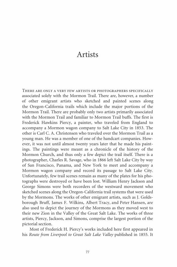
��
�������
���������������������������������������������������������������
���� ������������������ ������� ������ �������� ���� ������ ��������� ��� ��������������������������������������������������������������������������������������������������������������������������������������������������������� �������� �������� �� ��������� ���� ��������� ����� �������� ����������������������������������� ������������������ ���������������������������������������������������������������������������������������������������������������������������������������������������������� ������������������������������������� ����������������������������������� ���� ���������� ����� ������ ��� �� ���������� ��� ���� �������� ��� ���������������������������������� ����������� ���� ������ �������������� ������������������������������������������������������������������������������ ���� ����������� �������� ���� ���� ����� ��� ����� ���� ���������� �������� ������ �������� ���� ������� ���� �������� ��� ����� ����� ��������������������������������������������������������������������������������������������������������������������������������������������������������� ������� ����� ����� ���������� ��� ���� ��������� ��������� ��������������������������������������������������������������������������������������������������������������������������������������������������������� ������� ������ ��� ��������� ��������������������������������������������������������������������������������������������������������������������������������������������������������������������������������������������������������������������������������������������������������������������������
���������������������������������������������������������������������� ������ ��������������� �����������������������������������������������
associated solely with the Mormon Trail. There are, however, a number of other emigrant artists who sketched and painted scenes along
· The Mormon Trail, Yesterday and Today ·
78
documents his trip to Salt Lake City in 1853. Piercy was born in Ports-mouth, England, and by the age of eighteen had one of his paintingsexhibited in the Royal Academy. His subjects were primarily portraitsand landscapes. The Mormon Church had engaged in an extensive mis-sionary effort in Europe, and by the early 1850s there were widespreadconversions. The church was active in bringing its new converts to Utah.Piercy was engaged by the Mormons to travel and record their journeyfrom England across the plains to the new Zion. Piercy himself did notconvert to Mormonism but still accepted the position. He traveled toSalt Lake and then returned to England to have the narration of his jour-ney printed. His route was a little different from the route in Clayton’sguide. Piercy started his overland journey from Council Bluffs, generallyfollowing Clayton’s north side route. He did not cross over to the southside of the Platte at Fort Laramie to follow the route as recommended byClayton but remained on the north side of the Platte. Near present-dayCasper the two routes rejoined, and Piercy again followed the originalroute the rest of the way to the Great Salt Lake. He made sketches ofscenes both on his way west to Salt Lake and on his return trip. Hisworks included not only major landmarks but also some of the sites hav-ing specific historic significance for the Mormons. They have becomeeven more significant because the works of some other artists who trav-elled and sketched during the same period have either been lost ordestroyed. Piercy’s sketches were made into steel engravings or wood-cuts. Some critics feel that while most of his work is accurate, some of hispaintings are a little too idyllic or romanticized. Thus, notwithstandingthe style of his work, it provides us today with one of the few “eyewit-ness” views of scenes along the trail. His narrative became a useful guidefor Mormons and non-Mormons alike. He remained in England afterhis return and continued to paint. However, his paintings recording histrip to Salt Lake remain his most outstanding contribution to the field ofhistory and art. His last art exhibit was in 1880. He died in 1891.
William Henry Jackson is one of the most famous recorders of scenesand events of the West. He was a photographer and a self-taught artist. In1866 he decided to go west and signed on as a bullwacker on a freightingoutfit heading for the Montana goldfields. En route he changed his mindand continued traveling west to Salt Lake City and then on to California.He returned from Los Angeles in 1867. During his journeys out and backhe made many sketches of scenes and events encountered along the way.After he returned, he renewed his interest in photography, and in 1868,he opened a studio in Omaha, Nebraska. He began photographing thewestward expansion of the Union Pacific Railroad in 1869. Then, in 1870
· Pictorial Journey ·
79
he became the photographer for the Hayden Expedition. His photo-graphs taken of the expedition, which included the Yellowstone area,were instrumental in having Yellowstone designated our first nationalpark in 1872. Later he turned many of his sketches and his early photosof the West into paintings depicting the emigrants’ migration west. Hewas born in 1843, the year before Prophet Joseph Smith was killed, andtraveled west after most of the Mormons had already migrated. Yet, thescenes along the route had changed little. His interests in photographyand painting continued until he died in 1943 at the age of ninety-nine.
George Simons was another of the non-Mormon artists who cap-tured scenes of the Mormons moving west and of the route they fol-lowed. He was a pioneer and a gold prospector in Colorado and huntedbuffalo with the Indians. He travelled with his wife back and forth overthe emigrant trails to California and served as a member of the railroadsurvey led by Grenville M. Dodge. He was also a poet and an artist. Hemade many of his sketches while traveling back and forth over the west-ward trails during the 1840s, 50s, and 60s. Many of his pencil sketcheswere also made into oil paintings. He was not a professional artist likePiercy nor a photographer like Jackson, yet his works are fine records ofthe time and events of that period. Like many other artists of that time,such as C. C. A. Christensen and James Wilkins, he also painted rolledpanoramic views. His paintings were of scenes along the Missouri Riverand of the trail from Omaha west to Denver. Unfortunately, like those ofsome other recorders of the West, many of his paintings, including thepanoramas and some sketches, have since disappeared.
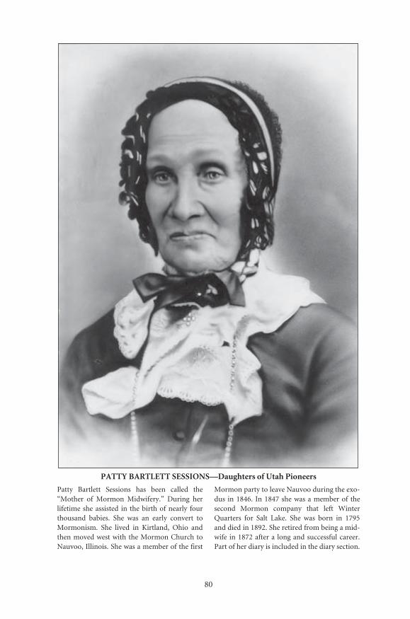
80
PATTY BARTLETT SESSIONS—Daughters of Utah Pioneers
Patty Bartlett Sessions has been called the“Mother of Mormon Midwifery.” During herlifetime she assisted in the birth of nearly fourthousand babies. She was an early convert toMormonism. She lived in Kirtland, Ohio andthen moved west with the Mormon Church toNauvoo, Illinois. She was a member of the first
Mormon party to leave Nauvoo during the exo-dus in 1846. In 1847 she was a member of thesecond Mormon company that left WinterQuarters for Salt Lake. She was born in 1795and died in 1892. She retired from being a mid-wife in 1872 after a long and successful career.Part of her diary is included in the diary section.
Number: 227Orig:Crop:Scale:Final: 26.5 x 37
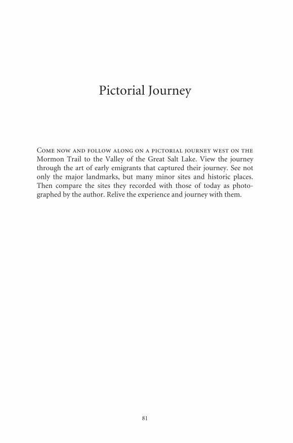
81
Pictorial Journey
Come now and follow along on a pictorial journey west on theMormon Trail to the Valley of the Great Salt Lake. View the journeythrough the art of early emigrants that captured their journey. See notonly the major landmarks, but many minor sites and historic places.Then compare the sites they recorded with those of today as photo-graphed by the author. Relive the experience and journey with them.
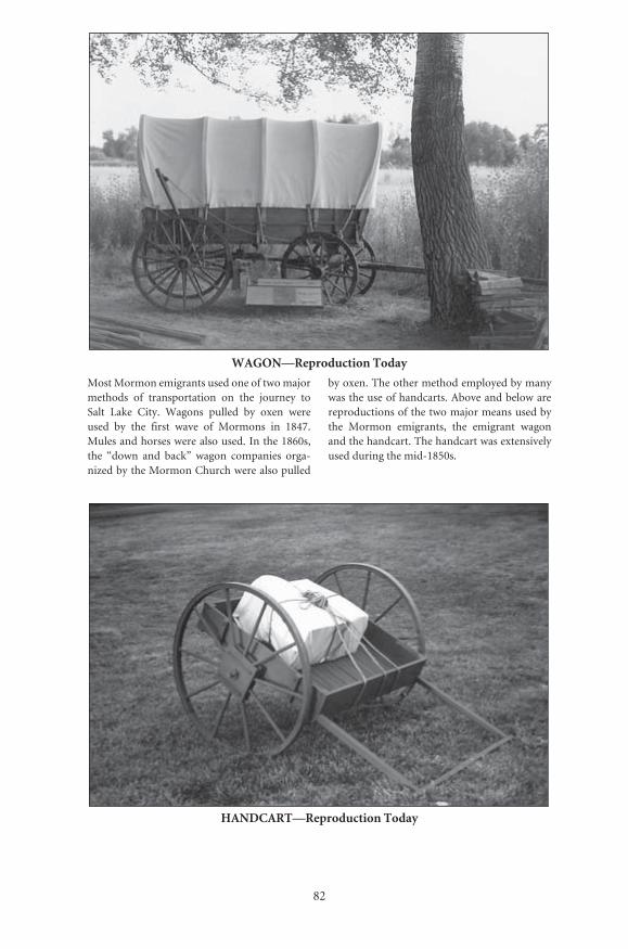
82
WAGON—Reproduction Today
Most Mormon emigrants used one of two majormethods of transportation on the journey toSalt Lake City. Wagons pulled by oxen wereused by the first wave of Mormons in 1847.Mules and horses were also used. In the 1860s,the “down and back” wagon companies orga-nized by the Mormon Church were also pulled
by oxen. The other method employed by manywas the use of handcarts. Above and below arereproductions of the two major means used bythe Mormon emigrants, the emigrant wagonand the handcart. The handcart was extensivelyused during the mid-1850s.
HANDCART—Reproduction Today
Number: 1Orig: 30 x 20.5Crop:Scale: 90%Final: 26.5 x 18
Number: 2Orig: 35.5 x 24Crop: 34 x 22Scale: 78%Final: 26.5 x 17
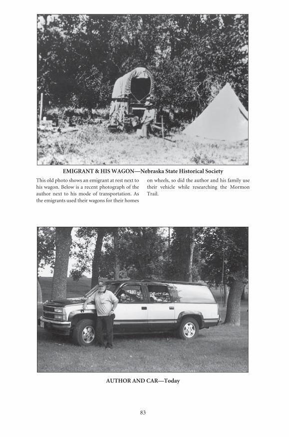
83
EMIGRANT & HIS WAGON—Nebraska State Historical Society
This old photo shows an emigrant at rest next tohis wagon. Below is a recent photograph of theauthor next to his mode of transportation. Asthe emigrants used their wagons for their homes
on wheels, so did the author and his family usetheir vehicle while researching the MormonTrail.
AUTHOR AND CAR—Today
Number: 5Orig: 38.5 x 27.5Crop:Scale: 69%Final: 26.5 x 18.5
Number: 6Orig: 35 x 24Crop: 34 x 24Scale: 78%Final: 26.5 x 18.5
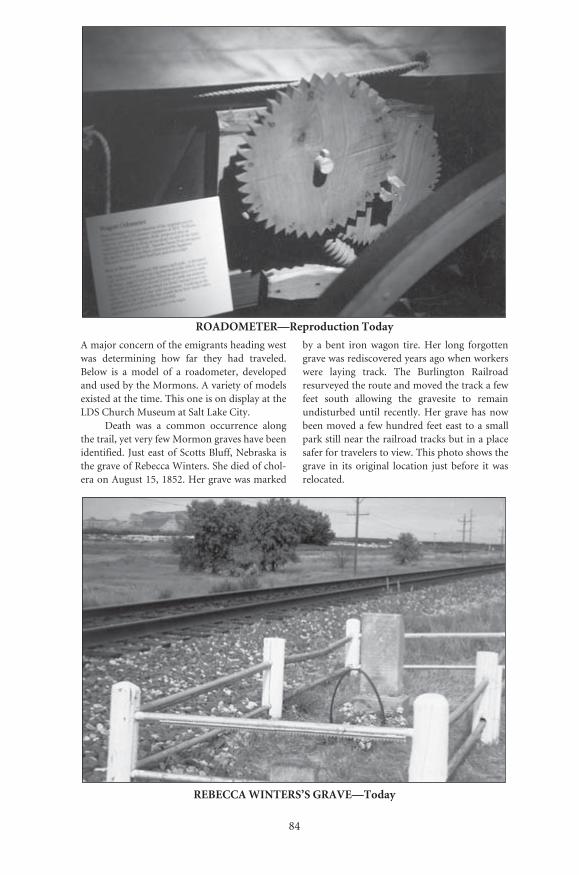
84
ROADOMETER—Reproduction Today
A major concern of the emigrants heading westwas determining how far they had traveled.Below is a model of a roadometer, developedand used by the Mormons. A variety of modelsexisted at the time. This one is on display at theLDS Church Museum at Salt Lake City.
Death was a common occurrence alongthe trail, yet very few Mormon graves have beenidentified. Just east of Scotts Bluff, Nebraska isthe grave of Rebecca Winters. She died of chol-era on August 15, 1852. Her grave was marked
by a bent iron wagon tire. Her long forgottengrave was rediscovered years ago when workerswere laying track. The Burlington Railroadresurveyed the route and moved the track a fewfeet south allowing the gravesite to remainundisturbed until recently. Her grave has nowbeen moved a few hundred feet east to a smallpark still near the railroad tracks but in a placesafer for travelers to view. This photo shows thegrave in its original location just before it wasrelocated.
REBECCA WINTERS’S GRAVE—Today
Number: 4Orig: 35 x 24Crop:Scale: 76%Final: 26.5 x 17.5
Number: 8Orig: 35 x 24Crop: 34 x 24Scale: 78%Final: 26.5 x 17.5
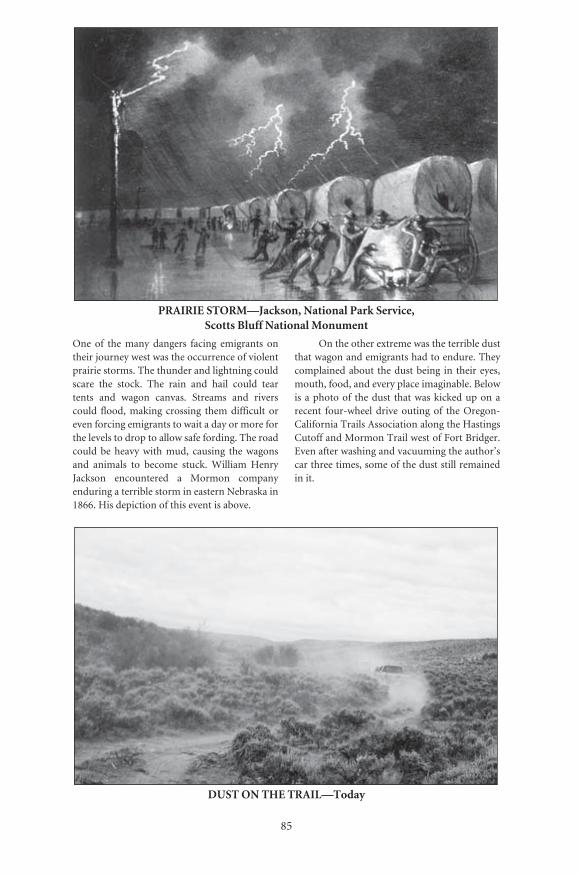
85
PRAIRIE STORM—Jackson, National Park Service, Scotts Bluff National Monument
One of the many dangers facing emigrants ontheir journey west was the occurrence of violentprairie storms. The thunder and lightning couldscare the stock. The rain and hail could teartents and wagon canvas. Streams and riverscould flood, making crossing them difficult oreven forcing emigrants to wait a day or more forthe levels to drop to allow safe fording. The roadcould be heavy with mud, causing the wagonsand animals to become stuck. William HenryJackson encountered a Mormon companyenduring a terrible storm in eastern Nebraska in1866. His depiction of this event is above.
On the other extreme was the terrible dustthat wagon and emigrants had to endure. Theycomplained about the dust being in their eyes,mouth, food, and every place imaginable. Belowis a photo of the dust that was kicked up on arecent four-wheel drive outing of the Oregon-California Trails Association along the HastingsCutoff and Mormon Trail west of Fort Bridger.Even after washing and vacuuming the author’scar three times, some of the dust still remainedin it.
DUST ON THE TRAIL—Today
Number: 9Orig: 33.5 x 22.5Crop: 32 x 22Scale: 83%Final: 26.5 x 16.5
Number: 10Orig: 35 x 24Crop: 35 x 20.5Scale: 76%Final: 26.5 x 15.5
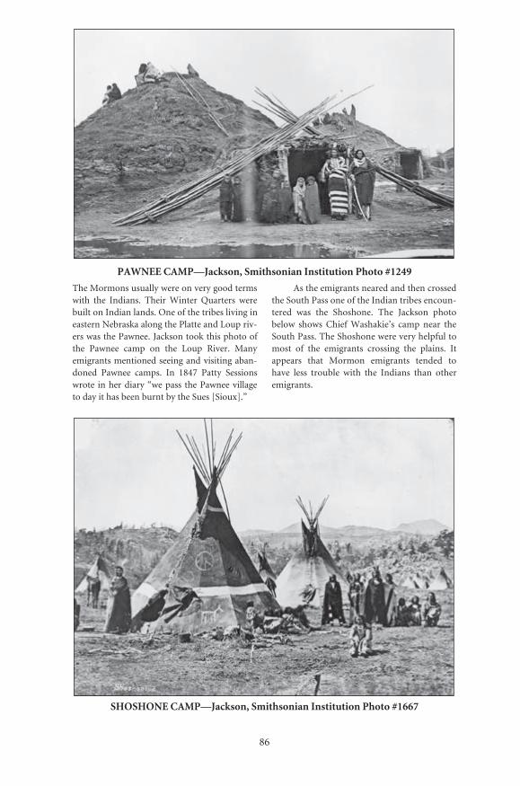
86
PAWNEE CAMP—Jackson, Smithsonian Institution Photo #1249
The Mormons usually were on very good termswith the Indians. Their Winter Quarters werebuilt on Indian lands. One of the tribes living ineastern Nebraska along the Platte and Loup riv-ers was the Pawnee. Jackson took this photo ofthe Pawnee camp on the Loup River. Manyemigrants mentioned seeing and visiting aban-doned Pawnee camps. In 1847 Patty Sessionswrote in her diary “we pass the Pawnee villageto day it has been burnt by the Sues [Sioux].”
As the emigrants neared and then crossedthe South Pass one of the Indian tribes encoun-tered was the Shoshone. The Jackson photobelow shows Chief Washakie’s camp near theSouth Pass. The Shoshone were very helpful tomost of the emigrants crossing the plains. Itappears that Mormon emigrants tended tohave less trouble with the Indians than otheremigrants.
SHOSHONE CAMP—Jackson, Smithsonian Institution Photo #1667
Number: 11Orig: 56 x 39.5Crop: 56 x 34Scale: 47%Final: 26.5 x 16
Number: 12Orig: 56 x 41Crop:Scale: 47%Final: 26.5 x 19

87
NAUVOO WELCOME CENTER (LDS)
Both the Church of Jesus Christ of Latter-daySaints and the Reorganized Church of JesusChrist of Latter Day Saints have visitor centersin Nauvoo. Both have been active in restoring
new life to old Nauvoo. Each center has fine dis-plays and programs and should be visited. Manyof the restored pioneer shops and homes arelocated near them.
JOSEPH SMITH HISTORIC CENTER (RLDS)
Illinois
Number: 13Orig: 35 x 24Crop: 34 x 24Scale: 78%Final: 26.5 x 18.5
Number: 14Orig: 35.5 x 23Crop:Scale: 75%Final: 26.5 x 17

88
NAUVOO—From Piercy’s Route from Liverpool to Great Salt Lake Valley
The Mormon exodus from Nauvoo began in1846. Piercy did not visit Nauvoo until 1853. Bythen Nauvoo had been sold to the Icarians, aFrench utopian society. The town and the Tem-ple had deteriorated. This is how Piercy sawNauvoo, and he described it as follows: “Thecity is first seen from the top of a hill about twomiles from Montrose. From this point thebeauty of its situation is fully realized....It is thefinest possible site for a city....The first objects Isaw in approaching the city were the remains ofwhat was once the Temple, situated on the high-
est eminence of the city, and which, in the daysof its prosperity must have been to it what thecap or top stone is to a building.”
Here is a similar view of Nauvoo today. Ifyou look closely to the right of the center of thephoto, you will note the Nauvoo water tower.To the left of center is the steeple of The HolyApostles-Sts. Peter and Paul Church. The watertower is situated only a block from the locationof the Nauvoo Temple. The Temple was eventaller than the water tower.
NAUVOO—Today
Number: 15Orig: 35.5 x 24Crop: 35.5 x 21Scale: 75%Final: 26.5 x 15.5
Number: 16Orig: 34 x 24Crop: 34 x 2.5Scale: 78%Final: 26.5 x 17.5
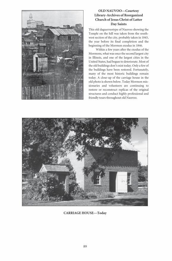
89
OLD NAUVOO—Courtesy Library-Archives of Reorganized Church of Jesus Christ of Latter
Day Saints
This old daguerreotype of Nauvoo showing theTemple on the hill was taken from the south-west section of the city, probably taken in 1845,the year before its final completion and thebeginning of the Mormon exodus in 1846.
Within a few years after the exodus of theMormons, what was once the second largest cityin Illinois, and one of the largest cities in theUnited States, had begun to deteriorate. Most ofthe old buildings don’t exist today. Only a few ofthe buildings have been restored. Fortunately,many of the most historic buildings remaintoday. A close-up of the carriage house in theold photo is shown below. Today Mormon mis-sionaries and volunteers are continuing torestore or reconstruct replicas of the originalstructures and conduct highly professional andfriendly tours throughout old Nauvoo.
CARRIAGE HOUSE—Today
Number: 17Orig: 27 x 39Crop:Scale: 48.5%Final: 13 x 19
Number: 18Orig: 35 x 24Crop: 34.5 x 24Scale: 80Final: 26.5 x 18.5
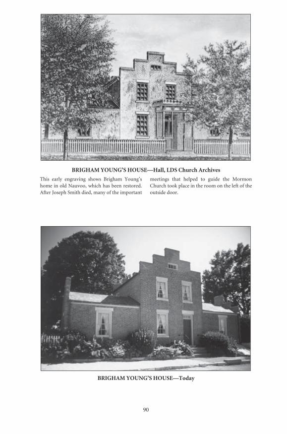
90
BRIGHAM YOUNG’S HOUSE—Hall, LDS Church Archives
This early engraving shows Brigham Young’shome in old Nauvoo, which has been restored.After Joseph Smith died, many of the important
meetings that helped to guide the MormonChurch took place in the room on the left of theoutside door.
BRIGHAM YOUNG’S HOUSE—Today
Number: 19Orig: 39.5 x 27.5Crop:Scale: 67%Final: 26.5 x 18
Number: 20Orig: 35 x 24Crop: 34 x 24Scale: 78%Final: 26.5 x 18.5
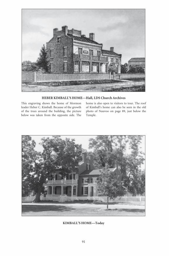
91
HEBER KIMBALL’S HOME—Hall, LDS Church Archives
This engraving shows the home of Mormonleader Heber C. Kimball. Because of the growthof the trees around the building, the picturebelow was taken from the opposite side. The
home is also open to visitors to tour. The roofof Kimball’s home can also be seen in the oldphoto of Nauvoo on page 89, just below theTemple.
KIMBALL’S HOME—Today
Number: 21Orig: 57 x 38Crop:Scale: 47%Final: 26.5 x 17.5
Number: 22Orig: 35.5 x 23.5Crop:Scale: 75%Final: 26.5 x 17.5
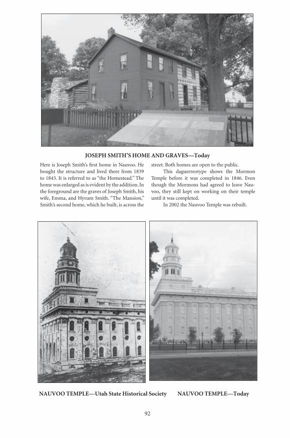
��
������������������������������������
�����������������������������������������������������������������������
������� ������� �������������������� ��������� ���������
������� ������� �������������������� ��������� ���������
Here is Joseph Smith’s first home in Nauvoo. He bought the structure and lived there from 1839 to 1843. It is referred to as “the Homestead.” The home was enlarged as is evident by the addition. In the foreground are the graves of Joseph Smith, his wife, Emma, and Hyrum Smith. “The Mansion,” Smith’s second home, which he built, is across the
street. Both homes are open to the public.This daguerreotype shows the Mormon
Temple before it was completed in 1846. Even though the Mormons had agreed to leave Nau-voo, they still kept on working on their temple until it was completed.
In 2002 the Nauvoo Temple was rebuilt.

93
OLD STONE ARCHED BRIDGE—Today
This old bridge at one time carried the mainroad into Nauvoo. Today it is situated in asmall park off the main road. You cannotdrive over it, but you can walk on it. Thinkof all the historic figures and thousands ofcommon people who used it coming to Nau-voo.
Below is a painting by C. C. A. Chris-tensen depicting the route taken by many of theMormons when they were forced to leave Nau-voo in 1846. Fortunately, the winter was so coldthat for a short time the Mississippi River froze,and many of the Mormons were able to drivetheir wagons and teams safely across the ice.
EXODUS FROM NAUVOO—Christensen, Museum of Art, Brigham Young University
Number: 25Orig: 30.5 x 21Crop:Scale: 87%Final: 26.5 x 18
Number: 26Orig: 58 x 46Crop: 57 x 39Scale: 46%Final: 26.5 x 18

��
���������������������������������������������
������� ������� ������������������ ��������� �����������
������� ������� �������������������� ��������� ���������
Piercy visited the site of the Nauvoo Temple. The Temple had been burned on October 10, 1848, and a few years later a storm blew much of it down. Shortly after Piercy made this drawing, the rest of the temple was torn down for safety reasons. Piercy had noted that the people who moved in after the Mormons left “have used the stones of the Temple
to build workshops and a school-house.”Below is a view of the Temple site today. The
new Temple was built on the original site in 2002. In 1962 the original site was excavated and then stabilized. It remained as such until the decision was made to rebuild the Temple. See also page 92 for a comparison.
NAUVOO TEMPLE—Today

95
CARTHAGE JAIL—Piercy, LDS Church Archives
Piercy visited the Carthage Jail, the site of themurders of Joseph and Hyrum Smith, in 1853,nine years after the event. Joseph and Hyrumwere being held in jail awaiting trial ontrumped up charges when a mob broke in,killed the two brothers, and critically woundedJohn Taylor. Only Willard Richards escapedserious harm. Joseph fell through the secondfloor center window on the left when he wasshot. Piercy wrote, “I felt very anxious to visit
Carthage...I considered that sketches of its jailwould possess undying interest for tens of thou-sands, and concluded not to return withoutthem.” He was right!!
Here is the Carthage Jail today. The build-ing functioned as a jail until 1866, after whichtime it was used only as a residence. It wasacquired by the Mormon Church in 1903 andrestored in 1939. It seems that only the wellhousing and the trees have changed.
CARTHAGE JAIL—Today
Number: 33Orig: 39 x 26.5Crop:Scale: 68%Final: 26.5 x 18
Number: 34Orig: 35.5 x 23.5Crop:Scale: 75%Final: 26.5 x 17.5
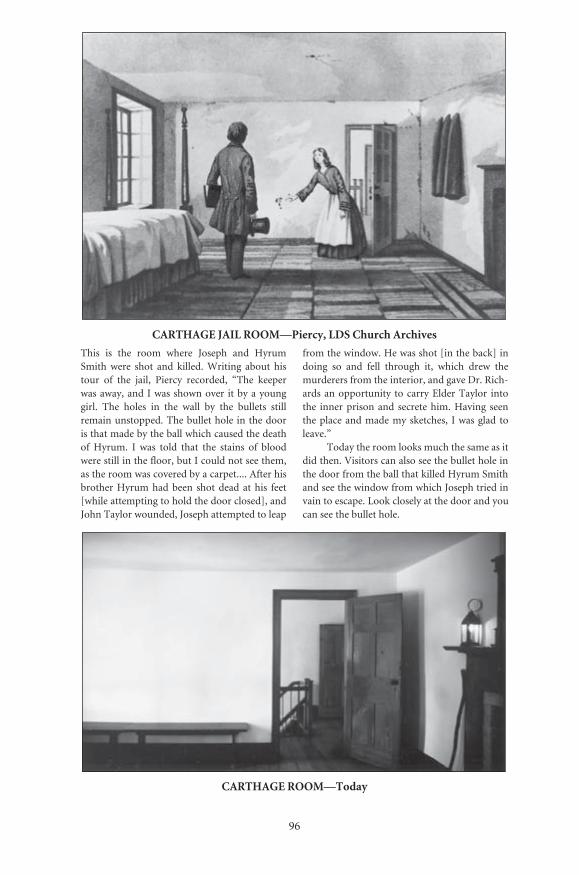
96
CARTHAGE JAIL ROOM—Piercy, LDS Church Archives
This is the room where Joseph and HyrumSmith were shot and killed. Writing about histour of the jail, Piercy recorded, “The keeperwas away, and I was shown over it by a younggirl. The holes in the wall by the bullets stillremain unstopped. The bullet hole in the dooris that made by the ball which caused the deathof Hyrum. I was told that the stains of bloodwere still in the floor, but I could not see them,as the room was covered by a carpet.... After hisbrother Hyrum had been shot dead at his feet[while attempting to hold the door closed], andJohn Taylor wounded, Joseph attempted to leap
from the window. He was shot [in the back] indoing so and fell through it, which drew themurderers from the interior, and gave Dr. Rich-ards an opportunity to carry Elder Taylor intothe inner prison and secrete him. Having seenthe place and made my sketches, I was glad toleave.”
Today the room looks much the same as itdid then. Visitors can also see the bullet hole inthe door from the ball that killed Hyrum Smithand see the window from which Joseph tried invain to escape. Look closely at the door and youcan see the bullet hole.
CARTHAGE ROOM—Today
Number: 35Orig: 39 x 27.5Crop: 39 x 26.5Scale: 68Final: 26.5 x 18
Number: 36Orig: 35 x 23.5Crop: 35 x 20Scale: 76Final: 26.5 x 15

97
CAMP AT KEOKUK—From Piercy’s Route from Liverpool to Great Salt Lake Valley
The Mormons with whom Piercy was travelingstarted their overland journey from Keokuk,Iowa, about twelve miles south-southwest ofNauvoo. Describing the Mormon camp hewrote, “I sallied out in search of the camp,which, after climbing a steep bluff on the edgeof the River, I found most picturesquely situ-ated on the top of a hill,...commanding a viewof the country for miles around....The emi-grants from each nation had wisely been placed
together, and those who crossed the seatogether were still associated as neighbours inCamp....Before leaving I made the accompany-ing sketch of the Camp.
Today Keokuk has grown and expandedover the area. Fine homes and a park standwhere wagons once gathered and tents stood.This view shows a modern road that climbs thesteep bluff at the edge of the river and followsthe crest of the hill as shown in the sketch.
KEOKUK—Today
Number: 39Orig: 38.5 x 26.5Crop: 38.5 x 23Scale: 69%Final: 26.5 x 16
Number: 40Orig: 35 x 24Crop: 34 x 20Scale: 78%Final: 26.5 x 15.5
Iowa
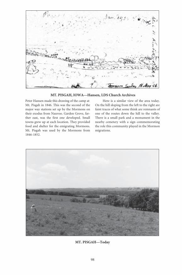
��
����������������������������������������������
������������������������������������������������������������������������������������������������������������������������ ��������������������������������������������������������������� ������ ���� ���� ������ ���� ����������� ����������������������������������������������������������� �������� ���� ���� ����������������������� ������� ���� ����� ��� ���� �������� ��������������
����� ��� �� �������� ����� ��� ���� ����� ����������������������������������������������������������������������������������������������������������� ��� ���� ������� ����� ���� ����� ��� ���� ������������� ��� �� �������������������������� ��� ���������� ��������� ����� �� ����� ��������������������������������������������������������������������
�����������������
������� ������� �������������������� ��������� ���������
������� ������� ������������ ������������� ��������� �����������
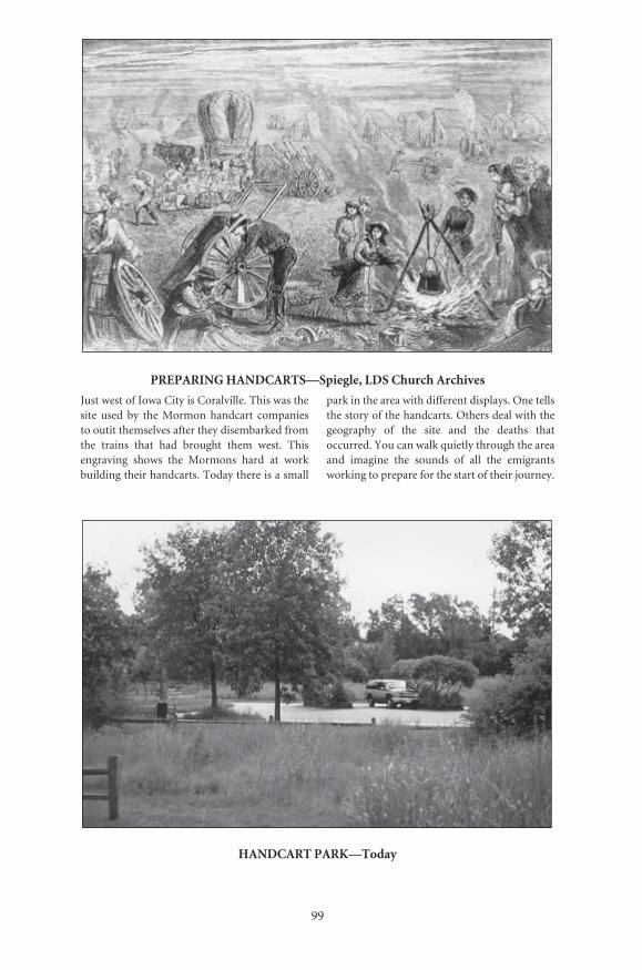
99
PREPARING HANDCARTS—Spiegle, LDS Church Archives
Just west of Iowa City is Coralville. This was thesite used by the Mormon handcart companiesto outit themselves after they disembarked fromthe trains that had brought them west. Thisengraving shows the Mormons hard at workbuilding their handcarts. Today there is a small
park in the area with different displays. One tellsthe story of the handcarts. Others deal with thegeography of the site and the deaths thatoccurred. You can walk quietly through the areaand imagine the sounds of all the emigrantsworking to prepare for the start of their journey.
HANDCART PARK—Today
Number: 45Orig: 57 x 38Crop:Scale: 46.5%Final: 26.5 x 18
Number: 46Orig: 35.5 x 23.5Crop: 34 x 22.5Scale: 78%Final: 26.5 x 17.5

100
FORT DES MOINES—Today
Farther west the Mormon handcart companieshad to cross the Des Moines River. A number ofthe emigrants recorded seeing parts of old aban-doned Fort Des Moines. Today this is all that isleft. It is located next to the river near the cross-ing area.
Garden Grove was the site of the first waystation built on April 25, 1846 after leavingNauvoo. Very little archaeological work hasbeen done here. Only recently has GardenGrove begun to receive the attention it deserves.
GARDEN GROVE—Today
Number: 48Orig: 36 x 23.5Crop: 29 x 21Scale: 91%Final: 26.5 x 19
Number: 41Orig: 35.5 x 23.5Crop:Scale: 75%Final: 26.5 x 17.5

101
MORMON CAMP NEAR PARK’S MILL—Simons, Western Heritage Museum
There are very few illustrations of the Mormonscrossing Iowa. Piercy did not travel with the Mor-mons once they left Keokuk. However, in the1850s George Simons sketched and later painted aMormon camp on Mosquito Creek just east ofCouncil Bluffs (Kanesville) near the present-dayIowa School for the Deaf.
Today there is a marker and small displayin the area on land adjacent to the Iowa Schoolfor the Deaf near the intersection of highway 92and US 275. This view is not from the markerbut from the old railroad right-of-way west ofthe display. This whole area was used by the Mor-mons as a camping ground.
MOSQUITO CREEK—Today
Number: 49Orig: 60 x 38.5Crop:Scale: 44Final: 26.5 x 17
Number: 50Orig: 35.5 x 23Crop:Scale: 75%Final: 26.5 x 17
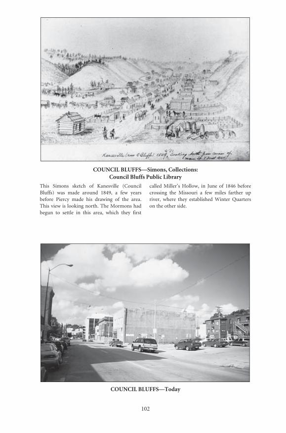
102
COUNCIL BLUFFS—Simons, Collections: Council Bluffs Public Library
This Simons sketch of Kanesville (CouncilBluffs) was made around 1849, a few yearsbefore Piercy made his drawing of the area.This view is looking north. The Mormons hadbegun to settle in this area, which they first
called Miller’s Hollow, in June of 1846 beforecrossing the Missouri a few miles farther upriver, where they established Winter Quarterson the other side.
COUNCIL BLUFFS—Today
Number: 51Orig: 42 x 29.5Crop: 41 x 28.5Scale: 64%Final: 26.5 x 18.5
Number: 52Orig: 35 x 23.5Crop: 34 x 22.5Scale: 78%Final: 26.5 x 17.5
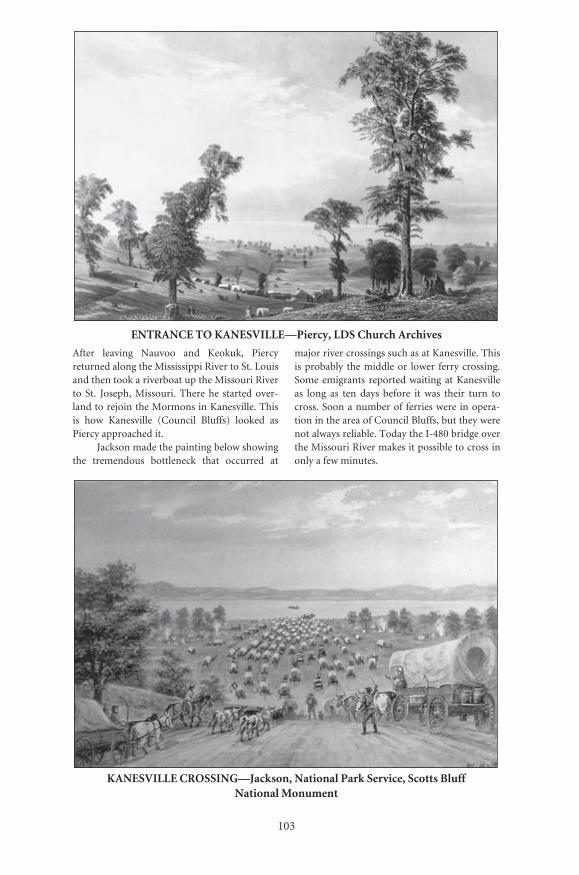
103
ENTRANCE TO KANESVILLE—Piercy, LDS Church Archives
After leaving Nauvoo and Keokuk, Piercyreturned along the Mississippi River to St. Louisand then took a riverboat up the Missouri Riverto St. Joseph, Missouri. There he started over-land to rejoin the Mormons in Kanesville. Thisis how Kanesville (Council Bluffs) looked asPiercy approached it.
Jackson made the painting below showingthe tremendous bottleneck that occurred at
major river crossings such as at Kanesville. Thisis probably the middle or lower ferry crossing.Some emigrants reported waiting at Kanesvilleas long as ten days before it was their turn tocross. Soon a number of ferries were in opera-tion in the area of Council Bluffs, but they werenot always reliable. Today the I-480 bridge overthe Missouri River makes it possible to cross inonly a few minutes.
KANESVILLE CROSSING—Jackson, National Park Service, Scotts Bluff National Monument
Number: 53Orig: 55.5 x 38Crop:Scale: 48%Final: 26.5 x 18
Number: 54Orig: 29.5 x 20Crop:Scale: 90%Final: 26.5 x 17.5
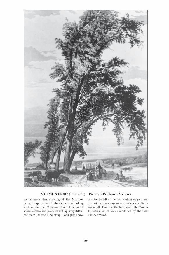
104
MORMON FERRY (Iowa side)—Piercy, LDS Church Archives
Piercy made this drawing of the MormonFerry, or upper ferry. It shows the view lookingwest across the Missouri River. His sketchshows a calm and peaceful setting, very differ-ent from Jackson’s painting. Look just above
and to the left of the two waiting wagons andyou will see two wagons across the river climb-ing a hill. That was the location of the WinterQuarters, which was abandoned by the timePiercy arrived.
Number: 55Orig: 38 x 55Crop:Scale: 70%Final: 26.5 x 38

105
MORMON FERRY SITE (Iowa Side)—Today
The Mormon ferry was located a little north ofwhere the present I-680 or Mormon Bridgespans the Missouri River. Here is a similarview. The route into Florence from the Iowaside of the river was similar to the one shownin Piercy’s sketch.
VIEW OF MISSOURI RIVER—Piercy, LDS Church Archives
This plate shows the view from what was left ofWinter Quarters looking northeast towards theMormon Ferry. In his narrative Piercy wrotethat a cabin, the last remnant of Winter Quar-
ters, was being burned when he arrived. Note acabin burning to the right in this plate. The wag-ons shown climbing the hill on the trail coincidewith the view from the Iowa side view.
Nebraska
Number: 56Orig: 23.5 x 35.5Crop:Scale: 57%Final: 13 x 20
Number: 57Orig: 39 x 27Crop:Scale: 68%Final: 26.5 x 15
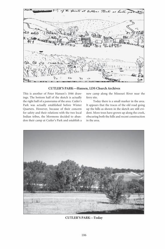
���
������������������������������������������
����� ��� �������� ��� ������ ��������� ����� ����������� ���� ������� ����� ��� ���� ������� ��� ��������������������������������������������������������������� ���� ��������� ������������ ������� ���������������� ��������� �������� ��� ������ ��������������������������������������������������������������� �������� ���� �������� �������� ��� ����������������������������������������������������
���� ����� ������ ���� ��������� ������ ����� ���������������
��������������������������������������������������������������������������������������������������������������������������������������������������������������������������������������������������������������������������������������������������������
�������������������
������� ������� ������������ ��������������� ��������� ���������
������� ������� �������������������� ��������� ���������

107
WINTER QUARTERS—Christensen, Brigham Young University Museum
This is C.C.A. Christensen’s painting of WinterQuarters. Note the cabins all lined up and thetypical grid pattern used by the Mormons. A
reconstruction of a similar log cabin is part ofthe Mormon Winter Quarters Visitors Center.
WINTER QUARTERS CABIN—Reconstruction Today
Number: 61Orig: 57 x 44.5Crop: 55.5 x 38Scale: 48%Final: 26.5 x 18
Number: 62Orig: 35 x 23.5Crop:Scale: 78%Final: 26.5 x 17.5

108
MORMON MILL—Today
Today two reminders of the Mormon pastremain in Florence, site of Winter Quarters.First is the Mormon Mill, the only remainingMormon structure. Turkey Creek, the streamthat ran the mill, has been moved and routedunderground. After the Mormons left, the millwas taken over and expanded. Years ago it wasdismantled and then moved only a few hundredfeet to its present site.
The second reminder is the Mormoncemetery. This memorial stands on top of thehill where many of the Mormons who perishedthat fateful winter of 1846-47 were buried. The
statue depicts a mother and father bidding theirfinal farewell to their young child whom theyare burying in a shallow grave in the frozenground. If you stand in the right spot on theright side facing the statue, you will even see atear on the mother’s face. This very movingbronze statue depicts both the sufferingendured and the strength shown by the Mor-mons. None of the specific graves of the earlyMormons is marked, but the names of morethan three hundred are listed on a bronzeplaque. The new Mormon Trail Center isnearby.
WINTER QUARTERS CEMETERY AND MEMORIAL—Today
Number: 63Orig: 35 x 23.5Crop: 34.5 x 22Scale: 77%Final: 26.5 x 17
Number: 64Orig: 35.5 x 23.5Crop: 35 x 20.5Scale: 75%Final: 26.5 x 15.5
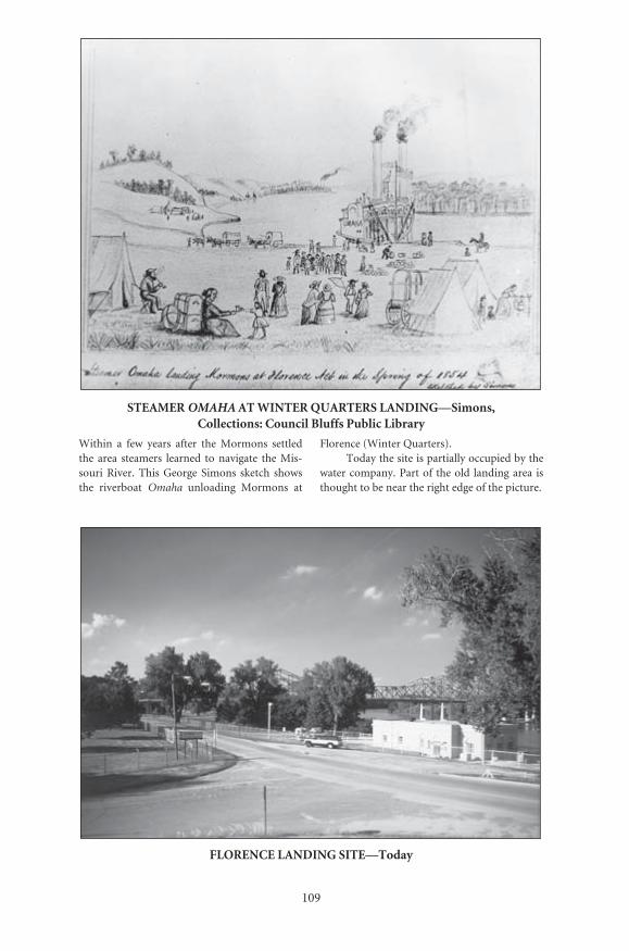
109
STEAMER OMAHA AT WINTER QUARTERS LANDING—Simons, Collections: Council Bluffs Public Library
Within a few years after the Mormons settledthe area steamers learned to navigate the Mis-souri River. This George Simons sketch showsthe riverboat Omaha unloading Mormons at
Florence (Winter Quarters). Today the site is partially occupied by the
water company. Part of the old landing area isthought to be near the right edge of the picture.
FLORENCE LANDING SITE—Today
Number: 65Orig: 56.5 x 44.5Crop: 54 x 42Scale: 49%Final: 26.5 x 20.5
Number: 66Orig: 35 x 23.5Crop: 34 x 23Scale: 78%Final: 26.5 x 18
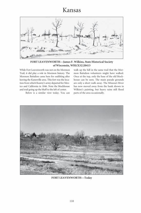
110
FORT LEAVENWORTH—James F. Wilkins, State Historical Society of Wisconsin, WHi(X32)20413
While Fort Leavenworth was not on the MormonTrail, it did play a role in Mormon history. TheMormon Battalion came here for outfitting afterleaving the Kanesville area. This fort was the loca-tion from which Kearny’s army departed for Mex-ico and California in 1846. Note the blockhouseand trail going up the bluff to the left of center.
Below is a similar view today. You can
walk up the hill in the same trail that the Mor-mon Battalion volunteers might have walked.Once at the top, only the base of the old block-house can be seen. The main parade groundsare only a short walk away. The Missouri Riverhas now moved away from the bank shown inWilkins’s painting, but heavy rains still floodparts of the area occasionally.
FORT LEAVENWORTH—Today
Kansas
Number: 67Orig: 53 x 21.5Crop:Scale: 50%Final: 26.5 x 10.5
Number: 68Orig: 35.5 x 24Crop:Scale: 75%Final: 26.5 x 17.5
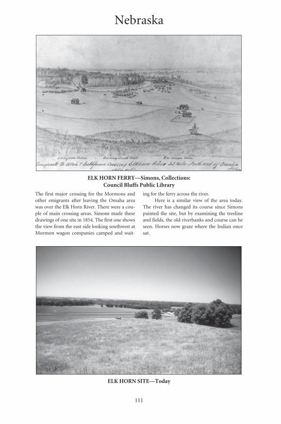
111
ELK HORN FERRY—Simons, Collections: Council Bluffs Public Library
The first major crossing for the Mormons andother emigrants after leaving the Omaha areawas over the Elk Horn River. There were a cou-ple of main crossing areas. Simons made thesedrawings of one site in 1854. The first one showsthe view from the east side looking southwest atMormon wagon companies camped and wait-
ing for the ferry across the river.Here is a similar view of the area today.
The river has changed its course since Simonspainted the site, but by examining the treelineand fields, the old riverbanks and course can beseen. Horses now graze where the Indian oncesat.
ELK HORN SITE—Today
Nebraska
Number: 69Orig: 56.5 x 43Crop: 56 x 37Scale: 47%Final: 26.5 x 17.5
Number: 70Orig: 35 x 23.5Crop: 34 x 21Scale: 78%Final: 26.5 x 16.5
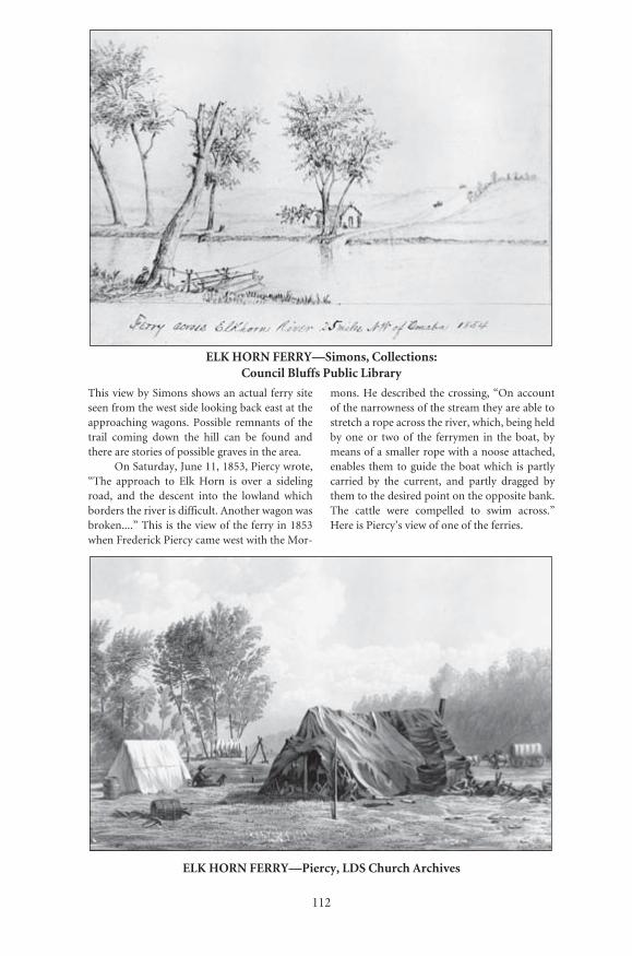
112
ELK HORN FERRY—Simons, Collections: Council Bluffs Public Library
This view by Simons shows an actual ferry siteseen from the west side looking back east at theapproaching wagons. Possible remnants of thetrail coming down the hill can be found andthere are stories of possible graves in the area.
On Saturday, June 11, 1853, Piercy wrote,“The approach to Elk Horn is over a sidelingroad, and the descent into the lowland whichborders the river is difficult. Another wagon wasbroken....” This is the view of the ferry in 1853when Frederick Piercy came west with the Mor-
mons. He described the crossing, “On accountof the narrowness of the stream they are able tostretch a rope across the river, which, being heldby one or two of the ferrymen in the boat, bymeans of a smaller rope with a noose attached,enables them to guide the boat which is partlycarried by the current, and partly dragged bythem to the desired point on the opposite bank.The cattle were compelled to swim across.”Here is Piercy’s view of one of the ferries.
ELK HORN FERRY—Piercy, LDS Church Archives
Number: 71Orig: 57 x 45Crop: 51.5 x 34.5Scale: 50%Final: 26.5 x 17.5
Number: 72Orig: 57 x 43.5Crop: 57 x 36.5Scale: 46%Final: 26.5 x 17
113
HANDCART COMPANY—Simons, Collections: Council Bluffs Public Library
Simons made this sketch of one of the 1856handcart companies. It had come across Iowa,had passed through Council Bluffs, and wasthen crossing Nebraska.
C. C. A. Christensen had been a memberof a handcart company. This painting depicts
the company turning out to rest as some of itsmembers are crossing a small stream inNebraska. The lady in the lower right can be seengathering buffalo chips while people at the leftare cooking. Where there was no wood, driedbuffalo chips provided a hot smokeless fire.
HANDCART COMPANY—Christensen, LDS Church Art Museum
Number: 73Orig: 40.5 x 29Crop: 38.5 x 27Scale: 68.5%Final: 26.5 x 18.5
Number: 74Orig: 36.5 x 23.5Crop: 33.5 x 21.5Scale: 79%Final: 26.5 x 17
114
LOUP FERRY—Piercy, LDS Church Archives
Traveling farther west along the Platte River theemigrants came to the Loup River. They weresometimes forced to travel up the river for manymiles before being able to cross it safely. Whilethe river was comparatively shallow, it wasknown for its quicksand. The location where thevanguard party of Mormon Pioneers of 1847crossed was different from places used in later
years. Piercy made this drawing of the Loup Ferrynear the mouth of the Loup in 1853. The drawingshows some wagons being pulled by mules.
The view below of the Loup River near thecrossing shows how the area looks today. Aswith all the rivers in this area the flow has beengreatly reduced due to the large amount ofwater taken out for irrigation.
LOUP RIVER—Today
Number: 75Orig: 57 x 45.5Crop: 57 x 36.5Scale: 46%Final: 26.5 x 17
Number: 76Orig: 35 x 23.5Crop: 34 x 23.5Scale: 78%Final: 26.5 x 18

115
PAWNEE INDIAN CAMP—Jackson, Smithsonian Institution Photo #1245-b
One of the Indian tribes encountered by theemigrants along both the Platte and Loup riversin eastern Nebraska was the Pawnee. Many ofthe emigrants had contact with members of thistribe. This 1870 Jackson photo is probably of oneof the Pawnee camps along the Loup River. TheMormons met the Pawnee near this same area.
Simons also visited the Pawnee andrecorded his experience. Today they are gonefrom the Platte River Valley. A lodge might havelasted about twenty years. A reconstructed Paw-nee Indian earth lodge is one of the exhibits atthe Stuhr Museum of the Prairie Pioneer.
PAWNEE VILLAGE—Simons, Collections: Council Bluffs Public Library
Number: 77Orig: 55 x 25Crop:Scale: 48%Final: 26.5 x 12
Number: 78Orig: 56.5 x 43Crop: 54 x 36.5Scale: 49%Final: 26.5 x 18

116
BUFFALO STAMPEDE—Jackson, National Park Service, Scotts Bluff National Monument
Probably the animal that best symbolized theGreat Plains was the buffalo. This Jacksonpainting shows a wagon company caught in alarge herd while traveling along the Platte River.On Thursday, July 30, 1853, twenty-one daysafter leaving Winter Quarters, Frederick Piercywrote, “I saw buffalo this day for the first timein my life. They are very singular in shape andrun in a most grotesque manner, and appar-ently very rapidly. I had no chance of gettingnear them, but the enthusiasm of some of thehunters in camp drew them out in chase. I wish
them success, for I was tired of bacon.” PattySessions wrote on Friday, July 16, 1847, “seethousands of buffaloe...after we camped a herdof buffaloe ran in among our cattle.”
Whereas buffalo were a common sight tothe early emigrants from eastern Nebraska tothe South Pass, some of the later emigrantsrarely saw more than a few individuals near thetrail. Today there are several buffalo associa-tions concerned with increasing the number ofbuffalo again.
BUFFALO—Today
Number: 80Orig: 38.5 x 26.5Crop: 38.5 x 25Scale: 69%Final: 26.5 x 16
Number: 79Orig: 35 x 24Crop: 35 x 22.5Scale: 75.5%Final: 26.5 x 17

117
LASSOING THE STEERS—Simons, Collections: Council Bluffs Public Library
One of the early morning activities was yokingup the oxen. Simons’s sketch shows the scene ofemigrants catching their oxen while campedalong the Platte River. After they were roped theox yokes had to be put on. For emigrants notused to this, it was quite a trying experience.
Here the oxen at Rock Creek Station,Nebraska, are being brought in after being las-soed. The Mormons who followed the trailfrom Independence, Fort Leavenworth, or St.Joseph would have passed through Rock Creek.
LASSOING THE OXEN—Today
Number: 81Orig: 42 x 30Crop: 37 x 19.5Scale: 72%Final: 26.5 x 14
Number: 82Orig: 35.5 x 23.5Crop:Scale: 75%Final: 26.5 x 17.5
118
LONE TREE MARKER—Today
One of the experiences mentioned withenthusiasm by diarists along the trailwas the sighting of trees. Most of thePlatte River Valley was void of any bigtrees. Thus, seeing any large tree was amajor event. This highway marker tellsthe story of one Lone Tree and itsdemise.
Below is the actual site of the treeand another tree that residents plantedto replace it. So many trees are nowfound in the area that it is hard toimagine a lone tree on the prairie. Thesite is located southwest of Central Citynear the Platte River. Read Piercy’saccount in the diary section. Itdescribes his similar experience atanother Lone Tree which was located afew miles east of Ash Hollow.
LONE TREE SITE—Today
Number: 83Orig: 29.5 x 41.5Crop:Scale: 51Final: 14.5 x 21
Number: 84Orig: 35 x 23.5Crop: 34.5 x 23.5Scale: 77%Final: 26.5 x 18

119
CAMP AT WOOD RIVER—From Piercy’s Route from Liverpool to Great Salt Lake Valley
A few days later the Mormons came to WoodRiver. Piercy made this drawing of their camp onJune 26, 1853. The painting shows a beautifulpastoral setting. I am sure that a few months laterwhile crossing the deserts they must have lookedback fondly at their camp on Wood River.
Here is a similar view of the area todayalong Wood River just south of Grand Island.The river is off in the trees on the right.Although the author found cattle grazing in thesame area, they walked away and appear only asspecks in the background.
WOOD RIVER AREA—Today
Number: 85Orig: 35.5 x 24Crop: 29 x 18.5Scale: 91%Final: 26.5 x 17
Number: 86Orig: 35.5 x 23.5Crop:Scale: 75%Final: 26.5 x 17.5

120
ASH HOLLOW—Jagger, California Historical Society
Ash Hollow marked one of the locations wherethose emigrants who had been following theOregon Trail on the south side of the PlatteRiver met the North Platte River. It served as areference point for the Mormon vanguard pio-neers in 1847. D. Jagger, a ’49er, made thissketch of the outlet on his journey to California.The Mormons traveling with Piercy saw the sitefrom the north side of the North Platte River, ahalf mile away. Piercy wrote on July 13, 1853,
“We passed Ash Hollow, which is on the southside of the Platte, where we could see animmense herd of buffalo, which good judgessaid could not number less than 10,000.”
Here is a view of the mouth of Ash Hollowtoday. The course of the creek has been movedand channeled. For the emigrants who followedthe early Oregon Trail from Independence,Missouri, the drop into the head of Ash Hollowwas steep and dangerous.
ASH HOLLOW OUTLET—Today
Number: 87Orig: 36 x 23.5Crop: 34 x 22.5Scale: 78%Final: 26.5 x 17.5
Number: 88Orig: 30 x 20Crop:Scale: 88%Final: 26.5 x 17.5
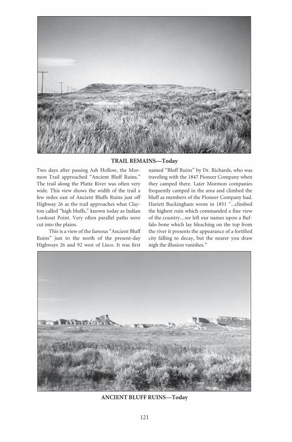
121
TRAIL REMAINS—Today
Two days after passing Ash Hollow, the Mor-mon Trail approached “Ancient Bluff Ruins.”The trail along the Platte River was often verywide. This view shows the width of the trail afew miles east of Ancient Bluffs Ruins just offHighway 26 as the trail approaches what Clay-ton called “high bluffs,” known today as IndianLookout Point. Very often parallel paths werecut into the plains.
This is a view of the famous “Ancient BluffRuins” just to the north of the present-dayHighways 26 and 92 west of Lisco. It was first
named “Bluff Ruins” by Dr. Richards, who wastraveling with the 1847 Pioneer Company whenthey camped there. Later Mormon companiesfrequently camped in the area and climbed thebluff as members of the Pioneer Company had.Hariett Buckingham wrote in 1851 “...climbedthe highest ruin which commanded a fine viewof the country....we left our names upon a Buf-falo bone which lay bleaching on the top fromthe river it presents the appearance of a fortifiedcity falling to decay, but the nearer you drawnigh the illusion vanishes.”
ANCIENT BLUFF RUINS—Today
Number: 89Orig: 35 x 23.5Crop: 34 x 22Scale: 78%Final: 26.5 x 17
Number: 90Orig: 35.5 x 23.5Crop: 35.5 x 22.5Scale: 75%Final: 26.5 x 17
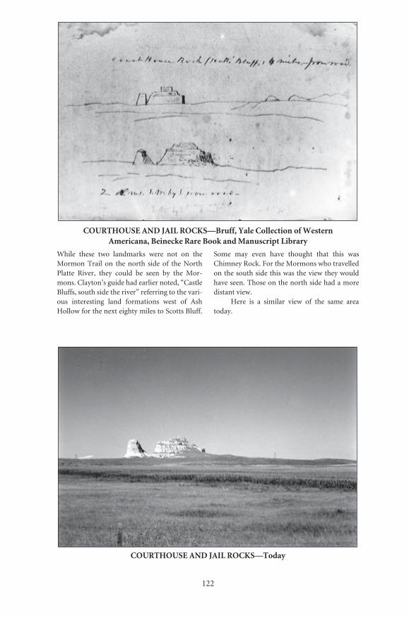
122
COURTHOUSE AND JAIL ROCKS—Bruff, Yale Collection of Western Americana, Beinecke Rare Book and Manuscript Library
While these two landmarks were not on theMormon Trail on the north side of the NorthPlatte River, they could be seen by the Mor-mons. Clayton’s guide had earlier noted, “CastleBluffs, south side the river” referring to the vari-ous interesting land formations west of AshHollow for the next eighty miles to Scotts Bluff.
Some may even have thought that this wasChimney Rock. For the Mormons who travelledon the south side this was the view they wouldhave seen. Those on the north side had a moredistant view.
Here is a similar view of the same areatoday.
COURTHOUSE AND JAIL ROCKS—Today
Number: 91Orig: 36 x 24Crop: 33.5 x 22Scale: 79%Final: 26.5 x 17.5
Number: 92Orig: 35.5 x 23.5Crop:Scale: 75%Final: 26.5 x 17.5

123
CHIMNEY ROCK—Piercy, Nebraska State Historical Society
This is one of two drawings of Chimney Rock byPiercy. Writing in his journal he noted, “Trav-elled 13 miles and camped on the Platte, Chim-ney Rock in sight all day, and Scott’s Bluffs inthe evening. Chimney Rock is on the south sideof the Platte, and on my journey home I madethe accompanying sketch of it...which is takennearer by three miles than it could be obtainedfrom the north side.” Some Mormons firstreported seeing what they thought was Chim-
ney Rock by climbing some bluffs two mileswest of present-day Lisco, Nebraska.
Here is a view similar to Piercy’s. Of all thelandmarks on all the emigrant trails, ChimneyRock is the one most frequently mentioned indiaries. Lucy Canfield, a Mormon emigrant,camped opposite Chimney Rock September 1,1862 and wrote, “Tis a wild and romantic coun-try around this rock.” It still is today. Wagontrain rides are available in the area.
CHIMNEY ROCK—Today
Number: 93Orig: 36 x 24Crop:Scale: 73%Final: 26.5 x 17.5
Number: 95Orig: 35.5 x 23.5Crop: 35.5 x 21.5Scale: 75%Final: 26.5 x 16

124
SCOTTS BLUFF—From Piercy’s Route from Liverpool to Great Salt Lake Valley
Piercy noted in his journal, “Scott’s Bluffs werein view all day. They were certainly the mostremarkable sight I had seen since I left England.Viewed from the distance at which I sketchedthem the shadows were of an intense blue, whilethe rock illuminated by the setting sun partookof its gold, making a beautiful harmony of
colour. They present a very singular appear-ance, resembling ruined palaces, castellatedtowers, temples and monuments.”
Today the buffalo are gone from thearea and tall corn grows where the prairiegrasses grew. Here is a view from near thesame location.
SCOTTS BLUFF—Today
Number: 97Orig: 35.5 x 22.5Crop: 34.5 x 21.5Scale: 77%Final: 26.5 x 16.5
Number: 98Orig: 35.5 x 23.5Crop:Scale: 75%Final: 26.5 x 17.5
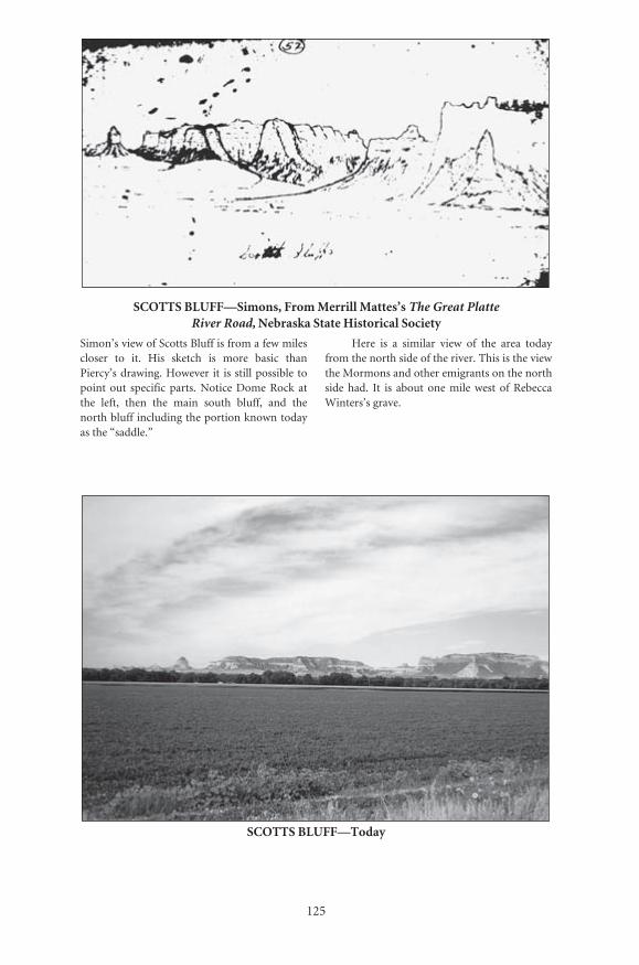
125
SCOTTS BLUFF—Simons, From Merrill Mattes’s The Great Platte River Road, Nebraska State Historical Society
Simon’s view of Scotts Bluff is from a few milescloser to it. His sketch is more basic thanPiercy’s drawing. However it is still possible topoint out specific parts. Notice Dome Rock atthe left, then the main south bluff, and thenorth bluff including the portion known todayas the “saddle.”
Here is a similar view of the area todayfrom the north side of the river. This is the viewthe Mormons and other emigrants on the northside had. It is about one mile west of RebeccaWinters’s grave.
SCOTTS BLUFF—Today
Number: 99Orig: 56 x 45Crop: 55 x 30Scale: 48%Final: 26.5 x 14.5
Number: 100Orig: 34 x 23.5Crop:Scale: 78%Final: 26.5 x 18
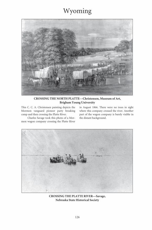
126
CROSSING THE NORTH PLATTE—Christensen, Museum of Art, Brigham Young University
This C. C. A. Christensen painting depicts theMormon vanguard pioneer party breakingcamp and then crossing the Platte River.
Charles Savage took this photo of a Mor-mon wagon company crossing the Platte River
in August 1866. There were no trees in sightwhere this company crossed the river. Anotherpart of the wagon company is barely visible inthe distant background.
CROSSING THE PLATTE RIVER—Savage, Nebraska State Historical Society
Wyoming
Number: 101Orig: 57 x 44.5Crop: 56 x 38Scale: 47%Final: 26.5 x 18
Number: 102Orig: 56 x 32Crop: 42 x 24Scale: 63%Final: 26.5 x 15

127
FORT LARAMIE—From Piercy’s Route from Liverpool to Great Salt Lake Valley
Piercy visited and sketched the fort twice, firston his way out and then again on his return.This view was made during his return trip. Itshows both the old adobe Fort John (also knownas Fort Laramie) and the rapidly expanding mil-itary construction of the new Fort Laramie.
Here is a similar view. Old Fort John hasbeen replaced. However, Old Bedlam, the offic-ers’ quarters is still standing. Trees have grownup along the river bank and the river haschanged its course a little making it impossibleto duplicate the exact scene.
FORT LARAMIE—Today
Number: 103Orig: 38.5 x 27Crop: 38.5 x 25Scale: 69%Final: 26.5 x 17
Number: 104Orig: 35.5 x 23Crop:Scale: 75%Final: 26.5 x 17
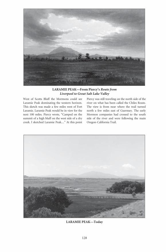
128
LARAMIE PEAK—From Piercy’s Route from Liverpool to Great Salt Lake Valley
West of Scotts Bluff the Mormons could seeLaramie Peak dominating the western horizon.This sketch was made a few miles west of FortLaramie. Laramie Peak would be in view for thenext 100 miles. Piercy wrote, “Camped on thesummit of a high bluff on the west side of a drycreek. I sketched Laramie Peak....” At this point
Piercy was still traveling on the north side of theriver on what has been called the Chiles Route.The view is from near where the trail turnednorth a few miles east of Guernsey. The earlyMormon companies had crossed to the southside of the river and were following the mainOregon-California Trail.
LARAMIE PEAK—Today
Number: 107Orig: 35 x 24Crop: 29.5 x 18.5Scale: 90%Final: 26.5 x 16.5
Number: 108Orig: 34.5 x 24Crop:Scale: 77%Final: 26.5 x 18

129
MEXICAN HILL—Today
Just west of Fort Laramie the main trailfollowed the bluffs. After a few miles itdropped off the bluffs to the river andwithin a few more miles it had to climbback up over some hills. Clayton’s guiderecords, “Steep hill to descend. Thedescent being over rock, and very steep,makes it dangerous to wagons, but it isnot lengthy.” This steep hill is knowntoday as Mexican Hill. This view is look-ing back up the bluff in the cut made bythe thousands of wagons that came downit. Just as Clayton said, it is very steep andnarrow and, luckily, not very long.
Once in the bottom the trail wasforced close to the cliffs. Then the areaopened up for a short distance. It was a nat-ural stopping or camping area. The emi-grants carved their names all along thecliffs in this location, just south of Guern-sey, Wyoming. The trail is in the depres-sion from which the picture was taken. Thecliff to the left is called Register Cliff.
REGISTER CLIFF—Today
Number: 109Orig: 29.5 x 42Crop:Scale: 50%Final: 14.5 x 20.5
Number: 110Orig: 35.5 x 23.5Crop:Scale: 75%Final: 26.5 x 17.5
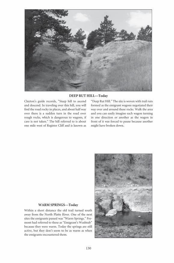
130
DEEP RUT HILL—Today
Clayton’s guide records, “Steep hill to ascendand descend. In traveling over this hill, you willfind the road rocky in places, and about half wayover there is a sudden turn in the road overrough rocks, which is dangerous to wagons, ifcare is not taken.” The hill referred to is aboutone mile west of Register Cliff and is known as
“Deep Rut Hill.” The site is woven with trail rutsformed as the emigrant wagons negotiated theirway over and around these rocks. Walk the areaand you can easily imagine each wagon turningin one direction or another as the wagon infront of it was forced to pause because anothermight have broken down.
WARM SPRINGS—Today
Within a short distance the old trail turned southaway from the North Platte River. One of the nextsites the emigrants passed was “Warm Springs.” Fre-mont had referred to these as “Emigrant’s Washtub”because they were warm. Today the springs are stillactive, but they don’t seem to be as warm as whenthe emigrants encountered them.
Number: 111Orig: 35.5 x 23Crop:Scale: 75%Final: 26.5 x 17
Number: 112Orig: 23.5 x 35Crop: 23.5 x 34Scale: 51%Final: 12 x 17
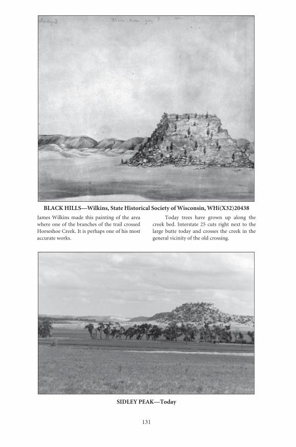
131
BLACK HILLS—Wilkins, State Historical Society of Wisconsin, WHi(X32)20438
James Wilkins made this painting of the areawhere one of the branches of the trail crossedHorseshoe Creek. It is perhaps one of his mostaccurate works.
Today trees have grown up along thecreek bed. Interstate 25 cuts right next to thelarge butte today and crosses the creek in thegeneral vicinity of the old crossing.
SIDLEY PEAK—Today
Number: 113Orig: 50 x 42.5Crop:Scale: 53%Final: 26.5 x 22.5
Number: 114Orig: 35.5 x 23.5Crop:Scale: 75%Final: 26.5 x 17.5
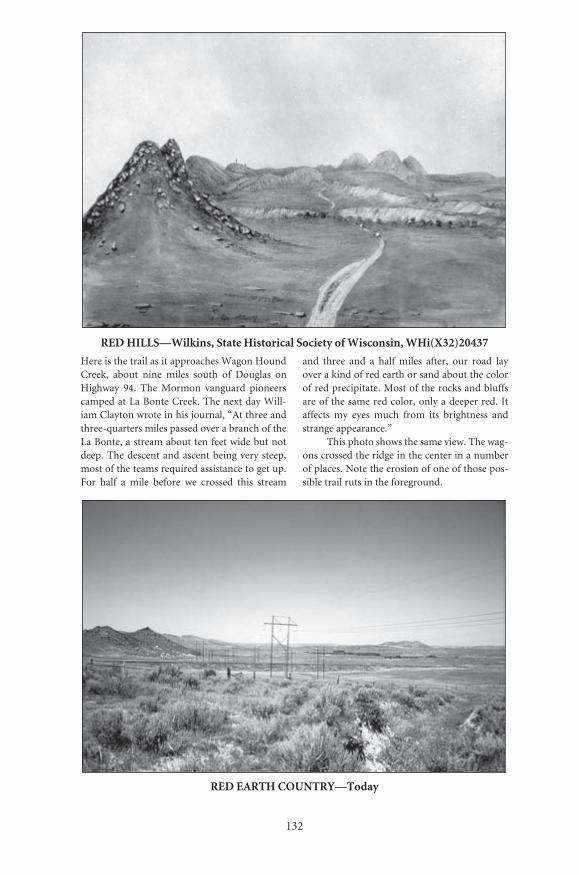
132
RED HILLS—Wilkins, State Historical Society of Wisconsin, WHi(X32)20437
Here is the trail as it approaches Wagon HoundCreek, about nine miles south of Douglas onHighway 94. The Mormon vanguard pioneerscamped at La Bonte Creek. The next day Will-iam Clayton wrote in his journal, “At three andthree-quarters miles passed over a branch of theLa Bonte, a stream about ten feet wide but notdeep. The descent and ascent being very steep,most of the teams required assistance to get up.For half a mile before we crossed this stream
and three and a half miles after, our road layover a kind of red earth or sand about the colorof red precipitate. Most of the rocks and bluffsare of the same red color, only a deeper red. Itaffects my eyes much from its brightness andstrange appearance.”
This photo shows the same view. The wag-ons crossed the ridge in the center in a numberof places. Note the erosion of one of those pos-sible trail ruts in the foreground.
RED EARTH COUNTRY—Today
Number: 115Orig: 49.5 x 42.5Crop: 49.5 x 34.5Scale: 53%Final: 26.5 x 18.5
Number: 116Orig: 35 x 23.5Crop: 34 x 22Scale: 78%Final: 26.5 x 17

133
VIEW NEAR LABONTE—Courtesy Omaha World-Herald Quesenbury Sketchbook
These mountains with their distinctive curvedand folded rock formations were subjects for anumber of artists. James Wilkins and J. Golds-borough Bruff recorded them in 1849. In 1851William Quesenbury made this sketch.
The view is actually much closer to the LaPrele River than the LaBonte River. It was taken
off Ayers Natural Bridge Road. The immediatearea along the route of the old trail has notchanged much. There is a small park nearby atAyers Natural Bridge where modern travelerscan picnic, wade in the river, or camp, much assome of the early emigrants did.
BLACK HILLS—Today
Number: 119Orig: 35 x 57.5Crop: 26.5 x 21Scale: 100%Final: 26.5 x 21
Number: 120Orig: 35 x 24Crop: 35 x 22.5Scale: 76%Final: 26.5 x 17
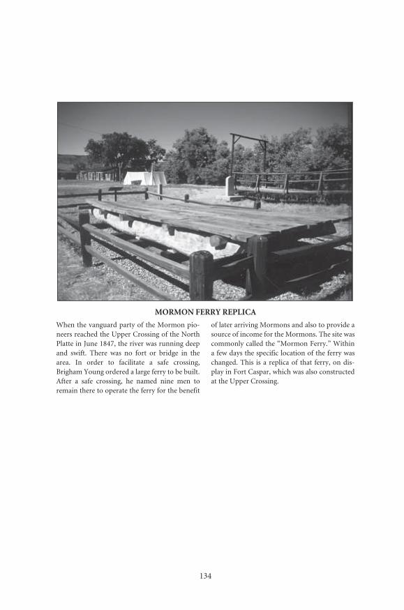
134
MORMON FERRY REPLICA
When the vanguard party of the Mormon pio-neers reached the Upper Crossing of the NorthPlatte in June 1847, the river was running deepand swift. There was no fort or bridge in thearea. In order to facilitate a safe crossing,Brigham Young ordered a large ferry to be built.After a safe crossing, he named nine men toremain there to operate the ferry for the benefit
of later arriving Mormons and also to provide asource of income for the Mormons. The site wascommonly called the “Mormon Ferry.” Withina few days the specific location of the ferry waschanged. This is a replica of that ferry, on dis-play in Fort Caspar, which was also constructedat the Upper Crossing.
Number: 123Orig: 35 x 23.5Crop: 34 x 23.5Scale: 78%Final: 26.5 x 18
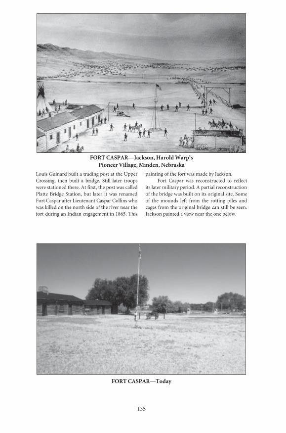
135
FORT CASPAR—Today
FORT CASPAR—Jackson, Harold Warp’s Pioneer Village, Minden, Nebraska
Louis Guinard built a trading post at the UpperCrossing, then built a bridge. Still later troopswere stationed there. At first, the post was calledPlatte Bridge Station, but later it was renamedFort Caspar after Lieutenant Caspar Collins whowas killed on the north side of the river near thefort during an Indian engagement in 1865. This
painting of the fort was made by Jackson.Fort Caspar was reconstructed to reflect
its later military period. A partial reconstructionof the bridge was built on its original site. Someof the mounds left from the rotting piles andcages from the original bridge can still be seen.Jackson painted a view near the one below.
Number: 125Orig: 29.5 x 20Crop: 29 x 19Scale: 90%Final: 26.5 x 17
Number: 126Orig: 35.5 x 23Crop:Scale: 73.5%Final: 26.5 x 16.5
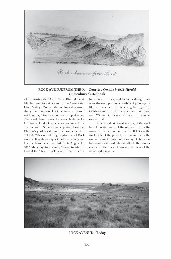
136
ROCK AVENUE FROM THE N.—Courtesy Omaho World-HeraldQuesenbury Sketchbook
After crossing the North Platte River the trailleft the river to cut across to the SweetwaterRiver Valley. One of the geological featuresalong the trail was Rock Avenue. Clayton’sguide notes, “Rock avenue and steep descent.The road here passes between high rocks,forming a kind of avenue or gateway for aquarter mile.” Sohia Goodridge may have hadClayton’s guide as she recorded on September5, 1850, “We came through a place called RockAvenue. It is about a quarter of a mile long andlined with rocks on each side.” On August 11,1863 Mary Lightner wrote, “Came to what istermed the ‘Devil’s Back Bone.’ It consists of a
long range of rock, and looks as though theywere thrown up from beneath, and pointing uplike ice in a jamb. It is a singular sight.” J.Goldsborough Bruff made a sketch in 1849,and William Quesenbury made this similarone in 1851.
Recent widening and grading of the roadhas eliminated most of the old trail ruts in theimmediate area, but some are still left on thenorth side of the present road as you enter theavenue from the east. Weathering of the rockshas now destroyed almost all of the namescarved on the rocks. However, the view of thearea is still the same.
ROCK AVENUE—Today
Number: 127Orig: 36 x 25.5Crop: 31 x 18.5Scale: 74%Final: 26.5 x 16
Number: 128Orig: 35.5 x 23Crop: 35.5 x 20Scale: 75%Final: 26.5 x 15
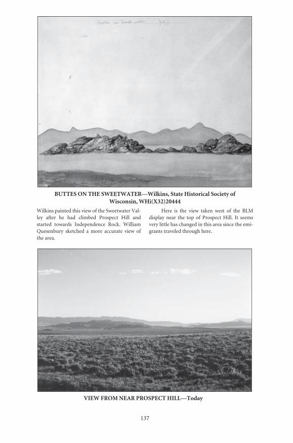
���
����������������������������������
��������������������������������������������������������������������������������������
���������������������������������������������������� ������ ��� ���� �������� ��������� ����� ����������� �������� ������������� ������ ������������������ ��������� �� ����� ��������� ����� ������������
����� ��� ���� ����� ������ ����� ��� ���� ����������� ����� ���� ���� ��� ��������� ������ ��� �������������������������������������������������������������������������������������
������� �������� ���������������������� ��������� ���������
������� �������� �������������������� ��������� �����������
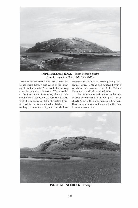
138
INDEPENDENCE ROCK—From Piercy’s Route from Liverpool to Great Salt Lake Valley
This is one of the most famous trail landmarks.Father Pierre DeSmet had called it the “greatregister of the desert.” Piercy made this drawingfrom the southeast. He wrote, “We proceededto the ford of the Sweetwater, about a milebeyond Rock Independence. Forded, and then,while the company was taking breakfast, I hur-ried back to the Rock and made a sketch of it. Itis a large rounded mass of granite, on which are
inscribed the names of many passing emi-grants.” Alfred J. Miller had painted it from avariety of directions in 1837. Bruff, Wilkins,Quesenbury, and Jackson also sketched it.
Emigrants wrote their names on the rockwith whatever they had available—paint, tar, orchisels. Some of the old names can still be seen.Here is a similar view of the rock, but the riverhas meandered a little.
INDEPENDENCE ROCK—Today
Number: 131Orig: 35.5 x 24Crop: 29 x 18Scale: 91%Final: 26.5 x 16.5
Number: 132Orig: 29 x 20Crop:Scale: 91%Final: 26.5 x 18
139
INDEPENDENCE ROCK—Jackson, National Archives #57-HS-385
Jackson sketched, painted, and photographed thisrock a number of times. The old trail split to goaround both ends of the rock. This 1870 photo-graph shows the trail on the north side of the rock.
Here is the same view today from the
highway rest area occupying the site. A pedis-trian walkway crosses the actual swale shown inJackson’s photo. For modern trail travelers ashort walk and climb will bring you to the topof the rock. The view is well worth it.
INDEPENDENCE ROCK—Today
Number: 133Orig: 56.5 x 44Crop:Scale: 47%Final: 26.5 x 20.5
Number: 134Orig: 29.5 x 20.5Crop:Scale: 90%Final: 26.5 x 18
140
PASS OF THE RATTLE-SNAKE MOUNTAINS—Bruff, Yale Collection of Western Americana, Beinecke Rare Book and Manuscript Library
After leaving Independence Rock the trailheaded west towards Devil’s Gate. The trail didnot pass through it but through a notch in thehills a little south of the gate. In 1849 Bruff madethis drawing of the pass and Frederick RichardFulkerson’s 1847 grave. The Mormon PioneerParty had passed here on June 21, 1847, ten daysbefore Fulkerson’s death. Later Mormon com-
panies would have seen the fresh grave. Here is how the pass looks today. Not much
has changed. The grave shown in the sketch is stillthere, but the inscription is gone. In 1864 anotheremigrant, T.P. Baker, carved his name on it.Today the modern highway does not follow thepaved road that was built on top or next to theold trail, but loops around farther south.
RATTLESNAKE PASS—Today
Number: 135Orig: 42 x 55Crop: 40 x 35Scale: 54%Final: 21.5 x 19
Number: 136Orig: 35.5 x 23.5Crop: 35.5 x 21.5Scale: 75%Final: 26.5 x 16

���
���������������������������������������������������������������������
������������������
������� �������� ������������ ��������������� ��������� ���������
������� �������� ���������������������� ��������� �����������
Jackson’s painting captures the emigrants after they have passed through what Bruff called Rattle-snake Pass. Clayton wrote in his journal, “the road passes between two high ridges of granite, leaving a surface of about two rods of level ground on each side of the road. The road
then bends to the west and a quarter mile farther, passes over a small creek....” Today the Mormon Handcart Visitors’ Center occupies this part of the old Sun Ranch. Handles of handcarts are barely visible along the fence at lower left.
142
DEVIL’S GATE—From Piercy’s Route fromLiverpool to Great Salt Lake Valley
Clayton’s guide notes, “Devil’s Gate. A littlewest from the road. The river here passesbetween perpendicular rocks, four hundred feethigh—This is a curiosity worthy of a traveler’sattention.” It still is. Piercy wrote, “At Devil’sGate, about 4 miles further [from their campnear Independence Rock], I remained behind tomake a sketch of this great curiosity, after which,
as my boots were without toes, and admitted thegravel, which cut one’s feet dreadfully, I hadsome difficulty catching up with the wagons.”
Here is a similar view today. Unfortu-nately the steel plate copy of Piercy’s drawingis not as detailed as his other ones. Jacksonalso photographed the area from a number oflocations.
DEVIL’S GATE—Today
Number: 139Orig: 35.5 x 24Crop: 23 x 19/5Scale: 105%Final: 24 x 20.5
Number: 140Orig: 35 x 23.5Crop: 34 x 23.5Scale: 71%Final: 23.5 x 16.5

143
SPLIT ROCK—Jackson, National Park Service, Scotts Bluff National Monument
Split Rock was another famous landmark. Itcould be seen to the west from Devil’s Gate.
Alfred J. Miller painted it in 1837. At thattime buffalo could be found up and down thevalley. By the time the Mormons came buffalo
were rarely found in the valley. This is Jackson’spainting of the area.
Today the area looks much the same as itdid when the emigrants passed through.
SPLIT ROCK—Today
Number: 143Orig: 29.5 x 20.5Crop: 29.5 x 19.5Scale: 90%Final: 26.5 x 17.5
Number: 144Orig: 29.5 x 20Crop: 29.5 x 19Scale: 90%Final: 26.5 x 17

144
SANDSTONE TOWER—Bruff, Yale Collection of Western Americana, Benienke Rare Books and Manuscript Library
This curious structure is on the south side of theold trail a few miles west of Split Rock. Bruffmade this drawing of it. He, like many otheremigrants, left the trail to examine it.
This is the view today of Old Castle. Onlyranch fences are in the area. The old trail is nowparallel to, or in a few spots, under the modernhighway.
SANDSTONE TOWER—Today
Number: 147Orig: 36 x 23.5Crop:Scale: 74%Final: 26.5 x 17
Number: 148Orig: 35 x 24Crop: 34 x 24Scale: 78%Final: 26.5 x 18.5

145
ROCKY RIDGE—Wilkins, State Historical Society of Wisconsin, WHi(X32)20446
James Wilkins traveled to California in 1849,painting scenes along the way. This is his viewof Rocky Ridge. The emigrants had been follow-ing along the banks of the Sweetwater, but nearhere the river entered a small canyon area. Thetrail had to cut over those hills. However, thetops of the hills were very rocky—thus thename “Rocky Ridge.” Clayton’s guide stated,
“Rough, rocky ridges. Dangerous to wagons,and ought to be crossed with care.” Piercy wrote“crossed rocky ridges very rough and tedious toget over.” This is the only known early drawingof the area.
Today the view is the same, and the ridgecan even be tough on 4x4 vehicles.
ROCKY RIDGE—Today
Number: 149Orig: 51 x 44Crop:Scale: 52%Final: 26.5 x 19
Number: 150Orig: 41 x 30Crop:Scale: 65%Final: 26.5 x 18
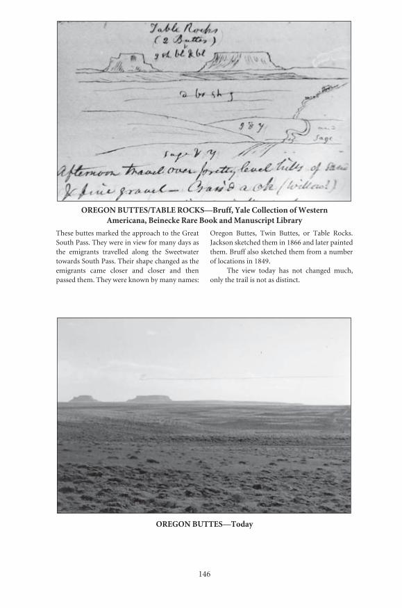
146
OREGON BUTTES/TABLE ROCKS—Bruff, Yale Collection of Western Americana, Beinecke Rare Book and Manuscript Library
These buttes marked the approach to the GreatSouth Pass. They were in view for many days asthe emigrants travelled along the Sweetwatertowards South Pass. Their shape changed as theemigrants came closer and closer and thenpassed them. They were known by many names:
Oregon Buttes, Twin Buttes, or Table Rocks.Jackson sketched them in 1866 and later paintedthem. Bruff also sketched them from a numberof locations in 1849.
The view today has not changed much,only the trail is not as distinct.
OREGON BUTTES—Today
Number: 151Orig: 38.5 x 27Crop: 38.5 x 24Scale: 68.5%Final: 26.5 x 16
Number: 152Orig: 31.5 x 21Crop:Scale: 84%Final: 26.5 x 17.5
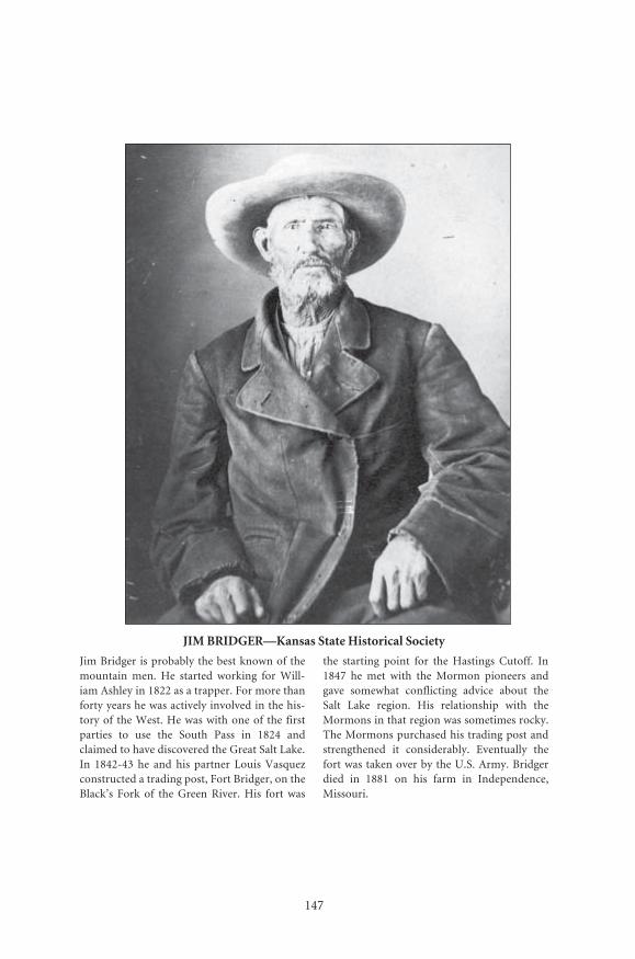
147
Number: 228Orig: 46 x 57.5Crop:Scale: 48%Final: 22 x 27.5
JIM BRIDGER—Kansas State Historical Society
Jim Bridger is probably the best known of themountain men. He started working for Will-iam Ashley in 1822 as a trapper. For more thanforty years he was actively involved in the his-tory of the West. He was with one of the firstparties to use the South Pass in 1824 andclaimed to have discovered the Great Salt Lake.In 1842-43 he and his partner Louis Vasquezconstructed a trading post, Fort Bridger, on theBlack’s Fork of the Green River. His fort was
the starting point for the Hastings Cutoff. In1847 he met with the Mormon pioneers andgave somewhat conflicting advice about theSalt Lake region. His relationship with theMormons in that region was sometimes rocky.The Mormons purchased his trading post andstrengthened it considerably. Eventually thefort was taken over by the U.S. Army. Bridgerdied in 1881 on his farm in Independence,Missouri.

148
SOUTH PASS—Wilkins, State Historical Society of Wisconsin, WHi(X32)20447
This painting appears to show the pass with theemigrant trail passing from left to right, east towest. The actual pass would be just off thepainting to the right. It shows the approach tothe pass and not the pass itself. Susan Noble tra-versed South Pass in 1847 and remembered,“We had heard so much of the South Pass thatwe thought, of course, a dangerous and difficult
climb was before us. One can hardly imagineour surprised feeling when we found the Conti-nental Divide as a long broad easy upland valleywith splendid trails. It was hardly believeable....”
This is a similar view looking in a south-erly direction. Pacific Springs is to the west ofthe pass. It was the first water west of the Conti-nental Divide, and thus it drained to the Pacific.
SOUTH PASS—Today
Number: 153aOrig: 54 x 27Crop: 26 x 19Scale: 100%Final: 26 x 19
Number: 154aOrig: 35.5 x 24Crop: 35 x 23.5Scale: 74%Final: 26 x 17.5
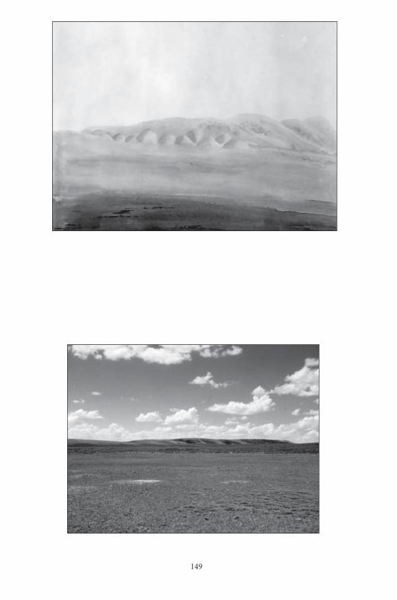
149
Number: 153bOrig: 54 x 27Crop: 26 x 19Scale: 100%Final: 26 x 19
Number: 154bOrig: 35.5 x 24Crop: 31.5 x 24Scale: 72.5%Final: 23 x 17.5
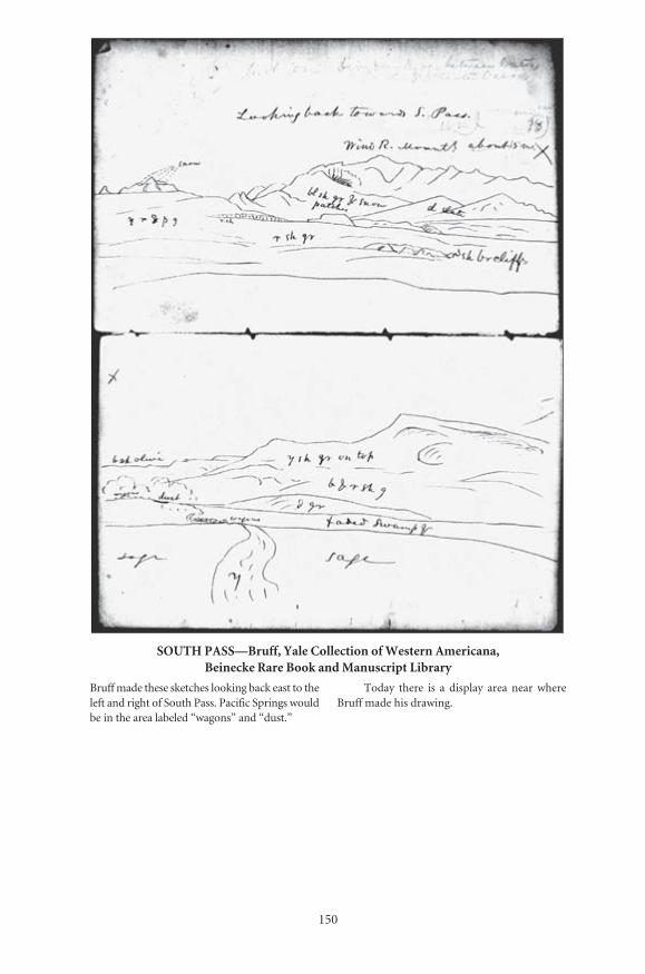
150
SOUTH PASS—Bruff, Yale Collection of Western Americana, Beinecke Rare Book and Manuscript Library
Bruff made these sketches looking back east to theleft and right of South Pass. Pacific Springs wouldbe in the area labeled “wagons” and “dust.”
Today there is a display area near whereBruff made his drawing.
Number: 155/156Orig: 42 x 53Crop:Scale: 63%Final: 26.5 x 33.5

151
LOOKING BACK AT SOUTH PASS—Today
Number: 157Orig: 41 x 29.5Crop:Scale: 64%Final: 26.5 x 19
Number: 158Orig: 41 x 29.5Crop: 40 x 29.5Scale: 66%Final: 26.5 x 19.5

152
BIG SANDY—Jackson, National Park Service, Scotts Bluff National Monument
Jackson made this painting of the Big Sandywith the Wind River Mountains in the back-ground. A few miles east of this area on the Lit-tle Sandy the Mormons met with Jim Bridgerand discussed the Great Salt Lake Valley.
The painting seems to have been made
from present-day Farson where the US 187bridge crosses the river. For those modern trav-elers who would love some cold ice cream on ahot day, be sure to stop in Farson for a “BigCone.” West of Farson to the Green River thenew road follows the old trail.
BIG SANDY AND FARSON—Today
Number: 159Orig: 35 x 24Crop: 34 x 22.5Scale: 78%Final: 26.5 x 17.5
Number: 160Orig: 35 x 23.5Crop: 34 x 23Scale: 78%Final: 26.5 x 18
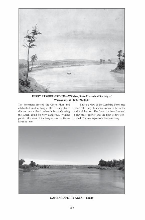
153
FERRY AT GREEN RIVER—Wilkins, State Historical Society of Wisconsin, WHi(X32)20449
The Mormons crossed the Green River andestablished another ferry at the crossing. Laterthis area was called Lombard’s Ferry. Crossingthe Green could be very dangerous. Wilkinspainted this view of the ferry across the GreenRiver in 1849.
This is a view of the Lombard Ferry areatoday. The only difference seems to be in thewidth of the river. The Green has been dammeda few miles upriver and the flow is now con-trolled. The area is part of a bird sanctuary.
LOMBARD FERRY AREA—Today
Number: 161Orig: 51 x 43Crop: 51 x 40.5Scale: 52%Final: 26.5 x 21
Number: 162Orig: 41 x 29.5Crop: 41 x 26Scale: 64.5%Final: 26.5 x 17

154
HANDCARTS—Jackson, National Park Service, Scotts Bluff National Monument
Jackson made this painting depicting the Mor-mon handcart companies that brought thou-sands of Mormons to Salt Lake during the1850s.
This recent photo shows some Mormonstudents participating on a camping trip andreligious retreat.
MORMON OUTING—Today
Number: 163Orig: 29.5 x 20Crop: 29.5 x 19.5Scale: 90%Final: 26.5 x 17.5
Number: 164Orig: 29 x 20.5Crop: 27 x 19Scale: 98%Final: 26.5 x 18.5
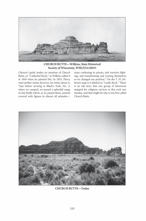
155
CHURCH BUTTE—Wilkins, State Historical Society of Wisconsin, WHi(X32)20451
Clayton’s guide makes no mention of ChurchButte, or “Cathedral Rock,” as Wilkins called itin 1849 when he painted this. In 1853, Piercyused neither name; however, he writes about it,“Just before arriving at Black’s Fork, No. 3,where we camped, we passed a splendid rangeof clay bluffs which, as we passed them, seemedcovered with figures in almost all attitudes—
nuns confessing to priests, and warriors fight-ing, and transforming and varying themselvesas we changed our position.” On the T. H. Jef-ferson map it is labeled as “Castle Rock.” Thereis an old story that one group of Mormonsstopped for religious services at this rock oneSunday, and that might be why it was first calledChurch Butte.
CHURCH BUTTE—Today
Number: 167Orig: 54 x 22.5Crop: 54 x 21.5Scale: 49%Final: 26.5 x 10.5
Number: 168Orig: 35 x 23.5Crop: 34 x 23Scale: 78%Final: 26.5 x 18

156
CHURCH BUTTE—Jackson, National Archives #57-HS-462
Jackson passed Church Butte a number oftimes. This photo shows the rock looking east.Look closely and you will see a person at its basejust to the left of center. Thomas Moran alsodrew the butte from the same location.
Below is the same view today. The author
is standing in the same spot as the person inJackson’s picture. Little has changed in theimmediate area, but there is a tremendousamount of oil drilling going on now—oh, whatthe emigrants walked over!
CHURCH BUTTE—Today
Number: 171Orig: 56.5 x 39Crop:Scale: 47%Final: 26.5 x 18
Number: 172Orig: 29.5 x 20.5Crop:Scale: 90%Final: 26.5 x 18
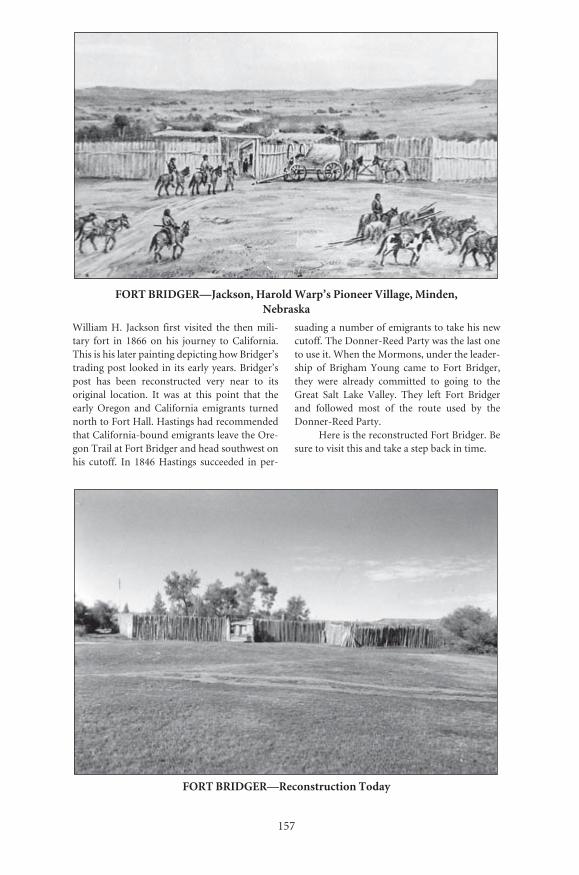
157
FORT BRIDGER—Jackson, Harold Warp’s Pioneer Village, Minden, Nebraska
William H. Jackson first visited the then mili-tary fort in 1866 on his journey to California.This is his later painting depicting how Bridger’strading post looked in its early years. Bridger’spost has been reconstructed very near to itsoriginal location. It was at this point that theearly Oregon and California emigrants turnednorth to Fort Hall. Hastings had recommendedthat California-bound emigrants leave the Ore-gon Trail at Fort Bridger and head southwest onhis cutoff. In 1846 Hastings succeeded in per-
suading a number of emigrants to take his newcutoff. The Donner-Reed Party was the last oneto use it. When the Mormons, under the leader-ship of Brigham Young came to Fort Bridger,they were already committed to going to theGreat Salt Lake Valley. They left Fort Bridgerand followed most of the route used by theDonner-Reed Party.
Here is the reconstructed Fort Bridger. Besure to visit this and take a step back in time.
FORT BRIDGER—Reconstruction Today
Number: 173Orig: 38.5 x 27Crop: 38.5 x 22.5Scale: 68.5%Final: 26.5 x 15.5
Number: 174Orig: 35 x 23.5Crop:Scale: 76%Final: 26.5 x 17.5

158
OLD FORT BRIDGER—From Piercy’s Routefrom Liverpool to Great Salt Lake Valley
After traveling about twenty miles farther fromChurch Butte the Mormons came in view ofFort Bridger. Bridger built this trading post withhis partner Louis Vasquez hoping to capitalizeon trade with the Indians, but more importantlywith the emigrant trade. Piercy arrived there onSaturday, August 5, 1853, and wrote, “It ismerely a trading post, then belonging to MajorJames Bridger, one of the oldest mountaineersin this region. The fort is built in the usual form
of pickets, with lodging apartments openinginto a hollow square. A high picket fenceencloses a yard into which the animals of theestablishment are driven for protection, bothfrom wild beasts and Indians. The grass in theneighborhood was abundant, but about a mileand a half from the fort Mr. Bridger had erecteda board, on which was written a request for emi-grants to keep a mile away from the place.”Bridger Butte is in the background.
Number: 175Orig: 39 x 27Crop: 36 x 25.5Scale: 73.5%Final: 26.5 x 19

159
MORMON WALL—Today
MORMON FORT BRIDGER—Tracy, Utah State Historical Society
After the sale of Fort Bridger to the Mormons,Brigham Young had the old wooden fortstrengthened. The fort was enlarged and alarge stone wall was built surrounding it.Albert Tracy was part of the U.S. Army sent toUtah in 1859 during the period known as theMormon War. When the Mormons withdrew
because of the advancing U.S. Army, theyburned part of the fort. Tracy made this sketchof the Mormon fort when the army took pos-session of it.
Below is part of the display near themuseum. This part of the Mormon wall wasreconstructed along the north side.
Number: 177Orig: 57 x 28Crop:Scale: 46%Final: 26.5 x 13
Number: 179Orig: 34.5 x 23Crop:Scale: 77%Final: 26.5 x 17.5
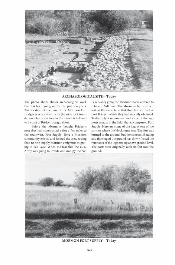
160
ARCHAEOLOGICAL SITE—Today
The photo above shows archaeological workthat has been going on for the past few years.The location of the base of the Mormon FortBridger is very evident with the wide rock foun-dation. One of the logs in the trench is believedto be part of Bridger’s original fort.
Before the Mormons bought Bridger’spost they had constructed a fort a few miles tothe southwest, Fort Supply. Here a Mormoncommunity existed and farmed the area, raisingfood to help supply Mormon emigrants migrat-ing to Salt Lake. When the fear that the U. S.Army was going to invade and occupy the Salt
Lake Valley grew, the Mormons were ordered toreturn to Salt Lake. The Mormons burned theirfort at the same time that they burned part ofFort Bridger, which they had recently obtained.Today only a monument and some of the log-posts remain in the fields that encompassed FortSupply. Here are some of the logs at one of thecorners where the blockhouse was. The fort wasburned to the ground, but the constant freezingand thawing of the ground has slowly forced theremnants of the logposts up above ground level.The posts were originally sunk six feet into theground.
MORMON FORT SUPPLY—Today
Number: 180Orig: 35 x 23.5Crop:Scale: 76%Final: 26.5 x 17
Number: 182Orig: 35 x 23.5Crop:Scale: 76%Final: 26.5 x 17

161
THE NEEDLES—Charles Savage, LDS Church Archives
The Needles were a major landmark on the trailwest of Bridger’s Butte. They marked the trailnear where it crossed the Bear River and enteredUtah. It was in this area that Brigham Young
became sick and had to wait to recover beforecontinuing west.
The view below is taken from the traillooking west towards the Needles.
THE NEEDLES—Today
Number: 183Orig: 57 x 45.5Crop: 56 x 44.5Scale: 47%Final: 26.5 x 21
Number: 184Orig: 35.5 x 23.5Crop:Scale: 75%Final: 26.5 x 17.5
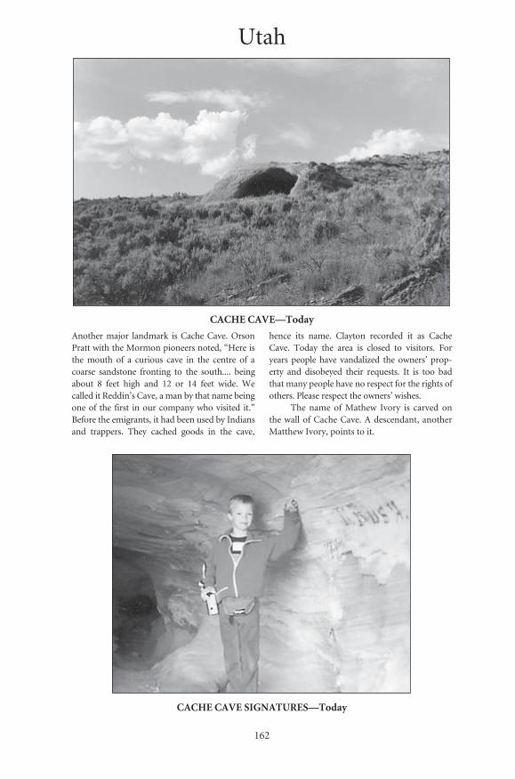
162
CACHE CAVE—Today
Another major landmark is Cache Cave. OrsonPratt with the Mormon pioneers noted, “Here isthe mouth of a curious cave in the centre of acoarse sandstone fronting to the south.... beingabout 8 feet high and 12 or 14 feet wide. Wecalled it Reddin’s Cave, a man by that name beingone of the first in our company who visited it.”Before the emigrants, it had been used by Indiansand trappers. They cached goods in the cave,
hence its name. Clayton recorded it as CacheCave. Today the area is closed to visitors. Foryears people have vandalized the owners’ prop-erty and disobeyed their requests. It is too badthat many people have no respect for the rights ofothers. Please respect the owners’ wishes.
The name of Mathew Ivory is carved onthe wall of Cache Cave. A descendant, anotherMatthew Ivory, points to it.
CACHE CAVE SIGNATURES—Today
Number: 185Orig: 35.5 x 23.5Crop:Scale: 75%Final: 26.5 x 17.5
Number: 186Orig: 17 x 13.5Crop:Scale: 126%Final: 21 x 17
Utah
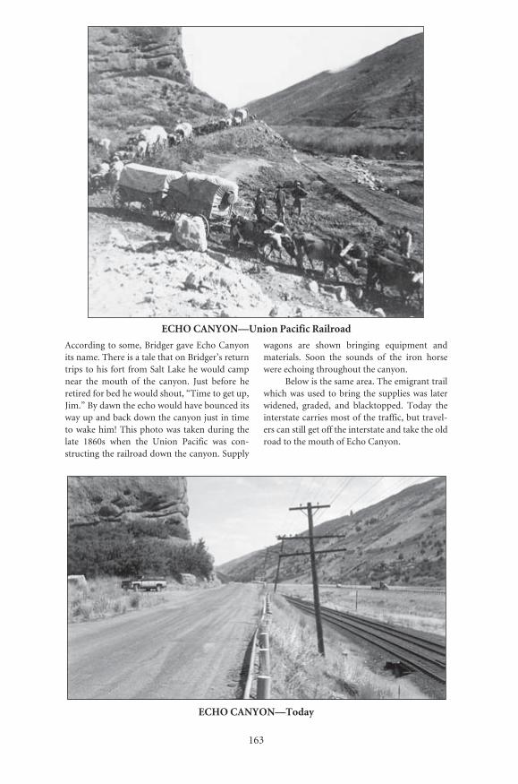
163
ECHO CANYON—Union Pacific Railroad
According to some, Bridger gave Echo Canyonits name. There is a tale that on Bridger’s returntrips to his fort from Salt Lake he would campnear the mouth of the canyon. Just before heretired for bed he would shout, “Time to get up,Jim.” By dawn the echo would have bounced itsway up and back down the canyon just in timeto wake him! This photo was taken during thelate 1860s when the Union Pacific was con-structing the railroad down the canyon. Supply
wagons are shown bringing equipment andmaterials. Soon the sounds of the iron horsewere echoing throughout the canyon.
Below is the same area. The emigrant trailwhich was used to bring the supplies was laterwidened, graded, and blacktopped. Today theinterstate carries most of the traffic, but travel-ers can still get off the interstate and take the oldroad to the mouth of Echo Canyon.
ECHO CANYON—Today
Number: 187Orig: 31 x 26.5Crop:Scale: 76%Final: 23.5 x 20
Number: 188Orig: 35.5 x 23.5Crop: 35 x 20.5Scale: 75%Final: 26.5 x 15.5

164
ECHO CANYON WAGON TRAIN—Charles William Carter, LDS Church Archives
This picture has often been used to show wagontrains coming down Echo Canyon bringingMormons to Salt Lake City. However, it reallyshows one of the Mormon “down and back”wagon trains heading up Echo Canyon in the1860s, on its way east to meet Mormon emi-grants in the Omaha area and to bring themback to Utah.
Here is the same area today near SawmillCanyon. The building of the railroad and,later, Interstate 80, changed the location of thestream. This is one of a few places in EchoCanyon where remnants of the old trail arestill visible.
WAGON TRAIN SITE—Today
Number: 189Orig: 56.5 x 33.5Crop:Scale: 47%Final: 26.5 x 15.5
Number: 190Orig: 35.5 x 23.5Crop:Scale: 75%Final: 26.5 x 17.5

165
ECHO CANYON—Jackson, National Archives #57-HS-33
Jackson made a number of sketches and photo-graphs of the Echo Canyon area during the1860s, first, when he traveled down the canyonon his way to Salt Lake City and California, andlater when the railroad was being constructed.This view is from the area known as the Amphi-theater. It shows the old trail and the bed of therailroad that was being constructed.
This is the same area today. In his journal
Clayton called the canyon “Red Fork Canyon”because of it’s colored walls, but he also wroteabout the echoes. Summarizing his experiencethere he wrote, “The echo, the high rocks to thenorth, high mountains on the south with thenarrow ravine for a road, form a scenery at onceromantic and more interesting than I have everwitnessed.” All of what Clayton said is still truetoday.
ECHO CANYON—Today
Number: 191Orig: 56.5 x 44.5Crop: 55.5 x 41.5Scale: 47%Final: 26.5 x 19.5
Number: 192Orig: 38.5 x 26.5Crop: 38.5 x 24.5Scale: 69%Final: 26.5 x 17

166
MONUMENT ROCK-ECHO CANYON—Jackson, Colorado
Historical Society
ECHO CANYON—Jackson, National Park Service, Scotts Bluff National Monument
Notice this Jackson painting of Echo Canyon.Jackson sometimes used earlier photographs forthe basis of his later paintings. If the old photowas reversed, note how similar his paintingwould be to the reverse image.
Monument Rock is near the mouth of
Echo Canyon on the north side of the canyonwall. Jackson took the below left photo in1870.
Below to the right is the rock today. Itseems that little has changed. The climb to therock is steep.
MONUMENT ROCK—Today
Number: 193Orig: 30 x 20.5Crop:Scale: 88%Final: 26.5 x 18
Number: 194Orig: 45 x 57Crop: 38 x 53Scale: 33%Final: 12.5 x 17.5
Number: 196Orig: 19 x 28.5Crop:Scale: 69%Final: 13 x 19.5
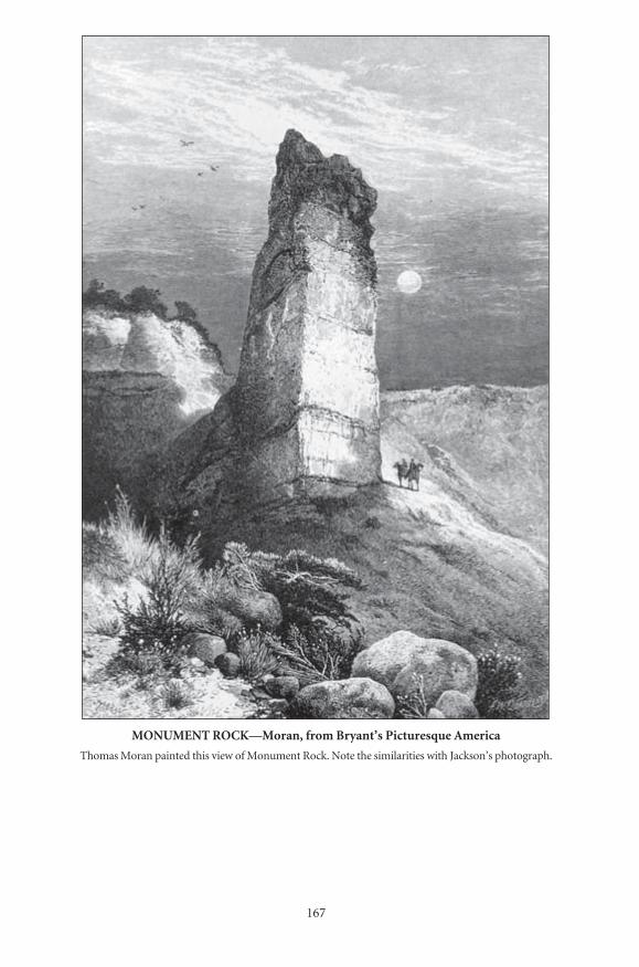
167
MONUMENT ROCK—Moran, from Bryant’s Picturesque America
Thomas Moran painted this view of Monument Rock. Note the similarities with Jackson’s photograph.
Number: 195Orig: 24 x 35.5Crop: 20.5 x 30Scale: 130%Final: 26.5 x 38.5
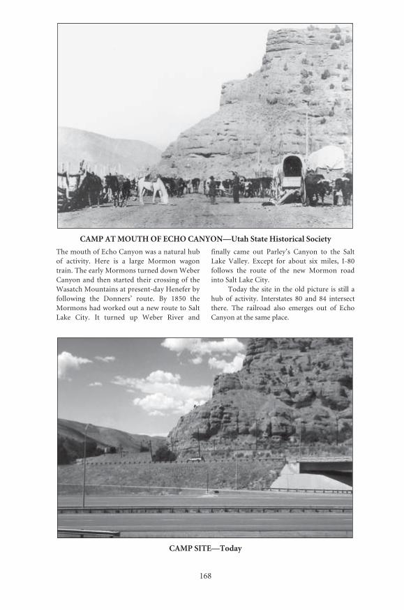
168
CAMP AT MOUTH OF ECHO CANYON—Utah State Historical Society
The mouth of Echo Canyon was a natural hubof activity. Here is a large Mormon wagontrain. The early Mormons turned down WeberCanyon and then started their crossing of theWasatch Mountains at present-day Henefer byfollowing the Donners’ route. By 1850 theMormons had worked out a new route to SaltLake City. It turned up Weber River and
finally came out Parley’s Canyon to the SaltLake Valley. Except for about six miles, I-80follows the route of the new Mormon roadinto Salt Lake City.
Today the site in the old picture is still ahub of activity. Interstates 80 and 84 intersectthere. The railroad also emerges out of EchoCanyon at the same place.
CAMP SITE—Today
Number: 197Orig: 57 x 40.5Crop: 56 x 39Scale: 47%Final: 26.5 x 18.5
Number: 198Orig: 35 x 24Crop:Scale: 76%Final: 26.5 x 18
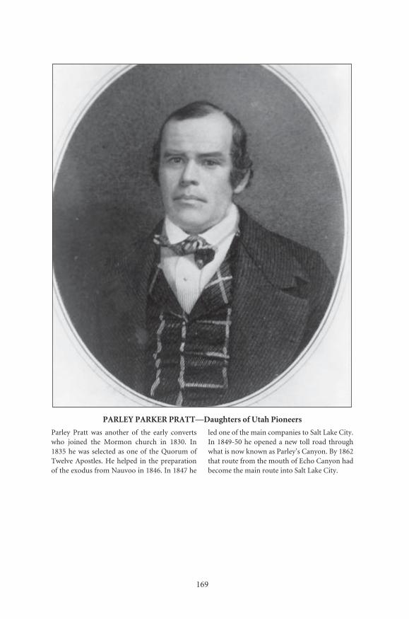
169
Number: 225Orig: 27 x 38Crop: 27 x 31Scale: 98%Final: 26.5 x 30.5
PARLEY PARKER PRATT—Daughters of Utah Pioneers
Parley Pratt was another of the early convertswho joined the Mormon church in 1830. In1835 he was selected as one of the Quorum ofTwelve Apostles. He helped in the preparationof the exodus from Nauvoo in 1846. In 1847 he
led one of the main companies to Salt Lake City.In 1849-50 he opened a new toll road throughwhat is now known as Parley’s Canyon. By 1862that route from the mouth of Echo Canyon hadbecome the main route into Salt Lake City.
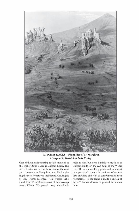
170
WITCHES ROCKS—From Piercy’s Route from Liverpool to Great Salt Lake Valley
One of the most interesting rock formations inthe Weber River Valley is Witches Rocks. Thesite is located on the northeast side of the can-yon. It seems that Piercy is responsible for giv-ing the rock formations their name. On August8, 1853, Piercy recorded, “We crossed EchoCreek from 15 to 20 times, most of the crossingswere difficult. We passed many remarkable
rocks to-day, but none I think so much so asWitches Bluffs, on the east bank of the Weberriver. They are more like gigantic and somewhatrude pieces of statuary in the form of womenthan anything else. Out of compliment to theirresemblance to the ladies I made a sketch ofthem.” Thomas Moran also painted them a fewtimes.
Number: 199Orig: 36.5 x 56.5Crop:Scale: 66%Final: 24 x 37
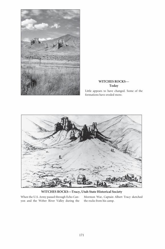
171
WITCHES ROCKS—Today
Little appears to have changed. Some of theformations have eroded more.
WITCHES ROCKS—Tracy, Utah State Historical Society
When the U.S. Army passed through Echo Can-yon and the Weber River Valley during the
Mormon War, Captain Albert Tracy sketchedthe rocks from his camp.
Number: 200Orig: 23.5 x 35Crop: 23 x 34Scale: 56%Final: 13 x 19
Number: 201Orig: 58.5 x 35.5Crop:Scale: 45%Final: 26.5 x 16

���
������������������������������������������������������
��������������������������������������������������������������������������������������������������������� ���� ����� ���� ��������� ������ ������������ ���������������������������������������� ���������������������������������������
���� ������� ������ ��� ����� ���� �������� ��������������������������������������������
���� ����� ��� ���� ����� ���� ����� ������� ������������������������������������������������������������������������������
������������������������
������� �������� ���������������� ��������������� ��������� ���������
������� �������� ���������������������� ��������� �����������
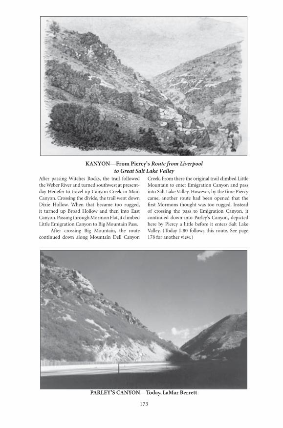
���
�������������������������������������������������������������������
������� �������� ������������ ������������� ����������� ���������
������� �������� ���������������������� ��������� �����������
After passing Witches Rocks, the trail followed the Weber River and turned southwest at present-day Henefer to travel up Canyon Creek in Main Canyon. Crossing the divide, the trail went down Dixie Hollow. When that became too rugged, it turned up Broad Hollow and then into East Canyon. Passing through Mormon Flat, it climbed Little Emigration Canyon to Big Mountain Pass.
After crossing Big Mountain, the route continued down along Mountain Dell Canyon
Creek. From there the original trail climbed Little Mountain to enter Emigration Canyon and pass into Salt Lake Valley. However, by the time Piercy came, another route had been opened that the first Mormons thought was too rugged. Instead of crossing the pass to Emigration Canyon, it continued down into Parley’s Canyon, depicted here by Piercy a little before it enters Salt Lake Valley. (Today I-80 follows this route. See page 178 for another view.)
PARLEY’S CANYON—Today, LaMar Berrett

174
ENTRANCE TO SALT LAKE—Jackson, National Park Service, Scotts Bluff National Monument
Jackson made this painting depicting the emi-grants as they came down Little Mountain andgot their view of the Great Salt Lake Valley.
The picture below was taken near the spotwhere the emigrants came down the mountaininto Emigration Canyon. This was the route
opened by the Donners. The passage down thecanyon was very difficult. Each succeeding emi-grant company made the route a little better. Itwas the main route for the Mormons until theroute down Parley’s Canyon was developed inthe 1850s.
EMIGRATION CANYON—Today
Number: 207Orig: 30 x 20.5Crop: 29 x 19Scale: 91%Final: 26.5 x 17.5
Number: 208Orig: 35 x 23.5Crop: 34 x 23.5Scale: 78%Final: 26.5 x 18
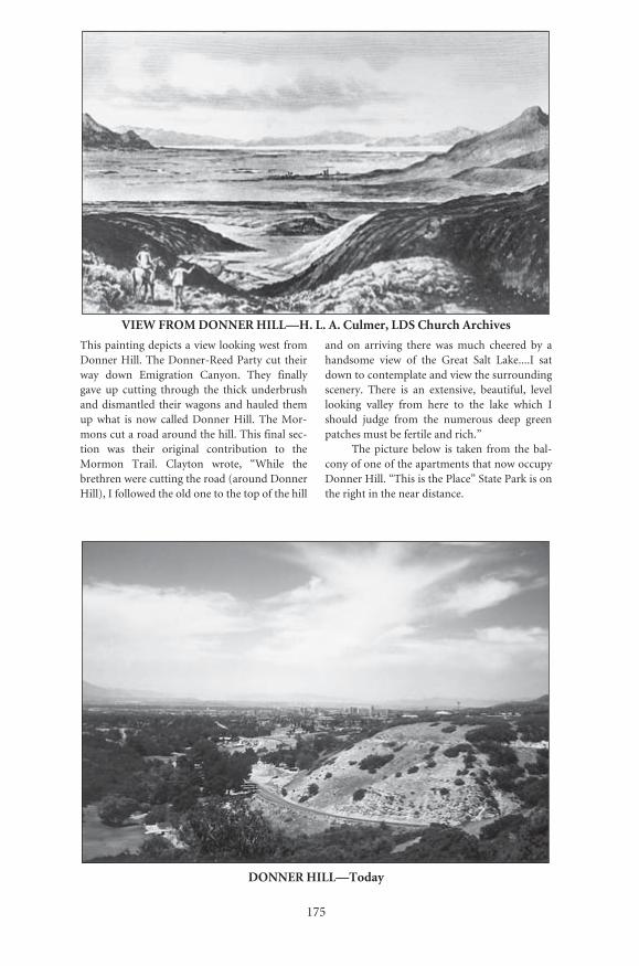
175
VIEW FROM DONNER HILL—H. L. A. Culmer, LDS Church Archives
This painting depicts a view looking west fromDonner Hill. The Donner-Reed Party cut theirway down Emigration Canyon. They finallygave up cutting through the thick underbrushand dismantled their wagons and hauled themup what is now called Donner Hill. The Mor-mons cut a road around the hill. This final sec-tion was their original contribution to theMormon Trail. Clayton wrote, “While thebrethren were cutting the road (around DonnerHill), I followed the old one to the top of the hill
and on arriving there was much cheered by ahandsome view of the Great Salt Lake....I satdown to contemplate and view the surroundingscenery. There is an extensive, beautiful, levellooking valley from here to the lake which Ishould judge from the numerous deep greenpatches must be fertile and rich.”
The picture below is taken from the bal-cony of one of the apartments that now occupyDonner Hill. “This is the Place” State Park is onthe right in the near distance.
DONNER HILL—Today
Number: 209Orig: 57 x 38Crop: 57 x 37.5Scale: 46%Final: 26.5 x 17.5
Number: 210Orig: 35 x 23.5Crop: 34 x 23.5Scale: 78%Final: 26.5 x 18
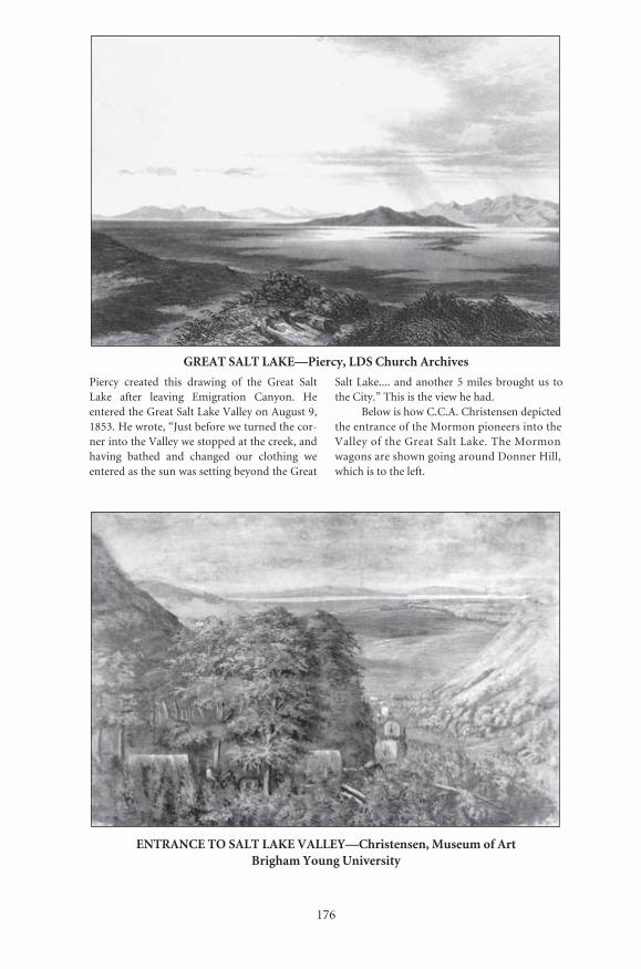
���
�������������������������������������������
������� �������� ����� �������� ��� ���� ������ ��������� ������ �������� ����������� �������� ������������������������������������������������������������������������������������������������������������������������������������������������������� ������� ���� �������� ���� ��������� �������������������������������������������������
��������������������������������������������� �������������������������������������
��������������������������������������������������������������������������������������������������������������������������������������������������������������������������������������������
��������������������������������������������������������������������������������
������� �������� ������������ ������������� ��������� �����������
������� �������� �������������������� ��������� ���������
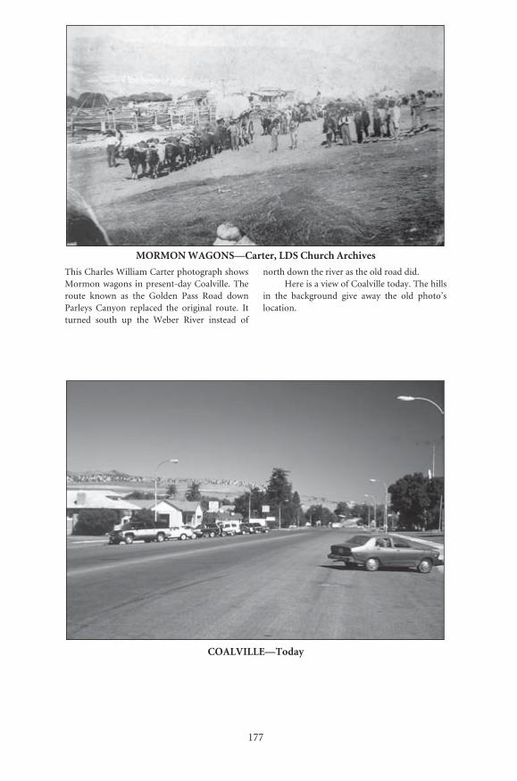
177
MORMON WAGONS—Carter, LDS Church Archives
This Charles William Carter photograph showsMormon wagons in present-day Coalville. Theroute known as the Golden Pass Road downParleys Canyon replaced the original route. Itturned south up the Weber River instead of
north down the river as the old road did.Here is a view of Coalville today. The hills
in the background give away the old photo’slocation.
COALVILLE—Today
Number: 213Orig: 56 x 33Crop: 56 x 32Scale: 47%Final: 26.5 x 15
Number: 214Orig: 35 x 23.5Crop: 34 x 23.5Scale: 78%Final: 26.5 x 18
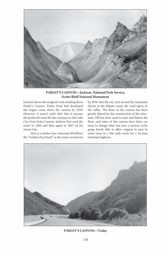
178
PARLEY’S CANYON—Jackson, National Park Service, Scotts Bluff National Monument
Jackson shows the emigrant trail winding downParley’s Canyon. Parley Pratt had developedthe wagon route down the canyon by 1850.However, it wasn’t until 1862 that it becamethe preferred route for the entrance to Salt LakeCity from Echo Canyon. Jackson first used theroute in 1866 and then again in 1867 on hisreturn trip.
Here is a similar view. Interstate 80 followsthe “Golden Pass Road” as the route was known
by 1850, into the city. Just around the mountainshown in the distant center the road opens tothe valley. The floor of the canyon has beengreatly altered by the construction of the inter-state. Fill has been used to raise and flatten thefloor, and sides of the canyon have been cutaway to change what was once a narrow rockygorge barely able to allow wagons to pass insome areas to a flat wide route for a six-laneinterstate highway.
PARLEY’S CANYON—Today
Number: 215Orig: 39 x 27Crop: 38 x 25Scale: 70%Final: 26.5 x 17
Number: 216Orig: 38.5 x 26.5Crop:Scale: 69%Final: 26.5 x 18

���
���������������������������������������������������������
������� �������� ���������������������� ��������� �������
������� �������� ���������������������� ��������� �����������
In this early photo of Salt Lake City, the road to the left is East Temple Street, known today as Main Street. The photo was taken from nearly the same place as Piercy almost two decades earlier made his drawing shown on the following pages.
The Tabernacle appears to be complete, but the Temple is under construction.
Here is a similar view today. The spire of the Temple can be seen in the center.
SALT LAKE CITY—Today, David Doepner

180
SALT LAKE CITY—Piercy, LDS Church Archives
Piercy’s view of Salt Lake City is looking south“from the ‘Bench,’ north of it, and just above Pres-
ident H.C. Kimball’s house, which is seen in theforeground, a little to the left of East Temple St.”
Number: 217aOrig: 57 x 38Crop: 28.5 x 38Scale: 100%Final: 28.5 x 38, gutter bleed, adjust as needed for gutter

181
Number: 217bOrig: 57 x 38Crop: 28.5 x 38Scale: 100%Final: 28.5 x 38
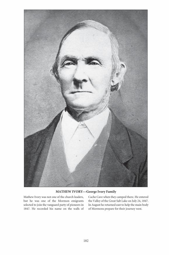
182
MATHEW IVORY—George Ivory Family
Mathew Ivory was not one of the church leaders,but he was one of the Mormon emigrantsselected to join the vanguard party of pioneers in1847. He recorded his name on the walls of
Cache Cave when they camped there. He enteredthe Valley of the Great Salt Lake on July 24, 1847.In August he returned east to help the main bodyof Mormons prepare for their journey west.
Number: 226Orig: 27 x 39Crop:Scale: 98%Final: 26.5 x 38

P A R T I V
Historic Sites

185
Museums and Displays
For those who wish to further increase their understandingand appreciation of the Mormon Trail experience, there are numeroushistoric sites that can be visited. Many of these are conveniently locatedalong major highways; others are on smaller local roads. Most havemuseums or displays that help tell the story of the trail. Some sites areassociated specifically with Mormon history, while others deal with theexperiences of all emigrants. Many will require hours to view and appre-ciate, while others have only small interpretive signs to read. All, how-ever, represent historic events, places, or scenes experienced or viewed byMormons and recorded in their writings.
H I S T O R I C N A U V O O , I L L I N O I S
This area is the natural place to start your journey back in time to the1840s. Nauvoo had originally been built to be both the home and ashowplace for the growing Mormon faith. While today it is not the homeof the Mormon faith, much of it has been restored and reconstructed toits original luster. This has been accomplished by the work of both theChurch of Jesus Christ of Latter-day Saints (LDS) and the ReorganizedChurch of Jesus Christ of Latter Day Saints (RLDS).
Nauvoo was the center for the church from 1839–46. Here one canfind the homes of many of the famous early Mormons: Joseph Smith’sHomestead and Mansion House, Brigham Young’s home, Heber C.Kimball’s home, plus many homes of lesser-known Mormons. Alongwith these buildings one finds a wide variety of shops and businesses thatwere typical of towns and cities of the mid-1800s: the blacksmith andwagon shop, the carpenter’s shop, the bakery, the printing office, thepost office, plus many more. One can take tours of the buildings, andmany of the shops have living history programs. On top of the hill, on
· The Mormon Trail, Yesterday and Today ·
186
the grounds of the destroyed temple, there is a quiet park and a beautifulmemorial. The graves of Joseph, Emma, and Hyrum Smith are alsolocated in Nauvoo. Within the area are the Joseph Smith Historic Center(RLDS) and the Nauvoo Welcome Center (LDS). In addition to thetours and the displays and films within the visitor centers, there are alsoresearch facilities.
Historic Nauvoo is located in western Illinois on the east bank of theMississippi River on State Highway 96, north of Hamilton.
C A R T H A G E J A I L M U S E U M
This jail is the site of the murder and martyrdom of the Prophet JosephSmith and his brother Hyrum on June 27, 1844. The jail has beenrestored to appear as it did in 1844. The small visitors center offersguided tours of the jail site.
The jail is located in the city of Carthage, Illinois, in western Illinoison U.S. Highway 136, about fourteen miles east of the Mississippi River.Nauvoo and Carthage should be seen together.
L O C U S T C R E E K C A M P S I T E , I O W A
At present there is only a marker at this site. However, in terms of Mor-mon history, this is a significant site. It is where the words to the famousMormon hymn “Come, Come, Ye Saints” were written by William Clay-ton. This hymn soon became the “Mormon Marseillaise.” (See WayneCounty Museum.) The hymn is reprinted at the front of this book.
The marker is located at the Tharp Cemetery off the main highways,on local roads about fifteen miles southeast of Corydon, Iowa.
W A Y N E C O U N T Y H I S T O R I C A L M U S E U M , C O R Y D O N , I O W A
This fine county museum has a major display about the Mormon exodusfrom Nauvoo and across central Iowa. Here also is a display commemo-rating Clayton’s writing of the Mormon hymn “Come, Come, Ye Saints.”In addition to these Mormon-related displays there are other fine onesabout the early settlement and life in Iowa.
The museum is located on State Highway 2 in the town of Corydon,Iowa.
Between Corydon and Council Bluffs there are some additionalmarkers concerning two of the permanent supply camps and communi-ties set up to assist other Mormons on their exodus from Nauvoo. Oneof the communities and markers is at Garden Grove Town Park, Gar-den Grove, Iowa, on Highway 204. A second marker is at the Mt. Pisgah

· Historic Sites ·
187
Historic Site near the town of Thayer, Iowa, on U.S. Highway 34. Rutsof the Mormon Trail may be seen near the Mormon Trail Park nearBridgewater, Iowa, and also in a field at Cold Spring County Park.
M O R M O N H A N D C A R T P A R K , C O R A L V I L L E ( I O W A C I T Y ) , I O W A
In the Iowa City area there are several markers dedicated to the handcartcompanies that left Iowa City in the 1850s. Iowa City was the end of theline for the railroad. Mormon immigrants from Europe and others whocame by train from the East disembarked in Iowa City. It was in this areawhere the handcarts which were used by many of the Mormons on theirjourney west were constructed. Also in the vicinity is the small HeritageMuseum. It has rotating displays depicting different aspects of the area’shistory.
Both the park and the museum are in Coralville, Iowa, off U.S. High-way 6.
F O R T D E S M O I N E S , D E S M O I N E S , I O W A
The handcart companies crossing Iowa from Iowa City crossed the DesMoines River in Des Moines near the site of Fort Des Moines. The forthad been abandoned in 1846, but the ruins were still there when theMormons crossed. Part of the old fort has been restored.
It is located near the intersection of Southwest First Street and River-side Drive.
C O U N C I L B L U F F S , I O W A
Within the area of Council Bluffs there are a number of sites related toMormon history. This area was also known as Kanesville. It was namedafter Colonel Thomas L. Kane, who used his influence to try to help theMormons during their persecutions. In this area were a number of ferrieswhich crossed the Missouri River. This was the site of the KanesvilleTabernacle and the Grand Encampment, or the mustering in site for theMormon Battalion, and some Mormon cemeteries from the exodusperiod can be found here.
Council Bluffs will also be the site of the new National Trails Centercommemorating the significance of Kanesville in the migrations west.
W I N T E R Q U A R T E R S , O M A H A A R E A , N E B R A S K A
This was the site that marked the end of the first portion of the MormonTrail after leaving Nauvoo. Mormons ferried across the Missouri River

· The Mormon Trail, Yesterday and Today ·
188
and established their winter camp here in the fall of 1846. This becamethe famous “Winter Quarters” and was used as mile zero, the startingpoint for William Clayton’s emigrant guide. Here is the new MormonTrail Historic Center, the Mormon Mill, and the Mormon Pioneer Cem-etery where many of the Mormons who died during the terrible winterof 1846–47 were buried. Displays include a reconstructed cabin andhandcart. Today the cemetery’s setting is beautiful and serene, and thestatue commemorating the hardships endured at Winter Quarters is verymoving. The Mormon Ferry was located by the site of the present-dayMormon Bridge (I-680), which crosses the Missouri River. Cutler’s Park,another of the Mormon camps, is situated nearby. Unfortunately themill is closed and deteriorating. The site has great potential as an educa-tional and tourist attraction.
The new visitors center and cemetery are located in Florence, justsouth off I-680 before crossing the Mormon Bridge into Iowa. The West-ern Heritage Museum is also located in Omaha.
F O R T L E A V E N W O R T H , L E A V E N W O R T H , K A N S A S
Fort Leavenworth, Kansas, was established in 1827. It is still an activemilitary post. Most of its history is not directly associated with the Mor-mon Trail. However, it served as the outfitting grounds for the MormonBattalion in 1846. It was the assembly grounds for Colonel StephenKearny’s command that marched overland along the Santa Fe Trail andthe Gila route to California during the Mexican War. Few buildings areleft from that Mormon period. The great swale of the trail coming up thehill from the river landing, part of the wall from the stone blockhouse,the Rookery, and the parade grounds can still be seen. The museum cov-ers the complete history of Fort Leavenworth.
The fort is located off U.S. Highway 73, just north of present-dayLeavenworth, Kansas.
I N D E P E N D E N C E , M I S S O U R I , A N D K A N S A S C I T Y A R E A
Within the Independence, Missouri, area are a number of sites related tothe emigrant trails and the Mormon religion that are well worth visiting.One major museum is the National Frontier Trails Center. While itsfocus is on the Oregon, California, and Santa Fe Trails, much of the con-tent here relates to the Mormon Trail since for much of its length, itcoincided with parts of the Oregon and California Trails. The headquar-ters for the Oregon-California Trails Association is also located here.

· Historic Sites ·
189
Independence was a center of Mormon activity in the mid-1800s, andtoday it is the headquarters for the Reorganized Church of Jesus Christof Latter Day Saints. The Temple and Auditorium are open for tours.The Mormon Visitor Center (Church of Jesus Christ of Latter-daySaints) focuses on the significance of the Missouri area in the history ofthe Mormon Church. There are numerous displays and programs avail-able to visitors. There is also a Family History Center to assist peopleinterested in researching their family genealogy. The historic Liberty Jailis located a few miles north of Independence.
Independence Square marks the beginning of the Oregon, Califor-nia, and Santa Fe Trails and houses the Jackson County Historical Soci-ety and research archives. The mountain man Jim Bridger lived inIndependence for a few years and is buried in the Mount WashingtonCemetery. In addition to the items above there are many other historicsites, especially those related to President Harry S. Truman, who residedthere.
There are very few major museums on the north side of the Plattedealing with the Mormon Trail. The Stuhr Museum is the exception.
S T U H R M U S E U M O F T H E P R A I R I E P I O N E E R , G R A N D I S L A N D , N E B R A S K A
This is another fine musuem at which visitors could spend many hours.The museum has a wide variety of exhibits and buildings that cover thewhole range of the history of Nebraska, including the Plains Indians, theemigrants, early road ranches, towns, railroads, and farming. A PawneeIndian lodge much like those noted by Mormons and other emigrants asthey passed through Nebraska can be visited.
The museum is located four miles north of I-80, at the junction ofU.S. Highways 34 and 281.
M O R M O N I S L A N D S T A T E R E C R E A T I O N A R E A , G R A N D I S L A N D , N E B R A S K A
Modern travelers can camp along the Platte River near where the earlierMormon emigrants camped. There is a small display and reconstructedhandcart in the park. The recreation area is just north of the I-80 inter-change with U.S. 34 and 281.
Seventy miles west of Grand Island in Lexington is the DawsonCounty Museum. It includes displays about the westward migrationalong the Platte.
The following museums are found on the south side of the Platte, offthe Mormon Trail itself, but are worthy of visits. Most are related to sites
� ������������������������������������� �
���
���������������������������������������������������������������������������������������������������������������������������������������������������
� � � � � � � � � � � � � � � � �� � � � � � � � � � � � � � � � � �
������������������������������������������������������������������������������������������������������������������������������������������������������������������������������������������������������������������������������ �������� �������� ��������� �������� ��������� ��������� ������ ������ ������������������������������������������������������������������������������������������������������������������������������������������������������������������������������������
��������������������������������������������������������������������������������������������
� � � � � � � � � � � � � � � � � � � � � � � � � � � � �� � � � � � � � � � � � � � � � � � � � � � � � �
���������� ������������������������������������������������������������������ ����� ������ ���� ������ ����� ��� ������� ����������� ��� ���� ������ ������������������������������������������������������������������������������������������������������������������������������������������������������������������������������������������������������������������������������������������������������� �������������������������������������� ��������������� ������� ��� �������������� ���������� ����� ������������� ��������������������������������������������������������������
��������������������������������������������������������������������������������������
THE GREAT PLATTE RIVER ROAD ARCHWAY MONUMENTK E A R N E Y , N E B R A S K A
This structure combines the graceful beauty of an arch with the look of a wooden western fort, and it is located right over I-80. For those traveling in Nebraska the monument is found almost midway across the state. The center has a theater and two floors of displays that focus on the history and importance of the Platte River valley. From the early period of Indian oc-cupation until today the Platte River has played a crucial role in the history and cultures of the peoples who passed through or lived there.
The visitor can take a walking tour through the arch’s continuous displays and experience the march of history, including the periods of Indian habita-tion, the mountain men, the Oregon pioneers, the gold-seeking California
� �������������� �
���
� � � � � � � � � � � � � � � � � � � � � � � � � � � � � �
��������������������������������������������������������������������������������������������������������������������������������������������������������������������������������������������������������������������������������������������������������������������������������������������������������������������������������������������������������������������������������������������������������������������������������������������������������������������������������������������������������������������������������������������������������������������� ���������� ����������� ��������������������������������������������
����������������������������������������������������������������������������������������������������
� � � � � � � � � � � � � � � � � � � � � � � � � �� � � � � � � �
��������������������������������������������������������������������������� ���� �������� ���� ������� ���������� ��� ���� ������ ����� ��� ���� ���������������������������������������������������� ��������������������������������������
������������������������������������������������������������������������������������������������
� � � � � � � � � � � � � � � � � � � � � � � � � � � � � �� � � � � � � �� � � � �� � � � � �� � � � � � � � �� � � � � �
� � � � � � � �
��������������������������������������������������������������������������� �������� ���� ����� ���������� ����� ���� ������ ����� ��� ���� �������������������������������������������������������������������������������������������������������������������������������������������������������������������������������������������������������������������������������������������������������������������������������������������������������������������������������������������������������������������������������
����� ���������� ���� ���� �������� ��� ����� ������������ ������������������������������������������������������������������������������������������������
argonauts, the Mormon wagon and handcart immigrants, the Pony Express, the building of the transcontinental railroad, and the construction of the Lincoln Highway and the modern interstate. State-of-the-art electronic and visual displays bring the whole westware experience to life.
The arch spans Interstate 80 near Kearney, Nebraska.

· The Mormon Trail, Yesterday and Today ·
192
S C O T T S B L U F F N A T I O N A L M O N U M E N T A N D O R E G O N T R A I L M U S E U M ,
G E R I N G , N E B R A S K A
The travelers on the north side of the river did not pass through eitherRobidoux Pass or Mitchell Pass at Scotts Bluff. However, the landmarkwas on the horizon for a number of days as the Mormons moved alongthe river. The Oregon Trail Museum is located at Mitchell Pass, whichbecame the main route of the Oregon–California Trail in the early 1850s.Earlier trappers and emigrants used Robidoux Pass a few miles further tothe southwest. The museum uses many of William Henry Jackson’spaintings to tell the story of the migrations west. Visitors can walk in thepath of the wagons that cut their way deep into the earth here. Someemigrants indicated they crossed the North Platte and climbed the bluffand had a spectacular view of the area. Today visitors may either walk ordrive to the top of Scotts Bluff. The view today is still spectacular.
The museum is located on Highway 92 just west of Gering,Nebraska.
R E B E C C A W I N T E R S ’ S G R A V E S I T E , S C O T T S B L U F F , N E B R A S K A
While hundreds of Mormons perished on their way to Salt Lake Valley,very few Mormon graves have been identified. This grave is marked by abent iron wagon wheel. After the survey the railroad relocated its tracks afew yards so as not to disturb the gravesite.
The since relocated grave can be found three miles east of ScottsBluff just off U.S. Highway 26, near the railroad tracks in a park with ahistorical marker.
F O R T L A R A M I E N A T I O N A L H I S T O R I C S I T E , F O R T L A R A M I E , W Y O M I N G
The Mormon Trail crossed from the north side of the river to the southside, where it joined the main Oregon–California Trail. From here onemigrants to Oregon, California, or to Utah all traveled the same route.The first Fort Laramie, Fort William, was a wooden stockade fort, whichhad been replaced with an adobe fort, Fort John, when the Mormonsfirst came through. The U.S. government soon replaced Fort John withits military structures. Today, it is the Fort Laramie of the military periodthat visitors see. This is an outstanding museum with many living historydisplays. The oldest structures are the restored Old Bedlam and the sut-ler’s store. Within a few miles of the fort are many miles of trail ruts and
· Historic Sites ·
193
swales as the Mormon–Oregon–California Trails traveled along theriver.
The fort is located only three miles off U.S. Highway 26, west of thetown of Fort Laramie.
R E G I S T E R C L I F F A N D O R E G O N T R A I L R U T S D I S P L A Y , G U E R N S E Y , W Y O M I N G
In this area the wagons and handcarts were forced close to the cliffs andthen over them. The wheels cut deeply into the ground and rocks, leav-ing dramatic evidence of the thousands who passed by here. Many peo-ple also wrote their names on the cliffs along the river. Today you can seesome of their names and walk along the same route taken by those thou-sands of emigrants crossing the hill.
The sites are located at Guernsey, Wyoming, off U.S. Highway 26.
W Y O M I N G P I O N E E R M E M O R I A L M U S E U M , D O U G L A S , W Y O M I N G
This is another fine example of a local community that has invested timeand resources to develop an excellent museum. While its focus is not onthe Mormon experience itself, one aspect is on the westward migrations.There are numerous other displays and fine exhibits which would be ofinterest to young and old—from the Indians to the range wars and to lifein the early West— including guns, clothing, furniture, and many otheritems.
The museum is located in Douglas, off Center Street, in the Wyo-ming State Fairgrounds.
A Y E R S N A T U R A L B R I D G E P A R K , W Y O M I N G
This natural wonder was visited by many emigrants on their way west.There are no historic displays there, but there is a campground and pic-nic area. You may also wade in the stream, just as the pioneers did somany years ago. It provides a cool break and resting spot from the hottrail even today.
The park is located between Douglas and Casper, about five milessouth of I-80 on Natural Bridge Road.
F O R T C A S P A R M U S E U M , C A S P E R , W Y O M I N G
This is the site of the original Mormon Ferry established by BrighamYoung in 1847. In 1849 another ferry was located a few miles down the
· The Mormon Trail, Yesterday and Today ·
194
river. Louis Guinard built a trading post and then a bridge over thePlatte here at the site of the original Mormon Ferry in 1859. The militarywas stationed there in 1861. It was originally called the Platte RiverBridge Station, and the post was expanded. After Lieutenant Caspar Col-lins was killed in 1865, the post was renamed in his honor. The fort wasabandoned in 1867. The reconstructed fort holds fine displays about thetrails west and a full-scale model of the Mormon Ferry. Other sitesrelated to the last crossings of the Platte are also nearby. The site of the1849 ferry and Reshaw’s bridge are both within Casper. To the southwestis Bessemer Bend or the Red Buttes, the last area where emigrants, bothMormons and Gentiles alike, crossed the North Platte.
The fort and site of the 1847 Mormon Ferry are located in Casper onFort Caspar Road just before it crosses the North Platte River.
H I S T O R I C T R A I L S I N T E R P R E T I V E C E N T E R , C A S P E R , W Y O M I N G
Another museum in the planning stage, scheduled for completion by thelate 1990s, is the Historic Trails Interpretive Center. It will focus on thedifferent trails that funneled through Casper: the Oregon–California, theMormon, the Bozeman, and the Bridger Trails. It will also include mate-rial about the Overland and Pony Express Trails, both of which wentthrough southern Wyoming.
Between Fort Caspar and Fort Bridger there are no museums relat-ing to the Mormon migrations. However, there are a number of sites andlandmarks that were important to their journey west. Many of these arein the Sweetwater River Valley as the trail heads for the South Pass andcan be seen from the highway.
I N D E P E N D E N C E R O C K , D E V I L ’ S G A T E , M A R T I N ’ S C O V E , A N D
S P L I T R O C K , W Y O M I N G
These sites are all within a few miles of each other. Independence Rockwas a major camping area. The Sweetwater River provided a large supplyof freshwater and grass. The highway rest stop and display allow visitorsto walk over the trail and visit the rock Father Pierre DeSmet had calledthe “Great Register of the Desert.” Many of the names carved by the emi-grants who passed by can still be seen on the rock. For those who havethe time and energy to climb the rock, the view is beautiful, but be extracareful not to destroy the emigrant carvings.
The view to the west from Independence Rock shows Devil’s Gate,where the Sweetwater River cut through the granite hills. The emigrant
� �������������� �
���
����������� ���������� ���� ���������� ���� ���� ������ ������ ���� �������������������������������������������������������������������������������������������������������������������������������������������������������� ��������� ��� ������ ���������� �������� �������� ������� ������������� ��� ����� ������� ��������� ��� �������� ����� ������ ���� ���� ������������������������������������������
� � � � � � � � � � � � � � � � � � �
���������������������������������������������������������������������������������������������������������������������������������� ���������������������� ��� ����� ������� ��������� ����� ���������� ������ ���� ���������������������������������������������������������������������������������������������������������������������������������������������
���� ������������������ ������������������� ����������������������������������������������������������������������������������������������������������������������������������������������������������������������������������������������������������������������������������������������������������� ������������ �������� ����� ��� ���� ��������� ��� ������ ���� ������� ������������������������������������������������������������������������������������������������������������������������������������������������������������������������������������������������������������������������������������������ ���� ����������������������������� ��� ���������� ���������������� ��������������
� � � � � � � � � � � � � � � � � � � � � �
����� ���� ���� ����� ��� �������� ������� ������ ����� ���� ������������ ���������������������������������������������������������������������������� ��� ������� ������������ ������ ���������� ���� ����������� ��������������������������������������������������������������������������������������������������������������������������������������������������������������������������������������������������
����������������������������������������������������������������������������������������������������
trail goes through a low spot to its south. The Mormon Handcart Visitors’ Center is located past Devil’s Gate. The center deals with both Devil’s Gate and the disaster that hit Edward Martin’s Handcart Company in freezing weather in 1856. Martin’s Cove itself is about two miles west of Devil’s Gate on the north side of the river. Looking further west one can see the famous Split Rock.
The visitors’ center and displays are located off Highway 220.

· The Mormon Trail, Yesterday and Today ·
196
C H U R C H B U T T E , W Y O M I N G
At present there is no display at the butte. The old marker has been van-dalized. This landmark was sometimes referred to as Cathedral Rock,Solomon’s Temple, or Castle Butte.
The butte is located on old U.S. Highway 30. Take the Church Butteexit from I-80 and head north and east about five miles on a rough gravelroad.
F O R T B R I D G E R S T A T E H I S T O R I C S I T E , F O R T B R I D G E R , W Y O M I N G ,
A N D F O R T S U P P L Y
Jim Bridger and Louis Vasquez established their trading post here in1842–43. Many of the buildings from the military period of Fort Bridgerhave been restored and are open. There is a fine museum in what was oncethe infantry barracks. The Mormons who arrived in 1847 saw Bridger’s logfort. A replica of it has been reconstructed on the grounds. There visitorscan step back into the time of the mountain men. Also on the grounds is asmall portion of a wall of the Mormon Fort, built after the Mormons hadpurchased the fort from Bridger and Vasquez. Extensive archaeologicalwork is being done in the area. There are changing living history displays.
The Fort Bridger Historic Site is located at the west end of the littletown of Fort Bridger off I- 80.
Another site southwest of Fort Bridger is the site of Fort Supply.Today there is only a marker in the tall grass next to a country road.However, in the fields are the remnants of some of the posts of the fort.Brigham Young had this fort built to provide supplies for emigratingMormons, but also to act as a first line of defense. Modern travelerswould have to inquire locally about directions to its location.
The next major museums and sites are located in the city of Salt Lakeitself. However, while traveling down Echo Canyon in Utah travelers willagain experience the same canyon walls and sights as the Mormons whenthey traveled. Within the canyon are some of the remains of the earth-works built by the Mormons as protection during the so-called Mor-mon, or Utah, War of 1857. No battles were fought during this “war.” Itwas more a war of nerves.
S A L T L A K E C I T Y A R E A , U T A H
As the Mormons broke out of Emigration Canyon they had their firstfull view of the Valley of the Great Salt Lake and their “promised land.”

· Historic Sites ·
197
Salt Lake City has many sites related to the Mormon Trail and Mormonhistory in general. The “This is the Place” monument and its beautifulsculptures, the Pioneer Trail State Park and Old Deseret Village with itsextensive living history exhibits, Temple Square with the Temple andTabernacle, the headquarters of the Church of Jesus Christ of Latter-daySaints (LDS), the Museum of Church History and Art, the BeehiveHouse, the Family History Library, the Daughters of Utah PioneersMuseum, the Utah Historical Society Museum, and the Joseph SmithMemorial Building all deserve your time and attention in order to trulyappreciate the Mormon Trail experience. Observe the layout of thecity—its roads and parks even are related to early Mormon history. Thecity is basically laid out in a rectangular grid with streets wide enough fora wagon team to make a U-turn. Remnants of a low wall that surroundedthe old city can still be seen. The Joseph Smith Memorial Building has anIMAX theater, showing a movie titled “Legacy,” which highlights Mor-mon history, including the persecution, the martyrdom, and the migra-tions. All these are but a few of the things to see.
From Salt Lake City the Mormons soon spread out to establish newcommunities throughout the Great Basin area and into part of Califor-nia. They played a major role in developing new roads and trails in thearea—but that is another story.


P A R T V
Readings and Sources


201
Recommended Readings
For the modern traveler intent on further investigating theMormon Trail there are a variety of books, both old and new, which areavailable covering the myriad of topics related to the Mormon Trailexperience. Fortunately, some books that were out of print only a fewyears ago are now available to the public. While some of the books men-tioned are concerned with the general migration westward, most willfocus on some aspect of the Mormon Trail. This is but a sampling ofbooks available for the Mormon Trail enthusiast.
For the modern traveler there are a few books that can act as yourguide. Stanley Kimball is the author of many of these, among them hisHistoric Sites and Markers along the Mormon and Other Great WesternTrails. Included in it are a series of thirty maps, detailing the major high-ways along with the Mormon Trail. The scale for many of the maps isabout eighteen miles to an inch. However, the range of the scale variesfrom about eight miles to an inch to over sixty miles to an inch. Historicsites are noted and a brief description is given about each. As the titleindicates, this book includes information about other trails as well. Someof these other trails, however, such as the Mormon Battalion Route, arerelated to Mormon history.
Another of Kimball’s works, co-authored with Don R. Oscarson, is afine little book called The Travelers’ Guide to Historic Mormon America.Included in it are thirty-five site maps, pointing out the locations of avariety of places that have played a significant role in Mormon historysince its beginning. These include sites in New England, the East, theMidwest, and the West. Information about each site is also given.
There is another travel guide edited by Kimball. It is William Clay-ton’s The Latter-Day Saints Emigrants’ Guide. This is the book written in1847 by Clayton for use by future Mormons on their journey to Salt Lake

· The Mormon Trail, Yesterday and Today ·
202
City. Kimball’s annotations allow the modern traveler to read not onlyClayton’s description of the route, but also what it refers to in relation tothe modern highways. The guide starts at Winter Quarters and ends inSalt Lake City. There are five small maps which show the trail in relationto the modern roads.
LaMar Berrett is publishing two new books. His first, The MormonTrail, Fort Bridger to Salt Lake Valley, is just the right book for followingthe route west from Fort Bridger. It includes all the useful material—large detailed maps showing the trail and significant site locations,including directions and other information about the trail—that makelocating and following the trail easy. The second book is a two-volumeedition in which he wrote some sections and edited the rest. One volumeis The Mormon Experience: Vermont to Illinois and the second, The Mor-mon Trail: Nauvoo to Salt Lake City. These two volumes identify all thesites related to the development of both the Mormon Church and theMormon movement west. Detailed site maps provide information neverfound in any other work.
Since the Mormon Trail overlapped much of the Oregon Trail, it ispossible to use Oregon Trail books to examine parts of the Mormonroute. Gregory Franzwa’s books The Oregon Trail Revisited and Maps ofthe Oregon Trail are two fine books in this respect. As mentioned earlier,the Mormon Historic Pioneer Trail followed the Platte River on thenorth side but crossed the river at Fort Laramie and then followed theolder Oregon Trail until Fort Bridger in western Wyoming. These twobooks will take the modern traveler mile by mile as they head west fromIndependence, Missouri. Aubrey Haines’s book Historic Sites along theOregon Trail lists and describes many of the sites the trails had in com-mon. These three books will be very helpful. Also, since some Mormonsthemselves started in Independence, Missouri, these three books wouldcover that route except for the portion west of Fort Bridger. Whatremain to be published are books similar to these for the eastern part ofthe Mormon Trail from Nauvoo to Fort Laramie. LaMar Berrett’s books,mentioned earlier, come very close to doing this.
There are a few books which I consider to be both classics and basicreaders. One of the best of these books is Wallace Stegner’s The Gather-ing of Zion: The Story of the Mormon Trail. This excellent book covers thestory of the Mormons primarily from their time in Nauvoo just beforetheir exodus to their arrival in Salt Lake. It also includes informationabout the influx of Mormon emigrants from Europe until 1869. Writtenin an easy, flowing manner, it is a must for anyone beginning to studyMormon history. For those seeking additional information concerning
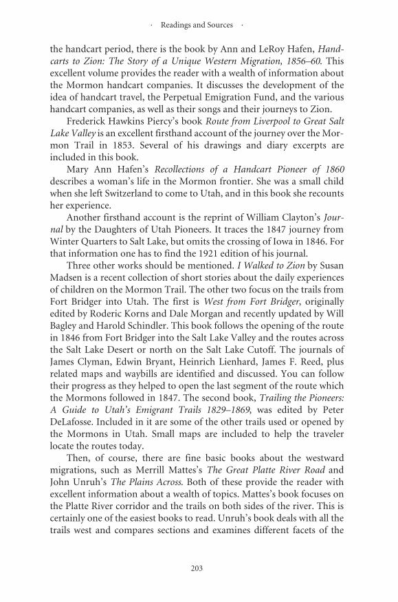
· Readings and Sources ·
203
the handcart period, there is the book by Ann and LeRoy Hafen, Hand-carts to Zion: The Story of a Unique Western Migration, 1856–60. Thisexcellent volume provides the reader with a wealth of information aboutthe Mormon handcart companies. It discusses the development of theidea of handcart travel, the Perpetual Emigration Fund, and the varioushandcart companies, as well as their songs and their journeys to Zion.
Frederick Hawkins Piercy’s book Route from Liverpool to Great SaltLake Valley is an excellent firsthand account of the journey over the Mor-mon Trail in 1853. Several of his drawings and diary excerpts areincluded in this book.
Mary Ann Hafen’s Recollections of a Handcart Pioneer of 1860describes a woman’s life in the Mormon frontier. She was a small childwhen she left Switzerland to come to Utah, and in this book she recountsher experience.
Another firsthand account is the reprint of William Clayton’s Jour-nal by the Daughters of Utah Pioneers. It traces the 1847 journey fromWinter Quarters to Salt Lake, but omits the crossing of Iowa in 1846. Forthat information one has to find the 1921 edition of his journal.
Three other works should be mentioned. I Walked to Zion by SusanMadsen is a recent collection of short stories about the daily experiencesof children on the Mormon Trail. The other two focus on the trails fromFort Bridger into Utah. The first is West from Fort Bridger, originallyedited by Roderic Korns and Dale Morgan and recently updated by WillBagley and Harold Schindler. This book follows the opening of the routein 1846 from Fort Bridger into the Salt Lake Valley and the routes acrossthe Salt Lake Desert or north on the Salt Lake Cutoff. The journals ofJames Clyman, Edwin Bryant, Heinrich Lienhard, James F. Reed, plusrelated maps and waybills are identified and discussed. You can followtheir progress as they helped to open the last segment of the route whichthe Mormons followed in 1847. The second book, Trailing the Pioneers:A Guide to Utah’s Emigrant Trails 1829–1869, was edited by PeterDeLafosse. Included in it are some of the other trails used or opened bythe Mormons in Utah. Small maps are included to help the travelerlocate the routes today.
Then, of course, there are fine basic books about the westwardmigrations, such as Merrill Mattes’s The Great Platte River Road andJohn Unruh’s The Plains Across. Both of these provide the reader withexcellent information about a wealth of topics. Mattes’s book focuses onthe Platte River corridor and the trails on both sides of the river. This iscertainly one of the easiest books to read. Unruh’s book deals with all thetrails west and compares sections and examines different facets of the

� ������������������������������������� �
���
����������������������������������������������������������������������������� ��� ��� ����� ��� ��������� ������������� ������ �������� ����� ������������������������������������������������������������������������������� ����� ���� ����� ��������� ����� ������ ���� ������������ ��� ���� ���������������
��������������������������������������������������������������������������������������������������������������������������������������������������������������������������������������������������������������������������������������������� ������������������ ������������������������������
���� ���������������� ����������� ��� ������������������������������������������������������������������������������������� �������������������������������������������������������������������������������������������������������������������������������������������������������� ������� ���� ��������� ������ �������� ������ ���� ��������� ������������������ �������� ������� ��������� ������ ��� ��� ���������� ����������������������������������������������������������������������������������� ������������ ��� ����������� ��� ��� ����� ��� ������������� ���� ��������������������������������������������������������������������������������������������������������������������������������������������������������������������������������������������������������������������������������������
�������������������������������������������������������������������������������� ��� ���� ������ ������� ����� ��� ����������� ����� ��� ������ ������������������������ ��������������������������������������������������������� �������� ���� ���������������� ���������� ������ ������ �������������������������������������������������������������������������������������������������������������������������������������������������������������������������������������������������������������
��������������������������������������������������������������

205
Bibliography
B O O K S A N D A R T I C L E S
Allen, James B., and Glen M. Leonard. The Story of the Latter-Day Saints.Salt Lake City: Deseret Book, 1992.
Arrington, Leonard J. Brigham Young: American Moses. New York:Alfred Knopf, 1985. Reprint, Urbana: University of Illinois Press,1986.
Arrington, Leonard J., and Davis Bitton. The Mormon Experience: A His-tory of the Latter-Day Saints. New York: Alfred Knopf, 1979.
Bagley, Will. “Lansford Warren Hastings, Scoundrel or Visionary?”Overland Journal 12.1 (1994): 12–26.
Berrett, LaMar. The Mormon Trail, Fort Bridger to Salt Lake Valley. SaltLake City: Deseret Books, forthcoming.
Berrett, LaMar, ed. The Mormon Experience: Vermont to Illinois, Vol. I;The Mormon Trail, Nauvoo to Salt Lake City, Vol. II. Salt Lake City:Deseret Books, forthcoming.
Bitton, Davis, ed. Guide to Mormon Diaries and Autobiographies. Provo:Brigham Young University Press, 1977.
Brodie, Fawn M. No Man Knows My History: The Life of Joseph Smith, theMormon Prophet. New York: Alfred Knopf, 1971.
Cannon, D. James, ed. Centennial Caravan, Story of the 1947 CentennialReenactment of the Original Mormon Trek. Salt Lake City: The Sonsof Utah Pioneers, 1948.
Carter, Kate B. The Story of the Negro Pioneer. Salt Lake City: Daughtersof Utah Pioneers, 1965.
Commager, Henry Steele, ed. The West: An Illustrated History. NewYork: Exeter Books, 1984.

� ������������������������������������� �
���
���������������������������������������������������������������������������������� ����������� ������� ����� ������ ����������� ������� ����� �����������������������������������������������������������
���������������������������������������������������������������������������������������������������������������������������������������������
���������������������������������������������������������������������������������������
������������������������������������������������������������������������������
�����
��������������������������������������������������������������������������� �������� ����������� ����������� ���������� �������� ������������������
�������� �������� ��������� ������ ������ ���� ������� ������� �������� ������������������������
�������������������������������������������������������������� ��������������������������������������������������������������
�����������������������������������������������������������������������������������������
����������������������������������������������������������������������������������������������
�������� ������ ���� ������� �������� �� ������ ��������� ����� ����� ��������������������������������
���������������������������������������������������������������������������������������������������������������������������������
�����������������������������������������������������������������������������������������������������
����������������������������������������������������������������������������������������������������������������������������������������
������������������������������������������������������������������������������������������������������������������������������������������
������������������������������������������������������������������������������ �������� ���� ���� ���� �������� ���� ����� ������������������������
���������������������������������������������������������������������������������������������
������������������������������������������������
Gowans, Fred R. Discovery and Exploration of the Great Fur Trade Road, 1739–1843. Salt Lake City, Utah: Utah Crossroads, Oregon-California Trail Association, 1994.
Gowans, Fred R., and Eugene Campbell. Fort Supply, Brigham Young’s Green River Experiment. Provo: Brigham Young University Publications, 1976.
· Readings and Sources ·
207
Launius, Roger D. Joseph Smith III, Pragmatic Phophet. Urbana: Univer-sity of Illinois Press, 1988.
Mattes, Merrill J. The Great Platte River Road: The Covered Wagon Main-line via Fort Kearny to Fort Laramie. Lincoln: Nebraska State Histori-cal Society, 1969.
Mattes, Merrill J. Platte River Road Narratives. Urbana: University of Illi-nois Press, 1988.
Paden, Irene D. The Wake of the Prairie Schooner. New York: Macmillan,1943.
Sonne, Conway B. Saints on the High Seas, A Maritime History of MormonMigration: 1830–1890. Salt Lake City: University of Utah Press, 1983.
Stegner, Wallace. The Gathering of Zion: The Story of the Mormon Trail.Salt Lake City: Westwater Press, 1981.
Stewart, George R. The California Trail: An Epic with Many Heroes. NewYork: McGraw-Hill, 1962.
Unruh, John. The Plains Across: The Overland Emigrants and the Trans-Mississippi West, 1840–60. Urbana: University of Illinois Press, 1979.
Worcester, Don, ed. Pioneer Trails West. Caldwell, Idaho: Caxton Print-ers, 1985.
G U I D E S , D I A R I E S , A N D R E M I N I S C E N C E S
Baker, Jean Rio. “By Windjammer and Prairie Schooner London to SaltLake City.” In Covered Wagon Women, Vol. 3. Edited by KennethHolmes. Glendale, Calif.: Arthur Clark, 1984.
Bruff, J. Goldsborough. Gold Rush: The Journals, Drawings, and OtherPapers of J. Goldsborough Bruff. Edited by Georgia Willis Read andRuth Gaines. New York: Columbia University Press, 1949.
Bryant, Edwin. What I Saw in California. New York: D. Appleton, 1848.Reprint, Minneapolis: Ross and Haines, 1967.
Buckingham, Harriet Talcott. “Crossing the Plains in 1851.” In CoveredWagon Women, Vol 3. Edited by Kenneth Holmes. Glendale, Calif.:Arthur Clark, 1984.
Child, Andrew. Overland Route to California. Milwaukee: Daily SentinelSteam Power Press, 1852.
Clark, Caroline Hopkins. “Liverpool to Utah in 1866 by Sailing Ship andPrairie Schooner.” In Covered Wagon Women, Vol. 9. Edited by Ken-neth Holmes. Spokane, Wash.: Arthur Clark, 1990.
Clayton, William. The Latter-Day Saints Emigrants’ Guide. St. Louis:Chambers and Knapp, 1848. Reprint, Gerald, Mo.: Patrice Press, 1983.
· The Mormon Trail, Yesterday and Today ·
208
Clayton, William. The Journal of William Clayton. Salt Lake City: Daugh-ters of Utah Pioneers, 1994.
Clayton, William. William Clayton’s Journal. Salt Lake City: DeseretNews, 1921.
Clyman, James. Journal of a Mountain Man. Edited by Linda M. Hassel-strom. Missoula: Mountain Press Publishing, 1984.
Cummings, Mariett Foster. “A Trip across the Continent.” In CoveredWagon Women, Vol. 4. Edited by Kenneth Holmes. Glendale, Calif.:Arthur Clark, 1985.
Frémont, John Charles. The Exploring Expedition to the Rocky Mountains.Washington, D.C.: Gales and Seaton, 1845. Reprint, Washington,D.C.: Smithsonian Institution Press, 1988.
Goodridge, Sohia Lois. “The Mormon Trail, 1850.” In Covered WagonWomen, Vol. 2. Edited by Kenneth Holmes. Glendale, Calif.: ArthurClark, 1983.
Hafen, Mary Ann. Recollections of a Handcart Pioneer of 1860: A Woman’sLife on the Mormon Frontier. Lincoln: University of Nebraska Press,1983.
Hastings, Lansford. The Emigrants’ Guide to Oregon and California. 1845.Reprint, Princeton: Princeton University Press, 1932.
Horn, Hosea. Horn’s Overland Guide. New York: J. H. Colton, 1853.King, Hannah Tapfield. “My Journal.” In Covered Wagon Women, Vol.
6. Edited by Kenneth Holmes. Glendale, Calif.: Arthur Clark, 1986.Korns, Roderic, and Dale Morgan, eds. West from Fort Bridger: The Pio-
neering of the Immigrant Trails across Utah, 1846–1850. Revised byWill Bagley and Harold Schindler. Logan: Utah State UniversityPress, 1994.
Lienhard, Heinrich. From St. Louis to Sutter’s Fort, 1846. Edited by Erwinand Elisabeth Gudde. Norman: University of Oklahoma Press, 1961.
Lightner, Mary Elizabeth. “Journal of a Mormon Woman, 1863.” InCovered Wagon Women, Vol. 8. Edited by Kenneth Holmes. Glen-dale, Calif.: Arthur Clark, 1989.
Little, James A. From Kirtland to Salt Lake City. Salt Lake City: James Lit-tle, 1890.
Madsen, Susan Arrington. I Walked to Zion: True Stories of Young Pio-neers on the Mormon Trail. Salt Lake City: Deseret Book Company,1994.
Mitchell, S. Augustus. A New Map of Texas, Oregon, and California.Reprint, Oakland: Biobooks, 1948.
Morgan, Dale. Overland in 1846. Georgetown, Calif.: Talisman Press,1963.
· Readings and Sources ·
209
Mousley, Sarah Maria. “Delaware to Utah, 1857.” In Covered WagonWomen, Vol. 7. Edited by Kenneth Holmes. Glendale, Calif.: ArthurClark, 1988.
Piercy, Frederick H. Route from Liverpool to Great Salt Lake Valley.Edited by Fawn M. Brodie. Cambridge: Belknap Press of HarvardUniversity Press, 1962.
Piercy, Frederick H. Route from Liverpool to Great Salt Lake Valley.Edited by James Linforth. Liverpool: Franklin D. Richards, 1855.
Pratt, Sarah. “The Daily Notes of Sarah Pratt.” In Covered WagonWomen, Vol. 4. Edited by Kenneth Holmes. Glendale, Calif.: ArthurClark, 1985.
Sessions, Patty Bartlett. Diary. LDS Church Archives. Salt Lake City.Sessions, Patty. “A Pioneer Mormon Diary.” In Covered Wagon Women,
Vol. 1. Edited by Kenneth Holmes. Glendale, Calif.: Arthur Clark,1983.
Shackleford, Ruth. “To California by the Mormon Trail, 1865.” In Cov-ered Wagon Women, Vol. 9. Edited by Kenneth Holmes. Spokane,Wash.: Arthur Clark, 1990.
Stansbury, Howard. An Expedition to the Valley of the Great Salt Lake ofUtah. Philadelphia: Lippincott, Grambo, 1852.
Wilkins, James F. An Artist on the Overland Trail: The 1849 Diary andSketches of James F. Wilkins. Edited by John F. McDermott. SanMarino, Calif.: Huntington Library, 1968.
B O O K L E T S A N D P A M P H L E T S
“Fort Bridger/Pioneer Trail Tour.” Utah Museum Volunteers Associa-tion. August 1, 1992.
“Fort Bridger.” Wyoming Recreation Department, State Archives andHistorical Department.
“Fort Caspar Museum.” Casper, Wy.“Fort Kearny.” Nebraska State Historical Society. Ed. Leaflet No. 7.“Fort Laramie.” Washington, D.C.: National Park Service.“Historic Nauvoo, Illinois.” Nauvoo Tourism and Western Illinois Tour-
ism Council.“Landmarks and Events along the Historic Mormon Trail.” Daughters of
Utah Pioneers.“Mormon Pioneer National Historic Trail.” U.S. Department of the
Interior, National Park Service, 1994.“Nauvoo City Beautiful.” Reorganized Church of Jesus Christ of Latter
Day Saints.
· The Mormon Trail, Yesterday and Today ·
210
“Nauvoo, the Beautiful and Historic Carthage Block.” The Church ofJesus Christ of Latter-day Saints.
“Oregon Trail: Oregon National Historic Trail.” U.S. Department of theInterior, 1993.
“Scotts Bluff.” Washington, D.C.: National Park Service.“Winter Quarters Historical Site and Mormon Pioneer Cemetery.” The
Church of Jesus Christ of Latter-day Saints.

211
Index
Adventures of Captain Bonneville in the Rocky Mountains and the Far West, 20
Ancient Bluff Ruins (see also Bluff Ruins), 64, 73, 191
Argonauts, 27Ash Creek, 58Ash Hollow, 56–61, 73, 118, 120–22, 191Ashley, William Henry, 18, 147Astor, John Jacob, 18Astorians, 18Ayers Natural Bridge, 133, 193
Barlow, Samuel, 2Battle of Crooked River, 21Bear River, 19, 35, 39, 51, 161Bear River Valley, 35, 51Beauvais Trading Post, 190Beehive House, 197Benson, Ezra T., 8, 65, 67Bessemer Bend, 194Bible, 4, 19Bidwell-Bartleson Party, 22Big Mountain Pass, 173Big Sandy, xv, 152Bill of Particulars, 52, 53Billings, George, 65Black Hills, 51Black’s Fork, 23, 52, 147, 155Bluff Ruins, 64, 65, 73, 121, 191Boggs, Governor Lilburn W., 21Bonneville, Captain Benjamin L.E., 20, 23Book of Mormon, 4, 16, 19Bozeman Trail, xvii
Brannan, Samuel, 39Bridger Butte, 158Bridger, Jim, xvii, 13, 14, 18, 19, 22, 23,
26, 29, 30, 34, 38, 39, 43, 50, 51, 85, 147, 152, 157–60, 163, 189, 194, 196, 202, 203
Broad Hollow, 172Brown, John, 58, 59, 66, 70Bruff, J. Goldsborough, 7, 57, 77, 133,
136, 138, 140, 141, 144, 146, 150Bryant, Edwin, 38, 203Buckingham, Hariett, 121Buffalo, 19, 50, 67, 69, 73, 74, 79, 113,
116, 120, 121, 124, 143Buffalo chips, 113Bullock, Thomas, 39, 45, 56, 58Bureau of Land Management, xviiiBurlington Railroad, 84
Cache Cave, 162, 182California Hill, 190California National Historic Trail, xv, xviiCalifornia Trail, xv, xvi, 2, 3, 17, 23Calm Creek, 73Campbell, Robert, 20Camp Floyd, 30Canfield, Lucy, 123Carthage, 23, 95, 96, 186Carthage Jail, 23, 95, 96, 186Casper, xvii, 13, 78, 193, 194Castle Bluffs, 60Castle Creek, 60Cathedral Rock (see Church Butte), 196
· The Mormon Trail, Yesterday and Today ·
212
Cedar Bluffs, 60Central Pacific, 10, 32Chimney Rock, 50, 51, 62, 64, 68–73, 122,
123, 191Church Butte, 155, 156, 158, 196Church of Jesus Christ of Latter-day
Saints, xviii, 8, 16, 87, 189, 197Christensen, Carl C. A., 71, 77, 78City of Rocks, 27Clark, William, 17Clayton, William, xix, xx, 25, 38, 48, 52,
56–58, 62, 78, 121, 129, 132, 141, 162, 165, 175, 186, 201
Clyman, James, 18, 19, 203Coalville, 177Cobble Hills, 63“Come, Come Ye Saints”, xxCommerce, 5, 21Compromise of 1850, 28Conestoga wagon, 11Conyers, Enoch, 2Coralville, 99, 187Council Bluffs, xvi, xvii, 8, 13, 21, 23, 25,
35, 49, 52, 56, 78, 101–3, 109, 111–13, 115, 117, 186, 187
Council Bluffs Road, xviCourthouse and Jail Rock, 191Crab Creek, 61, 73Cumming, Alfred, 30Cutler’s Park, 106, 188
Davenport (Devenport), James, 65Dawson County Museum, 189Deer Creek, 13Denver, 79Deseret, 28, 197DeSmet, Father Pierre, 19, 21, 22, 138,
194Devil’s Gate, 29, 140, 142, 143, 194, 195Diamond Springs Pony Express Station,
190Dixie Hollow, 172Doctrine and Covenants, 4Dodge, Grenville M., 79Dome Rock, 125Donner, George, 38, 173, 174Donner-Reed Party, xvii, 14, 157, 175Down and back, 10, 12, 30, 32, 82
Echo Canyon, xvii, 43, 163–66, 168, 169, 171, 178, 196
Emigrants’ Guide to Oregon and Califor-nia, 23, 51
Emigration Canyon, 4, 14, 26, 28, 174–76, 196
Exodus, xix, 6, 7, 9, 13, 21, 23, 26, 48, 76, 80, 88, 89, 93, 98, 169, 186, 187, 202
Exploring Expedition to the Rocky Moun-tains, 50
Extermination order, 20, 21
Fairbanks, Nathaniel, 65Family History Library, 197Farr, Aaron, 65Far West, 7, 20, 21Fayette, 13, 29, 103, 112, 187, 195Ferries, 13, 29, 103, 112, 187, 195Ferris, Benjamin, 26Fitzpatrick, Thomas, 18, 22Florence, 25, 30, 105, 108, 109, 188Fort Bridger, xvii, 13, 14, 22, 23, 26, 29,
30, 34, 38, 39, 43, 51, 85, 147, 157–60, 194, 196, 202, 203
Fort Des Moines, 100, 187Fort Hall, 11, 38, 157Fort John, 22, 127, 192Fort Kearny, 190Fort Laramie, xvii, 20, 22, 38, 56, 78, 127–
29, 192, 193, 202Fort Leavenworth, 25, 49, 110, 117, 188,
190Fort Supply, 13, 29, 30, 160, 196Fort William, 20, 22, 192Frémont, John Charles , 22, 36–37, 38–42,
49–51, 60, 130
Garden Grove, 13, 25, 98, 100, 186Gentiles, 2, 23, 27, 30, 35, 194Gila Route, 188Golden Pass Road, 28, 177Golden Plates, 16Golden Spike, 10Gold Rush, 6, 27Goodridge, Sohia, 136Grand Encampment, 187Grand Island, 38, 50, 119, 189Great Basin, xvi, 2, 17, 26, 28, 35, 39, 197

� ����� �
���
���������������������������������������������������������������������������������������������������������������������������������������������������������������������������������������������������
�������������������������������������������������������
��������������������������������������������������������������
������������������������������������������������������������
���������������������������������
��������������������������������������������������
���������������������������������������������������������������������������������������������������������������
�����������������������������������������������������������������������������������������������������������������������������������������������������������������������������������������������������������������������������������������������
�����������������������������������������������������������
��������������������������������������������������������������������
�������������������������������������������������������������������������������������������������������������
��������������������������������������������������������������������������������������������������������������������������������������������������
��������������������������������������������������������������������������������
�������������������������������������������������������������������������������������������
���������������������������������������������������������������������������������������������������������������������������������������������������������������������������������������������������������������������������������������������������������������������������
����������
������������������������������������������������������������
��������������������������������������������������������������������������������������������������������������������������������������
�����������������������������������������
���������������������������������������������������������������������������
�������������������������������������������������������������������������������������������
�����������������������������������������������������������������������������������������������������������������������������������������������������������������������������������������������������������������������������������������������������������������������������������������������
��������������������������������������������������������������������������������
�������������������������������������������������������

� ������������������������������������� �
���
�������������������������������������������������������������������������������������������������������������������������������������������������������������������������������������������������������������������������������������������������������������������������������������
����������������������������������������������������������������������������������������������������������
���������������������������������������������������������������������������������������������������������������������������������������������������������������������������������������������������������������������������������������������������������������������������������������������������������������������������������������������������������
�������������������������������������������
���������������������������������������������������������������������������������
�����������������������������������������������������������������������������������������������������������������������������������������������������������������
�������������������������������������������������������������������������
����������������������������������������������������������������
��������������������������������
��������������������������������������������������������������������������������������������
�����������������������������������������������������������
����������������������������������������������������������������������������������������������������������������������������������������������������
��������������������������������������������������������������������������������������������������
��������������������������������������������������������������������������������������������
������������������������������
����������������������������������������������������������������������������������������������������������������������������������������������
����������������������������������������������������������������������������������������������������
�������������������������������������������������������������������������������������������������������������
����������������������������������������������
��������������������������������������������������������������������������������������������������������
����������������������������������������������������������������
������������������������������������������������������������������������������������������������������������������������������������������������������������������������������������������������������������������������������������
Parley’s Canyon, 28, 168, 173, 174, 178
· Index ·
215
Promised Land, 6, 38, 49Promontory Point (Summit), 10, 32Prospect Hill, 137
Quesenbury, William, 133, 136, 137Quorum of Twelve, 4, 23, 76, 169
Rattlesnakes, 65Raw Hide Creek, 74Reed, James, 14, 38Reed, Margaret, 14Redding (or Redden), Jackson, 65Reddin’s (Redden) Cave, 162Red Buttes, 194Red River Valley, 11Register Cliff, 129, 130, 193Reorganized Church of Jesus Christ of
Latter Day Saints (RLDS), xviii, 20, 87, 89, 185, 189
Richards, Dr., 64Roadometer, 48, 58, 84Robidoux Pass, 192Rocky Ridge, 13, 145Rock Creek Station, 117Rockwell, Porter, 61, 68–70Rookery, 188Route from Liverpool to Great Salt Lake
Valley, 72, 77, 119, 203
Saints, xv, xviii, xx, xxi, 4, 8, 16, 20, 25–27, 29, 48, 56, 68, 87, 89, 185, 186, 189, 197, 201, 204
Salt Lake City, xvi–xix, 6, 7, 10, 12, 13, 26–30, 32, 72, 77, 78, 82, 84, 164, 165, 168, 169, 178–80, 196, 197, 202
Salt Lake Desert, 4, 23, 51, 203Santa Fe, xv, xvi, xviii, 1–4, 6, 11, 17, 19,
25, 188, 189Santa Fe National Historic Trail, xvSanta Fe Trail, 1–3, 6, 11, 19, 25, 188Savage, Charles, 31, 126Scott, Hiram, 19Scotts Bluff, 19, 39, 50, 56, 57, 84, 85, 103,
116, 122, 125, 128, 143, 152, 154, 166, 174, 178, 192
Scotts Bluff National Monument, 85, 103, 116, 143, 152, 154, 166, 174, 178, 192
Sessions, Patty, 57, 86, 116Sioux, 86
Sharon, 18Sheep Rock, 22Shepard, George, 173Sherwood, Elder, 68Shoshone, 86Sierra Nevada, 26Simons, George, 77, 79, 101, 109Smith, Charles, 39Smith, Hyrum, 16, 21, 92, 95, 96, 186Smith, Jedediah, 18, 19Smith, Joseph, 4, 5, 8, 16, 18–21, 23, 35,
38, 48, 49, 76, 79, 87, 90, 92, 186, 197Soda Springs, 22Solomon’s Temple, 196South Pass, xvii, 18, 19, 22, 23, 29, 39, 50,
86, 116, 146–48, 150, 194, 195South Platte River, 190Spencer, 71Split Rock, 143, 144, 194, 195Spring Creek, 74Stake, 8, 12Stewart, Sir William Drummond, 20Stuart, Robert, 18Sublette, William, 19, 20Stuhr Museum of the Prairie Pioneer,
115, 189Sugar Creek, 23Sun Ranch, 141Sweetwater River, xvii, 136, 194
Tabernacle, 13, 32, 179, 187, 197Table Rocks, 146Taylor, John, 95, 96Temple, 5, 20, 21, 27, 28, 88, 89, 91, 92,
94, 179, 180, 186, 189, 196, 197Temple Square, 27, 197This Is the Place, xviiiTracy, Albert, 77, 159, 171Twin Buttes, 146
Union Pacific, 10, 32, 78, 163, 190Utah Statehood Centennial Commission,
xviiiUtah War, 29, 30
Vanguard Party, 14, 26, 48, 114, 134, 182
Wagons, 8, 9, 11, 12, 21, 22, 25, 27, 30, 43, 59, 60, 62, 63, 65, 67, 69, 70, 73, 82, 83,
· The Mormon Trail, Yesterday and Today ·
216
85, 93, 97, 104, 105, 112, 114, 129, 130, 132, 142, 145, 163, 175–78, 191–93
Walker, Joseph Reddeford, 18, 20Wards, 12Wasatch Mountains, xvii, 14, 23, 26, 43,
51, 168Wayne County Historical Museum, 186Way Stations, 13, 98Weather, 29, 50, 67, 72, 195Weber Canyon, 31, 168Western Heritage Museum, 101, 188Weston, 49Westport, xvi, 29, 39, 49, 190Whitman, Marcus & Narcissa, 11Whitney, Orson, 64Willamette Valley, 2Willie Handcart Company, 12, 29Wilkes, Charles, 23Wind River Mountains, 152Winter Quarters, xvi, xvii, 4, 7, 8, 13, 22,
25, 26, 30, 38, 48, 49, 52, 56, 58, 60, 63, 66, 71, 72, 76, 80, 86, 102, 104–9, 116, 187,188,202,203
Whitney, Horace, 64Witches Rocks, 170, 172Wolves, 59, 60, 69Wood River, 13, 119Woodruff, Wilford, 8Word and Will of the Lord, 8Wyoming, xvi, xvii, 12, 13, 25, 28, 30–32,
56, 129, 192–96, 202Wyoming Pioneer Memorial Museum,
193
Yellowstone, 79Young, Brigham, 4, 6–10, 12, 16, 18, 22,
23, 25, 26, 28–30, 35, 38, 39, 50, 58, 60, 61, 64–67, 70, 77, 93, 96, 107, 108, 126, 134, 157, 159, 161, 176, 191, 193, 195, 196, 204
Young, Lorenzo, 61
Zion, xix, xxi, 4–6, 8, 11, 17, 20, 21, 25, 35, 72, 77, 78, 202, 203
Zion’s Camp, 76