
VILLAGE OF LAKEWOOD, NY - Comprehensive Plan
163
Village of lakewood, NY Comprehensive Plan January 2017
-
Upload
khangminh22 -
Category
Documents
-
view
1 -
download
0
Transcript of VILLAGE OF LAKEWOOD, NY - Comprehensive Plan

Village of lakewood, NY
Comprehensive Plan
January2017


Village of Lakewood Comprehensive Plan
Acknowledgements
Village BoardCara Birrittieri, Mayor
Trustees David J. DiSalvo, Deputy Mayor
Ellen E. Barnes Susan F. Drago
Randall G. Holcomb
David T. Wordelmann, former Mayor
Steering CommitteeEdward J. McCague, chair
Craig Seger, Vice Chair William F. Chandler
David J. DiSalvoJohn Jablonski IIIJoseph M. Johnson
Richard RoseKaie Smith
Jared Yaggie
Photos by Kaie Smith and peter j. smith & company, inc. except where noted
Adopted January 9, 2017
Prepared by: peter j. smith & company, inc.

Ex
ec
ut
ive
Su
mm
ar
yFor the 124 years since its incorporation, the Village of
Lakewood has surveyed the world from a vaunted position near
the toe of Chautauqua Lake. It serves as a gateway community
for the Chautauqua Institution to its northwest and sits just
to the west of Jamestown. As the name suggests, Lakewood
is firmly a waterfront community, having given and received
sustenance from the lake, its fortunes ebbing and flowing with
those of the lake.
Lakewood – the name is apparently a mash up of Beachwood,
an early neighboring settlement, and Lakeview, as it was
originally known – has had a far grander and more diverse
history than its quiet lakeside lanes and spectacular hillside
vistas would suggest. An agricultural enclave at first, the beauty
of its waters and serenity of its lakeside location soon attracted
well-to-do cottagers and hotels sprang up to serve those who
wanted to “take the waters,” rub shoulders with the swells and
get away from the hubbub of the city. The village boasts an
important legacy of the generosity of one family, the Packards
of the famous automobile manufacturing family, and while
some landmarks remain standing, many of the mansions and
all the hotels that put Lakewood on the map are now gone,
victims of fire and changing times.
Becoming a 21st Century Community
Too many people aren’t familiar with Lakewood’s best assets.
Although it’s true that the busy Fairmount Avenue shopping
district bisects the community into north and south, Fairmount
is not really the essence of Lakewood. And the wildly popular
Southern Tier Brewery has a Lakewood address, but it’s really
located in the Town of Busti (although Lakewood does take
pride in the brewery and its success).
To see it today, Lakewood gives the impression of a charming
lakeside village with a wonderful compact downtown, parks,
beautiful homes and narrow streets that always seem to be busy
with walkers and bicyclists. It is building mementum through
citizen involvement and this plan to bring the best of its past
to bear upon its future. It seeks to become a force, a village
partnering and leading in its region to become a 21st Century
Community.
To realize its dreams and aspirations, Lakewood has once
again become a planning community rediscovering the
importance of asking the questions: Where are we; where
do we want to go; and how shall we get there? When it first
executed its master plans for the future, back in the 1960s and
1970s, there seemed to be a good deal more to be enthused
about – growth and prosperity were in the air, the population
to double by 1985, the community to become an important
regional warehousing and industrial hub.
Changing Times
Much has changed since those heady times. The bottom has
fallen out of the population projections and the community’s
1985 population was roughly the same as it was in 1960 which
is 1,000 more than it is today. Like communities everywhere,
Lakewood wishes it could provide value added services for
its taxpayers, some of whom have voted with their feet to
“greenfields” in areas with lower taxes. Costs escalate and
maintenance suffers for once-proud housing stock.
But the Lakewood of today has the same indomitable spirit
that 26 women of the community exhibited in 1960 when they
gathered in an Ivy Lane home and resolved to begin a library
association. They not only did so in record time, receiving
their provisional charter in five short months allowing them
to establish the Lakewood Memorial Library, they have grown
from borrowed space in the post office to an institution busting
at the seams of its own building, boasting 80,000 books and
providing active programming for Lakewood residents of all
i

ages from computer access and instruction to book clubs; from
art shows to discussion groups.
This comprehensive plan is the community’s roadmap for its
future. It was inspired by a new-found sense of energy that
threatened to lose focus after enthusiastic idea after idea
overwhelmed the ability of government, Lakewood’s community
funding sources and the ability of community volunteer reserves
to keep up, prioritize and plan.
“Step back!” leaders said. “Let us ask the important questions
first!”
And so they have.
The Future of the Land
Perhaps the most important “product” of the comprehensive plan
is the Future Land Use Plan. The Future Land Use Plan forms the
basis for the community’s future zoning. Because the Future Land
Use Plan, as a technical resource, is quite general, a “Futures
Concept” was prepared that shows how the Future Land Use
Plan, Vision, Goals and Objectives and policies all work together
to draw a picture of the village’s preferred future. It shows feature
The Futures Plan outlines a series of exciting developments for Lakewood based upon the public’s wishes for a bright and sustainable future.
ii

development areas, potential new parks, a revitalized
Chautauqua Mall area, gateways and connections to the
lake from all over the community through a network of
trails, green and complete streets, environmental areas
and other features.
Supporting the Future Land Use Plan and Futures Plan are
a vision of the community crafted by the community for its
own future through the nearly year-long comprehensive
panning process. That process is summarized below.
The Vision and Goals
A vision for Lakewood’s future was crafted that
highlights the following concepts of Lakewood
as:
• The most significant visitor destination on the shores of Chautauqua Lake developing a brand that identifies the Lakewood as a waterfront village with a multi-use Fairmount Avenue environment.
• A model in sustainability, economically, environmentally and socially.
• A gateway community for the City of Jamestown and Chautauqua Institution.
Following the vision are a series of 19 goals that
cover each of the elements of the inventory and
outline the measureable aspects of the plan.
These goals cover all facets of the community’s
future, sketching out how the vision will be
implemented in an implementation matrix that
contains 88 separate measures and includes
priority, timing, key partners, costs and funding
sources. This is the checklist for implementation
of the plan.
Policies
Guiding the hands of the community’s leaders, investors
and residents as they consider the impacts of development
proposals that will come to them are the policies of the
plan. Like the goals, the policies cover every inventory
element of the plan. The policies are there to help the
community determine if proposals that come before it
are consistent with the vision, goals and objectives. And
The Action Plan and Implementation Strategy is a checklist for accomplishing the goals and objectives of the plan in an 88-item, step-by -step matrix.
iii

if they are, these proposals should move forward. If they
are not, the proposal should go back to the developer for
modification.
A close look
The comprehensive plan process was led by an appointed
steering committee of representative members of the
community including elected officials, business leaders,
activists and a high school student with a serious
interest in civics and the future of his community. The
process commenced with an inventory of Lakewood, an
assessment of all aspects of the community, beginning
with a regional assessment and literature review and
progressing to land use and zoning, roads and parks,
population and housing, the economy, community
facilities, amenities, services and so on. This phase of the
planning process also involved looking at the community’s
neighborhoods, or character areas, defining what about
each makes up the whole that is Lakewood. These
activities set the stage for mapping a path to a preferred
future for the community.
The community weighs in
Throughout the comprehensive planning process, a
public input program was implemented to gather the
opinions, wants and needs from residents. In addition to
steering committee meetings, there were focus groups,
two public meetings, including an interactive mapping
session that brought out markers and asked participants
to show where the potentials of the community exist. There
Communitiy members came together to map their visions of Lakewood’s potential, their dreams and wishes for the community during a public Visioning Workshop.
was also an exhaustive public survey that was ultimately
completed by more than 400 people. During the public
meetings, residents had the opportunity to review progress
on the plan, from the vision, goals and objectives to the
recommendations of the plan. The public input program is
summarized in the Appendix.
iv

Village of Lakewood Comprehensive PlanI Introduction to the Plan ...................................................... 1
1.0 Planning for the Future 3
2.0 Introduction to the Inventory 7
II. Community Assessment .................................................... 9
A. Community Trends .......................................................... 10
3.0 Lakewood in Context 11
4.0 Community character & Design 17
5.0 Existing Land Use & Zoning 25
6.0 Population & Housing 33
7.0 Economic Vitality 47
B. Community Characteristics .............................................. 56
8.0 Environment 57
9.0 Infrastructure & Utilities 61
10.0 Transportation Network 65
C. Community Amenities ..................................................... 70
11.0 Historic & Cultural Resources 71
12.0 Parks & Recreation 77
13.0 Community Facilities & Services 85
III. A 21st Century Community ............................................. 91
14.0 Lakewood: A 21st Century Community 93
15.0 Action Plan & Implementation Strategy 105
IV. Appendix: The Public’s Say ......................................... 121
16.0 Policies 123
17.0 Public Input Program 135Co
nt
en
ts
of
th
e P
la
n

Table 5.1 Current Land Use .......................................................... 25
Table 5.2 Current Zoning ............................................................. 29
Table 6.1 Population Change 1950-2013 ..................................... 33
Table 6.2 Population Projections ................................................... 34
Table 6.3 Residential Mobility – 2013 ............................................ 35
Table 6.4 Housing Tenure – 2013 ................................................ 36
Table 6.5 Vacancy Status – 2013 .................................................. 37
Table 6.6 Housing Type – 2013 .................................................... 38
Table 6.7 – Age of Housing .......................................................... 39
Table 6.8 Household Annual Income – 2013 ................................. 40
Table 6.9 Value of Owner Occupied Housing – 2013 .................... 41
Table 6.10 Monthly Cost of Owner-Occupied Housing ................... 41
Table 6.11 Monthly Cost of Renter-Occupied Housing .................... 42
Table 6.12 Monthly Rent – 2013 .................................................. 43
Table 6.13 Educational Attainment – 2013 .................................... 44
Table 7.1 Selected Tax Rates ......................................................... 47
Table 7.2 Labor Force – 2013 ...................................................... 48
Table 7.3 Industries of Employment – 2013 .................................. 49
Ta
bl
es
Village of Lakewood Comprehensive Plan
Table 7.4 Occupations – 2013 ..................................................... 50
Table 7.5 Retail Supply and Demand ............................................. 52
Table 11.1 Location of “Year Built” Plaques in the Village ................ 73
Table 15.1 Implementation Matrix ................................................ 107
Table 17.1 Workshop Individual Input ........................................ 138
Table 17.2 Workshop Individual Input (continued) ....................... 139
Table 17.3 Distribution of Survey Respondents .............................. 142
Table 17.4 Satisfaction with Government Services ......................... 143
Table 17.5 Knowledge and Perception of Government Services ..... 143
Table 17.6 Satisfaction with Community Services .......................... 144
Table 17.7 Satisfaction with Infrastructure Services ....................... 144
Table 17.8 Quality of Development ............................................. 145
Table 17.9 Land Use .................................................................. 146
Table 17.10 Traffic and Transportation ......................................... 147
Table 17.11 Environment ........................................................... 148
Table 17.12 Arts and Culture ...................................................... 149
Table 17.13 Historic Assets ......................................................... 149
Table 17.14 Economic Community Revitalization .......................... 150

Comprehensive PlanVillage of Lakewood
Figure 3.1 Regional Setting ............................................................. 11
Figure 4.1 Character Areas ............................................................ 18
Figure 5.1 Current Land Use ........................................................... 26
Figure 5.2 Current Zoning .............................................................. 28
Figure 8.1 Environment ................................................................... 60
Figure 10.1 Transportation .............................................................. 64
Figure 10.2 Existing and Proposed Greenways .................................. 68
Figure 11.1 Plaques ....................................................................... 72
Figure 11.2 Historic Resources ........................................................ 74
Figure 12.3 Parks .......................................................................... 76
Figure 13.1 Community Services ..................................................... 86
Figure 14.1 Futures Concept .......................................................... 94
Figure 14.2 Futures Plan ................................................................ 95
Figure 14.3 Future Land Use Plan ................................................... 98
Figure 17.1 Public Input Synthesis Map .......................................... 140
Figure 17.2 Survey Respondents .................................................... 142
Fig
ur
es
Village of Lakewood Comprehensive Plan

1
Comprehensive Planpeter j. smith & company, inc.
I.
Introduction
to the Plan

Village of Lakewood2
Comprehensive Plan
3
Comprehensive Planpeter j. smith & company, inc.
1.0 Planning for the Future 1.1. Introduction
The purpose of this new Comprehensive Plan for
the Village of Lakewood is to establish a vision and
implementation strategy to achieve the village’s aspirations
for its future. Lakewood has evolved into an engaged and
energized community of passionate stakeholders. They
see how the village’s unique character is precious and
valued by all its residents and they also understand the role
the community can have in a robust region on a healthy
Chautauqua Lake. The community has been coming
together over a series of issues such as environmental and
social sustainability, economic and community diversity
and now sees it must set a course before raising the sail.
To extend the metaphor, the comprehensive plan is the
vessel that will help carry the village to its preferred future.
It has been more than 40 years since the village
formulated its first comprehensive plan. Since then many
changes have taken place. These include the role of the
community in its region and structural changes to the
economy. The comprehensive planning process provides
an opportunity to develop an inventory or current snapshot
of the Village of Lakewood in the context of the historical
development of the community. Throughout the process,
a public consultation program has provided community
members and stakeholders platforms for expressing their
hopes and dreams for the community. The inventory and
public input are both used to help craft a vision of a
preferred future. They have formed the basis for the goals
and objectives that have been developed to guide the
coordinated and orderly future development of the village.
The Comprehensive Plan plays many roles in the
community. Its purpose is to:
•Document local characteristics and trends regarding resident population composition, land use, the natural environment, economic development and service provision;
•Provide a benchmark for evaluating the compatibility of individual development proposals with the long range development objectives of the community;
•Reveal future service needs and explore the potential for regional cooperation, including land acquisition and public improvements;
•Serve as a comprehensive source of current information that can be used by the village as well as its philanthropic, social and fraternal organizations in their efforts to secure grant funding and in marketing the area to potential developers;
•Provide leverage for obtaining state and federal funding;
•Promote open space conservation designed to preserve the heritage of the community and enhance the overall quality of life;
•Identify projects and programs to revitalize the community’s economy and attract investors; and
•Lay the foundation for future cooperative efforts between the Village of Lakewood, Town of Busti and all Chautauqua Lake communities.

Village of Lakewood4
Comprehensive Plan
1.2. Implementing the Plan
The adoption of the Comprehensive Plan is a commitment
to a coordinated vision for the future. The Plan’s success
is measured through its use by elected officials, municipal
employees and residents.
•Elected officials will use the plan to learn about their residents’ vision of the community's future and adopt local codes and ordinances to support those goals. The plan provides both background information and leverage as elected officials negotiate inter-governmental agreements or dedicate financial and administrative support for identified Plan objectives.
•Zoning and planning boards will measure the desirability of development applications by their conformity with plan goals and objectives. In addition, they should adopt policies and procedures that actively assist those projects that comply with plan’s goals and objectives to discourage those projects that fail to honor the community's vision. Working with developers, the community will target projects that implement the vision and reduce the need for excessive variances, development delays and poor development patterns.
•The plan will empower municipal employees to make administrative decisions within the framework of the vision and goals and objectives. It will help them prioritize their work efforts and promote their buy-in to implementing a plan that promotes their autonomy.
•Finally, local residents will use the plan as a reference when making residential location choices, evaluating the effectiveness of local government, lobbying for
financial or legislative support and when choosing political representatives. They will use the policy to help guide the Village and enhance its quality of life through projects and programs that they can develop and implement and for which they can seek funding and technical assistance. The Comprehensive Plan clearly states the vision for the Village of Lakewood and truly sets a course for the future vitality of the village, the lake and its region.
1.3. Creating the Plan
The Plan represents the collaborative effort of village staff
and officials, the Comprehensive Plan Steering Committee,
myriad community volunteers and residents. The Plan is a
collection of inventory and policies prepared to guide the
village over the next 10 to 20 years. This section outlines
the tasks completed in preparation of the Comprehensive
Plan.
1.3.1 Steering Committee Meetings
A Steering Committee representing a diverse cross
section of the community was appointed by the Village
Board to oversee and supervise the plan process. The
Committee consisted of elected and appointed Village
officials and citizens. The Committee met periodically
with the consultant to discuss and direct the preparation
of the plan, reviewed documentation and mapping,
provided contacts and helped determine representatives to
participate in a series of focus group sessions.

5
Comprehensive Planpeter j. smith & company, inc.
The steering committee’s first meeting included a Vision
Session. The session, a facilitated conversation around a
series of prepared questions, helped to set the stage for the
plan and the process. The session helped the consultant
understand the steering committee members’ ideas about
the potentials and opportunities the comprehensive plan
represents for the community.
1.3.2 Inventory
A data collection process was completed for the Plan. The
information contained in the Plan was supplemented by
data from various governmental and private agencies, to
help ensure the accuracy of the document. With the help
of the village clerk’s office, information was obtained
regarding local laws and ordinances, land use, the
environment, population, community services, housing,
municipal services and economic development. The
inventory represents a “snapshot” in time.
1.3.3 Focus Group Sessions
Two focus group sessions were held in May 2015.
Participants were invited to the sessions because of their
extensive insights about and experiences with a wide-range
of pertinent community issues including village operations,
recreation, public safety, Chautauqua Lake issues,
education, transportation, Lakewood history and culture,
economy and so on.
1.3.4 Public Meetings
Interactive public meetings were conducted in June and
September 2015. The public was invited to hear about
the plan and provide comments. These sessions helped
provide the consultant and elected officials with valuable
feedback on the plan and future of the village.
1.3.5 Community Survey
A survey was posted online to gather the opinions of
residents on a variety of topics, including community
design, land use, transportation, environment, housing
and community services. More than 400 responses to
the survey were received. The survey helps to inform
the recommendations of the plan and to gauge citizen
sentiment about a wide variety of issues.
1.3.6 Implementation
Goals, objectives and policies were developed to help
guide decisions over the next 20 years. The goals, and
objectives are based upon the public input, including the
results of the community survey, focus groups, steering
committee and other community input.

Village of Lakewood6
Comprehensive Plan

7
Comprehensive Planpeter j. smith & company, inc.
2.0 Introduction to the Inventory
1. Legislative Summary & Conclusion and intent. The
legislature hereby finds and determines that:
d. The great diversity of resources and conditions that
exist within and among the villages of the state
compels the consideration of such diversity in the
development of each village comprehensive plan.
3. Content of a village comprehensive plan. The village
comprehensive plan may include the following topics at
the level of detail adopted to the special requirements
of the village:
o. Any items which are consistent with the orderly
growth and development of the village.
The inventory serves as a compendium document of
relevant facts, statistics and conditions of the Village of
Lakewood, which is used to set the context for the vision
of the comprehensive plan. It has taken into account
previous studies, plans and reports that the Village and
surrounding communities have commissioned.
2.3. Organization
The inventory is organized into sections each assessing
specific current and specific conditions in the Village:
•Regional context
•Character areas
2.1. Understanding
The comprehensive plan is constructed in part on the
foundation laid by an understanding of the general
conditions in the community at the time of the planning
process. This understanding is informed by the inventory
of the community. The inventory, a snapshot in time,
sets the context of the historical and recent development
of the village. This information – along with the public
input program – helps the community craft a vision
of a preferred future. The inventory documents local
characteristics and trends regarding resident population
composition, land use, the natural environment, economic
development, historic context and service provision. It also
serves as a comprehensive source of current information
that can be used to secure state and federal funding and
provide a foundation for public-private partnerships.
2.2. Legislative Intent
In accordance with New York State Village Law, Section
7-722, Village Comprehensive Plan, the Village of
Lakewood’s comprehensive plan considers the existing
inventory of conditions. Specifically, section 7-722,
defines the following as necessary to developing a
comprehensive plan

Village of Lakewood8
Comprehensive Plan
•Existing land use & zoning
•Population & housing
•Economic vitality
•Environment & open space
•Transportation network
Lakewood’s historic village center on Chautauqua Avenue is a defining feature of the village.
•Infrastructure & utilities
•Historic & cultural resources
•Parks & recreation
•Community facilities & services

9
Comprehensive Planpeter j. smith & company, inc.
II.
Community
Assessment

Village of Lakewood10
Comprehensive Plan
A.
Co
mm
un
ity
Tr
en
ds
This section of the Comprehensive Plan includes the first five
elements of inventory.
They are:
•Lakewood in context
•Character areas
•Existing land use & zoning
•Population & housing
•Economic vitality
These basic categories offer a snapshot of the Village
and the trends that impact the total population.

11
Comprehensive Planpeter j. smith & company, inc.
3.0 Lakewood in Context3.1. Overview
A community is defined not only by its own unique
characteristics, but also by its place within the surrounding
region. The regional context of a place can identify the
purpose for its original establishment, its evolutionary
role and its ongoing importance. It is vital to recognize
the impacts of the region upon the Village, as well as
the function that the Village serves for the region. A
comprehensive plan must take into account the planning
that has already occurred in adjacent communities,
understanding the direction of the region as a whole and
consider ways in which they can work together to achieve
common goals.
In preparing a plan, it is integral that each element is
viewed in context with the vision, goals and elements
identified for adjacent and nearby regional communities.
It also presents the Village of Lakewood in the geographic
context of its region encompassing Chautauqua County,
the Chautauqua Lake Communities and as a suburb of
Jamestown.
In accordance with New York State Village Law, Section
7-722. Village Comprehensive Plan, the Village of
Lakewood’s comprehensive plan considers the regional
setting in which the plan will be developed and
implemented. Specifically, this section recognizes the
following element of Section 7-722.:
3. Content of a village comprehensive plan. The village
comprehensive plan may include the following topics at
the level of detail adapted to the special requirements
of the village:
b. consideration of regional needs and the official
plans of other government units and agencies within
the region
3.2. Regional Setting
The regional setting of the Village of Lakewood is
significant and must be considered on three levels:
Figure 3.1 Regional Setting

Village of Lakewood12
Comprehensive Plan
commercial uses that provide services to the waterfront,
and offer seasonal residences that surround the lake.
These villages also contain a higher concentration of
residential use.
3.2.2 A Suburb of Jamestown
The Village of Lakewood is located two miles west of
the City of Jamestown, which is the largest population
center in Chautauqua County. As a result, historical
development patterns have been shaped by suburban
trends surrounding the city. These patterns include not
only suburban flight from the city, but also serves as an
attractive location based on proximity to the amenities
provided by the city.
The historic and economic development of Lakewood has
been shaped by Jamestown. Jamestown is a community
of 31,146 (2010 Census). Jamestown has been fighting
the same trends that have stymied economic growth
everywhere through the past several years. it has been
making progress through efforts including those of
Jamestown Renaissance Corp. and other organizations to
improve the city’s quality of life and desirability.
Lakewood is particularly well-situated to take advantage
of the benefit of being neighbor to Jamestown’s successes
as it hosts much of the Fairmount Avenue commercial
corridor including Chautauqua Mall. Additionally,
Lakewood serves as a gateway community for both
Jamestown and the Chautauqua Institution.
•Within Chautauqua County,
•As a Chautauqua Lake community
•As a suburb of Jamestown.
Lakewood is a unique locale within each of these
geographic contexts. The Village both offers and gains
amenities and opportunities to each of these contexts. It
is important that the comprehensive plan consider these
contexts within the plan’s vision for the future.
3.2.1 Chautauqua County
The Village of Lakewood is the third-largest village in
Chautauqua County by population behind the villages
of Westfield and Fredonia. The village is located in the
southeast corner of the county in the Town of Busti. State
Route 394 runs through the village as Fairmount Avenue.
Route 394 runs along the south side of Chautauqua Lake
and connects the village to the Village of Westfield and
I-90 to the West and the City of Jamestown to the east.
Route 394 also connects to I-86 which runs from the City
of Erie, PA along the Southern Tier of New York State. The
village’s accessibility along with its proximity to the City
of Jamestown makes it an ideal location for a regional
shopping destination.
4.2.2 A Lake Community
The Village of Lakewood is one of four villages located
on Chautauqua Lake. These villages are nodes of

13
Comprehensive Planpeter j. smith & company, inc.
Jamestown has been hard at work creating and
implementing plans for community renewal that focus
on economic development but also on quality of life
and community satisfaction. All of these have potentially
positive repercussions for its neighbors, including
Lakewood, but also the Town of Busti, Village of Falconer,
Village of Celoron and southern Chautauqua County as a
whole.
Jamestown’s goal is to reverse the effects of the worldwide
economic slowdown that has seemed to have hit
harder and lingered longer in Chautauqua County than
elsewhere. Its focus is on overcoming the fundamental shift
from a manufacturing to a service- and information-based
economy. Its hopes to leverage the $19.5 million National
Comedy Center along with significant investments in visitor
facilities, downtown housing and quality of life amenities
such as riverfront developments and trails. As Jamestown
positions itself as an entertainment and residential
destination of choice, its neighbors, including Lakewood,
are likely to reap benefits as well in increased interest from
new residents, new business opportunities and retail and
residential tax receipts.
3.3. Literature Review
The purpose of the literature review is to understand the
planning context of the Village of Lakewood including the
influence that planning exercises have had on the physical
development of the community. The plans of adjoining
communities and those of the county and region as a
whole are also included. These not only serve as context
but help to ensure that the direction for Lakewood is
consistent with the adopted plans of these communities
or, if it is not, the disparity is reconciled and understood.
Following are synopses of the reviewed documents.
3.3.1 Comprehensive Economic
Development Strategy (2013)
The plan for the Western Southern Tier is a federally
mandated plan designed to promote big-picture economic
development projects to the US Economic Development
Administration for funding. It is a long-term strategy for
economic development in Chautauqua, Cattaraugus, and
Allegany counties focused on achieving five objectives:
•Retain existing population and attract a younger demographic
•Foster innovation and entrepreneurship
•Create quality places to live
•Create a value of the regions products through branding and marketing
•Establish collaboration between communities
Among CEDS projects, the Southern Tier Extension
Authority Railroad Rehabilitation Project is directly relevant
to the Village of Lakewood. The proposal is designed to
keep the rail line, which traverses the village, viable for
the shipment of freight.

Village of Lakewood14
Comprehensive Plan
3.3.2 Chautauqua County
Comprehensive Plan (2011)
The Chautauqua County Comprehensive
Plan is a high level policy statement and
action plan. The plan focuses on promoting
the counties assets to attract residents
and visitors. The plan seeks to establish
Chautauqua County as a center of learning
as well as a destination for year-round
recreation. The plan calls for a regional
approach to accomplish goals and increase
efficiency. The plan promotes sound planning
practices and the Village of Lakewood will
benefit from many of the initiatives. The
plan does not include a future land use plan
and there are no actions recommended that
directly involve the Village of Lakewood.
3.3.3 Chautauqua County
Greenways Plan (2012)
The Chautauqua County Greenways Plan is
a county-wide plan that seeks to establish an
interconnecting system of recreational trails
and natural corridors. In the plan, the Village
of Lakewood is designated as one of the
plan’s 20 “Trail Towns.” These hubs should
provide at least three of the following: Main Streets, food,
lodging and fuel. Two existing bike trails were identified
that run through the village. There are no natural corridors
located in the village. A Sinclairville to Jamestown trail
identified by the plan goes through Lakewood.
3.3.4 Chautauqua County Design
Principles Guidebook (2009)
The county design guidebook offers examples of good
design. The guidebook presents designs for both urban
and rural development. The design principals are not a
regulatory devise, but many of the concepts should be
adopted by the communities as regulations to ensure
compatible, attractive development.
3.3.5 Chautauqua Lake Watershed
Management Plan (2010)
The plan is designed to improve water quality and
recreational value of Chautauqua Lake. Sediment and
nutrient runoff have created conditions conducive to
submerged aquatic vegetation. The recommendations that
pertain to the Village of Lakewood include:
• Maintain native stream banks and lakeshore buffers
•Reduce household impacts to water quality
•Establish swales to capture runoff from road surfaces.
3.3.6 Chautauqua Lake LWRP (2011)
The communities of Chautauqua Lake collectively carried
out a Local Waterfront Revitalization Program (LWRP). The
Chautauqua 20/20Comprehensive Plan
April 2011
Greenway Plan
ChautauquaCounty
A four season destination for outdoor active living, nurtured by public/private partnerships.
Prepared by
Pashek Associates in cooperation with
Chautauqua County Department of Planning & Economic Development
April 2012

15
Comprehensive Planpeter j. smith & company, inc.
3.3.7 Downtown
Jamestown Economic
Development Strategy
(2015)
The Strategy was commissioned by the Gebbie
Foundation to position downtown Jamestown
to take full advantage of the development
of the $19.5 million National Comedy
Center and leverage the region’s estimated
730,000-person annual tourism market and
other strategic downtown investments:
•Development of the Chadakoin riverfront, including Riverwalk, landscaping, Comedy Park, two pedestrian bridges and trail connections to Chautauqua Lake;
•$4 million investment in planned improvements by the Reg Lenna Center for the Arts;
•Renovation of the former Ramada into a 144-room Double Tree; and
•$1.2 million renovation of downtown’s M & T Bank Building.
The study concludes that Jamestown should
position itself as a weekend and entertainment
destination with activities complementary to
the National Comedy Center. It recommends
niche, retail and restaurant developments for downtown,
including a second Southern Tier Brewery location.
LWRP helps communities foster economic development
by making the best use of their waterfront assets, while
at the same time preserving environmental resources.
The following projects were identified for the Village of
Lakewood:
•Improve street ends to create public access to the water
•Control/Remove sedimentation from streams
•Enlarge beach at Hartley Park
•Establish a public dock at Hartley Park
•Repair breakwall of rip-rap at Hartley Park
•Improve boat launch at Community Park
•Establish a “Village Green” park on Chautauqua Avenue
•Construct an overlook at Hartley Park
•Improve Chautauqua Avenue signage and streetscape
•Plant additional canopy trees at Hartley Park
•Update playground at Hartley Park
•Upgrade Community Park
•Incorporate a trail network from Ellicott to Busti
•Update storm water system to minimize non-point pollution
•Establish a walking tour of historic houses
•New sidewalks
Visualizing the Options:
Choosing Among our Alternative Futures
Chautauqua County Design Principles Guidebook
by Randall Arendt
May 2009

Village of Lakewood16
Comprehensive Plan
land use pattern of today. The mall was already planned
and the surrounding area was designated for regional
commercial development. There are some areas that were
designated for recreation that are now private residences.
Areas along the rail corridor were designated for industrial
use. It was the intent of the plan to provide warehousing
facilities to serve the regional commercial area. The plan
does offer examples for preferred subdivision design, but
not building or site design. The plan lays out regulatory
guidelines for implementation of the plan including
subdivision regulations, zoning, and housing codes.
3.3.11 Active Community
Enhancements
The Active Communities Enhancements (ACE) Report is
a summary of a planning process aimed at identifying
key projects that would improve pedestrian and bicycle
circulation in the village. The purpose of the planning
project is to leverage grant opportunities and compel state
and county agencies to implement the plans into their road
improvements. Projects include:
•Sidewalks on East Summit Street (Veteran’s Park to Shadyside Road), West Summit Street (Vista Way to Brooks Street) and West Fairmount Avenue (Chautauqua Avenue to Elmcrest Avenue)
•Pedestrian Bridge over WNY&P tracks at Winchester Road
•Sidewalk improvements and traffic calming measures on Terrace Avenue
3.3.8 Town of Busti Comprehensive
Plan (2013)
The 2013 Busti Comprehensive Plan encourages the
development of design standards along Fairmount
Ave. Goals to improve the quality of Chautauqua Lake
through storm water management are included. The plan
embraces smart growth policies.
3.3.9 Lakewood Master Plan (1964)
The 1964 Plan was written before the arrival
of the Chautauqua Mall. The plan noted
areas along Fairmount Avenue designated
for commercial development, but much
of the area was designated for multifamily
development. Parcel depths were not to the
standard required for modern commercial
establishments. Population projections at
the time saw the population doubling by
1985. The plan was written to obtain federal
redevelopment aid which was used to develop
vacant areas of the Village.
3.3.10 Lakewood Comprehensive Plan
(1970)
The 1970 Lakewood Comprehensive Plan plan provides a
regional circulation concept which designates Route 394
as a main arterial. A future land use plan for the village
is presented that doesn’t differ greatly with the existing
17
Comprehensive Planpeter j. smith & company, inc.
4.0 Community character & Design4.2. Methodology
The general homogeneous characteristics of the area
and the views into and out of an area define the
character area. The character areas map outlines areas
with common qualities however there are numerous
generalizations made to facilitate the mapping of
community character.
Character areas were defined by reviewing the zoning
map, land use plan, aerial photography, building coverage
and through field observations. Homogeneous areas were
defined and mapped. Characteristics observed were: date
of construction, land use, lot size, set back, building style,
landscape, streetscape, age of development, signage,
fencing, architectural appurtenances and views.
4.3. Character Areas
There were nine character areas identified. They are:
•Lakeside Heritage Residential and Historic Packard Houses
•Lakeside Cottage District
•Lakeside Residential
•Uplands Residential
•Village Flats Residential East
•Village Flats Residential West
•Village Core
•Suburban Commercial
4.1. Introduction
The purpose of defining character areas within the village
is to better understand the evolution of the community and
preserve what makes it unique. Analyzing the components
that define local character areas also helps to guide future
community land use decision making, zoning and design
standards.
The character areas analysis looks at the village as a
collection of distinct areas. The districts are generalized
meaning the boundaries are not definitive but overlap.
Districts have homogeneous characteristics and are
defined by natural and manmade landscape and
development patterns. In general, an assessment of the
character of a community includes its geology, topography,
views, spatial definition, vegetation, condition, land use,
buildings and roads.
Communities evolve over time and the character areas
and neighborhoods are reflections of the community’s
physical geography overlain by its history, culture and
social structure. The Village of Lakewood is a product of
a dynamic and exciting settlement history influenced by its
waterfront, hillside, wetlands and circulation corridors. This
combination of people and culture combined with local
topography, climate and natural environment defines the
character of the Village of Lakewood.

Village of Lakewood18
Comprehensive Plan
Figure 4.1 Character Areas

19
Comprehensive Planpeter j. smith & company, inc.
This circa 1909 home is typical of the Lakeside Cottage District.
Stately lakefront mansions are a Lakewood Heritage Residental signature.
The character areas are described below.
4.3.1 Lakeside Heritage Residential
Lakeside heritage homes are picturesque and represent the
historic identity of Lakewood with large and unique older
estate-like homes around a central park (Hartley Park) and
the former Packard Estate. The large historic homes date
from the nineteenth through the early twentieth century.
Infill occurred in the 1920s and 1930s. Lot sizes range
from one-tenth of an acre to two acres with the median
being one-quarter acre. Front yard setbacks range from
20 to 50 feet. Most buildings are two to three stories and
consist of wood shingle and wood style siding. Homes
have architectural appurtenances such as turrets and large
porches. Sites are generally well landscaped with mature
vegetation.
Streetscapes offer mature trees and a deciduous street tree
canopy. Sidewalks or curbs, are not present throughout.
Paved shoulders allow for pedestrian and bicycle
circulation. Overhead utilities are visible.
4.3.2 LAKESIDE COTTAGE DISTRICT
The Lakeside cottage district is directly adjacent to the lake
and is comprised of older cottage homes on small lots.
Many are susceptible to removal and infill or enhancement
with larger structures as the area gentrifies. These
cottages are the waterfront
heritage of the village and its
waterfront character. The lots
are generally 20 to 30 feet
wide reflected in 5,000 to
6,000 square feet. They are
proximate to the water and the
street. Under present zoning
the lots are considered to be
substandard. These small lots
dominate both the east and
west sides of the village but are
more predominant on the east
side. Setbacks are as small
as five feet with garages on
the roadside. Buildings range
mostly from the 1920’s to the
1930’s with some modern
infill. Building materials are
mostly horizontal wood style
siding. The street is narrow,
streetscapes offer mature trees
and a deciduous street tree
canopy. There are no sidewalks
or curbs. The street allows
for pedestrian and bicycle
circulation. Water views are
dominant and overhead utilities
are visible.
Village of Lakewood20
Comprehensive Plan
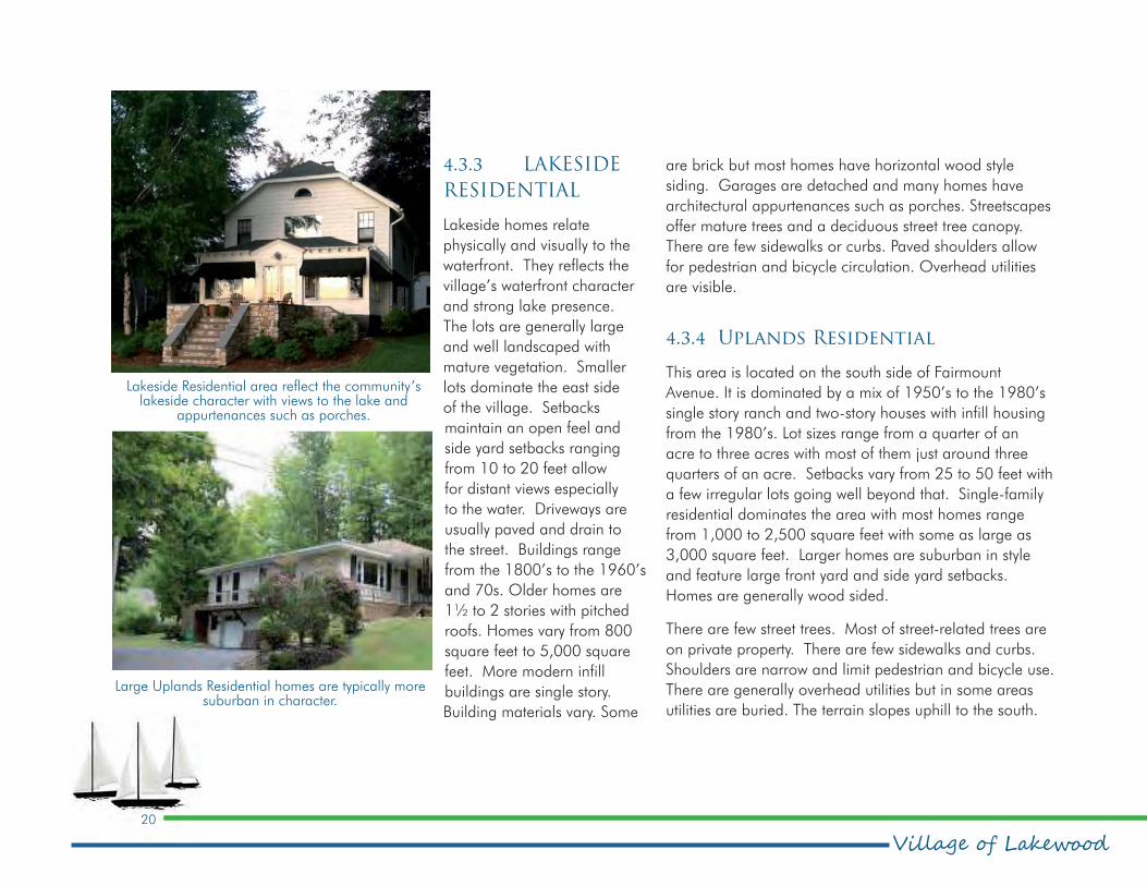
4.3.3 LAKESIDE
RESIDENTIAL
Lakeside homes relate
physically and visually to the
waterfront. They reflects the
village’s waterfront character
and strong lake presence.
The lots are generally large
and well landscaped with
mature vegetation. Smaller
lots dominate the east side
of the village. Setbacks
maintain an open feel and
side yard setbacks ranging
from 10 to 20 feet allow
for distant views especially
to the water. Driveways are
usually paved and drain to
the street. Buildings range
from the 1800’s to the 1960’s
and 70s. Older homes are
1½ to 2 stories with pitched
roofs. Homes vary from 800
square feet to 5,000 square
feet. More modern infill
buildings are single story.
Building materials vary. Some
are brick but most homes have horizontal wood style
siding. Garages are detached and many homes have
architectural appurtenances such as porches. Streetscapes
offer mature trees and a deciduous street tree canopy.
There are few sidewalks or curbs. Paved shoulders allow
for pedestrian and bicycle circulation. Overhead utilities
are visible.
4.3.4 Uplands Residential
This area is located on the south side of Fairmount
Avenue. It is dominated by a mix of 1950’s to the 1980’s
single story ranch and two-story houses with infill housing
from the 1980’s. Lot sizes range from a quarter of an
acre to three acres with most of them just around three
quarters of an acre. Setbacks vary from 25 to 50 feet with
a few irregular lots going well beyond that. Single-family
residential dominates the area with most homes range
from 1,000 to 2,500 square feet with some as large as
3,000 square feet. Larger homes are suburban in style
and feature large front yard and side yard setbacks.
Homes are generally wood sided.
There are few street trees. Most of street-related trees are
on private property. There are few sidewalks and curbs.
Shoulders are narrow and limit pedestrian and bicycle use.
There are generally overhead utilities but in some areas
utilities are buried. The terrain slopes uphill to the south.
Large Uplands Residential homes are typically more suburban in character.
Lakeside Residential area reflect the community’s lakeside character with views to the lake and
appurtenances such as porches.

21
Comprehensive Planpeter j. smith & company, inc.
4.3.5 VILLAGE FLATS EAST
RESIDENTIAL
This east area is relatively flat draining toward the lake.
It is primarily comprised of large areas of wetlands,
community services and park/open space areas with single
family residential mostly on the west and east ends of the
district. There is a mix of one- and two-story homes from
the late 1930’s to and 1940’s with infill form the 1960’s.
Infill buildings date from the 1970’s to the present. Front
yard setbacks vary between 20 and 25 feet and lot sizes
are small approximately 1/4 acre. Widths range from
50’ to 100’. Most buildings are cottage style of wood
style siding. Infill homes are modern suburban ranch style
predominantly along the main street. Recent infill includes
some brick façade. Main roads are curbed. Side streets
are narrow and have no curbs or sidewalks and poor
pedestrian and bicycle circulation. Overhead utilities are
visible. The main street of the district, East Summit Street
has few street trees, however mature trees and more recent
plantings form a street tree canopy on side streets.
4.3.6 VILLAGE FLATS WEST
RESIDENTIAL
The west character is generally more verdant than the
rest of the village and the streets form a tight urban grid.
Primarily single family residential the area is relatively
flat draining toward the lake There is a predominance of
single story homes on side streets built 1950’s - 1960’s.
Infill buildings date from the
1970’s to 2000. Front yard
setbacks vary but are larger
than most areas creating
large and well landscaped
front lawns between 40 and
50 feet and lot sizes are
approximately 1/3 to a half of
an acre. Widths are generally
100’. Most buildings are
of wood style siding with
some brick façades. Streets
have no curbs or sidewalks;
shallow swales define road
edges. In some areas paved
and unpaved shoulders
allow pedestrian and bicycle
circulation. Overhead utilities
are visible. Mature trees form
a street tree canopy and
integrate with the abundant
landscape to create the
verdant feel of the district.
4.3.7 Village Core
The village center is a
quaint central business
district offering local goods
and services centered on
Chautauqua Avenue. It
This restored Victorian on Third Street is evocative of the Village Flats East Side Character Area.
This Stoneman Avenue Cottage is representative of the Village Flats West Residential home.

Village of Lakewood22
Comprehensive Plan
Panera is a typical Suburban Commercial development.
The quaint Chautauqua Avenue business district is a mix of modern and historic styles.
offers both historic style
commercial and modern
commercial buildings. The
western side consists of historic
Village Hall and the Lakewood
Memorial Library, both brick.
The remainder is a mix of
commercial uses, community
services and historic houses.
Most buildings are wood and
masonry/brick siding. There
are numerous architectural
features including some large
porches. Lot and building sizes
vary considerably, setbacks are
minimal. The area is relatively
flat with a downhill gradient
to the lake. There is a distinct
and direct view down the street
to the waterfront and physical
connections to the waterfront
and park. Streets have curbs,
sidewalks and on-street parking.
The streetscape is relatively new
and street trees are young and
not predominant. Electric service
has been buried.
4.3.8 Suburban Commercial
Strip style and big box development with parking in front
and side yards characterize this suburban style regional
commercial area on Fairmount Avenue. Lots typically have
minimal landscape as asphalt parking areas surround
buildings and are highly visible. The area is relatively flat
with no distant views. Commercial uses including retail,
office, restaurants, services and auto-related uses are
dominate. Big box and strip-mall style facades characterize
the built form. Building styles are generally 1970’s and
1980s suburban commercial and newer buildings from
2000. There is no distinct pattern of lot sizes. Setbacks are
generally between 10 to 60 feet. Big box uses are deeper
with large parking areas. Street trees are not predominant
in the landscape. Streets are curbed and have sidewalks.
There is overhead electric.
4.4. Mixed Commercial Industrial Area
The Mixed Commercial Industrial Area surrounds the
intersection of Chautauqua and Fairmount avenues and
extends to the railway corridor. The intersection is a major
gateway leading to the downtown area. The area has
a mix of individual commercial uses on larger lots and
community services with industrial uses located along the
railway. Some residential uses exist among these larger
developments.

23
Comprehensive Planpeter j. smith & company, inc.
4.5. Conclusion
The character of Lakewood is defined by its past and
is important in defining its future. Its character makes
Lakewood unique from all other communities; it is an
expression of its residents’ footprint through time and
should be preserved and enhanced as the community
changes and progresses. Lakewood is a unique historic,
waterfront, pre war village with suburban regional
development defined by the highway and railroad. The
architectural history of the early estate cottage area and
downtown offer a detail and scale that is unique, reflects
the history of the village and is worth preserving. The
waterfront, the most magnificent component of Lakewood,
has a feeling of surrounding most of the community. The
visual access to the waterfront and the scenic drive tell a
powerful waterfront story.
4.6. Community Character Policy framework
As a result of the analysis, the following policies have been
developed to guide the community’s future character and
design.
4.6.1 Intent of the policies
Lakewood should maintain its waterfront character and
historic village identity. Its commercial nodes and strips
including the character of
streets, parks, open spaces and
built form should be enhanced
into an attractive, organized,
functional and understandable
urban system. The village should
enhance the quality of the public
realm, the natural environment
and define community identity,
sense of pride and sense of
place. Most important, the
quality of urban design attracts
people and activity to a place
enhancing the experience
and making it more viable
aesthetically, socially and
commercially.
4.6.2 Policies
Policy – Neighborhood Character
Originally an historic village, Lakewood evolved into a
first ring commercial and residential suburb of Jamestown.
At present, it includes a denser form of suburban style
commercial. The village should build on its existing historic
waterfront/heritage character to define and enhance
unique neighborhood and commercial character areas.
Matco Tool, located in the Mixed Commercial Industrial Character Area, is an example of a use
that could be amortized in the future as other development types emerge.

Village of Lakewood24
Comprehensive Plan
Policy – Social Space
The village should provide/develop/enhance a community
space and social spaces that are active and urban
promoting interaction between residents and visitors and
allowing gathering for groups and community events.
Policy – Street Trees
Trees should be planted in all street rights-of-way and
encouraged on private property proximate to the street to
line neighborhood streets. Trees should be deciduous,
provide shade, provide a clear canopy, be indigenous, salt
tolerant and could be of species that naturalize and lend
themselves to being planted in clusters.
Policy – Views
Views and sightlines should be maintained and enhanced
to Chautauqua Lake at all street ends and especially along
the length of Chautauqua Ave.
Policy – Public Art
Public art in the form of street sculptures or interpretive
structures should be encouraged at prominent points in the
village streetscape and gateways.
25
Comprehensive Planpeter j. smith & company, inc.
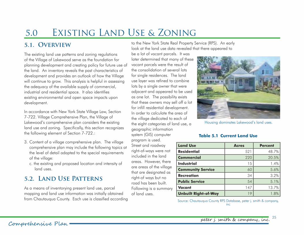
Table 5.1 Current Land Use
Land Use Acres Percent
Residential 521 48.7%
Commercial 220 20.5%
Industrial 15 1.4%
Community Service 60 5.6%
Recreation 34 3.2%
Public Service 54 5.1%
Vacant 147 13.7%
Unbuilt Right-of-Way 19 1.8%
Source: Chautauqua County RPS Database, peter j. smith & company, inc
Housing dominates Lakewood’s land uses.
5.0 Existing Land Use & Zoningto the New York State Real Property Service (RPS). An early
look at the land use data revealed that there appeared to
be a lot of vacant parcels. It was
later determined that many of these
vacant parcels were the result of
the consolidation of several lots
for single residences. The land
use layer was refined to combine
lots by a single owner that were
adjacent and appeared to be used
as one lot. The possibility exists
that these owners may sell off a lot
for infill residential development.
In order to calculate the area of
the village dedicated to each of
the eight categories of land use, a
geographic information
system (GIS) computer
program is used.
Street and roadway
right-of-ways were not
included in the land
areas. However, there
are areas of the village
that are designated as
right-of ways but no
road has been built.
Following is a summary
of land uses.
5.1. Overview
The existing land use patterns and zoning regulations
of the Village of Lakewood serve as the foundation for
planning development and creating policy for future use of
the land. An inventory reveals the past characteristics of
development and provides an outlook of how the Village
will continue to grow. This analysis is helpful in assessing
the adequacy of the available supply of commercial,
industrial and residential space. It also identifies
existing environmental and open space impacts upon
development.
In accordance with New York State Village Law, Section
7-722. Village Comprehensive Plan, the Village of
Lakewood’s comprehensive plan considers the existing
land use and zoning. Specifically, this section recognizes
the following element of Section 7-722.:
3. Content of a village comprehensive plan. The village
comprehensive plan may include the following topics at
the level of detail adapted to the special requirements
of the village:
c. the existing and proposed location and intensity of
land uses.
5.2. Land Use Patterns
As a means of inventorying present land use, parcel
mapping and land use information was initially obtained
from Chautauqua County. Each use is classified according

Village of Lakewood26
Comprehensive Plan
Figure 5.1 Current Land Use

27
Comprehensive Planpeter j. smith & company, inc.
� Residential (48.7%)
Land that is used exclusively for residential purposes is
classified as a residential land use. Nearly half of the
village is occupied by residential uses. These uses are
located mainly north of the railroad corridor. Larger
residential lots are located on the west side of the village
south of Fairmount Avenue.
� Commercial (20.5%)
Commercial land uses include offices, retail establishments
and similar enterprises. More than 20% of the village
is taken up by commercial use. These uses are located
mainly in the southeast quadrant of the village. This area
is home to a regional retail power center anchored by
Chautauqua Mall and a Walmart. Other commercial uses
exist along Fairmount Avenue and Chautauqua Avenue.
� Industrial (1.4%)
Industrial properties are those engaged in manufacturing
or warehousing facilities. Only a small portion of the
village is dedicated to industrial uses. They are located
south of the railroad between Chautauqua Avenue and
Winchester Road.
� Community Service (5.6%)
Community service land uses include schools, churches,
cemeteries, government facilities, institutions and medical
facilities. Community services are scattered throughout
the village. Large areas are taken up by church complexes
and a senior living facility.
� Public Service (5.1%)
Parcels designated as public
service are used for utilities such
as electric sub-stations, water
towers and communication
towers. Railroad corridors are
also classified as public service.
In the village of Lakewood, the
railroad corridor makes up the
bulk of public services uses. There
is also a public water facility.
� Recreation (3.2%)
Recreational uses include parks,
and marina facilities. These uses
make up 3.2 % of the community
and are mainly located on the
north side of the village.
� Vacant (13.7%)
Vacant land is comprised of
parcels that either have not
been developed yet, have been
abandoned or are undevelopable.
There is a concentration of vacant area located between
the railroad and Summit Street on the east side of the
Policy: Buffer parking in commercial corridors with landscaping.
Policy: Setbacks in the Historic Village Center area should be equal to maintain character

Village of Lakewood28
Comprehensive Plan
Figure 5.2 Current Zoning

29
Comprehensive Planpeter j. smith & company, inc.
Unbuilt right of way in the village.
Table 5.2 Current Zoning
Zoning District Acres Percent
Retail Business B1 12 1.0%
Highway Business B2 305 24.3%
Light Industrial I1 38 3.0%
Single Family R1 707 56.4%
Multiple Family R2 187 15.0%
Mobile Residential R3 4 0.3%
Source: Chautauqua County RPS Database, peter j. smith & company, inc
village. There are also undeveloped lots in both the
commercial and residential areas of the village.
� Un-built Rights-of-Way (1.8%)
Un-built rights-of-way are areas of the village that have
been designated through original subdivision as rights-of-
way, but no roads were subsequently built. These areas
are either vacant or being used by neighboring properties
as if abandoned by the village.
Figure 5.1 illustrates the village’s current land uses.
5.3. Land use Regulations
5.3.1 Current Zoning Law
A community’s zoning ordinance dictates types of uses
and the density and scale of development. Zoning can
also regulate design, protect environmental resources,
and set performance standards. The Village of Lakewood
is currently divided into six zoning districts. There are
three residential districts (R1, R2, and R3), two commercial
districts (B1 and B2), and one industrial district (I1).
The map on the previuos page illustrates the Village of
Lakewood’s current zoning.
� Retail Business B1 (1.0%)
The retail business district promotes smaller scale
commercial uses mixed with residential uses. The district
is located around
Chautauqua Avenue,
which is considered the
village’s downtown.
� Highway Business B2 (24.3%)
The Highway
Commercial District
is intended to provide
space for auto-oriented
commercial uses.
The District is mainly
located in the southeast
portion of the village. This is
the area of the Chautauqua
Mall, as well as other
commercial establishments
that benefit from the location
of the mall. The B2 District
is also found in other areas
of the village, notably on the
eastern and western gateways
and along the north side of
Fairmount east of Winchester
Road.
� Light Industrial I1 (3.0%)
The L1 District provides an area for the establishment of
light industrial uses. These areas are found adjacent to the

Village of Lakewood30
Comprehensive Plan
The B1 zoning district, centered on Chautauqua Avenue, allows a mix of uses.
railroad corridor in the central and
eastern portion of the village.
� Single Family R1 (56.4%)
The Single Family district is designed
to protect existing and permit new
large lot single family neighborhoods.
Minimum lot width is 75 feet with a
front yard setback of 25 feet. The R1
District takes up much of the western
two-thirds of the village.
�Multiple Family R2 (15.0%)
The R2 District promotes
neighborhoods with a mix of
residential uses at a greater density.
The R2 surrounds the downtown
areas. There is also an R2 district
located in the northeast section of the
village.
� Mobile Residential R3 (0.3%)
The R3 District provides an area for the development of a
mobile home park. This area is found on the south side of
the railroad corridor on the eastern end of the village.
The Lakewood zoning ordinance also provides regulations
for specific uses and regulations specific to the lakeshore.
5.4. Land Use & Zoning Policy framework
As a result of the analysis, the following policies have been
developed to guide the community’s land use and zoning
as it grows and evolves into the future.
5.4.1 Intent of the policies
The Village of Lakewood should strengthen its waterfront
character, and accent and improve commercial
nodes, strengthen corridors and link neighborhoods.
Redevelopment should offer a full range of land uses in
mixed-use developments to create a diverse community.
Commercial centers that supply the goods and services
required by the community and region should be
developed within walking distances of neighborhoods to
minimize auto use. Zoning should facilitate desired quality
development, be easier to understand for all residents and
encourage variety in building styles, uses and densities.
5.4.2 Policies
Policy – Density and Mixed-Density Development
The village will expand and intensify as demographics
change and populations grow. The village should
promote compatible increases in density in future mixed-
use neighborhoods.

31
Comprehensive Planpeter j. smith & company, inc.
Policy – Two-Village Commercial District Concept
As the village grows and changes it needs structure to
give it a stronger sense of community. As commercial
development and intensification occur each of the village’s
“downtowns” should form a centre and help to organize
the community creating a strong identity and sense of
place. The downtown districts are:
•Historic Village Center
•Mixed-Use Mall Village
These are further supported by the Fairmount Avenue
Corridor commercial area.
Policy – Sustainability
Sustainability means promoting the conservation of
resources, the wise use of resources and development
of strategies to help resources regenerate so that they
can be enjoyed, developed and used for generations
to come. Development and redevelopment should
promote sustainability and energy efficiency in all aspects
of site planning, construction, building materials and
maintenance.
Policy – Residential Infill
Residential infill buildings should reflect character, finish,
floor elevation and setback of the neighborhood and
context of surrounding buildings.
Policy – Commercial Buildings – Historic Village Center
Commercial buildings should
support the unique heritage
character of the village,
maintaining setbacks equal to
surrounding buildings, transparent
ground floors and façades parallel
to street.
Policy – Commercial Buildings – Mixed-Use Mall Village
Commercial buildings should
support a unique waterfront,
heritage character creating a
strong presence in relationship to
the street, with transparent ground
floors and façades parallel to street
and a primary façade with varied
setbacks.
Policy – Commercial Buildings – Fairmount Avenue Corridor
Commercial buildings should be set
back to allow for parking buffered
by landscape strip creating a tree
lined walkway and green zone along the street.
The Packard condominiums are located in an R2 district. Most of the village’s R2 districts are located
north of Fairmount Avenue.
The B1 district features auto-oriented uses and architecture typical of these uses including low-slung buildings with generous window coverage
and parking in front.

Village of Lakewood32
Comprehensive Plan
Policy: Signage should be attached and on premises.
Policy: Follow Dark Sky rating standards to preserve the nighttime sky.
Policy – Orientation
Buildings should be oriented to the street, have active
widows proximate to the street and primary entrances
accessed directly from the street.
Policy – Gateways
Gateways and arrival signatures should be developed to
enhance neighborhood identity and strengthen the sense
of the village and neighborhoods as unique places. The
locations should be:
•At Lakewood Community Park
•At the intersection of Summit and Fairmount Avenue in cooperation with the Town of Busti.
•At the east end of Fairmount Avenue
•At all roads entering the village from the south (village signs are sufficient)
Policy – Commercial Signage
Signage in commercial and mixed-use districts should be
limited to attached on-premises signs.
Policy – Commercial Lighting
Lighting in commercial and mixed-use districts should be
from high-efficiency light sources and cast downwards to
minimize light pollution. Dark Sky rating standards should
be followed to preserve the nighttime sky and minimize
light pollution.
Photo
: N
ASA

33
Comprehensive Planpeter j. smith & company, inc.
6.0 Population & Housing6.1. Overview
Demographic and housing data is helpful for planning
how to manage future growth in the Village of Lakewood.
The data presented in this chapter will help the community
know more about itself and be consistent with local,
regional and statewide growth and development
goals. The main focus of the chapter is on the Village’s
characteristics.
Access to diverse and affordable housing options is a key
factor in creating livable communities. As a community
plans for the future, trends in the size and composition of
its population should be examined to assure that housing
opportunities are available for those who choose to rent or
own their home and for those with special needs.
In accordance with New York State Village Law, Section
7-722. Village Comprehensive Plan, the Village of
Lakewood’ comprehensive plan considers the existing
Village population and housing stock characteristics.
Specifically, this section recognizes the following elements
of Section 7-722.:
3. Content of a village comprehensive plan. The village
comprehensive plan may include the following topics at
the level of detail adapted to the special requirements
of the village:
e. consideration of population, demographic and
socio-economic trends and future projections.
h. existing housing resources and future housing needs,
including affordable housing.
6.2. Population Characteristics
6.2.1 Population Change
The population change over the last decade presents
a trend. Ideally, a moderate growth rate is evident of
a healthy community. In Chautauqua County, there is
a general trend of a declining population. While these
forces are partially at play, Chautauqua County as a whole
has shown a decline in population. The major forces that
influence population change are births, deaths, migration
– in and out – and changing household size.
Table 6.1 Population Change 1950-2014
Village of LakewoodBusti outside of
LakewoodTown and Village
Year Population%
ChangePopulation
% Change
Population%
Change
1950 3,013 2,793 5,806
1960 3,933 30.5% 3,833 37.2% 7,766 33.8%
1970 3,864 −1.8% 4,503 17.5% 8,367 7.7%
1980 3,941 2.0% 4,787 6.3% 8,728 4.3%
1990 3,564 −9.6% 4,486 -6.3% 8,050 -7.8%
2000 3,258 −8.6% 4,502 0.4% 7,760 -3.6%
2010 3,002 −7.9% 4,349 -3.4% 7,351 -5.3%
2014 2,994 -0.4% 4,334 -0.3% 7,325 -0.4%
Source: US Bureau of the Census and peter j. smith & company, inc.

Village of Lakewood34
Comprehensive Plan
While the Town
and Village grew at
relatively similar rates
between 1950 and
1960, the village
population began to
decline and except
for a minor growth of
two percent between
1970 and 1980 has
been declining since,
resulting in a 2013
population that is
almost identical to that
of 1950. The Town of
Busti outside the Village
continued to grow
into the 1980s and as
a result had a 2013
population that was
55% greater than it was
in 1950, despite some
losses in population
between 1980 and 1990 and more recently.
It is common for villages to lose residents to surrounding
suburban areas where land is available for newer homes.
Taxes are often lower outside of villages where residents
trade fewer services for lower rates. For example, Busti’s
tax rate is $1.30/$1,000 of assessed value, while
Lakewood’s is $7.50
6.2.2 Population
Projections
Lakewood has been experiencing population shrinkage
since the 1960s. Beginning with the 1990 Census,
the village began to exhibit a larger decline, marking
decreases of 9.6, 8.6 and 7.9 percent respectively with
the three successive Census counts. These rates are not
significantly different from one another and are useful in
making projections about the future population picture for
the village.
Population projections for the Village of Lakewood that
take into consideration certain statistical and scientific
variables, such as fertility, mortality, births and deaths
as well as in and out migration are not available. These
projections are generally computed for larger areas
such as regions and counties. However, using a simple
trend projection analysis that assumes that there will be
statistically insignificant changes to these inputs – and
it is likely that these inputs will not significantly change
– can serve as a useful tool for projecting Lakewood’s
future population. It can this be extrapolated that 2030
population could drop more than 500 from the 2010
population.
A drop in population is a concern for any community. A
significant drop, as much as 15 percent over 20 years,
is a matter of paramount concern. It can be an indicator
of lower housing values, leading to housing stress and
abandonment, lower real estate tax collections to support
village services and growing poverty among residents.
Table 6.2 Population Projections
Census Population
1980 total population (Census) 3,941
1990 total population (Census) 3,564
2000 total population (Census) 3,258
2010 total population (Census) 3,002
2020 total population (Projected) 2,765
2030 total population (Projected) 2,546
1980-2010 population change -939
1980-2010 % change -23.80%
2000-2010 population change -256
2000-2010 % change -7.90%
Projected changes
2010-2020 population change 237
2010-2020 % change -7.9%
2010-2030 population change 456
2010-2030 % change -15%
Source: David DiSalvo, US Bureau of the Census and peter j. smith & company, inc.

35
Comprehensive Planpeter j. smith & company, inc.
6.2.3 Migration
Residential Mobility can demonstrate where people living
in the community lived a year ago. However, it does not
tell where residents of a year ago may have moved. The
Village of Lakewood shows a stable population base with
nearly 80% living in the same house. The Village also
shows a significant percentage of people that have moved
here from a different state. This demonstrates that the
village is able to attract people from outside of the area.
Table 6.3 Residential Mobility – 2013
Movement within the last
yearLakewood Busti
Busti outside of Lakewood
Bemus Point
Celoron Mayville County
Same house 1 year ago:
78.9% 86.2% 91.2% 90.5% 82.9% 70.3% 86.0%
Moved within same county:
12.1% 8.4% 5.9% 1.7% 14.3% 13.9% 8.9%
Moved from different county within same state:
1.7% 0.8% 0.2% 5.4% 0.0% 9.4% 2.9%
Moved from different state:
7.3% 4.5% 2.6% 0.0% 2.8% 5.8% 1.8%
Moved from abroad:
0.0% 0.0% 0.0% 2.5% 0.0% 0.6% 0.3%
Source: US Bureau of the Census, 2013 ACS 5 year estimate
6.2.4 Race and Ethnicity
Race and ethnicity are important considerations when
developing programs and recreational amenities for
the community. The Village of Lakewood, like most of
Chautauqua County has a high percentage of Caucasian
residents. Asian people make up the second largest, albeit
small, percentage of the population.

Village of Lakewood36
Comprehensive Plan
6.2.5 Age Distribution
Age is also an important consideration for residential
programming and recreational needs. The Village of
Lakewood has a significantly older population. Only
Bemus Point has a higher median age of over 50. The
nearby Village of Celoron demonstrates the opposite with
nearly a quarter of the population under the age of 15
and a median age of 31.7. The age of the population
suggests that housing specifically developed to allow
seniors to age in place as well as to attract younger
families and singles could be welcome additions to the
marketplace in Lakewood. These can include traditional
single-family homes for sale and rent, townhomes, condos
and apartments at various price points to appeal to a
diverse population.
Table 6.4 Housing Tenure – 2013
LakewoodTown of
Busti
Busti outside of Lakewood
Bemus Point
Celoron Mayville County
Total housing units
1,586 3,690 2,104 253 595 781 66,731
Owner-occupied
70.10% 78.80% 85.40% 59.60% 61.70% 63.20% 69.10%
Renter-occupied
29.90% 21.20% 14.60% 40.40% 38.30% 36.80% 30.90%
Source: US Bureau of the Census, 2013 ACS 5-year estimate
6.3. Housing Characteristics
6.3.1 Housing Tenure
The total number of housing units is presented to give
value to the percentages displayed in the subsequent
sections. Similar to population, The Village of Lakewood
has a larger number of housing units than other
Chautauqua Lake villages. The number of units makes up
nearly half of the units in the Town of Busti.

37
Comprehensive Planpeter j. smith & company, inc.
6.3.2 Vacancy Status
Occupancy and vacancy status are
important statistics to understand
the types of housing choices
available within a community.
The Village of Lakewood has
the highest proportion of owner-
occupied housing units, 70%, than
do the comparison Chautauqua
Lake villages and a slightly higher
percentage than the County as a
whole where 69% of housing is
owner occupied.
Chautauqua County communities
in general show a relatively
large proportion of vacant units
– 20.6%. At nearly 18% of
housing units vacant, the Village
of Lakewood has roughly the
same proportion of vacant units as the county. The large
percentage of vacant units can be attributed to a large
number of seasonal homes. This is particularly true in
the Villages of Mayville and Bemus Point, 58% and 65%,
respectively. The villages of Lakewood and Celoron show
large proportions of vacant units for rent, 32% and 33%,
respectively. While the vacancy rates reflect many seasonal
rentals, Lakewood has nearly the same proportion as
those of its vacant units for rent as for seasonal use. Five
percents is considered a normal vacancy rate and would
include units that are off the market for repairs, renovation
Table 6.5 Vacancy Status – 2013
LakewoodTown
of Busti
Busti outside of Lakewood
Bemus Point
Celoron Mayville County
Vacant Units 17.5% 17.2% 17.1% 56.9% 13.6% 26.6% 17.8%
For rent 32.1% 14.0% 0.0% 6.9% 33.3% 5.3% 11.7%
Rented, not occupied
0.0% 0.0% 0.0% 0.0% 0.0% 0.0% 2.0%
For sale only 10.8% 4.7% 0.0% 18.8% 0.0% 15.4% 4.9%
Sold, not occupied
2.9% 1.3% 0.0% 0.0% 0.0% 0.0% 1.0%
For seasonal, recreational, or occasional use
37.2% 65.7% 87.7% 65.3% 25.9% 57.7% 59.8%
For migrant workers
0.0% 0.0% 0.0% 0.0% 0.0% 0.0% 0.1%
Other vacant 17.0% 14.3% 12.3% 9.0% 40.7% 21.6% 20.6%
Source: US Bureau of the Census, 2013 ACS 5 year estimate
and for marketing. A higher percentage of vacant units
for rent suggests an inability to fill these housing units for
reasons of location, condition, desirability and the cost of
monthly rent.
Since the housing crisis of the early 2000s there has
been a national trend away from homeownership. Stricter
underwriting and lending standards, high down payments
and the ongoing responsibility of homeownership are
barriers to what was once considered a goal. As family
sizes shrink and seniors are much more independent and
for longer, different and more desirable housing types are
needed to accommodate changing needs.

Village of Lakewood38
Comprehensive Plan
6.3.3 Housing Type
The number of units in a structure presents the type of
housing unit mix. Similar to tenure, 70% of the housing
units in the Village of Lakewood are single unit detached
Table 6.6 Housing Type – 2013
LakewoodTown of Busti
Busti outside of Lakewood
Bemus Point
Celoron Mayville County
1-unit, detached
70.2% 76.5% 81.20% 57.3% 82.5% 72.7% 68.3%
1-unit, attached
0.9% 0.6% 0.30% 3.2% 0.0% 1.5% 1.4%
2 units 7.3% 4.8% 3.00% 7.1% 5.5% 7.7% 11.3%
3 or 4 units 0.4% 1.1% 1.60% 11.9% 6.4% 4.6% 5.1%
5 to 9 units 0.0% 0.3% 0.50% 0.0% 5.5% 6.3% 2.6%
10 to 19 units
11.9% 5.3% 0.40% 8.3% 0.0% 3.6% 1.8%
20 or more units
6.9% 4.4% 2.50% 12.3% 0.0% 2.0% 3.2%
Mobile home 2.3% 7.0% 10.60% 0.0% 0.0% 1.5% 6.4%
Source: US Bureau of the Census, 2013 ACS 5-year estimate
houses. Lakewood has the highest percentage of housing
units in structures with between 10 and 19 units. There is
a small percentage of mobile housing units.

39
Comprehensive Planpeter j. smith & company, inc.
Table 6.7 – Age of Housing
Year built LakewoodTown of
Busti
Busti outside of Lakewood
Bemus Point
Celoron Mayville County
2010 or later 0.0% 0.3% 0.60% 0.0% 0.0% 0.0% 0.1%
2000-2009 4.2% 6.0% 7.40% 21.7% 1.0% 4.4% 4.9%
1990 to 1999 5.8% 5.4% 5.20% 2.0% 2.5% 5.6% 6.2%
1980 to 1989 10.9% 9.0% 7.50% 5.5% 3.4% 10.8% 8.1%
1970 to 1979 14.6% 14.8% 15.00% 3.6% 8.6% 9.9% 8.8%
1960 to 1969 6.1% 9.9% 12.80% 5.9% 9.1% 4.1% 7.7%
1950 to 1959 18.7% 18.0% 17.40% 9.1% 8.4% 10.6% 11.6%
1940 to 1949 11.0% 12.3% 13.20% 5.1% 11.6% 12.0% 7.7%
1939 or earlier 28.8% 24.3% 21.00% 47.0% 55.5% 42.6% 44.9%
Source: US Bureau of the Census, 2013 ACS 5-year estimate
6.3.4 Age of Housing
The age of housing gives insight into the general age of
the community. It can also show if there has been any new
building activity going on in the community. Compared
to the other Chautauqua Lake villages, the Village of
Lakewood has the smallest percentage of structures built
before 1939. In both Mayville and Lakewood,10% of the
housing stock has been built since 1990. Nearly a quarter
of the housing stock in Bemus Point was built in the past
25 years.

Village of Lakewood40
Comprehensive Plan
6.4. Income
Incomes are important because they indicate the relative
affluence of the community and also the ability of its
residents to afford housing. The median household income
in the Village of Lakewood is lower than the incomes in
Busti while it has a higher proportion of households with
Table 6.8 Household Annual Income – 2013
LakewoodTown of
Busti
Busti outside of Lakewood
Bemus Point
Celoron Mayville County
<$10,000 11.1% 7.9% 5.40% 11.0% 6.2% 4.4% 9.4%
$10,000-$14,999 1.1% 4.3% 6.80% 2.8% 3.3% 8.4% 6.7%
$15,000-$24,999 15.4% 10.1% 6.10% 13.8% 16.0% 13.6% 13.5%
$25,000-$34,999 8.2% 10.1% 11.60% 7.3% 11.3% 16.4% 12.9%
$35,000-$49,999 16.7% 16.2% 15.90% 15.6% 21.2% 11.3% 15.6%
$50,000-$74,999 18.5% 22.0% 24.70% 11.0% 22.8% 22.9% 18.7%
$75,000-$99,999 7.3% 10.8% 13.40% 11.9% 13.6% 13.3% 11.0%
$100,000-$149,999 13.4% 12.2% 11.30% 15.6% 5.4% 8.0% 8.5%
$150,000-$199,999 5.0% 3.8% 2.80% 6.4% 0.2% 0.0% 2.7%
>$200,000 3.4% 2.6% 1.90% 4.6% 0.0% 1.7% 1.1%
Median $47,684 $51,154 53,316 $42,404 $42,500 $44,398 $42,429
Source: US Bureau of the Census, 2013 ACS 5 year estimate
median incomes over $100,000. Lakewood also has a
higher proportion of very low income households and
households with incomes under $25,000.
Incomes are important because they link directly to
housing affordability, examined in the following section.

41
Comprehensive Planpeter j. smith & company, inc.
6.5. Housing Value and Affordability
Higher value housing generates higher
tax revenues. But housing should also
be affordable for households of all
incomes. Single family homes valued
under $50,000 make up 10% of
housing units in the Village and nearly
double this proportion in the town
outside of the village. Housing values
range in the village of Lakewood
with some houses valued at more
than $500,000. Among comparison
communities, Bemus Point has the
most expensive housing, with a median
value of nearly $200,000.
� Owner-Occupied Housing Costs
Monthly housing costs in excess of 30%
of household income are considered
unaffordable and unsustainable. In
the Village of Lakewood, more than
a quarter of the owner-occupied
households pay more than this. In the
Town of Busti outside of Lakewood, the
percentage of people paying more than
30% of income is higher.
Table 6.10 Monthly Cost of Owner-Occupied Housing
LakewoodTown
of Busti
Busti outside of Lakewood
Bemus Point
Celoron Mayville County
<20 percent 59.4% 46.9% 39.20% 58.1% 61.8% 48.5% 49.6%
20 to 24.9 percent 6.3% 16.5% 22.90% 12.9% 11.3% 20.6% 14.2%
25 to 29.9 percent 6.5% 5.0% 4.00% 6.5% 11.3% 8.3% 9.8%
30 to 34.9 percent 4.9% 5.7% 6.20% 0.0% 0.5% 2.9% 6.5%
35 percent or more 22.9% 25.9% 27.80% 22.6% 15.1% 19.6% 19.9%
Source: US Bureau of the Census, 2013 ACS 5-year estimate
Table 6.9 Value of Owner Occupied Housing – 2013
LakewoodTown of
Busti
Busti outside of Lakewood
Bemus Point
Celoron Mayville County
< $50,000 10.0% 15.7% 19.20% 0.0% 31.5% 5.5% 19.3%
$50,000 to $99,999
44.8% 37.7% 33.30% 10.8% 44.5% 45.3% 42.8%
$100,000 to $149,999
10.7% 16.7% 20.50% 12.3% 15.1% 20.7% 17.3%
$150,000 to $199,999
15.3% 13.7% 12.80% 29.2% 6.6% 15.2% 10.5%
$200,000 to $299,999
12.6% 9.6% 7.70% 15.4% 0.6% 4.1% 5.8%
$300,000 to $499,999
5.1% 5.4% 5.50% 7.7% 1.6% 5.2% 2.8%
$500,000 to $999,999
1.4% 1.2% 1.10% 23.1% 0.0% 3.9% 1.1%
$1,000,000 or more
0.0% 0.0% 0.00% 1.5% 0.0% 0.0% 0.2%
Median (dollars)
$94,900 $96,400 97,000 $197,100 $59,300 $99,000 $83,500
Source: US Bureau of the Census, 2013 ACS 5-year estimate

Village of Lakewood42
Comprehensive Plan
Table 6.11 Monthly Cost of Renter-Occupied Housing
LakewoodTown of
Busti
Busti outside of Lakewood
Bemus Point
Celoron Mayville County
Less than 15.0 percent 11.0% 12.8% 15.10% 26.3% 25.4% 23.0% 14.2%
15.0 to 19.9 percent 11.7% 17.0% 23.70% 18.4% 18.2% 11.8% 13.3%
20.0 to 24.9 percent 7.5% 4.2% 0.00% 5.3% 5.5% 14.6% 11.7%
25.0 to 29.9 percent 25.3% 21.6% 16.90% 18.4% 7.2% 14.0% 10.3%
30.0 to 34.9 percent 5.0% 12.4% 21.90% 15.8% 6.1% 0.0% 7.1%
35.0 percent or more 39.5% 32.0% 22.40% 15.8% 37.6% 36.5% 43.4%
Source: US Bureau of the Census, 2013 ACS 5 year estimate
� Renter-Occupied Housing Costs
A significant proportion of Lakewood renters are spending
more than 35 percent of their monthly incomes on
housing. From this standpoint, the village is the least
affordable of the comparison communities, exceeded only
by the county as a whole where more than 40 percent
spend more than 35 percent of their incomes on rent.
The median rent in the village of Lakewood is higher
than the median monthly rent in any of the comparison
communities. Lakewood dominates the highest monthly
rent category, $1,500 or more. These are probably all
vacation rentals, an assumption endorsed by a search for
Chautauqua Lake rentals on vrbo.com. But Lakewood has
almost no rentals available for less than $500 per month
and almost 85% of the rental housing goes for between
$500 and $1,000 a month. These rents are significantly
higher than those in the comparison communities and
explain Lakewood’s high rental vacancy rates.

43
Comprehensive Planpeter j. smith & company, inc.
Table 6.12 Monthly Rent – 2013
LakewoodTown of
Busti
Busti outside of Lakewood
Bemus Point
Celoron Mayville County
Less than $200
0.0% 1.4% 3.70% 2.6% 0.0% 1.7% 1.7%
$200 to $299
0.0% 4.9% 12.80% 23.7% 0.0% 6.1% 5.2%
$300 to $499
3.5% 9.0% 17.80% 50.0% 16.6% 43.1% 22.3%
$500 to $749
56.5% 48.2% 35.20% 2.6% 50.3% 31.5% 44.7%
$750 to $999
28.0% 26.3% 23.70% 21.1% 15.5% 16.6% 18.4%
$1,000 to $1,499
0.0% 2.3% 5.90% 0.0% 15.5% 1.1% 6.0%
$1,500 or more
12.1% 7.8% 0.90% 0.0% 2.2% 0.0% 1.7%
Median $728 $712 $674 $393 $713 $498 $609
Source: US Bureau of the Census, 2013 ACS 5 year estimate

Village of Lakewood44
Comprehensive Plan
6.6. Educational Attainment
Educational attainment is important because it is a strong
indicator of the community’s residents’ workforce readiness
and its potential earning power. Among the comparison
communities, the Village of Lakewood has the lowest
percentage of residents over the age of 25 who did not
finish high school. And while Lakewood has the second-
highest proportion of residents who have an associate’s
degree, its educational attainment in comparison drops off
after the associate’s level. Still, Lakewood is second only
to Bemus Point in educational attainment overall. Nearly
a third of people over the age of 25 have four-year
degrees or higher and more than half have some college
degree. The Village of Bemus Point has a significantly
higher percentage of college graduates and holders of
advanced degrees, 48%.
Table 6.13 Educational Attainment – 2013
LakewoodTown
of Busti
Busti outside of Lakewood
Bemus Point
Celoron Mayville County
No HS Diploma
6.9% 8.8% 10.00% 7.3% 13.4% 12.4% 12.6%
HS Diploma 43.0% 48.5% 52.20% 25.1% 62.7% 51.6% 54.3%
Associate’s Degree
17.7% 14.5% 12.30% 19.4% 11.2% 15.5% 12.5%
Bachelor’s Degree
16.9% 15.6% 14.70% 21.5% 6.5% 11.8% 11.4%
Graduate or Professional Degree
15.5% 12.7% 10.80% 26.7% 6.1% 8.7% 9.3%
Source: US Bureau of the Census, 2013 ACS 5-year estimate

45
Comprehensive Planpeter j. smith & company, inc.
6.7. Population & Housing Policy framework
As a result of the population and housing analysis, the
following policies have been developed to guide the
Village as its population changes.
6.7.1 Intent of the policies
Over time, the village will attract a diversity of new
residents because of its ideal location, unique heritage
and abundance of goods and services. A diverse
population will require a variety of housing choices for
all socio-economic groups and household composition
types. Appropriate housing choices should be available
in compatible land uses to improve commercial nodes,
strengthen corridors, enhance waterfront character and
strengthen existing neighborhoods.
6.7.2 Policies
Policy – Population Growth
The village should encourage increased density of the
population to reduce the consumption of land while
providing a mix of housing types to meet current and
future market demand. A mix that includes smaller, more
affordable apartments and condominiums for rent and for
sale to house young singles, families and seniors should
be provided. These higher density residential developments
should be located proximate to or in conjunction with and
linked to commercial development
in mixed-use areas to provide
accessible goods and services.
Policy – Aging in Place
The Village’s zoning should be
flexible to encourage senior
citizens to age in place safely and
independently as long as they are
able. This includes incorporating
mixed-use development to
encourage accessibility of
goods and services, apartment
conversion, accessory apartments,
congregate and shared living
opportunities that are satisfying
and affordable.
Policy – Redevelopment and Infill
Housing redevelopment in existing
residential districts should maintain
a style and size similar to the
existing surrounding character.
Policy – Viewsheds
Higher density housing in mixed-
use districts should maintain views
to Chautauqua Lake.
Sourc
e:
Trulia
.com
Rents in Lakewood are high, over $700, and more than 40% of renters spend 30%+ of their incomes on rent. More apartments, and more affordable apartments, could attract diverse new residents.
Policy: Locate housing proximate to goods and services and community amenities.

Village of Lakewood46
Comprehensive Plan
Lakewood’s economic features are its historic village center and the Fairmount Avenue highway
commercial area, dominated by the Chautauqua Mall. Local businesses include the mall, left and continuing clockwise, Brick Elephant Design,
Davidson’s, a local landmark restaurant, downtown boutiques and spas, Farmer Brown’s Food Truck and
the Farmers Market.

47
Comprehensive Planpeter j. smith & company, inc.
7.0 Economic Vitality
house in Lakewood pays $375 more than if the identical
home is located outside of the village in the Town of Busti.
Much of the difference can be ascribed to public safety.
Lakewood, unlike Mayville and Bemus Point, has its own
police force. Bemus Point and Mayville rely upon the
County Sheriff to provide the communities’ with public
safety services.
School taxes are a significant portion of the tax rate. The
Southwestern Central School District (CSD), with a tax rate
of $20.50 per $1,000 of assessed valuation, is higher
than that of the Chautauqua Lake CSD and the Bemus
Point CSD. In combination with the school tax, the village
pushes Lakewood’s combined tax rate to $38.50 per
$1,000 of assessed valuation. This rate is second only to
Celoron, which also sends its youngsters to Southwestern
CSD. Celoron’s village tax rate is lower than Lakewood’s
but the Town of Ellicott rate is higher than that of Busti.
7.1. Economic Overview
In accordance with New York State Village Law, Section
7-722. Village Comprehensive Plan, the Village of
Lakewood’s comprehensive plan considers all aspects of
the existing economy. Specifically, this section recognizes
the following elements of Section 7-722.:
3. Content of a village comprehensive plan. The village
comprehensive plan may include the following topics at
the level of detail adapted to the special requirements
of the village:
e. consideration of population, demographic and
socio-economic trends and future projections.
l. specific policies and strategies for improving the local
economy in coordination with other plan topics.
7.1.1 Tax Burden
The tax burden can be an indicator of the ability of the
village to attract new residents and retain existing families.
Where the tax burden is perceived as onerous, residents
may move to more affordable areas. Residents of villages
and cities pay an additional tax amount for the village
or city services that they receive. In order to escape this
additional burden some residents may opt to live in a town
as opposed to in a village. The Town of Busti, with a tax
rate of $1.30 per $1,000 of assessed valuation, offers a
very low town rate. Lakewood’s village tax rate is $7.50
per $1,000 of assessed valuation. It is the highest of the
comparison communities summarized in Table 7.1. With
the added layer of village taxes, the owner of a $50,000
Table 7.1 Selected Tax Rates per $1,000 of Assessed Value – 2014
School Tax Rate
Town Tax Rate
Village/City Tax
Rate
County Tax Rate
Total Tax Rate
Tax On $50,000 Home
Lakewood 20.5 1.3 7.5 9.2 38.5 $1,926
Mayville 8.9 2.1 7.2 9.2 27.3 $1,367
Bemus Point
14.4 2.6 1.8 9.2 28.0 $1,399
Celoron 20.5 4.4 6.4 9.2 40.5 $2,023
Source: Chautauqua County and peter j. smith & company

Village of Lakewood48
Comprehensive Plan
7.2. Labor Force and Employment
7.2.1 Labor Force
The percentage of the people in the workforce in the
Village of Lakewood is greater than that of the Village of
Celoron and the County as a whole but less than that of
the other comparison communities. The unemployment
Table 7.2 Labor Force – 2013
LakewoodTown of Busti
Busti outside of Lakewood
Bemus Point
Celoron MayvilleChautauqua
County
% In Labor Force 60.60% 63.40% 65.50% 43.60% 64.90% 46.70% 58.90%
Unemployment Rate
6.00% 5.60% 5.40% 6.50% 15.60% 9.50% 8.80%
Source: US Bureau of the Census, 2013 ACS 5 year estimate
rate is lower in Lakewood than it is in Mayville and the
county, but higher than it is in the villages of Bemus
Point and Celoron. Communities with lower work force
participation may have higher numbers of retirees.
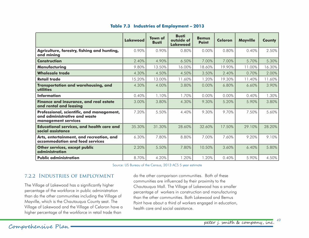
49
Comprehensive Planpeter j. smith & company, inc.
Table 7.3 Industries of Employment – 2013
LakewoodTown of
Busti
Busti outside of Lakewood
Bemus Point
Celoron Mayville County
Agriculture, forestry, fishing and hunting, and mining
0.90% 0.90% 0.80% 0.00% 0.80% 0.40% 2.50%
Construction 2.40% 4.90% 6.50% 7.00% 7.00% 5.70% 5.30%
Manufacturing 9.80% 13.50% 16.00% 18.60% 19.90% 11.00% 16.30%
Wholesale trade 4.30% 4.50% 4.50% 3.50% 2.40% 0.70% 2.00%
Retail trade 15.20% 13.00% 11.60% 1.20% 19.30% 11.40% 11.60%
Transportation and warehousing, and utilities
4.30% 4.00% 3.80% 0.00% 6.80% 6.60% 3.90%
Information 0.40% 1.10% 1.70% 0.00% 0.00% 0.40% 1.30%
Finance and insurance, and real estate and rental and leasing
3.00% 3.80% 4.30% 9.30% 5.20% 5.90% 3.80%
Professional, scientific, and management, and administrative and waste management services
7.20% 5.50% 4.40% 9.30% 9.70% 7.50% 5.60%
Educational services, and health care and social assistance
35.30% 31.30% 28.60% 32.60% 17.50% 29.10% 28.20%
Arts, entertainment, and recreation, and accommodation and food services
6.30% 7.80% 8.80% 7.00% 7.60% 9.20% 9.10%
Other services, except public administration
2.20% 5.50% 7.80% 10.50% 3.60% 6.40% 5.80%
Public administration 8.70% 4.20% 1.20% 1.20% 0.40% 5.90% 4.50%
Source: US Bureau of the Census, 2013 ACS 5 year estimate
7.2.2 Industries of employment
The Village of Lakewood has a significantly higher
percentage of the workforce in public administration
than do the other communities including the Village of
Mayville, which is the Chautauqua County seat. The
Village of Lakewood and the Village of Celoron have a
higher percentage of the workforce in retail trade than
do the other comparison communities. Both of these
communities are influenced by their proximity to the
Chautauqua Mall. The Village of Lakewood has a smaller
percentage of workers in construction and manufacturing
than the other communities. Both Lakewood and Bemus
Point have about a third of workers engaged in education,
health care and social assistance.

Village of Lakewood50
Comprehensive Plan
Table 7.4 Occupations – 2013
LakewoodTown of
Busti
Busti outside of Lakewood
Bemus Point
Celoron Mayville County
Management, business, science and arts
44.9% 37.6% 32.70% 62.8% 11.1% 36.4% 29.8%
Service 18.1% 17.6% 17.30% 15.1% 20.7% 19.0% 20.2%
Sales and office 25.1% 26.0% 26.60% 11.6% 31.4% 20.9% 23.5%
Natural resources, construction and maintenance
5.9% 9.5% 12.00% 1.2% 16.5% 12.3% 9.6%
Production, transportation and material moving
6.1% 9.3% 11.40% 9.3% 20.3% 11.4% 17.0%
Source: US Bureau of the Census, 2013 ACS 5 year estimate
7.2.3 Occupations
Except for the Village of Bemus Point, the Village of
Lakewood has the highest percentage of the workforce
employed in management, business, science and arts
occupations. These can be higher paying professions and
are also associated with the burgeoning creative economy.
Communities with creative economies are associated
with higher levels of community engagement and better
qualities of life.

51
Comprehensive Planpeter j. smith & company, inc.
Southern Tier Brewing Company’s Lakewood address is a source of pride for Village residents. But the company is actually located in the
Town of Busti.
Maintaining a strong connection between the historic village center and the public dock at Hartley Park could
encourage boaters to visit Lakewood. Lakewood has excellent wired broadband connectivity. It can use this asset to ensure it is better connected to residents and
businesses.
Sourc
e:
NYS O
ffic
e o
f Secu
rity
and C
ritic
al In
frast
ruct
ure
C
oord
inatio
n
7.3. Major Private-Sector Employers
Within the 14750 ZIP code, one establishment has
more than 500 employees. The ZIP code includes all
of the Village of Lakewood and a portion of the Town
of Busti. Cummins Engine, located just outside of the
village, is the largest employer with an estimated 1,400
employees. Two other establishments have more than 250
employees. Most of the establishments are in the retail
trade sector. Other major employers in the immediate
Jamestown area are The Resource Center, a provider
of services to persons with disabilities, which has
1,800 employees; and Womens Christian Association
(WCA) Hospital, 1,200 employees. Southern Tier
Brewing Company, located in 14750 in the Town of
Busti, has just under 90 employees, according to a
November 2014 article in Buffalo Business First.

Village of Lakewood52
Comprehensive Plan
Industry Group Demand Supply Retail Gap Estabs
Automobile Dealers $11,700,280 $3,756,908 $7,943,372 3
Other Motor Vehicle Dealers $807,829 $1,167,649 ($359,820) 1
Auto Parts, Accessories & Tire Stores $709,301 $614,214 $95,087 2
Furniture Stores $689,204 $5,957,475 ($5,268,271) 4
Home Furnishings Stores $698,749 $376,118 $322,631 1
Electronics & Appliance Stores $1,916,177 $1,219,249 $696,928 3
Bldg Material & Supplies Dealers $1,686,664 $13,322,084 ($11,635,420) 6
Lawn & Garden Equip & Supply Stores $383,737 $0 $383,737 0
Grocery Stores $10,536,454 $36,959,955 ($26,423,501) 5
Specialty Food Stores $573,761 $211,657 $362,104 1
Beer, Wine & Liquor Stores $872,093 $1,863,220 ($991,127) 1
Health & Personal Care Stores $5,304,444 $6,352,845 ($1,048,401) 6
Gasoline Stations $5,985,667 $14,255,974 ($8,270,307) 3
Clothing Stores $3,026,069 $53,623,499 ($50,597,430) 11
Shoe Stores $578,161 $10,921,510 ($10,343,349) 8
Jewelry, Luggage & Leather Goods Stores $468,056 $4,171,067 ($3,703,011) 8
Sporting Goods/Hobby/Musical Instr Stores $1,210,023 $6,867,975 ($5,657,952) 12
Book, Periodical & Music Stores $161,676 $865,070 ($703,394) 2
Department Stores Excluding Leased Depts. $2,699,633 $18,746,487 ($16,046,854) 5
Other General Merchandise Stores $4,067,848 $94,333,097 ($90,265,249) 2
Florists $149,063 $98,920 $50,143 1
Office Supplies, Stationery & Gift Stores $389,029 $2,070,760 ($1,681,731) 10
Used Merchandise Stores $192,156 $394,563 ($202,407) 3
Other Miscellaneous Store Retailers $1,306,054 $9,146,744 ($7,840,690) 6
Full-Service Restaurants $3,119,928 $6,993,294 ($3,873,366) 6
Limited-Service Eating Places $2,354,567 $11,902,559 ($9,547,992) 12
Special Food Services $455,467 $60,464 $395,003 1
Drinking Places -Alcoholic Beverages $189,631 $601,276 ($411,645) 2
Table 7.5 Retail Supply and Demand
Source: ESRI

53
Comprehensive Planpeter j. smith & company, inc.
7.4. Retail demand analysis
A retail demand analysis presents the amount of demand
and the supply of various retail sectors within a given
area. By subtracting the supply from the demand shows
the retail gap. A negative retail gap suggests that there
may be a market for that type of business. A positive retail
gap indicates that the area is generating more sales than
the population demands. This suggests that the area is
bringing in money from outside the area. A retail demand
analysis was carried out for the Village of Lakewood. Three
market areas were established. The market areas are
based on travel time to 85 Fairmount Ave, which is near
the geographic center of the village. The primary market
area is five minutes travel time and includes the whole
village and a few surrounding areas. The secondary
market area is 10 minutes travel time and extends from the
center of Jamestown almost as far as Stow. The tertiary
market area is 15 minutes travel time and includes all
of Jamestown and Bemus Point, as well as everything in
between.
The primary market area shows a large surplus of retail
activity in almost every sector. This is to be expected from
an area that houses a regional retail center. The analysis
does show a negative gap in automotive sales, electronic
sales, home furnishing, specialty food stores and specialty
food services. These represent possible sectors for new
businesses. While the large surplus in other retail sectors
suggest the lack of demand for new businesses, the
analysis does not break down into niche markets.
The secondary market area also shows a large surplus in
most retail sectors. In this market area, automobile sales
is also a surplus business as there are several dealerships
on the west side of Jamestown. There is still a demand for
electronic sales, home furnishing, specialty food stores and
specialty food services.
There is still a surplus of retail activity presented in the
tertiary market area. Automobile sales exhibits an even
higher surplus. There is still a demand for electronic sales,
home furnishing, specialty food stores, and specialty food
services. The tertiary market area also shows a demand for
heath and personal care stores.
The Village of Lakewood is in a strong economic position
because it attracts spending from outside of the area,
even beyond a 15- minute travel radius. Developing
itself as a destination, particularly in the context of the
historic lakeside downtown, could present a number of
opportunities.

Village of Lakewood54
Comprehensive Plan
7.5. Economic Vitality Policy framework
As a result of the analysis of Lakewood’s economic
characteristics the following policies have been developed
to guide the community as it works to foster economic
vitality.
7.5.1 Intent of the policies
The economic vitality of the Village of Lakewood will be
greatly enhanced by building on its existing sense of place
as an attraction for new business compatible with the
existing village character. The local economy depends on
diversity of employment and a variety of labor skills more
than the availability of employment lands. Lakewood is
situated ideally for the creative economy, requiring minimal
employment lands compared to many other economic
sectors. Tourism-related and place-based economic
opportunities, focusing on jobs that support/appreciate
community character, will build on village heritage and
waterfront character and accessible supply of goods and
services.
7.5.2 Policies
Policy – Arts & Culture
Arts and culture should be components of an economic
development strategy that includes a recognition of arts,
cultural industries and tourism as economic resources.
Policy – Creative Economy
The development of a strong sense of place and
community supported by arts and cultural activities as
economic opportunities should be the foundation of an
expanded creative economy.
Policy – Historic Village Center
The quality and experience of the village commercial
area should be strengthened for long-term viability and
sustainability, promoting a revitalization strategy and
enhanced urban design.
Policy – Mixed-Use Mall Village
The quality and experience of the primary commercial area
and mall should be strengthened for long-term viability
and sustainability, promoting enhanced design, increased
density and mixed use.

55
Comprehensive Planpeter j. smith & company, inc.
Policy – Existing Industry
New and incompatible uses can impact major existing
industries‘ abilities to continue or expand. Their potential
for eventual relocation to industrial areas should be
promoted.
Policy – Water Based Tourism
Promote water-based development/redevelopment
encouraging attractions and destination for uses including:
restaurants, accommodation, water activities and water
dependent uses.
Policy – Communication
Communication infrastructure should be developed and
maintained as an essential component of a strong local
economy and an informed and safe population.
Policy – Employment Lands
Maintain a diversified economic base and a range
and choice of land that could be used for employment
generating activities.

Village of Lakewood56
Comprehensive Plan
B.
Co
mm
un
ity
C
ha
ra
ct
er
ist
ics
The following three chapters provide an in-
depth analysis of specific characteristics. These
chapters are:
•Environment
•Infrastructure & Utilities
•Transportation Network
These sections identify the most significant aspects
of their topics with respect to what is pertinent to
developing a vision for the future direction of the
Village.

57
Comprehensive Planpeter j. smith & company, inc.
8.0 Environment8.1. Overview
An investigation into the existing environment, agriculture
and open space in the Village of Lakewood defines the
present physical status of the Village’s natural resources.
Identification of these conditions, and the regulations that
govern them, will serve to shape future policies for the
environment, guiding development and preservation.
In accordance with New York State Village Law, Section
7-722. Village Comprehensive Plan, the Village of
Lakewood comprehensive plan considers the existing
natural elements. Specifically, this section recognizes
the following element of Section 7-722.:
3. Content of a village comprehensive plan. The
village comprehensive plan may include the
following topics at the level of detail adapted to the
special requirements of the village:
d. consideration of agricultural uses, historic and
cultural resources, coastal and natural resources and
sensitive environmental areas.
8.2. Topography
The topography of an area plays a role in scenic quality,
storm water flow, and can influence development patterns.
The topography of the village is gently sloping from the
lake south to Fairmount Avenue. South of Fairmount, they
get steeper, especially on the west where they exceed 20%.
8.3. Soils
The majority of Lakewood’s soil types are classified as
silt loams and most are prime farmland. Silt loams drain
slightly more poorly than loams or sandy loams. As a
result, these soils are more prone to runoff than other soils.
8.4. Watersheds
Lakewood is in the Chautauqua Lake Watershed which is
part of the Alleghany watershed via the Chadakoin River
and Conewango Creek. Ultimately, the waters flow to the
Gulf of Mexico through the Mississippi River.
8.5. Water Quality
Chautauqua Lake is classified as Class A, which means
the waters should be suitable for drinking water, public
bathing, and recreational fishing and boating. However,
according to the NYS Department of Environmental
Conservation’s Waterbody Inventory/Priority Waterbodies
List, the waters of Chautauqua Lake are considered
impaired for all types of uses due to algae blooms and
growth of invasive plant life.
8.6. Flooding
There are a few village areas located in a flood hazard
area. These are located along the coastal areas of the
village. There are no stream corridors that cause potential
flooding issues. Coastal flooding is primarily due to wave

Village of Lakewood58
Comprehensive Plan
8.9. Farmland
There is no farmland in the Village of Lakewood
8.10. Wetlands
Wetlands areas are saturated for a significant portion of
a season and so support unique habitats. Wetlands also
provide natural storm water management functions. Three
areas totaling 9.75 acres of DEC wetlands within the
Village of Lakewood are located between Summit Street
and the railroad corridor east of Shadyside Avenue. While
the size of these wetlands falls below the threshold (12.4
acres) of the Freshwater Wetlands Act, these wetlands
should be protected to the greatest extent possible.
8.11. Environment & Open Space Policy Framework
As a result of the analysis of the community’s environment
the following policies have been developed to guide the
Village as it works toward sustainability and reclamation of
Chautauqua Lake.
8.11.1 Intent of the policies
The village should be a model community leading the
way in the regeneration of Chautauqua Lake and in the
management of storm water. A sustainable Lakewood
should promote quality development that meets the needs
of today without denying future generations the ability
action and sieches, or waves, more than heavy rain events.
In addition to the Federal Emergency Management
Agency (FEMA) mapped flood hazard areas, flooding has
been observed in village areas including:
•Crescent Creek at Fairmount Avenue
•Crescent Creek between Summit Avenue and Chautauqua Lake
•Mall Boulevard, Chautauqua Mall and Aspire area
•Brook Street Brook and its upstream tributaries
8.7. Hydric Soils
Hydric soil is a soil formed under conditions of saturation,
flooding or ponding long enough during the growing
season to develop anaerobic conditions in the upper part.
Hydric soils cover 59% of the land area in the Village of
Lakewood. While these areas are not necessarily wetlands
or subject to flooding, these conditions have been
known to exist within the given soil group. Development
constraints should be assessed on a site-specific basis.
8.8. Protected Open Space
Other than parks, there are no protected open space
areas for environmental reasons in the village. There is a
wetland area that is owned by the village, but it has not
been official designated as a protected area. Naetzker
Park, located on Fairmount Avenue and Fairwood Drive is
dedicated to natural open space.

59
Comprehensive Planpeter j. smith & company, inc.
to meet their own needs. It is a change in attitude and
action that stems from a mandate to protect the natural
environment and improve the quality of Chautauqua Lake.
Planning for sustainability means addressing pollution,
biodiversity, water quality and climate change to minimize
the impact on the lake and the community.
8.11.2 Policies
Policy – Air Quality
Alternative modes of circulation such as multi–purpose
trails should be developed and the designation of land
uses for local provision of goods and services should be
promoted to minimize vehicle use, improve air quality and
community health.
Policy – Biodiversity
Local parks, open spaces and the rail corridor should
promote diverse ecology and indigenous flora and fauna.
Policy – Storm Water Retention
Storm water should be detained/retained on site and in
the streetscape with the use of rain barrels, rain gardens,
detention/retention and percolation beds. Use of rain
gardens should be encouraged for all lakefront property
owners, including the village. Streetside ditches should not
be filled with plastic drain pipe and covered.
Policy – Storm Drains and Street Cleaning
Storm water catch basins should be retrofitted to trap
sediments, litter petroleum and other pollutants. Storm
drains and catch basins should be monitored and cleaned
on a regular schedule. Streets should be wet cleaned and
vacuumed to remove pollutants seasonally.
Policy – Alternative Energy
Alternative energy sources should be promoted and used
in a way that is compatible with adjacent land uses and
does not interfere with the visual integrity of the community.
Policy – Water Conservation
Low-flow fixtures, faucets and showerheads should be
promoted to conserve potable water and reduce discharge
into the lake.
Policy – Tree Protection
The preservation and proliferation of trees is an important
component of neighborhood quality, design, habitat
and air quality. Trees should be protected on site before
and after construction. Trees removed for or during
construction should be replaced.
Policy – Environmental Ordinances
Model ordinances should be adopted to address
sedimentation, erosion control and storm water retention.
Policy – Lake Restoration
As a waterfront community, Lakewood should be a leader
in efforts to restore and revitalize Chautauqua Lake.

Village of Lakewood60
Comprehensive Plan
Figure 8.1Environment

61
Comprehensive Planpeter j. smith & company, inc.
9.1. Overview
The following is a summary of the status of the Village of
Lakewood’s infrastructure for the drinking water system,
sanitary sewer system, storm water system, natural gas and
electric and solid waste disposal. This inventory will serve
to identify present and future needs of the system and will
be used to identify future public improvement projects.
In accordance with New York State Village Law, Section
7-722. Village Comprehensive Plan, the Village of
Lakewood’s comprehensive plan considers the existing
infrastructure and utility network. Specifically, this section
recognizes the following element of Section 7-722.:
3. Content of a village comprehensive plan. The village
comprehensive plan may include the following topics at
the level of detail adapted to the special requirements
of the village:
g. existing and proposed general location of public and
private utilities and infrastructure.
9.2. Infrastructure services
Lakewood is a “full service” community from an
infrastructure standpoint. Because of its proximity to the
urban Jamestown area, Lakewood offers full sewer and
water throughout the community. This is not true of more
rural communities around the lake and overall, provides a
more healthy, environmentally protected community.
9.3. Water
Public water service is provided
by Jamestown Board of Public
Utilities located at 92 Steele St.,
Jamestown.
9.4. Sanitary Sewer System
The entire village is served by
public sewer which is owned by
the South & Center Chautauqua
Lake Sewer District. The facility
is located at Jones & Gifford avenues in the Village of
Celoron. There is a quarterly single-family Sewer User
Fee of $88.50. Commercial user fees are based upon
quarterly water usage.
Sewer service is available to all Lakewood parcels.
However, development of some larger parcels may require
service to be brought in from the street to the parcel.
9.5. Natural Gas & Electric
Electricity to the village is provided by National Grid with
offices in Syracuse. Natural Gas is provided through
National Fuel with local offices at 1380 Peck Settlement
Road in the City of Jamestown.
9.0 Infrastructure & Utilities
The Jamestown Board of Public Utilities provides public water service to Lakewood.
Sourc
e:
Jam
est
ow
n B
PU

Village of Lakewood62
Comprehensive Plan
9.6. Cable/Internet
Time Warner Cable is the sole provider of cable television
and internet access. There are other wireless providers.
9.7. Solid Waste
In the Village of Lakewood, solid waste and recyclables are
picked up at the curb every Tuesday. Garbage removal
services are contracted to Bestway Disposal of Fredonia.
The annual fee is $90. Village residents can also purchase
stickers from the Town of Busti to use at the Town’s transfer
station adjacent to the Highway Garage off of Lawson
Road. Garbage may also be disposed of at the Town of
Busti Transfer Station. Materials other than household
garbage can be disposed of at the South County Transfer
Station on South Work Street in Falconer. Chautauqua
County holds Household Hazardous Waste Drop-Off days
annually. More information is available from the county.
9.8. Infrastructure & Utilities policy framework
As a result of the analysis of the infrastructure and utilities
in the village, the following policies have been developed
to help guide the village as it works with infrastructure
providers to deliver services to residents and businesses.
9.8.1 Intent of the policies
Efficient and safe infrastructure should be provided to the
Village of Lakewood to the extent of the servicing capacity
and consistent with local and regional planning.
9.8.2 Policies
Policy – Quality Infrastructure
The maintenance, enhancement and coordination of
physical infrastructure such as water and sewer shall be
considered important to the village’s economic and social
well being.
This photo, taken by Charles McChesney in August 2015, shows the accumulation of sand and gravel at the mouth
of the Brook Street brook culvert.
Photo
courtesy
of th
e C
hauta
uqua W
ate
rshed C
onse
rvancy
.
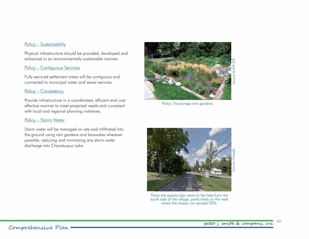
63
Comprehensive Planpeter j. smith & company, inc.
Policy – Sustainability
Physical infrastructure should be provided, developed and
enhanced in an environmentally sustainable manner.
Policy – Contiguous Services
Fully serviced settlement areas will be contiguous and
connected to municipal water and sewer services.
Policy – Consistency
Provide infrastructure in a coordinated, efficient and cost
effective manner to meet projected needs and consistent
with local and regional planning initiatives.
Policy – Storm Water
Storm water will be managed on site and infiltrated into
the ground using rain gardens and bioswales wherever
possible, reducing and minimizing any storm water
discharge into Chautauqua Lake.
There are spectacular views to the lake from the south side of the village, particularly on the west
where the slopes can exceed 20%.
Policy: Encourage rain gardens.
Sourc
e:
Sourc
e:S
UN
Y E
SF

Village of Lakewood64
Comprehensive Plan
Figure 10.1 Transportation

65
Comprehensive Planpeter j. smith & company, inc.
10.0 Transportation Network10.1. Overview
In accordance with New York State Village Law, Section
7-722. Village Comprehensive Plan, the Village of
Lakewood comprehensive plan considers transportation
characteristics. Specifically, this section recognizes the
following element of Section 7-722.:
3. Content of a village comprehensive plan. The village
comprehensive plan may include the following topics at
the level of detail adapted to the special requirements of
the village:
f. The location and type of transportation facilities.
10.2. Roads and Traffic
10.2.1 Functional Classification
In New York State, the functional classification system
is prepared and maintained by the New York State
Department of Transportation. The Federal Highway
Administration (FHWA) classifies roadways and highways
according to the function or service it provides. There are
three major categories of roadways and highways: Local,
Collector and Arterial. Within the Village of Lakewood,
each of these classifications exist:
•Major Arterials - Route 394, Fairmount Ave
•Minor Arterial – Summit Street, Shadyside Avenue (Summit to Fairmount), County Route 45
•Major Collectors – Shadyside Avenue (south of Fairmount), Winch Road, Winchester Road
•Local roads are all roadways not included in a higher-level classification. They provide basic access between residential and commercial properties as well as connections to higher classification roads.
•Collectors are designed for lower speeds and shorter distances. They are typically two-lane roads that collect and distribute traffic to and from the arterial system and connect them with residential neighborhoods.
•Arterials include interstates, other freeways and expressways, and are designed for higher speed and traffic volumes. These roads serve as connections between municipalities or to the interstate system.
10.2.2 Traffic Counts
Traffic counts are taken by the NYS Department of
Transportation. These counts are measured in Average
Annual Daily Traffic (AADT). The traffic counts in the village
are fairly modest with the exception of those on Fairmount
Avenue. The AADT on Fairmount Avenue in the center of
the village is 10,238. This figure almost doubles on the
eastern end of the village where traffic between the mall
and Jamestown plays a significant role. It should be noted
that AADT counts could be significantly higher during the
summer as all communities surrounding Chautauqua Lake
are affected by seasonal fluctuations.

Village of Lakewood66
Comprehensive Plan
10.3. Rail Service
An active rail line that runs through the center of the village
serves the surrounding communities for the movement of
freight. There is no passenger rail service provided in the
surrounding area.
10.4. Bus Service
Public transportation is provided by the Chautauqua Area
Regional Transportation System (CARTS). Two routes run
between Lakewood and Jamestown via Fairmount Avenue,
Chautauqua Avenue and Summit Street. By request, these
routes can be extended further west down Fairmount and
Summit. Another route travels between Mayville and
Jamestown via Route 394 (Fairmount Ave.)
10.5. Air Service
The Chautauqua County-Jamestown Airport, about 10
miles from Lakewood, provides daily commercial flights to
Pittsburgh as well as private aircraft accommodations. Erie
International Airport, the closest international airport to
Lakewood, is 56 miles away. Buffalo Niagara International
Airport, 80 miles away, is the closest major airport to
Lakewood.
10.5.1 Bicycle and Pedestrian Travel
Fairmount Avenue is designated as State Bike Route 17,
which runs from Westfield to Wappinger Falls, Dutchess
County, NY. The route is a shared road route with no
designated bike lanes. Summit Street and Terrace Avenue
are designated as county bike routes. These routes also
do not have designated bike lanes.
Lakewood is an active biking and walking community.
However, few streets in the Village of Lakewood have
sidewalks on both sides of the street although several
streets have a sidewalk on one side of the road. On
longer streets, these sidewalks are often not continuous.
Busier streets, such as Fairmount Avenue, have wider
shoulders to accommodate pedestrian and bicycle travel.
There are no trails in the village. The Chautauqua County
Greenways Plan shows a planned trail that cuts across the
village.
Planning has been initiated to complete a trail along the
4.1 miles of the WNY&P railway within the Town of Busti,
including the Village of Lakewood, called the LoCo Trail.
This rail corridor remains active, but fewer than one train
per week is currently using this low-speed line. Southern
Tier West’s Comprehensive Economic Development
Strategy (CEDS) views this corridor to be vital to area
businesses, however, one track is already abandoned and
the track removed, leaving adequate space for a “Rail
With Trail.” A trail on this corridor could be expanded to
connect with adjacent communities and other trail systems
currently in place or in development, including the City of
Jamestown Riverwalk and the Erie-Pittsburgh Trail Northern
Section in Corry, PA. Negotiations regarding a lease
agreement with WNY&PA to develop a trail are ongoing.

67
Comprehensive Planpeter j. smith & company, inc.
10.6.2 Policies
Policy – Land Use
Land use patterns shall be
promoted which minimize the
length and number of trips and
reduce dependence on the
automobile.
Policy – Railroad Corridor
The preservation and reuse
of the abandoned portion
of the railroad corridor for a
recreational trail and as a
linear park offering park
facilities and storm water
management should be
encouraged.
Policy – Bicycle Circulation
Safe and efficient bicycle
lanes should be
introduced to all streets
in the community linking
all destinations.
Traffic on busy Fairmount Avenue.
An alternate plan was proposed by community members
which would involve construction of a trail adjacent to the
Rail right-of-way. Several paper streets (unused road right-
of-ways) exist along this route as well as publicly owned
land, but easements would still need to be negotiated with
some private property owners, and this option presents
other challenges including stream-crossings and grade
changes. A feasibility study should be completed to assess
the viability, potential trail alignment, and estimated cost of
this option.
10.6. Transportation Network policy framework
As a result of the analysis of the community’s
transportation network, the following policies have been
developed to help Lakewood develop into a multi-modal,
connected and green village.
10.6.1 Intent of the policies
The purpose of the transportation network is to facilitate
the movement of people and to minimize the impacts of
vehicular traffic. The improvement of the pedestrian and
bicycle circulation systems is a priority. Alternatives need
to be developed to promote a safe, healthy, multi-modal
transportation network.
Lakewood residents enjoy biking and walking on village streets.
Photo
by
Lisa
Sch
mid
tferick
-Mill
er

Village of Lakewood68
Comprehensive Plan
Figure 10.2 Existing & Proposed Greenways

69
Comprehensive Planpeter j. smith & company, inc.
Policy – Street Hierarchy
A hierarchy of streets based on the desired character of
each should express and enhance the identity of the village
and facilitate wayfinding. The hierarchy is:
•Mixed-Use Mall Village – wide sidewalks, seating, gathering, urban art, banners, buildings oriented to the street
•Historic Village Center – wide sidewalks, interpretive panels, banners, street lamp flower containers
•Fairmount Avenue – boulevard streets: green medians, naturalized street trees, street lamp banners, pedestrian recreation trail
Policy – Roundabouts
Roundabouts should be located at primary intersections
to facilitate traffic flow and support the intersection as a
gateway area accenting focal points for the centers of the
two villages.
Potential roundabout locations include:
•Fairmount Avenue and Chautauqua Avenue
•Fairmount Avenue and Mall Boulevard
Policy – Pedestrian Circulation
Pedestrian circulation should be facilitated to the two
commercial cores and Chautauqua Lake access points
linking all parks and open spaces in the community.
Policy – Commercial Parking
Parking in commercial/mixed-use districts should be hard
surfaced, permeable and planted with native, deciduous
trees to provide shade and reduce the heat island effect.
Policy – Multi–Modal Circulation
A staging area for public transit should be located
proximate to the two village centers to support intermodal
circulation and should include bicycle parking and seating.

Village of Lakewood70
Comprehensive Plan
C.
Co
mm
un
ity
Am
en
itie
sThe following three
chapters are:
• Historic & cultural resources
• Parks & recreation
• Community facilities & services
These sections are relevant to exploring the amenities
of Lakewood that are publicly available for
the use of residents and visitors.

71
Comprehensive Planpeter j. smith & company, inc.
11.0 Historic & Cultural Resourceswhich burned or were razed by the mid-20th century.
The Packard family figures prominently in the history of
the village. The family’s largesse has contributed land and
funding for a number of community objectives. The stately
Packard Mansion, now a condominium complex, still
presides over the lake. Its gardens are still maintained.
A collection of quaint wooden vacation cottages known
as the Packard cottages, are so-named because they
were moved from their sites to make way for construction
of the Packard family mansion. The Packard cottages
were moved to scattered sites in the village. Many of
these whimsical structures remain today, and have been
converted to year-round use.
Another surviving landmark, known as the Green Farm,
was built in 1905 by Ohio native Paul Sorg. For many
years the mansion housed the Green Farm Tea Room
where visitors could enjoy tea and lighter fare and
purchase upscale gifts, clothing and novelties in the
restaurant’s gift shop. The Green Farm Tea Room closed
in 2002 and its contents were auctioned. A 13-room bed
and breakfast, to be known as the Chautauqua House,
was proposed for the mansion that same year. The
building now sits vacant.
Lakewood’s history has been carefully preserved in its
history museum as well in numerous publications and
books. The legacy of people, buildings and spaces provide
invaluable connections to the history of Lakewood and
adds significantly to Lakewood’s charm and character. It
11.1. Overview
In accordance with New York State Village Law, Section
7-722. Village Comprehensive Plan, the Village of
Lakewood’s comprehensive plan considers the existing
historic and cultural resources. Specifically, this section
recognizes the following element of Section 7-722.:
3. Content of a village comprehensive plan. The village
comprehensive plan may include the following topics at
the level of detail adapted to the special requirements
of the village:
d. consideration of agricultural uses, historic and
cultural resources, coastal and natural resources and
sensitive environmental areas.
i. the present and future general location of educational
and cultural facilities, historic sites, health facilities
and facilities for emergency services.
11.2. Historic Resources
New York’s State Historic Preservation Office (SHPO)
administers programs authorized by both the National
Historic Preservation Act of 1966 and the New York State
Historic Preservation Act of 1980. Currently no sites within
the Village of Lakewood are listed on the State or National
Registers of Historic Places.
Even though there are no Lakewood sites listed on the
registers, the village is rich in history. A series of interpretive
plaques throughout the waterfront area mark the location
and heritage of the grand 19th century resort hotels, all of

Village of Lakewood72
Comprehensive Plan
This map was adapted from a brochure developed by the Lakewood Historical Museum Committee. It shows the locations of plaques marking the locations of 14 of Lakewood’s
historic resorts, cottages, hotels and beautiful homes. While many of these structures are now gone the plaques include images and narrative to set the context for Lakewood in the Gilded Age. The plaques comprise a great context-
setting walking tour of the village.
Figure 11.1 Plaques
does this through the plaque program, interpretive markers
on Chautauqua Avenue and through “year built” markers
available to homeowners for a nominal fee. The locations
of these plaques are illustrated in the map on the following
page summarized in the tables at right.
11.3. Cultural Resources
There are no significant cultural facilities located in the
Village of Lakewood. A small village community history
museum is located in the lower level of Village Hall. The
Chautauqua Institution, a regional cultural resource, is
located 10 miles northwest of the Village. Jamestown
is three miles to the east. The following performing arts
venues and museums are located in Jamestown:
•Chautauqua Regional Youth Ballet
•Community Music Project
•Fenton History Center
•Infinity Visual and Performing Arts
•Lucille Ball Little Theater of Jamestown
•Lucille Ball Desi Arnaz Museum & Center for Comedy
•Reg Lenna Civic Center
•Jamestown Concert Association
•Roger Tory Peterson Institute of Natural History
•James Prendergast Art Collection
•The Weeks Gallery at Jamestown Community College
•Willow Bay Theater
•Robert H. Jackson Center

73
Comprehensive Planpeter j. smith & company, inc.
11.4. Historic & Cultural resources policy framework
As a result of the analysis of the historic and cultural
resources in the village, the following policies have been
developed to help guide the village as it works to preserve
and interpret these resources for the enrichment of
residents and visitors and to use as economic development
tools.
11.4.1 Intent of the policies
The Packard summer home, overlooking Chautauqua
Lake, surrounded by a number of unique heritage
cottages, a central waterfront park and a historic village
downtown forms the heart of this significant heritage
village. The waterfront location and heritage story form
the basis of creating an attractive place to live and work
incorporating economic development opportunities and
unique commercial opportunities in promoting tourism:
restaurants, galleries, culture and the arts.
Policy – Historic Districts
Lakewood is a heritage village and in order to protect its
historic structures and character, historic districts should be
defined and developed.
Policy – Heritage/Cultural Events
Heritage and cultural events should be promoted in
the village downtown/heritage district as a source of
Table 11.1 Location of “Year Built” Plaques in the Village
ADDRESS YEAR
12 Stoneman Ave. 1826
43 W. Fairmount Ave. 1826
176 Bentley Ave. 1830
75 E. Fairmount Ave. 1837
12 E. Fairmount Ave. 1850
4 E. Terrace Ave. 1865
6 Alta Way 1870
50 W. Terrace Ave. 1875
37 W. Terrrace Ave. 1875
10 & 12 E. Summit St. 1876
81 E. Terrace Ave. 1880
11 E. Summit St. 1880
15 Sunset Ave. 1880
41 E. Terrace Ave. 1888
1 Winchester Rd. 1890
16 Owana Way 1890
137 E. Terrace Ave. 1891
51 W. Terrace Ave. 1891
178 Bentley Ave. 1895
15 E. Third St. 1895
1 Pine Ave. 1895
7 Winchester Rd. 1898
7 Sunset Ave. 1899
38 Chautauqua Ave. 1900
154 Lakeview Ave. 1900
ADDRESS YEAR
6 Freeman Ave. 1900
11 Sunset Ave. 1900
89 E. Terrace Ave. 1902
34 Ohio Ave. 1905
218 W. Summit St. 1907
400 East Terrace Ave. 1908
293 E. Terrace Ave. 1909
166 Bentley Ave. 1910
19 Owana Way 1910
6-12 W. Terrace Ave. 1912
11 W. Terrace Ave. 1917
138 E. Terrrace Ave. 1920
71 W. Summit St. 1920
39 New York Ave. 1920
14 Webster St. 1924
68 E. Terrace Ave. 1929
2 East Second St. 1933
70 E. Fairmount Ave. 1952
9 Stoneman Ave. 1954
65 W. Summit St. 1955
133 Winch Rd. 1956
188 E. Terrace Ave. 1956
103 Erie St. 1959
107 Waldemere Way 1961
44 W. Fairwood Dr. 1967
31 Mapleview Ave. 1973

Village of Lakewood74
Comprehensive Plan
Figure 11.2 Historic Resources

75
Comprehensive Planpeter j. smith & company, inc.
The charming and whimsical Packard Cottages are a unique historic resource.
The Sorg Mansion, or Green Farm, looks remarkably contemporary in this historic postcard. Inedeed, exterior of the building is unchanged.
A penny postcard of Kent House.
community pride and the village as a regional destination.
Policy – Interpretation
Heritage districts should be viewed as outdoor museums
offering interactive heritage displays and pedestrian nodes
with seating and informational panels supported by a
comprehensive interpretive program.

Village of Lakewood76
Comprehensive Plan
Figure 12.1 Parks
77
Comprehensive Planpeter j. smith & company, inc.
12.0 Parks & RecreationThe National Parks & Recreation Association (NPRA)
issues guidelines that recommend between two and five
acres of community park space per 1,000 people and
an additional one to two acres of neighborhood park per
1,000 people. For the Village of Lakewood, this equates to
six to 15 acres of community park space and three to six
acres of neighborhood park space.
The Village of Lakewood has a total of 31.5 acres of park
space including Packard Field, a school-owned facility
open to public use. The NRPA standards would seem to
suggest that the village has a sufficient amount of park
space. However, all the parks in the Village of Lakewood
are of the community type with no neighborhood parks.
Furthermore, residents on the south side of the village are
underserved by parks. Naetzker Park is only preserved
open space in Lakewood located south of the rail corridor
and the only one with no facilities.
Play structures are also needed in the village. Existing
playground equipment in Hartley and Veterans parks
is older and in need of replacing. Small neighborhood
parks, also known as tot lots, with playground equipment
throughout the village accessible from all neighborhoods
are also needed.
The village should undertake a parks and recreation
planning process with a broad public input program to
determine local needs. Following is summary of parks
located within the village along with the amenities they
provide:
12.1. Overview
The existing parks and recreation system is depicted to
provide a basis for making decisions on its future course.
The intent is to make recommendations for policies and
strategies to meet the future recreational needs of the
community.
In accordance with New York State Village Law, Section
7-722. Village Comprehensive Plan, the Village of
Lakewood’s comprehensive plan considers the existing
parks and recreation facilities. Specifically, this section
recognizes the following element of Section 7-722.:
3. Content of a village comprehensive plan. The village
comprehensive plan may include the following topics at
the level of detail adapted to the special requirements
of the village:
j. existing and proposed recreation facilities and
parkland.
12.2. Parks & Recreation Resources
12.2.1 Facilities Inventory
An inventory of the existing parks and recreation facilities is
required as a basis for the analysis of the park system. The
Village provides a variety of recreational facilities.
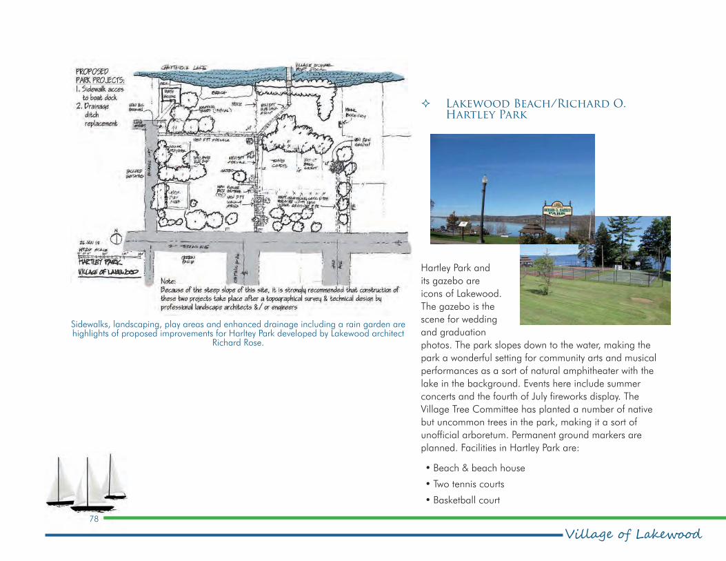
Village of Lakewood78
Comprehensive Plan
� Lakewood Beach/Richard O. Hartley Park
Hartley Park and
its gazebo are
icons of Lakewood.
The gazebo is the
scene for wedding
and graduation
photos. The park slopes down to the water, making the
park a wonderful setting for community arts and musical
performances as a sort of natural amphitheater with the
lake in the background. Events here include summer
concerts and the fourth of July fireworks display. The
Village Tree Committee has planted a number of native
but uncommon trees in the park, making it a sort of
unofficial arboretum. Permanent ground markers are
planned. Facilities in Hartley Park are:
•Beach & beach house
•Two tennis courts
•Basketball court
Sidewalks, landscaping, play areas and enhanced drainage including a rain garden are highlights of proposed improvements for Harltey Park developed by Lakewood architect
Richard Rose.

79
Comprehensive Planpeter j. smith & company, inc.
•Two playgrounds
•Gazebo
•Public dock
� LaGrega Field
The existing baseball diamond at Michael LaGrega
Memorial Field is for Little League players. There is an
adult-sized diamond being built by the village at the south
end of the park between the north/south park road and
Fireman’s Park. There is a new small pond and pier just
north of the new baseball field at the edge of the wooded
wetland that extends to Summit Avenue.
To better organize parking and make it safe for the many
children who play there, the Tree Committee has started
to plant a line of shade trees parallel to the north/south
road to create 20-foot deep parking spaces at right
angles to the road and a five-foot wide accessible paved
sidewalk from the Little League diamond to the pickleball
courts. The Village DPW has been asked to provide gravel
and parking bumpers for this parking area as well as the
sidewalk.
LaGrega Field amenities are:
•Baseball diamond
•Six pickleball courts
•New baseball field under construction
� Veterans Park
Veterans Park has a very-well used basketball court as well
as a flag pole and small veterans marker. There is also
some outdated children’s play equipment.

Village of Lakewood80
Comprehensive Plan
� Packard Field
Packard Field is owned by the Southwestern School District
and harkens back to a time when Lakewood High School
was located nearby. There is lot of traffic generated by the
school bus and maintenance garage which is located to
north of the playing fields along the rail embankment.
Because the park is owned by the school district which
no longer had a school facility located adjacent, the
park’s future is somewhat uncertain. However, the district
continues to use the park: high school baseball teams still
play at the baseball diamond.
Packard Field amenities are:
•Baseball diamond
• Two Soccer pitches
� Lakewood Community Park
Lakewood Community Park is host to Lakewood’s public
boat launch and also includes picnic facilities. The
community’s “Bark Park” is located across the street.
Lakewood Community Park amenities:
•Public boat launch
•Picnic pavilion with grills

81
Comprehensive Planpeter j. smith & company, inc.
Chautauqua Avenue just south of Yesterday’s Bar. This is
a single-lot park where a home was demolished. It has
a wall with the names of people and organizations that
donated or helped the 2004 $2.5 million reconstruction
of Chautauqua Avenue completed by the Lakewood
Community Development Corporation. There is a small
screened parking area to the east, some plantings and one
shaded bench with space for another bench or two.
The annual Christmas Tree Lighting takes place in
Recognition Park.
� Firemen’s Grounds
The Firemen’s Grounds are located between Pleasantview
and Glenwood avenues. The grounds are privately owned
by the Fire Company used for training and member
recreation. Activities available for public use at the
discretion of the fire company include weddings and other
celebrations.
� Lowe Park
This park conceals a large metal storm water pipe that
drains into Chautauqua Lake. Lowe Park is a one-lot wide
mowed grass space with no parking. Village residents use
the park for fishing and bring their own chairs to sit by the
water.
� Recognition Park
Recognition Park is located on the east side of

Village of Lakewood82
Comprehensive Plan
Potential improvements for Naetzker Park include a nature trial with seating areas and a new parking area to make this park more enjoyable for Lakewood residents. This concept was
developed by Lakewood architect Richard Rose.
� Naetzker Park
Naetzker Park is a completely
wooded two-plus acre parcel with
a large deep ravine and a stream
running. It serves as a buffer to an
adjacent housing complex. It is the
only village park on the south side
of the village.
In addition to the parks, the
community has a branch of the
Jamestown Family YMCA located
on Fairmount Avenue. For a
fee, members can participate
in a range of recreational,
educational and creative
programming. The Jamestown YWCA maintains Lake
Lodge, a handicapped-accessible facility available to
the community for rent. The lodge has a capacity of 100
people and parking for 28 cars. Available amenities
include picnic tables, grills, playground, seasonal dock
and restrooms.

83
Comprehensive Planpeter j. smith & company, inc.
12.3. Parks & Recreation policy framework
As a result of the analysis of the Village of Lakewood’s
parks and recreation resources, the following policies have
been developed to guide the community as it works to
create a multipurpose parks and recreation system
12.3.1 Intent of the policies
Lakewood should offer a broad range of recreational
amenities and facilities to all residents and visitors in an
open space system that includes the railroad corridor.
The system should provide areas for socialization and
community and neighborhood events to strengthen
neighborhood bonds, pride and responsibility as well as
managing storm water.
12.3.2 Policies
Policy – Distribution of Parks
There should be parks evenly distributed throughout the
community for access to recreation and facilities by all
village residents.
Policy – Lakefront Parks
Lakefront parks should be developed as community
gathering and event spaces and for waterfront-related
activities and facilities.
Policy – Lakefront Portal Parks
All road ends at the lakefront should be developed as
community access points providing seating, interpretive
and water-based amenities if available.
Policy – Recreation Activities
Inland parks should offer a full range of recreation
activities for all ages including play structures, exercise
stations, sports courts, seating areas, walking trails and
interpretive displays. Specific parks may be limited in
amenities, e.g. gateway parks.
Policy – Waterfront Promenade
A pedestrian/bicycle waterfront trail/promenade should
be developed continuous along the lakefront in both
directions from Lakewood Beach as far as possible. The
trail should be hard surfaced, lighted and allow access to
the water.
Village of Lakewood84
Comprehensive Plan
Policy – Waterfront Access
Waterfront access should be consistent and parallel to the
entire length of the lakefront wherever possible and access
should be provided at all road ends.
Policy – Parks as Wetlands
Parks should be designed and used as detention/retention
and wetlands. Wetland parks should offer boardwalks,
seating areas and interpretive information and act as links
in the overall trail/open space system.
Policy – Trailheads as Brand
Trailheads should be developed at all road-to-trail
connections with seating areas, wayfinding signage and
interpretive signage as neighborhood features. Trailheads
should be used to enhance connections to and between
neighborhoods.
Policy – Heritage/Cultural Events
Heritage and Cultural events should be promoted both
in the Village centers, heritage parks and along the
waterfront.

85
Comprehensive Planpeter j. smith & company, inc.
13.0 Community Facilities & Services•One Ladder
•One Heavy Rescue Unit
•One Ambulance
•One Medical Support Unit, certified as an Advanced Life Support Unit. This unit has all the capabilities and equipment of an ambulance, minus the capabilities of patient transportation.
•One Miscellaneous Support Unit for scene support and traffic control
The department responds to
more than 800 annual calls and
provides support to neighboring
departments and Chautauqua County. The department
hosted the US Coast Guard simulated aircraft crash
incident exercise on Chautauqua Lake in February 2014.
13.2.2 Law Enforcement
Law enforcement is provided by the Lakewood-Busti
Police Department located at 20 West Summit St. The
department has nine full-time police officers and eight
part-time officers. The Village contracts with the Town to
provide police protection to the Town under a NYS shared
services contract. The department responded to more than
12,000 reportable incidents in 2014. The department’s K9
Unit is one of four in Chautauqua County.
The Lakewood Fire Department participated in a US Coast Guard simulated aircraft crash on
Chautauqua Lake in February 2014.
13.1. Overview
An evaluation of the existing community facilities and
services in the Village of Lakewood defines the present
conditions of public services and amenities available to
Village residents. This will serve as the guide for planning
and improving this infrastructure in the future.
In accordance with New York State Village Law, Section
7-722. Village Comprehensive Plan, the Village of
Lakewood’s comprehensive plan considers the existing
community facilities and services. Specifically, this section
recognizes the following element of Section 7-722.:
3. Content of a village comprehensive plan. The village
comprehensive plan may include the following topics at
the level of detail adapted to the special requirements
of the village:
i. the present and future general location of educational
and cultural facilities, historic sites, health facilities
and facilities for emergency services.
13.2. Community services
13.2.1 Fire Department
The Lakewood Volunteer Fire Department, 37 J.W.
Packard Blvd., provides fire and emergency services
including emergency medical services . The department
houses the following pieces of apparatus:
•Two Fire Pump Engines

Village of Lakewood86
Comprehensive Plan
Figure 13.1 Community Services

87
Comprehensive Planpeter j. smith & company, inc.
Southwestern Elementary, the
Middle and High schools. The
are all located on one campus
at 600 Hunt Road in the Town
of Ellicott just southeast of the
village. The district has an
enrollment of 1,481 students;
employs 137 faculty members
and 81 non-instructional
personnel. The district’s
graduation rate is 98 percent.
13.3.3 Department
of Public
Works
The Department of Public
Works (DPW) is located at 6 Packard Way. It makes up
21.5% of the Village Budget. The DPW is responsible
for street maintenance, snow removal, garbage and leaf
pickup and park maintenance.
13.4. Libraries
The Village is served by Lakewood Memorial Library
located at 12 West Summit St. The library is part of the
Chautauqua-Cattaraugus Library System and features:
•More than 43,000 holdings.
•Meeting room
•Programs for adults and children
13.2.3 Code Enforcement
The Code Enforcement Officer (CEO) works for both
the Village of Lakewood and Town of Busti under an
NYS shared services contract. In the village the CEO is
responsible for reviewing development proposals prior to
the Planning Board who which make recommendations
to the Village Board of Trustees. The CEO also reviews
Zoning Board of Appeals applications and inspects
properties and structures to ensure they are built and
maintained to zoning regulations and New York State
Building & Fire Code standards.
13.3. Community facilities
13.3.1 Village Hall
The Village hall is located in the same building as the
police department at 20 West Summit St. The village
offices house the Mayor’s Office, as well as offices for the
Village Clerk, Village Treasurer, Code Enforcement Officer,
Department of Public Works, and the Streets Department.
The Village Board meets on the second and fourth Monday
of each month at 6 p.m.; Planning Board meetings are on
the third Wednesday at 7:30 p.m.; and the Zoning Board
of Appeals meetare on the second Thursday at 6:30 p.m.
13.3.2 Educational Facilities
The Village of Lakewood belongs to the Southwestern
School District. The district is comprised of three schools:
Southwestern School District, with a campus on Hunt Road in Ellicott, serves Lakewood children.
Although it no longer has a school facility located there, the district continues to own Packard Field in
the village.
Soutc
e:
South
west
ern
Sch
ool D
istric
t

Village of Lakewood88
Comprehensive Plan
•Computer access
•Heritage Room Exhibit for monthly art shows by local artists
•Issues and Interests discussion group
•Computer classes
•Third Tuesday Book Group
13.5. Churches
The following churches are located in Lakewood:
•Lakewood Baptist – 150 Erie St.
•Lakewood United Methodist – 164 Shadyside Ave.
•Gloria Dei Lutheran – 35 W. Fairmount Ave.
•Sacred Heart Roman Catholic – 380 E. Fairmount Ave.
13.6. Community Centers
The village does not currently have a community center.
13.7. Cemeteries and Funeral homes
The Town of Busti owns historic Bentley Cemetery on
Shadyside and Fairmount avenues in the Village. Among
local figures buried there is George Stoneman. Stoneman
was born in Lakewood in 1822. A West Point Military
Academy graduate and career soldier, he commanded the
Third Corps in the Civil War Battle of Fredericksburg and
led “Stoneman’s Raid” at the Battle of Chancellorsville.
For more about Stoneman, this blog entry provides
some interesting information: https://petruzz.
wordpress/2007/02/24/.
There are no funeral homes in Lakewood.
13.8. Fraternal, Social and Charitable Organizations
Fraternal and social organizations in Lakewood include a
chapter of the international fraternal organization Kiwanis
and an American Legion post.
The Lakewood Rod and Gun Club, a private membership
organization located on East Terrace Avenue, offers social
and family events. Its waterfront facility includesfull dining
and bar service and banquet hall. It also rents boat
dockage spaces to its members.
The Chautauqua Lake Yacht Club is a private
membership organization located in Lakewood. The
objectives of the club are to promote and encourage
yachting on Chautauqua Lake, to conduct races, and to
promote adherence to rules of safety. It sponsors a junior
sailing program, clinics, and regattas as well as hosting
Eastern and National sailing competitions. At its Lake
Street facilities it offers full dining services and numerous
social events
The Chautauqua Lake Community Sailing Foundation
was founded in 2015 with the goal of making sailing

89
Comprehensive Planpeter j. smith & company, inc.
the center of Chautauqua Lake. The foundation sposnors
the Southwestern High School competitive sailing team,
hosts sailing competitions on Chautauqua Lake, and in
partnership with Jamestown Community College offers
adult sailing instruction.
Founded in 1947, the Women’s Club of Lakewood is a
member of the General Federation of Women’s Clubs
(GFWC). The GFWC is an international women’s
organization dedicated to community improvement by
enhancing the lives of others through volunteer service.
The Women’s Club has more than 150 members. It raises
funds for yearly scholarships for high school students,
the biannual spring cleanup and annual planting of the
street planters on Chautauqua Avenue., the annual Arbor
Day Tree, Christmas Wreaths for the Library and Village
Buildings, and many other community service programs.
The Club sponsors two Book Groups, Bridge, Crafts,
Garden, Gourmet, Knitting, and Movie Night social
groups that meet monthly. Club membership is open to
any female resident of Lakewood.
13.9. Community Facilities & Services Policy framework
As a result of the analysis of the Village of Lakewood’s
community facilities and services, the following policies
have been developed to guide the village as it strives
to provide services that are efficient, cost effective and
accessible by everyone.
13.9.1 Intent of the policies
The Village of Lakewood shall provide equitable services
for all ages, ethnicities and incomes to better serve
residents and visitors and make community resources
available for everyone with the understanding that
shared services between all agencies and governments is
appropriate and preferred.
13.9.2 Policies
Policy – Coordination
Promote coordination with and among surrounding
municipalities and all levels of government in planning for
emergency services, trails, transportation, infrastructure,
etc.
Policy – Shared Use of Community Facilities
Encourage coordination, co-location and shared use
of public facilities such as libraries, schools, indoor and
outdoor recreational facilities and community center.
Policy – Community Health
Recognize elements of healthy communities such as
community design and planning for all ages.
Policy – Community Signatures
Recognize institutional uses as important elements and
community signatures/monuments in community design
including: cemeteries, fraternal and social organizations.

Village of Lakewood90
Comprehensive Plan

91
Comprehensive Planpeter j. smith & company, inc.
III. A 21st
Century
Community

Village of Lakewood92
Comprehensive Plan

93
Comprehensive Planpeter j. smith & company, inc.
14.0 Lakewood: A 21st Century Community
14.1. Introduction
Lakewood has a significant identity or brand as an historic
and unique heritage resort community including its
Packard family legacy. It is now embracing a transition to
a 21st Century new community with a unique approach
and commitment to its environment and potential for
regional leadership in a shared responsibility for the
health and recovery of Chautauqua Lake. Lakewood
offers a diversity of activities, places and people. While
it preserves and celebrates its strong sense of identity
and character, it is ready to extend its ethic of wholesome
community, walkability and sustainability through a strong
commitment to its future and the future of the region.
Lakewood is a complete community that offers village
friendliness, quaintness and comfort through a diversity of
neighborhoods and range of amenities including urban
and downtown shopping, dining and entertainment.
Peaceful subdivisions complement commercial districts and
the iconic waterfront character upon which it was founded.
14.2. Vision
Lakewood’s waterfront should be one of the most
significant visitor destinations on the shores of Chautauqua
Lake. It is foremost a waterfront community and in
the future will offer a broader range of lake access
opportunities and linkages, both physical and visual.
The Chautauqua Avenue village core will be a brand
that identifies the community personality and scale
as a waterfront village with appropriate small-scale
shopping and restaurants. Fairmount Avenue’s suburban
commercial district will offer goods and services in an
attractive and multi-use new downtown commercial
environment. The community will offer a series of
interconnected and vibrant residential neighborhoods with
community parks and greenspaces for recreation that will
also help protect the quality of Chautauqua Lake’s waters.
Overall, the community will be connected with tree-
lined streets that offer safe pedestrian and bicycle access
between all neighborhoods, commercial nodes, public
outdoor spaces and Chautauqua Lake.
Lakewood will be a model in sustainability, economically,
environmentally and socially. It will express the concept
for the “new community” offering diversity of choice
in goods and services, housing and employment. The
village will be a leader in restoring Chautauqua Lake
through erosion control, pollution prevention and storm
water and sediment management. A gateway community
to the Chautauqua Institution, it is a year-round model
community, its thriving culture driven by an engaged and
passionate population.
Lakewood is also a regional anchor and a gateway
community for the City of Jamestown and Chautauqua
Institution. The communities complement each other and
work with shared goals to improve the region and build
on the natural beauty of Chautauqua Lake. Together,
they enhance the identity of the region as a year-round
destination offering residents and visitors walking, cycling,

Village of Lakewood94
Comprehensive Plan
fishing, swimming , boating, and simply enjoying and
viewing nature and the lake in an active, clean, safe and
exciting environment.
14.3. Futures Concept
The concept plan demonstrates the simple organization
of the community developing a model for a walkable
and an environmentally environment with an efficient
appraoch to handling storm-water discharge into the
Lake. The main north south links are creek corridors which
connect all parks to the Lake. They should be naturalized
and intermittently deposit into detention/retention areas.
The main east west links are the rail line and Fairmount
Avenue. Both should be developed as green pedestrian
corridors that assist to intercept and infiltrate storm-water
runoff. All linkages should be viewed as greenways, green
backbones that form the structure of the community and
focus on Chautauqua Lake.
14.4. Futures plan
The Futures Plan is the graphic expression of the goals,
objectives and policies, applied spatially to the village.
The Futures Plan serves as the conceptual rationale for
defining future land use and better organizes the village for
a future of economic vitality and sustainability. The Futures
Plan is also a manifestation of the ideas and values that
have been expressed by the public through the planning
processand the value the community places on preserving
its legacy, celebrating the past and connecting to the
future.
The Futures Plan is a vision for Lakewood as a premier
residential community of choice, employment and
recreation. The vision promotes healthy, active lifestyles
and integrates work, life and play into a dynamic
recreation network that is anchored by the walkable,
Historic Village Center and the Mixed-Use Mall Village.
The Futures Plan is a template. It identifies areas for
future development including connectors, streetscape
improvements, trails, and signature corridors. The Futures
Plan outlines a future for Lakewood in which the natural
landscape and Chautauqua Lake are preserved and
celebrated in this historic lakeside community.
Figure 14.1 Futures Concept
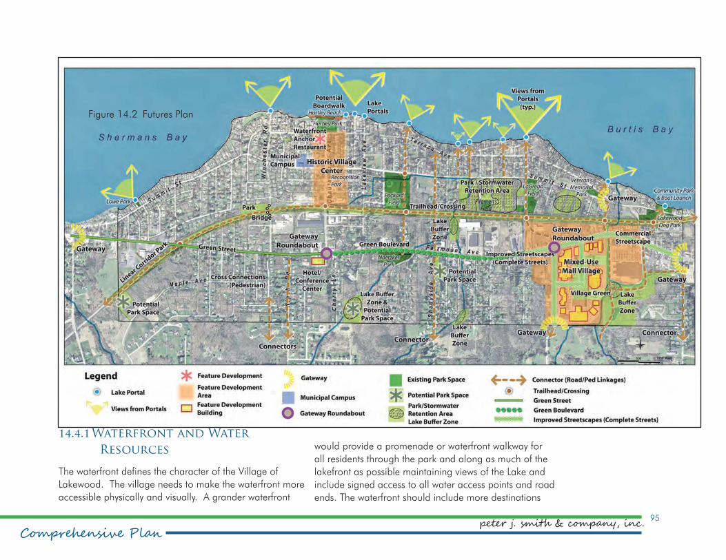
95
Comprehensive Planpeter j. smith & company, inc.
would provide a promenade or waterfront walkway for
all residents through the park and along as much of the
lakefront as possible maintaining views of the Lake and
include signed access to all water access points and road
ends. The waterfront should include more destinations
14.4.1 Waterfront and Water
Resources
The waterfront defines the character of the Village of
Lakewood. The village needs to make the waterfront more
accessible physically and visually. A grander waterfront
Figure 14.2 Futures Plan

Village of Lakewood96
Comprehensive Plan
for residents, visitors and marine traffic. Attractions could
include transient slips, a defined harbor and potential pier
or main dock, the promenade, and a waterfront restaurant
and encouraging reuse of a heritage home at the north
end of Chautauqua Avenue across from the park as a
restaurant, B&B or mixed commercial use.
All creeks should be naturalized. Areas for increased
detention and retention should be developed including
the rail line as a future greenway and primary storm water
detention. Ballast, the bed of gravel under the rail, could
be mined and in its place, pedestrian trails and park could
be developed. The entire ribbon of green could serve as
a water recharge area to filter storm water before it enters
the lake.
14.4.2 Destinations
The Village of Lakewood is identified by its heritage
downtown and panoramic vista to the lake. In the future
the Historic Village Center district should encourage more
shops and services supporting the traditional role of the
village. Residential development consisting of townhomes
or low rise apartments would support appropriate
commercial development. These uses on underutilized
parcels of land could be arranged around a square or
common that is home to community events and bisected
by the east-west greenway (former railroad) making
pedestrian connections to all areas of the Village.
The regional commercial area is a significant retail
destination at present in the form of a suburban mall. But
in the future could be in the form of the Mixed-Use Mall
Village. Enhancing land use opportunities and urban
design in the district is significant to maintain the districts
vitality and attraction. The area should be viewed as a
downtown with higher density residential development,
pedestrian streetscapes and commercial buildings with
minimal setbacks from the sidewalk to make a vibrant
livable and walkable district.
14.4.3 Circulation
All streets should allow and encourage pedestrian and
bicycle use. As a primary corridor Fairmount Avenue
should be a tree lined linear greenway accenting the core
corridor for the entire village experience and enhancing
the appearance of commercial uses. The central portion
of the road could be developed as a boulevard street with
a treed median.
Gateways at entrances to the village should be developed
to define the identity of this waterfront community and
direct the visitor to all of its unique destinations. The
gateway to the west could be a joint development with
the Town where Fairmount divides. Main access points
from the south should also be signed with a waterfront
inspired logo. Gateways should also be developed on
Fairmount Avenue highlighting the “main” streets for the
two commercial districts. These gateways could potentially
be roundabouts with central features and signage.

97
Comprehensive Planpeter j. smith & company, inc.
14.5. Future Land Use Plan
A future land use plan is designed to foster a desired
land use pattern in the near and distant future. The Future
Land Use Plan becomes a guide for land use decisions
in the future. Zoning changes should be consistent
with the Future Land Use Plan. This does not mean
that the current zoning districts need to be immediately
amended upon adoption of this plan. Current land uses
are protected and some zoning districts can remain in
place until a transformation to the Future Land Use Plan
is feasible. When a new Zoning Ordinance is adopted,
new zoning districts should be created to accommodate
the type of land use pattern suggested by the Future Land
Use Plan. This is only so the zoning adoption process
is not unnecessarily duplicated. Existing zoning district
boundaries can still be weeded out over time. The Future
Land Use Plan does, however, stop development that
requires a rezoning and is not consistent with the Future
Land Use Plan. The Future Land Use Plan also purposely
does not indicate concrete boundaries between different
future land use categories. This is done to allow for a little
flexibility in establishing boundaries between the different
land use patterns.
14.5.1 Historic Village Center
The Historic Village Center future land use is an extension
of the existing traditional village center to include a
connection to the waterfront and Fairmount Avenue.
While existing uses can remain, the area should contain
a mix of commercial and residential uses. Village scale
mixed use buildings should be located along Chautauqua
Ave with complimentary uses away from the strip. Historic
cottages should be preserved and community service
nodes should be enhanced and be visually connected
with the heritage village core. The future land use plan
anticipates the conversion of tracks into a linear park,
thereby removing the barrier to extend the downtown
south of the corridor where some industrial uses still exist.
Design standards should be created to establish a unifying
theme for the area.
14.5.2 Mixed-Use Mall Village
The Mixed-Use Mall Village future land use fosters
the transformation of the suburban retail center into a
somewhat high density mixed use village over time. The
designation does not suggest displacing the existing
commercial uses but rather incorporating them into an
urban village. Large parking areas would be replaced
with parking structures, apartment buildings, park and
recreational space, and complete streets. Residential units
can be built into the existing structures. Taller buildings
can take advantage of lake views. This future land use
transition is not expected to happen in the near future, but
over a long period of time as the demand for this type of
community develops with increasing population.

Village of Lakewood98
Comprehensive Plan
Figure 14.3 Future Land Use Plan

99
Comprehensive Planpeter j. smith & company, inc.
14.5.3 Residential Commercial Mixed-
Use Corridor
Along the rest of the Fairmount corridor, the future land
use plan calls for a mix of commercial and residential
uses. Design standards will dictate compatible
development. Densities can be greater than currently
exist. The street will be transformed into a parkway like
atmosphere accommodating pedestrian and cycling travel
as well as a moderately busy automobile traffic.
14.5.4 Shoreline Residential
The Shoreline Residential future land use echoes the
existing single family residential character of the area.
Setbacks should be in place to keep an open area
between the water and structures. Shoreline protection
could be improved. Residents will likely have personal
boat docks. Public access will be provided at street right-
of-ways that extend to the water.
14.5.5 Residential
The residential future land use will permit a mix of single
family and two family structures. Some areas may
be appropriate for multifamily units at a small scale.
Sidewalks should be provided on both sides of all streets.
Historic cottages should be preserved and surrounding
structures should complement their character. Park space
should be acquired and developed wherever possible.
Strong property maintenance regulations and enforcement
should be in place to protect the residential character.
14.5.6 Recreation and Resource
Management
The Recreation and Resource Management future land
use should foster the establishment of parks space and
recreational uses. The large undeveloped area, much of
which is already wetlands will be preserved and used to
divert storm water runoff to be filtered into the ground
instead of flowing directly into the lake. This area can also
provide natural open space for public enjoyment when dry.
Limited and appropriate residential development can be
permitted.
14.5.7 Linear Park
When rail service is no longer necessary, the corridor
should be acquired and turned into a linear park with
a multiuse trail surrounded by a thin tree-lined buffer.
The trail would be part of a larger rail-to trail system
connecting to other communities. In some areas,
particularly around Chautauqua Ave, the grade of the
corridor should reduced so as not to create a barrier
between the north and south section.

Village of Lakewood100
Comprehensive Plan
14.6. Future Land Use Regulations
The existing Zoning Ordinance will need to be revised in
order to accommodate land use patterns proposed by this
Comprehensive Plan, better address environmental issues
and development character, and correct some existing
errors that are present in the code. The following is a list
of measures that should be considered in a new Zoning
Ordinance.
•New zoning districts will need to be created to accommodate mixed use development patterns along Fairmount, the Mixed-Use Mall Village and the Historic Village Center.
•Design and performance standards should be used to control the types of uses and the character of development.
•R-1 and R-2 districts could be consolidated.
•Setbacks should be determined in the context of neighboring development as opposed to a minimum.
•Establishment of an historic/architectural review board
•Amend procedures to incorporate use of the review board
•Add historic preservation guidelines & standards
•Storm water management regulations need to be strengthened and include a threshold that post development run-off levels not exceed pre-development levels.
•Expand the tree regulations to protect significant trees on all properties.
•Incorporate circulation considerations into development proposals.
•Demand use of permeable paving materials.
•Include provisions for solar energy including solar access and design criteria.
•Adjust parking levels to limit expansive parking areas. (consider maximums)
•Update definitions to match modern interpretations, uses and development styles.
•Establish a new district or procedure for the development of senior housing units including accessory apartments and living arrangements such as cohousing and congregate living.
In addition, the following corrections should be made to
existing regulations before incorporating them into a new
ordinance.
Goals and objectives address the quality and design of the public realm to preserve and enhance Lakewood’s unique
identity.

101
Comprehensive Planpeter j. smith & company, inc.
goals and objectives of the plan
drive action.
Regional Context & Administration
Goal A To oversee community improvement through administration
» Objective A1: Develop a
framework to implement the
Comprehensive Plan
Goal B To establish a collaborative approach to governance and development of leadership capacity
» Objective B1: Engage the creativity and passion of
residents by encouraging civic involvement
» Objective B2: Promote Lakewood as a 21st Century
community by developing and adopting model
approaches to land use and citizen services
Goal C To improve efficiency and effectiveness of services through regional collaboration
» Objective C1: Coordinate with adjacent villages
and town as well as the Town of Busti on projects for
mutual benefit
•Reorganize the outdoor cooking section as a supplemental regulation or improve heading levels.
•The number of dwellings on a property should read “structures” not “dwellings”.
•Number of parking spaces does not read correctly. It needs to state a “number(s) per”
While existing regulations are in place for property
maintenance, regulations need to be more thoroughly
enforced, the correction period accelerated and a more
aggressive stance regarding nuisance properties taken.
14.7. Goals & Objectives
The goals and objectives reflect the needs and desires
of the residents of Village of Lakewood for their future.
They offer a guide for decision making into the future and
establish evaluation criteria to implement the community’s
vision for its future. The goals and objectives support long-
term sustainable relationships among residents, business
owners, elected officials, administrators and agencies. The
following goals and objectives form the foundation and
guidance in addressing specific community projects, issues
and concerns.
Each of the inventory elements is represented in the goals
and objectives. These goals become the framework for
the implementation of the Comprehensive Plan. They will
define project groups for the Village of Lakewood, serving
as umbrellas under which the specific measures to realize
the vision developed by the plan are to be organized. The
Objective: Move the community’s museum out of the bottom of Village Hall and into a new freestanding
facility.

Village of Lakewood102
Comprehensive Plan
Goal: Improve all modes of transportation for a safe and enjoyable environment.
» Objective C2: Promote
economies of scale by
developing public purchasing
networks
» Objective C3: Foster
regional approaches to
Chautauqua Lake reclamation
by fully participating in the
Chautauqua Watershed
Conservancy, Local Waterfront
Revitalization Program,
Chautauqua Lake Management
Commission, Chautauqua Lake Association and other
multi-jurisdictional organizations and their activities
Land Use & Zoning
Goal D To transition to a new land use pattern based on the Future Land Use Plan
» Objective D1: Alter zoning districts to be consistent
with the Future Land Use Plan
» Objective D2: Develop a new zoning ordinance
» Objective D3: Encourage mixed-use development
Goal E To promote infill development
» Objective E1: Reuse, preserve and upgrade vacant
and underutilized land by developing an acquisition
and marketing plan
Goal F Goal F: To improve public access to the lake
» Objective F1: Reclaim ownership of village right-of-
ways for lake access
Community Character
Goal G To improve the quality and character of the community
» Objective G1: Develop design standards to strengthen
the visual appeal, design character and quality of
commercial areas with building styles that evoke the
community’s waterfront character
» Objective G2: Create positive first impressions for
travelers entering the village
» Objective G3: Encourage the development of new
and infill housing appropriate in scale and character
to strengthen the design character and quality of
residential areas
Population & Housing
Goal H To improve the quality of existing housing stock
» Objective H1: Improve and enforce property
maintenance regulations
» Objective H2: Provide homeowners with connections
to technical assistance and funding for home repairs
and energy efficiency improvements

103
Comprehensive Planpeter j. smith & company, inc.
Goal I To provide housing options for a wide range of people
» Objective I1: Provide more opportunity for new and
different types of housing units
Economic Vitality
Goal J To enhance the lake as a visitor destination with improved amenities, services and activities on the waterfront and in surrounding urban areas
» Objective J1: Improve community amenities and
facilities for access to and from the lake
» Objective J2: Increase opportunities for entrepreneurs
to found new retail and commercial enterprises by
providing mixed-use areas close to customers and
shoppers
Goal K To develop visitor amenities related to the community’s heritage and culture
» Objective K1: Market Lakewood’s heritage by
developing events and activities to promote the
community’s history
» Objective K2: Create a central location for visitor
services and activities by developing a freestanding
museum
Environment
Goal L To become a leader in the reclamation of Chautauqua Lake and protection of a sustainable, quality environment
» Objective L1: Adopt best
practices policies that includes
removing culverts and creating
retention infiltration areas
as part of any public works
projects
» Objective L2: Control runoff
into Chautauqua Lake by
developing sand maintaining
storm water management
infrastructure
» Objective L3: Prevent erosion
by adopting regulations for
storm water management and
erosion control
» Objective L4: Facilitate the natural absorption of storm
water by conserving, enhancing, restoring natural
stream corridors, floodplains and wetlands
Objective: Move Lakewood “off the grid” with solar, heat exchangers
Objective: Develop a permanent farmers market. It would increase access to fresh local foods and
draw shoppers and tourists.

Village of Lakewood104
Comprehensive Plan
Goal M To be part of the global effort to reduce climate change by promoting “green energy” and increasing energy efficiency
» Objective M1: Mandate the use of “green” building
standards through Zoning
» Objective M2: Move Lakewood “off the grid” by
promoting use of solar energy and use of energy
efficient technologies.
Infrastructure & Utilities
Goal N To ensure that utility infrastructure adequately serves the residents and businesses in Lakewood
» Objective N1: Maintain and ensure communications
and telecommunications infrastructure for public safety
and citizen use
» Objective N2: Ensure that water and sewer services
are adequately provided to village residents
Transportation
Goal O To improve all modes of transportation for a safe and enjoyable environment
» Objective O1: Establish the LoCo trail or other public
bikeway through the village as a vital link between
destinations in the Village of Lakewood and Town of
Busti
» Objective O2: Implement the Village’s complete
streets policy to encourage walking and bicycle use
» Objective O3: Enhance the character of the
community and neighborhoods by developing
streetscape standards
» Objective O4: Improve the connections between the
two commercial areas as robust community centers,
attracting residents and visitors by improving access,
circulation and multimodal capacity
» Objective O5: Direct people to attractions and the
waterfront by developing a wayfinding system
» Objective O6: Encourage movement on foot and by
bicycle throughout the community by developing safe
access across Fairmount Avenue
Historic & Cultural Resources
Goal P To ensure the community’s heritage resources are sustained into the future
» Objective P1: Create a knowledge database of
heritage resources

105
Comprehensive Planpeter j. smith & company, inc.
» Objective P2: Provide owners of heritage buildings
and landscapes access to funding and technical
support by nominating buildings, landscapes and
districts to the state and federal registers of historic
places
Parks & Recreation
Goal Q To ensure access to recreation for all neighborhoods by establishing a system of parks, trails and open spaces
» Objective Q1: Improve access to active and passive
recreation areas including the waterfront and
residential neighborhoods including those south of
Fairmount Avenue
» Objective Q2: Encourage year-round facilities,
destinations and uses on and around the lake as
well as throughout the community by strengthening
connections between recreation facilities
» Objective Q3: Draw residents and visitors to the
waterfront by developing attractions, amenities and
events there
» Objective Q4: Become a leisure time destination by
creating spaces on the waterfront for people to linger
and socialize
» Objective Q5: Maintain & improve the quality of
existing parks
Community Facilities
Goal R To improve community health and wellness
» Objective R1: Improve access to fresh, local food
sources by developing a permanent farmers market in
Lakewood
Goal S To create a “municipal campus,” an attractive centralized location for community services and facilities
» Objective S1: Improve the appearance and
functionality of existing community facilities
» Objective S2: Develop new community facilities to
provide additional services

Village of Lakewood106
Comprehensive Plan

107
Comprehensive Planpeter j. smith & company, inc.
15.1. Overview
The implementation matrix for the Lakewood
Comprehensive Plan is organized into the categories of the
inventory of the plan and reflects its goals and objectives.
For each of the objectives, specific implementation steps
are listed. The matrix serves as a checklist and guide for
implementation with the following columns:
•Priority – including low, medium and high priority
•Timing – including short (1-5 years), medium (6-10 years), long (more than 10 years) and ongoing
•Key Partners – these are the agencies, groups and individuals that will be primarily responsible for each implementation step
•Partner with Private Sector? – indicates whether private sector contributions can encourage implementation
•Relative cost – an order-of-magnitude estimate of costs where:
•N/A – No Cost;
•$ – minimal, under $25K;
•$$ – $25K - $100K;
•$$$ – $100K-$500K;
•$$$$ – Over $500K
•Funding sources are mostly public and some private sources to aid in implementation
•Cost type includes such categories as administrative cost, acquisition, capital expense, consultant fees, etc.
•As each measure is implemented, the Date Complete column can be filled in.
15.0 Action Plan & Implementation Strategy15.2. Acronyms
The matrix includes a number of acronyms. They are:
•Admin – Administrative
•CC – Chautauqua County
•CCIDA – County of Chautauqua Industrial Development Agency
•CCLS – Chautauqua Cattaraugus Library System
•CDBG – Community Development Block Grant
•CEO – Code Enforcement Officer
•CHHIARC – Chautauqua Home Improvement & Rehabilitation Corp.
•CWC – Chautauqua Watershed Conservancy
•DHCD - Division of Homes & Community Renewal
•ESDC – Empire State Development Corp.
•HUD – US Department of Housing & Urban Development
•JBPU – Jamestown Board of Public Utilities
•LWRP – Local Waterfront Revitalization Program
•NYSDEC – New York State Department of Environmental Conservation
•NYSDOT – New York State Department of Transportation
•NYSERDA – New York State Energy Research and Development Authority
•NYSOPRHP – New York State Office of Parks, Recreation & Historic Preservation
•SCSD – South & Central Sewer District

Village of Lakewood108
Comprehensive Plan
•TB – Busti Town Board (Including Supervisor)
•USDA – United States Department of Agriculture
•VB – Lakewood Village Board (Including Mayor)
•WNY&P – Western New York & Pennsylvania Railroad
•ZC – Zoning Committee (Established in Objective D1)

109
Comprehensive Planpeter j. smith & company, inc.
StepsPriority Timing
Key Partners
Partner w/Private Sector?
Relative Cost
Funding Source
Cost TypeDate
CompleteL M H S M L O
Regional Context & Administration
Goal A: To oversee community improvement through administration
Objective A1: Develop a framework to implement the Comprehensive Plan
Adopt the Comprehensive Plan
X X VB No N/A N/A Admin
Appoint a voluntary Implementation Committee
X X VB No N/A N/A Admin
Committee develops work groups to address specific elements
X X X IC No N/A N/A Admin
Goal B: To establish a collaborative approach to governance and development of leadership capacity
Objective B1: Engage the creativity and passion of residents by encouraging civic involvement
Solicit input from residents at Board meetings and other public forum
X X VB No N/A N/A Admin
Develop better methods for advertising public forums
X XVB, Clerk,
Local mediaYes N/A N/A Admin
Goal C: To improve efficiency and effectiveness of services through regional collaboration
Objective C1: Coordinate with the Town of Busti on projects for mutual benefit
Establish and maintain regular line of communication between village and town officials
X X VB, TB No N/A N/A Admin
Table 15.1 Implementation Matrix

Village of Lakewood110
Comprehensive Plan
StepsPriority Timing
Key Partners
Partner w/Private Sector?
Relative Cost
Funding Source
Cost TypeDate
CompleteL M H S M L O
Study combining administrative offices into one building and achieving facilities economies of scale
X X VB, TB No
$-$$ for a study, $$$$ for any new
facility
None
Consultant fees, Capital
Improvements, Admin
Carry out planning initiatives as a joint effort with the Town of Busti
X X VB, TB No N/A N/A Admin
Consolidate administrative agencies where appropriate
X X VB, TB No N/A N/A Admin
Objective C2: Promote economies of scale by developing public purchasing networks
Establish a consortium of regional administrations and school districts to develop a system of responsibility and distribution of common purchases
XRegional
Administrators, Clerks
No N/A N/A Admin
Coordinate purchases with other regional governments and school districts
XRegional
Administrators, Clerks
No N/A N/A Admin

111
Comprehensive Planpeter j. smith & company, inc.
StepsPriority Timing
Key Partners
Partner w/Private Sector?
Relative Cost
Funding Source
Cost TypeDate
CompleteL M H S M L O
Objective C3: Foster regional approaches to Chautauqua Lake reclamation by fully participating in the Chautauqua Watershed Conservancy, Local Waterfront Revitalization Program, Chautauqua Lake Management Commission, Chautauqua Lake Association and other multi-jurisdictional organizations and their activities
Participate and become a leading member of the Chautauqua Lake & Watershed Management Alliance
X XMayor,
Participating communities
No N/A N/A Admin
Allocate funding to implement recommendation of the Alliance if necessary
X X VB Yes Varies NoneBudget
increase
Land Use & Zoning
Goal D: To transition to a new land use pattern based on the Future Land Use Plan
Objective D1: Develop a new zoning ordinance
Establish a zoning committee
X X VB, TB No N/A Admin
Retain a consultant to prepare the ordinance
X X VB, TB No $$NYSERDA,
LWRPConsultant
fees
Prepare SEQR requirements
X X VB, TB No N/A N/A Admin
Adopt Zoning Ordinance
X VB, TB No N/A N/A Admin
Objective D2: Alter zoning districts to be consistent with the Future Land Use Plan
Redraw zoning districts as part of zoning update
X X ZC No Included in zoning update
Objective D3: Encourage Mixed Development
Establish mixed use zoning districts with a wide range of uses
X X ZC No Included in zoning update

Village of Lakewood112
Comprehensive Plan
StepsPriority Timing
Key Partners
Partner w/Private Sector?
Relative Cost
Funding Source
Cost TypeDate
CompleteL M H S M L O
Goal E: To promote infill development
Objective E1: Reuse, preserve and upgrade vacant and underutilized land by developing an acquisition and marketing plan
Actively assist the Chautauqua County Land Bank by identifying vacant & underutilized parcels
X XCEO, Regional
AssessorNo N/A N/A Admin
Goal F: To improve public access to the lake
Objective F1: Reclaim ownership of village right-of-ways for lake access
Identify village owned land and public right-of-ways
X X
County Planning,
CEO, Regional Assessor
No N/A N/A Admin
Resolve to take possession of public lands with lake access or receive payment in lieu of adverse possession
X X VB No N/A N/A Political will
Develop plan for improvements and public access
X X VB Yes $$ NYSPRHPCapital
improvements
Implement strategies to prevent future privatization of public water-access spaces
X X CEO No N/A N/A Admin

113
Comprehensive Planpeter j. smith & company, inc.
StepsPriority Timing
Key Partners
Partner w/Private Sector?
Relative Cost
Funding Source
Cost TypeDate
CompleteL M H S M L O
Community Character
Goal G: To improve the quality and character of the community
Objective G1: Develop design standards to strengthen the visual appeal, design character and quality of commercial areas with building styles that evoke the community’s waterfront character
Develop Design Standards as part of Zoning Update
X X ZC No Included in zoning update
Objective G2: Create positive first impressions for travelers entering the village
Design, construct, and maintain decorative gateways at key locations
X XVB, Public Works, TB
Yes $$ NYSDOTCapital
Improvement
Objective G3: Encourage the development of new and infill housing appropriate in scale and character to strengthen the design character and quality of residential areas
Provide incentives for infill development as part of the zoning update
X X ZC No Included in zoning update
Population & Housing
Goal H: To improve the quality of existing housing stock
Objective H1: Improve and enforce property maintenance regulations
Improve enforcement procedures through the Zoning Update
X X ZC No Included in zoning update
Establish policy to thoroughly enforce property maintenance regulations
X X VB, CEO No N/A N/A Admin
Establish and enforce a renter certification program to ensure that rental units are up to code.
X X VB, CEO No N/A N/A Admin

Village of Lakewood114
Comprehensive Plan
StepsPriority Timing
Key Partners
Partner w/Private Sector?
Relative Cost
Funding Source
Cost TypeDate
CompleteL M H S M L O
Objective H2: Provide homeowners with connections to technical assistance and funding for home repairs and energy efficiency improvements
Make funds available for home repair assistance
X X CHRIC, HUD Yes VariesDHCR, CDBG,
NYSERDA
Revenue Source
Educate public of available programs
X X CHRIC, HUD Yes N/A CHIARC Admin
Goal I: To provide housing options for a wide range of people
Objective I1: Provide more opportunity for new and different types of housing units
Provide more opportunity for multi-family housing in zoning code
X X ZC No Included in zoning update
Allow for creation of accessory apartments
X X ZC No Included in zoning update
Establish regulations for the location and development of senior housing communities
X X ZC No Included in zoning update
Economic Vitality
Goal J: To enhance the lake as a visitor destination with improved amenities, services and activities on the waterfront and in surrounding urban areas
Objective J1: Improve community amenities and facilities for access to and from the lake
Establish gateway improvements at Chautauqua Avenue and Hartley park to facilitate movement between the two
X XVB, Public
WorksPossibly $$
NYSDOT, Chautauqua
County
Capital Improvement

115
Comprehensive Planpeter j. smith & company, inc.
StepsPriority Timing
Key Partners
Partner w/Private Sector?
Relative Cost
Funding Source
Cost TypeDate
CompleteL M H S M L O
Objective J2: Increase opportunities for entrepreneurs to found new retail and commercial enterprises by providing mixed-use areas close to customers and shoppers
Establish mixed use zoning districts with a wide range of uses
X X ZC No Included in zoning update
Goal K: To develop visitor amenities related to the community’s heritage and culture
Objective K1: Market Lakewood’s heritage by developing events and activities to promote the community’s heritage & culture
Invite the arts community to assist in program development
X X Arts Council Yes N/ACouncil of the
ArtsAdmin
Develop walking tours highlighting the village heritage resources
X Historian No N/A ESDC Admin
Establish annual events that highlight the communities heritage & culture
X X
VB, Public Works, Art
Council, Visitors Bureau
Yes $Council of the
Arts, ESDCEvent costs
Aggressively market amenities through Chautauqua County Visitors Bureau and tourism agencies
X XBusiness owners,
Visitors BureauYes $ ESDC
Marketing costs
Objective K2: Create a central location for visitor services and activities by developing a freestanding museum
Secure interested party to champion museum & Info Center
X X Yes $$Council of the
ArtsIncentives,
subsidies
Develop design and programming
X X Yes $$$Council of the
ArtsPlanning
Construct Facility X X Yes $$$Council of the
ArtsCapital
Improvement

Village of Lakewood116
Comprehensive Plan
StepsPriority Timing
Key Partners
Partner w/Private Sector?
Relative Cost
Funding Source
Cost TypeDate
CompleteL M H S M L O
Environment
Goal L: To become a leader in the reclamation of Chautauqua Lake and protection of a sustainable, quality environment
Objective L1: Adopt best practices policies that includes removing culverts and creating retention infiltration areas as part of any public works projects
Adopt policy by resolution
X X VB No N/A N/A Admin
Objective L2: Control runoff into Chautauqua Lake by developing storm water management infrastructure
Retain consultant to develop design plans for storm water retention facilities (Park amenities could also be included)
X X
Public Works, VB, Consultant,
CLC, NYSDEC,
ACOE, CWC
No $$NYSDEC,
USEPA Design costs
Acquire necessary parcels
X XVB, CLC, NYSDEC
No $NYSDEC,
USEPA Acquisition
Costs
Construct storm water retention facility
X X
Public Works, VB, Consultant,
CLC, NYSDEC,
ACOE
No $$$$NYSDEC,
USEPA Capital
Improvement
Objective L3: Prevent erosion by adopting regulations for storm water management and erosion control
Develop storm water management and erosion regulations as part of the Zoning Update
X X ZC No Included in zoning update
Objective L4: Facilitate the natural absorption of storm water by conserving, enhancing, restoring natural stream corridors, floodplains and wetlands

117
Comprehensive Planpeter j. smith & company, inc.
StepsPriority Timing
Key Partners
Partner w/Private Sector?
Relative Cost
Funding Source
Cost TypeDate
CompleteL M H S M L O
Incorporate stream corridors, floodplains, and wetlands into storm water infrastructure plans
X X
Public Works, VB, Consultant,
CLC, NYSDEC,
ACOE
No Included in storm water Infrastructure
Goal M: To be part of the global effort to reduce climate change by promoting “green energy” and increase energy efficiency
Objective M1: Mandate the use of “green” building standards through Zoning
Include “green” building regulations in zoning update
X X ZC No Included in zoning update
Objective M2: Move Lakewood “off the grid” by promoting use of solar energy and use of energy efficient technologies
Actively promote the use of energy efficient technology through educational campaigns at public forums and on the village’s website
X X NYSERDA Yes $NYSERDA,
NYSDEC
Administrate, minor
material and distribution
costs
Infrastructure & Utilities
Goal N: To ensure that utility infrastructure adequately serves the residents and businesses in Lakewood
Objective N1: Ensure a strong communications and telecommunications infrastructure for public safety and citizen use
Maintain a line of communication with internet providers to ensure coverage
X XVB, Internet
providersYes N/A N/A Admin
Objective N2: Ensure that water and sewer service is adequately provided to village residents
Monitor the Jamestown Board of Public Utilities and South & Central Sewer District to ensure that their facilities are operating at a high standard
X XPublic Works, JBPU, SCSD
Yes N/A N/A Admin
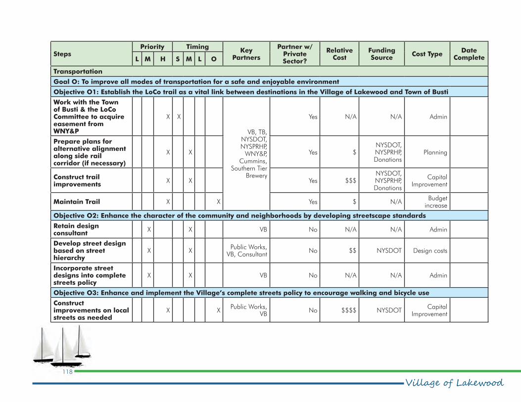
Village of Lakewood118
Comprehensive Plan
StepsPriority Timing
Key Partners
Partner w/Private Sector?
Relative Cost
Funding Source
Cost TypeDate
CompleteL M H S M L O
Transportation
Goal O: To improve all modes of transportation for a safe and enjoyable environment
Objective O1: Establish the LoCo trail as a vital link between destinations in the Village of Lakewood and Town of Busti
Work with the Town of Busti & the LoCo Committee to acquire easement from WNY&P
X X
VB, TB, NYSDOT, NYSPRHP,
WNY&P, Cummins,
Southern Tier Brewery
Yes N/A N/A Admin
Prepare plans for alternative alignment along side rail corridor (if necessary)
X X Yes $NYSDOT, NYSPRHP, Donations
Planning
Construct trail improvements
X X Yes $$$NYSDOT, NYSPRHP, Donations
Capital Improvement
Maintain Trail X X Yes $ N/ABudget
increase
Objective O2: Enhance the character of the community and neighborhoods by developing streetscape standards
Retain design consultant
X X VB No N/A N/A Admin
Develop street design based on street hierarchy
X XPublic Works,
VB, ConsultantNo $$ NYSDOT Design costs
Incorporate street designs into complete streets policy
X X VB No N/A N/A Admin
Objective O3: Enhance and implement the Village’s complete streets policy to encourage walking and bicycle use
Construct improvements on local streets as needed
X XPublic Works,
VBNo $$$$ NYSDOT
Capital Improvement

119
Comprehensive Planpeter j. smith & company, inc.
StepsPriority Timing
Key Partners
Partner w/Private Sector?
Relative Cost
Funding Source
Cost TypeDate
CompleteL M H S M L O
Ensure state and county street repairs incorporate street design
X XPublic Works, VB, NYSDOT
No N/A NYSDOT Admin
Objective O4: Improve the connections between the two commercial areas as robust community centers, attracting residents and visitors by improving access, circulation and multimodal capacity
Implement Complete Streets Policy
X XPublic Works,
VBIncluded in Complete Streets Policy
Objective O5: Direct people to attractions and the waterfront by developing a wayfinding system
Lobby for and assist in the development of a County-wide wayfinding signage plan
X XVB, County
Planning, NYSDOT
No $ NYSDOT Planning
Objective O6: Encourage movement on foot and by bicycle throughout the community by developing safe access across Fairmount Avenue
Ensure state and county highway repair projects on the corridor incorporate safe-streets designs and policies
X XVB, County
Planning, NYSDOT
No N/A NYSDOT Admin
Historic & Cultural Resources
Goal P: To ensure the community’s heritage resources are sustained into the future
Objective P1: Create a knowledge database of heritage resources
Develop historic preservation regulations as part of zoning update
X X ZC No Included in zoning update
Develop mechanism for historic review
X X ZC No Included in zoning update
Establish an Historic and Architectural Review Board
X X ZC No Included in zoning update

Village of Lakewood120
Comprehensive Plan
StepsPriority Timing
Key Partners
Partner w/Private Sector?
Relative Cost
Funding Source
Cost TypeDate
CompleteL M H S M L O
Inventory the community’s historic resources
X XHistoric Review
BoardNo N/A N/A Admin
Nominate buildings and districts to the state and national registers
X XHistoric Review
BoardNo N/A N/A Admin
Become a Certified Local Government
XVB, Historic
Review BoardNo N/A N/A Admin
Objective P2: Provide owners of heritage buildings and landscapes access to funding and technical support by nominating buildings, landscapes and districts to the state and federal registers of historic places
Utilize resources provided by becoming a Certified Local Government
X XVB, Historic
Review BoardNo N/A N/A Admin
Make owners of heritage properties aware of the resources available
X XHistoric Review
Board, CEONo N/A N/A Admin
Parks & Recreation
Goal Q: To ensure access to recreation for all neighborhoods by establishing a system of parks, trails and open spaces
Objective Q1: Improve access to active and passive recreation areas including the waterfront and residential neighborhoods including those south of Fairmount Avenue
Construct improvements at Naetzger Park
X X VB, Parks Dept Yes $$NYSPRHP,
LWRPCapital
Improvement
Acquire land where feasible for future park development
X X VB, Parks Dept Yes $$$NYSPRHP,
LWRPCapital
Improvement

121
Comprehensive Planpeter j. smith & company, inc.
StepsPriority Timing
Key Partners
Partner w/Private Sector?
Relative Cost
Funding Source
Cost TypeDate
CompleteL M H S M L O
Construct improvements at new parks
X X VB, Parks Dept Yes $$$NYSPRHP,
LWRPCapital
Improvement
Objective Q2: Encourage year-round facilities, destinations and uses on and around the lake as well as throughout the community by strengthening connections between recreation facilities and formalizing and publicizing the community’s informal recreation network
Participate in Chautauqua County tourism marketing efforts
X XVB, Visitors’
BureauYes N/A N/A Admin
Objective Q3: Draw residents and visitors to the waterfront by developing attractions, amenities and events there
Improve transient boat dock at Hartley Park
X X DPW Yes $ NYSPRHPCapital
Improvement
Expand Hartley Park when feasible
X X VB, DPW Yes $$ NYSPRHPAcquisition,
Capital Improvement
Increase event programming at Hartly Park
X DPW Yes $ Arts Council Programming
Objective Q4: Become a leisure time destination by creating spaces on the waterfront for people to linger and socialize
Expand Hartley Park when feasible
X X VB, DPW Yes $$ NYSPRHPAcquisition,
Capital Improvement
Increase event programming at Hartly Park
X DPW Yes $ Arts Council Programming
Objective Q5: Maintain & improve the quality of existing parks
Allocate more resources to maintain and improve facilities at existing parks
X X DPW No $ N/ABudget
Allocation

Village of Lakewood122
Comprehensive Plan
StepsPriority Timing
Key Partners
Partner w/Private Sector?
Relative Cost
Funding Source
Cost TypeDate
CompleteL M H S M L O
Community Facilities
Goal R: To improve community health and wellness
Objective R1: Improve access to fresh, local food sources by developing a permanent farmers market in Lakewood
Expand days of operation and facilities for a farmers market as demand dictates
X X XVB, Market
representativesYes $$
USDA, Ag & Markets
Capital Improvement, Programming
Goal S: To create a “municipal campus,” an attractive centralized location for community services and facilities
Objective S1: Improve the appearance and functionality of existing community facilities
Renovate community buildings as appropriate
X X XVB, Public
WorksNo $$$ ESDC
Capital improvement
Objective S2: Develop new community facilities to provide additional services
Support addition to library for community events
X XLibrary Board,
CCLS, VB, Public Works
Yes $$ESDC, Private foundations,
Donations
Capital improvement
Develop a community center as part of the Municipal Campus, possibly in partnership with the library
X XVB, Public
WorksNo $$$ ESDC
Capital improvement

123
Comprehensive Planpeter j. smith & company, inc.
IV.
Appendix

Village of Lakewood124
Comprehensive Plan

125
Comprehensive Planpeter j. smith & company, inc.
16.0 Policiesthe natural environment and define community identity,
sense of pride and sense of place. Most important, the
quality of urban design attracts people and activity to a
place enhancing the experience and making it more viable
aesthetically, socially and commercially.
16.2.2 Community character
Policies
Policy – Neighborhood Character
Originally an historic village, Lakewood evolved into a
first ring commercial and residential suburb of Jamestown.
At present, it includes a denser form of suburban style
commercial. The village should build on its existing historic
waterfront/heritage character to define and enhance
unique neighborhood and commercial character areas.
Policy – Social Space
The village should provide/develop/enhance a community
space and social spaces that are active and urban
promoting interaction between residents and visitors and
allowing gathering for groups and community events.
Policy – Street Trees
Trees should be planted in all street rights-of-way and
encouraged on private property proximate to the street to
line neighborhood streets. Trees should be deciduous,
provide shade, provide a clear canopy, be indigenous, salt
tolerant and could be of species that naturalize and lend
themselves to being planted in clusters.
16.1. Introduction
As the foundation of a sustainable future the
Comprehensive Plan is a guide for the village’s efforts
to responsibly manage its future prospects. The policies
are intended to communicate the specifics of how the
community will develop within the context of the new
plan. They provide the lens that leaders and community
members will use to evaluate proposals that come before
the village and are the measurable implementation
strategies of the forgoing goal and objectives.
The policies for each element of the plan appear with the
associated element and are repeated below.
16.2. Community Character Policy framework
As a result of the analysis, the following policies have been
developed to guide the community’s future character and
design.
16.2.1 Intent of the Community
Character policies
Lakewood should maintain its waterfront character and
historic village identity. Its commercial nodes and strips
including the character of streets, parks, open spaces
and built form should be enhanced into an attractive,
organized, functional and understandable urban system.
The village should enhance the quality of the public realm,

Village of Lakewood126
Comprehensive Plan
Policy – Views
Views and sightlines should be maintained and enhanced
to Chautauqua Lake at all street ends and especially along
the length of Chautauqua Ave.
Policy – Public Art
Public art in the form of street sculptures or interpretive
structures should be encouraged at prominent points in the
village streetscape and gateways.
16.3. Land Use & Zoning Policy framework
As a result of the analysis, the following policies have been
developed to guide the community’s land use and zoning
as it grows and evolves into the future.
16.3.1 Intent of the land use &
zoning policies
The Village of Lakewood should strengthen its waterfront
character, and accent and improve commercial
nodes, strengthen corridors and link neighborhoods.
Redevelopment should offer a full range of land uses in
mixed-use developments to create a diverse community.
Commercial centers that supply the goods and services
required by the community and region should be
developed within walking distances of neighborhoods to
minimize auto use. Zoning should facilitate desired quality
development, be easier to understand for all residents and
encourage variety in building styles, uses and densities.
16.3.2 land use & zoning Policies
Policy – Density and Mixed-Density Development
The village will expand and intensify as demographics
change and populations grow. The village should
promote compatible intensification in future mixed-use
neighborhoods.
Policy – Two-Village Commercial District Concept
As the village grows and changes it needs structure to
give it a stronger sense of community. As commercial
development and intensification occur each of the village’s
“downtowns” should form a centre and help to organize
the community creating a strong identity and sense of
place. The downtown districts are:
•Historic Village Center
•Mixed-Use Mall Village
These are further supported by the Fairmount Avenue
Corridor commercial area.
Policy – Sustainability
Sustainability means promoting the conservation of
resources, the wise use of resources and development
of strategies to help resources regenerate so that they
can be enjoyed, developed and used for generations
to come. Development and redevelopment should
127
Comprehensive Planpeter j. smith & company, inc.
promote sustainability and energy efficiency in all aspects
of site planning, construction, building materials and
maintenance.
Policy – Residential Infill
Residential infill buildings should reflect character, finish,
floor elevation and setback of the neighborhood and
context of surrounding buildings.
Policy – Commercial Buildings – Historic Village Center
Commercial buildings should support the unique heritage
character of the village, maintaining setbacks
equal to surrounding buildings, transparent ground
floors and façades parallel to street.
Policy – Commercial Buildings – Mixed-Use Mall Village
Commercial buildings should support a unique waterfront,
heritage character creating a strong presence in
relationship to the street, with transparent ground floors
and façades parallel to street and a primary façade with
varied setbacks.
Policy – Commercial Buildings – Fairmount Avenue Corridor
Commercial buildings should be set back to allow for
parking buffered by landscape strip creating a tree lined
walkway and green zone along the street.
Policy – Orientation
Buildings should be oriented to the street, have active
widows proximate to the street and primary entrances
accessed directly from the street.
Policy – Gateways
Gateways and arrival signatures should be developed to
enhance neighborhood identity and strengthen the sense
of the village and neighborhoods as unique places. The
locations should be:
•At Lakewood Community Park
•At the intersection of Summit and Fairmount Avenue in cooperation with the Town of Busti
•At the east end of Fairmount Avenue
•At all roads entering the village from the south (village signs are sufficient)
Policy – Commercial Signage
Signage in commercial and mixed-use districts should be
limited to attached on-premises signs.
Policy – Commercial Lighting
Lighting in commercial and mixed-use districts should be
from high-efficiency light sources and cast downwards to
minimize light pollution. Dark sky rating standards should
be followed to preserve the nighttime sky and minimize
light pollution.

Village of Lakewood128
Comprehensive Plan
16.4. Population & Housing Policy framework
As a result of the population and housing analysis, the
following policies have been developed to guide the
Village as its population changes.
16.4.1 Intent of the Population &
housing policies
Over time, the village will attract a diversity of new
residents because of its ideal location, unique heritage and
abundance of goods and services. A diverse population
will require a variety of housing choices for all socio-
economic groups. Appropriate housing choices should be
available in compatible land uses to improve commercial
nodes, strengthen corridors, enhance waterfront character
and strengthen existing neighborhoods.
16.4.2 Population & Housing Policies
Policy – Population Growth
The village should encourage increased density of the
population to reduce the consumption of land while
providing a mix of housing types to meet current and
future market demand. A mix that includes smaller, more
affordable apartments and condominiums for rent and for
sale to house young singles, families and seniors should
be provided. These higher density residential developments
should be located proximate to or in conjunction with and
linked to commercial development in mixed-use areas to
provide accessible goods and services.
Policy – Aging in Place
The Village’s zoning should be flexible to encourage senior
citizens to age in place safely and independently as long
as they are able. This includes incorporating mixed-use
development to encourage accessibility of goods and
services, apartment conversion, accessory apartments,
congregate and shared living opportunities that are
satisfying and affordable.
Policy – Redevelopment and Infill
Housing redevelopment in existing residential districts
should maintain a style and size similar to the existing
surrounding character.
Policy – Viewsheds
Higher density housing in mixed-use districts should
maintain views to Chautauqua Lake.
16.5. Economic Vitality Policy framework
As a result of the analysis of Lakewood’s economic
characteristics the following policies have been developed
to guide the community as it works to foster economic
vitality.

129
Comprehensive Planpeter j. smith & company, inc.
16.5.1 Intent of the Economic
Vitality policies
The economic vitality of the Village of Lakewood will be
greatly enhanced by building on its existing sense of place
as an attraction for new business compatible with the
existing village character. The local economy depends on
diversity of employment and a variety of labor skills more
than the availability of employment lands. Lakewood is
situated ideally for the creative economy, requiring minimal
employment lands compared to many other industries.
Tourism-related and place-based economic opportunities,
focusing on jobs that support/appreciate community
character, will build on village heritage and waterfront
character and accessible supply of goods and services.
16.5.2 Economic Vitality Policies
Policy – Arts & Culture
Arts and culture should be components of an economic
development strategy that includes a recognition of arts,
cultural industries and tourism as economic resources.
Policy – Creative Economy
The development of a strong sense of place and
community supported by arts and cultural activities as
economic opportunities should be the foundation of an
expanded creative economy.
Policy – Historic Village Center
The quality and experience of the village commercial
area should be strengthened for long-term viability and
sustainability, promoting a revitalization strategy and
enhanced urban design.
Policy – Mixed-Use Mall Village
The quality and experience of the primary commercial area
and mall should be strengthened for long-term viability
and sustainability, promoting enhanced design, increased
density and mixed use.
Policy – Existing Industry
New and incompatible uses can impact major existing
industries ability to continue or expand. Their potential
for eventual relocation to industrial areas should be
promoted.
Policy – Water Based Tourism
Promote water-based development/redevelopment
encouraging attractions and destination for uses including:
restaurants, accommodation, water activities and water
dependent uses.
Policy – Communication
Communication infrastructure should be developed and
maintained as an essential component of a strong local
economy and an informed and safe population.

Village of Lakewood130
Comprehensive Plan
Policy – Employment Lands
Maintain a diversified economic base and a range
and choice of land that could be used for employment
generating activities.
16.6. Environment & Open Space Policy Framework
As a result of the analysis of the community’s environment
the following policies have been developed to guide the
Village as it works toward sustainability and reclamation of
Chautauqua Lake.
16.6.1 Intent of the Environment &
open space policies
The village should be a model community leading the
way in the regeneration of Chautauqua Lake and in the
management of storm water. A sustainable Lakewood
should promote quality development that meets the needs
of today without denying future generations the ability
to meet their own needs. It is a change in attitude and
action that stems from a mandate to protect the natural
environment and improve the quality of Chautauqua Lake.
Planning for sustainability means addressing, pollution,
biodiversity, water quality and climate change to minimize
the impact on the lake and the community.
16.6.2 Environment & open space
Policies
Policy – Air Quality
Alternative modes of circulation such as multi–purpose
trails should be developed and the designation of land
uses for local provision of goods and services should be
promoted to minimize vehicle use, improve air quality and
community health.
Policy – Biodiversity
Local parks, open spaces and the rail corridor should
promote a diverse ecology and indigenous flora and
fauna.
Policy – Storm Water Retention
Storm water should be detained/retained on site and in
the streetscape with the use of rain barrels, rain gardens,
detention/retention and percolation beds. Use of rain
gardens should be encouraged for all lakefront property
owners, including the village. Streetside ditches should not
be filled with plastic drain pipe and covered.
Policy – Storm Drains and Street Cleaning
Storm water catch basins should be retrofitted to trap
sediments, litter petroleum and other pollutants. Storm
drains and catch basins should be monitored and cleaned
on a regular schedule. Streets should be wet cleaned and
vacuumed to remove pollutants seasonally.

131
Comprehensive Planpeter j. smith & company, inc.
Policy – Alternative Energy
Alternative energy sources should be promoted and used
in a way that is compatible with adjacent land uses and
does not interfere with the visual integrity of the community.
Policy – Water Conservation
Low-flow fixtures, faucets and showerheads should be
promoted to conserve potable water and reduce discharge
into the lake.
Policy – Tree Protection
The preservation and proliferation of trees is an important
component of neighborhood quality, design, habitat
and air quality. Trees should be protected on site before
and after construction. Any trees removed for or during
construction should be replaced.
Policy – Environmental Ordinances
Model ordinances should be adopted to address
sedimentation, erosion control and storm water retention.
Policy – Lake Restoration
As a Chautauqua Lake waterfront community, Lakewood
should be a leader in efforts to restore and revitalize the
lake.
16.7. Infrastructure & Utilities policy framework
As a result of the analysis of the infrastructure and utilities
in the village, the following policies have been developed
to help guide the village as it works with infrastructure
providers to deliver services to residents and businesses.
16.7.1 Intent of the Infrastructure
& Utilities policies
Efficient and safe infrastructure should be provided to the
Village of Lakewood to the extent of the servicing capacity
and consistent with local and regional planning.
16.7.2 Infrastructure & Utilities
Policies
Policy – Quality Infrastructure
The maintenance, enhancement and coordination of
physical infrastructure such as water and sewer shall be
considered important to the village’s economic and social
well being.
Policy – Sustainability
Physical infrastructure should be provided, developed and
enhanced in an environmentally sustainable manner.

Village of Lakewood132
Comprehensive Plan
Policy – Contiguous Services
Fully serviced settlement areas will be contiguous and
connected to municipal water and sewer services.
Policy – Consistency
Provide infrastructure in a coordinated, efficient and cost
effective manner to meet projected needs and consistent
with local and regional planning initiatives.
Policy – Storm Water
Storm water will be managed on site and infiltrated into
the ground using rain gardens and bioswales wherever
possible, reducing and minimizing any storm water
discharge into Chautauqua Lake.
16.8. Transportation Network policy framework
As a result of the analysis of the community’s
transportation network, the following policies have been
developed to help Lakewood develop into a multi-modal,
connected and green village.
16.8.1 Intent of the Transportation
Network policies
Vehicle traffic in the village and on Fairmount Avenue in
particular can be very congested. The purpose of the
transportation network is to facilitate the movement of
people and to minimize the impacts of vehicular traffic.
The improvement of the pedestrian and bicycle circulation
systems is a priority. Alternatives need to be developed
to promote a safe, healthy, multi-modal transportation
network.
16.8.2 Transportation Network
Policies
Policy – Land Use
Land use patterns shall be promoted which minimize the
length and number of trips and reduce dependence on the
automobile.
Policy – Railroad Corridor
The preservation and reuse of the abandoned railroad
corridor for recreational trails and as a linear park offering
park facilities and storm water management should be
encouraged.
Policy – Bicycle Circulation
Safe and efficient bicycle lanes should be introduced to all
streets in the community linking all destinations.
Policy – Street Hierarchy
A hierarchy of streets based on the desired character of
each should express and enhance the identity of the village
and facilitate wayfinding. The hierarchy is:

133
Comprehensive Planpeter j. smith & company, inc.
•Mixed-Use Mall Village – wide sidewalks, seating, gathering, urban art, banners, buildings oriented to the street
•Historic Village Center – wide sidewalks, interpretive panels, banners, street lamp flower containers
•Fairmount Avenue – boulevard streets: green medians, naturalized street trees, street lamp banners, pedestrian recreation trail
Policy – Roundabouts
Roundabouts should be located at primary intersections
to facilitate traffic flow and support the intersection as a
gateway area accenting focal points for the centers of the
two villages.
Potential roundabout locations include:
•Fairmount Avenue and Chautauqua Avenue
•Fairmount Avenue and Mall Boulevard
Policy – Pedestrian Circulation
Pedestrian circulation should be facilitated to the two
commercial cores and Chautauqua Lake access points
linking all parks and open spaces in the community.
Policy – Commercial Parking
Parking in commercial/mixed-use districts should be hard
surfaced, permeable and planted with native, deciduous
trees to provide shade and reduce the heat island effect.
Policy – Multi–Modal Circulation
A staging area for public transit should be located
proximate to the two village centers to support intermodal
circulation and should include bicycle parking and seating.
16.9. Historic & cultural resources policy framework
As a result of the analysis of the historic and cultural
resources in the village, the following policies have been
developed to help guide the village as it works to preserve
and interpret these resources for the enrichment of
residents and visitors and to use as economic development
tools.
16.9.1 Intent of the Historic &
Cultural policies
The Packard summer home, overlooking Chautauqua
Lake, surrounded by a number of unique heritage
cottages, a central waterfront park and a historic village
downtown forms the heart of this significant heritage
village. The waterfront location and heritage story form
the basis of creating an attractive place to live and work
incorporating economic development opportunities and
unique commercial opportunities in promoting tourism:
restaurants, galleries, culture and the arts.

Village of Lakewood134
Comprehensive Plan
16.9.2 Historic & Cultural Policies
Policy – Historic Districts
Lakewood is a heritage village and in order to protect its
historic structures and character, historic districts should be
defined and developed.
Policy – Heritage/Cultural Events
Heritage and cultural events should be promoted in the
village downtown/heritage district to promote community
pride and the village as a regional destination.
Policy – Interpretation
Heritage districts should be viewed as outdoor museums
offering interactive heritage displays and pedestrian
nodes with seating and interpretive panels supported by a
comprehensive interpretive program.
16.10. Parks & Recreation policy framework
As a result of the analysis of the Village of Lakewood’s
parks and recreation resources, the following policies have
been developed to guide the community as it works to
create a muti-purpose parks and recreation system
16.10.1 Intent of the parks &
recreation policies
Lakewood should offer a broad range of recreational
amenities and facilities to all residents and visitors in an
open space system that includes the railroad corridor. The
system should provide areas for socialization including
community and neighborhood events to strengthen
neighborhood bonds, pride and responsibility as well as
managing storm water.
16.10.2 parks & recreation Policies
Policy – Distribution of Parks
There should be parks evenly distributed throughout the
community for access to recreation and facilities by all
village residents.
Policy – Lakefront Parks
Lakefront parks should be developed as community
gathering and event spaces and for waterfront-related
activities and facilities.
Policy – Lakefront Portal Parks
All road ends at the lakefront should be developed as
community access points providing seating, interpretive
and water-based amenities if available.
Policy – Recreation Activities
Inland parks should offer a full range of recreation
activities for all ages including play structures, exercise
stations, sports courts, seating areas, walking trails and
interpretive displays. Specific parks may be limited in

135
Comprehensive Planpeter j. smith & company, inc.
amenities, e.g. gateway parks.
Policy – Waterfront Promenade
A pedestrian/bicycle waterfront trail/promenade should
be developed continuous along the lakefront in both
directions from Lakewood Beach as far as possible. The
trail should have a permeable hard surface, lighted and
allow access to the water.
Policy – Waterfront Access
Waterfront access should be consistent and parallel to the
entire length of the lakefront wherever possible and access
should be provided at all road ends.
Policy – Parks as Wetlands
Parks should be designed and used as detention/retention
and wetlands. Wetland parks should offer boardwalks,
seating areas and interpretive information and act as links
in the overall trail/open space system.
Policy – Trailheads as Brand
Trailheads should be developed at all road-to-trail
connections with seating areas, wayfinding signage and
interpretive signage as neighborhood features. Trailheads
should be used to enhance connections to and between
neighborhoods.
Policy – Heritage/Cultural Events
Heritage and Cultural events should be promoted both
in the Village centers, heritage parks and along the
waterfront.
16.11. Community Facilities & Services Policy framework
As a result of the analysis of the Village of Lakewood’s
community facilities and services, the following policies
have been developed to guide the village as it strives
to provide services that are efficient, cost effective and
accessible by everyone.
16.11.1 Intent Community Facilities
& Services of the policies
The Village of Lakewood shall provide equitable services
for all ages, ethnicities and incomes to better serve
residents and visitors and make community resources
available for everyone with the understanding that
shared services between all agencies and governments is
appropriate and preferred.
16.11.2 Community Facilities &
Services Policies
Policy – Coordination
Promote coordination with and among surrounding

Village of Lakewood136
Comprehensive Plan
municipalities and all levels of government in planning for
emergency services, trails, transportation, infrastructure,
etc.
Policy – Shared Use of Community Facilities
Encourage coordination, co-location and shared use
of public facilities such as libraries, schools, indoor and
outdoor recreational facilities and community center
facility.
Policy – Community Health
Recognize elements of healthy communities such as
community design and planning for all ages
Policy – Community Signatures
Recognize institutional uses as important elements and
community signatures/monuments in community design
including: cemeteries, fraternal and social organizations,
places of worship, etc.

137
Comprehensive Planpeter j. smith & company, inc.
17.1. Steering Committee Meetings
17.1.1 Kickoff/Vision Session
The Lakewood Comprehensive Plan Steering Committee
met for a kickoff meeting on April 20, 2015. The purpose
of the meeting was to review the scope and schedule
for the planning process and to discuss the public input
process. Attending from the community were Jared
Yaggi, Dave DiSalvo, Joseph Johnson, Richard Rose,
Ted McCague, and Craig Seger. Peter Smith and project
manager Eve Holberg attended from the consulting firm of
peter j. smith & company, inc.
It was proposed that the schedule for completion be
extended from an anticipated October plan completion
to December to allow for review and revisions. It was also
agreed that rather than scheduling two focus groups on
different topics that two focus groups open to all invitees
should be held. Those were scheduled for May 14. The
first public meeting was scheduled for June 24.
Also during the meeting, a vision session was held. The
vision session is a facilitated conversation around a limited
number of questions to familiarize the consultant with the
steering committee members’ vision for the community’s
future and to draw them out on important topics. A
synopsis of the vision session follows.
When asked to describe the character that Lakewood
reflects, the steering committee members mentioned the
lakefront setting, historic properties and the community’s
walkability. The variety of activities available, parks and
compact scale were also mentioned. The community’s split
personality with the Fairmount Avenue commercial district
juxtaposed with the historic lakefront neighborhoods was
mentioned. Lakewood “should be a place where you can
experience Chautauqua Lake,” said one participant.
The qualities that the community shares with its
neighbors are its natural resources including four season
recreation opportunities, rolling hills, fairly homogenous
demographics and cultural activities. The water quality of
the lake is another shared resource. “Chautauqua Lake is
the common denominator,” said a participant, “How the
lake goes, so go its lakeside communities.”
The biggest assets that Lakewood can use to preserve,
strengthen and increase the village’s vitality are its citizens
and its historic and cultural assets. It’s a safe community,
one participant said: “People argue we spend too much
on cops, but, no.” Others mentioned Chautauqua Avenue,
a potential Packard historic district and the revenues that
come in from the Fairmount Avenue commercial district.
Issues impacting the quality of the lake were at the
forefront of the challenges that the comprehensive plan
should help Lakewood overcome. These include runoff
from construction, roads, chemical lawn applications,
invasive species, storm water runoff and aging sewer
and water infrastructure. Also noted were the disconnect
17.0 Public Input Program

Village of Lakewood138
Comprehensive Plan
between neighborhoods on the north of Fairmount Avenue
and those on the south side and the lack of safe walking
and biking between the two and to the community’s
parks and open spaces. Enforcement of existing codes
and development of new codes to help better state
development expectations were also mentioned. “394
is not planned,” said one participant. “There’s no urban
design or streetscape standards.”
17.2. Focus Group Sessions
The purpose of the focus groups is to give people who
are knowledgeable about the village or who have
particular experience or insight that would be a valuable
to the comprehensive plan the opportunity to share their
perspectives. There were 40 invitees to the two identical
focus group meetings held on May 14. There were a
total of 25 participants in the two sessions. The sessions
featured facilitated conversations around questions similar
to those that were addressed in the steering committee
Vision Session held in April. A synopsis of the two
sessions, aggregated together, is below.
The themes describing the character of the community
revolved around Lakewood’s small town appeal, safety,
walker- and bicyclist-friendly atmosphere and convenience.
“We said it would be a great place to retire and it has
been,” said one participant. However, participants also
noted that Lakewood is a divided community in several
ways: It is divided by Fairmount Avenue, and the busy
Fairmount Avenue commercial district is in sharp contrast
to the historic lakeside neighborhoods to the south. Others
noted a divide between “ages and stages.”
The Village of Lakewood should be more business
friendly to improve its role in the region, participants
noted. They also said a mix of housing to attract young
people and empty nesters is needed including condos
and townhouses. Lakewood could also be a role model
for husbandry of the Chautauqua Lake and support other
communities in their efforts to help improve the water
quality in the lake. “Lakewood can’t fix the lake on its
own,” one participant said. “It could set an example for
how communities treat the lake, manage weeds and waste
water, improve and increase lake recreation. The lake can
spur business.”
Lakewood’s safety and first responders, its family village
atmosphere and community communication, collegiality
and generosity are all qualities that can help strengthen
the village, participants said. Other assets are Chautauqua
Lake, Chautauqua Avenue, Packard properties and the
momentum for change that has emerged are other assets
noted.
The issues that the comprehensive plan should help
Lakewood address include the mix and condition of
existing housing in the village, zoning violations and code
enforcement and the condition of the lake. Other issues
that need to be addressed include traffic flow, awareness
of Chautauqua Avenue businesses and a perception
of elitism and awareness of it as more than a lakeside
community. “The village is two square miles, not just two

139
Comprehensive Planpeter j. smith & company, inc.
blocks on the lake,” one participant said. Participants also
noted a number of issues that are beyond the purview of
the local community to address by itself including state
taxes and a shrinking middle class.
Participants said that for the future, they would like to see
Lakewood attract an upscale hotel to complement the two
motels already in the village. They’d also like to see the
rail trail completed industrial growth and more cohesion
between the village of and the Town of Busti. They also
said they want the village to preserve its unique character.
Resolving political divisions was also an issue. One
participant hoped the village would “make decisions based
on what is best for the village, not worrying about getting
our political agenda through.” Another said they fear that
“politicians won’ be able to gain consensus on the vision
and implement actions to deliver it.”
17.3. Visioning workshop
A community visioning workshop was held June 24 a
Gloria Dei Lutheran Church on Fairmount Avenue. The
forum was designed to gather the individual and group
input of the village’s residents about their visions for the
future of the community. More than 50 residents attended.
Participants were invited to give their individual input on a
series of policy statements, expressing the degree to which
they agreed or disagreed with each. The results of that
activity are on the following pages.
Working together on maps as groups at each of eight
tables, participants were asked to locate areas where, for
example, design guidelines could improve the character
and feel and of the community, where traffic is a problem
and where tourist attractions could be located, etc. Those
responses were mapped and the map is included here.
Participants were also asked a series of open-ended
questions. Their responses are summarized below.
Participants were asked to complete the sentence:
“The character of the Village of Lakewood is ...” Many
participants noted the village’s charm, historic qualities,
friendliness and lakeside setting as key elements of the
community’s character. The community is quaint, they
said, an appealing place to raise a family. But some
participants also said the community is badly and in need
of improvement. It’s not as inviting as it was when we first
moved here,” wrote one participant
Another open-ended question invited participants to
identify “The thing I like most about living in Lakewood.”
Many of the responses reflected those of the character
question, above. People enjoy the safety, small-town,
close-knit and walkable aspects of the community. Living
on the lake with services and goods nearby were also
prominently mentioned “It’s so close to so many things,”
wrote one participant, “and the lake is beautiful.”
A third question invited participants to identify “the thing
that needs the most improvement in Lakewood” By far and
away the two most mentioned aspects of the community

Village of Lakewood140
Comprehensive Plan
Land Use Strongly Agree
Agree Neutral Disagree Strongly Disagree
The Village needs to develop design guidelines to protect and enhance the character of its unique historic character and village feel and to improve the appeal of its commercial districts.
66.7% 27.1% 4.2% 2.1% 0.0%
Lakewood needs to develop more diverse land uses such as mixed-use districts and housing types, including more affordable townhouse and condominiums to attract young families and empty nesters.
21.3% 48.9% 14.9% 10.6% 4.3%
The overall visual quality of residential and commercial development in the Village should be protected with more code enforcement.
67.4% 21.7% 4.3% 6.5% 0.0%
The Village should acquire abandoned and underutilized sites for redevelopment.
38.3% 17.0% 29.8% 12.8% 2.1%
Circulation and Accessibility Strongly Agree
Agree Neutral DisagreeStrongly Disagree
I am concerned with the volume of traffic and traffic safety in the Village.
10.9% 21.7% 34.8% 26.1% 6.5%
Pedestrian safety is an issue in Lakewood and there is a need for more sidewalks and bike ways in the Village of Lakewood.
47.8% 32.6% 19.6% 0.0% 0.0%
Residents of the south side of the village need to have better connections to the lake.
24.4% 24.4% 42.2% 4.4% 4.4%
Trail connections to neighboring communities are needed for recreation and transportation.
34.9% 39.5% 16.3% 9.3% 0.0%
17.3.1 Individual Exercise
The individual exercise invited participants to fill in a
workbook in which they indicated the extent to which they
agreed or disagreed with a series of policy-type statements
in each of four categories:
•Land Use
•Circulation & Accessibility
Table 17.1 Workshop Individual Input
that need improvement are Chautauqua Avenue and code
enforcement efforts in the village. Other responses included
walkability and bike accessibility, affordable housing
including housing for seniors and the quality of the lake. A
number of participants suggested updating the zoning and
introducing design standards as possible solutions.
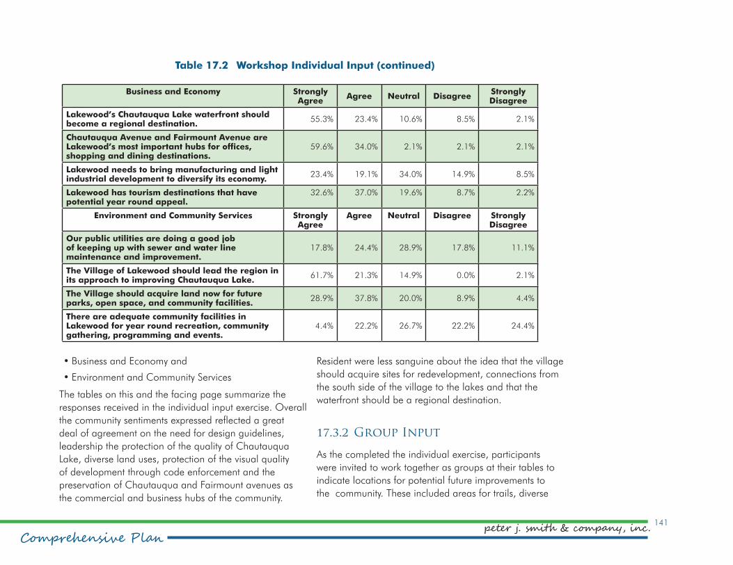
141
Comprehensive Planpeter j. smith & company, inc.
Business and Economy Strongly Agree
Agree Neutral DisagreeStrongly Disagree
Lakewood’s Chautauqua Lake waterfront should become a regional destination.
55.3% 23.4% 10.6% 8.5% 2.1%
Chautauqua Avenue and Fairmount Avenue are Lakewood’s most important hubs for offices, shopping and dining destinations.
59.6% 34.0% 2.1% 2.1% 2.1%
Lakewood needs to bring manufacturing and light industrial development to diversify its economy.
23.4% 19.1% 34.0% 14.9% 8.5%
Lakewood has tourism destinations that have potential year round appeal.
32.6% 37.0% 19.6% 8.7% 2.2%
Environment and Community Services Strongly Agree
Agree Neutral Disagree Strongly Disagree
Our public utilities are doing a good job of keeping up with sewer and water line maintenance and improvement.
17.8% 24.4% 28.9% 17.8% 11.1%
The Village of Lakewood should lead the region in its approach to improving Chautauqua Lake.
61.7% 21.3% 14.9% 0.0% 2.1%
The Village should acquire land now for future parks, open space, and community facilities.
28.9% 37.8% 20.0% 8.9% 4.4%
There are adequate community facilities in Lakewood for year round recreation, community gathering, programming and events.
4.4% 22.2% 26.7% 22.2% 24.4%
•Business and Economy and
•Environment and Community Services
The tables on this and the facing page summarize the
responses received in the individual input exercise. Overall
the community sentiments expressed reflected a great
deal of agreement on the need for design guidelines,
leadership the protection of the quality of Chautauqua
Lake, diverse land uses, protection of the visual quality
of development through code enforcement and the
preservation of Chautauqua and Fairmount avenues as
the commercial and business hubs of the community.
Resident were less sanguine about the idea that the village
should acquire sites for redevelopment, connections from
the south side of the village to the lakes and that the
waterfront should be a regional destination.
17.3.2 Group Input
As the completed the individual exercise, participants
were invited to work together as groups at their tables to
indicate locations for potential future improvements to
the community. These included areas for trails, diverse
Table 17.2 Workshop Individual Input (continued)

Village of Lakewood142
Comprehensive Plan
Figure 17.1 Public Input Synthesis Map

143
Comprehensive Planpeter j. smith & company, inc.
housing, mixed and commercial uses, future parks and
community gathering places. Participants also located
existing shoreline and, traffic and code enforcement issues.
The result is synthesized on the map on the following page.
17.4. Survey Results
To gather statistically valid indications of community
sentiment, a community survey was developed. The
instrument was developed with the participation of the
steering committee and was distributed online an in paper
formats during the summer of 2015.
To determine if the survey results were truly representative
of a cross-section of Lakewood residents, the first question
asked them to locate the ares in which they reside,
numbered one through six. Among respondents, 363
of 422 designated an area, 31 indicated they do not
live in the village of Lakewood and the balance did not
answer the question. The map and table on the following
page illustrate and summarize the distribution of survey
respondents.
17.4.1 Survey Methodology
The survey was divided into sections that asked
respondents to indicate their levels of satisfaction with
services available and agreement with policy statements.
The sections are:
•Government Services
•Community Services
•Infrastructure Services
•Development
•Land Use
•Traffic and Transportation
•Environment
•Arts and Culture
•Historic Assets
•Economic Development and Community Revitalization
The results are summarized here in a series of tables
reflecting the direct input. The steering committee also
included an open-ended question with each of the
sections. Those results are to be compiled in a separate
stand-alone document for reference.

Village of Lakewood144
Comprehensive Plan
Area Population Percent Seasonal Unit
Est Pop
Summer Pop
Percent Residents
Percent Respondents
1 309 10.3% 73.0 146 455 13.6% 21.7%
2 631 21.0% 79.0 158 789 23.6% 19.0%
3 585 19.5% 9.0 18 603 18.1% 19.0%
4 474 15.8% 1.0 2 476 14.3% 7.8%
5 619 20.6% 7.0 14 633 19.0% 19.3%
6 384 12.8% 0.0 0 384 11.5% 3.7%
3,002 3,340
Source: US Bureau of the Census and peter j. smith & company, inc.
Table 17.3 Distribution of Survey Respondents
Figure 17.2 Survey Respondents

145
Comprehensive Planpeter j. smith & company, inc.
Please indicate your level of satisfaction with the following:
Very Satisfied
Satisfied Neither Satisfied
Nor Unsatisfied
Unsatisfied Very Unsatisfied
Police 44.90% 41.00% 8.80% 4.00% 1.40%
Fire Department 62.10% 27.10% 9.30% 0.80% 0.60%
EMS/Ambulance 56.50% 29.00% 13.90% 0.30% 0.30%
Public Works 34.40% 42.00% 16.50% 5.10% 2.00%
Building and Zoning Code Enforcement
10.80% 26.30% 31.70% 17.30% 13.90%
Please indicate the degree to which you agree or disagree with the following:
Strongly Agree
Agree
Neither Agree Nor
Disagree
Disagree Strongly Disagree
I feel safe in Lakewood 45.0% 46.6% 5.8% 2.3% 0.3%
I feel I know about Village services and offices 21.3% 51.9% 13.2% 12.6% 1.0%
I am satisfied with the value of services for taxes paid 10.3% 38.1% 23.2% 21.6% 6.8%
I am satisfied with the strength and enforcement of village code 5.8% 27.1% 32.9% 21.3% 12.9%
I feel Lakewood should expand its efforts to market the qualities of the village in the region and beyond in order to attract more economic activity
36.6% 41.5% 16.7% 4.2% 1.0%
I feel Lakewood should develop design standards to improve community appearance
35.4% 35.7% 16.7% 9.0% 3.2%
Lakewood should spend more in order to strengthen the services it provides to residents
11.5% 24.4% 37.2% 21.8% 5.1%
Please indicate the extent to which you agree or disagree with the following:
Table 17.4 Satisfaction with Government Services
Table 17.5 Knowledge and Perception of Government Services

Village of Lakewood146
Comprehensive Plan
Please indicate your level of satisfaction with the following community services:
Very Satisfied
Satisfied Neither
Satisfied Nor Unsatisfied
UnsatisfiedVery
Unsatisfied
Library 46.5% 33.0% 18.8% 1.3% 0.3%
Museums 9.3% 22.0% 61.7% 6.3% 0.7%
Community Center 2.4% 12.1% 51.9% 19.9% 13.8%
Cultural Facilities 2.0% 16.3% 60.7% 15.3% 5.8%
Parks System 13.9% 51.3% 20.5% 13.6% 0.7%
Public School System 21.5% 47.4% 24.8% 5.3% 1.0%
YMCA 15.0% 44.0% 32.3% 6.7% 2.0%
YWCA 6.8% 28.7% 60.8% 2.4% 1.4%
Public Services 12.7% 50.2% 29.1% 7.4% 0.7%
Table 17.6 Satisfaction with Community Services
Please indicate your level of satisfaction with the following infrastructure services:
Very Satisfied
Satisfied Neither
Satisfied Nor Unsatisfied
UnsatisfiedVery
Unsatisfied
Sewer 21.3% 56.7% 13.2% 6.4% 2.3%
Water 21.6% 58.5% 9.9% 7.6% 2.3%
Electric 14.0% 60.5% 13.5% 10.8% 1.2%
Gas 17.6% 66.0% 12.6% 3.5% 0.3%
Cable 8.8% 34.8% 24.2% 23.3% 8.8%
Storm Water Management 6.2% 40.2% 23.5% 23.2% 7.0%
Roads and Streets 15.2% 48.4% 19.5% 14.6% 2.3%
Sidewalks 5.6% 28.7% 22.9% 29.9% 12.9%
Street Lighting 9.1% 53.7% 20.2% 14.7% 2.3%
Table 17.7 Satisfaction with Infrastructure Services

147
Comprehensive Planpeter j. smith & company, inc.
Please indicate the degree to which you agree or disagree with the following:
Strongly Agree
Agree Neither Agree Nor
Disagree
Disagree Very Disagree
Lakewood has a positive sense of identity 16.0% 55.3% 15.2% 12.4% 1.1%
Landscaping, including trees, plays an important role in the overall appearance of the village
46.1% 47.5% 5.3% 1.1% 0.0%
A building’s exterior condition, including landscaping, plays an important role in the future of the village
49.8% 42.3% 6.0% 1.8% 0.0%
Lakewood should concentrate on improving the quality of development on and around Chautauqua Avenue
38.8% 40.9% 14.2% 4.6% 1.4%
Lakewood should concentrate on improving the quality of development in the Fairmount Avenue commercial area
30.8% 41.9% 16.5% 9.0% 1.8%
Lakewood should concentrate on improving the quality of development in its residential neighborhoods
34.1% 38.7% 21.1% 5.7% 0.4%
Table 17.8 Quality of Development

Village of Lakewood148
Comprehensive Plan
Please indicate the degree to which you agree or disagree with the following:
Strongly Agree
Agree Neither Agree Nor
Disagree
Disagree Strongly Disagree
There is adequate access to Chautauqua Lake throughout the village 11.3% 42.2% 17.7% 23.0% 5.7%
The village should acquire land and buildings for future economic and community development
9.6% 33.6% 31.4% 19.3% 6.1%
Lakewood should provide for a diverse blend of housing options in its zoning
10.8% 34.8% 35.1% 12.9% 6.5%
Areas should be identified to redevelop for a range of housing types to accommodate current and future population
8.3% 43.3% 31.8% 12.3% 4.3%
Lakewood should address housing options to help seniors age in place
18.7% 46.4% 24.1% 8.6% 2.2%
Lakewood should address housing options to attract young adults and young families to live in the village
32.3% 46.2% 15.1% 4.7% 1.8%
Lakewood should help to revitalize Chautauqua Avenue by allowing a combined retail and residential district
29.6% 46.4% 15.4% 6.4% 2.1%
The overall visual quality of residential and commercial development in the village is important
47.5% 45.7% 5.3% 1.1% 0.4%
Table 17.9 Land Use

149
Comprehensive Planpeter j. smith & company, inc.
Please indicate the extent to which you agree or disagree with the following:
Strongly Agree
Agree Neither Agree Nor Disagree
Disagree Strongly Disagree
Traffic safety is an issue in Lakewood 19% 30% 20% 27% 5%
Pedestrian safety is an issue in Lakewood 27% 35% 18% 20% 1%
Bicycle safety is an issue in Lakewood 34% 38% 15% 12% 2%
More sidewalks are needed in Lakewood 41% 33% 17% 9% 1%
More designated bike lanes are needed in Lakewood 45% 33% 11% 9% 2%
More trails are needed within Lakewood for recreation and transportation
34% 30% 23% 11% 2%
More trails are needed that connect to neighboring communities 28% 31% 28% 11% 2%
Safer north-south connections over Fairmount Avenue are needed
36% 37% 17% 9% 1%
Electric vehicle charging stations should be incorporated into proposed new parking areas in Lakewood
5% 23% 44% 20% 7%
The quality of street lighting in the village should be improved 14% 28% 41% 15% 2%
More receptacles for “doggie waste bags” would help to keep our sidewalks and streets a cleaner
17% 41% 27% 12% 5%
Public water fountains should be strategically located around the village
9% 27% 32% 26% 6%
More public rest rooms should be added to the village 12% 32% 30% 22% 5%
New parks are needed in Lakewood 9% 18% 37% 29% 7%
Table 17.10 Traffic and Transportation

Village of Lakewood150
Comprehensive Plan
Please indicate the degree to which you agree or disagree with the following:
Strongly Agree
Agree
Neither Agree Nor
Disagree
Disagree Strongly Disagree
Lakewood’s trees are an asset to the community 58.8% 34.5% 5.2% 1.1% 0.4%
Lakewood should adopt tighter tree regulation to protect this asset 23.8% 21.9% 39.2% 11.3% 3.8%
Lakewood is adequately controlling sediment erosion 4.5% 13.9% 52.1% 21.0% 8.6%
Lakewood’s storm water management system is adequate 1.1% 21.5% 42.3% 25.3% 9.8%
Measures should be in place to protect downstream properties and waters from flooding, pollution and sedimentation erosion
28.8% 50.2% 19.5% 0.4% 1.1%
Lakewood should adopt a policy to conserve and restore natural stream corridors, floodplains and wetlands
33.2% 38.2% 24.8% 2.7% 1.1%
Lakewood should promote rain gardens and pervious surfaces into its public area designs
31.4% 31.4% 32.2% 3.8% 1.1%
Lakewood should promote solar energy 25.7% 29.1% 34.3% 6.0% 4.9%
Lakewood should be a leader in the regional effort aimed at restoring Chautauqua Lake
51.5% 32.7% 12.8% 2.3% 0.8%
Table 17.11 Environment
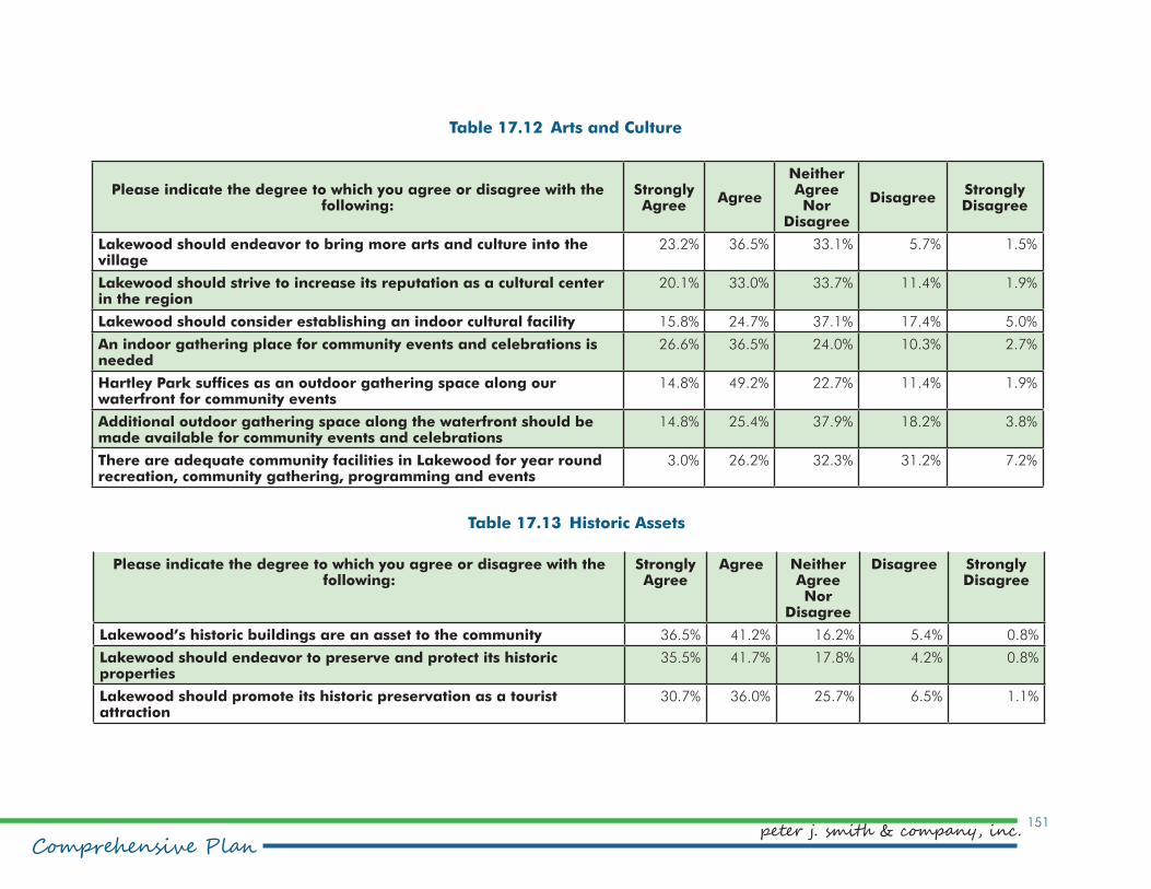
151
Comprehensive Planpeter j. smith & company, inc.
Please indicate the degree to which you agree or disagree with the following:
Strongly Agree
Agree
Neither Agree Nor
Disagree
Disagree Strongly Disagree
Lakewood should endeavor to bring more arts and culture into the village
23.2% 36.5% 33.1% 5.7% 1.5%
Lakewood should strive to increase its reputation as a cultural center in the region
20.1% 33.0% 33.7% 11.4% 1.9%
Lakewood should consider establishing an indoor cultural facility 15.8% 24.7% 37.1% 17.4% 5.0%
An indoor gathering place for community events and celebrations is needed
26.6% 36.5% 24.0% 10.3% 2.7%
Hartley Park suffices as an outdoor gathering space along our waterfront for community events
14.8% 49.2% 22.7% 11.4% 1.9%
Additional outdoor gathering space along the waterfront should be made available for community events and celebrations
14.8% 25.4% 37.9% 18.2% 3.8%
There are adequate community facilities in Lakewood for year round recreation, community gathering, programming and events
3.0% 26.2% 32.3% 31.2% 7.2%
Table 17.12 Arts and Culture
Please indicate the degree to which you agree or disagree with the following:
Strongly Agree
Agree Neither Agree Nor
Disagree
Disagree Strongly Disagree
Lakewood’s historic buildings are an asset to the community 36.5% 41.2% 16.2% 5.4% 0.8%
Lakewood should endeavor to preserve and protect its historic properties
35.5% 41.7% 17.8% 4.2% 0.8%
Lakewood should promote its historic preservation as a tourist attraction
30.7% 36.0% 25.7% 6.5% 1.1%
Table 17.13 Historic Assets

Village of Lakewood152
Please indicate the degree to which you agree or disagree with the following:
Strongly Agree
Agree Neither Agree Nor
Disagree
Disagree Strongly Disagree
Lakewood’s waterfront should be carefully developed in order to make it a regional destination
34.9% 40.3% 14.0% 8.1% 2.7%
Lakewood should make it possible for visitors to access the Chautauqua Avenue business district BY BOAT
38.5% 41.2% 12.3% 5.4% 2.7%
Chautauqua Avenue is key to revitalizing the community and should be a priority
45.0% 38.0% 9.7% 3.9% 3.5%
The look and feel of Fairmount Avenue is a priority to revitalizing the community
28.7% 40.6% 18.8% 10.0% 1.9%
Lakewood needs to market itself to the region and beyond as a great place to live, work and do business
44.2% 36.8% 15.1% 2.3% 1.6%
Table 17.14 Economic Development and Community Revitalization