St. Bernard Parish COMPREHENSIVE PLAN
116
St. Bernard Parish COMPREHENSIVE PLAN 2014 Amendment - 2017
-
Upload
khangminh22 -
Category
Documents
-
view
3 -
download
0
Transcript of St. Bernard Parish COMPREHENSIVE PLAN

St. Bernard Parish COMPREHENSIVE PLAN
2014Amendment - 2017


St. Bernard Parish COMPREHENSIVE PLAN

AcknowledgementsSTEERING COMMITTEEDedre Bailey
Rev. Henry Ballard
Carol T. Brown
Polly Campbell
Earl Dauterive
Carol Emery
Drew Heaphy
Jenny Karubian
Susan Klees
Howard Luna
Andrew Le
Nicky Mones
Shelly Monk
Jerry Moore
Gwendolyn Mullen
James Pohlmann
Katherleen Pride
Claudette Reuther
Brad Robin
Lou Schneider
Will F. Schneider
Lara Schultz
Catherine Serpas
Harry Turner
PLANNING COMMISSIONDavid C. Chimento (2014)
Earl Dauterive (2012 - 2014)
Roy Gross III (2012-2014)
Jody Honald (2014)
Richard Lewis (2012 - 2013)
John McElroy (2014)
Hugh Pentney Sr. (2014)
Louis Schneider (2012 - 2014)
Kevin Williams (2012 - 2014)
PARISH COUNCILGeorge Cavignac
Nathan J. Gorbaty
Casey Hunnicutt
Ray Lauga, Jr.
Richard J. Lewis
Guy McInnis
Manuel “Monty” Montelongo
PARISH PRESIDENTDavid E. Peralta
ST. BERNARD PARISH GOVERNMENTMichael Albert
Jason Stopa
Jerry Graves
Robin Jones
Candace Watkins
CONSULTANT TEAMczb, LLC
Donald Poland Consulting
MIG / Winston
James Richardson
FUNDING SOURCELouisiana Office of Community Development - Disaster Recovery Unit
U.S. Department of Housing and Urban Development
CreditsGIS mapping source: Esri, Digital Globe, GeoEye, i-cubed, USDA, AEX, Getmapping, Aerogrid, IGN, IGP, swisstopo, and the GIS User Community
Trail and bicycle lane mapping source: the Regional Planning Commission for Jefferson, Orleans, Plaquemines, St. Bernard, St. Tammany, and Tangipahoa Parishes

Table of ContentsPREFACE: AN OPEN LETTER TO THE RESIDENTS OF ST.
BERNARD PARISH II
A VISION FOR ST. BERNARD PARISH III
INTRODUCTION IV
A New Direction v
A Plan by/for the Residents of the Parish v
A Plan that Builds on Previous Plans v
How the Plan is Organized v
BASELINES / EXISTING CONDITIONS 2
Understanding the Past 2
Current Assets 3
CHOICES FOR THE FUTURE 4
THE PLAN ON A PAGE 5
SB2050: AN ORGANIZATION TO FOSTER CHANGE 6
NATURAL ENVIRONMENT 8
Introduction 8
Existing Conditions 8
Vegetation 8
Wildlife 8
Scenic Rivers and Byways 8
Environmental Issues 8
Natural Environment Directions 11
STORM WATER MANAGEMENT 14
How the Drainage System Works 14
Storm Water Management Directions 15
FAIR HOUSING 18
Existing Conditions 18
Twin Challenges 19
Housing Choices for the Future 20
Fair Housing Directions 21
LAND USE 22
Existing Conditions 22
The City-Form of the Parish 26
Choices for the Future 27
The Future Land Use Map 28
Summary of Proposed Land Uses 35
Future Land Use 35
Land Use Directions 36
Future Land Use Implementation Strategies 38
TRANSPORTATION 40
The Street System 40
An Integrated System of Bicycle and Pedestrian Paths 44
Complete Streets 46
Transit 48
Waterways and Rail 48
Air 48
Transportation Directions 49
CULTURAL AND HISTORIC RESOURCES AND TOURISM 50
History 50
Existing Conditions 50
Cultural and Historic Resources and Tourism Directions 51
COMMUNITY APPEARANCE 53
Gateways 53
Hurricane Damage Is Still with Us 54
Lack of a “There” 54
Streetscapes 54
Neighborhoods 57
Industrial Appearance 57
Community Appearance Directions 58
PARKS AND RECREATION 60
Existing Park and Recreation Conditions 60
Park Needs 61
Parks and Recreation Opportunities 63
Bikeways and Trails 65
Parks and Recreation Directions 67
COMMUNITY INFRASTRUCTURE 70
Existing Conditions 70
Community Infrastructure Directions 72
ECONOMIC DEVELOPMENT 73
A Regional & Local Issue 73
Shifting the Recovery Focus 73
Economic Development Concepts 73
A Final Caution... 76
Economic Development Directions 76
APPENDICES 77

ii ST. BERNARD PARISH COMPREHENSIVE PLAN
PREFACE | an open letter to the residents of st. bernard parish
Figure 1: The Central Wetlands are a beautiful and treasured resource for the parish.
Preface: An Open Letter to the Residents of St. Bernard ParishThe St. Bernard Parish Comprehensive Plan is not written for any singleindividual, entity, or organization, but rather for everyone who togethercomprise the St. Bernard community. If we follow the plan, it will guide ustoward a parish that keeps and attracts strong families and businesses.
This plan takes into account the history of the parish, and the currentstate of the parish physically and fiscally. Extensive data was also gatheredand analyzed, from a variety of sources, such as real estate sales, the U.S.Census, parish budgets, crime statistics and public school performance.
All values, recommendations and assumptions in the plan are based oninput gathered from residents, business owners and other stakeholdersin the community through small group meetings, individual interviews,and community wide meetings, as well as from appointed and electedofficials.
To make the parish stronger than it was even prior to 2005 will takeeveryone’s commitment to a community-wide effort.
The good news is that the parish has many assets on which to build: aclass A school system, a high-functioning Sheriff’s department, and anabundance of public infrastructure that will limit the need for furthermajor new buildings and infrastructure for many years.
Over and above the assets we have, St. Bernard Parish has theopportunity to improve our aesthetic, commercial, and recreationalamenities. If we are to keep existing strong families and businesses, andattract new ones, we have to better compete with other communities inthe region. So, even though we face difficulties meeting today’s needs,the people of St. Bernard will have to agree to do even more. We needto better maintain what we have, and invest in additional improvementsand amenities to make our parish an even more attractive place in whichto live and work. In the end, these kinds of investments will have a return:they will attract more people and businesses who can also help pay thebills.
Participants in the St. Bernard Parish Comprehensive Plan processindicated that they want a vibrant parish with schools and services thatremain strong; a family-friendly parish that is beautiful and safe; and aparish that has great neighborhoods and good stores. The St. BernardParish Comprehensive Plan contains the various trade-offs and costsnecessary to reach this vision for the parish as well as recommendationsin regard to the financial sacrifices necessary to sustain and improve theparish in the years to come. It also outlines ways that the communitycan have greater influence on public spending in order to increaseconfidence while making these decisions for the future.
Signed:
Parish PresidentParish Council ChairParish Planning Commission Chairman
Figure 2: Located just southeast of New Orleans, St. Bernard is part of the regional economy and lifestyle.

ST. BERNARD PARISH COMPREHENSIVE PLAN iii
A VISION | for st. bernard parish
Figure 3: Live Oaks along St. Bernard Highway.
A Vision for St. Bernard ParishThe concepts, policies, and actions contained in the St. Bernard Parish Comprehensive Plan aim to bring to life a bold, exciting, and long overdue vision for St. Bernard—one that has evolved from the aspirations expressed by participants in this planning process.
The people of St. Bernard Parish want, and are committed to build a parish of the future that is…
PROSPEROUSIt keeps its existing strong businesses and attracts new jobs, businesses, residents.
Its employers demonstrate pride in their properties with attractive fencing, landscaping and signage.
It has vibrant commercial centers that are social destinations as well as convenient, appealing places to shop.
INCLUSIVEIt provides parks, trails, and recreational facilities that appeal to all life stages, from young children to the elderly.
It provides a high level of public services to all ethnicities within its population, and actively reaches out to assure the same in housing, retail, and other private services.
DISTINCTIVEParish pride is demonstrated at its entries, as well as throughout its major thoroughfares—with quality landscaping, signage, and furnishings.
It takes advantage of its waterways and drainages to create water features, greenways, parks, and gathering places that are attractive settings for homes as well as unique places for recreation.
The main corridors and the waterways are woven together in beautiful ways that immediately and continuously remind everyone how special and unique the parish is.
IT IS CLEAN AND SAFE THROUGHOUTResidents show consideration for their neighbors through continued maintenance of homes and yards.
The parish community actively promotes its unique assets (natural, historic, cultural, recreational, etc.) to the region.
It feels safe to walk anywhere in the parish. Children can safely ride their bicycles to school, to get an ice cream cone, or to visit a friend.
It is a place where one’s grandparents can relocate and be independent, able to get around, and part of the community.
CONVENIENTTo relieve congestion, and provide for emergencies, there are multiple ways to get around the community and neighborhoods interconnect with those adjacent.
There are attractive, safe routes through the community for bicycles and pedestrians.
There are attractive commercial centers with goods and services near where people live.
To achieve this vision, St. Bernard Parish must be committed to a sustained effort in each of the four transformative strategies, and their respective actions, that are outlined in this document.
Figure 4: The Chalmette Battlefield is one of the unique historic and cultural resources in the parish to be actively promoted.

iv ST. BERNARD PARISH COMPREHENSIVE PLAN
INTRODUCTION | a new direction
IntroductionSt. Bernard Parish has many compelling positive attributes:
• It has one of the best public school systems in the State of Louisiana. All facilities are less than 5 years old, and the student test scores are amongst the best in the State. Its teachers rank amongst the best in the State.
• A new hospital facility opened in 2012.
• Most of its streets and infrastructure have been revamped since Katrina.
• The crime rate is the lowest in the metropolitan area. It is a safe place to raise a family.
• Val Reiss, Torres, and Hannan parks are outstanding recreational facilities.
• St. Bernard Manor is a recently completed retirement home.
• Some of the best hunting and fishing on the Gulf Coast is within the parish; it is truly a “Sportsman’s Paradise”.
• It is New Orleans’ most historic neighbor, with its Islenos, French, and Spanish heritage, the Chalmette Battlefield, and the National Cemetery.
• Housing is affordable for a working class family—with one wage earner at the refinery at $15/hr and a spouse able to be home with the children.
• A new $9 billion perimeter seawall was built to protect St. Bernard from future 100-year storms.
All of these attributes, and steps taken, should make the parish an attractive place to raise a family. And yet, houses lag on the market and builders are not bidding for available private land on which to develop housing.
Put another way: the market should be operating at a more functional level. Yet, it is not. The operative question in 2014 is “why”?
The “answer” is that there are also many significant issues and challenges facing the parish: some caused by still-remaining impacts of Hurricane Katrina, and others that have been growing gradually, unrecognized, over the years, well before Katrina.
A contributing reality is that, in spite of its physical isolation, St. Bernard Parish does not operate in a vacuum. It is part of the regional economy. The businesses and residents the parish wishes to attract have choices. The parish is in competition with other parishes in the region that have been investing regularly in quality-of-life amenities; St. Bernard Parish is in the position of having to catch up.
• The competition has invested in education; St. Bernard Parish needs to increase its support for education.
• The competition has invoked standards for rental property maintenance; St. Bernard Parish must greatly improve.
• The competition aggressively enforces codes and ordinances that are meant to enhance and maintain the community’s quality of life and public safety and have elected local officials that support these regulations, rather than placate constituents regarding and use, master plans, and enforcing violations of codes and ordinances.
• The competition has leveraged their investments to attract and retain their middle class, and in turn their rising tax base has become a source of continual self-financed improvements. St. Bernard Parish must catch up, and can.
Figure 5: St. Bernard Parish has one to the best public school systems in the state
Figure 6: Abundant and prosperous fishing is one of the attributes of St. Bernard Parish that makes it a “sportsman’s paradise”.

ST. BERNARD PARISH COMPREHENSIVE PLAN v
A NEW DIRECTIONFaced with all of the above, the people of St. Bernard Parish have arrived at a general commitment to elevate the parish’s aspirations, and to take the hard steps necessary to move the parish in a new direction. This document is a major tool in bringing this to pass.
This document is a comprehensive assessment of where the parish is today, where residents have said they want it to be in the future, and how committed the community is to getting there.
Underlying the directions outlined in this document is a central mission statement:
INTRODUCTION | a new direction
doing” to 4 “really hard work” the general consensus fell in the range of “hard work” to “really hard work”.
This document follows that direction, and outlines a truly challenging course of action. It will be, in the eyes of many in the parish, not only really hard work, but also the only option the parish has to create the quality of life most have said they aspire to.
A PLAN THAT BUILDS ON PREVIOUS PLANSThis plan also stands on the shoulders of many previous plans. Except where inconsistent with current public voice, this plan incorporates many key elements of other plans by the Parish and other agencies. Many of the previous plans are referenced in the Appendix.
Figure 7: Community members participating at the first St. Bernard Parish Comprehensive Plan public meeting provided input used to create the plan.
HOW THE PLAN IS ORGANIZEDThis document presents information on two levels:
The Big Picture—a high level summary for those who want a general overview
The Details—detailed descriptions, by specific topic areas (transportation, housing, etc.) for those that desire more specific information.
Each subsection generally follows the outline below:
Existing Conditions
Futures/Choices
General Directions
Goals and Policies
Actions
Goals describe broad public purposes toward which policies and actions are directed. They express the broad desired results of the plan.
Policies are more specific and are intended to carry out goals. They are decision statements by the Parish on how the parish will address the topics.
Actions are steps for the Parish to take in order to meet the goals stated. Goals, policies, and actions are noted with the following symbols:
Goals Policies Actions
The letters represent the plan chapter or topical area of the goal, policy, or action and the number distinguishes which goal, policy, or action it is. for example, the “NE” above indicates the goal, policy, or actions refers to the natural environment. The “G” refers to goals, “P” refers to policies, and “A” refers to actions. For each of the examples above, the “1” indicates it is the first goal, policy, or action for that topic.
Not every topic appears in each section since the content of each subsection varies with the issues, and needed level of detail.
Note: In this document, where “Parish” is capitalized, it is referring to the Parish Government; where “parish” is not capitalized, it refers to the parish as a community or geographical location.
NE P1NE G1 NE A1
The overarching mission of St. Bernard Parish is to diversify its economic base—residents as well as
businesses. Since the parish has a disproportionately larger number of lower-income residents, this goal
means, in essence, that the parish must attract a larger proportion of moderate, middle, and upper-income
residents—and the businesses and jobs that they will want and will help create.
This mission statement serves two very important purposes.
First it is an organizing principle. As such, all of the plan’s, strategies, actions and recommendations are focused on achieving this single objective.
Second, the statement can and should be used as a “test” in evaluating the advisability of future actions, approvals, and policies.
A PLAN BY/FOR THE RESIDENTS OF THE PARISHThe content of this document was derived from the contributions of many residents of the parish—through a series of small group discussions (“kitchen table conversations”), interviews with various groups representing a variety of interests, and input from a Steering Committee that represented a cross section of the community. From this broad input, the Planning Commission and Council will mold the final document into a form that they feel best reflects the needs and potential of the whole parish. It will then be adopted in hearings before the Planning Commission and Parish Council.
When the general public was asked to choose what level of effort they would endorse, on a scale from 1 “keep doing what we have been

PART ONE | the big picture
vi ST. BERNARD PARISH COMPREHENSIVE PLAN

The Big Picture includes a summary of the
baselines and exiting conditions and the
key directions of the St. Bernard Parish
Comprehensive Plan.
The following includes the “plan on a page”
- a summary of the proposed directions and
key actions.
The Big Picture
part 1

PART ONE | the big picture
2 ST. BERNARD PARISH COMPREHENSIVE PLAN
BASELINES / EXISTING CONDITIONS
Figure 8: Many neighborhoods have numerous vacant lots.
Baselines / Existing ConditionsUNDERSTANDING THE PAST: CHALLENGES FROM DEVASTATION, HEART BREAK, AND MISSED OPPORTUNITIESIn the wake of the Hurricane Katrina, which destroyed 90% of the parish’s structures, emotions ran understandably high. The deeply suffering survivors, who literally dug their personal possessions and cherished lifetime keepsakes out of several feet of sludge, wanted to restore, as quickly as possible, life as it was on August 28, 2005. This was the focus of all their strength and concentration. As national planning firms descended on the parish, residents quickly rejected the seemingly foreign and unfeeling suggestions about how to rebuild their homes and lives.
Now, looking back, this extremely resilient group can see that, although some of the proposed approaches to restore life in the parish may have led to an increased level and speed of ultimate recovery, some valuable opportunities were missed.
To fully realize the vision of parish residents, the parish cannot afford to put off dealing with:
• Unattractive entrances and first impressions as one arrives in the parish.
• Scattered resettlement patterns, with many blocks only partially filled with homes.
• An inordinately large supply of vacant land in residential districts.
• A slow conversion of single-family homes from owner-occupied to rentals, and often the rental incomes did not justify major upgrades or even major maintenance.
• In spite of recent renovations and new construction, many of the housing types in the parish are dated and do not compete well in today’s marketplace.
• Numerous, and highly visible abandoned commercial structures.
• The loss of many neighborhood baseball parks that formerly were centers of neighborhood identity and interaction.
• Blighted properties and code violations that are detrimental to the quality of life and public safety of the community.
Figure 9: The St. Bernard Port Authority contributes to the parish economy.
Figure 10: Many structures are still vacant or abandoned.
Figure 11: Agricultural lands provide open areas between communities.

PART ONE | the big picture
ST. BERNARD PARISH COMPREHENSIVE PLAN 3
BASELINES / EXISTING CONDITIONS
CURRENT ASSETSThe good news is that the parish has a long list of assets (natural resources, reconstructed infrastructure, and attributes) - assets that by far out number the negative aspects - some of which Katrina afforded on which we can continue to build the economy of the parish:
• An excellent public school system with highly ranked faculty and test scores among the best in the state.
• A state-of-the-art hospital that opened in 2012.
• Many new roads, and water and sewer infrastructure upgraded since Katrina.
• The lowest crime rate in the metropolitan area.
• A 15 minute commute to the New Orleans Central Business District and French Quarter.
• Some of the best hunting and fishing on the Gulf Coast.
• A recently completed St. Bernard Manor retirement home.
• Numerous historic destinations such as the Chalmette Battlefield and Cemetery, and sites related to the Buffalo Soldiers, Islenos, French, and Spanish settlers.
• Newly constructed $9 billion storm surge defense system.
• Numerous affordable real estate opportunities.
• Natural and agricultural areas that separates communities and provides extraordinary open space.
• The new Val Reiss Park, a multi-purpose recreational facility.
• Special financing programs for first-time home buyers.
• Churches.
• A strong family-oriented environment.
• West entry bridges being repainted.
Figure 12: The new storm surge defense system is in place.
Figure 13: The St. Bernard Parish Hospital offers premium health care and hundreds of jobs.
Figure 14: The historic and cultural resources, including that of the Los Islenos, are attractions for the parish.
Figure 15: The Val Reiss Complex provides ball fields, concession stands, and a multi-purpose building. (image source: Meyer Engineers, Ltd)

PART ONE | the big picture
4 ST. BERNARD PARISH COMPREHENSIVE PLAN
CHOICES FOR THE FUTURE
Choices for the FutureAt the second community-wide meeting1, the residents of the parish were presented with a range of possible actions to address the problems facing the parish. The choices were grouped in 4 categories:
• Keep doing what we have been doing.
• More work.
• Hard work.
• Really hard work.
Each level of work/organization will create a community that has a corresponding appeal to a slightly different segment of the market, and will have a different impact on the local economy, as shown in Figure 16.
The public was then presented with a range of actions that would correspond to each of the levels of effort, and would help the parish achieve the desired alternative future.
The Actions were grouped in six topics:
• Housing.
• Retail.
• Schools.
• Safety.
• Beautification.
• Recreation.
The Actions for each Level of Effort were presented as Benefits and Costs.
When polled about where, on the scale of effort, they felt the parish should be for each topic, the residents indicated that the community wanted to work “hard” on all these topic areas.
Although there were modest differences between the various categories, the public-indicated support for an overall relatively aggressive program of action. This feedback and direction were used to formulate the plan of action described in the next section.
1 See description in Appendix D: Public Process
Figure 16: A range of actions presented at the second community meeting that correspond with the levels of effort and the desired alternative future.
Figure 17: Community members providing input on the desired future of St. Bernard Parish.
Alternative Futures
Current More HardResidential (who is living here)
working + low income
working income
working + middle income
Commercial (retail businesses)
marginal + leaking
adequate responsive + growing
Property Values unstable stable stable + rising
Revenue (taxes to pay for
stuff)
nominal to insufficient
sufficient sufficient + some extra
Resulting Fiscal Reality
weak and dependent
stable and less dependent
independent
Level of Effort / Organization
Housing
Retail
Schools
Safety
Appearance
Recreation
Current More Hard Really Hard
Figure 18: Desired level of effort indicated by participants at the second community meeting.
Figure 19: Reviewing the options and levels of effort at the second public meeting.

PART ONE | the big picture
ST. BERNARD PARISH COMPREHENSIVE PLAN 5
THE PLAN ON A PAGE
THE PLAN ON A PAGETo achieve the vision, St. Bernard Parish must be committed to a sustained effort in each of the four transformative strategies and their respective actions shown here in the summary “plan on a page”.
The following outline is what any change from the status quo requires—from residents, from the business community, from elected and appointed officials.
Retain and attract strong businesses and a greater share of middle and upper income residents.
WHY? FAILING TO BUILD A “MIDDLE” AND “UPPER” INCOME CLASS WILL:
• Further strain the schools.
• Further strain the sheriff's office.
• Further strain the Parish budget.
• Accelerate transition to a low income community.
HOW? YOU CAN ONLY BUILD A “MIDDLE” AND “UPPER” THROUGH:
• Quality development.
• Public investment in aesthetics.
• High quality public amenities.
• Fiscal controls.
• Complete transparency/integrity.
PUT OUR BEST FACE FORWARD1. Clean up hurricane impacts
• Damaged signs and buildings
• Debris in canals
2. Remove abandoned structures, reclaim property• Homes
• Commercial buildings
• Revegetate vacant lots
3. Upgrade entries into the parish• Lush landscaping
• Accent lighting
• Signage
o New entry signage
o Higher quality commercial signage
• Screen unsightly industrial properties along major thoroughfares
4. Capitalize on our heritage sites• Improve way-finding signs and
monuments
• Leverage historic resources to promote local tourism (e.g., river cruises)
5. Tell the world about the parish• Market historic resources regionally and
nationally
• Promote parish successes and achievements consistently
MIND THE MARKET, GROW DELIBERATELY6. Minimize the supply of vacant parcels that can be developed
• Phased expansion
7. Concentrate development into “strong neighborhoods”
8. Provide assistance and/or incentives for first- time middle-income home buyers
9. Increase the quality of residential development• Develop community standards
o Homes on stilts
o Double frontage lots
• Allow more variety of home types
o Higher densities adjacent to major thoroughfares
o Very low densities (if at all) in flood-prone areas
• Upgrade codes
• Enforce codes
• RFP for development of key LLT block(s)
10. Improve the quality of rental property maintenance
• Rental registration and inspection program
CREATE A LIVEABLE COMMUNITY11. Create quality-of-life amenities
• Multi-use bikeways and trails
• Refit canals as greenway corridors, trails, plazas, and parks
• Resolve the recreation center problem
12. Create “centers” (or “hearts”) of the parish to give the community focus and a quality image
• A central downtown
• Pedestrian-friendly “main street” centers
• With lighting, architecture, signage, street trees, shared parking, and a mix of uses
13. Connect the community with bikeways and trails
LIVE WITHIN OUR MEANS AND BE TRANSPARENT14. Fiscal sustainability
• Create funding for actions items
15. Transparent governance• Keep public thoroughly informed
16. Form a public/private entity to: • Raise funds
• Oversee fund expenditure
• Report to parish residents regularly
FOUR TRANSFORMATIVE STRATEGIES: (THE “WHAT”)
THE GOAL: (THE “WHY”)

PART ONE | the big picture
6 ST. BERNARD PARISH COMPREHENSIVE PLAN
THE PLAN ON A PAGE
SB2025: An Organization to Foster ChangeTo implement the St. Bernard Parish Comprehensive Plan, St. Bernard Parish needs a workgroup within Parish government responsible for carrying out the plan’s goals, policies, and actions. The entity needs to have the capacity to engage parish residents, business stakeholders, and civic organizations; to steward parish resources towards stabilizing and growing the parish.
St. Bernard Parish needs for this work to be organized and effective in its efforts to lead, promote and engage comprehensive growth management efforts that will help position the parish in the regional economy.
The workgroup proposed is St. Bernard Parish 2025 or SB2025, a five (5) person committee comprised of a Councilmember-at-Large (or his designee), a Councilmember (or his designee), the Parish President (or his designee), the arish CAO (or his designee), and the Chairman of the Planning Commission. SB2025 will develop a quarterly work plan to guide the implementation of the Comprehensive Plan with each member having one (1) vote to determine which action items to prioritize. The workgroup will produce a quarterly report including the status of ongoing projects as well as proposed
projects for the upcoming period. Parish staff will assist with the report by contributing department updates. Once the report is approved by SB2025, the results will be shared with the public at the following Parish Planning Commission meeting.
TASK PRIMARY RESPONSIBILITY SUPPORT RESPONSIBILITY PRIORITY
1 Commission urban design guidelines. Planning Commission Office of Community Development Mid-term (within 3 - 5 years)
2 Update Parks, Recreation, Open Space & Trails Plan. Administration Council Mid-term (within 3 - 5 years)
3 Adopt a “consistency” policy. Council Planning Commission Immediate (within 6 months)
4 Prepare an annual action plan to accomplish the key directions of this plan. Planning Commission Administration / Council Immediate (within 6 months)
5 Require all future Capital Improvement Program budget requests to document how the request will help implement the St. Bernard Parish Comprehensive Plan.
Administration Administration / Planning
Commission
Short-term (within 1 - 2 years)
6 Present an annual “report card” to the Parish on progress on the implementation of the St. Bernard Parish Comprehensive Plan. Planning Commission Council / Administration Short-term (within 1 - 2 years)
7 Do a streetscape “demonstration” project in Old Arabi using already approved CDBG funds. Office of Community Development / Administration Council Mid-term (within 3 - 5 years)
8 Commission designs for parish gateways that can be implemented in phases. Planning Commission Council Long-term (within 5 - 8 years)
9 Update zoning code to be consistent with the St. Bernard Parish Comprehensive Plan. Planning Commission Council / Administration Short-term (within 1 - 2 years)
10 Formulate and adopt a rental property registration program. Housing, Redevelopment & Quality of Life Authority Commission Council / Administration Long-term (within 5 - 8 years)
11 Help form, contribute to, and participate in an SB2025 organization. Council Administration Short-term (within 1 - 2 years)
12 Identify steps necessary to remove / remediate vacant buildings and signs; pass necessary ordinances, then remove / remediate vacant buildings and signs.
Housing, Redevelopment & Quality of Life Authority Commission Council Short-term (within 1 - 2 years)
PARISH GOVERNMENT
DETAILED ACTIONS (THE “HOW”)

The Details Section presents the directions for
the specific topic areas of the St. Bernard Parish
Comprehensive Plan:
Natural Environment
Storm Water Management
Fair Housing
Land Use
Transportation
Cultural and Historic Resources and Tourism
Community Appearance
Parks and Recreation
Infrastructure
The Details
part 2

PART TWO | the details
8 ST. BERNARD PARISH COMPREHENSIVE PLAN
NATURAL ENVIRONMENT
Natural EnvironmentINTRODUCTIONThe natural environment is a large part of the lure and appeal of the parish. The natural environment provides the conditions to allow the vast diversity of animal species to exist, which attracts fishing and hunting enthusiasts from the region. The beautiful scenery provides areas for hiking, boating, and other recreational activities. Other natural resources, such as oil and gas fields, also add to the parish’s economy and livelihood.
The natural environment of St. Bernard Parish has been extensively studied. The following documents have been used to inform this element of the St. Bernard Parish Comprehensive Plan:
• US Army Corps of Engineers Comprehensive Environmental Document Greater New Orleans Hurricane and Storm Damage Risk Reduction System 20131
• St. Bernard Parish Coastal Zone Management Program 20122
• New Orleans Regional Planning Commission St. Bernard Parish Land Use and Transportation Vision Plan 20073
• Waggonner & Ball St. Bernard Parish Planning 20064
• Louisiana Speaks Charrette Report 20065
1 Addresses storm risk and coastal protection and focuses on the seawall built around the parish.2 Outlines environmental concerns, existing conditions, current environmental issues. It also includes goals, policies and strategies and the accepted land use and permitting process for development in the coastal areas of the parish.3 Includes an inventory and account of environmental issues along with policies and strategies including a reduction of development in flood risk areas to address drainage and reduce flood impacts to property. 4 Addresses drainage and flooding related to urban design and development.5 Included a strategy to address drainage through the reduction of development and increase of open space, holding ponds, and parks in areas along the canals.
EXISTING CONDITIONS6 There are a variety of natural resources in the parish. Minerals produced in St. Bernard Parish include natural gas, petroleum, sand, and clay. Of these minerals, oil and gas constitute the highest economic value. The parish has vast areas of wetlands, estuarine zones, and coastal marshes; there are also areas of bottomland hardwood and back swamp forests. Marsh habitat covers most of the parish’s land area and is the principle source of detritus and organic matter that are vital elements in the biological productivity of this area of the coast. The parish is also home to a large variety of fish, wildlife and plant species.
VEGETATIONThough there are a vast variety of plant species in the parish, no federally listed endangered or threatened plant species occur in St. Bernard Parish that would influence additional review for land use at this level of planning. Coastal restoration tree planting should follow the recommendations in Appendix F.
6 Excerpted from the 2012 St. Bernard Parish Coastal Zone Management Program Report.
WILDLIFEAs with plant species, there are a vast variety of animal species within the parish. Of these species, seven protected animal species are listed for St. Bernard Parish: the Gulf Sturgeon, the Pallid Sturgeon, the Loggerhead Sea Turtle, the Piping Plover, the Snowy Plover, the Bald Eagle, the Brown Pelican, the Manatee, the Diamondback Terrapin, and the Paddlefish. These protected species are mainly found in the coastal areas of the parish and are not likely found in the developed area within the levee system.
SCENIC RIVERSSt. Bernard Parish has seven designated scenic rivers and bayous in the Louisiana Natural and Scenic Rivers and Byways Program (see Figure 21):
• Bashman Bayou
• Bayou Bienvenue
• Bayou Chaperon
• Bayou Dupre
• Bayou Terre aux Boeufs
• Lake Borgne Canal
• Pirogue Bayou
These are important resources that help attract residents and visitors to the parish. Land uses adjacent to these corridors should not be allowed to deteriorate the Scenic Rivers status.
ENVIRONMENTAL ISSUES7 The environmental concerns of the parish are largely a function of man-made impacts on a sensitive environment on the gulf coast and at the mouth of a major river. Environmental concerns in St. Bernard Parish include land loss, habitat change, maintenance of environmental quality, restoration and maintenance of the natural resources, flooding, and wetland restoration/conservation projects.
7 Excerpted from the 2012 St. Bernard Parish Coastal Zone Management Program Report.
Figure 20: The Central Wetlands are a valuable resource for the parish.
PART TWO | the details
ST. BERNARD PARISH COMPREHENSIVE PLAN 9
NATURAL ENVIRONMENT
Figure 21: St. Bernard Scenic Rivers.
Land Loss, Soils and Subsidence
The parish has been gradually losing land over time, due to a variety of factors:
• Loss of wetlands and coastal vegetation that formerly resisted the erosive force of wave actions and storm surges
• Subsidence (compaction) of soils due to drying out caused by storm drain systems that cut off ground water recharge
• Loss of interior wetlands due to canal construction
• Erosion caused by overgrazing of some agricultural lands
All of these impacts weaken the ability of the natural environment to withstand tropical storms, and the result is a greater threat of damage to property and life.
Wetlands Reduction
Coastal wetland loss has occurred due to natural processes and human acts. Land loss due to natural processes include damage from storms and other factors. Saltwater intrusion also impacts wetlands. Human acts that have caused land loss include the construction of channels, canals, roads, and the extraction of non-renewable resources.
Saltwater Intrusion on Habitat
Saltwater intrusion has been a major problem on two fronts:
• Construction of canals for oil rigs, pipelines, and navigation (such as MRGO) have cut off the normal flow of freshwater into interior wetlands, allowing saltwater to encroach, which in turn has killed the freshwater vegetation and aquatic species. This has affected the type, distribution, and area of habitats and associated resources used by commercial and recreational interests.
• Pumping of groundwater for drinking and intercepting storm water that is used to replenish the groundwater have resulted in a gradual shrinking of the freshwater lens below the New Orleans region. This has caused a number of wells in the parish to be abandoned, and forced the parish to use treated river water as its drinking water source.

PART TWO | the details
10 ST. BERNARD PARISH COMPREHENSIVE PLAN
NATURAL ENVIRONMENT
Figure 22: Existing and Proposed Flood Plain (also see Figure 23).

PART TWO | the details
ST. BERNARD PARISH COMPREHENSIVE PLAN 11
NATURAL ENVIRONMENT
Storm Impacts, Flooding, and Drainage
Almost all of St. Bernard is a flood-prone area according to FIRM - Flood Insurance Rating Maps. prepared by the Federal Emergency Management Agency (FEMA). Natural levee ridges and approximately 60 acres of former public landfill property are the only areas above the 100-Year Flood Plain. This non-100-Year Flood Zone equated to about 3.8 percent of the total land area in the parish in 1988/90.
Water Quality
As urbanization encroaches on lowlands, sewage and storm runoff cause pollution problems in the adjacent back swamps, marshes, and estuarine water bodies. Water quality in the Mississippi River is of concern because “clean” Mississippi River water is needed for freshwater diversion into the wetlands. Because oysters tend to accumulate coliforms, an indicator of sewage pollution, polluted diversion waters can cause the periodic closure of oyster beds by the Department of Health and Human Resources when standard coliform levels are exceeded.
Air Quality
St. Bernard Parish was designated as nonattainment for sulphur dioxide (SO2) in 2013. Due to this designation, the Louisiana Department of Environmental Quality (LaDEQ) must create and implement a State Implementation Plan (SIP) to EPA that would outline how to bring St. Bernard Parish into attainment as expeditiously as possible (not to exceed 5 years from the designation date).
In addition to SO2, ozone levels in the parish have been climbing. Although the parish has not been designated with a nonattainment status for ozone, levels are near the maximum concentrations allowed by the State.
NATURAL ENVIRONMENT DIRECTIONSProtecting natural resources is increasingly important to the current residents of the parish as well as to future residents. The focus for the Parish government should be to aggressively implement the plans and regulations that are already in place - the land use regulations, as well as the plans and programs of other agencies, which are described below. Once environmental protection has become a priority, the Parish needs to increase public awareness in its marketing and visibility programs.
Natural Environment Goals
Preserve and protect the St. Bernard Parish natural environment through actions that are consistent with, or complimentary to, the most recent version of the state’s Coastal Master Plan.
Natural Environment Policies
The Parish will use the 2012 Coastal Zone Management Program to review land uses and development in the coastal zone areas of the parish.
The Parish will review land uses that may locate adjacent to Scenic Rivers to avoid deterioration of the designated status of Scenic River.
Natural Environment Actions
Implement Existing Plans.
Many environmental issues - water quality, soil subsidence, salt water intrusion, wetland reduction, and storm impacts/flooding/drainage - are addressed within existing Parish and regional plans. The Parish merely has to (avidly) implement the actions over which it has jurisdiction, and cooperate with other agencies in their implementation actions.
To do this, when land use or development proposals are reviewed for compliance with Parish plans and regulations:
• Ascertain if the proposal site is located within an area that is addressed by an existing plan of one or more agencies.
• If so, apply the relevant policies and actions of that plan.
2012 Coastal Zone Management Program (CZMP)
For future development in the designated Coastal Zone areas (outside of the levee system), as a participating member, the Parish is committed to follow the permitting process of the 2012 Coastal Zone Management Program, and should incorporate its goals, policies and strategies into the Parish review process. The Local Administrator of the Coastal Management Plan will consider requests in the designated coastal region and process the Coastal Use Permit based on the policies of the plan. The policies and implementation tasks for the CZMP are located in Appendix F.
For example, permissible uses in coastal areas vary by local condition, but take into consideration presence of natural resources, existing cases of subsidence and salt water intrusion, and other similar environmental conditions. Uses often permitted include:
• Flood protection features.
• Wetland restoration.
• Coastal restoration.
• Archaeological and historic site preservation.
• Oil and gas activities.
• Recreational and commercial fishing and hunting activities.
• Recreational campsite development.
• Limited residential / commercial development.
Regional strategies for coastal restoration at the state and federal level included “closing” the Mississippi River Gulf Outlet (MRGO) canal and restoring wetlands impacted by canal construction and maintenance.
NE G1
NE P1
NE P2
NE A1

PART TWO | the details
12 ST. BERNARD PARISH COMPREHENSIVE PLAN
NATURAL ENVIRONMENT
Figure 23: Existing and Proposed Flood Plain - Northwest Portion (also see Figure 22) - the flood plain designation is proposed to be reduced in many areas of the parish.

PART TWO | the details
ST. BERNARD PARISH COMPREHENSIVE PLAN 13
STORM WATER MANAGEMENT
US Army Corps of Engineers Comprehensive Environmental Document Greater New Orleans Hurricane and Storm Damage Risk Reduction System / MRGO Deep-Draft De-Authorization Report
Regional Planning Commission St. Bernard Parish Land Use and Transportation Vision Plan
This document includes an inventory of environmental issues that need to be addressed in the parish, as well as goals, strategies and policies. For example, the recommended goals of the Vision Plan, stated as if looking back from the future with tasks carried out according to the plan, include:
1. The MRGO we once knew is a thing of the past.
2. The US Army Corps of Engineers has completed levee improvements that protect the parish from major storms and surge. This includes raising the Mississippi River levees as well
as the back levee system.
3. Coastal restoration projects have been completed and/or are continuing to regain lost marsh and wetland areas. These projects include freshwater diversion and cypress replanting outside the levee system.
4. Our historic oak trees and other green space are thriving.
5. Oil clean-up has been completed and berms have been established to protect residents from future spills at local oil refineries.
6. The forests, wetlands, and waterways are healthy, and provide fishing and hunting opportunities.
(Additional goals, policies and actions are included in Appendix G.)
The Vision Plan notes that many of the environmental issues in the parish, particularly relating to the flood control and hurricane protection system, are beyond the control of the Parish Government. But it does point out that there are some environmental issues that can be addressed by the Parish through land use planning, controlling the development pattern, and enforcing regulations. For example, it proposes that the Parish reduce flood impacts to property by allowing development intensity in inverse proportion to flood risk (low density in high risk areas).
Other implementation steps proposed for the Parish include:
• Develop and promote a system of open space corridors to provide recreational opportunities and to expand opportunities for floodwater retention.
• Promote protection and restoration of the coastal wetlands through partnerships and outreach.
• Minimize adverse environmental impacts in infrastructure and transportation projects.
• Guide urban development to already developed or disturbed sites.
• Protect rural land.
• Improve storm water management practices.
Implementation: The recommendations of the Vision Plan have been incorporated, in a variety of forms, into the St. Bernard Parish Comprehensive Plan.
Waggonner & Ball St. Bernard Parish Planning
The Parish engaged Waggonner & Ball Architects in 2006 and again in 2013 to develop concept plans to address drainage and flooding related to urban development. These plans, when completed and adopted, are intended to have a positive impact on environmental issues. For example, the proposed storm water management system not only conveys water but also creates holding areas where water can infiltrate the ground, which helps address subsidence.
Implementation: The Parish should work with the canal agencies, including the Southeast Louisiana Flood Protection Authority (formerly Lake Borgne Basin Levee District) to endorse the concept plans being developed, to construct the necessary hydraulic structures (check dams) and to grant the appropriate permissions for public use of canal servitudes Additional strategies of this plan and the Waggonner & Ball drainage concepts are presented in the Storm Water Management chapter.
State Implementation Plan (Air Quality)
Air quality enforcement is not within Parish control. However, because air quality is so important to future government funding, and therefore economic development in the parish, the Parish government should carefully monitor air quality reports, apply influence on violators, and lobby the State on the development and implementation of the State Implementation Plan (SIP).
Currently, the USACE has completed a feasibility study that results in a comprehensive ecosystem restoration plan to restore Lake Borgne and areas affected by the MRGO channel.
Features outlined in the plan include creating marsh areas using dredged material, planting cypress trees and other wetland vegetation, protecting shorelines with breakwaters, creating oyster reefs, and diverting freshwater from the Mississippi River near Violet to reduce salinity and enhance wetlands and fishery productivity.
In this case, the Parish itself does not implement the plan but it should be aware of the efforts of the USACE and work with them to allow improvements to occur.
PART TWO | the details
14 ST. BERNARD PARISH COMPREHENSIVE PLAN
STORM WATER MANAGEMENT
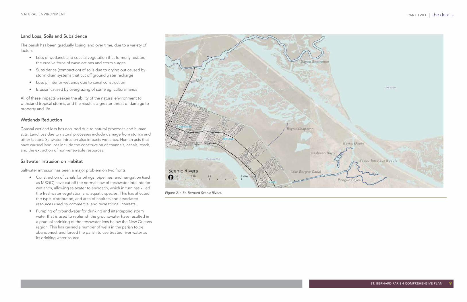
In 2005, St. Bernard Parish experienced devastating destruction caused by Hurricane Katrina. The devastation was due to several factors: collapse of the seawall protecting the Lower 9th Ward from Lake Pontchartrain, exceptionally high wind-driven storms, and intense rainfall from a Category 5 storm with winds reaching 174 mph.
In the aftermath of Hurricane Katrina the US Army Corps of Engineers (USACE) constructed a new, $9 billion floodwall/levee system surrounding the parish. The seawall has greatly mitigated the threat of cataclysmic flooding from seawall failure and storms1. In spite of these physical protections, the parish is still subject to significant rainfall-induced flooding. And to handle the flood waters, the parish still depends on storm sewers and canals to collect storm water, and on pumps to lift the collected water over the levees and floodwalls. Even with these systems, some portions of the parish will still be flooded in a 100-year storm event (see Figures 22 and 23, the Existing and Proposed Flood Plain Maps). If these mechanical systems fail, many more homes in the parish will be flooded. If a greater than 100-year event occurs, the hazard will be even greater.
This reality affects the goal of attracting a greater portion of higher income families to the parish in two ways:
• Homes built on slabs in a flood-prone area are more susceptible to even minor flooding, they undermine market strength and increase insurance costs.
• Suburban development patterns and construction methods increase flood probabilities and infrastructure costs associated with mitigation.
It suggests that one of the biggest issues in St. Bernard Parish is the challenge of storm water - how to think about it, manage it, leverage it, and control it or be controlled by it. The parish has the opportunity to work with the storm water and not against it. How the parish - as a community and government - manages storm water will also have an impact on its ability to retain and attract strong businesses and middle and upper income residents, all of whom have choices as to where to locate.
1 To meet a 100-year storm surge.
HOW THE DRAINAGE SYSTEM WORKSUnlike most river systems in the US, along the lower Mississippi River, the high ground is adjacent to the river (due to deposition from flooding over millennia). From this high ground next to the river, the land slopes gradually downward away from the river. Storm water historically flowed perpendicular to the river into lowlands and marshes.
Today in St. Bernard Parish, storm runoff from the high ground is captured in storm drains and road gutters, which channel runoff into canals that run east-west and then connect to north-south canals that flow north into the 40 Arpent Canal. From the 40 Arpent Canal, runoff is lifted, by eight pumping stations, over the levee into the Central Wetlands Unit. Outside the levee system, tidal pumps are also used. The East Bank Flood Protection Agency (formerly the Lake Borgne Basin Levee District) operates and maintains the drainage canals and pump stations.
Recent studies in St. Bernard Parish and New Orleans suggest that there are alternative approaches to the design and function of drainage canals. Since the presence of water (lakes, rivers, bayous) is almost always appealing and attracts people:
• Canals that are visually attractive are opportunities to strengthen property values.
• Canals that adjoin private instead of public property are missed chances to create quality of life amenities that can promote and market the parish as a great place to live.
Storm Water Management
Figure 24: The Braithwaite Auditorium, located south of St. Bernard Parish, is an example of an elevated structure in the flood plain.
Figure 25: This flooding along North Claiborne Avenue just east of St. Bernard Parish is an example of flooding in the area after rainfall.

PART TWO | the details
ST. BERNARD PARISH COMPREHENSIVE PLAN 15
STORM WATER MANAGEMENT
STORM WATER MANAGEMENT DIRECTIONS
Storm Water Management Concepts
Flood-Prone Areas
Although the mapping of flood-prone areas is being revised after the construction of the new seawall, preliminary maps indicate that the anticipated reduction in the 100-year flood plain boundary still leaves a significant portion of the western and northern parts of the urbanized parish subject to flooding. (See Figures 22 and 23: Existing and Proposed Flood Plain Maps)
The Parish should use several different strategies to reduce the future risk of damage to properties:
1. With the assembled vacant lots in the flood plain, the Parish could create parks, ball fields, natural areas, and in general dedicate the land to non-residential uses that function as public amenities.
2. Zone flood plain areas for very low density residential uses (very large lots). This will still allow private development, but greatly reduce the number of people and homes exposed to flood hazard.
3. Require homes built in flood-prone areas to be elevated above the flood level, either on pilings (that allow flooding under the dwelling) or by a combination of filling and excavating that achieves zero net fill (and does not increase the flooding on neighboring areas).
Figure 26: Storm water flows away from the highest ground along the Mississippi River, via canals to the 40 Arpent Canal, to stations where it is mechanically pumped over the levee into the Central Wetlands.
k
k
k
k
k
k
Chalmette
Violet
Toca
Meraux
KenilworthPoydras
Arabi
St. Bernard
VerretCaernarvon
Bayou Rd
St Bernard Hwy
La Hwy 46
Judge Perez Dr
Paris
Rd
Levee Access Rd
Patricia St
Lena
Dr
Volp
e D
r
Plaz
a D
r
Jaco
b D
r
Meh
le A
ve
Vent
ura
Dr
Canal St
Ange
la A
ve
Perri
n D
r
Barto
lo D
r
Delill
e St
Buffo
n St
Chal
ona
Dr
Gal
lo D
r
Virtue St
Vero
nica
Dr
Nancy Dr
Mum
phre
y R
d
Meraux Ln
Farmsite Rd
Cent
er S
t
Guerra Dr
St Bernard Pky
St Avide St
Palm
isano
Blv
d
Legend Dr
Cam
pagn
a D
r
Mun
ster
Blv
d
Lapl
ace
St
Jean
Laf
itte
Pky
Maureen Ln
Mar
ietta
St
Chalmette Back Levee Rd
Saro
Ln
Paul
Dr
Kare
n D
r
Gin
a D
r
Jack
son
Blvd
Oak Dr
Syl
via
Dr
Torr
es D
r
Riverbend Dr
Liberaux St
Gold
en D
r
Lloy
ds A
ve
Peters St
Neh
lig L
n
Fene
lon
St
Lynd
el D
r
3rd St
Acce
ss R
d
Green Ave
Judy
Dr
Daut
eriv
e D
r
6th St
Fris
covi
lle A
ve
Josephine St
St Marie
Dr
River Rd
Mar
y An
n D
r
Coug
ar D
r
Benjamin St
A St
Rowl
ey B
lvd
Tara Dr
Jupi
ter D
r
King
s D
r
Reunion Dr
Trio
St
Ayco
ck S
t
Marina Rd
Ken
ilwor
th D
r
Valmar D
r
Prosper St
Pack
enha
m A
ve
Boni
ta D
r
Alex
ande
r Ave
C St
Licciardi L
n
Nea
l Ln
Law St
Este
ban
St
South Lake Blvd
Pira
te D
r
Genie St
Norto
n Av
e
Char
les
Dr
Corin
ne D
r
D'amour St
Wal
kers
Ln
Suz
i Dr
Rose
St
Juno
Dr
Beachead Ln
Rive
rland
Dr
Margaret Ln
Desp
aux
Dr
Gne
ll D
r
Violet St
Bear Dr
Hei
ghts
Dr
Francis Ave
Rose
tta D
r
Coke
Pla
nt R
d
Cree
ly Dr
Prince Dr
Marlin Dr
Todd
Dr
Stacie Dr
Claiborne Sq
Shannon Dr
Rue Joli
Daniel Dr
Lakewood Dr
Old
Hic
kory
Ave
Packenham Rd
Guillot D
r
Moreau St
1st St
Verret St
Parc Pl
4th St
Blan
char
d D
r
Florida Ave
Rue
Mar
celle
Com
mun
ity S
t
Valor Dr
Fanz Rd
Pumping Station No. 8 Access Rd
Old
Lan
dfill
Acce
ss R
d
Corin
ne A
ve
Jamie's C
t
Pine
Dr
Ric
hard
's L
n
Sug
ar M
ill D
r
Bill
iot D
r
Sta
y P
ark
Dr
Cen
tann
i Dr
Cre
edm
oor
Dr
Lumberyard R
d
River Queen Dr
Magistrate St
Nic
osia
Pl
Fish
er R
d
Funn
y Fa
rm L
n
Laco
ste
Cir
Newport Dr
Norw
ood
Dr
Cha
lmet
te S
lip R
d
Livingston Ave
Gre
y's
Rd
Woo
dlan
ds C
t
Oak
Gro
ve L
n
5th St
Carro
ll Dr
Palm
Ave
Wein
berg
er R
d
Fountain Ln
Olivia S
t
Rus
sell
Pl
Meadow Dr
Najolia Dr
Seel
os C
tLi
sa S
t
Hermitage Dr
Newt
on B
lvd
Priv
ate
Dr
Wes
tern
Gas
Rd
Pierre St
Redbird Dr
Beau
rega
rd S
t
Suga
r Rd
Lynn Oaks Dr
Wat
er B
oard
Rd
Mustang Dr
Ferry
Lan
ding
Rd
Dolphin Dr
Colonel Dr
Senko Rd
Philip Ct
3rd Navy Access Rd
Group
er D
r
Dove St
Camille Trl
Robin Ln
Rue Ciel
Access Rd
Genie St
Acc
ess
Rd
Florida Ave
Ayco
ck S
t
River Rd
River Rd
Chalmette Back Levee Rd
Ayco
ck S
t
Florida Ave
River Rd
Levee Access Rd
Florida Ave
Florida Ave
Acc
ess
Rd
Genie St
Acce
ss R
d
Acce
ss R
d
Judy
Dr
Florida Ave
Violet
Toca
Meraux
Kenilworth
Arabi
St. BernardVerret
Chalmette
Poydras
Caernarvon
Lake Borgne
Mississippi River
Big Mar
Mississippi River Gulf Outlet
Source: Esri, DigitalGlobe, GeoEye, i-cubed, USDA, USGS, AEX, Getmapping, Aerogrid, IGN, IGP, swisstopo, and the GIS User Community
[ 0 2 41 Miles
DrainageMajor Roadway
Minor Roadway
Canals
Other Drainage
k Drainage Pumps
ElevationHighest Lowest
Central Wetlands
40 Arpent Canal
Highest Elevation
Highest Elevation

PART TWO | the details
16 ST. BERNARD PARISH COMPREHENSIVE PLAN
STORM WATER MANAGEMENT
Figure 27: Existing canals within the parish.
Figure 28: Many canals in Holland are good examples of how canals, integrated with streets and parkways, can be redeveloped as positive contributors to the parish landscape.
Canal System Improvements
Today the canals are dry or nearly dry most of the time, and many are littered with shopping carts, old tires, and other trash. Most of the canals have wide servitudes that receive only periodic mowing and appear overgrown.
The canals were created as a storm water management device - to speed up the collection of water and transport to the pumping stations along the 40 Arpent Canal. An unintended consequence, however, was that the canals and storm drains have lowered the ground water levels in the parish, which has allowed the organic soils in some areas to be exposed to air, which in turn causes them to oxidize and compact. This creates a condition called subsidence (settling of the soil) that leads to cracked roads and sidewalks and structures exposed. The rate of subsidence is relatively slow, so it only becomes perceptible after decades.
A 2010 study by Waggonner & Ball Architects proposed two other important functions (besides drainage) the canal system could fill:
• Raising the water level in the canals (by installing check dams) could cause the canals to recharge the ground water and eliminate subsidence.
• More surface water in the canals (created by the check dams) would make them more attractive as water features, which in turn would make them attractive locations for public greenways, waterside plazas, and trails that can differentiate St. Bernard Parish as a great place to live.
Since the presence of water typically increases property values, the raised water level in the canals would also make canal-side private properties more attractive for premium residences.
The potential of a grand canal system that is functional as well as recreational and aesthetic, that could be achieved relatively cost effectively, is a compelling vision for St. Bernard Parish, and would make the parish truly unique in the region.
Figure 29: Illustrative drawing of paths and development along the canals. (source: St. Bernard Charrette Report by Duany Plater-Zyberg & Company)

PART TWO | the details
ST. BERNARD PARISH COMPREHENSIVE PLAN 17
STORM WATER MANAGEMENT
Storm Water Management Policy
The Parish will encourage the use of Best Management Practices for storm water management.
Storm Water Management Actions
Assure that the current detailed planning by Waggonner & Ball develops actionable concept designs and implementation steps/priorities.
Conduct a large public information campaign to create awareness and support for canal-side amenity improvements.
a. Demonstration model
b. Education-related projects
Designate specific LLT lots for a demonstration project.
Formulate a partnership for development.
a. Drainage district (demonstration project)
b. Developers (development opportunity)
c. Parish or foundation (provides land)
SW A1
SW A2
SW A3
SW A4
SW P1
Figure 30: Bayou St. John, New Orleans illustrates the potential for converting drainage canals into recreational water amenities.

PART TWO | the details
18 ST. BERNARD PARISH COMPREHENSIVE PLAN
FAIR HOUSING
Fair HousingSt. Bernard Parish has two housing-related challenges. One is for housing to remain affordable, thereby remaining accessible to low to moderate income households wanting and able to live in the parish. The other is to not become so affordable that future demand - and thus prices - fall further.
EXISTING CONDITIONS Historically, St. Bernard Parish has had three notable characteristics in regard to housing:
• The parish has traditionally been homogenous with over 90% of its residents being white and with low to very low percentage mixes of minorities.
• It has been a homeowner community with very high rates of owner occupancy with the resulting pride of place and protective tendencies that accompany ownership.
• It has been a working class community, without very much poverty at one end, or professional class households on the other.
Well prior to Katrina (2005), demographic shifts in race, homeownership, and income began to emerge in the parish and the trend continued at a more rapid pace after the storm1.
• Owner-occupied homes remain overwhelmingly held by white households, though this rate has been decreasing2 as more non-whites purchase homes in the parish in which to reside.
• At the same time, while diversity among parish owners is fairly modest, St. Bernard’s renters are increasingly diverse3. In all cases (parish-wide and individual places within the parish - particularly in Meraux, Chalmette, and Arabi), the main change over the past decade was a notable increase in the percentage of black renters4.
1 The percentage of non-Hispanic white declined from 84.4% in 2000 to 68.5% by 2010. Similarly, homeownership rates have fallen, from 74.7% in 2000 to 68.4% in 2010. 2 The percentage of non-Hispanic white owners declined from 89% in 2000, to 78% (still high) by 2010. In Arabi, Chalmette, and Meraux, nearly all owners (95%, 95%, and 92%, respectively) were non-Hispanic white in 2000; while by 2010 these figures declined slightly (85%, 88%, and 84%, respectively). In contrast, in Poydras, the portion of non-Hispanic white owners fell to 75% in 2010, and in Violet it fell below half (to 44%).3 Parish-wide, the percentage of rental units occupied by non-Hispanic white households was 59% in 2010, down from 79% in 2000). In Violet, just 20% of renters were non-Hispanic white in 2010. 4 African-Americans accounted for two-and-a-half times the share of renters in 2010 than in 2000 (27% versus 11%); at the place level: nearly four times the share in Meraux (27% versus 7%); five times the share in Chalmette (23% versus 5%); and ten times the share in Arabi (20% versus 2%).
• When it comes to household income, St. Bernard Parish has not progressed at the rate seen in other areas of the region. As the overall region around New Orleans grew in wealth over the last 20 years, St. Bernard Parish has not - median income and median home values have fallen relative to those in surrounding parishes.
When these characteristics are blended to realistically and comprehensively depict the overall conditions in St. Bernard Parish, the following interconnected trends emerge:
• Since 1995, potential homeowners in the region, whether white or black, have given a greater preference to buy in Jefferson, Orleans, Plaquemines, and St. Tammany Parishes than in St. Bernard. One consequence is falling demand and falling home values in St. Bernard Parish relative to surrounding areas. Another consequence is the gradual outmigration of the financially ablest households from St. Bernard Parish5 looking for a product that was not found within the parish.
• Rental housing has also changed over this period. In 1995, although some rental units were single-family homes and duplexes, the great majority of rental units in St. Bernard were multi-family buildings, principally in roughly 3,500 apartments. Although the majority of rental units are still apartments, the percentage of rental units in single-family homes has been growing6. Of all the single-family homes in the parish, a fifth are now rental units.
This trend is partially due to the growing number of people in the parish who may want to sell their home but cannot find a buyer due to the lack of demand in St. Bernard; therefore, they become, one house at a time, landlords who may lack expertise to appropriately manage rental property.
In addition, with many low cost homes, the parish has seen a rise in speculative buyers who tend to put as little into the properties as possible and extract cash flow (with low resale value and no tax value given the realities of depreciation).
5 owner occupancy significantly decreased by 19.6% in just the five years prior to Katrina6 from 27% in 2000, to 38% in 2011
Figure 31: Example of a single-family residence within the parish.
Figure 32: Recently developed multi-family housing in the parish.

PART TWO | the details
ST. BERNARD PARISH COMPREHENSIVE PLAN 19
FAIR HOUSING
• The increasing proportion of housing that is renter-dominated has allowed more housing opportunities for lower income residents that previously could not afford purchasing or renting a house within the parish. As a result, the parish has become a somewhat lower-income community each year since the mid- 1990s and, when Katrina hit, this trend accelerated.
In sum, the parish has traditionally been a predominately white, working class community where most owned, and lived in their own homes and where most families through the early 1990s maintained their homes to a high standard.
By the early half of 2013, the parish remains mainly white but decreasingly so. It remains mainly owner-occupied, but decreasingly so. And it remains a working class parish, but with an influx of notably lower income households (particularly into the increasing number of rental units within the parish).
These shifts portend significant challenges for the parish going forward as it seeks to balance the work of revitalization with preservation and enlargement of fair housing.
THE TWIN CHALLENGE: A STRONGER HOUSING MARKET THAT IS ALSO FAIR AND ACCESSIBLE
There is one over-arching regional theme in regard to settlement within the region: Jefferson, Plaquemines, St. Bernard, and St. Tammany each have significantly less than a fair share of the region’s low to moderate income households, and Orleans Parish has significantly more7.
At the local level the pattern is similar. St. Bernard is principally comprised of five population centers: Arabi, Chalmette, Meraux, Poydras, and Violet. The “whitest” of these is Meraux, which is also the wealthiest. The second whitest is Chalmette. Third is Arabi. In stark comparison, Violet is significantly non-white. To the extent that there is diversity within the parish, it is in rental housing regardless of the location.
7 In the last 30 years, Jefferson Parish has moved from an 80 percent white parish to 56. St. Bernard has gone from being the region’s ”whitest” parish at nearly 88 percent to 68.5 today. The constants in the region are Orleans (consistently the ”blackest” and poorest) and St. Tammany (consistently the ”whitest” and wealthiest).
This last point underscores the essential dilemma of a revitalization challenge in a weak market: when households are not able to buy in a relatively affordable area (a weak market where home values are comparatively low) it is typically because they are unqualified to purchase a home (for example, they do not make adequate income and/or do not have adequate down payment saved, and or they lack sufficiently bankable credit) and not because they are priced out of the area. To the extent that earning power and savings histories serve as a proxy for homeownership and in turn as a proxy for race, rebuilding a shattered housing market in a weak region of a poor state is a monumental task when fair access to housing is respected.
Given the precarious state of the St. Bernard housing market, there are two goals for which to aim:
• A stronger housing market from an economic point of view. That is, more reason for buyers to locate in St. Bernard, resulting in stronger values, greater price stability and appreciation, and more continuous reinvestment by existing owners.
• A fairer, more accessible housing market of genuine choice unimpeded by policy or action that measurably results in overall diversity.
These are very difficult goals to achieve in any market, and exceedingly difficult in south Louisiana where the size of the population of buyer-ready black households is relatively small, where there are numerous hurdles (appeal, product, history, location) in the way of any family – black, white, or Hispanic – considering buying in St. Bernard, and where the quality of competition in the surrounding parishes is so significant.
What is Fair Housing? The Fair Housing Act outlaws the discrimination in the rental or purchase of housing (as well as other related housing transactions) on the basis of color or race, sex, religion, national origin, disability, or familial status.
By law, one is prohibited to:
• Refuse or deny to rent or sell
• Refuse to negotiate for housing
• Make housing unavailable
• Set different terms, conditions or privileges for sale or rental of housing, or
• Provide different housing services or facilities based on a renter’s or buyer’s color or race, sex, religion, national origin, disability, or familial status.
The intention is for a fair and unitary housing market where a person’s background, versus his or her financial resources, does not arbitrarily restrict access.
PART TWO | the details
20 ST. BERNARD PARISH COMPREHENSIVE PLAN
FAIR HOUSING
HOUSING CHOICES FOR THE FUTURE: REBRANDING TO COMPETE FOR MIDDLE AND PROFESSIONAL CLASS FAMILIESTo accomplish the goal of creating a stronger housing market, St. Bernard Parish has to want to compete for two key groups in the region: middle and professional class families, and upwardly mobile low to moderate income families, both of whom will make important cultural and economic contributions to a newly rebranded St. Bernard Parish.
This will require a “rebranding” of, or creating a new identity for, the parish.
The need for “rebranding” is best understood by seeing the parish through the eyes of the market in the region - a weak housing market defined by three key elements: (1) a lack of desirable amenities and an unsightly environment, (2) a reputation of being a segregated community, and (3) obsolete housing stocks in comparison to surrounding parishes.
Lack of Marketable Amenities and an Unsightly Environment
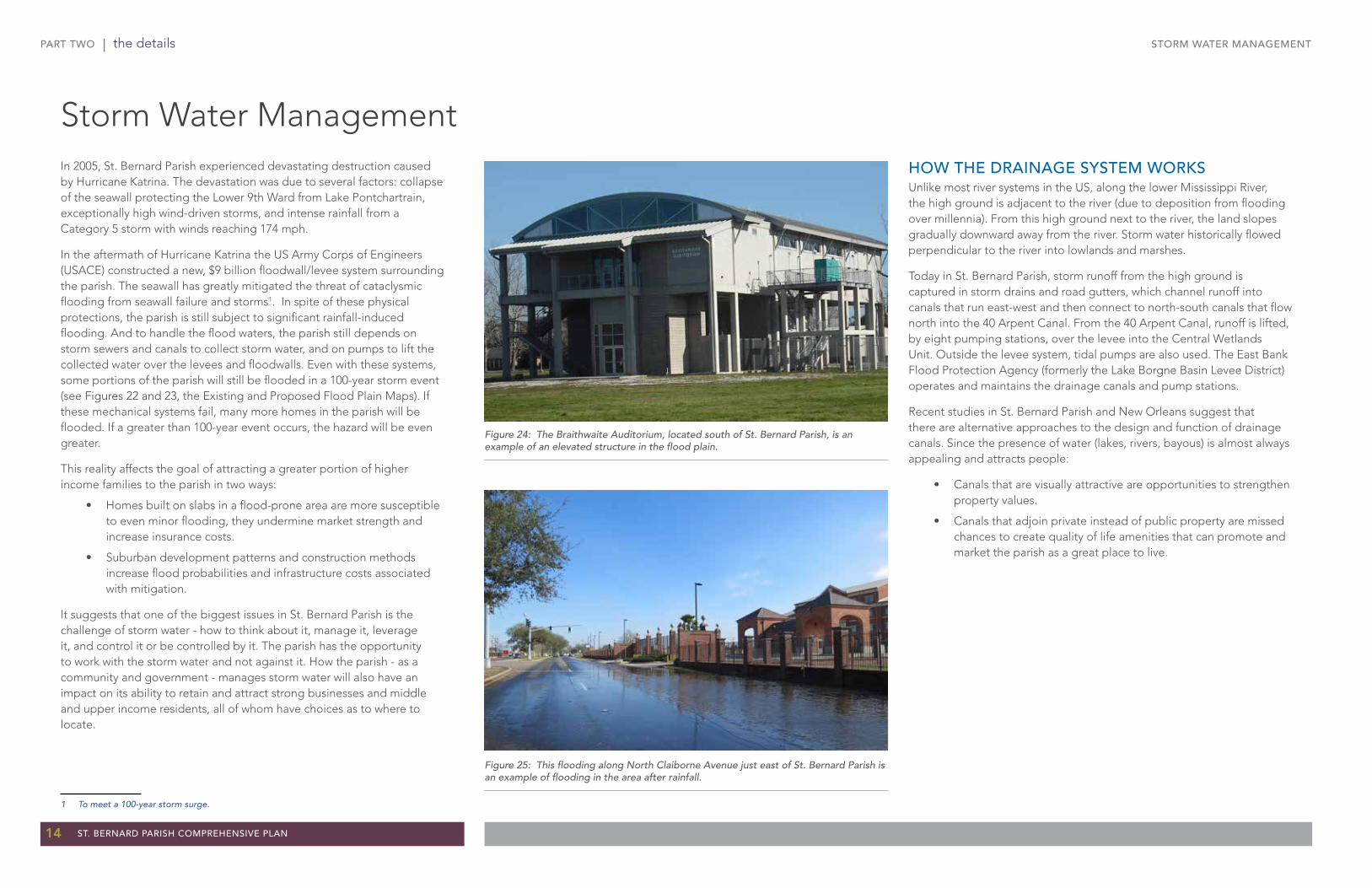
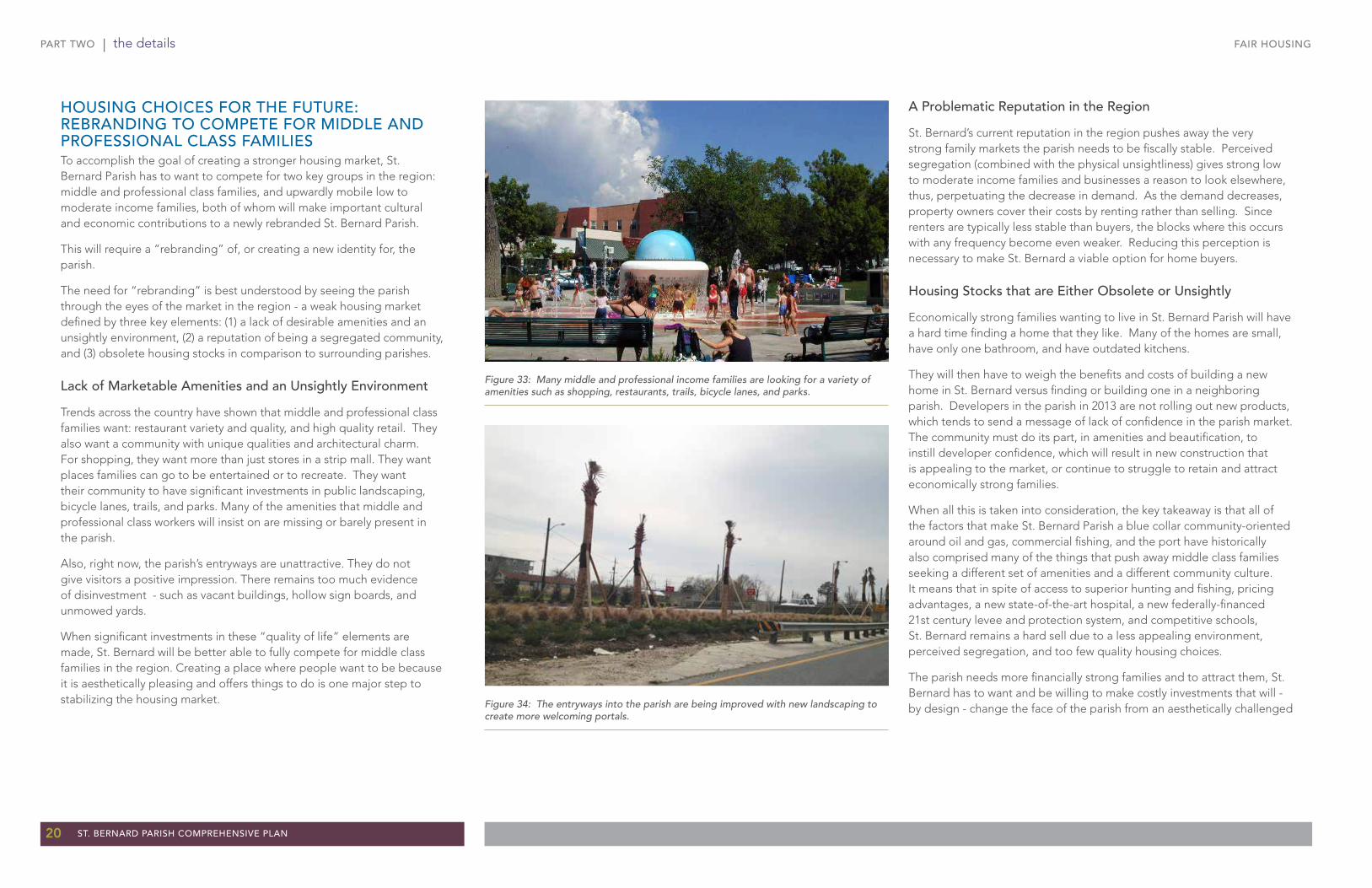
Trends across the country have shown that middle and professional class families want: restaurant variety and quality, and high quality retail. They also want a community with unique qualities and architectural charm. For shopping, they want more than just stores in a strip mall. They want places families can go to be entertained or to recreate. They want their community to have significant investments in public landscaping, bicycle lanes, trails, and parks. Many of the amenities that middle and professional class workers will insist on are missing or barely present in the parish.
Also, right now, the parish’s entryways are unattractive. They do not give visitors a positive impression. There remains too much evidence of disinvestment - such as vacant buildings, hollow sign boards, and unmowed yards.
When significant investments in these “quality of life” elements are made, St. Bernard will be better able to fully compete for middle class families in the region. Creating a place where people want to be because it is aesthetically pleasing and offers things to do is one major step to stabilizing the housing market.
A Problematic Reputation in the Region
St. Bernard’s current reputation in the region pushes away the very strong family markets the parish needs to be fiscally stable. Perceived segregation (combined with the physical unsightliness) gives strong low to moderate income families and businesses a reason to look elsewhere, thus, perpetuating the decrease in demand. As the demand decreases, property owners cover their costs by renting rather than selling. Since renters are typically less stable than buyers, the blocks where this occurs with any frequency become even weaker. Reducing this perception is necessary to make St. Bernard a viable option for home buyers.
Housing Stocks that are Either Obsolete or Unsightly
Economically strong families wanting to live in St. Bernard Parish will have a hard time finding a home that they like. Many of the homes are small, have only one bathroom, and have outdated kitchens.
They will then have to weigh the benefits and costs of building a new home in St. Bernard versus finding or building one in a neighboring parish. Developers in the parish in 2013 are not rolling out new products, which tends to send a message of lack of confidence in the parish market. The community must do its part, in amenities and beautification, to instill developer confidence, which will result in new construction that is appealing to the market, or continue to struggle to retain and attract economically strong families.
When all this is taken into consideration, the key takeaway is that all of the factors that make St. Bernard Parish a blue collar community-oriented around oil and gas, commercial fishing, and the port have historically also comprised many of the things that push away middle class families seeking a different set of amenities and a different community culture. It means that in spite of access to superior hunting and fishing, pricing advantages, a new state-of-the-art hospital, a new federally-financed 21st century levee and protection system, and competitive schools, St. Bernard remains a hard sell due to a less appealing environment, perceived segregation, and too few quality housing choices.
The parish needs more financially strong families and to attract them, St. Bernard has to want and be willing to make costly investments that will - by design - change the face of the parish from an aesthetically challenged
Figure 33: Many middle and professional income families are looking for a variety of amenities such as shopping, restaurants, trails, bicycle lanes, and parks.
Figure 34: The entryways into the parish are being improved with new landscaping to create more welcoming portals.

PART TWO | the details
ST. BERNARD PARISH COMPREHENSIVE PLAN 21
FAIR HOUSING DIRECTIONSCurrent weak market conditions can be remedied but only if the Parish (as a community and Government) is willing to make sizable investments in “rebranding” or remaking its image.
Rebranding St. Bernard Parish will take time. The key will be to appeal to economically strong buyers overall as well as specifically to economically strong low to moderate income buyers. This will require a two-pronged effort:
Make major investments in amenities and beautification
Work with homebuilders, realtors, mortgage and construction lenders, and others to understand and respond to the regional demand for new product types8.
Appendix B outlines a ten-year plan to achieve the general objectives described in this chapter as well as additional charts on background information.
8 The outreach, marketing, and developing strategy needed to become racially balanced can be the same strategy needed to strengthen the market.
FAIR HOUSING
industrial-looking area with outdated suburban style development to a more service-oriented economy with contemporary amenities.
While remedying the problem of low demand ideally results in a stable market, doing so in a racially segregated region without perpetuating segregation is very tricky. It means focusing all efforts on remaking the parish to appeal to financially strong households with a range of options, and doing so without narrowly and exclusively orienting those efforts towards white households. It means navigating the regional market to find and invest in strong buyers, regardless of race, on the demand side, and ensuring a steady flow of well-aimed financial instruments and desirable housing products on the supply side.
Of course, market forces mean that each family has a choice about where to live. White families will tend to want to live near white families and black families will tend to want to live near black families. So the challenge of distributional balance is significant. What is more important than actual numerical perfection is demonstrable intention to affirmatively further fair housing.
Seniors Housing
Seniors housing is another area on which to focus. Many current residents want to be able to age in place within the parish and not have to move out of the parish in order to downsize or find communities catering to seniors. Encouraging the development of retirement communities for seniors would allow resident seniors a choice in the market as well as attract seniors in the region to buy second homes within the parish.
Figure 35: Although many homes are well kept within the parish, others are more unsightly and obsolete with only one bathroom and outdated kitchens.
FH A1
FH A2

PART TWO | the details
22 ST. BERNARD PARISH COMPREHENSIVE PLAN
LAND USE
Land UseLand can be used in a variety of ways. The broadest and most common categories of use are residential, commercial, industrial, and agricultural. Within these categories are a myriad of subcategories (high-, medium-, and low-density residential, retail commercial, business commercial, etc.).
Two interrelated forces influence where various land uses occur: the market (supply and demand) and regulation (zoning, building codes).
Of the two forces, the market is by far the strongest. For example, if a property is “zoned” for commercial uses, stores will not appear unless the parcel is in a location that brings in (supplies) potential customers (demand from nearby residences). Conversely, a parcel in a busy downtown could be zoned for estate living, but the market would demand a more intensive use, and an estate would not occur.
The result is that in actuality, regulation (zoning and building codes) is intended not to “dictate” to the market, but rather to help the market work more efficiently, by making sure that what one person does with their property does not make someone else’s property less valuable. It does this by establishing standards that assure:
• Functional needs (adequate parking, plumbing, putting compatible uses next to each other).
• Safety needs (fire walls, sprinklers, roads wide enough for fire trucks).
• Quality of life (appropriate signage, setting aside parks, setback from the street).
Regulations generally are authorized by the broad constitutional provision for “health, safety, and welfare”. They also bring about predictability and consistent standards of care, which helps business because good developers, before they invest, want some assurance as to what can happen next door.
EXISTING CONDITIONS: MARKET-RELATED CHALLENGES FACING THE PARISHSt. Bernard Parish faces several challenges related to land use that powerfully shape the Parish’s (as a community and Government) ability to achieve its stated vision of attracting and retaining strong businesses and of having a competitive share of the region’s middle and upper income families.
Large Supply of Vacant Land
The combination of profound population loss1 with a slow recovery rate has resulted in a significant supply of excess land in the parish. This vacant land consists of:
• Abandoned lots generally scattered throughout the parish, but with several areas having large collections vacant lots (e.g. northwest Chalmette, west of Valero Oil tanks).
• Very large acreages of undeveloped land (much of it owned by the Meraux Foundation), some of which is internal to communities (such as the former “airport tract” in Chalmette) and most of which are forest or agricultural tracts between communities in the parish.
If past patterns (scattered development of hard-to-market homes, as opposed to concentrating development in a few areas) continue, the unfinished and haphazard character of many areas of the parish2 will be cemented, which means that the parish will continue to generally look unattractive to potential businesses and residents.
1 68,000 pre-Katrina to roughly 40,000 today2 Primarily Chalmette, but Meraux and Violet as well
Figure 36: Many lots, whose houses were destroyed by Hurricane Katrina, continue to remain vacant even after 8 years.
Figure 37: Several Meraux Charitable Foundation properties provide valuable separation between communities as well as glimpses of the agricultural heritage of the parish.

PART TWO | the details
ST. BERNARD PARISH COMPREHENSIVE PLAN 23
LAND USE
Impression of “Unfinished” Development
If the large areas of abandoned lots in the parish merely looked like undeveloped land, St. Bernard Parish would look like many other communities with unused land around the edges. Unfortunately, St. Bernard Parish’s landscape of abandoned lots remains divided by the old grid of streets, with only a few homes scattered here and there. To an outsider, this recalls images of failed developments3, of perpetually “unfinished” development. This negative impression is a huge discouragement of robust investment and reinvestment.
Lack of Standards and Predictability
Most of the older homes in the parish were built as slab-on-grade where the home is flush to the ground. As newer homes have been built, some are also slab-on-grade, some have been elevated slightly, and others have been built on tall pilings - this variety is intermixed. Furthermore, many of the homes built on pilings use the area under the homes for storage of all kinds (equipment, boxes, tools, etc.).
The result gives yet another impression to an outsider: incoherence and low community standards. A person considering buying a lot should be concerned that they could build a nice home only to risk having neighbors build a very different type of home, store boats in their yards, or pile everything from BBQ grills to gardening equipment underneath the house. Not until a vacant lot will be developed in predictably high standard ways will the parish become competitive in the regional market.
Lack of Neighborhood
Given the above, the resulting development pattern is not able to recreate a traditional neighborhood feel, especially the tight-knit neighborhood feel that in the past, made Arabi / Chalmette truly appealing places to live. This further weakens the St. Bernard market in comparison to other competing communities.
3 Not unlike the impression given by real estate projects where all the roads were put in but only a few homes were sold
Lack of Diversity in Housing Type
Residential development in the parish is mostly suburban in character - single-family homes on a single lot. There is a slight variation in lot size, density, and layout between the various communities in the parish:
• Since Arabi and Chalmette also have duplexes, apartments, and mobile homes, their density is slightly higher than typical suburban development, about 6-7 units/acre.
• Meraux and Violet above the Violet Canal, represent the mid-range of typical suburban development, about 5 units/acre.
• South of the Violet Canal, the character transitions from suburban to rural, with larger lots and some agricultural uses.
• Further southeast, outside the levee system, development is very rural, mostly coastal wetlands interrupted by scattered, small commercial villages and fishing camps, recreation, and a major oil processing complex (Chevron).
This general pattern is changing very slightly: a few new developments have provided a few apartments as well as some homes on larger lots, but most have remained consistent.
What is happening in the regional market, outside the parish? There is increasing demand for a greater variety of housing types, including single-family homes on large lots, medium lots, small lots, patio homes, duplexes, triplexes, small apartment buildings, condominiums, and even live-work opportunities (living above or adjacent to one’s business). The lack of this variety puts St. Bernard Parish at a disadvantage in the larger market4.
4 Since builders usually build in a style to which they are accustomed, the claim that “that’s what the market wants” can be countered by “that’s the only choice being offered.” Changing the type of housing offered is a slow, gradual process of becoming familiar with other possibilities, reinforced by willingness to take a risk.
Figure 38: Although there are some duplexes (as shown above) and apartment buildings, the majority of the housing units in the parish are single-family homes.
Figure 39: An example of elevated structures built adjacent to at-grade homes.

24 ST. BERNARD PARISH COMPREHENSIVE PLAN
LAND USE PART TWO | the details
Figure 40: Existing Land Use Map - Northwest section of the urban areas of the parish.

PART TWO | the details
ST. BERNARD PARISH COMPREHENSIVE PLAN 25
LAND USE
Figure 41: Existing Land Use Map - Southeast section of the urban areas of the parish.

PART TWO | the details
26 ST. BERNARD PARISH COMPREHENSIVE PLAN
PART TWO
THE CITY-FORM OF THE PARISHMost communities have a similar form. The most common pattern they often take, is illustrated by the transect (cross-section) as shown in Figure 43.
The transect shows a range of land uses from farms and open land on the edge, increasing to more intense building forms as one gets closer to the center, then diminishing toward the other edge. This transect is a generic diagram that varies somewhat from community to community.
For example, St. Bernard Parish more or less follows the transect in the east-west direction with high intensity uses along Judge Perez Drive and then gradually lower densities to the east and west. The pattern continues eastward to the 40 Arpent Canal and the Central Wetlands. But on the west side of Judge Perez, the parish transect has been evolved with shipping and industrial development along the Mississippi River rather than lower density development and farmland.
In the north-south direction St. Bernard Parish reflects one-half of the transect: higher density development on the north edge in Chalmette, with gradually less dense development extending south and east (Meraux, Violet, etc.).
The transect is important because it reflects how St. Bernard Parish might develop over future decades, and it can be used as a pattern for making
long range land use decisions.
Separation of Housing Types
This section of the St. Bernard Parish Comprehensive Plan seeks to outline a strategy for making land use decisions that will encourage future development to occur in locations and forms that will appeal to the real estate markets, and will, as a by-product, provide more manageable and financially sustainable patterns of land use in the future.
The dominant trend throughout the parish’s history has been to develop and settle in homogenous ways - subdivisions of the same housing type, on the same size lots, with the same income requirements. Newer development appears to be trending the same: single-density subdivisions (all large lots, all apartments, and so on). The result is a long-standing and detrimental lack of economic diversity.
The “take-away” is that practices that have worked well for the parish in the past will not position the parish to compete effectively with other communities for those strong businesses and families that have the luxury of choosing where to locate.
Figure 42: The image above shows incompatible land uses: multi-family units across the street from single-family units; although the two types of housing can be designed to mix well, this example shows a separation of types seen in the parish today.
Figure 43: The illustrated transect shows the typical gradual increase in land use intensity from open lands and agricultural uses to suburbs to a more intense building types in a downtown.
Figure 44: A recent trend in the parish is to place apartment buildings in remote locations isolated from shopping, parks, and paths; the Future Land Use Map proposes smaller apartment buildings integrated in numerous locations close to commercial corridors and other amenities.
downtown
rural
estates
lower intensity
higher intensity
suburbs
townhouses, apartments

PART TWO | the details
ST. BERNARD PARISH COMPREHENSIVE PLAN 27
LAND USE
CHOICES FOR THE FUTUREHow should the parish develop in the future? While “the market” will ultimately decide how the parish will develop, the pattern and speed of development can be influenced by the effective use of regulations, the location of roads and utilities, and by making other public investments (parks, open areas, plazas, public buildings, etc.).
This section of the St. Bernard Parish Comprehensive Plan seeks to outline land use strategies that will encourage future development to occur in locations and forms that will appeal to the regional real estate markets, and will, as a by-product, provide more manageable and financially sustainable patterns of land use in the future.
This section addresses both the type and location, in general, the Parish anticipates occurring, as well as functional needs (roads, amenities) to ensure that future developments are successful, safe, efficient (can be served cost-effectively) and create a high quality of life for the property owners and parish residents.
Put another way, a key objective for St. Bernard Parish is to encourage attractive, well-functioning development, with amenities and services that will help St. Bernard Parish be more competitive in the region. This can only be done by capitalizing on the existing character and assets of the parish and by not recreating the less marketable aspect of parish past.
Fill In Before Spreading Out
Flooding the market with land will keep the price low, and continue to encourage lower cost development. “Metering” the supply of developable land will increase property values.
Also, to avoid continuing to project the “unfinished” character prevalent today, it will be important that a few neighborhoods reach completion (with true neighborhood character), rather than having many areas only partially developed. This can be accomplished by discouraging development of the large undeveloped parcels in the parish—except for specific projects to introduce new development types, and/or to fill in highly visible parts of the urban fabric.
Mixing of Densities and Uses
There are basically two ways communities use to accommodate a variety of densities and uses: isolate them or mix them. In the early days, St. Bernard Parish land uses were generally mixed with homes, businesses, and stores intermixed. Then, beginning in the 1950’s, communities, including those in St. Bernard Parish, began to segregate uses creating district zones for industrial, residential, commercial uses into office parks, shopping centers, apartment complexes, single-density subdivisions.
Because this segregation of uses brought about increased travel times, traffic congestion, and uniform obsolescence5, in recent years many communities have been going back to allowing a greater mix of uses and densities. Examples include “lifestyle centers” and new “downtowns” that include stores and apartment/condo uses together. Even predominantly single-family subdivisions now often include duplexes on corner lots, townhomes on busier streets, and even small neighborhood stores at a busy intersection - all within the same zone.
The St. Bernard Parish Future Land Use Map (FLUM) encourages mixing of densities and unit types, within compatible ranges and sizes, rather than segregating them. Following the “transect” described previously, this would allow small apartment buildings in many locations adjacent to the commercial “spine” along Judge Perez Drive (rather than zoning only for large apartment complexes in a few locations, as occurs today). An aspect of this approach that appeals to the “market” is that it allows families to “age-in-place”- as children leave home, couples that no longer want to maintain a large yard, can move into a patio home or townhouse nearby, without having to leave behind family or neighborhood relationships.
5 The stores in shopping centers and malls all went downhill together, after about 15 to 20 years, often caused by “bigger, better, newer” ones down the road to which customers switched.
Figure 45: There are a number of vacant lots within the core of the parish’s developed areas that should be “filled in” before development occurs on the outer, less developed areas of the parish.
Figure 46: A mix of densities - single-family units (right side of image) next to multi-family buildings (left side of image) can provide a greater variety of housing choices for the residents of the parish.

PART TWO | the details
28 ST. BERNARD PARISH COMPREHENSIVE PLAN
LAND USE
Gradually “Feather” Densities and Uses (When They Cannot Be Mixed)
Creating high density developments immediately adjacent to low density neighborhoods should be avoided. Instead, the densities should be “feathered.” That is, a new home or building type placed adjacent to existing homes should be similar in density (no more than two categories different from what is adjacent). For example, if existing homes along a property line developed at 6 units per acre, new homes along the other side of the property line should be no more than 8 units per acre. Further away from the property line the new development densities can increase to higher levels. The reverse is true for new development at a lower density next to an existing higher density development.
New residential development adjacent to commercial, industrial, or business uses should generally be medium or high density (apartments, town homes) rather than single-family development.
When large increases in density next to each other cannot be avoided, they should be mitigated with buffer transitions such as increased setbacks, landscaping and/or gradual stepping of building heights.
Increase the Quality of Residential Development
To attract economically strong buyers, the Parish needs to increase the quality of future residential development:
• Create development standards to bring about consistency and quality that will appeal to the regional market.
• Adjust zoning as necessary to make it possible to follow the concepts in the Future Land Use Map.
• Encourage and incentivize the creation of good examples of development types that are not currently found in the parish. Consider using a block of LLT lots, and/or other tracts of land for public/private partnerships and/or creating developer/builder packages to bring about good demonstration projects.
Figure 47: When developments of different densities are located adjacent to one another, densities can be “feathered” (gradually increased or decreased) to avoid putting incompatible home types next to each other.
THE FUTURE LAND USE MAPThe Future Land Use Map portrays how the parish is anticipated to grow, over time, as well as how future land uses should be organized and configured so as to result in more successful businesses and highly livable neighborhoods.
Many Areas Not Likely to Change
In many areas of the parish the Future Land Use Map reflects existing conditions. These are stable areas that will not likely change significantly over the foreseeable future.
The areas with the highest potential to change are:
• As-yet undeveloped land.
• Abandoned lots.
• Vacant or underutilized buildings.
• Areas with potential improved scenic qualities made more attractive by canal improvements (see Storm Water Management chapter).
• Redevelopment in designated centers.
Centers
The objective of being able to better compete against neighboring parishes to retain and attract a greater share of middle and upper income families hinges on being able to create more walkable, pedestrian-friendly commercial areas (downtowns or centers).
Why? Because, while it may not be important to long time residents of St. Bernard Parish, it is exactly what this very critical market segment wants today, and if St. Bernard does not supply it, needed middle and upper middle income families will go elsewhere to find it.
Within the overall commercial strip pattern of the parish there are several unique nodes of smaller-scale commercial, and several underutilized areas. These represent valuable opportunities that could be developed as small “downtowns.” These include:
• Old Arabi.
• The Curve – the commercial area at the curve of West Judge Perez Drive in Chalmette.
• Meraux Airport Tract.
Figure 48: Vacant and abandoned lots have a high potential to change.
subdivision boundary
gradual increase in density

PART TWO | the details
ST. BERNARD PARISH COMPREHENSIVE PLAN 29
LAND USE
Figure 49: Center locations (above) and concepts for West Judge Perez at Old Hickory Avenue (upper right), Arabi Gateway (lower left) and Old Arabi Center (lower right).
0’ 100 200 400 800
commercialhigh-density residentialexisting park / open spaceproposed park / open spacepublic squarerailroad
existing bulidingsproposed buildingsexisting treesproposed treesparking lotwater
P
Arabi Gateway to Arabi Town Center- W Judge Perez Avenue
P
P P
P
PP
PP
P
P
P
PP
P
0’ 100 200 400 800
commercialhigh-density residentialmedium-density residentialexisting park / open spaceproposed park / open spacepublic square
existing bulidingsproposed buildingsexisting treesproposed treesparking lotwater
P
P
P
P
P
P
The Curve Center on W Judge Perez Dr
0’ 100 200 400 800
commercialhigh-density residentialmedium-density residentialexisting park / public greenproposed park / public greenpublic square
existing bulidingsproposed buildingsexisting treesproposed treesparking lotwater
P
railroadproposed: move powerlines or eliminate median
Old Arabi Center- St Claude Avenue
PP
P
PPP
P
P
CENTER CONCEPTS
Old Arabi
Arabi
the Curve
Meh
le A
venu
e
Le B
eau
Stre
et
Fris
covi
lle A
venu
e
St. Claude Avenue
Cen
ter
Stre
et
Ayc
ock
Stre
et
Perr
in D
rive
Nor
ton
Ave
nue
Row
ley
Boul
evar
d
West Judge Perez Drive
Old
Hic
kory
Ave
nue
De
La R
onde
Dri
ve
West Judge Perez Drive
Arabi Gateway to Arabi Town Center - W. Judge Perez Drive
The Curve Town Center on W. Judge Perez Drive
Old Arabi Town Center - St. Claude Avenue

PART TWO | the details
30 ST. BERNARD PARISH COMPREHENSIVE PLAN
LAND USE
The Core Commercial Strips
The majority of commercial uses are located along the two primary arterials - Judge Perez Drive and St. Bernard Highway. The Future Land Use Map indicates that these roads are likely to continue to be bounded by commercial land uses, as they are today. However, an important modification is proposed: the commercial areas are proposed to allow/encourage the vacant and redeveloping commercial areas to infill with a mix of uses (commercial, office, residential multi-family) with high standards of site design to improve the appearance of the parish along the major corridors.
The “In-Between” Areas
The area between the two arterial/commercial strips are generally designated to continue as Medium Density Residential uses. Stable single-family neighborhoods will remain as they are.
However, for the few vacant areas immediately behind commercial uses that are less desirable for single-family residences, the Medium Density designation encourages slightly higher density uses such as single-family homes on smaller lots, duplexes, townhomes, and even small apartment buildings. These types of homes would fill a current market demand for a greater diversity in housing types. This also provides an opportunity, for those that like a more urban lifestyle, to live in close proximity to commercial areas and drive less.
Neighborhood Commercial Nodes
Small neighborhood convenience uses are successfully used in some communities to create more walkable, livable neighborhoods. There are a few locations suggested on the Future Land Use Map that are recommended to be developed with modest convenience-oriented stores, restaurants, salons, and professional offices (for accountants, insurance agents, architects, and lawyers).
Larger Residential Lots
To effectively compete with other parishes in the region, it will also be important for St. Bernard Parish to provide more opportunities for larger lots than are present in the older developed areas of the parish. Very large lots are being provided further east in the more rural areas of the parish (e.g. Violet, Poydras, and St. Bernard).
But there is also a market niche for in-between lot sizes, located close to Chalmette (vs. the eastern parish). An opportunity exists to create such larger residential lots is in the northwest area of Chalmette (as long as
Figure 50: Guillory’s is an example of neighborhood commercial as it occurs in the eastern part of the parish.
Figure 51: Neighborhood commercial nodes allow for compatible nonresidential land uses to mix with the neighborhood, thus creating destinations for interacting with neighbors.
the homes in the flood plain are raised above the flood elevation). Since this area was long ago subdivided into small lots6 , larger lots can only be created by combining lots. The Parish has already consolidated a number of LLT lots, and thereby reduced the number of LLT lots by 600. More can be done.
Recreation-Related Uses
Another valuable use for the flood plain areas of the parish is recreation-related uses (parks, natural areas, athletic fields), such as proposed for the Meraux “Airport” Tract (see the Parks and Recreation Chapter). Recreational uses are also proposed along drainage canals, which can become linear parks, as well as aesthetic assets, while still functioning as part of the water management plan. Recreational land use is also envisioned for the vacant lots in the Murphy/Valero buffer area as well as in one or more locations along the Mississippi River. Recreation-related uses are more fully described in the Parks and Recreation chapter.
Industrial Uses
Because of the use of the Mississippi River for heavy transportation, industrial uses are concentrated along the river banks. The Valero Oil refinery is an exception; it is a perpendicular swath extending north-to-south across the parish from the river to the levee. The existing industrial areas are envisioned in the Future Land Use Map to remain unchanged.
Development Reserve
Within a very short drive from any community in the parish, one passes through large landscapes of natural forests and open meadows with grazing cows. These are tremendous unleveraged assets.
It is important not to take these landscapes for granted, nor to underestimate their value in giving St. Bernard Parish a unique character and resource. They not only separate the various communities and keep them from becoming one continuous development corridor, but also they give visitors and residents alike a rare glimpse of old south Louisiana. If preserved and leveraged, they have the potential to truly differentiate St. Bernard Parish from many competing communities.
In the future, there will undoubtedly be pressure for development of these tracts. The Parish should develop a strategy for gradual, strategic release of these tracts, while preserving the majority of their scenic and urban separator functions.
6 Such as two lots combined into one, and 3 lots re-subdivided into two

PART TWO | the details
ST. BERNARD PARISH COMPREHENSIVE PLAN 31
PART TWO
Ser vice Laye r Cr edi ts: So urc e: Esr i, Di git alG lo be, G eoEye , Ear t hstar Ge ogr aphics , CN ES/ Ai r bus D S, USD A, U SG S, A er oGR ID , I GN , and t he GI S User Com m uni ty
Toca
Chalmette
Violet
Meraux
KenilworthPoydrasYscloskey
Hopedale
Arabi
St. Bernard Verret
Reggio
Delacroix
Shell Beach
Lake Borgne
Breton Sound
Chandeleur Sound
Drum Bay
Eloi Bay
Mississippi Sound
West Karako Bay
Bay Boudreau
Lake Calebass
Morgan Harbor
Indian Mound Bay
Three Mile Bay
Shell Island Lake
Lake Jean Louis Robin
Fishing Smack Bay
[ 0 10 205Miles
Agriculture
Recreation
Natural Areas
Rural Residential
Low Density Residential
Medium Density Residential
High Density Residential
Rural Village
Commercial
Industrial
Institutional
Development of Regional Impact
Future Land Use
Figure 52: Future Land Use Map (Center designation shown on area maps - Figures 53 - 55).

PART TWO | the details
32 ST. BERNARD PARISH COMPREHENSIVE PLAN
LAND USE
Figure 53: Future Land Use Map - areas near Chalmette and Arabi.
Ser vice Laye r Cr edi ts: So urc e: Esr i, Di git alG lo be, G eoEye , Ear t hstar Ge ogr aphics , CN ES/ Ai r bus D S, USD A, U SG S, A er oGR ID , I GN , and t he GI S User Com m uni ty
kj kj
kjChalmette
Meraux
Violet
Arabi
Levee Access Rd
Perrin Dr
Schn
ell D
r
Jud
y D
r
Trio
St
Tara D
r
Plaz
a D
r
Canal St
River Rd
Valmar
Dr
Marina Rd
Rose
St
Wal
kers
Ln
Meraux L
n
Fris
covi
lle A
ve
Guerra D
r
N Peters St
E Chalmette Back Levee Rd
Rue
Car
men
Alex
ande
r Ave
Mar
y A
nn D
r
Jup
iter
Dr
Cam
pagn
a D
r
Del
ille
St
Palm
isan
o Bl
vdG
allo
Dr
W Chalmette Back Levee Rd
Vero
nica
Dr
Boni
ta D
r
Lynd
el D
r3Rd St
Lena
Dr
Benjamin St
Access Rd
Gol
den
Dr
Margare
t Ln
Lum
bery
ard
Rd
Rive
rland
Dr
Patricia St
Ivy
Pl
Jaco
b D
r
Cok
e Pl
ant
Rd
Pine
Dr
Beach
ead Ln
Bear Dr
Valor Dr
E Genie St
Pira
te D
r
Rose
tta D
r
Volp
e D
r
Stacie
Dr
Fishe
r Rd
Cha
rles
Dr
Nancy
Dr
King
s D
r
1St St
Cen
ter
St
Earl
Dr
Cor
inn
e D
r
Cre
ely
Dr
Gib
bs D
r
Fairfax Dr
Des
paux
Dr
Easy St
Shan
non Dr
Ara
mis
Dr
Nor
wo
od D
r
Deco
min
e Dr
Maureen Ln
Rose
Ave
Tour
nef
ort S
t
E Law St
Cof
fee
Dr
Fable
Dr
Meh
le A
ve
Red Maple Dr
Rue Bien
Jon
es D
r
Cha
lm N
atl C
emet
ery
Rd
Mo
bil O
il A
cces
s Rd
Seel
os C
t
Jean
Laf
itte
Pky
Mu
rph
y O
il Re
fine
ry P
rope
rty
Rd
Florida Ave
Genet Dr
Woods D
r
Missouri St
5Th St
Daryl Dr
Fene
lon
St
Brig
ade
Dr
Ferr
y La
ndin
g Rd
Ten
ebra
ch S
t
Oak Tree Ln
Plau
che
Dr
Jagu
ar D
r
Her
nand
ez S
t
Brad
bury
Dr
Mar
iett
a D
r
W Virtue St
Stan
der
Pl
Wat
er B
oard
Rd
Tusa
Dr
Cora Ann St
Colonel Dr
Dolphin Dr
Hamlet Pl
Moler
o Ln
Gro
uper
Dr
Olivia
St
E Genie St
River Rd
Jud
y D
r
Jud
y D
r
Cha
rles
Dr
Access
Rd
UV39
UV46
[ 0 1.5 30.75Miles
Agriculture
Recreation
Natural Areas
Rural Residential
Low Density Residential
Medium Density Residential
High Density Residential
Rural Village
Commercial
Industrial
Institutional
Development of Regional Impact
Minor Roadway
Major Roadway
Future Land Use Mississippi River
kj Center
The Development of Regional Impact land use designation is applied to large private undeveloped or underdeveloped tracts over 20 acres in area, under one ownership, and within the levee system. A Master Plan and Future
Land Use Map amendment are required prior to development activities. The Master Plan should include a site plan detailing landscaping, parking, lighting, vehicular access, location and massing of buildings, mix of uses, and
number of residential units.

PART TWO | the details
ST. BERNARD PARISH COMPREHENSIVE PLAN 33
LAND USE
Ser vice Laye r Cr edi ts: So urc e: Esr i, Di git alG lo be, G eoEye , Ear t hstar Ge ogr aphics , CN ES/ Ai r bus D S, USD A, U SG S, A er oGR ID , I GN , and t he GI S User Com m uni ty
kj
Violet
Meraux
Chalmette
Poydras
TocaSt. Bernard
Canal St
Levee Access Rd
Del
ille
St
Volp
e D
r
Jud
y D
r
Trio
St
Tara D
r
Plaz
a D
r
Oak D
r
Valmar
DrW
alke
rs L
n
Meraux L
n
Guerra D
r
Torr
es D
r
Rue
Car
men
Mar
y A
nn D
r
Saro
Ln
Cam
pagn
a D
r
Gal
lo D
r
Lynd
el D
r
B St
Lena
Dr
Repose St
Jack
son
Blvd
Gol
den
Dr
Margare
t Ln
Rive
rland
Dr
Farmsite Rd
Ivy
Pl
Jaco
b D
r
Pine
Dr
Beach
ead Ln
6Th St
E Genie St
Stacie
Dr
Fishe
r Rd
Cha
rles
Dr
Nancy
Dr
Earl
Dr
Cor
inn
e D
r
Riverbend Dr
1St St
Des
paux
Dr
Jamie'S C
t
River Rd
Shan
non Dr
Ara
mis
Dr
Deco
min
e Dr
Lakew
ood Dr
Maureen Ln
Fable
Dr
Green Ave
Blan
char
d D
r
Rue Bien
River Queen Dr
Mo
bil O
il A
cces
s Rd
Seel
os C
t
Mu
rph
y O
il Re
fine
ry P
rope
rty
RdW
oods Dr
Buff
on S
t
Wilson St
Reunion Dr
Olive Dr
Redbird Dr
Brad
bury
Dr
Stan
der
Pl
Wat
er B
oard
Rd
Goodwill St
4Th St
Camille
Trl
Olivia
St
River Rd
Mo
bil O
il A
cces
s Rd
Jud
y D
r
Jud
y D
r
Lake Borgne
UV39
UV46
UV46La Hwy 46 [ 0 1.5 30.75
Miles
Agriculture
Recreation
Natural Areas
Rural Residential
Low Density Residential
Medium Density Residential
High Density Residential
Rural Village
Commercial
Industrial
Institutional
Development of Regional Impact
Minor Roadway
Major Roadway
Future Land Use
Mississippi River
kj Center
Figure 54: Future Land Use Map - areas near Violet and Meraux.
The Development of Regional Impact land use designation is applied to large private undeveloped or underdeveloped tracts over 20 acres in area, under one ownership, and within the levee system. A Master Plan and Future
Land Use Map amendment are required prior to development activities. The Master Plan should include a site plan detailing landscaping, parking, lighting, vehicular access, location and massing of buildings, mix of uses, and
number of residential units.

PART TWO | the details
34 ST. BERNARD PARISH COMPREHENSIVE PLAN
LAND USE
Ser vice Laye r Cr edi ts: So urc e: Esr i, Di git alG lo be, G eoEye , Ear t hstar Ge ogr aphics , CN ES/ Ai r bus D S, USD A, U SG S, A er oGR ID , I GN , and t he GI S User Com m uni ty
Toca
Violet
KenilworthPoydras
St. Bernard
VerretCaernarvon
Canal St
Sylv
ia D
r
Neh
lig L
n
Acc
ess
Rd
Gin
a D
r
Leve
e A
cces
s Rd
Nea
l Ln
Saro Ln
South Lake Blvd
Suzi
Dr
Kelly
Rd
Keni
lwor
th D
r
Torr
es D
r
B St
Guillot D
r
Repose St
Farmsite Rd
Stay
Par
k D
r
Pumping Station No. 8 Access Rd
6Th St
Billi
ot D
rNic
osia
Pl
Cen
tann
i Dr
Cre
edm
oor
Dr
Liccia
rdi Ln
W Fanz Rd
Riverbend Dr
Flam
ingo
Dr
Jamie'S C
t
Hei
ghts
Dr
Fountain Ln
Green Ave
Mic
helle
Dr
River Queen Dr
Priv
ate
Dr
Rich
ard'
S Ln
5Th St
Reunion Dr
Wes
tern
Gas
Rd
Jose
ph D
r
Lynn Oaks Dr
Joe
Rose
Dr
4Th St
Purn
ell L
n
Acc
ess
Rd
Levee Access Rd
Acc
ess
Rd
Acc
ess
Rd
Acc
ess
Rd
UV46
UV39
UV300
UV39
La Hwy 46
Bayou Rd
[ 0 1.5 30.75Miles
Future Land Use
Mississippi River
Agriculture
Recreation
Natural Areas
Rural Residential
Low Density Residential
Medium Density Residential
High Density Residential
Rural Village
Commercial
Industrial
Institutional
Development of Regional Impact
Minor Roadway
Major Roadway
kj Center
Figure 55: Future Land Use Map - areas near Poydras and Toca.
The Development of Regional Impact land use designation is applied to large private undeveloped or underdeveloped tracts over 20 acres in area, under one ownership, and within the levee system. A Master Plan and Future
Land Use Map amendment are required prior to development activities. The Master Plan should include a site plan detailing landscaping, parking, lighting, vehicular access, location and massing of buildings, mix of uses, and
number of residential units.

PART TWO | the details
ST. BERNARD PARISH COMPREHENSIVE PLAN 35
LAND USE
FUTURE LAND USE DESCRIPTION EXAMPLE
Neighborhood Commercial
Land Use: Provide areas for small scale, neighborhood-oriented commercial and mixed-use residential development within walking distance to surrounding residential areas
Density: Maximum 2,500 sq. ft. structures and minimum lot area of 6,500 sq. ft. @ four (4) developments per acre
Commercial Land Use: Retail services and amenities to include medium and large scale commercial establishments and shopping centers. General commercial also allows for multi-family residential and mixed use development
Density: 36 units/acre and 24 – 50 units/development
Centers
Land Use: Compact, pedestrian-oriented mix of uses: retail, office, residential (medium and high density)
Industrial
Land Use: Heavy commercial (vehicle/equipment), light industrial, heavy industrial (by conditional use)
Rural Village
Land Use: Small agriculture, small scale commercial, and all residential uses
Institutional
Land Use: Government offices, cemeteries, and other improved parcels and facilities that are held in the public interest
FUTURE LAND USE DESCRIPTION EXAMPLE
Natural Land Use: Areas designated for natural and wetland preservation utilized for stormwater storage, canal corridors, conservation, public enjoyment and protection of coastal resources
Density: No structures except those necessary to support the principal use
Agriculture Land Use: Activities and structures typically associated with agricultural operations: farming, livestock, nurseries, greenhouses and retail activity associated with on-site sale of farm produce
Density: a variety of lot sizes; 1 dwelling unit or less per acre
Recreation, Parkland & Open Land Use: Passive and active recreation, as well as open space,
utilized by the public at-large
Density: No structures except those necessary to support the principal use
Low Density Residential
Land Use/Density: Single-family with maximum density of 4-6 dwellings / acre
Medium Density Residential
Land Use/Density: Single and two family @ 6 to 14 units / acres
High Density Residential
Land Use/Density: Single and two family @ 6 to 14 units / acre
Multi-family up to 40 units / acre
Rural Residential
Land Use/Density: Single - family with maximum density of 2 - 4 dwellings / acre
Table 1: Future Land Use Descriptions
SUMMARY OF PROPOSED LAND USES
This land use is applied to large private undeveloped or underdeveloped tracts over 20 acres in area, under one ownership, and within the levee system. A Master Plan and Future Land Use Map amendment are required prior to development activities. The Master Plan should include a site plan detailing landscaping, parking, lighting, vehicular access, location and massing of buildings, mix of uses, and number of residential units.
Development of Regional Impact
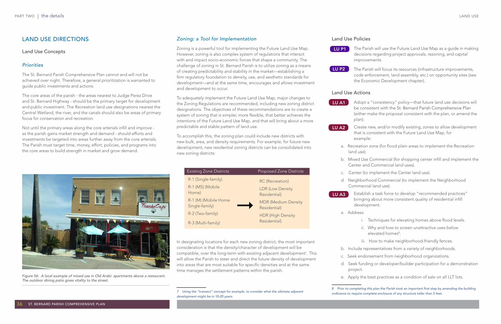
PART TWO | the details
36 ST. BERNARD PARISH COMPREHENSIVE PLAN
Land Use Policies
The Parish will use the Future Land Use Map as a guide in making decisions regarding project approvals, rezoning, and capital improvements.
The Parish will focus its resources (infrastructure improvements, code enforcement, land assembly, etc.) on opportunity sites (see the Economic Development chapter).
Land Use Actions
Adopt a “consistency” policy—that future land use decisions will be consistent with the St. Bernard Parish Comprehensive Plan (either make the proposal consistent with the plan, or amend the plan).
Create new, and/or modify existing, zones to allow development that is consistent with the Future Land Use Map, for example:
a. Recreation zone (for flood plain areas to implement the Recreation land use).
b. Mixed Use Commercial (for shopping center infill and implement the Center and Commercial land uses).
c. Center (to implement the Center land use).
d. Neighborhood Commercial (to implement the Neighborhood Commercial land use).
Establish a task force to develop “recommended practices” bringing about more consistent quality of residential infill development.
a. Address:
i. Techniques for elevating homes above flood levels.
ii. Why and how to screen unattractive uses below elevated homes8.
iii. How to make neighborhood-friendly fences.
b. Include representatives from a variety of neighborhoods.
c. Seek endorsement from neighborhood organizations.
d. Seek funding or developer/builder participation for a demonstration project.
e. Apply the best practices as a condition of sale on all LLT lots.
8 Prior to completing this plan the Parish took an important first step by amending the building ordinance to require complete enclosure of any structure taller than 5 feet.
LAND USE
Zoning: a Tool for Implementation
Zoning is a powerful tool for implementing the Future Land Use Map. However, zoning is also complex system of regulations that interact with and impact socio-economic forces that shape a community. The challenge of zoning in St. Bernard Parish is to utilize zoning as a means of creating predictability and stability in the market—establishing a firm regulatory foundation to density, use, and aesthetic standards for development—and at the same time, encourages and allows investment and development to occur.
To adequately implement the Future Land Use Map, major changes to the Zoning Regulations are recommended, including new zoning district designations. The objectives of these recommendations are to create a system of zoning that is simpler, more flexible, that better achieves the intentions of the Future Land Use Map, and that will bring about a more predictable and stable pattern of land use.
To accomplish this, the zoning plan could include new districts with new bulk, area, and density requirements. For example, for future new development, new residential zoning districts can be consolidated into new zoning districts:
In designating locations for each new zoning district, the most important consideration is that the density/character of development will be compatible, over the long-term with existing adjacent development7. This will allow the Parish to steer and direct the future density of development into areas that are most suitable for specific densities and at the same time manages the settlement patterns within the parish.
7 Using the “transect” concept for example, to consider what the ultimate adjacent development might be in 10-20 years.
RC (Recreation)
LDR (Low Density Residential)
MDR (Medium Density Residential)
HDR (High Density Residential)
LU P1
LU P2
LU A1
LU A2
LU A3
LAND USE DIRECTIONS
Land Use Concepts
Priorities
The St. Bernard Parish Comprehensive Plan cannot and will not be achieved over night. Therefore, a general prioritization is warranted to guide public investments and actions.
The core areas of the parish - the areas nearest to Judge Perez Drive and St. Bernard Highway - should be the primary target for development and public investment. The Recreation land use designations nearest the Central Wetland, the river, and the canals should also be areas of primary focus for conservation and recreation.
Not until the primary areas along the core arterials infill and improve - as the parish gains market strength and demand - should efforts and investments be targeted into areas further away from the core arterials. The Parish must target time, money, effort, policies, and programs into the core areas to build strength in market and grow demand.
R-1 (Single-family)
R-1 (MS) (Mobile Home)
R-1 (M) (Mobile Home Single-family)
R-2 (Two-family)
R-3 (Multi-family)
Proposed Zone DistrictsExisting Zone Districts
Figure 56: A local example of mixed use in Old Arabi: apartments above a restaurant. The outdoor dining patio gives vitality to the street.
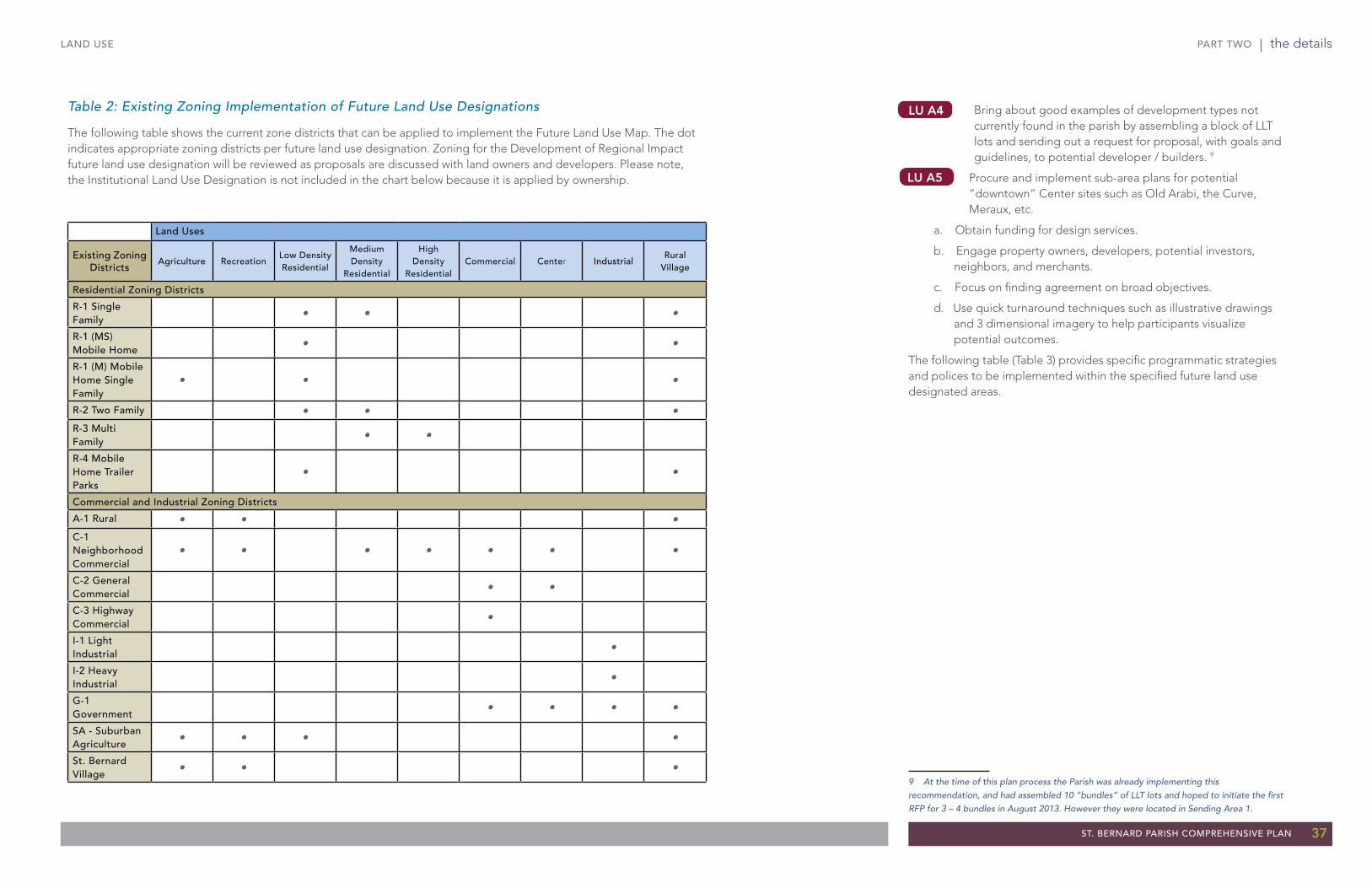
PART TWO | the details
ST. BERNARD PARISH COMPREHENSIVE PLAN 37
Table 2: Existing Zoning Implementation of Future Land Use Designations
The following table shows the current zone districts that can be applied to implement the Future Land Use Map. The dot indicates appropriate zoning districts per future land use designation. Zoning for the Development of Regional Impact future land use designation will be reviewed as proposals are discussed with land owners and developers. Please note, the Institutional Land Use Designation is not included in the chart below because it is applied by ownership.
LU A4
LAND USE
Bring about good examples of development types not currently found in the parish by assembling a block of LLT lots and sending out a request for proposal, with goals and guidelines, to potential developer / builders. 9
Procure and implement sub-area plans for potential “downtown” Center sites such as Old Arabi, the Curve, Meraux, etc.
a. Obtain funding for design services.
b. Engage property owners, developers, potential investors, neighbors, and merchants.
c. Focus on finding agreement on broad objectives.
d. Use quick turnaround techniques such as illustrative drawings and 3 dimensional imagery to help participants visualize potential outcomes.
The following table (Table 3) provides specific programmatic strategies and polices to be implemented within the specified future land use designated areas.
9 At the time of this plan process the Parish was already implementing this recommendation, and had assembled 10 “bundles” of LLT lots and hoped to initiate the first RFP for 3 – 4 bundles in August 2013. However they were located in Sending Area 1.
LU A5
Land Uses
Existing Zoning Districts
Agriculture RecreationLow Density Residential
Medium Density
Residential
High Density
ResidentialCommercial Center Industrial
Rural Village
Residential Zoning Districts
R-1 Single Family • • •
R-1 (MS) Mobile Home • •
R-1 (M) Mobile Home Single Family
• • •
R-2 Two Family • • •R-3 Multi Family • •
R-4 Mobile Home Trailer Parks
• •
Commercial and Industrial Zoning Districts
A-1 Rural • • •C-1 Neighborhood Commercial
• • • • • • •
C-2 General Commercial • •
C-3 Highway Commercial •
I-1 Light Industrial •
I-2 Heavy Industrial •
G-1 Government • • • •
SA - Suburban Agriculture • • • •
St. Bernard Village • • •

PART TWO | the details
38 ST. BERNARD PARISH COMPREHENSIVE PLAN
LAND USE
LAND USE NEAR TERM (0 - 5 YEARS) MEDIUM TERM (6 - 10 YEARS) LONG TERM (10+ YEARS)
Recreation • Identify and retain all Parish-owned lots.
• Implement “Lot Swap” program.
• Design and implement tree planting program.
• Create and implement high standards of maintenance, including mowing, informal tree planting clusters, and revegetation plan.
• Continue informal tree plantings.
• Purchase homes in flood plain area when they come available; demolish, and convert to recreational lands.
• Reassess progress and modify strategies as needed.
• Continue to purchase homes in flood plain area when they come available; demolish, and convert to recreational lands.
Low Density Residential
• Retain all Parish-owned lots.
• Maintenance on Parish-owned lots:
o Implement two stage grass cutting program (frequent perimeter cutting, occasional
interior mowing).
o Implement tree planting program (informal & rear property line plantings).
• Implement ”Lot Swap” program.
• Implement “Adopt-A-Lot” program.
• Identify and decrease investment in public infrastructure in areas where resettlement is not likely.
• Implement a voluntary purchase and swap program to resettle owners interested in moving.
• Purchase homes when they come available, demolish, and convert to recreational lands.
• Continue tree planting initiatives.
• Continue ”Adopt-A-Lot” program.
• Evaluate progress and adjust strategies as needed.
• If core area neighborhoods have in-filled and overall housing market is strong, consider increasing to Medium Density and encouraging new development.
Medium Density
Residential
• Target sales of Parish-owned lots on strong blocks.
• Retain Parish-owned lots on weak blocks.
• On Parish-owned lots:
o Implement two stage grass cutting program (frequent perimeter cutting, occasional
interior mowing
o Implement tree planting program (informal & rear property line plantings)
• Implement ”Lot Swap” program
• Implement ”Adopt-A-Lot” program.
• Encourage multi-family housing.
• Target public investment on the strongest blocks.
• Where land is available, re-establish community ballparks.
• Continue tree planting initiatives.
• Continue targeted public investment on strongest blocks and improved blocks.
• Invest in public infrastructure.
• Continue perimeter grass cutting program on Parish-owned lots.
• Target homebuyer program on strongest blocks.
• Continue to encourage multi-family housing.
• Evaluate progress and adjust strategies as needed.
• If core area neighborhoods have in-filled and overall housing market is strong, encourage new development.
FUTURE LAND USE IMPLEMENTATION STRATEGIES
Table 3: Future Land Use Implementation Strategies

PART TWO | the details
ST. BERNARD PARISH COMPREHENSIVE PLAN 39
LAND USE
LAND USE NEAR TERM (0 - 5 YEARS) MEDIUM TERM (6 - 10 YEARS) LONG TERM (10+ YEARS)
High Density Residential
• Aggressively target homebuyer programs on strong blocks.
• Target sales of Parish-owned lots on strongest blocks.
• Utilize Parish-owned lots for resettlement from sending areas per standard (see Low Density Residential).
• Maintain all Parish-owned lots.
• Implement ”Lot Swap” program.
• Encourage multi-family housing.
• Continue to target homebuyer programs on strong blocks.
• Continue to target sales of Parish-owned lots on strongest blocks.
• Utilize Parish-owned lots for resettlement from sending areas.
• Cut and maintain all Parish-owned lots.
• Continue ”Lot Swap” program.
• Continue to encourage multi-family housing.
• Evaluate progress and adjust strategies as needed.
• Continue to encourage multi-family housing.
Commercial• Implement street-tree planting program at gateways.
• Aggressively enforce building codes on blighted and abandoned properties.
• Work with land owners (such as Meraux Foundation) to develop sub-area redevelopment plans.
• Expand street-tree planting program beyond gateways.
• Continue to enforce blighted and abandoned properties.
• Implement redevelopment plans.
• Foreclose tax delinquent properties. Demolish if blighted.
• Evaluate progress and adjust strategies as needed.
• Continue street-tree planting program.
Industrial• Implement street-tree planting program along major roads and at gateways.
• Implement sign registration and removal program.
• Aggressively enforce blighted and abandoned properties.
• Develop a redevelopment plan.
• Continue to enforce codes on blighted and abandoned properties.
• Implement redevelopment plans.
• Foreclose tax delinquent properties. Demolish if blighted.
• Evaluate progress and adjust strategies as needed.
• Continue street-tree planting program.
Rural Village• Protect, preserve, and maintain rural character and lifestyle.
• Implement ”Lot Swap” program.
• Allow recreational vehicles (RV) as seasonal accessory uses with a minimum of 3 acres and total units based on health codes.
• Allow seasonal RV Parks by Conditional Use. Minimum of 10 acres and total units based on health code.
• Protect, preserve, and maintain rural character and lifestyle.• Protect, preserve, and maintain rural character and
lifestyle.
Table 3: Future Land Use Implementation Strategies (continued)
Please note, the Institutional Land Use Designation is applied by ownership. There are no additional recommendations for this future land use. There are also no recommendations for the Development of Regional Impact Land Use.

PART TWO | the details
40 ST. BERNARD PARISH COMPREHENSIVE PLAN
TRANSPORTATION
TransportationIn today’s competitive environment, companies and entrepreneurs wishing to relocate have many choices – regionally and nationally. Quality of life, the attractiveness of the built environment, and variety in travel choices are all primary factors in economic competitiveness. Said another way, if the Parish wants to attract and retain new residents and quality businesses, one key strategy is to maximize travel choices. For businesses in St. Bernard Parish, this means roadways, rail, and water shipping. For residents, travel choices available in competing communities include bicycle, walking, bus, as well as automobile.
In order to retain and attract strong businesses and more middle and upper income residents, the parish needs a convenient, functional, and diverse transportation network. Such a transportation network will help reinvigorate the parish, create economic development opportunities, and improve the quality of life for existing and future residents.
St. Bernard Parish’s desire to retain, and attract, strong businesses and residents, who have choices from other successful communities in Louisiana (and the U.S.), will require a well-rounded transportation network.
The following directions incorporate elements of previous plans as well as public input. The major plan directions are:
1. Adopt a “major streets plan” to guide future street development, including completing key “missing links”, and possible street removal in some areas.
2. Adopt standards that encourage circulation between parking lots.
3. Create, adopt, and implement an integrated system of bicycle/pedestrian paths.
4. Adopt a policy of constructing future streets as “complete streets” that will accommodate bicycles, pedestrians, buses (in appropriate locations), as well as automobiles. Policy recommendations from the Regional Planning Commission Land Use and Transportation Vision Plan are located in Appendix G.
These directions are further described in the following sections.
THE STREET SYSTEMRoutes into the parish are limited. The parish is bound by waterways, and has only a narrow common boundary with adjoining parishes. The two western entries into the parish are North Claiborne Street (Judge Perez Drive) and St. Claude Avenue (St. Bernard Highway). Both of these entries create negative impressions: a) by having to go through the Lower 9th Ward), and b) by delays due to draw bridges being raised over the Industrial Canal and stops due to train traffic that crosses the parish from north to south.
The third access into the parish is via I-510 (Paris Road), which connects to I-10 in easternmost New Orleans. This access is mostly convenient to traffic from the north shore of Lake Pontchartrain.
Once arrived, the long, narrow parish has two main through arteries: Claiborne Street becomes Judge Perez Drive and St. Claude Avenue becomes St. Bernard Highway. These two major roadways extend the length of the more developed part of the parish.
Analysis has shown that a grid pattern of two-lane streets carries more traffic than a single arterial with the same number of lanes. This is due to the normal tendency of drivers to minimize their travel time. If a road is congested, they will use parallel routes (if available) even though the distance may be longer, if the travel time is shorter. This tends to send traffic to wider streets/roadways until they become just as congested as the side streets.
The secondary circulation pattern of the developed portion of the parish is characterized by:
• A general grid pattern of local and collector streets.
• The grid pattern is broken in several key areas by “missing links” (large blocks of land without roads, either because they are vacant, or are large commercial/parking areas).
• Numerous subdivisions that are served by only a single entry.
• Closely-spaced individual commercial driveways that slow traffic on the main arterials.
Figure 57: Judge Perez Drive is one of the major roadways into and through the parish.
Figure 58: The rail system still plays a vital role in the overall transportation system in the parish.

PART TWO | the details
ST. BERNARD PARISH COMPREHENSIVE PLAN 41
TRANSPORTATION
Figure 59: Existing parish roads.

PART TWO | the details
42 ST. BERNARD PARISH COMPREHENSIVE PLAN
TRANSPORTATION
When a grid of streets has “missing links”, traffic is forced to the main arterials. This results in greater congestion, especially when the arterials have many driveways and parking lot entries whose turning movements slow down traffic.
The prescription for St. Bernard Parish is to complete the grid of streets as vacant land is developed and existing development is redeveloped.
A Major Streets Plan
A well-connected system of local streets is able to diffuse traffic over multiple routes rather than concentrating traffic on one or two corridors. This results in greater mobility, the reduction of congestion at intersections, and the facility of emergency access. It also allows more direct routes for pedestrians and bicyclists. In some areas, the addition of short street lengths through blocks would break up the block to create a more walkable area and provide more ways for vehicles to get around. As redevelopment occurs in the commercial centers, streets should also be used to break up large commercial sites and create smaller scale sites.
The Meraux “airport tract” (hospital area) is a key area to resolve the future circulation system as soon as possible. The incremental development of this tract has already compromised several possible alignments of a boulevard that could link the port area to Patricia Street.
The proposed Major Streets Plan (Figure 61) illustrates a possible grid of streets. This road plan should be further refined and formally adopted.
Removal of Streets
As part of the refinement of the Major Street Plan, a careful analysis of the cost benefit of some roads should be evaluated. There are a number of areas in the parish where hurricane impacts eliminated or dramatically reduced the number of houses, yet the street system has been restored and will soon require maintenance. Streets are expensive to maintain. One analysis suggests that a two-lane street costs an average of $15,000 per mile per year. Therefore, it is important that Parish revenues not be spent on barely used streets rather than on other needs that have much higher benefits to the community.
Adequate access to existing development will need to be maintained. However, in areas where redevelopment is not recommended parish streets should be carefully analyzed and removed or converted to levels of finish (asphalt, chip seal, gravel) to the level of use. For example, there are several roads in the buffer area around the Valero complex that can be removed. In other areas, access can be consolidated into one or two access roads.
Interconnected Parking Lots1
To allow better mobility around and between existing commercial sites, and to reduce on-street congestion, parking lots, driveways, and access aisles of commercial and mixed-use development should be interconnected with those of abutting properties. This will allow users to get from site to site without having to go back out on the roadway. For sites where the abutting property is not developed, parking lots, driveways, and access aisles should be brought to the common property line so that future interconnection is possible.
To encourage walking, parking lot layout should also take into consideration pedestrian circulation. Pedestrian crosswalks should be provided where appropriate. These crosswalks should be easily distinguishable from the rest of the lot area by being constructed out of textured or special pavers or being outlined with noticeable paint colors.
In order to make future commercial development more attractive (and thereby compete more effectively for customers), parking lots in shopping centers in the parish should be improved by adding shade trees and landscaped islands, as well as to screen the parking from the street/sidewalk with planters, berms, hedges, or low decorative walls.
In pedestrian-oriented ”centers” (see the Land Use Chapter), large front parking lots that separate stores from the street, and avoid breaking up the continuous shopping sidewalks with parking lots and driveways. Instead, locate parking behind commercial buildings whenever possible. Encourage/permit on-street parking, and/or small side-parking as an alternative to parking lots in front of stores.
1 Access management and consolidated parcels provisions were added to the 2010 Zoning Regulations. They need to be applied consistently to achieve the objectives of this section.
Figure 60: As large big box commercial parcels (top image), redevelop extend the street grid into the parcels (bottom image) to allow for additional access and frontage

PART TWO | the details
ST. BERNARD PARISH COMPREHENSIVE PLAN 43
TRANSPORTATION
Figure 61: Major Streets Plan.
inset is rotated

PART TWO | the details
44 ST. BERNARD PARISH COMPREHENSIVE PLAN
TRANSPORTATION
AN INTEGRATED SYSTEM OF BICYCLE AND PEDESTRIAN PATHSOver the last 15 years, there has been a renewed national interest in alternatives to automobile transportation (bicycle, pedestrian, bus). The purposes of alternative modes are to:
• Relieve some of the traffic related to short trips.
• Provide less costly travel options.
• Combine recreation, fitness, and travel.
Bicycle paths are one of the most popular amenities in communities all over the US, including other communities in south Louisiana with whom St. Bernard Parish competes. For more detail on the path system, please see the Parks and Recreation chapter of this plan.
In many communities, sidewalks, bicycle lanes, and paths provide critical connections for short trips, particularly when street connections may not be feasible or desired. Paths, sidewalks, and bicycle lanes can actually reduce a significant amount of short automobile trips, but also they help promote a healthy community.
In St. Bernard Parish, walking and bicycling are climate-appropriate for much of the year, particularly for short trips like those to school and recreational areas. However, the ability to walk or ride to destinations in the parish is limited due to the lack of paths, bicycle lanes, and sidewalks. The key to well-used bicycle paths is unifying them into a whole system, including linking on-street bicycle lanes to off-street bicycle paths. Further, strollers, walkers, roller blades, and bicycles should, and can, all intermingle safely.
Bicycle Facilities Existing Conditions
The parish has a limited number and extent of bikeways and trails. Most of them are within or adjacent to existing parks, such as the trail around Val Reiss Park and at Torres Park. There are also trails at the Battlefield and in the Cemetery.
Fortunately, a variety of regional agencies are involved in trail planning within the parish. Their cumulative efforts can do much to augment the Parish’s efforts, and bring about an exciting, extensive trail system.
2001 Proposed Bicycle Plan for St. Bernard Parish
A 10-mile bicycle path proposed for St. Bernard Parish would connect to paths in Orleans and Jefferson Parishes. The 2001 Plan proposed a variety of bicycle path alignments for St. Bernard Parish (see Figure 103). The Parish currently plans to provide a 10-foot wide asphalt path atop the levee for several miles to the Violet Canal and shipdocks. The southernmost reach of the St. Bernard section is at St. Bernard State Park located at the St. Bernard/Plaquemines Parish line.
The Parish Public Works Department is progressing forward with the planned implementation and is working with the Lake Borgne Levee District.
Although St. Bernard Parish has no specific bicycle plan or policy, the Department of Public Works officials have been supportive of the concept of alternative transportation, mainly for fitness and recreation opposed to commuter transportation.
Meraux Multi-Use Path
A 2-mile section of multi-use path in Meraux is listed in the 2011-2014 Transportation Improvement Program for St. Bernard Parish. The path would be built along St. Bernard Highway in Meraux south to Caernarvon.
The Mississippi River Trail
A feature of the 2005 New Orleans Metropolitan Bicycle and Pedestrian Plan, this trail would follow the Mississippi River from Orleans Parish to the border with Plaquemines Parish. Sections could become separated paths. Phases I and II span between the Valero Refinery site to the Violet Canal. Permits for these phases are in process.
The Mississippi River Trail
Leading from the Violet Canal to St. Bernard Highway, this project will eventually serve as a feeder to the Mississippi River Trail when a connection can be established to cross St. Bernard Highway and access the Mississippi River Trail. The Parish is currently awaiting the issuance of a permit from the U.S. Army Corps of Engineers. As soon as the permit is issued, the project will move on to the Advertising, Bid and Award stage.
The Hannan Blvd.-DeBouchel Bicycle Lane Project
The project includes putting a dedicated bicycle lane on Hannan Blvd. and adding shared lane markings and signage on DeBouchel Blvd. Partial funding for the project is from Exxon-Mobil in the name of Bicycle Easy, a 501(c)(3) non-profit corporation which advocates for bicycle projects in the New Orleans Region.
St. Bernard Highway Bicycle Lanes
LaDOTD is currently planning on adding bicycle lanes to eastbound and westbound St. Bernard Highway. The plan is to connect to Orleans Parish’s St. Claude Bicycle Lane where it currently ends at the St. Bernard Parish line and extend the bicycle lanes beginning at the Parish line and extending to Old Hickory Street. This project is scheduled to be completed prior to the 200th anniversary of the Battle of New Orleans in January 2015.
The prescription for St. Bernard is to create a parish-wide bicycle/pedestrian system that links on-street bicycle lanes with off-street bicycle/pedestrian paths, and to relax the prohibitions against various kinds of uses. The Regional Planning Commission (RPC) has begun bicycle route planning for the Parish. The RPC plan includes alignments for funded and envisioned on-street bicycle lanes or shared lanes and for funded and envisioned trails (including the projects mentioned within this section).
A variety of agencies in the region are involved in path planning. Many of these agencies are identified in the Land Use and Transportation Vision Plan.The proposed bicycle and pedestrian recommendations in Figure 62 are the synthesis of the plans of various agencies and public input consolidated by the Regional Planning Commission. The Parish will need to coordinate and collaborate with regional entities in order to make sure that, as plans are updated, they continue to connect with the systems in the region.
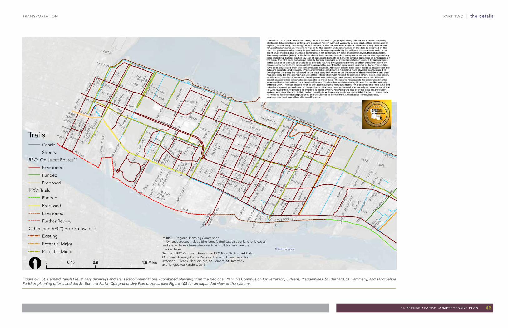
PART TWO | the details
ST. BERNARD PARISH COMPREHENSIVE PLAN 45
TRANSPORTATION
Figure 62: St. Bernard Parish Preliminary Bikeways and Trails Recommendations - combined planning from the Regional Planning Commission for Jefferson, Orleans, Plaquemines, St. Bernard, St. Tammany, and Tangipahoa Parishes planning efforts and the St. Bernard Parish Comprehensive Plan process. (see Figure 103 for an expanded view of the system).
!!!!!!!!!
!!
!!
!!!!!!!!!!!!!!
!!!!!!!!!!!!!
!
!!!!!
!!!!!!!!!!!!!!!!!!!!!!!!!!!!!!!!!!!!!!!!!!!!!!!!!!!!!!!!!!!!!!!!!!!!!
!!!!!!!!!!!!!!!!!!!!!!!!!!!!!!!!!!!!!!!!!!!!!!!!!!!!!!!!!!!!!!!!
!!!!!!!!!!!!!!!!!!!!!!!!!!!!!!!!!!!!!!!!!!!!!!!!!
!!!!!!!!!!!!!!!!!!!!!!
!!!!!!!!!!!!!!!!!!!!!!!!!!!!!!!!
!!!!!!!!!!!!!!!!!!!!!!!!!!!!!!!!!
!!!!!!!!!!!!!!!!!!!!!!!!
!!!!!!!!!!!!!!!!!!!!!!!!!!!!!!
!!!!
!!!!
!!!!!!!!!!!!!!!!!!!!!!!!!!!!!!!!!!!!!!!!!
!!!!!!!!!!!!!!
!!!
!!
!!!!!!!!!!!!!!!!
!!!!!!!!!!!!!!!!!!!!!!!!!!!!!!!!!!!!!!!!!!!!!!!!!!!!!
!!!!!!!!!!!!!!!!!!!!!!!!! !!!!!!
!!!!!!!!!!!!!!!!!!!!!!!!!!!!!!!!!!!!!!!!!!!!!!!!!!!!!!!!!!!!!!!!!!!!!!!!!!!!!!!!
!!!!!!!!!!!!!!!!!!!!!!!!!!!!!!!!!!!!!!!!!!!!!!!!!!!!!!!!!!!!!!!!!!!!!!!!!!!!!!!!!!!!!!!!!
!!!!!!!!!!!!!!!!!!!!!!!!!!!!!!!!!!!!!!!!!!!!!!!!!!!!!!!!!!!!!!!!!!!!!!!!!!!!!!!!!!!!!!
!!!!!!!!!!!!!!!!!!!!!!!!!!!!!!!!!!!!!!!!!!
!!!!!!!!!!!!!!!!!!!!!
!!!!!
!!!!
!!!!!
!!!!!
!!!!
!!!!
!!!!
!!!!!
!!!!!
!!!!
!!!!
!!!!!
!!!!!
!!!!!!!
!!!!
!!!
!!!!!
!!!
!!!!!!!!!!!!!!!
!!!!!!!!!!!!!!!!
!!!!!!!!!!!!!!!!!!!!!!!
!!!!!!!!!!!!!!!!!!!!!!!!!!!!!!!!!!!!!!!!!
!!!! !!!!!!!!
!!!!
!!!!
!!!!!
!!!!!!!!!!!!!!!!!!!!!!!
!!!!!!!!!!
!!!
!!!!!!
PARI
S
ST BERNARD
LENA
PATRICIA
PLAZ
A
VOLP
E
JACO
B
MEH
LE
ANG
ELA
VENT
URA
LEVEE ACCESS
PERR
IN
GALL
O
CHAL
ONA
DELI
LLE
BUFF
ON
VIRTUE
MUM
PHRE
Y
BART
OLO
PALM
ISAN
O
VERO
NICA
MUN
STER
PAUL
ST AVIDE
CENT
ER
CAM
PAG
NA
OHIOJA
CKSO
N
LAPL
ACE
KARE
N
JEAN
LAF
ITTE
IVY
JUDGE PEREZ
JUDY
PAKE
NHAM
LLO
YDS
GOLD
EN
RIVER
CHALMETTE BACK LEVEE
LYND
EL
MAR
IETT
A
PETERS
LIBERAUX
LAW
ROW
LEY
MISSOURI
FENE
LON
KING
S
GIROD
LEBE
AU
TRIO
SCHN
ELL
MAR
Y AN
N
COUG
AR
JOSEPHINE
BENJAMIN
MARINA
FRIS
COVI
LLE
JUPI
TER
JUNO
BONI
TA
ROSE
PACK
ENHA
M
AYCO
CK
KARL
NORT
ON
PIRA
TE
ALEX
ANDE
R
MINK
REISS
BEAR
ESTE
BAN
ROYAL
PROSPER
D'AMOUR
TOUR
NEFO
RT
CORI
NNE
DESP
AUXCH
ARLE
S
WAL
KERS
CELESTINE
FAZZ
IO
PRINCE
PARK
CREE
LY
RIVE
RLAN
D
MARLIN
TRIST
PARC
ROSE
TTA
PINE
COKE
PLA
NT
8TH
PELI
TERE
OCTA
VIA
CLAIBORNE
OLD
HICK
ORY
GENET
ARAM
IS
MOREAUEV
ANG
ELIN
E
DOERR
ACC
ESS
LLAMA
PALM
ETTO
VALOR
SABLE
DE L
A RO
NDE
COM
MUN
ITY
ETIE
NNE
PECA
N
MAD
ISO
N
GIBBS
PALM
BLAN
CHAR
D
EASY
CHAL
MET
TE
FISH
ER
ST CLAUDE
GENIE
TERR
Y
5TH
DECO
MIN
E
MEL
VYN
PERE
Z
COBIA
MAR
CELL
E
3RD
SINC
LAIR
EMIL
IE O
AKS
KEAN
E
LACO
STECASA CALVO
BIENVENUE
DAUT
ERIV
E
LISA
MAGISTRATE
GARD
EN
LYNX
MAGNOLIA
ARCHBISHOP H
ANNAN
COFF
EE
LIVINGSTON
NORW
OO
D
1ST
OAK TREE
SEAL
JONE
SMOBIL OIL ACCESS
OLIVIA
SALLY RED MAPLE
CH
ALM
ETTE
SLI
P
SOLIDELLEW
OO
DLAN
DSCAROLINA
CHAL
M N
ATL
CEM
ETER
Y
NUNE
Z
SEEL
OS
DARYL
WAX MYRTLE
INTE
RMO
DAL
WEI
NBER
GER
MAIN
CARR
OLL
GAL
LANT
SUG
AR
PARISH PIERRE
HERMITAGE
VICTORY
MUSTANG
FLORIDA
WAT
ER B
OAR
D
COCH
RANE
ARTI
LLER
Y
DOCT
OR
MER
AUX
INDIANA
COLONEL
FERR
Y LA
NDIN
G
DOUGLAS
ANDR
ES
TRACY
TITANS
EAGLE
GRAND HOMMES
DAUPHINECHARTRES
DELA
MBE
RT
GROUPER
PLEASURE
RUE CAR
MEN
BRITTANY
RUE CIEL
AMOUR
WISCONSIN
MUR
PHY
TRUC
KING
RAMPART
BON
NER
WHA
RF A
CCES
S
FAZE
NDEV
ILLE
BURGUNDY
SENEZ
CARO
LYN
WEBSTER
PONTALBA
GENIE
PECA
N
GENIE
DESP
AUX
GENIE
ACCE
SS
JUDY
FLORIDA
RIVE
RLAN
D
RIVER
ACCE
SS
GALL
O
CHALMETTE BACK LEVEE
ROSE
FLORIDA
JUDY
PROSPER
LYND
EL
CENT
ER
CORI
NNE
MAR
IETT
A
RIVER
MAGISTRATE
CENT
ER
CHAR
LES
LYND
EL
MAGISTRATE
Mississippi River
Source: Esri, DigitalGlobe, GeoEye, i-cubed, USDA, USGS, AEX, Getmapping, Aerogrid, IGN, IGP, swisstopo, and the GIS User Community
Canals
Streets
RPC* On-street Routes**
Envisioned
Funded
Proposed
RPC* Trails
Funded
Proposed
Envisioned
Further Review
Other (non-RPC*) Bike Paths/Trails!!!!!!!!! Existing
!!!!!!!!! Potential Major
!!!!!!!!! Potential Minor
[ 0 0.9 1.80.45 Miles
Trails
Source of RPC On-street Routes and RPC Trails: St. Bernard ParishOn-Street Bikeways by the Regional Planning Commission forJefferson, Orleans, Plaquemines, St. Bernard, St. Tammanyand Tangipahoa Parishes, 2013
** RPC = Regional Planning Commission ** On-street routes include bike lanes (a dedicated street lane for bicycles)and shared lanes - lanes where vehicles and bicycles share the marked lanes.

PART TWO | the details
46 ST. BERNARD PARISH COMPREHENSIVE PLAN
TRANSPORTATION
The highest priority for new sidewalks and bicycle routes should be:
• Address safety problems.
• School access.
• Access to activity centers.
• Connections to other travel modes.
Sidewalks and bicycle lanes should also be a priority in any redevelopment of the centers such as the ones recommended for Old Arabi, the Curve, and the redevelopment of the shopping plaza in Meraux. For existing neighborhoods and commercial areas that desire sidewalks, the Parish should work with property owners to plan an appropriate and feasible way to install them over time.
The Parish will also need to change its policy on the use of community paths. Currently, the Parish does not allow bicycles and other wheeled vehicles on the existing parish paths. With adequate design and signage, the paths can be shared by all non-motorized users.
Figure 63: Temporary painted bicycle lanes during the lane planning process.
Figure 64: Permanent painted bicycle lanes.
COMPLETE STREETS “Complete Streets” is the concept of accommodating multiple modes of transportation on major parish streets and roads. Commonly, a “Complete Street” includes generous sidewalks and bicycle lanes in addition to lanes for automobiles. Variations may exist depending on traffic volume and physical constraints of the corridor.
Numerous benefits are associated with the implementation of complete streets. The Federal Highway Administration (FHWA) found that Complete Streets can make streets safer. Complete Streets also improve public health and help combat childhood obesity. (Studies show that people with safe places to walk within 10 minutes of their home tend to meet recommended daily activity levels, as compared to people with no safe locations nearby.)
Complete Streets can be implemented by:
1. Adopting a policy that future streets should be “complete ”2. The complete streets policy should set goals, but maintain flexibility that will allow solutions that take into account local conditions and the needs of different users (emergency service, for example).
2. Modifying the Parish road standards to include bicycle lanes, sidewalks, and future bus/trolley/transit lines (if appropriate) for each road type, with appropriate dimensions.
The 3 major roads in the parish that should be high priorities for the eventual application of a complete street design are Paris Road, St. Bernard Highway, and Judge Perez Drive.
2 Such as, “the Parish will aim to create a comprehensive and connected network of streets that provides for all users including drivers, transit users, pedestrians and bicyclists of all ages and abilities.”

PART TWO | the details
ST. BERNARD PARISH COMPREHENSIVE PLAN 47
TRANSPORTATION
Where roads are too narrow to add conventional bicycle lanes, “sharrows” - where bicycles and vehicles share the road lane - are being considered on the following streets when overlays are scheduled:
• Friscoville Avenue - N. Peters to LA 46.
• Patricia Street - Kings Drive to Delaronde Drive.
• Patricia Street - Delaronde Drive to Juno Drive.
• Patricia Street - Juno Drive to Packenham Drive.
• W. Genie Street - Packenham Drive to Paris Road.
• Mehle Street - N. Peters Street to LA 46.
• Mehle Street - LA 39 to Patricia Street.
• Packenham Drive - LA 39 to N. Derbigny Street.
• Patricia Street - Schnell Drive to Cougar Drive.
• Rowley Blvd. - Patricia Street to LA 39.
• Palmisano Blvd. - LA 39 to Magristrate Street.
• Patricia Street - Mehle Street to Schnell Drive.
• E. Genie Street - Paris Road to Golden Drive.
The Regional Planning Commission completed the Transportation Enhancement Study for St. Bernard Parish in 2013. The study contains recommendations for dramatically upgraded entrance into Old Arabi from Orleans Parish and for a uniform design to LeBeau Street. Some of the corridor designs include sidewalks, bicycle lands, and/or shared use trails to create a more Complete Street. Street corridors targeted for bicycle enhancements by the study include:
• St. Claude Avenue from Orleans Parish / St. Bernard Parish line to LeBeau Street
• West St. Bernard Highway from LeBeau Street to Old Hickory Avenue
The Regional Planning Commission Land Use and Transportation Vision Plan also promotes the complete street concept presented in this chapter along with recommended street sections. Policy recommendations from the Regional Planning Commission Land Use and Transportation Vision Plan are located in Appendix C.
Figure 65: Complete Streets are those that include adequate facilities for automobiles (road travel lanes), bicycles (bicycle lanes, trails/paths, and/or shared vehicle travel lanes), and pedestrians (sidewalks and/or shared trails/paths). (image courtesy of Urban Advantage)

PART TWO | the details
48 ST. BERNARD PARISH COMPREHENSIVE PLAN
TRANSPORTATION
TRANSITThe Parish should continue to operate the St. Bernard Urban Rapid Transit program. The agency should consider expanding operation hours as funding allows. Extending the route to Verret should be considered. In addition, the Parish should work towards installing bicycle racks on the bus fleet to increase the ability to get around the parish without an automobile.
The recommended streetcar line identified in the Louisiana Speaks St. Bernard Parish Charrette Report may be a good investment for the Parish. If it can be funded appropriately, it will further establish a unique image for the parish in the minds of potential businesses, residents, and visitors.
The Parish should collaborate with the New Orleans Transit Authority in exploring the feasibility of a streetcar/trolley. If the system proves feasible, the Authority can reassess the existing bus system and re-route the bus line. Creating a relationship with the Authority may lead to other programs and funding sources that may benefit the Parish over time.
WATERWAYS AND RAILThe waterways, railroad, and ports are vitally important to St. Bernard Parish’s industries.
Thus, any improvements to the road system must avoid or accommodate the canal and train traffic.
AIR The parish has one existing airstrip - a single runway located south of Violet (see Future Land Use Map - Southwest Area). The runway is short (under 4,000 feet) and constrained from expanding north or south by the Mississippi River and wetlands.
As an opportunity for small aircraft and helicopter emergency service, it is worth reserving the airport use unless another use would generate significant economic development.
Figure 66: Transit options for the parish: a trolley along Judge Perez Drive as proposed in the Louisiana Speaks St. Bernard Parish Charrette Report. (source: Louisiana Speaks St. Bernard Parish Charrette Report )

PART TWO | the details
ST. BERNARD PARISH COMPREHENSIVE PLAN 49
TRANSPORTATION
TRANSPORTATION DIRECTIONS
Transportation Goal
Become more “walkable” and “bicycleable” and provide safe, efficient, alternative modes of travel throughout the parish, for recreation as well as commuting.
Transportation Policies
The Parish will apply the “complete streets” policy to future construction and reconstruction. Bicycle lanes, bicycle paths and generous sidewalks will be incorporated into key roadways.
The Parish supports the creation of a multi-modal path system within the parish that connects parks and recreation centers. The Parish will work with regional agencies, including the Regional Planning Commission, to develop the system that connects destinations within the parish and also connects with path systems in adjacent parishes.
The Parish will encourage the incorporation of sidewalks and bicycle lanes in any redevelopment of commercial areas and community centers.
When improving existing streets or constructing new streets, the Parish will balance access, circulation, and road design with the community’s need to maintain a safe and efficient street system.
TR A1
TR A2
TR A3
TR A4
TR A5
TR A6
TR G1
TR P1
TR P2
TR P3
TR P4
Transportation Actions
Refine, formally adopt the Major Streets Plan (Figure 61) in this chapter as the official Major Streets Plan for the parish and keep current with annual reviews.
Modify street standards to require that all arterials and collectors have complete street components.
Apply the framework toward the creation of a complete streets policy as presented by the Land Use and Transportation Vision Plan (see Appendix G).
Develop a meeting schedule with the New Orleans Transit Authority to discuss the streetcar route between downtown New Orleans and the Chalmette area. If the program is achievable, the Parish should access its current system to support the streetcar line.
Work with property owners to plan an appropriate and feasible way to install missing sidewalks in existing neighborhoods.
Create and adopt parking lot standards for the zoning code that reflect the concepts for interconnected parking lots presented in this plan.

PART TWO | the details
50 ST. BERNARD PARISH COMPREHENSIVE PLAN
CULTURAL AND HISTORIC RESOURCES AND TOURISM
Cultural and Historic Resources and TourismSt. Bernard Parish’s rich historical variety is another potential “differentiator” in the competition with other communities to retain and attract strong businesses and residents.
Historic and cultural resources contribute to the parish’s identity and character; they convey an important sense of continuity, they build pride in residents, and they contribute to economic development in two ways: they attract new residents and businesses and they also attract visitors to the parish through tourism.
HISTORYSt. Bernard Parish, named after the patron saint of colonial governor Bernardo de Galvez, was settled in 1778. The parish was officially designated in 1807 although the parish boundaries changed a number of times until 1842 when the current boundaries were set.
A variety of cultures settled in the area including French, Spanish, Islenos (from the Canary Islands), British, Africans, and Croatians.
Early industries were agriculture and trapping and fishing. Early crops included sugar cane, indigo, and cotton.
On January 8, 1815, the famous battle of New Orleans, where Andrew Jackson defeated the British forces, took place almost entirely in St. Bernard Parish. This battle ended the War of 1812.
EXISTING CONDITIONSIn addition to Jackson Barracks (technically adjacent to the parish), there are 18 historical sites within the parish; seven of which are listed on the National Register of Historic Places. These sites include:
• Jean Lafitte National Historical Park, Chalmette Battlefield.
• Fort Proctor.
• Overseer’s House of Sebastapol Plantation.
• Kenilworth Plantation.
• Old Arabi National Register Historic District.
• Friscoville Street (National Register Historic District).
• Fort Battery Bienvenue.
Seven National Register sites are archaeological sites, including one prehistoric site, the Magnolia Mound Archaeological Site.
There are several other sites commemorated by historical markers within the parish:
• St. Bernard Church and Cemetery.
• Sites of former plantations: Jumonville, Reggio, De La Ronde, Villere, and Contreras.
• Ducros Historical Museum.
• Kenilworth Plantation.
• U.S. National Cemetery.
• Site of the first steam sugar mill.
• Old St. Bernard Courthouse.
• Violet Community Center.
The Los Islenos museum includes replicas of early dwellings as well as artifacts from the Islenos who were some of the earliest settlers of south St. Bernard Parish.
NATIONAL AND STATE PARKSThe parish is also home to the St. Bernard State Park. The state park offers camping, historic sites, preservation areas, trails, and other activities that add to the overall types of experiences found in the parish.
The Jean Lafitte National Historic Park and the Chalmette Battlefield play a large role in overall tourism in the parish. The sites include a national cemetery, battle weapons, and interpretive signage on the events of the Battle of New Orleans.
SCENIC BYWAYS
The San Bernardo National Scenic Byway is a twenty nine mile stretch of LA Hwy 46 within St. Bernard Parish. The byway begins at the border with Orleans Parish and extends to the fishing villages of Yscloskey and Delacroix. The byway runs along the Mississippi River and passes through many culturally and historically significant areas including the Chalmette Battle Field, the Docville Oaks, and the Islenos Village. The route is treasure for the parish and provides a convenient means to reaching significant sites of interest for residents and visitors.
Figure 67: The Chalmette Battlefield is one of the most prominent historical sites within the parish.
Figure 68: The Los Islenos Museum presents both historic and cultural aspects unique to the parish.

PART TWO | the details
ST. BERNARD PARISH COMPREHENSIVE PLAN 51
CULTURAL AND HISTORIC RESOURCES AND TOURISM
CULTURAL AND HISTORIC RESOURCES AND TOURISM DIRECTIONS
Cultural and Historic Resources and Tourism Concepts
Historic and Cultural Site Promotion
The number of historic sites within the parish is a unique opportunity to market them individually and as a package—to history buffs, to general visitors, and even to local residents.
• History buffs are dedicated travelers to historic sites. They can be reached through magazines, websites, newsletters, etc.
• Marketing historic resources locally will build awareness, community pride, and even provide activities for families and individuals.
• Expanding the use of historical knowledge and field trips in school curricula can help build awareness, and stimulate interest in related careers.
Several other actions that can be taken to further promote historic and cultural sites include:
• Develop distinct signage that is recognizable at all sites.
• Where needed, create and establish historical markers throughout the parish.
• Develop directional signs and map a tour of the cultural and historical sites. Signage should be informative about the parish’s culture and history, and should be in English, French, and Spanish.
• Apply for additional designations on Local, State, and National historic registers. If a local register does not exist, the Parish can work with local entities to establish one.
• Participate in grant proposals for the maintenance and preservation, such as upgrades to plantations, of historical and cultural sites.
Historic Re-enactments
Pageants and re-enactments have been effective nationally in attracting visitors to historic sites. The Meraux Foundation has proposed to make available Foundation-owned land near the Chalmette Battlefield for re-enactments of the Battle of 1812. The re-enactments would take place inside the treed-lined area of the property, which has great access from both Judge Perez Drive and St. Bernard Highway.
Expand Historic Connections with New Orleans
The paddle wheeler, Creole Queen, makes daily trips from New Orleans’ French Quarter to the battlefield1. In conjunction with this unique and existing experience, the Parish could consider:
• Co-promoting this unique tour locally and regionally, especially with history buffs (magazines, newsletters, etc.), mentioning also the other rich historical sites in the parish.
• Work with the riverboat company to promote a reverse tour, with visitors boarding in Chalmette and traveling to New Orleans and back.
Convey History and Cultural through Arts and Recreation
The Parish and local groups can spread the history and cultural background of the parish through art programs and recreational opportunities. For example, the levee wall in Old Arabi could tell the history of the parish through murals. An interpretive sign describing the mural can direct people to other historical assets in the parish. Historic and cultural aspects can be presented in the parks and recreational areas of the parish as well. New art also has a role to play and should be included in public spaces.
Expand Recreational Opportunities for Parish Families
During the community outreach, one of the desires conveyed by attendees was to have a variety of youth/family-oriented activities (bowling, skating, movies, etc.) in addition to just recreational opportunities. Chalmette Movies is known for art films in the region. Additional youth/family-oriented activities could be encouraged to locate ear the theater to create a family activity center. There have also been discussions in regard to the need for a stand-alone public library within the parish. This amenity would also provide a recreational opportunity for parish families.
1 Passengers disembark at Jean Lafitte National Historical Park and Preserve, tour the Chalmette Battlefield, including the Malus-Beauregard House and the Chalmette Monument, before re-boarding for return cruise. (see http://www.bigeasystore.com/CC/cruise_battlefield.html)
Figure 69: The Kenilworth Plantation is a West Indies style plantation built as early as 1759.
Figure 70: The Old Beauregard Courthouse, built in 1916, was the original courthouse for the parish.

PART TWO | the details
52 ST. BERNARD PARISH COMPREHENSIVE PLAN
CULTURAL AND HISTORIC RESOURCES AND TOURISM
Cultural and Historic Resources and Tourism Goals
Leverage cultural and historic assets to attract visitors and new residents to the community as well as to improve the pride and quality of life of those already living, working, and playing in the parish.
Protect and restore cultural and historic assets so that they may be shared with generations to come.
Encourage and attract more cultural businesses to the parish - particularly in the Arabi / Old Arabi neighborhood.
Cultural and Historic Resources and Tourism Policies
The Parish (as a community and government) will consider the protection of cultural and historic resources during land use and development decisions. Historic sites will be considered during neighborhood planning so that adequate buffering can be designated either through physical separation, land use, or landscape design.
The Parish will encourage local industry activities and contributions to invest in preserving historic and cultural assets.
The Parish will encourage and support community initiatives for preservation, education and awareness for both the community’s benefit and also for the interest of promoting tourism.
Cultural and Historic Resources and Tourism Actions
Cooperate with other public agencies, civic leaders, local industry, chambers, and private enterprises to promote and encourage organized activities that bring people to St. Bernard Parish. The Parish can support the growth of tourism by:
• Contributing to tourism promotion.
• Upgrading and expanding parks and trails along the canals.
• Improving the first impressions into the parish.
• Continuing support for the maintenance of historic sites and buildings.
Encourage, and help fund, the St. Bernard Parish Office of Tourism to:
• Develop an aggressive marketing campaign that highlights the various cultural and historic aspects of the parish, along with the parish’s proximity to New Orleans. The campaign should employ:
o The Parish website enhanced to include more information on tourism.
o Websites of historic organizations, tours, etc. (place notices, advertisements).
o Local/regional television and/or magazine advertisements (created, with historic themes, and submitted by the campaign).
• Explore the potential of enhancing the Creole Queen cruises to the Chalmette Battlefield with additional local descriptions and a reverse tour (as described in this section).
• Commission a tasteful roadway signage program to direct visitors to historic sites.
• Research and apply for grants for historic resource programs.
• Report biannually to the residents of the parish on their activities.
Explore with the Meraux Foundation their proposal to use a portion of their land for a re-enactment of the Battle of New Orleans. Determine appropriate standards, for access, land use, promotion, maintenance, safety, etc.
Work with business owners to create additional family-oriented activities near the theater in Chalmette.
Promote additional uses of the Civic Center.
Plan the location and appropriate size for a stand alone public library - particularly in areas with higher density future land use desginations. Begin to mark CIP funds for the facility.
CHT A1
CHT A2
CHT A3
CHT A4
CHT G1
CHT G2
CHT P1
CHT P2
CHT P3
Figure 71: The Paddelewheeler Creole Queen stops in St. Bernard at the Chalmette Battlefield site. (source: http://www.bigeasystore.com/CC/cruise_battlefield.html)
Figure 72: There is a significant collection of historic homes remaining in Old Arabi that can be incorporated into historic tourism and/or become part of a historic neighborhood restoration.
CHT G3
CHT A5
CHT A6

PART TWO | the details
ST. BERNARD PARISH COMPREHENSIVE PLAN 53
COMMUNITY APPEARANCE
Community AppearanceA community’s appearance is a large “billboard” displaying community values and standards. The “billboard” is actually composed of many small impressions—the appearance of buildings, streets, signs, parks, parking lots, and more—that add up to an overall impression. The overall impression tells a visitor much about the pride of the community, and the community’s ability to work together for a common goal.
Community appearance is an important “differentiator” in the parish’s competition with other communities to retain and attract strong businesses and a greater share of middle and upper income residents.
Attendees at the St. Bernard Parish Comprehensive Plan public meetings gave the parish generally low scores for “first impressions” and “property maintenance standards,” and overwhelmingly (64%) voted for a “hard-to-really-hard” level of future effort on beautification issues.
GATEWAYSFirst impressions occur naturally at entries to the community—the “gateways”. Since the parish is surrounded by water bodies, bridges force the parish’s gateways into 3 corridors. Figures 73 and 74 are photos of the entry and streetscape experience at St. Claude Avenue / St. Bernard Highway and Paris Road.
The remedies for gateways are the same as described for streetscapes in general, as described in the Streetscapes section in this chapter. The condition of the bridges is compounded by the fact that they are under the jurisdiction of many different agencies: Port Authority, LaDOTD, Regional Planning Commission, railroad companies, and others.
Figure 73: St. Claude Avenue / St. Bernard Highway entry. Figure 74: Paris Road entry.

PART TWO | the details
54 ST. BERNARD PARISH COMPREHENSIVE PLAN
COMMUNITY APPEARANCE
HURRICANE DAMAGE IS STILL WITH USThe combination of wind and flooding associated with Hurricane Katrina hit the parish with devastating impacts: buildings and signs damaged or destroyed, trees knocked down, boats and other vehicles deposited haphazardly.
In the years since Katrina, much cleanup and repair has been accomplished. Volunteers have even planted 120,000 trees around the parish. And yet, there are still all too many remnants of hurricane damage—damaged signs, boat hulls poking out of marshes, building shells, and debris piles—all constant reminders that send negative signals not only about the local economy, but about community pride.
Finishing the hurricane clean up is an urgent need. The two highest priorities should be:
• Repairing or removing damaged signs along the main corridors of Judge Perez and St. Bernard Highway.
• Removing visible debris and boat hulls from visible areas.
LACK OF A “THERE” (CENTERS)Most memorable, thriving communities have a “there”- a heart, a downtown, a civic place, a center of town. Often communities have a primary center as well as satellite centers.
Centers seem to have a timeless quality - they endure through good economic times and bad. Characteristics include: continuous storefront facades that lure shoppers onward (not broken by having to cross parking lots), attractive sidewalks, variation in buildings (not repetitive), benches, planters, decorative paving, attractive lighting, and tasteful signage. They usually have a mix of uses, restaurants, large and small stores and often include offices so people can accomplish multiple tasks on a trip, and to increase the lunchtime eating and shopping crowd.
St. Bernard Parish does not have any well-defined center, or satellite centers. But it has a number of opportunity sites that could gradually become centers, including ”the Curve” on Judge Perez Drive, Old Arabi, the Meraux Foundation ”airport tract”, and the old shopping center site in Meraux. The potential of these sites is illustrated in the Opportunity Sites section at the end of this plan.
In addition to encouraging specific kinds of building types, uses, and layouts, centers should also focus on creating attractive streetscapes, which are described in the following section.
Figure 75: Many signs and buildings are still vacant today and they send a message that St. Bernard has a ways to go before fully recovering from Katrina.
Figure 76: Hurricane and flood damage to a structure in the southern portion of the parish.
STREETSCAPES (STREET LANDSCAPES)Streetscapes, especially those in the core commercial areas of the parish, send negative messages about lack of pride, or lack of awareness about “how we look”, which does not compare favorably with many of the communities competing for strong businesses and families.
The Parish developed the Transportation Enhancement Study in 2013. The prime objective of the study is to provide a visually impressive entrance into Old Arabi from Orleans Parish and to continue a uniform design to LeBeau Street. The study targets these seven median blocks and provides streetscape ideas for segments of St. Claude Avenue, St. Bernard Highway, and Friscoville Avenue, as well as recommendations for the Heights Park and the St. Bernard Government Complex. The study is a great beginning to address aesthetics and should be expanded to other main corridors and destinations within the parish.
Figure 77: Many damaged residential and commercial structures remain standing around the parish and are very visible from major parish roads.

PART TWO | the details
ST. BERNARD PARISH COMPREHENSIVE PLAN 55
COMMUNITY APPEARANCE
Street Trees
Figure 78 shows a classic, memorable section of the St. Bernard Highway that has a street tree canopy created by live oaks that recalls fond images of the old south. Many streetscapes and medians in the parish, especially in Chalmette, are watered down versions of this classic model—the live oaks have been hacked into unnatural shapes to accommodate overhead power lines. In many street sections, overhead power lines prevent growing street trees at all, leaving barren, uninviting corridors that are not attractive to passers-by.
Many street trees and landscaping were lost during the flooding events associated with Katrina. Since Katrina efforts have been made to reestablish the street trees – volunteers have planted 120,000 around the parish. However, more can be done.
Where live oak canopies are not possible (due to overhead lines and small planting areas), and to provide landscape diversity in general, other planting types are encouraged: palm trees, smaller ornamental trees, and even shrubs and flower beds. They can be planted in evenly-space formal patterns, or in less formal random groupings. The result would be a distinctive character for the parish.
Medians
St. Bernard Parish had the foresight to establish many broad medians along much of the length of Judge Perez Drive. These medians provide a ”green relief” from all the paving in the core commercial areas and give St. Bernard an gracious appeal. Medians also tend to slow traffic down subconsciously, which appears to be the case in St. Bernard Parish.
Notwithstanding, St. Bernard Parish’s medians, as well as the triangle of land near St. Bernard Highway and Paris Road and areas around the ferry dock, are suffering from some neglect and are missed opportunities. They could be much more richly landscaped with flower and shrub beds as well as street trees with canopies arching over the street. In some communities, broad medians like these are also used as pedestrian amenities—walking paths, benches, gathering areas.
Figure 78: The live oaks canopy framing St. Bernard Highway recalls the fond character of the old south.
Overhead Power Lines
Stringing power lines overhead has always been the least expensive distribution system. However, it not only is unattractive, but it also turns out to be more vulnerable to hurricane damage. Some communities have found that underground distribution is very expensive, but in the long run, results in lower overall costs and dramatically improves the appearance of the community. Obviously, converting to underground systems is a long-term process. Where possible, a less expensive alternative is to locate overhead power lines along alleys and back property lines—away from immediate view of major thoroughfares.
Figure 79: Well-kept, landscaped medians help soften the streetscape by adding “green relief”.
Figure 80: Although expensive, over time the power lines can be relocated underground or at the back of property lines, to allow re-establishment of stately trees once again lining the major streets of the parish.

PART TWO | the details
56 ST. BERNARD PARISH COMPREHENSIVE PLAN
COMMUNITY APPEARANCE
Lighting
Roadway lighting is a functional, safety requirement, but in up-scale commercial areas many communities install light fixtures that add character and identity. Decorative light fixtures can replace the industrial-looking general lighting fixtures (often cobra-heads), or smaller fixtures can be installed in addition to the overhead fixtures. The parish should have a consistant fixture design (and not a number of different fixture types) along the roadway in order to create a stronger sense of identity.
Screened Parking
To lessen the clutter of cars and bumpers facing the road, which tend to distract passers-by from seeing the stores and signage, up-scale commercial areas generally screen parking lots by using walls, hedges, or planted berms (earth mounds).
Signage
In trying to attract the attention of passers-by, merchants often think that bigger, bolder signs will dominate. In fact, it turns out to be self-defeating—an uncontrolled proliferation of signs becomes almost unintelligible.
Up-scale commercial areas tend to coordinate signs—to make them more legible, and easier for customers to locate.
In 2013, the Regional Planning Commission prepared a Transportation Enhancement Study to improve the vehicular, pedestrian and recreational experience for the residents and visitors of the parish. The areas of focus were St. Claude and Friscoville Avenues near the east parish border as well as Heights Park and the St. Bernard Parish Government Complex. This study is a good start but the concept and recommendations should be extended to all of the major corridors within the parish.
Figure 81: Light fixtures that add character and identity should be installed in up-scale commercial areas.
Figure 82: Landscpaing lessens the clutter of cars facing the road.
Figure 83: Many neighborhoods in the parish are attractive and well-maintained; all neighborhoods should strive to do the same.
Figure 84: These street trees have been preserved and provide sidewalk shade as well as softening the overall feel of the street.

PART TWO | the details
ST. BERNARD PARISH COMPREHENSIVE PLAN 57
COMMUNITY APPEARANCE
NEIGHBORHOODSIf the Parish (as a community and government) wants to “retain and attract strong businesses and a greater share of middle and upper income families” then the appearance of neighborhoods matters. And it is not just the appearance of new subdivisions that is important, but also all neighborhoods.
In general, the residents of the parish are fastidious—they keep their homes and yards in good order. It is much easier to find examples of well-maintained homes than poorly maintained ones.
Yet, there are conditions where lower property standards are prevalent. For the most part, most neighbors seem to be very tolerant when someone lets the paint peel, lets their front lawn die, stores ”stuff” under their stilt home. And, there are still far too many homes that are vacant and damaged.
Anecdotally, many of the examples of poor maintenance standards appear to be related to rental properties—both apartments and individual homes that are not owner-occupied.
There are also surprising examples of trash left by the side of the road that seem to stay there for long periods.
All of these conditions give an impression of low community standards, willingness to put up with conditions many other communities would have solved a long time ago. St. Bernard Parish needs to address them only to the degree the Parish wishes to be more competitive in the regional market.
Figure 85: The unkept industrial uses and overhead wires give a negative impression along portions of St. Bernard Highway.
Figure 86: Vegetation helps screen industrial facilities from major roadways and creates a more attractive road corridor.
INDUSTRIAL APPEARANCEIndustry is important to the parish for employment as well as a tax base. However, industrial properties are a significant contributor to the negative appearance of the parish. Not only are many industrial properties in poor condition (broken windows, unclean, prominent storage of derelict equipment, rusted security fencing) but they are also highly visible.
The decorative fencing installed at the Valero Refinery frontage on St. Bernard Highway is a good example of the potential for attractive screening. The recent Port Authority building is a good example of quality industrial architecture in the parish.

PART TWO | the details
58 ST. BERNARD PARISH COMPREHENSIVE PLAN
COMMUNITY APPEARANCE
COMMUNITY APPEARANCE DIRECTIONSThe broad objectives for the parish are to:
• Upgrade the entries into the parish with landscaping, signage, and decorative lighting.
• Remove vacant, dilapidated buildings, with the highest priority being those that front on, or are visible from, Judge Perez Drive and St. Bernard Highway.
• Repair/remove damaged dilapidated signs, especially those that are highly visible from main arterials.
• Improve appearance of streetscapes along Judge Perez Drive and St. Bernard Highway, focusing on street trees, median planting, decorative street lights, screening of parking, and upgraded signage.
• Foster the creation of pedestrian-friendly commercial “centers” at key locations that give the community focus and a quality image. Centers should include: pedestrian-friendly “Main Street” shopping areas, lighting for ambience as well as safety, appealing architecture, tasteful signs that do not dominate views, street trees, shared parking, and mixed uses.
Figure 87: The LaDOTD planned for the cleaning and painting of the Judge Seeber Bridge in 2013; St. Bernard Parish can work with LaDOTD to do the same for area bridges. (source: Louisiana Department of Transportation and Development)
Figure 88: Trash and service areas should be screened from nearby roadways.
Figure 89: An iconic Domino Sugar sign, like the one in Baltimore Harbor (seen above) would be a creative way to celebrate the industries of the parish.

PART TWO | the details
ST. BERNARD PARISH COMPREHENSIVE PLAN 59
Neighborhoods
Establish a rental property registration, so that the Parish knows which properties are occupied by non-owners, repeat offenders, and owners of multiple properties.
Hire additional code enforcement personnel and establish a reporting system that assures impartial application of Parish regulations.
Hold a summit meeting with neighborhood representatives and Homeowners’ Associations to formulate plans for improving the character of parish neighborhoods. Consider:
a. A photo tour of parish to identify the “good, bad, and ugly.”
b. A community cleanup day each month, quarter, or year to clean up canals, streets, and other visible places.
c. An adopt-a-canal program, with signs that give credit to businesses or families that take responsibility to periodically pick up litter.
d. A volunteer group to assist homeowners that are physically or financially unable to maintain their properties.
e. An awards program for neighborhoods and homes: best overall, most improved, best renovation, etc.
f. Small grants and no-interest loans (by the Parish) for home and neighborhood improvements (entry planting, street tree planting, sidewalks, attractive fences, street lights, etc.) along with the development of criteria and standards for the use of grants.
Commission the creation of planting plans for LLT lots that will:
a. Reduce maintenance.
b. Keep undeveloped land from appearing barren and/or unmaintained.
c. Follow ”defensible space” criteria for crime prevention.
Create an inventory of blighted structures. Conduct code enforcement on these properties to bring them into compliance.
COMMUNITY APPEARANCE
Community Appearance Actions
Bridges
Work with other affected communities to bring about collective pressure on responsible agencies1.
a. Participate in annual budget meetings by the various agencies that manage the bridges.
b. Lobby for bridge maintenance as a priority at the State Legislature.
Streetscapes on Commercial Corridors
Apply the concepts and directions of the 2013 Transportation Enhancement Study - including landscaping, lighting and signage along entry corridors. Expand the concepts to additional arterial streets within the parish.
Initiate an aggressive street tree planting program:
a. Commission the preparation of a streetscape master plan that identifies potential tree planting locations—both immediate opportunities, and areas that may take longer to acquire and prepare (such as by removing paving, relocating power lines, and acquiring easements or permission from land owners).
b. Require new developments along major thoroughfares to install their portion of the streetscape plan as a condition of approval.
c. Organize volunteers to help implement appropriate portions of the streetscape plans.
Modify Parish development standards to require:
a. Screening of parking from public rights-of-way.
b. Screening of trash and service areas.
Form a task force of Parish staff and interested citizens to work with public utility agencies to:
a. Review standards for tree trimming below power lines in medians and along street edges.
b. Develop guidelines for planting of new trees to avoid damage from power pole trimming.
c. Create a long-term strategy to relocate overhead utilities underground or away from street corridors.
1 As of the time of this document the Parish had already requested the Regional Planning Commission to add the New Orleans/Slidell “green” bridge to their priority list for painting. The Claiborne Avenue Bridge was in the process of being painted by LaDOTD.
Centers
Assure that the 2013-2014 Old Arabi planning effort looks not only at a streetscape plan, but also at a full range of recommendations for how it can evolve into a center with commercial success and social interaction.
Commission a sub-area plan for the Curve, the vacant property in Meraux, and/or other potential centers.
Work with the Regional Planning Commission and the Louisiana Chapter of the Urban Land Institute’s Technical Assistance Panel. These entities may be able to assist with example designs for the centers.
Industrial Properties
Hold a summit with the heads of major local industries. Discuss ways they and the Parish can work toward improved aesthetics along major gateways, as well as how the effort could also provide favorable visibility for industry.
Resolve any legal and Homeland Security issues with screening industrial yards from major thoroughfares.
Work with Domino Sugar to install a neon sign similar to the one they have in Baltimore Harbor.
Install landscape screening in public servitudes along unkempt industrial fences, or work with the company to install improved fencing.
Amend the Parish code to require higher standards for screen fencing of industrial areas and apply a nuisance ordinance or as a condition of future property improvements.
Abandoned, Damaged Signs and Buildings
CA A1
CA A2
CA A3
CA A4
CA A5
CA A6
CA A7
CA A8
CA A9
CA A10
CA A11
CA A12
CA A13
CA A14
CA A15
CA A16
CA A18
Use all tools available to the Parish: code enforcement, condemnation, personal contact, fines, and public awareness to begin to immediately and aggressively remove abandoned signs and buildings and restore their properties to
“undeveloped land” status (remove paving, re-seed). or repair exteriors to make the appearance of occupancy and ready for use.
CA A19
CA A17

PART TWO | the details
60 ST. BERNARD PARISH COMPREHENSIVE PLAN
PARKS AND RECREATION
Parks and RecreationPark and recreational facilities and amenities are important to the quality of life in any community. They provide physical outlets, skill building, lessons in competition, and places for social interaction. Parks and recreational amenities facilitate healthy lifestyle choices by providing opportunities to play – both outdoors and indoors – or walk, or ride bicycles. It is also important to provide quality park and recreational amenities for the children of the parish in order to compete with the range of activities most of today’s youth in the United States have at their disposal.
But parks and recreational facilities are also economic development tools. They are one of the “magnets” that help retain and attract residents. When making decisions about where, or whether, to relocate, if they have several communities to choose from, families will often take into account the quality of recreation among other things. Communities that have abundant parks, active recreational programs, access to nature, are often perceived as more desirable, and progressive, than communities that do not.
Also, because it affects their ability to attract and retain employees, businesses will also consider the quality of recreation in their decisions as to where to locate, or stay. For example, hi-tech businesses that wish to attract, young “generation x and y” workers, have been known to seek out communities that have bicycle paths, natural areas, recreation centers, and places with many community activities.
In special cases, recreational facilities can be a source of revenue by attracting regional and national tournaments that generate significant sales taxes from visiting players and spectators.
In the Parish’s desire to retain and attract strong businesses and additional middle and upper income families, the recreation system can play a significant role.
Figure 90: Val Reiss Park provides the community with quality sports fields and playgrounds.
EXISTING PARK AND RECREATION CONDITIONSSt. Bernard Parish has an abundance of existing indoor and outdoor recreational opportunities. There are approximately 25 local, state, and federal parks, monuments and playgrounds, one state wildlife management area and one national wildlife refuge in the parish. There are many bayous, lakes, and rivers that offer miles of navigable waters to boaters and fishing and camping and hunting grounds. Sportsman activities include boating, bird watching, trapping, camping, fishing and hunting. The Biloxi Wildlife Management Area is the largest publicly accessible wetland in the parish.
The Parish’s recreation department provides programs in all sports, which are available year-round. Recreation department facilities include:
• Val Reiss Complex in Chalmette.
• Hannan Complex in Meraux.
• Violet #2 Playground in Violet.
• Kenilworth Playground on Bobolink Drive.
• Paul Noel Gym in Chalmette.
• St. Claude Heights Gym in Arabi.
• Gauthier Gym on Bobolink Drive.
• Cypress Garden Gym in Meraux.
• Torres Park.
The new Val Reiss Park is a 33-acre sports complex in the heart of Chalmette. The facility includes eight baseball fields, two large concession stands, a 47,000-square foot multi-purpose building.
There are also a number of trails in the parish. Most of them are within or adjacent to existing parks, such as the trail around Val Reiss Park. Unfortunately, the Parish has restricted the use of these trails to pedestrians, excluding bicycle, strollers, rollerblades, and other similar devices. However, plans are underway to modify and expand some of these trails.
Figure 91: Gauthier Gym is a valued recreational facility that was rebuilt with funds from the Federal Emergency Management Agency (FEMA).
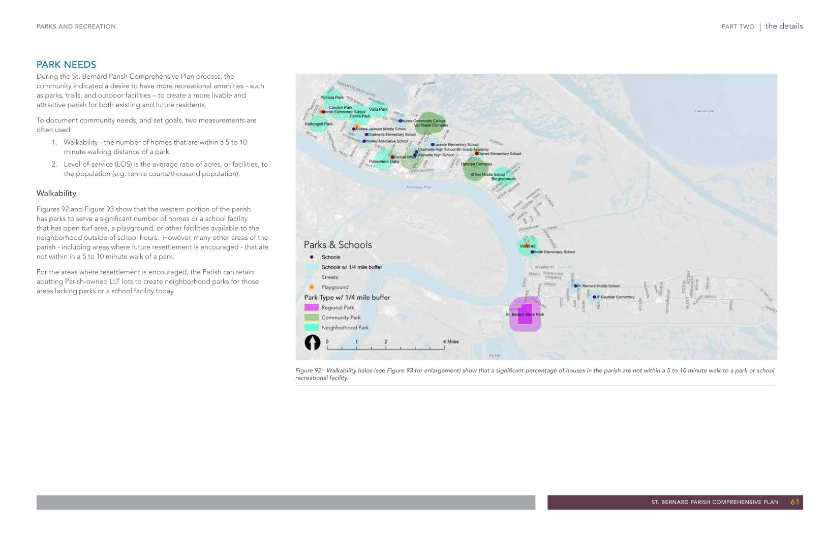
PART TWO | the details
ST. BERNARD PARISH COMPREHENSIVE PLAN 61
PARKS AND RECREATION
PARK NEEDSDuring the St. Bernard Parish Comprehensive Plan process, the community indicated a desire to have more recreational amenities - such as parks, trails, and outdoor facilities – to create a more livable and attractive parish for both existing and future residents.
To document community needs, and set goals, two measurements are often used:
1. Walkability - the number of homes that are within a 5 to 10 minute walking distance of a park.
2. Level-of-service (LOS) is the average ratio of acres, or facilities, to the population (e.g. tennis courts/thousand population).
Walkability
Figures 92 and Figure 93 show that the western portion of the parish has parks to serve a significant number of homes or a school facility that has open turf area, a playground, or other facilities available to the neighborhood outside of school hours. However, many other areas of the parish - including areas where future resettlement is encouraged - that are not within in a 5 to 10 minute walk of a park.
For the areas where resettlement is encouraged, the Parish can retain abutting Parish-owned LLT lots to create neighborhood parks for those areas lacking parks or a school facility today.
Figure 92: Walkability halos (see Figure 93 for enlargement) show that a significant percentage of houses in the parish are not within a 5 to 10 minute walk to a park or school recreational facility.

PART TWO | the details
62 ST. BERNARD PARISH COMPREHENSIVE PLAN
PARKS AND RECREATION
Figure 93: Park and school walkability halos (northwest detail) - the Parish should look for LLT lots and other opportunities to create neighborhood parks in the areas showing the largest gaps - particularly ares targeted for development.
Name Type AcresParksBorgnemouth Park Neighborhood Park 7.03
Carolyn Park Neighborhood Park 5.58
Hannan Complex Community Park 27.61
Kattengell Park Neighborhood Park 3.47
Packenham Oaks Park Neighborhood Park 8.49
Patricia Park Neighborhood Park 3.46
St. Bernard State Park Regional Park 187.30
Torres Park Neighborhood Park 20.33
Val Reiss Complex Community Park 43.47
Violet #2 Park Neighborhood Park 10.20
Vista Park Neighborhood Park 4.97
SchoolsAndrew Jackson Middle School 14.6
Arabi Elementary School 4.0
Chalmette Elementary School 8.2
Chalmette High School 21.8
Chalmette High School 9th
Grade Academy
School 8.9
Davies Elementary School 9.0
JF Gauthier Elementary - St.
Bernard Historical Courthouse
School 2.6
Lacoste Elementary School 5.2
Nunez Community College Community College 16.0
Rowley Alternative School 2.5
Smith Elementary School 12.8
St. Bernard Middle School 23.0
Trist Middle School 10.0
Total Acres LOSNeighborhood Parks 63.53 1.61
Community Parks 71.08 1.80
Regional Parks 187.3 4.73
Schools 138.6 3.50
St. Bernard Parish Population - 39,558 persons
The following existing parks and schools were evaluated:
With this data, the following LOS was determined:
target areas for additional neighborhood parks
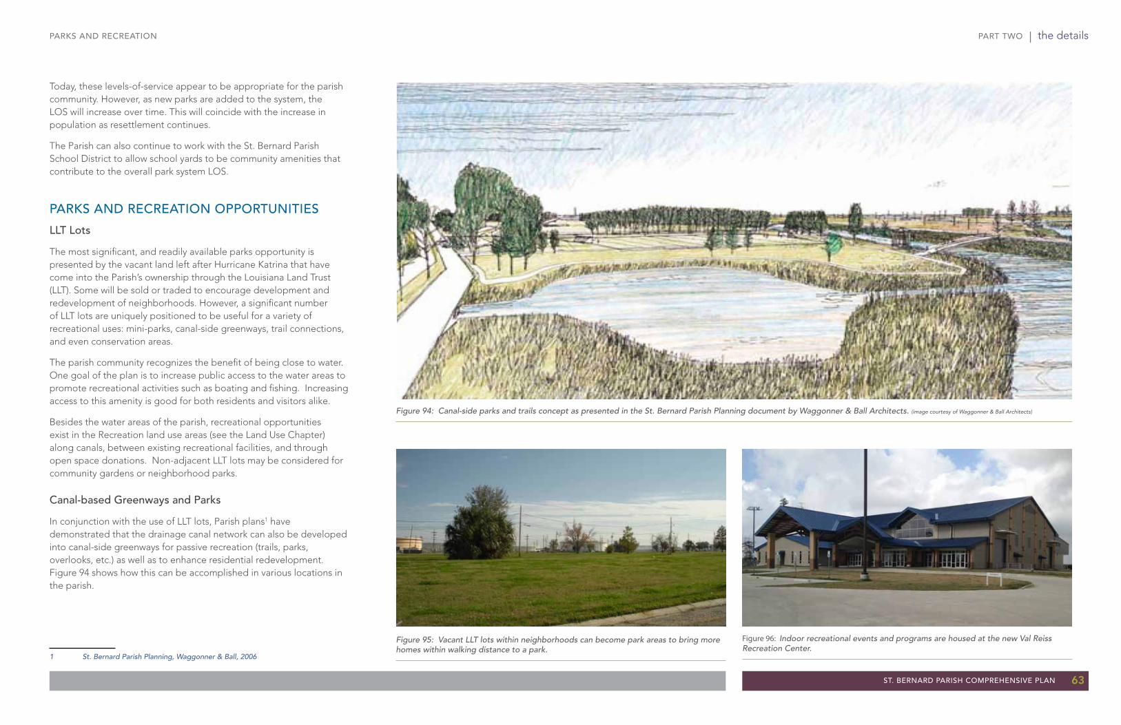
PART TWO | the details
ST. BERNARD PARISH COMPREHENSIVE PLAN 63
PARKS AND RECREATION
Figure 94: Canal-side parks and trails concept as presented in the St. Bernard Parish Planning document by Waggonner & Ball Architects. (image courtesy of Waggonner & Ball Architects)
Figure 95: Vacant LLT lots within neighborhoods can become park areas to bring more homes within walking distance to a park.
Figure 96: Indoor recreational events and programs are housed at the new Val Reiss Recreation Center.
Today, these levels-of-service appear to be appropriate for the parish community. However, as new parks are added to the system, the LOS will increase over time. This will coincide with the increase in population as resettlement continues.
The Parish can also continue to work with the St. Bernard Parish School District to allow school yards to be community amenities that contribute to the overall park system LOS.
PARKS AND RECREATION OPPORTUNITIES
LLT Lots
The most significant, and readily available parks opportunity is presented by the vacant land left after Hurricane Katrina that have come into the Parish’s ownership through the Louisiana Land Trust (LLT). Some will be sold or traded to encourage development and redevelopment of neighborhoods. However, a significant number of LLT lots are uniquely positioned to be useful for a variety of recreational uses: mini-parks, canal-side greenways, trail connections, and even conservation areas.
The parish community recognizes the benefit of being close to water. One goal of the plan is to increase public access to the water areas to promote recreational activities such as boating and fishing. Increasing access to this amenity is good for both residents and visitors alike.
Besides the water areas of the parish, recreational opportunities exist in the Recreation land use areas (see the Land Use Chapter) along canals, between existing recreational facilities, and through open space donations. Non-adjacent LLT lots may be considered for community gardens or neighborhood parks.
Canal-based Greenways and Parks
In conjunction with the use of LLT lots, Parish plans1 have demonstrated that the drainage canal network can also be developed into canal-side greenways for passive recreation (trails, parks, overlooks, etc.) as well as to enhance residential redevelopment. Figure 94 shows how this can be accomplished in various locations in the parish.
1 St. Bernard Parish Planning, Waggonner & Ball, 2006

PART TWO | the details
64 ST. BERNARD PARISH COMPREHENSIVE PLAN
PARKS AND RECREATION
Figure 97: The community indicated that additional access to fishing areas is desired.
Figure 98: More access to the Central Wetlands (seen above) creates additional opportunities for boating, fishing, wildlife watching, and other leisure pursuits.
Increased Public Access to the Central Wetlands and Fishing Areas
Some participants in the St. Bernard Parish Comprehensive Plan process expressed strong support for the development of a new community marina. The marina would provide water access for small boats and allow for boat storage facilities. The intention is not to compete with Paris Road marina facilities but increase public access to the waters. Currently, Paris Road marina facilities provide the most extensive access to the extraordinary fishing of the Central Wetland Unit, and beyond. However, these facilities are private (require fees) and are generally restricted to larger motorized boats.
Possible sites include:
• A new, small boat launch and dock on Paris Road.
• Shell Beach Area Boat launch – that would include a fishing pier, an interpretative center for Hurricane Katrina, and a Fort Proctor Area Historical interpretation center.
• End of LA 46 (Hwy 624) to Hopedale – MRGO Corridor, camp rentals, boat launching facilities, commercial dockage, Center for Oyster Reef Restoration.
Additional proposals have been put forward to provide increased public access for small and non-motorized boats.
Access to the 40 Arpent Canal and Central Wetland
This program, entitled the Louisiana Tourism Recovery Program Central Wetlands Unit and Forty Arpent Canal Access and Enhancement Program Activity, would construct:
• Two pedestrian bridges across the Forty Arpent Canal to provide public access to the northern bank of the canal and the Central Wetlands Unit.
• A boathouse on the southern bank of the canal, where a concessioner could sell bait and rent kayaks and other small boats; the boathouse would have a parking lot for visitors.
• Interpretive signage regarding the coastal environment and ongoing restoration efforts along both banks of the canal and near the Central Wetlands Unit.
• Opportunity also exists to create a nature park in the area.
A portion of the proposed project is envisioned to be at least partially funded through the Louisiana Tourism Recovery Program.
Other Water Access Sites
The Land Use and Transportation Vision Plan identified several sites that are suitable for enhancement to meet public marina needs. These sites include:
• LA Hwy 46 Corridor as a designated scenic highway - roadside parks, historical tours, and the Islenos Museum.
• LA 47 – Bayou Bienvenue Area - recreational camp development, fishing and marina complex.
• Chandeleur Islands - boat camping, surf fishing, and bird watching.
• MRGO Spoil Bank (inside levee from Bayou Dupre to Verret) - water oriented facilities.
The Parish should work with the local chamber of commerce and tourist organizations to enhance these areas. The sites can be marketed as a road trip through the parish.
Figure 99: Illustrative drawing of potential development along the 40 Arpent Canal. (source: St. Bernard Charrette Report by Duany Plater-Zyberk & Company)

PART TWO | the details
ST. BERNARD PARISH COMPREHENSIVE PLAN 65
PARKS AND RECREATION
BIKEWAYS AND TRAILSOver the last two decades national and regional trends show that bikeways and trails are the single most valuable recreational amenity. They are an attraction to users of all ages and abilities and are relatively low cost transportation improvements compared to many other options. They are especially valuable, and used, when they are combined into a system. Please see the Transportation Chapter for more information on bikeways and trails.
Existing Conditions
The parish has a limited number and extent of bikeways and trails. Most of them are within or adjacent to existing parks, such as the trail around Val Reiss Park and at Torres Park. There are also trails at the Battlefield and in the Cemetery.
Fortunately, a variety of regional agencies are involved in trail planning within the parish. Their cumulative efforts can do much to augment the Parish’s efforts and create an exciting, extensive trail system.
2001 Proposed Bicycle Plan for St. Bernard Parish
A 10-mile bicycle path proposed for St. Bernard Parish would connect to paths in Orleans and Jefferson Parishes. The Parish currently plans to provide a 10-foot wide asphalt path atop the levee for several miles to the Violet Canal and shipdocks. The southernmost reach of the St. Bernard section is at St. Bernard State Park located at the St. Bernard/Plaquemines Parish line.
Meraux Multi-Use Path
A 2-mile section of multi-use path in Meraux is listed in the 2011-2014 Transportation Improvement Program for St. Bernard Parish. The path would be built along St. Bernard Highway in Meraux south to Caernarvon.
The Mississippi River Trail
A feature of the 2005 New Orleans Metropolitan Bicycle and Pedestrian Plan, this trail would follow the Mississippi River from Orleans Parish to the border with Plaquemines Parish. Sections could become separated paths. Phases I and II span between the Valero Refinery site to the Violet Canal. Permits for these phases are being processed.
Figure 100: One existing trail in the parish is at Val Reiss Park, however, its use is currently limited; improvements are planned that will accommodate multiple types of
Figure 101: Plans to extend the Mississippi River Trail into St. Bernard Parish will connect the parish to the regional and national trail system.
Figure 102: Trails are one of the most popular recreational amenities across the United States; expanding the trail system throughout the parish will provide that desired amenity locally.

PART TWO | the details
66 ST. BERNARD PARISH COMPREHENSIVE PLAN
PARKS AND RECREATION
Figure 103: St. Bernard Parish Preliminary Bikeways and Trails Recommendations - combined planning from the Regional Planning Commission for Jefferson, Orleans, Plaquemines, St. Bernard, St. Tammany, and Tangipahoa Parishes planning efforts and the St. Bernard Parish Comprehensive Plan process.
!!!!
!
!!!!!!!
!!!!!
!! !!!!!!!!!!!!!!!!!!!!!!!!!!!!!
!!!!!!!!!!!!!!!!!!!!!!!!!!
!!!!!!!!!!!!!!!!!!!!!
!!!!!!!!!
!!!!!!!!!!!!!
!!!!!!!!!!!!!!
!!!!!!!!!!
!!!!!!!!!!!!!
!
!!
!!!!!!!!!!!!!!!!!
!!!!!!
!!
!!!!!!!
!!!!!!!!!!!!!!!!!!!!!
!!!!!!!!!!! !!
!!!!!!!!!!!!!!!!!!!!!!!!!!!!!!!!!
!!!!!!!!!!!!!!!!!!!!!!!!!!!!!!!!!!!!!
!!!!!!!!!!!!!!!!!!!!!!!!!!!!!!!!!!!!
!!!!!!!!!!!!!!!!!
!!!!!!!!!!!!!!!!!!!!!!!!!!
!!!!!!!!!
!!!!!
!!!!
!!!!
!!!!!
!!!!
!!!!!!!
!!!
!!
!!!!!!
!!!!!!!
!!!!!!!!!
!!!!!!!!!!!!!!!!!
!! !!!!
!!!
!!!
!!!!!!!!!
!!!!
!!
!!
BAYOU
ST BERNARD
PARI
S
LA HWY 46
JUDGE PEREZ
LENA
LEVEE ACCESS
PATRICIA
PLAZ
A
VOLP
E
JACO
B
MEH
LE
A
ANG
ELA
B
CANAL
C
VENT
URA
NANCY
PERR
IN
GALL
O
OAK
DELI
LLE
BUFF
ON
VIRTUE
GIN
A
MUM
PHRE
Y
MERAUX
BART
OLO
PALM
ISAN
O
FARMSITE
VERO
NICA
PAUL
LEGEND
ST AVIDE
GUERRA
CENT
ER
SAR
O
CAM
PAG
NA
JACK
SON
LAPL
ACE
JEAN
LAF
ITTE
IVY
3RD6TH
SY
LVIA
JUDY
GREEN
NEH
LIG
RIVER
ACC
ESS
CHALMETTE BACK LEVEE
LYND
EL
RIVERBEND
TOR
RE
S
TARA
PETERS
LIBERAUX
LAWROW
LEY
KING
S
LEBE
AU
TRIO
SU
ZI
NE
AL
ST MARIE
MAR
Y AN
N
COUG
AR
JOSEPHINE
BENJAMINMARINA
SOUTH LAKE
JUPI
TER
GENIE
BONI
TAPA
CKEN
HAM
AYCO
CK
VALMAR
DEAN
NORT
ON
PIRA
TE
1ST
EDGAR
TOD
D
4TH
CORI
NNE
KE
NIL
WO
RTH
DESP
AUX
GN
ELL
FANZ
DANIEL
PARK
HE
IGH
TS
SHANNON
COKE
PLA
NT
8TH
OLD
HIC
KORY
MOREAU
FLORIDA
JAMIE'S
2ND
DE
BO
RA
H
RUE BIEN
VERRET
PECA
N
FISH
ER
JOS
EP
H STA
Y P
AR
K
TERR
Y
BIL
LIO
T
5THLUM
BERYARD
RUE
MAR
CELL
E
CH
RIS
TIE
CR
EE
DM
OO
R
GR
EY
'S
OLD
LAN
DFIL
L ACC
ESS
TINO
VENUS
OLIVIA
CH
ALM
ETTE
SLI
P
WO
OD
LAN
DS
FOU
NTAIN
NAJOLIA
SE
RPA
S
PRIV
ATE
SIDNEYHERMITAGE
SENKO
WES
TER
N G
AS
LYNN OAKS
4TH
ACCESS
RIVER
RIVER
LYND
EL
FLORIDA
AC
CE
SS
ACC
ESS A
CC
ES
S
Lake Borgne
Mississippi River
Big Mar
Source: Esri, DigitalGlobe, GeoEye, i-cubed, USDA, USGS, AEX, Getmapping, Aerogrid, IGN, IGP, swisstopo, and the GIS User Community
Canals
Streets
RPC* On-street Routes**
Envisioned
Funded
Proposed
RPC* Trails
Funded
Proposed
Envisioned
Further Review
Other (non-RPC*) Bike Paths/Trails!!!!!!!!! Existing
!!!!!!!!! Potential Major
!!!!!!!!! Potential Minor
[ 0 2 41 Miles
Trails
Source of RPC On-street Routes and RPC Trails: St. Bernard ParishOn-Street Bikeways by the Regional Planning Commission forJefferson, Orleans, Plaquemines, St. Bernard, St. Tammanyand Tangipahoa Parishes, 2013
** RPC = Regional Planning Commission ** On-street routes include bike lanes (a dedicated street lane for bicycles)and shared lanes - lanes where vehicles and bicycles share the marked lanes.
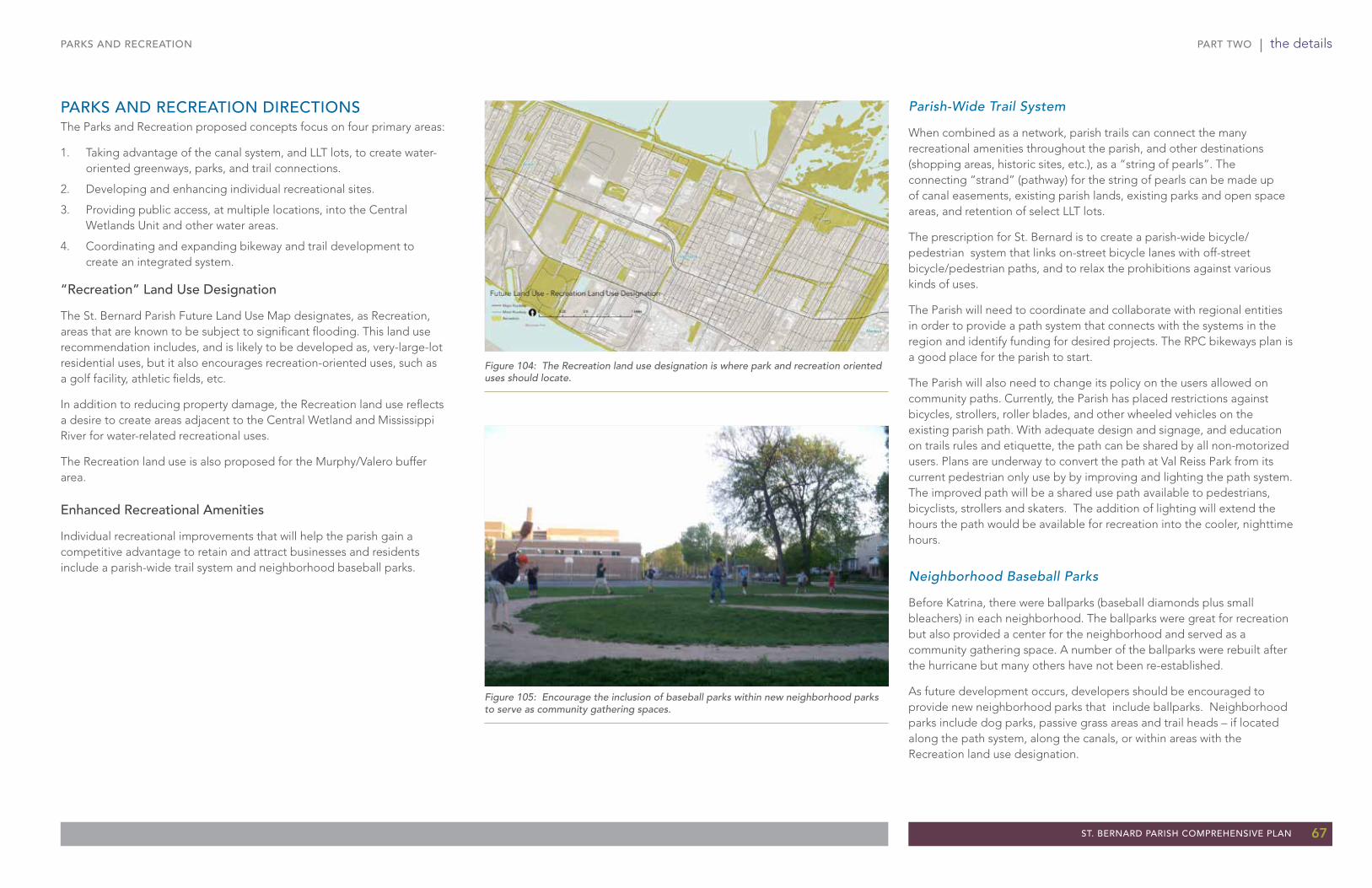
PART TWO | the details
ST. BERNARD PARISH COMPREHENSIVE PLAN 67
PARKS AND RECREATION
PARKS AND RECREATION DIRECTIONSThe Parks and Recreation proposed concepts focus on four primary areas:
1. Taking advantage of the canal system, and LLT lots, to create water-oriented greenways, parks, and trail connections.
2. Developing and enhancing individual recreational sites.
3. Providing public access, at multiple locations, into the Central Wetlands Unit and other water areas.
4. Coordinating and expanding bikeway and trail development to create an integrated system.
“Recreation” Land Use Designation
The St. Bernard Parish Future Land Use Map designates, as Recreation, areas that are known to be subject to significant flooding. This land use recommendation includes, and is likely to be developed as, very-large-lot residential uses, but it also encourages recreation-oriented uses, such as a golf facility, athletic fields, etc.
In addition to reducing property damage, the Recreation land use reflects a desire to create areas adjacent to the Central Wetland and Mississippi River for water-related recreational uses.
The Recreation land use is also proposed for the Murphy/Valero buffer area.
Enhanced Recreational Amenities
Individual recreational improvements that will help the parish gain a competitive advantage to retain and attract businesses and residents include a parish-wide trail system and neighborhood baseball parks.
Parish-Wide Trail System
When combined as a network, parish trails can connect the many recreational amenities throughout the parish, and other destinations (shopping areas, historic sites, etc.), as a “string of pearls”. The connecting “strand” (pathway) for the string of pearls can be made up of canal easements, existing parish lands, existing parks and open space areas, and retention of select LLT lots.
The prescription for St. Bernard is to create a parish-wide bicycle/pedestrian system that links on-street bicycle lanes with off-street bicycle/pedestrian paths, and to relax the prohibitions against various kinds of uses.
The Parish will need to coordinate and collaborate with regional entities in order to provide a path system that connects with the systems in the region and identify funding for desired projects. The RPC bikeways plan is a good place for the parish to start.
The Parish will also need to change its policy on the users allowed on community paths. Currently, the Parish has placed restrictions against bicycles, strollers, roller blades, and other wheeled vehicles on the existing parish path. With adequate design and signage, and education on trails rules and etiquette, the path can be shared by all non-motorized users. Plans are underway to convert the path at Val Reiss Park from its current pedestrian only use by by improving and lighting the path system. The improved path will be a shared use path available to pedestrians, bicyclists, strollers and skaters. The addition of lighting will extend the hours the path would be available for recreation into the cooler, nighttime hours.
Neighborhood Baseball Parks
Before Katrina, there were ballparks (baseball diamonds plus small bleachers) in each neighborhood. The ballparks were great for recreation but also provided a center for the neighborhood and served as a community gathering space. A number of the ballparks were rebuilt after the hurricane but many others have not been re-established.
As future development occurs, developers should be encouraged to provide new neighborhood parks that include ballparks. Neighborhood parks include dog parks, passive grass areas and trail heads – if located along the path system, along the canals, or within areas with the Recreation land use designation.
Figure 104: The Recreation land use designation is where park and recreation oriented uses should locate.
Figure 105: Encourage the inclusion of baseball parks within new neighborhood parks to serve as community gathering spaces.

PART TWO | the details
68 ST. BERNARD PARISH COMPREHENSIVE PLAN
PARKS AND RECREATION
Creation of a Unified Image for the Recreation System
The Parish should consider the development of a special sign design to identify the facility but also provide way-finding from one amenity to another. Trail heads can be developed and include parking areas, overall system maps, and additional way-finding materials.
To market the recreational amenities, the Parish can also work with the tourism groups to develop a guided tour of the recreational facilities and list additional tours for hunting and fishing such as the swamp tours offered for wildlife viewing.
Community Garden Project
For many, gardening is a relaxing way to exercise and enjoy the outdoors. Community gardens provide a safe, recreational green space, a place for people to gather and interact, can contribute to keeping air clean, and provides fresh produce to the community. Community gardens are becoming increasingly popular across the United States2.
A movement has begun in the parish to create a community garden program. A summary report has been written that outlines the benefits of community gardens and a strategy for the creation of a program as well as identifies several potential sites within St. Bernard Parish. To promote such a program, the Parish should consider working with Parkway Partners, a regional group that provides management of community gardens and provides a horticulturist.
2 American Community Gardening Association
Figure 106: Community gardens are becoming popular recreational elements for many communities.

PART TWO | the details
ST. BERNARD PARISH COMPREHENSIVE PLAN 69
Fund “missing links” trails including land acquisition and construction.
Fund canal‐side parks with check‐dam ponds per the Waggonner & Ball plans.
Use LLT lots, and “lot swap” program to acquire/preserve major open spaces/natural areas.
Finalize grant applications for public access to wetlands.
Work with community efforts, such as the movement for a community garden program within the parish, to create recreational opportunities in St. Bernard.
Work with the Lake Borgne Levee District, part of the Southeast Louisiana Flood Protection - East, to determine adequate water quality of canals before canals are used for recreation purposes.
Parks and Recreation Actions
Relax restrictions and remove signs that prohibit certain uses to allow broader uses on existing trails.
Create a Parish Bicycle and Pedestrian Master Plan map (start with St. Bernard Parish Comprehensive Plan map as base) and identify funding opportunities.
Prepare detailed plan for canal greenways, including use of specific LLT lots, desired park improvements and priorities (which can be done through the 2013-2014 Water Management Study by Waggonner and Ball Architects).
Immediately resolve the continued closure of the recreation/community center. The longer the center remains closed, the greater the negative image it gives the community, and the longer the community loses in the competition for strong businesses and families.
Work with private partners to identify funding for the maintenance of open space donations. Consider creating a shared revenue stream from future Foundation development.
Create standards for Neighborhood Parks, to include “ballparks” – a baseball diamond with small bleacher sections.
Revise subdivision standards to require new subdivisions to provide a pro-rata share of a neighborhood parks in areas targeted for resettlement.
PARKS AND RECREATION
Parks and Recreation Goals
Increase the quality of life for residents through the enhancement of recreational amenities.
Increase awareness that St. Bernard is a fun, outdoor destination with an abundance of water and nature-based activities to be enjoyed by the entire family.
Increase public access to water areas to promote recreational activities such as boating and fishing.
Increase the park Levels-of-Service and the number of parks within the target resettlement areas as the population of the parish increases.
Parks and Recreation Policies
Park land should be provided in quantities and locations so that the target areas of resettlement - according to the Future Land Use Map - are within a 5 to 10 minute walk from a park.
The Parish will work with the St. Bernard School District for the joint use of public recreational facilities to cost-effectively expand and integrate parks and recreational amenities.
PR A1
PR A2
PR A3
PR A4
PR A5
PR A6
PR A7
PR A8
PR A9
PR A10
PR A11
PR A12
PR P2
PR G1
PR G2
PR G3
PR G4
PR P1
PR A13

PART TWO | the details
70 ST. BERNARD PARISH COMPREHENSIVE PLAN
COMMUNITY INFRASTRUCTURE
Community InfrastructureInfrastructure is essential for a functional community and helps cities and regions win the competition for retaining and attracting businesses and residents. Infrastructure includes: water and sewer facilities, fire and police buildings, equipment and services, schools, and government buildings. Infrastructure is provided by a variety of agencies: the Parish, the state, special districts (e.g. the school district), as well as private and quasi-private entities (e.g. cable, electric, gas). The storm water sewer system is also infrastructure but is addressed in the Storm Water Management chapter due to the critical importance of the system on future development patterns within the parish.
Most of the critical facilities and infrastructure in the parish have been rebuilt since Hurricane Katrina in 2005 and are in good to adequate condition today. In fact, those rebuilt to pre-Katrina levels probably have capacity that exceeds current needs. The cost of infrastructure is related to: operations, expansion to serve new development, and setting aside funds for maintenance and replacement. Without proper maintenance and planning, the systems will see decline over time.
The costs to operate community facilities and maintenance of infrastructure are often closely tied to development patterns – it requires more roads per house to serve scattered development than it does to serve more compact development. There are many costs that are sensitive to both the type and location of development. One of the benefits of the Future Land Use Map is to help the Parish and other infrastructure and service providers anticipate what type of growth will occur where, and where it will not occur. Having a general, overall Future Land Use Map for the Parish helps agencies plan, and coordinate with each other, to provide a more cost-effective system, which translates into lower costs for the community.
EXISTING CONDITIONS
Water
The Parish Public Works Department provides water to the parish through water districts. Water District #1 serves the area from Arabi to the Violet Canal. Water District #2 serves the area south of the Violet Canal. Water pressure is maintained by a series of elevated water towers and a booster pump station.
Historically, St. Bernard Parish obtained potable water from three aquifers, the St. Bernard Delta “200-foot” sand, the “700-foot” sand, and the “1200-foot” sand. Unfortunately, there has been extensive saltwater intrusion into these aquifers and the parish no longer has potable groundwater. Today the water source for all domestic water is an intake from the Mississippi River.
The domestic system has been reconstructed to meet pre-Katrina capacities. The Parish has completed the construction of the raw water pump station and begun upgrading the system from Violet to Delacroix and Hopedale of which, the Hopedale portion of the waterline extension has been completed.
The Parish has a Source Water Assessment Plan (SWAP) that is an assessment of the Parish’s water source and an inventory of potential sources of contamination.
Figure 107: Image taken at the ground breaking for the new water treatment plant.
Figure 108: The parish wastewater treatment operations were consolidated to one facility after Katrina.

PART TWO | the details
ST. BERNARD PARISH COMPREHENSIVE PLAN 71
COMMUNITY INFRASTRUCTURE
Figure 109: Parish water lines and sewer mains.
BAYOU
ST BERNARD
PARI
S
JUDGE PEREZ
LA HWY 46
LENA
LEVEE ACCESS
PATRICIA
PLAZ
A
VOLP
E
JACO
B
MEH
LE
A
ANG
ELA
B
CANAL
C
VENT
URA
NANCY
GALL
O
OAK
DELI
LLE
BUFF
ON
VIRTUE
GIN
A
MUM
PHRE
YMERAUX
BART
OLO
PALM
ISAN
O
FARMSITE
PERR
IN
VERO
NICA
MUN
STER
PAUL
LEGEND
ST AVIDE
GUERRA
CENT
ER
SAR
O
CAM
PAG
NA
JACK
SON
LAPL
ACE
MAUREEN
JEAN
LAF
ITTE
IVY
3RD6TH
SY
LVIA
JUDY
GREEN
NEH
LIG
RIVER
ACC
ESS
CHALMETTE BACK LEVEE
LYND
EL
RIVERBEND
TOR
RE
S
TARA
PETERS
LIBERAUX
LAWROW
LEY
KING
S
LEBE
AU
TRIO
SU
ZI
NE
AL
ST MARIE
MAR
Y AN
N
COUG
AR
JOSEPHINE
BENJAMIN
MARINA
SOUTH LAKE
JUPI
TER
GENIE
BONI
TA
ROSE
PACK
ENHA
M
AYCO
CK
VALMAR
DEAN
NORT
ON
PIRA
TE
MINK
ESTE
BAN
1ST
EDGAR
TOD
D
4TH
CORI
NNE
KE
NIL
WO
RTH
DESP
AUX
GN
ELL
FANZ
DANIEL
PARK
HE
IGH
TS
TRIST
SHANNON
COKE
PLA
NT
8THO
LD H
ICKO
RY
MOREAU
EVAN
GEL
INE
FLORIDA
JAMIE'S
2ND
RUE JOLI
GU
ILLOT
DE
BO
RA
H
PECA
N
FISH
ER
JOS
EP
H STA
Y P
AR
K
BIL
LIO
T
5THLUM
BERYAR
D
RUE
MAR
CELL
E
CH
RIS
TIE
CR
EE
DM
OO
R
GR
EY
'S
LACO
STE
TINO
VENUS
OLIVIA
CH
ALM
ETTE
SLI
P
WO
ODL
ANDS
RIC
OU
AR
D
FOU
NTAIN
NAJOLIA
PRIV
ATE
SENKO
WES
TER
N G
AS
LYNN OAKS
RIVER
AC
CE
SS
4TH
GENIE
AYCO
CKCE
NTER
RIVER
AC
CE
SS
FLORIDA
AC
CE
SS
Lake Borgne
Mississippi River
Big MarSource: Esri, DigitalGlobe, GeoEye, i-cubed, USDA, USGS, AEX, Getmapping, Aerogrid, IGN, IGP, swisstopo, and the GIS User Community
Water Lines
Sewer Mains
Streets
[ 0 1.5 30.75 Miles
Water Lines & Sewer Mains

PART TWO | the details
72 ST. BERNARD PARISH COMPREHENSIVE PLAN
The Parish will use the Future Land Use Map to influence the planning of maintenance and operations of facilities and services within the parish.
Community Infrastructure Actions
Coordinate with non-Parish Government infrastructure providers regarding the details of the Future Land Use Map so that these agencies can better plan for expansion and maintenance over time.
Locate and digitize the water and sewer infrastructure system to create new Geographic Information System (GIS) mapping data.
Conduct an assessment of the water distribution lines and sewer sanitation lines to determine condition and needs for replacement.
Identify grant funding sources to support the assessment of water and sewer lines within the parish.
Create a master infrastructure replacement plan to establish long-range needs and priorities consistent with the St. Bernard Parish Comprehensive Plan.
• Focus services and facilities in areas where growth is encouraged and away from areas where development is discouraged.
• Identify areas where infrastructure can be reduced.
Require Parish departments to include, in their Capital Improvement Program budget requests, an explanation of how the proposed project will help implement, and be consistent with, the St. Bernard Parish Comprehensive Plan:
• Prioritize infrastructure improvements according to how projects support the Future Land Use Map.
• Use the Future Land Use Map to size infrastructure according to the uses and densities shown.
COMMUNITY INFRASTRUCTURE
Wastewater (Sewer)
There were 5 wastewater treatment plants prior to Hurricane Katrina. Post-Katrina, the Parish has one wastewater treatment facility at the Dravo site. The facility was recently upgraded and has a designed capacity to treat at pre-Katrina levels –approximately 3.5 mgd (million gallons per day) capacity with a 1.6 mgd average flow and a 6 mgd peak flow. The Munster wastewater treatment plant (WWTP) expansion was part of a $63 million effort by St. Bernard Parish in Louisiana to consolidate operations. Wastewater is collected through a series of collection lines and lift stations. The plant sends effluent to be de-chlorinated and disinfected, from which it is discharged into the Central Wetlands. The de-chlorinated discharge provides fresh water and nutrients to the Central Wetlands and helps restore and sustain fresh-to-intermediate wetland habitat.
Although it will be some time before the demand meets current capacity, the ability exists to expand both the water treatment plant and the Riverbend Oxidation Pond as needed in the future.
The rest of the inhabited area outside the urban area / levee system uses individual sewage systems for wastewater treatment.
Electric and Gas
Private companies supply the parish with electricity and gas service. Currently, Entergy provides electricity and Atmos Energy provides gas. Both services are considered adequate.
COMMUNITY INFRASTRUCTURE DIRECTIONS
Replacement of Water Service Lines
The water and wastewater treatment plants in the parish have been rebuilt in the past few years. The capacity of both facilities is at pre-Katrina levels and, therefore, they are below capacity until demands rise to those prior to 2005. The ability exists to expand both facilities at their current sites if needed in the future.
The area where attention needs to be paid over the next decade or two is the service lines, particularly for water distribution lines. The lines are old and will need to be replaced to avoid cracks in the pipes leading to saltwater intrusion or other contamination threats. Wastewater lines are also aging and will need to be replaced to avoid contamination from matter in the lines to ground water and other natural systems.
The Parish should prepare a master infrastructure replacement plan to implement over the next two decades. The plan should outline a method to identify problem areas (such as leaks, breaks, corrosion, misalignment, and worn down pipes), prioritize the replacement process (based on need and also the direction of the Future Land Use Map), and a strategy to fund the project.
Because adequate spatial information on the systems was lost due to the flooding events that occurred over the past decade, the project should also include mapping of the system and an assessment of current conditions.
Community Infrastructure Goals
Adequate, cost-effective infrastructure is provided for the current and future parish residents, businesses, and visitors.
The drainage in the Parish is managed to protect the health and safety of people and property and to protect the natural functioning and health of the environment.
Community Infrastructure Policies
The Parish will work with non-Parish service and infrastructure providers to ensure that they can provide adequate services and facilities to meet the demands of parish residents and businesses.
CI P1
CI P2
CI G1
CI G2
CI A2
CI A1
CI A3
CI A4
CI A5
CI A6

PART TWO | the details
ST. BERNARD PARISH COMPREHENSIVE PLAN 73
ECONOMIC DEVELOPMENT
Economic DevelopmentMany former residents have returned to St. Bernard Parish over the past few years and some new residents have recently moved to the parish. Regardless, the parish has not necessarily been able to largely expand the population base of new residents. New employment opportunities certainly are important to achieve that goal, but community development - creating an attractive location for people to reside - is an even more important priority in the near future in order to stabilize the community, attract new families, as well as continue the encouragement of additional former residents to return.
A REGIONAL AND LOCAL ISSUESt. Bernard Parish does not operate in a vacuum; it is part of the regional economy, therefore, economic development needs to be considered at a regional level and not just the parish level. St. Bernard Parish is located at the nexus of culture and industry: to the north is New Orleans, the indisputably global city of Louisiana that was, until Hurricane Katrina in 2005, the largest city in the state. To the west is Plaquemines Parish, a parish that services the oil and gas industry, commercial fishing, trade that moves up and down the Mississippi River, and a major naval air base in Belle Chasse.
The stability and growth of St. Bernard is closely coupled with the overall success of the surrounding metropolitan region, especially employment growth in those parts of the region that are linked to St. Bernard by major transportation arteries. The growth or decline of Orleans Parish significantly affects employment conditions in St. Bernard Parish.
Traditionally, except for workers in local refinery and shipping businesses, St. Bernard Parish residents were employed in neighboring parishes. St. Bernard’s two biggest opportunities are:
• To establish itself as a highly desirable bedroom community for New Orleans where there are many new jobs coming to the region through extensive development programs.
• To attract new employment to the parish.
SHIFTING THE RECOVERY FOCUS: ATTRACTING NEW RESIDENTS AND BUSINESSESAfter Hurricane Katrina, officials worked hard to get the public services restored hoping to encourage families to return to St. Bernard Parish. Many families did in fact return, drawn by ties to friends and family, personal business, the excellent school system, etc. However, many other families put new roots down elsewhere. They have now had eight years to become accustomed to a new community. Attracting these former residents to return to St. Bernard will be similar to attracting new residents and businesses - it will involve out-competing other communities with regards to quality of life, community standards, and employment opportunities.
This means the recovery strategy now needs to focus on the overall quality of the community, the conditions that enable a family to be a part of a community of neighbors, safety, schools, parks, community activities, and other quality of life amenities.
Figure 110: Example products made locally in St. Bernard Parish.
ECONOMIC DEVELOPMENT CONCEPTSStrengthening the economy of St. Bernard parish must be a multi-pronged effort. It will consist of:
1. Developing a community that will attract residents and workers, which will in turn attract businesses and employers.
2. Attracting business through effective outreach (marketing) incentives and supportive services (infrastructure, job training, visibility).
3. Exploiting the unique resources of St. Bernard (vacant land, natural environment, riverfront access, proximity to New Orleans).
Community Development
The businesses and residents the parish wishes to attract have choices in the region. The parish is in competition with other parishes in the area that have been investing regularly in quality-of-life amenities; St. Bernard Parish is in the position of having to catch up. The competition has invested in education; St. Bernard needs to increase its support for education. The competition has invoked standards for rental property maintenance; St. Bernard Parish must greatly improve current standards. The competition has made investments to attract and retain their middle class, and in turn their rising tax base has become a source of continual self-financed improvements. St. Bernard Parish must catch up, and can.
St. Bernard Parish has many assets on which to build: a class A school system, a high-functioning Sheriff’s department, and an abundance of public infrastructure that will avoid the need for further major capital projects – and thus expenditures - by Parish government for many years.
The challenges are numerous: to keep these facilities and services in good shape, we need to immediately raise the level of maintenance. Furthermore, because St. Bernard Parish lacks many of the aesthetic, commercial, and recreational amenities of surrounding parishes, if St. Bernard is to effectively compete in the region—to keep and attract businesses and strong new middle income families—the people of St. Bernard will have to agree to invest in the additional amenities. In the end, these kinds of investments will have a return: they will attract more people and businesses who can also help pay the bills in order to reduce the per capita share of expenses.

PART TWO | the details
74 ST. BERNARD PARISH COMPREHENSIVE PLAN
ECONOMIC DEVELOPMENT
Summarized below are specific St. Bernard Parish Comprehensive Plan directions that will help establish the parish as a highly desirable place to live and work. By promoting the various directions presented in this plan, the Parish can create a truly unique, livable, attractive community - an inviting place to live, work, play, and visit. The increased attraction to the community will first stabilize the local economy then grow the parish once the word is spread about this unique and inviting community just southeast of New Orleans.
Create a Unique Place to Visit and Play: Canals and Expanded Greenway and Trails
By investing in the canal system proposed by the Waggonner and Ball St. Bernard Parish Planning document, the Parish would have features that are nationally unique. More surface water in the canals (created by the check dams) would make them more attractive as water features, which in turn would make them attractive locations for public greenways, waterside plazas, and trails that can differentiate St. Bernard Parish as a great place to live or visit. The expansive Recreation District with even more planned trails throughout the parish would add another layer to the attraction. This system, in addition to the existing assets, including the historic and cultural sites, can set St. Bernard parish apart from anything else in the United States.
Create Centers
The creation of centers as proposed in the Land Use section of this Plan will provide destinations that will give the community focus and a quality image as well as attract families of various incomes to the parish. The centers will support smaller, local businesses such as “mom and pop” stores as well as be more walkable, pedestrian-friendly commercial areas (“downtowns”).
Retain Industrial uses
Because of the use of the Mississippi River for heavy transportation, industrial uses are concentrated along the river banks. The Valero Oil refinery is an exception; it is a perpendicular swath extending north-to-south across the parish from the river to the levee. The existing industrial areas are envisioned in the Future Land Use Map to remain unchanged.
Expand Cultural and Historic Site Tourism
The number of historic sites within the parish is a unique opportunity to market them individually and as a package—to history buffs, to general visitors, and even to local residents. Marketing historic resources locally will also build awareness, community pride, and even provide activities for families and individuals. Expanding the use of historical knowledge and field trips in school curricula can help build awareness, and stimulate interest in related careers.
Improve Gateways
First impressions occur naturally at entries to the community—the “gateways”. Improving the aesthetics of these gateways creates a favorable first impression of the parish.
Attracting Businesses to the Parish
As described in the previous section, attracting middle and upper income residents will also attract the businesses they will support. However, there are additional actions the Parish should undertake to specifically reach out to businesses and industries.
Use Available Programs to Incentivize Economic Development
There are a number of key resources St. Bernard Parish can to tap into to promote economic development within the parish: the Louisiana Department of Economic Development, Greater New Orleans, Inc., and the St. Bernard Parish Economic Development Foundation. The following sections describe how these agencies can assist in particular projects, participate in promoting the region, and position the parish as new opportunities arise.
Louisiana Department of Economic Development (LaDED)
The State’s Department of Economic Development (LaDED) provides leadership, policy, and programs to create a positive business climate. The Department works to create public-private opportunities to diversify the economic base and create job opportunities. The Business Services Program assists in the start-up and expansion of business and industry, provides local partnering services for community development projects, and provides technical and financial assistance to entrepreneurial businesses.
Figure 111: Center concept proposed in the St. Bernard Charrette Report. (source: St. Bernard Charrette Report by Duany Plater-Zyberg & Company)
Figure 112: Continue to promote local economic engines such as the fishing industry.

PART TWO | the details
ST. BERNARD PARISH COMPREHENSIVE PLAN 75
ECONOMIC DEVELOPMENT
Figure 113: The Parish has many resources, such as the State of Louisiana Department of Economic Development to tap into to help further economic development efforts.
The key industries identified for expansion in Louisiana include:
• Aerospace.
• Agribusiness.
• Manufacturing.
• Automotive.
• Process industries.
• Software development.
• Water management.
• Energy.
• Entertainment.
The LaDED provides incentive programs in each of these sectors for which the Parish can apply. The incentives include training, tax credits and rebates, low overall business tax, suitable site identification, expedited permitting, and competitive energy costs.
Greater New Orleans Inc.
The Greater New Orleans, Inc. (GNO) works to market the region and coordinate economic development initiatives betweeen parishes and communities. GNO works to focus state and other economic development efforts on southeast Louisiana. Recent projects in St. Bernard Parish include infrastructure projects at the Courthouse Square Building, the Old Arabi Jail, the Old Beauregard Courthouse, Maumus Center, and Chalmette High School. Recent development projects include the acquisition of the Violet Docks, the St. Bernard Port, and the Medical Office Building for St. Bernard Parish Hospital.
St. Bernard Parish Economic Development Foundation
The St. Bernard Economic Development Foundation’s mission is to promote commercial revitalization and further economic development in the parish. The foundation supports and partners with the St. Bernard Tourist Commission, St. Bernard Chamber of Commerce, St. Bernard Development Commission, and other local and regional entities to promote activities and projects that will have a positive impact on the economics of the parish. The foundation offers a range of marketing, funding opportunities, available local, State and Federal program information, and site selection services to attract businesses and industries and to assist existing companies with promotion and expansion.
Expand Agricultural Operations
The Parish has many open areas that may be used by agriculture operations ranging from community gardens to small crop fields, to orchards and tree farms to livestock grazing areas.
The Parish could group vacant LLT lots to create small community gardens as well as large areas for small commercial agriculture operations, track farms, and other similarly scaled production.
Using LLT lots in this fashion will provide modest rental income as well as reduce the maintenance costs to the parish.
The Parish should consult with regional colleges that have agricultural programs to provide guidance to the program.
An example of agricultural uses applied to vacant lots elsewhere, see sidebar in the forest proposal in Detroit.
In addition, the fishing and seafood industry (including oyster aquaculture, kelp farming and harvesting, shrimp and fish) along the MRGO is another industry that can be furthered.
Figure 114: The expansion of agriculture provides both locally available fresh food to the community and contributes to the local economy.
Detroit’s 140-acre Forest
A large scale attempt is underway to create an
140-acre forest in vacant lands in Detroit. Hantz
Farms purchased the property, formerly 1,500
vacant city-owned lots, from the City of Detroit for
the purposes of growing trees for lumber . The
property will be regularly mowed and maintained
by the property owner. The purchase will convert
a former city maintenance liability to private use
that will generate property taxes. Additional public
revenue will come from the sales tax from harvesting
of the trees as well use of some land for commercial
orchards and gardens, and the cultivation of
ornamental plants and shrubbery. The purpose
of the project is to create a more livable area and
recover investment over the long term.
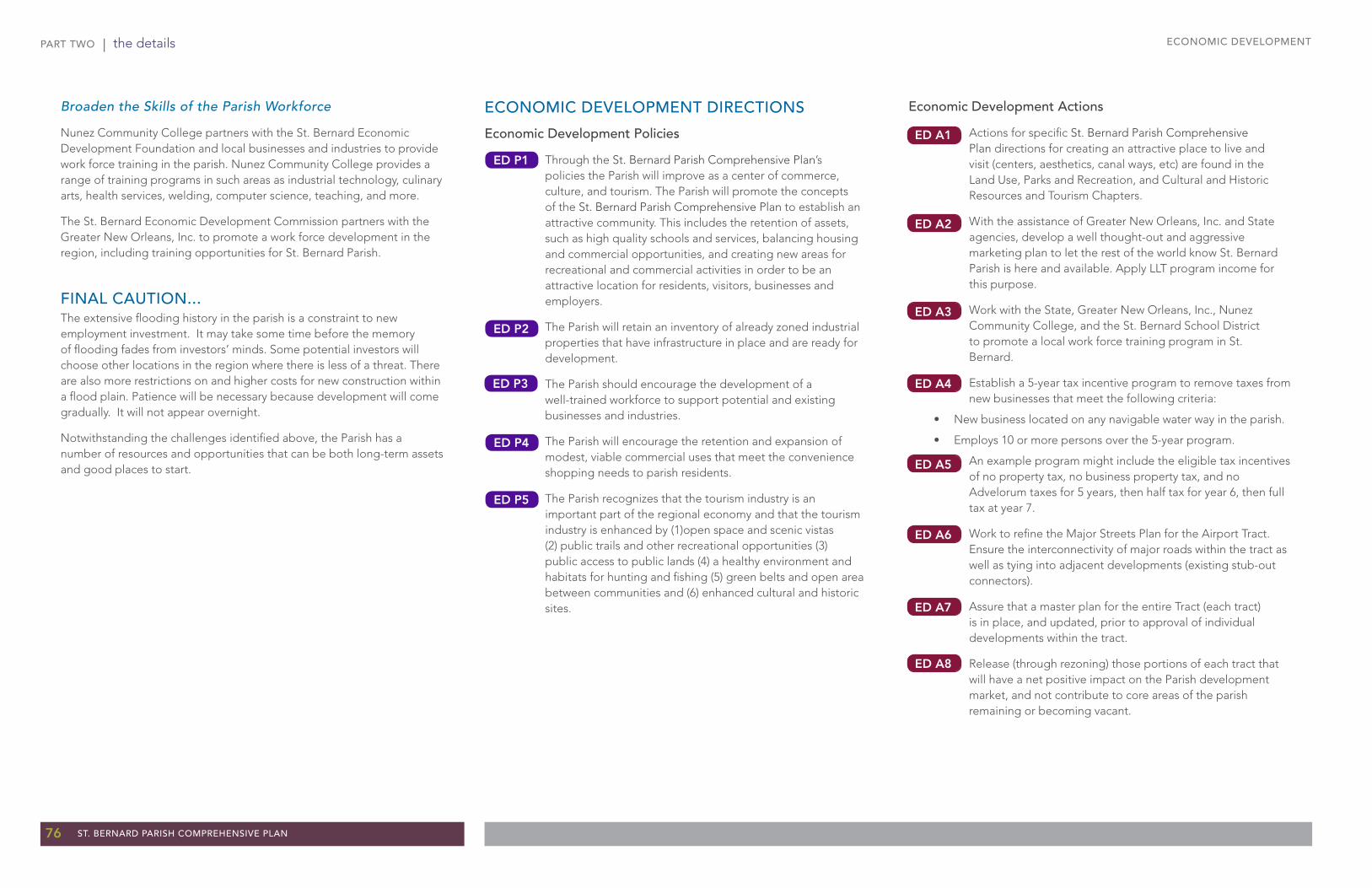
PART TWO | the details
76 ST. BERNARD PARISH COMPREHENSIVE PLAN
ECONOMIC DEVELOPMENT
ECONOMIC DEVELOPMENT DIRECTIONS
Economic Development Policies
Through the St. Bernard Parish Comprehensive Plan’s policies the Parish will improve as a center of commerce, culture, and tourism. The Parish will promote the concepts of the St. Bernard Parish Comprehensive Plan to establish an attractive community. This includes the retention of assets, such as high quality schools and services, balancing housing and commercial opportunities, and creating new areas for recreational and commercial activities in order to be an attractive location for residents, visitors, businesses and employers.
The Parish will retain an inventory of already zoned industrial properties that have infrastructure in place and are ready for development.
The Parish should encourage the development of a well-trained workforce to support potential and existing businesses and industries.
The Parish will encourage the retention and expansion of modest, viable commercial uses that meet the convenience shopping needs to parish residents.
The Parish recognizes that the tourism industry is an important part of the regional economy and that the tourism industry is enhanced by (1)open space and scenic vistas (2) public trails and other recreational opportunities (3)public access to public lands (4) a healthy environment and habitats for hunting and fishing (5) green belts and open area between communities and (6) enhanced cultural and historic sites.
Economic Development Actions
Actions for specific St. Bernard Parish Comprehensive Plan directions for creating an attractive place to live and visit (centers, aesthetics, canal ways, etc) are found in the Land Use, Parks and Recreation, and Cultural and Historic Resources and Tourism Chapters.
With the assistance of Greater New Orleans, Inc. and State agencies, develop a well thought-out and aggressive marketing plan to let the rest of the world know St. Bernard Parish is here and available. Apply LLT program income for this purpose.
Work with the State, Greater New Orleans, Inc., Nunez Community College, and the St. Bernard School District to promote a local work force training program in St. Bernard.
Establish a 5-year tax incentive program to remove taxes from new businesses that meet the following criteria:
• New business located on any navigable water way in the parish.
• Employs 10 or more persons over the 5-year program.
An example program might include the eligible tax incentives of no property tax, no business property tax, and no Advelorum taxes for 5 years, then half tax for year 6, then full tax at year 7.
Work to refine the Major Streets Plan for the Airport Tract. Ensure the interconnectivity of major roads within the tract as well as tying into adjacent developments (existing stub-out connectors).
Assure that a master plan for the entire Tract (each tract) is in place, and updated, prior to approval of individual developments within the tract.
Release (through rezoning) those portions of each tract that will have a net positive impact on the Parish development market, and not contribute to core areas of the parish remaining or becoming vacant.
Broaden the Skills of the Parish Workforce
Nunez Community College partners with the St. Bernard Economic Development Foundation and local businesses and industries to provide work force training in the parish. Nunez Community College provides a range of training programs in such areas as industrial technology, culinary arts, health services, welding, computer science, teaching, and more.
The St. Bernard Economic Development Commission partners with the Greater New Orleans, Inc. to promote a work force development in the region, including training opportunities for St. Bernard Parish.
FINAL CAUTION...The extensive flooding history in the parish is a constraint to new employment investment. It may take some time before the memory of flooding fades from investors’ minds. Some potential investors will choose other locations in the region where there is less of a threat. There are also more restrictions on and higher costs for new construction within a flood plain. Patience will be necessary because development will come gradually. It will not appear overnight.
Notwithstanding the challenges identified above, the Parish has a number of resources and opportunities that can be both long-term assets and good places to start.
ED A7
ED A6
ED A8
ED P1
ED P2
ED P4
ED P5
ED A5
ED A4
ED A3
ED A2
ED A1
ED P3

Appendices

78 ST. BERNARD PARISH COMPREHENSIVE PLAN
APPENDICES APPENDICES

ST. BERNARD PARISH COMPREHENSIVE PLAN 79
APPENDICESAPPENDICES
A. PREVIOUS PLANS FOR ST. BERNARD PARISH 80
B. ST. BERNARD PARISH 10-YEAR DISTRIBUTION OF FAIR HOUSING GOALS & DATA CHARTS 82
C. SUMMARY OF PREVIOUS TRANSPORTATION NETWORK PLANNING 84
D. THE PLANNING PROCESS
90
E. ON-LINE SURVEY RESULTS
92
F. COASTAL ZONE MANAGEMENT PROGRAM POLICIES AND IMPLEMENTATION TASKS 97
G. THE ST. BERNARD PARISH LAND USE & TRANSPORTATION VISION PLAN: VISION, GOALS & ACTIONS 99
H. ST. BERNARD PARISH: POPULATION, EMPLOYMENT, AND THE LOCAL BUDGET 101
I. ST. BERNARD PARISH COMPREHENSIVE PLAN AMENDMENT PROCEDURES 105
Appendices - Table of Contents
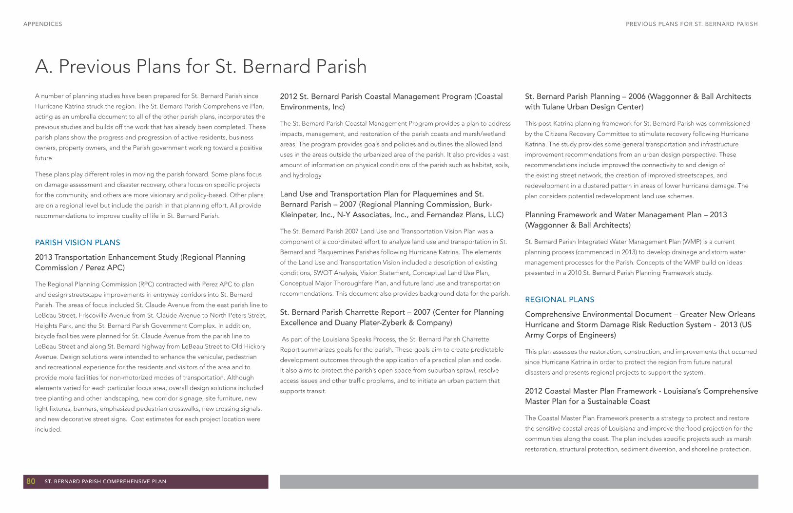
80 ST. BERNARD PARISH COMPREHENSIVE PLAN
APPENDICES PREVIOUS PLANS FOR ST. BERNARD PARISH
A. Previous Plans for St. Bernard ParishA number of planning studies have been prepared for St. Bernard Parish since
Hurricane Katrina struck the region. The St. Bernard Parish Comprehensive Plan,
acting as an umbrella document to all of the other parish plans, incorporates the
previous studies and builds off the work that has already been completed. These
parish plans show the progress and progression of active residents, business
owners, property owners, and the Parish government working toward a positive
future.
These plans play different roles in moving the parish forward. Some plans focus
on damage assessment and disaster recovery, others focus on specific projects
for the community, and others are more visionary and policy-based. Other plans
are on a regional level but include the parish in that planning effort. All provide
recommendations to improve quality of life in St. Bernard Parish.
PARISH VISION PLANS
2013 Transportation Enhancement Study (Regional Planning Commission / Perez APC)
The Regional Planning Commission (RPC) contracted with Perez APC to plan
and design streetscape improvements in entryway corridors into St. Bernard
Parish. The areas of focus included St. Claude Avenue from the east parish line to
LeBeau Street, Friscoville Avenue from St. Claude Avenue to North Peters Street,
Heights Park, and the St. Bernard Parish Government Complex. In addition,
bicycle facilities were planned for St. Claude Avenue from the parish line to
LeBeau Street and along St. Bernard highway from LeBeau Street to Old Hickory
Avenue. Design solutions were intended to enhance the vehicular, pedestrian
and recreational experience for the residents and visitors of the area and to
provide more facilities for non-motorized modes of transportation. Although
elements varied for each particular focus area, overall design solutions included
tree planting and other landscaping, new corridor signage, site furniture, new
light fixtures, banners, emphasized pedestrian crosswalks, new crossing signals,
and new decorative street signs. Cost estimates for each project location were
included.
2012 St. Bernard Parish Coastal Management Program (Coastal Environments, Inc)
The St. Bernard Parish Coastal Management Program provides a plan to address
impacts, management, and restoration of the parish coasts and marsh/wetland
areas. The program provides goals and policies and outlines the allowed land
uses in the areas outside the urbanized area of the parish. It also provides a vast
amount of information on physical conditions of the parish such as habitat, soils,
and hydrology.
Land Use and Transportation Plan for Plaquemines and St. Bernard Parish – 2007 (Regional Planning Commission, Burk-Kleinpeter, Inc., N-Y Associates, Inc., and Fernandez Plans, LLC)
The St. Bernard Parish 2007 Land Use and Transportation Vision Plan was a
component of a coordinated effort to analyze land use and transportation in St.
Bernard and Plaquemines Parishes following Hurricane Katrina. The elements
of the Land Use and Transportation Vision included a description of existing
conditions, SWOT Analysis, Vision Statement, Conceptual Land Use Plan,
Conceptual Major Thoroughfare Plan, and future land use and transportation
recommendations. This document also provides background data for the parish.
St. Bernard Parish Charrette Report – 2007 (Center for Planning Excellence and Duany Plater-Zyberk & Company)
As part of the Louisiana Speaks Process, the St. Bernard Parish Charrette
Report summarizes goals for the parish. These goals aim to create predictable
development outcomes through the application of a practical plan and code.
It also aims to protect the parish’s open space from suburban sprawl, resolve
access issues and other traffic problems, and to initiate an urban pattern that
supports transit.
St. Bernard Parish Planning – 2006 (Waggonner & Ball Architects with Tulane Urban Design Center)
This post-Katrina planning framework for St. Bernard Parish was commissioned
by the Citizens Recovery Committee to stimulate recovery following Hurricane
Katrina. The study provides some general transportation and infrastructure
improvement recommendations from an urban design perspective. These
recommendations include improved the connectivity to and design of
the existing street network, the creation of improved streetscapes, and
redevelopment in a clustered pattern in areas of lower hurricane damage. The
plan considers potential redevelopment land use schemes.
Planning Framework and Water Management Plan – 2013 (Waggonner & Ball Architects)
St. Bernard Parish Integrated Water Management Plan (WMP) is a current
planning process (commenced in 2013) to develop drainage and storm water
management processes for the Parish. Concepts of the WMP build on ideas
presented in a 2010 St. Bernard Parish Planning Framework study.
REGIONAL PLANS
Comprehensive Environmental Document – Greater New Orleans Hurricane and Storm Damage Risk Reduction System - 2013 (US Army Corps of Engineers)
This plan assesses the restoration, construction, and improvements that occurred
since Hurricane Katrina in order to protect the region from future natural
disasters and presents regional projects to support the system.
2012 Coastal Master Plan Framework - Louisiana’s Comprehensive Master Plan for a Sustainable Coast
The Coastal Master Plan Framework presents a strategy to protect and restore
the sensitive coastal areas of Louisiana and improve the flood projection for the
communities along the coast. The plan includes specific projects such as marsh
restoration, structural protection, sediment diversion, and shoreline protection.
ST. BERNARD PARISH COMPREHENSIVE PLAN 81
APPENDICESPREVIOUS PLANS FOR ST. BERNARD PARISH
Regional Planning Commission Priority Roadway Improvements Metro New Orleans – 2012 (Regional planning Commission - Transportation Improvement Program – New Orleans Urbanizing Area – Fiscal Years 2013-16)
This State document presents the state roadway improvements planned for
the New Orleans metropolitan area. The Transportation Improvement Program
consists of a priority list of projects (both highway and transit) which are being
advanced toward construction over the four year period FFY-13 to FFY-16.
Projects found in the Transportation Improvements Program have evolved
through the transportation planning process and are contained in the region’s
long-range Metropolitan Transportation Plan.
Metropolitan Transportation Plan – New Orleans Urbanized Area – Fiscal Years 2011 – 2040 (Regional Planning Commission)
This plan presents the record of proposed transportation – road, trail, bridge,
transit, etc. - projects in the New Orleans metropolitan area, including some
projects in St. Bernard Parish. It identifies prioritization of projects, funding
sources, project status, and the time frame for the completion of funded projects.
Long Term Community Recovery (LTCR) – 2007
The LTCR Plan, or the Parish Planning Tool for the Louisiana Recovery Authority’s
(LRA) Louisiana Speaks Planning Process was a short term recovery tool for the
Parish. Goals identified in that planning process include those presented in the
2007 Land Use and Transportation Plan. Goals included creating new public open
spaces throughout the parish, restoring landscaping and vegetation along public
corridors and in public spaces, updating land use and development regulations,
and improving the transportation network.
Transit Plan for the Greater New Orleans Region – 2007
This document includes Orleans, Jefferson, and St. Bernard Parishes and
presents a plan for the re-establishment of a broader level of transit services
in the post-Katrina era. The report includes information on demographics,
transit service demand, transit service standards, and operations plan; makes
recommendations for short, mid, and long-term operations; and coordinates
opportunities for the various transit providers and parishes.
2005 New Orleans Metropolitan Bicycle and Pedestrian Plan - 2006 (Regional Planning Commission for Jefferson, Orleans, Plaquemines, St. Bernard, and St. Tammany Parishes)
The New Orleans Metropolitan Bicycle and Pedestrian Plan reviewed existing
conditions in the region for pedestrians and bicyclists and laid out policies
and programs to promote and support increased pedestrian and bicycle
transportation and safety. Many of the recommendations from this report are now
being implemented by the Greater New Orleans Pedestrian & Bicycle Program.
FEMA Interim Recovery Planning - 2006 (The Federal Emergency Management Agency, FEMA)
This document provided technical assistance to the recovery planning process
in a variety of sectors, including: population and economic recovery, principles
and planning, flood protection and coastal restoration, transportation and
infrastructure, land recovery, and design guidelines. The plan documented
the damage caused by Hurricane Katrina and Rita and developed a resource
“toolbox” of mechanisms to achieve a preferred recovery scenario in the least
damaged areas.

82 ST. BERNARD PARISH COMPREHENSIVE PLAN
APPENDICES ST. BERNARD PARISH 10-YEAR DISTRIBUTION OF FAIR HOUSING GOALS & DATA CHARTS
B. St. Bernard Parish 10-Year Distribution of Fair Housing Goals & Data Charts
Figure 115: Fair Housing targets. (source: cbz, LLC)
Figure 116: Race/ethnicity of renters by parish and place in 2000 & 2010. (source: 2000 and 2010 Census, czbLLC)
Figure 117: Race/ethnicity of owners by parish and place in 2000 & 2010. (source: 2000 and 2010 Census, czbLLC)
The following presents the data reviewed while preparing the Fair Housing Chapter. The data sources include czb, LLC, the 2000 U.S. Census, the 2010 U. S. Census, and the 2011 American Community Survey 3-Year Estimates.

ST. BERNARD PARISH COMPREHENSIVE PLAN 83
APPENDICESST. BERNARD PARISH 10-YEAR DISTRIBUTION OF FAIR HOUSING & DATA CHARTS
Figure 118: Median household income by parish in 2000 & 2011. (source: 2000 Census, 2011 American Community Survey 3-Year Estimates, czbLLC)
Figure 119: Median value by parish in 2000 & 2011. (source: 2000 Census, 2011 American Community Survey 3-Year Estimates, czbLLC)
Figure 120: Breakdown of rental units per structure in 2000 & 2011. (source: 2000 Census, 2011 American Community Survey 3-Year Estimates, czbLLC)
Figure 121: Percentage of owners vs. renters by race/ethnicity by parish and compared to the New Orleans Metropolitan Statistical Area (MSA) in 2010. (source: 2010 Census, czbLLC)
Figure 122: Percentage of owners vs. renters by race/ethnicity & by area within St. Bernard Parish vs. the New Orleans Metropolitan Statistical Area (MSA) in 2010. (source: 2010 Census, czbLLC)
Figure 123: Gap difference in owners vs. renters by race/ethnicity & by parish vs. that of the New Orleans Metropolitan Statistical Area (MSA) in 2010 (source: 2010 Census, czbLLC)
Figure 124: Gap difference in owners vs. renters by race/ethnicity & by area within St. Bernard Parish vs. that of the New Orleans Metropolitan Statistical Area (MSA) in 2010.(source: 2010 Census, czbLLC)

84 ST. BERNARD PARISH COMPREHENSIVE PLAN
APPENDICES
C. Summary of Previous Transportation Network PlanningROAD SYSTEM PLANS
In the various plans described below, the recommendations have focused on
maintenance and safety improvements, with only a few significant changes to the
roadway system itself.
State Plans
2011-2014 Transportation Improvement Program
The following are key aspects of the 2011 - 20114 Transportation Improvement
Plan.• Intersection improvements at Judge Perez and Paris Road and at LA 39
and LA 47.
• Safety improvements and drainage along St. Bernard Highway.
• Cleaning and painting of the Bayou La Loutre Bridge.
• A replacement of the Reggio Canal Bridge near Hopedale.
2012 Regional Planning Commission Priority Roadway Improvements Report
Two road projects cover approximately 5.5 miles of roadway: • The Packenham – Jackson Rehabilitation project. $5 million project
funded with STP Attributable with a local match. The project is in the final design stage. The project focuses on the stretches of Packenham Drive and Jackson Boulevard between Judge Perez Drive and St. Bernard Highway.
• St. Bernard Road Rehabilitation Program. This project, also estimated at $5 million, is underway and funded with RPC / STP monies with a DOTD match. The project includes the rehabilitation of several road sections including stretches of Packenham Drive, Palmisano Boulevard, W. Genie and Patricia Streets, and Mehle, Aycock, and Friscoville Avenues.
The 2040 Metropolitan Transportation Plan
This plan includes the proposed construction of the Florida Avenue Bridge over
the Industrial Canal with an arterial extension to Paris Road*. The route connects
to Elysian Fields and I-610 on the New Orleans side. The four lane section would
then taper to two lanes in St. Bernard Parish to Paris Road (LA 47). Though funds
are not committed to the project, the identified funding would come from the
TIMED program, Parish funding, and the STP>200k program. At this point a cost
of $25 million per year for ten years has been identified. The project is proposed
to be built in phases. The bridge is not necessarily the first phase.
The project is being reassessed by Parish officials and the LaDOTD and the
project extent and design may change pending the recommendation of
LaDOTD’s reassessment. At the time of this report the environmental study on
the Florida Avenue Bridge was to be re-opened within a year or two. For the
most part the older concepts have been discarded. The concepts that will be
under discussion have the new roadway at grade on the south side of the levee,
extending to Paris Road.
Parish Plans
The Waggonner and Ball Report - St. Bernard Planning
The following are key aspects of the Waggonner and Ball report.• Extension of Florida Road along the canal*.
• A reinforced “ladder” (grid) of public streets as a continuation of the New Orleans street/neighborhood pattern and of the scale and order of Louisiana, Napoleon, and Jefferson Avenues in New Orleans (an avenue or boulevard design).
• Rights-of-way for new or improved local and arterial streets needed to reduce block length that should be acquired before private redevelopment efforts are expanded.
• Integrating the street system with the parks, open space, and canal system to form an overall storm management framework.
• Streetscape improvements to the commercial corridors to promote alternative modes of transportation and a more pedestrian friendly environment.
The Louisiana Speaks St. Bernard Parish Charrette Report
The follwing are key aspects of the St. Bernard Parish Charrette Report.• A new transportation policy for the Parish to provide an array of
transportation choices and efficient transit connections to New Orleans.
• Streetscape improvements to the commercial corridors to promote alternative modes of transportation and a more pedestrian friendly environment.
St. Bernard Parish Land Use and Transportation Vision Plan
The Land Use and Transportation Vision Plan highly recommends: • The adoption of policy for integration of bicycling and walking into the
transportation system.
• The need for funding and project prioritization.
• Creation of specifications and guidelines.
• The establishment of benchmarking goals and tracking progress.
• Participation, review, and consensus on proposed route planning.
• Establishment of a Bicycle and Pedestrian Advisory Committee (BPAC) - a forum for citizens to review and make recommendations on all projects and policies in regards to their impact on the walking and bicycling environment of the community.
• Creating 34 miles of bicycle routes, at an estimated cost of $1.25 million, to take advantage of funding for non-motorized transportation in the Federal transportation legislation. These routes, developed by the Regional Planning Commission, University of New Orleans, the Louisiana Public Health Institute, and the City of New Orleans were recommended to be reviewed and adopted (or modified and adopted) by St. Bernard Parish Government.
The plan also recommends the adoption of a “Complete Street” policy .
Compete Streets are those that are designed and operated to enable safe access
for all users: drivers, transit riders, pedestrians, and bicyclists of all ages and
abilities. The plan outlines steps to realizing a Complete Street system:• All public agencies would integrate walking and bicycling into their
transportation systems.
• Incorporation of pedestrian and bicycle features into all future projects.
• A prioritization strategy to guide pedestrian- and bicycle-specific projects to address existing deficiencies.
• Creating plans, guidelines and specifications in order to construct safe, consistent and high quality facilities that meet the established best practices.
• Set benchmark goals and track progress to determine if the policies and projects are achieving the goals.
SUMMARY OF PREVIOUS TRANSPORTATION NETWORK PLANNING
* These concepts are not supported in this comprehensive plan.

ST. BERNARD PARISH COMPREHENSIVE PLAN 85
APPENDICESSUMMARY OF PREVIOUS TRANSPORTATION NETWORK PLANNING
Figure 125: The 2007 Land Use and Transportation Vision Plan proposed future land use. (source: 2007 St. Bernard Parish Land Use and Transportation Vision Plan)

86 ST. BERNARD PARISH COMPREHENSIVE PLAN
APPENDICES SUMMARY OF PREVIOUS TRANSPORTATION NETWORK PLANNING
The Land Use and Transportation Plan recommends street sections to
accommodate a Complete Street (which would require revising the standards in
the suburban-oriented Subdivision Ordinance). The complete recommendation
follows:
Over the last 15 years, a renewed interest in pedestrian and bicycle
needs has taken hold in transportation planning as communities seek to
create an environment that meets the transportation needs of all users.
This renewed focus has been demonstrated in the last three federal
transportation bills: the Intermodal Surface Transportation Efficiency
Act of 1991 (ISTEA), the 1998 Transportation Equity Act for the 21st
Century (TEA‐21), and the 2005 Safe, Accountable, Flexible, Efficient
Transportation Equity Act: A Legacy for Users (SAFETEA‐LU); the 1998
Louisiana Statewide Bicycle and Pedestrian Master Plan; and the Regional
Planning Commission’s 2005 New Orleans Metropolitan Bicycle and
Pedestrian Plan. Communities around the country have used the federal
legislation and their equivalent state and regional plans as a foundation
for developing policies, plans and design guidelines with the goal of
becoming more “walkable” and “bicycleable.”
In the wake of Hurricane Katrina, St. Bernard Parish faces the challenge
of rebuilding, but also has an opportunity to embrace progressive non‐
motorized concepts that will produce a better community for the people
of the Parish. Creating a safe and efficient transportation system for
all users will reinvigorate communities, create economic development
opportunities, stimulate sustainable development, and improve the
quality of life.
US Department of Transportation Policy
The first step to improved pedestrian and bicycle infrastructure is
to adopt a strong policy regarding transportation projects. “Design
Guidance Accommodating Bicycle and Pedestrian Travel,” a United
States Department of Transportation (USDOT) document published in
2000, established a clear policy statement with the intent that all public
agencies would adopt the policy to integrate walking and bicycling into
Figure 126: The 2007 Land Use and Transportation Plan Future Transportation Network Map. (source: 2007 St. Bernard Parish Land Use and Transportation Vision Plan)
¾¾½
¾¾½
¾¾½
¾¾½
¾¾½
¾¾½
¾¾½
¾¾½
¾¾½
¾¾½¾¾½
¾ ¾½
¾¾½
¾¾½
¾¾½
St. Bernard Highway
St. Bernard Highway
Judge Perez Drive
Judge Perez Drive
Coug
ar/N
orto
n
Coug
ar/N
orto
n
Pake
nham
Driv
e
Pake
nham
Driv
e
Patricia Avenue
Patricia Avenue
Meh
leAv
enue
Meh
leAv
enue
Frisc
ovill
e Ave
nue
Frisc
ovill
e Ave
nue
Paris
Road
Paris
RoadSt. Bernard Highway
St. Bernard Highway
Genie Street
Genie StreetPa
lmisa
no
Palm
isano
St Bernard Hwy
St Bernard HwyJudge Perez Drive
Judge Perez Drive
Archbish
opHan
nande Bou
chel
Archbish
opHan
nande Bou
chel
ColonialColonial
St. Bernard ParkwaySt. Bernard Parkway
Port
Port
Port
\\Ferry
Figure No. 5-7
CitationProduced by: Burk-Kleinpeter, Inc in association with N-Y Associates andFernandez Plans, LLC for the Regional Planning Commission of Jefferson,Orleans, Plaquemines, St. Bernard and St. Tammany Parishes
July 2008
The United States Geological Survey (USGS) and the Regional PlanningCommission, Color Infrared Orthophotography of Louisiana, USGS (2004).Actual Photography acquired in Feruary, 2004. Data projected toUTM 15 NAD 83, unit of measure = meter. Pixel size is approximately 1 meter.Images enhanced by the Regional Planning Commission. Originator of mosaic:U.S. Department of Agriculture, Natural Resources Conservation ServicePublication_Date: 20050902. Title: Orthophoto Mosaicfor New Orleans Area, Louisiana
Future TransportationNetwork
¯
Legend
0 1 2 3 4Miles
St. Bernard HighwaySt. Bernard Highway
Bayou RoadBayou Road
Data Source (s):Imagery:
Existing Major Street Network
Major Arterial
Minor Arterial
Rural Minor Arterial
Collector Street
Rail
¾¾½ Bike Routes
Port Facilities

ST. BERNARD PARISH COMPREHENSIVE PLAN 87
APPENDICESSUMMARY OF PREVIOUS TRANSPORTATION NETWORK PLANNING
their transportation systems.
This policy states “bicycling and walking facilities will be incorporated
into all transportation projects unless exceptional circumstances exist.”
The allowed exceptions are situations where bicyclists and pedestrians
are prohibited, when cost of accommodation exceeds 20% of the project
costs or where factors indicate an absence of need.
Adopting and implementing this federal policy guideline will allow St.
Bernard to begin a transformation of its public right of ways through
the routine incorporation of pedestrian and bicycle infrastructure into all
projects.
Building on the above policy is the Complete Streets concept, which
are streets designed and operated to enable safe access for all users:
drivers, transit riders, pedestrians, and bicyclists of all ages and abilities.
When planning transportation projects, the entire right of way should be
designed in a manner that is appropriate to local context and needs and
allows all users to move along and across the street.
Complete Streets
A strong Complete Streets policy sets numerous goals and outcomes,
but maintains flexibility that will allow context sensitive solutions for all
roads. An effective policy addresses the following:
• Specifies all users as including drivers, transit users, pedestrians and
bicyclists of all ages and abilities
• Creates a comprehensive and connected network within the
community and to neighboring communities
• Acknowledges need for flexibility to meet the needs of different
streets and users
• Applies to new construction and reconstruction and covers the entire
process; planning, design, maintenance and operations
• Establishes specific exceptions and procedures for allowing exceptions
• Establishes performance measurable benchmarks
• Requires the use of best practice design standards
• Requires context sensitive design and implementation.
National research has identified numerous benefits to communities
from the implementation of Complete Streets. The Federal Highway
Administration (FWHA) found that Complete Street design elements can
reduce pedestrian risk by 28%. Complete Streets also serve to improve
public health and can serve as a means to combat childhood obesity. A
recent study found that 43% of people with safe places to walk within
10 minutes of their home meet recommended daily activity levels, as
compared to only 27% of people when safe locations were not nearby.
Prioritization
In addition to the incorporation of pedestrian and bicycle features into
all future projects, a prioritization strategy can be developed to guide
pedestrian and bicycle specific projects to address existing deficiencies.
This prioritization can be developed by dividing the community into
smaller segments with overlapping priority zones. These zones are
defined as a set radius around public amenities and commercial areas.
The areas where these priority zones overlap will then guide the
prioritization of limited resources to maximize benefit.
Develop Design Guidelines and Specifications
Once the broad policy initiatives and goals are established, the task shifts
to creating plans, guidelines and specifications in order to construct
safe, consistent and high quality facilities that meet the established best
practices. These documents can and should be created in partnership
with other agencies such as the Louisiana Department of Transportation
and Development and the Regional Planning Commission. This will allow
St. Bernard to build on the work already being done within these partner
agencies and promote consistent policies and standards throughout the
region. Working with DOTD is particularly important in St. Bernard, as
many of the Parish’s main arterials are state highways.
Advisory Committee
The establishment of clear guidelines and standards will prevent
oversights in projects that may result in a harmful effect on the
pedestrian and bicycle environment. Such guidelines can address a wide
range of topics including: the placement of rumble strips on highways;
crosswalk treatments; lane widths and reallocation of lane space to
various users ; and the required number and placement of bicycle racks
to name a few. This process can also develop documents that serve as
outreach and education to the general public on pedestrian and bicycle
issues. For example, New Orleans and Chicago are just two of the cities
that have developed materials that discuss the different types of bicycle
facilities: bicycle lanes, shared lanes, unmarked routes and shared use
trails. The process to develop these plans and guidelines should involve
the input and participation of the Bicycle and Pedestrian Advisory
Committee, as discussed in the next section.
The establishment of a Bicycle and Pedestrian Advisory Committee
(BPAC) provides a forum for citizens to review and make
recommendations on all projects and policies in regards to their impact
on the walking and bicycling environment of the community. The
committee would be comprised of citizen members, reviewed by Parish
staff and confirmed by Parish leaders. The Committee would review
and comment on all projects within the parish that effect pedestrians
and bicyclists; review and comment on plans, guidelines, manuals and
programs that effect pedestrians and bicyclists; and serve as a watchdog
off any dedicated pedestrian and bicycle funding.
In addition to establishing a Committee for the Parish, St. Bernard should
also be represented on the Regional Planning Commission’s Bicycle
and Pedestrian Advisory Committee which will be organized within the
next year. The existence of both the St. Bernard BPAC and RPC BPAC
will allow coordination and input on projects sponsored by all levels of
government.
Benchmarking
The implementation of these policies is based on the goals of increasing
safety for pedestrians and bicyclists and to encourage growth in the
number of pedestrians and bicyclists by offering more transportation
choices. Benchmark goals must be set and progress tracked to determine
if the policies and projects are achieving the goals. These benchmarks
should at the least include goals for crash reductions and for increases
in mode share. The crash reduction benchmark can be set at a 10%
reduction in crashes and fatalities over three years, which is in line with
the goals set in the RPC’s Metropolitan Master Plan. In 2007, there were
15 reported crashes involving pedestrians and bicyclists resulting in one
fatality and 15 injuries. A more complete review of crash data back to
1999 is available and should be analyzed along with population estimates
post‐Katrina to determine the appropriate baseline number of crashes
and fatalities.

88 ST. BERNARD PARISH COMPREHENSIVE PLAN
APPENDICES SUMMARY OF PREVIOUS TRANSPORTATION NETWORK PLANNING
Figure 127: 2007 St. Bernard Parish Land Use and Transportation Vision Plan recommended street sections. (source: 2007 St. Bernard Parish Land Use and Transportation Vision Plan)
The mode share refers to the percentage of total commuters that use a
particular form of transportation as their primary means of commuting.
Mode share benchmarks should seek increases in the transit, pedestrian
and bicycling modes which would result in a corresponding decrease in
the motor vehicle mode share. This shift would result in reductions in
congestion, travel time, and pollution for all users.
A reasonable goal is to double the percentages of transit, bicycle and
walking commuter in three years. As with the crash data, additional
analysis and review is necessary to determine appropriate baseline data
post‐Katrina.
An additional benchmarking exercise that reviews progress on the
non‐engineering issues of education, enforcement, encouragement
and evaluation is the League of American Bicyclist’s Bicycle Friendly
Community Program. The Parish can submit an annual application to the
program which will review the bicycling environment of the parish and
determine if St. Bernard meets the requirement of one of the four levels
of bicycle friendly communities. The application serves many purposes in
that it helps the Parish take stock of it bicycling environment, provides
feedback from the League to help guide future action and provides
positive media attention when a designation as a bicycle friendly
community is awarded to the community.
Preliminary Route Planning
In anticipation of a significant increase in non‐motorized funding in the
next federal transportation legislation the Regional Planning Commission,
University of New Orleans, Louisiana Public Health Institute and the City
of New Orleans prepared a proposal for a regional network of bicycle
routes. The proposal was prepared for inclusion in the Rails‐to‐Trails
Conservancy’s 2010 Campaign, which is seeking to expand the federal
Non‐motorized Transportation Program from four to forty cities in the
next federal transportation bill.
The proposal included nearly 34 miles of bicycle routes in St. Bernard
ST. BERNARD PARISH COMPREHENSIVE PLAN 89
APPENDICESSUMMARY OF PREVIOUS TRANSPORTATION NETWORK PLANNING
Parish at an estimated cost of $1.25 million. These routes consist of a
combination of bicycle lanes and shared lanes on major roads from Arabi to
Caernarvon. A table of the included routes can be found at the end of this
chapter. This proposal can serve as a framework for a future comprehensive
parishwide bicycle route network accessible to all citizens of St. Bernard
Parish. Additionally, this proposal provides connectivity with neighboring
communities in New Orleans and Plaquemines Parish via road and ferry.
The actual treatments implemented on designated bicycle routes will take
shape in a variety of facility types depending on the characteristics of a
given road. These different facilities include bicycle lanes, shared lanes,
bicycle boulevards, wide shoulders, and shared use‐trails.
Conceptual Examples of Bicycle Facilities
There are a variety of bicycle facilities that should be considered when
building or upgrading a road to improve the bicycling environment.
The type of facility to choose is based on a variety of factors such as
motor vehicle traffic volume and speed, roadway and lane widths, and
surrounding land use.
Summary
As the people of St. Bernard rebuild their community, creating a
transportation system that meets the needs of all citizens is crucial to the
future prosperity of the Parish. Establishing forward thinking policies and
embracing the national best practices in pedestrian and bicycle planning
and design will initiate a reinvention of the public right of way’s role in the
character of the community and the lives of its citizens. The incorporation
of pedestrian and bicycle infrastructure into the transportation network
will offer transportation options, improve safety, promote public health,
stimulate redevelopment of neighborhoods and commercial areas and
help set St. Bernard on a course towards sustainable development.
PEDESTRIAN AND BICYCLE PATH PLANS & ACTIVITIES
2001 Bicycle Plan for St. Bernard Parish
A 10-mile bicycle path built on a portion of the levee that would join levee paths
in Orleans and Jefferson Parishes, thus connecting St. Bernard Parish with other
parts of the New Orleans metro area. Designated bikeways in St. Bernard Parish
include: • Orleans/St. Bernard Parish line to Center Street
• Center Street to LA 47 (Paris Road)
• LA 47 to Lake Borgne Levee Administration Building
• Lake Borgne Levee District Administration building to Montelongo Lane
• Montelongo Lane to St. Bernard Parish/Plaquemines Parish line
The Waggonner and Ball Report- St. Bernard Planning
The Waggonner and Ball St. Bernard Planning document promotes an extended
path system adjacent to selected canals.
2011-2014 Transportation Improvement Program for St. Bernard Parish
A 2-mile section of multi-use path along St. Bernard Highway in Meraux south to
Caernarvon.
Current Parish Activities
The Parish is currently planning to build a portion of the Mississippi River Trail
as a 10’ wide asphalt path atop the river levee for several miles to the Violet
Canal and ship docks. The southernmost reach of the St. Bernard section is at St.
Bernard State Park located at the St. Bernard/Plaquemines Parish line.
Parish officials say they are progressing forward with the planned implementation
of the bicycle and pedestrian paths along the levee. According to the Plan, the
only two agencies within whose jurisdictions the potential Mississippi River Trail
crosses are the Parish government and the Lake Borgne Levee District. Parish
officials would prefer to enter into a joint-use agreement with the levee district
and then build and maintain routes through the Parish Public Works Department.
Though St. Bernard Parish has no specific bicycle plan or policy, Department
of Public Works officials have been supportive of the concept of alternative
transportation mainly for fitness and recreation as opposed to commuter
transportation.
TRANSIT PLANS
The Louisiana Speaks St. Bernard Parish Charrette Report
The Louisiana Speaks St. Bernard Parish Charrette Report recommends a streetcar
line from St. Bernard to downtown New Orleans. The route would begin near Paris
Road and run along Judge Perez Drive. A complement of 3 neighborhood specific
bus routes in Arabi and Chalmette would link to the streetcar line and feeder buses
would serve the south areas of the Parish.

90 ST. BERNARD PARISH COMPREHENSIVE PLAN
APPENDICES THE PLANNING PROCESS
D. The Planning ProcessThe development of the St. Bernard Parish Comprehensive Land Use Plan
occurred over the course of a year. This section describes the key points of the
process.
The kind of planning St. Bernard deserves is neither high handed nor deferential.
It is planning that co-evolves through a genuine partnership of planners,
analysts, and community developers working closely with residents, staff and
commissioners to find a way forward, together. Planned by residents alone, the
Parish will be hard-pressed to learn from the experiences of other communities.
Planned by experts working in a vacuum, recommendations are certain to be off
course. For this plan effort, the St. Bernard Parish Comprehensive Plan Team (the
Team) collected data using both the Team and residents, in order to match our
expertise in housing, land use, economic development, and other policies with
residents who are experts in living in the parish, using the land, and making the
parish economically viable.
The basis of the approach was a wide, targeted community outreach effort. The
outreach plan included:• Training of community volunteers.
• Appointment and continued interaction with a Steering Committee.
• Facilitated kitchen table discussions.
• Stakeholder and focus group discussions.
• Intercept surveys.
• Public meetings.
• Interactive project website.
• On-line survey.
The public outreach process included the series of events needed to encourage
residents to talk, inform, and train participants about choices and options, and
then to collectively devise a physical plan to reflect community values and grow
support for plans and policy recommendations. In the end, the goal was to build
consensus from an informed public that will outweigh objections from vocal
special interests, when such voices do not represent the broad community.
The Team began with the coordination of interested community volunteers and
trained these residents and business owners to help spread the word and gather
input during the plan process. This group also included Parish staff, the Steering
Committee, and interested members of the Parish Planning Commission and
Housing Redevelopment and Quality of Life Commission.
Early in the process the Team conducted kitchen table discussions. Kitchen table
discussions were an effective tool to give the Steering Committee, Planning
Commission and the Parish Council an “ear to the ground” regarding public
attitudes about the community, and to obtain feedback that will inform the
St. Bernard Parish Comprehensive Plan. The process was straight-forward:
invite neighbors, friends, and any other members of the community to have a
conversation about what is working, not working, and what they would like to see
in Saint Bernard Parish’s "big picture” future. Significant insights were shared,
unusual perspectives emerged, and there was generally a better appreciation for
how the “person-on-the-street” perceived, and cared about, the community.
Also early in the process, the Team convened small groups (stakeholder and
focus groups) for in-depth questioning to help identify issues and values. This
individual input was helpful in understanding and probing specific community
issues in greater depth than public meetings permit. Convening one or more
small groups for in-depth questioning, while not statistically representative of the
general public, is helpful in understanding the reasons behind the answers.
A project website was created and a web-based public opinion survey, though
not statistically valid, was conducted and found to be informative.
Two community-wide public meetings were held during the process. One was
held early in the process and served as a kick-off meeting. This meeting focused
on issues and values; shared what the Team heard from the community to date;
conveyed recent trends and developments leading to the need for the plan
and the plan process. A second community-wide meeting was held to review
potential future alternatives and gain feedback on the plan direction. A Fair
Housing Education component was incorporated into these meetings.
The Team worked closely with the Steering Committee, Housing Redevelopment
and Quality of Life Commission, Planning Commission, and Parish staff. The
Steering Committee was comprised of residents from the parish-at-large with
broad interests along with interested elected and appointed officials. The
Steering Committee helped identify issues and how to address them.
Major components of the plan were the housing market analysis and Housing
and Urban Development (HUD) housing needs assessment / housing analysis.
The housing market analysis and needs assessment included a detailed
review of the population and households by income, age, race, and tenure
compared to the existing housing stock by tenure, size, and value/cost. The
housing needs assessment reviewed recent housing development, local realtor
assessments, and regional projections for housing need. It also included in-depth
consideration of fair housing in the parish. The intention was to determine if and
how the housing stock in St. Bernard met the needs of St. Bernard’s population
and to identify any populations that were not adequately served by the existing
housing stock.
The economic development study and strategy provided a comprehensive
analysis of both macro and micro economic conditions in St. Bernard. This
included, with input from Parish finance department, providing an economic
base analysis about how the Parish, as a community and as a government,
was currently functioning economically and how those trends would progress
under current circumstances. The Team developed a concise description
and quantification of the parish economy that served as a basis for growth
projections, capital facility and service requirements, and estimates of long-term
land use needs. The analysis also served as a basis for future fiscal analyses of
alternative land use scenarios and implementation strategies and was used to
support other elements of the comprehensive planning process.
Regulatory standards (such as zoning and subdivision) and a comprehensive
review of Road Home and Louisiana Recovery Authority (LRA) lots were
conducted to ensure they complement the plan and future land use. The land
use assessment provided an inventory of existing land uses and the regulatory
framework.
With the information derived from the analyses and community outreach,
the plan was developed. The Steering Committee vetted the document then
forwarded the review to the Planning Commission. After review by the two
groups, the Team prepared the final document to present to the Planning
Commission for adoption and to the Parish Council for ratification.

ST. BERNARD PARISH COMPREHENSIVE PLAN 91
APPENDICESTHE PLANNING PROCESS
Figure 128: Over 250 residents participated at Public Meeting #1 to discuss community values and vision.
Figure 129: The community gathered again to talk strategies to reach the goals at Public Meeting #2. Figure 130: The Community Report Card exercise at Public Meeting #1 was used to rate various areas of community services and assets.
Figure 131: Residents meet with the Consultant Team and Steering Committee Members to discuss issues at several scheduled Kitchen Table Discussions.
Figure 132: Values workshop session during Community Meeting #1.
Figure 133: The St. Bernard Parish Comprehensive Plan website was used to inform the community about the status of the project during the process.
+
We’re currently drafting theplan with the SteeringCommittee; the public draft willbe available in late August.
Stay tuned!
WELCOME
This is the website for the 2012 – 2013 St. Bernard Parish Comprehensive Plan update. This
site is the primary location for you to learn about this project and how you can
get involved. This plan is your plan! We want your input so that the final plan reflects your
goals and is one that the people are firmly behind.
ATTEND COMMUNITY MEETINGS
A number of community meetings will be scheduled at key steps in the process as a means
for broad public comment. The meetings will range from “roll-up-the-sleeves” workshops to
NEWS by MILLISSA on MARCH 12, 2013
Community Meeting #2 DisplayBoards
Community Meeting #2 display
boards: Boards2
NEWS by MILLISSA on MARCH 12, 2013
Community Meeting #2PowerpointPresentation
SBP_PubMtg#2-v8
NEWS by MILLISSA on FEBRUARY 21, 2013
Parish assets! What are yourfavorites?
Some of our Parish assets!
St. BernardParish ComprehensivePlan Community Workshop
Recent News &Updates
Home All Updates & News Stay In Touch

92 ST. BERNARD PARISH COMPREHENSIVE PLAN
APPENDICES ON-LINE SURVEY RESULTS
E. On-line Survey ResultsST. BERNARD ON-LINE SURVEY
An on-line survey was conducted to gather public input in regard to choices and
decisions each family has made or may make when it comes to deciding where to
live, and why. The results would help inform community values in regard to living
in St. Bernard Parish. Despite the on-line survey effort, the response rate was
relatively low, therefore, the information was used qualitatively.
A comprehensive plan charts a community’s future direction by establishing
“rules” for how available land is used (for housing or industry) and how buildings
are designed (their density, height, and form). It describes what the community
wants and how it’s going to get there.
What options are realistic are profoundly influenced by the market. How much
is the community sought out as a place to live or to do business, relative to the
countless other choices around it? As a result, a major contribution that can be
made to this comprehensive planning process is to provide information about
choices and decisions families make or may make when it comes to deciding
where to live, and why. Understanding these choices helps planners grasp the
current state of the market and to predict how it may change over time.
A comprehensive plan is a document that establishes the direction for future
development activity in an area. It establishes the so-called “rules” for such
things as land use (the pattern of development residents desire to see), and
zoning (density, height, form). The land use part of a plan is the consensus
intention of the community. The zoning regulations are the binding requirements
that actually regulate use on a day in/day out basis. A good example is that the
land use part of the St. Bernard Parish Comprehensive Plan will state that a
certain part of the Parish is for housing, but not for industry. The zoning part is
more fine-grained, and regulates the kind of housing (single or multi-family), the
size of the residential buildings, density, and other elements such as massive,
set backs, side yard requirements, and so on). A comprehensive plan organizes
these many elements in a framework for making decisions.
While a plan at some level describes what the community wants, to be optimal,
it must coherently link together a great many variables in ways that result in the
community being the better for it. A good example is budgetary. A community
must be able to balance its budget. This is tax revenue (from fees, and from
sales taxes and property taxes) minus expenses (maintaining roads and sewers
and sidewalks and parks, for example). If the many obligations of a community
exceed its capacity to maintain them, amenities like parks become deteriorated,
or services like trash collection get curtailed.
Of course, these budgetary realities are not entirely shaped by what the
designated land uses are, nor what’s in the zoning or other regulations. Rather,
they are profoundly influenced by the market.
What “the market” in this case really means is how much a certain County or
Parish or City or Region is desired as a place to live or to do business in, in
comparison to the many other options that are available. This is perhaps the
most important and ironically most overlooked part of most comprehensive
planning efforts. Naturally, all of these go together. If the only allowed use is
housing, as is the case of vast parts of Suburban America, heavy industry cannot
be located in such places. If some housing is allowed but also some industry,
then the nature of the industry can impact the housing market.
There are literally hundreds of combinations of uses and regulations - present
or absent - that are in constant motion with respect to extremely fluid market
conditions at the household level (marriage and divorce, family expansion and
contraction, promotions and demotions, hirings and firings), at the business level
(startups and expansions, growth and bankruptcy, mergers and acquisitions), and
at wider state and regional levels (interest rates, area wide economic conditions,
weather).
The reasons a family makes decisions are important in two critical respects.
First they are in reaction to circumstances, and so the reaction is valuable to
understand. Having a good idea of “what” drive these reactions helps planners
grasp the factors that shape choice in an area. Second, they are influential,
and so a reaction today to something in place yesterday in turn shapes what
may happen tomorrow. Having a good idea of how these all fit together helps
planners predict what may result.
The answers to the questions contained in this survey are vitally important.
They are not intended to dive into private lives. They are designed to help the
consultant team design a planning framework that enables St. Bernard Parish
to thrive.
SURVEY QUESTIONS & RESPONSES
Thirty responses were received. The following are the results.
Where you live now
1. What is your street address? (Streets named in responses:)
• Charles Dr. • Gallo Dr. • Plaza Dr.
• N. River Park Dr. • Plaza Dr. • Perrin Dr.
• E. St. Bernard Highway • Acorn Dr. • Legend Dr.
• St. Bernard Highway • Lena Dr. • Farmsite
• Woods Dr. • Beaver Dr. • 6th St.
• Pamela Pl. West • Buffon St. • Corrine Dr.
• Lakewood Dr. • Corrine Dr. • Licciardi Ln.
• E. Claiborne Sq. • Acorn Dr. • Despaux Dr.
• Rose Ave. • Judy Dr. • Le Beau St.
• Acorn Dr. • Debouchel Blvd. • Judy Dr.
2. How Long have you loved there (in month and years)?
Duration ranges from 4 months to 57 years with the average time frame being
around 16 years.
3. What are the best parts about living on your street where you do?
Many responses indicated proximity to stores and roads and the nice neighbors
were positive aspects of their location. Responses are as follows:
• Great neighborhood and close location to many things such as grocery
stores, schools, gas stations, etc.
• I live close to family and friends. It is a close knit community. We are
all in the process of planting a tree canopy as well as gardens. We are
impatiently awaiting Nicosia’s Grocery Store to rebuild and re-open. We
have easy access to a nearby boat launch, the State Park and the Ferry.
ST. BERNARD PARISH COMPREHENSIVE PLAN 93
APPENDICESON-LINE SURVEY RESULTS
• Between and close to 2 major highways, close to river, city, businesses and
good neighbors
• It is relatively quiet and there are nice neighbors
• We know each other, we don’t feel like we are neighbors, we feel more like
family. Although most of the neighbors never returned after Katrina. The few
of us that came back make a perfect neighborhood.
• Great neighbors, nicer houses
• Peaceful, original owners, 10 out of 30 families rebuilt, we all know each
other for many years. We watched all of our children grow up and start their
families. Val Reiss Park is wonderful.
• Solitude
• Safe
• Quiet neighborhood. Predominantly owner occupied dwellings.
• Easy to locate for someone who doesn’t live in the parish & are not familiar
with the area.
• Cul de sac , so limited traffic - close to bus transportation to city- close to
CBD and all of New Orleans but in St. Bernard Parish. The neighbors take
pride in their property. Excellent fire and police protection.
• Open wooded area behind home with lake. Quiet. Neighbors are like family.
• Decent neighbors
• Was my father-in-law’s
• Neighbors are great
• Large lot size with a modest house (plenty of yard and garden space), quiet
neighborhood, not much traffic, friendly respecting neighbors.
• On the river
• Easy access to Judge Perez Dr., Paris Rd., etc.
• Peaceful
• Families
• Nice neighbors, quiet, proximity to mall, stores, etc.
• We are a close neighborhood. The families who chose to rebuild are
committed to keeping our street active and alive.
• Location, quiet
• Good neighbors
• Convenient to Chalmette, St. Claude Ave, close to CBD, safe and quiet
neighborhood
• It’s a good neighborhood
• Location to food, gas, small local stores
• Quiet and clean. Need families and things for kids to do. Re: pocket parks;
walking trails. Etc
4. What are the most significant immediate challenges on your street?
The top themes included vacant lots, unkept properties, street maintenance, and
poor drainage as immediate challenges. Responses are as follows:
• Keeping street lights working, finishing road repairs, and keeping crime out
of our neighborhood that we didn’t have before Katrina!
• Trying to advocate to everyone to participate in our tree canopy campaign as
well as our front entrance beautification project.
• Empty lots
• Constant foot traffic at all hours going to 24-hour convenience store on
neighboring corner
• Empty homes and empty lots that make our street look unattended not to
mention the rental properties.
• Vacant houses for sale which are not selling so they are rented.
• Having rental houses on my street, that owners used to live in before Katrina.
The lawns and houses are not kept up like they were before Katrina
• Industrial noise
• Streets
• Vacant lots in the area
• Heavy through traffic
• The steady rapid decline of the neighborhood due to the residents of the 50
apartments located directly behind my property - noise, trash, no respect for
the neighborhood, loud stereos, drugs.
• Unoccupied homes
• Drug users
• Renters
• Rentals to low income people
• Slow drainage during heavy storms
• Multiple dangerous accidents on highway
• Speeders, litter, unkept properties and pollutions from Valero
• Flooding and drainage
• Proximity to expanding hazardous refinery that does not adhere to local
codes
• Blight, animals
• Lack of neighbors
• None
• Blighted properties
• Would like trees planted along street to prevent parking cars
• Landlords are not keeping up their property.
• Many houses for sale and worry about blight
• Noise....mufflers on cars, vulgar music playing in cars late at night, garbage
guys leave can in street instead of putting it back where they got it from (they
are paid) causing traffic problems all day until someone gets home from work
to move it
5. What are the most significant long term challenges on your street?
Safety and improving neighborhood conditions (lots, houses, streets, etc) were
also top responses for long term challenges. Responses are as follows:
• Keeping our neighborhood SAFE for ALL! You must get to know who lives
around you and not having rental property in formally single-family areas
would help.
• Dealing with the empty vacant lots.
• Bringing back the neighborhood as it was.
• Vacant lot (only 1), house not finished rebuilding from Katrina
• We want our street to stay free of rental properties, we would like to see the
Parish Government keep their promises by fixing the sewerage and drainage
system.
• Selling empty houses so they are not rented.
• Who is going to buy all these lots in my neighborhood and can they just
build anything they want on it. I don’t know of anyone looking to move back
because of the uncertainty of St. Bernard.
• Expansion of refinery
• Keeping it safe
• Neighborhood redevelopment, with a sense of community
• Neighborhood upkeep
• The steady decline of the neighborhood from the apartments
• Patch-work street repairs will not hold up; unoccupied homes.
• Council keeps changing zoning to commercial
• Crime from Daniel Park
• Speeding
• The road is quite narrow, it would be nice to have just another foot of space.
Also, there is some turnover in housing, some lots were not redeveloped, but
otherwise not as concerned.
• Safety and lack of lighting
• Development
• Continued pattern of zoning changes from residential to either commercial
or industrial
• Clearing blighted houses, controlling animals, empty lot maintenance
• Valero refinery. They want to buy us all out and expand their refinery. We are
not allowing that to happen.

94 ST. BERNARD PARISH COMPREHENSIVE PLAN
APPENDICES ON-LINE SURVEY RESULTS
• Poor design. No good retail in walking distance. Pedestrian unfriendly
• Increased traffic
• Getting rid of blight
• Keep this subdivision drug free and family friendly
• Flooding in certain areas that has gotten worse after road work was done?
Also on Judge Perez where the street meets Judy Drive floods
6. Is your street one that is held in high regard in the Parish? (Answers are
the total of responses for each category.)
Yes - 5
Somewhat yes - 10
Somewhat no - 7
No - 3
Other - 4
7. How desirable is your street as a place to potentially move to in the
minds of families now living there? (Answers are the total of responses for
each category.)
Very desirable - 13
Somewhat desirable - 10
Somewhat not desirable- 4
Not desirable - 0
Other - 2
7a. How desirable is your street as a place to potentially move to in the
minds of families now living elsewhere in your neighborhood? (Answers are
the total of responses for each category.)
Very desirable - 8
Somewhat desirable - 9
Somewhat not desirable- 8
Not desirable -1
Other - 3
7b. How desirable is your street as a place to potentially move to in the
minds of families now living elsewhere in parish (not in your neighborhood)?
(Answers are the total of responses for each category.)
Very desirable - 7
Somewhat desirable - 8
Somewhat not desirable- 7
Not desirable -5
Other - 3
7ci. How desirable is your street as a place to potentially move to in the
minds of families now living outside of St. Bernard in the West Bank of
Jefferson? (Answers are the total of responses for each category.)
Very desirable - 6
Somewhat desirable - 5
Somewhat not desirable- 6
Not desirable -10
Other - 0
7cii. How desirable is your street as a place to potentially move to in the
minds of families now living outside of St. Bernard elsewhere in Jefferson?
(Answers are the total of responses for each category.)
Very desirable - 4
Somewhat desirable - 5
Somewhat not desirable- 7
Not desirable -11
Other - 4
7ciii. How desirable is your street as a place to potentially move to in
the minds of families now living outside of St. Bernard elsewhere in
Plaquemines? (Answers are the total of responses for each category.)
Very desirable - 7
Somewhat desirable - 10
Somewhat not desirable- 5
Not desirable -5
Other - 2
7civ. How desirable is your street as a place to potentially move to in
the minds of families now living outside of St. Bernard elsewhere in St.
Tammany?
(Answers are the total of responses for each category.)
Very desirable - 7
Somewhat desirable - 10
Somewhat not desirable- 5
Not desirable -5
Other - 2
7cv. How desirable is your street as a place to potentially move to in the
minds of families now living outside of St Bernard elsewhere in Orleans?
(Answers are the total of responses for each category.)
Very desirable - 7
Somewhat desirable - 9
Somewhat not desirable- 5
Not desirable -7
Other - 2
Market Value
1. How much do you think your home is worth if you had to sell it today?
Prices ranged from $60,000 to $330,000.
2. If you listed it, who do you think the most likely actual buyer would be?
Answers included a young couple, someone looking for an affordable home,
someone looking for a starter home, someone from around this area, single
person, young family, couple without children, middle income family, no idea,
and I am not selling my home.
3. If you listed it, where do you think the most likely actual buyer would
be moving from? (Answers are the total of responses for each category.)
St. Bernard - 10
Orleans - 8
Plaquemines - 2
Other - 4
I don’t know - 6
4. If such a transaction were to occur, say, tomorrow, why would that
buyer choose your house and your street?
Responses included nice neighbors, young neighborhood, proximity to roads
and city, quiet street, nice house, new construction, safety, well-kept lot, and
affordable house.
5. Where else would the buyer of your house be likely to also be looking
inside St. Bernard Parish?
Locations included Chalmette, Old Arabi, subdivisions off East Judge Perez,
Lexington, Buccanner Villa, Meraux, Emily Oaks, far from refinery, near high
school, and lower St. Bernard.

ST. BERNARD PARISH COMPREHENSIVE PLAN 95
APPENDICESON-LINE SURVEY RESULTS
6. If they were also looking outside St. Bernard, where would they be
likely to be looking?
Locations included Slidell, Metairie, West Bank, Kenner, Mid-City, Gentilly,
Covington, Lakeview, St. Tammany, North Shore, and rural west bank parishes.
Competition
1. Please rank the following Parishes from best to worst (with best =
1 and worst = 5) places to live according to the general consensus of the
region:
The ratings went from best to worst: St. Tammany, Jefferson, St. Bernard,
Orleans, Plaquemines
2. Please rank the following Parishes from best to worst (with best
= 1 and worst = 5) places to live in terms of home value and return on
investment:
The ratings went from best to worst: St. Tammany, Jefferson, St. Bernard,
Orleans, Plaquemines
3. Please rank the following Parishes from best to worst (with best = 1
and worst = 5) places to live in your own opinion:
The ratings went from best to worst: St. Bernard, St. Tamanny, Jefferson, Orleans,
Plaquemines
4. How would the average parishes rate St. Bernard Parish for each
characteristic on a scale of 1 to 10 (where 1 = Fantastic and 10 = Terrible)?
(Answers are the average of the responses.)
a. Residents of Jefferson Parish when it comes to…
i. Quality of life - 5.5
ii. Aesthetics - 6.5
iii. Home Value - 6
iv. Schools - 3.5
b. Residents of Orleans Parish when it comes to…
i. Quality of life - 6
ii. Aesthetics - 5.5
iii. Home Value - 5
iv. Schools - 2
c. Residents of Plaquemines Parish when it comes to…
i. Quality of life -5.5
ii. Aesthetics - 5
iii. Home Value - 5.5
iv. Schools - 1.5
d. Residents of St. Tammany Parish when it comes to…
i. Quality of life - 5.5
ii. Aesthetics - 7
iii. Home Value - 7
iv. Schools - 3.5
Direction
1. Is St. Bernard Parish headed in the right direction overall? (Answers
are the total of responses for each category.)
Yes - 3
Somewhat yes - 14
Somewhat no - 6
No - 12
Other - 3
2. Please rate the following in terms of value to the Parish’s future (1
being valuable and 10 being a terrible idea). (Answers are the average of
the responses.)
a. Building standards for homes - 1.5
b. Promotion of strip retail development - 4.5
c. Higher residential density in some areas to generate supports for
retail - 3.5
d. Big open spaces for water management and or parks and recreation
- 1.5
e. Clustered development of housing - 7
f. Reduction of heavy industry - 4.5
g. Aesthetic and architectural design guidelines - 1.5
h. Small retail shops (mom and pops) - 2.5
i. Big box retail - 4.5
j. Apartment buildings - 9.5
k. Golf courses - 5.5
l. Waterfront spaces for public use - 2
m. Development of the Riverfront - 2.5
n. Expansion of heavy industry - 5
o. Discouragement of strip retail development - 4
3. How important is “community” to St. Bernard? (Answers are the total
of responses for each category.)
Very important - 26
Somewhat important - 3
Somewhat not important - 1
Not important - 0
Other - 0
A Variety of Goals
1. Please rank from most to least important the following goals in your
opinion as regards the future of the Parish. Some of these intentionally
overlap. (Answers are the average of the responses.)
a. Stable (and possibly) rising home values (home values and equity) -
1.5
b. Environmental sustainability (how stable the ground is vis a vis rising
sea levels, how clean the water is, how clean the air is, how noisy the
environment is) - 1.5
c. Flood protection (how protected residents and businesses are for a
storm not as bad as Betsy or Katrina but way worse than Isaac) - 1.5
d. Sense of community (how it feels to be among neighbors) - 1.5
e. Quality of Life (the level of enjoyment life in Parish offers in terms of
amenities) - 1.5
f. Marketability (the amount the parish appeals to the wider market as
a place to invest in or move to or start a business in) - 1.5
g. Predictability (when a property is bought, the “rules” are known) -
2.5
h. Aesthetics of the buildings and streetscapes (how nice it looks) - 1.5
i. Other: no answers
2. If you could only pick three choices from the list below, which would
they be? (Answers are the totals of the responses for each category.)
a. Stable (and possibly) rising home values (home values and equity) -
18
b. Environmental sustainability (how stable the ground is vis a vis rising
sea levels, how clean the water is, how clean the air is, how noisy the
environment is) - 11
c. Flood protection (how protected residents and businesses are for
a storm not as bad as Betsy or Katrina but way worse than Isaac) - 19
d. Sense of community (how it feels to be among neighbors) - 6
e. Quality of Life (the level of enjoyment life in Parish offers in terms
of amenities) - 17
f. Marketability (the amount the Parish appeals to the wider market as
a place to invest in or move to or start a business in) - 6
g. Predictability (when a property is bought, the “rules” are known) - 1
h. Aesthetics of the buildings and streetscapes (how nice it looks) - 13
i. Other:
• More reliable leadership

96 ST. BERNARD PARISH COMPREHENSIVE PLAN
APPENDICES ON-LINE SURVEY RESULTS
• A residential community that is convenient to the New Orleans and
Northshore where a person could shop, dine, and seek entertainment
• Strip malls to mimic Elmwood Shopping Center (but improved),
farmer’s market to mimic small French Market, and streetscapes to mimic
Old Metairie Road.
3. When you consider the three you consider most essential, how hard will
it be, or easy, to achieve a consensus in the Parish in terms of building a land
use and zoning and economic development framework to achieve them?
Answers ranged from not difficult to very difficult although more responses
leaned toward not difficult. Responses are as follows:
• Not difficult at all. We want the parish we had before the federally caused
catastrophe KATRINA destroyed the wonderful place we had. That’s
ALL!!!!!!!!
• Not easy but possible. You have to follow Orleans Parish’s lead. Make
volunteering fun. For example, when I’m looking for people to help me paint,
I host a party and usually get a pretty good turnout. Everyone has a good
time and a lot of work gets accomplished. I got my whole house painted
in one day using this method. For example - A gardening committee; sell
donated food and drinks to the volunteers to pay for the products that will
be utilized on the next project and with a small startup and a good marketing
strategy the resources can be constantly replenished until the final product/
project is complete.
• Easy
• Stabilizing home values does not seem to be important to many people,
since they do not intend to sell or leave. This may make it difficult to garner
support for associated issues. Residents value flood protection, but there
seems to be little will to pay for it with local money. Residents appreciate
the beauty of the parish, but people here seem to hate the government,
and they loath taxes. It will be difficult in the future to finance beautification
projects.
• It would not be difficult to garner support for a residential based community.
At present the only reason people reside in St. Bernard Parish is that it is a
safe family-oriented residential area with good schools and ample outdoor
activities for all age groups. St Bernard Parish, like St. Tammany Parish, is a
bedroom community to Orleans Parish and development should reflect that
atmosphere.
• I think the first two are being addressed the third is being worked on.
• The community has been expressing their needs. Leadership just doesn’t
hear.
• Easy
• Not difficult, if the community truly want to prosper and be a community
again.
• Not too difficult
• Right now everyone distrust Parish Government. A long term plan with
milestones would be easier to sell.
• Community Support - yes. But politics will get in the way. We need Grass
Roots effort with CITIZENS making some of these decisions, NOT the Parish
Government. Parish Government should be there to SUPPORT desires of the
community it serves.
• It depends on if these outside planners are going to force people to move
or live next to something that was not there before. We moved back to our
neighborhood because that is where we want to live; we don’t want some
master plan forcing major changes especially if it is just to serve investors and
not the returned homeowners.
• Very
• Too many low income or no income residents here and coming here; in
reality St. Bernard is the new Ninth Ward.
• I think there is enough common ground, but the community disagrees on
the details. For instance, everyone believes there should be some flood
protection, but how much, where, and at what cost can be deal breakers.
Same if predictability - there’s always someone who wants to manage the use
of property expect when it pertains or impacts them. Instead of negotiating,
it becomes all or nothing.
• All three are connected, but people here are very resistant to change.
• We have been begging the administrations to address the issues pertaining
to litter, traffic laws, blighted properties and pollution to no avail. We reach
out to those in power with no results (this includes the sheriff department.)
• Very
• Very difficult to get parish wide support for environmental sustainability.
Those who point out the obvious poor air quality are labeled complainers
and essentially told to sell their property to the oil company and just
leave. Those who do not live with the constant adverse noise and chemical
exposure do not think about it. Local government REFUSES to enforce local
codes. It’s very bad.
• Not difficult at all; this is probably the goals of the majority of residents living
in the parish.
• Nearly impossible to get far sighted vision implemented; most likely are
doomed to a steady decline
• Not difficult if proper incentives are put in place, i.e. display possible
scenarios, rally groups to maintain public right of ways and/or plant trees and
landscaping.
• Not difficult
• Easy if people care about the community.
• Not hard

ST. BERNARD PARISH COMPREHENSIVE PLAN 97
APPENDICESCOASTAL ZONE MANAGEMENT PROGRAM POLICIES AND IMPLEMENTATION TASKS
F. Coastal Zone Management Program Policies and Implementation TasksThe following are the policies and implementation tasks presented in the 2012
St. Bernard Parish Coastal Management Program. The program should be
followed when making land use decisions in the coastal regions of the parish.
The language is the same as it was presented in the original plan.
GOALS, POLICIES AND MANAGEMENT UNITS
When reviewing permit applications for actions of local concern or state and
federal permit applications, the Coastal Zone Advisory Committee (CZAC)
considers whether the proposed actions are consistent with the goals and
policies for the parish as a whole and the environmental management unit
(EMU) in particular where the action will occur. An EMU is a geographical
area with characteristics (e.g., habitat type, hydrologic regime, land use,
environmental issues and other natural resource attributes) that facilitate
identification and implementation of management actions to address
environmental concerns, including conservation and sustainability of resources.
The local CZMP includes a list of parishwide goals and policies as well as
goals and policies specific to individual management units. A goal is defined
as the end or desired result toward which action or effort is directed in order
to achieve the stated result. A policy is a statement of a course of action that
guides present and future decision-making in order to reach a specified result
or goal.
PARISHWIDE GOALS
The goals, which were contained in the parish ordinance pertaining to the
CZMP approved by the federal government in 1987, were designed to achieve
the aims of the policies. These parishwide goals have been expanded in this
updated CZMP to include the following:
1. Optimal utilization and sustainability of parish resources through a balance of conservation and development.
2. Enhance productivity, flood protection, and water storage functions of St. Bernard Parish wetlands.
3. Protect stable wetlands, reduce land loss in deteriorating wetlands, and
create and restore wetlands, where practicable.
4. Reduce shoreline erosion in order to preserve wetlands and preserve shallow estuarine areas and protect water-dependent development outside of fastlands.
5. Identify natural habitats with unique characteristics and identify and develop methods to sustain them.
6. Introduce fresh water and nutrients into wetland areas to restore and sustain natural habitats to maximum extent practical.
7. Improve and maintain water quality.
8. Enhance multiple uses of wetlands by restoring fresh-to-saline gradients of surface water through hydrological management.
9. Reduce saltwater intrusion through the emplacement of plugs or water control structures at the ends of canals.
10. Protect water bottoms and associated biotic communities from damages induced by human activity, such as dredging.
11. Promote environmentally sound oil and gas exploration and production practices that minimize environmental damage to wetlands and sensitive natural areas and contribute to the parish's efforts to maintain and restore wetlands, sensitive natural areas, and barrier islands.
12. Restore Chandeleur Barrier Island system through coastal restoration projects involving repair of breaches and creation of dunes for protection from storm surge and for wildlife habitat.
13. Maintain of the extensive seagrass beds behind the Chandeleur Islands.
14. Restore wetlands, including marshes and where feasible cypress swamps, using sustained freshwater diversions and dredged material near levees for additional protection from storms.
15. Restore forest habitats (freshwater swamps, maritime forests, live oak natural levee forests) throughout the parish for habitat diversity, use by migratory neotropical birds, recreation and storm surge protection.
16. Encourage participation in wetland conservation and restoration programs by landowners and public agencies.
17. Review development of wetland areas for non-wetland dependent uses and require appropriate mitigation for unavoidable adverse impacts.
18. Support environmentally sound economic uses with special emphasis on sustainable multiple-use of waterfront areas.
19. Support orderly development with encouragement of land use that is
compatible with wetlands and aquatic habitats.
20. Promote and enhance cultural and recreational opportunities in the parish through the development of ecologically sensitive facilities within the context of a comprehensive coastal management program.
PARISHWIDE POLICIES
The original policies adopted in 1982 and approved by the federal government
in 1987, have been updated to reflect current environmental conditions and
issues facing the parish:
1. Support restoration strategies identified in the State of Louisiana’s 2007 Integrated Ecosystem Restoration and Hurricane Protection: Louisiana’s Comprehensive Master Plan for a Sustainable Coast and subsequent state approved restoration and flood protection plans using measures appropriate for St. Bernard Parish.
2. Support restoration strategies for Regions 1 and 2 of St. Bernard Parish as recommended in Coast 2050: Toward a Sustainable Coastal Louisiana.
3. Support restoration programs that utilize the introduction of fresh water and sediment into wetlands.
4. Support beneficial use of dredged material to create and/or restore wetlands, barrier islands, and beaches, where practicable.
5. Encourage use of appropriate bankline stabilization measures to retard wetland loss resulting from shoreline erosion by wind, wave, and slumping actions.
6. Support and encourage wetland management and restoration projects implemented by private landowners.
7. Support state and federal wetland management and restoration projects in designated wildlife management areas.
8. Encourage the locating of new pipelines in established pipeline corridors to the maximum extent practical.
9. Encourage oil and gas exploration and production practices to be conducted in an environmentally sound manner and consistent with the CZMP and ordinance.
10. Encourage oil and gas operating companies to incorporate wetland management and mitigation components in their operation plans that are

98 ST. BERNARD PARISH COMPREHENSIVE PLAN
APPENDICES COASTAL ZONE MANAGEMENT PROGRAM POLICIES AND IMPLEMENTATION TASKS
consistent with the state and local coastal management programs.
11. Support actions to restore and/or maintain barrier islands.
12. Oppose projects that damage barrier islands, beaches, wetlands, and other habitats where proposed project associated restoration or mitigation measures are inadequate.
13. Support reestablishment and/or relocation of productive oyster seed reefs that are impacted by government funded restoration projects (e.g., freshwater diversions, dredging and deposition of fill material) and man-made disasters such as oil spills.
14. Support efforts to improve water quality.
15. Support, enhance, encourage and protect multiple-use of resources consistent with maintenance and enhancement of renewable resources management and productivity, and the need to provide for economic and orderly growth and development, with minimization of adverse effects of one resource use upon another without imposing undue restrictions on any user.
16. Promote recreational activities in wetlands through the development of environmentally compliant support and staging facilities such as parks and boat launches.
17. Encourage the use of Best Management Practices during construction of development projects in upland and fastland areas in order to reduce adverse environmental impacts to adjacent wetlands.
18. Encourage avoidance of activities on upland/fastland areas that would have negative impacts on adjacent wetlands.
19. Establish separate guidelines for wetlands that recognize that:
a. The wetlands of St. Bernard Parish, although part of a larger estuarine ecosystem, stretching from Lake Maurepas to the Chandeleur Islands, consist of a series of distinct geographic areas. These areas have been combined into appropriate environmental units to facilitate wetland management and habitat enhancement.
b. Individual permissible uses for each wetland management unit are based on a balance of economic, environmental, and social priorities and needs.
c. The primary goal for future use of parish wetlands is to maintain them in their natural condition and to restore, when possible, those areas that have deteriorated due to natural and human-induced actions. A major aspect of these restoration activities should be the preservation of the parish’s archaeological and historical resources. Maximum use of the renewable and non-renewable resources of the wetlands is encouraged
as long as high productivity is maintained and the ecological balance of the wetlands is not disrupted further.
PROGRAM ADMINISTRATION
The manner and procedures for administering the CZMP constitute
an important element of the program. The CZMP is implemented and
administered by the St. Bernard Parish Department of Community
Development (DCD) through the Office of Coastal Zone Management (OCZM).
The environmental staff, under the supervision of the Director of Community
Development, handles the daily business of administering the program
including acquisition and processing of grants, developing and negotiating
contracts, accounting for expenditures, commenting on issues of greater than
local concern, and performing duties as necessary for efficient implementation
of the program. Among the DCD’s duties related to implementation of the
CZMP are review of permit applications, development of permit decisions and
field monitoring to ensure compliance with permit conditions.
The permit procedure involves the submission of a Coastal Use Permit
(CUP) application to the LDNR-OCM (state administrator) which makes a
determination as to whether the use is one of state or local concern. The
LDCD-OCM forwards a copy of the permit application to the DCD-OCZM (local
administrator) for their review, and/or processing. The DCD-OCZM conducts
independent environmental reviews of applications using parish goals, policies,
and performance standards. The St. Bernard Parish CZAC reviews applications
at their monthly meeting and advises the CZMP administrator with regard to
actions to be taken on the application. The DCD-OCZM finalizes the permit
application process. Activities or uses conducted within fastlands (areas within
publicly maintained levees) or on uplands (above the 5-foot contour) generally
do not require a coastal use permit.
For state CUPs, the local administrator reports the CZAC's comments, if any
to the state administrator. For local CUPs, the local administrator presents the
decision to the Parish Council which approves or denies the local CUP. From
this point the local administrator notifies the applicant, sends the approved
permit to the St. Bernard Port Harbor and Terminal District, and publishes
notice of the decision.
A permit decision can be appealed to the appeals committee following the
established protocol. An appeal of a Local CUP decision may be taken to
the St. Bernard Parish CZMP Appeals Committee. The decision of the CZMP
Appeals Committee may be reviewed by the Twenty-fourth Judicial District
Court in and for the Parish of St. Bernard, pursuant to the conditions stated in
the Judicial Review section of Chapter 7 of the CZMP.

ST. BERNARD PARISH COMPREHENSIVE PLAN 99
APPENDICES
G. The St. Bernard Parish Land Use & Transportation Vision Plan: Vision, Goals & ActionsThe following are the vision, goals, and actions presented in the 2007 St. Bernard
Parish Land Use and Transportation Plan prepared by the New Orleans Regional
Planning Commission. The language is the same as it was presented in the
original plan. These concepts were considered in the development of the 2014
St. Bernard Parish Comprehensive Plan.
ST. BERNARD VISION 2007
With the marshes and wetlands restored and strong levees St. Bernard is safe
from storms, and is a thriving, self sufficient community.
The Parish provides safe neighborhoods that are accessible to community
services; offers high performing schools; and makes available high quality
healthcare.
These elements have made the children who grow up in St. Bernard want to
grow old in their neighborhoods. They are tied to the Parish because of the
Parish’s rich history and great recreational opportunities.
Our families are neighborhoods and our neighbors are family.
GOALS
Environment
1. The MRGO we once knew is a thing of the past.
2. The US Army Corp of Engineers has completed levee improvements that protect the parish for major storms and surge. This includes raising the Mississippi River levees as well as the back levee system.
3. Coastal restoration projects have been completed and/or are continuing to regain lost marsh and wetland areas. These projects include Freshwater Diversion and Cypress replanting outside the levee system.
4. Our historic oak trees and other green space are thriving.
5. Oil clean-up has been competed and berms have been established to protect residents for future spills at local oil refineries.
6. The forests, wetlands, and waterways are healthy, and provide fishing and hunting opportunities.
Healthcare
1. There is a new medical complex that is the focus for community reconstruction. This complex is a mixed use project including the hospital, pubic safety, offices, retail and senior housing.
Housing
1. Add larger lot sizes: 10,000 sq. ft.
2. Add zoning for wetlands areas to prevent inappropriate uses.
3. A neighborhood based map of the parish has been adopted and followed that enabled property owners a voice and a choice in what would become of their neighborhood.
4. A centralized housing information center provides both governmental and private non profit information to residents that have returned to rebuild. Newly constructed housing meets all building codes and flood plain elevation requirements.
5. Zoning codes are updated to reflect the needs of the parish post-Katrina. This includes revamping the zoning code to include much larger lot sizes, using zoning and other regulatory mechanisms to protect wetlands.
Economic Development
1. The port has expanded both at Chalmette and adjacent to the Violet Canal. These expansions have provided over 1,000 new jobs to the Parish.
2. Florida Avenue has been completed and provides critical intermodal linkages between the Port and the interstate highway system.
3. Old Arabi is a vital historic community that has linkages to the river and Chalmette Battlefield. This has been the catalyst for renewed tourism into the Parish.
4. The Seafood and Farmers Market, coupled with recreational fishing and public piers have also expanded tourism as an economic engine in the Parish.
5. Recreational fishing communities such as Shell Beach and Delacroix are expanded.
6. The petro-chemical industry is maintained as a Parish economic
stronghold.
Public Safety
1. All government buildings and investments, including sheriff and fire protection are located on high ground and constructed in ways which are best suited to survive future flooding events and serve to keep the Parish safe.
Recreation
1. Val Reiss Park is the primary park and recreation area for the Parish; it includes playing fields, walking and biking paths, and indoor facilities. This park meets the current parish needs and future parks are planned to accommodate future residents. It is modeled after Sulphur, LA.
2. The commercial center offers many entertainment options including things like movies and theater.
3. Sydney Torres Park is upgraded and serves as the center of civic events.
Culture & Heritage
1. Museums and historic sites have expanded, serving local residents and tourists alike.
ACTIONS
1. Fully staff the Planning Department so that it can take on a comprehensive plan for redevelopment. Recovery is a fluid process and it is going to take a long time.
2. Strategize for recovery. Adapt policies according to flood risk and present rate of rebuilding based on policy areas concepts of ReInvent, ReThink and ReBuild.
a. ReInvent: High risk of future flooding, low rate of return. Strategies:
i. Keep densities lower.
ii. Elevate structures.
iii. Redevelop property using land-banking, lot next door, or keep in public stewardship as green space.
THE ST. BERNARD PARISH LAND USE AND TRANSPORTATION VISION PLAN - VISION, GOALS & ACTIONS

100 ST. BERNARD PARISH COMPREHENSIVE PLAN
APPENDICES THE ST. BERNARD PARISH LAND USE AND TRANSPORTATION VISION PLAN - VISION, GOALS & ACTIONS
iv. Zone for rural residential, conservation, and recreation.
v. Repair infrastructure on an “as-needed” basis.
b. ReThink: Moderate or lower risk of future flooding, moderate or low rate of return. Strategies:
i. Land bank properties and steer new development projects to these areas.
ii. Use zoning strategies such as: Planned Unit Developments, mixed use added, or a form based code to encourage a range of housing choice and a mix of uses sometimes referred to as a town center concept or traditional neighborhood design.
iii. Repair infrastructure when necessitated by private investment.
c. ReBuild: The risk of future flooding is somewhat lower (because they tend to be at higher elevations) and population return is higher.
Strategies:
i. Infill grayfield properties.
ii. Preserve the streetscape and the neighborhood context.
iii. Public infrastructure improvements and repairs should be prioritized in these locations.
iv. Form-based reviews to help give a cohesive appearance to the pre-existing and infill development.
3. Update zoning codes to do the following:
• Revise Planned Unit Development (PUD).
• Adopt Mixed Use Category.
• Adopt Corridor Overlay.
4. On the Future Land Use Map (FLUM), reduce the amount of land dedicated to uses for which demand has been reduced. This will stabilize property values and allow the Parish to steer development to where it is most appropriate. This also allows the potential for new uses that may be more appropriate in the areas of reduced demand with higher flood risk.
5. Conduct a comprehensive planning process including a market analysis and revisit progress. Steer future development based upon the returning population trends that the parish has tracked at the address level throughout the recovery process. Availability of functioning utilities should also be a prominent factor in the FLUM.

ST. BERNARD PARISH COMPREHENSIVE PLAN 101
APPENDICES
H. St. Bernard Parish: Population, Employment, and the Local Budget
ST. BERNARD PARISH: POPULATION, EMPLOYMENT AND THE LOCAL BUDGET
The following includes economic, socio-economic, and market data collected by the consultant team. Data sources include the 2000 U.S. Census, 2010 U.S. Census, the American Community Survey, Louisiana State demographic data compiled at Louisiana State University Baton Rouge, and St. Bernard Parish budget records.
POPULATION TRENDS IN ST. BERNARD PARISHSt. Bernard Parish is located at the nexus of culture and industry. To the north is New Orleans that was, until Hurricane Katrina in 2005, the largest city in the state. To the west is Plaquemines Parish which is relatively small in terms of population, but still larger than 23 of the 63 other parishes in the state. Just before Katrina, St. Bernard Parish was about 2.5 times the size of Plaquemines Parish in terms of population and approximately 15 percent the size of Orleans Parish; according to the most recent data available, St. Bernard Parish is now about 11 percent the size of Orleans Parish and 1.8 times the size of Plaquemines Parish.
Trends in population in Orleans, Plaquemines, and St. Bernard Parishes are shown in Figures 137 and 138. The population in Orleans Parish had been declining since the 1960s. In 1970 New Orleans had close to 600,000 persons, but by the Census in 2000 its population had declined to fewer than 485,000 persons. By mid-2005 the population of New Orleans was almost 455,000 persons, still the largest city in Louisiana, but there was a clear trend towards population loss.
Until 2005, population growth in Plaquemines Parish was modest but stable until it increased after the 2000 Census. Plaquemines Parish had a population of 26,757 as of the 2000 Census, and by January 2005 it had a population of approximately 28,500. After Katrina the population declined (as it did in Orleans and St. Bernard) and the population in the parish, as of the 2010 Census, was roughly 24,000 persons.
The population in St. Bernard Parish was on a downward trend after the 2000 Census, declining to roughly 64,500 persons from a level of 67,000 persons in 2000. St. Bernard had a major reduction in its population due to Katrina (over 75 percent reduction), a reduction made it temporarily smaller than Plaquemines Parish. St. Bernard has increased in population but its estimated population in 2012 is 41,635, approximately 62 percent of its 2000 population. Plaquemines Parish’s population is almost 90 percent of its 2000 population and the population of Orleans Parish is approximately 70 percent of its 2000 population and 75 percent of its approximate 2005 population.
Figure 134: St. Bernard, Orleans, and Plaquemines Parishes - Population 1970 - 2012.
Figure 135: St. Bernard, Orleans, and Plaquemines Parishes - Population 2000 - 2012.
po
pul
atio
n in
tho
usan
ds
of
per
sons
per
cent
cha
nge
in p
op
ulat
ion
po
pul
atio
n in
tho
usan
ds
of
per
sons
po
pul
atio
n in
tho
usan
ds
of
per
sons
po
pul
atio
n in
tho
usan
ds
of
per
sons
year
year
year
year
year
00 01 02 03 04 05 06 07 08 09 10 11 12
00 01 02 03 04 05 06 07 08 09 10 11 12
00 01 02 03 04 05 06 07 08 09 10 11 12

102 ST. BERNARD PARISH COMPREHENSIVE PLAN
APPENDICES ST. BERNARD PARISH: POPULATION, EMPLOYMENT AND THE LOCAL BUDGET
St. Bernard Parish has recovered a substantial portion of its population since Hurricane Katrina. The growth-rate pattern suggests that the population will return to its 2005 level in roughly 2019, nearly fifteen years after the event that precipitated the decline. This rate of growth is not expected to hold, so it is unlikely that the parish will meet this recovery year. In fact, it is probably an overly optimistic projection, especially given that the parish was already undergoing a population loss pre-Katrina.
A primary indicator of growth is building permits (see Figure 139). Given the pattern of permits in the last three years, it is unreasonable to expect a high level of growth in St. Bernard Parish. From 2000 through 2004, building permits averaged around 100 permits per year. In 2005, building permits dropped sharply and then jumped to over 100 permits in 2006, to over 200 permits in 2007, fell back to about 100 permits in 2008, and then dipped to about 50 permits in 2009. In 2010, 2011, and 2012 building permits have been less than the 2009 level.
The population of Orleans Parish is important to St. Bernard because of how closely the employment conditions in St. Bernard are connected to the New Orleans Metropolitan Area. A slow growing New Orleans will impact adversely the recovery in St. Bernard since many persons working in other parishes, especially Orleans Parish, reside in St. Bernard. As noted, the Orleans Parish population was trending downward before Hurricane Katrina, and since the storm, Orleans has reached a population roughly 75 percent of the 2005 level.
Plaquemines Parish is a bit different. Its employment is tied to industries along the Louisiana coast, oil and gas, commercial fishing, and trade. These industries are tied to national and global events. Another important employer in Plaquemines is the Naval Air Base in Belle Chasse.
Recovery begins with housing. A large number of homes in St. Bernard, roughly 80 percent, incurred major or severe damage due to Katrina. This was the first requirement to jump-start recovery from the hurricane: homes required repair or, in many cases, razing and rebuilding. After any major natural disaster, the first obstacle to overcome is housing for those seeking to return. If the homes are in livable conditions, families can return, and then they have to see if their jobs are still in tact, if public services are available, if the retail stores are able to open, if the schools can start up again, if health care services are available, and if the other conveniences of living in a community are available. And, the ability of the conveniences of living in a community being available to service the community will depend on the number of families able to return to their homes and neighborhoods.
With over 80 percent of its homes being severely damaged, the lack of shelter was the first obstacle that St. Bernard had to overcome. Officials worked hard to get the public services restored hoping that the availability of public services
Figure 136: Building Permits in St. Bernard Parish 2000 - 2013.
such as the public schools would encourage families to return to St. Bernard Parish. The availability of public schools certainly made St. Bernard more attractive, but the need to rebuild and repair homes limited the ability of families who had lived in the parish to return. As of academic 2012, the St. Bernard Parish School System had 5,439 students as compared to 8,447 in academic 2000 so, as of today, St. Bernard has about 65 percent of its 2000 population. This corresponds with the population trends.
In many respects, the communities in and around St. Bernard Parish were faced with unprecedented levels of recovery. Families faced a lack of housing availability and had to find places to live, schools faced capital demands and were required for families with children to return, and job opportunities did not match the demands. As a consequence of the uncertainty that prevailed after the storm, families established their lives in new communities. They did not lose their affection for St. Bernard Parish, but they found, by necessity, a new place of comfort.
After a storm, the first goal for a community is to help residents expeditiously return. When the pre-disaster community proves unwilling or unable to return, then a new recovery model is required. Immediately after the hurricane and for many subsequent months, housing was the central issue. At this point, housing is no longer a crucial component of recovery and community development becomes a major part of the equation. We know anecdotally that former residents of St. Bernard Parish express a desire to return, but their expectations may be unreasonable. Families want to return to the St. Bernard of pre-Katrina, but after years of uneven recovery, it is more reasonable to expect a different St. Bernard Parish. This should not be cause for alarm for any potential residents of St. Bernard. Even absent the unusual conditions of change sparked by a natural disaster, communities undergo gradual change over a long period of time. Families that left St. Bernard because of the hurricane may still consider returning, but their families have had several years to become accustomed to a new community. A return to St. Bernard will now depend on factors and conditions that influence any usual process of migration: community expectations, quality of life, and employment opportunities.
St. Bernard’s focus must now turn to employment growth and overall community development. These are not necessarily related endeavors given St. Bernard’s low employment to population ratio. The stability and growth of St. Bernard is closely coupled with the overall success of the surrounding metropolitan region, especially employment growth in parts of the state that are linked to St. Bernard by major transportation arteries. St. Bernard needs employment growth in Orleans Parish and in Plaquemines Parish at the Belle Chasse Naval Base. This, of course, means that the discussion must shift to individuals and families who have perhaps not previously lived in St. Bernard Parish. While the benefits to a family of the economic conditions are regional, community development is a more local concern. The focus of the recovery strategy now cannot just be repairing housing, but it must be to provide the conditions that enable a family to be a part of a community of neighbors. This includes safety, schools, parks, community activities, and other quality of life efforts provided by public spaces and agencies.
The community keeps using the term recovery but now the analysis is really focused on sustainable community development. The parish had the land capacity to accommodate a population of around 65,000 at one point in time, but there is not an effective demand of that magnitude at this time. Expected demand for public services need to be built around this new “norm” and then adjust to the growth from this new standard.
year
num
ber
of
bui
ldin
g p
erm
its
Total Number of Building Permits 2000 - 2013
2000 2001 2002 2003 2004 2005 2006 2007 2008 2009 2010 2011 2012 2013

ST. BERNARD PARISH COMPREHENSIVE PLAN 103
APPENDICESST. BERNARD PARISH: POPULATION, EMPLOYMENT AND THE LOCAL BUDGET
EMPLOYMENT CHARACTERISTICS OF ST. BERNARD PARISHEmployment characteristics of St. Bernard Parish are provided in Figure 140 for the years 2003 (pre-Katrina); 2007 (just after Katrina); and 2011. The most noticeable change in these three years is the dramatic drop in the percent of employees and the percent of payroll in health care from 2003 to 2007 and 2011. In 2003, health care employees made up over 22 percent of the total employees in the parish and over 22 percent of the wages paid to workers in St. Bernard Parish. This percentage fell sharply to 5 percent of total employees and payroll by 2007 and then moved up to almost 10 percent of employees in 2011, but still only about 5.5 percent of payroll for the same year. Chalmette Medical Center had to close after Katrina and this major medical provider employed more than 500 persons.
A new medical facility opened in St. Bernard Parish in the summer of 2012. St. Bernard Parish Hospital, a 113,000 square-foot building with an adjoining 60,000 square-foot medical office building, was projected to cost $90 million and is partially financed by a 10-year millage passed by the voters of St. Bernard Parish in November 2010. The new facility will initially employ almost 200 people.
Employment in St. Bernard Parish in 2003 totaled 13,607. Total employment declined to 6,206 in 2007, and in 2011, had risen modestly to 7,482, approximately 55 percent of 2003 employment. In Figure 141, the 2011 employment by major sector is represented as a percent of 2003 employment in the same sector. Some sectors of the economy, such as manufacturing and construction, have recovered to almost 80 percent of their 2003 status, better than the population recovery. Sectors of the economy that are typically more related to local population growth such as real estate and finance and healthcare, are still lagging behind the 2003 employment levels. These are also services that can be purchased in nearby communities. Retail trade, a service that is perhaps more sensitive to convenience, is keeping up with the recovery of the population.
Employment is following population in terms of the number of jobs per person who lives in St. Bernard Parish. Industrial sectors such as manufacturing and construction are doing better than the overall economy, and this is not unexpected. After all, construction is a necessary component of the “Let’s Rebuild” moment. And, due to the damage of homes, construction is expected to be proportionately larger for a number of years, though the reduction in building permits is not a positive indicator for the next few years. Manufacturing employment has not regained its pre-Katrina level and its continued growth will depend on national and global market conditions, not just local community factors.
EMPLOYMENT/POPULATION St. Bernard Parish has followed a consistent pattern in terms of its population that is also part of the labor force, at least as measured by the Bureau of Labor Statistics. In 2000, this ratio was just around 20 percent; in 2007, it was around 19 percent; and, in 2011 it was around 18 percent. This ratio is notably different from the state ratio and the ratio of other parishes in the New Orleans Metropolitan Area.
For example, statewide, about 35 percent of the population is also in the labor force; in Orleans Parish this ratio was 41 percent; in Plaquemines Parish almost 50 percent; in Jefferson Parish over 40 percent; in St. Charles Parish nearly 40 percent; in St. John the Baptist Parish about 45 percent; in St. Tammany Parish just under 30 percent. St. Bernard Parish stands out as having a much larger population than it has a workforce.
Overall community development, given the employment/population tendencies in St. Bernard, is an important factor in the regaining of the population, but new employment opportunities will also be crucial. It appears that St. Bernard Parish has encouraged its former citizens to return, but it has not necessarily been able to expand the population base. New and exciting employment opportunities are important for that goal, but community development is also important in attracting new families as well as continuing the encouragement of former citizens to return.
Figure 137: Employment characteristics of St. Bernard Parish 2003 - 2011.
Figure 138: Employment by industry sector - 2011 - as percentage of 2003 employment.
percentage of employment
ind
ustr
y se
cto
r

104 ST. BERNARD PARISH COMPREHENSIVE PLAN
APPENDICES ST. BERNARD PARISH: POPULATION, EMPLOYMENT AND THE LOCAL BUDGET
BUDGET COMPARISONSComparisons for the Parish Budget are presented in Figure 142. Since Katrina the Parish budget has been dominated by federal grants. Total revenues available for all governmental funds included in the Parish’s budget, absent federal grants, amounted to $37.522 million in 2003; this amount slipped to $31.446 million in 2007; and then climbed back to $34.416 million in 2011. In 2003 dollars (or accounting for inflation) St. Bernard Parish, as of 2011, has $28.2 million to spend compared to $37.5 million in 2003. This represents a 25 percent reduction in real spending power.
The federal grants are very essential parts of the recovery process, but the real budget of the parish will ultimately be determined by local and state revenue inputs. These are the revenues that will still be in place once the federal grants go away.
Figure 139: St. Bernard Parish Budget Comparisons - 2003, 2007, and 2011.

ST. BERNARD PARISH COMPREHENSIVE PLAN 105
APPENDICESST. BERNARD PARISH COMPREHENSIVE PLAN AMENDMENT PROCEDURES
I. St. Bernard Parish Comprehensive Plan Amendment ProceduresThe St. Bernard Parish Comprehensive Plan is a statement of long-term objectives that guides day-to-day development review decisions by Parish officials informed by citizen input. To be effective, it is important that the plan continues to reflect the community’s values and vision. To achieve this, the plan must be able to be amended through a clear, established procedure.
There are three (3) types of amendments Administrative, Minor, and Major. Each amendment has different procedural requirements.
ADMINISTRATIVE AMENDMENT Administrative amendments to the St. Bernard Parish Comprehensive Plan - such as editing, clarification and slight changes that do not change the substance or intent of the plan – shall be submitted by the Parish Community Development Director for approval by the Planning Commission. A citizen, property owner, Parish official or staff may request an administrative amendment by contacting the Department of Community Development. Administrative amendments may be brought forward to the Commission as routine business without issuing public notice prior to their introduction. The administrative amendment process shall be open to public comment at the Commission meeting. These amendments shall require a simple majority vote of those present at the meeting for approval.
MINOR AMENDMENTSThe Parish may amend the plan if the proposed change is consistent with the vision (intent), goals and polices of the St. Bernard Parish Comprehensive Plan. The following criteria should be applied when considering a minor amendment:
1. Subsequent events have invalidated the original premise and findings; and/ or
2. The character and/or condition of the area has changed such that the amendment is consistent with the plan; and/or
3. Public and community facilities are adequate to serve the type and scope of land use proposed; and/or
4. An inadequate supply of suitably designated land is available in the community, as defined by the presiding body, to accommodate the proposed land use; and/or
5. The community or area, as defined by the presiding body, will derive benefits from the proposed amendment.
Minor amendments will be reviewed by staff during annual Comprehensive Plan amendment period then considered by the Planning Commission at the February Commission meeting. A citizen, property owner or Parish official may request a minor amendment change by submitting an application to the Department of Community Development beginning on January 1st and ending January 31st. Minor amendments to the plan shall follow the notice procedures for zoning amendments including advertisement in the official journal of record three (3) weeks prior to the meeting. Minor amendments shall require five (5) affirmative votes of the Commission for approval.
MAJOR UPDATESMajor updates to the St. Bernard Parish Comprehensive Plan shall be done every five (5) years and occur during the annual Comprehensive Plan amendment period when necessary to reflect significant changes in community goals and needs. Major amendments would include:
1. Addition of Sections to promote community goals and needs.
2. Major updates to the future land use map (FLUM) to align with changes to the zoning map.
3. Changes to the Goals, Policies, or Vision (intent) of the adopted plan.
Because priorities and work plans change from year to year, Parish staff and officials should continually evaluate and adjust the actions at each update of the St. Bernard Parish Comprehensive Plan. The amendment request and staff review process for major amendments shall be the same as the minor amendment request and review process. Major amendments to the plan shall ollow the notice procedures for zoning amendments including advertisement in the official journal of record three (3) weeks prior to the meeting. Major amendments shall require five (5) affirmative votes of the Commission for approval.

106 ST. BERNARD PARISH COMPREHENSIVE PLAN
PART TWO APPENDICES