Comprehensive Plan--,---,. - City of Brillion
272
•,-' '-- I - 7- 0' f - . - - - ,_- -;-- ,- --,--,---- .:r; p- ' - F 'H -• d i nat e d .. Comprehensive Plan - - ,--- , . Poo es working together, 2020 and be y o r' F ( '- • , -.--.• ,-._. p__I - . 1' # F-, - City 8z Town of Brilltion, Wiscon hi11SA:"
-
Upload
khangminh22 -
Category
Documents
-
view
3 -
download
0
Transcript of Comprehensive Plan--,---,. - City of Brillion

•,-'
'-- I
-
7- 0'
f-. - -
- ,_-
-;-- ,- --,--,----
.:r;
p-
'-F 'H -•
dinated..
Comprehensive Plan-- ,---,. Poo es working together, 2020 and beyo r'
F (
'- • ,
-.--.• ,-._. p__I-.
1' #
F-,
-
City 8z Town of Brilltion, Wiscon hi11SA:"

TABLE OF CONTENTS
Acknowledgements .
Ordinances and Resolutions ......................................................................... ii
Chapter 1.0 Introduction Location..............................................................................................1.1 Background.................... ...................................................................... 1.1 Purpose and Scope of This Document......................................................1.2 Public Involvement ...............................................................................1.2 USDA Natural Resource Conservation Service...........................................1.3
Chapter 2.0 Issues and Opportunities Introduction.........................................................................................2.1 VisioningProcess ..................................................................................2.1 Visions................................................................................................2.4 Demographic Profile ..............................................................................2.4 Economic Profile ...................................................................................2.8
Chapter 3.0 Housing Introduction.........................................................................................3.1 HousingVision......................................................................................3.1 ExistingHousing Supply ........................................................................3.1 Age and Quality of Housing Stock ...........................................................3.2 Occupancy...........................................................................................3.3 Costof Housing ....................................................................................3.4 Housing Affordability Analysis.................................................................3.5 Housing for Senior Citizens and Persons with Disabilities ...........................3.6 Incorporating Alternative Housing Styles .................................................3.7 Future Housing Needs ...........................................................................3.8 Housing Issue and Concerns ..................................................................3.8 HousingPrograms.................................................................................3.8 Coordination with Other Comprehensive Plan Elements ...........................3.10 Goals and Objectives...........................................................................3.11
Chapter 4.0 Transportation Introduction.........................................................................................4.1 Vision..................................................................................................4.1 Inventory of Existing Transportation Facilities...........................................4.1 Transportation Opportunities for Seniors and People with Disabilities...........4.6 Summary of Existing Transportation Plans ...............................................4.6 Transportation Issues and Concerns........................................................4.8 Coordination with Other Required Plan Elements.....................................4.10 Goals and Objectives...........................................................................4.12
Chapter 5.0 Utilities and Community Facilities Introduction.........................................................................................5.1 Utilities and Community Facilities Vision ..................................................5.1 Existing Utilities Inventory - Location, Use, Capacity.................................5.1 Existing Facilities Inventory - Location, Use, Capacity ...............................5.9 Utilities and Community Facilities Issues and Concerns............................5.22 Utilities and Community Facilities Funding Options..................................5.22 Utilities and Community Facilities Maps .................................................5.23
City and Town of Bullion Coordinated Comprehensive Plan Table of Contents

Coordination with Other Comprehensive Plan Elements ...........................5.23 Goals and Objectives...........................................................................5.24
Chapter 6.0 Agricultural, Natural and Cultural Resources Introduction.........................................................................................6.1 Agricultural, Natural and Cultural Resources Vision ...................................6.1 Agricultural Resources...........................................................................6.1 Natural Resources and Environmental Concerns........................................6.6 Historical and Cultural Resources ..........................................................6.11 Current Policies, Trends and Programs ..................................................6.14 Agricultural, Natural and Cultural Resources Issues and Concerns.............6.19 Coordination with Other Comprehensive Plan Elements ...........................6.20 Goals and Objectives...........................................................................6.20 Agricultural, Natural and Cultural Resources Policy Statements.................6.20
Chapter 7.0 Economic Development Element Introduction.........................................................................................7.1 Economic Development Vision ................................................................7.1 Labor Force and Economic Base..............................................................7.1 Current Business Inventory....................................................................7.1 Attracting and Retaining Business and Industry ........................................7.4 Economic Development Opportunities......................................................7.6 Existing Underdeveloped Industrial and Commercial Areas.........................7.8 Tools to Promote Economic Development.................................................7.8 Desired Business and Industry .............................................................7.11 Economic Development Assistance........................................................7.13 Potential City Economic Development Organizations................................7.15 Environmentally Contaminated Sites .....................................................7.15 Goals and Objectives...........................................................................7.16
Chapter 8.0 Existing Land Use Introduction.........................................................................................8.1 LandUse Vision ....................................................................................8.1 Existing Land Use Inventory...................................................................8.1 Natural Limitations for Building Site Development.....................................8.2 Zoning Information ...............................................................................8.3 Subdivision Regulations.........................................................................8.3 Community Design Considerations ..........................................................8.5 Trends in Supply, Demand and Price for Land...........................................8.7 Annexation........................................................................................8.10 Assets and Opportunities .....................................................................8.10 Goalsand Objectives...........................................................................8.11 Land Use Policy Statement...................................................................8.12
Chapter 9.0 Intergovernmental Coordination Introduction.........................................................................................9.1 Intergovernmental Coordination Vision ....................................................9.1 Governmental Units and Relationships.....................................................9.1 Intergovernmental Comprehensive Planning Process .................................9.3 Intergovernmental Cooperation Programs................................................9.4 Existing and Proposed Plans ...................................................................9.4 Intergovernmental Goals and Objectives..................................................9.5 Intergovernmental Policy Statement .......................................................9.5
Chapter 10.0 Future Land Use Introduction .................................................. 10.1 Future Land Use Map Development 10.1
City and Town of Brillion Coordinated Comprehensive Plan Table of Contents
Projected Land Use Demand .
Future Land Use Classifications.................................................... Rural Town Development............................................................ Coordination with Other Comprehensive Plan Elements .................. Town of Brillion Rural Objectives.................................................. Town of Brillion Rural Development Policy.....................................
Chapter 11.0 Implementation Introduction.......................................................................................11.1 Implementation Vision .................................................. ....................... 11.1 Relationship Amongst Elements ............................................................11.1 Measuring Progress.............................................................................11.1 Implementation Responsibilities ...........................................................11.2 Updating the Comprehensive Plan.........................................................11.2 Special Implementation Considerations .................................................11.2 Comprehensive Plan Policy Statements..................................................11.6
Goals and Objectives Housing Element Agenda ................................................................. Transportation Element Agenda ........................................................ Utilities and Community Facilities Element Agenda .............................. Agricultural, Natural and Cultural Resources Element Agenda ............... Economic Development Element Agenda............................................ Land Use Element Agenda ............................................................... Intergovernmental Cooperation Element Agenda ................................ Implementation Element Agenda ......................................................
Appendices Appendix A Appendix B Appendix C Appendix D Appendix E Appendix F Appendix G Appendix H
Quick Reference Maps Figures and Tables Public Participation Plans and Surveys Architecture and History Inventory (AHI) Schedule of Required Updates 2007 Census of Agriculture Reduced Coding Scheme - Existing Land Use
City and Town of Brillion Coordinated Comprehensive Plan Table of Contents

ACKNOWLEDGEMENTS
This plan could not have been developed without the assistance of many dedicated volunteers, citizens, professionals, and elected officials from the City and Town of Brillion and beyond. We would like to take the opportunity to thank...
City of Brillion Plannina Commission • Robert Mathiebe, Chairman • Tim Geary - Zane Zander • Matt Vechart • Robert Jensen - Kevin Clavers • Earl Herring - Hank Horn
City of Brillion Plannina Committee Members • T.J. Bastian - Steve - Larry Pagel • Matthew Bennett Letourneaux • Jill Peters • Mary Boldt • Carol Lietzke - Dave Schwahn • Tom Kees - Beverly Loofboro • Wally Sonnabend • Mary Larson • Mary Maciejewski Jeff Wittmann - Claire • Howard McVicker • Harold Wolf
Letourneaux • Mo Mollen
Town of Brillion Land Use Committee Members Mary Eickert, - Scott Eickert - Otto Schley Committee Chair - Ken Hedrich Bob Stanelle
• Wayne Maile, Town • Paul Heraly Len Vaness Chairman • Richard Konrad • Kevin Wentland
• Jamie Bell - Bob Maile - Richard Levash • Howard Brux • Lyle Ott • Mimi Ariens
Project Coordinators, Agencies and Professional Support Jerry Braatz, Former UW-Extension Agent for Calumet County Mark Buelke, Calumet County NRCS Agent Dr. Ken Genskow, Sociologist, Environmental Resources Center Lori Gosz, City of Brillion Administrator Dr. Thomas Greene, Gains Professor of Psychology, St. Lawrence University, New York Jack Lewis, Brillion School District Superintendent Jeff Kenyon, Anthropologist/Sociologist, NRCS Social Sciences Institute Mary Kohrell, UW-Extension Agent for Calumet County Ginger Murphy, USDA Natural Resource Conservation Service Dawn M. Wagner, Former City of Brillion Administrator Heather M. Zander, City of Brillion Community Development Director Calumet County Planning Department East Central Wisconsin Regional Planning Commission Forest Junction Sanitary Sewer District University of Wisconsin-Madison Land Information & Computer Graphics
And Most Importantly... The citizens, business owners and property owners from the City and Town who provided
input at public meetings, and completed the community survey.
City & Town of Brillion Coordinated Comprehensive Plan Acknowledgments, Ordinances and Resolutions

ORDINANCES AND RESOLUTIONS
The State of Wisconsin Smart Growth Law requires that once a community has completed its Comprehensive Land Use Plan, it must adopt the document through ordinance. Amendments also require public process and ordinance amendments. The law further states that, beginning in January 2010, any program or action of a local governmental unit of which affects land use, must be consistent with the municipality's comprehensive plan.
According to State Statute Chapter 66 General Municipality Law, Subchapter X Planning, Housing and Transportation § 66.1001 Comprehensive Planning (4) Procedures for Adopting Comprehensive Plans, a municipality must comply with all of the following before any comprehensive plan may take effect:
State Requirements For specific requirements for resolution and ordinance content, public hearing notices, public hearings, required plan elements, and other parameters associated with Community Comprehensive Planning, refer to the Smart Growth Law found in Wisconsin
1. Adopt written procedures that are designed to foster public participation.
2. The Plan Commission or other authorized unit of local government authorized to prepare or amend a comprehensive plan, may recommend adoption or changes by adopting a resolution by a majority vote of the entire commission.
3. The local governmental unit must hold at least one Class 1 public hearing at which the proposed ordinance (to adopt the plan or amend the document) is discussed.
4. After the Public Hearing, the local governmental unit must enact an ordinance that adopts the plan or amendments, by a majority vote of the members elect.
5. The resulting ordinance must be filed with the following entities:
• Every governmental body that is located in whole or in part within the boundaries of the local governmental unit
- The Clerk of every local governmental unit that is adjacent to the municipality enacting the plan
• The Wisconsin Land Council
- The Department of Administration
• The Regional Planning Commission (ECWRPC)
• The Public Library serving the area (Brillion Public Library)
The City and Town of Brillion Coordinated Comprehensive Plan has been formatted in such a way that each section can be amended independently, which will not require a complete reprint of the entire publication, should amending the document be necessary. As those amendments occur, each formal action will be added to this section - Ordinances and Resolutions.
City & Town of Brillion Coordinated Comprehensive Plan Acknowledgments, Ordinances and Resolutions

City of Brillion Ordinance No. 0R03-02 2003 An Ordinance Adopting the City of Brillion Smart Growth Comprehensive Plan June 2, 2003 Page 1 of 2
ORDINANCE NO. 0R03-02
AN ORDINANCE AMENDING THE MUNICIPAL CODE CHAPTER 66, PLANNING, ARTICLE III.,
SMART GROWTH COMPREHENSIVE PLAN, SECTION 66-51 THROUGH SECTION 66-55,
AS IT RELATES TO THE SMART GROWTH COMPREHENSIVE PLAN IN THE CITY OF BRILLION, CALUMET COUNTY, WISCONSIN
The Common Council of the City of Brillion do ordain as follows:
SECTION 1. Chapter 66, Planning, Article Ill, Smart Growth Comprehensive Plan, Section 66-51 through Section 66-55 is hereby created as follows:
ARTICLE III. SMART GROWTH COMPREHENSIVE PLAN
Sec. 66-5!. Declaration of Intent.
Pursuant to the provisions of Ch. 66.1001 and Ch. 60.22(3)Wis. Stats., the Brillion City Council, Calumet County, Wisconsin does ordain as follows:
Having completed the Cliv of Brillion Smart G,ontl, Comprehensive Plan, as part of a multi-jurisdictional effort with the Town of Brillion, in accordance with the requirements stipulated in Wisconsin's Smart Growth Law, 1999 Wisconsin Act 9, and defined in Ch. 66.1001 Wis. Stats., and as recommended for adoption by the City Planning Commission on June 2, 2003, and posted in accordance with Class I Public Notice requirements. the Brillion City Council hereby adopts the Cliv ofBrillion Smart Growth Comprehensive Plan as the guide for future land use and development decisions in the City. All programs and actions of the City that affect land use shall he consistent with the comprehensive plan. This includes any other ordinances, plans or regulations of the City that relate to land use, including, but not limited to: Cooperative Boundary Agreements entered into under s. 66.0307, Municipal Boundary Agreement Fixed under s. 66.0225. Local Subdivision Regulation under s. 236.45. City Zoning Ordinances, Land Acquisition for Recreational Lands under s. 23.09(20), and Construction Site Erosion Control and Stonnwater Management Zoning under s. 61.354.
Sec. 66-52. Background.
On April 7, 2003, the City of Brillion Planning Commission unanimously recommended the Ciii of Brillion Smart Growth Comprehensive Plan be distributed, in accordance with 1999 Wisconsin Act 9, as the City's recommended plan. The plan represents the culmination of a 30-month planning program, including extensive public involvement.
Since that motion was passed, copies of the recommended plan were forwarded to the East-Central Wisconsin Regional Planning Commission, Wisconsin Department of Natural Resources, Wisconsin Department of Transportation, adjoining Towns, the Brillion School District, Calumet County, Manitowoc County, and the Wisconsin Land Council do Wisconsin Department of Administration. Comments from these agencies and governments were requested
City & Town of Brillion Coordinated Comprehensive Plan Acknowledgments, Ordinances and Resolutions
City of Brillion Ordinance No. 0R03-02 2003 An Ordinance Adopting the City of Brillion Smart Growth Comprehensive Plan
June 2, 2003 Page 2 of 2
by June 2, 20 Thpies of the recommended plan have been displayed on th :met, at the City Hall, and at the City Public Library for 30 days prior to the June 2, 2003 1 .olic Hearing.
Following the public hearing, the Planning Commission unanimously recommended the City Council, subject to corrections and comments received during the 30-day comment period and public hearing, adopt the City of Brillion Smart Growth Comprehensive Plan.
Sec. 66-53. Authority.
This ordinance is enacted pursuant to power granted by virtue of present Wisconsin Statutes, including Section 66.1001(4)(c).
Sec. 66-54. Definition.
Comprehensive Plan is a plan for development that recognizes the physical, economic, social, political, aesthetic, and related factors of the community. As required by the Wisconsin Smart Growth Legislation, the comprehensive plan addresses nine (9) required plan elements: Issues & Opportunities, Housing, Transportation, Agricultural Natural & Cultural Resources, Economic Development, Land Use, Intergovernmental Coordination and Implementation.
Sec. 66-55. Restrictions.
The City of Brillion Planning Commission shall review and recommend all subsequent amendments to the plan to City Council. All amendments shall require a public hearing and Class I Public Notice. Copies of the recommended and approved changes shall be mailed to all neighboring units of government and affected agencies, in accordance with the Wisconsin Statutes Section 66.1001 (4)(h) requirements for Plan Commission recommendation of the original plan.
SECTION II: This ordinance shall take effect upon passage and publication as required by law.
Ordinance Number 0R03-02 introduced and its adoption moved by and seconded by Alderperson
Upon a pole vote thereon, the result was as follows: '2 Votes Cast ' Votes Yes C Votes No
The Mayor declared Ordinance Number 0R03-02 adopted, approved and signed the same this clay of June, 2003.
Attested:
City Administrator/Clerk-'lreasurer
City & Town of Brillion Coordinated Comprehensive Plan iv Acknowledgments, Ordinances and Resolutions

Town of Brillion Ordinance No. 2003-07 2003 An Ordinance Adopting the Town of Brillion Smart Growth Comprehensive Plan July 14, 2003 Page 1 of 2
Town of Brillion Calumet County, WI
OPDINM4C NO. 2003-07 9.RT GF40MB Cf1dPEHEN8IV PLAN
STATE OF WISCONSIN) 5.5.
COUNTY OF CALUMET
Pursuant to the provisions of Ch. 66.1001 and Ch. 60.22(3)Wis. Stats., the Brillion Town Board, Cabinet County, Wisconsin does ordain as follows:
Raving completed the Town of Brillion Smart Growth Comprehensive Plan, as part of a multi-jurisdictional effort with the City of Brillion, in accordance with the requirements stipulated in Wisconsin's Smart Growth Law, 1999 Wisconsin Act 9, and defined in Ch. 66.1001 Wis. Stats., and as recommended for adoption by the Town Planning Commission on July 14, 2003, and posted in accordance with Class I Public Notice requirements, the Brillion Town Board hereby adopts the Town of Brillion Smart Growth Comprehensive Plan as the guide for future land use and development decisions in the Town. All programs and actions of the Town that affect land use shall be consistent with the comprehensive plan. This includes any other ordinances, plans or regulations of the Town that relate to land use, including, but not limited to: Cooperative Boundary Agreements entered Into under s. 66.0307, Municipal Boundary Agreement Fixed under a. 66.0225, Local Subdivision Regulation under s. 236.45, Town Zoning Ordinances, Land Acquisition for Recreational Lands under s. 23.09(20), and Construction Site Erosion Control and Storinwater Management Zoning under a. 61.354.
BACKGROUND. On May 19, 2003, the Town of Brillion Planning Commission unanimously recommended the Town of Brillion Smart Growth Comprehensive Plan be distributed, in accordance with 1999 Wisconsin Act 9, as the Town's recommended plan. The plan represents the culmination of a 30-month planning program, including extensive public involvement.
Since that motion was passed, copies of the recommended plan were forwarded to the East Central Wisconsin Regional Planning Commission, Wisconsin Department of Natural Resources, Wisconsin Department of Transportation, adjoining Towns, the Brillion School District, Hilbert School District, Wxightstown School District, Calumet County, Manitowoc County, Brown County, the Purest Junction Sanitary District, and the Wisconsin Land Council do Wisconsin Department of Administration. Comments from these agencies and governments were requested by July 14, 2003. Copies of the recommended plan have been displayed on the internet, at the Town Hall, and at the Brillion Public Library for 30 days prior to the July 14, 2003 Public Hearing.
Following the public hearing, the Planning Commission unanimously recommended the Town Board, subject to corrections and comments received during the 30-day comment period and public hearing, adopt the Town of Brillion Smart Growth Comprehensive Elan.
AUTHORITY. This ordinance is enacted pursuant to power granted by virtue of present Wisconsin Statutes, including Section 66,1001(4)(c).
DEFINITION. Comprehensive Plan is a plan for development that recognizes the physical, economic, social, political, aesthetic, and related factors of the community. As required by the Wisconsin Smart Growth Legislation, the
City & Town of Brillion Coordinated Comprehensive Plan v Acknowledgments, Ordinances and Resolutions

Town of Brillion Ordinance No. 2003-07
An Ordinance Adopting the Town of Brillion Smart Growth Comprehensive Plan July 14, 2003 Page 2 of 2
comprehensive plan addresses nine (6) required plan elements: Issues Opportunities, Housing, Transportation, Agricultural Natural & Cultural Resources, Economic Development, Land Use, Intergovernmental Coordination and Implementation.
RESTRICTIONS. The Town of Brillion Planning Commission shall review and recommend all subsequent amendments to the plan to Town Board. All amendments shall require a public hearing and Class I Public Notice. Copies of the recommended and approved changes shall be mailed to all neighboring units of government and affected agencies, in accordance with the Wisconsin Statutes Section 66.1001 (4)(b) requirements for Plan Commission recommendation of the original plan.
EFFECT. This ordinance takes effect upon passage and publication.
Approved the 14th day of July, 2003
Dated this 14th day of July, 2003
Filed in my office
2003
Brenda Geiger Wayne Mile, Town Chairman Town Clerk
2003
City & Town of Brillion Coordinated Comprehensive Plan vi Acknowledgments, Ordinances and Resolutions

City of Brillion Plan Commission Resolution No. 06-04 2006 A Resolution Recommending Council Adopt Amendments to the Comprehensive Plan February 6, 2006
RESOLUTION NO. RE06-04
RESOLUTION RECOMMENDING THE AMENDMENTS MADE TO THE CITY OF BRILLION AND TOWN OF BRILLION COORDINATED SMART GROWTH
COMPREHENSIVE PLAN ADOPTED IN JUNE OF 2003.
WHEREAS, Comprehensive planning requires that local land use decisions be Consistent with a comprehensive strategy towards a vision developed by the local community, and
WHEREAS, The state's Comprehensive Planning Program allows jurisdictions to develop their own approach to meet the program's goals; and
WHEREAS, The City of Brillion and Town of Brillion have adopted a Coordinated Comprehensive Plan in June of 2003 through the Creation of a Municipal Ordinance; and
WHEREAS, After the adoption of the Coordinated Smart Growth Comprehensive Plan, the State of Wisconsin demanded that certain changes and additions to the Coordinated Smart Growth Comprehensive Plan be made so that it meets the requirements set forth by the State of Wisconsin, and the standards of the Comprehensive Planning Grant Program; and
WHEREAS, The City of Brillion Plan Commission and Town of Brillion Plan Commission have amended the plan to reflect those changes, so that the Coordinated Smart Growth Comprehensive Plan be in compliance with the State of Wisconsin's Smart Growth Comprehensive Planning Law ch. 66.1001; and
WHEREAS, The amendments satisfy the requirements of the State of Wisconsin Smart Growth Law and the Comprehensive Planning Grant Program and are consistent with, and supportive of, the City of Brillion and Town of Brillion future land use maps, the Public Participation requirements, and the nine required plan elements: Issues and Opportunities, Housing, Transportation, Agricultural, Natural and Cultural Resources, Economic Development, Land Use, Intergovernmental Coordination and Implementation;
NOW THEREFORE, BE IT RESOLVED, that the City of Brillion Plan Commission recommends the amendments of the comprehensive plan as reflected in the minutes of the City of Brillion Plan Commission Meetings.
RESOLUTION NO. 06-04 introduced and its adoption moved by Commissioner Jensen, second by Commissioner Clavers.
Upon a poll vote thereon; the results are as follows:
6 Votes Cast 6 Votes Yes 0 Votes No
The Plan Commission Chairperson declared Resolution No. 06-04 adopted, approved and signed this 6th day of February, 2006.
obert Mathiebe, Chairperson
Attested: Lori M. G&<6ty Adiinistpf/C1erkTreasurer
City & Town of Brillion Coordinated Comprehensive Plan vii Acknowledgments, Ordinances and Resolutions

City of Brillion Ordinance No. 0R06-02 2006 An Ordinance Amending the City and Town of Brillion Coordinated Comprehensive Plan March 27, 2006 Page 1 of 3
ORDINANCE NO. 0R06-02
AN ORDINANCE AMENDING THE MUNICIPAL CODE CHAPTER 66, PLANNING, ARTICLE III.,
SMART GROWTH COMPREHENSIVE PLAN, SECTION 66-51 THROUGH SECTION 66-55,
AS IT RELATES TO THE SMART GROWTH COMPREHENSIVE PLAN IN THE CITY OF BRILLION, CALUMET COUNTY, WISCONSIN
The Common Council of the City of Brillion do ordain as follows:
SECTION 1. Chapter 66, Planning, Article III, Smart Growth Comprehensive Plan, Section 66-51 through Section 66-55 are hereby repealed and recreated as follows:
ARTICLE III. SMART GROWTH COMPREHENSIVE PLAN
Sec. 66-51. Declaration of Intent.
Pursuant to the provisions of Ch. 66.1001 and Ch. 60.22(3)Wis. Stats., the Brillion City Council, Calumet County, Wisconsin does ordain as follows:
Having completed the City and Town of Brillion Coordinated Comprehensive Plan, as part of a multi-jurisdictional effort with the Town of Brillion, in accordance with the requirements stipulated in Wisconsin's Smart Growth Law, 1999 Wisconsin Act 9, and defined in Ch. 66.1001 Wis. Stats., and as recommended for adoption by the City Planning Commission on June 2, 2003, and posted in accordance with Class I Public Notice requirements, the Brillion City Council hereby adopts the City and Town of Brillion Coordinated Comprehensive Plan as the guide for future land use and development decisions in the City. All programs and actions of the City that affect land use shall be consistent with the comprehensive plan. This includes any other ordinances, plans or regulations of the City that relate to land use, including, but not limited to: Cooperative Boundary Agreements entered into under s. 66.0307, Municipal Boundary Agreement Fixed under s. 66.0225, Local Subdivision Regulation under s. 236.45, City Zoning Ordinances, Land Acquisition for Recreational Lands under s. 23.09(20), and Construction Site Erosion Control and Stormwater Management Zoning under s. 61.354.
Sec. 66-52. Background.
On April 7, 2003, the City of Brillion Planning Commission unanimously recommended the City and Town of Brillion Coordinated Comprehensive Plan be distributed, in accordance with 1999 Wisconsin Act 9, as the City's recommended plan. The plan represents the culmination of a 30-month planning program, including extensive public involvement.
Since that motion was passed, copies of the recommended plan were forwarded to the East-Central Wisconsin Regional Planning Commission, Wisconsin Department of Natural Resources, Wisconsin Department of Transportation, adjoining Towns, the Brillion School District, Calumet County, Manitowoc County, and the Wisconsin Land Council do Wisconsin Department of Administration. Comments from these agencies and governments were requested
City & Town of Brillion Coordinated Comprehensive Plan viii Acknowledgments, Ordinances and Resolutions

City of Brillion Ordinance No. 0R06-02 2006 An Ordinance Amending the City and Town of Brillion Coordinated Comprehensive Plan March 27, 2006 Page 2 of 3
by June 2, 2003. Copies of the recommended plan have been displayed on the internet, at the City Hall, and at the City Public Library for 30 days prior to the June 2, 2003 Public Hearing.
Following the public hearing, the Planning Commission unanimously recommended the City Council, subject to corrections and comments received during the 30-day comment period and public hearing, adopted the City and Town of Brillion Coordinated Comprehensive Plan.
On February 6, 2006, the City of Brillion Plan Commission adopted a resolution recommending the City and Town of Brillion Coordinated Comprehensive Plan be amended to satisfy requirements of the State of Wisconsin Comprehensive Planning Grant program and the smart growth law under s. 66.1001.
Since that motion was passed, copies of the recommended plan were forwarded to the East-Central Wisconsin Regional Planning Commission, Wisconsin Department of Natural Resources, Wisconsin Department of Transportation, adjoining Towns, the Brillion School District, Calumet County, Manitowoc County, and the Wisconsin Land Council do Wisconsin Department of Administration. Comments from these agencies and governments were requested by March 27, 2006. Copies of the recommended plan have been displayed on the internet, at the City Hall, and at the City Public Library for 30 days prior to the March 27, 2006 Public Hearing.
Following the public hearing, the City Council, subject to corrections and comments received during the 30-day comment period and public hearing, adopted the City and Town of Brillion Coordinated Comprehensive Plan.
Sec. 66-53. Authority.
This ordinance is enacted pursuant to power granted by virtue of present Wisconsin Statutes, including Section 66.1001(4)(c).
Sec. 66-54. Definition.
Comprehensive Plan is a plan for development that recognizes the physical, economic, social, political, aesthetic, and related factors of the community. As required by the Wisconsin Smart Growth Legislation, the comprehensive plan addresses nine (9) required plan elements: Issues & Opportunities, Housing, Transportation, Agricultural Natural & Cultural Resources, Economic Development, Land Use, Intergovernmental Coordination and Implementation.
Sec. 66-55. Restrictions.
The City of Brillion Planning Commission shall review and recommend all subsequent amendments to the plan to City Council. All amendments shall require a public hearing and Class I Public Notice. Copies of the recommended and approved changes shall be mailed to all neighboring units of government and affected agencies, in accordance with the Wisconsin Statutes Section 66.1001 (4)(b) requirements for Plan Commission recommendation of the original plan.
SECTION II: This ordinance shall take effect upon passage and publication as required by law.
Ordinance Number OR06-02 introduced and its adoption moved by Alderperson Schneider; and seconded by Alderperson Edinger.
City & Town of Brillion Coordinated Comprehensive Plan ix Acknowledgments, Ordinances and Resolutions
City of Brillion Ordinance No. 0R06-02 2006 An Ordinance Amending the City and Town of Brillion Coordinated Comprehensive Plan March 27, 2006 Page 3 of 3
Upon a pole vote thereon, the result was as follows: 8 Votes Cast 8 Votes Yes 0 Votes No
The Mayor declared Ordinance Number 0R06-02 adopted, approved and signed the same this 27" day of March, 2006.
obert Mathiebe Mayor
Attested: (LofM. Gosz, CMC
City Administrator/Clerk-Treasurer
City & Town of Brillion Coordinated Comprehensive Plan Acknowledgments, Ordinances and Resolutions

City of Brillion Plan Commission Resolution No. 09-16 2009 A Resolution Recommending Council Adopt Amendments to the Comprehensive Plan August 3, 2009
Resolution No. 09-16
A RESOLUTION TO ADOPT AMENDMENTS TO THE CITY AND TOWN OF BRTLLION COORDINATED COMPREHENSIVE PLAN
WHEREAS, in June 2003, the City and Town of Brillion adopted the City & Town of Brillion Coordinated Comprehensive Plan in accordance with Section 66.1001, Wis, Stats.; and
WHEREAS, Section 66.1001 (2)(i), Wis. Stats. states that a comprehensive plan shall be updated no less than once every 10 years; and
WHEREAS, the City and Town of Brillion worked with the Calumet County Planning Department to update the comprehensive plan; and
WHEREAS, the plan, in its entirety, was reviewed for updating in 2009. Amendments include, but are not limited to: updates to population forecasts and statistical data, expansion of Chapter 6 (Agricultural, Natural and Cultural Resources Element), new future land use classifications (Chapter 10— Future Land Use) and updated mapping including the Existing Land Use and 20-Year Future Land Use Maps; and
WHEREAS, the amendments satisfy the requirements of the State of Wisconsin Smart Growth Law and are consistent with, and supportive of, the Public Participation requirements, and the nine required plan elements: Issues and Opportunities; Housing; Transportation; Agricultural, Natural and Cultural Resources; Economic Development; Land use; Intergovernmental Coordination; and, Implementation.
NOW THEREFORE, BE IT RESOLVED, that the City of Brillion Plan Commission recommends to the City of Brillion Common Council adoption of the amendments to the City & Town of Brillion Coordinated Comprehensive Plan.
RESOLUTION NO. RE09-16 introduced and its adoption moved by Sonnabend; Second by Ebert.
Upon a poll vote thereon; the results are as follows:
7 Votes Cast 7 Votes Yes 0 Votes No
The Mayor declared Resolution No. RE09-16 adopted, approved and signed this 3rd of August, 2009.
Gary Deiter Mayor
Attested: - I Lori M. Gosz
City Adnlinistr Clerk-Treasurer
City & Town of Brillion Coordinated Comprehensive Plan xi Acknowledgments, Ordinances and Resolutions
City of Brillion Ordinance No. 0R09-13 AiII1 An Ordinance Amending the City and Town of Brillion Coordinated Comprehensive Plan September 28, 2009 Page 1 of 3
ORDINANCE NO. 0R09-13
AN ORDINANCE AMENDING THE MUNICIPAL CODE CHAPTER 66, PLANNING, ARTICLE III.,
SMART GROWTH COMPREHENSIVE PLAN, SECTION 66-51 THROUGH SECTION 66-55,
AS IT RELATES TO THE SMART GROWTH COMPREHENSIVE PLAN IN THE CITY OF BRILLION, CALUMET COUNTY, WISCONSIN
The Common Council of the City of Brillion do ordain as follows:
SECTION 1, Chapter 66, Planning, Article III, Smart Growth Comprehensive Plan, Section 66-51 through Section 66-55 are hereby repealed and recreated as follows:
ARTICLE III, SMART GROWTH COMPREHENSIVE PLAN
Sec. 66-51. Declaration of Intent.
Pursuant to the provisions of Ch. 66.1001 and Ch. 60.22(3)Wis. Stats., the Brillion City Council, Calumet County, Wisconsin does ordain as follows:
Having completed the City and Town of Brillion Coordinated Comprehensive Plan, as part of a multi-jurisdictional effort with the Town of Brillion, in accordance with the requirements stipulated in Wisconsin's Smart Growth Law, 1999 Wisconsin Act 9, and defined in Ch. 66.1001 Wis. Stats., and as recommended for adoption by the City Planning Commission on June 2,2003, and posted in accordance with Class I Public Notice requirements, the Brillion City Council hereby adopts the City and Town of Brillion Coordinated Comprehensive Plan as the guide for future land use and development decisions in the City. All programs and actions of the City that affect land use shall be consistent with the comprehensive plan. This includes any other ordinances, plans or regulations of the City that relate to land use, including, but not limited to: Cooperative Boundary Agreements entered into under s. 66.03 07, Municipal Boundary Agreement Fixed under s. 66.0225, Local Subdivision Regulation under s. 236.45, City Zoning Ordinances, Land Acquisition for Recreational Lands under s. 23.09(20), and Construction Site Erosion Control and Stormwater Management Zoning under s. 61.354.
Sec. 66-52. Background.
On April 7, 2003, the City of Brillion Planning Commission unanimously recommended the City and Town of Brillion Coordinated Comprehensive Plan be distributed, in accordance with 1999 Wisconsin Act 9, as the City's recommended plan. The plan represents the culmination of a 30-month planning program, including extensive public involvement.
Since that motion was passed, copies of the recommended plan were forwarded to the East-Central Wisconsin Regional Planning Commission, Wisconsin Department of Natural Resources, Wisconsin Department of Transportation, adjoining Towns, the Brillion School District, Calumet County, Manitowoc County, and the Wisconsin Land Council do Wisconsin Department of Administration. Comments from these agencies and governments were requested
City & Town of Brillion Coordinated Comprehensive Plan xii Acknowledgments, Ordinances and Resolutions

City of Brillion Ordinance No. 0R09-13 2009 An Ordinance Amending the City and Town of Brillion Coordinated Comprehensive Plan September 28, 2009 Page 2 of 3
by June 2, 2003. Copies of the recommended plan have been displayed on the internet, at the City Hall, and at the City Public Library for 30 days prior to the June 2, 2003 Public Hearing.
Following the public hearing, the Planning Commission unanimously recommended the City Council, subject to corrections and comments received during the 30-day comment period and public hearing adopted the City and Town of Brillion Coordinated Comprehensive Plan.
On February 6, 2006, the City of Brillion Plan Commission adopted a resolution recommending the City and Town of Brillion Coordinated Comprehensive Plan be amended to satisfy requirements of the State of Wisconsin Comprehensive Planning Grant program and the smart growth law under a. 66.1001.
Since that motion was passed, copies of the recommended plan were forwarded to the East-Central Wisconsin Regional Planning Commission, Wisconsin Department of Natural Resources, Wisconsin Department of Transportation, adjoining Towns, the Brillion School District, Calumet County, Manitowoc County, and the Wisconsin Land Council do Wisconsin Department of Administration. Comments from these agencies and governments were requested by March 27, 2006. Copies of the recommended plan have been displayed on the internet, at the City Hall, and at the City Public Library for 30 days prior to the March 27, 2006 Public Hearing.
Following the public hearing, the City Council, subject to corrections and comments received during the 30-day comment period and public hearing, adopted the City and Town of Brillion Coordinated Comprehensive Plan,
On August 3, 2009, the City of Brillion Plan Commission adopted a resolution recommending the City and Town of Brillion Coordinated Comprehensive Plan be amended to satisfy requirements of the State of Wisconsin Comprehensive Planning Grant program and the smart growth law under s. 66.1001.
Since that motion was passed, copies of the recommended plan were forwarded to the East-Central Wisconsin Regional Planning Commission, Wisconsin Department of Natural Resources, Wisconsin Department of Transportation, adjoining Towns, the Brillion School District, Calumet County, Manitowoc County, and the Wisconsin Land Council do Wisconsin Department of Administration. Comments from these agencies and governments were requested by September 28, 2009. Copies of the recommended plan have been displayed on the internet, at the City Hall, and at the City Public Library for 30 days prior to the September 28, 2009 Public Hearing.
Following the public hearing, the City Council, subject to corrections and comments received during the 30-day comment period and public hearing, adopted the City and Town of Brillion Coordinated Comprehensive Plan.
Sec. 66-53. Authority.
This ordinance is enacted pursuant to power granted by virtue of present Wisconsin Statutes, including Section 66.1001(4)(c).
Sec. 66-54. Definition.
City & Town of Brillion Coordinated Comprehensive Plan xiii Acknowledgments, Ordinances and Resolutions
City of Brillion Ordinance No. 0R09-13 ziII1 An Ordinance Amending the City and Town of Brillion Coordinated Comprehensive Plan September 28, 2009 Page 3 of 3
Comprehensive Plan is a plan for development that recognizes the physical, economic, social, political, aesthetic, and related factors of the community. As required by the Wisconsin Smart Growth Legislation, the comprehensive plan addresses nine (9) required plan elements: Issues & Opportunities, Housing, Transportation, Agricultural Natural & Cultural Resources, Economic Development, Land Use, Intergovernmental Coordination and Implementation.
Sec. 66-55. Restrictions.
The City of Brillion Planning Commission shall review and recommend all subsequent amendments to the plan to City Council. All amendments shall require a public hearing and Class I Public Notice. Copies of the recommended and approved changes shall be mailed to all neighboring units of government and affected agencies, in accordance with the Wisconsin Statutes Section 66.1001 (4)(b) requirements for Plan Commission recommendation of the original plan.
SECTION II: This ordinance shall take effect upon passage and publication as required by law.
Ordinance Number OR09-13 introduced and its adoption moved by Alderperson Nies; and seconded by Alderperson Edinger.
Upon a pole vote thereon, the result was as follows: 9 Votes Cast 9 Votes Yes 0 Votes No
The Mayor declared Ordinance Number OR09-13 adopted, approved and signed the same this 28' day of September, 2006.
AL1 24 Gary L. Duller
Mayor
Attested:
1ri M. Gosz, CMC City Adminitra'tor/Clerk-Treasurer
City & Town of Brillion Coordinated Comprehensive Plan xiv Acknowledgments, Ordinances and Resolutions

Town of Brillion Plan Commission Resolution No. 2009-01 2009 A Resolution Recommending the Town Board Adopt Amendments to the Comprehensive Plan August 18, 2009
Resolution No. D_- 01 A RESOLUTION TO ADOPT AMENDMENTS TO THE CITY AND TOWN OF
BRILLION COORDINATED COMPREHENSIVE PLAN
WHEREAS, in June 2003, the City and Town of Brillion adopted the City & Town of Brillion Coordinated Comprehensive Plan in accordance with Section 66. 1001, Wit. Stats.; and
WHEREAS, Section 66.1001 (2)(i), Wis. Stats, states that a comprehensive plan shall be updated no less than once every 10 years; and
WHEREAS, the City and Town of Brillion worked with the Calumet County Planning Department to update the comprehensive plan: and
WHEREAS, the plan, in its entirety, was reviewed for updating in 2009. Amendments include, but are not limited to: updates to population forecasts and statistical data, expansion of Chapter 6 (Agricultural. Natural and Cultural Resources Element), new future land use classifications (Chapter 10— Future Land Use) and updated mapping including the Existing Land Use and 20-Year Future Land Use Maps; and
WHEREAS, the amendments satisfy the requirements of the State of Wisconsin Smart Growth Law and are consistent with, and supportive of, the Public Participation requirements, and the nine required plan elements: Issues and Opportunities; Housing; Transportation; Agricultural, Natural and Cultural Resources; Economic Development; Land use; Intergovernmental Coordination; and, Implementation.
NOW THEREFORE, BE IT RESOLVED, that the Town of Brillion Plan Commission recommends to the Town of Brillion Town Board adoption of the amendments to the City & Town of Brillion Coordinated Comprehensive Plan.
ADOPTED this gth day of August, 2009.
Wayne Maile, Chairperson
City & Town of Brillion Coordinated Comprehensive Plan xv Acknowledgments, Ordinances and Resolutions

Town of Brillion Ordinance No. 2009-10 2009 An Ordinance Amending the City and Town of Brillion Coordinated Comprehensive Plan October 14, 2009
Ordinance No. 2009-10
AN ORDINANCE TO ADOPT AMENDMENTS TO THE CITY & TOWN OFBRILLION COORDINATED COMPREHENSIVE PLAN
AND ADOPT SAID PLAN AS THE SMART GROWTH COMPREHENSIVE PLAN FOR THE TOWN OFBRILLION
The Town Board of the Town of Brillion, Calumet County, Wisconsin, does ordain as follows:
SECTION 1 Pursuant to sections 60.22(3) and 62.23(2) and (3), Wisconsin Statutes, the Town of Brillion is authorized to prepare and adopt a comprehensive plan as defined in sections 66.1001(1)(a) and 66.1001(2), Wisconsin Statutes.
SECTION 2. In 2003, the Town of Brillion by simple motion recommended adoption of the City & Town of Brillion Coordinated Comprehensive Plan.
SECTION 3. Section 66.1001 (2)(i), Wisconsin Statutes, states that a comprehensive plan shall be updated no less than once every 10 years; and
SECTION 4. The Town of Brillion Plan Commission, by a majority vote of the commission recorded in its official minutes, approved a motion recommending to the Town Board the adoption of the amended document entitled "City & Town of Brillion Coordinated Comprehensive Plan" containing all of the information necessary in section 66.1001(2), Wisconsin Statutes.
SECTION 5. The Town of Brillion has provided numerous opportunities for public involvement in accordance with the Public Participation Plan adopted by the Town Board including a public informational meeting on August 18, 2009.
SECTION 6. The Town of Brillion Town Board held a public hearing on October 14, 2009, to review the amended City & Town of Brillion Coordinated Comprehensive Plan in compliance with the requirements of Section 66.1001(4)(d), Wisconsin Statutes.
SECTION 7. Town Board of the Town of Brillion does, by the enactment of this ordinance, formally adopt the City & Town of Brillion Coordinated Comprehensive Plan, as amended, as the official Smart Growth Comprehensive Plan Jbr the Town of Brillion.
SECTION 8. This ordinance shall take effect upon passage by a majority vote of the members-elect of the Town Board and publication/posting as required by law.
ADOPTED this 14th day of October, 2009.
Voting Aye: .±__ Voting Nay: J,....... C'
Published/Posted on.' I ( . 2009.
Attest:
aren Lamers, Thwn Clerk
Wayne Maile, Thwn Chair
City & Town of Brillion Coordinated Comprehensive Plan xvi Acknowledgments, Ordinances and Resolutions

F~

1.0 INTRODUCTION
HARRISON
~F.re
ILLION
oT Junction
"We are looking forward to working with the Town of Brillion to address long term land use planning, and hope to set an example for other communities to promote multi-jurisdictional cooperative efforts."
WOOD- a;
7potter
ANTOITL NA
-
HILTON
IL I
—Robert Mathiebe, Brillion Mayor, Brillion News, - November 23, 2000 STOCK-
BRIDGE CHARLES- TOWN ©
is OTHERTOWN
roth NEW .tIeu Ho stein
aw - HOLSTEIN
+ K i' I
Location FIGURE 1: LOCATION MAP City & Town of Brillion - Calumet County, WI
The Brillion Community is located in northeastern Calumet County, Wisconsin, approximately seven miles east of Lake Winnebago. The City is the fourth largest city in the county, behind Chilton, New Holstein and the portion of the City of Appleton that extends into the county. Forest Junction serves as the Town's commercial and residential center. Beyond Forest Junction, farms dominate the landscape of the Town. USH 10 bisects the northern portion of the Town between Forest Junction and the City of Brillion (See Figure) above, and the Orthophoto Map in the Maps Appendix B). Given its central location between the cities of Appleton, Green Bay, Fond du Lac, and Manitowoc, the Brillion Community is being "discovered" by dual-income families who desire affordable housing within an easy commute to these nearby cities.
Background The Coordinated Comprehensive Plan for the City and Town of Brillion was developed for one basic reason - to manage growth. Both communities have seen a fair amount of development in recent years. When the Brillion School District decided to build its new high school on the City's western edge on land annexed from the Town, an increase in new residential development seemed inevitable. The foreseeable growth motivated the Town to create a plan to ensure new development does not overwhelm Town resources or jeopardize the rural character of the community. Developing this plan sends a clear message that the Town of Brillion wishes to act proactively - to set its own ground rules for the types of development that will benefit the Town, maintain its rural atmosphere and still provide flexibility for landowners. After initiating the process, the Town contacted the City to see if it was interested in developing a comprehensive plan.
To prepare residents for Comprehensive Planning, Town leaders first discussed the issue at the 1999 Annual Town Meeting. At that meeting, the majority of Town residents expressed interest in developing a Comprehensive Plan. Later, the Town invited Jerry Braatz, of the UW-Extension, and representatives from OMNNI Associates to provide
City & Town of Brillion Coordinated Comprehensive Plan Chapter 1.0 Introduction 1.1

more information to the public about the new Wisconsin "Smart Growth" Law. At the end of this meeting, several people volunteered to serve on the Comprehensive Plan Committee.
Early in the planning process, the Town realized that to be successful in its planning efforts, it was imperative that the Town cooperate with the City of Brillion. The City and the Town decided to work jointly in the development of their comprehensive plans. In addition to addressing the required intergovernmental cooperation element, working jointly on one Comprehensive Plan was cost-effective and increased the likelihood that the City and Town would receive grant funds.
Purpose and Scope of This Document This 20-year Coordinated Comprehensive Plan for the Brillion Community includes four major components:
I. A profile of the demographic, economic and housing characteristics of the communities;
2. An inventory and assessment of the environment, community facilities, and natural resources;
3. Goals, objectives, policies and implementation strategies; and
4. A land use map that depicts the vision of future land use patterns in the communities.
This plan was developed under the authority of 1999 Wisconsin Act 9, and mandated under State Statute 66.100 1 (Wisconsin's Smart Growth Law), requiring a 20-year comprehensive plan be developed and adopted by all units of government that wish to have a role in land use issues. The law authorizes cities and towns to prepare and adopt a comprehensive plan to serve as a guide for the development of the community. The law also authorizes multi-jurisdictional planning efforts.
The Smart Growth Law defines, for the first time, what is meant by a "comprehensive plan." It includes nine (9) elements that were addressed during the planning process and included as part of the plan. These are: 1. Issues and Opportunities 2. Housing 3. Transportation 4. Utilities and Community Facilities 5. Agricultural, Natural and Cultural Resources 6. Economic Development 7. Intergovernmental Cooperation 8. Land Use 9. Implementation
Public Involvement
Citizen Survey Results Report, January 2002
The Coordinated Comprehensive Plan was developed in an environment rich with public input. To gain citizen understanding and support, the public was provided with meaningful opportunities to become involved in the process. Public input was facilitated through the following meetings and activities:
Kick-Off Meetings
The Town of Brillion "Kick-Off' meeting was held at 7:00 p.m. on August 16, 2000 at the Brillion Town Hall. At that meeting, OMNNI Associates presented an overview of the planning process and provided each member of the Land Use Committee with a binder to store planning materials. The Land Use Committee selected Mary Eickert as Committee Chair. Discussion was held about methods to keep the public informed about the comprehensive planning process.
The City of Brillion Planning Commission officially kicked off its planning process at 4:00 p.m., Monday, December 4, 2000 at the Brillion City Hall. At that meeting, OMNNI Associates presented basic information about the community from past census data and other available information sources. The Committee members were also introduced to comprehensive planning and the OMNNI planning approach.
City & Town of Brillion Coordinated Comprehensive Plan Chapter 1.0 Introduction 1.2

Bi-Monthly Coordinated Plan Committee Meetings
The first intergovernmental meeting was held on February 6, 2001 at the Town of Brillion Municipal Service Building. That meeting began with self-introductions, each stating the reason they volunteered. Regardless of residency, most shared the same motivations for being on the committee. MEETING TIMELINE
From that initial meeting, the Coordinated Plan Committee continued to meet on the first Tuesday of every other month at 7:30 p.m. Each meeting focused on a particular element. Most of the early meetings were dedicated to vision development. Agendas and attendance sheets for all public meetings are provided under a separate cover.
Mid-Course Meeting, January 16, 2002
At mid-point of the planning process, the Coordinated Plan Committee hosted a mid-course meeting to provide the public with program updates and future program events.
Community Land Use Workshop - December 3, 2002
A community land use workshop was hosted by the Coordinated Plan Committee to share the Draft Future Land Use Map with the public and receive feedback on the draft.
Open House - March 4, 2003
The purpose of the plan open house was to display the plan maps and text in an informal setting. Members of the Coordinated Plan Committee and OMNNI staff were available to answer questions.
Additional meetings, including visioning workshops, cognitive mapping and intergovernmental meetings with the City of Brillion, Brillion School District, Hubert School District, Calumet County, Forest Junction Sanitary District, and neighboring towns to identify and address inconsistencies in planning goals, objectives and strategies were also open to the public. Planning updates were announced in the Brillion News, Town Newsletter, City Newsletter and on the Internet.
The Coordinated Comprehensive Plan was adopted by the Brillion City Council and the Town of Brillion Board at their respective public meetings.
8/16/00 Town of Brillion Kick-Off Meeting
10/17/00 Town of Brillion SWOT
12/4/00 City of Brillion Kick-Off Meeting
12/5/00 Town of Brillion Land Use Committee Meeting
2/6/01 First Coordinated Plan Committee Mtg.
3/5/01 City of Brillion SWOT
4/3/01 Coordinated Vision Development— Part I
5/22/01 Coordinated Vision Development - Part II
6/5/01 Cognitive Mapping Facilitated by NRCS
8/7/01 Vision Illustration Assignment
9/19/01 Cognitive Mapping Results & Draft Survey Review
10/2/01 Public Participation Plan & Survey Draft
10/29/01 Interactive Mapping
11/7/01 Cognitive Mapping Results
12/4/01 Interactive Mapping
1/16/02 Mid-Course Meeting
2/5/02 Transportation Element
6/4/02 Utilities & Community Facilities Element
8/6/02 Economic Development Element
10/7/02 Agricultural, Natural & Cultural Resources
11/7/02 Housing Element
12/3/02 Land Use Element
1/7/03 Intergovernmental Element Meeting
2/4/03 Implementation Element
3/4/03 Draft Plan Review and Completion of Coordinated Process
USDA Natural Resource Conservation Service
Pilot Project
The Brillion Community had the honor of being selected by the United States Department of Agriculture Natural Resource Conservation Service (NRCS) as one of two national pilot projects. The NRCS provided the City and Town additional planning and mapping services free of charge. This planning program will now serve as a model for other communities across the country. Specific NRCS program elements included:
City & Town of Brillion Coordinated Comprehensive Plan Chapter 1.0 Introduction 1.3
Leadership Training Modules
In May of 2001, Jeff Kenyon, a sociologist/anthropologist from the NRCS Social Sciences Institute in Madison, Wisconsin, facilitated a daylong leadership training seminar in the Town of Brillion Municipal Services Building. The seminar consisted of three training modules: community issues identification, addressing community issues, and conflict management.
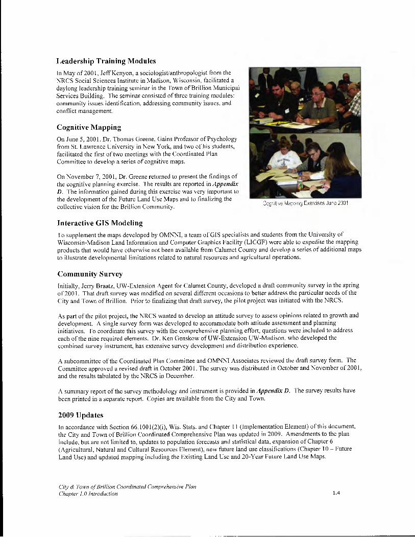
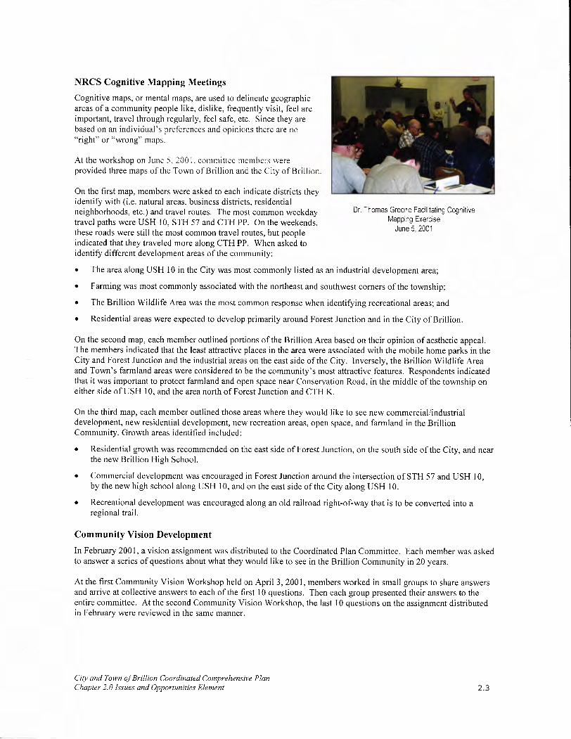
Cognitive Mapping
On June 5, 2001, Dr. Thomas Greene, Gains Professor of Psychology from St. Lawrence University in New York, and two of his students, facilitated the first of two meetings with the Coordinated Plan Committee to develop a series of cognitive maps.
On November 7, 2001, Dr. Greene returned to present the findings of the cognitive planning exercise. The results are reported in Appendix D. The information gained during this exercise was very important to the development of the Future Land Use Maps and to finalizing the collective vision for the Brillion Community.
Cogtive 1apping Exercises June 2001
Interactive GIS Modeling
To supplement the maps developed by OMNNI, a team of GIS specialists and students from the University of Wisconsin-Madison Land Information and Computer Graphics Facility (LICGF) were able to expedite the mapping products that would have otherwise not been available from Calumet County and develop a series of additional maps to illustrate developmental limitations related to natural resources and agricultural operations.
Community Survey
Initially, Jerry Braatz, UW-Extension Agent for Calumet County, developed a draft community survey in the spring of 2001. That draft survey was modified on several different occasions to better address the particular needs of the City and Town of Brillion. Prior to finalizing that draft survey, the pilot project was initiated with the NRCS.
As part of the pilot project, the NRCS wanted to develop an attitude survey to assess opinions related to growth and development. A single survey form was developed to accommodate both attitude assessment and planning initiatives. To coordinate this survey with the comprehensive planning effort, questions were included to address each of the nine required elements. Dr. Ken Genskow of UW-Extension UW-Madison, who developed the combined survey instrument, has extensive survey development and distribution experience.
A subcommittee of the Coordinated Plan Committee and OMNNI Associates reviewed the draft survey form. The Committee approved a revised draft in October 2001. The survey was distributed in October and November of 2001, and the results tabulated by the NRCS in December.
A summary report of the survey methodology and instrument is provided in Appendix D. The survey results have been printed in a separate report. Copies are available from the City and Town.
2009 Updates
In accordance with Section 66.1001(2)(i), Wis. Stats. and Chapter 11 (Implementation Element) of this document, the City and Town of Brillion Coordinated Comprehensive Plan was updated in 2009. Amendments to the plan include, but are not limited to, updates to population forecasts and statistical data, expansion of Chapter 6 (Agricultural, Natural and Cultural Resources Element), new future land use classifications (Chapter 10 - Future Land Use) and updated mapping including the Existing Land Use and 20-Year Future Land Use Maps.
City & Town of Brillion Coordinated Comprehensive Plan Chapter 1.0 Introduction 1.4

FA

2.0 IssuEs & OPPORTUNITIES
Introduction The Issues and Opportunities Element is the background information on the local government unit(s) and the overall visions to guide future development and redevelopment of the area. The Issues and Opportunities Element must include population, household and employment forecasts, demographic trends, age distributions, education levels, income levels and employment characteristics.
Visioning Process To identify community issues and opportunities, a three-step process was employed, which resulted in the development of individual vision statements for each of the nine required Smart Growth planning elements. This process included: community SWOT meetings, cognitive mapping, and element vision development. What follows is a description of the activities and the major issues and opportunities identified through the issues and opportunities process.
SWOT Analysis
A SWOT is a planning exercise used to get communities thinking about where they are, where they've been, where they want to be in the future, and how they want to get there.
Town of Brillion SWOT Analysis. On October 17, 2000, the Town of Brillion Land Use Committee participated in an informal SWOT discussion facilitated by OMNNI Associates. The Town Land Use Committee agreed on the following, which was later used as a starting point to develop the community survey.
Four primary strengths:
• A central location in Northeast Wisconsin with easy access to Manitowoc, Fond du Lac, Green Bay and the Fox Cities;
• Two major highways;
• The sanitary district in Forest Junction, which helps to concentrate development; and
• A strong farming tradition.
S.W.O.T. DEFINITIONS
Strength Something that makes a community standout when compared to other communities. Something that makes you proud to call the community home. A strength can be a physical asset, a program, or an environmental condition (i.e. friendly community atmosphere).
Weakness Opposite of strength. Problem that needs to be addressed.
Opportunity Something that could be done to improve the community. A potential.
Threat A threat may be internal or external. A threat can be anything that could jeopardize the future success of a community.
Two weaknesses to address:
• The Town's limited tax base; and
• The loss of railroads in the Town of Brillion. (At one time, there were two lines serving the area, but both were abandoned in 2002).
Three opportunities the Town should focus on in the future:
• As a result of the railroad abandonment, the Town needs to consider alternative uses for these corridors. One option available is a rails-to-trails project.
City and Town of Brillion Coordinated Comprehensive Plan Chapter 2.0 Issues and Opportunities Element 2.1
• Farmland preservation
• Controlling development to avoid situations where something is approved that is contrary to the plan.
The Land Use Committee identified annexation as the most pressing threat facing the Town of Brillion, particularly, the potential development areas around the high school.
City of Brillion SWOT Analysis Monday, March 5, 2001, the City of Brillion Comprehensive Plan Committee participated in a SWOT workshop facilitated by OMNNI Associates. Fifteen (15) members of the Committee were in attendance, including several Planning Commissioners and Mayor Robert Mathiebe.
The SWOT analysis was updated as a result of additional studies which were developed after the initial adoption of this plan.
Brillion's strengths include:
• High-quality, well-maintained housing;
• A large industrial sector to support the local tax base;
• A good quality of life and family-friendly environment; and
• A great location between Appleton, Green Bay, and Manitowoc.
Weaknesses the City of Brillion must address include:
• A high municipal tax rate;
• Limited shopping opportunities;
• A high vacancy rate downtown; and
• Lack of diversity in the local job market.
Opportunities identified at the workshop include:
• Downtown redevelopment;
• The City's central location as a marketing draw; and
• USH 10 and the overall transportation network provide strong connections to the region that can bring additional business and other opportunities for the City
• Business Park Development
Threats to the successful future of the City of Brillion include:
• Increased taxation;
• Sprawl ("strip mall" looking) development along USH 10 and elsewhere in the City;
• Fear of change on the part of residents and local businesses; and
• Limited jobs and activities for youth.
• Loss of services due to budget cuts
• High costs of new infrastructure to aid new development
City and Town ofBrillion Coordinated Comprehensive Plan Chapter 2.0 Issues and Opportunities Element 2.2
NRCS Cognitive Mapping Meetings
Cognitive maps, or mental maps, are used to delineate geographic areas of a community people like, dislike, frequently visit, feel are important, travel through regularly, feel safe, etc. Since they are based on an individual's preferences and opinions there are no "right" or "wrong" maps.
At the workshop on June 5. 2001, committee members were provided three maps of the Town of Brillion and the City of Brillion.
On the first map, members were asked to each indicate districts they identify with (i.e. natural areas, business districts, residential neighborhoods, etc.) and travel routes. The most common weekday travel paths were USH 10, STH 57 and CTH PP. On the weekends, these roads were still the most common travel routes, but people indicated that they traveled more along CTH PP. When asked to identify different development areas of the community:
Dr. Thomas Greene Facilitating Cognitive Mapping Exercise
June 5, 2001
• The area along USH 10 in the City was most commonly listed as an industrial development area;
• Farming was most commonly associated with the northeast and southwest corners of the township;
• The Brillion Wildlife Area was the most common response when identifying recreational areas; and
• Residential areas were expected to develop primarily around Forest Junction and in the City of Brillion.
On the second map, each member outlined portions of the Brillion Area based on their opinion of aesthetic appeal. The members indicated that the least attractive places in the area were associated with the mobile home parks in the City and Forest Junction and the industrial areas on the east side of the City. Inversely, the Brillion Wildlife Area and Town's farmland areas were considered to be the community's most attractive features. Respondents indicated that it was important to protect farmland and open space near Conservation Road, in the middle of the township on either side of USH 10, and the area north of Forest Junction and CTH K.
On the third map, each member outlined those areas where they would like to see new commercial/industrial development, new residential development, new recreation areas, open space, and farmland in the Brillion Community. Growth areas identified included:
• Residential growth was recommended on the east side of Forest Junction, on the south side of the City, and near the new Brillion High School.
• Commercial development was encouraged in Forest Junction around the intersection of STH 57 and USH 10, by the new high school along USH 10, and on the east side of the City along USH 10.
• Recreational development was encouraged along an old railroad right-of-way that is to be converted into a regional trail.
Community Vision Development
In February 2001, a vision assignment was distributed to the Coordinated Plan Committee. Each member was asked to answer a series of questions about what they would like to see in the Brillion Community in 20 years.
At the first Community Vision Workshop held on April 3, 2001, members worked in small groups to share answers and arrive at collective answers to each of the first 10 questions. Then each group presented their answers to the entire committee. At the second Community Vision Workshop, the last 10 questions on the assignment distributed in February were reviewed in the same manner.
City and Town of Brillion Coordinated Comprehensive Plan Chapter 2.0 Issues and Opportunities Element 2.3

Vision Discussion Groups April 3, 2001
The results produced draft vision statements for each of the nine required elements. The final vision statements are provided at the beginning of each chapter.
Visions Working together on a plan was a tremendous commitment for both communities, which historically have had differences on important land use and development issues.
To ease concerns and establish a focus for the planning program, the Coordinated Comprehensive Planning Committee participated in an extensive visioning process. This process was critical to establish a unified vision for both the City and Town and provide a direction and focus for the planning effort.
The community vision statements represent the broad interests of the City of Brillion and Town of Brillion residents, elected/appointed officials, business leaders and property owners. These visions established the planning framework and a direction for subsequent planning efforts. These visions illustrate that:
• City residents take pride in their small-town character, school district and park system.
• Town residents share a strong sense of community identity and pride closely associated with the rural character.
Demographic Profile The planning process began with a profile of the people who live, work and own property in the City and Town of Brillion. This information is critical to forecasting the need for community facilities and services, and will be used to consider school, road, park, job and public service decisions.
Population Trends & Forecasts
The population growth rate in the Town of Brillion compares favorably with the City of Brillion and the State of Wisconsin. Table I compares the rate of population change between 1990 and 2000 for the Town of Brillion, City of Brillion, Calumet County, and the State of Wisconsin. While the Town is growing at a faster rate than the State and the City, it is growing at a slower rate than Calumet County. The largest area of county growth was in that portion of the City of Appleton that lies in Calumet County.
DEFINITIONS
Vision An overall statement related to each of the nine required elements expressing the Town's expectations for the future. These statements provide a framework and context to consider when making future land use decisions.
Goal A statement that describes, usually in general terms, a desired future condition. Goals will usually only address one specific aspect of the vision.
Objective A statement that describes a specific action or condition that is to be attained within a stated period of time. Objectives include ordinances changes, new programs, and other tasks. The objectives serve as a "to do" list to implement the plan. To be effective, objectives must be evaluated regularly and updated as necessary.
Policy A course of action, or rule of conduct, used to achieve the goals and objectives of the plan. Policies are based on specific research. Therefore, they are developed after vision statements. In some cases, the policies relate closely to the vision, but provide more refined, specific actions.
To put the Town of Brillion's population growth rate into context, Table 2 compares the population changes for all towns in Calumet County. The only town experiencing a higher population growth rate than the Town of Brillion is the Town of Harrison, which is adjacent to the City of Appleton. The Town of Harrison has seen a lot of residential development in the 1990s as people in the Fox Valley seek affordable housing near job opportunities in the cities of Appleton, Neenah, Menasha and the Heart-of-the-Valley area.
City and Town of Brillion Coordinated Comprehensive Plan Chapter 2.0 Issues and Opportunities Element 2.4
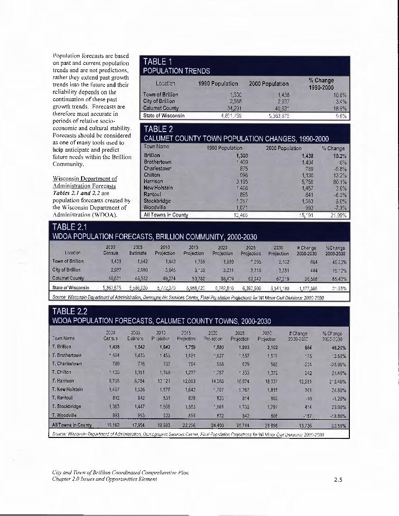
Population forecasts are based on past and current population trends and are not predictions, POPULATION rather they extend past growth
% Change trends into the future and their Location 1990 Population 2000 Population
1990.2000 reliability depends on the Town of Brillion 1,300 1,438 10,6% continuation of these past City of Brillion 2,588 2,937 3.4% growth trends. Forecasts are Calumet County 34,291 40,631 18.5% therefore most accurate in State of Wisconsin 4,891,769 5,363.675 9.6% periods of relative socio- economic and cultural stability. TABLE 2 Forecasts should be considered CALUMET COUNTY TOWN POPULATION CHANGES, 1990-2000 as one of many tools used to I help anticipate and predict
Town Name 1990 Population 2000 Population % Change
future needs within the Brillion Brillion 1,300 1,438 10.2%
Community. Brothertown 1,409 1,404 0% Charlestown 875 789 -9.8%
Wisconsin Department o f Chilton 998 1,130 13.2% Harrison 3,195 5,756 80.1%
Administration Forecasts New Holstein 1,406 1,457 3.6% Tables 2.1 and 2.2 are Rantoul 895 841 -6.0% population forecasts created by Stockbridge 1,317 1,383 5.0% the Wisconsin Department of Woodville 1,071 993 -7.3% Administration (WDOA). All Towns in County 12,466 15,191 21.98%
TABLE 2.1 WDOA POPULATION FORECASTS, BRILLION COMMUNITY, 2000-2030
2000 2005 2010 2015 2020 2025 2030 #Change %Change Location Census Estimate Projection Projection Projection Projection Projection 2000-2030 2000-2030
Town of Brillion 1,438 1,542 1,642 1,759 1,880 1,995 2,102 664 46.20%
City of Brillion 2,937 2,980 3,045 3,138 3,231 3,315 3,381 444 15.10%
Calumet County 40,631 45,302 49,274 53,782 58,409 62,942 67,219 26,588 65.43%
State of Wisconsin 5,363,675 5,589,920 5,772,370 5,988,420 6,202,810 6,390,900 6,541,180 1,177,505 21.95%
Source: Wisconsin Department of Administration, Demographic Services Center, Final Population Projections for WI Minor Civil Divisions: 2000-2030
2000 2005 2010 2015 2020 2025 2030 #Change %Change Town Name Census Estimate Projection Projection Projection Projection Projection 2000-2030 2000-2030
T. Brillion 1,438 1,542 1,642 1,759 1,880 1,995 2,102 664 4620%
T. Brothertown 1,404 1,433 1,455 1,491 1,527 1,557 1,579 175 12.50%
T. Charlestown 789 776 737 704 668 629 585 -204 -25.90%
T. Chilton 1,130 1,151 1,189 1,237 1,287 1,333 1,372 242 21.40%
T. Harrison 5,756 8,284 10,121 12,063 14,065 16,074 18,037 12,281 213.40%
T. New Holstein 1,457 1,526 1,577 1,642 1,707 1,767 1,818 361 24.80%
T. Rantoul 812 842 831 828 823 814 802 -10 -1.20%
T. Stockbridge 1,383 1,447 1,508 1,583 1,661 1,733 1,797 414 29.90%
T. Woodville 993 953 923 899 872 842 806 -187 -18.80%
All Towns in County 15,162 17,954 19,983 22,206 24,490 26,744 28,898 13,736 90.59%
Source: Wisconsin Department of Administration, Demographic Services Center, Final Population Projections for WI Minor Civil Divisions: 2000-2030
City and Town of Brillion Coordinated Comprehensive Plan Chapter 2.0 Issues and Opportunities Element 2.5
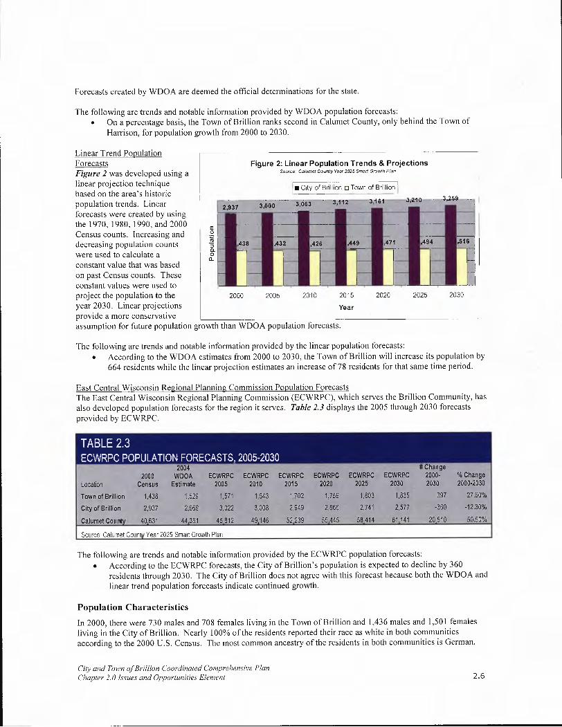
Forecasts created by WDOA are deemed the official determinations for the state.
The following are trends and notable information provided by WDOA population forecasts: On a percentage basis, the Town of Brillion ranks second in Calumet County, only behind the Town of Harrison, for population growth from 2000 to 2030.
Linear I rena t-'opuiauon Forecasts Figure 2 was developed using a linear projection technique based on the area's historic population trends. Linear forecasts were created by using the 1970, 1980, 1990, and 2000 Census counts. Increasing and decreasing population counts were used to calculate a constant value that was based on past Census counts. These constant values were used to project the population to the year 2030. Linear projections provide a more conservative
Figure 2: Linear Population Trends & Projections Sou,ro. Calumet County Year 2025 Small G,o,,Ah Plan
in ofBhIIioDTownoio
3112 3;t6l 3,210 3,259
IL 3 o003o63
432 449 471 494 51
2000 2005 2010 2015 2020 2025 2030
Year
assumption for future population growth than WDOA population forecasts.
The following are trends and notable information provided by the linear population forecasts: • According to the WDOA estimates from 2000 to 2030, the Town of Brillion will increase its population by
664 residents while the linear projection estimates an increase of 78 residents for that same time period.
East Central Wisconsin Regional Planning Commission Population Forecasts The East Central Wisconsin Regional Planning Commission (ECWRPC), which serves the Brillion Community, has also developed population forecasts for the region it serves. Table 2.3 displays the 2005 through 2030 forecasts provided by ECWRPC.
2004 # Change 2000 WDOA ECWRPC ECWRPC ECWRPC ECWRPC ECWRPC ECWRPC 2000- % Change
Location Census Estimate 2005 2010 2015 2020 2025 2030 2030 2000-2030
Town of Brillion 1,438 1,529 1,571 1,643 1,702 1,759 1,803 1,835 397 27.60%
City of Brillion 2,937 2,969 3,022 3,008 2,949 2,866 2,741 2,577 -360 -12.30%
Calumet County 40,631 44,361 45,812 49,146 52,239 55,445 58,414 61,141 20,510 50.50%
Source: Calumet County Year 2025 Smart Growth Plan
The following are trends and notable information provided by the ECWRPC population forecasts: • According to the ECWRPC forecasts, the City of Brillion's population is expected to decline by 360
residents through 2030. The City of Brillion does not agree with this forecast because both the WDOA and linear trend population forecasts indicate continued growth.
Population Characteristics
In 2000, there were 730 males and 708 females living in the Town of Brillion and 1,436 males and 1,501 females living in the City of Brillion. Nearly 100% of the residents reported their race as white in both communities according to the 2000 U.S. Census. The most common ancestry of the residents in both communities is German.
City and Town of Brillion Coordinated Comprehensive Plan Chapter 2.0 Issues and Opportunities Element 2.6

Figure 3: City of Brillion Population Age Distribution Source USC,,ss S—u, 9O ST-PS STF I a,,d2000 QT-PISFI
D 1990 .20
Figures 3 and 3.1 examine the age of City and Town residents in 1990 and 2000. It is interesting that, when comparing the charts, the population breakdowns by age groups are quite similar, especially since cities and towns typically attract residents at different stages and ages of life.
300
250
200
150
100
50
Also noteworthy, nearly equal senior populations / S 60 S
Lb Lb Lb Lb Lb Lb ,2Lb 'Lb Lb S S S
live in the Town and City. This is of some
\O
'1\0 Lb 1 9 I
Lb Lb Lb1_0 Lb Lb Lb9 Lb 1_0
40 concern since the Town is predominately a farming community which offers relatively few alternative housing opportunities and no senior support services. Seniors may need to seek residency elsewhere if they cannot live independently.
General Household Trends
National, state, and local trends have seen an increase in the number of households, along with a decrease in the average number of persons per household. The main reasons for this decrease include:
• Decrease in birth rate
People waiting longer to get married
• Increased divorce rate
Figure 3.1: Town of Brillion Population Age Distribution Source US Census Bureau, 1)900T-P14 STF I and 2000 ST-P ISFI
1990 0 2000]
140
120
100
80
60
40
20
<Os ç <s 5O <Os <Os oP Lb Lb Lb Lb Lb Lb Lb Lb Lb Lb Lb Lb Lb Lb Lb <5
Lb '.t
Lb
• Increase in the average life span thereby resulting in more elderly people living either alone or with another family member.
Figure 3.2 demonstrates that the number of DEFINITION: WHAT IS A "HOuSEHoLD?"
persons per household is A household is a group of people living together in a single dwelling unit. This could expected to decrease in include a family, a single person, or a group of unrelated individuals sharing a house or an the City and Town apartment, but excluding those persons living in group quarters. through the year 2030.
According to the 2000 U.S. Census, there were 501 households in the Town of Brillion, an increase of 73 households since 1990. The vast majority (341) were married-couple family households. The second largest category was the one-person household (90).
City and Town of Brillion Coordinated Comprehensive Plan Chapter 2.0 Issues and Opportunities Element 2.7

Figure 3.2: Estimated Persons per Household, 2000-2030 Source. East Central Wisconsin Regional Planning Commission, 2004.
3.5
3- 0
2.5 U)
o 2-
1.5CL
-
E 0.5--
0- 2000 2005
• CiofBrillion2.53.51
—u--Town of Brillion 2.87 2.86
2010 2015
2.45 2.39
2.82 2.77
Year
2020 2025 2030
2.35 2.31 2.27
2.73 2.71 2.69
In 2000, there were 1,155
households in the City of Brillion, an increase of 123 households since 1990. The majority of these households (700) were married-couple family households. The second largest category was the one-person household (291). Similar to population forecasts, the WDOA also develops household forecasts. Note that projections are for households rather than total housing units. Households are defined as occupied housing units. Table 3 details the WDOA household forecast for the Brillion Community.
2000 2005 2010 2015 2020 2025 2030 # Change %Change Location Census Estimate Projection Projection Projection Projection Projection 2000-2030 2000-2030
Town of Brillion 501 538 577 622 672 721 772 271 54.10%
City ofBrillion 1,155 1,173 1,208 1,254 1,303 1,352 1,400 245 21.20%
Source: Wisconsin Department of Administration, Demo qraphic Services Center, Final Household Projections for WI Municipalities: 2005-2030
Economic Profile DEFINITIONS: ECONOMIC PROFILE TERMS
Economic conditions have a Labor Force direct impact on the supply, The sum of employed and unemployed persons who are 16 years of age and older. demand and costs for housing, infrastructure and services within Participation Rate a community. It is necessary to Describes the relationship between the labor force and the population examine the economic situation, to predict additional housing, Per Capita Income
infrastructure and service needs. The total income divided by the number of residents in an area.
This section profiles the economic environment of Calumet County and the Brillion Community by examining factors, including:
• Per capita income;
• Poverty rate; and
• Unemployment rate.
City and Town of Brillion Coordinated Comprehensive Plan Chapter 2.0 Issues and Opportunities Element 2.8

Much of the information in this section was obtained through the U.S. Census Bureau. Unfortunately, not all information is available specifically for the City and Town. In these cases, county information serves as a good economic environment indicator.
Labor Force
Table 4 tracks the employment rate in Calumet County between 2003 and 2007. Over this period, the labor force in Calumet County increased by 421.
Participation rates are often affected by economic, cultural, and demographic conditions. Calumet County has traditionally had a higher participation rate than the State. This can be partially attributed to the easy access to employment opportunities in Green Bay and the Fox Cities, Fond du Lac, and Manitowoc areas. Commuting Patterns
Approximately 7,000 more workers leave Calumet County for work than come to the county for work. Calumet County loses the majority of its labor force to Outagamie County, followed by Winnebago County. Calumet County does attract 1,255 workers from Manitowoc County. Table 5 shows the number of Calumet County residents that commute beyond the county limits versus how few people commute into the county.
Major County Employers
2003 2004 2005 2006 2007
Labor Force 25,219 25,057 25,189 25,411 25,640 Employed 23,982 24,026 24,145 24,374 24,416
Unemployed 1,237 1,031 1,044 1,037 1,224
Calumet County Unemployment Rate 4.90% 4.10% 4.10% 4.10% 4.80%
State of Wisconsin Unemployment Rate 5.60% 5.00% 4.80% 4.70% 4.90%
Source: Wisconsin Department of Workforce Development, Calumet County Workforce Profile, 2008
CALUMET COUNTY COMMUTING PATTERNS County Live in Calumet County Travel to Calumet Net
Work In: County From: Commute
Brown 598 467 -131 Fond duLac 494 614 120 Manitowoc 713 1,968 1,255 Outagamie 6,739 1,611 -5,128 Sheboygan 632 433 -199 Winnebago 3,423 570 -2,853 Total 12,599 5,663 -6,936
Work within Calumet County: 8,951 Source: U.S. Census, STF-3, 2000
Tables 6 and 7 illustrate the top industries and employers in 2008 for Calumet County. Manufacturing is the top industry in Calumet County. However, more service oriented industries such as retail, restaurants/bars are becoming more and more prevalent.
Industry Group Employees Manufacturing (26%) 3,201 Accommodation & Food Services (10%) 1,217 Retail Trade (9%) 1,111 Health Care and Social Assistance (8%) 935 Professional & Technical Services (7%) 841 Wholesale Trade (7%) 832 All Other Industries (34%) 4,249 Source Wisconsin Department of Workforce Development, 2dQuarter2008
Cliv and Town of Brillion Coordinated Comprehensive Plan Chapter 2.0 Issues and Opportunities Element 2.9

Income & Wages
Average annual income earned by TOP 10 EMPLOYERS IN CALUMET COUNTY Calumet County residents was Company Product or Service Location Employees 97% of the state average in 2000. Traditionally, Calumet County has Aerotek Engineering Services Brillion 500-999
lagged behind state and national Ariens Company Lawn & Garden Bril lion 500-999
averages in per capita personal Manufacturing
income because of few Brillion Iron Works Iron Foundaries Brillion 500-999 opportunities for higher paying Hardware Merchant professional and technical jobs. In Endries Wholesalers
Brillion 250-499
recent years, an increasing number Kaytee Products Animal Food Manufacturing Chilton 250-499 of residents who live in Calumet County commute to other counties, County of Calumet County Government Chilton 250-499
where there are more opportunities Wal-Mart Discount Department Store Chilton 100-249
for higher paying professional and technical jobs. As a result, per Calumet Medical General Medical & Surgical Chilton 100-249 capita income in Calumet County
Center Hospital
has been rising at a greater rate Chilton Public School Education Chilton 100-249
than the state or nation. It is School District of Education New Holstein 100-249 anticipated that by the year 2005 New Holstein the average annual wages earned
Source Wisconsin Department of Workforce Development, 35 Quarter 2008 by county residents will surpass both state and national averages.
Table 8 provides information about the relative income for TABLE 8 residents living in the City and
PER CAPITA PERSONAL INCOME COMPARISON Town compared to Calumet County and Wisconsin residents. 1995 Per 2000 Per
2000 Median
2000 Median 2000 The table includes statistics for Location Capita Capita Household
Family Adjusted
per capita income, median Income Income Income
Income Gross Income
family income, median Wisconsin $21,960 $21,271 $43,791 $52,911 $40,570 household income, and adjusted Calumet County $20,714 $21,919 $52,569 $58,654 $43,504 gross income. Generally, the City of Brillion NA $20,754 $46,633 $52,989 $38,140 City and Town compare Town of
NA $21,927 $52,500 $58,403 $36,088 favorably to the similar statistics Brillion
for the county and state. The : U.S Department of Commerce. Bureau of Economic Analysis.
P011-t1:1
Regional Economic Information
2000 Calumet County per capita m, 2000 U.S. Census, and Wisconsin Department of Revenue
income figure ($21,919) also compares favorably to the figures for Brown ($21,784), Fond Du Lac ($20,022), Manitowoc ($20,285), Outagamie
($21,943) and Winnebago ($21,706) counties.
It concerns economic development professionals that retail trade employment represents approximately 9 percent of employment in Calumet County. Retail average hourly pay rates are lower than those in other industries.
Manufacturing employment represents approximately 26 percent of total employment and over 39 percent of wages earned by Calumet County residents. Some of this difference can be attributed to several large employers who have collective bargaining agreements. The dominance of manufacturing employment raises some concerns about the overall strength of the county economy. Given recent manufacturing trends that show companies are relocating out of state, the county should seek to expand its economic base to generate more diverse industry and employment opportunities.
City and Town of Brillion Coordinated Comprehensive Plan Chapter 2.0 Issues and Opportunities Element 2.10

Table 9 compares the relative TABLE 9 income position of the Town of TOWN INCOME COMPARISON, CALUMET COUNTY, W1 Brillion to the other eight towns in the county. The table demonstrates Average Average
DifferenceDifference 1990 2000 that the Town has seen a TOWN NAME Household
Income Between
Rank Rank significant increase in per capita Income 2000
1990 1990 & 2000
income over the last decade to Harrison $66094 $42626 $23468 1 1 allow its rank to increase from 8th New Holstein $58,050 $38,880 $19,170 6 2 to 5th. For comparison, Stockbridge $55,096 $37,182 $17,914 7 3 information about the City of Chilton $53,603 $39,002 $14,601 5 4 Brillion is provided at the bottom Brillion $52,500 $34,032 $18,468 8 5 of this table. Woodville $52,375 $40,883 $11,492 3 6
Charlestown $52,300 $39,833 $12,467 4 7
Education Attainment Brothertown $49,861 $33,480 $16,381 9 8 Rantoul $48,000 $42,310 $5,690 2 9
A good quality of life indicator in a Average for All $54,209 $38,692 $15,517 NA NA community is the education Towns
attainment of its residents. City of Brillion 46,633 28,250 18,383 NA NA Source: 1990 and 2000 U S. Census Generally, a high level of
education attainment
Figure 4: Education Attainment 2000 SOURCE: US Census 2000 SF3 QT-P20
Doctorate Degree 0% [ " imet County • City ofBrillion n Town ofBhIlj
0.0% Professional Degree 0.3%
11.2%
11.5% Masters Degree 2.7%
11114.0%
Bachelor Degree 12,0%
____I8.% Associate Degree 8.4%
8.5%
117.% Sorne college no degree 14.4%
1175%
148,8% High School Graduate
45.81.
12.0% 9-12nodiplcma 6.8%
l7.1
4.5 Yo
<9th Grade 5.6%
0.0% 10.0% 20.0% 30.0% 40.0% 50.0% 60.0%
reflects a skilled population with higher earnings potential. Figure 4 illustrates the level of education attainment for persons age 25 and over in the Brillion Community and Calumet County in 2000.
Employment Forecast
This employment forecast is presented at the county level, which offers the most comprehensive sources of data, and is an excellent indicator of local conditions.
The strong national economy from 1990 to 2000 had a positive impact on Calumet County. The economy now supports a variety of service industries, including tourism. Low-interest mortgage loan rates spurred housing construction, particularly in the western portions of Calumet County. Unemployment rates in Calumet County were at a 10-year low. Workers were finding employment faster and getting paid more.
City and Town of Brillion Coordinated Comprehensive Plan Chapter 2.0 Issues and Opportunities Element 2.11

A recession began for the United States in March 2001, evidenced by the declining stock market and rising energy prices. The war in Iraq impacted gas rates causing Calumet County residents to pay more at the pump. This, in turn, contributed to an increased cost of living. It is important to monitor the economy and prepare for a potential economic downturn by supporting a diversified economic base. At the time of the 2009 City and Town of Brillion Coordinated Comprehensive Plan updates, the economy was in a severe economic downturn. The unemployment rate for Calumet County was 8.8% (March 2009) compared to an unemployment rate of 4.4% the prior year (March 2008).
The City and Town are confident they will fare well over the recession and beyond. The Brillion Community offers a high quality of living that is attractive to employers seeking locations for business development. Population projections indicate the City and Town will continue to grow, which will help support additional business development and job opportunities. Moreover, the central location of the Brillion Community in the region, with easy access to USH 10, will spur continued economic growth in the long-term.
To monitor and improve local employment levels, the City employs a Community Development Director who works closely with local employers to help improve their efficiencies and facilitate expansion, and also seeks to attract new employers to the City.
Location Quotient Analysis
A location quotient for an industry is the simple ratio of the percentage of local employment in the industry divided by the percentage of employment in the industry for a comparison unit, such as a state, region or the nation. Within the Issues and Opportunities Element of this plan is a breakdown of the major employers in Calumet County and the Brillion Community. Table 10 provides a breakdown of employment by industry sector as reported by Brillion residents in the 2000 U.S. Census.
The figures in Table 10 provide little insight about the employment in the City. Are these percentages higher than average? Are they lower than average? Comparing employment in the City to nearby communities provides additional insights into the City economy.
Industry Town of City of Calumet Wisconsin Midwest U.S. Brillion Brillion County
Agriculture, forestry, fishing, hunting & 104 13.1% 20 1.3% 4.5% 1.5% 1.9% 2.7% mining Construction 54 6.8% 58 3,6% 5.8% 6.8% 6.1% 5.9% Manufacturing 293 36.9% 689 43.1% 33.3% 14.1% 18.5% 22.2% Wholesale trade 21 2,6% 81 5.1% 3.0% 3.6% 3.5% 3.2% Retail trade 58 7.3% 124 7.8% 10.7% 11.7% 11.7% 11.6% Transportation and warehousing 50 6.3% 29 1.8% 4.0% 4.3% 4.3% 3.7% Utilities - - - - - 0.9% 0.9% 0.8% Information 10 1.3% 13 0.8% 2.0% 3.1% 2.5% 2.2% Finance and insurance 23 2.9% 143 9.0% 6.3% 5.0% 5.0% 4.9% Real estate and rental and leasing 1,9% 1.5% 1.2% Scientific and technical services 36 4.5% 46 2.9% 4.2% 5.9% 4.9% 4.0% Administration and support 3.4% 2.9% 2.5% Educational services 59 7.4% 233 14.6% 15.3% 8.8% 8.6% 8.5% Health care and social assistance 11.2% 11.5% 11.6% Arts, entertainment and recreation 58 7.3% 69 4.3% 5.0% 1.8% 1.5% 1,5% Accommodation and food services 6.1% 5.8% 5.8% Other services (except public administration) 18 2.3% 73 4.6% 3.9% 4.9% 4.6% 4.1% Public administration 10 1.3% 19 1.2% 2.0% 4.8% 3.9% 3.5%
SOURCE: 2000 U.S. Census NOTE: Finance, Insurance, Real Estate Data is only available ins combined category for the City, Town and Calumet County. The same census data consolidation for reporting purposes exists for three other combined categories: scientific, technical, administration and support positions, (2) education, health care and social assistance, and (3) arts, entertainment, recreation, accommodation and food services. This consolidation is required to maintain anonymity in census reporting.
City and Town of Brillion Coordinated Comprehensive Plan Chapter 2.0 Issues and Opportunities Element 2.12

Table 10 reveals differences in employment between the City, Town and greater region. From the table it is apparent that the City of Brillion and the region have a significantly higher percentage of the workforce employed in manufacturing than Wisconsin and the Midwest. Comparing these employment percentages is useful, but somewhat cumbersome. Location Quotients (LQ) are an easier way to compare communities and analyze the Brillion economy.
LQ are used to help identify export industries in a community (those industries producing more than needed to meet local demand) and import industries (those producing less than enough to meet local demand).
• LQ greater than 1.0 indicates that a community has proportionately more people than the national average employed in a specific industry. This implies that a community is producing more of a product than is consumed locally. The excess is available for export.
• LQ less than 1.0 suggests that a community is not producing enough of a product or service to meet local demand, and is importing to meet local demand.
LQ approximately equal to 1.0 indicates that a community is producing enough to meet local demand.
Experts suggest that LQ of at least 1.25 is required to consider classifying a local industry as an exporter. Similarly, they recommend that a location quotient of .75 or less is needed to categorize an industry as an importing sector. Identifying local export industries (LQ> 1.25) provides a measure of industry specialization within a community. A community with a high location quotient in a specific industry may mean that the local economy has a competitive advantage in that industry. There may be economic development opportunities because of existing economies or synergies that make a community more attractive to businesses in related industries. LQ significantly lower than 1.0 may indicate an import substitution opportunity, the potential to develop local businesses to fill the gap and meet local demand.
Traditionally, LQ are calculated by comparing local employment to national or regional employment. Calculating LQ by comparing nearby communities provides anew perspective and insight into a local economy. Table 11 compares the City of Brillion to communities within Calumet County, as well as Wisconsin, the Midwest and the United States.
Industry Area Communities* Wisconsin Midwest U.S. Construction 0.65 1.26 1.40 1.45 Manufacturing 1.27 1.36 1.03 0.86 Wholesale trade 1.71 0.68 0.69 0.76 Retail trade 0.70 1.12 1,12 1.13 Transportation and warehousing 0.45 0.81 0.82 0.94 Utilities 0.44 0.33 0.34 0.37 Information 0,45 0.29 0.35 0.41 Finance and insurance 1.55 1.62 1.61 1.64 Real estate and rental and leasing 0.76 0.16 0.20 0.25 Scientific and technical services 0.50 1.11 1.31 1.61 Management of Companies & Enterprises 4.52 3.46 2.80 2.75 Administration and support 0.97 0.99 1.14 1,35 Educational services 1.32 0.98 1.00 1.02 Health care and social assistance 0.72 1.41 1.36 1.36 Arts, entertainment and recreation 1.37 0.90 1.06 1.08 Accommodation and food services 0.78 0.37 0.38 0.39 Other services (except public administration) 1.13 0,43 0.46 0,52 Public administration 0.57 0.55 0.69 0.52 SOURCE: UW-Extension Community Indicators Software based on 2000 U.S. Census * Composite companson to results for New Holstein, Chubs, and Hubert and aggregate results for Calumet County
City and Town of Brillion Coordinated Comprehensive Plan Chapter 2.0 Issues and Opportunities Element 2.13

The LQ for the City of Brillion compared to area communities shows higher LQ for manufacturing, wholesale trade, finance and insurance, management, educational services, and arts, entertainment and recreation. However, when compared to Wisconsin, the situation changes. For example, the LQ for management of companies and enterprises falls from 4.52 to 3.46. This means that while Brillion is particularly strong in this area compared to other communities in Calumet County, but it is somewhat weaker when compared to the state as a whole. On the other hand, the LQ for finance and insurance rises from 1.55 to 1.62. This LQ information is presented as a tool for the Brillion Community and local business owners to use to identify targeted business and industry. It is also useful in forecasting employment by industry sector.
Local employment growth is likely in those areas with LQ around 0.75. In particular, there is room for employment expansion in the retail, food service and health care industries. Those industries with an LQ below 0.50 are not as likely to be targeted due to competitive advantages elsewhere in the state and Midwest. This is not to say these types of businesses are not welcome, they are just less likely to establish locally. As expected, the Brillion Community will seek to retain its exporting manufacturing industries as they are the foundation of the local economy.
Regional Employment Forecasts
To further consider employment forecasts for the Brillion Community, an effort was made to review the economic development planning efforts of the East Central Wisconsin Regional Plan Commission (ECWRPC).
In preparing its regional Smart Growth Comprehensive Plan, the ECWRPC relies on the State Department of Workforce Development employment projections for Wisconsin Metropolitan Statistical Areas (MSA's). The nearest MSA's to Brillion are the Green Bay MSA and the Appleton-Oshkosh-Neenah MSA. Given that many residents of the Brillion Community commute to employers within these MSA's, employment forecasts for these areas are very relevant to the workforce living in Brillion.
Based on the State Department of Workforce Development employment projections, ECWRPC interpreted the data and reported that all MSAs in Wisconsin are expected to see an increase in employment over the next ten years. Employment forecasts between 2001 and 2006, however, are lower in most MSAs when compared to growth between 1995 and 2000. The impacts of the 2001 economic downturn and the weaker labor market have lowered future employment growth accordingly. Metropolitan areas that depend heavily on manufacturing have been more affected by the current economic employment slowdown. However, while a slowdown has occurred in the Appleton-Neenah-Oshkosh MSA because of its dominant manufacturing employment, other areas of the State, such as Milwaukee and Racine, has suffered greater manufacturing employment setbacks. For the time period of 2001 to 2006, it is anticipated a 5.1% employment growth will occur. The strongest growth is expected in the finance, insurance, and real estate sector and in the services sector.
Chamber Employment Forecasts
The Green Bay and Fox Cities Chambers of Commerce provide additional employment information for their respective markets. Again, this information is important to understanding employment forecasts impacting the Brillion Community, as many residents of the Brillion Community commute to these areas to work.
The Green Bay Chamber of Commerce does little actual employment forecasting, but does monitor historic trends in employment. Over the last five years employment trends have reflected the forecasts included in the ECWRPC Smart Growth Comprehensive Plan. Unemployment rates in the late 1990s remained steady at around 2.6 percent. In 2001, the rate increased to 3.9 percent. The unemployment rates continued to increase in 2002 (5.3 percent) and 2003 (4.9 percent) as several large manufacturing employers reduced their local workforce. However, in the last year unemployment rate decreased to 4.3 percent. The
City and Town of Brillion Coordinated Comprehensive Plan Chapter 2.0 Issues and Opportunities Element
r -- Fox Cities ( hntrr ti r,m.vc t.
Fox Cities Chamber of Commerce and Industry
http://www.foxcitieschamber.com/
Green Bay Area Chamber of Commerce http://www.titletown.org/
2.14

unemployment rate for the entire period has been about a half to full percentage point lower than the state and national averages over the same period. The Green Bay Chamber, based on comments from its membership, is hopeful that the unemployment rates will continue to decline back toward the 2.6 percent level experienced in the late 1990s within 5 years.
• The Fox Cities Chamber of Commerce conducts an annual survey of its members to understand their staffing changes in the previous year and make predictions for the next. The most recent results from that survey reveal:
• In 2004, 51 percent of businesses predicted their staff size would increase during the coming year. According to the 2005 survey, 43 percent did indeed increase employment during 2004.
• With respect to the health of the Fox Cities economy, 56 percent of businesses surveyed rated the economic vitality as excellent to good while 35 percent believe it to be average. Only 8 percent of this years respondents characterize the economy as below average to poor. In comparison to other U.S. cities of similar size, 73 percent indicated the Fox Cities as a better place to conduct business.
• Fifty-three percent of participating businesses predict staff size to grow during 2005 with another 45 percent anticipating that it will remain the same.
The 2005 Economic Outlook Survey suggests a confidence in the Fox Cities business community that has not been present for the past few years. In general, survey respondents are optimistic about the local economy and their own individual businesses ability to grow and prosper. Sales, profits and employment levels are all expected to increase during the coming year for a significant percentage of the survey respondents. This is not only true for the retail and service sectors that have experienced solid growth over the last three years, but manufacturing as well which bore the brunt of the recent soft economy.
Local Employment Forecast
Based on available data described in this section, the assessment of community strengths and weaknesses for attracting economic development (refer to Chapter 7, Economic Development Element), and the anticipated impact associated with the successful implementation of the smart growth plan, employment forecasts for Brillion are for slow but consistent growth. The recovering manufacturing economy will bode well for Brillion.
New employment growth, based on the results of the location quotient, is projected in the retail, food service and health care industries.
City and Town of Brillion Coordinated Comprehensive Plan Chapter 2.0 Issues and Opportunities Element 2.15

3

3.0 HOUSING ELEMENT kill
H '1F
Introduction Traditionally, rural towns and small cities have a high percentage of single-family homes, with few other housing types available. As new residents move in and the population ages, other types of housing must be considered to meet all resident needs. This is particularly true in communities where a large proportion of the population has been long-time residents, where there is a desire for these residents to remain in the area during their retirement years. Fortunately, the City does have some additional housing choices available (i.e. apartments, senior housing), beyond what is typically found in communities of its size. To develop a 20-year plan for the City and Town, the existing housing stock has been reviewed and recommendations made to meet future housing needs, including specific recommendations to ensure that local housing choices exist for all stages of life.
Housing Vision Through 2020, the City of Brillion will contain a wide variety of housing types to meet the lifestyle, demographic and economic needs and desires of its residents. The Town of Brillion will maintain a mix of farm residences and single-family homes through 2020.
Existing Housing Supply In 1990, there were 1,069 housing units in the City and 439 housing units in the Town (including Forest Junction). According to the 2000 U.S. Census, there were 1,233 housing units in the City and 521 housing units in the Town. This translates into a 15.1 percent growth rate in the City and an 18.7 percent growth rate in the Town between 1990 and 2000. These figures indicate that the housing market in both communities is strong.
Town of Brillion
Most of the new housing in the Town of Brillion is being developed in subdivisions around Forest Junction, north of USH 10 and east of STH 57. All housing in Forest Junction is served by public water and sewer service. In 2003, there were 202 dwelling units in Forest Junction. According to the Forest Junction Sewer Service Area Plan, this figure is only expected to increase to 211 housing units by 2020. Town residents and officials believe this modest prediction significantly underestimates the number of new units that will actually be constructed. Based on local estimates, it is more likely that there will be up to 240 dwelling units in Forest Junction by 2020 (based on building permit trends). New housing is also being developed on large parcels of land in more rural portions of the Town, adjacent to county and Town roads.
Forest Junction Subdivision East of STH 57 and South of USH 10
Forest Junction Mobile Home Park Because the housing supply in the Town consists mostly of single- West of STH 57 and North of USH 10 family homes, with the exception of four, eight-plex apartment buildings on Holmes Road in Forest Junction, it is important to consider that single-family homes may not be suitable for everyone. Some people may not be able afford a single-family home. Others may not be able to physically handle the maintenance necessary to keep up a home and yard. Opportunities for other types of housing (i.e. duplexes,
City and Town of Brillion Coordinated Comprehensive Plan Chapter 3.0 Housing Element 3.1

condominiums, town houses, apartments, etc.) exist in and around Forest Junction and the City, where municipal and utility services are readily available.
City of Brillion
New housing developments in the City are located in the southern portion of the City (near the golf course) and in areas to infill existing development. Additional housing is anticipated near the new high school.
The housing supply in the City:
• consists primarily of single-family homes (873 units or 71.3%)
• includes a significant share of duplexes (102 units or 8.3%) City of Brillion Historic Home
Located on Washington Street
. includes 60 Mobile Homes (4.9%)
• includes 49 apartments in 5, 9-unit buildings (4.0%) and 95 apartments in 10+ unit buildings (7.7%)
• includes 46 housing units that are part of three- or four-plexes (3.8%)
• is served by public water and sewer service
• is heated by utility natural gas (81.8%), electric heat (9.8%) or wood heat (1.1%)
Currently, 25 percent of the City's housing is rental-occupied, including apartments and senior housing. The City should maintain New Neighborhood home in a
this balance of rental housing options over the next 20 years, given City of Brillion subdivision.
the City's role as a service destination for neighboring communities. If alternative and rental housing are not part of the future plan, long-time residents and people with special needs may be forced to move away from the City and Town to neighboring communities that offer more housing options.
Age and Quality of Housing Stock The relative age of the housing __________________________ stock in a community is a good indicator of the quality of
Year # of Units % of Total City # of Units % of Total ' available housing. The City
Structure City of of Brillion Brillion Town of Brillion
Town of Brillion and Town have a large supply Built Brillion Housing Stock Housing Stock of units that were built before
1990 to 2000 185 15.0% 106 20.4% 1939. This does not 1980 to 1989 105 8.5% 65 12.5% necessarily mean that the units 1970 to 1979 205 16.6% 78 15.1% are in poor condition, but does 1960 to 1969 194 15.7% 32 6.2%
indicate that the need for 1940 to 1959 228 18.5% 27 5.2% 1939 or earlier 316 25.6% 210 40.5% repairs and maintenance is
Total 1, 233 100.0% 518 100.0% likely greater. However, both
Source: 2000 U.S. Census the City and Town experienced a great deal of new housing
construction in the 1990s. Table 12 lists the number of units and the corresponding percentage of the City's and Town's total housing stock by year built. The median year a home was constructed in the City of Brillion was 1963. The Town median was 1952.
City and Town of Brillion Coordinated Comprehensive Plan Chapter 3.0 Housing Element 3.2
Age alone is not the best measure of a community's housing condition. To be more accurate, a visual assessment of the housing stock is helpful. Such an assessment is commonly referred to as a windshield survey. The theory is that exterior condition generally correlates with interior conditions.
Town of Brillion
A windshield survey of the City and Town was conducted in the summer of2001. This survey found the following for the Town:
• A new subdivision is being developed on the north side of USH 10 in Forest Junction. These houses are modest ranch-style units. The roads in the subdivision are unpaved. Since the windshield survey in 2001, these roads, with the exception of Tim Drive, have been paved.
• The mobile homes in Forest Junction Mobile Home Park are of a mixed quality. Some of the units are in need of exterior repairs, including aluminum skirting, while others seem very well maintained. Since the windshield survey in 2001, improvements to the mobile home park continue to be made.
• The older housing in Forest Junction, for the most part, appears to be in good condition with some need for minor improvements (i.e. paint siding, roofing, etc.).
• Some of the older farmhouses outside of Forest Junction in the Town are in need of repair. These classic farmhouses provide character to the landscape and should be maintained.
• Some new rural residential development has scattered along portions of the roadways in the Town. These homes, given their recent development, appear to be of good quality.
City of Brillion
In the City of Brillion the housing types can be classified in four ways:
Historic Homes. This category includes large traditional colonials and bungalows situated in the blocks around Main Street and the old high school. Most of these homes appear to be in good condition with some need for minor exterior improvements (i.e. painting, roof shingling and gutter repair, etc.). It may be reason for concern if remodeling efforts show a trend in converting these homes into apartment buildings, which may lead to parking, landscaping, and maintenance issues. Any efforts in converting historic homes into smaller apartment units should be strictly regulated and enforced to minimize nuisance to neighboring properties and ensure that the character and quality of these homes are maintained.
New Neighborhood Homes. New residential development is characterized by cul-de-sacs and homes with attached garages facing the street. Given the newness of these units they are in good repair.
Mobile Home Park. Mobile homes are a source of affordable housing in the City of Brillion. The units in the City's mobile home park are in better condition than in typical mobile home parks. To maintain the quality of living for residents of these units, continued maintenance, code enforcement, parking and speed limit enforcement should continue.
Multiple Family. Multiple family housing options include apartments, two-family homes, and senior housing. In recent years, new multiple family units have been constructed in the City. The developments appear to be of high quality and well maintained. Continued monitoring and enforcement of codes and ordinances, as well as open communication with local landlords, is important in maintaining these properties over time.
Occupancy For a housing market to operate efficiently, it must possess an adequate supply of available housing units (units for sale or rent). A community's supply of available housing units must be sufficient to allow for the formation of new
City and Town of Brillion Coordinated Comprehensive Plan Chapter 3.0 Housing Element 3.3

households by the existing population, and to provide opportunities for households to change their housing because of a change in size or status.
According to U.S. Department of Housing and Urban Development TABLE 13 (HUD), an overall available MEDIAN HOME VALUES IN CALUMET COUNTY vacancy rate of 6.5 percent (1.5
1990 Median 1990 2000 percent for the owned portion of Municipality Value
2000 MedianHome Rank Home Value Rank
a housing stock and 5.0 percent Town of Brillion $53,600 13 $102,900 8 for the rented portion) is required Town of Brothertown $ 56200 9 $111600 7 to allow for an adequate housing Town of Charlestown $ 64,900 5 $114200 6 choice among consumers. The Town of Chilton $ 52200 15 $119,600 4
overall available vacancy rate for Town of Harrison $ 77,700 2 $144,000 2
Wisconsin is 4.75 percent for Town of New Holstein $62,000 6 $117,900 5
rentals and 1.14 percent for Town of Rantoul $51,100 17 $101,200 10
owner occupants'. Vacancy rates Town of Stockbridge $61,500 8 $122,100 3
vary from one community to the Town of Woodville
City of Appleton (part) $56,100 $ 69,200
10 4
$102,200 $97,700
9 11
next. The available vacancy rate City of Sri//ion $53,400 14 $86,900 15 of a housing market is a good City of Chilton $52,200 15 $84,900 17 indication of the adequacy of the City of New Holstein $ 54,500 11 $85,700 16 housing supply, which in turn City of Keil $46,700 18 $95,700 12
helps dictate the cost of housing. City of Menasha (part) $70,300 3 $87,700 14
For example, high vacancy rates Village of Hubert $53,900 12 $84,000 18
offer a degree of competition in Village of Potter $43,100 19 $82,300 19
terms of price. Village of Sherwood $91,000 I $160,000 1
Village of Stockbridge $61,500 6 $93,900 13 Calumet County Average $ 56,274 NA $109,300 NA
The 2000 vacancy rate in the Source: 1990 and 2000 U.S. Census Town for owner-occupied housing units was 1.1 percent. TABLE 14 The rental vacancy rate was 5.1 percent. The homeowner 2000 OWNER-OCCUPIED HOUSING VALUE vacancy rate in the City was 1.3 Cost Range City of Town of Calumet State of
percent in 2000 and the rental Brillion Brillion County Wisconsin
vacancy rate was 14.0 percent. Less than $50,000 3.6% 2.6% 2.5% 6.5%
These rates compare favorably $50,000 to $99,999 66.2% 45.1% 39.2% 35.4%
with Calumet County, which had $100,000 to $149,999 24.2% 35.2% 36.6% 30.6%
a 1.3 percent homeowner $150,000 to $199,999 4.4% 10.7% 13.8% 15.5%
vacancy rate and an 8.0 percent $200,000 or More 1.6% 6.5% 8.0% 12.0%
rental vacancy rate in 2000. 1 Source. 2000 US. Census
These vacancy rates indicate that the housing supply is sufficient to meet local demand and provide adequate
choices. The vacancy rate for the City poses some concern and should be monitored to ensure that supply does not
outpace demand.
Cost of Housing The available supply, age and condition of the housing stock are the basis for determining the demand for and cost of housing. Table 13 compares the 1990 and 2000 median home values in all municipalities of Calumet County. The 1990 and 2000 median home value in both the City and Town was below the county average.
Table 14 provides a detailed breakdown of the value of owner-occupied housing units in the City and Town of Brillion. According to this information, a sizable share of the City and Town housing is valued less than $100,000.
According to the 2000 U.S. Census, with respect to rental housing:
City and Town of Brillion Coordinated Comprehensive Plan Chapter 3.0 Housing Element 3.4

S IflI 1 l
IQ: The photos above are examples of desirable
and affordable manufactured homes with attached garages, appropriate roof pitch,
front porches, located on a foundation, crawl space or basement.
Example of Undesired Mobile Home Development
City of Brillion
256 renter-occupied in 1990 Table 15 289 renter-occupied in 2000 1990 Median Rent was $292 Average Home Selling Price
2000 Median Rent was $413 Community 1997 Average 2001 Average Actual Difference Percent Sale Price Sale Price Change
City of Brillion $65,900 $118,500 $52,600 + 44.4% Town of Brillion Town of Brillion $95,000 $122,000 $27,000 + 22.1%
31 renter-occupied in 1990 Homes not listed with RANEWs Multiple Listing Service are not accounted for in this data. 14 Homes in the
56 renter-occupied in 2000 City were listed with the MLS during this period and 23 homes were listed in the Town.
1990 Median Rent was $334 2000 Median Rent was $395
The average selling price of a single family home in the City and Town has increased significantly over the last five years (See Table 15). On average, five residential properties are sold in the Town each year and three homes are sold in the City, the vast majority being single family homes. In the Town, a significant number of hobby farms are also sold. 2
Housing Affordability Analysis Does the cost of housing match the ability of residents to pay for it? This is the fundamental question to answer when determining housing affordability. Although there are many ways to answer this question, HUD offers a common technique, which involves comparing income to housing costs. According to HUD, housing is considered affordable when it costs no more than 30 percent of total household income (including utilities). Per HUD standards, people should have the choice of having decent and safe housing for no more than 30 percent of their household income.
Town of Brillion
In 2000, the median annual household income in the Town was $52,500. Therefore, the median monthly income was $4,375. Thirty (30) percent of the median monthly income yields $1,312 or less to be used for housing costs. Slightly less than 70 percent of residents have a mortgage.
Of those individuals with a mortgage, the median mortgage payment is $352 - well below the 30 percent threshold even if utilities are added to household costs, however it is a concern that slightly more than 20 percent of Town residents paid more than 30 percent of their monthly household income on housing in 2000.
Rental household statistics were very similar. The 2000 median rent of $395 was well below the 30% threshold when compared to median income. However, 24.9% of Town residents reported that they paid more than 30% of their income on rental housing costs in 2000.
City of Brillion
The median 2000 annual household income in the City was $46,633. Therefore, the median monthly income was $3,886. Thirty percent of the median monthly income yields $1,165 or less to be used for housing costs. According to the 2000 U.S. Census, almost 40
City and Town of Brillion Coordinated Comprehensive Plan Chapter 3.0 Housing Element 3.5

Parkview Homes Parkway Drive, City of Bullion
Heritage Apartments, National Avenue, City of Brillion
percent of City residents have paid for their homes, and do not have a mortgage.
Of the approximately 60 percent with mortgages, the median mortgage payment is $347, which is well below the 30 percent threshold. The Census further indicates that only 10.3 percent of City residents pay more than 30 percent of their household income toward housing costs. Likewise, the median rent $413, though higher than the median mortgage payment, is still well below the 30 percent threshold and only 13.2 percent of renters reported spending more than 30 percent of their household income on rent in the 2000 U.S. Census.
One strategy to promote affordable housing is to encourage quality manufactured housing in the City and Town. Manufactured homes are not mobile homes. (The City and Town of Brillion do not encourage mobile home park development or additional mobile homes on individual lots.)
Manufactured housing is considered a viable affordable housing choice only if units are compatible in size, appearance and quality of area stick-built housing. Any manufactured housing unit must be constructed in accordance with local building and zoning restrictions. The manufactured home, once located on a property, should be virtually indistinguishable from 70 percent of site built housing located within a half mile of the home. Therefore, manufactured housing should have a similar roof pitch, garage facilities, and be located on a foundation, basement, or crawl space as a site built home would be required. Manufactured homes may even be two stories.
Manufactured housing is far more affordable than stick built housing because homes are built in a factory, which eliminates delays and costs associated with weather and the factory approach improves efficiencies. Manufactured housing costs are typically around $40 a square foot, compared to $90 or $100 per square foot for site built housing.
Many other county, regional and state housing programs exist to promote choices and affordability. These programs are profiled later in this chapter.
Housing for Senior Citizens and Persons with Disabilities Most seniors and persons with disabilities who reside in the Brillion Community must be able to live independenti), move into one of the City facilities, or move elsewhere. When asked about the adequacy of existing housing choices, many people in the community survey identified elderly and disabled housing choices as somewhat limited in the City and Town. There are no assisted living or group facilities located in the Town of Brillion. The hur, eight-plexes in Forest Junction provide handicap accessible first floor housing for disabled residents and will target mobile seniors who want to live in Forest Junction without the responsibilities (i.e. maintenance) associated with homeownership. There are three senior housing facilities and one group home in the City - quite an achievement for a small city like Brillion.
Senior Citizen Facilities
The three housing facilities are operated by the Brillion Housing Authority:
Parkview Homes is a 28-unit apartment complex located on a 2-acre site at 214 South Parkway Drive. Parkview Homes consists of nine buildings in a park-like setting and has been housing elderly tenants since April 1969.
City and Town of Brillion Coordinated Comprehensive Plan Chapter 3.0 Housing Element 3.6
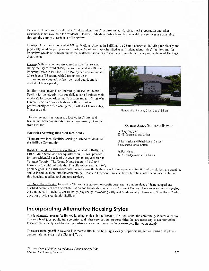
Parkview Homes are considered an "independent living" environment. Nursing, meal preparation and other assistance is not available for residents. However, Meals on Wheels and home healthcare services are available through the county to residents of Parkview.
Heritage Apartments, located at 108 W. National Avenue in Brillion, is a 23-unit apartment building for elderly and physically handicapped persons. Heritage Apartments are classified as an "independent living" facility, but like Parkview, Meals on Wheels and home healthcare services are available through the county to residents of Heritage Apartments.
Garrow Villa is a community-based residential assisted living facility for frail elderly persons located at 210 South Parkway Drive in Brillion. The facility can accommodate 20 residents (18 rooms with 2 rooms set-up to accommodate couples), offers room and board, and is staffed 24 hours per day.
Brillion West Haven is a Community Based Residential Facility for the elderly with specialized care for those with moderate to severe Alzheimer's or Dementia. Brillion West Haven is certified for 28 beds and offers excellent professionally certified care givers, staffed 24 hours a day, 7 days a week.
The nearest nursing homes are located in Chilton and Kaukauna; both communities are approximately 17 miles from Brillion.
Facilities Serving Disabled Residents
There are two local facilities serving disabled residents of the Brillion Community:
Garrow Villa, Parkway Drive, City of Brillion
OTHER AREA NURSING HOMES
Century Ridge, Inc. 531 E. Calumet Street, Chilton
Chilton Health and Rehabilitation Center 810 Memorial Drive, Chilton
Roads to Freedom, Inc. Group Home, located in Brillion at St. Paul Home 610 S. Main Street and headquartered in Chilton, provides 1211 Oakridge Avenue, Kaukauna for the residential needs of the developmentally disabled in Calumet County. The Group Home began in 1983 and houses up to eight individuals. This State-licensed facility's primary goal is to assist individuals in achieving the highest level of independent function of which they are capable, and to introduce them into the community. Roads to Freedom, Inc. also helps families with special needs children find housing, medical and support services.
The New Hope Center, located in Chilton, is a private non-profit corporation that services all handicapped and disabled persons in need of rehabilitation and habilitation services in Calumet County. The center strives to develop the total person - socially, vocationally, physically, psychologically and academically. However, New Hope Center does not provide residential facilities.
Incorporating Alternative Housing Styles The fundamental reason for limited housing choices in the Town of Brillion is that the community is rural in nature. The supply ofjobs, public transportation and other services and opportunities that are necessary to accommodate low-income, elderly, and disabled populations are either unavailable or extremely limited in supply.
There are many possible ways to incorporate alternative housing styles (i.e. apartments, senior housing, duplexes, condominiums, etc.) in the City and Town.
City and Town of Brillion Coordinated Comprehensive Plan Chapter 3.0 Housing Element 3.7

• First, ensure that units are adequately served with water, sewer, and other basic infrastructure needs. Locate alternative housing developments in either Forest Junction, the City of Brillion, or adjacent to the City of Brillion, possibly through a joint agreement to share tax revenue.
• Where consistent with the overall land use plan, policies and philosophies, alternative housing types should be considered as an mull housing opportunity in Forest Junction, or as an integral part of a mixed-use development along USH 10.
• Alternative housing styles should be considered near Main Street in the City of Brillion in order to bring people and services to the downtown.
• New alternative development should be compatible with surrounding housing. Special consideration should be given to parking, signage, landscaping and façade requirements.
Future Housing Needs Based on the WDOA Household Projections, 2000-2030 (Provided in Table 3 of the Issues and Opportunities Element):
• 772 households will exist in the Town by 2030. Most of these new households should be concentrated in the Forest Junction area. This represents an increase of 271 households, or roughly, 9 new households annually.
• 1,400 households will exist in the City by 2030. This represents an increase of 245 households or roughly 8 new households annually.
• The City's housing supply is expected to increase by 21 percent. The Town's housing supply is expected to increase by 54 percent.
Housing Issues and Concerns The primary issue identified by the Coordinated Plan Committee is the need to provide affordable housing choices (valued between $80,000 and $100,000) in the Brillion Community. A successful affordable housing subdivision has been constructed in Forest Junction. New single family residential construction in the City has been concentrated mainly in the southern portions in the City. The homes built generally exceed $150,000 in value. The City would like to provide additional affordable, high quality single family housing choices.
Also revealed in the community survey results, residents lack a consensus about where housing should be located in the Brillion Community (scattered or in subdivisions). Residents were also split about recommended lot sizes for new housing— small lots ('/2 acre) or large lots (more than '/2 acre). This may indicate that residents desire diversity in their housing choices.
Housing Programs A number of federal and state housing programs are available to help the Brillion Community promote housing developments for individuals with lower incomes, senior housing, housing for people with special needs, and housing maintenance needs.
Federal Programs and Revenue Sources
United States Department of Housing and Urban Development (HUD) USDA HUD is the federal agency responsible for housing programs and community
development. Though many of its programs are directed toward larger cities and urban areas, the Brillion Community does qualify for some funding ww.rurdev.usdagov assistance. Specifically, HUD provides money to non-entitlement (i.e. United States Department of Agriculture communities with populations less than 50,000) communities through grants.
City and Town of Brillion Coordinated Comprehensive Plan Chapter 3.0 [lousing Element 3.8

The Wisconsin Department of Commerce, Bureau of Housing (BOH) is responsible for the distribution of state and federal funds. It awards these funds through a competitive proposal process. Its mission is to expand local affordable housing opportunities for low- and moderate-income households and for the elderly and persons with disabilities.
The United States Department of Agriculture-Rural Development (USDA-RD) USDA-RD provides a variety of housing and community development programs for rural areas. Its programs are generally available to communities with populations of 10,000 or less. It provides support for rental housing development, direct and guaranteed mortgage loans for homebuyers, and support for self-help and cooperative housing development.
if For information on Community Development Block
Grants, call the Wisconsin Department of Commerce Division of Housing and Community Development
(DHCD) at 608/267-2627 or visit hftp://commerce.state.wi.us/CD/cd-boh-Home.html
State Programs and Revenue Sources
Wisconsin Department of Commerce Bureau of Housing (BOH) Beyond the funds distributed through HUD, the BOH administers several state funded programs that can potentially help finance housing improvements. Although money available through the BOH cannot be used to invest directly in housing development, (because it is funded by general-put-pose revenue), it can provide various types of financial assistance to homebuyers or renters through grants to local governments or non-profit agencies.
The Wisconsin Housing and Economic Development Authority (WHEDA) WHEDA is a quasi-governmental agency that finances housing development through the sale of bonds. Unlike the BOH, it receives no direct state-tax support. Therefore, WHEDA can provide mortgage NEDAW financing for first-time homebuyers and financing for multi-family housing. Specific programs evolve and change with the needs of the For more information visit
housing market. www.wheda.com
Local Programs and Revenue Sources
Calumet County Homebuyer Program The Calumet County Homebuyer Program is offered through the County's Planning Department and is administered by Community Housing Coordinators. Funds are allocated to qualifying persons in order to help them make a down payment on a home, make repairs to a home they are purchasing, or even construct a home. Applicants must be income eligible to qualify for services and family size also helps determine eligibility. Applicant must complete an application, participate in homebuyer classes and financial counseling, prepare a spending/savings plan, and use a minimum of$ 1,000 of personal funds toward the down payment. Information is available at the County Planning Department which can also be contacted for further information.
CAP (Community Action Program) Services, Inc. CAP has been on the frontline of the war on poverty since 1966. As a private, non-profit corporation, CAP offers programs in Marquette, Outagamie, Portage, Waupaca, and Waushara counties as well as in parts of Calumet and Wood counties. CAP Services, Inc. is a member of the Wisconsin Community Action Program Association (WISCAP). CAP offers a number of housing related programs including home buyer's assistance, weatherization, housing rehabilitation, rental housing assistance, and a lease/purchase program. For further information contact CAP Services, Inc.
Tax Incremental Financing (TIF) TIF is a tool available to municipalities for redeveloping blighted areas. TIF can be used to cover costs of public works or improvement including demolition, land assembly, public improvements, and new buildings. Under TIF, new private development creates higher property values, thus creating a greater tax base (the tax increment). TIF could be used to rehabilitate the downtown or to create newly platted residential development as part of a mixed use development. For more information about the TIP program, refer to Chapter 7 (Economic Development Element).
City and Town of Brillion Coordinated Comprehensive Plan Chapter 3.0 Housing Element 3.9

Local Zoning Regulations Local regulations and policies have the ability to affect the type and cost of housing available. While most government regulations are implemented in order to protect public health, safety and welfare needs, they may also have unintended adverse impacts on affordability.
One technique for ensuring a range of housing choice is to provide a variety of densities and lot sizes. This can be regulated through recommended improvements on the comprehensive plan, subdivision control ordinances (including conservation subdivisions), and local zoning controls.
The City of Brillion maintains and enforces its own zoning and subdivision ordinances. The zoning ordinance divides the City into 12 districts, including 4 residential zones:
• R-MH, Mobile Home Park
• R-1, Single Family Residence District
R-2, Single and Two Family Residence District
R-3, Multiple Family Residence District
At this time, Calumet County enforces all zoning and subdivision controls in the Town of Brillion. While the Town has no separate zoning or subdivision ordinances, it does have some options available with respect to zoning decisions made by the county. If a rezoning petition is received that the Town does not support, but is approved by the county, the Town can file a Resolution of Objection within 10 days which would prohibit the county from forwarding the matter to the County Board for final approval. Unfortunately, the statutes are less clear in a situation whereby the Town supports the rezoning petition but the county does not. The Resolution of Objection only applies in the reverse scenario. For any text amendments proposed by Calumet County to the county zoning ordinance which the Town objects to, all the towns in Calumet County would need to file a Resolution of Objection within 10 days to prevent the text amendment from being finalized by the County Board.
we
Mankin
For more information about Calumet County Zoning Ordinance requirements, call the County Planning Department at (920) 849-1442, or visit the department web page at:
www. co. calumet. W/. us
Calumet County anticipates that comprehensive revisions to both the Calumet County Zoning and Subdivision Ordinances will be adopted by the end of 2009. The Town will urge Calumet County to revise their Growth Management Policy and Subdivision Ordinance to allow for conservation design/cluster development subdivisions and clustering of homes in some rural areas (dependent on soil type and location) through a density based approach to land development. Such development will aid in preserving agricultural land and open space, and when developed correctly, be more environmentally friendly. Furthermore, the proposed amendments to the Calumet County Zoning Ordinance would allow greater flexibility for an Exclusive Agricultural zoned parcel to be subdivided. The benefits to this amendment are two-fold: 1) It could possibly create more affordable housing in the Town since the minimum lot size would be one acre instead of 35 acres; and 2) The sale of the lot would provide additional income for the farm operator and not require the sale of the entire farm operation.
The Town of Brillion does have the option to develop a subdivision ordinance or other growth management tools to gain better control over local land development. These ordinances must be as restrictive as or more restrictive than similar ordinances currently being enforced by Calumet County. The Town of Brillion could also create their own zoning ordinance but it would not need to be more stringent than Calumet County's Zoning Ordinance.
Coordination with Other Comprehensive Plan Elements It is important that the elements are consistent and support one another. Housing is the primary land use in the City of Brillion and a major land use in the Town of Brillion. As such, it directly affects most other comprehensive plan elements. The goals and policies set forth in this Housing Element will affect these elements and vice versa.
City and Town of Brillion Coordinated Comprehensive Plan Chapter 3.0 Housing Element 3.10

Land Use Element
Land use dictates the amount of land available for housing, as well as its location, type and density. The 20-Year Future Land Use Maps devote 969.4 acres to residential use. Furthermore, the goals and objectives of the Land Use Element recommend reviewing building permit and residential platting activities to gauge development trends.
Utilities and Community Facilities
Improvements to roads, sewers, water supplies, parks, recreational facilities and schools all need to be coordinated with housing decisions and vice versa. The best method to coordinate improvements is to follow the land use pattern presented on the Future Land Use Maps as closely as possible and plan for future infrastructure improvements through the use of a Capital Improvements Plan and Budget - as recommended in the Utilities and Community Facilities Element. This approach will greatly enhance the efficiency of capital improvements expenditures.
Transportation
The location of housing affects commuting patterns and transportation costs. The inverse is also true. The location and density of housing affects transportation needs. The location of housing influences on which roads people drive or whether they need to drive at all. The affordability of housing also influences how far people must commute. If housing is not affordable near places of employment, workers must commute from elsewhere. These factors were carefully considered in the Transportation Element to ensure compatibility with projected residential development.
Economic Development
It is important to ensure that the local housing supply is affordable to local residents working in the City and Town. For this reason, an affordability analysis is presented in this chapter.
Since housing is such a predominant and important land use in the City and Town, the quality of the local housing supply is important to the local economy. From a municipal standpoint, high-quality, well-maintained housing supports the local economy through property taxes, which in turn finance local improvements, which facilitate economic development (i.e. roads, sewers, etc.). From an aesthetic standpoint, high-quality well-maintained housing improves the aesthetic value of the City and Town thereby attracting people to live and work in the area.
The development of additional housing in the Brillion Community will be closely tied to the local economy. As development continues in Brillion, new businesses and industries will bring additional people to the area. It will be incumbent upon the City and Town to provide quality housing choices for the people who will work in these new businesses. Otherwise, they will live elsewhere and commute into the community. The result will be a loss of dollars in the local economy.
Agricultural, Natural and Cultural Resources
The desire to preserve agricultural and natural areas competes with the desire of others to build additional housing in the City and Town. These competing interests are balanced through the land suitability analysis information presented in the Agricultural, Natural and Cultural Resources Element. This information helps to ensure that housing is located in areas that will have the least adverse impact possible on existing farming areas and important natural resources, while still supporting additional residential development needs.
Goals and Objectives Based on projected population increases through 2030 and the predicted reduction in household size over that same period, it is estimated that there will be 271 additional households in the Town and 245 additional households in the City of Brillion. To ensure that new housing units associated with these additional households are of a high quality, goals and objectives included in Chapter 11 (Implementation Element) should be based on the information gained during the SWOT analysis and input from City/Town residents and committee members.
City and Town of Brillion Coordinated Comprehensive Plan Chapter 3.0 Housing Element 3.11

I WI Dept. of Commerce, 2000 Consolidated Plan.
2 This information was provided by the Realtors Association of Northeast Wisconsin and only includes properties listed through the Multiple Listing Service (MLS).
City and Town of Brillion Coordinated Comprehensive Plan Chapter 3.0 Housing Element 3.12

n

4.0 TRANSPORTATION ELEMENT
Introduction In the Brillion Community, private vehicles are the primary means of transportation Sidewalks and other pedestrian amenities are available in the City, but not currently available in the Town or Forest Junction.
The Friendship Trail serves mainly as a recreational opportunity and is not considered a viable commuting alternative.
According to the 2001 cognitive mapping exercises, primary routes for weekday traffic include USH 10 and STH 57. During the weekends, in addition to these two corridors, CTH PP is also a major direct access route to the City of Green Bay.
Brillion Community residents are concerned about the long-term plans for USH 10. Rumors of bypasses, realignments and other changes have increased speculation and concern. This chapter clarifies the current WisDOT project plans in the "Summary of Existing Transportation Plans" subsection.
This chapter also provides information about existing transportation facilities, plans and issues, and concludes with a series of goals and supporting objectives, intended to help the Brillion Community achieve its vision for 2020.
Vision In 2020, the City and Town of Brillion are served by a limited variety of transportation options, including paths and trails, which provide safe, efficient, and environmentally friendly choices.
Inventory of Existing Transportation Facilities Transportation facilities in the Brillion Community include a mixture ranging from rural Town roads to state highways. Residents enjoy easy access to USH 10 and STH 57, which connect residents to Green Bay, Appleton, Manitowoc and Fond du Lac. Opportunities for safe pedestrian travel are limited mainly to the City, given a lack of sidewalks and trail facilities in the Town. Residents mainly rely on their personal vehicles to meet the majority of their transportation needs. Other modes of transit, including light rail and air transportation, are not available in the Brillion Community, nor are they likely to be developed in the next 20 years. Air transportation service is available to residents at the Outagamie County Regional Airport in Appleton, Austin Straubel International Airport in Green Bay and the New Holstein Airport.
Pedestrian Facilities
Modern planning approaches recommend:
Walkable neighborhoods to promote social interaction, community safety and physical fitness.
Ideally, residents should be within ¼ mile, or a five- to ten-minute walk, of a destination point (i.e. school, shopping, park, church, etc.).
Pedestrian opportunities vary greatly throughout the Brillion Community. In the Town, most local roads have limited shoulder areas and the posted speed limits greater than 45 miles per hour. These conditions hinder safe pedestrian travel. Walking to places of work, shopping or entertainment is not realistic for most rural Town residents, given the low-density development pattern in rural areas of the Town beyond the sanitary district, and that nearly all goods and services are located several miles away in the City of Brillion. This situation is not anticipated
City & Town of Brillion Coordinated Comprehensive Plan Chapter 4.0 Transportation Element 4.1

to change over the next 20 years. As a result, rural Town residents without access to vehicles face severe transportation challenges since there is no public transportation service available. Seniors and people with disabilities may be particularly challenged to find adequate transportation.
Opportunities for pedestrian travel are better in Forest Junction, but still not optimal. Speed limits are much lower than the posted speed limits along rural Town roads, particularly in the newer subdivisions and the mobile home park. However, there are no sidewalks to provide the recommended separation between motorists and pedestrians for improved safety conditions. USH 10 and STH 57 are barriers to pedestrian travel given the number of lanes at the intersections, width of the roadway, and speed of traffic on these corridors.
In the City of Brillion, sidewalks are common and speed limits are reduced in most areas. More importantly, the density and scale of development supports pedestrian travel throughout the community. Most City residents enjoy this walkable environment; however, walkability may be less favorable in developments that extend outward away from the City's center and other destination points. It is important that the City consider pedestrian linkages when a new development is proposed to eliminate any negative impacts on the quality of life of residents living in the outermost neighborhoods.
Trail and Cycling Opportunities
Based on the community survey results, 62% of Brillion Community residents believe that bicycling and pedestrian trails are inadequate or very inadequate.
Trails
Friendship Trail. Friends of the Friendship Trail Inc. converted an abandoned railroad corridor that runs parallel to USH 10 into a six-mile, crushed limestone, multi-use trail. The Friendship Trail extends from the City of Brillion to Forest Junction where it connects to the Fox River State Trail. The ultimate goal is to extend the Friendship Trail to Lake Winnebago in Calumet County and connect to a trail that is currently being developed from Lake Michigan through Manitowoc County, creating the Lake-to-Lake Trail.
Fox River State Trail. Similar to the Friendship Trail, the Fox River State Trail is a limestone, multi-use trail, which is also located in an abandoned railroad corridor. The trail runs east of STH 32/57 from Brown County to Ott Road in the Town.
A map of the Friendship Trail and Fox River State Trail routes is included on the Transportation Network Map in Appendix B.
Cycling As part of its Corridors 2020 Plan, the Wisconsin Department of Transportation (WisDOT) completed a bicycling conditions assessment in conjunction with planned state highway priority corridors, to identify key linkages in Calumet County.
The WisDOT Plan Map provided in Appendix B only suggests possible bicycle routes along state, county, and local roads. Although the plan does not establish bicycle routes in these areas, routes along state highways will be included in WisDOT's State Highway 2020 Plan and WisDOT will control their development.
City & Town of Brillion Coordinated Comprehensive Plan Chapter 4.0 Transportation Element 4.2

WisDOT has identified CTH K as having the best conditions for bicycle routes in the Town of Brillion. CTH HR is classified as having moderate conditions for cycling. CTH PP, STH 32/57 and USH 10 are not recommended for a bicycle route given the high traffic volumes along this roadway.
WisDOT also considers town roads on their appropriateness for bicycle traffic. Specifically, WisDOT considers road width (i.e. ability to accommodate a shoulder path) and traffic volume as primary factors for bicycle paths. Secondary considerations include the percent of truck traffic and site distance restrictions. Due to the limited width and shoulder areas of these roads, they are not being considered "best." WisDOT did not evaluate roads in the City of Brillion, nor did it evaluate streets in Forest Junction for bicycle traffic appropriateness.
Safe Routes to School Program The revised federal transportation act, SAFETEA-LU, signed into law on August 10, 2005, provides funding to state departments of transportation to create and administer Safe Routes to School (SRTS) Programs. SRTS programs encourage children ages K-8 to walk and bike to school by creating safer walking and biking routes. SRTS programs improve walking and biking travel options, promote healthier lifestyles in children at an early age, and decrease auto-related emissions near schools.
SRTS will allow parents and communities to feel better about their children walking and biking to school by creating a safer environment in the vicinity of the school. This can be achieved through a variety of ways including new sidewalks and bikeways, traffic calming initiatives, educating parents and children on pedestrian safety, and creating programs that encourage students to walk/bike to school such as a Walking School Bus. In addition, SRTS programs ease automobile traffic and congestion near schools, and reduce fuel consumption and air pollution.
In 2008, the City of Brillion created a Safe Routes to School Committee to work with East Central Wisconsin Regional Planning Commission to develop a Brillion Area Safe Routes to School Plan. It is the intent of the Safe Routes to School Committee to have the Brillion Area Safe Routes to School Plan adopted by the City of Brillion Common Council in November 2009. The Plan will then be used for application to the Safe Routes to School Infrastructure Grant in 2010 for the development of a walkway to Fawn Ridge Subdivision and Trinity Lutheran Church and School.
Railroad Corridors
There are no active railroad corridors in the Brillion Community. There are, however, two abandoned rail corridors; one parallel to USH 10 and the other extends parallel to STH 57. There are no plans to re-establish either rail corridor or rail service in the Town. This situation is not anticipated to change over the life of this plan.
Streets and Highways
Streets and highways are classified according to their primary function, either to move vehicles or to serve adjacent land. Arterials accommodate the movement of vehicles, while local roads are designed to provide direct access to individual parcels of land. Collectors serve both local and through traffic by providing a connection between arterials and local roads. Facilities classified under the Federal Aids Secondary System (county trunks and state highways) qualify for federal aid for capital projects involving construction, reconstruction or repair. State highway aids are available to communities for construction and maintenance on a per mile basis provided their tax levy is greater than $1 per $1,000 of assessed valuation.
Principal Arterials Principal arterials serve interstate and inter-regional trips. These routes are in areas with populations greater than 50,000. These include USH 10, which runs east and west through the center of the Town and the northern portion of the City, and STH 57, which runs north to south through the Town. These classifications are based on traffic volumes and road capacities.
Minor Arterials Minor arterials accommodate inter-regional and inter-area traffic movements, often in conjunction with principal arterials. According to the Calumet County Highway Department, there are no minor arterials in the City or Town of Brillion.
City & Town of Brillion Coo rdinaied Comprehensive Plan Chapter 4.0 Transportation Element 4.3

Major Collectors Major collectors provide service to moderate sized communities and other intra-area traffic generators. Many county trunk highways fall into this classification. This includes CTH PP, which is located in the eastern portion of the planning area, and extends through the City in a north to south direction, and CTH FIR, which connects STH 57 to USH 10 in the Town.
Minor Collectors Minor collectors are roads that collect traffic from local roads and provide links to all remaining portions of smaller communities and other higher function roads. CTH K is the only minor collector in the Brillion Community. CTH K connects CTH PP to STH 57.
Local and Low Use Roads Local roads provide direct access to residential, commercial and industrial development. The remaining roads in the Brillion Community (Town roads and City streets) are classified as local or "low use." They provide access to residential, commercial and industrial uses within the Brillion Community. In total, 49.6 miles of Town roads and 18.35 miles of City streets fall into this category.
All the roads described in this section are illustrated on the Transportation Network Map. All 2000 average daily traffic count data available from the Calumet County Highway Department for the Brillion Community is also provided.
Mass Transit
Mass transit via bus, high-speed train, or other means is not currently available in the community, and is not likely to be established in the next 20 years, given the relatively low density of development in the Town and small size of the City. The City and Town have no plans to establish any transit service.
Water Transportation
There are no streams, rivers or lakes in the area that are large enough to support water-based transportation opportunities.
Truck Transportation
There are two freight trucking operations in the Brillion Community. These facilities enjoy easy access to STH 57 and USH 10. Neither company plans to expand their operations.
Airports
There is no airport facility located in the Brillion Community, although three airports are accessible in nearby communities: Austin Straubel International Airport; Outagamie County Regional Airport, and; New Holstein Airport.
Brown County Airport, Austin Straubel International The Brown County Airport, Austin Straubel International, located seven miles southwest of Green Bay, provides a full-range of air transportation services. It's the third largest airport in the state of Wisconsin and operates 24 hours per day, seven days per week. It contains the physical facilities for up to 90,000 take-off and landings annually, and serves approximately 370,000 commercial passengers and general aviation enthusiasts. The Austin Straubel International Airport has two runways. Specifications for the runways are provided in Table 16.
The Austin Straubel Airport currently offers (AirNay.com, Nov. 2001): 5 commercial air carriers
Several airfreight companies
5 rental car agencies
City & Town of Brillion Coordinated Comprehensive Plan Chapter 4.0 Transportation Element 4.4
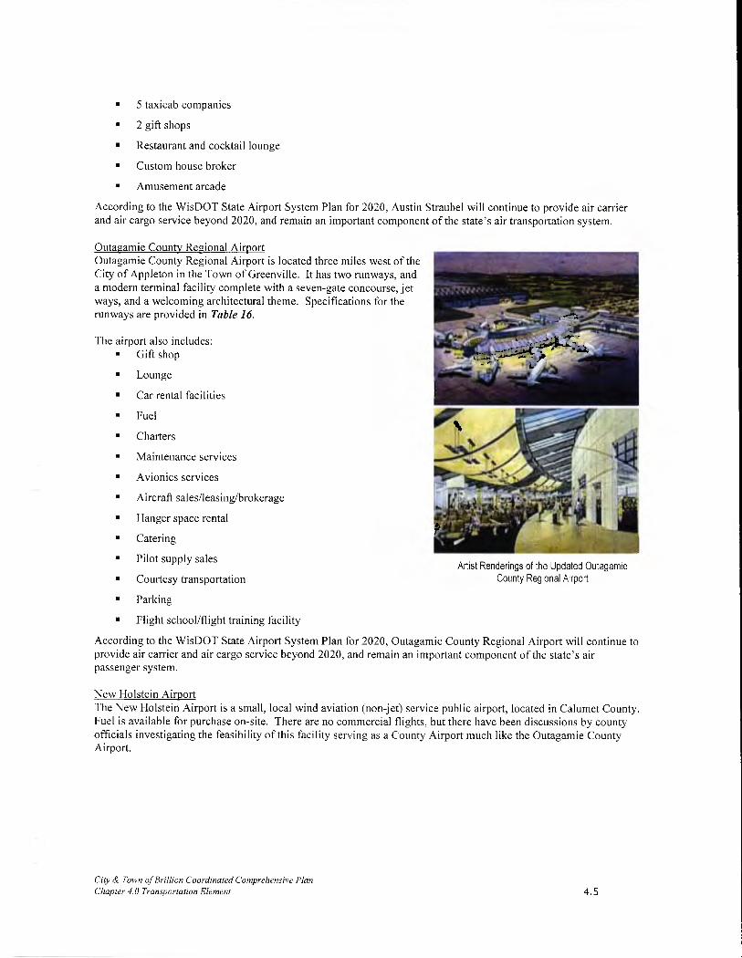
• 5 taxicab companies
• 2 gift shops
• Restaurant and cocktail lounge
• Custom house broker
• Amusement arcade
According to the WisDOT State Airport System Plan for 2020, Austin Straubel will continue to provide air carrier and air cargo service beyond 2020, and remain an important component of the state's air transportation system.
Outagamie County Regional Airport Outagamie County Regional Airport is located three miles west of the City of Appleton in the Town of Greenville. It has two runways, and a modern terminal facility complete with a seven-gate concourse, jet '.7• -
ways, and a welcoming architectural theme. Specifications for the
runways are provided in Table 16.
_L..FT The airport also includes: .
• Gift shop 'i
• Lounge -.-
• Car rental facilities
• Fuel f'
• Charters -
• Maintenance services 1zj • Avionics services --.'-
• Aircraft sales/leasing/brokerage f _,. •• .
• Hanger space rental I
• Catering
• Pilot supply sales Artist Renderings of the Updated Outagamie
• Courtesy transportation County Regional Airport
• Parking
Flight school/flight training facility
According to the WisDOT State Airport System Plan for 2020, Outagamie County Regional Airport will continue to provide air carrier and air cargo service beyond 2020, and remain an important component of the state's air passenger system.
New Holstein Airport The New Holstein Airport is a small, local wind aviation (non-jet) service public airport, located in Calumet County. Fuel is available for purchase on-site. There are no commercial flights, but there have been discussions by county officials investigating the feasibility of this facility serving as a County Airport much like the Outagamie County Airport.
City & Town of Brillion Coordinated Comprehensive Plan Chapter 4.0 Transportation Element 4.5

Runway Name Length Width Surface Material Outagamie County Regional Airport: RWY 3-21 7,001 feet 150 feet Grooved Concrete Outagamie County Regional Airport: RWY 11-29 6,501 feet 150 feet Grooved Concrete Austin Straubel: RWY 6-24 7,699 feet 150 feet Grooved Concrete Austin Straubel: RWY 18-36 8,200 feet 150 feet Grooved Concrete
New Holstein Airport 3,600 feet 75 feet Concrete Source: AirNay. corn
Transportation Opportunities for Seniors and People with Disabilities Transportation choices for seniors and people with disabilities are limited in the Brillion Community. There is no public bus service or private taxi service in either community. Residents primarily rely on friends and neighbors to receive needed transportation.
Calumet County provides limited transportation services to seniors over age 60 and individuals on disability through a program administered by the Aging and Disability Resource Center. The program includes five vans, all of which have wheelchair ramps, and maintains a network of volunteers who provide transportation for seniors and people with disabilities who are ambulatory. To utilize the county transportation service, individuals must contact the Human Services Department at least 24 hours in advance to make a reservation. The vans provide door-to-door service for any medical, financial, or legal appointments, but do not provide transit to grocery stores or other needed services. This situation is not expected to change.
Funding limitations prevent the City or Town from developing independent transportation systems. To meet local needs, both communities encourage church groups and other organizations to establish volunteer transportation networks.
Summary of Existing Transportation Plans Connections 2030: Wisconsin's Long Range Transportation Plan
During the preparation of this Coordinated Comprehensive Plan, several committee members and residents expressed concerns about USH 10. Some expressed a desire for realignment to minimize the curves between Forest Junction and the City of Brillion. Others were concerned that straightening the corridor would spur additional development elsewhere in the Town. The committee also discussed the potential for and impact of a bypass around the City of Brillion. Currently, the City depends on its access to USH 10 as a vital transportation link to support the local economy. Severing this link could have dire consequences on the economic vitality of Downtown Brillion and other areas of the City.
WisDOT developed the Connections 2030: Wisconsin's Long Range Transportation Plan to address all forms of transportation over a 20-year planning horizon: highways, local roads, air, water, rail, bicycle, pedestrian and transit. WisDOT officially adopted Connections 2030 in October 2009.
City & Town of Brillion Coordinated Comprehensive Plan Chapter 4.0 Transportation Element
1
The Wisconsin State Highway System has 11,800 miles of road.
USH 10 Curves
The curves in USH 10 between Forest Junction and Brillion were a major point of discussion during the planning process. The 2005 WisDOT project will reduce the degree (or sharpness) of the curves. WisDOT believes this change will address local safety concerns.
4.6

Included in Connections 2030 is the Lake to Lake Corridor. This corridor links Lake Winnebago and its surrounding metro areas to Lake Michigan along WIS 310 and USH 10. Current and proposed future activities along the Lake to Lake Corridor in the Brillion Community include:
Short-term projects (2008-2013)
• Reconstruct from CTH HR to east Brillion municipal limits.
Complete a corridor plan from USH 10/STH 114 split to STH 32/57.
Mid-term (2014-2019)
• Bicycle/Pedestrian - Provide urban and rural accommodations along USH 10 from CTH HR to the Calumet/Manitowoc county line.
Entire Planning Period
• Prepare corridor plan from STH 32/57 to 1-43 and implement results, which may include constructing candidate passing lanes.
WisDOT 2008-2013 Six-Year Highway Improvement Program
The WisDOT 2008-2013 Six Year Highway Improvement Program has identified two future WisDOT projects in the Brillion Community. The projects include:
• Urban reconstruction of USH 10/Ryan Street between CTH FIR to Progress Drive. The project resurfaces USH 10 from CTH HR to Progress Drive and reconstructs and extends the urban section from Progress Drive to the Eastern corporate limits. Connecting highway limits will be extended to Progress Drive to accommodate utility replacement expansion by the City of Brillion. The project is tentatively scheduled to occur between 2010 and 2013. Discussions with the City have already commenced.
• Construction of a round-a-bout at the current USH 10 & STH 32/57 intersection. This project is tentatively scheduled to occur between 2010 and 2013. Discussions with the Town have already commenced.
Calumet County
The Calumet County Highway Department has a transportation plan that includes a five-year Capital Improvement Program for county trunk highways. This program is posted at the Calumet County Highway Office and updated yearly (as is required by law). Current priorities for the Calumet County Highway Department include providing required maintenance and improvements to existing county roads. Coordination with the county for road improvements has been a tradition for the City and Town and should continue.
City of Brillion Capital Improvements Plan
The City of Brillion has a six-year Capital Improvements Plan (CIP) that is updated annually. The plan helps the City anticipate long-term expenditures for equipment, building maintenance and street improvements. Annual allocations for transportation-based expenditures include:
• general street maintenance,
• sidewalks, curb and gutter,
• bridges and culverts,
• parking lots,
• storm sewer improvements, and
• maintenance vehicle replacement.
City & Town of Brillion Coordinated Comprehensive Plan Chapter 4.0 Transportation Element 4.7

The CIP identifies $10,000 increases annually in the street maintenance fund through 2006 to $150,000, demonstrating the City's commitment to a quality transportation network.
Midwest Regional Rail Systems1
In the future, the Brillion Community may have access to a regional passenger rail service. Since 1996, the Midwest Regional Rail Initiative (MWRRI) has developed a well-defined vision to create a 21st century regional passenger rail system - a transportation plan known as the Midwest Regional Rail Systems (MWRRS). Its primary purpose is to meet future regional travel needs through significant improvements to the level and quality of regional passenger rail service. The major MWRRS elements will improve Midwest travel, including:
• Use of 3,000 miles of existing rail rights-of-way to connect rural, small urban and major metropolitan areas throughout Minnesota, Iowa, Missouri, Illinois, Indiana, Ohio, Michigan, Nebraska and Wisconsin.
• Operation of "hub-and-spoke" passenger rail system through Chicago to locations throughout the Midwest.
• Introduction of modern train equipment, operating at speeds up to 110 mph.
• Provision of multi-modal connections to improve system access.
Improvements in reliability and on-time performance.
If the $978 million plan is carried out, residents of Brillion could access a train in Green Bay or Oshkosh (planned connection points) to connect in Milwaukee to a high-speed rail line. The MWRRS plan calls for full implementation by 2025. As of December 2004, Wisconsin completed preliminary engineering and environmental work for the phase one extension of high-speed (110 mph) rail service from Milwaukee to Madison. It is anticipated that construction to connect Green Bay to Milwaukee will be completed by 2014.
East Central Wisconsin Regional Plan Commission (ECWRPC)
ECWRPC does not have a Master or Comprehensive Transportation Plan for the region. It will, however, review the transportation element of this plan for consistency with state and county planning efforts. Unless a conflict exists with this plan and those of the county and state, ECWRPC prefers not to become involved in local road issues.
Transportation Issues and Concerns PASER-Road Maintenance and Repair
Pavement Surface and Evaluation Rating System (PASER) is a visual inspection system that rates roads based on their condition, and provides a snapshot of all roads, to establish priorities for maintenance and rehabilitation. This system can be used for gravel, asphalt and concrete road surfaces. Surface defects, cracking, potholes and shoulders are all examined during a typical PASER evaluation.
By PASER standards, it is considered ideal to maintain all paved community roads at a level 7 or above and unpaved roads at a level 3 or above.
In May of 2007, the Town completed a PASER assessment of its roads (a PASER assessment is completed every two years). The assessment reveals that the Town considers road maintenance an important priority. Generally, paved roads in the Town rank between 4 and 9 and the gravel roads rank between 2 and 5.
City & Town of Brillion Coordinated Comprehensive Plan Chapter 4.0 Transportation Element
PASER RATINGS Roads are rated 1 —10 based on their condition (1-5 if unpaved).
Rating 9 & 10: no maintenance required
Rating 7 & 8: routine maintenance, cracksealing & minor patching
Rating 5 & 6: preservative treatments (sealcoating) recommended
Rating 3 & 4: structural improvement & level (overlay or recycle)
Rating I & 2: reconstruction recommended
There are two state programs - The Local Road Improvement Program and Municipal Street Improvement Program - which may be utilized to obtain funding to help address the flooding issues on Center Road. The Calumet County Highway Commissioner has additional information about these programs.
4.8

The City utilizes PASERWARE software to identify and prioritize specific road improvement projects based on local criteria (i.e. improve all roads to a "7", or maintain all roads in current condition, etc.). In this way, PASERWARE helps the City understand the impact of its spending decisions. The City's PASER ratings and subsequent report are available at the City Clerk's office at the Brillion City Hall.
Transportation Budgeting
Another long-standing transportation issue in the Brillion Community is road maintenance and improvement costs, a major expense that can consume a large share of limited budgets. This plan recommends implementing a Capital Improvements Program and Budget to help the Brillion Community effectively budget for these costs over time.
Capital Improvements Program and Budget A Capital Improvements Program and Budget or CIP/B is a five to six year short-range plan requiring annual updates. A general CIP/B includes a community's capital items such as:
Existing parks
• Public buildings
• Emergency vehicles
• Wastewater and water treatment facilities
• Streets
Capital items are generally defined as those items that are expensive (cost $5,000 or more) and will last at least 3-5 years. The CIP/B also includes improvement projects required for the community's future and the appropriate timeline and funding to be followed to implement the improvements.
The general steps involved in developing and maintaining a CIP/B include:
Identifying desired capital items. Items should be categorized by type (i.e. road, fire, water, sewer, etc.).
• Estimating the cost and means of financing each capital expenditure.
• Comparing the desired expenditures to the budget to determine annual spending priorities.
This process helps to ensure improvements are made in a logical order and do not surprise local officials or taxpayers. Moreover, a CIP/B helps a community focus on community needs and goals and allows a community to establish rational priorities.
Capital improvements programs and budgets should serve as the present and near-future financial plan to match future capital improvement costs, such as roads, to anticipated revenues. The City of Brillion already has a CIP/B program in place and should continue to use this approach to plan for future expenditures. in the Town of Brillion, the Plan Commission should be given the authority to develop and review the CIP/B, thereby linking planning to the annual budgetary process.
Transportation for Seniors and People with Disabilities
Residents expressed weighted concern regarding the limited transportation choices available to serve residents who are elderly or disabled. While the population density and demand needed to sustain a bus route is not present, volunteer programs can be coordinated through the schools, churches and other organizations.
Center Road
Center Road forms the northern boundary of the Brillion Wildlife Area. The road runs east-west from the City into the Town. Currently, water floods onto portions of this road. The City and Town have requested the DNR to control water levels of the marsh to minimize any adverse impacts on the City and Town infrastructure. It is against WDNR policy to dredge the creek for fear of negatively impacting area wildlife.
City & Town of Brillion Coordinated Comprehensive Plan Chapter 4.0 Transportation Elemeni 4.9
In 2006, Center Road was repaved and new culverts were installed by the Town of Brillion. Additional lanes were not added, which was agreed upon by all parties. Development adjacent to the roadway should be extremely limited, as is illustrated on the Future Land Use Maps. The DNR would like to see accommodations made for animal crossings in conjunction with any improvements made to Center Road. Unfortunately, the WDNR does not have funds to support transportation improvements to the area. Likewise, though the road is a Town road, given development on the north side of Center Road within the City continues, the Town feels the City should contribute toward road improvements. The City agrees that it has some level of financial responsibility in this area.
Safety of USH 10 and HR Intersection
The Brillion High School is located at the USH 10 and HR intersection, and has drawn an increased amount of traffic. Currently, there are no traffic lights or turn signal lights installed at this intersection, although turning lanes have been provided. WisDOT has no plans to install any signal lights. The City and Town agree that this intersection has the potential for a signal in the future and will coordinate with Calumet County and WisDOT to ensure this concern is understood and considered.
USH 10 Realignment
Over the 20-year planning period, it is anticipated that USH 10 may be somewhat realigned, particularly the curved stretch between Holmes Road and Keuer Road. At this time there is no specific plan or detail of the proposed realignment. The Town and City will coordinate with WisDOT as proposals are presented to incorporate the recommended changes into this plan.
Trail to the Brillion Wildlife Area
There is strong support for developing a southern spur off this trail to link the high school to the Brillion Wildlife Area at Center Road. This connection should be integrated into any residential development in this area behind the new Brillion High School.
Speeds & Safety on Town Roads
Several Town residents expressed their concern over the excessive speed of motorists traveling on town roads, presenting safety hazards to residents. To address this issue, the Town:
• Posts speed limits in all areas that are not 551nph; and
Designs and constructs town road to accommodate lower speeds (i.e. surface materials, width, sight-lines)
The Town can also consider posting additional speed limit signs in all areas (including 55mph zones) and coordinating with the Calumet County Sheriff's Department to improve speed enforcement along Town roads.
Development of New Town Roads
To ensure that the Town of Brillion will not have to pay for the construction of new Town roads, the Town will either develop road construction regulations as part of a Town of Brillion Subdivision Ordinance or urge Calumet County to include such regulations in its Subdivision Ordinance. The road construction regulations should, at a minimum, include construction and design standards, road acceptance procedures, and that costs for road development will be at the developer's expense.
Coordination with Other Required Plan Elements To clarify how the transportation element was considered in the context of the other required plan elements, a description of the major issues considered follows.
Issues and Opportunities
The Issues and Opportunities Element establishes the framework for the overall future vision of this plan. That vision will impact the way the City and Town consider changes to the transportation network and guides their
City & Town of Bullion Coordinated Comprehensive Plan Chapter 4.0 Transportation Element 4.10

participation in activities sponsored by WisDOT, Calumet County and the ECWRPC. The City and Town will consider ways to design transportation projects that blend with the natural landscape, and maintain the small town and rural character of the area, while promoting efficiency and access. This effort includes maintaining the current transportation network scale of City streets, Town and county roads, and supporting trail development.
Housing
The location and density of housing affects commuting patterns and transportation costs. The inverse is also true. The location of housing also influences the roads on which people drive, or whether they need to drive at all. The affordability of housing also influences how far people must commute. If housing is not affordable, workers must commute from elsewhere. These factors were carefully considered in this element as well as the Land Use Element to ensure compatibility with projected residential development.
Agricultural, Natural and Cultural Resources
How will changes to the transportation system impact the preservation and protection of environmental resources? Since the Town only has jurisdiction over Town roads, the answer may often be dictated by actions of Calumet County, ECWRPC, DNR, and WisDOT. Fortunately, these agencies have policies in place designed to protect the natural environment. Town residents' and leaders' continued plan involvement will ensure that local interests are realized in future transportation plans as they relate to the natural environment.
The City of Brillion controls improvements of City streets, providing more latitude to ensure that changes to the transportation network are considered in the context of natural resource limitations.
Utilities and Community Facilities
To ensure that decisions made for the transportation system will coincide with the capacity and planned expansion of existing utilities and facilities, the location of future development and associated transportation improvements is correlated to the location of adequate utilities and community facilities. In addition, both the City and Town should utilize capital improvements planning and budgeting as a technique to ensure that transportation improvements are well planned and coincide, where feasible, with utilities and community facilities.
Economic Development
Providing a quality transportation system is important to the success of any business. Just as businesses need good access, employees also need efficient access to their places of employment. Lack of access to employment opportunities may adversely affect the local labor market, as well as employees' decisions to live in the community Adequate transportation systems also enable efficient trucking operations for industries. In the Brillion Community plan, these issues were carefully considered, particularly the location of new commercial and industrial development. The local solutions to these issues are reflected on the Future Land Use Maps.
Land Use
While transportation improvements generally respond to changes in land use, they could indirectly affect land development either by inducing new development or altering the pattern of existing development.
Although transportation is not the only influence on land use, decisions regarding the transportation system may impact land use both directly and indirectly. Direct impacts are caused by the construction of a new transportation facility, changes to an existing facility, and/or decision to change traffic patterns along a facility. These may result in positive or negative impacts. Efforts were made to plan accordingly for land uses along STH 57, USH 10, county roads, Town roads and City streets. The result of these efforts is reflected on the Future Land Use Maps.
Intergovernmental Cooperation
Transportation facilities connect and flow through communities, regions, and states, thereby requiring coordination between communities, counties, regional planning agencies and state agencies for efficiency and effectiveness of the overall transportation network. A significant effort was made to review available long-term transportation planning
City & Town of Billion Coordinated Comprehensive Plan Chapter 4.0 Transportation Element 4.11

activities at the county, regional, and state levels. Both the City and Town realize that coordination, particularly with road improvements, is very important at their shared boundaries.
Implementation
Developing/maintaining a CIP/B can help the Brillion Community address transportation costs. The City and Town's capital improvement plans and budgets will not only predict local expenditures, but also locate grant and low interest loan opportunities that may exist to fund needed improvements. It is also recommended that the City and Town consult one another to ensure that potential conflicts are identified and discussed.
Goals and Objectives It is the vision of the Brillion Community that residents will enjoy safe streets and highways with minimal traffic congestion, and safe bike/pedestrian routes and trails. The goals found in Chapter 11 (Implementation Element) are divided to provide specific objectives for the Town and the City. Goals provided for the Town relate to those actions that the Town can control.
Midwest Regional Rail System Executive Report September 2004. Prepared by Transportation Economics and Management Systems, Inc. in association with HNTB Corporation. wsw.dot.wisconsin.govlprojectslraiLhtm
City & Town of Brillion Coordinated Comprehensive Plan Chapter 4.0 Transportation Element 4.12

5

5.0 UTILITIES AND COMMUNITY
FACILITIES ELEMENT
Introduction The availability of utilities and community facilities is an important factor to determine development potential and quality of life. This chapter:
• Profiles the existing utilities and community facilities serving the Brillion Community;
• Identifies needed services; and
• Provides goals and objectives to help the City and Town achieve their vision.
Understanding the location, use and capacity of utilities and community facilities is an important consideration when planning for the future. This information, coupled with demographic trends and projections, provides a realistic picture of service supply and demand. The utilities and community facilities discussed in this chapter were carefully considered in the development of the Future Land Use Maps.
An important resource used in the development of this chapter was the March 2001 City of Brillion Citizen Survey used to assess City services and their delivery. The Citizen Survey will continue to be a valuable resource in guiding decisions for providing services and monitoring their delivery.
Utilities & Community Facilities Vision Residents of the City of Brillion will have access to a full-range of municipal utility services, primary medical care, general merchandise retailing, educational facilities, alternative fuel sources, and selective entertainment choices. Town residents will have access to basic municipal services and will utilize additional services available in the City of Brillion.
Existing Utilities Inventory- Location, Use, Capacity
Wastewater Collection and Treatment
In the Brillion Community, sewer service is limited to the City of Brillion and Forest Junction. Areas beyond these districts utilize individual on-site waste treatment systems. In 2000, the ECWRPC updated the sewer service area plans for both Forest Junction and the City of Brillion. The information provided in this section is from those plans.
Forest Junction Sewer Service Area The Forest Junction Utility District is the only entity in the Town that provides public sewerage collection and treatment. The district was formed in 1977 by the Town to address numerous problems with on-site system failures related to high groundwater and low soil permeability. The Forest Junction Utility District wastewater treatment facility:
• is located in the northeastern portion of the Town;
• discharges into Plum Creek, a tributary of the Lower Fox River;
• was originally constructed in 1980 with major modifications occurring in 1982;
• uses two stabilization lagoons with periodic agricultural sludge spreading;
• has a current flow average of 26,700 gallons per day;
• was designed for a maximum average design flow of 29,000 gallons per day; and
City and Town of Brillion Coordinated Comprehensive Plan Chapter 5.0 Utilities and Community Facilities Element 5.1

periodically exceeds recommendations for flow, biological oxygen demand or total suspended soils.
The collection system for the Forest Junction Utility District comes mainly from eight-inch gravity sewers with several sections of four-inch gravity sewers in the mobile home park. A series often-inch collector sewers exist within the central portion of the district to transport waste to a lift station and then into a six-inch force main directed to the treatment plant. An additional lift station and four-inch force main exists along Church Street that allows for exiting and future gravity service in the northern portion of the district.
The Town of Brillion has experienced significant increase in discharge to the sanitary sewer collection system during large runoff events in recent years. One potential source of the increased load on the system is inflow into the sanitary sewer manholes during localized flooding of the streets and ditches where the sanitary manholes are located. A Storm Water Analysis Engineering Report: Hydrologic and Hydraulic Analysis of the Impact of Storm Water Runoff on Sanitary Sewer Overflow was prepared by Robert E. Lee & Associates for the Town of Brillion in August 2009. The study identified potential source areas that may contribute to sanitary inflow, performed hydrologic and hydraulic calculations for the source areas to determine if the existing storm sewers, culverts, and ditches are adequately sized, and made recommendations to reduce localized flooding that may be a source of inflow to the sanitary sewer collection system. It was determined that in most cases, inflow can be prevented by ensuring the manholes are constructed to be water tight. There are several locations where improvements to the drainage system in conjunction with watertight manholes are warranted. Additionally, there are some areas that may have flooding; however, there is no impact to the sanitary sewer system.
In 2000, the East Central Wisconsin Regional Planning Commission (ECWRPC) completed an update to the Forest Junction Sewer Service Area Plan. Because the Plan was created by ECWRPC, ECWRPC's 2020 population projections were used. It should be noted that any future Sewer Service Area Plan updates will reflect the most current population projections from ECWRPC. Based strictly on the ECWRPC population projection methodology, the Forest Junction Sewer Service Area is projected to decrease by 42 persons through the year 2020. Town residents have little faith in these figures given the new subdivision development that has occurred in the Town.
If all vacant lands allocated in the Forest Junction Sewer Service Area were to develop, the anticipated flows for the 193 acres are calculated to be 349,756 gallons per day using the following assumptions:
• 163 acres of residential development at an average density of three units per acre, 2.55 persons per household [2020 ECWRPC projection], and 80 gallons per day per capita;
• 30 acres of commercial/industrial land which can accommodate 10 businesses with 25,000 gallon per day per business.
If all vacant lands were developed, the associated flows will certainly exceed the design capacity. Realistically, such a level of development will not occur and is not planned for on the Future Land Use Maps. While some additional residential development is expected, the new business development is not expected to necessarily require 25,000 gallons per day per business. A reduction in this amount can significantly decrease needed capacity.
The Forest Junction Utility District will need to closely monitor new growth to determine when the district needs to make improvements in the treatment plant capacity. The Future Land Use Maps presented in this Comprehensive Plan should serve as a guide to anticipate capacity needs.
Brillion Sewer Service Area and the Sewer Service Area Plan The City's wastewater treatment facility:
is located on Clearwater Drive;
• was constructed in 1981 with several iii nor modi ticatiori, occurring since its construction, and:
• uses an activated sludge treatment s\ stem to process raw sewerage followed with tertiary filtrations by sand filters.
City of Bullion Waste Water Treatment Facility
City and Town of Brillion Coordinated Comprehensive Plan Chapter 5.0 Utilities and Community Facilities Element 5.2

Year Capacity Annual Av. Remaining (MGD) Monthly Flow Capacity
(MGD*) (MGD)
2003 993 526.5 466.5 2004 993 633.6 359.4 2005 993 499.7 493.3 2006 993 574.5 418.5 2007 993 524.7 468.3
Treated effluent is discharged into Black Creek, which flows into Spring Creek, a tributary of the Manitowoc River. As of June 2001, all sludge is aerobically digested and pumped into one of nine reed beds for further treatment. The capacity of the reed beds should allow for about ten years worth of sludge. The final disposal will be according to DNR guidelines.
Industrial wastes from the Brillion Iron Works, Ariens, and Professional Plating, either receive some pre-treatment or are shipped to other locations for treatment. Although the City provides public sewer, there are several homes in outlying areas of the City that are still utilizing on-site septic systems.
2008 993 616.5 376.5 The treatment plant has an excellent record of performance and MGO — Miiongaions per day consistently meets permit limits. According to the 2008 Source; Comphance Maintenance Annual Report. 2003, 2004 2005, 2006, Compliance Maintenance Annual Report, the plant was designed 2007, and 2008
for a maximum average design flow of 993,000 gallons per day. The annual average monthly flow for 2008 was 616,500 gallons
per day; approximately 38 percent of the capacity remains unused in the systems.
The City's existing wastewater collection system consists mainly of eight-inch gravity sewers. These sewers lead to larger collectors (10-inch to 15-inch), which, in turn, feed into a series of 18-inch and 21-inch interceptors located in the central portion of the City. Wastewater is then pumped from the main lift station to a 14-inch force main for transport into a 21-inch interceptor that leads to the treatment plant. The main lift station was upgraded in 1995 with new, larger pumps and a new stand-by generator set. The City jet cleans 1/5 of the entire system each year.
Two lift stations within the system serve existing and future single family residential subdivisions located in the southwestern portion of the City. Gravity sewers utilizing the lift station located near CTH PP will service future areas of undeveloped land in the southwestern portion of the City. Gravity sewers and the USH 10 lift station will serve lands in the northwestern portion of the service area. In 2002, a new upsized station replaced the lift station on USH 10. Additional lift stations may be needed to serve the area adjacent to CTH PP, north of Spring Creek and the area adjacent to Center Street, west of Glenview.
The Brillion Sewer Service Area Plan includes projections completed by the ECWRPC. These projections indicated that the City's population was expected to increase minimally, if at all, over the next 20 years. However, due to the City's location within Y hour of the Fox Cities, Green Bay and Manitowoc, coupled with a strong industrial base and a new high school, the plan acknowledges that the projections included in the plan are likely inaccurate.
The Brillion Sewer Service Area Plan estimates that approximately 150 homes will be constructed in the City by 2020. Assuming that all single-family units are built at an average density of 3.0 units per acre, approximately 50 acres of vacant land will be required within the sewer service area to accommodate future residential development. An additional 20 percent "market factor" is added to this total for a final projection of 60 acres. Based on this information, infihl development within the existing sewer service area is possible without adding significant amounts of new land to the sewer service area. Vacant lands available for development within the sewer service area boundary total 737.3 acres.
Future commercial development is predicted along the USH 10 corridor and in the central business district along CTH PP. Future development potential consists primarily through infilling of vacant or developable parcels within the sewer service area.
Two areas with significant industrial development potential are located in the sewer service area along USH 10. Areas between USH 10 and Hacker Road in the western portion of the City are expected to accommodate additional infill and expansion of the City's industrial park utilizing the existing 12-inch gravity sewer and USH 10 lift station.
Additional lands located in the eastern portion of the City, south of USH 10 and east of CTH PP, which housed the old Dean Foods facility, will likely accommodate future expansion of the Brillion Iron Works as well as having the
City and Town of Bill/ion Coordinated Comprehensive Plan Chapter 5.0 Utilities and Community Facilities Element 5.3

potential to accommodate additional industries. This area may need a new interceptor sewer to accommodate development. Approximately 115 acres have been allocated within these areas on the Future Land Use Maps and in the Brillion Sewer Service Area Plan to accommodate future industrial uses.
Based on these residential, commercial and industrial growth projections for the Brillion Sewer Service Area, it is assumed that associated flows will approach the capacity of the plant. Like the Forest Junction Utility District, the City should monitor its new growth and loading to the plant in order to determine if and when future capacity changes are necessary. Moreover, the Future Land Use Maps should serve as a guide to anticipate capacity needs.
Stormwater Management
The City has a Stormwater Drainage Facilities Code (Sec. 86-169) that requires developers to obtain permits and provide drainage facilities adequate to serve development. These facilities may include curb and gutter, catch basins and inlets, storm sewers, road ditches, open channels, water retention structures and settling basins. Under the code, culverts must be designed to accommodate the ten-year storm and shall be sized so that the 25-year storms do not cause flooding of the adjacent roadway. Stormwater swales and ditches may be sized for from 25-year to 100-year frequency storms, depending upon the estimated amount of damage that would be incurred by adjacent properties if flooding did occur. City staff is currently reviewing the Stormwater Drainage Facilities Code and may recommend modifications to better protect the City. The City budgets approximately $10,000 per year for stormwater system maintenance and minor repairs as part of the operating budget.
The Town has no curb and guttered areas. There is no stormwater management plan in place for the Town of Brillion. Open, grass-lined ditches serve to slow the flow of stormwater, reduce erosion, filter pollutants, and allow infiltration to the groundwater. The Town has experienced significant increase in discharge to the sanitary sewer collection system during large runoff events in recent years. One potential source of the increased load on the system is inflow into the sanitary sewer manholes during localized flooding of the streets and ditches where the sanitary manholes are located. A Storm Water Analysis Engineering Report: Hydrologic and Hydraulic Analysis of the Impact of Storm Water Runoff on Sanitary Sewer Overflow was prepared by Robert E. Lee & Associates for the Town in August 2009. The report recommends that improvements be made to the drainage system at particular locations to help decrease stormwater inflow to the sanitary sewer system.
In 2008, Calumet County adopted a Post-Construction Stormwater Management Ordinance (Chapter 10, Article Ill of the Calumet County Code of Ordinances) that applies to the unincorporated areas of the county. The ordinance requires that certain construction sites obtain a stormwater management permit from Calumet County prior to construction. Each permitted construction site must develop a stormwater management plan demonstrating that best management practices (BMPs) such as wet detention basins, grassed swales and bioretention facilities will be designed, installed and maintained to handle the stormwater
WDNR Stormwater Regulations In Wisconsin, the WDNR is responsible for issuing stormwater permits. The WDNR has recently adopted a series of stormwater resolutions and requirements.
NRI5I, Runoff Management— Modified in 2002, to include five resolutions impacting performance standards for agricultural operations, wetlands and in-fill development.
NR 152, Model Ordinances for Construction Site Erosion Control and Stormwater Management - Modified in 2002 to reflect changes to NR 216 and NR 151.
NR 216, Stormwater Discharge Permits - Defines the WNDR stormwater permit requirements. Certain industrial sites in the City of Brillion are required to obtain discharge permits under this law through the WDNR.
A complete copy of the law is available at: wvw.1egis.state. wi. us/rsb/code/nr/nr2 16.p df
P-8 Urban Catchment Model. Available free of charge from the WDNR, this model is used to evaluate site plans for stormwater performance.
For more information: Cheryl Bougie, Stormwater Management Specialist (920) 448-5141 or check the Internet at: www. dnr.sta te. wi. uslorg/water/wm/nps/sto rmwater. htm
generated from the additional impervious surlaces. IiMI-'s must reouce tue amount of total suspended solids in the stormwater, protect groundwater, control peak discharges and infiltrate runoff.
While the Post-Construction Stormwater Management Ordinance applies to the unincorporated portions of Calumet County, the county does review major subdivision plats per sec. 236.12(2)(b), Wis. Stats. that are proposed within the corporate boundaries of a city or village such as the City of Brillion. The county can object to the plat if it is determined that the development's drainage channels will negatively impact the county.
City and Town of Brillion Coordinated Comprehensive Plan Chapter 5.0 Utilities and Community Facilities Element 5.4
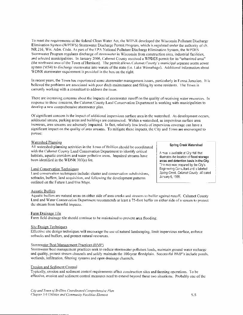
To meet the requirements of the federal Clean Water Act, the WDNR developed the Wisconsin Pollutant Discharge Elimination System (WPDES) Stormwater Discharge Permit Program, which is regulated under the authority of ch. NR 216, Wis. Adm. Code. As part of the EPA National Pollutant Discharge Elimination System, the WPDES Stormwater Program regulates discharge of stormwater in Wisconsin from construction sites, industrial facilities, and selected municipalities. In January 2006, Calumet County received a WPDES permit for its "urbanized area" (the northwest area of the Town of Harrison). The permit allows Calumet County's municipal separate storm sewer system (MS4) to discharge stormwater into waters of the state (i.e. Lake Winnebago). Additional information about WDNR stormwater requirement is provided in the box on the right.
In recent years, the Town has experienced some stormwater management issues, particularly in Forest Junction. It is believed the problems are associated with poor ditch maintenance and filling by some residents. The Town is currently working with a consultant to address the issue.
There are increasing concerns about the impacts of stormwater runoff on the quality of receiving water resources. In response to those concerns, the Calumet County Land Conservation Department is working with municipalities to develop a new comprehensive stormwater plan.
Of significant concern is the impact of additional impervious surface area in the watershed. As development occurs, additional streets, parking areas and buildings are constructed. Within a watershed, as impervious surface area increases, area streams are adversely impacted. In fact, relatively low levels of impervious coverage can have a significant impact on the quality of area streams. To mitigate these impacts, the City and Town are encouraged to pursue:
Watershed Planning All watershed-planning activities in the Town of Brillion should be coordinated with the Calumet County Land Conservation Department to identify critical habitats, aquatic corridors and water pollution areas. Impaired streams have been identified in the WDNR 303(e) list.
Land Conservation Techniques Land conservation techniques include: cluster and conservation subdivisions, setbacks, buffers, land acquisition, and following the development patterns outlined on the Future Land Use Maps.
Spring Creek Watershed
A map is available at City Hall that illustrates the location of flood storage areas and detention basis in the City. This map was prepared by the City's Engineering Consultant and is labeled Spring Creek, Calumet County, WI dated January 6, 1999.
Aquatic Buffers Aquatic buffers are natural areas on either side of area creeks and streams to buffer against runoff. Calumet County Land and Water Conservation Department recommends at least a 75-foot buffer on either side of a stream to protect the stream from harmful impacts.
Farm Drainage Tile Farm field drainage tile should continue to be maintained to prevent area flooding.
Site Design Techniques Effective site design techniques will encourage the use of natural landscaping, limit impervious surface, enforce setbacks and buffers, and protect natural resources.
Stormwater Best Management Practices (BMP) Stormwater best management practices seek to reduce stormwater pollutant loads, maintain ground water recharge and quality, protect stream channels and safely maintain the 100-year floodplain. Successful BMP's include ponds, wetlands, infiltration, filtering systems and open drainage channels.
Erosion and Sediment Control Typically, erosion and sediment control requirements affect construction sites and farming operations. To be effective, erosion and sediment control measures need to extend beyond these two situations. Probably one of the
City and Town of Brillion Coordinated Comprehensive Plan Chapter 5.0 Utilities and Community Facilities Element 5.5

most effective techniques is to reduce the time that soil is exposed. As with the other mitigation techniques outlined in this subsection, education will be critical to success.
Water Supply
City of Brillion City of Brillion residents are provided public drinking water from a municipal system drawing water from three individual wells. Two of these wells are approximately 180 feet in depth, drawing groundwater from the Niagara Dolomite Aquifer, while the other is 805 feet, respectively, and draws groundwater from the St. Peter Sandstone formation (See Agricultural, Natural & Cultural Resources Chapter for more information). The two shallower wells are more susceptible to contamination due to the fractured nature of the dolomitic limestone of the Niagara Dolomite Aquifer. Individual shallow wells outside of the City are also more susceptible to the threat of contamination.
According to the 2001 City Services Survey, over 79 percent of respondents felt the City should continue to provide soft water. The City's commitment to a continued quality municipal water supply is evident based on allocations identified in the City's Capital Improvement Plan (CIP). A major project identified in the CIP is softener replacement to comply with chloride limits between 2005 and 2008. The CIP also indicates that the City may develop a fifth well and transmission main, if demand justifies this expense.
Concerns about the future provision of public water to portions of the City exist based on the topography of the land. In particular, areas within the eastern portion of the City, which are at or above 894' above sea level, may not be serviceable by municipal water without significant modifications to the water system to increase water pressure. This factor will limit the amount of new development on the City's eastern side and subsequently increase development pressures in the western and southern areas of the City.
Water usage is actually decreasing in the City of Brillion. In 1999, approximately I million gallons of water was used. Today, that amount has decreased to 785,000 gallons. This reduction is due to the efforts of local industry to reduce water consumption through recycling and other means. This decreasing consumption trend is expected to continue in the future. Approximately 70% of the City's treated water supply is used by local industry.
Town of Brillion In the Town of Brillion, groundwater resources are not plentiful and of poor quality (due to the presence of sulfur and some nitrates from farm fields). Moreover, the vertical flow of groundwater is limited due to the presence of Maquoketa Shale that acts as a confining unit. Groundwater is low in most areas of the Town and continues to drop. Groundwater recharge areas consist of wetlands, permeable soils and karst features within the immediate area of the Water Table Aquifer.
All Forest Junction residents are provided with public drinking water from a municipal system that are drawing from the sandstone aquifer. This deep aquifer is not as susceptible to contamination due to the Maquoketa Shale. Individual shallow wells outside the utility district are also more susceptible to the threat of contamination due to karst features and may be of serious concern.
In rural areas of the Town, conversion of rural/agricultural lands to urban uses may impact the quality and quantity of groundwater. Groundwater recharge will decrease as areas are paved over or built upon. At the same time, withdrawal of groundwater in the region is likely to increase for domestic, commercial and industrial use. All residential developments in the rural areas of the Town, beyond the sanitary district, are currently serviced by private wells.
During the planning process, a few Town residents living near the City indicated that they have had to dig deeper wells in recent years in order to continue to serve their homes. This could be the result of a cone of depression associated with the dewatering of the quarry.
City and Town of Brillion Coordinated Comprehensive Plan Chapter 5.0 Utilities and Community Facilities Element 5.6

Waste Management and Disposal
Refuse Collection The City and Town use a private carrier (Veolia Environmental Services previously Onyx Waste Services), under separate contracts, to collect refuse weekly. According to the City Services Survey, an overwhelming majority of City residents were satisfied (50%) or very satisfied (45%) with garbage collection. Waste collected by Veolia Environmental Services is taken to their transfer station in Omro, Wisconsin. From there, the materials are taken to the Veolia Environmental Services Landfill located in the Town of Chilton.
Recycling Collection In 1989, the State of Wisconsin adopted a recycling law. Beginning in 1995, the disposal of paper products such as newspaper, office paper, magazines and corrugated cardboard and containers made from aluminum and steel were prohibited from being disposed in landfills. Certain glass and plastic containers were also banned. In addition, the recycling law also prohibited landfill disposal of tires, automotive batteries, oil, appliances, toxic substances and yard wastes.
The City and Town manage separate recycling programs. Veolia Environmental Services (private company) provides curbside pickups of recycle tin, aluminum, plastic, glass, newspaper and brown cardboard. Materials for recycling collected by Veolia Environmental Services are also taken to the transfer station in Omro, Wisconsin to be processed and marketed for industrial, business and other potential users.
Yard Waste - City Compost Site City residents may discard yard waste at the City's compost site, located off the north side of USH 10.
Curbside Leaf Pickup In 2000, the City initiated a curbside leaf pick-up program. In the fall, City residents may rake leaves onto City streets, along the curb, for pickup.
Curbside Chipping City residents may place brush, branches and small limbs on the curbside for chipping during spring, summer, and fall months, and can also be discarded at the City's compost site in designated areas.
Electricity and Natural Gas
Wisconsin Public Service (WPS) WPS provides electricity and natural gas service in the City and Town of Brillion. The company has a long history of supplying safe, reliable and reasonably priced service to its customers More importantly, the company seeks opportunities and technologies to increase customer value and improve the environment. WPS has no plans to expand the type or level of services offered in the City or Town of Brillion.
American Transmission Company (ATC) ATC provides transmission service for the WPS electricity. In 2004, ATC rebuilt its transmission site to improve the reliability of the electric power supply Wisconsin Public Service provides system in the Green Bay and Fox River Valley. Known as the Forest Junction electricity and natural gas service to Project, in completing this project, ATC was able to address the overloading of the City and Town of Brillion existing equipment and instability in the electrical transmission as a result of increased electrical demand. Today, the site accommodates projected electric load growth in the area, assuring continued reliable ATC electric transmission service. The scope of this project included:
• Construction of a new transmission substation on 25 acres in the Town, adjacent to an existing switching station to be retired and removed.
City and Town of Brillion Coordinated Comprehensive Plan Chapter 5.0 Utilities and Community Facilities Element 5.7

• Rebuilding of an existing 75-year-old 20.2-mile transmission line from the new substation in Brillion to an existing substation in Bellevue. For the line rebuild, existing lattice steel towers will be replaced with steel poles, in approximately the same location.
• Construction of a second transmission line along 12.1 miles of the aforementioned 20.2-mile line (wire only) and along 2.4 miles of another transmission line (wire and structure). This new line would be 14.5 miles from the new substation in Brillion to an existing substation in the Town of Lawrence in Brown County.
• The addition and modification of minor equipment at existing substations located in Calumet, Brown, Outagamie, Manitowoc, Sheboygan and Waukesha Counties.
These upgrades will ensure continued, quality service to the Brillion Community for the next 20 years.
ANR Pipeline Company (ANR) ANR owns and maintains the gas transmission pipelines that provide WPS natural gas service to the City and Town. ANR was the first interstate pipeline to deliver natural gas supplies to Wisconsin, and it currently delivers most of the natural gas consumed in the state. ANR operates and maintains five compressor stations, four warehouses, 130 meter stations and more than 1,700 miles of pipeline. Wisconsin field operations are managed through an area office in Waukesha, which also serves as a satellite marketing office to provide closer liaison with local distribution companies and other customers. ANR has no plans to expand its pipelines in the City or Town.
Wind Power Electric power demand in Northeast Wisconsin has significantly increased over the past decade. In a number of incidents since 1997, various residential and commercial customers have been threatened with blackouts and/or brownouts during peak use periods (usually summer periods). This problem has also been compounded by routine power plant maintenance and unforeseen plant shutdowns.
Wind power has some potential as an alternative energy source. Unlike fossil fuel dependent technologies, wind power does not pollute the environment. Future, more intensive use of this technology will depend on unit cost reductions. One of the nearest successful examples of wind power in Wisconsin is found along USH 41 south of Fond du Lac. Here, Wisconsin Electric Power Company (WE) has two low-speed wind turbines.
Depending on wind speeds, each turbine is designed to produce a maximum flow of 660 kilowatts of electricity - enough electricity to supply about 300 homes with energy. During the course of a year, the wind turbines will generate approximately 3,450 megawatt-hours of electricity. If that power were produced using conventional fossil fuels, there would be 1,956 tons of carbon dioxide emissions; the equivalent of 260 people driving sport utility vehicles for a year.
There are proponents and opponents to the use of wind power. If this technology were to be seriously pursued, City and Town officials should:
• Pay careful attention to the siting and visual impact on the community.
• Consider potential impacts on migratory bird patterns.
• Establish standards restricting location, height, noise and other issues with respect to the turbines as conditions to any approval to minimize potential impacts on neighboring property owners.
• Consult with special experts to ensure that the application of these technologies will notjeopardize public health, safety and welfare.
• Require that all reasonable costs and expenses associated with such consultations be paid by the applicant.
City and Town of Brillion Coordinated Comprehensive Plan Chapter 5.0 Utilities and Community Facilities Element 5.8

Methane Gas- Alternative Fuel During the planning process, the potential for using methane gas generated from cow manure as an alternative fuel source was discussed. Manure digesters are available to capture and utilize methane gas in this way. As collected manure decomposes it releases methane biogas. A manure digester will capture the gas and use it to fuel a power plant that will in turn, produce electricity. The City and Town consider the use of methane gas a viable future alternative energy source.
Existing Facilities Inventory- Location, Use, Capacity
Park and Recreation Facilities
The City of Brillion Park and Recreation Department offers a variety of year-round programs for people of all ages. The Brillion Community Center is the headquarters of the Park and Recreation Department and
Brillion Community Center allows the City to host a series of creative and
diverse programs for residents. The City has four parks, which encompass approximately 31 acres. Town residents are welcome to use the facilities and services provided by the City's Park and Recreation Department. In Forest Junction, residents also enjoy Freitag Memorial Park.
According to the community survey conducted as part of this planning effort, residents generally encourage new park and recreation facilities in the community, including additional: children's playgrounds, recreation trails, and areas for scenic enjoyment, hunting and fishing. The community survey also indicated that residents are satisfied with the current availability of golf courses and sports fields.
A description of the park and recreation facilities available in the Brillion Community follows. Park and recreation facilities are also identified on the Utilities and Community Facilities Maps provided in Appendix B.
Brillion Community Center Unlike other communities the size of Brillion, the City is able to offer year-round recreation services due to the Brillion Community Center. Founded in 1970, the community center houses an indoor gymnasium, racquetball court, and industrial kitchen, 3 classrooms and 2 swimming pools. This 40,000 square foot facility allows the Brillion Park and Recreation Department to offer an array of recreational activities including: dance, volleyball, basketball, Tae Kwon Do, aerobics, yoga, water-exercise and swim lessons.
Brillion Wildlife Area (Brillion Marsh) & Nature Center The Brillion Wildlife Area (known locally as the Brillion Marsh) is approximately 4,800 acres in size (including areas in the Town of Rantoul). The property offers: a snowmobile trail route, 16 small
City and Town of Brillion Coordinated Comprehensive Plan Chapter 5.0 Utilities and Community Facilities Element
/000, ~Z-4i~m
Nature Center
Brillion Nature Center w.briIIionnaturecenter.net
Freitag Memorial Park, Forest Junction, WI
Shaded Play Area - Horn Park
5.9

parking areas (5-9 vehicles each), a dog training area, and a model airplane area (privately owned by the Calumet
Flyers).
The Brillion Nature Center, located at WI 135 Deer View Road, is part of the Brillion Wildlife Area owned by the State of Wisconsin and managed by the Department of Natural Resources. The nature center is operated by the Brillion Nature Center Association, Inc., a non-profit organization that utilizes public and private funding to support its environmental education programs.
The Brillion Nature Center's eight hiking trails cover nearly six miles and are open to the public everyday from 7 am. to sunset. The trails lead hikers through a wide variety of natural communities, including marsh, ponds, forests, and restored prairie. Limestone formations and historical sites also dot the trail. The Brillion Nature Center Building, a small barn built in the 1940s, is used as a classroom and office and hosts a variety of educational stations.
Deer Run Golf Course The Deer Run Golf Course is a public 9-hole course located on Fairway Drive in the City. Opened in 1964, this course plays to a par 72 for 6160 yards. This attractive course offers reasonable green fees for local golfers and a clubhouse facility.
Freitag Memorial Park This 24-acre community park is located south of USH 10 in Forest Junction. Four acres of the park is mowed and includes children's playground equipment, space for picnicking, and a 9-hole disc golf course. The remaining acreage is woodlands with another 9-hole disc golf course planned to be installed in summer 2009. The park is owned and maintained by the Forest Junction Civic League.
Horn Park This 19-acre park is Brillion's largest and most diverse. Located in the northeast section of the City, adjacent to Brillion Iron Works, it serves as a traditional community park, providing a verity of recreational amenities.
Most of the park's development is concentrated in the northern portion of the site, which is rolling and tree-covered. The City has maintained an active tree-planting program to ensure that the park's character is preserved.
A baseball field with a scoreboard, a play apparatus area, picnic facilities and benches provide additional recreational opportunities for residents. Support structures include a sheltered picnic area, an enclosed shelter with serving windows, an open-air amphitheater, restroom facilities and a maintenance shed. A paved drive loops through the park providing convenient access to all facilities. Paved parking areas are provided by the shelter. A lighted, paved walkway also extends through the park.
Heritage Park This five-acre park is located in south-central Brillion on the corner of S. Main Street and Fairway Dive. It functions primarily as a neighborhood park for residents living in the southeastern portion of the City. Heritage Apartments, an elderly housing complex, is located immediately south of the park.
Facilities include four lighted tennis courts, playground equipment, shelter building with restrooms, picnic facilities, and paved parking areas. The park boasts an open character with accent landscaping. The southern portion of the park contains a baseball diamond with bleachers and a scoreboard.
Peters Park Athletic Field This six-acre parcel located in west-central Brillion adjacent to the Brillion Elementary/Middle School campus includes:
• A lighted softball diamond with bleachers, scoreboard and a scorekeeper that is used by the City, school district, and Brillion Athletic Association.
• A lighted basketball court.
• Two lighted sand volleyball courts.
City and Town of Brillion Coordinated Comprehensive Plan Chapter 5.0 Utilities and Community Facilities Element 5.10

A hard plastic play station.
The southwest corner of the field is also used as a soccer field.
Support facilities include a concession stand, restrooms, a maintenance/storage shed and a parking area. The parking area and concession stand receive heavy use during football games and major track meets held at the adjacent Brillion Elementary/Middle School campus.
Sniifh Pirk
This half-acre downtown pocket-park along Spring Creek is at the corner of Horn and South Main Streets. It serves as a green space for downtown visitors.
Outer Limits Youth Outreach Located in the former Forest Junction Elementary School, Outer Limits Youth
For additional information Outreach is a non-profit facility serving as a recreation center for school age children about Outer Limits Youth in grades 3-8. The facility offers supervised activities, a game room, and after Outreach or to volunteer, school tutoring. It is open three evenings each week to provide youth with a place to contact James Breeden at go. Local organizations also occasionally rent space for meetings and special 989-1611. functions. The primary challenge facing Outer Limits Youth Outreach is finding enough volunteers to provide adequate supervision.
Camp Forest Located east of the USH 10 and STH 32/57 interchange in Forest Junction, this property was once a church campground. Now, owned by a private non-profit organization, the cabins are rented to various groups for bible schools, retreats, picnics, family reunions, weddings, craft shows and other special events. The owners are currently considering developing an all-weather building for year-round use.
Snowmobile Trails The Deer Run Sno-Riders maintain a network of snowmobile trails in the Brillion Community. Beginning in 2001, the City of Brillion allowed snowmobilers access to the City. According to the City Services Survey, 65% of respondents favored allowing snowmobiling within the City. Of those who said yes to snowmobiling, 50% said snowmobiling in the City should be limited to City streets to and from trails. The Utilities and Community Facilities Maps provided in this chapter illustrate the location of snowmobile trails in the Brillion Community.
The National Recreation and Park Association recommends:
• A community standard of 10 acres of local recreation land per 1,200 residents.
• The current population of the City of Brillion is 2,937 (2000 U.S. Census).
• To meet this standard, the City would need to provide approximately 25 acres of parkland.
• The City's 31 acres of parkland exceed this standard.
The ECWRPC recommends:
• 10 acres of local recreation land per 1,000 residents.
• Based on this standard, 29.64 acres of parkland should be provided.
• The City's 31 acres of parkland exceed this standard.
The current population for the Town is 1,438 (2000 U.S. Census). To meet the National Recreation and Park Association standards the Town would need to provide at least 12.1 acres of parkland. Likewise, to meet the ECWRPC recommendation, the Town would need to provide 14.55 acres of parkland. Freitag Park alone exceeds both recommendations. Moreover, City and Town residents have easy access to the more than 5,000 acres of recreation land in the Brillion Wildlife Area. Given this situation, both City and Town residents have ample access to recreation amenities.
City and Town of Brillion Coordinated Comprehensive Plan Chapter 5.0 Utilities and Community Facilities Element 5.11

Continued access to quality recreational facilities is a priority for the City of Brillion, as reflected in the City's CIP. Likewise, the Town of Brillion considers park maintenance needs annually as part of its budgeting process.
Communication Facilities
Access to communication facilities is very important in the modern economy. Several communication companies provide service to the Brillion Community. The quality of communication services depends on the capacity of the lines and towers serving the area. This element will help to guide decisions for installation of upgraded facilities and lines that may be needed to provide quality services to residents over the next 20 years.
Television and Radio There are no television stations or towers located in the City or Town of Brillion nor are there plans to establish such facilities. The community receives the three major television commercial networks, Wisconsin Public Television and two independent Fox Valley television stations.
Charter Communications provides cable television service to the City and Time Warner provides cable to the Town. Both companies offer packages with more than 100 channels. Future service upgrades are determined based on cost-constraints and customer demand.
Residents of the Brillion Community enjoy a number of different radio program formats provided by numerous area radio stations throughout Northeast Wisconsin. One FM station is also broadcast from the area.
Newspapers The Brillion Community is served by several local and regional newspapers. Below is a partial list of newspapers in circulation in the area.
Weekly papers include:
The Brillion News - local paper serving the City and Town of Brillion
The Lake to Lake Shopper - delivered free to area residents
• The Tempo- delivered free to area residents
• The Chilton Times Journal
Daily papers include:
The Appleton Post Crescent
The Green Bay Press Gazette
• Herald Times Reporter - Manitowoc
• The Milwaukee Journal-Sentinel
Local and Long Distance Telephone Service Verizon is the local telephone service provider for the City and TDS Telecom is the local telephone service provider for the Town. Residents may purchase long distance telephone service from many different providers. As a result, costs remain competitive and services are regularly upgraded to reflect new technologies and services, such as digital phone service, in this competitive environment. The area is linked to a fiber optic network.
Brillion, WI Post Office
Postal Service The City of Brillion Post Office is located at 210 E. Water Street. Forest Junction also has a small post office located on the south side of USH 10, east of the intersection with STH 57. Together, these facilities offer rural and city delivery to the Brillion Community. The existing postal facilities are expected
City and Town of Brillion Coordinated Comprehensive Plan Chapter 5.0 Utilities and Community Facilities Element 5.12
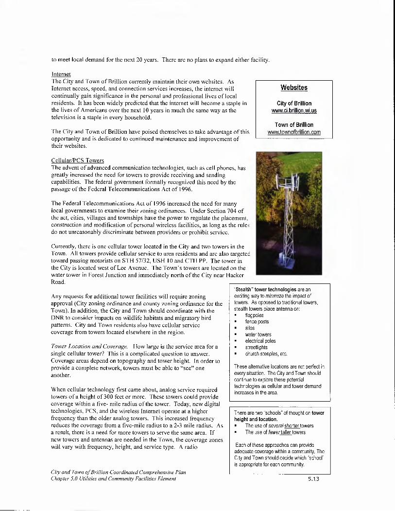
Websites
City of Brillion www.ci.brillion.wi.us
Town of Brillion www.townofbrillion.com
to meet local demand for the next 20 years. There are no plans to expand either facility.
Internet The City and Town of Brillion currently maintain their own websites. As Internet access, speed, and connection services increases, the internet will continually gain significance in the personal and professional lives of local residents. It has been widely predicted that the internet will become a staple in the lives of Americans over the next 10 years in much the same way as the television is a staple in every household.
The City and Town of Brillion have poised themselves to take advantage of this opportunity and is dedicated to continued maintenance and improvement of their websites.
Cellular/PCS Towers The advent of advanced communication technologies, such as cell phones, has greatly increased the need for towers to provide receiving and sending capabilities. The federal government formally recognized this need by the passage of the Federal Telecommunications Act of 1996.
The Federal Telecommunications Act of 1996 increased the need for many local governments to examine their zoning ordinances. Under Section 704 of the act, cities, villages and townships have the power to regulate the placement, construction and modification of personal wireless facilities, as long as the rules do not unreasonably discriminate between providers or prohibit service.
Currently, there is one cellular tower located in the City and two towers in the Town. All towers provide cellular service to area residents and are also targeted toward passing motorists on STH 57/32, USH 10 and CTH PP. The tower in the City is located west of Lee Avenue. The Town's towers are located on the water tower in Forest Junction and immediately north of the City near Hacker Road.
Any requests for additional tower facilities will require zoning approval (City zoning ordinance and county zoning ordinance for the Town). In addition, the City and Town should coordinate with the DNR to consider impacts on wildlife habitats and migratory bird patterns. City and Town residents also have cellular service coverage from towers located elsewhere in the region.
Tower Location and Coverage. How large is the service area for a single cellular tower? This is a complicated question to answer. Coverage areas depend on topography and tower height. In order to provide a complete network, towers must be able to "see" one another.
When cellular technology first came about, analog service required towers of a height of 300 feet or more. These towers could provide coverage within a five- mile radius of the tower. Today, new digital technologies, PCS, and the wireless Internet operate at a higher frequency than the older analog towers. This increased frequency reduces the coverage from a five-mile radius to a 2-3 mile radius. As a result, there is a need for more towers to serve the same area. If new towers and antennas are needed in the Town, the coverage zones will vary with frequency, height, and service type. A radio
City and Town of Brillion Coordinated Comprehensive Plan Chapter 5.0 Utilities and Community Facilities Element
"Stealth" tower technologies are an exciting way to minimize the impact of towers. As opposed to traditional towers, stealth towers place antenna on: • flagpoles • fence posts • silos • water towers • electrical poles - streetlights • church steeples, etc.
These alternative locations are not perfect in every situation. The City and Town should continue to explore these potential technologies as cellular and tower demand increases in the area.
There are two schools" of thought on tower height and location. • The use of several shorter towers - The use of fewer taller towers
Each of these approaches can provide adequate coverage within a community. The City and Town should decide which school is appropriate for each community.
5.13

frequency engineer can determine the exact coverage areas for any tower or antenna.
As technology changes and as demand for service increases, tower demand will follow. The City and Town have several options to reduce the overall number of towers needed in the future and to minimize their visual impact. For example, co-location of several antennas on a single tower reduces the need for additional towers. Carriers also are more and more willing to camouflage their towers by locating antennas on church steeples, tall buildings, silos, tall power transmission lines and water towers. Each technique can help minimize the impact of the wireless industry in the City and Town of Brillion.
Future Tower Needs. Unfortunately, it is not possible to develop a map of specific locations to site towers in the City and Town of Brillion, because networks provided by different carriers have different location requirements for towers. Moreover, as technologies change and new licenses are granted for additional carriers to move into the area, locations identified on a map would quickly become outdated.
One problem with 1996 Telecommunications Act, from a local perspective, is that simply providing coverage is not enough. Communities must provide for networks from competing carriers licensed in an area. The number of licenses granted, and in turn, the number of towers needed is controlled by the FCC. Currently, there are seven carriers licensed to provide cellular service in Eastern Wisconsin.
It is anticipated that in the next 5-10 years the primary coverage area for wireless service in the Brillion Community will continue to be along the USH 10 corridor. Secondary coverage areas include: Downtown Brillion, Forest Junction and the STH 32/57 corridor. Beyond this timeframe, coverage will likely infihl in the City of Brillion and rural areas of the Town, particularly along county trunk highways. The rate of tower construction will depend on local demand, the number of licenses granted by the FCC, and the capacity of new towers to accommodate additional carriers.
Cemeteries
Often overlooked, cemeteries are an important facility every community must provide. There are eight cemeteries located in the Brillion Community. Five are located within the City of Brillion, and three are located in the Town. Altogether, there are four maintained and operated by the communities, and four that are maintained and operated by local church congregations. (See Utilities and Community Facilities Maps in Appendix B).
Given historical plot demands and available acreage, it is anticipated that adequate cemetery space is available to meet local needs for at least the next 20 years. In addition, residents may also use space available in other public and private cemeteries and mausoleums throughout the region.
City Cemeteries
The Old (Village) Cemetery: The Old Cemetery (Village Cemetery) is located on the west side of CTH PP in the Town, but on land owned by the City. Headstones in this cemetery date back to the 1800s. The City has no plans to expand this cemetery. In fact, the City does not sell lots in this cemetery because historic records may not be accurate about the location of all grave sites.
• The Old Town Cemetery: The Old Town Cemetery is directly south of the Old Village Cemetery previously mentioned. It is also very old, and there are no plans for expansion; no lots are sold.
• The Old Trinity Lutheran (Church) Cemetery: This cemetery is also located in the same area as the Old Village and Old Town Cemeteries. Because of the cemeteries' ages, it is very difficult to determine where one cemetery ends and the other begins. For this reason, no expansions are planned, and no lots are sold.
• Community Cemetery: The Community Cemetery is located in south Brillion on the east side of CTH PP. The City maintains this cemetery. Future expansion would be difficult because the cemetery is surrounded by a residential
City and Town of Brillion Coordinated Comprehensive Plan Chapter 5.0 Utilities and Community Facilities Element 5.14

subdivision near the Deer Run Golf Course. The cemetery is 5.13 acres in size, and currently has space available. The City of Brillion Cemetery Commission reviews capacity issues as they deem necessary, and at this point feels additional space is not needed.
• The New Trinity Lutheran (Church) Cemetery: The Trinity Lutheran Cemetery is adjacent to the southern boundary of the Brillion Community Cemetery on the east side of CTH PP. There are no immediate plans for expansion.
Town Cemeteries
• The Brillion Bluffs Cemetery: The Brillion Bluffs Cemetery is located in the Town on the corner of CTH K and CTH PP. This cemetery includes approximately 5 acres and space is available in this cemetery.
• The Forest Homes/North Cemetery/Zion Cemetery(Church): This cemetery is located on the northeast corner of Cemetery Road and Schmidt Road between Dundas and Forest Junction, and is operated by the Zion United Methodist Church of Forest Junction. It is approximately 5 acres in size and has space available.
• St. Mary Catholic (Church) Cemetery: St. Mary's Cemetery is located in the Town, north of the City on CTH PP. There are no immediate plans for expansion.
Health Care Facilities
There are no health care facilities located in the Town. The City has:
• A family practice clinic;
• Two chiropractic offices;
• Two dental offices; and
• A physical therapy clinic.
Residents in need of more intensive and specialized medical treatment must visit Calumet Medical Center located in Chilton or hospitals in Green Bay, Manitowoc, Two Rivers, Neenah or Appleton. These larger facilities are accessible via USH 10, CTH PP, and STH 32/57.
The population in the City and Town of Brillion is not large enough to support its own hospital. However, the population is large enough to support its local clinic and medical offices. Though the existing facilities available in the City of Brillion and in nearby communities are expected to meet all basic local health care needs for the next 20 years, in the community survey, residents indicated that additional medical services and choices are desired. According to the community planning survey, 73% of residents would like to see additional health care facilities (i.e. doctor, dentist, optometrist, etc.) open in the area.
Childcare Facilities
15.3 percent of Brillion Community residents are under the age of 18. This is a very significant portion of the local population that has immediate and particular service demands (i.e. schools, parks, child care facilities). As these residents grow into adulthood, this information will help to determine the amount of growth in the Brillion Community as they find residences, have children, or move elsewhere.
18.9 percent of the local population is between the ages of 20 and 34. This is the age group that will have children over the next 10-15 years. These children will also require access to childcare facilities, schools, parks and other amenities. To meet this growing need, the Brillion Community offers these facilities and services:
City and Town of Brillion Coordinated Comprehensive Plan Chapter 5.0 Utilities and Community Facilities Element 5.15

Circle of Friends Child Learning Center, Inc. located at 333 W. National Avenue is licensed to accommodate 84 children from 6 weeks of age and older. The center also offers a summer program for children between the ages of 6 and 12 years of age. City and Town residents, as well as commuters from outside the area, use the Circle of Friends Child Learning Center.
Residents also have access to several other childcare facilities found in nearby communities. Specifically, facilities are available in Hilbert, Chilton, Kaukauna and Wrightstown.
The Outer Limits Youth Outreach facility (See Parks and Recreation Section) in Forest Junction provides after school activities and tutoring for students in grades 3-8 and evening activities for older children.
Services for Seniors and People with Disabilities
According to the 2000 U.S. Census, 573 people (13.1 percent) who live in the Brillion Community are age 65 or over. Like youth populations, seniors also demand particular services and housing options to meet their specific needs.
Additional Information about Senior and Disabled Housing Facilities is provided in
Chaoter 3.0, the Housinu Element.
The Town does not have any senior housing, assisted living retirement communities or special senior programs for its residents. Seniors living in the Town must be able to live independently or find assistance from family members, friends, neighbors and Calumet County.
Calumet County offers an array of services and programs for older people and people with disabilities living in the City and Town of Brillion. Most notably, the Calumet County Health and Human Services Department seeks to meet the needs of older adults and the disabled through nutrition, transportation, respite care, advocacy, and general coordination of services with other public and private agencies. These programs provide vital services that make independent living possible. In addition, the county sponsors a congregate meal site and home delivered meal program.
Congregate Meal Site This site was established to offer balanced noon meals in a group setting, to encourage fellowship, reduce isolation and make needed supportive services available in an easily accessible site. All county residents age 60 and over are able to utilize this service. The meal site is located in the Brillion Community Center in the City of Brillion.
Home Delivered Meals This service is designed to help county residents remain self-sufficient in their own homes. Through the program, volunteers deliver prepared mid-day meals. Eligible county residents must be over age 60, unable to attend the congregate meal site and unable to be transported.
The City of Brillion Housing Authority also operates three public housing projects in the City: Parkview Homes, Heritage Apartments, and Garrow Villa. Likewise, the City's Park and Recreation Department and Library welcome seniors to participate in programs and utilize the facilities.
Police and Law Enforcement
The City and Town of Brillion are protected by the Brillion Police Department and the Calumet County Sheriff's Department.
Brillion Police Department The Brillion Police Department operates from the City Hall located at 130 Calumet Street in Brillion. The Department is in continuous operation, with officers on duty 24 hours a day, 7 days a week, 365 days a year. The Department is made up of seven full-time police officers, three part-time
City and Town of Brillion Coordinated Comprehensive Plan Chapter 5.0 Utilities and Community Facilities Element 5.16

POLICE PROTECTION STANDARDS
• The traditional Wisconsin standard for small town/rural police protection is 1.86 officers per 1,000 population.
The FBI recommended standard is 1.5 officers per 1,000 population.
personnel, and one part-time civilian. In addition to general police activities and response to calls for services, the Department actively participates in:
• Community-policing activities
• DARE (Drug Abuse Resistance Education)
• Instruction at the elementary and middle school levels
• Crime Stoppers; and
The Calumet County Drug Enforcement Unit.
The Brillion City Council has made a commitment to ensure the Department is supplied with sufficient personnel, state of the art equipment and necessary training. The Department is currently working to become one of approximately 20 State Accredited Law Enforcement Agencies. The Brillion Police Department has mutual aid agreements with Calumet County, Brown County and Manitowoc County.
The Department also has 911 emergency dispatch service provided through Calumet County. Emergency response times in the City are between two and three minutes. The Department currently has three squad cars.
The City of Brillion Police Department has seven full-time officers to serve the City's 3,032 residents. Therefore, the City is operating slightly above the Wisconsin standard (six officers required) and the FBI standard (five officers required). The Department has no immediate plans to expand its office space or hire additional staff. However, the Department annually evaluates staff and space needs.
Calumet County Sheriff's Department The Town of Brillion is served by the Calumet County Sheriff's Department. The Sheriff's Department headquarters is located at 206 Court Street in Chilton. The Department has 24 sworn officers (13 Patrol Officers, 2 Patrol Corporals, 1 Patrol Sergeant, 2 Administrative Lieutenants, 1 Captain, 4 Investigators, and I Sheriff) and 11 dispatchers (9 full-time, 2 part-time) for the 24-hour 911 emergency dispatch service provided by the county. The Department provides primary protection services to 22,800 residents living in the villages and unincorporated areas of the county and back-up protection to the cities. According to the FBI standards for police protection, the Department should have 34 sworn officers - 10 more than the current force.
Response times for emergency calls within the county vary depending on the location of the call and the location of the nearest cruiser at the time the call is placed. The average response time is 15 minutes.
The Calumet County Sheriff's office has a fleet of seven cruisers, three unmarked vehicles, four inmate transport vehicles, two snowmobiles and a
water patrol boat. At any given time at least two (and up to five) of the cruisers are patrolling the county. The Department updates its equipment frequently. In fact, every two years the entire fleet of cruisers is replaced.
In April 2009, the Department applied for federal grant money offered through the American Recovery and Reinvestment Act COPS program to expand the size of its force. Expansion of the force would only occur if the grant funding was received. Staffing needs are evaluated annually based on demand and budget constraints.
County Jail Facilities The Calumet County Sheriff's Department also operates ajail facility at 206 Court Street in Chilton. The jail can accommodate up to 54 adults. In the last year, the jail has been consistently operating at or near capacity. For this reason, the Sheriff's Department is studying opportunities to expand its current jail facility or build a larger, regional jail facility with Outagamie County.
City and Town of Brillion Coordinated Comprehensive Plan Chapter 5.0 Utilities and Community Facilities Element 5.17

WDNR Wardens In addition to the protection services offered by the City and county, two Wisconsin Department of Natural Resources Wardens protect the Brillion Community. The wardens seek to enhance and promote the safe and wise use of natural resources, including waterways, through enforcement, education and community based wardening that guarantees fair and equal treatment. Wardens have full arrest authority for natural resource laws, and are authorized to enforce other state criminal laws when necessary. Wardens are required to be armed while in uniform, and may be asked to assist in investigations by other law enforcement agencies.
Fire and Rescue Services
Brillion Fire Department Brillion Fire Department is an independent volunteer-based department providing service to the City of Brillion. The station is located at 130 Calumet Street, part of the City Hall. The Brillion Fire Department provides contract service to the Town of Maple Grove and areas east of Bastian Road in the Town of Brillion. The Brillion Fire Department also participates in the Calumet County Mutual Aid Agreement and has mutual aid agreements with Reedsville, Hollandtown, Collins, Potter, and Wayside.
The Brillion Fire Department has 911 emergency response service dispatched by Calumet County. Currently, the Brillion Fire Department has 37 firefighters. The average response time, including outlying areas and areas with mutual aid agreements, is six minutes. In the City, response time is considerably less, approximately four minutes.
At this time, the Department has no plans to acquire additional vehicles. The need for new and replacement vehicles is evaluated regularly as part of the City's CIP process. Insurance Services Office (ISO) rates fire protection service to the City of Brillion as a 5 (out of 10 with 1 being the best). The ISO issues "fire protection" ratings and classifications across the United States. Most insurance underwriters utilize the assigned fire protection rating to calculate residential, commercial and industrial insurance premiums. Fire districts arc evaluated on a cyclical basis that is determined by district growth and the size of the population served. For a small city department, the 5 rating is fair to average.
The primary challenge facing the Brillion Fire Department is maintaining staff. The Department strives to maintain a force of 34 trained staff— enough to meet all fire needs 24 hours per day.
Budget constraints are also an issue for most fire departments, including the City's. The Brillion Fire Department attempts to maintain its spending levels at a 0% increase in funding annually. This is very challenging when vendors raise prices. The demand for additional services is always growing so maintaining service levels within budget constraints can be a challenge.
Forest Junction Fire Department The Forest Junction Fire Department includes all areas west of Bastian Road in the Town. The Forest Junction Fire Department provides on-call volunteer based fire service. The Forest Junction Fire Department participates in mutual aid agreements with all neighboring towns and the City. These agreements allow the Town to call on additional service should the need arise.
The fire station is located in the Town's Municipal Building on USH 10. The Town Fire Department provides 911-based emergency service dispatched by Calumet County.
City and Town of Brillion Coordinated Comprehensive Plan Chapter 5.0 Utilities and Community Facilities Element 5.18

The primary challenge facing the fire department is maintaining enough trained volunteers to adequately serve the Town.
At this time, based on the local population size, the amount of equipment serving the City and Town is adequate to meet all local needs. There are no plans to expand the fleet of vehicles serving the area.
Emergency Medical Services Brillion Gold Cross serves the entire Town of Brillion, City of Brillion and a portion of the Town of Woodville. The Town of Brillion First Responders also provides emergency services to the Town of Brillion.
Brillion Public Library
Established in 1928, the Brillion Public Library is a progressive institution. Open everyday except Sundays, the library has a growing collection of materials, services and information to meet community needs. It offers a number of public access Internet computers, some of which are connected to a printer and have word processing programs. Color copying, photocopying, and faxing services are also available to the public.
The Brillion Public Library is affiliated with the Manitowoc- Calumet Federated Library system and the Library Brillion Public Library Automated Resources Sharing (LARS) Catalog. Through this affiliation, users can access resources available from libraries within the region. Also, through Badger Link, an internet-based Wisconsin state-wide card catalog, the library provides access to magazine databases with many full text articles, newspaper articles, and access to WISCAT (the state library data base). The Brillion Public Library recognizes the particular needs of the elderly population by providing special services, including:
• Deposit collection of books, audio books and audiocassette players in Heritage, Garrow Villa and Parkview housing units in Brillion;
• Large print books of all types;
• Books on tape in both abridged and unabridged format;
• Tape recorders to listen to books on tape;
• Videocassettes for programs;
• Demonstration cart from the Regional Library for the Blind and Physically Handicapped;
• Voyager XL Reading and writing magnification unit; and
• Home delivery of materials to homebound patrons.
The Brillion Public Library has completed its five-year long-range plan which identified two primary goals for the library: automation of the card catalogue, and participation in the consolidation effort of all Manitowoc and Calumet County libraries to develop a shared catalog. Maintaining adequate funding is the primary challenge facing the Brillion Public Library. Funds are needed to maintain and expand the collection, facility, and staff. Complicating matters, the library continually struggles to receive needed funds from Calumet County to serve rural residents who use the library.
City and Town of Brillion Coordinated Comprehensive Plan Chapter 5.0 Utilities and Community Facilities Element 5.19

Brillion Public High School Entrance
Brillion Public Elementary and Middle School
Hilbert Elementary School
Area Private Schools
- Holy Family Catholic School (PreK-3), Reedsville
• Holy Family Catholic School (4-8), 209 Custer Street, Brillion
• St. John School (K-8), N7680 County Road BB, Hilbert
• St. Mary's of Hilbert (K-8), 132 S. 66h Street, Hubert
• St. Peter Lutheran School (K-8), 42 N. 3rd
Street, Hilbert
• Trinity Evangelical Lutheran School (Pre K-8), 601 E. National Avenue, Brillion
• Trinity Lutheran School (K-8), N6081 W. River Road, Hilbert
Schools
The Brillion Community is served by three school districts: Brillion Public Schools, Hilbert Public Schools and Wrightstown Community School District. Long-term, none of these districts have expansion plans. However, during the life of this plan additional school facility needs may arise. Any expansion decisions will be based on desired class size (i.e. smaller class sizes may require additional classrooms and teachers) and development within the school district that may bring additional students to each district. Other continuing and advanced educational facilities are found in the Fox Cities, Green Bay, Fond du Lac and Manitowoc.
Brillion Public Schools The Brillion Area School District serves the City of Brillion and most of the Town of Brillion. The district provides a comprehensive program of educational opportunities for its 900 students, also providing special education for students between the ages of 3 and 21 who are mentally or physically handicapped, have speech, language, physical and learning disabilities, and hearing or visual impairments.
The district's two school campuses are located in the City of Brillion. The Brillion Elementary and Middle School share a single campus located at 315 S. Main Street. The Brillion High School, built in 2001, is located in the western portion of the City at the intersection of CTH HR and USH 10. Enrollment numbers are located on Table 18.
Hubert Public Schools The Hilbert Public School District has two campuses located in Hilbert, WI. The elementary school is located on 8th Street and the combined middle/high school is located at the intersection of 11th and Milwaukee Streets in Hilbert. Enrollment has been stable or declining slightly in the Hilbert School District. Despite student enrollment, the school district is planning for a complete update of the middle/high school building, which includes the addition of a science and technology wing, and a new elementary school. These improvements are, of course, dependent on the approval of a referendum.
Wrightstown Community School District Eighty acres of land in Section 3 of the Town (between Bastian & Boettcher Roads) is included in the Wrightstown School District. The district serves two residences and has no plans to expand its boundaries or build facilities in the Brillion Community.
Private Schools Beyond the public schools, there are several private schools serving residents of the City and Town of Brillion. These facilities provide a faith-based education to students. The students attending private schools also have the option of attending local public schools. Expansions and improvements to private facilities are subject to the financial obligations and capacities of the sponsoring church. Trinity Evangelical Lutheran School is relocating on National Avenue, east of the City of Brillion. It is anticipated that Holy
City and Town of Brillion Coordinated Comprehensive Plan Chapter 5.0 Utilities and Community Facilities Element 1W41]
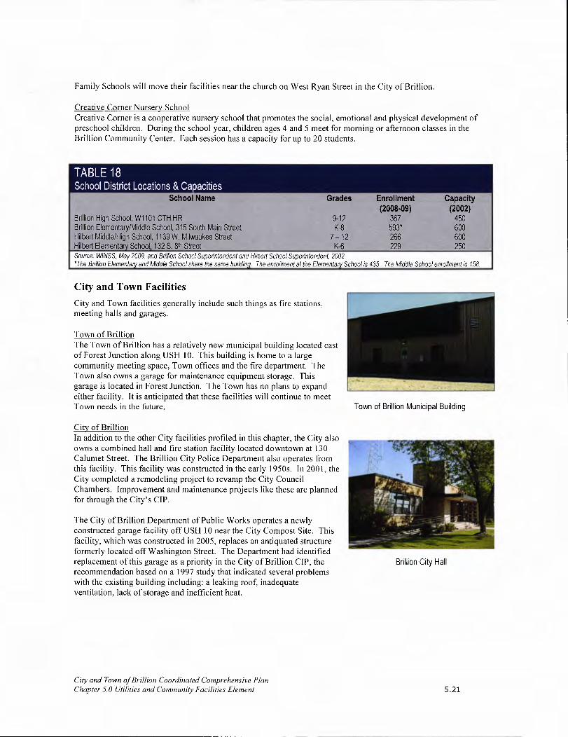
Family Schools will move their facilities near the church on West Ryan Street in the City of Brillion.
Creative Corner Nursery School Creative Corner is a cooperative nursery school that promotes the social, emotional and physical development of preschool children. During the school year, children ages 4 and 5 meet for morning or afternoon classes in the Brillion Community Center. Each session has a capacity for up to 20 students.
School Name Grades Enrollment Capacity (2008.09) (2002)
Bullion High School, Wi 101 0TH HR 9-12 367 450 Brillion Elementary/Middle School, 315 South Main Street K-8 593* 600 Hilbert Middle/High School, 1139W. Milwaukee Street 7-12 266 600 Hubert Elementary School, 132 S. 8th Street K-6 229 250 Source: WINSS, May 2009. and Brillion School Superintendent and Hilbert School Superintendent, 2002 'The Brillion Elementary and Middle School share the same buildinq The enrollment at the Elementary School is 435. The Middle School enrollment is 158.
City and Town Facilities
City and Town facilities generally include such things as fire stations, meeting halls and garages.
Town of Brillion The Town of Brillion has a relatively new municipal building located east of Forest Junction along USH 10. This building is home to a large community meeting space, Town offices and the fire department. The Town also owns a garage for maintenance equipment storage. This garage is located in Forest Junction. The Town has no plans to expand either facility. It is anticipated that these facilities will continue to meet Town needs in the future.
City of Brillion In addition to the other City facilities profiled in this chapter, the City also owns a combined hall and fire station facility located downtown at 130 Calumet Street. The Brillion City Police Department also operates from this facility. This facility was constructed in the early 1950s. In 2001, the City completed a remodeling project to revamp the City Council Chambers. Improvement and maintenance projects like these are planned for through the City's CIP.
The City of Brillion Department of Public Works operates a newly constructed garage facility off USH 10 near the City Compost Site. This facility, which was constructed in 2005, replaces an antiquated structure formerly located off Washington Street. The Department had identified replacement of this garage as a priority in the City of Brillion CIP, the recommendation based on a 1997 study that indicated several problems with the existing building including: a leaking roof, inadequate ventilation, lack of storage and inefficient heat.
Town of Brillion Municipal Building
Brillion City Hall
City and Town of Brillion Coordinated Comprehensive Plan Chapter 5.0 Utilities and Community Facilities Element 5.21

Utilities and Community Facilities Issues & Concerns
Kettl Commission- Regional Cooperative Efforts
In April 2000, former governor Tommy Thompson formed the Kettl Commission to "rethink what Wisconsin governments do and how they can do it better." The commission included representatives from state and local governments, school districts and universities. Given this mission, the commission held a series of 15 meetings and developed a report recommending four primary principles:
• Economic Development - strengthen state and local partnerships and minimize competition between communities for economic development.
• Citizens at the Center— Seek to ensure that governments at all levels provide customer driven service that is cost effective.
• Performance Driven Government - Seek to improve government efficiencies through coordination and consolidation of services.
Maximum local flexibility in pursuing statewide goals.
"One size doesn't fit all." As such, local governments should have the freedom to develop their own policies and programs, under the guide of statewide goals, to solve issues locally.
The City and Town's progressive role in developing this coordinated comprehensive plan exemplifies the principles outlined by the Kettl Commission. The City and Town should continue to build on this coordinated effort as they implement this plan.
Budget Constraints
In the wake of Wisconsin's debate over the future of shared revenue, the City and Town understand the need to carefully consider all expenditures. This consideration certainly extends to providing utilities and community facilities for the community. The City and Town will pursue efficient, cost-effective opportunities for regionalized services that benefit both communities. Likewise, the City will continue to use its budgeting tools, including the CIP, to carefully plan for expenditures. The Town may also consider a CIP and other tools to further improve its budgeting abilities.
Utilities and Community Facilities Funding Options Many of the utilities and community facilities serving the City and Town are provided by other governments and agencies (i.e. county and school district). As such, they are funded through their general budgets and funding through tax revenues and referendums.
The City and Town are constantly seeking opportunities to finance needed utilities and community facilities. There are numerous grant and loan programs that the City and Town may seek to help finance needed improvements. These programs are available through the State of Wisconsin and the U.S. Federal Government. What follows is a description of some of the major opportunities available to the City and Town.
Water and Wastewater Grant and Loan Program
The USDA Rural Development (Rural Utility Service) has a water and wastewater grant and loan program to assist cities, villages, tribes, sanitary districts, and towns in rural areas with a population up to 10,000. The program provides loans and grants to construct, improve, or modify municipal drinking water and wastewater systems, storm sewers, and solid waste disposal facilities. This program may provide needed assistance to pursue recommendations included in the Forest Junction Sewer Service Area Plan and Brillion Sewer Service Area Plan.
City and Town of Brillion Coordinated Comprehensive Plan Chapter 5.0 Utilities and Community Facilities Element 5.22

Wisconsin Community Development Block Grant Program
The Wisconsin Department of Commerce administers the Wisconsin Community Development Block Grant Program to provide cities, villages and towns with a population of less than 50,000 and all counties except Milwaukee, Dane and Waukesha matching grants for the installation, upgrade or expansion of municipal drinking water and wastewater systems. Successful applications are based on a distress score, documentation of need, ability to repay, matching fund availability and project readiness.
State Trust Fund Loan Program
The Board of Commissioners of Public Lands provides this loan program with terms of up to 20 years and deeply discounted interest rates. Loans may be used for a variety of purposes including: road improvements, community centers/halls, trail development, and park property acquisition. The funds available fluctuate annually. The current annual loan limit is $3,000,000.
Rural Development Community Facility Grants
The USDA Rural Development also offers grants to communities seeking to build or improve their community buildings (i.e. halls, libraries, community center, and fire departments). These grants are awarded to communities with a population up to 10,000 based on a competitive application process.
Fire Administration Grants
The Federal Emergency Management Administration (FEMA) offers over $100,000,000 in annual grant awards to fire departments in six specific areas: training, fitness programs, vehicles, firefighting equipment, and Fire Prevention Programs. Applicants from communities, which serve a population of less than 50,000, must provide a 10% match.
Utilities and Community Facilities Maps The Utilities and Community Facilities Maps provided in Appendix B illustrate the location of utilities and community facilities in the City and Town. The maps outline school district boundaries and identify the location of City and Town Halls, fire stations and other community facilities serving the area.
Coordination with Other Comprehensive Plan Elements Utilities and community facilities can dictate future planning for a community based on capacity, location, and service availability to support development. Therefore, it is important to inventory existing utilities and community facilities and understand how utilities and community facilities will be provided over the planning period. Furthermore, utilities and community facilities have a direct impact on the other elements of the comprehensive plan.
Housing
Improvements such as roads, sewer, water, parks, recreational facilities and schools all need to be coordinated with the housing decisions and vice versa. The best method to coordinate improvements is to follow the land use pattern presented on the Future Land Use Maps as closely as possible and plan for future improvements in a Capital Improvement Plan and Budget. This approach will greatly enhance the efficiency of capital improvements expenditures.
Economic Development
The availability of utilities like sewer, water, electricity and communications services is critical to economic development. This infrastructure is needed to support business and industrial growth in the City and Town. Therefore, the goals and objectives of this chapter seek to maintain, and where feasible, improve local utilities and community facilities to improve economic development opportunities in the City and Town.
City and Town of Brillion Coordinated Comprehensive Plan Chapter 5.0 Utilities and Community Facilities Element 5.23

Land Use Element
Land use dictates the need for utilities and community facilities. Inversely, the availability of utilities and community facilities can dictate where development can occur. The Future Land Use Maps were developed after careful consideration of where utilities and community facilities are now available, or will be available, within the planning period. In addition, the Future Land Use Maps carefully consider the economic feasibility of utilities and community facility extensions to serve areas planned for future development. Areas where the extension of sewer service, communication services, or power supplies are cost prohibitive, are not encouraged for future residential, commercial or industrial development in the City and Town.
Intergovernmental Cooperation
Utilities and community facilities are not provided solely by the City or Town of Brillion, but are also provided by Calumet County, private companies and neighboring communities. It is important that utilities and community facilities continue to effectively serve the City and Town. Therefore, continued coordination between the City and Town and other providers is essential to ensure that local development is compatible with local utility and community facility capacities. Goals and objectives included in this chapter, as well as the Intergovernmental Coordination Element, support continued coordination between the City and Town, other organizations and agencies to efficiently provide needed utilities and community facilities. This coordination can also support service consolidation efforts to provide efficient and cost effective services in the future.
Goals and Objectives It is the overall goal of the City and Town that all future utilities and community facilities needs are met through the year 2020 (and beyond). Though some of these facilities and services may be located outside of the immediate area, they will be easily accessible to residents. The services provided will also address the special needs of the elderly, disabled and youth populations. The City and Town will support the continued efforts of neighboring communities, local school districts, Calumet County, and private companies, which provide utilities and community facilities to the City and Town.
The goals and objectives listed in Chapter 11 (Implementation Element) reflect issues the City and Town can control. Neighboring communities, school districts, private utilities and Calumet County will establish their own objectives and priorities for the future. The City and Town of Brillion will work, in accordance with the Intergovernmental Coordination Element of the Wisconsin "Smart Growth" Law, with neighboring communities, the county and local school districts to ensure that adequate community and utilities facilities are available to serve the area.
City and Town of Brillion Coordinated Comprehensive Plan Chapter 5.0 Utilities and Community Facilities Element 5.24

ri

6.0 AGRICULTURAL, NATURAL & CULTURAL RESOURCES ELEMENT
Introduction Agriculture is important to the Brillion Community. In the community survey, respondents consistently recognized farming as important for the local economy, for the preservation of rural character, and for the open, scenic vistas it provides. Nearly 90 percent of respondents indicated that farmland protection should be a high priority. However, approximately half of all farmers surveyed do not know how long they plan to continue farming, which could indicate a willingness to sell their land for development. Consequently, a significant decrease in the amount of total farmland could result.
The protection of natural resources is also an important issue to residents according to the results of the community survey. Residents overwhelmingly support the protection of woodlands, grasslands, lakes and lakeshores, rivers, streams and wetlands. Survey respondents consistently recognized natural resources as important for recreational, wildlife habitat, scenic, and environmental quality benefits.
Agricultural, Natural & Cultural Resources Vision Although the area will experience a decrease in the number of small family farms, the increase in large corporate farming operations will help to maintain agriculture as an important economic and cultural part of the Brillion Community. Niche and family farms also remain a vital part of the local farm economy.
Community and faith-based organizations continue to provide leadership in developing educational and cultural activities for the Brillion Community.
In 2020, the protection and enhancement of natural resources will play a dominant role in growth and development decisions, so that the area's rural character and quality of life is maintained.
Agricultural Resources
Farm Field in Town of Brillion
The Brillion Community has a strong farming history and tradition. Over Farm in Calumet County 80 percent of all land area in the Brillion Community is used for farming which makes it the primary land use. Today, farming continues to significantly support the Town's local economy and the farm fields on the landscape create the rural character that makes the area such an attractive community. The Town has always been an agricultural town and desires to remain a farming area. See Appendix G: 2007 Census ofAgriculture for more statistical information regarding agriculture in Calumet County.
Most of the Town has been labeled Agricultural Enterprise (AE) on the Future Land Use Maps. This district is intended for all types of agriculture, regardless of size, and also limits residential development (it permits a lower density of homes than the other agricultural class). Areas where farming operations are to be limited in size appear on the map as General Agricultural (GA).
City & Town of Brillion Coordinated Comprehensive Plan Chapter 6.0 Agricultural, Natural and Cultural Resources Element 6.1

Soils
Soil types define prime farmlands. Soils support the physical base for development and agriculture in the community. Knowledge of soil limitations is important in evaluating crop production capabilities and other land use alternatives, such as residential development. A Soils Map based on soil types is provided in Appendix B. The ollowing table defines the soil types in the Brillion Community.
TABLE 19 Soil Characteristics
Soil Type and Location Characteristics Attributes • Is well to poorly drained; • Has a nearly level slope; • Is found on glaciated uplands; and • Is composed mostly of gently sloping plains bisected by drainage ways and broad depressions.
Qualities and Concerns: Kewaunee-Manawa-Poygan Well suited for cropland. Management Concerns: Association Many areas require surface draining and or subsurface drainage to produce high yields. Most prominent soil type. • Controlling water erosion.
• Improving drainage. - Maintaining tillage and fertility. Not well suited to urban development. Management Concerns: - Roads are subject to frost heavy during winter months. - Percolation rates are slow and many areas are saturated with water at less than five feet below the surface
during wet periods causing severe limitations for septic tank absorption fields.
Attributes Houghton-Palms-Willette • Very poorly drained. Association • Found in nearly level organic soils. southern portion of the Town, in the area occupied Qualities and Concerns by the Brillion Wildlife Area May not be well suited for cropland or community development given wet conditions and flood hazards.
Attributes • Poorly drained. • Loamy soil is nearly level. • Gently sloping.
Pella-Mundelein-Shiocton • Some un-drained areas are used for pasture or as wildlife habitat. Association Small deposit located along Qualities and Concerns the western boundary of the If drained, has good potential for cultivated crops such as corn, shell grains and hay. City
Management concerns: • Improving drainage. - Maintaining tilth and fertility.
Attributes - Is excessively drained to somewhat poorly drained. • Has a nearly level slope. • Is found on moraines, terraces, and outwash plains that are dissected by large drainage ways.
Wasepi-Nichols-Boyer • Used for pasture, dairying, as woodland or as wildlife habitat. Association located in the northeast Qualities and Concerns corner of the Town Fair to poor potential for cultivated crops.
Management Concerns: • Controlling erosion and blowing soil control. • Improving drainage and maintained tillage. • Fertility.
City & Town of Brillion Coordinated Comprehensive Plan Chapter 6. 0 Agricultural, Natural and Cultural Resources Element 6.2

According to Table 19.1, approximately 26% of the soils in the Town of Brillion are considered prime for farming. Because the amount of prime soils are so limited, it is the Town's preference these areas not be jeopardized by using them for development. Housing should be discouraged on prime agricultural soils. See Appendix B for the Prime Farmland and Agricultural Productivity Maps.
Location
Town of Brillion
City of Brillion
Calumet Coun'
Source: Calumet
Farm Ownership
Prime Prime if Drained Not Prime Farmland and/or not Flooded
2,697.2 5,522.4 13,073.6
242.8 602.9 866.9
Year 2025 Smart Growth Plan, 2007
Prime Farmland Total as % of Total
21,293.2 25.9%
1,712.6 35.2%
204.804,9 43.3%
The primary issue with farmland preservation is that only a small number of farmers own the majority of farmland. Faced with development pressures, retirement needs, and a fluctuating farm economy, farmers see the sale of their land for development as an attractive financial opportunity. In fact, between 1990 and 1997, the Brillion Community lost between 2.5 and 5 percent of its farmland acres to development.' In order to maintain open areas of farmland in the community, which are large enough to support either a small family farming operation or serve as rental fields, creative development options must be explored. See Coordinated Rural Land Management Practices section below.
The Right to Farm
Wisconsin has a Right-to-Farm law protecting farms from nuisance lawsuits related to typical farm noise and odors. As residential development expands into farmland areas, it is inevitable that these issues will arise. Often, the issues relate to manure spreading and storage. Many who move to rural areas near farmland are not aware of these and other potential nuisances. To alleviate this situation, non-agricultural uses beyond the City of Brillion and Forest Junction should be limited so as to minimize potential land use conflicts between farmers and non-farmers, and to keep land available for agriculture. Residential development in the agricultural areas is discouraged, unless property owners understand they will be developing in an area which may have potential land use conflicts with farming operations. New homes in the agricultural areas should be built on nonprime soils or other lands not suited for farming. The use of good productive agricultural land for residential development is not acceptable to the Town. Educational efforts are strongly recommended so potential conflicts can be avoided.
Working Lands Initiative
In July 2006, the Wisconsin Working Lands Initiative, a report sponsored by the Secretary of Agriculture and the Department of Agriculture, Trade, and Consumer Protection, was completed. Overall, the report acknowledged Wisconsin's 'tool kit' used for farmland preservation and its efforts directed to improve the agricultural industry needed to be updated and expanded to meet significant preservation and development challenges. A Working Lands Initiative Steering Committee was established, consisting of 26 Wisconsin residents from agriculture, local government, forestry, various private sector businesses, the University of Wisconsin System, and non-profit organizations. Several of the recommendations in this report are applicable and particularly important to the Town of Brillion as Calumet County updates and implements the Calumet County Farmland Preservation Plan. Some of the recommendations are as follows:
• Update the existing Farmland Preservation Program to improve agricultural planning and zoning, increase tax credits, and improve the flexibility of local governments to administer the program.
• Create Agricultural Enterprise Areas to foster clustering of active farms and slow farmland conversion, while providing incentives to promote environmental sustainability.
City & Town of Brillion Coordinated Comprehensive Plan Chapter 6.0 Agricultural, Natural and Cultural Resources Element 6.3

• Working in partnership with local governments and organizations, create a new state Purchase of Agricultural Conservation Easements (PACE) program to permanently preserve selected properties.
• Create a beginning farmer and logger program to improve farm viability and recruit and train the next generation of farmers and loggers.
• Promote opportunities to increase non-agricultural development density and quality of life, using land more efficiently and reducing demand for conversion of working lands.
• Improve state leadership in working lands preservation to set statewide priorities and provide technical resources and assistance to local governments.
• Create a new education and outreach program to help local governments implement working lands programs and increase public understanding and support of programs.
• Create a new public/private organization to promote agricultural entrepreneurship and regional initiatives, and strengthen the state's existing programs that offer grants and technical assistance to farmers.
The Wisconsin Working Lands Initiative was passed as part of the states 2009-2011 biennial budget process. The Wisconsin Working Lands Initiative can be found primarily in Chapter 91 of the Wisconsin State Statutes. The main components include:
• Expand and modernize the state's existing farmland preservation program • Establish Agricultural Enterprise Areas (AEAs) • Develop a Purchase of Agricultural Conservation Easement matching grant program
Concentrated Animal Feeding Operations (CAFOs)
CAFOs (700+ cattle), or mega farms, are increasing in number in Wisconsin. In 1985, there was one such operation in the state. By 1990, 24 operations and by 2000 there were 77 in Wisconsin. In August 2007, 165 CAFOs existed in the state. Generally, CAFOs locate in rural areas where conflicts with neighboring property owners can be minimized. There is one CAFO located in the Town of Brillion at N8681 Bastian Road (Shiloh Dairy).
The farmland in the Town of Brillion is in close proximity to USH 10. Likewise, farm areas exist that are well buffered from the City and Forest Junction development. These rural, yet accessible areas would be the most desirable for a CAFO. At this time, there are no protective requirements in the Calumet County Zoning Ordinance that would stipulate the minimal proximity of large dairy farms to sanitary district boundaries.
Livestock Facility Siting Law
The Livestock Facility Siting Law consists of a State Statute (s. 93.90) and rule (ATCP 51) that changed how local governments regulate the siting of new and expanded livestock operations. The statute limits the exclusion of livestock facilities from agricultural zoning districts. It establishes procedures local governments must follow if they decide to issue conditional use or other local permits for siting livestock facilities. It also created the Livestock Facility Siting Review Board to hear appeals concerning local decisions on permits.
Effective on May 1, 2006, the rule established standards that local governments must follow if they decide to issue local permits. Local governments must use the application and worksheets in the rule to determine if a proposed facility meets these standards:
• Property line and road setbacks • Management plans • Odor management • Manure management • Manure storage facilities • Runoff management
Under the livestock facility siting law, local governments
City & Town of Brillion Coordinated Comprehensive Plan Chapter 6.0 Agricultural, Natural and Cultural Resources Element
The siting standards only apply to new and expanding livestock facilities in areas that require local permits, and then only if they will have 500 animal units (AU) or more and expand by at least 20%*.
*(Unless a lower local threshold approved prior to July 19, 2003 applies or an applicant exceeds a limit expressed in a previous permit approval.)
6.4

retain the authority to approve or deny siting and expansion requests, but must use the state siting standards when making their decisions. The benefits of the rule include:
• A predictable process, which is critical for long-term business investments. • The ability for local governments to plan and determine the landscape of their communities. • A less contentious and less costly local permitting process. • Livestock operations that meet air and water quality standards. • A competitive agricultural economy.
Calumet County plans to enact a livestock operation licensing ordinance according to State Statute 93.90 and Administrative Code ATCP 51. The ordinance will apply countywide to all new livestock operations that will have greater than 500 animal units (about 357 mature dairy cows) and all existing livestock operations that expand their animal units by 20% or more and will have greater than 500 animal units. It is not a zoning ordinance and will not regulate where a large operation can site within the county. Instead, it will contain certain performance standards that the operation must meet to protect surface water and groundwater quality and control odor. The ordinance will have all the requirements for manure storage and management, odor management, erosion control, and runoff management that are in the state statutes and administrative code. It will be administered by the Land and Water Conservation Department and Committee.
Coordinated Rural Land Management Practices
This plan has several recommendations in Chapter 10 (Future Land Use Element) that could impact agriculture and farmland preservation. As an example, this plan recommends adding density provisions to the County Zoning and Subdivision Ordinances in order to manage rural development in the Town of Brillion by actual number of residential dwellings, not by minimum lot sizes. Each of the agriculturally-related Future Land Use Classifications recommended a low density in accordance with continued agricultural operations. Managing density is also recommended in concert with adding cluster development provisions to existing ordinances to allow the ability to develop rural or agricultural lands in a way not available to Calumet County land owners now. Coordinating density management with cluster development and site plan regulations will lend significant advantage to the county's ability to accommodate high rural development demands while achieving goals of farmland preservation and maintaining rural character. The example in this section illustrates the impact a cluster development policy could have in the Brillion Community in respect to managing rural development. This plan endorses creating code provisions that may potentially allow a rural landowner more development opportunity that exists currently while also securing farmland preservation through coordinated site development and density management. The proverbial win-win is possible in that both development and preservation interests can be accommodated.
Calumet County Growth Management Policy Existing Regulations General Agriculture Zoning
2005 2010 2015 2020 2025
=ff
7 r,j;1 TE Ii 1Ji- NiH LH' JEJT1
• 40 acre mother tract • Total of S lo ti • EXIStU18 policy of 2 lots every 5 years No agricultural • Original farm, one owner preservation • No main1utn lot size • Land converted • Minimum lot size of I acre Source: Calumet County Year 2025 Smart Growth Plan to other use • No cluster provisions
City & Town of Brillion Coordinated Comprehensive Plan Chapter 6.0 Agricultural, Natural and Cultural Resources Element 6.5
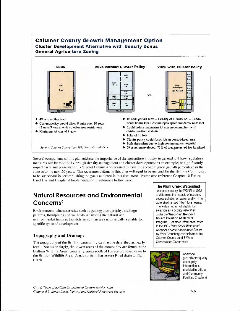
The Plum Creek Watershed was assessed by the WDNR in 1992 to determine the impacts of nonpoint source pollution on water quality. The watershed ranked High' for streams. The watershed is not eligible for selection as a priority watershed under the Wisconsin Nonpoint Source Pollution Abatement Program. For more information, refer to the 1994 Plum Creek Watershed Non point Source Assessment Report by Mary Gransberg available from the Calumet County Land & Water Conservation Department.
Additional groundwater quality and supply information is provided in Utilities and Community Facilities Chapter 5
Calumet County Growth Management Option Cluster Development Alternative with Density Bonus General Agriculture Zoning
2005 2025 without Cluster Policy
T.
C,.,.
I jz
L --4 r! VS.
2025 with Cluster Policy
HE .,d..d
'Lthk • 40 acre mother tract • Current policy would allow S units over 20 years
(2 units/5 wars) with no other area restrictions • Minimum lot size of I acre
Source: Calumet County Year 2025 Smart Growth Plan
• 10 units per 40 acres = nsity of I uniti4 ac. = 2 addi- tional bonus lots if certain open space standards were met
• Could reduce maximum lot size in conjunction with cluster sanitary systems
• Total of 10 lots • Cluster policy could focus lots in conso lidated area • Soils dependent due to hi,h contamination potential • 29 acres undeveloped-,72 of area preserved for farmland
Several components of this plan address the importance of the agriculture industry in general and how regulatory measures can be modified (through density management and cluster development as an example) to significantly impact farmland preservation. Calumet County is forecasted to have the second highest growth percentage in the state over the next 20 years. The recommendations in this plan will need to be enacted for the Brillion Community to be successful in accomplishing the goals as stated in this document. Please also reference Chapter 10 Future Land Use and Chapter 9 Implementation in reference to this issue.
Natural Resources and Environmental Concerns2 Environmental characteristics such as geology, topography, drainage patterns, floodplains and wetlands are among the natural and environmental features that determine if an area is physically suitable for specific types of development.
Topography and Drainage
The topography of the Brillion community can best be described as nearly level. Not surprisingly, the lowest areas of the community are found in the Brillion Wildlife Area. Generally, areas south of Harvestore Road drain to the Brillion Wildlife Area. Areas north of Harvestore Road drain to Plum Creek.
C/tv & Town of Brillion Coordinated Comprehensive Plan Chapter 6.0 Agricultural, Natural and Cultural Resources Element

Watersheds
Manitowoc River, North Branch Most of the Brillion Community is in the North Branch of the Manitowoc River Watershed. This watershed includes a 77-square mile area of land in northeastern Calumet County. It includes the communities of Brillion, Forest Junction, Hilbert and Potter. The north branch of the Manitowoc River flows about 10 miles from its origin west of the Brillion Wildlife Area to its confluence with the South Branch to the main stem of the Manitowoc River. The Brillion Wildlife Area, a state-owned public hunting ground, is the largest wetland in the watershed.
Plum Creek Watershed A portion of the Town, generally described as north of Harvestore Road, is in the Plum Creek Watershed. Water quality problems in this area include low dissolved oxygen, and high nutrient and sediment concentrations, and have been attributed primarily to non-point pollution. Poor land practices in the Plum Creek Watershed (84 square miles, 102 square kilometers), cause non-point source pollution that degrades water quality in the upper reaches of Plum Creek.
Surface Water (Navigable Waters)
In the Brillion Community, there is very little surface water beyond the Brillion Wildlife Area - Black Creek and Spring Creek both pass through the marsh and portions of the City. Round Lake is also located in the plan area and Grass Lake, located in the Town of Rantoul, abuts the southern boundary of the Town.
Black Creek Black Creek is an intermittent stream that seasonally flows into the Brillion Wildlife Area. It offers little or no fishery potential and limited potential for other forms of aquatic recreation. Black Creek flows past the Deer Run Golf Course that frequently uses chemicals and fertilizers and has little to no buffer zones next to the stream.
Spring Creek Spring Creek, a hard water stream, originates north of the City and flows more than five miles southwesterly before draining into the North Branch of the Manitowoc River. This stream flows through most of the Brillion Wildlife Area, which provides an excellent breeding ground for many wildlife species.
Round Lake Round Lake is a landlocked lake within a 0.7 square mile drainage basin. It is located in the far southeastern corner of the Town of Brillion and extends into the Town of Rantoul. The lake covers a total of 10.0 surface acres. The maximum depth is 55 feet and the mean depth is 30 feet. The total shoreline length is 0.55 miles - 0.2 miles of the shoreline are publicly owned. Largemouth bass and other pan fish are common in the lake. Trout are often stocked in the lake. Toads, wood frogs, leopard frogs and green frogs are also common, as are chorus frogs in the adjoining wetlands. Shorebirds and waterfowl are frequent residents.
Groundwater
Groundwater is the primary source of drinking water for the residents of the Brillion Community. The main water supply aquifers in the area are the Niagara Dolomite Aquifer and the St. Peter Sandstone Aquifer. The two aquifers can be considered somewhat distinct, since the upper Niagara Dolomite is separated from the lower St. Peter Sandstone by Maquoketa shale, which confines the lower St. Peter Sandstone. Lesser quantities of groundwater are also found in the overlying glacial drift.
Recharge to the upper Niagara aquifer percolates through the glacial drift, and then moves slowly southeasterly toward Lake Michigan. Most recharge to the St. Peter Sandstone Aquifer is by lateral movement of water from areas to the northwest, although small quantities of water move down through the overlying Maquoketa shale.
A shallow groundwater divide in the glacial drift bisects the Town in a southwest to northeast direction, and is located northwest of the City. Shallow groundwater in the glacial drift to the northwest of the divide moves toward the Fox River, while shallow groundwater to the southeast of the divide moves toward the Brillion Wildlife Area and eventually Lake Michigan. Recharge to the shallow aquifer in the Town and City comes from local
City & Town of Bill/ion Coordinated Comprehensive Plan Chapter 6.0 Agricultural, Natural and Cultural Resources Element 6.7

precipitation, and then moves slowly toward either the Fox River or Lake Michigan. The shallow aquifer has distinct implications for affecting groundwater quality.
Contamination risks from land use practices are the major threat to groundwater resources. Potential contaminant sources include old, unregulated landfills, nitrates from failed septic systems or farm runoff, pesticides, leaking underground storage tanks, and road salt. All of these sources are presently regulated or are being addressed through ordinances or technical assistance services by various county and state agencies.
Significant arsenic levels have not been observed in the wells screened in the St. Peter Sandstone in the Brillion area, unlike wells in Outagamie and Winnebago Counties, due to the significantly greater depth of the St. Peter formation in the Brillion area. However, significant radium problems have been observed, in particular with one of the two Forest Junction municipal wells. This problem is currently being addressed. The extent of radium levels in private wells is unknown and may need to be monitored in the future.
Town of Brillion Well Testing
Bacteria: From 2002-2008, 86 samples for bacteria have been taken on 60 wells. Of the 86 samples, 22 were positive for bacteria (25% were unsafe), 3 E.coli positive (3.4% were unsafe)
Nitrates: From 2002-2008, 54 samples for nitrates have been taken. Of the 54 samples, 5 were unsafe (above loppm), 13 had elevated levels.
Source: Calumet County Land and Wafer Conservation Department, May 2009
Over-pumping the St. Peter Sandstone Aquifer can contribute to I increased arsenic levels, which may become an issue in the future. The Town and City are on the edge of the zones of influence of heavy municipal and industrial pumping in the Green Bay and Fox Cities areas. As groundwater usage increases in those areas and in the Brillion area, further draw down will be observed in supply wells. Limited data is available about the groundwater levels. Available data suggests a decline in the water levels in the St. Peter Sandstone Aquifer. Monitoring information is not available about the shallower, Niagara Dolomite, aquifer. It is believed that this shallower aquifer has never had a significant yield. As more people with modern (higher) water needs have moved into the area, this aquifer has continued to deplete.
Wetlands & Floodplains
City, County and State regulations place limitations on the development and use of wetlands and shore lands. Wetlands in the City and Town are shown on the Natural Features Map. The primary area of wetlands in the Brillion Community is the Brillion Marsh (i.e. Brillion Wildlife Area). In fact, this area is the principal wetland area in Calumet County. According to WDNR, approximately 90 percent of the county's original wetland areas have been drained, making the wetlands of the Brillion Wildlife Area even more important to the region.
The Natural Features Map also illustrates that most of the floodplain areas in the Brillion Community are located adjacent to the Brillion Wildlife Area and ditches which flow through the area. Generally, areas susceptible to flooding are considered unsuitable for development due to potential health risks and property damage. For this reason, the Future Land Use Maps restrict development in these areas.
Woodlands & Grasslands
Several small areas of woodlands are scattered throughout the plan area. The Natural Features Map (Appendix B) illustrates the location of these areas. Because woodlands are an important natural feature to residents, the remaining woodland areas should be protected from future encroachment through the use of conservation subdivisions, land trust activities, private stewardship and other preservation techniques. Care
BENEFITS OF WETLANDS
Wetlands act as a natural filtering system for sediment and nutrients such as phosphorus and nitrates.
Wetlands serve as a natural buffer, protecting shorelines and stream banks from erosion.
Wetlands contribute to the storage of water.
Wetlands are also essential in providing fish & wildlife habitat, flood control, and groundwater recharge.
The WDNR Managed Forest Law provides opportunities for conservation of contiguous woodland environments for wildlife and plants inhabiting these areas. For more information visit:
nv. dnr.state. wi.us/orplland/forestrv/pub1ica fionst
City & Town of Brillion coordinated Comprehensive Plan Chapter 6.0 Agricultural, Natural and Cultural Resources Element 6.8

WILDLIFE HABITAT FRAGMENTATION
A primary threat to wildlife is fragmentation --the breaking up of larger habitat areas into smaller sections. Fragmentation decreases wildlife population sizes, isolates habitat areas and creates more edges -where two dissimilar habitats meet (i.e. grassland and residential subdivisions).
To prevent further fragmentation, forested areas shown on the Natural Features Map should also remain largely intact to maintain their integrity.
Purple Cone Flower at the Brillion Wildlife Area
should be taken to prevent the degradation of these woodlands by invasive species such as buckthorn, honeysuckle and garlic mustard.
Permanent grasslands in the Brillion Community only exist on public lands. These areas provide important wildlife habitat and travel corridors, which must be continued in the future.
Location Open Acres Closed Acres Total % of County Total
Town of Brillion 56.0 125.0 181.0 5.1%
CalumetCountv 406.8 3,125.5 3,532.3 100.0%
I Source: Calumet County Year 2025 Smart Growth Plan I
Wildlife Habitats
To protect wildlife habitats from encroachment, detailed information collected by the WDNR is not available to the public.
The Brillion Wildlife Area (known locally as the Brillion Marsh) includes approximately 4,800 acres (including areas in the Town of Rantoul). The principal wildlife found in the marsh include: deer, sandhill cranes, turkeys, pheasants, Hungarian partridge, woodcocks, ruffed grouse, waterfowl, raccoons, squirrels, amphibians (frogs, toads and salamanders), reptiles (snakes), and several rare species of insects. The Brillion Wildlife Area hosts the Brillion Nature Center, the purpose of which is to educate residents about wildlife and the habitat.
As described under the "surface and groundwater" subsection in this chapter, Black Creek and Round Lake are also important wildlife habitats for small mammals, frogs, toads, fish, shorebirds and waterfowl
Local farm fields also serve as a food source for deer, sandhill cranes, turkeys and waterfowl in the area. Farmland is also a very important local wildlife habitat that provides travel corridors between waterways, woodlands, grasslands and the Brillion Wildlife Area. Farmland also provides cover opportunities and large contiguous open spaces needed by wildlife.
The remaining areas of the community (i.e. residential areas, road corridors, and other developed areas) are not classified as primary wildlife habitat areas - though certainly animals do wander into these areas.
Exotic and Invasive Species
Non-native, invasive, plant and animal species have been recognized in recent years as a major threat to the integrity of native habitats and species, as well as a potential economic threat damaging crops and the tourist economy. Local invasive species include: purple loosestrife, phragmites, Japanese knotweed, common and cut leaf teasel, garlic mustard, spotted knapweed, wild parsnip, honeysuckle and buckthorn, among others. The WDNR requires that any person seeking to bring an exotic or invasive fish or wild animal for introduction in Wisconsin obtain a permit. A list of recommended prohibited and restricted species has been developed by the WDNR and may be passed by the state legislature in 2009. The City and Town can help combat invasive species by educating and
City & Town of Brillion Coordinated Comprehensive Plan Chapter 6.0 Agricultural, Natural and Cultural Resources Element

encouraging residents to use native plants in landscaping. Adoption of best management practices to prevent the spread of invasive species by the City and Town should be encouraged.
Calumet County Aquatic Invasive Species Coordinator Through grant funding provided by the Wisconsin Department of Natural Resources, Calumet County has an Aquatic Invasive Species (AIS) Coordinator. The AIS Coordinator works independently with citizens and organizations to educate, monitor, and control invasive species within Calumet County. The AIS Coordinator is available to assist the Brillion Community with any issues related to invasive species.
Threatened and Endangered Species and Communities
There are many threatened and endangered plant and animal species, and species of special concern in Calumet County. Specifically,
Exotic and Invasive Species
To prevent the spread of invasive species like zebra mussels and Eurasian water mi/foil, boat launching regulations are in effect which prevent boaters from launching with invasive species attached to their boat or trailer. Boaters must remove water from bilges, drain water from engines and other containers. For more information, visit the WDNR web site at: aww.dnr.state.wi,us or contact the Calumet County Aquatic Invasive Species Coordinator at (920) 849-1442.
blanchard's cricket frog, northern ringneck snake, banded killtish, greater red horse, broadwinged skipper, yellow rail, prairie parsley, ram-head lady's slipper, snow trillium, and yellow gentian are found in the county. Additional threatened and endangered species include Wild Quinine, pale purple cone flower and a variety of snake species. Whooping cranes have been confirmed in the Brillion Wildlife Area. Although a more specific list is not available for the Brillion Community, a complete, up-to-date list of endangered plant and animal species in Calumet County is available on the WDNR website.
Rare wildlife habitat areas, or communities, in Calumet County include: Snake hibernaculum, bat hibernaculum, dry cliff, emergent aquatic, floodplain forest, moist cliff, northern wet forest, open bog, shrub-car, and southern mesic forest.
Local DNR officials report that the Brillion Wildlife Area has restorations of prairie plants that are listed as state threatened, including: Wild Quinine and Pale Purple Coneflower. Species of special concern, such as ospreys and bald eagles, nest in the Brillion Wildlife Area. Blanding turtles, also listed on the state threatened species list, are found within the county.
Metallic and Non-Metallic Mining Resources
As part of NR 135, Wisconsin Administrative Code, adopted in December 2000, any community in Wisconsin may adopt an ordinance to establish requirements for reclamation of non-metallic mines, such as gravel pits and rock quarries. If a community does not develop its own ordinance, the county may develop an ordinance to regulate operations. Regional planning agencies can also develop ordinances for counties within their region. The ordinances must establish reclamation requirements to prevent owners and operators of quarries and gravel pits from abandoning their operations without proper reclamation of the mines.
ECWRPC, under an agreement approved in July, 2001 is the regulatory authority for administering five individual, county-adopted, Non-Metallic Mining Reclamation Ordinances for Winnebago, Calumet, Outagamie, Waupaca and Shawano Counties. This agreement transfers permit issuance and reclamation plan review/approval authority to the ECWPRC for the program; however, the individual counties are still responsible for enforcing ordinance requirements should any problems arise with sites, operators or landowners. The ECWPRC only oversees the reclamation aspect of active sites in these counties as it relates to the NR-135 requirements. Zoning and other operational issues of sites are still administered by a town or county under their existing zoning regulations.
The process of locating a mine continues to be a local matter governed by local authorities under existing zoning procedures. The new reclamation
City & Town of Brillion Coordinated Comprehensive Plan Chapter 6.0 Agricultural, Natural and Cultural Resources Element
K -
(.
: pd_J,
C U
Information about the NR 135 permits issued by the East Central Wisconsin Regional Planning Commission for the mining operations in the Brillion Community is available on-line at: www, eastcent ralrpc. org.
6.10

requirements through NR 135 add to the status quo but do not replace or remove current means of regulation. The requirements neither regulate active mining process nor have any effect upon local zoning decisions like those related to the approval of new mine sites.
There are three properly permitted, active non-metallic gravel mining operations in the planning area: • Western Lime Corporation owns a pit operated by Michaels Materials (15 active acres and 30 acres in
reserve status) in Section 24, north of the City limits.
• Kempen Excavating operates an active pit facility in Section 2 of the Township. This site includes one active acre of non-metallic mining and seven acres in reserve.
• Hilltop Trucking & Excavating operates an active pit facility in Section 12 of the Township. This site includes one active acre of non-metallic mining and 20 acres in reserve.
The location of all active quarry sites is provided on the Existing Land Use Maps provided in Appendix B.
Air Quality
The following is from the Wisconsin Department of Natural Resources:
"A few common air pollutants are found all over the United States. These pollutants can injure health, harm the environment and cause property damage. EPA calls these pollutants criteria air pollutants because the agency has regulated them by first developing health-based criteria (science-based guidelines) as the basis for setting permissible levels. One set of limits (primary standard) protects health; another set of limits (secondary standard) is intended to prevent environmental and property damage. A geographic area that meets or does better than the primary standard is called an attainment area; areas that don't meet the primary standard are called non-attainment areas."
Calumet County is an attainment area. This situation is not expected to change in the future. County, state and federal air quality protection standards are in place to maintain and improve the local air quality. The nearest air quality monitoring stations are located in the cities of Manitowoc, Fond du Lac and Appleton.
Historical and Cultural Resources Cultural resources, like natural resources, are valuable assets, which should be preserved. They provide a community with a sense of history, and support a sense of community and togetherness, which makes a community like Brillion a friendly place to live. As part of the community survey effort, respondents were asked to identify areas of cultural or historic significance in the City and Town. Some of the most popular areas identified include:
• The Brillion Nature Center
• Brillion History House
• The Ariens Company Museum
• Haese Memorial Village, Forest Junction (Listed on the State and National Register of Historic Places in 1982)
• Horn Park, City of Brillion
• Neumeyer House, City of Brillion
• Brillion High School, off USH 10
• Brillion Wildlife Area
• Forest Assembly Grounds, Forest Junction
City & Town of Brillion Coordinated Comprehensive Plan Chapter 6.0 Agricultural, Natural and Cultural Resources Element 6.11

Endries Center for the Performing Arts
Thanks to a generous donation from Bob and Pat Endries, the new Brillion High School offers a performing arts
center for school and community use. In the short time since the facility has been operating, it has been used for
several community and school productions. The Coordinated Plan Committee consistently identified this facility as
an important local entertainment venue.
Churches
There are several churches in the Brillion Community. These institutions are an integral part of the community and
provide opportunities for faith and fellowship.
Area Churches - Brillion Methodist Church, W908 Rusch Road, Brillion
• Community Assembly of God, 821 Fairway Drive, Brillion
• Faith United Methodist Church, 204 Horn Street, Brillion
• Holy Family Parish, 1100 West Ryan Street, Brillion
• Peace United Church of Christ, 489 S. Glenview Ave., Brillion
• St. Bartholomew Lutheran Church, 105 Horn Street, Brillion
• Trinity Evangelical Lutheran Church, 601 E. National Avenue, Brillion
• Zion United Methodist Church, N8893 Church Street, Forest Junction Zion United Methodist Church, Forest Junction
Museums
There are two museums located in the Brillion Community. The Haese Memorial Museum is on the east side of
Forest Junction off Randolph Street. This complex consists of 12 buildings, including a:
Grocery (w/living area)
• Furniture store
• Hardware store
• Farm implement store
• Lumber store
• Feed store
The living quarters include all of the original furnishings of the Haese family, and several antiques are also found in
the grocery store. Since 1962, the Haese Memorial Museum has been under private ownership and is not open to
the public at this time.
Another museum in the Brillion Community is the Brillion History House and Museum, located at 110 N. Francis
Street in Brillion, houses a unique collection of Brillion artifacts, including an extensive photo collection. The
Brillion Historical Society maintains the facility through volunteer support. There are no regular hours of operation,
but is open by appointment.
The Ariens Company Museum opened in 2003 and is located at 109 Calumet Street in Brillion. The 7,000 square
foot museum features seven decades of power equipment. The museum showcases two-wheel tractors, snow
City & Town of Brillion Coordinated Comprehensive Plan Chapter 6.0 Agricultural, Natural and Cultural Resources Element 6.12
blowers, lawnmowers, riding lawnmowers, tractors, and commercial mowers and tillers. There are no regular hours of operation, but is open by appointment.
Historical Societies
Brillion Historical Society The mission of the society is "to develop, maintain, and update a written and recorded history of the Brillion area, and to collect artifacts relative to that history, so that present and future generation may be able to study and take pride in the Brillion area heritage." In addition to operating the Brillion Historical Museum and History House, they also sponsor the annual Christmas Tree Display and Holiday Open House. They meet at the Brillion Community Center at 7 p.m. on the 1st Monday of the month. For more information, visit their website, www.brillionhistoricalsociety.org.
Haese Memorial Village Historical Society The Haese Memorial Village Historic District, located at the corner of Milwaukee Street and Randolph Street in Forest Junction, was listed on the National Register of Historic Places in 1982. For more information about the Society, please mail N8874 Church Street, Forest Junction, WI, 54123.
Buildings, Districts and Archaeological Sites
There are several historic properties in the Brillion Community. The table located in Appendix E provides available information related to the historic properties/districts and archaeological sites/cemeteries in the area. The information was obtained from the Architecture and History Inventory (AHI) and the Archaeological Site Inventory (ASI).
The AHI is comprised of written text and photographs of each property, which document the property's architecture and history. Most of the properties became part of the AHI as a result of systematic architectural and historical surveys. Inclusion in the AHI conveys no special status or advantage; it is merely a record of the property. The AHI inventory, located in the appendix, is housed at the State Historical Society of Wisconsin in Madison and is maintained by the Society's Division of Historic Preservation. For more information, visit www.wisconsinhistory.org/ahi.
The ASI is the most comprehensive list of archaeological sites, mounds, unmarked cemeteries, marked cemeteries, and cultural sites available. The ASI does not include all of the sites and cemeteries present. It includes only those sites that have been reported to the Wisconsin Historical Society. AIS information is confidential and is not subject to Wisconsin's open records law (Wis. Stats. §44.48 and 157.70). This information is also protected by Federal Law. This caution not only helps protect archaeological sites but also protects landowners since private landowners own the majority of archaeological sites. Under Wisconsin law, Native American burial mounds, unmarked burials, and all marked and unmarked cemeteries are protected from intentional disturbance.
Funding Opportunities
External funding is essential for many successful preservation related projects. The Wisconsin Historical Society maintains a database that can help identify private and public sources of funding assistance for projects related to the documentation and preservation of Wisconsin's historic places. Assistance types include grants, low-cost loans and tax credit programs. There are funding programs administered by federal, state and local agencies, as well as by private organizations. Eligibility, application requirements and level of competition vary according to the goals of each grantmaker. The funding database can be found at www.wisconsinhistory.org/hp/funding/. Below are a few examples of tax credit programs available through the state and federal governments.
Historic Home Owner's Tax Credits A 25% Wisconsin income tax credit is available through the Wisconsin Historical Society for people who rehabilitate historic non-income-producing, personal residences, and who apply for and receive project approval before beginning physical work on their projects.
City & Town of Brillion Coordinated Comprehensive Plan Chapter 6.0 Agricultural, Natural and Cultural Resources Element 6.13

The Calumet County we Planning Department
maintains a web site
@.T
with general zoning information at
. Co. calumet. wi, us.
ca-VU I
The City's official Zoning Map is
available on line at www.ci.brillion. wt us.
Historic Preservation Tax Credit for Income-Producing Historic Buildings A 20% federal tax credit for rehabilitation of income-producing historic buildings. An additional 5% Wisconsin tax credit for those who apply for and receive project approval before beginning physical work on their projects. This program is administered through the Wisconsin Historical Society.
Non-Historic 10% Income Tax Credit A 10% federal tax credit for the rehabilitation of buildings built prior to 1936 that are NOT listed on the National Register of Historic Places and are not intended to be used for residential purposes. The U.S. Department of Treasury - Internal Revenue Service administers this program.
Current Policies, Trends and Programs
Zoning
The Calumet County Zoning Ordinance regulates the Town of Brillion. Land uses within the Town, including agricultural and natural areas, must adhere to the zoning requirements (height, density, etc.) stipulated in the Calumet County Zoning Ordinance (Refer to the Existing Zoning Maps provided in Chapter 8).
The Calumet County Zoning Ordinance seeks to protect farming operations through the use of the Exclusive Agricultural Zoning classification. In addition, the ordinance includes a Conservancy District. Conservation or cluster subdivision developments are permissible under the R-4 zoning district. To allow these developments, the Town will need to coordinate with the county to assess locations that would be appropriate. Calumet County is in the process of completing a comprehensive revision of the zoning ordinance. It is anticipated that adoption of the new zoning ordinance will occur in 2009.
The Town does have the ability to adopt its own subdivision ordinance. In order for a Town subdivision ordinance to be enforced it must be as restrictive as the county's.
To obtain a copy of the Calumet County Land and Water Resource Management Plan, contact the County Conservationist at (920) 849-1444.
The City of Brillion has its own zoning ordinances and other policies to regulate and protect agricultural and natural areas within the City limits. Specifically, the City has an A- 1 Agricultural Zoning District which provides for "the continuation of general farming and related uses in those areas of the City that are not yet committed to urban development" (Sec 106-90). Additional information about the City of Brillion Zoning Code is provided in Chapter 8.
Shoreiand/Floodplain Zoning
Shorelands and floodplains are often viewed as valuable recreational and environmental resources. These areas provide for stormwater retention and habitat for various type of wildlife. The State of Wisconsin requires that counties adopt shore land/floodp lain zoning ordinances to address the problem associated with development in these areas. Development in shoreland areas is generally permitted, but specific design techniques must be utilized. Development in floodplain areas is strictly regulated and in some instances, not permitted. The authority to enact and enforce these types of zoning provisions is set forth in Chapter 59.97 of the Wisconsin Statutes and Wisconsin Administrative Codes NRI 15.116 and 117, and is established in the Calumet County Zoning Ordinance.
The Shoreland Zoning Ordinance adopted by Calumet County in 1993 regulates shoreland uses and development in unincorporated areas of Calumet County within 1,000 feet from the ordinary high water mark of a lake, pond or flowage, and within 300 feet from the ordinary high water mark of a river or stream.
City & Town of Brillion Coordinated Comprehensive Plan Chapter 6.0 Agricultural, Natural and Cultural Resources Element 6.14
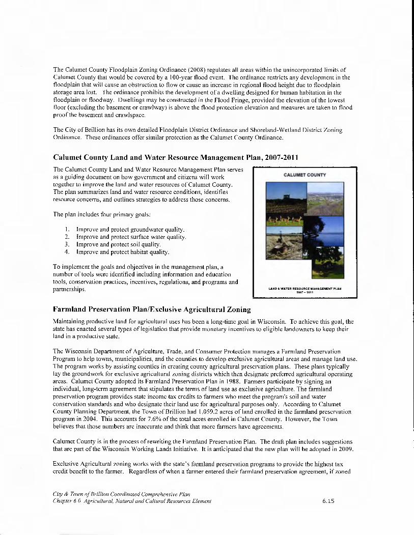
The Calumet County Floodplain Zoning Ordinance (2008) regulates all areas within the unincorporated limits of Calumet County that would be covered by a 100-year flood event. The ordinance restricts any development in the floodplain that will cause an obstruction to flow or cause an increase in regional flood height due to floodplain storage area lost. The ordinance prohibits the development of a dwelling designed for human habitation in the floodplain or floodway. Dwellings may be constructed in the Flood Fringe, provided the elevation of the lowest floor (excluding the basement or crawlway) is above the flood protection elevation and measures are taken to flood proof the basement and crawlspace.
The City of Brillion has its own detailed Floodplain District Ordinance and Shoreland-Wetland District Zoning Ordinance. These ordinances offer similar protection as the Calumet County Ordinance.
Calumet County Land and Water Resource Management Plan, 2007-2011
The Calumet County Land and Water Resource Management Plan serves as a guiding document on how government and citizens will work together to improve the land and water resources of Calumet County. The plan summarizes land and water resource conditions, identifies resource concerns, and outlines strategies to address those concerns.
The plan includes four primary goals:
1. Improve and protect groundwater quality. 2. Improve and protect surface water quality. 3. Improve and protect soil quality. 4. Improve and protect habitat quality.
To implement the goals and objectives in the management plan, a number of tools were identified including information and education tools, conservation practices, incentives, regulations, and programs and partnerships.
Farmland Preservation Plan/Exclusive Agricultural Zoning
Maintaining productive land for agricultural uses has been a long-time goal in Wisconsin. To achieve this goal, the state has enacted several types of legislation that provide monetary incentives to eligible landowners to keep their land in a productive state.
The Wisconsin Department of Agriculture, Trade, and Consumer Protection manages a Farmland Preservation Program to help towns, municipalities, and the counties to develop exclusive agricultural areas and manage land use. The program works by assisting counties in creating county agricultural preservation plans. These plans typically lay the groundwork for exclusive agricultural zoning districts which then designate preferred agricultural operating areas. Calumet County adopted its Farmland Preservation Plan in 1988. Farmers participate by signing an individual, long-term agreement that stipulates the terms of land use as exclusive agriculture. The farmland preservation program provides state income tax credits to farmers who meet the program's soil and water conservation standards and who designate their land use for agricultural purposes only. According to Calumet County Planning Department, the Town of Brillion had 1,059.2 acres of land enrolled in the farmland preservation program in 2004. This accounts for 7.6% of the total acres enrolled in Calumet County. However, the Town believes that those numbers are inaccurate and think that more farmers have agreements.
Calumet County is in the process of rewriting the Farmland Preservation Plan. The draft plan includes suggestions that are part of the Wisconsin Working Lands Initiative, It is anticipated that the new plan will be adopted in 2009.
Exclusive Agricultural zoning works with the state's farmland preservation programs to provide the highest tax credit benefit to the farmer. Regardless of when a farmer entered their farmland preservation agreement, if zoned
City & Town of Brillion Coordinated Comprehensive Plan Chapter 6.0 Agricultural, Natural and Cultural Resources Element 6.15

Exclusive Agricultural Zoning ordinances must be certified by the state. To meet certification requirements, the ordinance must be consistent with the governmental
Town of Brillion Farm body's adopted Farmland Preservation Plan, and comply with Section 91.75 of the Wisconsin State Statutes (which specify minimum requirements for the ordinance). The two main components most farmers remember about the ordinance are that the ordinance specifies minimum lot sizes and limits development that is not consistent with agricultural use.
Calumet County adopted Exclusive Agricultural zoning in late 1984 (zoning requirements in the town are established and enforced by Calumet County). Calumet County is anticipating on amending the county zoning ordinance in 2009. The Town intends to retain Exclusive Agricultural Zoning. The exclusive agricultural areas of the Town are seen on the Zoning Maps provided in the Appendix B.
Exclusive Agricultural, the farmer would be eligible to continue to claim credits (provided his land was identified in the Farmland Preservation Plan as agricultural).
Data from the Calumet County Planning Department indicates that in 2009 approximately 16,446.72 acres of the Town of Brillion (77% of the town) was zoned Exclusive Agricultural. This effort provides interested farmers the opportunit\ to obtain credits.
Brillion Wildlife Area History and Management
In late 1975, the WDNR completed an Environmental Impact Statement (EIS)3 for the proposed acquisition, development and management of the Brillion Wildlife Area. Management activities outlined in the EIS included:
. Creation of a 2,620 acre flowage (i.e. flood area)
• Construction of a dam (Potter Dam) and 1,200 foot channel of the North Branch of the Manitowoc River
. Construction of three runoff ponds
• Clearing a channel for Spring Creek by removal of old culverts, debris, and cattail vegetation and development of a series of small potholes. (Dredging was not proposed).
• Establishment of two scenic overlooks
• Establishment of four small parking lots
• Construction of a nature center
• Establishment of hiking trails
City & Town of Brillion Coordinated Comprehensive Plan Chapter 6.0 Agricultural, Natural and Cultural Resources Element
NATURAL RESOURCES BOARD POLICIES ON WILDLIFE MANAGEMENT
The policies that govern the management of the State Wildlife Areas, including the Brillion Wildlife Area, are outlined in NR 1.015, NR 1.11, NR 1.41, NR 1,44, NR 1.445 and NR 1.60.
These policies provide direction for land management, acquisition (including cooperation with neighboring governments related to land acquisition) and master planning. According to the policies, the primary goal of wildlife management is to provide healthy life systems necessary to sustain Wisconsin's wildlife for their biological, recreational, cultural and economic values.
The complete text of these policies is available on the internet at www.wisconsin.gov.
6.16

In 1973, during development of the EIS, the Calumet County Board of Supervisors adopted a resolution opposing construction of dam (Potter Dam) for impounding water in the Brillion Wildlife Area. The resolution stated that the proposed impoundment would kill trees and other vegetation, flood existing lowlands, and raise the water level on area farms. The County Board passed a second resolution in 1974 petitioning the Department of Natural Resources to dredge a channel for Spring Creek from the western Brillion City limits to the junction with the North Branch of the Manitowoc River to relieve flooding problems in Brillion. The City passed a similar resolution in 1975, which was included in the WDNR EIS.
The Town of Brillion, in a letter dated June 4, 1975, also opposed the building of the Potter Dam and flooding of the marsh for waterfowl habitat. The Town was concerned that the marsh would support a large goose population that would have an adverse impact on farming operations. Likewise, residents were concerned about flooding of farmland in the area. BURNING IN THE MARSH
In response to these objections, WDNR considered the impacts on agricultural uses in the area as well as dredging Spring Creek. The EIS acknowledges (pg 49 of EIS) that the Spring Creek area was subject to annual flooding as a result ofsnowmelt runoff and rainfall. Likewise, lack of drainage and water logged soils were an obstacle to agricultural production in parts of the Brillion Watershed. The WDNR indicated in the EIS that the proposal to remove the debris and cattails blocking Spring Creek to increase the velocity of water going through the channel would be sufficient to handle stream flow most of the year. Furthermore, the proposed dam could relieve flooding downstream during annual flood events (pg 51 of EIS). The EIS goes on to say that establishment of the Brillion Wildlife Area flowage would have no effect on flooding problems above the Glenview Bridge located on Spring Creek, west of the City (pg 57 of EIS). However, the EIS indicates in the same section that flood relief is expected to be minimal (pg. 58 of EIS).
The EIS also states that fluctuation of the water table due to development of the flowage area was not expected to substantially alter agricultural capabilities of adjacent farmlands (pg. 62 of EIS).
Specifically in response to the dredging of Spring Creek, the EIS indicates that the dredging could not significantly reduce flooding within Brillion because the bridges and culverts in Brillion act as the control for Spring Creek rather than the undefined channel in the upper marsh. Furthermore, the EIS indicates the effects of dredging the creek would create the potential for drying the marsh in the summer (pg. 68).
After considering these objections against the benefits the marsh and associated environs would provide for wildlife, the WDNR proceeded with the projects outlined in the EIS. Today, most of the objectives in the original EIS have been completed; however, flooding remains an issue for residents in the City and Town of Brillion.
The DNR uses prescribed burning as a tool to maintain grassland, wetland and timber vegetation in the Brillion Wildlife Area. The DNR makes every effort to prevent impacts from burning (and other maintenance measures) on adjacent properties. The City and Town support the measures the DNR takes to control vegetation growth along roadways and around other developed areas.
SUMMARY OF MAJOR MANAGEMENT ACTIVITIES FOR THE BRILLION
WILDLIFE AREA 1979_2002*
1979— Present. Acquire additional property
1980-2002. Buffered property to reduce silt accumulation
1983— Present. Assist with establishment of privately run nature center
1984— 1993. Broke up several roads in marsh to restore flow to channel
1984— 1997. Helicopter spraying of cattails
1990s. Assisted Town with efforts to rebuild Conservation Road
1993-2002. Established several small parking areas and ponds
2002. Completed Conservation Road Flowage on 51 acres to enhance and restore wetland
* Summary information obtained from Dick Nikolai, Wildlife Biologist, Brown, Calumet & Outagamie Counties.
In 1979, the WDNR completed and adopted the Brillion Wildlife Area Master Plan to address the long-term management of the newly acquired Brillion Wildlife Area. The primary goal established in the plan is to:
Develop and manage the Brillion Wildlife Area for waterfowl production and broad spectrum of hunting recreation; and to provide opportunities for educational and compatible non-hunting recreational objectives.
City & Town of Thu/ion Coordinated Comprehensive Plan Chapter 6.0 Agricultural, Natural and Cultural Resources Element 6.17
This goal has a history of conflicting with the land management objectives of neighboring landowners in the City and Town. Management objectives included in the plan relate to the following:
• Produce ducklings annually by developing and managing wetlands and upland cover.
• Provide participant days in relationship of hunting of game species, dog training and dog trialing.
• Provide adequate food and cover base to maintain a wintering deer herd.
• Protect one scenic area, one historic area and an archeological area.
The Brillion Wildlife Area Master Plan is dated. The City and Town strongly support updating the plan to address current concerns. Despite the age of the plan, the present-day WDNR Wildlife Management mission compliments the goal of the Brillion Wildlife Area Master Plan:
Protect and manage Wisconsin wildlife population and their habitats, and, to promote wildlife enjoyment and appreciation for the benefit of current and future generations.
The WDNR continues to follow the goals and objectives of the 1979 plan, as well as current goals, to: • Promote land stewardship practices favorable to wildlife in terrestrial and aquatic systems,
• Share responsibility for wildlife resources,
• Provide a wide range of wildlife recreational opportunities,
• Improve people's knowledge and appreciation of wildlife,
• Strengthen the wildlife database, and
• Be a leader in professional wildlife management.
In accordance with these goals, the WDNR discourages residential, commercial and industrial development adjacent to the marsh.
The Brillion Wildlife Area is a critical habitat - the primary wetland - in Calumet County. The following actions are recommended to protect the Brillion Wildlife Area:
• Provide financing for rebuilding Center Road, but do not allow for roadway expansion that accommodates additional traffic lanes. Also, seek to provide at grade animal crossings along the roadway using available grant funds.
• Encourage the DNR to cut back forested areas along Center Road to increase the buffer between wildlife habitat and the roadway.
• Seek to limit development adjacent to the Brillion Wildlife Area to protect this natural area and minimize conflicts between people and wildlife. Specifically:
o Restrict future development on the north side of Center Road. The current Calumet County Zoning requirements severely limit development in this area. If annexed into the City, conservation and cluster subdivisions should be required to maintain wildlife habitat areas and minimize habitat fragmentation. Development in Sections 27 and 28 should be connected via trails to the City, including the Brillion High School, and should be limited to 30% of the total land area north of Center Road.
o Development south of Center Road in Sections 28 and 29 should be limited to agricultural and rural residential development. Where possible, landowners should coordinate with the WDNR to seek purchase of development rights. Development density should not exceed one home per 10 acres. No subdivision development should occur in this area.
o Future residential subdivision development adjacent to the Brillion High School should not extend south of the Section 21 and 22 boundaries. All development in this area should be oriented toward
City & Town of Brillion Coordinated Comprehensive Plan Chapter 6.0 Agricultural, Natural and Cultural Resources Element 6.18

the high school, as a neighborhood focal point, and traffic should be directed toward limited outlets along USH 10, not toward Center Road.
Annexation and Development Trends
Beyond the external threats to farming associated with the poor agricultural economy and a decreasing supply of farm workers, farming faces additional threats in Brillion. First, as growth has occurred in the City, annexation of land has become a perceived threat to farms adjacent to the City. Historically, property owners have initiated annexations to develop their property and utilize City services. Though not anticipated, if the City were to decide to become more aggressive in its annexation efforts, the threat to farmland would increase.
Farm Outside Forest Junction
Of more immediate concern, is the influx of residents, who have moved to the area seeking rural housing opportunities. These individuals acquire large areas of farmland for limited residential development (i.e. 1 house on 30 acres or more). This situation consumes vast areas of productive farmland.
The Brillion Wildlife Area is not suitable for development and is therefore protected from development pressure. However, people want to live near the marsh because of the quiet setting it offers. It will be important to establish buffers to protect the marsh and minimize conflicts between marsh management and adjacent development.
Other natural resources like Black Creek, Round Lake, and the scattered woodlands are relatively unprotected from development pressure. As people seek to develop in the area, efforts must be made to protect these areas by enforcing the provisions of the County and City zoning ordinances and the guidelines recommended in the Calumet County Land and Water Resource Management Plan.
Agricultural, Natural & Cultural Resources Issues & Concerns
Groundwater Issue
The Town of Brillion should continue to coordinate with the Calumet County Land and Water Conservation Department a well testing program for the Town. During the planning process some concerns were raised about drawdown from local quarry operations. Other groundwater problems such as nitrates, bacteria, and radium have been identified in the Town. All of these concerns and occurrences should be monitored in the future.
Brillion Wildlife Area Management
As is indicated previously in this chapter, the City and Town have conflicted with the WDNR management of the Brillion Wildlife Area. Some of this conflict is due to the age of the Brillion Wildlife Area Master Plan. To more effectively address these concerns as they relate to management of the marsh, the City and Town of Brillion would like to see the plan updated.
Updating the Brillion Wildlife Area Master Plan, would involve a new feasibility study (similar in nature of the EIS completed in 1975). Furthermore, the process to update the goals, objectives and policies of the master plan would provide for public involvement. Given budgetary constraints, it is possible that any update of the Brillion Wildlife Area Master Plan may occur in conjunction with other area wildlife master plans.
City & Town of Brillion Coordinated Comprehensive Plan Chapter 6.0 Agricultural, Natural and Cultural Resources Element 6.19

Coordination with Other Comprehensive Plan Elements The development of the Agricultural, Natural and Cultural Resources Element required coordination with all of the required plan elements, and is critical to the success of the plan.
Transportation
Transportation improvements may support additional development. Likewise, additional development may require new or upgraded roads. These improvements may lead to impacts on wildlife habitat areas as residential development increases. To minimize the impact on wildlife and natural areas, the City and Town should monitor developmental impacts closely and consider development techniques that offer greater environmental protection (i.e. conservation subdivisions, easements, mixed use development, etc.). These types of development seek to offset the impact of dispersed development patterns that force people to make more automobile trips each day.
Land Use
Brillion Community residents clearly indicated that the preservation of agricultural operations and the protection of natural resources is a priority. The Future Land Use Maps were developed with special consideration to these priorities. The implementation element will guide protection efforts through the enforcement of desired planning and zoning requirements.
Housing
Housing, if not carefully located and planned for, can have a severe impact on natural resources and farming operations. The Brillion Community desires a rural development pattern that protects natural resources and farmlands, while still accommodating some residential and economic development. To achieve this, development is encouraged in the City limits and Forest Junction, where services are available. This housing strategy is reflected on the Future Land Use Maps.
Goals and Objectives It is the vision of the City and Town that the community will retain its rural character by continuing to enjoy a mix of scenic areas and farming operations through 2020. Natural resources will be protected and serve as an environmental, recreational, and economic asset. Residential and commercial development will be in harmony with the area's natural environment.
The City and Town will support the continued efforts of neighboring communities, school districts, Calumet County and the State of Wisconsin, to provide cultural and historic resources that can be used by local residents. The City and Town will also work, in accordance with the Intergovernmental Coordination Element of the Wisconsin "Smart Growth" Law, with neighboring communities, Calumet County, the ECWRPC and the State of Wisconsin to ensure that natural resources are adequately protected for future generations. Chapter I (Implementation Element) provides the list of Goals and Objectives for the Brillion Community.
Agricultural, Natural and Cultural Resources Policy Statements As is discussed in the Introduction Chapter, rather than establish a series of policy statements, this plan includes a vision for each of the nine required plan elements. However, given the over-riding importance of the Agricultural, Natural & Cultural Resources Element and its far-reaching impact on the other eight elements, it is necessary to define some specific policy statements here:
It is the policy of the City and Town of Brillion to: • Direct new residential and commercial/industrial development to areas within the Forest Junction Sanitary
District and the City of Brillion in order to maximize available infrastructure and protect rural farmland areas, wildlife habitat areas and corridors, woodlands, grasslands, and the Brillion Wildlife Area.
City & Town of Bullion Coordinated Comprehensive Plan Chapter 6.0 Agricultural, Natural and Cultural Resources Element 6.20

• Encourage Concentrated Animal Feeding Operations to locate outside the limits of the Sanitary District Planning Areas, as defined by the East Central Wisconsin Regional Plan Commission, so as to minimize the potential for conflict with residential development.
• Discourage development of existing prime farmland for future non-agricultural use unless consistent with the comprehensive plan.
• Ask Calumet County to revise their Growth Management Policy and Subdivision Ordinance to allow density based lot sizes rather than standard lot sizes. A density-based approach can be more conducive to preserving agricultural land and open space.
• Not extend municipal services into farmland areas unless a plan for their immediate use is in place.
• Enhance cooperative efforts with the county to educate landowners on groundwater and the effects land use can have on water quality. The Town will encourage well testing in the Town and will meet with the Calumet County Groundwater Specialist to help develop a well maintenance program and groundwater clarity plan.
1 Data available on-line from the Program on Agricultural Studies - a division of the UW-Extension at http:Ilww.pats.wisc.eduIlanduseIrpcmaps.htm
2 Information used to develop this section was obtained from: Soil Survey of Calumet County, United States Department of Agriculture Soil Conservation Service, 1980 Calumet County Land and Water Resource Management Plan, Calumet County Land and Water Conservation Department and NRCS Staff, March 1999.
Page references are provided in this section from the Environmental Impact Statement for Proposed Acquisition, Development and Management of the Brillion Marsh Wildlife Area, Calumet County, WI as approved by the WDNR in 1975.
City & Town of Brillion Coordinated Comprehensive Plan Chapter 6.0 Agricultural, Natural and Cultural Resources Element 6.21

7
7.0 EcoNoMic DEVELOPMENT ELEMENT
'U- •,.i..
•....I
Introduction According to the Smart Growth Law, the purpose of the Economic Development Element is to promote the stabilization, retention and expansion of the economic base, and quality employment opportunities. To address this requirement, this chapter includes:
• Highlights of the labor force information from Chapter 2;
• An assessment of strengths and weaknesses with respect to attracting and retaining business and industry;
• An overview of programs that deal with environmentally contaminated sites for commercial or industrial uses; and
• A list of organizations (and contact information) providing economic development programs at the county, regional, state and federal levels.
Economic Development Vision In 2020, non-agricultural economic activity has expanded but is still concentrated along the HWY 10 corridor, Forest Junction and downtown Brillion. Agri-business has remained strong in the rural portions of the Town. Economic development has been accomplished in harmony with the area's natural environment and its residential neighborhoods.
Labor Force and Economic Base Chapter 2 provides a detailed analysis of the local and county economy as well as the labor force. Highlights from that chapter include:
• Calumet County has traditionally had a higher participation rate than the State of Wisconsin. The 2000 participation rate for Calumet County was 75.1%, while the state's rate was 69.0%.
• The City of Brillion's 2000 participation rate was 71.7% and the Town's participation rate was 77.5%.
• Manufacturing employment represents approximately 26 percent of total employment and over 39 percent of wages earned by Calumet County residents.
• About half of all employed Calumet County residents work outside the county.
• Fewer residents of the City and Town of Brillion have advanced degrees compared to all residents of Calumet County.
• The Town per capita income was $21,927 and the City's was $20,754. Both are competitive with the Calumet County per capita income figure ($21,919).
These facts and statistics indicate that the Brillion Community has a modest economic base with opportunities for expansion.
Current Business Inventory Historically, economic activity in the Town has been closely tied to the land. However, as additional residents have moved into the Town and as Forest Junction has developed, the importance of farming as an economic development opportunity has diminished somewhat.
City & Town of Brillion Coordinated Comprehensive Plan Chapter 7.0 Economic Development Element 7.1

/ - _--
The City enjoys a strong mix of manufacturing establishments the growth and stability of the major industries have been largely responsible for Brillions vitality and growth.
Commercial Businesses
Town of Brillion The Town is a rural community with relatively easy access to nearby communities via USH 10. There are few businesses located in the Town. Residents generally travel to nearby communities, particularly the City of Brillion, to purchase needed goods and services.
Forest Junction offers a collection of businesses catering to local residents and passing motorists, including a post office, gas station/convenience store, auto body shop and equipment sales. An agri-business (tractor sales) is also provided in Forest Junction to support the surrounding farming areas.
Although not confirmed officially, some home occupation uses (i.e. child care, hair stylist, taxidermy, etc.) also exist without any special permits or other zoning approvals. The Town supports a resident's right to have a small business operation on his/her property or work at home, provided that the business activity or establishment does not create a nuisance for neighboring property owners by generating excessive traffic, noise, lighting, visual structural obstructions, etc.
City of Brillion The City's commercial businesses are located in two districts: downtown Main Street, and along USH 10. According to the 2002 Market Analysis, Brillion has significantly fewer businesses compared to the 14 comparison communities studied. Conclusions made from this fact include that Brillion and its surrounding trade market area are considerably underserved. In past years, the retail/service sector has remained fairly stable.
USH 10. The USH 10 corridor stretches east-west through the northern half of the City. It is an important truck route between Manitowoc and Appleton and onward to the west.
Retail and service establishments along the corridor cater to both local residents and passing motorists. Much of the land along the corridor is occupied, but the potential exists for some infill activities and expansion on the edges of existing development.
Downtown Brillion. Downtown Brillion offers a much different economic environment. It includes a mix of small businesses that provide basic and specialized services and products with special attention to customer service. Several City facilities are also located downtown as well as Ariens Company Plant #2.
With access to USH 10 via CTH PP, downtown Brillion serves as a regional destination and point of interest for passing motorists.
Given its traditional compact design, customers can easily walk from one business to the next. Likewise, residents from adjoining neighborhoods find it convenient to walk downtown for needed goods and services. The community continually strives to make the downtown a gathering place and focal point for City activities.
City & Town of Brillion Coordinated Comprehensive Plan Chapter 7.0 Economic Development Element 7.2

Industrial Makeup
Measuring the industrial makeup is assessing the industries that make up the community's current economic base. By doing this, a community can better understand the types of companies it is likely to attract. Target industries will most likely include complementary businesses such as buyers and suppliers for existing businesses.
Town of Brillion Due to the traditional makeup of a township, the Town of Brillion does not have any manufacturing or conventional industrial businesses. There are, however, smaller businesses industrial by nature that are located in Forest Junction.
City of Brillion The City is home to three of Calumet County's 10 largest private sector employers.
• Ariens Company manufactures an internationally known line of yard and garden equipment.
• Brillion Iron Works has two divisions - the Foundry division and Farm Equipment division, producing both sand castings and agricultural equipment.
• Endries International processes bulk shipments of fasteners and other commodities, and offers an inventory management system.
• Professional Plating Inc. provides metal finishing, and line-ready part preparation services for the automotive, lawn and garden, and general metal fabrication and casting industries.
Regional Industry Mix
The Brillion Community is served by USH 10, and therefore in a position to serve not only greater Calumet County, but its neighboring counties as well. For this reason it is beneficial to also provide a brief overview of those counties' economic situation.
Brown County (th thu., A .,,A
FNs. INTERN \TIONA( INC
IL...altlls..u1,..alat 1flJOjJILUI u1I,.A Ih1.....AI.u1 3..I V IS.¼.O, LJIVJ nil VJl.4IlLJ JIh'J --
solid presence in the paper industry. Food products and processing are also important to the county's economy.
Calumet County Of the top 50 private and public employers of Calumet County, machinery and foods processing are most predominant in number of employees supported. Value-added industrial processes such as metal stamping and electroplating are also prevalent in the Calumet market.
Fond du Lac County Although machinery and equipment manufacturing are important to this county, the most prevalent industry for Fond du Lac County seems to be food products and processing. Healthcare is also an important factor for Fond du Lac County's economic base.
Manitowoc County Manitowoc County is highly industrial, with many of its top employers belonging to the machinery and equipment manufacturing sector. Food products and processing although overshadowed by the manufacturing industries are quite important to the economy.
City & Town of Brillion Coordinated Comprehensive Plan Chapter 7.0 Economic Development Element 7.3

Outagamie County Outagamie County's top employers mostly belong to the service sector. However, the paper industry is probably the most important, second to the food products and processing markets. The healthcare industry also maintains a prominent presence.
Sheboygan County Although most assume this county is predominantly machinery manufacturing, this is simply not the case. Plastics technologies seem to be the main focus of this area. Food products and processing is also important.
Winnebago County There is little doubt that Winnebago County's economic strength depends in large part on the success of the paper industry. There is also a strong presence of commercial and specialty printing in the area. There are not as many machinery or small engine manufacturers, although the few located in the area are quite successful and hold a respectable share of their markets.
Attracting and Retaining Business and Industry Identifying and assessing a community's competitive advantage is an important step in understanding the community's economy and its capabilities to attract and retain business.
Location Factors
Location factors contribute most in business location decisions. Generally, industries like to be located in an area that best fulfills business needs, usually within a cluster.
Local Labor Market. Compared to Calumet County overall, the Brillion Community has fewer residents with advanced degrees. Manufacturing employment represents about 26 percent of total employment and over 39 percent of wages earned by Calumet County residents. About half of all Calumet County residents work outside the County. Per capita income for the City is $20,754, which is below the county's per capita income of $21,919.
Financial Capital Availability. The City of Brillion has a local bank that, by the nature of its organizational structure, is not limited to the types of loans available. There are no venture capital programs locally, but equipment and real estate loans are not uncommon. The City of Brillion has also established a local revolving loan fund, which has contributed over $1.9 million in reinvestments within the community. Calumet County has a revolving loan fund as well, available to Brillion area businesses.
Access to Markets. USH 10 and State Highways 32/57 are the perceived lifelines for the Brillion Community. Major metropolitan areas are identified as the home to industrial suppliers and customers. Location (Approximate Distance in miles) Milwaukee, WI 100 Madison, WI 120 Appleton, WI 25 Green Bay, WI 30 Manitowoc, WI 30 Chicago, IL 200 St. Paul/Minneapolis, MN 300
Transportation. Transportation provides the capacity to move materials, goods and people efficiently and cost effectively. The Brillion Community is primarily served by highways and air transportation.
City & Town of Brillion Coordinated Comprehensive Plan Chapter 7.0 Economic Development Element 7.4

Facilities/Sites The Brillion Community has been fortunate to have a solid industrial base without the aid of a municipally owned business park. However, in recent years the community has had to turn down business location opportunities for lack of adequate/available sites or facilities.
Knowledge Resources Brillion does not have direct access to Research & Development facilities such as universities and research parks.
Education and Training The Brillion Community is a direct beneficiary of various training programs offered by local technical colleges and non-profit training centers.
Fox Valley Technical College has a regional center located in the City of Chilton. This regional center has five major areas to serve the public; specialized training for business and industry, credit classes for technical and associate degrees, continuing education class for license renewals, GED/HSED/GOAL, and hobby classes.
The University of Wisconsin Fox Valley, located in the City of Menasha, is a two-year campus of the University of Wisconsin system. UW-Fox Valley provides the first two years of high quality liberal arts studies necessary as a foundation to university arts and science degrees as well as specialized professional and occupational degrees.
Business Climate. The City has experienced a limited number of closings in recent years, despite the economy's rollercoaster effect. The year 2000 experienced three business closings, one of which was caused by a proprietor's death. 2001 experienced 1 business closing. There were no closings reported in 2002. The 2003 report identified four relocations within the City, four business closings or relocations outside the City's corporate limits, eleven new businesses, and eight business expansions including major renovations. There is no data available for the Town of Brillion.
Taxes/Regulations The municipal tax rate has been a concern to existing businesses. Despite past efforts to decrease the tax rate, the City of Brillion is still considered one of the highest taxed communities in the area. Efforts to keep from increasing the local rate have been successful for over four years. With the ever increasing operational costs and declines in State shared revenue this will continue to be a concern for the Town of Brillion as well.
Quality of Life and Other Features The Brillion Community has boasted about its high quality of life for many years. The crime rate in Brillion is the lowest in Calumet County. Brillion Public Schools have reported that Brillion's ACT scores were one point higher at 23.5 than the state average of 22.3; the Brillion school district graduation rate of 96.3% surpasses the State's 90.4%.
Town of Brillion
The Town has several positive attributes to offer potential businesses. Specifically, the Town has:
• A relatively low municipal tax rate (Assessed at 95.23% of full value - Rate that ranges from $18.91 per thousand to $21.29 per thousand, varies because of school, sanitary, and fire districts);
• Properties with USH 10 and STH 32/57 frontage;
• Land available for development;
• Municipal water and sewer service in the Forest Junction Area.
While the Town certainly enjoys its share of advantages, there are several weaknesses the Town must contend with when seeking to attract new businesses and industry:
• The Town population is not large enough to provide the customer base necessary to support a large commercial endeavor.
City & Town of Brillion Coordinated Comprehensive Plan Chapter 7.0 Economic Development Element 7.5

• Town residents are very mobile and can easily drive to nearby communities to purchase services and products.
City of Brillion
Based on the economic assessment of both the City and its regional neighbors, Brillion is in a favorable position to foster and encourage new business growth.
• The Brillion primary trade area is roughly approximated by a nine-mile ring around the City, with a U.S. Census 2000 population of 13,180. The City is a regional destination point.
• Easy access to USH 10, which connects to USH 41 and 1-43. Transportation systems provide connectivity to the paper industry and plastics markets.
• The City enjoys a central location in the region.
• The City has ample space for development within the City's corporate limits, and may not require immediate annexation.
• An extensive array of City services are available to new businesses and workers locating in the City.
• Municipal sewer and water capacity available to support business development.
• Strong industries located in Brillion that require the dependability of suppliers.
• Regional initiatives designed to spark additional economic activity.
It is the opinion of the State of Wisconsin that economic growth will only be realized through the support and encouragement of new technology development. The State has further identified industry clusters throughout the region, and is making efforts to build upon the successes and growth of these industries. Based on this information, and the knowledge that Brillion is, in essence, a transition point from plastics to paper, opportunities are quite considerable.
The City also faces economic development challenges. The City has a high tax rate to pay for the quality services and amenities it offers to residents. (More information about City services is available in the Utilities and Community Facilities Element.) To attract economic development, the City continues to pursue ways to reduce its tax rate to stay competitive with other communities, while still maintaining its quality of life.
Economic Development Opportunities Town of Brillion
The Plan Committee has indicated a preference for commercial and industrial development to occur in Forest Junction to protect the rural character and farmland in other portions of the Town. However, the committee does not envision significant commercial and industrial development within Forest Junction over the next 20 years. The Town Plan Commission has also expressed interest in targeting downtown Forest Junction as an area for redevelopment. This redevelopment would include a mix of uses (i.e. commercial and residential) that are sensitive to and complement the historic integrity of downtown Forest Junction.
While the Town would welcome some additional commercial and light industrial development to support the local tax base, it is important that any new development exist in harmony with the local environment. New industrial and commercial development should be "clean" and not produce a significant amount of waste, which could pose a hazard to the groundwater, streams, and wetlands. New development should also blend into the rural landscape and not represent a nuisance to residents. For example, new developments should include natural landscaping and attractive signage.
New development along USH 10 and STH 32/57 must not interfere with the traffic flow along these highways. Therefore, development in an industrial park development is preferred to direct access drives along these roadways.
City & Town of Brillion Coordinated Comprehensive Plan Chapter 7.0 Economic Development Element 7.6

City of Brillion
The following is a profile of the major studies completed by the City, and a description of how the results should be integrated and implemented with this plan. These studies have helped the City identify underutilized assets and find ways to take full advantage of existing infrastructure improvements. The two districts identified by City residents include the Downtown Commercial District, and the USH 10 corridor - west of the City.
Brillion Commercial Business District Market Analysis. A market analysis is a comprehensive study that provides details about a business districts current condition, explores changes occurring in the marketplace, verifies consumer wants, needs, and spending habits from that district, discovers what the market will support, and provides the foundation for business development strategy creation. The study was completed in October 2002.
The Market Analysis identified a 9-mile ring trade area around the City of Brillion, and includes key economic, demographic and lifestyle data for the area. The report also provides some insight on potential impact of in-commuter spending on the community.
The recommendations included in the Market Analysis report should be implemented in conjunction with this plan to ensure that the economic development opportunities desired are being realized. This will require coordination with utilities and community facilities and transportation improvements identified in previous chapters. The recommendations of the Market Analysis should be reviewed in 5 years to measure progress and identify additional objectives.
Brillion Business Park Feasibility Study In October 2002, a Business Park Feasibility study was completed for the City of Brillion. According to the recommendations, business park development should occur within the boundaries of two parcels currently owned by the Ariens Company, adjacent to Ariens Plant 3. Among the conclusions provided, it's estimated that:
• Development in this area would provide almost 100 acres of developable property.
• Over $2.4 million in capital expenditures would be required to fully develop the property.
• Tax Incremental Financing should be used to make the park financially feasible.
• Approximately 261,400 square feet of buildings will be constructed (value about $8.6 million).
392 jobs will be created.
Recommendations included in the report should be implemented in conjunction with this plan to ensure the economic development vision is being realized. Also, to minimize risk and still foster progressive economic development practices, the business park should be developed in phases. Marketing the business park should begin as soon as development initiatives begin.
2004 Economic Development Strategy The City of Brillion completed its Economic Development Strategic Plan in 2004. This plan was a collaborative effort between the Community Development Committee, Brillion Chamber of Commerce and the Redevelopment Authority. This plan provides recommendations for growth based on location factors, industry clusters and land availability. The tasks identified were developed as an answer to the economic needs of the community and trade market area. The Economic Development Strategic Plan has been adopted by the Community Development Committee and the City Council to serve as an extension to this chapter of the Comprehensive Plan.
Brillion Downtown Master Plan In January 2009, the University of Wisconsin Milwaukee School of Architecture and Urban Planning collaborated with the City of Brillion to prepare a 10 Year Downtown Master Plan for the Main Street Business District. Utilizing the talents of five Urban Planning Graduate Students from UWM, the planning project consisted of developing a master plan for a 10 block area in Brillion's Downtown. Creating a vision of "Rediscover Downtown Brillion: The Center of a Great Community"; the Plan establishes goals and strategies, design guidelines,
City & Town of Brillion Coordinated Comprehensive Plan Chapter 7.0 Economic Development Element 7.7

circulation and accessibility improvements, business enhancement strategies, and a plan of implementation for the next one, two, five and ten year time periods. The Downtown Master Plan is further supported by a series of Plan Appendices that document downtown land uses, zoning classifications, parking spaces, market analysis, and business / community survey results.
Completed in May 2009, the Plan is intended to be implemented by the City of Brillion Redevelopment Authority Commission, with technical assistance and support provided by the City of Brillion Community Development Department. Plan implementation projects that are currently underway in Downtown Brillion include a Building Façade Improvement Program with Zero Interest Loans; a streetscaping program, parking space improvements, a Tax Incremental Finance District (TIF) to encourage the redevelopment and revitalization of downtown buildings and properties; and a marketing program to promote the downtown and fill vacant store fronts. With the assistance of the Brillion Chamber of Commerce, a Business Retention and Business Ad Hoc Group has been formed to further promote and enhance the Downtown Business District. A direct outgrowth of these efforts has been the expansion the Downtown Farmers Market held at the Main Street Shopping Center from July to October of 2009, and in subsequent years to come.
Existing Underdeveloped Industrial and Commercial Areas Town of Brillion
Commercial and industrial uses in the Town are concentrated in Forest Junction. Development in Forest Junction is limited in scale reflecting both the rural nature of the area and strong competition from the City. The opportunity does exist for enhancement of the commercial and industrial uses in Forest Junction, particularly at the intersection of STH 57/32 and USH 10. Land is available for expansion of existing businesses or to establish new businesses along the highway corridors near the intersections in a manner consistent with the pattern illustrated on the Future Land Use Map. Existing businesses could be improved to provide better pedestrian access to accommodate residents in the immediate vicinity, and also provide better landscaping and façade amenities to enhance the appearance of the area. This is consistent with the economic development opportunities described previously.
City of Brillion
Commercial and industrial uses in the City are concentrated within the Central Business District (Main Street) and along USH 10. Opportunities do exist for enhancement of the Main Street Corridor, which calls for façade improvements, streetscaping, and infill development.
USH 10 is considered the City's industrial corridor. While there is some land available for expansion in this area, floodways, wetlands, and flat contours make any further development challenging. If the City chooses to address the stormwater impact issue, the existing industries could be able to expand further in their area, and more land, such as the Westwind Development area could become more developable. This is consistent with the economic development opportunities described in the previous section.
Improvements to the USH 10 corridor could also improve traffic circulation and safety and help define industrial expansion options. These issues and opportunities are clearly defined on the Future Land Use Maps, and Natural Features Map.
Tools to Promote Economic Development Tax Increment Financing (TIF)
Tax Incremental Financing (TIF) can help the Town or City of Brillion undertake a public project to stimulate beneficial development or redevelopment that would not otherwise occur. It is a mechanism for financing local economic development projects in underdeveloped and blighted areas. Taxes generated by the increased property values pay for land acquisition or needed public works.
City & Town of Brillion Coordinated Comprehensive Plan Chapter 7.0 Economic Development Element 7.8

General Procedure for Establishing a TIF
I. The municipality defines a TIF district. It may range in size from a single block to the entire Downtown area.
2. Tax assessments for the district are frozen at their current value.
3. The municipality, through its tax-increment finance authority, can acquire land and make capital improvements in the district (e.g. streets, lighting, landscaping, etc.) to make it more desirable to developers.
4. When development occurs, the value of the land in the district increases. This increased value is taxed, but for a period of time while the TIF district is in effect, the additional tax revenues go to the TIF.
5. This additional tax revenue is used to pay off the expenses incurred by the municipality in land acquisition and installation of capital improvements.
More information about establishing a TIF is available in Sections 60.85 (towns) and 66.1105 (cities, villages), Wis. Stats.
Industrial Revenue Bond For more information on the
The Department of Commerce's Industrial Revenue Bond (IRB) Program Industrial Revenue Bond Program, allows all Wisconsin cities, villages and towns to support industrial contact the Wisconsin Department of development through the sale of tax-exempt bonds. The proceeds from the Commerce at 608/267-0762 or get
bond sale are loaned to businesses to finance capital investment projects at, information on the internet at:
primarily, manufacturing facilities. Even though IRBs are municipal bonds, wNw.commerce.state.wi.us.
they are not general obligations of the municipality. The company or business that will use the facilities provides the interest and principal payments on the loan. The local government is in partnership with the business, lending its name, but not its credit, to the bond issue.
Business Park Development
A business park (most commonly referred to as an industrial park) is a planned, coordinated development of a tract of land equipped to accommodate a community of industries by providing all necessary facilities and services in attractive surroundings among compatible neighbors. The business park administration and infrastructure is controlled by the community in which the park is located. The uses permitted are regulated by zoning and covenants. Both the City and Town have the authority to establish business parks within their community limits. Prior to establishing any business park, a feasibility study should be completed to ensure adequate demand exists. The City has conducted such a study.
As of the creation of this document, there are no industrial parks available for new business development. Over the years, City officials and staff have made every effort to direct business location inquiries to existing vacant buildings. Unfortunately, lack of quick site preparation and flexibility hindered efforts, and were not sufficient. Therefore, the community has struggled to attract new employers, losing out to neighboring communities like the Fox Cities, Manitowoc, and even smaller municipalities like Reedsville. The City has planned almost 100 acres in its north-west quadrant devoting it to industrial development. For this business park plan to come to fruition, a significant community investment is required, in terms of roads and site development, to serve this planned area.
Internet Marketing
The City and Town of Brillion markets itself on the internet by profiling significant community highlights. The City and Town should continue to keep this site updated to take full advantage of its marketing potential. A website has also been developed that highlights Forest Junction.
City & Town of Brillion Coordinated Comprehensive Plan Chapter 7.0 Economic Development Element
City of Brillion www.ci.brillion.wi.us
Town of Brillion v.townofbrillion.com
Forest Junction www.foresljunction org
7.9

Rapid Industrial Preparation Program (RIP)
If desired, a RIP could be established by the City. A RIP consists of two parts. The first is a semiformal organization of individuals who have key roles in the process of helping a prospective new business acquire and prepare space to begin operations. In the second part, the individuals involved in step one assist interested businesses in locating and establishing operations in the community. The general steps involved in operating a RIP are as follows:
I. City or other organization (i.e. Economic Development Corporation) should retain a current list of available properties for industrial and commercial development.
2. A set of plans for a modifiable speculative building is drawn, including a set of standardized accompanying site plans.
3. A contractor ready, willing and able to construct is identified and a price estimated.
4. Each of the potential legal interactions with the City is listed and the Community Development Director is prepared to walk the prospective business through that process. This may be accomplished through the current New Developers Folder offered by the City.
5. A mechanism for financing both the plan and equipment is established. The Community Development Director is prepared to do a preliminary screening of the project and the business to determine financial feasibility.
6. Linkages are established with schools, community colleges and vocational centers to provide customized training for newly hired employees (while construction of the building is being completed).
The Town could also encourage the establishment of a less formal RIP coordinated through the Forest Junction Civic League (described later in this chapter). This RIP could complete steps 1, 4 and 6 described above to help prospective business owners understand what property is available and the steps necessary to obtain development approval from the Town and County.
Calumet County Revolving Loan Fund
Calumet County, through a partnership with the Department of Commerce, administers a Business Revolving Loan Fund Program. The program is designed to create new employment, retain and expand existing businesses by providing business loans, on a competitive basis, with other financing resources. The loan terms and conditions vary. Applications may be submitted at any time and are processed in the order received.
Eligible Activities include: • Land, buildings, machinery and fixed equipment acquisition; For more information about
the Calumet County • Site preparation and equipment installation; Revolving Loan Fund
• Construction expansion rehab or removal of existing buildings and contact.
Calumet County Planning
• Working capital (inventory and direct labor costs only). Office at 920-849-1442.
To be eligible for the program, applicants must: • Leverage a minimum of one dollar of private funds for every dollar of loan funds requested;
• Create or retain at least one full-time equivalent position for every $20,000 of funds requested;
• Demonstrate that their project is viable and their ability to repay;
• Make at least 51% of the jobs created or retained available to persons of low to moderate income; and
Locate all activities within Calumet County.
City & Town of Bullion Coordinated Comprehensive Plan Chapter 7.0 Economic Development Element 7.10

City of Brillion Revolving Loan Fund
The City of Brillion Revolving Loan Fund (RLF) works in much the same way as the County RLF. Also through a partnership with the Wisconsin Department of Commerce, the RLF was established to encourage the creation and retention of permanent jobs, encourage the leveraging of new private investment into the City, perpetuate a positive and proactive business climate, maintain and promote a diverse mix of employment opportunities, and encourage the development and use of modern technology and create safe work environments.
City of Brillion Zero Interest Loan Program
The City of Brillion Zero Interest Loan Program provides incentives to stimulate visible reinvestment in City of Brillion businesses. Property owners are encouraged to consider improvements that incorporate the surrounding community. These improvements should create a cohesive, inviting environment. The program provides dollars for actual project costs up to $8,000 per property address, to commercial property owners and/or merchants for exterior building and site improvements. Priority will be given to façade restoration projects within the downtown commercial district.
Milk Volume Production Program (MVP)
The MVP program is designed to assist dairy producers that are seeking to acquire additional cows. The program is managed by the Wisconsin Department of Commerce. The goal of the MVP program is to provide qualifying dairy producers with needed financing and to partner with local communities to increase dairy production in Wisconsin. Assistance is limited to no more than $500 per cow added to an operation or a maximum award of $1 million. Additional information about this program is available at www.commerce.state.wi.us.
Northeast Wisconsin Regional Economic Partnership
COMMUNITY SURVEY RESULTS
When asked to identify new commercial development that is needed in the Brillion Community, community survey respondents indicated that:
Restaurants (74% encourage) and childcare facilities (78% encourage) were strongly desired. [Since the survey was completed a childcare facility opened in the City. See the Utilities and Community Facilities Element for more information.] Sixty-six percent (66%) of survey respondents indicated that the community should encourage some additional small specialty or niche stores. Residents generally did not favor additional convenience stores, grocery stores, or shopping centers.
When asked specifically about additional industrial development opportunities that should be encouraged in the community, residents strongly supported:
• Additional manufacturing facilities (82%)
• Agriculture-related industries (67%)
• Warehousing distribution (62%) • Heavy industry (56%)
Calumet County is a member of the Northeast Wisconsin Regional Economic Partnership (NEWREP). NEWREP focuses primarily on businesses engaged in research, development, or manufacture of advanced products. It can also help knowledge-based operations or any business that uses advanced technology production processes, systems, or equipment in traditional manufacturing operations. NEWREP has $5 million in tax incentives available through the Wisconsin Department of Commerce Technology Zone Program to help stimulate the development of technology-based infrastructure and increase venture financing for companies. There are many other financial programs available. For further information contact the Wisconsin Department of Commerce or visit the NEWREP website.
Desired Business and Industry Because farming is essential to the continued success of the local economy, it is critical that the plan protects agricultural areas. As a result, the economic development opportunities discussed in this chapter are encouraged in Forest Junction and in the City of Brillion only. Other areas of the Town are not encouraged for commercial or industrial development. (Information about agricultural trends, including expansion and retention is provided in the Agricultural, Natural and Cultural Resources Element Chapter of this plan.)
City & Town of Brillion Coordinated Comprehensive Plan Chapter 7.0 Economic Development Element 7.11

The City and Town want to be sure that new development does not jeopardize the local quality of life. Therefore, businesses and industries which locate in the area should be environmentally friendly, have limited outdoor storage (if any) to control unsightliness, generate minimal traffic and noise, and require only minimal lighting and signage.
A business will typically seek a location where a cluster of its industry type is prevalent. Although encouraging the cluster of businesses within a region is a good practice, it is also important to keep a relatively diverse economic base to avoid cyclical changes in any one industry. For these reasons, target markets will be identified, but efforts to recruit a variety of business types should continue.
In an effort to improve economic vitality, the State of Wisconsin has identified seven existing clusters or regional markets. These clusters represent the state's mature industries that have been the backbone of the economy.
Dairy
• Food Products and Processing
• Paper
• Plastics
• Printing
• Small Engine Manufacturing
• Tourism
The State has also identified three emerging clusters - those industries with high-growth potential which will strike a balance and achieve overall economic sustainability:
Biotechnology
Information Technology
Medical Devices
Residential Development
It is also recognized that in order to attract additional industry and business into the area, a healthy labor force must be present. The Brillion Community has identified residential growth as an economic development objective. Because of the quality school system, high quality of life and low crime rate, the community is ideal for raising a family. Furthermore, the community should market itself to appeal to Generation X which according to demographic statistics is now looking to settle down and raise a family.
Given these constraints and regional intentions, the City and Town would like to target the following types of development:
Agri-Businesses
• Nature-based businesses are encouraged in the Brillion Community, and include: strawberry-picking on local farms, pumpkin patches, farmers markets, and outfitters for outdoor enthusiasts.
• Agri-business ventures, particularly in Forest Junction. Given the large farm market in the Town of Brillion and surrounding towns in Calumet and Brown Counties, farm supply, equipment, and other businesses catering to agricultural needs are desired.
Commercial Businesses
Niche development in downtown Brillion to attract motorists from USH 10 into the City.
• Service business in the City to cater to local needs. This includes additional restaurants and possibly small, locally owned retail stores.
• Home occupations of a professional nature to take advantage of the internet and other technologies, permitting people to work from the privacy of their homes.
The City has also identified 14 business expansion opportunities and 12 new service and retail industries for which the community has expressed a need. These industries are identified in the 2002 Market Analysis.
City & Town of Brillion Coordinated Comprehensive Plan Chapter 7.0 Economic Development Element 7.12
Industrial Businesses
• Light industrial, commercial and office establishments along USH 10 catering to both passing motorists and the local population. These businesses should generate higher income and skilled jobs for area residents. Industries that compliment and support existing area industries are strongly encouraged.
• Opportunities for technical employment. As mentioned previously, the City has a strong manufacturing base. The Town has a strong agricultural economy. Increased opportunities for technical employment (i.e. engineering, electronics, computer technology, etc.) are desired.
In order for the community's economic base to grow and still support the State's initiative to grow, it would be counter-productive to "steal away" other businesses from neighboring communities and states. Instead, Brillion should encourage business expansion and creation to achieve its economic goals. Two subcategories have been identified as growth opportunities:
• Support industries for the existing businesses within the community, such as suppliers, and value-added processes.
• Regional support businesses, especially those that support both the plastics belt and the paper belt (Sheboygan through Winnebago Counties). These industries also include those businesses employing new technological advances which will in some way support the regional business community and create a new market for themselves.
Economic Development Assistance Several organizations exist to encourage economic development opportunities in the Brillion Community. What follows is a description of the primary groups. Also provided is a list of federal, state, and regional organizations that can help the Brillion Community to support economic development opportunities and initiatives. These organizations provide an array of programs to support economic development opportunities.
City of Brillion
Community Development The City of Brillion offers a collection of business development resources through its Business Development and Business Retention and Expansion (BRE) Programs, and the Brillion Public Library.
Redevelopment Authority The Redevelopment Authority was formulated based on State Statute to prevent and eliminate blighted areas within a municipality. Among other powers, it has the power to condemn property, buy and sell real estate, issue bonds, and enter into contracts. Since RDAs have many of the same powers as the municipality but not as many restrictions and political constraints, they can exercise greater flexibility and be involved in public-private partnerships in a different way than the municipality. The RDA then becomes a tool the community can use to come up with more creative redevelopment strategies than may be possible if only the municipal government was involved.
Brillion Chamber of Commerce
The Brillion Chamber of Commerce is an organization of local business representatives seeking to promote business activity in the City of Brillion. The chamber organizes and sponsors annual community events to promote the business community. Its members are also notified of area seminars to improve their business skills.
Forest Junction Civic League (FJCL)
Residents, business owners, and others interested in the welfare of Forest Junction are welcome to join the Forest Junction Civic League. Established in 1961, the FJCL is a volunteer organization whose main responsibility is the upkeep and maintenance of the Freitag Memorial Park, which is privately owned by the Civic League, but held for public benefit. The FJCL also organizes an adopt-a-street program in Forest Junction to maintain the appearance of
City & Town of Brillion Coordinated Comprehensive Plan Chapter 7.0 Economic Development Element 7.13

the community, and hosts an annual picnic and winter potluck. In the past, the organization has also sought to recognize and welcome new local businesses in the Forest Junction Community.
Travel Calumet-TravelCalumet.com
Travel Calumet, created and maintained by the Calumet County Planning Department, seeks to bring visitors to area attractions and establishments, and strives to see the tourism economy flourish to bring in additional county revenue. Travel Calumet publishes an annual visitor's guide, and the Nature's Retreat brochure. It also maintains a website listing attractions and Calumet County events. www.travelcalumet.com
Calumet County Economic Develop ment-CalumetBusiness.com
Calumet County launched a website in 2005, CalumetBusiness.com, which provides information to help enhance an existing Calumet County business or assist in the development of a new business. It provides workforce and employment profiles, community profiles and web links, information regarding technical and financial assistance, and contact information.
UW-Extension
Through the Calumet County office of the University of Wisconsin Extension service, the Calumet County Community Resource Development Educator offers:
small business management assistance workshops or one-on-one counseling
revolving loan funds information and other sources of financing
local demographic information
networking and linkages to other business development resources
Heart of the Valley Chamber of Commerce (HVCC)
The HVCC was established more than 20 years ago to serve the business communities in Kimberly, Kaukauna, Little Chute, Combined Locks and surrounding areas, including Forest Junction, Brillion, Greenleaf and Freedom. Beyond providing an important network for local business owners, the HVCC:
• offers programs and seminars designed to improve business skills and general education about specific business sectors like agri-business.
• supports a "Government in Action" subcommittee that sponsors monthly meetings with local, state and federal representatives.
• works with local health care providers to offer its members a group health insurance plan at a discounted rate.
Regional
East Central Wisconsin Regional Planning Commission (ECWRPC) ECWRPC is the official comprehensive planning agency for the East Central Wisconsin Counties of Calumet, Fond du Lac, Green Lake, Marquette, Menominee, Outagamie, Shawano, Waupaca, Waushara and Winnebago.
Services provided by ECWRPC include Comprehensive Land Use Planning; Transportation Improvement and Corridor Planning; Open Space, Recreational and Environmental Planning; Economic Development; Demographic Information and Projections; Technical Assistance to Local Governments; Geographic Information Services and Aerial Photography Distribution. www.eastcentralrpc.org
NEWREP Calumet County is a member of a 16-county Northeast Wisconsin Regional Economic Partnership (NEWREP) designed to bring high-paying jobs to Wisconsin through start-up and expansion of technology businesses.
City & Town of Bullion Coordinated Comprehensive Plan Chapter 7.0 Economic Development Element 7.14

• Governor Scott McCallum announced the creation of the Northeast Wisconsin Technology Zone on Friday June 28, 2002.
• It is one of eight zones created throughout the state, and each has $5 million in income tax credits to provide incentives to attract high-tech companies to the area, and to help existing companies increase productivity and free up capital.
• The zones will be in effect for 10 years — until 2012.
• Projects within the region will be considered and approved based on their ability to create high-wage jobs and support the development of high-tech industries in the region.
For more information, contact the Department of Commerce or visit the NEWREP website.
State Agencies/Programs
• Wisconsin Department of Commerce— www.commerce.state.wi.us: the state's primary agency for delivery of integrated services to businesses.
• Wisconsin Department of Transportation— www.dot.state.wi.us: The office of disadvantaged Business Enterprise Programs administers a range of services to increase participation of firms owned by disadvantaged individuals in all federal aid and state transportation facility contracts.
• Forward Wisconsin - www.forwardwi.com: to market outside Wisconsin to attract new businesses, jobs and increased economic activity to the state.
• Department of Workforce Development— www.dwd.state.wi.us: to build and strengthen Wisconsin's workforce by providing job services, training and employment assistance, and helps employers find necessary workers.
• Wisconsin Small Business Development Centers - www.uwex.edulsbdc: to help ensure the state's economic health and stability through formative business education by counseling, technology and information transfer and instruction.
Federal Agencies/Programs:
Department of Agriculture Rural Development Administration - www.rurdev.usda.gov
• U.S. Small Business Administration - www.sba.gov: provides financial, technical and management assistance to help Americans start, run and grow their businesses.
• U.S. Department of Commerce - www.doc.gov
• U.S. Department of Transportation - www.dot.gov
Potential City Economic Development Organizations To better organize and foster economic development, the City may want to establish either a Local Economic Development Corporation and/or a Downtown Development Authority.
Local Economic Development Corporation (EDC)
Also called a Community Development Corporation/Industrial Development Corporation, an EDC is typically a semi-public local development authority designed to generate local economic development, and not realize a profit. They are created and partially financed by the public sector, and raise money by issuing notes, selling stocks and bonds, or seeking contributions. Essentially, they would serve as the economic development arm of the City. Ideally, the City's Community Development Director would oversee this organization.
City & Town of Brillion Coordinated Comprehensive Plan Chapter 7.0 Economic Development Element 7.15
Downtown Development Authority (DDA)
A DDA is traditionally concerned with helping revitalize declining inner city and downtown areas. A DDA has a specific jurisdictional boundary and a governing board made up of people who own homes, businesses or property within the jurisdiction. They have the power to invest in business, lend to business, build and own real estate and earn a surplus from successful business venture. A DDA differs from an EDC in that the focus of the organization is more limited.
Environmentally Contaminated Sites A Brownfield refers to an abandoned, idled, or underused industrial or commercial facility or property where expansion or redevelopment is complicated by real or perceived environmental contamination. At this time, there are no known Brownfield sites located in the Brillion Community. If this situation were to change, the City and Town could pursue organizational and financial assistance from Calumet County, the Wisconsin Department of Natural Resources and the U.S. Environmental Protection Agency. There are many grant programs available through these agencies to help communities address Brownfields, leaking underground storage tanks, and other environmental concerns. To prevent an environmentally contaminated site, the City and Town will encourage only environmentally friendly business development that is properly permitted and regulated.
The WDNR has a Brownfield program in their Bureau for Remediation and Redevelopment section that can assist in Brownfield identification and remediation. The database documents several sites in the community where spills and other incidents have occurred. Clean-up efforts are also indicated. The City and Town will use this resource to monitor any future Brownfield activity in the community.
Goals and Objectives In 2020, the Brillion Community will have expanded its local economic activities to support the local tax base without jeopardizing the rural character of the community. The goals and programs needed to expand the economic base are provided in Chapter II (Implementation Element). The location for new business development is illustrated on the Future Land Use Maps provided in the Future Land Use Chapter (Chapter 10) of this Plan.
City of Brillion 2004 Strategic Economic Development Plan, Adopted by the Community Development Committee August 4, 2004, p. 4.
City & Town of Bullion Coordinated Comprehensive Plan Chapter 7.0 Economic Development Element 7.16

rj

8.0 ExIsTING LAND USE
Introduction To understand the character and economic base of the Brillion Community one only needs to look at the landscape. From the scenic, open farmlands, to the small town feel of Downtown Brillion, the area is a rural community, with a rich farming tradition and expanding development potential.
Residential development, particularly around Forest Junction, is an important land use in the Town. Moreover, the Town is at a critical crossroads between the desire to protect farming operations and the pressure for additional residential development.
Commercial development, serving the immediate area and surrounding communities, strong industrial employers, and charming neighborhoods are the pride of the City. IJSH 10 bisects through the area bringing tourists and economic development with it. The City has great potential to develop its Downtown to create a niche shopping market and a defined destination point in Calumet County.
Land Use Vision In 2020, the Brillion Community boasts an orderly blend of housing, commercial, industrial and open spaces. The open spaces are well-maintained and interspersed between other land uses. Large areas of productive agricultural land are still an important part of the rural landscape.
Existing Land Use Inventory In 2004, East Central Wisconsin Regional Planning Commission (ECWRPC) inventoried the existing land uses in Calumet County using aerial photography, other existing maps, field verification, and input from local communities. The existing land use inventory incorporated land use classifications that were determined to best represent the character and features of the county while being classified consistently throughout the East Central planning region. The completed Brillion Community and City of Brillion Existing Land Use Maps (2009) was an update of 2004 inventory completed by ECWRPC. Information for the existing land use inventory update was provided by the Town of Brillion, City of Brillion and Calumet County.
Undeveloped and agricultural areas dominate the landscape. Development is concentrated in Forest Junction and the City of Brillion. A description of the existing land use categories illustrated on the Brillion Community and the City of Brillion Existing Land Use Maps are described in Appendix H.
City & Town of Brillion Coordinated Comprehensive Plan Chapter 8.0 Existing Land Use 8.1

City of % of City Town of % of Town Total Acres Land Use Type Brillion Area Brillion Area % of Plan Area
Acres Acres Residential 34687 1973% 416.48 1.96% 763.35 3.31%
Single Family 311.99 17.74% 388.35 1.83% 700.34 3.04% Multi-Family 26.51 1.51% 3.70 0.02% 30.21 0.13% Mobile Home 8.37 0.48% 24.43 0.11% 32.80 0.14%
Commercial 60.97 3.47% 77.56 0.36% 138.53 0.60% Industrial 133.45 7.59% 46.11 0.22% 179.56 0.78%
Quarry 44.95 2.56% 25.14 0.12% 70.09 0.30% Institutional 99.62 5.67% 25.57 0.12% 125.19 0.54% Transportation &Utilities 216.42 12.31% 719.18 3.38% 935.60 4.07% Farm & Cropland 350.03 19.90% 14,164.23 66.64% 14,514.26 63.08% Forestlands 110.68 6.29% 2,098.86 9.87% 2,209.54 9.60% Recreational 140.64 8.00% 2644.16 12.44% 2,784.80 12.10% Open/Other 232.73 13.24% 816.87 3.84% 1,049.60 4.56% Water 19.04 1.08% 220.51 1.04% 239.55 1.04% TOTAL 1755.40 99.84% 21,284.67 99.99% 23,010.07 99.98%
Natural Limitations for Building Site Development In determining development opportunities it is best to refer to the following maps in Appendix B: Natural Features Map, Soils Map, Building Suitability Map, Sanitary Suitability Map, and Water System Service Area- City.
Natural Features Map
Perhaps the most obvious natural development limitation in the Brillion Community is the Brillion Wildlife Area, located in the southern quarter of the Town of Brillion.
Soils Map
Development is more desirable in areas where the ground is more elevated, and the soils more accommodating for water drainage. Most of the Brillion Community lies atop Kewaunee-Manawa-Poygan Association soil types, and although it is very well suited for cropland use, it's not the ideal soil for building site development. Extra engineering costs may be assumed to develop land in these areas, but development per se, would be thwarted solely for this reason. Both the Building Suitability Map and Sanitary Suitability Map below were created using the data included in the Soils Map.
Building Suitability Map
When consulting the Building Suitability Map, more than half of the Township lies in the "severe risk" zones. The land area in the eastern half of the Town, including most of the City and excluding the Brillion Wildlife Area, shows "moderate risk" in building suitability. It is perhaps most beneficial to develop land in this area. This may also make more sense, since as the Agricultural Productivity Map indicates, the areas indicated in orange on the Building Suitability Map lie within the areas best suited for cropland.
Sanitary Suitability Map
This resource tends to depict a similar story to the aforementioned maps.
Water System Service Area
This map highlights the areas within and adjacent to the City. This map indicates that if the City were to develop to the east and north of the community, it would have to invest in added infrastructure to maintain the necessary water
City & Town of Brillion Coordinated Comprehensive Plan Chapter 8.0 Existing Land Use 8.2
pressure required for various developments. This lack of water pressure seems to correlate directly with the topography of the land, where elevations rise to the north and to the east of the City.
Summary
Although there are concerns with soils and lack of topography, engineering techniques can address most of the concerns presented. It is recommended that both the Town and City consider promoting development in areas with the least obstacles to limit infrastructure cost demands, and to achieve the greatest return on those investments. The suitability of the land and the natural features also seem to coordinate nicely with the results of the Citizen Survey where respondents indicated that development should occur within sanitary districts and that farmland should be preserved whenever afforded.
Zoning Information Two zoning maps are included in Appendix B because zoning is regulated differently in the City and Town. The Town zoning requirements are established and enforced by Calumet County. The City has its own zoning ordinance, independent of the Calumet County Zoning Ordinance.
Town Zoning Requirements
The Calumet County Zoning Ordinance was developed by the Calumet County Planning Department in 1976, which was revised and reprinted in 2000. The Calumet County Zoning Ordinance includes requirements for 14 different zoning districts and general provisions for accessory structures, parking, and loading requirements. The zoning ordinance also includes sign regulations, conditional uses, and provisions for appeals. The Calumet County Planning Department anticipates that a comprehensive revision to the zoning code will be completed in 2009.
Comparing the Town of Brillion Zoning Map to the Brillion Community Existing Land Use Map, it is clear that for the most part, properties in the Town are zoned appropriately for their current use. Table 21 provides a description of the current zones found in the Town. There are five additional zoning districts in the Calumet County Zoning Ordinance. Calumet County anticipates that a comprehensive revision to the zoning ordinance will be completed in 2009. The revision is being undertaken to ensure that the zoning ordinance is consistent with Calumet County Year 2025 Smart Growth Plan.
City Zoning Requirements
The City of Brillion has its own zoning ordinance to regulate land uses within the City. Like the Calumet County Ordinance, the City of Brillion Zoning Ordinance establishes a hierarchy of uses, whereby each district builds upon the next. The majority of the City is zoned as residential.
Comparing the City of Brillion Zoning Map to the City of Brillion Existing Land Use Map, most properties in the City are zoned appropriately for their current use. This is the result of a long-term effort by the City to minimize non-conforming uses by zoning properties in accordance with their actual use.
The City of Brillion Zoning Map illustrates the existing zoning pattern established in the City.
Subdivision Regulations
The Calumet County Department
•' maintains a website with OPlanning
ET general zoning
Mankind information at vww.co.calumet.wi.us
f The City's official Zoning Map is available on line at w.ci.brillion.wi.us
As is the case with zoning regulations, the City and Town have separate subdivision regulations in effect.
City & Town ofBrillion Coordinated Comprehensive Plan Chapter 8.0 Existing Land Use 8.3

Calumet County Subdivision Ordinance
The Calumet County Subdivision Ordinance regulates subdivision development in the Town. The county ordinance outlines procedures and design requirements for residential subdivision development, including provisions for street width and construction, grading, easements, lot area, park facilities and drainage. The ordinance also includes a series of definitions, a fee schedule, and procedures for applying for variances. In addition, the Calumet County Subdivision Ordinance includes a growth management policy (see box on the right). Copies of the Calumet County Subdivision Ordinance are available from the Calumet County Planning Department located in the courthouse in Chilton - (920) 849-1442. Like that of the zoning ordinance, Calumet County anticipates that a comprehensive revision to the subdivision ordinance will be completed in 2009.
City of Brillion Subdivision Ordinance
Calumet County Growth Management Policy (from the Calumet County Subdivision
Ordinance)
Purpose: To regulate non-agricultural growth and to promote efficient growth patterns to minimize public costs.
Requirements: No subdivision shall be permitted beyond the corporate limits of any incorporated city or village or the growth service area defined by the county.
The City of Brillion Subdivision Ordinance is organized in similar fashion as the Calumet County Subdivision Ordinance, but includes additional requirements to provide more information to the City Staff and decision-makers. Unlike the county ordinance, the City of Brillion Subdivision Ordinance includes specific requirements for condominium and planned unit developments. The general process for residential subdivision approval is identical to the recommended procedure at the county level:
• A preliminary meeting with staff is recommended to review the proposed location and discuss requirements.
- A preliminary plat must be submitted for staff review. • The preliminary plat is reviewed and approved by the Plan Commission and Council (including a public
hearing). • A final plat is submitted to the Plan Commission and Council for final review and approval.
The City of Brillion Subdivision Ordinance, like the county ordinance, has separate requirements for major and minor plats and land divisions. The City ordinance also lists required improvements (streets, sidewalks, lighting, stormwater, etc.) for subdivision development and includes provisions to ensure those improvements are completed. The ordinance gives the council the authority to require bicycle and other trail considerations as well as landscaping (i.e. street trees).
City & Town of Brillion Coordinated Comprehensive Plan Chapter 8.0 Existing Land Use 8.4

TABLE 21 CALUMET COUNTY ZONINGIDISTRICTS IN THE TOW IOF BRI LLIO DISTRICT MINIMUM MINIMUM FRONT SIDE REAR LAND USE PERMITTED
AREA FRONTAGE SETBACK SETBACK SETBACK Exclusive 35 acres 150 feet None 25 feet 50 feet Farms and Similar. Up to 2 residences Agricultural occupied by farm owner, operator or (A-I) children Transitional 35 acres 150 feet None 25 feet 50 feet Same as A-i Agricultural (A-2)
General Agricultural 1 acre 150 feet None 25 feet 50 feet Farming one-and two-family residential; home occupations and like
Residential 'R-l' 12,500 square 100 feet None 10 feet 25 feet One-family dwellings, crop farming, feet utilities & home occupations
Multiple Family (R-3) 15,000 square 100 feet 30 feet 10 feet 25 feet Same as R-1 and two- family residential feet 12,500 square 85 feet w/sewer None 10 feet 25 feet See Ordinance for List of Approved Uses
Local & feet w/sewer 100 feet w/o w/sewer Neighborhood sewer 15 feet w/o Commercial (C-I) 20,000 square sewer
feet w/o sewer 15,000 square 100 feet None 10 feet 25 feet See Ordinance for Specifics
Community & Area feet w/sewer Wide Commercial (C- 2) 20,000 square
feet w/o sewer
Industrial(l) 40,000 square 200 feet None 25 feet 25 feet Manufacturing, assembly, processing and feet warehousing Varies by Use 100 feet if sewer None 10 feet if 25 feet Farm, one and two-family residential,
sewer schools
Recreational District l5O feet if not in sewer area 15 feet if
not in sewer area
Conservancy District None None None None None Hatcheries, preserves, orchards, forests,
etc. Source: Calumet County Zoning Ordinance, 2000 NOTE: Please refer to the Calumet County Zoning Ordinance for additional and most current requirements, specifications and permitted uses.
Community Design Considerations Ensuring that developed and natural areas of the Brillion Community are attractive and well maintained is a priority. The City and Town support the continued enforcement of zoning regulations, including sign ordinances. Likewise, the City supports the use of a detailed site plan review process, including lighting, sidewalk, building material and sign proposals, to ensure that new development is compatible with surrounding land uses and the visions, goals, objectives and policies expressed in this plan.
Traditional Neighborhood Development (TND)'
The "Smart Growth" law defines "traditional neighborhood development" to mean: compact, mixed-use neighborhood where residential, commercial and civic buildings are in close proximity to each other. TND is a planning concept based on the principles of traditional small communities and is found in the older parts of Wisconsin's cities and villages. Principles of TND include:
City & Town of Brillion Coordinated Comprehensive Plan Chapter 8.0 Existing Land Use 8.5

Compact. TND areas have a higher density than traditional single family subdivisions (i.e. duplexes, apartments, etc. as well as single family homes in a single area). Compact development also means that the developed area is designed for human scale, not necessarily the automobile. This includes being sensitive to walking distances, heights of buildings, design of streetlights, signs, sidewalks and other features. Compact development includes parks, public buildings, and retail development within a close proximity. These features serve as destination points for surrounding residential areas in the immediate vicinity (1/2 mile or less).
Mixed Use. TND includes a mixture of land uses (i.e. commercial areas are mixed with residential development). Mixing uses helps promote walking in a community. Mixing land uses can also broaden the local tax base.
Mixed use also means promoting a mix of housing types and sizes to accommodate households of all ages, sizes and incomes. This translates into varying lot sizes and allowing varied types of housing such as attached single family residences, town homes, duplexes, and housing for seniors. Mixed use may also mean that residential uses are provided above or in the same building as commercial uses such as shops or offices.
Street Patterns, Sidewalks, and Bikeways. TND provides for access through an interconnected network of streets, which facilitate walking, bicycling and driving.
Cultural and Environmental Sensitivity and Design. TND can foster a sense of community identity. The design of buildings and their placement receives special attention. Provision of adequate open spaces, use of indigenous vegetation and environmentally responsive storm water management systems are equally important.
TND and Brillion Downtown Brillion could be considered a TND development. This area serves as the heart of the Brillion Community. Schools, city hall, shopping, parks and other amenities are concentrated in the Downtown. These uses are important destination points for local activity.
This plan recognizes the importance of TND by encouraging development within the City, including higher density housing. The City wants to ensure that the Downtown is a safe and attractive part of the community. Since most residents live around the Downtown and a significant amount of the local business activity is concentrated in this same area, successfully achieving this objective will directly impact the quality of living available in the City. There is a TND Principles Guide available to help the City in this effort. In 2000, the UW-Extension created a model TND ordinance, which is available as a reference.
iiIL • V..1 • 1
These buildings illustrate housing above a commercial space to promote mixed use development.
The Model TND Ordinance developed by UW-Extension is available on-line at www.wisc.edu/urpllpeople/ohm/pro/ects/tndord.pdf
To a lesser extent, Forest Junction has the potential to promote TND design characteristics. However, the STH 32/57 and USH 10 corridors, which bisect through the area challenge TND design in Forest Junction. Nevertheless, the Town supports concentrating new commercial, industrial, and residential development in and around Forest Junction, rather than haphazardly locating development across the Town or lining USH 10. To be a successful area, the TND principles should serve as a guide for new development.
City & Town of Brillion Coordinated Comprehensive Plan Chapter 8.0 Existing Land Use 8.6
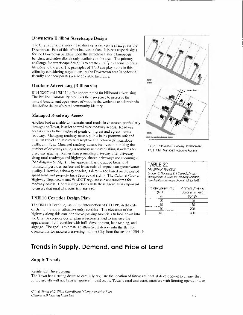
Downtown Brillion Streetscape Design
The City is currently working to develop a marketing strategy for the Downtown. Part of this effort includes a facelift (streetscape design) for the Downtown building upon the attractive historic lampposts, benches, and sidewalks already available in the area. The primary challenge for streetscape design is to create a unifying theme to bring harmony to the area. The principles of TND can play a role in this effort by considering ways to ensure the Downtown area is pedestrian friendly and incorporates a mix of viable land uses.
Outdoor Advertising (Billboards)
STH 32/57 and USH 10 offer opportunities for billboard advertising. The Brillion Community prohibits their presence to preserve the natural beauty, and open views of woodlands, wetlands and farmlands that define the area's rural community identity.
Managed Roadway Access
Another tool available to maintain rural roadside character, particularly through the Town, is strict control over roadway access. Roadway access refers to the number of points of ingress and egress from a roadway. Managing roadway access points helps promote safe and efficient travel and minimize disruptive and potentially hazardous traffic conflicts. Managed roadway access involves minimizing the number of driveways along a roadway and establishing standards for driveway spacing. Rather than promoting driveway after driveway along rural roadways and highways, shared driveways are encouraged (See diagram on right). This approach has the added benefit of limiting impervious surface and its associated impacts on groundwater quality. Likewise, driveway spacing is determined based on the posted speed limit, not property lines (See box at right). The Calumet County Highway Department and WisDOT regulate current standards for roadway access. Coordinating efforts with these agencies is important to ensure that rural character is preserved.
USH 10 Corridor Design Plan
The USH 10 Corridor, east of the intersection of CTH PP, in the City of Brillion is not an attractive entry corridor. The elevation of the highway along this corridor allows passing motorists to look down into the City. A corridor design plan is recommended to improve the appearance of this corridor with infill development, landscaping, and signage. The goal is to create an attractive gateway into the Brillion Community for motorists traveling into the City from the east on USH 10.
/
NOT TKE -.-....
/
1
-.
/
/
TRI
.iniii tkc nw,i&, fcrc pQznts
TOP: Undesirable Driveway Development BOTTOM: Managed Roadway Access
TABLE 22 DRIVEWAY SPACING Source: F. Humstone & J. Campoli, Access Management: A Guide for Roadway Corridors, Planning Commissioners Journal, Winter 1998
Posted Speed Limit Minimum Driveway (MPH) Spacing (in Feet)
25 90-125 30 155 35 185 40 225
45± 300
Trends in Supply, Demand, and Price of Land
Supply Trends
Residential Development The Town has a strong desire to carefully regulate the location of future residential development to ensure that future growth will not have a negative impact on the Town's rural character, interfere with farming operations, or
City & Town of Brillion Coordinated Comprehensive Plan Chapter 8.0 Existing Land Use 8.7

result in significant increases in service needs and costs. Scattered rural development translates directly into increased potential for conflicts with adjacent farms (i.e. odors, lighting, etc.), and interrupts scenic views and character of rural areas. It also costs more for the Town to provide road maintenance (including snowplowing), garbage collection and other amenities to residents that are scattered throughout the Town than it does for residents living in a single area.
Forest Junction provides the greatest opportunities for housing in the Town. Affordable subdivision development, some older established homes on larger lots, a mobile home park, and some new multiple family housing provide opportunities for residents of different ages, incomes and needs. Furthermore, Forest Junction residents have access to water and sewer service. Additional space is available in the Forest Junction area for expansion within the areas served with sewer and water (see the Future Land Use Maps in Appendix B)
The Town would like to continue to concentrate future housing development in Forest Junction to minimize conflicts between housing and farming uses and to protect the rural character of the community. To achieve this goal, the Town understands the need to continue investing in the infrastructure and amenities available in Forest Junction to provide quality residential choices.
The City provides a quality supply of historic homes around the Downtown business district, which are very affordable for residents of the area. The City also provides apartment, and senior housing choices that are not available in surrounding communities. Newer, larger homes are being built in the southern areas of the City near Deer Run Golf Course. Additional future housing development is anticipated around the Brillion High School.
Supply/Trends in Farming As discussed in the Agricultural, Natural and Cultural Resources Element Chapter, older area farmers are retiring. Furthermore, the poor farm economy discourages people from becoming farmers. The result is a diminished pool of local family farmers. This leads to pressure to sell and convert farmland to more profitable uses to improve the sale price.
Fortunately, the Brillion Community sees this plan as a tool to protect farmland by directing development to the City and Forest Junction. This strategy helps to minimize community service costs by concentrating services in a single area, which helps to keep taxes lower for farmers. Likewise, the potential for conflicts with adjacent residential land uses is also minimized.
Commercial and Industrial Development The City's westward development pattern is not encouraged in the future because development extending along the USH 10 corridor may eventually destroy the rural buffer that exists between Forest Junction and the City. For this reason, the City will seek to:
• Infill new commercial/industrial development along USH 10;
• Enhance the appearance of the eastern stretches of USH 10 through Brillion;
• Promote additional Downtown development; and
• Utilize any new business park development as a means to grow the local economy.
Although Forest Junction has not experienced new commercial/industrial development along USH 10 or STH 32/57, new residential development may increase the potential for additional commercial and industrial development. The Town of Brillion also sees potential for the redevelopment of downtown Forest Junction, which encompasses the areas of Main, Harrison, W. Milwaukee and Randolph Streets. Redevelopment projects could include the development of a historical village, a regional farmers market, or facilities relevant to users of the Fox River and Friendship State Trails. Strategies to promote additional business opportunities are presented in the Economic Development Chapter of this plan.
City & Town of Brillion Coordinated Comprehensive Plan Chapter 8.0 Existing Land Use 8.8

Demand
Given anticipated population increases and the Town's desire to direct development to Forest Junction, housing demand is expected to increase in Forest Junction over the next 20 years. Additional development is predicted in the City in accordance with its anticipated population growth.
In 2001, the Brillion High School was completed on the westernmost edge of the City on land that was annexed from the Town. Housing development adjacent to the school is almost a certainty.
Trends in Land Prices Town of Brillion Farm Field
The Brillion Community enjoys very affordable land compared to surrounding communities, particularly given the services (i.e. water and sewer) available and access to USH 10 and STH 32/57. The land in the Town, including Forest Junction, is slightly more affordable because the tax rate is lower. However, these areas do not provide the same level of services available within the City (sidewalk connections, parks, etc.). Land values in the Brillion Community are steadily increasing, but at a lesser rate than larger urban areas (i.e. Appleton) and their surrounding towns.
Assessed Valuation 2
Historical trends have demonstrated that land prices have steadily increased in the Brillion Community. In comparing assessed land values in the Town of Brillion to neighboring towns, the assessed value per acre of residential land is greater than the Town of Woodville and Rantoul. This is explained in part by the influence of the sanitary district in Forest Junction.
It is interesting to note that the Town of Brillion has a slightly lower assessed value per acre of agricultural land when compared to Rantoul and Woodville. This likely reflects the impact the Brillion Wildlife Area has on agricultural land values.
For the City, the assessed value per ace of residential land was compared to that of the two other cities contained completely within Calumet County. Brillion has had a consistently higher assessed residential value per acre than Chilton, but lower than New Holstein over the last several years. The gap between Brillion and Chilton has expanded, but the difference in assessed value between Brillion and New Holstein has remained basically unchanged. Therefore, the assessed values of land have been growing faster in Brillion than Chilton and keeping a steady pace with New Holstein.
Total Equalized Valuation The annual equalized value of each municipality represents the Wisconsin Department of Revenue's estimate of market value of all taxable property. Property tax levies of such jurisdictions are apportioned to each municipality on the basis of equalized value. In 2004, of the nine towns in Calumet County, the Town of Brillion ($13,576,700) ranked fifth behind the Towns of Harrison ($132,718,900), Stockbridge ($32,997,600), Brothertown ($28,021,100) and New Holstein ($15,351,800) with respect to equalized land value (NOTE: excludes value of improvements). Given the vast areas covered by the Brillion Wildlife Area (e.g. areas with minimal land value), this is a very respectable ranking, particularly considering the amount of improved residential land in the Towns of Harrison and Stockbridge.
City & Town of Brillion Coordinated Comprehensive Plan Chapter 8.0 Existing Land Use 8.9

In 2004, the City of Brillion ($18,639,800) ranked third among municipalities (cities and villages) contained completely within Calumet County behind the Village of Sherwood ($39,469,400) and Chilton ($23,276,000) with respect to equalized land value. Brillion was just ahead of New Holstein ($18,604,300).
Summary This information is presented to provide a context for understanding land values in the Brillion Community. To spur increases in land values over time, efforts need to be made in implementing this plan to ensure that Brillion takes advantage of its great location, schools, parks, and other amenities. This may mean marketing and investment in the community's appearance to attract quality development (and additional tax base) to the Brillion Community. These actions are consistent with the visions, goals, objectives and policies provided within this plan.
Annexation In Wisconsin, cities cannot instigate annexations. Town landowners have to petition for annexation; then cities have to determine whether or not they are willing to annex those parcels.
If the Town of Brillion is concerned about annexations, the Town should study why residents decide to petition for annexation:
• Do residents want services the Town is unable to provide?
• Does annexation increase the marketability and value of their property?
GROWTH BOUNDARY
A growth boundary between the City and Town should be first verbally agreed to and then mapped. A growth boundary represents the planned limit of City growth for a 10 and 20 year period. These growth lines help the Town to plan for its own growth and development and help limit conflicts between the City and Town.
• Is the annexing municipality more willing than the Town to address their concerns?
• What other issues are involved?
Once the issues have been identified, the Town needs to determine what measures it can, and is willing to take to address those issues.
The greatest potential for annexation exists along the western boundary of the City. It is anticipated that over the life of this plan, residents in this area will seek annexation to the City to support development opportunities between the current City limits and Bastian Road. Cooperative boundary agreements, shared tax revenue, and other forms of intergovernmental agreements could be pursued by the Town to protect its eastern boundary from annexation. Likewise, an effort must be made to educate residents about the benefits and downfalls of annexation.
Assets and Opportunities What follows is a description of those community features that the City and Town would like to enhance over the next 20 years. In addition, potential opportunities or threats facing the community are also profiled. The Future Land Use Maps presented in Appendix B attempt to address these concerns through land use allocations and development patterns.
Assets
• The Brillion Community enjoys a central location in a growing region between Appleton, Manitowoc, Green Bay and Fond du Lac.
• The Brillion School District, the primary district serving the area, provides high quality education and state of the art facilities for its students, which is a draw to bring new families to the area.
City & Town of Brillion Coordinated Comprehensive Plan Chapter 8.0 Existing Land Use
Intersection of STH 32/57 and USH 10 in Forest Junction
8.10

• The extensive array of "big city" services and amenities available to area residents is unparalleled. The City's extensive park system (including a community center and recreation programs), ambulance service, fire protection, police protection, library, and more makes the City a premier residential community.
• The Brillion Community enjoys a strong industrial sector and a quality mix of residential development options.
• Natural resources are also an important community asset, anchored by the Brillion Wildlife Area.
• Farmland, from a scenic, economic, and cultural perspective is an integral part of the Brillion Community history and future. It is an asset to be preserved.
• Another important asset in the area is the USH 10 corridor. The USH 10 corridor is the lifeline of the community. It connects the area to the region, supports the local economy by bringing people through the area, and is an important local travel route.
I STH 32/57 is a vital north-south route through the Town.
The City and Town must continue to protect these community assets to preserve the character of the area and to achieve the vision presented in this chapter.
Opportunities
To begin the planning process, the City and Town identified important opportunities (see Chapter 2). Throughout this plan, these opportunities were often revisited. What follows is a brief description of the opportunities identified and strategies for success:
• Town residents see Forest Junction as an important part of the community. Many opportunities exist to enhance Forest Junction - for additional commercial, industrial, and residential development. To ensure that development in the area is compatible and attractive, this plan identifies specific areas for additional development (see Chapter 7). Likewise using design tools like TND, considering trail and sidewalk access, and working with the county and others to promote economic development opportunities will help to maximize the opportunities Forest Junction offers.
- The City of Brillion realizes that one of its greatest opportunities is its Downtown. This plan supports downtown development efforts and encourages additional infill development, design amenities (including the clock tower) and pedestrian amenities.
• The City would like to capitalize on its strong connection USH 10 provides to surrounding communities. This corridor brings people and commerce into the area. The City would like to ensure that this corridor is attractive, easy to navigate, and welcoming to visitors.
A related, but equally important opportunity exists to strengthen the connection between USH 10 and Downtown Brillion. Enticing passing motorists to turn off USH 10 into Downtown Brillion is critical to the long-term economic growth of Downtown.
Finally, farmland protection is seen as an important local opportunity. The plan is seen as an opportunity to direct development to Forest Junction and the City to protect rural farmland by minimizing residential conflicts and pressure to develop.
Goals and Objectives The City and Town both anticipate continued growth over the next 20 years. To ensure that this development will not destroy the rural character of the area, negatively impact the natural environment, or create undue congestion on area roads, the City and Town will pursue the goals and objectives listed in Chapter 11 - Implementation.
City & Town of Brillion Coordinated Comprehensive Plan Chapter 8.0 Existing Land Use 8.11

Land Use Policy Statement Given the overriding importance of the Land Use Element and its far-reaching impact on the other eight elements, the City and Town of Brillion created the following policy statement:
It is the policy of the City and Town of Brillion to direct future residential, commercial and industrial development within the City limits and the limits of the Forest Junction Sewer Service Area, in accordance with the Calumet County Growth Management Boundaries, and the City and Town's desire to protect farm operations, rural character and the local quality of life.
In accordance with this policy, the Town of Brillion will work with the City of Brillion to establish a growth boundary (see objectives above) and the Town of Brillion will coordinate with Calumet County to restrict building activity beyond the limits of the Forest Junction Sanitary District.
I Model Traditional Neighborhood Development Ordinance, UW-Extension, 2000 2 Analysis is based on data available from the Wisconsin Department of Revenue. Reflects information through 2004.
City & Town ofBrillion Coordinated Comprehensive Plan Chapter 8.0 Existing Land Use 8.12

Eli
9.0 INTERGOVERNMENTAL
COORDINATION
Introduction For the City and Town of Brillion, Intergovernmental Cooperation was at the forefront of their planning effort. In deciding to work together, to develop a coordinated multi-jurisdictional comprehensive plan, they have made a commitment to intergovernmental coordination.
The City's and Town's relationship with neighboring municipalities, school districts, sanitary districts, state agencies and Calumet County can significantly impact residents in terms of planning, the provision of services, and the siting of public facilities. An examination of these relationships and the identification of potential conflicts will help the City and Town address these situations in a productive manner.
Intergovernmental Coordination Vision In 20 years, the City and Town work cooperatively to provide residents with a wide variety of cost-efficient, non-duplicative services for the betterment of both communities. Through this cooperation, both communities have preserved their rural lifestyle, while providing a unique blend of needed and desired commercial, industrial and residential development.
Governmental Units and Relationships The City and Town share borders with towns and three counties. In addition, the City and Town must also coordinate with neighboring school districts, sanitary districts, county and regional government units, and state agencies.
Adjacent Governmental Units
Town of Rantoul, Calumet Co.
Town of Woodville, Calumet Co.
• Town of Maple Grove, Manitowoc Co.
• Town of Holland, Brown Co
The Town's relationship with adjacent towns can be characterized as one of mutual respect and compatibility from a land use and political standpoint. Towns cannot annex land from one another. Therefore, the borders between the Town of Brillion and the adjacent towns are fixed and boundary disputes are non-existent. The towns share a common rural character. Public services (i.e. road maintenance and construction, etc.) are conducted individually by each town. However, as mutually beneficial opportunities for shared service contracts arise, the Town, City and other neighboring communities are open to considering these options.
The City of Brillion also has a positive relationship with its neighbors. However, given its status as a City, Brillion does have the ability to accept annexation proposals, which sometimes creates a strain on intergovernmental relations. The City considers intergovernmental coordination an important aspect of government relations.
School Districts
• Brillion School District
Hilbert School District
• Wrightstown School District
City & Town of Brillion Coordinated Comprehensive Plan Chapter 9.0 Intergovernmental Cooperation Element 9.1

www.brillion.kl2.wi.us
wArw.hilbert.k12.wi.us
We Ex nd the
Mankind
Calumet County website: ww.co.calumet.wi.us
4 Brown County website www.co.brown.wi.us
t,.
As is discussed in Chapter 5, the City is served by the Brillion School District and the Town is served by the Brillion, Hilbert, and Wrightstown School Districts. The City and Town's relationship with the local school districts can be characterized as cooperative. This relationship must continue and be strengthened as growth is coordinated with local school capacities.
Sanitary Districts
Forest Junction Sanitary District
Brillion Sanitary District
There are two sanitary districts in the Brillion Community. The City and Town enjoy a cooperative relationship with the local sanitary districts. The continued strength of these relationships is important, particularly for the Forest Junction Sanitary District as growth is directed to this area of the Town.
County and Regional Government Units
• Calumet County
• Brown County
• Manitowoc County
• East Central Wisconsin Regional Planning Commission (ECWRPC)
The City and Town are located in Calumet County. The county has some jurisdiction within the Town. In particular, Calumet County has jurisdiction over land divisions, on-site sanitary systems, and zoning (including shoreland-wetland and floodplain areas) of the Town. Calumet County also maintains many county roads in the Town. The county's jurisdiction has at times created conflict with the Town.
The relationship between the City and Calumet County is more limited. The primary interaction occurs with respect to county road maintenance and improvements and police services.
The relationship between the City, Town and Calumet County can be characterized as one of general agreement and respect. In those areas where the county has jurisdiction in the Town, the county attempts to get input from the Town before making decisions affecting the Town. Likewise, the City and Town have attempted to maintain open communication with Calumet County. Continued cooperation will be especially important as it relates to zoning as a tool to implement this plan in the Town.
The northern boundary of the Town is also the southern boundary of Brown County. Historically, Brown County and the Town have had limited interaction with one another. This situation is not anticipated to change in the future.
Manitowoc County website: The City and Town also share a boundary with Manitowoc County to the east. www.co.manitowoc.wi.us Like the relationship the Town has with Brown County, interaction with Manitowoc County is rather limited. This situation is only likely to change if the City grows extensively to the east into Manitowoc County. The City has no plans to expand into Manitowoc County at this time.
City & Town of Brillion Coordinated Comprehensive Plan Chapter 9.0 Intergovernmental Cooperation Element 9.2

The City and Town are part of the East Central Wisconsin Regional Planning Commission (ECWRPC). The City and Town have little direct interaction with the ECWRPC. The primary relationship is through the sanitary districts.
State Agencies
• Wisconsin Department of Natural Resources (WDNR)
• Department of Agriculture, Trade and Consumer Protection (DATCP)
• Wisconsin Department of Transportation (WisDOT)
WDNR, WisDOT, and DATCP are the primary state agencies the City and Town must coordinate with to achieve the goals and objectives of this plan.
WDNR is a major agency involved in the acquisition and development of recreational/pedestrian trails - a major component of this plan. WisDOT website Furthermore, the WDNR takes a lead role in wildlife protection and the www. dot. state. wi. us protection and sustained management of woodlands, wetlands and other natural wildlife habitat areas.
The mission of the DATCP is to serve Wisconsin citizens by assuritm:
The safety and quality of food
• Fair business practices for the buyer and seller
• Efficient use of agricultural resources in a quality environment
• Consumer protection
• Healthy animals and plants
The vitality of Wisconsin agriculture and commerce
WDNR website: http:lldnr.wi.gov
Given the importance of farming in the Brillion Community, DATCP plays an important role in the Town. DATCP policies, programs and directives impact local farm operations.
WisDOT is also a key player in the planning and development of pedestrian/cycling facilities. In addition, WisDOT is responsible for the maintenance of the STH 32/57 and USH 10 corridors.
Open communication and participation in land use and transportation decisions, which may impact the City and Town, is an important priority for intergovernmental cooperation in the future.
Intergovernmental Comprehensive Planning Process To facilitate a planning environment open to intergovernmental coordination, the City and Town sent all adjacent municipalities, school districts, Calumet County, and the ECWRPC a letter during the on-set of the planning effort to notify these agencies and communities of the City and Town of Brillion multi-jurisdictional comprehensive planning process. Likewise, this letter extended an open invitation for participation in the development of this plan.
On an element-by-element basis, the City and Town contacted Calumet County, local school districts, the sanitary districts, and state agencies again to complete inventories of available services, facilities, and programs. For example, during the development of the Transportation Element, WisDOT was contacted to obtain information available related to transportation facilities and programs. Likewise, WisDOT was provided a preliminary copy of the Transportation Element to review and comment upon.
Throughout the plan development process, City and Town worked closely with Calumet County and the ECWRPC to coordinate plan-mapping resources and obtain detailed information related to zoning, agricultural preservation, quarry operations and general demographic data.
City & Town of Brillion Coordinated Comprehensive Plan Chapter 9. 0 Intergovernmental Cooperation Element 9.3

On January 7, 2003, as the draft plan was nearing completion, the City and Town hosted a special intergovernmental fleeting to discuss the plans of other local agencies and governments and attempt to coordinate the City and Town of Brillion Coordinated Comprehensive Plan with the goals and objectives of these other local plans. The participants were also given the opportunity to view and comment on the Draft Future Land Use Maps and this chapter. This collective "meeting of the minds" provided a unique opportunity to discuss area growth, development, transportation, education, and other concerns.
Intergovernmental Cooperation Programs Many intergovernmental programs are already in effect in the City and Town. For example, Calumet County Sheriff's Department provides police protection to the Town and backup to the Brillion City Police Department. Mutual aid agreements for fire protection exist between the City, Town and their neighbors.
As growth and change continues in the area, land use will remain a controversial topic. The City and Town have the opportunity, under State Statutes 66.023 and 66.30, to pursue a boundary agreement. If a boundary agreement were established, the City and Town could work together to make rational decisions about where growth will occur, including the setting or changing of boundaries, and how public services (including sewer and water) could be provided. Other intergovernmental agreements, such as shared tax revenue, may also be pursued.
Existing and Proposed Plans
Adjacent Governmental Units
To ensure compatibility with planning goals and objectives of this plan, the City and Town would like to participate in the planning efforts of its neighboring communities.
School Districts
The Brillion, Hilbert and Wrightstown school districts extend beyond the City and Town of Brillion. Therefore, development in neighboring communities may have an impact on the need to expand. At this time, the only district planning to expand its existing facilities is the Hilbert School District. The school district is planning for a complete update of the middle/high school building, which includes the addition of science and technology wing, and a new elementary school. These improvements are, of course, dependent on the approval of a referendum. The City and Town wish to remain involved in the siting of future schools to ensure that the goals and objectives of this plan can be met.
County and Regional Governments
It is important that the City and Town participate in the planning processes when Calumet, Manitowoc and Brown Counties, and ECWRPC develop and maintain their comprehensive plans. It is also important for the City and Town to work with the ECWRPC in the planning for the boundaries of the sanitary districts.
In the future, Calumet County and the ECWRPC may oversee efforts related to farm planning for purchase and transfer of development rights programs. These farm planning efforts will have the potential to impact stream buffers and areas that are cropped in the Brillion Community. Therefore, the City and Town will need to coordinate with Calumet County and the ECWRPC with respect to farmland planning to protect the interests of local farmers.
State Agencies
The City's and Town's relationship with the State of Wisconsin primarily occurs through coordination with the WDNR with respect to the Brillion Wildlife Area. A detailed discussion of the Brillion Wildlife Area Plan is provided in the Agricultural, Natural and Cultural Resources Chapter. Coordination with the state also occurs with respect to state aids for local roads and the administering of various state mandates. Furthermore, coordination with WisDOT will continue to be important with respect to any changes to USH 10 and STH 32/57.
City & Town of Brillion Coordinated Comprehensive Plan Chapter 9.0 Intergovernmental Cooperation Element 9.4

Intergovernmental Goals and Objectives The goals, objectives and policies provided in Chapter 11 (Implementation Element) generally seek to enhance lines of communication between area governments. This approach will help to create an environment where coordination is possible and conflicts are minimized.
Intergovernmental Policy Statement The City and Town will seek to cooperate with all neighboring municipalities, counties, state agencies and school districts for mutual benefit.
City & Town of Br//lion Coordinated Comprehensive Plan Chapter 9.0 Intergovernmental Cooperation Element 9.5

IC

10.0 FUTURE LAND USE
Introduction The Future Land Use Maps presented in Appendix B incorporate the realities, ideas, goals, and visions explained in Chapters 1-9, and are probably the most important feature of the Comprehensive Plan. These maps present the vision for growth and development through 2020. These maps will be used extensively by the City and Town when making land use decisions and recommendations.
Future Land Use Map Development The maps were built from the Existing Land Use Maps and Zoning Maps. Areas targeted for future development and farmland preservation were decided through a series of special meetings and activities including: Cognitive Mapping, Interactive GIS Modeling, the Community Survey, the Community Mapping Forum and an Intergovernmental Meeting.
Over the course of the planning process, several draft copies of the Future Land Use Maps were presented to:
• Coordinated Plan Committee
• Neighboring Communities
• Local School Districts
• Calumet County
• Wisconsin Department of Transportation
• Wisconsin Department of Natural Resources; and
• Residents and property and business owners from the area
Each of these stakeholders was given opportunities to comment on the Future Land Use Maps and suggest changes. The Future Land Use Maps incorporate many of the recommendations.
The 2010 Land Use Maps were developed after the 2020 Land Use Maps were completed. The 2010 Land Use Maps suggest timing and phasing of development in the area. These maps were developed in accordance with the requirements of 1999 Wisconsin Act 9.
Interactive GIS Modeling
The University of Wisconsin Madison Land Information and Computer Graphics Facility (LICGF) facilitated Interactive GIS Modeling with the Coordinated Plan Committee between September 2001 and December 2001. This activity was sponsored as part of the NRCS Pilot Project (See Chapter 1 for additional information).
Land Information &
Computer Graphics Facility
Essentially, Interactive GIS Modeling allowed the Coordinated Plan For more info about the LICGF visit
Committee to ask "what if' questions related to future development their web site at www.11c.wisc.edu
and farmland preservation. The answers to their questions were displayed using computer-aided mapping and modeling techniques. These preliminary questions helped the committee to understand the impact of decisions and policies. For example, when given information about soil quality in the area, the Coordinated Plan Committee asked to see where development could be located if all productive farm areas were excluded from development. Questions like these helped to begin the process of making future decisions about where development was most appropriate.
City & Town of Brillion Coordinated Comprehensive Plan Chapter 10.0 Land Use Element - Future Land Use 10.1

Cognitive Mapping
In 2001, the Coordinated Plan Committee worked with Dr. Thomas Greene to develop a series of cognitive maps, to illustrate areas desired for development and preservation in the City and Town. (For more information about the cognitive mapping exercise see Chapter 2.)
The maps developed through the cognitive mapping exercise were a starting point from which to develop the Future Land Use Maps.
Community Survey
The community survey provided a great deal of information about resident desires and expectation for the future, and brought to light several conflicts in ideas about where future development should and should not occur. The survey clearly established that residents place a high priority on farmland, new economic development opportunities, quality housing, a sense of safety/security, the Town's rural/country atmosphere. and the City's "small town" feel. (See Chapter 1 for more information)
The survey included a series of questions to help identify where residents were most interested in seeing new development in the City and Town of Brillion. A series of maps illustrating the survey results follows. These maps were an important information source used to develop the Future Land Use Maps presented in Appendix B.
Dr. Thomas Greene Facilitating Cognitive Mapping Exercise
June 5, 2001
Community Mapping Forum Dr. Ken Genskow
After the first series of draft planning maps were completed, the Community Survey Results Presentation
Coordinated Plan Committee hosted a special public meeting to present all January 2002
of the plan maps and receive preliminary public feedback. This meeting provided residents a brief progress report of the planning process, and more importantly, time to review the maps, and opportunities to ask questions and provide feedback.
Intergovernmental Meeting
During the planning process, the Coordinated Plan Committee facilitated a special intergovernmental meeting. The purpose of this meeting was to identify, and mitigate where possible, conflicts between the proposed Future Land Use Maps for the Brillion Area and surrounding community plans.
2009 Future Land Use Map Amendments
In 2009, the City and Town of Brillion worked with the Calumet County Planning, Zoning and Information Department to amend the 2003 Future Land Use Maps, which were developed through the process described above. The purpose of the amendments was to use the same future land use classifications that were used in the Calumet County Year 2025 Smart Growth Plan. The Calumet County Smart Growth Plan was adopted in May 2007, several years after the adopted City and Town of Brillion Coordinated Comprehensive Plan. Since the majority of the communities in the county participated in the county's smart growth planning process, the City and Town of Brillion felt it necessary to be consistent with the future land use categories that were used by their neighboring communities.
Unlike the land use maps that were adopted in 2003, the Town and City of Brillion did not feel it was necessary to have both a 10-Year and 20-Year Future Land Map. Only 20-Year Future Land Use Maps were developed.
City & Town of Brillion Coordinated Comprehensive Plan Chapter /0.0 Land Use Element— Future Land Use 10.2
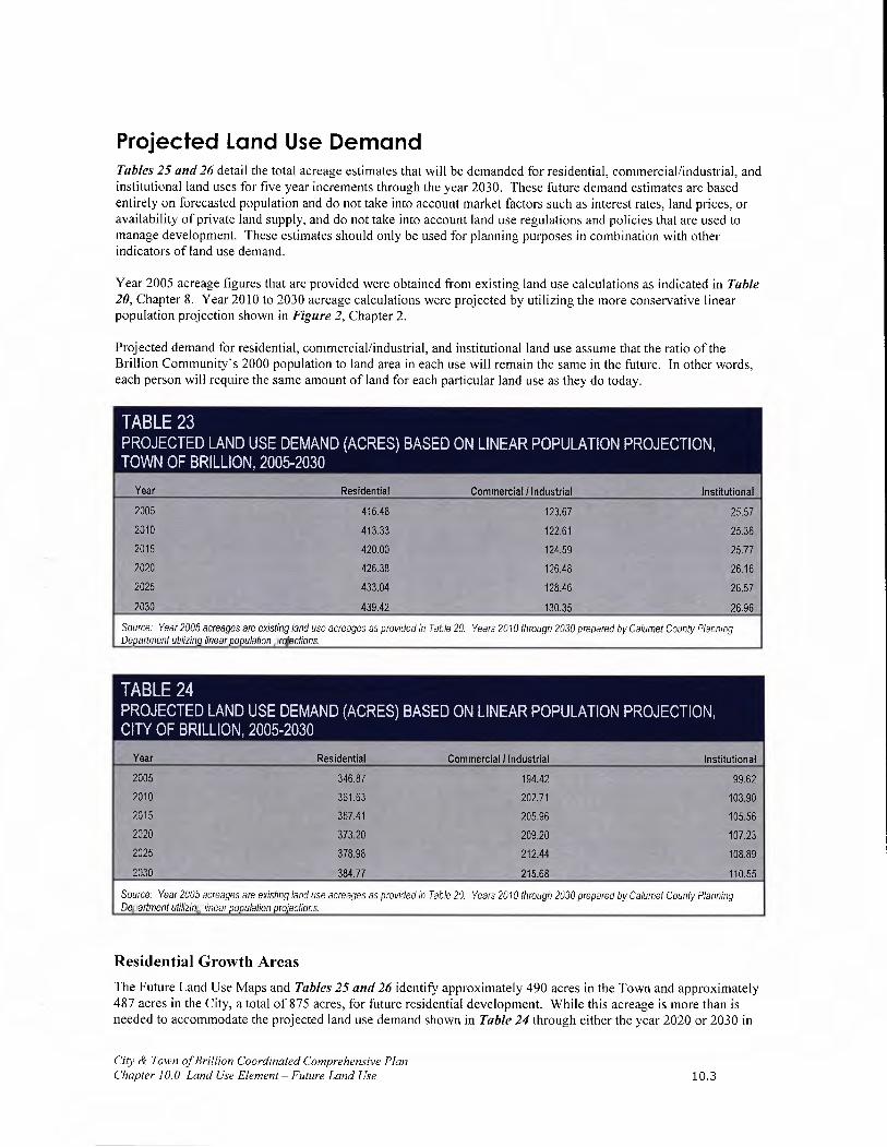
Projected Land Use Demand Tables 25 and 26 detail the total acreage estimates that will be demanded for residential, commercial/industrial, and institutional land uses for five year increments through the year 2030. These future demand estimates are based entirely on forecasted population and do not take into account market factors such as interest rates, land prices, or availability of private land supply, and do not take into account land use regulations and policies that are used to manage development. These estimates should only be used for planning purposes in combination with other indicators of land use demand.
Year 2005 acreage figures that are provided were obtained from existing land use calculations as indicated in Table 20, Chapter 8. Year 2010 to 2030 acreage calculations were projected by utilizing the more conservative linear population projection shown in Figure 2, Chapter 2.
Projected demand for residential, commercial/industrial, and institutional land use assume that the ratio of the Brillion Community's 2000 population to land area in each use will remain the same in the future. In other words, each person will require the same amount of land for each particular land use as they do today.
Year Residential Commercial! Industrial Institutional
2005 416.48 123.67 25.57
2010 413.33 122.61 25.36
2015 420.00 124.59 25.77
2020 426.38 126.48 26.16
2025 433.04 128.46 26.57
2030 439.42 130.35 26.96
Source; Year 2005 acreages are existing land use acreages as provided in Table 20. Years 2010 through 2030 prepared by Calumet County Planning Department utilizing linear population projections.
Year Residential Commercial! Industrial Institutional
2005 346.87 194.42 99.62
2010 361.63 202.71 103.90
2015 367.41 205.96 105.56
2020 373.20 209,20 107.23
2025 378.98 212.44 108.89
2030 384.77 215.68 110.55
Source; Year 2005 acreages are existing land use acreages as provided in Table 20. Years 2010 through 2030 prepared by Calumet County Planning Department utilizing linear population projections.
Residential Growth Areas
The Future Land Use Maps and Tables 25 and 26 identify approximately 490 acres in the Town and approximately 487 acres in the City, a total of 875 acres, for future residential development. While this acreage is more than is needed to accommodate the projected land use demand shown in Table 24 through either the year 2020 or 2030 in
City & Town of Brillion Coordinated Comprehensive Plan Chapter 10.0 Land Use Element- Future Land Use 10.3

the City, it is not sufficient to cover projected land use demand shown in Table 23 in the Town. However, there are
approximately 450 acres of Planned Urban Transition lands that surround Forest Junction and the west side of the
City of Brillion that could accommodate residential development should sewer and water infrastructure become
available in those areas.
Commercial and Industrial Growth Areas
The Future Land Use Maps and Tables 25 and 26 identify approximately 496 acres in the Town and approximately
531 acres in the City for commercial and industrial development. This exceeds the projected land use demands for
the Town, 130 acres, and the City, 216 acres.
The Future Land Use Maps identify additional commercial and industrial development in Forest Junction. The
commercial development is concentrated near the intersection of USH 10 and STH 32/57. However, the majority of
commercial and industrial development is proposed to occur mainly around the City of Brillion. A proposed
gateway, along USH 10 in the City east of CTH PP, would incorporate new development, landscaping and signage
to welcome visitors traveling east of USH 10 into the City. Industrial development would also remain along the
USH 10 Corridor and in any new business park. Downtown Brillion is also identified as a primary area for
commercial development over the next 20 years.
While the probability for the developing all of the identified commercial and industrial lands by the year 2020 is
low, the City and Town have an understanding and vision as to where that type of growth should occur. As
demonstrated in Table 7, Chapter 2, 5 out of the top 10 private sector employers in Calumet County are located in
the City of Brillion.
Agricultural Growth Areas
Using the same land use projection methodology as above, it is estimated that 15,160 acres of land will be needed
for agriculture through the year 2030 in the Town. The 20-Year Future Land Use Maps identify approximately
15,161 acres of land in the Town of Brillion as Exclusive Agricultural and General Agriculture. For some
agricultural communities a decrease in agricultural land is the trend due to development pressure, the Town is very
proud of its agricultural heritage and has chosen for agriculture to continue as its prominent land use.
The City of Brillion, however, is the opposite in terms of agricultural land use. Future land use projections indicate
that the City should contain approximately 388 acres of agricultural land in the year 2030. The 20-Year Future Land
Use Maps have identified approximately 27 acres of land with an agricultural land use. The decrease in agricultural
land is consistent with the City and Town's plan to encourage development in the urban areas of the Brillion
Community that being the City of Brillion and Forest Junction.
Future Land Use Classifications Future land use classifications represent the desired arrangement of future land use. The classifications are intended
to reflect community desires and to display how land is planned for preferred future use(s). The classifications were
used to create the Future Land Use Maps to graphically represent the desired arrangement of land use through 2020
and to guide and assist in growth management decisions and community development. The classifications address
the type of intended use, the location of development, and proposed density.
According to State Statute 66.1001, the Land Use Element of a comprehensive plan must specify the general
location of future land uses by net density or other classification. To address this requirement, the following future
land use classifications have been developed to promote the desired features of the Town of Brillion and City of
Brillion. The future land use classifications are simply designated areas of consistent character, use, and density that
share similar goals, objectives, and management polices for preferred use.
The future land use classifications are not zoning districts and do not have the authority of zoning. However, they
can be used to help guide land use decisions through a number of different implementation tools such as land
division ordinances and coordination with zoning regulations.
City & Town of Bullion Coordinated Comprehensive Plan Chapter 10.0 Land Use Element — Future Land Use 10.4

Where the identification of desired future land uses as identified on the Future Land Use Maps are not consistent with zoning, the maps do not imply that any area is immediately appropriate for rezoning. Given service demands and a desire for controlled growth, careful consideration to the timing of zoning decisions is essential. Depending on the chosen implementation strategy, it may be desirable to rezone land to reflect the planned land use designations as soon as possible. In other cases, it may be appropriate to wait to rezone the area until an actual development proposal is brought forward by the landowner or until the property can be appropriately serviced (i.e. public sewer and water). This is especially true for the industrial areas shown on the Future Land Use Maps that are located in the Town of Brillion but are adjacent to the City of Brillion. While the Town of Brillion is not currently able to accommodate such development, the City of Brillion may be able to in the future.
City of Brillion Future Land Use Classifications
Sin2le Family Residential • Purpose: The single family residential designation is designed to include existing and planned single family
residential development as well as other forms of residential development that will be served by municipal sewer and water systems and as dictated by the zoning code and map. Planned residential expansions will primarily occur through recorded subdivisions. Densities will be regulated by each community's zoning ordinance.
• Intent: The residential areas designated on the Future Land Use Maps reflect all areas that are currently in, or are planned for, single family residential use. The single family residential district is intended to accommodate primarily single family residential development, but may allow some additional uses in accordance with each community's zoning code. Mobile home parks and attached condominiums would not be categorized as single family residential but as general residential (see description below). Where agricultural uses occur in these mapped areas, it is anticipated that the area will transition to residential in the future.
> Range of lot sizes will occur between 7,000 square feet and 18,000 square feet. > The net density in this district should not exceed six (6) dwelling units per acre. > Other uses generally allowed in this district could include public and quasi-public uses, elder care
facilities, and utilities in accordance with the zoning ordinance. > Use of the Planned Unit Development Overlay District (here after referred to as PUD) would be an
acceptable use in this preferred land use classification. PUD established to provide a voluntary regulatory framework designed to encourage and promote improved environmental and aesthetic design by allowing for greater freedom, imagination, and flexibility in the development of land while insuring substantial compliance to the basic intent of the zoning ordinance and the general plan for community development.
General Residential • Purpose: The general residential designation is designed to include existing and planned residential
development that may vary in density and use. The areas would be served by municipal sewer and water systems and could include both single and duplex developments. Planned, two-family residential expansions would be occurring primarily through recorded subdivisions. Densities would be regulated by the zoning ordinance.
• Intent: The general residential use designated on the Future Land Use Maps reflects areas that are currently in, or are planned for, residential use. It also includes the majority of areas that are currently zoned for two-family uses. This district is intended to accommodate primarily two-family residential development while also allowing for single family residential development. > Range of lot sizes will occur between 7,000 square feet and 10,000 square feet. > The net density in this district should not exceed six (6) dwelling units per acre. > Other uses generally allowed in this district could include single family residential, converted single family
to two-family dwellings, public and quasi-public uses, elder care facilities, and utilities. > Use of the Planned Unit Development Overlay District would be an acceptable use in this future land use
classification.
City & Town of Brillion Coordinated Comprehensive Plan Chapter 10.0 Land Use Element - Future Land Use 10.5

Multi-Family Residential • Purpose: The multi-family residential designation is designed to include existing and planned multi-family
residential development as well as other forms of residential development that will be served by municipal sewer and water systems. Densities will be regulated by the zoning ordinance.
• Intent: The multi-family residential future land use classification reflects areas that are currently in residential use and some areas that are currently in, or are planned for, higher density residential uses. It also includes the majority of areas that are currently zoned for multi-family uses. A limited higher density multi-family development may also be permitted in appropriate locations along the periphery of this district, adjacent to transportation corridors, commercial areas, and schools. This district is intended to accommodate primarily multi-family residential development. > Lot sizes will be 15,000 square feet with no less than 2,000 square feet per unit. > Multi-family units shall be at least three (3) units and will not exceed eight (8) units per structure. > The net density in this district should not exceed seven (7) buildings per acre. (assumes a minimum of
three units per building, therefore 6,000 square feet minimum per building) > Other uses generally allowed in this district could include two family dwellings, public and quasi-public
use, elder care facilities, utilities, and multi-family structures greater than eight (8) units. > Use of the Planned Unit Development Overlay District would be an acceptable use in this preferred land
use classification.
Planned Urban Transition • Same as Town of Brillion Future Land Use Classification
eral Commercial Purpose: The general commercial future land use is planned to represent existing commercial type land uses and anticipated preferred commercial areas. Densities will be regulated by the zoning ordinance.
Intent: The general commercial classification is intended to accommodate large and small-scale commercial and office development. A wide range of retail, service, lodging, and office uses are appropriate in this district. > This classification is located primarily along major transportation corridors. > It is important for development within these districts to be attractively designed or substantially
screened as necessary along these corridors as they establish a community image. > Use of the Planned Unit Development Overlay District would be an acceptable use in this future land use
classification. > Site plan requirements will be required to review the development proposals in accordance with local plans
and codes.
Central Business/Downtown Commercial • Description: The central business/downtown commercial designation is designed to include existing and
planned commercial development that will be served by municipal sewer and water systems. Densities will be regulated by the zoning ordinance.
• Intent: The central business/downtown commercial classification is intended to be a focus area for business and pedestrian traffic in the community. This district is intended to remain a compact pedestrian-oriented area with a mix of commercial uses, small professional offices and services, institutional, residential, civic, and park and open space uses. > This area should avoid vacant lots and large surface parking lots fronting a main street. > Large gaps in street walls (the line of attached building facades along the street frontage) should be
avoided. > Reuse and/or redevelopment of vacant commercial buildings is especially encouraged.
Multiple story (up to 4 stories), mixed use buildings that include high quality architecture, signage, lighting, and streetscape amenities that are sensitive to and enhance the character of the community and small central business district are encouraged.
> Higher density residential zoning districts are also appropriate for the downtown area if adequate parking can be provided on site.
> Use of the Planned Unit Development Overlay District would be appropriate based on the site plan and coordination with adjacent uses.
City & Town of Brillion Coordinated Comprehensive Plan Chapter 10.0 Land Use Element— Future Land Use 10.6

Industrial • Purpose: The industrial designation is designed to include existing and planned industrial development that
will be served by municipal sewer and water systems, served by highways and roads that can accommodate transportation needs of industrial uses, and as dictated by the zoning code and map. Densities will be regulated by the zoning ordinance.
• Intent: The industrial classification is intended to include existing and planned industrial park and industrial expansion areas. This district is intended to be served by appropriate water and sewer facilities to meet industrial business requirements and provide an area for industrial uses that provide employment for local citizens and support the local tax base. ' Use of the Planned Unit Development Overlay District would be an acceptable use in this future land use
classification. > Lot minimum would be seven thousand two hundred square feet (7,200 sq. ft.) in area and shall be not
less than 60 feet in width. Development applications shall, before a building permit is issued, present detailed site plans pertaining to the proposed structures to the plan commission.
Utilities and Community Services • Purpose: The utilities and community services designation is designed to include existing and planned areas
for land uses intended for public and quasi-public uses (not including park and recreation areas). The locations of these areas will be further dictated by the zoning ordinance.
• Intent: This district is intended to accommodate civic, institutional, and related uses such as government facilities, schools, utilities, churches, post offices, police and fire stations, and cemeteries. It is important for public and institutional developments within this district to set a high standard for architecture and site design for the community. > Lot area and width requirements shall provide sufficient area for the principal structure and its accessory
structures, off-street parking, and loading areas as required by the zoning ordinance.
Parks and Recreation • Purpose: The parks and recreation designation is designed to include existing and planned park and recreation
areas. The locations of these areas will be further dictated by the zoning ordinance. • Intent: The park and recreation classification is intended to include all existing park and recreational areas as
well as some additional areas which will allow for the community to serve a growing population's recreation needs. > Classification to be coordinated with applicable Outdoor Recreation and Open Space Plans. > Lot area and width requirements shall provide sufficient area for the principal structure and its accessory
structures, off-street parking, and loading areas as required by the zoning ordinance. > Inter-municipal trail connections to facilities are emphasized.
Agriculture • Purpose: To continue agriculture as the predominant land use while planning for the potential of long-term
land conversions in accordance with the comprehensive plan. The areas planned for agriculture within the municipal limits or within the municipal Extraterritorial Area (ETA) have short or long term potential for public services or may have opportunity for shared services between the community and neighboring town as identified through intergovernmental cooperation discussions.
• Intent: Maintaining land in agriculture, while still allowing limited development in concert with the overall growth management strategy. Designated agricultural areas would not be served by future water and sewer system extensions unless the areas were planned for conversion of use. The agriculture classification could have the benefit of potential advocacy for intergovernmental cooperation with neighboring unincorporated communities due to probable discussions concerning long term growth coordination. > Minimum lot area: 10 acres. > Minimum lot width: 200 feet. > It is further intended that use of this classification may lead to boundary agreements in these areas to
define preferred land use, phasing of development, and the possibility for shared service agreements prior to any development. Lot area and width requirements shall provide sufficient area for the principal
City & Town of Brillion Coordinated Comprehensive Plan Chapter 10.0 Land Use Element— Future Land Use 10.7

structure and its accessory structures, off-street parking, and loading areas as required by the zoning ordinance.
> Inter-municipal trail connections to facilities are emphasized.
Town of Brillion Future Land Use Classifications
The purpose and primary goal encapsulates the goals or objectives of the land use area. The intent of each classification is broken down further by preferred uses, proposed density, and proposed conditions. The idea is to not only capture the location and type of the future land uses in the plan, but also the proposed density and associated recommendations into code modifications or regulatory tool development.
Single Family Residential • Same as City of Brillion Future Land Use Classification
General Residential • Same as City of Brillion Future Land Use Classification
Multi-Family Residential • Same as City of Brillion Future Land Use Classification
A2ricultural Enterprise • Purpose: To prevent the conversion of agricultural land to other uses that are not consistent with agriculture
while optimizing agricultural production areas. The purpose is also to implement comprehensive plan goals by encouraging livestock and other agricultural uses in areas where soil and other conditions are best suited to these agricultural pursuits.
• Primary Goal: To preserve and promote a full range of agricultural uses. In addition, this management area is intended to maintain a viable agricultural base to support the agricultural processing and service industries, help control public service costs in rural areas thereby avoiding the need to extend urban services to scattered, isolated residential areas, help to preserve productive soils, and help to maintain the scenic beauty, rural character, and cultural heritage of the community.
• Preferred Uses: All agricultural uses regardless of size. Specific preferred uses could include livestock production, dairy, residences, greenhouses, horse facilities, agriculture sales and service, agricultural storage, agricultural research and development, fish and wildlife management activities, timber harvest and milling, and aqua culture. Sand and gravel extraction and home based businesses would be permitted in accordance with county regulations governing such activity. The agricultural enterprise classification could include a limited amount of residential development, but the predominant land use would be agricultural in nature.
• Proposed Residential Density: Lot sizes may vary within this area; recommended maximum density is one home per forty acres. Within some areas, existing development at slightly greater densities may already be in place. There may be opportunities to guide different lot patterns (e.g., clustering) within this designation, in coordination with the requirements of the state's farmland preservation law and proposed modifications to the zoning codes.
• Proposed Operations Density: As the Calumet County plan was being completed, DATCP advised that if the word "agriculture" is in the name or is the primary intent of a land use area, the county cannot prohibit the size or location of the farms (other than setbacks). This point is a primary reason why Calumet County has decided to implement an agricultural licensing ordinance to address expansion and location issues. Agricultural operations density will be managed as part of the licensing ordinance (through the county manure management and runoff ordinance).
City & Town of Brillion Coordinated Comprehensive Plan Chapter 10.0 Land Use Element Future Land Use 10.8
Proposed Conditions: When considering future rezone requests, the Calumet County zoning district most compatible with the agriculture enterprise designation is the exclusive agriculture (A-i) district, which presently requires a minimum lot size of 35 acres. Managing development would need to change (per the proposed implementation strategy discussion) to be density-based, not by the minimum lot size as is the current condition. > To promote clustering of homes and preservation of land for open space use within mapped agriculture
enterprise areas, the county should work with the Town and DATCP, which administers the state's Farmland Preservation Program, to amend its A-i zoning district to allow this type of flexibility.
> Utilize maximum and minimum lot size provisions to ensure the lots created are large enough to accommodate development (say one acre) and yet small enough not to consume prime agricultural lands (say three or five acres).
> Consider soil characteristics when siting new buildings to maintain as much of the prime soils in production as possible.
> Encourage new development that is allowed in agricultural enterprise to be designed located in a manner that does not detract from the area's rural character, and which may be easily served by county, Town, and emergency services. The Town, if interested, may want to work with the county in developing a driveway ordinance that guides the placement of driveways in new developments. For example, new driveways could be placed along existing contours, property lines, fencerows, lines of existing vegetation, or other natural features wherever possible.
General Agriculture • Purpose: Continue agriculture as the predominant land use while accommodating rural development within
existing agricultural areas. This management area could allow landowners the opportunity to respond to economic trends and housing demand in rural areas in accordance with the Growth Management Policy of the Calumet County land subdivision regulations.
• Primary Coal: Maintaining land in agriculture. In the event of a rural land division, promote the infill of areas which already have this development pattern in order to increase overall density without sacrificing community character.
• Preferred Uses: All agricultural uses regardless of size. Limited residential development generally located along existing roadways, in clusters, and on larger lots than found in an urban area. Development would primarily use private on-site waste disposal systems and private wells, as they do not have access to public services.
• Possible Density: Lot sizes may vary. Recommended maximum density is one home per twenty acres. • Proposed Conditions: When considering future rezone requests, there is no Calumet County zoning district
that is most compatible with the general agriculture future land use classification. The existing general agriculture zoning district has a one-acre minimum lot size, which is essentially a rural residential zone. The county should modify the existing general agriculture zoning district to include density and other proposed conditions as represented below. Managing development would need to change (per the proposed implementation strategy discussion) to be density-based, not by the minimum lot size as is the current condition. > To promote clustering of homes and preservation of land for open space use within mapped general
agriculture areas, the Town should work with the county to amend the county zoning ordinance to allow this type of flexibility.
> Utilize maximum and minimum lot size provisions to ensure the lots created are large enough to accommodate development (say one acre) and yet small enough not to consume prime agricultural lands (say three or five acres).
> Consider soil characteristics when siting new buildings to maintain as much of the prime soils in production as possible.
> Encourage new development that is allowed in the general agriculture classification to be located in a manner that does not detract from the area's rural character, and which may be easily served by county, Town, and emergency services. The Town may be interested in working with the county in developing a driveway ordinance that guides the placement of driveways in new developments. For example, new driveways could be placed along existing contours, property lines, fencerows, lines of existing vegetation, or other natural features wherever possible.
City & Town of Brillion Coordinated Comprehensive Plan Chapter 10.0 Land Use Element— Future Land Use 10.9

Rural Character • Purpose: Maintain the Town's rural character of an area, buffer communities from potential land use conflicts,
limit intensive land uses in areas the Town considers to be environmentally sensitive, and to protect sensitive areas such as shoreline areas. The need for the rural character classification resulted from the need for coordinated planning and density regulation typically within the boundary area of an incorporated community or hamlet area that did not include or allow agricultural expansion.
• Primary Goal: Preserve the existing rural character of some of the land surrounding cities, villages, and hamlets. Protect some of the Town's environmentally sensitive areas from intensive land uses.
• Preferred Uses: All uses currently existing where the land use classification is to be rural character, provided none of the uses are expanded or altered so as to jeopardize the existing character of the rural community. Continued open space uses, including farming, are generally recommended for these areas.
• Possible Density: Lot sizes may vary. Recommended maximum density is one home per ten acres. • Proposed Conditions: When considering future rezone requests, there is no Calumet County zoning district
that is most compatible with the rural character future land use classification. The county should modify the existing zoning code to include a new district to accommodate the classification. Managing development would need to change (per the proposed implementation strategy discussion) to be density-based, not by the minimum lot size as is the current condition. > Within boundary areas, new development should be reviewed and coordinated within long term
perspectives involving future road layout, future connection to or need to accommodate community/public services, and future land division (shadow platting) requirements as predicated by public service availability.
> There should be site plan review required around cities, villages, and hamlets. There are opportunities to guide different types of lot patterns (e.g., clustering) over lands in this designation.
> Utilize maximum and minimum lot size provisions to ensure the lots created are large enough to accommodate development (say '/2 acre) and yet small enough not to consume prime agricultural lands (say two acres).
> Encourage new development that is allowed in the general agriculture classification to be located in a manner that does not detract from the area's rural character, and which may be easily served by county, Town, and emergency services. The Town, if interested, may want to work with the county in developing a driveway ordinance that guides the placement of driveways in new developments. For example, new driveways could be placed along existing contours, property lines, fencerows, lines of existing vegetation, or other natural features wherever possible.
Planned Urban Transition • Purpose: To plan for areas adjacent to incorporated
communities in accordance with county designated Growth Management Areas or planned Sewer Service Areas where residential, commercial, or other uses will occur at higher densities. The management area will have short or long term potential for public services and/or the ability for shared services between the Town and the City.
• Primary Goal: To recognize the planned growth areas, including sewer service areas and /or areas within extraterritorial jurisdiction of the City of Brillion and allow for their efficient growth into more rural areas in accordance with coordinated utility and other public services. Development within the planned transition area should be phased outward from the urban edges of the City of Brillion and Forest Junction.
• Preferred Uses: Single family and multi-family dwellings as well as other more urban land uses on smaller urban sized lots.
City & Town of Brillion Coordinated Comprehensive Plan Chapter 10.0 Land Use Element -Future Land Use
Planned Urban Transition I Unit Per 0.50 Acres
Adj.... city
Stmide $4t)wy
tare Set. - Are. D.eelapnent PI.n
Pd
Futu, ,.t • hAd,. Ertein
1Tfl
I j • . -.. .1
• . - City - •tFUI*fl. -
• • opT..nt
9 aft,
I . Gren Sp...
''•'°•
• 12 acrc parcel Source Colu,nei County 2025 Stuart Growth P/an
• 24homewa11od • 6 ucres dewloped • Average lot ze of 10.890 10.25 aw,..) • Municipal utilities extended )uewcr and water) • Open lands retained for recreation/buffers and future development
10.10

• Possible Density: Densities and lot sizes should be allowed to vary. Recommended minimum density is one home per half acre. Density could be increased in accordance with Area Development Plans and access to appropriate public services.
• Proposed Conditions: When considering future rezone requests, there is no Calumet County zoning district that is most compatible with the planned urban transition classification. The county has several residential zoning districts that have similar lot sizes, but not the mixed uses. The county should modify the existing zoning code to include a new district to accommodate the classification. Managing development would need to change (per the proposed implementation strategy discussion) to be density-based, not by the minimum lot size as is the current condition. > Planned urban transition area development should be coordinated and managed through a detailed
boundary or intergovernmental agreement. > If there is no boundary agreement in the proposed development area, development should be coordinated
with area development plans to ensure appropriate placement and density in accordance with long term development objectives.
> The planned urban transition area is intended to promote intergovernmental cooperation with neighboring incorporated municipalities (i.e. City of Brillion).
> It is further intended that the Town pursue boundary agreements in these areas to define preferred land use, phasing of development, and the possibility for shared service agreements prior to any development.
Conservancy • Purpose: To protect natural resources found in the community, such as lakes, rivers, and streams and the
associated shorelands and floodlands, wetlands, wet, poorly drained soils, and rugged terrain and high relief topography.
• Primary Goal: To maintain natural features and areas as community assets and conserve these features for future generations. In addition, to limit intensive development in areas which are not suited for development.
• Preferred Uses: Allowable uses may include crop harvesting, pasturing, forestry, passive recreation, wildlife protection activities, and fisheries as possible uses.
• Possible Density: Development would be limited, or not allowed at all, depending on location and type of resource.
• Proposed Conditions: When considering future rezone requests, there is an existing conservancy (CON) zoning district that is mostly compatible with the conservancy classification. The county should review the intent of the classification to ensure its consistency with the zoning ordinance when the zoning code is being reviewed. > Any development within this classification should meet the requirements of the Calumet County shoreland
zoning ordinance, or beyond the shoreland zone in accordance with and designated by local plans.
Private Resource • Purpose: To accommodate the long-term use of privately owned recreation areas (golf courses, gun clubs, etc.)
that are intended for recreation or resource management. • Primary Goal: Maintain a low development density that will support many of the features and activities
residents and property owners enjoy in conjunction with reducing service costs to local taxpayers. Objectives of the private resource classification would include maintaining the rural character of the area, accommodating local conservation land and associated land management such as Quality Deer Management (QDM) programs, accommodating private forestry efforts, reducing forest fragmentation, accommodating quality outdoor recreational experiences, and limiting sporadic development that is inefficient for the Town to service.
• Preferred Uses: Conservation club lands, lands in forest management, private recreation lands such as golf courses, campgrounds, etc.
• Proposed Conditions: When considering future rezone requests, there is no existing zoning district that is directly compatible with the private resource classification. The existing recreation (REC) zoning district could be used to implement the classification but would need to be reviewed for consistency with the zoning ordinance. > The county should require a detailed site and operations plan before expansion of campgrounds, and other
new or expanded commercial recreational uses are approved. > Cooperate with the campgrounds to assure continued success and compliance with local, county, and state
rules.
City & Town of Bill/ton Coordinated Comprehensive Plan Chapter 10.0 Land Use Element— Future Land Use 10.11

Recreational • Purpose: To maintain existing parks as a community resource and plan for the future allocation of park and
recreational land. • Primary Goal: Communities are often evaluated on the quality of life opportunities they provide for residents
and visitors. The goal is therefore to maximize the uses of these existing areas and ensure that areas will be available in the future for the community.
• Preferred Uses: Local, county, state, and federal recreation areas as well as privately owned recreation areas (golf courses, gun clubs, etc.).
• Proposed Conditions: When considering future rezone requests, the county already has an existing recreational zoning district (REC) that is directly compatible with the recreation classification. The existing recreation (REC) zoning district could be used to implement the classification. > There is potential for uses to be classified as either private resource or recreation (a campground for
example). The county should require a detailed site and operations plan before expansion of uses such as campgrounds, and other new expanded commercial recreational uses are approved.
Commercial • Purpose: To represent existing commercial type land uses and anticipate limited preferred commercial areas.
• Primary Goal: To accommodate commercial uses in areas that can support such activities while recognizing that more intensive commercial uses that require public services such as sewer and water should be located in a sanitary district or adjacent incorporated community.
• Preferred Uses: Agriculture support businesses, retail sales and services, eating and drinking establishments, professional offices, service and repair businesses, entertainment, visitor accommodations, parking lots, and other commercial type uses.
• Proposed Conditions: When considering future rezone requests, there are two Calumet County zoning districts that could be compatible with the commercial future land use classification. Local and neighborhood commercial (C-I) is a commercial district intended to provide for the orderly and attractive grouping of convenient locations of local retail stores, shops, offices, and establishments serving the daily needs of the neighborhood. Community and area-wide commercial (C-2) is a district intended to provide for grouping at convenient locations, larger community orientated retail stores, shops, offices and establishments serving the needs of the area, rather than just the local neighborhood. Higher levels of traffic and activity would be expected in this district. Either of the existing county commercial zoning districts could work; the proper district will need to be defined upon review of the development application. > It should be a requirement that all proposed commercial projects submit a detailed site plan showing
the proposed location of the building, parking, outdoor storage, loading, signage, landscaping, and lighting prior to development approval.
> Require that all new commercial development be accessed by public roads. > Consider waiting to rezone areas in this planned land use designation until specific development proposals
are offered.
Industrial • Purpose: To represent existing light and heavy industrial type land uses and anticipate limited preferred
industrial areas. • Primary Goal: To accommodate industrial uses in areas that can support such activities while recognizing that
most industrial uses that require public services such as sewer and water should be located within sanitary districts, or within the City of Brillion.
• Preferred Uses: Industrial uses such as manufacturing and production facilities, resource extraction and processing, warehousing, feed mills, wholesale establishments, salvage and junk yards, and other industrial type uses.
• Proposed Conditions: When considering future rezone requests, there are two Calumet County zoning districts that could be compatible with the industrial future land use classification. The commercial/light industrial (C-3) zoning district provides for the development of industrial or commercial areas where activity and usage are more intense than in the C-I or C-2 commercial district. These uses are generally considered quasi commercial/industrial or light industrial. These districts, due to actual physical and operational characteristics, need to be carefully established to ensure compatibility with surrounding areas. The second potentially compatible district is the industrial district, which is intended to provide for any manufacturing or
City & Town of Bullion Coordinated Comprehensive Plan Chapter 10.0 Land Use Element- Future Land Use 10.12

industrial operations which, on the basis of actual physical and operational characteristics, would not be detrimental to the surrounding area or the county as a whole by reason of noise, dust, smoke, odor, traffic, physical appearance, or other similar factors and subject to such regulatory controls as will reasonably ensure compatibility in this respect. Either of the existing county industrial zoning districts could work; the proper district will need to be defined upon review of the development application. > It should be a requirement that all proposed industrial or intensive commercial projects submit a
detailed site plan showing the proposed location of the building, parking, outdoor storage, loading, signage, landscaping, and lighting prior to development approval.
> New development should have associated design standards to adhere to high quality building design, generous landscaping, modest lighting, screened storage areas, and limited and attractive signage.
> Require that all new industrial or intensive commercial development be accessed by public roads. > Consider waiting to rezone areas in this planned land use designation until specific development proposals
are offered.
Govern ment/tnstitutional • Purpose: To accommodate existing and preferred locations of government and institutional facilities. • Primary Goal: To ensure that land is available for government and institutional uses in areas which best
accommodate their use. • Preferred Uses: Public and private utility facilities as well as those uses which provide a service to the
community except parks. Land uses such as churches, cemeteries, post offices, libraries, nursing homes, assisted living facilities, water wells, water towers, wastewater treatment facilities, airports, hospitals, town/city/village halls, police and fire stations, museums, and schools are some examples.
• Proposed Conditions: When considering future rezone requests, the Calumet County zoning district that is most compatible with the institutional future land use classification is the local and neighborhood commercial (C-l) district. The district is intended to provide for the orderly and attractive grouping of convenient locations of local retail stores, shops, offices and establishments serving the daily needs of the neighborhood, and permits public and semi-public buildings and institutions. These districts, due to actual physical and operational characteristics, need to be carefully established to ensure compatibility with surrounding areas. > It should be a requirement that all proposed institutional projects submit a detailed site plan showing
the proposed location of the building, parking, outdoor storage, loading, signage, landscaping, and lighting prior to development approval.
> New development should have associated design standards to adhere to high quality building design, generous landscaping, modest lighting, screened storage areas, and limited and attractive signage.
> Ensure that all land use decisions related to the institutional designation are in coordination with utility and community facility recommendations of this plan.
> Require that all new institutional development be accessed by public roads. > Consider waiting to rezone areas in this planned land use designation until specific development proposals
are offered.
City & Town of Brillion Coordinated Comprehensive Plan Chapter 10. 0 Land Use Element — Future Land Use 10.13

Future Land Use Classification Acreage % of Total Future Land Use Classification Acreage % of Total
Single Family Residential 384.59 1.81%
General Residential 34.18 0.16% Single Family Residential 489.56 27.84%
Multi-Family Residential 4.64 0.02% General Residential 16.67 0.95%
Agricultural Enterprise 14,834.50 69.80% Multi-Family Residential 42.39 2.41%
General Agriculture 326.49 1.54% General Commercial 87.21 4.96%
Rural Character 0.00 0.00% Central Business/Downtown Commercial 21.36 1.22%
Planned Urban Transition 449.25 2.11%
Conservancy 1,129.92 5.32% Industrial 422.92 24.05%
Private Resource 0.00 0.00% Planned Urban Transition 19.49 1.11%
Recreational 2,810.92 13.23% Parks and Recreation 269.05 15.30%
Commercial 157.31 0.74% Agriculture 26.68 1.52%
Industrial 338.68 1.59% Utilities and Community Services 189.22 10.76%
Government/Institutional 67.67 0.32%
Roadways 730.93 3.44% Roadways 173.50 9.87%
Total 1,758.11 100% Total 21269.14 100%
Rural Town Development
Density Management - A Different Approach to Managing Development
Calumet County, who currently administers zoning for the Town, manages growth through a zoning code that generally regulates the types of uses allowed and the associated minimum lot sizes that are required. Growth is also managed through a subdivision ordinance, administered by Calumet County, that regulates the frequency and location of development through requirements applied with the Calumet County Growth Management Policy. These items are discussed in Chapter 8 which covers these management approaches in detail. Reviewing the amount and potential impact of anticipated growth may have, over the planning period, forced county leadership to evaluate the capabilities of the existing land management tools (zoning, subdivision ordinances, etc.) to achieve the goals established in this plan. Many of the regulations the county has employed in the recent past will be applicable in the future, but how the county manages those regulations does need to be modified.
This plan advocates an approach to establish certain maximum densities for development within some of the planned rural and use designations as managed by Calumet County ordinances. This plan recommends the following density guidelines as the framework for implementing density as a land management tool. The Calumet County Advisory Committee, a committee created for the Calumet County Year 2025 Smart Growth Plan, endorsed the concept of density management as a planning tool, and for planning purposes endorsed acreage recommendations that should be similar to the following:
A density of no more than one new home per every 40 acres under the agricultural enterprise classification. A density of no more than one new home per every 20 acres under the general agriculture classification. A density of no more than one new home per every 10 acres under the rural character classification. A minimum density of one new home per every 3/4 acres under the rural hamlet/mixed use classification. A minimum density of one new home per every /2 acre under the planned urban transition classification.
City & Town of Brillion Coordinated Comprehensive Plan Chapter /0.0 Land Use Element — Future Land Use 10.14

Conventional Development
• 4bcm. • f .131 ,us • 1AJ aere dedupcd • O*re, ivmairuzi
Conservation Development
• 4 Jiuin,s • Average Io qi7e it . acre, • About 2 • Abut 15 sres en, nflg
Density and Minimum Lot Size It is critical to understand the difference between how density is used to manage development in comparison to minimum lot size. Minimum lot size requirements set how big individual lots have to be. Maximum density requirements set how many new homes or lots can be divided from a larger parcel, regardless of how big individual homesites or lots have to be. Establishing density standards typically works in conjunction with minimum lot sizes to ensure the goals of the area (such as very low density in the agriculture enterprise classification) are met while ensuring standards are applied for health and safety (minimum lot size areas for adequate septage treatment and replacement).
This plan recommends amendments to the county's zoning and subdivision regulations to allow for both approaches to achieving these standards, in accordance with sufficient public input. Any modifications to the zoning and subdivision code are separate and distinct from the planning process and will require a public review and input process.
The accompanying graphics to this section describe alternative approaches to dividing land ft
• ideeIoped Site - l&)AL're..
)
oun!y Year 2025in
under a density based a3JJroach using a one home per 40 acre standard, such as planned under the agriculture enterprise classification.
The example shows a hypothetical 160-acre parcel with site conditions common to the Brillion Community. The first square shows predevelopment site conditions with agricultural land uses, a woodlot, and stream corridor. The
City & Town of Brillion Coordinated Comprehensive Plan Chapter 10.0 Land Use Element - Future Land Use 10.15

conventional development option illustrates the division of the 160 acres into four equal 40 acre parcels and the resulting development conditions. The alternative scenario, the conservation development option, illustrates the application of a density based approach instead of the conventional minimum lots size approach. In other words, the same 160 acres can still be divided into four separate parcels; there is a greater flexibility that allows the creation of smaller lot sizes and the opportunity to cluster. Neither of these options is currently available in Calumet County's ordinances. Both clustering and density management are recommendations of this plan. By using both, development can achieve greater efficiency in road access, facilitate farmland protection by avoiding the fragmentation of large expanses of farmland, and help preserve rural character while still allowing some development.
Calumet County should also consider the impacts of development potential in association with density management in the planned low density classifications such as planned agricultural areas. Using the planned Agricultural Enterprise areas as an example, the suggested density is one house per 40 acres. Assuming a landowner has 400 tillable acres and no existing homes on the land, the overall residential development potential on that 400 acres is 10 homes. The overall density would be low at one home per every 40 acres, but there is potential for 10 homes in an area that is planned and utilized for agricultural production. The potential for conflict between land uses is increased, but the amount of development is limited. A question that must be addressed is - should there be a cap or limit to the amount of development in planned agricultural areas regardless of density? Said another way under the scenario discussed above, are 10 new homes in a planned agricultural expansion area too many? The county needs to consider this issue as codes and ordinances are modified and density management is evaluated.
The conservation development option is also advised as another development option the county or Town may wish to include in its land management "toolbox". This plan sets the approach to how this could impact the manner of which land is developed and how density management will allow the county to:
Accommodate high levels of growth, Address property owner concerns about land division capability, and Provide the mechanism to preserve the rural and environmental characteristics that drive, in part, some of the development demand.
Cluster Development In concert with adding density provisions or the ability to develop a conservation subdivision to achieve goals of farmland preservation and maintaining rural character, the county should also consider adding cluster development as a primary development option for rural land development. The example below illustrates the impact a cluster development policy could have in respect to managing rural development.
2005 2025 without Cluster Policy 2025 with Cluster Policy
[
I
_T I'.. L1 L
C" LI1 12%Fflnd
VS.
•.T
_____ _____
• 40 acre mother tract • Current policy would allow 8 units over 20 years
12 units/5 years with no other area restrictions • Minimum lot size of l acre
Source: Calurne! Count, Year 2025 Smart Growth Plan
• II) units per 40 acres = Density of I unit/4 ac. = 2 addi- tional bonus lots if certain open space standards were met
• Could reduce maximum lot size in conjunction with cluster sanitary systems
• Total of 10 lots • Cluster policy could focus lots in consolidated area • Soils dependent due to high contamination potential • 29 acres undeveloped: 72c4 of area preserved for farmland
City & Town of Brillion Coordinated Comprehensive Plan Chapter 10.0 Land Use Element - Future Land Use 10.16
According to the community survey, 54% of respondents the use of conservation subdivisions/cluster development options in the City and 51% of respondents support the use of conservation development in the Town.

The first way is the typical example where a 40 acre tract in existing General Agriculture zoning with a one acre minimum lot size is split up and sold off. The example shows the land divisions would happen in accordance with the existing Growth Management Policy, two lots at a time, at various lot sizes. Development is sporadic and farmland preservation goals have a high potential of not being met. There is a high probability this development scenario will happen in the Brillion Community if plan recommendations as stated within this document are not implemented.
Another way the same amount of development could be accommodated, and even more development allowed, is to plan and coordinate the land divisions, cluster the lots, keep the lots smaller and locate the development on non-prime soils. In this manner it is not the number of lot splits allowed, but rather how the splits are managed that determines development. This development scenario has real opportunity to achieve plan recommendations without significant cost or administrative consequence to the county or the landowner.
Clustering with Density Bonus Considerations 'Advocacy stimulants' should also be considered when considering code modifications. With any situation, the best way to achieve results or come to an agreement is to have a win-win outcome for the parties involved. As an example, the county could consider incorporating density bonuses into code and ordinance modifications if the owner/developer of the tract in question is willing to develop the property in accordance with cluster development principles. The current Growth Management Policy allows for two land divisions to occur within a five year period. This plan advocates for continuance of the Growth Management Policy; however, there are modifications that could be incorporated to the policy to allow a landowner more options than currently exist and still attain stated plan goals.
As an example, let's say a landowner wishes to sell three lots from a tract of land. Under the Growth Management frequency regulation, it would take the landowner six years to split the third lot. The policy could be modified to allow the landowner to split all three at once assuming the landowner is willing to work through the design and planning process up front. The county should consider adding bonus lot development potential to stimulate such planning. The density bonuses could vary depending on the amount of acreage involved or within which preferred land use classification the land split is being considered. The concept should be considered for incorporation into the county code when modifications are being reviewed.
-- —
I
I
Bonus Lot-
Preserved Lands
County HIi waY
5o,,pce C.1 County Year 2025 Smart
(/,y,rth Plan
Maximum Lot sizes in Conjunction with Cluster Development Planned agricultural areas in the Brillion Community are intended for production, as agricultural or rural landowners typically derive their livelihood from the land. Farmland is also the major component of what we define as "rural character". The agriculture areas also have rural development demands. Rural development is organized for consumption through the dividing, developing, and buying of "proximity privacy" from intrusions, for lack of a better term. Besides farmland, rural land also includes wetlands, river corridors, wildlife habitat, and areas for recreation. Intrusions are a two way street in rural lands (farmers' right to farm and residential landowners' noise, dust, and smell impacts) which may lead to conflict.
Calumet County utilizes a minimum lot size requirement for establishing minimum standards for both the land division and zoning ordinances. For example, the general agriculture zoning district requires a minimum lot size of one acre. There are controls on how many one acre lots can be developed over time, but they can and will continue to occur. When large tracts of land are divided up over time (whether all at once or a little bit at a time) into lots of various sizes, there are impacts to agriculture and to rural character.
Utilizing a maximum lot size in conjunction with cluster development will allow the Brillion Community to accommodate growth in its rural areas and keep available a base of land for agricultural production. Most zoning ordinances (as is the case with Calumet County) don't distinguish between minimum lot size and density.
City & Town of Brillion Coordinated Comprehensive Plan Chapter 10.0 Land Use Element - Future Land Use 10.17

(Typically, minimum lot sizes get directly translated into a maximum density. This is not the case.) To separate lot size from density in a rural zoning district, you want:
• a minimum lot size that will provide for safe septic systems and wells, and privacy; • a maximum lot size that won't intrude on the rural land; and • a maximum density that limits the overall number of house Jots.
To preserve blocks of land large enough to keep rural character and activities, a maximum of no more than one unit per 10 acres is desirable. The preferred land use classifications of agriculture enterprise and general agriculture have planned density at or lower than that. Even density of one home per 10 acres won't accomplish plan goals if the development gets translated into 10 acre house lots. In combination with the maximum density, maximum lot size should strive to preserve a significant percentage (a goal of 70% is attainable) of the parcel as contiguous open space. With the proposed density discussed in this plan, maximum lot sizes should be considered to be no more than two to three acres in size. At this maximum, only two to three acres of every 10 will be allowed to be house lots. Allowing for a road leaves between six and seven acres of productive land or open space.
Site design is also a consideration to maintain rural function. When abutting parcels are developed, proper siting is important to ensure the open space of each parcel can combine to preserve the critical blocks of land necessary to keep rural land functioning as rural land. Utilizing maximum lot sizes is not a substitute for planning. The location of where development occurs on a site is important. This plan advocates the majority of new development be designated to planned growth areas, hamlets, and incorporated communities per the local plans. When rural development is approved, the site review process should be considered of high value in the decision process.
Coordination with Growth Management Policy The recommendations to manage development with a density standard, allow for cluster development, and utilize conservation design as a development alternative are absolutely consistent with the county Growth Management Policy. This plan recommends the policy be upheld and modified to include the provisions as stated in previous sections. The summary of the existing policy is included here to allow the reader an opportunity to familiarize themselves with the policy intent. The County Advisory Committee (CAC) felt strongly the existing Growth Management Policy intent is consistent with plan goals and aligns with the county's land management vision. The policy does not however, have all the tools necessary to achieve the goals in this plan. The current policy manages the frequency of land development with the two lot split in five year provision. It does not manage how those land divisions occur, but it needs to. It has been suggested that the proposed cluster subdivision (five lots or more) developments occur only in the planned Growth Management Areas. The cluster development concept could be available in the rural areas to allow a landowner the ability to create land divisions (not a subdivision), and, rather than have them sporadically throughout his land, the lots could be clustered on a certain portion to the benefit of both the landowner and rural character.
Coordination with Other Comprehensive Plan Elements In many ways the Future Land Use Maps presented in Appendix B represent the culmination of desires, limitations, and expectations expressed in each of the other elements. What follows is a brief description of how these Future Land Use Maps were coordinated with other elements of the plan.
City & Town of Brillion Coordinated Comprehensive Plan Chapter 10.0 Land Use Element — Future Land Use 10.18

Issues & Opportunities
The population trends and projections included in Chapter 2 were critical for understanding how much land was needed for additional development. This element also provided the visions that expressed desired land use conditions in 20 years.
Housing
The expectations and desires related to housing development are reflected by the location and amount of land designated for residential development.
Transportation
Existing and proposed road network capacity was considered when determining future land use and development. Accommodations for trails have also been carefully considered.
Agricultural, Natural & Cultural Resources
The desire to protect these areas from development was a primary objective in developing the Future Land Use Maps. Since farmland preservation was a primary objective of the Coordinated Plan Committee, efforts have been made throughout this chapter and on the Future Land Use Maps to protect farmland areas.
Utilities and Community Facilities
Availability of sanitary sewers and municipal water will greatly influence the location and pattern of development. For this reason, development is encouraged in areas that are within the Forest Junction Sanitary District and the City.
Intergovernmental Cooperation
The City and Town sought input from all neighboring communities and various state, regional and local agencies to ensure that this Comprehensive Plan, including the Future Land Use Maps, is compatible with other area plans.
Economic Development
Both the City and Town support additional economic development. The Town would like to concentrate new development in Forest Junction.
The City would like to enhance its Downtown, promote additional development along USH 10, and expand its industrial sector. These goals are illustrated on the Future Land Use Maps.
Implementation
The Implementation Element (Chapter 11) provides guidance in utilizing the Future Land Use Maps, as well as additional supporting goals, objectives and policies that support the maps.
Town of Brillion Rural Objectives • Work with Calumet County to revise their Growth Management Policy and Subdivision Ordinance to allow
for conservation design/cluster development subdivisions and clustering of homes in some rural areas (dependent on soil type and location) through a density based approach to land development. Such development will aid in preserving agricultural land and open space, and when developed correctly, be more environmentally friendly.
Coordinate with County with respect to any changes to the Growth Service Area.
City & Town of Brillion Coordinated Comprehensive Plan Chapter /00 Land Use Element — Future Land Use 10.19

Town of Brillion Rural Development Policy All new development is encouraged in the Forest Junction area, within the limits of the Growth Service Area identified by Calumet County.
Limited, rural home development, in accordance with the Calumet County Zoning Ordinance, is permissible, but landowners must consider opportunities to locate their homes on the edges of farm fields and the use of landscape screening to minimize the visual impact of rural development.
City & Town of Brillion Coordinated Comprehensive Plan Chapter 10.0 Land Use Element— Future Land Use 10.20

11

11 .0 IMPLEMENTATION
Introduction The Implementation Element is the "how to" portion of the plan. It prescribes those actions necessary to realize the visions, including proposed changes to any applicable zoning ordinances, sign regulations, site plan regulations, design review ordinances and subdivision ordinances.
This chapter includes all of the goals, objectives and policies highlighted in previous chapters of the plan. In this way, this chapter serves as the master "to do" list for implementing the plan.
According to the community survey, 74 percent of respondents support the use of a plan to guide decisions in the City and Town of Brillion. The survey results also indicated that residents support the enforcement of ordinances designed to protect important community resources. For example, 84 percent of respondents support ordinances to protect wetlands, woodlands and lands adjacent to streams and lakes in the City of Brillion. Likewise, 86 percent of respondents support similar ordinances in the Town of Brillion.
A vast majority, 72 percent of Town residents and 74 percent of City residents responding to the community survey, support the City and Town considering ways to provide "joint" or regionalized services. When asked to which services the City and Town should consider "joint" or regionalized approaches, the most popular choices were ambulance service, public utility projects (such as road improvements), and land use planning.
Implementation Vision The widely supported Coordinated Comprehensive Plan is the accepted guide for the area's growth and development. It outlines the cooperative activities necessary to provide both communities with effective and efficient municipal services. It contains the flexible tools needed to preserve the small town and rural character of the area.
Relationship Amongst Elements Throughout the plan, coordination between the nine required elements has been highlighted as a special section of each chapter. In several instances, a single objective applies to more than one element of the plan and was reprinted in several chapters.
Special attention has been given to the milestone dates to ensure that individual objectives act in harmony with other stated goals and objectives.
To ensure that the plan elements are understood in their totality over the life of the plan, the City Planning Commission and Town Plan Commission will annually review the goals and objectives. The two commissions will meet together every year to discuss implementation and concerns for the future.
Measuring Progress To track planning progress and help to ensure that the plan is implemented, milestone dates are provided for each objective. The Coordinated Plan Committee reviewed the milestone dates to ensure that they are feasible expectations for the town. Likewise, the City Planning Commission and Town Plan Commission reviewed the milestone dates before recommending plan adoption to the City Council and Town Board, respectively.
Milestone Date A specific date, after the adoption of the Comprehensive Plan, when the City and Town will review the plan implementation actions to see if the objective has been met and consider additional implementation strategies to achieve the stated goal.
City & Town of Brillion Coordinated Comprehensive Plan Chapter 11.0 Implementation Element 11.1
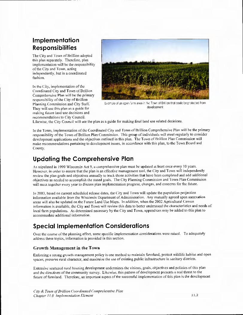
In the City, implementation of the Coordinated City and Town of Brillion Comprehensive Plan will be the primary responsibility of the City of Brillion Planning Commission and City Staff. They will use this plan as a guide for making future land use decisions and recommendations to City Council. Likewise, the City Council will use the plan as a guide for making final land use related decisions.
In the Town, implementation of the Coordinated City and Town of Brillion Comprehensive Plan will be the primary responsibility of the Town of Brillion Plan Commission. This group of individuals will meet regularly to consider development applications and the objectives outlined in this plan. The Town of Brillion Plan Commission will make recommendations pertaining to development issues, in accordance with this plan, to the Town Board and County.
Updating the Comprehensive Plan As stipulated in 1999 Wisconsin Act 9, a comprehensive plan must be updated at least once every 10 years. However, in order to ensure that the plan is an effective management tool, the City and Town will independently review the plan goals and objectives annually to track those activities that have been completed and add additional objectives as needed to accomplish the stated goals. The City Planning Commission and Town Plan Commission will meet together every year to discuss plan implementation progress, changes, and concerns for the future.
In 2003, based on current scheduled release dates, the City and Town will update the population projection information available from the Wisconsin Department of Administration. Any mutually agreed upon annexation areas will also be updated on the Future Land Use Maps. In addition, when the 2002 Agricultural Census information is available, the City and Town will review this data to better understand the characteristics and needs of local farm populations. As determined necessary by the City and Town, appendices may be added to this plan to accommodate additional information.
Special Implementation Considerations Over the course of the planning effort, some specific implementation considerations were raised. To adequately address these topics, information is provided in this section.
Growth Management in the Town
Enforcing a strong growth management policy is one method to maintain farmland, protect wildlife habitat and open spaces, preserve rural character, and maximize the use of existing public infrastructure in sanitary districts.
Extensive scattered rural housing development undermines the visions, goals, objectives and policies of this plan and the directives of the community survey. Likewise, this pattern of development presents a real threat to the future of farmland. Therefore, an important aspect of the successful implementation of this plan is the development
City & Town of Brillion Coordinated Comprehensive Plan Chapter 11.0 Implementation Element 11.2
Implementation Responsibilities The City and Town of Brillion adopted this plan separately. Therefore, plan implementation will be the responsibility of the City and Town, acting independently, but in a coordinated fashion.
Example of an open farm area in the Town of Brillion that could be protected from development
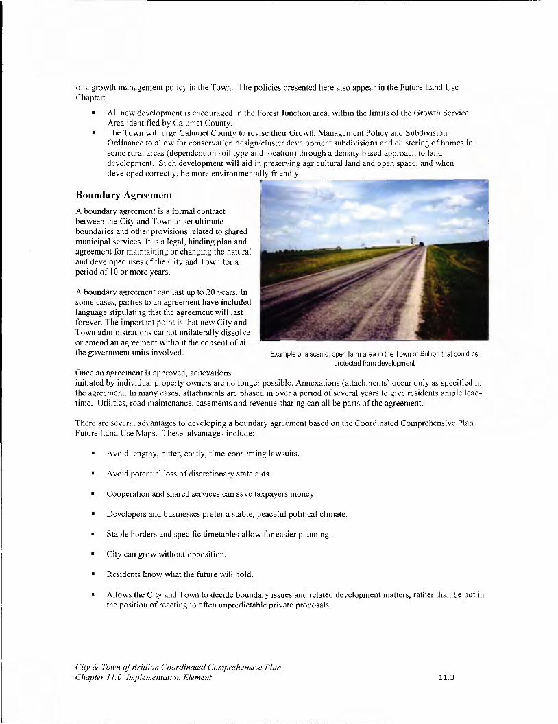
of a growth management policy in the Town. The policies presented here also appear in the Future Land Use Chapter:
• All new development is encouraged in the Forest Junction area, within the limits of the Growth Service Area identified by Calumet County.
• The Town will urge Calumet County to revise their Growth Management Policy and Subdivision Ordinance to allow for conservation design/cluster development subdivisions and clustering of homes in some rural areas (dependent on soil type and location) through a density based approach to land development. Such development will aid in preserving agricultural land and open space, and when developed correctly, be more environmentally friendly.
Boundary Agreement
A boundary agreement is a formal contract between the City and Town to set ultimate boundaries and other provisions related to shared municipal services. It is a legal, binding plan and agreement for maintaining or changing the natural and developed uses of the City and Town for a period of 10 or more years.
A boundary agreement can last up to 20 years. In some cases, parties to an agreement have included language stipulating that the agreement will last forever. The important point is that new City and Town administrations cannot unilaterally dissolve or amend an agreement without the consent of all the government units involved. Example of a scenic, open farm area in the Town of Brillion that could be
protected from development Once an agreement is approved, annexations initiated by individual property owners are no longer possible. Annexations (attachments) occur only as specified in the agreement. In many cases, attachments are phased in over a period of several years to give residents ample lead-time. Utilities, road maintenance, easements and revenue sharing can all be parts of the agreement.
There are several advantages to developing a boundary agreement based on the Coordinated Comprehensive Plan Future Land Use Maps. These advantages include:
• Avoid lengthy, bitter, costly, time-consuming lawsuits.
• Avoid potential loss of discretionary state aids.
• Cooperation and shared services can save taxpayers money.
• Developers and businesses prefer a stable, peaceful political climate.
• Stable borders and specific timetables allow for easier planning.
• City can grow without opposition.
• Residents know what the future will hold.
• Allows the City and Town to decide boundary issues and related development matters, rather than be put in the position of reacting to often unpredictable private proposals.
City & Town of Br//lion Coordinated Comprehensive Plan Chapter 11.0 Implementation Element 11.3

Purchase of Development Rights (PDR)/Purchase of Agricultural Conservation Easements (PACE)
One of the most serious land use problems facing Wisconsin today is the accelerating rate at which prime farmland is being sold, subdivided and developed for non-agricultural use. Evidence of rural land conversion can be seen virtually everywhere, including the Brillion Community.
One way of protecting farmland is purchasing of development rights (PDR)/purchase of agricultural conservation easements (PACE). PDR/PACE is a voluntary program, where a land trust or some other agency usually linked to local government, makes an offer to a landowner to buy the development rights on the parcel. The landowner is free to turn down the offer, or to try to negotiate a higher price.
When the development rights to a farm are sold, the farmer receives payment equal to the difference between the fair market value of the land a developer would pay if it could be developed and the price the land would command for agricultural use. In return for this payment, a conservation easement is recorded on the deed to the property. This easement stays with the land so it is binding not only on the current owner, but future owners of the property as well.
When the development rights to a farm are sold, the farm remains as private ownership. The private landowner still retains the right to occupy and make economic use of the land for agricultural purposes. The landowner gives up the right to develop the property for some other use in the future. Farmers are not compelled to sell their development rights. Participation in PDR programs is entirely voluntary.
Advantages and Disadvantages of PDR/PACE Restrictions on land use, including zoning, have been used to protect agriculture for many years. One of the primary benefits of PDR/PACE is that it is completely voluntary. Under PDR/PACE, the landowner is not deprived of any of the value of the property. This is very important because many farmers rely on their property in order to fund their retirement. Simply depriving them of the opportunity to realize the full economic value of their property has important ethical, socioeconomic, and perhaps legal ramifications. Moreover, zoning regulations may be easily changed in the future.
The main advantage of PDR/PACE over other approaches to farmland preservation is that it offers a permanent, long-lasting solution. PDR/PACE virtually assures that land will remain forever in agriculture because it extinguishes the right to develop agricultural land for non-agricultural uses. Farmland preservation tax credits and use value assessment of agricultural land encourage farmers to keep their land in agricultural use somewhat longer than otherwise might be the case, but do not assure that land will remain in agricultural use.
Another major advantage of PDR/PACE is that it is perceived as an equitable, fair, and voluntary way to preserve agricultural land. A third advantage is that it provides a way to correct a major shortcoming of the current Farmland Preservation Program by targeting limited financial resources to preserve and protect agricultural land most worthy of preservation.
Another benefit of PDR/PACE is that it makes it much easier for a farmer to pass their farm on to an heir interested in farming the land. Once the development rights have been separated from the land, the value of the parcel typically declines to its agricultural value. This generally has an enormous effect on reducing the inheritance tax liability. If taxed at the full development value, many parcels are simply taxed out of agriculture, because the heirs are not able to pay the taxes without selling the land.
The main disadvantage of PDR/PACE is cost. Development rights can be expensive to purchase, and so funding for PDR/PACE needs to be selectively targeted to preserve and protect agricultural land that is most worthy of preservation. As a result, not every farmer who wants to sell his or her development rights will be able to do so.
PDR/PACE in the Brillion Community In recent years, purchase and transfer of development right programs have been the topic of much discussion in the region. In the Brillion Community Survey, residents were asked two questions about these types of programs. Specifically, residents were asked:
City & Town of Brillion Coordinated Comprehensive Plan Chapter 11.0 Implementation Element 11.4

To what extent would you support municipal government protecting land by purchasing permanent or temporary development rights for land in the Town?
If you own land in the Town, would you consider taking advantage of opportunities to protect your land from development by selling development rights?
City and Town residents did not provide responses that were significantly different to the question of purchasing temporary and permanent development rights. The responses indicate that about 35% of the respondents were supportive of such a program. This is not a majority. Moreover, approximately 30% of respondents indicated they were uncertain of the idea. This means additional education and information must be made available to gain support for such a program. Of great concern is the fact that the majority of landowners indicated that they were very unlikely (28%) or unsure about selling their development rights (34%).
How to Establish and Operate a PDR/PACE Program The establishment of a PDR program could occur in a variety of ways either at the state, county or town level. Together, they would seek to educate farmers and landowners about the concept. This could be accomplished through direct letters, a town newsletter, articles on the town web page and public meetings. Next, they would need to coordinate with the county to gain county awareness and acceptance of such an effort. Finally, they would seek to raise the capital needed to purchase local development rights. This may mean asking residents to consider a tax increase specifically dedicated to this program, or perhaps seeking foundation, land trust, or grant funds to initiate the program.
Once the pool of funds has been established, the Plan Commission and Agricultural Committee would review applications of landowners who wish to sell development rights. This process would require obtaining appraisals, prioritizing parcels, negotiating agreements, and ensuring that deed restrictions are enforced.
The WDNR is also very supportive of purchase of development rights/purchase of agricultural conservation easements as a tool to protect areas adjacent to the Brillion Wildlife Area from development pressures. The WDNR is very willing to act as a partner in Town efforts to establish a local PDR/PACE program.
Transfer of Development Rights (TDR)
Like a PDR program, the landowner who voluntarily sells his or her development rights will not be able to develop their property. It will remain as agricultural land. However, unlike a PDR program, where a body that has no intention of using them acquires the development rights, in a TDR transaction the development rights are applied, or transferred, to another property.
A TDR program is premised on the idea that legally certain property rights can be separated from one property owner and transferred to another to achieve community development goals. In the case of the Town, the development rights would be transferred from rural areas to the Forest Junction Sanitary District.
The two basic elements of TDR are "sending" and "receiving" areas. Sending areas are those parcels that are deemed less desirable to be developed. For example, areas that have been identified as primary farmland. As a result, these parcels send or transfer their development rights to properties in the receiving areas. The receiving areas are those parcels that are deemed desirable for development, like the sanitary district. They "receive" transferred rights, therefore allowing development to occur at a density greater than would be normally allowed.
The primary challenge of a TDR program is administration. Successful programs require strong administration policies to keep track of development rights sold and transferred.
City & Town of Brillion Coordinated Comprehensive Plan Chapter 11.0 implementation Element 11.5

Maximum Lot Size
In many Wisconsin counties, including Calumet, the minimum lot size for residential development in areas zoned Exclusive Agricultural, AE, is 35-acres. Initially, this 35-acre requirement was designed to deter non-agricultural development. The 35-acre minimum dates back to a time when acquiring 35-acres would have been nearly impossible based on its costs. Today, 35-acres is affordable to more and more people. As such, some are capitalizing on the opportunity to purchase a 35-acre parcel, place a house in the middle of it and eliminate its agricultural integrity and promote sprawling rural development.
Jefferson County, as part of its comprehensive planning efforts, took a stand against this pattern of residential development. It overhauled the county zoning code to:
Prohibit residential development in exclusive agricultural areas, except for the replacement of existing buildings;
Limit the number of potential lots per rural property, depending on the size and agricultural soil types, to one to three lots per parcel;
Limit rural residential lot size to two acres per lot, and
Require clustering of all rezoned proposed lots in rural areas to maintain contiguous agricultural and natural areas.
The City and Town encourage Calumet County to consider similar measures to overhaul the county zoning ordinance to protect rural areas of the county from sprawling residential development.
Comprehensive Plan Policy Statements Rather than develop policy statements, this plan includes a series of vision statements. These visions represent the desired future and act as policy when considering proposals. In three areas, supplemental policy statements are provided to further enhance the ideas presented in the vision. These policies have far-reaching implications for all of the required plan elements.
Agricultural, Natural and Cultural Resources Element Chapter
Direct new residential and commercial/industrial development to areas within the Forest Junction Sanitary District and the City of Brillion in order to maximize available infrastructure and protect rural farmland areas, wildlife habitat areas and corridors, woodlands, grasslands, and the Brillion Wildlife Area.
Land Use Element Chapter
It is the policy of the City and Town of Brillion to direct future residential, commercial and industrial development within the City limits and the limits of the Forest Junction Sewer Service Area, in accordance with the Calumet County Growth Management Boundaries, and the City and Town's desire to protect farm operations, rural character and the local quality of life.
In accordance with this policy, the Town will work with the City to establish a growth boundary and the Town will coordinate with Calumet County to restrict building activity beyond the limits of the Forest Junction Sanitary District.
Intergovernmental Cooperation Element Chapter
The City and Town will seek to cooperate with all neighboring municipalities, counties, state agencies and school districts for mutual benefit.
These policies impact all of the required plan elements. In addition, it is fully anticipated that in carrying out the objectives of this plan, additional policies will be developed. In fact, some of the objectives specifically state a policy will be developed after additional research and investigation.
City & Town of Brillion Coordinated Comprehensive Plan Chapter 11.0 Implementation Element 11.6

12
I
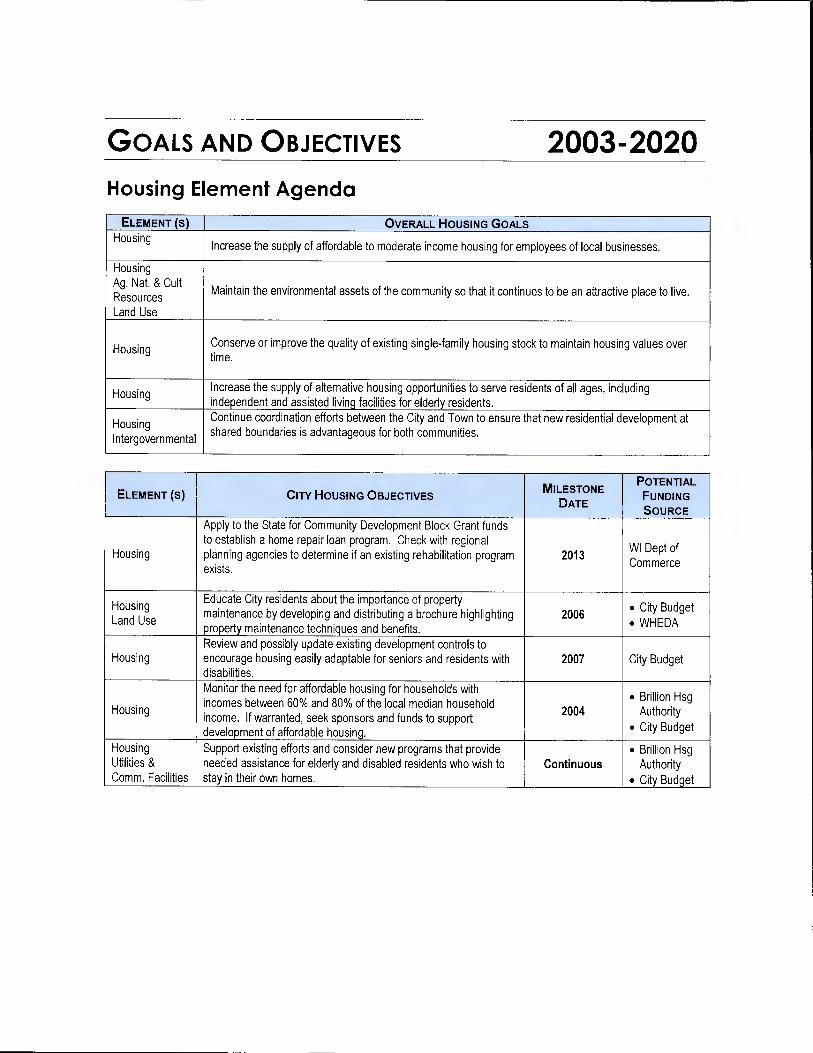
GOALS AND OBJECTIVES 2003-2020 Housing Element Agenda
ELEMENT (s) OVERALL HOUSING GOALS Housing
Increase the supply of affordable to moderate income housing for employees of local businesses.
Housing Ag Nat. & Cult Resources Maintain the environmental assets of the community so that t continues to be an attractive place to live. i Land Use
Housing Conserve or improve the quality of existing single-family housing stock to maintain housing values over time.
Housing Increase the supply of alternative housing opportunities to serve residents of all ages, including independent and assisted living facilities for elderly residents.
H Housing Continue coordination efforts between the City and Town to ensure that new residential development at
Intergovernmental shared boundaries is advantageous for both communities.
ELEMENT (s) CITY HOUSING OBJECTIVES POTENTIAL OTENTIAL
FUNDING
DATE SOURCE
Apply to the State for Community Development Block Grant funds to establish a home repair loan program. Check with regional
WI Dept of Housing planning agencies to determine if an existing rehabilitation program 2013 exists. Commerce
Housing Educate City residents about the importance of property • City Budget
Land Use maintenance by developing and distributing a brochure highlighting 2006 • WHEDA property maintenance techniques and benefits.
Review and possibly update existing development controls to Housing encourage housing easily adaptable for seniors and residents with 2007 City Budget
disabilities.
Monitor the need for affordable housing for households with • Brillion Hsg Housing incomes between 60% and 80% of the local median household
2004 Authority income. If warranted, seek sponsors and funds to support development of affordable housing.
• City Budget
Housing Support existing efforts and consider new programs that provide • Brillion Hsg Utilities & needed assistance for elderly and disabled residents who wish to Continuous Authority Comm. Facilities stay in their own homes. • City Budget

CITY AND TOWN OF BRILLIoN COORDINATED COMPREHENSIVE PLAN
MILESTONE POTENTIAL
ELEMENT (s) TOWN HOUSING OBJECTIVES DATE FUNDING
SOURCE
Housing Encourage future single- and two-family residential development in Land Use the Forest Junction area where services are more readily available Continuous NA Ag., Nat. & Cult. and conflicts with agricultural uses in minimized. Resources
Coordinate with the City of Brillion to direct alternative and multiple Housing family developments to the City where appropriate services are Continuous NA Land Use available to serve these uses.
Monitor drainage control efforts enforced by Calumet County to Housing Utilities &
ensure that they are effective and adequately protect property Continuous NA Comm. Facilities
owners.
Housing Using the information provided in the Agricultural, Natural and Land Use Cultural Resources Element, identify and map areas for primary 2006 Town Budget Ag., Nat., & Cult. and secondary conservation in the Town of Brillion. Resources
Housing Coordinate with Calumet County to develop a density-management Land Use approach to subdivisions in the Town. 2010 Town Budget Ag., Nat. & Cult Resources
Support existing efforts and consider new programs that provide Housing Utilities &
needed assistance for elderly and disabled residents, who wish to 2009 Town Budget Comm. Facilities
stay in their own homes.
Educate Town residents about the importance of property Housing maintenance. Develop a Town newsletter that highlights property 2010 Town Budget Land Use maintenance techniques and benefits.
City & Town of Brillion Coordinated Comprehensive Plan Goals and Objectives 2003-2020 Page 2 of 17

CITY AND TOWN OF BRILLIoN COORDINATED COMPREHENSIVE PLAN
Transportation Element Agenda
ELEMENT (s) OVERALL TRANSPORTATION GOALS
Transportation Continue coordination efforts between the City and Town of Brillion to address transportation needs at shared boundaries and needs of special populations (i.e. seniors and people with disabilities).
Transportation Maintain and improve roads in a timely and well-planned manner. Transportation Enhance the pedestrian links and amenities (i.e. sidewalks, trails, etc.) available to residents of both
communities.
Transportation Provide a safe and efficient transportation network that serves the needs of all community residents.
ELEMENT (5) OVERALL TRANSPORTATION OBJECTIVES
Transportation Notify WisDOT of proposed development projects and rezonings near STH 32/57 and USH 10 so WisDOT Intergovernmental may plan accordingly for needed improvements. Transportation Coordinate with WisDOT, WDNR, DATCP and Calumet County to ensure transportation facilities are safe Intergovernmental and natural features and farmland are protected. Ag. Nat. & Cult Res.
POTENTIAL OTENTIAL
ELEMENT (S) CITY TRANSPORTATION OBJECTIVES DATE
FUNDING SOURCES
Using local roadway evaluations (PASER) continue to regularly • State Road Transportation
evaluate roads, and utilize evaluations to identify and prioritize Annually Funds
road improvement projects. • City Budget
Become an active partner in transportation improvements made to USH 10 and CTY PP by: a. Continuing to work with WisDOT and the Calumet County
Highway Department at any opportunity presented. a. Continuous
b. Providing copies of this plan to WisDOT and Calumet Transportation County. b. 2003 Intergovernmental City Budget
c. Coordinating with Calumet County during the development of c. 2010 the County Comprehensive Plan to ensure that City interests are represented. d. As Needed
d. Participating in any corridor studies undertaken by WisDOT for USH 10 to ensure that City interests are represented.
Transportation Coordinate with Calumet County so when
Intergovernmental improvements/reconstruction of county roads in and around the
Economic City are scheduled, appropriate consideration is given for bike As Directed NA
Development path and trail development, and business and industry operations.
Continue to support the efforts of the Friends of the Friendship Transportation Trail and similar organizations seeking to expand recreational trail • City Budget Land Use opportunities in the area, by designating bike paths on City streets
Continuous to connect the trail from Glenview Avenue to Horn Park and to • WisDOT other City parks, schools, and the Brillion Nature Center. Grants
City & Town of Br//lion Coordinated Comprehensive Plan Goals and Objectives 2003-2020 Page 3 of 17

CITY AND TOWN OF BRILuON COORDINATED COMPREHENSIVE PLAN
Consult the Town of Brillion when addressing anticipated Transportation development, improvements, and planned road extensions at
As Needed NA Intergovernmental shared boundaries with the Town.
Continue to utilize the Capital Improvements Program and Budget technique to coordinate and plan for transportation expenses. As
Transportation part of this effort, allow the Planning Commission to review Continuous City Budget spending priorities in accordance with the goals, objectives and visions provided in this plan.
Transportation Continue discussions with the WDNR and Town of Brillion to Ag, Nat. & Cult. resolve issues surrounding the future of Center Road and trail
Continuous NA Resources connections to the Brillion Wildlife Area. Intergovernmental
Review the results of the Calumet County Transportation Study (when available) to ensure that its recommendations effectively address local elderly/disabled transportation choices. In
Transportation conjunction with the recommendations, assist in establishing a
Intergovernmental volunteer-based program, coordinated through local community 2006 NA service organizations, churches, or the school district, to connect volunteer drivers with individuals in need.
POTENTIAL OTENTIAL
ELEMENT (S) TOWN TRANSPORTATION OBJECTIVES DATE
FUNDING SOURCES
Using PASER results, continue to update ratings, as required by • State Road
Transportation state law, and utilize ratings to identify and prioritize road
Annually Funds improvements projects.
• City Budget
Develop a Capital Improvements Plan and Budget (CIP/B) to
Transportation coordinate and plan for annual transportation network
Utilities & Comm. improvements and maintenance, as well as and other capital
Town Facilities
improvements. As part of this effort, have the Town Plan 2008 Budget
Commission (to be established upon completion of this plan) take the lead role in making spending recommendations in accordance with the goals, objectives and visions provided in this plan.
Become an active partner in transportation improvements made in the Town by WisDOT and Calumet County by: a. Continue to work with WisDOT and the Calumet County
a. Continuous Highway Department at any opportunity presented, including providing copies of this plan to WisDOT and Calumet County.
b. 2003 Transportation b. Coordinating with Calumet County during the development of
Town Budget Intergovernmental the Calumet County Smart Growth Comprehensive Plan to
. 2010 ensure that Town interests are represented.
c. Participate in any corridor studies undertaken by WisDOT for d. As Needed USH 10 and STH 57 to ensure that Town interests are represented.
City & Town of Brillion Coordinated Comprehensive Plan Goals and Objectives 2003-2020 Page 4 of 17
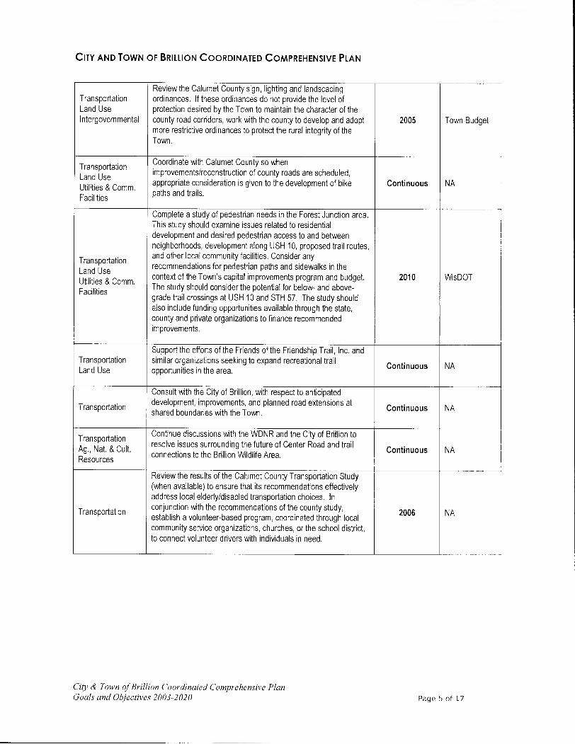
CITY AND TOWN OF BRILLIoN COORDINATED COMPREHENSIVE PLAN
Review the Calumet County sign, lighting and landscaping Transportation ordinances, If these ordinances do not provide the level of Land Use protection desired by the Town to maintain the character of the Intergovernmental county road corridors, work with the county to develop and adopt 2005 Town Budget
more restrictive ordinances to protect the rural integrity of the Town.
Transportation Coordinate with Calumet County so when
Land Use improvements/reconstruction of county roads are scheduled,
Utilities & Comm. appropriate consideration is given to the development of bike Continuous NA
Facilities paths and trails.
Complete a study of pedestrian needs in the Forest Junction area. This study should examine issues related to residential development and desired pedestrian access to and between neighborhoods, development along USH 10, proposed trail routes,
Transportation and other local community facilities. Consider any
Land Use recommendations for pedestrian paths and sidewalks in the
Utilities & Comm. context of the Town's capital improvements program and budget. 2010 WisDOT
Facilities The study should consider the potential for below- and above- grade trail crossings at USH 10 and STH 57. The study should also include funding opportunities available through the state, county and private organizations to finance recommended improvements.
Support the efforts of the Friends of the Friendship Trail, Inc. and Transportation similar organizations seeking to expand recreational trail
Continuous NA Land Use opportunities in the area.
Consult with the City of Brillion, with respect to anticipated
Transportation development, improvements, and planned road extensions at Continuous NA shared boundaries with the Town.
Transportation Continue discussions with the WDNR and the City of Brillion to
Ag., Nat. & Cult. resolve issues surrounding the future of Center Road and trail Continuous NA
Resources connections to the Brillion Wildlife Area.
Review the results of the Calumet County Transportation Study (when available) to ensure that its recommendations effectively address local elderly/disabled transportation choices. In
Transportation conjunction with the recommendations of the county study, 2006 NA establish a volunteer-based program, coordinated through local
community service organizations, churches, or the school district, to connect volunteer drivers with individuals in need.
City & Town of Brillion Coordinated Comprehensive Plan Goals and Objectives 2003-2020 Page 5 of 17

CITY AND TOWN OF BRILLIoN COORDINATED COMPREHENSIVE PLAN
Utilities & Community Facilities Element Agenda
ELEMENT OVERALL UTILITIES & COMMUNITY FACILITIES GOALS
Utilities & Corn. Continue coordination efforts between the City and Town to ensure that residents have access to high Facilities quality and cost-effective utilities and community facilities.
Utilities & Corn. Seek to ensure that all new development is served by adequate utilities. Facilities
POTENTIAL OTENTIAL
ELEMENT (s) CITY UTILITIES &COMMUNITY FACILITIES OBJECTIVES DATE
FUNDING SOURCES
Continue to provide cost-effective community services as supported by residents.
a. Continue to evaluate resident satisfaction with City Services every three years and consider modifications to the services available based on resident desires, budget constraints, and
a 2006, City capabilities. 2009, etc.
. a. City Budget
Utilities & Corn. b. Pursue opportunities to provide cost-effective mutual b. Continuous b. NA
Fac. services between the City and Calumet County and /or City Intergovernmental and neighboring towns. c. Continuous
c. See Chapter
c. Pursue grant opportunities available through the County, d. Continuous
d. NA State and Federal government.
d. Pursue partnership opportunities and recognize the efforts of area civic and religious organizations that provide programs and services benefiting local residents.
Continue to utilize the Capital Improvement Plan and Budget as a Utilities & Comm. tool to maintain and improve City Services and implement this Continuous City Budget Fac. Comprehensive Plan.
Utilities & Corn. Work closely with the Brillion Sanitary District and Utility to Fac. coordinate the orderly extension of services. Continuous NA Intergovernmental
In accordance with the Brillion Sewer Service Area Plan, continue
Utilities & Corn. to support existing treatment plans and programs to control infiltration and inflow to the wastewater treatment plant so as to Continuous NA
Fac. maintain or increase capacity for new developments.
Coordinate the updates of future City Service Plans (i.e. DPW,
Utilities & Corn. Sewer Service Area, Park and Recreation, Fire Department, etc.)
Fac with the context of this comprehensive plan to ensure consistency Continuous City Budget between these two documents.
Educate City Residents about available community facilities Utilities & Corn. through the City newsletter and web site, particularly to ensure Continuous City Budget Fac. that populations in need can obtain services.
City & Town of Brillion Coordinated Comprehensive Plan Goals and Objectives 2003-2020 Page 6 of 17
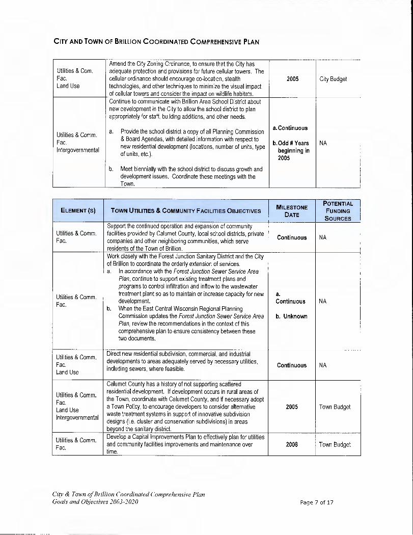
CITY AND TOWN OF BRILLIoN COORDINATED COMPREHENSIVE PLAN
Utilities & Corn. Fac. Land Use
Amend the City Zoning Ordinance, to ensure that the City has adequate protection and provisions for future cellular towers. The cellular ordinance should encourage co-location, stealth technologies, and other techniques to minimize the visual impact of cellular towers and consider the impact on wildlife habitats.
2005 City Budget
Continue to communicate with Brillion Area School District about new development in the City to allow the school district to plan appropriately for staff, building additions, and other needs.
Utilities & Comm. a, Provide the school district a copy of all Planning Commission a. Continuous
Fac. & Board Agendas, with detailed information with respect to b. Odd # Years NA
Intergovernmental new residential development (locations, number of units, type beginning in of units, etc.). 2005
b. Meet biennially with the school district to discuss growth and development issues. Coordinate these meetings with the Town.
ELEMENT (5) TOWN UTILITIES & COMMUNITY FACILITIES OBJECTIVES POTENTIAL OTENTIAL
FUNDING
DATE SOURCES
Support the continued operation and expansion of community Utilities & Comm. facilities provided by Calumet County, local school districts, private
Continuous NA Fac. companies and other neighboring communities, which serve residents of the Town of Brillion.
Work closely with the Forest Junction Sanitary District and the City of Brillion to coordinate the orderly extension of services. a. In accordance with the Forest Junction Sewer Service Area
Plan, continue to support existing treatment plans and programs to control infiltration and inflow to the wastewater
Utilities & Comm. treatment plant so as to maintain or increase capacity for new a.
Fac development. Continuous NA
b. When the East Central Wisconsin Regional Planning Commission updates the Forest Junction Sewer Service Area b. Unknown Plan, review the recommendations in the context of this comprehensive plan to ensure consistency between these two documents.
Utilities & Comm. Direct new residential subdivision, commercial, and industrial
Fac. developments to areas adequately served by necessary utilities, Continuous NA
Land Use including sewers, where feasible.
Calumet County has a history of not supporting scattered
Utilities & Comm. residential development. If development occurs in rural areas of
Fac the Town, coordinate with Calumet County, and if necessary adopt
Land Use a Town Policy, to encourage developers to consider alternative 2005 Town Budget
Intergovernmental waste treatment systems in support of innovative subdivision designs (i.e. cluster and conservation subdivisions) in areas beyond the sanitary district.
Utilities & Comm. Develop a Capital Improvements Plan to effectively plan for utilities
Fac. and community facilities improvements and maintenance over 2008 Town Budget time.
City & Town of Brillion Coordinated Comprehensive Plan Goals and Objectives 2003-2020 Page 7 of 17

CITY AND TOWN OF BRILLIoN COORDINATED COMPREHENSIVE PLAN
Utilities & Comm. Fac•
Seek to educate residents of the Town of Brillion about available community facilities in the area through a Town newsletter and
web site, particularly to ensure that populations in need can obtain services.
2011 Town Budget
Coordinate with Calumet County and WDNR to ensure that the Utilities & Com. County cellular tower ordinance provides adequate protection and Fac. provisions for the Town of Brillion. If deemed necessary, work with
2009 Town Budget Land Use the county to update the cellular ordinance to further encourage Intergovernmental co-location, stealth technologies, and other techniques to minimize
the visual impact of cellular towers.
Continue to communicate with the school districts about new development in the Town in order to allow the school districts to plan appropriately for staff, building additions, and other needs.
Utilities & Comm. a. Provide copies of future Plan Commission & Town Board a. Continuous Fac. Agendas with detailed information with respect to new NA Land Use residential development (locations, number of units, type of b.Odd # Years Intergovernmental units, etc.). Begin in 2005
b. Meet every other year with the local school districts to discuss issues with respect to growth and development. Possibly, coordinate _these _meetings _with _the _City _of_Brillion.
City & Town of Brillion Coordinated Comprehensive Plan Goals and Objectives 2003-2020 Page 8 of 17

CITY AND TOWN OF BRILuON COORDINATED COMPREHENSIVE PLAN
Agricultural, Natural & Cultural Resources Element Agenda
ELEMENT (5) OVERALL AGRICULTURAL, NATURAL & CULTURAL RESOURCES GOALS Ag. Nat. & Cult. Res. Intergovernmental Enhance coordination efforts between the City, Town and the WDNR.
Ag., Nat. & Cult. Res. Land Use Preserve agricultural operations to maintain the rural character of the area.
Ag., Nat. & Cult. Res. Land Use
Preserve open spaces and undeveloped natural areas in the City and Town.
Ag., Nat. & Cult. Res. Land Use Protect the quality of surface and groundwater resources.
Ag., Nat. & Cult. Res. Provide cultural enrichment opportunities to residents.
ELEMENT (s) Cir' AND TOWN AGRICULTURAL, NATURAL & CULTURAL MILESTONE
POTENTIAL
FUNDING RESOURCES OBJECTIVES DATE
SOURCES Identify and protect areas of prime agricultural land through appropriate land use controls.
a. Coordinate these efforts through Calumet County and
Ag., Nat., & Cult. Res.
the WDNR. b. The Town should work with the County to compare the
a. 2006 Municipal
Land Use areas identified in objective 1. a. to the Calumet County b. 2006 c. 2004
Budgets R-4 Zoning. The areas identified should be adopted as an overlay zone.
c. The City should review its subdivision ordinance to permit _cluster/conservation _subdivisions.
Educate local farmers and developers about the potential for
Ag., Nat., & Cult. cluster/conservation subdivisions as a means to permit some
Res. additional residential development as a buffer between rural areas
ContinuousMunicipal
Land Use and Forest Junction and the City of Brillion, preserve the rural Budgets character, and protect farming operations.
Ag., Nat., & Cult. Coordinate with Calumet County and state officials to ensure DATCP Res. county and state farmland preservation and protection programs Continuous Municipal Intergovernmental are effective and meet local needs. Budgets Ag., Nat., & Cult. Support efforts of the Calumet County Land and Water Res. Conservation Department, by taking on an advisory capacity, to
Continuous NA Intergovernmental fully implement the Calumet County Land and Water Resource Land Use Management Plan.
Ag., Nat., & Cult. Support Calumet County efforts to maintain and enhance natural
Res buffers along stream banks, lakeshores and the Brillion Wildlife Continuous NA
Land Use Area, by taking an advisory capacity, in accordance with zoning requirements.
WDNR DATCP
Ag., Nat., & Cult. Res. Coordinate with Calumet County, the WDNR, and DATCP to
Continuous Calumet Co. Intergovernmental promote and help fund buffer strips along Black Creek.
Municipal Budgets
Ag., Nat., & Cult. Encourage efforts of local volunteer organizations and churches to Continuous NA Res. promote community involvement.
City & Town of Brillion Coordinated Comprehensive Plan Goals and Objectives 2003-2020 Page 9 of 17
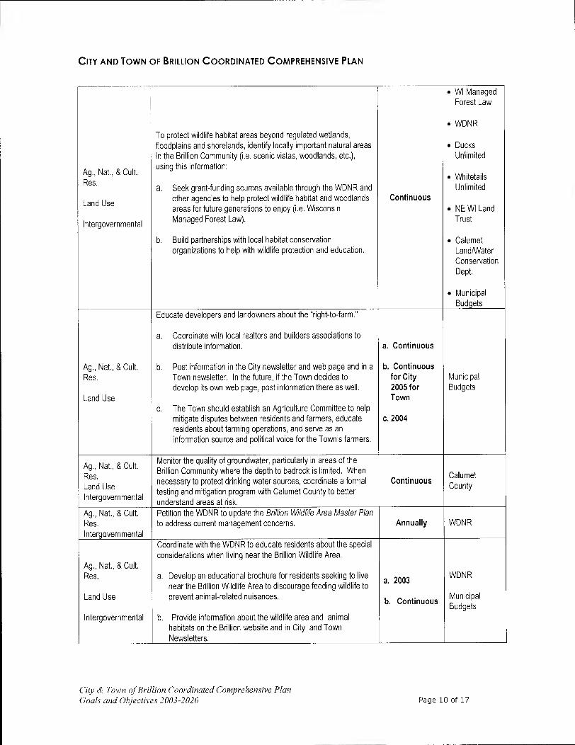
CITY AND TOWN OF BRILLION COORDINATED COMPREHENSIVE PLAN
• WI Managed Forest Law
• WDNR To protect wildlife habitat areas beyond regulated wetlands, floodplains and shorelands, identify locally important natural areas • Ducks in the Brillion Community (i.e. scenic vistas, woodlands, etc.), Unlimited
Ag., Nat., & Cult. using this information:
Res. • Whitetails
a. Seek grant-funding sources available through the WDNR and Unlimited
Land Use other agencies to help protect wildlife habitat and woodlands Continuous areas for future generations to enjoy (i.e. Wisconsin • NE WI Land
Intergovernmental Managed Forest Law). Trust
b. Build partnerships with local habitat conservation • Calumet organizations to help with wildlife protection and education. Land/Water
Conservation Dept.
• Municipal Budgets
Educate developers and landowners about the "right-to-farm."
a. Coordinate with local realtors and builders associations to distribute information, a. Continuous
Ag., Nat., & Cult. b. Post information in the City newsletter and web page and in a b. Continuous Res. Town newsletter. In the future, if the Town decides to for City Municipal
develop its own web page, post information there as well. 2005 for Budgets Land Use Town
c. The Town should establish an Agriculture Committee to help mitigate disputes between residents and farmers, educate c. 2004 residents about farming operations, and serve as an information source and political voice for the Town's farmers.
A Nat & Cult Ag., ., Monitor the quality of groundwater, particularly in areas of the
Res. Brillion Community where the depth to bedrock is limited. When Calumet
Land Use necessary to protect drinking water sources coordinate a formal Continuous
County Intergovernmental
testing and mitigation program with Calumet County to better understand areas at risk.
Ag., Nat., & Cult. Petition the WDNR to update the Brillion Wildlife Area Master Plan Res. to address current management concerns. Annually WDNR Intergovernmental
Coordinate with the WDNR to educate residents about the special considerations when living near the Brillion Wildlife Area.
Ag., Nat., & Cult. Res. a. Develop an educational brochure for residents seeking to live
a 2003 WDNR
near the Brillion Wildlife Area to discourage feeding wildlife to Land Use prevent animal-related nuisances.
b. Continuous Municipal Budgets
Intergovernmental b. Provide information about the wildlife area and animal habitats on the Brillion website and in City and Town Newsletters.
City & Town of Brillion Coordinated Comprehensive Plan Goals and Objectives 2003-2020 Page 10 of 17

CITY AND TOWN OF BRILLIoN COORDINATED COMPREHENSIVE PLAN
Economic Development Element Agenda
ELEMENT OVERALL ECONOMIC DEVELOPMENT GOALS Economic Dev. Expand commercial and light industrial development along USH 10 in the City and some additional service
and industrial development in Forest Junction.
Economic Dev. Continue to develop working relationships between the City, Town, School District and area economic
Intergovernmental development organizations to support the long-term economic success of the area.
ELEMENT Cliv ECONOMIC DEVELOPMENT GOAL Economic Dev. Revitalize downtown Brillion to beautify the community, create a sense of place for the community, and
promote economic expansion. ELEMENT TOWN ECONOMIC DEVELOPMENT GOALS
Economic Dev. Encourage local entrepreneurs who seek to expand and diversify the area economy by supporting home occupations.
Economic Dev. Promote the expansion of business and industry in Forest Junction to firmly establish the area as the Town's focal point for attractive, well-planned economic activity.
OTENTIAL
POTENTIAL ELEMENT (s) Cliv ECONOMIC DEVELOPMENT OBJECTIVES
DATE FUNDING SOURCES
Through appropriate zoning and communication with local Economic realtors, seek to concentrate new commercial and industrial
Continuous NA Development development in the City of Brillion in accordance with the Future
Land Use Maps.
Economic Research business incubators and other economic development 2004 City Budget
Development tools, while upholding the community's small town/rural character.
Support the initiatives of local business owners and residents to City Budget Economic enhance the appearance of Downtown Brillion. This should
Continuous Development include efforts to erect a tower to preserve and display the 100- DATCP year-old Brillion Community clock. Programs
Economic Continue to provide a community website that details City
Development services, organizations, and committees, and profiles the Continuous City Budget community.
Consider establishing a DDA, EDC or CDA to build upon the initial Economic efforts to the Brillion Community Development Committee and
2004 NA Development implement the recommendations of the Market Analysis and
Business Park Feasibility Study.
Economic Update the Brillion Business District Community Market Analysis City Budget
Development every 5 years to ensure an accurate measure of the City's retail Starting 2008 Chamber of and service needs. Commerce
Economic Support efforts of the Chamber of Commerce to promote business Continuous NA
Development development and retention in the City.
Through the efforts of the City's Community Development Department, continue to provide interested business owners with
Economic information about programs available to improve or expand their Continuous City Budget
Development business, organize seminars to improve business skills and conduct outreach programs to educate the business community about available services and programs.
Economic Continue to be involved in other regional economic development Development activities that help to support economic development in the City. Continuous NA Intergovernmental
City & Town of Brillion Coordinated Comprehensive Plan Goals and Objectives 2003-2020 Page 11 of 17
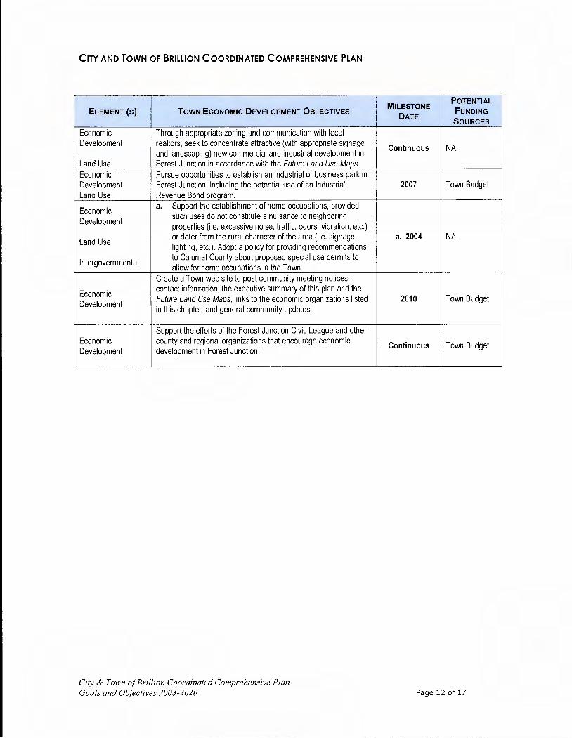
CITY AND TOWN OF BRILLIoN COORDINATED COMPREHENSIVE PLAN
POTENTIAL OTENTIAL
ELEMENT (s) TOWN ECONOMIC DEVELOPMENT OBJECTIVES DATE
FUNDING SOURCES
Economic Through appropriate zoning and communication with local Development realtors, seek to concentrate attractive (with appropriate signage Continuous NA
and landscaping) new commercial and industrial development in Land Use Forest Junction in accordance with the Future Land Use Maps.
Economic Pursue opportunities to establish an industrial or business park in Development Forest Junction, including the potential use of an Industrial 2007 Town Budget Land Use Revenue Bond program.
Economic a. Support the establishment of home occupations, provided
Development such uses do not constitute a nuisance to neighboring properties (i.e. excessive noise, traffic, odors, vibration, etc.)
Land Use or deter from the rural character of the area (i.e. signage, a. 2004 NA lighting, etc.). Adopt a policy for providing recommendations
Intergovernmental to Calumet County about proposed special use permits to allow for home occupations in the Town.
Create a Town web site to post community meeting notices,
Economic contact information, the executive summary of this plan and the
Development Future Land Use Maps, links to the economic organizations listed 2010 Town Budget in this chapter, and general community updates.
Support the efforts of the Forest Junction Civic League and other Economic county and regional organizations that encourage economic Continuous Town Budget Development development in Forest Junction.
City & Town of Brillion Coordinated Comprehensive Plan Goals and Objectives 2003-2020 Page 12 of 17

CITY AND TOWN OF BRILLION COORDINATED COMPREHENSIVE PLAN
Land Use Element Agenda'
ELEMENT OVERALL LAND USE GOALS Land Use Ag., Nat. & Cult. Promote the rural, farming atmosphere in the Town and the "small town" feel of the City. Res. Land Use Ag., Nat. & Cult. Preserve the scenic vistas and undeveloped areas along USH 10 between the City and Town. Res. Land Use Enhance the mix of businesses, amenities, and design of Downtown Brillion to maximize the potential Economic this area has to serve its surrounding market. Development
ELEMENT (s) Crry LAND USE OBJECTIVES DATE
MILESTONE POTENTIAL FUNDING SOURCES
Promote dense residential development patterns in the City to encourage walking to shopping, work and community (i.e. parks/schools) destinations.
Land Use a. Continue to maintain and extend sidewalks throughout the
a. Continuous City Budget
Housing community. b. 2011
WisDOT
b. Coordinate with local students and parents to inventory, assess, and identify sidewalk and trail needs.
Transform Downtown Brillion into a regional destination point with a varied selection of local businesses serving niche and basic shopping needs.
a. Coordinate closely with local business owners and residents to define and create the desired future business environment.
a. Continuous City Budget b. Utilize marketing and specialty studies completed by the City
Land Use as the tools to guide Downtown development. b. Continuous Private Funding
Economic c. Work with the Calumet County Planning Department (and c. Continuous DATCP Grants
Development id entified dentified in the Economic Development Chapter) to
encourage economic redevelopment of the area through d. 2010 CDBG Grants marketing, zoning, and other initiatives.
e. Continuous d. Provide identification signage and kiosks for the Downtown,
including directional signage along USH10.
e. Promote development patterns that promote TND design principles. As part of this effort, review the model ordinance developed _by_ the _UW-Extension.
'NOTE: The City of Brillion has an Official Map that is maintained at City Hall. This map is updated regularly to reflect current boundaries, annexations and roads. The Town of Brillion does not have an Official Map. Current legislation prevents towns under county zoning from having an Official Map. If legislation is changed, the Town will use the Transportation Network, Existing Land Use and Future Land Use Maps to develop an Official Map.
City & Town of Brillion Coordinated Comprehensive Plan Goals and Objectives 2003-2020 Page 13 of 17

CITY AND TOWN OF BRILuoN COORDINATED COMPREHENSIVE PLAN
Seek to ensure that the appearance of the Brillion Community is attractive and well-maintained.
a. Enforce local zoning and subdivision ordinance requirements.
b. Establish a program to identify and annually recognize local a. Continuous
Land Use home and business owners who maintain their property to exemplary standards or residents who have made great b.2009 City Budget
Economic strides in property appearance.
c. Continuous WisDOT Development
c. Encourage service organizations, schools, and churches to participate in annual events like "Make a Difference Day" by d. 2012 taking on projects to improve the appearance of the City.
d. Complete a corridor design plan for USH 10, with particular emphasis on landscaping, infill development and signage along USH 10, east of CTH PP -the City's eastern gateway.
Establish a growth boundary between the City and Forest Junction. Limit development along USH 10 to areas with in the Forest Junction Sanitary District and the City. Once established,
Land Use this agreement should be reviewed annually to determine if adjustments are needed. Restrict new development west of the
Ag., Nat. & Cult. City and east of Forest Junction in order to: Resources a. Minimize the number of curb cuts needed in this area, which 2005
City Budget may lead to a reduction in speed and an eventual relocation Town Budget
Housing of the corridor north of the City of Brillion. b. Maintain separation between the Forest Junction and the
Intergovernmental City. c. Maintain the farming operations found between these two
communities.
ELEMENT (5) TOWN LAND USE OBJECTIVES MILESTONE
DATE
POTENTIAL FUNDING SOURCES
Improve the Forest Junction area so that it may become a community focal point for quality development. a. Work with the county to enforce existing and consider new
overlay landscape and sign regulations to improve community appearance.
b. Work with local property owners and Calumet County to encourage sidewalk development throughout Forest Junction. a. 2010
Town Budget Land Use • Include information about the benefits of sidewalks in
any newsletter or web page eventually developed by the b. 2012 Calumet
Intergovernmental Town. County Budget • Seek to encourage developers to install sidewalks in c. Continuous
their new developments. • Work with the County and other specialists to identify
needed sidewalk routes to provide opportunities for safe pedestrian travel in Forest Junction.
C. Maintain existing identification signage, including the water tower identification marker.
City & Town of Brillion Coordinated Comprehensive Plan Goals and Objectives 2003-2020 Page 14 of 17

CITY AND TOWN OF BRILLIoN COORDINATED COMPREHENSIVE PLAN
Expand business and industrial development in Forest Junction. a. Develop an industrial park on the north side of Forest Town Budget
Land Use Junction. a. 2008 b. Work with the Calumet County Planning Department to Calumet
Intergovernmental encourage economic redevelopment of the area through b. Continuous County marketing, zoning, and other incentives. Budget
Work with the Calumet County Planning Department on land division issues to encourage development in and adjacent to the Forest Junction Sanitary District and to prevent development in more rural areas of the township. a. If new subdivision development is desired, coordinate with
Calumet County to encourage local developers to consider Town Budget
Land Use cluster/conservation-based subdivision designs particularly
a. Continuous near the edges of the Forest Junction area, to provide a Calumet
Intergovernmental buffer between development in Forest Junction and rural
b. 2006 County Budget
farmland. Any conservation or cluster subdivision developed, must maintain undeveloped open spaces, including farmland and scenic vistas on the property.
b. Delineate areas suitable for conservation subdivisions and cluster developments based on primary and secondary conservation areas.
Establish a growth boundary between the City and Forest Junction. Limit development along USH 10 to areas with in the Forest Junction Sanitary District and the City. Restrict new development west of the City and east of Forest Junction in order to:
Land Use a. Minimize the number of curb-cuts needed in this area, which Town Budget
may lead to a reduction in speed and an eventual relocation 2005 City Budget
Intergovernmental of the corridor north of the City of Brillion. b. Maintain separation between the Forest Junction and the
City. C. Maintain the farming operations found between these two
communities.
Work with the Forest Junction Sanitary District, electric, natural Land Use gas and other utility providers to ensure that adequate utilities will
Continuous NA Intergovernmental be made available for cost effective future growth and
development in the Town.
Work with the UW-Extension, Calumet County Highway Department, Calumet County Planning Department and other
Land Use professional experts to develop and enforce a site plan review ordinance to present a positive image of the community by 2015 Town Budget
Intergovernmental regulating the appearance of commercial and industrial development in the Town.
City & Town of Brillion Coordinated Comprehensive Plan Goals and Objectives 2003-2020 Page 15 of 17

CITY AND TOWN OF BRILLION COORDINATED COMPREHENSIVE PLAN
Intergovernmental Cooperation Element Agenda
ELEMENT(S) OVERALL INTERGOVERNMENTAL GOAL Intergovernmental Improve communication with neighboring towns, counties, school districts, sanitary districts, the
ECWRPC, and state agencies.
Intergovernmental Resolve annexation and boundary disputes.
Intergovernmental Continue to seek new ways to coordinate and share community facilities and services with neighboring communities and counties whenever efficient.
ELEMENT(S) OVERALL INTERGOVERNMENTAL OBJECTIVES MILESTONE DATE
Intergovernmental The City and Town should co-host an annual summit to discuss concerns, Annually plans, exchange ideas and report implementation achievements.
Intergovernmental Participate in the "Smart Growth" planning activities of neighboring Through 2010 communities, _Calumet _County, _and _the _ECWRPC.
Notify the local school districts about proposed residential developments
Intergovernmental and rezonings so the district may plan accordingly for additional school Continuous
Utilities & Com. Fac. children. Encourage the school district to provide input into these decisions.
Intergovernmental Notify WisDOT of proposed development projects and rezonings near STH
Transportation 32/57 and USH 10 so WisDOT may plan accordingly for needed Continuous improvements.
Intergovernmental Coordinate with the ECWRPC with respect to the permitting and reclamation Utilities & Comm. Fac. of quarry operations and sanitary district expansions (through the Forest Continuous Land Use Junction and Brillion Sanitary Districts).
Intergovernmental Coordinate with WisDOT, WDNR and DATCP to ensure transportation Transportation facilities are safe and natural features and farmland are protected. Continuous Ag., Nat., & Cult. Res.
Intergovernmental Consider developing a boundary agreement to establish expansion areas 2005 Land Use for a minimum of 10 years.
Intergovernmental Expand and continue to explore the potential for mutual services with
Utilities & Comm. Fac. neighboring communities (including road development and maintenance, Continuous garbage collection, etc.).
ELEMENT(S) TOWN INTERGOVERNMENTAL OBJECTIVE MILESTONE DATE
Intergovernmental Coordinate with Calumet County to develop a density-management
Land Use approach to subdivisions as described in the Land Use and Agricultural, 2010
Ag., Nat. & Cult. Res. Natural and Cultural Resource Elements of this plan.
City & Town of Brillion Coordinated Comprehensive Plan Goals and Objectives 2003-2020 Page 16 of 17

CITY AND TOWN Of BRILLIoN COORDINATED COMPREHENSIVE PLAN
Implementation Element Agenda2
ELEMENT I OVERALL IMPLEMENTATION GOAL Implementation I To ensure that the Coordinated Comorehensive Plan is an effective tool for makino local land use decisions.
POTENTIAL OTENTIAL
ELEMENT (S) CITY IMPLEMENTATION OBJECTIVES FUNDING DATE
SOURCES
Implementation Intergovernmental
Coordinate with Town. Continuous NA
Implementation Review Plan Objectives, Annually NA DOA Grants
Implementation Complete a Comprehensive Update of the Plan every 10 years or 2014 as needed based on development. City Budget
Implementation Pursue a Boundary Agreement with the Town. 2010 City Budget
POTENTIAL OTENTIAL
ELEMENT (s) TOWN IMPLEMENTATION OBJECTIVES FUNDING DATE
SOURCES Implementation Intergovernmental
Coordinate with City. Continuous NA
Implementation Review Plan Objectives. Annually NA DOA Grants
Implementation Complete a Comprehensive Update of the Plan every years or 10 2014
as needed based on development. Town Budget
Implementation Pursue a Boundary Agreement with the City. 2010 Town Budget Implementation Encourage County to Review 35-Acre Minimum Lot Size. 2008 NA
Town Budget
NE WI Land
Implementation Trust Ag, Nat. & Cult. Seek to establish a PDRIPACE Program. 2014 Res. Calumet Co.
Budget
Private Foundations
2 As part of this Element, it was determined no changes were needed to existing building, mechanical, housing, and sanitary codes to implement this plan. Existing code requirements are consistent with the recommendations of this plan.
City & Town of Brillion Coordinated Comprehensive Plan Goals and Objectives 2003-2020 Page 17 of 17

A
APPENDIX A QUICK REFERENCE
AirQuality .................................................................................................6.11 Airports.......................................................................................................4.4 American Transmission Company ....................................................................5.7 Annexation, Trends .....................................................................................6.19 ANRPipeline Company ..................................................................................5.8 Archaeological Site Inventory (ASI) ...............................................................6.13 Architecture and History Inventory (AHI) .......................................................6.13
BlackCreek .................................................................................................6.7 Brillion Business Park Feasibility Study, 2002 ....................................................7.7 Brillion Commercial Business District Market Analysis, 2002 ................................7.7 Brillion Wildlife Area and Nature Center ........... ................................................. 5.9 Brownfield.................................................................................................7.16
Lwv CampForest ..............................................................................................5.11 CellularTowers...........................................................................................5.13 Cemeteries................................................................................................5.14 Churches...................................................................................................6.12 Cluster Development.................................................................................10.16 Community Center, Brillion ............................................................................5.9 Concentrated Animal Feeding Operations (CAFO) ..............................................6.4
D DeerRun Golf Course ..................................................................................5.10 DensityManagement.................................................................................10.14
Economic Development Strategic Plan, 2004.....................................................7.7 Education Attainment ..................................................................................2.11 Emergency Medical Services.........................................................................5.19 Employers, Major County ...............................................................................2.9 EmploymentForecast ..................................................................................2.11 Environmental Impact Study, Brillion Wildlife Area ([IS) ................................... 6.16 Exotic and Invasive Species............................................................................6.9
I
Farmland Preservation Plan ..........................................................................6.15 Fireand Rescue ..........................................................................................5.18 Floodplain Zoning, Calumet County ...............................................................6.14 Fox River State Trail......................................................................................4.2 FreitagMemorial Park..................................................................................5.10 Friendship Trail, Friends of the .......................................................................4.2 Future Land Use Classifications .....................................................................10.4
City & Town of Brill ion Coordinated Comprehensive Plan Appendix A Quick Reference A.1

Garrow Villa . 3.7 Goal, definition .............................................................................................2.4 Groundwater.................. .............................................................................. 6.7 GrowthBoundary........................................................................................8.10 Growth Management Policy, Calumet County ....................................................8.4
U- I
Heritage Apartments .....................................................................................3.7 HeritagePark .............................................................................................5.10 HornPark ..................................................................................................5.10 HouseholdTrends .........................................................................................2.7 Household, definition .............. .. ..................................................................... 2.7
Incomeand Wages .....................................................................................2.10 Industrial Revenue Bond Program (IRB) ...........................................................7.9 Industrymix ................................................................................................7.3
J JailFacilities...............................................................................................5.17
K KettlCommission ........................................................................................5.22
I Labor force, definition....................................................................................2.8 Land and Water Resource Management (LWRM) Plan .......................................6.15 Land Information and Computer Graphics Facility (LICGF) ................................10.1 Library......................................................................................................5.19 Livestock Facility Siting Law ...........................................................................6.4 Location Factors, business..............................................................................7.4 LocationQuotient .......................................................................................2.12
mil ManagedForest Law, WDNR...........................................................................6.8 Managed Roadway Access..............................................................................8.7 Manitowoc River Watershed............................................................................6.7 Marsh, burning ................. ........................ .................................................. 6.17 MethaneGas ................................................................................................5.9 Midwest Regional Rail System.........................................................................4.8 Milestone Date, definition.............................................................................11.1 Milk Volume Production Program (MVP)..........................................................7.11 Mining, Metallic and Non-Metallic ..................................................................6.10 Museums...................................................................................................6.12
N NewHope Center, the ...................................................................................3.7
City & Town of Bill/ion Coordinaied Comprehensive Plan
Appendix Quick Reference A.2

Northeast Wisconsin Regional Economic Partnership ........................................7.11
0 Objective, definition ......................................................................................2.4 Outer Limits Youth Outreach ........................................................................5.11
I ParkviewHomes ...........................................................................................3.6 Participationrate ..........................................................................................2.9 Participation rate, definition............................................................................2.8 PASER - Road Maintenance and Repair ............................................................4.8 PASER, ratings .............................................................................................4.8 Per Capita Income, definition ..........................................................................2.8 Peters Park Athletic Field .............................................................................5.10 PlumCreek Watershed ..................................................................................6.7 Police and Law Enforcement .........................................................................5.16 Policy, definition ...........................................................................................2.4 Population Characteristics ..............................................................................2.6 Population Trends and Forecasts .....................................................................2.4 Projected Land Use Demand .........................................................................10.3 Purchase of Agricultural Conservation Easements (PACE)..................................11.4 Purchase of Development Rights (PDR) ..........................................................11.4
Rapid Industrial Preparation Program (RIP) ....................................................7.10 Revolving Loan Fund, Calumet County ...........................................................7.10 Revolving Loan Fund, City of Brillion ..............................................................7.11 Rightto Farm, the ........................................................................................6.3 Roads to Freedom, Inc. Group Home ...............................................................3.7 RoundLake..................................................................................................6.7
S Schools.....................................................................................................5.20 Sewer Service Area, City of Brillion..................................................................5.2 Sewer Service Area, Forest junction ................................................................5.1 SmartGrowth: Elements ................. .................................................... ........... 1.2 SnowmobileTrails ............................... ........................................................ 5.11 Soils...........................................................................................................6.2 SouthPark ........................................................................ ......................... 5.11 SpringCreek................................................................................................6.7 Stealth Tower Technologies ..........................................................................5.13 Stormwater Management...............................................................................5.4 Street and Highway Classifications ..................................................................4.3 Subdivision regulations ..................................................................................8.3 SWOT, Definition ..........................................................................................2.1
I Tax Incremental Financing (TIF) .....................................................................7.8 Traditional Neighborhood Development (TND) ..... .............................................. 8.5 Trails..........................................................................................................4.2 Transfer of Development Rights (TDR) ...........................................................11.5
City & Town of Bullion Coordinated Comprehensive Plan Appendix A Quick Reference A.3

U USDA NRCS Pilot Project . 1.3
V Vision, definition ...........................................................................................2.4
iTA Waste Management.......................................................................................5.7 WDNRWardens ..........................................................................................5.18 Wetlands, benefits of .......... ........................................................................... 6.8 Wildlife Habitat Fragmentation ........................................................................6.9 Wildlife Management Policies ........................................................................6.16 WindPower .................................................................................................5.8 Wisconsin Pollutant Discharge Elimination System (WPDES)................................5.5 Wisconsin Public Service ................................................................................5.7 Working Lands Initiative ................................................................................6.3
z Zero Interest Loan Program, City of Brillion ....................................................7.11 Zoning........................................................................................................8.3 Zoning, Exclusive Agricultural .......................................................................6.15
City & Town of Bullion Coordinated Comprehensive Plan Appendix A Quick Reference A.4


APPENDIX B MAPS
Each map provided in this appendix is support documentation as referenced within the City and Town of Brillion Coordinated Comprehensive Plan.
Chapter 1.0 Introduction 2008 Orthophoto - Brillion Community
Chapter 4.0 Transportation Transportation Network— Brillion Community Bicycling Conditions Assessment
Chapter 5.0 Utilities and Community Facilities Utilities and Community Facilities - Brillion Community Utilities and Community Facilities - City of Brillion
Chapter 6.0 Agricultural, Natural and Cultural Resources Soils - Brillion Community Prime Farmland - Brillion Community Agricultural Productivity - Brillion Community Natural Features - Brillion Community
Chapter 8.0 Existing Land Use Existing Land Use - Brillion Community Existing Land Use - City of Brillion Building Suitability - Brillion Community Sanitary Suitability - Brillion Community Water System Service Area— City of Brillion Existing Zoning— Town of Brillion Existing Zoning - City of Brillion
Chapter 10.0 Future Land Use 20-Year Future Land Use - Brillion Community 20-Year Future Land Use - Forest Junction 20-Year Future Land Use - City of Brillion
City and Town of Brillion Coordinated Comprehensive Plan Appendix B Aaps
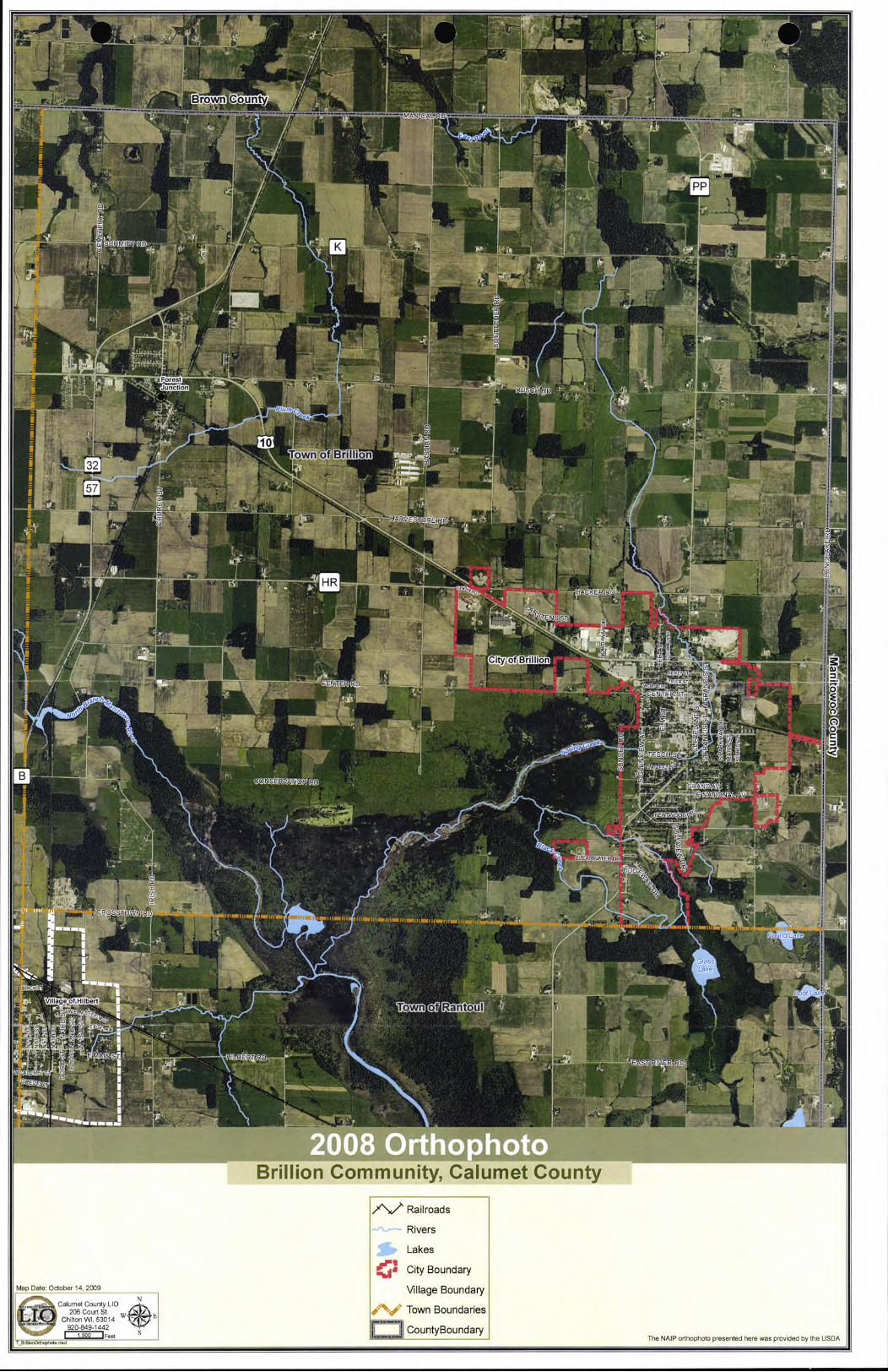
-9-0. M1111111111116--ii,- TO
rr~ is
--------------
PP
19 K
i ç jFores IH zW:
Aa
........
'1 unct In - -
'
1 r,4t1
Clj
own of Brilli I
OEM 41(
ENSST
City of Bfflliq I lilt
z, 0 rNERD
in NTEFT
Ely
All
LAILR DF
RIDC
. PamCROSSOWNRD 41::I
Village ofHabert4_ II own ot Rantoul Is
Ilk
Lk AS E N
~ 011
Brillion Community, Calumet County
Railroads
Rivers
Lakes P1
ç, City Boundary
Map Date: October 14 2009 Village Boundary Calumet County LID
206 Court St Town Boundaries Chilton Wl, 53014 920-849-1442
S
W
CountyBoundary Feet The NAIP ohophoto presented here was provided by the USDA I 1500 I
T rd

• 0 3500
tOO, 4101)
of Brillion
2500 7.900
U I
IN 6400 7500 - mfililp
-J 1 6200 o —
---
Horn I Park
TI City of Brillion-1
I I
,'s Park
ParkJ L I i =outh
= HP kz---
RD
I--- •. I I ••..
creekspring rce
Brown County
!E S
L1, : S
6000 Junction
ULI
Freitag Memoriài,'ark '.
57 - I
• = • (_)
'S
_5'•
A
0
0 C, C) 0
-I.
NSER VAT I 0 N RD
: L4•.. S: L...J Brillion Wildlife Area • .:?.s!\'.
S
- _..__.._nIri Ou"ItugtSerr' .• -------- ore 1 •• — °—& w 11t11,,,fl
'. ....:.: Round Lake
- - I
• \ Grass
a Lake
Town of 1' Village of Hubert I Rantoul . Boot Lao
trk
77-711
i — —
Brillion Community, Calumet County
Jurisdictional Class Functional Class Urban Major Collector Lakes
Federal Highways Urban Principal Arterial ^40Rural Major Collector Parks and Public Lands
State Highways Rural Principal Arterial Urban Minor Collector City Boundary
County Highways Urban MinorArterial Rural Minor Collector Village Boundary
Local Roads r0 t P Rural MinorArterial Railroads
Town Boundaries
Municipal Streets i CountyBoundary Map Date. October 14, 2010 OOO) Average Annual
5.SS. Muft-Use Trails N
Calumet County LID 206 Court St
Chilton WI, 53014
{2000l Daily Traffic Counts by Year
"" 2004 Snowmobile Trails
Rivers 920-849-1442 'i
I 1,500 Feet S --- ----'------'--_____...... .. ........... ........................ . , .,
T_BrllITO.NeOwOrknOd .. , Functional Class and Average Daily Traffic Count data from \MsD0T

Appleton
WDOT Bicycle Conditions Assessment Map
Calumet County
Town Roads
Best Conditions for Bicycling
Moderate Conditions for Bicycling
Hiqhways with Wider Paved Shoulders 2 Lane 4 Lane witl'r Higher Volumes
High Volume; Undesirable Conditions
Bicyclists Prohibited or Not Recommended
•. -. Bicycle Touring Traits t. Anne k.- 1-A — Urban Escape Routes
Major Urban Streets Scale
Planned State Highway Bikeways Priorities o 1 2 3 4 5 Miles and Linkages
Potential Local Bicycle Route Connections _______ 0-000 o i 2 3 Kilometers
I_ii

0 U) U) U)
U) z di
RD
• . ••
P1 go.
: "• .:
Brillion Wildlife Area
LJy Lr10 4
PIP F- City of Brillion
0
0.4
Il] i Ii NATICNAL RD
- II LLS ACKBIRD LN 1E RD
11
U)
I9 k' "H '1
I I
t - In
:1
GRASSHOPPER ED
. .: ..:H..i'
Brown County
uJ S( HMIDT RD
Lu
cl
TIA4 DR
LNI
Z Forest tT
Junction
10 LLJ
Ljj
32
57
/ o
Town of BrttIion
Lu
HR
astt
U) '0 0 C
U)
0 00 00 '0 H H '0 U)
HAR yES TO RE RD
U) fl
HACKER 11 [i
euiaa
di U) di U)
(0 00 HE
IOTTRDi I
P1
a I Ct)
•
'VIEW RD
iiiil .............fl_.. . .
. VOSSD
Community Services Public Facilities Daycare School - Public Recreational Facilities Utilities X Substation
11111 City/V/lloyd Town Hall Airport Fm Station if School Athletic Facilities Boat Launch Dam
AL Telephone Utility
4. EMS/Ambulance Auto Salvage Yard Health Care Clinic
. Golf Course /\ Landfill Tower - Communication
Fire Station tJ Cemetary f• Hospital
School District Office A Indoor Recreation FacilityEl Lift Station Utility Shop/Office
Garage Church Museum Senior Center/Elder Cam • Municipal Open Space • Lock V//flstewater Treatment Plant
Lb i Community Center P Public Parking * US Post office
Parts Quarry () VlbterTcwer
1.4 • Compost Site A Outdoor Bee Facility 5.' Quarry - Inactive Police -
School - Private Stormwuter Facility / Power Station
- '9
Tranmission Line
-1
Brillion Community, Calumet County
/\/Railroads Parks and Public Lands ON Brillion School District
'%.' Federal Highways"" Multi-Use Trails Hilbert School District
'*State Highways ® Unincorporated Communities Kaukauna School District uocv County Highways City Boundary Wrightstown School District
Local Roads i.'Villaae Boundary Map Date: October 14,2009
N /LMunicipal Streets T Town Boundaries
Calumet County LIC, - JQ T D
6 Court St W E
Rivers [,1 CountyBou ndary Chilton WI, 53014 Transmission Line data provided by
' 920-849-1442 Lakes -
erican Transmission Company. 'Feet .. ................ .
ToAienZoriir.rinxd

T
•I I g _ • p IIrJ • HAR V E SIC RE RD
CTH
iELI
I I CENTER-RDW
r+1
-
I
I I I I
LLJ I PETTY ST
it 10
SCHLEYST
ISELAWN G DEWEY ST PINE ST
H DR U) U-
TRIER ST OAK ST D z C U
C CENTER ST
_•• - z
I I
Ir II
MA T
b/v
BEACH S T JACK
SON S, >
UMET
MARKET
VWATERST 1C Enw WATEST
WOLFSCHM DT1ST W
WASHINGTON 51 MADISON
City of Brillion H C
U)
eCU U) U-
rk
0 I
U) UJ C
I r -
(,0 IESCHST
Jj U
PAGELAV - HOR N ST
MACARTHUR Town of Brillion
cc car. II
AM cc ru cc
H o LA VT
C DR
I' ISCONSIN AM fl
FAWN DR ID
LI GRANDAM
D
V RAP IGNAL AM E NATIONAL AV NATIONAL RD
lii[Iiri IJlilIil, I
I IL I I H
U) I
EOOOD C uJ
R> /X I U) C I
I IBENTWDDDR ç / •
•
: U /7 U 0
SUNR\ VALLEY VIEW DR j Cr II /HlLLS RD
• • mum=#//
II Cl/A on
IL a111IQ1IW BLACKBIRD LN
.. :• : •.. o
• •
r DR
• •. I. • -
I PARADISE ( • . ...
• •CT
LU
.CDvARWAFER.DR: is
R/O : • '. ••
L
I
SUMMER
VEER VIEW RD - 01 11 I'll - r1 • • P Z. I1141
U •• U . 0# 0 _S •
Community Services Public Facilities rj Daycare Schvvl Ptublic, Recreational Facilities Utilities Substation
11111 CrlyN I agel Town Hall Almon Fire Station J School Athletic Facilities
Boat Launch - Dam Telephone Utility
EMS/Ambulance Auto Salvage Yard Health Care Clinic ,j Golf Course 75 Landfill
Tower - Communication
Fire Station [t] Cometary 11 Hospital
School Distinct Office A Indoor Recreation FacilityEl
• Municipal Open Space
LS Lift Station U Utility Shop/Office
Garage Church Museum Senior Center/Elder Cam • Lock Vrbstewater Treatment Plant
Library 16 Community Center pi Public Parking * US Post Office
Park Quarry
Quarry - Inactive
V'rbterTower 'SLaP
Compost Site • A Outdoor Rev Faci lity iu' [] Well Police
School - Private113 Cteerrwutar Facility u
City of Brillion, Calumet County
1\1'Railroads Parks and Public Lands =Brillion School District
"%..Federal Highways"" Multi-Use Trails Hilbert School District ked' State Highways ® Unincorporated Communities Kaukauna School District 0v County Highways t,City Boundary Wrightstown School District
Local Roads .,_,Village Boundary Map Date October 14, 2009 Municipal Streets Town Boundaries
N .
Calumet County LID
UQ206 Court St
W*E
Rivers t:J CountyBoundary Chilton WI, 53014 -
- Transmission Line data provided by '- 920-849-1442 ' Lakes - American Transmission Company.
I 5cc Feet S ---7 __ C_On LonZonrrexd

Brown County ------------------------------------
------------------------------------------------------ Old
10
Town of Brillion U)
32
57
I HARVESTOER
LLJ
FIR
CENTER RD ,! .
1 0 -40 Ch
0 o
LuolfflBn lion
C.)
B AL
~-,UH0SSTDVVN ND
Town of
VillageofHilbert Rantoul
Brillion Community, Calumet County
Federal Highways 4I City Boundary CHANNAHON KOLBERG PELLA WATER
State Highways Village Boundary COSAD LUTZKE PITS WASEPI
County Highways Town Boundaries FLUVAQUENTS MANAWA POYGAN WAUSEON
Local Roads ,
CountyBoundary GRANBY MOSEL SHIOCTON WAYMOR -
Municipal Streets Soil Types HOCHHEIM MUNDELEIN SYMCO WHALAN
Map Date: October 14, 2009 7\/ Railroads BELLEVUE HOUGHTON NICHOLS TEDROW WLLETTE
fCalumet County LiO Rivers BOYER KEOWNS OAKVILLE LIII TUSTIN ZURICH
F06 Court St ChctonW153014 W Lakes BRIGGSVILLE KEWAUNEE PALMS UDORTHENTS 920-849-1442
I 1500 jFeel S --
LBiIIniId Soi ls data from NRCS

I
Brown County
S l\ti'
I I LU
ir ction RJRD r ',
1oc_~,
- NI EN RD
oCç
-
CONSERVAIION RD
----I I
t
I S
At-
1 'II
Brillion Community, Calumet County
Map Date October 14, 2009 N
Cal met County LID
Lb 206 Court St w N Chilton WI, 53014 - Ch
920-849-1442 I 1,500 IFeet
TBrIlePreFar 1-d —d
Federal Highways City Boundary Agricultural Suitability
State Highways Village Boundary Prime Farmland
County Highways Town Boundaries Prime If Drained/Not Flooded
Local Roads CountyBoundary Non Prime Farmland
Municipal Streets
-7\( Railroads
Rivers
Lakes -
- Based on NRCS Soil Data

Brown County
/ It - T ----- O - SCHMIDTRD -
dr a 1 P pp— C 0 llkl, f 6r, I
T77 I
, eqC iir I :
- -: RVArONR
M
I f Own t an oul
Brillion Community, Calumet County
ic
0
0 C)
C) 0
Federal Highways Rivers HIGH
State Highways Lakes MODERATE
° o County Highways City Boundary LOW
Local Roads 1" Village Boundary UNPRODUCTIVE Map Date: October 14, 2009
Calumet County LID Municipal Streets p Town Boundaries - 206 Court St w-- ' 'Z37 Railroads
- Ir J CountyBoundary 920-849-1442
IFeet Br rile r,ft0PrOd. flied
Soils data from NRCS
Areas in light yellow indicate soil types which are capable of producing high yields of crops typically grown in the county under a high level of management. Productive soils are considered to be those which are capable of producing an average of 4 tons per acre per year of grass-legume hay, or 100 bushels per acre of corn, The Soil Conservation Service considers a "high level of management" to include provisions for adequate drainage, appropriate tillage, planting and seeding with high yielding varieties, control of weeds, diseases, insects, optimum fertilizer application and timely, efficient harvesting techniques

Brown County
'II
- - - uj SCHMIDT RD
GlacialWindow
ALu
HaeseMemorial Village j-t!11 èe - I
—— Junction
- Plum
---=--=-==--------- --- If — Freitaq M I
/
IL ____
10 Town of Brillion 4L 32
AL • - g
- i
- HARVESTbRERO
I
' *
11 N
JLiIL
00 ,
.:.
PP
City OT ~jri ion zj7
:S'Phr~ Cre'e'k Corridor
JpP o
-77 IL
VAT. 11111111
1W 11 i
• '4lL—' A I 'r1F
Town of Rcintdul
• \ •, 77 I
i ...................• IiII I
______
• • II - • •...............$,it IuI,uIluuIu
-
civic park
' MI Park
Brillion Community, Calumet County
Federal Highways Rivers A Important Historic Sites Natural Heritage Inventory Floodplains
'.s State Highways Lakes • Important Ecological Sites Aquatic Special Flood Hazard Areas
County Highways 11100City Boundary Wetlands Under 2 Acres Both Other Flood Areas
Local Roads Village Boundary Important Natural Areas Terrestrial
Municipal Streets Town Boundaries Wetlands Town Occurance Map Date October 14, 2009
N /\./ Railroads CountyBoundary Woodlands \ Catumet County LIO _#
LI Ch206 Co.,tonW53O14
Parks and Pub lie Lands
920-849-1442 Fioodplacns data provided by FEMA
I 500 Feet S Natural Heritage inventory provided by
T_v,II Fe•t eed Wisconsin Department Of Natural Resources

VA
000011 IiiIi1FA_
_ _
1•1_
M I pff-
u __ IUU:T_•__II -_ '
'iIUiIdfgj 111. A
EMMA ___II___-
I j__J!II•'!HII
I I S, JIL IKE __ _____
I TI1ii•;l L 1_
- - Ill
Note Nil NEI
411
Rev. a
_ 15 I
NL
16
IIIiII
Elm. r.
ISIIIII,juuII.,.JJjiti,,.
I MENEM 0
MENEERM
- 4 -
EN MINE KIM
• 1
-- •., - - - - - -- S -
S - - •'-.:. S. -
- - -
-
-- - S S•S. S
- - - S... •
•
• . •
:'
'
S
•i


\\_____~N
St
Town of Brillion J RARVESTO(
IN
1' -v
c7
¼ 1321
In
CS
1T2
VVP
Town
Brown County
WAN
CR
f Hilbert
) ç?J
(( s)
CENTER RD
CON ERVAATIO r)
F~,_~ /
c)
IL U
z
I D C
MAN
I
z
\•'.. YJ1j
10 10
I • , .. - 0
Iz
/ . ''•'. j
\\
' -- -
Map Date October 14, 2009
Ca umet County Lb 206 C I S'
N
LIQ Chil tonW53O14 W*R 920-849-1442
I 1500 iFeet S
T_BrdhonB reSbhtyr, d
Brillion Community, Calumet County
Federal Highways Lakes Very high (Favorable)
State Highways City Boundary High
'ko County Highways Village Boundary j Medium
V Local Roads Town BoundariesM3 Low
Municipal Streets CountyBoundary Very low (Severe Limitations)
Railroads
Rivers Based on NRCS Soil DataI

Brown County
-1-S Ui
1—
/7
NP Farest Junction
II r'U cS f -
CRD
ii
yc /1 kc N/
10
41
/ ç
own of Brillion 32
57
ee-4( y
HR
P In Imam
CENTER RD
_____
I
0
PP /
t
a CItyo
Joe
IIion
AL
\0 SERVAATIO,,.\D
gh R ex;
fe CF
rn Vo
Town o Rantoul
/77
Map Date October 14, 2009
N Calumet County Lb
LIQ206 Court St
W ChdtonWL 53014 *E 920-849-1442
I 1,500 IFeet S
T_BrI nSa tarySutab Iltym d
LL.S
Brillion Community, Calumet County
Federal Highways Lakes Probability Site Suitable for POWTS
State Highways City Boundary HIGH
County Highways Village Boundary I ' MODERATE
Local Roads Town Boundaries LOW
Municipal Streets CountyBoundary VERY LOW
Railroads
Rivers
Based on NRCS Soil Data

il
/S1 p'1MrCern - r- -
L_ __. Quzr
Cr
KEY: SHADED AREAS ARE:
Areas where 35 psi can not be provided from existing water system (ground elevation over 867)
Areas of marginal pressure (less than 45 psi) from existing water system
Tank overflow elevation 958
rAys
895
-
1
Indost,,j Waste
WT
-
dutraiWatt
Trader pafi..
oWT
Sewaa Brillion Ospo' I
r
tiATIONAL Nt 87 NNY
GoICouP
'
Black NORTH
/
SCALE: 1"= 2000
WATER SYSTEM SERVICE AREA ASSOCIATES, INC, CITY OF BRILLION, WISCONSIN ENGINEERS • ARCHITECTS • McM#60004-9301217/17/2009 'Rfl.I M(-,R.- • EIIRVFV(RE ID, PP'fl2004\MCM WIS\BRILLION WATER PSI.PPT AJV:jmk


I * 11111111 I'll"
E. WATER ST
MADISON ST.
IUMD I-2
NATIONAL AVE. E. NATIONAL AVE. E. t'

q
NEI
r'Imin
SCH TRD
It
I'
p
I:
ci ii
SPIWCI
ITIN
i. •1 .. •... ....
Rantoul
A_
Brillion Community, Calumet County
/\,/ Railroads I I Sewer Service Area General Commercial Multi-Family Residential
Rivers I I Planning Area Boundary Central Business/Downtown Commercial Conservancy
Lakes 20 Year Future Land Use Commercial Recreational
1 I Parcel Boundaries General Agriculture Government/Institutional Parks and Recreational
1I ______
U City Boundary Agricultural Enterprise Industrial Private Resource Map Date: October 14,2009 romma
Village Boundary Agriculture Single Family Residential Utility and Community Services Calumet County LID
LUP Ch/tonCourtWL 53St 014
" Town Boundaries Planned Urban Transition General Residential Roadways
920-849-1442 I 1.500 'Feel s CountyBoundary
TBriItrQ0yrPLU.nxd
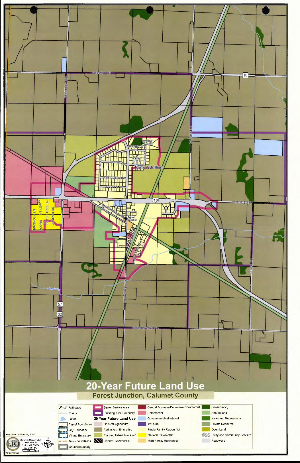
rillio
JZL
z -< 0 —J H ry
z-
—J 0 o z Ctiofl
n
Forest Junction, Calumet County
Map Date October 14, 2009
-, Calumet County Lb N
LI 206 Court St ChctonW53O14 WE
920-849-1442 I 500 IFeet
S
2Oyr nxd
Railroads Sewer Service Area Central Business/Downtown Commercial Conservancy
Rivers E3 Planning Area Boundary Commercial Recreational
Lakes 20 Year Future Land Use Govern mentllnstitutional Parks and Recreational
Parcel Boundaries General Agriculture Industrial Private Resource
I--- I City Boundary Agricultural Enterprise Single Family Residential Open Land
_1J Village Boundary Planned Urban Transition General Residential Utility and Community Services
Town Boundaries General Commercial Multi-Family Residential Roadways
CountyBoundary

LU
FL —__ A. tVES1TOREaRD
L&
PID
HR
L11
10
C NT
i_ ) Z CE TT. ERST
AC 1
low CALUMEtST-
____-- EERST WATs
_ HMI D;TST ii ii
LMs rr Th ity of Brillion
Town of Brillion
J MACART.HR.AV VESTA I iriiiij NJ
F11 'DR hISN-011
1.
. Lr- NIJQN'ENATIONALV NAlilONAL R
LU I I P-
U ' cr / MOO1 DER T / BE TWO
•1
I
\4
I
SUNyISF " VALiErCIEwbDRLI_g c
'4tIttr4IIl!_i
... B'LB;lFl
PARADISE CT
41
C Li EfA II
r: J VU ,DR
.... .... .... .... .........R.VIE.W.R.D./ft-fl
D Town of Rantoul
H City of Brillion, Calumet County
'/\/ Railroads I I Sewer Service Area General Commercial Multi-Family Residential
Rivers I I Planning Area Boundary Central Business/Downtown Commercial Conservancy
Lakes 20 Year Future Land Use Commercial Recreational
Parcel Boundaries General Agriculture Government/Institutional Parks and Recreational
City Boundary Agricultural Enterprise Industrial Private Resource Map Date: October 14, 2009
N j Village Boundary Agriculture Single Family Residential ii Utility and Community Services Calumet County Lb
ILJ . 206 Court St
10 " Town Boundaries Planned Urban Transition General Residential Roadways
Ch ton WI, 53014
CBn1on2CyrPLUnxd
s ICountyBoundary

C

APPENDIX C FIGURES AND TABLES
Chapter 1.0 Introduction Figure 1 Location Map: City and Town of Brillion, Calumet County Wisconsin ................1.1
Chapter 2.0 Issues and Opportunities Element Table 1 Population Trends....................................................................................2.5 Table 2 Calumet County Town Population Changes..................................................2.5 Table 2.1 WDOA Population Forecasts, Brillion Community ..........................................2.5 Table 2.2 WDOA Population Forecasts, Calumet County Towns ....................................2.5 Table 2.3 ECWRPC Population Forecasts, Calumet County Towns .................................2.6 Table 3 WDOA Household Projections, Brillion Community ........................................2.8 Table 4 Calumet Civilian Labor Force Data .............................................................2.9 Table 5 Calumet County Commuting Patterns .........................................................2.9 Table 6 Top Employing Industries in Calumet County...............................................2.9 Table 7 Top 10 Employers in Calumet County ........................................................2.10 Table 8 Per Capita Personal Income Comparison ....................................................2.10 Table 9 Town Income Comparison, Calumet County WI...........................................2.11 Table 10 Percentage of Total Employees by Industry ................................................2.12 Table 11 Location Quotients for Industries in Brillion, WI .........................................2.13
Figure 2 Linear Population Trends and Projections ....................................................2.6 Figure 3 City of Brillion Population Age Distribution...................................................2.7 Figure 3.1 Town of Brillion Population Age Distribution.................................................2.7 Figure 3.2 Estimated Persons per Household ..............................................................2.8 Figure 4 Education Attainment..............................................................................2.11
Chapter 3.0 Housing Element Table 12 Age of Housing Stock...............................................................................3.2 Table 13 Median Home Values in Calumet County .....................................................3.4 Table 14 Owner-Occupied Housing Value .................................................................3.4 Table 15 Average Home Selling Price ......................................................................3.5
Chapter 4.0 Transportation Element Table 16 Airport Runway Specifications ...................................................................4.6
Chapter 5.0 Utilities and Community Facilities Element Table 17 City of Brillion Waste Water Treatment Annual Aver. Monthly Flow Trends .......5.3 Table 18 School District Locations and Capacities.....................................................5.21
Chapter 6.0 Agricultural, Natural and Cultural Resources Element Table 19 Soil Characteristics .................................................................................6.2 Table 19.1 Prime Farmland......................................................................................6.3 Table 19.2 Enrollment in Managed Forest Law............................................................6.9
Chapter 7.0 Economic Development Element None
Chapter 8.0 Existing Land Use Table 20 Existing Land Use - Amount, Intensity and Density ......................................8.2 Table 21 Calumet County Zoning Districts in the Town of Brillion ................................8.5 Table 22 Driveway Spacing ......................................................... ........................... 8.7
Chapter 9.0 Intergovernmental Cooperation None
City and Town of Bullion Coordinated Comprehensive Plan Appendix C Figures and Tables C.1

Chapter 10.0 Future Land Use Table 23 Projected Land Use Demand, Town of Brillion Table 24 Projected Land Use Demand, City of Brillion Table 25 Future Land Use, Town of Brillion ............... Table 26 Future Land Use, City of Brillion .................
Chapter 11.0 Implementation Element None
10.3 10.3
10.14 10.14
City and Town of Bill/ion Coordinated Comprehensive Plan Appendix C Figures and Tables C.2

L,J

APPENDIX D PUBLIC PARTICIPATION
PROCEDURES. PLANS. SURVEYS
This appendix includes copies of the following documents:
The City of Brillion Public Participation Plan & Adoption Procedures ............................ D.2
The Town of Brillion Public Participation Plan & Adoption Procedures..........................D.3
Cognitive Mapping Study of November 2001 .......................................................................D.5 PerceivedDistricts .................................................................................................D.6 TravelPaths ...........................................................................................................D.7 Pleasantness and Development Zones ...................................................................D.8
Community Survey of December 2001 ...............................................................................D.11
These documents were developed early in the planning process to provide ample opportunities for public involvement throughout the planning programs. Both the City and Town adopted these plans in 2001.
City &Town ojBrillion Coordinated Comprehensive Plan Appendix D Public Participation D.1

PUBLIC PARTICIPATION PROCEDURES AND PLAN ADOPTION
City of Brillion Public Participation Procedures
The City of Brillion, Calumet County, Wisconsin, in order to provide the greatest amount of public involvement possible, and to meet the provisions of Section 66.1001(4) (a) Wis. Stats., has adopted the following Public Participation Procedures. It is the intent of these procedures to provide opportunities for the public to be meaningfully involved in our efforts throughout the planning process.
The City Council has designated the City of Brillion Plan Committee to lead this public involvement effort. This committee includes members of the City of Brillion Planning Commission, the Mayor, City Administrator, Director of Community Development, Brillion School District Superintendent, representatives from the local utility providers, residents and business owners. The committee was established by the Planning Commission to include broad representation from the City's varied geographic, political, business, and social circles.
It shall be the responsibility of this committee to:
Make available to the public, information about the planning process and copies of plan documents. This information shall be made available in the most suitable variety of media possible, including newsletters, public meetings, workshops and the internet. Recommend the adoption of the Public Participation Procedures. Actively solicit comments and suggestions from the residents of the city, neighboring governmental units, school and special purpose districts serving residents of the city, Calumet County, East Central Wisconsin Regional Planning Commission, Wisconsin Department of Natural Resources, Wisconsin Department of Transportation, Wisconsin Land Council, the University of Wisconsin Extension (UW-EX) and the general public. As part of this effort, the committee shall conduct a survey to obtain resident opinions on comprehensive planning and the City's Strengths, Weaknesses, Opportunities and Threats.
• Work closely with the consultant hired by the city to prepare the Comprehensive Plan.
All meetings on the comprehensive plan shall be open to the public and duly posted pursuant to Ch. 985.02(2). The public hearing shall be published as a class I notice, pursuant to Ch. 985.02(1) at least 30 days prior to the hearing. The class 1 notice shall include the following: (1) date, time and place of the hearing, (2) a summary of the proposed Comprehensive Plan, (3) the name of the city employee who may provide additional information regarding the plan, and (4) where and when a copy of the proposed Comprehensive Plan may be viewed prior to the hearing, and how a copy of the plan may be obtained.
Copies of the proposed Comprehensive Plan shall be made available for viewing by the general public at the same time as the hearing notice is published. Copies of the proposed plan shall be available from the City Clerk's Office (130 Calumet Street, Brillion, WI 54110) and at the City of Brillion Public Library (326 North Main Street, Brillion, WI). After the notice of the public hearing has been published, those wishing to submit written comments on the plan may do so until two weeks prior to the public hearing. Comments on the draft plan should be submitted to: Ms. Heather Zander, Community Development Director, City of Brillion, 130 Calumet Street, Brillion, WI 54110. Written comments will be addressed at the public hearing and will be given the same weight as oral testimony.
City of Brillion Plan Adoption
City Council - Based on the recommendation of the Brillion Plan Committee and comments received at the public hearing, the City Council, by majority vote, shall enact an ordinance adopting the Comprehensive Plan. A copy of the ordinance and adopted plan shall be sent to neighboring units of government, school and special
City & Town of Brillion Coordinated Comprehensive Plan Appendix D Public Participation D.2

purpose districts serving residents of the city, Calumet County, East Central Wisconsin Regional Planning Commission, Wisconsin Department of Natural Resources, Wisconsin Department of Transportation, the University of Wisconsin Extension (UW-EX), the Wisconsin Land Council and the City of Brillion Public Library. A copy of the resolution and adopted plan shall be available for inspection at the office of the City of Brillion Clerk. Copies of the Comprehensive Plan may be purchased from the City Clerk at a cost of $30.00 each.
Planning Commission - The City of Brillion Planning Commission shall assist the City Council in implementing the provisions of the Comprehensive Plan.
From time to time, but not less than once every ten (10) years, the Planning Commission shall review the Comprehensive Plan for potential changes, additions or corrections. The Planning Commission shall also be responsible for recommending Comprehensive Plan amendments to the City Council on a majority vote of its entire membership.
Town of Brillion Public Participation Procedures
The Town of Brillion, Calumet County, Wisconsin, in order to provide the greatest amount of public involvement possible, and to meet the provisions of Section 66.1001(4) (a) Wis. Stats., has adopted the following Public Participation Procedures. It is the intent of these procedures to provide opportunities for the public to be meaningfully involved in our efforts throughout the planning process.
The Town Board has designated the Town of Brillion Land Use Committee to lead this public involvement effort. This committee includes more than a dozen volunteers from the local business community, farmers, residents from Forest Junction, and the Town Chairman. It shall be the responsibility of this committee to:
Make available to the public, information about the planning process and copies of plan documents. This information shall be made available in the most suitable variety of media possible, including newsletters, public meetings, workshops and the internet. Recommend the adoption of the Public Participation Procedures. Actively solicit comments and suggestions from the residents of the town, neighboring governmental units, school and special purpose districts serving residents of the town, Calumet County, East Central Wisconsin Regional Planning Commission, Wisconsin Department of Natural Resources, Wisconsin Department of Transportation, Wisconsin Land Council, the University of Wisconsin Extension (UW-EX) and the general public. As part of this effort, the committee, in cooperation with the UW-EX shall conduct a survey to obtain resident opinions on comprehensive planning and the town's Strengths, Weaknesses, Opportunities and Threats. Work closely with the consultant hired by the town to prepare the Comprehensive Plan.
All meetings on the comprehensive plan shall be open to the public and duly posted pursuant to Ch. 985.02(2). The public hearing shall be published as a class 1 notice, pursuant to Ch. 985.02(1) at least 30 days prior to the hearing. The class 1 notice shall include the following: (1) date, time and place of the hearing, (2) a summary of the proposed Comprehensive Plan, (3) the name of the town employee who may provide additional information regarding the plan, and (4) where and when a copy of the proposed Comprehensive Plan may be viewed prior to the hearing, and how a copy of the plan may be obtained.
Copies of the proposed Comprehensive Plan shall be made available for viewing by the general public at the same time as the hearing notice is published. Copies of the proposed plan shall be available from the Town Clerk and at the City of Brillion Public Library (326 North Main Street, Brillion, WI). After the notice of the public hearing has been published, those wishing to submit written comments on the plan may do so until two weeks prior to the public hearing. Comments on the draft plan should be submitted to: Ms. Mary Eickert, Chair, Town of Brillion Land Use Committee, N8865 Tiffany Lane, Brillion, WI. Written comments will be addressed at the public hearing and will be given the same weight as oral testimony.
City & Town of Brillion Coordinated Comprehensive Plan Appendix D Public Participation D.3

Town of Brillion Plan Adoption
Town Board - Based on the recommendation of the Land Use Committee and comments received at the public hearing, the Town Board, by majority vote, shall enact an ordinance adopting the Comprehensive Plan. A copy of the ordinance and adopted plan shall be sent to neighboring units of government, school and special purpose districts serving residents of the town, Calumet County, East Central Wisconsin Regional Planning Commission, Wisconsin Department of Natural Resources, Wisconsin Department of Transportation, the University of Wisconsin Extension (UW-EX), the Wisconsin Land Council and the City of Brillion Public Library. A copy of the resolution and adopted plan shall be available for inspection at the office of the Town of Brillion Clerk. Copies of the Comprehensive Plan may be purchased from the Town Clerk at a cost of $30.00 each.
Planning Commission The Town of Brillion Board established a 7-member Planning Commission upon completion of the Coordinated Comprehensive Planning Process with the City of Brillion. The newly established Town of Brillion Planning Commission included members of the Land Use Committee, The Planning Commission recommended approval of the Town of Brillion Comprehensive Plan to the Town Board.
From time to time, but not less than once every ten (10) years, the Planning Commission shall review the Comprehensive Plan for potential changes, additions or corrections. The Planning Commission shall also be responsible for recommending Comprehensive Plan amendments to the Town Board on a majority vote of its entire membership.
City & Town of Brillion Coordinated Comprehensive Plan Appendix D Public Participation D.4

COGNITIVE MAPPING
This appendix provides the results of the cognitive mapping exercise as presented by Dr. Thomas Greene on November 7,2001.
At the meeting, Dr. Thomas Greene, from St. Lawrence University in New York State, returned to present the results of the cognitive mapping exercise that the Coordinated Plan Committee completed in June of 2001. At the June meeting, the Coordinated Plan Committee responded to a series of maps by reporting districts of distinctive character and individual travel routes. Participants then indicated pleasant or unpleasant zones and areas in which they would or would not like to see additional development. After the meeting, several participants provided positive comments about the exercise, but were somewhat disappointed that the scale of the maps didn't provide a very large or detailed are of the City.
At June meeting, 31 members of the Coordinated Plan Committee were in attendance. In order to increase the number of respondents to help ensure that collective cognitive maps were based on a consensus and not inappropriately skewed by individual responses, Dr. Greene had hoped at least 70 complete cognitive mapping exercises were completed. Additional copies of the cognitive mapping exercise were distributed to residents of the City and Town and to those members of the Coordinated Plan Committee who were not in attendance. Unfortunately, Dr. Greene only received 3 additional responses from these distributed copies. As a result, the cognitive mapping results primarily express the desires and expectations of the Coordinated Plan Committee.
PERCEIVED DISTRICTS MAPS On the first series of cognitive maps, the Coordinated Plan Committee was asked to identify areas that are perceived to have a distinctive character or a common feel, the responses identified: farm areas, school zones (particularly around the new Brillion High School), and recreational areas (i.e. Brillion Marsh). The most common responses identified Forest Junction as an area of distinctive character and residential areas in the Forest Junction and City of Brillion. Development along USH 10 in the City of Brillion was also identified as an area with a distinctive character.
TRAVEL PATHS MAP Not surprisingly, the travel path maps identified USH 10, CTH 57 and CTY PP as important transportation corridors in the City and Town of Brillion.
PLEASANTNESS AND DEVELOPMENT ZONES MAP Finally, participants at the June 6, 2001 meeting were asked to rate the relative visual pleasantness of areas in the community and indicate where they would like to or would not like to see additional development. Pleasant areas identified included farms in the Town of Brillion, the Brillion Marsh, and the golf course in the City of Brillion.
These maps illustrate where the Coordinated Plan Committee participants indicated future development is most appropriate and least appropriate in the City and Town of Brillion.
City & Town of Brillion Coordinated Comprehensive Plan Appendix D Public Participation D.5
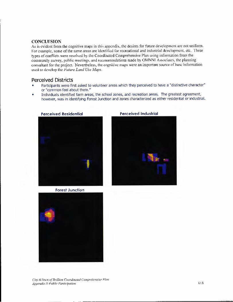
CONCLUSION As is evident from the cognitive maps in this appendix, the desires for future development are not uniform. For example, some of the same areas are identified for recreational and industrial development, etc. These types of conflicts were resolved by the Coordinated Comprehensive Plan using information from the community survey, public meetings, and recommendations made by OMNNI Associates, the planning consultant for the project. Nevertheless, the cognitive maps were an important source of base information used to develop the Future Land Use Maps.
Perceived Districts • Participants were first asked to volunteer areas which they perceived to have a "distinctive character"
or "common feel about them." • Individuals identified farm areas, the school zones, and recreation areas. The greatest agreement,
however, was in identifying Forest Junction and zones characterized as either residential or industrial.
Perceived Residential
Forest Junction
Perceived Industrial
City & Town of Brillion Coordinated Comprehensive Plan Appendix D Public Participation D.6

Travel Paths • Participants then indicated their usual travel paths on a base map. Summed over all of the 34
participants, common travel patterns appeared.
Common Weekday Paths
- —
Most Traveled Routes
W
Common Weekend Paths
City & Town of Brillion Coordinated Comprehensive Plan Appendix D Public Participation D.7

Pleasantness and development zones • Finally, participants rated the relative visual pleasantness of the Brillion area and indicated areas in
which they would or would not like to see additional development.
Brillion Pleasantness Zones
El] Least Pleasant El El El El El
- Most Pleasant
El No Data
II
Areas For Residential Development
Least Desirable
El] El - -
Most Desirable
El No Data
4 W E
City & Town of Brillion Coordinated Comprehensive Plan Appendix D Public Participation D.8

Areas For Business Development
Least Desirable
Most Desirable
Areas For Recreation Development
Least Desirable - Most Desirable
City & Town of Brillion Coordinated Comprehensive Plan Appendix D Public Participation
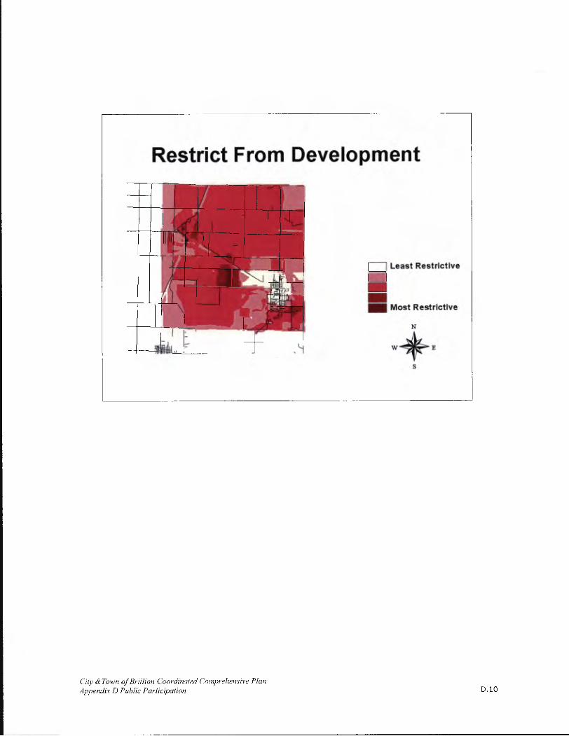
Restrict From Development
'TTI7 T_
Least Restrictive
I :
-
Most Restrictive
N
H W
City & Town of Brillion Coordinated Comprehensive Plan Appendix D Public Participation D.10

COMMUNITY SURVEY As part of a coordinated comprehensive planning initiative, the City and Town of Brillion conducted a survey to gather public input on local priorities and planning options.
The questionnaire was developed with extensive input and review from the City and Town of Brillion Coordinated Plan Committee, OMNNI Associates, and the NRCS staff in the Social Sciences Institute and Office of Farmland Protection and Community Planning. The questions addressed community resources, preferences regarding future development and conservation, and a variety of options for implementing community decisions.
The survey effort involved a mailed survey to a random sample of 500 households in the City and Town of Brillion- approximately one-third of the total households in the two communities. Reflecting the population proportion between the City and Town, 67% of the households surveyed were from the City and 33% from the Town. The sample households were selected primarily from mailing lists provided by the City of Brillion utility records and Calumet County property ownership information for the Town. Recognizing that renters would be under-represented in the Town
To Learn More... The final survey results are summarized in a detailed report developed by Dr. Ken Genskow, UW-Extension UW-Madison. The report was published under a separate cover. Copies are available from the City and Town. The report includes a copy of the survey questionnaire.
list, project partners attempted to obtain lists of renters from landlords in the Town. Anticipating that the survey could lose credibility if some residents felt excluded by not being selected as part of a sample group, project partners developed a separate process for other residents (those not selected as part of the random sample) to complete survey questionnaires. Nine (9) residents from the City and two (2) from the Town completed additional questionnaires; those results were summarized separately and provided to the local planning committee.
The survey was completed between October and December 2001. Two weeks before survey distribution, articles ran in two community papers describing the community survey and encouraging those receiving surveys to participate.
Surveys were mailed to the sample group using a delivery process that involved as many as five mail contacts. All 500 members of the sample group were sent advanced letters addressed to them and signed by local elected officials; the advance letters included information about the planning process and the survey, and asked for their participation. One week after the advance letters were distributed, all 500 households received an initial survey packet including a copy of the survey questionnaire, a pre-addressed postage-paid envelope, and a cover letter describing the questionnaire and restating how the information would be used. All respondents were assured of confidentiality.
Those households that did not respond within the next ten-day period were sent a post card reminding them of the survey and again asking for their participation. The households that had not responded approximately ten days after the first postcard was sent, received another full survey packet, which included another copy of the survey, another stamped and addressed envelope, and another cover letter. Those who had still not responded two weeks after the second packet were sent a final post-card reminder.
Out of 500 surveys sent, 357 households returned usable surveys, 5 surveys were returned blank or largely incomplete and 12 households were dropped from the list because the individuals had moved or were deceased. The final response rate was 73 percent (357/488)."
City & Town of Brillion Coordinated Comprehensive Plan Appendix D Public Participation Dli

E

APPENDIX E ARCHITECTURE AND HISTORY INVENTORY AND
ARCHAEOLOGICAL SITE INVENTORY
ARCHITECTURE AND HISTORY INVENTORY (AHI)
The AHI contains data on buildings, structures and objects that illustrate Wisconsin's unique history. The AHI documents a wide range of historic properties such as the round barns, log houses, metal truss bridges, small town commercial buildings, and Queen Anne houses that create Wisconsin's distinct cultural landscape. It is a permanent record maintained by the Wisconsin Historical Society.'
The AHI isn't a comprehensive list, but rather an introduction to the area's properties which have historical relevance. The items indicated in yellow are not listed on the AHI but were identified as having historic relevance by the Coordinated Comprehensive Plan Committee. Also, items highlighted in indicate that the Wisconsin Historical Society does possess a file with additional historical information about the property.
The list primarily consists of City of Brillion properties, which have been cross-referenced with property cards to provide further information about the properties. Most Township properties have obscure location descriptions, and for this reason, have not been included on this table. For further
information about Town of Brillion AHI listings, see the attached list at the end of this appendix.
At last count, there were 45 entries for the Town of Brillion.
The Wisconsin Historical Society does advise those who reference the AHI to use caution and exercise restraint:
"Keep in mind that this is not a comprehensive list of all old Wisconsin buildings and structures. The inventory has been assembled over a period of more than 25 years from a wide variety of sources. In many cases, the information is dated. Some properties may be altered or no longer exist. The majority ofproperties included in this inventory are privately owned and not open to the public. Inclusion in this inventory conveys no special status, rights or benefits to owners of these properties. Please respect the rights ofprivate property owners when visiting any of these properties."
City & Town of Brillion Coordinated Comprehensive Plan Appendix E, Architecture and History inventory and Archaeological Site Inventory
[.1
PROPERTY DESIGN STYLE & AH1 # MUNICIPALITY LOCATION
TYPE COMMENTS
CURRENT OR HISTORIC NAME
Milwaukee & Haese Memorial Village T. Brillion Randolph Streets Historic District
NA
(Forest Junction) Parcel: 15083
NA C. Brillion 218 N. Main Retail Building Construction Date: 1909 Not listed on the AHl Street State Farm Insurance
Parcel 14929 NA C. Brillion
100S. Main Retail Building Construction Date: 1920 Not listed on the AHI
Street Pete's Barber Shop
Parcel: 14930 NA C. Brillion
104 S. Main Retail Building Construction Date: 1896 Not listed on the AHI Street Richard's Clothing
Parcel: 14933 NA C. Brillion
110 S. Main Retail Building Construction Date: 1900 Not listed on the AHl
Street Furniture Plus
Construction Date: 1900 American Foursquare, Dutch Gable 2851 C. Brillion 215 Center Street House Holy Family Rectory Dormers, front porch
2852 C. Brillion 310 Cleveland House Parcel 15472 Construction Date: 1895
Italianate
Romanesque Revival
2853 C. Brillion Custer & Center Holy Family Demolished
Wall Material: Cream Brick Church Hooded windows, rose window in
steeple engaged buttresses Other Vernacular Wall Material: Clapboard
2854 C. Brillion 111 Custer House Does not exist/Demolished Projecting Gable Over Entry With Massive Columned Porch
Parcel: 15744 Gothic Revival Construction Date: 1896 Wall Material: Clapboard
115 S. Custer Church Divine Apartments Structural System: Balloon Frame
2855 C. Brillion Street
Historic Name: Evangelische Friedens Site File exists at the State Church Historical Society
Gabled Eli
2856 C. Brillion 206 Dewey
House Parcel: 15605 Wall Material: Brick
Street Segmental arch windows with keystones Front Gabled Wall Material: Clapboard
Construction Date: 1872 Return cornices. Hooded windows.
2857 C. Brillion 333 N. Francis Hotel/Motel
Green Hotel Front porch. Moved to current Street History House location c. 1969.
Site File exists at the State Historical Society
City & Town of Brillion Coordinated Comprehensive Plan Appendix B, Architecture and Histoiy Jnvento,y and Archaeological Site Inventory

DESIGN STYLE & wAHI # MUNICIPALITY LOCATION PROPERTY
3
COMMENTS E CURRENT OR HISTORIC NAME
I I I "Liz and Lyle Bar Could be the "Black Commercial Vernacular
Listed as: Main Castle" since Lyle Wall Material: Brick
St., 2 S of 102 Krizenesky was the owner 2858 C. Brillion Main Retail Building the establishment. Prior to CNR round turret over entry may
Could be 105 S. this, was the Bloedorn have once been a hotel Main Street Hotel. If this is correct,
structure has been demolished.
106 S. Main Parcel: 14932 2859 C. Brillion
Street Retail Building Construction Date: 1903 Romanesque Revival Juices Bar and Bowl
Listed as: NE CNR MAIN Gas/Service Spanish Colonial
2860 C. Brillion STAND US Station
Skelly Gas Station Wall Material: Brick
HIGHWAY 10 Red tile roof, steep gables
Commercial Vernacular
116 N. Main Parcel: 15076 Wall Material: Glass 2861 C. Brillion
Street Retail Building Construction Date: 1885 Continuous cornice with brick band
The Real Giese's beneath large glass windows and storefront largely intact Front Gabled
Parcel: 15078 Wall Material: Clapboard
2862 C. Brillion 202 N. Main
House Construction Date: 1880 Prominent gable with round arch Street
Apartments window and paired brackets under eaves front entry with transom and side lights Commercial Vernacular
208 N. Main Parcel: 15080 Wall Material: Brick 2863 C. Brillion
Street Retail Building Construction Date: 1900 Stilted segmental arch windows Hot Heads connected by string course altered
first story*
Parcel: 15082 Commercial Vernacular
2864 C. Brillion 214 N. Main Sports Lounge Construction Date: 1921
Wall Material: RCO side walls and Street
Shakers brick front. some neoclassical influence
Listed as 404 N. Main Street Other Vernacular
No property in Wall Material: Asbestos
2865 C. Brillion Brillion with that House Parcel: 15022 Highly individualized with coned
address. Most Construction Date: 1906 turrets projecting form hip roof
likely 502 N. Main symmetrical façade with giant
Street columns in Greek revival manner
Other Vernacular
118 S. Main Parcel: 14935 Wall Material: Stone Veneer
2866 C. Brillion Street
House Construction Date: 1900 Side shed dormer, segmental arch Apartments windows with keystones side bay
windows*
Parcel: 15202 Commercial Vernacular
207 S. Main Construction Date: 1901 Wall Material: Cream Brick
2867 C. Brillion Street
Retail Building Endries Otto and Calmes
Large stone arch window at cut CNR
Formerly a News Building prominent corbel table glass block
"news" windows in stone block
City & Town of Brillion Coordinated Comprehensive Plan Appendix E, Architecture and History Inventory and Archaeological Site Inventory
E.3

PROPERTY LOCATION
TYPE ll1 COMMENTS
CURRENT OR HISTORIC NAME I I Commercial Vernacular
Parcel: 14945 Wall Material: Cream Brick 2868 C. Brillion
210 S. Main Hotel/Motel Construction Date: 1900 Segmental arch windows and
Street Bullseye Screenprinting double-width door may have been a hotell/2 round window in gable
Parcel: 15211 Construction Date Other Vernacular
2869 C. Brillion 315 S. Main
Brillion School Demolish Date: 1989 Wall Material: Brick Street Symmetrical Building w/Hip Dormers
Original Core Demolished
Parcel: 15047 International Style
2870 C. Brillion 200 Park Ave Industrial
Construction Date: -1914 Wall Material: Brick
Building Brillion Iron Works Simple with rounded corners
235 E. Ryan Parcel: 15044 Street Deans Foods Canning
Astylistic Utilitarian Building 2871 C. Brillion Listed as State Mill
Factory Wall Material: Metal
Highway 10 At Demolished Tall vacant mill
End Of Francis
Astylistic Utilitarian Building Wall Material: Cream Brick
Parcel: 15179 2872 C. Brillion 114W. Water Granary Construction Date: 1899
Gabled bldg with segmental archwindows in wall recesses alterations
Henry Carstens and Sons are minor with many additions to surrounding parts High Victorian Gothic Design
Parcel: 15755 Wall Material: Cream Brick Tall wren-like steeply lancets in tall
2873 C. Brillion 235W. Water Church Construction Date: 1902 pointed arch windows with stilted Trinity Lutheran Church
moldings engaged buttresses*addition at entry
Horn Park Pavilion Astylistic Utilitarian 70625 C. Brillion Horn Park Pavilion Demolished Wall Material: Clapboard
W1lFMUNICIPALITY LOCATION TYPE CURRENT OR HISTORIC NAME
Milwaukee & Haese Memorial Village T. Brillion Randolph Streets
Historic District NA
(Forest Junction) Parcel: 15083
NA C. Brillion 218 N. Main
Retail Building Construction Date: 1909 Not listed on the AHI Street State Farm Insurance
Parcel 14929 NA C. Brillion
100 S. Main Retail Building Construction Date: 1920 Not listed on the AHI
Street Pete's Barber Shop
Parcel: 14930 NA C. Brillion
104 S. Main Retail Building Construction Date: 1896 Not listed on the AHI
Street Richard's Clothing
City & Town of Brillion Coordinated Comprehensive Plan Appendix E, Architecture and History Inventory and Archaeological Site Inventory
E.4

PROPERTY DESIGN STYLE & AH1# MUNICIPALITY LOCATION COMMENTS TYPE CURRENT OR HISTORIC NAME
110 S. Main I Parcel: 14933 I
NA C. Brillion Street
Retail Building Construction Date: 1900 Not listed on the AHI Furniture Plus
2851 C. Brillion 215 Center Street House Construction Date: 1900 American Foursquare, Dutch Gable Holy Family Rectory Dormers, front porch
2852 C. Brillion 310 Cleveland House Parcel 15472
Italianate Construction Date: 1895
Romanesque Revival
2853 C. Brillion Custer & Center Holy Family
Demolished Wail Material: Cream Brick
Church Hooded windows, rose window in steeple engaged buttresses Other Vernacular Wall Material: Clapboard
2854 C. Brillion 111 Custer House Does not exist/Demolished Projecting Gable Over Entry With Massive Columned Porch
Parcel: 15744 Gothic Revival
Construction Date: 1896 Wall Material: Clapboard
2855 C. Brillion 115 S. Custer Church Divine Apartments
Historic Name: Structural System: Balloon Frame Street
Evangeiische Friedens Site File exists at the State
Church Historical Society
Gabled Eli
2856 C. Brillion 206 Dewey House Parcel: 15605
Wall Material: Brick Street Segmental arch windows with
keystones Front Gabled Wail Material: Clapboard
Construction Date: 1872 Return cornices. Hooded windows.
2857 C. Brillion 333 N. Francis
Hotel/Motel Green Hotel Front porch. Moved to current Street History House location c. 1969.
Site File exists at the State Historical Society
"Liz and Lyle Bar" Could be the "Black Commercial Vernacular
Listed as: Main Castle" since Lyle Wail Material: Brick
St., 2 S of 102 Krizenesky was the owner 2858 C. Brillion Main Retail Building the establishment. Prior to CNR round turret over entry may
Could be 105 S. this, was the Bloedorn have once been a hotel Main Street Hotel. If this is correct,
structure has been demolished.
106 S. Main Parcel: 14932
2859 C. Brillion Street
Retail Building Construction Date: 1903 Romanesque Revival Juices Bar and Bowl
Listed as: Gas/Service Spanish Colonial
2860 C. Brillion NE CNR MAIN Station Skelly Gas Station Wail Material: Brick
ST AND US Red tile roof, steep gables
City & Town of Brillion Coordinated Comprehensive Plan Appendix E, Architecture and History Inventory and Archaeological Site Inventory
E.5

PROPERTY DESIGN1
STYLE & AH1 # MUNICIPALITY LOCATION .]l'lI
TYPE CURRENT OR HISTORIC NAME
HIGHWAY 10 I I
Commercial Vernacular Parcel: 15076 Wall Material: Glass
2861 C. Brillion 116 N. Main
Retail Building Construction Date: 1885 Continuous cornice with brick band Street The Real Giese's beneath large glass windows and
storefront largely intact Front Gabled Wall Material: Clapboard
202 N. Main Parcel: 15078 Prominent gable with round arch
2862 C. Brillion Street
House Construction Date: 1880 window and paired brackets under Apartments eaves front entry with transom and
side lights Commercial Vernacular
Parcel: 15080 Wall Material: Brick 2863 C. Brillion
208 N. Main Retail Building Construction Date: 1900 Stilted segmental arch windows
Street Hot Heads connected by string course altered first story*
Commercial Vernacular 214 N. Main
Parcel: 15082 Wall Material: RCO side walls and 2864 C. Brillion
Street Sports Lounge Construction Date: 1921 brick front. some neoclassical
Shakers influence Listed as 404 N. Other Vernacular Main Street Wall Material: Asbestos No property in Parcel: 15022 Highly individualized with coned
2865 C. Brillion Brillion with that House Construction Date: 1906 turrets projecting form hip roof address. Most symmetrical façade with giant likely 502 N. Main columns in Greek revival manner Street
Other Vernacular Parcel: 14935 Wall Material: Stone Veneer
2866 C. Brillion 118 S. Main
House Construction Date: 1900 Side shed dormer, segmental arch Street Apartments windows with keystones side bay
windows*
Commercial Vernacular Parcel: 15202 Wall Material: Cream Brick
2867 C. Brillion 207 S. Main Retail Building
Construction Date: 1901 Large stone arch window at cut CNR Street Endries Otto and Calmes prominent corbel table glass block
Formerly a News Building windows "news" in stone block Commercial Vernacular
Parcel: 14945 Wall Material: Cream Brick 2868 C. Brillion
210 S. Main Hotel/Motel Construction Date: 1900 Segmental arch windows and Street Bullseye Screenprinting double-width door may have been a
hotell/2 round window in gable Parcel: 15211 Construction Date Other Vernacular
2869 C. Brillion 315 S. Main
Brillion School Demolish Date: 1989 Wall Material: Brick Street Symmetrical Building w/Hip Dormers
_______________ Original Core Demolished Parcel: 15047 International Style
2870 C. Brillion 200 Park Ave Industrial Construction Date: —1914 Wall Material: Brick Building Brillion Iron Works Simple with rounded corners
City & Town of Brillion Coordinated Comprehensive Plan Appendix E, Architecture and [Jistoiy Inventoiy and Archaeological Site Inventory
E.6
PROPERTY DESIGN STYLE & AH1 # MUNICIPALITY LOCATION COMMENTS
TYPE CURRENT OR HISTORIC NAME I
I I I
235 E. Ryan Street Parcel: 15044
Astylistic Utilitarian Building 2871 C. Brillion Listed as State Mill Deans Foods Canning
Wall Material: Metal Highway 10 At Factory
Tall vacant mill End Of Francis
Demolished
Astylistic Utilitarian Building
Parcel: 15179 Wall Material: Cream Brick
2872 C. Brillion 114W. Water Granary Construction Date: 1899 Gabled bldg with segmental arch
Henry Carstens and Sons windows in wall recesses alterations are minor with many additions to surrounding parts High Victorian Gothic Design
Parcel: 15755 Wall Material: Cream Brick
2873 C. Brillion 235 W. Water Church Construction Date: 1902 Tall wren-like steeply lancets in tall
Trinity Lutheran Church pointed arch windows with stilted moldings engaged buttresses*addition at entry
70625 C. Brillion Horn Park Pavilion Horn Park Pavilion Astylistic Utilitarian Demolished Wall Material: Clapboard
City & Town of Brillion Coordinated Comprehensive Plan Appendix E, Architecture and Histoiy Inventoiy and Archaeological Site Inventory
E.7
ARCHEOLOGICAL SITE INVENTORY (AS!)
ARCHAEOLOGICAL SITES AND CEMETERIES in the
Town of Brillion Source: Office of Stale Archaeologist, July 2005
Existing Information. The Wisconsin Historical Society maintains a list of archaeological sites and cemeteries referred to as the Archaeological Site Inventory (ASI).
Since only a small portion of the Town has been surveyed for the presence of archaeological sites and cemeteries, the sites listed in the inventory represent only a faction of the sites that are actually present. Notably missing are sites related to the history of agriculture in the area; a way of life that started 1000 years ago. Local residents and American Indian communities who have and do live and work in the area possess much additional information on other archaeological sites and cemeteries. Steps should be taken to have this information incorporated into the land use plan.
Up to this point in time, 25 archaeological sites and cemeteries has been reported for the Town. The following types of sites have been identified:
Cemeteries - including, mounds, and unmarked graves Campsite/villages
Clearly this sample of sites does not reflect the rich history of the area. Many more sites are present in the area. Many in the Town certainly may be eligible for the State/National Register and important.
Where are archaeological site going to be located? Using the results of archaeological surveys, relevant historical and environmental data, the following high priority areas were designated:
-- higher, dryer areas adjacent to rivers, streams, creeks, lakes, wetlands -- higher, dryer areas adjacent to older abandoned rivers, streams, creeks, lakes, wetlands -- areas adjacent to older historic features such as trails, early roads, rail corridors, and earlier communities.
Cemeteries, Burial Mounds, and Other Burials. Cemeteries and burial areas have been set aside as special areas throughout Wisconsin history and they have been given special protection under the law.
Under Wisconsin law, Native American burial mounds, unmarked burials, and all marked and unmarked cemeteries are protected from intentional disturbance. If anyone suspects that a Native American burial mound or an unmarked or marked burial is present in an area, the Burial Sites Preservation Office should be modified. If human bone is unearthed during any phase of a project, all work must cease, and the Burial Sites Preservation Office must be contacted at 1-800-342-7834 to be in compliance with Wis. Stat. 157.70 which provides for the protection of all human burial sites. Work cannot resume until the Burial Sites Preservation Office gives permission. If you have any questions concerning the law, please contact the Coordinator of the Burial Sites Preservation Program at the Wisconsin Historical Society, Dr. Leslie Eisenberg, 608-264-6503.
At the present time, a total of 13 cemetery or burial sites have been identified in the Town. Since a systematic survey of the county has not been completed, additional cemeteries and burials may be present. As part of the planning process all cemeteries and burials in the Town should be cataloged under
City & Town of Brillion Coordinated Comprehensive Plan Appendix E, Architecture and History Inventory and Archaeological Site Inventory
E.8

Wis. Stat. 157.70 to provide for the maximum protection of these important sites and to clearly define their boundaries.
Determining Which Sites are Important. How do we know which archaeological sites need preservation? Under Wisconsin law, Native American burial mounds, unmarked burials, and all marked and unmarked cemeteries are protected. In addition to these, a wide variety of archaeological sites may be worthy of preservation. Through the use of the State and National Register of Historic Places, a procedure for identifying important sites is available. The criteria include: a good local example of an architectural style and period; association with a person important in our past; represent an important period, movement or trend in local, state or national history; or have the potential to yield important information about our past through archaeological investigations.
Protecting Important Archaeological Sites. The wide variety of methods used to protect natural resources can also be used to protect archaeological sites. For example, land purchases, easement purchases, zoning, and the state operates a tax exemption program for property owners.
With the 1991 changes to Wis. Stats. 70.11 [see 70.11(13m)], it became possible to provide a property tax exemption for owners of archaeological sites listed in the National or State Register of Historic Places. To obtain the tax exemption, the landowner has to agree to place a permanent protective covenant for the site area in the deed for the property. The tax exemption program makes the landowner and subsequent owners stewards of Wisconsin's past. The intent of the program is not to discourage all use of the property containing a site, but to encourage land use planning that protects sites.
Under Wisconsin law, Native American burial mounds, unmarked burials, and all marked and unmarked cemeteries are protected from intentional disturbance.
How are archaeological sites and cemeteries identified and evaluated? Archaeological identification and evaluations are required for a variety of projects that receive Federal or State funding, licenses, or permits. These projects are automatically forwarded to the Wisconsin Historical Society for review. Local residents frequently report sites and cemeteries.
RECOMMENDATIONS
• The development of a strong cultural resource component will allow the residents to identify valuable sites and locations and clarify the important role they play in the present and in the planning for the future. This can provide a variety of rewards such as heritage tourism, economic development and other community enrichments.
• Local residents and American Indian communities who have or do live and work in the area possess much additional information on the history of the Town and steps should be taken to have this information incorporated into the land use plan.
• As part of the planning process, all cemeteries and burials in the Town should be cataloged under Wis. Stat. 157.70 to provide for the maximum protection of these important sites and to clearly define their boundaries.
• Archaeological investigations should be completed at the locations of known archaeological sites to assess the impacts of projects on these resources and archaeological investigations should be completed at high potential areas as identified through research.
City & Town of Brillion Coordinated Comprehensive Plan Appendix E, Architecture and Histoiy Inventory and Archaeological Site Inventory
E.9

CAUTION
• It is not uncommon to find evidence of American Indian Villages and other earlier settlements in the form of houses, storage areas, burials, and other undisturbed deposits underneath the tilled layer in farm fields or urban settings.
STATE SITE #/ SITE NAME i TYPE CULTURAL STUD Y UNIT TOWN-RANGE-SECTION BURIAL CODE #
I
CT-0031 Unnamed Site 1. Unknown 20,20,E,25
1. Cemetery/burial
CT-0056 Unnamed Site 1. Unknown 20,20,E,23
1. Campsite/village Prehistoric
CT-0059 Unnamed Site 1. Unknown 20,20,E,25
1. Campsite/village Prehistoric
CT-0055 Unnamed Site 1. Unknown 20,20,E,23
1. Campsite/village Prehistoric
CT-0057 Unnamed Site 1. Unknown 20,20,E,14
1. Campsite/village Prehistoric
CT-0086 FOREST JUNCTION 1. Unknown 20,20,E,7
1. Campsite/village Prehistoric
BCT-0003 Unnamed Site 1. Historic Euro-American
20,20,E,35 1. Cemetery/burial 20,20,E,35
BCT-0001 BRILLION BLUFF CEMETERY 20,20,E,1 1
1. Cemetery/burial
ST. MARY'S CATHOLIC BCT-002 CEMETERY 1. Historic Euro-American 20,20,E,24
1. Cemetery/burial
BRILLION CEMETERY 20,20,E,35 BCT-0086 1. Cemetery/burial
BRILLION TOWNSHIP BCT-0004 CEMETERY 20,20,E,35
1. Cemetery/burial OLD TRINITY LUTHERAN
BCT-0005 CEMETERY 20,20,E,35 1. Cemetery/burial
BCT-0006 CITY OF BRILLION 20,20,E,35 COMMUNITY CEMETERY
NEW TRINITY LUTHERAN BCT-0007 CEMETERY 20,20,E,35
1. Cemetery/burial
City & Town of Brillion Coordinated Comprehensive Plan Appendix E, Architecture and History Inventory and Archaeological Site Inventory
E.10

STATE SITE #/ BURIAL CODE #
SITE NAME / TYPE CULTURAL STUDY
FOREST HOME ZION UNITED I
BCT-0021 METHODIST CEMETERY (AKA 1. Historic Euro-American 20,20E,6 GERMAN EVANGELICAL)
1. Cemetery/burial
BCT-0050 UNNAMED CEMETERY 20,20,E,25 1. Cemetery/burial
CT-0185 BFC ISOLATE #1 1. Campsite/village I. Unknown Prehistoric 20,20,E,23
OTT III I. Archaic CT-0189
1. Campsite/village 2. Late Archaic 20,20E,30 3. Middle Archaic 1. Early Archaic 2. Early Woodland
CT-0190 OTT 4 3. Late Archaic
20,20E,30 1. Campsite/village 4. Late Paleo-Indian 5. Late Woodland 6. Middle Woodland
CT-0188 OTT 2 1. Early Archaic
20,20,E30 1. Campsite/village 2. Unknown Prehistoric
CT-0187 OTT 5 1. Campsite/village
1. Early Woodland 20,20E,33
CT-0191 OTT 6 1. Campsite/village 1. Middle Archaic 20,20,E,30
CT-0193 OTT 1 1. Campsite/village
1. Early Woodland 20,20,E,19
CT-0192 OTT 7 1. Mound(s) - Other/Unk 1. Woodland 20,20,E,30
EVANGELICAL LUTHERAN BCT-0089 CEMETERY 1. Historic Euro-American 20,20,E,35
1. Cemetery/burial
http://www.wisconsinhistory.org/ahi/ The Wisconsin Architecture and History Inventory website, as maintained by the Wisconsin Historical Society. January 2006.
City & Town of Brillion Coordinated Comprehensive Plan Appendix E, Architecture and Histoiy Inventory and Archaeological Site Inventory
Eli

Wisconsin Architecture & history inventory Page 1 of
WISCONSIN
SOCIETY
Wisconsin Architecture & History Inventory Page 1 of 5 (45 Records Found)
You searched for: CALUMET ->BRILLION (Civil)
fine_Saib
Click on the AHI number to view the record detail
Ahi# Image County City/Village IRS Civil
uc r,ed Location Historic Name Township Commun
-
E SIDE
[28O6J CALUMET 2020-19 BRILLION ROSNER RD, 0.2 MI S OF HARVESTORE RD
E COUNTY LINE
CALUMET 2020E-01 BRILLION OF N COUNTY LINE RD
E SIDE COUNTY HIGHWAY PP, [28j CALUMET 2020E-01 BRILLION
COUNTY LINE RD
N SIDE BARTHOLOMAEUS
COUNTY EVANGELICAL
[.2824] CALUMET 2020E-01 BRILLION HIGHWAY PP,
GERMAN LUTHERAN
COUNTY LINE CHURCH
RD
CALUMET 2020E-05 BRILLION SCHMIDT RD AND STATE HIGHWAY 57
US HIGHWAY '
CALUMET 2020E-07 BRILLION OF FOREST JUNCTION
FOREST CAMPGROUND
CALUMET 2020E-07 BRILLION RD AT US JUNCTION
HIGHWAY 10
CAMPGROUND F28281 CALUMET 2020E-07 BRILLION EST RD Al US U
CTION HIGHWAY 10
SOUTH SIDE OF SCHMIDT RD 0.5 MILES
L 2829.j CALUMET 2020E-08 BRILLION WEST OF STATE HIGHWAY 57
N SIDE RUSCI-4 GERMAN
http://www.wisconsinhistory.org/ahi/summary.asp 6/12/2009

Wisconsin Architecture & History Inventory Page 2 of 2
RD, 1.0 MI W METHODIST
LoJ CALUMET 2020E-10 BRILLION OF COUNTY EPISCOPAL HIGHWAY PP CHURCH
Ahi#: Image County: City/Village TRS Civil
I
Township Unincorporated Location Historic Name
I Community
Records 1 through 10 of 45
N&bgprdIng2
Start a New Search
- .
©19962009 Wisconsin Historical Society 816 State Street, Madison, WI 53706-1417
http://www.wisconsinhistory.org/ahi/surnmary. asp 6/12/2009

Wisconsin Architecture & History Inventory Page] of2
W I SCONSIN USTORICIL SOCIETY
Wisconsin Architecture & History Inventory Page 2 of 5 (45 Records Found)
You searched for: CALUMET ->BRILLION (Civil)
Pe1ineSearch
Click on the AHI number to view the record detail
Ahi# Image County City/Village TRS Civil Unincorporated
Location Historic Name Township Community
NW CNR
CALUMET 2020E-11 BRILLION COUNTY HIGHWAY PP AND RUSCH RD
W SIDE E
CALUMET 2020E-12 BRILLION COUNTY LINE RD, 0.3 MI S OF COUNTY HIGHWAY K
S SIDE RUSCH
CALUMET 2020E-14 BRILLION OF COUNTY HIGHWAY PP
COUNTY HIGHWAY PP,
[2.834:i CALUMET 2020E-14 BRILLION 0.6 MI N OF HARVESTORE RD
N SIDE
[28351 CALUMET 2020E-14 BRILLION HARVEYSTORE RD AND COUNTY
CARSON SC) OL
HIGHWAY PP
N SIDE
[836j CALUMET 2020E-15 BRILLION HARVESTORE
OF
BASTIAN RD
NW CRN
[283 7] CALUMET 2020E-16 BRILLION BASTIAN RD AND HARVESTORE RD
SECNR FGHAESE
1 28381 CALUMET 2020E-17 BRILLION FOREST MILWAUKEE GENERAL JUNCTION ST AND MERCHANDISE
RANDOLPH ST STORE (A)
FOREST [28. CALUMET 2020E-17 BRILLION JUNCTION
CHURCH ST
{:24p.1 CALUMET 1 2020E-17 1 BRILLION FOREST
MAIN ST FOREST JUNCTION JUNCTION
http://www.wisconsinhistory.org/ahi/summary. asp 6/12/2009

Wisconsin Architecture & History Inventory Page 2 of
I I STATE BANK
LAh# Image County: City/Vlllage TRS
Civil Township
I Unincorporated Community
I Location Historic Name
Records 11 through 20 of 4
2
Need p.-searching?
Start a New Search
{ Next 10 Recgrgs>> J
©1996-2009 Wisconsin Historical Society 816 State Street, Madison, WI 53706-1417
http://www.wisconsinhistory.org/ahi/summary.asp 6/12/2009

Wisconsin Architecture & History Inventory Page] of 2
~ISCON SJN H1$TOICAL S ()C I E T
Wisconsin Architecture & History Inventory Page 3 of 5 (45 Records Found)
You searched for: CALUMET ->BRILLXON (Civil)
RfLa_ich_ Click on the AHI number to view the record detail
Ahi# Image County City/Village TRS Civil UrP;ed Location H
1rc
Township
F2841 I CALUMET 2020E-18 BRILLION
Communit
FOREST SE CNR CHURCH ST ZION'S KIRCH(ON
JUNCTION AND US HIGHWAY 10 BLDG)
[2842.1 CALUMET 2020E-20 BRILLION SW CNR CHURCH RD AND HACKER RD
N SIDE HACKER RD, CALUMET 2020E-23 BRILLION 0.4 MI W OF COUNTY
HIGHWAY PP
CALUMET 2020E-'24 BRILLION
BRILLION J
SW CNR HARVESTORE RD AND E COUNTY LINE RD
[284.5] CALUMET 2020E-25 N SIDE NATIONAL AVE, 0.3 MI W OF COUNTY LINE RD
[H28i,.6J CALUMET 2020E-25 BRILLION N SIDE NATIONAL AVE. 0.3 MI W OF E COUNTY LINE RD
[E2847:] CALUMET 2020E-25 BRILLION N SIDE NATIONAL AVE. 0.3 MI W OF E COUNTY LINE RD
[,2848[ CALUMET 2020E-30 BRILLION IRISH RD, 0.4 MI N OF COUNTY HIGHWAY B
CALUMET 2020E-31 BRILLION N SIDE CROSSTOWN RD, 0.2 MI E OF STATE HIGHWAY 57
t 2849 ]
[2850 CALUMET 2020E-36 BRILLION NW CNR ROUND LAKE RD AND E COUNTY LINE RD
Ahi#: Image I
County: City/Village TRS Civil incorporated UnCommunity Location Township Name
Records 21 through 30 of 45
[ <<Pyiots 10 Fecords1
3
Need Lbe.Iseatcft[r
Start a New Search
http://wwrw.wisconsinhistory.org/ahi/summary. asp 6/12/2009

Wisconsin Architecture & History Inventory Page 1 of
WISCONSIN
Va HISTORICAL SOCIETY
Wisconsin Architecture & History Inventory Page 4 of 5 (45 Records Found)
You searched for; CALUMET ->BRILLION (Civil)
Refine Search
Click on the AHI number to view the record detail
Ahi# Image County City/Village TRS Civil Township
Unincorporated Community
Location Historic Name
SE CNR
r121 CALUMET 2020E-17 BRILLION FOREST
MILWAUKEE ST JUNCTION AND RANDOLPH ST
_____
r126731 CALUMET 2020E-17 BRILLION FOREST
SE CNR MILWAUKEE ST
JUNCTION AND RANDOLPH ST
SE CNR ______
[ 126741 CALUMET 2020E-17 BRILLION FOREST
MILWAUKEE ST .. JUNCTION AND RANDOLPH ST
CALUMET 2020E-17 BRILLION FOREST
SE CNR MILWAUKEE ST
JUNCTION AND RANDOLPH ST
SE CNR [ 12676j • CALUMET 2020E-17 BRILLION
FOREST MILWAUKEE ST JUNCTION
AND RANDOLPH ST
SE CNR
126771 CALUMET 2020E-17 BRILLION FOREST
MILWAUKEE ST JUNCTION AND RANDOLPH ST
SE CNR CALUMET 2020E-17 MILWAUKEE ST12678] BRILLION
FOREST .. JUNCTION
AND RANDOLPH ST
[ CALUMET 2020E-17 MILWAUKEE ST12679] BRILLION FOREST
SE CNR
JUNCTION AND RANDOLPH ST
SE CNR _______
L 12680] CALUMET 2020E-17 BRILLION FOREST JUNCTION
MILWAUKEE ST AND RANDOLPH ST
N SIDE CROSSTOWN RD,
CALUMET 2020E-31 BRILLION 0.2 MI E OF STATE HIGHWAY 57
Ahi#: Image County: City/Village TRS Civil Township
Unincorporated I Community
Location I
Historic Name
Records 31 through 40 of 45
4
http://www.wisconsinhistory.org/ahi/summary.asp 6/12/2009

Wisconsin Architecture & History Inventory Page 1 of 1
WISCONSIN HISTORICAL S 0 C I ETY
Wisconsin Architecture & History Inventory Page 5 of 5 (45 Records Found)
You searched for: CALUMET ->BRILLION (Civil)
Refine Search
Click on the AHI number to view the record detail
Ahi# Image County City/Village TRS Civil Unincorporated
Location Historic
Township Community Name
CALUMET 2020E-31 BRILLION N SIDE CROSSTOWN RD, 0.2 MI E OF STATE HIGHWAY 57
Forest Badger
[:70621J CALUMET 2020E-18 BRILLION N 8897 HIGHWAY. 57 Motor Car
CALUMET 2020E-34 BRILLION Potter BRILLION WLA
CALUMET 2020E-34 BRILLION Potter BRILLION WLA
[634tJ CALUMET 2020E-34 BRILLION BRILLION WLA
Ahi#: Image County: City/Village TRS Civil Unincorporated Location
Historic Township Community Name
Records 41 through 45 of 45
End of Records
5
lieedijseaccbing?
$rçh
©19962009 Wisconsin Historical Society 816 State Street, Madison, WI 53706-1417
http://www.wisconsinhistory.org/ahi/summary.asp 6/12/2009

F

Diectory Of Resources ThpreheniV Plarinjjig in W
isconsin
IR
....i OCoberjj
APPENDIX F SCHEDULE OF REQUIRED UPDATES
The City and Town of Brillion Coordinated Comprehensive Plan is a dynamic document, and requires regular maintenance to keep information up to date, and relevant, so that community planners and decision makers can guide development efforts intelligently, and with confidence.
To allow for efficient maintenance of the Comprehensive Plan document, the list below provides a schedule for updating required information mandated by the State of Wisconsin and the Smart Growth Law. This schedule serves as a guideline, and is not intended as a mandate for Comprehensive Plan Amendment efforts. During the implementation processes, and after the City and Town of Brillion have accomplished many of the items set forth in the Implementation Chapter, have formulated new initiatives, set new goals and objectives, and s to set new goals and objectives, this schedule should be consulted to ensure that information updates to Chapters 1.0 through 10.0 are included during the amendment phases. This list will also indicates the sources of the information to aid in document updating efficiency.
The State of Wisconsin has also compiled the Directory of Resources for Comprehensive Planning in Wisconsin, developed by the Department of Administration and the Wisconsin Land Council. This document can be accessed by visiting the Department of Administration website at www.doa.state.wi.us, and enter the document title in the search field.
Ution Topic Chapter ScheduledUpdates Source
Table 1 Population Trends 2.0 Issues and Opportunities 10 years U.S. Census Bureau
Table 2 Calumet County Town Population Changes
2.0 Issues and Opportunities 10 years U.S. Census Bureau
Table 2.1 WDOA Population Forecasts, Brillion Community
2.0 Issues and Opportunities 5 years* Wisconsin Department of Administration
Table 2.2 WDOA Population Forecasts, Calumet County
2.0 Issues and Opportunities 5 years* Wisconsin Department of Administration
City & Town of Brillion Coordinated Comprehensive Plan
Appendix F Schedule of Required Updates F.1

Location Topi II Chapter Scheduled Updates 1I1!I1S
Figure 2 Linear Population Trends and 2.0 Issues and Opportunities 10 years* U.S. Census Bureau Projections
Table 2.3 ECWRPC Population Forecasts 2.0 Issues and Opportunities 5 years ECWRPC
Figure 3 City of Brillion Population Age 2.0 Issues and Opportunities 10 years U.S. Census Bureau Distribution
Figure 3.1 Town of Brillion Population Age 2.0 Issues and Opportunities 10 Years U.S. Census Bureau Distribution
Figure 3.2 Estimated Persons per 2.0 Issues and Opportunities 5 Years' ECWRPC Household
Table 3 WDOA Final Household 2.0 Issues and Opportunities 5 years Wisconsin Department of Administration Projections
Table 4 Calumet County Civilian Labor 2.0 Issues and Opportunities 5 years Wisconsin Department of Workforce Development Force Data
Table 5 Calumet County Commuting 2.0 Issues and Opportunities 10 years U.S. Census Bureau Patterns
Table 6 Top Employing Industries in 2.0 Issues and Opportunities 5 years* Wisconsin Department of Workforce Development Calumet County
Table 7 Top 10 Employers in Calumet 2.0 Issues and Opportunities 5 years* Wisconsin Department of Workforce Development County
Table 8 Per Capita Personal Income 2.0 Issues and Opportunities 10 years U.S. Census Bureau Comparison
City & Town of Brillion Coordinated Comprehensive Plan
Appendix F Schedule of Required Updates F.2
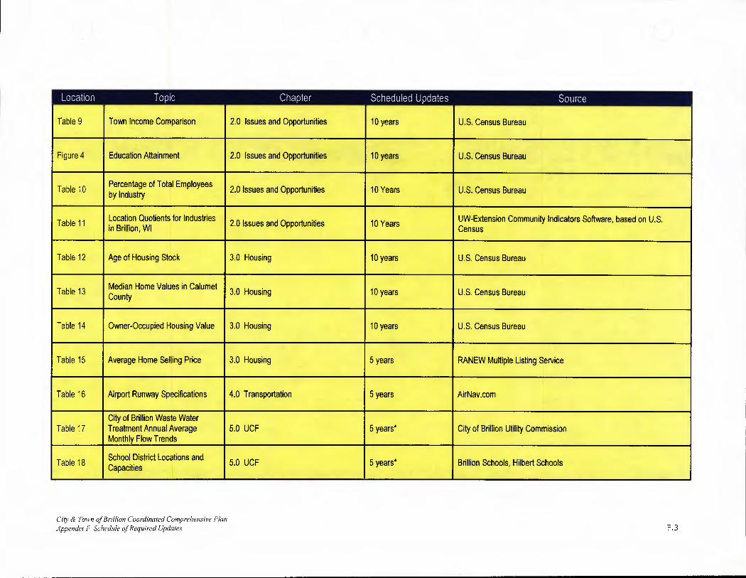
Location ISIS1[l Chapter Scheduled tUpdates i Source
Table 9 Town Income Comparison 2.0 Issues and Opportunities 10 years U.S. Census Bureau
Figure 4 Education Attainment 2.0 Issues and Opportunities 10 years U.S. Census Bureau
Table 10 Percentage of Total Employees by Industry 2.0 Issues and Opportunities 10 Years U.S. Census Bureau
Table 11 Location Quotients for Industries 2.0 Issues and Opportunities 10 Years UW-Extension Community Indicators Software, based on U.S.
in Brillion, WI Census
Table 12 Age of Housing Stock 3.0 Housing 10 years U.S. Census Bureau
Table 13 Median Home Values in Calumet County 3.0 Housing 10 years U.S. Census Bureau
Table 14 Owner-Occupied Housing Value 3.0 Housing 10 years U.S. Census Bureau
Table 15 Average Home Selling Price 3.0 Housing 5 years RANEW Multiple Listing Service
Table 16 Airport Runway Specifications 4.0 Transportation 5 years AirNay.com
City of Brillion Waste Water Table 17 Treatment Annual Average 5.0 UCF 5 years* City of Brillion Utility Commission
Monthly Flow Trends
Table 18 School District Locations and Capacities
5.0 UCF 5 years* Brillion Schools, Hilbert Schools
City & Town of Brillion Coordinated Comprehensive Plan Appendix F Schedule of Required Updates F.3

Location Topic Chapter Scheduled tI pdates Source
Table 19 Soil Characteristics 6.0 ANCR 20 years UW-W LICGF
Table 19.1 Prime Farmland 6.0 ANCR 20 years UW-W LICGF
Table 20 Existing Land Use - Amount,
8.0 Existing Land Use 5 years* Calumet County Planning Department Intensity, Density
Table 21 Calumet County Zoning Districts in Town of Brillion
8.0 Existing Land Use 5 Years Calumet County Zoning Ordinance
Table 22 Driveway Spacing 8.0 Existing Land Use 10 years E. Humstone & J. Campoli, Access Management: A Guide forRoadway Corridors, Planning Commissioners Journal, Winter 1998
Table 23 Projected Land Use Demand, Town of Brillion
10.0 Future Land Use 10 years* Calumet County Planning Department
Table 24 Projected Land Use Demand, City of Brillion
10.0 Future Land Use 10 years* Calumet County Planning Department
Table 25 Future Land Use, Town of Brillion 10.0 Future Land Use 10 years* Calumet County Planning Department
Table 26 Future Land Use, Town of Brillion
I
10.0 Future Land Use
I
10 years*
I
Calumet County Planning Department
I
Others
Housing Supply Characteristics
I
3.0 Housing
I
10 years* I
City of Brillion and Town of Brillion
City & Town of Brillion Coordinated Comprehensive Plan Appendix F Schedule of Required Updates F.4

* Updated in 2009
Cdv & Town of Brillion Coordinated Comprehensive Plan
Appendix F Schedule of Required Updates F.5

APPENDIX G 2007 CENSUS OF AGRICULTURE
City & Town of Brillion Coordinated Comprehensive Plan Appendix C 2007 Census ofAgriculture A.1

County Profile
Calumet, Wisconsin
2007 2002 % change
Number of Farms 732 733 -0
Land in Farms 151,659 acres 150,316 acres + 1
Average Size of Farm 207 acres 205 acres + 1
Market Value of Production $166,954,000 $81,857,000 + 104
Crop Sales $28,936,000 (17 percent) Livestock Sales $138,019,000 (83 percent)
Average Per Farm $228,080 $111,674 +104
Government Payments $1,978,000 $3,242,000 - 39
Average Per Farm $3,724 $9,055 - 59
Farms by Size
300
200
100
0 1-9 10-49 50-179 180-499 500-999 1,000*
Acres/Form
Land in Farms by Type of Land
Cropland 84,75'.
\. Other uses 7.940
\. Woodland 7.3 10

2007 CENSUS OF
AGRICULTURE County IProfile
Calumet, Wisconsin
Ranked items among the 72 state counties and 3,079 U.S. counties, 2007
- Item Quantity State Rank Universe 1 U.S. Rank Universe MARKET VALUE OF AGRICULTURAL PRODUCTS SOLD ($1,000)
Total value of agricultural products sold 166,954 22 72 451 3,076 Value of crops including nursery and greenhouse 28,936 40 72 1,234 3,072 Value of livestock, poultry, and their products 138,019 17 72 238 3,069
VALUE OF SALES BY COMMODITY GROUP ($1000)
Grains, oilseeds, dry beans, and dry peas 24,324 23 71 907 2,933
Tobacco (-) (-) 8 (-) 437
Cotton and cottonseed (-) (-) (-) (-) 626 Vegetables, melons, potatoes, and sweet potatoes 1,249 39 71 735 2,796
Fruits, tree nuts, and berries 260 49 70 964 2,659
Nursery, greenhouse, floriculture, and sod 1,235 38 70 1,005 2,703
Cut Christmas trees and short rotation woody crops 7 62 68 1,187 1,710
Other crops and hay 1,861 32 72 940 3,054
Poultry and eggs 87 55 72 1,466 3,020
Cattle and calves 17,506 20 72 777 3,054
Milk and other dairy products from cows 117,306 12 70 44 2,493 Hogs and pigs 130 45 71 1,310 2,922
Sheep, goats, and their products 156 28 71 780 2,998
Horses, ponies, mules, burros, and donkeys (D) (D) 70 (0) 3,024
Aquaculture (0) (D) 58 (0) 1,498 Other animals and other animal products 2,792 7 70 62 2,875
TOP LIVESTOCK INVENTORY ITEMS (number)
Cattle and calves 60,705 23 72 412 3,060 Mink and their pelts 9,201 15 25 40 123 Layers 1,613 54 71 1,227 3,024
Hogs and pigs 907 44 71 1,234 2,958 Horses and ponies 815 58 72 1,651 3,066
TOP CROP ITEMS (acres)
Forage-land used for all hay and haylage, grass silage, and greenchop 37,644 35 72 502 3,060
Corn for grain 32,745 39 68 738 2,634
Soybeans for beans 21,305 29 66 814 2,039
Corn for silage 18,205 13 70 54 2,263 Wheat for grain, all 11,076 11 66 673 2,481
Other County Highlights
Economic Characteristics Quantity Operator Characteristics Quantity
Farms by value of sales Principal operators by primary occupation: Less than $1,000 121 Farming 408
$1,000 to $2,499 27 Other 324
$2,500 to $4,999 43 $5,000 to $9,999 41 Principal operators by sex: $10,000 to $19,999 73 Male 676
$20,000 to $24,999 27 Female 56
$25,000 to $39,999 67 $40,000 to $49,999 15 Average age of principal operator (years) 53.7
$50,000 to $99,999 80 $100,000 to $249,999 104 All operators 2 by race: $250,000 to $499,999 72 American Indian or Alaska Native (-) $500,000 or more 62 Asian 1
Black or African American (-) Total farm production expenses ($1,000) 104,549 Native Hawaiian or Other Pacific Islander (-)
Average per farm ($) 142,826 White 1,097 More than one race (-)
Net cash farm income of operation ($1,000) 67,755 Average per farm ($) 92,561 All operators 2 of Spanish, Hispanic, or Latino Origin (-)
(D) Cannot be disclosed. (Z) Less than half of the unit shown. See "Census of Agriculture, Volume 1, Geographic Area Series" for complete footnotes. 1 Universe is number of counties in state or U.S. with item. 2 Data were collected for a maximum of three operators per farm.
............................................


H

APPENDIX H REDUCED CODING SCHEME -
EXISTING LAND USE
City & Town of Brillion Coordinated Comprehensive Plan Appendix H Reduced Coding Scheme Existing Land Use A.1

Reduced Coding Scheme A Regional Land Use Methodology v.4
August 15, 2001
AGRICULTURE Irrigated Cropland Non-irrigated Cropland Barns / Sheds/Outbuildings! Manure Storage Buildings - includes abandoned / destroyed barns, sheds, and land between buildings
Open areas that are wet, rocky, or outcrop; open lots in a subdivision or rural parcel; side or back lots on a residential parcel that are no developed, double, "big" lots (> 5 acres) - should be divided and coding accordingly. Note: Areas that are wooded within the parcel should be coded as woodland or if cropped coded agricultural. Pastureland and gamefarm land or included in this categor
WATER AREAS - ponds (man-made & natural), lakes, streams, rivers, etc.
WOODLANDS
Planted Wood Lots - includes forestry and timber tract operations, silviculture, orchards, & vineyards General Woodlands - includes hedgerows where distinguishable
RESIDENTIAL
Residential, vacated, other or unknown Single Family Structures / Duplexes - includes the mowed land surrounding house and Bed & Breakfast Houses Farm Residences, includes mowed yard Mobile Homes Not in Parks, includes mowed yard Accessory Residential Uses / Buildings (ECWRPC CODE) i.e. garages / sheds, includes mowed land surrounding the unit. If the garag€ is attached to a single family dwelling and is coded 9411 with the house Resident Halls, Group Quarters, Retirement Homes, Nursing Care Facilities, Religious Quarters, includes parking MOBILE HOME PARKS Apartments, Three or More Households: includes condos, Rooming and Boarding Houses - includes parking and yard
Commercial, vacated, other, or unknown
WHOLESALE TRADE
WHOLESALE TRADE, DURABLE GOODS - LUMBER, AUTOMOBILE, ELECTRICAL, HARDWARE WHOLESALERS! SUPPLIERS
WHOLESALE TRADE, NONDURABLE GOODS - GROCERY, BEER, WINE, FRUIT, GRAIN, BEAN WHOLESALERS / SUPPLIERS
RETAIL TRADE CAR AND BOAT DEALERS, USED OR NEW, INCLUDES PARTS SALES FURNITURE AND HOME FURNISHINGS STORES ELECTRONICS AND APPLIANCE STORES BUILDING MATERIAL AND GARDEN EQUIPMENT, SUPPLIES DEALERS, HARDWARE STORES GROCERY AND LIQUOR STORES HEALTH AND PERSONAL CARE STORES GASOLINE STATIONS CLOTHING AND CLOTHING ACCESSORIES STORES, SHOE, LUGGAGE, JEWELRY STORES SPORTING GOODS, HOBBY, BOOK AND MUSIC STORES GENERAL MERCHANDISE STORES - DEPARTMENT STORES - Multi-Retail, Malls & Strip Malls
MISCELLANEOUS STORE RETAILERS - FLORISTS, USED MERCHANDISE STORES, PET STORES, MOBILE HOME MANUF.
NONSTORE RETAILERS - CAR WASHES, VIDEO RENTAL STORES COURIERS AND MESSENGERS - LOCAL DELIVERY Greenhouse, Nursery and Floriculture Production (buildings I facilities only) Golf Course Pro shops, Driving Range / Country Clubs (buildings / facilities only)

SERVICES SUPPORT ACTIVITIES FOR CROP & ANIMAL, AND FORESTRY PRODUCTION -Coops, Grain and Feed Storage/Supply PUBLISHING INDUSTRIES - newspaper, software, book, publishers MOTION PICTURE AND SOUND RECORDING INDUSTRIES - Movie Theaters CELLULAR TELECOMMUNICATIONS - U.S. Cellular, Cellulink, Einstein INFORMATION SERVICES AND DATA PROCESSING SERVICES BANKS AND FINANCIAL INSTITUTIONS REAL ESTATE OFFICES - Century 21, Coldwell Banker INSURANCE AGENCIES AND CARRIERS WASTE MANAGEMENT AND REMEDIATION SERVICES - offices Taxidermists, Veterinary Services/Animal Hospitals ACCOMMODATIONS - Hotels / Motels RESTAURANTS AND DRINKING PLACES Copy Stores, Fed Ex, UPS - Kinkos, Mailboxes Etc. Travel Agencies REPAIR AND MAINTENANCE - AUTOMOTIVE, BOAT, ELECTRONIC, AG MACHINERY PERSONAL & LAUNDRY SERVICES - Funeral Homes, Dry cleaning, Kennels, Laundromats, Barber Shops SOCIAL ASSISTANCE - Humane Society, Day Care Centers, Dating/Wedding Services, Family Services Promoters of Performing Arts, Sports and Similar Events Agents and Managers for Artists, Athletes, Entertainers and Other Public Figures Independent Artists, Writers and Performers
OTHER COMMERCIAL Warehousing and Storage - includes ag warehouses and mini-warehouses Automobile Salvage Yards / Junk Yards
INDUSTRIALI
Industrial, vacated, other, or unknown
MINING / QUARRIES Sand, gravel, clay pits; non-metallic and stone quarries
CONSTRUCTION Contractors: excavating, roofing, siding, plumbing, electrical, highway and stree
MANUFACTURING - includes warehousing with factory or mill operation Food, beverage, clothing, leather mills, batch and mixed planH WOOD PRODUCT MANUFACTURING - pallets, plywood, veneer, sawmills PAPER MANUFACTURING PRINTING AND RELATED SUPPORT ACTIVITIES PETROLEUM AND COAL PRODUCTS MANUFACTURING CHEMICAL MANUFACTURING PLASTICS AND RUBBER PRODUCTS MANUFACTURING NONMETALLIC MINERAL PRODUCT MANUFACTURING (facilities only / quarries have sep. codes) PRIMARY METAL MANUFACTURING - Steel /Aluminum - Foundries FABRICATED METAL PRODUCT MANUFACTURING - Machine shops, hardware mfg. MACHINERY MANUFACTURING - Ag equipment, engines, turbines, refrigeration mfg. COMPUTER AND ELECTRONIC PRODUCT MANUFACTURING ELECTRICAL EQUIPMENT, APPLIANCE AND COMPONENT MANUFACTURING TRANSPORTATION EQUIPMENT MANUFACTURING - motor vehicle mfg., boat building FURNITURE AND RELATED PRODUCT MANUFACTURING MISCELLANEOUS MANUFACTURING - Medical equipment, signs & displays
OTHER INDUSTRIAL FACILITIES TRUCK FACILITIES - Freight trucking, outdoor storage areas for semis, trucks & equip., Docking terminals
TRANSPORTATION
Transportation facilities vacated, other, or unknown AIR TRANSPORTATION - Airports, includes support facilities RAIL TRANSPORTATION - includes right of way and railyards SUPPORT ACTIVITIES FOR TRANSPORTATION - waysides, freight weigh stations, includes bus stations, taxi, limo services, park and ride lots. (carpool lots) HIGHWAYS AND STREET RIGHTS OF WAY

UTILITIES
Utilities, vacated, other, or unknown Electric Power Generation, Transmission and Distribution - includes transformers and substations Natural Gas Distribution - substations, designated distribution brokers who sell natural gas. Water Towers I Storage Tanks (ECWRPC CODE) Sewage Treatment Plant (ECWRPC CODE) - includes lift stations Water Treatment and Related Facilities (ECWRPC CODE) - includes pump stations and wells that are designated BROADCASTING AND TELECOMMUNICATIONS - Radio, Telephone, &Television Stations, includes Cell Towers Waste Treatment and Disposal (other wastepiles, industrial settling ponds, etc.) Active Landfills (ECWRPC CODE) Abandoned Landfills (ECWRPC CODE) Recycling facilities (ECWRPC Code)
INSTITUTIONAL FACILITIES
INSTITUTIONAL FACILITIES - vacated, other, or unknown
Public Libraries EDUCATIONAL SERVICES - Public and Private Schools, Elementary, Middle, and High Schools HIGHER EDUCATION FACILITIES - Colleges, Universities, Professional Schools - Public and Private, Technical and Trade School Facilities, Business I Computer training centers (Athletic fields and resident halls are coded Separately where available.) HEALTH CARE SERVICES - Doctor & Dentist Offices, Other Health Care offices HOSPITALS Churches, religious organizations, non-profit agencies, unions Cemeteries and Crematories
PUBLIC ADMINISTRATION - OTHER GOVERNMENT FACILITIES
City & Town Halls, Community Centers, Post Offices, Police Depts., Fire Stations, Municipal Garages, Jails, Administration of Human Resource Programs, Social Security & Employment Offices, Environmental Quality Programs, Administration of Housing Pgms., Urban Planning & Community Develop., Administration of Economic Programs, Armories and Military Facilities, Other Government Facilities
RECREATIONAL
SPORTS AND RECREATIONAL FACILITIES public and private - Athletic clubs - YMCA, other, or unknown,
Designated Fishing and Hunting areas, Trapping areas, fish hatcheries, boat landings Spectator Sports - Baseball Stadiums, Arenas, Race Tracks, Sport Complexes MUSEUMS, HISTORICAL SITES, AND SIMILAR INSTITUTIONS, Nature parks, Nature Preserve Areas, Zoos, Botanical Gardens AMUSEMENT, GAMBLING, AND RECREATION INDUSTRIES - Casinos, amusement parks, Go-Carts, Mini-Golf, Bowling Alleys Golf Courses and Country Clubs (private and public) - includes driving ranges Ski Hills and Facilities Marinas RV (Recreational Vehicle) Parks and Recreational Camps - includes campgrounds and resorts (public and private) Bible Camps
PARKS AND OUTDOOR RECREATION, vacated. Other, or unknown, Site Seeing Areas, Designated Trails GENERAL RECREATION PARKS - includes playground areas, playfields such as ball diamonds, soccer fields, tennis courts, City, State, and County Parks (These may be located within a school, separate recreational uses from school buildings.) FAIRGROUNDS - buildings and facilities included
* Land uses depictable from air photo interpretation with some level of accuracy, no field survey!