Chapter 8 Transportation - Bellevue Comprehensive Plan
11
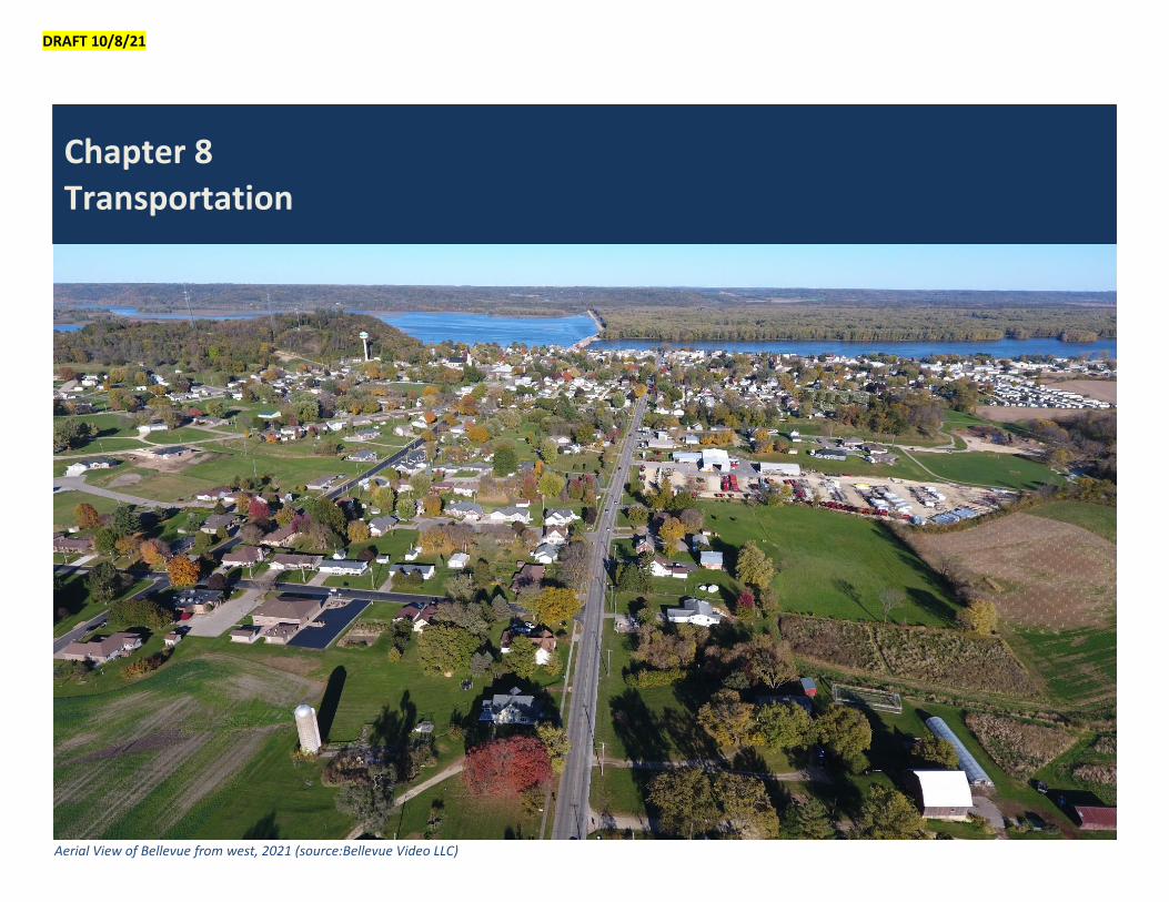
DRAFT 10/8/21 Aerial View of Bellevue from west, 2021 (source:Bellevue Video LLC) Chapter 8 Transportation
-
Upload
khangminh22 -
Category
Documents
-
view
1 -
download
0
Transcript of Chapter 8 Transportation - Bellevue Comprehensive Plan
DRAFT 10/8/21
Aerial View of Bellevue from west, 2021 (source:Bellevue Video LLC)
Chapter 8
Transportation

City of Bellevue Comprehensive Plan Transportation
2
Introduction The City of Bellevue’s transportation system is vital to everyday life in the community. The system facili-tates the movement of people and goods within the City allowing residents to get from their homes to employment, education, medical care, and shop-ping. Bellevue’s local system connects to regional and national networks providing access to surround-ing communities and the rest of the world. Busi-nesses import products and raw materials from out-side the region and export goods and commodities to other regions. Connections to regional transpor-tation networks allow businesses to conduct these transactions quickly and efficiently and allow the re-gion to compete in the global marketplace. The goal of this chapter is to provide efficient and affordable transportation to residents and businesses in the City of Bellevue.
Automobile Travel Automobile travel is by far the most used mode of transportation in the United States and is relied on even more in smaller communities like Bellevue where the area’s population is more spread out.
Figure 8-1 shows the US Census estimate of how people get to work in the United States, Iowa, and Bellevue. In Bellevue, 89.9% of people use a car, truck or van to get to work. These numbers illus-trate the level of reliance on personal vehicles and the importance of maintaining regional infrastruc-ture needed for personal vehicle travel.
For the City of Bellevue this means maintaining its system of local streets and bridges that allow people to access their property and travel across town. For Iowa counties, the Iowa Department of Transporta-tion (IDOT), and the Federal Highway Administration (FHWA), this means maintaining the highways and bridges that connect communities within the region and across the country.
Local City Streets Bellevue’s network of streets allows people to get around within the community. Bellevue has approxi-mately 47 lane miles of local streets and 4 miles of alleys within its city limits. In most cities, local streets are a high priority with pavement mainte-nance, traffic speed, and safety the most common is-sues for residents and businesses.
Streets are also vital for future economic growth in Bellevue. Streets provide a framework for creating value in the community. The City builds streets as an in-vestment. The money invested in streets allows people to access property. Once a piece of prop-erty is accessible, it becomes more valuable because the prop-erty owner can build on the land and people can get to the build-ing. Accessible buildings can be used for businesses and housing.
Highways The region’s transportation system works extremely well for the majority of users. Most commuters drive alone to work. Five major US highways, along with a dense network of State, County, and local roads, make it possible for commuters in private ve-hicles to get from one part of the region to the other efficiently. Freight transportation also benefits from the region’s relatively uncongested highway facilities and other major roadways.
Bellevue radiates from the intersection of US High-way 52 (Riverview Street) and Iowa Highway 62 (State Street). From Bellevue, US Highway 52 continues north to St. Donatus and Dubuque and south to Sabula, before it enters Savanna, Illinois via the Dale Gardner Veterans Memorial Bridge.
US Highway 52 is Bellevue’s primary connection to the national highway system. The highway follows a northwest-southeast route 2,072 miles from Portal, North Dakota, on the Canadian border, to Charles-ton, South Carolina. In Iowa, much of the 174-mile route remains two lanes.
US Highway 52 provides Bellevue with a two-lane connection north to Dubuque and US Highways 61 and 151. The highway allows residents looking for a small-town lifestyle to live in Bellevue, but still be close to shopping, medical care, and employment opportunities in this larger city.
US Highway 52 is also important for economic growth. Businesses in Bellevue can import raw ma-terials and export products to world markets on the highway. US Highway 52 is maintained by the Iowa DOT. The City of Bellevue should continue to com-municate the importance of US Highway 52 to the Iowa DOT.
In addition to US Highway 52, the City of Bellevue is Figure 8-1. Means of Transportation to Work Source: US Census 2019 American Community Survey (ACS) 5-Year Estimates Subject Tables
76.3
81.1
83.1
0% 20% 40% 60% 80% 100%
US
Iowa
Bellevue
Car, truck,or van - alone
Car, truck,or van - carpooled
Public transportation(excluding taxicabs)
Walked
Bicycle
Taxicab, motorcycle,or other means
Worked from home
City of Bellevue Comprehensive Plan Transportation
3
connected to surrounding communities by a system of regional highways that include state highways, farm-to-market routes, and federal aid routes. At Bellevue, US Highway 52 runs along the city's river-front and passes Lock and Dam No. 12, intersecting with the eastern terminus of Iowa Highway 62, which continues on to Andrew and ends in Maquo-keta. Other roads coming into the city are Bellevue-Cascade Road (County D61) which terminates near Cascade, and Mill Creek Road (County D56) which terminates in La Motte.
Farm to Market Routes A farm-to-market route is a road that is used to con-nect agricultural areas to distribution centers in nearby towns. Many residents of Bellevue and the surrounding unincorporated areas work in the agri-cultural industry or supporting industries, making a good quality farm-to-market system important for future economic growth in Bellevue. Jackson County maintains the farm-to-market roads that connect to Bellevue.
Federal-Aid Routes Federal-aid routes are regional roadways that are el-igible for federal funding. Federal-aid routes can be maintained by cities, counties, or the Iowa DOT.
Federal aid eligibility is determined by the roadway’s functional classification. Functional classification for a given roadway is determined based on its setting (urban or rural) and whether its main role is provid-ing connectivity, mobility, or accessibility. The num-ber of vehicle miles traveled (VMT), average annual daily traffic (AADT), and adjoining land uses of a roadway are also considered.
Traditionally, the functional classification system has been used to describe how travel flows through the regional roadway network and to determine project eligibility for inclusion in different transportation
planning projects and grants. The arterial streets form the backbone of the network. Local roads feed the collectors, which in turn feed the arterials.
In the Bellevue area, US Highway 52 and Iowa High-way 62 are minor arterials, with AADT of 1,000 to 5,000 vehicles. Bellevue-Cascade Road (County D61) is a major collector with AADT less than 1,000 vehi-cles.
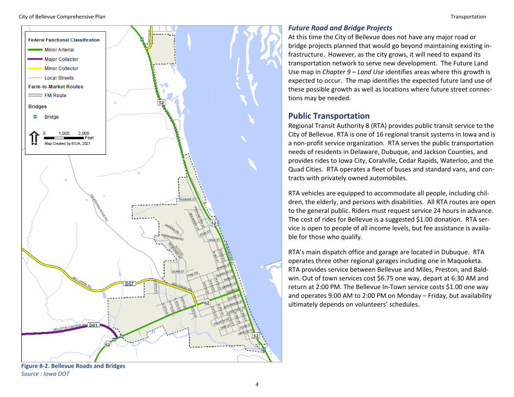
Bellevue Functional Classification The functional classification categories found in Bellevue include: principal arterials, minor arterials, major collectors, minor collectors, and local streets. Table 8-2 summarizes roadways within the Bellevue city limits by functional classification. Figure 8-1 maps regional roadways by functional classification and farm-to-market routes.
Table 8-1. Lane Miles by Functional Classification
Functional Classification Lane Miles
Principal Arterials 0
Minor Arterials 4.29
Major Collectors 0.68
Local Streets 15.98
Total 20.95 Source: Iowa DOT
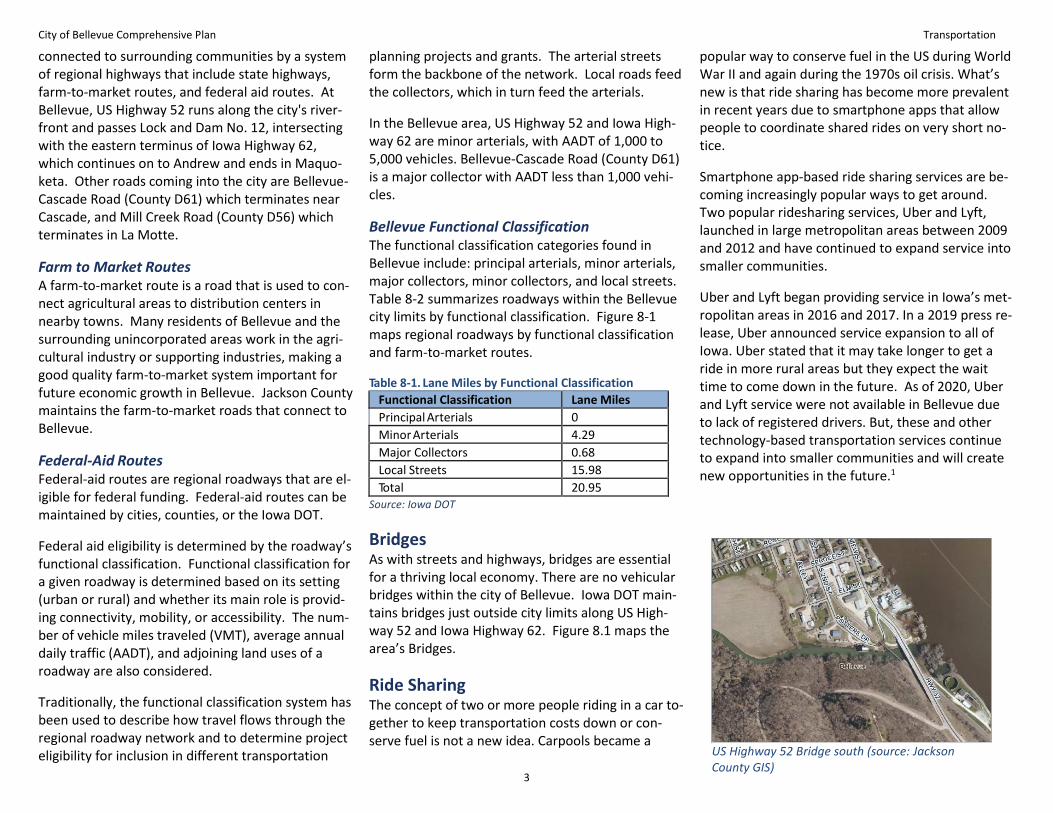
Bridges As with streets and highways, bridges are essential for a thriving local economy. There are no vehicular bridges within the city of Bellevue. Iowa DOT main-tains bridges just outside city limits along US High-way 52 and Iowa Highway 62. Figure 8.1 maps the area’s Bridges.
Ride Sharing The concept of two or more people riding in a car to-gether to keep transportation costs down or con-serve fuel is not a new idea. Carpools became a
popular way to conserve fuel in the US during World War II and again during the 1970s oil crisis. What’s new is that ride sharing has become more prevalent in recent years due to smartphone apps that allow people to coordinate shared rides on very short no-tice.
Smartphone app-based ride sharing services are be-coming increasingly popular ways to get around. Two popular ridesharing services, Uber and Lyft, launched in large metropolitan areas between 2009 and 2012 and have continued to expand service into smaller communities.
Uber and Lyft began providing service in Iowa’s met-ropolitan areas in 2016 and 2017. In a 2019 press re-lease, Uber announced service expansion to all of Iowa. Uber stated that it may take longer to get a ride in more rural areas but they expect the wait time to come down in the future. As of 2020, Uber and Lyft service were not available in Bellevue due to lack of registered drivers. But, these and other technology-based transportation services continue to expand into smaller communities and will create new opportunities in the future.1
US Highway 52 Bridge south (source: Jackson County GIS)
City of Bellevue Comprehensive Plan Transportation
4
Future Road and Bridge Projects At this time the City of Bellevue does not have any major road or bridge projects planned that would go beyond maintaining existing in-frastructure. However, as the city grows, it will need to expand its transportation network to serve new development. The Future Land Use map in Chapter 9 – Land Use identifies areas where this growth is expected to occur. The map identifies the expected future land use of these possible growth as well as locations where future street connec-tions may be needed.
Public Transportation Regional Transit Authority 8 (RTA) provides public transit service to the City of Bellevue. RTA is one of 16 regional transit systems in Iowa and is a non-profit service organization. RTA serves the public transportation needs of residents in Delaware, Dubuque, and Jackson Counties, and provides rides to Iowa City, Coralville, Cedar Rapids, Waterloo, and the Quad Cities. RTA operates a fleet of buses and standard vans, and con-tracts with privately owned automobiles.
RTA vehicles are equipped to accommodate all people, including chil-dren, the elderly, and persons with disabilities. All RTA routes are open to the general public. Riders must request service 24 hours in advance. The cost of rides for Bellevue is a suggested $1.00 donation. RTA ser-vice is open to people of all income levels, but fee assistance is availa-ble for those who qualify.
RTA’s main dispatch office and garage are located in Dubuque. RTA operates three other regional garages including one in Maquoketa. RTA provides service between Bellevue and Miles, Preston, and Bald-win. Out of town services cost $6.75 one way, depart at 6:30 AM and return at 2:00 PM. The Bellevue In-Town service costs $1.00 one way and operates 9:00 AM to 2:00 PM on Monday – Friday, but availability ultimately depends on volunteers’ schedules.
Figure 8-2. Bellevue Roads and Bridges Source : Iowa DOT

City of Bellevue Comprehensive Plan Transportation
5
Bicycle and Pedestrian Walking and biking are important modes of trans-portation for Bellevue. Walking and biking can pro-vide transportation for those who are unable to drive or don’t have access to a car. Choosing to walk or bike instead of drive can reduce traffic conges-tion, improve air quality, and improve physical health. Increasingly, people are listing bike and pe-destrian amenities among the features that they consider when choosing where to live. Existing bicy-cle and pedestrian facilities in Bellevue can be classi-fied into three categories: off-street trails, on-street routes, and sidewalks. Descriptions of each type fol-lows.
The City of Bellevue is connected with national, re-gional, county and city bike and pedestrian trail sys-tems, often a combination of off-street and on-street routes as described below. Bicycle and pedes-trian routes in the city and in Bellevue State Park are shown on Figure 8-5.
Off-Street Trails Bellevue and the surrounding area have several off-street trails. Most area trails are classified as multi-use trails. These trails typically are made of concrete or brick pavers and 6 to 10 feet wide. Multi-use trails are physically separated from motorized traffic by an open space or barrier and can be in an inde-pendent right of way or within a roadway right-of-way. Multi-use trails accommodate both bicyclists and pedestrians and are suitable for most age groups and abilities.
RIVERFRONT TRAIL The City has a separated walking path that runs along Riverview Street/US Highway 52 from High Street heading south to Vine Street, then to Mill Creek Trail/US Highway 52 along Bellevue’s east bor-der.
The City has roughly a three fourths of a mile River-view Trail in Riverview Park that runs along the Mis-sissippi River with benches, picnic tables, gazebos, a Jackson County Veterans Memorial Freedom Rock,
flowerbeds kept up by the River-view Gardeners Club, and views of Lock and Dam No. 12.
In 2012 to 2013, the City ex-tended a roughly 1.7 mile, 10-foot-wide Rivervue Trail along US Highway 52 north to the Off Shore resort’s campground. In winter, this trail is closed for use as a snowmobile route. The plan is for Jackson County Con-servation to continue the trail further north into the county to the campground in Spruce Creek Park.
FELDERMAN PARK TRAIL In 2017, the Riverview Trail was connected to Felder-man Park by a roughly half-mile sidewalk connection trail. The Felderman Park Trail is a roughly three fourths of a mile of 10-feet wide concrete. There are two outlets for the trail, one to South 8th Street and a second to the trailer court.
The 2017 trail extension also included the Mill Creek pedestrian bridge connecting Felderman Park to Bellevue State Park’s Nelson Unit located just south of Bellevue. This bridge was the first in Iowa to con-nect a city park and a state park. It was part of the Parks to People project initiated by the State of Iowa. The trail and bridge also were funded by other grants, donations, and a City General Obligation loan.
BELLEVUE STATE PARK TRAILS Five trails within Bellevue State Park total about four miles of multi-use paths: Bellevue Scenic Overlook Trail, Woodland Culture Indian Trail, South Bluff Na-ture Center Trail, Quarry Trail, and Woodland Inter-pretative Trail. In addition, the Park has several miles of trails for hiking only; bicycles are not allowed on these trails. These hiking trails are used for recrea-tion and are usually unpaved and narrower than a multi-use trail, and as a result, may require a rela-tively higher level of physical ability.
On-Street Bicycle Routes In addition to trails, Bellevue bicyclists also have the option to ride on the streets. With an on-street route, bicyclists share the roadway with motor vehi-cle traffic. Many of Bellevue’s local residential streets are ideal on-street bicycle routes. These streets have low vehicle traffic volume and 25 mile-per-hour speed limits or less.
Streets with higher speeds and more traffic can in-clude specific design improvements to direct bicycles Riverview Trail (Source: City of Bellevue

City of Bellevue Comprehensive Plan Transportation
6
and vehicles and improve safety for all users. Design improvements include signage, shared lane markings (sharrows), bike lanes, separated bike lanes, and pro-tected bikeways.
The design strategy used depends on vehicle speed, traffic volume, and space available in the right-of-way. Streets with higher vehicle speeds and vol-umes will usually call for elements like buffered bicy-cle lanes or separated bikeways that offer more pro-tection to bicyclists.
Streets with slower speeds and lower traffic volumes are generally safer for bicyclists and are good candi-dates for less protective elements such as bicycle signage or shared lane markings. In many cases, local streets are suitable for biking without any additional design elements.
To help smaller communities like Bellevue select bi-cycle design elements, the FHWA published a design guidance document called The Small Town and Rural Multimodal Network Guide. Figures 8-2, 8-3, and 8-4 provide examples of possible on-street improve-ments from the guide.2
PAVED SHOULDER Roadway shoulders can be enhanced to serve as space for pedestrians and bicyclists. Paved shoul-ders are appropriate on roads with moderate to high traffic volumes and speeds.
BIKE LANE Bike lanes provide a dedicated space for bicyclists on the edge of a moderate to high traffic speed and vol-ume roadway. Bike lanes are similar to paved shoul-ders but are intended for more urban applications and have additional pavement markings and sign-age.
SEPARATED BIKE LANE Sometimes referred to as protected bike lanes, sepa-rated bike lanes offer additional separation from ve-hicle traffic. Typically, the bike lane is separated by a vertical element such as curb, parked cars, decora-tive planting, or flex post.
Regional Trails
MISSISSIPPI RIVER TRAIL The national Mississippi River Trail (MRT), currently under development, will follow the river 2,000 miles on both sides through 10 states, from its headwaters in Minnesota to the Gulf of Mexico. The MRT runs through Downtown Bellevue along the riverfront.
MISSISSIPPI CIRCUIT The Mississippi Circuit trail system links regional as-sets via the MRT and Iowa’s portion of the scenic Great River Road through shoulder widening along US Highway 52 in Dubuque and Jackson Counties. The result: visitors can move between the City of Dubuque to Mines of Spain State Park, St. Donatus, Spruce Creek Park, City of Bellevue, Felderman Park’s Mill Creek Pedestrian Bridge, and Bellevue State Park.
BELLEVUE-CASCADE ROAD ROUTE This paved shoulder route runs along Bellevue-Cas-cade Road/County D61 from Bernard Road, then east to Bellevue.
SPRINGBROOK, ANDREW, LA MOTTE LOOP The loop route begins at 362nd Avenue going south-southwest from Bellevue at the MRT to Springbrook, then west to Andrew on 150th Street, then north to La Motte on 250th Street, and then northeast back to the MRT.
Sidewalks Sidewalks are an important part of the pedestrian network. Sidewalks provide necessary walking
connections to homes, businesses, transit services, and other activities. Many streets in Bellevue have sidewalks, but gaps exist in the network. In some cases, sidewalks do not exist, in others the sidewalks are there but pedestrians are deterred by an unsafe crossing of a busy street.
Figure 8-2. Paved Shoulder
Figure 8-3. Bike Lane
Figure 8-4. Separated Bike Lane

City of Bellevue Comprehensive Plan Transportation
7
Sidewalk maintenance also can be an issue. Unlike trails or city streets, private property owners usually maintain sidewalks, and owners can vary greatly in their ability or desire to maintain side-walks. The City of Bellevue’s Public Works Department will offer to remove the existing sidewalks in effort to help commercial or resi-dential property owners with the cost of repairing or reconstructing sidewalks. The City also covers costs for where the sidewalk’s acces-sibility ramp meets the street.
Private ownership somewhat limits the City’s ability to address gaps in the sidewalk network. But the City does have options available to improve the sidewalk network, such as:
• Inventory the sidewalk network and identify critical gaps and safety issues.
• Work with property owners through the City’s sidewalk removal option.
• Install safety improvements at crossings, such as enhanced signs and markings.
Future Bicycle and Pedestrian Projects Figure 8-5 maps the City of Bellevue’s existing bicycle and pedestrian facilities and future bicycle and pedestrian projects. The map in-cludes future projects that are located within the existing city as well as some conceptual plans within the city’s Possible Growth Areas.
The conceptual projects are shown on the map to provide an idea what bicycle and pedestrian facilities in the Possible Growth Areas might look like once the areas are developed. With the inclusion of these conceptual projects in the map, the Bellevue is stating that it wants to ensure that bicycle and pedestrian facilities are included as part of the development plans for the Possible Growth areas, ac-knowledging that the exact nature and location of the facilities that are eventually constructed in these areas may be different than what is shown in the map.
See Chapter 9 – Land Use for more information the Possible Growth Areas and the future development concepts for these areas.
Figure 8-5. City of Bellevue Existing and Planned Bicycle and Pedestrian Facilities

City of Bellevue Comprehensive Plan Transportation
8
Parking For Bellevue, parking is primarily an issue in the downtown area. Higher building density and a mix of residential, office, and retail uses in downtown means that demand for parking is high, while space for parking is limited. Parking is an important ele-ment within a downtown that supports shopping, entertainment, working, and living. Bellevue’s recent investments in its downtown and plans for future development have been great for the community, but have also caused concerns regarding parking.
The City allows for 72-hour parking in the Municipal Parking Lot, located in the downtown area near the Lock and Dam and Municipal Boat Ramp. The park-ing lot is rented from the US Army Corps of Engi-neers on a 25-year lease.
Because of its importance, Bellevue should take a proactive approach to downtown parking that in-cludes developing an inventory of existing parking spaces and studying their usage. A downtown park-ing inventory should set out to answer the following questions:
• How many public parking spaces are available and where are they located?
• How many on-street spaces?
• How many paid reserved spaces?
Following the inventory, the City can focus on how and when available parking is used. Periodic surveys of parking usage can help the City to understand parking demand during a typical day and during spe-cial events.
Bellevue can use the information collected to better manage its existing parking supply and plan for pos-sible future parking space additions. Potential park-ing solutions include:
• Add signage to direct people to available public parking.
• Provide a map of all downtown parking areas.
• Improve aesthetics of off-street lots.
• Make safety improvements to off-street lots in-cluding lighting.
• Improve pedestrian routes, sidewalks, and street crossings between parking areas and destina-tions.
• Provide parking for bicycles as a way to reduce demand for vehicle parking.
Freight Regional freight transportation connections are very important for Bellevue’s economic competitiveness. According to the US Census 2015-2019 American Community Survey (ACS) 5-year estimates, 24.0% of the Bellevue workforce are employed in production, transportation, and material moving occupations.
The 2018 Eight County Freight Study3 looked at freight transportation in a region that included four counties in eastern Iowa: Clinton, Delaware, Dubu-que, and Jackson; and four counties in western Illi-nois: Carroll, Jo Daviess, Stephenson, and Whiteside. According to the study, the region has good access to freight but is very dependent on connections to points outside the eight counties to distribute goods within the Midwest and beyond. Local companies that ship goods outside the region may need to first send goods to regional freight facilities in Davenport, Cedar Rapids, Rochelle, Rockford, and Chicago.
Trucking The region’s road network is made up of different sub-networks including interstate highways, national highways, state highways, and county roads. The study notes that trucks carry the greatest share of the region’s freight by both tonnage and value. The share of freight value carried by truck (82%) is
greater than the share of freight tonnage (73%), sug-gesting that trucks are being used to carry the re-gion’s higher-value, lower weight manufactured goods.
Railroads The study notes that four Class I railroads serve the region, providing access to a wide range of locations throughout the western and southern US. Rail car-ries 23% of the region’s tonnage, but only 7% of its value, suggesting rail shipments are being used for relatively high-weight, low-value commodities like agricultural products.
The Canadian Pacific (doing business as the Dakota, Minnesota, and Eastern) connects to the Twin Cities, Chicago, and Kansas City through Bellevue. This rail-road bisects the city parallel to the Mississippi River, with eight at grade rail crossings on public streets.
With a busy rail line passing through the community, rail safety is a key issue for Bellevue. A search of Iowa DOT crash reports over the previous ten years identified one train vehicle crash. The crash oc-curred in 2011 and did not result in any injuries. The city should continue to monitor railroad safety issues and work with the railroad to address any problems that arise.
Barges The study notes that the Mississippi River flows for 93 miles through the center of the region, providing a direct waterways connection to the Gulf of Mexico and international markets. The river’s flow is con-trolled by three locks and dams in the region, includ-ing Lock and Dam No. 12 in Bellevue. The river car-ries 1% of the region’s freight volume and value.
Airports The Bellevue area is served by one commercial
City of Bellevue Comprehensive Plan Transportation
9
airport in Dubuque, and municipal airports in Man-chester, Maquoketa, and Clinton. Currently, the freight transportation through the region’s airports is limited, as Cedar Rapids, IA and Rockford, IL are lo-cated within reasonable driving distance and both serve as major air freight hubs for the surrounding area. However, airports could provide an oppor-tunity for future freight expansion through projects such as the Clinton Railport.
Regional Coordination Building a transportation system that effectively connects communities requires local governments to work together. The FHWA administers transporta-tion activities on a national level and the IDOT man-ages transportation within the state. At the regional level, Iowa has nine Metropolitan Planning Organiza-tions (MPOs) and 18 Regional Planning Affiliations (RPAs) that conduct transportation planning activi-ties and facilitate coordination between local gov-ernments. MPOs operate in urban areas with more than 50,000 residents and RPAs cover non-metropol-itan areas of the state.
Bellevue is a member of Regional Planning Affiliation 8 (RPA 8). RPA 8 covers Clinton, Delaware, Dubuque, and Jackson counties. RPA 8 is governed by a policy board made up of representatives of its member cit-ies, counties, and regional transportation agencies. As a city with a population under 5,000, Bellevue does not have a representative on the RPA policy board.
The 2018 Eight County Freight Study stresses the im-portance of regional coordination. Cities within the region, like Bellevue, need to work together to es-tablish key partnerships to better understand freight system needs and work toward advancing strategies to improve the regional freight system and its con-nections. The study includes several recommended
projects and programs including:
• Highway improvements to address congestion and safety
• Pavement improvements
• Bridge improvements
• New/improved intermodal, transload and/or port facilities
• Lock and dam improvements
Maintenance Ongoing maintenance of transportation infrastruc-ture is one of Bellevue’s most important transporta-tion priorities. Regular maintenance protects the community’s investment in its infrastructure by pre-venting deterioration and extending its useful life. Well maintained transportation infrastructure also supports economic development and public safety. Local residents and businesses depend on quality transportation infrastructure to get to their destina-tion safely and efficiently.
The City of Bellevue plans transportation infrastruc-ture maintenance primarily through its annual Capi-tal Improvements Program (CIP). Development of the CIP includes a systematic evaluation process that allows the City to compare all potential projects and develop a maintenance plan that ensures efficient use of funding.
Maintenance planning efforts can be aided by tech-nology. Iowa State University’s Iowa Pavement Man-agement Program (IPMP) offers automated data col-lection on the condition of roads including infor-mation on cracks and the quality of the ride. The IPMP information is available for free to communi-ties through a web portal. The IPMP also offers ac-cess to pavement management software that allows the user to develop an inventory of streets by loca-tion and to perform a life cycle cost analysis to
determine the best maintenance action for each street.
Safety Transportation safety is an important issue that af-fects millions of people across the United States every year. US Centers for Disease Control (CDC) re-ports that more than 32,000 people are killed and two million are injured each year from motor vehicle crashes.5 In Iowa over the last ten years, 3,584 peo-ple have been killed and 15,755 people have been seriously injured in motor vehicle crashes.6
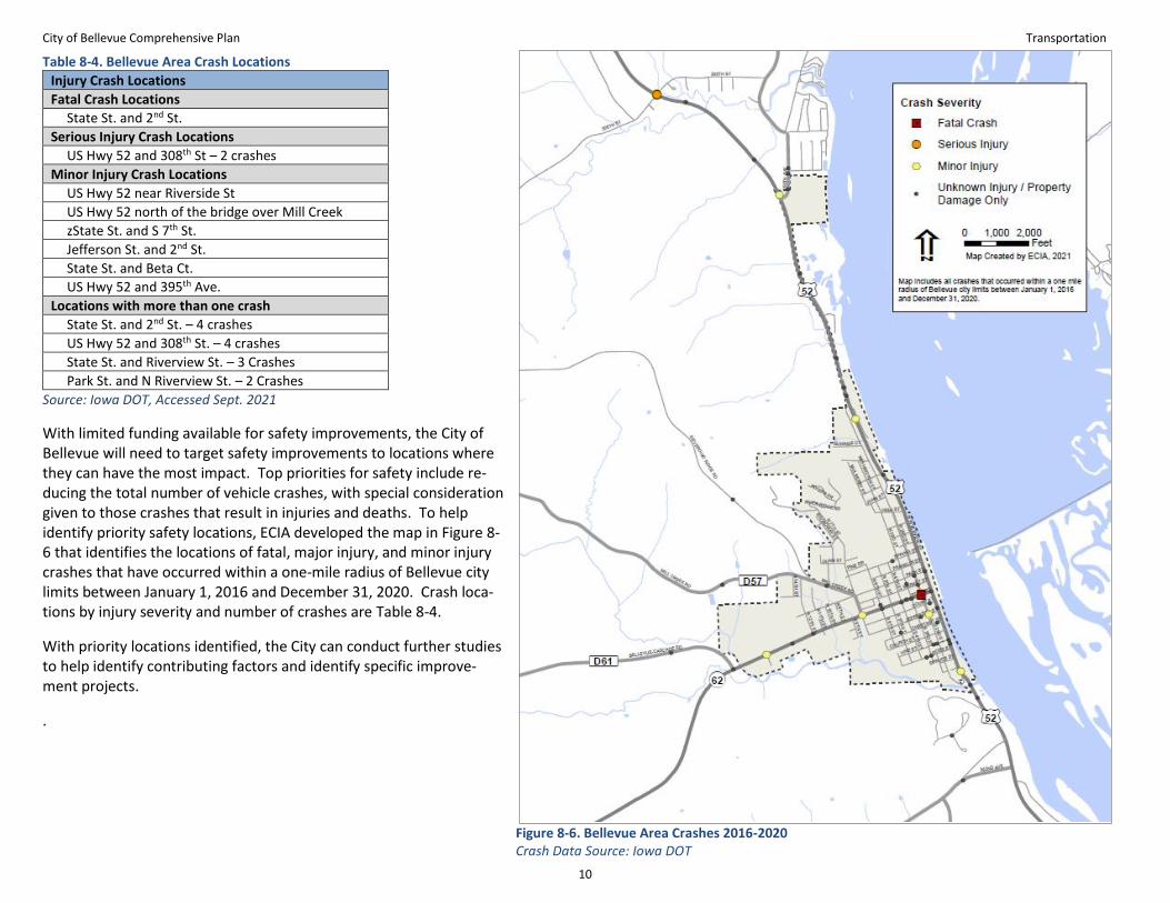
The planning team conducted an analysis of Iowa DOT crash data that looked at crashes that occurred within one mile of Bellevue city limits between 2016 and 2020. The assessment found that a total of 60 vehicle crashes occurred in five-year period. Of these crashes, one resulted in a fatality, two crashes resulted in a serious injury, and six caused a minor injury. Table 8-3 summarizes the cashes by severity.
Table 8-3. Bellevue Vehicle Crash Severity, 2016-2021 Crash Severity No. of Crashes
Fatal 1
Serious Injury Crash 2
Minor Injury Crash 6
Possible/Unknown Injury Crash 10
Property Damage Only 41
Total 60
Source: Iowa DOT, Accessed Sept. 2021.
City of Bellevue Comprehensive Plan Transportation
10
Table 8-4. Bellevue Area Crash Locations
Injury Crash Locations
Fatal Crash Locations
State St. and 2nd St.
Serious Injury Crash Locations
US Hwy 52 and 308th St – 2 crashes
Minor Injury Crash Locations
US Hwy 52 near Riverside St
US Hwy 52 north of the bridge over Mill Creek
zState St. and S 7th St.
Jefferson St. and 2nd St.
State St. and Beta Ct.
US Hwy 52 and 395th Ave.
Locations with more than one crash
State St. and 2nd St. – 4 crashes
US Hwy 52 and 308th St. – 4 crashes
State St. and Riverview St. – 3 Crashes
Park St. and N Riverview St. – 2 Crashes
Source: Iowa DOT, Accessed Sept. 2021
With limited funding available for safety improvements, the City of Bellevue will need to target safety improvements to locations where they can have the most impact. Top priorities for safety include re-ducing the total number of vehicle crashes, with special consideration given to those crashes that result in injuries and deaths. To help identify priority safety locations, ECIA developed the map in Figure 8-6 that identifies the locations of fatal, major injury, and minor injury crashes that have occurred within a one-mile radius of Bellevue city limits between January 1, 2016 and December 31, 2020. Crash loca-tions by injury severity and number of crashes are Table 8-4.
With priority locations identified, the City can conduct further studies to help identify contributing factors and identify specific improve-ment projects.
.
Figure 8-6. Bellevue Area Crashes 2016-2020 Crash Data Source: Iowa DOT

City of Bellevue Comprehensive Plan Transportation
11
Recommendations The following recommendations are intended to guide the City of Bellevue in providing safe, high-quality transportation for all residents of the City.
Transportation Planning • Continue to work with outside agencies such as
Jackson County, the Iowa Department of Trans-portation, and Regional Planning Affiliation 8 to maintain regional highway connections.
• Follow a performance-based planning process that ensures that resources are used effectively.
• Continue to look for opportunities to fund trans-portation infrastructure projects through state and federal programs.
Roads and Bridges • Evaluate the City’s street system and plan future
street maintenance projects through the City of Bellevue’s Capital Improvement Program (CIP).
• Reduce the number of major injuries and deaths from vehicle crashes by identifying problem lo-cations and making safety improvements at those locations.
• Develop a pavement management plan.
Public Transportation • Coordinate with the Regional Transit Authority
to improve public transit service in the Bellevue area.
Bicycle and Pedestrian • Create a more complete bicycle and pedestrian
network through the development of trails, on street bicycle routes, and sidewalks.
• Improve safety for bicyclists and pedestrians by adding improvements to on-street bicycle routes and improving street crossings.
• Encourage walking and biking as ways to get around town.
Railroads • Coordinate with the railroad to monitor railroad
safety issues and to address any problems.
Parking • Develop a parking inventory for the downtown
area.
• Manage downtown parking to complement busi-ness and residential uses.
Wayfinding • Create wayfinding signage network to help visi-
tors find points of interest and amenities.
• Install signage directing people to available pub-lic parking.
Chapter Endnotes
1. See “Uber Services Available Across Iowa.” 2. See “Small Town and Rural Multimodal Networks” 3-5, 3-
13, & 4-27. 3. See “Eight County Freight Study” 4. See “Iowa Pavement Management Program” 5. See “Motor Vehicle Crash Deaths.” 6. “Iowa Strategic Highway Safety Plan 2019-2023.”