Comprehensive Plan Lower Anacostia/Near Southwest Area ...
39
Comprehensive Plan Lower Anacostia/Near Southwest Area Element October 2019 Draft Amendments Chapter 19_Public_Review_Draft_AW_Oct2019.docx.docx Page 1 of 36 DELETIONS ADDITIONS CITATION HEADING CITATION Narrative Text. Citation NEW New text, policy or action. CITATION Policy Element Abbreviation-Section Number, Policy Number: Policy Name CITATION Action Abbreviations-Section Number, Action Letter: Action Name Completed Action Text (at end of action and before citation): Completed-See Implementation Table
-
Upload
khangminh22 -
Category
Documents
-
view
1 -
download
0
Transcript of Comprehensive Plan Lower Anacostia/Near Southwest Area ...
Comprehensive Plan Lower Anacostia/Near Southwest Area Element October 2019
Draft Amendments
Chapter 19_Public_Review_Draft_AW_Oct2019.docx.docx
Page 1 of 36
DELETIONS
ADDITIONS
CITATION HEADING
CITATION Narrative Text. Citation
NEW New text, policy or action.
CITATION Policy Element Abbreviation-Section Number, Policy Number: Policy Name
CITATION Action Abbreviations-Section Number, Action Letter: Action Name
Completed Action Text (at end of action and before citation): Completed-See Implementation
Table
Comprehensive Plan Lower Anacostia/Near Southwest Area Element October 2019
Draft Amendments
Chapter 19_Public_Review_Draft_AW_Oct2019.docx.docx
Page 2 of 36
1900 Overview 1900
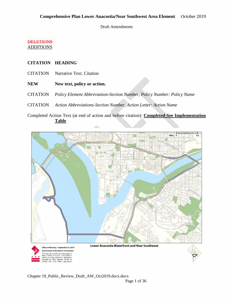
1900.1 The Lower Anacostia Waterfront/Near Southwest Planning Area encompasses 3.0 square
miles of land located along both sides of the Anacostia River in the southwest and
southeast quadrants of the District of Columbia. The boundaries include the I-395
Freeway to the north, Anacostia Park and portions of South Capitol Street to the
east and south and the Washington Channel to the west. Its boundaries are shown in
the Map to the left. This Planning Area includes parts of Wards 6, 7, and 8. In the past,
portions of this Planning Area have also been in Ward 2. 1900.1
1900.2 The Anacostia waterfront is home to many of Washington’s great neighborhoods.
frontier for the 21st century. Much of its shoreline on the cusp of has been experiencing
a transformation set in motion by the 2003 Anacostia Waterfront Framework Plan,
which set a visionary and ambitious plan for the revitalization of the waterfront into
a world class destination. The former being transformed from a landscape of
industrial, transportation, and government uses continues to transform into one of new
mixed-use neighborhoods, workplaces, civic spaces, parks, and restored natural areas.
Established waterfront neighborhoods stand to benefit greatly. This transformation is
delivering improved access to the shoreline, new recreational amenities, new housing and
transportation choices, and a cleaner natural environment, along with new opportunities
to enhance the resilience of the Anacostia waterfront. 1900.2
NEW The Lower Anacostia/Near Southwest Planning Area includes a diverse mix of
neighborhoods and architecture. New high rise multifamily buildings dominate the
Capitol Riverfront and the Wharf. The Southwest neighborhood is known for its
mix of low and high density modernist buildings, and other areas closer to Capitol
Hill maintain the historic rowhouse blocks amid new construction. There is a mix
of high rise, public housing and other subsidized housing throughout the area.
1900.3 Residents of the Lower Anacostia/Near Southwest Waterfront Planning Area have
multiple transit options, including seven Metrorail stations, many bikeshare stations
and multiple bus lines. Land uses along the Anacostia waterfront are diverse. These
uses currently include wetlands and large open spaces, the Nationals Ballpark, Audi
Soccer Field, home to the DC United professional soccer team, marinas, a retired
power plant, power plants, housing, commercial centers, and industry Fort McNair. The
Lower Anacostia Waterfront/Near Southwest Planning Area includes the residential
neighborhoods of Southwest and Capitol Riverfront/Navy Yard, which includes the
former Arthur Capper public housing community that was redeveloped beginning
in 2007. The Planning Area’s Its parks and open spaces include Anacostia Park, Poplar
Point, Yards Park, Canal Park, Diamond Teague Park, The Wharf, East Potomac
Park and Hains Point, as well as historic squares and playgrounds in the residential areas.
The area also includes federal military installations such as Fort McNair and the
Washington Navy Yard, and local public facilities such as schools and recreation centers.
It also includes Southeastern University, a business-oriented university catering to the
educational needs of many District residents. 1900.3
1900.4 Significant environmental improvements are coming to the Anacostia River after
years of neglect as Washington’s “second river,” lagging behind the Potomac River
Comprehensive Plan Lower Anacostia/Near Southwest Area Element October 2019
Draft Amendments
Chapter 19_Public_Review_Draft_AW_Oct2019.docx.docx
Page 3 of 36
in visibility, image, and public investment. The District is building, legislating, and
educating for a cleaner Anacostia River that is fishable and swimmable over the
coming decades. With the completion of the Clean Rivers tunnel in 2018, DC Water
is on target to reduce untreated raw sewage going into the Anacostia River by 98%.
Meanwhile, the 2016 Anacostia River Accord is a renewed commitment on the part
of the District, Montgomery County, and Prince George’s County, to work
collaboratively toward removing trash from the Anacostia River, its tributaries, and
watershed. As noted in the Citywide Elements, the Anacostia River itself has suffered
from neglect. It has long been Washington’s “second river” lagging far behind the
Potomac in visibility, image, public investment, and environmental clean-up. Runoff
from the 176-square mile Anacostia River watershed, most of which is in Maryland, has
polluted surface waters and compromised wetlands. This in turn affects water quality in
the Lower Potomac River and the Chesapeake Bay. 1900.4
1900.5 Conditions along the river will change dramatically as the Anacostia Framework Plan is
implemented. The 2003 Anacostia Waterfront Framework Plans part of the legislation
creating the Anacostia Waterfront Corporation, lays out a strategy for improving water
quality, restoring habitat, and improving shoreline parks so that the waterfront becomes
the centerpiece for new and revitalized communities. A network of trails and paths as
part of the Anacostia Riverwalk Trail and reconstructed bridges such as the
completed 11th Street Bridge replacement and future new Frederick Douglass
Memorial Bridge will help mend the divide that the river has symbolized in Washington.
The objective is not only to connect the east and west shorelines, but to connect the city
itself through great parks, public places, and new neighborhoods along a restored river.
1900.5
1900.6 A diverse coalition of public and private sector entities The Anacostia Waterfront
Corporation (AWC) is leading the revitalization of lands along the river and coordinating
environmental and programming initiatives that promote river clean up, public
awareness, and waterfront recreation. Restoring the river’s natural environment is a
central part of the AWC’s revitalization of the Anacostia waterfront neighborhoods.
mission. 1900.6
1900.7 The waterfront area is already experiencing substantial change. Since 2000, over 4
million of square feet of office space have been constructed in the Capitol
Riverfront/Navy Yard area and more than 6,000 and hundreds of new residential
units have been built, with over 800 set aside as affordable units. Over 6,000
residents now live in the Capitol Riverfront/Navy Yard area, with that number
expected to grow to 16,000 by 2020 , making this the fastest growing neighborhood
in the District. Former public housing at Arthur Capper-Carrollsburg is being
transformed into Capitol Quarter, a mixed income community replaced by new
mixed income housing. with planned one-for-one replacement of every public housing
unit removed. Redevelopment has been included includes a new community recreation
center and affordable senior housing. The continued growth of families with young
children in the area has necessitated the reopening and renovation of Van Ness
Elementary school on M Street SE. accompanied by vast improvements in housing
quality, public safety, and project design. One residential building is currently under
construction and two additional residential buildings are planned for the sites

Comprehensive Plan Lower Anacostia/Near Southwest Area Element October 2019
Draft Amendments
Chapter 19_Public_Review_Draft_AW_Oct2019.docx.docx
Page 4 of 36
adjacent to Canal Park (Canal Park is a three block park bounded by M Street, 2nd
Street, 2nd Place and I Street SE). All three buildings will include either affordable
units as well as replacement units for public housing units. Groundbreaking for the
The new Washington Nationals’ Ballpark baseball stadium took place in continues to
draw crowds from across the DC region to games, games, concerts and other events.
Overall, the ballpark hosts about 2.5 million visitors annually. Audi Field, a
professional soccer stadium with a seating capacity of 20,000, opened in July 2018 in
Buzzard Point. Sellout games are bringing thousands of people to this area of the
waterfront. The opening of Yards Park and Canal Park have added over 8 acres of
passive and active recreation space to the neighborhood. early 2006. Phase 1 of the
Wharf in Southwest opened in late 2017 with over 1,000 residential units, office
space and multiple recreation and cultural amenities, transforming the Southwest
waterfront area into a regional draw. Projects on surrounding sites and at Buzzard
Point will continue to transform this area into a new regional waterfront destination for
visitors and residents from all parts of the region, nation, and world. 1900.7
1900.8 Other planned improvements include a 70-acre public park at Poplar Point, and an
Interpretive Nature Center at Kingman Island, the Washington Canal Blocks Park in Near
Southeast, and mixed-use development in the Southwest Waterfront in Buzzard Point
Southeast Federal Center, Carrollsburg, and Poplar Point neighborhoods. Plans for these
areas have been prepared in a broader context, taking into consideration “upriver” sites
such as Reservation 13 and Parkside. Throughout the Planning Area and in the adjacent
areas of Capitol Hill, Upper Northeast, and Far Northeast/ Southeast, neighborhoods will
be better connected to the river by extending streets to the waterfront, adding waterfront
promenades, and providing new forms of transportation such as water taxis. The
completion of the new 11th Street Bridge and the rebuilding of the South Capitol
Street/Frederick Douglass Bridge /12th Street bridges will change the visual profile of the
waterfront and make pedestrian and bicycle crossings safer and easier. As the area’s
population and development continues to grow, including within flood zones near
and along the waterfront, resilient design is critical to riverine and storm surge
flooding and projected sea level rise are critical. 1900.8
1901 History
1901.1 The Anacostia watershed contains lush habitat and diverse ecosystems, which in pre-
colonial times supported the Nacotchtank Native Americans., whose name, when
Anglicized, eventually became Anacostia. In the early years of European settlement, the
river was known as the “Eastern Branch” of the Potomac. It formed the edge of the
federal city and was the terminus of important radial avenues extending out from the U.S.
Capitol in the 1791 L’Enfant Plan. 1901.1
1901.2 In 1799, the Washington Navy Yard was established about a mile south of the
U.S. Capitol. It became the main port for receiving materials to construct the new city’s
monumental buildings. Wharves and fisheries were established along the shoreline, and
ocean-going vessels enjoyed a navigable channel up to the port of Bladensburg,
Maryland. By the mid-1800s, development around the Navy Yard extended across the
river via the 11st Street Bridge to Historic Anacostia (then called Uniontown). Working
Comprehensive Plan Lower Anacostia/Near Southwest Area Element October 2019
Draft Amendments
Chapter 19_Public_Review_Draft_AW_Oct2019.docx.docx
Page 5 of 36
class housing for Navy workers and others employed at the docks and nearby industrial
areas was developed. 1901.2
1901.3 By the time of the Civil War, tobacco farming, clear-cutting of forests, and industrial
activities had silted and polluted the Anacostia. The river shrank from depths of 40 feet to
barely eight feet, making it too shallow for navigation by sea-bound vessels. The Navy
Yard built its last large ship in 1876. After the War, the large tobacco plantations that had
dominated the landscape along the Anacostia River were broken up into smaller farms or
abandoned. The blue-collar settlements around the Navy Yard included a large
population of freed slaves, beginning a long history of African- American neighborhoods
along the river. 1901.3
1901.4 With the construction of Washington’s sewer system in the 1880s, water quality in the
Anacostia River continued to deteriorate. The tidal wetlands were the source of
mosquito-borne malaria outbreaks and were prone to periodic flooding. In 1901, the
Senate Parks Commission suggested (through the McMillan Plan) that riverfront open
space be constructed as means of improving public health conditions and creating
parkland. Between 1902 and 1926, the US Army Corps of Engineers filled in wetlands
and mud flats, and constructed seawalls along the riverbanks in order to create Anacostia
Park. Tons of dredged river bottom were used to create Kingman and Heritage Islands.
However, the McMillan Plan vision of a grand interconnected public park system was
never realized. 1901.4
1901.5 For most of the 20th century, the Anacostia waterfront continued to be the location for
unwanted land uses and neglectful land management practices. Landfilling of the marshes
and wetlands continued through the 1930s and 1940s. Most of the tributaries were re-
routed into storm drains, further compromising the ecosystem and health of the river.
1901.5
1901.6 After World War II, significant population growth in the watershed affected both the
river and the waterfront neighborhoods. While direct dumping into the river was curbed,
highway building and development in the 176- square mile watershed led to continued
pollution from stormwater runoff. Neighborhoods near the Southwest waterfront
deteriorated further and finally were declared “obsolete” by planning documents of the
early 1950s. Plans to rehabilitate the housing in an incremental manner were passed over
in favor of more dramatic plans to clear and rebuild the entire community. These plans
ultimately resulted in the largest urban renewal project in the United States. Thousands of
mostly poor, African-American families were displaced and connections to the waterfront
were further eroded by the new Southeast/Southwest Freeway. 1901.6
1901.7 By the 1970s, a grass roots movement to save the Anacostia River was gaining
momentum. This movement grew during the 1980s and 1990s, as groups like the
Chesapeake Bay Foundation and the Anacostia Watershed Society advocated for the
restoration of the city’s “forgotten” river and improvements to its watershed to reduce
pollution. Initiatives and mandates to clean the Chesapeake Bay and implement federal
water quality programs provided further impetus for action. In March 2000, Mayor
Anthony Williams and 20 different agencies controlling land or having jurisdiction over
the Anacostia shoreline signed the Anacostia Waterfront Initiative Memorandum of
Comprehensive Plan Lower Anacostia/Near Southwest Area Element October 2019
Draft Amendments
Chapter 19_Public_Review_Draft_AW_Oct2019.docx.docx
Page 6 of 36
Understanding (MOU). The MOU led to the production and completion of the Anacostia
Waterfront Framework Plan in November 2003. The Framework Plan is intended to
guide has guided the revitalization of the waterfront and its shoreline communities for
well over a decade, with many actions already realized or underway such as
improvement to water and environmental quality and the ongoing development of
Capitol Riverfront, the Wharf, Buzzard Point, and Hill East. Decades to come.
1901.7
1902 Land Use 1902
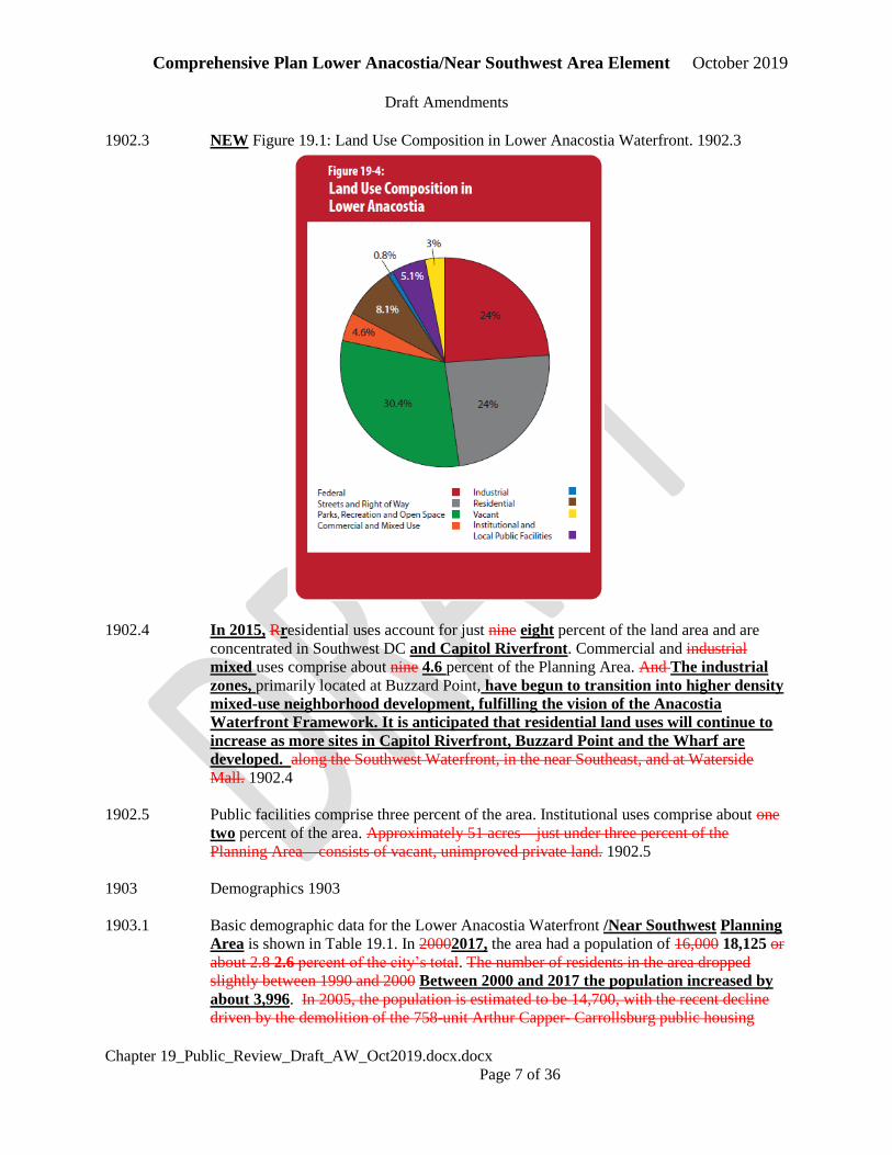
1902.1 Land use statistics for the Anacostia Waterfront Planning Area appear in Figure 19.1. The
area includes 1,884 acres of land and 1,295 acres of water. The Planning Area represents
about five percent of the District of Columbia’s land area. Statistics on existing land use
are estimated from current lot-by-lot property tax data together with additional
information on housing units, employment, DC- and Federal land ownership, parks,
roads, water bodies, etc. They are not comparable to the statistics originally
included in the 2006 Comprehensive Plan, which were based on a much simpler
method. Even large differences between the older and newer statistics may reflect
differences in the modeling approaches used a decade apart and not to actual
changes in land use. 1902.1
1902.2 About 75 25 percent of the Planning Area is in public Federal ownership. Almost 30 A
little over 30 percent of the Planning Area consists of parks and open space. Much of this
land is adjacent to the waterfront and is under the jurisdiction of the National Park
Service. Street rights of way are the second largest land use, representing about 25
percent of the total area. Non-park federal uses include represent 22 percent of the land
area, including Fort McNair and the Navy Yard. 1902.2
Comprehensive Plan Lower Anacostia/Near Southwest Area Element October 2019
Draft Amendments
Chapter 19_Public_Review_Draft_AW_Oct2019.docx.docx
Page 7 of 36
1902.3 NEW Figure 19.1: Land Use Composition in Lower Anacostia Waterfront. 1902.3
1902.4 In 2015, Rresidential uses account for just nine eight percent of the land area and are
concentrated in Southwest DC and Capitol Riverfront. Commercial and industrial
mixed uses comprise about nine 4.6 percent of the Planning Area. And The industrial
zones, primarily located at Buzzard Point, have begun to transition into higher density
mixed-use neighborhood development, fulfilling the vision of the Anacostia
Waterfront Framework. It is anticipated that residential land uses will continue to
increase as more sites in Capitol Riverfront, Buzzard Point and the Wharf are
developed. along the Southwest Waterfront, in the near Southeast, and at Waterside
Mall. 1902.4
1902.5 Public facilities comprise three percent of the area. Institutional uses comprise about one
two percent of the area. Approximately 51 acres—just under three percent of the
Planning Area—consists of vacant, unimproved private land. 1902.5
1903 Demographics 1903
1903.1 Basic demographic data for the Lower Anacostia Waterfront /Near Southwest Planning
Area is shown in Table 19.1. In 20002017, the area had a population of 16,000 18,125 or
about 2.8 2.6 percent of the city’s total. The number of residents in the area dropped
slightly between 1990 and 2000 Between 2000 and 2017 the population increased by
about 3,996. In 2005, the population is estimated to be 14,700, with the recent decline
driven by the demolition of the 758-unit Arthur Capper- Carrollsburg public housing
Comprehensive Plan Lower Anacostia/Near Southwest Area Element October 2019
Draft Amendments
Chapter 19_Public_Review_Draft_AW_Oct2019.docx.docx
Page 8 of 36
project and a slight decline in household size. Average household size in 2005 is
estimated to be 1.78, which is lower than the city average of 2.12. Average household
size has been dropping in the Anacostia Waterfront as it has in other neighborhoods
across the city. It was 1.97 in 1990. The decline is likely to continue in the future as much
of the planned residential development consists of higher density housing with smaller
units. 1903.1
1903.2 As of 2017, just under 52 percent of the Lower Anacostia/Near Southwest Planning
Area’s residents were white, which is a significant increase from 24 percent in 2000.
In 2017 just under 40 percent of the Planning Area’s residents were black, which is
a decrease from 67 percent in 2000. Some of this change in demographics can be
attributed to the net gain in developable land and subsequent new construction of
residential units attracting residents to the area. Additionally, most of the new
residential buildings have primarily consisted of market rate one- bedroom units
attracting more young professionals to the area for the first time. Approximately 6
percent of the area’s residents are of Hispanic origin and 10 percent are foreign
born.
A notable demographic shift is the reduction in the percentage of the population
under the age of 18. In 2017 10.4% of the population was under age 18, compared to
18.4 percent in 2000. These trends reflect the increase in the working-age population
moving into the area. The area’s percentage of older adults over the age of 65
remained generally constant at about 13 percent between 2000 and 2015.
Based on land availability, planning policies, and regional growth and development
trends, the Lower Anacostia Waterfront/Near Southwest Planning Area will
experience significant growth in population, households and jobs over the coming
decades. The population, which was 18,125 in 2017, is expected to grow to 40,200 in
2025, 48,997 in 2035 and 58,789 in 2045. The number of households is expected to
increase from 10,083 to 33,915 in 2045. Approximately 68 percent of the area’s
residents are African-American, which is higher than the citywide average of 60 percent.
Only about four percent of the area’s residents are of Hispanic origin, and almost nine
percent are foreign born. Relative to the city as a whole, the area has about the same
percentage of children (20 percent). The area’s percentage of seniors is 13 percent,
compared to 12 percent citywide. 1903.2
1903.3 Diversity is one of the strengths of the Lower Waterfront community. The Southwest
neighborhood, in particular, is one of the most racially and economically diverse areas in
the District of Columbia. The neighborhood is a microcosm of the city at large; this is
one of the defining characteristics of the community and it is highly valued by residents.
1903.3
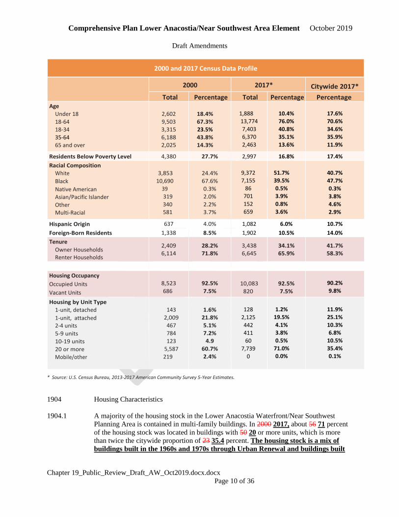
1903.4 NEW Table 19.1 Lower Anacostia Waterfront/Near Southwest at a Glance
Basic Statistics
2000 2010 2017* 2025 2035 2045

Comprehensive Plan Lower Anacostia/Near Southwest Area Element October 2019
Draft Amendments
Chapter 19_Public_Review_Draft_AW_Oct2019.docx.docx
Page 9 of 36
Population
14,129 14,635
18,125
40,200 48,977 58,789
Households 7,848 8,678 10,083 24,205 28,915 33,915
Household Population 13,807 14,487 17,884 39,924 48,696 58,508
Persons Per Household 1.76 1.67 1.77 1.65 1.68 1.73
Jobs 29,645 43,216 52,979 65,698 79,397 92,314
Density (persons per sq mile) 4,710 4,878 6,042 13,400 16,325 19,596
Land Area (square miles) 3.0 3.0 3.0 3.0 3.0 3.0
Comprehensive Plan Lower Anacostia/Near Southwest Area Element October 2019
Draft Amendments
Chapter 19_Public_Review_Draft_AW_Oct2019.docx.docx
Page 10 of 36
* Source: U.S. Census Bureau, 2013-2017 American Community Survey 5-Year Estimates.
1904 Housing Characteristics
1904.1 A majority of the housing stock in the Lower Anacostia Waterfront/Near Southwest
Planning Area is contained in multi-family buildings. In 2000 2017, about 56 71 percent
of the housing stock was located in buildings with 50 20 or more units, which is more
than twice the citywide proportion of 23 35.4 percent. The housing stock is a mix of
buildings built in the 1960s and 1970s through Urban Renewal and buildings built
2000 and 2017 Census Data Profile
2000 2017* Citywide 2017*
Total Percentage Total Percentage Percentage Age
Under 18
18-64
18-34
35-64
65 and over
2,602
9,503
3,315
6,188
2,025
18.4%
67.3%
23.5%
43.8%
14.3%
1,888
13,774
7,403
6,370
2,463
10.4%
76.0%
40.8%
35.1%
13.6%
17.6%
70.6%
34.6%
35.9%
11.9%
Residents Below Poverty Level 4,380 27.7% 2,997 16.8% 17.4%
Racial Composition
White
Black
Native American
Asian/Pacific Islander
Other
Multi-Racial
3,853
10,690
39
319
340
581
24.4%
67.6%
0.3%
2.0%
2.2%
3.7%
9,372
7,155
86
701
152
659
51.7%
39.5%
0.5%
3.9%
0.8%
3.6%
40.7%
47.7%
0.3%
3.8%
4.6%
2.9%
Hispanic Origin 637 4.0% 1,082 6.0% 10.7%
Foreign-Born Residents 1,338 8.5% 1,902 10.5% 14.0%
Tenure
Owner Households Renter Households
2,409
6,114
28.2%
71.8%
3,438
6,645
34.1%
65.9%
41.7%
58.3%
Housing Occupancy
Occupied Units
Vacant Units
8,523
686
92.5%
7.5%
10,083
820
92.5%
7.5%
90.2%
9.8%
Housing by Unit Type
1-unit, detached
1-unit, attached 2-4 units
5-9 units
10-19 units
20 or more
Mobile/other
143
2,009
467
784
123
5,587
219
1.6%
21.8%
5.1%
7.2%
4.9
60.7%
2.4%
128
2,125
442
411
60
7,739
0
1.2%
19.5%
4.1%
3.8%
0.5%
71.0%
0.0%
11.9%
25.1%
10.3%
6.8%
10.5%
35.4%
0.1%
Comprehensive Plan Lower Anacostia/Near Southwest Area Element October 2019
Draft Amendments
Chapter 19_Public_Review_Draft_AW_Oct2019.docx.docx
Page 11 of 36
in the last five years. About 25 percent of the area’s housing stock consists of
rowhouses and townhomes, which is similar similar to the citywide level of 26 percent.
to the citywide average. However, the proportion of single family detached homes in the
Lower Anacostia Waterfront/Near Southwest Planning Area is less than two percent,
which is substantially less than the citywide average of 13 11.9 percent. 1904.1
1904.2 There are currently 87 spaces for “live aboard” vessels and houseboats at the
Southwest Waterfront Gangplank Marina. Once Phase 2 of the Wharf is
completed, that number is expected to increase to 94 spaces. The Planning Area has
more than 220 dwelling units in the “Other” category reported by the US Census,
corresponding mainly to houseboats and live- aboards. These represent 2.4 percent of the
Area’s housing units. 1904.2
1904.3 In 2000 2017 7.5 7.5 percent of the residential units in the Lower Anacostia
Waterfront/Near Southwest Planning Area were vacant, which is is the same as the
vacancy rate in 2000. The percentage of vacant units is comparable slightly lower to the
than the city as a whole. Approximately 48 percent of the area’s residents resided in the
same house in 2000 as they did in 1995, which is also comparable to the citywide
average. Between 2000 and 2017, homeownership rates in the area increased from
28.2 percent to 34.1 percent, while the portion of renter-occupied units decreased.
1904.3
1905 Income and Employment
1905.1 According to the US Census Bureau, 2015 Data, the median household income in
2015 for the Planning Area was $72,904, a 117 percent increase from $35,516 in
2000. Data from the Department of Employment Services and the Office of Planning
indicates there were approximately 32,500 49,511 jobs in the Lower Anacostia
Waterfront Area in 2015. This represents four 6.2 percent of the city’s District’s job
base. According to the 2000 Census, about 40 percent of the jobs in the Planning Area
were filled by Maryland residents and about 38 percent were filled by Virginia residents.
Only about 22 percent were filled by District residents. Job growth is expected to
increase significantly to 65,698 jobs in 2025, 79,397 jobs in 2035 and 92,314 jobs in
2045. 1905.1
1905.2 Most employed residents in the Anacostia Waterfront commute to jobs elsewhere in the
city and region, with about 40 percent commuting to Central Washington, 26 percent
commuting elsewhere in the District of Columbia, 27 percent commuting to Maryland
and Virginia, and only seven percent working within the Anacostia Waterfront Planning
Area. As of the 2000 Census, median household income in the Planning Area was
$33,516, compared to a citywide median of $45,927. Approximately 27 percent of
the residents lived below the federal poverty line, compared to a citywide average of 20
percent. 1905.2
1906 Projections See Previous Demographic Sections for Projections.
Comprehensive Plan Lower Anacostia/Near Southwest Area Element October 2019
Draft Amendments
Chapter 19_Public_Review_Draft_AW_Oct2019.docx.docx
Page 12 of 36
1906.1 Based on land availability, planning policies, and regional growth trends, the Anacostia
Waterfront area is projected to more than double its population between 2005 and 2025.
The Planning Area is expected to grow from 8,100 households in 2005 to 17,500
households in 2025, with a projected increase in population from 14,700 to 33,100. Much
of the growth is expected to consist of moderate to high density residential development
along the Washington Channel and Near Southeast, and on the east side of the waterfront
at Poplar Point. The Waterfront Planning Area represents 17 percent of the household
growth expected in the District of Columbia over the next 20 years. 1906.1
1906.2 The number of jobs is expected to increase from about 32,500 in 2005 to 57,900 in 2025.
Much of the increase is anticipated to occur in the vicinity of M Street SE and along
South Capitol Street. Job growth in this Planning Area represents more than one-fifth of
the citywide 20-year total. 1906.2
1907 Planning and Development Priorities See Introduction for a description of
engagement activities.
1907.1 Planning issues along the Anacostia Waterfront were discussed at many of the
Comprehensive Plan workshops held in 2005 and 2006, particularly at meetings
conducted on Capitol Hill and in Southwest DC. Priorities for this area were more
explicitly stated during the previous three-year process that led to the development of the
Anacostia Waterfront Framework plan. Concurrent planning programs for the Southwest
Waterfront, Reservation 13, and the Near Southeast in the early 2000s involved hundreds
of District residents. Since 2000, several citizens advisory groups, focus groups, and
design charrettes have been convened, providing additional opportunities to identify key
issues and goals. 1907.1
1907.2 The Comprehensive Plan responds to the key messages provided by the community at
these meetings. These are summarized below: 1907.2
a. The river has come to symbolize the widening social and economic divide in the city,
separating “east” from “west” and presenting a challenge to the city’s goal of growing
more inclusively. It should instead become a unifier and a source of economic
opportunity for the neighborhoods on its shores. The waterfront should unite the city
physically, economically, and socially. This will require redefining its image and identity,
and fundamentally redirecting growth patterns in the city toward emerging waterfront
areas.
b. Revitalizing the waterfront must not be done at the expense of the established
communities that exist near its shoreline. Existing neighborhoods and important
community institutions should be conserved and should be the focus of reinvestment
during the coming years. Residents must have a say in the future of the waterfront and
should be protected from displacement as change occurs. Within new neighborhoods,
diverse housing choices should be provided so that a mix of household types and incomes
are accommodated. Affordable housing for working families and for the city’s poorest
residents must be part of this equation. Social and economic diversity must be respected.
Comprehensive Plan Lower Anacostia/Near Southwest Area Element October 2019
Draft Amendments
Chapter 19_Public_Review_Draft_AW_Oct2019.docx.docx
Page 13 of 36
c. The river provides a unique setting for monuments, memorials, and signature features
that can potentially shape and redefine Washington’s identity in the 21st Century. This
potential should not be squandered. The Potomac River is already a celebrated
waterfront, but its character is distinctive in its own way. The Anacostia should be
unique, with activities that invigorate urban life. New destinations should celebrate the
cultural heritage of the city and the nation. As cultural facilities are developed, the
extraordinary and unheralded stories of the neighborhoods along the river should be told.
d. Many of the great open spaces and parks of the Anacostia Waterfront are hard to find,
underutilized, and neglected. These areas should be better connected to one another, and
to the neighborhoods they adjoin. A variety of park environments should be created, from
lively urban waterfront plazas to serene natural settings. Trails and promenades are
needed to provide better access along the shoreline, and to make the waterfront more
accessible to surrounding communities. New parks, recreational areas, and cultural
facilities should be developed.
e. Urban development and natural resource conservation should not be mutually
exclusive but should go hand in hand. Development on the waterfront—and throughout
the watershed—should be environmentally sustainable and designed to minimize
negative effects on water quality and ecological resources. In some cases, plans to reduce
sewage overflows into the river should be accompanied by restoration of wetlands and
buried streams, and conservation of natural habitat. From a regional perspective,
additional density along the waterfront is one of the best examples of “smart growth.” It
can curb urban sprawl by channeling more housing demand back toward the center city.
More density near the waterfront can also be used to leverage the creation of additional
waterfront parks and open spaces.
f. Access between the east and west sides of the river should be improved. “Human”
scale crossings should be emphasized, rather than the existing freeway bridges which are
almost exclusively oriented toward cars and trucks. The design of transportation
infrastructure should be rethought to better serve waterfront neighborhoods, reduce
barriers to waterfront access, and create gateways to waterfront parks. Bridges should be
regarded as opportunities for great civic architecture. In general, transportation design
should strive for a better balance between the needs of cars, and the needs of pedestrians,
bicyclists, and transit users. The river itself should be seen as a transit opportunity, with
water taxis and ferries providing easy access across the river and to riverfront
designations like Georgetown and Alexandria.
g. Development along the waterfront must be designed to respect the scale and integrity
adjacent neighborhoods. As the city works to create distinct waterfront destinations, it
also restore and rehabilitate historic structures, protect views and sunlight, reinforce
neighborhood commercial centers, and enhance the quality of life for existing residents.
While densities in new waterfront communities are likely to be higher than those in
adjacent communities, they should not be visually overwhelming. This is particularly true
where new development sites abut fine-grained row house neighborhoods that have
existed for more than a century. Planning for large-scale development must be responsive
to local concerns about traffic, crowd-control, displacement, community service impacts,
and changing neighborhood character. 1907.2

Comprehensive Plan Lower Anacostia/Near Southwest Area Element October 2019
Draft Amendments
Chapter 19_Public_Review_Draft_AW_Oct2019.docx.docx
Page 14 of 36
1908 AW-1.1 Guiding Growth and Neighborhood Conservation
1908.1 The following general policies and actions should guide growth and neighborhood
conservation decisions in the Lower Anacostia Waterfront and Near Southwest area.
These policies and actions should be considered in tandem with those in the citywide
elements of the Comprehensive Plan. 1908.1
1908.2 Policy AW-1.1.1: Conservation of Established Waterfront Neighborhoods
Revitalize and preserve established neighborhoods in the Waterfront Planning Area,
while promoting infill development to provide new housing opportunities, including
accessory dwelling units, to meet a range of affordability levels and housing needs.
Continued investment in the existing housing stock and in established local commercial
areas should be strongly encouraged. 1908.2
1908.3 Policy AW-1.1.2: New Waterfront Neighborhoods
Create new mixed- use neighborhoods on vacant or underutilized waterfront lands,
particularly on large contiguous publicly-owned waterfront sites. Within the Lower
Anacostia Waterfront/Near Southwest Planning Area, new neighborhoods should be
continue to be developed at the Southwest Waterfront, Buzzard Point, Poplar Point,
Southeast Federal Center and Navy Yard/Capitol Riverfront. and Carrollsburg areas.
These neighborhoods should be linked to new neighborhoods upriver at Reservation 13,
Poplar Point, and Kenilworth-Parkside via trails, additional water recreation
opportunities and improved park access points along the Anacostia shoreline. A
substantial amount of new housing and commercial space should be developed in these
areas, reaching households of all incomes, types, sizes, and needs. Opportunities for
neighborhood-scale energy utilities as part of the development of these areas should
be evaluated, utilizing traditional fuels or wastewater thermal to provide greater
environmental benefits for the community. The new waterfront neighborhoods
should integrate new parks and amenities, enhance public access to the waterfront,
and incorporate resilient design to mitigate flooding. 1908.3
NEW Policy AW—Lower Anacostia Waterfront Infrastructure for Flood Mitigation
Identify locations of future development that are at-risk of flooding to help
prioritize infrastructure improvements to mitigate flooding. Encourage the
inclusion of parks, open space, and other improvements around denser development
that preserve or enhance the natural function of floodplains.
NEW Policy AW Lower Anacostia Waterfront Flood Modeling
Prioritize the Lower Anacostia waterfront area for comprehensive flood modeling of
projected sea level rise and future flood hazard conditions, because the area’s
flooding potential is not accounted for in the current Flood Insurance Rate maps.
Local studies should be used that are not currently accounted for in the District’s
Comprehensive Plan Lower Anacostia/Near Southwest Area Element October 2019
Draft Amendments
Chapter 19_Public_Review_Draft_AW_Oct2019.docx.docx
Page 15 of 36
currently effective Flood Insurance Rate Maps, s and used in tandem with Policy
AW-R.3 (below) for encouraging climate-adaptive development.
NEW Policy AW – Flood Resilient and Climate-Adaptive Development
Provide guidelines and promote the planning, design, construction, and
management of resilient buildings in flood hazard areas within the Lower Anacostia
Waterfront/Near Southwest Planning Area. Design and construct developments to
be adaptive to future flood hazard conditions due to storm surge and sea level rise.
See Urban Design Element for additional guidance.
NEW Policy AW-- Resilient Affordable Housing
Incorporate climate resilience measures into the rehabilitation of existing affordable
housing and the creation of new affordable housing, including public housing,
located in the Lower Anacostia Waterfront/Near Southwest Planning Area to
protect these units against current and projected future flood conditions.
1908.4 Policy AW-1.1.3: Waterfront Area Commercial Development
Encourage commercial development in the Waterfront Area in a manner that is consistent
with the Future Land Use Map. Such development should bring more retail services and
choices to the Anacostia Waterfront as well as space for government and private sector
activities, such as offices and hotels. Commercial A mix of high- density commercial
and residential development should be focused along key corridors, particularly along
Maine Avenue and M Street Southeast, along South Capitol Street; and near the
Waterfront/SEU and Navy Yard metrorail Metrorail stations. Maritime activities such as
cruise ship operations should be maintained and supported as the waterfront redevelops.
1908.4
1908.5 Policy AW-1.1.4: Waterfront Development Amenities
Leverage new development in the Waterfront Planning area to create amenities and
benefits that serve existing and new residents. These amenities should include parks, job
training and educational opportunities, new community services, and transportation and
infrastructure improvements. 1908.5
1908.6 Policy AW-1.1.5: River Basins as a Planning Guide
Recognize and be responsive to the distinct settings and environments created by varying
conditions along the shoreline. Consistent with the Anacostia Framework Plan, the river
should be viewed as a series of “basins,” each defined by their unique physical and visual
characteristics. In general, there should be a progression from a more urban environment
on the lower basins (Washington Channel and the river gateway) to a more natural
environment on the upper basins such as Kingman and Heritage Islands, and the
Arboretum.Arboretum, etc.) 1908.6
1908.7 Policy AW-1.1.6: Pedestrian Orientation of Waterfront Uses
Provide a high level of pedestrian and cyclist amenities along the shoreline, including
informational and interpretive signs, benches and street furniture, and public art.
Pedestrian and cyclist facilities should be designed to accommodate the greatest
number of users with varying abilities. Where possible, trail design should support
the safe use of the trail in the evenings. Continue to coordinate with federal agencies
Comprehensive Plan Lower Anacostia/Near Southwest Area Element October 2019
Draft Amendments
Chapter 19_Public_Review_Draft_AW_Oct2019.docx.docx
Page 16 of 36
to ensure the continuity of character and wayfinding, and explore additional
opportunities for public access, on federally-owned waterfront properties. 1908.7
1908.8 Policy AW-1.1.7: Multi-modal Waterfront Streets
Design streets along the waterfront to be truly multi-modal, meeting the needs of
pedestrians, bicyclists, and transit users as well as motor vehicles. Safe pedestrian
crossings, including overpasses and underpasses, should be provided to improve
waterfront access. 1908.8
1908.9 Policy AW-1.1.8 Barriers to Shoreline Access
Minimize the visual and accessibility impacts of railroad and highway infrastructure,
surface parking, access roads and industrial uses along the Anacostia River Shoreline. In
particular, the impacts of freeways on waterfront access should be mitigated by
supporting the redesign of these facilities as tunnels or landscaped boulevards. Explore
ways to mitigate the impacts of highway infrastructure on shoreline access for
neighborhoods east of the Anacostia River. Continue to increase the number of boat
slips, waterside amenities, and water recreation options such as kayaking and
paddle boarding along the Anacostia shoreline. 1908.9
NEW Policy AW 1.1.X Southwest Ecodistrict Plan Implementation
Explore ways to jointly fund the implementation of recommendations of the
Southwest Ecodistrict Plan in coordination with the National Capital Planning
Commission (NCPC) to improve the aesthetic quality, identity, and pedestrian
character of Near Southwest and strengthen connections between the Wharf and the
National Mall. Identify and implement design guidelines for new or renovated
buildings, streetscape and signage improvements, pedestrian circulation changes,
and measures to mitigate the scale of the area’s monolithic buildings. Promote new
residential, cultural and/or retail uses if federal properties transfer from federal use,
or pursuant to any new arrangements with the NCPC such as 99- year ground
leases.
1908.11 Policy AW-1.1.10: Upgrading the Bridges
Upgrade the bridges across the Anacostia River to better manage transportation flows,
ensure their safety for decades to come, facilitate pedestrian and bicycle travel across the
river, and provide attractive and distinctive civic landmarks. 1908.11
1908.12 Action AW-1.1.A: Anacostia Waterfront Framework Plan
Implement the recommendations of the Anacostia Waterfront Framework Plan through
interagency coordination among District and federal agencies, community
stakeholders, Business Improvement Districts (BIDs), private property owners, and
environmental, philanthropic and community organizations. ongoing activities of the
Anacostia Waterfront Corporation, and continued cooperative efforts with the federal
government. 1908.12
1908.13 Action AW-1.1.B: River Crossing Improvements
Implement the recommendations of the Middle Anacostia River Transportation Crossings
Study that seek to improve local and regional traffic mobility. 1908.13
Comprehensive Plan Lower Anacostia/Near Southwest Area Element October 2019
Draft Amendments
Chapter 19_Public_Review_Draft_AW_Oct2019.docx.docx
Page 17 of 36
1909 AW-1.2 Conserving and Enhancing Community Resources 1909
1909.1 Policy AW-1.2.1: Historic and Cultural Waterfront Assets
Capitalize on the historic and cultural assets located near the Lower Waterfront, such as
the Washington Navy Yard and Fort McNair. Public education about these assets should
be expanded, the physical trail connections and wayfinding signage between them
should be enhanced, and greater recognition of their value and importance should be
achieved. 1909.1
1909.2 Policy AW-1.2.2: Waterfront Cultural and Commemorative Sites
Encourage the siting of new museums, memorials, civic gathering places, and cultural
attractions on or near the Anacostia River as a way to catalyze revitalization and meet the
demand for additional commemorative works without further crowding the National Mall and monumental core of the city. Such facilities should make the most of their waterfront
locations and create an integrated system of gracious, beautiful, and vibrant places.
1909.2
1909.3 Policy AW-1.2.3: Waterfront Sports and Recreation Destinations
Continue to develop new destinations for sports, recreation, and celebration on or near
the Anacostia waterfront, including as part of future development at Buzzard Point
and Poplar Point. Ensure that these destinations are served by adequate and efficient
transportation systems and infrastructure. 1909.3
1909.4 Policy AW-1.2.4: Anacostia River Parks
Create a connected network of waterfront parks from Hains Point to the Sousa Bridge,
and continuing through adjacent upriver Planning Areas to the Maryland border. These
parks should be easily accessible to surrounding neighborhoods and accommodate the
need for more local and regional serving recreational activities in the city. New parks
should be an integral part of any new waterfront neighborhood and should showcase the
remarkably diverse landscape along the Anacostia River. A variety of active and passive
recreational settings should be provided. Parks should be designed to enhance
resilience to flooding and incorporate natural shorelines where feasible. 1909.4
1909.5 Policy AW-1.2.5: African-American Heritage
Recognize and highlight the role of Lower Anacostia Waterfront neighborhoods in the
history of the District’s African-American community. Acknowledge the impact of the
African-American community ole should be through markers, heritage trails, and
cultural facilities. 1909.5
1910 AW-2 Policy Focus Areas 1910
1910.1 The Comprehensive Plan has identified four six areas in the Lower Anacostia/Near
Southwest Waterfront Planning Area as “policy focus areas,” meaning that they require a
level of direction and guidance above that in the prior section of this Area Element and in
the citywide elements (see Map 19.1 and Table 19.2). These six areas are:
• Southwest Waterfront, home of the Wharf development and the historic to the
Washington Fish Market and popular waterfront restaurants
Comprehensive Plan Lower Anacostia/Near Southwest Area Element October 2019
Draft Amendments
Chapter 19_Public_Review_Draft_AW_Oct2019.docx.docx
Page 18 of 36
• South Capitol Street, a major axis to the US Capitol and Anacostia River
/Buzzard Point, site of the new Washington Nationals Ballpark and a still active
waterfront industrial district
• Near Southeast/Capitol Riverfront, home the Navy Yard, Nationals Ball
Park, acres of waterfront parks and thousands of new residential units. an
emerging office and residential development area
• Poplar Point, a large and prominent site on the river’s eastern edge currently
under federal ownership and adjacent to Anacostia Park.
• Southwest Neighborhood, an established and diverse residential community
located in between the Wharf and Buzzard Point
• Buzzard Point, a traditionally industrial area currently into an emerging
mixed-use waterfront neighborhood and the home of the Audi Field soccer
stadium. 1910.1
910.2 NEW Map 19.1: Lower Anacostia Waterfront/Near Southwest Policy Focus Areas.

Comprehensive Plan Lower Anacostia/Near Southwest Area Element October 2019
Draft Amendments
Chapter 19_Public_Review_Draft_AW_Oct2019.docx.docx
Page 19 of 36
1910.3 Table 19.2 Policy Focus Areas Within and Adjacent to Lower Anacostia Waterfront/Near
Southwest
Policy Focus Areas Within and Adjacent to
Lower Anacostia Waterfront/Near Southwest 1910.3
Comprehensive Plan Lower Anacostia/Near Southwest Area Element October 2019
Draft Amendments
Chapter 19_Public_Review_Draft_AW_Oct2019.docx.docx
Page 20 of 36
1911 AW-2.1 Southwest Waterfront 1911
1911.1 The Southwest Waterfront is a 45-acre area along the Washington Channel, stretching
three quarters of a mile along Maine Avenue from the Tidal Basin to Fort McNair.
The area includes the Washington Fish Market, portions of East Potomac Park, a
boating/residential community at Gangplank Marina, and the Wharf, a mixed- use
development on the Southwest waterfront. restaurants and entertainment uses, and
parking areas. Nearby uses include the Arena Stage, several churches, Waterside Mall,
office buildings, and apartments. Major points of access include 4th, 6th, 7th, and 9th
Streets SW, M Street SW, and the L’Enfant and WaterfrontSEU Metro Stations. 1911.1
1911.2 Although it is relatively accessible and familiar to residents of Southwest, the Southwest
Waterfront is in recent years had not been not the active, public, civic space it could be.
Historically, roads and parking lots accounted for over 40 percent of the area, with
multiple lanes of traffic between the shoreline and adjacent residential areas. L’Enfant
Plaza and the National Mall are just a few blocks away. Until recently, there were no
clear means of pedestrian access from these heavily visited areas to the shoreline. With
much of the Southwest Waterfront in public ownership, the city has had a unique
opportunity to create a place that serves both as an extension of the adjacent
neighborhood and a new regional destination. 1911.2
Within Lower Anacostia Waterfront/Near Southwest
2.1 Southwest Waterfront
2.2 South Capitol Street/Buzzard Point
2.3 Near Southeast
2.4 Poplar Point
2.5 Southwest Neighborhood
2.6 Buzzard Point
Adjacent to Anacostia Waterfront
1 Pennsylvania Avenue Corridor/Capitol Hill
2 Historic Anacostia
3 Barry Farm/Hillsdale/Stanton
4 St. Elizabeths Hospital
5 Pennsylvania Ave SE Corridor (east of the River) (see p. 17-22)
6 Reservation 13/RFK Stadium (see p. 15-28)
Comprehensive Plan Lower Anacostia/Near Southwest Area Element October 2019
Draft Amendments
Chapter 19_Public_Review_Draft_AW_Oct2019.docx.docx
Page 21 of 36
1911.3 The District completed the Southwest Waterfront Development Plan in 2003, adopting
short-term and mid-term actions to transform the area. The Plan calleds for eliminating
Water Street and improving Maine Avenue as a pedestrian-friendly urban street. The
elimination of Water Street and replacement of surface parking with structured parking
has increased available public space and developable land and will has allowed for the
creation of new parks, plazas and mixed-use development. Active ground floor uses such
as retail stores, restaurants and performance venues are now making this area an active
and animated urban waterfront. 1911.3
1911.4 While the Southwest Waterfront Plan provides important guidance, the specific
development square foedotage and housing-unit targets should be interpreted as I
illustrative, as they were developed in 2003 under different market conditions. sketches in
Final development plans for the Southwest Waterfront should respond to guidance of the
Southwest Waterfront Plan, envision some 800 new residences, a large hotel, and
more than 500,000 square feet of retail, office, cultural, and civic uses. Construction of
The Wharf at the Southwest waterfront began in 2014. The first phase of
development delivered in 2017 and includes a mix of housing, office, retail, hotel and
concert venues as well as improved public waterfront access, recreational piers, and
green space. Following the recommendations from the previous planning effort and
extensive community input, The Wharf will include over 3 million square feet of
mixed use development at full build-out. The mix of market-rate and affordable
residential units and commercial development, with retail, restaurants and
entertainment offerings, has created a vibrant new waterfront destination and
regional attraction. as well as new policies in the Comprehensive Plan that support
sustainable and compact development that enhances access to transit. Illustrative sketches
in the Southwest Waterfront Plan envision new residences, hotels, retail, office, cultural,
and civic uses. New public gathering places will include an urban “Market Square” near
the Fish Wharf, and a more passive Civic Park at the south end of the waterfront near M
Street SW. Between these spaces will be a series of smaller plazas on the Washington
Channel that mark the ends of local streets.
The existing fish market will be retained in its present location and refurbished, with its
low-scale character maintained. Additionally, the Wharf includes expanded piers,
additional boat slips and several acres of waterfront parks and a promenade.
Development of the park at the south end of the waterfront is contingent on a number of
factors, including relocation of the tour-boat terminals and surface parking to a new
location further north on the Channel. Until this can be accomplished, the existing
terminals will be supported in their current location. Even though the Future Land Use
Map designates the location of the tour-boat terminals and their surface parking as Mixed
Use Low Density Commercial and Parks, Recreation, and Open Space, the existing low
density commercial use and zoning would not be inconsistent with this map designation.
1911.4
1911.5 The District has worked with federal and local partners to improve The illustrative
plans also suggest improving pedestrian access to the waterfront via the Banneker
Overlook at 10th Street SW. The area also has seen the development of new museums in
Comprehensive Plan Lower Anacostia/Near Southwest Area Element October 2019
Draft Amendments
Chapter 19_Public_Review_Draft_AW_Oct2019.docx.docx
Page 22 of 36
this vicinity further north, close to L’Enfant Plaza and is benefitting from new water taxi
service, transit improvements, and landscaping. 1911.5
1911.6 Ongoing plans for the Southwest Waterfront should be implemented in a way that
recognizes continues to recognize the broader context of the Southwest neighborhood
and its connection to the National Mall. Southwest is a strong urban community which
benefits from the wide social, economic, and ethnic diversity of its residents, as well as a
diverse mix of housing types and affordability levels. The neighborhood includes
Waterside Mall, initially envisioned as Southwest’s “Town Square” in the 1950s-era
urban renewal plans. Today the Mall is an office and retail complex of over one million
square feet of floor space, including a supermarket, drug store, and bank. Waterside Mall
never evolved into the Town Square it was envisioned to become, and today is planned
for redevelopment. Plans for the site call for the re-establishment of 4th Street through
the site, and the retention and improvement of retail and office space—along with new
uses such as housing and open space. 1911.6
1911.7 Policy AW-2.1.1: Mixed Use Development
Support the redevelopment of the Southwest Waterfront with medium to high-density
housing, commercial and cultural uses, and improved open space and parking. The Future
Land Use Map shows high density development and it is expected that the project will
capitalize on height opportunities to provide public spaces and, where appropriate, a mix
of medium development density in order to transition to the surrounding neighborhoods.
The development should be designed to make the most of the waterfront location,
preserving views and enhancing access to and along the shoreline. 1911.7
1911.8 Policy AW-2.1.2: New Public Spaces and Open Space
Continue to Ccreate additional public spaces and plazas at the Southwest waterfront
during the second phase of construction, including the continuation of the public
promenade at the water’s edge and a new marina. Public piers should extend from each
of the major terminating streets, providing views and public access to the water. 1911.8
1911.9 Policy AW-2.1.3: Connecting to the Southwest Waterfront
Continue to enhance pedestrian connections from the Southwest neighborhood,
Waterfront Metrorail Station and L’Enfant Plaza area to the Washington Channel
Wharf by creating new public spaces and trails, eliminating Water Street, reducing
surface parking, linking the Banneker Overlook to Maine Avenue, and providing safer
pedestrian crossings across Maine Avenue. 1911.9
1911.10 Policy AW-2.1.4: Maine Avenue
Continue to transform Maine Avenue into a landscaped urban street that has direct
access to waterfront uses, provides a pedestrian-friendly street environment, and
accommodates multiple modes of travel (including bicycles). Future developments on
the north side of Maine Avenue should be designed to support a pedestrian friendly
environment. 1911.10
1911.11 Policy AW-2.1.5: Washington Channel Maritime Activities
Comprehensive Plan Lower Anacostia/Near Southwest Area Element October 2019
Draft Amendments
Chapter 19_Public_Review_Draft_AW_Oct2019.docx.docx
Page 23 of 36
Reorganize the Washington Channel’s maritime activities, including cruise ship berths
and marinas, to provide more appropriate relationships to landside uses and provide
opportunities for water taxis, ferries, and other forms of water transportation. In
implementing this policy, cruise ship operations should be retained and supported,
recognizing their economic benefits to the city and their recreational and cultural value
for residents and tourists. 1911.11
MOVED Policy AW-2.1.6: Waterside Mall
Continue to support the redevelopment of Waterside Mall with residential, office, and
local-serving retail uses. The site should be strengthened as a retail anchor for the
surrounding Southwest community. New development on the former Waterside Mall site
should leverage the reopened 4th Street SW connection between I and M Streets SW to
facilitate greater pedestrian activity and new retail and neighborhood services on the
corridor. 1911.12
1911.13 Action AW-2.1A: Southwest Waterfront Development Plan
Implement the 2003 Southwest Waterfront Development Plan. 1911.13
1911.14 Action AW-2.1.B: Long-Term Improvements
Study the feasibility of the long-term improvements identified in the Southwest
Waterfront Plan, such as a Hains Point Canal (in East Potomac Park), relocation of cruise
lines and their infrastructure, a new Yellow Line Metro station at the waterfront, and
construction of a pedestrian/bicycle bridge across the Channel near the Case Bridge.
1911.14
1912 AW-2.2: South Capitol StreetBuzzard Point 1912
1912.1 South Capitol Street is one of the District’s four principal axes and marks the division
between the southeast and southwest quadrants of the city. It is an important part of the
regional highway system, with traffic volumes of approximately 100,000 52,000 cars per
day. The street provides many residents and visitors with their first view of the U.S.
Capitol building and is an important gateway into Central Washington. 1912.1
1912.2 This symbolic role contrasts with the current state of the corridor. Awkwardly shaped
properties, some vacant and others barricaded from public access, front the street between
the U.S. Capitol and I-395. Elevated railroad tracks and freeway ramps obstruct vistas
and the massive Capitol Power Plant is an additional looming presence. South of I-395,
the street enters into a mix of new residential high-rise buildings, jumble of fast food
restaurants, gas stations, poorly maintained commercial uses, vacant businesses, the
Nationals Ballpark, and parking lots. South of the Frederick Douglass Bridge, these uses
give way to an eclectic mix of industrial and utility uses along the shoreline, including a
power plant. 1912.2
1912.3 The transportation infrastructure in the area also creates a significant barrier to
connectivity to surrounding areas. Both South Capitol Street and the Frederick
Douglass Bridge are in need of repair. There are no bike lanes along South Capitol Street
and sidewalks are minimal and unshaded. High speed traffic and the lack of signalized
intersections have been a deterrent to increasing active and safe bike and pedestrian
Comprehensive Plan Lower Anacostia/Near Southwest Area Element October 2019
Draft Amendments
Chapter 19_Public_Review_Draft_AW_Oct2019.docx.docx
Page 24 of 36
access investment and create a harsh environment for pedestrians. These issues will be
addressed as part of the South Capitol Street Corridor Project currently underway.
This major capital project extending across the Anacostia River will make major
streetscape improvements to South Capitol Street and create a new Frederick
Douglass Memorial Bridge. This project represents the largest capital project that
the District Department of Transportation has ever undertaken. 1912.3
1912.4 For the last ten years Since the mid-1990s, the District has been working with its federal
partners to transform South Capitol Street into a grand urban boulevard with a mix of
land uses and commemorative works that are more fitting of its role as a gateway to the
national capital. Such a vision was first laid out in the 1997 National Capital Planning
Commission Legacy Plan, and later refined by the 2003 South Capitol Urban Design
Study. A Task Force including federal and District representatives was convened in 2004
to develop design options and an open space framework for the corridor. Concurrently,
the District selected a 20-acre site on the east side of South Capitol Street between
Potomac Avenue and N Street SE as the site for a new 41,000-seat baseball stadium.
1912.4
1912.5 Over the coming decades years, South Capitol Street will be continue to transformed
into a waterfront gateway with new mixed-use development, green space, broad
sidewalks, and a beautiful new and realigned Frederick Douglass Memorial Bridge.
High-density office, housing, and retail uses are envisioned along the corridor between I-
395 and the shoreline. The Nationals Ballpark stadium will has become the centerpiece
of a new entertainment district that includes cultural attractions, retail, restaurants,
rowhouses and high-density housing in the Capitol Riverfront/Navy Yard area. Near
the foot of the reconstructed Frederick Douglass bridge, an oval traffic rotary is planned
to create a green “commons” for a future national memorial. A new waterfront park will
be created at the shoreline, linked to the network of parks planned up and down the river.
Further south in Buzzard Point, the opening of Audi Field, the new stadium for DC’s
professional soccer team is leading the transformation of this formerly industrial land
into a new waterfront neighborhood with multiple mixed use residential and
commercial development planned or under construction. will be encouraged on. See
the Buzzard Point Policy Focus Area for further guidance.1912.
1912.6 As the design and construction of the South Capitol Street Corridor Project continues into
the coming years, additional agency coordination will help ensure this major
infrastructure investment achieves other District goals for the Lower Anacostia
Waterfront area.etailed area planning for the Baseball Stadium vicinity is already
underway. Future Plans will need to focus on the Buzzard Point waterfront, addressing
such issues as land use compatibility, the relocation (or retention) of existing uses,
transportation and access, urban design, and opportunities for new park and open space
amenities. The Buzzard Point Vision Framework and Design Review Guide,
completed by the Office of Planning in 2017, provides urban design-based guidance to shape future public investments and private mixed-use development as part of
Buzzard Point’s transformation into a new waterfront community. The Framework
supports making South Capitol Street more pedestrian- and bike-friendly to and
from Buzzard Point and includes recommendations to inform the design of the new
Oval Park being created through the South Capitol Street Corridor project. Plans

Comprehensive Plan Lower Anacostia/Near Southwest Area Element October 2019
Draft Amendments
Chapter 19_Public_Review_Draft_AW_Oct2019.docx.docx
Page 25 of 36
for this area should improve connections between Southwest and the waterfront, and
should retain and improve the established low-scale residential areas on the west side of
South Capitol Street. 1912.6
1912.7 Policy AW-2.2.1: South Capitol Street Urban Boulevard
Transform South Capitol Street into a great urban boulevard and “walking” street,
befitting its role as a gateway to the U.S. Capitol and a major Anacostia River crossing.
Development along the street should include a mix of federal, District, and private uses.
1912.7
1912.8 Policy AW-2.2.2: Ballpark Entertainment District and Capitol Riverfront
Leverage the construction success of the Washington Nationals Ballpark and Audi Field,
the new professional soccer stadium, drawing residents, workers and visitors to the
Capitol Riverfront/Navy Yard area to catalyze additional development of the South
Capitol Street corridor with retail, high density residential, entertainment, and
commercial uses. 1912.8
1912.9 Policy AW-2.2.3: South Capitol Commemorative and Civic Uses
Incorporate ceremonial uses such as memorials, plazas, monuments, museums and other
commemorative works, along the South Capitol Street Corridor. The revitalized street
provides a significant opportunity to expand civic and cultural facilities beyond the
confines of the monumental core. 1912.9
1912.10 Policy AW-2.2.4: South Capitol Street Transit Improvements
Promote transit multimodal transportation improvements along the South Capitol
Corridor, including transit options like streetcar or bus rapid transit, and improved
pedestrian connections to the Navy Yard and Waterfront Metrorail stations. at Navy
Yard and Waterside Mall/SEU. 1912.10
1912.11 Policy AW-2.2.5: South Capitol Open Space
Create additional open space in the South Capitol Street corridor, including an oval traffic
rotary and South Capitol “commons” and a new waterfront parks and plazas along the
Anacostia shoreline. 1912.11
1912.12 Policy AW-2.2.6: South Capitol Neighborhood Buffers
Ensure that the established communities adjacent to the South Capitol Street corridor,
including the James Creek, Syphax and Greenleaf Gardens housing projects and adjacent
residential areas, are buffered from adverse impacts associated with increased density
development capacity and traffic relating to stadium area development. Avoid
displacing Conserve these communities as they are an important part of the city
fabric,and provide as affordable housing resources for the Southwest community.
1912.12
MOVED Policy AW-2.2.7: Buzzard Point
Support the long-term redevelopment of Buzzard Point with mixed medium- to high-
density commercial and residential uses. Recognize the opportunity for innovative design
and architecture in this area, and for the creation of a unique urban waterfront 1912.13
Comprehensive Plan Lower Anacostia/Near Southwest Area Element October 2019
Draft Amendments
Chapter 19_Public_Review_Draft_AW_Oct2019.docx.docx
Page 26 of 36
1912.14 Action AW-2.2.A: Coordination with Federal Agencies
Continue to coordinate with the National Capital Planning Commission, the National
Park Service, and other federal agencies on implementing and refining the South Capitol
Street Corridor project. 1912.14
1912.15 Action AW-2.2.B: Ballpark Area Plan
Work collaboratively with the Anacostia Waterfront Corporation in completing detailed
area plans for the Ballpark entertainment district. Completed- See Implementation
Table. 1912.15
1912.16 Action AW-2.2.C: Buzzard Point Plan
Work collaboratively with the community stakeholders Anacostia Waterfront
Corporation in developing a detailed area plan for Buzzard Point. The Plan should
address the future of industrial and utility uses in Buzzard Point, identify concepts and
standards for new development, and address a range of related urban design,
transportation, infrastructure, environmental, and community service issues. The
feasibility of access along the Fort McNair waterfront also should be addressed.
Completed-See Implementation Table. 1912.16
1912.17 Action AW-2.2.D: South Capitol Gateway
Create a civic or commemorative feature of national significance at the north end of the
Frederick Douglass Bridge to celebrate this location as a riverfront and city gateway.
1912.17
1912.18 Action AW-2.2.E: South Capitol Transportation Improvements
Continue efforts to improve traffic flows and accommodate additional travel modes along
South Capitol Street, including completion of the South Capitol Environmental Impact
Statement and the reconstruction of the Frederick Douglass Memorial Bridge and related
access points. 1912.18
1913 AW-2.3 Near Southeast/Capitol Riverfront 1913
1913.1 The Near Southeast includes the triangular area between the I-695 and the Southeast
Boulevard Southeast/Southwest Freeway, South Capitol Street, and the Anacostia
River. This 350-acre area has played an important role in the history of Washington,
D.C.—its initial settlement even predates the creation of the District of Columbia. In the
19th century, this was a community where residential streets came down to the river’s
edge, a place teeming with life and maritime activity. Near Southeast suffered substantial
disinvestment during the second half of the 20th century, however, along with social and
economic decline. The 2000 Census reported that the area had one of the highest poverty
and unemployment rates in the city. Much of the land near the shoreline still sits vacant
today and is fenced off from public access. 1913.1
1913.2 Over the last ten fifteen years, District and federal initiatives have begun have to
transformed the Near Southeast into a dynamic waterfront neighborhood and workplace.
These initiatives have included the relocation of 5,000 federal employees back to the
Comprehensive Plan Lower Anacostia/Near Southwest Area Element October 2019
Draft Amendments
Chapter 19_Public_Review_Draft_AW_Oct2019.docx.docx
Page 27 of 36
Washington Navy Yard, the redevelopment of the Arthur Capper Carrollsburg public
housing project through the federal HOPE VI program, construction of a new
headquarters for the US Department of Transportation, and the reconfiguration of the 55-
acre Southeast Federal Center to allow new housing, offices, and waterfront parkland.
Significant private and public investment has followed, including the construction of new
office buildings, hotels, and housing as well as the Nationals Ballpark. Signature new
parks such as Yards Park, an award-winning 4-acre waterfront park, are drawing
thousands of visitors weekly. and m2ost recently, groundbreaking for the new
Washington Nationals ballpark (see discussion under Section AW-2.2). 1913.2
1913.3 Revitalization of the Near Southeast/Capitol Riverfront has been one of the
cornerstones of the Anacostia Waterfront Initiative (AWI). A 2003 AWI Urban Design
Plan for the area provides a framework for its redevelopment. The Plan seeks to harness
the development momentum in the Near Southeast and provide the direction necessary to
help the neighborhood reach its full potential. While many of the recommendations
from the 2003 AWI Plan have been completed, future development should continue
to create It also addresses the infrastructure, transportation, open space, and streetscape
improvements necessary to support redevelopment. The Near Southeast Plan establishes
strategies to reconnect the area to the river, create mixed income housing opportunities,
provide pedestrian-friendly streets, enhance neighborhood resilience to flooding and
other climate threats, and establish great public spaces both on the waterfront and in the
adjacent neighborhood. One of its AWI’s most important principles is to preserve
existing low- income housing in the area, while adding thousands of units of new market
rate and affordable housing. 1913.3
1913.4 The Near Southeast Urban Design Plan, as part of the Anacostia Waterfront Initiative
envisioneds M Street SE as a great urban boulevard with high-density offices and
apartments activated by ground floor retail space, restaurants, and civic uses. It calls for
the extension of New Jersey Avenue and other streets in the city grid to the waterfront,
terminating at a new shoreline park and waterfront promenade, which has been
completed as Yards Park. The Plan calls for the preservation of important historic
resources and the respectful integration of future developments with those of historic
resources. These include the majority of the Navy Yard, which is now designated as
historic and such as the “Blue Castle” trolley barn and Latrobe Gate at the Navy Yard,
as well as the historic street grid and network of park reservations laid out by Pierre
L’Enfant. Strategies to link the area with adjacent neighborhoods like Southwest and
Capitol Hill also are provided. 1913.4
1913.5 Several subareas are were identified by the Near Southeast Urban Design Plan, with land
use and urban design goals set forth for each. These areas are South Capitol Gateway,
Canal Blocks, Capper Carrollsburg, the Marine Barracks area, the 8th Street SE historic
area, East M Street, the Navy Yard, the Southeast Federal Center, and the WASA pump
station area. Strategies to better connect and integrate these areas are provided. The Near
Southeast Plan lays laid out a street and block plan for the entire area, as well as a trail
system and open space framework. Guidelines for specific sites such as Florida Rock
(near the foot of South Capitol) and Maritime Plaza (the former Washington Gas site) are
were provided to ensure that planned development fits into the framework for the overall
area. 1913.5
Comprehensive Plan Lower Anacostia/Near Southwest Area Element October 2019
Draft Amendments
Chapter 19_Public_Review_Draft_AW_Oct2019.docx.docx
Page 28 of 36
1913.6 The Near Southeast Urban Design Plan envisioneds a net increase of 4,200 housing
units, 13.6 million square feet of office space, and 705,000 square feet of retail area
within the area’s boundaries. The Plan also identified more than 40 acres of new parks
and open space. Since the launch of the Anacostia Waterfront Initiative and
completion of the Near Southeast Urban Design Plan, the Capitol Riverfront area
largely fulfilled the vision of these plans. As of 2017, Capitol Riverfront is now home
to over 6,000 new residential units, 6.2 million square feet of office space and 34,000
daytime employees. Over 10 acres of parks and 400,000 square feet of retail have
also been developed. Additional residential buildings, retail and other amenities are
currently planned or under construction. Collaborative planning between the District,
the federal government, and the private sector has been ongoing since the Near Southeast
Plan was completed and will continue during the years ahead. 1913.6
1913.7 Policy AW-2.3.1: Restoring the Urban Pattern of the Near Southeast/Capitol Riverfront
Facilitate redevelopment of the Near Southeast by breaking down large contiguously
owned government properties into individual development parcels in scale with the
traditional urban street grid. Encourage high- density mixed use development and open
space on newly configured parcels, with new buildings designed and oriented to make the
most of their waterfront or near-waterfront settings. 1913.7
1913.8 Policy AW-2.3.2: Near Southeast/Capitol Riverfront Shoreline Access
Improve shoreline access and movement to and through the Near Southeast by
eliminating real and perceived barriers, improving public space and street corridors,
reducing the amount of land occupied by surface parking and industrial uses, and
encouraging new land uses that maximize public activity near the waterfront. Ensure
resilient shoreline design that is adaptive to flooding from storm surge and sea level
rise and implement natural shorelines where possible. 1913.8
1913.9 Policy AW-2.3.3: Near Southeast/ Capitol Riverfront Housing Opportunities
Significantly increase residential land uses in the Near Southeast, particularly in the
Southeast Federal Center, Capper Carrollsburg, Canal Blocks, and South Capitol
Gateway areas. Consistent with the existing zoning for these areas, mixed use
development that includes housing as well as commercial uses should be strongly
encouraged. The mix of housing should accommodate residents of all incomes and
household types. 1913.9
1913.10 Policy AW-2.3.4: M Street Southeast
Transform M Street into an attractive pedestrian-oriented thoroughfare, lined with retail
shops and services, with upper story office, hotels, and residential uses. The street itself
should be designed as a multi-modal boulevard, accommodating pedestrians, bicycles,
and transit vehicles as well as cars. It should strengthen connections between the Near
Southeast, Southwest, and Capitol Hill. 1913.10
1913.11 Policy AW-2.3.5: Restoration of the L’Enfant Plan in Near Southeast/ Capitol Riverfront
Restore key elements of the original L’Enfant street plan within Near Southeast,
including the city street grid, the extension of New Jersey Avenue and 3rd and 4th Streets
SE to the waterfront, and the possible replacement of the Southeast/Southwest Freeway
Comprehensive Plan Lower Anacostia/Near Southwest Area Element October 2019
Draft Amendments
Chapter 19_Public_Review_Draft_AW_Oct2019.docx.docx
Page 29 of 36
with an at-grade boulevard (Virginia Avenue). Amend the L’Enfant Plan designation
as needed to prevent further intrusion into the New Jersey Avenue vista of the
Capitol Dome or other intended street views. 1913.11
1913.12 Policy AW-2.3.6: Near Southeast/ Capitol Riverfront Urban Amenities
Leverage new and existing developments in the Near Southeast/Capitol Riverfront
area to create amenities such as parks, trails, child care facilities, civic uses, and retail
space that serve the area’s residents and workforce. Encourage the redesign of Virginia
Avenue Park into a more inviting park and green space that supports a wide range
of users of all ages and abilities. 1913.12
1913.13 Policy AW-2.3.7: Near Southeast/Capitol Riverfront Historic Identity
Celebrate the Near Southeast’s history and Create an identity in the Near Southeast
that celebrates the area’s history and integrates important historic and cultural resources.
These resources include the Navy Yard, local educational, religious, and cultural
institutions, and historic landmarks, including industrial and utility buildings like the DC
Pumping Station. 1913.13
NEW Policy AW 2.3.X: Revitalization of Lower 8th Street SE
Support new development and active ground floor uses in the area around 8th
Street SE, south of Virginia Avenue to create greater retail and residential
opportunities that reinvigorate the area. Increased development will improve
linkages with areas north and west, benefit workers at the Navy Yard and existing
businesses along Barracks Row, and support the redesign of Virginia Avenue Park.
The planned unit development process should be used to allow for additional
building heights on portions of the Lower Eighth Street SE corridor while not
encroaching on the existing view shed of the historic Latrobe Gate of the Navy
Yard. Prioritize supporting ways to allow existing businesses to remain at potential
ground floor uses in new developments.
NEW Policy AW-2.3-X: Development of Boathouse Row
Study ways to enhancement of Boathouse Row, a historic African-American boating
area located between the 11th Street Bridge and the CSX Freight rail bridge per the
Guiding Principles outlined in the 2009 Boathouse Row Planning Study. Increase
access to water recreation, and use resilient design features to mitigate flooding and
sea level rise. This area has the potential to be further developed as a recreational
area with facilities and amenities to support wider community use. Support direct
pedestrian and bike connections between nearby neighborhoods and the waterfront
as included in the Southeast Boulevard project plans.
1913.14 Action AW-2.3.A: Near Southeast Urban Design Plan Implementation
Implement the recommendations of the Near Southeast Urban Design Framework Plan,
including zoning, financing, phasing, and infrastructure improvements. Completed- See
Implementation Table. 1913.14
1913.15 Action AW-2.3.B: Canal Blocks and Waterfront Park
Comprehensive Plan Lower Anacostia/Near Southwest Area Element October 2019
Draft Amendments
Chapter 19_Public_Review_Draft_AW_Oct2019.docx.docx
Page 30 of 36
Create the Canal Blocks Park on the three blocks between M Street and I Street that once
contained the historic Washington Canal. Create a waterfront park of at least five acres
along the shoreline at the Southeast Federal Center. These two parks should be designed
as attractions and amenities for Near Southeast residents, employees, and visitors. They
should be linked to each other and to Garfield Park and the Virginia Avenue playground
by trails and greenways, and connected to other waterfront open spaces by the proposed
Anacostia Riverwalk and Trail system. Completed- See Implementation
Element.1913.15
1913.16 Action AW-2.3.C: Zoning Incentives
Continue to develop and apply zoning incentives incentivize to promote residential uses
within the near Southeast areas, such as the Capitol Gateway, the former Southeast
Federal Center, and Downtown zones within the Lower Anacostia/Near Southeast
planning area;expand and intensify zoning incentives that promote affordable
housing in these areas. Overlay District. Zoning changes should not diminish
established provisions for transfer of development rights into the Capitol South area.
1913.16
1913.17 Action AW-2.3.D: Cushing Place
Consider Cushing Place to be an “alley” rather than a “street” for the purpose of
regulating future driveway locations, thereby ensuring that future development may be
designed to minimize disruption of the street environment with curb cuts, and to
maximize access to sunlight. 1913.17. Completed-See Implementation Table.
NEW Action AW 2.3-E Boathouse Row Recreational Uses
Ensure that zoning and land use guidance are put into place to facilitate the use of
Boathouse Row as a recreational and community resource. Recreational
improvements also should include equipment or design features that are
appropriate for persons of all ages and physical abilities.
1914 AW-2.4 Poplar Point 1914
1914.1 Poplar Point encompasses the area on the east side of the Anacostia River bounded by
South Capitol Street, I-295, and the 11th Street Bridge. The area contains U.S. Park
Police and National Park Service facilities, the former Architect of the Capitol nurseries,
a 700-space Metrorail parking garage, private land along Howard Road, a WASA pump
station, and more than 60 acres of managed meadows. The point was created through the
filling of tidal mudflats in the 1910s, and has been used for tree nurseries and federal and
District maintenance activities for almost a century. Construction of freeways in the
1950s and 1960s left Poplar Point disconnected from the neighborhoods around it. 1914.1
1914.2 Poplar Point remains isolated today and is underutilized as a great waterfront open space.
It is completely unknown to visitors and even most residents of the District of Columbia.
Nearly half the site is fenced off from public access and much of the remainder is covered
by freeway ramps and bridge approaches. nd a National African American Museum and
Cultural Complex. 1914.2

Comprehensive Plan Lower Anacostia/Near Southwest Area Element October 2019
Draft Amendments
Chapter 19_Public_Review_Draft_AW_Oct2019.docx.docx
Page 31 of 36
1914.3 In 2003, the Anacostia Waterfront Initiative called for the site’s improvement as a green
gateway to the Anacostia River Park network. Today, Poplar Point has the potential to
be is envisioned as the future crown jewel in a necklace of great parks extending from
Kenilworth Aquatic Gardens on the north to the mouth of the Anacostia River on the
south. Key features of this the vision for this park will include restored wetlands, a
daylighted Stickfoot Creek, and new cultural and entertainment facilities. Poplar Point
has also been identified by the National Capital Planning Commission as a potential site
for new monuments, commemorative works and museums. It has also been discussed as a
possible site for a 27,000-seat soccer stadium. 1914.3
1914.4 The Poplar Point Target Area Plan recommended rebuilding creating a new roadway
and circulation pattern, developing a mixed-use neighborhood and a 70-acre
waterfront park. Anacostia Drive along a crescent-shaped alignment that divides the
120-acre area into roughly two halves. The park will be developed to the north of the
crescent and a new mixed use neighborhood will be developed to the south. Medium to
high-density housing should be provided within this neighborhood, with new
development used to leverage the recreational and environmental improvements that will
make this a great future public place for all Washingtonians. In the years since the AWI
Plan, there has been increased understanding of the site’s flood risk. Anticipated sea
level rise and floodplain effects will inform development alternatives and the
ultimate design of Poplar Point. 1914.4
1914.5 The new Poplar Point park and neighborhood will be well connected to the nearby
Anacostia Metrorail station, multiple Metrobus lines and to new modes of transit
including water taxis, shuttles, and the DC Circulators. Connections to the historic
neighborhoods east of I-295 will be strengthened by upgrading Howard Road, W Street
SE, and Good Hope Road and improving pedestrian and bicycle access along these
gateways. Redevelopment of Poplar Point is intended to coincide with and bolster
parallel initiatives to revitalize Historic Anacostia, redevelop St. Elizabeth’s Hospital,
and rebuild Barry Farm. 1914.5
1914.6 Notable skyline features such as the Washington Monument and U.S. Capitol are visible
from much of Poplar Point. The site also affords views of the tree-lined ridge above
Historic Anacostia. Future structures on the site should preserve these important views,
and make the most of the Point’s spectacular physical setting. Development should
maintain include a mix of uses and densities that is compatible with and
complementary to a scale that is compatible with and contributes to the fabric of
adjacent neighborhoods, breaking development into identifiable, distinctive parts rather
than creating “superblocks.” 1914.6
1914.7 Policy AW-2.4.1: Poplar Point Park
Create a great urban park at Poplar Point that serves neighborhoods across the city, and
that includes a variety of active and passive recreation areas. The park should be designed
to serve a variety of users, including children, youth, families, and seniors. 1914.7
1914.8 Policy AW-2.4.2: Environmental Restoration at Poplar Point
Comprehensive Plan Lower Anacostia/Near Southwest Area Element October 2019
Draft Amendments
Chapter 19_Public_Review_Draft_AW_Oct2019.docx.docx
Page 32 of 36
Restore the portions of the natural environment at Poplar Point, especially the wetlands
and Stickfoot Creek. The creek should be daylighted and restored as a natural habitat
area. 1914.8
1914.9 Policy AW-2.4.3: Poplar Point Mixed Use Neighborhood
Create a new transit-oriented mixed-use neighborhood oriented around the Poplar Point
Park, and linked to the Anacostia and Congress Heights Metrorail stations. The
neighborhood should include a significant component of affordable housing and should
also include as well as retail and civic uses that benefit the adjacent communities east of
I-295. Within the overall mix of uses, allow segments of the future development to be
devoted entirely to office use to encourage location of Federal office space and other
office space supportive of Federal government agencies to occupy new buildings at
Poplar Point. This should be particularly targeted to office space related to the
Department of Homeland Security consolidation at the St. Elizabeths site. To minimize
the loss of useable open space, development should utilize the land recovered after the
realignment and reconstruction of the Frederick Douglass Bridge. 1914.9
1914.10 Policy AW-2.4.4: Poplar Point Cultural Facilities
Support the development of regional cultural facilities at Poplar Point, such as museums,
memorial sites, gardens, nature centers, amphitheaters, and public gathering places.
1914.10
1914.11 Policy AW-2.4.5: Scale of Development at Poplar Point
Provide a scale and pattern of development in Poplar Point that is recognizes the area’s
proximity to a Metrorail station and other major surface arterials and that the area is
physically separated from surrounding neighborhoods and, therefore, may accommodate
buildings and site plans unlike but compatible with the fine-grained pattern found in
nearby Historic Anacostia. Development should be pedestrian-oriented and should
include active ground floor uses. The massing, height, and bulk of buildings and related
features such as parking also should respect adjacent park uses and environmentally
sensitive areas. 1914.11
1914.12 Policy AW-2.4.6: Poplar Point Vista and View Preservation
Ensure that the design of Poplar Point capitalizes on significant views to the river and
U.S. Capitol. The New Jersey Avenue axis is particularly important, as it provides a clear
line of sight to the Capitol dome from Poplar Point’s prominent river bend. 1914.12
1914.13 Policy AW-2.4.7: Poplar Point as an Economic Catalyst
Use development at Poplar Point to bring economic development opportunities to
adjacent neighborhoods, particularly Barry Farm and Historic Anacostia. Activities at
Poplar Point should foster the success of existing businesses in Historic Anacostia,
provide job opportunities, and create cultural, educational, and institutional uses that
benefit East of the River communities. 1914.13
1914.14 Policy AW-2.4.8: Access Improvements to Poplar Point
Improve access to Poplar Point by redesigning the road system on the site’s perimeter,
rebuilding the Frederick Douglass (South Capitol) bridge, converting the Anacostia
Metrorail station to a multi-modal terminal, adding provisions for pedestrians and
Comprehensive Plan Lower Anacostia/Near Southwest Area Element October 2019
Draft Amendments
Chapter 19_Public_Review_Draft_AW_Oct2019.docx.docx
Page 33 of 36
bicycles along Howard Road, W Street SE, and Good Hope Road, and providing water
taxi service on the Anacostia River. 1914.14
1914.15 Action AW-2.4.A: Poplar Point Planning
Complete a future analysis for Poplar Point to define the site design, circulation,
infrastructure, land use program, park and urban design to guide future
development and to facilitate the land transfer from the federal government to the
District. Development and proposed projects shall be guidedby the Poplar Point Small
Area Plan, and by large tract review and planned unit development processes. (b)
However, as set forth in the Sense of
the Council in Support of the Howard Road Private Development Zone Emergency
Resolution of 2010, effective May 4, 2010 (Res. 18-472; 57 DCR 4140), because of the
importance of benefits from development in the Howard Road Private Development Zone
(HRPDZ) to the community and the city as a whole, high density commercial and
residential mixed use shall be considered as a matter of right only on a provisional basis
should a large federal tenant select the HRPDZ site. Projects anchored by large federal
tenants that are required to be submitted under large tract review or as planned unit
developments can be reviewed and go forward on an expedited basis, notwithstanding
whether or not a small area plan has been completed. This subsection shall expire upon
Council approval of a Poplar Point Small Area Plan submitted by the Mayor. 1914.15
1914.16 Action AW-2.4.B: Poplar Point Long-Range Transportation Improvements
As recommended by the 2003 Target Area Plan, assess the feasibility of long-term
modifications to the regional highway system on the perimeter of Poplar Point. These
include depressing I-295 to facilitate crossings from Historic Anacostia to the waterfront,
improving the connection between Suitland Parkway and South Capitol Street, and
building a tunnel between I-295 and I-395. 1914.16 Completed-See Implementation
Table.
NEW AW-2.5 Southwest Neighborhood
NEW For nearly 50 years, the Southwest neighborhood has been a quiet, tucked away
stable neighborhood of almost 12,000 residents. The product of Urban Renewal
interventions of the 1950s and 1960s, the predominantly residential enclave is unlike
any other in Washington, DC. Modernist architecture, large swaths of green open
space and a variety of residential development is a source of pride for many
Southwest residents. Since major changes have taken shape in Southwest, such as
the removal of Waterside Mall to allow for the reopening of 4th Street SW between
I and M Streets and the addition of new offices, retail and residential developments
to form a “town center.” As the surrounding waterfront areas around Southwest
continue to grow, the established core of the Southwest neighborhood continues to
experience mounting development pressure.
NEW Population projections for Southwest indicate that the population will increase by
almost 3,000 residents bringing the total closer to 15,000 residents in Southwest by
2023. Southwest residents have indicated a desire to maintain the area’s historic
integrity of inclusion for all kinds of families and household incomes. The
Comprehensive Plan Lower Anacostia/Near Southwest Area Element October 2019
Draft Amendments
Chapter 19_Public_Review_Draft_AW_Oct2019.docx.docx
Page 34 of 36
neighborhood contains an abundance of District and federally owned parcels, many
of which are currently underutilized or underdeveloped with low scale buildings
and surface parking lots clustered on M Street near South Capitol Street. As
technology changes and service needs grow and evolve, the District is interested in
optimizing its properties as well as finding opportunities to utilize these assets to
best serve residents and contribute to the community through improved design and
function. Additionally, the District of Columbia Housing Authority (DCHA) intends
to redevelop the Greenleaf public housing complex, located on four large parcels
straddling both sides of M Street, SW near the Waterfront Metro Station, into a
mixed income housing development.
NEW All of these changes and existing opportunity areas served as a catalyst for studying
and analyzing the Southwest neighborhood through a Small Area Plan, which was
initiated in 2013 and approved by the DC Council in 2015. The Southwest
Neighborhood Plan supplements the Comprehensive Plan by providing more
detailed planning and land use guidance at the block level. The Plan focused on a
study area that extended from South Capitol Street to the east, Maine Avenue SW
to the west; P Street SW to the south, and the I-395 Freeway to the north. The
Southwest Neighborhood Plan is a community-based strategy developed for the
purpose of creating an urban design, land use and neighborhood preservation
framework to enhance parks, pedestrian and street connections, integrate
community amenities, enhance transportation choices and guide the future growth
of the Southwest neighborhood. In addition, the Plan provides land use guidance
for the Future Land Use Map. The Plan aims to provide Southwest residents and
property owners with assurances of what future development may look like,
including recommendations to preserve and enhance existing assets and ensure that
Southwest retains social, economic and racial diversity. The following policies have
been developed to reinforce the outcomes of the Southwest Neighborhood Plan.
1911.13 Policy AW-2.5.1: Waterside Mall 4th Street, SW as a Thriving Town Center
Develop 4th Street as a thriving town center and commercial heart of the
community with a range of neighborhood-serving retail options, an active street
atmosphere, high quality public realm, new development and accessible transit
options. Support the redevelopment of the remaining parcels of land at Waterfront
Metro Station (formally the Waterside Mall site) with residential, office, and local-
serving retail uses. Fourth Street should serve as a retail anchor for the
surrounding Southwest community and to improve aesthetics, circulation, and
connectivity.
Support the Waterside Mall site Waterside Mall with residential, office, and local-serving
retail uses. The sites should be strengthened as a retail anchor for the surrounding
Southwest community. New development on the former Waterside Mall site should
leverage the reopened 4th Street SW connection between I and M Streets SW to facilitate
greater pedestrian activity and new retail and neighborhood services on the corridor.
NEW Policy AW -2.5.2: Southwest Neighborhood Plan
Implement the policies and recommendations of the Southwest Neighborhood Plan.
Utilize the Plan as a framework for guiding public investment and evaluating new
development per plan recommendations and design guidelines.

Comprehensive Plan Lower Anacostia/Near Southwest Area Element October 2019
Draft Amendments
Chapter 19_Public_Review_Draft_AW_Oct2019.docx.docx
Page 35 of 36
NEW Policy AW:-2.5.3: Greenleaf Public Housing Redevelopment
Promote the redevelopment of the Greenleaf public housing complex, comprised of
four sites on both the north and south sides of M Street SW between 3rd and
Delaware Streets, to benefit existing Greenleaf residents and realize a well-designed
mixed-income community. Explore the potential for District-controlled properties in
the vicinity to support a “build-first” strategy to keep Greenleaf residents within the
Southwest neighborhood. Support one for one replacement of all existing public
housing units on site.
NEW Policy AW 2.5.4: An Equitable and Inclusive Southwest Neighborhood
Ensure that Southwest remains an exemplary model of equity and inclusion for all
races, ages, abilities, income levels and enhances wellbeing for all residents. Support
and encourage affordable and equitable access to housing with a range of housing
types to support families, seniors, singles, people with disabilities and artists.
Encourage more inclusive options for transit and more accessible public realm
design.
NEW Policy AW-2.5.5: Southwest Historic Preservation
Support and promote Southwest’s unique legacy of Modernist mid-20th century
architecture, landscape architecture and urban design. Continue the community-
led process to garner support for preserving Modernist properties through a variety
of ways such as individual landmarks.
NEW Policy AW-2.5.6 Southwest Greenspaces and Parks
Strike a balance between nature and the built environment and retain the green
character of Southwest as it continues to grow. Encourage additional capital
investments, resilient design enhancements and outstanding programming at
Southwest parks: Lansburgh, Randall, King Greenleaf, Southwest Duck Pond and
Library Park. The needs of both school age children and seniors aging in place
should be considered in future design for all parks, green spaces and recreational
programming. Parks and green spaces should be beautiful and functional while
contributing to stormwater management and flood mitigation.
NEW Policy AW-2.5.7: Southwest Sustainability and Resilience
Encourage the adoption of sustainability measures to support outstanding
environmental performance, energy efficiency, stormwater management and
healthy living. New developments in Southwest that are vulnerable to flooding and
future sea level rise should incorporate flood protection in their building and site
designs.
NEW Policy AW-2.5.8: Southwest Arts and Culture
Comprehensive Plan Lower Anacostia/Near Southwest Area Element October 2019
Draft Amendments
Chapter 19_Public_Review_Draft_AW_Oct2019.docx.docx
Page 36 of 37
Grow and support Southwest as a premier arts and cultural destination, leveraging
existing institutions such as Arena Stage and the Anthem concert venue to attract
new creative uses in both temporary and permanent locations and to reinforce I
Street SW as a cultural corridor.
NEW Policy AW 2.5.9: Southwest District Parcels
Redevelop outdated public facilities and underused publicly-owned land for
development that delivers high quality design and community benefits. These
District properties include key sites adjacent to M Street and Half Street SW and
are the current locations of the Department of Motor Vehicles (DMV) Fire and
Emergency Medical Services (FEMS) and the Metropolitan Police Department
(MPD). Future developments at these sites should consider public-private
opportunities for joint development as well as co-location of District government
uses. Land use changes recommended in the Small Area Plan should be achieved
through the Planned Unit Development process and conform to the Design
Guidelines, affordable housing goals, and broader recommendations of the Small
Area Plan.
NEW Policy AW- 2.5.10: Southwest Multimodal Transportation Options
Support an active and growing Southwest community by accommodating multiple
transportation modes, increasing mobility and safety within the community and
providing ease of access to adjacent neighborhoods and the waterfront. Improve
pedestrian and bike crossings through enhanced signage and redesigned crosswalks.
Continue to expand and link bicycle routes. Where feasible (as detailed in the Small
Area Plan), reinstate lost connections of the L’Enfant Plan.
NEW Policy AW-2.5.11: Affordable and Family-sized Housing in Southwest
Promote a mix of affordable and market-rate residential units that better serve
community needs in Southwest. Prioritize the creation of a greater number of
affordable units than the Inclusionary Zoning requirement and/or more family-
sized units as part of a community benefits agreement for any Planned Unit
Developments and by targets on District controlled sites that exceed overarching
affordable housing requirements.
NEW Action AW-2.5.A: Greenleaf Planned Unit Development
Support the redevelopment of DC Housing Authority-controlled Greenleaf public
housing parcels consistent with the increased density of Future Land Use Map
designations as outlined in the Southwest Neighborhood Plan if development is
achieved through a Planned Unit Development which meets the following criteria:
a. conforms to the design guidelines for each parcel as outlined in the Small Area
Plan;
b. provides replacement housing for all the existing affordable units within the
project or the immediate Southwest Neighborhood
c. encourages a mixed-income community through the inclusion of market rate units
and to the extent practicable, workforce housing;
d. and achieves a significant level of green design in terms of both site and building
design to contribute to healthy living and improved environmental performance.
Comprehensive Plan Lower Anacostia/Near Southwest Area Element October 2019
Draft Amendments
Chapter 19_Public_Review_Draft_AW_Oct2019.docx.docx
Page 37 of 38
NEW Action AW- 2.5.B: Lansburgh Park
Redesign Lansburgh Park to become a safer, more accessible “central park” for the
Southwest community. Create a signature design and beautiful park space that
serves as a centerpiece for redevelopment of surrounding properties like the
Greenleaf complex and the Southwest government cluster. Any future design also
should enhance community resilience by helping to address and manage flooding
issues.
NEW Action AW-2.5.C: Storage Facility at Jefferson Middle School Academy
Complete a feasibility study to determine the need for the existing storage facility
located adjacent to the Jefferson Middle School Academy. Study the option of
removing the storage facility to expand the recreation space or repurposing the
building to better serve the community.
NEW AW-2.6 BUZZARD POINT
NEW Buzzard Point is located at the confluence of the Potomac and the Anacostia rivers,
roughly one mile south of the US Capitol Building. Buzzard Point is bounded by the
existing Southwest residential area to the north, the Anacostia River to the south
and east, and Fort McNair to the west. Fort McNair, housing the National Defense
University, is the oldest use on the Buzzard Point peninsula, with historic buildings
dating to the 18th century. Buzzard Point is currently transitioning from primarily
heavy industrial sites for much of the 20th century to a new mixed-use
neighborhood anchored by the DC United soccer stadium, Audi Field, which opened
in 2018. The District’s South Capitol Street Corridor and Frederick Douglass
Memorial Bridge Project will better connect the Buzzard Point neighborhood with
downtown DC and neighborhoods across the Anacostia River.
NEW Following the selection of the Buzzard Point site for a new DC United soccer
stadium in July 2013, planning for the larger Buzzard Point neighborhood began.
This planning effort built upon earlier planning through the Anacostia Waterfront
Initiative in 2002, Comprehensive Plan guidance and previously-adopted medium to
high density zoning, with the goal of coordinating investments in public
infrastructure and private redevelopment. The DC Office of Planning completed the
Buzzard Point Vision Framework and Design Review Guide in 2017, with the
collaboration and input of multiple stakeholders that included area residents,
private property owners, the Capitol Riverfront Business Improvement District,
Fort McNair, and the National Park Service.
This urban design-driven plan for Buzzard Point provides additional guidance for
the transformation of a former industrial area into an environmentally sustainable,
mixed-use waterfront neighborhood that leverages its location as a regional
destination for spectator sports along the Anacostia River. The Vision Framework
articulates a vision of Buzzard Point as a well-designed waterfront neighborhood
with dynamic parks and public spaces and a well-connected transportation network.
Given Buzzard Point’s location along the waterfront, multiple properties are within
the current floodplain, and the area is vulnerable to future flooding from riverine
Comprehensive Plan Lower Anacostia/Near Southwest Area Element October 2019
Draft Amendments
Chapter 19_Public_Review_Draft_AW_Oct2019.docx.docx
Page 38 of 39
flooding, storm surge and sea level rise. Strategies for ensuring resilience against
these climate hazards are central to the Vision Framework’s successful
implementation and to Buzzard Point’s transformation into a new, vibrant
waterfront neighborhood.
NEW Policy AW-2.6.1: Buzzard Point Vision Framework
Implement the policies and recommendations of the Buzzard Point Vision
Framework and Design Guidance. Utilize the framework to guide public and
private investment and evaluate new development.
NEW Policy AW-2.6.2:Buzzard Point Development
New residential development in Buzzard Point should be concentrated near the
waterfront, between Potomac Avenue and P Street. Commercial, cultural, retail
uses should be concentrated around the traffic oval along Half Street, the soccer
stadium and the waterfront park and plaza. Support the long-term redevelopment
of Buzzard Point with mixed-use medium to high density development.
NEW Policy AW-2.6.3:_Buzzard Point Design and Architecture
Promote innovative design and architecture for new development in this area and
for the creation of a unique urban waterfront. Encourage a water orientation in site
planning and design, facilitating public access to the water and marine
transportation.
NEW Policy AW-2.6.4: Buzzard Point Resilience
Design public and private infrastructure, buildings, streets, and park spaces for
climate adaptation and flood risk reduction. Protect the Buzzard Point
neighborhood against current and future climate threats through model resilient
development.
NEW Policy AW-2.6.5: Buzzard Point Public Spaces
Following the guidance of the Buzzard Point Vision Framework, identify and
implement a set of interconnected parks and playgrounds designed for a variety of
users. Develop Half Street with green features that link to the stadium plaza other
park, and the Anacostia River.
NEW Policy AW-2.6.6: National Park Service Properties in Buzzard Point
Coordinate with the National Park Service to plan and design their waterfront
properties in Buzzard Point, including Buzzard Point Park and the James Creek
Marina.
NEW Action AW- 2.6.A: Buzzard Point Transportation/Riverwalk Connections
Implement a well-connected street grid for all transportation modes that supports
future transit expansion and comfortable walking and biking. Reconnect streets
where possible and redesign Second Street as the inland extension of the Anacostia
Riverwalk. Complete new sections of the Anacostia Riverwalk as each new
development in Buzzard Point is constructed, extending a 75-foot waterfront
esplanade. Use aquatic vegetation along the shoreline as part of the Riverwalk
Comprehensive Plan Lower Anacostia/Near Southwest Area Element October 2019
Draft Amendments
Chapter 19_Public_Review_Draft_AW_Oct2019.docx.docx
Page 39 of 39
design to mitigate flooding, soften the river’s edge, and clean the water. Initiate a
workshop with Ft. McNair to explore extending the Anacostia around the point.