Concord Township Comprehensive Plan adopted version
195
Concord Comprehensive Plan February 23, 2004 Page 1 Concord Township Comprehensive Plan 2004 Adopted February 23, 2004 Prepared by Delaware County Regional Planning Commission Delaware, Ohio
-
Upload
khangminh22 -
Category
Documents
-
view
4 -
download
0
Transcript of Concord Township Comprehensive Plan adopted version

Concord Comprehensive Plan February 23, 2004 Page 1
ConcordTownshipComprehensive Plan 2004Adopted February 23, 2004Prepared byDelaware County Regional Planning CommissionDelaware, Ohio

Concord Comprehensive Plan February 23, 2004 Page 2
Concord Township Zoning Commission
Rick Dodge, ChairpersonBruce Wylie
Bette SheldrickVirginia Farneman
Fred WintherWaltraut Knoechel, Secretary
Concord Board of Zoning Appeals
Nicholas Cua, ChairmanElizabeth Cotter
Robert BrownfieldKaren Roggenkamp
Virginia ReeseJerry Ellis, Alternate
Zoning Inspector
Richard Dodge
Concord Township Comprehensive Plan Steering Committee
Bob GrantLarry Burchfield
Carol DavisGary Davis
Karen A. Schenk, ASLABob SochorDave Gerold
Wes NiemeyerMarty PalmerJay LipovichJim KloiberMarci Bird
Wayne WeatherfordLen Zuga
Charlie KennedyAlan Hooper
Larry NewmanWilliam Anklam
Ken ReidTodd Ellerbrock
Frank PeirsolCharles RodmanDave ArmstrongMelinda Parrish

Concord Comprehensive Plan February 23, 2004 Page 3
Delaware County Regional Planning Commission Staff
Philip C. Laurien, AICP, Executive Director
Stephanie J. Matlack, Executive Administrative Assistant
Da-Wei Liou , MCP, GIS Manager
Paul A. Deel, AICP, Planner II
Scott Sanders, MCP, Planner II,
Robert Sochor, Planner I, GIS Operator
Joseph Clase, Student Intern
Concord Township Trustees
Ernie Maschmann
Karen Koch
Kenneth Cox
Concord Township Clerk
Barbara J. Hughes

Concord Comprehensive Plan February 23, 2004 Page 4
Table of Contents
Executive Summary Page 5
Chapter 1 Introduction Page 15
Chapter 2 Population and Growth Page 28
Chapter 3 Development 1990-2000 Page 36
Chapter 4 Issues and Opportunities Page 40
Chapter 5 Existing Land Use Page 46
Chapter 6 Natural Resources and Conservation Page 52
Chapter 7 Housing Page 68
Chapter 8 General Economic Conditions Page 79
Chapter 9 Roads and Transportation Page 90
Chapter 10 Utilities Page 110
Chapter 11 Community Facilities Page 121
Chapter 12 Open Space and Recreation Page 138
Chapter 13 Future Development Patterns Page 148
Chapter 14 Goals and Objectives Page 171
Chapter 15 Recommendations Page 178
Chapter 16 Implementation of the Plan Page 193

Concord Comprehensive Plan February 23, 2004 Page 5
Executive Summary
According to the U.S. Bureau of Census, Delaware County is the fastest growing county in Ohio
by percentage of growth (64.3 % increase from 1990-2000) and the 15th fastest growing county in the USA
(2000-01). The highest growth areas were in Orange Township (228.95 %), Genoa Township (178.63 %)
and Liberty Township (142.27 %). Those three townships have county sewer service, which permits higher
densities and production builders in large subdivisions. Meanwhile, Concord Township, without sanitary
sewer service, grew modestly by 725, from a population of 3,363 in 1990 to 4,088 in 2000, an increase of
21.56%.
These numbers do not tell the coming story of Concord Township. From 1990-97 an average of 34
new homes per year were built in Concord Township. In 2001, 355 new homes were built in Concord
Township, a ten-fold increase. Concord Township has begun the shift from a large lot, rural community to
a blend of rural and suburban, with production-builder neighborhoods that look much like those in Liberty,
Orange and Genoa Townships.
Tartan Fields and Scioto Reserve subdivisions were approved in 1997 and 1998. These
developments will eventually add 1,857 new homes and 5,000 new residents, more than doubling the
population of the township. Since there is no county centralized sanitary sewer service in Concord
Township, these two golf course communities use on-site land- application sewage disposal systems to
achieve densities that were previously not possible.
0.1 Concord Township 2001: Land Use Facts and Issues
1. The township has lost 1,199 acres by annexation.
2. 707 new home building permits were issued from 1990-2000.
3. The 2000 census reported 1,374 dwelling units in April 2000, but by August 2002, DCRPC
counted 2,128 housing units within Concord Township. 2,030 units, (95 %) are single family
homes. Two family and multi-family housing units comprise less than 5 % of the housing stock.
Multi family condominiums are currently being built in Scioto Reserve.
4. Population is projected to double from 2000 to 2010 (4,088 to 9,343)
5. From January 1993 to January 1997 only 97 new lots were platted, but from January 1997 to
January 2001 1,389 new lots were platted.

Concord Comprehensive Plan February 23, 2004 Page 6
6. Agricultural acreage in 2001 was still 40% of the township, but the rapid loss of farmland is a
concern. 11% of the township (approximately 1,700 acres of farmland) has been developed in the
last 11 years. The time may come when the land values for development, loss of agricultural
support services and traffic make large-scale farming uneconomical.
7. Traffic is becoming a significant problem on Riverside Drive, Section Line, Bunty Station and
Home Roads. U.S. 42 is heavily traveled by interstate trucking. Dump truck quarry traffic is
heavy on Section Line, Home, Dublin and Bunty Station Roads.
8. The local farm-to-market roads were not built to sustain their new functional roles as collector and
arterial streets. Many township roads need widening, but narrow roads are considered part of the
rural character. If densities are kept below 1 unit per acre, many two-lane roads can continue to
give acceptable service.
9. Concord Township has significant natural beauty in its Scioto River frontage and ravines, but
development pressure can cause damage to these sensitive areas.
10. There is a variety of housing for different income levels. 96% of all housing is new, or in very
good condition. The County Commissioners have hired a consultant to prepare a county housing
affordability study, because housing is a regional issue. The study will assess low and moderate-
income housing needs across the county and recommend strategies.
11. The Lucy Depp subdivision in southern Concord Township contains approximately 700 small, non
conforming lots of record that were platted in the 1920’s but have not been fully built because of
lack of sanitary sewer. These lots may annex to Shawnee Hills to obtain sewer service. It also
might be possible for Delaware County to shift 300 sewer taps promised to Shawnee Hills by
contract with Dublin to this neighborhood.
12. Delaware County is in good economic condition. The May 2002 unemployment rate was 3.6%,
reflecting some softening from the robust period 1998-2000 when unemployment held steady at 2
%. This is the lowest in the region, which for central Ohio reported 4.2% (Business First). Ohio
reported 5.8% unemployment, the same as the United States. With mortgage interest rates at 40-
year lows, the housing industry has led the local economy. Delaware County’s strong economy,
and good public schools create demand for new housing. Because of growth pressures, the
Concord Township Comprehensive Plan stands a good chance of being realized.

Concord Comprehensive Plan February 23, 2004 Page 7
13. U.S. 42 is a busy two-lane federal highway with heavy truck traffic that has not become a
commercial frontage road. Access management practices that limit curb cuts can help prevent the
deterioration of this important highway as the area develops.
14. There is adequate potable water supplied by the Del Co Water Company, but summertime lawn
watering stretches their ability to maintain treatment and pressure. A year-round alternate-day
watering ban was instituted in 1999.
15. Delaware County does not currently provide sanitary sewer service to the township, but it does
maintain the treatment plants at Scioto Reserve and Tartan Fields subdivisions. The majority of
Concord Township will not receive sanitary sewer service in the 2000-2010 scope of this plan.
16. The Olentangy School District serves the eastern-most portion of the township. Olentangy School
system is adding approximately 650 new students every year. A levy was recently passed for
operations and new construction, but the pace of growth is a strain on the schools. Buckeye Valley
Schools, which serves most of the township, has experienced modest growth in its student
population, but will see a major increase from Scioto Reserve subdivision. Dublin schools serve
the southern portion of the township.
17. The Concord Township Fire Department, staffed by both full time firefighters provides fire
protection and part time paid volunteers. Long range plans call for a second fire station within the
township.
18. Concord Township has a contract with the county sheriff for one full time police officer. The
sheriff is considering the installation of a substation in Liberty Township, near Concord
Township’s eastern border. Concord Township generated 887 of 15,052 or 5.8% of the Sheriff’s
complaints in 1998.
19. The township is blessed with significant parks and open space. The township operates its owns
park with both recreational fields and walking paths at the SW corner of Dublin and Home Roads.
The City of Columbus maintains parklands surrounding the O’Shaughnessey Reservoirs, providing
passive open space, and boating. With growth there will be a need for more active recreation such
as baseball and soccer fields, tennis and basketball courts and perhaps a public swimming pool.

Concord Comprehensive Plan February 23, 2004 Page 8
0.2 Vision Statement
Ultimately, we would like Concord Township to be a community that retains large lots, and a low
residential density (generally less than one unit per gross acre) in a pastoral setting with significant
permanent open space.
The rural character of the township will be maintained by agriculture so long as it is economically
viable, by large acreage residential lots, and by conservation subdivisions at an overall low density.
Most roads would retain two lanes, and have a rough edge, with grassed drainage ditches and fencing
or landscaping to replace fence/tree rows if they are removed. Sensitive environmental aspects
(ravines, floodplains, jurisdictional wetlands, waterways, etc.) should be preserved as the township
develops. “Special places” such as forested lands, open meadows and creek-side trails can be
preserved within conservation subdivisions.
Historic and/or significant structures that give a sense of our heritage should be preserved as part of
new developments.
There should be a variety of housing choices and price ranges to meet different housing needs (i.e.,
older adults, empty nesters, individuals and families). Adequate infrastructure should serve new
development, with developers paying their fair share of project related costs. There should be a
balance of commercial, residential and recreational uses; commercial and industry should be
developed for a broader tax base, but should be buffered from exclusively residential areas. The
Scioto River should be a continuous park and open space corridor.
0.3 Goals and Objectives for Future Development of Concord Township
Natural Resources
Goals
1. To preserve the rural character of Concord Township as expressed in its openness, green areas,
farms, natural resources (floodplains, wetlands, slopes> 20%, ravines, creeks and rivers).
2. To retain wildlife cover and corridors where feasible.
3. To preserve the rural “look” along township roads via fencing and landscaping in new planned
developments.
4. To retain historic and agricultural structures, where feasible in new planned unit developments.

Concord Comprehensive Plan February 23, 2004 Page 9
5. To preserve scenic views, where feasible, as open space within Planned Residential Developments
or Conservation Subdivisions.
6. To preserve a high degree of environmental quality.
7. To link Planned Residential Developments (PRD’s) and Conservation Subdivisions with common
green spaces and paths.
8. To conserve surface and ground water quality around the Scioto River and the O’Shaughnessey
Reservoir.
Objectives
1. Obtain the linkage of subdivisions by streets, bike paths, or green way trails so neighborhoods are
connected and pedestrian oriented. Create a landscape detail for green way trails.
2. Retain wooded green ways along ravines, waterways and project perimeters.
3. Amend the zoning resolution to reflect the net developable acreage rather than gross density in
calculating the number of dwelling units in a PRD.
4. Amend the zoning resolution to identify and protect floodplains, jurisdictional wetlands, and steep
slopes.
5. Adopt regulations that permit Conservation Subdivisions in the FR-1 District as a planned unit
development permitted without rezoning.
6. Support amendment of county subdivision regulations to protect 100-year floodplains.
7. Set landscape and architectural design standards for PRD subdivisions. Stipulate centralized green
space.
8. Create a rural landscape detail for PRD’s that front on township roads.
9. Amend the zoning text to require the appropriate landscaping buffer detail between residential and
non-residential land uses. Retain natural vegetation and use existing topography as buffers.
10. Promote off-stream storm water detention in developments tributary to the O’Shaughnessey
Reservoir.
11. Retain natural ravines and their vegetation as filter strips for surface water.
12. Establish a 120-foot structural and subsurface wastewater disposal systems setback from the
normal pool elevation of the Scioto River to preserve surface water quality.

Concord Comprehensive Plan February 23, 2004 Page 10
Agriculture
Goals
1. To provide an opportunity for agriculture to continue through flexible/creative zoning.
2. To retain low residential density in agricultural areas.
Objectives
1. Retain the 1.5-acre lot as the minimum in areas not served by centralized sanitary sewer.
2. Permit Conservation Subdivisions in the FR-1 zoning district. .
3. Use the Land Evaluation Site Assessment (LESA) system to evaluate lands worthy of Purchase of
Agricultural Conservation Easements (PACE).
4. Identify potential farmlands for PACE.
5. Preserve farmland by voluntary (sale) of development rights from farmland to adjacent farm
villages.
6. Apply for available state or federal funding for purchase of agricultural easements if farmers wish
to sell them.
Residential Development
Goals
1. To relate land use and density to land suitability, utility availability, existing land use, and the
recommendations for each sub area.
2. To consider the carrying capacity of infrastructure (sewer, water, fire protection, roads, etc) in
establishing residential densities.
3. To provide for rural residential areas where agriculture is transitioning to residential and where no
central sewer is available.
4. To provide for suburban residential housing districts where central water, sewer, fire protection,
schools, adequate roads and other suburban services can be economically provided.
5. To retain a primarily single family residential housing mix, but also permit a diversity of housing.
6. To avoid sprawling subdivisions consisting only of lots and streets and no local parks or green
space, and where every human need results in an automobile trip, even a trip to a green space area.
7. To protect township real estate values.

Concord Comprehensive Plan February 23, 2004 Page 11
Residential Development
Objectives
1. Retain 1.5-acre minimum lot size where no centralized sanitary sewer is provided.
2. Use the width of roads, water and sewer systems, and soil characteristics to establish densities and
land uses on the comprehensive plan.
3. Permit Conservation Subdivisions in the FR-1 district at a density of .75 units per acre with
centralized sewer.
4. Avoid development of uses or densities that cannot be serviced by currently available or
imminently planned infrastructure, unless such development mitigates its unplanned infrastructure
impacts.
5. Amend the PRD text to identify non-developable lands (floodplains, water, slopes greater than
20%, jurisdictional wetlands and utility easements) in density calculations.
6. Permit multi-family units in Planned Residential Developments, approved per development plan.
7. Permit age restricted elderly housing in prescribed areas along arterial roads.
8. Maintain the area east of The Scioto River, and south of Home Road as a possible suburban
residential heart of the township, subject to provision of centralized water and sewer.
9. Permit single family housing in standard R-2 zoning subdivisions on 20,000 square foot lots with
centralized sanitary sewer and water, adequate fire protection and road access.
10. Permit Planned Residential Developments with at a density of 1.25 units per acre. PRDs should
have centralized sewer, access to a major collector or arterial street, and should mitigate their
traffic impacts on the surrounding roads.
11. Consider a Traditional Neighborhood Development on the platted narrow lots in the Lucy Depp
area adjacent to Shawnee Hills if public sewer can be extended.
12. Consider a Traditional Neighborhood Development (country village) adjacent to Bellepoint if
public sewer can be extended.

Concord Comprehensive Plan February 23, 2004 Page 12
Commercial and Industrial Development
Goals
1. To encourage office, commercial and light industrial development in planned districts in the U.S.
42 corridor to broaden the jobs and tax base.
2. To provide for dense landscape buffering between Commercial/Industrial and residential uses.
3. Work with the village of Shawnee Hills to entice development of a community shopping center
(grocery store, drugstore, etc.) in Shawnee Hills to also serve Concord Township, and Dublin.
4. To provide for transitional land uses and dense landscape buffering between incompatible uses.
Objectives
1. Create development guidelines for planned commercial development.
2. Use parallel frontage or backage roads to US 42 to service the commercial uses and to control
access point onto the arterial road.
Recreation
Goals
1. To provide passive and active recreational areas as the township grows.
2. To expand the township parks program.
3. To link planned residential neighborhoods with green spaces and walking/biking paths.
Objectives
1. Improve the Home Road Park with more active recreation (playing fields for organized sports).
2. Create a series of mini-parks (less than 1 acre) with ¼ mile spacing within Planned Residential
Developments where densities are between 1-2 units per acre. Create a series of neighborhood
parks of 15 acres with active recreation within PRD neighborhoods.
3. Where possible, link new parks in PRDs with Columbus parkland along the Scioto River.

Concord Comprehensive Plan February 23, 2004 Page 13
Township Services
Goals
1. To recognize and maintain only those services needed for a predominantly rural/low density
community.
2. To expand township services at a rate to ensure public health and safety, and to discourage
premature development.
3. To acquire suitable land for the township’s future needs.
Objectives
1. Acquire new sites for township facilities, including fire, police, road maintenance, etc.
2. Determine the services the township can provide as a rural/suburban community.
3. Work with elected officials to increase services as needed, but not in a way to compete with urban
development, so as to retain a rural community.
4. Use the Comprehensive plan as the guideline in zoning.
Planning and Zoning
Goals
1. To determine and implement an appropriate land use mix.
2. To coordinate central sewer extensions to appropriate suburban core areas.
3. To implement and maintain the land use plan.
4. To enforce zoning regulations.
Objectives
1. Revise the zoning text and map in accordance with the comprehensive plan.
2. Develop policies for service provision that relate to the comprehensive plan.
3. Provide for 5 year updates and revisions to the plan.
Transportation
Goals
1. To avoid congestion on local, county and state roads.
2. To retain the narrow township roads where possible as part of the rural character.
3. To improve the road network without destroying the rural character.
4. To seek developer mitigation of their road impacts of their adjacent developments.

Concord Comprehensive Plan February 23, 2004 Page 14
Objectives
1. Cooperate with ODOT on removing & preventing unnecessary commercial curb cuts on US 42.
2. Require commercial parallel access roads and connections between planned commercial
developments along major arterial roads, especially US 42.
3. Assist appropriate government agencies in the review of corridors for the proposed Alternative 1
to the County Thoroughfare Plan. Seek the corridor that provides the best traffic efficiency and
least impact on north Concord Township. Consider portions of Bunty Station Road as a corridor.
4. Restrict left turns across traffic on US 42. Coordinate left turns at traffic signals.
5. Adopt the appropriate ODOT Access Management recommendations; work with ODOT to
prevent the deterioration of US 42.
6. Encourage construction of new roads on the Comprehensive Plan as part of new developments.
Citizen Participation
Goals1. To ensure significant and diverse citizen input into the planning process.
Objectives
1. Use the 24-member steering committee as the primary citizen input to the Zoning Commission in
amending the Comprehensive Plan.
2. Advertise open informational meetings to discuss and review the recommendations of the plan
prior to public hearings.
3. Publish and mail a synopsis of the plan to every household in Concord Township.
4. Encourage active citizen participation in future comprehensive plan updates.
Recommendations
• Chapter 15 includes detailed Sub Area recommendations that relate to the 2004 Comprehensive
Plan Map (please turn to Chapter 15 for those details).

Concord Comprehensive Plan February 23, 2004 Page 15
Chapter 1
Introduction
1.1 Why Plan?
“Make no small plans; they have no magic to stir men’s blood and probably will not be realized.
Make big plans; aim high in hope and work, remember that a noble logical diagram once recorded
will never die, but long after we are gone will be a living thing, asserting itself with ever growing
insistency. Remember that our sons and grandsons are going to do things that would stagger us. Let
your watchword be order and your beacon beauty.”
Quote: Daniel Hudson Burnham, Father of the American City Planning Movement
City and community planning in the United States is a fairly young child, birthed in the city
beautiful movement of the turn of the 20th century. Open space was the deliverance from the stuffy,
overcrowded and disease filled tenements of American cities in the late eighteen hundreds. The city
beautiful movement used parks and public open spaces as centerpieces of the future city, oases of
respite from the hustle and bustle. After the First World War, the movement evolved from its
landscape architecture revitalization roots to a legal instrument for planning for orderly future growth.
The intent of the city planning movement was to plan for the future. At first this was done by
the creation of zones with separate land use regulations attached to each zone. In some communities,
there was a plan, which was the basis for the zoning map and resolution. However, in most
communities, zoning itself was seen to be the plan. Zoning was legally tested, and found to be an
appropriate legislative power.
1.2 Ohio Enabling Legislation: Township Planning and Zoning (ORC 519)_
Township authority to zone comes from Ohio Revised Code Chapter 519, which states:
"For the purpose of promoting the public health, safety, and morals, the township trustees may, in
accordance with a comprehensive plan, regulate the location, height, bulk, number of stories, and size
of buildings and other structures, including tents, cabins, and trailer coaches, percentages of lot areas
which may be occupied, setback building lines, sizes of yards, courts, and other open spaces, the
density of population, the uses of buildings and other structures including tents, cabins, and trailer

Concord Comprehensive Plan February 23, 2004 Page 16
coaches, and the uses of land for trade, industry, residence, recreation, or other purposes...and for such
purposes may divide all or any part of the ... territory into districts or zones of such number, shape and
areas as the board determines.
The Ohio Supreme Court recognized the importance of a plan in Columbia Oldsmobile Inc v.
City of Montgomery (1990, 56 Ohio St. 3d 60). The Court found that “R.C. 303.02, regulating rural
land use in counties and R.C. 519.02 regulating land use in townships require [court emphasis] that
zoning regulations promulgated by counties and townships be in accordance with a comprehensive
plan.”
Current Ohio enabling legislation does not specify the content of the Comprehensive plan. Over
the course of recent planning history, there has been deliberation as to what the content of a plan
should be.
1.3 A General Timeline of Planning (Compiled by Dr. Laurence Gerckens, National Historian,
American Institute of Certified Planners, Professor Emeritus, the Ohio State University Graduate
School of City and Regional Planning)
1189 England required stone party walls between attached houses, 1.5 feet thick each side, 16’ tall
on houses.
1214 Magna Carta- King John of England prevented the seizure of land without compensation.
First land use regulation, restricting forests for hunting.
1297 England- Front yards to be cleared and maintained
1400’s England- all roofs in urban areas to be stone, lead or tile (fire protection)

Concord Comprehensive Plan February 23, 2004 Page 17
Figure 1C – St. Augustine, Florida
1565 St. Augustine, Florida, first American planned city, Spanish Law of the Indies. Established
plat, central green surrounded by public buildings.
Figure 1D – St. Augustine, Florida

Concord Comprehensive Plan February 23, 2004 Page 18
1666 Great fire of London, England- An Act for the Rebuilding of the City of London, divided city
housing into 4 classes, required uniform roof lines and balconies, established front setbacks,
mandated 3 year reconstruction or seizure by the city for the public good.
Figure 1E – Annapolis, Maryland
1690 Annapolis, Maryland, Sir Francis Nicholson, designed it as a new town, with radial spokes as
streets.
1692 Philadelphia, first major city built on land speculation, used grid streets. 1st neighborhood park
system.
1692 Boston ordinance restricted slaughter, still, curriers and tallow chandler’s houses to areas of
the city less populous and offensive to the public.
1699 Williamsburg, Virginia, Sir Francis Nicholson, designed grid with green mall, central avenue.

Concord Comprehensive Plan February 23, 2004 Page 19
Figure 1F – Savannah, Georgia
1733 Savannah, Georgia, plat by General James Ogelthorpe comprised 24 public (park) squares, 40
families per square, grid pattern. Idealized as one of America’s most beautiful cities, still
admired today for its design.
1777 Vermont, 1780 Massachusetts, 1789 North Carolina Constitutions prevent taking of land
without compensation. US Constitution, Article V of the Amendments- “ no person shall …be
deprived of life, liberty, or property, without due process of law; nor shall private property be
taken for public use without just compensation.”
1785 Land Act - Established survey grid 36 square mile townships, North West territories, (includes
Ohio)
1789 Washington D.C. plan, Pierre Charles L’Enfant combined the radial spokes of Annapolis and
the green mall of Williamsburg.
1811 25’ x 100’ standard New York City lot.
1856 Central Park, New York City, public green space, parks movement started by Frederick Law
Olmstead, Sr.
1860’s Public health movement- New York, San Francisco, regulating tenements and
slaughterhouses.

Concord Comprehensive Plan February 23, 2004 Page 20
Figure 1G – Riverside, Illinois
1869 Riverside, Illinois, English garden style city by Frederick Law Olmstead Sr. Used curving,
tree-lined streets, deep setbacks, single family detached houses, exclusively residential
neighborhoods. Became the standard for FHA in the 1930’s, thus copied in virtually every
major city and community in the US. Still the standard suburban style of land plan used
today.
1871 Pumpelly V. Green Bay 80 US 166 (1871)-Established a taking by flooding of private
property.
1890 Jacob Riss writes How the Other Half Lives, photographs depict slum conditions in New
York; cities widely seen as dirty and unhealthful.
1893 Chicago, Colombian Exposition, “White City”, Daniel Hudson Burnham, beginning of City
Beautiful movement.

Concord Comprehensive Plan February 23, 2004 Page 21
Figure 1H – Ebeneezer Howard’s Garden City
1898 Ebeneezer Howard writes Tomorrow, a Peaceful Path to Real Reform, beginning of Garden
City movement.
1903 Cleveland Plan, Daniel Burnham, civic center, first master plan for an American city to be
realized.
1904 San Francisco Plan, Daniel Burnham, based on City Beautiful principles.
1909 Chicago, first regional plan in U.S., by Daniel Burnham.
1909 Wisconsin passed first state enabling legislation permitting cities to plan
1909 Los Angeles, first zoning ordinance
1909 Harvard, first course in city planning
1915 Hadacheck V. Sebastian- U.S. Supreme Court determined that a local government can prohibit
land uses in certain areas it deems inappropriate, even though this significantly reduces land
value.
1916 New York adopts first comprehensive zoning ordinance, no mention of master plan.
1917 American City Planning Institute established, Kansas City
1919 Ohio Planning Conference, precursor of American Planning Association established.
1920’s City Beautiful gives way to legalistic, “city efficient” emphasis on administration, lawyers,
and engineers
1922 Standard State Zoning Enabling Act issued by the US Department of Commerce. Mentions a

Concord Comprehensive Plan February 23, 2004 Page 22
plan as a separate study, but most communities do not realize its importance. Zoning seen as
planning.
1922 Pennsylvania Coal v. Mahon, - U.S. Supreme Court rules that if a regulation goes too far, it
will be recognized as a taking. The determination whether a taking has occurred rests on the
facts of the case.
1925 Cincinnati, Ohio, first comprehensive city land use plan in America.
1926 First capital budget, Cincinnati, Ohio
1927 Village of Euclid (Ohio) V. Ambler Realty U.S Supreme Court upheld zoning as
constitutional under the U. S. Constitution police power of the state. If zoning classifications
are reasonable, they will be upheld.
1928 Standard City Planning Enabling Act issued by the US Department of Commerce. Enter the
modern planning age, where a comprehensive plan is the intended basis of zoning, the
implementing tool. Act flawed, not largely followed; most major cities already regulating
land use under standard zoning act.
Figure 1I – Greenbelt, Maryland
1930’s Greenbelt cities, including Greenhills, Ohio, Greenbelt, Maryland, Greendale, Wisconsin.

Concord Comprehensive Plan February 23, 2004 Page 23
1935 Frank Lloyd Wright’s Broadacre City, A New Community Plan, lot size varied with family.
Did not consider the broad economic spectrum, elitist.
1941 Ladislas Segoe, Cincinnati, Ohio writes Local Planning Administration, (the “Green” book).
The Planning “bible” still used and updated today as the basic manual for planners.
1961 Jane Jacobs writes The Death and Life of Great American Cities
1964 T.J. Kent writes The Urban General Plan. Noted Standard. City Planning Act of 1928 was
faulty. Said the plan should be:
1.) long range and general
2.) one comprehensive document adopted at one time with all elements integrated
3.) focused on the physical development implications of socio-economic policies
4.) be identified as the city council’s (elected official’s) plan
1969 Design with Nature, Ian McHarg, brings environmental sensitivity to planning movement with
overlay of land capability and critical resources.
1970’s Citizen participation and advocacy planning movements bring power back to the people from
the inception of the plan.
1970’s-90’s Land use law cases; Appellate and Supreme Court decisions.
1972 Golden v. Planning Board of Ramapo- Growth management permissible by moratorium, must
be a defined time and a reason, such as the lack of basic infrastructure (i.e. water). Must have
a plan to remedy the lack of infrastructure, after which the moratorium must be removed. (30
NY 2d 339, 285 N.E. 2d 1972). Construction Industry Association of Sonoma County
(California) v. City of Petaluma, 522 F2nnd 897 (9th Circuit, 1975, cert. Denied 424 US 934
1976).
1975 Southern Burlington County NAACP v. Township of Mount Laurel -Affordable Housing and
fair share analysis counter discrimination in exclusionary zoning. (67 N.J. 151, 336 A. 2d 713,
1975)
1978 Penn Central Transportation Company et al v. City of New York, 1978. No taking occurred
as a result of the Grand Central Station being placed in a Landmark Preservation District. The
use of the terminal was unimpeded, and useful governmental purpose (landmark preservation)
was vindicated. The fact that the landmark Preservation commission recommended denial of
a 53 story tower over Grand Central Station did not in itself assure that the tower would be

Concord Comprehensive Plan February 23, 2004 Page 24
denied zoning, nor was it a taking.
1987 First English Evangelical Lutheran Church v County of Los Angeles. U.S. Supreme Court
rejected as a full remedy the declaration of invalidity of the zoning ordinance. Plaintiff could
be compensated for time the use of the land was lost due to zoning. 482 US 304 (1987)
1987 Nollan v. California Coastal Commission- U.S. Supreme Court held that development
exaction’s are valid so long as there is a reasonable relationship between the imposed exaction
and the impact on property. The requirement of an easement for public walkway along the
beach was not related to the issuance of a building permit on private property. 483 US 825
(1987)
1992 Lucas v. South Carolina Coastal Council- Court held that when a regulation denies all
economic use of a property, it will be considered a taking. 505 US 1003 112 S. Ct. 2886
(1992)
1994 Dolan v. Tigard- City requirement to dedicate land in a floodplain for a bike path as a
condition to approval of expansion of an existing hardware store was not reasonable. Must be
an essential nexus (connection) between the exaction and the use. The benefit to the
landowner must be roughly proportional to the impact of the development. The burden is on
the community to show this nexus. 114 S. Ct. 2309, 2315 (1994)
1990’s Desktop geographic information systems (GIS) allow for inexpensive sophisticated land
capability and land use analysis, court decisions relate to reasonableness of environmental
preservation (aquifers, endangered species, floodplains, wetlands).
Figure 1J – New Urbanist Transect
1990’s New Urbanist Movement. Return to Traditional Neighborhood Design (TND) grid pattern of
cities, with mixed uses, high densities.

Concord Comprehensive Plan February 23, 2004 Page 25
1996 Conservation Design for Subdivisions, by Randall Arendt- How-to conservation subdivision
guidebook. Rural character, environmentally sensitive alternative “PRD” and “cluster”
subdivisions.
2001 Growing Smarter, by the American Planning Association is “a collection of planning,
regulatory, and development practices that use land resources more efficiently through
compact building forms, in-fill development and moderation in street and parking standards.”
For APA, one of the purposes of Smart Growth “is to reduce the outward spread of
urbanization, protect sensitive lands and in the process create true neighborhoods with a sense
of community.” Smart Growth includes a departure from the complete separation of
“incompatible uses”. Suggestions for amending state and local legislation to incorporate
Smart Growth concepts such as Traditional Neighborhood Development with mixed uses, grid
streets, and higher densities; transit oriented design to permit higher densities along light rail,
bus, bike corridors; farmland preservation; environmental set asides. Identifies elements of a
good comprehensive plan.
1.4 1996 Concord Township Comprehensive Plan
Concord Township adopted a Comprehensive Plan in 1996 (see map). Since that time, residential
growth has increased, changing land use from farming and large-lot single family homes in rural areas
to suburban Planned Residential Developments with hundreds of homes built by production builders.
1. Strengths of the 1996 Concord Township Plan
a.) It existed, and was the underpinning of zoning and road planning for 6 years from 1996-2002.
b.) It specifically endorsed the Sawmill Parkway and the Southern Delaware Bypass from the
1988 Southern Delaware County Thoroughfare Plan.
c.) It established functional classifications for all roads.
d.) Its densities conformed to the lack of central sanitary sewers and soil types.
e.) It preserved rural character in non-sewer areas by keeping densities low.
f.) It recommended bike trails and parks along all river corridors.
g.) It outlined the need for recreational facilities in the future.
h.) It provided goals for future development and development policies.
i.) It located potential commercial “nodes” and Planned Residential Developments.

Concord Comprehensive Plan February 23, 2004 Page 26
Drawbacks of the 1996 Comprehensive Plan
a.) The environmental criteria for evaluation of land (i.e. slopes > 20%, 100 year floodplains,
wetlands, prime agricultural soils, unsuitable soils for septic systems, topography) were less
fully developed than is now possible, and need to be updated.
b.) The goals could not have anticipated the 1996 OEPA ruling allowing land application zero
discharge centralized sewers, and the rapid growth it brought to non-sewer service areas of the
township. New policies need to respond to this type of growth.
c.) There were no objectives to implement goal attainment; therefore it is difficult to evaluate
success.
d.) There are no specific sub-area planning recommendations to interpret the map.
e.) There are no development policies for lands in transition.
f.) Without measurements or descriptions of boundaries of land uses, it is difficult to judge the
edge of proposed districts.
1.5 2002 Comprehensive Plan Update
By the end of the 20th century, it was clear that much more change was in store. Tremendous
development pressure was based on zoning that many residents now saw as overly permissive. With
that in mind, the Concord Township Zoning Commission convened on October 1, 2001 for the
purpose of updating the 1996 Concord Township Comprehensive Plan.
The Zoning Commission is responsible (Ohio Revised Code 519.05) for the submission of a
plan to the Township Trustees to achieve the purposes of land use regulation under zoning powers
(ORC 519.02). At-large residents and landowners of the township were encouraged to participate in
the planning process.
The 2002 Concord Township Comprehensive Land Use Plan (update) is intended to:
• Review the changes in land use, population, utility services, roads, and boundaries that
have occurred from 1996 to 2001.
• Review the changes in economic, legislative, judicial and regulatory conditions that have
occurred from 1996 to 2001.
• Review the goals and policies adopted in 1996; judge whether the goals and policies are
still representative of the community’s values and visions of its future, and if the goals and
policies conform to current federal and state land use legislation and court decisions.
• Amend the goals and objectives for the growth in the ensuing five to ten years.

Concord Comprehensive Plan February 23, 2004 Page 27
• Recommend amendments to local zoning, and the adoption of development policies to
assure that the township will be what it has envisioned when it is all built out.
• The 2002 Comprehensive Land Use Plan is intended to be site-specific , with land use
and/or density classification attached to each parcel, and viewed from an environmental
standpoint with policies to protect critical resource areas and guide future growth of the
township.
1.6 The DCRPC 1993 County Comprehensive Plan
The 1993 DCRPC Regional Comprehensive Plan overlays data to create a land suitability map for new
development. It is suggestive, not prescriptive. It is not site-specific, does not recommend use and
density, and is a general guide for development. The 2002 Concord Township Comprehensive Plan
will be the vision, goals and objectives determined by the Township. If these plans differ, the
Township plan takes precedence.
1.7 DALIS – How digital information affects the township’s ability to plan
The Delaware County Auditor developed a Geographic Information System (GIS) for the primary
purpose of accurately mapping tax parcels. DALIS stands for Delaware Area Land Information
System. It is an accurate computer mapping system that offers both tabular and graphic real estate
data about each of 50,000 tax parcels.
This mapping system has a cadastral (property line) layer and topography layer. Topography is
available in 2’, 5’, and 10’ contours depending upon which area of the county is viewed. In addition,
the Auditor has also created revised soil maps and digital ortho photos with structures.
DALIS mapping is used as the base map for the 2002 Concord Township Comprehensive Plan. The
software used is Arc/Info and ArcView, by ESRI. Planners may now view each parcel in a site-
specific manner. This allows the Comprehensive Land Use Plan to be site-specific.
Concord Comprehensive Plan February 23, 2004 Page 28
Chapter 2
Population
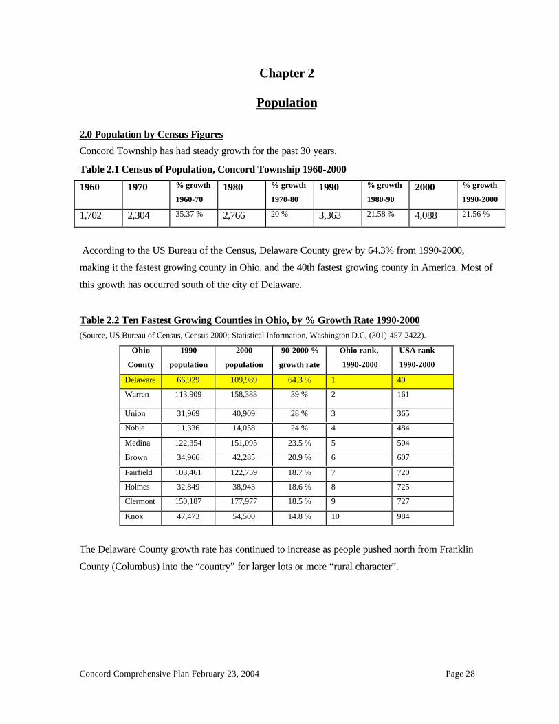
2.0 Population by Census Figures
Concord Township has had steady growth for the past 30 years.
Table 2.1 Census of Population, Concord Township 1960-2000
1960 1970 % growth
1960-701980 % growth
1970-801990 % growth
1980-902000 % growth
1990-2000
1,702 2,304 35.37 % 2,766 20 % 3,363 21.58 % 4,088 21.56 %
According to the US Bureau of the Census, Delaware County grew by 64.3% from 1990-2000,
making it the fastest growing county in Ohio, and the 40th fastest growing county in America. Most of
this growth has occurred south of the city of Delaware.
Table 2.2 Ten Fastest Growing Counties in Ohio, by % Growth Rate 1990-2000(Source, US Bureau of Census, Census 2000; Statistical Information, Washington D.C, (301)-457-2422).
Ohio
County
1990
population
2000
population
90-2000 %
growth rate
Ohio rank,
1990-2000
USA rank
1990-2000
Delaware 66,929 109,989 64.3 % 1 40
Warren 113,909 158,383 39 % 2 161
Union 31,969 40,909 28 % 3 365
Noble 11,336 14,058 24 % 4 484
Medina 122,354 151,095 23.5 % 5 504
Brown 34,966 42,285 20.9 % 6 607
Fairfield 103,461 122,759 18.7 % 7 720
Holmes 32,849 38,943 18.6 % 8 725
Clermont 150,187 177,977 18.5 % 9 727
Knox 47,473 54,500 14.8 % 10 984
The Delaware County growth rate has continued to increase as people pushed north from Franklin
County (Columbus) into the “country” for larger lots or more “rural character”.

Concord Comprehensive Plan February 23, 2004 Page 29
Delaware County is growing largely by domestic in-migration. 25,347 new residents moved into the
county from 1990 to 1999. Births minus deaths represented 5,341 new population in this time span.
By contrast, Franklin County experienced a net loss of –21,749 via outward migration from 1990-99.
Delaware County received 62% of the domestic migration in Central Ohio from 1990-99.
To put Delaware County’s rate of growth into national perspective, consider the state and national
annual growth rates in Table 2.3.
Comparison of Population Growth Rate in Metro Areas in Ohio
-10.00%
0.00%
10.00%
20.00%
30.00%
40.00%
50.00%
60.00%
1900-'10 '10-20 '20-30 '30-40 '40-50 '50-60 '60-70 '70-80 '80-90 '90-2000
Year
% G
row
th R
ate
Central Ohio Cleveland Metro Cincinnati Metro Ohio United States

Concord Comprehensive Plan February 23, 2004 Page 30
Table 2.3 Delaware County Growth Rate vs. Ohio vs. USA(Source, US Bureau of Census, Internet Release Date: April 2001; Statistical Information, Washington D.C, (301)-457-2422).
Area 1990 population 2000 population Growth Rate 1990-2000
USA 248,709,873 281,421,906 13.15 %
Ohio 10,847,115 11,353,140 4.66 %
Central Ohio 1,377,419 1,581,066 14.78 %
Franklin Co. 961,437 1,068,978 11.2 %
Berkshire Twp. 1,713 1,946 13.6 %
Berlin Twp. 1,978 3,315 67.59 %
Brown Twp. 1,164 1,297 11.43 %
Concord Twp. 3,363 4,088 21.56 %
Delaware Twp. 1,607 906 -43.62 %
Genoa Twp. 4,053 11,293 178.63 %
Harlem Twp. 3,391 3,762 10.94 %
Kingston Twp. 1,136 1,603 41.11 %
Liberty Twp. 3,790 9,182 142.27 %
Marlboro Twp. 213 227 6.57 %
Orange Twp. 3,789 12,464 228.95 %
Oxford Twp. 901 854 -5.22 %
Porter Twp. 1,345 1,696 26.10 %
Radnor Twp. 1,156 1,335 15.48 %
Scioto Twp. 1,698 2,122 24.97 %
Thompson Twp. 582 558 -4.12 %
Trenton Twp. 1,906 2,137 12.12 %
Troy Twp. 1,652 2,665 61.32 %
Total Unincorp. 35,437 61,450 73.41 %
Delaware 20,030 25,243 26.03 %
Dublin 3,811 4,283 12.39 %
Galena 361 305 -15.51 %
Sunbury 2,046 2,630 28.54 %
Shawnee Hills 423 419 -.95 %
Powell 2,154 6,247 190.02 %
Ashley 1059 1,216 14.83 %
Ostrander 431 405 -6.03 %
Westerville 1,177 5,900 401.27 %
Columbus 0 1,891
Total Incorp. 31,492 48,539 54.13 %
Total Delaware Co. 66,929 109,989 64.3 %

Concord Comprehensive Plan February 23, 2004 Page 31
Table DP-1 (below) is taken from the 2000 US Census. It shows that Delaware County’s population is
50% male and 50% female, over 94% White (Caucasian), and 80% residing in their own homes.
Population figures indicate that from 1990-2000, Concord Township grew one third as fast as
Delaware County as a whole; however, Concord Township began a rapid growth spurt in 1997 with
the approval of two golf course subdivisions (Tartan Fields and Scioto Reserve, total 1,857 new
homes). Both these subdivisions were made possible by the Ohio Environmental Protection Agency

Concord Comprehensive Plan February 23, 2004 Page 32
allowance of on-site land-application sewage treatment systems. Population soared from 3,363 in
1990 to 5,839 (projected) 2002 year-end. Concord’s projected growth rate for 2000-2010 is 116%, 6
times its 1990-2000-growth rate.
The numbers tell the story of Concord Township’s growth spurt.
• From 1990-97 an average of 34 new homes per year were built in Concord Township.
• In 2001, 355 new homes were built in Concord Township, a ten-fold increase.
• Population is projected to double from 2000 to 2010 (4,088 to 9,343).
• From January 1993 to January 1997 97 new lots were platted.
• From January 1997 to January 2001 1,389 new lots were platted.
2.1 Population Projections
The Delaware County Regional Planning Commission makes population projections based upon a
Housing Unit Method. The formula works as follows:
1.) Last Census (2000) used as a base year.
2.) Number of residents per dwelling unit is calculated based upon the last census information
(2.74 for Concord Township).
3.) Number and type of new residential building permits is tracked by month for all
jurisdictions.
4.) A time lag factor anticipates the occupancy date of new housing after building permit
issuance.
5.) New population is projected for each jurisdiction based on the number of building permits
issued times the number of residents per dwelling unit type, after the lag factor.
6.) New population added to last census data to create projected population.
Concord Township has begun the shift from a large lot, rural community to a blend of rural and suburban,
with production-builder neighborhoods that look much like those in Liberty, Orange and Genoa Townships.
The Population by Housing Unit Method Projections table contains population projections for
Delaware County through the year 2020.

Concord Comprehensive Plan February 23, 2004 Page 33

Concord Comprehensive Plan February 23, 2004 Page 34
2.2 Building Permits and Population Growth
The building permit numbers, more than the census, tell what is happening in Concord Township. Concord
Township has begun a growth spurt. From 1980-1997, 434 new housing permits were issued in Concord
Township, an average of 24 new homes per year. From 1998-2000, 524 new homes were built in Concord
Township, an average of 175 new homes per year. In 2000, 235 new homes were built, a ten-fold increase
from the 1980-1996 average. In 2001, 350 new homes were built.
.
Number of New Residential Building Permits(1980 to 2001)
DELAWARE COUNTY REGIONAL PLANNING COMMISSIONNUMBER OF BUILDING PERMITS1980 THROUGH 2001YEAR 1 9 8 0 1 9 8 1 1982 1983 1 9 8 4 1 9 8 5 1986 1987 1 9 8 8 1989 1990 1991 1992 1 9 9 3 1994 1995 1996 1 9 9 7 1 9 9 8 1999 2000 2 0 0 1 Total ('80-'01)
TOWNSHIPSBERKSHIRE 6 3 2 6 6 1 3 30 28 2 6 26 30 18 27 2 6 13 21 22 1 6 1 7 34 16 1 6 402BERLIN 8 1 1 4 9 1 1 1 9 19 34 3 2 17 13 22 26 3 5 39 65 66 5 4 9 8 117 128 182 1,009BROWN 3 2 2 9 5 3 5 10 1 5 13 8 7 9 1 2 14 11 17 9 1 0 8 17 1 0 199CONCORD 1 6 1 6 4 11 1 4 2 6 42 44 5 1 27 30 22 33 3 8 42 35 30 4 3 9 6 103 235 350 1,308
DELAWARE 3 5 2 2 7 5 6 6 5 6 11 9 5 1 0 12 3 4 1 2 2 5 11 31 4 9 229G E N O A 9 3 10 21 3 0 2 7 66 52 3 9 40 51 54 114 187 271 243 363 342 622 507 651 667 4,369HARLEM 1 3 8 8 19 1 9 1 6 32 33 3 0 19 18 17 32 3 7 27 25 30 3 0 2 3 27 16 1 8 497KINGSTON 6 3 2 7 9 1 1 6 14 1 5 7 14 12 22 3 2 20 19 18 1 9 2 4 37 30 3 7 364
LIBERTY 2 0 1 8 9 19 3 5 3 7 60 59 9 3 57 73 91 164 153 202 164 202 231 262 322 276 198 2,745MARLBORO 0 0 0 0 0 0 1 0 1 0 0 0 1 0 0 1 1 0 1 1 1 1 0 1 8ORANGE 1 1 5 5 56 5 7 4 3 110 150 139 80 84 103 135 170 180 188 268 352 378 637 410 536 4,097OXFORD 0 1 2 3 4 1 2 4 3 4 8 8 6 7 7 3 6 6 4 9 10 1 1 109
PORTER 1 0 5 7 6 4 6 14 11 1 7 17 10 21 20 1 2 25 12 13 1 6 1 7 11 12 9 275R A D N O R 7 3 6 4 3 2 1 5 7 8 9 7 11 1 5 12 13 11 9 1 3 11 12 5 174SCIOTO 1 6 8 8 12 1 4 2 1 17 30 2 1 11 22 15 17 2 8 26 33 26 2 0 2 7 37 21 9 439
THOMPSON 1 0 1 2 1 1 6 4 2 7 1 3 3 0 2 0 3 4 4 4 2 1 1 6 2TRENTON 6 7 3 7 9 4 8 17 1 5 16 11 12 12 1 7 9 11 25 1 7 1 3 12 10 1 1 252TROY 0 6 1 21 4 6 5 18 1 3 7 15 5 9 1 3 18 9 15 1 3 1 2 6 7 1 4 217TOTAL UNINCORP. 135 104 76 214 232 241 430 519 524 362 408 426 646 792 919 856 1,120 1,193 1,646 1,894 1,885 2,143 16,765INCORPORATED AREASDELAWARE 132 104 6 54 4 6 103 86 160 150 322 89 76 87 111 245 305 465 248 355 790 318 368 4,620GALENA 0 0 0 0 0 0 1 1 0 1 0 0 0 0 0 0 2 0 2 2 1 0 1 0SUNBURY 2 0 0 1 8 1 3 5 4 8 4 3 3 11 1 0 14 17 40 3 0 3 3 19 47 7 5 347
SHAWNEE HILLS 3 7 1 2 1 0 4 5 2 3POWELL 9 9 7 7 2 4 5 6 105 202 137 129 92 73 89 169 166 103 130 163 217 141 103 105 2,236ASHLEY 1 1 0 2 3 0 2 0 0 1 0 1 0
OSTRANDER 2 0 0 0 2 2 6 2 2 0 1 0 0 1 0 9 7 1 0 1 0 0 3 6DUBLIN 4 9 1 1 4WESTERVILLE 140 122 262COLUMBUS 83 121 546 184 774 146 9 7 1,951TOTAL INC. 145 113 13 62 8 0 174 203 369 297 456 186 153 187 291 430 527 766 992 792 1,731 769 773 9,509T. INC&UNINC. 280 217 89 276 312 415 633 888 821 818 594 579 833 1,083 1,349 1,383 1,886 2,185 2,438 3,625 2,654 2,916 26,274NOTE: 1) IN THE CITY OF DELAWARE AND COLUMBUS, THOSE FIGURES ARE INCLUDING MULTI-FAMILY RESIDENTIAL BUILDING PERMITS. 2) FROM 1997, THOSE FIGURES ARE INCLUDING MULTI-FAMILY RESIDENTIAL BUILDING PERMITS IN TOWNSHIPS 3) PLEASE CHECK DCRPC WEBSITE (WWW.DCRPC.ORG) FOR 2002 INFORMATION.
SOURCE: DELAWARE COUNTY REGIONAL PLANNING COMMISSION.

Concord Comprehensive Plan February 23, 2004 Page 35
Building Permit TrendsIn Delaware County, Ohio

Concord Comprehensive Plan February 23, 2004 Page 36
Chapter 3
Development and Change
From January 1993 to December 2000, 1,486 new subdivision lots were platted in Concord Township.
During the same time frame, 622 new home permits were issued. There is an advance supply of new
lots being created to meet perceived demand. These new subdivision lots are in addition to road
frontage 1.5-acre lot splits and five-acre mini-farms.

Concord Comprehensive Plan February 23, 2004 Page 37
Table 3.1 New Delaware County Subdivisions
Subdivision Proposals
3.1 Summary of Development Indicators in Delaware County and Concord Township
Concord Township has only recently experienced significant residential growth in suburban style
subdivisions, and more is coming within Scioto Reserve and Tartan Fields until those platted lots are
absorbed. After that occurs, will there be additional large new sewer-served subdivisions with small
sizes? Will these two subdivisions be an anomaly, with Concord Township returning to slower growth
rates? Will annexation remove land area that might otherwise stay in the township? These issues will
be considered in later chapters.
There are some observed trends that merit concern for the townships in Delaware County. Significant
zoning and subdivision activity has lead to a buildup of supply in subdivision lots available for
development. As of December 31, 2002, there were 14,639 single family lots or multi-family housing

Concord Comprehensive Plan February 23, 2004 Page 38
units in the development approval process. This means that all 14,639 lots/units had received at least
zoning approval or had begun the subdivision process. These 14,639 housing units represent an eight
(8) year supply, using the average number of new housing permits in the townships for the previous 5
years (1752/yr). A three (3) year supply is considered normal. Despite this significant increase in
platting and zoning, subdivision activity has remained strong. DCRPC reviewed 4,177 new lots in
2001.
Table 3.15 Available Lots and MF Units in Delaware County Townships , 1/1/2002All Delaware County Townships Combined Concord Township
• Multi family zoning pending 33 0
• Single family zoning pending 1,049 0
• Multi family zoning approved, not platted 894 0
• Single family zoning approved, not platted 1,083 1
• Multi family with subdiv. approval 977 91
• Expired subdivision (can be restored) 2,575 44
• Sketch plan reviewed 143 4
• Tabled 15 2
• Overall preliminary subdivision approved 621 325
• Preliminary approved subdivisions 3,114 343
• Final subdivision approved (not recorded) 527 99
• Unbuilt, recorded lots 3,608 441
Totals 14,639* 1,350*
* Totals are not the sum of all categories, since there can be zonings that are also an expired subdivision.
Perceptions of Growth
A 1998 Delaware Health Department survey asked questions relating to the community’s
perception of its environmental health. Trained volunteers surveyed 500 students in five local
high schools and 200 county fair attendees. In addition, the survey questions were mailed to
40,000 households.
The top five environmental concerns were:
1. Need for more parks, green space, wildlife habitats (733 responses)
2. County development, zoning, annexation out of control (721)

Concord Comprehensive Plan February 23, 2004 Page 39
3. Surface water pollution from sewage systems (686)
4. Surface water pollution from factories, agriculture (685)
5. Environmental Education (660)
The public’s perception of Delaware County growth includes negative comments:
• too much traffic,
• unplanned neighborhoods,
• lack of environmental and open space protection,
• inadequate new school construction
• the pace of growth is too rapid
Concord Township has begun the rapid pace of growth seen in Genoa, Orange, and Liberty
Townships. More growth is likely in the near future. The comprehensive plan needs to address how
this growth can best be managed.

Concord Comprehensive Plan February 23, 2004 Page 40
CHAPTER 4
Issues and Opportunities
Concord Township steering committee members
The Comprehensive Planning process is a forum for the development issues (forces) pushing and
pulling at the township. The issues are categorized as strengths, opportunities, weaknesses, or threats.
The township’s response to these issues is a future vision, or strategic plan of action for the township’s
development.
4.1 Citizen Participation in the Decision Making Process
A. Need for Citizen Participation
The Comprehensive Plan typically looks 5-10 years into the future, with the understanding that
unforeseen circumstances may change the vision.
The planning process demands broad representation of the populace to ascertain current issues, and to
set goals for the future. Each community may take a slightly different approach to involving the
public, but a citizen participation element is the backbone of the process; it provides legitimacy to the
resulting plan.

Concord Comprehensive Plan February 23, 2004 Page 41
In general, the citizen participation should be:
• Representative of the population and land ownership of the township
• More broad based than just elected and appointed officials
• Long term and open to continuing debate
• Influential in the recommendations made to appointed and elected officials
B. Open Invitation to the Process
The Concord Township Zoning Commission took steps to open the discussion to the community by
placing notices along major thoroughfares in the township.
1. A story in the local newspaper outlined the planning process and invited all to attend.
2. Posted legal advertisements for the public meetings to discuss the plan.
3. Requested a core group of citizens to join a Comprehensive Plan Steering Committee,
which would work on the plan update and forward the final draft to the Zoning
Commission for consideration. A twenty-four (24) member Steering Committee was
organized. This core group agreed to meet on a monthly basis until the update of the plan
was completed.
Concord Township Steering Committee members

Concord Comprehensive Plan February 23, 2004 Page 42
C. Commencement of the Planning Process
A group of approximately 80 Concord Township residents and landowners attended the initial meeting
of October 1, 2001, at which time they discussed the following items:
1. Why do we need a Comprehensive Plan for future land use?
2. What do we like about Concord Township?
3. What do we dislike about Concord Township?
4. What do we want the township to look like when it is ultimately developed?
5. What is our Vision for the development of the township for the next 5-10 years?
4.2 Citizens’ Likes and Dislikes- Issues and Opportunities Regarding Development
During a second meeting on November 5, 2001, the members of the steering committee and other
concerned citizens (a total of 28 citizens) ranked the Likes and Dislikes issues above in order of
importance. The numbers assigned to each represents each item’s average rank. Respondents were free
to rank the items using whatever system they preferred (i.e., they could give several items the same
rank).
LIKES Average1. Rural character 4.852. Trees and green space 7.783. Large lots, low density 8.524. Fire department 8.965. Relatively quiet 9.006. Del-Co water 9.817. Privacy 11.968. Road maintenance 12.779. Wildlife 12.7810. Rivers and recreation 12.93
Reasonable safety 13.04Farms 14.27Relatively low taxes 14.569-1-1 service 14.74Low traffic 15.19Good city country mix 15.23Good zoning 15.52Friendly people 15.67No light pollution 15.69
DISLIKES Average1. Truck traffic 7.172. Increasing traffic 8.053. Greedy over-development without needed infrastructure 8.954. Lack of speed limit enforcement 9.475. Annexation threats 9.796. Speed limit too high 10.877. Insufficient commercial tax base for schools 11.648. Quarries too large 11.719. Maximum security prison 12.2410. Pending temporary closing of Home Road bridge 14.37
Lack of some utilities 14.40Dangerous intersection at US42 and Section Line Road 14.48Poorly drained soils 14.50Narrow roads 14.54Noisy off-road vehicles 14.84Lack local community input on development proposals 14.95Park continuity 15.04Truck noise (brakes) 15.33No walkways along roads 15.43

Concord Comprehensive Plan February 23, 2004 Page 43
Diligent zoning board 16.42No commercial in residential 16.80Township form of government 17.52Proximity to Columbus 17.65Good road network 18.27Proximity to shopping 18.38Access to hospital 18.59No sewers, so density is low 18.80Concord park track 21.16Active community 21.23Small, rural churches 21.42Columbus Zoo 21.72Proximity to restaurants 22.48Buckeye Valley Schools 23.44Township newsletter 24.76Dublin schools 25.38Columbus Park Marina 25.48Narrow roads 25.48Scioto Reserve development 27.65
Lack of law enforcement 16.23Roads are widened after development 16.80Loss of agricultural infrastructure 16.86Alternate 1 on the Thoroughfare Plan 17.12Lack of community input 17.22Light pollution 17.78Junk cars in yards 18.19Development in floodplain 18.47Home bridge is too skinny 18.65Too few good restaurants 20.40Lack of county support 20.44Utility boxes on street 20.60No community center 21.00Uniform telephone area code 21.76Lack of communication with the township 22.39Inadequate telephone service 22.53Lack of local post office 22.95Need additional communication (e-mail) news from township 23.68Poor right-of-way maintenance 23.84Second fire station 24.72Lack of leash law enforcement 25.11
The group also identified other general issues related to the future of Concord Township:
1. There is a valid benefit to a community from upscale developments.
2. Will Home Road extend to U.S. 42 in Union County?
3. Will there be moderately priced housing options in the township in the future?
4. What will the new Home Road Bridge look like (pedestrian access)?
Attendees were asked to place items in the same list into categories: Strengths, Weaknesses,
Opportunities, and Threats. Within each category, certain themes begin to emerge. These themes have
been grouped below.
Strengths
Rural character• Large lots, low density• Relatively quiet• Privacy• Farms• No light pollution• No sewer, so density is low
Natural Resources• Wildlife• Rivers and Recreation• Trees and greenspace
Location• Proximity to Columbus• Columbus Zoo• Columbus Park marina

Concord Comprehensive Plan February 23, 2004 Page 44
Services• Fire Department• Del-Co• Road maintenance• Reasonable safety• Relatively low taxes• 9-1-1 service• Diligent Zoning Board
Other• Reasonable safety• Low traffic in some areas• Friendly people• Township form of government• Concord Park track• Small rural churches
Weaknesses
Services• Buckeye Valley Schools• Lack of some utilities• Inadequate phone service• Too few good restaurants
Transportation• Narrow Roads• Noisy off-road vehicles• Truck traffic and the noise associate with trucks• Speed limits are felt to either be too high or not enforced• The dangerous US42 and Section Line Road intersection• Lack of walkways along road• Poor right-of-way maintenance
Government• Lack of law enforcement• Lack of county support• Lack of post office• Need additional communication (e-mail) within the Township
Development Issues• Lack of community input on development issues• Lack of park continuity along reservoir• Continued development in the floodplain• Roads are only widened after the development goes in• Insufficient commercial to support the schools• Poorly drained soils• Junk cars on some properties• No community center
Opportunities• Lots of land left- still rural• Need to clarify how to preserve open space and rural character• Still have time to alter course of development before entire township becomes suburban sprawl.

Concord Comprehensive Plan February 23, 2004 Page 45
• Plan for second fire station• Good zoning in place- time to refine it while there is land left to be developed
Threats• Increased traffic• Greedy over-development without needed infrastructure• Alternate 1 on the Delaware County Proposed Thoroughfare Plan (connector road from US 42 to US 23)• Quarries too large• Maximum security prison• Annexation threats, Dublin, Delaware, Powell?
4.3 Vision Statement for Future Development
The October 1, 2001 large group created a future vision for the community development pattern:
When Concord Township is all built out, we would like it to retain large lots and low density in a
pastoral setting with adequate infrastructure; with a balance of commercial, residential and
recreational uses; with the river as a focal point; maintaining the character of narrow roads; and a
variety of housing types and reasonable community safety.
The mission of the Concord Township steering committee is to analyze the factors that influence
future development patterns, consider the strengths, weaknesses, opportunities and threats to attaining
the vision, and select a plan that assures the desired result.

Concord Comprehensive Plan February 23, 2004 Page 46
CHAPTER 5
Existing Land Use
5.1 Land Use Maps
DCRPC staff has prepared four different land use maps. Each tells a story of how land is being used.
I. Existing Land Use Map- The existing land use map (see Concord Township Existing Land
Use map) displays single family residential, commercial, agricultural and open space,
industrial by color. The land use is determined by the Auditor’s tax codes. This acreage is
displayed in Table 5.1.
Table 5.1 Concord Township Land Use by Acreage, 1990 and 2001
1990
(Satellite imagery)
% Land 2001*
(Auditor’s tax data)
% Land
Residential (SF +MF) ** 2824.02 17.79 4,480.46 28.22
Single Family 2824.02 4,371.80 27.53
Multi family 0.00 108.66 .684
Commercial 41.84 .26 63.87 .402
Institutions 188.43 1.18 156.11 .983
Industrial 111.95 .7 212.29 1.337
Agriculture
(includes forests)
8046.75 50.68 6,307.69 39.729
Lakes, rivers and public lands*** 1160.41 7.31 956.92 6.027
Roads and Utilities**** 497.68 3.13 724.68 4.564
Parks/open space 2932.32 18.47 2,373.47 14.949Recreation 304.99Wetlands 2.51Undeveloped, forest and shrub 2624.82Vacant land rezoned, stillundeveloped
0.00 0 601.143 3.786
Vacant land agriculturally zoned,still undeveloped.
73.09 .46 N/A N/A
Acreage in Township 15,876.49 99.99% 15,876.643 99.9972 %
* The 2001 DALIS Geographic Information System acreage vector data.
**2001 residential acreage calculated using DALIS data for entire parcel.
*** Area created as follows: Lakes, ponds and rivers polygons calculated by GIS. Streams (including seasonal swales on the USGS maps)
were given a width of 20 feet, and multiplied times the number of lineal feet.
****The ROW area for roads and utilities is 306.31 acres. There are no railroads in Concord Township.

Concord Comprehensive Plan February 23, 2004 Page 47

Concord Comprehensive Plan February 23, 2004 Page 48
II. Windshield survey- DCRPC staff recorded land uses on 1997 aerial photos with current lot
lines. Structural uses are noted, unlike the existing land use acreage map (see Table 5.2).
Table 5.2 Existing Land Use by Windshield Survey, DCRPC staff 10/ 2001
III. Development Pattern Map- A third type of existing land use map defines the progress of
anticipated development. The development pattern map tracks the size and location of zonings and
subdivisions. Concord’s Development Pattern Map, December 2001, depicts these various
characteristics. Further information, called attribute information, is available from the DCRPC GIS
and the County DALIS. Such information includes building permit issuance, developer /landowner,
subdivision names, number of homes and density.
(Please see the Concord Township Development Pattern Map, December 2001)
Section Single-Family MH Commercial** InstitutionalUnits Units Res. Units Res. 1 2 3 4 5 None
1 of 10 78 0 0 1 3 0 69 8 1 1 0 0 4 22 of 10 179 1 2 0 0 0 156 17 7 0 0 0 4 43 of 10 152 1 2 0 0 0 137 13 2 0 1 0 4 14 of 10 190 0 0 0 0 1 179 11 1 0 0 0 3 05 of 10 163 0 0 0 0 1 160 4 0 0 0 0 4 46 of 10 442 1 2 4 12 0 444 1 1 0 1 0 3 17 of 10 206 4 8 0 0 0 210 0 0 0 0 0 3 28 of 10 95 0 0 0 0 1 87 4 3 1 1 0 2 19 of 10 250 0 0 0 0 0 247 3 0 0 0 0 0 0
10 of 10 66 0 0 0 0 0 61 4 1 0 0 0 1 0
Totals 1821 7 14 5 15 3 1750 65 16 2 3 0 28 15
**Commercial count includes three public utility towers (3 cellular tower).
Source- Field Survey completed, checked and compiled by DCRPC.
*Housing Conditions
1.) Sound: no defects, a meticulously maintained structure, or a recently completed new structure.2.) Sound: slight defects- structure in which defects were correctable by normal maintenance.3.) Sound: deteriorated- an intermediate defect, for example, a roof sagging, a wall unit warped, a foundation
settled unevenly or a chimney eroding.4.) Dilapidated: critical defects- a structure in a state of disrepair to the extent that the present condition might
impose a threat to the health and safety of its occupants but which was still considered inhabitable.5.) Uninhabitable: extensive critical defects- structures in a state of disrepair to the extent that the unit is not
suitable for habitation.
% of total D.U. #1 cond. 96.10%% of total D.U. #2 cond. 3.57%% of total D.U. #3 cond. 0.88%% of total D.U. #4 cond. 0.11%% of total D.U. #5 cond. 0.16%
Existing Land Use (unit count) in Concord TownshipOctober 2001
Two-Family Multi-Family Housing Conditions*

Concord Comprehensive Plan February 23, 2004 Page 49
IV. Land in Speculation -A fourth type of potential land use map, based upon land ownership andadjacency to known development sites, is the land in speculation map. Using the DALIS, DCRPCstaff can query all landowners for lands that are owned by:• Known land developers and subdividers• Known homebuilding companies• Limited liability corporations (LLC)• Trusts• Incorporated entities
For tax and estate planning purposes there may be non-development entities that use one of these typesof ownership, so the land in speculation map is a best guess, not a certain picture of how much landmay be in speculation.
Lands that are adjacent to current development may also be targets of expansion. They are alsoidentified as possible land in speculation (see the Land In Speculation Map, Concord Township).
V. Observations on Existing Land Use, and Current Development Patterns in 2001:
Now that we have studied the various existing land use maps (DALIS Existing Land Use Map,Concord Development Pattern Map, Land in Speculation Map, and the acreage tabulations from thewindshield survey), we may draw some observations about emerging land use patterns in ConcordTownship.
1.) The township comprises 15,877 acres, divided east and west by the Scioto River.
2.) Lakes and rivers comprise 957 acres or 6% of the land area.
3.) Parks and recreational area comprise another 2374 acres or 15 % of the land area.
4.) Roads and utility rights of way comprise 725 acres, or 5% of the land area.
5.) Of the 11,780 acres remaining after subtraction of lakes/rivers, parks/recreation and roads/utilities,6300 acres are still open agricultural land, or 40% of the total acreage in the township. This makesAgricultural (open fields and forests) use the largest land use in the township.
6.) Agriculture is a shrinking land use, and, based on the last 40 years, is probably a temporary landuse:
• 600 acres are being farmed temporarily, but are already zoned for other land uses.• Agricultural land decreased by 10% or 1,745 acres in the last decade.
7.) Residential land acreage increased by 10.43 %, or 1,656 newly developed acres in the last decade.There were 4,480 acres of developed residential land.
8.) Single family residential use now accounts for over 27% of land use.
9.) Residential land use is spread throughout the township, but is concentrated in the southern half ofthe township, south of Home Road. Higher densities are found south of Home Road.

Concord Comprehensive Plan February 23, 2004 Page 50
10.) The township is no longer a “blank canvas” of open land. There has been enough developmentthat there are definite “neighborhoods”, which share certain common attributes.
11.) In the period 1997-2001, residential development has shifted from large lot (1-5 acres), to a mix oflarge lot and small lot (10,000 square feet) in Planned Residential Developments.
12.) Production builders are now purchasing large tracts of land (Tartan Fields, Scioto Reserve) for thepurpose of building their product in a more rural area, and are using the PRD as the legalinstrument.
13.) There were 1,821 single-family homes, 7 duplexes, and 5 multi-family buildings observed in thewindshield survey.
14.) Tartan Fields is a 445-acre R-2 zoned (minimum lot size 29,000 sq. ft.) single family subdivisionthat uses an on-site central sewer system with land application to a golf course for 598 homes,with a gross density of 1.34 units/acre.
15.) Scioto Reserve is a 695 acre Planned Residential Development (typical lot size 9,500 sq. ft.) thatuses an on-site central sewer system with land application to a golf course for a mixture of 1,163single family homes and 92 multi-family condominiums, with a gross density of 1.8 units per acre.
16.) Although there was very little existing multi-family housing (15 individual units), condominiumunits are now being built in the Scioto Reserve area.
17.) The Martin Marietta stone quarry on the west side of the Scioto River and the east side of DublinRoad is the largest single industrial use (121 acres).
18.) There were 28 commercial uses by windshield survey, comprising 64 acres, an increase of 22acres since 1990.
19.) There were 15 institutional uses (prison, fire station, churches, school, cemeteries)
20.) There appear to be 1,295 acres of land in speculation (47 parcels).
21.) There appear to be 102 acres of potential development land adjacent to approved developments(13 parcels).
22.) The township has lost 1,199 acres to annexation.
VI. Conclusions
The real estate market seems to validate a strong demand for home sites in Concord Township,
especially the smaller (10,000 Sq. ft.) lots in Planned Residential Development subdivisions.
Production builders, who have only in the last five years come to the township, have the ability to
construct and sell hundreds of homes on smaller lots every year in the township.

Concord Comprehensive Plan February 23, 2004 Page 51
Traditional rural 1-5 acre lots have not produced a high growth rate, but PRD subdivisions have.
Planned Residential Developments with water and sewer permit smaller suburban size lots that
facilitate production builder lot demands. If growth shifts from rural large lot to “conventional” PRD
smaller lot subdivisions, it could mark a drastic shift (increase) from the 1990-2000 building of 71
new homes per year. Farmland decreased 10% in the last decade, and would likely decrease
proportionately to the number of “conventional” new PRD subdivisions.
If extrapolated into all neighborhoods, “conventional” Planned Residential Development design as
seen in much of southern Delaware County would significantly change the “rural character” of
Concord Township.
The impact of future land use patterns must be considered. Some of the many influences on land
development patterns are:
• $ The power of money (market demand)
• Regional economic conditions
• Location
• Sanitary sewer service areas, sewer capacity, density of development by sewer design
• Soils and their suitability for on- site sewage disposal systems
• Natural resources (topography, floodplains, wetlands)
• Public/private centralized water service areas and capacity
• Roads and traffic congestion
• Community Facilities (schools, fire, police, etc.)
• Local zoning
• Banking/lending practices for kinds of development
Concord Township has choices. Township zoning controls the type and density of future
development. If the township intends to retain its rural character at a time of unprecedented growth, it
must imagine itself “all built-out” in alternative scenarios, and pursue the scenario it prefers.
The book Rural by Design, by Randall Arendt (Planners Press, American Planning Association) is one
guide to other development patterns that may augment the large lot and conventional development
patterns the township has already experienced.

Concord Comprehensive Plan February 23, 2004 Page 52
CHAPTER 6
Natural Resources and Conservation
Concord Township lies mostly within the Upper Scioto River Watershed. The Upper Scioto
Watershed comprises 323,787 acres, with 46, 368 acres of the watershed within Delaware County.
0 6 12 18 24 Mil es
Delaware CountyIncorporated Area in Delaware CountyScioto R iver Watershed in Lower Sciot oScioto R iver Watershed in Upper SciotoWatersheds BoundariesHydrologic Unit Boundaries
N
EW
S
Prepared By: Delaware Coun ty Regio nal Plannin g Commission (7 40-833-2260)ht tp://www.dcrpc.orgSource: Watershed B oundaries fr om ODNR 1996 Hydro logi c Units f rom USGS 2 001
Scioto River Watershed, Ohio

Concord Comprehensive Plan February 23, 2004 Page 53
The Scioto River rises in Hardin County, flows easterly through Marion County, then south through
Delaware, Franklin, Pickaway, Ross, Pike and Scioto Counties to its confluence with the Ohio River at
Portsmouth. Within Concord Township, the Scioto River and the O’Shaughnessey Reservoir are the
most dominant natural resources, dividing Concord Township into East (5784 acres) and West (7861
acres) Banks (exclusive of Shawnee Hills and Dublin).
Concord Township also has floodplains, wetlands, farmed fertile soils, forests, and abundant wildlife.
These natural resources are most frequently cited as the foundation of “rural character” noted in
Chapter Four. These resources should be conserved wherever practicable as the township develops.
6.1 Topography- (DALIS contours)
Concord Township’s topography consists of a level upper plateau between 930-950 feet above mean
sea level, on the East and West banks of the Scioto, folding into the river valley. Highest elevation of
1004 feet above mean sea level is located off Tartan Fields Drive on the West Bank. The low
elevation is 854 feet above mean sea level at the Scioto River above the O’Shaughnessey Dam, and
780 feet above mean sea level below the dam. The River Valley is visually different from the upper
plateau. Most elevations below 900’ mean sea level generally have a view of the water, or physically
relate to the valley itself. Elevations above 900 feet mean sea level may relate more to the upper
plateaus. These form the basis for two natural neighborhoods.
6.2 Slopes Greater than 20%
The township set a goal to preserve ravines, and slopes greater than 20% for open space when the
township develops. The steep slope map indicates slopes over 20%. Generally, roads do not exceed
10% slope. Houses with walkout basements can typically be built on slopes up to 20%. (See Slope
Map)
6.3 Floodplains, bodies of water
O’Shaughnessey Reservoir is a significant natural resource area; it is the dominant geographic feature
in Concord Township. Its principal function is a drinking water reservoir for the City of Columbus.
As development encroaches along the creeks that feed the reservoir, there is a potential for surface and
ground water pollution, most notably from failed septic systems in rural areas. For this reason, the
Ohio EPA has asked the Delaware County Board of Health to consider a minimum 3 acre lot size in
areas without public water and sewer. Since Del Co water is generally available throughout the

Concord Comprehensive Plan February 23, 2004 Page 54
township, this 3-acre standard lot size may be reduced. Where lands possess ravines or floodplains
that flow directly to the reservoir, and no centralized sewer is available, the township may wish to use
even lower densities to preserve water quality, especially in rural areas where some houses still rely on
well water.
There are floodplains along Mills Creek and the Scioto River. The National Flood Insurance Program,
(which includes Concord Township) discourages development in the 100 year floodplain and prohibits
development in the 100 year floodway. These areas are mapped by the Federal Emergency
Management Agency (FEMA). The floodplain map gives a general location of the floodplains. For
specific information see the FEMA maps at the Delaware County Building Department, 50 Channing
Street, Delaware Ohio (740-368-5850). (See Floodplain Map).
According to Protecting Floodplain Resources (FEMA, 1996) undisturbed floodplains perform several
critical functions:
Water Resources- Natural flood and erosion control
• flood storage and conveyance; reduce flood velocities; reduce peak flows; reduce
sedimentation
Water Quality Maintenance
• Filter nutrients and impurities from runoff; process organic wastes; moderate temperature
fluctuations
Groundwater Recharge
• Reduce frequency and duration of low surface flows
Biological Resources
• Rich, alluvial soils promote vegetative growth; maintain bio diversity, integrity of ecosystems
Fish and Wildlife habitats
• Provide breeding and feeding grounds; create and enhance waterfowl habitat; protect habitats
for rare and endangered species.
Societal Resources
• Harvest of wild and cultivated products; enhance agricultural lands; provide sites for aqua
culture; restore and enhance forest lands
Recreation
• Provide areas for passive and active uses; provide open space; provide aesthetic pleasure
Scientific Study/Outdoor Education
• Contain cultural resources (historic and archeological sites); environmental studies

Concord Comprehensive Plan February 23, 2004 Page 55
The Delaware County FEMA floodplain maps were revised in 1999. One hundred (100) year
floodplain elevations have risen in some areas. New development is a contributing factor to the rise in
floodplains.
With floodplains rising, and with all the natural benefits of floodplains listed previously, it is unwise to
permit residential development in the 100-year floodplains of Delaware County. The subsidy for the
low-cost, flood insurance sold under National Flood Insurance Program comes from federal taxes.
Each land use decision to permit development in the 100 year floodplain not only puts people in
harm’s way, but also potentially burdens all American taxpayers with the cost of continuing to bail out
bad development.
For all these reasons, the 100-year floodplains in Concord Township should be protected. Some
counties have flat floodplains that comprise a great deal of the developable area of the county. In an
urban county, where such land is precious, it is understandable, but not advisable, that some filling
may occur. In Delaware County, the floodplains are narrow and limited. They comprise a very small
portion of the land area, and they occur on four rivers or streams that are drinking water and
recreational resources (Alum Creek, Big Walnut, Olentangy, and Scioto). It is critically important to
protect the floodplains of these four rivers or streams.
6.4 Wetlands
Wetlands are generally defined as soils that support a predominance of wetland (hydrophytic)
vegetation, and/or are under water at least two weeks per year. The more specific definition to
wetlands under the jurisdiction of the US Army Corps of Engineers is found in the Corps of Engineers
Wetlands Delineation manual Technical Report Y-87-1, US Army Engineer Waterways Experiment
Station, Vicksburg, Miss. The wetlands map shows the location of potential wetlands from OCAP
satellite imaging. These locations are raster data, meaning they have square edges in their computer
images. They may indicate the locations of potential jurisdictional wetlands.
Jurisdictional wetlands are regulated by the clean Water Act of 1972, Section 404. They consist of:
1.) hydric soils,
2.) hydrophytic vegetation,
3.) wetland hydrology (this means they support more than 50% wetland vegetation, are
poorly drained, and are periodically inundated or saturated).

Concord Comprehensive Plan February 23, 2004 Page 56
Wetlands serve many of the same functions as floodplains, and similarly deserve protection. Wetlands
are natural storm water detention systems that trap, filter and break down surface runoff. Most
Concord Township wetlands are tiled fields. If tiled before 1985, they are exempt from regulation
unless they revert to their natural state.
6.5 Prime Agricultural Soils
The Prime Agriculture Soils map shows the location of soils suited to high yields in Concord
Township. Agriculture is still an important land use in Concord Township, although the land value for
future development may exceed the short-term value for continued agricultural use.
Creative zoning and development techniques may be able to save some agricultural land as open
space. There is a methodology to evaluate which farms should be preserved, based upon highest yield
soils, proximity to utilities, four-lane highways, and dense settlements. The method is called the Land
Evaluation Site Assessment system or LESA and is created by the US Department of Agriculture.
When farms are considered for purchase of development rights, those with the highest LESA ranking
might be given the most favorable consideration. The DCRPC and the Delaware Soil and Water
District can perform the LESA evaluation.
6.6 Soil Suitability for Septic Systems
Since sanitary sewer service is not available to a large portion of the township, it is useful to evaluate
the soil capability for septic systems. Centralized sanitary sewer or alternative sewage disposal
systems should serve land with very poor suitability for septic systems. The Soil Suitability for
Septic Systems Maps displays this information.
6.7 Combined Critical Resources
The combined Critical Resources map displays generalized floodplains, water, wetlands, prime
agricultural soils and 100 foot suggested setbacks from major watercourses. Since it is a goal to
preserve the natural resources of the township, this map should be used as an evaluation tool when
land is developed.
6.8 Development or Harvesting of Natural Resources
Limestone is commercially mined in Concord Township. Prime agricultural soils are an additional
natural resource that are harvested every year as agriculture, or could be harvested as topsoil or sod.

Concord Comprehensive Plan February 23, 2004 Page 57
The township might consider natural resource extraction policies, either as a specific zoning district, or
as a conditional use if certain performance standards are met (noise prevention, dust control, buffering
and screening, appropriate access, hours of operation, etc). Mining operations should not be permitted
within the 100-year floodway, and should only be permitted within the 100-year floodplain with strict
environmental controls to prevent water pollution, flotation of equipment and other related hazards.

Concord Comprehensive Plan February 23, 2004 Page 58
O Sh au ghne ss y Re s.
GLICK RD
HOME RD
CON
CORD R D
HARR IOTT RD
C OOK R D
MER CHANT RD
RIVER SID
E DR
HYAT TS R D
MILLS R D
CA L HO
U N R D
FRY RD
DU BL IN
RD
HOME RD
CONC O
R D RD DUFFY RD
MOORE RD
CLAR K-S HAW RD
BEAN-OLLER R D
BUNTY STAT ION RD
S S
ECTI
ON
LINE
RD
US HI GHWAY 4
2 S
Digital Elevation, Concord Township, Delaware County, Ohio
N
EW
S
0 2000 4000 6000 8000 Fee t
Scale: 1" = 5000'
Digital Elevation770 - 790 ft790 - 810 ft810 - 830 ft830 - 850 ft850 - 870 ft870 - 890 ft890 - 910 ft910 - 930 ft930 - 950 ft950 - 970 ft970 - 990 ft990 - 1010 ft
Rivers/Ponds/LakesStreamsRailroadRoadsIncorp. Area BoundariesTownship Boundaries
Prepared by: Delaware County Regional Planning Commission (740-833-2260); www.dcrpc.or g(12/18/2001)

Concord Comprehensive Plan February 23, 2004 Page 59
O Sh au ghne ss y Re s.
GLICK RD
HOME RD
CON
CORD R D
HARR IOTT RD
C OOK R D
MER CHANT RD
RIVER SID
E DR
HYAT TS R D
MILLS R D
CA L HO
U N R D
FRY RD
DU BL IN
RD
HOME RD
CONC O
R D RD DUFFY RD
MOORE RD
CLAR K-S HAW RD
BEAN-OLLER R D
BUNTY STAT ION RD
S S
ECTI
ON
LINE
RD
US HI GHWAY 4
2 S
Prepared by: Delaware County Regional Planning Commission (740-833-2260); www.dcrpc.or g(12/18/2001)
Ponds/Rivers/LakesSlope > 20%StreamsIncorp. Area BoundariesRailroadRoadsTownship Boundaries
N
EW
S
0 2000 4000 6000 8000 Feet
Slope, Concord Township, Delaware County, Ohio
Scale: 1" = 5000'

Concord Comprehensive Plan February 23, 2004 Page 60
O Shau gh ne ssy Re s.
GLICK RD
HOM E R D
CONCO
RD R D
HARRIOTT RD
C OOK RD
M ER CHANT R D
RIV ER SIDE DR
HYATTS R D
MILLS R D
CA L HO
UN R D
FRY RD
DU BL IN R D
HOM E RD
CONC O
RD R D DUFFY RD
MOOR E RD
CLARK-SHAW R D
BEAN-OLLE R R D
BUNTY STATION R D
S S
ECTI
ON
LIN
E RD
US H
I GHW AY 42 S
Prepared by: Delaware County Regional Planning Commission (740-833-2260); www.dcrpc.org(12/18/2001)
WetlandWetland (ODNR)Farmed Wetlands (ODNR)
Rivers/Lakes/PondsStreamsRailroadRoad CenterlinesIncorporated AreasTownship Boundary
N
EW
S
0 20 00 4000 6000 800 0 Feet
Wetland, Concord Township, Delaware County, Ohio
Scale: 1" = 5000'

Concord Comprehensive Plan February 23, 2004 Page 61
O Sh au ghne ss y R
e s.
GLIC K R D
HOME RD
CONCO
RD R D
HARRIOTT RD
COOK RD
MER C HANT RD
RIV ER SIDE D
R
HYATTS RD
MILLS RD
CA LHO
U N R D
FRY RD
DUBL IN R
D
HOME RD
CON
COR D R D DUFFY RD
MOORE RD
CLARK-SHAW RD
BEAN-OLLER RD
BUNTY STAT ION RD
S S
ECT
I ON
LIN
E R
D
US H
I GHWAY 42 S
Prepared by: Delaware County Regional Planning Commission (740-833-2260); www.dcrpc.org(12/18/2001)
Prime FarmlandHigh ( Y=120-130 )High ( Y=115)Moderate High ( Y=80-115 )Moderate High ( Y=85-110)Moderate High ( Y=95-110 )Moderate High ( Y=90-95 )Moderate ( Y=65-95)Low ( Y=0-85)Not Reated / Data Not AvailableWater
Lakes/Ponds/RiversStreamsIncorp. Area BoundariesRailroadsRoadsTownship Boundary
N
EW
S
0 2000 4000 6000 8000 Feet
Prime Farmland, Concord Township, Delaware County, Ohio
Scale: 1" = 5000'

Concord Comprehensive Plan February 23, 2004 Page 62
æ
æ
æ
æ
æ
ææ
æ
æ
LO
N DI K
E
R OA
D
UL
EVA
RD
O Sh au ghne ss y R
e s.
GLICK RD
HOME RD
CON CO
RD R D
HARRIOTT R D
COOK RD
MER CHANT R D
RIVER SIDE D
R
HYATTS RD
MIL LS RD
CA LHO
UN R D
FRY RD
DUBLIN R
D
HOME RD
CON
C OR D RD DUFFY RD
MOORE RD
CLARK-SHAW RD
BEAN-OLL ER RD
BUNTY ST ATION RD
S S
ECT
ION
LIN
E R
D
US HI GHWA Y 42
S
Prepared by: Delaware County Regional Planning Commission (740-833-2260); www.dcrpc.org(12/18/2001)
Ponds/Rivers/LakesStreamsRoad CenterlinesRailroadIncorp. Area BoundariesTownship Boundaries
æ Cemeteries
N
EW
S
0 2000 4000 6000 8000 Feet
Cemeteries, Concord Township, Delaware County, Ohio
Scale: 1" = 5000'

Concord Comprehensive Plan February 23, 2004 Page 63
$
$$$
$
$$$$$$$$$$$$$$ $
$
$
$
$$$
$
$$
$
$$$$$$$
$$$$$$$$$$$$$$ $$$$$$$$ $$$$
$
$
$$ $$
$$$$
$$$
$$ $
$
$
LO
N DI K
E
R OA
D
UL
EVA
RD
US HI GHWA Y 42
S
S S
ECT
ION
LIN
E R
D
BUNTY ST ATION RD
BEAN-OLL ER RD
CLARK-SHAW RD
MOORE RD
DUFFY RD
CON
C OR D RD
HOME RD
DUBLIN R
D
FRY RD
CA LHO
UN R D
MIL LS RD
HYATTS RD
RIVER SIDE D
R
MER CHANT R D
COOK RD
HARRIOTT R D
CON CO
RD R D
HOME RD
GLICK RD
O Sh au gh ne ssy R
e s.
Prepared by: Delaware County Regional Planning Commission (740-833-2260); www.dcrpc.org(12/18/2001)
Rivers/Ponds/LakesStreamsProperty LinesRoad CenterlinesRailroadIncorp. Area BoundariesTownship Boundaries
$ Archeological Sites
N
EW
S
0 2000 4000 6000 8000 Feet
Archeological Sites, Concord Township, Delaware County, Ohio
Scale: 1" = 5000'

Concord Comprehensive Plan February 23, 2004 Page 64
O Sh augh ne ss y R
es.
GLICK RD
HOME RD
CON CO
RD RD
HARR IOTT RD
COOK R D
MER CHANT RD
RIV ER SIDE D
R
HYATTS RD
MILLS RD
CALHO
U N RD
FRY RD
DUBL IN R
D
HOME RD
CON
C OR D R D DUFFY RD
MOORE RD
CLARK-SHAW RD
BEAN-OLLER RD
BUNTY STATION RD
S S
ECT
I ON
LIN
E R
D
US HIG
HWA Y 42 S
Prepared by: Delaware County Regional Planning Commission (740-833-2260); www.dcrpc.org(12/18/2001)
Septic Suitability AreasWater and StreamsSoils Rated Not SuitableFlood Prone AreasSoils: D Slope or GreaterSoils:Additional Soils PointsTrees/Shrubs in Bad SoilsWetlands (Undrained; ODNR)Remaining Land Area: Suitable
Incorp. Area BoundariesRailroadsRoadsTownship Boundary
N
EW
S
0 2000 4000 6000 8000 Feet
Soil Suitability for Septic System, Concord Township, Delaware County, Ohio
Scale: 1" = 5000'

Concord Comprehensive Plan February 23, 2004 Page 65
O Sh au gh ness y R
e s.
GLICK RD
HOME RD
CON CO
RD R D
HARRIOTT RD
COOK RD
MER C HANT RD
RIV ER SIDE D
R
HYAT TS RD
MILL S RD
CA LHO
U N R D
FRY RD
DUBL IN R
D
HOME RD
CON
C ORD R D DUFFY RD
MOORE RD
CLARK-S HAW RD
BEAN-OLLER RD
BUNTY STATION RD
S S
ECT
I ON
LIN
E R
D
US H
I GHWAY 42 S
Prepared by: Delaware County Regional Planning Commission (740-833-2260); www.dcrpc.org(12/18/2001)
Critical Resources AreasStreams & Water FeaturesWetland (ODNR)Farmed Wetlands (ODNR)Drainage CoursesFlood Prone Areas (FIA)Buffer Setback: Major Water 100Remaining LandNot Rated by FIANatural Heritage Sites (ODNR)Archaeological Sites (OHS)RoadsTownship Boundary
Incorp. Area BoundariesRailroadsRoadsTownship Boundary
N
EW
S
0 2000 4000 6000 8000 Feet
Critical Resources, Concord Township, Delaware County, Ohio
Scale: 1" = 5000'

Concord Comprehensive Plan February 23, 2004 Page 66
O Sh au ghne ss y R
e s.
GLIC K R D
HOME RD
CON CO
RD R D
HAR RIOT T RD
C OOK RD
MER CHANT RD
RIV ER SIDE D
R
HYATTS RD
MILLS RD
CALHO
U N RD
FRY RD
DUBL IN R
D
HOME R D
CON
COR D R D DUFFY RD
MOORE RD
CLARK-SHAW RD
BEAN-OLLER RD
BUNTY STAT ION RD
S S
ECT
I ON
LIN
E R
D
US HIG
HW AY 42 S
Prepared by: Delaware County Regional Planning Commission (740-833-2260); www.dcrpc.org(12/18/2001)
SoilBoABoBGwBGwC2GzC3LoALsALyD2LyE2MgAMhAMoBMoC2MpD2PwARoARsAScAScBSdC2SfASkASoAStASuAUdBUpW
RailroadsRoadsIncorp. Area BoundariesTownship Boundary
N
EW
S
0 2000 4000 6000 8000 Feet
Soil Map, Concord Township, Delaware County, Ohio
Scale: 1" = 5000'

Concord Comprehensive Plan February 23, 2004 Page 67
O Sh augh ne ss y R
es.
GLICK R D
HOME RD
CON CO
RD RD
HARR IOT T RD
COOK R D
MER CHANT RD
RIV ERSIDE D
R
HYATTS R D
MILLS RD
CA LHO
U N R D
FRY RD
DUBL IN R
D
HOME RD
CON
C OR D R D DUFFY RD
MOORE RD
CLARK-SHAW RD
BEAN-OLLER RD
BUNTY STATION RD
S S
ECT
I ON
LIN
E R
D
US HIG
HWA Y 42 S
Prepared by: Delaware County Regional Planning Commission (740-833-2260); www.dcrpc.org(12/18/2001)
500 Year Flood Plains100 Year Flood PlainsRivers/Lakes/PondsStreamsIncorporated AreasRai lroadRoad CenterlinesTownship Boundary
N
EW
S
0 2000 4000 6000 8000 Feet
Flood Plains, Concord Township, Delaware County, Ohio
Scale: 1" = 5000'

Concord Comprehensive Plan February 23, 2004 Page 68
CHAPTER 7
Housing
Rural large lot 2-5 acres Suburban one acre PRD .2 acre
Housing has been the primary index of growth in Concord Township. The township is changing from
a rural community with no central water or sewer, to a suburbanizing community with Del-Co water
service throughout.
Planning for a range of housing in a developing community can be complicated. Many factors are
involved, such as the availability or lack of public water and centralized sanitary sewer, land values,
market demand, proximity to major employment and shopping centers, and transportation network. In
addition there is the vision of how the community wants to look. There are also legal considerations
related to non-discrimination in housing, and “fair share” provision of the regional housing needs, to
the extent necessary services can be provided.
The majority of Concord Township in 2002 is zoned Farm Residential 1 (FR-1), which permits single
family residences on a minimum lot size of 1.5 acres with 200 feet of frontage on a public road. Flag
lots with 60 feet of frontage may also be permitted in the FR-1 district, or the frontage may be
provided on a private shared driveway (Common Access Drive or CAD). Lands within the FR-1
district have traditionally been located in areas not served by centralized sanitary sewer. Minimum
square footage for a single family home in FR-1 is 1,000 square feet, a modest requirement.
Landowners served by centralized sanitary sewer may apply for Planned Residential District (PRD)
zoning, which permits a variety of housing types, (single family detached, single family attached,
modular, cluster manufactured homes, patio homes and common wall homes and multi-family
housing). Minimum PRD square footages for single family houses are 1,000 square feet; multi-family

Concord Comprehensive Plan February 23, 2004 Page 69
minimum square footages are 800, 950, and 1,000 square feet respectively for 1, 2, or 3 bedroom
apartments. Densities for PRD’s are generally 1.5 units per gross acre, but may be increased by up to
3 units per gross acre if certain “quality standards” are met.
7.1 Existing housing stock
A house-to-house windshield (exterior view from a moving automobile) survey was conducted in
October 2001. An exterior condition of each house was given based upon five criteria. The housing
survey results are in Table 7.1.
Table 7.1 Concord Township Housing Survey Results, October 2001, field survey
HousingType
Total #Units
#Units Sound:no defects
# Unitssound: slight defects
# Units soundbut deteriorated
# Unitsdilapidated
# Unitsuninhabita
bleSingle Family 1821 1729 58 12 2 3
Two Family 14 6 6 2
Multi Family 15 15
Mobile Homes 3 1 2
Totals 1853 1750 65 16 2 3
% Totals 100% 94.4 % 3.5% .86 % 0.1% 0.1 %
Based upon the housing survey, several points about housing may be made:
• There is no significant problem with deteriorated housing stock in Concord Township.
1.) 94.4 % of all housing is either new or maintained like new (sound, no defects).
2.) 3.5 % of all housing is in very good condition. (sound, minor defects)
3.) Only .86 % (less than 1 %) of all housing appeared to be somewhat dilapidated.
4.) Less than 1/10 of 1% of housing units appeared dilapidated.
5.) Less than 1/10 of 1% of housing units appeared uninhabitable.
• The township is almost entirely single family residential. This is largely due to the lack of
sanitary sewers and other services that multi-family housing demand.
• Concord Township has not adopted a housing code to assure the constant maintenance of its
housing stock, to retain property values and stable neighborhoods.
7.2 Housing needs
Concord Township is the 10th largest provider of housing stock in Delaware County, as of April 2000.
Concord Township has provided 4.1% of the total new housing in Delaware County in the last 20

Concord Comprehensive Plan February 23, 2004 Page 70
years. The top five communities (city of Delaware, Genoa, Orange, Liberty Townships, and Powell)
have provided 69.26% of all the housing in Delaware County in the last 20 years. They all have
centralized sewer service.
Table 7.2 Housing Providers in Delaware County, by Census & Building Permits
Community Census 2000
Housing
Units
County
Rank
Vacancy
Rate,
4/ 20000
Building
Permits
1980-2000
% total
permits
1980-2000
Berkshire Township 712 16 4.5 % 386 1.65 %
Berlin Township 1,239 11 4.7 % 827 3.54 %
Brown Township 479 21 3.3 % 189 .8 %
Concord Township 1,374 10 5.8 % 958 4.1 %
Delaware Township 373 22 7.0 % 180 .77 %
Genoa Township 4,058 3 5.0 % 3,702 15.8 %
Harlem Township 1,382 9 3.1 % 479 2.05 %
Kingston Township 554 18 3.1 % 327 1.39 %
Liberty Township 3,469 4 5.3 % 2,547 10.9 %
Marlboro Township 167 26 6.7 % 8 .034 %
Orange Township 5,055 2 8.4 % 3,561 15.24 %
Oxford Township 318 23 7.2 % 98 .41 %
Porter Township 597 17 3.0 % 266 1.13 %
Radnor Township 511 19 4.3 % 169 .72 %
Scioto Township 864 14 4.7 % 430 1.84 %
Thompson Township 220 24 8.2 % 51 .21 %
Trenton township 769 15 3.0 % 241 1.03 %
Troy Township 1,210 12 8.5 % 203 .86 %
Total Townships 23,273 5.3 % 14,622 62.59 %
Columbus 1,660 7 7.8 % 1,854* 7.93 %
Delaware city 10,208 1 6.7 % 4,252 18.2 %
Galena 132 28 7.6 % 10 .042 %
Sunbury 1,057 13 3.9 % 272 1.16 %
Shawnee Hills 199 25 9.0 % 18 .077 %
Powell 2,032 6 2.8 % 2,131 9.12 %
Ashley 500 20 6.2 % 10 .042 %
Ostrander 156 27 5.1 % 36 .15 %
Dublin 1,501 8 6.9 % 13** .055%
Westerville 2,311 5 3.7 % 140*** .59 %
Total Incorporated areas 19,756 5.0 % 8,736 37.4 %
Total All Reporting Incorp. &
Unincorp. areas in Delaware County
43,029 23,358 100 %
*- Data available from 1995-2000 only
** Data from 1999- 2000 only
*** Data from 2000 only

Concord Comprehensive Plan February 23, 2004 Page 71
Table 7.2 also shows vacancy rates, as determined by the US Bureau of Census during the April 2000
count. In general, vacancy rates show a healthy supply of new homes available for sale. Vacancy
rates below 2% indicate a tight housing market, while vacancy rates of 5% are normal for a market
with reasonable supply for market demand.
7.3 Open Space (“Golf Course”) Developments
The Delaware County townships that have experienced the most growth (Liberty, Orange, and Genoa)
have access to county sanitary sewer. In 1996 the Ohio EPA amended their anti-degradation rules,
making it more difficult to discharge treated effluents from sewage treatment plants to running
streams. In order to facilitate centralized sewer systems that cannot discharge to running streams, the
Ohio EPA now allows alternative centralized sewage treatment systems with appropriate design, and
maintenance. The most popular alternative in Delaware County (three systems approved) is the
standard tertiary treatment plant using the treated effluents to be spray-irrigated onto an acceptable
vegetated area, normally a golf course.
The decision to permit such an alternative centralized treatment plant is the jurisdiction of the
Delaware County Sanitary Engineer and the Ohio EPA. Since such planned developments normally
require rezoning, the zoning decision is left to the township or county.
This change in sewer policy has led to a surge in “golf course” development in townships that
previously had no sanitary sewer service. Houses are placed around the golf course, which enhances
house lot prices. This form of cluster housing may be appropriate, depending on the gross overall
density and other service demands.
These golf course communities, with on site centralized sewer facilities, may shift more housing starts
to previously rural, non-sewer service areas. This could redistribute the housing geography in
Delaware County.
For example, in 1997 Concord Township had no sanitary sewer service from Delaware County.
Annual new home permits in Concord Township on large lots (one acre or larger) with septic systems
averaged 30 homes per year from 1980-1997. Tartan Fields subdivision was approved in Concord
Township in 1997. Tartan Fields is a Planned Residential Development using cluster single family
homes on ¼ acre lots surrounding a golf course that is irrigated by treated effluents from a centralized
sanitary sewer system built by the developer and dedicated to the county for ownership and
maintenance.

Concord Comprehensive Plan February 23, 2004 Page 72
Scioto Reserve subdivision was approved in Concord Township in 1998. It also uses an on-site
centralized sanitary sewer with treatment plant and irrigation of a golf course. With Scioto Reserve
and Tartan Fields subdivisions under construction, Concord Township issued 350 new home permits
in 2001.
In the space of just 3 years, Concord Township may move from the 8th largest number of annual new
home permits in the county to 4th largest due to these two new “golf course” developments.
Tartan Fields (left) and Scioto Reserve.
7.4 Land Application Systems- Opportunity or Threat to Planning?
For Ohio Townships, Land Application Systems can be both an opportunity and a threat.
• Opportunity #1- Additional sewer capacity privately funded. If cluster developments with
Land Application Systems are proposed in areas anticipated to be served by county sewer, the
Land Application Systems can augment the county’s sewer capacity. This means additional areas
for sewer users may be accommodated without future upgrades to the existing public treatment
plant. This may be a benefit.
• Opportunity # 2- Saving farmland or open space. Agricultural (non-urban service) areas can
use conservation developments (such as the Farm Village Concept adopted by Trenton Township)
to transfer development rights from working farmland to adjacent open space developments. The
key to success of this concept is low density (.5 unit per acre might be an appropriate minimum
gross density). Homes in such areas may be tightly clustered on smaller lots, perhaps 12,000

Concord Comprehensive Plan February 23, 2004 Page 73
square feet. A Land Application System can be used as irrigation of agriculture and managed
open space. The lower the gross density, the more farmland is preserved.
• Opportunity # 3- Reduce potable water usage Land application systems can also augment the
water capacity of the potable water supply by reducing the summer lawn watering peak usage. By
using a parallel gray water system to irrigate open space, lawns and golf courses, potable water
demand could be reduced during droughts.
• Threat # 1- Sprawl. Ohio townships should be cautious when using alternative sewer systems to
achieve urban densities (greater than one unit per acre) in rural areas. These areas typically have
no broad base of community services available to them (i.e. fire and police protection, public
transportation, shopping, recreation, entertainment, and cultural activities). Every demand for
such services requires trips in cars. Local roads typically cannot support significant trip increases
for high density, large-scale development. The cost of upgrading farm-to-market roads to
accommodate leapfrog suburban density development may exceed the benefits and adversely alter
the “rural character” people sought in the first place (sprawl).
• Threat # 2 –Farmland loss. If gross densities of more than one unit per acre are allowed in rural
(non urban service) areas, more farms become targets for golf course development, and existing
golf courses become targets for effluent irrigation easements. This does not preserve farmland.
• Threat # 3 – Repayment of Bonds. Most municipal or county sewage treatment plants are built
using general obligation bonds. Sewer tap fees typically make the bond payments. If
developments construct their own treatment plant and avoid sewer tap fees, they may compete
with a municipal or county sewer system. Property owners may incur increased taxes if a shortfall
in tap fees occurs. Note: This does not appear to be a threat in Delaware County because there has
historically been strong demand for county sewer, so tap fees should be collected regardless of
Land Application System developments.
• Threat #4– Private plant maintenance . If a public entity (i.e. city, county, township) does not
maintain the Land Application System and treatment plant, it may be prone to failure, and a costly
public take-over. Delaware County prefers county ownership of the plant (by dedication) to
assure proper design and maintenance. Homeowners associations may be under-financed and ill
equipped to maintain or oversee maintenance of a sewage treatment plant.

Concord Comprehensive Plan February 23, 2004 Page 74
7.5 Recommendations for “Land Application Systems”
To prepare for potential suburban-density developments using Land Application Systems or other
approved “centralized” on-site sewage disposal systems, Ohio townships should:
1. Adopt up-to-date land use plans with recommended densities as the basis for their zoning.
2. Consider Land Application Systems as accommodations to development:
• When the use and density conform to the comprehensive plan and zoning.
• When there is (preferably) public dedication (ownership) and maintenance of the system.
3. Avoid gross tract densities greater than one unit per acre in truly rural areas. Even lower gross
densities are appropriate in prime agricultural areas to save farmland or open space.
4. Consider land application systems as a tool to permit low density “conservation subdivisions”
(see definition in Chapter 13 of this document) in rural areas without sewer service. Conservation
subdivisions protect primary conservation areas (unbuildable wetlands, floodplain, river valleys,
and steep slopes) and “secondary conservation” areas (unique scenic views, cultural or historic
attributes).
Table 7.3
Developments Proposed with Alternative Centralized Sanitary Sewage DisposalDevelopment Location Township Acres # Units
Approved
# Units
Proposed
Gross
Density
Status
Tartan Fields Concord Rd. Concord 302 449 1.49/ac Approved
Dornoch US 23 Liberty/Delaware 282 393 1.39/ac Approved
Scioto Reserve Home Road,
Riverside Drive
Concord 695 1250 1.8/ac Approved
Tanglewood Cheshire Road Berlin/Liberty 573 1035 1.8/ac Withdrawn
North Star N. Galena Road Kingston/Berkshire 965 1500 1.55/ac Pending
West Farm Robins Road Harlem 175 540 3.1/ac Optioned
Woods Farm SR 605. Harlem 128 260 2/ac Optioned
Totals 2092 3335

Concord Comprehensive Plan February 23, 2004 Page 75
7.6 Future Housing Needs
In order to make future housing projections, a community might anticipate what services they can
provide then anticipate their share of the future area population and allocate the distribution of housing
types.
Few communities attempt such an analysis, leaving the housing mix up to the traditional power of
zoning, which is seldom so analytical. In a high-growth area such as Delaware County, it is
impossible to anticipate what the county’s share of the state’s population will be, and distribute that
amount among the townships, village and cities.
Where the possibility of annexation exists, townships cannot be certain of their future boundaries. For
that reason, it is impossible to assess fair share allocations of housing to be provided by the township
when a city or village with superior services may annex land and provide housing at a higher density.
A more pragmatic approach to housing distribution is for the township to:
1.) determine how the community wants to look when it is all built out (vision)
2.) determine what services it can and should provide
3.) anticipate its fair share of the county’s projected population
4.) permit a variety of housing that relates to 1, 2, and 3.
The Delaware County Commissioners hired Poggemeyer Consultants in 2002 to perform an“Affordable Housing Market Study” to assess low and moderate income resident’s housing needs.
“Affordable housing” refers to housing that is constructed for those that cannot afford to live in the
average residential unit. These
individuals have household incomes
that are defined by the U.S.
Department of Housing and Urban
Development (HUD) as “extremely
low,” “very low,” or simply “low” on
the American Management Index.
Table 1.1 shows HUD’s
classifications for Affordable Housing qualification.Table 1.1 – Source: U.S. Department of Housing and Urban Development
$66,950$62,900$58,850$54,800$50,000$45,650$40,600$35,50080% of AMILow
Source: US Department of Housing & Urban Development (HUD)
$41,850$39,300$36,750$34,250$31,700$28,550$25,350$22,20050% of AMIVery low
$25,100$23,600$22,050$20,550$19,000$17,100$15,200$13,30030% of AMI
Extremelylow
87654321
Section 8 Income Guidelines
Household Size:

Concord Comprehensive Plan February 23, 2004 Page 76
Affordable housing is diminishing in the county, just as it is in the nation. National trends are showing
an increasing population, while the number of all new housing units being built is constantly
decreasing. This trend is accompanied by a decreasing household size and an increase in the market
price for those units that are being built. HUD seeks to offer assistance to those households that are
paying more than 30% of their gross household income toward housing without a choice. The low-
skilled job market is not raising salaries to meet the needs of those employees where the cost of living
is increasing significantly.
Delaware County is currently experiencing rising property values and an increased cost of living. As
high-growth development continues, travel costs will rise and the relative impact on schools, public
facilities and infrastructure will be immense as each new house is constructed. As these costs of living
increase, many local residents face job markets that can not financially meet their needs. Low-skilled
employees are forced in other market areas for housing that may meet their budget. If housing is
unavailable, these individuals are forced to relocate. This can cause service sector unemployment to
increase locally, thus affecting the entire community.
Within Concord Township many of these trends may not be completely evident. However, they exist
locally just as they do nationally. A lack of
affordable housing as population increases is
unavoidable unless developers are
encouraged and/or granted incentives to
develop more reasonably priced units. The housing market is driven by developer’s profits, which
increase with housing market values.
The Delaware County Affordable Housing Market Study produced the projections illustrated in Table
1.2 to demonstrate the need for affordable housing through 2020. The study estimated that the City of
Delaware has 5,000 homes in the planning and construction stages, while the County has 16,000
homes. In order to reach the projected 19,900 units needed countywide by 2020, Concord Township
is responsible for their fair-share along with the remainder of the county. The demand for affordable
housing will increase higher in Concord Township than the remainder of the county, due to their
future projected population growth. The Delaware County Regional Planning Commission projects
that Concord Township will have a higher growth rate than the remainder of the county in the next ten
years. (see Chapter 2) Affordable housing is needed in Concord Township to make the local economy
Table 1.2 – Source: Del. Co. Affordable Housing Market Study
19,90017,60015,00012,60010,128AffordableUnits Needed
139,908123,867105,81788,80871,137# of HousingUnits
20202015201020052000
Projected Affordable Housing Needs inDelaware County

Concord Comprehensive Plan February 23, 2004 Page 77
stronger and to house local residents to fill lower-income jobs. Affordable housing should be
considered a necessary type of development in Concord’s future.
Source: Delaware County Affordable Housing Market Study: Draft Copy. Kirkland, Washington:Poggemeyer Design Group, Inc., September 5th, 2002.
7.7 Housing Policies
Sewer capacity and the township’s desire to maintain a sense of rural character limit Concord
Township’s density and housing mix. Columbus and Delaware are the primary multi-family providers
in the Delaware County housing market. They offer higher densities than the townships. The City of
Delaware has recently passed a high-density apartment district that will compete with Columbus.
In areas with access to arterial roads or as part of large planned developments, multi family housing
can and will occur in the townships. Concord Township must evaluate its housing mix in light of all
state and federal housing laws, and binding court decisions.
7.8 Concord Township Sub-areas
The Concord Township Comprehensive Plan Steering Committee identified five distinct
neighborhoods within the township; three on the west bank and two on the east bank of the Scioto
River. (see Map 7.1- Upper and Middle Scioto were combined )

Map 7.1 Planning Sub Areas
As the comprehensive plan unfolds, the committee has been asked to constantly reflect what theinformation in each new chapter means within their own sub-area.
Upper Scioto
Farm Country Lower Scioto
Mill Creek Valley
Dublin / Shawnee Hills
S SE
C TIO
N L
INE
RD
MOORE RD
HOME RD
H ARRIOT T RD
CLARK-SHAW RD
BEAN-OL LER RD
U S HIG
HWAY 4 2 S
BUNT Y STATIO N RD
DUFFY RD
RUTHERFORD RD
DU
B LIN R
D
COOK RD
Shawnee Heights
CO
N CO
R D R
D
Rivers\LakesIncorporated AreasRoadsSub-Areas
N
EW
S
2000 0 2000 4000 6000 Fe et
Concord TownshipSub - Areas

Concord Comprehensive Plan February 23, 2004 Page 79
CHAPTER 8
General Economic Conditions
Land development depends on a strong local economy. Within the national economy there are regional
economies moving forward or slumping due to local conditions. Delaware is one of Ohio’s most
affluent counties. The central Ohio economy drives Concord Township’s economy.
In March 2001, the United States economy slipped into a national recession. Despite low interest rates
and low inflation rates, the long period of expansion from 1991 to 2001 was ended. The effects of the
September 11, 2001 terrorist attacks on the United States deepened the downturn. A 12/21/01 report
by the U.S. Commerce Department declared the U.S. economy “turned in its weakest performance in a
decade in the third quarter, shrinking at an annual rate of 1.3 %” (Columbus Dispatch, 12/22/01).
Signs of economic weakness:
• U.S. unemployment rate jumped from 4% (8/00) to 5.7% (11/01) (Columbus Dispatch).
• Ohio’s unemployment rate rose from 4.2% (7/00) to 4.7% (11/01) (Columbus Dispatch).
• Central Ohio unemployment rose from 2.4% (11/00) to 3.2% (11/01) (Business First, 1/11/02)
• Central Ohio Labor Force was at 904,300, a decrease from July 2001 high levels of approximately
918,000, but ahead of the 12 month low of 871,800 in December 2000 (Business First, 1/11/02).
• Central Ohio Labor Force (excluding Union County) showed an average of 41 weekly work hours,
compared to 42.7 weekly work hours in October 2000. (Business First, 1/11/02).
• Delaware Co. unemployment rose from 1.9% (August 2000) to 2.7% (November 2001)
(Columbus Dispatch), but still remains one of the lowest unemployment rates in Ohio.
• Greater Columbus industrial vacancy rates rose from 7.9% first quarter 1998 to 10.18% fourth
quarter 2001 (Columbus Business First Market Report, 1/18/02).
• Greater Columbus area office vacancy rates are expected to reach 10-15% in 2002 (Columbus
Business First Market Report, 1/18/02)
• DCRPC platting rates for new subdivisions softened in 2002

Concord Comprehensive Plan February 23, 2004 Page 80
Signs of economic strength:
• Delaware County Per Capita Income was $30,252 in 1997, 11.29% increase from 1994-96, 52nd in
the USA, the fastest growing per capita income of any county in Ohio (Ohio Development
Department web site).
• While new platting activity in the Delaware County townships slowed in November and
December 2001, new construction continued, fed by cheap mortgage rates of 6% - 7.5% for fixed
30-year loans. Final 2001 building permit tallies for the unincorporated Delaware County
townships showed 2148 new building permits, the largest number ever in Delaware County.
Concord Township moved to number three provider, with 355 new homes, a 51% increase from
2000 (235 permits).
• Kroger announced (Business First, January 25, 2002) they will build a $69 million, 750,000
square foot food distribution warehouse on US 36 in the city of Delaware, at Glenn Road. The
facility will create 276 new full-time jobs, and retain/transfer 387 full time jobs, paying an average
$13.00 per hour. The state of Ohio estimates the new project will generate $587,221 in additional
corporate franchise and individual income taxes in the next 10 years.
• Polaris Fashion Place Mall opened in November 2001, with record-breaking sales tax receipts.
The mall is a destination for central Ohio shoppers, bringing new dollars into Delaware County.
Polaris Centers of Commerce is the largest office park in central Ohio, with 3.8 million square feet
of office space, 28 buildings and 900 of 1200 acres built. Bank One Corporate Office Center
(Polaris) is the largest office building in central Ohio (2 million square feet). Affluence is the mark
of the Polaris region. Within a 10-mile radius of Polaris are 200,000 households with a median
household income of $54,400. The upscale Easton Mall/office-park, by comparison, counts
300,000 homes with a $40,600 household median (Business First).

Concord Comprehensive Plan February 23, 2004 Page 81
8.1 Other Economic Indicators
The US Census 2000 provides economic information by township.
Census Facts:
1. Delaware County’s poverty rate was 3.3% in 1999.
2. Concord Township’s poverty rate was 2.6 %.
3. Delaware County has the highest educational attainment rate of any central Ohio county. 92.9% of
the population is a high school graduate. 41% of the population has a Bachelor’s or higher college
degree.
4. In Concord Township, 94.6 % of adults have a high school degree, and 41.6 % have a Bachelor’s
degree or higher.
5. The April 2000 unemployment rate in Concord Township was 3.2 %.
6. The median household income in 1999 in Concord Township was $79,169.
7. The median family income in 1999 in Concord Township was $83,761.
Social Economic Census 3 (Census 2000)(Source: U.S. Census Bureau 2000)
Number Percent Number Percent Number Percent Number Percent Number Percent
Delaware County 92.9% 41.0% 82,043 100.0% 58,580 71.4% 2,293 2.8% 67,258 76,453 31,600 883 2.9% 4,118 3.8%
Township:Berkshire 93.7% 43.8% 1,488 100.0% 1,097 73.7% 6 0.4% 70,663 71,744 31,496 0 0.0% 12 0.6%
Berlin 91.7% 31.0% 2,342 100.0% 1,735 74.1% 40 1.7% 69,028 77,788 23,765 37 4.1% 182 5.5%
Brown 92.9% 35.1% 955 100.0% 675 70.7% 0 0.0% 63,456 59,922 24,557 9 2.4% 39 3.2%
Concord 94.6% 41.6% 3,006 100.0% 1,969 65.5% 95 3.2% 79,169 83,671 28,851 28 2.6% 83 2.5%
Delaware 86.1% 33.4% 1,272 100.0% 946 74.4% 10 0.8% 60,372 74,844 26,052 15 3.4% 39 2.7%
Genoa 95.9% 49.8% 8,263 100.0% 6,210 75.2% 59 0.7% 94,167 97,113 39,905 18 0.5% 71 0.6%
Harlem 90.1% 23.6% 2,752 100.0% 1,978 71.9% 30 1.1% 55,080 58,375 24,151 35 3.1% 136 3.7%
Kingston 91.4% 22.9% 1,248 100.0% 921 73.8% 0 0.0% 68,750 70,679 22,829 0 0.0% 44 2.6%
Liberty 96.3% 58.6% 6,908 100.0% 4,989 72.2% 27 0.4% 89,787 103,903 46,654 27 1.0% 181 2.0%
Marlboro 81.9% 15.1% 245 100.0% 145 59.2% 0 0.0% 29,514 36,750 16,851 13 18.8% 62 22.8%
Orange 97.2% 54.1% 8,852 100.0% 7,103 80.2% 141 1.6% 74,612 83,996 33,240 184 5.3% 626 5.1%
Oxford 86.9% 17.5% 644 100.0% 392 60.9% 11 1.7% 47,100 52,727 20,247 2 0.8% 4 0.5%
Porter 92.6% 24.9% 1,271 100.0% 942 74.1% 16 1.3% 70,949 71,359 25,301 24 4.9% 76 4.8%
Radnor 94.3% 20.5% 1,029 100.0% 701 68.1% 6 0.6% 55,089 56,607 35,456 8 1.9% 23 1.7%
Scioto 74.4% 24.5% 1,542 100.0% 1,117 72.4% 54 3.5% 54,706 64,196 25,440 20 3.3% 112 5.5%
Thompson 91.4% 28.8% 491 100.0% 356 72.5% 11 2.2% 57,639 61,080 22,985 0 0.0% 24 3.9%
Trenton 90.3% 26.3% 1,633 100.0% 1,191 72.9% 17 1.0% 62,500 68,676 24,792 12 1.9% 57 2.7%
Troy 65.9% 15.1% 1,674 100.0% 1,168 69.8% 16 1.0% 51,951 60,938 23,421 12 1.8% 75 3.6%
Total Township 93.9% 42.4% 45,615 100.0% 33,635 73.7% 539 1.2% 444 2.5% 1,846 3.8%
City & Village:Delaware 87.7% 26.8% 19,516 100.0% 12,737 65.3% 1,514 7.8% 46,030 54,463 20,633 304 4.8% 1,704 7.3%
Galena 84.0% 20.4% 236 100.0% 162 68.6% 6 2.5% 46,250 49,500 20,163 4 4.8% 29 9.6%
Sunbury 83.3% 18.2% 2,018 100.0% 1,296 64.2% 19 0.9% 46,477 50,750 18,861 32 4.1% 122 4.7%
Shawnee Hills 87.8% 29.3% 333 100.0% 242 72.7% 4 1.2% 52,222 70,179 25,266 6 5.4% 32 7.8%
Powell 98.8% 68.6% 4,093 100.0% 2,999 73.3% 62 1.5% 115,904 117,801 46,257 8 0.4% 24 0.4%
Ashley 80.2% 8.0% 881 100.0% 598 67.9% 21 2.4% 39,239 42,312 15,513 33 10.2% 155 12.7%
Ostrander 66.1% 11.3% 272 100.0% 223 82.0% 3 1.1% 49,583 49,375 27,751 6 6.3% 21 5.8%
Dublin 96.4% 69.3% 3,251 100.0% 2,121 65.2% 56 1.7% 127,820 135,545 58,462 21 1.6% 81 1.8%
Westerville 93.1% 56.3% 4,170 100.0% 3,070 73.6% 58 1.4% 104,250 108,582 38,280 25 1.5% 104 1.8%
Columbus 89.8% 49.1% 1,658 100.0% 1,497 90.3% 11 0.7% 58,696 71,250 30,964 0 0.0% 0 0.0%
Total Incorporated 91.5% 39.3% 36,428 100.0% 24,945 68.5% 1,754 4.8% 439 3.3% 2,272 3.9%
NOTE: 1. All demographic and social economic statistics are from 2000 U.S. census, adjusted by DCRPC to exclude incorporated statistics from township totals.
2. For detailed Table DP-1 to DP-4 for each jurisdiction, please check DCRPC web site at www.dcrpc.org .
* Civilian labor force consists of all civilians 16 years or older who are either employed, or seeking employment.
Percent HighSchool
Graduate OrHigher
PercentBachelor'sDegree Or
Higher
PoliticalJurisdictions
* Cilvilian LaborForce Employed
* Cilvilian LaborForce Unemployed Median
HouseholdIncome (dollars)
POVERTY STATUS IN 1999EDUCATION EMPLOYMENT STATUS INCOME IN 1999Population 16 Yrs & Over Families Below
Poverty LevelIndividuals Below
Poverty LevelPer CapitaIncome(dollars)
Median FamilyIncome
(Dollars)
Demographic Information, Delaware County, Ohio 4

Concord Comprehensive Plan February 23, 2004 Page 82
8. The per capita income in Concord Township in 1999 was $28,851.
9. Delaware county ranked third in the state of Ohio’s 88 counties in the highest per capita property
taxes, with 1997 revenues of $1,063.86 per capita. (Source, Business First).
8.2 Employment by Industry in Delaware County
Delaware County has a broad-based economy, as described by employment sectors in Table 8.1.
Table 8.1 Employment by (covered) Industry in Delaware County, 1998 (Source: Ohio Development Department, OBES/LMI place of work data) *This does not include all employment
Employment Category 2000 Employees % of total
1. Wholesale and Retail Trade 10,259 29.1 %
2. Services 8,831 25
3. Manufacturing 4,901 13.9
4. Government 4,618 13.1
5. Finance, Insurance Real Estate 3,027 8.6
6. Construction 2,446 6.9
7. Transportation/Utilities 553 1.6
8. Agriculture, forestry, Fishing 543 1.5
9. Mining 120 .3
Table 8.2 Major Employers, Delaware County, 2000 (Source: Delaware Co. Chamber of Commerce)
Employer Employment Sector # Employees
Advance Auto Parts Vehicle parts 304
American Showa Manufacturing (vehicle suspensions) 375
Bank One Finance 1,000
Cigna Insurance 450
Delaware City BD of Education Government 559
Delaware County Government 810
General Castings Manufacturing 425 (1998)
Grady Memorial Hospital Service (medical) 657
Liebert Manufacturer, cooling systems 300 (1998)
Mid West Acoust-A-fiber Manufacturing 160 (1998)
Nippert Manufacturing (Copper processing ) 300 (1998)
Ohio Wesleyan University Service (Higher Education) 495
Olentangy Schools Education 672
PPG Industries Manufacturing (paint) 563
State of Ohio Government 891 (1998)
Wal Mart # 2725 Retail 465

Concord Comprehensive Plan February 23, 2004 Page 83
8.3 Concord Township Economy
Concord Township’s economy was historically based on agriculture. Some commercial land useshave been planned, zoned and developed along US 42.
Table 8. 3 Businesses in Concord Township, by Windshield Survey, August 1999:Business Name Business Type
42 Storage Mini-storage
Dari Treat Restaurant
The Dock Stop Bait and tackle
Dreamland Motel Motel
Delaware Veterinary Clinic Animal doctor
Eagle Creek Camp Retreat
Gardener’s Market Gardening supplies
Home Road Acres Party House Entertainment
LTI Trucking Trucking
Marathon Fuel
Martin Marietta Stone Quarry
NW Storage Mini-storage
Propeller Boater’s Prop Shop Boating supplies
Scioto Bait and Tackle Bait and tackle
Smith Garden Wholesale Gardening supplies
State of Ohio Prison (s) Prisons
Studio 42 Hair salon
Visions Market and restaurant
Martin Marietta Quarry entrance and Riverview Juvenile Correctional Facility
Concord Township has the possibility for additional economic development on or with access to US
42. Access management (limiting left turn movements and combining curb cuts) will be important to
safe traffic flow.

Concord Comprehensive Plan February 23, 2004 Page 84
Because there is currently no county sanitary sewer service in Concord Township, commercial and
industrial development is likely to be limited to those use that do not need sewer.
If lands could be served by a privately constructed OEPA approved centralized sanitary sewer system
that is dedicated to the county for ownership and maintenance, then the commercial and industrial tax
base could be expanded.
Farm along Mills Road
8.4 Agricultural Component of the Delaware County Economy
Agriculture is still the largest land use (by acreage) in Delaware County. It is also still a significant
land use in Concord Township. In 1998 the Delaware County Commissioners appointed an
Agricultural Preservation Task Force to study the issue of loss of farmland and to prepare a strategy
for agricultural preservation. The Task Force determined that:
“Over a 15 year period, 1982-1997, agriculture in Delaware County has been constant in that it is still
a family owned industry and it is still a vibrant economical resource with sales of over $64 million in

Concord Comprehensive Plan February 23, 2004 Page 85
1997. However, there has also been a great amount of change in the industry over those 15 years. The
number of farmland acres in Delaware County has continually declined. In 1997, 160,770 farm acres
remained in Delaware County. The farmland acres that remain are no longer owned by the farm
operators, but are rented from someone outside the farming operation. To compensate for this loss of
farmland, farmers have turned to producing higher value crops, added value products and direct
marketing. Farm commodity production is becoming polarized with the loss of livestock operations
and a move toward crop production. This loss of diversity will increase the chances that a commodity
specific issue will dramatically impact the total Delaware County agricultural sector” (page 20,
Delaware County Farmland Preservation Plan, June 2000).
Table 8.4 Amount of Agricultural Land in Delaware County
Delaware County- Total Acreage 283,700
Delaware Co. Agricultural Acres (2000-Ohio Dept. Dev.) 175,000
Percent of Delaware County Acres in Agriculture 60%
Ohio Acreage in Agriculture, 2000 14,900,000 acres
Delaware County’s Share of Total Ohio Agricultural Acres 1.2 %
Table 8.5 Census of Agriculture, Loss of Farmland in Delaware County
Source: 1995 Ohio Dept. of Agriculture Annual Report
Period Land in Farms1982-92 -10 %
1974-92 -11 %
1964-92 -18 %
1954-92 -31 %
1945-92 -39 %
Agriculture represented 770 farms in 1999 according to the Delaware County Farm Bureau. The 1997
Census of Agriculture reports a much lower number of 627 farms. These employees (most are family
farmers) represent an estimated 3% of the total Delaware County labor force (770 farms, @ 2 full
time workers/farm = 1440 farm workers; 1440/47,800 total labor force = 3%).
In 1997, the total value of all non-farm sector sales/receipts/shipments in Delaware county was
$3,506,597,000 (Source: Delaware County Economic Development/US Census Bureau County
Business Patterns and Economic Conditions). Total 1998 cash receipts for all agricultural production

Concord Comprehensive Plan February 23, 2004 Page 86
in Delaware County in 1998 was $55,195,000. This represented 1.6% of the total sales/receipts for the
county.
The US Bureau of Economic Analysis reported in May 1999 that non-farm personal income in
Delaware County in 1997 was $2,625,058,000, and Farm income was $22,431,000.
Table 8.6 Agricultural Change 1950-97 in Delaware CountySource: 2000 Ohio Department of Agriculture Annual Report
Land Use % Change
Cropland -18%
Permanent Pasture -92%
Woodland -39%
Other land -60%
Total land in farms -38%
Table 8.7 Delaware County Agricultural Comparison: 1994 &2000
1994 2000
Number of Farms 710 770
Average Farm Size 254 ac 227
Total Land in Farms 180,000 ac 175,000
Fertilizer Deliveries 10,615 tons 21,534 tons
Commercial Grain Storage Capacity 562,000 bushels 317,000 bushels
Source: 1995 and 1999 Ohio Department of Agriculture Annual Report
Table 8. 8 Delaware County Agricultural Production: Comparison, 1994 & 2000
Crop 1994 Acres 1998 Acres 1994 Production 2000 Production
Corn (grain) 43,300 41,000 5,000,600 Bu 6,391,100 Bu
Soybeans 72,200 75,000 2,255,700 Bu 2,967,900 Bu
Wheat 18,800 12,300 969,100 Bu 923,500 Bu
Oats - - -
Hay 8,300 8,100 21,100 ton 28,500 ton
Source: 1995 and 1999 Ohio Department of Agriculture Annual Report

Concord Comprehensive Plan February 23, 2004 Page 87
Table 8. 9 Delaware County Cash Receipts from Marketing of Farm Commodities
Crop 1994 2000
Corn $13,921,000 $10,607,000
Soybeans 21,208,000 14,674,000
Wheat 3,353,000 1,917,000
Oats and Hay 633,000 649,000
Other Crops 14,393,000 13,581,000
Dairy and Milk 2,687,000 1,955,000
Cattle and Calves 1,828,000 1,231,000
Hogs and Pigs 2,808,000 2,787,000
Poultry and other Livestock 953,000 578,000
Total $61,784,000 $47,979,000
Average per farm $84,635 $62,311
Source: 1995 and 2000 Ohio Department of Agriculture Annual Report
Observations about the Agricultural Impact on Delaware County’s Economy in 1998:
60% of the land was in agriculture
1.9 % (estimated) of the labor force was in agriculture
1.3 % of the total cash county receipts for production of goods and services was in agriculture
.85 % (less than one percent) of total county personal income was in agriculture
Agriculture is still a large land use, but it is becoming a smaller portion of the local economy.
8.5 Local Housing and Real Estate Market
Delaware County’s housing market has been strong for two decades. The townships have primarily
provided upscale single family housing, while the cities of Delaware and Columbus have provided
more moderate income and middle class housing.
.

Concord Comprehensive Plan February 23, 2004 Page 88
Condominiums under construction at Scioto Reserve, Concord Township
The Mid Year Greater Columbus Blue Chip Economic Forecast (August 16, 2000, Greater Columbus
Chamber of Commerce) warned that the declining ability of residents to find affordable housing
threatens the Greater Columbus economic expansion. As reported in Business First (8/25/00) “ even
with high average incomes and large down payments, the majority of newly built homes in Greater
Columbus are economically out of reach for most regional residents. A household making $40,300,
the average income for the region, and placing a 20 percent down payment on a home could afford
only 4 percent of the area’s new houses.”
In the townships of Delaware County (see Summary Statistics of Rezoning and Subdivision, Chapter
3) there were 12, 969 lots in the subdivision “pipeline” for approval on 12/31/2001. Based upon a
three-year average absorption of 1976 new lots in the unincorporated townships, the 12,969 house-lots
represents a 6.5 year supply. If too much high-end housing is offered to the market, and if demand
becomes reduced by weakness in the local, state and national economy, the Delaware County real
estate economy could suffer. It is too soon and too difficult to predict at this moment (February 2002).

Concord Comprehensive Plan February 23, 2004 Page 89
Table 8.10 Summary of Enterprise Zone Data, 2000
Source: Delaware Gazette, 4/12/00
Delaware County’s established enterprise zone program provides tax abatements in return for
guaranteed job creation. The enterprise zone program has been successful in creating 1,392 new jobs
at 28 of 30 firms receiving abatements as of 12/31/99 (source, Delaware Gazette, 4/12/00). The four
enterprise zones in Delaware County are in Orange Township, city of Delaware, Westerville, and the
village of Sunbury.
8.6 Concord Township Future Economic Development
Concord Township could:
• Investigate the possibility of a Joint Economic Development District (JEDD) with the city of
Delaware for lands that could be served by Delaware sewer southwest of the city.
• Consider future commercial development served by on-site (i.e. zero discharge, land application
sewer systems) at locations not served by county sewer.
• Prevent the oversupply of commercial property before there is an apparent market need by zoning
only for planned commercial uses when there is a known end user. Phasing of large projects helps
the incremental absorption of the land costs to the developer and avoids oversupply of product.
Agreements Committed Actual Committed Actual Committed Actual Committed Actual Committed Actual
CITY OF DELAWARE 18 329 345 867 534 21,404.00$ 13,525.00$ 29,570.00$ 40,101.00$ 110,062.00$ 81,383.00$
VILLAGE OF SUNBURY 3 0 25 94 69 1,931.00$ 1,374.00$ 3,726.00$ 5,749.00$ 0.00$ 10,956.00$
ORANGE TOWNSHIP 9 206 329 1,005 578 25,404.00$ 20,124.00$ 26,643.00$ 36,280.00$ 66,945.00$ 108,286.00$
CITY OF WESTERVILLE 1 0 104 100 165 1,700.00$ 4,607.00$ 3,650.00$ 4,609.00$ 31,000.00$ 16,157.00$
County Totals: 31 535 803 2,066 1,346 50,439.00$ 39,629.00$ 63,589.00$ 86,738.00$ 208,007.00$ 216,782.00$
Personal Property Jobs
Retained Created New Payroll (000's) Real PropertyInvestment (000's)

Concord Comprehensive Plan February 23, 2004 Page 90
CHAPTER 9
Roads and Transportation
9.1 General Information
Concord Township’s original road network was laid out in the
nineteenth century. With the exception of residential
subdivisions, such as Scioto Reserve, all development in the
township has taken place along these original farm roads. As
the area develops from a rural to a suburbanizing community,
the function of these original roads is changing from farm-to-
market roads to collector or arterial streets. As traffic counts
increase, roadway improvements and new roads will be
needed.
9.2 Rural versus Urban Roads
Concord township’s rural roads generally range from 16’-20’
in width within a 50-60’ wide right of way, which is adequate
for drainage ditches and two lane roads.
The southwest corner of the township was platted in the
1920s. These Lucy Depp area subdivisions had an urban grid
network made up of 35-foot wide rights of way that present
challenges to construction of drainage ditches, sidewalks and
normal road width. (see Section 9.13)
Map 9.1 Concord Township Rural Roads
9.3 Bus Service
Automobiles are the primary means of transportation in Concord Township. The Delaware Area
Transportation Authority (DATA) offers an on-call non-scheduled bus service from point-to-point in the
county. A Central Ohio Transit Authority linkage from Crosswoods delivers bus riders to any COTA stop
in Franklin County. As the county grows, new transportation options will be considered.

Concord Comprehensive Plan February 23, 2004 Page 91
9.4 Bikeways- One designated bikeway exists along Avery Road north of
Dublin; a second is committed on Dublin Road just south of Glick Road.
The Mid Ohio Regional Planning Commission (MORPC) is preparing a
regional bikeway plan for Franklin and Delaware Counties, in hopes of
obtaining Transportation Equity Act 21 funding. The draft bikeway plan
recommends five bikeways along traditional roads in Concord Township:
• North-South #1, which follows Concord Road.
• North-South #4, which follows Dublin Road.
• North-South #2, which follows Riverside Drive.
• East-West #4, which follows Mills Road.
• East-West #5, which follows Home Road.
Map 9.2 MORPC Regional Bikeway Plan for Concord Twp.
9.5 Road Maintenance
Concord Township roads are maintained by various authorities:
• Federal and state roads are maintained by District 6, Ohio Department of Transportation.
• The Delaware County Engineer maintains county roads.
• The Township maintains township roads.
• Homeowner associations maintain private subdivision roads.
• Common Access Driveways (CADs) are private roads serving 2-5 lots, maintained by the lot owners.

Concord Comprehensive Plan February 23, 2004 Page 92
Mills Road and S.R. 257 in Bellepoint
9.6 Federal and State Roads
a.) U.S. 42 – 4.45 miles of U.S. 42 pass through Concord Township. U.S. 42 acts as a connector
from I-70 in London, Ohio to US 23 and to I-71. This road is heavily traveled with trucks carrying
interstate commerce and passenger vehicles.
b.) SR 257 – State Route 257 follows Riverside Drive through most of Concord Township as a major
north/south route. At U.S. 42, it crosses the Scioto River toward the west and then turns north
through Bellpoint. There are 6.49 miles of 257 in the township. It is heavily traveled with
commuter traffic.
c.) SR 745 – Over 5 miles of State Route 745 follow Dublin Road on the west-side of the Scioto
River. Because it serves as access to a major quarry, it is heavily traveled by dump trucks.
9.7 County Roads
The Delaware County Engineer maintains 11 county roads in Concord Township (see Table 9.1).

Concord Comprehensive Plan February 23, 2004 Page 93
Table 9.1 County Roads and Conditions in Concord Township, 1998
# Road Name Surface Width Road Width Surface Type
5 South Section Line 20 26 I
123 Hyatts Road 17 21 G2
124 Home Road 12, 16, 18 12, 22, 26 H2
126 Glick Road 20, 22 26, 28 I
128 Manley Road 16 24 I
129 Concord Road 16 16, 22, 24 H2, G2
131 Harriott 16 22 G2
136 Moore Road 14 18 G2
137 Butts Road 14 20 H1
150 Mills Road 14 18 H2
Road carrying capacity is determined by the paved surface width and number of lanes. Road speed is
determined by width, pavement conditions, curve radii, topography, number of driveways and cross traffic
movements. Future land development will lower the level of service (LOS) of county roads. Upgrades will
be needed to keep pace with the increased traffic counts.
Population density has a direct relationship to trip generation on local roads. Table 9.2 shows the
relationship between minimum lot size (units/acre) and population per square mile. Engineers anticipate the
size of road needed to serve a calculated density of population. A generalized table for road size versus
population density at full build-out is provided in Table 9.3.
Table 9.2 Dwelling Unit Density Per Acre and the Equivalent Population per Square Mile
# Units/acre x #Persons/unit x % Developable/ac x Acres/ Square Mile = Population/Square Mile
.2 2.7 95 % 640 328
.5 2.7 90 % 640 7781 2.7 90 % 640 15551.25 2.7 85 % 640 18361.5 2.7 85 % 640 22032 2.7 85 % 640 29383 2.7 80 % 640 41474 2.7 80 % 640 55305 2.7 80 % 640 69126 2.7 80 % 640 8294

Concord Comprehensive Plan February 23, 2004 Page 94
Table 9.3 Road Size and Type Needed to Serve Specific Population Density/Square Mile
Density(# Units/ac)
Average AnnualDaily Trips/Square Mile
DirectionalDesign HourTraffic
LevelOfService
RoadClassRequired
Calculation# lanes eachdirection
Actual# lanes
WidthNeeded(feet) *
.2 1,220 139 ACE
Local 0.240.110.08
222
38’38’38’
.5 2,880 328 ACE
Collector 0.560.270.19
222
38’38’38’
1 5,760 655 ACE
Arterial 1.120.540.38
222
38’38’38’
1.25 6,800 774 ACE
Arterial 1.320.640.45
422
62’38’38’
1.5 8,160 928 ACE
Arterial 1.580.760.54
422
62’38’38’
2 10,880 1,238 ACE
Arterial 2.111.020.72
422
62’38’38’
3 15,360 1,747 ACE
Arterial 2.981.431.02
642
86’62’38’
4 20,480 2,330 ACE
Arterial 3.971.911.36
844
110’62’62’
5 25,600 2,912 ACE
Arterial 4.962.391.70
1064
134’86’62’
6 30,720 3,494 ACE
Arterial 5.962.872.04
1264
158’86’62’
*With 12’ lanes and 7’shoulder each side [Author: Scott Pike, Chief Deputy Delaware County Engineer]
Assumptions:8% trucksLevel terrain# vehicles per hour per lane = SFL:
LOS A 650LOS C 1,350LOS E 1,900
Conclusions from Table 9.3
• When average densities reach 3 dwelling units per acre, 4 lane arterial roads are needed to maintain
level of service C.
• When densities reach 1.25 dwelling units per acre, 4 lane arterial roads are needed to maintain level of
service A.
• When densities remain less than 1 dwelling unit per acre, 2 lane arterial roads can handle traffic with
level of service A.

Concord Comprehensive Plan February 23, 2004 Page 95
9.8 Township Roads
The Township currently maintains sixty-one roads, of which thirteen are major or minor collectors.
According to the Delaware County Engineer, all township and county local and collector roads should
be at least 20 feet of surface width with an additional shoulder of five to seven feet. Many county and
township roads do not meet this standard.
County standards permit a Low Volume, Low Density (LVLD) road width of 18’ of pavement within a 50
foot right of way provided that there are no more than 15 homes served, and no possibility of future
connection.
Concord Township zoning and County subdivision regulations also allow for frontage to be provided on a
Common Access Driveway (CAD). The CAD is (current regulations) a 12 foot wide gravel surface
driveway within a 60 foot wide easement. The CAD may serve 3 lots, or up to 5 lots if two frontage lots
satisfy the full frontage requirement on an adjacent public road, but take access from the CAD. The CAD
is intended to be a relief valve for odd shaped or environmentally constrained land where a regular road, or
an LVLD would be economically unfeasible.
Table 9.4 Concord Township Roads 1998 Source: ODOT Road Inventory 1998
# Road Name Surface Width Road Width Surface Type
129 Muirfield Drive 48 85 I
131 Harriott Dr. 14 18 I
132 Cook Road 16, 20 24 H1
133 Merchant Road 16 20 H2
135 Duffy Road 16 20 I
139 Clark-Shaw 12, 18 18, 22 I
140 Bean-Oller Road 17, 18 18, 22 I, H2
141 Bunty Station Road 20 24 I
142 Owen-Fraley, Ford 18, 16 22, 24 I
143 Freshwater Road 16 20 H2
149 Klondike 18 22 H2
151 Dix Road 18 22 I
152 Calhoun Road 18 20 I
161 Russell Road 18 20 I
262 Fry Road 18 22 I
304 Elmgee 20 24 I
305 Sundown Drive 16 22 I
306 Park Ridge 20 26 I

Concord Comprehensive Plan February 23, 2004 Page 96
306A Edgewood 18 28 I
307 308 Lakehill Drive 16 22 E2
309 Frabell Drive 10 14 E2, G2
310 Sterling Road 10 16 I, E2
346 Buechel 16 24 E2
357 Brust Drive 12 24 H1
368 Sec. Est. Maynard Road 20 28 H2
378 Griffiths Lane 18 26 I
379 Rivers End 14 22 H2
420 Concord Bend Drive 20 36 I
445 Badenoch Drive 21 25 I
464 Erin Woods Drive 20 36 I
465 Serenity Drive 20 36 I
466 Sylvian Drive 14, 20 18, 20 I
470 Chancel Gate Drive 20 36 I
471 Canterbury Circle 20 28, 36 I
781 Turfway Bend Drive 20 28 I
782 Whirlaway Circle 20 28 I
796 Highlands Drive 20 28 I
797 Highlands Court 20 28 I
814 Tartan Fields Drive 32, 52 32, 82 I
815 MacKenzie Way 27 27 I
816 Tillingharst Drive 27 27 I
881 Redan Court 27 27 I
1001 Bellepoint 10, 14 20, 22 I
1049 S. Park W. 12 18 I
1051 Myrna Drive 12 18 I
1052 Gwendolyn 12 18 E2
1053 Lakeview 10 16 E2
1054 Springdale 12 18 E2
1055 Frabell 12 18 E2
1056 Elizabeth 12 18 E2
1057 Goode Road 12 18 E2
1058 Logan Road 12 20 I
1067 Bellepoint 12 16 E2
1068 Mohican 14 18 I
1093 Ladona Drive 12 18 E2
1094 Riverview 12 18 E2
1100 Pagett Place 10 14 G2
1101 Depp Place 10 14 G2

Concord Comprehensive Plan February 23, 2004 Page 97
1103 Ladona Drive 10 16 E2, I
1104 South Park Place East 10 14 G2
1105 Sunset Drive 12 16 I
A Primitive RoadB Unimproved RoadC Graded and drained earth roadE2 Gravel or stone roadF Bituminous surface treated roadG1 Mixed bituminous combined base with surface under 7”G2 Mixed bituminous combined base with surface 7” or moreH1 Bituminous Penetration combined base under 7”H2 Bituminous penetration combined base 7” or overI Bituminous concrete sheet asphalt or rock asphalt roadJ Portland Cement RoadK Brick RoadL Block Road
9.9 Functional classifications.
The Delaware County Engineer’s 1999 Design Standards identify definitions for road functional
classifications.
The 2000 Delaware County Thoroughfare Plan identifies arterial and collector streets (see foldout map
titled Delaware County and City Thoroughfare Plan Functional Classification of Roadways and
Alternatives).
From the Design Standards Definitions:
Arterial roads have the primary purpose of carrying through traffic to and from residential, commercial,
and industrial areas and the secondary purpose of providing access to abutting property. They are usually a
continuous route carrying heavy loads and Average Daily Traffic (ADT) in excess of 3,500 vehicles.
From the Thoroughfare Plan Functional Classification Map:
• Major arterial roads in Concord Township: US 42, SR 745, SR 257, S. Section Line, Home Roads.
• Minor arterial roads in Concord Township: Concord Road, Hyatts Road, Bunty Station Road.

Concord Comprehensive Plan February 23, 2004 Page 98
From the Design Standards Definitions:
Collector roads have the primary purpose of intercepting traffic from intersecting local streets and
handling this movement to the nearest major collector or arterial street. Average Daily Traffic
typically range from 1,500 to 3,500 vehicles, with AM peak hour traffic about 7-8% and PM peak
hour of 10%.
From the Thoroughfare Plan Functional Classification Map:
• Major collector roads in Concord Township are : Mills, Bean Oller, and Klondike Roads.
• Minor collector roads in Concord Township are Harriott Road, Cook Road, Merchant Road,
Moore Road, Rutherford Road, Clark-Shaw Road, Ford Road.
From the Design Standards Definitions:
Local Streets represent the lowest category. Their primary function is to serve abutting land use.
Typical ADT’s range from 100 to 1,500 vehicles. Local streets are further classified as Loop, Through
and Cul-de-sac.
Local street examples: Brust Road, Highlands Drive, Fairfield Lakes Drive, Tartan Fields Drive

Concord Comprehensive Plan February 23, 2004 Page 99

Concord Comprehensive Plan February 23, 2004 Page 100

Concord Comprehensive Plan February 23, 2004 Page 101
9.10 Traffic Counts
Map 9.3 shows traffic counts taken on arterial
and collector roads. This map is from the 2001
Thoroughfare Plan.
Map 9.3 Concord Township Traffic Counts
9.11 Access Management
Access management is the practice of limiting curb cuts to major roads to prevent conflicting turning
movements and maintain safe traffic flow. The Ohio Department of Transportation (ODOT) has some
authority for restricting access to state highways. According to ODOT, poor access management can
reduce highway capacity to 20% of its design. Delay is as much as 74% greater on highways without access
management. 60% of urban and 40% of rural crashes are driveway and intersection related.
ODOT Access Management Principles:
• Regulate the location, spacing and design of drives.
• Space access points so they do not interact with each other.
• Provide adequate sight distance for driveways.
• Use appropriate curve radius, lane widths, driveway angle.
• Provide turn lanes to separate conflict points for acceleration, deceleration, & storage lanes.
• Prohibit some turns in critical areas; relocate that activity to a less conflicted point.
• Restrict driveways to fewer than 30 per mile (every 350 lineal feet maximum).
• Use feeder roads to relocate critical movements and to handle short trips parallel to the main road.
• Locate driveways away from intersections to reduce conflicts (corner clearance).

Concord Comprehensive Plan February 23, 2004 Page 102
• Use right in, right out drives to prevent unwanted left turns across traffic.
• Use zoning with access management to develop good site plans.
• Connect parking lots; share driveways.
• Use frontage roads to connect commercial traffic, and keep it parallel to the main road.
• Connect frontage roads to collector streets at properly spaced intersections.
• Use “backage” roads as rear access roads connecting commercial uses.
• Avoid individual, closely spaced curb cuts to “bowling alley” lots.
• Use the 30-curb cuts/mile standard, or maximum of one access each 350 feet.
• Avoid disconnected street systems.
• Encourage internal access to out-parcels.
• Minimize the number of traffic signals. Two per mile is ideal (half mile spaced).
• Use medians to separate traffic flows.
• Coordinate access permit review between ODOT, local zoning and building departments
The US 42 corridor offers potential commercial tax base to Concord Township. When new sites are zoned
for commercial use, access management is imperative. Access management practices are appropriate for
driveway cuts on all arterial roads. The Delaware County Engineer is considering access management
standards for new driveway cuts on certain County Roads. Pending HB366 would empower counties to
regulate driveways on county roads.
The new Home Road Bridge at Rathbone (construction 2002-2003)

Concord Comprehensive Plan February 23, 2004 Page 103
9.12 Future Roads- The Thoroughfare Plan
“Original” farm-to-market county and township roads are often narrower than new subdivision streets, and
sometimes built to a lighter load bearing standard. The cost of upgrading “original” county and township
roads to collector or arterial standards can be factors in land use decisions, although excess traffic by itself
is not considered grounds in Ohio to deny a zoning change.
A plan for the major streets or highways, or “Thoroughfare” plan is a tool for counties and townships. The
Thoroughfare Plan is enabled by Ohio Revised Code Section 711.10:
“Whenever a regional planning commission adopts a plan for the major streets or highways of the
county or region, then no plat of a subdivision of land within the county or region, other than land
within a municipal corporation”…“shall be recorded until it is approved by the regional planning
commission.”
The Delaware County Thoroughfare Plan was adopted in December 2002 by the Delaware County
Commissioners. The Thoroughfare Plan recommends several improvements in Concord Township.
2001 Delaware County Thoroughfare Plan Recommendations
• Alternative 1 is an East-West connector from US 42 on the west to US 23 on the east, south of the
city of Delaware, but north of Bean Oller Road.
• Alternative 16 is a proposed US 42 southern bypass of the city, extending from US 23 to Glenn
road. It should reduce traffic on Bunty Station and S. Section Line road.
• Alternative G extends South Section Line Road to connect it with North Section Line Road. It also
connects Riverside Drive with South Section Line in Concord Township. This provides a
continuous north south route from south of the city through to Marion County. It is projected to
reduce volumes on SR 203 and Troy Road.
• Alternative J is an extension of Home Road east of US 23, crossing the railroad tracks connecting
to Lewis Center Road east of Lewis Center. Although not in Concord Township, this alternative
provides an important east-west link when the new Home Road Bridge is completed.

Concord Comprehensive Plan February 23, 2004 Page 104
9.13 Lucy Depp Area Subdivision- Road Issues
The Lucy Depp and Shawnee Hills 1920-era subdivisions totaled over 3,600 lots, each typically 35’ wide
by 70’ deep. In 1942, portions of Shaw Nee Hills Additions 1,2,3, and 4 incorporated to become the
Village of Shawnee Hills. There are, however, still over 700 lots platted in unincorporated Concord
Township.
• Lucy Depp’s Lakeview Addition (272 lots)
• Lucy Depp’s Grove Addition (154 lots)
• Lucy Depp’s Park Place Addition (172 lots)
• Shaw Nee Hills North (55 lots)
• Scioto View (52 lots)
Total 705 lots
Some of the Lucy Depp area subdivision streets remain unbuilt, due to a lack of sanitary sewer, and lot
sizes too small to support septic systems without consolidation.. Those streets that are built do not meet
modern standards. Some streets are gravel only. Those that are paved are typically 12 feet wide within a
35-foot right of way. A 20- foot wide street within a 60-foot right of way is the county recommended
standard. In order to obtain a building permit, a lot must have frontage on an improved public street (i.e.
paved, water, sewer, electric, etc.). The potential exists for provision of sanitary sewer to this area, which
will create demand for platted street construction (See Section 10.2). The Street Map catalogs which streets
have been built, which are paved/gravel, and which have not been built. This necessitates unique street
construction policies and design cross sections.
Suggested Policies for Platted Streets in Lucy Depp Area Subdivisions
Unimproved “paper” streets may be constructed to township standards:
a.) by their contiguous lot owners, jointly, at their expense, dedicating all improvements to the
township;
b.) by the township, at its expense, if the project is a community-wide benefit;
c.) by the township upon petition from the contiguous lot owners, with a neighborhood
assessment to reimburse the township for the cost of street, drainage and utilities extensions.
d.) A combination of a) and b) or b) and c).

Concord Comprehensive Plan February 23, 2004 Page 105
e.) May be left unconstructed, where established homes are built on back-to-back lots that span
two blocks, with intervening paper streets acting as rear lot lines. In such cases, paper streets
may never need to be constructed, and may be used for bikeways or left as open space.
Safety Issues Regarding Lucy Depp Area Streets
The narrowness of roads in Lucy Depp is an attribute and a risk. Many residents may like the narrow lanes,
and feel they contribute to the sense of intimacy. Conversely, many roads are too narrow for cars to safely
pass without moving onto the lawns. Fire fighting vehicles cannot easily navigate many of the narrow
roads. Without sidewalks, children have no place to walk or bicycle but in the street. Without defined
drainage ditches, flash floods can do significant property damage and overtop local streets.
Lucy Depp area subdivision streets and their rights of way should:
a.) Provide for safe access to the adjacent lots and local traffic.
b.) Provide safe access for fire and police emergency response.
c.) Provide safe ways for pedestrians and cyclists to share the road or right of way with cars.
d.) Provide for storm water runoff.
e.) Maintain an established intimacy.
f.) Provide for limited guest parking
g.) Provide for anticipated growth while maintaining the quality of life.
Effect of Sewer Construction on Roads
As part of the sewer installation in the adjacent Village of Shawnee Hills, the village expected
trenching of a discreet portion of the street and repavement in kind. Trench lines were scored on
the pavement.

Concord Comprehensive Plan February 23, 2004 Page 106
Pavement scored in preparation for sewer trenching, Shawnee Hills, 2001
Heavy construction equipment crumbled the pavement adjacent to the trenches, requiring
reconstruction of the entire street. Since narrow streets are part of the community character, it is
suggested that if sanitary sewer is extended into Lucy Depp area subdivisions that streets either be
widened to 16 feet or be replaced to a similar standard narrow width but make selected streets one-way
to increase safety.
One Way Street Network
Due to unsafe sight distances entering Dublin Road, conflict with oversize emergency vehicles, and
unsafe pedestrian/auto conflicts, streets need to be upgraded for safety. Widening all streets would be
desirable, but costly and might change the character of the Lucy Depp area. A one-way street network
can provide access for local traffic and emergency response, encourage safer pedestrian and bicycle
use, provide storm water runoff, maintain the intimate township character, slow traffic and reduce cut-
through traffic, and provide limited on street guest parking. The township may evolve the one-way
streets as needed by new growth.
Two standards could be used for local streets: a one-way and a two-way standard
v 12 foot Standard, One Way Street
a.) 12’ of asphalt pavement, one-way circulation
b.) Drainage ditch (grassed) on one (or both) sides of street.
c.) 4’ walk/bikeway striped within the 12’ pavement surface.

Concord Comprehensive Plan February 23, 2004 Page 107
Example 12’ Street with 4’ bikeway striped – East Seneca Drive, Shawnee Hills
Example 12’ Street with 4’ bikeway striped and sidewalk with mountable curb – East Seneca Drive

Concord Comprehensive Plan February 23, 2004 Page 108
v 20 foot Standard, two way street- 20’ of asphalt pavement, two-way circulation; drainage ditches
both sides, center crown; 4’ striped walk/bikeway within the 20’ pavement surface.
Example of a 20’ Street with 4’ bikeway striped – Old Powell Drive
9.14 Other Road related Issues
As Delaware County grows, traffic increases. Traffic generation is one consideration in rezoning
requests, but by itself is not a valid reason to deny a zoning.
Traffic considerations to re-zonings:
Patterns of Development -Traffic can be reduced by the design of the development and the
mix of land uses. Low density (one acre lots or larger) development generates significant
traffic per unit, but the number of units is modest overall. In large developments with densities
greater than one unit per acre a mix of local convenience commercial uses and a network of
sidewalks, trails and bike paths can reduce auto trips. Consideration should be given to neo
traditional development patterns (see Chapter 13) for planned developments with densities
greater than one unit per acre. A combination of a grid street core, with curvilinear edges may

Concord Comprehensive Plan February 23, 2004 Page 109
allow for the preservation of open space. A typical home in an exclusively residential area
generates 10 or more trips per day. A home located in a neighborhood that is designed to be
convenient for walking and biking with mixed commercial and service uses can reduce auto
trips to as little as 4 trips per home per day.
Traffic Impact- New development proposals should be assessed for their trip generation. An
assessment using ITE trip generation rates should be submitted by the developer as part of any
planned development. As a general rule, if the trip generation is more than 1000 vehicles per
day, a full-fledged traffic study should be performed to determine the impact and mitigation
measures needed. Current level of service (LOS) and post development LOS should be
compared. Roads should not be degraded below LOS C on a scale of A-F.
Impact Fees-Ohio planning and zoning legislation does not currently empower townships to
charge impact fees to offset costs of service expansion (roads, schools, parks, etc.). Generally,
road improvements immediately adjacent to the development can be attributable to the project as
part of the subdivision and zoning process. If large impact development proposals do not
reasonably offer to mitigate their significant off-site impacts, they may impose an undue burden on
the township. In such cases the rezoning may be premature.
Air Pollution Standards - Delaware County is one of 32 counties in Ohio where air pollution
exceeded the 8-hour US EPA air quality standard for ozone. The 8-hour standard has been appealed to
the US Supreme Court. If the 8-hour standard is supported by the Court, then there may be substantial
impacts on economic development and transportation. Some of the possible consequences:
a.) loss of federal funding for state infrastructure (roads and other improvements)
b.) requirement of potentially more expensive, cleaner burning fuels
c.) use of vapor controls at fueling stations
d.) emissions testing (E check) of tailpipes (not currently planned)
e.) voluntary restrictions on travel with staggered work hours, etc.
Project CLEAR (Community Leadership to Effect Air Emission Reductions) is a community oriented
partnership between the Columbus Health Department, The Ohio State University and the Mid Ohio
Regional Planning Commission. Project CLEAR will evaluate and recommend strategies to reduce air
emissions that contribute to smog and ground level ozone in Central Ohio. Even small details, such as
providing tree islands in commercial parking lots, can reduce the incidence of ground level ozone, and
should be a consideration in the zoning process when reviewing development plans.

Concord Comprehensive Plan February 23, 2004 Page 110
CHAPTER 10
Utilities
10.1 Water
The Del-Co Water Company, a cooperatively owned private water company established in 1973, serves
Concord Township with potable water. As the county has grown, Del-Co has expanded its service to
provide larger diameter water lines for residential and commercial service as well as fire protection.
A. Supply
Del-Co draws surface water from the Olentangy River and from the Alum Creek reservoir. The water is
pumped to up-ground reservoirs on South Old State Road and Olentangy River Road prior to treatment.
Wells along the Kokosing River in Knox County provide additional supply.
Del-Co Water Headquarters and Up-Ground Reservoirs on State Route 315, Liberty Township
Del-Co has expanded its water supply to keep pace with growth of the county. For example, in 1998 Del-
Co added over 1,800 new customers and installed over 63 miles of new water lines. In 1999, the company
again added 2,177 additional customers and installed 67 miles of new water lines. Del-Co has constructed

Concord Comprehensive Plan February 23, 2004 Page 111
a new administrative office building, a million-gallon storage tank in Morrow County and a second water
treatment plant on S. Old State Road in Orange Township.
The rapid growth of Delaware County has strained water treatment capabilities during summer months.
Del-Co has a current daily treatment and pumping capacity of 17 million gallons per day (mgd). In May of
1999, with a minor drought, demand was 13mgd, with approximately 9 mgd attributed to lawn watering.
Because of this, Del-Co is currently maintaining a permanent odd/even day/address sprinkling regulation.
Three future supply locations are planned at the Whetstone River, northwest of Ashley, 400 acres on the
Scioto River at SR257 and Donovon Road, and South Old State Road in Orange Township
With these new facilities, a total of 38 mgd is Del-Co’s long term pumping and treatment capacity.
1998 service population for Del-Co was approximately 50,000. This is expected to double in twenty
years. If water demand also doubles, the peak pumping of 26 mgd would be within the realm of Del-
Co’s supply and treatment plan. Growth beyond a service population of 140,000 in the villages and
townships would require additional supply sources and treatment facilities.
B. Water Lines in Concord Township
Map 10.1 shows the location and diameter of water lines in the township. Development densities greater
than one unit per acre typically require fire hydrants, which require a minimum 6-inch diameter water line.

Concord Comprehensive Plan February 23, 2004 Page 112
Map 10.1 Water Lines, Concord Township
O Sh au gh ne ssy R
e s.
G LI C K R D
H O M E R D
CONCO
RD R
D
H A R R IO T T R D
C O O K R D
M ER C H A N T R D
RIV ER SID
E DR
H Y A T T S R D
M I L L S R D
CAL HO
UN R
D
FRY R
D
DUBLIN R
D
H O M E R D
CON
C OR
D RD
D U F FY R D
M O O R E R D
C LA R K - S H A W R D
B E A N - O L L E R R D
B U N TY S T A T IO N R D
S S
ECTI
ON
LI N
E R
D
US H
I GH W
A Y 4 2 S
P re p a re d b y : D e la w a r e C o u n ty R e g io n a l P l a n n i n g C o m m is s io n (7 4 0 - 8 3 3 - 2 2 6 0 ); w w w . d c r p c . o r g(2 / 2 0 /2 0 0 2 )
R i v e r s /L a k e s /P o n d s
W a t e r L in e s0 " - 2 " P ip e3 " - 5 " P ip e6 " - 8 " P ip e9 " - 2 4 " P i p e2 5 " - 6 3 " P i p e
S t r e a m sR a i lr o a dR o a d C e n t e r l i n e sIn c o rp o r a te d A r e a sT o w n s h i p B o u n d a ry
N
EW
S
0 2 0 0 0 40 0 0 60 0 0 8 0 0 0 F ee t
W a t e r L in e s , C o n c o r d T o w n s h i p , D e l a w a r e C o u n ty , O h io
S c a le : 1 " = 5 0 0 0 '

Concord Comprehensive Plan February 23, 2004 Page 113
10.2 Sanitary Sewer
Concord Township primarily uses on-site sewage disposal systems. Scioto Reserve and Tartan Fields
subdivisions are served by on-site sewage treatment plants with land application systems.
Facts About Sanitary Sewer Service in Concord Township
§ The Delaware County Sanitary Sewer Department maintains treatment plants at Scioto
Reserve and Tartan Fields, but has no trunk lines in Concord Township. The entire township
is within its sewer district.
§ Delaware County currently operates a sewage treatment plant (OECC) located on the West
Bank of the Olentangy River at the Franklin County Line. The plant’s design capacity is 6
million gallons per day (mgd). This plant could serve a tributary area in Concord Township.
§ By agreement Delaware County could build collector lines and send sewage from land west of
the O’Shaughnessey Reservoir (south of U.S. 42) and discharge into Columbus sewers. The
allowable density is 1.25 dwelling units per acre. This area is depicted on Map 10.2.
§ Delaware County sewage treatment plant capacities are based on the existing sewer sizes.
For the purposes of allocating land use density based upon sewer capacity, the following
assumptions were made:
1. Pump station capacities can be upgraded.
2. The pipe that discharges the pump station is not expected to be upgraded.
3. The ultimate capacity limitation is the treatment plant capacity.

Concord Comprehensive Plan February 23, 2004 Page 114
Map 10.2 Sewer Service Area prior to 2004 Delaware County Sewer Master Plan
US H
I GH W A Y 4 2 S
S S
ECTI
ON
LIN
E RD
B U N T Y S T A T I O N R D
B EA N -O LL E R R D
C LA R K - S H A W R D
M O O R E R D
D U F F Y R D
CONCO
RD R D
H O M E R D
DU BL IN R D
FRY RD
CA L HO
UN R D
M I L L S R D
H Y A T TS R D
RIV E
R SIDE DR
M ER C H A N T R D
C O O K R D
H A R R I O T T R D
CON
CORD RD
H O M E R D
G LI C K R D
O Sh au gh ness y R
e s.
P re p a re d b y : D e la w a re C o u n t y R e g i o n a l P l a n n in g C o m m is s i o n (7 4 0 -8 3 3 -2 2 6 0 ); w w w . d c rp c . o r g(2 / 2 0 / 2 0 0 2 )
S e w e r S e rv i c e A re a Z o n eZ O N E A - E A S T A L U M C R E E KZ O N E B - C H E S H IR EZ O N E C - P E A C H B L O WZ O N E D - A L U M C R E E KZ O N E E - M A X T O W NZ O N E F - O R A N G E R O A DZ O N E G - H ID D E N R A V IN E SZ O N E H - O L E N T A N G Y E N V I R O N M E N T A L C O N T R OZ O N E I - W I N G A T E F A R M SZ O N E J - L IB E R T Y H IL L SZ O N E K - L E A T H E R L IP SZ O N E L - S E L D O M S E E NZ O N E M - P O T E N T I A L
P o t e n t i a l -s e w e r-s e r v i c e -a r e a .s h pP o t e n ti a l C o l u m b u s /D e la w a re C o . S e w e r S e r v i c e A r e a@ 1 ,2 0 0 g a l / a c r eP o t e n ti a l C o l u m b u s /D e la w a re C o . S e w e r S e r v i c e A r e a @ 4 p e rs o n s / a c reS h a w n e e H i l l s S e w e r S e rv i c e A re a
L a k e s / P o n d s / R i v e rsS t r e a m sR o a d C e n t e r l in e sR a i l R o a dM i n o r S e w e r L i n e sM a j o r S e w e r L i n e sIn c o rp o r a t e d A r e a sT o w n s h ip B o u n d a ry
N
EW
S
0 2 0 0 0 40 0 0 60 0 0 80 0 0 F ee t
S a n i t a r y S e w e r S e r v i c e A r e a s , C o n c o r d T o w n s h i p ,
D e l a w a r e C o u n t y , O h i o
S c a le : 1 " = 5 0 0 0 '

Concord Comprehensive Plan February 23, 2004 Page 115
Shawnee Hills and Lucy Depp Sewer Service - By agreement with Columbus, the Village of
Shawnee Hills (Concord Township) has constructed sewers to serve the village. The
contract stipulates a sewer service area, which includes the Lucy Depp area subdivisions
in unincorporated southwest Concord Township. Annexation to the village is a
requirement to obtain sewer service. (See Map 10.3).
Map 10.3 Shawnee Hills Sewer Service Area
Based upon a detailed capacity analysis (see Shawnee Hills 2002 Comprehensive Plan,
DCRPC), Shawnee Hills has determined that the pipe capacity of their new sewer system
is approximately 882 taps. There is not adequate capacity to serve Lucy Depp and related
subdivisions with their hundreds of 35’ x 70’ non-conforming lots of record.

Concord Comprehensive Plan February 23, 2004 Page 116
Shawnee Hills had to determine a fair and consistent method to distribute 882 sewer taps
among 2199 platted lots of record, most of which did not meet current zoning requirement
of 14,700 square feet per building lot. Their objective was to fairly distribute sewer
service to each landowner, but not necessarily to each platted lot. Zoning and vesting of
lots play a part in this strategy. Even though current zoning requires 14,700 square foot (6
platted lots) minimum lot size, all of the lots in the village were platted prior to zoning, so
they are legal non conforming lots; however, not all the lots front on constructed streets.
Lots fronting on unbuilt streets may not have full “vested” rights. Legal precedents were
considered. Negin, Appellee v. Board of Building and Zoning Appeals of the city of
Mentor et al, Appellants (69 Ohio St 2d 492, 433 N.E. 2d 165; 1982) and Schreiner
(Schreiner, Trustee, Appellee, v. Russell Township Bd. Of Trustees, Appellant (1990), 60
Ohio App 3d 152, (certification to the Supreme Court of Ohio overruled in 52 Ohio St. 3d
703, 556 N.E. 2d 529) suggested that some fully vested lots may be entitled to building
rights when sewer is constructed. Clark v. Woodmere, 28 App. 3d 66, 1985, suggested the
village has police power over multiple non-conforming lots (more than 6 contiguous) in
common ownership to protect the health safety and welfare and to protect a significant
public interest (such as available sewer capacity, narrowness of streets, etc.).
Sewer Policy Implications for Lands in Columbus Sewer Contract Area, but Outside Village
A review was made of the number of lots in the Lucy Depp and the remaining Shaw-Nee Hills
Additions that lie outside the village of Shawnee Hills. These lands are governed by Concord
Township zoning and require one acre to conform to zoning standards. Lots are typically 35’x 70’.
A preliminary “vesting” analysis was done, which determined there might be 247 potential homes
using the same lot size criteria as in Shawnee Hills.
Lucy Depp existing homes 80
Lucy Depp potentially “vested” 1, 2, 3, 4, and 5 lot combos 107
Building sites of 14,700 sq.ft. (1 acre currently required in township) 60
Total potential buildable lots 14,700 sq. ft. or less. Lucy Depp area 247
By contract with Dublin (Agreement for Sanitary Sewer Service, August 22, 1994), Delaware
County is providing sewer service to 210 acres (Service Area No. 1) north of Summitview

Concord Comprehensive Plan February 23, 2004 Page 117
Road and east of Riverside Drive. In return, Dublin will provide sewer service up to 300
taps in Service Area No. 2 (the village of Shawnee Hills). Since Shawnee Hills has now
made an agreement with Columbus directly these 300 taps are not needed in the village.
In order to eliminate the existing septic systems in the Lucy Depp area, Concord township
might be able to request that the Delaware County Commissioners renegotiate the
agreement with Dublin to use the 300 owed taps in the Lucy Depp area. If the same type
of vesting analysis were performed, a single lot owner, or owners of 2 contiguous, 3
contiguous, 4 contiguous, or 5 contiguous lots would be entitled to one sewer tap. Owners
of 6 or more contiguous lots of record would have to retain them and would receive one
tap for each 6 lots. Concord Township would have to create a new zoning district that
recognizes the vesting procedure, and zones the Lucy Depp area for a minimum lot size of
14,700 square feet. By so doing the potential 247 buildable lots could become safe,
sanitary building lots. A date to establish vesting is suggested. Shawnee Hills used
September 1, 2000.
Policy Implications for Land Use- County Sewer
1. The County Commissioners sewer user policy is “first come, first served”. The county
sanitary engineer cannot, and does not, police the densities of land uses using the sewer.
2. It is up to the township to determine the density of population by zoning. If the township
zones land in sewer service areas for higher densities than the average density based upon
residual sewer capacity, there will be “holes” in the sewer service area without sewer
capacity.
Land Application Sewage Treatment Systems
1. Centralized sewer systems traditionally meant placing sewage in a pipe, and sending it to
a publicly owned sewage treatment plant that discharged to a running stream. In 1996 the
Ohio Environmental Protection Agency changed its anti-degradation requirements for
surface discharge from a wastewater treatment plant. This has prompted alternative “zero
discharge” centralized sewage disposal systems, such as on-site treatment plants that use
the treated effluent to irrigate a golf course. Permits are issued by the OEPA. This action
allows an opportunity for cluster development in rural areas with lot sizes smaller than
would have been possible without centralized sewers. Tartan Fields subdivision and

Concord Comprehensive Plan February 23, 2004 Page 118
Scioto Reserve subdivisions use on site treatment plants dedicated to Delaware County ,
and land application of treated effluents on golf courses.
Future Sewer Service – The Delaware County Sanitary Engineer is updating the County’s 201 Water
Quality Plan with a County wide sewer master plan. Analysis of soils (see Soil Suitability for Septic
Systems Map, Chapter 6) indicates less than 3% of the County’s soils are truly viable for long term
leach field usage. Additional sewer expansion is necessary for the preservation of surface water
quality and the public health since growth will not abate and is expected to push north. Some surface
water pollution was found by testing ditch water in older neighborhoods in Concord Township. The
Township Trustees have asked the County Sanitary Engineer to use 1.25 units per acre as the
maximum density for purposes of calculating cost feasibility of a sewer system in Concord Township.
As a result, the Delaware County Sewer Master Plan Preliminary Report published in February 2004
designated Concord Township as being in the future Lower Scioto Sewer Service Area.

Concord Comprehensive Plan February 23, 2004 Page 119
Map 10.4 Electric, Gas & Bridges, Concord Township
#### ##
## #
####### #
# ### ## # ## # # ## ## # # ### ### ## ## #
# # ## # # # ## # # # # # # ### # # ## # ## ## #
# ## ##
# ## ## ### ## #
## ##### ## #
#### ## #
# ## ##
# ## ### ## ### ##
## # #
## ##### ### # #### ## ## #
# # # ####
# #### ### #
#### #
# # # # ## ## # #
###
#### ###
# ## # # ## # ## ###
### # ####
####
####
# ##
# ## # ###
##
## #
####
##
# ##
##
# ##
#######
##
##
##
#
# #
##
##
#
##
##
#
# #
##
##
##
#
##
###
#
#
#
#
#
##
## ##
#
#
#
#
#
#
#
### #
#
#
#
##
#
#
#
#
#
#
#
##
#
#
U S H I GH W A
Y 42 S
S S
ECT
I ON
LIN
E R
D
B U N TY S T A T I O N R D
B E A N - O LL E R R D
C LA R K -S H A W R D
M O O R E R D
D U F F Y R D
CO
NCO
R D R
D
H O M E R D
DUBL
IN R
D
FRY R
D
CAL H
OU N
RD
M I L L S R D
H Y A T TS R D
RIVERSID
E DR
M ER C H A N T R D
C O O K R D
H A R R I O T T R D
CONCO
RD R D
H O M E R D
G LI C K R D
O Sh au gh ne ssy R
e s.
P re p a r e d b y : D e la w a r e C o u n ty R e g io n a l P la n n i n g C o m m is s io n (7 4 0 - 8 3 3 -2 2 6 0 ); w w w . d c rp c . o r g(2 /2 0 /2 0 0 2 )
E le c t r i c P o w e r S e r v i c e D i s tr i c t B o u n d a r yA m e r i c a n E l e c t r i c P o w e rC o n s o l i d a t e d E le c t r ic C o .D a y t o n P o w e r & L i g h tL ic k in g E . C .M o r r o w E . C .O h i o E d i s o nO h i o P o w e rU n i o n E . C .
R iv e r s / L a k e s /P o n d sS t r e a m sM i n o r S e w e r li n e sM a jo r S e w e r l i n e sR a i l r o a dR o a d C e n te r l in e sG a s L in e sP o w e r L i n e s
# P o w e r P o l e s# B r id g e s l o c a t io n
I n c o r p o r a t e d A r e aT o w n s h ip b o u n d a r y
N
EW
S
0 2 0 0 0 40 0 0 6 0 0 0 8 0 0 0 F ee t
U t i l i t i e s M a p , C o n c o r d T o w n s h i p , D e l a w a r e C o u n t y , O h i o
S c a le : 1 " = 5 0 0 0 '

Concord Comprehensive Plan February 23, 2004 Page 120
10.3 Electric
American Electric Power and Ohio Edison largely provide electric service to Concord Township with
smaller areas served by Consolidated Electric Power and Union Electric Company. The Utilities Map
shows the service area.
Major electric transmission lines also cross Concord Township. No structures are permitted within the
rights of way for these transmission lines. The locations of these lines are shown on the
Comprehensive Land Use Plan (Chapter 15).
10.4 Gas
Concord Township is served by Columbia Gas and Southeastern Natural Gas Company. The service
area is shown on the Utilities map.
10.5 Telecommunications/cellular
Under current state and federal laws, telecommunications towers are permitted in any non-residentially
zoned districts. Under Ohio law, townships can regulate (which may include prohibition)
telecommunications towers in residential districts if objections are filed by abutting property owners.
10.6 Storm Water Management
Storm water management is reviewed by the Delaware County Engineer’s office for subdivisions, and
road construction. The Delaware County Soil and Water District maintains ditches by agreement with
the County Engineer’s maintenance program. As of December 31, 1999 there were 70 projects on
county ditch maintenance, 46 of which were subdivisions.
Table 10.4 Drainage Structures on Maintenance
Open Ditch 38.26 milesTile drains 27.38 milesSurface Drains .62 milesRetention/Detention Basins 44

Concord Comprehensive Plan February 23, 2004 Page 121
CHAPTER 11
Community Facilities
11.1 Schools
Concord Township lies within four local school districts. Approximately 67.9% of the Township is
located in the Buckeye Valley District. Approximately 26.4% of the Township is in the Dublin City
School District. Approximately 5.4% is in the Olentangy School District. Less than 1% of the
Township is in the Delaware City School District.
The Ohio Department of Education evaluates each school district in the State of Ohio annually, based
on 27 standards and an associated ranking. Table 11.1 illustrates these four districts academic
rankings. Dublin City and Olentangy Local School Districts received “Effective” rankings, while
Buckeye Valley Local and Delaware City School Districts received “Continuous Improvement”
rankings.
Table 11.1 Performance Ratings for Concord Township School DistrictsPerformance Standards Min. State
PerformanceBuckeyeValley
Schools
Dublin CitySchools
OlentangySchools
Delaware CitySchools
Grade 4 – Prof. TestsCitizenship 75% 64.7% 83.3% 81.4% 60.7%Mathematics 75% 60.3% 78.7% 79.3% 60.6%Reading 75% 62.2% 77.1% 74.4% 57.9%Writing 75% 85.1% 93.0% 93.4% 81.2%Science 75% 58.3% 75.1% 73.0% 58.7%Grade 6 – Prof. TestsCitizenship 75% 74.2% 84.8% 84.9% 64.2%Mathematics 75% 58.9% 76.1% 78.8% 60.8%Reading 75% 66.9% 74.6% 73.7% 55.3%Writing 75% 82.8% 91.4% 91.0% 76.5%Science 75% 56.4% 71.4% 75.8% 67.2%Grade 9 – Prof. Tests (8 th,9th)Citizenship 75% 89.6% 94.4% 92.3% 80.7%Mathematics 75% 78.0% 90.3% 87.7% 73.6%Reading 75% 92.8% 96.9% 97.8% 92.7%Writing 75% 94.0% 97.4% 97.0% 92.1%Science 75% 88.5% 92.7% 94.1% 78.5%Grade 9 – Prof. Tests (8 th,9th,10th)Citizenship 85% 95.1% 97.2% 93.8% 89.9%Mathematics 85% 92.0% 96.0% 92.7% 81.5%Reading 85% 97.5% 98.6% 98.6% 96.1%Writing 85% 99.4% 98.7% 97.8% 94.7%Science 85% 94.5% 97.4% 95.7% 87.8%Grade 12 – Prof. TestsCitizenship 60% 71.4% 89.5% 85.4% 69.6%Mathematics 60% 60.0% 85.8% 79.3% 64.8%Reading 60% 78.4% 88.0% 88.4% 70.5%Writing 60% 86.8% 95.8% 93.4% 84.1%Science 60% 69.3% 90.4% 84.7% 62.6%Student Attendance Rate 93% 94.5% 95.5% 95.4% 93.2%Graduation Rate 90% 92.9% 94.7% 96.0% 86.4%Overall State Ranking Continuous
Improvement(19 of 27)
Effective(25 of 27)
Effective(24 of 27)
ContinuousImprovement
(16 of 27)(Source: Ohio Department of Education 2002 Report Cards)

Concord Comprehensive Plan February 23, 2004 Page 122
The Buckeye Valley School District is situated in the northern half of Concord Township and also
includes all of Brown, Marlboro, Oxford and Radnor Townships and parts of Delaware, Kingston,
Liberty, Scioto, Thompson and Troy Townships. The Dublin City School District is situated in the
southern half and does not extend into any other townships in Delaware County. The Olentangy
School District is scattered along the eastern township line and also includes all of Berlin and Orange,
most of Liberty, and portions of Genoa, and Delaware Townships. The Delaware City School District
is only included in Concord Township through one parcel, located in the northeastern corner.
The city and county boards of education established the Delaware Joint Vocational School in 1974 as
a career/technical school, to offer specific career training to Delaware County residents. Delaware
JVS, The Area Career Center, now provides career training and academic instruction to over 650 area
High School juniors and seniors who desire skilled employment immediately upon high school
graduation.
A. Enrollment Growth
Buckeye Valley
Buckeye Valley School District predicts a 44.5% enrollment increase in the next ten years, or 988 new
students. The following tables show the current enrollment numbers as well as the trend over the last
ten years. Table 11.4 shows the projections performed by Planning Advocates in 2000-01 for
enrollment growth to 2010-11.
Table 11.2 2000-01 Buckeye Valley Local School District EnrollmentsGrade East
ElementaryNorth
ElementaryWest
ElementaryMiddle School High School JVS Total
P* 23 23MH** 9 9K*** 64 44 49 1571-5 332 226 251 8096-8 516 5169-12 658 81 739Total 419 279 300 516 658 81 2253 (Source: Buckeye Valley Local School District, 2001) * P – Preschool ** MH – Multiple Handicap*** K- Kindergarten
Table 11.3 Buckeye Valley Enrollment 1991-01Grade 1991-92 1992-93 1993-94 1994-95 1995-96 1996-97 1997-98 1998-99 1999-00 2000-01K* - 5 1053 1017 1023 1023 998 1009 993 973 969 9666 – 8 474 515 535 578 552 538 553 504 522 516
9 – 12 593 621 648 702 752 785 799 788 744 739K - 12 2120 2153 2206 2303 2302 2332 2345 2265 2235 2221
(Source: Planning Advocates, 2001) *K- Kindergarten

Concord Comprehensive Plan February 23, 2004 Page 123
Enrollment over the last 10 years increased slowly, then dropped slightly, and stabilized in the 2,200’s
in the last 3 years. Projections done by Planning Advocates in 2001 show that the enrollments will
again begin to increase.
Table 11.4 Most Likely Enrollment Projections, Buckeye Valley Local School DistrictGrade 2001-02 2002-03 2003-04 2004-05 2005-06 2006-07 2007-08 2008-09 2009-10 2010-11K* – 5 1009 1076 1167 1234 1427 1412 1473 1508 1551 16176 – 8 532 554 539 546 522 537 575 670 749 7829 – 12 708 718 747 753 783 781 770 762 756 810K - 12 2249 2348 2453 2533 2732 2730 2818 2940 3056 3209(Source: Enrollment Projections by Planning Advocates, Inc. 2001)* K- Kindergarten
The enrollment projections for the Buckeye Valley School District calculated in 2001 by Planning
Advocates, Inc. show a “most likely” 44% enrollment increase by 2010-11, or 988 new students. This
is a drastic change from the slow growth of the last 10 years. The increase is primarily due to major
residential developments underway in the District.
The “most likely projection” reflects a growth of approximately 3.7 percent per year on average,
higher than the annual population growth rate projections made by the Delaware County Regional
Planning Commission (approx. 2% for Buckeye Valley School District). The future trend indicates an
overall steady growth with small dips in certain grade groups at different times (see table 11.4).
Dublin City Schools
The following tables show the current enrollment numbers as well as the trend over the last ten years and
projections for the next ten years.
Table 11.5 Enrollment for Dublin City Schools that serve the Village of Shawnee HillsElementary Middle High Total
Indian Run Elementary School 648 648Willard Grizzell Middle School 740 740Dublin Scioto High School 1,449 1,449Total 2000-01 Enrollment 648 740 1,449 2,837(Source: Dublin City School District, February 23 rd, 2001)
Table 11.6 Past Enrollment, Dublin City School District (School Year 1991-92 to School Year 2000-01)GradeLevel 1991-92 1992-93 1993-94 1994-95 1995-96 1996-97 1997-98 1998-99 1999-00 2000-01
Elementary 4,504 4,669 4,809 4,954 5,076 5,128 5,214 5,219 5,348 5,614Middle 1,783 1,975 2,095 2,237 2,368 2,429 2,525 2,632 2,670 2,715High 1,844 1,919 2,072 2,217 2,417 2,738 2,988 3,130 3,255 3,281Other 0 0 0 0 0 26 21 15 45 34Total 8,131 8,563 8,976 9,408 9,861 10,321 10,748 10,996 11,318 11,644
(Source: Dublin City School District, 2001)

Concord Comprehensive Plan February 23, 2004 Page 124
Table 11.7 Enrollment Projections, Dublin City School District (Year 2000-01 to Year 2009-10)GradeLevel 2001-02 2002-03 2003-04 2004-05 2005-06 2006-07 2007-08 2008-09 2009-10 2010-11
Elementary 5,654 5,730 5,831 5,949 6,031 6,022 6,065 6,104 6,139 6,174Middle 2,788 2,882 2,966 2,966 2,981 3,113 3,209 3,266 3,226 3,243High 3,418 3,492 3,526 3,631 3,744 3,815 3,884 3,930 4,050 4,128JVS 34 34 34 34 34 34 34 34 34 34
Total 11,894 12,138 12,357 12,580 12,790 12,984 13,192 13,334 13,449 13,579(Source: Dublin City School District, 2001)
The Dublin City School District 1997 Five-year Facilities Plan calls for the development of an eleventh
elementary school which is currently under-construction and will open in fall 2002. This facility will hold
a maximum of 550 to 600 students and be located on Concord Road in Concord Township, Delaware
County. The Plan also calls for the development of a third high school, which is currently being planned
for and is expected to open in fall 2004. This facility will hold a maximum of 1,200 students and will be
expandable to a capacity of 1,800 students. The Dublin City School District Planning & Development
Office is currently working to update this Plan to meet current enrollment needs.
Olentangy
Olentangy School District predicted a 16% enrollment increase in 1999, or 650 new students. This is
the equivalent of adding a new elementary school every two years. New elementary schools are
designed for 650 students, but are projected to house 817 students in the year 2000. The present
middle school, designed for 900 students, is projected to house close to 1500 students by 2001/2002.
Table 11.8 2001-02 Olentangy Local Schools Enrollment (for week ending March 1st, 2002)Grade Alum Creek
ElementaryArrowheadElementary
Oak CreekElementary
Scioto RidgeElementary
Tyler RunElementary
Wyandot RunElementary
LibertyMiddleSchool
ShanahanMiddleSchool
OlentangyHigh School
JVS Total
K* 100 105 124 89 93 103 0 0 0 0 614
1-5 523 534 571 471 467 583 0 0 0 0 3,149
6-8 0 0 0 0 0 0 748 703 0 0 1,451
9-12 0 0 0 0 0 0 0 0 1,550 0 1,550
Total 623 639 695 560 560 686 748 703 1,550 0 6,764
(source: Olentangy Local School District, March 2002)* K- Kindergarten
Table 11.9 Olentangy Local School Enrollment 1992-02Grade 1992-93 1993-94 1994-95 1995-96 1996-97 1997-98 1998-99 1999-00 2000-01 2001-02K* - 5 1,257 1,426 1,566 1,797 1,962 2,180 2,521 2,916 3,261 3,7276 – 8 564 648 713 799 878 959 1,119 1,200 1,329 1,450
9 – 12 641 690 775 864 992 1,082 1,172 1,288 1,416 1,563Totals 2,462 2,764 3,054 3,460 3,832 4,221 4,812 5,404 6,006 6,740
(source: DeJong & Associates, Dec. 2001)*K- Kindergarten
Enrollment over the last 10 years has continued to increase at a fairly accelerated rate. Projections
done by DeJong & Associates in 2002 show that the enrollments will continue to increase rapidly
throughout the next 10 years.

Concord Comprehensive Plan February 23, 2004 Page 125
The school district has been playing catch-up with its unprecedented housing growth. The District has
impact models for 500, 600, 700, 800, and 900 new homes per year. The number of students is
divided by the number of grades to receive the number of students per grade expected under each
growth scenario. These scenarios are used to determine future projected enrollment.
Table 11.10 Projected Enrollment, Olentangy Local Schools (based on 900 Homes Built per Year)Grade 2002-03 2003-04 2004-05 2005-06 2006-07 2007-08 2008-09 2009-10 2010-11 2011-12K* - 5 4,079 4,427 4,751 5,078 5,363 5,687 6,011 6,335 6,659 6,9836 – 8 1,665 1,816 2,057 2,244 2,469 2,631 2,796 2,919 3,081 3,243
9 – 12 1,693 1,883 2,016 2,228 2,501 2,730 3,022 3,305 3,545 3,761Totals 7,437 8,126 8,824 9,550 10,333 11,048 11,829 12,559 13,285 13,987
(source: Enrollment Projections DeJong & Associates, Inc. Dec. 2001)* K- Kindergarten
The enrollment for 2001-02 school year was 6,740 students. At the lowest projected increase of 800
homes per year, the school district will more than double its enrollment in ten years to 13,339. If the
current development pace continues at around 1,100-homes per year, the school population will
increase by 227 % in ten years to 15,300 (DeJong and Associates, Inc., December 2001).
In order to reflect a higher growth rate in the lower grade areas, DeJong and Associates revised the
yield/house ratios in December 2001 for all grades, using 2000 and 2001 actual enrollments. In
addition, 2001 residential building permits issued within the Olentangy School District were expected
to total 1,279, an increase from 1,129 in 2001.
Delaware City Schools
Delaware City Schools have had less growth than Buckeye Valley, Olentangy and Dublin City
Schools.
Table 11.11 2001-02 Delaware City Schools Enrollment (for week ending March 15th, 2002)Grade Carlisle
ElementaryConger
ElementarySchultz
ElementarySmith
ElementaryWoodwardElementary
WillisMiddle
DempseyMiddle
HayesHigh
Total
PK* 95 87 97 56 68 4031-4 354 238 289 219 281 1,3815-6 699 6997-8 629 6299-12 1,220 1,220Total 449 325 386 275 349 699 629 1,220 4,332 (Source: Delaware City School District, March 2002)* PK- Pre-School & Kindergarten

Concord Comprehensive Plan February 23, 2004 Page 126
The following table shows the enrollment growth over the last ten years in the Delaware City School
District.
Table 11.12 Delaware City Schools Enrollment 1991-01Grade 1991-92 1992-93 1993-94 1994-95 1995-96 1996-97 1997-98 1998-99 1999-00 2000-01K – 4 1,510 1,536 1,612 1,611 1,694 1,714 1,656 1,660 1,619 1,6385 – 6 587 596 603 592 587 611 647 678 631 6617 – 8 563 572 597 576 575 582 612 619 645 6789 – 12 1,133 1,142 1,127 1,173 1,155 1,194 1,207 1,164 1,210 1,188K – 12 3,793 3,846 3,939 3,952 4,011 4,101 4,122 4,121 4,105 4,165(source: Planning Advocates, 2001)
Table 11.13 Delaware City School Most Likely Enrollment ProjectionsGrade 2002-03 2003-04 2004-05 2005-06 2006-07 2007-08 2008-09 2009-10 2010-11K - 4 1,734 1,765 1,860 1,923 2,026 2,121 2,235 2,355 2,4815 - 6 603 625 634 643 680 694 732 757 7987 – 8 668 685 609 632 640 651 687 701 7409 – 12 1,276 1,227 1,325 1,298 1,244 1,290 1,229 1,265 1,310K - 12 4,281 4,302 4,428 4,496 4,590 4,756 4,883 5,078 5,329(source: Planning Advocates, 2001)
Over the last 10 years, enrollment has grown steadily (9.85% overall), with a drop only in 1999-00 of
16 students. Most likely projections for the next 10 years show a more rapid increase from 4165
students in 2000-01 to 5329 students in 2010-11. This increase of 28% (1,164 students) for Delaware
City is a higher increase in students than Buckeye Valley but a lower growth rate over the 10 year
interval. The average growth rate over the next ten years will be approximately 2.1%, which is very
close to the 2% population growth rate projected by the Delaware County Regional Planning
Commission.
B. Current Facilities
Buckeye Valley
The Buckeye Valley Local School District has a $10 million operating budget including 26 voted mills
and a 1% income tax.
The following information is from the Buckeye Valley web site - http://www.buckeyevalley.k12.oh.us/:
A $14 million bond was approved by the district community in 1995 to construct:
• a nine million dollar middle school for 750 students southeast of the high school, featuring two
computer labs, expanded media center, foreign language, two music studios, and a gymnasium
with four locker rooms. This building opened for the 1997-98 school year; and
• 800 seat auditorium in the high school plus a new auxiliary gymnasium, expanded library, a new
art classroom with darkroom, two science laboratories, weight and exercise rooms. This addition

Concord Comprehensive Plan February 23, 2004 Page 127
opened in the fall of 1997; and
• six new classrooms and an elevator at West Elementary School plus a renovated library media
center for the 1997-98 school year; and
• eight new classrooms and an elevator at East Elementary School, including a new library media
center and student restrooms for the 1997-98 school year; and
• converted the existing middle school at Radnor into a third elementary school with a new library,
playground and an elevator.
Buckeye Valley High School is located at 901 Coover Road. Buckeye Valley Middle School is
located at 683 Coover Road.
There are three elementary schools in the Buckeye Valley School District:
• East Elementary located at 522 E. High St., Ashley.
• North Elementary located at 4230 St. Route 203., Radnor.
• West Elementary located at 61 North 3rd., Ostrander.
The Buckeye Valley Local School District facility plan from 1989 is now being updated by Planning Advocates,
Inc. Many of the recommendations of the 1989 facilities plan have been realized. With the growth over the last
ten years, this update is necessary to ensure that the district continues to provide the best educational
opportunities for its students.
Dublin City Schools
The Dublin City School District had total revenue of $98,994,591 for 1999-2000, including program and general
revenues. Program revenues include charges for services and operating grants. General revenues include
property taxes, grants and entitlements, payment of lieu of taxes and investment earnings.
There are two high schools:
• Dublin Coffman High located at 6780 Coffman Road, Dublin Ohio 43017.
• Dublin Scioto High located at 4000 Hard Road, Dublin Ohio 43016.

Concord Comprehensive Plan February 23, 2004 Page 128
There are four middle schools:
• Ann Simpson Davis Middle located at 2400 Sutter Parkway, Dublin Ohio 43016.
• John Sells Middle located at 150 West Bridge Street, Dublin Ohio 43017.
• Willard Grizzell Middle located at 8705 Manley Road, Dublin Ohio 43017.
• Karrer Middle School located at 7245 Tullymore Drive, Dublin Ohio 43017.
There are ten elementary schools:
• Albert Chapman Elementary located at 8450 Sawmill Road, Powell Ohio 43065.
• Daniel Wright Elementary located at 2335 West Case Road, Columbus Ohio 43235.
• Deer Run Elementary located at 8815 Manley Road, Dublin Ohio 43017.
• Griffith Thomas Elementary located at 4671 Tuttle Crossing Blvd., Dublin Ohio 43016.
• Indian Run Elementary located at 80 West Bridge Street, Dublin Ohio 43017.
• Mary Emma Bailey Elementary located at 4900 Brandonway Drive, Dublin Ohio 43017.
• Olde Sawmill Elementary located at 2485 Olde Sawmill Blvd., Dublin Ohio 43016.
• Riverside Elementary located at 3260 Riverside Green Drive, Dublin Ohio 43017.
• Scottish Corners Elementary located at 5950 Sells Mill Drive, Dublin Ohio 43017.
• Wyandot Elementary located at 5620 Dublinshire Drive, Dublin Ohio 43017.
Olentangy
Olentangy High School was completed in June 1990 at 675 Lewis Center Road. A high school
addition of 149,000 square feet was completed in early 1997. Its March 1st, 2002 enrollment was
1,550. The new Liberty High School opened on Home Road in August 2003.
There are two middle schools:
• Olentangy Shanahan Middle School (first established as Olentangy Middle School in 1969 and
continued under the same name until the end of the 2000-01 school year, when Olentangy Liberty
Middle School opened)
• Olentangy Liberty Middle School (opened at the start of the 2001-02 school year and became the
district’s second middle school.
There are six elementary schools:
• Wyandot Run Elementary School (opened in the 1993-94 school year)
• Alum Creek Elementary School (opened in the 1996-97 school year)

Concord Comprehensive Plan February 23, 2004 Page 129
• Arrowhead Elementary School (opened in the 1998-99 school year)
• Scioto Ridge Elementary School (opened in the 1998-99 school year)
• Oak Creek Elementary School (opened in the 2000-01 school year)
• Tyler Run Elementary School (opened in the 2001-02 school year)
Olentangy Local School District - 10 Year Facility Plan
Based on a forecast of 1100 annual housing starts, by the end of the 2009-10 school year, the
Development Committee anticipates the need for the following total number of buildings in the
District:
• High Schools - 3
• Middle Schools - 4
• Elementary Schools -12 (Shanahan East is the 12th elementary school)
Table 11.14 Olentangy School’s Bond & Building Patterns (based on 1,100 annual buildingpermits).
Year K-5 6-8 9-12
2001-02 B7 O6 B3 O22002-032003-04 B8 O7 O22004-05 B9 B4 O3 B2+2005-06 O82006-07 B10 O9 B32007-08 B11 O4 O2+2008-09 O102009-10 O11 O3
(Source: Annual Long Range Plan Update- 1999 Olentangy Development Committee, 11/23/99)B= Year of Bond Issue in spring electionO= year opened

Concord Comprehensive Plan February 23, 2004 Page 130
Delaware City Schools
Hayes High School serves students in grades 9 through 12 in the Delaware School District. The
school was opened in 1962 at 289 Euclid Avenue and expanded and renovated in 1996.
There are two schools in the Delaware City School District:
• Willis Intermediate School: 74 West William Street (opened in 1890 and renovated in 1933 and
1985)
• Dempsey Middle School – 621 Pennsylvania Avenue (opened in 2000)
There are five elementary schools in the Delaware School District:
• Carlisle Elementary School: 746 West State Route 37 (opened in 1955 and renovated in 1979)
• Conger Elementary School: 10 Channing Street (opened in 1966 and renovated in 1981 and 1995)
• Smith Elementary School: 355 N. Liberty Street (opened in 1994)
• Schultz Elementary School: 499 Applegate Lane (opened in 1950 and renovated in 1982)
• Woodward Elementary School: 200 South Washington Street (opened in 1950 and renovated in
1975 and 1979)
Delaware JVS
The Delaware JVS serves the Delaware area school districts: Big Walnut, Buckeye Valley, Delaware
City, Olentangy and open-enrolled students from Westerville and Worthington districts. The
Delaware JVS offers two campuses:
• North Campus, 1610 SR 521, Delaware, Ohio 43015 (740)363-1663
• South Campus, 4565 Columbus Pike, Delaware, Ohio 43015 (740)548-0708
C. Funding for Schools
Table 11.15 District Expenditures Per PupilBuckeye Valley Dublin Olentangy Delaware
Instruction $3,822 $4,832 $3,859 $4,382Building Operations $1,620 $1,502 $1,731 $1,455Administration $856 $770 $840 $798Pupil Support $795 $1,305 $825 $1,066Staff Support $57 $102 $120 $212Totals $7,150 $8,511 $7,375 $7,913Source: Ohio Department of Education, 2002 District Report Cards)

Concord Comprehensive Plan February 23, 2004 Page 131
Table 11.16 District Revenues Per PupilBuckeye Valley Dublin Olentangy Delaware
Local Funds $3,851 $6,813 $6,301 $4,158State Funds $2,633 $1,395 $1,008 $2,607Federal Funds $181 $92 $110 $347Totals $6,665 $8,300 $7,419 $7,112Source: Ohio Department of Education, 2002 District Report Cards)
D. Effect of Land Use Planning on School Planning
When schools become overcrowded due to rapid growth, there may be call for growth controls, or
limitations on residential building permits (moratoriums). A series of 1970’s cases regarding growth
rate limitations, the most famous of which is Golden v. Ramapo (409 US 1003, 93 S. Ct. 440 34 L. Ed.
2d 294 (1972) suggested that communities could control growth to allow new infrastructure to be built
at a reasonable, attainable rate. Where upheld, moratoriums have been temporary, based on a critical
shortage of a basic community service. The community must work to provide that service, at which
time the moratorium must be removed.
Ohio law does not provide for building moratoriums in townships (see Meck and Pearlman, Ohio
Planning and Zoning Law, The West Group, Section 11.27-11.28). Cities and villages in Ohio have
home rule authority which “provides the flexibility to experiment with different types of planning
programs to respond to the issues of rapid growth” (Meck and Pearlman)
Since townships do not have the authority in Ohio to control their growth by moratoriums, and they do
not have the authority to impose impact fees, their only recourse to overly rapid growth is to control
the timing of zoning.
Buckeye Valley, Dublin and Olentangy currently do not have funding problems, however Delaware
City Schools may require additional monies to maintain the current level of service. Concord
Township may wish to use the schools as one additional indicator of critical facilities that need to be
monitored in making zoning decisions.
11.2 Historic Sites
There are no sites in Concord Township listed on the National Register of Historic Places.
The Critical Resources Map in Chapter 6 indicates possible archeological sites. These sites are
mapped by the State of Ohio OCAP data available from the Ohio Division of Natural Resources. The
DCRPC has no information regarding any materials found at any of these sites.

Concord Comprehensive Plan February 23, 2004 Page 132
11.3 Libraries
Currently there are no public libraries in Concord Township. However, residents can obtain a library
card at any of the following libraries.
The Delaware County District Library has its downtown library at 84 East Winter Street, Delaware,
and branch libraries in the Village of Powell at 460 S. Liberty Street, and Ostrander at 75 North 4th
Street.
The District Library employs 30 people or 24 full time equivalents. Its annual budget is
approximately $2 million, which is used for staff salaries and materials, maintenance, and operating
expenses. 94 % of the budget comes from state income tax and the remaining 6 % is generated by
overdue fines.
The District’s long range plan is to monitor the growth area and provide service to the expanding
population, expand facilities if necessary, and promote home based programs.
Ohio Wesleyan University, Beeghley Library located at 43 University Ave., Delaware extends
borrowing privileges to all residents of Delaware County.
Ashley Wornstaff Library is located at 302 E. High St., Ashley.
As the population of Concord Township and Delaware County increases, there may be a need for
expanded library service.
11.4 Hospitals
There are no hospitals located within Concord Township. Grady Memorial Hospital is located on
Central Avenue in the City of Delaware. Grady Hospital provides 125 beds for general surgery, and
orthopedics, urology and ophthalmology, as well as Emergency care. Cardiac surgery and neuro
surgery are referred to other hospitals. Grady recently expanded its emergency room and constructed
a helicopter pad for incoming life flights.
Grady competes with northern Franklin County Hospitals such as Riverside Methodist Hospital,
Olentangy River Road in Columbus, and St. Ann’s in Westerville.

Concord Comprehensive Plan February 23, 2004 Page 133
Two outpatient facilities serve southern Delaware County. Grady at Wedgewood and Mt. Carmel
OutPatient, both on Sawmill Parkway in Liberty Township serve Liberty Township, Powell, and
northern Franklin County. Both centers provide medical services that do not require an overnight stay.
11.5 Fire Protection
Fire Protection is provided by Concord Township (740-881-5338). The Fire Station is located at 7943
Dublin Road. According to Chief Robert Varner, the Fire Department provides fire protection with 10 full
time and 30 part time paid firefighters. Staff is dispatched on all EMS runs in Concord Township as a first
responder with a transporting medic unit. In addition, the department has mutual aid contracts with all
neighboring fire departments. All firefighters are CPR and AED trained.
The department owns the following equipment:
♦ One 61 foot aerial pumper,
♦ One 1,000gpm pumper,
♦ One 1,000 gallon pumper tanker,
♦ One advanced life support ambulance,
♦ One basic life support ambulance,
♦ One grass fighter,
♦ One rescue boat,

Concord Comprehensive Plan February 23, 2004 Page 134
♦ One fire prevention unit,
♦ One hazardous material response unit, and
♦ One command vehicle.
The Concord Township Fire Department plans to upgrade all 4” water mains to a minimum of 6” in order
to improve flow for additional fire hydrants. The Department wishes to build a second station in 5 to 7
years in the northern area of the township. They are currently planning on building a substation around the
intersections of Klondike Rd., US 42, and South Section Line Rd. The Department’s 2 to 8-minute
response times increase as more development occurs in the township and traffic congestion increases on its
roads. Chief Varner stated that these response times might be assisted by the future upgrade of the Home
Road Bridge.
11.6 Police
Concord Township is policed by the Delaware County Sheriff’s Office, (DCSO) which is
headquartered in Delaware on U.S. 42. In 2002 the department was budgeted for 68 full-time deputies
and 17 special deputies patrolling in 54 vehicles. Each vehicle is shared between two officers (two
shifts) and travels around 100 miles a shift. The township contracts for 40 hours of full time deputy
sheriff coverage per week.
Table 11.17 Sheriff’s ComplaintsSheriffs Complaints for 2001 by Geographic Code
Orange Township 4,217 Oxford Township 138Liberty Township 3,229 Thompson Township 67Genoa Township 2,940 Marlboro Township 57Concord Township 1,062 Sunbury 890Berkshire Township 913 Ashley 346Berlin Township 854 Delaware 197Harlem Township 750 Alum Creek State Park 155Troy Township 631 Shawnee Hills 122Delaware Township 564 Galena 106Scioto Township 404 Ostrander 71Trenton Township 349 Other (out of county) 46Brown Township 278 Columbus 24Kingston Township 249 Delaware State Park 24Porter Township 215 Westerville 21Radnor Township 223 Powell 17
Dublin 6Source: Delaware County Sheriff Office web page http://www.delawarecountysheriff.com/patrol.htm

Concord Comprehensive Plan February 23, 2004 Page 135
Concord Township represented 5.9% of the Sheriff’s complaints in 2000, but represented only 3.7% of
the county population. It should be noted that Genoa Township, the City of Delaware, Dublin,
Columbus, Westerville and the Village of Powell provide their own police protection.
11.7 Churches and Cemeteries
There are currently two churches located within Concord Township.
• Bellpoint United Methodist Church: Located at 4771 South State Route 257 .
• Scioto Valley Christian Union Church: Located at 5447 Riverside Drive .
Concord Township Trustees maintain only four cemeteries: Eversole, Hill, Old Mill Creek and Oller.
They have records from earlier 1800’s and will search records on request.
• Black Cemetery: 30 feet south of County Road 150 (Miller Road), and 0.3 mile west of
Township Road 151 (Dix Road). Moved to Old Mill Creek Cemetery.
• Carson (Stonewall) Cemetery: 320 feet east of State Route 257, and 600 feet south of County
Road 124 (Home Road).
• Courtright Cemetery: At the junction of State Route 745 and Township Road 131 (Harriott
Road). Authors can not find this one.

Concord Comprehensive Plan February 23, 2004 Page 136
• Cutler Cemetery: 900 feet east of State Route 745, and 600 feet south of County Road 136
(Moore Road). Now in a housing development.
• Depp Cemetery: 0.1 mile north of Township Road 131 (Harriott Road), 1000 feet east of State
Route 745.
• Eversole (Freshwater) Cemetery: 0.3 mile south of Township Road 133 (Merchant Road), 390
feet west of County Road 129 (Concord Road).
Entrance to hill cemetery
• Hill Cemetery: 0.7 mile north of County Road 124 (Home Road) 1500 feet east of State Route
745. On the bank of the Scioto River.
• Leasure Cemetery: 0.5 mile north of Township Road 121 (Seldom Seen Road), 280 feet west of
State Route 257. Now in the park area along the river. Mrs. Powell calls this Carson Cemetery.
• Ohio Home Cemetery: East of State Route 745, south of County Road 124 (Home Road), on the
west bank of the Scioto River on the grounds of Scioto Village (State Correctional Institution for
Youth), at Rathbone.
• Old Mill Creek (Mill Creek) Cemetery: 2 miles west of Bellpoint on the northside of County
Road 150 (Mills Road).
• Oller Cemetery: 1 mile south of U.S. Route 42, 40 feet east of State Route 257. Ninety-two
graves were moved to another area of existing cemetery because of O’Shaughnessey Dam Project.

Concord Comprehensive Plan February 23, 2004 Page 137
• White Cemetery: 480 feet south of Township Road 133 (Merchant Road) and 25 feet west of
State Route 745.
11.8 Ohio State Correctional Institutions
Scioto Juvenile Correctional Facility is the male reception center for the Ohio Department of Youth
Services (DYS) located in Delaware County. Scioto Juvenile Correctional Facility (SJCF) provides
one of the most extensive assessment programs in the nation for juvenile offenders. The facility was
built in 1994 at 5993 Home Road. The facility has a rated capacity of 192 incarcerated youth.
Superintendent Rhonda Richards can be contacted at (740) 881-3250.
Riverview Juvenile Correctional Facility is a maximum security facility of the Ohio Department of
Youth Services (DYS) located northwest of Columbus in Delaware, Ohio. Riverview Juvenile
Correctional Facility (RJCF) is the only secure facility for juvenile female offenders in the State of
Ohio. The facility was built in 1968 at 7990 Dublin Road. The facility has a rated capacity of 144
incarcerated youth. Superintendent M.L. Sutherland can be contacted at (740) 881-3550.
Opportunity Center (OC) is a residential treatment center for juvenile males with either mental
retardation/developmental disabilities or chronic medical conditions. This specialized facility provides
youth with special education classes, psychological counseling, programming on special health issues
and self-care, around the clock nursing care, therapy and community re-integration activities. Those
youth that are in need of regular education classes attend school at the Scioto Juvenile Correction
Center near the facility. The small treatment setting provides youth with the opportunity to receive
individualized, staff-intensive care in a normative culture environment where youth are expected to
help others while helping themselves. The facility was built in 1995 at 8091 Dublin Road. The
facility has a rated capacity of 42 incarcerated youth. The facility can be contacted at (740) 881-3627.
Freedom Center is a youth residential drug and alcohol treatment center operated by the Department of
Youth Services and certified by the Ohio Department of Alcohol and Drug Addiction Services for
female offenders. The facility was built in 1956 at 8101 Dublin Road. The facility has a rated
capacity of 26 incarcerated youth. Superintendent Shannon Teague can be contacted at (740) 881-
3337.

Concord Comprehensive Plan February 23, 2004 Page 138
CHAPTER 12
Open Space and Recreation
12.1 Introduction
The Ohio Revised Code acknowledges the importance of open space and recreation in both the zoning
and subdivision enabling legislation. RC 519.02 states that the trustees may regulate by [zoning]
resolution “sizes of yards, courts, and other open spaces…the uses of land for…recreation.” RC 711
states that “a county or regional planning commission shall adopt general rules [subdivision
regulations]… to secure and provide for…adequate and convenient open spaces for…recreation, light,
air, and for the avoidance of congestion of population.”
The importance of open space and recreation has long been recognized. In the 1850’s the City
Beautiful Movement advocated public parks as retreats from the congestion and overcrowding of city
life. New York’s Central Park (1856, Frederick Law Olmstead, Sr.) is the best known American
example. Every desirable community in America has a significant park and recreation system as one
of its building blocks.
The Subdivision and Site Design Handbook (David Listokin and Carole Walker, 1989, Rutgers, State
University of New Jersey, Center for Urban Policy Research) is considered a planner’s bible for many
accepted standards in subdivision review. In their chapter on open space and recreation, they relate
the following critical functions of open space:
• Preserves ecologically important natural environments
• Provides attractive views and visual relief from developed areas
• Provides sunlight and air
• Buffers other land uses
• Separates areas and controls densities
• Functions as a drainage detention area
• Serves as a wildlife preserve
• Provides opportunities for recreational activities
• Increase project amenity
• Helps create quality developments with lasting value

Concord Comprehensive Plan February 23, 2004 Page 139
12.2 Open Space Defined
Listokin and Walker define open space as: “Essentially unimproved land or water, or land that is
relatively free of buildings or other physical structures, except for outdoor recreational facilities. In
practice, this means that open space does not have streets, drives, parking lots, or pipeline or power
easements on it, nor do walkways, schools, clubhouses and indoor recreational facilities count as open
space. Private spaces such as rear yards or patios not available for general use are not included in the
definition either.”
“Open space is usually classified as either developed or undeveloped. Developed open space is
designed for recreational uses, both active and passive, whereas undeveloped open space preserves a
site’s natural amenities.”
12.3 Land Area Required
The National Recreation and Park Association (NRPA) has developed a set of standards for local
developed open space (See Appendix). Although these standards have been promoted as goals, they
are not universally accepted. Recreational needs vary from community to community, and desires for
recreation vary also.
Listokin notes that: “Ideally, the [NRPA] national standards should stand the test in communities of all
sizes. However, the reality often makes it difficult or inadvisable to apply national standards without
question in specific locales. The uniqueness of every community, due to differing geographical,
cultural, climatic, and socioeconomic characteristics, makes it imperative that every community
develop its own standards for recreation, parks, and open space.”
12.4 Location of Open Space Parcels
Listokin notes what has been the subject of many debates in Concord Township, namely that: “Open
space parcels should be easily accessible by development residents. In smaller developments, one
large, centrally located parcel may suffice; but a large development may require several parcels,
equitably distributed. Linking open space parcels is a good strategy, because it enlarges the area
available for recreation. Parcels containing noise generators, such as basketball courts or playgrounds,
should be sited to minimize disturbance to residents.”

Concord Comprehensive Plan February 23, 2004 Page 140
12.5 Undeveloped Open Space
Listokin suggests that “No general standard can specify the amount of open space that should remain
undeveloped: a determination will depend on the particular development site.”
O’Shaughnessey Reservoir is located on the Scioto River, between Concord and Liberty Townships.
The Reservoir has boating and fishing access provided through parks located along State Route 257.
The availability of this Reservoir may satisfy some of Concord Township’s requirements for passive
open space.
Columbus Parks and Recreation Lands – O’Shaughnessey Reservoir
The lake was created by impoundment of the Scioto River by a concrete dam in the early 1920’s to
serve as a water supply and recreation lake for the City of Columbus. The 1,750-foot wide
O’Shaughnessey Dam began operation in 1925. A 979 square mile watershed feeds the 6.5 mile long
reservoir. The spillway for the dam is 75 feet high and 880 feet long. Approximately 4.8 billion
gallons of water are held in the reservoir covering 943 acres. While the park serves a regional
function, it is also serving as a de facto township park.
Today, the O’Shaughnessey Reservoir serves five purposes:
• Flood control.
• Safe Yield of Water Supply (27 million gallons per day).
• Fish and wildlife enhancement.
• Water Quality.
• Recreation.
Land (including parks)
• 240 acres.
• 21 park areas.
• Boating Education Facility.
• Marina.
Lake
• 943 acres.
• Three Boat Launching Ramps.

Concord Comprehensive Plan February 23, 2004 Page 141
• Unlimited horsepower for boats, however boats are limited to 22 feet in length and 40 miles per
hour in open zones. (All restrictions are listed in City of Columbus Code 921.18)
12.6 Concord Township Park
Concord Township owns and maintains one park within the Township boundaries. The park is located
on the southwestern corner of State Route 745 and Home Road. The park contains a swing set,
basketball court, tennis court, three baseball fields, a 1.6-mile walking path and a shelter house with
ten picnic tables and two grills.
The park is used everyday for walking, jogging and during the baseball season some approximately
2,000 kids play there. There are 19 teams. Bellpoint Athletic Association and also senior men’s
baseball team along with all residents use the park. The park requires one man from the park’s
department to mow throughout the season. The park is open daily from daylight to dusk. And finally,
Concord Township owns 26 acres and has completed the purchase of additional acreage this year to be
used for one more ball field, parking for soccer fields. Restrooms will be added.
12.7 Future Recreational Needs
As Concord Township grows it may wish to use the NRPA model, “which surveys the service area
population to determine demand for different activities. Demand is then converted to facilities needs
and then to land requirements.” (Listokin and Walker, ibid. Appendix A.)
A. Undeveloped Open Space - Regional and Township
Suggestion: The large amounts of undeveloped open space along Dublin Road and the presence of
O’Shaughnessey Reservoir should help fulfill the need for undeveloped (passive) open space and a
portion of developed (active) open space on a township-wide basis. They do not replace the need for
neighborhood parks and township-wide parks with athletic fields for organized sports.
B. Undeveloped Open Space - Neighborhood
Suggestion: The open space requirement for new Planned Residential Developments should be used
to provide centrally located undeveloped and developed open space within residential neighborhoods
of suburban densities (generally greater than 1 unit/acre). These would be either mini parks of one
acre or less within a ¼ mile radius of all portions of such neighborhoods, or 15-acre joint
neighborhood parks that provide athletic fields for neighborhoods within ½ mile radius. The open
space requirement in the PRD zones may be inadequate unless undevelopable land (slopes greater than

Concord Comprehensive Plan February 23, 2004 Page 142
20%, power line easements and storm water detention basins) is either excluded, or reduced in its
contribution to the open space requirement.
C. Greenways
An inexpensive way to provide undeveloped open space is to assure the linkage of neighborhoods by
greenways, or corridors of natural or man made landscaped paths, and trails. These can be easily
placed along drainage ways, creeks, sewer easements and portions of the land that cannot be otherwise
developed. These paths can maintain undisturbed wildlife habitat, or create new habitat through
plantings and creative use of storm water retention and detention facilities. These areas of
developments are often afterthoughts in the design and planning process. They should be viewed as
opportunities to improve the value of the development and link developments. The Mid-Ohio
Regional Planning Commission has developed a set of suggested standards for greenways that are
available at the Delaware County Regional Planning Commission.
D. Developed Open Space - Township wide
Suggestion: The township should provide active recreational areas for its ultimate population. Use
the NRPA Standards as a guide.
NRPA Recreational Standards
Excerpted from The Subdivision and Site Plan Handbook, David Listokin and Carole Walker,copyright 1989, Rutgers, State University of New Jersey, Center for Urban Policy Research,New Brunswick, New Jersey.

Concord Comprehensive Plan February 23, 2004 Page 143
EXHIBIT 3-3NRPA RECOMMENDED STANDARDS FOR LOCAL DEVELOPED OPEN SPACE
This classification system is intended to serve as a guide to planning – not as an absolute blueprint.Sometimes more than one component may occur within the same site (but not on the same parcel of land),particularly with respect to special uses within a regional park. Planners of park and recreation systems should becareful to provide adequate land for each functional component when this occurs.
NRPA suggests that a park system, at a minimum, be composed of a “core” system of parklands, with a totalof 6.25 to 10.5 acres of developed open space per 1,000 population. The size and amount of “adjunct” parklandswill vary from community to community, but must be taken into account when considering a total, well-roundedsystem of parks and recreation areas.
Component Use ServiceArea
DesirableSize
Acres /1,000
Population
Desirable SiteCharacteristics
LOCAL / CLOSE-TO-HOME SPACE
Mini-Park Specialized facilities that serve aconcentrated or limited population orspecific group such as tots or seniorcitizens
Less than ¼ mileradius
1 acre orless
0.25 to 0.5acres
Withinneighborhoods andin close proximityto apartmentcomplexes,townhousedevelopments, orhousing for theelderly.
NeighborhoodPark /Playground
Area for intense recreational activities,such as field games, craft, playgroundapparatus area, skating, picnicking,wading pools, etc.
¼ to ½ mile radiusto serve apopulation up to5,000 (aneighborhood).
15+ acres 1.0 to 2.0acres
Suited for intensedevelopment. Easilyaccessible toneighborhoodpopulation –geographicallycentered with safewalking and bikeaccess. May bedeveloped as aschool-park facility
CommunityPark
Area diverse environmental quality.May include areas suited for intenserecreational facilities, such as athleticcomplexes, large swimming pools.May be an area of natural quality foroutdoor recreation, such as walking,viewing, sitting, picnicking. May beany combination of the above,depending upon site suitability andcommunity need.
Severalneighborhoods. 1to 2 mile radius
25 + acres 5.0 to 8.0acres
May include naturalfeatures, such aswater bodies, andareas suited forintensedevelopment. Easilyaccessible toneighborhoodserved.
TOTAL CLOSE-TO-HOME SPACE = 6.25-10.5 A / 1,000Source: National Recreation and Park Association, Recreation, Park and Open Space Standards and Guidelines, p. 56. Copyright© 1983 by the National Recreation and Park Association, 3101 Park Center Drive, Alexandria, Virginia 22302.

Concord Comprehensive Plan February 23, 2004 Page 144
Activity /Facility
RecommendedSpace
Requirements
Recommended Sizeand Dimensions
Recommendedorientation
No. of units perPopulation
ServiceRadius
LocationNotes
Badminton 1620 sq. ft. Singles - 17’ x 44’Doubles – 20’ x 44’with 5’ unobstructed areon all sides
Long axis north-south
1 per 5000 ¼ - ½mile
Usually inschool,recreation center,or churchfacility. Safewalking or bikeaccess
Basketball Youth High School Collegiate
2400-3036 sq. ft.5040-7280 sq. ft.5600-7980 sq. ft.
40’-50’ x 84’50’ x 84’50’ x 94’with 5’ unobstructedspace on all sides
Long axis north-south
1 per 5000 ¼ - ½mile
Same asbadminton.Outdoor courts inneighborhoodand communityparks, plus activerecreation areasin other parksettings
Handball(3-4 wall)
800 sq. ft. for 4-wall,1000 sq.ft. for 3-wall
20’ x 40’ – minimum of10’ to rear of 3-wallcourt. Minimum 20’overhead clearance
Long axis north-south. Front wall atnorth end
1 per 20,000 15-30minutetraveltime
4-wall usuallyindoor as part ofmulti-purposefacility. 3-wallusually outdoorin park or schoolsetting
Ice Hockey 22,00 sq. ft.including supportarea
Rink 85’ x 200’(minimum 85’ x 185’)Additional 5000 sq. ft.support area
Long axis north-south if indoor
Indoor – 1 per100,000Outdoor-depends onclimate
½ - 1hourtraveltime
Climateimportantconsiderationaffecting no. ofunits. Best aspart of multi-purpose facility.
Tennis Minimum of 7,200sq. ft. single court(2 acres forcomplex)
36’ x 78’12’ clearance on bothsides21’ clearance on bothends
Long axis north-south
1 court per 2000 ¼ - ½mile
Best in batteriesof 2-4. Locatedin neighborhood/community parkor adjacent toschool site
Volleyball Minimum of 4,000sq. ft.
30’ x 60’. Minimum 6’clearance on all sides
Long axis north-south
1 court per 5,000 ¼ - ½mile
Same as othercourt activities(e.g. badminton,basketball, etc.)
Baseball Official
LittleLeague
3.0 – 3.85 acreminimum
1.2 acre minimum
• Baselines-90’• Pitching distance-60
½’• Foul lines-min. 320’• Center field – 400’+• Baselines-60’• Pitching distance –
46’• Foul lines – 200’• Center field – 200’-
250’
Locate home plateso pitcher throwingacross sun andbatter not facing it.Line from homeplate throughpitcher’s mound runeast-north-east
1 per 5000
Lighted – 1 per30,000
¼ - ½mile
Part ofneighborhoodcomplex.Lighted fieldspart ofcommunitycomplex

Concord Comprehensive Plan February 23, 2004 Page 145
Field Hockey Minimum 1.5acres
180’ x 300’ with aminimum of 10’clearance on all sides
Fall season – longaxis northwest tosoutheastFor longer periods,north to south
1 per 20,000 15 – 30minutetraveltime
Usually part ofbaseball,football, soccercomplex incommunity parkor adjacent tohigh school
Football Minimum 1.5 acres 160’ x 360’ with aminimum of 6’ clearanceon all sides.
Same as field hockey 1 per 20,000 15-30minutestraveltime
Same as fieldhockey
Soccer 1.7 to 2.1 acres 195’ to 225’ x 330’ to360’ with a minimumclearance on all sides.
Same as field hockey 1 per 10,000 1-2 miles Number of unitsdepends onpopularity. Youthsoccer on smallerfields adjacent toschools orneighborhoodparks.
Golf –Driving Range
13.5 acres forminimum of 25 tees
900’ x 680’ wide. Add12’ width for eachadditional tee
Long axis south-west. Northeast withgolfer driving towardnorth-east.
1 per 50,000 30minutestraveltime
Part of golf coursecomplex. As aseparate unit, maybe privatelyoperated.
¼ MileRunningTrack
4.3 acres Overall width – 276’Length – 600.02’Track width for 8 to 4lanes is 32’.
Long axis in sectorfrom north to southto north-west-south-east with finish lineat northerly end
1 per 20,000 15-30minutestraveltime
Usually part ofhigh school or incommunity parkcomplex incombination withfootball, soccer,etc.
Softball 1.5 to 2.0 acres • Baselines – 60’• Pitching distance –
46’ min. 40’ – women• Fast pitch field
radius from plate –225’ between foullines.
• Slow pitch – 275’(men)
• 250’ (women)
Same as baseball 1 per 5,000 (if alsoused for youthbaseball)
¼ - ½mile
Slight differencein dimension for16” slow pitch.May also be usedfor youth baseball.
MultipleRecreationCourt(baseball,volleyball,tennis)
9,840 sq. ft. 120’ x 80’ Long axis of courtswith primary use isnorth-south
1 per 10,000 1-2 miles
Trails N/A Well defined headmaximum 10’ width,maximum average grade5%, not to exceed 15%.Capacity rural trails – 40hikers/day/mile.Urban trails – 90hikers/day/mile.
N/A 1 system per region N/A

Concord Comprehensive Plan February 23, 2004 Page 146
Activity /Facility
RecommendedSpace
Requirements
Recommended Size andDimensions
RecommendedOrientation
No. of unitsper
Population
ServiceRadius
Location Notes
ArcheryRange
Minimum 0.55acres
300’ length x minimum 10’ widebetween targets. Roped clearspace on sides of range minimumof 30’, clear space behind targetsminimum of 90’ x 45’ withbunker.
Archer facingnorth+ or - 45º
1 per 50,000 30 minutestravel time
Part of a regional /metro parkcomplex
CombinationSkeet andTrap Field (8station)
Minimum 30 acres All walks and structures occurwithin an area approximately 130’wide by 115’ deep. Minimumcleared area is contained withintwo superimposed segments with100-yard radii (4 areas). Shot-falldanger zone is contained withintwo superimposed segments with300-yard radii (36 acres)
Center line oflength runsnortheast-south-west with shooterfacing northeast.
1 per 50,000 30 minutestravel time
Part of a regional /metro parkcomplex
Golf
Par 3 (18hole)
9 Holestandard
18 holestandard
50-60 A
Minimum 50 A
Minimum 110 A
Average length –vary 600-2700yardsAverage length – 2250 yards
Average length – 6500 yards
Majority of holeson north-southaxis
1/25,000
1/50,000
½ to 1 hourtravel time
9 hole course canaccommodate 350people/day.18 hole course canaccom-modate500-550people/day.Course may belocated incommunity ordistrict park, butshould not be over20 miles frompopulation center.
SwimmingPools
Varies size of pooland amenities.Usually ½ to 2 Asite
Teaching-minimum of 25 yards x45’ even depth of 3 to 4 feet.Competitive- minimum of 25m x16m. Minimum of 27 sq. ft. ofwater surface per swimmer.Ratios of 2:1 deck vs. water.
None-althoughcare must be takenin siting oflifeguard stationsin relation toafternoon sun.
1 per 20,000(Pools shouldaccommodate3 to 5% oftotalpopulation at atime.)
15 to 30minutestravel time
Pools for generalcommunity useshould be plannedfor teaching,competitive, andrecreationalpurposes withenough depth(3.4m) toaccommodate 1mand 3m divingboards. Located incommunity parkor school site.
Beach Areas N/A Beach area should have 50 sq. ft.of land and 50 sq. ft. of water peruser. Turnover rate is 3. Thereshould be 3.4 A supporting landper A of beach.
N/A N/A N/A Should have sandbottom with slopea maximum of 5%(flat preferable).Boating areascompletelysegregated fromswimming areas.

Concord Comprehensive Plan February 23, 2004 Page 147
Recommendations at Build–Out
• Overall active recreational area required - NRPA recommends 6.25-10.5 acres /1000 population.
Use the lower ratio because of the existence of Alum Creek State Park, Hoover Reservoir and Big
Walnut Creek.
• Establish mini parks of one acre or less within neighborhoods, serving the population within ¼
mile radius (these should be developer dedications as part of the PRD zoning).
1. Establish neighborhood parks of 15 acres, with field games, play ground apparatus,
serving the population within ¼ to ½ mile radius, such as the Concord Township Park on
Home Road.
2. Establish a community park of 25-50 acres (when built out) with an athletic complex,
large swimming pool, and recreational fields.
Within these parks consider the following facilities:
• tennis courts
• basketball courts
• volleyball courts
• baseball fields (this may be reduced according to the popularity of baseball versus soccer)
• softball fields
• football fields
• field hockey field
• soccer fields (this number may rise according to the popularity of soccer versus baseball)
• ¼ mile running track
• Swimming Pool (normally should be large enough to accommodate 1000 people; with
Alum Creek beach, make large enough to accommodate 200 people).
• Delaware County voters approved a ballot initiative for a parks levy in November 1999.
Preservation Parks now receives a .4 mill levy, which is expected to generate about
$900,000 per year for parks. 10% of that money is set aside for townships and
municipalities to develop parks. Concord Township can apply for a share of this money.

Concord Comprehensive Plan February 23, 2004 Page 148
CHAPTER 13
Future Development Patterns
13.1 Preserving Rural Character- Community Choices
The number one goal of Concord Township is to preserve its rural character. This rural character is
expressed as an overall low density, with the preservation of open space and natural lands such as a
stream valley, wildflower meadow or patch of woods.
Clearly, part of what makes the township desirable is the vision there will always be some permanent,
interconnected open space and natural lands throughout. When agriculture changes to other land uses,
this rural character will be lost unless conservation areas are preserved by future development patterns.
Concord Township is still a rural community with 39% of its acreage in agriculture. However,
agricultural lands are quickly converting to large-lot residential uses, which account for 28 % of all
acreage.
Concord’s vision to remain a low-density (average one unit per acre) residential community seems
understandable and defensible for the scope of this comprehensive plan (2002-2012) because most
areas are not serviced by public centralized sanitary sewer, and are not anticipating public sewer

Concord Comprehensive Plan February 23, 2004 Page 149
service in the next ten years, which is the horizon of this plan. If the county offers sewer it will be at a
modest density of 1.25 units per acre per contract with Columbus. If average overall densities remain
less than one unit per acre, local two lane collector and arterial roads will generally be able to carry the
traffic with a good level of service.
There are different development pattern options to consider.
13.2 Rural Large-Lot Development
Until 1997, most residential development had taken place along township roads. These “splits” are
minor no-plat subdivisions on lots larger than one acre with on-site sewage disposal. Such large lot
development also occurs on Common Access Drives, or CAD subdivisions which are 3-5 lots on a 12-

Concord Comprehensive Plan February 23, 2004 Page 150
foot wide gravel drive approved by the county regional planning commission.
CAD subdivision, lower right
Such acreage development, surrounded by woods and farm fields, has been accepted as retaining rural
character. The Comprehensive Plan Steering Committee acknowledged, however, that if all rural
lands were developed for one-acre house lots, there would be no interconnecting open space, and the
rural character would be destroyed. Development of large lots everywhere on township roads would
actually lead to “rural sprawl”.
B uild-Out Map
In order to picture how the township would look fully built out at today’s zoning standards, a “Build-
Out Map” was created. This map may be compared with the Existing Land Use, Development Pattern
and Land in Speculation Maps from Chapter 5 to see how much land is currently available for
development, and how the township would look fully built out under the current zoning and
subdivision regulations.
The Build Out Map suggests:
1. There is an open space corridor around the O’Shaughnessey reservoir owned and
maintained as parkland by the city of Columbus.
2. With the exception of a handful of tracts, most of the land south of Harriot Road is already
developed.
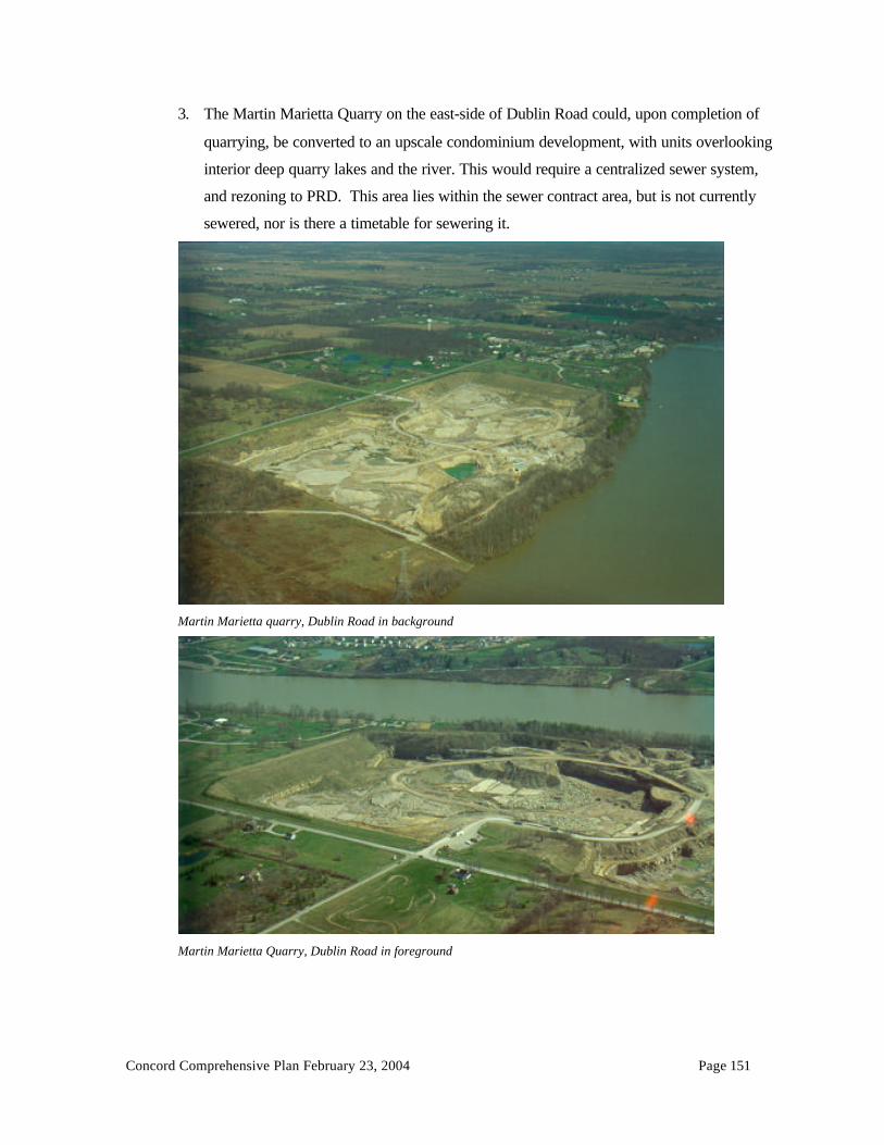
Concord Comprehensive Plan February 23, 2004 Page 151
3. The Martin Marietta Quarry on the east-side of Dublin Road could, upon completion of
quarrying, be converted to an upscale condominium development, with units overlooking
interior deep quarry lakes and the river. This would require a centralized sewer system,
and rezoning to PRD. This area lies within the sewer contract area, but is not currently
sewered, nor is there a timetable for sewering it.
Martin Marietta quarry, Dublin Road in background
Martin Marietta Quarry, Dublin Road in foreground

Concord Comprehensive Plan February 23, 2004 Page 152
4. Due to the lack of sanitary sewer and generally unsuitable soils for on-site septic and leach
line systems, the development of the remainder of the township west of the river must be
very low density (approximately one unit per two acres) utilizing mounds, or other
alternative sewage disposal systems such as land application zero discharge systems.
5. Without alternatives such as conservation subdivisions in the rural areas, there will
ultimately be no public or semi public (common, private) open space in this area.
6. Bellepoint will become surrounded by large lots, either in subdivisions or on road frontage
lots. The neighborhood grid pattern will stop at its current limits. The walking scale
traditional neighborhood will not be expanded.
7. Two commercial areas on US 42 will be developed within ¾ mile of one another. The
first is approximately 16 acres on the immediate east-side of the reservoir, being the
northeast and southeast corners of Riverside Drive and US 42., displacing some homes
and vacant land. The second commercial area comprises 18 acres at the intersection of S.
Section Line Road and US 42. These areas are currently zoned Planned Commercial, but
no development plans are currently in place, meaning that any commercial development
will be reviewed only as an administrative action, and no right of referendum will be
available to the residents. To be viable commercial land, sanitary sewer must be available.
8. A large Industrial area (173 acres) will straddle US 42 at the northeast corner of the
township, abutting the city of Delaware. These lands will be developed in the Industrial
zone, which is not a planned district. Any permitted use in this district will be allowed
provided it meets zoning requirements. There will be no right of referendum. To be truly
viable industrial land, sanitary sewer must be provided. If sewer is not available in the
township, these lands may eventually annex into Delaware for services. Alternatively, a
joint economic development agreement, or JEDD, might be struck between the township
and Delaware to share the services and revenues without annexation.
9. Few new road connections are guaranteed in the rural areas due to the repeated use of
Common Access Drive subdivisions. Existing two lane township roads may therefore
have to bear all connecting traffic.

Concord Comprehensive Plan February 23, 2004 Page 153
10. As road frontage is used up by no plat lot splits, and CADS, some new “conventional”
subdivision streets will be platted. Concord Township has many such conventional
subdivisions, Brust Road, Irish Hills Drive, Eversole Run, and more. Conventional
subdivisions create only lots and streets. There are no public open spaces to walk to, no
central green or woods, no riverbank or lakeshore because all the land has been parceled
out to all landowners. Conventional subdivisions do not create permanent, interconnected
open space. They do not preserve conservation areas. If all land were divided into
conventional subdivisions, rural character would eventually be destroyed.
13.3 Alternative Development Patterns
1. Cluster Subdivisions
For thirty years, cluster subdivisions, or “Planned Residential Developments” have been touted as an
improved alternative to the conventional subdivision. To date, one large cluster subdivision, Scioto
Reserve, has been approved in Concord Township.
Scioto Reserve PRD subdivision, Home Road running east-west
In PRDs, greater design flexibility is obtained by reducing lot size, and width. The absence, however,
of comprehensive standards for quantity, quality and configuration of open space has permitted
uninspired designs, which are reduced-scale conventional subdivisions. Scioto Reserve uses its golf
course as the required open space. This is a single-use open space that does not provide for non
golfers and children’s open space needs.

Concord Comprehensive Plan February 23, 2004 Page 154
Typical Delaware County Planned Residential Development
The typical Delaware County PRD has often resulted in developments that did not fulfill community
expectations for:
• Open Space- In Concord Township, there is no PRD open space requirement.
Environmentally sensitive areas or unbuildable areas (wetlands, steep slopes, floodplains,
storm water detention basins and utility easements) do not have to be delineated. The
calculation of density per gross acre results in inflated “net” densities because unbuildable
areas count toward density. The result is smaller lot sizes and a more urban feel than the gross
density suggests. For example, many PRD’s have been built in Delaware county at a gross
density of 2 units per acre, yet the actual lot size is 6,000- 9,000 square feet ( 5-7 net units per
acre).

Concord Comprehensive Plan February 23, 2004 Page 155
• Useable Open Space- PRD subdivisions with small (7,200-10,000 square feet) lots have been
created without any useable common open space. Scioto Reserve has little common or public
open space. The golf course is private open space, for members only.
Scioto Reserve. Looking west toward the Scioto River
• Density-Any property owner in the township may request a PRD at densities of up to 3 units
per acre. Densities greater than one unit per acre may not conform to the comprehensive plan.
• Design- large (300 units or more) Planned Unit Developments need a local pedestrian oriented
design, with a possible local commercial and service core, active recreation area, and
sidewalks/bike paths. Many true Delaware County villages are smaller than 300 homes. For
example, Shawnee Hills is currently 208 homes, and the village provides local services and
pedestrian scale.
• Architectural Standards- in order to make higher density cluster subdivisions work,
considerable thought needs to be given to the architecture, materials, facades, detailing, colors
and landscape features that will bind the neighborhood into a cohesive unit. Such criteria are
generally required. Seldom does a land developer, who intends to sell the subdivision to a
builder or builders, bother to provide significant criteria. The result is often a jarring hodge-
podge of different builder’s standard production houses with no continuity of material or
architectural syntax. Without specific standard criteria, the zoning commissions must
negotiate these details on an inconsistent basis. Cluster housing demands greater advance
planning and significant landscape architecture and architectural design elements.

Concord Comprehensive Plan February 23, 2004 Page 156
Harbor Pointe is a Berlin Township Planned Residential Development (cluster subdivision) designed
to better open space and environmental protection standards. With an overall density of 1.25 units per
acre, Harbor Pointe saves sensitive areas, preserves useable open space, and connects neighborhoods
with trails.
Harbor Pointe, under construction on the right, Meadows of Cheshire on the left, Berlin Township, Delaware County, Ohio.
Note the preserved tree lines, open space at the entrance and distributed throughout the site.

Concord Comprehensive Plan February 23, 2004 Page 157
2. Conservation Subdivisions
Conservation Subdivisions are a form of rural cluster subdivision where natural features and
environmentally sensitive areas (conservation areas) are excluded from development and preserved.
Homes are clustered in the remaining areas.
The term Conservation Subdivision, as coined by author Randall Arendt (Conservation Design for
Subdivisions, 1996, Island Press) requires the following elements:
• 50% or more of the buildable land area is designated as undivided permanent open space.
• The design is density-neutral. The overall number of dwellings allowed is the same as would
be permitted in a conventional subdivision layout based on an alternative “yield plan”.
• Primary Conservation Areas are protected as open space and deducted from the total parcel
acreage, to determine the number of units allowed by zoning on the remaining parts of the site.
Primary conservation areas are highly sensitive resources that are normally unusable, such as
wetlands, steep slopes, and floodplains.
• Secondary Conservation Areas are preserved to the greatest extent possible. Secondary
conservation areas are natural resources of lesser value such as woodlands, prime farmland,
significant wildlife habitats, historic archaeological or cultural features, and views into, or out
from the site.
• Compact house lots are grouped adjacent to the open space.
• Streets are interconnected to avoid dead ends wherever possible.
• Open space is interconnected and accessible by trails or walkways.
Conservation subdivisions are typically located in areas without sanitary sewer service, at densities of
less than one unit per acre. (Note: For densities greater than one unit per acre, a PRD with 25-35%
open space may be more appropriate. Primary conservation areas should still be preserved.)
The following graphics are presented with permission of Randall Arendt, from his book Conservation
Design for Subdivisions (1996, Island Press, )

Concord Comprehensive Plan February 23, 2004 Page 158
Site before development
Traditional subdivision of large lots, leaving no common open space – Yield Plan

Concord Comprehensive Plan February 23, 2004 Page 159
Site with conventional subdivision
Identifying primary conservation areas

Concord Comprehensive Plan February 23, 2004 Page 160
Identifying the secondary conservation areas
Siting of potential buildings

Concord Comprehensive Plan February 23, 2004 Page 161
Drawing streets and lot lines
Site build-out with conservation design

Concord Comprehensive Plan February 23, 2004 Page 162
Conservation Subdivisions offer tremendous potential for retaining rural character and maintaining an
overall low density in Concord Township.
3. Traditional Neighborhood Development (TND)
Andres Duany, Elizabeth Plater-Zyberk, Peter Calthorpe and others are a school of architects and
planners (The New Urbanism, Toward an Architecture of Community , Peter Katz, 1994, McGraw Hill)
who advocate a return to the traditional neighborhood design popular in the United States before
World War II. The hallmarks of TNDs are formal design, a dense core, grid streets, mixed uses, and
strict guidelines for architecture, materials, and common open space. Distance from the center of a
neighborhood to its edge is ideally ¼ mile, or a five-minute walk. TNDs emulate successful older
neighborhoods such as Delaware’s north end historic district and old Sunbury. TNDs require public
sanitary sewer to support urban densities.
The following TND graphics are reproduced from Rosemary Beach sales literature. Rosemary Beach
is a TND located on the Gulf of Mexico in Florida, designed by Andres Duany and Elizabeth Plater-
Zyberk.

Concord Comprehensive Plan February 23, 2004 Page 163
A miniature TND already exists at Bellepoint. Expansion of the grid street pattern with smaller lots
would be possible if sanitary sewer service could be provided.Aerial photo of Bellepoint, April 2002
Lucy Depp subdivision was platted in the 1920’s with grid streets and small lots (35’ x 70’). If it were
desired, Lucy Depp could become a TND with the addition of mixed uses, strict architectural
Concord Comprehensive Plan February 23, 2004 Page 164
standards and sanitary sewer.
Common Elements of Great Communities and the TND
In 1996 the state of Florida prepared a development guide for its Department of Community Affairs as
a way of attempting to improve the tremendous growth it foresaw in the coming decades. The book
was republished by the American Planning Association as Best Development Practices, by Reid
Ewing, and immediately became a planner’s must-read. It looked at new and mature developments in
Florida and identifies the best development practices to be emulated by others.
In so doing it listed dozens of developments and communities considered Florida’s best. What
relevance is there for Ohio? Ohio’s traditional neighborhoods (TND’s) were designed like theirs, in
grids, and then evolved into curvilinear street patterns of segregated land uses. As Florida became one
of the nation’s fastest growing states, new thinking was needed to prevent traffic congestion, sustain
investment in neighborhoods, and create interesting, efficient, places to live and work. DCRPC
Director Philip Laurien visited Florida to tour these preferred communities. While touring older,
established communities that had never declined, or had been reborn with vitality, it was obvious there
were shared elements of the best of the new and the best of the old. As a way of concentrating these
perceived physical elements of that one trip, the following list is offered for consideration in planning
TND’s, and rural communites.
Common Elements of Great Communities
1. Central public open spaces (park, square, greenbelt, and water) in every neighborhood.
2. Variety of architectural styles, with compatible elements
3. Retention of history through reinvestment and restoration of structures
4. Fine grained downtown or village centers with:a.) Intimate, human scaleb.) Angle parking, with 2-3 lanes of trafficc.) Street trees/plantersd.) Decorative/historic street lighting (at human scale)e.) High quality, permanent, natural materials (stone, brick, stucco, real wood)f.) Classic architectural elements: pillars, cornices quoins, deep overhangs. No plain boxes.g.) Wide sidewalks, with colored paver or brick accentsh.) Retention of public and cultural buildings as anchorsi.) Mixed uses (residential, commercial, office)j.) Compact blocks with no rapid through-traffic. Block design purposefully interrupted.
Where through streets exist, make treed boulevards.k.) Fine grained signage with theme. No pole signs. Extensive use of painted window signs,
labeled awnings, fascia signs, none internally lit. Small hanging signs from buildings.

Concord Comprehensive Plan February 23, 2004 Page 165
l.) Large glass area on first floor shops to invite the outside in. Glass divided by verticalposts or pillars as support and as design element.
m.) Narrow streetsn.) Restrained color palette. No clashing garish colors.o.) “0” setbacks or minimal setbacks from the right of way. Commercial uses on ROW with
paved sidewalk up to storefronts. House with 10-20’ courtyards, fenced at ROW.p.) Grid pattern streets, short blocks, with low speeds, stop signs at intersections.q.) Wall graphics in classic style, restrained palette. Historic murals or advertising.r.) Small shops, narrow structures, with greater depth. Parking to rear and angle parking in
street.s.) Landscape end islands to protect angle parking and provide location for street trees.
5. Highway Commercial Uses with the following attributes:a.) Greenbelts along roadwayb.) Controlled access points, adequate setback for parallel access roads.c.) Ground signs rather than pole signs. High (100’) pole signs only permitted within certain
distance of major interstate interchanges for on-premise advertising of highway relatedservices (motel, food, auto).
d.) Prohibition of billboardse.) Lush landscaping; end islands for parking stalls. Forested parking lots.f.) Signage restraint. Use of franchise type fonts and colors, but neutral backgrounds. No
garish or florescent colors. Unified background color on shared signs.g.) Avoidance of white, yellow and red plastic internally lit signs.h.) Limit number, type and location of signs.i.) Limit conversion to inappropriate uses such as flea markets from storage lockers.j.) Parallel access roads or interconnecting parking lots to limit curb cuts to major highway.k.) Community theme for greenbelt/landscape along road.l.) Deep setbacks.
6. Residential Areas with the following attributes:a.) Narrow streets with either no on street parking for streets with deep (more than 35’ from
ROW) setbacks, or on-street parking with landscaped end islands for streets with shallow(less than 35’ from ROW) setbacks.
b.) Traffic calming features (center islands with landscaping), eyebrow islands withlandscaping), parks at blocks end to divert traffic flow.
c.) Separation of residential uses from all other uses, or alternatively, intentional mixture ofresidential and commercial as part of a town center or Traditional NeighborhoodDevelopment with strict architectural controls and elements.
d.) Curvilinear roads to fit hilly topography and/or environmentally sensitive areas; gridstreets in flat, or formal planned town centers or TND’s, low speeds.
7. A general plan for overall road development.
8. Require development to “fit” and preserve natural features such as topography, wetlands,floodplains, water views, and trees. Encourage public space around such features.
9. Preserve rural areas with the following attributesa.) open vistas from the roadsb.) save natural resourcesc.) retain agriculture where feasible

Concord Comprehensive Plan February 23, 2004 Page 166
d.) retain woods where feasible or replant.e.) Narrow roads, wide spacing of curb cutsf.) Deep setbacks.g.) Low densities.h.) Retention of rural/historic structures, such as attractive wooden barns.i.) Retain tree lines along rural roads.
10. Industrial areas with the following attributes:a.) Ground or fascia signage, no pole signs.b.) Wide roads with large curve radii for heavy trucks.c.) Location in parks, not stripped out along highways.d.) Landscaped greenbelt around parking areas.e.) Signalized entrance to park areas for safe vehicular entry.f.) Landscaped buffer to residential usesg.) Generous area for truck loading and turning
4. Farmland Preservation
With 39% of Concord Township land still in agriculture (Table 5.1), agricultural preservation is an
issue. The Delaware County Commissioners appointed a Farmland Preservation Task Force in 1998.
The Task Force issued a Farmland Preservation Plan in June 2000 with 12 recommendations for
action. Recommendation number 4 is to “Support and encourage any township that seeks to protect its
agricultural industry through zoning codes.”
The following are some possibilities:
A. Purchase of Agricultural Easements- (Quoting from the County Farmland Preservation Plan):
“With the passage of Ohio Senate Bill 223 in 1998, purchase of agricultural conservation
easements (PACE), also known as purchase of development rights (PDR), is now legal under Ohio
law. The Ohio Department of Agriculture-Office of Farmland Preservation is currently drafting
rules in anticipation that Ohio will be able to offer matching funds to local entities that have set up
a program to retain and protect farmland.” The plan also recommends that the county “ Provide
redevelopment incentives for cities and villages with existing urban services to reduce cost of new
services and unnecessary conversion of farmland.” Perhaps both Bellepoint and Lucy Depp would
be considered as locations for such redevelopment efforts.
B. The Farm Village
The Farm Village is a conservation-subdivision where the “secondary” conservation area is farmland.
In the Concord Township Farm Residential zone, one-acre lots are currently required, but 2-5 acres

Concord Comprehensive Plan February 23, 2004 Page 167
lots are common in order to meet Board of Health requirements for on-site sewage disposal systems.
As an alternative, a Farm Village could permit the same overall density, but with clustering of smaller
lots to preserve large amounts of open space as agriculture.
Farm Village, 120 lots (15 % bonus for doing Farm Village) in cluster, 240 acres in permanent
easement for open space/farmland, 320 acres total.
The township could delineate areas farmers wish to see remain agricultural, if any. The township
could also determine what densities can reasonably be served with roads, sewer, water, fire, schools,
etc, and plan for only those densities.
13.4 Smart Growth
Maryland enacted “Smart Growth” legislation in 1997. Since then, Smart Growth has been a topic for
planners nationwide. Maryland directs state growth related expenditures into locally designated
compact growth areas.
The American Planning Association defines Smart Growth as “a collection of planning, regulatory,
and development practices that use land resources more efficiently through compact building forms,
in-fill development and moderation in street and parking standards.” For APA, one of the purposes of

Concord Comprehensive Plan February 23, 2004 Page 168
Smart Growth “is to reduce the outward spread of urbanization, protect sensitive lands and in the
process create true neighborhoods with a sense of community.”
Smart Growth encourages the location of stores, offices, residences, schools and related public
facilities within walking distance of each other in compact neighborhoods. The popularity of many
smart growth concepts has captured the interest of the press as well. Smart growth incorporates many
of the concepts of conservation subdivisions in rural areas, and TNDs in urban areas.
13.5 Which Development Pattern(s) for Concord?
Concord Township should:
• Identify critical resource areas that should be given primary or secondary conservation area status,
and permit both Conventional large lot and Conservation subdivisions in the FR-1 District.
• Consider using “Farm Villages” as Conservation Subdivisions to preserve farmland .
• Consider a TND as a mixed- use development “node” at either Bellepoint and/or Lucy Depp.
• Group commercial buildings to share parking and access to arterial streets. Consider mixed uses
of commercial and residential as part of a large scale planned unit development that creates a sense
of community rather than strip the commercial along arterial roads.
13.6 Development Patterns and Cost of Services
Many growing communities struggle with the cost of providing new services, especially when their
property tax base is primarily residential. Depending on the development pattern chosen, Concord
Township has the potential opportunity to develop a significant commercial and industrial property tax
base on US 42. This commercial tax base could help pay for new services and support the school
districts.
Every community must determine what land use mix provides an appropriate balance of commercial
versus residential property tax base. Single family residential development is often suspected of not
paying its fair share of its costs because of school costs for children.
A $150,000 single family house in the Olentangy School district that generates one school age child
also generates a $5,100 negative fiscal impact (property taxes paid versus cost to educate the student)
that must made be up by other sources of revenue, most importantly other property tax revenues.

Concord Comprehensive Plan February 23, 2004 Page 169
In order to ascertain what land use mix might be optimal, it is necessary to analyze the fiscal impacts
of development to determine the costs versus revenues to the community.
Models for estimating the fiscal impact of new development were developed by Robert Burchell,
David Listokin and William Dolphin in The New Practitioner’s Guide to Fiscal Impact Analysis,
(Center for Urban Policy Research, Rutgers University, 1985), and the Development Assessment
Handbook , Urban Land Institute, 1994). Burchell and Listokin define development impact analysis as
follows:
“Development impact analysis is the process of estimating and reporting the effects of residential and
nonresidential construction on a host political subdivision, usually a local community, school district,
special district and/or county. The effects take several forms:
a.) physical
b.) market
c.) environmental
d.) social
e.) economic
f.) fiscal
g.) traffic
Development impact assessment may be either prospective or retrospective; it may be short term or
long term; it may be an in depth or abbreviated study.”
Burchell and Listokin have created models to calculate fiscal development impacts. These models
use derived multipliers from regional or national standards to gauge impacts. For example, a single
family home with four bedrooms in Central Ohio would be expected to generate 1.428 school age
children. These may be further broken down to .9866 school age children in grades Kindergarten–
Sixth; .2475 in Junior High School, and .1906 in High School. Local school districts use their own
derived multipliers.
13.7 Impact Fees and Ohio Law
Concord Township’s vision for future development will be represented by its Comprehensive Plan.
The potential fiscal impacts of future development projects can be determined, but such determination
does not, however, entitle the township or the school district to charge an impact fee.

Concord Comprehensive Plan February 23, 2004 Page 170
Although some states permit impact fees based upon a fair share allocation of the costs of new
development, Ohio planning and zoning legislation does not currently empower townships to charge
impact fees that offset costs of service expansion (roads, schools, parks, etc.). It has been generally
held, however, that if road improvements are needed immediately adjacent to the development, and
can be directly attributable to the project, and if the benefit of contributing to the improvement
outweighs the burden of such improvement for the development in question, a “fair share”
contribution to the improvement can be requested by the community.
Alternatively, if large proposed developments do not reasonably mitigate their own impacts, they may
impose an undue burden on the township. In such cases the rezoning may be premature.
Cities and villages can impose impact fees for road improvements. An Ohio Supreme Court case
(Home Builders Association of Dayton and the Miami Valley et al v. City of Beavercreek, 89 Ohio St
3d 121; decided June 14, 2000) held that an impact fee imposed on real estate developers is
constitutional if:
1.) the impact fee bears a reasonable relationship between the city’s interest in constructing
new roads and the traffic generated by new developments, and
2.) there is a reasonable relationship between the fee imposed and the benefits accruing to the
developer as a result of the construction of new roads.
Clearly, cities and villages may now adopt impact fees that conform to the Supreme Courts ruling in
Ohio. Whether this power will ever be extended to townships is unclear, and should be discussed with
township legal counsel.

Concord Comprehensive Plan February 23, 2004 Page 171
CHAPTER 14
Goals and Objectives
14.1 Vision Statement for Future Development of Concord Township, 2002-2012
Now that the Steering Committee has studied the history of the township’s recent growth, the forces
that bear upon it for additional growth, the opportunities and constraints to such growth, they have
expanded their initial vision statement (see Chapter 4) for development of the township in the next ten
years.
Ultimately, we would like Concord Township to be a community that retains large lots, and a low
residential density (generally less than one unit per gross acre) in a pastoral setting with significant
permanent open space.
The rural character of the township will be maintained by agriculture as long as it is economically
viable. When agriculture is no longer viable, open space should be preserved by large lots, and by
conservation subdivision developments at an overall density of less than one unit per acre. Rural
roads should generally remain two lane roads, and have a rough edge, with fencing that reminds of
the rural past. Mature landscaping should replace fence/tree rows if they are removed.
Sensitive environmental aspects (ravines, floodplains, jurisdictional wetlands, waterways, etc.) should
be preserved as the township develops. “Special places” such as forested lands, open meadows and
creek-side trails can be preserved within conservation subdivisions. Historic and/or significant
agricultural structures that give a sense of our heritage should be preserved as part of new
developments.
There should be a variety of housing choices and price ranges, and adequate infrastructure to serve
new development. We would like to see a diversity of housing types to meet different housing needs
(i.e., older adults, empty nesters, individuals and families). There should be a balance of commercial,
residential and recreational uses; commercial and industry should be developed for a broader tax
base, but should be buffered from exclusively residential areas. The Scioto River should be a
continuous park and open space corridor.

Concord Comprehensive Plan February 23, 2004 Page 172
14.2 Goals and Objectives for Future Development
Natural Resources
Goals
1. To preserve the rural character of Concord Township as expressed in its openness, green areas,
farms, natural resources (floodplains, wetlands, slopes> 20%, ravines, creeks and rivers).
2. To retain wildlife cover and corridors where feasible.
3. To preserve the rural “look” along township roads via fencing and landscaping in new planned
developments.
4. To retain historic and agricultural structures, where feasible.
5. To preserve scenic views, where feasible, as open space within Planned Residential Developments
or Conservation Subdivisions.
6. To preserve a high degree of environmental quality.
7. To link Planned Residential Developments (PRD’s) and Conservation Subdivisions with common
green spaces and paths.
8. To conserve surface and ground water quality around the Scioto River and the O’Shaughnessey
Reservoir.
Objectives
1. Obtain the linkage of subdivisions by streets, bike paths, or green way trails so neighborhoods are
connected and pedestrian oriented. Create a landscape detail for green way trails.
2. Retain wooded green ways along ravines, waterways and project perimeters.
3. Amend the zoning resolution to reflect the net developable acreage rather than gross density in
calculating the number of dwelling units in a PRD.
4. Amend the zoning resolution to identify and protect floodplains, jurisdictional wetlands, and steep
slopes.
5. Adopt regulations that permit Conservation Subdivisions in the FR-1 District as a Planned Unit
Development at FR-1 density.
6. Support amendment of county subdivision regulations to protect 100-year floodplains.
7. Set landscape and architectural design standards for PRD subdivisions. Stipulate centralized green
space.
8. Create a rural landscape detail for PRD’s that front on township roads.

Concord Comprehensive Plan February 23, 2004 Page 173
9. Amend the zoning text to require the appropriate landscaping buffer detail between residential and
non-residential land uses. Retain natural vegetation and use existing topography as buffers.
10. Promote off-stream storm water detention in developments tributary to the O’Shaughnessey
Reservoir.
11. Retain natural ravines and their vegetation as filter strips for surface water.
12. Establish a 120-foot structural setback from the normal pool elevation of the Scioto River to
preserve surface water quality. Such setback should include subsurface wastewater disposal
systems.
Agriculture
Goals
1. To provide an opportunity for agriculture to continue through flexible/creative zoning.
2. To retain low residential density in agricultural areas.
Objectives
1. Retain a 1.5-acre minimum lot size in areas not served by centralized sanitary sewer.
2. Permit Conservation Subdivisions and Farm Villages in the FR-1 zoning district. .
3. Use the Land Evaluation Site Assessment (LESA) system to evaluate lands worthy of Purchase of
Agricultural Conservation Easements (PACE).
4. Identify potential farmlands for PACE.
5. Preserve farmland by voluntary (sale) of development rights from farmland to adjacent Farm
Villages.
6. Assist interested farmers in applying for state or federal funding for purchase of agricultural
easements.
Residential Development
Goals
1. To relate land use and density to land suitability, utility availability, existing land use, and the
recommendations for each sub area.
2. To consider the carrying capacity of infrastructure (sewer, water, fire protection, roads, etc) in
establishing residential densities.
3. To provide rural areas where agriculture is transitioning to large lot residential and where no
central sewer is available.

Concord Comprehensive Plan February 23, 2004 Page 174
4. To provide for suburban residential housing districts where central water, sewer, fire protection,
schools, adequate roads and other suburban services can be economically provided.
5. To retain a primarily single family residential housing mix, but permit a diversity of housing
types.
6. To avoid sprawling subdivisions consisting only of lots and streets and no local parks or green
space, and where every human need results in an automobile trip, even a trip to a green space area.
7. To protect township real estate values.
Residential Development
Objectives
1. Retain a minimum lot size of 1.5 acres where there is no centralized sanitary sewer provided.
2. Use the width of roads, water and sewer systems, and soil characteristics to establish densities and
land uses on the comprehensive plan.
3. Permit Conservation Subdivisions in the FR-1 district at a density of .75 units per acre with
centralized sewer service.
4. Avoid development of uses or densities that cannot be serviced by currently available or
imminently planned infrastructure, unless such development mitigates its unplanned infrastructure
impacts.
5. Amend the PRD text to identify non-developable lands (floodplains, water, slopes greater than
20%, jurisdictional wetlands and utility easements) in density calculations.
6. Permit multi-family units in Planned Residential Developments, approved per development plan.
7. Permit age-restricted elderly housing in prescribed areas along arterial roads.
8. Maintain the area east of The Scioto River, and south of Home Road as a possible suburban
residential heart of the township, subject to provision of centralized water and sewer.
9. Permit single family housing in standard “straight zoning” subdivisions on 20,000 square foot lots
with centralized sanitary sewer and water, adequate fire protection and road access.
10. Permit PRD’s at approximately 1.25 units per acre. PRDs should have centralized sewer, access
to a major collector or arterial street, and mitigate their fair share of off site traffic impacts.
11. Consider a Traditional Neighborhood Development on the platted narrow lots in the Lucy Depp
area adjacent to Shawnee Hills if public sewer can be extended.
12. Consider a Traditional Neighborhood Development (country village) adjacent to Bellepoint if
public sewer can be extended.

Concord Comprehensive Plan February 23, 2004 Page 175
Commercial and Industrial Development
Goals
1. To encourage commercial and light industrial development in planned districts to broaden the jobs
and tax base, and to prevent property taxes from rising faster than the growth in the township tax
base.
2. To provide for dense landscape buffering between Commercial/Industrial and residential uses.
3. To encourage commercial, office and light industrial development in the US 42 corridor.
4. Work with the village of Shawnee Hills to encourage a community shopping center (grocery store,
drugstore, etc.) in Shawnee Hills to serve Concord Township, Shawnee Hills and Muirfield
Village.
5. To provide for transitional land uses and dense landscape buffering between incompatible land
uses.
Objectives
1. Create development guidelines for planned commercial development.
2. Use parallel frontage or backage roads on U.S. 42 to control access onto the arterial road.
Recreation
Goals
1. To provide passive and active recreational areas as the township grows.
2. To expand the township parks program.
3. To link planned residential neighborhoods with green spaces and walking/biking paths.
Objectives
1. Improve Home Road park with more active recreation (playing fields for organized sports).
2. Create a series of mini-parks (less than 1 acre) with ¼ mile spacing within Planned Residential
Developments where densities are between 1-2 units per acre. Create a series of neighborhood
parks of 15 acres with active recreation with ½ mile spacing in PRD neighborhoods.
3. Where possible, link new parks in PRDs with Columbus parkland along the Scioto River.
Township Services
Goals
1. To recognize and maintain only those services needed for a predominantly rural/low density
community.

Concord Comprehensive Plan February 23, 2004 Page 176
2. To expand township services at a rate to ensure public health and safety, and to discourage
premature development.
3. To acquire suitable land for the township’s future needs.
Objectives
1. Acquire new sites for township facilities, including fire, police, road maintenance, etc.
2. Determine the services the township can provide as a suburban community with a sense of rural
character.
3. Work with elected officials to increase services as needed, but not in a way to compete with urban
development, so as to retain a rural community.
4. Use the Comprehensive plan as the guideline in zoning.
Planning and Zoning
Goals
1. To determine and implement an appropriate land use mix.
2. To coordinate central sewer extensions to appropriate suburban core areas.
3. To implement and maintain the land use plan.
4. To enforce zoning regulations.
Objectives
1. Revise the zoning text and map in accordance with the comprehensive plan.
2. Develop policies for service provision that relate to the comprehensive plan.
3. Provide for 5 year updates and revisions to the plan.
Transportation
Goals
1. To avoid congestion on local, county and state roads.
2. To retain the narrow township roads where possible as part of the rural character.
3. To improve the road network without destroying the rural character.
4. To seek developer mitigation of their road impacts of their adjacent developments.
Objectives
1. Cooperate with ODOT on removing/preventing unnecessary commercial curb cuts on US 42.
2. Require commercial parallel access roads and connections between planned commercial
developments along major arterial roads, especially US 42.

Concord Comprehensive Plan February 23, 2004 Page 177
3. Assist appropriate government agencies in the review of corridors for the proposed Alternative 1
to the County Thoroughfare Plan. Seek the corridor that provides the best traffic efficiency and
least impact on north Concord Township. Consider portions of Bunty Station Road as a corridor.4. Restrict left turns across traffic on US 42. Coordinate turns at new signals.
5. Adopt the appropriate ODOT Access Management recommendations; work with ODOT to
prevent the deterioration of US 42.
6. Encourage construction of new roads A and B shown on the Comprehensive Plan as part of new
developments.
Citizen Participation
Goals1. To ensure significant and diverse citizen input into the planning process.
Objectives
1. Use the 24-member steering committee as the primary citizen input to the Zoning Commission in
amending the Comprehensive Plan.
2. Advertise open informational meetings to discuss and review the recommendations of the plan
prior to public hearings.
3. Publish and mail a synopsis of the plan to every household in Concord Township.
4. Encourage active citizen participation in future comprehensive plan updates.

Concord Comprehensive Plan February 23, 2004 Page 178
Chapter 15
Recommendations
Intent of the Concord Township Comprehensive Land Use Plan
The 2004 Concord Township Comprehensive Plan is the sum of all the chapters and appendices.
Chapter 15 is to be read in conjunction with the Comprehensive Land Use Plan map.
15.1 Sub Area I – Dublin and Shawnee Hills area, southern portion of the township
Boundaries: Territory inside of the city of Dublin and the Village of Shawnee Hills, pockets of
Concord Townshipalong the Scioto River.
Land Area: 1,458 acres.
General Facts and Findings
Concord Township has no planning or zoning authority over municipal areas. Nonetheless, Township
land use plans should relate to the adjacent existing land uses within Dublin or Shawnee Hills.
The Shawnee Hills Comprehensive Plan resolved the issue of building rights on hundreds of non-
conforming lots of record by a policy and zoning amendment that distributes sewer taps to all land
owners, but not every lot of record. The ability to obtain sewer may encourage the annexation to
Shawnee Hills of non-conforming lots of record in Lucy Depp and Shaw Nee Hills Additions.
Certain land uses that need sewer service might be better located within Shawnee Hills than Concord
Township. For example, a community shopping center and satellite local stores could be serviced
with infrastructure in Shawnee Hills, and would still serve the region.
The isolated subdivisions of Stan-Gene No. 3 and Hiland Heights are pockets of Concord Township
that are surrounded by Dublin. They are recommended for continued Farm Residential district usage ,
as they are developed in accordance with standards for single family homes on acreage lots.
15.2 Sub Area II - Shawnee Heights
Boundaries: Territory outside the city of Dublin and the Village of Shawnee Hills, west of the Scioto
river, south of Merchant Road.
Land Area: 2,941 acres

Concord Comprehensive Plan February 23, 2004 Page 179
General Facts and Findings
This area has access to Dublin Road, SR 745. It is the only location in the township with major
arterial streets, water and potential sewer service (subject to annexation to Shawnee Hills in their
sewer contract area, or provided by Delaware County in the future using Dublin sewer as the discharge
point). The highest elevations in the township are found in the southwest, sloping towards the river,
with rolling land veined with seasonal creeks. A two-pronged confluence of Eversole Run and its
southern sister divides the eastern portion of the sub area. There are few large blocks of undeveloped
land remaining. Most soils are suitable for development, but with limitations for on- site sewage
systems due to slow permeability in heavy soils, or shallow depth to bedrock. Most soils do not
produce high agricultural yields, and the value for housing is rapidly changing agriculture to country
lots in the desirable Dublin school system. Most development is single family homes on acreage lots
in FR-1 zoning, which requires 1.5 acre lots. The exception is Tartan Fields, a 302-acre golf course
and upscale housing development in the southwest corner of the township. Tartan Fields will
ultimately provide centralized sewer service to 455 homes with a developer-built, OEPA approved and
county-maintained tertiary sewage treatment plant and land application system.
No Delaware County public sewer service is anticipated in Sub Area II in the near future, however,
Delaware County does have a contract with Columbus that would allow either party to sewer this sub-
area at up to 4 persons per acre (approximately 1.25 units per acre). The 2004 Delaware County
Sewer Master Plan Preliminary Report depicts this area as the Lower Scioto (future) Service Area,
with densities up to 1.25 dwelling units per acre.
Sub Area II Recommendations
1. Lucy Depp- Lands in the Lucy Depp area north of Shawnee Hills have been platted since
1920’s with very small (typically 35’ x 70’) lots and are currently without sewer service. This
area is part of the Shawnee Hills sewer contract area, but it requires annexation to Shawnee
Hills to obtain sewer service. If county sewer service were made available, the Township
should create a new zone that requires the same lot size as Shawnee Hills (14,700 square feet)
per building lot, but also have a system to recognize certain smaller non-conforming lots of
record. Annexation will reflect the personal decision of the landowners. A Traditional
Neighborhood Development (see Chapter 13) could be developed in Lucy Depp and Shawnee
Hills based on the original subdivision plat.

Concord Comprehensive Plan February 23, 2004 Page 180
2. Baker and Hagloch land - approximately 13 acres west end of Logan Street.
11.2 acres are being used for agriculture with greenhouses. The Baker and Hagloch lands
could be redeveloped as higher-value uses. With the recent rezoning of the Saunders tract to
the west as PRD at 1.25 units per acre, a stub street was required to access these lands. These
lands are recommended for single family development at 1.25 units per acre with centralized
sewer service.
3. Corner of Glick and Manley Roads- the Kroger Company purchased 9.6 acres in a triangle
bound by Glick and Manley Roads in 2002. Kroger has since announced that the grocery store
planned for this site will be moved to the intersection of Hard and Sawmill Roads in Dublin.
The Comprehensive Plan recommends the 9.6-acre site be used as a Planned Residential
Development for single family residential at approximately 1.5 units per acre with centralized
sewer. If township officials feel some limited convenience commercial is appropriate at this
site, approximately one-acre of “the Point” of the 9.6-acre triangle could be developed as
convenience store, subject to strict architectural controls such as brick exterior, A-roof, ground
signs, no pole signs, parking and loading facing Manley Road. Dense landscaping should
buffer the residential homes.
4. Saunders lands - the lands to the east of Tartan Fields and west of Shawnee Hills on the south
side of Harriot road have recently been rezoned to PRD in accordance with the
recommendation of this plan for single family residential uses at a density of 1.25 units per
acre.
5. Marble Cliff Quarry lands, east/west side of Dublin Road, north of Cook Road.
These lands lie south of the existing limestone quarry. The quarry was recently
decommissioned and is being closed out.
The comprehensive plan recommends residential re-use of the quarry after the 120 acre
mining operation is done at a density of approximately 1.5 units per acre if served by sanitary
sewer, or .66 units/ac. if served by on-site sewage disposal systems. The plan also
recommends the same use and density for the lands directly opposite the existing quarry, being
63.89 acres owned by Marble Cliff, 40.2 acres owned by Kaylor Hill Painter, and 10 acres

Concord Comprehensive Plan February 23, 2004 Page 181
owned by Constance Patridge. This quarry site has the opportunity to line the riverbank with
upscale homes or condominiums that take advantage of river views and lake views in the
quarry. If all the Marble Cliff tracts were eventually combined into one upscale waterfront
development, there would be a total of approximately 327 (gross) acres, which could result in
approximately 490 housing units. Centralized sanitary sewer service would be required.
6. The remainder of Sub Area II is recommended for residential use maintaining the current
minimum lot size of 1.5 acres with septic systems, or single family residential PRDs at 1.25
units per acre with centralized sewer.
7. In order to promote rural character and still retain permanent open space, it is suggested that
FR-1 zoning be amended to permit density-neutral Conservation Subdivisions. Total number
of lots in the Conservation subdivision if no centralized sewer were provided would be
equivalent to a yield plan showing 1.5 acre lots (approx. .67 units/ac.). If centralized sewer is
provided in Conservation Subdivisions, density could be .75 units per acre.
15.3 Sub Area III - Farm Country
Boundaries: West of the Scioto river, south of U.S. Route 42, north of Merchant Road.
Land Area: 3,496 acres
General Facts and Findings
The area contains some moderately high yielding level farmland west of Dublin Road. More than
1,000 acres are being farmed, but there have been extensive road frontage lot splits into acreage home
sites with on site septic systems. Such lots are typically 2 acres and larger. This low-density area
geographically relates to the Union County farms to the west.
Del-Co water is available. Although no county sewer service is anticipated in Sub Area III in the near
future, Delaware County has a contract with Columbus that would allow either party to sewer this sub-
area at up to 4 persons per acre, equivalent to 1.25 dwelling units per acre. The Township Trustees
have requested the County Sanitary Engineer consider the feasibility of sewer service at a density of
1.25 units per acre for this area in his current sewer master planning.
The 1,000 acres of active farmland north and south of Moore Road and west of Dublin Road is a
potential target for another PRD, which, at present densities of 1.5-3 units per gross acre could allow

Concord Comprehensive Plan February 23, 2004 Page 182
1,500-3,000 new homes and 4,500-9,000 new residents. Such dense subdivisions served by skinny
farm-to-market township roads would promote suburban sprawl, adversely impact the township’s
desire to maintain rural character, and result in the need to widen township roads, increase fire
protection, consider township police protection, and construct new schools.
Recommendations, Farm Country Sub Area III
8. A standard minimum lot size for a residential lot should be maintained at 1.5 acres (.66
dwelling units per acre) when served by on-site sewage disposal systems. Depending on soil
conditions, larger lot sizes may be required by the Board of Health for on site sewage disposal
systems. Pewamo soils shown on the Plan map are not suitable for septic systems.
9. In order to promote rural character and still retain permanent open space, it is suggested that
Conservation Subdivisions be made a permitted use in FR-1 zoning at a density of .75
dwelling units per acre with sanitary sewer service.
10. If Planned Residential Developments are requested, they should not exceed 1.25 dwelling
units per acre, be located on a major collector or arterial road, be served by centralized
sanitary sewer, and their fair share of road improvements to mitigate their traffic impacts.
They should remain a referendable legislative event, enacted pursuant to Ohio Revised code
519.021 A.).
11. U.S. Route 42 road frontage should not be developed commercially at this time. This is a
federal highway with heavy truck traffic connecting from I-70 and US 33 to US 23 and I-71.
This is a 2-lane 55-mile per hour road. Excessive commercial development along this corridor
would slow down traffic and result in more accidents. When centralized sanitary sewer
becomes available to the commercial and industrial development in the northeast corner of the
township (Area V) then this corridor should be revisited for possible commercial development
provided there are proper access management practices such as limited left turns across traffic,
parallel backage roads and strict sign controls to prevent visual clutter.
15.4 Sub Area IV - Lower Scioto
Boundaries: East of O'Shaunessey Reservoir, south of Hyatts Road.
Land Area: 1,893 acres

Concord Comprehensive Plan February 23, 2004 Page 183
General Facts and Findings
Until 1998 this sub area was a farming and low-density residential area, with no sewer service. In
1998 the township zoned 748 acres PRD for Scioto Reserve, a 1,255-unit planned golf course
development utilizing on-site sewage treatment with land application to the golf course (density 1.67
units per acre). New home sales by production builders at Scioto Reserve pushed Concord Township
into the third fastest growing township in the county, with 330 new homes built in 2001. While the
golf course provides a visual green space in the center of the development, there is little common open
space other than the golf course, and virtually none that is useable and free. The township has already
received comments from Scioto Reserve residents that there is no place for children to play.
Scioto Reserve now dominates the Lower Scioto sub area. It has brought a diversity of housing sizes
and types to the township, and attracted city dwellers to come live in the “country” in a suburban
setting, albeit a very nice suburban setting. When completed, its 1,255 new homes will generate
12,000 new auto trips per day. The developer widened Home Road to 3 lanes, and has committed to
placing a traffic signal at the intersection of Home and Riverside Drive. Riverside Drive traffic has
increased.
Home Road is the major east-west arterial. The narrow two-lane Home Road Bridge has been
replaced by a wide two lane bridge with the capability to be expanded to four-lanes, which makes it
easier to cross the river, but may also signal that the west bank is ready for development.
The steering committee acknowledged the many improvements made by the developer of Scioto
Reserve, and the apparent demand for housing types such as those provided at Scioto Reserve, but
lamented the rapidity of change, and the loss of rural character. The committee felt that Concord
Township would not be well served to repeat large PRD’s at this density wherever developers could
assemble lands, although expansion of Scioto Reserve to adjacent lands may be appropriate, if there is
additional sewer capacity.
Del-Co water is available to sub area IV, but there is no county sanitary sewer service currently
provided outside of Scioto Reserve.

Concord Comprehensive Plan February 23, 2004 Page 184
Delaware County has undertaken a sewer master plan for the entire unincorporated county and
solicited opinions from the trustees as to their desire for sewer in the township and at what density.
The trustees have indicated a willingness to have county sewer service at 1.25 units per acre.
The city of Powell is within 1,500 feet of the east boundary of the township after the Golf Village
annexation (at Steitz Road).
Sub Area IV Recommendations
12. A standard minimum lot size for a residential lot should be maintained at 1.5 acres when
served by on-site sewage disposal systems.
13. Planned Residential Developments at a density of 1.25 units per acre should also be allowed in
this sub area if served with centralized county sewer. If Planned Residential Developments are
requested, they should have access to a major collector or arterial road, and have centralized
sewer, plus pay their fair share of road improvements to mitigate their traffic impacts.
14. PRDs should remain a referendable legislative event, enacted pursuant to Ohio Revised code
519.021 A.) as amended by HB 280 in 1997. The lands adjacent to Scioto Reserve and south
of Hyatt’s Road are potential extensions of Scioto Reserve if sewer capacity is available.
15. The 39- acre R-6 multi family zoning district on the west side of Steitz Road has begun to
develop for eighteen 4-unit condominium buildings. The plan reflects its R-6 zoning.
15.5 Sub Area V - Upper Scioto
Boundaries: North: Scioto Township; West: Scioto River; East: Delaware/Delaware and Liberty
Townships; South: Hyatts Road.
Land Area: 4,108 acres
General Facts and Findings
This is an area of very level, high-yield agriculture soils. Agriculture continues, but proximity to the
city of Delaware puts development pressure on flat lands along US 42 if sewer ever becomes
available. There is Del-Co water service, but no county sewer currently provided. The 2004 Delaware
County Sewer Master Plan Preliminary Report designates this area as part of the future Lower Scioto
Sewer Service Area. Residential development tends to be large lot 2-10 acres, with many flag lots and

Concord Comprehensive Plan February 23, 2004 Page 185
some Common Access Drive (CAD) subdivisions. Extensive Pewamo soils are not conducive to on-
site sewage disposal systems.
There are two areas of active farmland that could be a potential PRD. Approximately 200 acres lie
north of Hyatts Road, south of Clark Shaw Road, and east of Section Line Road. Approximately 400
acres lie north of Bean Oller, south of Maynard, and east of Section Line Road. If developed under
current PRD standards of 1.5-3 units per acre these 600 acres could yield 900-1800 homes and 2,700-
5,400 new residents. Such large, dense subdivisions accessed by skinny farm-to-market township
roads would promote suburban sprawl and adversely impact the townships desire to maintain its rural
character, result in the need to widen township roads, increase fire protection, consider township
police protection, construct new schools, and encourage neighborhood commercial development.
Riverside Drive and Section Line Road are the major north/south arterial streets, and are expected to
see increased traffic. Section Line Road carries heavy trucks from the quarries in Union County and
Scioto Township. These trucks run down Bunty Station Road to U.S. 23 and points east.
The 2002 Delaware County Thoroughfare Plan recommends two new roads in this sub area. Alternate
G is a Riverside Drive to Section Line Road connector south of Clark Shaw Road. Alternate 1 is an
east-west connector from U.S. 42 to U.S. 23 whose alignment is being further studied, but could be
anywhere in a swath from north of Bean Oller Road to south of Slack Road.
Sub Area V Recommendations
16. A standard minimum lot size for a residential lot should be maintained at 1.5 acres when
served by on-site sewage disposal systems.
17. In order to promote rural character and still retain permanent open space, it is suggested that
Conservation Subdivisions be made a permitted use in FR-1 zoning at a density of .75
dwelling units per acre with sanitary sewer service.
18. If Planned Residential Developments are requested, they should be a maximum density of
1.25 dwelling units per acre, have access to a major collector or arterial road, and have
centralized sewer, plus pay their fair share of road improvements to mitigate their traffic

Concord Comprehensive Plan February 23, 2004 Page 186
impacts. PRDs should remain a referendable legislative event, enacted pursuant to Ohio
Revised code 519.021 A.).
19. U.S. Route 42 road frontage should not be developed commercially southwest of Freshwater
Road at this time. This is a two-lane 55-mile per hour federal highway with heavy truck
traffic connecting from I-70 and U.S. 33 to U.S. 23 and I-71. Excessive commercial
development along this corridor would slow traffic and increase accidents. However, if county
sewer service is provided to the proposed commercial and industrial area in the northeast
corner of the township (Area V) then this US 42 corridor should be revisited for possible
commercial development provided there is proper access management control.
20. When agriculture is no longer viable, a large industrial park area should be developed north of
Bunty Station Road and extending west of Section Line Road. Delaware County should be
encouraged to provide sanitary sewer service. There have been significant large industrial
developments interested in tracts of 150 or more acres here, but the lack of loop roads around
Delaware, the possibility of being divided by the Sawmill Parkway extension to US 42, and
lack of sanitary sewer have delayed development. Industrial development is especially
desirable in the flight paths of Delaware airport. Federal Aviation Administration height
restrictions must be considered for structures in the direct flight path.
21. Sawmill Parkway will be extended from Home Road in Liberty Township north to intersect
with US 42, potentially within Concord Township. The Sawmill Parkway corridor study has
been commissioned by the Delaware County Engineer and is currently underway. To preserve
the major super blocks of land north of Bunty Station in Sub Area V for industrial
development, the Comprehensive Plan suggests Sawmill Parkway be routed to the west to
intersect US 42 northeast of Section Line Road (new road “A” on the Comprehensive Plan).
Sawmill Parkway should continue north across US 42 to end at Section Line Road (new road
“B” on the Comprehensive Plan). A portion of Bunty Station Road could be incorporated into
the Sawmill Parkway. Bunty Station Road could thus be considered as the preferred
alignment for Alternate 1, a widely defined corridor east-west connector from US 42 to US 23
depicted in the 2002 Delaware County Thoroughfare Plan. If Bunty Station became the
improved Alternate 1, improvements would be needed at the northerly terminus of SR 315,
Bunty Station and US 23. Such improvements must avoid the Stratford Ecological Preserve, a

Concord Comprehensive Plan February 23, 2004 Page 187
state- protected farm. The Plan suggests further study of these proposals as part of the
Delaware County Engineer’s corridor study for the Sawmill Parkway.
22. A 45-acre tract at the NW corner of the US 42 and Section Line Road intersection and
extending to Freshwater Road is recommended for Planned Commercial as a future
neighborhood shopping center when sewer is available. Access management practices should
limit access. There should be extensive landscape mounding and tree buffering established to
screen the single-family homes on the south side of Freshwater Road.
23. Land north of U.S 42 and west of the proposed industrial and commercial areas should remain
low-density single family residential along Freshwater and Klondike Roads with minimum lot
sizes of 1.5 acres. PRD’s are generally not preferred for this area.
15.6 Sub Area VI - Mill Creek Valley
Boundaries: North: Scioto Township; South: U.S. 42 to a line south of the U.S. 42/Dublin Road
intersection extending east to the river; East: east side of parcels that front on the east side of Klondike
Road; West: Scioto Township and Union County.
Land Area: 1,981 acres.
General Facts and Findings
This area is divided east west by the Scioto River and north- south by Mills Creek. Mills Creek’s wide
floodplain impacts lands along Mills Road. The topography is rolling with flat plateaus. The
unincorporated village of Bellepoint is a 19th century grid town center, commercially zoned but
without commercial development. Bellepoint church is a local gathering place, as are the City of
Columbus parklands at the confluence of Mills Creek and the Scioto River. With the closure of the
old Bellepoint Bridge, the small east and west side settlements are divided.
Other than Bellepoint, the area is sparsely populated with low-density 2-10 acre lots and small farms.
Many of the township roads are narrow. Three large power lines cross the area.
Soils along the Scioto River and Mills Creek have underlying bedrock. Upland soils are moderately
high yielding croplands. One family owns much of the agricultural acreage.

Concord Comprehensive Plan February 23, 2004 Page 188
The approximately 400 acres of active farmland northwest of US 42 and south of Mills Creek is a
potential target for another PRD. At present densities of 1.5-3 units per gross acre such development
could allow 600-1200 homes and 1800-3600 new residents. Such far-flung large suburban density
subdivisions, accessed by skinny farm-to-market township roads on the west side of the Scioto River
would promote suburban sprawl, result in the loss of rural character, the immediate and costly need to
widen township roads, increase fire protection, consider township police protection, construct new
schools, and encourage neighborhood commercial development.
Soils over bedrock may be unsuitable for on site sewage disposal systems. This territory is part of
Delaware County’s future Lower Scioto Sewer Service area, but sewer extension is going to be
development driven and may be a long time in the future.
Sub Area VI Recommendations
24. A standard minimum lot size for a residential lot should be maintained at 1.5 acres when
served by on-site sewage disposal systems.
25. In order to promote rural character and still retain permanent open space, it is suggested that
FR-1 zoning be amended to also allow Conservation Subdivisions as permitted uses at the
same density of (.66 units/acre) without sanitary sewer, or .75 units per acre with centralized
sewer.
26. U.S. Route 42 road frontage should not be developed commercially at this time. This is a two-
lane 55-mile per hour federal highway with heavy truck traffic connecting from I-70 and U.S.
33 to U.S. 23 and I-71. Excessive commercial development along this corridor would slow
traffic and increase accidents. However, if county sanitary sewer is provided to the
commercial and industrial development in the northeast corner of the township (Area V), then
this corridor should be revisited for possible commercial development provided there is proper
access management.
27. If Planned Residential Developments are requested, they should be a maximum of 1.25
dwelling units per acre, have access to a major collector or arterial road and have centralized
sewer, plus pay their fair share of road improvements to mitigate their traffic impacts. PRDs

Concord Comprehensive Plan February 23, 2004 Page 189
should remain a referendable legislative event, enacted pursuant to Ohio Revised code
519.021 A.).
15.7 Future Land Use Mix
Table 15.1 shows the future land use mix of the township if the 2004 Comprehensive Plan were
implemented and the township was totally built out.

Concord Comprehensive Plan February 23, 2004 Page 190
Table 15.1 Future Land Use Mix- 2002 Concord Township Comprehensive Plan-Total build out
2001land use in acres
%Total
ComprehensivePlan
(total build-out)to nearest acre
%Total
Single Family 4,371.802 27.53 10,035 63.2 %
Multi family 89.284 .562 93 .58 %
Commercial/office 63.87 .402 90 .56 %
Institutions 156.112 .9832 156 .98 %
Industrial/Hwy Dev. 212.29 1.337 688 4.33 %
Agriculture 6,307.693 39.729 0 0 %
Water 956.92 6.027 957 6.02 %
Highway/Rail/Utility 724.68 4.564 1539 9.69 %
Parks/undev land 2373.476 14.949 2373 14.94 %
Totals 100.00 15,931 100.00
15.8 Future Population- Alternative Scenarios
The projected 2003 year end population of Concord Township was 6,612 (DCRPC housing unit
method).
There are approximately 6,000 acres of unplatted, developable agricultural land (after factoring out
2,198 acres of river, floodplain, steep slopes, and jurisdictional wetlands) recommended for residential
use.
The alternate scenarios for future population and open space are:
1.) Build Out Scenario Based On Existing Zoning
§ With PRDs at 3 units per (gross) acre- If the township were built out under current 2003
zoning, with all identified potential PRD sites developed at 3 units per acre (no deductions
for roads, steep slopes, wetlands or floodplains) within the 6,000 developable acres, the
maximum population would be approximately 56,000. Because of the 3 units per gross
acre density, the zoning resolution would require the developer to provide “ useable parks
or public open space” but there is no certainty as to the percentage of open space that
would be provided. All farmland would be developed.

Concord Comprehensive Plan February 23, 2004 Page 191
§ With PRDs at 1.5 units per (gross) acre- If the township were built out under current
(2003) zoning, with all identified potential PRD sites developed at 1.5 dwelling units per
gross acre (no deductions for roads, steep slopes, wetlands or floodplains) within the
6,000 developable acres, the maximum population would be approximately 31,000.
Because this is the standard 1.5 units per gross acre density, there is no specific open
space requirement. All farmland would be developed.
2.) Build Out Scenarios Based On The 2004 Comprehensive Plan
• (Highest population estimate)- If all the large tracts of vacant land were developed as
PRDs at 1.25 units per (gross) acre, (no deductions for roads, steep slopes, wetlands or
floodplains within the 6,000 developable acres) the maximum population of Concord
Township would be approximately 26,000.
§ (Medium Population Estimate with Conservation Subdivisions and PRD density
reductions for environmentally sensitive areas) -If all potential large tracts of vacant
land were developed as PRDs at 1.25 units per acre, but with density deductions for roads,
steep slopes, wetlands and floodplains within the 6,000 developable acres, the maximum
population of Concord Township would be approximately 23,000. There would be
approximately 1,200-2000 acres of preserved open space if the township adopted a 20%
open space standard in PRDs and 50% in Conservation Subdivisions. This would permit
fields of prairie grass, new forests, walking and biking paths, ponds and wetlands. Homes
sitting on one-quarter to one-half acre lots would be interspersed within this open space, so
there would be a rural feel and sense of tranquility. Wildlife would continue to run
through these open areas.
• (Low Population Estimate- no PRDs or Conservation Subdivisions)
If no new PRDs or Conservation subdivisions are developed and all remaining land is simply
developed with on-lot sewage disposal systems at the minimum lot size of 1.5 acres, the
maximum build out population would be approximately 16,000, with no new open space
preserved other than parks existing in 2003.
§ Realistic Expectation of Future Population- A realistic expectation of the township’s
maximum population developed pursuant to the 2004 Comprehensive Plan would be

Concord Comprehensive Plan February 23, 2004 Page 192
20,000, with 1,500 acres of permanent open space in addition to current park land. If the
2001 rate of building continues (320 homes per year x 2.74 person /unit = 879 new
residents/year), the township could be totally built out by 2019.
The character of the township will continue to reveal itself as the plan is implemented. The township
should revisit the comprehensive plan in five years (2009) to consider whether changes need to be
made.

Concord Comprehensive Plan February 23, 2004 Page 193
Chapter 16
Implementation
The Comprehensive Plan is intended to be the basis for township zoning. Zoning is the enforceable
tool. The Comprehensive Plan is a guide that should be consulted in every proposed rezoning.
16.1 Recommended Zoning Amendments
1. Minimum lot size- FR-1 lot size of 1.5 acres in zone for lots not served by centralized sewer.
Require at least one acre of net developable land within the 1.5-acre lot.
2. Planned Residential Developments
a.) Establish density for PRD zoning as a maximum of 1.25 dwelling units per gross acre. Make
a base density of less than 1.25 units per acre, but allow that density provided certain
performance criteria are met.
b.) Create a two step approval process. The first step would be the review and approval of a
preliminary development plan by the Township Zoning Commission and Trustees, and the
amendment of the zoning map. This would be a referendable event. The second step would
be the administrative review of the development plan for final
3. Conservation Subdivisions
a.) Adopt a Conservation Subdivision text.
b.) Make Conservation Subdivision subdivisions a permitted use in the FR-1 zone at a density of
.66 units per net developable acre without centralized sewer, and .75 units per net developable
acre with centralized sewer.
4. Signs- revise sign code to prohibit pole signs and billboards. Permit ground signs and fascia signs.
5. Floodplains-
a.) Prohibit filling of 100- year floodplain unless granted a conditional use for cause.
b.) Create a zoning regulation for floodplain development that supplements the county floodplain
regulations.
6. M-2 district- Establish performance conditions for the quarrying use in the M-2.

Concord Comprehensive Plan February 23, 2004 Page 194
7. Planned Commercial – Modernize and update. Use the North American Standard Industrial
Classification system numbers to identify specific land uses that are permitted. Create a two step
approval process as described in the PRD section above.
8. Planned Industrial -Modernize and update. Use the North American Standard Industrial
Classification system numbers to identify specific land uses that are permitted. Create a two step
approval process as described in the PRD section above.
9. Adult Entertainment- Adopt new regulations to control the location of adults only uses.
10. Access Management and Traffic-
a.) Work with County Engineer to develop access policies and standards for county/township
roads.
b.) Coordinate developments along state roads with ODOT regarding access management
standards.
c.) Require access management compliance as condition of development plan approval for
Planned Developments.
d.) Require traffic studies for rezoning to any use that generates more than 100 new trips per day,
or as determined by the proposed Delaware County Traffic Impact Standards. Require
developer to mitigate his fair share of the traffic impact as part of PUD review and approval.
Establish a level of service (LOS) C as the desired level of service.
11. New Roads- Use the comprehensive plan as the guide where new roads need to be built.
Coordinate with County Engineer regarding corridor studies for such new roads. Seek provision
of right of way within super blocks of land developed as planned districts. Use Bunty Station as
the northern terminus of the Sawmill Parkway and also as the east west Alternative 1 corridor
depicted generally on the County Thoroughfare Plan.
12. Recreation- use NRPA standards as a guide for recreational areas needed. Secure the provision
and/or construction of useable open space by developers of major new Planned Unit
Developments (30 homes or more).

Concord Comprehensive Plan February 23, 2004 Page 195
13. Greenways- Require a landscaped or forested greenway linkage of new Planned Unit
Developments (Planned Residential Developments, Conservation Subdivisions, and/or Farm
Villages). Add greenway criteria to the zoning resolution; count its area as open space.
14. Buffer-Amend the zoning resolution to show a landscape detail buffer between incompatible land
uses.
15. Definitions-
a.) Amend definition of single family dwelling to include permanently sited manufactured homes
in compliance with Ohio Revised code.
b.) Add other definitions as needed to clarify the intention of the zoning resolution.
13. Scioto River Corridor- Establish 900’ elevation on the zoning map in Sub Areas III-VI. Maintain
lot size of at least 1.5 acre below 900’ elevation to protect the Scioto River from urban runoff. This
continues the same regulation in Liberty Township. Within Conservation Subdivisions and PRDs
served by centralized sewer lot sizes may be reduced to .6 acre below elevation 900’, provided all
houses are constructed outside of the 100-year floodplain.
16.2 Non zoning related actions
1. Consider acquisition of additional public parklands in quantities that relate to population size,
according to NRPA standards in this plan.