FORM 1 - Environmental Clearance
77
Form 1 for Enhancement of capacity from 0.4 MTPA to 2.62 MTPA of DVC Bermo Mine, Bermo 1 FORM 1 (Issue 01, Rev 01, May 2017) (I) Basic Information 1 Name of the Project/s : Damodar Valley Corporation (DVC) Bermo mine 2 S. No. in the Schedule 1(A) 3 Proposed capacity/ area/ length/ tonnage to be handled/ command area/ lease area/ number of wells to be drilled Proposed Capacity: 2.62 MTPA Mine Lease Area: 167.434 Ha Project Area: 169.344 Ha 4 New/ Expansion/ Modernization Expansion (0.4 MTPA to 2.62 MTPA) 5 Existing capacity/ area etc 0.4 MTPA 6 Category of Project A 7 Does it attract general condition. If yes, please specify No, as there is no state boundary, sanctuary/ National Park/ Ecological Sensitive area/ critically polluted area in 10 km radius of the project. Nearest State Boundary- West Bengal, 22.4 km, SSE Nearest International boundary- Bangladesh, 272 km, E Nearest critically Polluted area-Jharia-43 km, E 8 Does it attract specific condition If yes, please specify No 9 Location Refer Annexure I for location plan Plot/ Survey/ Khasra no. Several, as given in Annexure II Village Baidkaro, Kargali, Karo and Amlo Tehsil Block - Bermo District Bokaro State Jharkhand
-
Upload
khangminh22 -
Category
Documents
-
view
0 -
download
0
Transcript of FORM 1 - Environmental Clearance

Form 1 for Enhancement of capacity from 0.4 MTPA to 2.62 MTPA of DVC Bermo Mine, Bermo 1
FORM 1 (Issue 01, Rev 01, May 2017)
(I) Basic Information 1 Name of the Project/s : Damodar Valley Corporation (DVC)
Bermo mine 2 S. No. in the Schedule 1(A) 3 Proposed capacity/ area/ length/
tonnage to be handled/ command area/ lease area/ number of wells to be drilled
Proposed Capacity: 2.62 MTPA Mine Lease Area: 167.434 Ha Project Area: 169.344 Ha
4 New/ Expansion/ Modernization Expansion (0.4 MTPA to 2.62 MTPA) 5 Existing capacity/ area etc 0.4 MTPA 6 Category of Project A 7 Does it attract general condition. If
yes, please specify No, as there is no state boundary, sanctuary/ National Park/ Ecological Sensitive area/ critically polluted area in 10 km radius of the project. Nearest State Boundary- West Bengal, 22.4 km, SSE Nearest International boundary-Bangladesh, 272 km, E Nearest critically Polluted area-Jharia-43 km, E
8 Does it attract specific condition If
yes, please specify No
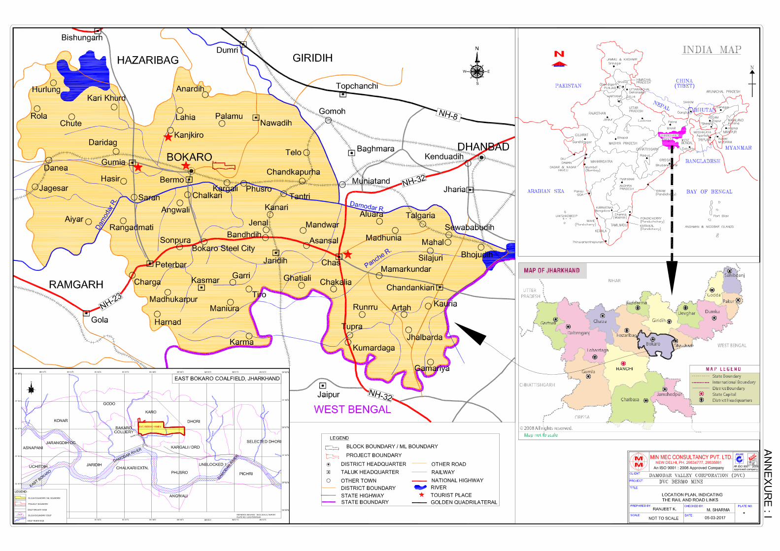
9 Location Refer Annexure I for location plan Plot/ Survey/ Khasra no. Several, as given in Annexure II Village Baidkaro, Kargali, Karo and Amlo Tehsil Block - Bermo District Bokaro State Jharkhand

Form 1 for Enhancement of capacity from 0.4 MTPA to 2.62 MTPA of DVC Bermo Mine, Bermo 2
10 Nearest railway station/ airport along with distance in kms
Bermo Railway Station - 0.8 km, SW Ranchi Airport - 120 km
11 Nearest town, city, district head
quarters along with distance in kms Bokaro Steel City - 40 km District HQ - Bokaro - 40 km
12 Village Panchayats, Zilla Parishad,
Municipal Corporation, Local Body (complete postal addresses with telephone nos. to be given)
PO - Bermo District - Bokaro Pin - 829104
13 Name of the applicant M/s Damodar Valley Corporation (DVC)
Bermo Mine 14 Registered Address DVC Towers, VIP Road, Kolkata-700054 15 Address for correspondence : Name Mr. Pramod Kumar Designation (Owner/ Partner/ CEO) Executive Director (Fuel) Address DVC Tower, 3rd floor, VIP Road, Kolkata Pin Code 700054 Telephone no. 033-66072316, 09434742667 Fax - 16 Details if Alternative sites examined,
if any. Location of these sites should be shown in a toposheet
Not Applicable
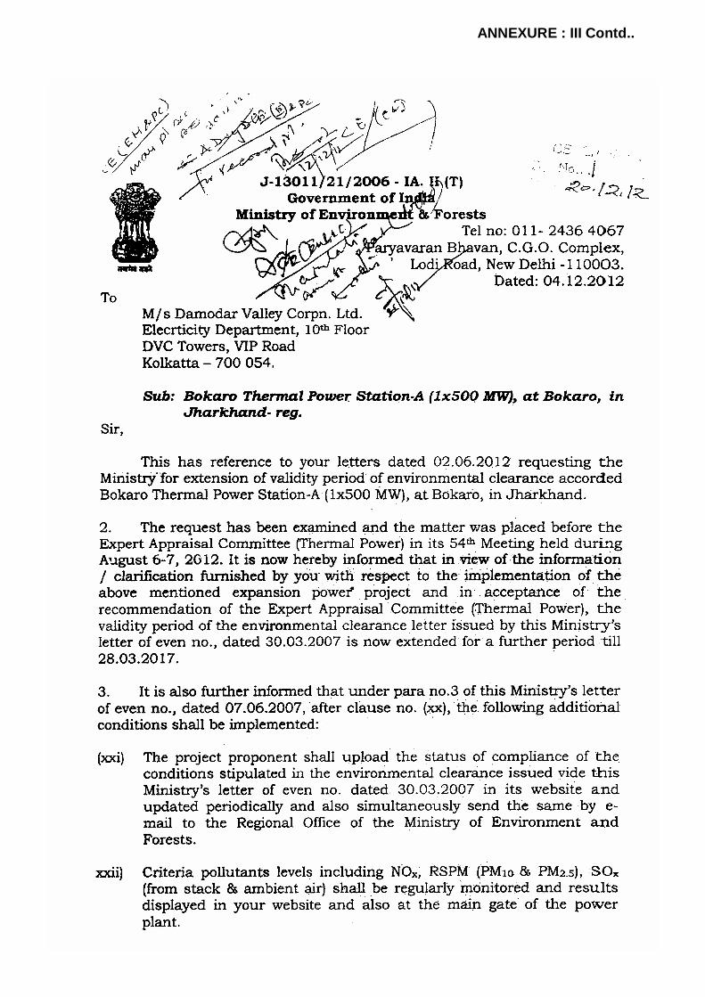
17 Interlinked Projects Bokaro Thermal Power Station (BTPS)
and Chandrapura Thermal Power Station (CTPS)
18 Whether separate application of
interlinked project has been submitted?
Yes, EC has been granted for Bokaro Thermal Power Station (BTPS) ‘A’(1*500 MW) at BTPS, Bokaro, Jharkhand
19 If yes, date of submission EC letter is attached as Annexure III. 20 If no, reason NA

Form 1 for Enhancement of capacity from 0.4 MTPA to 2.62 MTPA of DVC Bermo Mine, Bermo 3
21 Whether the proposal involves approval/ clearance under : if yes, details of the same and their status to be given:
Yes
(a) The Forest (Conservation) Act, 1980?
Forest clearance shall be required as 120.313 ha of Forest land is present within ML Area named as “GM Jungal” The Company has approached DFO and Formalities will be completed in near future.
(b) The Wildlife (Protection) Act, 1972?
Not applicable
(c) The CRZ Notification, 1991? Not applicable 22 Whether there is any Government
Order/ Policy relevant/ relating to the site?
Not applicable
23 Forest land involved (hectares) 120.313 ha of Forest land is present
within ML Area named as “GM Jungal” 24 Whether there is any litigation
pending against the project and/or land in which the project is proposed to be set up?
Nil
(a) Name of Court - (b) Case No. - (c) Orders/ directions of the Court, if
any and its relevance with the proposed project
-
(II) Activity 1. Construction, operation or decommissioning of the Project involving
actions, which will cause physical changes in the locality (topography, land use, changes in water bodies, etc.)
Sl. No.
Information/Checklist confirmation
Yes/ No
Details there of (with approximate quantities /rates, wherever possible) with
source of information data 1.1 Permanent or temporary
change in land use, land cover or topography including increase in intensity of land use (with
Yes Presently, the core zone is covered with mining activities with gently undulating topography. The total mine lease area is 167.434 ha, presently out of which 42.85 ha is excavated area and 5.77 Ha (over floor of
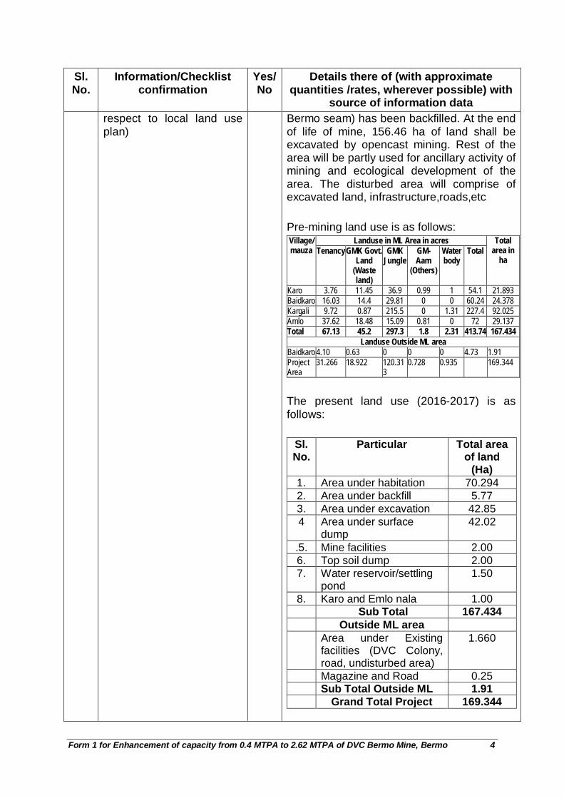
Form 1 for Enhancement of capacity from 0.4 MTPA to 2.62 MTPA of DVC Bermo Mine, Bermo 4
Sl. No.
Information/Checklist confirmation
Yes/ No
Details there of (with approximate quantities /rates, wherever possible) with
source of information data respect to local land use plan)
Bermo seam) has been backfilled. At the end of life of mine, 156.46 ha of land shall be excavated by opencast mining. Rest of the area will be partly used for ancillary activity of mining and ecological development of the area. The disturbed area will comprise of excavated land, infrastructure,roads,etc Pre-mining land use is as follows:
Landuse in ML Area in acres Village/ mauza Tenancy GMK Govt.
Land (Waste land)
GMK Jungle
GM- Aam
(Others)
Water body
Total Total
area in ha
Karo 3.76 11.45 36.9 0.99 1 54.1 21.893 Baidkaro 16.03 14.4 29.81 0 0 60.24 24.378 Kargali 9.72 0.87 215.5 0 1.31 227.4 92.025 Amlo 37.62 18.48 15.09 0.81 0 72 29.137 Total 67.13 45.2 297.3 1.8 2.31 413.74 167.434
Landuse Outside ML area Baidkaro 4.10 0.63 0 0 0 4.73 1.91 Project Area
31.266 18.922 120.313
0.728 0.935 169.344
The present land use (2016-2017) is as follows:
Sl. No.
Particular Total area of land
(Ha) 1. Area under habitation 70.294 2. Area under backfill 5.77 3. Area under excavation 42.85 4 Area under surface
dump 42.02
.5. Mine facilities 2.00 6. Top soil dump 2.00 7. Water reservoir/settling
pond 1.50
8. Karo and Emlo nala 1.00 Sub Total 167.434 Outside ML area Area under Existing
facilities (DVC Colony, road, undisturbed area)
1.660
Magazine and Road 0.25 Sub Total Outside ML 1.91 Grand Total Project 169.344

Form 1 for Enhancement of capacity from 0.4 MTPA to 2.62 MTPA of DVC Bermo Mine, Bermo 5
Sl. No.
Information/Checklist confirmation
Yes/ No
Details there of (with approximate quantities /rates, wherever possible) with
source of information data
Present land use can also be seen in Present Surface Plan attached as Annexure IV.
The proposed land use at end of life of mine will be as follows:
Land use pattern Area (ha) Within ML Mining Rights
Excavation Area Sum of I.2 & I.3 Backfilled Area 101.35 Excavated Void 55.11 Facilities incl. Coal stack, road
3.22
Safety Zone 7.5m (Green belt)
5.54
Rationalisation area (non-forest)
2.214
Sub Total (I) 167.434 Outside the ML Area
Surface Rights only
Facilities excluding magazine
1.09
Green Belt (10m wide) within II.1
0.57
Magazine and Road
0.25
Sub-Total (II) 1.91 Grand Total 169.344
PROPOSED LAND USE OF THE PROJECT AREA AFTER POST
MINE CLOSURE

Form 1 for Enhancement of capacity from 0.4 MTPA to 2.62 MTPA of DVC Bermo Mine, Bermo 6
Sl. No.
Information/Checklist confirmation
Yes/ No
Details there of (with approximate quantities /rates, wherever possible) with
source of information data
Post Closure Type Agricult
ural land
Plantation
Water Body
Public Use
Forest Land
(Returned)
Total
Within ML A. Quarry area Excavation Area 0 0 0 0 0 0 Backfilled Area 0 1.00 0 100.35 101.35 Excavated Void 0 0 55.11 0 0 55.11 Top Soil Dump 0 0 0 0 0 0 Facilities incl. Coal stack, road 0 0 0.82 2.4 3.22
Coal Stack (included in facilities)
0 0 0 0 0 0
External Dump 0 0 0 0 0 0 Safety Zone 7.5m (Green belt)
0
0 0 5.54 5.54
Road (included in facilities) 0 0 0 0 0 0
Road diversion 0 0 0 0 0 0 Nala 0 0 0 0 0 0 Setting pond 0 0 0 0 0 0 Rationalisation area (non-forest)
0 0 0 2.214 2.214
Garland drains 0 0 0 0 0 0 Embankment 0 0 0 0 0 0 Other Green Belt 0 0 0 0 0 0
Habitation 0 0 0 0 0 0 Undisturbed area 0 0 0 0 0 0
0 0 0 0 0 0 0.000 0 56.11 0.82 110.50
4 167.43
4 Outside the block area away from block
Facilities including magazine as follows
Industrial 0 0 0 0 0 0 Colony including road
0 0 0 0.74 0 0.74
R&R 0 0 0 0 0 0 Green Belt (10m wide)
0 0.57 0 0 0 0.57
Magazine with approach road
0.25 0 0 0 0 0.25
Undisturbed 0.35 0 0 0 0 0.35 Sub-Total 0.60 0.57 0 0.74 0 1.91 G. Total 0.600 0.570 56.11
0 1.560 110.504
169.344

Form 1 for Enhancement of capacity from 0.4 MTPA to 2.62 MTPA of DVC Bermo Mine, Bermo 7
Sl. No.
Information/Checklist confirmation
Yes/ No
Details there of (with approximate quantities /rates, wherever possible) with
source of information data The geological plan is given in Annexure V and geological section is given in Annexure VI. Proposed stage plan at the end of 5th year and 21st year of west pit is given in Annexure VII A and VII B respectively. Post Mine Closure Plan is given in Annexure VII C. Conceptual mine sections is given in Annexure VIII.
1.2 Clearance of existing land, vegetation and buildings
Yes Habitation/colonies of Central Coalfields Ltd. (CCL)/DVC that are present inside the ML area, shall be subsequently shifted as mine workings are progressed. These are present in the eastern portion of the block (over “Y-Y” area), as shown in Present Surface Plan (Annexure IV) which will be rehabilitated before exploitation. Few trees exist in forest area due to old habitation/ excavation.
1.3 Creation of new land uses Yes Excavated area, plantation, dumps, etc. will be there during the operational period. Mine Office, Garage, First Aid Room, Rest Shelters, Toilets, Tool/ Store Rooms, etc. are provided at mine site. In the post mining scenario, the project area will comprise of facilities, backfilled and void area of the opencast mine besides plantation. Proposed topography and land use at the end of life (conceptual) within ML is given in Post Mine Closure Plan in Annexure VII C.
1.4 Pre-construction investigations e.g. bore holes, soil testing
Yes Pre-construction activities are not required as the mine is already operational. Core infrastructure like Office Building, Coal Stockyard, Weigh Bridge, CHP, Workshop, Diesel Pump, Workers Accommodation etc. is present at the mine.
1.5 Construction works Yes Office Building, Coal Stockyard, Weigh Bridge, CHP, Diesel Pump, Workers Accommodation etc. have already been constructed and no additional construction is envisaged.
1.6 Demolition works Yes Habitation/ colonies of CCL/DVC that are present inside the ML area, shall be

Form 1 for Enhancement of capacity from 0.4 MTPA to 2.62 MTPA of DVC Bermo Mine, Bermo 8
Sl. No.
Information/Checklist confirmation
Yes/ No
Details there of (with approximate quantities /rates, wherever possible) with
source of information data demolished in the initial stage and shifted as mine workings are progressed. These are present along X-X’ and Y-Y’ area, as shown in Present Surface Plan (Annexure IV) which will be rehabilitated before exploitation.
1.7 Temporary sites used for construction works housing of construction workers
No Though construction activities have been constructed in past but additional construction work is envisaged in the NW corner of the ML.
1.8 Above ground buildings, structures or earthworks including linear structures, cut and fill or excavations
Yes The above ground buildings and structures such as Office Building, Coal Stockyard, Weigh Bridge, CHP, Diesel Pump, Workers accommodation etc. though, are already present at site But will be required to be constructed for expansion on NW corner of the ML. However excavation will be continued through out the life of the mine.
1.9 Underground works including mining or tunneling
No No underground work will be done.
1.10 Reclamation works Yes Plantation over excavated area, external dump, road, Settling pond/reservoir and green belt will be done. Out of 167.434 Ha of ML area, 156.46 Ha will be mined out. Out of total excavated area, 101.35 Ha will be backfilled and planted, while the rest 55.11 ha will remain in the form of a void at conceptual stage and will ultimately become a water reservoir.
1.11 Dredging No No dredging will be done. 1.12 Offshore structures No Not applicable 1.13 Production and
manufacturing processes No It is not a factory, hence manufacturing
process is not applicable. Coal is extracted during mining by removing OB waste after drilling/blasting. Transportation of both is affected by dumpers withn the ML area
1.14 Facilities for storage of goods or materials
Yes Facilities for the storage of coal and other materials though existing but will be relocated to the NW corner of ML during expansion.
1.15 Facilities for treatment or disposal of solid waste or
Yes 110.79 MCum(B) of overburden will be generated during life of mine. Backfilling will start from 8th year with a quantity of 1.00

Form 1 for Enhancement of capacity from 0.4 MTPA to 2.62 MTPA of DVC Bermo Mine, Bermo 9
Sl. No.
Information/Checklist confirmation
Yes/ No
Details there of (with approximate quantities /rates, wherever possible) with
source of information data liquid effluents Mcum(B). During 8th and 9th year partial
backfilling will be done and then from 10th year full backfilling will take place concurrent with mining. The total topsoil generated will be 0.74 Mcum (B) during the life of the mine. As the mine is already operating, the top soil generated will be spread over the dump concurrent with mining for reclamation. Top soil will be used for growing plants along the fringes of the site roads and reclamation of surface dump and backfilled area. Solid waste generated from manpower is and shall be mostly of organic and recyclable nature. The organic waste shall be composted and used as manure while recyclable component will be sold to recycling agencies. The waste water from mine site offices and colony is and shall be treated in septic tank and soak pits system. The waste water from workshop is treated in oil water separator followed by settling tank, which is maintained by outsourcing agency and will be dealt by ETP in future. Vehicles and machinery maintenance is being regularly done by contractor at his own facility outside the project area. The contractors are instructed to reuse the lubricant for different purposes and dispose off only to the licensed agencies for the purpose.
1.16 Facilities for long term housing of operational workers
Yes The mine is already operational and has experienced manpower in place. Additional manpower required for expansion will be available in the surrounding area as the mine is located in the long established coal producing part of the coalfield. Long term housing of operational workers has been envisaged within the existing TPP colony outside the mine lease.
1.17 New road, rail or sea traffic during construction or operation
Yes The mine is already operational and therefore, no new road, rail or sea traffic during construction or operation will be warranted

Form 1 for Enhancement of capacity from 0.4 MTPA to 2.62 MTPA of DVC Bermo Mine, Bermo 10
Sl. No.
Information/Checklist confirmation
Yes/ No
Details there of (with approximate quantities /rates, wherever possible) with
source of information data 1.18 New road, rail, air
waterborne or other transport infrastructure including new or altered routes and stations, ports, airports etc
Yes Coal is being dispatched by road through contractual trucks from Opencast quarry-head to Bokaro Thermal Power Station (BTPS) and Chandrapura Thermal Power Station (CTPS) by the existing road. No new road for OB transportation will be required as it will be managed within the ML area. To cater to the enhanced production of 2.62 MTPA, a CHP/Deshaler for dispatching crushed coal by conveyor, with standby arrangement of truck loading is proposed.
1.19 Closure or diversion of existing transport routes or infrastructure leading to changes in traffic movements
No No closure of existing roads needed. No public road passes through the project or ML area.
1.20 New or diverted transmission lines or pipelines
No There is no HT power line passing through the ML.
1.21 Impoundment, damming, culverting, realignment or other changes to the hydrology of watercourses or aquifers
Yes Karo nallah flows north to south, through the middle of the block. Emlo Nallah, further east to Karo nala, also flows noth to south through the block. Another nallah, namely, Baidkaro Nallah flows (outside the block) parallel to the boundary in the south western side of the block. The mining operations on west of Karo nala (over X-X area) will be initially carried out with concurrent backfilling the de-coaled area starting from immediate vicinity of the Karo nala and moving away from it towards further west. As the Y-Y area on east of Karo nala will have to be mined after 20 years, it will be necessary to divert this nala towards west side over the backfilled area by 20th year. The length of this diverted portion will be about 540m.
1.22 Stream crossings Yes Karo nallah flows north to south, through the middle of the block. Emlo Nallah, further east to Karo nala, also flows noth to south through the block.

Form 1 for Enhancement of capacity from 0.4 MTPA to 2.62 MTPA of DVC Bermo Mine, Bermo 11
Sl. No.
Information/Checklist confirmation
Yes/ No
Details there of (with approximate quantities /rates, wherever possible) with
source of information data Another nallah, namely, Baidkaro Nallah flows (outside the block) parallel to the boundary in the south western side of the block. Stream crossings will be made as per transportation & movement requirement on the nalas before and after diversion.
1.23 Abstraction or transfers of water from ground or surface waters
Yes Potable Water requirement is 242 m3/day & Industrial water 339 m3/day. Potable water requirement will be met from bore well and industrial water requirement will be met from mine sump and surface water reservoir of the Mine
1.24 Changes in water bodies or the land surface affecting drainage or run-off
Yes At present, there are two nalahs flowing in Y-Y’ area [as shown in Present Surface Plan Annexure IV] which are to be diverted. After post mine closure, a water body of 55.11 ha will be left in the Y-Y area. (refer Annexure VIIC).
1.25 Transport of personnel or materials for construction, operation or decommissioning
Yes The requirement of manpower will b met locally as this area is engaged in similar activities for decades. Hence the personnel will manage travelling at their own. The material and coal transport will be affected by trucks/dumpers within ML area and coal will be transported to the TPS initially by road and subsequently by conveyor.
1.26 Long-term dismantling or decommissioning or restoration works
Yes Habitation/colonies of CCL/DVC are present inside the ML area and shall be shifted as mine workings progress. These are present over “Y-Y”and X-X areas, as shown in Present Surface Plan (Annexure IV). Other dismantling will be done only in the post mine closure period. Restoration work will be carried out simultaneously by plantation over backfill area.
1.27 Ongoing activity during decommissioning which could have an impact on the environment
No Improvement of environment will take place
1.28 Influx of people to an area in either temporarily or permanently
Yes There are total of 128 workers including regular staff for 0.4 MTPA production. The proposed expansion project will generate employment for 569 people, some of whom

Form 1 for Enhancement of capacity from 0.4 MTPA to 2.62 MTPA of DVC Bermo Mine, Bermo 12
Sl. No.
Information/Checklist confirmation
Yes/ No
Details there of (with approximate quantities /rates, wherever possible) with
source of information data will be coming from outside and living permanently. It is proposed that the manpower will be accommodated in the already existing colony of BTPS
1.29 Introduction of alien species
No
1.30 Loss of native species or genetic diversity
No
1.31 Any other actions No 2. Use of Natural resources for construction or operation of the Project (such
as land, water, materials or energy, especially any resources which are non-renewable or in short supply)
Sl. No.
Information/checklist confirmation
Yes/No
Details thereof (with approximate quantities /rates, wherever possible)
with source of information data 2.1 Land especially undeveloped
or agricultural land (ha) Yes Out of 169.344 Ha of total project land,
private agricultural land (27.166 ha), Government waste land (18.292 ha), forest land (120.313 ha), others (0.728 ha) and water body (0.935 ha). It may however be noted that the agriculture land as well as forest land (which is mentioned in records as GM jungle land) is already almost completely occupied by the encroachments/ habitation. During the life of the mine, 156.46 ha of land will get excavated at the end of life of mine from total lease which is presently 90.64 ha.
2.2 Water (expected source & competing users) unit: KLD
Yes Total requirement of water for mining and allied activities is estimated as about 581 KLD.
Industrial water required for HEMM washing, sprinkling on haul roads for dust suppression and for watering the mine site plantations, is being and will be supplied from pumping installation at mine sump and for keeping the mine workings dry.
Potable water is being sourced from borewells and stored in overhead tank near the facilities area and distributed through

Form 1 for Enhancement of capacity from 0.4 MTPA to 2.62 MTPA of DVC Bermo Mine, Bermo 13
Sl. No.
Information/checklist confirmation
Yes/No
Details thereof (with approximate quantities /rates, wherever possible)
with source of information data pipe lines to different facilities area for drinking and domestic purposes.
It is proposed to accommodate the manpower in the existing colony of BTPS which already has water supply.
2.3 Minerals (MT) No The project itself will mine coal, hence it does not require any mineral.
2.4 Construction material – stone, aggregates, sand / soil (expected source – MT)
No As the mine is already operating with existing facilities, limited construction materials like cement, aggregates will be required for relocating and constructing the facilities at the NW coener of ML.
2.5 Forests and timber (source – MT)
No As the mine is already operating, limited wood will be required for relocating and constructing the facilities at the NW coener of ML.
2.6 Energy including electricity and fuels (source, competing users) Unit: fuel (MT), energy (MW)
Yes At present, almost all of the equipments are diesel operated for mining activities. Where electrical power is a must, diesel generator backup is available. 11 KvA power shall be required for the proposed expansion phase. Power is received from DVC BTPS (located about 15 km from mine) through 33 KV overhead line. It is stepped down to 11 KV/440v.
2.7 Any other natural resources (use appropriate standard units)
No
3. Use, storage, transport, handling or production of substances or materials,
which could be harmful to human health or the environment or raise concerns about actual or perceived risks to human health.
Sl. No.
Information/Checklist confirmation
Yes/No
Details thereof (with approximate quantities/ rates, wherever possible)
with source of information data 3.1 Use of substances or
materials, which are hazardous (as per MSIHC rules) to human health or the environment (flora, fauna, and water supplies)
No The hazardous materials are engine oil, transformer oil etc., which will be stored in leak proof drums. Hence, no contamination anticipated.

Form 1 for Enhancement of capacity from 0.4 MTPA to 2.62 MTPA of DVC Bermo Mine, Bermo 14
Sl. No.
Information/Checklist confirmation
Yes/No
Details thereof (with approximate quantities/ rates, wherever possible)
with source of information data 3.2 Changes in occurrence of
disease or affect disease vectors (e.g. insect or water borne diseases)
No No water borne diseases are anticipated since due precautions for treatment and disposal of waste-water are and will be taken.
3.3 Affect the welfare of people e.g. by changing living conditions?
Yes The proposed expansion project will generate employment for 569 additional people and the existing manpower is 128. Any change will be towards betterment of life. The company is already conducting CSR activities in the vicinity of the project which shall be continued in future also.
3.4 Vulnerable groups of people who could be affected by the project e.g. hospital patients, children, the elderly etc.
Yes Mining and transportation activity will generate SPM in ambient air, which can affect health of vulnerable groups in nearby villages. However, with proper management planning by sprinkling of water, use of dust extractors, etc, the ambient air is and will be maintained clean. It may be noted that the area is under extensive coal mining activity through many mines, the activity of the proposed DVC Bermo mines will be a meager fraction of that.
3.5 Any other causes No
4. Production of solid wastes during construction or operation or decommissioning (MT/month)
Sl. No.
Information/Checklist confirmation
Yes/ No
Details thereof (with approximate quantities/rates, wherever possible)
with source of information data 4.1 Soil, overburden or mine
wastes Yes 110.79 McumB of overburden will be
generated in the entire life of mine. All the OB generated shall be backfilled ultimately. Top soil quantity of about 0.74 McumB shall be generated which will be reused for plantation.
4.2 Municipal waste (domestic and/or commercial wastes)
Yes As per current provisions, sludge from septic tanks in mines & facilities area, is removed and used as manure. This practice at pit head will be continued. Sludge from domestic wastewater at pit head will be meager quantity and can be used as manure after composting. In

Form 1 for Enhancement of capacity from 0.4 MTPA to 2.62 MTPA of DVC Bermo Mine, Bermo 15
Sl. No.
Information/Checklist confirmation
Yes/ No
Details thereof (with approximate quantities/rates, wherever possible)
with source of information data mine, the sludge generation will be about 10-15 gm/capita/day. Domestic waste will be generated at the rate of 35 gm/capita/day from colony at BTPS location, 15 km away.
4.3 Hazardous wastes (as per Hazardous Waste Management Rules)
Yes Used oil from transformers, generated once in two years will be sold to CPCB/ SPCB authorised recycling vendors.
4.4 Other industrial process wastes
Yes Oil and grease from the workshop effluent will be skimmed through oil-water separator and sold to authorized recycling vendors. The generated sludge will be disposed off in specially constructed pit.
4.5 Surplus product No - 4.6 Sewage sludge or other
sludge from effluent treatment Yes As given in point 4.2 above and will be
used as manure in gardens/ horticulture after composting.
4.7 Construction or demolition wastes
No
4.8 Redundant machinery or equipment
No
4.9 Contaminated soils or other materials
No
4.10 Agricultural wastes No 4.11 Other solid wastes No
5. Release of pollutants or any hazardous, toxic or noxious substances to air
(Kg/hr) Sl. No.
Information/Checklist confirmation
Yes/ No
Details thereof (with approximate quantities/rates, wherever possible)
with source of information data 5.1 Emissions from combustion of
fossil fuels from stationary or mobile sources
Yes Fossil fuel (diesel) is being used in operation of machinery. The excavation and dumping activities cause mine emissions which includes SPM, RPM, SO2 and NOx. Regular monitoring is and shall be carried out by the company at the mine site in line with the requirements of the State Pollution Control Board and Ministry of Environment, Forests & Climate Change.
5.2 Emissions from production processes
Yes The production process involves excavation, which generates SPM.

Form 1 for Enhancement of capacity from 0.4 MTPA to 2.62 MTPA of DVC Bermo Mine, Bermo 16
Sl. No.
Information/Checklist confirmation
Yes/ No
Details thereof (with approximate quantities/rates, wherever possible)
with source of information data 5.3 Emissions from materials
handling including storage or transport
Yes The emissions are included in production emission above.
5.4 Emissions from construction activities including plant and equipment
No
5.5 Dust or odours from handling of materials including construction materials, sewage and waste
No
5.6 Emissions from incineration of waste
No No incineration processes within the mine.
5.7 Emissions from burning of waste in open air (e.g. slash materials, construction debris)
No No burning process within the lease area.
5.8 Emissions from any other sources
No
6. Generation of Noise and Vibration, and Emissions of Light and Heat
Sl. No.
Information/Checklist confirmation
Yes/No
Details thereof (with approximate quantities/rates, wherever possible) with source of information data with
source of information data
6.1 From operation of equipment e.g. engines, ventilation plant, crushers
Yes HEMM is required for excavation of OB and coal. These are high noise generating machinery in the range of 60-100 dB (A) for which noise proof air conditioned cabins has been provided for operator.
6.2 From industrial or similar processes
Yes Plants & Machinery has been provided with suitable devices to reduce the noise level and is being maintained well within the statutory requirements. Ear plugs are being used by workers in noisy areas.
6.3 From construction or demolition
No
6.4 From blasting or piling No Drilling and blasting has been proposed both for OB and coal before excavation / loading operation. 10 tonnes magazine capacity for about 2/3 weeks of storage of permitted explosive, detonators primers

Form 1 for Enhancement of capacity from 0.4 MTPA to 2.62 MTPA of DVC Bermo Mine, Bermo 17
Sl. No.
Information/Checklist confirmation
Yes/No
Details thereof (with approximate quantities/rates, wherever possible) with source of information data with
source of information data and fuse etc has been provided besides an already existing magazine of 4.536 te capacity
6.5 From construction or operational traffic
Yes The plying of trucks for coal transportation shall increase the noise level as the production expansion is from 0.4 to 2.62 MTPA.
6.6 From lighting or cooling systems
Yes Heat shall be generated only in immediate vicinity of light bulb, air conditioners, machinery, etc.
6.7 From any other sources No
7. Risks of contamination of land or water from releases of pollutants into the ground or into sewers, surface waters, groundwater, coastal waters or the sea
Sl. No.
Information/Checklist confirmation
Yes/ No
Details thereof (with approximate quantities/rates, wherever possible)
with source of information data
7.1 From handling, storage, use or spillage of hazardous materials
No The hazardous materials are engine oil, transformer oil etc., which is and will be stored in leak proof drums. Hence, no contamination anticipated.
7.2 From discharge of sewage or other effluents to water or the land (expected mode and place of discharge)
Yes Run-off water from mine facilities area as well as pumped out mine water will be led to settling ponds and after removal of Suspended Solids, a part will be utilized for industrial purpose, sprinkling, greenbelt watering, etc and the excess will be disharged into natural drain.
The sewage from the pit head facility is treated in septic tanks and soak pits.
The existin BTPS colony where mine manpower is proposed to be accommodated already has a STP to treat the waste water, which is recycled back to be utilized for industrial purpose, sprinkling, greenbelt watering, etc
Workshop waste water is and continue to be passed through oil-water separator

Form 1 for Enhancement of capacity from 0.4 MTPA to 2.62 MTPA of DVC Bermo Mine, Bermo 18
Sl. No.
Information/Checklist confirmation
Yes/ No
Details thereof (with approximate quantities/rates, wherever possible)
with source of information data and subsequently through settling tank prior to reuse. In future, an ETP at new workshop is also proposed
7.3 By deposition of pollutants emitted to air into the land or into water
Yes Water released from the mine site may result in the deposition of suspended solids. In that case, settlement of suspended solids will be done in settlement tanks before discharging. Deposition of dust on land and plants from air due to mining activities and transportation will be there which will be minimised through sprinkling.
7.4 From any other sources No
7.5 Is there a risk of long term build up of pollutants in the environment from these sources?
No Dust falling on land/ plants will be washed off during rains.
8. Risk of accidents during construction or operation of the Project, which
could affect human health or the environment Sl. No.
Information/Checklist confirmation
Yes/No
Details thereof (with approximate quantities/rates, wherever possible)
with source of information data
8.1 From explosions, spillages, fires etc from storage, handling, use or production of hazardous substances
Yes The storage of detonating/ priming materials/ devices (if used in future) is proposed to be done at the magazine that has been provided. A magazine is already existing and shall be expanded in line with applicable explosive rules, hence there is no danger of untoward incident. Risk of accidents can also be from HEMM operation and crushing system, for prevention of which proper training will be given to operators. Coal itself is inflammable and precautions for handling and storage is and continue to be followed.
8.2 From any other causes No
8.3 Could the project be affected by natural disasters causing environmental damage (e.g.
No The project is not under moderate seismic zone (Zone-III). The project area is not prone to floods, landslides or cloudburst

Form 1 for Enhancement of capacity from 0.4 MTPA to 2.62 MTPA of DVC Bermo Mine, Bermo 19
Sl. No.
Information/Checklist confirmation
Yes/No
Details thereof (with approximate quantities/rates, wherever possible)
with source of information data floods, earthquakes, landslides, cloudburst, etc)?
etc. Appropriate arrangement of protection from Karo nala HFL have been proposed by way of embankments against HFL.
9. Factors which should be considered (such as consequential
development) which could lead to environmental effects or the potential for cumulative impacts with other existing or planned activities in the locality
Sl. No.
Information/Checklist confirmation
Yes/ No
Details thereof (with approximate quantities/rates, wherever possible)
with source of information data
9.1 Lead to development of supporting facilities, ancillary development or development stimulated by the project which could have impact on the environment e.g.:
Supporting infrastructure (roads, power supply, waste or waste water treatment, etc.)
Yes All such facilities have already been developed in the past. The same will be maintained by the company as a part of its CSR activities. The only new addition will be a conveyor connecting the mine to the BTPS for coal transportation hich is environmentally sound otion wrt the road transportation.
housing development Yes It is proposed to accommodate the proposed manpower in the existing colony of BTPS.
extractive industries No
supply industries Yes The whole project area as well as surrounding area is already fully developed due to existing mines. Relevant shops and industries are already existing along the road sides and and other places to serve the requirements of the drivers and other workers.
other No

Form 1 for Enhancement of capacity from 0.4 MTPA to 2.62 MTPA of DVC Bermo Mine, Bermo 20
Sl. No.
Information/Checklist confirmation
Yes/ No
Details thereof (with approximate quantities/rates, wherever possible)
with source of information data
9.2 Lead to after-use of the site, which could have an impact on the environment
Yes The mine will close as per Progressive Mine Closure Plan and post mine closure plan, which will involve rehabilitation of mined out areas by plantation & development of void that will ultimately get converted into water reservoir.
9.3 Set a precedent for later developments
No
9.4 Have cumulative effects due to proximity to other existing or planned projects with similar effects
Yes There are 12 industries and mines in 10 km radius. The nature and range of the pollutants from mines is mostly related to localized air pollution, pollution due to transportation and impact on surface & ground water besides ecology and land.
(III) Environmental Sensitivity
(Refer Annexure IX for topography and features map of 15 km radius around ML) Sl. No.
Areas Name/ Identity Aerial distance (within 15 km.)
Proposed project location boundary
1. Areas protected under international conventions, national or local legislation for their ecological, landscape, cultural or other related value
As listed in point 2
Water Bodies
Damodar River 0.7,S
Khanjo nadi 3.9, S
Samlata nala 7.1, SW
Garga nadi 14.9,S
Jaria nala 10.3, E
Barkijharia nala 7.6, ENE
2. Areas which are important or sensitive for ecological reasons - Wetlands, watercourses or other water bodies, coastal zone, biospheres, mountains, forests
Dhakai Jhor 6.9,NE

Form 1 for Enhancement of capacity from 0.4 MTPA to 2.62 MTPA of DVC Bermo Mine, Bermo 21
Sl. No.
Areas Name/ Identity Aerial distance (within 15 km.)
Proposed project location boundary
Nagarpath nala 8.5,NNE
Barkijora nala 1.6,E
Ghoragara nala 3.4,E
Turi nala 5.0, E
Tenughat Reservoir 13.9, WSW
Godo nala 1.6, W
Ghantik nala 8.9, WNW
Konar nala 8.5,W
Bokaro nala 8.6, W
Pokharia nala 13.4, ESE
Tenughat Bokaro canal 3.7, SSW
Daiobera nala 12.9,N
Barki nala 10.4,NNW
Forests
PF near Mungo 8.7, E
PF near Birni 7.3, ENE
PF near Nawadih 10.5, NE
PF near Khaiyakhar 12.6, NNE
3. Areas used by protected, important or sensitive species of flora or fauna for breeding, nesting, foraging, resting, over wintering, migration
Forests are present as mentioned in point 2 above
4. Inland, coastal, marine or underground waters
Water bodies are present as mentioned in point 2 above
5. State, National boundaries Nil
Roads
NH-23, Gola to Chas 12.5 km, S
Phusro to Dumri Road 1.8 km, E
6. Routes or facilities used by the public for access to recreation or other tourist, pilgrim areas
Phusro to Jainamore 2.4 km, SE

Form 1 for Enhancement of capacity from 0.4 MTPA to 2.62 MTPA of DVC Bermo Mine, Bermo 22
Sl. No.
Areas Name/ Identity Aerial distance (within 15 km.)
Proposed project location boundary
Road
Phusro to Nawadih Road Within
Tenughat Dam Road 13.8 km, SW
Railway Line
Barkakana to Phularitand 0.7 km, S
Phularitand to Kotshila 9.6 km, SE
7. Defense installations Nil
8. Densely populated or built-up area
Phusro 2.2 km, SE
9. Areas occupied by sensitive man-made land uses (hospitals, schools, places of worship, community facilities)
Hospitals, Schools, Community facilities are present within 10 km of the study area. List of amenities in Villages in 10 km as per Census 2011 is given in Annexure X.
10. Areas containing important, high quality or scarce resources (ground water resources, surface resources, forestry, agriculture, fisheries, tourism, minerals)
Nil
11. Areas already subjected to pollution or environmental damage. (those where existing legal environmental standards are exceeded)
Nil
12. Areas susceptible to natural hazard which could cause the project to present environmental problems (earthquakes, subsidence, landslides, erosion, flooding or extreme or adverse climatic conditions)
The project is not under actively seismic zone (Zone-III). The project area is not prone to floods, landslides or cloudburst etc.

Form 1 for Enhancement of capacity from 0.4 MTPA to 2.62 MTPA of DVC Bermo Mine, Bermo 23

Form 1 for Enhancement of capacity from 0.4 MTPA to 2.62 MTPA of DVC Bermo Mine, Bermo 24
LIST OF ANNEXURES FOR FORM-1
Annexure No. Description
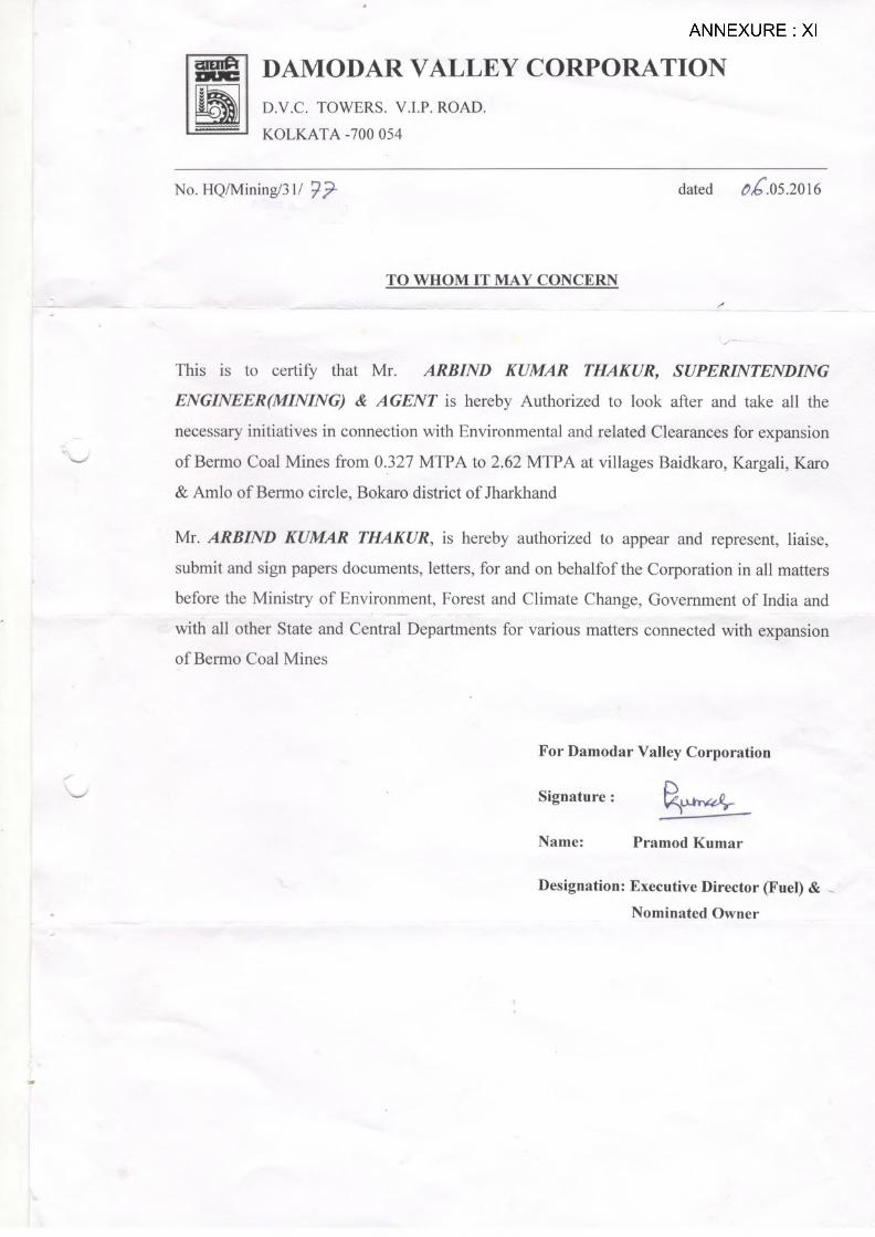
I Location map II List of Khasras III EC letter of Captive Power Plant (Bokaro Thermal Power Station) IV Present Surface plan V Geological plan VI Geological sections VIIA Mine Stage Plan at the end of 5th year VIIB Mine Stage Plan at the end of West Pit (21st year) VIIC Post Mine Closure Plan VIII Conceptual Mine sections IX Map showing study area 15 km radius around project X List of amenities in villages within 10 km radius XI Authorized signatory through board resolution XII Proposed Terms of Reference for EIA XIII Pre-feasibility Report
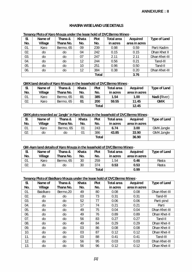
ANNEXURE : II
[1]
KHASRA WISE LAND USE DETAILS Tenancy Plots of Karo Mouza under the lease hold of DVC Bermo Mines:-
Sl. No.
Name of Village
Thana & Thana No.
Khata No.
Plot No.
Total area in acres
Acquired area in acres
Type of Land
01. Karo Bermo, 65 09 239 0.98 0.59 Parti Kadim 02. do do 04 242 0.15 0.15 Dhan Khet II 03. do do 07 247 2.11 2.11 Dhan Khet-III 04. do do 12 244 0.56 0.21 Tand-III 05. do do 10 251 0.96 0.50 Tand-II 06. do do 12 384 0.38 0.20 Dhan Khet-III
Total 3.76 GMK land details of Karo Mouza in the leasehold of DVC Bermo Mines:-
Sl. No.
Name of Village
Thana & Thana No.
Khata No.
Plot No.
Total area in acres
Acquired area in acres
Type of Land
01. Karo Bermo, 65 01 385 1.54 1.00 Nadi (River) 02. Karo Bermo, 65 01 200 59.55 11.45 GMK
Total 12.45 GMK plots recorded as ‘Jungle’ in Karo Mouza in the leasehold of DVC Bermo Mines:-
Sl. No.
Name of Village
Thana & Thana No.
Khata No.
Plot No.
Total area in acres
Acquired area in acres
Type of Land
01. Karo Bermo, 65 01 243 6.74 3.00 GMK Jungle 02. do do 01 386 43.85 33.90 GMK Jungle
Total 36.90
GM-Aam land details of Karo Mouza in the leasehold of DVC Bermo Mines:-
Sl. No.
Name of Village
Thana & Thana No.
Khata No.
Plot No.
Total area in acres
Acquired area in acres
Type of Land
01. Karo Bermo, 65 30 259 1.54 0.46 Rasta 02. do do 30 374 0.53 0.53 Rasta
Total 0.99 Tenancy Plots of Baidkaro Mouza under the lease hold of DVC Bermo Mines:-
Sl. No.
Name of Village
Thana & Thana No.
Khata No.
Plot No.
Total area in acres
Acquired area in acres
Type of Land
01. Baidkaro Bermo,20 49 80 0.08 0.08 Dhan Khet-III 02. do do 03 73 0.31 0.31 Tand-III 03. do do 52 77 0.06 0.06 Parti pind 04. do do 17 74 0.21 0.21 Parti 05. do do 49 75 0.04 0.04 Dhan Khet-III 06. do do 49 76 0.89 0.89 Dhan Khet-II 07. do do 56 83 0.27 0.27 Tand-II 08. do do 49 84 0.29 0.29 Dhan Khet-II 09. do do 03 86 0.08 0.08 Dhan Khet-II 10. do do 03 87 0.12 0.12 Dhan Khet-II 11. do do 03 88 0.41 0.41 Tand-III 12. do do 56 95 0.03 0.03 Dhan Khet-III 13. do do 56 96 0.12 0.12 Dhan Khet-II

ANNEXURE : II Contd..
[2]
Sl. No.
Name of Village
Thana & Thana No.
Khata No.
Plot No.
Total area in acres
Acquired area in acres
Type of Land
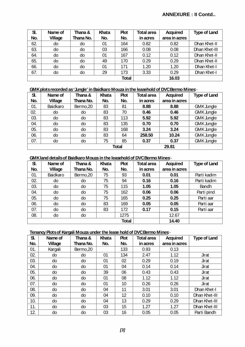
14. do do 59 97 0.13 0.13 Dhan Khet-II 15. do do 56 99 0.15 0.15 Dhan Khet-II 16. do do 52 82 0.04 0.04 Parti pind 17. do do 54 100 0.11 0.11 Dhan Khet-II 18. do do 50 101 0.17 0.17 Dhan Khet-III 19. do do 50 102 0.04 0.04 Parti kadim 20. do do 63 103 0.17 0.17 Dhan Khet-III 21. do do 59 104 0.16 0.16 Dhan Khet-III 22. do do 61 105 0.16 0.16 Dhan Khet-III 23. do do 54 106 0.09 0.09 Dhan Khet-III 24. do do 50 107 0.08 0.08 Dhan Khet-III 25. do do 56 108 0.05 0.05 Dhan Khet-III 26. do do 59 109 0.05 0.05 Dhan Khet-III 27. do do 61 110 0.07 0.07 Dhan Khet-III 28. do do 65 111 0.37 0.37 Dhan Khet-III 29. do do 65 112 0.21 0.21 Tand-II 30. do do 44 117 0.53 0.53 Dhan Khet-II 31. do do 44 118 0.12 0.12 Dhan Khet-III 32. do do 18 119 0.31 0.31 Tand-III 33. do do 18 120 0.05 0.05 Dhan Khet-III 34. do do 18 121 0.18 0.18 Tand-III 35. do do 18 122 0.17 0.17 Dhan Khet-III 36. do do 18 123 0.30 0.30 Dhan Khet-II 37. do do 18 126 1.46 1.22 Dhan Khet-II 38. do do 14 129 0.07 0.07 Dhan Khet-II 39. do do 01 130 0.21 0.21 Dhan Khet-II 40. do do 14 131 0.15 0.15 Dhan Khet-II 41. do do 14 132 0.14 0.14 Dhan Khet-II 42. do do 01 133 0.27 0.27 Dhan Khet-II 43. do do 01 134 0.27 0.27 Dhan Khet-II 44. do do 14 137 0.13 0.13 Dhan Khet-II 45. do do 14 140 0.08 0.08 Dhan Khet-II 46. do do 14 141 0.09 0.09 Dhan Khet-II 47. do do 14 146 0.06 0.06 Dhan Khet-II 48. do do 14 149 0.36 0.36 Dhan Khet-II 49. do do 14 150 0.17 0.17 Dhan Khet-II 50. do do 14 151 0.12 0.12 Dhan Khet-II 51. do do 14 152 0.23 0.23 Dhan Khet-II 52. do do 14 153 0.24 0.24 Dhan Khet-II 53. do do 14 154 0.11 0.11 Dhan Khet-II 54. do do 14 155 0.33 0.33 Tand-II 55. do do 61 156 0.20 0.20 Dhan Khet-II 56. do do 54 157 0.25 0.25 Dhan Khet-II 57. do do 56 158 0.35 0.35 Dhan Khet-II 58. do do 59 159 0.37 0.37 Dhan Khet-II 59. do do 54 160 0.30 0.30 Tand-II 60. do do 59 161 0.31 0.31 Dhan Khet-III 61. do do 61 163 0.58 0.58 Dhan Khet-II
ANNEXURE : II Contd..
[3]
Sl. No.
Name of Village
Thana & Thana No.
Khata No.
Plot No.
Total area in acres
Acquired area in acres
Type of Land
62. do do 01 164 0.82 0.82 Dhan Khet-II 63. do do 03 166 0.08 0.08 Dhan Khet-III 64. do do 01 167 0.12 0.12 Dhan Khet-II 65. do do 49 170 0.29 0.29 Dhan Khet-II 66. do do 01 171 1.20 1.20 Dhan Khet-I 67. do do 29 173 3.33 0.29 Dhan Khet-I
Total 16.03 GMK plots recorded as ‘Jungle’ in Baidkaro Mouza in the leasehold of DVC Bermo Mines:-
Sl. No.
Name of Village
Thana & Thana No.
Khata No.
Plot No.
Total area in acres
Acquired area in acres
Type of Land
01. Baidkaro Bermo,20 83 81 8.88 8.88 GMK Jungle 02. do do 83 70 0.46 0.46 GMK Jungle 03. do do 83 113 5.92 5.92 GMK Jungle 04. do do 83 135 0.70 0.70 GMK Jungle 05. do do 83 168 3.24 3.24 GMK Jungle 06. do do 83 64 258.50 10.24 GMK Jungle 07. do do 75 85 0.37 0.37 GMK Jungle
Total 29.81 GMK land details of Baidkaro Mouza in the leasehold of DVC Bermo Mines:-
Sl. No.
Name of Village
Thana & Thana No.
Khata No.
Plot No.
Total area in acres
Acquired area in acres
Type of Land
01. Baidkaro Bermo,20 75 93 0.01 0.01 Parti kadim 02. do do 75 94 0.16 0.16 Parti kadim 03. do do 75 115 1.05 1.05 Bandh 04. do do 75 162 0.06 0.06 Parti pind 05. do do 75 165 0.25 0.25 Parti aar 06. do do 83 169 0.05 0.05 Parti aar 07. do do 83 172 0.17 0.15 Parti aar 08. do do 1275 12.67
Total 14.40 Tenancy Plots of Kargali Mouza under the lease hold of DVC Bermo Mines:- Sl.
No. Name of Village
Thana & Thana No.
Khata No.
Plot No.
Total area in acres
Acquired area in acres
Type of Land
01. Kargali Bermo,20 133 0.93 0.13 02. do do 01 134 2.47 1.12 Jirat 03. do do 01 02 0.29 0.19 Jirat 04. do do 01 04 0.14 0.14 Jirat 05. do do 39 06 0.43 0.43 Jirat 06. do do 01 08 1.12 1.12 Jirat 07. do do 01 10 0.26 0.26 Jirat 08. do do 04 11 3.01 3.01 Dhan Khet-I 09. do do 04 12 0.10 0.10 Dhan Khet-III 10. do do 04 13 0.29 0.29 Dhan Khet-III 11. do do 03 15 1.27 1.27 Dhan Khet-III 12. do do 03 16 0.05 0.05 Parti Bandh

ANNEXURE : II Contd..
[4]
Sl. No.
Name of Village
Thana & Thana No.
Khata No.
Plot No.
Total area in acres
Acquired area in acres
Type of Land
13. do do 22 20 0.24 0.24 Dhan Khet-I 14. do do 22 21 0.43 0.43 Dhan Khet-II 15. do do 11 22 0.31 0.22 Dhan Khet-I 16. do do 22 23 0.15 0.15 Dhan Khet-I 17. do do 22 24 0.27 0.12 Parti kadim 18. do do 26 26 0.05 0.05 Dhan Khet-III 19. do do 11 27 0.34 0.22 Tand-II 20. do do 09 262 0.05 0.05 Makan sahan Total 9.72
GMK plots recorded as ‘Jungle’ in Kargali Mouza in the leasehold of DVC Bermo Mines:- Sl.
No. Name of Village Thana &
Thana No. Khata
No. Plot No.
Total area in acres
Acquired area in acres
Type of Land
01. Kargali Bermo,20 27 135 3.92 1.12 GMK Jungle 02. do do 27 116 79.00 54.03 GMK Jungle 03. do do 27 01 237.50 125.60 GMK Jungle 04. do do 27 03 0.16 0.16 GMK Jungle 05. do do 27 273 46.50 34.59 GMK Jungle
Total 215.50 GMK land details of Kargali Mouza in the leasehold of DVC Bermo Mines:-
Sl. No.
Name of Village
Thana & Thana No.
Khata No.
Plot No.
Total area in acres
Acquired area in acres
Type of Land
01. Kargali Bermo,20 27 132 3.17 0.45 Parti kadim 02. do do 27 05 0.02 0.02 Parti aar 03. do do 27 07 0.04 0.04 Parti aar 04. do do 27 09 0.03 0.03 Parti aar 05. do do 27 14 0.05 0.05 Parti aar 06. do do 27 17 0.28 0.28 Parti pind 07. do do 27 18 1.31 1.31 Pokhar
Total 2.18 Tenancy Plots of Emlo Mouza under the lease hold of DVC Bermo Mines:-
Sl. No.
Name of Village
Thana & Thana No.
Khata No.
Plot No.
Total area in acres
Acquired area in acres
Type of Land
01. Emlo Bermo,20 17 289 1.01 0.45 Tand-III 02. do do 08 290 0.24 0.19 Dhan Khet-III 03. do do 16 291 1.94 1.94 Dhan Khet-II 04. do do 16 294 1.03 1.03 Dhan Khet-II 05. do do 16 296 0.59 0.59 Dhan Khet-II 06. do do 16 298 1.12 1.12 Dhan Khet-II 07. do do 16 299 0.49 0.49 Dhan Khet-II 08. do do 31 300 0.31 0.31 Dhan Khet-II 09. do do 13 302 0.38 0.38 Tand-III 10. do do 14 304 0.68 0.68 Tand-III 11. do do 18 305 0.39 0.39 Tand-II 12. do do 17 306 0.26 0.26 Tand-III

ANNEXURE : II Contd..
[5]
Sl. No.
Name of Village
Thana & Thana No.
Khata No.
Plot No.
Total area in acres
Acquired area in acres
Type of Land
13. do do 01 308 0.95 0.95 Tand-III 14. do do 03 309 0.39 0.39 Tand-III 15. do do 17 310 0.40 0.40 Tand-III 16. do do 27 311 0.57 0.57 Tand-III 17. do do 24 312 2.39 2.39 Tand-III 18. do do 01 313 2.53 2.53 Tand-III 19. do do 20 314 0.46 0.26 Tand-III 20. do do 24 362 0.36 0.36 Dhan Khet-II 21. do do 24 363 0.22 0.22 Dhan Khet-II 22. do do 14 365 0.28 0.28 Bandh 23. do do 16 352 1.29 1.29 Dhan Khet-II 24. do do 01 351 2.06 2.06 Tand-III 25. do do 24 354 0.16 0.16 Dhan Khet-II 26. do do 04 355 0.39 0.39 Dhan Khet-II 27. do do 24 346 0.33 0.33 Dhan Khet-II 28. do do 01 347 1.74 1.74 Tand-III 29. do do 01 349 1.85 1.85 Tand-III 30. do do 12 316 0.60 0.20 Tand-III 31. do do 09 317 0.61 0.60 Tand-III 32. do do 12 222 0.20 0.15 Dhan Khet-III 33. do do 12 221 0.74 0.50 Dhan Khet-II 34. do do 04 340 0.17 0.17 Dhan Khet-II 35. do do 24 339 0.09 0.09 Dhan Khet-III 36. do do 11 335 0.15 0.15 Dhan Khet-III 37. do do 03 333 0.08 0.08 Dhan Khet-III 38. do do 21 322 0.42 0.42 Dhan Khet-III 39. do do 12 220 0.23 0.23 Dhan Khet-II 40. do do 12 217 0.14 0.14 Dhan Khet-II 41. do do 18 216 0.04 0.04 Dhan Khet-III 42. do do 12 214 0.50 0.50 Dhan Khet-II 43. do do 18 325 0.14 0.14 Dhan Khet-III 44. do do 24 336 0.09 0.09 Dhan Khet-II 45. do do 24 331 0.04 0.04 Dhan Khet-II 46. do do 18 327 0.08 0.08 Dhan Khet-II 47. do do 18 212 0.50 0.50 Dhan Khet-II 48. do do 37 211 0.04 0.04 Dhan Khet-II 49. do do 37 210 0.26 0.26 Dhan Khet-II 50. do do 37 206 0.47 0.47 Dhan Khet-II 51. do do 37 205 0.28 0.28 Dhan Khet-II 52. do do 04 203 0.91 0.55 Dhan Khet-II 53. do do 24 330 0.42 0.42 Dhan Khet-II 54. do do 17 453 0.29 0.29 Dhan Khet-II 55. do do 18 450 1.02 1.02 Dhan Khet-II 56. do do 24 342 0.01 0.01 Dhan Khet-III 57. do do 18 343 0.08 0.08 Dhan Khet-II 58. do do 24 345 0.05 0.05 Dhan Khet-II 59. do do 03 449 0.45 0.45 Dhan Khet-II 60. do do 04 447 0.02 0.02 Dhan Khet-II

ANNEXURE : II Contd..
[6]
Sl. No.
Name of Village
Thana & Thana No.
Khata No.
Plot No.
Total area in acres
Acquired area in acres
Type of Land
61. do do 04 445 0.01 0.01 Dhan Khet-II 62. do do 04 504 0.13 0.13 Dhan Khet-II 63. do do 04 458 0.33 0.33 Dhan Khet-II 64. do do 16 208 1.79 1.70 Dhan Khet-II 65. do do 24 209 0.09 0.09 Dhan Khet-II 66. do do 04 207 0.31 0.31 Dhan Khet-II 67. do do 02 440 0.01 0.01 Dhan Khet-II 68. do do 04 508 0.17 0.17 Dhan Khet-II 69. do do 16 439 0.44 0.44 Dhan Khet-II 70. do do 24 507 0.02 0.02 Dhan Khet 71. do do 24 503 0.46 0.46 Dhan Khet-II 72. do do 27 502 0.11 0.11 Dhan Khet-II 73. do do 17 546 0.05 0.05 Makan sahan 74. do do 24 463 0.17 0.17 Dhan Khet-III 75. do do 24 461 0.22 0.22 Dhan Khet-III 77. do do 21 465 0.19 0.15 Dhan Khet-II 78. do do 04 499 0.61 0.61 Dhan Khet-II 79. do do 24 497 0.59 0.24 Dhan Khet-II 80. do do 16 498 0.36 0.34 Dhan Khet-II
Total 37.62 GM-Aam land details of Emlo Mouza in the leasehold of DVC Bermo Mines:-
Sl. No.
Name of Village
Thana & Thana No.
Khata No.
Plot No.
Total area in acres
Acquired area in acres
Type of Land
01. Emlo Bermo,20 40 348 0.26 0.26 Rasta 02. do do 40 549 0.59 0.55 Rasta
Total 0.81 GMK land details of Emlo Mouza in the leasehold of DVC Bermo Mines:-
Sl. No.
Name of Village
Thana & Thana No.
Khata No.
Plot No.
Total area in acres
Acquired area in acres
Type of Land
01. Emlo Bermo,20 39 295 0.31 0.31 Parti pathar 02. do do 39 318 0.06 0.06 Parti pathar 03. do do 39 319 0.07 0.07 Parti pathar 04. do do 39 338 0.15 0.15 Parti pathar 05. do do 39 334 0.38 0.38 Parti pathar 06. do do 39 323 0.03 0.03 Parti pathar 07. do do 39 218 0.16 0.08 Parti pathar 08. do do 39 324 0.04 0.04 Parti kadim 09. do do 39 326 0.04 0.04 Parti pathar 10. do do 39 213 0.04 0.04 Parti kadim 11. do do 39 344 1.64 1.30 Parti pathar 12. do do 39 446 0.01 0.01 Parti kadim 13. do do 39 448 0.03 0.03 Parti kadim 14. do do 39 457 0.01 0.01 Parti pathar 15. do do 39 464 0.66 0.36 Parti pathar 16. do do 451 0.95 0.95 17. do do 456 0.98 0.98

ANNEXURE : II Contd..
[7]
Sl. No.
Name of Village
Thana & Thana No.
Khata No.
Plot No.
Total area in acres
Acquired area in acres
Type of Land
18. do do 264 0.48 0.48 19. do do 265 0.38 20 do do 266 0.09 21 do do 267 0.12 0.12 22. do do 268 0.32 0.32 23. do do 269 0.24 0.24 24. do do 270 0.34 0.34 25. do do 273 0.97 0.97 26. do do 274 0.05 0.05 27. do do 275 0.06 0.06 28. do do 276 2.77 2.40 29. do do 219 2.99 1.65 30. do do 187 1.35 1.00 31. do do 201 0.70 0.10 32. do do 202 0.30 0.09 33. do do 262 0.09 0.05 34. do do 263 0.10 0.09 35. do do 260 0.09 0.05 36. do do 545 1.05 0.35 37. do do 509 0.69 0.69 38. do do 544 0.20 0.14 39. do do 539 0.09 0.09 40. do do 541 0.60 0.60 41. do do 500 0.54 0.54 42. do do 506 0.03 0.03 43. do do 462 0.60 0.60 44. do do 542 0.05 0.05 45. do do 540 0.18 0.10 46. do do 536 0.35 0.10 47. do do 505 0.04 0.04 48. do do 366 2.30 0.96 49. do do 364 0.30 0.28 50. do do 460 0.22 0.22 51. do do 501 0.37 0.37
Total 18.48 GMK plots recorded as ‘Jungle’ in Emlo Mouza in the leasehold of DVC Bermo Mines:- Sl.
No. Name of Village Thana &
Thana No. Khata
No. Plot No.
Total area in acres
Acquired area in acres
Type of Land
01. Emlo Bermo,20 39 297 10.99 10.99 GMK Jungle 02. do do 39 301 0.50 0.50 GMK Jungle 03. do do 39 303 4.24 3.60 GMK Jungle
Total 15.09

ANNEXURE : III

ANNEXURE : III Contd..

ANNEXURE : III Contd..
ANNEXURE : III Contd..
ANNEXURE : III Contd..

ANNEXURE : III Contd..
ANNEXURE : III Contd..

ANNEXURE : III Contd..


ANNEXURE : XSUMMARY OF AMENITIES AVAILABLE (CENSUS 2011) IN VILLAGES WITHIN THE STUDY AREA OF BERMO COAL MINE OF DAMODAR VALLEY CORPORATION IN JHARKHAND
AMENITIES NOS. AMENITIES NOS. AMENITIES NOS.
EDUCATION FACILITIES DRINKING WATER FACILITY APPROACH TO VILLAGEPPS (Pre-Primary School) 19 TWT (Tap Water-Treated) 2 NH (National Highway) 2PS (Primary school) 69 TWUT (Tap Water Untreated) 0 SH (State Highway) 9MS (Middle school) 38 CW (Covered Well) 3 MDR (Major District Road) 11SS (Secondary school) 15 UW (Uncovered Well) 44 ODR (Other District Road) 21SSS (Sr. Sec. School) 2 HP (Hand Pump) 44 BTPR (Black Topped (pucca) Road) 44DCAS (Deg. College Arts & Science only) 1 TW/ BW (Tube Wells/Borehole) 5 GCR (Gravel (kuchha) Roads) 44EC ( Engg. College) 0 S (Spring) 4 WBM (Water Bounded Macadam) 33MC (Medicine College) 0 R/C (River/Canal) 13 AWR (All Weather Road) 31MI (Management Institute) 0 T/P (Tank/Pond/Lake) 44 NWR/C (Navigable Waterways (River/Canal)) 3
P (Polytechnic) 0 WO (Others) 1 FP (Foot Path) 44VTS/ITI (Vocational Trg School/ITI) 1NFTC (Non Formal Training Centre) 0 COMMUNICATION SYSTEM BANKS AND COMMERCIAL SOCIETIESSFD (School For Disabled) 0 PO (Post Office) 16 ATM (ATM) 1EO (Others) 0 SPO (Sub Post Office) 12 CB (Commercial bank) 6
P&T (Post & Telegraph office) 1 COB (Co-operative bank) 2MEDICAL FACILITIES PIN (Village PIN code) 44 ACS (Agricultural Crredit Societies) 3CHC (Community Health Centres ) 0 T (Telephone (landline)) 10 SHG (Self-Help Group (SHG)) 20PHC (Primary Health Centre) 5 PCO (Public Call Office/ Mobile PCO) 18 PDS (Public Distribution System (PDS)) 28PHSC (Primary Health Sub-Centre) 10 MPC (Mobile phone coverage) 32 M/RM (Mandis/Regular Market) 5MCWC (Maternity And Child Welfare Centre) 3 IC/CSC (Internet Cafes/Common Service Centre) 3 WH (Weekly Haat) 9TBC (TB Clinic) 0 PCF (Private Courier Facility) 1 AMS (Agricultural Marketing Society) 6HA (Hospital Allopathic) 3 NCICDS (Nutritional Centres-ICDS) 39HAM (Hospiltal Alternative Medicine) 1 TRANSPORT SYSTEM NCAC (Nutritional Centres-Anganwadi Centre) 39
D (Dispensary) 5 PBS (Public Bus Service) 1 NCO (Nutritional Centres-Others) 10VH (Veterinary Hospital) 1 PvtBS (Private Bus Service) 12 ASHA (ASHA) 44MHC (Mobile Health Clinic) 0 RS (Railway station) 1 CC-TV (Community Centre with/without TV) 8
FWC (Family Welfare Centre) 2 MA (Auto/Modified Autos) 4NGMF-OP (Non Govt. Med. facilities Out Patient) 2 Taxi (Taxi) 7 SPORTS AND ENTERTAINMENTNGMF-IOP (Non Govt. Med. facilities In And Out Patient) 1 Van (Vans) 10 SF (Sports Field) 9
NGMF-C (Non Govt. Med. facilities Charitable) 1 T (Tractors) 14 SC/RC (Sports Club/Recreation Centre) 21 CPR-Man (Cycle-pulled Rickshaws (manual driven)) 18 C/VH (Cinema/Video Hall) 2
CPR-Mec (Cycle-pulled Rickshaws (machine driven)) 0 PL (Public Library) 1
6 CDA (Carts Drivens by Animals) 40 PRR (Public Reading Room) 1S/R/FS (Sea/River/Ferry Service) 0 DNS (Daily Newspaper Supply) 35
12 APS (Assembly Polling Station) 29POWER SUPPLY BDRO (Birth and Death Registration Office) 11
4 PSDU (Power Supply For Domestic Use) 33PSIAU (Power Supply ForAgriculture Use) 9
NGMF-MS (Non Govt. Med. facilities Medicine Shop ) 6 PSCU (Power Supply For Commercial Use) 0
NGMF-O (Non Govt. Med. facilities Others) 2 PSALL (Power Supply For All Users) 8
NGMF-MBBS (Non Govt. Med. facilities Medical Prctitioner with MBBS Degree )
NGMF-OD (Non Govt. Med. facilities Medical Prctitioner with other Degree )NGMF-ND (Non Govt. Med. facilities Medical Practitioner with no Degree )
NGMF-TPFH (Non Govt. Med. facilities Traditional Practitioner and Faith Healer )

ANNEXURE : X Contd..SUMMARY OF AMENITIES AVAILABLE (CENSUS 2011) IN TOWNS WITHIN THE STUDY AREA OF BERMO COAL MINE OF DAMODAR VALLEY CORPORATION IN JHARKHAND
AMENITIES NOS. AMENITIES NOS. AMENITIES NOS.
EDUCATION Private-MS Office (Nos.) 0 WATER SUPPLY AND SANITATIONGovt. Primary School (Nos.) 1 Govt.-Desk Top Publishing (Nos.)) 0 Latrines-Pit (Nos.) 10Private Primary School (Nos.) 1 Private-Desk Top Publishing (Nos.) 0 Latrines-Flush/Pour Flush (Nos.) 400Govt. Middle School (Nos.) 0 Govt.-Vocational(Others) (Nos.)) 0 Latrines-Service (Nos.) 1Private Middle School (Nos.) 0 Private-Vocational(Others) (Nos.) 0 Latrines-Others (Nos.) 0Govt. Secondary School (Nos.) 0 Govt.-Non Formal Education (Nos.)) 0 Protected Water Supply Source-1 0Private Secondary School (Nos.) 0 Private-Non Formal Education (Nos.) 0 Capacity Source-1 (KL) 485Govt. Senior Secondary School (Nos.) 0 Govt.-Special School for Disabled (Nos.)) 0 Protected Water Supply Source-2 0Private Senior Secondary School (Nos.) 1 Private-Special School for Disabled (Nos.) 0 Capacity Source-2 (KL) 0Govt. Degree College-Art Only (Nos.) 0 Govt.-Others(Specify) (Nos.)) 0 Protected Water Supply Source-3 0Private Degree College-Art Only (Nos.) 0 Private-Others(Specify) (Nos.) 0 Capacity Source-3 (KL) 0Govt. Degree College-Science Only (Nos.) 0 MEDICAL Protected Water Supply Source-4 0Private Degree College-Science Only (Nos.) 0 Hospital Allopathic (Nos.) 0 Capacity Source-4 (KL) 153Govt. Degree College-Commerce Only (Nos.)) 0 Hospital Alternative Medicine (Nos.) 0 Protected Water Supply Source-5 0Private Degree College-Commerce Only (Nos.) 0 Dispensary/Health Centre (Nos.) 0 Capacity Source-5 (KL) 0Govt. Degree College-Art and Science Only (Nos.)) 0 Family Welfare Centre (Nos.) 0 TRANSPORTPrivate Degree College-Art and Science Only (Nos.) 0 Maternity and Child Welfare Centre (Nos.) 0 Bus Route Road Distance (in kms.) 0Govt. Degree College-Art and Commerce Only (Nos.)) 0 Maternity Home (Nos.) 0 Pucca Road Length (in kms.) 5.0Private Degree College-Art and Commerce Only (Nos.) 0 Maternity Home Nearest facility Distance (in kms.) 8 Kutcha Road Length (in kms.) 2Govt. Degree College-Art,Science and Commerce (Nos.)) 0 T.B. Hospital/ Clinic (Nos.) 0 ENTERTAINMENT AND COMMODITYPrivate Degree College-Art,Science and Commerce (Nos.) 0 Nursing Home (Nos.) 0 Govt.-Stadium (Nos.)) 0Govt. Degree College-Law (Nos.)) 0 Veterinary Hospital (Nos.) 0 Private-Stadium (Nos.) 1Private Degree College-Law (Nos.) 0 Mobile Health Clinic (Nos.) 0 Govt.-Cinema Theatre (Nos.)) 0Govt. Degree College-University (Nos.)) 0 Others (Nos.) 0 Private-Cinema Theatre (Nos.) 0Private Degree College-University (Nos.) 0 Non-Government Out-Patient (Nos.) 0 Govt.-Auditorium/Community Hall (Nos.)) 0Govt. Degree College-Others (Nos.)) 0 Non-Government In and Out Patient (Nos.) 0 Private-Auditorium/Community Hall (Nos.) 0Private Degree College-Others (Nos.) 0 Non-Government Charitable-Hospital/Nursing Home (Nos.)0 Govt.-Public Library (Nos.)) 0Govt.-Medical College (Nos.)) 0 Non-Government Medicine Shop (Nos.) 0 Private-Public Library (Nos.) 0Private-Medical College (Nos.) 0 ELECTRICITY Govt.-Public Reading Room (Nos.)) 0Govt.-Engineering College (Nos.)) 0 Electricity-Domestic Connection (Nos.) 998 Private-Public Reading Room (Nos.) 0Private-Engineering College (Nos.) 0 Electricity-Industrial Connection (Nos.) 1 Manufactured Commodity (First) 0Govt.-Management Institute (Nos.)) 0 Electricity-Commercial Connection (Nos.) 40 Manufactured Commodity (Second) 0Private-Management Institute (Nos.) 0 Electricity-Road Lighting Connection (Nos.) 0 Manufactured Commodity (Third) 0Govt.-Polytechnic (Nos.)) 0 Electricity-Others Connection (Nos.) 0 HELP HOMESPrivate-Polytechnic (Nos.) 0 FINANCIAL Govt.-Orphanage Home (Nos.)) 0Govt.-Shorthand (Nos.)) 0 Nationalised Bank (Nos.) 1 Private-Orphanage Home (Nos.) 0Private-Shorthand (Nos.) 0 Private Commercial Bank (Nos.) 0 Govt.-Working Women's Hostel (Nos.)) 0Govt.-Typewriting (Nos.)) 0 Co-operative Bank (Nos.) 0 Private-Working Women's Hostel (Nos.) 0Private-Typewriting (Nos.) 0 Agricultural Credit Society (Nos.) 0 Govt.-Old Age Home (Nos.)) 0Govt.-Shorthand and Typewriting (Nos.)) 0 Non-Agricultural Credit Society (Nos.) 0 Private-Old Age Home (Nos.) 0Private-Shorthand and Typewriting (Nos.) 0 FIRE FIGHTINGGovt.-MS Office (Nos.)) 0 Fire Fighting Service (Status A(1)/NA(2)) 0
Mahesh
Typewritten text
ANNEXURE : XI
ANNEXURE : XII Contd..
Proposed TOR 1
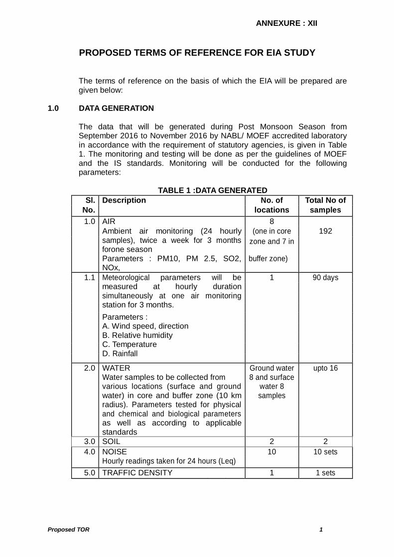
PROPOSED TERMS OF REFERENCE FOR EIA STUDY The terms of reference on the basis of which the EIA will be prepared are
given below: 1.0 DATA GENERATION The data that will be generated during Post Monsoon Season from
September 2016 to November 2016 by NABL/ MOEF accredited laboratory in accordance with the requirement of statutory agencies, is given in Table 1. The monitoring and testing will be done as per the guidelines of MOEF and the IS standards. Monitoring will be conducted for the following parameters:
TABLE 1 :DATA GENERATED
Sl. Description No. of Total No of No. locations samples
AIR 8 (one in core 192 Ambient air monitoring (24 hourly
samples), twice a week for 3 months forone season
zone and 7 in
1.0
Parameters : PM10, PM 2.5, SO2, NOx,
buffer zone)
1 90 days
Meteorological parameters will be measured at hourly duration simultaneously at one air monitoring station for 3 months.
1.1
Parameters : A. Wind speed, direction B. Relative humidity C. Temperature D. Rainfall
2.0 WATER Water samples to be collected from various locations (surface and ground water) in core and buffer zone (10 km radius). Parameters tested for physical and chemical and biological parameters as well as according to applicable standards
Ground water 8 and surface
water 8 samples
upto 16
3.0 SOIL 2 2 10 10 sets 4.0 NOISE
Hourly readings taken for 24 hours (Leq) 5.0 TRAFFIC DENSITY 1 1 sets

ANNEXURE : XII Contd..
Proposed TOR 2
2.0 DATA COLLECTION 10 km radius (buffer zone), both of which comprising the ‘study area’. The
following data, through field survey and other sources will be generated by consultant for preparing the EIA/EMP of the proposed project with related facilities:
i Study of fauna, flora, forests and cropping pattern. ii Major habitats, ecologically sensitive areas, biosphere reserves,
wildlife sanctuaries within 15 km of the project site. iii Major industries and places of historical/ archaeological importance. iv Land use pattern within core zone and buffer zone. v Geo-hydrological aspects based on available data from various
secondary sources. vi Demography and socio-economic status based on last available
census data for the entire study area. vii Relevant meteorological data for the previous decades from Indian
Meteorological Department (IMD). viii Identification of water bodies, hills, roads etc. ix In case of operational plant, emission data and details of implemented
pollution control systems. 3.0 PREPARATION OF EMP The EMP will include the following details:
a. Study of the reports, like Project report, FR for plant available with the client regarding the project.
b. Present Environmental Setting The base line data generated and collected as per para 1.0 and 2.0
will be used to establish the present environmental scenario. c. Identification, prediction and evaluation of Anticipated
Environmental Impacts due to the Proposed Plant and related facilities
The environmental impacts would be anticipated in core and buffer zone on:
Topography Climate Water resources & quality (Surface/Ground) Air quality Noise Levels Flora and Fauna Traffic density Land-Use

ANNEXURE : XII Contd..
Proposed TOR 3
Socio-Economic Conditions Habitats Health, culture, human environment including public health Occupational health and safety Sensitive Places/Historical Monuments
The impacts would be anticipated based on experience of similar projects.
d. Proposed Environmental Safeguards and Monitoring Mechanism Relevant guidelines, as per Environmental Impact Assessment (EIA)
Notification no. S.O. 1533 dated the 14th September, 2006 and its amendments till date under the Environment (Protection) Act, 1986, will be kept in mind while spelling out mitigation measures. The following aspects would be covered.
i Reclamation of areas disturbed during construction but not required
for any activity during operation. ii Measures to control the surface and ground water pollution due to
various effluents to be discharged. iii Measures to control air pollution due to proposed activities/
operation. iv Green belt development and identification of flora species which
can be planted in and around the project. v Measures to contain noise pollution and mitigate adverse impact on
workers and habitat in core and buffer zone. vi Pronounce the improvement in socio-economic conditions and
benefits the people will get on implementation of the project. vii Measures to control health hazard of workers and surrounding
population. viii Total and specific cost of implementation of pollution control
measures. ix Environmental monitoring, implementation organization and
feedback mechanism to effect mid course corrections. x Solid Waste Management
The experience of similar project(s) will be made use of for envisaging the
pollution control measures by pronouncing the success in the past. The EIA report shall be prepared as per the generic structure prescribed in
MOEF Notification dated 14.09.2006 with following chapters :
1. An introduction covering background, location, surrounding features, compliance to TOR and salient features (Chapter 1)
2. Study of the approved mining plan (to prepare Chapter 2). 3. Present Environmental Setting The base line data generated by NABL/ MOEF accredited lab will be
used to establish the present environmental scenario. (Chapter 3)

ANNEXURE : XII Contd..
Proposed TOR 4
4. Identification, prediction and evaluation of Anticipated Environmental
Impacts due to the Mining and related facilities (Chapter 4) 5. Justification of project technology (Chapter 5) 6. Environmental monitoring and control mechanisms with budget
(Chapter 6) which will include
Total investment for improving/mitigating environment Recurring expenditure during stage of production
7. Additional studies – Public consultation, Risk Assessment or any other
study prescribed in TOR(Chapter 7) 8. Project benefits and commitment of the company to social welfare in
surrounding areas (Chapter 8) 9. EMP (Chapter 9) 10. Summary & Conclusion (Chapter 10) 11. Disclosure of consultants engaged (Chapter 11)

MM//ss DD AAMMOODDAA RR VVAALLLLEEYY CCOORRPPOORRAA TTIIOO NN
P.O. BOKARO THERMAL- 829 107, DIST. BOKARO, JHARKHAND
PRE-FEASIBILITY REPORT FOR
BERMO COAL MINES AT
VILLAGES BAIDKARO, KARGALI, KARO AND AMLO BLOCK BERMO, DISTRICT BOKARO,
JHARKHAND (EXTENT OF ML: 167.434 Ha.,
EXPANSION FROM 0.4 TO 2.62 MTPA)
May, 2017 (Issue 01, Rev 01)
Prepared by:
M I N M E C C O N S U L T AN C Y PV T . L TD . A - 1 21 , Pa r y av ar a n C om p l ex , I G NO U R o a d , N ew D e l h i – 11 0 0 30 Ph : 29534777, 29532236, 29535891 ; Fax : +91 -11-29532568 E m ai l : m i n _m ec @ v s n l . c om ; W eb s i t e : http: //www.minmec.co.in
EEssttbb.. 11998833
An ISO 9001:2008 approved company
ANNEXURE : XIII
ANNEXURE : XIII Contd..
Min Mec Consultancy Pvt. Ltd.
PFR for Enhancement of Capacity from 0.4 MTPA to 2.62 MTPA of DVC Bermo Mine, Jharkhand i
CONTENTS Sl. No. Description Page No. 1.0 Executive summary 1 2.0 Introduction 2
2.1 Identification of project and project proponent 2 2.2 Brief description of nature of the project 4 2.3 Need for the project and its importance to the country and or
region 4
2.4 Demand-supply gap 5 2.5 Imports vs. indigenous production 5 2.6 Export possibility 5 2.7 Domestic / export markets 6 2.8 Employment generation (direct and indirect) 6
3.0 Project description 6
3.1 Type of project including interlinked and interdependent projects
6
3.2 Location with coordinates 6 3.3 Details of alternate sites & environmental considerations 7 3.4 Size or magnitude of operation 7 3.5 Project description with process details 7 3.6 Mining method 9 3.7 Raw material required along with estimated quantity, likely
source, marketing area of final product’s mode of transport of raw material and finished product
9
3.8 Resource optimization/recycling and reuse envisaged in the project
9
3.9 Availability of water its source, energy/ power requirement and source
10
3.10 Quantity of wastes to be generated (liquid and solid) and scheme for their management /disposal
10
3.11 Schematic representations of the feasibility drawing which give information of EIA purpose
11
4.0 Site analysis 11
4.1 Connectivity 11 4.2 Land form, land use and land ownership 12 4.3 Topography 14 4.4 Existing infrastructure 15 4.5 Soil classification 15 4.6 Climatic data from secondary sources 15 4.7 Social infrastructure available 16
ANNEXURE : XIII Contd..
Min Mec Consultancy Pvt. Ltd.
PFR for Enhancement of Capacity from 0.4 MTPA to 2.62 MTPA of DVC Bermo Mine, Jharkhand ii
Sl. No. Description Page No. 5.0 Planning brief 16
5.1 Planning concept 16 5.2 Population projection 16 5.3 Land use planning (break up along with green belt etc.) 16 5.4 Assessment of infrastructure demand (physical & social) 16 5.5 Amenities / facilities 17
6.0 Proposed infrastructure 17
6.1 Industrial area (processing area) 17 6.2 Residential area (non processing area) 17 6.3 Green belt 17 6.4 Social infrastructure 18 6.5 Connectivity 18 6.6 Drinking water management (source & supply of water) 18 6.7 Sewarage system & Industrial waste management 18 6.8 Solid waste management 19 6.9 Power requirement & supply / source 19
7.0 Rehabilitation and resettlement plan 19 8.0 Project schedule & cost estimates 19
8.1 Cost of production 19
9.0 Analysis of proposal (final recommendations) 19
LIST OF TABLES
Table No. Description Page No.
1 Calendar programme of coal production, OB removal, rehandling and stripping ratio
8
2 Pre-mining (pre-1951) land use of the project area 12 3 Present (2016-2017) land use of the project area 12 4 Proposed land use of the project area at end of mining 13
4A Proposed land use of the project area after post mine closure
13

ANNEXURE : XIII Contd..
Min Mec Consultancy Pvt. Ltd.
PFR for Enhancement of Capacity from 0.4 MTPA to 2.62 MTPA of DVC Bermo Mine, Jharkhand 1
PRE-FEASIBILITY REPORT 1.0 EXECUTIVE SUMMARY The salient features of the project are given below:
Project name DVC Bermo Mine Project proponent Damodar Valley Corporation Villages in the ML area Baidkaro, Kargali, Karo & Amlo of Bermo circle Latitude 23°46’47.55” to 23°47’15.955”* Longitude 85°57’29.477” to 85°59’10.673”* Total ML Area 413.74 acres / 167.434 Ha Land ownership break up
Land pattern Area (ha) Agricultural land (Private land) 27.166 Waste Land (Govt. Land) 18.292 Water body (Govt. land) 0.935 Forest Land (GMK land recorded as Jungle) (Govt. land)
120.313
Others (Govt. land) 0.728 Total 167.434
Reserve Gross geological reserve = 145.28 MT Net Geological Reserve= 130.754 MT Mineable/extractable reserves = 60.66 MT
Rated capacity Expansion from 0.4 MTPA to 2.62 MTPA Life of the mine 27 years Stripping ratio 1.83 cum/t OB Generation 110.79 Mcum Method of Mining Opencast Mechanized Blasting Overburden requires drilling and blasting prior to
excavation. Storage of explosives Shed/Magazine Working days 330 days, 6 hours, 3 shift Manpower 569 proposed including existing 128 Transportation By road Expected cost of the project
Rs. 150 Cr
Elevation The elevation based on RLs of Bore holes drilled in Bermo seam in 1950 varies between 233.17 and 243.84 m.
Topography The topography is gentle and is almost flat and general slope is towards South.
Drainage diversion Two nalas (Karo and Amlo) are proposed to be diverted.
Water requirement 581 m3/day (Potable water 242 m3/day &
ANNEXURE : XIII Contd..
Min Mec Consultancy Pvt. Ltd.
PFR for Enhancement of Capacity from 0.4 MTPA to 2.62 MTPA of DVC Bermo Mine, Jharkhand 2
Industrial water 339 m3/day ) Source of water Potable water is met from bore well and
industrial water requirement is met from mine sump and surface water reservoir of the existing Mine.
Power requirement 11 KVA Power source Power is received from DVC BTPS (located
about 15 km from mine) through 33 KVA overhead line. It is stepped down to 11 KVA/440v.
(*Source: Letter no. CMPDI/BD/C(886-A)/1-1307 dt 25-04-2017 (Attached as Attachment I of letter)
2.0 INTRODUCTION 2.1 Identification of project and project proponent The Damodar Valley Corporation (DVC) is Public company which operates
several power stations in the Damodar River area of West Bengal and Jharkhand states of India. The company operates both thermal power stations and hydel power stations under the Ministry of Power Govt of India. DVC is headquartered in the city of Kolkata, West Bengal. With time DVC developed and expanded its infrastructure- six thermal power stations, three hydro-electric power stations with a capacity of 144 MW and one gas turbine station with a capacity of 82.5 MW contribute to a total installed capacity of 6357.3 MW. Presently DVC has 35 sub-stations and receiving stations more than 5500-circuit km of transmission and distribution lines. DVC has also four dams, a barrage and a network of canals that play an effective role in water management. The construction of check dams, development of forests and farms and upland and wasteland treatment developed by DVC play a vital role in eco conservation and environment management. (Source: https://en.wikipedia.org/wiki/Damodar_Valley_Corporation)
Damodar Valley Corporation is operating Bermo Mines of East Bokaro
Coalfield, located in the Bokaro district of Jharkhand state, since last over 50 years. Prior to that, this mine was owned by the Indian Railways and DVC had taken over this mine from the Indian Railways in 1951. It is a captive mine for Bokaro Thermal Power Station (BTPS)/Chandrapura Thermal Power Station (CTPS) of DVC. Opencast mining was done in the past and the mining was restricted in the low cover area of the incrop zone, which was later abandoned and coal mining continued exclusively by underground method. Thus, from 1951 to 1975, Coal winning was done by opencast method and from 1976 to 1992, by underground Bord & Pillar method (development only). From 1993 onwards, Coal winning is being done by mechanized Opencast method.
All the mining operations referred to are confined to Bermo seam only. This
seam has been extensively developed in two sections by U/G Bord & Pillar
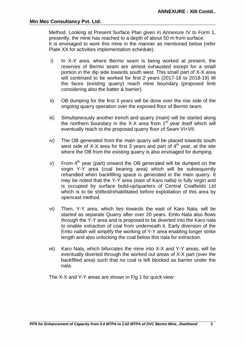
ANNEXURE : XIII Contd..
Min Mec Consultancy Pvt. Ltd.
PFR for Enhancement of Capacity from 0.4 MTPA to 2.62 MTPA of DVC Bermo Mine, Jharkhand 3
Method. Looking at Present Surface Plan given in Annexure IV to Form 1, presently, the mine has reached to a depth of about 50 m from surface.
It is envisaged to work this mine in the manner as mentioned below (refer Plate XX for activities implementation schedule).
i) In X-X area, where Bermo seam is being worked at present, the
reserves of Bermo seam are almost exhausted except for a small portion in the dip side towards south west. This small part of X-X area will continued to be worked for first 2 years (2017-18 to 2018-19) till the faces (existing quarry) reach mine boundary (proposed limit considering also the batter & barrier).
ii) OB dumping for the first 3 years will be done over the rise side of the
ongoing quarry operation over the exposed floor of Bermo seam.
iii) Simultaneously another trench and quarry (main) will be started along the northern boundary in the X-X area from 1st year itself which will eventually reach to the proposed quarry floor of Seam VI+VII.
iv) The OB generated from the main quarry will be placed towards south
west side of X-X area for first 3 years and part of 4th year, at the site where the OB from the existing quarry is also envisaged for dumping.
v) From 4th year (part) onward the OB generated will be dumped on the
virgin Y-Y area (coal bearing area) which will be subsequently rehandled when backfilling space is generated in the main quarry. It may be noted that the Y-Y area (east of Karo nalla) is fully virgin and is occupied by surface build-up/quarters of Central Coalfields Ltd which is to be shifted/rehabilitated before exploitation of this area by opencast method.
vi) Then, Y-Y area, which lies towards the east of Karo Nala, will be
started as separate Quarry after over 20 years. Emlo Nala also flows through the Y-Y area and is proposed to be diverted into the Karo nala to enable extraction of coal from underneath it. Early diversion of the Emlo nallah will simplify the working of Y-Y area enabling longer strike length and also unlocking the coal below this nala for extraction.
vii) Karo Nala, which bifurcates the mine into X-X and Y-Y areas, will be
eventually diverted through the worked out areas of X-X part (over the backfilled area) such that no coal is left blocked as barrier under the nala.
The X-X and Y-Y areas are shown in Fig 1 for quick view:

ANNEXURE : XIII Contd..
Min Mec Consultancy Pvt. Ltd.
PFR for Enhancement of Capacity from 0.4 MTPA to 2.62 MTPA of DVC Bermo Mine, Jharkhand 4
FIG 1
DVC Bermo Mine is a captive mine for Bokaro Thermal Power Station (BTPS) at Bokaro/Chandrapura Thermal Power Station (CTPS) at Chandrapura of D.V.C. To meet the increased demand of coal in above captive power stations, it has become necessary to enhance the capacity from 0.4 MTPA to 2.62 MTPA.
2.2 Brief description of nature of the project Damodar Valley Corporation possesses coal block DVC Bermo Mine with
lease area of 167.434 Ha in villages Baidkaro, Kargali, Karo & Amlo of Bermo circle in District Bokaro, Jharkhand. The production level of DVC Bermo Mine has already been achieved at 0.4 MTPA during 2015-2016. Now the production is proposed to be expanded to 2.62 MTPA without any change in lease area. Anticipated balance life of mine would be 27 years. Opencast mining method is selected. Mine is captive to the Bokaro Thermal Power Station (BTPS) at Bokaro having capacity of 630 MW {(3x 210) + 550 MW (proposed)} and Chandrapura Thermal Power Station (CTPS) at Chandrapura of D.V.C. having capacity of 890 MW (2x 250 + 130x3).
2.3 Need for the project and its importance to the country and or region Coal is regarded as the backbone of power generation in India. There is
huge demand for power in India. Power is essential and most important factor for industrial and business set up. India’s coal position is quite encouraging and it offers good prospects for the development of this industry. During 2011, India was the third largest coal producing country in the world. Hence, coal is an important constituent of the present Indian economy. The total reserves of coal in India have been over 290 billion metric tons. The coalfields in India are located mostly in Jharkhand, Odisha, Madhya Pradesh, Chhattisgarh, Uttar Pradesh, Meghalaya, Telangana, West Bengal, Sikkim, Arunachal Pradesh and Bihar. India has the fifth largest coal reserves in the world. Of the total reserves, nearly 88% are non-coking coal reserves, while tertiary coals reserves account for a meager 0.5 % and the balance is coking coal. The Indian coal is characterised by its high ash content (45%) and low sulphur content. The
ANNEXURE : XIII Contd..
Min Mec Consultancy Pvt. Ltd.
PFR for Enhancement of Capacity from 0.4 MTPA to 2.62 MTPA of DVC Bermo Mine, Jharkhand 5
power sector is the largest consumer of coal followed by the iron and steel and cement segments. India is the world’s fifth largest energy consumer, accounting for 4.1% of the global energy consumption. Maharashtra is the leading state in electricity generation. The current per capita consumption of energy in India is 0.5 toe against the global average of 1.9 toe, indicating a high potential for growth in this sector. Of the total electricity consumed in the country, approximately 80% is produced from coal. (Source:https://www.pwc.in/assets/pdfs/industries/power-mining/icc-coal-report.pdf)
2.4 Demand-supply gap The overall long-term demand of coal is closely linked to the performance of
the end-use sectors. In India, the end-use sectors of coal mainly include electricity, iron and steel and cement. Demand from the unorganised small scale sector comprising primarily of the brick and ceramic industry is relatively large though infirm as users switch between coal, firewood and biomass depending on their relative prices. Other industries using coal have only a marginal impact on the long-term demand for coal. The report of the Working Group of Coal and Lignite for the 12th Five Year Plan projects the coal demand in India to grow at a CAGR of 7.1% till 2016-17 and reach 980.5 MT annually under realistic demand. At a CAGR of 7.0%, the demand is expected to reach 1,373 MT by 2021-22.The current shortage of coal stands at 84 MT and the same is expected to rise to 300 MTPA in medium-term if all the letters of assurance issued by the state-owned coal companies materialise. Some of this shortfall will be met by supplies from captive coal blocks and rest through imports. Also, the choice between the supplies from domestic and imported coal is mainly driven by timely availability of coal from domestic sources, quality requirements and the economics of landed cost of coal at the end-use plant. Captive coal mining in India was, gradually, being permitted by amending the Coal Mines Nationalisation Act, primarily in iron and steel making, power generation and cement production. However, the capacity augmentation from captive coal blocks was dismal as only 30 mines could come online as compared to a targeted 76 mines. Hence, it became important for India to secure coal through imports from international market to meet their significantly rising coal demand. However, import is mainly dependent on availability of coal in global market, increasing competitive scenario and affordability. (Source:https://www.pwc.in/assets/pdfs/industries/power-mining/icc-coal-report.pdf)
2.5 Imports vs. indigenous production There will not be any import for the proposed enhancement in capacity from
0.4 to 2.62 MTPA of mine. 2.6 Export possibility There will not be any export of coal from the coal block. Mine is captive to
the Bokaro Thermal Power Station (BTPS) at Bokaro having capacity of 630 MW {(3x 210) + 550 MW (proposed)} and Chandrapura Thermal Power

ANNEXURE : XIII Contd..
Min Mec Consultancy Pvt. Ltd.
PFR for Enhancement of Capacity from 0.4 MTPA to 2.62 MTPA of DVC Bermo Mine, Jharkhand 6
Station (CTPS) at Chandrapura of D.V.C. having capacity of 890 MW (2x 250 + 130x3).
2.7 Domestic / export markets Entire coal produced from the mine shall be used for power plant of the
company. 2.8 Employment generation (direct and indirect) As the production is proposed to be enhanced from 0.4 MTPA to 2.62
MTPA, additional manpower is envisaged. Total manpower after expansion shall be 569. The existing mining establishment provides employment opportunities under various cadres viz. management, supervisory, highly skilled, skilled, semi skilled and unskilled workmen etc.
3.0 PROJECT DESCRIPTION The Bermo Coal Mine lies in Bermo Block of East Bokaro Coalfield in
Bokaro district of Jharkhand state. The DVC mining area is divided into two sections (areas/portions), namely.
“X-X area” and “Y-Y area” as seen in Fig 1 earlier and the Present Surface Plan given in Annexure IV to Form 1.
The mine is being worked by mechanized Opencast method over developed
underground galleries with diesel operated shovels/backhoes (1.9 – 3.0 cum bucket capacity) working with 25 T rear dumpers. The mine is working in close proximity of dwelling houses, which has restricted the bench height, diameter of the holes, total charge per blast and no. of holes per blast. The OB and coal bench height is 6 m as permitted by the DGMS & 100 mm dia. holes are drilled.
Diesel operated shovels/backhoes (2.5 cum bucket capacity) working with
25 T rear dumpers has been proposed for coal production and for OB removal 4.5 cum diesel operated shovels with 35 T rear dumpers have been proposed.
3.1 Type of Project including interlinked and interdependent projects The coal from the mine will be used for power generation in captive power
plants. 3.2 Location with coordinates DVC Bermo Mine is present in villages Baidkaro, Kargali, Karo & Amlo of
Bermo circle. Please refer Annexure I of Form 1 for the location map of the project.

ANNEXURE : XIII Contd..
Min Mec Consultancy Pvt. Ltd.
PFR for Enhancement of Capacity from 0.4 MTPA to 2.62 MTPA of DVC Bermo Mine, Jharkhand 7
The mining lease area falls in the Survey of India Toposheet no. No. 73 E/13 and bounded by following co-ordinates:
Latitude : 23° 46' 47.55" to 23° 47' 15.955" Longitude : 85° 57' 29.477" to 85° 59' 10.673" 3.3 Details of alternate sites & Environmental considerations Mining being site specific, no alternatives site is under consideration.
Moreover, it is the expansion of an existing mine. Environmental considerations and protection measures assume greater importance for the project. DVC Bermo Mine shall ensure that the proposed mine causes minimum adverse impact on the area.
The proposed project is planned to meet all environmental norms and
further improve the environs in the area. Regular monitoring is being carried out by DVC Bermo Mine at the mine site in line with the requirements of the Jharkhand Pollution Control Board and Ministry of Environment, Forests and Climate Change.
3.4 Size or magnitude of operation The total extent of the proposed mining lease area is 167.434 Ha and the
project area is 169.344 Ha. From the lease area, there will be increase in production from 0.4 million tonnes to 2.62 million tonnes per annum.
3.5 Project description with process details The total extent of the mining lease area is 167.434 Ha. From the lease
area, there will be increase in production from 0.4 MTPA to 2.62 MTPA. To achieve this rate of production it is proposed to adopt mechanised opencast method on three-shift basis. The coal production process from the mine will involve deployment of shovels, dumpers and levelling machinery respectively (Drill machines are deployed wherever necessary to deal with hard strata), loading and transportation of coal and OB to respective destination viz. coal to the captive power plants and OB to the external dumps as the internal dumping can be started only after sufficient void with sufficient safety barrier from the working bench is generated. Overburden, is proposed to be mined with 4.5 cum diesel hydraulic shovel and 35 T dumpers and coal by using 2.5 cum diesel hydraulic shovel and 25 T dumpers. Overburden benches are to be worked by shovel-dumper combination with bench height of 10 m. the cut width of shovel benches is proposed to be 20m.
Presently, the mine has reached to a depth of 50 m from surface. Controlled
blasting operation has been adopted, as proposed by CMRI, Dhanbad in June, 1994. Wet operated drills are in operation. Provision has been made for one magazine of 10 T for storage of explosive. Partly backfilling will be started from 8th year. The overall slope of the surface dump would be maintained at 26°.

ANNEXURE : XIII Contd..
Min Mec Consultancy Pvt. Ltd.
PFR for Enhancement of Capacity from 0.4 MTPA to 2.62 MTPA of DVC Bermo Mine, Jharkhand 8
Year wise production for the life of the mine is tabulated in Table 1.
TABLE 1 CALENDAR PROGRAMME OF COAL PRODUCTION, OB REMOVAL,
REHANDLING AND STRIPPING RATIO Sl Year Calendar
Year Coal, MT OB, Mcum SR Rehandal
OB, Mcum Total OB
Excavation + Rehandal
SR With Rehandling
Prog Cumul Prog Cumul Prog Cumul Prog Cumul Prog Cumul Prog Cumul Past 2016-17 0.20 0.20 0.10 0.10 0.50 0.50 0.00 0.00 0.10 0.10 0.50 0.50
1 2017-18 0.40 0.60 5.20 5.30 13.00 8.83 0.00 5.20 5.30 13.00 8.83
2 2018-19 0.60 1.20 5.40 10.70 9.00 8.92 0.00 5.40 10.70 9.00 8.92
3 2019-20 0.55 1.75 4.93 15.63 8.96 8.93 0.00 4.93 15.63 8.96 8.93
4 2020-21 1.04 2.79 4.35 19.98 4.18 7.16 0.00 4.35 19.98 4.18 7.16 5 2021-22 2.00 4.79 4.15 24.13 2.08 5.04 0.00 4.15 24.13 2.08 5.04
6 2022-23 2.62 7.41 3.84 27.97 1.46 3.77 0.00 3.84 27.97 1.46 3.77
7 2023-24 2.62 10.03 3.84 31.81 1.46 3.17 0.00 3.84 31.81 1.46 3.17
8 2024-25 2.62 12.65 3.84 35.64 1.46 2.82 0.00 3.84 35.64 1.46 2.82
9 2025-26 2.62 15.27 3.84 39.48 1.46 2.59 0.00 3.84 39.48 1.46 2.59
10 2026-27 2.62 17.89 3.84 43.32 1.46 2.42 0.00 3.84 43.32 1.46 2.42
11 2027-28 2.62 20.51 4.08 47.40 1.56 2.31 0.00 4.08 47.40 1.56 2.31
12 2028-29 2.62 23.13 4.08 51.48 1.56 2.23 3.49 3.49 7.57 54.97 2.89 2.38
13 2029-30 2.62 25.75 4.08 55.55 1.56 2.16 3.49 6.98 7.57 62.53 2.89 2.43
14 2030-31 2.62 28.37 4.08 59.63 1.56 2.10 3.49 10.47 7.57 70.10 2.89 2.47
15 2031-32 2.62 30.99 4.08 63.71 1.56 2.06 3.49 13.96 7.57 77.67 2.89 2.51
16 2032-33 2.62 33.61 3.69 67.40 1.41 2.01 4.37 18.33 8.06 85.73 3.08 2.55
17 2033-34 2.62 36.23 3.69 71.09 1.41 1.96 4.37 22.70 8.06 93.80 3.08 2.59
18 2034-35 2.62 38.85 3.69 74.79 1.41 1.92 4.37 27.08 8.06 101.86 3.08 2.62
19 2035-36 2.62 41.47 3.69 78.48 1.41 1.89 4.37 31.45 8.06 109.93 3.08 2.65
20 2036-37 2.62 44.09 3.69 82.17 1.41 1.86 4.37 35.82 8.06 117.99 3.08 2.68
21 2037-38 2.62 46.71 4.76 86.93 1.82 1.86 0.00 35.82 4.76 122.75 1.82 2.63
22 2038-39 2.62 49.33 4.76 91.70 1.82 1.86 0.00 35.82 4.76 127.52 1.82 2.58
23 2039-40 2.62 51.95 4.76 96.46 1.82 1.86 0.00 35.82 4.76 132.28 1.82 2.55
24 2040-41 2.62 54.57 4.76 101.23 1.82 1.85 1.44 37.26 6.20 138.48 2.37 2.54
25 2041-42 2.62 57.19 4.76 105.99 1.82 1.85 1.44 38.69 6.20 144.68 2.37 2.53
26 2042-43 2.50 59.69 4.00 109.99 1.60 1.84 3.70 42.39 7.70 152.38 3.08 2.55
27 2043-44 0.97 60.66 0.80 110.79 0.82 1.83 3.69 46.08 4.49 156.87 4.63 2.59
60.66 110.79 1.83 46.08 156.87 2.59
*The year 1 will start from the date when all the clearances are in place.
Balance life of the mine, considering a capacity of 2.62 MT coal production per annum, will be 27 years and the average stripping ratio of the mine works out to1.83 cum/t. Coal is being dispatched by road through trucks from Opencast quarry-head to Power plants.

ANNEXURE : XIII Contd..
Min Mec Consultancy Pvt. Ltd.
PFR for Enhancement of Capacity from 0.4 MTPA to 2.62 MTPA of DVC Bermo Mine, Jharkhand 9
3.6 Mining method Opencast mining method has been selected for the proposed enhancement
of production. Shovel Dumper Mining Technology shall be used for coal and overburden.
For Coal - Shovel Dumper Mining Technology Due to existence of inseam bands contributing for coal seam thickness,
selective band removal may not be feasible while mining by continuous miner, therefore combination of shovel dumper is preferred. Moreover, for production of better grade coal and requirement of sized coal, mining by continuous mining technology may not be the most suitable option. However, a hydraulic backhoe/shovel has been proposed to meet the selective mining requirement.
For Overburden - Shovel Dumper Mining Technology Overburden has been proposed to be mined by this technology. Application
of shovel dumper technology for OB is envisaged due to the following reasons:
a) Moderate thickness of coal seam. b) Parting thickness averaging between 0.36 – 21.40m. c) Flexible and easy operation.
3.6.1 Blasting pattern Three diesel drills of 100 mm size is required for drilling OB benches. Coal
is being mined by shovel/ backhoe deployed on coal benches, drilling and blasting is performed by a 160 mm drill provided for the purpose. Magazines for storing explosives has been kept.
3.7 Raw material required along with estimated quantity, likely source,
marketing area of final product’s, Mode of transport of raw material and Finished product
No raw material is required. Only diesel is required for transportation
vehicles, operation of HEMM and generators in case of emergency. Coal is being dispatched for captive use in BTPS and CTPS located at Bokaro and Chandrapura by Road.
3.8 Resource optimization/ recycling and reuse envisaged in the project The Coal does not require any beneficiation. The ROM coal is processed at
CHP useable in TPS. The resources which are used in the mining will be recycled by various methods. Spent oil from transformers, once in one or two years is sold to the authorized vendors. Mine water is discharged from quarry through adequate number of pumps (as required) and is being used for mining activity.

ANNEXURE : XIII Contd..
Min Mec Consultancy Pvt. Ltd.
PFR for Enhancement of Capacity from 0.4 MTPA to 2.62 MTPA of DVC Bermo Mine, Jharkhand 10
3.9 Availability of water its source, energy / power requirement and source 3.9.1 Water Requirement: Water requirement after expansion will be 242 KLD for
potable and 339 KLD for industrial purpose. Source: The mine water is collected in sump and dewatering is done to
keep mine working dry. Dewatered water as well as any surface run off during rain is led to settling tank for settlement of suspended solids. Thereafter, the water is used for industrial purpose, sprinkling, greenbelt watering, etc. Excess water is and will be discharged to natural drain after settlement of suspended solids. The potable requirement will be met through borewells. The waste water in Workshop will be treated and recycled.
3.9.2 Power The total power is being sourced from Bokaro Thermal Power Station which
is about 15 km from the Mine through 33 KVA over head line. It is stepped down to 11KVA then to 440v.
3.10 Quantity of wastes to be generated (liquid and solid) and scheme for
their management / disposal 110.79 MCum(B) of overburden will be generated during life of mine. The
existing surface dump is on the northern portion of the X-X Area. it is proposed to accommodate 19.41 mcum(B) OB generated during the 1st about three and half years over the floor of Bermo seam in the SW corner of X-X area. Thereafter, the generated OB will also be placed on the surface over the virgin Y-Y area east of karo nala. It has been estimated that Y-Y area will be adequate to accommodate the generated OB in temporary surface dump, till the backfilling in X-X void can be done concurrent with mining without requiring any additional area outside the ML area for external surface dumping.Presently, the mine has reached to a depth of about 50 m from surface. The sequence of mining has been planned in such a way as to avoid any external dumping area outside the block which is not available in the vicinity of the mine as the surrounding land is under jurisdiction of CCL and the areas are coal bearing.c
All the OB generated shall be backfilled ultimately, any OB dumped on
surface will be temporary and will be rehandaled to backfill in a planned manner. Top soil quantity of about 0.74 Mcum(B) shall be generated during life of mine which will be reused for plantation. Mine sequence has been so planned that the OB generated while opening of Y-Y area (during 21st year) beyond Karo nala as separate quarry, gets placed in the voids already created till then in the X-X area, such that the rehandling of dump is minimised,
ANNEXURE : XIII Contd..
Min Mec Consultancy Pvt. Ltd.
PFR for Enhancement of Capacity from 0.4 MTPA to 2.62 MTPA of DVC Bermo Mine, Jharkhand 11
The top soil generated will be spread over the reclaimed dump concurrent with mining. Top soil will be used for growing plants along the fringes of the site roads and reclamation of temporary surface dump and backfilled area.
Solid waste generated from manpower is mostly of organic and recyclable
in nature. The organic waste is and will continue to be composted and used as manure while recyclable component are and will be sold to recycling agencies. The waste water from mine site offices is and will continue to be treated in septic tank- soak pit system.
The mine sump water is regularly monitored for pH level and treated, if
required, prior to discharge. The waste water from workshop is treated in oil water separator followed by settling tank and reused in washing.
It is planned to relocate workshop outside over the NW corner of ML and
install an ETP in addition to oil-water separator at new location. 3.11 Schematic representations of the feasibility drawing which give
information of EIA purpose The conceptual plan of mine lease is given in Annexure VI to Form 1. 4.0 SITE ANALYSIS The Mine site is located in Block Bermo New, villages Baidkaro, Kargali,
Karo & Amlo of Bermo circle, District Bokaro, Jharkhand. The Coordinates of mine are: Latitude : 23°46’47.55” to 23°47’15.955”
Longitude : 85°57’29.477 to 85°59’10.673” The topography is gentle and is marked by the absence of any high hill or
deep depressions. The general slope of the ground is towards south. The elevation based on RLs of Bore holes drilled in Bermo seam in 1950 was between 233.17 and 243.84 m.
4.1 Connectivity Road: The coal mine is located in the East Bokaro coalfield near Kargali
and other mines of CCL. The mine is well connected with BTPS by a metalled road. The mine is located about 50 km away from Bokaro township. Bermo Railway Station is connected through road.
Railway Line: The nearest Railway Station is Bermo at a distance of about
3 Km towards south from the block on Gomoh-Chandrapur, Barkakana-line of the East Central Railway.
Airport: The nearest airport is Ranchi and Kolkata at a distance of about
120 and 330 km. respectively.

ANNEXURE : XIII Contd..
Min Mec Consultancy Pvt. Ltd.
PFR for Enhancement of Capacity from 0.4 MTPA to 2.62 MTPA of DVC Bermo Mine, Jharkhand 12
4.2 Land form, Land use and land ownership Total project area is 169.344 ha. This includes Mine Lease area of 167.434
Ha and 1.91 Ha proposed to be used for facilities adjoining to the NW corner of ML. No increase in existing ML area is proposed for increasing the production from 0.40 MTPA to 2.62 MTPA.
Pre Mining, present and post mining landuse is given in Table 2, 3 and 4
respectively.
TABLE 2 PRE-MINING (PRE-1951) LAND USE OF THE PROJECT AREA
Pre Mining Land Use in ML Area in acres (Area detailed in acres in the lease records)
Sl. No.
Village/ Mauza
Tenancy GMK Govt. Land (Waste
land)
GMK Jungle
GM- Aam
(Others)
Water body
Total
Total area in
ha
I Within ML/ Block
1 Karo 3.76 11.45 36.9 0.99 1.00 54.10 21.893 2 Baidkaro 16.03 14.40 29.81 0 0 60.24 24.378 3 Kargali 9.72 0.87 215.5 0 1.31 227.40 92.026 4 Emlo 37.62 18.48 15.09 0.81 0 72.00 29.137 Total acres 67.13 45.20 297.30 1.80 2.31 413.74 Total in Ha 27.166 18.292 120.313 0.728 0.935 167.434 167.434
II Out side ML/ Block (in Ha)
Baidkaro 4.10 0.63 0 0 0 4.73 1.91 I+II Project Area 31.266 18.922 120.313 0.728 0.935 169.344
TABLE 3
PRESENT (2016-2017) LAND USE OF THE PROJECT AREA Sl. No. Particular Total area of land (Ha) Within ML/ Block Area (Mining rights)
1. Area under habitation 70.294 2. Mine facilities 2.00 3 Top soil dump 2.00 4 Water reservoir/settling pond 1.50 5 Karo and Emlo nala 1.00 6 Area under backfill 5.77 7 Area under excavation 42.85 8 Area under surface dump 42.02
90.64
Sub Total Within ML/ Block Area 167.434 Outside ML/ Block (Surface rights only)
1 Area under Existing facilities (DVC Colony, road, undisturbed area)
1.660
2 Magazine and Road 0.25 Sub Total Outside ML/ Block 1.91
Grand Total Project area 169.344
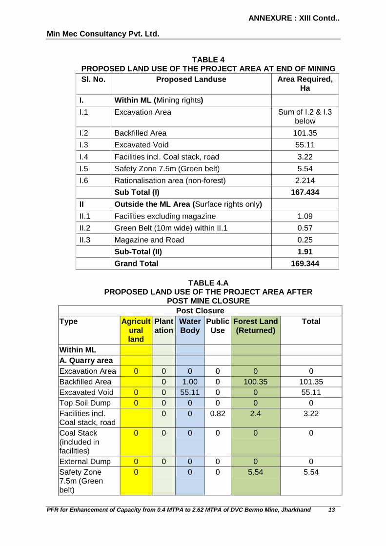
ANNEXURE : XIII Contd..
Min Mec Consultancy Pvt. Ltd.
PFR for Enhancement of Capacity from 0.4 MTPA to 2.62 MTPA of DVC Bermo Mine, Jharkhand 13
TABLE 4
PROPOSED LAND USE OF THE PROJECT AREA AT END OF MINING Sl. No. Proposed Landuse Area Required,
Ha I. Within ML (Mining rights) I.1 Excavation Area Sum of I.2 & I.3
below I.2 Backfilled Area 101.35 I.3 Excavated Void 55.11 I.4 Facilities incl. Coal stack, road 3.22 I.5 Safety Zone 7.5m (Green belt) 5.54 I.6 Rationalisation area (non-forest) 2.214 Sub Total (I) 167.434 II Outside the ML Area (Surface rights only) II.1 Facilities excluding magazine 1.09 II.2 Green Belt (10m wide) within II.1 0.57 II.3 Magazine and Road 0.25 Sub-Total (II) 1.91 Grand Total 169.344
TABLE 4.A
PROPOSED LAND USE OF THE PROJECT AREA AFTER POST MINE CLOSURE
Post Closure Type Agricult
ural land
Plantation
Water Body
Public Use
Forest Land (Returned)
Total
Within ML A. Quarry area Excavation Area 0 0 0 0 0 0 Backfilled Area 0 1.00 0 100.35 101.35 Excavated Void 0 0 55.11 0 0 55.11 Top Soil Dump 0 0 0 0 0 0 Facilities incl. Coal stack, road
0 0 0.82 2.4 3.22
Coal Stack (included in facilities)
0 0 0 0 0 0
External Dump 0 0 0 0 0 0 Safety Zone 7.5m (Green belt)
0 0 0 5.54 5.54

ANNEXURE : XIII Contd..
Min Mec Consultancy Pvt. Ltd.
PFR for Enhancement of Capacity from 0.4 MTPA to 2.62 MTPA of DVC Bermo Mine, Jharkhand 14
Post Closure Type Agricult
ural land
Plantation
Water Body
Public Use
Forest Land (Returned)
Total
Road (included in facilities)
0 0 0 0 0 0
Road diversion 0 0 0 0 0 0 Nala 0 0 0 0 0 0 Setting pond 0 0 0 0 0 0 Rationalisation area (non-forest)
0 0 0 2.214 2.214
Garland drains 0 0 0 0 0 0 Embankment 0 0 0 0 0 0 Other Green Belt 0 0 0 0 0 0 Habitation 0 0 0 0 0 0 Undisturbed area 0 0 0 0 0 0 0 0 0 0 0 0 0.000 0 56.11 0.82 110.504 167.434 Outside the block area away from block
Facilities including magazine as follows
Industrial 0 0 0 0 0 0 Colony including road
0 0 0 0.74 0 0.74
R&R 0 0 0 0 0 0 Green Belt (10m wide)
0 0.57 0 0 0 0.57
Magazine with approach road
0.25 0 0 0 0 0.25
Undisturbed 0.35 0 0 0 0 0.35 Sub-Total 0.60 0.57 0 0.74 0 1.91 G. Total 0.600 0.570 56.110 1.560 110.504 169.344
4.3 Topography Topography is gentle, no high hills or deep depression being present.
However the area has a footprint of mining due to presence of coal mines of Central Coalfields Ltd and DVC in the coalfields. The elevation in the 10 km radius of the project (also referred to as buffer zone) varies from 312 m to 211 m MSL. The elevation based on RLs of Bore holes drilled in Bermo seam in 1950 varies between 233.17 and 243.84 m.

ANNEXURE : XIII Contd..
Min Mec Consultancy Pvt. Ltd.
PFR for Enhancement of Capacity from 0.4 MTPA to 2.62 MTPA of DVC Bermo Mine, Jharkhand 15
4.4 Existing infrastructure Complete site facilities are important for smooth working of any mine. Core
infrastructure like Office Building, Coal Stockyard, Weigh Bridge, CHP, Workshop, Diesel Pump, Workers Accommodation etc. is present at the mine as mine is operational for 0.4 MTPA coal production.
Habitation/colonies of CCL/DVC that are present inside the ML area, shall
be subsequently shifted as mine workings are progressed. Mine is already operating for more than 65 years in X-X area. The virgin
area of the block is occupied by CCL colony and is to be shifted/ rehabilitated in consultation with CCL. For displaced persons/ families other than CCL, policy of Govt. of Jharkhand for resettlement & rehabilitation in case of mining projects, will be followed. Land for rehabilitation is to be identified.
4.5 Soil classification Regular monitoring of quality of soil at site is being carried out by third party
laboratory. Analysis of soil samples reveals that there is no wide variation in the natural material. Particle size analysis shows that the texture of the soil is of sandy loam in nature with moderate water holding capacity. Electrical conductivity has been observed to be in the normal range while the values of organic carbon is found to be lower. Available phosphorus and potassium have been found in medium range.
4.6 Climatic data from secondary sources The climate of the area is dry humid and sub-tropical. It is characterised by
hot and dry summer from March to May, rainy season from June to October and cold winter spreading from November to February.
Temperature In summer, the temperature rises up to 42.5°C to 44.6°C on some summer
days. During winter, the temperature drops down to 5-7°C at times. Dust storms are common in dry season (May and June) before the onset of monsoon with increase in temperature and wind speed in the afternoon coupled with low humidity.
Rainfall
Annual rainfall is about 1200 mm, a major portion of which occurs during the
monsoon period and the maximum rainfall occur in the month of August. The number of rainy days in a year is about 100.
Wind Speed and wind direction The wind speed of the area varies from 1.5 to 2.8 ms-1.

ANNEXURE : XIII Contd..
Min Mec Consultancy Pvt. Ltd.
PFR for Enhancement of Capacity from 0.4 MTPA to 2.62 MTPA of DVC Bermo Mine, Jharkhand 16
Relative Humidity The average annual relative humidity is about 67%. In summer months the
relative humidity varies between 32 to 73%. 4.7 Social infrastructure available Hospitals, school, banks etc are present in the villages in buffer zone (within
10 Km of project area). Social infrastructures are existing as per Census 2011 and are listed in Annexure X to Form 1.
5.0 PLANNING BRIEF 5.1 Planning concept The Damodar Valley Corporation is the first multipurpose river valley project
of independent India which came into being on July 7,1948 by an Act of The Constitution Assembly (Act No XIV of 1948) and is equally owned by Govt. of India, Govt. of West Bengal and Govt. of Jharkhand (earlier Bihar). It is planned to use the coal produced from the mine for Captive use by thermal power plant of the the Corporation.
5.2 Population projection Existing manpower of DVC Bermo Mines is 128. The proposed estimated
manpower strength of the mine for enhanced production of 2.62 MTPA will be 569.
Unskilled and semi skilled (after training) are hired from the surrounding
area while skilled persons, engineers, managerial staff and technical experts are hired from outside.
5.3 Land use planning (break up along with green belt etc.) The pre mining and present land use of the mine lease is referred in Table 2
and Table 3. Landuse at the end of life of mine is given in Table 4 in Section 4.2 earlier.
5.4 Assessment of infrastructure demand (physical & social) An assessment of the current facilities available in the villages in and
adjacent to the mine lease area in education, health, drinking water, power supply, post and telegraph, banks, communication and approach road has been done using Census 2011 data and presented in Annexure X to Form 1.
Core infrastructure, like power distribution system, road, telecommunication,
housing, service buildings viz. office, store, First Aid centre, canteen etc. have been established at the mine site during the past operation.

ANNEXURE : XIII Contd..
Min Mec Consultancy Pvt. Ltd.
PFR for Enhancement of Capacity from 0.4 MTPA to 2.62 MTPA of DVC Bermo Mine, Jharkhand 17
5.5 Amenities / facilities Education, Hospitals, drinking water, power supply, post and telegraph,
banks, communication and approach roads are present in the villages in buffer zone within 10 Km of project area. Office Building, Coal Stockyard, Weigh Bridge, CHP, Diesel Pump, Workers Accommodation etc. has been constructed.
The First Aid Room, Rest Shelters, Toilets, Tool /Store Rooms etc has been
provided at mine site. 6.0 PROPOSED INFRASTRUCTURE 6.1 Industrial area (processing area) The activity wise detail of present landuse is given in Table 3 and at the end
of life of mine is given in Table 4 of Section 4.2 earlier. A triangular portion of ML area in the NW corner has been reserved for constructing the facilities required for the proposed expansion.
6.2 Residential area (non processing area) As Bermo mine is captive to the BTPS, most of the mine employees live in
BTPS colony except the few which are presently living within the ML area. It is proposed that in future, all the employees will live in BTPS colony and the existing quarters of DVC within the ML will be dismantled to mine the coal underneath them.
6.3 Green belt In order to combat pollution effects arising out of the mining operations and
to improve the ecological and aesthetic status of the area, a comprehensive three tier green belt development programme will be implemented. Keeping in view the environmental problems, plantation programme has been prepared to mitigate the problems. The areas considered for plantations are:
All along the roads and around office, stores, workshop etc.
In all vacant/barren places near the quarry area
Waste surface dumps (temporary) in stages
Over the backfilled area
Peripheral portion of mining lease.

ANNEXURE : XIII Contd..
Min Mec Consultancy Pvt. Ltd.
PFR for Enhancement of Capacity from 0.4 MTPA to 2.62 MTPA of DVC Bermo Mine, Jharkhand 18
6.4 Social infrastructure With the mine already in operation for over 6 decades, amenities for
communication, education, health, canteen, etc have developed by BTPS and will continue to be developed and maintained in and around the project area. These amenities are and will be available to local people also, who are directly associated with the project. Even those not associated in the project related activities are benefited by these amenities. With the continuation and expansion of the mine, there will be substantial improvement in the overall economy of the local people in the form of additional income through employment, development of infrastructure in surrounding areas such as transport facility, health and education, shops and ancillary industries. Over and above, the people can avail any of the medical/ educational facilities that will be established by the company in the area. Water can also be supplied free of cost on festive occasions. Overall, the rest of the villagers will be encouraged to be self sufficient.
The objective of CSR is to:
Significantly improve the physical quality of life
Create opportunities for livelihood
Improve the level of education including adult education
Create health awareness among women and
Ensure availability of safe drinking water 6.5 Connectivity Road Refer section 4.1. Railway Line/Airport Refer section 4.1. 6.6 Drinking water management (source & supply of water) Refer section 3.9.1 6.7 Sewerage system & industrial waste management A sump of adequate capacity has already been created at the present
mining pit to accommodate seepage water as well as to accommodate any sudden torrential rainfall. Heavy duty pumps are operational in this sump. Water is being discharged into the main garland drain by pipeline. The pumping capacity is presently sufficient to handle any torrential rain in the

ANNEXURE : XIII Contd..
Min Mec Consultancy Pvt. Ltd.
PFR for Enhancement of Capacity from 0.4 MTPA to 2.62 MTPA of DVC Bermo Mine, Jharkhand 19
mining area. Pumps of similar capacities have been kept as standby. Water is now being utilized in sprinkling the mine working area.
6.8 Solid waste management Refer section 3.10. 6.9 Power requirement & supply / source Refer section 3.9.2. 7.0 REHABILITATION AND RESETTLEMENT PLAN This matter has been covered under para 4.4 earlier. In old colony, approx
245 quarters of DVC un-authorised occupancy exist which will be taken care by DVC in X-X area. Approx. 1500 quarters un-authorised occupancy exist over the adjoining area (outside the ML area) to the southern ML boundary but these quarters belong to CCL which will be dealt by CCL. In Y-Y area approx 2164 quarters Un-authorised occupancy exist (in two clonies of CCL named Subhash Nagar and Jawahar nagar) but these quarters belong to CCL which will be taken care by CCL.
Plan for rehabilitation and resettlement has been discussed in detail
between DVC and CCL and it has been principally agreed that the R&R work will be taken up. Tentative costs involved have also been calculated by CCL as Rs 63.57 Crore in the year 2003, the present amount of which will be updated.
8.0 PROJECT SCHEDULE & COST ESTIMATES 8.1 Cost of production The cost of production at pit head is about Rs. 500/ tonne of coal
approximately. 9.0 ANALYSIS OF PROPOSAL (FINAL RECOMMENDATIONS) This is an operational opencast mine with present production capacity of
0.4MT and is proposed to be expanded to a capacity of 2.62 MTPA, and the extent of ML is 167.434 Ha. The balance life of mine will be 27 years. The environmental impacts are kept at minimum by adopting proper mitigation measures.