NTPC Limited - Environmental Clearance
522
ENVIRONMENTAL IMPACT ASSESSMENT/ ENVIRONMENTAL MANAGEMENT PLAN July’ 2021 Rammam Hydro Power Project, Stage-III (3x40 MW) in District-Darjeeling & West Sikkim State-West Bengal & Sikkim NTPC Limited (A Government of India Enterprise) PREPARED BY SV ENVIRO LABS & CONSULTANTS Visakhapatnam Phone: 0891-2755528, Fax: 0891-2755529 Email: [email protected] Recognized by MoEF&CC and QCI – Accredited, Certificate No. NABET/EIA/1821/SA 0118
-
Upload
khangminh22 -
Category
Documents
-
view
0 -
download
0
Transcript of NTPC Limited - Environmental Clearance

ENVIRONMENTAL IMPACT ASSESSMENT/ ENVIRONMENTAL MANAGEMENT PLAN
July’ 2021
Rammam Hydro Power Project, Stage-III
(3x40 MW)
in
District-Darjeeling & West Sikkim
State-West Bengal & Sikkim
NTPC Limited (A Government of India Enterprise)
PREPARED BY
SV ENVIRO LABS & CONSULTANTS Visakhapatnam
Phone: 0891-2755528, Fax: 0891-2755529
Email: [email protected]
Recognized by MoEF&CC and QCI – Accredited,
Certificate No. NABET/EIA/1821/SA 0118

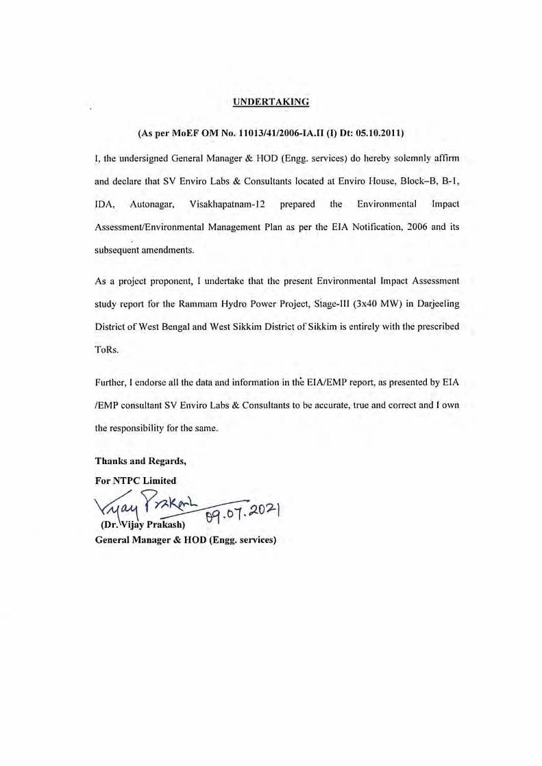
UNDERTAKING BY CONSULTANT
This is to certify that M/s. SV Enviro Labs & Consultants is a NABET & NABL Accredited,
ISO 9001:2015 certified company and is recognised by Ministry of Environment, Forest and
Climate Change under Environment (Protection) Act, 1986.
Further, this Environmental Impact Assessment/ Environmental Management Plan for the
Rammam Hydro Electric Project Stage-III (3 x 40 MW) in Darjeeling District of West
Bengal and West Sikkim District of Sikkim has been carried out by M/s. SV Enviro Labs &
Consultants and the prescribed ToR’s have been complied with and the data submitted in the
Final EIA report is factually correct.
Thanks and Regards,
M. Murali Krishna
Managing Partner
July, 2021
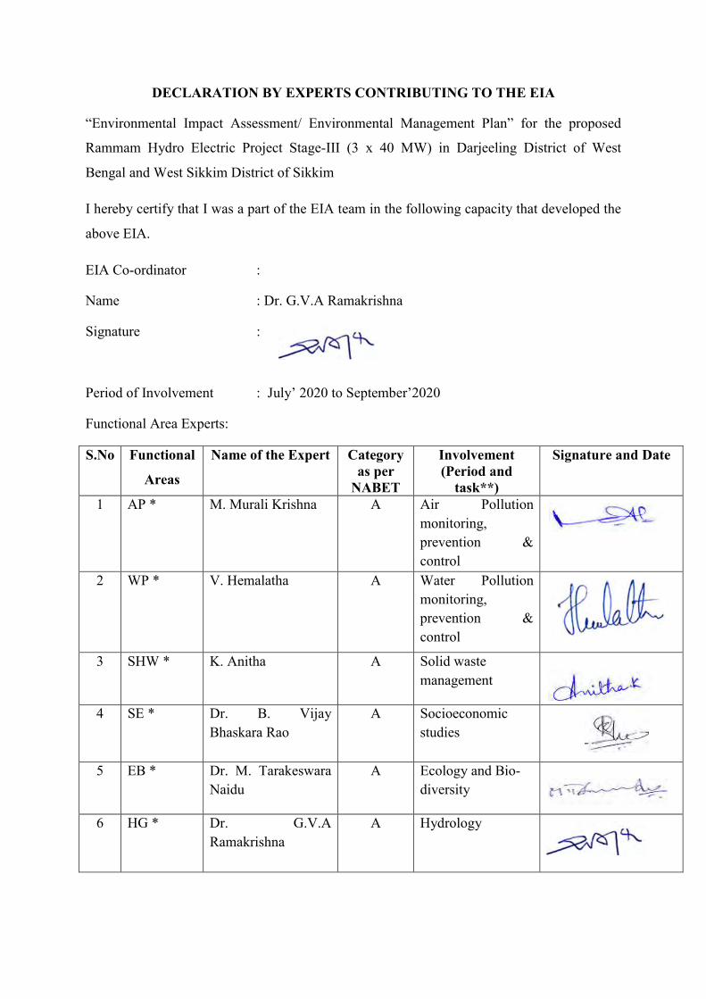
DECLARATION BY EXPERTS CONTRIBUTING TO THE EIA
“Environmental Impact Assessment/ Environmental Management Plan” for the proposed
Rammam Hydro Electric Project Stage-III (3 x 40 MW) in Darjeeling District of West
Bengal and West Sikkim District of Sikkim
I hereby certify that I was a part of the EIA team in the following capacity that developed the
above EIA.
EIA Co-ordinator :
Name : Dr. G.V.A Ramakrishna
Signature :
Period of Involvement : July’ 2020 to September’2020
Functional Area Experts:
S.No Functional
Areas
Name of the Expert Category as per
NABET
Involvement (Period and
task**)
Signature and Date
1 AP * M. Murali Krishna
A Air Pollution
monitoring,
prevention &
control
2 WP * V. Hemalatha
A Water Pollution
monitoring,
prevention &
control
3 SHW * K. Anitha
A Solid waste
management
4 SE * Dr. B. Vijay
Bhaskara Rao
A Socioeconomic
studies
5 EB * Dr. M. Tarakeswara
Naidu
A Ecology and Bio-
diversity
6 HG * Dr. G.V.A
Ramakrishna
A Hydrology
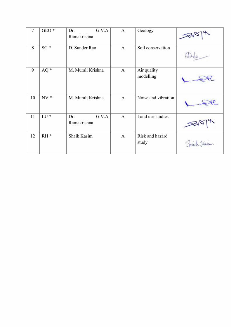
7 GEO * Dr. G.V.A
Ramakrishna
A Geology
8 SC * D. Sunder Rao
A Soil conservation
9 AQ * M. Murali Krishna A Air quality
modelling
10 NV * M. Murali Krishna A Noise and vibration
11 LU * Dr. G.V.A
Ramakrishna
A Land use studies
12 RH * Shaik Kasim
A Risk and hazard
study
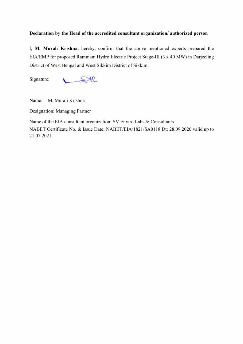
Declaration by the Head of the accredited consultant organization/ authorized person
I, M. Murali Krishna, hereby, confirm that the above mentioned experts prepared the
EIA/EMP for proposed Rammam Hydro Electric Project Stage-III (3 x 40 MW) in Darjeeling
District of West Bengal and West Sikkim District of Sikkim.
Signature:
Name: M. Murali Krishna
Designation: Managing Partner
Name of the EIA consultant organization: SV Enviro Labs & Consultants
NABET Certificate No. & Issue Date: NABET/EIA/1821/SA0118 Dt: 28.09.2020 valid up to
21.07.2021

Certificate of Plagiarism check
Title of EIA Report
Environmental Impact Assessment/Environmental
Impact Assessment Report for Rammam Hydro Electric
Project Stage-III (3 x 40 MW) in Darjeeling District of
West Bengal and West Sikkim District of Sikkim
Name of Accredited Organization SV Enviro Labs & Consultants
Unique Identification Number SVELC/EIA/NTPC/FINAL/2021
Name of EIA Co-ordinator (EC) Dr. G.V.A. Ramakrishna
Name of the Software Plagiarism Checker X
Date of Check 05.07.2021
Time of Check 5:00 PM
Declaration by the Head of the accredited consultant organization/authorized person
I hereby certify that this EIA/EMP Report has been evaluated using in-house software
Plagiarism Checker X version 6.0.11. The report produced has been analyzed by the system and
based on it, I certify that the EIA report produced in accordance with good scientific practice.
Date and Sign of EIA Coordinator: 06.07.2021
Name: Dr. G.V.A. Ramakrishna
Designation: EIA Coordinator
Date and Sign of Head of Accredited Organization: 06.07.2021 (M. Murali Krishna)
Name of the EIA consultant organization: SV ENVIRO LABS & CONSULTANTS
NABET Certificate No. & Issue Date: NABET/EIA/1821/SA 0118 Dt. 28.09.2020


CONTENTS
Table of Contents C0-1
List of Tables C0-9
List of Figures C0-12
List of Annexures C0-14
Index of Compliance with TOR for EIA Study – Additional TOR C0-15
Index of Compliance with TOR for EIA Study – Standard TOR C0-20
Chapter I Introduction C1-1
Chapter II Project Description C2-1
Chapter III Description of the Environment C3-1
Chapter IV Anticipated Environmental Impacts &Mitigation Measures C4-1
Chapter V Analysis of Alternatives C5-1
Chapter VI Environmental Monitoring Program C6-1
Chapter VII Additional Studies C7-1
Chapter VIII Project Benefits C8-1
Chapter IX Environment Cost Benefit Analysis C9-1
Chapter X Environmental Management Plan C10-1
Chapter XI Summary and Conclusions C11-1
Chapter XII Disclosure of Consultants C12-1
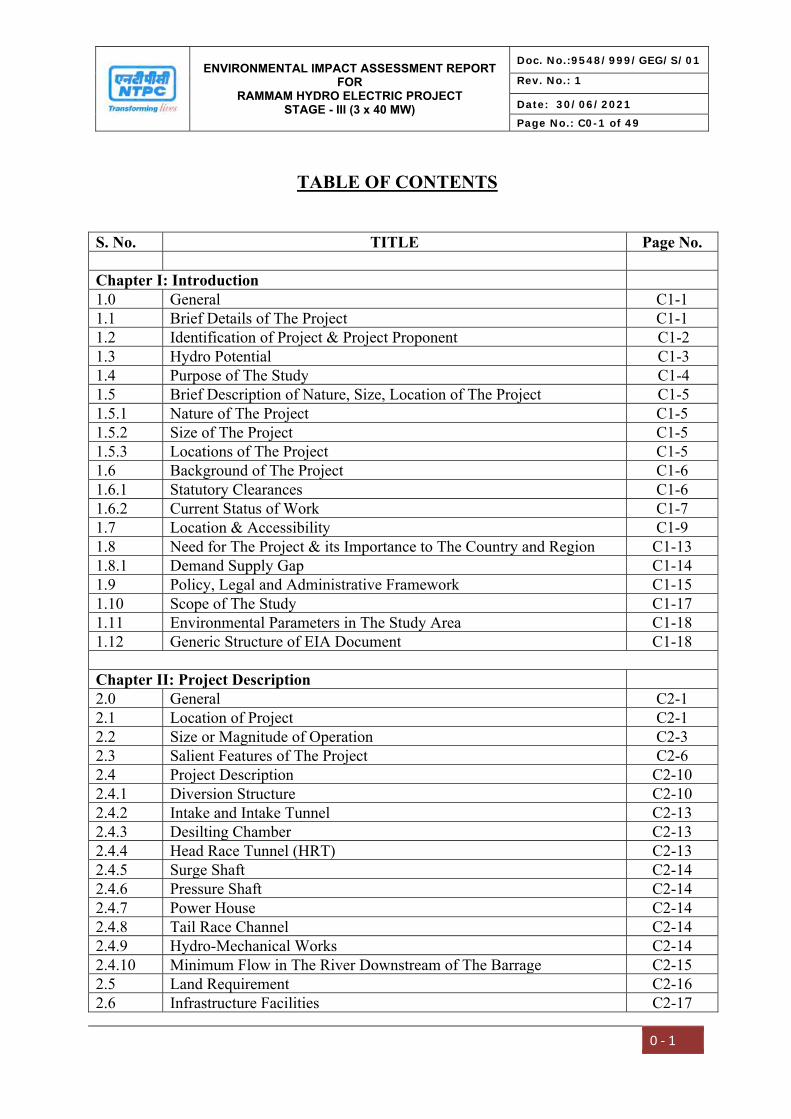
ENVIRONMENTAL IMPACT ASSESSMENT REPORT FOR
RAMMAM HYDRO ELECTRIC PROJECT STAGE - III (3 x 40 MW)
Doc. No.:9548/999/GEG/S/01
Rev. No.: 1
Date: 30/06/2021
Page No.: C0-1 of 49
0 ‐ 1
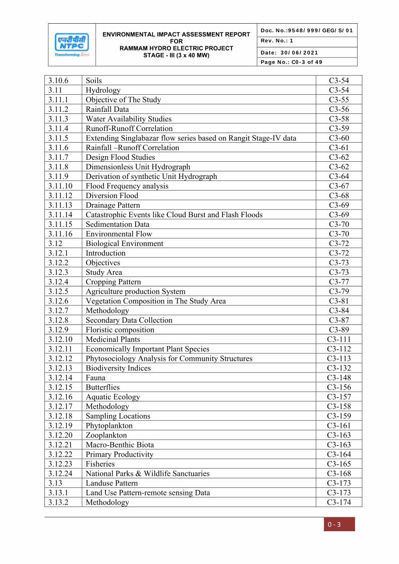
TABLE OF CONTENTS
S. No. TITLE Page No. Chapter I: Introduction 1.0 General C1-1 1.1 Brief Details of The Project C1-1 1.2 Identification of Project & Project Proponent C1-2 1.3 Hydro Potential C1-3 1.4 Purpose of The Study C1-4 1.5 Brief Description of Nature, Size, Location of The Project C1-5 1.5.1 Nature of The Project C1-5 1.5.2 Size of The Project C1-5 1.5.3 Locations of The Project C1-5 1.6 Background of The Project C1-6 1.6.1 Statutory Clearances C1-6 1.6.2 Current Status of Work C1-7 1.7 Location & Accessibility C1-9 1.8 Need for The Project & its Importance to The Country and Region C1-13 1.8.1 Demand Supply Gap C1-14 1.9 Policy, Legal and Administrative Framework C1-15 1.10 Scope of The Study C1-17 1.11 Environmental Parameters in The Study Area C1-18 1.12 Generic Structure of EIA Document C1-18 Chapter II: Project Description 2.0 General C2-1 2.1 Location of Project C2-1 2.2 Size or Magnitude of Operation C2-3 2.3 Salient Features of The Project C2-6 2.4 Project Description C2-10 2.4.1 Diversion Structure C2-10 2.4.2 Intake and Intake Tunnel C2-13 2.4.3 Desilting Chamber C2-13 2.4.4 Head Race Tunnel (HRT) C2-13 2.4.5 Surge Shaft C2-14 2.4.6 Pressure Shaft C2-14 2.4.7 Power House C2-14 2.4.8 Tail Race Channel C2-14 2.4.9 Hydro-Mechanical Works C2-14 2.4.10 Minimum Flow in The River Downstream of The Barrage C2-15 2.5 Land Requirement C2-16 2.6 Infrastructure Facilities C2-17
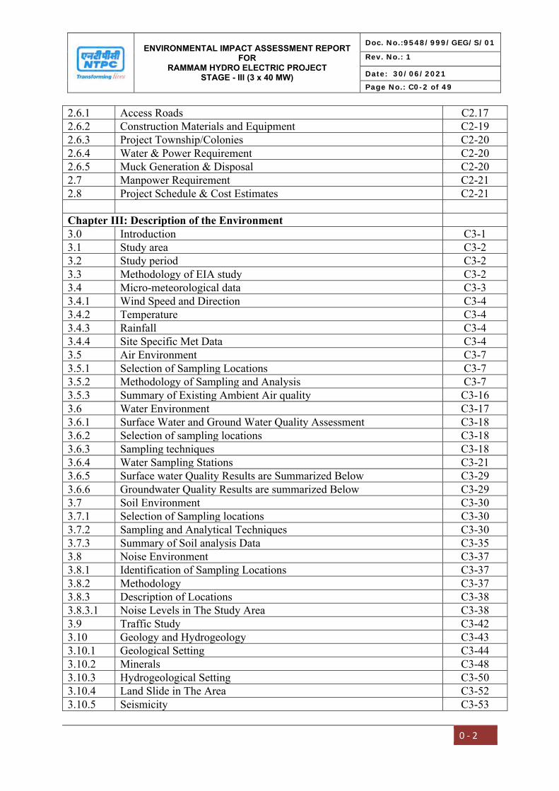
ENVIRONMENTAL IMPACT ASSESSMENT REPORT FOR
RAMMAM HYDRO ELECTRIC PROJECT STAGE - III (3 x 40 MW)
Doc. No.:9548/999/GEG/S/01
Rev. No.: 1
Date: 30/06/2021
Page No.: C0-2 of 49
0 ‐ 2
2.6.1 Access Roads C2.17 2.6.2 Construction Materials and Equipment C2-19 2.6.3 Project Township/Colonies C2-20 2.6.4 Water & Power Requirement C2-20 2.6.5 Muck Generation & Disposal C2-20 2.7 Manpower Requirement C2-21 2.8 Project Schedule & Cost Estimates C2-21 Chapter III: Description of the Environment 3.0 Introduction C3-1 3.1 Study area C3-2 3.2 Study period C3-2 3.3 Methodology of EIA study C3-2 3.4 Micro-meteorological data C3-3 3.4.1 Wind Speed and Direction C3-4 3.4.2 Temperature C3-4 3.4.3 Rainfall C3-4 3.4.4 Site Specific Met Data C3-4 3.5 Air Environment C3-7 3.5.1 Selection of Sampling Locations C3-7 3.5.2 Methodology of Sampling and Analysis C3-7 3.5.3 Summary of Existing Ambient Air quality C3-16 3.6 Water Environment C3-17 3.6.1 Surface Water and Ground Water Quality Assessment C3-18 3.6.2 Selection of sampling locations C3-18 3.6.3 Sampling techniques C3-18 3.6.4 Water Sampling Stations C3-21 3.6.5 Surface water Quality Results are Summarized Below C3-29 3.6.6 Groundwater Quality Results are summarized Below C3-29 3.7 Soil Environment C3-30 3.7.1 Selection of Sampling locations C3-30 3.7.2 Sampling and Analytical Techniques C3-30 3.7.3 Summary of Soil analysis Data C3-35 3.8 Noise Environment C3-37 3.8.1 Identification of Sampling Locations C3-37 3.8.2 Methodology C3-37 3.8.3 Description of Locations C3-38 3.8.3.1 Noise Levels in The Study Area C3-38 3.9 Traffic Study C3-42 3.10 Geology and Hydrogeology C3-43 3.10.1 Geological Setting C3-44 3.10.2 Minerals C3-48 3.10.3 Hydrogeological Setting C3-50 3.10.4 Land Slide in The Area C3-52 3.10.5 Seismicity C3-53
ENVIRONMENTAL IMPACT ASSESSMENT REPORT FOR
RAMMAM HYDRO ELECTRIC PROJECT STAGE - III (3 x 40 MW)
Doc. No.:9548/999/GEG/S/01
Rev. No.: 1
Date: 30/06/2021
Page No.: C0-3 of 49
0 ‐ 3
3.10.6 Soils C3-54 3.11 Hydrology C3-54 3.11.1 Objective of The Study C3-55 3.11.2 Rainfall Data C3-56 3.11.3 Water Availability Studies C3-58 3.11.4 Runoff-Runoff Correlation C3-59 3.11.5 Extending Singlabazar flow series based on Rangit Stage-IV data C3-60 3.11.6 Rainfall –Runoff Correlation C3-61 3.11.7 Design Flood Studies C3-62 3.11.8 Dimensionless Unit Hydrograph C3-62 3.11.9 Derivation of synthetic Unit Hydrograph C3-64 3.11.10 Flood Frequency analysis C3-67 3.11.12 Diversion Flood C3-68 3.11.13 Drainage Pattern C3-69 3.11.14 Catastrophic Events like Cloud Burst and Flash Floods C3-69 3.11.15 Sedimentation Data C3-70 3.11.16 Environmental Flow C3-70 3.12 Biological Environment C3-72 3.12.1 Introduction C3-72 3.12.2 Objectives C3-73 3.12.3 Study Area C3-73 3.12.4 Cropping Pattern C3-77 3.12.5 Agriculture production System C3-79 3.12.6 Vegetation Composition in The Study Area C3-81 3.12.7 Methodology C3-84 3.12.8 Secondary Data Collection C3-87 3.12.9 Floristic composition C3-89 3.12.10 Medicinal Plants C3-111 3.12.11 Economically Important Plant Species C3-112 3.12.12 Phytosociology Analysis for Community Structures C3-113 3.12.13 Biodiversity Indices C3-132 3.12.14 Fauna C3-148 3.12.15 Butterflies C3-156 3.12.16 Aquatic Ecology C3-157 3.12.17 Methodology C3-158 3.12.18 Sampling Locations C3-159 3.12.19 Phytoplankton C3-161 3.12.20 Zooplankton C3-163 3.12.21 Macro-Benthic Biota C3-163 3.12.22 Primary Productivity C3-164 3.12.23 Fisheries C3-165 3.12.24 National Parks & Wildlife Sanctuaries C3-168 3.13 Landuse Pattern C3-173 3.13.1 Land Use Pattern-remote sensing Data C3-173 3.13.2 Methodology C3-174

ENVIRONMENTAL IMPACT ASSESSMENT REPORT FOR
RAMMAM HYDRO ELECTRIC PROJECT STAGE - III (3 x 40 MW)
Doc. No.:9548/999/GEG/S/01
Rev. No.: 1
Date: 30/06/2021
Page No.: C0-4 of 49
0 ‐ 4
3.13.3 Landuse map analysis C3-174 3.13.4 Spatial Data from SOI Topographical Sheets C3-175 3.13.5 Contour Map and Elevations of Study Area C3-178 3.15.6 Digital Elevation Model C3-178 3.13.7 Land use land cover statistics of study area C3-178 3.14 Socio-economic Environment C3-185 3.14.1 Overview C3-185 3.14.2 Methodology C3-185 3.14.3 Brief Profile of West Bengal district C3-186 3.14.3.1 Demographical details of the District C3-186 3.14.3.2 Demographical details of the study area C3-188 3.14.3.3 Economy and Land based Livelihood C3-193 3.14.3.4 Landuse Pattern C3-193 3.14.3.5 Working Population C3-193 3.14.3.6 Cropping Pattern C3-194 3.14.3.7 Agricultural Implements C3-194 3.14.3.8 Irrigation C3-195 3.14.3.9 Horticulture C3-196 3.14.3.10 Industries C3-197 3.14.3.11 Tea Industry of Darjiling District (Darjeeling Tea) C3-197 3.14.3.12 Physical and Social Infrastructure Facilities in Darjeeling C3-198 3.14.4 Brief Profile of the Sikkim District C3-203 3.14.4.1 Communities of Sikkim C3-203 3.14.4.2 Demographical details of the study area C3-203 3.14.4.3 Economy and Land based Livelihood of Sikkim C3-210 3.14.4.4 Physical and Social Infrastructure Facilities in Sikkim C3-213 3.14.5 Primary Survey C3-215 Chapter IV: Anticipated Environmental Impacts &Mitigation Measures 4.0 Introduction C4-1 4.1 Impact Assessment C4-1 4.2 Identification of Impacts C4-2 4.3 Impacts On Land Environment C4-3 4.3.1 Construction Phase C4-3 4.3.2 Operation Phase C4-10 4.4 Impacts On Water Quality C4-11 4.4.1 Construction Phase C4-11 4.4.2 Operation Phase C4-14 4.5 Impacts On Air Environment C4-19 4.5.1 Construction Phase C4-19 4.5.2 Operation Phase C4-22 4.6 Impacts On Noise Environment C4-22 4.6.1 Construction Phase C4-22 4.7 Impacts On Ecology C4-28 4.7.1 Terrestrial Ecology C4-28

ENVIRONMENTAL IMPACT ASSESSMENT REPORT FOR
RAMMAM HYDRO ELECTRIC PROJECT STAGE - III (3 x 40 MW)
Doc. No.:9548/999/GEG/S/01
Rev. No.: 1
Date: 30/06/2021
Page No.: C0-5 of 49
0 ‐ 5
4.7.2 Aquatic Ecology C4-31 4.8 Impact On Socio-Economic Environment C4-34 4.8.1 Positive Impacts C4-35 4.8.2 Negative Impacts C4-36 4.9 Impact On Geological Environment C4-40 4.10 Impact of Natural Resources C4-41 Chapter V: Analysis of Alternatives
5.0 General C5-1 5.1 Alternate Location for the project C5-1 5.2 Alternate Technology C5-2 5.3 Conclusion C5-2 Chapter VI: Environmental Monitoring Program 6.0 Introduction C6-1 6.1 Objective of Monitoring C6-1 6.2 Area of Concern C6-1 6.3 Ambient Air Quality and Meteorology C6-2 6.4 Water Quality C6-3 6.5 Noise Monitoring C6-4 6.6 Erosion and Siltation C6-5 6.7 Ecology C6-5 6.8 Incidence of Water-Related Diseases C6-5 6.9 Summary of Environmental Monitoring Programme C6-6 6.10 Environmental Management Group (Emg) C6-8 6.11 Cost for Implementing Environmental Monitoring Programme C6-9 6.12 Environmental Audits and Corrective Action Plans C6-9 6.13 Submission of Monitoring Reports To Regulatory Authorities
(MOEF&CC, CPCB, WBSPCB & SSPCB) C6-10
Chapter VII: Additional Studies 7.0 Additional Studies C7-1 7.1 Public Consultation C7-1 7.2 Catchment Area Treatment Plan C7-11 7.2.1 Need for Catchment Area Treatment C7-12 7.2.2 Objectives of Catchment Area Treatment Plan C7-14 7.2.3 Approach For The Study C7-14 7.2.3.1 Data Acquisition C7-15 7.2.3.2 Data Preparation C7-15 7.2.3.3 Output Presentation C7-18 7.2.4 Estimation of Soil Loss Using Silt Yield Index (SYI) Method C7-20 7.2.5 Watershed Management – Available Techniques C7-22 7.2.6 Catchment Area Treatment Measures C7-23 7.2.7 Cost Estimate C7-25 7.3 Disaster Management Plan C7-28

ENVIRONMENTAL IMPACT ASSESSMENT REPORT FOR
RAMMAM HYDRO ELECTRIC PROJECT STAGE - III (3 x 40 MW)
Doc. No.:9548/999/GEG/S/01
Rev. No.: 1
Date: 30/06/2021
Page No.: C0-6 of 49
0 ‐ 6
7.3.1 Purpose of The Plan C7-28 7.3.2 Scope of The Plan C7-28 7.3.3 Hazardous Chemicals On-Site & Their Normal Inventories C7-29 7.3.4 Emergencies Scenarios C7-32 7.3.5 Factors To Control Emergency C7-34 7.3.6 Emergency Organization C7-43 7.3.7 Response Functions C7-43 7.4 R&R Action Plan C7-44 7.4.1 Details of Land Acquired C7-45 7.4.2 Resettlement & Rehabilitation C7-46 7.4.3 Basis of R&R Action Plan C7-47 7.4.4 Process of formulation of R&R Action Plan C7-47 7.4.5 Social Assessment & Project Design C7-48 7.4.6 R&R Basic Approach C7-51 7.4.7 R&R Entitlement Matrix C7-52 7.4.8 Rehabilitation Measures C7-54 7.4.9 Resettlement Measures C7-57 7.4.10 Additional Resettlement Benefits C7-57 7.4.11 Socio-Economic Profile of PAPs C7-58 7.4.12 Community Development Measures C7-59 7.4.13 Implementation Mechanism for One Time Rehabilitation Package C7-60 7.4.14 Cost Incurred C7-60 7.5 Power Potential Study C7-63 Chapter VIII: Project Benefits 8.0 General C8-1 8.1 Benefits to Economy C8-1 8.2 Social Infrastructure C8-1 8.2.1 R & R Benefits C8-2 8.2.2 CSR/CER Activities C8-2 8.3 Employment Potential C8-5 8.4 CO2 Emissions C8-6 Chapter IX: Environment Cost Benefit Analysis 9.0 General C9-1 9.1 Need for The Hydropower Project C9-1 9.1.1 Power Evacuation C9-2 9.2 Environment Cost Benefit Analysis C9-2 9.3 Environment Cost C9-3 9.3.1 Cost of Forest Land Diverted C9-3 9.3.2 Compensatory Afforestation C9-4 9.3.3 Cost Incurred In Rehabilitation & Resettlement C9-4 9.4 Environment Benefits C9-5 9.4.1 Increase In Electricity Production C9-5 9.4.2 Economic Benefits C9-5 9.4.3 Employment Generation C9-6

ENVIRONMENTAL IMPACT ASSESSMENT REPORT FOR
RAMMAM HYDRO ELECTRIC PROJECT STAGE - III (3 x 40 MW)
Doc. No.:9548/999/GEG/S/01
Rev. No.: 1
Date: 30/06/2021
Page No.: C0-7 of 49
0 ‐ 7
9.4.4 Economic Benefits Due To Catchment Area Treatment Plan C9-6 9.4.5 Positive Social Impact Assessment of Project C9-6 9.5 Environment Cost and Benefits C9-7 9.5.1 Cost Estimate for R&R Action Plan C9-7 9.5.2 Cost for Implementing Environmental Management Plan C9-8 Chapter X: Environmental Management Plan 10.0 Introduction C10-1 10.1 EMP During Various Project Phases C10-1 10.2 Control of Pollution From Labour Camps During Construction Phase C10-2 10.2.1 Facilities In Labour Camps C10-2
10.2.2 Sanitation Facilities C10-2 10.2.3 Solid Waste Management From Labour Camps C10-3 10.2.4 Provision of Free Fuel C10-3 10.3 Environmental Management In Road Construction C10-3 10.4 Management of Muck Disposal Sites C10-5 10.5 Restoration and Landscaping Of Project Sites C10-6 10.6 Greenbelt Development C10-7 10.7 Compensatory Afforestation C10-8 10.8 Biodiversity and Wildlife Conservation and Management Plan C10-9 10.8.1 Introduction C10-9 10.8.2 Biodiversity Policy of NTPC C10-9 10.8.3 Objectives C10-11 10.8.4 Study Area C10-11 10.8.5 Protected Areas C10-12 10.8.6 Conservation Plan For IUCN Threatened Category Plants C10-13 10.8.7 Establishment of Gardens For Voucher Specimens (Threatened
Category Plants) C10-15
10.8.8 Conservation And Cultivation of Medicinal Plants C10-15 10.8.9 Forest Protection Plan C10-17 10.8.10 Biodiversity Management Committee (BMC) C10-18 10.9 Public Health Delivery System C10-19 10.10 Control of Air Pollution C10-19 10.11 Control of Water Pollution C10-20 10.12 Fish Management C10-21 10.12.1 Release of Minimum Flow C10-21 10.12.2 Fish Migration C10-21 10.12.3 Sustenance of Endemic Fisheries C10-22 10.13 Wildlife Conservation C10-23 10.14 Seismicity Considerations C10-24 10.15 Noise Control Measures C10-24 10.16 Establishment of an Environmental Management Group C10-25 10.17 Summary of Impacts and EMP C10-26 10.18 NTPC’s Environmental Policy C10-30 10.19 Cost for Implementing Environmental Management Plan C10-30
ENVIRONMENTAL IMPACT ASSESSMENT REPORT FOR
RAMMAM HYDRO ELECTRIC PROJECT STAGE - III (3 x 40 MW)
Doc. No.:9548/999/GEG/S/01
Rev. No.: 1
Date: 30/06/2021
Page No.: C0-8 of 49
0 ‐ 8
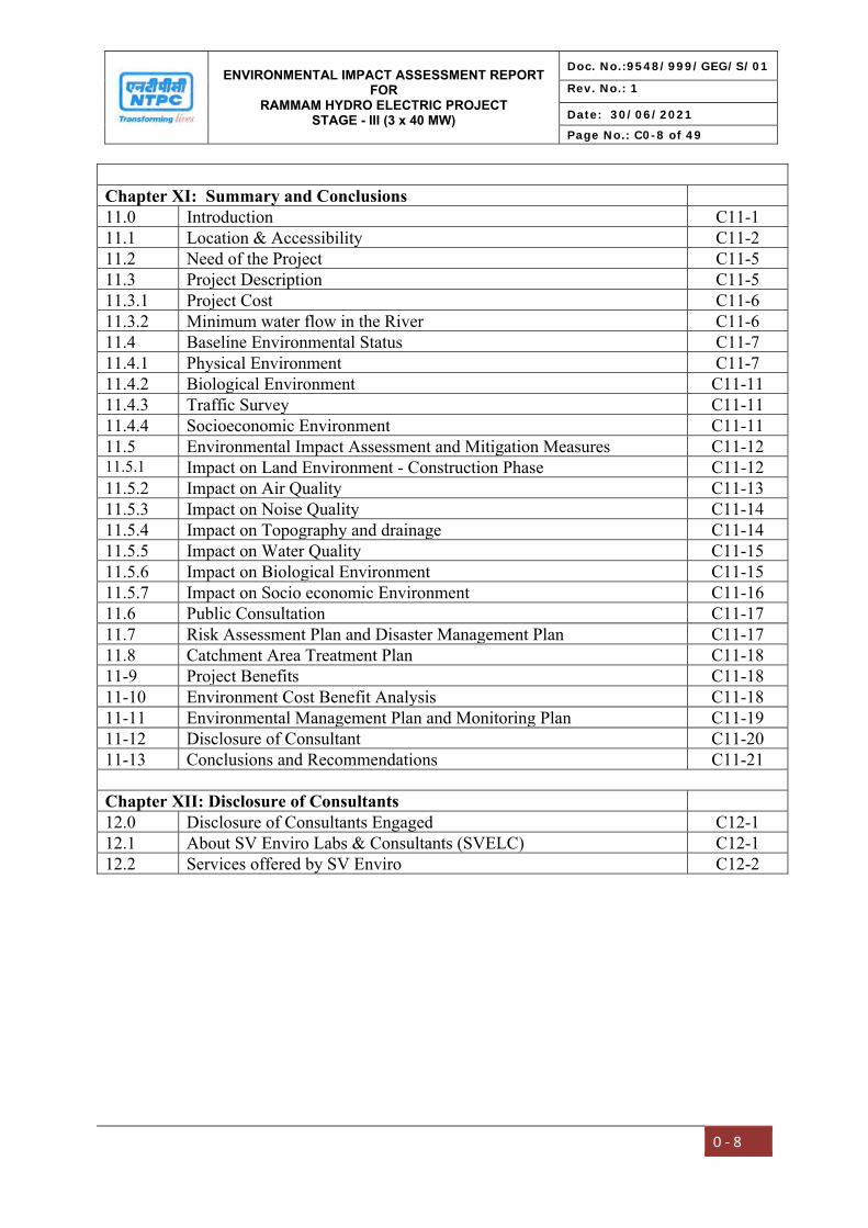
Chapter XI: Summary and Conclusions 11.0 Introduction C11-1 11.1 Location & Accessibility C11-2 11.2 Need of the Project C11-5 11.3 Project Description C11-5 11.3.1 Project Cost C11-6 11.3.2 Minimum water flow in the River C11-6 11.4 Baseline Environmental Status C11-7 11.4.1 Physical Environment C11-7 11.4.2 Biological Environment C11-11 11.4.3 Traffic Survey C11-11 11.4.4 Socioeconomic Environment C11-11 11.5 Environmental Impact Assessment and Mitigation Measures C11-12 11.5.1 Impact on Land Environment - Construction Phase C11-12 11.5.2 Impact on Air Quality C11-13 11.5.3 Impact on Noise Quality C11-14 11.5.4 Impact on Topography and drainage C11-14 11.5.5 Impact on Water Quality C11-15 11.5.6 Impact on Biological Environment C11-15 11.5.7 Impact on Socio economic Environment C11-16 11.6 Public Consultation C11-17 11.7 Risk Assessment Plan and Disaster Management Plan C11-17 11.8 Catchment Area Treatment Plan C11-18 11-9 Project Benefits C11-18 11-10 Environment Cost Benefit Analysis C11-18 11-11 Environmental Management Plan and Monitoring Plan C11-19 11-12 Disclosure of Consultant C11-20 11-13 Conclusions and Recommendations C11-21 Chapter XII: Disclosure of Consultants 12.0 Disclosure of Consultants Engaged C12-1 12.1 About SV Enviro Labs & Consultants (SVELC) C12-1 12.2 Services offered by SV Enviro C12-2

ENVIRONMENTAL IMPACT ASSESSMENT REPORT FOR
RAMMAM HYDRO ELECTRIC PROJECT STAGE - III (3 x 40 MW)
Doc. No.:9548/999/GEG/S/01
Rev. No.: 1
Date: 30/06/2021
Page No.: C0-9 of 49
0 ‐ 9
LIST OF TABLES
S. No. Description Page no. 1.1 Coordinates of Project Components C1-9 1.2 All India Installed Capacity (In MW) Of Power Stations (As On
31.01.2021) C1-13
1.3 All India Demand-Supply Scenarios By 2026-27 C1-14 1.4 Eastern Region Demand-Supply Scenarios By 2026-27 C1-14 1.5 Key Environmental Legislations Pertaining To Hydro Projects C1-16 2.1 Salient Features of Rammam Stage-III Hydroelectric Project C2-6 2.2 Details of Land Acquired C2-17 2.3 Length of Project Road C2-18 3.1 Summary of Methodology for Baseline Data Collection C3-2 3.2 IMD Climatological Data of Period 1981-2010 C3-3 3.3 Site-Specific Meteorological Data C3-4 3.4 Techniques and Detectable Limits For Ambient Air Quality Monitoring C3-8 3.5 Location of Ambient Air Quality Monitoring Stations C3-9 3.6 Summary of Ambient Air Quality Analysis C3-11 3.7 Standard Operating Procedures (SOP) For Water Sampling C3-19 3.8 Analytical Techniques for Water Analysis C3-19 3.9 Ground Water Sampling Locations C3-21 3.10 Surface Water Sampling Locations C3-21 3.11 Ground Water Quality of The Study Area C3-25 3.12 Surface Water Quality of The Study Area C3-27 3.13 Analytical Techniques for Soil Analysis C3-30 3.14 Details of Soil Sampling Locations C3-31 3.15 Soil Analysis Results In The Study Area C3-33 3.16 Standard Soil Classification C3-36 3.17 Noise Monitoring Locations C3-37 3.18 Noise Levels In The Study Area C3-38 3.19 Traffic Density Monitoring Locations C3-42 3.20 Traffic Volume Counts C3-43 3.21 Gauge and discharge data C3-56 3.22 Time Distribution Coefficients C3-66 3.23 Areas Under Field Crops From West Sikkim District (Ha) C3-77 3.24 Areas Under Horticultural Crops From West Sikkim District (Ha) C3-77 3.25 Areas Under Field Crops From Darjeeling District (Ha) C3-78 3.26 Areas Under Horticultural Crops From Darjeeling District (Ha) C3-79 3.27 Production And Productivity of Major And Horticultural Crops From
West Sikkim District C3-79
3.28 Production And Productivity of Major And Horticultural Crops From Darjeeling District
C3-80
ENVIRONMENTAL IMPACT ASSESSMENT REPORT FOR
RAMMAM HYDRO ELECTRIC PROJECT STAGE - III (3 x 40 MW)
Doc. No.:9548/999/GEG/S/01
Rev. No.: 1
Date: 30/06/2021
Page No.: C0-10 of 49
0 ‐ 10
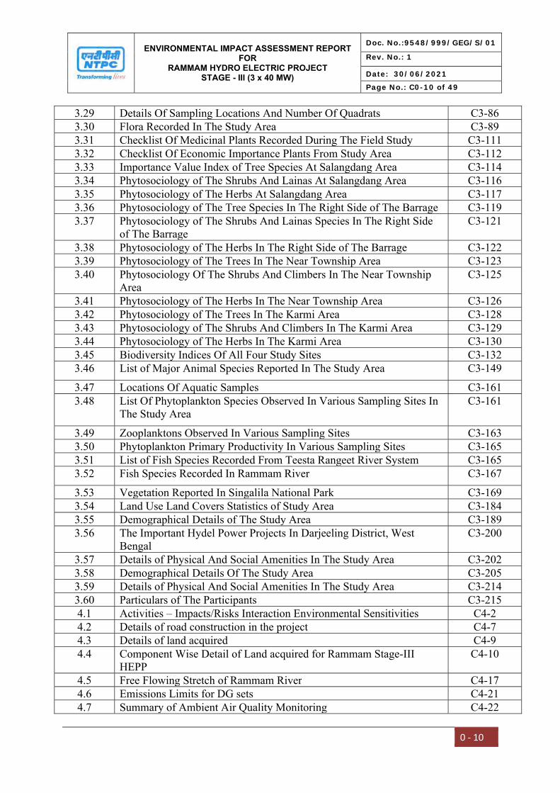
3.29 Details Of Sampling Locations And Number Of Quadrats C3-86 3.30 Flora Recorded In The Study Area C3-89 3.31 Checklist Of Medicinal Plants Recorded During The Field Study C3-111 3.32 Checklist Of Economic Importance Plants From Study Area C3-112 3.33 Importance Value Index of Tree Species At Salangdang Area C3-114 3.34 Phytosociology of The Shrubs And Lainas At Salangdang Area C3-116 3.35 Phytosociology of The Herbs At Salangdang Area C3-117 3.36 Phytosociology of The Tree Species In The Right Side of The Barrage C3-119 3.37 Phytosociology of The Shrubs And Lainas Species In The Right Side
of The Barrage C3-121
3.38 Phytosociology of The Herbs In The Right Side of The Barrage C3-122 3.39 Phytosociology of The Trees In The Near Township Area C3-123 3.40 Phytosociology Of The Shrubs And Climbers In The Near Township
Area C3-125
3.41 Phytosociology of The Herbs In The Near Township Area C3-126 3.42 Phytosociology of The Trees In The Karmi Area C3-128 3.43 Phytosociology of The Shrubs And Climbers In The Karmi Area C3-129 3.44 Phytosociology of The Herbs In The Karmi Area C3-130 3.45 Biodiversity Indices Of All Four Study Sites C3-132 3.46 List of Major Animal Species Reported In The Study Area C3-149
3.47 Locations Of Aquatic Samples C3-161 3.48 List Of Phytoplankton Species Observed In Various Sampling Sites In
The Study Area C3-161
3.49 Zooplanktons Observed In Various Sampling Sites C3-163 3.50 Phytoplankton Primary Productivity In Various Sampling Sites C3-165 3.51 List of Fish Species Recorded From Teesta Rangeet River System C3-165 3.52 Fish Species Recorded In Rammam River C3-167
3.53 Vegetation Reported In Singalila National Park C3-169 3.54 Land Use Land Covers Statistics of Study Area C3-184 3.55 Demographical Details of The Study Area C3-189 3.56 The Important Hydel Power Projects In Darjeeling District, West
Bengal C3-200
3.57 Details of Physical And Social Amenities In The Study Area C3-202 3.58 Demographical Details Of The Study Area C3-205 3.59 Details of Physical And Social Amenities In The Study Area C3-214 3.60 Particulars of The Participants C3-215 4.1 Activities – Impacts/Risks Interaction Environmental Sensitivities C4-2 4.2 Details of road construction in the project C4-7 4.3 Details of land acquired C4-9 4.4 Component Wise Detail of Land acquired for Rammam Stage-III
HEPP C4-10
4.5 Free Flowing Stretch of Rammam River C4-17 4.6 Emissions Limits for DG sets C4-21 4.7 Summary of Ambient Air Quality Monitoring C4-22
ENVIRONMENTAL IMPACT ASSESSMENT REPORT FOR
RAMMAM HYDRO ELECTRIC PROJECT STAGE - III (3 x 40 MW)
Doc. No.:9548/999/GEG/S/01
Rev. No.: 1
Date: 30/06/2021
Page No.: C0-11 of 49
0 ‐ 11
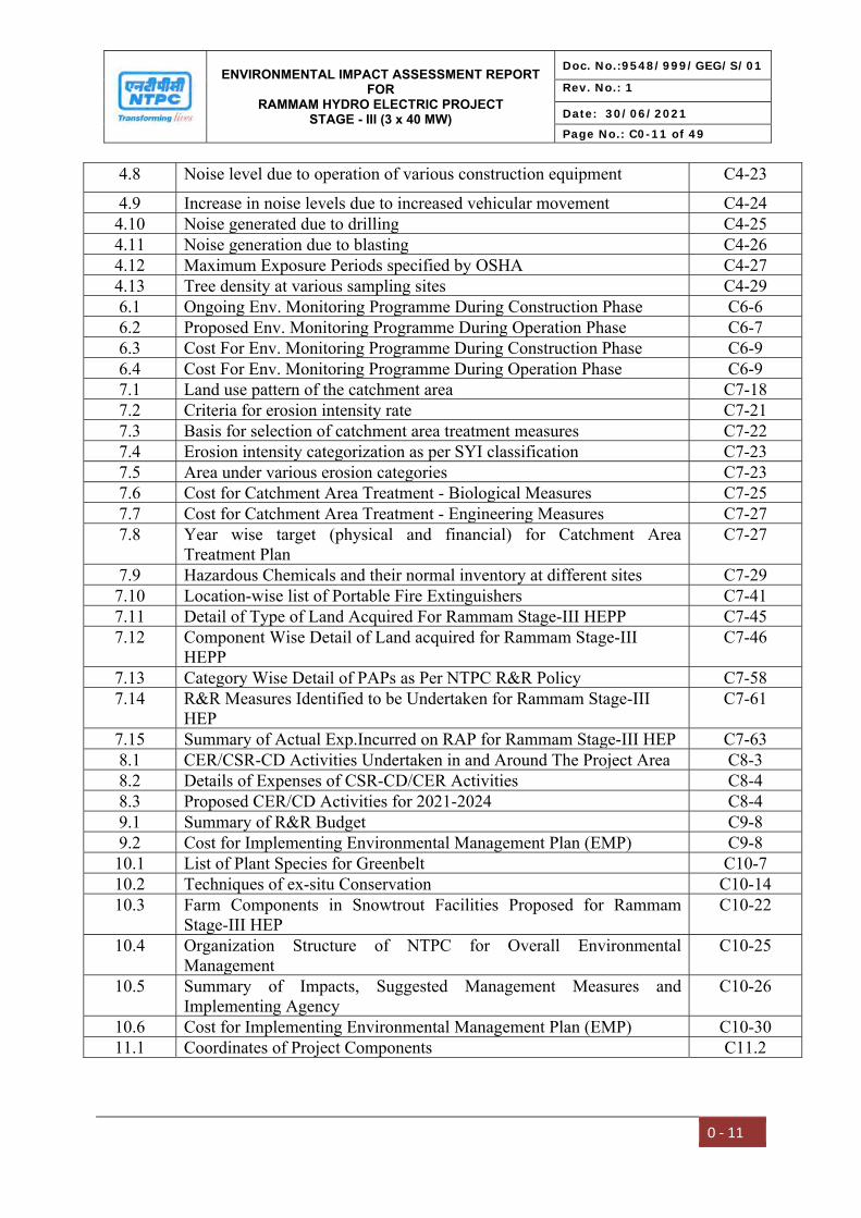
4.8 Noise level due to operation of various construction equipment C4-23
4.9 Increase in noise levels due to increased vehicular movement C4-24 4.10 Noise generated due to drilling C4-25 4.11 Noise generation due to blasting C4-26 4.12 Maximum Exposure Periods specified by OSHA C4-27 4.13 Tree density at various sampling sites C4-29 6.1 Ongoing Env. Monitoring Programme During Construction Phase C6-6 6.2 Proposed Env. Monitoring Programme During Operation Phase C6-7 6.3 Cost For Env. Monitoring Programme During Construction Phase C6-9 6.4 Cost For Env. Monitoring Programme During Operation Phase C6-9 7.1 Land use pattern of the catchment area C7-18 7.2 Criteria for erosion intensity rate C7-21 7.3 Basis for selection of catchment area treatment measures C7-22 7.4 Erosion intensity categorization as per SYI classification C7-23 7.5 Area under various erosion categories C7-23 7.6 Cost for Catchment Area Treatment - Biological Measures C7-25 7.7 Cost for Catchment Area Treatment - Engineering Measures C7-27 7.8 Year wise target (physical and financial) for Catchment Area
Treatment Plan C7-27
7.9 Hazardous Chemicals and their normal inventory at different sites C7-29 7.10 Location-wise list of Portable Fire Extinguishers C7-41 7.11 Detail of Type of Land Acquired For Rammam Stage-III HEPP C7-45 7.12 Component Wise Detail of Land acquired for Rammam Stage-III
HEPP C7-46
7.13 Category Wise Detail of PAPs as Per NTPC R&R Policy C7-58 7.14 R&R Measures Identified to be Undertaken for Rammam Stage-III
HEP C7-61
7.15 Summary of Actual Exp.Incurred on RAP for Rammam Stage-III HEP C7-63 8.1 CER/CSR-CD Activities Undertaken in and Around The Project Area C8-3 8.2 Details of Expenses of CSR-CD/CER Activities C8-4 8.3 Proposed CER/CD Activities for 2021-2024 C8-4 9.1 Summary of R&R Budget C9-8 9.2 Cost for Implementing Environmental Management Plan (EMP) C9-8 10.1 List of Plant Species for Greenbelt C10-7 10.2 Techniques of ex-situ Conservation C10-14 10.3 Farm Components in Snowtrout Facilities Proposed for Rammam
Stage-III HEP C10-22
10.4 Organization Structure of NTPC for Overall Environmental Management
C10-25
10.5 Summary of Impacts, Suggested Management Measures and Implementing Agency
C10-26
10.6 Cost for Implementing Environmental Management Plan (EMP) C10-30 11.1 Coordinates of Project Components C11.2
ENVIRONMENTAL IMPACT ASSESSMENT REPORT FOR
RAMMAM HYDRO ELECTRIC PROJECT STAGE - III (3 x 40 MW)
Doc. No.:9548/999/GEG/S/01
Rev. No.: 1
Date: 30/06/2021
Page No.: C0-12 of 49
0 ‐ 12
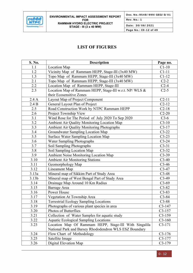
LIST OF FIGURES
S. No. Description Page no. 1.1 Location Map C1-10 1.2 Vicinity Map of Rammam HEPP, Stage-III (3x40 MW) C1-11 1.3 Topo Map of Rammam HEPP, Stage-III (3x40 MW) C1-12 2.1 Topo Map of Rammam HEPP, Stage-III (3x40 MW) C2-2 2.2 Location Map of Rammam HEPP, Stage-III C2-4 2.3 Location Map of Rammam HEPP, Stage-III w.r.t. NP/ WLS &
their Ecosensitive Zones C2-5
2.4 A Layout Map of Project Component C2-11 2.4 B General Layout Plan of Project C2-12 2.5 Road Construction Work by NTPC Rammam HEPP C2-18 2.6 Project Township View C2-20 3.1 Wind Rose for The Period of July 2020 To Sep 2020 C3-6 3.2 Ambient Air Quality Monitoring Location Map C3-10 3.3 Ambient Air Quality Monitoring Photographs C3-17 3.4 Groundwater Sampling Location Map C3-22 3.5 Surface Water Sampling Location Map C3-23 3.6 Water Sampling Photographs C3-24 3.7 Soil Sampling Photographs C3-31 3.8 Soil Sampling Location Map C3-32 3.9 Ambient Noise Monitoring Location Map C3-39 3.10 Ambient Air Monitoring Stations C3-40 3.11 Geomorphology Map C3-46 3.12 Lineament Map C3-47 3.13a Mineral map of Sikkim Part of Study Area C3-48 3.13b Mineral map of West Bengal Part of Study Area C3-49 3.14 Drainage Map Around 10 Km Radius C3-69 3.15 Barrage Area C3-82 3.16 Power House C3-83 3.17 Vegetation At Township Area C3-84 3.18 Terrestrial Ecology Sampling Locations C3-88 3.19 Photographs of various plant species in area C3-147 3.20 Photos of Butterflies C3-157 3.21 Collection of Water Samples for aquatic study C3-159 3.22 Aquatic Ecological Sampling Locations C3-160 3.23 Location Map Of Rammam HEPP, Stage-III With Singalila
National Park and Barsey Rhododendron WLS ESZ Boundary C3-171
3.24 Flow Chart of Methodology C3-176 3.25 Satellite Image C3-177 3.26 Digital Elevation Map C3-179

ENVIRONMENTAL IMPACT ASSESSMENT REPORT FOR
RAMMAM HYDRO ELECTRIC PROJECT STAGE - III (3 x 40 MW)
Doc. No.:9548/999/GEG/S/01
Rev. No.: 1
Date: 30/06/2021
Page No.: C0-13 of 49
0 ‐ 13
3.27 Contour Map C3-180 3.28 LULC Map C3-181 3.29 Road Network Map C3-182 3.30 Slope Map C3-183 3.31 Graphical Presentation of Land Use Statistics C3-184 3.32 Demographical Details of The District C3-187 3.33 Details of The Working Population C3-194 3.34 Primary Consultation With Local Communities C3-216 3.35 Community Need of The Study Area C3-217 4.1 Settling Tank provided near crusher plant C4-12 4.2 Cascade Development of Hydro Power Projects on Rammam
River C4-18
7.1 Directly Draining Catchment Area C7-13 7.2 Land Use Classification Of The Catchment Area C7-17 7.3 Slope Map Of Directly Draining Catchment Area C7-19 7.4 Prioritization Of Directly Draining Catchment Area C7-24 7.5 Catchment Area Treatment Measures C7-26 7.6 Layout Of Project Site C7-30 7.7 Barrage Complex – Layout Plan C7-31 7.8 Power House – Layout Plan C7-31 7.9 Emergency Communication Organization C7-36 7.10 Emergency Organization Chart C7-43 11.1 Vicinity Map of Rammam HEPP, Stage-III (3x40 MW) C11-3 11.2 Topo Map of Rammam HEPP, Stage-III (3x40 MW) C11-4 12.1 NABET Certificate C12-4 12.2 NABET Validity Extension Certificate C12-5 12.3 NABL Certificate C12-6

ENVIRONMENTAL IMPACT ASSESSMENT REPORT FOR
RAMMAM HYDRO ELECTRIC PROJECT STAGE - III (3 x 40 MW)
Doc. No.:9548/999/GEG/S/01
Rev. No.: 1
Date: 30/06/2021
Page No.: C0-14 of 49
0 - 14
LIST OF ANNEXURES (VOLUME-II)
Annexure No. Description Page No.
Annexure-I MoEF&CC Notification dated 18.01.2021 A-1Annexure-II ToR Copy A-5Annexure-III MoEF&CC Notification S.O. 1247(E) dated 18.03.2021 A-11Annexure-IV Memorandum of Implementation Agreement with WBSEB A-14Annexure-V Techno Economic Clearance (TEC) accorded by CEA A-20Annexure-VI Inter State Agreement between West Bengal & Sikkim A-23Annexure-VII NOC obtained from Ministry of Defence A-27Annexure-VIII Copies of Earlier Environmental Clearance A-29Annexure-IX Clearance accorded by Directorate of Forest, GoWB A-37Annexure-X Forest Clearance accorded by MOEF&CC A-40Annexure-XI Consent to Establish from West Bengal Pollution Control Board
and SPCB, Sikkim A-44
Annexure-XII MoEF&CC Notification S.O. 4254 (E) dated 27.11.2020 A-58Annexure-XIII Certified Compliance Report A-62Annexure-XIV CCF (WL), West Bengal letter dated 01.02.2008 A-69Annexure-XV MoEF&CC Notification No. S.O.3613(E) dated 16.11.2017 A-72Annexure-XVI MoEF&CC Notification No.S.O.2172 (E) dated 27.08.2014 A-94Annexure-XVII-A Hydrology Report A-118Annexure-XVII-B Hydrology Flow Series A-179Annexure-XVIII Conservation plan for Schedule-I species A-182Annexure-XIX Public Hearing Proceedings, West Bengal A-277Annexure-XX Public Hearing Proceedings, Sikkim A-292Annexure-XXI Emergency Action Plan A-330Annexure-XXII Power Potential Study A-414Annexure-XXIII Guidelines for conducting Cost Benefit Analysis A-432Annexure-XXIV NTPC Biodiversity Policy A-439Annexure-XXV NTPC Environment Policy A-445Annexure-XXVI Catchment Area Treatment Plan, West Bengal A-451Annexure-XXVII Catchment Area Treatment Plan, Sikkim A-457Annexure-XXVIII Seismotectonic Study for Rammam HEPP A-475Annexure-XXIX CWC Clearance for Design of Rammam HEPP A-497Annexure-XXX Project Layout Superimposed on Counter Map A-499

ENVIRONMENTAL IMPACT ASSESSMENT REPORT FOR
RAMMAM HYDRO ELECTRIC PROJECT STAGE - III (3 x 40 MW)
Doc. No.:9548/999/GEG/S/01
Rev. No.: 1
Date: 30/06/2021
Page No.: C0-15 of 49
0 ‐ 15
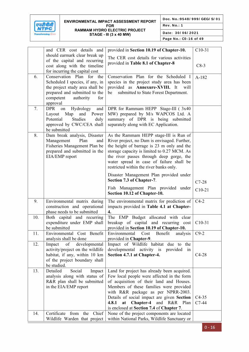
Compliance Index for TOR for EIA Study (MOEF&CC File No. J-12011/11/2020-IA-I (R))
A. Compliance with Additional ToR
S.No. Condition Compliance Page reference in EIA report
1. Land acquired for the project shall be suitably compensated in accordance with the law of the land with the prevailing guidelines. Private land shall be acquired as per provisions of Right to Fair Compensation and Transparency in Land Acquisition, Rehabilitation and Resettlement Act, 2013
Entire land for the project has already been acquired and the PAPs have been compensated. However, the provisions of Right to Fair Compensation and Transparency in Land Acquisition, Rehabilitation and Resettlement Act, 2013 were not applicable at that time. Approved Budget for R&R plan is 59.20 Crore.
One time settlement for R&R package to affected PAPs has been agreed during VDAC meeting as per R&R policy. Total of Rs. 3.58 Crores disbursed as per R&R policy till 31.03.2021.
Details are given in Section 2.5 of Chapter-2.
C2-16
2. The details of funds allocation and activities for CER shall be incorporated in EIA/EMP report
The details of funds allocated for CER/CD activities for the FY 2021-2024 provided in Table 8.3 at Chapter-8. The total allocation of Rs 9.25 Crores has been kept for CER/CD.
The Corporate Environment Responsibility (CER)/Community Development (CD) activities undertaken are provided in Table 8.1 of Chapter-8.
C8-4
C8-3
3. Consolidated EIA/EMP report is to be submitted as per the generic structure (Appendix III & III A) given in the EIA Notification, 2006
The EIA/EMP is prepared as per the generic structure (Appendix III & III A) given in the EIA Notification, 2006.
4. One season baseline data shall be collected for all the environmental attributes including biological environment
One season baseline data July’2020 to Sep’2020 has been included in EIA/EMP report in Chapter-3 Description of Environment. The baseline data are given in Chapter-3.
C3-1
5. The EIA report should clearly mention activity wise EMP
The EMP Budget allocated with clear breakup of capital and recurring cost
Table of Contents
ENVIRONMENTAL IMPACT ASSESSMENT REPORT FOR
RAMMAM HYDRO ELECTRIC PROJECT STAGE - III (3 x 40 MW)
Doc. No.:9548/999/GEG/S/01
Rev. No.: 1
Date: 30/06/2021
Page No.: C0-16 of 49
0 ‐ 16
and CER cost details and should earmark clear break up of the capital and recurring cost along with the timeline for incurring the capital cost
provided in Section 10.19 of Chapter-10.
The CER cost details for various activities provided in Table 8.1 of Chapter-8
C10-31
C8-3
6. Conservation Plan for the Scheduled I species, if any, in the project study area shall be prepared and submitted to the competent authority for approval
Conservation Plan for the Scheduled I species in the project study area has been provided as Annexure-XVIII. It will be submitted to State Forest Department.
7. DPR on Hydrology and Layout Map and Power Potential Studies duly approved by CWC/CEA shall be submitted
DPR for Rammam HEPP Stage-III ( 3x40 MW) prepared by M/s WAPCOS Ltd. A summary of DPR is being submitted separately along with EC Application.
8. Dam break analysis, Disaster Management Plan and Fisheries Management Plan be prepared and submitted in the EIA/EMP report
As the Rammam HEPP stage-III is Run of River project, no Dam is envisaged. Further, the height of barrage is 23 m only and the storage capacity is limited to 0.27 MCM. As the river passes through deep gorge, the water spread in case of failure shall be restricted within the river banks only.
Disaster Management Plan provided under Section 7.3 of Chapter-7.
Fish Management Plan provided under Section 10.12 of Chapter-10.
C7-28
C10-21
9. Environmental matrix during construction and operational phase needs to be submitted
The environmental matrix for prediction of impacts provided in Table 4.1 at Chapter-4.
C4-2
10. Both capital and recurring expenditure under EMP shall be submitted
The EMP Budget allocated with clear breakup of capital and recurring cost provided in Section 10.19 of Chapter-10.
C10-31
11. Environmental Cost Benefit analysis shall be done
Environmental Cost Benefit analysis provided in Chapter-9.
C9-2
12. Impact of developmental activity/project on the wildlife habitat, if any, within 10 km of the project boundary shall be studied.
Impact of Wildlife habitat due to the developmental activity is provided in Section 4.7.1 at Chapter-4. C4-28
13. Detailed Social Impact analysis along with status of R&R plan shall be submitted in the EIA/EMP report
Land for project has already been acquired. Few local people were affected in the form of acquisition of their land and Houses. Members of these families were provided with R&R package as per NPRR-2003. Details of social impact are given Section 4.8.1 at Chapter-4 and R&R Plan is enclosed at Section 7.4 of Chapter 7.
C4-35C7-44
14. Certificate from the Chief Wildlife Warden that project
None of the project components are located within National Parks, Wildlife Sanctuary or
A-182
ENVIRONMENTAL IMPACT ASSESSMENT REPORT FOR
RAMMAM HYDRO ELECTRIC PROJECT STAGE - III (3 x 40 MW)
Doc. No.:9548/999/GEG/S/01
Rev. No.: 1
Date: 30/06/2021
Page No.: C0-17 of 49
0 ‐ 17
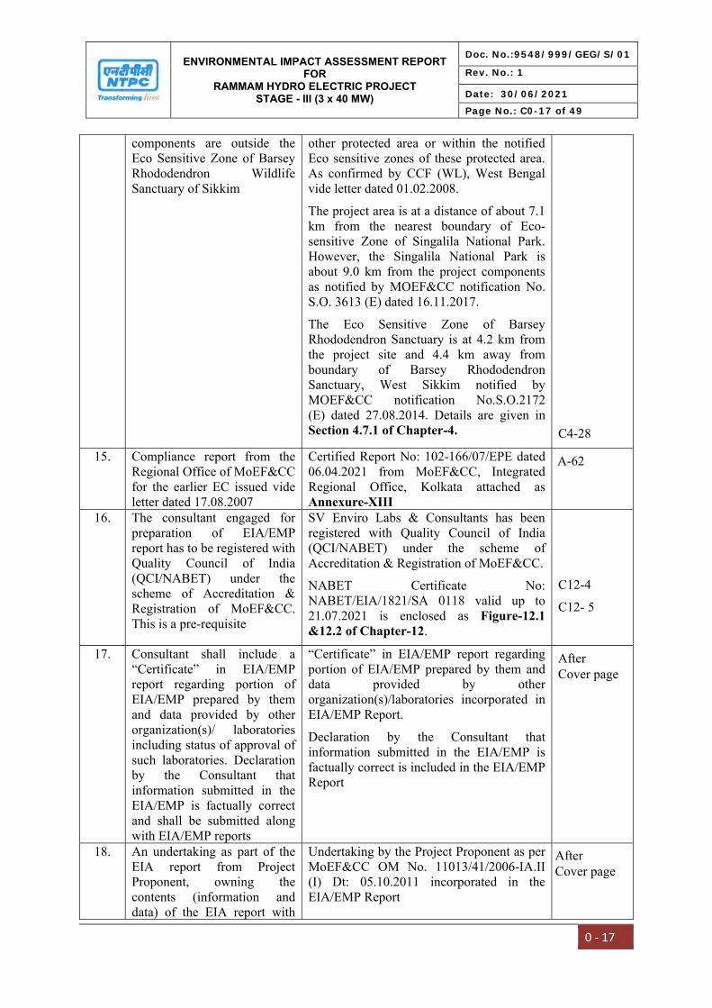
components are outside the Eco Sensitive Zone of Barsey Rhododendron Wildlife Sanctuary of Sikkim
other protected area or within the notified Eco sensitive zones of these protected area. As confirmed by CCF (WL), West Bengal vide letter dated 01.02.2008.
The project area is at a distance of about 7.1 km from the nearest boundary of Eco-sensitive Zone of Singalila National Park. However, the Singalila National Park is about 9.0 km from the project components as notified by MOEF&CC notification No. S.O. 3613 (E) dated 16.11.2017.
The Eco Sensitive Zone of Barsey Rhododendron Sanctuary is at 4.2 km from the project site and 4.4 km away from boundary of Barsey Rhododendron Sanctuary, West Sikkim notified by MOEF&CC notification No.S.O.2172 (E) dated 27.08.2014. Details are given in Section 4.7.1 of Chapter-4. C4-28
15. Compliance report from the Regional Office of MoEF&CC for the earlier EC issued vide letter dated 17.08.2007
Certified Report No: 102-166/07/EPE dated 06.04.2021 from MoEF&CC, Integrated Regional Office, Kolkata attached as Annexure-XIII
16. The consultant engaged for preparation of EIA/EMP report has to be registered with Quality Council of India (QCI/NABET) under the scheme of Accreditation & Registration of MoEF&CC. This is a pre-requisite
SV Enviro Labs & Consultants has been registered with Quality Council of India (QCI/NABET) under the scheme of Accreditation & Registration of MoEF&CC.
NABET Certificate No: NABET/EIA/1821/SA 0118 valid up to 21.07.2021 is enclosed as Figure-12.1 &12.2 of Chapter-12.
C12-4
C12- 5
17. Consultant shall include a “Certificate” in EIA/EMP report regarding portion of EIA/EMP prepared by them and data provided by other organization(s)/ laboratories including status of approval of such laboratories. Declaration by the Consultant that information submitted in the EIA/EMP is factually correct and shall be submitted along with EIA/EMP reports
“Certificate” in EIA/EMP report regarding portion of EIA/EMP prepared by them and data provided by other organization(s)/laboratories incorporated in EIA/EMP Report.
Declaration by the Consultant that information submitted in the EIA/EMP is factually correct is included in the EIA/EMP Report
18. An undertaking as part of the EIA report from Project Proponent, owning the contents (information and data) of the EIA report with
Undertaking by the Project Proponent as per MoEF&CC OM No. 11013/41/2006-IA.II (I) Dt: 05.10.2011 incorporated in theEIA/EMP Report
A-62
After Cover page
After Cover page
ENVIRONMENTAL IMPACT ASSESSMENT REPORT FOR
RAMMAM HYDRO ELECTRIC PROJECT STAGE - III (3 x 40 MW)
Doc. No.:9548/999/GEG/S/01
Rev. No.: 1
Date: 30/06/2021
Page No.: C0-18 of 49
0 ‐ 18
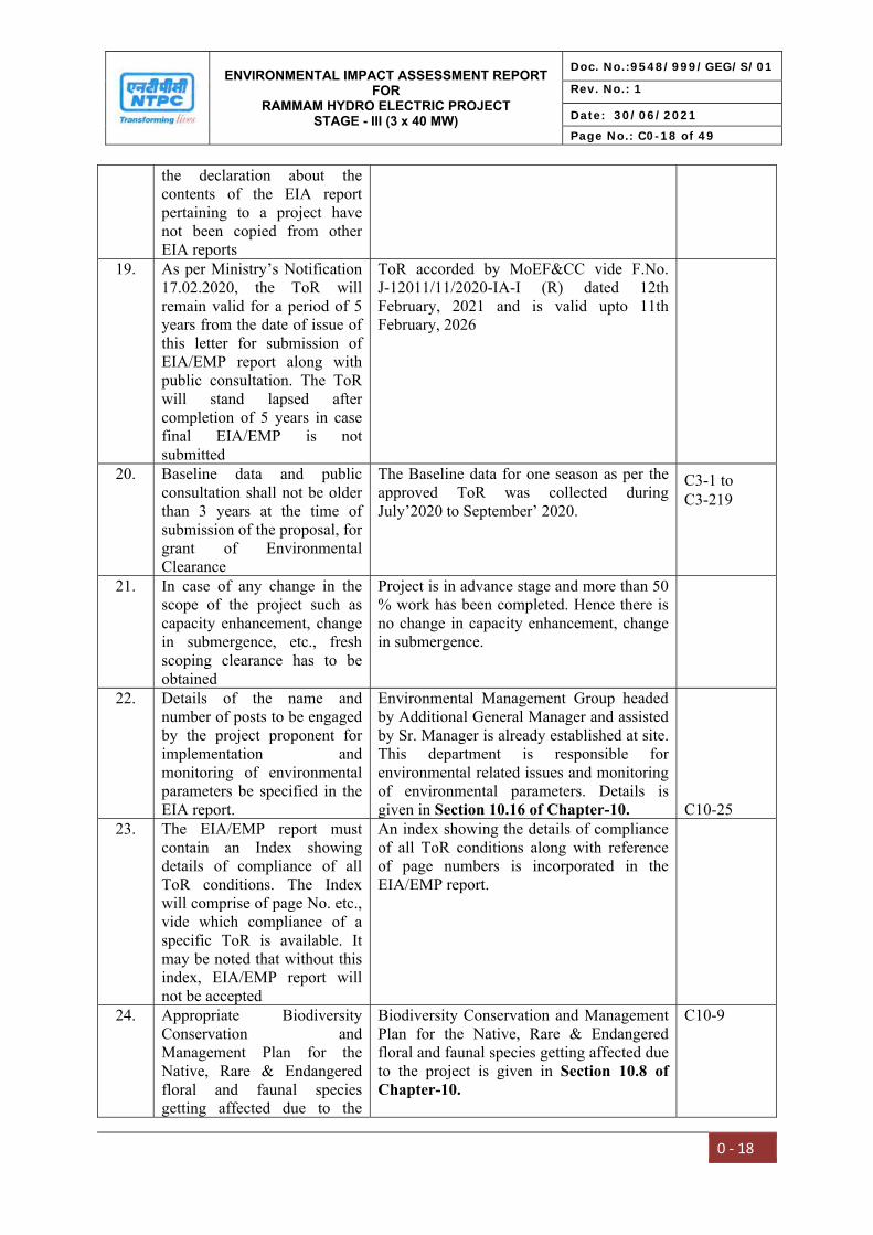
the declaration about the contents of the EIA report pertaining to a project have not been copied from other EIA reports
19. As per Ministry’s Notification 17.02.2020, the ToR will remain valid for a period of 5 years from the date of issue of this letter for submission of EIA/EMP report along with public consultation. The ToR will stand lapsed after completion of 5 years in case final EIA/EMP is not submitted
ToR accorded by MoEF&CC vide F.No. J-12011/11/2020-IA-I (R) dated 12thFebruary, 2021 and is valid upto 11thFebruary, 2026
20. Baseline data and public consultation shall not be older than 3 years at the time of submission of the proposal, for grant of Environmental Clearance
The Baseline data for one season as per the approved ToR was collected during July’2020 to September’ 2020.
21. In case of any change in the scope of the project such as capacity enhancement, change in submergence, etc., fresh scoping clearance has to be obtained
Project is in advance stage and more than 50 % work has been completed. Hence there is no change in capacity enhancement, change in submergence.
22. Details of the name and number of posts to be engaged by the project proponent for implementation and monitoring of environmental parameters be specified in the EIA report.
Environmental Management Group headed by Additional General Manager and assisted by Sr. Manager is already established at site. This department is responsible for environmental related issues and monitoring of environmental parameters. Details is given in Section 10.16 of Chapter-10. C10-25
23. The EIA/EMP report must contain an Index showing details of compliance of all ToR conditions. The Index will comprise of page No. etc., vide which compliance of a specific ToR is available. It may be noted that without this index, EIA/EMP report will not be accepted
An index showing the details of compliance of all ToR conditions along with reference of page numbers is incorporated in the EIA/EMP report.
24. Appropriate Biodiversity Conservation and Management Plan for the Native, Rare & Endangered floral and faunal species getting affected due to the
Biodiversity Conservation and Management Plan for the Native, Rare & Endangered floral and faunal species getting affected due to the project is given in Section 10.8 of Chapter-10.
C10-9
C3-1 to C3-219
ENVIRONMENTAL IMPACT ASSESSMENT REPORT FOR
RAMMAM HYDRO ELECTRIC PROJECT STAGE - III (3 x 40 MW)
Doc. No.:9548/999/GEG/S/01
Rev. No.: 1
Date: 30/06/2021
Page No.: C0-19 of 49
0 ‐ 19
project shall be prepared 25. The PP should complete all
the tasks as per the provisions of EIA Notification, 2006 and as amended time to time and submit the application for final clearance within the stipulated time.
The EIA/EMP report is prepared as per the approved Terms of Reference and EIA Notification, 2006 and its subsequent amendments.

ENVIRONMENTAL IMPACT ASSESSMENT REPORT FOR
RAMMAM HYDRO ELECTRIC PROJECT STAGE - III (3 x 40 MW)
Doc. No.:9548/999/GEG/S/01
Rev. No.: 1
Date: 30/06/2021
Page No.: C0-20 of 49
0 ‐ 20
B. Compliance with Standard TOR
Sl. No. Condition Reference Section Page reference in EIA Report
Standard Terms of Reference
1 Scope of EIA Studies
The EIA Report should identify the relevant environmental concerns and focus on potential impacts that may change due to the construction of proposed project. Based on the baseline data collected for three (3) seasons (Pre-monsoon, Monsoon and Winter seasons), the status of the existing environment in the area and capacity to bear the impact on this should be analysed. Based on this analysis, the mitigation measures for minimizing the impact shall be suggested in the EIA/EMP study.
Environmental concerns and potential impacts that may change due to the construction of proposed project are provided in Chapter-4 anticipated environmental impacts and mitigation measures. The baseline data for one season as per the approved tor was collected during July’2020 to September’ 2020 and provided in Chapter-3.
2 Details of the Project and Site
i General introduction about the proposed project.
Introduction about the project is provided in Section 1.0 of Chapter-1.
C1-1
ii Details of project and site giving L-sections of all U/S and D/S projects of River with all relevant maps and figures. Connect such information as to establish the total length of interference of Natural River, the total length of tunneling of the river and the committed unrestricted release from the site of diversion into the main river.
Details of project and project site with all relevant maps and figures are provided in Section 4.4.2 of Chapter-4.
C4-14
iii A map of boundary of the project site giving details of protected areas in the vicinity of project location
Singalila National Park is about 9.0 km and Barsey Rhododendron Sanctuary is 4.4 km away from the
C2-4
C4-1 to C4-41
C3-1 to C3-219
ENVIRONMENTAL IMPACT ASSESSMENT REPORT FOR
RAMMAM HYDRO ELECTRIC PROJECT STAGE - III (3 x 40 MW)
Doc. No.:9548/999/GEG/S/01
Rev. No.: 1
Date: 30/06/2021
Page No.: C0-21 of 49
0 ‐ 21
project. Details are given in Figure-2.2 of Chapter-2.
iv Location details on a map of the project area with contours indicating main project features. The project layout shall be superimposed on a contour map of ground elevation showing main project features (viz. location of dam, Head works, main canal, branch canals, quarrying etc.) shall be depicted in a scaled map
The superimposed project layout on a contour map of ground elevation showing main project features is provided in chapter-2 projectdescription along with location details on a map of the project area.Please also refer Annexure-XXX.
v Layout details and map of the project along with contours with project components clearly marked with proper scale maps of at least a 1:50,000 scale and printed at least on A3 scale for clarity
Project layout and map details with clear markings are provided in chapter-2 project description. Please also refer Annexure-XXX.
vi Existence of National Park, Sanctuary, Biosphere Reserve etc. in the study area, if any, should be detailed and presented on a map with distinct distances from the project components
The project area is at a distance of about 9.0 km from the nearest boundary of Singalila National Park and about 4.4 km from the Barsey Rhododendron Sanctuary, West Sikkim. None of the project components are located within National Parks, Wildlife Sanctuary or other protected area or their Ecosensitive Zones. As confirmed by CCF (WL), West Bengal vide letter dated 01.02.2008 attached as Annexure-XIV.
Details are given in Section 2.1 of Chapter- 2. C2-1
vii Drainage pattern and map of the river catchment up to the proposed project site
Drainage pattern and map of the river catchment is provided in Section 7.2 of Chapter-7.
C7-1
viii Delineation of critically degraded areas in the directly draining catchment on the basis of silt Yield Index as per the methodology of All India Soil and Land Use Survey of
Delineation of critically degraded areas in the directly draining catchment details provided in Catchment Area Treatment Plan in
A-499
A-499
A-69
ENVIRONMENTAL IMPACT ASSESSMENT REPORT FOR
RAMMAM HYDRO ELECTRIC PROJECT STAGE - III (3 x 40 MW)
Doc. No.:9548/999/GEG/S/01
Rev. No.: 1
Date: 30/06/2021
Page No.: C0-22 of 49
0 ‐ 22
India. Section 7.2 of Chapter-7. C7-11
ix Soil characteristics and map of the project area.
Soil characteristics provided in Section 3.7 of Chapter-3. C3-30
x Geological and seismo-tectonic details and maps of the area surrounding the proposed project site showing location of dam site and powerhouse site.
Geological and seismo-tectonic details provided under Geology and Hydrogeology in Section 3.10 of Chapter-3. A detailed seismo-tectonic evaluation of Rammam
as HEPP Stage-III is enclosed Annexure-XXVIII.
C3-43
xi Remote Sensing studies, interpretation of satellite imagery, topographic sheets along with ground verification shall be used to develop the land use/land cover pattern of the study using overlaying mapping techniques viz. Geographic Information System (GIS), False Color composite (FCC) generated from satellite data of project area.
Remote Sensing studies, interpretation of satellite imagery, topographic sheets along with ground verification used to develop the land use/land cover pattern of the study and provided under Section 3.11 in Chapter-3.
C3-54
xii Land details including forests, private and other land.
Land details including forests, private and other land provided in Table 2.2 of Chapter-2. C2-3
xiii Demarcation of snow fed and rain fed areas for a realistic estimate of the water availability.
Details of snow fed and rain fed is given in Section 3.11 of Chapter- 3.
C3-54
xiv Different riverine habitats like rapids, pools, side pools and variations in the river substratum – bedrocks, rocks, boulders, sand/silt or clay etc. need to be covered under the study.
Details about riverine habitats are provided in Section 3.12.16 of Chapter-3.
C3-157
3 Description of Environment and Baseline Data
To know the present status of environment in the area, baseline data with respect to environmental components air, water, noise, soil, land and biology & biodiversity (flora & fauna), wildlife, socio-
The baseline data for one season as per the approved ToR was collected during July’2020 to September’ 2020 is provided in Chapter-3.
A-475
ENVIRONMENTAL IMPACT ASSESSMENT REPORT FOR
RAMMAM HYDRO ELECTRIC PROJECT STAGE - III (3 x 40 MW)
Doc. No.:9548/999/GEG/S/01
Rev. No.: 1
Date: 30/06/2021
Page No.: C0-23 of 49
0 ‐ 23
economic status etc. should be collected with 10 km radius of the main components of the project/site i.e. dam site and power house site.The air quality and noise are to bemonitored at such locations whichare environmentally& ecologicallymore sensitive in the study area.The baseline studies should becollected for 3 seasons(PreMonsoon, Monsoon and PostMonsoon seasons). The study areashould comprise of the following:
i Catchment area up-to the dam site Catchment area details are provided in section 2.2 of Chapter-2.
C2-3
ii Submergence Area Submergence area details are provided in section 2.2 of chapter-2.
C2-3
iii Project area or the direct impact area should comprise of area falling within 10 km radius from the periphery of reservoir, land coming under submergence and area downstream of dam upto the point where Tail Race Tunnel (TRT) meets the river.
The study area of 10 km radius from the periphery of the barrage has been considered as shown in Figure 1.3 in Chapter-1.
C1-12
iv Downstream upto 10 km from tip of Tail Race Tunnel (TRT)
Downstream upto 10 km from tip of Tail Race Tunnel (TRT) considered as shown in Figure 1.3 in Chapter-1.
C1-12
4 Details of the Methodology
i The methodology followed for collection of base line data along with details of number of samples and their locations in the map should be included. Study area should be demarcated properly on the appropriate scale map. Sampling sites should be depicted on map for each parameter with proper legends. For forest classification, Champion and Seth (1968) classification should be followed.
The methodology for collection of base line data, number of samples and their locations, sample sites and demarcated study area is provided in chapter-3 description of environment.
ENVIRONMENTAL IMPACT ASSESSMENT REPORT FOR
RAMMAM HYDRO ELECTRIC PROJECT STAGE - III (3 x 40 MW)
Doc. No.:9548/999/GEG/S/01
Rev. No.: 1
Date: 30/06/2021
Page No.: C0-24 of 49
0 ‐ 24
5 Methodology for collection of Biodiversity Data
i The number of sampling locations should be adequate to get a reasonable idea of the diversity and other attributes of flora and fauna. The guiding principles should be the size of the study area (larger area should have larger number of sampling locations) and inherent diversity at the location, as known from secondary sources (e.g. eastern Himalayan and low altitude sites should have a larger number of sampling locations owing to higher diversity)
The no. of sampling locations and map provided in Table 3.29 and Fig 3.18 of Chapter-3. C3-86
C3-88
ii The entire area should be divided in grids of 5km X 5km preferably on a GIS domain. There after 25% of the grids should be randomly selected for sampling of which half should be in the directly affected area (grids including project components such as reservoir, dam, powerhouse, tunnel, canal etc.) and the remaining in the rest of the area (areas of influence in 10 km radius form project components). At such chosen location, the size and number of sampling units (e.g. quadrats in case of flora/transects in case of fauna) must be decided by species area curves and the details of the same (graphs and cumulative number of species in a tabulated form) should be provided in the EIA report. Some of the grids on the edges may not be completely overlapping with the study area boundaries. However these should be counted and considered for selecting 25% of the grids. The number of grids to be surveyed may come out as a decimal number (i.e. it has an integral and a fractional part) which should be rounded to the next whole number
Details provided under Section 3.12 of Chapter-3.
C3-27
ENVIRONMENTAL IMPACT ASSESSMENT REPORT FOR
RAMMAM HYDRO ELECTRIC PROJECT STAGE - III (3 x 40 MW)
Doc. No.:9548/999/GEG/S/01
Rev. No.: 1
Date: 30/06/2021
Page No.: C0-25 of 49
0 ‐ 25
iii The conventional sampling is likely to miss the presence of rare, endangered and threatened (R.E.T.) species since they often occur in low densities and in case of faunal species are usually secretive in behaviour. Reaching the conclusion about the absence of such species in the study area based on such methodology is misleading. It is very important to document the status of such species owing to their high conservation value. Hence likely presence of such species should be ascertained from secondary sources by a proper literature survey for the said area including referring to field guides which are now available for many taxonomic groups in India. Even literature from studies/surveys in the larger landscapes which include the study area for the concerned project must be referred to since most species from adjoining catchments is likely to be present in the catchments in question. In fact such literature form the entire state can be referred to. Once a listing of possible R.E.T. species form the said area is developed, species specific methodologies should be adopted to ascertain their presence in the study area which would be far more conclusive as compared to the conventional sampling. If the need be, modern methods like camera trapping can be resorted to, particularly for areas in the eastern Himalayas and for secretive/nocturnal species. A detailed listing of the literature referred to, for developing lists of R.E.T. species should be provided in the EIA reports.
Details provided under Section 3.12 of Chapter-3.
C3-27
iv The R.E.T. species referred to in this point should include species
Details provided under Section C3-27

ENVIRONMENTAL IMPACT ASSESSMENT REPORT FOR
RAMMAM HYDRO ELECTRIC PROJECT STAGE - III (3 x 40 MW)
Doc. No.:9548/999/GEG/S/01
Rev. No.: 1
Date: 30/06/2021
Page No.: C0-26 of 49
0 ‐ 26
listed in Schedule I and II of Wildlife (Protection) Act, 1972 and those listed in the red data books (BSI, ZSI and IUCN)
3.12 of Chapter-3.
6 Components of the EIA Study
A. Physical and Chemical Environment
Geological & Geophysical Aspects and Seismo – Tectonics:
i Physical geography, Topography, Regional Geological aspects and structure of the Catchment
Physical geography, Topography, Regional Geological aspects and structure of the Catchment provided under Section 3.10 of Chapter-3
C3-21
ii Tectonics, seismicity and history of past earthquakes in the area. A site specific study of the earthquake parameters will be done. The results of the site specific earthquake design shall be sent for approval of the NCSDP (National committee of Seismic Design Parameters, Central water commission, New Delhi for large dams
The seismic study has been conducted by IIT Roorkee. The suggested Earth Quake (EQ) design parameters have been cleared from National Committee of Seismic Design Parameters (NCSDP) of CWC and are being adopted for design of the project components. (Report already submitted to MOEF, Shillong through e-mail in May 2011) (Ref. Compliance Report submitted vide NHL/RammamIII/11-12/01 dated 9th May 2011). Copy of Seismo-tectonic evaluation is enclosed as Annexure-XXVIII. Central Water Commission has accorded clearance vide letter dated 05.08.2014 based on TEC clearance dated 12.09.2006. Copy of CWC letter is enclosed as Annexure-XXIX.
iii Landslide zone or area prone to landslide existing in the study area should be examined
Landslide zone or area prone to landslide existing in the study area examined in Section 3.10.4 of Chapter-3. C3-52
iv Presence of important economic mineral deposit, if any
There are no economic mineral deposits in the project area. The mineralogical maps are presented
A-475
A-20A-497
ENVIRONMENTAL IMPACT ASSESSMENT REPORT FOR
RAMMAM HYDRO ELECTRIC PROJECT STAGE - III (3 x 40 MW)
Doc. No.:9548/999/GEG/S/01
Rev. No.: 1
Date: 30/06/2021
Page No.: C0-27 of 49
0 ‐ 27
in Section 3.10.2 of Chapter-3. C3-48
v Justification for location & execution of the project in relation to structural components (dam height)
The project is in advanced stage of construction after Techno-economic Clearance by CEA and Environmental Clearance by MOEF&CC. The location for execution of the project was found feasible. Details are given in Section 2.1 of Chapter-2.
C2-1
vi Impact of project on geological environment
Details of local geology of area is given at Section 3.10 of Chapter-3. As the proposed project is Runof River project, no major impactson local geology are envisaged.The impact due to tunneling will berestored by thick concreting. Thedetails of impact on geologicalenvironment are covered in Section4.9 of Chapter-4.
C3-43
C4-40
Meteorology, Air and Noise:
i Meteorology (viz. Temperature, Relative humidity, wind speed/direction etc.) to be collected from nearest IMD station.
Meteorology (viz. Temperature, Relative humidity, wind speed/direction etc.) collected from IMD provided in Section 3.4 of Chapter-3.
C3-3
ii Ambient Air Quality with parameters viz. Suspended Particulate Matter (SPM), Respirable Suspended Particulate Matter (RSPM) i.e. suspended particulate materials
Ambient air quality with parameters at 7 locations is provided in Section 3.5 of Chapter-3. C3-7
iii Existing noise levels and traffic density in the study area at 6 locations
Ambient noise levels at 7 locations is provided in Section 3.8 of Chapter-3. Traffic Study of study area id given in Section 3.9 of Chapter-3.
C3-37
C3-42
Soil Characteristics:
i Soil classification, physical parameters (viz., texture, porosity, bulk density and water holding capacity) and chemical parameters
Soil classification, physical parameters and chemical parameters at 10 locations is provided in Section 3.7 of C3-30
ENVIRONMENTAL IMPACT ASSESSMENT REPORT FOR
RAMMAM HYDRO ELECTRIC PROJECT STAGE - III (3 x 40 MW)
Doc. No.:9548/999/GEG/S/01
Rev. No.: 1
Date: 30/06/2021
Page No.: C0-28 of 49
0 ‐ 28
(viz. pH, electrical conductivity, magnesium, calcium, total alkalinity, chlorides, sodium, potassium, organic carbon, available potassium, available phosphorus, SAR, nitrogen and salinity, etc.) (6 locations)
Chapter-3.
Remote sensing and GIS Studies:
i Generation of thematic maps viz., slope map, drainage map, soil map, land use and land cover map, etc. Based on these, thematic maps, an erosion intensity map should be prepared
Thematic maps provided under Section 3.11 of Chapter-3. C3-54
Water Quality:
i History of the ground water table fluctuation in the study area
Depth of the ground water table fluctuation in the study area is provided in Section 3.10.3 of Chapter-3. C3-50
ii Water quality for both surface water and ground water for (i) Physical parameters (pH, temperature, electrical conductivity, TSS); (ii) Chemical parameters (Alkalinity, Hardness, BOD, COD, NO2, PO4, CI, SO4, Na, K, Ca, Mg, Silica, Oil & Grease, phenolic compounds, residual sodium carbonate); (iii) Bacteriological parameter (MPN, Total coliform) and (iv) Heavy Metals (Pb, As, Hg, Cd, Cr-6, total Cr, Cu, Zn, Fe) (6 locations)
Water quality at 8 locations for surface water and 4 location for ground water for physical parameters, chemical parameters, bacteriological parameter and heavy metals is provided in Section 3.6.1 of Chapter 3.
C3-18
iii Delineation of sub and micro-watersheds, their locations and extent based on the All India Soil and Land Use Survey of India (AISLUS), Department of Agriculture, Government of India. Erosion levels in each micro-watershed and prioritization of micro-watershed through silt yield index (SYI) method of AISLUS
Details provided under Catchment Area Treatment Plan in Section 7.2 of Chapter-7. C7-11
ENVIRONMENTAL IMPACT ASSESSMENT REPORT FOR
RAMMAM HYDRO ELECTRIC PROJECT STAGE - III (3 x 40 MW)
Doc. No.:9548/999/GEG/S/01
Rev. No.: 1
Date: 30/06/2021
Page No.: C0-29 of 49
0 ‐ 29
B. Water Environment & Hydrology
i Hydrometeorology of the project viz. precipitation (snowfall, rainfall), temperature, relative humidity, etc. Hydro-meteorological studies in the catchment area should be established along-with real time telemetry and data acquisition system for inflows monitoring.
Hydrometeorology of the project like rainfall, temperature, relative humidity etc. provided in Section 3.4 of Chapter-3. No snowfall is observed in the area. C3-3
ii Run off, discharge, water availability for the project, sedimentation rate, etc.
Run off, sedimentation, water availability for the project provided in Section 3.11 of Chapter-3. C3-54
iii Basin characteristics
iv Catastrophic events like cloud bursts and flash floods, if any, should be documented.
Flash flood and cloud brust details are provided in Section 3.11.14 of Chapter-3. C3-69
v For estimation of Sedimentation Rate, direct sampling of river flow is to be done during the EIA study. The study should be conducted for minimum one year. Actual silt flow rate to be expressed in ha-m km2 year-1
The project is a Run of River (ROR) project in which barrage bays with crest level at riverbed level have been proposed for flushing out the silt at regular intervals. Suitable sediment management practices like routine flushing during flood period will be evolved to avoid sediment deposition in the pond. Details are provided in Section 3.11.15 of Chapter-3. The calculated values of Silt Yield Index, erosion intensity and water shed management is given in Section 7.2.4, 7.2.5 and 7.2.6 of Chapter-7.
C7-20 C7-22 C7-23
vi Set up a G&D monitoring station and a few rain gauge stations in the catchment area for collecting data during the investigation
The G&D monitoring Stations are located at Singlabazar, Lodhama Khola and Rammam-II. For the proposed project, the available ten daily discharge data of Singlabazar as well as discharge data as derived based on Rammam stage-II H.E. Project generation data are considered for water availability studies. Details are given in
C3-56
ENVIRONMENTAL IMPACT ASSESSMENT REPORT FOR
RAMMAM HYDRO ELECTRIC PROJECT STAGE - III (3 x 40 MW)
Doc. No.:9548/999/GEG/S/01
Rev. No.: 1
Date: 30/06/2021
Page No.: C0-30 of 49
0 ‐ 30
Section 3.11.2 of Chapter-3.
vii Flow series, 10 daily with 90%, 75% and 50% dependable years discharges
Flow series, average ten daily flows with various % dischargesare given in Annexure-XVII.
viii Information on the 10-daily flow basis for the 90 per cent dependable year the flow intercepted at the dam, the flow diverted to the power house and the spill comprising the environmental flow and additional flow towards downstream of the dam for the project may be given
Information on the 10-daily flow basis for the 90 per cent dependable year the flow intercepted at the Barrage, the flow diverted to the power house and the spill comprising the environmental flow and additional flow towards downstream of the dam for the project provided in Section 3.11 of Chapter-3 and Annexure- XVIIA.
ix The minimum environmental flow shall be 20% of the flow of four consecutive lean months of 90% dependable year, 30% of the average monsoon flow. The flow for remaining months shall be in between 20-30%, depending on the site specific requirements. A site specific study shall be carried out by an expert organization.
National Green Tribunal in the matter of Pushp Saini Vs. Ministry of Environment, Forest & Climate Change & Others dated 09/08/2017 regarding environmental flow of the River directs that all the rivers in the country shall maintain minimum 15 % to 20% of the average lean season flow of that river. Accordingly, as per site specific requirement, NTPC Rammam HEPP shall maintain the minimum Environmental flow of 18 % in River Rammam. Details are given in Section-2.4 of Chapter-2.
C2-10
x Hydrological studies/data as approved by CWC shall be utilized in the preparation of EIA/EMP report. Actual hydrological annual yield may also be given in the report
The Central Water Commission (CWC) has accorded clearance for design data of Rammam HEPP Stage-III (3x40 MW) vide letter dated 05.08.2014 considering the TEC clearance dated 12.09.2006 and its revalidation dated 01.08.2013. Copy of TEC letter is enclosed as Annexure-V and CWC approval letter is enclosed as Annexure-XXIX. Hydrological studies/data as approved by CWC has been utilized in preparation of EIA report.
A-118 & A-179
A-118
A-118 & A-179

ENVIRONMENTAL IMPACT ASSESSMENT REPORT FOR
RAMMAM HYDRO ELECTRIC PROJECT STAGE - III (3 x 40 MW)
Doc. No.:9548/999/GEG/S/01
Rev. No.: 1
Date: 30/06/2021
Page No.: C0-31 of 49
0 ‐ 31
xi Sedimentation data available with CWC may be used to find out the loss in storage over the years.
Sedimentation data is useful for large Dam projects. As, the project is a Run of River (ROR) project in which barrage bays with crest level at riverbed level have been proposed for flushing out the silt at regular intervals. Barrage height is also smaller 23 m to to minimize the sedimentation. Suitable sediment management practices like routine flushing during flood period will be evolved to avoid sediment deposition in the pond. Moreover, intake has been proposed to be located at suitably higher level above the spillway crest to prevent the entry of the silt in the water conductor system. However, underground desilting chambers have been proposed for removal of silt particles of size 0.20 mm and above. Details are given in Section 3.11.15 of Chapter-3.
C3-70
xii A minimum of 1 km distance from the tip of the reservoir to the tail race tunnel should be maintained between upstream and downstream projects
There is no hydro power project downstream of Rammam HEPP. The details of distances among Upstream project are given in Section 4.4.2 of Chapter-4.
C4-14
C. Biological Environment
Besides primary studies, review of secondary data/literature published for project area on flora & fauna including RET species shall be reported in EIA/EMP report
Secondary data incorporated in the EIA report from available published literature (books, websites, scientific papers, articles etc.). The State Forest/ Working Plan were also referred for secondary information. Details are given in Section 3.12 of Chapter-3.
C3-72
Flora
i Characterization of forest types (as per Champion and Seth method) in the study area and extent of each forest type as per the Forest Working Plan
Characterization of forest types provided in section 3.12.3 of Chapter-3.
C3-73

ENVIRONMENTAL IMPACT ASSESSMENT REPORT FOR
RAMMAM HYDRO ELECTRIC PROJECT STAGE - III (3 x 40 MW)
Doc. No.:9548/999/GEG/S/01
Rev. No.: 1
Date: 30/06/2021
Page No.: C0-32 of 49
0 ‐ 32
ii Documentation of all plant species i.e. Angiosperm, Gymnosperm, Pteriodophytes, Bryophytes (all groups).
Documentation of all plant species reported and observed in study area are provided in Section 3.12 of Chapter-3.
C3-72
iii General vegetation profile and floral diversity covering all groups of flora including lichens and orchids. A species wise list may be provided.
General vegetation profile and floral diversity covering all groups of flora provided in Section 3.12 of Chapter-3. The list of species given in Table 3.30 at Chapter-3.
C3-72 C3-89
iv Assessment of plant species with respect to dominance, density, frequency, abundance, diversity index, similarity index, importance value index (IVI) , Shannon Weiner index etc. of the species to be provided. Methodology used for calculating various diversity indices along with details of locations of quadrates, size of quadrates etc. to be reported within the study area in different ecosystems.
Assessment of plant species with respect to dominance, density, frequency, abundance, diversity index, similarity index, importance value index (IVI), Shannon Weiner index etc. provided in Section 3.12 of Chapter-3.
C3-72
v Existence of National Park, Sanctuary, Biosphere Reserve etc in the study area, if any, should be detailed.
Singalila National Park is about 9.0 km and Barsey Rhododendron Sanctuary is 4.4 km away from the project. Details are provided in Section 3.12.24 of Chapter-3.
C3-168
vi Economically important species like medicinal plants, timber, fuel wood etc
Economically important species like medicinal plants, timber, fuel wood etc. provided in Section 3.12 of Chapter-3.
C3-72
vii Details of endemic species found in the project area.
Details of endemic species found in the project area provided in Section 3.12.6 of Chapter-3.
C3-81
viii Flora under RET categories should be documented using International Union for the Conservation of Nature and Natural Resources (IUCN) criteria and Botanical Survey of India’s Red Data list along-with economic significance. Species diversity curve for RET species should be given.
Details provided in Section 3.12 of Chapter-3.
C3-72
ix Cropping pattern and Horticultural Details provided in Section 3.12 of C3-72
ENVIRONMENTAL IMPACT ASSESSMENT REPORT FOR
RAMMAM HYDRO ELECTRIC PROJECT STAGE - III (3 x 40 MW)
Doc. No.:9548/999/GEG/S/01
Rev. No.: 1
Date: 30/06/2021
Page No.: C0-33 of 49
0 ‐ 33
Practices in the study area Chapter-3.
Fauna
i Fauna study and inventorisation should be carried out for all groups of animals in the study area. Their present status along with Schedule of the species
Details provided in Section 3.12 of Chapter-3.
C3-72
ii Documentation of fauna plankton (phyto and zooplankton), periphyton, benthos and fish should be done and analyzed
Documentation of fauna plankton, periphyton, benthos and fish carried out and details provided in Section 3.12.16 of Chapter-3.
C3-157
iii Information (authenticated) on Avi-fauna and wildlife in the study area
Details on Avi-fauna provided in Section 3.12.14 of Chapter-3.
C3-148
Status of avifauna their resident/ migratory/ passage migrants etc.
Details provided in Section 3.12.14 of Chapter-3.
C3-148
Documentation of butterflies, if any, found in the area.
Details provided in Table 3.46 and Section 3.12.15 of Chapter-3.
C3-149 C3-156
Details of endemic species found in the project area.
Details provided in Section 3.12.14 of Chapter-3.
C3-148
RET species-voucher specimens should be collected along-with GPS readings to facilitate rehabilitation. RET faunal species to be classified as per IUCN Red Data list and as per different schedule of Indian Wildlife (Protection) Act, 1972.
Details provided in Section 3.12.14 of Chapter-3.
C3-148
Existence of barriers and corridors, if any, for wild animals.
There is no wildlife corridors in study area. The main barriers for wild life are River Rammam and Rangit, however existing bridges has removed these barriers. Details of wildlife is provided in Section 3.12.14 of Chapter-3.
C3-148
Compensatory afforestation to compensate the green belt area that will be removed, if any, as part of the proposed project development and loss of biodiversity.
Amount deposited to State Forest Department, West Bengal and Sikkim for Compensatory Afforestation. Details provided in Section 10.7 of Chapter-10.
C10-8
Collection of primary data on agricultural activity, crop and their
Details provided in Sub-section 3.14.3.6 to 3.14.3.9 of Chapter-3.
C3-194
ENVIRONMENTAL IMPACT ASSESSMENT REPORT FOR
RAMMAM HYDRO ELECTRIC PROJECT STAGE - III (3 x 40 MW)
Doc. No.:9548/999/GEG/S/01
Rev. No.: 1
Date: 30/06/2021
Page No.: C0-34 of 49
0 ‐ 34
productivity and irrigation facilities components
C3-196
For categorization of sub-catchment into various erosion classes and for the consequent CAT plan, the entire catchment (Indian Portion) is to be considered and not only the directly the draining catchment.
Details provided in Catchment Area Treatment Plan in Section 7.2 of Chapter-7.
C7-11
D. Aquatic Ecology
i Documentation of aquatic fauna like macro-invertebrates, zooplankton, phytoplantktons, benthos etc.
Details of aquatic fauna like macro-invertebrates, zooplankton, phytoplantktons, benthos etc provided in Sub-section 3.12.16 of Chapter-3.
C3-157
ii Fish and fisheries, their migration and breeding grounds.
Details provided in Sub-section 3.12.23 of Chapter-3 and Section 10.12 of Chapter-10.
C3-165 C10-21
iii Fish diversity composition and maximum length & weight of the measured populations to be studies for estimation of environmental flow.
Details provided in Sub-section 3.12.23 of Chapter-3.
C3-165
iv Conservation status of aquatic fauna.
Details provided in Sub-section 3.12.16 of Chapter-3.
C3-157
v Sampling for aquatic ecology and fisheries and fisheries must be conducted during three seasons – Pre-monsoon (summer), monsoon and winter. Sizes (length & weight) of important fish species need to be collected and breeding and feeding grounds should also be identified along the project site or in vicinity
Aquatic ecology and fisheries sampling has been done at 4 locations and important fish species has been recorded. Details provided in Sub-section 3.12.16 of Chapter-3. However, as per specific TOR, the data has been collected for one season only.
C3-157
E. Socio-Economic
i Collection of baseline data on human settlements, health status of the community and existing infrastructure facilities for social welfare including sources of livelihood, job opportunities and
Collection of baseline data on human settlements, health status of the community etc. done and details provided under Section 3.14 of Chapter-3.
C3-185

ENVIRONMENTAL IMPACT ASSESSMENT REPORT FOR
RAMMAM HYDRO ELECTRIC PROJECT STAGE - III (3 x 40 MW)
Doc. No.:9548/999/GEG/S/01
Rev. No.: 1
Date: 30/06/2021
Page No.: C0-35 of 49
0 ‐ 35
safety and security of workers and surroundings population.
ii Collection of information with respect to social awareness about the developmental activity in the area and social welfare measures existing and proposed by project proponent.
Details provided in Section 3.14 of Chapter-3.
C3-185
iii Collection of information on sensitive habitat of historical, cultural and religious and ecological importance
Details provided in Section 3.14 of Chapter-3.
C3-185
iv The socio-economic survey/ profile within 10 km of the study area for demographic profile; Economic Structure; Developmental Profile; Agricultural Practices; Infrastructure, education facilities; health and sanitation facilities; available communication network etc.
Details provided in Section 3.14 of Chapter-3.
C3-185
v Documentation of demographic, Ethnographic, Economic Structure and development profile of the area
Details provided in Section 3.14 of Chapter-3.
C3-185
vi Information on Agricultural Practices, Cultural and aesthetic sites, Infrastructure facilities etc.
Details provided in Section 3.14 of Chapter-3.
C3-185
vii Information on the dependence of the local people on minor forest produce and their cattle grazing rights in the forest land.
Details provided in Section 3.14 of Chapter-3.
C3-185
viii List of all the Project Affected Families with their name, age, educational qualification, family size, sex, religion, caste, sources of income, land & house holdings, other properties, occupation, source of income, house/land to be acquired for the project and house/land left with the family, any other property, possession of cattle, type of house etc.
The Socio-economic Impact Assessment Study was conducted by Indian Institute of Social Welfare and Business Management, Kolkata in 2007. The The Socio-economic profile of PAPs are given in Section 7.4.11 of Chapter-7. R&R Plan has been approved and implemented and land has been acquired by NTPC long ago.
C7-58
ENVIRONMENTAL IMPACT ASSESSMENT REPORT FOR
RAMMAM HYDRO ELECTRIC PROJECT STAGE - III (3 x 40 MW)
Doc. No.:9548/999/GEG/S/01
Rev. No.: 1
Date: 30/06/2021
Page No.: C0-36 of 49
0 ‐ 36
Project is under advance stage of construction. R&R action plan summary is provided in Section 7.4 of Chapter-7.
ix Special attention has to be given to vulnerable groups like women, aged persons etc. and to any ethnic/indigenous groups that are getting affected by the project.
R&R plan has one of the criteria ‘Socio-economic status of the PAPs i.e. vulnerable groups, occupation,educational status, income, etc. forthe identification of the targetgroup’.Special efforts for welfare measures was made for SC/ST, Physically Challenged, Women Headed Household, Aged, etc. These also include special vocational training programmes, priority in engagement for suitable jobs and facilities, free/enhanced subsidized medical treatment, etc. Details provided in Section 7.4 of Chapter-7.
7 Impact Prediction and Mitigation Measures
The adverse impact due to the proposed project should be assessed and effective mitigation steps to abate these impacts should be described.
The adverse impact due to the project delineated in Chapter-4.
Air Environment
i Changes in ambient and ground level concentrations due to total emissions from point, line and area sources.
As all equipment and DG sets have preventive maintenance program and pollution control system during construction. Therefore, no major impacts are envisaged due to total emissions from point, line and area sources. During operation phase, no pollutant emissions envisaged except intermittent low-level emissions from DG sets and vehicles. No major industry is located in study area, except
C7-44
ENVIRONMENTAL IMPACT ASSESSMENT REPORT FOR
RAMMAM HYDRO ELECTRIC PROJECT STAGE - III (3 x 40 MW)
Doc. No.:9548/999/GEG/S/01
Rev. No.: 1
Date: 30/06/2021
Page No.: C0-37 of 49
0 ‐ 37
Rammam HEPP Stage-II. Hence thre would be no significant change in ambient air quality and ground level concentrations due to project. Ambient air quality levels in study area are well within the permissible limits of NAAQS 2009. It indicates that there is no major impact on air quality due to DG sets and other emissions sources. Details are given in Section 4.5 of Chapter-4.
C4-20
ii Effect on soil, material, vegetation and human health.
No significant effects on soil, material, vegetation and human health are envisaged. Details are given in section 4.3, 4.7,4.8 of Chapter-4.
C4-3 C4-28 C4-34
iii Impact of emissions from DG set used for power during the construction, if any, on air environment.
A 250 kVA DG set with acoustic enclosure being utilized in the project site and emission levels are within the standards. Ambient air quality levels in study area are within the permissible limits of NAAQS 2009. It indicates that there is no major impact on air quality due to DG sets emissions. Details are given in section 4.5 of Chapter-4.
C4-19
iv Pollution due to fuel combustion in equipment’s and vehicles
The SPM emissions are minimal hence no significant impact on ambient air quality. Ambient air quality levels in study area are well within the permissible limits of NAAQS 2009. It indicates that there is no significant impact on ambient air quality due to fuel combustion in equipment and vehicles. Details are given in section 4.5 of Chapter-4.
C4-19
v Fugitive emissions from various sources
Adverse impacts on this account are not expected to be significant and water sprinkling is being resorted to at necessary places to

ENVIRONMENTAL IMPACT ASSESSMENT REPORT FOR
RAMMAM HYDRO ELECTRIC PROJECT STAGE - III (3 x 40 MW)
Doc. No.:9548/999/GEG/S/01
Rev. No.: 1
Date: 30/06/2021
Page No.: C0-38 of 49
0 ‐ 38
suppress the dust. Details are given in section 4.5 of Chapter-4.
C4-19
Water Environment
i Changes in surface and ground water quality
No change in ground water quality and minimal change in surface water quality due to the construction activities, which is short-term impact. No ground water is being used for construction and same is also not envisaged during operation phase. Details are given in section 4.4 of Chapter-4.
C4-11
ii Steps to develop pisci-culture and recreational facilities
It is proposed to develop small gardens at 2 locations and few viewpoints along the periphery of the water spread area and power house site. pisci-culture activities will be promoted in consultation with fishery department. Details are given section 10.5 & 10.11 of Chapter-10.
C10-6 C10-20
iii Changes in hydraulic regime and downstream flow.
No major changes are envisaged as project is run-of-river hydraulic electric project. However, minimum environmental flow to be discharged from barrage will be about 18% of normal flow of river. Details are given in Section 2.4.10 of Chapter-2 and Section 4.4.2 of Chapter-4.
C2-15, C4-14
iv Water pollution due to disposal of sewage
No sewage disposal is envisaged as it is sent biodigester septic tank and treated water is being reused/recycled in plantation. Details are given in section 4.4 of Chapter-4.
C4-11
v Water pollution from labour colonies/ camps and washing equipment
The sewage quantity is too small w.r.t to river water to cause any adverse impact. However, it is being treated in biodigester septic tank. Settling tanks has been installed at crushers site to prevent sediments. Details are given in section 4.4 of Chapter-4.
C4-11

ENVIRONMENTAL IMPACT ASSESSMENT REPORT FOR
RAMMAM HYDRO ELECTRIC PROJECT STAGE - III (3 x 40 MW)
Doc. No.:9548/999/GEG/S/01
Rev. No.: 1
Date: 30/06/2021
Page No.: C0-39 of 49
0 ‐ 39
Land Environment
i Adverse impact on land stability, catchment of soil erosion, reservoir sedimentation and spring flow (if any) (a) due to considerable road construction / widening activity (b) interference of reservoir with the inflowing stream (c) blasting for commissioning of HRT, TRT and some other structures.
Minimal impacts are envisaged and specific management measures are suggested in Section-4.3 of chapter-4.
ii Changes in land use / land cover and drainage pattern
Impacts due to changes in land use / land cover and drainage pattern and mitigation measures are provided in Section 4.3 of Chapter-4.
C4-3
iii Immigration of labour population Immigration of labour is occurring only during the construction period only. Impact on land, air quality, water quality, local ecology and socio-economic environment due to immigration of labour and mitigation measures has been described in Section 4.3, 4.5 4.7 and 4.8 of Chapter-4.
C4-3 C4-19 C4-28 C4-34
iv Quarrying operation and muck disposal
A suitable area is earmarked for the disposal of muck generated during the construction phase. Muck disposal and mitigation measures are covered in Section 4.3 of Chapter-4. No quarrying is envisaged for the project and the requirement of construction material is met from muck generated.
C4-3
v Changes in land quality including effects of waste disposal
Minimal changes in land quality is envisaged as the land requirement is less due to Run of River project. Detailed are given in Section 4.3 of Chapter-4. Necessary management plan to minimize impact on land is provided in Section 10.3, 10.4 and 10.5 of Chapter-10.
C4-3
C10-3 C10-5 C10-6
C4-3
ENVIRONMENTAL IMPACT ASSESSMENT REPORT FOR
RAMMAM HYDRO ELECTRIC PROJECT STAGE - III (3 x 40 MW)
Doc. No.:9548/999/GEG/S/01
Rev. No.: 1
Date: 30/06/2021
Page No.: C0-40 of 49
0 ‐ 40
vi River bank and their stability Impacts on riverbank and its stability are shown in Sub-section 4.3.1 and 4.4.1 of Chapter-4.
C4-3 C4-11
vii Impact due to submergence Minimal impact as the project is envisaged as a run of river (ROR) scheme, with significant diurnal variations in water level. Impact is described in Sub-Section 4.4.2 of Chapter-4.
C4-14
Biological Environment
i Impact on forests, flora, fauna including wildlife, migratory avi-fauna, rare and endangered species, medicinal plants etc.
Anticipated environmental impacts and mitigation measures on biological environment is provided in Section 4.7 of Chapter-4.
C4-28
ii Pressure on existing natural resources
No significant pressure has envisaged on existing natural resources for long term. The impact on natural resources due to project has been discussed in Section 4.10 at Chapter-4.
C4-41
iii Deforestation and disturbance to wildlife, habitat fragmentation and wild animal’s migratory corridors
No wild animal’s migratory corridors, National Park and Wildlife sanctuary is located within the project area. Only 1.927 Ha. of forest land is converted which is quite degraded. The details are given in Sub-section 4.7.1 at Chapter-4.
C4-28
iv Compensatory afforestation-identification of suitable native tree species for compensatory afforestation and green belt.
The total land acquired for the project is about 74.007 ha, of which 1.927 ha is the forest land. During field study, it was found that the forest land acquired for the project do not contain any unique or rare or endangered species. Compensatory afforestation and identification of suitable native tree species are done by State Forest Department. The details of Compensatory afforestation are given in Section 10.7 of Chapter-10.
C10-8

ENVIRONMENTAL IMPACT ASSESSMENT REPORT FOR
RAMMAM HYDRO ELECTRIC PROJECT STAGE - III (3 x 40 MW)
Doc. No.:9548/999/GEG/S/01
Rev. No.: 1
Date: 30/06/2021
Page No.: C0-41 of 49
0 ‐ 41
v Impact on fish migration and habitat degradation due to decreased flow of water
The project is a Run of River (ROR) scheme, hence minimum impact on fish migration and habitat degradation due to decreased flow of water. The impact on fishes due to project is provided in Section 4.7.2 of Chapter-4. A Fish Management Plan to mitigate these impacts is provided in Section 10.12 of Chapter-10.
C4-31 C10-21
vi Impact on breeding and nesting grounds of animals and fish.
The project is a Run of River (ROR) scheme, therefore nesting and breeding will not have major impact. The impact is discussed in Section 4.7.2 of Chapter-4. A Fish Management Plan to mitigate these impacts is provided in Section 10.12 of Chapter-10.
C4-31 C10-21
Socio-economic aspects
i Impact on local community including demographic profile.
There is some migration of labor force from outside into the project area during construction phase, which may put some pressure on local settlements and resources. The project envisages all round development and growth in the region. However, few local people were affected in the form of acquisition of their land. Members of families were provided with R&R package as per NPRR-2003. Impact have been discussed in Section 4.8 of Chapter-4.
C4-34
ii Impact on socio-economic status Details provided in in Section 4.8 of Chapter-4.
C4-34
iii Impact on economic status. Various types of business-like shops, food-stall, tea stalls, etc. besides a variety of suppliers, traders, transporters will concentrate here and benefit immensely as demand will increase significantly for almost all types of goods and services. The business

ENVIRONMENTAL IMPACT ASSESSMENT REPORT FOR
RAMMAM HYDRO ELECTRIC PROJECT STAGE - III (3 x 40 MW)
Doc. No.:9548/999/GEG/S/01
Rev. No.: 1
Date: 30/06/2021
Page No.: C0-42 of 49
0 ‐ 42
community as a whole will be benefited. Development of infrastructure and availability of reliable power supply as a result of the project realization would contribute to the stimulation of economic activities like small scale industries in the area. Details provided in Section 4.8.1 of Chapter-4.
C4-35
iv Impact on human health due to water / vector borne disease
Details provided in Section 4.8.2 of Chapter-4
C4-36
v Impact on increase traffic Details provided in Section 4.5.1 of Chapter-4.
C4-19
vi Impact on Holy Places and Tourism No Holy place like temples, Church, mosque and Monastery are located within project site. No Holy place of national importance is located within Study Area. The barrage of project will promote the tourism activities in the area. Details provided in section 4.8.2 of Chapter-4.
C4-36
vii Impacts of blasting activity during project construction which generally destabilize the land mass and leads to landslides, damage to properties and drying up of natural springs and cause noise population will be studies. Proper record shall be maintained of the baseline information in the post project period.
There would be controlled blasting is being done at project with all preventive measures to prevent any damage to surrounding area. Details provided in Section 4.5.1, 4.6.1 and 4.9 at Chapter-4.
C4-19 C4-22 C4-40
viii Positive and negative impacts likely to be accrued due to the project are listed.
Details provided in Section 4.8 of Chapter-4.
C4-34
8 Environmental Management Plans
i Catchment Area Treatment (CAT) Plan should be prepared micro-watershed wise.
Catchment Area Treatment (CAT) Plan provided in section 7.2 of Chapter-7.
C7-11

ENVIRONMENTAL IMPACT ASSESSMENT REPORT FOR
RAMMAM HYDRO ELECTRIC PROJECT STAGE - III (3 x 40 MW)
Doc. No.:9548/999/GEG/S/01
Rev. No.: 1
Date: 30/06/2021
Page No.: C0-43 of 49
0 ‐ 43
Identification of free draining/ directly draining catchment based upon Remote Sensing and Geographical Information System (GIS) methodology and Sediment Yield Index (SYI) method of AISLUS, Deptt. of Agriculture, Govt. of India coupled with ground survey. Areas or watersheds falling under ‘very severe’ and ‘severe’ erosion categories should be provided and required to be treated. Both biological as well as engineering measures should be proposed in consultation with State Forest Department for areas requiring treatment. Year-wise schedule of work and monetary allocation should be provided. Mitigation measures to check shifting cultivation in the catchment area with provision for alternative and better agricultural practices should be included.
ii Compensatory Afforestation shall be prepared by the State Forest Department in lieu of the forest land proposed to be diverted for construction of the project as per the Forest (Conservation) Act, 1980. Choice of plants for afforestation should include native and RET species, if any. This will be a part of the forest clearance proposal.
Compensatory Afforestation Plan was prepared by the State Forest Department West Bengal and Sikkim. Amount deposited to State Forest Department, West Bengal and Sikkim for Compensatory Afforestation. Sikkim has been implemented the plan. Final Forest Clearance already accorded by MOEF&CC on 23.05.2008. Details provided in Section 10.7 of Chapter-10.
C10-8
iii Biodiversity and Wildlife Conservation and Management Plan for the conservation and preservation of rare, endangered or endemic floral/faunal species or some National Park/Sanctuary/ Biosphere Reserve or other protected area is going to get
Biodiversity and Wildlife Conservation and Management Plan for the conservation and preservation of rare, endangered or endemic floral/faunal species is provided in Section 10.8 of Chapter-10. A detailed Wildlife Conservation Plan has been
C10-9

ENVIRONMENTAL IMPACT ASSESSMENT REPORT FOR
RAMMAM HYDRO ELECTRIC PROJECT STAGE - III (3 x 40 MW)
Doc. No.:9548/999/GEG/S/01
Rev. No.: 1
Date: 30/06/2021
Page No.: C0-44 of 49
0 ‐ 44
affected directly or indirectly by construction of the project, then suitable conservation measures should be prepared in consultation with the State Forest Department and with the physical and financial details. Suitable conservation techniques (in-situ/ex-situ) will be proposed under the plan and the areas where such conservation is proposed will be marked on a project layout map
enclosed at Annexure-XVIII.
iv Fisheries Conservation and Management Plan – a specific fisheries management measures should be prepared for river and reservoir. If the construction of fish ladder/ fishway etc. is not feasible then measures for reservoir fisheries will be proposed. The plan will detail out the number of hatcheries, nurseries, rearing ponds etc. proposed under the plan with proper drawings. If any migratory fish species is getting affected then the migratory routes, time/season of upstream and downstream migration, spawning grounds etc will be discussed in details.
Fish Management Plan provided under Section 10.12 of Chapter-10.
C10-21
v Resettlement and Rehabilitation Plan needed to be prepared on the basis of findings of the socio-economic survey coupled with the outcome of public consultation held. The R&R package shall be prepared after consultation with the representatives of the project affected families and the State Government. Detailed budgetary estimates are to be provided. Resettlements site should be identified. The plan will also incorporate community development strategies.
One-time settlement for R&R package to affected PAPs has been agreed during VDAC meeting as per R&R policy. Cost provision for land including R&R was Rs. 59.20 Crores out of which, spent/ committed expenditure as on date under land head is Rs. 45.20 crores while R&R including CD/CER provisions is Rs. 19.03 Crores (within overall amount of Rs. 59.20 crores). Total of Rs. 3.58 Crores disbursed as per R&R policy till 31.03.2021. Land acquisition has been completed and R&R plan has been implemented by NTPC. Detailed R&R action Plan and its implementation is
C7-44
ENVIRONMENTAL IMPACT ASSESSMENT REPORT FOR
RAMMAM HYDRO ELECTRIC PROJECT STAGE - III (3 x 40 MW)
Doc. No.:9548/999/GEG/S/01
Rev. No.: 1
Date: 30/06/2021
Page No.: C0-45 of 49
0 ‐ 45
given in Section 7.4 of Chapter-7.
vi Green Belt Development Plan along the periphery of the reservoir, approach roads around the colonies and other project components, local plant species must be suggested with physical and financial details. A layout map showing the proposed sites for developing the green belt should be prepared.
As the proposed project is located in hilly area the area available for plantation is limited. Therefore NTPC will carry out plantation in nearby villages in consultation with forest department. Green belt development plan is provided in section 10.6 of Chapter-10.
C10-7
vii Reservoir Rim Treatment Plan for stabilization of land slide / land slip zones, if any, around the reservoir periphery is to be prepared based on detailed survey of geology of the reservoir rim area. Suitable engineering and biological measures for treatment of identified slip zones to be suggested with physical and financial schedule. Layout map showing the landslide/landslip zones shall be prepared and appended in the chapter.
As the Rammam HEPP stage-III is Run of River project and the storage capacity is limited to 0.27 MCM, no reservoir is envisaged. The surrounding loose rocks in water storage area of barrage will be dressed to prevent land slide, in future. Plantation will be done in surrounding area of barrage to mitigate land slide and land slip. Details has been provided in Section 10.20 of Chapter-10.
C10-30
viii Muck Disposal Plan suitable sites for dumping of excavated materials should be identified in consultation with State Pollution Control Board and State Forest Department. All muck disposal sites should be minimum 30 m away from the HFL of river. The quantity of muck to be generated and the quantity of muck proposed to be utilized shall be calculated in consultation with the project authorities. Details of each dumping site viz. area, capacity, total quantity of muck that can be dumped etc. should be worked out and discussed in the plan. Plan for rehabilitation of muck disposal sites should also be given. The L-section / cross section of muck disposal sites and approach roads should be
Anticipated environmental impacts and mitigation measures for Muck disposal is provided in Section 4.3.1 of Chapter-4. Muck disposal plan provided in section 10.4 of chapter-10
C4-3
C10-5 C10-6

ENVIRONMENTAL IMPACT ASSESSMENT REPORT FOR
RAMMAM HYDRO ELECTRIC PROJECT STAGE - III (3 x 40 MW)
Doc. No.:9548/999/GEG/S/01
Rev. No.: 1
Date: 30/06/2021
Page No.: C0-46 of 49
0 ‐ 46
given. The plan shall have physical and financial details of the measures proposed. Layout map showing the dumping sites vis-à-vis other project components will be prepared and appended in the chapter.
ix Restoration Plan for Quarry Sites and landscaping of colony areas, working areas, roads etc. Details of the coarse/fine aggregate/clay etc. required for construction of the project and the rock/clay quarries/river shoal sites identified for the project should be discussed along-with the Engineering and Biological measures proposed for their restoration with physical and financial details. Layout map showing quarry sites vis-à-vis other project components, should be prepared.
No quarrying is envisaged for the project and the requirement of construction material is met from muck generated.
x Study of Design Earthquake Parameters: A site specific study of earthquake parameters should be done. Results of the site specific earthquake design parameters should be approved by National Committee of Seismic Design Parameters, Central Water Commission (NCSDP), New Delhi.
The seismic study has been conducted by IIT Roorkee. The suggested Earth Quake (EQ) design parameters have been cleared from National Committee of Seismic Design Parameters (NCSDP) of CWC and are being adopted for design of the project components. (Report already submitted to MOEF, Shillong through e-mailin May 2011) (Ref. Compliance Report submitted vide NHL/RammamIII/11-12/01 dated 9th May 2011). A detailed seismo-tectonic evaluation of Rammam HEPP Stage-III is enclosed as Annexure-XXVIII.
xi Dam Break Analysis and Disaster Management Plan The outputs of dam break model should be illustrated with appropriate graphs and maps clearly bringing out the
As the Rammam HEPP stage-III is Run of River project, no Dam is envisaged. Further, the height of barrage is 23 m only and the storage capacity is limited to 0.27
A-499
ENVIRONMENTAL IMPACT ASSESSMENT REPORT FOR
RAMMAM HYDRO ELECTRIC PROJECT STAGE - III (3 x 40 MW)
Doc. No.:9548/999/GEG/S/01
Rev. No.: 1
Date: 30/06/2021
Page No.: C0-47 of 49
0 ‐ 47
impact of Dam Break scenario. To identify inundation areas, population and structures likely to be affected due to catastrophic floods in the event of dam failure. DMP will be prepared with the help of Dam Break Analysis. Maximum water level that would be attained at various points on the downstream in case of dam break will be marked on a detailed contour map of the downstream area, to show the extent of inundation. The action plan will include Emergency Action and Management plan including measures like preventive action notification, warning procedure and action plan for co-ordination with various authorities.
MCM. As the river passes through deep gorge, the water spread in case of failure shall be restricted within the river banks only. Disaster Management Plan provided in Section 7.3 of Chapter-7.
C7-28
xii Water, Air and Noise Management Plans to be implemented during construction and post-construction periods
Water, Air and Noise Management Plans provided in Section 10.10, 10.11 & 10.15 of Chapter-10.
C10-19 C10-20 C10-24 C10-30
xiii Public Health Delivery Plan including the provisions of drinking water supply for local population shall be in the EIA/EMP Report. Status of the existing medical facilities in the project area shall be discussed. Possibilities of strengthening of existing medical facilities, construction of new medical infrastructure etc. will be explored after assessing the need of the labour force and local populace.
Public Health Delivery Plan provided in Section 10.9 of Chapter-10.
C10-19
xiv Labour Management Plan for their Health and Safety.
Labour Management Plan provided in Section 10.2 of Chapter-10.
C10-2
xv Sanitation and Solid waste management plan for domestic waste from colonies and labour camps etc.
Adequate facilities for collection, conveyance and disposal of solid waste are developed. The solid wastes being disposed regularly through Nayabazar Jorethang Municipal Corporation (NJMC).
ENVIRONMENTAL IMPACT ASSESSMENT REPORT FOR
RAMMAM HYDRO ELECTRIC PROJECT STAGE - III (3 x 40 MW)
Doc. No.:9548/999/GEG/S/01
Rev. No.: 1
Date: 30/06/2021
Page No.: C0-48 of 49
0 ‐ 48
Sanitation and Solid waste management details are provided in Section 10.2.3 of Chapter-10.
xvi Local Area Development Plan to be formulated in consultation with the Revenue Officials and Village Pancahayats. Appropriate schemes shall be prepared under EMP for the Local Area Development Plan with sufficient financial provisions.
VDAC (Village Development Advisory committee) for monitoring R&R activities have been constituted by DM of concerned districts which include representatives of Project Affected Persons. Infrastructure facilities like schools, community centre, roads are being developed by NTPC. Various plan and activities under CD/CER/CSR has been provided in Section 8.2 of Chapter-8 for development of local area and other welfare measures.
C8-1
xvii Environmental safeguards during construction activities including Road Construction.
Environmental protection measures during construction activities including Road Construction provided in Section 10.3 chapter-10.
C10-3
xviii Energy Conservation Measures for the work force during construction with physical and financial details. Alternatives will be proposed for the labour force so that the exploitation of the natural resource (wood) for the domestic and commercial use is curbed.
Energy Conservation Measures with provision of LPG provided in Section 10.2.4 of Chapter-10. At present LPG gas is being used for officers & staff engaged in the construction work. Adequate fuel for labour camp (30 LPG cylinders, Kerosene & fire wood) is provided by the contractor. Also, fuel depot at Jorethang (South Sikkim) is available within accessible reach from site. Regular preventive maintenance of heavy equipment is being done to save fuel and energy. LED lights are being used at road side to conserve energy.
C10-3
xxi Environmental Monitoring Programme to monitor the mitigatory measures implemented at the project site is required will be prepared. Provision for
Environmental Monitoring Programme provided in Chapter-6
C6-1
ENVIRONMENTAL IMPACT ASSESSMENT REPORT FOR
RAMMAM HYDRO ELECTRIC PROJECT STAGE - III (3 x 40 MW)
Doc. No.:9548/999/GEG/S/01
Rev. No.: 1
Date: 30/06/2021
Page No.: C0-49 of 49
0 ‐ 49
Environment Management Cell should be made. The plan will spell out the aspects required to be monitored, monitoring indicators/ parameters with respect to each aspect and the agency responsible for the monitoring of that particular aspect throughout the project implementation.
xx A summary of Cost Estimates for all the plans, cost for implementing all the Environmental Management Plans.
Summary of Cost Estimates for all the plans, cost for implementing all the Environmental Management Plans provided in Section 10.19 of Chapter-10.
C10-30
CHAPTER – I
INTRODUCTION
ENVIRONMENTAL IMPACT ASSESSMENT REPORT FOR
RAMMAM HYDRO ELECTRIC PROJECT STAGE - III (3 x 40 MW)
Doc. No.:9548/999/GEG/S/01
Rev. No.: 1
Date: 30/06/2021
Page No.: C1-1 of 20
1 - 1
CHAPTER-1 INTRODUCTION
1.0 GENERAL Electrical energy has a vital and significant role to play in the economy of any State.
To accommodate the need of growing population of country and an improved quality
of life, the demand for irrigation, drinking water and electric power is increasing day
by day. Comparing the projected growth of peak power demand, anticipated energy
requirement, there would be requirement of new projects and completion of under
construction projects.
NTPC has been exploring the possibility of tapping the potential of non-conventional
sources such as solar power, wind power, hydro power etc. Rammam Hydro Power
Project is one such project, the construction of which was started by NTPC in year
2014. However, due to several reasons, (due to late receipt of tree felling permission,
Gorkha land movement, intermittent strikes by villagers, etc.) the construction of the
project could not be completed within the extended validity period of its
Environmental Clearance. The present EIA Report is prepared to obtain a fresh
Environmental Clearance for Rammam HEPP (3x40 MW), in order to complete its
construction.
Hydropower or water power is power derived from the energy of falling or fast-
running water, which may be harnessed for useful purposes. Hydro power is a
renewable, economical, non-polluting and eco-friendly source of energy. This form of
green energy, unlike energy from fossil fuel sources, entails no discharge of waste or
emission of harmful hydrocarbons and other gases in the atmosphere. Power
generation from such projects is also comparatively less damaging for the
environment. Hydropower has generated a great deal of interest in India because it is
in-exhaustible source of energy and a clean method of providing electricity to far
flung areas in hilly regions.
1.1 BRIEF DETAILS OF THE PROJECT NTPC Limited is constructing Rammam Hydro Electric Power Project (HEPP), Stage
III (3x40 MW) in Darjeeling District of West Bengal. The project is located on
ENVIRONMENTAL IMPACT ASSESSMENT REPORT FOR
RAMMAM HYDRO ELECTRIC PROJECT STAGE - III (3 x 40 MW)
Doc. No.:9548/999/GEG/S/01
Rev. No.: 1
Date: 30/06/2021
Page No.: C1-2 of 20
1 - 2
Rammam River, which flows along the border of West Bengal and Sikkim at about 50
km from Ghoom and 130 km from Siliguri on Siliguri-Darjeeling Road in District
Darjeeling of West Bengal.
The site for diversion structure is located downstream at the confluence of Rammam
with Lodhama khola near Lodhama village just downstream of the power house of
Rammam Stage-II hydroelectric project (51 MW under operation by West Bengal
State Electricity Board). The site for power house is located near village Barbatia on
the right bank of River Rammam. All the major project components are located in the
State of West Bengal except the right abutments of the Barrage structure and a portion
of submergence area in Siktam Block of West Sikkim. Techno Economic Clearance
(TEC) for the project has been obtained from Central Electricity Authority
(CEA)/Govt. of India vide letter dated 12.09.2006 and revalidated on 01.08.2013 and
the construction of the project started in September 2014. However, as the
construction of the project is likely to continue beyond the validity period of
Environmental Clearance (EC), the EIA study has been conducted to obtain fresh EC
from MOEF&CC.
1.2 IDENTIFICATION OF PROJECT & PROJECT PROPONENT NTPC Limited (A Govt. of India Enterprise), is the largest power generating company
in India. It was set up by Government of India (GoI) in November, 1975 with the
objective of planning, promoting and organizing integrated development of thermal
power in the country. In 1997, NTPC was conferred “Navratna” status by GoI and in
2007, it became the first public sector company to be granted “Maharatna” status.
NTPC is now emerging as a well-diversified company on its way of becoming an
Integrated Power Major, having entered into hydro power, coal mining, power
trading, equipment manufacturing, power distribution business and renewable energy
generation. Company also plans to enter into nuclear power development.
Presently, NTPC generates power from Coal, Gas, Hydro and Renewable (i.e. Solar
and Wind) projects. With an installed capacity of 65,810 MW (as on June 2021),
NTPC is the largest power generating major in the country. With an increasing
presence in the power value chain, NTPC is well on its way to becoming an Integrated
Power Major. Considering the track record of the company, Govt. of India,
ENVIRONMENTAL IMPACT ASSESSMENT REPORT FOR
RAMMAM HYDRO ELECTRIC PROJECT STAGE - III (3 x 40 MW)
Doc. No.:9548/999/GEG/S/01
Rev. No.: 1
Date: 30/06/2021
Page No.: C1-3 of 20
1 - 3
subsequently allowed NTPC to venture into hydro power development and other non-
conventional energy sources. NTPC is presently implementing number of Greenfield
and expansion projects in thermal and hydro areas.
NTPC is already operating Koldam Hydro Power Project (800 MW) in Himachal
Pradesh. Further Rammam Hydro Power Project (120 MW) in West Bengal &
Tapovan Vishnugad Hydropower Project (540 MW) in Uttarakhand are under
execution.
1.3 HYDRO POTENTIAL India has an estimated hydropower potential of 1,45,320 MW, excluding small hydro
projects (SHPs). At the end of February 2020, installed capacity was about 45,700
MW. Only about 10,000 MW of hydropower could be added over the last 10 years. In
a bold move, the Government of India accorded Renewable Energy (RE) status to
large HEPs in March 2019, enabling new HEPs to receive concessions and green
financing available to RE projects.
Advantage of Hydro Power
A renewable source of energy - saves scarce fuel reserves.
Non-polluting and hence environment friendly.
Long life - The first hydro project completed in 1897 is still in operation at
Darjeeling.
Cost of generation, operation and maintenance is comparable than the other
sources of energy.
Ability to start and stop quickly and instantaneous load acceptance/rejection
makes it suitable to meet peak demand and for enhancing system reliability
and stability.
Has higher efficiency (over 90%) compared to thermal (35%) and gas (around
50%).
Cost of generation is free from inflationary effects after the initial installation.
Storage based hydro schemes often provide attendant benefits of irrigation,
flood control, drinking water supply, navigation, recreation, tourism,
pisciculture etc.

ENVIRONMENTAL IMPACT ASSESSMENT REPORT FOR
RAMMAM HYDRO ELECTRIC PROJECT STAGE - III (3 x 40 MW)
Doc. No.:9548/999/GEG/S/01
Rev. No.: 1
Date: 30/06/2021
Page No.: C1-4 of 20
1 - 4
Being located in remote regions leads to development of interior backward
areas (education, medical, road communication, telecommunication etc.)
1.4 PURPOSE OF THE STUDY Environmental Impact Assessment (EIA) is a systematic process to identify, predict
and evaluate the environmental effects of proposed actions and projects. The purpose
of EIA study is to provide information for decision-making on the environmental
consequences of proposed actions and promote environmentally sound and
sustainable development through the identification of appropriate enhancement and
mitigation measures. The EMP (Environmental Management Plan) provides a plan
meant for reducing the adverse impacts of the project.
As per Environmental Impact Assessment (EIA) Notification dated 14th September,
2006 and its subsequent amendments, hydroelectric power generation projects >50
MW falls under category ‘A’ of activity 1(c) requires prior Environmental Clearance
(EC) to be obtained from MoEF&CC before the commencement of ground activity.
Earlier Ministry of Environment Forest & Climate Change (MOEF&CC) accorded the
Environmental Clearance (EC) for project vide letter No. J-12011/42/2007-IA.I dated
17.08.2007 with a validity period of 10 years. Further, MOEF&CC vide its letter
dated 13.07.2017, extended the validity of Environmental Clearance (EC) for a further
period of 3 years i.e. up to 16.08.2020.
MOEF&CC vide Notification dated 18.01.2021 (Copy enclosed at Annexure-I) has
amended the EIA Notification, 2006 and made a provision that period from
01.04.2020 to the 31.03.2021 shall not be considered for the purpose of calculation of
the period of validity of prior Environmental Clearance in view of outbreak of Corona
Virus (COVID-19) and subsequent lockdowns. In this regard, the Environment
Clearance for Rammam HEPP is valid till 16.08.2021.
An application for extending the validity of the Environment Clearance (EC) of the
Rammam Hydro Power Project, Stage-III (3X40 MW) was submitted by NTPC vide
letter dated 28.02.2020 and 11.05.2020 citing the reasons for delay and plan of
commissioning. The proposal was considered during the EAC meeting held on
15.05.2020 and as per MOM of EAC posted on the website of MoEF&CC, EAC
ENVIRONMENTAL IMPACT ASSESSMENT REPORT FOR
RAMMAM HYDRO ELECTRIC PROJECT
STAGE - III (3 x 40 MW)
Doc. No.:9548/999/GEG/S/01
Rev. No.: 1
Date: 30/06/2021
Page No.: C1-5 of 20
1 - 5
suggested the Project Proponent to apply de novo for processing of fresh
Environmental Clearance.
Application for approval of Terms of Reference (TOR) for generation of fresh baseline environmental data and upgradation of EIA report for Rammam HEPP, Stage-III (3x40 MW) was submitted to MoEF&CC on 07.07.2020. The proposal was considered in the EAC meeting held on 29.07.2020. MoEF&CC issued Terms of Reference for the Rammam Hydro Power Project, Stage III (3x40 MW) vide F.No. J-12011/11/2020-IA-I (R) dated 12th February, 2021 (Copy enclosed at Annexure-II) for the preparation of the EIA/EMP report. Pointwise compliance of Additional TOR and Standard TOR along with the Index of Compliance is presented in the Contents Section (C0-15 to C0-49) is enclosed as Annexure-II A. NTPC has appointed M/s. SV Enviro Labs & Consultants, Visakhapatnam for carrying out this Environmental Impact Assessment study for Rammam HEPP as per the EIA Notification, 2006 and MOEF&CC TOR. SV Enviro Labs & Consultants has accreditated by NABET, Quality Council of India, New Delhi for carrying out EIA studies of various sectors including hydro power projects. Since the project is in advanced stage of construction and more than 50% has been completed, it is exempted from requirement of public hearing as per MoEF&CC Notification S.O. 1247(E) dated 18.03.2021 (Copy enclosed at Annexure-III).
1.5 BRIEF DESCRIPTION OF NATURE, SIZE, LOCATION OF THE PROJECT
1.5.1 Nature of the Project
The Rammam Stage-III project is a Run of River (ROR) scheme utilizing power
potential of Rammam River from elevation EL. 900.0 m to EL. 397.0 m.
1.5.2 Size of the Project
The capacity of the project is 120 MW (3x40MW). The total land required for the
project is 74.007 Ha of which 66.777 Ha is acquired in West Bengal and the balance
7.3 Ha is acquired in Sikkim.
1.5.3 Location of the Project
All the major project components are located in the State of West Bengal except the
right abutments of the Barrage structure and a portion of submergence area in Siktam
Block of West Sikkim.

ENVIRONMENTAL IMPACT ASSESSMENT REPORT FOR
RAMMAM HYDRO ELECTRIC PROJECT STAGE - III (3 x 40 MW)
Doc. No.:9548/999/GEG/S/01
Rev. No.: 1
Date: 30/06/2021
Page No.: C1-6 of 20
1 - 6
1.6 BACKGROUND OF THE PROJECT Ministry of Environment Forest & Climate Change (MOEF&CC) accorded the
Environmental Clearance (EC) for Rammam Hydro Electric Power Project (HEPP),
Stage-III (3X40 MW), vide letter No. J-12011/42/2007-IA.I dated 17.08.2007 with a
validity period of 10 years. Further, MoEF&CC vide its letter dated 13.07.2017,
extended the validity of Environmental Clearance (EC) for a further period of 3 years
i.e. up to 16.08.2020.
MOEF&CC vide Notification dated 18.01.2021 (Copy enclosed at Annexure-I) has
amended the EIA Notification, 2006 and made a provision that period from
01.04.2020 to the 31.03.2021 shall not be considered for the purpose of calculation of
the period of validity of prior Environmental Clearance in view of outbreak of Corona
Virus (COVID-19) and subsequent lockdowns. In this regard, the Environment
Clearance for Rammam HEPP is valid till 16.08.2021.
MoEF&CC has issued Terms of Reference for the Rammam Hydro Power Project,
Stage III (3x40 MW) vide F.No. J-12011/11/2020-IA-I (R) dated 12th February, 2021.
1.6.1 Statutory Clearances The construction of the project was started after obtaining all statutory clearances.
The details of statutory clearances for the project is as follows:
1. Memorandum of Implementation Agreement with WBSEB signed on
28.04.2005 which is provided as Annexure-IV2. Techno Economic Clearance (TEC) was accorded by CEA on 12.09.2006 and
re-validated on 01.08.2013 which is attached as Annexure-V3. Inter State Agreement between West Bengal & Sikkim signed on 26.06.2007
which is attached as Annexure-VI4. NOC obtained from Ministry of Defence on 20.01.2006 which is attached as
Annexure-VII5. EC was accorded by MOEF&CC vide letter No. J-12011/42/2007- IA.I dated
17.08.2007 with a validity period of 10 years which was subsequently
extended vide MoEF&CC letter dated 13.07.2017, for a further period of 3
years i.e. up to 16.08.2020 and attached as Annexure-VIII. EC was further
extended up to 16.08.2021.
ENVIRONMENTAL IMPACT ASSESSMENT REPORT FOR
RAMMAM HYDRO ELECTRIC PROJECT STAGE - III (3 x 40 MW)
Doc. No.:9548/999/GEG/S/01
Rev. No.: 1
Date: 30/06/2021
Page No.: C1-7 of 20
1 - 7
6. Wildlife Clearance accorded by Directorate of Forest, GoWB on 01.02.2008
which is attached as Annexure-IX7. Final Forest Clearance accorded by MOEF&CC on 23.05.2008 which is
attached as Annexure-X8. Consent to Establish are available from West Bengal Pollution Control Board
and SPCB, Sikkim which are attached as Annexure-XI9. MoEF&CC notification S.O. 4254 (E) dated 27.11.2020 Extension of Validity
of Environmental Clearance attached as Annexure-XII10. Investment Approval accorded/ Construction started in September, 2014.
Scheduled completion of the project was in September, 2019 and the
anticipated completion is by December, 2026.
11. NTPC has already spent Rs. 762.68 Crores out of the total approved project
cost of Rs. 1381.84 Crores on the project. Total spent is about 55% of the said
approved Project cost.
12. Out of total approved expenditure of Rs. 34.14 crores towards environment &
ecology and community development an amount of Rs. 17.48 crores has
already been spent.
13. The project site was inspected by Integrated Regional Office, MOEF&CC
Kolkata on 23.03.2021 and 24.03.2021. Certified Report No: 102-166/07/EPE
dated 06.04.2021 from MoEF&CC, Integrated Regional Office, Kolkata is
attached as Annexure-XIII.
1.6.2 Current Status of Work The units are under advance stage of construction and is expected to be commissioned
by
Unit I: October, 2026 Unit II: November, 2026 Unit III: December, 2026
The EIA is required for seeking fresh Environmental Clearance (EC) from the
Ministry of Environment, Forest and Climate Change (MoEF&CC). The progress of
construction work is shown in following photographs.
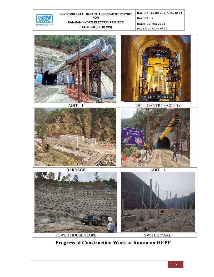
ENVIRONMENTAL IMPACT ASSESSMENT REPORT FOR
RAMMAM HYDRO ELECTRIC PROJECT STAGE - III (3 x 40 MW)
Doc. No.:9548/999/GEG/S/01
Rev. No.: 1
Date: 30/06/2021
Page No.: C1-8 of 20
1 - 8
ADIT – 1 DC -1 GANTRY (ADIT-1)
BARRAGE ADIT – 1
POWER HOUSE SLOPE SWITCH YARD
Progress of Construction Work at Rammam HEPP
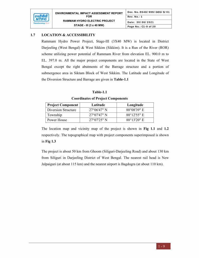
ENVIRONMENTAL IMPACT ASSESSMENT REPORT FOR
RAMMAM HYDRO ELECTRIC PROJECT STAGE - III (3 x 40 MW)
Doc. No.:9548/999/GEG/S/01
Rev. No.: 1
Date: 30/06/2021
Page No.: C1-9 of 20
1 - 9
1.7 LOCATION & ACCESSIBILITY
Rammam Hydro Power Project, Stage-III (3X40 MW) is located in District
Darjeeling (West Bengal) & West Sikkim (Sikkim). It is a Run of the River (ROR)
scheme utilizing power potential of Rammam River from elevation EL. 900.0 m to
EL. 397.0 m. All the major project components are located in the State of West
Bengal except the right abutments of the Barrage structure and a portion of
submergence area in Siktam Block of West Sikkim. The Latitude and Longitude of
the Diversion Structure and Barrage are given in Table-1.1
Table-1.1 Coordinates of Project Components
Project Component Latitude Longitude Diversion Structure 27°06'47" N 88°08'39" E Township 27°07'47" N 88°12'55" E Power House 27°07'25" N 88°13'20" E
The location map and vicinity map of the project is shown in Fig 1.1 and 1.2
respectively. The topographical map with project components superimposed is shown
in Fig 1.3
The project is about 50 km from Ghoom (Siliguri-Darjeeling Road) and about 130 km
from Siliguri in Darjeeling District of West Bengal. The nearest rail head is New
Jalpaiguri (at about 115 km) and the nearest airport is Bagdogra (at about 110 km).

ENVIRONMENTAL IMPACT ASSESSMENT REPORT FOR
RAMMAM HYDRO ELECTRIC PROJECT STAGE - III (3 x 40 MW)
Doc. No.:9548/999/GEG/S/01
Rev. No.: 1
Date: 30/06/2021
Page No.: C1-10 of 20
1 - 10
Fig 1.1 Location map

ENVIRONMENTAL IMPACT ASSESSMENT REPORT FOR
RAMMAM HYDRO ELECTRIC PROJECT STAGE - III (3 x 40 MW)
Doc. No.:9548/999/GEG/S/01
Rev. No.: 1
Date: 30/06/2021
Page No.: C1-11 of 20
1 - 11
Fig 1.2 Vicinity Map of Rammam HEPP, Stage-III (3x40 MW)
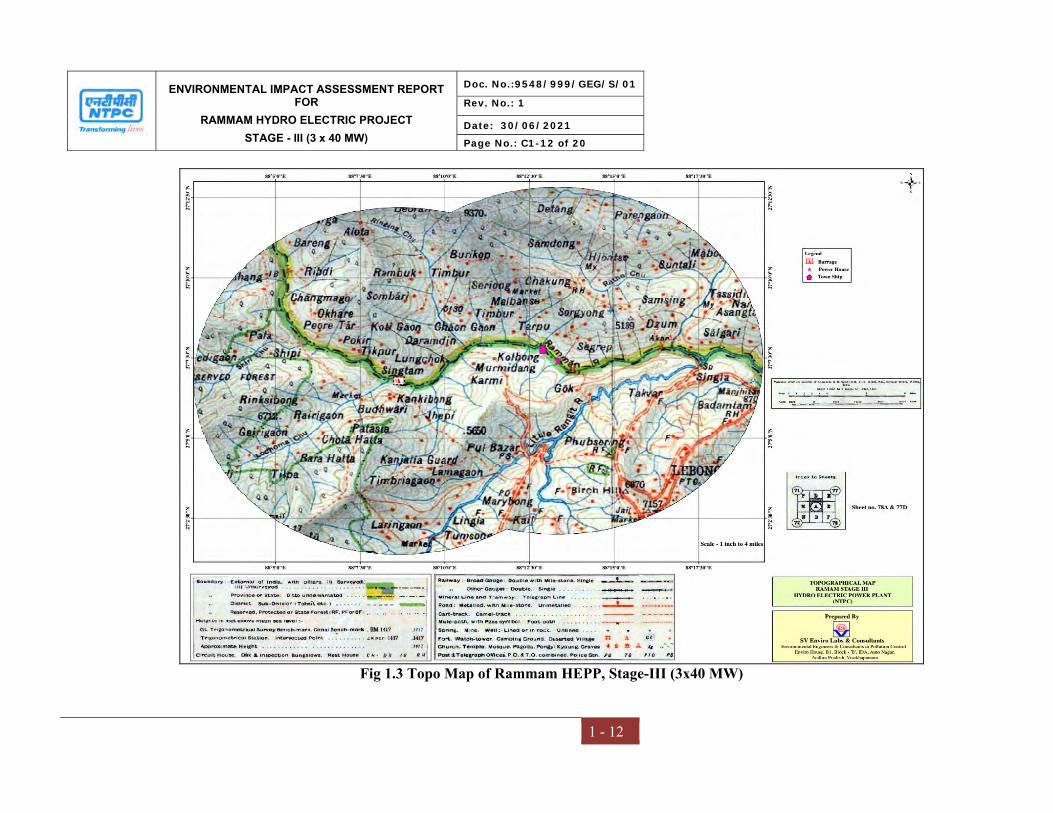
ENVIRONMENTAL IMPACT ASSESSMENT REPORT FOR
RAMMAM HYDRO ELECTRIC PROJECT STAGE - III (3 x 40 MW)
Doc. No.:9548/999/GEG/S/01
Rev. No.: 1
Date: 30/06/2021
Page No.: C1-12 of 20
1 - 12
Fig 1.3 Topo Map of Rammam HEPP, Stage-III (3x40 MW)
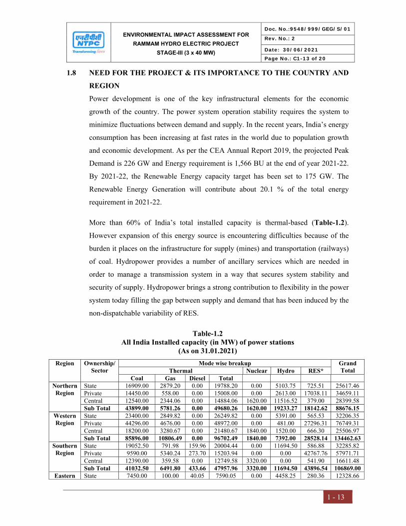
ENVIRONMENTAL IMPACT ASSESSMENT FOR RAMMAM HYDRO ELECTRIC PROJECT
STAGE-III (3 x 40 MW)
Doc. No.:9548/999/GEG/S/01
Rev. No.: 2
Date: 30/06/2021
Page No.: C1-13 of 20
1 - 13
1.8 NEED FOR THE PROJECT & ITS IMPORTANCE TO THE COUNTRY AND REGION Power development is one of the key infrastructural elements for the economic
growth of the country. The power system operation stability requires the system to
minimize fluctuations between demand and supply. In the recent years, India’s energy
consumption has been increasing at fast rates in the world due to population growth
and economic development. As per the CEA Annual Report 2019, the projected Peak
Demand is 226 GW and Energy requirement is 1,566 BU at the end of year 2021-22.
By 2021-22, the Renewable Energy capacity target has been set to 175 GW. The
Renewable Energy Generation will contribute about 20.1 % of the total energy
requirement in 2021-22.
More than 60% of India’s total installed capacity is thermal-based (Table-1.2).
However expansion of this energy source is encountering difficulties because of the
burden it places on the infrastructure for supply (mines) and transportation (railways)
of coal. Hydropower provides a number of ancillary services which are needed in
order to manage a transmission system in a way that secures system stability and
security of supply. Hydropower brings a strong contribution to flexibility in the power
system today filling the gap between supply and demand that has been induced by the
non-dispatchable variability of RES.
Table-1.2 All India Installed capacity (in MW) of power stations
(As on 31.01.2021) Region Ownership/
Sector Mode wise breakup Grand
Total Thermal Nuclear Hydro RES* Coal Gas Diesel Total
Northern Region
State 16909.00 2879.20 0.00 19788.20 0.00 5103.75 725.51 25617.46 Private 14450.00 558.00 0.00 15008.00 0.00 2613.00 17038.11 34659.11 Central 12540.00 2344.06 0.00 14884.06 1620.00 11516.52 379.00 28399.58 Sub Total 43899.00 5781.26 0.00 49680.26 1620.00 19233.27 18142.62 88676.15
Western Region
State 23400.00 2849.82 0.00 26249.82 0.00 5391.00 565.53 32206.35 Private 44296.00 4676.00 0.00 48972.00 0.00 481.00 27296.31 76749.31 Central 18200.00 3280.67 0.00 21480.67 1840.00 1520.00 666.30 25506.97 Sub Total 85896.00 10806.49 0.00 96702.49 1840.00 7392.00 28528.14 134462.63
Southern Region
State 19052.50 791.98 159.96 20004.44 0.00 11694.50 586.88 32285.82 Private 9590.00 5340.24 273.70 15203.94 0.00 0.00 42767.76 57971.71 Central 12390.00 359.58 0.00 12749.58 3320.00 0.00 541.90 16611.48 Sub Total 41032.50 6491.80 433.66 47957.96 3320.00 11694.50 43896.54 106869.00
Eastern State 7450.00 100.00 40.05 7590.05 0.00 4458.25 280.36 12328.66
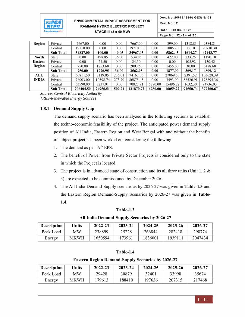
ENVIRONMENTAL IMPACT ASSESSMENT FOR RAMMAM HYDRO ELECTRIC PROJECT
STAGE-III (3 x 40 MW)
Doc. No.:9548/999/GEG/S/01
Rev. No.: 2
Date: 30/06/2021
Page No.: C1-14 of 20
1 - 14
Region Private 7667.00 0.00 0.00 7667.00 0.00 399.00 1318.81 9384.81 Central 19710.00 0.00 0.00 19710.00 0.00 1005.20 15.10 20730.30 Sub Total 34827.00 100.00 40.05 34967.05 0.00 5862.45 1614.27 42443.77
North Eastern Region
State 0.00 498.85 36.00 534.85 0.00 422.00 233.25 1190.10 Private 0.00 24.50 0.00 24.50 0.00 0.00 105.92 130.42 Central 750.00 1253.60 0.00 2003.60 0.00 1455.00 30.00 3488.60 Sub Total 750.00 1776.95 36.00 2562.95 0.00 1877.00 369.17 4809.12
ALL INDIA
State 66811.50 7119.85 236.01 74167.36 0.00 27069.50 2391.52 103628.39 Private 76003.00 10598.74 273.70 86875.45 0.00 3493.00 88526.91 178895.36 Central 63590.00 7237.91 0.00 70827.91 6780.00 15496.72 1632.30 94736.93 Sub Total 206404.50 24956.51 509.71 121870.72 6780.00 16059.22 92550.74 377260.67
Source: Central Electricity Authority *RES-Renewable Energy Sources
1.8.1 Demand Supply Gap
The demand supply scenario has been analyzed in the following sections to establish
the techno-economic feasibility of the project. The anticipated power demand supply
position of All India, Eastern Region and West Bengal with and without the benefits
of subject project has been worked out considering the following:
1. The demand as per 19th EPS.
2. The benefit of Power from Private Sector Projects is considered only to the state
in which the Project is located.
3. The project is in advanced stage of construction and its all three units (Unit 1, 2 &
3) are expected to be commissioned by December 2026.
4. The All India Demand-Supply scenarious by 2026-27 was given in Table-1.3 and
the Eastern Region Demand-Supply Scenarios by 2026-27 was given in Table-1.4.
Table-1.3 All India Demand-Supply Scenarios by 2026-27
Description Units 2022-23 2023-24 2024-25 2025-26 2026-27 Peak Load MW 238899 25228 266844 282418 298774
Energy MKWH 1650594 173961 1836001 1939111 2047434
Table-1.4 Eastern Region Demand-Supply Scenarios by 2026-27
Description Units 2022-23 2023-24 2024-25 2025-26 2026-27 Peak Load MW 29428 30879 32401 33998 35674
Energy MKWH 179613 188410 197636 207315 217468

ENVIRONMENTAL IMPACT ASSESSMENT FOR RAMMAM HYDRO ELECTRIC PROJECT
STAGE-III (3 x 40 MW)
Doc. No.:9548/999/GEG/S/01
Rev. No.: 2
Date: 30/06/2021
Page No.: C1-15 of 20
1 - 15
Although, the proportion of Hydro Electric Power (13.84%) in terms of installed
Capacity (MW) at Eastern Region (ER) is close to the national average of 12.33%, but
the proportion of Hydro + Renewable Energy source (RES) at ER is only 17.42% in
comparison to the national average of 35.92% (Country wide installed capacity dated
31.05.20 has been considered). As the scope of installation of Wind Power or Solar
PV generating stations, the main two components of RES in India are less in ER,
hence in ER, emphasis should be put on installing medium to small hydro power
generating units for enriching the proportion of green energy.
As per National Electricity Plan (NEP), 2018, Capacity addition in between 2017-22
in Hydro Power Sector in ER is limited to only one project, i.e. Rammam HPP, Stage-
III (3x40 MW) by NTPC.
Ministry of Power has given following allocation:
S.No. State Share in installed capacity (%)
Equivalent quantum in installed capacity (MW)
1. West Bengal 73 87.6 2. Sikkim 12 14.4 3. Unallocated 15 18
Total 100 120
As per the interstate agreement between Sikkim & West Bengal, the share of power of
the Sikkim Government (12%) will be made available to the Sikkim Government at
free of cost. The Rammam Stage-III Hydro Electric Power Project would not only
meet the power requirements, but would also improve the ratio of hydro, thermal mix
as well.
1.9 POLICY, LEGAL AND ADMINISTRATIVE FRAMEWORK The emerging environmental scenario calls for requisite attention on conservation and
proper use of natural resources and also development without destruction. There is a
need of integrate the environmental consequences of the development activities and to
planning suitable mitigation measures in order to ensure sustainable development in
the region. The environmental consideration in any development process have
become a necessity for achieving sustainable developmental to achieve these goals,
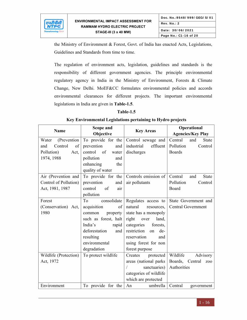
ENVIRONMENTAL IMPACT ASSESSMENT FOR RAMMAM HYDRO ELECTRIC PROJECT
STAGE-III (3 x 40 MW)
Doc. No.:9548/999/GEG/S/01
Rev. No.: 2
Date: 30/06/2021
Page No.: C1-16 of 20
1 - 16
the Ministry of Environment & Forest, Govt. of India has enacted Acts, Legislations,
Guidelines and Standards from time to time.
The regulation of environment acts, legislation, guidelines and standards is the
responsibility of different government agencies. The principle environmental
regulatory agency in India in the Ministry of Environment, Forests & Climate
Change, New Delhi. MoEF&CC formulates environmental policies and accords
environmental clearances for different projects. The important environmental
legislations in India are given in Table-1.5.
Table-1.5 Key Environmental Legislations pertaining to Hydro projects
Name Scope and Objective Key Areas Operational
Agencies/Key Play Water (Prevention and Control of Pollution) Act, 1974, 1988
To provide for the prevention and control of water pollution and enhancing the quality of water
Control sewage and industrial effluent discharges
Central and State Pollution Control Boards
Air (Prevention and Control of Pollution) Act, 1981, 1987
To provide for the prevention and control of air pollution
Controls emission of air pollutants
Central and State Pollution Control Board
Forest (Conservation) Act, 1980
To consolidate acquisition of common property such as forest, halt India’s rapid deforestation and resulting environmental degradation
Regulates access to natural resources, state has a monopoly right over land, categories forests, restriction on de-reservation and using forest for non forest purpose
State Government and Central Government
Wildlife (Protection) Act, 1972
To protect wildlife Creates protected areas (national parks / sanctuaries) categories of wildlife which are protected
Wildlife Advisory Boards, Central zoo Authorities
Environment To provide for the An umbrella Central government

ENVIRONMENTAL IMPACT ASSESSMENT FOR RAMMAM HYDRO ELECTRIC PROJECT
STAGE-III (3 x 40 MW)
Doc. No.:9548/999/GEG/S/01
Rev. No.: 2
Date: 30/06/2021
Page No.: C1-17 of 20
1 - 17
(Protection) Act, 1986
protection and improvement of environment
legislation, supplements pollution laws
nodal agency, MoEF&CC can delegate to state departments of environment
National Policy on R & R, 2007 and Rehabilitation and Resettlement Act, 2013”.
Resettlement and rehabilitation of project affected people
Social issues Central and State Government
EIA Notification 14th September 2006
Environment Impact Assessment
Environmental Protection
Project Development, State and Central Government
1.10 SCOPE OF THE STUDY The scope of the EIA study considers the impact due to setting up Rammam Satge-III
Hydro Electric Project (ROR) of 3x40 MW capacity in Darjeeling district of West
Bengal and West Sikkim district of Sikkim on physical, biological and socioeconomic
environment of the surrounding areas in compliance to the approved ToR provided by
MoEF&CC. The scope of the EIA study includes the following:
To establish the prevailing environmental and socio-economic condition of the
study area;
To assess environmental and socioeconomic impacts arising out of the
proposed activities;
To recommend appropriate preventive and mitigation measures to eliminate or
minimize pollution;
To identify and propose management plans in terms of good practices that
may help in abating environmental or socio-economic impacts due to the
project;
To prepare a Disaster Management Plan (DMP), Catchment Area Treatment
(CAT) Plan and Resettlement and Rehabilitation Plan.
The study area for the EIA study shall be as under:
Submergence area

ENVIRONMENTAL IMPACT ASSESSMENT FOR RAMMAM HYDRO ELECTRIC PROJECT
STAGE-III (3 x 40 MW)
Doc. No.:9548/999/GEG/S/01
Rev. No.: 2
Date: 30/06/2021
Page No.: C1-18 of 20
1 - 18
• Area within 10 km of periphery of submergence area & other project
appurtenances viz. Barrage, Power House, Muck Disposal etc. and
As per the approved Terms of Reference, one season baseline data has been collected
for all environmental attributes including biological environment for the preparation
of the EIA/EMP report. Environmental baseline monitoring was carried out during
July’ 2020 to September’ 2020 representing monsoon season and used to identify
potential significant impacts.
1.11 ENVIRONMENTAL PARAMETERS IN THE STUDY AREA Collection of base line data is an integral aspect of the preparation of Environmental
Impact Assessment report. Baseline data reflects the present scenario of Environment
before the initiation of any activity of the project. The possible effects due to the
project are estimated and superimposed on the compiled baseline data subsequently to
assess Environmental impacts.
Project environment assessment was conducted in the study area during July’ 2020 to
September’ 2020. Studies were under taken to generate base line data of the
following:-
1. Geology
2. Hydrology
3. Meterology
4. Ambient Air Quality
5. Water Quality – Ground Water & Surface Water
6. Ambient Noise Quality
7. Soil Quality
8. Ecology
9. Land Use / Land Cover
10. Socio-Economy.
1.12 GENERIC STRUCTURE OF EIA DOCUMENT In terms of the EIA notification of MoEF&CC dated 14th September 2006 and its
subsequent amendments, the generic structure of the EIA document is as follows:
ENVIRONMENTAL IMPACT ASSESSMENT FOR RAMMAM HYDRO ELECTRIC PROJECT
STAGE-III (3 x 40 MW)
Doc. No.:9548/999/GEG/S/01
Rev. No.: 2
Date: 30/06/2021
Page No.: C1-19 of 20
1 - 19
Chapter – I: Introduction
The chapter gives an overview of the project details, identification of project &
project proponent, nature, size and location of the project, purpose of the study, need
for the project and its importance to country and region, policy, legal and
administrative framework, scope and methodology adopted for EIA study.
Chapter – II: Project Description The chapter narrates the project background, size or magnitude of the operation,
salient features of the project, project description, infrastructure requirements and
associated facilities, project colonies/buildings and project schedule and cost estimate.
Chapter – III: Environmental Baseline Study The chapter covers identification of the study area and baseline study of the physico-
chemical and biological environmental condition of the study area. The rationale is to
evaluate the key environmental parameters of the project area before its actual
implementation. The planning of baseline survey emanated from short listing of
impacts assessed during identification. The baseline study involved both review of
secondary data and generation of primary data through field studies.
Chapter – IV: Impact Assessment & Mitigation Measures The chapter assesses the anticipated impacts (positive and negative) arising during
various phases of the project. Prediction is essentially a process to forecast the future
environmental conditions of the project area that may occur as a result of the project
activities. An attempt has been made to predict future environmental conditions
quantitatively on the present and possible scenario. Based on the anticipated impacts,
the mitigation measures have been suggested.
Chapter – V: Analysis of alternatives (Technology and site) The chapter provides the alternate location and technology analyzed for various
parameters in the project.
ENVIRONMENTAL IMPACT ASSESSMENT FOR RAMMAM HYDRO ELECTRIC PROJECT
STAGE-III (3 x 40 MW)
Doc. No.:9548/999/GEG/S/01
Rev. No.: 2
Date: 30/06/2021
Page No.: C1-20 of 20
1 - 20
Chapter – VI: Environmental Monitoring Programme Environmental Monitoring Programme to ensure effectiveness of the environmental
management plan during various phases of project advancement and health, safety
and environmental management cell is briefed in this chapter.
Chapter – VII: Additional Studies The Chapter depicts the Public Hearing outcomes and identifies the risks associated
with the project, CAT Plan, and Disaster Management Plan to be implemented in the
event of an emergency.
Chapter – VIII: Project Benefits The Chapter discusses the overall benefits which will accrue after implementation of
the project to cover power demand of central and state governments, employment
generation and overall economic development.
Chapter – IX: Environmental Cost Benefit Analysis The chapter covers details of cost and Benefits related to Rammam HEPP.
Chapter – X: Environmental Management Plan The chapter details the Environment Management Plan (EMP) to maximize the
positive environmental impacts and to minimize the negative ones.
Chapter – XI: Summary & Conclusion
This chapter provide the summary of EIA study and gives conclusions &
recomondations for appraisal of EC.
Chapter – XII: Disclosure of Consultants engaged
This chapter describe the accreditation of EIA Consultant and associated expert in
EIA Study.
CHAPTER – II
PROJECT DESCRIPTION
ENVIRONMENTAL IMPACT ASSESSMENT REPORT FOR
RAMMAM HYDRO ELECTRIC PROJECT
STAGE-III (3 x 40 MW)
Doc. No.:9548/999/GEG/S/01
Rev. No.: 1
Date: 30/06/2021
Page No.: C2-1 of 21
2 - 1
CHAPTER-2
PROJECT DESCRIPTION
2.0 GENERAL
Rammam HEPP, Stage-III (3x40 MW) is a Run of the River (ROR) Scheme Project
located on Rammam River (Teesta River basin), which flows along the border of
West Bengal and Sikkim at about 130 km from Siliguri on Siliguri-Darjeeling Road in
District Darjeeling of West Bengal.
The site for diversion structure is located downstream at the confluence of Rammam
with Lodhama khola near Lodhama village just downstream of the power house of
Rammam Stage-II HEPP (51 MW under operation by WBSEB). The site for
powerhouse is located near village Barbatia on the right bank of River Rammam.
2.1 LOCATION OF PROJECT
Rammam Stage-III H.E Project is a Run of the River (ROR) scheme utilizing power
potential of Rammam River from elevation 900 m to 397 m, in the District of
Darjeeling, West Bengal with an installed capacity of 120 MW (3x40 MW). All the
major project components are located in the State of West Bengal except the right
abutments of the Barrage structure and a portion of submergence area in Siktam
Block of West Sikkim.
Location of the project components on 1:50,000 scale toposheet is presented in Fig.
2.1.
The location of the project on google map is shown in Fig 2.2.
The location of the project with respect to National Park, Wildlife Sanctuary and their
eco-sensitive zones is shown in Fig 2.3.
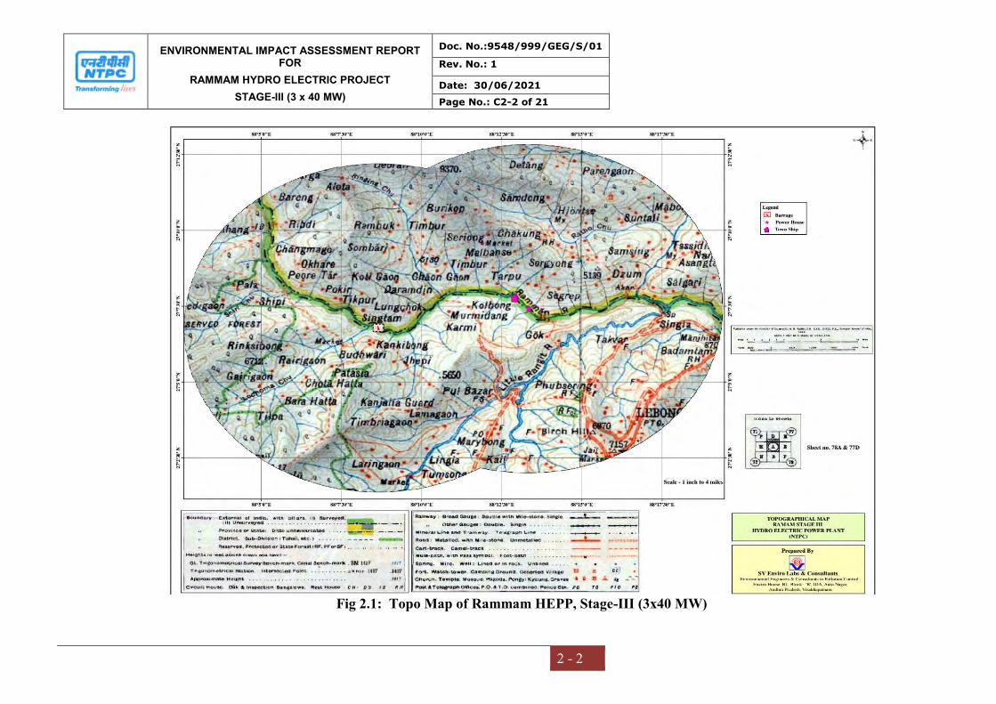
ENVIRONMENTAL IMPACT ASSESSMENT REPORT FOR
RAMMAM HYDRO ELECTRIC PROJECT
STAGE-III (3 x 40 MW)
Doc. No.:9548/999/GEG/S/01
Rev. No.: 1
Date: 30/06/2021
Page No.: C2-2 of 21
2 - 2
Fig 2.1: Topo Map of Rammam HEPP, Stage-III (3x40 MW)
ENVIRONMENTAL IMPACT ASSESSMENT REPORT FOR
RAMMAM HYDRO ELECTRIC PROJECT
STAGE-III (3 x 40 MW)
Doc. No.:9548/999/GEG/S/01
Rev. No.: 1
Date: 30/06/2021
Page No.: C2-3 of 21
2 - 3
Justification of location & execution of the project in relation to structural
components (Barrage height)
As the project is a Run of River project, a barrage is being constructed in place of
Dam. The barrage height (23 m) has kept considering the location and structure
component of project. Details of structural components of Rammam HEPP project are
given in Table: 2.1.
The project is in advanced stage of construction after Techno-economic Clearance by
CEA and Environmental Clearance by MOEF&CC. As per Detailed Project Report
(DPR), the location for execution of the project was found feasible.
None of the project components are located within National Parks, Wildlife Sanctuary
or other protected area or within the notified Eco sensitive zones of these protected
area. As confirmed by CCF (WL), West Bengal vide letter dated 01.02.2008 copy
attached as Annexure-XIV, the project area is at a distance of about 7.1 km from the
nearest boundary of Eco-sensitive Zone of Singalila National Park. However, the
Singalila National Park is about 9.0 km from the project components as notified by
MOEF&CC notification No. S.O. 3613 (E) dated 16.11.2017 (copy enclosed as
Annexure-XV). The Eco Sensitive Zone of Barsey Rhododendron Sanctuary is at 4.2
km from the project site and 4.4 km away from boundary of Barsey Rhododendron
Sanctuary, West Sikkim notified by MOEF&CC notification No.S.O.2172 (E) dated
27.08.2014 (copy enclosed as Annexure-XVI) and about 10 km from the nearest
boundary of the reserve forest area of Darjeeling Territorial Forest Division.
2.2 SIZE OR MAGNITUDE OF OPERATION
The capacity of the project would be 120 MW with installation of 3 units of 40MW
each. Township with adequate nos. quarters/facilities/infrastructure shall be
constructed to accommodate staffs of Rammam HEPP, Stage-III.
Project Area: 74.077 Ha (excluding submergence area)
Submergence area: 3.852 Ha.
Catchment Area: 5273 Ha (WB side: 3808 Ha + Sikkim side: 1465 Ha)

ENVIRONMENTAL IMPACT ASSESSMENT REPORT FOR
RAMMAM HYDRO ELECTRIC PROJECT
STAGE-III (3 x 40 MW)
Doc. No.:9548/999/GEG/S/01
Rev. No.: 1
Date: 30/06/2021
Page No.: C2-4 of 21
2 - 4
Fig 2.2 Location Map of Rammam HEPP, Stage-III
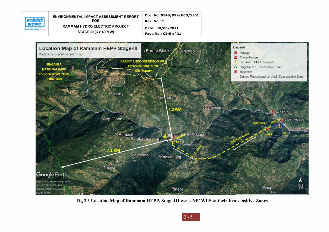
ENVIRONMENTAL IMPACT ASSESSMENT REPORT FOR
RAMMAM HYDRO ELECTRIC PROJECT
STAGE-III (3 x 40 MW)
Doc. No.:9548/999/GEG/S/01
Rev. No.: 1
Date: 30/06/2021
Page No.: C2-5 of 21
2 - 5
Fig 2.3 Location Map of Rammam HEPP, Stage-III w.r.t. NP/ WLS & their Eco-sensitive Zones
ENVIRONMENTAL IMPACT ASSESSMENT REPORT FOR
RAMMAM HYDRO ELECTRIC PROJECT
STAGE-III (3 x 40 MW)
Doc. No.:9548/999/GEG/S/01
Rev. No.: 1
Date: 30/06/2021
Page No.: C2-6 of 21
2 - 6
2.3 SALIENT FEATURES OF THE PROJECT
The project consists of 23 m high Barrage (above u/s apron level) 122.5m long
Barrage near Lodhama Village and approximately 10.75km of water conductor
system (8.2 km long 3.5m dia horse shoe shape head race tunnel, 1.6 km long
Penstock and 0.74 km long tailrace channel etc.). It has also a 14.5 m dia 53.75m high
surge shaft and a deep seated surface power house near Barbatia village on right bank
of the Rammam River.
The project is envisaged to use water from catchment area of 247sq. km. The Full
Reservoir Level (FRL) of the pondage behind the Barrage structure has been fixed at
EL903m with a view to provide sufficient storage capacity above Minimum Draw
Down Level to provide optimum peaking operation of more than 2 hours at a time.
The Minimum Draw Down Level (MDDL) is fixed at EL 892m. The storage at FRL
is 0.27MCM and at MDDL is 0.05MCM.
Storages between FRL and MDDL is 0.22 MCM. About 476 MU will be generated
using 28.31 cumec of discharge excluding a 4.69 cumec of water to flush silt and
1 cumec of water as environmental flow. Upstream of Rammam Stage-III is 51
MW Rammam Stage-II project and on the downstream there is no project on the
Rammam River till its confluence with Rangit River.
However at present during the construction stage, no impounding/ stoppage of river
water flow is being done. The river has been diverted through diversion channel to
facilitate the construction of Barrage. The salient features of the project are given in
Table 2.1
Table-2.1
Salient Features of Rammam Stage-III Hydroelectric Project
1 LOCATION a) State West Bengal b) District Darjeeling c) Latitude & Longitude Diversion Structure: 27°06'47" N,
88°08'39" E Township: 27°07'47" N, 88°12'55" E Power House: 27°07'25" N, 88°13'20" E
d) Nearest rail head New Jalpaiguri (115 KM)
e) Nearest Airport Bagdogra (110 KM)
ENVIRONMENTAL IMPACT ASSESSMENT REPORT FOR
RAMMAM HYDRO ELECTRIC PROJECT
STAGE-III (3 x 40 MW)
Doc. No.:9548/999/GEG/S/01
Rev. No.: 1
Date: 30/06/2021
Page No.: C2-7 of 21
2 - 7
f) Approach/Access Road 50 Km From Ghoom (Siliguri-Darjeeling Road), 130 KM From Siliguri
g) Name of the River, Tributary Rammam h) Name of River basin Teesta Basin 2 HYDROLOGY AND CLIMATE a) Catchment Area up to head works 247 sq.km b) Average Annual Yield 686.56 MCM c) Maximum/Minimum Yield 1040.37 / 485.65 MCM d) Average annual rainfall 2800 mm e) Design Flood 1825 cumecs f) Ninety percent available discharge 15.43 cumecs g) Max. temperature 30o C h) Min. temperature 3o C i) Max. relative humidity 100% j) Design discharge for barrage/dam 1825 cumecs 3 BARRAGE/DAM a) Length of Barrage 122.5 m b) Height of Barrage 23 m (above u/s apron level) c) Number of gated bays 5 d) Type of gate Radial Gate (operated by hydraulic
hoists) e) Crest elevation 884.00 m (4bays)/882.00 m (1bay) f) Width of the top roadway 6.5 m 4 RESERVOIR a) Full Reservoir Level (FRL) 903.00 m b) Maximum Drawdown Level (MDDL) 892.00 m 5 INTAKE a) No of Intake 2 b) Design discharge of Intake 33.0 m3/sec d) Center line of Intake EL 887.50 m e) Nos. and size of Gates 2 (2.60 m x 2.850 m) each f) Type of Gates Fixed Wheel g) Intake Bulk Head Gate 1 No. 2.60 x 2.85 m fixed wheel type 6 DESILTING CHAMBER (Underground) a) Numbers 2 b) Size 140.0 x 7.50 x 12.55m c) Top level of trough EL. 876.85 m d) Bottom Level of Conduits EL. 875.85 m e) Design discharge 33.0 cumec f) Discharge (for flushing) 4.69cumec (for both SFT) g) Particle size to be removed 0.2 mm & above h) Efficiency of removal 90 % 7 HEAD RACE TUNNEL a) Alignment Right bank b) Length 8200 m

ENVIRONMENTAL IMPACT ASSESSMENT REPORT FOR
RAMMAM HYDRO ELECTRIC PROJECT
STAGE-III (3 x 40 MW)
Doc. No.:9548/999/GEG/S/01
Rev. No.: 1
Date: 30/06/2021
Page No.: C2-8 of 21
2 - 8
c) Shape &Diameter Horseshoe & 3.5 m diameter d) Design discharge 28.31 m3/sec. e) Velocity 1.93m/sec. f) Number of adits 3 8 SURGE SHAFT a) Type Restricted orifice type b) Dia (m) 14.50 c) Height (m) 53.75 m d) Top Elevation (m) 923.0 e) Bottom Elevation (m) 869.25 9 PRESSURE SHAFT / PENSTOCK a) Type Circular b) Number of Pressure Shafts /
Penstocks One
c) Maximum discharge through pressure shaft / penstocks (cumecs)
28.31 cumecs
d) Dia. Of each pressure shaft / penstock 2.7 m e) Maximum Velocity 4.9 m / sec f) Length of pressure shaft / penstock 1526 m g) Penstock valve (type &dia) Butterfly, 2.5 m dia
10 POWER HOUSE
a) Type Deep Seated Surface Power House
b) Location Near village Barbatia in West Bengal
c) Number of units 3
Size of Power House 73.50 m x 22.40 m x 41.60 m
d) Rated unit capacity 40 MW
e) Installed capacity 120 MW
f) Max. Gross Head 495.33 m
g) Rated Head (m) 484.33 m
h) Type of turbine Vertical shaft pelton
i) Maximum flow through each unit 9.33 cumec
j) Generator
- Type - Power factor, generator voltage - Speed
Synchronous, Vertical Shaft 0.9, 11.0 kV 428.6 rpm
k) Size of machine hall 65.0 x 19 x 35m
l) Transformers – Type, Nos., No. of Phases, step – up voltage capacity
Single phase, 11 Nos., 16 mVA, 11/132/ √3 kV
m) Power House Cranes
- Nos. and Capacity (Ton) 1 EOT Crane with 125 T main hook & 25 T auxiliary hook
11 TAIL RACE CHANNEL a) Size 4m x 3m, Rectangular Section
b) Length 740 m
c) Tail Water Level 397.0 m (max.)

ENVIRONMENTAL IMPACT ASSESSMENT REPORT FOR
RAMMAM HYDRO ELECTRIC PROJECT
STAGE-III (3 x 40 MW)
Doc. No.:9548/999/GEG/S/01
Rev. No.: 1
Date: 30/06/2021
Page No.: C2-9 of 21
2 - 9
12 SWITCHYARD
a) Type of Switchyard Conventional
b) Number of bays in the switchyard 9
c) Voltage Level 132 kV
d) Location Outdoor
13 ENVIRONMENTAL SENSITIVITY
Singalila National Park None of the project components are within the Eco-sensitive zone of Singlila National Park notified by MOEF&CC notification No. S.O. 3613 (E) dated 16.11.2017 (copy enclosed as Annexure-XV). The nearest boundary of Singalila National Park Eco-Sensitive Zone is located at about 7.1 km from the Rammam Stage-III HEPP. However, the Singalila National Park is about 9.0 km from the project components.
Barsey Rhododendron Sanctuary, West Sikkim
None of the project components are within the Eco-sensitive zone of Barsey Rhododendron wild life Sanctuary notified by MOEF&CC notification No.S.O.2172 (E) dated 27.08.2014 (copy enclosed as Annexure-XVI). The nearest boundary of Barsey Rhododendron Wildlife Sanctuary Eco-sensitive Zone is about 4.2 km from the Rammam Stage-III HEPP. However, the Barsey Rhododendron Wildlife Sanctuary is about 4.4 km from the project components.
14 R & R 275 families have lost only land. 61 families have lost land as well
as homesteads. 11 families have lost only
homesteads.15 TARIFF (As per Investment approval)
Levellised Rs. 6.51 kWhr
First years Rs. 7.88 kWhr
16 PROJECT COST
Total Cost of the Project As per EC: Rs. 633.92 Crores As per Inv. Approval: Rs. 1,381.84
Crores (2ndQtr, 2014)

ENVIRONMENTAL IMPACT ASSESSMENT REPORT FOR
RAMMAM HYDRO ELECTRIC PROJECT
STAGE-III (3 x 40 MW)
Doc. No.:9548/999/GEG/S/01
Rev. No.: 1
Date: 30/06/2021
Page No.: C2-10 of 21
2 - 10
2.4 PROJECT DESCRIPTION
The project is envisaged to harness the hydropower potential of River Rammam. The
project comprises of diversion arrangement, desilting chamber, water conveyance
system, power house and tailrace. Installed capacity of the project will be 120 MW
and will utilize a design discharge of 28.31 cumecs.
The project comprises of the following components:
Barrage/dam as a diversion structure
Intake tunnel
Underground desilting chamber
HRT (Head Race Tunnel)
Surge Shaft
Surface Penstock
Vertical Pressure Shaft
Power House
Tail Race Channel (TRC)
The layout Map of the project component is shown in Fig 2.4A & General Layout
Plan is shown in Fig 2.4B. The above referred project appurtenances are briefly
described in the following sections:
2.4.1 Diversion structure
It is planned to construct a barrage with its axis about 200 m downstream of
confluence of Rammam River with Lodhama Khola. The barrage/dam has been
designed to have optimum pondage and capacity so as to safely pass a designed flood
of 1825 cumecs which correspond to Standard Project Flood (SPF) of the Rammam
River. It is proposed to provide surge shaft, hence, storage for diurnal peaking has
been made in the barrage only. The average bed level at barrage/dam site is 883.0 m
and maximum pond level for the barrage/dam has been kept at 903.0 m considering
the out fall level of Rammam Stage-II (EL 908.00 m). Storage between Maximum
Pond Level (EL 903.0) and Minimum Draw Down Level (EL 892.0) is 220,000.0
cum.
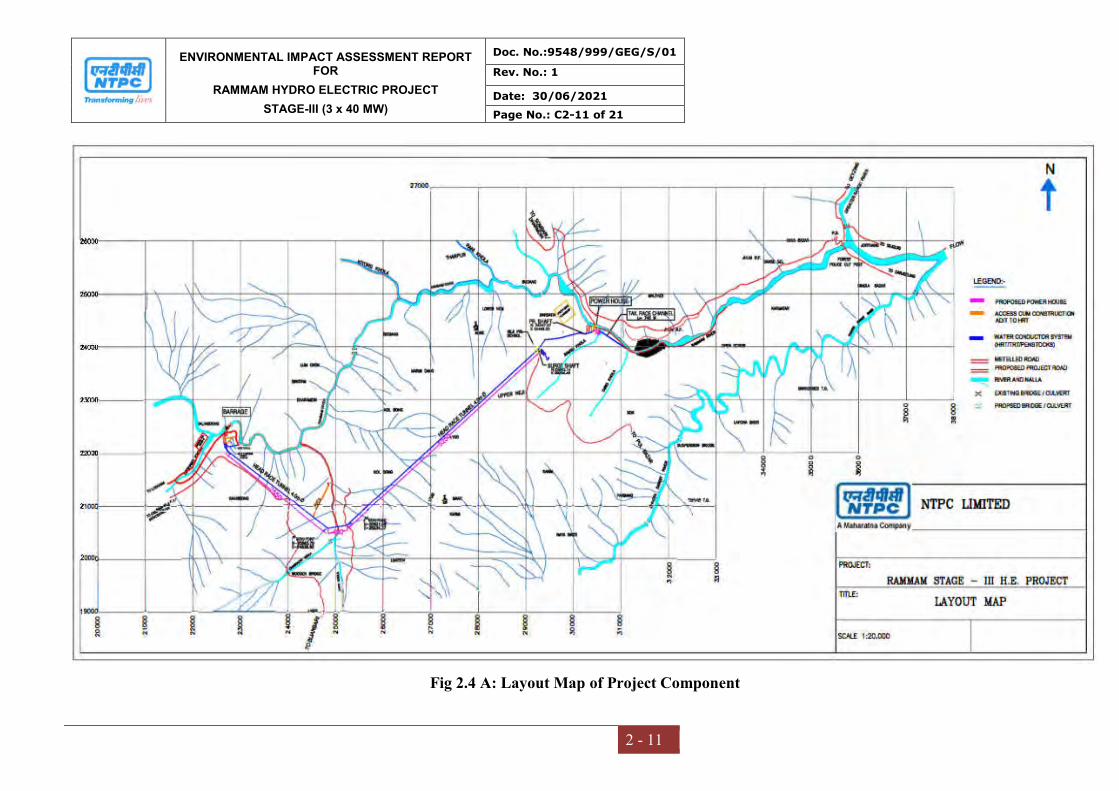
ENVIRONMENTAL IMPACT ASSESSMENT REPORT FOR
RAMMAM HYDRO ELECTRIC PROJECT
STAGE-III (3 x 40 MW)
Doc. No.:9548/999/GEG/S/01
Rev. No.: 1
Date: 30/06/2021
Page No.: C2-11 of 21
2 - 11
Fig 2.4 A: Layout Map of Project Component
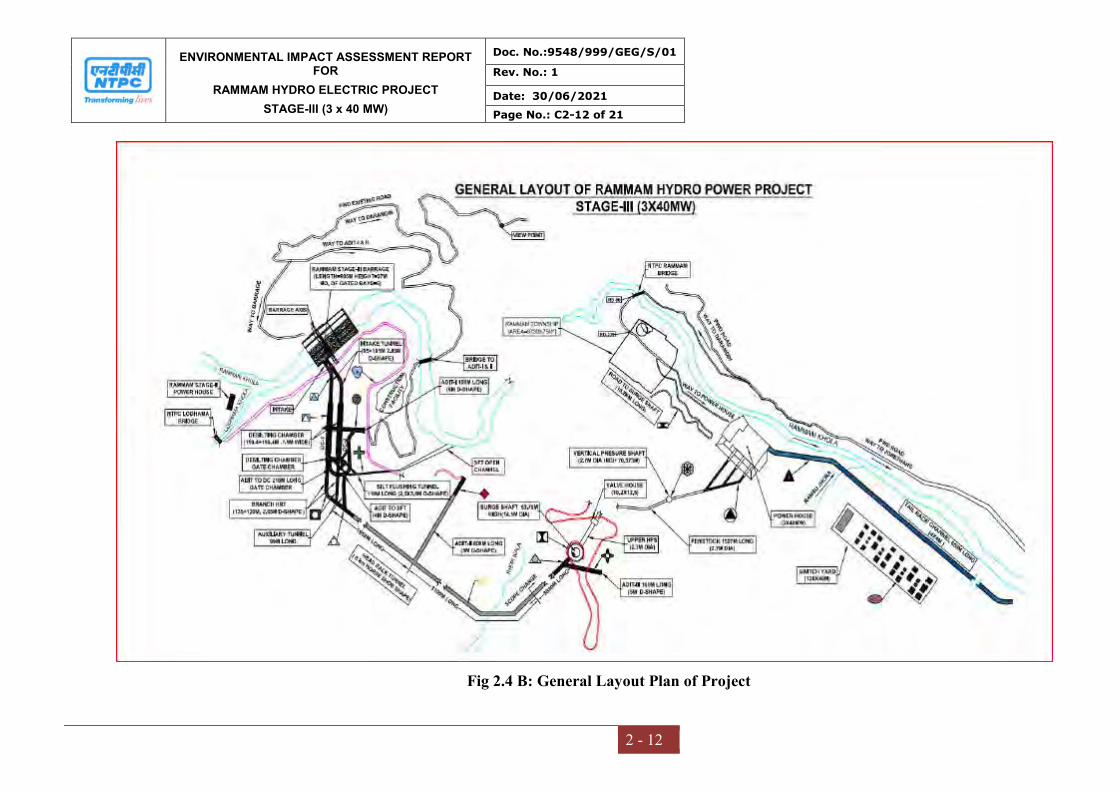
ENVIRONMENTAL IMPACT ASSESSMENT REPORT FOR
RAMMAM HYDRO ELECTRIC PROJECT
STAGE-III (3 x 40 MW)
Doc. No.:9548/999/GEG/S/01
Rev. No.: 1
Date: 30/06/2021
Page No.: C2-12 of 21
2 - 12
Fig 2.4 B: General Layout Plan of Project
ENVIRONMENTAL IMPACT ASSESSMENT REPORT FOR
RAMMAM HYDRO ELECTRIC PROJECT
STAGE-III (3 x 40 MW)
Doc. No.:9548/999/GEG/S/01
Rev. No.: 1
Date: 30/06/2021
Page No.: C2-13 of 21
2 - 13
The barrage is planned with three piers each of 4 m width and two abutments each of
size 2.75 m and the floor of the Barrage/dam has been designed as raft. Since
barrage/dam width is less than River width, it is proposed to construct flank wall
through in filled cellular wall. To prevent the seepage through foundation two rows of
grout curtain have been proposed. The grout curtain is proposed to be extended at
least 1.0 m in the fresh rock, which will provide a barrier for seepage below
barrage/dam foundation.
2.4.2 Intake and Intake Tunnel
Two intakes have been proposed on the right bank of the River at about 40 m
upstream of the barrage/dam axis to enable withdrawal of 32 cumecs of water. The
intake sizes have been fixed in such a way that the entry velocity through trash racks
is less than 1.0 m/sec. Two D -shaped intake tunnels of size 2.85 m have been
proposed to feed desilting chamber independently. As the geographical conditions of
rock on the right bank are quite competent and steep, placing of intake will not need
much stabilization measures. For preventing the entry of trash in the intake, trash rack
of adequate size has been provided.
2.4.3 Desilting Chamber
Considering the stability problem of hill slope and associated land acquisition etc. an
underground desilting chamber has been constructed in the project. Two underground
desilting chambers each of size 140.0 m x 7.5 m x 12.55 m is provided for collecting
the settled silt particle, which passes through a duct of size 0.75 m x 1.0 m for
flushing the settled silt particle. Combined silt flushing duct of size 2.0 m x 2.5 m will
be provided for disposing the settled silt back in the Rammam River. The total length
of silt flushing tunnel is 230 m.
2.4.4 Head Race Tunnel (HRT)
A horse shoe-shaped HRT with 3.5 m as finished diameter has been proposed with a
capacity to convey 28.31 cumecs from desilting chamber to surge shaft. The length of
HRT will be 8200m. For ease in construction, three adits of length 100m, 800m &
90m each have been proposed.

ENVIRONMENTAL IMPACT ASSESSMENT REPORT FOR
RAMMAM HYDRO ELECTRIC PROJECT
STAGE-III (3 x 40 MW)
Doc. No.:9548/999/GEG/S/01
Rev. No.: 1
Date: 30/06/2021
Page No.: C2-14 of 21
2 - 14
2.4.5 Surge Shaft
Restricted orifice type, surge shaft of 14.5 m diameter is proposed to take care of rise
in water level due to surge created because of sudden change in operating conditions.
2.4.6 Pressure Shaft
For conveying the water from surge tank to power house, combination of surface
penstock and pressure shaft has been proposed. Optimum penstock diameter has been
finalized as 2.7 m. Initial 175 m penstock passes through tunnel, a surface valve house
is proposed. Subsequently 1211 m length of penstock runs on surface and considering
the topography and deep seated power house, last 140 meter has been proposed as
vertical and horizontal pressure shaft.
2.4.7 Power House
Surface power house of 120 MW (3 x 40 MW) is at the right bank of the Rammam
River, 50.0 m upstream of the confluence of the Ramsu Khola with Rammam River.
It houses three units of Pelton turbine having center line at EL 400.0 m.
2.4.8 Tail Race Channel
Tail Race Channel (TRC) of 4.0 m x 3.0 m is planned from power house to 707 m
downstream of power house. For protection against flood of intensity greater than 1 in
100 years, gated arrangement is proposed at the outfall structure. TRC will be a
concrete cut and cover section.
2.4.9 Hydro-Mechanical Works
The following are the hydro mechanical works:
i. Two sets of fixed type trash racks
ii. Four Nos. Radial gates, (3 nos-8 x 6m and 1 no-8 x 14m) operated with
Hydraulic hoist.
iii. One set of stop logs operated with gantry crane and lifting beam.
iv. Two Nos. of Intake gates operated with rope drum hoist supported on trestles.
v. One No. of Intake Bulk head gate operated with gantry crane.
vi. Two Nos. of desilting chamber gates operated with rope drum hoist.
vii. Two Nos. of silt flushing gates operated with hydraulic hoist.
viii. One No. surge shaft gate operated with rope drum hoist.
ENVIRONMENTAL IMPACT ASSESSMENT REPORT FOR
RAMMAM HYDRO ELECTRIC PROJECT
STAGE-III (3 x 40 MW)
Doc. No.:9548/999/GEG/S/01
Rev. No.: 1
Date: 30/06/2021
Page No.: C2-15 of 21
2 - 15
ix. One No. Tail race gate operated with mono rail crane.
x. One No. tail race outfall gate at out fall operated with rope drum hoist
supported on trestle.
2.4.10 Minimum Flow in the River downstream of the barrage:
Environmental clearance for the projects was been accorded with a condition that
iv) A minimum flow of 1 cumec shall always be released from the
barrage. The minimum flow to be released is about 22% of the
minimum flow of 4.47 cumec recorded in the river
The project has been designed accordingly. However, the standard TOR condition
stipulates that the minimum environmental flow shall be 20% of the flow of four
consecutive lean months of 90% dependable year, 30% of the average monsoon flow.
The flow for remaining months shall be in between 20-30%, depending on the site
specific requirements.
The change in minimum flow as per Standard TOR at this stage shall drastically
reduce the power generation from the project and render the project commercially
unviable.
The issue of minimum flow in the rivers downstream of the hydro power projects has
been a subject of study and deliberations at different levels.
(a) National Green Tribunal in its Order dated 09/08/2017 in the matter of Pushp
Saini Vs. Ministry of Environment, Forest & Climate Change & Others
regarding environmental flow of the rivers directed that all the rivers in the
country shall maintain minimum 15 % to 20% of the average lean season flow
of that river. During the same case, counsel appearing for Ministry of
Environment, Forest and Climate Change submitted that the Ministry has
already completed river basin study of 6 river basins i.e. Siang River Basin,
Twang River Basin, Bichom River Basin, Subansiri River Basin, Dibang
River Basin and Lohit River Basin and upon study the Ministry has
recommended the minimum flow of the river to be 18% of the average of lean
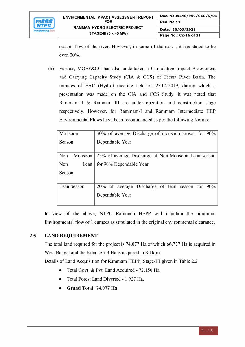
ENVIRONMENTAL IMPACT ASSESSMENT REPORT FOR
RAMMAM HYDRO ELECTRIC PROJECT
STAGE-III (3 x 40 MW)
Doc. No.:9548/999/GEG/S/01
Rev. No.: 1
Date: 30/06/2021
Page No.: C2-16 of 21
2 - 16
season flow of the river. However, in some of the cases, it has stated to be
even 20%.
(b) Further, MOEF&CC has also undertaken a Cumulative Impact Assessment
and Carrying Capacity Study (CIA & CCS) of Teesta River Basin. The
minutes of EAC (Hydro) meeting held on 23.04.2019, during which a
presentation was made on the CIA and CCS Study, it was noted that
Rammam-II & Rammam-III are under operation and construction stage
respectively. However, for Rammam-I and Rammam Intermediate HEP
Environmental Flows have been recommended as per the following Norms:
Monsoon
Season
30% of average Discharge of monsoon season for 90%
Dependable Year
Non Monsoon
Non Lean
Season
25% of average Discharge of Non-Monsoon Lean season
for 90% Dependable Year
Lean Season 20% of average Discharge of lean season for 90%
Dependable Year
In view of the above, NTPC Rammam HEPP will maintain the minimum
Environmental flow of 1 cumecs as stipulated in the original environmental clearance.
2.5 LAND REQUIREMENT
The total land required for the project is 74.077 Ha of which 66.777 Ha is acquired in
West Bengal and the balance 7.3 Ha is acquired in Sikkim.
Details of Land Acquisition for Rammam HEPP, Stage-III given in Table 2.2
Total Govt. & Pvt. Land Acquired - 72.150 Ha.
Total Forest Land Diverted - 1.927 Ha.
Grand Total: 74.077 Ha
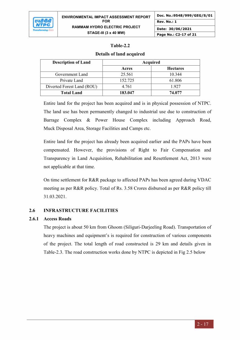
ENVIRONMENTAL IMPACT ASSESSMENT REPORT FOR
RAMMAM HYDRO ELECTRIC PROJECT
STAGE-III (3 x 40 MW)
Doc. No.:9548/999/GEG/S/01
Rev. No.: 1
Date: 30/06/2021
Page No.: C2-17 of 21
2 - 17
Table-2.2
Details of land acquired
Description of Land Acquired
Acres Hectares
Government Land 25.561 10.344
Private Land 152.725 61.806
Diverted Forest Land (ROU) 4.761 1.927
Total Land 183.047 74.077
Entire land for the project has been acquired and is in physical possession of NTPC.
The land use has been permanently changed to industrial use due to construction of
Barrage Complex & Power House Complex including Approach Road,
Muck Disposal Area, Storage Facilities and Camps etc.
Entire land for the project has already been acquired earlier and the PAPs have been
compensated. However, the provisions of Right to Fair Compensation and
Transparency in Land Acquisition, Rehabilitation and Resettlement Act, 2013 were
not applicable at that time.
On time settlement for R&R package to affected PAPs has been agreed during VDAC
meeting as per R&R policy. Total of Rs. 3.58 Crores disbursed as per R&R policy till
31.03.2021.
2.6 INFRASTRUCTURE FACILITIES
2.6.1 Access Roads
The project is about 50 km from Ghoom (Siliguri-Darjeeling Road). Transportation of
heavy machines and equipment’s is required for construction of various components
of the project. The total length of road constructed is 29 km and details given in
Table-2.3. The road construction works done by NTPC is depicted in Fig 2.5 below

ENVIRONMENTAL IMPACT ASSESSMENT REPORT FOR
RAMMAM HYDRO ELECTRIC PROJECT
STAGE-III (3 x 40 MW)
Doc. No.:9548/999/GEG/S/01
Rev. No.: 1
Date: 30/06/2021
Page No.: C2-18 of 21
2 - 18
Table-2.3 Length of Project Roads
Location Length (km) Location Remark Barrage/dam complex
4 Right bank of Rammam (Lodhama Bridge-Adit1-Adit2)
3.7 Km length under construction
Jhepi Adit crossing
11 Along right bank of Jhepi khola
Power house complex
2.7 Along right and left bank of River Rammam
2.0 Km Constructed
Surge shaft complex
11.3 Road from power house to surge shaft
6KM Constructed, WBM & protection measures under progress
Total 29 11.7 km constructed
KHARYA KHOLA BRIDGE (PUL BAZAR)
ROAD FROM POWER HOUSE TO NEJI VIA KHOPRAIL
Fig 2.5 Road Construction Work by NTPC Rammam HEPP

ENVIRONMENTAL IMPACT ASSESSMENT REPORT FOR
RAMMAM HYDRO ELECTRIC PROJECT
STAGE-III (3 x 40 MW)
Doc. No.:9548/999/GEG/S/01
Rev. No.: 1
Date: 30/06/2021
Page No.: C2-19 of 21
2 - 19
2.6.2 Construction Materials and Equipment
Cement, Steel and Aggregates are the main raw materials required for construction of
project components. The aggregates can be easily obtained from nearby feasible
locations, which are acquired by the NTPC Rammam site.
The lists of major equipment being used during construction phase are:
Dozer
Dumpers
Loaders
Transit mixers
Drill jumbos
Rock bolting machine
Compressors
Drilling machines
DG sets
Pneumatic concrete placers
Concrete pumps
Ventilation equipment
Batching plant
Grouting, Guniting and Shotcreting equipment
Crushers, screening plant and rod mill
Mechanized construction has been adopted for almost all types of construction
activities so as to achieve consistent quality at a faster progress rate. Special attention
has been paid to the equipment planning for the underground works since the large
quantities involved and restricted work space coupled with geological constraints and
interdependence of various construction activities make this work very critical.
The sequencing of construction activities, wherever possible, has been attempted in
such a way that equipment from one activity, on its completion can be shifted to the
other. This way, the total requirement of equipment at a time would be reduced and
also, sufficient utilization of equipment on the project would be ensured.
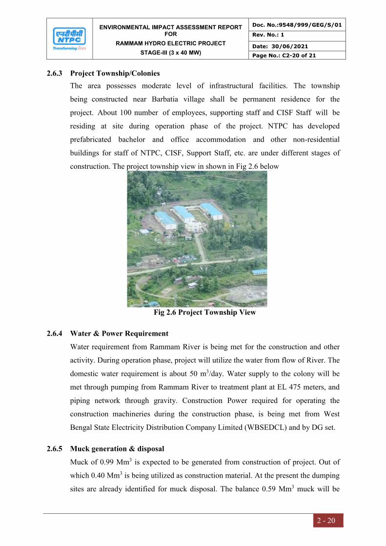
ENVIRONMENTAL IMPACT ASSESSMENT REPORT FOR
RAMMAM HYDRO ELECTRIC PROJECT
STAGE-III (3 x 40 MW)
Doc. No.:9548/999/GEG/S/01
Rev. No.: 1
Date: 30/06/2021
Page No.: C2-20 of 21
2 - 20
2.6.3 Project Township/Colonies
The area possesses moderate level of infrastructural facilities. The township
being constructed near Barbatia village shall be permanent residence for the
project. About 100 number of employees, supporting staff and CISF Staff will be
residing at site during operation phase of the project. NTPC has developed
prefabricated bachelor and office accommodation and other non-residential
buildings for staff of NTPC, CISF, Support Staff, etc. are under different stages of
construction. The project township view in shown in Fig 2.6 below
Fig 2.6 Project Township View
2.6.4 Water & Power Requirement
Water requirement from Rammam River is being met for the construction and other
activity. During operation phase, project will utilize the water from flow of River. The
domestic water requirement is about 50 m3/day. Water supply to the colony will be
met through pumping from Rammam River to treatment plant at EL 475 meters, and
piping network through gravity. Construction Power required for operating the
construction machineries during the construction phase, is being met from West
Bengal State Electricity Distribution Company Limited (WBSEDCL) and by DG set.
2.6.5 Muck generation & disposal
Muck of 0.99 Mm3 is expected to be generated from construction of project. Out of
which 0.40 Mm3 is being utilized as construction material. At the present the dumping
sites are already identified for muck disposal. The balance 0.59 Mm3 muck will be

ENVIRONMENTAL IMPACT ASSESSMENT REPORT FOR
RAMMAM HYDRO ELECTRIC PROJECT
STAGE-III (3 x 40 MW)
Doc. No.:9548/999/GEG/S/01
Rev. No.: 1
Date: 30/06/2021
Page No.: C2-21 of 21
2 - 21
disposed at designated/identified site in a planned manner so that it takes a least
possible space and is not hazardous to the environment.
2.7 MANPOWER REQUIREMENT
The estimated no. of employees during operation phase of the project is estimated to
be about 50. Considering the staff of CISF and support services, it is estimated
that about 100 families will reside in the project township during operation
stage. However, during construction stage, the number of workers are much higher
(about 1000). Temporary labour colonies with amenities like water supply and
sanitation facilities including biodigester has been developed for the construction
phase. Total capacity of Biodigester being installed is 98 KL, cost of supply &
installation is Rs 70 Lakhs.
2.8 PROJECT SCHEDULE & COST ESTIMATES
The project is in advance stage of construction and anticipated completion of its all
three units (i.e. I, II & III) is by December 2026.
Total Cost of the Project is:
o As per EC: Rs. 633.92 Crores
o As per Inv. Approval: Rs. 1,381.84 Crores (2nd Qtr, 2014)

CHAPTER – III
DESCRIPTION OF
ENVIRONMENT

ENVIRONMENTAL IMPACT ASSESSMENT REPORT FOR
RAMMAM HYDRO ELECTRIC PROJECT
STAGE-III (3 x 40 MW)
Doc. No.:9548/999/GEG/S/01
Rev. No.: 1
Date: 30/06/2021
Page No.: C3-1 of 219
3 - 1
CHAPTER-3
DESCRIPTION OF ENVIRONMENT
3.0 INTRODUCTION
This chapter describes the existing environmental and socio-economic baseline for the
project and its surrounding area. Baseline data establishes the present status of the
environment identifies the sensitive receptors in the study area and provides the basis
for assessment of the impacts due to the project, and enabling the development of a
robust and comprehensive environmental management and monitoring plan.
The baseline quality of various components of the environment, viz. air, noise, water,
land, biological, meteorological and socio-economic factors are assessed within the
impact zone of 10 km radius around the project site. Secondary data has also been
incorporated from authentic sources viz. Govt./Non-Governmental Agencies,
Universities, Indian Meteorological Department (IMD), Ground Water Board etc.
Various environmental components were monitored and samples analyzed.
The main purpose & objective of the study is:
To delineate the prevailing environmental condition of project/study area as per
TOR accorded by MoEF&CC for EIA study.
To understand the project need and environmental characteristics of the area.
To assess the existing environmental quality
To identify environmentally significant factors or sensitive geographical
locations.
To generate &/or collect the information of physical-chemical properties of the
environment of the project area, which includes data indicating quality &
prevailing status of air, water resources, soil fertility, noise, flora & fauna,
ecological habitats etc.
To study & generate/prepare the Land Use/Land Cover map, Topographic map,
Cartographic Map of 10 km radial area from the site.
To generate &/or collect details regarding climatic condition of project area.

ENVIRONMENTAL IMPACT ASSESSMENT REPORT FOR
RAMMAM HYDRO ELECTRIC PROJECT
STAGE-III (3 x 40 MW)
Doc. No.:9548/999/GEG/S/01
Rev. No.: 1
Date: 30/06/2021
Page No.: C3-2 of 219
3 - 2
3.1 STUDY AREA
Study area covers 10 km radius from the project site located in Rammam Hydro
Electric Power Project (HEPP), Stage III (3x40 MW) in Darjeeling district of West
Bengal and West Sikkim District of Sikkim.
3.2 STUDY PERIOD
MoEF&CC issued Terms of Reference for the Rammam Hydro Power Project, Stage
III (3x40 MW) vide F.No. J-12011/11/2020-IA-I (R) dated 12th February, 2021 for
preparation of Environmental Impact Assessment with one season basline data for all
the environmental attributes. Environmental baseline monitoring was carried out
during July’ 2020 to September’ 2020 representing monsoon season and used to
identify potential significant impacts. Primary baseline data has been supplemented
with requisite secondary data wherever necessary.
3.3 METHODOLOGY OF EIA STUDY
A. Approach & Methodology of Baseline Study
The methodology for conducting the baseline environmental survey has been obtained
from the guidelines provided in the “Guidance Manual for Environmental Impact
Assessment and Clearance of River Valley Projects” issued by the Ministry of
Environment, Forest and Climate Change (MoEF&CC).
B. Primary Data Collection: Monitoring Plan and Quality Assurance Procedures
The study period and methodology for primary data collection is followed as per the
approved ToR accorded by MoEF&CC. Summary of monitoring plan with sampling
testing methodology followed is summarised in Table 3.1.
Table 3.1
Summary of Methodology for Baseline Data Collection
S. No.
Environmental Attributes
No. of Locations/
Area
Duration and frequency of sampling and other remarks
1. Meteorology Data At one station Meteorology data was collected on an hourly basis for 3 months.
2. Ambient Air Quality 7 Twice a week for 24 hours; for 3 months
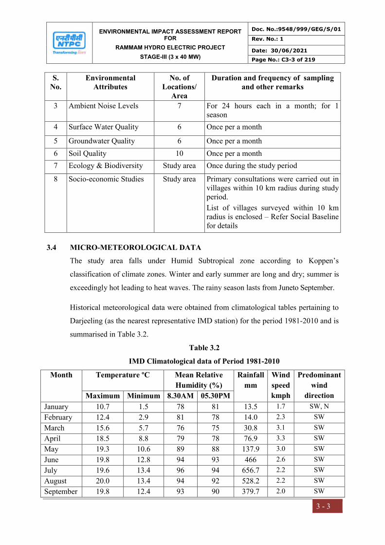
ENVIRONMENTAL IMPACT ASSESSMENT REPORT FOR
RAMMAM HYDRO ELECTRIC PROJECT
STAGE-III (3 x 40 MW)
Doc. No.:9548/999/GEG/S/01
Rev. No.: 1
Date: 30/06/2021
Page No.: C3-3 of 219
3 - 3
S. No.
Environmental Attributes
No. of Locations/
Area
Duration and frequency of sampling and other remarks
3 Ambient Noise Levels 7 For 24 hours each in a month; for 1 season
4 Surface Water Quality 6 Once per a month
5 Groundwater Quality 6 Once per a month
6 Soil Quality 10 Once per a month
7 Ecology & Biodiversity Study area Once during the study period
8 Socio-economic Studies Study area Primary consultations were carried out in villages within 10 km radius during study period.
List of villages surveyed within 10 km radius is enclosed – Refer Social Baseline for details
3.4 MICRO-METEOROLOGICAL DATA
The study area falls under Humid Subtropical zone according to Koppen’s
classification of climate zones. Winter and early summer are long and dry; summer is
exceedingly hot leading to heat waves. The rainy season lasts from Juneto September.
Historical meteorological data were obtained from climatological tables pertaining to
Darjeeling (as the nearest representative IMD station) for the period 1981-2010 and is
summarised in Table 3.2.
Table 3.2
IMD Climatological data of Period 1981-2010
Month Temperature ºC Mean Relative
Humidity (%)
Rainfall
mm
Wind
speed
kmph
Predominant
wind
direction Maximum Minimum 8.30AM 05.30PM
January 10.7 1.5 78 81 13.5 1.7 SW, N
February 12.4 2.9 81 78 14.0 2.3 SW
March 15.6 5.7 76 75 30.8 3.1 SW
April 18.5 8.8 79 78 76.9 3.3 SW
May 19.3 10.6 89 88 137.9 3.0 SW
June 19.8 12.8 94 93 466 2.6 SW
July 19.6 13.4 96 94 656.7 2.2 SW
August 20.0 13.4 94 92 528.2 2.2 SW
September 19.8 12.4 93 90 379.7 2.0 SW

ENVIRONMENTAL IMPACT ASSESSMENT REPORT FOR
RAMMAM HYDRO ELECTRIC PROJECT
STAGE-III (3 x 40 MW)
Doc. No.:9548/999/GEG/S/01
Rev. No.: 1
Date: 30/06/2021
Page No.: C3-4 of 219
3 - 4
October 19.5 10.5 84 84 59.1 1.7 SW
November 17.1 6.3 74 75 14.4 1.6 SW
December 14.0 3.8 75 74 2.9 1.5 SW, N
(Source-IMD Darjeeling)
3.4.1 Wind Speed and Direction
Wind speed is high and found mostly between 1.5 to 3.3 kmph for all the months. The
wind speed during summer recorded is high, and during rainy season, and winter
recorded low. The predominant wind direction is from Southwest (Fig 3.1).
3.4.2 Temperature:
December and January constitutes winter months with daily mean minimum
temperature around 1.5oC. With daily mean maximum temperature around 20.0oC.
August is the hottest month.
3.4.3 Rainfall
The distribution of rainfall in the region, which includes the study area, is regular.
Annual total rainfall in the region is 2380 mm. Over 80% of the total annual rainfall is
received during the monsoon period between June and September.
3.4.4 Site specific Met data
An automatic met station was established at Lodhama village, Darjeeling, West
Bengalto collect the site-specific data.The predominant wind direction was from
southwest direction. Clam conditions remain 11.44% of the time (Table 3.3).
Table 3.3
Site-specific meteorological data
Sl. No.
Parameters July.20 Aug.20 Sep.20
1 Temperature (0C)
Maximum 21.90 21.10 20.50
Minimum 17.10 16.30 15.70
Average 20.04 19.24 18.70
2 Relative Humidity (%)
Maximum 84.20 85.50 82.80
Minimum 55.40 56.70 56.00
Average 68.66 69.96 69.10
3 Wind Speed (m/s)
Maximum 3.80 4.36 4.83
Minimum 0.00 0.00 0.00
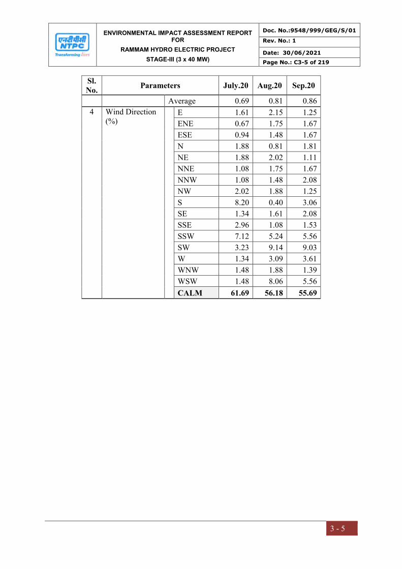
ENVIRONMENTAL IMPACT ASSESSMENT REPORT FOR
RAMMAM HYDRO ELECTRIC PROJECT
STAGE-III (3 x 40 MW)
Doc. No.:9548/999/GEG/S/01
Rev. No.: 1
Date: 30/06/2021
Page No.: C3-5 of 219
3 - 5
Sl. No.
Parameters July.20 Aug.20 Sep.20
Average 0.69 0.81 0.86
4 Wind Direction (%)
E 1.61 2.15 1.25
ENE 0.67 1.75 1.67
ESE 0.94 1.48 1.67
N 1.88 0.81 1.81
NE 1.88 2.02 1.11
NNE 1.08 1.75 1.67
NNW 1.08 1.48 2.08
NW 2.02 1.88 1.25
S 8.20 0.40 3.06
SE 1.34 1.61 2.08
SSE 2.96 1.08 1.53
SSW 7.12 5.24 5.56
SW 3.23 9.14 9.03
W 1.34 3.09 3.61
WNW 1.48 1.88 1.39
WSW 1.48 8.06 5.56
CALM 61.69 56.18 55.69
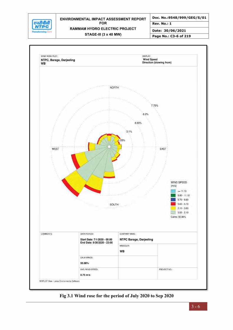
ENVIRONMENTAL IMPACT ASSESSMENT REPORT FOR
RAMMAM HYDRO ELECTRIC PROJECT
STAGE-III (3 x 40 MW)
Doc. No.:9548/999/GEG/S/01
Rev. No.: 1
Date: 30/06/2021
Page No.: C3-6 of 219
3 - 6
Fig 3.1 Wind rose for the period of July 2020 to Sep 2020
ENVIRONMENTAL IMPACT ASSESSMENT REPORT FOR
RAMMAM HYDRO ELECTRIC PROJECT
STAGE-III (3 x 40 MW)
Doc. No.:9548/999/GEG/S/01
Rev. No.: 1
Date: 30/06/2021
Page No.: C3-7 of 219
3 - 7
3.5 AIR ENVIRONMENT
3.5.1 Selection of Sampling Locations: To assess the baseline ambient air quality a
scientifically designed ambient air quality monitoring network was established. Air
quality monitoring study was carried out during pre-monsoon season (i.e. July’20 to
Sep’20) within 10km radius of the project site. The ambient air quality monitoring
stations were selected after a brief study based on the following considerations
Meteorological conditions
Topography of the study area
Predominant wind direction
Emission sources
Receptors sensitivity
Ambient Air Quality Monitoring Stations were set up at seven locations with due
consideration to the above mentioned points. The locations of the sampling stations
are given in the Table 3.5 and the same are shown in the Fig 3.2.
3.5.2 Methodology of Sampling and Analysis
Air samples collected were tested for the following parameters
PM10
PM2.5
Sulphur Dioxide (SO2)
Oxides of Nitrogen (NOx)
Carbon Monoxide (CO)
Ozone (O3)
Lead (Pb)
Ammonia (NH3)
Benzene (C6H6)
Benzo(a)Pyrene (BaP)
Arsenic (As)
Nickel (Ni),
Hydro Carbon HC (Methane and Non Methane)
Volatile Organic Compound (VOC)
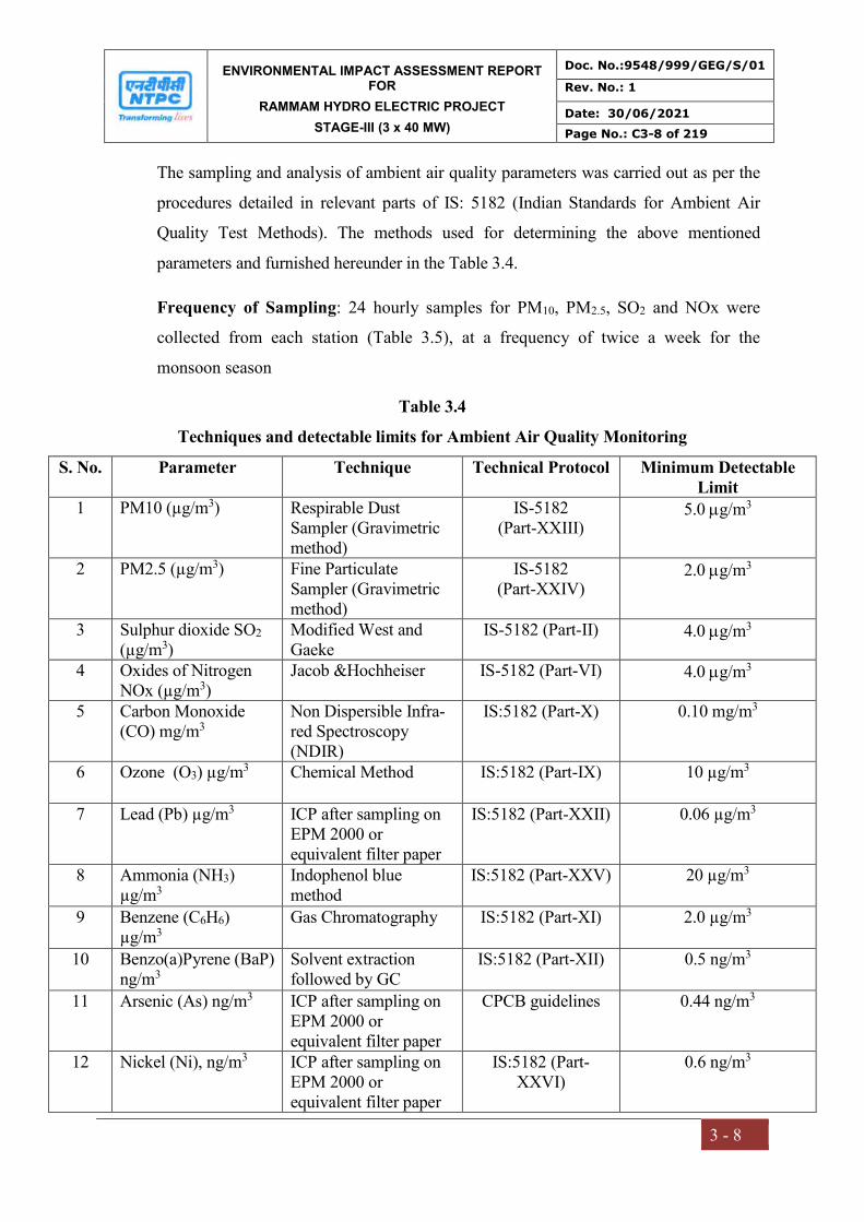
ENVIRONMENTAL IMPACT ASSESSMENT REPORT FOR
RAMMAM HYDRO ELECTRIC PROJECT
STAGE-III (3 x 40 MW)
Doc. No.:9548/999/GEG/S/01
Rev. No.: 1
Date: 30/06/2021
Page No.: C3-8 of 219
3 - 8
The sampling and analysis of ambient air quality parameters was carried out as per the
procedures detailed in relevant parts of IS: 5182 (Indian Standards for Ambient Air
Quality Test Methods). The methods used for determining the above mentioned
parameters and furnished hereunder in the Table 3.4.
Frequency of Sampling: 24 hourly samples for PM10, PM2.5, SO2 and NOx were
collected from each station (Table 3.5), at a frequency of twice a week for the
monsoon season
Table 3.4
Techniques and detectable limits for Ambient Air Quality Monitoring
S. No. Parameter Technique Technical Protocol Minimum Detectable Limit
1 PM10 (µg/m3) Respirable Dust Sampler (Gravimetric method)
IS-5182 (Part-XXIII)
5.0 g/m3
2 PM2.5 (µg/m3) Fine Particulate Sampler (Gravimetric method)
IS-5182 (Part-XXIV)
2.0 g/m3
3 Sulphur dioxide SO2 (µg/m3)
Modified West and Gaeke
IS-5182 (Part-II) 4.0 g/m3
4 Oxides of Nitrogen NOx (µg/m3)
Jacob &Hochheiser IS-5182 (Part-VI) 4.0 g/m3
5 Carbon Monoxide (CO) mg/m3
Non Dispersible Infra-red Spectroscopy (NDIR)
IS:5182 (Part-X) 0.10 mg/m3
6 Ozone (O3) µg/m3 Chemical Method IS:5182 (Part-IX) 10 µg/m3
7 Lead (Pb) µg/m3 ICP after sampling on EPM 2000 or equivalent filter paper
IS:5182 (Part-XXII) 0.06 µg/m3
8 Ammonia (NH3) µg/m3
Indophenol blue method
IS:5182 (Part-XXV) 20 µg/m3
9 Benzene (C6H6) µg/m3
Gas Chromatography IS:5182 (Part-XI) 2.0 µg/m3
10 Benzo(a)Pyrene (BaP) ng/m3
Solvent extraction followed by GC
IS:5182 (Part-XII) 0.5 ng/m3
11 Arsenic (As) ng/m3 ICP after sampling on EPM 2000 or equivalent filter paper
CPCB guidelines 0.44 ng/m3
12 Nickel (Ni), ng/m3 ICP after sampling on EPM 2000 or equivalent filter paper
IS:5182 (Part-XXVI)
0.6 ng/m3

ENVIRONMENTAL IMPACT ASSESSMENT REPORT FOR
RAMMAM HYDRO ELECTRIC PROJECT
STAGE-III (3 x 40 MW)
Doc. No.:9548/999/GEG/S/01
Rev. No.: 1
Date: 30/06/2021
Page No.: C3-9 of 219
3 - 9
13 Hydro Carbon (Methane and Non Methane)
Gas Chromatography IS-5182 (Part-XVII) 0.5 ppm
14 Volatile Organic Compound
GC Method EPA 21 PID 0.5 ppm
Table 3.5
Location of Ambient Air Quality monitoring stations
S. No Location Station
Code
Direction
Distance from
Project Site (km)
Latitude and
Longitude
Environmental
Setting
1 Project Site
A1 -- Near barrage site
27° 6'48.39"N,
88° 8'38.84"E
Industrial Area
2 Lodhoma
A2 SW
2.43 km from
adit-1
27° 6'12.77"N
88° 7'19.44"E
Residential Area
3 Tikpur
A3 NW
3.45 km from
barrage site
27° 8'5.76"N
88° 7'10.03"E
Residential Area
4 Salyangdang
A4 NE
1.03 km from
barrge site
27° 7'11.68"N
88° 9'4.16"E
Residential Area
5 Tharpu
A5 NE
2.90 km from
township
27° 8'37.74"N
88°11'26.02"E
Residential Area
6 Daramdin
A6 NE
3.63 km from
barrage site
27° 8'20.12"N
88° 9'59.85"E
Residential Area
7 Namla
A7 SW
4.39 km from
adit-1
27° 5'42.67"N
88° 6'17.01"E
Residential Area

ENVIRONMENTAL IMPACT ASSESSMENT REPORT FOR
RAMMAM HYDRO ELECTRIC PROJECT
STAGE-III (3 x 40 MW)
Doc. No.:9548/999/GEG/S/01
Rev. No.: 1
Date: 30/06/2021
Page No.: C3-10 of 219
3 - 10
Fig 3.2 Ambient Air Quality Monitoring Location Map

ENVIRONMENTAL IMPACT ASSESSMENT REPORT FOR
RAMMAM HYDRO ELECTRIC PROJECT
STAGE-III (3 x 40 MW)
Doc. No.:9548/999/GEG/S/01
Rev. No.: 1
Date: 30/06/2021
Page No.: C3-11 of 219
3 - 11
Table 3.6 Summary of Ambient Air Quality Analysis
Mon
ito
rin
g L
oca
tion
s
No
of
Sam
ple
s
PM10(µg/m3) PM2.5(µg/m3) SO2(µg/m3) NOx(µg/m3) M
ax
Min
Mea
n
98
pe
rcen
tile
Max
Min
Mea
n
98
pe
rcen
tile
Max
Min
Mea
n
98
pe
rcen
tile
Max
Min
Mea
n
98
pe
rcen
tile
A1 26 54.5 42.3 48.8 54.2 28.1 15.3 21.6 27.6 10.6 8.4 9.5 10.5 11.9 9.3 10.6 11.8
A2 26 48.6 35.6 43.7 48.3 23.5 12.7 17.3 22.6 9.7 7.8 8.8 9.6 10.8 8.3 9.6 10.6
A3 26 52.5 39.6 47.1 52.2 27.3 15.5 20.4 26.2 10.7 8.4 9.6 10.6 12.0 9.3 10.6 11.9
A4 26 66.9 48.5 57.0 65.4 33.0 20.5 27.4 32.6 13.1 9.9 11.7 13.0 14.6 11.7 13.4 14.4
A5 26 55.9 43.7 50.5 55.7 29.8 16.2 22.7 29.1 11.1 8.8 9.9 11.0 12.4 9.7 11.2 12.3
A6 26 53.8 29.0 37.1 47.6 19.5 8.1 12.3 19.0 8.8 6.8 7.5 8.5 9.2 7.2 8.2 9.1
A7 26 63.8 47.7 55.3 62.6 32.4 19.8 26.1 32.1 12.6 9.7 11.3 12.5 13.9 11.0 12.8 13.8
NAAQ Standards
100(µg/m3) 60(µg/m3) 80(µg/m3) 80(µg/m3)

ENVIRONMENTAL IMPACT ASSESSMENT REPORT FOR
RAMMAM HYDRO ELECTRIC PROJECT
STAGE-III (3 x 40 MW)
Doc. No.:9548/999/GEG/S/01
Rev. No.: 1
Date: 30/06/2021
Page No.: C3-12 of 219
3 - 12
Mon
itor
ing
Loc
atio
ns
No
of S
amp
les CO(mg/m3) O3(µg/m3)
Max
Min
Mea
n
98
per
cent
ile
Max
Min
Mea
n
98
per
cent
ile
A1 26 0.18 0.11 0.13 0.17 32.2 16.2 24.4 31.7
A2 26 0.15 0.10 0.11 0.14 30.2 14.2 22.2 29.7
A3 26 0.18 0.10 0.13 0.17 34.2 18.2 25.9 33.2
A4 26 0.30 0.15 0.22 0.29 44.2 26.2 34.7 43.2
A5 26 0.19 0.11 0.14 0.18 35.2 17.2 26.4 34.2
A6 26 0.14 0.10 0.11 0.13 23.2 9.2 16.5 22.7
A7 26 0.29 0.14 0.2 0.27 42.2 23.2 31.6 40.2
NAAQ Standards 4.0mg/m3 at 1hr 180µg/m3 at 1hr
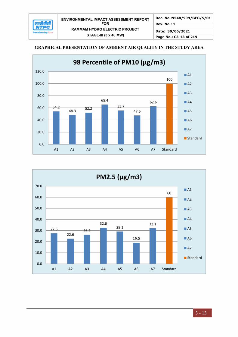
ENVIRONMENTAL IMPACT ASSESSMENT REPORT FOR
RAMMAM HYDRO ELECTRIC PROJECT
STAGE-III (3 x 40 MW)
Doc. No.:9548/999/GEG/S/01
Rev. No.: 1
Date: 30/06/2021
Page No.: C3-13 of 219
3 - 13
GRAPHICAL PRESENTATION OF AMBIENT AIR QUALITY IN THE STUDY AREA
54.248.3
52.2
65.4
55.747.6
62.6
100
0.0
20.0
40.0
60.0
80.0
100.0
120.0
A1 A2 A3 A4 A5 A6 A7 Standard
98 Percentile of PM10 (µg/m3)
A1
A2
A3
A4
A5
A6
A7
Standard
27.6
22.626.2
32.629.1
19.0
32.1
60
0.0
10.0
20.0
30.0
40.0
50.0
60.0
70.0
A1 A2 A3 A4 A5 A6 A7 Standard
PM2.5 (µg/m3)
A1
A2
A3
A4
A5
A6
A7
Standard
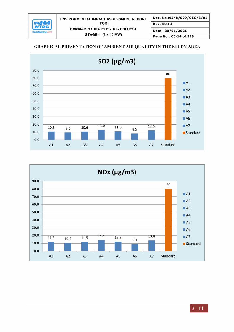
ENVIRONMENTAL IMPACT ASSESSMENT REPORT FOR
RAMMAM HYDRO ELECTRIC PROJECT
STAGE-III (3 x 40 MW)
Doc. No.:9548/999/GEG/S/01
Rev. No.: 1
Date: 30/06/2021
Page No.: C3-14 of 219
3 - 14
GRAPHICAL PRESENTATION OF AMBIENT AIR QUALITY IN THE STUDY AREA
10.5 9.6 10.6 13.0 11.0 8.512.5
80
0.0
10.0
20.0
30.0
40.0
50.0
60.0
70.0
80.0
90.0
A1 A2 A3 A4 A5 A6 A7 Standard
SO2 (µg/m3)
A1
A2
A3
A4
A5
A6
A7
Standard
11.8 10.6 11.914.4 12.3
9.113.8
80
0.0
10.0
20.0
30.0
40.0
50.0
60.0
70.0
80.0
90.0
A1 A2 A3 A4 A5 A6 A7 Standard
NOx (µg/m3)
A1
A2
A3
A4
A5
A6
A7
Standard
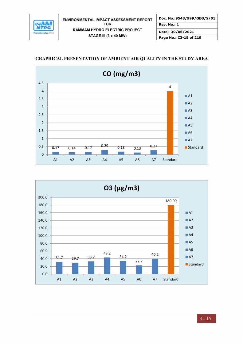
ENVIRONMENTAL IMPACT ASSESSMENT REPORT FOR
RAMMAM HYDRO ELECTRIC PROJECT
STAGE-III (3 x 40 MW)
Doc. No.:9548/999/GEG/S/01
Rev. No.: 1
Date: 30/06/2021
Page No.: C3-15 of 219
3 - 15
GRAPHICAL PRESENTATION OF AMBIENT AIR QUALITY IN THE STUDY AREA
0.17 0.14 0.17 0.29 0.18 0.130.27
4
0
0.5
1
1.5
2
2.5
3
3.5
4
4.5
A1 A2 A3 A4 A5 A6 A7 Standard
CO (mg/m3)
A1
A2
A3
A4
A5
A6
A7
Standard
31.7 29.7 33.243.2
34.222.7
40.2
180.00
0.0
20.0
40.0
60.0
80.0
100.0
120.0
140.0
160.0
180.0
200.0
A1 A2 A3 A4 A5 A6 A7 Standard
O3 (µg/m3)
A1
A2
A3
A4
A5
A6
A7
Standard

ENVIRONMENTAL IMPACT ASSESSMENT REPORT FOR
RAMMAM HYDRO ELECTRIC PROJECT
STAGE-III (3 x 40 MW)
Doc. No.:9548/999/GEG/S/01
Rev. No.: 1
Date: 30/06/2021
Page No.: C3-16 of 219
3 - 16
3.5.3 Summary of Existing Ambient Air Quality
On the perusal of above summary of analysis of ambient air quality in the study area it
is evident that all monitored values in various locations are well within the specified
limits of NAAQS. The results are summarized below:
PM10: The highest PM10 concentration 66.9µg/m3 was observed in the ambient air
was recorded at station A4 while the lowest PM10 concentration was found to be
29.0µg/m3 at A6. All the monitored values of PM10 are well below the specified limit
of 100 µg/m3.
PM2.5: The highest PM2.5 concentration 33.0µg/m3 was observed in the ambient air
was recorded at station A4 while the lowest PM2.5 concentration was found to be
8.1µg/m3 at A6. All the monitored values of PM2.5 are well below the specified limit
of 60µg/m3.
SO2: The highest SO2 concentration 13.1µg/m3 was observed in the ambient air was
recorded at station A4 while the lowest SO2 concentration was found to be 6.8µg/m3
at A6. All the monitored values of SO2 are well below the specified limit of 80 µg/m3.
NOx: The highest NOx concentration 14.6µg/m3was observed in the ambient air was
recorded at station A4 while the lowest NOx concentration was found to be 7.2µg/m3
at A6. All the monitored values of NOx are well below the specified limit of 80µg/m3.
CO: The highest CO concentration 0.30mg/m3was observed in the ambient air was
recorded at station A4 while the lowest CO concentration was found to be
<0.10mg/m3 at A6. All the monitored values of CO are well below the specified limit
of 4.0mg/m3.
OZONE (O3): The highest O3 concentration 44.2µg/m3 was observed in the ambient
air was recorded at station A4 while the lowest O3 concentration was found to be
9.2µg/m3 at A6. All the monitored values of O3 are well below the specified limit of
180µg/m3.
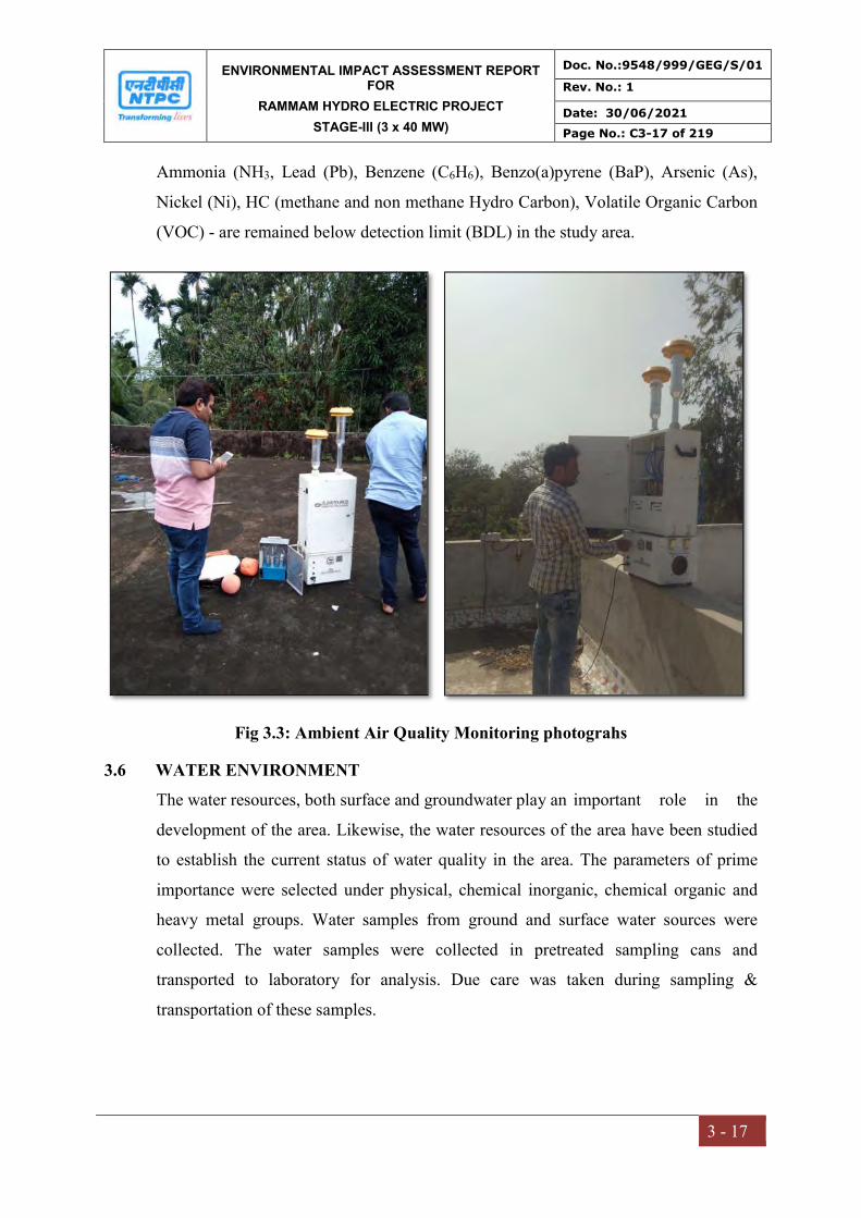
ENVIRONMENTAL IMPACT ASSESSMENT REPORT FOR
RAMMAM HYDRO ELECTRIC PROJECT
STAGE-III (3 x 40 MW)
Doc. No.:9548/999/GEG/S/01
Rev. No.: 1
Date: 30/06/2021
Page No.: C3-17 of 219
3 - 17
Ammonia (NH3, Lead (Pb), Benzene (C6H6), Benzo(a)pyrene (BaP), Arsenic (As),
Nickel (Ni), HC (methane and non methane Hydro Carbon), Volatile Organic Carbon
(VOC) - are remained below detection limit (BDL) in the study area.
Fig 3.3: Ambient Air Quality Monitoring photograhs
3.6 WATER ENVIRONMENT
The water resources, both surface and groundwater play an important role in the
development of the area. Likewise, the water resources of the area have been studied
to establish the current status of water quality in the area. The parameters of prime
importance were selected under physical, chemical inorganic, chemical organic and
heavy metal groups. Water samples from ground and surface water sources were
collected. The water samples were collected in pretreated sampling cans and
transported to laboratory for analysis. Due care was taken during sampling &
transportation of these samples.
ENVIRONMENTAL IMPACT ASSESSMENT REPORT FOR
RAMMAM HYDRO ELECTRIC PROJECT
STAGE-III (3 x 40 MW)
Doc. No.:9548/999/GEG/S/01
Rev. No.: 1
Date: 30/06/2021
Page No.: C3-18 of 219
3 - 18
3.6.1 Surface Water and Ground Water Quality Assessment
In order to assess water quality impacts surface water and ground water samples are
collected from the surrounding villages. The samples analyzed for various physical
and chemical parameters to know the contamination levels and compared as per the IS
Standards.
1. Ground water quality --- IS 10500-2012
2. Surface/canal/sea water quality --- IS 2296
3.6.2 Selection of sampling locations
Sampling locations (Table 3.9 & 3.10) were selected on basis of:
a) Drainage pattern
b) Location of residential areas respecting different activities
c) Likely areas those can represent baseline conditions
Samples for bacteriological analysis were collected in sterilized glass bottles. Selected
physico-chemical and bacteriological parameters have been analyzed for projecting
the existing water quality status in the study area. Water sampling locations are shown
in Fig 3.5.
The samples were analyzed in accordance with “Standard Methods for Examination
of Water and Wastewater Analysis” published by APHA.
3.6.3 Sampling techniques
Samples for chemical analysis were collected in polyethylene carboys. Samples
collected for metal content were acidified with 1 ml HNO3. Samples
forbacteriological analysis were collected in sterilized glass bottles. Selected physico-
chemical and bacteriological parameters have been analyzed for projecting the
existing water quality status in the study area. Parameters like temperature, Dissolved
Oxygen (DO) and pH were analyzed at the time of sample collection.
The methodology for sample collection and preservation techniques was followed as
per the Standard Operating Procedures (SOP) mentioned in Table 3.7.

ENVIRONMENTAL IMPACT ASSESSMENT REPORT FOR
RAMMAM HYDRO ELECTRIC PROJECT
STAGE-III (3 x 40 MW)
Doc. No.:9548/999/GEG/S/01
Rev. No.: 1
Date: 30/06/2021
Page No.: C3-19 of 219
3 - 19
Table 3.7
Standard Operating Procedures (SOP) for water sampling
Parameter Sample Collection Sample Size Storage/ Preservation
pH Grab sampling
Plastic /glass container
50 ml On site analysis
Electrical
Conductivity
Grab sampling
Plastic /glass container
50 ml On site parameter
Total suspended
solids
Grab sampling
Plastic /glass container
100 ml Refrigeration,
can be stored for 7 days
Total Dissolved
Solids
Grab sampling
Plastic /glass container
100 ml Refrigeration,
can be stored for 7 days
BOD Grab sampling
Plastic /glass container
500 ml Refrigeration, 48 hrs
Hardness Grab sampling
Plastic /glass container
100 ml Add HNO3 to pH<2,
refrigeration; 6 months
Chlorides Grab sampling
Plastic /glass container
50 ml Not required; 28 days
Sulphates Grab sampling
Plastic /glass container
100 ml Refrigeration; 28 days
Nitrates Plastic containers 100 ml Refrigeration; 48 hrs
Fluorides Plastic containers only 100 ml Not required; 28 days
Alkalinity Plastic/ glass containers 100 ml Refrigeration; 14 days
Ammonia Plastic/ glass containers 100 ml Add H2SO4 to pH>2,
refrigeration, 28 days
Heavy Metals (As,
Cd, Mn, Cu, Fe,
Zn, Pb etc.)
Plastic/ Glass rinse with
1+1 HNO3
500 ml Filter, add HNO3 to pH>2;
Grab sample; 6 months
Analytical Techniques
The analytical techniques used for water analysis is given in the Table 3.8.
Table 3.8
Analytical techniques for water analysis
Parameter Method
pH APHA-4500-H+
Colour APHA-2120 C
Odour IS: 3025, Part-4
Temperature APHA-2550 B
Dissolved Oxygen APHA-4500 O
BOD APHA-5210 B

ENVIRONMENTAL IMPACT ASSESSMENT REPORT FOR
RAMMAM HYDRO ELECTRIC PROJECT
STAGE-III (3 x 40 MW)
Doc. No.:9548/999/GEG/S/01
Rev. No.: 1
Date: 30/06/2021
Page No.: C3-20 of 219
3 - 20
Parameter Method
Electrical conductivity APHA-2510 B
Turbidity APHA-2130 B
Chlorides APHA-4500 Cl-
Fluorides APHA-4500 F-
Total dissolved solids APHA-2540 C
Total suspended solids APHA-2540 D
Total hardness APHA-2340 C
Sulphates APHA-4500 SO4-2
Arsenic APHA-3120 B/ APHA-3114 B/ APHA-3500 As
Calcium APHA-3120 B/ APHA-3500 Ca
Magnesium APHA-3120 B/ APHA-3500 Mg
Sodium APHA-3120 B/ APHA-3500 Na
Potassium APHA-3120 B/ APHA-3500 K
Manganese APHA-3120 B/ APHA-3500 Mn
Mercury APHA-3112 B/ APHA-3500 Hg
Lead APHA-3120 B/ APHA-3500 Pb
Copper APHA-3120 B/ APHA-3500 Cu
Cadmium APHA-3120 B/ APHA-3500 Cd
Iron APHA-3120 B/ APHA-3500 Fe
Zinc APHA-3120 B/ APHA-3500 Zn
Boron APHA-4500 B
Coliform organisms APHA-9215 D
Alkalinity APHA-2320 B
COD APHA-5220 D
Phenolic Compounds APHA-510 C
Nitrates APHA 22nd Edition -4500- NO3- B
Residual Chlorine IS : 3025 Part 32-1988 (Reaff: 2014)
Total kjeldal Nitrogen APHA 22nd Edition -4500- NH3 B&C
Dissolved phosphates IS : 3025 Part 31-1988 (Reaff:2014)
Hexavalent Chromium Cr+6 APHA-3120 B/ APHA-3500 Cr+6
Aluminum APHA-3120 B/ APHA-3500 Al
Ionic Detergents IS : 3025 Part 23- 1986 (Reaff:2012)
Barium APHA-3120 B/ APHA-3500 Ba
SAR Calculation
Free Ammonia APHA 22nd Edition -4500- NH3 B&C
Salinity APHA 22nd Edition -2520 B
Source: Standard Methods for the Examination of Water and Wastewater, Published By APHA,
AWWA, WEF 23rd Edition, 2017

ENVIRONMENTAL IMPACT ASSESSMENT REPORT FOR
RAMMAM HYDRO ELECTRIC PROJECT
STAGE-III (3 x 40 MW)
Doc. No.:9548/999/GEG/S/01
Rev. No.: 1
Date: 30/06/2021
Page No.: C3-21 of 219
3 - 21
3.6.4 Water Sampling Stations
Table 3.9
Ground water sampling locations
Code Station Direction Distance in km Latitude & Longitude
Source of collection
GW1 Namla
SW 4.26 km from
barrage site
27° 5'51.97"N
88° 6'17.02"E Tube well
GW2 Lodhoma
SW 2.2 km from
barrage site
27° 6'13.69"N
88° 7'28.41"E Tube well
GW3 Kankiabong
SE 1.87 km from
adit-1
27° 5'52.50"N
88° 9'8.14"E Bore well
GW4 Salyandang
NE 0.97 km from
barrage site
27° 7'14.45"N
88° 8'56.70"E Bore well
GW5 Daramdin
NE 3.4 from from
barrage site
27° 8'8.63"N
88°10'2.12"E Tube well
GW6 Rammam sub
station NE
0.66 km from
barrage site
27° 7'6.93"N
88° 8'48.13"E
Bore well
Table 3.10
Surface water sampling locations
Code Station Direction Distance in km Latitude & Longitude
Source of collection
SW1
(Upstream) Tikpur NW
1.93 km from
barrage site
27° 7'17.01"N
88° 7'37.14"E
River
SW2(Down
stream Longchok NE
2.04 km from
adit-1
27° 7'0.17"N
88° 9'51.70"E
River
SW3 Daramdin Bazar
NE 4.15 km from
barrage site
27° 8'32.29"N
88°10'13.05"E
Surface Water
SW4 Bansbotay Bazar
SW 5.78 from adit-1 27° 5'2.10"N
88° 5'45.16"E
Surface Water
SW5 Lodhoma
SW 2.27 km from
barrage site
27° 6'17.28"N
88° 7'23.47"E
Surface Water
SW6 NTPC Township
NE Near township 27° 7'49.22"N
88°13'3.00"E River

ENVIRONMENTAL IMPACT ASSESSMENT REPORT FOR
RAMMAM HYDRO ELECTRIC PROJECT
STAGE-III (3 x 40 MW)
Doc. No.:9548/999/GEG/S/01
Rev. No.: 1
Date: 30/06/2021
Page No.: C3-22 of 219
3 - 22
Fig 3.4 Groundwater sampling location map

ENVIRONMENTAL IMPACT ASSESSMENT REPORT FOR
RAMMAM HYDRO ELECTRIC PROJECT
STAGE-III (3 x 40 MW)
Doc. No.:9548/999/GEG/S/01
Rev. No.: 1
Date: 30/06/2021
Page No.: C3-23 of 219
3 - 23
Fig 3.5 Surface water sampling location map

ENVIRONMENTAL IMPACT ASSESSMENT REPORT FOR
RAMMAM HYDRO ELECTRIC PROJECT
STAGE-III (3 x 40 MW)
Doc. No.:9548/999/GEG/S/01
Rev. No.: 1
Date: 30/06/2021
Page No.: C3-24 of 219
3 - 24
Fig 3.6 Water sampling photographs
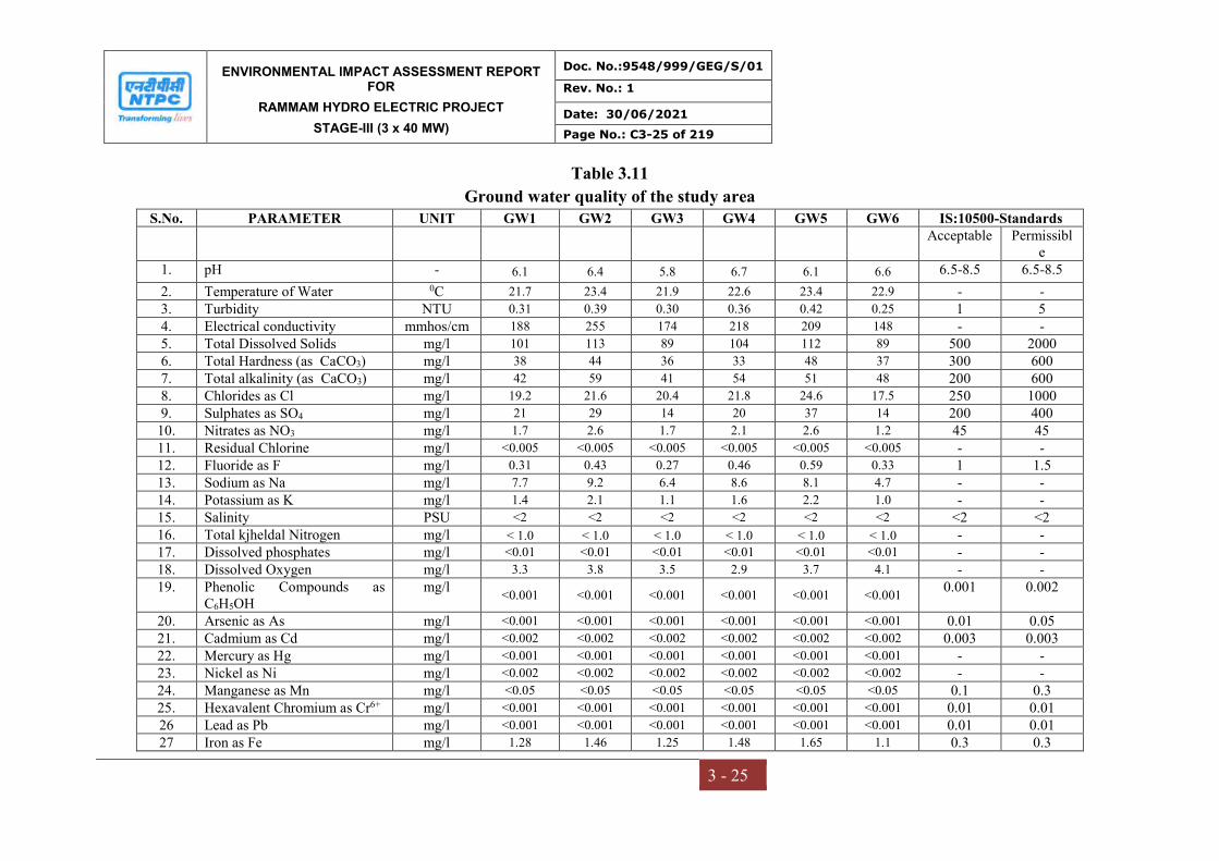
ENVIRONMENTAL IMPACT ASSESSMENT REPORT FOR
RAMMAM HYDRO ELECTRIC PROJECT
STAGE-III (3 x 40 MW)
Doc. No.:9548/999/GEG/S/01
Rev. No.: 1
Date: 30/06/2021
Page No.: C3-25 of 219
3 - 25
Table 3.11
Ground water quality of the study area S.No. PARAMETER UNIT GW1 GW2 GW3 GW4 GW5 GW6 IS:10500-Standards
Acceptable Permissible
1. pH - 6.1 6.4 5.8 6.7 6.1 6.6 6.5-8.5 6.5-8.5
2. Temperature of Water 0C 21.7 23.4 21.9 22.6 23.4 22.9 - - 3. Turbidity NTU 0.31 0.39 0.30 0.36 0.42 0.25 1 5 4. Electrical conductivity mmhos/cm 188 255 174 218 209 148 - - 5. Total Dissolved Solids mg/l 101 113 89 104 112 89 500 2000 6. Total Hardness (as CaCO3) mg/l 38 44 36 33 48 37 300 600 7. Total alkalinity (as CaCO3) mg/l 42 59 41 54 51 48 200 600 8. Chlorides as Cl mg/l 19.2 21.6 20.4 21.8 24.6 17.5 250 1000 9. Sulphates as SO4 mg/l 21 29 14 20 37 14 200 400
10. Nitrates as NO3 mg/l 1.7 2.6 1.7 2.1 2.6 1.2 45 45 11. Residual Chlorine mg/l <0.005 <0.005 <0.005 <0.005 <0.005 <0.005 - - 12. Fluoride as F mg/l 0.31 0.43 0.27 0.46 0.59 0.33 1 1.5 13. Sodium as Na mg/l 7.7 9.2 6.4 8.6 8.1 4.7 - - 14. Potassium as K mg/l 1.4 2.1 1.1 1.6 2.2 1.0 - - 15. Salinity PSU <2 <2 <2 <2 <2 <2 <2 <2 16. Total kjheldal Nitrogen mg/l < 1.0 < 1.0 < 1.0 < 1.0 < 1.0 < 1.0 - - 17. Dissolved phosphates mg/l <0.01 <0.01 <0.01 <0.01 <0.01 <0.01 - - 18. Dissolved Oxygen mg/l 3.3 3.8 3.5 2.9 3.7 4.1 - - 19. Phenolic Compounds as
C6H5OH mg/l
<0.001 <0.001 <0.001 <0.001 <0.001 <0.001 0.001 0.002
20. Arsenic as As mg/l <0.001 <0.001 <0.001 <0.001 <0.001 <0.001 0.01 0.05 21. Cadmium as Cd mg/l <0.002 <0.002 <0.002 <0.002 <0.002 <0.002 0.003 0.003 22. Mercury as Hg mg/l <0.001 <0.001 <0.001 <0.001 <0.001 <0.001 - - 23. Nickel as Ni mg/l <0.002 <0.002 <0.002 <0.002 <0.002 <0.002 - - 24. Manganese as Mn mg/l <0.05 <0.05 <0.05 <0.05 <0.05 <0.05 0.1 0.3 25. Hexavalent Chromium as Cr6+ mg/l <0.001 <0.001 <0.001 <0.001 <0.001 <0.001 0.01 0.01 26 Lead as Pb mg/l <0.001 <0.001 <0.001 <0.001 <0.001 <0.001 0.01 0.01 27 Iron as Fe mg/l 1.28 1.46 1.25 1.48 1.65 1.1 0.3 0.3
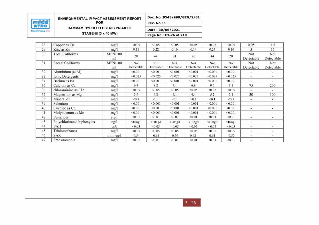
ENVIRONMENTAL IMPACT ASSESSMENT REPORT FOR
RAMMAM HYDRO ELECTRIC PROJECT
STAGE-III (3 x 40 MW)
Doc. No.:9548/999/GEG/S/01
Rev. No.: 1
Date: 30/06/2021
Page No.: C3-26 of 219
3 - 26
28 Copper as Cu mg/l <0.05 <0.05 <0.05 <0.05 <0.05 <0.05 0.05 1.5 29 Zinc as Zn mg/l 0.11 0.22 0.10 0.14 0.24 0.10 5 15 30 Total Coliforms MPN/100
ml 28 44 31 26 44 20
Not Detectable
Not Detectable
31 Faecal Coliforms MPN/100 ml
Not Detectable
Not Detectable
Not Detectable
Not Detectable
Not Detectable
Not Detectable
Not Detectable
Not Detectable
32 Aluminium (asAl) mg/l <0.001 <0.001 <0.001 <0.001 <0.001 <0.001 - - 33 Ionic Detergents mg/l <0.025 <0.025 <0.025 <0.025 <0.025 <0.025 - - 34 Barium as Ba mg/l <0.001 <0.001 <0.001 <0.001 <0.001 <0.001 - - 35 Calcium as Ca mg/l 6.4 8.2 7.1 6.9 9.5 8.1 75 200 36 chloraminine as Cl2 mg/l <0.05 <0.05 <0.05 <0.05 <0.05 <0.05 - - 37 Magnesium as Mg mg/l 3.9 4.8 4.1 4.4 5.2 3.1 30 100 38 Mineral oil mg/l <0.1 <0.1 <0.1 <0.1 <0.1 <0.1 - - 39 Selenium mg/l <0.001 <0.001 <0.001 <0.001 <0.001 <0.001 - - 40 Cyanide as Cn mg/l <0.001 <0.001 <0.001 <0.001 <0.001 <0.001 - - 41 Molybdenum as Mo mg/l <0.001 <0.001 <0.001 <0.001 <0.001 <0.001 - - 42 Pesticides µg/l <0.01 <0.01 <0.01 <0.01 <0.01 <0.01 - - 43 Polychlorinated biphenyles ng/l <10ng/l <10ng/l <10ng/l <10ng/l <10ng/l <10ng/l - - 44 PAH ppb <0.05 <0.05 <0.05 <0.05 <0.05 <0.05 - - 45 Trialomethanes mg/l <0.05 <0.05 <0.05 <0.05 <0.05 <0.05 - - 46 SAR milli eq/l 0.54 0.61 0.59 0.62 0.61 0.52 - - 47 Free ammonia mg/l <0.01 <0.01 <0.01 <0.01 <0.01 <0.01 - -

ENVIRONMENTAL IMPACT ASSESSMENT REPORT FOR
RAMMAM HYDRO ELECTRIC PROJECT
STAGE-III (3 x 40 MW)
Doc. No.:9548/999/GEG/S/01
Rev. No.: 1
Date: 30/06/2021
Page No.: C3-27 of 219
3 - 27
Table 3.12
Surface water quality of the study area S. No PARAMETER UNIT SW1 SW2 SW3 SW4 SW5 SW6 IS:2296 –
Standards 1. Color Hazen <1 <1 <1 <1 <1 <1 <1 2. Odour - Agreeable Agreeable Agreeable Agreeable Agreeable Agreeable - 3. Taste - Taste less Taste less Taste less Taste less Taste less Taste less - 4. pH - 6.8 6.8 7.0 6.9 7.1 7.2 6.50 – 8.50 5. Temperature of Water 0C 22.8 21.9 23.3 24.1 23.4 23.9 - 6. Turbidity NTU 2.2 2.6 2.8 1.9 2.7 2.4 - 7. Electrical conductivity mmhos/c
m 138 144 149 121 141 126
-
8. Total Dissolved Solids mg/l 79 84 77 86 74 71 1500 9. Total Hardness (as CaCO3) mg/l 24 26 29 31 36 26 - 10. Total alkalinity (as CaCO3) mg/l 39 43 46 40 45 39 - 11. Chlorides as Cl mg/l 7.7 7.9 8.1 7.2 7.7 8.2 600 12. Sulphates as SO4 mg/l 1.1 1.3 1.6 1.0 1.4 1.2 400 13. Nitrates as NO3 mg/l 0.16 0.18 0.28 0.14 0.24 0.31 50 14. Residual Chlorine mg/l ND ND ND ND ND ND - 15. Fluoride as F mg/l 0.31 0.32 0.34 0.28 0.33 0.29 1.5 16. Sodium as Na mg/l 3.1 3.6 4.1 2.9 3.3 3.8 - 17. Potassium as K mg/l 4.4 4.8 5.6 4.7 5.9 5.5 - 18. Salinity PSU 2.1 1.8 1.1 1.6 1.2 1.4 - 19. Total kjheldal Nitrogen mg/l <1.0 <1.0 <1.0 <1.0 <1.0 <1.0 - 20. Dissolved phosphates mg/l <0.001 <0.001 <0.001 <0.001 <0.001 <0.001 - 21. Dissolved Oxygen mg/l 5.2 5.8 5.6 5.1 5.8 6.1 5.0 min
22. Biochemical Oxygen Demand mg/l 1.0 1.1 1.2 1.0 1.2 1.3 3 23. Chemical Oxygen Demand mg/l 2.9 3.1 3.3 3.1 2.8 3.2 - 24. Phenolic Compounds as
C6H5OH mg/l
<0.001 <0.001 <0.001 <0.001 <0.001 <0.001 0.005
25. Arsenic as As mg/l <0.001 <0.001 <0.001 <0.001 <0.001 <0.001 - 26. Cadmium as Cd mg/l <0.002 <0.002 <0.002 <0.002 <0.002 <0.002 - 27. Mercury as Hg mg/l <0.001 <0.001 <0.001 <0.001 <0.001 <0.001 -
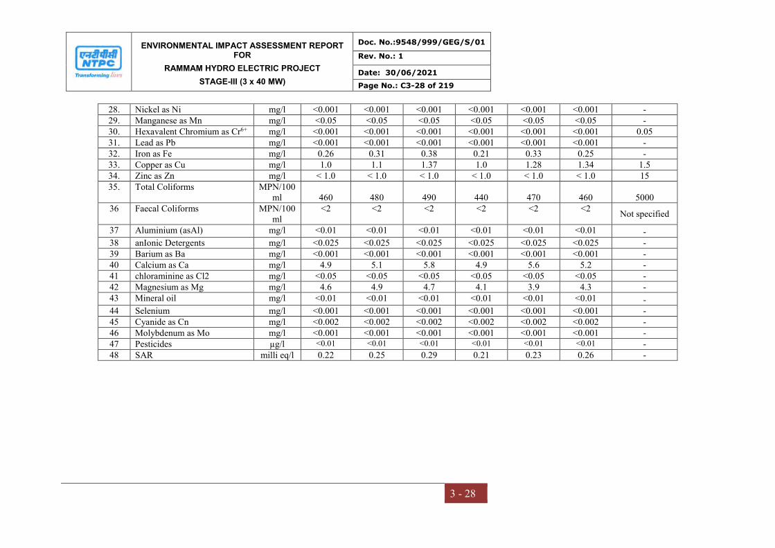
ENVIRONMENTAL IMPACT ASSESSMENT REPORT FOR
RAMMAM HYDRO ELECTRIC PROJECT
STAGE-III (3 x 40 MW)
Doc. No.:9548/999/GEG/S/01
Rev. No.: 1
Date: 30/06/2021
Page No.: C3-28 of 219
3 - 28
28. Nickel as Ni mg/l <0.001 <0.001 <0.001 <0.001 <0.001 <0.001 - 29. Manganese as Mn mg/l <0.05 <0.05 <0.05 <0.05 <0.05 <0.05 - 30. Hexavalent Chromium as Cr6+ mg/l <0.001 <0.001 <0.001 <0.001 <0.001 <0.001 0.05 31. Lead as Pb mg/l <0.001 <0.001 <0.001 <0.001 <0.001 <0.001 - 32. Iron as Fe mg/l 0.26 0.31 0.38 0.21 0.33 0.25 - 33. Copper as Cu mg/l 1.0 1.1 1.37 1.0 1.28 1.34 1.5 34. Zinc as Zn mg/l < 1.0 < 1.0 < 1.0 < 1.0 < 1.0 < 1.0 15 35. Total Coliforms MPN/100
ml 460 480 490 440 470 460 5000 36 Faecal Coliforms MPN/100
ml <2 <2 <2 <2 <2 <2
Not specified
37 Aluminium (asAl) mg/l <0.01 <0.01 <0.01 <0.01 <0.01 <0.01 - 38 anIonic Detergents mg/l <0.025 <0.025 <0.025 <0.025 <0.025 <0.025 - 39 Barium as Ba mg/l <0.001 <0.001 <0.001 <0.001 <0.001 <0.001 - 40 Calcium as Ca mg/l 4.9 5.1 5.8 4.9 5.6 5.2 - 41 chloraminine as Cl2 mg/l <0.05 <0.05 <0.05 <0.05 <0.05 <0.05 - 42 Magnesium as Mg mg/l 4.6 4.9 4.7 4.1 3.9 4.3 - 43 Mineral oil mg/l <0.01 <0.01 <0.01 <0.01 <0.01 <0.01 - 44 Selenium mg/l <0.001 <0.001 <0.001 <0.001 <0.001 <0.001 - 45 Cyanide as Cn mg/l <0.002 <0.002 <0.002 <0.002 <0.002 <0.002 - 46 Molybdenum as Mo mg/l <0.001 <0.001 <0.001 <0.001 <0.001 <0.001 - 47 Pesticides µg/l <0.01 <0.01 <0.01 <0.01 <0.01 <0.01 - 48 SAR milli eq/l 0.22 0.25 0.29 0.21 0.23 0.26 -
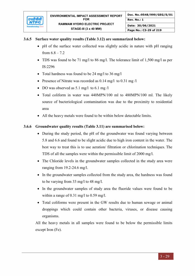
ENVIRONMENTAL IMPACT ASSESSMENT REPORT FOR
RAMMAM HYDRO ELECTRIC PROJECT
STAGE-III (3 x 40 MW)
Doc. No.:9548/999/GEG/S/01
Rev. No.: 1
Date: 30/06/2021
Page No.: C3-29 of 219
3 - 29
3.6.5 Surface water quality results (Table 3.12) are summarized below:
pH of the surface water collected was slightly acidic in nature with pH ranging
from 6.8 – 7.2
TDS was found to be 71 mg/l to 86 mg/l. The tolerance limit of 1,500 mg/l as per
IS:2296
Total hardness was found to be 24 mg/l to 36 mg/l
Presence of Nitrate was recorded as 0.14 mg/l to 0.31 mg /l
DO was observed as 5.1 mg/l to 6.1 mg /l
Total coliform in water was 440MPN/100 ml to 480MPN/100 ml. The likely
source of bacteriological contamination was due to the proximity to residential
area
All the heavy metals were found to be within below detectable limits.
3.6.6 Groundwater quality results (Table 3.11) are summarised below:
During the study period, the pH of the groundwater was found varying between
5.8 and 6.6 and found to be slight acidic due to high iron content in the water. The
best way to treat this is to use aeration/ filtration or chlorination techniques. The
TDS of all the samples were within the permissible limit of 2000 mg/l.
The Chloride levels in the groundwater samples collected in the study area were
ranging from 19.2-24.6 mg/l.
In the groundwater samples collected from the study area, the hardness was found
to be varying from 33 mg/l to 48 mg/l.
In the groundwater samples of study area the fluoride values were found to be
within a range of 0.31 mg/l to 0.59 mg/l.
Total coliforms were present in the GW results due to human sewage or animal
droppings which could contain other bacteria, viruses, or disease causing
organisms.
All the heavy metals in all samples were found to be below the permissible limits
except Iron (Fe).

ENVIRONMENTAL IMPACT ASSESSMENT REPORT FOR
RAMMAM HYDRO ELECTRIC PROJECT
STAGE-III (3 x 40 MW)
Doc. No.:9548/999/GEG/S/01
Rev. No.: 1
Date: 30/06/2021
Page No.: C3-30 of 219
3 - 30
3.7 SOIL ENVIRONMENT
3.7.1 Selection of sampling locations
For studying soil profile of the region, sampling locations were selected to assess the
existing overall soil conditions around the project site. The study of the soil profile
establishes the baseline characteristics and this will help in future for identifying the
incremental concentrations if any, due to the project. The sampling locations have
been identified with following objectives.
a) To determine the baseline soil characteristics of the study area
b) To determine the impact of the project activities on soil characteristics
3.7.2 Sampling and analytical techniques
Ten sampling locations were selected to assess the existing soil conditions
representing various land use conditions and geological features. At each location,
soil samples were collected from three different depths viz. 30 cm, 60 cm and 90 cm
below the surface and are homogenized. This is in line with IS: 2720 & Methods of
Soil Analysis, Part-1, 2nd edition, 1986 of (American Society for Agronomy and Soil
Science Society of America). The homogenized samples were analyzed for physical
and chemical characteristics. The soil samples were collected at different locations
(Table 3.14).The samples have been analyzed as per the established scientific
methods for physico-chemical parameters. Soil sampling locations are shown in
Figure 3.7. The methodology adopted for each parameter is described in Table 3.13.
Table 3.13
Analytical techniques for Soil analysis
Parameter Method (ASTM number)
Textural classification Chart developed by Public Roads
Administration
pH pH meter (D 1293-84)
Electrical conductivity Conductivity meter (D 1125-82)
Nitrogen Kjeldahl distillation (D 3590-84)
Phosphorus Molybdenum blue, calorimetric (D 515-82)
Potassium Flame photometric (D 1428-82)
Sodium Flame photometric (D 1428-82)
Calcium IS:2720
Magnesium IS:2720
Chlorides Argentometric (D 512-81 Rev 85)
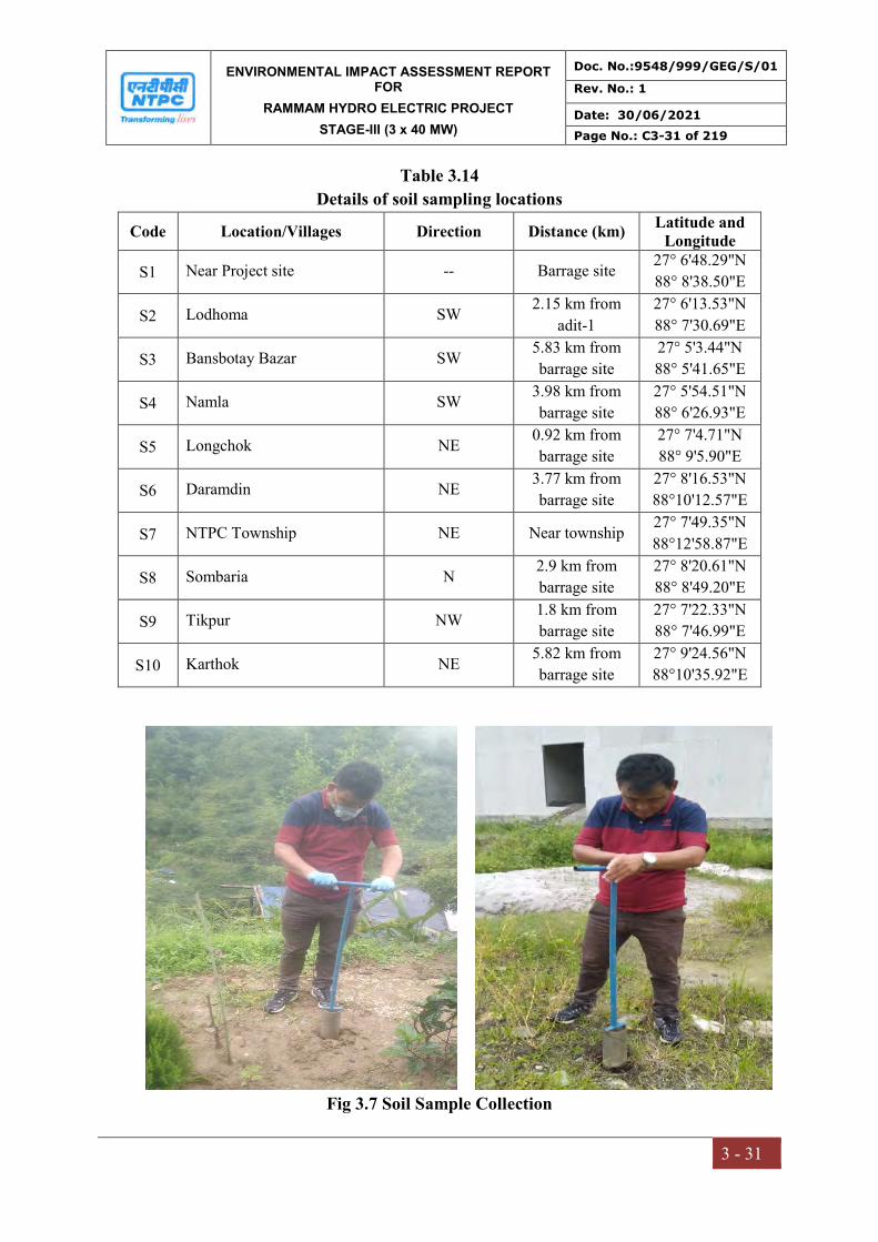
ENVIRONMENTAL IMPACT ASSESSMENT REPORT FOR
RAMMAM HYDRO ELECTRIC PROJECT
STAGE-III (3 x 40 MW)
Doc. No.:9548/999/GEG/S/01
Rev. No.: 1
Date: 30/06/2021
Page No.: C3-31 of 219
3 - 31
Table 3.14
Details of soil sampling locations
Code Location/Villages Direction Distance (km) Latitude and
Longitude
S1 Near Project site -- Barrage site 27° 6'48.29"N
88° 8'38.50"E
S2 Lodhoma SW 2.15 km from
adit-1
27° 6'13.53"N
88° 7'30.69"E
S3 Bansbotay Bazar SW 5.83 km from
barrage site
27° 5'3.44"N
88° 5'41.65"E
S4 Namla SW 3.98 km from
barrage site
27° 5'54.51"N
88° 6'26.93"E
S5 Longchok NE 0.92 km from
barrage site
27° 7'4.71"N
88° 9'5.90"E
S6 Daramdin NE 3.77 km from
barrage site
27° 8'16.53"N
88°10'12.57"E
S7 NTPC Township NE Near township 27° 7'49.35"N
88°12'58.87"E
S8 Sombaria N 2.9 km from
barrage site
27° 8'20.61"N
88° 8'49.20"E
S9 Tikpur NW 1.8 km from
barrage site
27° 7'22.33"N
88° 7'46.99"E
S10 Karthok NE 5.82 km from
barrage site
27° 9'24.56"N
88°10'35.92"E
Fig 3.7 Soil Sample Collection

ENVIRONMENTAL IMPACT ASSESSMENT REPORT FOR
RAMMAM HYDRO ELECTRIC PROJECT
STAGE-III (3 x 40 MW)
Doc. No.:9548/999/GEG/S/01
Rev. No.: 1
Date: 30/06/2021
Page No.: C3-32 of 219
3 - 32
Fig 3.8 Soil sampling location map
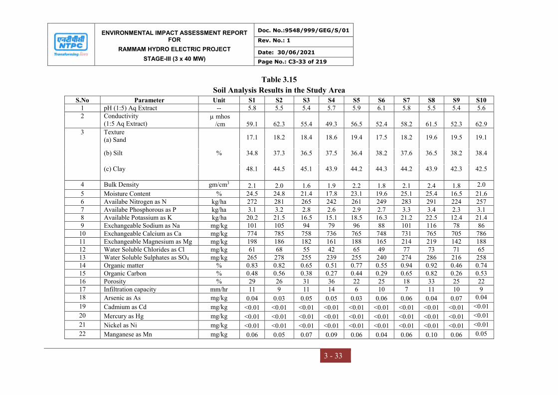
ENVIRONMENTAL IMPACT ASSESSMENT REPORT FOR
RAMMAM HYDRO ELECTRIC PROJECT
STAGE-III (3 x 40 MW)
Doc. No.:9548/999/GEG/S/01
Rev. No.: 1
Date: 30/06/2021
Page No.: C3-33 of 219
3 - 33
Table 3.15
Soil Analysis Results in the Study Area S.No Parameter Unit S1 S2 S3 S4 S5 S6 S7 S8 S9 S10
1 pH (1:5) Aq Extract -- 5.8 5.5 5.4 5.7 5.9 6.1 5.8 5.5 5.4 5.6 2 Conductivity
(1:5 Aq Extract) mhos
/cm 59.1 62.3 55.4 49.3 56.5 52.4 58.2 61.5 52.3 62.9 3 Texture
(a) Sand 17.1 18.2 18.4 18.6 19.4 17.5 18.2 19.6 19.5 19.1
(b) Silt % 34.8 37.3 36.5 37.5 36.4 38.2 37.6 36.5 38.2 38.4
(c) Clay 48.1 44.5 45.1 43.9 44.2 44.3 44.2 43.9 42.3 42.5
4 Bulk Density gm/cm3 2.1 2.0 1.6 1.9 2.2 1.8 2.1 2.4 1.8 2.0
5 Moisture Content % 24.5 24.8 21.4 17.8 23.1 19.6 25.1 25.4 16.5 21.6 6 Availabe Nitrogen as N kg/ha 272 281 265 242 261 249 283 291 224 257 7 Availabe Phosphorous as P kg/ha 3.1 3.2 2.8 2.6 2.9 2.7 3.3 3.4 2.3 3.1 8 Available Potassium as K kg/ha 20.2 21.5 16.5 15.1 18.5 16.3 21.2 22.5 12.4 21.4 9 Exchangeable Sodium as Na mg/kg 101 105 94 79 96 88 101 116 78 86
10 Exchangeable Calcium as Ca mg/kg 774 785 758 736 765 748 731 765 705 786 11 Exchangeable Magnesium as Mg mg/kg 198 186 182 161 188 165 214 219 142 188 12 Water Soluble Chlorides as Cl mg/kg 61 68 55 42 65 49 77 73 71 65 13 Water Soluble Sulphates as SO4 mg/kg 265 278 255 239 255 240 274 286 216 258 14 Organic matter % 0.83 0.82 0.65 0.51 0.77 0.55 0.94 0.92 0.46 0.74 15 Organic Carbon % 0.48 0.56 0.38 0.27 0.44 0.29 0.65 0.82 0.26 0.53 16 Porosity % 29 26 31 36 22 25 18 33 25 22 17 Infiltration capacity mm/hr 11 9 11 14 6 10 7 11 10 9 18 Arsenic as As mg/kg 0.04 0.03 0.05 0.05 0.03 0.06 0.06 0.04 0.07 0.04
19 Cadmium as Cd mg/kg <0.01 <0.01 <0.01 <0.01 <0.01 <0.01 <0.01 <0.01 <0.01 <0.01
20 Mercury as Hg mg/kg <0.01 <0.01 <0.01 <0.01 <0.01 <0.01 <0.01 <0.01 <0.01 <0.01
21 Nickel as Ni mg/kg <0.01 <0.01 <0.01 <0.01 <0.01 <0.01 <0.01 <0.01 <0.01 <0.01
22 Manganese as Mn mg/kg 0.06 0.05 0.07 0.09 0.06 0.04 0.06 0.10 0.06 0.05

ENVIRONMENTAL IMPACT ASSESSMENT REPORT FOR
RAMMAM HYDRO ELECTRIC PROJECT
STAGE-III (3 x 40 MW)
Doc. No.:9548/999/GEG/S/01
Rev. No.: 1
Date: 30/06/2021
Page No.: C3-34 of 219
3 - 34
23 Hexavalent Chromium as Cr+6 mg/kg <0.01 <0.01 <0.01 <0.01 <0.01 <0.01 <0.01 <0.01 <0.01 <0.01
24 Lead as Pb mg/kg <0.01 <0.01 <0.01 <0.01 <0.01 <0.01 <0.01 <0.01 <0.01 <0.01
25 Iron as Fe mg/kg 0.78 0.70 0.58 0.64 0.52 0.62 0.60 0.58 0.54 0.58
26 Copper as Cu mg/kg 0.07 0.05 0.04 0.07 0.04 0.06 0.05 0.08 0.07 0.09
27 Zinc as Zn mg/kg 3.9 3.6 4.1 3.9 3.4 4.1 3.6 3.2 3.9 4.1
28 SAR m.eq/100g 4.5 5.9 7.4 4.9 2.6 5.2 4.8 4.6 5.4 5.1 29 Permeability cm/hr 1.1 1.0 1.6 1.1 1.5 1.4 1.0 1.4 1.5 1.1 30 Water holding capacity % 25 28 22 26 31 22 25 22 21 26 31 Metals: Sb mg/kg <0.02 <0.02 <0.02 <0.02 <0.02 <0.02 <0.02 <0.02 <0.02 <0.02 32 Ba mg/kg <0.02 <0.02 <0.02 <0.02 <0.02 <0.02 <0.02 <0.02 <0.02 <0.02 33 Cr+3 mg/kg 5.8 5.2 5.8 5.1 5.4 5.9 5.6 5.4 5.1 5.6 34 Co mg/kg <0.02 <0.02 <0.02 <0.02 <0.02 <0.02 <0.02 <0.02 <0.02 <0.02 35 Mo mg/kg <0.02 <0.02 <0.02 <0.02 <0.02 <0.02 <0.02 <0.02 <0.02 <0.02 36 Cyanide mg/kg <0.1 <0.1 <0.1 <0.1 <0.1 <0.1 <0.1 <0.1 <0.1 <0.1 37 Thiocyanide mg/kg <0.1 <0.1 <0.1 <0.1 <0.1 <0.1 <0.1 <0.1 <0.1 <0.1
*Note: Detection Limits for Cd, Hg, Ni, Pb, Cr+6 are 0.01mg/kg; for Sb, Ba, Cr+3, Co, Mo is 0.02mg/kg and for Cyanide and thiocyanide is 0.1mg/kg

ENVIRONMENTAL IMPACT ASSESSMENT REPORT FOR
RAMMAM HYDRO ELECTRIC PROJECT
STAGE-III (3 x 40 MW)
Doc. No.:9548/999/GEG/S/01
Rev. No.: 1
Date: 30/06/2021
Page No.: C3-35 of 219
3 - 35
3.7.3 Summary of Soil Analysis Data
The analytical results of the soil samples are summarized below.
The pH of the soil is an important property; the normal range of pH in the soil is 6.0
to 8.5. The pH values in the study area are varying from 5.4 to 6.1 indicating that the
soils are falling in acidic soil.
Based on the electrical conductivity, the soils are classified into four groups (Normal,
Critical for germination, Critical for growth of the sensitive crops, Injurious to most
crops). The electrical conductivity in the study area is varying from 52.3 to 62.9
micro-mhos/ cm (µmhos/cm). This is average for germination.
The other important parameters for characterization of soil for irrigation are the
primary nutrients – Nitrogen, Phosphorus and Potassium (N, P, K) and the secondary
nutrients-Calcium, Magnesium and Sulphur (Ca, Mg, S). The primary and secondary
nutrient elements are known as major elements. This classification is based on their
relative abundance, and not on their relative importance.
Nitrogen encourages the vegetative development of plants by imparting a healthy
green color to the leaves. The available Nitrogen as N in the study area is varying
from 224 to 281 kg/ha. This is less for crops when compared with soil standards.
Phosphorus influences the vigour of plants and improves the quality of crops. In the
study area available, Phosphorus was found in varying quantities of 2.3 to 3.4kg/ha.
This is less sufficient level when compared to soil standards.
Potassium enhances the ability of the plants to resist diseases, insect attacks, cold and
other adverse conditions. The available potassium in the study area varies between
12.4 to 22.5 kg/ha. This is very less sufficient level for crops.
Organic Carbon in the study area ranges from 0.0.26 to 0.82%. This is very less level
for crops.
Based on the above results, the soils in the region are average fertile enough for
cultivation of crops.
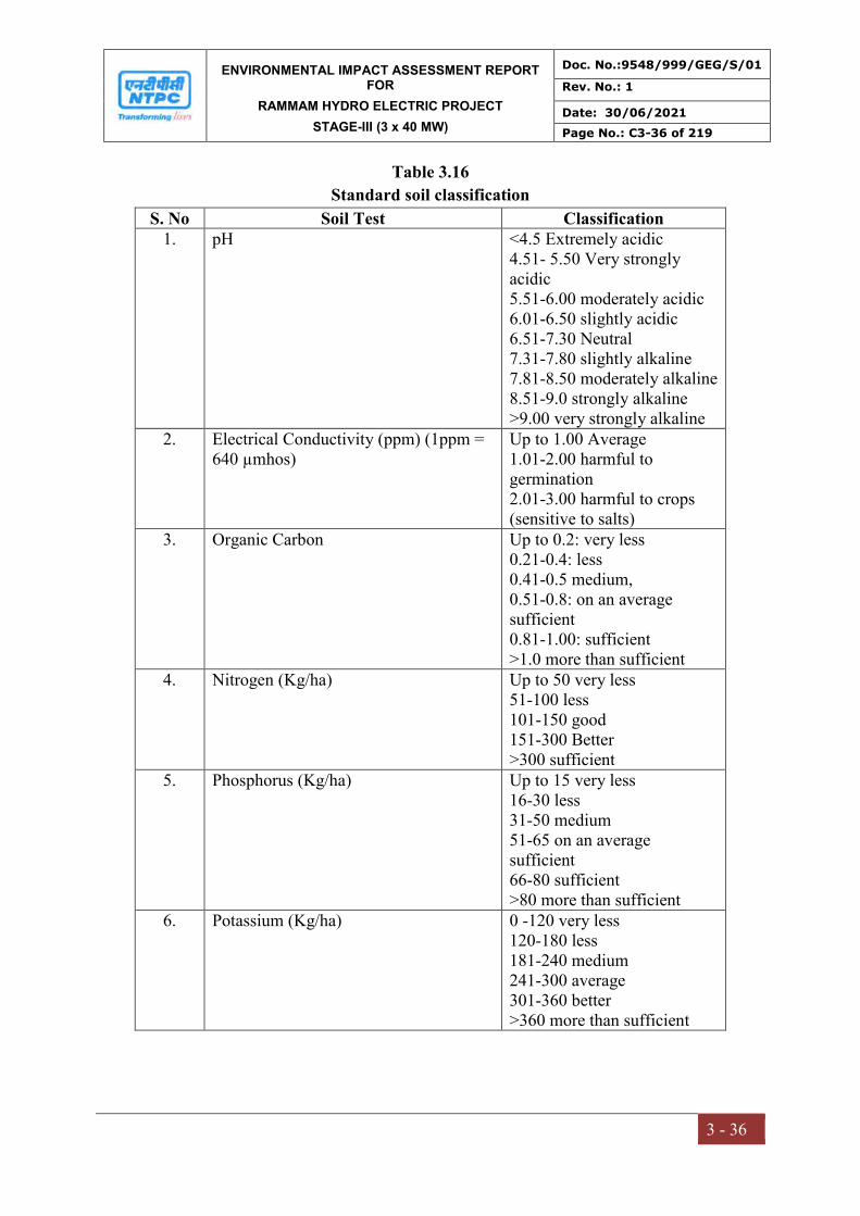
ENVIRONMENTAL IMPACT ASSESSMENT REPORT FOR
RAMMAM HYDRO ELECTRIC PROJECT
STAGE-III (3 x 40 MW)
Doc. No.:9548/999/GEG/S/01
Rev. No.: 1
Date: 30/06/2021
Page No.: C3-36 of 219
3 - 36
Table 3.16
Standard soil classification
S. No Soil Test Classification 1. pH <4.5 Extremely acidic
4.51- 5.50 Very strongly acidic 5.51-6.00 moderately acidic 6.01-6.50 slightly acidic 6.51-7.30 Neutral 7.31-7.80 slightly alkaline 7.81-8.50 moderately alkaline 8.51-9.0 strongly alkaline >9.00 very strongly alkaline
2. Electrical Conductivity (ppm) (1ppm = 640 µmhos)
Up to 1.00 Average 1.01-2.00 harmful to germination 2.01-3.00 harmful to crops (sensitive to salts)
3. Organic Carbon Up to 0.2: very less 0.21-0.4: less 0.41-0.5 medium, 0.51-0.8: on an average sufficient 0.81-1.00: sufficient >1.0 more than sufficient
4. Nitrogen (Kg/ha) Up to 50 very less 51-100 less 101-150 good 151-300 Better >300 sufficient
5. Phosphorus (Kg/ha) Up to 15 very less 16-30 less 31-50 medium 51-65 on an average sufficient 66-80 sufficient >80 more than sufficient
6. Potassium (Kg/ha) 0 -120 very less 120-180 less 181-240 medium 241-300 average 301-360 better >360 more than sufficient
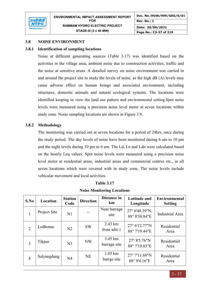
ENVIRONMENTAL IMPACT ASSESSMENT REPORT FOR
RAMMAM HYDRO ELECTRIC PROJECT
STAGE-III (3 x 40 MW)
Doc. No.:9548/999/GEG/S/01
Rev. No.: 1
Date: 30/06/2021
Page No.: C3-37 of 219
3 - 37
3.8 NOISE ENVIRONMENT
3.8.1 Identification of sampling locations
Noise at different generating sources (Table 3.17) was identified based on the
activities in the village area, ambient noise due to construction activities, traffic and
the noise at sensitive areas. A detailed survey on noise environment was carried in
and around the project site to study the levels of noise, as the high dB (A) levels may
cause adverse effect on human beings and associated environment, including
structures, domestic animals and natural ecological systems. The locations were
identified keeping in view the land use pattern and environmental setting.Spot noise
levels were measured using a precision noise level meter at seven locations within
study zone. Noise sampling locations are shown in Figure 3.9.
3.8.2 Methodology
The monitoring was carried out at seven locations for a period of 24hrs, once during
the study period. The day levels of noise have been monitored during 6 am to 10 pm
and the night levels during 10 pm to 6 am. The Ld, Ln and Ldn were calculated based
on the hourly Leq values. Spot noise levels were measured using a precision noise
level meter at residential areas, industrial areas and commercial centres etc., in all
seven locations which were covered with in study zone. The noise levels include
vehicular movement and local activities.
Table 3.17
Noise Monitoring Locations
S.No Location Station Code
Direction Distance in
km Latitude and
Longitude Environmental
Setting
1 Project Site N1 -- Near barrage
site 27° 6'48.39"N,
88° 8'38.84"E Industrial Area
2 Lodhoma N2 SW 2.43 km
from adit-1 27° 6'12.77"N
88° 7'19.44"E Residential
Area
3 Tikpur N3 NW 3.45 km
barrage site 27° 8'5.76"N
88° 7'10.03"E Residential
Area
4 Salyangdang N4 NE 1.03 km
barrge site 27° 7'11.68"N
88° 9'4.16"E Residential
Area
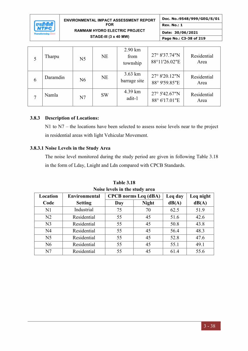
ENVIRONMENTAL IMPACT ASSESSMENT REPORT FOR
RAMMAM HYDRO ELECTRIC PROJECT
STAGE-III (3 x 40 MW)
Doc. No.:9548/999/GEG/S/01
Rev. No.: 1
Date: 30/06/2021
Page No.: C3-38 of 219
3 - 38
5 Tharpu N5 NE
2.90 km
from
township
27° 8'37.74"N
88°11'26.02"E Residential
Area
6 Daramdin N6 NE 3.63 km
barrage site 27° 8'20.12"N
88° 9'59.85"E Residential
Area
7 Namla N7 SW 4.39 km
adit-1 27° 5'42.67"N
88° 6'17.01"E Residential
Area
3.8.3 Description of Locations:
N1 to N7 – the locations have been selected to assess noise levels near to the project
in residential areas with light Vehicular Movement.
3.8.3.1 Noise Levels in the Study Area
The noise level monitored during the study period are given in following Table 3.18
in the form of Lday, Lnight and Ldn compared with CPCB Standards.
Table 3.18
Noise levels in the study area
Location
Code
Environmental
Setting
CPCB norms Leq (dBA) Leq day
dB(A)
Leq night
dB(A) Day Night
N1 Industrial 75 70 62.5 51.9
N2 Residential 55 45 51.6 42.6
N3 Residential 55 45 50.8 43.8
N4 Residential 55 45 56.4 48.3
N5 Residential 55 45 52.8 47.6
N6 Residential 55 45 55.1 49.1
N7 Residential 55 45 61.4 55.6
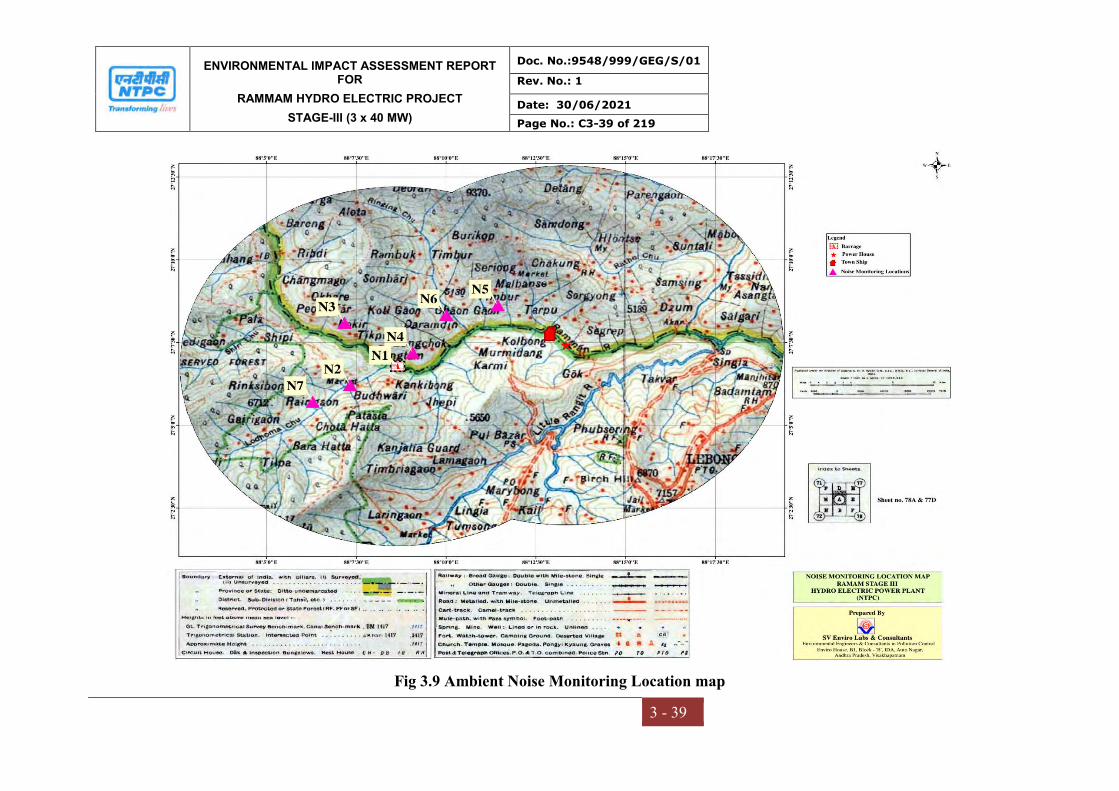
ENVIRONMENTAL IMPACT ASSESSMENT REPORT FOR
RAMMAM HYDRO ELECTRIC PROJECT
STAGE-III (3 x 40 MW)
Doc. No.:9548/999/GEG/S/01
Rev. No.: 1
Date: 30/06/2021
Page No.: C3-39 of 219
3 - 39
Fig 3.9 Ambient Noise Monitoring Location map
ENVIRONMENTAL IMPACT ASSESSMENT REPORT FOR
RAMMAM HYDRO ELECTRIC PROJECT
STAGE-III (3 x 40 MW)
Doc. No.:9548/999/GEG/S/01
Rev. No.: 1
Date: 30/06/2021
Page No.: C3-40 of 219
3 - 40
Fig 3.10 Ambient Noise Monitoring Stations

ENVIRONMENTAL IMPACT ASSESSMENT REPORT FOR
RAMMAM HYDRO ELECTRIC PROJECT
STAGE-III (3 x 40 MW)
Doc. No.:9548/999/GEG/S/01
Rev. No.: 1
Date: 30/06/2021
Page No.: C3-41 of 219
3 - 41
Graphical representation of Noise
0.0
10.0
20.0
30.0
40.0
50.0
60.0
70.0
80.0
Equivalent Noise Day Time Leq dB(A)
0.0
10.0
20.0
30.0
40.0
50.0
60.0
70.0
80.0
Equivalent Noise Night Time Leq dB(A)

ENVIRONMENTAL IMPACT ASSESSMENT REPORT FOR
RAMMAM HYDRO ELECTRIC PROJECT
STAGE-III (3 x 40 MW)
Doc. No.:9548/999/GEG/S/01
Rev. No.: 1
Date: 30/06/2021
Page No.: C3-42 of 219
3 - 42
Results and discussions
Ambient noise equivalent levels were measured at seven locations in and around the
project site. Noise equivalent levels varied from 50.8 to 62.5 Leq dB(A) during day time
and 42.6 to 55.6 Leq dB(A) during night time.
The noise levels at N1 were observed to be high as it is close to the construction
operations at the project site.
An overview of the above results indicate the noise levels in the study area are well
within the prescribed limits of CPCB.
3.9 TRAFFIC STUDY
The baseline traffic studies in the EIA Project study area were carried to assess the traffic
flow. The traffic survey is essential to realistically and accurately assess the prevailing
traffic volumes and travel characteristics by undertaking classified volume count. The
objective of traffic volume count survey is to assess the traffic intensity on the most
vulnerable section of the road. Traffic density was recorded at approach roads to the
powerhouse and barrage site and in the surrounding areas of the project site for 24 hours.
In order to record the traffic density the vehicles plying on the roads were divided into
heavy and light vehicles, three wheelers and two wheelers. Table 3.19 shows the traffic
monitoring sites.
Table 3.19
Traffic density monitoring locations
S.No. Location Latitude Longitude
1. Jorethang-Soreng Road 27° 7'50.39"N 88°16'19.25"E
2. Jorethang-Sombaria Road 27° 8'5.78"N 88° 9'5.38"E
The analysis of traffic counts provides an estimate of average daily traffic (ADT). In
order to convert recorded vehicles into a common scale, the passenger car units (PCU)
equivalent factor as per IRC:64-1990 has been adopted. Table 3.16 shows the details of
traffic density and PCU/day.
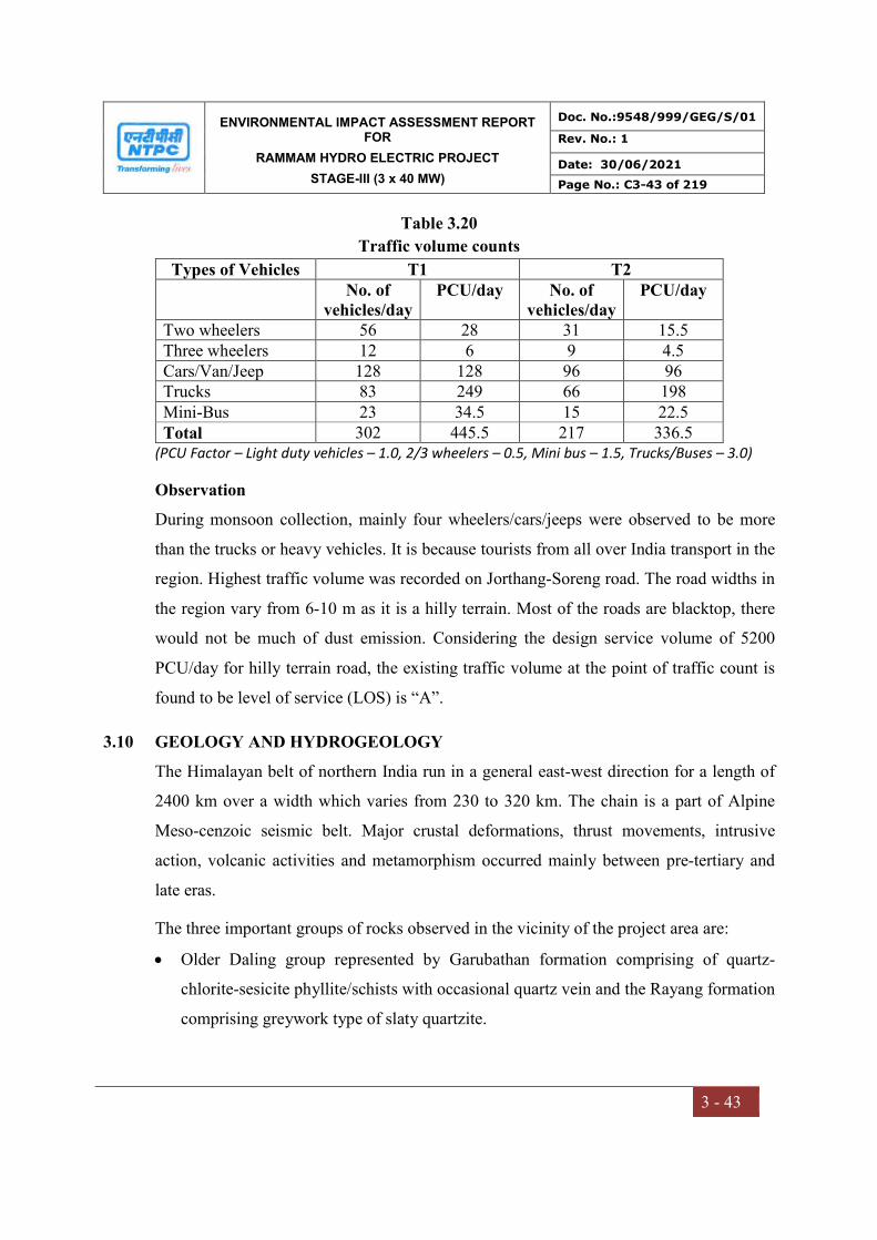
ENVIRONMENTAL IMPACT ASSESSMENT REPORT FOR
RAMMAM HYDRO ELECTRIC PROJECT
STAGE-III (3 x 40 MW)
Doc. No.:9548/999/GEG/S/01
Rev. No.: 1
Date: 30/06/2021
Page No.: C3-43 of 219
3 - 43
Table 3.20
Traffic volume counts
Types of Vehicles T1 T2 No. of
vehicles/day PCU/day No. of
vehicles/day PCU/day
Two wheelers 56 28 31 15.5 Three wheelers 12 6 9 4.5 Cars/Van/Jeep 128 128 96 96 Trucks 83 249 66 198 Mini-Bus 23 34.5 15 22.5 Total 302 445.5 217 336.5
(PCU Factor – Light duty vehicles – 1.0, 2/3 wheelers – 0.5, Mini bus – 1.5, Trucks/Buses – 3.0)
Observation
During monsoon collection, mainly four wheelers/cars/jeeps were observed to be more
than the trucks or heavy vehicles. It is because tourists from all over India transport in the
region. Highest traffic volume was recorded on Jorthang-Soreng road. The road widths in
the region vary from 6-10 m as it is a hilly terrain. Most of the roads are blacktop, there
would not be much of dust emission. Considering the design service volume of 5200
PCU/day for hilly terrain road, the existing traffic volume at the point of traffic count is
found to be level of service (LOS) is “A”.
3.10 GEOLOGY AND HYDROGEOLOGY
The Himalayan belt of northern India run in a general east-west direction for a length of
2400 km over a width which varies from 230 to 320 km. The chain is a part of Alpine
Meso-cenzoic seismic belt. Major crustal deformations, thrust movements, intrusive
action, volcanic activities and metamorphism occurred mainly between pre-tertiary and
late eras.
The three important groups of rocks observed in the vicinity of the project area are:
Older Daling group represented by Garubathan formation comprising of quartz-
chlorite-sesicite phyllite/schists with occasional quartz vein and the Rayang formation
comprising greywork type of slaty quartzite.
ENVIRONMENTAL IMPACT ASSESSMENT REPORT FOR
RAMMAM HYDRO ELECTRIC PROJECT
STAGE-III (3 x 40 MW)
Doc. No.:9548/999/GEG/S/01
Rev. No.: 1
Date: 30/06/2021
Page No.: C3-44 of 219
3 - 44
The tectonic window in the Rangit River valley restricted to the north of the Great
Rangit River and known as Rangit window is the most important geological structure
of the area. The younger Gondwana group is observed and is represented by pebbly
phyllite, shale, carbonaceous shale, with occasional thin coal band and sandstone of
Danuda formation. The older Daling/Buxa group of rocks are exposed as a result of
prolonged weathering. The youner Gondwana group of rocks, encircles the older
Daling/Buxa group of rocks.
Within the window zone, along either bank of River Rangit, extensive occurrences of
dolomitic rocks of Buxa group are observed. These then meet in the sub-surface with
tectonic slices within the flaggy quartzite in Gok area.
3.10.1 Geological setting
Diversion Structure
The intake structure is located on a straight course of River Rammam having steep rocky
cliff on the right bank upto a height of 100 m and a wide shoal deposit and terrace resting
over slumped disjointed rock mass on the left bank. The rock exposed on either side is
quartz-muscovite-biotite gneiss.
The rocks exposed at the barrage/dam site on the hill slope are garnetiferous quartz
biotite muscovite gneiss with quartz veins and lenses.
Desilting Chamber
The desilting chamber is proposed underground in the right side hill of River Rammam
near Lodhama confluence. The rocks exposed in this area are garnetiferrous quartz biotite
muscovite gneiss.
Head Race Tunnel
The tunnel alignment passes through different geological conditions. The alignment
passes below Jhepi Khola. The rock type exposed on left bank of Jhepi Khola towards
downstream below the ground elevation of 900 m is quartz-biotite gneiss. On the right

ENVIRONMENTAL IMPACT ASSESSMENT REPORT FOR
RAMMAM HYDRO ELECTRIC PROJECT
STAGE-III (3 x 40 MW)
Doc. No.:9548/999/GEG/S/01
Rev. No.: 1
Date: 30/06/2021
Page No.: C3-45 of 219
3 - 45
bank chlorite mica schist with some band of mica schist generally strike N 30o to 60o W –
S 30o to 60o E with dip of 20o to 60o towards SSW.
Surge shaft
The major rock type observed at the surge shaft is massive bedded quartzite with phyllitic
intercalation, striking NNW-SSE dipping hillward at an angle of 35o.
Penstock
The area around the underground pressure shaft portion from the surge shaft is mostly
occupied by surfacial soil and overburden with sporadic rock outcrops of flaggy sericite
quartzite interbanded with phyllite and chlorite-sercite schist.
Power house
The power house is proposed as deep seated surface type structure near the confluence of
Rammam and Ramsu Khola confluence on a rocky lodge, comprising chlorite schist
intercalated with quartzite or vein quartz, striking along the slope and dipping upstream
side at a steep angle. At this location, width of River Rammam is nearly 150-200 m wide.
The banks are stable and firm with rocky ledges.
Tail Race Channel
In the initial stage, the tail race is expected to have a rocky foundation, after which it
shall be laid within riverine boulders and sand.

ENVIRONMENTAL IMPACT ASSESSMENT REPORT FOR
RAMMAM HYDRO ELECTRIC PROJECT
STAGE-III (3 x 40 MW)
Doc. No.:9548/999/GEG/S/01
Rev. No.: 1
Date: 30/06/2021
Page No.: C3-46 of 219
3 - 46
Fig 3.11 Geomorphology map

ENVIRONMENTAL IMPACT ASSESSMENT REPORT FOR
RAMMAM HYDRO ELECTRIC PROJECT
STAGE-III (3 x 40 MW)
Doc. No.:9548/999/GEG/S/01
Rev. No.: 1
Date: 30/06/2021
Page No.: C3-47 of 219
3 - 47
Fig 3.12 Lineament map
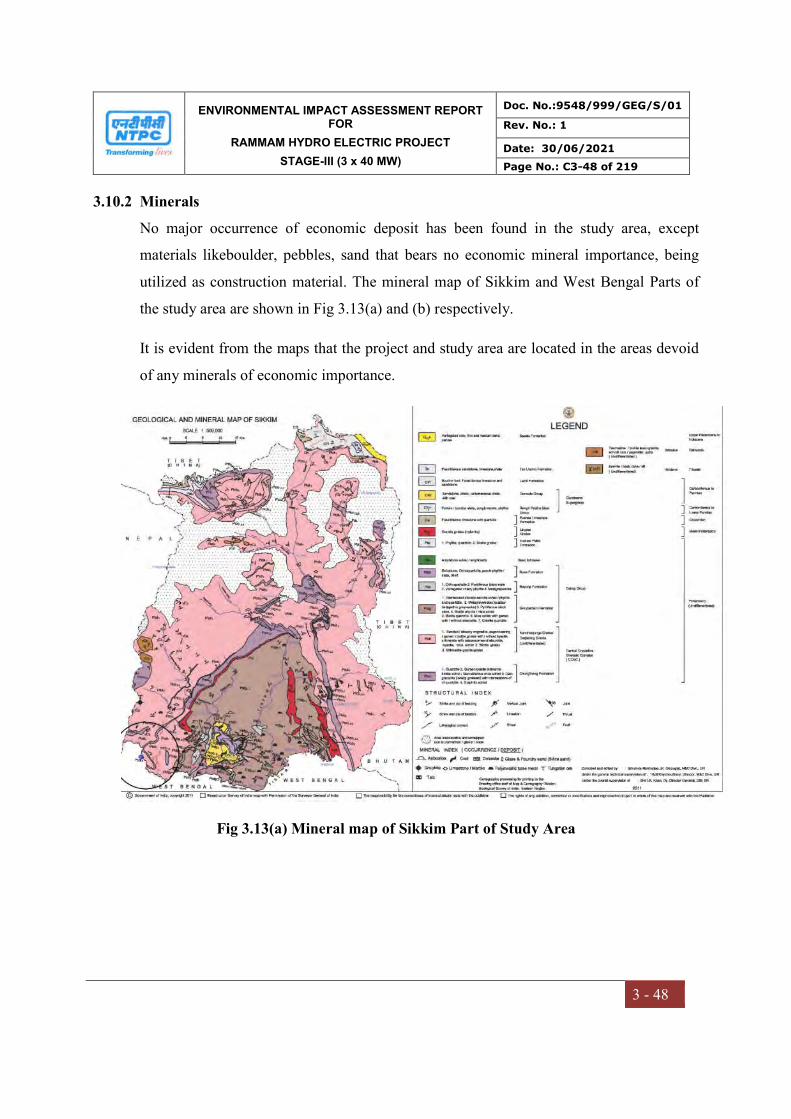
ENVIRONMENTAL IMPACT ASSESSMENT REPORT FOR
RAMMAM HYDRO ELECTRIC PROJECT
STAGE-III (3 x 40 MW)
Doc. No.:9548/999/GEG/S/01
Rev. No.: 1
Date: 30/06/2021
Page No.: C3-48 of 219
3 - 48
3.10.2 Minerals
No major occurrence of economic deposit has been found in the study area, except
materials likeboulder, pebbles, sand that bears no economic mineral importance, being
utilized as construction material. The mineral map of Sikkim and West Bengal Parts of
the study area are shown in Fig 3.13(a) and (b) respectively.
It is evident from the maps that the project and study area are located in the areas devoid
of any minerals of economic importance.
Fig 3.13(a) Mineral map of Sikkim Part of Study Area
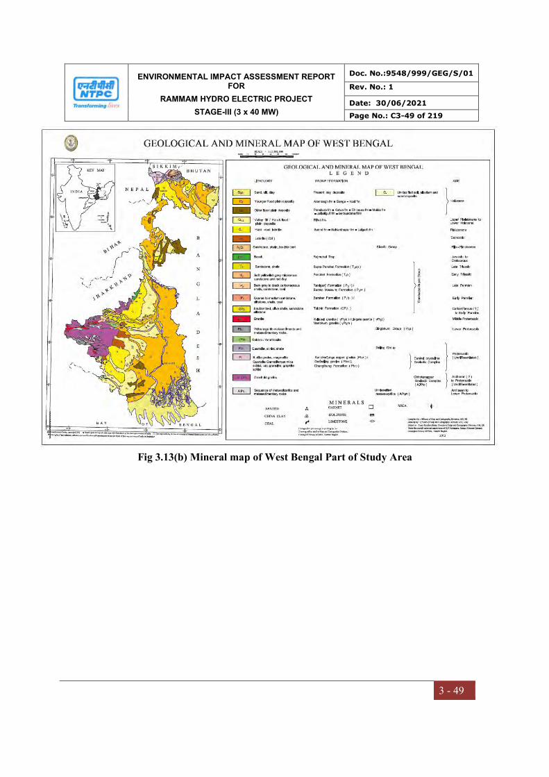
ENVIRONMENTAL IMPACT ASSESSMENT REPORT FOR
RAMMAM HYDRO ELECTRIC PROJECT
STAGE-III (3 x 40 MW)
Doc. No.:9548/999/GEG/S/01
Rev. No.: 1
Date: 30/06/2021
Page No.: C3-49 of 219
3 - 49
Fig 3.13(b) Mineral map of West Bengal Part of Study Area
ENVIRONMENTAL IMPACT ASSESSMENT REPORT FOR
RAMMAM HYDRO ELECTRIC PROJECT
STAGE-III (3 x 40 MW)
Doc. No.:9548/999/GEG/S/01
Rev. No.: 1
Date: 30/06/2021
Page No.: C3-50 of 219
3 - 50
3.10.3 Hydrogeological setting
The study area is divided into two parts:
North of Rammam River part of West Sikkim district of State Sikkim and
South of Rammam River which is a part of Darjeeling district of West Bengal
Hydrogeological setting on the northern part of Rammam River in study area
Physiographically the area is represented by moderate to steeply sloping hills, cliffs and
valleys. The rugged and hilly topography of the area does not favour the construction of
large scale multipurpose irrigation scheme. Irrigation practice is very limited due to soil
erosion issues. Rainwater and spring fed cultivation is predominant.
Geologically the area comprise of Buxa formation comprising of dolomite, phyllite and
quartzite,Darjeeling formation comprise of migmatite gneiss, calc-silicate lenses,
Kanchanjunga formation is represented by augen gneiss, quartzite, amphibolites,
migmatitic gneiss rocks,Chungthang formation comprise of quartz-biotite gneiss, calc-
silicate, marble, quartzite, kyanite and granite schists and Quatenary deposits of alluvium
with assorted gravel and fragments of gravels, pebbles, boulders and terrace covers are
developed sporadically along the streams and rivers.
The major water bearing formations are Darjeeling, Daling and Gondwana groups where
ground water occurs in weathered zones, joints and fractures.
Since the area is characterised by hilly terrain - it acts as a recharge area where surface
runoff is very high, has limited infiltration in the intermountain valleys. Ground water is
harnessed using perennial springs and jhoras. The discharge of most of the springs ranges
from 1 to 50 lpm during lean period and a few jhorasi kholas give discharge in the range
of 50 to 500 lpm.
Ground water occurs in largely disconnected localised along weathered zones, joints and
fracture zones. As such till date no ground water abstraction structures like wells are
present.
ENVIRONMENTAL IMPACT ASSESSMENT REPORT FOR
RAMMAM HYDRO ELECTRIC PROJECT
STAGE-III (3 x 40 MW)
Doc. No.:9548/999/GEG/S/01
Rev. No.: 1
Date: 30/06/2021
Page No.: C3-51 of 219
3 - 51
Hydrogeological setting on the southern part of Rammam River in study area
Because of heavy rainfall and high infiltration through highly permeable formations the
Bhabar and Terai formations have developed promising ground water regime.
Hydrogeologically the area can be broadly divided into consolidated formation
represented by Buxa group of metamorphic rocks semi consolidated formation
comprising of Gondwana and Siwalik sedimentary formations unconsolidated formation
consisting of piedmont and alluvial deposits.
Secondary porosity like joints, fractures, bedding planes etc. give rise to development of
potential aquifers in consolidated and semi-consolidated formations with moderate to low
yield prospects. Boulder, pebble, gravels and sand of unconsolidated formation constitute
highly potential aquifers under unconfined to semi-confined conditions. Piedmont zone
with high permeability, sloping topography and sub-surface runoff is characterised by
poor to moderate yield ranging from 5 to 50 cum per hour. Aquifers in alluvial plain are
highly potential with yield prospects ranging from 50 to 150 cum per hour.
The contact of these two formations is marked by an E-W trending discontinuous spring
line. In shallow unconfined aquifers the depth to water level is in the range of 4 to 10 m
below ground level. The depth to water level deepens progressively in the northern foot
hill areas. Water level in shallow aquifers is shallow with in 4m below ground level. In
the deeper semi-confined aquifers the depth to water level is observed with in 8m below
ground level. Water level fluctuation is in the order of 2 to 6 m in the northern foot hill
part and less than 2m in the central and southern parts.
Deeper aquifers are productive with yields ranging from 50 to 180 cum per hour. The
stage of development of ground water is less than 10% hence is Safe category. In the
piedmont zone the ground water occurs under water table conditions. In flood plain and
alluvial plains the ground water occurs under both water table as well as confined
conditions. Aquifers at 200m below ground level with expected yield of 27 litres per
ENVIRONMENTAL IMPACT ASSESSMENT REPORT FOR
RAMMAM HYDRO ELECTRIC PROJECT
STAGE-III (3 x 40 MW)
Doc. No.:9548/999/GEG/S/01
Rev. No.: 1
Date: 30/06/2021
Page No.: C3-52 of 219
3 - 52
second are reported. Long term trend of water level does not show any significant change
- indicating a stable ground water regime.
3.10.4 Land Slide in the area
The Darjeeling Hill area represents a unique geo- environmental perception. The area of
study is primarily composed of erosional landforms produced by southerly flowing
streams, which have exposed a full cross section of different tectonic units. The form
units are, however approximately the same throughout the hill area, having more or less
uniform lithology, structure, climate, soil and vegetative covers.
The soils of Darjeeling Hill area have developed depending upon the underlying
geological structure. But, in general the soils have been developed by both fluvial action
and lithological disintegration. The soils are predominantly reddish in color. Occasional
dark soils are found due to extensive existence of phyllitic and schists. Soils in the
highlands stretching from the west to the east of the district along most of the interfluvial
areas are mainly mixed sandy loam and loamy, while those on the southern slopes are
mainly clayey loam and reddish in color. Sandy soils are mainly found along Rammam
River.
All the soils are definitely acidic in nature with the tendency to increase slightly in depth
in most cases indicating the lacking of bases from surface and accumulation in the lower
horizons. The weathering of lateritic type is the substantial mechanism in the
transformation of the substratum. The variable thickness of the regolith and soils depend
on the rate of weathering and gradient of the longitudinal slope profiles and intensity /
gravity of mass movements. The basic soil types are yellow soils, red brown soils and
brown forest soils. Red and yellow soils have developed on gneiss while brown on schists
and shales. Coarse pale yellow to red brown soils are found on the Siwaliks while clayey
dark soils are developed on Daling series.
ENVIRONMENTAL IMPACT ASSESSMENT REPORT FOR
RAMMAM HYDRO ELECTRIC PROJECT
STAGE-III (3 x 40 MW)
Doc. No.:9548/999/GEG/S/01
Rev. No.: 1
Date: 30/06/2021
Page No.: C3-53 of 219
3 - 53
The character of the bedrock is reflected only in the grain size composition of the soil. On
the Darjeeling gneiss, very coarse-grained (50% -80%) particles are found. In Damuda
and Daling series percentage of sandy and coarse particles in the soils are high. On the
Siwaliks, silty – clay fraction is higher. The chemical content of the soil over Darjeeling
gneiss is characterized by a high proportion of potassium derived from feldspar and
muscovite mica. This soil is poor in lime, magnesium, iron oxides, phosphorous and
nitrogen. Therefore, lime is used in the tea plantation areas.
The landslide affected areas are areas cultivated with root crops like potato, ginger,
cardamom and onions. These root crops are harvested just after monsoon in the months of
September – October. This particular practice changes the cohesiveness of the soil and
makes it vulnerable to erosion. The slope instability factors along the main thoroughfares
due to heavy vehicular movements is another big problem that causes frequent land slides
along the roads, especially during rainy season. The problem of quarry operation and
their effect on environment is also another threatening problem. The illegally operated
quarries not only disturb the slope stability but also overburden the river and their
tributaries with excessive amount of load that ultimately leads to massive siltation along
the river beds and the adjoining plains. Thus, they destroy the ecological equilibrium of
the area. The landslides may be attributed to the effect of stone quarrying under the main
thoroughfare.
3.10.5 Seismicity
The project area belongs to the Lesser Himalaya, exposing varied rock types belonging to
different tehono-stratigraphic units thrown into complex fold system and tectonically
disturbed by faults and thrusts of different composition.
The Rammam basin has experienced quite a few earthquakes of moderate to severe
intensities in the last 100-120 years. The significant ones are the Great Assam Earthquake
of 12thJune 1897 and Dhubri Earthquake of 15thJanuary, 1934. The project area forms a
part of the seismic zone-IV (as per seismic zoning map of BIS). As per Bureau of Indian

ENVIRONMENTAL IMPACT ASSESSMENT REPORT FOR
RAMMAM HYDRO ELECTRIC PROJECT
STAGE-III (3 x 40 MW)
Doc. No.:9548/999/GEG/S/01
Rev. No.: 1
Date: 30/06/2021
Page No.: C3-54 of 219
3 - 54
Standard (BIS) recommendation 0.1 g horizontal and 0.05 g vertical acceleration is to be
considered for design of structures on consolidated foundations.
The seismic study has beenconducted by IIT Roorkee. The suggestedEarth Quake (EQ)
design parameters have beencleared from National Committee of Seismic Design
Parameters (NCSDP) of CWC and arebeing adopted for design of the projectcomponents.
(Report already submitted toMOEF, Shillong through e-mailin May 2011)
(Ref. Compliance Report submitted videNHL/RammamIII/11-12/01 dated 9th May
2011).
3.10.6 Soils
Soil is the product of geological, chemical and biological interactions. The soil in a
region varies according to altitude and climate. The soil like any other region of
Himalayas are young. The vegetal cover is one of the most important influencing factor
characterizing the soil types in a region. Soil on the slope above 30o, due to erosion and
mass wasting processes, are generally shallow and usually have very thin surface
horizons. Such soils have medium to coarse texture. Residual soils are well developed on
level summits of lesser Himalayas, sub-soils are deep and heavily textured. High contents
of organic matter are found in its `A’ horizon and are acidic in nature.
3.11 HYDROLOGY
Hydrological data for the Rammam River available in the DPR of Rammam HEPP Stage-
III was utilized. The baseline data was studied for evaluating the basin characteristics,
drainage pattern, hydrology, ground water regime and downstream wateruse.
The river Rammam is a major tributary of the Ranjit river which confluences with the
Teesta river. It rises from the Mane Bhanjan – Tongbu – Phalut ridge of the lower
Himalayas which are continuation of Kanchan Jungha mountain ranges, at an elevation of
about 3631 m. The River Rammam forms a natural boundary between the states of West
Bengal & Sikkim. The main tributaries of Rammam river are Kali Khola, Shiri Khola,
Lodhama khola, Jhepi Khola and Riyang Khola. In the initial stretch the river Rammam
ENVIRONMENTAL IMPACT ASSESSMENT REPORT FOR
RAMMAM HYDRO ELECTRIC PROJECT
STAGE-III (3 x 40 MW)
Doc. No.:9548/999/GEG/S/01
Rev. No.: 1
Date: 30/06/2021
Page No.: C3-55 of 219
3 - 55
flows along westernly direction for about 6 Km upto the confluence with its tributary
Kali Khola at an elevation of 2448 m. Further, its course changes towards N-S direction
and after traversing for a length of about 18 Km from origin, one of its major tributary
Shiri Khola joins the river at an elevation of about 1542 m where Stage-I of Rammam
H.E project is located. The slope of the river is moderate in their stretch (1 in 11.25).
Further downstream, the river takes a U-bend near the confluence point of tributary
Lodhama Khola. The Stage-II of the Rammam H.E project is located upsteam of
confluence point of Lodhama, Khola. The tributaries Jhepi Khola and Riyang Khola join
the river at about 2.5 Km and 6.5 Km downstream of confluence point of Lodhama
Khola. At an elevation of 700m the river takes an ~S’ bend and the stage III diversion
structure is located at about 1.5 Km upstream from the bend. The river flows in we
sternly direction upto confluence with Rangit river at an elevation of 305m. There is
considerable snow fed region in the catchment area of Rammam river in its upper
reaches. A significant portion of the catchment area is densely forested. The meandering
course between the diversion weir and the proposed power house of Stage-III project is
about 26 Km and the average gradient is about 1 in 26.
The Rammam river has a total length of about 42 km from its source in Phalut to its
confluence point with Rangit river at Naya Bazar. The total Catchment area of Rammam
river upto the project site is 24.7 Km2.
3.11.1 OBJECTIVE OF THE STUDY
i) To assess the water availability of the proposed project so as to carryout
simulation studies for estimation of power potential.
ii) To determine the probable maximum floods corresponding to different
probabilities so as to ensure safe passage of flood.
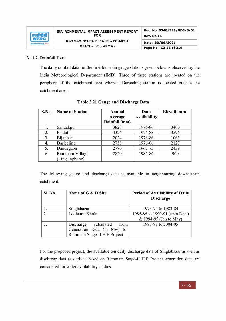
ENVIRONMENTAL IMPACT ASSESSMENT REPORT FOR
RAMMAM HYDRO ELECTRIC PROJECT
STAGE-III (3 x 40 MW)
Doc. No.:9548/999/GEG/S/01
Rev. No.: 1
Date: 30/06/2021
Page No.: C3-56 of 219
3 - 56
3.11.2 Rainfall Data
The daily rainfall data for the first four rain gauge stations given below is observed by the
India Meteorological Department (IMD). Three of these stations are located on the
periphery of the catchment area whereas Darjeeling station is located outside the
catchment area.
Table 3.21 Gauge and Discharge Data
S.No. Name of Station Annual Average
Rainfall (mm)
Data Availability
Elevation(m)
1. Sandakpu 3828 1976-86 3400 2. Phalut 4326 1976-83 3596 3. Bijanbari 2024 1976-86 1065 4. Darjeeling 2758 1976-86 2127 5. Dandegaon 2780 1967-75 2439 6. Rammam Village
(Lingsingbong) 2820 1985-86 900
The following gauge and discharge data is available in neighbouring downstream
catchment.
Sl. No. Name of G & D Site Period of Availability of Daily Discharge
1. Singlabazar 1973-74 to 1983-84 2. Lodhama Khola 1985-86 to 1990-91 (upto Dec.)
& 1994-95 (Jan to May) 3. Discharge calculated from
Generation Data (in Mw) for Rammam Stage-II H.E Project
1997-98 to 2004-05
For the proposed project, the available ten daily discharge data of Singlabazar as well as
discharge data as derived based on Rammam Stage-II H.E Project generation data are
considered for water availability studies.

ENVIRONMENTAL IMPACT ASSESSMENT REPORT FOR
RAMMAM HYDRO ELECTRIC PROJECT
STAGE-III (3 x 40 MW)
Doc. No.:9548/999/GEG/S/01
Rev. No.: 1
Date: 30/06/2021
Page No.: C3-57 of 219
3 - 57
Before the available data could be used for developing the flow series at diversion site,
the consistencies of observed data are required to be established. The average of annual
rainfall of two raingauge stations at Dandagaon and Lingsingbong established in the
project vicinity is 2800mm. The annual average discharge at Singlabazar is 2514 mm
which gives a runoff factor of 89% which, though on higher side is quite responsible
considering the rocky terrain in most of the upper reaches. For the river Lodhama Khola,
which has a catchment area of 79 Km2, the annual specific yield based on six years of
observed discharge data is 31.3 Cumecs/Sq. Km.
For Singlabazar, the specific yield based on discharge data for the period 1973-74 to
1984-85 is 29.17 Cumecs/Sq. Km which is found to be consistent.
Comparison of Specific Yield of Singlabazar & Lodhama (G&D Sites
Site May Jun Jul Aug Sep Oct Nov Dec Jan Feb Mar Apr Annual Singlabazar 2.2 5.9 6.1 5.9 3.0 1.4 1.0 0.8 0.6 0.5 0.6 0.98 29.17 Lodhama 2.4 6.5 8.2 5.8 3.1 1.6 1.0 0.7 0.5 0.6 0.6 1.1 31.3
For discharge data of Rammam Stage-II (based on generation data), an attempt has been
made to establish the consistency and the annual average specific yield worked out based
on generation data for the period 1997-98 to 2004-05 is 10.3 Cumecs/Sq. Km. This value
is quite low compared to specific yields at Singlabazar and Lodhama. The flows of River
Rammam are diverted to Stage-II power house through a trench weir and the discharges
from the tail race are released into Lodhama Nala.. Since the Stage-II discharge flows
account for only the diverted flows and not the entire available flows of the river and
especially during the monsoon period (June to October) considerable spill over flows
occur which are not gauged, specific yield turned out to be low.
Alternatively regression analysis has been carried out by correlating lean flow peiods
(November to May) of Singlabazar and Rammam Stage-II ten daily flows as almost
entire flows are utilized for power generation during lean period. Since, concurrent period
data is not available, the average ten daily flows for the available periods for the
ENVIRONMENTAL IMPACT ASSESSMENT REPORT FOR
RAMMAM HYDRO ELECTRIC PROJECT
STAGE-III (3 x 40 MW)
Doc. No.:9548/999/GEG/S/01
Rev. No.: 1
Date: 30/06/2021
Page No.: C3-58 of 219
3 - 58
respective sites is used. The correlation coefficient is found to be quite high which shows
and consistency of the data. The correlation relationship equation so developed is as
follows:
(i) Y = 1.8802x-0.1545 R = 0.898 (Nov to May)
The non-monsoon flow series of Singlabazar and Rammam Stage-II flows are found to
be consistent. However for Monsoon period, these flow series cannot be correlated as
only partial utilization of flow series will be done at Rammam Stage-II site.
3.11.3 Water Availability Studies
The discharge data available at Singlabazar for the period 1973-74 to 1984-85(12 years)
and the discharge data of Rammam-II H.E. Scheme (based on generation data) are
utilized for evolving flow series. Any gaps in the flow series data are filled based on the
average flows or based on the preceding and succeeding year flows. Since, sufficient
rainfall data for considerable period is not available. Rainfall-Runoff correlation could
not be attempted. Hence, the ten daily flows at Singlabazar (C.A 390 Km2) are
transposed to Rammam Stage-II Site (C.A 247 Km2) in catchment area proportion.
An attempt has been made to evolve flow series based on the hourly generation data of
Rammam Stage-II and assuming n as 0.9 and Hnet as 502m. For the lean flow period, the
ten daily flow series of Rammam Stage-II H.E scheme (C.A : 162 Km2) are transposed to
Stage-III site in catchment area proportion as for non-monsoon months the entire
available flows are utilized. However, for monsoon months (June-October), this approach
is not suitable as only a part of available flows are diverted to power house. Hence, for
evolving ten daily flow series for the monsoon months, the ratio of each ten daily flow
value of Singlabazar for the monsoon flow period with respect to the corresponding total
non-monsoon runoff for the entire lean period has been calculated and the average of ten
daily ratios for the 12 years for the monsoon period are considered for assessing the
monsoon flows of Stage-III Rammam H.E Scheme. Using these average ratios, each ten

ENVIRONMENTAL IMPACT ASSESSMENT REPORT FOR
RAMMAM HYDRO ELECTRIC PROJECT
STAGE-III (3 x 40 MW)
Doc. No.:9548/999/GEG/S/01
Rev. No.: 1
Date: 30/06/2021
Page No.: C3-59 of 219
3 - 59
daily value for the monsoon period is deduced by multiplying the corresponding average
ten daily ratio with the total non-monsoon flows for that particular year.
The Lodhama flow series based on the discharge data available on the lodhama nala (C.A
31.5 Km2, inclusive of Dilpa Khola flows) are available for the period 1985-86 to 1990-
1991. These have been transposed to joining point of Lodhama and Rammam (C.A : 79
Km2) in catchment area proportion. An alternate flow series has been evolved for Stage-
III by transposing the Singlabazar ten daily flow series for a catchment area of 168 Km2
(i.e. Rammam Stage III catchment area –Lodhama catchment area (247-79) and then
adding entire Lodhama flows.
In compliance to CWC’s observations regarding updating the flow series, additional
studies have been carried out for evolving the flow series at Rammam Stage-III by
adopting the following three approaches:
i) Monthly Runoff – Runoff correlation between Singlabazar discharge data and
Rangit Stage-IV data (available since June 1975 for 26 years) for the concurrent
period (1975-76 to 1984-85) after elimination of outliers after carrying detailed
regression analysis.
ii) Extending Singlabazar Flow series based on Rangit Stage-IV data in catchmean
area proportion after applying necessary correction.
iii) Rainfall-Runoff Correlation between SinglaBazar discharge data and available
rainfall data.
3.11.4 Runoff-Runoff Correlation
The Rangit Stage-IV H.E Project is located abount 10 km downstream of Rangit Stage-III
on river Rangit and has a catchment of 1232 Sq. Kms. The approved flow series evolved
for Rangit Stage-V are based on transposing the discharge data of Rangit Stage III
(catchment area : 979 Km2) in catchment area proportion for which flow data is available
since June 1975 for a period of 26 years and is found to be consistent. Hence, an attempt
has been made to correlate mean monthly Singlabazar flow data and Rangit IV flow data

ENVIRONMENTAL IMPACT ASSESSMENT REPORT FOR
RAMMAM HYDRO ELECTRIC PROJECT
STAGE-III (3 x 40 MW)
Doc. No.:9548/999/GEG/S/01
Rev. No.: 1
Date: 30/06/2021
Page No.: C3-60 of 219
3 - 60
(as obtained from Rangit Stage-IV H.E Project DPR) for the concurrent period 1975-76
to 1984-85 after elimination of a few outliers after carrying out detailed regression
analysis.
The correlation coefficients are reasonably good considering the variation in catchment
size. Hence using the correlation equations developed and the monthly flows available
for Rangit Stage-IV from June 1985 onwards. The Singlabazar data is extended for a
period of 16 years thus evolving a series of 28 years.
For the extended monthly series for Singlabazar from 1985 onwards, the monthly series
are broken up into ten daily series on the basis of corresponding ten daily ratios of
observed data at Rangit Stage IV. The 28 year flow series at Singlabazar are transposed
to Rammam Stage-III in catchment area proportion and T-test carried out for the evolved
series.
Alternatively an attempt has been made to correlate mean Monsoon Singlabazar flow
data and Rangit IV flow data (as obtained from Rangit Stage-IV H.E Project DPR) for the
concurrent period 1975-76 to 1984-85 after elimination of a few outliers. However, this
approach is not found to be suitable as it gives negative flows for several months.
3.11.5 Extending Singlabazar flow series based on Rangit Stage-IV data.
The catchment area of Rangit Stage-IV Project and Singlabazar G&D site are 1232 &
390 Km2 respectively. The flow series of Rangit from 1985-86 onwards are reduced in
catchment area proportion (390/1232) to extend Singlabazar flows for a period of 16
years thus evolving a total length of flow series of 28 years. However, the flow ratios of
the monthly flows of Singlabazar and Rangit –IV far exceed the catchment ratio. Hence,
a correction factor need to be applied on the evolved flow series derived on catchment
area proportion as the tributary Rangit has significant snowmelt contribution whereas it is
not so in case of Singlabazar.

ENVIRONMENTAL IMPACT ASSESSMENT REPORT FOR
RAMMAM HYDRO ELECTRIC PROJECT
STAGE-III (3 x 40 MW)
Doc. No.:9548/999/GEG/S/01
Rev. No.: 1
Date: 30/06/2021
Page No.: C3-61 of 219
3 - 61
For the extended monthly series for Singlabazar from 1985 onwards, the monthly series
are broken up into ten daily series on the basis of corresponding ten daily ratios of
observed data at Rangit Stage IV.
3.11.6 Rainfall –Runoff Correlation
Efforts have been made for collection of additional rainfall data for Rainfall Runoff
Correlation Studies. It has been confirmed by Forest Department officials that no
raingauge data is available for the project catchment area. However, some rainfall data
has been procured from IMD as per the following details.
S.No. Name of Raingauge Station Periodof data availability 1 Bijanbari 1971 to 2004 2. Phalut 1971 to 1983 3. Sandakpu 1970-72, 1980-83 & 1986 4 Darjeeling 1970-2004
Since Darjeeling Raingauge is located for away from project area, it has been ignored.
For the proposed project catchment area rainfall for significant period is available only
for Bijanbari and Phalut raingauges (for the period 1973 to 1983). Since the catchment
area is quite small (247 Sq. Kms), these stations have been considered as the index
rainfall for the catchment in absence of any other raingaue date. Using Singlabazar G &
D date and average of Bijanbari and Phalut Rajnfall date for the concurrent period 1975-
84, an attempt has been made to establish Rainfall –Runoff correlation for monsoon
period (June to Oct.)
Rainfall –Runoff correlation is very good (R=0.93). However the flow series cannot
extended using this correlation as Phalut rainfall data is available only upto 1983 and
correlation of Singlabazar frow data with Bijanbari rainfall data alone gave unsatisfactory
results (as given in the earlier report)
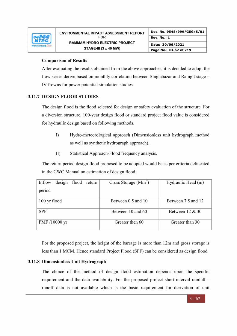
ENVIRONMENTAL IMPACT ASSESSMENT REPORT FOR
RAMMAM HYDRO ELECTRIC PROJECT
STAGE-III (3 x 40 MW)
Doc. No.:9548/999/GEG/S/01
Rev. No.: 1
Date: 30/06/2021
Page No.: C3-62 of 219
3 - 62
Comparison of Results
After evaluating the results obtained from the above approaches, it is decided to adopt the
flow series derive based on monthly correlation between Singlabazar and Raingit stage –
IV frowns for power potential simulation studies.
3.11.7 DESIGN FLOOD STUDIES
The design flood is the flood selected for design or safety evaluation of the structure. For
a diversion structure, 100-year design flood or standard project flood value is considered
for hydraulic design based on following methods.
I) Hydro-meteorological approach (Dimensionless unit hydrograph method
as well as synthetic hydrograph approach).
II) Statistical Approach-Flood frequency analysis.
The return period design flood proposed to be adopted would be as per criteria delineated
in the CWC Manual on estimation of design flood.
Inflow design flood return
period
Cross Storage (Mm3) Hydraulic Head (m)
100 yr flood Between 0.5 and 10 Between 7.5 and 12
SPF Between 10 and 60 Between 12 & 30
PMF /10000 yr Greater then 60 Greater than 30
For the proposed project, the height of the barrage is more than 12m and gross storage is
less than 1 MCM. Hence standard Project Flood (SPF) can be considered as design flood.
3.11.8 Dimensionless Unit Hydrograph
The choice of the method of design flood estimation depends upon the specific
requirement and the data availability. For the proposed project short interval rainfall –
runoff data is not available which is the basic requirement for derivation of unit
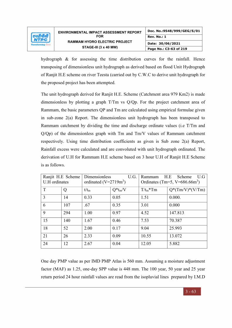
ENVIRONMENTAL IMPACT ASSESSMENT REPORT FOR
RAMMAM HYDRO ELECTRIC PROJECT
STAGE-III (3 x 40 MW)
Doc. No.:9548/999/GEG/S/01
Rev. No.: 1
Date: 30/06/2021
Page No.: C3-63 of 219
3 - 63
hydrograph & for assessing the time distribution curves for the rainfall. Hence
transposing of dimensionless unit hydrograph as derived based on flood Unit Hydrograph
of Ranjit H.E scheme on river Teesta (carried out by C.W.C to derive unit hydrograph for
the proposed project has been attempted.
The unit hydrograph derived for Ranjit H.E. Scheme (Catchment area 979 Km2) is made
dimensionless by plotting a graph T/Tm vs Q/Qp. For the project catchment area of
Rammam, the basic parameters QP and Tm are calculated using empirical formulae given
in sub-zone 2(a) Report. The dimensionless unit hydrograph has been transposed to
Rammam catchment by dividing the time and discharge ordinate values (i.e T/Tm and
Q/Qp) of the dimensionless graph with Tm and Tm/V values of Rammam catchment
respectively. Using time distribution coefficients as given is Sub zone 2(a) Report,
Rainfall excess were calculated and are convoluted with unit hydrograph ordinated. The
derivation of U.H for Rammam H.E scheme based on 3 hour U.H of Ranjit H.E Scheme
is as follows.
Ranjit H.E Scheme U.H ordinates
Dimensionless U.G. ordinated (V=2719m3)
Rammam H.E Scheme U.G Ordinates (Tm=5, V=686.66m3)
T Q t/tm Q*tm/V T/tm*Tm Q*(Tm/V)*(V/Tm)
3 14 0.33 0.05 1.51 0.000.
6 107 .67 0.35 3.01 0.000
9 294 1.00 0.97 4.52 147.813
15 140 1.67 0.46 7.53 70.387
18 52 2.00 0.17 9.04 25.993
21 26 2.33 0.09 10.55 13.072
24 12 2.67 0.04 12.05 5.882
One day PMP value as per IMD PMP Atlas is 560 mm. Assuming a moisture adjustment
factor (MAF) as 1.25, one-day SPP value is 448 mm. The 100 year, 50 year and 25 year
return period 24 hour rainfall values are read from the isopluvial lines prepared by I.M.D
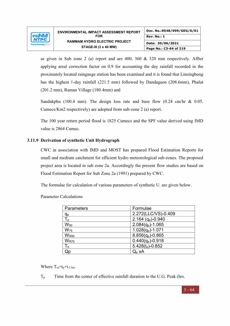
ENVIRONMENTAL IMPACT ASSESSMENT REPORT FOR
RAMMAM HYDRO ELECTRIC PROJECT
STAGE-III (3 x 40 MW)
Doc. No.:9548/999/GEG/S/01
Rev. No.: 1
Date: 30/06/2021
Page No.: C3-64 of 219
3 - 64
as given in Sub zone 2 (a) report and are 400, 360 & 320 mm respectively. Affter
applying areal correction factor on 0.9 for accounting the day rainfall recorded in the
proximately located raingauge station has been examined and it is found that Linsingbong
has the highest 1-day rainfall (221.5 mm) followed by Dandagaon (208.6mm), Phalut
(201.2 mm), Raman Village (180.4mm) and
Sandakphu (100.4 mm). The design loss rate and base flow (0.24 cm/hr & 0.05.
Cumecs/Km2 respectively) are adopted from sub-zone 2 (a) report.
The 100 year return period flood is 1825 Cumecs and the SPF value derived using IMD
value is 2864 Cumec.
3.11.9 Derivation of synthetic Unit Hydrograph
CWC in association with IMD and MOST has prepared Flood Estimation Reports for
small and medium catchment for efficient hydro meteorological sub-zones. The proposed
project area is located in sub zone 2a. Accordingly the present flow studies are based on
Flood Estimation Report for Sub Zone 2a (1991) prepared by CWC.
The formulae for calculation of various parameters of synthetic U. are given below.
Parameter Calculations
Parameters Formulae qp 2.272(LLC/VS)-0.409 Tp 2.164 (qp)-0.940 W50 2.084(qp)-1.065 W75 1.028(qp)-1.071 WR50 8.856(qp)-0.865 WR75 0.440(qp)-0.918 Tb 5.428(tp)-0.852 Qp Qp xA
Where Tm=tp+t-2 hrs
Tp Time from the center of effective rainfall duration to the U.G. Peak (hrs.

ENVIRONMENTAL IMPACT ASSESSMENT REPORT FOR
RAMMAM HYDRO ELECTRIC PROJECT
STAGE-III (3 x 40 MW)
Doc. No.:9548/999/GEG/S/01
Rev. No.: 1
Date: 30/06/2021
Page No.: C3-65 of 219
3 - 65
L Length of longes main stream along the river course in m
Lc length of longer main stream from a point opposite to centroid of the catchment
area to the gauging site along the main stream in Km.
S Equivalent stream slope in m/km.
Qp peak discharge of unit hydrograph in Cumec
W50 Width of U.G. measured at 50% of peak discharge ordinated (hrs.)
W75 Width of U.G. measured at 75% of peak discharge ordinated (hrs.)
WR50 Width of the rising limp of U.G. measures at 50% of peak discharge ordinate (hr.)
WR75 Width of the rising limp of U.G. measures at 75% of peak discharge ordinate (hr.)
Qp peak discharge of unit hydrograph (cumecs.)
The above relationship are recommended to estimate the parameters of 1-hour synthetic
unit graph for an ungauged catchment with known physiographic parameters A, L, Lc
and S for catchment area below 5000 km2.
For calculation of Lc (centroid distance), a cardboard template have been cut out in the
shape of sub-catchment area of Rammam river (upto diversion site) and is hung freely
using plumb bob and thread. Three axial lines were drawn by hanging cardboard in three
different directions. The point of intersection of these three lines gives the centroid of the
sub-catchment area. A point on the river which is nearest to centroid is considered and
the distance from that point to the project site is measured which gives the Lc.
a) Design Loss Rate: A design loss rate of 0.24 cm/hr has been adopted as
recommended by CWC’s sub zone report r (a)
b) Design Storm Duration: The base period of the SUG is for more than 24 hours, hence
one day design storm is considered
c) Pint to Areal Rainfall Ratios: areal correction factors as recommended in CWC’s sub
zone 2 (a) has been adopted.

ENVIRONMENTAL IMPACT ASSESSMENT REPORT FOR
RAMMAM HYDRO ELECTRIC PROJECT
STAGE-III (3 x 40 MW)
Doc. No.:9548/999/GEG/S/01
Rev. No.: 1
Date: 30/06/2021
Page No.: C3-66 of 219
3 - 66
d) Time Distribution Coefficients: The Time Distribution Coefficients for 24 hours is
given below: (vide sub-zone 2(a)
Table 3.22 Time Distribution Coefficients
Time in Hours Distribution Coefficient
Time in hours Distribution coefficient
1 0.13 13 0.79 2 0.25 14 0.81 3 0.32 15 0.84 4 0.40 16 0.86 5 0.47 17 0.88 6 0.52 18 0.90 7 0.56 19 0.92 8 0.61 20 0.93 9 0.65 21 0.95 10 0.69 22 0.97 11 0.73 23 0.98 12 0.76 24 1.00
e) Design Base Flow: As recommended by CWC’s sub zone report 2(a) a base flow rate
of 0.05 cumecs/sq. km has been adopted for the catchment area.
f) Critical Sequence of Rainfall Excess: The critical sequence of rainfall excess should
be characteristic of the area under study. When data is not available, to facilitate the
adoption of this principle, the arrangement of
g) Rainfall increments into design hyetograph may be made in the form of two bells of
12 hours each per day.
h) Convolution: In convolution the U.G. ordinates at unit duration interval are multiplied
by each of the rainfall excess ordinates of the design hyetograph and these are added
by lagging one hour duration at a time.
i) Computation of Unit Hydrograph: Using the basic physiographic parameters, unit
hydrograph is plotted and its each volume is calculated and adjusted to 1 cm while
adjusting the hydrograph the volumes Qp Tm & Ta are not changed. The design flood
hydrograph have been computed after the rainfall excess increments have been
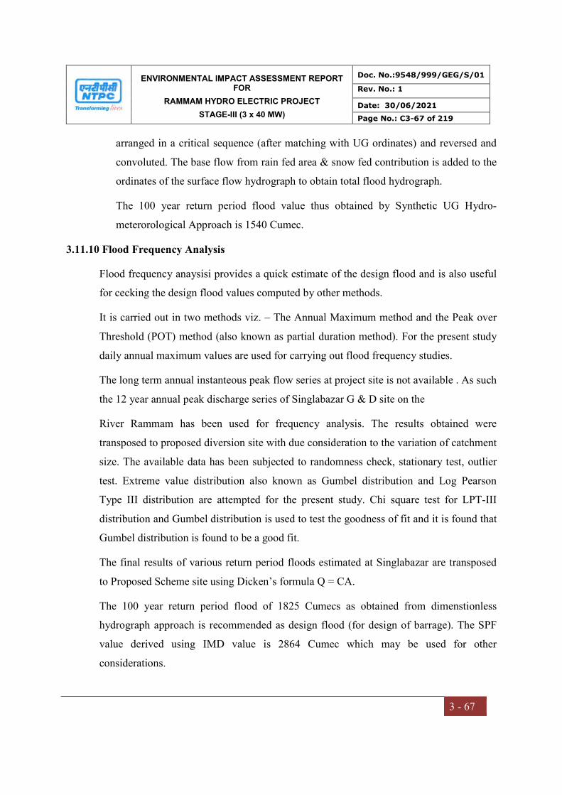
ENVIRONMENTAL IMPACT ASSESSMENT REPORT FOR
RAMMAM HYDRO ELECTRIC PROJECT
STAGE-III (3 x 40 MW)
Doc. No.:9548/999/GEG/S/01
Rev. No.: 1
Date: 30/06/2021
Page No.: C3-67 of 219
3 - 67
arranged in a critical sequence (after matching with UG ordinates) and reversed and
convoluted. The base flow from rain fed area & snow fed contribution is added to the
ordinates of the surface flow hydrograph to obtain total flood hydrograph.
The 100 year return period flood value thus obtained by Synthetic UG Hydro-
meterorological Approach is 1540 Cumec.
3.11.10 Flood Frequency Analysis
Flood frequency anaysisi provides a quick estimate of the design flood and is also useful
for cecking the design flood values computed by other methods.
It is carried out in two methods viz. – The Annual Maximum method and the Peak over
Threshold (POT) method (also known as partial duration method). For the present study
daily annual maximum values are used for carrying out flood frequency studies.
The long term annual instanteous peak flow series at project site is not available . As such
the 12 year annual peak discharge series of Singlabazar G & D site on the
River Rammam has been used for frequency analysis. The results obtained were
transposed to proposed diversion site with due consideration to the variation of catchment
size. The available data has been subjected to randomness check, stationary test, outlier
test. Extreme value distribution also known as Gumbel distribution and Log Pearson
Type III distribution are attempted for the present study. Chi square test for LPT-III
distribution and Gumbel distribution is used to test the goodness of fit and it is found that
Gumbel distribution is found to be a good fit.
The final results of various return period floods estimated at Singlabazar are transposed
to Proposed Scheme site using Dicken’s formula Q = CA.
The 100 year return period flood of 1825 Cumecs as obtained from dimenstionless
hydrograph approach is recommended as design flood (for design of barrage). The SPF
value derived using IMD value is 2864 Cumec which may be used for other
considerations.
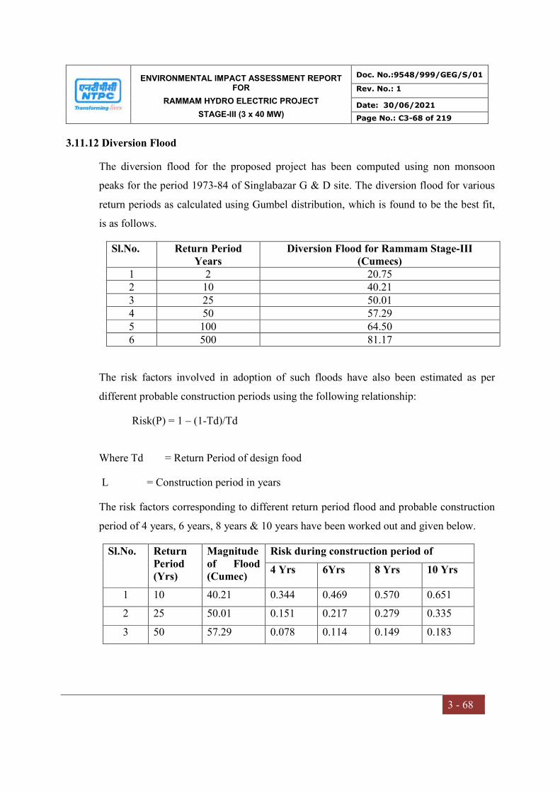
ENVIRONMENTAL IMPACT ASSESSMENT REPORT FOR
RAMMAM HYDRO ELECTRIC PROJECT
STAGE-III (3 x 40 MW)
Doc. No.:9548/999/GEG/S/01
Rev. No.: 1
Date: 30/06/2021
Page No.: C3-68 of 219
3 - 68
3.11.12 Diversion Flood
The diversion flood for the proposed project has been computed using non monsoon
peaks for the period 1973-84 of Singlabazar G & D site. The diversion flood for various
return periods as calculated using Gumbel distribution, which is found to be the best fit,
is as follows.
Sl.No. Return Period Years
Diversion Flood for Rammam Stage-III (Cumecs)
1 2 20.75 2 10 40.21 3 25 50.01 4 50 57.29 5 100 64.50 6 500 81.17
The risk factors involved in adoption of such floods have also been estimated as per
different probable construction periods using the following relationship:
Risk(P) = 1 – (1-Td)/Td
Where Td = Return Period of design food
L = Construction period in years
The risk factors corresponding to different return period flood and probable construction
period of 4 years, 6 years, 8 years & 10 years have been worked out and given below.
Sl.No. Return Period (Yrs)
Magnitude of Flood (Cumec)
Risk during construction period of
4 Yrs 6Yrs 8 Yrs 10 Yrs
1 10 40.21 0.344 0.469 0.570 0.651
2 25 50.01 0.151 0.217 0.279 0.335
3 50 57.29 0.078 0.114 0.149 0.183
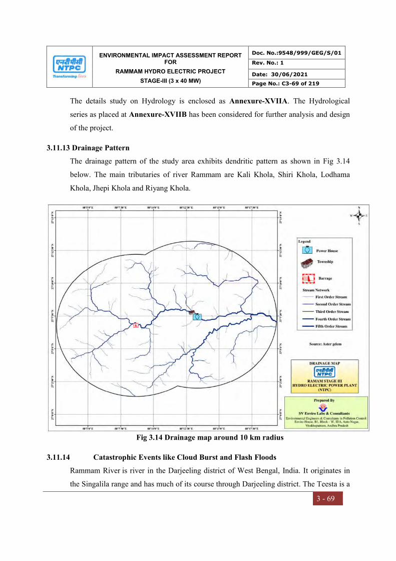
ENVIRONMENTAL IMPACT ASSESSMENT REPORT FOR
RAMMAM HYDRO ELECTRIC PROJECT
STAGE-III (3 x 40 MW)
Doc. No.:9548/999/GEG/S/01
Rev. No.: 1
Date: 30/06/2021
Page No.: C3-69 of 219
3 - 69
The details study on Hydrology is enclosed as Annexure-XVIIA. The Hydrological
series as placed at Annexure-XVIIB has been considered for further analysis and design
of the project.
3.11.13 Drainage Pattern
The drainage pattern of the study area exhibits dendritic pattern as shown in Fig 3.14
below. The main tributaries of river Rammam are Kali Khola, Shiri Khola, Lodhama
Khola, Jhepi Khola and Riyang Khola.
Fig 3.14 Drainage map around 10 km radius
3.11.14 Catastrophic Events like Cloud Burst and Flash Floods
Rammam River is river in the Darjeeling district of West Bengal, India. It originates in
the Singalila range and has much of its course through Darjeeling district. The Teesta is a
ENVIRONMENTAL IMPACT ASSESSMENT REPORT FOR
RAMMAM HYDRO ELECTRIC PROJECT
STAGE-III (3 x 40 MW)
Doc. No.:9548/999/GEG/S/01
Rev. No.: 1
Date: 30/06/2021
Page No.: C3-70 of 219
3 - 70
transboundary river shared by Bangladesh and India, which has a steep slope and high
seasonal flow variability. Flash flooding occurs from May to September during the
monsoon period. However, river flow decreases significantly from October to April.
Teesta river starts rising in late March due to snow melt in the Himalayas. The peak flow
occurs between July and September due to heavy rain.
3.11.15 Sedimentation data
Sediment is one of the major obstructions on the flow line or channel of water and
unmanageable quantity of it shorten longevity of channels. Moreover, it causes soil
erosion. Therefore, study of sediments and nature of its deposits on downstream are very
important for preparation of any water supply projects.
The project is a Run of River (ROR) project in which barrage bays with crest level at
river bed level have been proposed for flushing out the silt at regular intervals. Suitable
sediment management practices like routine flushing during flood period will be evolved
to avoid sediment deposition in the pond. Moreover, intake has been proposed to be
located at suitably higher level above the spillway crest to prevent the entry of the silt in
the water conductor system. Underground desilting chambers have been proposed for
removal of silt particles of size 0.20 mm and above.
3.11.16 Environmental flow
Environmental clearance for the projects was been accorded with a condition that
iv) A minimum flow of 1 cumec shall always be released from the barrage.
The minimum flow to be released is about 22% of the minimum flow of
4.47 cumec recorded in the river
The project has been designed accordingly. However, the standard TOR condition
stipulates that the minimum environmental flow shall be 20% of the flow of four
consecutive lean months of 90% dependable year, 30% of the average monsoon flow.
The flow for remaining months shall be in between 20-30%, depending on the site
specific requirements.
ENVIRONMENTAL IMPACT ASSESSMENT REPORT FOR
RAMMAM HYDRO ELECTRIC PROJECT
STAGE-III (3 x 40 MW)
Doc. No.:9548/999/GEG/S/01
Rev. No.: 1
Date: 30/06/2021
Page No.: C3-71 of 219
3 - 71
The change in minimum flow as per Standard TOR at this stage shall drastically reduce
the power generation from the project and render the project commercially unviable.
The issue of minimum flow in the rivers downstream of the hydro power projects has
been a subject of study and deliberations at different levels.
(a) National Green Trbunal in its Order dated 09/08/2017 in the matter of Pushp Saini
Vs. Ministry of Environment, Forest & Climate Change & Others regarding
environmental flow of the rivers directed that all the rivers in the country shall
maintain minimum 15 % to 20% of the average lean season flow of that river.
During the same case, counsel appearing for Ministry of Environment, Forest and
Climate Change submitted that the Ministry has already completed river basin
study of 6 river basins i.e. Siang River Basin, Twang River Basin, Bichom River
Basin, Subansiri River Basin, Dibang River Basin and Lohit River Basin and
upon study the Ministry has recommended the minimum flow of the river to be
18% of the average of lean season flow of the river. However, in some of the
cases, it has stated to be even 20%.
(b) Further, MOEF&CC has also undertaken a Cumulative Impact Assessment and
Carrying Capacity Study (CIA & CCS) of Teesta River Basin. The minutes of
EAC (Hydro) meeting held on 23.04.2019, during which a presentation was made
on the CIA and CCS Study, it was noted that Rammam-II & Rammam-III are
under operation and construction stage respectively. However, for Rammam-I and
Rammam Intermediate HEP Environmental Flows have been recommended as
per the following Norms:
Monsoon
Season
30% of average Discharge of monsoon season for 90%
Depenable Year
Non Monsoon
Non Lean
Season
25% of average Discharge of Non-Monsoon Lean season
for 90% Depenable Year
Lean Season 20% of average Discharge of lean season for 90%
Depenable Year
ENVIRONMENTAL IMPACT ASSESSMENT REPORT FOR
RAMMAM HYDRO ELECTRIC PROJECT
STAGE-III (3 x 40 MW)
Doc. No.:9548/999/GEG/S/01
Rev. No.: 1
Date: 30/06/2021
Page No.: C3-72 of 219
3 - 72
In view of the above, NTPC Rammam HEPP will maintain the minimum Environmental
flow of 1 cumecs as stipulated in the original environmental cleaarnce.
3.12 BIOLOGICAL ENVIRONMENT
3.12.1 Introduction
An ecological survey of the study area was conducted particularly with reference to
recording the existing biological resources in the study area. Ecological studies are one of
the important aspects of Environmental Impact Assessment with a view to conserve
environmental quality and biodiversity. Ecological systems show complex inter-
relationships between biotic and abiotic components including dependence, competition
and mutualism. Biotic components comprise of both plant and animal communities,
which interact not only within and between themselves but also with the abiotic
components viz. physical and chemical components of the environment.
Generally, biological communities are good indicators of climatic and edaphic factors.
Studies on biological aspects of ecosystems are important in Environmental Impact
Assessment for safety of natural flora and fauna. The biological environment includes
terrestrial and aquatic ecosystems.
The animal and plant communities co-exist in a well-organized manner. Their natural
settings can get disturbed by any externally induced anthropological activities or by
naturally occurring calamities or disaster. So, once this setting is disturbed, it sometimes
is either practically impossible or may take a longer time to come back to its original
state. Hence, changes in the status of flora and fauna are an elementary requirement of
Environmental Impact Assessment studies, in view of the need for conservation of
environmental quality and biodiversity. Information on flora and fauna was collected
within the study area. Relevant details on aquatic life within the study area were collected
from related government offices.
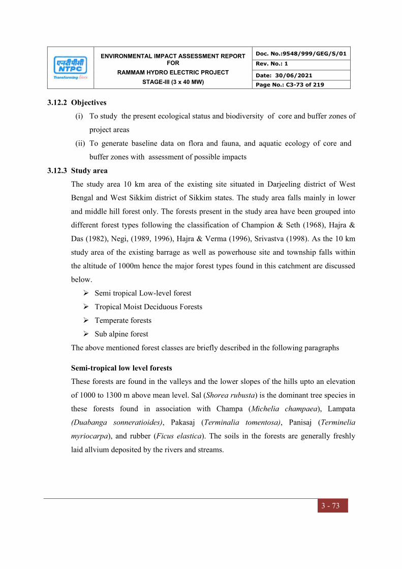
ENVIRONMENTAL IMPACT ASSESSMENT REPORT FOR
RAMMAM HYDRO ELECTRIC PROJECT
STAGE-III (3 x 40 MW)
Doc. No.:9548/999/GEG/S/01
Rev. No.: 1
Date: 30/06/2021
Page No.: C3-73 of 219
3 - 73
3.12.2 Objectives
(i) To study the present ecological status and biodiversity of core and buffer zones of
project areas
(ii) To generate baseline data on flora and fauna, and aquatic ecology of core and
buffer zones with assessment of possible impacts
3.12.3 Study area
The study area 10 km area of the existing site situated in Darjeeling district of West
Bengal and West Sikkim district of Sikkim states. The study area falls mainly in lower
and middle hill forest only. The forests present in the study area have been grouped into
different forest types following the classification of Champion & Seth (1968), Hajra &
Das (1982), Negi, (1989, 1996), Hajra & Verma (1996), Srivastva (1998). As the 10 km
study area of the existing barrage as well as powerhouse site and township falls within
the altitude of 1000m hence the major forest types found in this catchment are discussed
below.
Semi tropical Low-level forest
Tropical Moist Deciduous Forests
Temperate forests
Sub alpine forest
The above mentioned forest classes are briefly described in the following paragraphs
Semi-tropical low level forests
These forests are found in the valleys and the lower slopes of the hills upto an elevation
of 1000 to 1300 m above mean level. Sal (Shorea rubusta) is the dominant tree species in
these forests found in association with Champa (Michelia champaea), Lampata
(Duabanga sonneratioides), Pakasaj (Terminalia tomentosa), Panisaj (Terminelia
myriocarpa), and rubber (Ficus elastica). The soils in the forests are generally freshly
laid allvium deposited by the rivers and streams.
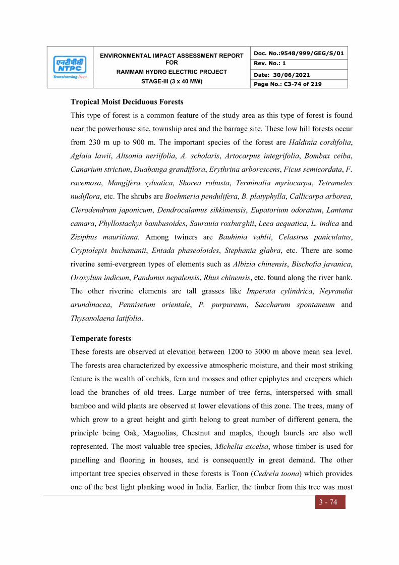
ENVIRONMENTAL IMPACT ASSESSMENT REPORT FOR
RAMMAM HYDRO ELECTRIC PROJECT
STAGE-III (3 x 40 MW)
Doc. No.:9548/999/GEG/S/01
Rev. No.: 1
Date: 30/06/2021
Page No.: C3-74 of 219
3 - 74
Tropical Moist Deciduous Forests
This type of forest is a common feature of the study area as this type of forest is found
near the powerhouse site, township area and the barrage site. These low hill forests occur
from 230 m up to 900 m. The important species of the forest are Haldinia cordifolia,
Aglaia lawii, Altsonia neriifolia, A. scholaris, Artocarpus integrifolia, Bombax ceiba,
Canarium strictum, Duabanga grandiflora, Erythrina arborescens, Ficus semicordata, F.
racemosa, Mangifera sylvatica, Shorea robusta, Terminalia myriocarpa, Tetrameles
nudiflora, etc. The shrubs are Boehmeria pendulifera, B. platyphylla, Callicarpa arborea,
Clerodendrum japonicum, Dendrocalamus sikkimensis, Eupatorium odoratum, Lantana
camara, Phyllostachys bambusoides, Saurauia roxburghii, Leea aequatica, L. indica and
Ziziphus mauritiana. Among twiners are Bauhinia vahlii, Celastrus paniculatus,
Cryptolepis buchananii, Entada phaseoloides, Stephania glabra, etc. There are some
riverine semi-evergreen types of elements such as Albizia chinensis, Bischofia javanica,
Oroxylum indicum, Pandanus nepalensis, Rhus chinensis, etc. found along the river bank.
The other riverine elements are tall grasses like Imperata cylindrica, Neyraudia
arundinacea, Pennisetum orientale, P. purpureum, Saccharum spontaneum and
Thysanolaena latifolia.
Temperate forests
These forests are observed at elevation between 1200 to 3000 m above mean sea level.
The forests area characterized by excessive atmospheric moisture, and their most striking
feature is the wealth of orchids, fern and mosses and other epiphytes and creepers which
load the branches of old trees. Large number of tree ferns, interspersed with small
bamboo and wild plants are observed at lower elevations of this zone. The trees, many of
which grow to a great height and girth belong to great number of different genera, the
principle being Oak, Magnolias, Chestnut and maples, though laurels are also well
represented. The most valuable tree species, Michelia excelsa, whose timber is used for
panelling and flooring in houses, and is consequently in great demand. The other
important tree species observed in these forests is Toon (Cedrela toona) which provides
one of the best light planking wood in India. Earlier, the timber from this tree was most
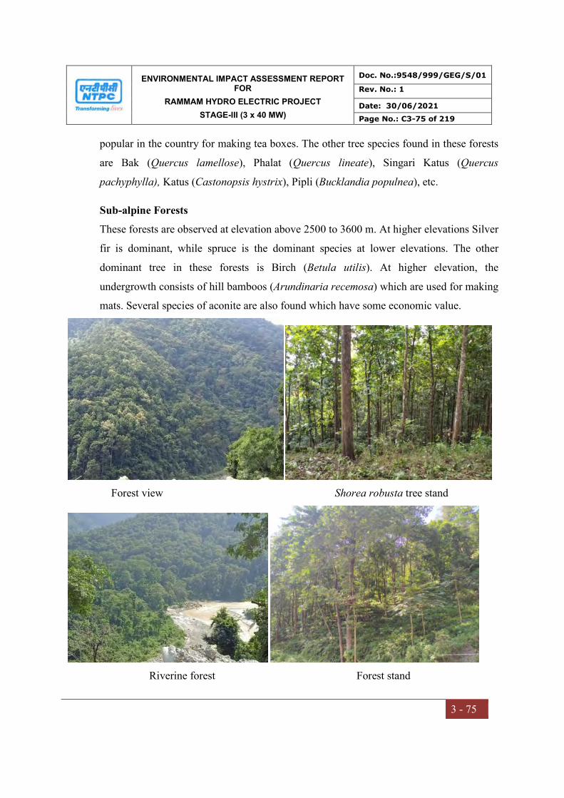
ENVIRONMENTAL IMPACT ASSESSMENT REPORT FOR
RAMMAM HYDRO ELECTRIC PROJECT
STAGE-III (3 x 40 MW)
Doc. No.:9548/999/GEG/S/01
Rev. No.: 1
Date: 30/06/2021
Page No.: C3-75 of 219
3 - 75
popular in the country for making tea boxes. The other tree species found in these forests
are Bak (Quercus lamellose), Phalat (Quercus lineate), Singari Katus (Quercus
pachyphylla), Katus (Castonopsis hystrix), Pipli (Bucklandia populnea), etc.
Sub-alpine Forests
These forests are observed at elevation above 2500 to 3600 m. At higher elevations Silver
fir is dominant, while spruce is the dominant species at lower elevations. The other
dominant tree in these forests is Birch (Betula utilis). At higher elevation, the
undergrowth consists of hill bamboos (Arundinaria recemosa) which are used for making
mats. Several species of aconite are also found which have some economic value.
Forest view Shorea robusta tree stand
Riverine forest Forest stand
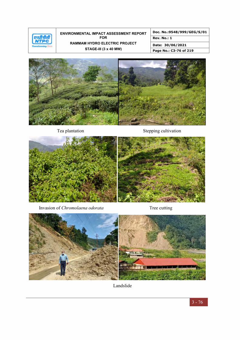
ENVIRONMENTAL IMPACT ASSESSMENT REPORT FOR
RAMMAM HYDRO ELECTRIC PROJECT
STAGE-III (3 x 40 MW)
Doc. No.:9548/999/GEG/S/01
Rev. No.: 1
Date: 30/06/2021
Page No.: C3-76 of 219
3 - 76
Tea plantation Stepping cultivation
Invasion of Chromolaena odorata Tree cutting
Landslide
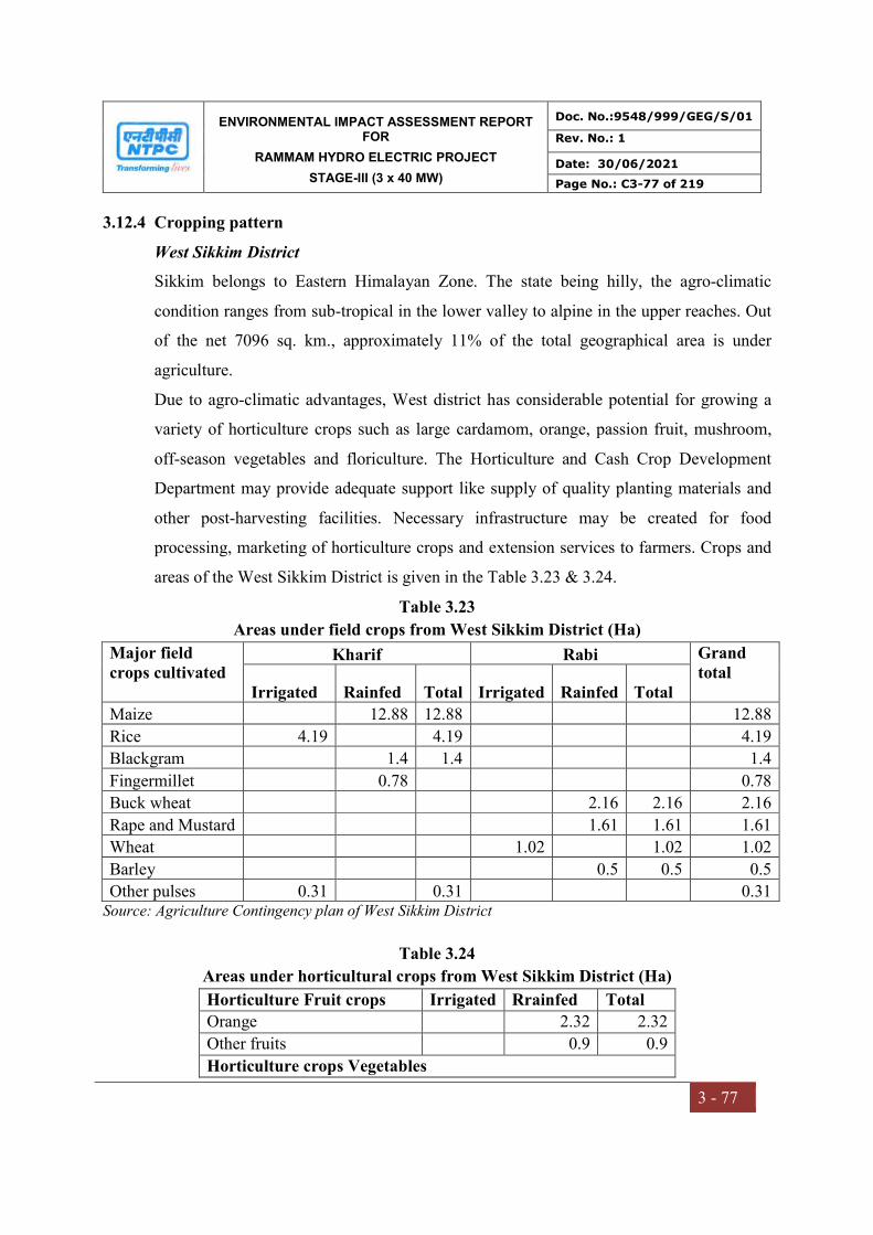
ENVIRONMENTAL IMPACT ASSESSMENT REPORT FOR
RAMMAM HYDRO ELECTRIC PROJECT
STAGE-III (3 x 40 MW)
Doc. No.:9548/999/GEG/S/01
Rev. No.: 1
Date: 30/06/2021
Page No.: C3-77 of 219
3 - 77
3.12.4 Cropping pattern
West Sikkim District
Sikkim belongs to Eastern Himalayan Zone. The state being hilly, the agro-climatic
condition ranges from sub-tropical in the lower valley to alpine in the upper reaches. Out
of the net 7096 sq. km., approximately 11% of the total geographical area is under
agriculture.
Due to agro-climatic advantages, West district has considerable potential for growing a
variety of horticulture crops such as large cardamom, orange, passion fruit, mushroom,
off-season vegetables and floriculture. The Horticulture and Cash Crop Development
Department may provide adequate support like supply of quality planting materials and
other post-harvesting facilities. Necessary infrastructure may be created for food
processing, marketing of horticulture crops and extension services to farmers. Crops and
areas of the West Sikkim District is given in the Table 3.23 & 3.24.
Table 3.23
Areas under field crops from West Sikkim District (Ha)
Major field crops cultivated
Kharif Rabi Grand total Irrigated Rainfed Total Irrigated Rainfed Total
Maize 12.88 12.88 12.88
Rice 4.19 4.19 4.19
Blackgram 1.4 1.4 1.4
Fingermillet 0.78 0.78
Buck wheat 2.16 2.16 2.16
Rape and Mustard 1.61 1.61 1.61
Wheat 1.02 1.02 1.02
Barley 0.5 0.5 0.5
Other pulses 0.31 0.31 0.31 Source: Agriculture Contingency plan of West Sikkim District
Table 3.24
Areas under horticultural crops from West Sikkim District (Ha)
Horticulture Fruit crops Irrigated Rrainfed Total
Orange 2.32 2.32
Other fruits 0.9 0.9
Horticulture crops Vegetables
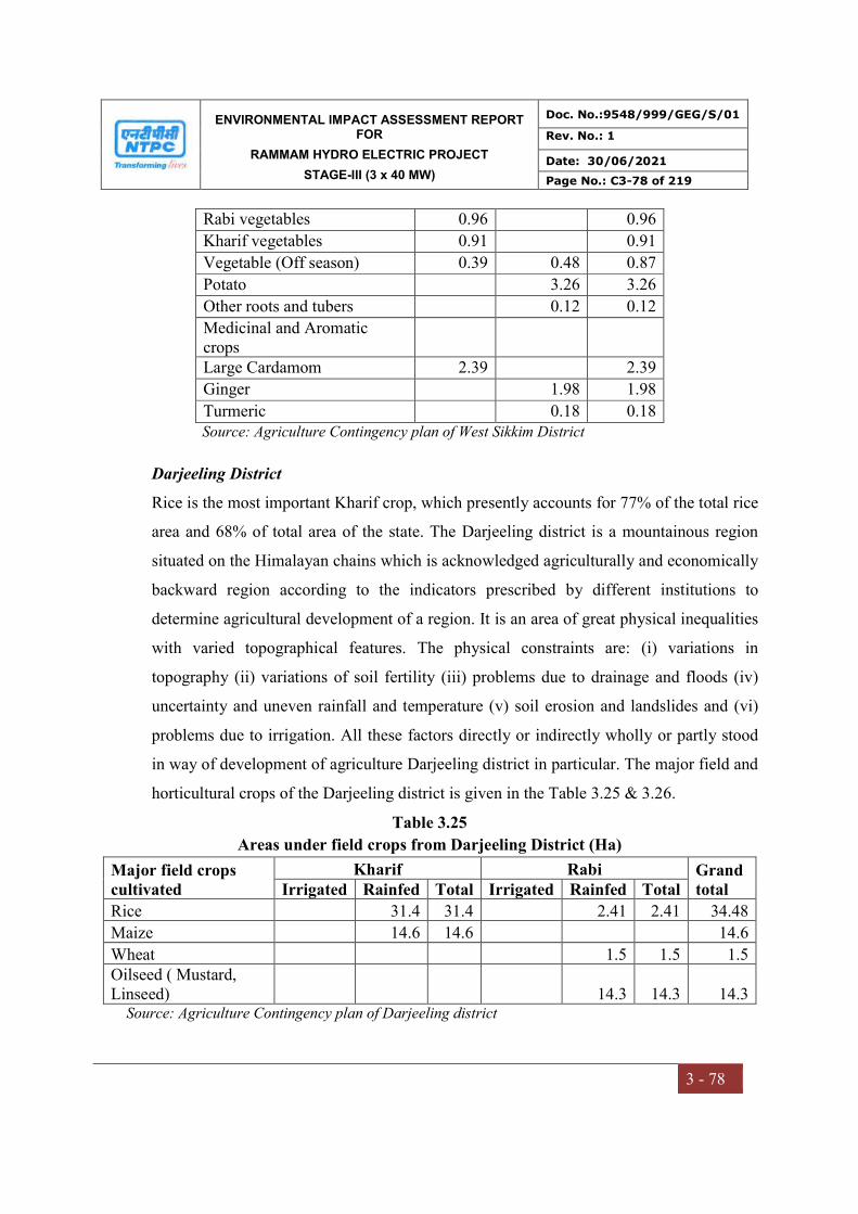
ENVIRONMENTAL IMPACT ASSESSMENT REPORT FOR
RAMMAM HYDRO ELECTRIC PROJECT
STAGE-III (3 x 40 MW)
Doc. No.:9548/999/GEG/S/01
Rev. No.: 1
Date: 30/06/2021
Page No.: C3-78 of 219
3 - 78
Rabi vegetables 0.96 0.96
Kharif vegetables 0.91 0.91
Vegetable (Off season) 0.39 0.48 0.87
Potato 3.26 3.26
Other roots and tubers 0.12 0.12
Medicinal and Aromatic crops
Large Cardamom 2.39 2.39
Ginger 1.98 1.98
Turmeric 0.18 0.18 Source: Agriculture Contingency plan of West Sikkim District
Darjeeling District
Rice is the most important Kharif crop, which presently accounts for 77% of the total rice
area and 68% of total area of the state. The Darjeeling district is a mountainous region
situated on the Himalayan chains which is acknowledged agriculturally and economically
backward region according to the indicators prescribed by different institutions to
determine agricultural development of a region. It is an area of great physical inequalities
with varied topographical features. The physical constraints are: (i) variations in
topography (ii) variations of soil fertility (iii) problems due to drainage and floods (iv)
uncertainty and uneven rainfall and temperature (v) soil erosion and landslides and (vi)
problems due to irrigation. All these factors directly or indirectly wholly or partly stood
in way of development of agriculture Darjeeling district in particular. The major field and
horticultural crops of the Darjeeling district is given in the Table 3.25 & 3.26.
Table 3.25
Areas under field crops from Darjeeling District (Ha)
Major field crops cultivated
Kharif Rabi Grand total Irrigated Rainfed Total Irrigated Rainfed Total
Rice 31.4 31.4 2.41 2.41 34.48
Maize 14.6 14.6 14.6
Wheat 1.5 1.5 1.5 Oilseed ( Mustard, Linseed) 14.3 14.3 14.3
Source: Agriculture Contingency plan of Darjeeling district
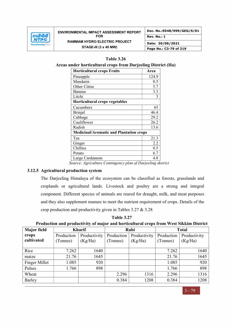
ENVIRONMENTAL IMPACT ASSESSMENT REPORT FOR
RAMMAM HYDRO ELECTRIC PROJECT
STAGE-III (3 x 40 MW)
Doc. No.:9548/999/GEG/S/01
Rev. No.: 1
Date: 30/06/2021
Page No.: C3-79 of 219
3 - 79
Table 3.26
Areas under horticultural crops from Darjeeling District (Ha)
Horticultural crops Fruits Area
Pineapple 124.9 Mandarin 0.5 Other Citrus 5.7 Banana 3.3 Litchi 3 Horticultural crops vegetables
Cucumbers 65 Brinjal 46.4 Cabbage 29.2 Cauliflower 26.2 Radish 13.6 Medicinal/Aromatic and Plantation crops
Tea 21.3 Ginger 2.2 Chillies 0.5 Potato 6.7 Large Cardamom 4.8
Source: Agriculture Contingency plan of Darjeeling district
3.12.5 Agricultural production system
The Darjeeling Himalaya of the ecosystem can be classified as forests, grasslands and
croplands or agricultural lands. Livestock and poultry are a strong and integral
component. Different species of animals are reared for draught, milk, and meat purposes
and they also supplement manure to meet the nutrient requirement of crops. Details of the
crop production and productivity given in Tables 3.27 & 3.28
Table 3.27
Production and productivity of major and horticultural crops from West Sikkim District
Major field crops cultivated
Kharif Rabi Total
Production (Tonnes)
Productivity (Kg/Ha)
Production (Tonnes)
Productivity (Kg/Ha)
Production (Tonnes)
Productivity (Kg/Ha)
Rice 7.262 1640 7.262 1640
maize 21.76 1645 21.76 1645
Finger Millet 1.085 920 1.085 920
Pulses 1.766 898 1.766 898
Wheat 2.296 1316 2.296 1316
Barley 0.384 1208 0.384 1208
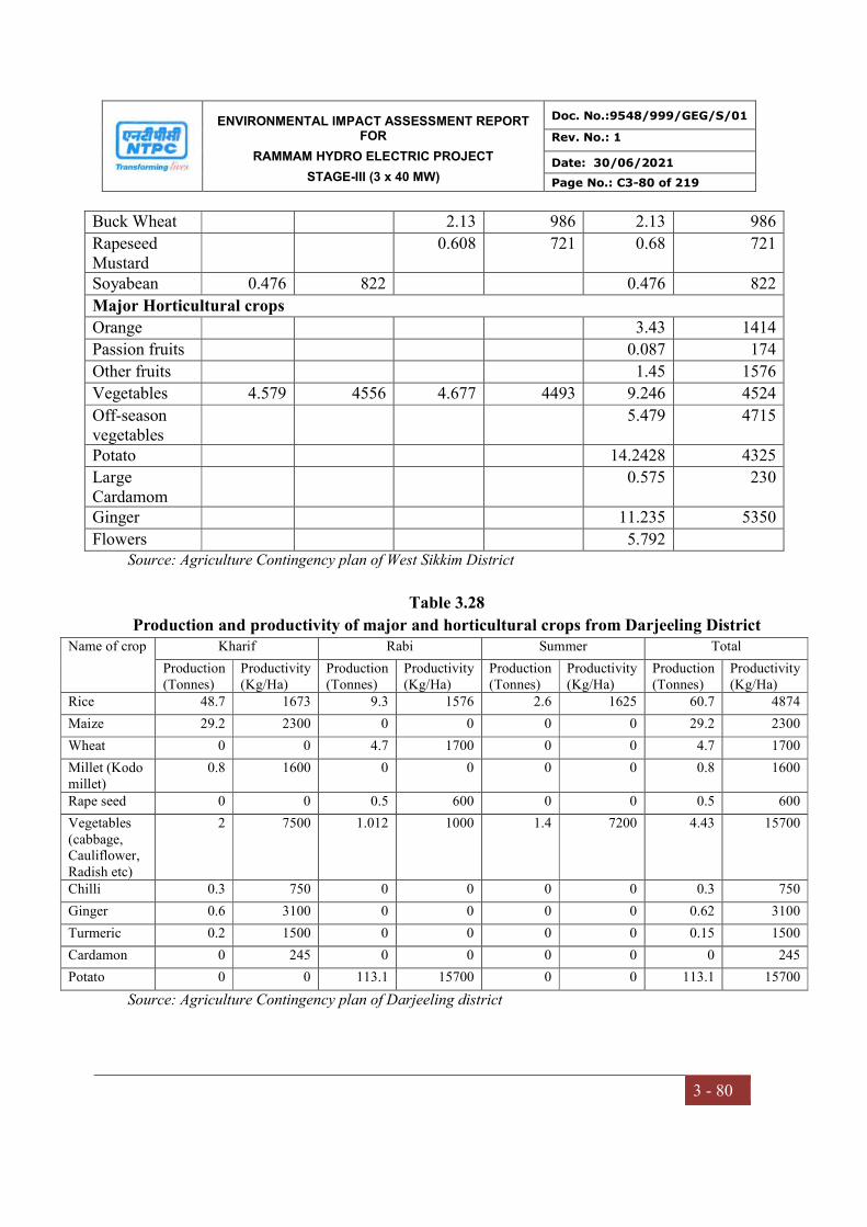
ENVIRONMENTAL IMPACT ASSESSMENT REPORT FOR
RAMMAM HYDRO ELECTRIC PROJECT
STAGE-III (3 x 40 MW)
Doc. No.:9548/999/GEG/S/01
Rev. No.: 1
Date: 30/06/2021
Page No.: C3-80 of 219
3 - 80
Buck Wheat 2.13 986 2.13 986
Rapeseed Mustard
0.608 721 0.68 721
Soyabean 0.476 822 0.476 822
Major Horticultural crops
Orange 3.43 1414
Passion fruits 0.087 174
Other fruits 1.45 1576
Vegetables 4.579 4556 4.677 4493 9.246 4524
Off-season vegetables
5.479 4715
Potato 14.2428 4325
Large Cardamom
0.575 230
Ginger 11.235 5350
Flowers 5.792 Source: Agriculture Contingency plan of West Sikkim District
Table 3.28
Production and productivity of major and horticultural crops from Darjeeling District Name of crop
Kharif Rabi Summer Total
Production (Tonnes)
Productivity (Kg/Ha)
Production (Tonnes)
Productivity (Kg/Ha)
Production (Tonnes)
Productivity (Kg/Ha)
Production (Tonnes)
Productivity (Kg/Ha)
Rice 48.7 1673 9.3 1576 2.6 1625 60.7 4874
Maize 29.2 2300 0 0 0 0 29.2 2300
Wheat 0 0 4.7 1700 0 0 4.7 1700
Millet (Kodo millet)
0.8 1600 0 0 0 0 0.8 1600
Rape seed 0 0 0.5 600 0 0 0.5 600
Vegetables (cabbage, Cauliflower, Radish etc)
2 7500 1.012 1000 1.4 7200 4.43 15700
Chilli 0.3 750 0 0 0 0 0.3 750
Ginger 0.6 3100 0 0 0 0 0.62 3100
Turmeric 0.2 1500 0 0 0 0 0.15 1500
Cardamon 0 245 0 0 0 0 0 245
Potato 0 0 113.1 15700 0 0 113.1 15700
Source: Agriculture Contingency plan of Darjeeling district
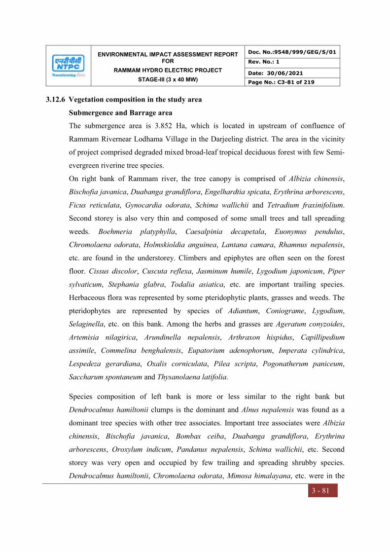
ENVIRONMENTAL IMPACT ASSESSMENT REPORT FOR
RAMMAM HYDRO ELECTRIC PROJECT
STAGE-III (3 x 40 MW)
Doc. No.:9548/999/GEG/S/01
Rev. No.: 1
Date: 30/06/2021
Page No.: C3-81 of 219
3 - 81
3.12.6 Vegetation composition in the study area
Submergence and Barrage area
The submergence area is 3.852 Ha, which is located in upstream of confluence of
Rammam Rivernear Lodhama Village in the Darjeeling district. The area in the vicinity
of project comprised degraded mixed broad-leaf tropical deciduous forest with few Semi-
evergreen riverine tree species.
On right bank of Rammam river, the tree canopy is comprised of Albizia chinensis,
Bischofia javanica, Duabanga grandiflora, Engelhardtia spicata, Erythrina arborescens,
Ficus reticulata, Gynocardia odorata, Schima wallichii and Tetradium fraxinifolium.
Second storey is also very thin and composed of some small trees and tall spreading
weeds. Boehmeria platyphylla, Caesalpinia decapetala, Euonymus pendulus,
Chromolaena odorata, Holmskioldia anguinea, Lantana camara, Rhamnus nepalensis,
etc. are found in the understorey. Climbers and epiphytes are often seen on the forest
floor. Cissus discolor, Cuscuta reflexa, Jasminum humile, Lygodium japonicum, Piper
sylvaticum, Stephania glabra, Todalia asiatica, etc. are important trailing species.
Herbaceous flora was represented by some pteridophytic plants, grasses and weeds. The
pteridophytes are represented by species of Adiantum, Coniograme, Lygodium,
Selaginella, etc. on this bank. Among the herbs and grasses are Ageratum conyzoides,
Artemisia nilagirica, Arundinella nepalensis, Arthraxon hispidus, Capillipedium
assimile, Commelina benghalensis, Eupatorium adenophorum, Imperata cylindrica,
Lespedeza gerardiana, Oxalis corniculata, Pilea scripta, Pogonatherum paniceum,
Saccharum spontaneum and Thysanolaena latifolia.
Species composition of left bank is more or less similar to the right bank but
Dendrocalmus hamiltonii clumps is the dominant and Alnus nepalensis was found as a
dominant tree species with other tree associates. Important tree associates were Albizia
chinensis, Bischofia javanica, Bombax ceiba, Duabanga grandiflora, Erythrina
arborescens, Oroxylum indicum, Pandanus nepalensis, Schima wallichii, etc. Second
storey was very open and occupied by few trailing and spreading shrubby species.
Dendrocalmus hamiltonii, Chromolaena odorata, Mimosa himalayana, etc. were in the
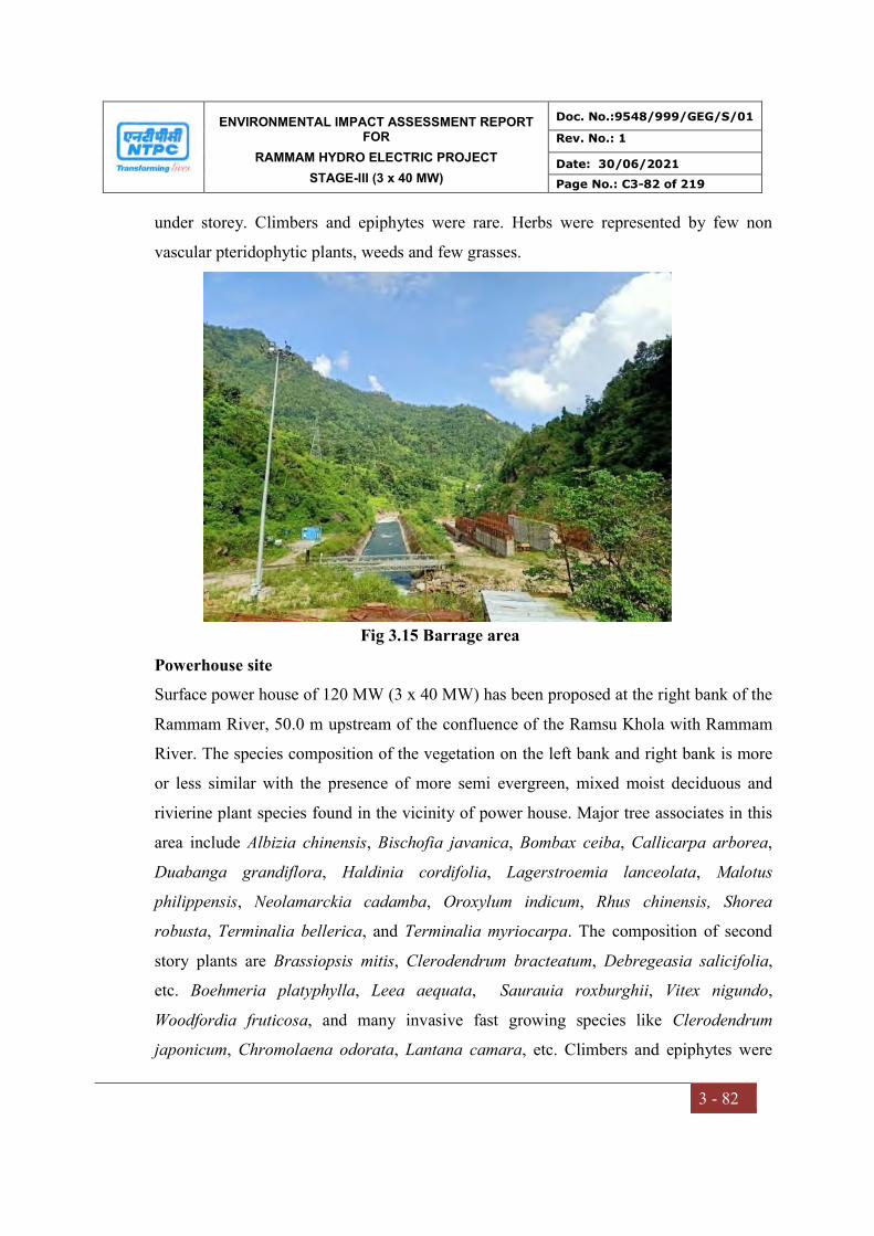
ENVIRONMENTAL IMPACT ASSESSMENT REPORT FOR
RAMMAM HYDRO ELECTRIC PROJECT
STAGE-III (3 x 40 MW)
Doc. No.:9548/999/GEG/S/01
Rev. No.: 1
Date: 30/06/2021
Page No.: C3-82 of 219
3 - 82
under storey. Climbers and epiphytes were rare. Herbs were represented by few non
vascular pteridophytic plants, weeds and few grasses.
Fig 3.15 Barrage area
Powerhouse site
Surface power house of 120 MW (3 x 40 MW) has been proposed at the right bank of the
Rammam River, 50.0 m upstream of the confluence of the Ramsu Khola with Rammam
River. The species composition of the vegetation on the left bank and right bank is more
or less similar with the presence of more semi evergreen, mixed moist deciduous and
rivierine plant species found in the vicinity of power house. Major tree associates in this
area include Albizia chinensis, Bischofia javanica, Bombax ceiba, Callicarpa arborea,
Duabanga grandiflora, Haldinia cordifolia, Lagerstroemia lanceolata, Malotus
philippensis, Neolamarckia cadamba, Oroxylum indicum, Rhus chinensis, Shorea
robusta, Terminalia bellerica, and Terminalia myriocarpa. The composition of second
story plants are Brassiopsis mitis, Clerodendrum bracteatum, Debregeasia salicifolia,
etc. Boehmeria platyphylla, Leea aequata, Saurauia roxburghii, Vitex nigundo,
Woodfordia fruticosa, and many invasive fast growing species like Clerodendrum
japonicum, Chromolaena odorata, Lantana camara, etc. Climbers and epiphytes were

ENVIRONMENTAL IMPACT ASSESSMENT REPORT FOR
RAMMAM HYDRO ELECTRIC PROJECT
STAGE-III (3 x 40 MW)
Doc. No.:9548/999/GEG/S/01
Rev. No.: 1
Date: 30/06/2021
Page No.: C3-83 of 219
3 - 83
also very few at this bank. Cissus repens, Cissampelos pariera, Mimosa himalayana,
Pueraria tuberosa, Stephania glabra, Vigna retusa, etc. were found trailing in the forest.
Epiphytes were represented by Dendrobium aduncum, Pepromia spp., Polypodium sp.,
Vittaria sp., etc. Among herbs were Ageratum conyzoides, Arthraxon hispidus,
Desmodium renifolium, Dichanthium annulatum, Eupatorium adenophorum, Flemingia
fruticosa, Neyraudia arundinacea, Oplismenus compositus, Parthenium hysterophorus,
Pogonatherum paniceum, Saccharum spontaneum and Thysanolaena latifolia.
Township area
The area possesses moderate level of infrastructural facilities. The township
being constructed near Barbatia village shall be permanent residence for the
project. About 100 numbers of staff/employees and CISF Staff will be residing at site
during operation phase of the project. NTPC has developed prefabricated bachelor and
office accommodation and other non-residential buildings for staff of NTPC, CISF,
Support Staff, etc. are under different stages of construction.
Fig 3.16 Power house
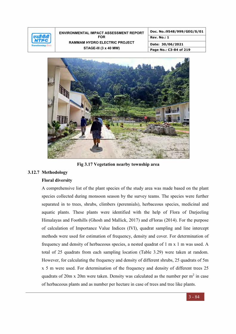
ENVIRONMENTAL IMPACT ASSESSMENT REPORT FOR
RAMMAM HYDRO ELECTRIC PROJECT
STAGE-III (3 x 40 MW)
Doc. No.:9548/999/GEG/S/01
Rev. No.: 1
Date: 30/06/2021
Page No.: C3-84 of 219
3 - 84
Fig 3.17 Vegetation nearby township area
3.12.7 Methodology
Floral diversity
A comprehensive list of the plant species of the study area was made based on the plant
species collected during monsoon season by the survey teams. The species were further
separated in to trees, shrubs, climbers (perennials), herbaceous species, medicinal and
aquatic plants. These plants were identified with the help of Flora of Darjeeling
Himalayas and Foothills (Ghosh and Mallick, 2017) and eFloras (2014). For the purpose
of calculation of Importance Value Indices (IVI), quadrat sampling and line intercept
methods were used for estimation of frequency, density and cover. For determination of
frequency and density of herbaceous species, a nested quadrat of 1 m x 1 m was used. A
total of 25 quadrats from each sampling location (Table 3.29) were taken at random.
However, for calculating the frequency and density of different shrubs, 25 quadrats of 5m
x 5 m were used. For determination of the frequency and density of different trees 25
quadrats of 20m x 20m were taken. Density was calculated as the number per m2 in case
of herbaceous plants and as number per hectare in case of trees and tree like plants.
ENVIRONMENTAL IMPACT ASSESSMENT REPORT FOR
RAMMAM HYDRO ELECTRIC PROJECT
STAGE-III (3 x 40 MW)
Doc. No.:9548/999/GEG/S/01
Rev. No.: 1
Date: 30/06/2021
Page No.: C3-85 of 219
3 - 85
The IVI values were calculated as the sum of relative frequency, relative density and
relative dominance (dominance was based on cover). Frequency, density, abundance, IVI
values and the indices of diversity of the plant species in the study area including the area
of submergence were determined basing on standard ecological methods (Curtis and Mc
Intosh, 1950) widely used in phytosociology as outlined hereunder:
Total number of quadrats in which a species occur Frequency = --------------------------------------------------------------------- × 100
Total number of quadrats studied
Total number of individuals of a species Density = -----------------------------------------------------------
Total number of quadrats studied
Total number of individuals of the species occurring Abundance = ---------------------------------------------------------------------
Total number of quadrats in which the species occur
Frequency of one species Relative frequency (RF) = --------------------------------------------------- × 100
Sum of all frequencies
Number of individuals of a species Relative density (RD) = ----------------------------------------------------- × 100
Total number of individuals of all species
Combined basal area of a single species Relative dominance (RDom) = --------------------------------------------------- × 100
Total basal area of all species
Importance Value Index (IVI) = RF + RD + RDom
Based on the IVI values, Shannon –Wiener Indices of Diversity and Simpson Index of
dominance were calculated by using a computer progamme called “PAST”. The data
collected were also used to compute community indices like species diversity (H') of
different tree species was calculated by using the Shannon- Weiner Index (Shannon and
Weiner, 1963), as such:

ENVIRONMENTAL IMPACT ASSESSMENT REPORT FOR
RAMMAM HYDRO ELECTRIC PROJECT
STAGE-III (3 x 40 MW)
Doc. No.:9548/999/GEG/S/01
Rev. No.: 1
Date: 30/06/2021
Page No.: C3-86 of 219
3 - 86
H' = -Σ (ni/N)/ n (ni/N),
Where, ni/N, which denotes the importance probability of each species in a population,
ni= Importance of value of species and N is the total number of individuals of all species
in that vegetation type. Species dominance (Cd) was calculated following Simpson
(Simpson, 1949): Such that
Cd = Σ (ni/N)2,
Where, ni and N are the same as those for Shannon-Weiner information function.
Table 3.29
Details of sampling locations and number of quadrtas
S.No. Location Latitude Longitude No of quadrats 1 Salangdang 27° 7'1.71"N 88° 8'54.58"E 25
2 Kankiabang 27° 6'26.86"N 88° 8'31.84"E 25
3 Near Township area 27° 7'29.87"N 88°12'52.68"E 25
4 Karmi 27° 7'3.46"N 88°13'58.54"E 25
Faunal diversity
A linear transect of 1 km each was chosen for sampling at each site. Each transect was
trekked for 1.5 hr for the sampling of faunal diversity through following methods for
different categories. For the sampling of butterflies, the standard ‘Pollard walk’ method
was employed and all the species that could not be identified in the field were collected
using a butterfly net besides photographing them.
For bird’s sampling ‘point sampling’ along the fixed transects (foot trails) was carried out.
All the species of birds were observed through a binocular and identified with the help of
field guide book and photographs.
For sampling of mammals, direct count on open width (20m) transect was used. In
addition, information on recent sightings/records of mammals by the villagers/locals was
also collected. For carnivores, indirect sampling was carried out and the mammals wee
identified by foot marks, faeces and other marks/sign created by them. In case of reptiles
mainly lizards were sampled by direct count on open width transects.
ENVIRONMENTAL IMPACT ASSESSMENT REPORT FOR
RAMMAM HYDRO ELECTRIC PROJECT
STAGE-III (3 x 40 MW)
Doc. No.:9548/999/GEG/S/01
Rev. No.: 1
Date: 30/06/2021
Page No.: C3-87 of 219
3 - 87
The study of fauna takes substantial amount of time to understand the specific faunal
characteristics of area. The assessment of fauna has been done by extensive field survey of
the area. During survey, the presence of wildlife was also inhabitants depending on animal
sightings and frequency of their visits in the project area which was later confirmed from
forest department, Wildlife department etc.
3.12.8 Secondary data collection
An extensive desktop review of available published literature (books, websites, scientific
papers, articles etc.) was conducted. The State Forest/ Working Plan were also referred
for secondary information. Additional information was sourced from the project
proponent, governmental institutions and local residents of the survey-area. The
secondary data was appropriately supplemented by a field survey for primary data
collection.
The species have been identified using relevant floras and standard literature such as
Carrying capacity study of Teesta Basin in Sikkim (MoEF&CC), Red data Book of
Indian Plants (Nayar and Shastry 2000). In course of the collection we came across
Rare, endangered and threatened species which have been included in the Red Data
Book of Indian Plants , CITES plants (www.bsienvis.org/citesplant), IUCN Red List
( https://www.iucnredlist.org/) of threatened species and several other papers from
the country. Other plants which have not been listed in the Red Data Book but are now
rare or endangered in the study area are also documented based on literature published by
BSI, ZSI and research articles. Rarity of species is determined by field study, visual
estimation, literature, herbaria and from discussions with the local forest officials.
The criterion for categorization of threatened species is based on the IUCN Redlist
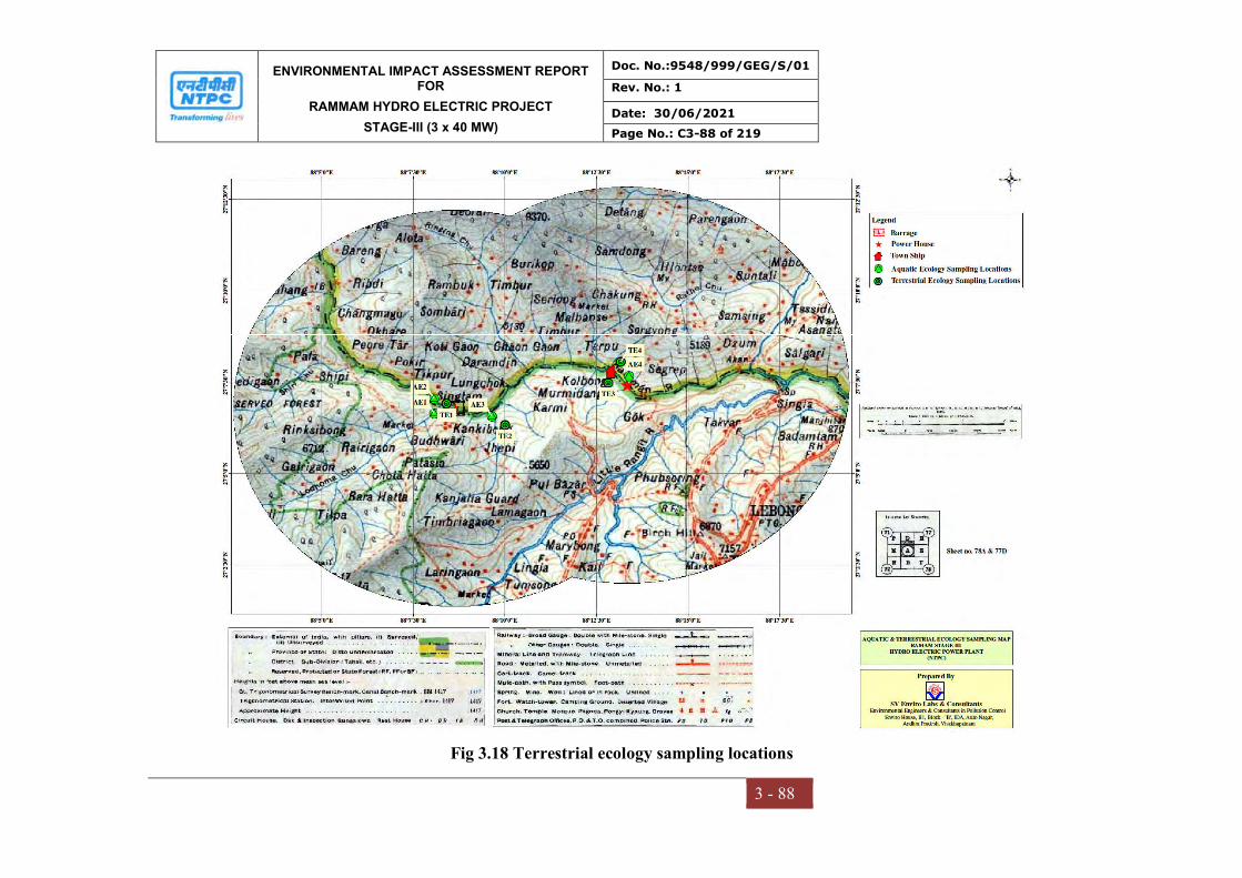
ENVIRONMENTAL IMPACT ASSESSMENT REPORT FOR
RAMMAM HYDRO ELECTRIC PROJECT
STAGE-III (3 x 40 MW)
Doc. No.:9548/999/GEG/S/01
Rev. No.: 1
Date: 30/06/2021
Page No.: C3-88 of 219
3 - 88
Fig 3.18 Terrestrial ecology sampling locations
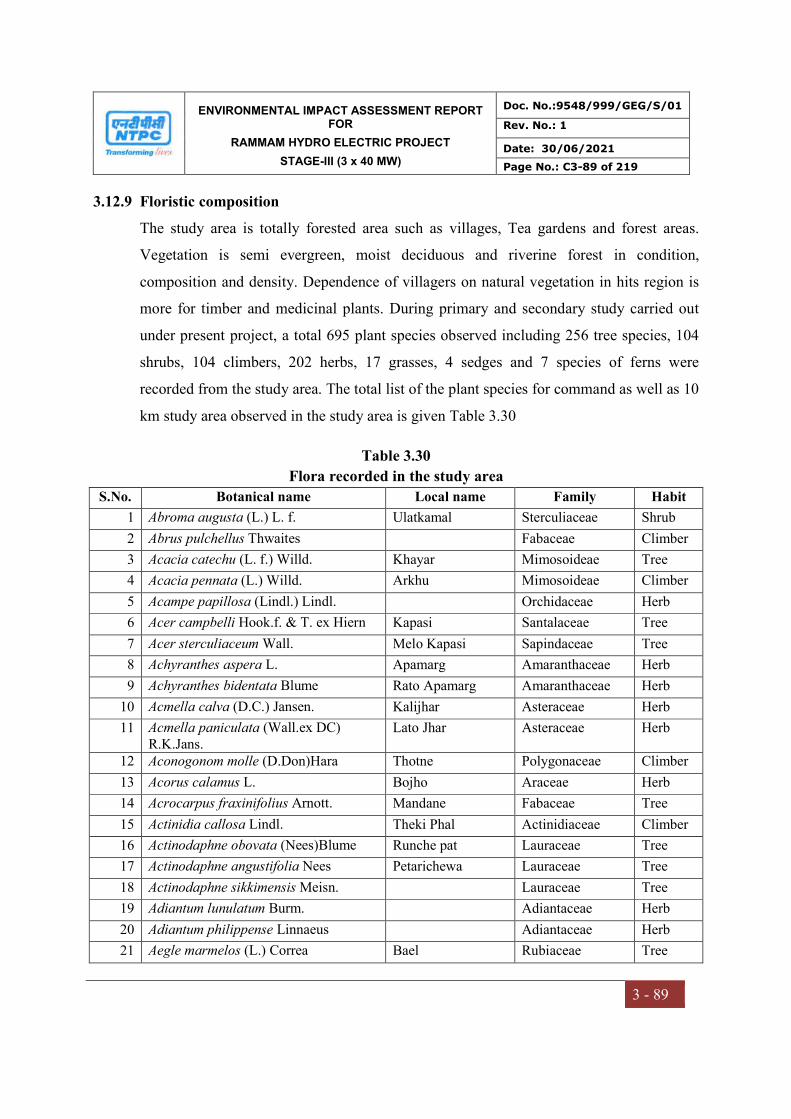
ENVIRONMENTAL IMPACT ASSESSMENT REPORT FOR
RAMMAM HYDRO ELECTRIC PROJECT
STAGE-III (3 x 40 MW)
Doc. No.:9548/999/GEG/S/01
Rev. No.: 1
Date: 30/06/2021
Page No.: C3-89 of 219
3 - 89
3.12.9 Floristic composition
The study area is totally forested area such as villages, Tea gardens and forest areas.
Vegetation is semi evergreen, moist deciduous and riverine forest in condition,
composition and density. Dependence of villagers on natural vegetation in hits region is
more for timber and medicinal plants. During primary and secondary study carried out
under present project, a total 695 plant species observed including 256 tree species, 104
shrubs, 104 climbers, 202 herbs, 17 grasses, 4 sedges and 7 species of ferns were
recorded from the study area. The total list of the plant species for command as well as 10
km study area observed in the study area is given Table 3.30
Table 3.30
Flora recorded in the study area
S.No. Botanical name Local name Family Habit
1 Abroma augusta (L.) L. f. Ulatkamal Sterculiaceae Shrub
2 Abrus pulchellus Thwaites Fabaceae Climber
3 Acacia catechu (L. f.) Willd. Khayar Mimosoideae Tree
4 Acacia pennata (L.) Willd. Arkhu Mimosoideae Climber
5 Acampe papillosa (Lindl.) Lindl. Orchidaceae Herb
6 Acer campbelli Hook.f. & T. ex Hiern Kapasi Santalaceae Tree
7 Acer sterculiaceum Wall. Melo Kapasi Sapindaceae Tree
8 Achyranthes aspera L. Apamarg Amaranthaceae Herb
9 Achyranthes bidentata Blume Rato Apamarg Amaranthaceae Herb
10 Acmella calva (D.C.) Jansen. Kalijhar Asteraceae Herb
11 Acmella paniculata (Wall.ex DC) R.K.Jans.
Lato Jhar Asteraceae Herb
12 Aconogonom molle (D.Don)Hara Thotne Polygonaceae Climber
13 Acorus calamus L. Bojho Araceae Herb
14 Acrocarpus fraxinifolius Arnott. Mandane Fabaceae Tree
15 Actinidia callosa Lindl. Theki Phal Actinidiaceae Climber
16 Actinodaphne obovata (Nees)Blume Runche pat Lauraceae Tree
17 Actinodaphne angustifolia Nees Petarichewa Lauraceae Tree
18 Actinodaphne sikkimensis Meisn. Lauraceae Tree
19 Adiantum lunulatum Burm. Adiantaceae Herb
20 Adiantum philippense Linnaeus Adiantaceae Herb
21 Aegle marmelos (L.) Correa Bael Rubiaceae Tree

ENVIRONMENTAL IMPACT ASSESSMENT REPORT FOR
RAMMAM HYDRO ELECTRIC PROJECT
STAGE-III (3 x 40 MW)
Doc. No.:9548/999/GEG/S/01
Rev. No.: 1
Date: 30/06/2021
Page No.: C3-90 of 219
3 - 90
22 Aerides odorata Loureiro. Orchidaceae Herb
23 Aerva javanica Juss. ex Schult. Kapok bush Amaranthaceae Herb
24 Aeschynanthus acuminatus Wall .ex A.DC.
Gesneriaceae Herb
25 Aeschynanthus hookeri C.B. Clarke Gesneriaceae Herb
26 Aeschynanthus novogracilisW.T.Wang Nilgiri Blushwort Gesneriaceae Herb
27 Aeschynanthus parviflorus (D.Don) Spreng.
Thirjo Gesneriaceae Herb
28 Agapetes serpens(Wight) Sleumer Khorsane Ericaceae Shrub
29 Ageratina adenophora (Sprengel) R.M.King &H.Rob.
Kalo Banmara Asteraceae Shrub
30 Ageratum conyzoides L. Ilame Jhar Asteraceae Herb
31 Ageratum houstonianum Miller Asteraceae Herb
32 Aglaia chittagonga Miq. Meliaceae Tree
33 Ailanthus excelsa Roxb. Gokul Simaroubaceae Tree
34 Ailanthus integrifolia Lam. Saragphula Simaroubaceae Tree
35 Alangium salvifolium (L. F.) Wangerin Asare Alanginaceae Tree
36 Alangium chinense (Lour.) Harms Phir Phire Alanginaceae Tree
37 Albizia lebbeck (L.) Benth. Kalo siris Fabaceae Tree
38 Albizia procera (Roxb.) Benth. Seto Siris Fabaceae Tree
39 Albizia odoratissima (L.f.) Benth. Kalo shirish Fabaceae Tree
40 Allium wallichii Kunth. Ban lasun Amyrallidaceae Herb
41 Alnus nepalensis D.Don. Utis Betulaceae Tree
42 Aloe barbadensis Miller. Chal-kuori Liliaceae Climber
43 Alseodaphne owdenii R.Parker Tilkhundi Lauraceae Tree
44 Alsophila glaucas (Sw.)Urb. Rukh unio Cyatheacea Fern
45 Alstonia scholaris (L.)R.Br. Chatiwan Apocynaceae Tree
46 Alternanthera sessile (L.) DC. Saranchi saag Amaranthaceae Herb
47 Amaranthus lividus L. Latte saag Amaranthaceae Herb
48 Amaranthus spinosus L. Lude saag Amaranthaceae Herb
49 Amaranthus viridus L. Lude saag Amaranthaceae Herb
50 Amomum dealbatum Roxb. Churumpha Zingiberaceae Shrub
51 Amomum subulatum Roxb. Alaichi Zingiberaceae Herb
52 Ampelocissus barbata (Wall.) Planchon.
Jarila laha Vitaceae Climber
53 Anaphalis contorta (D. Don) Hook.f. Bukiphul Asteraceae Herb
54 Anaphalis margaritacea (L.)Benth & Hook.f.
Indian Cudweed Asteraceae Herb
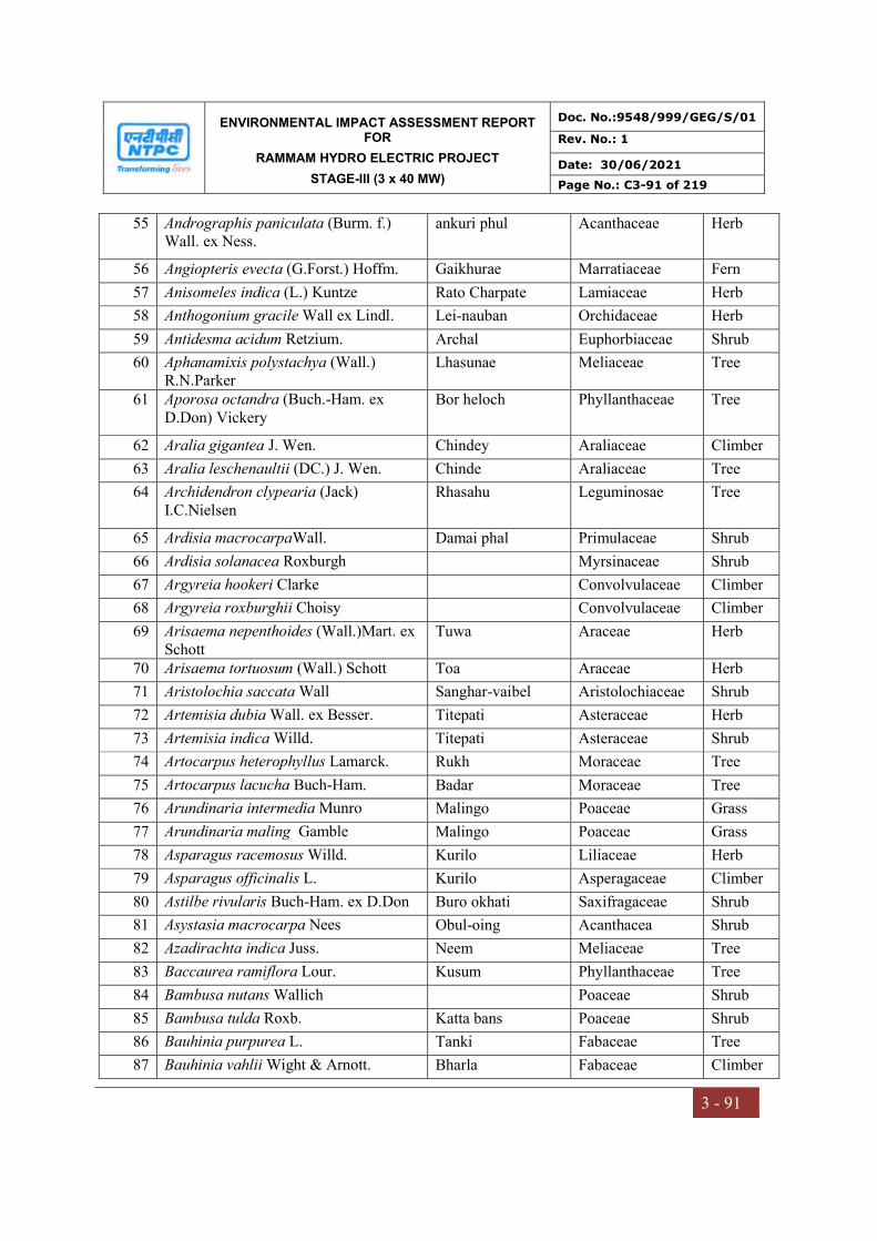
ENVIRONMENTAL IMPACT ASSESSMENT REPORT FOR
RAMMAM HYDRO ELECTRIC PROJECT
STAGE-III (3 x 40 MW)
Doc. No.:9548/999/GEG/S/01
Rev. No.: 1
Date: 30/06/2021
Page No.: C3-91 of 219
3 - 91
55 Andrographis paniculata (Burm. f.) Wall. ex Ness.
ankuri phul Acanthaceae Herb
56 Angiopteris evecta (G.Forst.) Hoffm. Gaikhurae Marratiaceae Fern
57 Anisomeles indica (L.) Kuntze Rato Charpate Lamiaceae Herb
58 Anthogonium gracile Wall ex Lindl. Lei-nauban Orchidaceae Herb
59 Antidesma acidum Retzium. Archal Euphorbiaceae Shrub
60 Aphanamixis polystachya (Wall.) R.N.Parker
Lhasunae Meliaceae Tree
61 Aporosa octandra (Buch.-Ham. ex D.Don) Vickery
Bor heloch Phyllanthaceae Tree
62 Aralia gigantea J. Wen. Chindey Araliaceae Climber
63 Aralia leschenaultii (DC.) J. Wen. Chinde Araliaceae Tree
64 Archidendron clypearia (Jack) I.C.Nielsen
Rhasahu Leguminosae Tree
65 Ardisia macrocarpaWall. Damai phal Primulaceae Shrub
66 Ardisia solanacea Roxburgh Myrsinaceae Shrub
67 Argyreia hookeri Clarke Convolvulaceae Climber
68 Argyreia roxburghii Choisy Convolvulaceae Climber
69 Arisaema nepenthoides (Wall.)Mart. ex Schott
Tuwa Araceae Herb
70 Arisaema tortuosum (Wall.) Schott Toa Araceae Herb
71 Aristolochia saccata Wall Sanghar-vaibel Aristolochiaceae Shrub
72 Artemisia dubia Wall. ex Besser. Titepati Asteraceae Herb
73 Artemisia indica Willd. Titepati Asteraceae Shrub
74 Artocarpus heterophyllus Lamarck. Rukh Moraceae Tree
75 Artocarpus lacucha Buch-Ham. Badar Moraceae Tree
76 Arundinaria intermedia Munro Malingo Poaceae Grass
77 Arundinaria maling Gamble Malingo Poaceae Grass
78 Asparagus racemosus Willd. Kurilo Liliaceae Herb
79 Asparagus officinalis L. Kurilo Asperagaceae Climber
80 Astilbe rivularis Buch-Ham. ex D.Don Buro okhati Saxifragaceae Shrub
81 Asystasia macrocarpa Nees Obul-oing Acanthacea Shrub
82 Azadirachta indica Juss. Neem Meliaceae Tree
83 Baccaurea ramiflora Lour. Kusum Phyllanthaceae Tree
84 Bambusa nutans Wallich Poaceae Shrub
85 Bambusa tulda Roxb. Katta bans Poaceae Shrub
86 Bauhinia purpurea L. Tanki Fabaceae Tree
87 Bauhinia vahlii Wight & Arnott. Bharla Fabaceae Climber

ENVIRONMENTAL IMPACT ASSESSMENT REPORT FOR
RAMMAM HYDRO ELECTRIC PROJECT
STAGE-III (3 x 40 MW)
Doc. No.:9548/999/GEG/S/01
Rev. No.: 1
Date: 30/06/2021
Page No.: C3-92 of 219
3 - 92
88 Bauhinia variegata L. Koirala Fabaceae Tree
89 Beaumontia grandiflora Wall. Chimale lahara Apocynaceae Climber
90 Begonia cathcartii Hook. f. D. Don. Dieng Jajew Begoniaceae Herb
91 Begonia dioica Buch._Ham. Ex D.Don Mangarkanche Begoniaceae Herb
92 Begonia hatacoa D. Don Begoniaceae Herb
93 Begonia picta Sm. Magarkache Begoniaceae Herb
94 Begonia rubella Buch._Ham. Ex D.Don Magar kanche Begoniaceae Herb
95 Beilschmiedia clarkei Hook.f. Tarsing Lauraceae Tree
96 Beilschmiedia roxburghiana Nees Thulo Tarsing Lauraceae Tree
97 Beilschmiedia dalzellii (Meisn.) Kosterm.
Lauraceae Tree
98 Belamcanda chinensis (L.) DC. Tarware phool Iridaceae Herb
99 Bergenia ciliata (Haworth) Sternberg. Pakhen bet Saxifragaceae Herb
100 Betula alnoides Buch.-Ham. ex D.Don Saur Betulaceae Tree
101 Bidens pilosa L. Kalo Kuro Asteraceae Herb
102 Biophytum reinwardtii (Zuccarini) Klotzsch
Oxalidaceae Herb
103 Bischofia javanica Blume Kainjal Phyllanthaceae Tree
104 Boehmeria macrophylla Hornemann Urticaceae Herb
105 Boehmeria rugulosa Weddell Dar Urticaceae Tree
106 Boehmeria ternifolia D. Don Chalnu sisnu Urticaceae Herb
107 Boenninghausenia albiflora (Hook.) Reichb. ex Meisn.
Ankuree Rutaceae Herb
108 Bombax ceiba L. Simal Malvaceae Tree
109 Brassaiopsis glomerulata (Blume) Reg. Kalo Chuletro Araliaceae Shrub
110 Brassaiopsis hainla (Buch.-Ham. Ex D.Don) Seem
Seto Chuletro Araliaceae Shrub
111 Brassaiopsis hispida Seem Putta Araliaceae Shrub
112 Brassaiopsis mitis C.B.Clarke Chuletro/Phutta Araliaceae Tree
113 Bridelea retusa (L.) Juss. Gayo lahara Phyllanthaceae Climber
114 Bridelia stipularis (L.) Blume Gayo lahara Euphorbiaceae Climber
115 Bridelia sikkimensis Gehrm. Phyllanthaceae Tree
116 Bryonopsis laciniosa (L.) Naud. The bryony Cucurbitaceae Climber
117 Buchanania lanzan Spreng. Charoli Anacardiaceae Tree
118 Buddleja asiatica Loureiro. Karukattaan Buddlejaceae Climber
119 Butea parviflora Roxb. Dhak Papillionoideae Climber
120 Caesalpinia cucullata Roxb. Boksi Kara Fabaceae Climber

ENVIRONMENTAL IMPACT ASSESSMENT REPORT FOR
RAMMAM HYDRO ELECTRIC PROJECT
STAGE-III (3 x 40 MW)
Doc. No.:9548/999/GEG/S/01
Rev. No.: 1
Date: 30/06/2021
Page No.: C3-93 of 219
3 - 93
121 Calamus erectus Roxb. Phyakre Areceae Tree
122 Calamus latifolius Roxb. Phekre Bet Arecaceae Climber
123 Calamus tenuis Roxb. Kukhre bet Arecaceae Climber
124 Callicarpa arborea Roxb. Guenlo Verbenaceae Tree
125 Callicarpa vestita Wall. Ex C.B.Clarke Guenlo Verbenaceae Tree
126 Calophyllum polyanthum Wall. Ex Choisy
Rate Clausiaceae Tree
127 Calotropis gigantea (L.) Dryander. Aank Asclepiadaceae Shrub
128 Canarium sikkimense King. Gokul Dhup Burseraceae Tree
129 Cannabis sativa L. Phul tarul Cannabiaceae Shrub
130 Capillipedium assimile (Steudel) A. Camus
Poaceae Grass
131 Carex baccans Nees ex Wight Harkatta Cyperaceae Sedge
132 Carex filicina Nees Harkatta Cyperaceae Sedge
133 Careya arborea Roxb. Kumbh Lecythidaceae Tree
134 Caryota urens L. Rangbhang Arecaceae Tree
135 Casearia glomerata Roxb. Barkaulae Salicaceae Tree
136 Casearia tomentosa Roxb. Saptrangi Salicaceae Tree
137 Casearia vareca Roxb. Salicaceae Tree
138 Cassia fistula L. Amaltas Caesalpinoideae Tree
139 Castanopsis hystrix Hook f & Thomson Jat/Patle Katus Fagaceae Tree
140 Castanopsis indica (Roxb.exLindley) A.de Cand.
Dhalnae Katus Fagaceae Tree
141 Castanopsis tribuloides (Sm.) A. DC. Musre katus Fagaceae Tree
142 Castanopsis lanceifolia (Oerst.) Hickel & A.Camus
Serang Fagaceae Tree
143 Catharanthus roseus (L.) G. Don. Nayantara Apocynaceae Herb
144 Catunaregam spinosa (Thunb.) Tirveng.
Maidal Rubiaceae Shrub
145 Cautleya gracilis (Sm).Dandy Zingiberaceae Herb
146 Cayratia trifolia (L.) Domin. Amalbel Vitaceae Climber
147 Celtis tetranda Roxb. Khari Ulmaceae Tree
148 Celtis timorensis Span Khari Ulmaceae Tree
149 Centella asiatica (L.) Urb. Athane Jhar Apiaceae Herb
150 Cephaelis ipecacuanha(Brot.) A. Rich. Rubiaceae Shrub
151 Cephalostachyum capitatium Munro Gope/ Dallo Bans Poaceae Grass
152 Chamabainia cuspidata Wight Urticaceae Herb
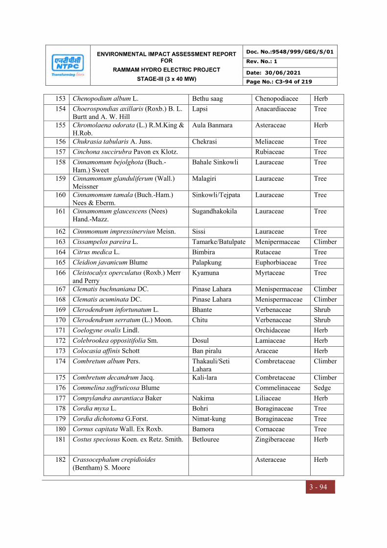
ENVIRONMENTAL IMPACT ASSESSMENT REPORT FOR
RAMMAM HYDRO ELECTRIC PROJECT
STAGE-III (3 x 40 MW)
Doc. No.:9548/999/GEG/S/01
Rev. No.: 1
Date: 30/06/2021
Page No.: C3-94 of 219
3 - 94
153 Chenopodium album L. Bethu saag Chenopodiacee Herb
154 Choerospondias axillaris (Roxb.) B. L. Burtt and A. W. Hill
Lapsi Anacardiaceae Tree
155 Chromolaena odorata (L.) R.M.King & H.Rob.
Aula Banmara Asteraceae Herb
156 Chukrasia tabularis A. Juss. Chekrasi Meliaceae Tree
157 Cinchona succirubra Pavon ex Klotz. Rubiaceae Tree
158 Cinnamomum bejolghota (Buch.- Ham.) Sweet
Bahale Sinkowli Lauraceae Tree
159 Cinnamomum glanduliferum (Wall.) Meissner
Malagiri Lauraceae Tree
160 Cinnamomum tamala (Buch.-Ham.) Nees & Eberm.
Sinkowli/Tejpata Lauraceae Tree
161 Cinnamomum glaucescens (Nees) Hand.-Mazz.
Sugandhakokila Lauraceae Tree
162 Cinnmomum impressinerviun Meisn. Sissi Lauraceae Tree
163 Cissampelos pareira L. Tamarke/Batulpate Menipermaceae Climber
164 Citrus medica L. Bimbira Rutaceae Tree
165 Cleidion javanicum Blume Palapkung Euphorbiaceae Tree
166 Cleistocalyx operculatus (Roxb.) Merr and Perry
Kyamuna Myrtaceae Tree
167 Clematis buchnaniana DC. Pinase Lahara Menispermaceae Climber
168 Clematis acuminata DC. Pinase Lahara Menispermaceae Climber
169 Clerodendrum infortunatum L. Bhante Verbenaceae Shrub
170 Clerodendrum serratum (L.) Moon. Chitu Verbenaceae Shrub
171 Coelogyne ovalis Lindl. Orchidaceae Herb
172 Colebrookea oppositifolia Sm. Dosul Lamiaceae Herb
173 Colocasia affinis Schott Ban piralu Araceae Herb
174 Combretum album Pers. Thakauli/Seti Lahara
Combretaceae Climber
175 Combretum decandrum Jacq. Kali-lara Combretaceae Climber
176 Commelina suffruticosa Blume Commelinaceae Sedge
177 Compylandra aurantiaca Baker Nakima Liliaceae Herb
178 Cordia myxa L. Bohri Boraginaceae Tree
179 Cordia dichotoma G.Forst. Nimat-kung Boraginaceae Tree
180 Cornus capitata Wall. Ex Roxb. Bamora Cornaceae Tree
181 Costus speciosus Koen. ex Retz. Smith. Betlouree Zingiberaceae Herb
182 Crassocephalum crepidioides (Bentham) S. Moore
Asteraceae Herb
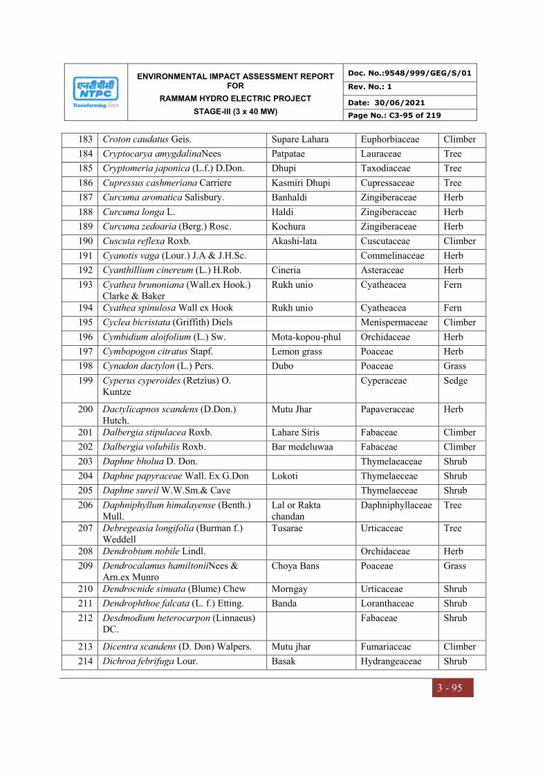
ENVIRONMENTAL IMPACT ASSESSMENT REPORT FOR
RAMMAM HYDRO ELECTRIC PROJECT
STAGE-III (3 x 40 MW)
Doc. No.:9548/999/GEG/S/01
Rev. No.: 1
Date: 30/06/2021
Page No.: C3-95 of 219
3 - 95
183 Croton caudatus Geis. Supare Lahara Euphorbiaceae Climber
184 Cryptocarya amygdalinaNees Patpatae Lauraceae Tree
185 Cryptomeria japonica (L.f.) D.Don. Dhupi Taxodiaceae Tree
186 Cupressus cashmeriana Carriere Kasmiri Dhupi Cupressaceae Tree
187 Curcuma aromatica Salisbury. Banhaldi Zingiberaceae Herb
188 Curcuma longa L. Haldi Zingiberaceae Herb
189 Curcuma zedoaria (Berg.) Rosc. Kochura Zingiberaceae Herb
190 Cuscuta reflexa Roxb. Akashi-lata Cuscutaceae Climber
191 Cyanotis vaga (Lour.) J.A & J.H.Sc. Commelinaceae Herb
192 Cyanthillium cinereum (L.) H.Rob. Cineria Asteraceae Herb
193 Cyathea brunoniana (Wall.ex Hook.) Clarke & Baker
Rukh unio Cyatheacea Fern
194 Cyathea spinulosa Wall ex Hook Rukh unio Cyatheacea Fern
195 Cyclea bicristata (Griffith) Diels Menispermaceae Climber
196 Cymbidium aloifolium (L.) Sw. Mota-kopou-phul Orchidaceae Herb
197 Cymbopogon citratus Stapf. Lemon grass Poaceae Herb
198 Cynadon dactylon (L.) Pers. Dubo Poaceae Grass
199 Cyperus cyperoides (Retzius) O. Kuntze
Cyperaceae Sedge
200 Dactylicapnos scandens (D.Don.) Hutch.
Mutu Jhar Papaveraceae Herb
201 Dalbergia stipulacea Roxb. Lahare Siris Fabaceae Climber
202 Dalbergia volubilis Roxb. Bar medeluwaa Fabaceae Climber
203 Daphne bholua D. Don. Thymelaeaceae Shrub
204 Daphne papyraceae Wall. Ex G.Don Lokoti Thymelaeceae Shrub
205 Daphne sureil W.W.Sm.& Cave Thymelaeceae Shrub
206 Daphniphyllum himalayense (Benth.) Mull.
Lal or Rakta chandan
Daphniphyllaceae Tree
207 Debregeasia longifolia (Burman f.) Weddell
Tusarae Urticaceae Tree
208 Dendrobium nobile Lindl. Orchidaceae Herb
209 Dendrocalamus hamiltoniiNees & Arn.ex Munro
Choya Bans Poaceae Grass
210 Dendrocnide sinuata (Blume) Chew Morngay Urticaceae Shrub
211 Dendrophthoe falcata (L. f.) Etting. Banda Loranthaceae Shrub
212 Desdmodium heterocarpon (Linnaeus) DC.
Fabaceae Shrub
213 Dicentra scandens (D. Don) Walpers. Mutu jhar Fumariaceae Climber
214 Dichroa febrifuga Lour. Basak Hydrangeaceae Shrub

ENVIRONMENTAL IMPACT ASSESSMENT REPORT FOR
RAMMAM HYDRO ELECTRIC PROJECT
STAGE-III (3 x 40 MW)
Doc. No.:9548/999/GEG/S/01
Rev. No.: 1
Date: 30/06/2021
Page No.: C3-96 of 219
3 - 96
215 Dichrocephala integrifolia (L.f.) Kuntze
Hadchun Jhar Asteraceae Herb
216 Dicliptera bupleuroides Nees Acanthaceae Herb
217 Didymocarpus aromaticus Wall. ex D. Don.
Gesneriaceae Herb
218 Digitalis purpurea L. Jhandi phool Scrophularaceae Herb
219 Dillenia indica L. Panchphale Dilleniaceae Tree
220 Dillenia pentagyna Roxb. Tatri Dilleniaceae Tree
221 Dioscorea alata L. Ghartarul Dioscoreaceae Climber
222 Dioscorea belophylla (Prain)Voigit ex Haines
Tarul Dioscoreceae Climber
223 Dioscorea bulbifera L. Githa/Ban Tarul Dioscoreaceae Climber
224 Dioscorea deltoidea Wall.ex Griseb. Kukur tarul Dioscoreaceae Climber
225 Dioscorea hamiltonii Hook.f. Ban tarul Dioscoreace Climber
226 Dioscorea hispida Dennstedt Dioscoreaceae Climber
227 Dioscorea pentaphylla L. Bhyagur Dioscoreaceae Climber
228 Diplazium esculentum (Retzius) Swart Saune niuro Athyriaceae Herb
229 Diplazium maximum(D. Don) C. Chr. Danthe niuro Athyriaceae Herb
230 Diploknema butyracea (Roxb.) Baehni Chiuri Sapotaceae Tree
231 Dobinea vulgaris Buch. Ham.ex D.Don Sangli phul Anacardiaceae Shrub
232 Dolichos biflorus L. Fabaceae Herb
233 Drimycarpus racemosus (Roxb.) Hook.f. ex Marchand.
Kagi Anacardiaceae Tree
234 Drymaria cordata Willd. Avijal Caryophyllaceae Herb
235 Drymaria villosa Cham .& Schl. Abhijal Caryophylaceae Herb
236 Dryopteris cochleata (D. Don) C. Chr. Danthe niuro Dryopteridaceae Herb
237 Dryopteris sikkimensis (Beddome) O. Kuntze
Dryopteridaceae Herb
238 Duabanga grandiflora (Roxb.ex DC.)Walpers.
Lampatae Lythraceae Tree
239 Duchesna indica(Andrews) Focke Bhui Aiselu Rosaceae Herb
240 Dysoxylum binectariferum (Roxb.) Hook.f. ex Bedd.
Lhasune Meliaceae Tree
241 Dysoxylum excelsum Blume Lhasune Meliaceae Tree
242 Eclipta prostrata (L.) L. Bhringraj Asteraceae Herb
243 Edgeworthia gardneri(Wall.) Meissn. Argeli Thymelaeceae Shrub
244 Elaeagnus infundibularis Momiy. Malledo Elaeagnaceae Shrub
245 Elaeocarpus lanceifolius Roxb. Bhadrasae Elaeocarpaceae Tree
246 Elaeocarpus sikkimensis Mast. Bhadrasae Elaeocarpaceae Tree
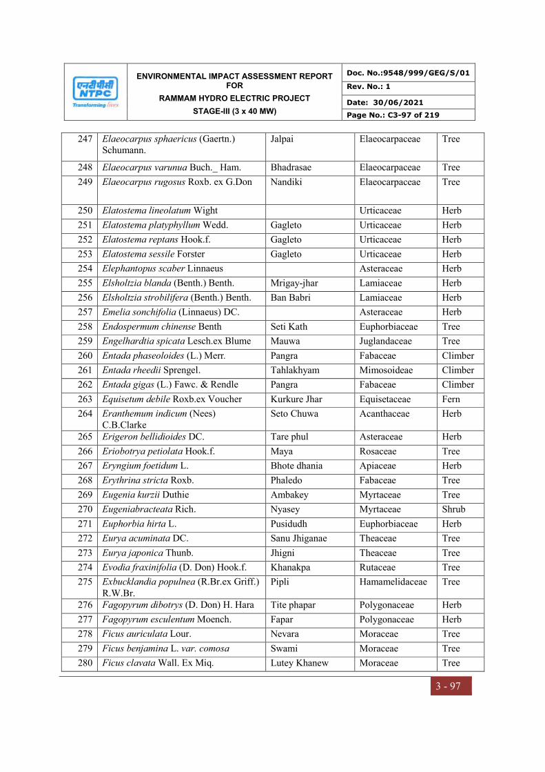
ENVIRONMENTAL IMPACT ASSESSMENT REPORT FOR
RAMMAM HYDRO ELECTRIC PROJECT
STAGE-III (3 x 40 MW)
Doc. No.:9548/999/GEG/S/01
Rev. No.: 1
Date: 30/06/2021
Page No.: C3-97 of 219
3 - 97
247 Elaeocarpus sphaericus (Gaertn.) Schumann.
Jalpai Elaeocarpaceae Tree
248 Elaeocarpus varunua Buch._ Ham. Bhadrasae Elaeocarpaceae Tree
249 Elaeocarpus rugosus Roxb. ex G.Don Nandiki Elaeocarpaceae Tree
250 Elatostema lineolatum Wight Urticaceae Herb
251 Elatostema platyphyllum Wedd. Gagleto Urticaceae Herb
252 Elatostema reptans Hook.f. Gagleto Urticaceae Herb
253 Elatostema sessile Forster Gagleto Urticaceae Herb
254 Elephantopus scaber Linnaeus Asteraceae Herb
255 Elsholtzia blanda (Benth.) Benth. Mrigay-jhar Lamiaceae Herb
256 Elsholtzia strobilifera (Benth.) Benth. Ban Babri Lamiaceae Herb
257 Emelia sonchifolia (Linnaeus) DC. Asteraceae Herb
258 Endospermum chinense Benth Seti Kath Euphorbiaceae Tree
259 Engelhardtia spicata Lesch.ex Blume Mauwa Juglandaceae Tree
260 Entada phaseoloides (L.) Merr. Pangra Fabaceae Climber
261 Entada rheedii Sprengel. Tahlakhyam Mimosoideae Climber
262 Entada gigas (L.) Fawc. & Rendle Pangra Fabaceae Climber
263 Equisetum debile Roxb.ex Voucher Kurkure Jhar Equisetaceae Fern
264 Eranthemum indicum (Nees) C.B.Clarke
Seto Chuwa Acanthaceae Herb
265 Erigeron bellidioides DC. Tare phul Asteraceae Herb
266 Eriobotrya petiolata Hook.f. Maya Rosaceae Tree
267 Eryngium foetidum L. Bhote dhania Apiaceae Herb
268 Erythrina stricta Roxb. Phaledo Fabaceae Tree
269 Eugenia kurzii Duthie Ambakey Myrtaceae Tree
270 Eugeniabracteata Rich. Nyasey Myrtaceae Shrub
271 Euphorbia hirta L. Pusidudh Euphorbiaceae Herb
272 Eurya acuminata DC. Sanu Jhiganae Theaceae Tree
273 Eurya japonica Thunb. Jhigni Theaceae Tree
274 Evodia fraxinifolia (D. Don) Hook.f. Khanakpa Rutaceae Tree
275 Exbucklandia populnea (R.Br.ex Griff.) R.W.Br.
Pipli Hamamelidaceae Tree
276 Fagopyrum dibotrys (D. Don) H. Hara Tite phapar Polygonaceae Herb
277 Fagopyrum esculentum Moench. Fapar Polygonaceae Herb
278 Ficus auriculata Lour. Nevara Moraceae Tree
279 Ficus benjamina L. var. comosa Swami Moraceae Tree
280 Ficus clavata Wall. Ex Miq. Lutey Khanew Moraceae Tree

ENVIRONMENTAL IMPACT ASSESSMENT REPORT FOR
RAMMAM HYDRO ELECTRIC PROJECT
STAGE-III (3 x 40 MW)
Doc. No.:9548/999/GEG/S/01
Rev. No.: 1
Date: 30/06/2021
Page No.: C3-98 of 219
3 - 98
281 Ficus hirta Vahl. Khasreto Moraceae Tree
282 Ficus hispida L.F. Khasre Moraceae Tree
283 Ficus hookeriana Corner Nebara Moraceae Tree
284 Ficus lacor Buch.- Ham. Kavra Moraceae Tree
285 Ficus neriifolia J.E.Smith Dudhilo Moraceae Tree
286 Ficus pubigera Miquel Dude Lahara Moraceae Climber
287 Ficus racemosa L. Dumri Moraceae Tree
288 Ficus sabincisa J.E.Smith Lutae Khanium Moraceae Shrub
289 Ficus semicordata Buch.-Ham. ex Sm Khasre Khaneu Moraceae Tree
290 Firmiana colorata (Roxb.) R.Br. Samarri pisi Malvaceae Tree
291 Flemingia stricta Roxburgh Fabaceae Shrub
292 Flueggea virosa (Willdenow) Voigt Euphorbiaceae Shrub
293 Fragaria nubicola (Lindl. Ex Hook.f.) Lac.
Bhuin Aselu Rosaceae Herb
294 Fraxinus floribunda Wall. Lankuri Oleaceae Tree
295 Galinsoga parviflora Cavanilles Asteraceae Herb
296 Gallium elgans Wall. Ex Roxb. Lahare Kuro Rubiaceae Herb
297 Gamblea ciliata C.B.Clarke Kursimla Araliaceae Tree
298 Garcinia cornea L. Chunyel Clusiaceae Shrub
299 Garcinia cowa Roxb. ex DC. Kaphal Clusiaceae Tree
300 Garcinia stipulata T.Anderson Sanakadan kung Clusiaceae Tree
301 Garuga floribunda Decne. Dabdabe Burseraceae Tree
302 Garuga pinnata Roxb. Dabdabe Burseraceae Tree
303 Gaultheria fragrantissima Wall. Patpate Ericaceae Tree
304 Geodorum densiflorum (Lam.) Schltr. Orchidaceae Herb
305 Geranium nepalenseEdgew.&Hook.f. Jerenium Geraniaceae Herb
306 Girardiana diversifolia (Link) Friis Bhangre sisnu Urticaceae Shrub
307 Gleichenia gigantea Wall.exHook. Kalame uneo Gleicheneaceae Fern
308 Globba racemosa Smith Zingiberaceae Herb
309 Glochidion acuminatum Mull. Lati Kath Phyllanthaceae Tree
310 Gloriosa superba L. Bishalanguli Liliaceae Herb
311 Gmelina arborea Roxb. Kasnar Verbenaceae Tree
312 Gonostegia hirta (Blume ex Hassk.) Miq.
Chiple Urticaceae Herb
313 Gordonia dipterosperma Kurz. Hinguwa Theaceae Tree
314 Gordonia excelsa (Blume) Blume Theaceae Tree
315 Grewia sapida Roxb.ex DC. Kuail Malvaceae Shrub
316 Grewia eriocarpa Juss. Fuhura Malvaceae Shrub

ENVIRONMENTAL IMPACT ASSESSMENT REPORT FOR
RAMMAM HYDRO ELECTRIC PROJECT
STAGE-III (3 x 40 MW)
Doc. No.:9548/999/GEG/S/01
Rev. No.: 1
Date: 30/06/2021
Page No.: C3-99 of 219
3 - 99
317 Grewia optiva J.R.Drumm. ex Burret Bauel Malvaceae Tree
318 Grewia serrulata DC. Malvaceae Tree
319 Guizotia abyssinica (L.f.) Cass Philunge Asteraceae Herb
320 Gynocordia ordorota R.Br. Gante/Bandare Flacourtiaceae Tree
321 Gynura cusimbua (D.Don)S.Moore Asteraceae Shrub
322 Haldina cordifolia (Roxb.) Ridsdale Karam Rubiaceae Tree
323 Hedychium coccineum Buch.-Ham ex Sm.
Sara Zingirberaceae Herb
324 Hedychium coronarium Koen. Pankha Phool Zingiberaceae Herb
325 Hedychium ellipticum Buch.-Ham ex Sm.
Rato Sara Zingirberaceae Herb
326 Hedyotis scandens Roxb. Bakhra Kanae Rubiaceae Climber
327 Helicia nilgerica Bedd. Bandare Proteaceae Tree
328 Helixanthera ligustrina(Wall.)Danser Aijaru Loranthaceae Shrub
329 Helixanthera parasitica Lour.(Wall.) Sanu Aijaru Loranthaceae Shrub
330 Helwingia himalaica Hook.f.&T. exC.B.Clarke
Pipli Hamamelidaceae Shrub
331 Hemiphragma heterophyllum Wall. Nashe/Lalgeri Jhar Scrophulariaceae Herb
332 Heracleum nepalense D. Don. Chimphing Apiaceae Herb
333 Heracleum wallichii DC Chimphing Apiaceae Herb
334 Herpetospermum pedunculosum (Ser.) C.B. Clarke
Jungali Ghiraula Cucurbitaceae Climber
335 Heteropanax fragrans Seeman. Lal Totola Araliaceae Tree
336 Heynea trijuga Roxb. ex Sims Akhaterwa Meliaceae Tree
337 Himalayacalamus hookerianus (Munro) Stapl.
Pareng Bans Poaceae Grass
338 Hiptage benghalensis (L.) Kurz Shempati Malpighiaceae Climber
339 Hodgsonia heteroclita Hook.f. and Thomson
Ghiuphal Cucurbitaceae Climber
340 Holarrhena pubescens Wall. ex G.Don Madhese Khirro Apocynaceae Tree
341 Holboellia angustifolia Wall. Gufla Lardizabalaceae Climber
342 Holboellia latifolia Wall. Golpha Lardizabalaceae Climber
343 Horsfieldia kingii (J. D. Hooker) Warburg
Ramguwa Myristicaceae Tree
344 Houttuynia cordata Thunb. Gande jhar Saururaceae Herb
345 Hoya parasitica (Roxb.)Wall.ex Wight Asclepiadaceae Climber
346 Hydrangea aspera D.Don Phirphire ghans Hydrangeaceae Shrub
347 Hydrocotyl himalaica P.K.Mukh. Golpatta Umbelliferae Herb
348 Hydrocotyl javanica Thunb. Dhungrijhar Umbelliferae Herb
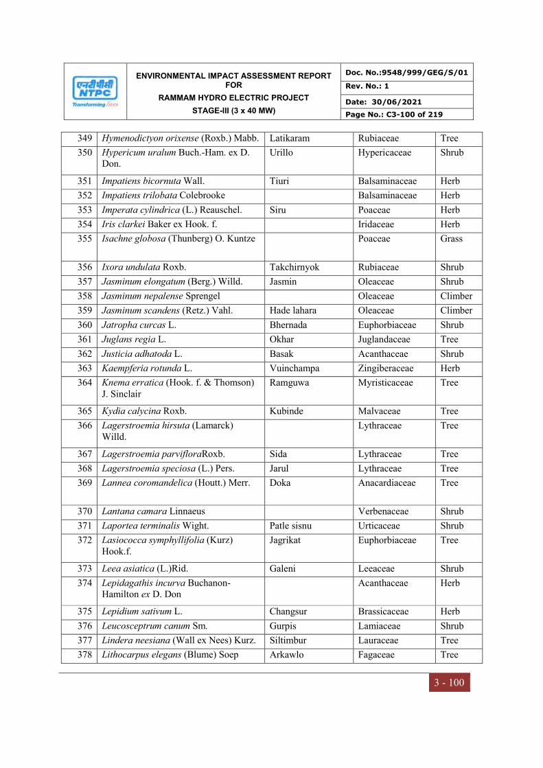
ENVIRONMENTAL IMPACT ASSESSMENT REPORT FOR
RAMMAM HYDRO ELECTRIC PROJECT
STAGE-III (3 x 40 MW)
Doc. No.:9548/999/GEG/S/01
Rev. No.: 1
Date: 30/06/2021
Page No.: C3-100 of 219
3 - 100
349 Hymenodictyon orixense (Roxb.) Mabb. Latikaram Rubiaceae Tree
350 Hypericum uralum Buch.-Ham. ex D. Don.
Urillo Hypericaceae Shrub
351 Impatiens bicornuta Wall. Tiuri Balsaminaceae Herb
352 Impatiens trilobata Colebrooke Balsaminaceae Herb
353 Imperata cylindrica (L.) Reauschel. Siru Poaceae Herb
354 Iris clarkei Baker ex Hook. f. Iridaceae Herb
355 Isachne globosa (Thunberg) O. Kuntze Poaceae Grass
356 Ixora undulata Roxb. Takchirnyok Rubiaceae Shrub
357 Jasminum elongatum (Berg.) Willd. Jasmin Oleaceae Shrub
358 Jasminum nepalense Sprengel Oleaceae Climber
359 Jasminum scandens (Retz.) Vahl. Hade lahara Oleaceae Climber
360 Jatropha curcas L. Bhernada Euphorbiaceae Shrub
361 Juglans regia L. Okhar Juglandaceae Tree
362 Justicia adhatoda L. Basak Acanthaceae Shrub
363 Kaempferia rotunda L. Vuinchampa Zingiberaceae Herb
364 Knema erratica (Hook. f. & Thomson) J. Sinclair
Ramguwa Myristicaceae Tree
365 Kydia calycina Roxb. Kubinde Malvaceae Tree
366 Lagerstroemia hirsuta (Lamarck) Willd.
Lythraceae Tree
367 Lagerstroemia parvifloraRoxb. Sida Lythraceae Tree
368 Lagerstroemia speciosa (L.) Pers. Jarul Lythraceae Tree
369 Lannea coromandelica (Houtt.) Merr. Doka Anacardiaceae Tree
370 Lantana camara Linnaeus Verbenaceae Shrub
371 Laportea terminalis Wight. Patle sisnu Urticaceae Shrub
372 Lasiococca symphyllifolia (Kurz) Hook.f.
Jagrikat Euphorbiaceae Tree
373 Leea asiatica (L.)Rid. Galeni Leeaceae Shrub
374 Lepidagathis incurva Buchanon-Hamilton ex D. Don
Acanthaceae Herb
375 Lepidium sativum L. Changsur Brassicaceae Herb
376 Leucosceptrum canum Sm. Gurpis Lamiaceae Shrub
377 Lindera neesiana (Wall ex Nees) Kurz. Siltimbur Lauraceae Tree
378 Lithocarpus elegans (Blume) Soep Arkawlo Fagaceae Tree

ENVIRONMENTAL IMPACT ASSESSMENT REPORT FOR
RAMMAM HYDRO ELECTRIC PROJECT
STAGE-III (3 x 40 MW)
Doc. No.:9548/999/GEG/S/01
Rev. No.: 1
Date: 30/06/2021
Page No.: C3-101 of 219
3 - 101
379 Lithocarpus fenestratus (Roxb.) Rehder Arkawlo Fagaceae Tree
380 Lithocarpus pachyphylla (Kurz.) Rehder.
Bante/Sungure katus
Fagaceae Tree
381 Litsea cubeba (Lour.) Pers. Siltimbur Lauraceae Tree
382 Litsea hookeri (Meisn.D.G. DudheLampatae Lauraceae Tree
383 Litsea lancifolia (Roxb.ex Nees) Benth.& Hook.f.
Kali pahenle Lauraceae Tree
384 Litsea monopetala (Roxb.)Pers. Kutmero Lauraceae Tree
385 Litsea salicifolia (Wall.exNees) Hook.f. Sano Pahalae Lauraceae Tree
386 Litsea glutinosa (Lour.) C.B.Rob. Suppatnyok Lauraceae Tree
387 Lycopodium clavatum L. Nagbeli Lycopodiaceace Climber
388 Lycopodium japonicum Thumb. Naagbeli Solanaceae Herb
389 Lygodium alatum (Clarke) V.A.V.R. Bahun Lahara Lygodioceae Climber
390 Lygodium flexosum (L.)Sw. Parawa andri Schizaeaceae Climber
391 Lygodium japonicum (Thunb.)Sw. Parawa andri Schizaeaceae Climber
392 Lyonia ovalifolia (Wall.) Drude. Angeri Ericaceae Tree
393 Macaranga denticulata(Blume)Mull. Jogi Malata Euphorbiaceae Tree
394 Macaranga indicaWight Rani Malata Euphorbiaceae Tree
395 Macaranga peltata (Geis.) Mull. Malata Euphorbiaceae Tree
396 Macaranga roxburghianus Mull. Phusre Malata Euphorbiaceae Shrub
397 Machilus edulis King ex Hook.f. Lapche Kawlo/Pumsi
Lauraceae Tree
398 Machilus gammieana King ex Hook.f. Chiple Kawlo Lauraceae Tree
399 Machilus glaucescens (Nees)Wight Bhainsi Kawlo Lauraceae Tree
400 Maclura cochinchinensis (Lour.) Corner
Bhale phul Moraceae Shrub
401 Macropanax dispermus (Wallich ex G. Don) Seemann
Chinde Araliaceae Tree
402 Maesa chisia Buch-Ham ex D. Don Bilaunae Myrsinaceae Shrub
403 Maesa indica (Roxb.)A.de Candolle Kalo Bilaunae Myrsinaceae Shrub
404 Maesa macrophylla (Wallich) A.DC. Myrsinaceae
405 Magnolia cathcartii (Hook.f.& T.) Noot.
Tite champ Magnoliaceae Tree
406 Magnolia doltsopa (Buch.-Ham. Ex DC.) Figlar
Rani/Mithe Champ Magnoliaceae Tree
407 Magnolia hodgsonii (Hook.f.&T.) H.Keng
Patpate Magnoliaceae Tree
408 Magnolia lanuginosa (Wall.) Figlar & Noot
Phusre Champ Magnoliaceae Tree
409 Magnolia pterocarpa Roxb. Gogay champ Magnoliaceae Tree
410 Mahonia nepaulensis DC. Mandre chutro Berberidaceae Tree
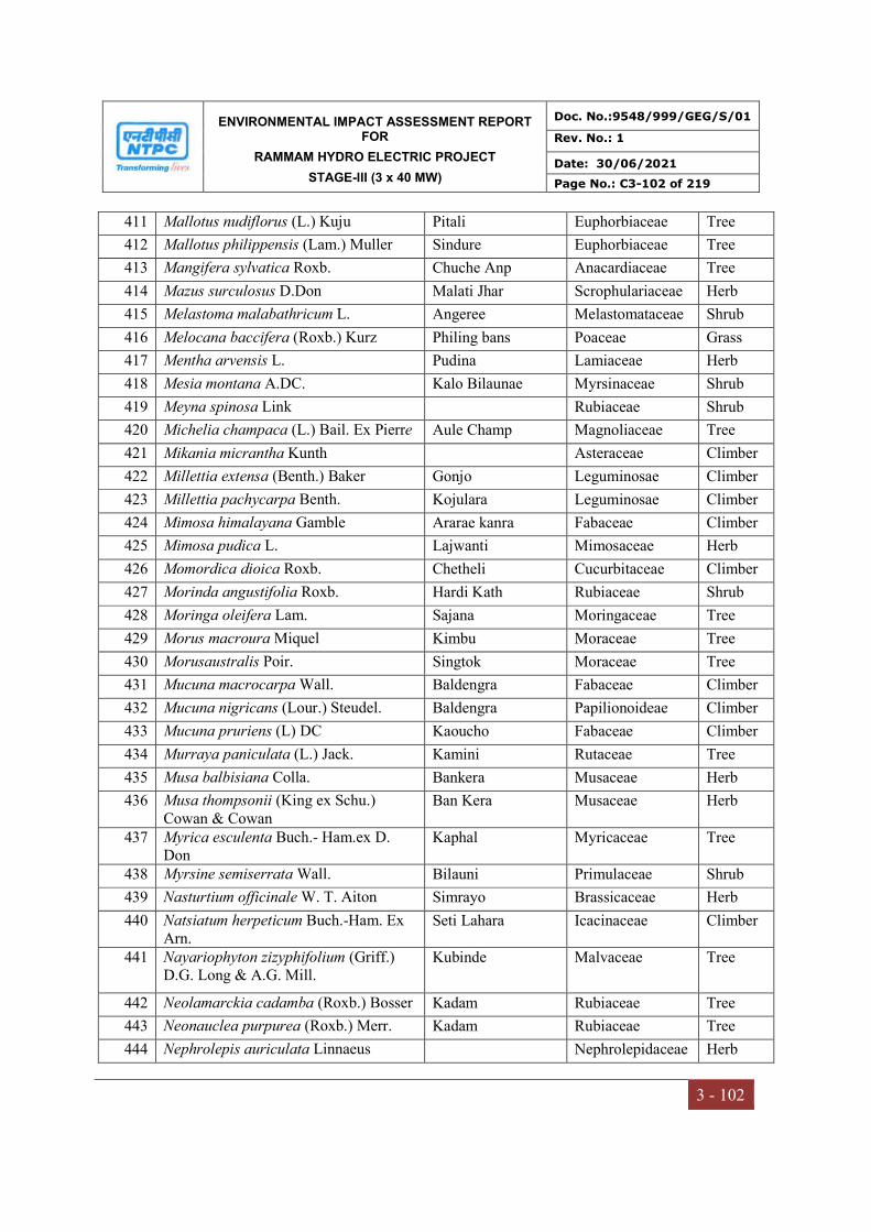
ENVIRONMENTAL IMPACT ASSESSMENT REPORT FOR
RAMMAM HYDRO ELECTRIC PROJECT
STAGE-III (3 x 40 MW)
Doc. No.:9548/999/GEG/S/01
Rev. No.: 1
Date: 30/06/2021
Page No.: C3-102 of 219
3 - 102
411 Mallotus nudiflorus (L.) Kuju Pitali Euphorbiaceae Tree
412 Mallotus philippensis (Lam.) Muller Sindure Euphorbiaceae Tree
413 Mangifera sylvatica Roxb. Chuche Anp Anacardiaceae Tree
414 Mazus surculosus D.Don Malati Jhar Scrophulariaceae Herb
415 Melastoma malabathricum L. Angeree Melastomataceae Shrub
416 Melocana baccifera (Roxb.) Kurz Philing bans Poaceae Grass
417 Mentha arvensis L. Pudina Lamiaceae Herb
418 Mesia montana A.DC. Kalo Bilaunae Myrsinaceae Shrub
419 Meyna spinosa Link Rubiaceae Shrub
420 Michelia champaca (L.) Bail. Ex Pierre Aule Champ Magnoliaceae Tree
421 Mikania micrantha Kunth Asteraceae Climber
422 Millettia extensa (Benth.) Baker Gonjo Leguminosae Climber
423 Millettia pachycarpa Benth. Kojulara Leguminosae Climber
424 Mimosa himalayana Gamble Ararae kanra Fabaceae Climber
425 Mimosa pudica L. Lajwanti Mimosaceae Herb
426 Momordica dioica Roxb. Chetheli Cucurbitaceae Climber
427 Morinda angustifolia Roxb. Hardi Kath Rubiaceae Shrub
428 Moringa oleifera Lam. Sajana Moringaceae Tree
429 Morus macroura Miquel Kimbu Moraceae Tree
430 Morusaustralis Poir. Singtok Moraceae Tree
431 Mucuna macrocarpa Wall. Baldengra Fabaceae Climber
432 Mucuna nigricans (Lour.) Steudel. Baldengra Papilionoideae Climber
433 Mucuna pruriens (L) DC Kaoucho Fabaceae Climber
434 Murraya paniculata (L.) Jack. Kamini Rutaceae Tree
435 Musa balbisiana Colla. Bankera Musaceae Herb
436 Musa thompsonii (King ex Schu.) Cowan & Cowan
Ban Kera Musaceae Herb
437 Myrica esculenta Buch.- Ham.ex D. Don
Kaphal Myricaceae Tree
438 Myrsine semiserrata Wall. Bilauni Primulaceae Shrub
439 Nasturtium officinale W. T. Aiton Simrayo Brassicaceae Herb
440 Natsiatum herpeticum Buch.-Ham. Ex Arn.
Seti Lahara Icacinaceae Climber
441 Nayariophyton zizyphifolium (Griff.) D.G. Long & A.G. Mill.
Kubinde Malvaceae Tree
442 Neolamarckia cadamba (Roxb.) Bosser Kadam Rubiaceae Tree
443 Neonauclea purpurea (Roxb.) Merr. Kadam Rubiaceae Tree
444 Nephrolepis auriculata Linnaeus Nephrolepidaceae Herb
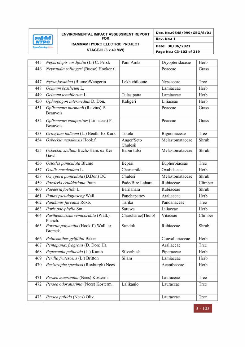
ENVIRONMENTAL IMPACT ASSESSMENT REPORT FOR
RAMMAM HYDRO ELECTRIC PROJECT
STAGE-III (3 x 40 MW)
Doc. No.:9548/999/GEG/S/01
Rev. No.: 1
Date: 30/06/2021
Page No.: C3-103 of 219
3 - 103
445 Nephrolepis cordifolia (L.) C. Persl. Pani Amla Dryopteridaceae Herb
446 Neyraudia zollingeri (Buese) Hooker f . Poaceae Grass
447 Nyssa javanica (Blume)Wangerin Lekh chiloune Nyssaceae Tree
448 Ocimum basilicum L. Lamiaceae Herb
449 Ocimum tenuiflorum L. Tulasipatta Lamiaceae Herb
450 Ophiopogon intermedius D. Don. Kaligeri Liliaceae Herb
451 Oplismenus burmanii (Retzius) P. Beauvois
Poaceae Grass
452 Oplismenus compositus (Linnaeus) P. Beauvois
Poaceae Grass
453 Oroxylum indicum (L.) Benth. Ex Kurz Totola Bignoniaceae Tree
454 Osbeckia nepalensis Hook.f. Anger/Seto Chulesii
Melastomataceae Shrub
455 Osbeckia stellata Buch.-Ham. ex Ker Gawl.
Babui tulsi Melastomataceae Shrub
456 Ostodes paniculata Blume Bepari Euphorbiaceae Tree
457 Oxalis corniculata L. Chariamilo Oxalidaceae Herb
458 Oxyspora paniculata (D.Don) DC Chulesi Melastomataceae Shrub
459 Paederia cruddasiana Prain Pade/Bire Lahara Rubiaceae Climber
460 Paederia foetida L. Barilahara Rubiaceae Shrub
461 Panax pseudoginseng Wall. Panchapattey Araliaceae Herb
462 Pandanus furcatas Roxb. Tarika Pandanaceae Tree
463 Paris polyphylla Sm. Satuwa Liliaceae Herb
464 Parthenocissus semicordata (Wall.) Planch.
Charcharae(Thulo) Vitaceae Climber
465 Pavetta polyantha (Hook.f.) Wall. ex Bremek.
Sundok Rubiaceae Shrub
466 Peliosanthes griffithii Baker Convallariaceae Herb
467 Pentapanax fragrans (D. Don) Ha Araliaceae Tree
468 Peperomia pellucida (L.) Kunth Silverbush Piperaceae Herb
469 Perilla frutescens (L.) Britton Silam Lamiaceae Herb
470 Peristrophe speciosa (Roxburgh) Nees Acanthaceae Herb
471 Persea macrantha (Nees) Kosterm. Lauraceae Tree
472 Persea odoratissima (Nees) Kosterm. Lalikaulo Lauraceae Tree
473 Persea pallida (Nees) Oliv. Lauraceae Tree
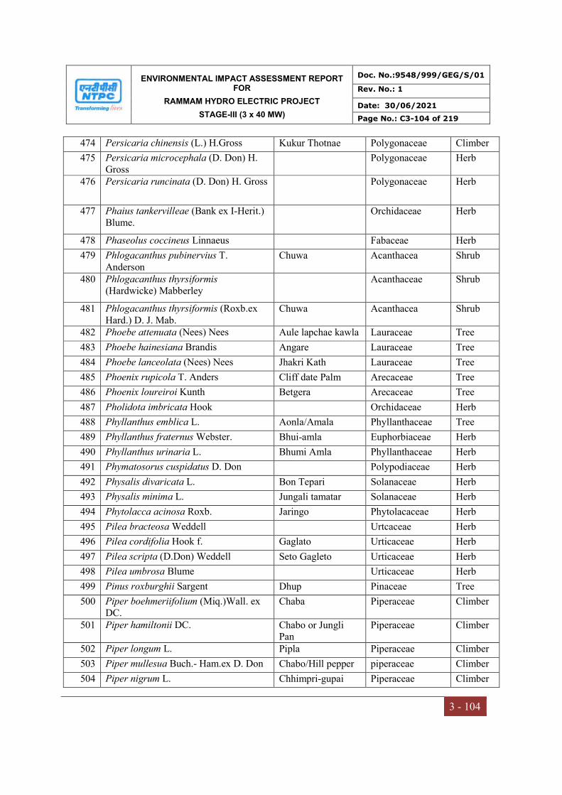
ENVIRONMENTAL IMPACT ASSESSMENT REPORT FOR
RAMMAM HYDRO ELECTRIC PROJECT
STAGE-III (3 x 40 MW)
Doc. No.:9548/999/GEG/S/01
Rev. No.: 1
Date: 30/06/2021
Page No.: C3-104 of 219
3 - 104
474 Persicaria chinensis (L.) H.Gross Kukur Thotnae Polygonaceae Climber
475 Persicaria microcephala (D. Don) H. Gross
Polygonaceae Herb
476 Persicaria runcinata (D. Don) H. Gross Polygonaceae Herb
477 Phaius tankervilleae (Bank ex I-Herit.) Blume.
Orchidaceae Herb
478 Phaseolus coccineus Linnaeus Fabaceae Herb
479 Phlogacanthus pubinervius T. Anderson
Chuwa Acanthacea Shrub
480 Phlogacanthus thyrsiformis (Hardwicke) Mabberley
Acanthaceae Shrub
481 Phlogacanthus thyrsiformis (Roxb.ex Hard.) D. J. Mab.
Chuwa Acanthacea Shrub
482 Phoebe attenuata (Nees) Nees Aule lapchae kawla Lauraceae Tree
483 Phoebe hainesiana Brandis Angare Lauraceae Tree
484 Phoebe lanceolata (Nees) Nees Jhakri Kath Lauraceae Tree
485 Phoenix rupicola T. Anders Cliff date Palm Arecaceae Tree
486 Phoenix loureiroi Kunth Betgera Arecaceae Tree
487 Pholidota imbricata Hook Orchidaceae Herb
488 Phyllanthus emblica L. Aonla/Amala Phyllanthaceae Tree
489 Phyllanthus fraternus Webster. Bhui-amla Euphorbiaceae Herb
490 Phyllanthus urinaria L. Bhumi Amla Phyllanthaceae Herb
491 Phymatosorus cuspidatus D. Don Polypodiaceae Herb
492 Physalis divaricata L. Bon Tepari Solanaceae Herb
493 Physalis minima L. Jungali tamatar Solanaceae Herb
494 Phytolacca acinosa Roxb. Jaringo Phytolacaceae Herb
495 Pilea bracteosa Weddell Urtcaceae Herb
496 Pilea cordifolia Hook f. Gaglato Urticaceae Herb
497 Pilea scripta (D.Don) Weddell Seto Gagleto Urticaceae Herb
498 Pilea umbrosa Blume Urticaceae Herb
499 Pinus roxburghii Sargent Dhup Pinaceae Tree
500 Piper boehmeriifolium (Miq.)Wall. ex DC.
Chaba Piperaceae Climber
501 Piper hamiltonii DC. Chabo or Jungli Pan
Piperaceae Climber
502 Piper longum L. Pipla Piperaceae Climber
503 Piper mullesua Buch.- Ham.ex D. Don Chabo/Hill pepper piperaceae Climber
504 Piper nigrum L. Chhimpri-gupai Piperaceae Climber
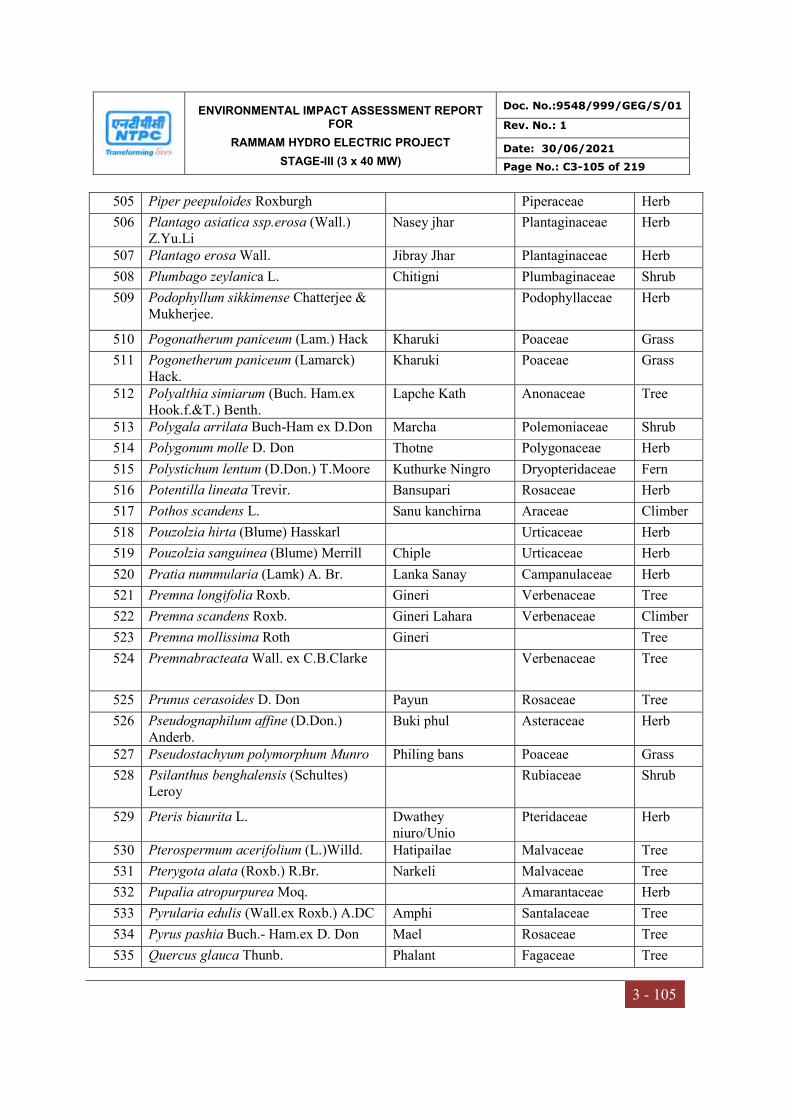
ENVIRONMENTAL IMPACT ASSESSMENT REPORT FOR
RAMMAM HYDRO ELECTRIC PROJECT
STAGE-III (3 x 40 MW)
Doc. No.:9548/999/GEG/S/01
Rev. No.: 1
Date: 30/06/2021
Page No.: C3-105 of 219
3 - 105
505 Piper peepuloides Roxburgh Piperaceae Herb
506 Plantago asiatica ssp.erosa (Wall.) Z.Yu.Li
Nasey jhar Plantaginaceae Herb
507 Plantago erosa Wall. Jibray Jhar Plantaginaceae Herb
508 Plumbago zeylanica L. Chitigni Plumbaginaceae Shrub
509 Podophyllum sikkimense Chatterjee & Mukherjee.
Podophyllaceae Herb
510 Pogonatherum paniceum (Lam.) Hack Kharuki Poaceae Grass
511 Pogonetherum paniceum (Lamarck) Hack.
Kharuki Poaceae Grass
512 Polyalthia simiarum (Buch. Ham.ex Hook.f.&T.) Benth.
Lapche Kath Anonaceae Tree
513 Polygala arrilata Buch-Ham ex D.Don Marcha Polemoniaceae Shrub
514 Polygonum molle D. Don Thotne Polygonaceae Herb
515 Polystichum lentum (D.Don.) T.Moore Kuthurke Ningro Dryopteridaceae Fern
516 Potentilla lineata Trevir. Bansupari Rosaceae Herb
517 Pothos scandens L. Sanu kanchirna Araceae Climber
518 Pouzolzia hirta (Blume) Hasskarl Urticaceae Herb
519 Pouzolzia sanguinea (Blume) Merrill Chiple Urticaceae Herb
520 Pratia nummularia (Lamk) A. Br. Lanka Sanay Campanulaceae Herb
521 Premna longifolia Roxb. Gineri Verbenaceae Tree
522 Premna scandens Roxb. Gineri Lahara Verbenaceae Climber
523 Premna mollissima Roth Gineri Tree
524 Premnabracteata Wall. ex C.B.Clarke Verbenaceae Tree
525 Prunus cerasoides D. Don Payun Rosaceae Tree
526 Pseudognaphilum affine (D.Don.) Anderb.
Buki phul Asteraceae Herb
527 Pseudostachyum polymorphum Munro Philing bans Poaceae Grass
528 Psilanthus benghalensis (Schultes) Leroy
Rubiaceae Shrub
529 Pteris biaurita L. Dwathey niuro/Unio
Pteridaceae Herb
530 Pterospermum acerifolium (L.)Willd. Hatipailae Malvaceae Tree
531 Pterygota alata (Roxb.) R.Br. Narkeli Malvaceae Tree
532 Pupalia atropurpurea Moq. Amarantaceae Herb
533 Pyrularia edulis (Wall.ex Roxb.) A.DC Amphi Santalaceae Tree
534 Pyrus pashia Buch.- Ham.ex D. Don Mael Rosaceae Tree
535 Quercus glauca Thunb. Phalant Fagaceae Tree
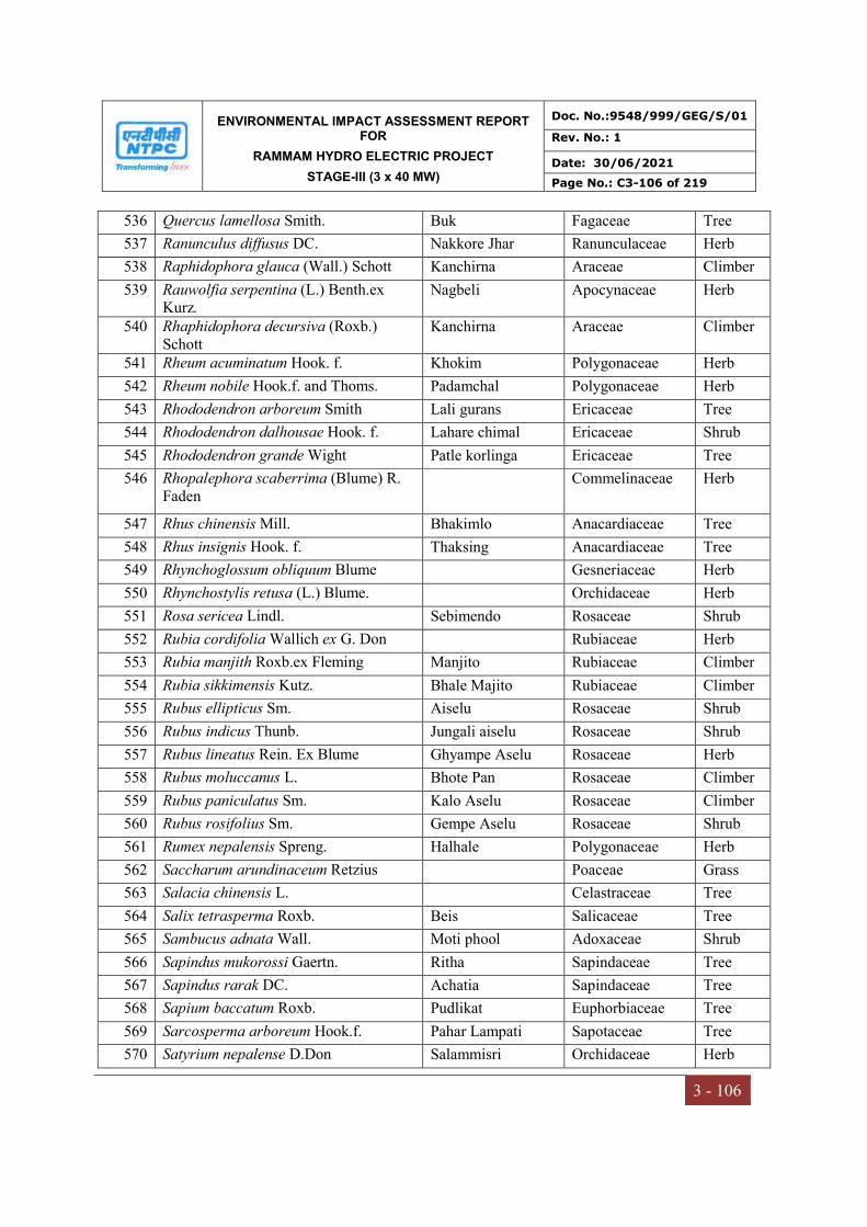
ENVIRONMENTAL IMPACT ASSESSMENT REPORT FOR
RAMMAM HYDRO ELECTRIC PROJECT
STAGE-III (3 x 40 MW)
Doc. No.:9548/999/GEG/S/01
Rev. No.: 1
Date: 30/06/2021
Page No.: C3-106 of 219
3 - 106
536 Quercus lamellosa Smith. Buk Fagaceae Tree
537 Ranunculus diffusus DC. Nakkore Jhar Ranunculaceae Herb
538 Raphidophora glauca (Wall.) Schott Kanchirna Araceae Climber
539 Rauwolfia serpentina (L.) Benth.ex Kurz.
Nagbeli Apocynaceae Herb
540 Rhaphidophora decursiva (Roxb.) Schott
Kanchirna Araceae Climber
541 Rheum acuminatum Hook. f. Khokim Polygonaceae Herb
542 Rheum nobile Hook.f. and Thoms. Padamchal Polygonaceae Herb
543 Rhododendron arboreum Smith Lali gurans Ericaceae Tree
544 Rhododendron dalhousae Hook. f. Lahare chimal Ericaceae Shrub
545 Rhododendron grande Wight Patle korlinga Ericaceae Tree
546 Rhopalephora scaberrima (Blume) R. Faden
Commelinaceae Herb
547 Rhus chinensis Mill. Bhakimlo Anacardiaceae Tree
548 Rhus insignis Hook. f. Thaksing Anacardiaceae Tree
549 Rhynchoglossum obliquum Blume Gesneriaceae Herb
550 Rhynchostylis retusa (L.) Blume. Orchidaceae Herb
551 Rosa sericea Lindl. Sebimendo Rosaceae Shrub
552 Rubia cordifolia Wallich ex G. Don Rubiaceae Herb
553 Rubia manjith Roxb.ex Fleming Manjito Rubiaceae Climber
554 Rubia sikkimensis Kutz. Bhale Majito Rubiaceae Climber
555 Rubus ellipticus Sm. Aiselu Rosaceae Shrub
556 Rubus indicus Thunb. Jungali aiselu Rosaceae Shrub
557 Rubus lineatus Rein. Ex Blume Ghyampe Aselu Rosaceae Herb
558 Rubus moluccanus L. Bhote Pan Rosaceae Climber
559 Rubus paniculatus Sm. Kalo Aselu Rosaceae Climber
560 Rubus rosifolius Sm. Gempe Aselu Rosaceae Shrub
561 Rumex nepalensis Spreng. Halhale Polygonaceae Herb
562 Saccharum arundinaceum Retzius Poaceae Grass
563 Salacia chinensis L. Celastraceae Tree
564 Salix tetrasperma Roxb. Beis Salicaceae Tree
565 Sambucus adnata Wall. Moti phool Adoxaceae Shrub
566 Sapindus mukorossi Gaertn. Ritha Sapindaceae Tree
567 Sapindus rarak DC. Achatia Sapindaceae Tree
568 Sapium baccatum Roxb. Pudlikat Euphorbiaceae Tree
569 Sarcosperma arboreum Hook.f. Pahar Lampati Sapotaceae Tree
570 Satyrium nepalense D.Don Salammisri Orchidaceae Herb
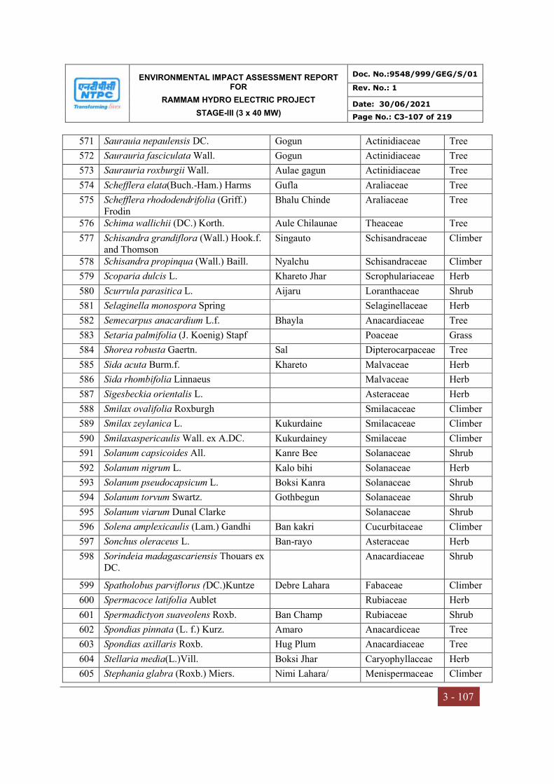
ENVIRONMENTAL IMPACT ASSESSMENT REPORT FOR
RAMMAM HYDRO ELECTRIC PROJECT
STAGE-III (3 x 40 MW)
Doc. No.:9548/999/GEG/S/01
Rev. No.: 1
Date: 30/06/2021
Page No.: C3-107 of 219
3 - 107
571 Saurauia nepaulensis DC. Gogun Actinidiaceae Tree
572 Saurauria fasciculata Wall. Gogun Actinidiaceae Tree
573 Saurauria roxburgii Wall. Aulae gagun Actinidiaceae Tree
574 Schefflera elata(Buch.-Ham.) Harms Gufla Araliaceae Tree
575 Schefflera rhododendrifolia (Griff.) Frodin
Bhalu Chinde Araliaceae Tree
576 Schima wallichii (DC.) Korth. Aule Chilaunae Theaceae Tree
577 Schisandra grandiflora (Wall.) Hook.f. and Thomson
Singauto Schisandraceae Climber
578 Schisandra propinqua (Wall.) Baill. Nyalchu Schisandraceae Climber
579 Scoparia dulcis L. Khareto Jhar Scrophulariaceae Herb
580 Scurrula parasitica L. Aijaru Loranthaceae Shrub
581 Selaginella monospora Spring Selaginellaceae Herb
582 Semecarpus anacardium L.f. Bhayla Anacardiaceae Tree
583 Setaria palmifolia (J. Koenig) Stapf Poaceae Grass
584 Shorea robusta Gaertn. Sal Dipterocarpaceae Tree
585 Sida acuta Burm.f. Khareto Malvaceae Herb
586 Sida rhombifolia Linnaeus Malvaceae Herb
587 Sigesbeckia orientalis L. Asteraceae Herb
588 Smilax ovalifolia Roxburgh Smilacaceae Climber
589 Smilax zeylanica L. Kukurdaine Smilacaceae Climber
590 Smilaxaspericaulis Wall. ex A.DC. Kukurdainey Smilaceae Climber
591 Solanum capsicoides All. Kanre Bee Solanaceae Shrub
592 Solanum nigrum L. Kalo bihi Solanaceae Herb
593 Solanum pseudocapsicum L. Boksi Kanra Solanaceae Shrub
594 Solanum torvum Swartz. Gothbegun Solanaceae Shrub
595 Solanum viarum Dunal Clarke Solanaceae Shrub
596 Solena amplexicaulis (Lam.) Gandhi Ban kakri Cucurbitaceae Climber
597 Sonchus oleraceus L. Ban-rayo Asteraceae Herb
598 Sorindeia madagascariensis Thouars ex DC.
Anacardiaceae Shrub
599 Spatholobus parviflorus (DC.)Kuntze Debre Lahara Fabaceae Climber
600 Spermacoce latifolia Aublet Rubiaceae Herb
601 Spermadictyon suaveolens Roxb. Ban Champ Rubiaceae Shrub
602 Spondias pinnata (L. f.) Kurz. Amaro Anacardiceae Tree
603 Spondias axillaris Roxb. Hug Plum Anacardiaceae Tree
604 Stellaria media(L.)Vill. Boksi Jhar Caryophyllaceae Herb
605 Stephania glabra (Roxb.) Miers. Nimi Lahara/ Menispermaceae Climber

ENVIRONMENTAL IMPACT ASSESSMENT REPORT FOR
RAMMAM HYDRO ELECTRIC PROJECT
STAGE-III (3 x 40 MW)
Doc. No.:9548/999/GEG/S/01
Rev. No.: 1
Date: 30/06/2021
Page No.: C3-108 of 219
3 - 108
Tambarke
606 Stephania japonica (Thunb.) Mier. Tambarkae Menispermaceae Climber
607 Sterculia villosa Roxb. Odal Sterculiaceae Tree
608 Stereospermum chelonoides (L.f.) DC. Parari Bignoniaceae Tree
609 Stereospermum tetragonum DC. Singyen-kung Bignoniaceae Tree
610 Streptolirion volubile Edgew. Akashveli Commelinaceae Herb
611 Strobilanthes capitata Nees Ankhle Acanthacea Herb
612 Strobilanthes divaricatus (Nees)T. Anders.
Aakhlae Acanthacea Shrub
613 Strobilanthes himalayana J.R.I. Wood Acanthaceae Herb
614 Strobilanthes wallichii Nees Ankhle Acanthacea Shrub
615 Swertia bimaculata (Sieb.&Zucc.) Hook.f.&T.
Bhale Chirowto Gentianaceae Herb
616 Swertia chirayita (Roxb.)H.Karst. Chiraito Gentianaceae Herb
617 Symplocos glomerata King ex C.B.Clarke
Kharane Symplocaceae Tree
618 Symplocos lucida (Thunb.) Sieb & Zucc.
Ghole/Kharane Symplocaceae Tree
619 Syzigium cumini (L.) Skeels Jamun Myrtaceae Tree
620 Syzigium ramosissimum (Blume) N.P.Bal.
Jhare Jamuna Myrtaceae Tree
621 Syzigium balsameum (Wight) Wall. ex Walp.
Archal Myrtaceae Tree
622 Syzigium claviflorum (Roxb.) Wall. ex A.M.Cowan & Cowan
Hare jamuna Myrtaceae Tree
623 Syzigium formosum (Wall.) Masam. Ambakae Myrtaceae Tree
624 Tabernaemontana divericata (L.) R.Br.ex Roem.Schult.
Chandnee/Tagar Apocynancea Shrub
625 Talinum portulacifolium (Forssk.) Asch.ex Scheinf.
Dalda saag Portulacaceae Herb
626 Tamarindus indica L. Titri Fabaceae Tree
627 Taxus baccata L. Cheongboo Taxaceae Tree
628 Tectaria coadunata (J. Sm.) C. Chr. Kalo unew Tectariaceae Herb
629 Tectaria griffithii (Baker) C. Christensen
Dryopteridaceae Herb
630 Tectona grandis L.f. Teak Verbenaceae Tree
631 Terminalia arjuna (Roxb.ex DC.) Wight & Arn.
Arjun Combretaceae Tree
632 Terminalia bellirica (Gaertn.) Roxb. Barra Combretaceae Tree

ENVIRONMENTAL IMPACT ASSESSMENT REPORT FOR
RAMMAM HYDRO ELECTRIC PROJECT
STAGE-III (3 x 40 MW)
Doc. No.:9548/999/GEG/S/01
Rev. No.: 1
Date: 30/06/2021
Page No.: C3-109 of 219
3 - 109
633 Terminalia chebula Retz. Harra Combretaceae Tree
634 Terminalia crenulata Roth. Pakasajh Combretaceae Tree
635 Terminalia tomentosa Wight & Arn. Saj Combretaceae Tree
636 Terminilia myriocarpa Van Heurck & Muller
Panisaj Combretaceae Tree
637 Tetradium fraxinifolium (Hook.f.) T.G.Hart.
Khanakpa Rutaceae Tree
638 Tetradium glabrifolium (Champ.ex Benth.) T.G.Hart.
Thulo Khankpa Rutaceae Tree
639 Tetrameles nudiflora R. Br. Maina Tetramelaceae Tree
640 Tetrastigma bracteolatum (Wall.) Planch.
Charcharae lahara Vitaceae Climber
641 Tetrastigma planicaule (Hooker f.) Gagnepain
Vitaceae Climber
642 Tetrastigma serrulatum (Roxb.) Planch. Charchare (Syaano) Vitaceae Climber
643 Thladiantha cordifolia (Blume) Cogniaux
Cucurbitaceae Climber
644 Thunbergia fragrance Roxb. Kanasae Lahara Acanthacea Climber
645 Thysanolaena latifolia (Roxb. ex Hornem) Honda.
Phul jharu Poaceae Shrub
646 Tinospora cordifolia (Willd.) Hook. f. & Thoms.
Gurjo lahara Menispermaceae Climber
647 Tinsopora sinensis (Lour.) Gurjo Lahara Menispermaceae Climber
648 Tithonia diversifolia (Hemsley) A. Gray Asteraceae Shrub
649 Toona ciliata M. Roem. Tooni Meliaceae Tree
650 Toxicodendron hookeri (Sahni & Bahadur) C.I.Wu &T.L.Ming
Kag bhalayo Anacardiaceae Tree
651 Toxicodendron succedaneum (L.) Kuntze
Rani Bhalayo Anacardiaceae Tree
652 Trema politoria Plancon Kuail Ulmaceae Tree
653 Trema orientalis (L.) Blume Khari Ulmaceae Tree
654 Trevesia palmata (Roxb.ex Lindl.) Vis. Phutta Araliaceae Tree
655 Trewia nudiflora L. Pithali Euphorbiaceae Tree
656 Trichosanthes tricuspidata Lour. Indreni Cucurbitaceae Climber
657 Trichosanthes wallichiana (Ser.) Wight Indreni Cucurbitaceae Climber
658 Trichosanthes lepiniana (Naudin) Cogn.
Indreni Cucurbitaceae Climber
659 Tridax procumbens L. Asteraceae Herb
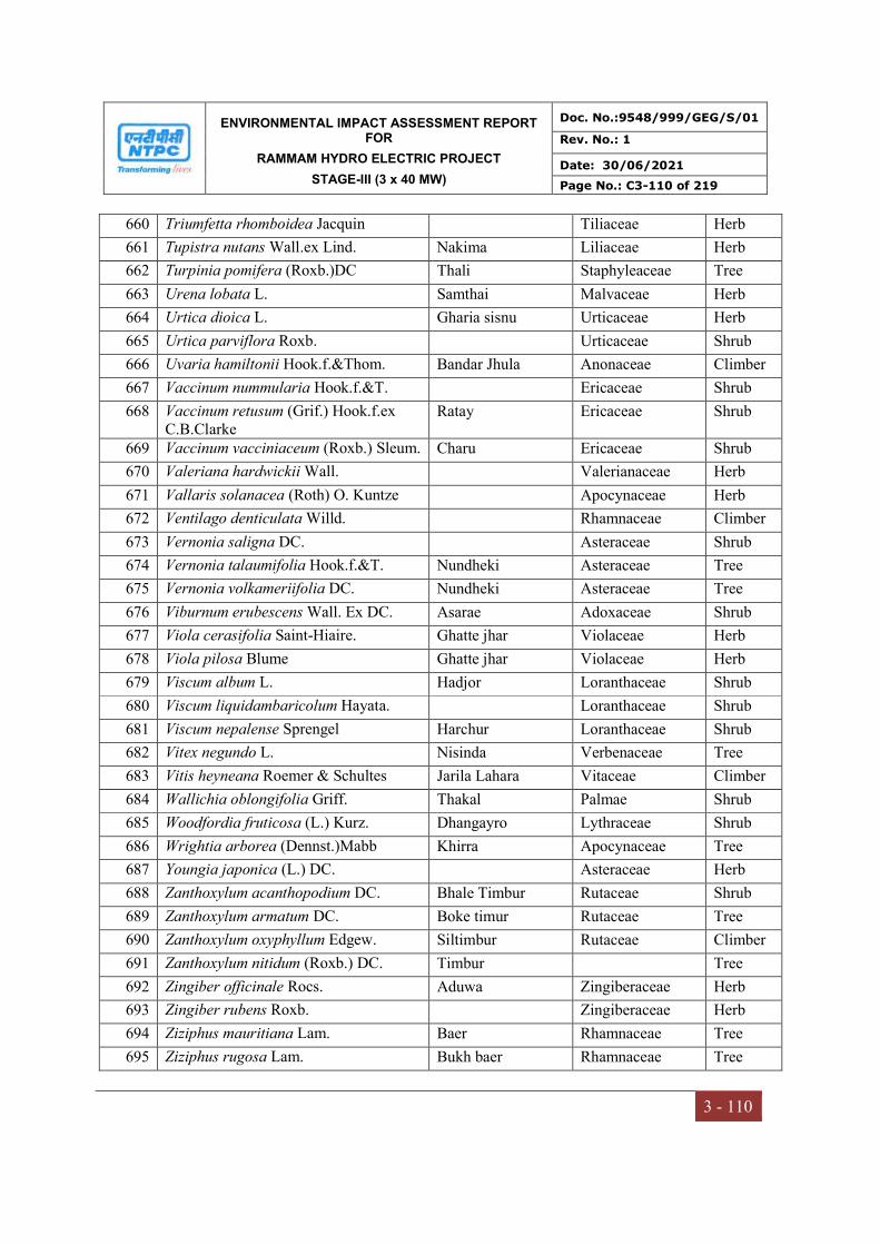
ENVIRONMENTAL IMPACT ASSESSMENT REPORT FOR
RAMMAM HYDRO ELECTRIC PROJECT
STAGE-III (3 x 40 MW)
Doc. No.:9548/999/GEG/S/01
Rev. No.: 1
Date: 30/06/2021
Page No.: C3-110 of 219
3 - 110
660 Triumfetta rhomboidea Jacquin Tiliaceae Herb
661 Tupistra nutans Wall.ex Lind. Nakima Liliaceae Herb
662 Turpinia pomifera (Roxb.)DC Thali Staphyleaceae Tree
663 Urena lobata L. Samthai Malvaceae Herb
664 Urtica dioica L. Gharia sisnu Urticaceae Herb
665 Urtica parviflora Roxb. Urticaceae Shrub
666 Uvaria hamiltonii Hook.f.&Thom. Bandar Jhula Anonaceae Climber
667 Vaccinum nummularia Hook.f.&T. Ericaceae Shrub
668 Vaccinum retusum (Grif.) Hook.f.ex C.B.Clarke
Ratay Ericaceae Shrub
669 Vaccinum vacciniaceum (Roxb.) Sleum. Charu Ericaceae Shrub
670 Valeriana hardwickii Wall. Valerianaceae Herb
671 Vallaris solanacea (Roth) O. Kuntze Apocynaceae Herb
672 Ventilago denticulata Willd. Rhamnaceae Climber
673 Vernonia saligna DC. Asteraceae Shrub
674 Vernonia talaumifolia Hook.f.&T. Nundheki Asteraceae Tree
675 Vernonia volkameriifolia DC. Nundheki Asteraceae Tree
676 Viburnum erubescens Wall. Ex DC. Asarae Adoxaceae Shrub
677 Viola cerasifolia Saint-Hiaire. Ghatte jhar Violaceae Herb
678 Viola pilosa Blume Ghatte jhar Violaceae Herb
679 Viscum album L. Hadjor Loranthaceae Shrub
680 Viscum liquidambaricolum Hayata. Loranthaceae Shrub
681 Viscum nepalense Sprengel Harchur Loranthaceae Shrub
682 Vitex negundo L. Nisinda Verbenaceae Tree
683 Vitis heyneana Roemer & Schultes Jarila Lahara Vitaceae Climber
684 Wallichia oblongifolia Griff. Thakal Palmae Shrub
685 Woodfordia fruticosa (L.) Kurz. Dhangayro Lythraceae Shrub
686 Wrightia arborea (Dennst.)Mabb Khirra Apocynaceae Tree
687 Youngia japonica (L.) DC. Asteraceae Herb
688 Zanthoxylum acanthopodium DC. Bhale Timbur Rutaceae Shrub
689 Zanthoxylum armatum DC. Boke timur Rutaceae Tree
690 Zanthoxylum oxyphyllum Edgew. Siltimbur Rutaceae Climber
691 Zanthoxylum nitidum (Roxb.) DC. Timbur Tree
692 Zingiber officinale Rocs. Aduwa Zingiberaceae Herb
693 Zingiber rubens Roxb. Zingiberaceae Herb
694 Ziziphus mauritiana Lam. Baer Rhamnaceae Tree
695 Ziziphus rugosa Lam. Bukh baer Rhamnaceae Tree
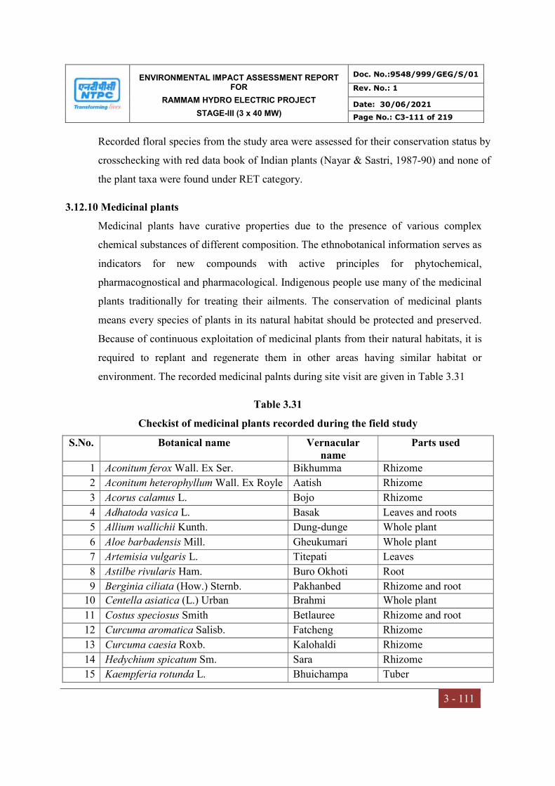
ENVIRONMENTAL IMPACT ASSESSMENT REPORT FOR
RAMMAM HYDRO ELECTRIC PROJECT
STAGE-III (3 x 40 MW)
Doc. No.:9548/999/GEG/S/01
Rev. No.: 1
Date: 30/06/2021
Page No.: C3-111 of 219
3 - 111
Recorded floral species from the study area were assessed for their conservation status by
crosschecking with red data book of Indian plants (Nayar & Sastri, 1987-90) and none of
the plant taxa were found under RET category.
3.12.10 Medicinal plants
Medicinal plants have curative properties due to the presence of various complex
chemical substances of different composition. The ethnobotanical information serves as
indicators for new compounds with active principles for phytochemical,
pharmacognostical and pharmacological. Indigenous people use many of the medicinal
plants traditionally for treating their ailments. The conservation of medicinal plants
means every species of plants in its natural habitat should be protected and preserved.
Because of continuous exploitation of medicinal plants from their natural habitats, it is
required to replant and regenerate them in other areas having similar habitat or
environment. The recorded medicinal palnts during site visit are given in Table 3.31
Table 3.31
Checkist of medicinal plants recorded during the field study
S.No. Botanical name Vernacular name
Parts used
1 Aconitum ferox Wall. Ex Ser. Bikhumma Rhizome
2 Aconitum heterophyllum Wall. Ex Royle Aatish Rhizome
3 Acorus calamus L. Bojo Rhizome
4 Adhatoda vasica L. Basak Leaves and roots
5 Allium wallichii Kunth. Dung-dunge Whole plant
6 Aloe barbadensis Mill. Gheukumari Whole plant
7 Artemisia vulgaris L. Titepati Leaves
8 Astilbe rivularis Ham. Buro Okhoti Root
9 Berginia ciliata (How.) Sternb. Pakhanbed Rhizome and root
10 Centella asiatica (L.) Urban Brahmi Whole plant
11 Costus speciosus Smith Betlauree Rhizome and root
12 Curcuma aromatica Salisb. Fatcheng Rhizome
13 Curcuma caesia Roxb. Kalohaldi Rhizome
14 Hedychium spicatum Sm. Sara Rhizome
15 Kaempferia rotunda L. Bhuichampa Tuber

ENVIRONMENTAL IMPACT ASSESSMENT REPORT FOR
RAMMAM HYDRO ELECTRIC PROJECT
STAGE-III (3 x 40 MW)
Doc. No.:9548/999/GEG/S/01
Rev. No.: 1
Date: 30/06/2021
Page No.: C3-112 of 219
3 - 112
16 Kalanchoe pinnata (Lam) Pers. Patharkuchi Leaves
17 Nardostachys jatamansi DC. Jatamansi Rhizome
18 Ocimum basilicum L. Tulsi Leaves and seeds
19 Orchis latifolia L. Panch- aunlay Tuber and root
20 Panax pseudoginseng Wall. Panchapatte y Rhizome
21 Picrorrhiza kurroa Royle ex Benth. Kutki Root
22 Podophyllum hexandrum Royle Rhizome and root
23 Sapindus mukorossi Gaertn. Ritha Fruits and root bark
24 Swertia chirata Ham. Chireto Whole plant
25 Taxus baccata L. Dhegreshalla Leaves and bark
26 Tinospora cordifolia (Willd.) Miers Gurjo Stem
27 Tupistra nutans Wall. Teeta Whole plant
28 Zingiber cassumunarRoxb. Banada Rhizome/ inflorescence
3.12.11 Economically Important Plant Species
The wood used in lower areas for timber include Bischofia javanica, Castanopsis indica,
Garuga pinnata, Fraxinus floribunda, Juglans regia, Schima wallichii, Shorea robusta,
Terminalia tomentosa and Toona ciliata. In addition to these trees, some tall and woody
bamboos like Bambusa tulda, Dendrocalamus hamiltonii, Dendrocalamussikkimensis,
etc. are also used for these purposes. At higher altitudes various oak and coniferous
species were used as timber trees and fuel wood. Some of the other plant species in the
study area are used by the local inhabitants for various purposes. A list of some
commonly occurring plant species and their miscellaneous uses are given in Table 3.32
Table 3.32
Checklist of economic importance plants from study area
S.No. Plant name Uses
1 Acorus calamus L. Rhizomes are used as insectisides in storage of cereals
2 Andrographis paniculata (Burm. f.) Wall. ex Ness.
Dried flowers are decorative and also used for preparation of pillow
3 Arisaema tortuosum (Wall.) Schott
Tubers are used as an insectisidal purposes
4 Artemisia nilagirica L. Leaves and flowering tops used for flavouring in alcoholic drinks
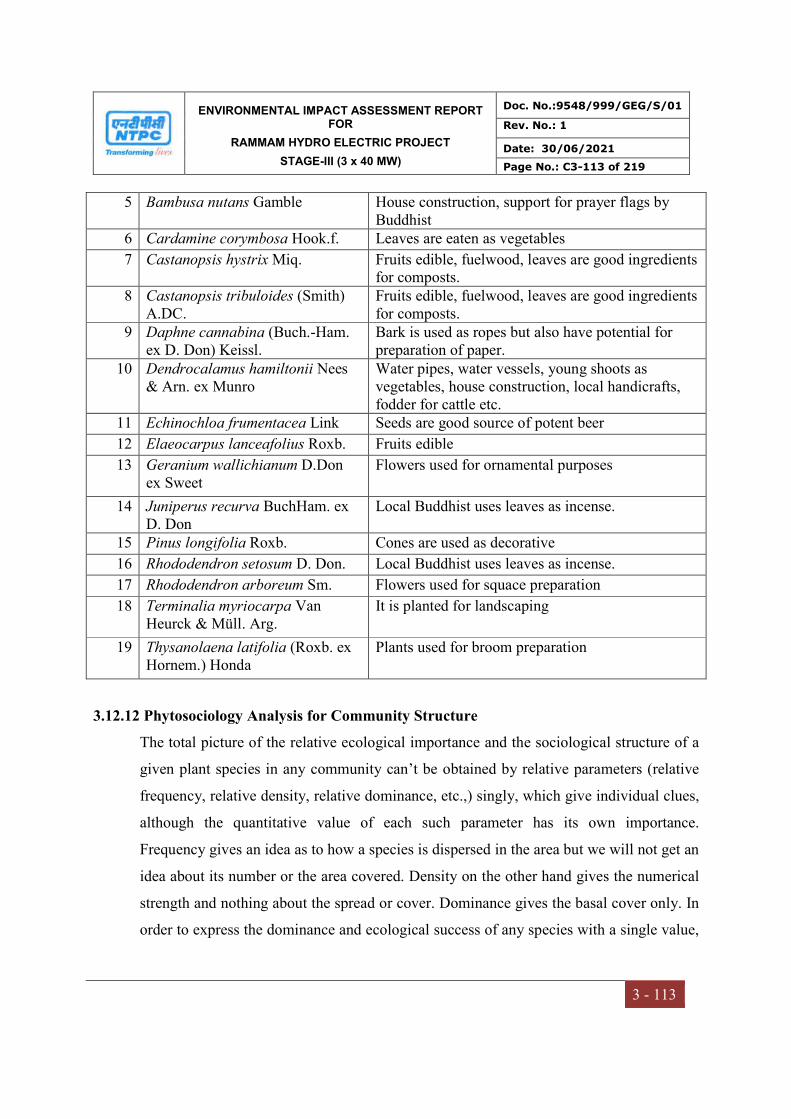
ENVIRONMENTAL IMPACT ASSESSMENT REPORT FOR
RAMMAM HYDRO ELECTRIC PROJECT
STAGE-III (3 x 40 MW)
Doc. No.:9548/999/GEG/S/01
Rev. No.: 1
Date: 30/06/2021
Page No.: C3-113 of 219
3 - 113
5 Bambusa nutans Gamble House construction, support for prayer flags by Buddhist
6 Cardamine corymbosa Hook.f. Leaves are eaten as vegetables
7 Castanopsis hystrix Miq. Fruits edible, fuelwood, leaves are good ingredients for composts.
8 Castanopsis tribuloides (Smith) A.DC.
Fruits edible, fuelwood, leaves are good ingredients for composts.
9 Daphne cannabina (Buch.-Ham. ex D. Don) Keissl.
Bark is used as ropes but also have potential for preparation of paper.
10 Dendrocalamus hamiltonii Nees & Arn. ex Munro
Water pipes, water vessels, young shoots as vegetables, house construction, local handicrafts, fodder for cattle etc.
11 Echinochloa frumentacea Link Seeds are good source of potent beer
12 Elaeocarpus lanceafolius Roxb. Fruits edible
13 Geranium wallichianum D.Don ex Sweet
Flowers used for ornamental purposes
14 Juniperus recurva BuchHam. ex D. Don
Local Buddhist uses leaves as incense.
15 Pinus longifolia Roxb. Cones are used as decorative
16 Rhododendron setosum D. Don. Local Buddhist uses leaves as incense.
17 Rhododendron arboreum Sm. Flowers used for squace preparation
18 Terminalia myriocarpa Van Heurck & Müll. Arg.
It is planted for landscaping
19 Thysanolaena latifolia (Roxb. ex Hornem.) Honda
Plants used for broom preparation
3.12.12 Phytosociology Analysis for Community Structure
The total picture of the relative ecological importance and the sociological structure of a
given plant species in any community can’t be obtained by relative parameters (relative
frequency, relative density, relative dominance, etc.,) singly, which give individual clues,
although the quantitative value of each such parameter has its own importance.
Frequency gives an idea as to how a species is dispersed in the area but we will not get an
idea about its number or the area covered. Density on the other hand gives the numerical
strength and nothing about the spread or cover. Dominance gives the basal cover only. In
order to express the dominance and ecological success of any species with a single value,
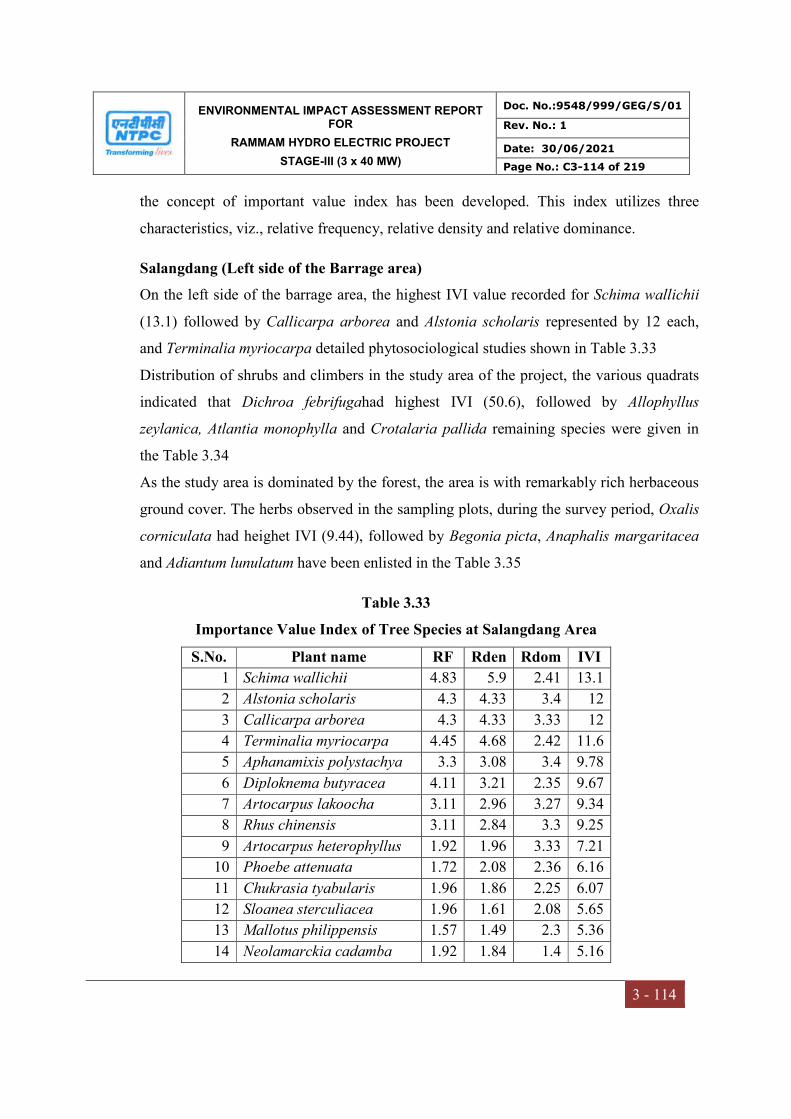
ENVIRONMENTAL IMPACT ASSESSMENT REPORT FOR
RAMMAM HYDRO ELECTRIC PROJECT
STAGE-III (3 x 40 MW)
Doc. No.:9548/999/GEG/S/01
Rev. No.: 1
Date: 30/06/2021
Page No.: C3-114 of 219
3 - 114
the concept of important value index has been developed. This index utilizes three
characteristics, viz., relative frequency, relative density and relative dominance.
Salangdang (Left side of the Barrage area)
On the left side of the barrage area, the highest IVI value recorded for Schima wallichii
(13.1) followed by Callicarpa arborea and Alstonia scholaris represented by 12 each,
and Terminalia myriocarpa detailed phytosociological studies shown in Table 3.33
Distribution of shrubs and climbers in the study area of the project, the various quadrats
indicated that Dichroa febrifugahad highest IVI (50.6), followed by Allophyllus
zeylanica, Atlantia monophylla and Crotalaria pallida remaining species were given in
the Table 3.34
As the study area is dominated by the forest, the area is with remarkably rich herbaceous
ground cover. The herbs observed in the sampling plots, during the survey period, Oxalis
corniculata had heighet IVI (9.44), followed by Begonia picta, Anaphalis margaritacea
and Adiantum lunulatum have been enlisted in the Table 3.35
Table 3.33
Importance Value Index of Tree Species at Salangdang Area
S.No. Plant name RF Rden Rdom IVI
1 Schima wallichii 4.83 5.9 2.41 13.1
2 Alstonia scholaris 4.3 4.33 3.4 12
3 Callicarpa arborea 4.3 4.33 3.33 12
4 Terminalia myriocarpa 4.45 4.68 2.42 11.6
5 Aphanamixis polystachya 3.3 3.08 3.4 9.78
6 Diploknema butyracea 4.11 3.21 2.35 9.67
7 Artocarpus lakoocha 3.11 2.96 3.27 9.34
8 Rhus chinensis 3.11 2.84 3.3 9.25
9 Artocarpus heterophyllus 1.92 1.96 3.33 7.21
10 Phoebe attenuata 1.72 2.08 2.36 6.16
11 Chukrasia tyabularis 1.96 1.86 2.25 6.07
12 Sloanea sterculiacea 1.96 1.61 2.08 5.65
13 Mallotus philippensis 1.57 1.49 2.3 5.36
14 Neolamarckia cadamba 1.92 1.84 1.4 5.16

ENVIRONMENTAL IMPACT ASSESSMENT REPORT FOR
RAMMAM HYDRO ELECTRIC PROJECT
STAGE-III (3 x 40 MW)
Doc. No.:9548/999/GEG/S/01
Rev. No.: 1
Date: 30/06/2021
Page No.: C3-115 of 219
3 - 115
15 Bischofia javanica 1.57 1.49 2.1 5.16
16 Cinnamomum glanduliferum
1.57 1.37 2.2 5.14
17 Michelia champaca 1.92 1.84 1.35 5.11
18 Toona ciliata 1.72 1.96 1.38 5.06
19 Baccaurea sapida 1.57 1.37 2.11 5.05
20 Terminalia tomentosa 1.92 1.72 1.4 5.04
21 Litsea monopetala 1.57 1.49 1.95 5.01
22 Cassia fistula 1.77 1.98 1.15 4.9
23 Syzygium cumini 2.11 1.47 1.3 4.88
24 Chrysophyllum roxburghii 1.77 1.98 1.1 4.85
25 Terminalia chebula 1.53 1.84 1.34 4.71
26 Daubanga grandiflora 1.72 1.59 1.39 4.7
27 Spondias pinnata 1.72 1.72 1.23 4.67
28 Macaranga denticulata 1.92 1.72 1.03 4.67
29 Antidesma acidum 1.53 1.59 1.26 4.38
30 Caryota urens 1.34 1.72 1.32 4.38
31 Ficus glomerata 1.34 1.72 1.31 4.37
32 Pentapanax fragrans 1.34 1.59 1.39 4.32
33 Bombax ceiba 1.34 1.47 1.39 4.2
34 Shorea robusta 1.34 1.47 1.39 4.2
35 Ficus semicordata 1.34 1.72 1.14 4.2
36 Canarium bengalensis 1.34 1.47 1.26 4.07
37 Kydia calycina 1.19 1.47 1.35 4.01
38 Ficus racemosa 1.15 1.47 1.37 3.99
39 Terminalia bellerica 1.34 1.35 1.29 3.98
40 Ficus ariculata 1.34 1.35 1.25 3.94
41 Glochidion lanceolarium 1.34 1.35 1.24 3.93
42 Tectona grandis 1.34 1.23 1.28 3.85
43 Chassalia curviflora 1.15 1.47 1.2 3.82
44 Elaeocarpus floribundus 1.15 1.23 1.38 3.76
45 Gmelina arborea 1.15 1.23 1.37 3.75
46 Styrax serrulatus 1.34 1.1 1.29 3.73
47 Terminalia arjuna 1.34 1.23 1.13 3.7
48 Cinnamomum glanduliferum
1.15 1.23 1.3 3.68
49 Sterculia versicolor 1.34 0.98 1.34 3.66
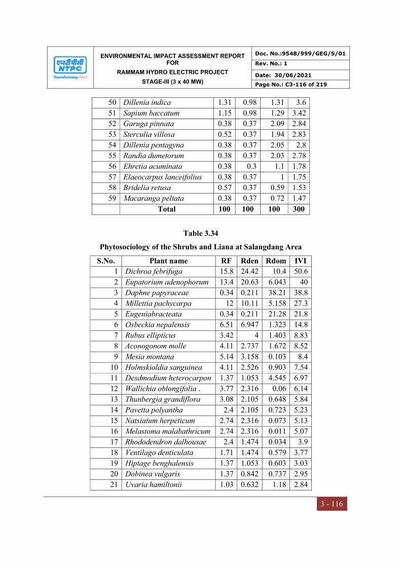
ENVIRONMENTAL IMPACT ASSESSMENT REPORT FOR
RAMMAM HYDRO ELECTRIC PROJECT
STAGE-III (3 x 40 MW)
Doc. No.:9548/999/GEG/S/01
Rev. No.: 1
Date: 30/06/2021
Page No.: C3-116 of 219
3 - 116
50 Dillenia indica 1.31 0.98 1.31 3.6
51 Sapium baccatum 1.15 0.98 1.29 3.42
52 Garuga pinnata 0.38 0.37 2.09 2.84
53 Sterculia villosa 0.52 0.37 1.94 2.83
54 Dillenia pentagyna 0.38 0.37 2.05 2.8
55 Randia dumetorum 0.38 0.37 2.03 2.78
56 Ehretia acuminata 0.38 0.3 1.1 1.78
57 Elaeocarpus lanceifolius 0.38 0.37 1 1.75
58 Bridelia retusa 0.57 0.37 0.59 1.53
59 Macaranga peltata 0.38 0.37 0.72 1.47
Total 100 100 100 300
Table 3.34
Phytosociology of the Shrubs and Liana at Salangdang Area
S.No. Plant name RF Rden Rdom IVI
1 Dichroa febrifuga 15.8 24.42 10.4 50.6
2 Eupatorium adenophorum 13.4 20.63 6.043 40
3 Daphne papyraceae 0.34 0.211 38.21 38.8
4 Millettia pachycarpa 12 10.11 5.158 27.3
5 Eugeniabracteata 0.34 0.211 21.28 21.8
6 Osbeckia nepalensis 6.51 6.947 1.323 14.8
7 Rubus ellipticus 3.42 4 1.403 8.83
8 Aconogonom molle 4.11 2.737 1.672 8.52
9 Mesia montana 5.14 3.158 0.103 8.4
10 Holmskioldia sanguinea 4.11 2.526 0.903 7.54
11 Desdmodium heterocarpon 1.37 1.053 4.545 6.97
12 Wallichia oblongifolia . 3.77 2.316 0.06 6.14
13 Thunbergia grandiflora 3.08 2.105 0.648 5.84
14 Pavetta polyantha 2.4 2.105 0.723 5.23
15 Natsiatum herpeticum 2.74 2.316 0.073 5.13
16 Melastoma malabathricum 2.74 2.316 0.011 5.07
17 Rhododendron dalhousae 2.4 1.474 0.034 3.9
18 Ventilago denticulata 1.71 1.474 0.579 3.77
19 Hiptage benghalensis 1.37 1.053 0.603 3.03
20 Dobinea vulgaris 1.37 0.842 0.737 2.95
21 Uvaria hamiltonii 1.03 0.632 1.18 2.84
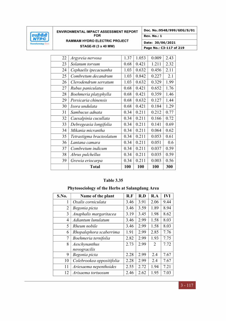
ENVIRONMENTAL IMPACT ASSESSMENT REPORT FOR
RAMMAM HYDRO ELECTRIC PROJECT
STAGE-III (3 x 40 MW)
Doc. No.:9548/999/GEG/S/01
Rev. No.: 1
Date: 30/06/2021
Page No.: C3-117 of 219
3 - 117
22 Argyreia nervosa 1.37 1.053 0.009 2.43
23 Solanum torvum 0.68 0.421 1.211 2.32
24 Cephaelis ipecacuanha 1.03 0.632 0.456 2.11
25 Combretum decandrum 1.03 0.842 0.227 2.1
26 Clerodendrum serratum 1.03 0.632 0.329 1.99
27 Rubus paniculatus 0.68 0.421 0.652 1.76
28 Boehmeria platyphylla 0.68 0.421 0.359 1.46
29 Persicaria chinensis 0.68 0.632 0.127 1.44
30 Ixora undulata 0.68 0.421 0.184 1.29
31 Sambucus adnata 0.34 0.211 0.212 0.77
32 Caesalpinia cucullata 0.34 0.211 0.166 0.72
33 Debregeasia longifolia 0.34 0.211 0.141 0.69
34 Mikania micrantha 0.34 0.211 0.064 0.62
35 Tetrastigma bracteolatum 0.34 0.211 0.053 0.61
36 Lantana camara 0.34 0.211 0.051 0.6
37 Combretum indicum 0.34 0.211 0.037 0.59
38 Abrus pulchellus 0.34 0.211 0.035 0.59
39 Grewia eriocarpa 0.34 0.211 0.003 0.56
Total 100 100 100 300
Table 3.35
Phytosociology of the Herbs at Salangdang Area
S.No. Name of the plant R.F R.D R.A IVI
1 Oxalis corniculata 3.46 3.91 2.06 9.44
2 Begonia picta 3.46 3.59 1.89 8.94
3 Anaphalis margaritacea 3.19 3.45 1.98 8.62
4 Adiantum lunulatum 3.46 2.99 1.58 8.03
5 Rheum nobile 3.46 2.99 1.58 8.03
6 Rhopalephora scaberrima 1.91 2.99 2.85 7.76
7 Boehmeria ternifolia 2.82 2.99 1.93 7.75
8 Aeschynanthus novogracilis
2.73 2.99 2 7.72
9 Begonia picta 2.28 2.99 2.4 7.67
10 Colebrookea oppositifolia 2.28 2.99 2.4 7.67
11 Ariesaema nepenthoides 2.55 2.72 1.94 7.21
12 Arisaema tortuosum 2.46 2.62 1.95 7.03
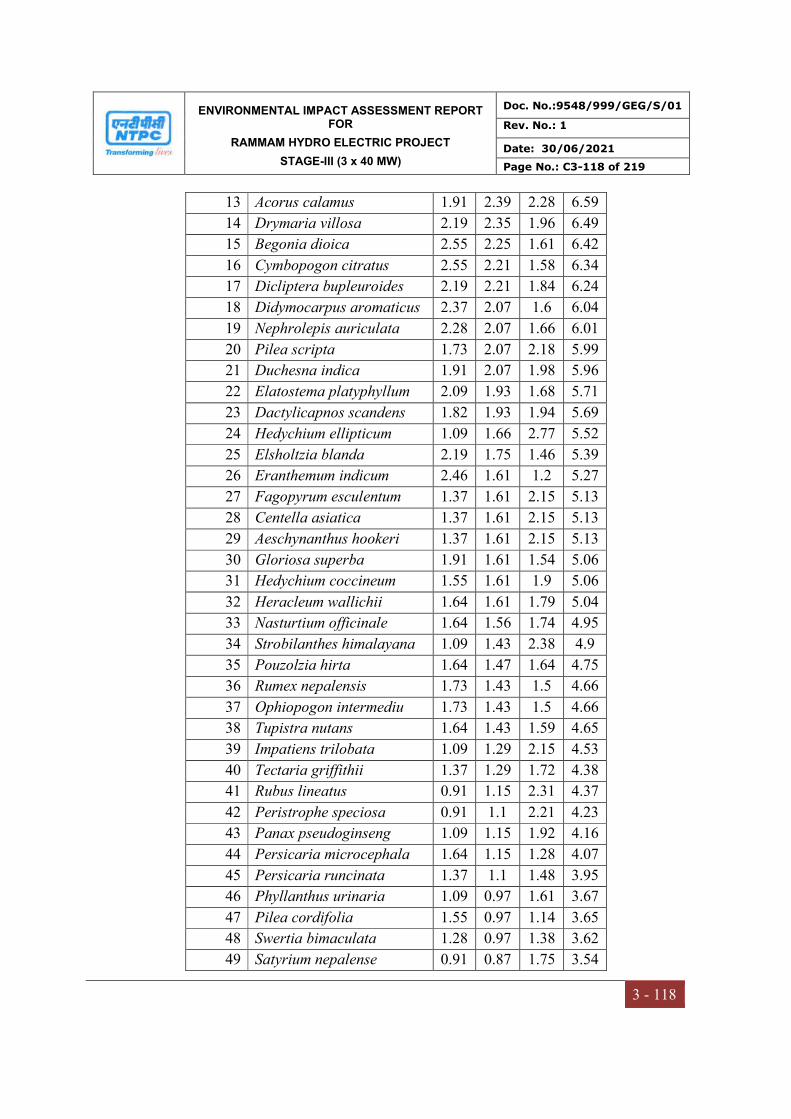
ENVIRONMENTAL IMPACT ASSESSMENT REPORT FOR
RAMMAM HYDRO ELECTRIC PROJECT
STAGE-III (3 x 40 MW)
Doc. No.:9548/999/GEG/S/01
Rev. No.: 1
Date: 30/06/2021
Page No.: C3-118 of 219
3 - 118
13 Acorus calamus 1.91 2.39 2.28 6.59
14 Drymaria villosa 2.19 2.35 1.96 6.49
15 Begonia dioica 2.55 2.25 1.61 6.42
16 Cymbopogon citratus 2.55 2.21 1.58 6.34
17 Dicliptera bupleuroides 2.19 2.21 1.84 6.24
18 Didymocarpus aromaticus 2.37 2.07 1.6 6.04
19 Nephrolepis auriculata 2.28 2.07 1.66 6.01
20 Pilea scripta 1.73 2.07 2.18 5.99
21 Duchesna indica 1.91 2.07 1.98 5.96
22 Elatostema platyphyllum 2.09 1.93 1.68 5.71
23 Dactylicapnos scandens 1.82 1.93 1.94 5.69
24 Hedychium ellipticum 1.09 1.66 2.77 5.52
25 Elsholtzia blanda 2.19 1.75 1.46 5.39
26 Eranthemum indicum 2.46 1.61 1.2 5.27
27 Fagopyrum esculentum 1.37 1.61 2.15 5.13
28 Centella asiatica 1.37 1.61 2.15 5.13
29 Aeschynanthus hookeri 1.37 1.61 2.15 5.13
30 Gloriosa superba 1.91 1.61 1.54 5.06
31 Hedychium coccineum 1.55 1.61 1.9 5.06
32 Heracleum wallichii 1.64 1.61 1.79 5.04
33 Nasturtium officinale 1.64 1.56 1.74 4.95
34 Strobilanthes himalayana 1.09 1.43 2.38 4.9
35 Pouzolzia hirta 1.64 1.47 1.64 4.75
36 Rumex nepalensis 1.73 1.43 1.5 4.66
37 Ophiopogon intermediu 1.73 1.43 1.5 4.66
38 Tupistra nutans 1.64 1.43 1.59 4.65
39 Impatiens trilobata 1.09 1.29 2.15 4.53
40 Tectaria griffithii 1.37 1.29 1.72 4.38
41 Rubus lineatus 0.91 1.15 2.31 4.37
42 Peristrophe speciosa 0.91 1.1 2.21 4.23
43 Panax pseudoginseng 1.09 1.15 1.92 4.16
44 Persicaria microcephala 1.64 1.15 1.28 4.07
45 Persicaria runcinata 1.37 1.1 1.48 3.95
46 Phyllanthus urinaria 1.09 0.97 1.61 3.67
47 Pilea cordifolia 1.55 0.97 1.14 3.65
48 Swertia bimaculata 1.28 0.97 1.38 3.62
49 Satyrium nepalense 0.91 0.87 1.75 3.54

ENVIRONMENTAL IMPACT ASSESSMENT REPORT FOR
RAMMAM HYDRO ELECTRIC PROJECT
STAGE-III (3 x 40 MW)
Doc. No.:9548/999/GEG/S/01
Rev. No.: 1
Date: 30/06/2021
Page No.: C3-119 of 219
3 - 119
50 Selaginella monospora 1.09 0.87 1.46 3.43
51 Potentella lineata 0.73 0.69 1.73 3.15
52 Sonchus oleraceus 0.82 0.69 1.54 3.05
53 Urtica dioica 0.82 0.64 1.43 2.9
54 Valeriana hardwickii 0.82 0.55 1.23 2.6
55 Rheum acuminatum 0.46 0.32 1.29 2.07
Total 100 100 100 300
Kankiabang (Right side of the Barrage area)
Analysis of the vegetation will help in determining the relative importance of each
species in the study area and to reveal if any economically valuable species is threatened
in the process. The major tree species recorded in the study area were Lithocarpus
pachyphyllus, Symplocos ramosissima, Castanopsis hystrix, Castanopsis tribuloides,
Schima wallichii, Rhododendron arboreum and Shorea robusta etc. Phytosociology of
the treespecies presented in Table 3.36
Table 3.36
Phytosociology of the Tree Species in The Right Side of The Barrage
S.No Species RD RF Rdom IVI
1 Lithocarpus pachyphyllus 6.22 7.04 15.27 28.54
2 Symplocos ramosissima 7.16 8.31 13.06 28.5
3 Castanopsis hystrix 7.56 5.05 10.63 23.25
4 Castanopsis tribuloides 6.89 3.97 8.92 19.78
5 Schima wallichii 7.14 6.49 3.8 17.44
6 Rhododendron arboreum 4.15 2.89 8.31 15.35
7 Shorea robusta 5.73 4.33 1.39 11.45
8 Eurya acuminata 5.56 4.33 1.1 11
9 Quercus lamellosa 4.32 4.33 1.95 10.61
10 Symplocos heishanensis 3.06 3.96 2.13 9.18
11 Engelhardtia spicata 2.74 2.17 4.15 9.05
12 Gynocardia odorata 2.66 2.35 3.86 8.87
13 Betula alnoides 2.49 3.07 2.46 8.02
14 Macaranga denticulata 2.91 2.88 1.85 7.65
15 Albizia lebbeck 3.57 3.07 0.87 7.51
16 Alnus nepalensis 2.4 2.52 2.28 7.22
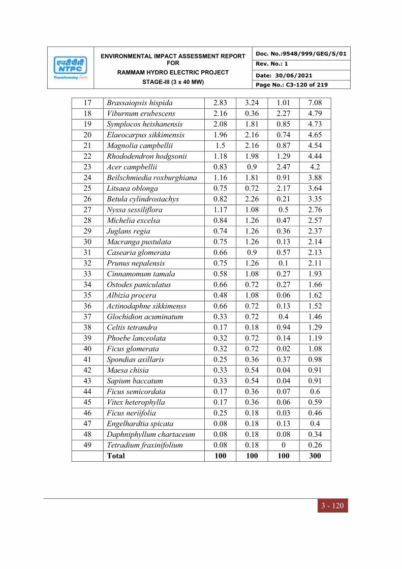
ENVIRONMENTAL IMPACT ASSESSMENT REPORT FOR
RAMMAM HYDRO ELECTRIC PROJECT
STAGE-III (3 x 40 MW)
Doc. No.:9548/999/GEG/S/01
Rev. No.: 1
Date: 30/06/2021
Page No.: C3-120 of 219
3 - 120
17 Brassaiopsis hispida 2.83 3.24 1.01 7.08
18 Viburnum erubescens 2.16 0.36 2.27 4.79
19 Symplocos heishanensis 2.08 1.81 0.85 4.73
20 Elaeocarpus sikkimensis 1.96 2.16 0.74 4.65
21 Magnolia campbellii 1.5 2.16 0.87 4.54
22 Rhododendron hodgsonii 1.18 1.98 1.29 4.44
23 Acer campbellii 0.83 0.9 2.47 4.2
24 Beilschmiedia roxburghiana 1.16 1.81 0.91 3.88
25 Litsaea oblonga 0.75 0.72 2.17 3.64
26 Betula cylindrostachys 0.82 2.26 0.21 3.35
27 Nyssa sessiliflora 1.17 1.08 0.5 2.76
28 Michelia excelsa 0.84 1.26 0.47 2.57
29 Juglans regia 0.74 1.26 0.36 2.37
30 Macranga pustulata 0.75 1.26 0.13 2.14
31 Casearia glomerata 0.66 0.9 0.57 2.13
32 Prunus nepalensis 0.75 1.26 0.1 2.11
33 Cinnamomum tamala 0.58 1.08 0.27 1.93
34 Ostodes paniculatus 0.66 0.72 0.27 1.66
35 Albizia procera 0.48 1.08 0.06 1.62
36 Actinodaphne sikkimenss 0.66 0.72 0.13 1.52
37 Glochidion acuminatum 0.33 0.72 0.4 1.46
38 Celtis tetrandra 0.17 0.18 0.94 1.29
39 Phoebe lanceolata 0.32 0.72 0.14 1.19
40 Ficus glomerata 0.32 0.72 0.02 1.08
41 Spondias axillaris 0.25 0.36 0.37 0.98
42 Maesa chisia 0.33 0.54 0.04 0.91
43 Sapium baccatum 0.33 0.54 0.04 0.91
44 Ficus semicordata 0.17 0.36 0.07 0.6
45 Vitex heterophylla 0.17 0.36 0.06 0.59
46 Ficus neriifolia 0.25 0.18 0.03 0.46
47 Engelhardtia spicata 0.08 0.18 0.13 0.4
48 Daphniphyllum chartaceum 0.08 0.18 0.08 0.34
49 Tetradium fraxinifolium 0.08 0.18 0 0.26
Total 100 100 100 300

ENVIRONMENTAL IMPACT ASSESSMENT REPORT FOR
RAMMAM HYDRO ELECTRIC PROJECT
STAGE-III (3 x 40 MW)
Doc. No.:9548/999/GEG/S/01
Rev. No.: 1
Date: 30/06/2021
Page No.: C3-121 of 219
3 - 121
Phytosociology of the shrubs and climbers in the study area were represented by Breynia
vitis-idea, Elaeagnus infundibularis, Lantana camara, Leea indica, Flemingia stricta and
Ampelocissus barbata. These species are top five of IVI. The ecological parameters of
shrubs and climbers are given in Table 3.37
Table 3.37
Phytosociology of the Shrubs and Liana Species in The Right Side of The Barrage
S.No Species Name R.D. R.F. R.Dom IVI
1 Breynia vitis-idea 8.36 4.35 7.91 20.62
2 Elaeagnus infundibularis 6.57 4.35 6.75 17.66
3 Lantana camara 5.37 4.35 6.55 16.27
4 Leea indica 5.07 4.35 5.82 15.25
5 Flemingia stricta 4.48 4.35 5.49 14.31
6 Ampelocissus barbata 4.48 4.35 5.37 14.2
7 Daphne papyraceae 4.48 4.35 5 13.82
8 Grewia eriocarpa 5.67 4.35 2.82 12.83
9 Rubus ellipticus 4.78 4.35 3.56 12.69
10 Bridelia stipularis 4.18 4.35 4.06 12.59
11 Stephania japonica 3.88 4.35 2.69 10.92
12 Combretum albidum 3.88 2.17 4.72 10.78
13 Osbeckia stellata 3.58 4.35 2.52 10.45
14 Leea asiatica 3.88 2.17 3.78 9.837
15 Combretum flagrocarpum 2.39 4.35 2.31 9.042
16 Woodfordia fruticosa 2.09 2.17 4.04 8.299
17 Dichroa febrifuga 2.09 4.35 1.73 8.163
18 Entada rheedii 2.69 2.17 2.92 7.776
19 Laportea terminalis 2.09 2.17 3.29 7.555
20 Zanthoxylum acanthopodium 2.99 2.17 2.3 7.457
21 Dalbergia volubilis 2.99 2.17 2.24 7.403
22 Urtica parviflora 2.09 2.17 2.33 6.59
23 Holarrhena antidysenterica 2.09 2.17 1.34 5.605
24 Paederia foetida 1.79 2.17 1.45 5.418
25 Pavetta polyantha 1.19 2.17 1.8 5.17
26 Calamus latifolius 1.49 2.17 1.48 5.149
27 Microcos paniculata 1.49 2.17 1.39 5.059
28 Ardisia solanacea 0.9 2.17 1.66 4.727
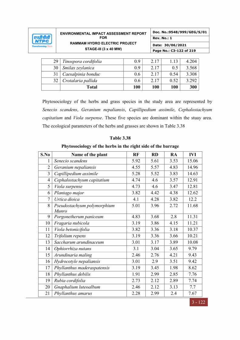
ENVIRONMENTAL IMPACT ASSESSMENT REPORT FOR
RAMMAM HYDRO ELECTRIC PROJECT
STAGE-III (3 x 40 MW)
Doc. No.:9548/999/GEG/S/01
Rev. No.: 1
Date: 30/06/2021
Page No.: C3-122 of 219
3 - 122
29 Tinospora cordifolia 0.9 2.17 1.13 4.204
30 Smilax zeylanica 0.9 2.17 0.5 3.568
31 Caesalpinia bonduc 0.6 2.17 0.54 3.308
32 Crotalaria pallida 0.6 2.17 0.52 3.292
Total 100 100 100 300
Phytosociology of the herbs and grass species in the study area are represented by
Senecio scandens, Geranium nepaliansis, Capillipedium assimile, Cephalostachyum
capitatium and Viola surpense. These five species are dominant within the stuay area.
The ecological parameters of the herbs and grasses are shown in Table 3.38
Table 3.38
Phytosociology of the herbs in the right side of the barrage
S.No Name of the plant RF RD RA IVI
1 Senecio scandens 5.92 5.61 3.53 15.06
2 Geranium nepaliansis 4.55 5.57 4.83 14.96
3 Capillipedium assimile 5.28 5.52 3.83 14.63
4 Cephalostachyum capitatium 4.74 4.6 3.57 12.91
5 Viola surpense 4.73 4.6 3.47 12.81
6 Plantago major 3.82 4.42 4.38 12.62
7 Urtica dioica 4.1 4.28 3.82 12.2
8 Pseudostachyum polymorphium Munro
5.01 3.96 2.72 11.68
9 Porgonetherum paniceum 4.83 3.68 2.8 11.31
10 Fragaria nubicola 3.19 3.86 4.15 11.21
11 Viola betonicifolia 3.82 3.36 3.18 10.37
12 Trifolium repens 3.19 3.36 3.66 10.21
13 Saccharum arundinaceum 3.01 3.17 3.89 10.08
14 Ophiorrhiza nutans 3.1 3.04 3.65 9.79
15 Arundinaria maling 2.46 2.76 4.21 9.43
16 Hydrocotyle nepaliansis 3.01 2.9 3.51 9.42
17 Phyllanthus maderaspatensis 3.19 3.45 1.98 8.62
18 Phyllanthus debilis 1.91 2.99 2.85 7.76
19 Rubia cordifolia 2.73 2.12 2.89 7.74
20 Gnaphalium luteoalbum 2.46 2.12 3.13 7.7
21 Phyllanthus amarus 2.28 2.99 2.4 7.67

ENVIRONMENTAL IMPACT ASSESSMENT REPORT FOR
RAMMAM HYDRO ELECTRIC PROJECT
STAGE-III (3 x 40 MW)
Doc. No.:9548/999/GEG/S/01
Rev. No.: 1
Date: 30/06/2021
Page No.: C3-123 of 219
3 - 123
22 Oplismenus burmanii 2.55 2.72 1.94 7.21
23 Trianthema portulacastrum 2.55 2.21 1.58 6.34
24 Primula malacoides 2.28 2.07 1.66 6.01
25 Parthenium hysterophorus 1.73 2.07 2.18 5.99
26 Neyraudia zollingeri 2.19 1.75 1.46 5.39
27 Stachytarpeta jamaicansis 1.37 1.61 2.15 5.13
28 Tephrosia purpurea 1.64 1.47 1.64 4.75
29 Oplismenus burmannii 1.09 1.29 2.15 4.53
30 Commelina benghalensis 0.91 1.1 2.21 4.23
31 Melocana baccifera 1.09 1.15 1.92 4.16
32 Sida cordata 1.37 1.1 1.48 3.95
33 Sida acuta 1.09 0.87 1.46 3.43
34 Spermacoce hispida 0.73 0.69 1.73 3.15
35 Sebastiania chamaelea 0.82 0.64 1.43 2.9
36 Mollugo pentaphylla 0.82 0.55 1.23 2.6
37 Ocimum gratissimum 0.46 0.32 1.29 2.07
Total 100 100 100 300
Near Township Area
Based on importance value index (IVI), the highest IVI recorded (Table 3.39) at township
area is for Schima wallichii (37.44), followed by Toona ciliate (29.84), Glochidion
lanceolarium(26.82), Shorea robusta(24.23), Alangium chinense(20.05) and Callicarpa
arborea(18.92).
Table 3.39
Phytosociology of the trees near township area
S. No Name of the species RD RF RDo IVI
1 Schima wallichii 12.7 8.79 15.95 37.44
2 Toona ciliata 5.29 11.29 13.27 29.85
3 Glochidion lanceolarium 14.04 9.99 2.79 26.82
4 Shorea robusta 3.75 8.09 12.39 24.23
5 Alangium chinense 10.02 8.99 1.04 20.05
6 Callicarpa arborea 8.1 9.49 1.33 18.92
7 Cinnamomum tamala 7.05 3 6.32 16.37
8 Careya arborea 2.02 2.4 11.26 15.68
9 Tectona grandis 5.65 7.09 0.95 13.69
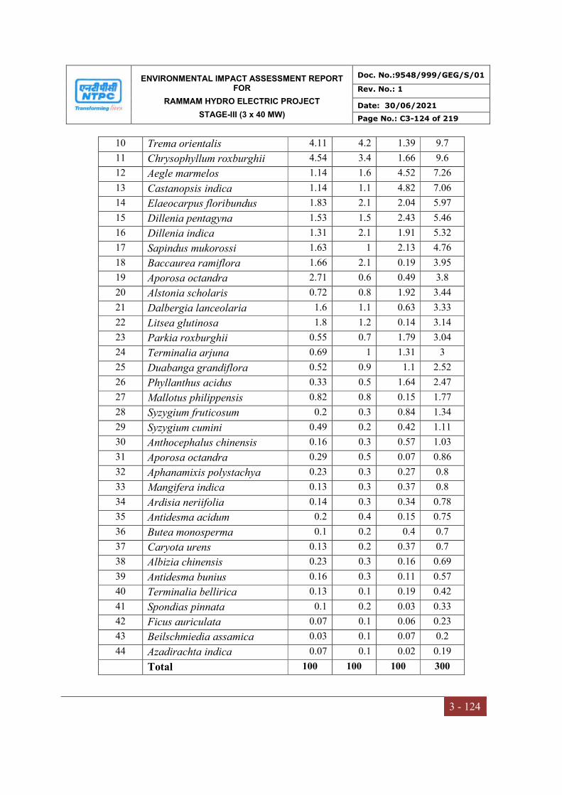
ENVIRONMENTAL IMPACT ASSESSMENT REPORT FOR
RAMMAM HYDRO ELECTRIC PROJECT
STAGE-III (3 x 40 MW)
Doc. No.:9548/999/GEG/S/01
Rev. No.: 1
Date: 30/06/2021
Page No.: C3-124 of 219
3 - 124
10 Trema orientalis 4.11 4.2 1.39 9.7
11 Chrysophyllum roxburghii 4.54 3.4 1.66 9.6
12 Aegle marmelos 1.14 1.6 4.52 7.26
13 Castanopsis indica 1.14 1.1 4.82 7.06
14 Elaeocarpus floribundus 1.83 2.1 2.04 5.97
15 Dillenia pentagyna 1.53 1.5 2.43 5.46
16 Dillenia indica 1.31 2.1 1.91 5.32
17 Sapindus mukorossi 1.63 1 2.13 4.76
18 Baccaurea ramiflora 1.66 2.1 0.19 3.95
19 Aporosa octandra 2.71 0.6 0.49 3.8
20 Alstonia scholaris 0.72 0.8 1.92 3.44
21 Dalbergia lanceolaria 1.6 1.1 0.63 3.33
22 Litsea glutinosa 1.8 1.2 0.14 3.14
23 Parkia roxburghii 0.55 0.7 1.79 3.04
24 Terminalia arjuna 0.69 1 1.31 3
25 Duabanga grandiflora 0.52 0.9 1.1 2.52
26 Phyllanthus acidus 0.33 0.5 1.64 2.47
27 Mallotus philippensis 0.82 0.8 0.15 1.77
28 Syzygium fruticosum 0.2 0.3 0.84 1.34
29 Syzygium cumini 0.49 0.2 0.42 1.11
30 Anthocephalus chinensis 0.16 0.3 0.57 1.03
31 Aporosa octandra 0.29 0.5 0.07 0.86
32 Aphanamixis polystachya 0.23 0.3 0.27 0.8
33 Mangifera indica 0.13 0.3 0.37 0.8
34 Ardisia neriifolia 0.14 0.3 0.34 0.78
35 Antidesma acidum 0.2 0.4 0.15 0.75
36 Butea monosperma 0.1 0.2 0.4 0.7
37 Caryota urens 0.13 0.2 0.37 0.7
38 Albizia chinensis 0.23 0.3 0.16 0.69
39 Antidesma bunius 0.16 0.3 0.11 0.57
40 Terminalia bellirica 0.13 0.1 0.19 0.42
41 Spondias pinnata 0.1 0.2 0.03 0.33
42 Ficus auriculata 0.07 0.1 0.06 0.23
43 Beilschmiedia assamica 0.03 0.1 0.07 0.2
44 Azadirachta indica 0.07 0.1 0.02 0.19
Total 100 100 100 300

ENVIRONMENTAL IMPACT ASSESSMENT REPORT FOR
RAMMAM HYDRO ELECTRIC PROJECT
STAGE-III (3 x 40 MW)
Doc. No.:9548/999/GEG/S/01
Rev. No.: 1
Date: 30/06/2021
Page No.: C3-125 of 219
3 - 125
It was also observed that a fewspecies including Eugenia bracteata, Chromolaena
odorata, Mikania micrantha, Lantana camara, Osbeckia nepalensis, and Tetrastigma
planicaule had quite good IVI (Table 3.40).
Table 3.40
Phytosociology of the shrubs and climbers near township area
S. No Name of the species RD RF RDo IVI
1 Eugenia bracteata 14.61 11.8 17.457 43.867
2 Chromolaena odorata 8.76 7.638 19.21 35.608
3 Mikania micrantha 4.87 5.555 17.193 27.618
4 Lantana camara 6.81 8.333 5.32 20.463
5 Osbeckia nepalensis 10.38 7.638 0.1 18.118
6 Tetrastigma planicaule 8.11 9.027 0.753 17.89
7 Tetrastigma serrulatum 1.29 1.388 13.467 16.145
8 Abrus pulchellus 6.16 5.555 1.834 13.549
9 Stephania japonica 6.48 4.165 1.738 12.383
10 Artemisia dubia 4.54 4.861 2.101 11.502
11 Thladiantha cordifolia 4.65 4.166 1.799 10.615
12 Maesa chisia 2.91 2.776 3.746 9.432
13 Mimosa himalayana 2.59 3.471 1.331 7.392
14 Rubus ellipticus 2.91 2.776 1.153 6.839
15 Psilanthus bengalensis 1.29 2.083 2.999 6.372
16 Aconogonom molle 1.62 2.083 2.656 6.359
17 Mesia montana 1.94 2.083 1.421 5.444
18 Bambusa nutans 1.94 2.083 1.128 5.151
19 Holmskioldia sanguinea 1.94 2.083 1.007 5.03
20 Desdmodium heterocarpon 1.29 2.088 0.302 3.68
21 Maesa macrophylla 0.97 2.088 0.516 3.574
22 Desdmodium heterocarpon 1.29 2.088 0.045 3.423
23 Wallichia oblongifolia 0.72 0.702 1.19 2.612
24 Dioscorea bulbifera 0.97 1.388 0.041 2.399
25 Melastoma malabathricum 0.32 0.694 1.35 2.364
26 Argyreia hookeri 0.32 0.694 0.124 1.138
27 Thunbergia grandiflora 0.32 0.694 0.019 1.033
Total 100 100 100 300
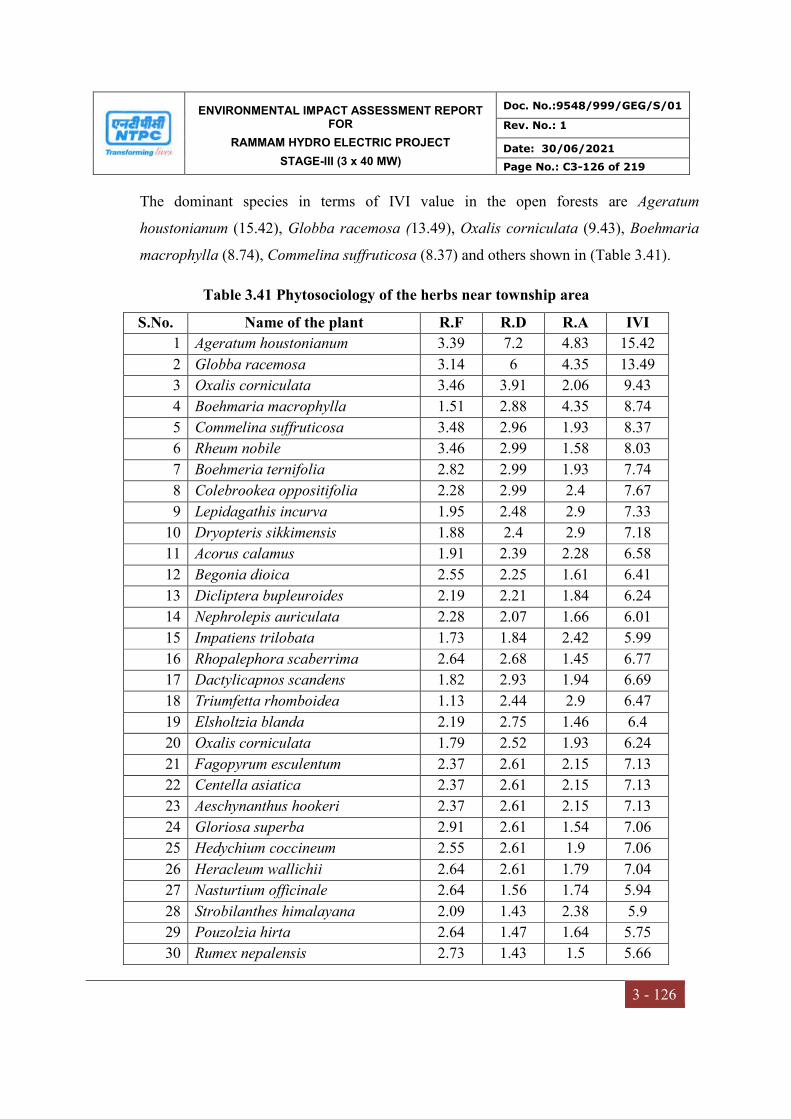
ENVIRONMENTAL IMPACT ASSESSMENT REPORT FOR
RAMMAM HYDRO ELECTRIC PROJECT
STAGE-III (3 x 40 MW)
Doc. No.:9548/999/GEG/S/01
Rev. No.: 1
Date: 30/06/2021
Page No.: C3-126 of 219
3 - 126
The dominant species in terms of IVI value in the open forests are Ageratum
houstonianum (15.42), Globba racemosa (13.49), Oxalis corniculata (9.43), Boehmaria
macrophylla (8.74), Commelina suffruticosa (8.37) and others shown in (Table 3.41).
Table 3.41 Phytosociology of the herbs near township area
S.No. Name of the plant R.F R.D R.A IVI
1 Ageratum houstonianum 3.39 7.2 4.83 15.42
2 Globba racemosa 3.14 6 4.35 13.49
3 Oxalis corniculata 3.46 3.91 2.06 9.43
4 Boehmaria macrophylla 1.51 2.88 4.35 8.74
5 Commelina suffruticosa 3.48 2.96 1.93 8.37
6 Rheum nobile 3.46 2.99 1.58 8.03
7 Boehmeria ternifolia 2.82 2.99 1.93 7.74
8 Colebrookea oppositifolia 2.28 2.99 2.4 7.67
9 Lepidagathis incurva 1.95 2.48 2.9 7.33
10 Dryopteris sikkimensis 1.88 2.4 2.9 7.18
11 Acorus calamus 1.91 2.39 2.28 6.58
12 Begonia dioica 2.55 2.25 1.61 6.41
13 Dicliptera bupleuroides 2.19 2.21 1.84 6.24
14 Nephrolepis auriculata 2.28 2.07 1.66 6.01
15 Impatiens trilobata 1.73 1.84 2.42 5.99
16 Rhopalephora scaberrima 2.64 2.68 1.45 6.77
17 Dactylicapnos scandens 1.82 2.93 1.94 6.69
18 Triumfetta rhomboidea 1.13 2.44 2.9 6.47
19 Elsholtzia blanda 2.19 2.75 1.46 6.4
20 Oxalis corniculata 1.79 2.52 1.93 6.24
21 Fagopyrum esculentum 2.37 2.61 2.15 7.13
22 Centella asiatica 2.37 2.61 2.15 7.13
23 Aeschynanthus hookeri 2.37 2.61 2.15 7.13
24 Gloriosa superba 2.91 2.61 1.54 7.06
25 Hedychium coccineum 2.55 2.61 1.9 7.06
26 Heracleum wallichii 2.64 2.61 1.79 7.04
27 Nasturtium officinale 2.64 1.56 1.74 5.94
28 Strobilanthes himalayana 2.09 1.43 2.38 5.9
29 Pouzolzia hirta 2.64 1.47 1.64 5.75
30 Rumex nepalensis 2.73 1.43 1.5 5.66
ENVIRONMENTAL IMPACT ASSESSMENT REPORT FOR
RAMMAM HYDRO ELECTRIC PROJECT
STAGE-III (3 x 40 MW)
Doc. No.:9548/999/GEG/S/01
Rev. No.: 1
Date: 30/06/2021
Page No.: C3-127 of 219
3 - 127
31 Ophiopogon intermediu 2.73 1.43 1.5 5.66
32 Pteris biaurita 3.39 1.72 1.48 6.59
33 Selaginella monospora 2.41 1.2 2.93 6.54
34 Impatiens trilobata 2.09 1.29 2.15 5.53
35 Rubus lineatus 1.09 1.15 2.31 4.55
36 Persicaria runcinata 1.76 1.12 2.45 5.33
37 Peristrophe speciosa 1.01 1.1 2.21 4.32
38 Panax pseudoginseng 1.09 1.15 2.92 5.16
39 Saccharum arundinaceum 1.63 1.04 2.45 5.12
40 Persicaria microcephala 1.64 1.15 2.28 5.07
41 Persicaria runcinata 1.37 1.6 2.48 5.45
42 Selaginella monospora 1.09 0.79 1.46 3.34
43 Isachne globosa 1.69 0.72 0.97 3.38
44 Adiantum philippense 1.13 0.72 1.45 3.3
45 Potentella lineata 0.73 0.68 1.73 3.14
46 Cyperus cyperoides 1.51 0.64 0.97 3.12
47 Costus speciosus 0.38 0.08 0.48 0.94
48 Hedychium ellipticum 0.38 0.08 0.48 0.94
Total 100 100 100 300
Karmi (Left bank of the River Rammam at Power house)
A total of 39 species were recorded in the tree layer. The dominant and co-dominant
species were Shorea robusta and Bischofia javanica showing their values of IVI of
37.64 and 24.17 respectively, the highest values of density was also recorded for Shorea
robusta (Table 3.42). 40 species of shrubs and climbers were recorded in the shrub-
layer. The highest IVI score was attained by Eupatorium adenophorum (IVI 34.93)
followed by Chromolaena odorata (IVI 20.68) (Table 3.43). In the herb layer, 59
species were investigated through the process among which the dominant species was
Oplismenus compositus and the co-dominant was Oplismenus burmanii scoring IVI
values of 21.72 and 20.28 respectively. The maximum density and the abundance to
frequency ratio in the herb layer were recorded respectively for Oplismenus compositus
and Pteris biaurita (Table 3.44).
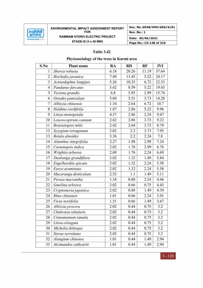
ENVIRONMENTAL IMPACT ASSESSMENT REPORT FOR
RAMMAM HYDRO ELECTRIC PROJECT
STAGE-III (3 x 40 MW)
Doc. No.:9548/999/GEG/S/01
Rev. No.: 1
Date: 30/06/2021
Page No.: C3-128 of 219
3 - 128
Table 3.42
Phytosociology of the trees in Karmi area
S.No Plant name RA RD RF IVI
1 Shorea robusta 6.18 20.26 11.19 37.64
2 Bischofia javanica 7.49 11.45 5.22 24.17
3 Actinodaphne longipes 5.26 10.35 6.72 22.33
4 Pandanus furcatus 5.62 8.59 5.22 19.43
5 Tectona grandis 6.8 5.95 2.99 15.74
6 Ostodes paniculata 5.04 5.51 3.73 14.28
7 Albizzia chinensis 1.34 2.64 6.72 10.7
8 Haldina cordifolia 1.87 2.86 5.22 9.96
9 Litsea monopetala 4.37 2.86 2.24 9.47
10 Leucosceptrum cannum 2.62 2.86 3.73 9.22
11 Brassaiopsis mitis 2.42 2.64 3.73 8.79
12 Syzygium tetragonum 2.02 2.2 3.73 7.95
13 Betula alnoides 3.36 2.2 2.24 7.8
14 Ailanthus integrifolia 2.27 1.98 2.99 7.24
15 Castanopsis indica 2.02 1.76 2.99 6.76
16 Wrightia arborea 2.69 1.76 2.24 6.69
17 Duabanga grandiflora 3.02 1.32 1.49 5.84
18 Engelhardtia spicata 2.02 1.32 2.24 5.58
19 Eurya acuminata 2.02 1.32 2.24 5.58
20 Macaranga denticulata 2.52 1.1 1.49 5.11
21 Persea macrantha 1.34 0.88 2.24 4.46
22 Gmelina arborea 3.02 0.66 0.75 4.43
23 Cryptomeria japonica 2.02 0.88 1.49 4.39
24 Rhus chinensis 1.01 0.66 2.24 3.91
25 Ficus neriifolia 1.51 0.66 1.49 3.67
26 Albizzia procera 2.02 0.44 0.75 3.2
27 Chukrasia tabularis 2.02 0.44 0.75 3.2
28 Cinnamomum tamala 2.02 0.44 0.75 3.2
29 Litsea elongata 2.02 0.44 0.75 3.2
30 Michelia doltsopa 2.02 0.44 0.75 3.2
31 Styrax serrulatus 2.02 0.44 0.75 3.2
32 Alangium chinense 1.01 0.44 1.49 2.94
33 Alcimandra cathcartii 1.01 0.44 1.49 2.94

ENVIRONMENTAL IMPACT ASSESSMENT REPORT FOR
RAMMAM HYDRO ELECTRIC PROJECT
STAGE-III (3 x 40 MW)
Doc. No.:9548/999/GEG/S/01
Rev. No.: 1
Date: 30/06/2021
Page No.: C3-129 of 219
3 - 129
34 Ficus auriculata 1.01 0.44 1.49 2.94
35 Ficus religiosa 1.01 0.44 1.49 2.94
36 Albizzia gamblei 1.01 0.22 0.75 1.97
37 Magnifera sylvatica 1.01 0.22 0.75 1.97
38 Phyllanthus emblica 1.01 0.22 0.75 1.97
39 Quercus griffithii 1.01 0.22 0.75 1.97
Total 100 100 100 300
Table 3.43
Phytosociology of the shrubs and climbers in Karmi area
S.No. Plant name RA RD RF IVI
1 Eupatorium adenophorum 5.87 19.5 9.55 34.93
2 Chromolaena odorata 5.62 9.96 5.1 20.68
3 Mikania micrantha 5.15 6.85 3.82 15.82
4 Lantana camara 4.84 6.43 3.82 15.1
5 Tetrastigma planicaule 2.5 4.98 5.73 13.21
6 Tetrastigma serrulatum 1.87 3.73 5.73 11.34
7 Abrus pulchellus 2.41 3.73 4.46 10.6
8 Stephania japonica 1.87 3.32 5.1 10.29
9 Artemisia dubia 2.5 3.32 3.82 9.64
10 Thladiantha cordifolia 3 3.32 3.18 9.5
11 Maesa chisia 1.25 2.49 5.73 9.47
12 Mimosa himalayana 4.37 2.9 1.91 9.19
13 Psilanthus bengalensis 1.61 2.49 4.46 8.55
14 Bambusa nutans 2.81 2.49 2.55 7.85
15 Maesa macrophylla 1.69 1.87 3.18 6.74
16 Desdmodium heterocarpon 3.75 1.66 1.27 6.68
17 Dioscorea bulbifera 1.87 1.66 2.55 6.08
18 Melastoma malabathricum 1.87 1.66 2.55 6.08
19 Argyreia hookeri 3.28 1.45 1.27 6.01
20 Debregeasia longifolia 2.19 1.45 1.91 5.55
21 Cassia floribunda 2.81 1.24 1.27 5.33
22 Flueggea virosa 2.81 1.24 1.27 5.33
23 Dioscorea hispida 1.41 1.24 2.55 5.2
24 Aconogonum molle 2.34 1.04 1.27 4.65
25 Flemingia stricta 2.34 1.04 1.27 4.65
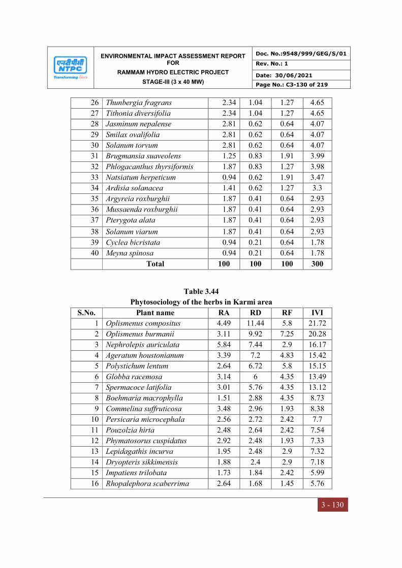
ENVIRONMENTAL IMPACT ASSESSMENT REPORT FOR
RAMMAM HYDRO ELECTRIC PROJECT
STAGE-III (3 x 40 MW)
Doc. No.:9548/999/GEG/S/01
Rev. No.: 1
Date: 30/06/2021
Page No.: C3-130 of 219
3 - 130
26 Thunbergia fragrans 2.34 1.04 1.27 4.65
27 Tithonia diversifolia 2.34 1.04 1.27 4.65
28 Jasminum nepalense 2.81 0.62 0.64 4.07
29 Smilax ovalifolia 2.81 0.62 0.64 4.07
30 Solanum torvum 2.81 0.62 0.64 4.07
31 Brugmansia suaveolens 1.25 0.83 1.91 3.99
32 Phlogacanthus thyrsiformis 1.87 0.83 1.27 3.98
33 Natsiatum herpeticum 0.94 0.62 1.91 3.47
34 Ardisia solanacea 1.41 0.62 1.27 3.3
35 Argyreia roxburghii 1.87 0.41 0.64 2.93
36 Mussaenda roxburghii 1.87 0.41 0.64 2.93
37 Pterygota alata 1.87 0.41 0.64 2.93
38 Solanum viarum 1.87 0.41 0.64 2.93
39 Cyclea bicristata 0.94 0.21 0.64 1.78
40 Meyna spinosa 0.94 0.21 0.64 1.78
Total 100 100 100 300
Table 3.44
Phytosociology of the herbs in Karmi area
S.No. Plant name RA RD RF IVI
1 Oplismenus compositus 4.49 11.44 5.8 21.72
2 Oplismenus burmanii 3.11 9.92 7.25 20.28
3 Nephrolepis auriculata 5.84 7.44 2.9 16.17
4 Ageratum houstonianum 3.39 7.2 4.83 15.42
5 Polystichum lentum 2.64 6.72 5.8 15.15
6 Globba racemosa 3.14 6 4.35 13.49
7 Spermacoce latifolia 3.01 5.76 4.35 13.12
8 Boehmaria macrophylla 1.51 2.88 4.35 8.73
9 Commelina suffruticosa 3.48 2.96 1.93 8.38
10 Persicaria microcephala 2.56 2.72 2.42 7.7
11 Pouzolzia hirta 2.48 2.64 2.42 7.54
12 Phymatosorus cuspidatus 2.92 2.48 1.93 7.33
13 Lepidagathis incurva 1.95 2.48 2.9 7.32
14 Dryopteris sikkimensis 1.88 2.4 2.9 7.18
15 Impatiens trilobata 1.73 1.84 2.42 5.99
16 Rhopalephora scaberrima 2.64 1.68 1.45 5.76

ENVIRONMENTAL IMPACT ASSESSMENT REPORT FOR
RAMMAM HYDRO ELECTRIC PROJECT
STAGE-III (3 x 40 MW)
Doc. No.:9548/999/GEG/S/01
Rev. No.: 1
Date: 30/06/2021
Page No.: C3-131 of 219
3 - 131
17 Triumfetta rhomboidea 1.13 1.44 2.9 5.47
18 Oxalis corniculata 1.79 1.52 1.93 5.24
19 Sida rhombifolia 1.6 1.36 1.93 4.89
20 Pteris biaurita 3.39 0.72 0.48 4.59
21 Capillipedium assimile 1.41 1.2 1.93 4.54
22 Selaginella monospora 1.41 1.2 1.93 4.54
23 Persicaria runcinata 1.76 1.12 1.45 4.33
24 Physalis divaricata 2.26 0.96 0.97 4.19
25 Saccharum arundinaceum 1.63 1.04 1.45 4.12
26 Bidens pilosa 1.88 0.8 0.97 3.65
27 Pupalia atropurpurea 1.88 0.8 0.97 3.65
28 Isachne globosa 1.69 0.72 0.97 3.38
29 Adiantum philippense 1.13 0.72 1.45 3.3
30 Cyperus cyperoides 1.51 0.64 0.97 3.11
31 Biophytum reinwardtii 1.32 0.56 0.97 2.84
32 Drymaria cordata 1.32 0.56 0.97 2.84
33 Emelia sonchifolia 1.32 0.56 0.97 2.84
34 Pilea scripta 1.32 0.56 0.97 2.84
35 Equisetum diffusum 1.88 0.4 0.48 2.77
36 Neyraudia zollingeri 1.88 0.4 0.48 2.77
37 Rubia charaefolia 0.75 0.48 1.45 2.68
38 Peristrophe speciosa 1.13 0.48 0.97 2.58
39 Urena lobata 1.13 0.48 0.97 2.58
40 Galinsoga parviflora 1.51 0.32 0.48 2.31
41 Peperomia pellucida 1.51 0.32 0.48 2.31
42 Rhynchoglossum obliquum 0.94 0.4 0.97 2.31
43 Strobilanthus himalayana 1.51 0.32 0.48 2.31
44 Begonia hatacoa 0.75 0.32 0.97 2.04
45 Crassocephalum crepidioides 0.75 0.32 0.97 2.04
46 Persicaria chinensis 0.75 0.32 0.97 2.04
47 Urtica dioica 0.75 0.32 0.97 2.04
48 Piper peepuloides 1.13 0.24 0.48 1.85
49 Setaria palmifolia 1.13 0.24 0.48 1.85
50 Dicliptera bupleuroides 0.56 0.24 0.97 1.77
51 Phaseolus coccineus 0.56 0.24 0.97 1.77
52 Aeschynanthus hookeri 0.38 0.16 0.97 1.5
53 Elastostema lineolatum 0.75 0.16 0.48 1.4

ENVIRONMENTAL IMPACT ASSESSMENT REPORT FOR
RAMMAM HYDRO ELECTRIC PROJECT
STAGE-III (3 x 40 MW)
Doc. No.:9548/999/GEG/S/01
Rev. No.: 1
Date: 30/06/2021
Page No.: C3-132 of 219
3 - 132
54 Elephantopus scaber 0.75 0.16 0.48 1.4
55 Peliosanthes griffithii 0.75 0.16 0.48 1.4
56 Tectaria griffithii 0.75 0.16 0.48 1.4
57 Vallaris solanacea 0.75 0.16 0.48 1.4
58 Costus speciosus 0.38 0.08 0.48 0.94
59 Hedychium ellipticum 0.38 0.08 0.48 0.94
Total 100 100 100 300
3.12.13 Biodiversity Indices
Species diversity indices can be considered as a measure of environmental quality and it
indicates the eco-system well being. The diversity measurements reflect as to how many
diverse species are present. Species diversity is the best measure of community structure
and it is sensitive to various environmental stresses. Smaller value of Simpson’s
Diversity Index shows healthy ecosystem and the higher value shows that an ecosystem
is under environmental stress. The vegetation (trees, Shrubs and Herbs) sampling was
carried out at four different sampling locations near Barrage site, Power house site and
near township area.
Tree species had Shannon diversity (H’) index is 3.96 at Salangdang area whereas lowest
in Kankiabang (3.76), shrubs and lainas had maximum Shannon diversity (H’) index is
3.38 and lowest in near tonship area and herbs have Simpson index having highest in
Karmi area (3.86) and lowest at Kankiabang (3.11). There is no major difference in the
Simpson index for all communities (Table 3.45).
Table 3.45
Biodiversity indices of all four study sites
Location Community Shannon-Wiener Index (H)
Simpson Index (1-D)
Salangdang
Trees 3.96 0.97
Shrubs and lainas 3.29 0.95
Herbs 3.62 0.96
Kankiabang
Trees 3.76 0.96
Shrubs and lainas 3.20 0.95
Herbs 3.11 0.93
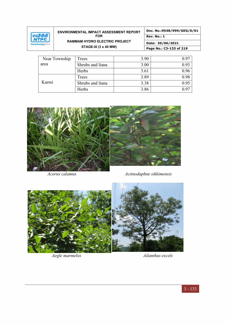
ENVIRONMENTAL IMPACT ASSESSMENT REPORT FOR
RAMMAM HYDRO ELECTRIC PROJECT
STAGE-III (3 x 40 MW)
Doc. No.:9548/999/GEG/S/01
Rev. No.: 1
Date: 30/06/2021
Page No.: C3-133 of 219
3 - 133
Near Township area
Trees 3.90 0.97
Shrubs and liana 3.00 0.93
Herbs 3.61 0.96
Karmi
Trees 3.89 0.98
Shrubs and liana 3.38 0.95
Herbs 3.86 0.97
Acorus calamus Actinodaphne sikkimensis
Aegle marmelos Ailanthus excels

ENVIRONMENTAL IMPACT ASSESSMENT REPORT FOR
RAMMAM HYDRO ELECTRIC PROJECT
STAGE-III (3 x 40 MW)
Doc. No.:9548/999/GEG/S/01
Rev. No.: 1
Date: 30/06/2021
Page No.: C3-134 of 219
3 - 134
Alangium salvifolium Albizia odoratissima
Albizia procera Ampelocissus barbata
Anaphalis contorta Ardisia solanacea

ENVIRONMENTAL IMPACT ASSESSMENT REPORT FOR
RAMMAM HYDRO ELECTRIC PROJECT
STAGE-III (3 x 40 MW)
Doc. No.:9548/999/GEG/S/01
Rev. No.: 1
Date: 30/06/2021
Page No.: C3-135 of 219
3 - 135
Arisaema tortuosum Bauhinia vahlii
Begonia picta Bischofia javanica
Bridelia stipularis Buchanania lanzan
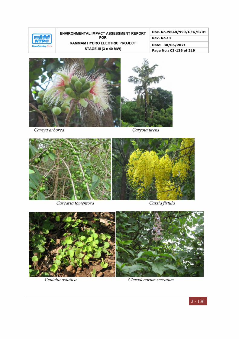
ENVIRONMENTAL IMPACT ASSESSMENT REPORT FOR
RAMMAM HYDRO ELECTRIC PROJECT
STAGE-III (3 x 40 MW)
Doc. No.:9548/999/GEG/S/01
Rev. No.: 1
Date: 30/06/2021
Page No.: C3-136 of 219
3 - 136
Careya arborea Caryota urens
Casearia tomentosa Cassia fistula
Centella asiatica Clerodendrum serratum
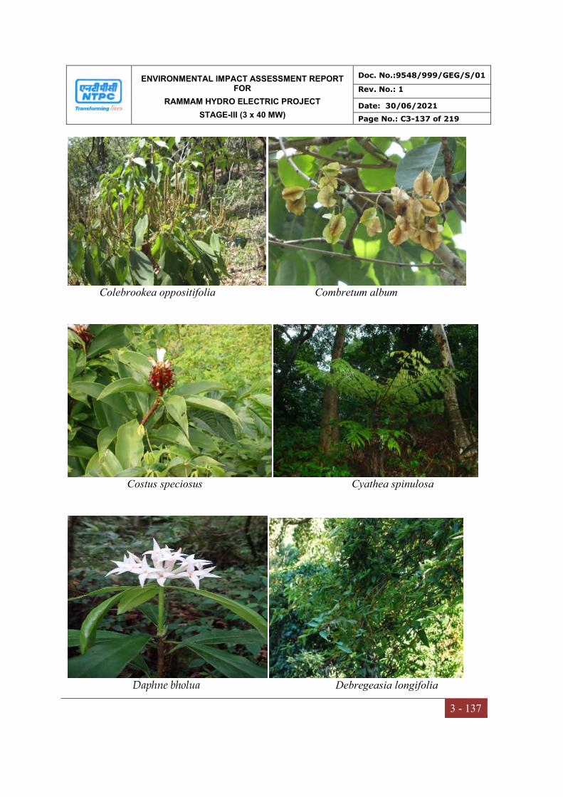
ENVIRONMENTAL IMPACT ASSESSMENT REPORT FOR
RAMMAM HYDRO ELECTRIC PROJECT
STAGE-III (3 x 40 MW)
Doc. No.:9548/999/GEG/S/01
Rev. No.: 1
Date: 30/06/2021
Page No.: C3-137 of 219
3 - 137
Colebrookea oppositifolia Combretum album
Costus speciosus Cyathea spinulosa
Daphne bholua Debregeasia longifolia

ENVIRONMENTAL IMPACT ASSESSMENT REPORT FOR
RAMMAM HYDRO ELECTRIC PROJECT
STAGE-III (3 x 40 MW)
Doc. No.:9548/999/GEG/S/01
Rev. No.: 1
Date: 30/06/2021
Page No.: C3-138 of 219
3 - 138
Dendrophthoe falcata Desmodium heterocarpon
Dichroa febrifuga Dillenia indica

ENVIRONMENTAL IMPACT ASSESSMENT REPORT FOR
RAMMAM HYDRO ELECTRIC PROJECT
STAGE-III (3 x 40 MW)
Doc. No.:9548/999/GEG/S/01
Rev. No.: 1
Date: 30/06/2021
Page No.: C3-139 of 219
3 - 139
Dillenia pentagyna Dioscorea bulbifera
Elephantopus scaber Elsholtzia blanda
Entada rheedii Eurya Japonica

ENVIRONMENTAL IMPACT ASSESSMENT REPORT FOR
RAMMAM HYDRO ELECTRIC PROJECT
STAGE-III (3 x 40 MW)
Doc. No.:9548/999/GEG/S/01
Rev. No.: 1
Date: 30/06/2021
Page No.: C3-140 of 219
3 - 140
Ficus benjamina Ficus semicordata
Firmiana colorata Garuga pinnata
Girardiana diversifolia Gloriosa superba
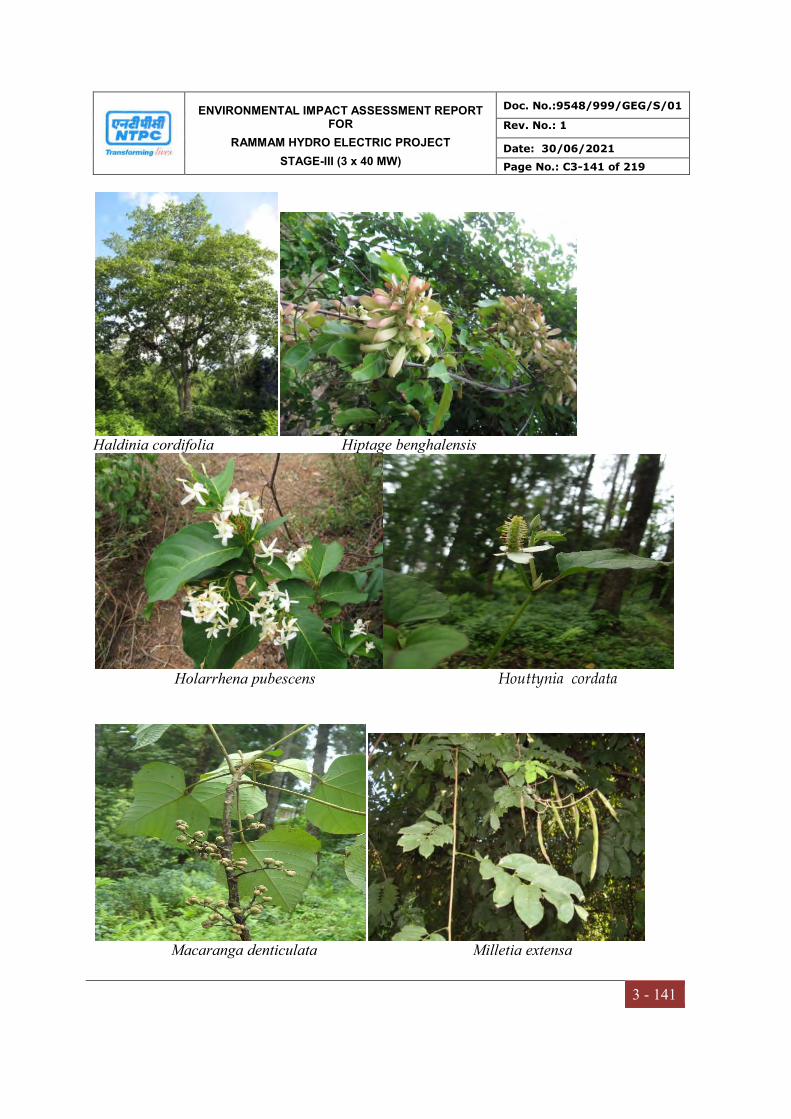
ENVIRONMENTAL IMPACT ASSESSMENT REPORT FOR
RAMMAM HYDRO ELECTRIC PROJECT
STAGE-III (3 x 40 MW)
Doc. No.:9548/999/GEG/S/01
Rev. No.: 1
Date: 30/06/2021
Page No.: C3-141 of 219
3 - 141
Haldinia cordifolia Hiptage benghalensis
Holarrhena pubescens Houttynia cordata
Macaranga denticulata Milletia extensa
ENVIRONMENTAL IMPACT ASSESSMENT REPORT FOR
RAMMAM HYDRO ELECTRIC PROJECT
STAGE-III (3 x 40 MW)
Doc. No.:9548/999/GEG/S/01
Rev. No.: 1
Date: 30/06/2021
Page No.: C3-142 of 219
3 - 142
Musa balbasiana Myrsine semiserrata
Oroxylum indicum Osbeckia stellata
Oxyspora paniculata Phoenix loureiroi
ENVIRONMENTAL IMPACT ASSESSMENT REPORT FOR
RAMMAM HYDRO ELECTRIC PROJECT
STAGE-III (3 x 40 MW)
Doc. No.:9548/999/GEG/S/01
Rev. No.: 1
Date: 30/06/2021
Page No.: C3-143 of 219
3 - 143
Phyllanthus emblica Pinus roxburghii
Plumbago zeylanica Rauwolfia serpetina
Rhaphidophora decursiva Rhus chinensis
ENVIRONMENTAL IMPACT ASSESSMENT REPORT FOR
RAMMAM HYDRO ELECTRIC PROJECT
STAGE-III (3 x 40 MW)
Doc. No.:9548/999/GEG/S/01
Rev. No.: 1
Date: 30/06/2021
Page No.: C3-144 of 219
3 - 144
Rhododendron arboretum Rubia cordifolia
Rubia manjith Rubus ellipticus
Rubus paniculatus Semicarpus anacardium

ENVIRONMENTAL IMPACT ASSESSMENT REPORT FOR
RAMMAM HYDRO ELECTRIC PROJECT
STAGE-III (3 x 40 MW)
Doc. No.:9548/999/GEG/S/01
Rev. No.: 1
Date: 30/06/2021
Page No.: C3-145 of 219
3 - 145
Stereospermum chelonoides Stereospermum tetragonum
Strobilanthes capitata Terminalia chebula
Terminalia tomentosa Tetrastigma serrulatum

ENVIRONMENTAL IMPACT ASSESSMENT REPORT FOR
RAMMAM HYDRO ELECTRIC PROJECT
STAGE-III (3 x 40 MW)
Doc. No.:9548/999/GEG/S/01
Rev. No.: 1
Date: 30/06/2021
Page No.: C3-146 of 219
3 - 146
Thysanolaena latifolia Toona ciliate
Trema orientalis Vaccinum vacciniaceum
Valeriana hardwickii Ventilago denticulate

ENVIRONMENTAL IMPACT ASSESSMENT REPORT FOR
RAMMAM HYDRO ELECTRIC PROJECT
STAGE-III (3 x 40 MW)
Doc. No.:9548/999/GEG/S/01
Rev. No.: 1
Date: 30/06/2021
Page No.: C3-147 of 219
3 - 147
Woodfordia fruticosa Wrightia arborea
Zanthoxylum armatum Ziziphus rugosa
Fig 3.19 Photographs of various plant species in area

ENVIRONMENTAL IMPACT ASSESSMENT REPORT FOR
RAMMAM HYDRO ELECTRIC PROJECT
STAGE-III (3 x 40 MW)
Doc. No.:9548/999/GEG/S/01
Rev. No.: 1
Date: 30/06/2021
Page No.: C3-148 of 219
3 - 148
3.12.14 Fauna
For the documentation of the faunal biodiversity of the study area with respect to birds,
reptiles, amphibians, and butterfly species, a baseline survey conducted in monsoon
period. To prepare a detailed report on the status of faunal diversity within study area of
10 Km radius around Rammam hydro power project area, field studies were conducted.
Both direct (sighting) and indirect (evidences) observations methods were used to survey
the faunal species around the study area. Additionally reference of relevant literatures
(published/unpublished) and dialogues with local people were also varied out to
consolidate the presence of faunal distribution in the area (Smith 1933-43, Ali and Ripley
1983, Daniel 1983, Prater 1993).
Livestock like cattle, goat, poultry, duck and pig are reared for dairy products, meat, egg
and for agriculture purpose. Majority of cattle are of local variety. Backyard poultry
farms are mostly common in this area.
All the direct sightings were recorded at the study period and also noted faunal species
after consultation with local villagers and secondary sources from DFO offices of
Department of Forests of Darjeeling district of West Bengal and West Sikkim district of
Sikkim states, Common five stripped Squirrel, Common Indian Mongoose, Indian
Rabbit, Large Indian Squirrel were observed during primary survey. Since birds are
considered to be the indicators for monitoring and understanding human impacts on
ecological systems attempt was made to gather quantitative data on the avifauna by walk
through survey within the study area and in the agricultural lands within the close
proximity to the rivers of this region is Lodhama and Rammam Rivers. Systematic
account of the fauna along with birds in the study area with the status of occurrence is
given in the Table 3.46.
ENVIRONMENTAL IMPACT ASSESSMENT REPORT FOR
RAMMAM HYDRO ELECTRIC PROJECT
STAGE-III (3 x 40 MW)
Doc. No.:9548/999/GEG/S/01
Rev. No.: 1
Date: 30/06/2021
Page No.: C3-149 of 219
3 - 149
Table 3.46
List of major animal species reported in the study area
S.No. Scientific name Trade name Family IWPA,1972,
Schedule
Mammals
1 Elephas maximus Asian Elephant Elephantidae Schedule-I
2 Tupaia belangeri Northern Treeshrew Tupaiidae Schedule-II
3 Macaca assamensis Assam Macaque Cercopithecidae Schedule-II
4 Macaca mulatta Rhesus Macaque Cercopithecidae Schedule-II
5 Semnopithecus hector Tarai Gray Langur Cercopithecidae Schedule-II
6 Ratufa bicolor Black Giant Squirrel Sciuridae Schedule-II
7 Belomys pearsonii Hairy-footed Flying
Squirrel
Sciuridae Schedule-II
8 Eupetaurus cinereus Woolly Flying Squirrel Sciuridae Schedule-II
9 Funambulus pennantii Five- striped Palm
Squirrel
Sciuridae Schedule-IV
10 Tamiops macclellandii Himalayan Striped
Squirrel
Sciuridae Schedule-II
11 Cannomys badius Lesser Bamboo Rat Spalacidae Schedule-V
12 Neodon sikimensis Sikkim Vole Muridae Schedule-V
13 Tatera indica Indian Gerbil Muridae Schedule-V
14 Bandicota bengalensis Lesser Bandicoot Rat Muridae Schedule-V
15 Bandicota indica Greater Bandicoot Rat Muridae Schedule-V
16 Mus booduga Little Indian Field Mouse Muridae Schedule-V
17 Mus cervicolor Fawn-colored Mouse Muridae Schedule-V
18 Mus musculus House Mouse Muridae Schedule-V
19 Mus pahari Gairdner’s Shrewmouse Muridae Schedule-V
20 Niviventer eha Smoke- bellied Rat Muridae Schedule-V
21 Niviventer fulvescens Chestnut White- bellied
Rat
Muridae Schedule-V
22 Niviventer niviventer Himalayan White-bellied
Rat
Muridae Schedule-V
23 Rattus nitidus Himalayan Field Rat Muridae Schedule-V
24 Rattus pyctoris Himalayan Rat Muridae Schedule-V
25 Rattus rattus House Rat Muridae Schedule-V
26 Hystrix brachyura Malayan Porcupine Hystricidae Schedule-II

ENVIRONMENTAL IMPACT ASSESSMENT REPORT FOR
RAMMAM HYDRO ELECTRIC PROJECT
STAGE-III (3 x 40 MW)
Doc. No.:9548/999/GEG/S/01
Rev. No.: 1
Date: 30/06/2021
Page No.: C3-150 of 219
3 - 150
27 Ochotona curzoniae Plateau Pika Ochotonidae Not assigned
28 Ochotona macrotis Large-eared Pika Ochotonidae Not assigned
29 Ochotona roylei Royle's Pika Ochotonidae Schedule-IV
30 Ochotona sikimaria Sikkim Pika Ochotonidae Not assigned
31 Neofelis nebulosa Clouded Leopard Felidae Schedule - I
32 Lepus nigricollis Indian Hare Leporidae Schedule-IV
33 Lepus oiostolus Wolly Hare Leporidae Not assigned
34 Crocidura attenuata Grey Shrew Soricidae Not assigned
35 Suncus etruscus Pygmy White-toothed
Shrew
Soricidae Not assigned
36 Suncus murinus House Shrew Soricidae Not assigned
37 Episoriculus macrurus Long-tailed Mountain
Shrew
Soricidae Not assigned
38 Euroscaptor micrura Himalayan Mole Talpidae Not assigned
39 Cynopterus sphinx Greater Short-nosed Fruit
Bat
Pteropodidae Schedule-V
40 Eonycteris spelaea Lesser Dawn Bat Pteropodidae Schedule-V
41 Megaerops niphanae Northern Tailless Fruit
Bat
Pteropodidae Schedule-V
42 Macroglossus sobrinus Greater Long-nosed Fruit
Bat
Pteropodidae Schedule-V
43 Pteropus giganteus Indian Flying Fox Pteropodidae Schedule-V
44 Rousettus leschenaultii Leschenault's Rousette Pteropodidae Schedule-V
45 Sphaerias blanfordi Blanford's Fruit Bat Pteropodidae Schedule-V
46 Rhinolophus affinis Intermediate Horseshoe
Bat
Rhinolophidae Not assigned
47 Rhinolophus
ferrumequinum
Horseshoe Bat Rhinolophidae Not assigned
48 Rhinolophus lepidus Blyth’s Horseshoe Bat Rhinolophidae Not assigned
49 Rhinolophus luctus Great Woolly Horseshoe
Bat
Rhinolophidae Not assigned
50 Rhinolophus trifoliatus Trefoil Horseshoe Bat Hipposideridae Not assigned
51 Coelops frithii Tailless Leaf-nosed Bat Hipposideridae Not assigned
52 Taphozous nudiventris Naked- rumped Tomb
Bat
Megadermatidae Not assigned
53 Tadarida teniotis European Free-tailed Bat Molossidae Not assigned
54 Arielulus circumdatus Bronze Sprite Molossidae Not assigned

ENVIRONMENTAL IMPACT ASSESSMENT REPORT FOR
RAMMAM HYDRO ELECTRIC PROJECT
STAGE-III (3 x 40 MW)
Doc. No.:9548/999/GEG/S/01
Rev. No.: 1
Date: 30/06/2021
Page No.: C3-151 of 219
3 - 151
55 Pipistrellus
coromandra
Indian Pipistrelle Molossidae Not assigned
56 Hypsugo cadornae Cadorna's Pipistrelle Molossidae Not assigned
57 Hypsugo joffrei Joffre’s Pipistrelle Molossidae Not assigned
58 Tylonycteris pachypus Lesser Bamboo Bat Molossidae Not assigned
59 Myotis annectans Hairy-faced Bat Molossidae Not assigned
60 Myotis formosus Hodgson’s Bat Molossidae Not assigned
61 Myotis sicarius Mandelli’s Mouse- eared
Myotis
Molossidae Not assigned
62 Myotis siligorensis Himalayan Whiskered
Myotis
Molossidae Not assigned
63 Harpiocephalus harpia Lesser Hairy-winged Bat Molossidae Not assigned
64 Murina aurata Little Tube- nosed Bat Molossidae Not assigned
65 Kerivoula picta Painted Woolly Bat Molossidae Not assigned
66 Felis chaus Jungle Cat Felidae Schedule-II
67 Pardofelis marmorata Marbled Cat Felidae Schedule-II
68 Panthera pardus Leopard Felidae Schedule-I
69 Paguma larvata Masked Palm Civet Viverridae Schedule-II
70 Viverricula indica Small Indian Civet Viverridae Schedule-II
71 Herpestes
auropunctatus
Small Indian Mongoose Herpestidae Schedule-IV
72 Herpestes edwardsii Grey Mongoose Herpestidae Schedule-II
73 Herpestes urva Crab-eating Mongoose Herpestidae Schedule-II
74 Canis aureus Golden Jackal Canidae Schedule-II
75 Cuon alpinus Dhole Canidae Schedule-II
76 Vulpes bengalensis Bengal Fox Canidae Schedule-II
77 Vulpes vulpes Red Fox Canidae Schedule-II
78 Ursus thibetanus Asiatic Black Bear Ursidae Schedule-II
79 Ailurus fulgens Red Panda Ailuridae Schedule-I
80 Martes foina Beech Marten Mustelidae Schedule-II
81 Melogale personata Large-toothed Ferret
Badger
Mustelidae Schedule-II
82 Mustela altaica Mustelidae Schedule-II
83 Mustela kathiah Yellow-bellied Weasel Mustelidae Schedule-II
84 Mustela sibirica Siberian Weasel Mustelidae Schedule-II
85 Sus scrofa Wild Boar Suidae Schedule-III
86 Axis axis Chital Cervidae Schedule-III
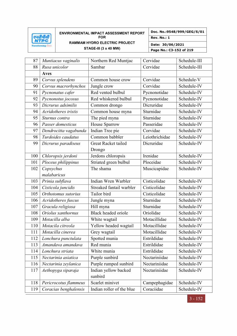
ENVIRONMENTAL IMPACT ASSESSMENT REPORT FOR
RAMMAM HYDRO ELECTRIC PROJECT
STAGE-III (3 x 40 MW)
Doc. No.:9548/999/GEG/S/01
Rev. No.: 1
Date: 30/06/2021
Page No.: C3-152 of 219
3 - 152
87 Muntiacus vaginalis Northern Red Muntjac Cervidae Schedule-III
88 Rusa unicolor Sambar Cervidae Schedule-III
Aves
89 Corvus splendens Common house crow Corvidae Schedule-V
90 Corvus macrorhynchos Jungle crow Corvidae Schedule-IV
91 Pycnonatus cafer Red vented bulbul Pycnonotidae Schedule-IV
92 Pycnonotus jocosus Red whiskered bulbul Pycnonotidae Schedule-IV
93 Dicrurus adsimilis Common drongo Dicruridae Schedule-IV
94 Acridotheres tristis Common house myna Sturnidae Schedule-IV
95 Sturnus contra The pied myna Sturnidae Schedule-IV
96 Passer domesticus House Sparrow Passeridae Schedule-IV
97 Dendrocitta vagabunda Indian Tree pie Corvidae Schedule-IV
98 Turdoides caudatus Common babbler Leiothrichidae Schedule-IV
99 Dicrurus paradiseus Great Racket tailed
Drongo
Dicruridae Schedule-IV
100 Chloropsis jerdoni Jerdons chloropsis Irenidae Schedule-IV
101 Ploceus philippinus Striated green bulbul Ploceidae Schedule-IV
102 Copsychus
malabaricus
The shama Muscicapidae Schedule-IV
103 Prinia subflava Indian Wren Warbler Cisticolidae Schedule-IV
104 Cisticola juncidis Streaked fantail warbler Cisticolidae Schedule-IV
105 Orthotomus sutorius Tailor bird Cisticolidae Schedule-IV
106 Acridotheres fuscus Jungle myna Sturnidae Schedule-IV
107 Gracula religiosa Hill myna Sturnidae Schedule-IV
108 Oriolus xanthornus Black headed oriole Oriolidae Schedule-IV
109 Motacilla alba White wagtail Motacillidae Schedule-IV
110 Motacila citreola Yellow headed wagtail Motacillidae Schedule-IV
111 Motacilla cinerea Grey wagtail Motacillidae Schedule-IV
112 Lonchura punctulata Spotted munia Estrildidae Schedule-IV
113 Amandava amandava Red munia Estrildidae Schedule-IV
114 Lonchura striata White munia Estrildidae Schedule-IV
115 Nectarinia asiatica Purple sunbird Nectariniidae Schedule-IV
116 Nectarinia zeylanica Purple rumped sunbird Nectariniidae Schedule-IV
117 Aethopyga siparaja Indian yellow backed
sunbird
Nectariniidae Schedule-IV
118 Pericrocotus flammeus Scarlet minivet Campephagidae Schedule-IV
119 Coracias benghalensis Indian roller of the blue Coraciidae Schedule-IV
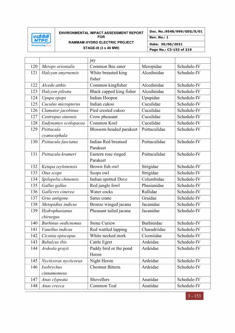
ENVIRONMENTAL IMPACT ASSESSMENT REPORT FOR
RAMMAM HYDRO ELECTRIC PROJECT
STAGE-III (3 x 40 MW)
Doc. No.:9548/999/GEG/S/01
Rev. No.: 1
Date: 30/06/2021
Page No.: C3-153 of 219
3 - 153
jay
120 Merops orientalis Common Bee eater Meropidae Schedule-IV
121 Halcyon smyrnensis White breasted king
fisher
Alcedinidae Schedule-IV
122 Alcedo atthis Common kingfisher Alcedinidae Schedule-IV
123 Halcyon pileata Black capped king fisher Alcedinidae Schedule-IV
124 Upupa epops Indian Hoopoe Upupidae Schedule-IV
125 Cuculus micropterus Indian cukoo Cuculidae Schedule-IV
126 Clamator jacobinus Pied crested cukoo Cuculidae Schedule-IV
127 Centropus sinensis Crow pheasant Cuculidae Schedule-IV
128 Eudynamys scolopacea Common Koel Cuculidae Schedule-IV
129 Psittacula
cyanocephala
Blossom-headed parakeet Psittaculidae Schedule-IV
130 Psittacula fasciatus Indian Red breatsed
Parakeet
Psittaculidae Schedule-IV
131 Psittacula krameri Eastern rose ringed
Parakeet
Psittaculidae Schedule-IV
132 Ketupa zeylonensis Brown fish owl Strigidae Schedule-IV
133 Otus scops Scops owl Strigidae Schedule-IV
134 Spilopelia chinensis Indian spotted Dove Columbidae Schedule-IV
135 Gallus gallus Red jungle fowl Phasianidae Schedule-IV
136 Gallicrex cinerea Water cocks Rallidae Schedule-IV
137 Grus antigone Sarus crane Gruidae Schedule-IV
138 Metopidius indicus Bronze winged jacana Jacanidae Schedule-IV
139 Hydrophasianus
chirurgus
Pheasant tailed jacana Jacanidae Schedule-IV
140 Burhinus oedicnemus Stone Curiew Burhinidae Schedule-IV
141 Vanellus indicus Red wattled lapping Charadriidae Schedule-IV
142 Ciconia episcopus White necked stork Ciconiidae Schedule-IV
143 Bubulcus ibis Cattle Egret Ardeidae Schedule-IV
144 Ardeola grayii Paddy bird or the pond
Heron
Ardeidae Schedule-IV
145 Nycticorax nycticorax Night Heron Ardeidae Schedule-IV
146 Ixobrychus
cinnamomeus
Chestnut Bittern Ardeidae Schedule-IV
147 Anas clypeata Shovellers Anatidae Schedule-IV
148 Anas crecca Common Teal Anatidae Schedule-IV

ENVIRONMENTAL IMPACT ASSESSMENT REPORT FOR
RAMMAM HYDRO ELECTRIC PROJECT
STAGE-III (3 x 40 MW)
Doc. No.:9548/999/GEG/S/01
Rev. No.: 1
Date: 30/06/2021
Page No.: C3-154 of 219
3 - 154
149 Nettapus
coromandelianus
Cotton Teal Anatidae Schedule-IV
150 Dinopium benghalensis Lesser Golden Backed
Woodpecker
Picidae Schedule-IV
151 Fulica atra Common coot Rallidae Schedule-IV
152 Anhinga melanogaster Indian Darter Anhingidae Schedule-IV
153 Himantopus
himantopus
Black winged Stilts Recurvirostridae Schedule-IV
154 Anastomus oscitans Openbilled stork Ciconiidae Schedule-IV
155 Gyps himalayensis Himalayan Griffon
Vulture
Accipitridae Schedule-I
156 Gyps bengalensis White rumped Vulture Accipitridae Schedule-I
157 Gyps indicus Slender Billed Vulture Accipitridae Schedule-I
158 Haliaeetus leucoryphus Palla's fish Eagle Accipitridae Schedule-I
159 Anser indicus Bar headed goose Anatidae Schedule-IV
160 Leptoptilos javanicus Lesser Adjutant Stork Ciconiidae Schedule-IV
161 Leptoptilos dubius Greater Adkitant Stork Ciconiidae Schedule-IV
162 Netta rufina Red crested Ponchard Anatidae Schedule-IV
163 Anas penelope Eurasian wigeon Anatidae Schedule-IV
164 Anas cypeata Northern Shoveller Anatidae Schedule-IV
165 Anas acuta Garganey Anatidae Schedule-IV
166 Anser anser Greylagloose Anatidae Schedule-IV
167 Anas poecilorhyncha Spot billed duck Anatidae Schedule-IV
168 Anas platyrhynchos Mallard Anatidae Schedule-IV
169 Tyto alba Barn owl Tytonidae Schedule-IV
Amphibians
170 Rana tigrina Frog Ranidae Schedule-IV
171 Hoplobatrachus
bengalensis
Indian bull frog Dicroglossidae Schedule-IV
172 Fejervarya limnocharis Cricket frog Schedule-IV
Reptiles
173 Naja naja Binocellate cobra Elapidae Schedule-II
174 Varanus bengalensis Monitor Lizard Varanidae Schedule-II
175 Xenochropis piscator Asiatic water snake Colubridae Schedule-II
176 Naza kaouthia Monocled cobra Elapidae Schedule-II
177 Bungarus coeruleus Indian krait Elapidae Schedule-IV
178 Vipera russellis Russel's Viper Crotalidae Schedule-II
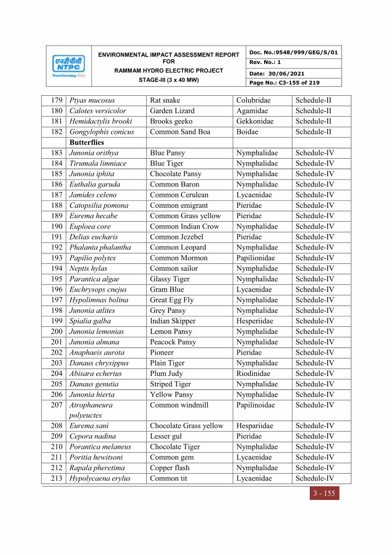
ENVIRONMENTAL IMPACT ASSESSMENT REPORT FOR
RAMMAM HYDRO ELECTRIC PROJECT
STAGE-III (3 x 40 MW)
Doc. No.:9548/999/GEG/S/01
Rev. No.: 1
Date: 30/06/2021
Page No.: C3-155 of 219
3 - 155
179 Ptyas mucosus Rat snake Colubridae Schedule-II
180 Calotes versicolor Garden Lizard Agamidae Schedule-II
181 Hemidactylis brooki Brooks geeko Gekkonidae Schedule-II
182 Gongylophis conicus Common Sand Boa Boidae Schedule-II
Butterflies
183 Junonia orithya Blue Pansy Nymphalidae Schedule-IV
184 Tirumala limniace Blue Tiger Nymphalidae Schedule-IV
185 Junonia iphita Chocolate Pansy Nymphalidae Schedule-IV
186 Euthalia garuda Common Baron Nymphalidae Schedule-IV
187 Jamides celeno Common Cerulean Lycaenidae Schedule-IV
188 Catopsilia pomona Common emigrant Pieridae Schedule-IV
189 Eurema hecabe Common Grass yellow Pieridae Schedule-IV
190 Euploea core Common Indian Crow Nymphalidae Schedule-IV
191 Delias eucharis Common Jezebel Pieridae Schedule-IV
192 Phalanta phalantha Common Leopard Nymphalidae Schedule-IV
193 Papilio polytes Common Mormon Papilionidae Schedule-IV
194 Neptis hylas Common sailor Nymphalidae Schedule-IV
195 Parantica algae Glassy Tiger Nymphalidae Schedule-IV
196 Euchrysops cnejus Gram Blue Lycaenidae Schedule-IV
197 Hypolimnas bolina Great Egg Fly Nymphalidae Schedule-IV
198 Junonia atlites Grey Pansy Nymphalidae Schedule-IV
199 Spialia galba Indian Skipper Hesperiidae Schedule-IV
200 Junonia lemonias Lemon Pansy Nymphalidae Schedule-IV
201 Junonia almana Peacock Pansy Nymphalidae Schedule-IV
202 Anaphaeis aurota Pioneer Pieridae Schedule-IV
203 Danaus chrysippus Plain Tiger Nymphalidae Schedule-IV
204 Abisara echerius Plum Judy Riodinidae Schedule-IV
205 Danaus genutia Striped Tiger Nymphalidae Schedule-IV
206 Junonia hierta Yellow Pansy Nymphalidae Schedule-IV
207 Atrophaneura
polyeuctes
Common windmill Papilinoidae Schedule-IV
208 Eurema sani Chocolate Grass yellow Hespariidae Schedule-IV
209 Cepora nadina Lesser gul Pieridae Schedule-IV
210 Porantica melaneus Chocolate Tiger Nymphalidae Schedule-IV
211 Poritia hewitsoni Common gem Lycaenidae Schedule-IV
212 Rapala pheretima Copper flash Nymphalidae Schedule-IV
213 Hypolycaena erylus Common tit Lycaenidae Schedule-IV
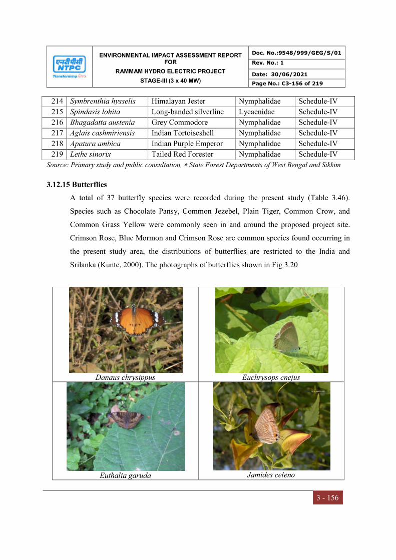
ENVIRONMENTAL IMPACT ASSESSMENT REPORT FOR
RAMMAM HYDRO ELECTRIC PROJECT
STAGE-III (3 x 40 MW)
Doc. No.:9548/999/GEG/S/01
Rev. No.: 1
Date: 30/06/2021
Page No.: C3-156 of 219
3 - 156
214 Symbrenthia hysselis Himalayan Jester Nymphalidae Schedule-IV
215 Spindasis lohita Long-banded silverline Lycaenidae Schedule-IV
216 Bhagadatta austenia Grey Commodore Nymphalidae Schedule-IV
217 Aglais cashmiriensis Indian Tortoiseshell Nymphalidae Schedule-IV
218 Apatura ambica Indian Purple Emperor Nymphalidae Schedule-IV
219 Lethe sinorix Tailed Red Forester Nymphalidae Schedule-IV
Source: Primary study and public consultation, State Forest Departments of West Bengal and Sikkim
3.12.15 Butterflies
A total of 37 butterfly species were recorded during the present study (Table 3.46).
Species such as Chocolate Pansy, Common Jezebel, Plain Tiger, Common Crow, and
Common Grass Yellow were commonly seen in and around the proposed project site.
Crimson Rose, Blue Mormon and Crimson Rose are common species found occurring in
the present study area, the distributions of butterflies are restricted to the India and
Srilanka (Kunte, 2000). The photographs of butterflies shown in Fig 3.20
Danaus chrysippus
Euchrysops cnejus
Euthalia garuda
Jamides celeno
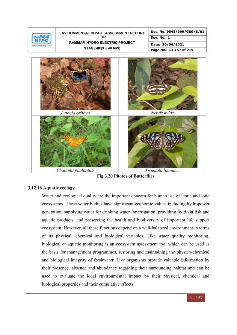
ENVIRONMENTAL IMPACT ASSESSMENT REPORT FOR
RAMMAM HYDRO ELECTRIC PROJECT
STAGE-III (3 x 40 MW)
Doc. No.:9548/999/GEG/S/01
Rev. No.: 1
Date: 30/06/2021
Page No.: C3-157 of 219
3 - 157
Junonia orithya
Neptis hylas
Phalanta phalantha
Tirumala limniace
Fig 3.20 Photos of Butterflies
3.12.16 Aquatic ecology
Water and ecological quality are the important concern for human use of lentic and lotic
ecosystems. These water bodies have significant economic values including hydropower
generation, supplying water for drinking water for irrigation, providing food via fish and
aquatic products, and preserving the health and biodiversity of important life support
ecosystem. However, all these functions depend on a well-balanced environment in terms
of its physical, chemical and biological variables. Like water quality monitoring,
biological or aquatic monitoring is an ecosystem assessment tool which can be used as
the basis for management programmes, restoring and maintaining the physico-chemical
and biological integrity of freshwater. Live organisms provide valuable information by
their presence, absence and abundance regarding their surrounding habitat and can be
used to evaluate the local environmental impact by their physical, chemical and
biological properties and their cumulative effects.

ENVIRONMENTAL IMPACT ASSESSMENT REPORT FOR
RAMMAM HYDRO ELECTRIC PROJECT
STAGE-III (3 x 40 MW)
Doc. No.:9548/999/GEG/S/01
Rev. No.: 1
Date: 30/06/2021
Page No.: C3-158 of 219
3 - 158
Biological parameters are very important in the aquatic ecosystem, since they determine
the productivity of a water body. The present study to assess the aquatic ecological status,
phytoplankton, zooplankton, macro-invertebrates and benthos was monitored within
study area of project. Primary productivity is an important indicator of pollution level in
any aquatic ecosystem. Fish production is dependent on production of zooplanktons
which in turn is dependent on the phytoplankton production or primary productivity. All
these are related to the physio-chemical characteristics of the water. Primary data
regarding fisheries, fish diversity composition, their migration and breeding grounds has
been collected from the study area, where as secondary data on fish and fisheries has also
been collected from Fisheries Department of Darjeeling.
3.12.17 Methodology
Collection and preservation of Phytoplankton sample: The plankton samples were
collected from sub surface water. In the case of phytoplankton, 500 ml sample water was
collected in polyethylene bottles and 1ml of Lugol’s solution was added for fixation and
preservation. The samples were centrifuged and decanted. A volume of 10 ml was
collected in double stoppered polyethylene bottles for further qualitative analysis of
phytoplankton. Identification of phytoplankton was dome with the help of standard books
and monographs (Turner, 1892; smith, 1924, Ward and Whipple 1959).
Collection and preservation of Zooplankton sample: The zooplankton samples were
collected by filtering 100 liters of sub-surface water through plankton net made up of
bolting silk cloth no 20. A sub sample of 30 ml was collected again, in polyethylene
double stoppered bottles and 4-5 drops of formalin and glycerin were added. The samples
were stored for further qualitative and quantitative study of zooplanktonic organism. The
identification of zooplankton was done up to species in most cases, according to the
reference books including that of Ward and Wipples (1959), Koste (1978), Battish (1992)
and Dhanapathi (2000).
Collection and preservation of macro-invertebrate and benthic samples: Samples have
been collected on monthly basis with the help of Ekman’s dredge, scoop and D-frame
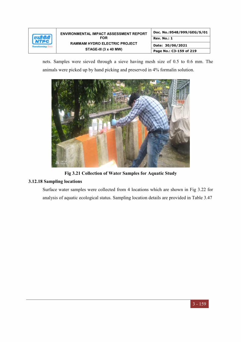
ENVIRONMENTAL IMPACT ASSESSMENT REPORT FOR
RAMMAM HYDRO ELECTRIC PROJECT
STAGE-III (3 x 40 MW)
Doc. No.:9548/999/GEG/S/01
Rev. No.: 1
Date: 30/06/2021
Page No.: C3-159 of 219
3 - 159
nets. Samples were sieved through a sieve having mesh size of 0.5 to 0.6 mm. The
animals were picked up by hand picking and preserved in 4% formalin solution.
Fig 3.21 Collection of Water Samples for Aquatic Study
3.12.18 Sampling locations
Surface water samples were collected from 4 locations which are shown in Fig 3.22 for
analysis of aquatic ecological status. Sampling location details are provided in Table 3.47

ENVIRONMENTAL IMPACT ASSESSMENT REPORT FOR
RAMMAM HYDRO ELECTRIC PROJECT
STAGE-III (3 x 40 MW)
Doc. No.:9548/999/GEG/S/01
Rev. No.: 1
Date: 30/06/2021
Page No.: C3-160 of 219
3 - 160
Fig 3.22 Aquatic ecological sampling locations
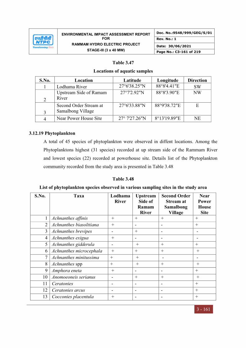
ENVIRONMENTAL IMPACT ASSESSMENT REPORT FOR
RAMMAM HYDRO ELECTRIC PROJECT
STAGE-III (3 x 40 MW)
Doc. No.:9548/999/GEG/S/01
Rev. No.: 1
Date: 30/06/2021
Page No.: C3-161 of 219
3 - 161
Table 3.47
Locations of aquatic samples
S.No. Location Latitude Longitude Direction
1 Lodhama River 27°6'38.25"N 88°8'4.41"E SW
2
Upstream Side of Ramam River
27°7'2.92"N 88°8'3.90"E NW
3
Second Order Stream at Samalbong Village
27°6'33.88"N 88°9'38.72"E E
4 Near Power House Site 27° 7'27.26"N 8°13'19.89"E NE
3.12.19 Phytoplankton
A total of 45 species of phytoplankton were observed in diffent locations. Among the
Phytoplanktons highest (31 species) recorded at up stream side of the Rammam River
and lowest species (22) recorded at powerhouse site. Details list of the Phytoplankton
community recorded from the study area is presented in Table 3.48
Table 3.48
List of phytoplankton species observed in various sampling sites in the study area
S.No. Taxa Lodhama River
Upstream Side of Ramam River
Second Order Stream at
Samalbong Village
Near Power House
Site 1 Achnanthes affinis + + + +
2 Achnanthes biasolttiana + - - +
3 Achnanthes brevipes - + - -
4 Achnanthes exigua + - - -
5 Achnanthes gidderula - + + +
6 Achnanthes microcephala + + + +
7 Achnanthes minitussima + + - -
8 Achnanthes spp + + + +
9 Amphora eneta + - - +
10 Anomoeoneis serianus - + + +
11 Ceratonies - - - +
12 Ceratonies arcus - - - +
13 Cocconies placentula + - - +

ENVIRONMENTAL IMPACT ASSESSMENT REPORT FOR
RAMMAM HYDRO ELECTRIC PROJECT
STAGE-III (3 x 40 MW)
Doc. No.:9548/999/GEG/S/01
Rev. No.: 1
Date: 30/06/2021
Page No.: C3-162 of 219
3 - 162
14 Cocconies vulgare - + + +
15 Cymbella affinis + - + +
16 Cymbella linearis - - - +
17 Cymbella nagaperense + - - -
18 Cymbella spp + - + +
19 Cymbella turgida + + + -
20 Cymbella ventricosa - + + -
21 Dia vulgare - + - -
22 Diatoma anceps - + - -
23 Diatoma hiemale + + + -
24 Diplonies spp - + - +
25 Eun prearuta - + - -
26 Eunotia lunaris + - + +
27 Eunotia spp - + - +
28 Fragilaria capucina + - + -
29 Fragilaria construens + + - -
30 Fragilaria familiaris + + + +
31 Fragilaria pinnata + + + +
32 Gomphonema intricatum + + + -
33 Gomphonema oilvaceoides + + + -
34 Gomphonema olivaceum + - + +
35 Gomphonema parvulum - + + -
36 Gomphonema undulatum + - + +
37 Navicula microcephala + + + -
38 Navicula minima - + + -
39 Navicula mitica colini - + - -
40 Navicula radiosa - + - -
41 Navicula spp + + + -
42 Raphonies amphiceros - + - +
43 Reimaria sinuata - + - -
44 Synedra ac + + + -
45 Synedra ulna - + + -
The density observed at various sampling locations ranged from 8 to 40 no./ml for the
four sampling locations which is an indicator of low phytoplankton productivity. Since
ENVIRONMENTAL IMPACT ASSESSMENT REPORT FOR
RAMMAM HYDRO ELECTRIC PROJECT
STAGE-III (3 x 40 MW)
Doc. No.:9548/999/GEG/S/01
Rev. No.: 1
Date: 30/06/2021
Page No.: C3-163 of 219
3 - 163
phytoplankton is first link in a food chain, the phytoplankton density is an indicator of
low primary productivity of river water at the project site.
3.12.20 Zooplankton
A total 13 species of the zooplankton observed in different locations. The density ranged
from 2 to 3 no./ml during study period from 3 to 4 no./litre. The list of zooplankton
species observed during the surveys conducted in study period and is given in Table 3.49
Table 3.49
Zooplanktons observed in various sampling sites
S.No. Taxa Lodhama River
Upstream Side of Ramam River
Second Order Stream at
Samalbong Village
Near Power House Site
1 Archella + + + +
2 Bosmina + + + -
3 Brachionus + + + -
4 Cypris + - + +
5 Daphnia spp. - + + -
6 Diffugia lebes + - + +
7 Diffugia spp + + + -
8 Keratella - + + -
9 Lecane signifera - + - -
10 Lecane spp - + - -
11 Mesocyclops + + + -
12 Philodina - + - +
13 Trichocera spp. - + - -
3.12.21 Macro-Benthic Biota
The macro-benthic communities consist of invertebrate & vertebrates. Among the
invertebrates insects contribute nearly 80% of the total biota. There are four orders of
insects and certain families of benthic fish species whose representatives in some stage
are found in water and that all of them are met with in greater or lesser numbers as clear
and rapid flowing waters in project area. The insect reported in the areas belongs to
Plecoptera, Ephimero-ptera, Trichoptera and Diptera.
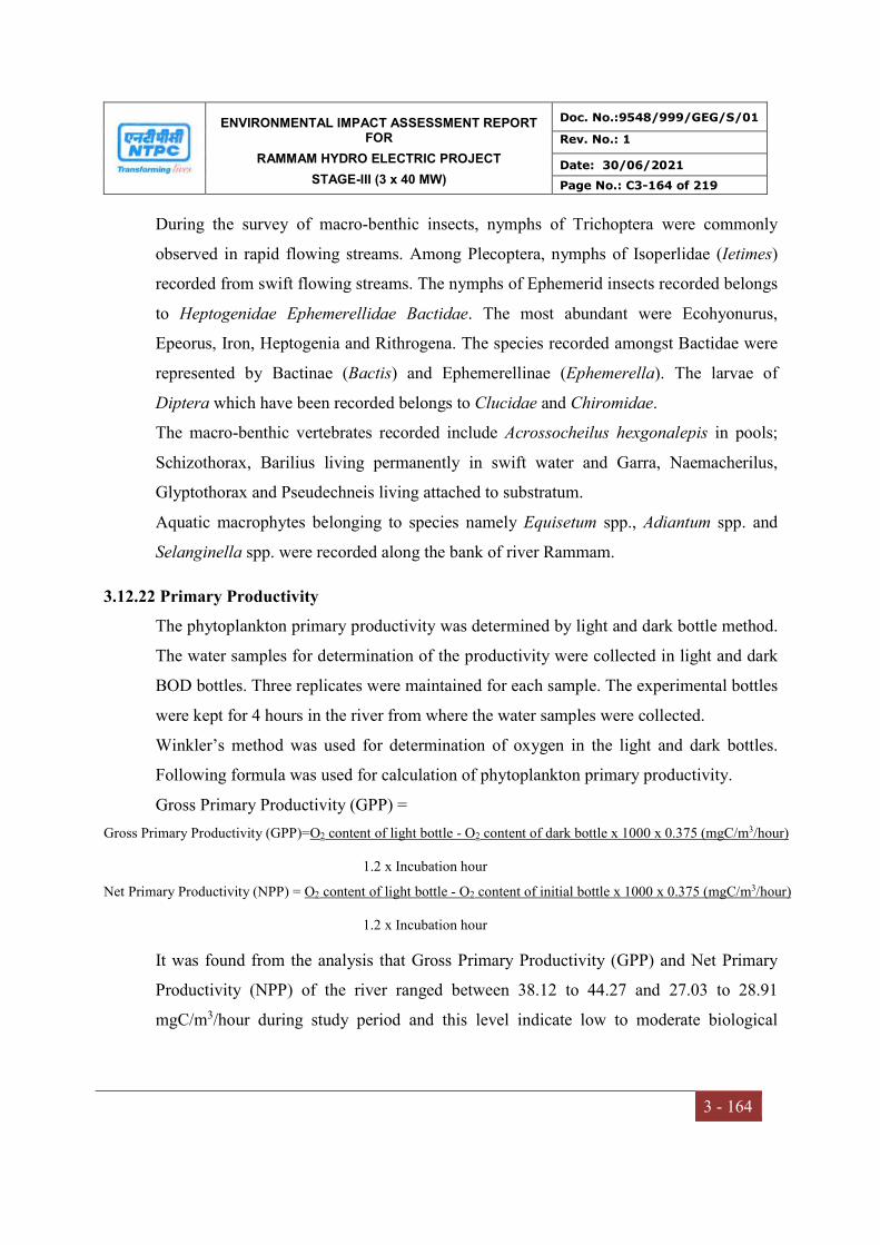
ENVIRONMENTAL IMPACT ASSESSMENT REPORT FOR
RAMMAM HYDRO ELECTRIC PROJECT
STAGE-III (3 x 40 MW)
Doc. No.:9548/999/GEG/S/01
Rev. No.: 1
Date: 30/06/2021
Page No.: C3-164 of 219
3 - 164
During the survey of macro-benthic insects, nymphs of Trichoptera were commonly
observed in rapid flowing streams. Among Plecoptera, nymphs of Isoperlidae (Ietimes)
recorded from swift flowing streams. The nymphs of Ephemerid insects recorded belongs
to Heptogenidae Ephemerellidae Bactidae. The most abundant were Ecohyonurus,
Epeorus, Iron, Heptogenia and Rithrogena. The species recorded amongst Bactidae were
represented by Bactinae (Bactis) and Ephemerellinae (Ephemerella). The larvae of
Diptera which have been recorded belongs to Clucidae and Chiromidae.
The macro-benthic vertebrates recorded include Acrossocheilus hexgonalepis in pools;
Schizothorax, Barilius living permanently in swift water and Garra, Naemacherilus,
Glyptothorax and Pseudechneis living attached to substratum.
Aquatic macrophytes belonging to species namely Equisetum spp., Adiantum spp. and
Selanginella spp. were recorded along the bank of river Rammam.
3.12.22 Primary Productivity
The phytoplankton primary productivity was determined by light and dark bottle method.
The water samples for determination of the productivity were collected in light and dark
BOD bottles. Three replicates were maintained for each sample. The experimental bottles
were kept for 4 hours in the river from where the water samples were collected.
Winkler’s method was used for determination of oxygen in the light and dark bottles.
Following formula was used for calculation of phytoplankton primary productivity.
Gross Primary Productivity (GPP) =
Gross Primary Productivity (GPP)=O2 content of light bottle - O2 content of dark bottle x 1000 x 0.375 (mgC/m3/hour)
1.2 x Incubation hour
Net Primary Productivity (NPP) = O2 content of light bottle - O2 content of initial bottle x 1000 x 0.375 (mgC/m3/hour)
1.2 x Incubation hour
It was found from the analysis that Gross Primary Productivity (GPP) and Net Primary
Productivity (NPP) of the river ranged between 38.12 to 44.27 and 27.03 to 28.91
mgC/m3/hour during study period and this level indicate low to moderate biological

ENVIRONMENTAL IMPACT ASSESSMENT REPORT FOR
RAMMAM HYDRO ELECTRIC PROJECT
STAGE-III (3 x 40 MW)
Doc. No.:9548/999/GEG/S/01
Rev. No.: 1
Date: 30/06/2021
Page No.: C3-165 of 219
3 - 165
productivity. The productivity measure of during study period at all sampling locations is
given in Table 3.50
Table 3.50
Phytoplankton Primary Productivity in various sampling sites
Sampling site Gross Primary Productivity (mg
C/m3/hour)
Net Primary Productivity(mg
C/m3/hour)
Lodhama River 44.27 27.03
Upstream Side of Ramam River
38.12 28.04
Second Order Stream at Samalbong Village
39.84 28.91
Near Power House Site 32.45 26.7
3.12.23 Fisheries
Fish is one of the most important species of the aquatic fauna as well as the important
source of proteinaceus food for human beings. No scientific documentation on fish life is
available on River Rammam. However, some published account of Teesta-Rangeet river
system is available. A total of 61 species have been recorded by different authors for
Teesta-Rangeet River. This list is outlined in Table 3.51
Table 3.51
List of fish species recorded from Teesta Rangeet river system
_________________________________________________________________________
1. Chela laubuca (Hamilton) 2. Salmostoma bacaila (Hamilton) 3. Barilius bacaila (Hamilton) 4. B.barna(Hamilton) 5. B. bendelisis(Hamilton) 6. B. bola (Hamilton) 7. B. schacra (Hamilton) 8. B. tileo (Hamilton) 9. B. vagra (Hamilton) 10. Danio.(Danio) acquipinnatus (McClelland) 11. Danio (Danio) dangila (Hamilton) 12. Danio (Danio) davario (Hamilton)
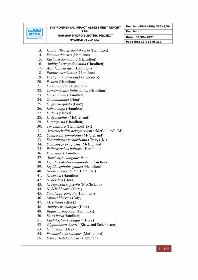
ENVIRONMENTAL IMPACT ASSESSMENT REPORT FOR
RAMMAM HYDRO ELECTRIC PROJECT
STAGE-III (3 x 40 MW)
Doc. No.:9548/999/GEG/S/01
Rev. No.: 1
Date: 30/06/2021
Page No.: C3-166 of 219
3 - 166
13. Danio (Brachydanio) rerio (Hamilton) 14. Esomus danrica (Hamilton) 15. Rasbora daniconius (Hamilton) 16. Amblypharyngodon mola (Hamilton) 17. Aspidopario jaya (Hamilton) 18. Puntius caschonius (Hamilton) 19. P. stigma (Cuvierand valencrneo) 20. P. tieto (Hamilton) 21. Cirrhina reba (Hamilton) 22. Crossocheilus latius latius (Hamilton) 23. Garra lamta (Hamilton) 24. G. annandalei (Hora) 25. G. gotyla gotyla (Gray) 26. Labeo boga (Hamilton) 27. L. dero (Heekal) 28. L. dyocheilus (McClelland) 29. L. pangusia (Hamilton) 30. Tor putitora (Hamilton) (M) 31. Acrossocheilus hexagonolepis (McClelland) (M) 32. Semiplotus semiplotus (McClelland) 33. Schizothorax richardsonii (Grary) (M) 34. Schizopyge progastus (McClelland) 35. Psilorhynchus balitora (Hamilton) 36. P. sneatio (Hamilton) 37. Aborichtys elongatus Hora 38. Lepidocephalus annandalei Chandhuri 39. Lepidocephalus guntea (Hamilton) 40. Naemacheilus botia (Hamilton) 41. N. cosiea (Hamilton) 42. N. devdevi (Hora) 43. N. rupecola rupecola (McClelland) 44. N. Schebbearei (Hora) 45. Somileptis gongota (Hamilton) 46. Mystus bleekeri (Day) 47. M. vittatus (Block) 48. Amblyceps mangois (Hora) 49. Bagarius bagarius (Hamilton) 50. Hora hora(Hamilton) 51. Euchiloglanis hodgarti (Hora) 52. Glyptothorax horavi (Shaw and Schebbeare) 53. G. lineatus (Day) 54. Pseudeehneis suleatus (McClelland) 55. Sisore rhabdophorus (Hamilton)
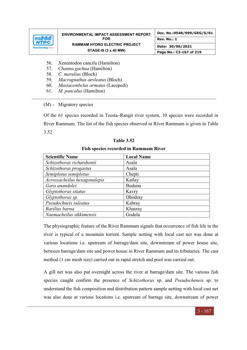
ENVIRONMENTAL IMPACT ASSESSMENT REPORT FOR
RAMMAM HYDRO ELECTRIC PROJECT
STAGE-III (3 x 40 MW)
Doc. No.:9548/999/GEG/S/01
Rev. No.: 1
Date: 30/06/2021
Page No.: C3-167 of 219
3 - 167
56. Xenentodon cancila (Hamilton) 57. Channa gachua (Hamilton) 58. C. merulius (Bloch) 59. Macrognathus aevleatus (Bloch) 60. Mastacembelus armatus (Lacepedi) 61. M. pancalus (Hamilton)
____________________________________________________________________________
(M) - Migratory species
Of the 61 species recorded in Teesta–Rangit river system, 10 species were recorded in
River Rammam. The list of the fish species observed in River Rammam is given in Table
3.52
Table 3.52
Fish species recorded in Rammam River
Scientific Name Local Name Schizothorax richardsonii Asala Schizothorax progastus Asala Semiplotus semiplotus Chepti Acrossacheilus hexagonalepis Katlay Gara anandolei Buduna Glyptothorax stiatus Kavry Glyptothorax sp. Dhodray Pseudochneis suleatus Kabray Barilius barna Khasray Naemacheilus sikkimensis Godela
The physiographic feature of the River Rammam signals that occurrence of fish life in the
river is typical of a mountain torrent. Sample netting with local cast net was done at
various locations i.e. upstream of barrage/dam site, downstream of power house site,
between barrage/dam site and power house in River Rammam and its tributaries. The cast
method (1 cm mesh size) carried out in rapid stretch and pool was carried out.
A gill net was also put overnight across the river at barrage/dam site. The various fish
species caught confirm the presence of Schizothorax sp. and Pseudocheneis sp. to
understand the fish composition and distribution pattern sample netting with local cast net
was also done at various locations i.e. upstream of barrage site, downstream of power

ENVIRONMENTAL IMPACT ASSESSMENT REPORT FOR
RAMMAM HYDRO ELECTRIC PROJECT
STAGE-III (3 x 40 MW)
Doc. No.:9548/999/GEG/S/01
Rev. No.: 1
Date: 30/06/2021
Page No.: C3-168 of 219
3 - 168
house site, between barrage site and power house in River Rammam and its tributaries.
The cast method (1 cm mesh size) carried out in rapid stretch and pool confirm that
Schizothorax contributes about 62.5% of total catch followed by Acrossocheilus
hexagonolepis (14.5%) Gara (14.6%) and others (8.4%). However, during winter season
the catch dominated by Schizothorax sp. (60%) followed by Pseudocheneis sp. (20.5%)
and others (19.5%). The size of Schizothorax ranged 50-100 mm in total length and 20 to
150 gm in weight. The catch per man hour has been worked out as 250 gm.
3.12.24 National Parks & Wildlife Sanctuaries
Singalila National Park
Singalila National Park Eco-sensitive zone is located on the West side of project area at a
distance of about 7.1 km from the barrage site. Singalila National Park is a
transboundary-protected area at the border with Nepal. Singalila National Park is located
at 27°14'N and 88°07'E, in the north-western part of Darjeeling District. Its total area is
about 78.6 km², and it is well known owing to the Sandakphu trekking route that runs
through it. It is bordered on the north by the state of Sikkim, west by the country of Nepal
and to the south & east by the state of West Bengal. The Core Area of Singalila National
Park is located on the Singalila Ridge at altitudes ranging from 8000 - 12000 ft in
Darjeeling district of West Bengal, although the average altitude of the Buffer area is
about 6000 ft. The Park was declared as wildlife Sanctuary in 1986, and was made a
National Park in 1992. The two highest peaks Sandakphu (3630 m) and Phalut (3600 m)
are located on the ridge and inside the Park.
The Rammam and Srikhola Rivers flow down through the Park. This forest became part
of Darjeeling District (West Bengal) and in 1992, it was declared as the National Park for
the conservation of this forest and was placed under the Wildlife Forest Department and
named “Singalila National Park”. The main motivation of the Government in declaring
Singalila forest as Singalila National Park was that it was a home to 80-90 species of
mammals, and several threatened medicinal plant species such as Aconitum spp.,
Dactylorhiza sp., Rheum nobile, Valeriana jatamansi, Picrorhiza kooroa, Swertia

ENVIRONMENTAL IMPACT ASSESSMENT REPORT FOR
RAMMAM HYDRO ELECTRIC PROJECT
STAGE-III (3 x 40 MW)
Doc. No.:9548/999/GEG/S/01
Rev. No.: 1
Date: 30/06/2021
Page No.: C3-169 of 219
3 - 169
chirayita, Himalayan ginseng etc. The vegetation of this area has extended vertically in
three successive layers. The average height of the upper storey of the communities, with
the cover of dominant tree species, stretched from 9 m to 18 m. Next was the layer of tree
saplings and shrubs; the middle storey was mainly up to 2 m height on the sites
dominated by Yushania maling and in other places from 0.5 - 1.5 m with various shrubs
species like Gaultheria, Berberis, Cotoneaster, Rosa, and mixed with scattered shrubs
like Daphne, Rubus, Aconogonum, Cardamine, and Osbeckia. The dense growth of Y.
maling reaching upto 3400 m asl made it an important floristic group of the region.
Berberis species spreads throughout the transect with the greater density along 3100 m to
3600 m asl. The other less predominant shrubs were Rosa sp., Gaultheria sp., and
Aconogonum molle. The ground layer was represented by herbaceous flora; there were
appreciable amount of moss, lichens, mushrooms, and ferns. We recorded marked
presence of Berberis aristata, Gaultheria pyroloides, Gaultheria trichophylla, and Rosa
sp. above 3300 m asl, reflected by their high relative density and high relative frequency.
However, we observed frequent presence of B. aristata in many sites with a relatively
high frequency. In the higher ranges beyond 3400 m asl, Iris decora along with the scrubs
of Rhododendron spp., forms the common vegetation composition. The location map of
Rammam HEPP Stage-III with Singalila National Park and Barsey Rhododendron
Wildlife Sanctury ESZ boundary is shown in Fig 3.23. The flora reported in the Singalila
National Park is given in Table 3.53.
Table 3.53
Vegetation reported in Singalila National Park
Altitude (2400-2700 m ) Altitude(2700- 3000m) Altitude (>3000 m)
Quercus pachyphylla Quercus spp. Abies densa
Quercus lamellosa Betula utilis Tsuga brunoniana
Quercus lineata Sorbus cuspidata Rhododendron campanulatum
Machilus odoratissima Castanopsis spp. Rhgododendrou barbatam
Acer campbellii Lkitsea elougata Rhododendrou cinnabarium
Mellisoma wallichii Tsuga brannoniana Rhododendrou hodgsonii
Castanopsis tribuloides Arundinaria maling Rhododendrou grande
Magnolia campbellii Arundinaria aristata Rhododendrou galeoneri
ENVIRONMENTAL IMPACT ASSESSMENT REPORT FOR
RAMMAM HYDRO ELECTRIC PROJECT
STAGE-III (3 x 40 MW)
Doc. No.:9548/999/GEG/S/01
Rev. No.: 1
Date: 30/06/2021
Page No.: C3-170 of 219
3 - 170
Rhododendron arboreuem Daphne spp. Rhododendrou lepidotum
Viburnum erubesans Berberis aristata Arundiwaria spp.
Dapne cannabina Piptanthus spp. Cotoneaster microphylla
Symplocas spp. Rhododendrou grandi Betula utilis
Schefflera impressa
Some threatened species of animals, such as Red Panda, Leopard, Chinese Pangolin,
Himalayan Black Bear, Red Throated Hill Partridge, Satyr Tragopan, Blood Pheasant,
and Slender Billed Babbler etc. are found in this National Park. The park has major
mammalian fauna like the Red Panda (Ailurus fulgens), Himalayan Black Bear
(Selenarctos thibetanus) Leopard cat (Felis benghalensis), Clouded Leopard (Neofeis
nebulosa), Barking Deer (Muntiacus muntjak) Serow (Capricornis sumatraensis), Yellow
Throated Marten (Matres flavigula), Wild Boar (Sus Scrofa), Himalayan Mouse Hare
(Ochotona royle), Wild dog (Cunon alpinus), Porcupine (Hystrix indica) and fox (Vulpes
vulpes). Of the above mentioned species, five species belong to endangered category.
These are Red Panda (Ailurus sp.), Leopard Cat (Felis benghalensis), Barking deer
(Muntiacus muntjak), Wild boar (Sus scrofa), Fox (Vulpes vulpes).
Barsey Rododendron Sanctuary
The Barsey Rhododendron Sanctuary (BRS) Eco-sensitive zone is at a distance of 4.2 km
from the barrage site on NW side. The sanctuary established in 1998, occupies an area of
104 km2 sharing its border with Nepal to the west and West Bengal to the south over the
Rambong Khola in the Singalila Range. The altitudinal gradient of 2200–4100 m asl
provides a wide range of topography leading to various forest types, viz., sub-tropical
moist deciduous forest (2200–2400 m), wet temperate forest (2400–2700 m), moist
temperate forest (2700–3250 m), sub-alpine forest (3200–4000 m) and alpine meadows
(>4000 m).

ENVIRONMENTAL IMPACT ASSESSMENT REPORT FOR
RAMMAM HYDRO ELECTRIC PROJECT
STAGE-III (3 x 40 MW)
Doc. No.:9548/999/GEG/S/01
Rev. No.: 1
Date: 30/06/2021
Page No.: C3-171 of 219
3 - 171
Figure-3.23 Location Map of Rammam HEPP, Stage-III with Singalila National Park and Barsey Rhododendron WLS ESZ boundary
ENVIRONMENTAL IMPACT ASSESSMENT REPORT FOR
RAMMAM HYDRO ELECTRIC PROJECT
STAGE-III (3 x 40 MW)
Doc. No.:9548/999/GEG/S/01
Rev. No.: 1
Date: 30/06/2021
Page No.: C3-172 of 219
3 - 172
The sanctuary harbors over dozen of rhododendron species, pure patches of Lithocarpus
pachyphyllus and epiphytes, climbers, ferns and fern-allies, moss and lichens. BRS is a
biologically diverse sanctuary and famous for its rhododendron stand which blooms
usually between April and May. The climate is wet and cold which is highly favorable for
the growth of rhododendrons. There is Hilley enter point of BRS, Hilley gives the best
view of sunrise while Barsey gives a splendid view of Mt. Khangchendzonga, Mt.
Pandim and Mt. Sinolchu, etc., which becomes more picturesque between October and
November.
The sanctuary is flourished with trees of Rhododendron arboreum, R. barbatum, R.
falconeri, R. grande, R. griffithianum and R. hodgsonii and shrubs such as R.
campanulatum, R. dalhousieae and R. lepidotum giving the forest a beautiful look at the
time of blooming. Other commonly available tree species are Abies densa, Acer
campbellii, A. caudatum, A. palmatum, A. pectinatum, Lithocarpus pachyphyllus,
Maddenia himalaica, Magnolia campbellii, Prunus sp., Symplocos lucida and Tsuga
dumosa. While many epiphytic species such as orchids, mosses and lichens are seen
growing on trees, shrubs such as Berberis insignis, Daphne cannabina, Gaultheria
nummularioides, Gaultheria trichophylla, Piptanthus nepalensis, Rosa sericea, Rubus sp.
and Viburnum erubescens are frequently seen throughout the forest. The forest floor is
covered by various species of herbs such as Arisaema sp., Frageria nubicola,
Hemiphragma heterophyllum, Oxalis sp., Potentila sp., Primula sp., Rubus sp., Swertia
sp. and Viola sp. The sanctuary is also rich in medicinal herbs such as Swertia sp., Paris
polyphylla, Oxalis corniculata, Meconopsis paniculata, Heracleum wallichii and Rumex
nepalensis. Thick growth of bamboo such as Bambusa sp. and Sinarundinaria
microphylla is encountered habitually along the trial serving a habitat for Red Panda.
The sanctuary is also home to many faunal species, Barking Deer (Muntiacus muntjak)
belonging to Cervidae family, Red Panda, Wild Boar, Himalayan Black Bear, Barking
Deer and Serow, etc. BRS is also notable for habitat of Red Panda (Ailurus fulgens)
which is the State Animal of Sikkim. Birds such as Verditer Flycatcher, Large-billed
Crow, Plain mountain finch, Spotted laughingthrush, Grey-backed shrike, Green-tailed
ENVIRONMENTAL IMPACT ASSESSMENT REPORT FOR
RAMMAM HYDRO ELECTRIC PROJECT
STAGE-III (3 x 40 MW)
Doc. No.:9548/999/GEG/S/01
Rev. No.: 1
Date: 30/06/2021
Page No.: C3-173 of 219
3 - 173
sunbird and Green-backed tit were spotted and recorded. The male and female Blood
Pheasant were spotted at 3352m asl in R. hodgsonii forest. Many beautiful avians were
encountered in the sanctuary out of which Indian Common Crow (Euploea core) was
recorded at around 3000 m asl, Indian Tortoise shell (Aglais caschmirensis) recorded at
around 2800 m asl and Painted Lady (Vanessa cardui ) recorded at around 2700 – 2800
m asl) butterflies (Pradhan et al 2018). The dense forests of Lithocarpus pachyphyllus
provides shelter as well as abundant fruits and as such are good indicators of faunal
presence and richness (Subba et al 2018). Pradhan et al and Subba et al 2018, Rapid
biodiversity survey report III by Department of Forest, Environment and Wildlife
Management, Government of Sikim.
Wildlife Conservation Plan for Schedule-I species has been prepared and submitted to
State Forest Department for approval. After approval, plan will be implementated in
consultation with State Forest Department. Copy of Wildlife Conservation Plan is
enclosed as Annexure XVIII.
3.13 LANDUSE PATTERN
3.13.1 Land use Pattern-Remote Sensing data
The basic purpose of land use pattern and classification in an EIA study is to identify the
manner in which different parts of land area is utilized or not utilized. Remote sensing
data provides reliable accurate baseline information for land use mapping as it is a rapid
method of acquiring up-to-date information of over a large geological area.
Studies on land use aspects of eco-system play an imperative role in identifying
susceptible issues and to take appropriate action to uphold ecological equilibrium in the
region. The main objective of this section is to provide a baseline status of the study area
covering 10 km radius around the project area so that temporal changes due to the
proposed activities on the surroundings can be assessed in future.
The objectives of Land use Pattern are to:
Determine the present Land use pattern

ENVIRONMENTAL IMPACT ASSESSMENT REPORT FOR
RAMMAM HYDRO ELECTRIC PROJECT
STAGE-III (3 x 40 MW)
Doc. No.:9548/999/GEG/S/01
Rev. No.: 1
Date: 30/06/2021
Page No.: C3-174 of 219
3 - 174
Study area with proposed unit as epicenter 10 km radius from the core area of
Rammam HEPP Stage-III Run of River (ROR) is considered for land use study.
Satellite Data: The Satellite IRS P-6 LISSIV images are obtained from National Remote
Sensing Centre (NRSC) Hyderabad. The satellite image of the site for the year 2020 is
presented in Fig 3.25.
3.13.2 Methodology: The overall methodology adopted and followed
Collection of source data of Survey of India (SOI) toposheets. These are the main
inputs for the preparation of essential layers.
Satellite data of IRS P-6 LISSIV sensor is geometrically corrected and enhanced
using principal component method and nearest neighborhood resampling technique
Preparation of basic themes like layout map, transport & settlement map and
contour map from the source data. Then updating of layout map, transport map and
drainage map from the satellite image by visual interpretation.
Essential maps (related to natural resources) like Land use / Land cover map are
prepared by visual interpretation of the satellite imagery. Visual interpretation is
carried out based on the image characteristics like tone, size, shape, pattern,
texture, location, association, background etc. in conjunction with existing maps/
literature
Preliminary quality check and necessary corrections are carried out for all the maps
prepared
All the maps prepared are converted into soft copy by digitization of contours and
drainages. In that process editing, labeling, mosaicking, quality checking, data
integration etc. are done, finally Land use areas are measured in Sq.km.
3.13.3 Land use Map Analysis
Land use Map Analysis carried out based on the image color, texture, tone etc.
Following steps are used to analyze the Land use pattern of project site:
Collection of scanned toposheets and Geo-reference the scanned image using the
available coordinates
ENVIRONMENTAL IMPACT ASSESSMENT REPORT FOR
RAMMAM HYDRO ELECTRIC PROJECT
STAGE-III (3 x 40 MW)
Doc. No.:9548/999/GEG/S/01
Rev. No.: 1
Date: 30/06/2021
Page No.: C3-175 of 219
3 - 175
Collection of IRS LISS IV images and made fused and blended the images for
color combinations using Image interpreter-Utilities and Layer stack option
available in ERDAS
Identification Area of interest (AOI) and made a buffer of 10 km radius.
Enhance the Fused and blended LISS IV image using the Spatial, Radiometric and
Temporal options in ERDAS
Rectified the LISS IV image using Geo-referencing technique, Toposheet to get
UTM coordinate system
Subset the LISS images and Toposheet using 10 km buffer AOI
Automatic classifications done for LISS IV images using maximum iterations and
number of options in unsupervised classification options
Created the signature file by selecting the more samples of different features with
AOI on Unsupervised classification image
Visual interpretation and supervised classification mixed with recoding practice
Verified through the QC / QA and finalized the data.
3.13.4 Spatial Data from SOI Topographical Sheets
Creating a GIS spatial database is a complex operation, and is the heart of the entire
work; it involves data capture, verification and structuring processes. Raw geographical
data are available in many different analogue and digital form such as toposheets, aerial
photographs, satellite imageries and tables. Out of all these sources, the source of
toposheets is of much concern to natural resource scientist and an environmentalist.
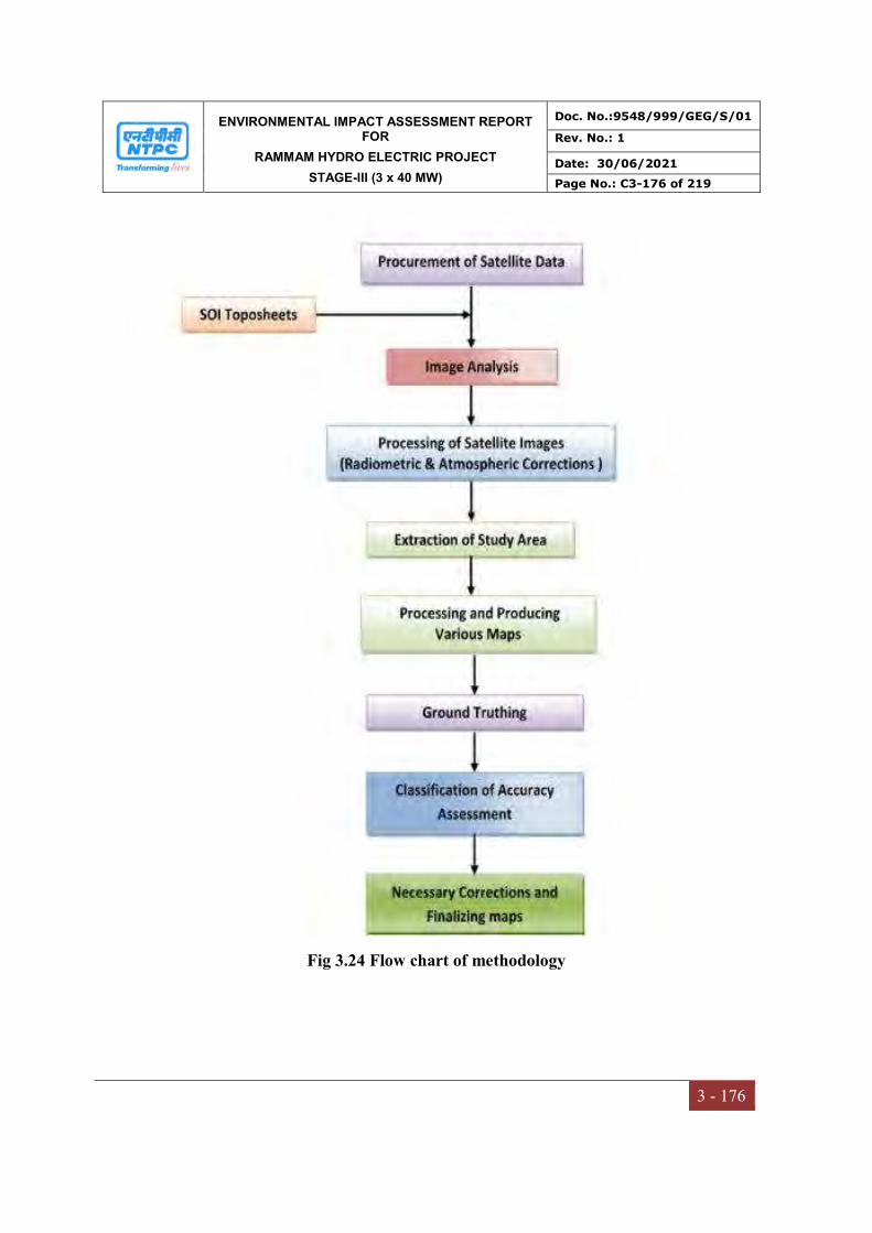
ENVIRONMENTAL IMPACT ASSESSMENT REPORT FOR
RAMMAM HYDRO ELECTRIC PROJECT
STAGE-III (3 x 40 MW)
Doc. No.:9548/999/GEG/S/01
Rev. No.: 1
Date: 30/06/2021
Page No.: C3-176 of 219
3 - 176
Fig 3.24 Flow chart of methodology

ENVIRONMENTAL IMPACT ASSESSMENT REPORT FOR
RAMMAM HYDRO ELECTRIC PROJECT
STAGE-III (3 x 40 MW)
Doc. No.:9548/999/GEG/S/01
Rev. No.: 1
Date: 30/06/2021
Page No.: C3-177 of 219
3 - 177
Fig 3.25 Satellite Image

ENVIRONMENTAL IMPACT ASSESSMENT REPORT FOR
RAMMAM HYDRO ELECTRIC PROJECT
STAGE-III (3 x 40 MW)
Doc. No.:9548/999/GEG/S/01
Rev. No.: 1
Date: 30/06/2021
Page No.: C3-178 of 219
3 - 178
3.13.5 Contour Map and Elevations of Study Area
The contours in Toposheet have been digitized in the GIS environment and assigned the
respective elevation values in meters with reference to the mean sea level. Using the
SRTM (Shuttle Radar Topography Mission) data, the elevation values has been verified.
Thereafter final contour map has been prepared with combination of Toposheet and
SRTM ith contour interval of 10 m. Project site contours vary from 854 m to 897 m
above MSL and the study area contours vary from 300 m to 3000 m above MSL.
Contour Map and Elevations of Study Area is presented in Fig 3.27.
3.13.6 Digital Elevation Model
A digital elevation model (DEM) is a digital representation of ground surface
topography or terrain (Fig 3.26). It is also widely known as a digital terrain model
(DTM). A DEM can be represented as a raster (a grid of squares, also known as a
height map when representing elevation) or as a triangular irregular network. The
project site is shown in that Relief map. For the relief study of the area very higher
quality SRTM (Shuttle Radar Topography Mission) and DEM is downloaded. These
DEMs of the Terra represents elevation at a 30 m resolution.
3.13.7 Land use land cover statistics of study area
Map showing the Land Use Land Cover classification in the study area is presented in
Figure 3.28. It is clearly that the area is covered with Dense Vegetation around 43.86%
respectively of the total area. Other class is Grass/Agricultual Fields occupies around
25.31%. The Contour Farming & Fallow Lands is 5.60% in the total study area. The
scrub area covers 20.83% of the total area. The Barren land & Fallow lands cover about
3.61% of total area. Water body and Built-up area is covered with 0.69% and 0.1%
respectively. The statistical break-up of the land use classes of buffer zone are presented
in Table 3.54 and depicted in Fig 3.31.
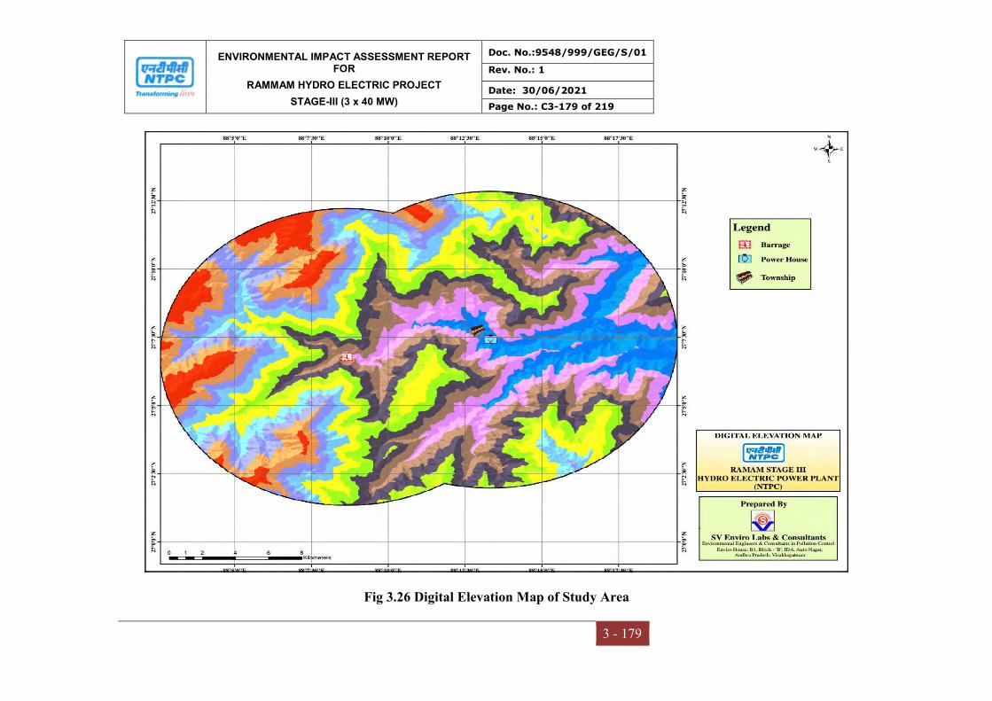
ENVIRONMENTAL IMPACT ASSESSMENT REPORT FOR
RAMMAM HYDRO ELECTRIC PROJECT
STAGE-III (3 x 40 MW)
Doc. No.:9548/999/GEG/S/01
Rev. No.: 1
Date: 30/06/2021
Page No.: C3-179 of 219
3 - 179
Fig 3.26 Digital Elevation Map of Study Area

ENVIRONMENTAL IMPACT ASSESSMENT REPORT FOR
RAMMAM HYDRO ELECTRIC PROJECT
STAGE-III (3 x 40 MW)
Doc. No.:9548/999/GEG/S/01
Rev. No.: 1
Date: 30/06/2021
Page No.: C3-180 of 219
3 - 180
Fig 3.27 Contour Map of Study Area
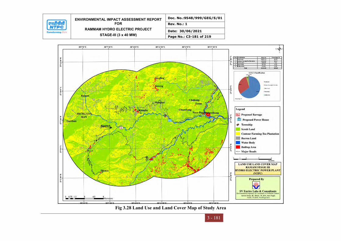
ENVIRONMENTAL IMPACT ASSESSMENT REPORT FOR
RAMMAM HYDRO ELECTRIC PROJECT
STAGE-III (3 x 40 MW)
Doc. No.:9548/999/GEG/S/01
Rev. No.: 1
Date: 30/06/2021
Page No.: C3-181 of 219
3 - 181
Fig 3.28 Land Use and Land Cover Map of Study Area
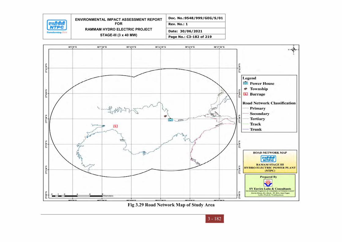
ENVIRONMENTAL IMPACT ASSESSMENT REPORT FOR
RAMMAM HYDRO ELECTRIC PROJECT
STAGE-III (3 x 40 MW)
Doc. No.:9548/999/GEG/S/01
Rev. No.: 1
Date: 30/06/2021
Page No.: C3-182 of 219
3 - 182
Fig 3.29 Road Network Map of Study Area
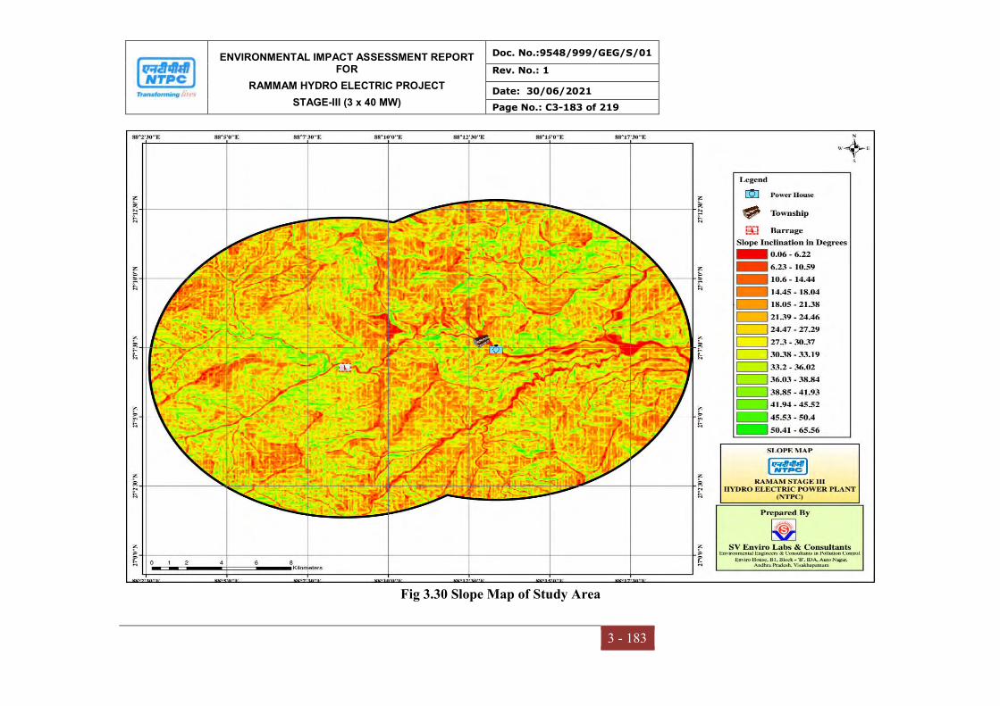
ENVIRONMENTAL IMPACT ASSESSMENT REPORT FOR
RAMMAM HYDRO ELECTRIC PROJECT
STAGE-III (3 x 40 MW)
Doc. No.:9548/999/GEG/S/01
Rev. No.: 1
Date: 30/06/2021
Page No.: C3-183 of 219
3 - 183
Fig 3.30 Slope Map of Study Area

ENVIRONMENTAL IMPACT ASSESSMENT REPORT FOR
RAMMAM HYDRO ELECTRIC PROJECT
STAGE-III (3 x 40 MW)
Doc. No.:9548/999/GEG/S/01
Rev. No.: 1
Date: 30/06/2021
Page No.: C3-184 of 219
3 - 184
Fig 3.31 Graphical Presentation of Land Use Statistics
Table 3.54
Land Use Land Covers Statistics of Study area
Sl. No. LULC_Class Area (Ha) Area (%)
1 Dense Vegetation 23773.99 57.83
2 Grass/Agricultural Fields 4663.11 11.4
3 Contour Farming & Fallow Lands 2300.74 5.60
4 Barren Land or Dry Bed 1485.05 3.61
5 Scrub 8564.44 20.83
6 Water Body 282.89 0.69
7 Built-up 43.09 0.10
Total 41113.31 100%
ENVIRONMENTAL IMPACT ASSESSMENT REPORT FOR
RAMMAM HYDRO ELECTRIC PROJECT
STAGE-III (3 x 40 MW)
Doc. No.:9548/999/GEG/S/01
Rev. No.: 1
Date: 30/06/2021
Page No.: C3-185 of 219
3 - 185
3.14 SOCIO-ECONOMIC ENVIRONMENT
3.14.1 Overview
The socio-economic baseline focuses on demographic patterns, economic and livelihood
profile and infrastructure facilities, risks and opportunities – from the proponent’s
perspective – and to provide policy and planning options for mitigating negative impacts
and enhancing project benefits. Essential elements of the study approach were its
strategic, issues-based and participatory nature. The impact assessment will envisage and
evaluate any potential impacts of the project on the local community, livelihoods and
other social systems.
3.14.2 METHODOLOGY
Aim and objectives:
The study area presented in the socio-economic baseline comprises of the following:
Project location – within the limits of Rammam, Hydro-Electric Power Project
(HEPP), Stage-III (3x40 MW), Darjeeling District (West Bengal) & West Sikkim
(Sikkim) and India
To examine the socio-economic conditions of the study project.
To develop attainable mitigation measures to enhance positive impacts and reduce
or avoid negative impacts; and
To develop management and monitoring measures to be implemented throughout
the life of the project.
Procedure and data collection
The socio-economic baseline has been prepared in two folds of secondary and primary
methods.
The secondary data source adopted for the study mainly includes review of
published secondary data (District Census Statistical Handbooks 2011 and
Primary Census Abstract of Census-2011), and other govt related govt office and
web sources of available secondary sources of information as well as select
primary consultations in the vicinity of the project area with respect to population,
ENVIRONMENTAL IMPACT ASSESSMENT REPORT FOR
RAMMAM HYDRO ELECTRIC PROJECT
STAGE-III (3 x 40 MW)
Doc. No.:9548/999/GEG/S/01
Rev. No.: 1
Date: 30/06/2021
Page No.: C3-186 of 219
3 - 186
density, household size, sex ratio, social stratification, literacy rate and
occupational structure for 10 km radius study area.
The primary survey was conducted in two different methods such as; Individual
Questionnaire Survey (IQS) and Focused Group Discussions (FGD). The primary
data has been collected within the vicinity of the project area with respect to
population, density, household size, sex ratio, social stratification, literacy rate and
occupational structure for 10 km radius study area. Data has been analyzed by
using SPSS. This will help measure the impacts with project in various aspects,
awareness of the project and community perceptions about the project and other
related information.
3.14.3 Brief Profile of West Bengal district
Darjeeling district is the northern most district of West Bengal. It is located in the lap of
the Himalayas. For administrative and revenue purposes, the district has four subdivisions
namely, Darjeeling Sadar, Kalimpong, Kurseong and Siliguri. Further, the district has 12
development blocks. Darjeeling Himalaya forms a part of eastern Himalayan ranges and
is bounded by Sikkim, Nepal and Bhutan on the north, west and east respectively. The
district occupies a geographical area of 3149sq.Km.
3.14.3.1Demographical details of the District
The initial provisional data released by Census of India 2011, shows that density of
Darjeeling district for 2011 is 586 people per sq.km. The sex ratio in Darjeeling is 937
females per thousand males. Rural population of Darjeeling according to Census 2011 is
11,23,859. Darjeeling’s urban population according to Census 2011 is 7,18,175. The total
population living in rural area is 1,118,860 of which males and females are 566,965 and
551,895 respectively. As per 2011 census, 60.58 percent population of Darjeeling district
lives in rural areas of villages. Out of the total Darjeeling population for 2011census,
39.42 percent lives in urban regions of district. In total 727,963 people lives in urban
areas of which males are 370,294 and females 357,669. In 2011 census, the male and
female literacy rate in Darjeeling was 80.05 percent and 62.94 percent respectively. Total
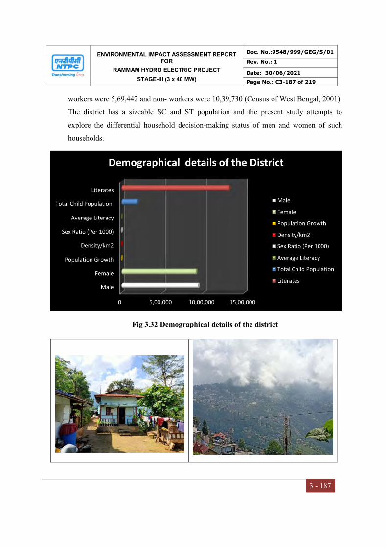
ENVIRONMENTAL IMPACT ASSESSMENT REPORT FOR
RAMMAM HYDRO ELECTRIC PROJECT
STAGE-III (3 x 40 MW)
Doc. No.:9548/999/GEG/S/01
Rev. No.: 1
Date: 30/06/2021
Page No.: C3-187 of 219
3 - 187
workers were 5,69,442 and non- workers were 10,39,730 (Census of West Bengal, 2001).
The district has a sizeable SC and ST population and the present study attempts to
explore the differential household decision-making status of men and women of such
households.
Fig 3.32 Demographical details of the district
0 5,00,000 10,00,000 15,00,000
Male
Female
Population Growth
Density/km2
Sex Ratio (Per 1000)
Average Literacy
Total Child Population
Literates
Demographical details of the District
Male
Female
Population Growth
Density/km2
Sex Ratio (Per 1000)
Average Literacy
Total Child Population
Literates

ENVIRONMENTAL IMPACT ASSESSMENT REPORT FOR
RAMMAM HYDRO ELECTRIC PROJECT
STAGE-III (3 x 40 MW)
Doc. No.:9548/999/GEG/S/01
Rev. No.: 1
Date: 30/06/2021
Page No.: C3-188 of 219
3 - 188
3.14.3.2Demographical details of the study area
The study area of Darjeeling district study area is located in the sub districts namely;
Darjeeling pulbazar and Jore bunglow sukaipokhri. It is surrounded with 74 villages in
this district area. The total study area has population of 2,40,451 with 52,938 households
of which males and females are 1,20,060 and 1,20,391 respectively. With regard to
children (0-6 age) are 21009 in this area. The Schedule caste (SC) and Schedule Tribes
(ST) are 12,278 and 70,651. Average literacy rates 2011 were 79.56. If things are looked
out at gender wise, male and female literacy were 80.05% and 62.94% respectively. The
village wise details are provided in Table 3.39.
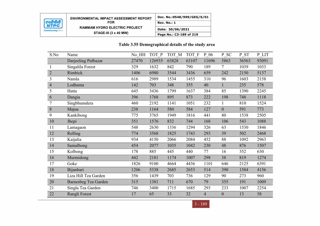
ENVIRONMENTAL IMPACT ASSESSMENT REPORT FOR
RAMMAM HYDRO ELECTRIC PROJECT
STAGE-III (3 x 40 MW)
Doc. No.:9548/999/GEG/S/01
Rev. No.: 1
Date: 30/06/2021
Page No.: C3-189 of 219
3 - 189
Table 3.55 Demographical details of the study area
S.No Name No_HH TOT_P TOT_M TOT_F P_06 P_SC P_ST P_LIT
Darjeeling Pulbazar 27470 126935 63828 63107 11696 5863 36563 93091
1 Singalila Forest 329 1632 842 790 189 7 1039 1033
2 Rimbick 1406 6980 3544 3436 659 242 2150 5137
3 Namla 616 2989 1534 1455 310 96 1603 2158
4 Lodhama 142 703 348 355 40 1 235 578
5 Hatta 645 3436 1799 1637 384 85 1390 2245
6 Dangia 396 1768 895 873 222 198 748 1118
7 Singbhumdera 460 2192 1141 1051 232 1 810 1524
8 Majua 238 1164 580 584 127 0 591 773
9 Kankibong 775 3765 1949 1816 441 80 1538 2505
10 Jhepi 351 1576 832 744 168 106 543 1088
11 Lamagaon 548 2630 1336 1294 326 63 1530 1846
12 Relling 774 3568 1825 1743 293 39 502 2468
13 Kaijalia 934 4150 2066 2084 452 88 1092 2963
14 Samalbong 454 2077 1035 1042 230 48 876 1507
15 Kolbong 178 885 445 440 77 16 352 630
16 Murmidong 442 2181 1174 1007 298 38 819 1274
17 Goke 1826 9100 4664 4436 1101 646 2125 6391
18 Bijanbari 1206 5338 2685 2653 514 390 1584 4156
19 Liza Hill Tea Garden 356 1439 703 736 129 90 273 960
20 Barnesbeg Tea Garden 315 1381 711 670 79 355 191 1009
21 Singla Tea Garden 746 3400 1715 1685 293 233 1007 2254
22 Rangli Forest 17 65 33 32 4 0 13 58
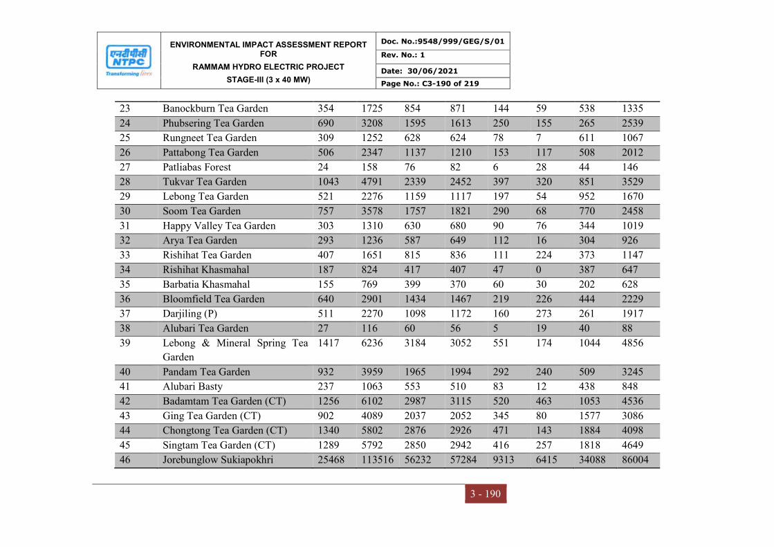
ENVIRONMENTAL IMPACT ASSESSMENT REPORT FOR
RAMMAM HYDRO ELECTRIC PROJECT
STAGE-III (3 x 40 MW)
Doc. No.:9548/999/GEG/S/01
Rev. No.: 1
Date: 30/06/2021
Page No.: C3-190 of 219
3 - 190
23 Banockburn Tea Garden 354 1725 854 871 144 59 538 1335
24 Phubsering Tea Garden 690 3208 1595 1613 250 155 265 2539
25 Rungneet Tea Garden 309 1252 628 624 78 7 611 1067
26 Pattabong Tea Garden 506 2347 1137 1210 153 117 508 2012
27 Patliabas Forest 24 158 76 82 6 28 44 146
28 Tukvar Tea Garden 1043 4791 2339 2452 397 320 851 3529
29 Lebong Tea Garden 521 2276 1159 1117 197 54 952 1670
30 Soom Tea Garden 757 3578 1757 1821 290 68 770 2458
31 Happy Valley Tea Garden 303 1310 630 680 90 76 344 1019
32 Arya Tea Garden 293 1236 587 649 112 16 304 926
33 Rishihat Tea Garden 407 1651 815 836 111 224 373 1147
34 Rishihat Khasmahal 187 824 417 407 47 0 387 647
35 Barbatia Khasmahal 155 769 399 370 60 30 202 628
36 Bloomfield Tea Garden 640 2901 1434 1467 219 226 444 2229
37 Darjiling (P) 511 2270 1098 1172 160 273 261 1917
38 Alubari Tea Garden 27 116 60 56 5 19 40 88
39 Lebong & Mineral Spring Tea
Garden
1417 6236 3184 3052 551 174 1044 4856
40 Pandam Tea Garden 932 3959 1965 1994 292 240 509 3245
41 Alubari Basty 237 1063 553 510 83 12 438 848
42 Badamtam Tea Garden (CT) 1256 6102 2987 3115 520 463 1053 4536
43 Ging Tea Garden (CT) 902 4089 2037 2052 345 80 1577 3086
44 Chongtong Tea Garden (CT) 1340 5802 2876 2926 471 143 1884 4098
45 Singtam Tea Garden (CT) 1289 5792 2850 2942 416 257 1818 4649
46 Jorebunglow Sukiapokhri 25468 113516 56232 57284 9313 6415 34088 86004

ENVIRONMENTAL IMPACT ASSESSMENT REPORT FOR
RAMMAM HYDRO ELECTRIC PROJECT
STAGE-III (3 x 40 MW)
Doc. No.:9548/999/GEG/S/01
Rev. No.: 1
Date: 30/06/2021
Page No.: C3-191 of 219
3 - 191
47 Salu Tea Garden 155 677 325 352 65 28 23 491
48 Kacel Tea Garden 202 855 418 437 100 9 179 596
49 Mariabong Tea Garden 607 2404 1203 1201 183 243 769 1721
50 Lingia Tea Garden 415 1841 910 931 127 66 228 1342
51 Tumsong Tea Garden 374 1700 815 885 123 133 416 1367
52 Tumsong Khasmahal 120 586 290 296 35 0 46 460
53 Mim Tea Garden 402 1842 884 958 151 64 419 1386
54 Ghoom Pahar Forest 116 484 242 242 40 14 322 402
55 Pulung Dong Khasmahal 533 2573 1296 1277 246 12 840 1974
56 Pulung Dong Tea Estate 127 622 317 305 61 0 3 511
57 Pubong Tea Garden 450 2170 1098 1072 165 61 625 1660
58 Pussinbong Tea Garden 651 2879 1425 1454 202 181 577 2203
59 Senchal Forest 120 527 283 244 56 17 188 358
60 Rangaroong Tea Garden 320 1423 702 721 113 107 460 1143
61 Rang Bul 904 3916 1920 1996 283 187 1908 3331
62 Hill Cart Road 275 1355 684 671 112 167 410 1149
63 Kalej Valley Tea Garden 596 2640 1311 1329 244 207 742 1846
64 Dooteria Forest 84 368 182 186 32 2 122 306
65 Dooteria Tea Garden 1166 5113 2636 2477 505 291 1401 3613
66 Okas Tea Garden 283 1262 614 648 100 65 34 921
67 Moonda Kotee Tea Garden 963 3972 1989 1983 325 120 849 2783
68 Ring Tong Tea Garden
(Gunawar)
183 820 419 401 57 13 259 551
69 Nahori Tea Garden (Balasom) 559 2402 1195 1207 170 164 1015 1743
70 Ringtong Tea Garden (Margaret
Hope)
1429 6025 2969 3056 455 351 2746 4243
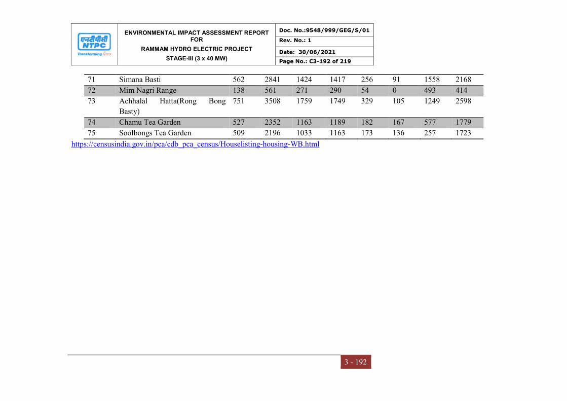
ENVIRONMENTAL IMPACT ASSESSMENT REPORT FOR
RAMMAM HYDRO ELECTRIC PROJECT
STAGE-III (3 x 40 MW)
Doc. No.:9548/999/GEG/S/01
Rev. No.: 1
Date: 30/06/2021
Page No.: C3-192 of 219
3 - 192
71 Simana Basti 562 2841 1424 1417 256 91 1558 2168
72 Mim Nagri Range 138 561 271 290 54 0 493 414
73 Achhalal Hatta(Rong Bong
Basty)
751 3508 1759 1749 329 105 1249 2598
74 Chamu Tea Garden 527 2352 1163 1189 182 167 577 1779
75 Soolbongs Tea Garden 509 2196 1033 1163 173 136 257 1723
https://censusindia.gov.in/pca/cdb_pca_census/Houselisting-housing-WB.html
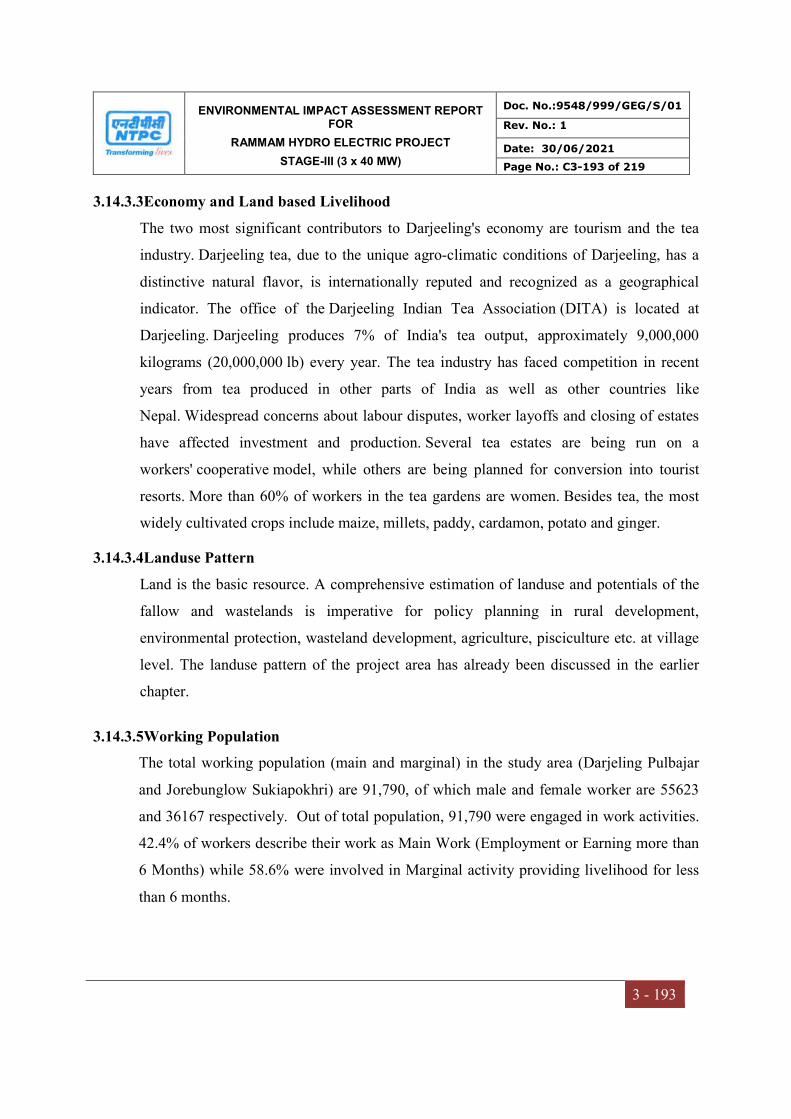
ENVIRONMENTAL IMPACT ASSESSMENT REPORT FOR
RAMMAM HYDRO ELECTRIC PROJECT
STAGE-III (3 x 40 MW)
Doc. No.:9548/999/GEG/S/01
Rev. No.: 1
Date: 30/06/2021
Page No.: C3-193 of 219
3 - 193
3.14.3.3Economy and Land based Livelihood
The two most significant contributors to Darjeeling's economy are tourism and the tea
industry. Darjeeling tea, due to the unique agro-climatic conditions of Darjeeling, has a
distinctive natural flavor, is internationally reputed and recognized as a geographical
indicator. The office of the Darjeeling Indian Tea Association (DITA) is located at
Darjeeling. Darjeeling produces 7% of India's tea output, approximately 9,000,000
kilograms (20,000,000 lb) every year. The tea industry has faced competition in recent
years from tea produced in other parts of India as well as other countries like
Nepal. Widespread concerns about labour disputes, worker layoffs and closing of estates
have affected investment and production. Several tea estates are being run on a
workers' cooperative model, while others are being planned for conversion into tourist
resorts. More than 60% of workers in the tea gardens are women. Besides tea, the most
widely cultivated crops include maize, millets, paddy, cardamon, potato and ginger.
3.14.3.4Landuse Pattern
Land is the basic resource. A comprehensive estimation of landuse and potentials of the
fallow and wastelands is imperative for policy planning in rural development,
environmental protection, wasteland development, agriculture, pisciculture etc. at village
level. The landuse pattern of the project area has already been discussed in the earlier
chapter.
3.14.3.5Working Population
The total working population (main and marginal) in the study area (Darjeling Pulbajar
and Jorebunglow Sukiapokhri) are 91,790, of which male and female worker are 55623
and 36167 respectively. Out of total population, 91,790 were engaged in work activities.
42.4% of workers describe their work as Main Work (Employment or Earning more than
6 Months) while 58.6% were involved in Marginal activity providing livelihood for less
than 6 months.

ENVIRONMENTAL IMPACT ASSESSMENT REPORT FOR
RAMMAM HYDRO ELECTRIC PROJECT
STAGE-III (3 x 40 MW)
Doc. No.:9548/999/GEG/S/01
Rev. No.: 1
Date: 30/06/2021
Page No.: C3-194 of 219
3 - 194
Fig 3.33 Details of the working population
3.14.3.6Cropping Pattern
The major crops in Darjeeling District and study area are maize, ginger, paddy, tamarind,
mustard, elachi, etc. in Kharif season (summer season), primarily maize and ginger,
which accounts nearly 80 – 90% of total crops of the season. However, paddy accounts
for 10 – 20% of the total crop, which is cultivated during Rabi season. In few pockets,
mustard, elachi, tamarind, vegetables, etc. are also being cultivated in less than 25% of
the total crop area.
3.14.3.7Agricultural Implements
The study area owing to its diverse geo-morphological conditions, has different agro-
climatic conditions. The highest altitude are covered with snow almost through-out the
year and are unsuitable for crop cultivation. The lower hills are mainly used for plantation
crops like Tea, Cinchona and Rubber. Study area is also famous for variety of fruits and
vegetables grown at different elevations. Pineapples are the highest growing fruit variety
in the district. Darjiling Orange is also a distinguished variety of fruit; famous for its
juiciness and texture. Banana, Papaya, Jackfruit, Guava, Lychee, Mango and Jackfruit 23
are the other major varieties of fruits cultivated in Darjiling depending upon the quality of
0
10000
20000
30000
40000
50000
60000
70000
Main Workers marginalWorkers
Axi
s Ti
tle
Main Workers
marginal Workers
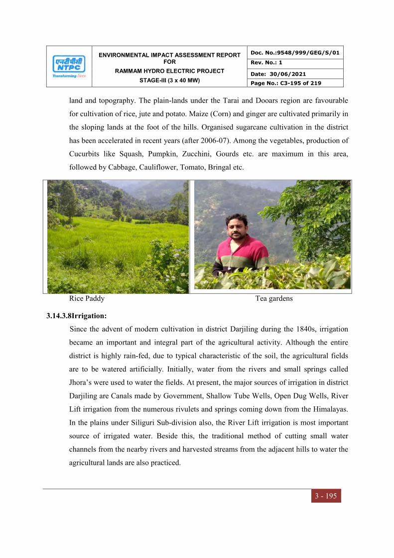
ENVIRONMENTAL IMPACT ASSESSMENT REPORT FOR
RAMMAM HYDRO ELECTRIC PROJECT
STAGE-III (3 x 40 MW)
Doc. No.:9548/999/GEG/S/01
Rev. No.: 1
Date: 30/06/2021
Page No.: C3-195 of 219
3 - 195
land and topography. The plain-lands under the Tarai and Dooars region are favourable
for cultivation of rice, jute and potato. Maize (Corn) and ginger are cultivated primarily in
the sloping lands at the foot of the hills. Organised sugarcane cultivation in the district
has been accelerated in recent years (after 2006-07). Among the vegetables, production of
Cucurbits like Squash, Pumpkin, Zucchini, Gourds etc. are maximum in this area,
followed by Cabbage, Cauliflower, Tomato, Bringal etc.
Rice Paddy Tea gardens
3.14.3.8Irrigation:
Since the advent of modern cultivation in district Darjiling during the 1840s, irrigation
became an important and integral part of the agricultural activity. Although the entire
district is highly rain-fed, due to typical characteristic of the soil, the agricultural fields
are to be watered artificially. Initially, water from the rivers and small springs called
Jhora’s were used to water the fields. At present, the major sources of irrigation in district
Darjiling are Canals made by Government, Shallow Tube Wells, Open Dug Wells, River
Lift irrigation from the numerous rivulets and springs coming down from the Himalayas.
In the plains under Siliguri Sub-division also, the River Lift irrigation is most important
source of irrigated water. Beside this, the traditional method of cutting small water
channels from the nearby rivers and harvested streams from the adjacent hills to water the
agricultural lands are also practiced.

ENVIRONMENTAL IMPACT ASSESSMENT REPORT FOR
RAMMAM HYDRO ELECTRIC PROJECT
STAGE-III (3 x 40 MW)
Doc. No.:9548/999/GEG/S/01
Rev. No.: 1
Date: 30/06/2021
Page No.: C3-196 of 219
3 - 196
3.14.3.9Horticulture
Horticulture is also one of the economy sources in the study area consists of fruits,
vegetables, spices and herbal products. These are proteinous and full of minerals and
salts. In a broader term, it incorporates floriculture also. These are cash crops, whose per
acre yield is higher and less disease prone than that of cereals. Horticulture is also one of
the economy sources in the study area. The climate and soil of Darjeeling District is aptly
suitable for horticultural development and in all the three seasons i.e. Winter, Summer
and monsoon, horticultural production can be done. In rainy season, main seasonal
horticultural products are Lady finger, Nenua (Taroi), Jhingi, Bitter gourd (Karaila),
Beans, Raddish, Brinjal, Tomato, Pumpkin group, Cucumber group, French bean, Potato,
Seem, Kanda, Cauliflower, etc. The main horticulture produce in Winter Season are
Brinjal, Tomato, Potato, Cabbage, Cauliflower, Turnip, Carrot, Raddish, Cucumber, Beet,
Spinach, Palak, Peanut, French beans, Seem, etc. In Summer Season, Nenua (Taroi),
Jhingi, Pumpkin group, Bitter gourd, Beans, Lady’s finger, Raddish, Cucumber, Brinjal,
Cauliflower, Tomato, Spinach, etc. are produced. The prime fruit crop of the area are
Mango, Guava, Lemon, Sharifa, Berries, Pomegranate, Jamun, Shahatut, Coconut,
Papaya, Banana, etc. Certain varieties of flowers viz., Rose, Hibiscus, Kamini, Rukmini,
Jasmin, Bela, Night queen, Chameli, Juhi, Kewda, Land lotus and other seasonal flowers
ENVIRONMENTAL IMPACT ASSESSMENT REPORT FOR
RAMMAM HYDRO ELECTRIC PROJECT
STAGE-III (3 x 40 MW)
Doc. No.:9548/999/GEG/S/01
Rev. No.: 1
Date: 30/06/2021
Page No.: C3-197 of 219
3 - 197
like Dahalia, Merry gold, etc. are also grown in the area. The main spices, that are being
cultivated in this area, are Red chillies, Coriander, Dhania, Ginger, Garlic, Methi, etc.
3.14.3.10Industries
There are no Large-Scale or Heavy industrial units in Darjiling. Historically, production
of tea from the plantations in and around the district has remained the largest industrial
activity. In later years, several MSME (Micro, Small and Medium Enterprises) and SSI
(Small Scale Industries) units have emerged in the district industrial scenario. The
industrial group wise distribution of factory units in the district Darjiling (for the
Financial Year 2008-09) is 178 industrial units in the district, production of food products
has the largest number of units with 154. In the category of Micro, Small and Medium
Enterprises and Artisan Units in the district Darjiling, there are a total of 13 Units
presently functioning in the district whose category wise distribution are as follows:
3.14.3.11Tea Industry of Darjiling District (Darjeeling Tea):
The plantation of Tea in the study area and district is as old as the history of the Darjiling
town itself. Tea plantation in the district started in a commercial basis during the earliest
years of establishment of British colonies in the district in 1830s and propagated by the
British Officer, Sir Arthur Campbell, primarily with an objective to reduce the monopoly
of the Chinese tea merchants. Although, the plantation of Assam tea started few decades
earlier, it was the ‘Darjeeling Tea’ that received the iconic status due to its significant
aroma, taste and colour. In order to encourage the tea plantation in and around Darjiling,
the Britishers distributed saplings and seeds from the Government nurseries. As a result
of this encouragement, the tea production in the district increased manifold and by the
advent of twentieth century, Darjeeling tea became world famous as the most exotically
flavoured and finest tea and has got the status of ‘Champagne of Tea’. As per the
definition, “Darjeeling Tea” can only refer to tea that has been cultivated, grown,
produced, manufactured and processed in tea gardens in few specific hilly areas of the
district. At present there are 87 Tea Gardens in the district covered under this GI Tag.

ENVIRONMENTAL IMPACT ASSESSMENT REPORT FOR
RAMMAM HYDRO ELECTRIC PROJECT
STAGE-III (3 x 40 MW)
Doc. No.:9548/999/GEG/S/01
Rev. No.: 1
Date: 30/06/2021
Page No.: C3-198 of 219
3 - 198
3.14.3.12Physical and Social Infrastructure Facilities in Darjeeling
Transport:
Despite a hilly terrain and high altitude, study area and Darjiling have a very wide spread
road-network covering almost all areas of the district. Since the expansion of British
territory in the early Nineteenth Century across the area, structured transformation of the
hilly rural roads to metalled and non-metalled road took place and within the end of
Nineteenth Century, owing to the important strategic location, far-flung places of the
district were well connected with district Head Quarter at Darjiling Town. Till date the
most famous and prominent mode of transport in the district is the Darjeeling Himalayan
Railway (The Toy Train of Darjiling). Established in 1881, with primary purpose of
transporting Darjeeling Tea from the Tea-Gardens in Hills to Kolkata, which was as
important Port City of Nineteenth Century. Subsequent to Indian independence, it came
under the control of Indian Government in 1948. In 1999, the Darjeeling Himalayan
Railway (DHR) was included in the list of World Heritage Site by the UNESCO World
Heritage Convention on the following grounds :
(a) The Darjeeling Himalayan Railway is an outstanding example of the influence of an
innovative transportation system on the social and economic development of a multi-
cultural region, which was to serve as a model for similar developments in many parts of
the world. (Criterion ii)
(b) The development of railways in the 19th century had a profound influence on social
and economic developments in many parts of the world.
This process is illustrated in an exceptional and seminal fashion by the Darjeeling
Himalayan Railway (Criterion iv) Presently its journey starts from the New Jalpaiguri
Railway Station near Siliguri and stretches upto Darjiling Town travelling a distance of
78 Kilometres. In the journey the elevation level changes from 100 Metres above sea
level to 2,200 Metres. However, owing to the factors like steep changes in elevation,
existence of several Loops in the path and a journey through a landslide prone path, the
services in the complete route is hindered. The Road network of district Darjiling is well
ENVIRONMENTAL IMPACT ASSESSMENT REPORT FOR
RAMMAM HYDRO ELECTRIC PROJECT
STAGE-III (3 x 40 MW)
Doc. No.:9548/999/GEG/S/01
Rev. No.: 1
Date: 30/06/2021
Page No.: C3-199 of 219
3 - 199
built and several National and State Highways pass through the district. NH-31, NH-31A,
NH-31C and NH-110 crosses the district and important locations are connected by SH-12
and SH-12A beside numerous medium, small and minor road networks. The length of
Road network maintained by P.W.D., DCAHC, Siliguri Mahakuma Parishad and Prime
Minister’s Gram Sarak Yojana exceeds 4,100 kilometres
Educational Facilities
In general the number of Primary, Junior High and High School in the project region has
increased over the years. The most of the study areas have schools and colleges in both
private and Govt. sectors. There are 2 nos.primary schools, 1 no. Secondary school, 2
nos. senior secondary schools in Darjeeling. The number of Primary Schools is 6, number
of Middle and Secondary/Matriculation schools is 2 in each in the study area.
Medical Facilities
Medical facilities available in the Project Affected Villages are presented in Table 5.4.
Sumbuk has 1 Health Sub-Centre. Other Health Sub-Centres are located at 2 - 15 km
distance from Sajbotey, Takbay, Nezi, Salandong and Kankibong. It may be pertinent to
mention here that villagers of Kankibong, Salandong, Takbay, Nezi and Sajbotey have to
travel 4 - 20 km distance to avail the facilities of even Primary Health Centre. The
villagers of PAVs have to cover a distance of upto approx. 18 km to reach Bijonbari
Rural Hospital. Also in many cases, it is very difficult for the patients to avail of the
medical services because of the bad condition of roads especially during the monsoon
season as well as non-availability of staff including doctors. Moreover the transport cost
is also very high as the fare is Rs 20-40 per person per trip which is not affordable to
specially poor people. Even there is no Private Allopathic/Ayurvedic/Homeopathic
Medical Practitioner in the PAVs. There is only 1 Medical Store at Sumbuk. Villagers of
the remaining 5 PAVs have to travel a distance of 1 - 14 km to avail the facility of the
nearest medical store. There is no Veterinary Dispensary in the PAVs.

ENVIRONMENTAL IMPACT ASSESSMENT REPORT FOR
RAMMAM HYDRO ELECTRIC PROJECT
STAGE-III (3 x 40 MW)
Doc. No.:9548/999/GEG/S/01
Rev. No.: 1
Date: 30/06/2021
Page No.: C3-200 of 219
3 - 200
Water Supply Facilities
The analysis of water supply facilities shows that the major sources of the supply of
drinking water are tap water and Rammam River in the PAVs. Being in the hilly terrain,
none of the people have tube wells. Most of the people have to bring drinking water from
tap water, which are at distances upto 0.5 – 2 km from their houses.
Water requirement for the other purposes like bathing, washing, cattle rearing, etc. are
met by nearby rivers and streams/canals. In Sajbotey, Nezi and Takbay, villagers use tap
water. People of Kankibong get facility of Rammam river besides tap water for bathing
and washing and sometimes also for drinking purposes. Villagers of Sumbuk quench their
thirst from natural sources.
Electricity and Power:
The oldest Hydro-Electric power plant in India is located in district Darjiling at a distance
of 12 kilometres from the Darjeeling town is known as Sidrapong Hydel Power Station.
The Hydel Power plant at Sidrapong became operational in the year 1896 and is located
at an elevation 1,100 Metres from the mean sea level. The Power Plant came under the
control of State-run West Bengal State Electricity Board from 1978 and presently beside
river Great Rangeet, three river streams named Kotwali, Hospital and Barbatia feed the
power plant. The status important hydel power projects of Darjiling district are depicted
in the following Table 3.56
Table 3.56
The important hydel power projects in Darjeeling district, West Bengal
S.No. Name of the Project Capacity (MW) Operational Status
1. Rammam Hydel Power Project
Stage-II
51 MW In Operation
2. Jaldhaka Hydel Power Project
Stage-I & II
27 MW In Internittent
Operation
3. Teesta Canal Fall Hydel Power
Project
9x7.5 MW In Operation
4. Fazi Jhora 2.448 MW In Operation
5. Rinchington 2.0 MW In Operation

ENVIRONMENTAL IMPACT ASSESSMENT REPORT FOR
RAMMAM HYDRO ELECTRIC PROJECT
STAGE-III (3 x 40 MW)
Doc. No.:9548/999/GEG/S/01
Rev. No.: 1
Date: 30/06/2021
Page No.: C3-201 of 219
3 - 201
6. Little Rangeet 2.0 MW In Operation
7. Sidrapong 0.6 MW In Operation
(Source: Website of West Bengal State Electricity Distribution Company Ltd., Report on
Hydel Projects)

ENVIRONMENTAL IMPACT ASSESSMENT REPORT FOR
RAMMAM HYDRO ELECTRIC PROJECT
STAGE-III (3 x 40 MW)
Doc. No.:9548/999/GEG/S/01
Rev. No.: 1
Date: 30/06/2021
Page No.: C3-202 of 219
3 - 202
Table 3.57
Details of physical and social amenities in the study area
S.No. Name of the
CD Block
Number of
inhabited
villages
Type of amenity available
Ed
uca
tion
Med
ical
Dri
nk
ing
wat
er
Pos
t O
ffic
e
Tel
eph
one
Tra
nsp
ort
com
mu
nic
atio
ns
Ba
nk
s
Agr
icu
ltu
ral
cred
it
soci
etie
s
Ap
pro
ach
by
pu
cca
road
Pow
er S
up
ply
1. Darjeeling
Pulbazar
43 42
(97.67)
34
(79.07)
43
(100)
25
(58.14)
41
(95.35)
6
(13.95)
5
(11.63)
8
(18.6)
27
(62.79)
43
(100)
2. Jorebunglow
Sukiapokhri
42 41
(97.62)
40
(95.24)
42
(100)
21
(50)
42
(100)
11
(26.19)
2
(4.76)
1
(2.38)
25
(59.52)
42
(100)
Source: http://censusindia.gov.in/2011census/dchb/DCHB.html
ENVIRONMENTAL IMPACT ASSESSMENT REPORT FOR
RAMMAM HYDRO ELECTRIC PROJECT
STAGE-III (3 x 40 MW)
Doc. No.:9548/999/GEG/S/01
Rev. No.: 1
Date: 30/06/2021
Page No.: C3-203 of 219
3 - 203
3.14.4 Brief Profile of the Sikkim District
Sikkim state fall in the 1.4 Meso Regions, namely North Eastern Himalayas of the Macro
Region 1 the Northern Mountains of the Natural Division of India. Nearly two third of its
hilly regions are very high mountains perpetually covered with snow are the sources of
glaciers like Talung, Zemu, Lhonak etc. The state being the part of inner mountain ranges
of Himalayas is hilly having varied elevations ranging from 300 meters to 7000 meters.
The largest portion of Sikkim is in its North-West, a large number of mountains having
the altitude of about nine thousand meters stand here which includes the famous
Kanchenjunga (8598 meters), the third highest peak in the world.Sikkim state has four
districts which are named according to their regional location and they are the: 1) North
District, 2. West District 3. South District and the 4. East District
3.14.4.1Communities of Sikkim
Communities, Cultures, Religions and Customs of different hues intermingle freely here
in Sikkim to constitute a homogeneous blend. The predominant communities are the
LEPCHAS, BHUTIAS and NEPALESE. In urban areas, many plainsmen have also
settled and they are almost engaged in business and Government service. Because of the
development activities in the state, like the construction of roads, bridges and buildings a
small part of the population consists of migrant laborers from the plains and Nepal.
3.14.4.2Demographical details of the study area
The proposed study area is covered with two major districts of Sikkim state, that is west
Sikkim and south Sikkim. There are 34 large Revenue Blocks having above 2000
population of which 2 falls in North districts followed by 12 in West district, 7 in South
district and 13 in East district. There are only 3 Revenue Blocks which has population
above 5,000 and they fall in East district only
West Sikkim is the second largest district in the Indian state of Sikkim with an area of
1,166 sq km. The headquarters of the district is at Gyalshing, also known as Geyzing.The
town is connected to the capital Gangtok by a metalled road. Geyzing is also connected to
the West Bengal towns of Darjeeling and Kalimpong via Jorethang. In West district
ENVIRONMENTAL IMPACT ASSESSMENT REPORT FOR
RAMMAM HYDRO ELECTRIC PROJECT
STAGE-III (3 x 40 MW)
Doc. No.:9548/999/GEG/S/01
Rev. No.: 1
Date: 30/06/2021
Page No.: C3-204 of 219
3 - 204
96.15 per cent population lives in rural area while only 3.85per cent population lives in
the urban areas at Gyalshing (NP) and xi Nayabazaar (NBA). In West district 96.15 per
cent population lives in rural area while only 3.85per cent population lives in the urban
areas at Gyalshing (NP) and Nayabazaar (NBA).
South District of Sikkim lies at an altitude of 400 mtr to 2000 mtr with unique and
countryside escape of endless waves of agricultural fields and the terraced slopes,
intercepted by spring patched forests and encompasses a total area of around 75000
hectares. Area wise, it is the smallest district of Sikkim and population-wise, second one.
Its total population is 1,46,742 (as per 2011 census) among which 76,663 are male
and 68,241 female. In South district 85.56 per cent population lives in rural areas while
the only 10.62 per cent are in urban area at Mangan (NP). In South district 85.56 per cent
population lives in rural areas while the remaining 14.44 per cent lives in the urban areas
at Namchi (M.Cl) and Jorethang (NP).
These two districts, Soreng and Namchi sub districts are the major covered areas in the
study. Those demographical details are provided on below table-

ENVIRONMENTAL IMPACT ASSESSMENT REPORT FOR
RAMMAM HYDRO ELECTRIC PROJECT
STAGE-III (3 x 40 MW)
Doc. No.:9548/999/GEG/S/01
Rev. No.: 1
Date: 30/06/2021
Page No.: C3-205 of 219
3 - 205
Table 3.58 Demographical details of the study area
Sno Name No_HH TOT_P TOT_M TOT_F P_06 P_SC P_ST P_LIT P_ILL
1 Soreng 13462 63525 32405 31120 6797 2463 25789 43943 19582
2 Tadong} 283 1445 769 676 164 9 336 1040 405
3 Rinchenpong 298 1458 737 721 139 25 471 1111 347
4 Sangadorji 237 1198 638 560 139 25 466 796 402
5 Jeel 159 744 398 346 91 35 393 406 338
6 Hathidunga 206 957 471 486 105 22 517 655 302
7 Bum 132 635 323 312 78 0 28 420 215
8 Rishi 117 659 330 329 85 0 490 434 225
9 Bara-Samdong 295 1385 707 678 158 12 827 1005 380
10 Sribadam 239 1127 576 551 131 47 747 820 307
11 Deythang 274 1283 648 635 145 0 612 822 461
12 Parrengaon 277 1301 674 627 154 6 521 755 546
13 Takuthang 278 1282 617 665 148 20 571 817 465
14 Chuchen 183 875 457 418 88 31 482 612 263
15 Tinzerbong 217 1037 553 484 110 41 500 679 358
16 Suldung 143 754 378 376 92 34 42 421 333
17 Kamling 230 1247 641 606 166 116 267 773 474
18 Mabong 237 1094 559 535 134 25 135 686 408
19 Segeng 175 864 426 438 120 6 285 546 318
20 Samsing 353 1802 983 819 221 128 270 1149 653
21 Geling 257 1306 659 647 155 53 236 760 546
22 Suntaley 86 414 210 204 45 19 93 207 207
23 Khanisherbung 235 1089 536 553 148 12 534 723 366
24 Aroobotey 154 787 415 372 92 0 559 504 283
25 Chota-Samdong 176 846 459 387 87 2 670 539 307
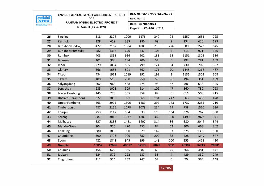
ENVIRONMENTAL IMPACT ASSESSMENT REPORT FOR
RAMMAM HYDRO ELECTRIC PROJECT
STAGE-III (3 x 40 MW)
Doc. No.:9548/999/GEG/S/01
Rev. No.: 1
Date: 30/06/2021
Page No.: C3-206 of 219
3 - 206
26 Singling 518 2376 1200 1176 240 94 1557 1651 725
27 Karthok 128 619 333 286 69 9 234 426 193
28 Burikhop(Dodok) 422 2167 1084 1083 216 226 689 1522 645
29 Burikhop(Rumbuk) 282 1337 690 647 104 5 313 971 366
30 Rumbuk 403 1838 936 902 188 68 1151 1302 536
31 Bhareng 101 390 184 206 54 5 292 281 109
32 Ribdi 229 1034 535 499 124 34 730 702 332
33 Okhery 366 1683 821 862 171 70 1445 1216 467
34 Tikpur 434 1911 1019 892 199 3 1135 1303 608
35 Siktam 109 510 260 250 55 96 194 351 159
36 Salyangdang 202 963 488 475 98 62 88 638 325
37 Longchok 235 1023 509 514 109 47 360 730 293
38 Lower Fambong 145 723 365 358 82 0 611 508 215
39 Dhalam(Daramden) 372 1886 921 965 181 242 563 1408 478
40 Upper Fambong 663 2995 1506 1489 297 173 1737 2285 710
41 Timberbong 427 2156 1078 1078 234 79 738 1520 636
42 Tharpu 253 1117 584 533 119 134 376 767 350
43 Soreng 887 3818 1937 1881 368 100 1490 2877 941
44 Malbasey 627 2888 1481 1407 314 86 680 2044 844
45 Mendo-Goan 204 925 470 455 84 62 306 663 262
46 Chakung 380 1859 930 929 142 53 325 1359 500
47 Chumbong 390 1796 909 887 202 38 428 1249 547
48 Zoom 422 1841 945 896 148 100 255 1421 420
49 Namchi 16057 77696 40517 37179 8078 3591 20392 56715 20981
50 Chumlok 154 622 335 287 69 25 266 481 141
51 Jaubari 124 579 292 287 58 4 429 330 249
52 Tingrithang 112 514 267 247 52 0 75 366 148
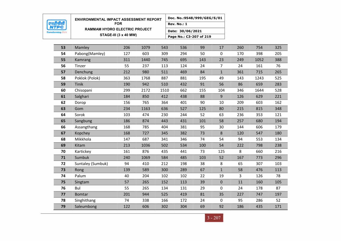
ENVIRONMENTAL IMPACT ASSESSMENT REPORT FOR
RAMMAM HYDRO ELECTRIC PROJECT
STAGE-III (3 x 40 MW)
Doc. No.:9548/999/GEG/S/01
Rev. No.: 1
Date: 30/06/2021
Page No.: C3-207 of 219
3 - 207
53 Mamley 206 1079 543 536 99 17 260 754 325
54 Pabong(Mamley) 127 603 309 294 50 0 170 398 205
55 Kamrang 311 1440 745 695 143 23 249 1052 388
56 Tinzer 55 237 113 124 24 7 24 161 76
57 Denchung 212 980 511 469 84 1 361 715 265
58 Poklok (Polok) 363 1768 887 881 195 49 143 1243 525
59 Tinik 190 942 510 432 91 56 86 659 283
60 Chisopani 299 2172 1510 662 155 104 346 1644 528
61 Salghari 184 850 412 438 88 9 126 629 221
62 Dorop 156 765 364 401 90 10 209 603 162
63 Gom 234 1163 636 527 125 80 215 815 348
64 Sorok 103 474 230 244 52 63 236 353 121
65 Sangbung 186 874 443 431 101 58 257 680 194
66 Assangthang 168 785 404 381 95 30 144 606 179
67 Kopchey 168 727 345 382 73 8 120 547 180
68 Mikkhola 147 687 341 346 74 54 94 553 134
69 Kitam 213 1036 502 534 100 54 222 798 238
70 Kartickey 161 876 435 441 73 125 8 660 216
71 Sumbuk 240 1069 584 485 103 52 167 773 296
72 Suntaley (Sumbuk) 94 410 212 198 38 8 65 307 103
73 Rong 139 589 300 289 67 1 58 476 113
74 Palum 40 204 102 102 22 19 3 126 78
75 Singtam 57 265 152 113 39 0 11 160 105
76 Bul 55 265 134 131 29 0 24 178 87
77 Bomtar 201 944 525 419 81 35 227 747 197
78 Singhithang 74 338 166 172 24 0 95 286 52
79 Saleumbong 122 606 302 304 69 92 186 435 171
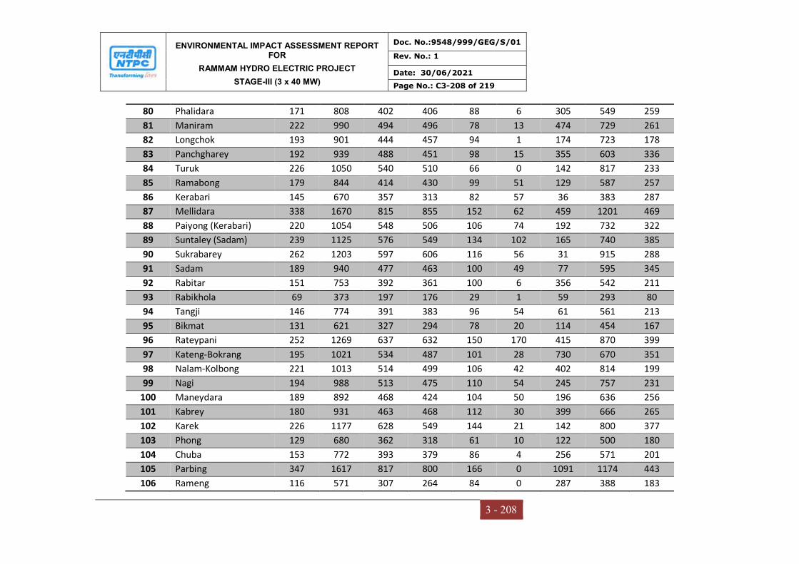
ENVIRONMENTAL IMPACT ASSESSMENT REPORT FOR
RAMMAM HYDRO ELECTRIC PROJECT
STAGE-III (3 x 40 MW)
Doc. No.:9548/999/GEG/S/01
Rev. No.: 1
Date: 30/06/2021
Page No.: C3-208 of 219
3 - 208
80 Phalidara 171 808 402 406 88 6 305 549 259
81 Maniram 222 990 494 496 78 13 474 729 261
82 Longchok 193 901 444 457 94 1 174 723 178
83 Panchgharey 192 939 488 451 98 15 355 603 336
84 Turuk 226 1050 540 510 66 0 142 817 233
85 Ramabong 179 844 414 430 99 51 129 587 257
86 Kerabari 145 670 357 313 82 57 36 383 287
87 Mellidara 338 1670 815 855 152 62 459 1201 469
88 Paiyong (Kerabari) 220 1054 548 506 106 74 192 732 322
89 Suntaley (Sadam) 239 1125 576 549 134 102 165 740 385
90 Sukrabarey 262 1203 597 606 116 56 31 915 288
91 Sadam 189 940 477 463 100 49 77 595 345
92 Rabitar 151 753 392 361 100 6 356 542 211
93 Rabikhola 69 373 197 176 29 1 59 293 80
94 Tangji 146 774 391 383 96 54 61 561 213
95 Bikmat 131 621 327 294 78 20 114 454 167
96 Rateypani 252 1269 637 632 150 170 415 870 399
97 Kateng-Bokrang 195 1021 534 487 101 28 730 670 351
98 Nalam-Kolbong 221 1013 514 499 106 42 402 814 199
99 Nagi 194 988 513 475 110 54 245 757 231
100 Maneydara 189 892 468 424 104 50 196 636 256
101 Kabrey 180 931 463 468 112 30 399 666 265
102 Karek 226 1177 628 549 144 21 142 800 377
103 Phong 129 680 362 318 61 10 122 500 180
104 Chuba 153 772 393 379 86 4 256 571 201
105 Parbing 347 1617 817 800 166 0 1091 1174 443
106 Rameng 116 571 307 264 84 0 287 388 183
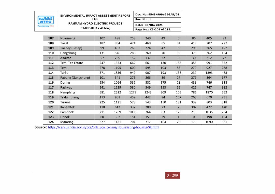
ENVIRONMENTAL IMPACT ASSESSMENT REPORT FOR
RAMMAM HYDRO ELECTRIC PROJECT
STAGE-III (3 x 40 MW)
Doc. No.:9548/999/GEG/S/01
Rev. No.: 1
Date: 30/06/2021
Page No.: C3-209 of 219
3 - 209
107 Nijarmeng 102 498 258 240 49 0 86 405 93
108 Tokal 182 934 474 460 85 34 418 707 227
109 Tokdey (Resep) 99 487 263 224 47 6 296 365 122
110 Gangchung 131 546 286 260 70 8 378 362 184
111 Aifaltar 57 289 152 137 27 0 30 212 77
112 Temi Tea Estate 247 1323 662 661 130 158 356 991 332
113 Temi 278 1195 600 595 103 83 270 927 268
114 Tarku 371 1856 949 907 193 136 239 1393 463
115 Pabong (Gangchung) 101 541 275 266 39 27 279 364 177
116 Doring 254 1064 532 532 175 28 433 746 318
117 Rashyap 241 1129 580 549 153 55 426 747 382
118 Namphing 581 2522 1279 1243 309 105 786 1870 652
119 Tsalumthang 173 901 459 442 94 107 265 670 231
120 Turung 225 1121 578 543 150 181 339 803 318
121 Kanamtek 110 612 332 280 73 2 307 472 140
122 Pamphok 211 1269 1005 264 83 126 218 1035 234
123 Donok 60 302 151 151 29 1 0 198 104
124 Mamring 327 1421 704 717 164 23 170 1090 331
Source: https://censusindia.gov.in/pca/cdb_pca_census/Houselisting-housing-SK.html
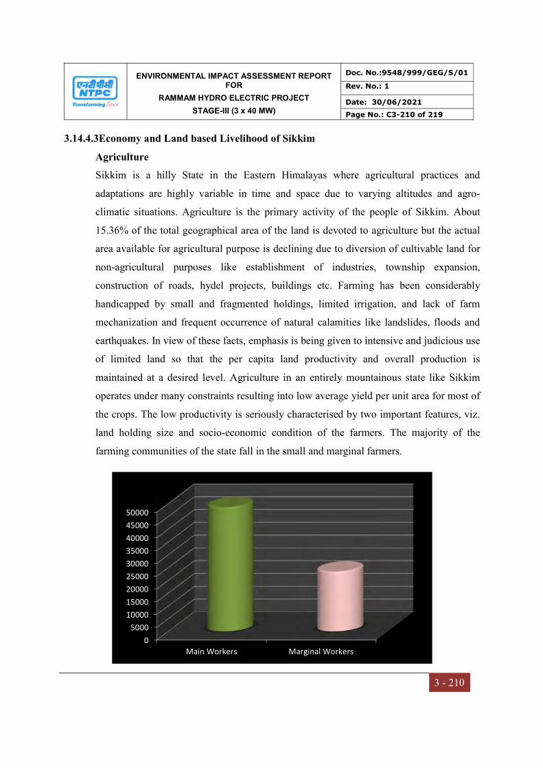
ENVIRONMENTAL IMPACT ASSESSMENT REPORT FOR
RAMMAM HYDRO ELECTRIC PROJECT
STAGE-III (3 x 40 MW)
Doc. No.:9548/999/GEG/S/01
Rev. No.: 1
Date: 30/06/2021
Page No.: C3-210 of 219
3 - 210
3.14.4.3Economy and Land based Livelihood of Sikkim
Agriculture
Sikkim is a hilly State in the Eastern Himalayas where agricultural practices and
adaptations are highly variable in time and space due to varying altitudes and agro-
climatic situations. Agriculture is the primary activity of the people of Sikkim. About
15.36% of the total geographical area of the land is devoted to agriculture but the actual
area available for agricultural purpose is declining due to diversion of cultivable land for
non-agricultural purposes like establishment of industries, township expansion,
construction of roads, hydel projects, buildings etc. Farming has been considerably
handicapped by small and fragmented holdings, limited irrigation, and lack of farm
mechanization and frequent occurrence of natural calamities like landslides, floods and
earthquakes. In view of these facts, emphasis is being given to intensive and judicious use
of limited land so that the per capita land productivity and overall production is
maintained at a desired level. Agriculture in an entirely mountainous state like Sikkim
operates under many constraints resulting into low average yield per unit area for most of
the crops. The low productivity is seriously characterised by two important features, viz.
land holding size and socio-economic condition of the farmers. The majority of the
farming communities of the state fall in the small and marginal farmers.
0
5000
10000
15000
20000
25000
30000
35000
40000
45000
50000
Main Workers Marginal Workers

ENVIRONMENTAL IMPACT ASSESSMENT REPORT FOR
RAMMAM HYDRO ELECTRIC PROJECT
STAGE-III (3 x 40 MW)
Doc. No.:9548/999/GEG/S/01
Rev. No.: 1
Date: 30/06/2021
Page No.: C3-211 of 219
3 - 211
Irrigation
The study area being a mountainous state consisting of steep rugged hills, narrow valleys
and rocky terrains, the topographical condition is not favourable to go in for medium or
major irrigation schemes. Hence all the irrigation schemes fall under minor irrigation
scheme category only. The rate of rainfall in Sikkim is very high and due to the
geographical characteristics, the irrigation channel is prone to extensive damages during
the monsoons. Even the optimal utilisation of the completed schemes is truncated due to
such damages inflicted during the rainy season. During lean periods, small discharges
will be collected in reservoirs for cultivation of Rabi crops. The implementation of non-
perennial irrigation system in most cases is unavoidable. The reason being the regular and
sufficient quantity of water is not available at the source throughout the year. Besides,
rice is the main crop grown in Sikkim for which the irrigation is mostly required. Hence,
inundation irrigation system in which sufficient quantity of water flowing in the rivulets
and streams during the monsoons and post monsoon period is diverted to irrigate the
kharif crops.
Animal Husbandry
The congenial temperate climate and the temperate vegetation existing in the study areas
are highly favorable for exotic high producing livestock. Moreover, the highlanders have
a traditional pastoral economy handed over from generation to generation with their
typical kind of livestock such as yaks, sheep, mountain goats, pigs and poultry. Livestock
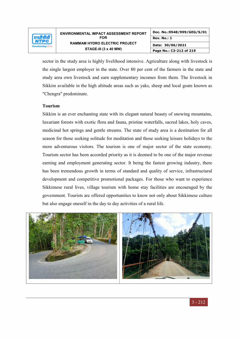
ENVIRONMENTAL IMPACT ASSESSMENT REPORT FOR
RAMMAM HYDRO ELECTRIC PROJECT
STAGE-III (3 x 40 MW)
Doc. No.:9548/999/GEG/S/01
Rev. No.: 1
Date: 30/06/2021
Page No.: C3-212 of 219
3 - 212
sector in the study area is highly livelihood intensive. Agriculture along with livestock is
the single largest employer in the state. Over 80 per cent of the farmers in the state and
study area own livestock and earn supplementary incomes from them. The livestock in
Sikkim available in the high altitude areas such as yaks, sheep and local goats known as
"Chengra" predominate.
Tourism
Sikkim is an ever enchanting state with its elegant natural beauty of snowing mountains,
luxuriant forests with exotic flora and fauna, pristine waterfalls, sacred lakes, holy caves,
medicinal hot springs and gentle streams. The state of study area is a destination for all
season for those seeking solitude for meditation and those seeking leisure holidays to the
more adventurous visitors. The tourism is one of major sector of the state economy.
Tourism sector has been accorded priority as it is deemed to be one of the major revenue
earning and employment generating sector. It being the fastest growing industry, there
has been tremendous growth in terms of standard and quality of service, infrastructural
development and competitive promotional packages. For those who want to experience
Sikkimese rural lives, village tourism with home stay facilities are encouraged by the
government. Tourists are offered opportunities to know not only about Sikkimese culture
but also engage oneself in the day to day activities of a rural life.
ENVIRONMENTAL IMPACT ASSESSMENT REPORT FOR
RAMMAM HYDRO ELECTRIC PROJECT
STAGE-III (3 x 40 MW)
Doc. No.:9548/999/GEG/S/01
Rev. No.: 1
Date: 30/06/2021
Page No.: C3-213 of 219
3 - 213
3.14.4.4Physical and Social Infrastructure Facilities in Sikkim
Electricity and Power
The present peak demand of the state is of 96 MW even with considering industrial units.
The state currently generates 38.2 MW, but since 32.2 MW is generated through hydel
projects, which are run of the river scheme, there output comes down to 50% (up to 12
MW) during the winter months. Now with the liberalized power policy, Sikkim can look
forward for developing and exploiting its huge Hydo Power Potential which has been
assessed to 8000 MW peak with a firm base of 3000MW. 43% of the household have
power supply in the study area.
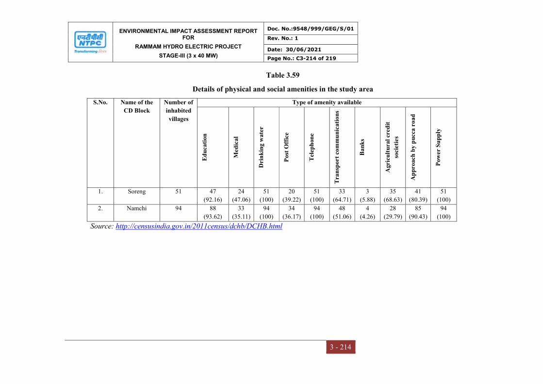
ENVIRONMENTAL IMPACT ASSESSMENT REPORT FOR
RAMMAM HYDRO ELECTRIC PROJECT
STAGE-III (3 x 40 MW)
Doc. No.:9548/999/GEG/S/01
Rev. No.: 1
Date: 30/06/2021
Page No.: C3-214 of 219
3 - 214
Table 3.59
Details of physical and social amenities in the study area
S.No. Name of the
CD Block
Number of
inhabited
villages
Type of amenity available
Ed
uca
tion
Med
ical
Dri
nk
ing
wat
er
Pos
t O
ffic
e
Tel
eph
one
Tra
nsp
ort
com
mu
nic
atio
ns
Ba
nk
s
Agr
icu
ltu
ral
cred
it
soci
etie
s
Ap
pro
ach
by
pu
cca
road
Pow
er S
up
ply
1. Soreng 51 47
(92.16)
24
(47.06)
51
(100)
20
(39.22)
51
(100)
33
(64.71)
3
(5.88)
35
(68.63)
41
(80.39)
51
(100)
2. Namchi 94 88
(93.62)
33
(35.11)
94
(100)
34
(36.17)
94
(100)
48
(51.06)
4
(4.26)
28
(29.79)
85
(90.43)
94
(100)
Source: http://censusindia.gov.in/2011census/dchb/DCHB.html

ENVIRONMENTAL IMPACT ASSESSMENT REPORT FOR
RAMMAM HYDRO ELECTRIC PROJECT
STAGE-III (3 x 40 MW)
Doc. No.:9548/999/GEG/S/01
Rev. No.: 1
Date: 30/06/2021
Page No.: C3-215 of 219
3 - 215
3.14.5 PRIMARY SURVEY
Community perception
The primary data collection was subsequently undertaken during process. This included
Individual and group assessments. The Individual assessment was done by using standard
questionnaire in non probability sampling method. The data were collected on
demographical particulars of the participants and perception of the participants towards
the project. The demographical details are included as household composition, education
levels, general health status, livelihood strategies, employment, This survey was also
focused five major various dimensions such as: 1) Economical; 2) Public Infrastructure
and services; 3) Social/cultural; 4) Environmental; 5) Health and well-being 6)
Psychological/personal. These domains assess the significant impact differences about
this proposed project. Apart from this expert done focused group discussion for
community and collective opinions of the proposed project. This study was carried on
population living in the 10 villages. The hamlets covered within 10 km of core and buffer
areas.
A primary study was collected from 165 participants from both, Darjeeling and West
Sikkim locations of the study area. This survey was conducted to identify the community
perception. In this connection, field experts used the technique of sampling to administer
a questionnaire on the existing awareness among the community on the project and its
potential impacts.
Table 3.60
Particulars of the participants
No Name No_HH TOT_P No of Participants
1 Tadong} 283 1445 14
2 Takuthang 278 1282 12
3 Chuchen 183 875 08
4 Tinzerbong 217 1037 10
5 Suldung 143 754 07
6 Segeng 175 864 08
7 Samsing 353 1802 18
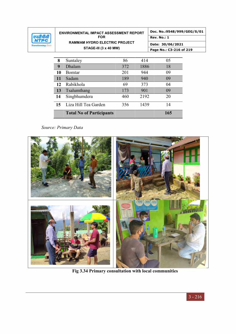
ENVIRONMENTAL IMPACT ASSESSMENT REPORT FOR
RAMMAM HYDRO ELECTRIC PROJECT
STAGE-III (3 x 40 MW)
Doc. No.:9548/999/GEG/S/01
Rev. No.: 1
Date: 30/06/2021
Page No.: C3-216 of 219
3 - 216
Source: Primary Data
Fig 3.34 Primary consultation with local communities
8 Suntaley 86 414 05
9 Dhalam 372 1886 18
10 Bomtar 201 944 09
11 Sadam 189 940 09
12 Rabikhola 69 373 04
13 Tsalumthang 173 901 09
14 Singbhumdera 460 2192 20
15 Liza Hill Tea Garden 356 1439 14
Total No of Participants 165
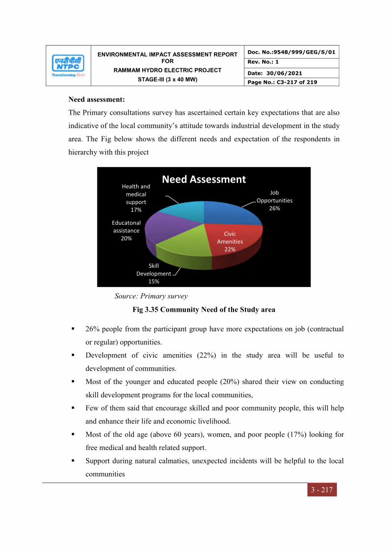
ENVIRONMENTAL IMPACT ASSESSMENT REPORT FOR
RAMMAM HYDRO ELECTRIC PROJECT
STAGE-III (3 x 40 MW)
Doc. No.:9548/999/GEG/S/01
Rev. No.: 1
Date: 30/06/2021
Page No.: C3-217 of 219
3 - 217
Need assessment:
The Primary consultations survey has ascertained certain key expectations that are also
indicative of the local community’s attitude towards industrial development in the study
area. The Fig below shows the different needs and expectation of the respondents in
hierarchy with this project
Source: Primary survey
Fig 3.35 Community Need of the Study area
26% people from the participant group have more expectations on job (contractual
or regular) opportunities.
Development of civic amenities (22%) in the study area will be useful to
development of communities.
Most of the younger and educated people (20%) shared their view on conducting
skill development programs for the local communities,
Few of them said that encourage skilled and poor community people, this will help
and enhance their life and economic livelihood.
Most of the old age (above 60 years), women, and poor people (17%) looking for
free medical and health related support.
Support during natural calmaties, unexpected incidents will be helpful to the local
communities
Job Opportunities
26%
Civic Amenities
22%
Skill Development
15%
Educatonal assistance
20%
Health and medical support
17%
Need Assessment
ENVIRONMENTAL IMPACT ASSESSMENT REPORT FOR
RAMMAM HYDRO ELECTRIC PROJECT
STAGE-III (3 x 40 MW)
Doc. No.:9548/999/GEG/S/01
Rev. No.: 1
Date: 30/06/2021
Page No.: C3-218 of 219
3 - 218
Major Findings of Socio-economic study
The following major socioeconomic findings are observed in the study area are presented
below
Most of the communities in the area are well aware about the project.
This hydro power project plays an important role in the development of the local
vicinities and state
It provides direct and indirect economical development within the study area.
This type of projects provides power at cheaper rate being perpetual and renewable
sources of energy.
Positive in the form more income to the local people, better infrastructure.
Increases the agricultural production increased and rural poverty declined.
The micro/mini hydels contribute to the meet the primary electricity needs.
This project also would help provide safe, reliable, sufficient and affordable electricity
for domestic consumption and industrial use.
It enhances income generation of agro-processing and small service business such as
mills and shops
Increase economic activity and tax revenues to the govt.
Picnic spot near the barrage as it can attract many visitors from the nearby places and
generate additional revenue not only for the government but also for the local people as
well.
R&R activated was done before starting the project, hence there are no chances for
migration and cultural influence on local communities.
Improve the quality of lives of students, housewives (women) and the rural households
and improved conditions in the quality of services
Exposure to health hazards from smoke created by fuel wood has been reduced.
The communities’ safety in general improves due to street lighting at night. Furthermore
women and children have more productive time which can be used for studying and thus
education is improved.

ENVIRONMENTAL IMPACT ASSESSMENT REPORT FOR
RAMMAM HYDRO ELECTRIC PROJECT
STAGE-III (3 x 40 MW)
Doc. No.:9548/999/GEG/S/01
Rev. No.: 1
Date: 30/06/2021
Page No.: C3-219 of 219
3 - 219
Injuries and sickness of the staffs and workers and also of local residents due to accidents
and fires is not a regular phenomenon.
Hydroelectric power plant, the energy of water is utilized for generating electricity which
is pollution free and also inflation free energy due to absence of fuel costs.
Natural hazards such as land slide or cloud burst often seen in these villages.
The heavy movement of project vehicle sometimes may create traffic in roads and
transportation problem.
Fumes and dust start spoil the air quality which is a controllable factor. It is observed
during the survey that as the villages are surrounded mostly by hills and forests, hence the
air quality is relatively good in the project area.
People in the study area have high expectations from the potential of improvement in
connectivity of roads, bridges and public infrastructure in the immediate vicinity of the
project area.
The respondents believed that this project enhance their quality of life due to social and
economical growth.
They said that increasing of land and labour cost, employment generation and other civic
amenities will generate positive attitude for individual and community people.
CONCLUSION
The present Social Impact Assessment study was conducted within the study area of
Rammam HEPP Stage-III Run of River (ROR) in Darjeeling and Sikkim districts of West
Bengal and Sikkim. Both, secondary and primary details within the study area discussed.
It traditionally involved the use of technical and participatory analytical methods to
anticipate change but also encouraging the life cycle of projects to minimize negative
outcomes and maximize benefits. The early consideration of social impacts, the
alignment of activities with regional and community planning objectives, and meaningful
participation of community in decision making are key features. Apart from the SIA
process and findings it can be concluded that most the respondents have positive
perception towards implementation of the project.
CHAPTER – IV
ANTICIPATED ENVIRONMENTAL
IMPACTS & MITIGATION MEASURES
ENVIRONMENTAL IMPACT ASSESSMENT REPORT FOR
RAMMAM HYDRO ELECTRIC PROJECT
STAGE-III (3 x 40 MW)
Doc. No.:9548/999/GEG/S/01
Rev. No.: 1
Date: 30/06/2021
Page No.: C4-1 of 41
4 - 1
CHAPTER-4
ANTICIPATED ENVIRONMENTAL IMPACTS AND
MITIGATION MEASURES
4.0 INTRODUCTION
The actual and anticipated impacts of the project activities on the environment have been
evaluated and predicted based on the information collected at the site and the information
provided by NTPC. The objective of the impact identification is to update and supplement
Environmental Management Plan (EMP) to mitigate the probable negative impacts that
might arise during further project activities. Therefore, in order to work out a strategic EMP,
it is imperative to identify the possibilities at various project stages, impact type and affected
environmental component, extent and severity. EIA is an activity designed to identify and
predict the impact on the environment, on human health and ecology, taking into account
the requirements of legislative proposals, policies, programs, operational procedures and to
communicate information about the impact.
The project is in construction stage since 2014 and more than 50% work has been
completed. The current impact assessment includes the actual impacts under various
attributes of the environment during construction and operation phase of the project.
Rammam Stage-III HEPP opeartional activities also includes positive socioeconomic
impacts in terms of increase in local business opportunities and on a larger perspective, by
providing potential energy security at a national level.
4.1 IMPACT ASSESSMENT
This section discusses the impacts of the project activities during construction and operation
phases on the environmental receptors that stand to get affected adversely by the project. It
discusses probable impacts during various phases of the project lifecycle on the
environmental and socioeconomic components. Adequate Environmental management
measures were incorporated during the entire planning of construction and operation stages

ENVIRONMENTAL IMPACT ASSESSMENT REPORT FOR
RAMMAM HYDRO ELECTRIC PROJECT
STAGE-III (3 x 40 MW)
Doc. No.:9548/999/GEG/S/01
Rev. No.: 1
Date: 30/06/2021
Page No.: C4-2 of 41
4 - 2
of the project to minimize the adverse Environmental impacts and assure sustainable
development of the area.
4.2 IDENTIFICATION OF IMPACTS
Generally, the environmental and social impacts can be categorized as either primary or
secondary. Primary impacts are those, which are attributed directly by the project and
secondary impacts are those, which are indirectly induced and typically include the
associated investment and changed patterns of social and economic activities by the
proposed actions. The identification and prediction of likely impacts form the base of
identification of monitoring requirements and mitigating measures. Considering the various
project activites of Rammam Stage-III HEPP their likely impacts have been identified and
shown in the Table 4.1.
Table 4.1 Activities – Impacts/Risks Interaction Environmental Sensitivities
Project Activities
Environmental Attributes Physical Biological Socio-Economic
Soi
l an
d
Sed
imen
t
Wat
er Q
ual
ity
Air
Qu
alit
y
Noi
se
Flo
ra
Fau
na
Liv
ing
con
dit
ion
s of
loca
l peo
ple
Eco
nom
y
Per
son
nel
/ su
pp
ort
crew
s A
rch
aeol
ogy
Tou
rism
/Lei
sure
Lan
d U
se
A. Construction Phase
Immigration of labour √ √ √ √ √ √ √Clearing Ground Cover √ √ √ √ √ √ √ √ Hauling / Excavation of construction material √ √ √ √ √ √ √Operation of construction equipment √ √ √ √ √ √Soil Erosion / Siltation √ √ √ √ √ Road Construction √ √ √ √ √ √ √ √ √ √ Muck disposal √ √ √ √ √ Sewage √ √Noise and Vibration √ √ √ √ √ √ Atmospheric Air Emissions √ √ √ Wastewater Generation √ √ √ √Soild / Hazardous Waste Disposal √ √ √ √ √ √ Fuel Combustion √ √

ENVIRONMENTAL IMPACT ASSESSMENT REPORT FOR
RAMMAM HYDRO ELECTRIC PROJECT
STAGE-III (3 x 40 MW)
Doc. No.:9548/999/GEG/S/01
Rev. No.: 1
Date: 30/06/2021
Page No.: C4-3 of 41
4 - 3
Project Activities
Environmental Attributes Physical Biological Socio-Economic
Soi
l an
d
Sed
imen
t
Wat
er Q
ual
ity
Air
Qu
alit
y
Noi
se
Flo
ra
Fau
na
Liv
ing
con
dit
ion
s of
loca
l peo
ple
Eco
nom
y
Per
son
nel
/ su
pp
ort
crew
s A
rch
aeol
ogy
Tou
rism
/Lei
sure
Lan
d U
se
Socio-economic Impacts √ √ Water related diseases √ √ √ √ B. Operation Phase Change in hydrological regime √ √ √ √ √ Sewage √ √ √
√ - Shows Impact
4.3 IMPACTS ON LAND ENVIRONMENT
4.3.1 Construction Phase
During the construction period, topography of construction area has changed due to erection
of buildings, fills and cuts for construction of intake components of powerhouse, penstock
and other associated structures. The submergence area is 3.852 Ha which is located in
upstream of confluence of Rammam River near Lodhama Village in the Darjeeling district.
The major impacts anticipated on land environment are as follows:
Movement and operation of construction equipment
Soil erosion
Muck disposal
Impacts due to construction of roads
Acquistion of land
Movement and operation of construction equipment
As the project is in advanced stage of construction in its all three units (Unit 1, 2, & 3) and
various types of equipment are already made available within the site. These include
crushers, batching plant, drillers, earth movers, rock bolters, etc. The siting of these
construction equipment is selected in such a way that causes minimum adverse impacts in
ENVIRONMENTAL IMPACT ASSESSMENT REPORT FOR
RAMMAM HYDRO ELECTRIC PROJECT
STAGE-III (3 x 40 MW)
Doc. No.:9548/999/GEG/S/01
Rev. No.: 1
Date: 30/06/2021
Page No.: C4-4 of 41
4 - 4
terms of air pollution, water pollution, noise pollution and safety of labour on surrounding
environment based on the criteria of
Proximity to the site of use
Sensitivity of forests in the nearby areas
Proximity to habitations
In addition, land is also acquired for storage of quarried material before crushing, crushed
material, cement, rubble, etc. Efforts were made to site the contractor’s working space
(construction sites) in such a way that the adverse impacts on environment are minimal.
These are located on Government land at a safe distance from human population. The
human population too resides at a distance of at least 0.8 to 1 km from the construction sites.
Hence, adverse impacts on human population too are not anticipated.
Soil Erosion
The runoff from the construction sites will have a natural tendency to flow towards River
Rammam or its tributaries. For some distance downstream of major construction sites, such
as barrage/dam, power house, etc. there is a possibility of increased sediment levels which
will lead to reduction in light penetration, which in turn could reduce the photosynthetic
activity to some extent of the aquatic plants as it depends directly on sunlight. This change is
likely to have an adverse impact on the primary productivity of the affected stretch of River
Rammam. The runoff would increase the turbidity levels with corresponding adverse
impacts on photosynthetic action and productivity. Adequate measures need to be
implemented as a part of the Environmental Management Plan (EMP) to ameliorate the
adverse impact on this account to the extent possible.
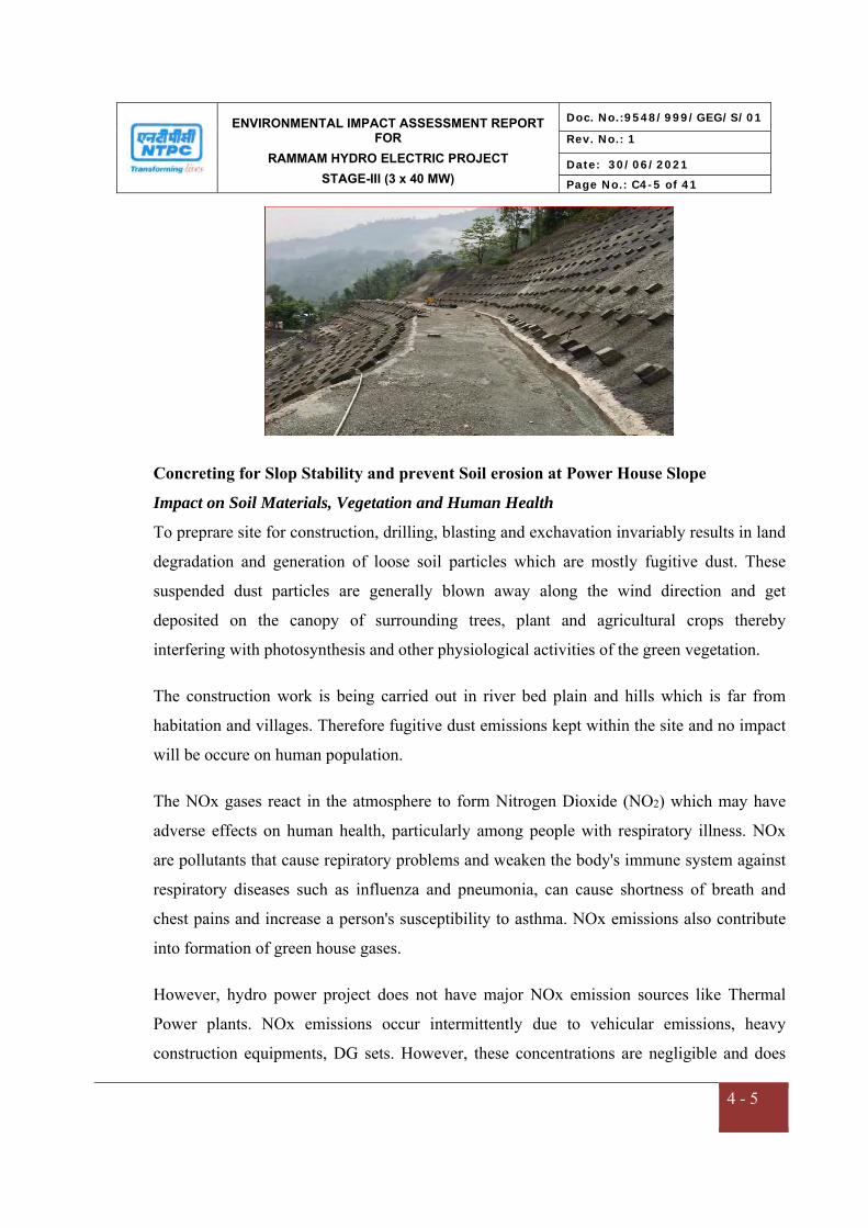
ENVIRONMENTAL IMPACT ASSESSMENT REPORT FOR
RAMMAM HYDRO ELECTRIC PROJECT
STAGE-III (3 x 40 MW)
Doc. No.:9548/999/GEG/S/01
Rev. No.: 1
Date: 30/06/2021
Page No.: C4-5 of 41
4 - 5
Concreting for Slop Stability and prevent Soil erosion at Power House Slope
Impact on Soil Materials, Vegetation and Human Health
To preprare site for construction, drilling, blasting and exchavation invariably results in land
degradation and generation of loose soil particles which are mostly fugitive dust. These
suspended dust particles are generally blown away along the wind direction and get
deposited on the canopy of surrounding trees, plant and agricultural crops thereby
interfering with photosynthesis and other physiological activities of the green vegetation.
The construction work is being carried out in river bed plain and hills which is far from
habitation and villages. Therefore fugitive dust emissions kept within the site and no impact
will be occure on human population.
The NOx gases react in the atmosphere to form Nitrogen Dioxide (NO2) which may have
adverse effects on human health, particularly among people with respiratory illness. NOx
are pollutants that cause repiratory problems and weaken the body's immune system against
respiratory diseases such as influenza and pneumonia, can cause shortness of breath and
chest pains and increase a person's susceptibility to asthma. NOx emissions also contribute
into formation of green house gases.
However, hydro power project does not have major NOx emission sources like Thermal
Power plants. NOx emissions occur intermittently due to vehicular emissions, heavy
construction equipments, DG sets. However, these concentrations are negligible and does

ENVIRONMENTAL IMPACT ASSESSMENT REPORT FOR
RAMMAM HYDRO ELECTRIC PROJECT
STAGE-III (3 x 40 MW)
Doc. No.:9548/999/GEG/S/01
Rev. No.: 1
Date: 30/06/2021
Page No.: C4-6 of 41
4 - 6
not have significant on ambient air quality. The ambient air quality at study are well below
the permissible limits of NAAQS, 2009.
Carbon monoxide (CO) is a product of incomplete combustion of fosil fuel (Diesel, Petrol,
Kerosin etc.) and it may cause impact on human health. Carbon monoxide can
badly affect the central nervous system and people with cardiovascular disease. Carbon
monoxide leaves the brain struggling for sufficient levels of oxygen and this in
turn affects the heart, brain and central nervous system. As the traffic density of trucks is
about 45-50 trucks/hour which is very low than road traffic at plain areas or cities. The study
area is remote and undeveloped area, therefore vehicular density is also low. Pollution levels
from equipments and machinery, vehicles will be regularly monitored. Therefore there
would be insignificant impacts due to low emissions of CO on helath of workers and nearby
population.
Muck disposal
About 0.99 Mm3 muck is expected to be generated as a result of tunneling operations,
construction of roads, etc. Based on the geological nature of the rocks and engineering
properties of the soil, a part of muck is utilized as construction material. The balance muck
is being disposed at designated dumping sites in a planned manner so that it takes a least
possible space and is not hazardous to the environment.
An area of 6.66 Ha has been earmarked which can cater the entire quantity of muck to be
disposed. About 0.148 Mm3 of aggregate is utilized for filling and construction works from
muck generated during excavation of underground works like HRT and desilting chamber.
A toe wall has been created around the muck disposal site and more landscaping to be done
in the muck site. The overall idea is to enhance/maintain aesthetic view in the surrounding
area of the project in post-construction period and avoid contamination of any land or water
resource due to muck disposal. The terraces of the muck disposal area ultimately covered
with fertile soil and suitable plants planted adopting suitable bio-technological measures.
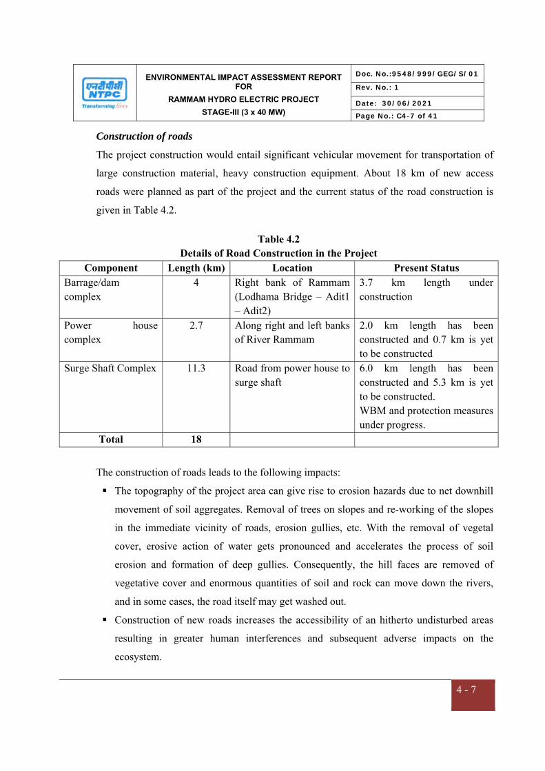
ENVIRONMENTAL IMPACT ASSESSMENT REPORT FOR
RAMMAM HYDRO ELECTRIC PROJECT
STAGE-III (3 x 40 MW)
Doc. No.:9548/999/GEG/S/01
Rev. No.: 1
Date: 30/06/2021
Page No.: C4-7 of 41
4 - 7
Construction of roads
The project construction would entail significant vehicular movement for transportation of
large construction material, heavy construction equipment. About 18 km of new access
roads were planned as part of the project and the current status of the road construction is
given in Table 4.2.
Table 4.2 Details of Road Construction in the Project
Component Length (km) Location Present Status Barrage/dam complex
4 Right bank of Rammam (Lodhama Bridge – Adit1 – Adit2)
3.7 km length under construction
Power house complex
2.7 Along right and left banks of River Rammam
2.0 km length has been constructed and 0.7 km is yet to be constructed
Surge Shaft Complex 11.3 Road from power house to surge shaft
6.0 km length has been constructed and 5.3 km is yet to be constructed. WBM and protection measures under progress.
Total 18
The construction of roads leads to the following impacts:
The topography of the project area can give rise to erosion hazards due to net downhill
movement of soil aggregates. Removal of trees on slopes and re-working of the slopes
in the immediate vicinity of roads, erosion gullies, etc. With the removal of vegetal
cover, erosive action of water gets pronounced and accelerates the process of soil
erosion and formation of deep gullies. Consequently, the hill faces are removed of
vegetative cover and enormous quantities of soil and rock can move down the rivers,
and in some cases, the road itself may get washed out.
Construction of new roads increases the accessibility of an hitherto undisturbed areas
resulting in greater human interferences and subsequent adverse impacts on the
ecosystem.
ENVIRONMENTAL IMPACT ASSESSMENT REPORT FOR
RAMMAM HYDRO ELECTRIC PROJECT
STAGE-III (3 x 40 MW)
Doc. No.:9548/999/GEG/S/01
Rev. No.: 1
Date: 30/06/2021
Page No.: C4-8 of 41
4 - 8
Increased air pollution during construction phase.
Postive impact on local population by increased accessibility from one bank of the
River Rammam to another.
The mitigation measures for above impact due to contruction of roads are provision of
appropriate drainage systems and water management structures, and promoted surface
protection and erosion control by using bioengineering methods. Retaining walls are most
important structures in hill road construction. To provide adequate stability to the roadway
and to the slope, retaining walls are being constructed on the valley side of the roadway. It is
also provided on the cut hill side to prevent land slide towards the roadway. Dry stone
masonry prefers to masonry in mortar as the former permits easy drainage of seeping water.
Impact on Micro-Climate
As the proposed project is Run of River (ROR) project, no large area would be submerged.
The barrage height is 23 m. In hydropower project major construction activities involve
blasting, drilling, surface excavation and concreting works at barrage site and excavation in
borrow areas. These activities shall not affect the ambient temperature, humidity, rainfall,
wind speed and direction and other meteorological parameters during construction.
Wind Speed: The wind speed in any area is dependent upon local topography and is
intimately connected with the development as high- and low-pressure zones. As the barrage
height is only 23 m and no high structure is proposed, hence it will not obstract in blow of
wind. Thus, no adverse impact on the regional wind speed is anticipated due to the
construction activities.
Temperature: No thermal process is involved in hydro power project. Although, Run of
River hydropower project involve cutting of tress at small scale which may cause a localized
temperature increase which shall be moderated by the trees in the green belt/afforstation
around the reservoir periphery. The impoundment of reservoir will also have slight colling

ENVIRONMENTAL IMPACT ASSESSMENT REPORT FOR
RAMMAM HYDRO ELECTRIC PROJECT
STAGE-III (3 x 40 MW)
Doc. No.:9548/999/GEG/S/01
Rev. No.: 1
Date: 30/06/2021
Page No.: C4-9 of 41
4 - 9
effect in the vicinity area. The temperature pattern is a regional behavior and is not likely to
be affected very much by the construction activity.
Humidity: The variation in relative humidity depends mainly on the rainfall, wind,
temperature and other weather phenomenon that are regional in behavior. The excavation
and concreting activities are not likely to have any impact on the relative humidity in the
surrounding area. However; the humidity in the area may slightly increase due to creation of
waterbody (reservoir).
Atmospheric Pressure : As the wind speed and direction will not change due to project,
there would be no change in atmospheric pressure in the area.
Rainfall: The trend of rainfall depends on a regional pattern and is mainly governed by the
south west monsoon and disturbances in the Arabian Sea. There are limited number of tree
felling which will be compensated by compensatory afforestation and plantation. The
construction activities, therefore, are not likely to have any adverse impacts on rainfall
pattern.
Acquisition of Land
The total land required for the project is 74.077 Ha of which 66.777 Ha is acquired in West
Bengal and the balance 7.3 Ha is acquired in Sikkim. Details of Land Acquisition for
Rammam HEP, Stage-III given in Table 4.3
Table 4.3 Details of land acquired
Description of Land Acquired Acres Hectares
Government Land 25.561 10.344 Private Land 152.725 61.806
Diverted Forest Land (ROU) 4.761 1.927 Total Land 183.047 74.077
ENVIRONMENTAL IMPACT ASSESSMENT REPORT FOR
RAMMAM HYDRO ELECTRIC PROJECT
STAGE-III (3 x 40 MW)
Doc. No.:9548/999/GEG/S/01
Rev. No.: 1
Date: 30/06/2021
Page No.: C4-10 of 41
4 - 10
Entire land for the project has been acquired and is in physical possession of NTPC. The
landuse has been permanently changed to industrial use due to construction of Barrage
Complex & Power House Complex including Approach Road, Muck Disposal Area, Storage
Facilities and Camps etc. The families who lost their land or homestead were provided with
adequate compensation etc. as per norms specified in National Policy on Resettlement and
Rehabilitation (2003) and R&R policy of NTPC (2005). One time settlement for R&R
package to affected PAPs has been agreed during VDAC meeting as per R&R policy. Total
of Rs. 3.58 Crores disbursed as per R&R policy till 31.03.2021.
4.3.2 Operation Phase
The operation phase, is likely to envisage impacts on the land use pattern due to diversion of
forest land for non – forest purposes i.e., for construction and widening of roads, installation
of surface components both upstream and downstream stretch of the river.
Diversion of Land/Change in Land Use Pattern
The project area lead to permanent change in the land use pattern. The total land
requirement for this project has been finalized to be 74.077 ha in which 1.927 ha is forest
land, 10.334 Ha is Government land and 61.806 ha is private land. The component wise
details of land use for Rammam Stage-III HEP is shown in Table 4.4 below
Table-4.4 Component Wise Detail of Land acquired for Rammam Stage-III HEPP
S. No. Components Area (ha) %
1 Barrage 8.50 11.47 2 Approach Roads 36.10 48.73 3 Tail Race Channel 8.130 10.97 4 Pen Stock and Surge Shaft 3.815 5.15 5 Power House 1.971 2.66 6 Township 8.903 12.0 7 Muck Disposal 6.661 8.99
Grand Total 74.076 100.00
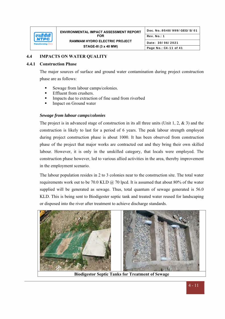
ENVIRONMENTAL IMPACT ASSESSMENT REPORT FOR
RAMMAM HYDRO ELECTRIC PROJECT
STAGE-III (3 x 40 MW)
Doc. No.:9548/999/GEG/S/01
Rev. No.: 1
Date: 30/06/2021
Page No.: C4-11 of 41
4 - 11
4.4 IMPACTS ON WATER QUALITY
4.4.1 Construction Phase
The major sources of surface and ground water contamination during project construction phase are as follows:
Sewage from labour camps/colonies. Effluent from crushers. Impacts due to extraction of fine sand from riverbed Impact on Ground water
Sewage from labour camps/colonies
The project is in advanced stage of construction in its all three units (Unit 1, 2, & 3) and the construction is likely to last for a period of 6 years. The peak labour strength employed during project construction phase is about 1000. It has been observed from construction phase of the project that major works are contracted out and they bring their own skilled labour. However, it is only in the unskilled category, that locals were employed. The construction phase however, led to various allied activities in the area, thereby improvement in the employment scenario.
The labour population resides in 2 to 3 colonies near to the construction site. The total water requirements work out to be 70.0 KLD @ 70 lpcd. It is assumed that about 80% of the water supplied will be generated as sewage. Thus, total quantum of sewage generated is 56.0 KLD. This is being sent to Biodigester septic tank and treated water reused for landscaping or disposed into the river after treatment to achieve discharge standards.
Biodigestor Septic Tanks for Treatment of Sewage
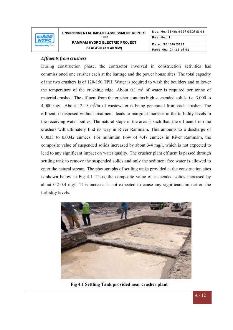
ENVIRONMENTAL IMPACT ASSESSMENT REPORT FOR
RAMMAM HYDRO ELECTRIC PROJECT
STAGE-III (3 x 40 MW)
Doc. No.:9548/999/GEG/S/01
Rev. No.: 1
Date: 30/06/2021
Page No.: C4-12 of 41
4 - 12
Effluents from crushers
During construction phase, the contractor involved in construction activities has
commissioned one crusher each at the barrage and the power house sites. The total capacity
of the two crushers is of 120-150 TPH. Water is required to wash the boulders and to lower
the temperature of the crushing edge. About 0.1 m3 of water is required per tonne of
material crushed. The effluent from the crusher contains high suspended solids, i.e. 3,000 to
4,000 mg/l. About 12-15 m3/hr of wastewater is being generated from each crusher. The
effluent, if disposed without treatment leads to marginal increase in the turbidity levels in
the receiving water bodies. The natural slope in the area is such that, the effluent from the
crushers will ultimately find its way in River Rammam. This amounts to a discharge of
0.0033 to 0.0042 cumecs. For minimum flow of 4.47 cumecs in River Rammam, the
composite value of suspended solids increased by about 3-4 mg/l, which is not expected to
lead to any significant impact on water quality. The crusher plant effluent is passed through
settling tank to remove the suspended solids and only the sediment free water is allowed to
enter the natural stream. The photographs of settling tanks provided at the construction sites
is shown below in Fig 4.1. Thus, the composite value of suspended solids increased by
about 0.2-0.4 mg/l. This increase is not expected to cause any significant impact on the
turbidity levels.
Fig 4.1 Settling Tank provided near crusher plant
ENVIRONMENTAL IMPACT ASSESSMENT REPORT FOR
RAMMAM HYDRO ELECTRIC PROJECT
STAGE-III (3 x 40 MW)
Doc. No.:9548/999/GEG/S/01
Rev. No.: 1
Date: 30/06/2021
Page No.: C4-13 of 41
4 - 13
Impacts due to extraction of fine sand from river bed
The aggregate required for the project is being met by crushed fine sand. The natural sand of
River Rammam is also being used. The extraction of large quantity of building material like
stones, pebbles, gravel and sand affected the river water quality by increasing the turbidity
levels. This is mainly because of the fact that during excavation of material from river, the
dredged material gets released during:
- excavation of material from the river bed
- loss of material during transport to the surface
- overflow from the dredger while loading
- loss of material from the dredger during transport.
The cumulative impact of the above is the increase in turbidity levels during dredging
operations. It has also been observed that slope collapse is the major factor in increasing the
turbidity levels. If the depth of cut is too high, there is slope collapse, which releases a
sediment cloud, which goes outside the suction radius of dredged head. In order to ensure
that this does not happen, the depth of cut should be restricted such that:
H/C < 5.5
where
- unit weight of the soil
H - depth of soil
C - cohesive strength of soil
The following measures are being taken care of during extraction of fine sand from river bed
Establish an absolute elevation below which no extraction may occur
Concentrate in-stream extraction activities to minimise area of disturbance
Maintain river channel flood discharge capacity
Minimise activities that release fine sediment to the river
Review of cumulative effects by monitoring program
ENVIRONMENTAL IMPACT ASSESSMENT REPORT FOR
RAMMAM HYDRO ELECTRIC PROJECT
STAGE-III (3 x 40 MW)
Doc. No.:9548/999/GEG/S/01
Rev. No.: 1
Date: 30/06/2021
Page No.: C4-14 of 41
4 - 14
Impact on Ground water
The ground water levels in the region could not be established, as is often the case in
mountainous terrain. Since the water usage is mainly from the river water for construction
purposes, no adverse impact on groundwater availability is expected. Dumping of wastes
also being undertaken at specified exposed surface locations only. The solid wastes being
disposed regularly through Nayabazar Jorethang Municipal Corporation (NJMC). Hence, no
negative effect is envisaged on the groundwater quality of the area.
4.4.2 Operation Phase
The major sources of water pollution during project operation phase include:
Domestic sewage from project colony
Impacts due to flooding and Heavy Rain
Operation and Maintenance of equipments and heavyVehicles
Sediments
Change in Hydraulic Regime and Downstream Flows
Domestic sewage from project colony
During project operation phase, only source of liquid waste is sewage generated from staff
colony and office premises. In the operation phase, about 50 memebers will reside in the
project colony. Considering the staff of CISF and support services, it is estimated that about
100 families will reside in the project township during operation phase. Since, only a small
number of O&M staff of about 50 employees will reside in the well designed colony with
sewage treatment plant and other infrastructure facilities, the problems of water pollution
due to disposal of sewage is minimum. About 45 to 50 KLD of sewage will be generated.
Considering the BOD level in the untreated sewage as 200 mg/l, the total BOD loading will
be order of 8 to 9 kg/day. The disposal of sewage without treatment may lead to adverse
impacts on the receiving water bodies or land. Thus, the sewage generated from the project
colony will be treated in Biodigestor septic tanks of total capacity 97 KL. Thus, the impact
as a result of disposal of sewage by staff involved in project operation phase is anticipated
of low significance.
ENVIRONMENTAL IMPACT ASSESSMENT REPORT FOR
RAMMAM HYDRO ELECTRIC PROJECT
STAGE-III (3 x 40 MW)
Doc. No.:9548/999/GEG/S/01
Rev. No.: 1
Date: 30/06/2021
Page No.: C4-15 of 41
4 - 15
Impacts due to flooding, Submergence and Heavy Rain
The flooding of previously forest and agricultural land in the submergence area will increase
the availability of nutrients resulting from decomposition of vegetative matter. In the
project, most of the land coming under water spread area is barren, with few patches of
trees.
Due to submergence, the major impacts will be on river regime and its existing land use will
be changed from river vally & green area to water body. However, the submergence area is
very small (3.852 Ha) only due to significantly small sized reservoir behind barrage. Due to
low tree density in the submergence area i.e. 290 per ha, will have insignificant impact on
local ecology. In view of above, the impact shall have no significance as well as magnitude.
The project is envisaged as a Run of River (ROR) scheme, with significant diurnal variations in water level. In such a scenario, significant re-aeration from natural atmosphere takes place, which maintains Dissolved Oxygen in the waterbody. Thus, in the project, no significant reduction in D.O. level in reservoir water is anticipated. In the operation phase of the project the water environment in general will not deteriorate as the water will be continuously used for power generation and will be released
simultaneously. For downstream usages of river course will have a minimum environmental flow of 1.0 cumec. The regular flushing operation of pond during monsoon shall not lead to the development of unwanted heaps / shoal in the flow section of the river bed which cause change in the river regime. The baseline study of water quality in respect of surface water and ground water has revealed that both are of good quality and the various water characteristics are within the tolerance limit as per IS: 10500 2012. The surface water meets the standards of drinking water quality. Therefore, seepage of good quality surface water from pond through rock acquirer shall least impair the obtaining quality of ground water. Operation and Maintenance of equipments and heavy Vehicles
There would be routine maitenenece of power equipments like transformers generators
motors & pumps which may involve leakage of oil and grease. Further, maitenence and

ENVIRONMENTAL IMPACT ASSESSMENT REPORT FOR
RAMMAM HYDRO ELECTRIC PROJECT
STAGE-III (3 x 40 MW)
Doc. No.:9548/999/GEG/S/01
Rev. No.: 1
Date: 30/06/2021
Page No.: C4-16 of 41
4 - 16
washing of the heavy vehocles involved generation of effluents.The effluents from these
activities will be suitably treated.
Sediments
When a river flows along a steep gradient, it could carry a significant amount of sediment
load, depending on the degradation status of the catchment. When a hydraulic structure is
built across the river, it creates a reservoir, which tends to accumulate the sediment, as the
suspended load settles down due to decrease in flow velocity. The project is envisaged as a
Run of River (ROR) scheme, with a barrage. At regular intervals, the gates of the barrage
shall be opened to flush out the sediments. Thus, in the project, sedimentation problems are
not anticipated. However, during rainy season sedimentation may occur from disposal area
which will be mitigate by constructing toe wall and plantation on slopes and surface.
Change in Hydraulic Regime and Downstream Flows
Rammam river, the natural boundary between the states of West Bengal and Sikkim, is a major tributary of the Ranjit river which rises from the Mane Bhanjan - Tongbu - Phalut ridge of the lower Himalayas at an elevation of about 3631 m. Kali Khola, Shiri Khola, Lodhama khola, Jhepi Khola and Riyang Khola are the main tributaries of Rammam. Initially, Rammam flows along W-E direction for about 6 km upto the confluence with its tributary Kali Khola at EL. 2448 m. Further, its course changes towards N-S direction upto confluence with Shiri Khola at EL. 1542 after traversing 18 km from origin, where Stage-I of Rammam H.E scheme is located. The slope of the river is moderate in this stretch (1 in 11.25). Further downstream, river confluences with its tributary Lodhama Khola at EL. 900m where the power house of Stage-II of the Rammam H.E scheme is located. The tributaries Jhepi Khola and Riyang Khola join the river at about 2.5 km and 6.5 km downstream of confluence point of Lodhama Khola respectively. At an elevation of 700 m, the river takes an 'S' bend at 1.5km downstream of diversion structure of stage-III. The meandering course between the diversion weir and the proposed power house of Stage-III project is about 26 km and the average gradient is about 1 in 26. The river flows in westerly direction up to confluence with Rangit river at an elevation of 305 m. There is considerable

ENVIRONMENTAL IMPACT ASSESSMENT REPORT FOR
RAMMAM HYDRO ELECTRIC PROJECT
STAGE-III (3 x 40 MW)
Doc. No.:9548/999/GEG/S/01
Rev. No.: 1
Date: 30/06/2021
Page No.: C4-17 of 41
4 - 17
snowfed region in the catchment area of Rammam river in its upper reaches. A significant portion of the catchment area is covered with dense forest. Rammam river has a length of about 42 km from its source in Phalut to its confluence point
with Rangit river at Naya Bazar. There are four hydroelectric projects located on the river:
Rammam Stage-I HEP (Under Development)
Rammam Intermediate HEP (Under Development)
Rammam Stage-II HEP (Under Operation)
Rammam Stage-III HEP (Under Construction)
The biggest impact of hydro power projects on hydrologic regime is on account of change in the free flowing condition of the river. With the construction of the proposed hydroelectric projects, the free flowing river in Rammam shall be available on an intermittent basis only for a length of 10.3 Km in a stretch of 31.6 km in River Rammam. The details are as presented in Table- 4.5 and Figure 4.2.
Table 4.5: Free Flowing Stretch of Rammam River
S. No.
Project Length of Free Flow of River
(km) 1 TWL of Rammam-I HEP & FRL of Rammam Intermediate HEP 1.0 2 TWL of Rammam Intermediate HEP and Trench Weir of
Rammam-II HEP 1.0
3 TWL of Rammam-II HEP & FRL of Rammam-III HEP 1.60 4 TWL of Rammam-III to confluence with Great Rangit River 6.70
The current norms of Ministry of Environment Forest and Climate Change are that atleast 1 km free river stretch should be available between TWL of upstream and FRL of downstream hydroelectric projects. These norms are followed in all the hydroelectric projects in the study area. Further, during operation phase, the minimum flow based on average lean weather flow that will be maintained in the river will be 1.0 cumecs downstream of barrage for meeting ecological flow requirement. Therefore, the downstream flow after implementation of the project is not likely to have any significant adverse impact.
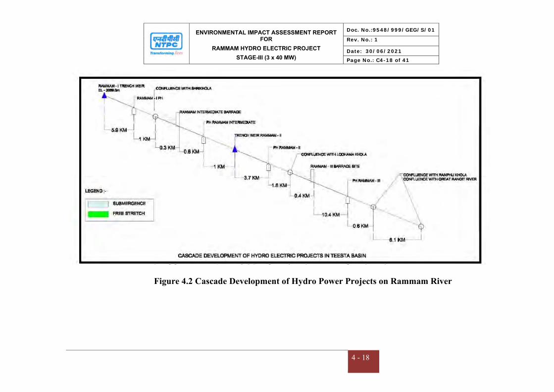
ENVIRONMENTAL IMPACT ASSESSMENT REPORT FOR
RAMMAM HYDRO ELECTRIC PROJECT
STAGE-III (3 x 40 MW)
Doc. No.:9548/999/GEG/S/01
Rev. No.: 1
Date: 30/06/2021
Page No.: C4-18 of 41
4 - 18
Figure 4.2 Cascade Development of Hydro Power Projects on Rammam River
ENVIRONMENTAL IMPACT ASSESSMENT REPORT FOR
RAMMAM HYDRO ELECTRIC PROJECT
STAGE-III (3 x 40 MW)
Doc. No.:9548/999/GEG/S/01
Rev. No.: 1
Date: 30/06/2021
Page No.: C4-19 of 41
4 - 19
4.5 IMPACTS ON AIR ENVIRONMENT
4.5.1 Construction Phase
In this project, air pollution occurs mainly during the project construction phase.
Considerable amount of air pollution during different stages of construction of diversion
structure, dam, power house, approach roads, etc. is identified. Suspended Particulate Matter
(SPM) is the main pollutant during construction. The major sources of air pollution during
construction phase are:
Pollution due to fuel combustion in various construction equipment
Fugitive emissions from crushers
Blasting Operations
Emissions from DG sets
Impacts due to vehicular movement
Impact due to Muck disposal
Pollution due to fuel combustion in various construction equipment
The lists of major equipment being used during construction phase are:
Dozer Dumpers Loaders Transit mixers Drill jumbos Rock bolting machine Compressors Drilling machines DG sets Batching plant Crushers, screening plant and rod mill
Air Pollution due to fuel combustion by above mentioned construction machinery and
equipment is minimum and short-term. Various construction machinery and equipment
consume fuel, normally diesel during their running / operation. Routine preventive
ENVIRONMENTAL IMPACT ASSESSMENT REPORT FOR
RAMMAM HYDRO ELECTRIC PROJECT
STAGE-III (3 x 40 MW)
Doc. No.:9548/999/GEG/S/01
Rev. No.: 1
Date: 30/06/2021
Page No.: C4-20 of 41
4 - 20
maintenance of construction machinery and equipment will be done to comply with
vehicular emission norms.
Based on past experience in similar projects, the increase in PM10, PM2.5, SO2 and NOx is
not expected to increase significantly due to combustion of fuel in construction equipment.
In the project, no significant impact on ambient air quality is expected as a result of
operation of various construction equipment.
Fugitive emissions from crushers
For the utilization of the river borne material for construction purposes one crusher each at
the barrage and the power house sites were installed. The total capacity of the two crushers
is of 120-150 TPH whose operation is likely to generate fugitive emissions. During crushing
operations, fugitive emissions comprising of the suspended particulate was identified.
Regular mist spray to contain the fugitive emissions from crushing operations is being
followed. During finalising the project layout, it was ensured that the labour camps,
colonies, etc. are located on the leeward side and outside the impact zone (about 0.8 to 1.0
km) of the crushers. Further water sprinkling is being resorted to at necessary places to
suppress the dust.
Blasting Operations
Blasting will result in vibration, which shall propagate through the rocks to various degrees
and causes loosening of rocks/boulders. CIMFR (Central Institute of Mining and Fuel
Research) has been engaged by both the Major Civil Contractors for design of blast pattern
and monitoring of tunnelling works. Geological Survey of India (GSI), is also associated
with NTPC, Rammam, vide MoU dated 8th Feb’ 2015, for supervision and advice on
tunnelling/ road construction and/ or any other vulnerable area of construction. During
tunneling operations, dust will be generated during blasting. ID blowers provided with dust
handling system to capture and generated dust. The dust will settle on vegetation, in the
predominant down wind direction. Appropriate control measures have been recommended
to minimize the adverse impacts on this account.

ENVIRONMENTAL IMPACT ASSESSMENT REPORT FOR
RAMMAM HYDRO ELECTRIC PROJECT
STAGE-III (3 x 40 MW)
Doc. No.:9548/999/GEG/S/01
Rev. No.: 1
Date: 30/06/2021
Page No.: C4-21 of 41
4 - 21
Emissions from DG sets
It has been observed that 250 kVA silent DG set is being operated during emergency
situation. The emissions from the DG set include Particulate Matter (PM), Carbon
Monoxide (CO), Oxides of Nitirogen (NOx) and unburnt Hydrocarbons (HC). The emission
limits for DG sets as per notification GSR 232 (E) dated 31.03.2014 and GSR (E) dated
07.03.2016 are presented in Table 4.6 below.
Table 4.6 Emissions Limits for DG sets
Power Category Emission Limits (g/kWh) Smoke Limit (Light absorption co-
efficient per meter) NOx + THC or NOx
+ NMHC or RHC CO PM
Up to 19 kW ≤ 7.5 ≤ 3.5 ≤ 0.3 ≤ 0.7 More than 19 kW up to 75 kW
≤ 4.7 ≤ 3.5 ≤ 0.3 ≤ 0.7
More than 75 kW up to 800 kW
≤ 4.0 ≤ 3.5 ≤ 0.2 ≤ 0.7
proper maitennece of DG set with regular monitoring of emissions from DG set shall be
carried out to achieve emission norms.
Impacts due to vehicular movement
Presently the vehicular movement for transportation of various construction materials and
equipment at the project site is maximum of 45-50 trucks/hour. The current number of
vehicles is not of the magnitude so as to cause adverse impacts on ambient air quality.
The vehicular movement leads to generation of dust. However, such ground level emissions
do not travel for long distances, and their effect is limited to a distance of about 100 m from
the point of their origin. Similarly, marginal increase in Hydrocarbons, SO2 and NOx levels
are anticipated for a short duration. Thus, no major adverse impacts are anticipated on this
account. Ambient air quality levels in study area are well within the permissible limits of
NAAQS 2009. It indicates that there is no significant impact on ambient air quality due to
fuel combustion in equipment and vehicles. However, regular maintenance of vehicles,

ENVIRONMENTAL IMPACT ASSESSMENT REPORT FOR
RAMMAM HYDRO ELECTRIC PROJECT
STAGE-III (3 x 40 MW)
Doc. No.:9548/999/GEG/S/01
Rev. No.: 1
Date: 30/06/2021
Page No.: C4-22 of 41
4 - 22
sprinkling of water where construction activities are prevalent, providing subsequent
vegetation etc. would greatly reduce such impacts.
The following mitigative measures are being followed during transportation activities
Transport trucks/tippers is being properly maintained.
Only PUC certificate issued vehicles are being used.
Avoiding of overloading of trucks beyond stipulated capacity by installing weigh
bridges.
Strict compliance of traffic rules and regulations
4.5.2 Operation Phase
The results of ambient air quality monitoring baseline data for the period July 2020 to Sept
2020 shows that the parameters PM10, PM2.5, SO2 and NOx are well within the standards
prescribed by NAAQS, 2009 as shown in Table 4.7
Table 4.7
Summary of Ambient Air Quality Monitoring
S.No. Parameter Range (µg/m3) Standard (µg/m3) 1. PM10 29.0-66.9 100 2. PM2.5 8.1-33.0 60 3. SO2 6.8-13.1 80 4. NOx 7.2-14.6 80
Since the project is a Run of River (ROR) scheme and does not involve major air emissions
during operation phase, therefore, it will have insignificant impact on the air quality of the
region.
4.6 IMPACTS ON NOISE ENVIRONMENT
4.6.1 Construction Phase
In a water resource project, the impacts on ambient noise levels are expected only during the
project construction phase, due to earth moving machinery, etc. Likewise, noise due to
excavation, blasting, vehicular movement will have some adverse impact on the ambient
noise levels in the area. Various likely impacts considered include:
Impacts due to operation of various construction machinery and equipment

ENVIRONMENTAL IMPACT ASSESSMENT REPORT FOR
RAMMAM HYDRO ELECTRIC PROJECT
STAGE-III (3 x 40 MW)
Doc. No.:9548/999/GEG/S/01
Rev. No.: 1
Date: 30/06/2021
Page No.: C4-23 of 41
4 - 23
Impacts due to increased vehicular movement
Noise generated due to drilling
Noise generated due to blasting
Impacts due to ground vibrations
Impacts on labour
Impacts due to operation of various construction machinery and equipment
The noise is generated during project construction by various operating heavy machinery &
equipments like pumps, air compressors, DG sets, drilling machines, dumpers etc. The areas
likely to be affected will be in the vicinity of main project components. Generally, the noise
levels due to operation of various construction machinery and equipment is given in Table
4.8.
Table 4.8
Noise level due to operation of various construction equipment
Equipment Noise level (dB(A)) Compressors 75-85 Cranes 82-85 DG Sets 72-82 Concrete placers 70-80 Batching plant 75-85 Pneumatically operated monkers 70-80 Drilling machines 85-95 Grouting, guniting, equipment 80-90 Crushers 68-70 Pumps 68-70 Vibrators 69-81 Saws 74-81
As seen from the above table, construction machinery & equipment produce noise levels in
the range 68-90 dB (A) from noise source as per CPCB. Under the worst case scenario,
considered for prediction of noise levels during construction phase, it has been assumed that
all these equipment generate noise from a common point. The crusher within the project
area shall be housed in a shed to contain noise. Screening activities shall generate average

ENVIRONMENTAL IMPACT ASSESSMENT REPORT FOR
RAMMAM HYDRO ELECTRIC PROJECT
STAGE-III (3 x 40 MW)
Doc. No.:9548/999/GEG/S/01
Rev. No.: 1
Date: 30/06/2021
Page No.: C4-24 of 41
4 - 24
noise level of about 90 dB (A). Workers in the noise generating zone will be provided with
earmuffs/earplugs besides dust mask.
Walls of various houses or other structure will attenuate at least 30 dB(A) of noise. In
addition there is noise attenuation due to the following factors.
Air absorption
Rain
Atmospheric inhomogeneties.
Vegetal cover
Thus, no increase in noise levels are anticipated as a result of various activities, during the
project construction phase due to the following:
assumption that all equipment are operating from a common point leads to over-
estimation of increase in noise level
attenuation of 30 dB(A) of noise by wall of any structure
noise attenuation due to various factors.
Impacts due to increased vehicular movement
During construction phase, there is significant increase in vehicular movement for
transportation of construction material. At present, the vehicular movement is maximum of
45 to 50 trucks/hour. As a part of EIA study, impact on noise level due to increased
vehicular movement was studied using Federal Highway Administration model. The results
of modelling are outlined in Table 4.9.
Table 4.9 Increase in noise levels due to increased vehicular movement
Distance (m) Ambient noise level dB(A)
Noise levels due to increased vehicular movement dB(A)
Increase in ambient noise level due to increased
vehicular movement dB(A) 10 42.6 70.6 28 20 43.8 66.8 23 50 47.6 68.6 21
100 40 56 16

ENVIRONMENTAL IMPACT ASSESSMENT REPORT FOR
RAMMAM HYDRO ELECTRIC PROJECT
STAGE-III (3 x 40 MW)
Doc. No.:9548/999/GEG/S/01
Rev. No.: 1
Date: 30/06/2021
Page No.: C4-25 of 41
4 - 25
Distance (m) Ambient noise level dB(A)
Noise levels due to increased vehicular movement dB(A)
Increase in ambient noise level due to increased
vehicular movement dB(A) 200 39 51 12 500 42 49 7
1000 40 44 4
As mentioned earlier, there will be significant attenuation due to various factors, e.g.
absorption by construction material, air absorption, atmospheric inhomogeneties, vegetal
cover. The vehicle movement is restricted to day time to reduce the impact of noise
pollution on surrounding environment. Thus, no significant impact on this account is
anticipated.
Noise generated due to drilling
The noise levels monitored at a 10 m distance from the source and operator’s cabin is given
in Table 4.10.
Table 4.10 Noise generated due to drilling
Equipment Noise level at source dB(A) Standing idle (inside cabin) 70-72 Standing idle (10 m radius) 72-74 On load (inside cabin) 78-80 On load (10 m radius) 82-84
The noise levels during various construction activities have been compared to various
standards prescribed by Occupational Safety and Health Administration (OSHA), which are
being implemented in our country through rules framed under Factories Act. It can be
observed (Refer Table 4.12) that for an 8 hour duration, equivalent noise level exposure
should be less than 90 dB(A).
The Director General of Mines Safety in its circular no. DG(Tech)/18 of 1975, has
prescribed the noise level in mining operations for workers in 8 hour shift period with
unprotected ear as 90 dB(A) or less. Similar norms can be considered for construction phase
of the project as well. The workers who are expected to be exposed to noise levels greater

ENVIRONMENTAL IMPACT ASSESSMENT REPORT FOR
RAMMAM HYDRO ELECTRIC PROJECT
STAGE-III (3 x 40 MW)
Doc. No.:9548/999/GEG/S/01
Rev. No.: 1
Date: 30/06/2021
Page No.: C4-26 of 41
4 - 26
than 90 dB(A), should not work in these areas beyond 6 to 8 hours. In addition, they also
need to be provided with ear plugs. Thus, increased noise levels due to drilling are not
expected to adversely affect the workers operating the drill or involved in other mining
activities closely.
Noise generated due to blasting
Noise generated by blasting is instantaneous, site specific and depends on type, quantity of
explosives, dimension of drill hole, degree of compaction of explosives in the hole and rock.
Noise levels generated due to blasting have been monitored at various sites and the results
have been summarized in Table 4.11.
Table 4.11 Noise generation due to blasting
No. of holes Total charge (kg)
Maximum charge/delay (kg)
Distance (m) Noise level dB(A)
15 1500 100 250 76-85 17 1700 100 250 76-86 18 1800 100 250 74-85 19 1900 100 400 70-75 20 2000 100 100 76-80
At the blast site with the given diameter of holes and their pattern, the noise levels are
expected to be in the range of 120-130 dB (A) and tend to decrease with increase in distance
of receptor. It can be observed from Table 4.11, that noise level due to blasting operations
are expected to be of the order of 75-86 dB(A) at a distance of 250 m. The baseline noise
level monitoring shows that the ambient noise levels in the area during day time ranged
from 50.8-62.5 dB(A) and night time noise level ranged from 42.6 to 55.6 dB(A). Since, the
nearest settlement is about 0.8 to 1.0 km away, the incremental noise due to blasting is
expected to be 40-50 dB(A). As the blasting is likely to last for 4 to 5 seconds depending on
the charge, noise levels over this time would be instantaneous and short in duration.
Considering attenuation due to various sources, even the instantaneous increase in noise
level is not expected to 70 dB(A). Hence, noise level due to blasting is not expected to cause
any significant adverse impact.
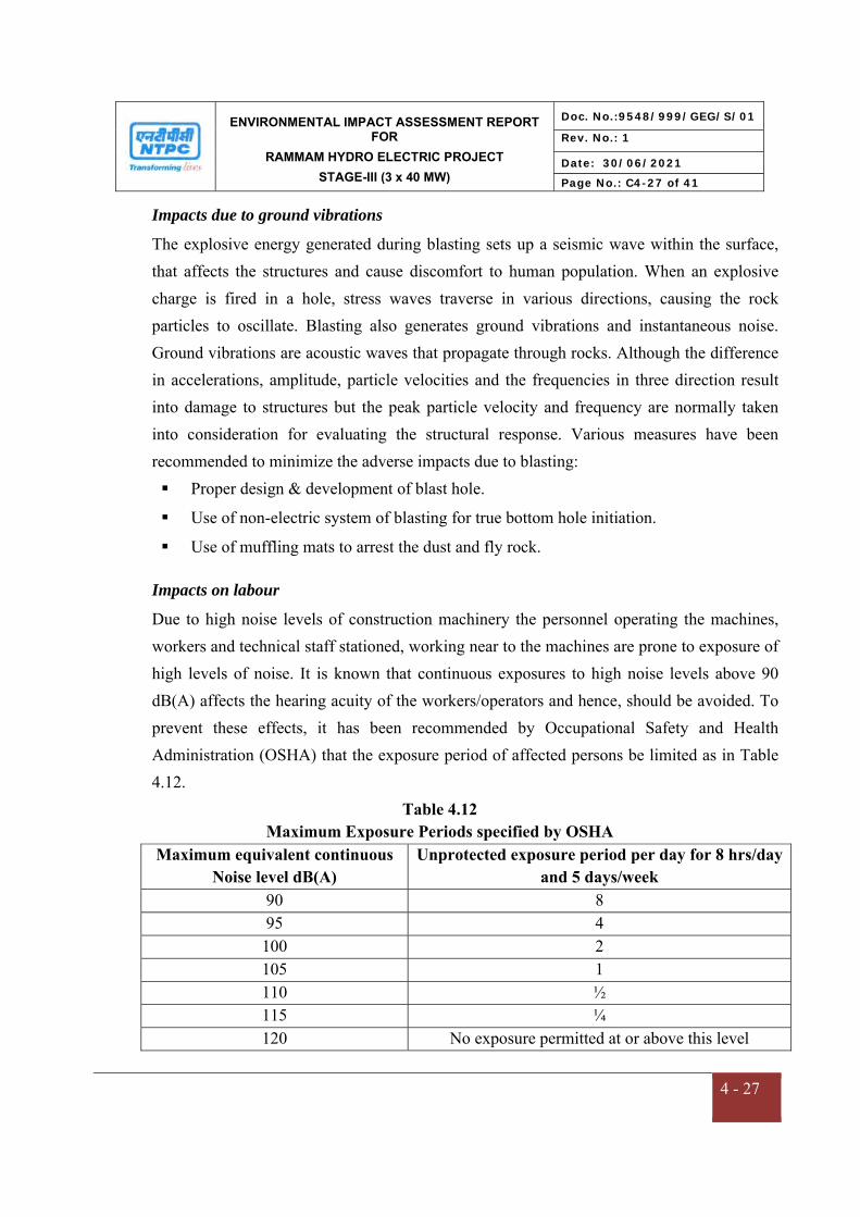
ENVIRONMENTAL IMPACT ASSESSMENT REPORT FOR
RAMMAM HYDRO ELECTRIC PROJECT
STAGE-III (3 x 40 MW)
Doc. No.:9548/999/GEG/S/01
Rev. No.: 1
Date: 30/06/2021
Page No.: C4-27 of 41
4 - 27
Impacts due to ground vibrations
The explosive energy generated during blasting sets up a seismic wave within the surface, that affects the structures and cause discomfort to human population. When an explosive charge is fired in a hole, stress waves traverse in various directions, causing the rock particles to oscillate. Blasting also generates ground vibrations and instantaneous noise. Ground vibrations are acoustic waves that propagate through rocks. Although the difference in accelerations, amplitude, particle velocities and the frequencies in three direction result into damage to structures but the peak particle velocity and frequency are normally taken into consideration for evaluating the structural response. Various measures have been recommended to minimize the adverse impacts due to blasting: Proper design & development of blast hole.
Use of non-electric system of blasting for true bottom hole initiation.
Use of muffling mats to arrest the dust and fly rock.
Impacts on labour
Due to high noise levels of construction machinery the personnel operating the machines, workers and technical staff stationed, working near to the machines are prone to exposure of high levels of noise. It is known that continuous exposures to high noise levels above 90 dB(A) affects the hearing acuity of the workers/operators and hence, should be avoided. To prevent these effects, it has been recommended by Occupational Safety and Health Administration (OSHA) that the exposure period of affected persons be limited as in Table 4.12.
Table 4.12 Maximum Exposure Periods specified by OSHA
Maximum equivalent continuous Noise level dB(A)
Unprotected exposure period per day for 8 hrs/day and 5 days/week
90 8 95 4 100 2 105 1 110 ½ 115 ¼ 120 No exposure permitted at or above this level

ENVIRONMENTAL IMPACT ASSESSMENT REPORT FOR
RAMMAM HYDRO ELECTRIC PROJECT
STAGE-III (3 x 40 MW)
Doc. No.:9548/999/GEG/S/01
Rev. No.: 1
Date: 30/06/2021
Page No.: C4-28 of 41
4 - 28
4.7 IMPACTS ON ECOLOGY
The impacts on the biodiversity of the area will be very low as it is "Run-of- River" (ROR)
scheme. The ecological setup in the project affected stretch between barrage, HRT and TRT
site is of concern.
4.7.1 Terrestrial Ecology
Increased Human Interferences
The direct impact of construction activity of any water resource project in a Himalayan
terrain is generally limited in the vicinity of the construction sites only. As mentioned
earlier, a large population (about 1000) including technical staff, workers and other group of
people are engaged during the project construction phase. It can be assumed that the
technical staff will be of higher economic status and will live in a more urbanized habitat,
and will not use wood as fuel, if adequate alternate sources of fuel are provided. Around 200
labours are local residents. To minimize this impact, LPG gas is being used for officers &
staff engaged in the construction work. Adequate fuel for labour camp (30 LPG cylinders,
Kerosene & fire wood) is provided by the contractor. Also, fuel depot at Jorethang (South
Sikkim) is available within accessible reach from site.
The other major impact on the flora in and around the project area is due to increased level
of human interferences. The workers may also cut trees to meet their requirements for
construction of houses, furniture. Normally in such situations, lot of indiscriminate tree
felling or wastage of wood is also observed, especially in remote or inaccessible areas. Thus,
proper measures are being undertaken, so as to avoid any significant adverse impacts on
terrestrial flora.
Acquisition of forest land
The project requires 74.077 ha of the land for project related activities of which about 1.927
ha is the forest land which has been diverted. The details of land required for various project
appurtenances are listed in Table 4.4.
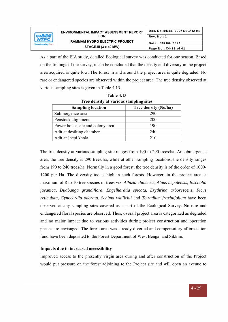
ENVIRONMENTAL IMPACT ASSESSMENT REPORT FOR
RAMMAM HYDRO ELECTRIC PROJECT
STAGE-III (3 x 40 MW)
Doc. No.:9548/999/GEG/S/01
Rev. No.: 1
Date: 30/06/2021
Page No.: C4-29 of 41
4 - 29
As a part of the EIA study, detailed Ecological survey was conducted for one season. Based
on the findings of the survey, it can be concluded that the density and diversity in the project
area acquired is quite low. The forest in and around the project area is quite degraded. No
rare or endangered species are observed within the project area. The tree density observed at
various sampling sites is given in Table 4.13.
Table 4.13 Tree density at various sampling sites
Sampling location Tree density (No/ha) Submergence area 290 Penstock alignment 200 Power house site and colony area 190 Adit at desilting chamber 240 Adit at Jhepi khola 210
The tree density at various sampling site ranges from 190 to 290 trees/ha. At submergence
area, the tree density is 290 trees/ha, while at other sampling locations, the density ranges
from 190 to 240 trees/ha. Normally in a good forest, the tree density is of the order of 1000-
1200 per Ha. The diversity too is high in such forests. However, in the project area, a
maximum of 8 to 10 tree species of trees viz. Albizia chinensis, Alnus nepalensis, Bischofia
javanica, Duabanga grandiflora, Engelhardtia spicata, Erythrina arborescens, Ficus
reticulata, Gynocardia odorata, Schima wallichii and Tetradium fraxinifolium have been
observed at any sampling sites covered as a part of the Ecological Survey. No rare and
endangered floral species are observed. Thus, overall project area is categorized as degraded
and no major impact due to various activities during project construction and operation
phases are envisaged. The forest area was already diverted and compensatory afforestation
fund have been deposited to the Forest Department of West Bengal and Sikkim.
Impacts due to increased accessibility
Improved access to the presently virgin area during and after construction of the Project
would put pressure on the forest adjoining to the Project site and will open an avenue to

ENVIRONMENTAL IMPACT ASSESSMENT REPORT FOR
RAMMAM HYDRO ELECTRIC PROJECT
STAGE-III (3 x 40 MW)
Doc. No.:9548/999/GEG/S/01
Rev. No.: 1
Date: 30/06/2021
Page No.: C4-30 of 41
4 - 30
encroachers for illegally entering in to the forests which may lead to degradation of nearby
forests, if not managed properly.
The project area is located at a distance of about 9 km from nearest boundary of Singalila
National Park and about 4.4 km from the Barsey Rhododendron Sanctuary, West Sikkim.
None of the components of the project are situated within the National Park. Thus, no
impact is expected on the National Park. However, Wildlife Conservation Plan has been
prepared and will be submitted to state forest department for implementation. The details of
measures to improve the terrestrial ecology of the area are covered in Chapter 10
Environmental Management Plan (EMP).
Disturbance to Wildlife
During construction phase, large number of machinery and construction labour was
mobilized. The operation of these construction equipment, and blasting generates noise
which lead to some disturbance to wildlife population. From the available data, the area
does not have significant wildlife population. Likewise, siting of construction equipment,
godowns, stores, labour camps, etc. lead to adverse impacts on fauna, in the area. Likewise,
area does not appear to be on the migratory routes of any animals and therefore the
construction of the project is not being affected the wildlife.
Based on field observations and interactions with locals, etc. it was found that no major
fauna is observed in the project area. The forests in the area are quite degraded (tree density
190-290 trees/ha). Normally, in such conditions, human interferences are generally high,
leading to large scale tree falling. As a result, major wildlife species is not reported in such
areas. Thus, impact on terrestrial fauna is not expected to be significant. Stray animals,
however, may some times drift to the construction site. It should be ensured through
stringent anti-poaching surveillance that the stray animals are not killed.

ENVIRONMENTAL IMPACT ASSESSMENT REPORT FOR
RAMMAM HYDRO ELECTRIC PROJECT
STAGE-III (3 x 40 MW)
Doc. No.:9548/999/GEG/S/01
Rev. No.: 1
Date: 30/06/2021
Page No.: C4-31 of 41
4 - 31
National Park and Wildlife Sanctuary
None of the project components are located within National Parks, Wildlife Sanctuary or
other protected area or within the notified Eco sensitive zones of these protected area. As
confirmed by CCF (WL), West Bengal vide letter dated 01.02.2008 copy attached as
Annexure-XIV, the project area is at a distance of about 7.1 km from the nearest boundary
of Eco-sensitive Zone of Singalila National Park. However, the Singalila National Park is
about 9.0 km from the project components as notified by MOEF&CC notification No. S.O.
3613 (E) dated 16.11.2017 (copy enclosed as Annexure-XV). The Eco Sensitive Zone of
Barsey Rhododendron Sanctuary is at 4.2 km from the project site and 4.4 km away from
boundary of Barsey Rhododendron Sanctuary, West Sikkim notified by MOEF&CC
notification No.S.O.2172 (E) dated 27.08.2014 (copy enclosed as Annexure-XVI) and about
10 km from the nearest boundary of the reserve forest area of Darjeeling Territorial Forest
Division.
Project components are outside the Eco Sensitive Zone of Barsey Rhododendron Wildlife
Sanctuary of Sikkim. The officals from Forest/wildlife department have visted site on
05/04/2021 to certify the that the no project component falls within boundary of any
National Nark and Wild life Sanctuary.
4.7.2 Aquatic Ecology
Construction Phase
The construction of the Rammam Stage-III HEPP involves large scale extraction of different
types of construction material from the river bed including boulders, stones, gravel, sand,
etc. Extraction of gravel and sand causes considerable damage to fish stocks and other
aquatic life by destabilizing the sub-stratum, increasing the turbidity of water, silting of the
channel bottom and modifying the flow which in turn may result in erosion of the river
channel. These alterations upset the composition and balance of aquatic ecosystem. The
material at the river sub-stratum like stones and pebbles often provide anchorage and home
to the invertebrates who remain attached in a fast flowing streams. During fish spawning
season, fertilized eggs are laid amidst the gravel, where it is made sure, that eggs are not
ENVIRONMENTAL IMPACT ASSESSMENT REPORT FOR
RAMMAM HYDRO ELECTRIC PROJECT
STAGE-III (3 x 40 MW)
Doc. No.:9548/999/GEG/S/01
Rev. No.: 1
Date: 30/06/2021
Page No.: C4-32 of 41
4 - 32
washed away in fast flowing stream. The eggs of almost all species are sticky in nature
which provide additional safety. The turbidity in excess of 100 ppm brought by suspended
solids chokes the gills of young fish.
During construction of a river valley project, huge quantity of debris is generated at various
construction sites. The debris, if a separate area for dumping of the material is not marked,
invariably would flow down the river during heavy precipitation. Such a condition adversely
affects the development of aquatic life. AT Rammam HEPP, muck is being disposed at
designated dumping sites so that it takes a least possible space and is not hazardous to the
environment. A toe wall has been created around the muck disposal site and landscaping to
be done in the muck site.
Impacts due to excavation of construction material from river bed
The excavation of construction material is likely to affect the survival and propagation of
micro-benthic organisms. The macro-benthic life which remains attached to the stones,
boulders etc. gets dislodged and is carried away downstream by turbulent flow. The areas
from where construction material is excavated, benthic flora and fauna gets destroyed. In
due course of time, however, the area gets recolonized. The density and diversity of benthic
flora and fauna, is however, much lesser as compared to the pre-dredging levels.
Impacts due to discharge of sewage from labour camp/colony
During construction phase wastewater mostly from domestic source will be discharged from
various camps of workers actively engaged in the project area. Around 70 KLD of water is
required for the workers during the peak construction phase out of which 80% (i.e. about 56
KLD) will be discharged back to the river as wastes, more or less as a point sources from
various congregation sites where workers will reside. Due to perennial nature of River
Rammam sufficient water for dilution is available to keep the DO of the river to
significantly high levels. Therefore there would be no significant impact envisaged due to
discharge of treated sewage.

ENVIRONMENTAL IMPACT ASSESSMENT REPORT FOR
RAMMAM HYDRO ELECTRIC PROJECT
STAGE-III (3 x 40 MW)
Doc. No.:9548/999/GEG/S/01
Rev. No.: 1
Date: 30/06/2021
Page No.: C4-33 of 41
4 - 33
Impacts due to increased human activities
The increase of human activities in the project area, results in enhancement in indiscriminate
fishing, which can adversely affect the riverine ecology. Indiscriminate fishing will reduce
fish stock availability for commercial and sport fishermen. Thus, it is recommended that
adequate surveillance measures are implemented during project construction phase to
ameliorate such impacts.
Operation Phase
The completion of Rammam Stage-III HEP would bring about significant changes in the
riverine ecology, as the river transforms from a fast-flowing water system to a quiescent
lacustrine environment. Such an alteration of the habitat would bring changes in physical,
chemical and biotic life. Amongst the biotic communities, certain species can survive the
transitional phase and can adapt to the changed riverine habitat. There are other species
amongst the biotic communities, which, however, for varied reasons related to feeding and
reproductive characteristics cannot acclimatize to the changed environment, and may
disappear in the early years of impoundment of water. The micro-biotic organisms
especially diatoms, blue-green and green algae before the operation of project, have their
habitats beneath boulders, stones, fallen logs along the river, where depth is such that light
penetration can take place. But with the damming of river, these organisms may perish as a
result of increase in depth. Amongst the aquatic animals, it is the fish life which would be
most affected. The migratory route of fish species, like Mahaseer and snow trout is likely to
be affected due to the construction of the project.
With the completion of project, and diversion of flow for hydropower generation, following
changes are expected
- reduced flow rate
- increase in water temperature
- reduction in availability of stano-thermal aquatic animals
- increase in population of euro-thermal species.

ENVIRONMENTAL IMPACT ASSESSMENT REPORT FOR
RAMMAM HYDRO ELECTRIC PROJECT
STAGE-III (3 x 40 MW)
Doc. No.:9548/999/GEG/S/01
Rev. No.: 1
Date: 30/06/2021
Page No.: C4-34 of 41
4 - 34
Unless the desired flow is maintained downstream of the barrage/dam, aquatic ecology in
general and fisheries in particular would be affected. Mahaseer (Schizothorax sp.) is
reported in River Rammam which may not be able to cross the barrage/dam for breeding.
The implementation of fish management plan including construction of a hatchery has been
taken up with fisheries department, Govt. of West Bengal as well as with the Fisheries
Department of Sikkim.
Impacts on migratory fish species
The obstruction created by the barrage would hinder the migration of certain migratory
species especially Mahaseer. Schizothorax (from upper reaches to the lower reaches). This
species undertakes annual migration for feeding and breeding. Finding their migratory path
obstructed due to the barrage, they are expected to congregate below the barrage wall and
will be indiscriminately caught by the poachers. This leads to adverse impact on the
migratory fish species. It is proposed to stock River Rammam upstream and the downstream
sides. On upstream side, stocking will be done upto diversion structure of Rammam-II
HEP. On the downstream, stocking will be done upto confluence of River Rangit with River
Rammam.
4.8 IMPACT ON SOCIO-ECONOMIC ENVIRONMENT
The socio-economic profile of the families of the study area has been outlined in Chapter 3
of this EIA Report. It is observed that a subsistence economy prevails amongst most of the
people. Most of them are primarily dependent upon agriculture. However, a few of families
to augment their income through / are dependent on jobs and business.
There is some migration of labor force from outside the project area during construction
phase, which may put some pressure on local settlements and resources. The project
envisages all round development and growth in the region as a whole. However, few local
people were affected in the form of acquisition of their land. Members of families were
provided with R&R package as per NPRR-2003.

ENVIRONMENTAL IMPACT ASSESSMENT REPORT FOR
RAMMAM HYDRO ELECTRIC PROJECT
STAGE-III (3 x 40 MW)
Doc. No.:9548/999/GEG/S/01
Rev. No.: 1
Date: 30/06/2021
Page No.: C4-35 of 41
4 - 35
4.8.1 Positive Impacts
The following positive impacts are anticipated on the socio-economic environment of the
local people of villages around the project area during the Project construction and
operation phases:
A number of marginal activities and jobs would be available to the locals in the vicinity of
project thus providing opportunities for the skilled or unskilled people such as jobs, petty
contracts during project construction phase etc.
The availability of electricity to the rural areas will reduce the dependence of the
locals on forests.
With increased availability of electricity, small-scale & cottage industries are likely
to come up in the area.
Better Living Standards
Access to improved infrastructure facilities
Health facilities are likely to develop further.
Implementation of Catchment Area Treatment will reduce soil erosion, increase soil
fertility and improve forest resources.
Clean and Renewable Source of Energy
Hydropower is one of the non-polluting and eco-friendly Renewable source of Energy. On
completion, the project would provide 3x40 MW of electricity. Also, there will be less
consumption of fuel by saving the depleting resources and reduction in Greenhouse Gas
emissions. With the construction of Ramman Stage-III HEP, CO2 emissions will be
eliminated. The other indirect benefits of hydropower project over thermal one are reduction
in water pollution, noise pollution, thermal, fly-ash and health effects in and around the area.
Increased Infrastruture
Besides improvement to the existing infrastructure, new infrastructure will be created with
the implementation of the project. Basic infrastructures like roads, health facilities,
educational facilities etc. will be developed. The people of the area will be benefited due to
ENVIRONMENTAL IMPACT ASSESSMENT REPORT FOR
RAMMAM HYDRO ELECTRIC PROJECT
STAGE-III (3 x 40 MW)
Doc. No.:9548/999/GEG/S/01
Rev. No.: 1
Date: 30/06/2021
Page No.: C4-36 of 41
4 - 36
development of better infrastructure in the project area. About Rs.1149.26 Lakhs have been
spent on CSR-CD activities till date.
Benefits to Economy
Apart from direct employment, the opportunities for indirect employment will also be
generated which would provide great impetus to the economy of the local area. Various
types of business-like shops, food-stall, tea stalls, etc. besides a variety of suppliers, traders,
transporters will concentrate here and benefit immensely as demand will increase
significantly for almost all types of goods and services. The business community as a whole
will be benefited.
Development of infrastructure and availability of reliable power supply as a result of the
project realization would contribute to the stimulation of economic activities like small scale
industries in the area. Additional power generation will mitigate the power shortage in the
country. Some of the local people may be permanent jobs during the operational phase of
the project depending on their skill and performance. The project will act as stimulant to
improve the economy both at the local and National levels.
Impact on Holuy Places and Tourism
No Holy place like temples, Church, mosque and Monastery are located within project site.
No Holy place of national importance is located within Study Area. Therefore no significant
impact on holy places due to project. The barrage of project will promote the tourism
activities in the area.
4.8.2 Negative Impacts
Increased Incidence of Water-Related Diseases
There is a close relationship between water and public health. The commissioning of project
can have both beneficial and adverse impacts on the health of the people in and around the
project area. The negative impacts foreseen are increase of certain vector-borne diseases like
malaria. The following factors are rendered responsible for vector-borne diseases:
a) Aggregation of labour population.

ENVIRONMENTAL IMPACT ASSESSMENT REPORT FOR
RAMMAM HYDRO ELECTRIC PROJECT
STAGE-III (3 x 40 MW)
Doc. No.:9548/999/GEG/S/01
Rev. No.: 1
Date: 30/06/2021
Page No.: C4-37 of 41
4 - 37
b) Excavations and water accumulation.
Aggregation of Labour Population
During the construction phase, new groups come and go constantly keeping the human
population in aflux. These people, if housed in temporary dwelling without proper sanitary
conditions and water supply may pose health hazard, if precautions are not taken the vector-
borne disease epidemiology may show sudden or long lasting change. Once they settle in
labour camps/colonies, increased incidence of various diseases may occur. The over
crowding may lead to increased incidence of respiratory infection and tuberculosis. The
scarcity of water in the houses and the absence of sanitary facilities in labour camps may be
responsible for increased prevalence of gastro enteritis and other diarrhoeal diseases. This
aspect needs to be looked into with precaution, and effort must be made to ensure that a
thorough check up of the labour population congregating in the area is conducted.
Excavations and water accumulation
The excavation of earth from burrow pits etc. is one of the major factors for the increase in
prevalence of malaria. After the excavation of sand/earth the burrow areas if left without
treatment, water will be collected. These pools of water then will serve as breeding grounds
for mosquitoes. However, area having cold climatic condition does not help much on this
account. These depressions are likely to be filled up during the subsequent floods. But, these
borrow sites may not serve as a potential breeding habitats for mosquitoes as the water will
always be running/flowing through the pits.
The NTPC Rammam Stage-III HEP will result on positive socio-economic development in
and around the project area. However the minimal adverse impact on the socio economic
environment would be experienced. Assuming that mitigation measures are incorporated to
minimize potential adverse impacts on socio economics would be expected to be nominal.

ENVIRONMENTAL IMPACT ASSESSMENT REPORT FOR
RAMMAM HYDRO ELECTRIC PROJECT
STAGE-III (3 x 40 MW)
Doc. No.:9548/999/GEG/S/01
Rev. No.: 1
Date: 30/06/2021
Page No.: C4-38 of 41
4 - 38
Summary of Anticipated Social Impact Assessment & Mitigation Measures:
Impact Area Pre Mitigation Significance
Mitigation Post Mitigation Significance
Relocation of Local Community
Medium R&R completed for this project
Low
General Characteristics and trends in population of region
Low No potential change on population of region due to this project & hence no mitigation envisaged.
Low
Migration trends in study area
Low/NIL No Impact on migration trends as local labour utilized during construction and very few people of non locals with necessary expertise during Construction & Operation stage
Low
Population characteristics in study area, including distributions by age, sex, ethnic groups, educational level and family size
Low No Impact on population Distributions, and hence no mitigation envisaged.
Low
Distinct settlement of ethnic groups or deprived economic/ minority groups
Low No Disruption in settlement patterns of people envisaged
Low
Economic history for the region
Low Positive Impact due to Increase of income levels of the region due to this project
Medium
Employment pattern in study area, including occupational distribution and location and availability of work force
Low Temporary or regular employment is expected to work during jetty construction period and laying activity.
Low/Medium
Income levels and tends for study area
Low/Medium Positive Impact - Increase the income levels
Medium
Land values in study area Low Positive Impact - Increase land values around the vicinity
Low/Medium
ENVIRONMENTAL IMPACT ASSESSMENT REPORT FOR
RAMMAM HYDRO ELECTRIC PROJECT
STAGE-III (3 x 40 MW)
Doc. No.:9548/999/GEG/S/01
Rev. No.: 1
Date: 30/06/2021
Page No.: C4-39 of 41
4 - 39
Housing characteristics in study area, including in types of housing and occupancy levels
Low/Medium No Change Envisaged Low
Health and social services in study area, including health, workforce, law enforcement, fire protection, water supply, wastewater treatment facilities, solid waste collection and disposal and utilities
Low - Periodic Health Check up of Construction Workers & necessary medication being conducted
- Periodic Check on Potable Water supplied and good housekeeping practices.
Medium
Public and private educational resources in study area
Low No Change Envisaged Medium
Community cohesion, including organized community groups
Low No Potential impact on community cohesions
Low
Areas of unique significance such as cemeteries of religious camps
Low No Disruption of unique areas Low
Archaeological Heritage Sites effected
Low No Archaeological Heritage Sites are disturbed or lost or effected in any way and hence no preservation plan required,
Low
The resulting terms for the overall assessment for each socio economic environment aspect
were defined as follows:
High: impact acceptable if any criterion is awarded as high grade.
Medium: tolerable risk/ impact not acceptable if managed to level that is As low As
reasonably practicable, if the criteria have grades combining medium & low; and
Low/NIL: negligible risk/impact acceptable than all criteria are low or Nil
ENVIRONMENTAL IMPACT ASSESSMENT REPORT FOR
RAMMAM HYDRO ELECTRIC PROJECT
STAGE-III (3 x 40 MW)
Doc. No.:9548/999/GEG/S/01
Rev. No.: 1
Date: 30/06/2021
Page No.: C4-40 of 41
4 - 40
4.9 IMPACT ON GEOLOGICAL ENVIRONMENT
Geological study for the project and study area was carried out and have been discussed in
Chapter-3 of EIA report. Geologically the area comprise of Buxa formation comprising of
dolomite, phyllite and quartzite,Darjeeling formation comprise of migmatite gneiss, calc-
silicate lenses, Kanchanjunga formation is represented by augen gneiss, quartzite,
amphibolites, migmatitic gneiss rocks,Chungthang formation comprise of quartz-biotite
gneiss, calc-silicate, marble, quartzite, kyanite and granite schists and Quatenary deposits of
alluvium with assorted gravel and fragments of gravels, pebbles, boulders and terrace covers
are developed sporadically along the streams and rivers.
As the project is Run of River Project, no large dam or reservoir is envisaged to construct.
Therefore no large scale drilling and blasting is involved for construction of barrage. As per
site specific investigations, the geological formations in the underconstruction project sites
are considered stable and will be able to withstand the impacts of drilling and blasting.
Hence, controlled blasting with use of multi-second delay detonators is being used at such
geologically fragile locations. Intensity of anticipated impacts on geology will be low based
on magnitude of operation and degree of disturbance. Therefore, intensity of anticipated
environmental impact on geology of the area will be weak and extent of anticipated impact
will be local. Duration of impact will be shor term leading to low significance of the impact.
The Rammam basin has experienced quite a few earthquakes of moderate to severe
intensities in the last 100-120 years. The significant ones are the Great Assam Earthquake of
12thJune 1897 and Dhubri Earthquake of 15thJanuary, 1934. The project area forms a part of
the seismic zone-IV (as per seismic zoning map of BIS). As per Bureau of Indian Standard
(BIS) recommendation 0.1 g horizontal and 0.05 g vertical acceleration is considered for
design of structures on consolidated foundations.
The intensity of anticipated environmental impact on geology of the area will be weak and
the disturbances to local geology due to tunneling work will be restored by concreting. No
impact is anticipated on the geology of the area during the operation phase.

ENVIRONMENTAL IMPACT ASSESSMENT REPORT FOR
RAMMAM HYDRO ELECTRIC PROJECT
STAGE-III (3 x 40 MW)
Doc. No.:9548/999/GEG/S/01
Rev. No.: 1
Date: 30/06/2021
Page No.: C4-41 of 41
4 - 41
4.10 IMPACT OF NATURAL RESOURCES
The project is a run of river (ROR) scheme. Therefore use of natural resources boulders,
sand stones in construction will be less in comparision of large hydro power project. The
area nearby upstream of barrage site will have sufficient amount of water for domestic use.
But on the other side, population between downstream of barrage and tail race may face
water scarcity . However, minimum environmental flow will be maintained for existence of
aquatic life and meet the water demand of local population. The water flow after penstock
and tailrace area will be normal as during pre-construction stage. The immigration of labour
may results in increased use of fuelwood and cutting of trees. Adequate LPG Cylinders are
being provided to avoid the tree cutting for fuel.
CHAPTER – V
ANALYSIS OF ALTERNATIVES
ENVIRONMENTAL IMPACT ASSESSMENT REPORT FOR
RAMMAM HYDRO ELECTRIC PROJECT
STAGE-III (3 x 40 MW)
Doc. No.:9548/999/GEG/S/01
Rev. No.: 1
Date: 30/06/2021
Page No.: C5-1 of 2
5- 1
CHAPTER-5
ANALYSIS OF ALTERNATIVES
5.0 GENERAL
The analysis of alternative is the process of comparing potential impacts and mitigation
options of a series of alternative location, technologies, operation to identify optimal
alternatives that meets national legislation. These alternatives can include variations in
layout, alternative engineering process, routing, linear facilities and screening of material
suppliers to select those with appropriate environmental and risk management system.
5.1 ALTERNATE LOCATION FOR THE PROJECT
The project was accorded Environmental Clearance (EC) in 2007 and MOEF&CC vide
its letter dated 13.07.2017, extended the validity of Environmental Clearance (EC) for a
further period of 3 years i.e. up to 16.08.2020.
MOEF&CC vide Notification dated 18.01.2021 (Copy enclosed at Annexure-I) has
amended the EIA Notification, 2006 and made a provision that period from 01.04.2020 to
the 31.03.2021 shall not be considered for the purpose of calculation of the period of
validity of prior Environmental Clearance in view of outbreak of Corona Virus (COVID-
19) and subsequent lockdowns. In this regard, the Environment Clearance for Rammam
HEPP is valid till 16.08.2021.
MoEF&CC issued Terms of Reference for the Rammam Hydro Power Project, Stage III
(3x40 MW) vide F.No. J-12011/11/2020-IA-I (R) dated 12th February, 2021 and
Environmental Impact Assessment was prepared for one season baseline data i.e. July’
2020 to September’ 2020.
As the project is already in advanced stage of construction, no change in site is possible
at this stage and the analysis of site is not relevant for this project.

ENVIRONMENTAL IMPACT ASSESSMENT REPORT FOR
RAMMAM HYDRO ELECTRIC PROJECT
STAGE-III (3 x 40 MW)
Doc. No.:9548/999/GEG/S/01
Rev. No.: 1
Date: 30/06/2021
Page No.: C5-2 of 2
5- 2
5.2 ALTERNATE TECHNOLOGY
The site for diversion structure is located downstream at the confluence of Rammam with
Lodhama khola near Lodhama village just downstream of the power house of Rammam
Stage-II HEPP (51 MW under operation by WBSEDCL formerly by WBSEB). The site
for power house is located near village Barbatia on the right bank of River Rammam. The
alternative that envisages the construction of a diversion structure on River Rammam just
downstream of its confluence with River Lodhama Khola gives the maximum returns in
terms of energy generation, higher load factor with lowest cost, therefore was considered
to be the best option.
The Rammam Hydro Electric project is a Run of River (ROR) project on River Rammam
and envisages several developments and facilities. The advantage of not having a large
amount of water storage is that less land is flooded and therefore the potential
environmental footprint impacts are reduced. Run of River (ROR) hydro projects directly
distribute economic benefits to a larger number of communities and municipalities
compared to large hydroelectric projects.
As the project is already in advanced stage of construction, and more than 50% work has
been completed, no change in technology is possible at this stage and the analysis of
alternate technology is not relevant for this project.
5.3 CONCLUSION
The project will have positive benefits in terms of revenue generation to central and state
government by generating electricity. The project has generated direct and indirect
employment opportunities as well as opportunities for self-employment.
In addition, the proposed project is not located in any Eco Sensitive Zone or National
Park or Wildlife Sanctuary. Consideration of these alternatives with strict compliance to
the Environment Management and Monitoring Plans suggested will ensure minimal
impact on the Environment.
CHAPTER –VI
ENVIRONMENTAL MONITORING
PROGRAMME

ENVIRONMENTAL IMPACT ASSESSMENT REPORT FOR
RAMMAM HYDRO ELECTRIC PROJECT
STAGE-III (3 x 40 MW)
Doc. No.:9548/999/GEG/S/01
Rev. No.: 1
Date: 30/06/2021
Page No.: C6-1 of 10
6 - 1
CHAPTER-6
ENVIRONMENTAL MONITORING
6.0 INTRODUCTION
Periodic monitoring of environmental parameters is of immense importance to assess the
sustainability of any water resources project during construction as well as operation
phase. With the knowledge of baseline conditions, the environmental monitoring
programme serve as an indicator for any deterioration in environmental conditions due to
operation of the project, to enable taking up suitable mitigatory steps in time to safeguard
the environment. The post monitoring results compared with the baseline status of the
environment provide an important tool to check the implementation of the management
plan. Monitoring is as important as that of control of pollution since the efficiency of
control measures can only be determined by monitoring.
Usually, as in the case of the study, an Impact Assessment study is carried over short
period of time and the data cannot bring out all variations induced by the natural or
human activities. Therefore, periodic monitoring programme of the environmental
parameters is essential to take into account the seasonal variation and changes in the
environmental quality due to project operations.
6.1 OBJECTIVE OF MONITORING
The objectives of monitoring are to:
Verify effectiveness of planning decisions;
Measure effectiveness of operational procedures;
Confirm statutory and corporate compliance; and
Identify unexpected changes.
6.2 AREA OF CONCERN
From the monitoring point of view, important parameters considered are meteorology, air
quality, water quality, soil, noise, ecology, erosion and siltation, land use, afforestation,
socio-economy, etc. Monitoring becomes essential to ensure that the mitigation measures
ENVIRONMENTAL IMPACT ASSESSMENT REPORT FOR
RAMMAM HYDRO ELECTRIC PROJECT
STAGE-III (3 x 40 MW)
Doc. No.:9548/999/GEG/S/01
Rev. No.: 1
Date: 30/06/2021
Page No.: C6-2 of 10
6 - 2
planned for environmental protection function effectively during the entire period of
project operation. Suggested monitoring details are outlined in the following sections:
6.3 AMBIENT AIR QUALITY AND METEOROLOGY
Construction Phase
The ambient air quality monitoring during construction phase is being carried out by an
external agency, approved by SPCB at four stations namely Salingdong, Lodhama, Jhepi
and Barbatia. Every year monitoring is done for the following three seasons:
- Winter
- Summer
- Post-monsoon
The frequency of monitoring is twice a week for four consecutive weeks at each station
for each season. The parameters to be monitored are Particulate Matter 10 (PM10),
Particulate Matter 2.5 (PM2.5), Sulphur dioxide (SO2) and Nitrogen Oxides (NOx). Every
year, ambient air quality is to be monitored for (4 stations * 2 days/week * 4 weeks x 3
seasons) 96 days as per NAAQS 2009.
Operation Phase
An automatic online meteorological station will be installed at the project site, during the
operation phase. Automatic recording for ambient temperature, wind speed and direction,
humidity, atmospheric pressure, rainfall will be carried out at the site. This will be a
permanent monitoring station and will continue throughout the life of the project.
Air Quality monitoring includes ambient air quality monitoring, stack emissions from
existing DG sets of capacity 25 kVA, 125 kVA and 250 kVA equipped with acoustic
enclosure. The numbers and locations of ambient air quality monitoring locations during
operation of project shall be decided in consultation with SPCB. However, four stations
(three stations at nearby villages and one station at project site) are proposed for ambient
air quality monitoring during whole year (except monsoon season).
The frequency of monitoring is twice a week for four consecutive weeks at each station
for each season (except monsoon). The parameters to be monitored are Particulate

ENVIRONMENTAL IMPACT ASSESSMENT REPORT FOR
RAMMAM HYDRO ELECTRIC PROJECT
STAGE-III (3 x 40 MW)
Doc. No.:9548/999/GEG/S/01
Rev. No.: 1
Date: 30/06/2021
Page No.: C6-3 of 10
6 - 3
Matter-10 (PM10), Particulate Matter-2.5 (PM2.5), Sulphur dioxide (SO2) and Nitrogen
Oxides (NOx). The monitoring is being carried out as per Central Pollution Control
Board (CPCB) guidelines and in consultation with SPCB, standard procedures like
CPCB/BIS/ASTM/EPA will be followed for sample collection, and analysis by
MOEF&CC/NABL accredited laboratory.
6.4 WATER QUALITY
Construction Phase
It is proposed to monitor the effluent before and after treatment from septic
tanks/Biodigestors. The frequency of monitoring is quarterly. The parameters being
monitored include pH, Bio-chemical Oxygen Demand, Total Suspended Solids and Total
Dissolved Solids. The analysis work will be carried out by a laboratory recognized by the
State Pollution Control Board. Currently monitoring is being done at 6 nos. of locations
for surface water quality for EIA study.
There is a monitoring location each for surface water quality of Rammam River at
upstream and downstream of project. The ground water is also monitored to check any
contamination due to the project. The parameters monitored will be as per IS: 10500-
2012.
Operation Phase
The surface water quality of the Rammam River will be monitored during all the seasons
in a year (winter, pre-monsoon, monsoon and post-monsoon). The proposed parameters
to be monitored include pH, temperature, Electrical Conductivity (EC), turbidity, total
dissolved solids, Calcium, Magnesium, Total Hardness, Chlorides, Sulphates, Nitrates,
DO (Dissolved Oxygen), COD (Chemical Oxygen Demand), BOD (Biochemical Oxygen
Demand), Iron, Zinc and Manganese.
The sampling sites will be
- One km upstream of the barrage site
- Water spread area
- One and three km downstream of the confluence of the tail race discharge
ENVIRONMENTAL IMPACT ASSESSMENT REPORT FOR
RAMMAM HYDRO ELECTRIC PROJECT
STAGE-III (3 x 40 MW)
Doc. No.:9548/999/GEG/S/01
Rev. No.: 1
Date: 30/06/2021
Page No.: C6-4 of 10
6 - 4
Existing Biodigester of capacity 97 KL with different stages of installation shall treat the
sewage from the township during operation of the project. The analysis of sample, before
and after treatment from the Biodigester shall be done periodically. The parameters to be
analyzed include pH, Biochemical Oxygen Demand, Chemical Oxygen Demand, Total
Suspended Solids and Total Dissolved Solids.
The ground water will also be monitored to check any contamination due to the operation
of the project. The proposed parameters to be monitored will be as per IS: 10500-2012.
The monitoring shall be carried out for all the seasons’ i.e. winter, summer, monsoon and
post-monsoon for at least 3 locations for ground water, once in every season.
The analysis will be done throughout the life of the project. The analysis work will be
conducted by a reputed laboratory recognized by the State Pollution Control Board and
MOEF&CC.
6.5 NOISE MONITORING
Construction Phase
Noise emissions from vehicular movement, operation of various construction
equipment’s, DG sets is being monitored during construction phase at major construction
sites and nearby villages at six locations. The frequency of monitoring is once in every
six months.
Operation Phase
Ambient Noise monitoring includes monitoring during day time as well as night time.
The monitoring at six locations shall be carried out as per CPCB guidelines and in
consultation with SPCB through MOEF&CC/NABL recognized laboratory using
standard instruments and methodology. The noise monitoring in work zone and at
surrounding villages shall be done once in 6 months.
ENVIRONMENTAL IMPACT ASSESSMENT REPORT FOR
RAMMAM HYDRO ELECTRIC PROJECT
STAGE-III (3 x 40 MW)
Doc. No.:9548/999/GEG/S/01
Rev. No.: 1
Date: 30/06/2021
Page No.: C6-5 of 10
6 - 5
6.6 EROSION AND SILTATION
Operation Phase
Soil erosion rate, slope stability of embankments of barrage, efficacy of soil conservation
measures, need to be closely monitored twice a year. The study can be done by an
expertise agency. The study should be undertaken throughout the life of the project so as
to design the soil erosion prevention measures.
In addition to above, soil quality at various locations in the catchment area needs to be
monitored annually. The parameters to be monitored are pH, organic matter, N, P, K and
texture, etc.
6.7 ECOLOGY
Construction Phase
A detailed ecological survey covering forestry, fisheries, wildlife is undertaken during the
entire construction phase and being conducted currently during the EIA Study. The
survey will be conducted once in every three years for the entire construction period. The
various aspects covered include qualitative and quantitative assessment of flora & fauna
and monitoring of restoration of muck disposal area.
Operation Phase
Monitoring of aquatic ecology will be essential to achieve sustainable yield of fish. Some
of the parameters to be monitored are phytoplankton, zooplanktons, benthic life and fish
composition, etc. The parameters will be monitored once in three years at the surface
water sampling sites. Status of greenbelt development, changes in migration patterns of
the aquatic and terrestrial fauna species should also be studied once in three years.
6.8 INCIDENCE OF WATER-RELATED DISEASES
Construction Phase
Identification of water-related diseases, adequacy of local vector control and curative
measures, status of public health are some of the parameters, are monitored with the help
of data maintained in the Government dispensaries/hospitals.
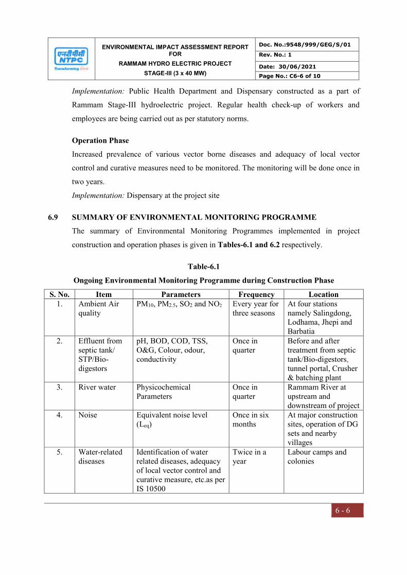
ENVIRONMENTAL IMPACT ASSESSMENT REPORT FOR
RAMMAM HYDRO ELECTRIC PROJECT
STAGE-III (3 x 40 MW)
Doc. No.:9548/999/GEG/S/01
Rev. No.: 1
Date: 30/06/2021
Page No.: C6-6 of 10
6 - 6
Implementation: Public Health Department and Dispensary constructed as a part of
Rammam Stage-III hydroelectric project. Regular health check-up of workers and
employees are being carried out as per statutory norms.
Operation Phase
Increased prevalence of various vector borne diseases and adequacy of local vector
control and curative measures need to be monitored. The monitoring will be done once in
two years.
Implementation: Dispensary at the project site
6.9 SUMMARY OF ENVIRONMENTAL MONITORING PROGRAMME
The summary of Environmental Monitoring Programmes implemented in project
construction and operation phases is given in Tables-6.1 and 6.2 respectively.
Table-6.1
Ongoing Environmental Monitoring Programme during Construction Phase
S. No. Item Parameters Frequency Location 1. Ambient Air
quality PM10, PM2.5, SO2 and NO2 Every year for
three seasons At four stations namely Salingdong, Lodhama, Jhepi and Barbatia
2. Effluent from septic tank/ STP/Bio-digestors
pH, BOD, COD, TSS, O&G, Colour, odour, conductivity
Once in quarter
Before and after treatment from septic tank/Bio-digestors, tunnel portal, Crusher & batching plant
3. River water Physicochemical Parameters
Once in quarter
Rammam River at upstream and downstream of project
4. Noise Equivalent noise level (Leq)
Once in six months
At major construction sites, operation of DG sets and nearby villages
5.
Water-related diseases
Identification of water related diseases, adequacy of local vector control and curative measure, etc.as per IS 10500
Twice in a year
Labour camps and colonies
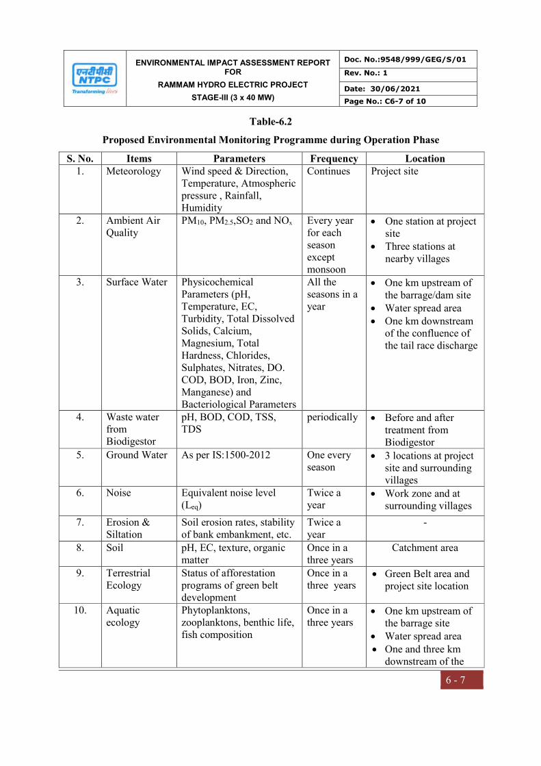
ENVIRONMENTAL IMPACT ASSESSMENT REPORT FOR
RAMMAM HYDRO ELECTRIC PROJECT
STAGE-III (3 x 40 MW)
Doc. No.:9548/999/GEG/S/01
Rev. No.: 1
Date: 30/06/2021
Page No.: C6-7 of 10
6 - 7
Table-6.2
Proposed Environmental Monitoring Programme during Operation Phase
S. No. Items Parameters Frequency Location 1. Meteorology Wind speed & Direction,
Temperature, Atmospheric pressure , Rainfall, Humidity
Continues Project site
2. Ambient Air Quality
PM10, PM2.5,SO2 and NOx Every year for each season except monsoon
One station at project site
Three stations at nearby villages
3. Surface Water Physicochemical Parameters (pH, Temperature, EC, Turbidity, Total Dissolved Solids, Calcium, Magnesium, Total Hardness, Chlorides, Sulphates, Nitrates, DO. COD, BOD, Iron, Zinc, Manganese) and Bacteriological Parameters
All the seasons in a year
One km upstream of the barrage/dam site
Water spread area One km downstream
of the confluence of the tail race discharge
4. Waste water from Biodigestor
pH, BOD, COD, TSS, TDS
periodically Before and after treatment from Biodigestor
5. Ground Water As per IS:1500-2012 One every season
3 locations at project site and surrounding villages
6. Noise Equivalent noise level (Leq)
Twice a year
Work zone and at surrounding villages
7. Erosion & Siltation
Soil erosion rates, stability of bank embankment, etc.
Twice a year
-
8. Soil pH, EC, texture, organic matter
Once in a three years
Catchment area
9. Terrestrial Ecology
Status of afforestation programs of green belt development
Once in a three years
Green Belt area and project site location
10. Aquatic ecology
Phytoplanktons, zooplanktons, benthic life, fish composition
Once in a three years
One km upstream of the barrage site
Water spread area One and three km
downstream of the

ENVIRONMENTAL IMPACT ASSESSMENT REPORT FOR
RAMMAM HYDRO ELECTRIC PROJECT
STAGE-III (3 x 40 MW)
Doc. No.:9548/999/GEG/S/01
Rev. No.: 1
Date: 30/06/2021
Page No.: C6-8 of 10
6 - 8
S. No. Items Parameters Frequency Location confluence of the tail race discharge
10. Water-related diseases
Identification of water-related diseases, sites, adequacy of local vector control measures, etc.
Once in a two year
Project Township and surrounding area.
Villages adjacent to project sites
11. Stack
monitoring
As per GSR 771 (E) or as
specified by Consent to
operate issued by State
pollution control board
(SPCB)
Quarterly DG set
12. Socio-economic conditions
Living standards, employment generations, skill development, through social & Need based assessment survey
Once in a three years
Project Affected Families (PAFs) and surrounding villages.
6.10 ENVIRONMENTAL MANAGEMENT GROUP (EMG)
An Environmental Management Group (EMG) consisting of competent workforce
headed by AGM level has been established by the proponent to deal with various
environmental aspects including follow-up with SPCB, Regional office MOEF&CC and
CPCB and to interact with inter-disciplinary groups responsible for maintenance and
operation of pollution control equipment and environmental protection measures. The
group reports to head of the station and responsible for following functions.
Obtaining Consent Order from SPCBs;
Environmental monitoring;
Analysis of environment data, reports preparation and transmission of report
to statutory authorities and Corporate Centre etc.;
Compliance with guidelines and statutory requirements;
Coordination with statutory bodies, functional groups of the station, Corporate
EMG / Engineering etc.;
Interaction for evolving and implementation of modification programs to
improve the availability / efficiency of pollution control devices / systems;

ENVIRONMENTAL IMPACT ASSESSMENT REPORT FOR
RAMMAM HYDRO ELECTRIC PROJECT
STAGE-III (3 x 40 MW)
Doc. No.:9548/999/GEG/S/01
Rev. No.: 1
Date: 30/06/2021
Page No.: C6-9 of 10
6 - 9
Environmental Appraisal (Internal) and Environmental Audit; and
Further Environment Management Group at regional level (ER-II HQ) and corporate
level (CC) monitor the environmental performance of the station and provide regular
guidance in consultation with MOEF&CC and CPCB, Delhi. The Environmental
Management Group at regional level reports to Executive Director (Hydro) and at
corporate level reports to Director (Operation).
6.11 COST FOR IMPLEMENTING ENVIRONMENTAL MONITORING PROGRAMME
The cost required for implementation of Environmental Monitoring programme during
construction phase is Rs. 7.0 lakhs/year. The details are provided in Table-6.3 below
Table-6.3 Cost for Environmental Monitoring Programme during Construction phase
Item Cost (Rs. lakh) Sewage from labour camps 3.00 Ambient air quality monitoring including Noise 2.25 Incidence of water related diseases 1.75 Total 7.00
The cost required for implementation of Environmental Monitoring programme during
operation phase is Rs. 27.0 lakhs. The details are provided in Table-6.4 below
Table-6.4
Cost for Environmental Monitoring Programme during Operation phase
Item Cost (Rs. Lakh/year) Ambient air quality monitoring including Noise 3.00 Water quality and effluent from township 3.70 Ecology 7.10 Riverine fisheries 8.10 Incidence of water related diseases 2.10 Other studies 3.00 Total 27.00
6.12 ENVIRONMENTAL AUDITS AND CORRECTIVE ACTION PLANS
To assess whether the implemented EMP is adequate, the project proponent’s
Environmental division will conduct the periodic environmental audits. These audits will
ENVIRONMENTAL IMPACT ASSESSMENT REPORT FOR
RAMMAM HYDRO ELECTRIC PROJECT
STAGE-III (3 x 40 MW)
Doc. No.:9548/999/GEG/S/01
Rev. No.: 1
Date: 30/06/2021
Page No.: C6-10 of 10
6 - 10
followed by Corrective Action and Preventive Action Plan to correct various issues
identified during the audits and to stop the recurrence of the same.
6.13 Submission of Monitoring Reports to Regulatory Authorities (MOEF&CC, CPCB,
WBSPCB & SSPCB)
As per the statutory requirements, the compliance status of Environmental Clearance
stipulations being submitted to Regional office of MOEF&CC in hard and soft copy
every six months. After operation of the project, the conventional pollutants will be
monitored as per schedule and reports will be submitted to SPCB, as per the
requirements.
The project site was inspected by Dr. Tandra Sarkar, Scientist C & Dr. Viplav Chandra
Sarkar, Technical Officer, (Forestry), IRO Kolkatta on 23.03.2021 and 24.03.2021.
Certified Report No: 102-166/07/EPE dated 06.04.2021 from MoEF&CC, Integrated
Regional Office, Kolkata attached as Annexure-XIII.

CHAPTER –VII
ADDITIONAL STUDIES
ENVIRONMENTAL IMPACT ASSESSMENT REPORT FOR
RAMMAM HYDRO ELECTRIC PROJECT
STAGE-III (3 x 40 MW)
Doc. No.:9548/999/GEG/S/01
Rev. No.: 2
Date: 30/06/2021
Page No.: C7-1 of 63
7 - 1
CHAPTER-7
ADDITIONAL STUDIES
7.0 ADDITIONAL STUDIES
The following are the list of additional studies considered for the Rammam HEPP Stage-
III (3x40 MW) in Darjeeling District of West Bengal and West Sikkim District of Sikkim.
S.No. Description Source
1. Public Consultation PH conducted in WB on 27.04.2007
and in Sikkim on 04.05.2007.
2. Catchment Area Treatment Plan Earlier EIA prepared by WAPCOS
3. Disaster Management Plan Emergency Action Plan prepared by
National Safety Council, July 2018
NTPC Limited
4. R&R Action Plan Indian Institute of Social Welfare &
Business Management, Kolkata,
NTPC Limited
7.1 PUBLIC CONSULTATION
As per MOEF&CC Notification S.O. 1247(E) dated 18.03.2021, Public Hearing is not
essential for the projects, in which construction have been undertaken more than 50%.
The details of Public Hearing undertaken at the time of original EC West Bengal
Pollution Control Board and State Pollution Control Board, Sikkim are enclosed as
Annexure – XIX and XX respectively.
In order to fulfill the EIA Notification, 2006 and its subsequent amendments, formal
public hearings have been conducted by the West Bengal Pollution Control Board at Dist.
- Darjeeling, West Bengal on 27.04.2007 and by State Pollution Control Board, Sikkim at
West Sikkim, Sikkim on 04.05.2007. The advertisement for the public hearing in West
Bengal was published on 26th March, 2007 in The Statesman, an English daily,
Anandabazar Patrika, a Bengali daily and Dainik Jagaran, a local Hindi daily. The
advertisement for the public hearing in Sikkim was published in one national daily

ENVIRONMENTAL IMPACT ASSESSMENT REPORT FOR
RAMMAM HYDRO ELECTRIC PROJECT
STAGE-III (3 x 40 MW)
Doc. No.:9548/999/GEG/S/01
Rev. No.: 2
Date: 30/06/2021
Page No.: C7-2 of 63
7 - 2
“Hindustan Times” (all India editions), “Sikkim Express” (local English daily) and
“Samay Dainik” (Regional Vernacular daily). After completion of the Public Hearings,
the applicant addressed all the environmental concerns expressed during this process and
respective State Pollution Control Boards have submitted the official report on the public
hearing proceedings to Director (Hydro) of MoEF&CC. The Final EIA Report was
submitted by the applicant to the MoEF&CC for appraisal, based on which Ministry of
Environment Forest & Climate Change (MOEF&CC) accorded the Environmental
Clearance (EC) for Rammam HEPP Stage-III (3x40 MW) vide letter No. J-
12011/42/2007-IA.I dated 17.08.2007.
Public Consultation at West Bengal
The Public Hearing of M/s. NTPC Limited was organized by West Bengal Pollution
Control Board (WBPCB) on 27.04.2007 at 11:30 AM at Community Hall/Recreation Hall
at Lodhama Hat, West Bengal State Electricity Board Township, Dist. - Darjeeling, West
Bengal.
The public hearing was presided by Mr. Gen Omdi Phipon, Additional District
Magistrate, Darjeeling. About 156 people attended the Public Hearing (PH). Dr. T.K.
Gupta, Senior Environmental Engineer and In charge – Consent Cell, WBPCB explained
about the provisions of the MoEF notification. Mr. R. Khetarpal, General Manager
explained about the project. Mr. Rajesh K Baderia, DGM (Env. Engg.) briefed the details
of the project through power point presentation, the likely environmental impacts arising
out of the same as well as the proposed pollution abatement/ environmental management/
socio-economic issued considered by them.
The issues raised during the public hearing conducted at Darjeeling, West Bengal given
below:
Issues raised and Response given during Public Hearing at Darjeeling, West Bengal
S.No. Name of
Participant &
Address
Question/comments by
participant
Remarks / Clarification by
Company Representative

ENVIRONMENTAL IMPACT ASSESSMENT REPORT FOR
RAMMAM HYDRO ELECTRIC PROJECT
STAGE-III (3 x 40 MW)
Doc. No.:9548/999/GEG/S/01
Rev. No.: 2
Date: 30/06/2021
Page No.: C7-3 of 63
7 - 3
1. Mr. M.K. Singh,
President Bhumi
Brangsha Bekari
Sangha, Rimbik
He raised issues regarding
water scarcity during
construction of the tunnel,
availability of potable
drinking water, greeneries,
health care establishment,
land slides, etc. He has
categorically mentioned that
the project proponent should
take adequate measures to
minimize the landslides
during construction
He explained that the design of the
proposed project is such that
the minimum water discharge would
be allowed in the Rammam River
keeping the sustainable environmental
situation. He also explained that the
proposed project activities are not
likely to affect the water table. To
check the landslides as and when
required, and would adopt modem
technologies to minimize the
same.The community development
work would include strengthening of
educational and health facilities,
widening and strengthening of village
road network, providing potable
drinking water, improving the
sanitation and drainage networks etc.
2. Mr. PremSubba,
Mr. Birkha Rai,
Mr. Jitendra Rai,
Mr. Prakash
Gurung, Mr.
Amar Subba,
Mr. Deng
Phinzo Sherpa
of local areas
They welcomed the project
but mentioned that the project
proponent should take the
necessary measures to
minimize any kind of damage
or loss to the local
environment. The project
proponent to consider for
involvement of the local
people for setting up of such
project the should take
necessary measures for
adequate water supply,
supply of fuel other than
wood, sanitation and
improvement of local road
networks. They have
requested the project
proponent to consider for
improvement of education
He ensured that all the likely damage
of roads, trees etc. during the
construction activities of project
would be restored by NTPC. However,
he also appraised that the technology
proposed to be used for the
construction work would be advanced
and all the measures would be taken to
keep the damage to local environment
at minimum level. He also explained
the NTPC Policy regarding the
employment opportunities to the local
people and highlighted that although
the direct employment opportunities
may not be there but there would be
number of economic opportunities to
the local people viz. Hiring of vehicle,
petty contract, employment with the
contract agencies, allotment of the
shops and kiosks at NTPC township,
ENVIRONMENTAL IMPACT ASSESSMENT REPORT FOR
RAMMAM HYDRO ELECTRIC PROJECT
STAGE-III (3 x 40 MW)
Doc. No.:9548/999/GEG/S/01
Rev. No.: 2
Date: 30/06/2021
Page No.: C7-4 of 63
7 - 4
and health facilities at the
local area.
vending contract, STD/ISD booth etc.
3. Mr. Abhijit Roy,
Paschim Banga
Vigyan Mancha
(PBVM),
Siliguri,
Mr. Sankar Kar,
Asst. Secretary,
State
Committee,
PBVM
Mr. Wangel
Sherpa,
President of
Manibhanjan
Zonal
committee of
PBVM
They have mentioned that the
project proponent should
consider the issues like
seepage due to blasting,
drying of agricultural land,
alterative supply of fuel,
construction and repairing of
roads, compensation
packages during resettlement,
deployment of local people in
the job, improvement of
sanitation facilities, water
supply etc.
He gave the emphasis on considering
the various major issues raised by the
local people like local meeting would
be organized at all the major project
affected villages to appraise local
people regarding the R&R benefits.
He also mentioned that NTPC
normally undertake number of welfare
activities in the project affected
villages viz. organizing the health
camps, providing the medical
dispensaries, organizing the cultural
and rural sports events etc. besides
undertaking the community
development work as approved by
Village Development Advisory
Committee (VDAC) formed under the
guidance and leadership of local
administration. The R&R issues will
be settled in consultation with local
and district administration with the
involvement of VDAC.
Additional District Magistrate, Darjeeling emphasized that all possible measures
should be ensured by the project proponent towards the mitigation of all environmental
hazards and various points raised by the public present in the hearing. In general, the
public present in the hearing welcome the project incorporating with all the pollution
control measures proposed by the Project Proponent.
Public Consultation at Sikkim
State Pollution Control Board, Sikkim on, organized the Public Hearing of M/s. NTPC
Limited on 04.05.2007 at Zero Point, Salangdang, West Sikkim, Sikkim.
The Public Hearing (PH) was presided by Shri D.G. Bhutia, Addl. District Collector,
West District, Govt. of Sikkim. About 131 people attended the public hearing. Dr. Gopal
ENVIRONMENTAL IMPACT ASSESSMENT REPORT FOR
RAMMAM HYDRO ELECTRIC PROJECT
STAGE-III (3 x 40 MW)
Doc. No.:9548/999/GEG/S/01
Rev. No.: 2
Date: 30/06/2021
Page No.: C7-5 of 63
7 - 5
Pradhan, Senior Scientist, SPCB, Sikkim explained about the provisions of the MoEF
notification. Mr. R. Khetarpal, General Manager explained about the project. This was
followed by brief note on environmental aspects by Dr. V. Prakash, Senior Manager,
Environmental Engineering, NTPC Ltd., the likely environmental impacts arising out of
the same as well as the proposed pollution abatement/ environmental management/ socio-
economic issued considered by them.
The issues raised during the public hearing conducted at West Sikkim, Sikkim given
below:
Issues raised and Response given during Public Hearing at West Sikkim, Sikkim
S.No. Name of
Participant &
Address
Question/comments by
participant
Remarks / Clarification by
Company
Representative/Concerned
person
1. Mr. D.R. Subba,
DFO, Land Use
(West)
Tunneling process may
lead to drying up of the
drinking water resources.
Is there any provision to
protect it
He replied that the technique
used in the process of tunneling
is of latest technology and we
will use minimum amount of
explosives so that water does not
sink down. On top of this, there
will be no tunneling towards
Sikkim.
2. Mr. D.R. Subba,
DFO, Land Use
(West)
There are various types of
fishes found here and if
the dam comes up then the
river may dry up leading
to the extinction of entire
aquatic life. What are the
provisions made by the
Developers to protect this
aquatic life?
He replied that there is no
necessity to worry as we will be
releasing 15% of water whether
we can reach our target or not
3. Mr. D.R. Subba,
DFO, Land Use
(West)
Though a very little
portion of the land will be
acquired by the
He replied that we have not
acquired any land till date. As
the process gets initiated we will

ENVIRONMENTAL IMPACT ASSESSMENT REPORT FOR
RAMMAM HYDRO ELECTRIC PROJECT
STAGE-III (3 x 40 MW)
Doc. No.:9548/999/GEG/S/01
Rev. No.: 2
Date: 30/06/2021
Page No.: C7-6 of 63
7 - 6
Developers in Sikkim,
what will be the valuation
of the land?
try to give the best value as per
the norms of the Government of
Sikkim
4. Mr. D.R. Subba,
DFO, Land Use
(West)
What will be the future of
National Park (WB) and
the wildlife sanctuary
(Sikkim) which are
situated at either side of
the river Rammam?
He replied that our project site is
much below the National Park
of West Bengal and wildlife
sanctuary of Sikkim. As such the
project will not have any effect
on these two protected areas.
5. Mr. D.R. Subba,
DFO, Land Use
(West)
What are the major benefit
of the project to the
common people of the
area?
He replied that the direct
benefits to the common people
as the project comes up are:
i. All the materials required by
the Developers can be
supplied through local
registered suppliers
ii. We will invest 0.5% of the
total profit of the
Corporation for the
Development of the project
area
iii. Registered contractors will
get chance in the
construction of the non-
technical work.
On top of this, we will be
supplying 12% of the power to
the State of Sikkim free.
6. Mr. N.R. Chettri,
Rammam,
Salangdang
Is there any provision to
employ the local skilled
and unskilled people of
the affected area in your
project?
Sorry, as our organization is a
Government of India
undertaking so we do not have
such provision to employ any
one directly. If anyone is
interested to join us, they have
to come through proper channel.

ENVIRONMENTAL IMPACT ASSESSMENT REPORT FOR
RAMMAM HYDRO ELECTRIC PROJECT
STAGE-III (3 x 40 MW)
Doc. No.:9548/999/GEG/S/01
Rev. No.: 2
Date: 30/06/2021
Page No.: C7-7 of 63
7 - 7
7. Mr. D.R. Subba,
DFO, Land Use
(West)
Is there any provision in
the project to develop the
area into a Tourist spot?
No, we do not have provision
for this. But we shall definitely
put up the green belt around the
project area, which will surely
add much better looks to the
present area.
8. Mr. D.R. Subba,
DFO, Land Use
(West)
The valuation of our land
that is to be acquired by
the Developers should be
good
He replied that we will not
negotiate for the land directly. It
will be through the Department
of Land & Revenue,
Government of Sikkim.
Whatever the Government fixes
we will pay the same.
9. Mr. D.R. Subba,
DFO, Land Use
(West)
There is a possibility of
increase in crime as the
project comes up. What
are the provisions made
by the Developers to have
a control over this?
He replied that why do you
underestimate your police force.
We will surely cooperate in
every aspects of the local
administration to overcome this
problem.
10. Mr. D.R. Subba,
DFO, Land Use
(West)
Is it possible to have
today’s proceeding in
written?
Yes, if any one wants to have
today’s proceeding in written
they can contact the office of the
Member Secretary, State
Pollution Control Board, Deorali
11. Dr. Pushpa Tamang,
Jt. Director, Fishery
Department
What will be the height of
the dam?
We will not be constructing any
dam as it will have great effect
on the environment as such we
will have a barrage only.
12. Dr. Pushpa Tamang,
Jt. Director, Fishery
Department
It is a well-known fact that
this type of project will
have maximum affect on
the aquatic life. What are
the provisions made by
the developers to
minimize this affect?
It is true. As such, we will be
releasing minimum required
water (1 cumec) to maintain the
aquatic eco system of Rammam
River.
ENVIRONMENTAL IMPACT ASSESSMENT REPORT FOR
RAMMAM HYDRO ELECTRIC PROJECT
STAGE-III (3 x 40 MW)
Doc. No.:9548/999/GEG/S/01
Rev. No.: 2
Date: 30/06/2021
Page No.: C7-8 of 63
7 - 8
13. Dr. Pushpa Tamang,
Jt. Director, Fishery
Department
Will the diversion of
water towards the tunnel
not affect the life of fish
present there?
We will not generate the power
for 24 hrs. We will release
sufficient amount of water to
sustain the aquatic life there in
the river. As such it will not
have adverse effect on migration
of the fishes.
14. Dr. Pushpa Tamang,
Jt. Director, Fishery
Department
Why the project
developers failed to
consult the Fishery
Institutes for the survey of
fishes of Rammam River?
The survey was carried out by
WAPCOS if necessary we do
not have any problem to hand
over the task of survey to any
one of the Indian Fishery
Institute if it is necessary to do
so.
15. Dr. Pushpa Tamang,
Jt. Director, Fishery
Department
There has been no
provision made in the
report of the project for
the compensation for the
people whose life depends
on fishing
For this we will discuss with the
Government and bring out the
necessary solution.
16. Mr. B.L. Chettri,
Rammam
What will be the impact of
project on drinking water
supply
As I have already told you that
there will be no negative impact
on the supply of drinking water,
instead the supply will increase
as we have enough fund for the
afforestation and plantation of
trees. I request you all to guide
us at the time of implementing
this programme.
17. Mr. B.L. Chettri,
Rammam
How will the developers
help the Government to
achieve the goal in
making Sikkim Clean and
Green?
There is enough provision for
the plantation and its
maintenance. For the
development of green belt at the
muck disposal sites,
compensatory afforestation and
the catchment area treatment
plan, we have sufficient fund for
ENVIRONMENTAL IMPACT ASSESSMENT REPORT FOR
RAMMAM HYDRO ELECTRIC PROJECT
STAGE-III (3 x 40 MW)
Doc. No.:9548/999/GEG/S/01
Rev. No.: 2
Date: 30/06/2021
Page No.: C7-9 of 63
7 - 9
these programmes.
18. Mr. R.N. Sapkota,
Teacher, Salangdang
How will the developers
help to improve the socio-
economy of the common
masss?
Once the project comes up there
will be various opportunities for
the common mass to improve
their life style as there will be
big demand for the daily
requirement of food, dairy
products, vegetables and other
construction materials.
19. Mr. R.N. Sapkota,
Teacher, Salangdang
Is there any provision for
the scholarship to the local
students, community
library etc.?
Mr. Sapkota, thanks for your
concern to the society. We have
such provisions in the project.
We well work as per the
genuineness of the local NGOs
or the Project Welfare
Committee
20. Mr. R.N. Sapkota,
Teacher, Salangdang
Our environment is very
clean, as such I request
you to maintain the same
as the project comes up
We have kept enough funds to
maintain the environment. On
top of this, we will have an
Environmental Laboratory and
an Environmental Management
Cell.
21. Mr. M.C. Gautam
ACF/Soreng
What will be the length of
the project?
I am sorry to say that we cannot
predict the length of the project
but would like to inform you
that in India the project does not
die out so soon.
22. Mr. M.C. Gautam
ACF/Soreng
What will be the status of
rehabilitation programme?
Rehabilitation Programme of
NTPC Ltd. is one of the best in
India and we started this
programme much before the
Government of India did.
23. Mr. Bharat Chettri,
Salangdang
Rammam River is the
only source for the
irrigation and we are
We shall discuss the matter with
the area MLA and the
Government and do the needful.
ENVIRONMENTAL IMPACT ASSESSMENT REPORT FOR
RAMMAM HYDRO ELECTRIC PROJECT
STAGE-III (3 x 40 MW)
Doc. No.:9548/999/GEG/S/01
Rev. No.: 2
Date: 30/06/2021
Page No.: C7-10 of 63
7 - 10
afraid that if the project
comes up we will have
much problem for the
same. As such we would
like to request you to
kindly release little more
water
24. Mr. Bharat Chettri,
Salangdang
Is there any provision for
the compensation of the
damage that the developer
causes?
Yes, we have the provision in
Resettlement and Rehabilitation
Action Plan.
25. Mr. Bharat Chettri,
Salangdang
Is there any provision for
the boating facility in the
dam area as one of the
tourist points?
No, sorry we do not have such
provision, as we are not
constructing a big reservoir. It
will be a simple barrage where
the depth of the water will be
very small.
26. Mr. Bharat Chettri,
Salangdang
Will the developer provide
us the facility in the field
of Education, Health and
other social activities?
Yes, we will help you in every
possible was as it is clearly
stated in Resettlement and
Rehabilitation Action Plan
27. Mr. Bharat Chettri,
Salangdang
What is the process for the
compensation of the land?
We will deal as per the
guidelines of the State
Government
28. Mr. Rajiv Roka
BDO/Daramdin
Drying up of the
Rammam River may lead
to economic problem as
the river is the only source
for the irrigation. So can
the developer release
some more water?
We will discuss the matter with
the Government and the area
MLA for the same. Thanks for
the information.
29. Mr. Rajiv Roka
BDO/Daramdin
As the project are coming
up in our area, I would
like to request you for the
long-term employment
opportunity for the local
educated youths
Sorry sir, we do not employ any
one directly. Anyone interested
should come up through proper
channel. But we will be
providing enough opportunity
through contract, allotment of

ENVIRONMENTAL IMPACT ASSESSMENT REPORT FOR
RAMMAM HYDRO ELECTRIC PROJECT
STAGE-III (3 x 40 MW)
Doc. No.:9548/999/GEG/S/01
Rev. No.: 2
Date: 30/06/2021
Page No.: C7-11 of 63
7 - 11
shops/ PCOs, Vehicle hiring etc.
30. Mr. Robin Rai, NGO
Member/Salangdang
As per the local protection
act we too should be given
employment opportunities
Sorry Mr. Rai, it is not possible
but we will be providing you the
opportunities in various fields
indirectly
31. Mr. Suk Bir Subba,
Salangdang
The time that we got is
very little to discuss all the
subjects I request you to
hold the public hearing
again
We had published the public
notice in one daily National
newspaper (Hindustan Times),
Nepali local paper (Samay
Dainik) and one English daily
local paper (Sikkim Express).
On top of this, we had put up a
number of banners at different
places of project-affected areas
for your information. We regret
to know that this could not
attract your attention.
The whole proceeding came to the conclusion with wrap up speech by Shri S.Z.
Lucksom, Member Secretary, SPCB. He concluded his speech by declaring that, as per
today’s proceedings all the people present wanted project to come up with a reservation
that maximum water is to be released and every effort to be made to protect the
environment of the area.
7.2 CATCHMENT AREA TREATMENT PLAN
A Catchment area Treatment Plan for the catchment area intercepted at the diversion
structure of the barrage site has been prepared as a part of the Comprehensive EIA study.
Catchment characteristics in terms of physiography, geomorphology, climate, land use,
soil, denudation processes and conservational activities gained much importance to find
out stress areas yielding higher sediments on micro-watershed basis. This entire process is
called as Prioritization of Micro-watersheds into very high, high, medium, low, etc.
sediment yielding categories for presenting a watershed development plan. For this
purpose, Sediment Yield Index Model developed by Soil and Land Use, Survey of India,
ENVIRONMENTAL IMPACT ASSESSMENT REPORT FOR
RAMMAM HYDRO ELECTRIC PROJECT
STAGE-III (3 x 40 MW)
Doc. No.:9548/999/GEG/S/01
Rev. No.: 2
Date: 30/06/2021
Page No.: C7-12 of 63
7 - 12
Ministry of Agriculture, Govt. of India was utilized in the preparation of CAT plan for the
Rammam HEPP, Stage-III.
The CAT plan is being implemented through State Forest Department as a deposit work
of respective states of West Bengal & Sikkim. NTPC has deposited Rs. 7.23 Crores in
favor of Principal Chief Conservator of Forests, West Bengal as part of proposal for
implementation of CAT Plan for Rammam Stage-III project. NTPC has deposited Rs.
1.459 Crores in favor of PCCF cum Principal Secretary, Govt. of Sikkim as part of
proposal for implementation of CAT Plan for Rammam Stage-III project. Fund utilization
for Sikkim portion during 2009 & 2010 furnished by DFO, LU & E (West), Forest, Envi.
& WL Management Department, Govt. of Sikkim has already been forwarded to
MoEF&CC, Shillong vide NHL/RammamIII/11-12/01 dated 9th May 2011. Fund
utilization report for WB part is still awaited.
7.2.1 Need for Catchment Area Treatment
It is a well-established fact that reservoirs formed by dams on rivers are subjected to
sedimentation. The process of sedimentation embodies the sequential processes of
erosion, entrainment, transportation, deposition and compaction of sediment. The study of
erosion and sediment yield from catchments is of utmost importance as the deposition of
sediment in reservoir reduces its capacity, and thus affecting the water availability for the
designated use. The eroded sediment from catchment when deposited on streambeds and
banks causes braiding of river reach. The removal of top fertile soil from catchment
adversely affects the agricultural production. Thus, a well-designed Catchment Area
Treatment (CAT) Plan is essential to ameliorate the above-mentioned adverse process of
soil erosion.
Soil erosion may be defined as the detachment and transportation of soil. Water is the
major agent responsible for this erosion. In many locations, winds, glaciers, etc. also
cause soil erosion. In a hilly catchment area, as in the present case, erosion due to water is
a common phenomenon and the same has been studied as a part of the CAT Plan.
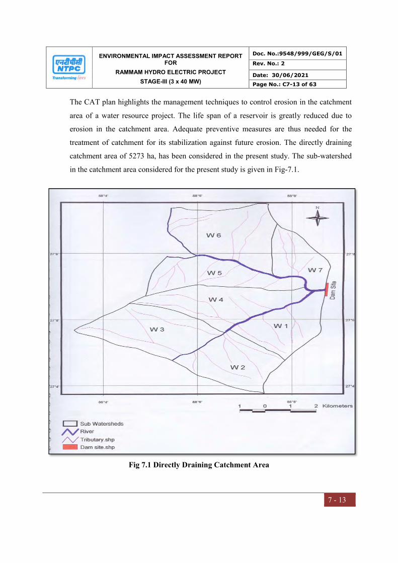
ENVIRONMENTAL IMPACT ASSESSMENT REPORT FOR
RAMMAM HYDRO ELECTRIC PROJECT
STAGE-III (3 x 40 MW)
Doc. No.:9548/999/GEG/S/01
Rev. No.: 2
Date: 30/06/2021
Page No.: C7-13 of 63
7 - 13
The CAT plan highlights the management techniques to control erosion in the catchment
area of a water resource project. The life span of a reservoir is greatly reduced due to
erosion in the catchment area. Adequate preventive measures are thus needed for the
treatment of catchment for its stabilization against future erosion. The directly draining
catchment area of 5273 ha, has been considered in the present study. The sub-watershed
in the catchment area considered for the present study is given in Fig-7.1.
Fig 7.1 Directly Draining Catchment Area
ENVIRONMENTAL IMPACT ASSESSMENT REPORT FOR
RAMMAM HYDRO ELECTRIC PROJECT
STAGE-III (3 x 40 MW)
Doc. No.:9548/999/GEG/S/01
Rev. No.: 2
Date: 30/06/2021
Page No.: C7-14 of 63
7 - 14
The catchment area treatment involves
Understanding of the erosion characteristics of the terrain and
Suggesting remedial measures to reduce the erosion rate
In the present study `Silt Yield Index’ (SYI), method has been used. In this method, the
terrain is subdivided into various watersheds and the erodibility is determined on relative
basis. SYI provides a comparative erodibility criteria of catchment (low, moderate, high,
etc.) and do not provide the absolute silt yield. SYI method is widely used mainly because
of the fact that it is easy to use and has lesser data requirement. Moreover, it can be
applied to larger areas like sub-watersheds, etc.
7.2.2 Objectives of Catchment Area Treatment Plan
The broad objectives for preparation of Catchment Area Treatment Plan are outlined as
under:
i. Checking soil erosion and land degradation by taking up adequate and effective
soil conservation measures, both engineering as well as biological, in erosion prone
areas.
ii. Rehabilitation of degraded forest areas through afforestation and facilitating natural
regeneration.
iii. Rehabilitation of degraded slopes and landslide prone area.
7.2.3 Approach for the Study
A detailed database on natural resources, terrain conditions, soil type of the catchment
area, socio-economic status, etc. is a pre-requisite to prepare treatment plan keeping in
view the concept of sustainable development. Various thematic maps have been used in
preparation of the CAT plan. Due to the spatial variability of site parameters such as soils,
topography, land use and rainfall, not all areas contribute equally to the erosion problem.
Several techniques like manual overlay of spatially index-mapped data have been used to
estimate soil erosion in complex landscapes.
ENVIRONMENTAL IMPACT ASSESSMENT REPORT FOR
RAMMAM HYDRO ELECTRIC PROJECT
STAGE-III (3 x 40 MW)
Doc. No.:9548/999/GEG/S/01
Rev. No.: 2
Date: 30/06/2021
Page No.: C7-15 of 63
7 - 15
Geographic Information System (GIS) is a computerized resource data base system,
which is referenced to some geographic coordinate system. In the present study, real
coordinate system has been used. The GIS is a tool to store, analyze and display various
spatial data. In addition, GIS, because of its special hardware and software characteristics,
has a capacity to perform numerous functions and operations on the various spatial data
layers residing in the database. GIS provides the capability to analyze large amounts of
data in relation to a set of established criteria. In order to ensure that latest and accurate
data is used for the analysis, satellite data has been used for deriving land use data.
Ground truth studies, too, have been conducted.
The various steps, covered in the study, are as follows:
Data acquisition
Data preparation
Output presentation
The above mentioned steps are briefly described in the following paragraphs:
7.2.3.1 Data Acquisition
The requirement of the study was first defined and the outputs expected were noted. The
various data layers of the catchment area used for the study are as follows:
Slope map
Soil map
Land use classification map
Current Management Practices
Catchment Area map
7.2.3.2 Data Preparation
The data available from various sources was collected. The ground maps, contour
information, etc. were scanned, digitized and registered as per the requirement. Data was
prepared depending on the level of accuracy required and any corrections required were
made. All the layers were geo-referenced and brought to a common scale (real co-

ENVIRONMENTAL IMPACT ASSESSMENT REPORT FOR
RAMMAM HYDRO ELECTRIC PROJECT
STAGE-III (3 x 40 MW)
Doc. No.:9548/999/GEG/S/01
Rev. No.: 2
Date: 30/06/2021
Page No.: C7-16 of 63
7 - 16
ordinates), so that overlay could be performed. A computer program was used to estimate
the soil loss. The formats of outputs from each layer were firmed up to match the formats
of inputs in the program. The grid size to be used was also decided to match the level of
accuracy required, the data availability and the software and time limitations. The format
of output was finalized. Ground truthing and data collection was also included in the
procedure.
For the present study, IRS 1C-LISS III digital satellite data was used for interpretation &
classification. The classified land use map of the catchment area, considered for the
study, is shown as Fig 7.2.
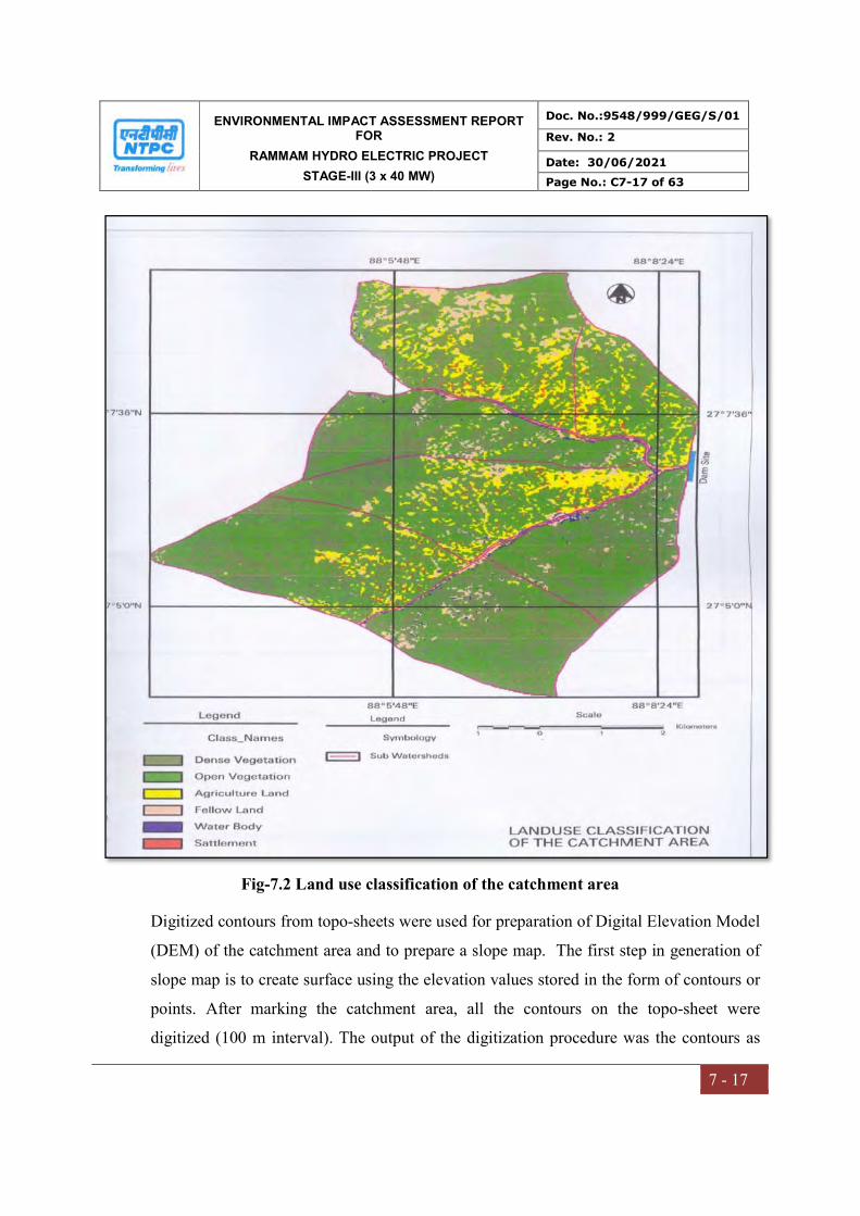
ENVIRONMENTAL IMPACT ASSESSMENT REPORT FOR
RAMMAM HYDRO ELECTRIC PROJECT
STAGE-III (3 x 40 MW)
Doc. No.:9548/999/GEG/S/01
Rev. No.: 2
Date: 30/06/2021
Page No.: C7-17 of 63
7 - 17
Fig-7.2 Land use classification of the catchment area
Digitized contours from topo-sheets were used for preparation of Digital Elevation Model
(DEM) of the catchment area and to prepare a slope map. The first step in generation of
slope map is to create surface using the elevation values stored in the form of contours or
points. After marking the catchment area, all the contours on the topo-sheet were
digitized (100 m interval). The output of the digitization procedure was the contours as
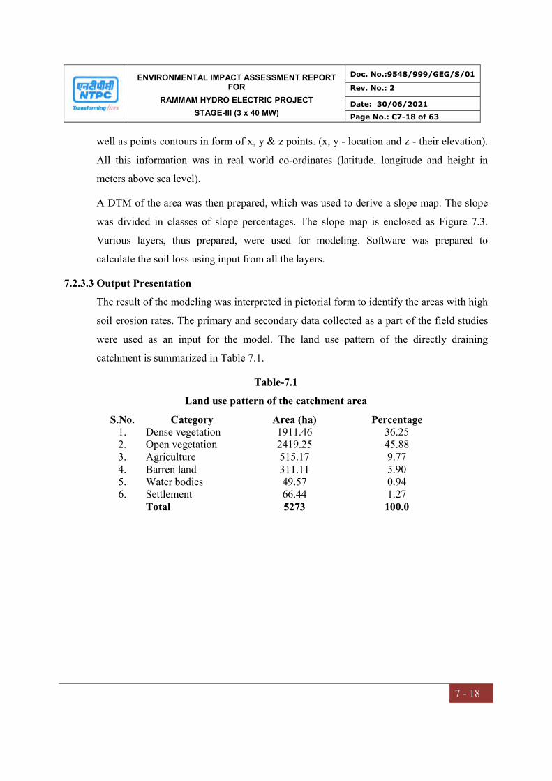
ENVIRONMENTAL IMPACT ASSESSMENT REPORT FOR
RAMMAM HYDRO ELECTRIC PROJECT
STAGE-III (3 x 40 MW)
Doc. No.:9548/999/GEG/S/01
Rev. No.: 2
Date: 30/06/2021
Page No.: C7-18 of 63
7 - 18
well as points contours in form of x, y & z points. (x, y - location and z - their elevation).
All this information was in real world co-ordinates (latitude, longitude and height in
meters above sea level).
A DTM of the area was then prepared, which was used to derive a slope map. The slope
was divided in classes of slope percentages. The slope map is enclosed as Figure 7.3.
Various layers, thus prepared, were used for modeling. Software was prepared to
calculate the soil loss using input from all the layers.
7.2.3.3 Output Presentation
The result of the modeling was interpreted in pictorial form to identify the areas with high
soil erosion rates. The primary and secondary data collected as a part of the field studies
were used as an input for the model. The land use pattern of the directly draining
catchment is summarized in Table 7.1.
Table-7.1
Land use pattern of the catchment area
S.No. Category Area (ha) Percentage 1. Dense vegetation 1911.46 36.25 2. Open vegetation 2419.25 45.88 3. Agriculture 515.17 9.77 4. Barren land 311.11 5.90 5. Water bodies 49.57 0.94 6. Settlement 66.44 1.27 Total 5273 100.0
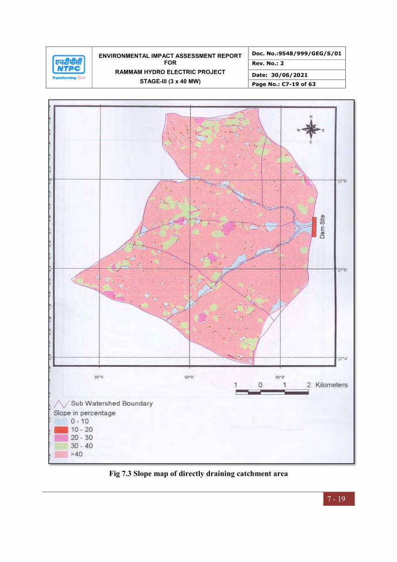
ENVIRONMENTAL IMPACT ASSESSMENT REPORT FOR
RAMMAM HYDRO ELECTRIC PROJECT
STAGE-III (3 x 40 MW)
Doc. No.:9548/999/GEG/S/01
Rev. No.: 2
Date: 30/06/2021
Page No.: C7-19 of 63
7 - 19
Fig 7.3 Slope map of directly draining catchment area
ENVIRONMENTAL IMPACT ASSESSMENT REPORT FOR
RAMMAM HYDRO ELECTRIC PROJECT
STAGE-III (3 x 40 MW)
Doc. No.:9548/999/GEG/S/01
Rev. No.: 2
Date: 30/06/2021
Page No.: C7-20 of 63
7 - 20
7.2.4 Estimation of soil loss using Silt Yield Index (SYI) method
The Silt Yield Index Model (SYI), considering sedimentation as product of erosivity,
erodibility and aerial extent was conceptualized in the All India Soil and Land Use
Survey (AISLUS) as early as 1969 and has been in operational use since then to meet the
requirements of prioritization of smaller hydrologic units.
The erosivity determinants are the climatic factors and soil and land attributes that have
direct or reciprocal bearing on the unit of the detached soil material. The relationship can
be expressed as:
Soil erosivity = f (Climate, physiography, slope, soil parameters, land use/land cover, soil
management)
Silt Yield Index
The Silt Yield Index (SYI) is defined as the Yield per unit area and SYI value for
hydrologic unit is obtained by taking the weighted arithmetic mean over the entire area of
the hydrologic unit by using suitable empirical equation.
Prioritization of Watersheds/Sub-watersheds
The prioritization of smaller hydrologic units within the vast catchments is based on the
Silt Yield Indices (SYI) of the smaller units. The boundary values or range of SYI values
for different priority categories are arrived at by studying the frequency distribution of
SYI values and locating the suitable breaking points. The watersheds/ sub-watersheds are
subsequently rated into various categories corresponding to their respective SYI values.
The application of SYI model for prioritization of sub-watersheds in the catchment areas
involves the evaluation of:
a) Climatic factors comprising total precipitation, its frequency and intensity,
b) Geo-morphic factors comprising land forms, physiography, slope and drainage
characteristics,
c) Surface cover factors governing the flow hydraulics and
d) Management factors
ENVIRONMENTAL IMPACT ASSESSMENT REPORT FOR
RAMMAM HYDRO ELECTRIC PROJECT
STAGE-III (3 x 40 MW)
Doc. No.:9548/999/GEG/S/01
Rev. No.: 2
Date: 30/06/2021
Page No.: C7-21 of 63
7 - 21
The data on climatic factors can be obtained for different locations in the catchment area
from the meteorological stations whereas the field investigations are required for
estimating the other attributes.
The various steps involved in the application of model are:
Preparation of a framework of sub-watersheds through systematic delineation
Rapid reconnaissance surveys on 1:50,000 scale leading to the generation of a
map indicating erosion-intensity mapping units.
Assignment of weightage values to various mapping units based on relative silt-
yield potential.
Computing Silt Yield Index for individual watersheds/sub-watersheds.
Grading of watersheds/sub-watersheds into very high, high, medium, low and
very low priority categories.
The area of each of the mapping units is computed and silt yield indices of individual
sub-watersheds are calculated using the following equations:
a. Silt Yield Index
SYI = (Ai x Wi ) x 100 ; where i = 1 to n Aw
where, Ai = Area of ith unit (EIMU) Wi = Weightage value of ith mapping unit n = No. of mapping units Aw = Total area of sub-watershed.
The SYI values for classification of various categories of erosion intensity rates are given
in Table-7.2.
Table-7.2
Criteria for erosion intensity rate
Priority categories SYI Values Very high > 1300 High 1200-1299 Medium 1100-1199 Low 1000-1099 Very Low <1000
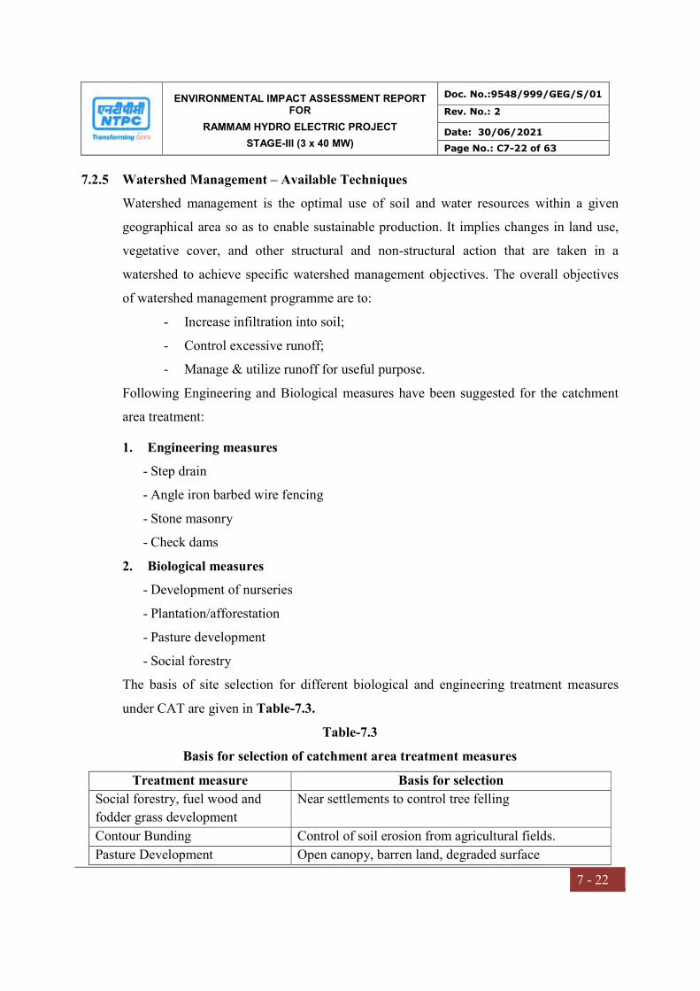
ENVIRONMENTAL IMPACT ASSESSMENT REPORT FOR
RAMMAM HYDRO ELECTRIC PROJECT
STAGE-III (3 x 40 MW)
Doc. No.:9548/999/GEG/S/01
Rev. No.: 2
Date: 30/06/2021
Page No.: C7-22 of 63
7 - 22
7.2.5 Watershed Management – Available Techniques
Watershed management is the optimal use of soil and water resources within a given
geographical area so as to enable sustainable production. It implies changes in land use,
vegetative cover, and other structural and non-structural action that are taken in a
watershed to achieve specific watershed management objectives. The overall objectives
of watershed management programme are to:
- Increase infiltration into soil;
- Control excessive runoff;
- Manage & utilize runoff for useful purpose.
Following Engineering and Biological measures have been suggested for the catchment
area treatment:
1. Engineering measures
- Step drain
- Angle iron barbed wire fencing
- Stone masonry
- Check dams
2. Biological measures
- Development of nurseries
- Plantation/afforestation
- Pasture development
- Social forestry
The basis of site selection for different biological and engineering treatment measures
under CAT are given in Table-7.3.
Table-7.3
Basis for selection of catchment area treatment measures
Treatment measure Basis for selection
Social forestry, fuel wood and
fodder grass development
Near settlements to control tree felling
Contour Bunding Control of soil erosion from agricultural fields.
Pasture Development Open canopy, barren land, degraded surface

ENVIRONMENTAL IMPACT ASSESSMENT REPORT FOR
RAMMAM HYDRO ELECTRIC PROJECT
STAGE-III (3 x 40 MW)
Doc. No.:9548/999/GEG/S/01
Rev. No.: 2
Date: 30/06/2021
Page No.: C7-23 of 63
7 - 23
Treatment measure Basis for selection
Afforestation Open canopy, degraded surface, high soil erosion,
gentle to moderate slope
Barbed wire fencing In the vicinity of afforestation work to protect it from
grazing etc.
Step drain To check soil erosion in small streams, steps with
concrete base are prepared in sloppy area where silt
erosion in the stream and bank erosion is high due to
turbidity of current.
Nursery Centrally located points for better supervision of
proposed afforestation, minimize cost of transportation
of seedling and ensure better survival.
7.2.6 Catchment Area Treatment Measures
The catchment area considered for CAT Plan is 5273 ha. The erosion category of various
watershed in the catchment area as per a SYI index are given in Tables-7.4 and 7.5
respectively and details are shown in Figure 7.4.
Table-7.4
Erosion intensity categorization as per SYI classification
Watershed number Area (ha) SYI values Category W1 638 1143 Medium W2 715 1151 Medium W3 926 1230 High W4 834 1256 High W5 695 1159 Medium W6 1009 1249 High W7 456 1276 High
Total 5273
Table-7.5
Area under various erosion categories
Sl. No. Category Area (ha) Percentage 1. Very Low - - 2. Low - - 3. Medium 2048 38.84 4. High 3225 61.16 5. Very High - Total 5273 100

ENVIRONMENTAL IMPACT ASSESSMENT REPORT FOR
RAMMAM HYDRO ELECTRIC PROJECT
STAGE-III (3 x 40 MW)
Doc. No.:9548/999/GEG/S/01
Rev. No.: 2
Date: 30/06/2021
Page No.: C7-24 of 63
7 - 24
Fig 7.4 Prioritization of directly draining catchment area

ENVIRONMENTAL IMPACT ASSESSMENT REPORT FOR
RAMMAM HYDRO ELECTRIC PROJECT
STAGE-III (3 x 40 MW)
Doc. No.:9548/999/GEG/S/01
Rev. No.: 2
Date: 30/06/2021
Page No.: C7-25 of 63
7 - 25
The objective of the SYI method is to prioritize sub-watershed in a catchment area for
treatment. The area under very high and high erosion categories is to be treated at the
project proponent cost. In the directly draining catchment of the project, there is no area
under very high erosion category. Hence, CAT plan has been suggested for high erosion
category, as a part of the present EIA study, the expenses of which have to be borne by
project proponents. The area under high erosion category is 3225 ha, which is about
61.16% of the catchment area considered for treatment.
7.2.7 COST ESTIMATE
The cost required for Catchment Area Treatment is Rs.32.08 million. The details of area
to be treated given in Figure 7.5 and costing provided in Tables 7.6 and 7.7. The year
wise physical and financial targets are given in Table-7.8.
Table-7.6
Cost for Catchment Area Treatment - Biological Measures
S.No. Item Rate
(Rs.)
Target
Physical Financial (Rs. million)
1. Afforestation
1600 trees/ha
61,000 41.5 ha 2.53
2. Plantation (800 trees/ha) 31,000/ha 286 ha 8.87
3. Pasture Development 15,000/ha 70 ha 1.05
4. Social forestry 30,000/ha 50 ha 1.50
5. Fuel wood and fodder
grass
20,000/ha 50 ha 1.00
6. Nursery development 300,000/no. 4 1.20
7. Maintenance of nursery 1,00,000/no 4 0.40
8. Barbed wire fencing 100,000/km 5 km 0.50
9. Watch and ward for 3
years for 8 persons
5000/man-month 240
man months
1.20
Total 18.20
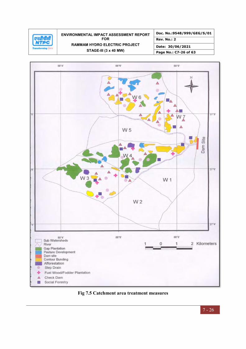
ENVIRONMENTAL IMPACT ASSESSMENT REPORT FOR
RAMMAM HYDRO ELECTRIC PROJECT
STAGE-III (3 x 40 MW)
Doc. No.:9548/999/GEG/S/01
Rev. No.: 2
Date: 30/06/2021
Page No.: C7-26 of 63
7 - 26
Fig 7.5 Catchment area treatment measures
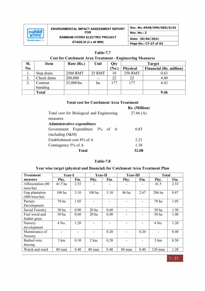
ENVIRONMENTAL IMPACT ASSESSMENT REPORT FOR
RAMMAM HYDRO ELECTRIC PROJECT
STAGE-III (3 x 40 MW)
Doc. No.:9548/999/GEG/S/01
Rev. No.: 2
Date: 30/06/2021
Page No.: C7-27 of 63
7 - 27
Table-7.7
Cost for Catchment Area Treatment - Engineering Measures
Sl. No.
Item Rate (Rs.) Unit Qty (No.)
Target Physical Financial (Rs. million)
1. Step drain 2500 RMT 25 RMT 10 250 RMT 0.63 2. Check dams 200,000 - 22 22 4.40 3. Contour
bunding 25,000/ha ha 177 177 4.43
Total 9.46
Total cost for Catchment Area Treatment
Rs. (Million)
Total cost for Biological and Engineering
measures
27.66 (A)
Administrative expenditure
Government Expenditure 3% of A
(including O&M)
0.83
Establishment cost 8% of A 2.21
Contingency 5% of A 1.38
Total 32.08
Table-7.8
Year wise target (physical and financial) for Catchment Area Treatment Plan
Treatment measure
Year-I Year-II Year-III Total Phy. Fin. Phy. Fin. Phy. Fin. Phy. Fin.
Afforestation (80 trees/ha)
41.5 ha 2.53 - - - - 41.5 2.53
Gap plantation (800 trees/ha)
100 ha 3.10 100 ha 3.10 86 ha 2.67 286 ha 8.87
Pasture Development
70 ha 1.05 - - - - 70 ha 1.05
Social Forestry 30 ha 0.90 20 ha 0.60 - - 50 ha 1.50 Fuel wood and fodder grass
30 ha 0.60 20 ha 0.40 - - 50 ha 1.00
Nursery development
4 No. 1.20 - - - - 4 No. 1.20
Maintenance of Nursery
- - - 0.20 - 0.20 - 0.40
Barbed wire fencing
3 km 0.30 2 km 0.20 - - 5 km
0.50
Watch and ward 80 man 0.40 80 man 0.40 80 man 0.40 120 man 1.20

ENVIRONMENTAL IMPACT ASSESSMENT REPORT FOR
RAMMAM HYDRO ELECTRIC PROJECT
STAGE-III (3 x 40 MW)
Doc. No.:9548/999/GEG/S/01
Rev. No.: 2
Date: 30/06/2021
Page No.: C7-28 of 63
7 - 28
Treatment measure
Year-I Year-II Year-III Total Phy. Fin. Phy. Fin. Phy. Fin. Phy. Fin.
months months months months Step Drain 150 m 0.38 100 m 0.25 - - 250 m 0.63
Check dam 12 No. 2.40 10 No. 2.00 - - 22 No. 4.40
Contour bunding 100 ha 2.50 77 ha 1.93 - 177 ha 4.43
Total 15.36 9.03 3.27 27.66
Note: Financial targets are in Rs. million
Till date, NTPC has deposited Rs. 7.23 Crores in favor of Principal Chief Conservator of
Forests, West Bengal and Rs. 1.459 Crores in favor of PCCF cum Principal Secretary,
Govt. of Sikkim as part of proposal for implementation of CAT Plan for Rammam Stage-
III project.
7.3 DISASTER MANAGEMENT PLAN
This plan has been prepared as an emergency preparedness measure to protect the life of
the employees and others present on-site, that of the public in the vicinity of the project,
company property and environment. The plan defines roles & responsibilities of persons
at different levels in the event of emergency in the sites of the company.
7.3.1 Purpose of the Plan
i. Basic purpose of this plan is to develop, implement and maintain an integrated
emergency management system for protection of people, property and the
environment in the event of on-site emergency as well as off-site emergency caused.
ii. Ultimate goal is to reduce vulnerability of the project area due to emergency situation
to save lives and protect property by developing capabilities that mitigate effects of,
prepare for, respond to and recover from emergency situation that could affect the
project area.
7.3.2 Scope of the Plan
This Disaster Management Plan/Emergency Action Plan covers technological
emergencies arising out of construction accidents and covers the following:

ENVIRONMENTAL IMPACT ASSESSMENT REPORT FOR
RAMMAM HYDRO ELECTRIC PROJECT
STAGE-III (3 x 40 MW)
Doc. No.:9548/999/GEG/S/01
Rev. No.: 2
Date: 30/06/2021
Page No.: C7-29 of 63
7 - 29
i. Geographical Coverage: The scope of the Plan is targeted to existing construction
project activities at the sites/facilities at following locations
a. Barrage across River Rammam (tributary of River Rangit), Intake structure, De-
silting basin
b. Head-Race Tunnel (HRT) with Surge shaft and the adit
c. Pressure shaft/Penstock
d. Power House
e. Surface Switchyard covering location
f. Tail-Race Tunnel (TRT) with outlet structure
g. Access tunnels and approach adits
The general layout of the project showing location of above activities is shown in Fig 7.6
and Barrage Complex and Power House complex layout shown in Fig 7.7 & 7.8
respectively.
ii. Emergency Scenarios: Emergency scenarios arising out of existing project status
and that anticipated in the immediate future expressed by the company management
personnel and those of the concerned agencies and the project risks as envisaged with
mutual thinking of the company and agency managements.
7.3.3 Hazardous Chemicals On-site & their Normal Inventories
The plant handles some hazardous chemicals as daily requirements and bulk storages.
Their normal inventory at different sites is given in Table 7.9
Table-7.9
Hazardous Chemicals and their normal inventory at different sites
S.No. Location Chemical Normal Inventory
1 Magazine house 1 near Barrage Site
Nitrate mixture Class 2, division 0 2450 kg
2 Magazine house 2 near Barrage Site
Nitrate mixture Class 2, division 0 2500 kg
3 Magazine house near TRC Nitrate mixture Class 2, division 0 1100 kg 4 Store at fabrication yard at
Barrage site Light Diesel Oil 1200 L

ENVIRONMENTAL IMPACT ASSESSMENT REPORT FOR
RAMMAM HYDRO ELECTRIC PROJECT
STAGE-III (3 x 40 MW)
Doc. No.:9548/999/GEG/S/01
Rev. No.: 2
Date: 30/06/2021
Page No.: C7-30 of 63
7 - 30
Fig 7.6 Layout of Project Site
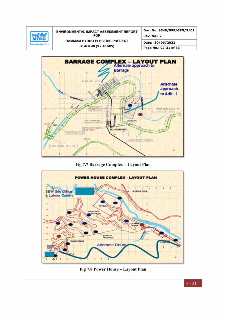
ENVIRONMENTAL IMPACT ASSESSMENT REPORT FOR
RAMMAM HYDRO ELECTRIC PROJECT
STAGE-III (3 x 40 MW)
Doc. No.:9548/999/GEG/S/01
Rev. No.: 2
Date: 30/06/2021
Page No.: C7-31 of 63
7 - 31
Fig 7.7 Barrage Complex – Layout Plan
Fig 7.8 Power House – Layout Plan

ENVIRONMENTAL IMPACT ASSESSMENT REPORT FOR
RAMMAM HYDRO ELECTRIC PROJECT
STAGE-III (3 x 40 MW)
Doc. No.:9548/999/GEG/S/01
Rev. No.: 2
Date: 30/06/2021
Page No.: C7-32 of 63
7 - 32
7.3.4 Emergencies Scenarios
The emergency scenarios are classified into 3 categories:
A. Natural calamities
i. Flood
ii. Landslide
iii. Earthquake
B. Man-made disaster
i. Fire
ii. Explosion
iii. Fire and Explosion
C. Security related disasters
i. Terrorist / Bomb threat attack
ii. Sabotage
Flood
Flood can occur due to
Heavy rain fall
Cloud burst to the upstream of the barrage area
More and sudden water released from TRC of the stage-II power project
Heavy debris falling into the river channel and form a water reservoir and due to
heavy rain the reservoir can break & emergency can occur along the river
Landslide
Compounded by the heavy rainfall and Geo-morphologic habits the landslides of major
and minor scale keep occurring every year during monsoon. Following areas are
susceptible to landslides
a) Water conductor systems
b) Surface Power House site
CIMFR (Central Institute of Mining and Fuel Research) has been engaged by both the
Major Civil Contractors for design of blast pattern and monitoring of tunneling works.
Geological Survey of India (GSI), is also associated with NTPC, Rammam, vide MoU
ENVIRONMENTAL IMPACT ASSESSMENT REPORT FOR
RAMMAM HYDRO ELECTRIC PROJECT
STAGE-III (3 x 40 MW)
Doc. No.:9548/999/GEG/S/01
Rev. No.: 2
Date: 30/06/2021
Page No.: C7-33 of 63
7 - 33
dated 8th Feb’ 2015, for supervision and advice on tunneling/ road construction and/or
any other vulnerable area of construction.
Earthquake
Darjeeling District, comprising of vast mountain terrain is vulnerable to landslide and
earthquake being situated at the fault line of Eurasian and Gondwana plates. The project
falls in Zone IV (Severe intensity zone) of Earthquake vulnerability map. Seismologists
have predicted the earthquake of major magnitude may occur at any moment and
therefore all precautions are required to be taken prior to earthquake.
Seismic study has been conducted by IIT Roorkee. The suggested Earth Quake (EQ)
design parameters have been cleared from National Committee of Seismic Design
Parameters (NCSDP) of CWC and are being adopted for design of the project
components.
Apart from some of the counter measures to be taken in foreseeable cases, emergency
recovery plans shall be considered by the emergency management team as per the
situation and site conditions
a) Structural failure
b) Collapse of structures inside the tunnels/adits
c) General alignment
Fire and Explosion
Following are areas where fire or explosion may take place due to improper maintenance
or mishandling
a) Switchyard area
b) Transformer and switchgear room area
c) Storages of explosives

ENVIRONMENTAL IMPACT ASSESSMENT REPORT FOR
RAMMAM HYDRO ELECTRIC PROJECT
STAGE-III (3 x 40 MW)
Doc. No.:9548/999/GEG/S/01
Rev. No.: 2
Date: 30/06/2021
Page No.: C7-34 of 63
7 - 34
Terrorist / Bomb threat attack
Terrorism is the deadliest from of emergency/disaster in terms of loss of life and damage
to property. Project sites could not be ruled out of the possibility of terrorism as these
sites are vital nation assets. The terrorist-related aspects could be dealt with by making
use of advancement of the technology in the areas of surveillance and proper intelligence
network.
Following are the vulnerable areas where the terrorists can strike
a) Explosives Storages
b) Barrage
c) Power House
d) Tunnels
e) Offices
7.3.5 Factors to control Emergency
i. Reporting of Incident
ii. Key Persons
iii. Emergency Management Teams
iv. Responsibilities
v. Emergency Communication Organization
vi. Emergency Control Center (ECC)
vii. Declaration of Emergency
viii. Termination of Emergency
ix. Siren System
x. Communication System
xi. Role of Employees after declaration of Emergency
xii. Resources on-site
xiii. Assembly Points

ENVIRONMENTAL IMPACT ASSESSMENT REPORT FOR
RAMMAM HYDRO ELECTRIC PROJECT
STAGE-III (3 x 40 MW)
Doc. No.:9548/999/GEG/S/01
Rev. No.: 2
Date: 30/06/2021
Page No.: C7-35 of 63
7 - 35
Reporting of Incident
Any person (employee of NTPC or contracting agency or Security) who sees the incident
shall inform/report to the ECC through the nearest office (NTPC, contracting agency/any
security point) through telephone/mobile or by shouting.
Key Persons
Following positions & names of key persons are included
1. Chief Incident Controller (CIC)
2. Works Incident Controller (WIC)
3. Site Incident Controller (SIC)
Project Manager of the site contracting agency assumes the role of IC in case of any
emergency. For silent hours (night time or on holidays) the senior security person will
handle the emergency with the help of other security personnel till arrival of the seniors.
Emergency Management Teams and Responsibilities
The list of emergency management teams-manning and responsibilities of various
emergency teams viz. Chief Incident Controller (CIC), Works Incident Controller (WIC),
Site Incident Controller (SIC), Resource Manager, Fire Team etc. enclosed as Annexure
- XXI
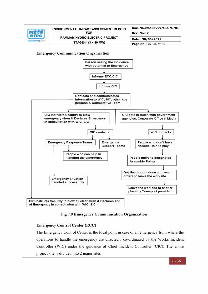
ENVIRONMENTAL IMPACT ASSESSMENT REPORT FOR
RAMMAM HYDRO ELECTRIC PROJECT
STAGE-III (3 x 40 MW)
Doc. No.:9548/999/GEG/S/01
Rev. No.: 2
Date: 30/06/2021
Page No.: C7-36 of 63
7 - 36
Emergency Communication Organization
Fig 7.9 Emergency Communication Organization
Emergency Control Center (ECC)
The Emergency Control Center is the focal point in case of an emergency from where the
operations to handle the emergency are directed / co-ordinated by the Works Incident
Controller (WIC) under the guidance of Chief Incident Controller (CIC). The entire
project site is divided into 2 major sites
ENVIRONMENTAL IMPACT ASSESSMENT REPORT FOR
RAMMAM HYDRO ELECTRIC PROJECT
STAGE-III (3 x 40 MW)
Doc. No.:9548/999/GEG/S/01
Rev. No.: 2
Date: 30/06/2021
Page No.: C7-37 of 63
7 - 37
i. Barrage and HRT
ii. Power House and its parts
Hence, from the viewpoint of convenience and to effectively handle the emergency each
of the two major sites should function from either of 2 separate ECCs – Main and
alternate
Locations
Barrage and HRT
Main ECC: NTPC, Sajbote
Alternate ECC: NTPC Porta cabin at Adit 1
Power House and Part HRT
Main ECC: NTPC, Sajbote
Alternate ECC: NTPC Porta cabin near SEW Work Shop
Contents of the ECC
Main ECC is a place normally manned 24x7 basis e.g. Security Office. A board
displaying “Emergency Control Center” / “Emergency Control Center - Alternate”
Display of Telephone/Mobile numbers of key persons working on-site
Display of Telephone/Mobile numbers of selected key government officials
A copy of Emergency Action Plan
Land-line telephone instrument for receiving calls only
A booklet of blank ‘Incident Information Summary’ sheets
Site Map showing:
o Storage area of hazardous materials
o Storage of safety equipment’s
o Firefighting system and additional source of water
o Site entrance, roadway and emergency exits
o Assembly points
o Truck parking area
o Surrounding location
ENVIRONMENTAL IMPACT ASSESSMENT REPORT FOR
RAMMAM HYDRO ELECTRIC PROJECT
STAGE-III (3 x 40 MW)
Doc. No.:9548/999/GEG/S/01
Rev. No.: 2
Date: 30/06/2021
Page No.: C7-38 of 63
7 - 38
Area map showing sensitive areas such as hospitals & nursing homes,
laboratories, offices of key government officials, schools
Black / white board
Intercom
Mobile Phone / walky-talky
Selected PPE storage
Meeting Room with chairs only
TV and Radio sets
Record Book
Desktop computer containing required data and printer
Note Book, Pad and Pencil/pen
Manning
At least one person should man ECC round the clock during peace time who can receive
and record information. During an emergency, it should be manned by the emergency
management staff, including the highest-ranking personnel in-charge of the whole
operation.
Declaration and Termination of Emergency
The WIC is authorized to declare and terminate the emergency. The sequence is given
below:
After receiving information about an incident, SIC would rush to incident site
immediately
SIC, if found beyond his control, informs the ECC attendant, who in turn informs
all concerned key persons
CIC & WIC would then rush to ECC
CIC then contacts other key persons on-site, establishes communication set up
with WIC & SIC to know more about the situation
After communication with WIC/SIC if it is beyond the control, CIC would give
clearance to Security to declare Emergency
ENVIRONMENTAL IMPACT ASSESSMENT REPORT FOR
RAMMAM HYDRO ELECTRIC PROJECT
STAGE-III (3 x 40 MW)
Doc. No.:9548/999/GEG/S/01
Rev. No.: 2
Date: 30/06/2021
Page No.: C7-39 of 63
7 - 39
The CIC contacts WIC & WIC then contacts SIC to know more about the incident
The Engineering Services Team approaches the incident site to attend emergency
Other plant In-charges occupy their offices to receive instructions from CIC
Other teams carry out their respective functions
CIC is in continuous interaction with the WIC & SIC and other senior persons in
each site
SIC in consultation with the other team leaders updates CIC & WIC
After handling emergency situation successfully i.e. after cessation of emergency,
WIC would declare termination of emergency in consultation with the CIC
Siren System
Declaration of emergency: Wailing sound for 30 seconds, break for 30 seconds
repeated 3 times
Termination of Emergency: All Clear Signal will be a continuous siren for 2
minutes repeated twice.
Apart from sounding siren, emergency message shall be communicated to all the
workers over Public Address system in and around the emergency site in Hindi,
English & Local language.
Communication Systems
Landline telephones
All key personnel are provided with land-line telephones at office as well as at their
residences. Landline telephones are also provided at selected locations in the project areas
Wireless communication
CUG Mobile Phones – Close User Group (CUG) mobile phones are also provided
to all key personnel and site personnel
Walky-Talky – Legalized Walky-Talky connections are provided to key personnel
at sites

ENVIRONMENTAL IMPACT ASSESSMENT REPORT FOR
RAMMAM HYDRO ELECTRIC PROJECT
STAGE-III (3 x 40 MW)
Doc. No.:9548/999/GEG/S/01
Rev. No.: 2
Date: 30/06/2021
Page No.: C7-40 of 63
7 - 40
Role of Contracting Agencies & Employees after declaration of Emergency
Role of Contracting Agencies after declaration of Emergency
The contracting agencies have their own on-site Emergency Management Plan. The
Contracting agencies implement their plan after declaration of emergency. General
guidelines they should follow as given below:
On getting the information of declaration of emergency on the site, the Project Managers
of Associates shall immediately report at site and shall act as per their emergency plan
Ensure that the immediate response is provided to protect health and safety of
persons in the immediate area
Appoint responsible persons to account for their agency’s personnel and report to
the Work Incident Controller of the site
Appoint emergency rescue team to locate the missing persons
Ensure that their personnel are housed in a secure place, till further instructions
from WIC
Provide to their trained personnel and equipment for respective emergency actions
Any other responsibility as assigned by CIC/WIC/SIC
Role of Employees after declaration of Emergency
After hearing the emergency siren / message, all the employees including workers of
associates shall stay on their worksites. Those employees who are required to help in
handling the emergency either for responding to emergency directly or support the
emergency actions as per this emergency action plan or that of the agency should act
accordingly.
Those employees who are not required to handle the emergency either directly or as
support, should wait for instructions from their superiors to gather at designated
Assembly Points.
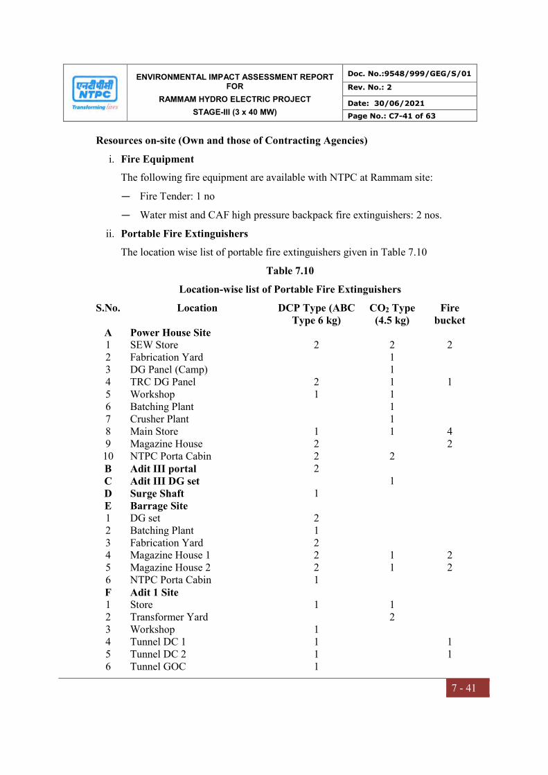
ENVIRONMENTAL IMPACT ASSESSMENT REPORT FOR
RAMMAM HYDRO ELECTRIC PROJECT
STAGE-III (3 x 40 MW)
Doc. No.:9548/999/GEG/S/01
Rev. No.: 2
Date: 30/06/2021
Page No.: C7-41 of 63
7 - 41
Resources on-site (Own and those of Contracting Agencies)
i. Fire Equipment
The following fire equipment are available with NTPC at Rammam site:
— Fire Tender: 1 no
— Water mist and CAF high pressure backpack fire extinguishers: 2 nos.
ii. Portable Fire Extinguishers
The location wise list of portable fire extinguishers given in Table 7.10
Table 7.10
Location-wise list of Portable Fire Extinguishers
S.No. Location DCP Type (ABC Type 6 kg)
CO2 Type (4.5 kg)
Fire bucket
A Power House Site 1 SEW Store 2 2 2 2 Fabrication Yard 1 3 DG Panel (Camp) 1 4 TRC DG Panel 2 1 1 5 Workshop 1 1 6 Batching Plant 1 7 Crusher Plant 1 8 Main Store 1 1 4 9 Magazine House 2 2 10 NTPC Porta Cabin 2 2 B Adit III portal 2 C Adit III DG set 1 D Surge Shaft 1 E Barrage Site 1 DG set 2 2 Batching Plant 1 3 Fabrication Yard 2 4 Magazine House 1 2 1 2 5 Magazine House 2 2 1 2 6 NTPC Porta Cabin 1 F Adit 1 Site 1 Store 1 1 2 Transformer Yard 2 3 Workshop 1 4 Tunnel DC 1 1 1 5 Tunnel DC 2 1 1 6 Tunnel GOC 1
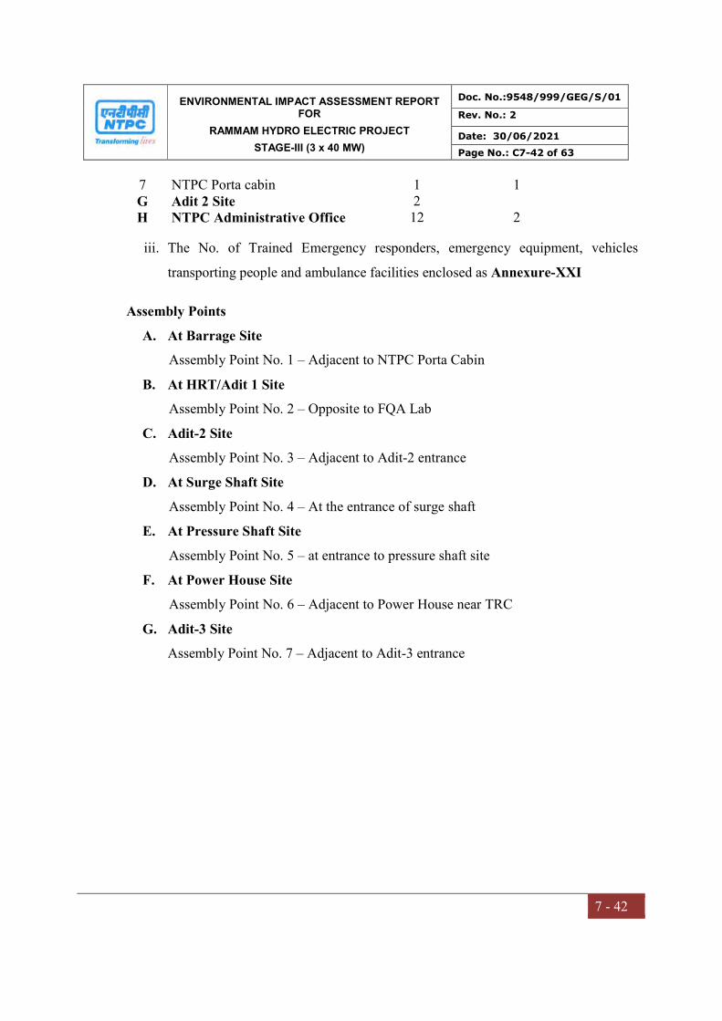
ENVIRONMENTAL IMPACT ASSESSMENT REPORT FOR
RAMMAM HYDRO ELECTRIC PROJECT
STAGE-III (3 x 40 MW)
Doc. No.:9548/999/GEG/S/01
Rev. No.: 2
Date: 30/06/2021
Page No.: C7-42 of 63
7 - 42
7 NTPC Porta cabin 1 1 G Adit 2 Site 2 H NTPC Administrative Office 12 2
iii. The No. of Trained Emergency responders, emergency equipment, vehicles
transporting people and ambulance facilities enclosed as Annexure-XXI
Assembly Points
A. At Barrage Site
Assembly Point No. 1 – Adjacent to NTPC Porta Cabin
B. At HRT/Adit 1 Site
Assembly Point No. 2 – Opposite to FQA Lab
C. Adit-2 Site
Assembly Point No. 3 – Adjacent to Adit-2 entrance
D. At Surge Shaft Site
Assembly Point No. 4 – At the entrance of surge shaft
E. At Pressure Shaft Site
Assembly Point No. 5 – at entrance to pressure shaft site
F. At Power House Site
Assembly Point No. 6 – Adjacent to Power House near TRC
G. Adit-3 Site
Assembly Point No. 7 – Adjacent to Adit-3 entrance

ENVIRONMENTAL IMPACT ASSESSMENT REPORT FOR
RAMMAM HYDRO ELECTRIC PROJECT
STAGE-III (3 x 40 MW)
Doc. No.:9548/999/GEG/S/01
Rev. No.: 2
Date: 30/06/2021
Page No.: C7-43 of 63
7 - 43
7.3.6 Emergency Organization
Fig 7.10 Emergency Organization Chart
7.3.7 Response Functions
i. Emergency in Tunnels
ii. Fire-fighting
iii. Rescue
iv. First-aid & Medical Response
v. Security & Traffic Control
vi. Communication
vii. Evacuation
Emergencies in the tunnels can arise from
a) Fire inside the Tunnel (Ignition of inflammable gases & explosives)
b) Tunnel Collapse or Failure of Works resulting in persons been trapped
c) Sudden release of toxic and inflammable gases
d) Sudden flooding (Inrush from above/from underground water source)
ENVIRONMENTAL IMPACT ASSESSMENT REPORT FOR
RAMMAM HYDRO ELECTRIC PROJECT
STAGE-III (3 x 40 MW)
Doc. No.:9548/999/GEG/S/01
Rev. No.: 2
Date: 30/06/2021
Page No.: C7-44 of 63
7 - 44
Fire at other construction sites
Fire would be extinguished with the help of own resources of trained firemen, available
portable fire extinguishers, Fire equipment. However, if it is beyond own capabilities,
help from nearby city fire brigade/mutual aid partners would be taken.
Treatment and Evacuation of injured person
1. A minor injury is one that causes no immediate danger to the life of the person who
has suffered the injury; the injury party is conscious and is capable of walking
unaided or with the support of a fellow worker. In general, cuts, bruises and minor
burns are classified as minor injuries. Injured shall be escorted to First Aid Room,
treatment be given worker should rest and returns to work when feeling better.
2. After treatment at the First Aid Room, if the First Aider thinks more treatment is
required e.g. stitches to a deep cut or a check-up after any head injury, or worker
complains of feeling ill or dizzy, then the First Aider arranges transport for the
injured party to be taken to the Company Doctor.
7.4 R&R ACTION PLAN
The most important deleterious impact during construction phase is, pertaining to land
acquisition. Socio-economic survey for the Project Affected Families (PAFs) was
conducted. Numbers of families lost their land were compensated as per NTPC R&R
Policy. One time settlement for R&R package to affected PAPs has been agreed during
VDAC meeting as per R&R policy. Total of Rs. 3.58 Crores disbursed as per R&R policy
till 31.03.2021.
VDAC (Village Development Advisory committee) for monitoring R&R activities have
been constituted by DM of concerned districts which include representatives of Project
Affected Persons.
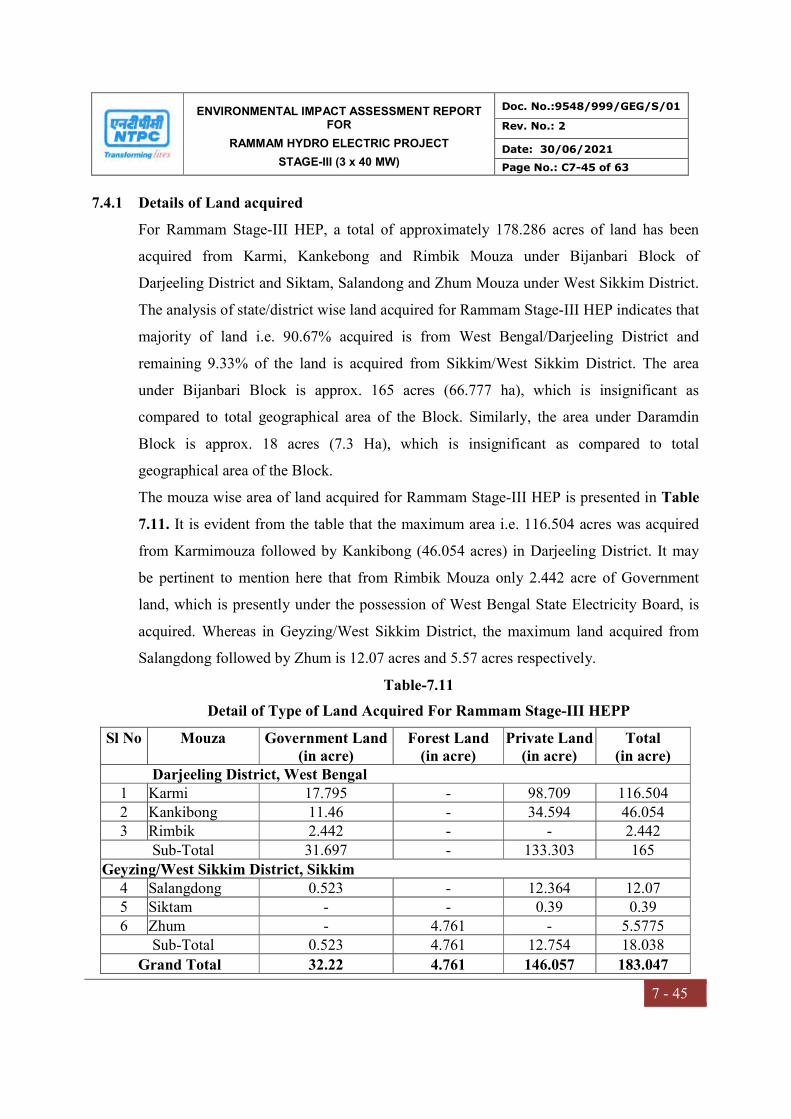
ENVIRONMENTAL IMPACT ASSESSMENT REPORT FOR
RAMMAM HYDRO ELECTRIC PROJECT
STAGE-III (3 x 40 MW)
Doc. No.:9548/999/GEG/S/01
Rev. No.: 2
Date: 30/06/2021
Page No.: C7-45 of 63
7 - 45
7.4.1 Details of Land acquired
For Rammam Stage-III HEP, a total of approximately 178.286 acres of land has been
acquired from Karmi, Kankebong and Rimbik Mouza under Bijanbari Block of
Darjeeling District and Siktam, Salandong and Zhum Mouza under West Sikkim District.
The analysis of state/district wise land acquired for Rammam Stage-III HEP indicates that
majority of land i.e. 90.67% acquired is from West Bengal/Darjeeling District and
remaining 9.33% of the land is acquired from Sikkim/West Sikkim District. The area
under Bijanbari Block is approx. 165 acres (66.777 ha), which is insignificant as
compared to total geographical area of the Block. Similarly, the area under Daramdin
Block is approx. 18 acres (7.3 Ha), which is insignificant as compared to total
geographical area of the Block.
The mouza wise area of land acquired for Rammam Stage-III HEP is presented in Table
7.11. It is evident from the table that the maximum area i.e. 116.504 acres was acquired
from Karmimouza followed by Kankibong (46.054 acres) in Darjeeling District. It may
be pertinent to mention here that from Rimbik Mouza only 2.442 acre of Government
land, which is presently under the possession of West Bengal State Electricity Board, is
acquired. Whereas in Geyzing/West Sikkim District, the maximum land acquired from
Salangdong followed by Zhum is 12.07 acres and 5.57 acres respectively.
Table-7.11
Detail of Type of Land Acquired For Rammam Stage-III HEPP
Sl No Mouza Government Land (in acre)
Forest Land (in acre)
Private Land (in acre)
Total (in acre)
Darjeeling District, West Bengal 1 Karmi 17.795 - 98.709 116.504 2 Kankibong 11.46 - 34.594 46.054 3 Rimbik 2.442 - - 2.442
Sub-Total 31.697 - 133.303 165 Geyzing/West Sikkim District, Sikkim
4 Salangdong 0.523 - 12.364 12.07 5 Siktam - - 0.39 0.39 6 Zhum - 4.761 - 5.5775
Sub-Total 0.523 4.761 12.754 18.038
Grand Total 32.22 4.761 146.057 183.047

ENVIRONMENTAL IMPACT ASSESSMENT REPORT FOR
RAMMAM HYDRO ELECTRIC PROJECT
STAGE-III (3 x 40 MW)
Doc. No.:9548/999/GEG/S/01
Rev. No.: 2
Date: 30/06/2021
Page No.: C7-46 of 63
7 - 46
The analysis of type of land acquired for Rammam Stage-III HEP reveals that out of total
land for Rammam Stage-III HEP nearly 80% is private land and remaining 17.6% is
Government land. Whereas, forest land is less than 3% only.
The component wise requirement of the land for Rammam Stage-III HEP is presented in
Table 7.12. The analysis reveals that the maximum area required for approach road to
barrage, power house, pen stock/surge shaft and township i.e. more than 30% of total land
is acquired. The land requirement for power house and barrage accounts for nearly 10%
each of total land. The muck disposal area requiring significant amount of land i.e. nearly
15% of total land was also acquired.
Table-7.12
Component Wise Detail of Land acquired for Rammam Stage-III HEPP
S. No. Components Area (ha) %
1 Barrage 8.50 11.47 2 Approach Roads 36.10 48.73 3 Tail Race Channel 8.130 10.97 4 Pen Stock and Surge Shaft 3.815 5.15 5 Power House 1.971 2.66 6 Township 8.903 12.0 7 Muck Disposal 6.661 8.99
Grand Total 74.076 100.00
7.4.2 Resettlement & Rehabilitation
The NTPC Limited has acquired approximately 66.777 Ha of land at Darjeeling District
and approximately 7.3 Ha at West Sikkim for Rammam Stage-III Hydro Electric Project
(HEP), out of which nearly 80% is private land and remaining only 20% is Government
land including the forestland. Acquiring these stretches of hilly agricultural as well as
homestead land for its project is likely to affect/displace number of people. Accordingly,
as per the R&R Policy of NTPC as well as Government of West Bengal and Sikkim,
NTPC initiated measures to resettle and rehabilitate Project Affected Persons (PAPs) with
the objective that the PAPs will improve or at least regain their previous standard of
living.
ENVIRONMENTAL IMPACT ASSESSMENT REPORT FOR
RAMMAM HYDRO ELECTRIC PROJECT
STAGE-III (3 x 40 MW)
Doc. No.:9548/999/GEG/S/01
Rev. No.: 2
Date: 30/06/2021
Page No.: C7-47 of 63
7 - 47
The Rehabilitation Action Plan (RAP) is formulated so that after a reasonable transition
period, the displaced/affected persons improve, or at least regain their previous standard
of living, earning capacity and production levels. The transition gap also is to be
reduced to a minimum.
7.4.3 Basis of R&R Action Plan
The R&R strategies have been worked out keeping in view the socio-economic status of
the PAPs and Impoverishment Risk Assessment of the PAPs. The existing infrastructure
of Pulbazar Bijanbari and Darmadin Blocks were given due consideration while
formulating the community development programme for Project Affected Villages. The
formulation of income restoration schemes for potential PAPs were in line with the
various on-going rural development and poverty alleviation programmes of the
Government.
The Resettlement & Rehabilitation Action Plan for the Project Affected Persons has been
prepared on the basis of the following criteria:
a) Concentration of PAPs in the village/Gram Panchayat for the location of target area;
b) Socio-economic status of the PAPs i.e. vulnerable groups, occupation, educational
status, income, etc. for the identification of the target group;
c) The Impoverishment Risk Assessment (IRA) and Quality of Life (QoL) of PAPs have
been used to prioritize the target group and area;
d) Existing infrastructure of the area, developmental plans of the district, specially the
affected Blocks.
Based on the above, R&R strategies (resettlement measures, rehabilitation measures
viz., jobs, self-employment, skill development, etc. and development of
infrastructure) have been evolved for the various target groups of the PAPs of
Rammam Stage-III HEP.
7.4.4 Process of Formulation of R&R Action Plan
The entire process of formulation of the Resettlement & Rehabilitation Action Plan
(RAP) was in consultation with the PAPs. For this purpose, qualitative research

ENVIRONMENTAL IMPACT ASSESSMENT REPORT FOR
RAMMAM HYDRO ELECTRIC PROJECT
STAGE-III (3 x 40 MW)
Doc. No.:9548/999/GEG/S/01
Rev. No.: 2
Date: 30/06/2021
Page No.: C7-48 of 63
7 - 48
techniques were employed which included focus group discussions, in-depth interviews
and participatory planning. The core team members with the help of Research Assistants
having relevant experience carried out most of these tasks. For successful employment of
qualitative research techniques, the following standard forms were used as recording
tools:
i. Village profile
ii. Discussion guidelines with
a. Knowledgeable persons and community leaders
b. Field level officials
c. NGOs
Participatory mapping and group discussions were carried out with the potential PAPs
along with Officials of Government of West Bengal & Government of Sikkim to identify
suitable rehabilitation measures, recording their options, preferences and suggestions for
formulation of effective RAP for PAPs of Rammam Stage-III HEP. The discussions in
the field were documented and analyzed.
7.4.5 Social Assessment & Project Design
Major efforts have been made to reduce the potential direct negative impacts of the
project on both social and biophysical environment. Social and environmental concerns
were considered carefully in project preparation and along with more conventional,
technical and economic considerations were influential factors in the design process.
These efforts have ranged from slight shifts of the plant boundary to avoid houses,
religious structures and other common property resources. They include attention to
social, environmental and safety measures to protect villagers. Environmental concerns
such as avoiding cutting down trees were also coordinated with this process.
The specific measures taken to minimize displacement during the design of the layout
plan for the Rammam Stage-III HEP included:
ENVIRONMENTAL IMPACT ASSESSMENT REPORT FOR
RAMMAM HYDRO ELECTRIC PROJECT
STAGE-III (3 x 40 MW)
Doc. No.:9548/999/GEG/S/01
Rev. No.: 2
Date: 30/06/2021
Page No.: C7-49 of 63
7 - 49
As it is a Run of River (RoR) Project, thus the reservoir have been designed for
storage of water only for two hours at the full load, keeping in view to minimize the
submergence area as well as displacement.
Only optimum quantity of land is being acquired for barrage, surge shaft, penstock,
powerhouse, township and other utility services.
As far as possible the land area required for the project were identified excluding
the houses falling within the proposed area for the project.
After completion of the initial layout of the project, the number of structures likely
to be affected was calculated by physical verification with the help of mouza maps.
Where large numbers of people were likely to be displaced, the project boundary
and road alignments were redefined to minimize the displacement.
A detailed study was carried out to determine/assess the prominent locations of
tribal groups within the study area. The plant layout in these areas was undertaken
to ensure that the proposed works do not affect the tribal communities.
Besides minimizing the amount of R&R required, these measures also minimized the loss
of public utilities and cultural properties such as schools, roads, grazing land,
gumpha/church, burial ground etc.
The sections that follow briefly present:
Key features of the design context and the social factors that were considered for
minimization of resettlement;
The social development approach and objectives;
The process by which the social features have been incorporated into design;
Results of collaboration between social assessment and project design and outcome
of efforts to reduce impacts and minimize displacement.
Project Design Context
Project design occurs in multileveled context in which focus and emphasis shift over the
project preparation period. Design inputs include economic, technical/engineering,
environmental and social, particularly R&R, displacement and land acquisition

ENVIRONMENTAL IMPACT ASSESSMENT REPORT FOR
RAMMAM HYDRO ELECTRIC PROJECT
STAGE-III (3 x 40 MW)
Doc. No.:9548/999/GEG/S/01
Rev. No.: 2
Date: 30/06/2021
Page No.: C7-50 of 63
7 - 50
considerations. At the macro level, the project is based on the feasibility studies prepared
on the basis of economic, social and environmental factors and conditions. This includes
preliminary design inputs. At the next level, preliminary engineering designs relating to
the plant layout, location of reservoir, township, alignment of Head Race Tunnel (HRT),
surge shaft/penstock, etc. were addressed. At the micro level, area-specific issues were
taken into considerations, e.g. a shift in layout to avoid demolishing of houses,
commercial structures, religious and other common property resources.
Social factors and assessment findings, including insights gained from consultations,
played an important role within the design context at each of these levels. Efforts to
minimize displacement and to avoid, reduce or mitigate rehabilitation requiring, other
social impacts were concentrated at the meso-and micro-level of project design, and
detailed engineering aspects of this design context and the associated opportunities for
minimizing adverse project impacts they presented are outlined below.
Project Layout
Using the available records with the Revenue Department, the R&R team of Rammam
Stage-III HEP verified the boundaries of project area. This information, entered in mouza
maps, was jointly verified and certified by the project investigators, NTPC and the
Revenue Department.
The objective of R&R contributions to project design was to ensure that the area of
impact was modulated, within acceptable design principles and standards, to minimize
displacement and other project impacts.
Design Pen Stock/Surge Shaft and Road Corridor of Impact
The Surge Shaft/Pen Stock and Road corridor of impact in rural area mainly restricted to
acquisition of agricultural land, vested land and other government lands. The effort has
been made to minimize the impact of land acquisition for access roads.
Mitigation Measures
While finalizing the plant layout including the corridor pen stock, surge shaft and roads,
etc., minimization of adverse environmental and social impacts including displacement
ENVIRONMENTAL IMPACT ASSESSMENT REPORT FOR
RAMMAM HYDRO ELECTRIC PROJECT
STAGE-III (3 x 40 MW)
Doc. No.:9548/999/GEG/S/01
Rev. No.: 2
Date: 30/06/2021
Page No.: C7-51 of 63
7 - 51
were major criteria. This practice will continue throughout the project preparation period.
The prime mitigation efforts and principles applied in project designs are described in the
subsequent sections.
Principles of Mitigation
Mitigation measures largely focused on settlement areas within the project area. The basic
social impact mitigation principles that guided designs were:
Minimal impact on residential and commercial structures thus minimizing
resettlement and loss of livelihood;
Religious structures to be maintained as far as possible;
Minimum loss of other common property resources viz., roads, graveyards,
orchards, grazing lands, etc.
The preservation of old and ethnic trees.
Mitigation Efforts
Mitigation efforts included the following:
Avoiding unnecessary displacement by modifying project layout of the plant and
reducing the width of the corridor of impact for pen stock, surge shaft, road, etc.
Reducing impacts on existing common property resources viz., roads, educational
institutions, religious structures etc.;
Providing access to businesses and residential units that would be otherwise impacted
by construction; and
Minimizing losses of public property, such as natural water sources, resting places,
orchards etc. within the project area.
7.4.6 R&R Basic Approach
NTPC Limited revised Resettlement & Rehabilitation Policy (June, 2005) on the basis its
experiences as well as in view of National Resettlement & Rehabilitation Policy of
Government of India (February, 2004). This R&R Policy describes the principles and
approach to be followed in minimizing and mitigating negative social and economic
impacts caused by the Thermal Power Project. This policy has been implemented within
ENVIRONMENTAL IMPACT ASSESSMENT REPORT FOR
RAMMAM HYDRO ELECTRIC PROJECT
STAGE-III (3 x 40 MW)
Doc. No.:9548/999/GEG/S/01
Rev. No.: 2
Date: 30/06/2021
Page No.: C7-52 of 63
7 - 52
the framework of Government of West Bengal & Sikkim R&R policy and other local
applicable laws. The salient features of the NTPC’s R&R policy are discussed in
subsequent sections.
Improper resettlement and rehabilitation is the root of discontentment and alienation
of the PAPs. It may be difficult to operate a project efficiently without the
cooperation of the local people.
The land acquisition and consequent displacement disrupts the traditional social
system. The changes in the land use pattern alter the agro-based rural economy and
affect the life style of the people. This calls for a concentrated effort to provide
means to ensure sustainable livelihood of these PAPs, considering them as
stakeholders.
The Rehabilitation Action Plan (RAP) is formulated so that after a reasonable
transition period, the affected families improve, or at least regain their previous
standard of living, earning capacity and production levels.
NTPC has taken all actions in accordance with the RAP, preparation of
Implementation Completion Report (ICR) and evaluation of activities post
completion.
7.4.7 R&R Entitlement Matrix
The compensation and rehabilitation assistance has been provided as per the following
matrix:
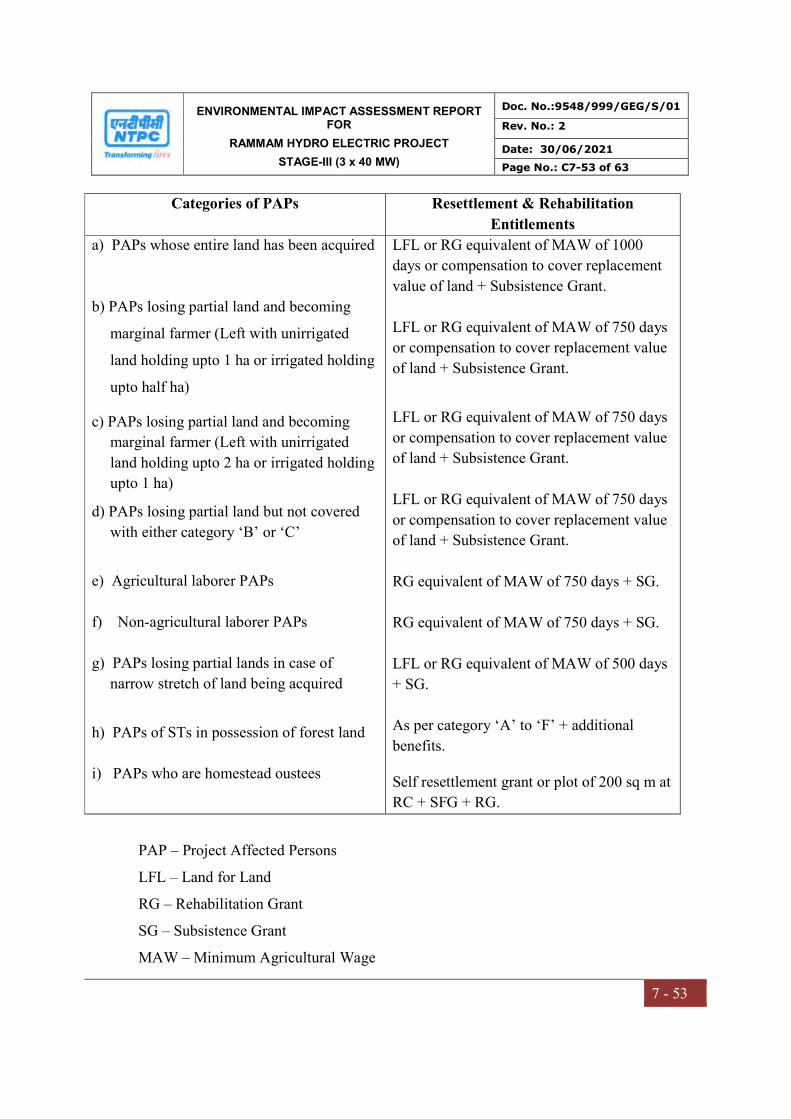
ENVIRONMENTAL IMPACT ASSESSMENT REPORT FOR
RAMMAM HYDRO ELECTRIC PROJECT
STAGE-III (3 x 40 MW)
Doc. No.:9548/999/GEG/S/01
Rev. No.: 2
Date: 30/06/2021
Page No.: C7-53 of 63
7 - 53
Categories of PAPs Resettlement & Rehabilitation
Entitlements
a) PAPs whose entire land has been acquired
b) PAPs losing partial land and becoming
marginal farmer (Left with unirrigated
land holding upto 1 ha or irrigated holding
upto half ha)
c) PAPs losing partial land and becoming
marginal farmer (Left with unirrigated
land holding upto 2 ha or irrigated holding
upto 1 ha)
d) PAPs losing partial land but not covered
with either category ‘B’ or ‘C’
e) Agricultural laborer PAPs
f) Non-agricultural laborer PAPs
g) PAPs losing partial lands in case of
narrow stretch of land being acquired
h) PAPs of STs in possession of forest land
i) PAPs who are homestead oustees
LFL or RG equivalent of MAW of 1000
days or compensation to cover replacement
value of land + Subsistence Grant.
LFL or RG equivalent of MAW of 750 days
or compensation to cover replacement value
of land + Subsistence Grant.
LFL or RG equivalent of MAW of 750 days
or compensation to cover replacement value
of land + Subsistence Grant.
LFL or RG equivalent of MAW of 750 days
or compensation to cover replacement value
of land + Subsistence Grant.
RG equivalent of MAW of 750 days + SG.
RG equivalent of MAW of 750 days + SG.
LFL or RG equivalent of MAW of 500 days
+ SG.
As per category ‘A’ to ‘F’ + additional
benefits.
Self resettlement grant or plot of 200 sq m at
RC + SFG + RG.
PAP – Project Affected Persons
LFL – Land for Land
RG – Rehabilitation Grant
SG – Subsistence Grant
MAW – Minimum Agricultural Wage

ENVIRONMENTAL IMPACT ASSESSMENT REPORT FOR
RAMMAM HYDRO ELECTRIC PROJECT
STAGE-III (3 x 40 MW)
Doc. No.:9548/999/GEG/S/01
Rev. No.: 2
Date: 30/06/2021
Page No.: C7-54 of 63
7 - 54
7.4.8 Rehabilitation Measures
To rehabilitate the PAPs losing their land following measures were adopted:
Land for Land (LFL)
The “Land for Land” option is applicable to only land losers (i.e. category ‘A’ to ‘D’).
Quantum of land for rehabilitation is as per the actual land acquired, subject to the ceiling
of maximum of 1 ha of irrigated land or 2 ha of unirrigated/cultivable wasteland subject
to availability of Government land in the districts. If Government land is not available,
PAPs has been facilitated for purchase of land on a “willing buyer-willing seller” basis.
For this purpose, the following process has been adopted:
Land price for the purpose of purchase of land was fixed after consultation with the
State Government and the VDAC on the basis of market price of the good
agricultural land in the vicinity generally within 25 km radius but normally not
exceeding the 1.3 times of the rate paid for the acquisition of good agricultural land
as per the LA Act.
The basic land compensation amount paid (i.e. excluding solatium and interest) has
been adjusted against land price fixed as above.
In addition, land development amount @ Rs. 10,000/- per acre as per entitlement
(based on process CPI as on 01.06.2004 and subject to revision from time to time)
and actual land registration and stamp duty charges as per entitlement has been paid
to those, who actually purchase the land and submit the required papers.
The PAPs losing less than 1 acre of land, purchase land upto 1 acre out of the grants
and compensation money they have been reimbursed the actual stamp duty and
registration charges of upto 1 acre.
In case of PAPs who are landless but are dependent only on the acquired land for
livelihood (Category ‘E’ & ‘F’), also buy land through the grants provided to them,
NTPC considered incentivizing their purchase by reimbursing actual stamp duty and
registration charges for upto 1 acre of purchase of land.

ENVIRONMENTAL IMPACT ASSESSMENT REPORT FOR
RAMMAM HYDRO ELECTRIC PROJECT
STAGE-III (3 x 40 MW)
Doc. No.:9548/999/GEG/S/01
Rev. No.: 2
Date: 30/06/2021
Page No.: C7-55 of 63
7 - 55
In situation, where the LFL option is not feasible because of scarcity of land, they were
eligible for Rehabilitation Grant (RG).
Rehabilitation Grant (RG)
One time RG was paid to eligible categories (i.e. A to G). If a category ‘A’ PAP does not
wish to go for LFL option, he/she had paid one time RG equivalent to 1000 days
Minimum Agricultural Wage (MAW) in the concerned State/UT at the time of Section 4
notification under LA Act. For the categories B to F, the RG is equivalent to 750 days
MAW. For the category ‘G’, a one-time RG equivalent to 500 MAW is payable with no
other additional rehabilitation benefit. For the Category ‘H’, the RG is vary depending
upon the type PAP as per Category ‘A’ to ‘G’. An illustrative amount will be as follows:
S No Category Amount (Rs.)
1
2
3
‘A’
‘B’ to ‘F’
‘G’
70,000/-
52,500/-
35,000/-
In case of non-feasibility of land for land option due to local constraints, the RG however,
could be suitably fixed on per acre of land loss basis for Category ‘A’ to ‘D’ subject to a
maximum of 5 acres in consultation with the stakeholders, to cover replacement value of
land not normally exceeding 1.3 times the basic compensation of good agricultural land
or the values in terms of MAW for these categories whichever is higher.
In case of rehabilitation of any rural artisan/small trader and a self employed person
(Category ‘F’) who is having a shop in the affected area, a one time financial assistance
of Rs. 15,000/- (based on CPI index as on 01.06.2004 subject to upward revision) was
provided in addition to RG for construction of working shed/shop, in case he continues
with his earlier vocation.
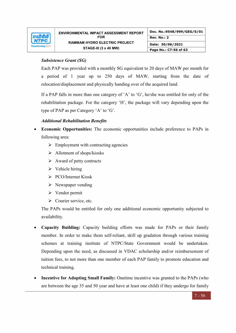
ENVIRONMENTAL IMPACT ASSESSMENT REPORT FOR
RAMMAM HYDRO ELECTRIC PROJECT
STAGE-III (3 x 40 MW)
Doc. No.:9548/999/GEG/S/01
Rev. No.: 2
Date: 30/06/2021
Page No.: C7-56 of 63
7 - 56
Subsistence Grant (SG)
Each PAP was provided with a monthly SG equivalent to 20 days of MAW per month for
a period of 1 year up to 250 days of MAW, starting from the date of
relocation/displacement and physically handing over of the acquired land.
If a PAP falls in more than one category of ‘A’ to ‘G’, he/she was entitled for only of the
rehabilitation package. For the category ‘H’, the package will vary depending upon the
type of PAP as per Category ‘A’ to ‘G’.
Additional Rehabilitation Benefits
Economic Opportunities: The economic opportunities include preference to PAPs in
following area:
Employment with contracting agencies
Allotment of shops/kiosks
Award of petty contracts
Vehicle hiring
PCO/Internet Kiosk
Newspaper vending
Vendor permit
Courier service, etc.
The PAPs would be entitled for only one additional economic opportunity subjected to
availability.
Capacity Building: Capacity building efforts was made for PAPs or their family
member. In order to make them self-reliant, skill up gradation through various training
schemes at training institute of NTPC/State Government would be undertaken.
Depending upon the need, as discussed in VDAC scholarship and/or reimbursement of
tuition fees, to not more than one member of each PAP family to promote education and
technical training.
Incentive for Adopting Small Family: Onetime incentive was granted to the PAPs (who
are between the age 35 and 50 year and have at least one child) if they undergo for family
ENVIRONMENTAL IMPACT ASSESSMENT REPORT FOR
RAMMAM HYDRO ELECTRIC PROJECT
STAGE-III (3 x 40 MW)
Doc. No.:9548/999/GEG/S/01
Rev. No.: 2
Date: 30/06/2021
Page No.: C7-57 of 63
7 - 57
planning operation within six to twenty four months period of acceptance of R&R
package.
Other Welfare Activities: In addition to above, activities was undertaken for socio-
economic upliftment of affected population. This may include special efforts for
education of girl child, rural sports, medical camps, subsidized treatment at NTPC project
hospital, cultural programmes, rural insurance scheme etc. These activities were finalized
in consultation of VDAC.
Special Efforts for Vulnerable PAPs: Special efforts for welfare measures was made
for SC/ST, Physically Challenged, Women Headed Household, Aged, etc. These also
include special vocational training programmes, priority in engagement for suitable jobs
and facilities, free/enhanced subsidized medical treatment, etc.
7.4.9 Resettlement Measures
Self-resettlement: PAPs of Category ‘I’ willing to resettle on their own or shift to some
alternate location was encouraged for self-resettlement. Financial assistance for self-
resettlement has provided generally at the rate of 5 times of the basic compensation
payable for the house, excluding solatium and interest, under the Land Acquisition Act
subject to a minimum of Rs. 50,000/- and a maximum of Rs. 1,00,000/- in each case
(based on CPI index as on 01.06.2004 subject to upward revision). No other benefit like
allotment of plot in RC, infrastructure at place of resettlement etc. was extended in case
of individual self-resettlement.
7.4.10 Additional Resettlement Benefits:
Shifting Grant: NTPC has bear the actual cost of transportation of the building materials
and other moveable properties including self, family members, cattle etc. belonging to the
PAPs from the place of displacement to resettlement colony or in the place of
resettlement generally within 25 km of accessible roads in any transport arranged by
NTPC. Alternatively, a lumpsum grant of Rs. 20,000/- (based on CPI index as on
01.06.2004 subject to upward revision) has been paid to each HSO for self-

ENVIRONMENTAL IMPACT ASSESSMENT REPORT FOR
RAMMAM HYDRO ELECTRIC PROJECT
STAGE-III (3 x 40 MW)
Doc. No.:9548/999/GEG/S/01
Rev. No.: 2
Date: 30/06/2021
Page No.: C7-58 of 63
7 - 58
transporting/shifting. This is inclusive of transportation of man, material, reusable goods,
wood, cattle etc. if any.
Resettlement Grant: A fixed resettlement grant of Rs. 30,000/- (based on CPI index as on
01.06.2004 subject to upward revision) was provided to each HSO. This is inclusive of
Rs. 5,000/- towards assistance for construction of cattle shed, if any.
7.4.11 Socio-economic Profile of PAPs
The Socio-economic Impact Assessment Study was conducted by Indian Institute of
Social Welfare and Business Management, Kolkata in 2007.
Project Affected Persons
The category wise detail of PAPs as per NTPC R&R policy (June, 2005) is presented in
Table-7.13. The analysis reveals that out of total 220 PAPs, nearly 72% PAPs lost only
part of their agricultural land and approximately 15% lost their dwelling units as well as
agricultural lands. Whereas only around 13% PAPs lost their homestead.
Table-7.13
Category Wise Detail of PAPs as Per NTPC R&R Policy
S No Category Description No of PAPs
1 A PAPs whose entire land has been acquired 20
2 B PAPs losing partial land and becoming marginal farmer
(left with unirrigated land holding upto one Ha or irrigated
holding upto half Ha)
13
3 C PAPs losing partial land and becoming small farmer (left
with unirrigated land holding upto two Ha or irrigated holding
upto 1 Ha)
35
4 D PAPs losing partial land but not covered in either category
B or C 268
5 E Agricultural labourer PAP -
6 F Non-agricultural labourer PAP -
7 G PAPs losing partial lands in case of projects/schemes wherein
only a narrow stretch of land extending several kilometers is
being acquired.
-
8 H Occupiers i.e. PAPs of STs in possession of forest land since -
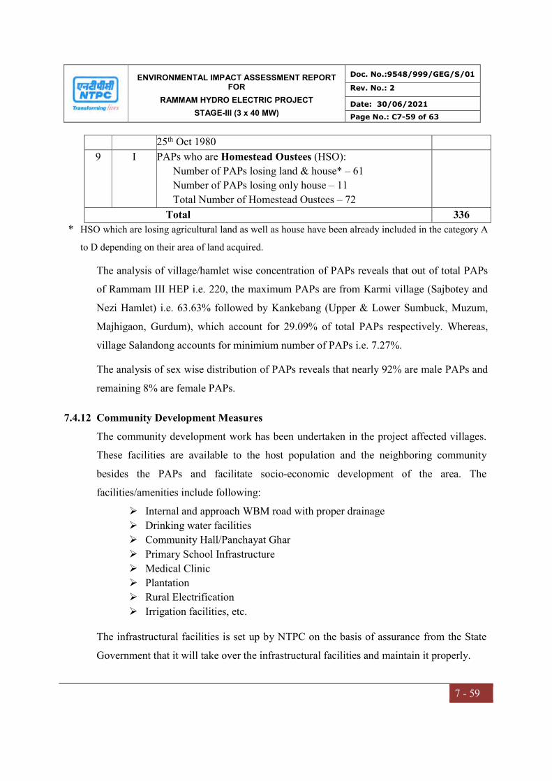
ENVIRONMENTAL IMPACT ASSESSMENT REPORT FOR
RAMMAM HYDRO ELECTRIC PROJECT
STAGE-III (3 x 40 MW)
Doc. No.:9548/999/GEG/S/01
Rev. No.: 2
Date: 30/06/2021
Page No.: C7-59 of 63
7 - 59
25th Oct 1980
9 I PAPs who are Homestead Oustees (HSO):
Number of PAPs losing land & house* – 61
Number of PAPs losing only house – 11
Total Number of Homestead Oustees – 72
Total 336
* HSO which are losing agricultural land as well as house have been already included in the category A
to D depending on their area of land acquired.
The analysis of village/hamlet wise concentration of PAPs reveals that out of total PAPs
of Rammam III HEP i.e. 220, the maximum PAPs are from Karmi village (Sajbotey and
Nezi Hamlet) i.e. 63.63% followed by Kankebang (Upper & Lower Sumbuck, Muzum,
Majhigaon, Gurdum), which account for 29.09% of total PAPs respectively. Whereas,
village Salandong accounts for minimium number of PAPs i.e. 7.27%.
The analysis of sex wise distribution of PAPs reveals that nearly 92% are male PAPs and
remaining 8% are female PAPs.
7.4.12 Community Development Measures
The community development work has been undertaken in the project affected villages.
These facilities are available to the host population and the neighboring community
besides the PAPs and facilitate socio-economic development of the area. The
facilities/amenities include following:
Internal and approach WBM road with proper drainage
Drinking water facilities
Community Hall/Panchayat Ghar
Primary School Infrastructure
Medical Clinic
Plantation
Rural Electrification
Irrigation facilities, etc.
The infrastructural facilities is set up by NTPC on the basis of assurance from the State
Government that it will take over the infrastructural facilities and maintain it properly.
ENVIRONMENTAL IMPACT ASSESSMENT REPORT FOR
RAMMAM HYDRO ELECTRIC PROJECT
STAGE-III (3 x 40 MW)
Doc. No.:9548/999/GEG/S/01
Rev. No.: 2
Date: 30/06/2021
Page No.: C7-60 of 63
7 - 60
The following community development work has been completed by Rammam HEPP
Stage-III.
1. Construction of 2 nos school buildings(NEZI,SUMBUK) completed.
2. Construction of school building in progress(Sajbotey)
3. Drinking water scheme under construction(1.NEZI,SAJBOTEY 2.Sumbuk)
4. Road construction from Khoprai to Nezi(1.5 km)completed
5. Road construction from Power house to Khoprai(5.8km)under construction,in
final stage.
6. 2 nos Ambulance handed over to District Administration,Darjeeling
7. Medical equipments of Rs2.5 lacs handed over to Jorethang Health Centre.
8. Footpath in Nezi 800m completed.
7.4.13 Implementation Mechanism for One Time Rehabilitation Package
After receiving the land compensation from District Authority the PAP have got the
certification of land compensation payment stating no dues are pending with land revenue
department of concerned District and same had submitting to Rammam Stage-III HEP
R&R Cell for calculation of one time rehabilitation package due to him/her. On receipt of
clearance certificate from PAPs, R&R Cell of Rammam Stage-III HEP calculate the one
time rehabilitation package payable to him/her and get his/her acceptance for the
calculated amount to be paid to him/her. Mean while the PAP had open a joint account in
the bank. The account was in the name of PAP & his/her spouse. In case of unmarried or
widow/widower, the PAP open the account in his/her own name. The opening of bank
accounts had facilitated by NTPC.
One time settlement for R&R package to affected PAPs has been agreed during VDAC
meeting as per R&R policy. Total of Rs. 3.58 Crores disbursed as per R&R policy till
31.03.2021.
7.4.14 Cost Incurred
The estimated budget for the RAP comprises the following prime area of compensation:
ENVIRONMENTAL IMPACT ASSESSMENT REPORT FOR
RAMMAM HYDRO ELECTRIC PROJECT
STAGE-III (3 x 40 MW)
Doc. No.:9548/999/GEG/S/01
Rev. No.: 2
Date: 30/06/2021
Page No.: C7-61 of 63
7 - 61
a) Acquisition of land for various components of Rammam Stage-III HEP including area
under barrage, power house, surge-shaft and other approach roads;
b) Rehabilitation & Resettlement Packages for PAPs/HSOs;
c) Relocation/Replacement of CPR viz. primary schools, construction of road,
graveyards, resting places, water reservoir, etc.;
d) Plantation of trees;
e) Training programme for self-employment and skill development for income
generating activities;
f) Community Development Programmes and other welfare activities;
g) Implementation Measures.
The R&R Policy (June, 2005) of NTPC provide the guidelines for R&R measures to be
taken for restoring the socio-economic status of PAPs/HSOs and undertaking community
development work in project affected village/hamlets for improving quality of life. On the
basis of SIA study conducted by IISWBM and interactions with PAPs as well as other
stakeholders through VDAC, PIC, and Village level focus group discussions, the R&R
measures to be taken for Rammam Stage-III HEP have been identified and presented in
Table 7.14. The budget for the same has been worked out keeping in view the guidelines
of NTPC R&R Policy.
The actual expenditure incurred by NTPC Ltd. on R&R is provided in Table 7.15. It
supplies and justifies a cost-wise, item-wise, budget estimate for implementation of
resettlement and rehabilitation schemes, including assistance, administrative expenses,
monitoring & evaluation and contingencies.
Table-7.14
R&R Measures Identified to be undertaken for Rammam Stage-III HEP
S No Description of R&R Activities REHABILITATION MEASURES:
1 One time Rehabilitation Package (this includes rehabilitation and subsistence grant, etc.)
2 Skill Development & Training and Scholarships for PAPs or their nominated family member.

ENVIRONMENTAL IMPACT ASSESSMENT REPORT FOR
RAMMAM HYDRO ELECTRIC PROJECT
STAGE-III (3 x 40 MW)
Doc. No.:9548/999/GEG/S/01
Rev. No.: 2
Date: 30/06/2021
Page No.: C7-62 of 63
7 - 62
S No Description of R&R Activities RESETTLEMENT MEASURES:
3 One time Self-Resettlement Package (this includes self resettlement, shifting grant and resettlement grant, etc )
COMMUNITY DEVELOPMENT & OTHER MEASURES: 4 Education Facilities:
a. Infrastructure Development for Schools b. Educational Cost (Furniture, Lab Equipment, Books, Stationery, etc.)
5 Health Facilities: a. Health Clinics b. General Health/Surgical/Eye Camps c. Family Planning d. Medicine &Equipments, etc. e. Mobile Clinic/Ambulance f. Veterinary Clinics
6 Village Sports & Cultural Programme: a. Sport kits/training & coaching/ rural sport events, etc. b. Cultural Programme
7 Welfare Measures for Physically Challenged & Other Vulnerable People: a. Movement Aid/Hearing Aid, etc. b. Self-employment Assistance viz. cattle for income generation, sewing machine, training/educational aid, etc.
8 Infrastructure Development Work: a. Community Centers b. Village Road & Culverts c. Drainage d. Sewerage & Toilets e. Drinking Water system f. Public Library g. Plantation under social forestry g. Infrastructure Development for Rural Electrification and Solar Systems h. Need Based Miscellaneous Rural Community Development Work (Smokeless
Chulhas, Low Cost Toilets & Soak Pits, Water Harvesting System, etc) IMPLEMENTATION MEASURES:
9 PAPs Verification & Issue of ID Card and Signing of Agreement with each PAPs/HSOs
10 Engagement of Institute/NGOs for Supervision of Implementation of RAP 11 Monitoring & Evaluation of Implementation of RAP
The cost of resettlement has been included in the overall costs of the project. Values for
compensation amounts and other support mechanisms will be adjusted, if required,

ENVIRONMENTAL IMPACT ASSESSMENT REPORT FOR
RAMMAM HYDRO ELECTRIC PROJECT
STAGE-III (3 x 40 MW)
Doc. No.:9548/999/GEG/S/01
Rev. No.: 2
Date: 30/06/2021
Page No.: C7-63 of 63
7 - 63
annually based on inflation factors. The budget incorporates provisions for this, and
mechanisms for budgetary adjustments and updates are included.
Table-7.15
Summary of Actual Expenditure incurred on RAP for Rammam Stage-III HEP
S. No. Descriptions
Actual Expenditure (Rs. Lakh) incurred
31.03.2021
REHABILITATION MEASURES:
1 One time Rehabilitation Package 357.49
2 Skill Development & Training and Scholarships 1.46
Sub-total 358.59
COMMUNITY DEVELOPMENT & OTHER MEASURES:
3 Educational Facilities 59.1
4 Health Facilities 287.29
5 Village Sports & Cultural Programme 15.44
6 Infrastructure Development Work 367.66
Sub-total 729.49
IMPLEMENTATION MEASURES:
7 Miscellaneous Expenses 68.71
Grand Total 798.20
7.5 POWER POTENTIAL STUDY
The power potential studies have been carried out for Rammam-III Hydroelectric
Scheme, situated on the river Rammam in West Bengal State of India. This is a run-of-
the-river type development and would operate on variable head of water. A copy of
Power Potential Study is enclosed as Annexure-XXII.
CHAPTER –VIII
PROJECT BENEFITS
ENVIRONMENTAL IMPACT ASSESSMENT REPORT FOR
RAMMAM HYDRO ELECTRIC PROJECT
STAGE-III (3 x 40 MW)
Doc. No.:9548/999/GEG/S/01
Rev. No.: 1
Date: 30/06/2021
Page No.: C8-1 of 6
8 - 1
CHAPTER-8
PROJECT BENEFITS
8.0 GENERAL
The implementation of the Rammam Hydro Electric Power Project (HEPP) Stage-III
will provide impetus to the development of the area and also provide green energy i.e.
hydro-electric power. The project will also throw opportunities to local people for
both direct and indirect employment. The other indirect benefits of a hydropower
project over thermal one are reduction in air pollution, water pollution, noise
pollution, thermal, fly-ash and health effects in and around the area.
The advantage of not having a large amount of water storage is that less land has to be
flooded and therefore the potential environmental footprint impacts are reduced.
Construction of Barrage will also bridge both banks with road connectivity
The project will bring social development and prosperity in area
The project provides indirect employment to the local population in
construction phase and will provide the same in operation phase as well
The CD/CSR has helped and will help in the development of the required
facilities for the general public of the area
The availability of the electricity will be highly beneficial for the cost effective
industrial activities which will bring further prosperity in the area
8.1 BENEFITS TO ECONOMY
Development of infrastructure and availability of reliable power supply as a result of
the project realization would contribute to the stimulation of economic activities like
small scale industries in the area. Additional power generation will mitigate the power
shortage in the West Bengal and Sikkim state. Some of the local people may get
permanent job during the operational phase of the project depending on their skill and
performance. The project will act as stimulant to improve the economy both at the
local and National levels.
8.2 SOCIAL INFRASTRUCTURE
The area possesses moderate level of infrastructural facilities. The township being
constructed near Barbatia village shall be permanent residence for the project. About
ENVIRONMENTAL IMPACT ASSESSMENT REPORT FOR
RAMMAM HYDRO ELECTRIC PROJECT
STAGE-III (3 x 40 MW)
Doc. No.:9548/999/GEG/S/01
Rev. No.: 1
Date: 30/06/2021
Page No.: C8-2 of 6
8 - 2
100 number of employees, support staff and CIEF Staff will be residing at site during
operation phase of the project. NTPC has developed bachelor and office
accommodation and other non-residential buildings for staff of NTPC, CISF, Support
Staff, etc. are under different stages of construction.
In addition to the rightful compensation and R & R package for the project affected
families, the project authorities will undertake a plan of infrastructural development in
the area for enhancing the quality of life for the entire human population of the project
affected area. Several such facilities would be created for the benefit and use of
general public. The project authorities have already initiated the social infrastructure
development activities in the project area under Corporate Social Responsibility
(CSR).
8.2.1 R&R Benefits
Socio-Economic survey for the Project Affected Families (PAFs) was conducted.
Number of families lost their land were compensated as per NTPC R&R Policy.
Details of PAFs of Rammam Project:
West Bengal: 6 villages (Darjeeling District)
Mouza Karmi: 3 villages (Sajbotay, Nezi and Kolbong)
Mouza Kankebong: 3 villages (Sumbuk, Lower Jhepi and Majhigaon)
Sikkim: 3 villages namely Chumbong, Salangdong & Siktam
Total provision for Land including R&R and CD activities is Rs. 59.20 Crore, out of
which total expenditure/ commitment for expenditure (as on date) is Rs. 45.20 Crore.
The cost provision for R&R and CD activities is Rs. 19.03 Crore.
8.2.2 CSR/CER Activities
As per MOEF&CC Office memorandum dated 30.09.2020, the project proponent to
commit to carryout proposed activites under Corporate Environmental Responsibility
(CER). In NTPC community development activites are carried out at nearby villages
before operation of project under capital expenditure of project. The similar welfare
and development activites has been proposed under CER by MOEF&CC. Various
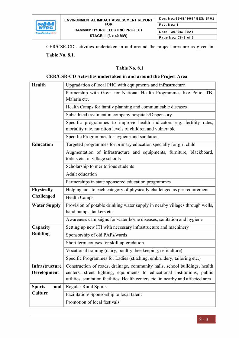
ENVIRONMENTAL IMPACT ASSESSMENT REPORT FOR
RAMMAM HYDRO ELECTRIC PROJECT
STAGE-III (3 x 40 MW)
Doc. No.:9548/999/GEG/S/01
Rev. No.: 1
Date: 30/06/2021
Page No.: C8-3 of 6
8 - 3
CER/CSR-CD activities undertaken in and around the project area are as given in
Table No. 8.1.
Table No. 8.1
CER/CSR-CD Activities undertaken in and around the Project Area
Health Upgradation of local PHC with equipments and infrastructure Partnership with Govt. for National Health Programmes like Polio, TB, Malaria etc. Health Camps for family planning and communicable diseases Subsidized treatment in company hospitals/Dispensory Specific programmes to improve health indicators e.g. fertility rates, mortality rate, nutrition levels of children and vulnerable Specific Programmes for hygiene and sanitation
Education Targeted programmes for primary education specially for girl child Augmentation of infrastructure and equipments, furniture, blackboard, toilets etc. in village schools Scholarship to meritorious students Adult education Partnerships in state sponsored education programmes
Physically Challenged
Helping aids to each category of physically challenged as per requirement Health Camps
Water Supply Provision of potable drinking water supply in nearby villages through wells, hand pumps, tankers etc. Awareness campaigns for water borne diseases, sanitation and hygiene
Capacity Building
Setting up new ITI with necessary infrastructure and machinery Sponsorship of old PAPs/wards Short term courses for skill up gradation Vocational training (dairy, poultry, bee keeping, sericulture) Specific Programmes for Ladies (stitching, embroidery, tailoring etc.)
Infrastructure Development
Construction of roads, drainage, community halls, school buildings, health centers, street lighting, equipments to educational institutions, public utilities, sanitation facilities, Health centers etc. in nearby and affected area
Sports and Culture
Regular Rural Sports Facilitation/ Sponsorship to local talent Promotion of local festivals

ENVIRONMENTAL IMPACT ASSESSMENT REPORT FOR
RAMMAM HYDRO ELECTRIC PROJECT
STAGE-III (3 x 40 MW)
Doc. No.:9548/999/GEG/S/01
Rev. No.: 1
Date: 30/06/2021
Page No.: C8-4 of 6
8 - 4
Table: 8.2
Details of Expenses of CSR-CD/CER Activities
S.No. Head Approved
Budget
(in Lac)
Booked
till date
(in
Lac)
Balance
(in Lac)
Expenditure Incurred (in Lacs)
A. CD Works FY
15-
16
FY
16-17
FY
17-18
FY
18-19
FY
19-20
FY
20-21
Total
1 Educational Facility 110.00 110.00 0.00 0.54 2.21 1.87 21.25 11.70 21.53 59.10
2 Health and medical
services
450.00 422.00 28.00 5.93 2.94 0.00 91.35 67.85 119.22 287.29
3 Providing other
infrastructure facility
90.00 31.00 73.00 0.00 2.09 0.17 3.28 3.86 2.76 12.16
4 Training/Self
Employment/Skill
Development
15.00 0.36 14.64 0.00 0.00 0.33 0.00 0.00 1.13 1.46
5 Construction of
Roads and Drains
450.00 426.00 24.00 0.00 0.00 1.15 72.88 206.63 0.00 280.66
6 Sponsoring Local
Sports/Cultural
Programme
30.00 10.80 19.20 1.19 2.19 1.81 1.76 3.67 4.82 15.44
7 Providing Drinking
Water Facility
110.00 94.00 16.00 0.00 30.38 0.00 22.68 0.00 21.78 74.84
8 Future Misc CD
Works Provision
75.00 0.00 75.00 0.00 0.00 0.00 0.00 0.00 17.23 17.23
9 Disaster Mitigation 70.00 69.10 0.90 0.00 11.16 9.50 0.00 26.56 21.49 68.71
1400.00 1149.26 250.74 7.66 50.97 14.83 213.20 320.27 209.96 816.89
The proposed CER/CD activities budget for 2021-2024 is given in Table 8.3.
Table 8.3
Proposed CER/CD Activities for 2021-2024
S.No. Acitivity Proposed Budget
(Rs. In Lakhs)
1. Education Facility 200
2. Health and medical services 200
3. Providing other infrastructure facility 120
4. Training/Self employment/Skill development 180
5. Providing Drinking water facility 100
6. Sponsirong local sports/Cultural programme 150
Total 950
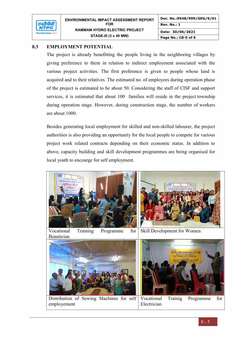
ENVIRONMENTAL IMPACT ASSESSMENT REPORT FOR
RAMMAM HYDRO ELECTRIC PROJECT
STAGE-III (3 x 40 MW)
Doc. No.:9548/999/GEG/S/01
Rev. No.: 1
Date: 30/06/2021
Page No.: C8-5 of 6
8 - 5
8.3 EMPLOYMENT POTENTIAL
The project is already benefitting the people living in the neighboring villages by
giving preference to them in relation to indirect employment associated with the
various project activities. The first preference is given to people whose land is
acquired and to their relatives. The estimated no. of employees during operation phase
of the project is estimated to be about 50. Considering the staff of CISF and support
services, it is estimated that about 100 families will reside in the project township
during operation stage. However, during construction stage, the number of workers
are about 1000.
Besides generating local employment for skilled and non-skilled labourer, the project
authorities is also providing an opportunity for the local people to compete for various
project work related contracts depending on their economic status. In addition to
above, capacity building and skill development programmes are being organised for
local youth to encourge for self employment.
Vocational Training Programme for Beautician
Skill Development for Women
Distribution of Sewing Machines for self employement
Vocational Trainig Programme for Electrician
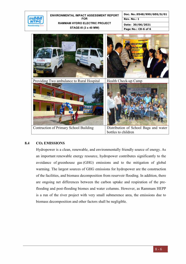
ENVIRONMENTAL IMPACT ASSESSMENT REPORT FOR
RAMMAM HYDRO ELECTRIC PROJECT
STAGE-III (3 x 40 MW)
Doc. No.:9548/999/GEG/S/01
Rev. No.: 1
Date: 30/06/2021
Page No.: C8-6 of 6
8 - 6
Providing Two ambulance to Rural Hospital Health Check-up Camp
Contruction of Primary School Building Distribution of School Baga and water
bottles to children
8.4 CO2 EMISSIONS
Hydropower is a clean, renewable, and environmentally friendly source of energy. As
an important renewable energy resource, hydropower contributes significantly to the
avoidance of greenhouse gas (GHG) emissions and to the mitigation of global
warming. The largest sources of GHG emissions for hydropower are the construction
of the facilities, and biomass decomposition from reservoir flooding. In addition, there
are ongoing net differences between the carbon uptake and respiration of the pre-
flooding and post-flooding biomes and water columns. However, as Rammam HEPP
is a run of the river project with very small submerence area, the emissions due to
biomass decomposition and other factors shall be negligible.
CHAPTER – IX
ENVIRONMENTAL COST BENEFIT
ANALYSIS

ENVIRONMENTAL IMPACT ASSESSMENT REPORT FOR
RAMMAM HYDRO ELECTRIC PROJECT
STAGE-III (3 x 40 MW)
Doc. No.:9548/999/GEG/S/01
Rev. No.: 1
Date: 30/06/2021
Page No.: C9-1 of 9
9-1
CHAPTER-9
ENVIRONMENT COST BENEFIT ANALYSIS
9.0 GENERAL
The development of any hydroelectric scheme involves inevitable impacts. Some of these
are negative and some positive. However, the deciding factor for any scheme is usually the
cost derived from securing a steady and predictable source of electricity. Cost Benefit
Analysis (CBA) simply compares all the expected present and future benefits of a project
with its present and future costs. It is a tool used either to rank projects or to choose the
most appropriate option. The ranking or decision is based on expected economic costs and
benefits.
This chapter discusses about the technique used for testing the financial viability of the
project i.e. whether the investment to be made is worth and whether the project is
financially rewarding. Costs here are described as the intended or unintended negative
effects of project investment, whereas, benefits is described as the intended or unintended
positive effects of the project. CBA aims to maximize economic efficiency at a point where
marginal benefits and marginal costs are equal.
9.1 NEED FOR THE HYDROPOWER PROJECT
In order to meet the ever-increasing power demand, it is imperative to commission power
projects in the State of West Bengal. The proposed Rammam Stage-III Hydro Electric
Project (HEP) would not only meet the power requirements, but would also improve the
ratio of hydro, thermal mix as well. Rammam Stage-III H.E Project is a Run of the River
(ROR) scheme utilizing power potential of Rammam River from elevation 900 m to 385
m, in the District of Darjeeling in the West Bengal with an installed capacity of 120 MW
(3x 40 MW). The Proposed project is Run of River hydro project, is a readily available
source of renewable electricity in a sustainable manner, and helps to meet greenhouse gas
emissions reduction targets as a part of worldwide efforts to reduce the impacts of climate
change.
ENVIRONMENTAL IMPACT ASSESSMENT REPORT FOR
RAMMAM HYDRO ELECTRIC PROJECT
STAGE-III (3 x 40 MW)
Doc. No.:9548/999/GEG/S/01
Rev. No.: 1
Date: 30/06/2021
Page No.: C9-2 of 9
9-2
9.1.1 Power Evacuation
As per National Electricity Plan (NEP), 2018, Capacity addition in between 2017-22 in
Hydro Power Sector in ER is limited to only one project, i.e. Rammam HEP, Stage-III
(3x40 MW) by NTPC. Ministry of Power has given following allocation:
S.No. State Share in installed Capacity (%)
Equivalent quantum in installed Capacity (MW)
1 West Bengal 73 87.6 2 Sikkim 12 14.4 3 Unallocated 15 18
100 120
As per the interstate agreement between Sikkim & West Bengal, the share of Power of the
Sikkim Government (12%) will be made available to the Sikkim Government at free of
cost. The issue of power generation of the project shall be taken up through 4 nos. of 132
kV outgoing Feeders from Rammam Stage-III Switchyard.
One 132 KV Double Circuit line from Rammam Stage-III to NJP 220/132/33 KV
substation & Looped in and Looped out (LILO) of one existing 132 KV single circuit line
from Rammam Stage-II to NBU 132 KV substation need to be constructed. This is in the
stage of finalization with West Bengal Electricity Development Corporation Limited
(WBSEDCL).
9.2 ENVIRONMENT COST BENEFIT ANALYSIS
The main intention if this section is to determine the impacts and benefits from the
proposed Run of River (ROR) project using cost - benefits analysis to verify significance
of the proposed project to the area. Hydroelectric project generally involves intervention
in river thereby changing river flow regime in the submergence area and causes changes in
existing land use in relation to the land forest, agriculture and barren land beside
waterbodies. Preferences for or against an impact may change through time and the relative
price effect has to be accounted for. Costs and benefits are rarely known with certainty so
that risk (probabilistic outcomes) and uncertainty (when no probabilities are known) also
ENVIRONMENTAL IMPACT ASSESSMENT REPORT FOR
RAMMAM HYDRO ELECTRIC PROJECT
STAGE-III (3 x 40 MW)
Doc. No.:9548/999/GEG/S/01
Rev. No.: 1
Date: 30/06/2021
Page No.: C9-3 of 9
9-3
have to be taken into account. Finally, identifying the distributional incidence of costs and
benefits is also important.
The MoEF&CC vide OM No. 7-69/2011-FC(Pt.), dated 1st August, 2017 (Copy enclosed
at Annexure-XXIII), issued Guidelines for conducting Cost Benefit Analysis for projects
involving diversion of forest land under the provisions of the Forest (Conservation) Act,
1980. The guidelines provide a broad and self-explanatory methodology for assessing
ecological and environmental losses and eco-economic distress caused to the people who
are displaced and weighted against economic and social gains. As per above mentioned
OM, Cost Benefit Analysis for forest diversion is not required for proposals involving
forest land up to 20 Ha. in plains and up to 5 Ha. in hills.
9.3 ENVIRONMENT COST
The major impacts due to the project would be direct, e.g. diversion of forest land, change
in topography, impact to aquatic life and reduction in diversity and population density of
migratory fishes, Rehabilitation and Resettlement of Project Affected Families (PAFs). In
addition there are host of indirect impacts like loss of animal husbandry productivity, loss
of fodder, etc.
9.3.1 Cost of Forest Land diverted
Forests are a stabilizing force for the climate. They regulate ecosystems, protect
biodiversity, play an integral part in the carbon cycle, support livelihoods, and supply
goods and services that can drive sustainable growth. The diversion of forestland for non-
forestry purpose certainly destabilize the existing eco-system balance. As per “Polluter
Pays” principle, the agency demanding the diversion of forest land has to pay for the loss
of benefits from ecological services from such land. Increasing and maintaining forests is
therefore an essential solution to climate change. As per MoEF&CC guidelines dated
01.08.2017, the economic value of loss of eco-system services due to diversion of forests
shall be the Net Present Value (NPV) of forest land being diverted as prescribed by the
Central Government (MoEF& CC).
ENVIRONMENTAL IMPACT ASSESSMENT REPORT FOR
RAMMAM HYDRO ELECTRIC PROJECT
STAGE-III (3 x 40 MW)
Doc. No.:9548/999/GEG/S/01
Rev. No.: 1
Date: 30/06/2021
Page No.: C9-4 of 9
9-4
The project implementation is likely to envisage impacts on the land use pattern due to
diversion of forest land for non-forest purposes i.e., for construction and widening of roads,
installation of surface components both upstream and downstream stretch of the river. The
total land requirement for this project has been finalized to be 74.077 ha out of which 1.927
ha is forest land, 10.334 Ha is Government land and 61.806 ha is private land. As a part of
the EIA study, detailed Ecological survey was conducted for one season. Based on the
findings of the survey, it can be concluded that the density and diversity of vegetation in
the project area acquired is quite low.
9.3.2 Compensatory Afforestation
Compensatory afforestation (CA) is one of the most important requirement/condition for
prior approval of the Central Government for diversion of forest land for non-forest
purposes and the purpose of compensatory afforestation (CA) is to compensate the loss of
'land by land' and loss of 'trees by trees'. It can be treated as a replacement cost of diverted
forestland by way of either afforestation in equivalent new non-forest area or double of
area diverted in a degraded forest area. Forest land diverted for project such as irrigation,
hydropower, railways, roads and transmission lines are unlikely to be returned and remain
in possession of the user agencies. As per MoEF&CC guidelines dated 01.08.2017, 30%
of environmental costs (NPV) due to loss of forests or circle rate of adjoining area in the
district should be added as a cost component of possession value of forestland, whichever
is maximum.
9.3.3 Cost incurred in Rehabilitation & Resettlement
The most important deleterious impact during construction phase is, pertaining to land
acquisition. As per the Socio-Economic survey for the Project Affected Families (PAFs)
275 families have lost land, 61 families have lost land as well as homesteads and 11
families have lost homesteads. Approved Budget for R&R plan is 59.20 Crore, Total
ENVIRONMENTAL IMPACT ASSESSMENT REPORT FOR
RAMMAM HYDRO ELECTRIC PROJECT
STAGE-III (3 x 40 MW)
Doc. No.:9548/999/GEG/S/01
Rev. No.: 1
Date: 30/06/2021
Page No.: C9-5 of 9
9-5
approved budget is Rs. 45.20 Crore for land & House shifting. Total of Rs. 3.58 Crores
disbursed as per R&R policy till 31.03.2021.
9.4 ENVIRONMENT BENEFITS
The benefits from the project are mainly from provision of green-fuel (hydropower), social
development and prosperity in area, direct and indirect employment due to the project,
development of infrastructure and facilities in the area.
9.4.1 Increase in Electricity Production
Although, the proportion of Hydro Electric Power (13.84%) in terms of installed Capacity
(MW) at Eastern Region (ER) is close to the national average of 12.33%, but the proportion
of Hydro + Renewable Energy source (RES) at ER is only 17.42% in comparison to the
national average of 35.92% (Country wide installed capacity dated 31.05.20 has been
considered). As per National Electricity Plan (NEP), 2018, Capacity addition in between
2017-22 in Hydro Power Sector in ER is limited to only one project, i.e. Rammam HPP,
Stage-III (3x40 MW) by NTPC. As per the interstate agreement between Sikkim & West
Bengal, the share of power of the Sikkim Government (12%) will be made available to the
Sikkim Government at free of cost. The Rammam Stage-III Hydro Electric Power Project
would not only meet the power requirements, but would also improve the ratio of hydro,
thermal mix as well.
9.4.2 Economic Benefits
Development of infrastructure and availability of reliable power supply as a result of the
project realization would contribute to the stimulation of economic activities like small
scale industries in the area. Additional power generation will mitigate the power shortage
in the country. Some of the local people may get temporary jobs during the operational
phase of the project depending on their skill and performance. The project will act as
stimulant to improve the economy both at the local and National levels. There would be
increase in government tax collection due to implementation of this project.
ENVIRONMENTAL IMPACT ASSESSMENT REPORT FOR
RAMMAM HYDRO ELECTRIC PROJECT
STAGE-III (3 x 40 MW)
Doc. No.:9548/999/GEG/S/01
Rev. No.: 1
Date: 30/06/2021
Page No.: C9-6 of 9
9-6
9.4.3 Employment Generation
The estimated no. of employees during operation phase of the project is estimated to be
about 50. Considering the staff of CISF and support services, it is estimated that about 100
families will reside in the project township during operation stage. However, during
construction stage, the number of workers are much higher (about 1000).
9.4.4 Economic Benefits due to Catchment Area Treatment Plan
A Catchment area Treatment Plan for the catchment area intercepted at the diversion
structure of the proposed barrage site has been prepared as a part of the Comprehensive
EIA study. NTPC has deposited Rs. 7.28 Crores in favor of Principal Chief Conservator of
Forests, West Bengal as part of proposal for implementation of CAT Plan for Rammam
Stage-III project. NTPC has deposited Rs. 1.46 Crores in favor of PCCF cum Principal
Secretary, Govt. of Sikkim as part of proposal for implementation of CAT Plan for
Rammam Stage-III project.
9.4.5 Positive Social Impact Assessment of Project
For economic development, infrastructure building is utmost important viz. power, road,
railways, dam, irrigation projects, mining, plantation, etc. For infrastructure development,
land is the most primary resource. The land may be free from any occupancy or occupied
by habitation, agricultural activity, plantation, forest, water, hills, barren, desert. The
ownership of land can be private or government or public bodies. In any infrastructural
projects, land acquisition is the key job. This results in two types of impacts on the
population who are owing or using this land for their habitation and/or livelihood. The
impacts are: a) Negative, b) Positive. The gravity of impact can be direct or indirect or
cumulative.
Negative impacts of any infrastructural project are highlighted for necessary resettlement
and rehabilitation work. In the projects, the negative impacts are always short-term and
applicable to limited number of population who are directly or indirectly involved. Positive
impacts are hardly highlighted. The positive impacts of any infrastructural project are long-
term and applicable to both affected and non-affected population. Positive impacts are the
ENVIRONMENTAL IMPACT ASSESSMENT REPORT FOR
RAMMAM HYDRO ELECTRIC PROJECT
STAGE-III (3 x 40 MW)
Doc. No.:9548/999/GEG/S/01
Rev. No.: 1
Date: 30/06/2021
Page No.: C9-7 of 9
9-7
visible indicators of economic development. The positive impacts are visible from the
infrastructural development itself and different income generating activities during the
project construction period and after the completion of the project.
The Rammam Stage-III HEP will have both positive and negative social impacts. The
prime positive impacts of Rammam Stage-III HEP are as follows:
Development of road, transport and communication facilities.
Development of ancillary industries to meet the requirement of the project.
Development of educational institutions such as schools, colleges, vocational
institutions, etc.
Opening of banks, post offices, hospitals, religious places, community welfare
centers, etc.
Generation of direct and indirect employment
Market activities will be increased and thereby purchasing power of the population
will also be increased.
The overall impact will be to provide better quality of life to population than mere
Resettlement and Rehabilitation of Project Affected Population.
The negative social impacts could be due to loss of land and homesteads and displacement
of population.
A total expenditure under CSR/CD activities undertaken by project is about Rs. 8.00 Crores
(until March 2021) and local people have benefited from these activities.
9.5 ENVIRONMENT COST AND BENEFITS
The environment cost and benefits of the project has been carried out based on the
methodology and discussion made in foregoing section/sub-sections and elucidated in the
following sections.
9.5.1 Expenditure on R&R and Community Development
The expenditure on R&R and Community Development as on 31.03.2021 is shown in
Table 9.1.
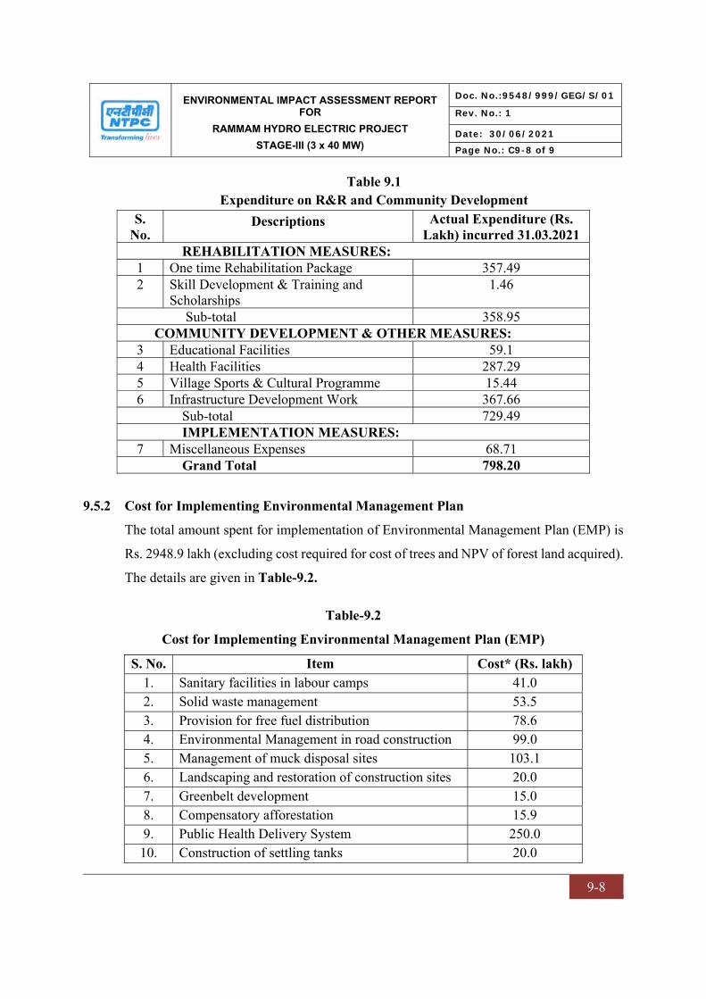
ENVIRONMENTAL IMPACT ASSESSMENT REPORT FOR
RAMMAM HYDRO ELECTRIC PROJECT
STAGE-III (3 x 40 MW)
Doc. No.:9548/999/GEG/S/01
Rev. No.: 1
Date: 30/06/2021
Page No.: C9-8 of 9
9-8
Table 9.1 Expenditure on R&R and Community Development
S. No.
Descriptions Actual Expenditure (Rs. Lakh) incurred 31.03.2021
REHABILITATION MEASURES: 1 One time Rehabilitation Package 357.49 2 Skill Development & Training and
Scholarships 1.46
Sub-total 358.95 COMMUNITY DEVELOPMENT & OTHER MEASURES:
3 Educational Facilities 59.1 4 Health Facilities 287.29 5 Village Sports & Cultural Programme 15.44 6 Infrastructure Development Work 367.66
Sub-total 729.49 IMPLEMENTATION MEASURES:
7 Miscellaneous Expenses 68.71 Grand Total 798.20
9.5.2 Cost for Implementing Environmental Management Plan
The total amount spent for implementation of Environmental Management Plan (EMP) is
Rs. 2948.9 lakh (excluding cost required for cost of trees and NPV of forest land acquired).
The details are given in Table-9.2.
Table-9.2
Cost for Implementing Environmental Management Plan (EMP)
S. No. Item Cost* (Rs. lakh) 1. Sanitary facilities in labour camps 41.0 2. Solid waste management 53.5 3. Provision for free fuel distribution 78.6 4. Environmental Management in road construction 99.0 5. Management of muck disposal sites 103.1 6. Landscaping and restoration of construction sites 20.0 7. Greenbelt development 15.0 8. Compensatory afforestation 15.9 9. Public Health Delivery System 250.0
10. Construction of settling tanks 20.0
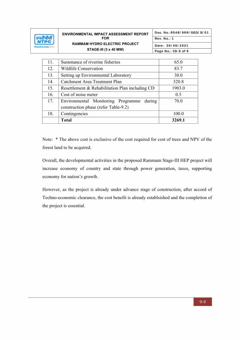
ENVIRONMENTAL IMPACT ASSESSMENT REPORT FOR
RAMMAM HYDRO ELECTRIC PROJECT
STAGE-III (3 x 40 MW)
Doc. No.:9548/999/GEG/S/01
Rev. No.: 1
Date: 30/06/2021
Page No.: C9-9 of 9
9-9
11. Sustenance of riverine fisheries 65.0 12. Wildlife Conservation 83.7 13. Setting up Environmental Laboratory 30.0 14. Catchment Area Treatment Plan 320.8 15. Resettlement & Rehabilitation Plan including CD 1903.0 16. Cost of noise meter 0.5 17. Environmental Monitoring Programme during
construction phase (refer Table-9.2) 70.0
18. Contingencies 100.0 Total 3269.1
Note: * The above cost is exclusive of the cost required for cost of trees and NPV of the
forest land to be acquired.
Overall, the developmental activities in the proposed Rammam Stage-III HEP project will
increase economy of country and state through power generation, taxes, supporting
economy for nation’s growth.
However, as the project is already under advance stage of construction, after accord of
Techno-economic clearance, the cost benefit is already establsished and the completion of
the project is essential.

CHAPTER – X
ENVIRONMENTAL MANAGEMENT PLAN
ENVIRONMENTAL IMPACT ASSESSMENT REPORT FOR
RAMMAM HYDRO ELECTRIC PROJECT
STAGE-III (3 x 40 MW)
Doc. No.:9548/999/GEG/S/01
Rev. No.: 1
Date: 30/06/2021
Page No.: C10-1 of 32
10 -1
CHAPTER-10
ENVIRONMENTAL MANAGEMENT PLAN
10.0 INTRODUCTION
This chapter provides a description of the administrative aspects of ensuring that
mitigative measures are implemented and their effectiveness monitored, after approval of
the EIA. Based on the evaluation of impacts and baseline conditions, an Environmental
Management Plan (EMP) has been delineated to mitigate the adverse impacts. The EMP
includes formulation, implementation and monitoring of environmental protection
measures. The EMP features guidelines and methodologies to be adopted at different
stages of the project for mitigating the impacts of various activities. The EMP is herein
outlined after taking into account the various Acts, Rules and Regulations/Standards
concerned with the environmental management. Thus, it is a planned and integrated
programme aimed at ensuring that both identified and unidentified impacts that may arise
during the various phases of the project are brought to an acceptable level.
10.1 EMP DURING VARIOUS PROJECT PHASES
Environmental Management Plan (EMP) is the key to ensure a safe and clean
environment. The desired results from the environmental mitigation measures proposed
in the project may not be obtained without a management plan to assure its proper
implementation and function. The EMP envisages the plans for the proper
implementation of mitigation measures to reduce the adverse impacts arising out of the
project activities. EMP has been prepared addressing the issues like:
Pollution control/mitigation measures for abatement of the undesirable impacts
caused during the construction and operation phase of the project.
Details of management plans (air pollution control devices/measures, utilization of
treated sewage, solid waste management plan etc.)
Institutional set up identified/recommended for implementation of the EMP.
Post project environmental monitoring programme to be undertaken
ENVIRONMENTAL IMPACT ASSESSMENT REPORT FOR
RAMMAM HYDRO ELECTRIC PROJECT
STAGE-III (3 x 40 MW)
Doc. No.:9548/999/GEG/S/01
Rev. No.: 1
Date: 30/06/2021
Page No.: C10-2 of 32
10 -2
Expenditures for environmental protection measures and budget for EMP.
10.2 CONTROL OF POLLUTION FROM LABOUR CAMPS DURING
CONSTRUCTION PHASE
As the project is in advanced stage of construction in its all three units (Unit 1, 2, & 3)
various types of construction equipment are already made available within the site and
the construction is likely to last till December, 2026. The aggregation of large labour
population of about 1000 nos. during construction phase has significant stress on various
facets of environment. Around 200 labours are local residents. The various issues covered
in environmental management during construction phase are:
- Facilities in labour camps
- Sanitation and sewage treatment facilities
- Solid waste management
- Provision of community kitchen
10.2.1 Facilities in labour camps
The labour population resides in 2 to 3 colonies near to the construction site. These
structures are tin sheds. These sheds have internal compartments allotted to each worker
family. The labour camp sites have electricity and ventilation system, water supply and
community sanitation facilities.
The water for meeting domestic requirements being collected from the rivers or streams
flowing upstream of the labour camps. The water is transferred to the labour camps,
stored in tanks and utilized.
10.2.2 Sanitation facilities
The total water requirements work out to be 70.0 KLD @ 70 lpcd. It is assumed that
about 80% of the water supplied will be generated as sewage. Thus, total quantum of
sewage generated is 56.0 KLD. This is being sent to Biodigestor septic tank and treated
water is being reused/recycled for landscaping.

ENVIRONMENTAL IMPACT ASSESSMENT REPORT FOR
RAMMAM HYDRO ELECTRIC PROJECT
STAGE-III (3 x 40 MW)
Doc. No.:9548/999/GEG/S/01
Rev. No.: 1
Date: 30/06/2021
Page No.: C10-3 of 32
10 -3
10.2.3 Solid waste management from labour camps
The labour colony located at diversion site, power house site and at adit sites. During
construction phase, about 1000 labours are congregated. The average per capita solid
waste generated is of the order of 450 gm/day/person. The solid waste generated from
labour camps is of the order of 0.45 tonnes/day. Adequate facilities for collection,
conveyance and disposal of solid waste are developed. The solid wastes being disposed
regularly through Nayabazar Jorethang Municipal Corporation (NJMC).
10.2.4 Provision of free fuel
At present LPG gas is being used for officers & staff engaged in the construction work.
Adequate fuel for labour camp (about 100 LPG cylinders, Kerosene & fire wood) is
provided by the contractors. Also, fuel depot at Jorethang (South Sikkim) is available
within accessible reach from site. The cost provision for free fuel distribution has
been made.
10.3 ENVIRONMENTAL MANAGEMENT IN ROAD CONSTRUCTION
The approach roads of 29 km was proposed to be constructed out of which 11.7 km has
been completed and reaming are under construction, as a part of providing appropriate
infrastructure for transporting staff and equipment to the construction site. In a hilly
environment, construction of roads sometime disturbs the scenic beauty of the area. In
addition, landslides are often triggered due to road construction because of the loosening
of rocks by water trickling from various streams. Steeply sloping banks are liable to
landslides, which can largely be controlled by provision of suitable drainage. The basic
principle is to intercept and divert as much water as possible, before it arrives at a point,
where it becomes a nuisance. The other erosion hazard is that of surface erosion of the
bank, which is best controlled by vegetation. However, in a steeply sloping terrain,
difficulty lies in growing vegetation on steeply sloping banks. Engineering solutions such
as surface drainage, sub-surface drainage, toe protection and rock bolting were used. The
cost required for implementation of various measures has already been incorporated in
the overall budget earmarked for construction of roads.
ENVIRONMENTAL IMPACT ASSESSMENT REPORT FOR
RAMMAM HYDRO ELECTRIC PROJECT
STAGE-III (3 x 40 MW)
Doc. No.:9548/999/GEG/S/01
Rev. No.: 1
Date: 30/06/2021
Page No.: C10-4 of 32
10 -4
In hilly terrain, road construction often generates significant quantity of wastes (muck)
due to the stripping of the rocks to make way for the roads. The stripped material is
collected and dumped in the designated muck disposal area with toe wall to prevent the
muck to flow down into the river. After disposal operation is complete at the dump site,
the dump yard shall be contoured and vegetated.
The various aspects considered while making the project roads are briefly described as
following.
Construction
Area for clearing and grubbing kept minimum subject to the technical requirements of
the road. The clearing area properly demarcated to save desirable trees and shrubs and
to keep tree cutting to the minimum.
Where erosion is likely to be a problem, clearing and grubbing operations is done in
such a way that scheduled and performed that grading operations and permanent
erosion control of features can follow immediately thereafter, if the project conditions
permit; otherwise temporary erosion control measures is being provided between
successive construction stages. Under no circumstances, very large surface area of
erodible earth material are exposed at any time by clearing and grubbing.
The method of balanced cut and fills formation adopted to avoid large difference in cut
and fill quantities.
The cut slopes suitably protected by breast walls, provision of flat stable slopes,
construction of catch water and intercepting drains, treatment of slopes and unstable
areas above and underneath the road, etc.
Where rock blasting is involved, controlled blasting techniques adopted to avoid over-
shattering of hill faces.
Excavated material dumped duly dressed up in a suitable form at appropriate places
where it cannot get easily washed away by rain, and such spoil deposits provided with
some vegetative cover.

ENVIRONMENTAL IMPACT ASSESSMENT REPORT FOR
RAMMAM HYDRO ELECTRIC PROJECT
STAGE-III (3 x 40 MW)
Doc. No.:9548/999/GEG/S/01
Rev. No.: 1
Date: 30/06/2021
Page No.: C10-5 of 32
10 -5
Drainage
All artificial drains linked with the existing natural drainage system.
Surface drains have gentle slopes. Where falls in levels are to be negotiated, check
dams with silting basins are constructed and that soil is not eroded and carried away by
high velocity flows.
Location and alignment of culverts so chosen as to avoid severe erosion at outlets and
siltation at inlets.
Grassing and Planting
Tree felling for road construction/works was bare minimum and strict control
exercised in consultation with the Forest Department.
Depending on the availability of land and other resources, afforestation of roadside
land shall be carried out to a sufficient distance on either side of the road.
About 29 km of roads were proposed to be constructed out of which 11.7 km has been
completed as a part of Rammam Stage-III hydroelectric project.
10.4 MANAGEMENT OF MUCK DISPOSAL SITES
For hydro-power projects, the quantity of muck generated is quite high for setting up of
various structures. Muck generated from excavation of any project component is required
to be disposed in a planned manner so that it takes a least possible space and is not
hazardous to the environment. In the hilly area, dumping is done after creating terraces.
The overall idea is to enhance/maintain aesthetic view in the surrounding area of the
project in post-construction period and avoid contamination of any land or water resource
due to muck disposal.
Muck of 0.99 Mm3 is expected to be generated from construction of project. Out of
which 0.40 Mm3 is being utilized as construction material. At the present the dumping
sites are already identified for muck disposal. The balance 0.59 Mm3 muck shall be
disposed at designated/identified site in a planned manner so that it takes a least possible
space and is not hazardous to the environment. An area of 6.66 Ha has been earmarked

ENVIRONMENTAL IMPACT ASSESSMENT REPORT FOR
RAMMAM HYDRO ELECTRIC PROJECT
STAGE-III (3 x 40 MW)
Doc. No.:9548/999/GEG/S/01
Rev. No.: 1
Date: 30/06/2021
Page No.: C10-6 of 32
10 -6
which can cater the entire quantity of muck to be disposed. About 0.132 Mm3 of
aggregate is utilized for filling and construction works from muck generated during
excavation of underground works like HRT and desilting chamber. A toe wall has been
created around the muck disposal site and more landscaping to be done in the muck site.
10.5 RESTORATION AND LANDSCAPING OF PROJECT SITES
The construction of the project, including its various appurtenances e.g. barrage, power
house, approach roads, labour camps, project colony, etc. would disturb the existing
topography and physiography. It is proposed to landscape the area, so that it integrates
with the natural surroundings and the beauty of the area is restored. Accordingly, it is
proposed to develop small gardens at 2 locations and few view points along the periphery
of the water spread area and power house site.
The landscaping plan is detailed as below:
- Garden complex
- View points
- Landscaping
The above referred measures are described briefly in the following paragraphs:
Garden Complex: A garden with local ornamentation plants and trees shall be created at
two locations, i.e. one each near the barrage/dam and project colony sites. All plants will
be properly labelled with scientific and/or common names.
Creation of viewpoints: Two viewpoints shall be created one near the powerhouse and
other at suitable place along the periphery of the water spread area. These view points
will be slab type extension above the ground, which will be properly reinforced and
fenced to avoid any undesirable incidence. It will be given a shed and plantation of
ornamental plants will be done near it.
Landscaping: Various sites in the area will be stabilized by constructing a series of
benches. The walls that will be constructed for containing the slope will be embedded
with local stone to integrate with the aesthetics of the area.
A total provision of Rs. 20 lakh is earmarked for restoration and landscaping of project
sites.
ENVIRONMENTAL IMPACT ASSESSMENT REPORT FOR
RAMMAM HYDRO ELECTRIC PROJECT
STAGE-III (3 x 40 MW)
Doc. No.:9548/999/GEG/S/01
Rev. No.: 1
Date: 30/06/2021
Page No.: C10-7 of 32
10 -7
10.6 GREENBELT DEVELOPMENT
The total land acquired for the project is about 74.007 ha, of which only 1.927 ha is the
forest land. Although the forest loss due to various project appurtenances will be
compensated as a part of compensatory afforestation, in addition to above, it is proposed
to develop greenbelt. Till date 11000 saplings has been planted in project area as well as
in nearby villages.
The general consideration involved while developing the greenbelt are:
- Local plant species trees growing upto 10 m or above in height with perennial
foliage have planted around various appurtenances of the proposed project.
- Planting of trees has been undertaken in appropriate encircling rows around the
project site.
- Fast growing trees have selected for plantation
- Since, the tree trunk area is normally devoid of foliage upto a height of 3 m, it
may be useful to have shrubbery in front of the trees so as to give coverage to this
portion.
The plantation at a spacing of 2.5 * 2.5 m. The plantation and maintenance of the
plantation area is being done by the project proponents in association with the State
Government. The selection of species for greenbelt development and afforestation for
further plantation shall be done in consultation with State Forest Department.
The following native species are being planted and suggested to plant under green belt development.
Table 10.1
List of Plant Species for Greenbelt
Sr. No. Name of Species Form of Species 1. Albizia chinensis Tree 2. Bischofia javanica Tree 3. Duabanga grandiflora Tree 4. Engelhardtia spicata, Tree 5. Erythrina arborescens Tree 6. Ficus reticulata, Tree 7. Gynocardia odorata Tree
ENVIRONMENTAL IMPACT ASSESSMENT REPORT FOR
RAMMAM HYDRO ELECTRIC PROJECT
STAGE-III (3 x 40 MW)
Doc. No.:9548/999/GEG/S/01
Rev. No.: 1
Date: 30/06/2021
Page No.: C10-8 of 32
10 -8
8. Boehmeria platyphylla Tree 9. Caesalpinia decapetala, Tree 10 Euonymus pendulus, Tree 11. Chromolaena odorata, Tree 12 Holmskioldia anguinea, Tree 13. Holmskioldia anguinea, Tree 14 Hedychium spicatum Sm. Medicinal Plants 15. Acrocarpus fraxinifolius Arnott. Tree 16. Centella asiatica (L.) Urban Medicinal Plants 17. Costus speciosus Smith Medicinal Plants 18. Acacia catechu (L. f.) Willd. Tree 19. Agapetes serpens(Wight) Sleumer Shrub 20. Albizia procera (Roxb.) Benth. Tree 21. Antidesma acidum Retzium. Shrub
10.7 COMPENSATORY AFFORESTATION
The total land acquired for the project is about 74.007 ha, of which 1.927 ha is the forest
land. During field study, it was found that the forest land acquired for the project do not
contain any unique or rare or endangered species. The loss of vegetal cover can be
compensated by compensatory afforestation. The Forest Conservation Act (1980)
stipulates:
- if non-forest land is not available, compensatory forest plantations are to be
established on degraded forest lands, which must be twice the forest area affected
or lost, and
- if non-forest land is available, compensatory forest are to be raised over an area
equivalent to the forest area affected or lost.
Compensatory afforestation and identification of suitable native tree species are done by
State Forest Department. NTPC has paid the amount estimated by the Forest Department
as Net Present Value (NPV) of forest land acquired. NTPC has deposited Rs. 7.28 Crores
in favor of Principal Chief Conservator of Forests, West Bengal as part of proposal for
implementation of CAT Plan for Rammam Stage-III project. NTPC has deposited Rs.
1.46 Crores in favour of PCCF cum Principal Secretary, Govt. of Sikkim as part of
proposal for implementation of CAT Plan for Rammam Stage-III project. Compensatory
ENVIRONMENTAL IMPACT ASSESSMENT REPORT FOR
RAMMAM HYDRO ELECTRIC PROJECT
STAGE-III (3 x 40 MW)
Doc. No.:9548/999/GEG/S/01
Rev. No.: 1
Date: 30/06/2021
Page No.: C10-9 of 32
10 -9
afforestation has been done by the Sikkim State Forest Department as per the stipulating
outlined as a part of Forestry Clearance. However, utilization certificate from West
Bengal Forest department is awaited.
10.8 BIODIVERSITY AND WILDLIFE CONSERVATION AND MANAGEMENT
PLAN
10.8.1 Introduction
Biodiversity plays a major role as it provides the fundamental building blocks for the
many goods and services which provide a healthy environment to lead our life. It
includes fundamental things to our health like fresh water, clean air and food products, as
well as the many other products and also serves as cultural, recreational, and spiritual
nourishment that play an important role in maintaining our personal life as well as social
life.
The implementation of Biodiversity conservation strategy is a challenging job especially
in North-Eastern States of India likes Sikkim state and Darjeeling hills of West Bengal as
the area is predominant with various tribal populations, which consider themselves as an
integral part of the forest ecosystem.
The formulation of a biodiversity management plan for a developmental project is one of
the steps towards the environment conservation. Human activities like agricultural
expansion, road construction, Dam construction, urbanization, and other developmental
activities are supposed to be major threats to biodiversity and wildlife, therefore, the most
effective and efficient mechanisms for conserving biodiversity is to prevent destruction
of habitats. Four strategies required for the biodiversity management are in situ strategy,
ex situ strategy, reduction of anthropogenic pressure and rehabilitation of endangered
species. A copy of Wildlife Conservation plan is enclosed at Annexure-XVIII.
10.8.2 Biodiversity Policy of NTPC
NTPC has become the first PSU to publish a Biodiversity Policy 2018 and become a
member of IBBI (India Business and Biodiversity Initiative). This is also in line with

ENVIRONMENTAL IMPACT ASSESSMENT REPORT FOR
RAMMAM HYDRO ELECTRIC PROJECT
STAGE-III (3 x 40 MW)
Doc. No.:9548/999/GEG/S/01
Rev. No.: 1
Date: 30/06/2021
Page No.: C10-10 of 32
10 -10
National Biodiversity Action Plan (NBAP) 2008, which recommends set of actions
towards biodiversity management. A copy of Biodiversity Policy is enclosed at
Annexure-XXIV.
The purpose of the Biodiversity Policy to mainstream the concept of biodiversity across
NTPC’s value chain and adopt a precautionary approach for sustainable management of
biodiversity in all decision making processes so that the earth's variety of life is
maintained ensured in and around NTPC’s the business units of NTPC.
Policy Statement
To mainstream the concept of biodiversity across NTPC’s value chain and adopt a
precautionary approach for sustainable management of biodiversity in all decision-
making processes so that the earth's variety of life is ensured in and around the business
units of NTPC
The policy is applicable to all existing and upcoming business units of NTPC and each
employee is a partner in implementing the policy.
The Biodiversity policy is guided by following five principles:
a) Consideration of biodiversity in all business decision right from planning to
operations and closure of sites;
b) Minimization of adverse impacts on biodiversity through right combination of
best industry practices and state of art technologies;
c) Biodiversity goals are not limited to statutory and regulatory compliances but are
aimed at the continual improvement of the biodiversity;
d) Provision of accountability for all locations and creating systems to respond to
any aberration;
e) Capacity building through inclusiveness and regular knowledge sharing on
biodiversity with concerned stakeholders;
ENVIRONMENTAL IMPACT ASSESSMENT REPORT FOR
RAMMAM HYDRO ELECTRIC PROJECT
STAGE-III (3 x 40 MW)
Doc. No.:9548/999/GEG/S/01
Rev. No.: 1
Date: 30/06/2021
Page No.: C10-11 of 32
10 -11
10.8.3 Objectives
The main objective of Biodiversity Conservation and Management plan is sustainable use
of natural resources, which involves scientific management of natural wealth vis-à-vis
developmental activities, is likely to affect these resources. The threats to natural
terrestrial and aquatic ecosystem generally arise due to by anthropogenic activities that
may arise because of construction and associated activities of project. A detailed
biodiversity conservation and management plan has been proposed and the main
objectives of said plan are as follows:
Maintenance of ecological balance through preservation and restoration of
wherever it has been disturbed due to project developmental activities
Conservation and preservation of natural habitats in catchment area
Rehabilitation of IUCN threatened category, if any provisions for in-situ or ex-situ
conservation of IUCN threatened and Schedule –I species
Mitigation and control of project catchment area by taking up afforestation and soil
conservation measures
Creating all round awareness regarding conservation and ensuring people’s
participation in the conservation efforts and minimizing man animal conflict.
10.8.4 Study area
The submergence area is 3.852 Ha, which is located in upstream of confluence of
Rammam River near Lodhama Village in the Darjeeling district. The area in the vicinity
of project comprised of degraded Mixed broad-leaf tropical deciduous forest with few
Semi-evergreen riverine tree species.
On right bank of Rammam river, the tree canopy is comprised of Albizia chinensis,
Bischofia javanica, Duabanga grandiflora, Engelhardtia spicata, Erythrina arborescens,
Ficus reticulata, Gynocardia odorata, Schima wallichiiand Tetradium fraxinifolium.
Second storey is also very thin and composed of some small trees and tall spreading
weeds. Boehmeria platyphylla, Caesalpinia decapetala, Euonymus pendulus,
Chromolaena odorata, Holmskioldia anguinea, Lantana camara, Rhamnus nepalensis,

ENVIRONMENTAL IMPACT ASSESSMENT REPORT FOR
RAMMAM HYDRO ELECTRIC PROJECT
STAGE-III (3 x 40 MW)
Doc. No.:9548/999/GEG/S/01
Rev. No.: 1
Date: 30/06/2021
Page No.: C10-12 of 32
10 -12
etc. are found in the under storey. Climbers and epiphytes are often seen on the forest
floor. Cissus discolor, Cuscuta reflexa, Jasminum humile, Lygodium japonicum, Piper
sylvaticum, Stephania glabra, Todalia asiatica, etc. are important trailing species.
Herbaceous flora was represented by some pteridophytic plants, grasses and weeds. The
pteridophytes are represented by species of Adiantum, Coniograme, Lygodium,
Selaginella, etc. on this bank. Among the herbs and grasses are Ageratum conyzoides,
Artemisia nilagirica, Arundinella nepalensis, Arthraxon hispidus, Capillipedium
assimile, Commelina benghalensis, Eupatorium adenophorum, Imperata cylindrica,
Lespedeza gerardiana, Oxalis corniculata, Pilea scripta, Pogonatherum paniceum,
Saccharum spontaneum and Thysanolaena latifolia.
Species composition of left bank is more or less similar to the right bank but
Dendrocalmus hamiltonii clumps is the dominant and Alnus nepalensis was found as a
dominant tree species with other tree associates. Important tree associates were Albizia
chinensis, Bischofia javanica, Bombax ceiba, Duabanga grandiflora, Erythrina
arborescens, Oroxylum indicum, Pandanus nepalensis, Schima wallichii, etc. Second
storey was very open and occupied by few trailing and spreading shrubby species.
Dendrocalmus hamiltonii, Chromolaena odorata, Mimosa himalayana, etc. were in the
under storey. Climbers and epiphytes were rare. Herbs were represented by few non
vascular pteridophytic plants, weeds and few grasses.
10.8.5 Protected areas
There are two protected areas which are Singalila National Park and Barsey Rododendron
Sanctuary located within the Buffer zone area. Singalila National Park ESZ is located on
the west side of project area at a distance of about 7.1 km from the barrage site. The
Barsey Rhododendron Wildlife Sanctuary ESZ is at a distance of 4.2 km from the barrage
site on NW side.

ENVIRONMENTAL IMPACT ASSESSMENT REPORT FOR
RAMMAM HYDRO ELECTRIC PROJECT
STAGE-III (3 x 40 MW)
Doc. No.:9548/999/GEG/S/01
Rev. No.: 1
Date: 30/06/2021
Page No.: C10-13 of 32
10 -13
10.8.6 Conservation plan for IUCN Threatened Category plants
According to Nayar and Sastry (1987, 1988, and 1990) and Ministry of Environment and
Forests, 13 species of plants are under the endangered category, two of them viz. Zeuxine
pulchra (Orchidaceae) and Dennstaedtia elwesii (Dennstaedtiaceae) in all probability
have already disappeared from Sikkim Himalaya. Around 10 species of plants are in
vulnerable category and 18 species have become rare. Six species of plants have
indeterminate status such as Acer hookeri var. majus (Endangered), Aconitum ferox
(Vulnerable), Acronema pseudotenera (Indeterminate), Angelica nubigena
(Indeterminate), Aphyllorchis parviflora (Rare), Arenaria thangoensis (Vulnerable),
Athyrium duthei (Vulnerable), Begonia rubella (Rare), Begonia satrapis (Rare), Begonia
scutata (Rare), Calamus inermis (Endangered), Calanthe alpina (Rare), Calanthe mannii
(Rare), Carex kingiana (Indeterminate), Ceropegia hookeri (Endangered), Ceropegia
lucida (Endangered or possibly extinct), Christella clarkei (Vulnerable), Christopteris
tricuspis (Indeterminate), Cissus spectabilis (Endangered), Codonopsis affinis (Rare),
Coelogyne truetleri (Possibly extent), Cotoneaster simonsii ((Indeterminate),
Cyclogramma squamaestipes (Rare), Cymbidium eburneum (Vulnerable), Cymbidium
hookerianum (Vulnerable), Cymbidium whiteae (Endangered), Cypripedium elegans
(Rare), Cypripedium himalaicum (Rare), Dennstaedtia elwesii (possibly extent), Didiciea
cunninghamii (Endangered), Juncus sikkimensis (Rare), Lactuca cooperi (Endangered),
Lagerstroemia minuticarpa (Rare), Livistona jenkinsiana (Endangered), Lloydia
himalensis (Rare), Mecodium levingei (Rare), Nardostachys grandiflora (Vulnerable),
Ophiorrhiza lurida (Rare), Oreopteris elwesii (Rare), Panax pseudoginseng (Vulnerable),
Paphiopedilumfairrieanum (Endangered), Paphiopedilum venustum (Vulnerable),
Phoenix rupicola (Rare), Picrorhiza kurrooa (Vulnerable), Pimpinella tongloensis
(Endangered), Pimpinella wallichii (Endangered), Pternopetalum radiatum
(Indeterminate), Rhopalocnemis phalloides (Rare), and Zeuxine pulchra (Endangered or
Extinct), these plant species included in the “Carrying capacity study of Teesta basin in
Sikkim” published by Ministry of Environment and Forests. Among these plant species,
only one species which is Phoenix rupicola (Near Threatened as per IUCN Redlist
ENVIRONMENTAL IMPACT ASSESSMENT REPORT FOR
RAMMAM HYDRO ELECTRIC PROJECT
STAGE-III (3 x 40 MW)
Doc. No.:9548/999/GEG/S/01
Rev. No.: 1
Date: 30/06/2021
Page No.: C10-14 of 32
10 -14
Category) available in the Barrage influence area. There is no vegetation in the Township
and Power house areas where the vegetation was cleared.
The peculiar topography, the area and the location of the barrage on a comparatively
narrow gorge, perhaps makes the creation of a comparatively 3.852 Ha submerging,
small forest area obligatory in this case. However, there deeming feature is that the type
of forest affected is, by no means unique to this area alone but occurs in other areas of the
vast catchment. Moreover, the percentage of forest-covered land in this catchment is
quite low which is 1.927 Ha reserved forest and the provision of compensatory
afforestation should adequately take care of the possibility of upsetting the ecological
balance. However, it is suggested that while clearing the forest area to be submerged, the
Forest Department should take adequate care to translocation the rare species of plants
particularly orchids, tree ferns and medicinal herbs and shrubs to other adjoining forest
areas as far as feasible and the Project Authority should fully co-operate in this job. These
should also ensure that their men and machineries create the least disturbance in the
neighboring forest areas. Some of the techniques for ex-situ conservation are listed in
Table 10.2.
Table 10.2 Techniques of ex-situ conservation
Techniques Definition Seed storage Collection of seed samples at one location and their transfer to a gene bank for
storage. The samples are usually dried to suitable low moisture content and then kept at sub-zero temperatures.
Field gene bank The collecting of seed or living material from one location and its transfer and planting at a second site. Large numbers of accessions of a few species are usually conserved.
Botanic garden/ arboretum
The collecting of seed or living material from one location and its transfer and maintenance at a second location as living plant collections of species in a garden or for tree species in an arboretum. Small numbers of accessions of a large number of species are usually conserved.
In vitro storage The collection and maintenance of explants (tissue samples) in a sterile, pathogen-free environment
DNA/pollen The collecting of DNA or pollen and storage in appropriate, usually storage refrigerated conditions.

ENVIRONMENTAL IMPACT ASSESSMENT REPORT FOR
RAMMAM HYDRO ELECTRIC PROJECT
STAGE-III (3 x 40 MW)
Doc. No.:9548/999/GEG/S/01
Rev. No.: 1
Date: 30/06/2021
Page No.: C10-15 of 32
10 -15
From the techniques mentioned in Table 10.2, creation of Botanic garden is proposed for
conservation of endangered plants found in Rammam river catchment area. It is proposed
to afforest rare and endangered species over an area of 2.5 ha (as a part of compensatory
afforestation) as a measure for ex-situ conservation and propagation in consultation with
Forest Departments of both states of West Bengal and Sikkim.
Many of the threatened plants and the superior germplasm that are going to be affected
can be transplanted to safer locations. There are useful technologies that are available for
this purpose. Appropriate technologies suiting to the species concerned could be adopted.
Some of the vegetative propagation methods like air layering, grafting, stump planting,
cuttings, suckers, stolon’s, bulbil propagation etc. may find application here.
There are many important trees and superior germplasm in the area particularly of timber
species and bamboos. We need to create germplasm banks with the materials obtained
from it. Though the same species could be found elsewhere, the germplasm may not be
available. The propagation and cultivation of these species may be done in co-ordination
with the Botanical Survey of India, Kolkata, G.B. Pant Institute of Himalayan
Environment and Development, Almora, Uttarakhand ENVIS Center at Gangtok,
Regional Botanical Survey of India, Gangtok and Forest departments of the both the
states.
10.8.7 Establishment of gardens for voucher specimens (Threatened category plants)
The proposed repositories would be of special interest to biodiversity conservation,
scientific research, education and environmental awareness. An Orchidarium and a fern
house are proposed to be developed near project area in association with national
Research Centre for Orchids, Pakyong, Sikkim, in which important species of orchids
and ferns collected from the catchment area will be conserved.
10.8.8 Conservation and cultivation of medicinal plants
It is proposed to develop herbal nursery at appropriate location preferably in the Gram
Panchayat. Self-help groups formed by women should be involved for the promotion of

ENVIRONMENTAL IMPACT ASSESSMENT REPORT FOR
RAMMAM HYDRO ELECTRIC PROJECT
STAGE-III (3 x 40 MW)
Doc. No.:9548/999/GEG/S/01
Rev. No.: 1
Date: 30/06/2021
Page No.: C10-16 of 32
10 -16
herbal drugs from the kitchen stock and rare medicinal plants. Species of medicinal plants
proposed for plantation in the project area is given as below:
i. Aconitum ferox Wall. Ex Ser. ii. Aconitum heterophyllum Wall. Ex Royle iii. Acorus calamus L. iv. Adhatoda vasica L. v. Allium wallichii Kunth. vi. Aloe barbadensis Mill. vii. Artemisia vulgaris L. viii. Astilbe rivularis Ham. ix. Berginia ciliata (How.) Sternb. x. Centella asiatica (L.) Urban xi. Costus speciosus Smith xii. Curcuma aromatica Salisb. xiii. Curcuma caesia Roxb. xiv. Hedychium spicatum Sm. xv. Kaempferia rotunda L. xvi. Kalanchoe pinnata (Lam) Pers. xvii. Nardostachys jatamansi DC. xviii. Ocimum basilicum L. xix. Orchis latifolia L. xx. Panax pseudoginseng Wall. xxi. Picrorrhiza kurroa Royle ex Benth. xxii. Podophyllum hexandrum Royle xxiii. Sapindus mukorossi Gaertn. xxiv. Swertia chirata Ham. xxv. Taxus baccata L. xxvi. Tinospora cordifolia (Willd.) Miers xxvii. Tupistra nutans Wall. xxviii. Zingiber cassumunar Roxb.
Farmers shall be trained to make them aware of the use of herbal plants and in animal
health care also. West Sikkim Forest Division is rich in a variety of medicinal plants.
However, in past uninhibited exploitation of medicinal plants has led to depletion of this
valuable resource. Therefore, in order to augment natural stock of medicinal plants in the

ENVIRONMENTAL IMPACT ASSESSMENT REPORT FOR
RAMMAM HYDRO ELECTRIC PROJECT
STAGE-III (3 x 40 MW)
Doc. No.:9548/999/GEG/S/01
Rev. No.: 1
Date: 30/06/2021
Page No.: C10-17 of 32
10 -17
forests, it is proposed to take up planting of medicinal plants and establishing medicinal
plants nurseries.
In order to ensure effective forest conservation, strong central legislation like Forest
Conservation Act and Wildlife Protection Act has been enacted. The CAMPA
(Compensatory Afforestation Fund Management and Planning Authority) fund can be
utilized to regenerate degraded forest area by way of planting and protecting natural
regeneration. Networks of base camps and strike forces can be set up to improve forest
protection involving the local people.
Enhance the long-term survival of a species;
Re-establish a keystone species;
Maintain and/or restore natural biodiversity;
Provide long-term economic benefits to the local and/or national economy; to
promote conservation awareness; or a combination of these.
Improve vigilance by procurement of field vehicles and motorbikes.
Conduct public awareness programmes, training camps, distribution of pamphlets,
brochures, hoardings, etc.
Provision of fire lines within critical areas to protect the forest from accidental
fires.
10.8.9 Forest Protection Plan
The submergence area is 3.852 Ha which is located in upstream of confluence of
Rammam River near Lodhama Village in the Darjeeling district. The following measures
are proposed as a part of Forest Protection Plan:
PBR’s shall be prepared, maintained and to validate in consultation with the local
people so that the Register gives information about the details of access to
biological resources and traditional knowledge pertaining to the area.
In order to ensure effective forest conservation, strong central legislation like Forest
Conservation Act and Wildlife Protection Act has been enacted. The CAMPA
(Compensatory Afforestation Fund Management and Planning Authority) fund can
be utilized to regenerate degraded forest area by way of planting and protecting
ENVIRONMENTAL IMPACT ASSESSMENT REPORT FOR
RAMMAM HYDRO ELECTRIC PROJECT
STAGE-III (3 x 40 MW)
Doc. No.:9548/999/GEG/S/01
Rev. No.: 1
Date: 30/06/2021
Page No.: C10-18 of 32
10 -18
natural regeneration. Networks of base camps and strike forces can be set up to
improve forest protection involving the local people.
Enhance the long-term survival of a species;
Re-establish a keystone species;
Maintain and/or restore natural biodiversity;
Provide long-term economic benefits to the local and/or national economy; to
promote conservation awareness; or a combination of these.
Improve vigilance by procurement of field vehicles and motorbikes.
Conduct public awareness programmes, training camps, distribution of pamphlets,
brochures, hoardings, etc.
Provision of fire lines within critical areas to protect the forest from accidental fires.
10.8.10 Biodiversity Management Committee (BMC)
The proposed Biodiversity Management Committee (BMC) will follow the guidelines of
National Biodiversity Authority and State Biodiversity Conservation Strategy Action
Plans (SBCSAP) to implement, monitor and evaluate the Biodiversity Management Plan
of the existing Rammam Hydro Power project The Biodiversity Champion shall be
designated among the executives from the NTPC Rammam HEPP and he will carry out
the Biodiversity Conservation related activities with the help of others who keeps interest
on biodiversity.
The budget for implementation of Biodiversity and Wildlife Management Plan shall be
utilized from the CAT plan budget already deposited to the Forest Departments of Govt.
of West Bengal and Sikkim. An amount of Rs. 3.2562 crores &Rs. 1.189 crores have
been deposited to the forest department of West Bengal & Sikkim in 2008 & 2010,
respectively. Fund utilisation for Sikkim portion during 2009 & 2010 furnished by DFO,
LU & E (West), Forest, Envi. & WL Management Department, Govt. Of Sikkim has
already been forwarded to MoEF&CC, Shillong, vide NHL/RammamIII/11-12/01 dated
9th May 2011. Fund utilisation report for WB part is still awaited.
ENVIRONMENTAL IMPACT ASSESSMENT REPORT FOR
RAMMAM HYDRO ELECTRIC PROJECT
STAGE-III (3 x 40 MW)
Doc. No.:9548/999/GEG/S/01
Rev. No.: 1
Date: 30/06/2021
Page No.: C10-19 of 32
10 -19
10.9 PUBLIC HEALTH DELIVERY PLAN
The increase in water fringe area provides suitable habitats for the growth of vectors of
various diseases and they are likely to increase the incidence of water-related diseases.
Malaria could be the major water related vector-borne disease. The main breeding
seasons of the anopheline mosquito (malaria vector) are the months of September and
March. The preferred habitat is stagnant or slow-moving fresh water open to sunshine or
moderate shade. Malaria can be controlled by mosquito control and mosquito proofing
measures.
Mosquito control measures aim at destroying the habitat and interrupting the life cycle by
mechanical or biological or chemical means. The anti-malarial operations are coordinated
by various Primary Health Centres in the nearby villages and Hospital at District Head
Quarters in association with the project authorities.
Development of medical facilities
The labour population resides in 2 to 3 colonies near to the construction site. In addition
they may invariably come up with injuries caused by accidents at work site. Under all
circumstances, workers need immediate medical care.
Medical/ First Aid facilities along with Ambulance are available at all the working sites
for 24x7 for providing medical assistance in case any accident at site during construction.
Regular health check-up of all labour is done before issuing the work permit.
In addition to this, Doctor is available on permanent/ weekly basis at Power House/
Barrage site respectively.
The sanitation facilities and community toilets has been provided in labour camps to
prevent unhygienic conditions in project area. Regular medical check-up of construction
worker is done by various contracting agencies of NTPC. Regular fogging and sanitation
work is done in project township and labour camps. Regular water sprinkling is being
done at excavation area to minimize fugitive emissions causing health problems to locals.

ENVIRONMENTAL IMPACT ASSESSMENT REPORT FOR
RAMMAM HYDRO ELECTRIC PROJECT
STAGE-III (3 x 40 MW)
Doc. No.:9548/999/GEG/S/01
Rev. No.: 1
Date: 30/06/2021
Page No.: C10-20 of 32
10 -20
NTPC is always forefront in development of health facilities and its related programs
under community development activities. Periodically medical camps have been
organized in nearby villages and free medicines are provided to villagers during camps.
NTPC Rammam also have a Medical Dispensary for treatment of worker, employees and
PAPs. Approved budget for Health and medical services is 450 lakhs. In last 5 years
2015-2021 about 287.29 lakhs has been incurred on this head. Two ambulances have
been donated to Govt. Rural Hospital.
10.10 CONTROL OF AIR POLLUTION
Construction Phase
The air pollution is basically generated due to primary crushing and fugitive dust from
the heap of crushed material. The various crushers provided with cyclones to control the
dust generated while crushing the stone aggregates. The fine aggregates stacked after
crushing are regularly sprayed with water to prevent fugitive emissions.
In addition, fugitive emissions are generated as a result of movement of earth movers,
vehicular traffic on unpaved roads, etc. Regular spray water over such areas to prevent
entrainment of fugitive emissions being followed.
Operation Phase
The emissions from DG sets shall be periodically monitored and preventive maintenance
will be done regularly to achieve emission norms. All heavy vehicles and equipment’s for
clearing of road and landslides will have “Pollution Under Control” certificates. The
labour engaged in operation of plant will be given LPG Cylinders by contractors to avoid
the burning of fuel wood and avoid the CO2 emission.
10.11 CONTROL OF WATER POLLUTION
Construction Phase
During project construction phase, sufficient measures are implemented to ameliorate the
problem of water pollution from various sources. The sewage generated from various
ENVIRONMENTAL IMPACT ASSESSMENT REPORT FOR
RAMMAM HYDRO ELECTRIC PROJECT
STAGE-III (3 x 40 MW)
Doc. No.:9548/999/GEG/S/01
Rev. No.: 1
Date: 30/06/2021
Page No.: C10-21 of 32
10 -21
labour camps is treated in Biodigestor septic tank. The disposal sites of treated sewage
are located in such a way that the drinking water sources are not polluted.
The construction activities require a crusher to crush large lumps of rocks to the requisite
size for coarse as well as fine aggregates. The effluent generated from these crushers has
high suspended solids. The crusher plant effluent is being passed through settling tank to
remove the suspended solids and only the sediment free water is allowed to enter the
natural stream. The sludge from the various settling tanks collected once in 15 days and
disposed in environmentally friendly manner.
Operation phase
In the project operation phase, about 30 persons are likely to be involved for which a
project colony has already been commissioned. The colony have Biodigestor septic tank
to treat the sewage generated from the colony.
10.12 FISH MANAGEMENT
The implementation of fish management plan including construction of a hatchery has
been taken up with fisheries department, Govt. of West Bengal as well as with the
Fisheries Department of Sikkim. Comprehensive Fish Management Plan is awaited from
Govt. of W.B.
10.12.1 Release of minimum flow
The construction of the project will lead to reduction in flow, especially during dry
months, in the intervening stretch between the barrage/dam site and the tail race disposal
point. Such a situation may adversely affect the benthic communities and fish. Snow trout
(Schizothorax sp.) are likely to be affected as a result of obstruction in their migration
created by the barrage
The segment of river between barrage site and tail race disposal at certain places may
retain some water in shallow pools subjecting the fish to prey by birds and other animals.
ENVIRONMENTAL IMPACT ASSESSMENT REPORT FOR
RAMMAM HYDRO ELECTRIC PROJECT
STAGE-III (3 x 40 MW)
Doc. No.:9548/999/GEG/S/01
Rev. No.: 1
Date: 30/06/2021
Page No.: C10-22 of 32
10 -22
Such a condition will also enable the locals to catch fish indiscriminately. It is therefore,
very essential for the project authorities to maintain the minimum flow for the survival
and propagation of invertebrates and fish. In order to avoid the possible loss of aquatic
life, a minimum flow of 1 cumec shall always be released from the barrage/dam. The
minimum flow to be released is about 18% of the minimum flow of 5.35 cumec recorded
in river.
10.12.2 Fish Migration
Among the Himalayan fish, Tor putitora (Mahseer) is the most important species. The
fish traverses a long distance from the Himalayan foothills or even from the plains to the
upper reaches in smaller tributaries for spawning. Generally, the fish ascends during the
months of April-June and uses the main river channel as the migratory route and finally
enters tributaries to spawn. Water temperature, turbidity and food availability are the
main factors which led Mahseer to the tributaries. After spawning, the fish descends to
the main river during September and October.
10.12.3 Sustenance of Endemic Fisheries
Snow trout (Schizothoraxrichardsonii) is the endemic species. The barrage on river
Rammam developed as a part of the project will act as a barrier to the free movement of
fish species. There are no satisfactory fish passes available for snow trout. Due to its
dorso-lateral compressed body, the snow trout is not an active swimmer as compared to
Indian Mahaseer and exotic brown trout.
Since, Schizothorax richardsonii is categorized as vulnerable species amongst the
threatened fishes of India, scientific management of the existing stock needs be adopted.
The water spread area in the project is quite small and the project is envisaged as Run off
the River (ROR) scheme, with significant diurnal variations. Hence, reservoir stocking is
not recommended in the project.
It is proposed to implement supplementary stocking programmes for the project area. It is
proposed to stock River Rammam upstream and the downstream sides. On upstream side,
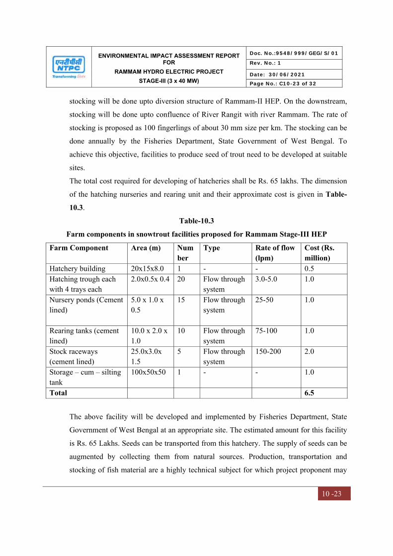
ENVIRONMENTAL IMPACT ASSESSMENT REPORT FOR
RAMMAM HYDRO ELECTRIC PROJECT
STAGE-III (3 x 40 MW)
Doc. No.:9548/999/GEG/S/01
Rev. No.: 1
Date: 30/06/2021
Page No.: C10-23 of 32
10 -23
stocking will be done upto diversion structure of Rammam-II HEP. On the downstream,
stocking will be done upto confluence of River Rangit with river Rammam. The rate of
stocking is proposed as 100 fingerlings of about 30 mm size per km. The stocking can be
done annually by the Fisheries Department, State Government of West Bengal. To
achieve this objective, facilities to produce seed of trout need to be developed at suitable
sites.
The total cost required for developing of hatcheries shall be Rs. 65 lakhs. The dimension
of the hatching nurseries and rearing unit and their approximate cost is given in Table-
10.3.
Table-10.3
Farm components in snowtrout facilities proposed for Rammam Stage-III HEP
Farm Component Area (m) Number
Type Rate of flow (lpm)
Cost (Rs. million)
Hatchery building 20x15x8.0 1 - - 0.5 Hatching trough each with 4 trays each
2.0x0.5x 0.4 20 Flow through system
3.0-5.0 1.0
Nursery ponds (Cement lined)
5.0 x 1.0 x 0.5
15 Flow through system
25-50 1.0
Rearing tanks (cement lined)
10.0 x 2.0 x 1.0
10 Flow through system
75-100 1.0
Stock raceways (cement lined)
25.0x3.0x 1.5
5 Flow through system
150-200 2.0
Storage – cum – silting tank
100x50x50 1 - - 1.0
Total 6.5
The above facility will be developed and implemented by Fisheries Department, State
Government of West Bengal at an appropriate site. The estimated amount for this facility
is Rs. 65 Lakhs. Seeds can be transported from this hatchery. The supply of seeds can be
augmented by collecting them from natural sources. Production, transportation and
stocking of fish material are a highly technical subject for which project proponent may
ENVIRONMENTAL IMPACT ASSESSMENT REPORT FOR
RAMMAM HYDRO ELECTRIC PROJECT
STAGE-III (3 x 40 MW)
Doc. No.:9548/999/GEG/S/01
Rev. No.: 1
Date: 30/06/2021
Page No.: C10-24 of 32
10 -24
not have the required expertise. Thus, implementation of this proposal may be done by
the Fisheries Department.
10.13 WILDLIFE CONSERVATION
As per the available data the project and its surrounding areas do not have much of
wildlife. Around the main construction areas i.e. the barrage site, powerhouse site, etc.
where construction workers congregate, no significant disturbance in the wildlife
population was observed. In view of the low wildlife concentration in the area, the
impacts due to various construction activities are marginal.
The project area is located at a distance of about 9 km from nearest boundary of Singalila
National Park and about 4.4 km from the Barsey Rhododendron Sanctuary, West Sikkim.
None of the components of the project are situated within the National Park/ Wildlife
Sanctuary or their Eco sensitive Zones. Thus, no impact is expected on the National Park.
However, Wildlife Conservation Plan as proposed for implementation. The conservation
plan shall be submitted to wildlife department for approval and after approval, same shall
be implemented in consultation with state wildlife department.
10.14 SEISMICITY CONSIDERATIONS
The Rammam basin has experienced quite a few earthquakes of moderate to severe
intensities in the last 100-120 years. The project area forms a part of the seismic zone-IV
(as per seismic zoning map of BIS). As per Bureau of Indian Standard (BIS)
recommendation 0.1 g horizontal and 0.05 g vertical acceleration is to be considered for
design of structures on consolidated foundations.
The seismic study has been conducted by IIT Roorkee. The suggested Earth Quake (EQ)
design parameters have been cleared from National Committee of Seismic Design
Parameters (NCSDP) of CWC and are being adopted for design of the project
components. (Report already submitted to MOEF, Shillong in May 2011)
ENVIRONMENTAL IMPACT ASSESSMENT REPORT FOR
RAMMAM HYDRO ELECTRIC PROJECT
STAGE-III (3 x 40 MW)
Doc. No.:9548/999/GEG/S/01
Rev. No.: 1
Date: 30/06/2021
Page No.: C10-25 of 32
10 -25
10.15 NOISE CONTROL MEASURES
Noise pollution can be mitigated at the source itself. As discussed in Chapter-4, the
ambient noise levels would have marginal increase up to about 1 km from the major
construction sites. The increased level of noise will, however, not have any significant
adverse impact. The effect of high noise levels on the construction labour is to be
considered. It is known that continuous exposure to high noise levels above 90 dB(A)
affects the hearing acuity of the workers/operators and hence has to be avoided. Other
physiological and psychological effects have also been reported in literature, but the
effect on hearing acuity has been specially stressed. To prevent these effects, it has been
recommended by international specialist organizations that the exposure period of
affected persons is limited as specified in Table 4.12.
Further, they are provided with effective personal protective measures such as ear muffs
or ear plugs to be worn during periods of exposure.
The other measures to control noise are as follows:
- Equipment and machineries maintained regularly to keep the noise generation at
the design level;
- Silencers and mufflers of the individual machineries regularly checked.
10.16 ESTABLISHMENT OF AN ENVIRONMENTAL MANAGEMENT GROUP
An Environmental Management Group (EMG) consisting of competent workforce
headed by AGM level and assisted by Sr. Manager has been established by the
Rammam HEPP. This department deals with various environmental aspects including
follow-up with SPCB, Regional office MOEF&CC and CPCB and interacts with inter-
disciplinary groups responsible for maintenance and operation of pollution control
equipment and environmental protection measures. The Environmental Management
Group (EMG) is reporting to the Head of Project, for effective implementation of the
Environmental Management Plan (EMP).
As per the present set-up, the environmental groups in NTPC have a three-tier
organization structure, as shown in Table 10.4.
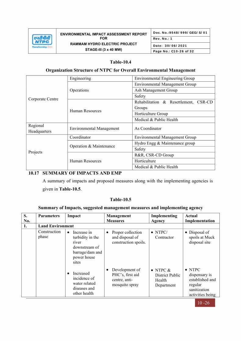
ENVIRONMENTAL IMPACT ASSESSMENT REPORT FOR
RAMMAM HYDRO ELECTRIC PROJECT
STAGE-III (3 x 40 MW)
Doc. No.:9548/999/GEG/S/01
Rev. No.: 1
Date: 30/06/2021
Page No.: C10-26 of 32
10 -26
Table-10.4
Organization Structure of NTPC for Overall Environmental Management
Corporate Centre
Engineering Environmental Engineering Group
Operations Environmental Management Group Ash Management Group Safety
Human Resources
Rehabilitation & Resettlement, CSR-CD Groups Horticulture Group Medical & Public Health
Regional Headquarters Environmental Management As Coordinator
Projects
Coordinator Environmental Management Group
Operation & Maintenance Hydro Engg & Maintenance group Safety
Human Resources R&R, CSR-CD Group Horticulture Medical & Public Health
10.17 SUMMARY OF IMPACTS AND EMP
A summary of impacts and proposed measures along with the implementing agencies is
given in Table-10.5.
Table-10.5
Summary of Impacts, suggested management measures and implementing agency
S. No.
Parameters Impact Management Measures
Implementing Agency
Actual Implementation
1. Land Environment Construction
phase
Increase in turbidity in the river downstream of barrage/dam and power house sites
Increased
incidence of water related diseases and other health
Proper collection and disposal of construction spoils.
Development of
PHC’s, first aid centre, anti-mosquito spray
NTPC/ Contractor
NTPC &
District Public Health Department
Disposal of spoils at Muck disposal site
NTPC
dispensary is established and regular sanitization activities being
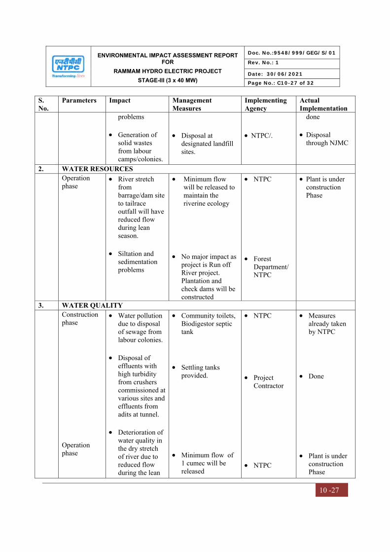
ENVIRONMENTAL IMPACT ASSESSMENT REPORT FOR
RAMMAM HYDRO ELECTRIC PROJECT
STAGE-III (3 x 40 MW)
Doc. No.:9548/999/GEG/S/01
Rev. No.: 1
Date: 30/06/2021
Page No.: C10-27 of 32
10 -27
S. No.
Parameters Impact Management Measures
Implementing Agency
Actual Implementation
problems Generation of
solid wastes from labour camps/colonies.
Disposal at
designated landfill sites.
NTPC/.
done
Disposal through NJMC
2. WATER RESOURCES Operation
phase River stretch
from barrage/dam site to tailrace outfall will have reduced flow during lean season.
Siltation and
sedimentation problems
Minimum flow will be released to maintain the riverine ecology
No major impact as project is Run off River project. Plantation and check dams will be constructed
NTPC Forest
Department/ NTPC
Plant is under construction Phase
3. WATER QUALITY Construction
phase Operation phase
Water pollution due to disposal of sewage from labour colonies.
Disposal of
effluents with high turbidity from crushers commissioned at various sites and effluents from adits at tunnel.
Deterioration of
water quality in the dry stretch of river due to reduced flow during the lean
Community toilets, Biodigestor septic tank
Settling tanks
provided. Minimum flow of
1 cumec will be released
NTPC Project
Contractor NTPC
Measures already taken by NTPC
Done
Plant is under construction Phase
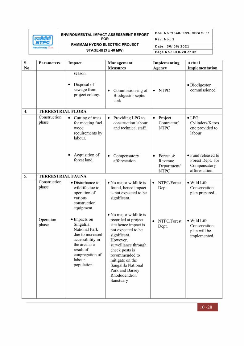
ENVIRONMENTAL IMPACT ASSESSMENT REPORT FOR
RAMMAM HYDRO ELECTRIC PROJECT
STAGE-III (3 x 40 MW)
Doc. No.:9548/999/GEG/S/01
Rev. No.: 1
Date: 30/06/2021
Page No.: C10-28 of 32
10 -28
S. No.
Parameters Impact Management Measures
Implementing Agency
Actual Implementation
season. Disposal of
sewage from project colony.
Commission-ing of
Biodigestor septic tank
NTPC
Biodigestor commissioned
4. TERRESTRIAL FLORA Construction
phase
Cutting of trees for meeting fuel wood requirements by labour.
Acquisition of
forest land.
Providing LPG to construction labour and technical staff.
Compensatory
afforestation.
Project Contractor/ NTPC
Forest &
Revenue Department/ NTPC
LPG Cylinders/Kerosene provided to labour
Fund released to
Forest Dept. for Compensatory afforestation.
5. TERRESTRIAL FAUNA Construction
phase Operation phase
Disturbance to wildlife due to operation of various construction equipment.
Impacts on
Singalila National Park due to increased accessibility in the area as a result of congregation of labour population.
No major wildlife is found, hence impact is not expected to be significant.
No major wildlife is
recorded at project site hence impact is not expected to be significant. However, surveillance through check posts is recommended to mitigate on the Sangalila National Park and Barsey Rhododendron Sanctuary
NTPC/Forest Dept.
NTPC/Forest
Dept.
Wild Life Conservation plan prepared.
Wild Life
Conservation plan will be implemented.

ENVIRONMENTAL IMPACT ASSESSMENT REPORT FOR
RAMMAM HYDRO ELECTRIC PROJECT
STAGE-III (3 x 40 MW)
Doc. No.:9548/999/GEG/S/01
Rev. No.: 1
Date: 30/06/2021
Page No.: C10-29 of 32
10 -29
S. No.
Parameters Impact Management Measures
Implementing Agency
Actual Implementation
6. AQUATIC ECOLOGY Construction
phase Operation phase
Marginal decrease in aquatic productivity due to increased turbidity and lesser light penetration.
Impacts on
migration of snow trout.
Drying of river
stretch downstream of barrage/dam up to tail race outfall
Treatment of effluent with high suspended solids through settling tanks
Stocking of river
Rammam upstream and downstream of barrage/dam site.
Release of
minimum flow of 1 cumec
NTPC/ Project Contractor
NTPC NTPC
Settling ponds already installed
Consultation
with fisheries dept will be done.
Will be done
during operation
7. NOISE ENVIRONMENT
Construction phase
Marginal increase in noise levels due to operation of various construction equipment.
Maintenance of construction equipment
Provision of ear plug /ear muff to labour operating in high noise areas
Project contractor
Noise monitoring at site has been done at site
PPE to labour provided.
8. AIR ENVIRONMENT
Construction phase
Fugitive emissions due to crusher operation at various sites.
Cyclone in each crusher.
Project contractor
Water sprinkling is being done
9. SOCIO-ECONOMIC ENVIRONMENT
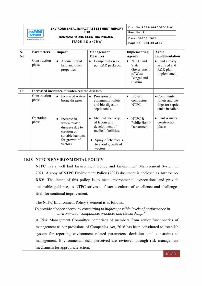
ENVIRONMENTAL IMPACT ASSESSMENT REPORT FOR
RAMMAM HYDRO ELECTRIC PROJECT
STAGE-III (3 x 40 MW)
Doc. No.:9548/999/GEG/S/01
Rev. No.: 1
Date: 30/06/2021
Page No.: C10-30 of 32
10 -30
S. No.
Parameters Impact Management Measures
Implementing Agency
Actual Implementation
Construction phase
Acquisition of land and other properties.
Compensation as per R&R package.
NTPC and State Government of West Bengal and Sikkim
Land already acquired and R&R plan implemented.
10. Increased incidence of water-related diseases Construction
phase Operation phase
Increased water-borne diseases
Increase in
water-related diseases due to creation of suitable habitats for growth of vectors.
Provision of community toilets and bio-digestor septic tanks.
Medical check-up
of labour and development of medical facilities.
Spray of chemicals
to avoid growth of vectors
Project contractor/ NTPC
NTPC &
Public Health Department
Community toilets and bio-digestor septic tanks installed
Plant is under construction phase
10.18 NTPC’S ENVIRONMENTAL POLICY
NTPC has a well laid Environment Policy and Environment Management System in
2021. A copy of NTPC Environment Policy (2021) document is enclosed as Annexure-
XXV. The intent of this policy is to meet environmental expectations and provide
actionable guidance, as NTPC strives to foster a culture of excellence and challenges
itself for continual improvement.
The NTPC Environment Policy statement is as follows. “To provide cleaner energy by committing to highest possible levels of performance in
environmental compliance, practices and stewardship.”
A Risk Management Committee comprises of members from senior functionaries of
management as per provisions of Companies Act, 2016 has been constituted to establish
system for reporting environment related parameters, deviations and constraints to
management. Environmental risks perceived are reviewed through risk management
mechanism for appropriate action.
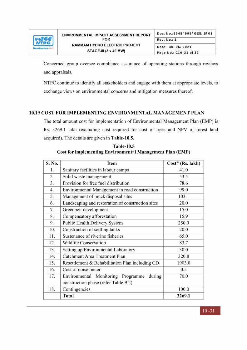
ENVIRONMENTAL IMPACT ASSESSMENT REPORT FOR
RAMMAM HYDRO ELECTRIC PROJECT
STAGE-III (3 x 40 MW)
Doc. No.:9548/999/GEG/S/01
Rev. No.: 1
Date: 30/06/2021
Page No.: C10-31 of 32
10 -31
Concerned group oversee compliance assurance of operating stations through reviews
and appraisals.
NTPC continue to identify all stakeholders and engage with them at appropriate levels, to
exchange views on environmental concerns and mitigation measures thereof.
10.19 COST FOR IMPLEMENTING ENVIRONMENTAL MANAGEMENT PLAN
The total amount cost for implementation of Environmental Management Plan (EMP) is
Rs. 3269.1 lakh (excluding cost required for cost of trees and NPV of forest land
acquired). The details are given in Table-10.5.
Table-10.5 Cost for implementing Environmental Management Plan (EMP)
S. No. Item Cost* (Rs. lakh) 1. Sanitary facilities in labour camps 41.0 2. Solid waste management 53.5 3. Provision for free fuel distribution 78.6 4. Environmental Management in road construction 99.0 5. Management of muck disposal sites 103.1 6. Landscaping and restoration of construction sites 20.0 7. Greenbelt development 15.0 8. Compensatory afforestation 15.9 9. Public Health Delivery System 250.0
10. Construction of settling tanks 20.0 11. Sustenance of riverine fisheries 65.0 12. Wildlife Conservation 83.7 13. Setting up Environmental Laboratory 30.0 14. Catchment Area Treatment Plan 320.8 15. Resettlement & Rehabilitation Plan including CD 1903.0 16. Cost of noise meter 0.5 17. Environmental Monitoring Programme during
construction phase (refer Table-9.2) 70.0
18. Contingencies 100.0 Total 3269.1
ENVIRONMENTAL IMPACT ASSESSMENT REPORT FOR
RAMMAM HYDRO ELECTRIC PROJECT
STAGE-III (3 x 40 MW)
Doc. No.:9548/999/GEG/S/01
Rev. No.: 1
Date: 30/06/2021
Page No.: C10-32 of 32
10 -32
The recurring cost for implementation of EMP included Environmental Monitoring cost,
Plantation, ETP/Sewage treatment, and salary of EMG Staff etc. The estimated budget
for recurring cost for EMP would be about 2 crores/year.
10.20 RESERVOIR RIM TREATMENT PLAN
As the Rammam HEPP stage-III is Run of River project and the storage capacity is
limited to 0.27 MCM, no large reservoir is envisaged. The submergence area is very
small (3.852 Ha) and it will not cause any land slide. However, the surrounding loose
rocks in water storage area of barrage will be dressed to prevent land slide, in future.
Plantation will be done in surrounding area of barrage to mitigate land slide and land slip.

CHAPTER – XI
SUMMARY & CONCLUSION
ENVIRONMENTAL IMPACT ASSESSMENT REPORT FOR
RAMMAM HYDRO ELECTRIC PROJECT
STAGE-III (3 x 40 MW)
Doc. No.:9548/999/GEG/S/01
Rev. No.: 1
Date: 30/06/2021
Page No.: C11-1 of 22
11 -1
CHAPTER-11
SUMMARY & CONCLUSION
11.0 INTRODUCTION
NTPC Limited is constructing Rammam Hydro Electric Power Project (HEPP), Stage III (3x40 MW) in Darjeeling District of West Bengal. The project is located on Rammam River, which flows along the border of West Bengal and Sikkim at about 50 km from Ghoom and 130 km from Siliguri on Siliguri-Darjeeling Road in District Darjeeling of West Bengal.
The site for diversion structure is located downstream at the confluence of Rammam with Lodhama khola near Lodhama village just downstream of the powerhouse of Rammam Stage-II hydroelectric project (51 MW under operation by West Bengal State Electricity Board). The site for powerhouse is located near village Barbatia on the right bank of River Rammam. All the major project components are located in the State of West Bengal except the right abutments of the Barrage structure and a portion of submergence area in Siktam Block of West Sikkim.
Earlier Ministry of Environment Forest & Climate Change (MOEF&CC) accorded the Environmental Clearance (EC) for project vide letter No. J-12011/42/2007-IA.I dated 17.08.2007 with a validity period of 10 years. Further, MOEF&CC vide its letter dated 13.07.2017, extended the validity of EC for a further period of 3 years i.e. up to 16.08.2020. MOEF&CC vide Notification dated 18.01.2021 (Copy enclosed at Annexure-I) has amended the EIA Notification, 2006 and made a provision that period from 01.04.2020 to the 31.03.2021 shall not be considered for the purpose of calculation of the period of validity of prior Environmental Clearance in view of outbreak of Corona Virus (COVID-19) and subsequent lockdowns. Hence, the Environment Clearance for Rammam HEPP is valid till 16.08.2021.
M/S SV Enviro Labs & Consultants a NABET-QCI Accredited firm has been entrusted to conduct an Environmental Impact Assessment (EIA) in and around of the project site. The MoEF&CC approved the standard ToR for the proposed project vide F.No. J-

ENVIRONMENTAL IMPACT ASSESSMENT REPORT FOR
RAMMAM HYDRO ELECTRIC PROJECT
STAGE-III (3 x 40 MW)
Doc. No.:9548/999/GEG/S/01
Rev. No.: 1
Date: 30/06/2021
Page No.: C11-2 of 22
11 -2
12011/11/2020-IA-I (R) dated 12th February 2021. Environmental baseline monitoring was carried out during July’ 2020 to September’ 2020 representing monsoon season and used to identify potential significant impacts. Since the project is in advanced stage of construction and more than 50% has been completed, it is exempted from requirement of public hearing as per MoEF&CC Notification S.O. 1247(E) dated 18.03.2021.
11.1 LOCATION & ACCESSIBILITY
Rammam Hydro Power Project, Stage-III (3X40 MW) is located in District Darjeeling (West Bengal) & West Sikkim (Sikkim). It is a Run of the River (ROR) scheme utilizing power potential of Rammam River from elevation EL. 900.0 m to EL. 397.0 m. All the major project components are located in the State of West Bengal except the right abutments of the Barrage structure and a portion of submergence area in Siktam Block of West Sikkim. The Latitude and Longitude of the Diversion Structure and Barrage are given in Table-11.1.
The vicinity map and topographical map of the project is shown in Fig 11.1 and 11.2
respectively.
Table-11.1
Coordinates of Project Components
Project Component Latitude Longitude Diversion Structure 27°06'47" N 88°08'39" E Township 27°07'47" N 88°12'55" E Power House 27°07'25" N 88°13'20" E
The project is about 50 km from Ghoom (Siliguri-Darjeeling Road) and about 130 km from Siliguri in Darjeeling District of West Bengal. The nearest rail head is New Jalpaiguri (at about 115 km) and the nearest airport is Bagdogra (at about 110 km).
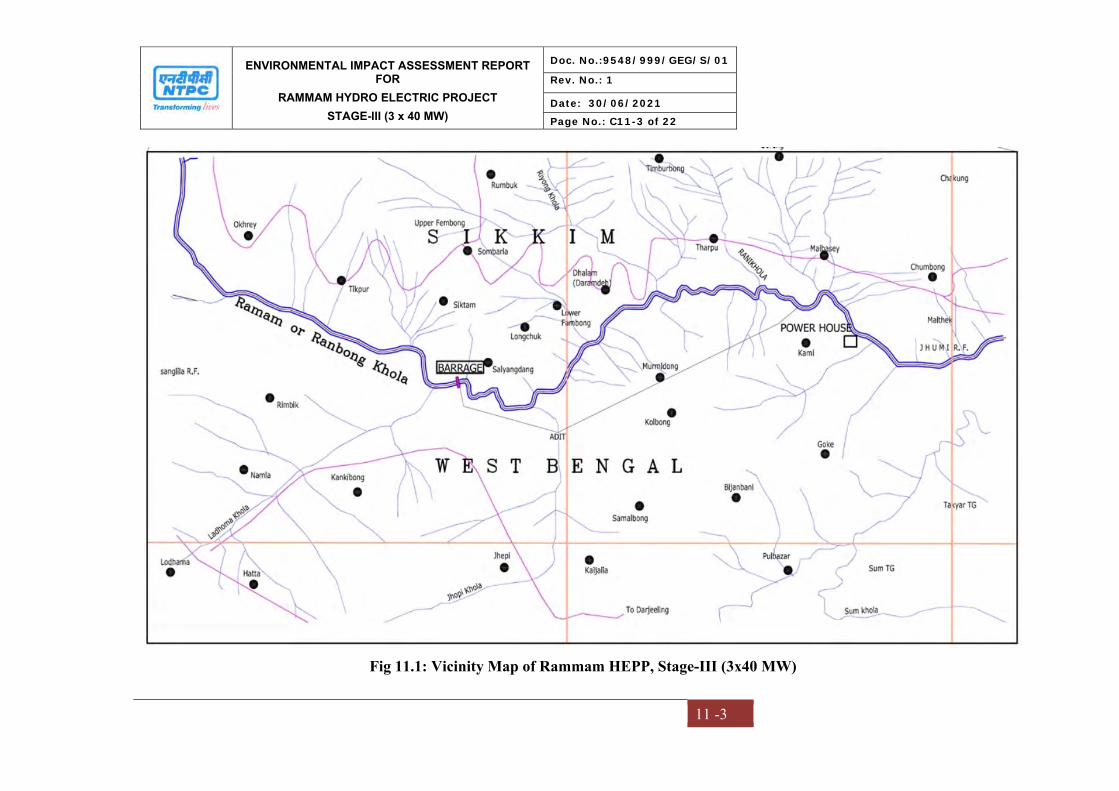
ENVIRONMENTAL IMPACT ASSESSMENT REPORT FOR
RAMMAM HYDRO ELECTRIC PROJECT
STAGE-III (3 x 40 MW)
Doc. No.:9548/999/GEG/S/01
Rev. No.: 1
Date: 30/06/2021
Page No.: C11-3 of 22
11 -3
Fig 11.1: Vicinity Map of Rammam HEPP, Stage-III (3x40 MW)

ENVIRONMENTAL IMPACT ASSESSMENT REPORT FOR
RAMMAM HYDRO ELECTRIC PROJECT
STAGE-III (3 x 40 MW)
Doc. No.:9548/999/GEG/S/01
Rev. No.: 1
Date: 30/06/2021
Page No.: C11-4 of 22
11 -4
Fig 11.2: Topo Map of Rammam HEPP, Stage-III (3x40 MW)
ENVIRONMENTAL IMPACT ASSESSMENT REPORT FOR
RAMMAM HYDRO ELECTRIC PROJECT
STAGE-III (3 x 40 MW)
Doc. No.:9548/999/GEG/S/01
Rev. No.: 1
Date: 30/06/2021
Page No.: C11-5 of 22
11 -5
11.2 NEED OF THE PROJECT
As per the interstate agreement between Sikkim & West Bengal, the share of power of
the Sikkim Government (12%) will be made available to the Sikkim Government at free
of cost. The Rammam Stage-III Hydro Electric Power Project would not only meet the
power requirements, but would also improve the ratio of hydro, thermal mix as well.
11.3 PROJECT DESCRIPTION
The project is envisaged to harness the hydropower potential of River Rammam. The
project comprises of diversion arrangement, desilting chamber, water conveyance system,
powerhouse and tailrace. Installed capacity of the project will be 120 MW and will utilize
a design discharge of 28.31 cumecs.
The project comprises of the following components:
Barrage/dam as a diversion structure
Intake tunnel
Underground desilting chamber
HRT (Head Race Tunnel)
Surge Shaft
Surface Penstock
Vertical Pressure Shaft
Power House
Tail Race Channel (TRC)
The project consists of 23 m high Barrage (above u/s apron level) 122.5m long Barrage
near Lodhama Village and approximately 10.75km of water conductor system (8.2 km
long 3.5m dia horse shoe shape head race tunnel, 1.6 km long Penstock and 0.74 km long
tailrace channel etc.). It has also a 14.5 m dia 53.75m high surge shaft and a deep seated
surface power house near Barbatia village on right bank of the Rammam River. The
project is envisaged to use water from catchment area of 247sq. km.

ENVIRONMENTAL IMPACT ASSESSMENT REPORT FOR
RAMMAM HYDRO ELECTRIC PROJECT
STAGE-III (3 x 40 MW)
Doc. No.:9548/999/GEG/S/01
Rev. No.: 1
Date: 30/06/2021
Page No.: C11-6 of 22
11 -6
Techno Economic Clearance (TEC) for the project has been obtained from Central
Electricity Authority (CEA), Govt. of India vide letter dated 12.09.2006 and revalidated
on 01.08.2013 and the construction of the project started in September 2014.
11.3.1 Project Cost
The project is in advance stage of construction and anticipated completion of its all three
units (i.e. I, II & III) is by December 2026.
Total Cost of the Project is:
As per EC: Rs. 633.92 Crores
As per Inv. Approval: Rs. 1,381.84 Crores (2nd Qtr, 2014)
11.3.2 Minimum water flow in the River
Environmental clearance for the projects was been accorded with a condition that
iv) A minimum flow of 1 cumec shall always be released from the barrage.
The minimum flow to be released is about 22% of the minimum flow of
4.47 cumec recorded in the river
The change in minimum flow as per Standard TOR at this stage shall drastically reduce
the power generation from the project and render the project commercially unviable.
The issue of minimum flow in the rivers downstream of the hydro power projects has
been a subject of study and deliberations at different levels.
(a) National Green Tribunal in its Order dated 09/08/2017 in the matter of Pushp
Saini Vs. Ministry of Environment, Forest & Climate Change & Others regarding
environmental flow of the rivers directed that all the rivers in the country shall
maintain minimum 15 % to 20% of the average lean season flow of that river.
During the same case, counsel appearing for Ministry of Environment, Forest and
Climate Change submitted that the Ministry has already completed river basin

ENVIRONMENTAL IMPACT ASSESSMENT REPORT FOR
RAMMAM HYDRO ELECTRIC PROJECT
STAGE-III (3 x 40 MW)
Doc. No.:9548/999/GEG/S/01
Rev. No.: 1
Date: 30/06/2021
Page No.: C11-7 of 22
11 -7
study of 6 river basins i.e. Siang River Basin, Twang River Basin, Bichom River
Basin, Subansiri River Basin, Dibang River Basin and Lohit River Basin and
upon study the Ministry has recommended the minimum flow of the river to be
18% of the average of lean season flow of the river. However, in some of the
cases, it has stated to be even 20%.
(b) Further, MOEF&CC has also undertaken a Cumulative Impact Assessment and
Carrying Capacity Study (CIA & CCS) of Teesta River Basin. The minutes of
EAC (Hydro) meeting held on 23.04.2019, during which a presentation was made
on the CIA and CCS Study, it was noted that Rammam-II & Rammam-III are
under operation and construction stage respectively. The change in Environmental
Flow has been recommended for Rammam-I and Rammam Intermediate HEPs
only, which are under planning.
In view of the above, NTPC Rammam HEPP will maintain the minimum Environmental
flow of 1 cumecs as stipulated in the original environmental clearance.
11.4 BASELINE ENVIRONMENTAL STATUS
The study of the baseline environmental status helps in assessing the existing
environmental conditions and identifying the critical environmental attributes. The study
of the physical, biological and socio-economic environment of the project area within a
radius of 10 km (study area) comprises of the baseline environment. Primary and
secondary data were collected for the EIA study.
11.4.1 Physical Environment
Climate and Meteorology
The study area falls under Humid Subtropical zone according to Koppen’s classification
of climate zones. Winter and early summer are long and dry; summer is exceedingly hot
leading to heat waves. The rainy season lasts from June to September. As per IMD data,
wind speed is high and found mostly between 1.5-3.3 m/sec for all the months. The wind
ENVIRONMENTAL IMPACT ASSESSMENT REPORT FOR
RAMMAM HYDRO ELECTRIC PROJECT
STAGE-III (3 x 40 MW)
Doc. No.:9548/999/GEG/S/01
Rev. No.: 1
Date: 30/06/2021
Page No.: C11-8 of 22
11 -8
speed during summer recorded is high, and during rainy season, and winter recorded low.
The predominant wind direction is from Southwest.
Air Quality
The ambient air quality representing PM10, PM2.5 Sulfur Dioxide (SO2), Nitrogen Oxides
(NOx), Carbon Monoxide (CO) was monitored at seven different locations for 24 hours
twice a week from July’ 2020 to September’ 2020. Volatile Organic Carbons (VOCs),
Methane (CH4), non-methane hydrocarbons (NMHCs), Ozone, Ammonia, Lead (Pb),
Benzene (C6H6), Benzo(a)pyrene (BaP), Arsenic (As), Nickel (Ni) were monitored for
the same period. All the parameters were found to be below the National Ambient Air
Quality Standards (NAAQS), 2009. The average 24 hourly PM10 at monitoring locations
ranged between 29.0-66.9 µg/m3 (NAAQS-100 µg/m3). The average 24 hourly PM2.5 at
monitoring locations ranged between 8.1-33.0 µg/m3 (NAAQS-60 µg/m3). The average
24 hourly SO2 at monitoring locations ranged between 6.8-13.1 µg/m3 (NAAQS-80
µg/m3). The average 24 hourly NOx at monitoring locations ranged between 7.2-14.6
µg/m3 (NAAQS-80 µg/m3). The average 24 hourly CO at monitoring locations ranged
between 0.10-0.30 µg/m3 (NAAQS-4.0 mg/m3). The average 24 hourly O3 at monitoring
locations ranged between 9.2-44.2 µg/m3 (NAAQS-180 µg/m3). Ammonia (NH3, Lead
(Pb), Benzene (C6H6), Benzo(a)pyrene (BaP), Arsenic (As), Nickel (Ni), HC (methane
and non methane Hydro Carbon), Volatile Organic Carbon (VOC) - are remained below
detection limit (BDL) in the study area.
Noise Quality
The noise quality was monitored for 24 hours at seven locations in and around the project
site. The ambient noise quality at day and night was in compliance to the Noise Limits set
for the residential area as per Noise Pollution (Control and Regulations), 2000. The
daytime noise level was found in the range between 50.8-62.5 dB (A) whereas the night
time noise level was found in the range between 42.6-55.6 dB(A).
ENVIRONMENTAL IMPACT ASSESSMENT REPORT FOR
RAMMAM HYDRO ELECTRIC PROJECT
STAGE-III (3 x 40 MW)
Doc. No.:9548/999/GEG/S/01
Rev. No.: 1
Date: 30/06/2021
Page No.: C11-9 of 22
11 -9
Geology
Geologically, three important groups of rocks observed in the vicinity of the project area.
They are older Daling group, younger Gondwana group and older Daling/Buxa group. No
major occurrence of economic deposit has been found in the study area, except materials
like boulder, pebbles, sand that bears no economic mineral importance, being utilized as
construction material.
Hydrogeology
The major water bearing formations are Darjeeling, Daling and Gondwana groups where
ground water occurs in weathered zones, joints and fractures. The project area is
characterized by hilly terrain - it acts as a recharge area where surface runoff is very high,
has limited infiltration in the intermountain valleys. Ground water is harnessed using
perennial springs and jhoras. The discharge of most of the springs ranges from 1 to 50
lpm during lean period and a few jhorasi kholas give discharge in the range of 50 to 500
lpm. Piedmont zone with high permeability, sloping topography and sub-surface runoff is
characterised by poor to moderate yield ranging from 5 to 50 cum per hour. Aquifers in
alluvial plain are highly potential with yield prospects ranging from 50 to 150 cum per
hour. Aquifers at 200m below ground level with expected yield of 27 litres per second are
reported. Water level fluctuation is in the order of 2 to 6 m in the northern foot hill part
and less than 2m in the central and southern parts.
Groundwater Quality
Groundwater was collected and analyzed as per IS: 10500:2012 from six locations in the
study area. All the parameters analyzed were under the acceptable and permissible limit
of IS: 10500:2012. Heavy metals were found to be below detection limit.
Surface Water Quality
Surface water was sampled from six representative locations. The water samples were
analyzed and compared as per IS 2296. The pH of the surface water samples varied from
6.8-7.2. The DO levels at all the locations exhibited values ranging from 5.1-6.1 mg/l.
ENVIRONMENTAL IMPACT ASSESSMENT REPORT FOR
RAMMAM HYDRO ELECTRIC PROJECT
STAGE-III (3 x 40 MW)
Doc. No.:9548/999/GEG/S/01
Rev. No.: 1
Date: 30/06/2021
Page No.: C11-10 of 22
11 -10
Nitrate content of all collected surface water sample ranges from 0.14-0.31 mg/l. TDS
and Total hardness was found to be 71 mg/l to 86 mg/l and 24 mg/l to 36 mg/l
respectively. The total coliform count of the surface water samples varied between
440MPN/100 ml to 480MPN/100 ml. All the heavy metals were found to be within
below detectable limits. However, the water quality is not coming under any class
designated by CPCB Water Use Criteria, but during the field visit, it has been observed
that the water is being used for irrigation, bathing, cleaning and for catching fishes.
Land Use
The study area is covered with Dense Vegetation around 57.83% respectively of the total
area. Other class is Grass/Agricultural Fields occupies around 11.4%. The Contour
Farming & Fallow Lands is 5.60% in the total study area. The scrub area covers 20.83%
of the total area. The Barren land & Fallow lands cover about 3.61% of total area. Water
body and Built-up area is covered with 0.69% and 0.1% respectively.
Soil Quality
The pH of the soils is acidic in nature. The electrical conductivity in the study area is
varying from 52.3 to 62.9 micro-mhos/ cm (µmhos/cm). This is average for germination.
Nitrogen, phosphorus, potassium and organic Carbon are very less sufficient level for
crops. Residual soils are well developed on level summits of lesser Himalayas, sub-soils
are deep and heavily textured. High contents of organic matter are found in its `A’
horizon and are acidic in nature. The soils in the region are average fertile enough for
cultivation of crops.
Natural Hazards
Natural calamities like Flood, Landslide and Earthquake are expected. Heavy rainfall and
could burst can lead to flood resulting in heavy debris falling into the river channel. The
project falls in Zone IV (Severe intensity zone) of Earthquake vulnerability map.
Landslides are envisaged for supervision and advice on tunneling/ road construction
and/or any other vulnerable area of construction Geological Survey of India (GSI), is also

ENVIRONMENTAL IMPACT ASSESSMENT REPORT FOR
RAMMAM HYDRO ELECTRIC PROJECT
STAGE-III (3 x 40 MW)
Doc. No.:9548/999/GEG/S/01
Rev. No.: 1
Date: 30/06/2021
Page No.: C11-11 of 22
11 -11
associated with NTPC, Rammam, vide MoU dated 8th Feb’ 2015. Disaster management
plan has been prepared as an emergency preparedness measure to protect the life of the
employees and others present on-site, that of the public in the vicinity of the project,
company property and environment
11.4.2 Biological Environment
Baseline Survey (Primary data through site visit) and Secondary data received from
Forest Department’s Website and other published and unpublished document regarding
sensitive ecological habitat and sensitive flora and fauna in the study area. The study area
has an undulating topography characterized by hills, hillocks (Locally known as tillah),
wide plains, and low-lying waterlogged areas (locally known as beels). The vegetation is
mixed evergreen and deciduous forest and in this region, forests are degraded due to
development of Tea Estates and Rubber plantations.
11.4.3 Traffic Survey
During monsoon collection, mainly four wheelers/cars/jeeps were observed to be more
than the trucks or heavy vehicles. It is because tourists from all over India transport in the
region. Highest traffic volume was recorded on Jorthang-Soreng road. The road widths in
the region vary from 6-10m as it is a hilly terrain. Most of the roads are blacktop; there
would not be much of dust emission. Considering the design service volume of 5200
PCU/day for hilly terrain road, the existing traffic volume at the point of traffic count is
found to be level of service (LOS) is “A”.
11.4.4 Socioeconomic Environment
The Social Impact Assessment study was conducted within the study area of Rammam
HEPP Stage-III Run of River (ROR) in Darjeeling and Sikkim districts of West Bengal
and Sikkim. Both, secondary and primary details within the study area discussed. It is
traditionally involved the use of technical and participatory analytical methods to
anticipate change but also encouraging the life cycle of projects to minimize negative
outcomes and maximize benefits. The early consideration of social impacts, the
alignment of activities with regional and community planning objectives, and meaningful
ENVIRONMENTAL IMPACT ASSESSMENT REPORT FOR
RAMMAM HYDRO ELECTRIC PROJECT
STAGE-III (3 x 40 MW)
Doc. No.:9548/999/GEG/S/01
Rev. No.: 1
Date: 30/06/2021
Page No.: C11-12 of 22
11 -12
participation of community in decision making are key features. Apart from the SIA
process and findings it can be concluded that most the respondents have positive
perception towards implementation of the project.
11.5 ENVIRONMENTAL IMPACT ASSESSMENT AND MITIGATION MEASURES
The potential impacts of the project on different components of the environment was
systematically identified and evaluated for significance. The principal concerns that
emerged are:
11.5.1 Impact on land environment
Construction phase
The major impacts anticipated on land environment are as follows:
Movement and operation of construction equipment
Soil erosion
Muck disposal
Impacts due to construction of roads
Acquisition of land
Mitigation measures
Turbidity return to its original level after cessation of sandy materials excavation.
Construction equipment is selected in such a way that causes minimum adverse
impacts on environmental parameters.
The running velocity of river is enough to dilute effluents/runoff carrying suspended
solids.
Water sprinkling during construction of roads.
Operation Phase
The operation phase is likely to envisage impacts on the land use pattern due to diversion
of forest land for non-forest purposes i.e., for construction and widening of roads,

ENVIRONMENTAL IMPACT ASSESSMENT REPORT FOR
RAMMAM HYDRO ELECTRIC PROJECT
STAGE-III (3 x 40 MW)
Doc. No.:9548/999/GEG/S/01
Rev. No.: 1
Date: 30/06/2021
Page No.: C11-13 of 22
11 -13
installation of surface components both upstream and downstream stretch of the river.
Necessary management measures are considered.
11.5.2 Impact on Air Quality
Construction Phase
The air pollution is basically generated due to primary crushing and fugitive dust from
the heap of crushed material. The various crushers provided with cyclones to control the
dust generated while crushing the stone aggregates. The fine aggregates stacked after
crushing are regularly sprayed with water to prevent fugitive emissions.
In addition, fugitive emissions are generated as a result of movement of earth movers,
vehicular traffic on unpaved roads, etc. The activities will generate large quantity of dust
and other gaseous pollutants like Oxides of Sulphur (SOx) and Oxides of Nitrogen (NOx).
Suspended Particulate Matter (SPM) is the main pollutant during construction phase,
released in the form of fugitive dust from various operations and activities. Regular spray
water over such areas to prevent entrainment of fugitive emissions being followed.
Mitigation measures
Activities are being planned in such a way that dust emissions and other gaseous
pollutants will be minimized.
Regular water sprinkling on haul roads and other places
Construction materials and muck for disposal are transported in covered trucks to
prevent fugitive emissions like dust etc. in the atmosphere.
Regular maintenance of machines, vehicles and equipments
Developing greenbelt around the project components
Operation Phase
Since the project is a Run of River (ROR) scheme and does not involve major air
emissions during operation phase, therefore, it will have minimum negative impact on the
air quality of the region.
ENVIRONMENTAL IMPACT ASSESSMENT REPORT FOR
RAMMAM HYDRO ELECTRIC PROJECT
STAGE-III (3 x 40 MW)
Doc. No.:9548/999/GEG/S/01
Rev. No.: 1
Date: 30/06/2021
Page No.: C11-14 of 22
11 -14
11.5.3 Impact on Noise Quality
Potential impact on noise quality is anticipated from operation of construction/site
preparation machineries/equipments and vehicular movement during site preparatory
activities. Operation of heavy machinery/equipments and vehicular movement during site
preparatory and road strengthening/construction activities may result in the generation of
increased noise levels. Operational phase noise impacts are anticipated from operation of
pump house.
Mitigation measures
Storage, handling, transportation and operation of explosives required for blasting
and tunneling activities
Underground construction work including tunneling, excavation and other related
activities
Movement of vehicles on construction site
Storage, handling, detection and safety measures for gases, chemicals and
flammable liquids
11.5.4 Impact on Topography and drainage
In general, drainage pattern of the area is in conformity with the topography, which area
structurally controlled. Potential impact on drainage and topography viz. alteration of
drainage pattern, water logging etc. are anticipated during site preparation,
widening/strengthening of access roads and surface runoff from construction sites.
Mitigation measures
Leveling and grading operations are undertaken with minimal disturbance to the
existing contour, thereby maintaining the general slope of site;
Loss of micro-watershed drainage, if any, is to be compensated through provision
of alternate drainage.
Disruption/alteration of micro-watershed drainage pattern will be minimized to
the extent possible.
ENVIRONMENTAL IMPACT ASSESSMENT REPORT FOR
RAMMAM HYDRO ELECTRIC PROJECT
STAGE-III (3 x 40 MW)
Doc. No.:9548/999/GEG/S/01
Rev. No.: 1
Date: 30/06/2021
Page No.: C11-15 of 22
11 -15
Proper engineering control has been employed as mitigation measures so that the flow
and the course of the stream will not be altered.
11.5.5 Impact on Water Quality
Construction Phase
The major sources of surface and ground water contamination during project construction
phase are as follows:
Sewage from labour camps/colonies.
Effluent from crushers.
Impacts due to extraction of fine sand from riverbed
Impact on Ground water
Mitigation measures
Drainage and sediment control systems at the well site will be efficiently designed.
The sewage generated from various labour camps is being treated in Biodigestor
septic tank.
The crusher plant effluent is being passed through settling tank to remove the
suspended solids.
The sludge from the various settling tanks collected once in 15 days and disposed at
the site designed for disposal of municipal solid wastes from the labour camps.
The sludge after drying used as cover material for landfill disposal site
Operation phase
In the project operation phase, about 50 persons are likely to be involved for which
township has already been developed. Township with amenities like water supply and
sanitation facilities including biodigester of total capacity 98 KL.
11.5.6 Impact on Biological Environment
Impact on the ecology will be mainly confined to study area.
Cutting of trees for meeting fuel wood requirements by labour.
Acquisition of forest land.
Disturbance to wildlife due to operation of various construction equipment.
ENVIRONMENTAL IMPACT ASSESSMENT REPORT FOR
RAMMAM HYDRO ELECTRIC PROJECT
STAGE-III (3 x 40 MW)
Doc. No.:9548/999/GEG/S/01
Rev. No.: 1
Date: 30/06/2021
Page No.: C11-16 of 22
11 -16
Marginal decrease in aquatic productivity due to increased turbidity and lesser light
penetration.
Impacts on migration of snow trout.
Drying of river stretch downstream of barrage/dam up to tail race outfall.
Marginal decrease in aquatic productivity due to increased turbidity and lesser light
penetration.
Impacts on migration of snow trout.
Drying of river stretch downstream of barrage/dam up to tail race outfall
Mitigation measures
Providing LPG to construction labour and technical staff.
Compensatory afforestation.
Minimum clearance of vegetation during site preparation
Fencing would be done on the camp site to avoid any unfortunate encounter with
faunal species.
No major wildlife is found, hence impact is not expected to be significant.
Treatment of effluent with high suspended solids through settling tanks
Stocking of river Rammam upstream and downstream of barrage/dam site.
Release of minimum flow of 1 Cumec
11.5.7 Impact on Socio economic Environment
From The socio-economic profiles It is observed that a subsistence economy prevails
amongst most of the people. Most of them are primarily dependent upon agriculture.
However, a few of families to augment their income through / are dependent on jobs and
business. There is some migration of labor force from outside the project area during
construction phase, which may put some pressure on local settlements and resources. The
project envisages all round development and growth in the region as a whole. However,
few local people were affected in the form of acquisition of their land. Members of
families were provided with R&R package as per NPRR-2003.
ENVIRONMENTAL IMPACT ASSESSMENT REPORT FOR
RAMMAM HYDRO ELECTRIC PROJECT
STAGE-III (3 x 40 MW)
Doc. No.:9548/999/GEG/S/01
Rev. No.: 1
Date: 30/06/2021
Page No.: C11-17 of 22
11 -17
The project will benefit the people living in the neighboring villages through direct &
indirect employment opportunities associated with the various project activities and
boosts the local economy.
Mitigation measures
Construction/ site preparation phase could lead to creation of indirect employment
and procurement opportunities.
Compensation as per R&R package.
There would be influx of workers during construction phase/site preparation which
could lead to pressure on key local infrastructure such as water, healthcare,
electricity.
11.6 PUBLIC CONSULTATION
The Public Hearing of M/s. NTPC Limited was organized by West Bengal Pollution
Control Board (WBPCB) on 27.04.2007 at 11:30 AM at Community Hall/Recreation
Hall at Lodhama Hat, West Bengal State Electricity Board Township, Dist. - Darjeeling,
West Bengal. v State Pollution Control Board, Sikkim on, organized the Public Hearing
of M/s. NTPC Limited on 04.05.2007 at Zero Point, Salangdang, West Sikkim, Sikkim.
As per MOEF&CC Notification S.O. 1247(E) dated 18.03.2021, Public Hearing is not
essential for the projects, in which construction have been undertaken more than 50%.
About 55% expenditure has been made on Rammam HEPP Stage-III till date and project
is in advance stage of construction, therefore, the project is exempted from conducting
Public Hearing again.
11.7 RISK ASSESSMENT PLAN and DISASTER MANAGEMENT PLAN
This plan has been prepared to assess risk and emergencies scenario associated with
project and as an emergency preparedness measure to protect the life of the employees
and others present on-site, that of the public in the vicinity of the project, company
property and environment. The major risks are two category- Natural Calamities (Flood
ENVIRONMENTAL IMPACT ASSESSMENT REPORT FOR
RAMMAM HYDRO ELECTRIC PROJECT
STAGE-III (3 x 40 MW)
Doc. No.:9548/999/GEG/S/01
Rev. No.: 1
Date: 30/06/2021
Page No.: C11-18 of 22
11 -18
Landslide and Earthquake), Manmade Risk (Fire and Explosion) The plan defines roles
& responsibilities of persons at different levels in the event of emergency in the sites of
the company.
11.8 CATCHMENT AREA TREATMENT PLAN
A Catchment area Treatment Plan for the catchment area intercepted at the diversion
structure of the barrage site has been prepared as a part of the Comprehensive EIA study.
Catchment characteristics in terms of physiography, geomorphology, climate, land use,
soil, denudation processes and conservational activities gained much importance to find
out stress areas yielding higher sediments on micro-watershed basis.
The CAT plan is being implemented through State Forest Department as a deposit work
of respective states of West Bengal & Sikkim. NTPC has deposited Rs. 7.23 Crores in
favor of Principal Chief Conservator of Forests, West Bengal as part of proposal for
implementation of CAT Plan for Rammam Stage-III project. NTPC has deposited Rs.
1.459 Crores in favor of PCCF cum Principal Secretary, Govt. of Sikkim as part of
proposal for implementation of CAT Plan for Rammam Stage-III project.
11.9 PROJECT BENEFITS
The implementation of the Rammam Hydro Electric Power Project (HEPP) Stage-III will
provide impetus to the development of the area and also provide green energy i.e. hydro-
electric power. The project will also throw opportunities to local people for both direct
and indirect employment. Various infrastructure like roads, bridges, schools buildings,
community center has been developed by project. Various welfare and development
activities shall be implemented as per CD/CER/CSR plan.
11.10 ENVIRONMENT COST BENEFIT ANALYSIS
Cost Benefit Analysis (CBA) simply compares all the expected present and future
benefits of a project with its present and future costs. It is a tool used either to rank
projects or to choose the most appropriate option. The ranking or decision is based on

ENVIRONMENTAL IMPACT ASSESSMENT REPORT FOR
RAMMAM HYDRO ELECTRIC PROJECT
STAGE-III (3 x 40 MW)
Doc. No.:9548/999/GEG/S/01
Rev. No.: 1
Date: 30/06/2021
Page No.: C11-19 of 22
11 -19
expected economic costs and benefits. However, as the project is already under advance
stage of construction, after accord of Techno-economic clearance, the cost benefit is
already establsished and the completion of the project is essential.
11.11 ENVIRONMENTAL MANAGEMENT PLAN AND MONITORING PLAN
M/s NTPC Ltd has formulated an Environment Policy and Safety Policy for its
operations. Through these Policy, M/s NTPC Ltd. is committed to protect the
Environment, health and safety of everyone involved in its operations, and the
sustainability of the environment in which it operates. The company strives for continual
improvement and the adoption of national/international codes and standards and also
aims at ensuring that all its operations comply with applicable health, safety and
environmental laws, regulations and other requirements.
A comprehensive environmental monitoring plan has been developed for the project.
Monitoring of ambient air quality, noise levels, soil and groundwater quality to be carried
out by MoEF&CC/NABL/SPCB recognized laboratories during construction and
operation phases.
11.11.1 Greenbelt Development
It is proposed to develop greenbelt/Plantation at all available spaces of project
components, roads and nearby area. Till date 11000 saplings has been planted in project
area as well as in nearby villages. About Rs. 15 lakhs have been kept in EMP budget for
green belt development and plantation.
11.11.2 Compensatory Afforestation
About 1.927 Ha forest land has been diverted for project. The loss of vegetal cover can be
compensated by compensatory afforestation. NTPC has paid the amount estimated by the
Forest Department as Net Present Value (NPV) of forest land acquired. NTPC has
deposited Rs. 7.28 Crores in favor of Principal Chief Conservator of Forests, West

ENVIRONMENTAL IMPACT ASSESSMENT REPORT FOR
RAMMAM HYDRO ELECTRIC PROJECT
STAGE-III (3 x 40 MW)
Doc. No.:9548/999/GEG/S/01
Rev. No.: 1
Date: 30/06/2021
Page No.: C11-20 of 22
11 -20
Bengal as part of proposal for implementation of CAT Plan for Rammam Stage-III
project. NTPC has deposited Rs. 1.46 Crores in favour of PCCF cum Principal Secretary,
Govt. of Sikkim as part of proposal for implementation of CAT Plan for Rammam Stage-
III project.
11.11.3 Biodiversity and Wildlife Conservation Plan and Management
NTPC has become the first PSU to publish a Biodiversity Policy 2018 and become a
member of IBBI (India Business and Biodiversity Initiative). A detailed biodiversity
conservation and management plan has been proposed as per said policy. NTPC will
make efforts to conserve IUCN Threatened category plants species. A Wildlife
Conservation Plan has been prepared for Schedule-I species recorded in Study area and
same will be submitted to State Forest department for approval.
11.11.4 Fish Management Plan
A minimum environmental flow will be maintained for sustaining the life of fishes. The
implementation of fish management plan including construction of a hatchery has been
taken up with fisheries department, Govt. of West Bengal as well as with the
Fisheries Department of Sikkim. Comprehensive Fish Management Plan is awaited from
Govt. of W.B.
11.11.5 Implementation of Environmental Management Plan
An Environmental Management Group (EMG) consisting of competent workforce
headed by AGM level and assisted by Sr. Manager has been established by the Rammam
HEPP. The total amount cost for implementation of Environmental Management Plan
(EMP) is Rs. 3269.1 lakh (excluding cost required for cost of trees and NPV of forest
land acquired). The estimated budget for recurring cost for EMP is about 2 crores/year. In
addition, the CER/ CD activities planned for the year 2021-2024 are as follows:
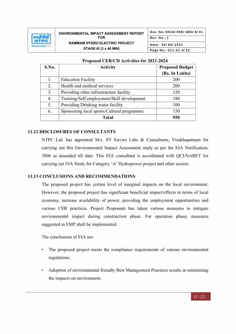
ENVIRONMENTAL IMPACT ASSESSMENT REPORT FOR
RAMMAM HYDRO ELECTRIC PROJECT
STAGE-III (3 x 40 MW)
Doc. No.:9548/999/GEG/S/01
Rev. No.: 1
Date: 30/06/2021
Page No.: C11-21 of 22
11 -21
Proposed CER/CD Activities for 2021-2024 S.No. Activity Proposed Budget
(Rs. In Lakhs) 1. Education Facility 200 2. Health and medical services 200 3. Providing other infrastructure facility 120 4. Training/Self employment/Skill development 180 5. Providing Drinking water facility 100 6. Sponsoring local sports/Cultural programme 150 Total 950
11.12 DISCLOSURES OF CONSULTANTS
NTPC Ltd. has appointed M/s. SV Enviro Labs & Consultants, Visakhapatnam for
carrying out this Environmental Impact Assessment study as per the EIA Notification,
2006 as amended till date. This EIA consultant is accriditated with QCI/NABET for
carrying out EIA Study for Category ‘A’ Hydropower project and other sectors.
11.13 CONCLUSIONS AND RECOMMENDATIONS
The proposed project has certain level of marginal impacts on the local environment.
However, the proposed project has significant beneficial impact/effects in terms of local
economy, increase availability of power, providing the employment opportunities and
various CER practices. Project Proponant has taken various measures to mitigate
environmental impact during construction phase. For operation phase, measures
suggested in EMP shall be implemented.
The conclusions of EIA are:
• The proposed project meets the compliance requirements of various environmental
regulations.
• Adoption of environmental friendly Best Management Practices results in minimising
the impacts on environment.
ENVIRONMENTAL IMPACT ASSESSMENT REPORT FOR
RAMMAM HYDRO ELECTRIC PROJECT
STAGE-III (3 x 40 MW)
Doc. No.:9548/999/GEG/S/01
Rev. No.: 1
Date: 30/06/2021
Page No.: C11-22 of 22
11 -22
• Due to land acquisition, PAPs has impacted which has been compensated
satisfactorily with approved R&R Plan. Overall Community impacts of the project
will be beneficial, as the project will generate significant economic benefits for the
region.
• As the project is under advance stage of construction, NTPC has demonstrate its
commitment towards local community and Environmental protection.
• With the effective implementation of the Environment Management Plan (EMP)
during the planning, design, construction and operation phases, the development and
construction of project can proceed without significant negative impact on the
environment.

CHAPTER –XII
DISCLOSURE OF CONSULTANTS
ENVIRONMENTAL IMPACT ASSESSMENT REPORT FOR
RAMMAM HYDRO ELECTRIC PROJECT
STAGE-III (3 x 40 MW)
Doc. No.:9548/999/GEG/S/01
Rev. No.: 1
Date: 30/06/2021
Page No.: C12-1 of 6
12 - 1
CHAPTER-12
DISCLOSURE OF CONSULTANTS
12.0 DISCLOSURE OF CONSULTANT ENGAGED
NTPC Ltd. has appointed M/s. SV Enviro Labs & Consultants, Visakhapatnam for carrying
out this Environmental Impact Assessment study as per the EIA Notification, 2006 as
amended till date. SV Enviro Labs & Consultants has approved EIA coordinators and
Functional Area Experts for undertaking Environmental and related studies in Eleven (11)
approved sectors including Hydropower by NABET, Quality Council of India, New Delhi.
12.1 About SV Enviro Labs & Consultants (SVELC):
SV ENVIRO LABS & CONSULTANTS pioneered its way in the mid 90’s in Yanam, the
evergreen Union Territory, to provide the quality services in the area of environmental
pollution. The laboratory serves have been set up in an extent of 7500 sq.ft in the city of
destiny Visakhapatnam to provide analytical expertise in the field of Environmental
Engineering. Our technical expertise is one among the best in the country, providing
economical & sound environmental and safety solutions.
SVELC is an ISO 9001:2015 company and is accredited by:
ISO 9001:2015
ISO 14001: 2004
Ministry of Environment, Forests & Climate Change (MOEF&CC), Govt. of
India, New Delhi
National Accreditation Board for Education & Training (NABET) registered
Environmental consultants by Quality Council of India (QCI).
National Accreditation Board for Testing and Calibration Laboratories
(NABL) in the field of testing
OSHAS 18001: 2007

ENVIRONMENTAL IMPACT ASSESSMENT REPORT FOR
RAMMAM HYDRO ELECTRIC PROJECT
STAGE-III (3 x 40 MW)
Doc. No.:9548/999/GEG/S/01
Rev. No.: 1
Date: 30/06/2021
Page No.: C12-2 of 6
12 - 2
12.2 SERVICES OFFERED BY SV ENVIRO
Environmental:
Environmental Impact Assessments
Environmental Management Plan
Environmental Audits preparation
Solid and hazardous waste management
Risk assessment and disaster management plans
Occupational health and safety studies
Socio-economic studies
Marine impact assessment
Rehabilitation and resettlement studies
Analysis:
Environmental monitoring for air, water, soil, noise, ecology, hazardous waste, etc.
Industrial emission source monitoring
Offshore sampling and analysis of marine water and sediments
Analysis of water, wastewater, soil, solid waste, hazardous waste, lube oils, etc.
Noise quality monitoring
Work zone source emission analysis
The firm has been engaged in the work of Environmental Impact Assessment studies for
category – A & B projects, preparation of Environmental management plans (EMP) for the
past 20 years for obtaining clearance from Ministry of Environment, Forest & Climate
Change.
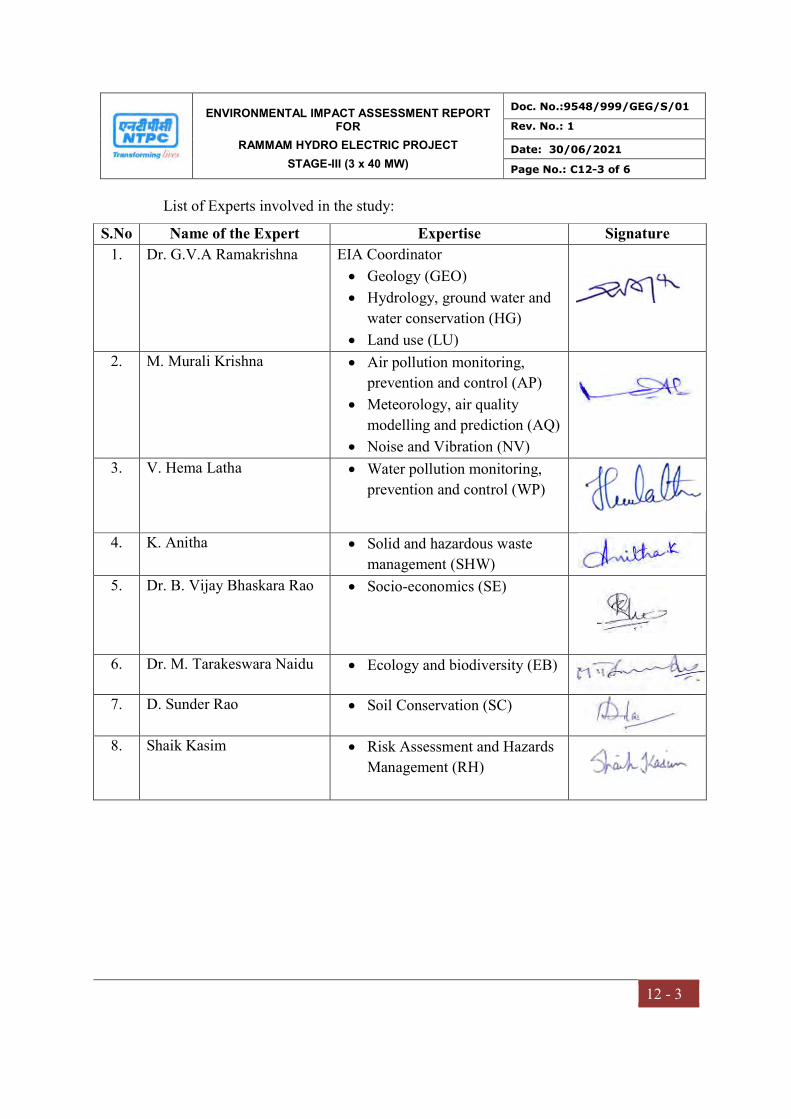
ENVIRONMENTAL IMPACT ASSESSMENT REPORT FOR
RAMMAM HYDRO ELECTRIC PROJECT
STAGE-III (3 x 40 MW)
Doc. No.:9548/999/GEG/S/01
Rev. No.: 1
Date: 30/06/2021
Page No.: C12-3 of 6
12 - 3
List of Experts involved in the study:
S.No Name of the Expert Expertise Signature
1. Dr. G.V.A Ramakrishna EIA Coordinator
Geology (GEO)
Hydrology, ground water and
water conservation (HG)
Land use (LU)
2. M. Murali Krishna
Air pollution monitoring,
prevention and control (AP)
Meteorology, air quality
modelling and prediction (AQ)
Noise and Vibration (NV)
3. V. Hema Latha Water pollution monitoring,
prevention and control (WP)
4. K. Anitha Solid and hazardous waste
management (SHW)
5. Dr. B. Vijay Bhaskara Rao Socio-economics (SE)
6. Dr. M. Tarakeswara Naidu Ecology and biodiversity (EB)
7. D. Sunder Rao Soil Conservation (SC)
8. Shaik Kasim Risk Assessment and Hazards
Management (RH)
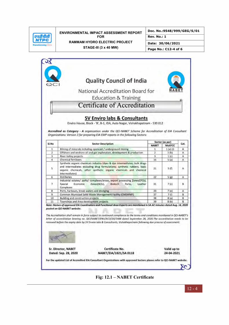
ENVIRONMENTAL IMPACT ASSESSMENT REPORT FOR
RAMMAM HYDRO ELECTRIC PROJECT
STAGE-III (3 x 40 MW)
Doc. No.:9548/999/GEG/S/01
Rev. No.: 1
Date: 30/06/2021
Page No.: C12-4 of 6
12 - 4
Fig: 12.1 – NABET Certificate
ENVIRONMENTAL IMPACT ASSESSMENT REPORT FOR
RAMMAM HYDRO ELECTRIC PROJECT
STAGE-III (3 x 40 MW)
Doc. No.:9548/999/GEG/S/01
Rev. No.: 1
Date: 30/06/2021
Page No.: C12-5 of 6
12 - 5
Fig: 12.2 – NABET Validity Extension Certificate
ENVIRONMENTAL IMPACT ASSESSMENT REPORT FOR
RAMMAM HYDRO ELECTRIC PROJECT
STAGE-III (3 x 40 MW)
Doc. No.:9548/999/GEG/S/01
Rev. No.: 1
Date: 30/06/2021
Page No.: C12-6 of 6
12 - 6
Fig 12.3 NABL Certificate